strategic directions for the u.s. geological survey …2 strategic directions for the u.s....
TRANSCRIPT
Strategic Directions for theU.S. Geological SurveyGround-Water Resources Program
A Report to CongressNovember 30, 1998
U.S. Department of the InteriorU.S. Geological Survey
Strategic Directions for theU.S. Geological SurveyGround-Water Resources Program
A Report to CongressNovember 30, 1998
U.S. DEPARTMENT OF THE INTERIORBruce Babbitt, Secretary
U.S. GEOLOGICAL SURVEYCharles G. Groat, Director
Copies of this report available upon request from:
U.S. Geological SurveyInformation ServicesBox 25286Federal CenterDenver CO 80225
For additional information about this report contact:
Chief, Office of Ground WaterU.S. Geological Survey12201 Sunrise Valley DriveMail Stop 411Reston VA 20192
CONTENTS III
CONTENTS
Introduction............................................................................................................................................................................ 1The Importance of Ground Water to the Nation .................................................................................................................... 1Evolving Ground-Water Issues and USGS Programs............................................................................................................ 2Relationship of Ground-Water Resources Program to Other USGS Programs..................................................................... 5Current Activities of the Ground-Water Resources Program ................................................................................................ 6Future Priorities for the Ground-Water Resources Program ................................................................................................. 7
Scientific Assessments of Critical Ground-Water Issues............................................................................................. 7Ground-Water Depletion.................................................................................................................................... 7Ground-Water/Surface-Water Interactions ........................................................................................................ 8Freshwater/Saltwater Relations ......................................................................................................................... 9Subsidence ......................................................................................................................................................... 11Ground Water in Complex Geologic Environments .......................................................................................... 11
Regional and National Overviews ............................................................................................................................... 12Access to Ground-Water Data ..................................................................................................................................... 12Research and Methods Development........................................................................................................................... 13
Concluding Remarks ............................................................................................................................................................. 14
INTRODUCTION 1
Strategic Directions for the U.S. Geological SurveyGround-Water Resources Program
INTRODUCTION
The U.S. Geological Survey (USGS) has beencollecting and interpreting ground-water data since thelate 1800’s. Ground-water issues have increased inscope and complexity as competing demands on theresource have grown. Moreover, ground-water systemschange over time in response to residential, industrial,and agricultural development, and in response tonatural stresses such as droughts. Aquifers cross Statelines and other political boundaries, creating the needfor impartial regional and national ground-water infor-mation. The USGS Ground-Water Resources Programresponds to these driving forces through ongoingefforts to examine and report on critical issuesaffecting the sustainability of the Nation’s ground-water resources.
This report discusses strategic directions of theGround-Water Resources Program. The report is in
response to a request from the U.S. House of Repre-sentatives Subcommittee on Interior Appropriationsin its report to accompany H.R. 4193.
THE IMPORTANCE OF GROUND WATERTO THE NATION
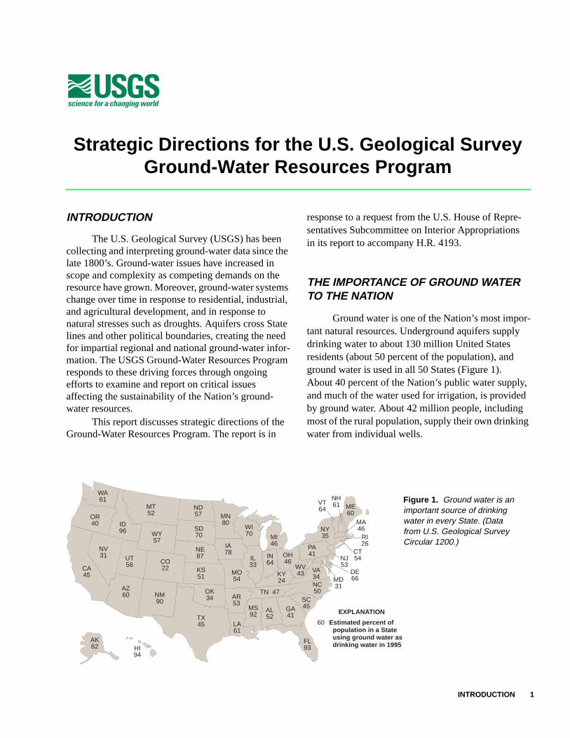
Ground water is one of the Nation’s most impor-tant natural resources. Underground aquifers supplydrinking water to about 130 million United Statesresidents (about 50 percent of the population), andground water is used in all 50 States (Figure 1).About 40 percent of the Nation’s public water supply,and much of the water used for irrigation, is providedby ground water. About 42 million people, includingmost of the rural population, supply their own drinkingwater from individual wells.
WA61
OR40
NV31
CA45
AZ60
ID96
UT56 CO
22
WY57
MT52
ND57
SD70
NE87
KS51
OK34
TX45 LA
61
AR53
MO54
IA78
MN80
WI70
IL33
IN64
OH46
PA41
WV43 VA
34NC50
SC45GA
41AL52
FL93
KY24
TN 47
MS92
MI46
NY35
ME60
VT64
NH61
MA46
RI26
CT54NJ
53DE66MD
31
AK62 HI
94
NM90
EXPLANATION
60 Estimated percent of population in a State using ground water as drinking water in 1995
Figure 1. Ground water is animportant source of drinkingwater in every State. (Datafrom U.S. Geological SurveyCircular 1200.)
2 Strategic Directions for the U.S. Geological Survey Ground-Water Resources Program
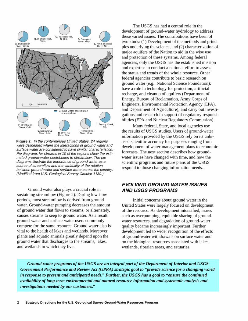
Ground water also plays a crucial role insustaining streamflow (Figure 2). During low-flowperiods, most streamflow is derived from groundwater. Ground-water pumping decreases the amountof ground water that flows to streams, or alternately,causes streams to seep to ground water. As a result,ground-water and surface-water users commonlycompete for the same resource. Ground water also isvital to the health of lakes and wetlands. Moreover,plants and aquatic animals greatly depend upon theground water that discharges to the streams, lakes,and wetlands in which they live.
The USGS has had a central role in thedevelopment of ground-water hydrology to addressthese varied issues. The contributions have been oftwo kinds: (1) Development of the methods and princi-ples underlying the science, and (2) characterization ofmajor aquifers of the Nation to aid in the wise useand protection of these systems. Among federalagencies, only the USGS has the established missionand expertise to conduct a national effort to assessthe status and trends of the whole resource. Otherfederal agencies contribute to basic research onground water (e.g., National Science Foundation);have a role in technology for protection, artificialrecharge, and cleanup of aquifers (Department ofEnergy, Bureau of Reclamation, Army Corps ofEngineers, Environmental Protection Agency (EPA),and Department of Agriculture); and carry out investi-gations and research in support of regulatory responsi-bilities (EPA and Nuclear Regulatory Commission).
Many federal, State, and local agencies usethe results of USGS studies. Users of ground-waterinformation provided by the USGS rely on its unbi-ased scientific accuracy for purposes ranging fromdevelopment of water-management plans to economicforecasts. The next section describes how ground-water issues have changed with time, and how thescientific programs and future plans of the USGSrespond to those changing information needs.
EVOLVING GROUND-WATER ISSUESAND USGS PROGRAMS
Initial concerns about ground water in theUnited States were largely focused on developmentof the resource. As development intensified, issuessuch as overpumping, equitable sharing of ground-water resources, and degradation of ground-waterquality became increasingly important. Furtherdevelopment led to wider recognition of the effectsof ground-water withdrawals on surface water andon the biological resources associated with lakes,wetlands, riparian areas, and estuaries.
Ground-water programs of the USGS are an integral part of the Department of Interior and USGSGovernment Performance and Review Act (GPRA) strategic goal to “provide science for a changing worldin response to present and anticipated needs.” Further, the USGS has a goal to “ensure the continuedavailability of long-term environmental and natural resource information and systematic analysis andinvestigations needed by our customers.”
0 250 500 MILES
Ground-water contribution to streamflow
B. Dismal River, Nebr.
C. Forest River,N. Dak. D. Sturgeon
River, Mich.
F. Orestimba Creek, Calif.
A. Duckabush River, Wash.
I. Homochitto River, Miss.
J. Brushy Creek, Ga.
E. Ammonoosuc River, N.H.
H. Dry Frio River, Tex.
G. Santa Cruz River, Ariz.
C
B
D
E
J
IH
G
F
A
Figure 2. In the conterminous United States, 24 regionswere delineated where the interactions of ground water andsurface water are considered to have similar characteristics.Pie diagrams for streams in 10 of the regions show the esti-mated ground-water contribution to streamflow. The piediagrams illustrate the importance of ground water as asource of streamflow and the variability of the relationbetween ground water and surface water across the country.(Modified from U.S. Geological Survey Circular 1139.)

EVOLVING GROUND-WATER ISSUES AND USGS PROGRAMS 3
Today, concerns about the sustainabilityof our ground-water resources involve:1. Long-term availability of ground-water supply
(and surface-water supply),2. Protection of ground-water quality, and3. Environmental effects of ground-water development.
Thus, ensuring sustainable ground-water develop-ment depends not only on understanding subsurface
processes in aquifers, but also understanding the inter-action of ground water with land and surface-waterresources (Figure 3).
The USGS has continuously responded tochanging ground-water issues. Four programs thatshould be mentioned in this regard are discussed hereas background to their interplay with the Ground-Water Resources Program.
Confining unit
Precipitation
Confining unit
Confining unit
Confining unit
Pumping wellPumping well
Water is recharged to the ground-water system bypercolation of water from precipitation and then flows to the stream through the ground-water system.
Water pumped from the ground-water system causes the water table to lower and alters the direction of ground-water movement. Some water that flowed to the stream no longer does so and some water may be drawn in from the stream into the ground-water system,thereby reducing the amount of streamflow.
Contaminants introduced at the land surface may infiltrate to the water table and flow towards a point of discharge, either the well or the stream. (Not shown, but also important, is the potential movement of contaminants from the stream into the ground-water system.)
Water-level declines may affect the environment for plants and animals. For example, plants in the riparian zone that grew because of the close proximity of the water table to the land surface may not survive as the depth to water increases. The environment for fish andother aquatic species also may be altered as the stream level drops.
Pumping well
Riparian zone
Precipitation Precipitation
Precipitation
Ground-water flow
Ground-water flow
Ground-water flow
Ground-water flow
Stream Stream
Evaporation
Infiltration Infiltration
Infiltration Infiltration
Watertable
Water
table
Water
table
Watertable
Ground-water flow direction
Ground-water flow direction
Ground-water flow direction
Evaporation
Evaporation Evaporation
Natural conditions Water-level declines
Ground-water quality Environmental effects
of ground-water
development
Contaminated
Ground-water flow direction
Riparian zone
Stream
Riparian zone
Stream
Riparian zone
water
Figure 3. Diagram of a cross section of ground-water flow to a stream illustrating various effects of ground-water development.
4 Strategic Directions for the U.S. Geological Survey Ground-Water Resources Program
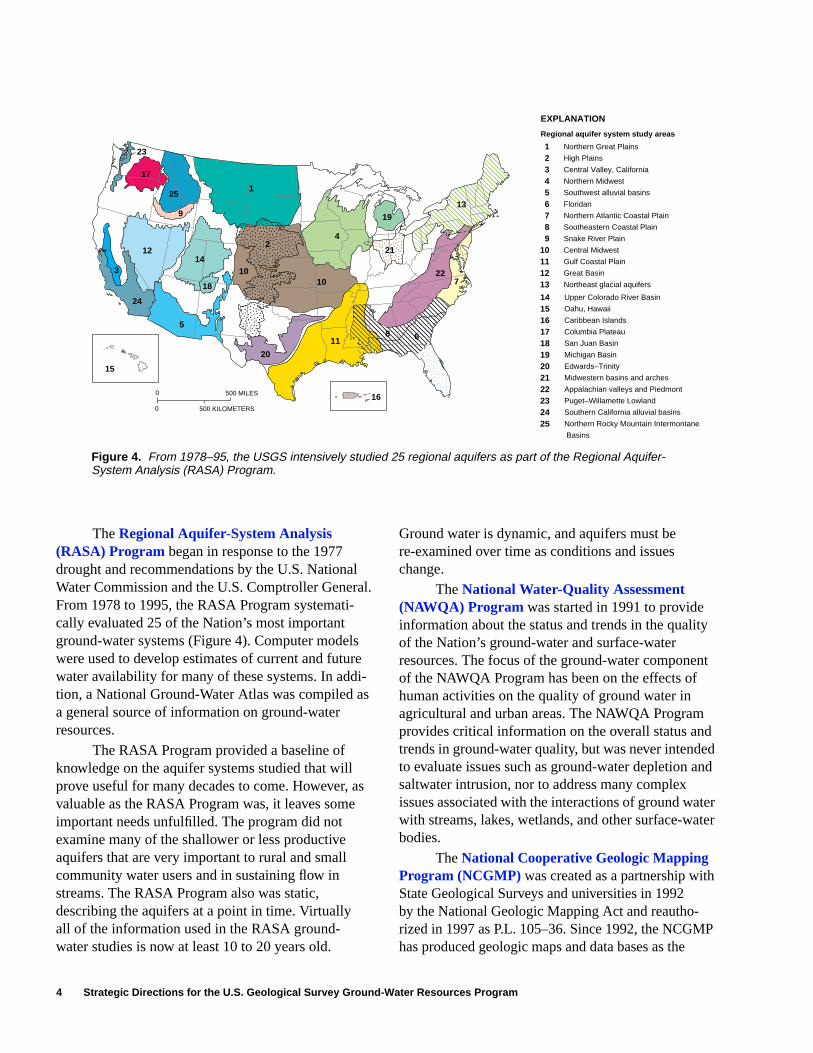
TheRegional Aquifer-System Analysis(RASA) Program began in response to the 1977drought and recommendations by the U.S. NationalWater Commission and the U.S. Comptroller General.From 1978 to 1995, the RASA Program systemati-cally evaluated 25 of the Nation’s most importantground-water systems (Figure 4). Computer modelswere used to develop estimates of current and futurewater availability for many of these systems. In addi-tion, a National Ground-Water Atlas was compiled asa general source of information on ground-waterresources.
The RASA Program provided a baseline ofknowledge on the aquifer systems studied that willprove useful for many decades to come. However, asvaluable as the RASA Program was, it leaves someimportant needs unfulfilled. The program did notexamine many of the shallower or less productiveaquifers that are very important to rural and smallcommunity water users and in sustaining flow instreams. The RASA Program also was static,describing the aquifers at a point in time. Virtuallyall of the information used in the RASA ground-water studies is now at least 10 to 20 years old.
Ground water is dynamic, and aquifers must bere-examined over time as conditions and issueschange.
TheNational Water-Quality Assessment(NAWQA) Program was started in 1991 to provideinformation about the status and trends in the qualityof the Nation’s ground-water and surface-waterresources. The focus of the ground-water componentof the NAWQA Program has been on the effects ofhuman activities on the quality of ground water inagricultural and urban areas. The NAWQA Programprovides critical information on the overall status andtrends in ground-water quality, but was never intendedto evaluate issues such as ground-water depletion andsaltwater intrusion, nor to address many complexissues associated with the interactions of ground waterwith streams, lakes, wetlands, and other surface-waterbodies.
TheNational Cooperative Geologic MappingProgram (NCGMP) was created as a partnership withState Geological Surveys and universities in 1992by the National Geologic Mapping Act and reautho-rized in 1997 as P.L. 105–36. Since 1992, the NCGMPhas produced geologic maps and data bases as the
������
yyyyyy
����������
�����
������
�QQ¢¢
���������
yyyyyyyyy ��
����
�����
��
�������
��������
0 500 MILES
0 500 KILOMETERS
16
6811
227
13
19
21
4
10
2
20
5
10
18
143
9
25
17
23
1
15
24
12
EXPLANATION
Northern Great Plains
High Plains
Central Valley, California
Northern Midwest
Southwest alluvial basins
Floridan
Northern Atlantic Coastal Plain
Southeastern Coastal Plain
Snake River Plain
Central Midwest
Gulf Coastal Plain
Great Basin
Northeast glacial aquifers
Upper Colorado River Basin
Oahu, Hawaii
Caribbean Islands
Columbia Plateau
San Juan Basin
Michigan Basin
Edwards–Trinity
Midwestern basins and arches
Appalachian valleys and Piedmont
Puget–Willamette Lowland
Southern California alluvial basins
Northern Rocky Mountain Intermontane
Basins
123456789
10111213
141516171819202122232425
Regional aquifer system study areas
Figure 4. From 1978–95, the USGS intensively studied 25 regional aquifers as part of the Regional Aquifer-System Analysis (RASA) Program.
RELATIONSHIP OF GROUND-WATER RESOURCES PROGRAM TO OTHER USGS PROGRAMS 5
framework for ground-water assessments of regionalaquifers in the southwest and in the southeasternCoastal Plain and has funded many geologic mappingprojects by State Geological Surveys and universities.On average, 35 percent of these projects cite ground-water issues as one of the principal reasons formapping. For example, geologic map information forground-water modeling, aquifer delineation, and well-head protection was cited as the highest priority needby public and private-sector participants at the 1997Great Lakes Geologic Mapping Forum in Indianapolis.
TheFederal-State Cooperative (Coop) WaterProgram matches funds from State and local agenciesto support data collection and investigations that serveboth federal interests and the needs of the State andlocal agencies. For over 100 years, this arrangementhas been a valuable means to build a national data baseand understanding of ground water. The RASA andNAWQA Programs have depended greatly on previouswork in the Coop Program as the starting point to theirefforts. A limitation of the Coop Program is that thestudies rarely cross State lines because of the difficultyof aligning the funding plans of multiple States. Astrength of the Coop Program is that close interactionwith water managers at the State and local levelensures continuing relevance of the ground-waterstudies to address the most pressing issues. As newneeds and issues emerge, the USGS works with itspartners to provide the science to resolve them.
Cooperators and other stakeholders respondingto strategic-plan development by the USGS havestrongly highlighted the importance of improved unbi-ased, long-term assessments of the quantity of waterin the Nation’s aquifers. They point out the importanceof these assessments to economic development, toresolution of interstate conflict, and to resolution ofconflicts between development and environmentalprotection. Interactions with the Western Water PolicyReview Advisory Commission (WWPRAC) furtherhighlighted the inadequacies of current assessments.Questions about the status and trends of ground-waterresources were central to their ability to envision thefuture of water in the West. The data assessments theUSGS could provide were not equal to the task, andthe WWPRAC report expresses the need for assess-ments that look at large scales over time scales ofmany decades.
RELATIONSHIP OF GROUND-WATERRESOURCES PROGRAM TO OTHERUSGS PROGRAMS
The Ground-Water Resources Program (GWRP)has evolved from the RASA Program. The GWRPbuilds upon the Coop Program and other more local-ized studies to provide a more complete picture ofthe Nation’s ground-water resources. The programis intended to update information from the RASAProgram about the long-term availability of ground-water supply and also to address the environmentaleffects of ground-water development on land andsurface-water resources. Geologic mapping capabilityby the NCGMP provides essential information onthe geologic framework of ground-water systems,including development of new three-dimensionalgeohydrologic maps.
The GWRP is primarily focused on ground-water quantity and the effects of ground-waterwithdrawals on ground water and surface water,but also provides key information to complementNAWQA and other water-quality programs, particu-larly in the area of ground-water/surface-water interac-tions. For example, enhanced understanding ofground-water/surface-water interactions could leadto significant improvements in the design of water-quality monitoring networks and is needed to helpidentify when wells near streams are vulnerable tocontamination by surface water (commonly referredto by EPA as “ground water under the influence ofsurface water”).
In addition to the four programs highlightedabove, the USGS has a wide range of capabilities inhydrology, biology, geology, and mapping to addressground-water resources in a fully integrated manner.For example, expertise in coastal geology enhancescharacterization of near-shore geologic environmentsfor better understanding of saltwater intrusion andthe discharge of fresh ground water to marine environ-ments. Capabilities in remote sensing and land charac-terization provide key information for computermodels and decision-support systems. Biologicalcapabilities in habitats, wetlands, and instream-flowrequirements are needed to assess the effects ofground-water development on surface-water systems.Expertise in climate improves understanding of therole of climate variability and climate change onground-water resources.
6 Strategic Directions for the U.S. Geological Survey Ground-Water Resources Program
CURRENT ACTIVITIES OF THE GROUND-WATER RESOURCES PROGRAM
Currently (1998), the Ground-Water ResourcesProgram consists of five primary activities, brieflydescribed below:
1. Middle Rio Grande Basin, New Mexico.—Studies by the New Mexico Bureau of Minesand Mineral Resources and the USGS in cooper-ation with the City of Albuquerque have shownthat ground water is not as plentiful as oncethought. Work is underway by the USGS toimprove the understanding and the accuracyof estimates of the quantities and distributionof water moving into and through the ground-water system of the entire Middle Rio GrandeBasin.
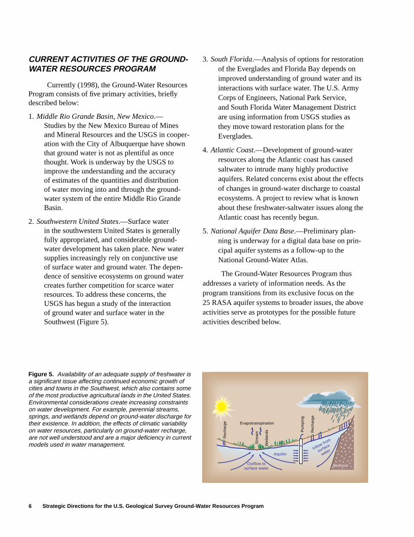
2. Southwestern United States.—Surface waterin the southwestern United States is generallyfully appropriated, and considerable ground-water development has taken place. New watersupplies increasingly rely on conjunctive useof surface water and ground water. The depen-dence of sensitive ecosystems on ground watercreates further competition for scarce waterresources. To address these concerns, theUSGS has begun a study of the interactionof ground water and surface water in theSouthwest (Figure 5).
3. South Florida.—Analysis of options for restorationof the Everglades and Florida Bay depends onimproved understanding of ground water and itsinteractions with surface water. The U.S. ArmyCorps of Engineers, National Park Service,and South Florida Water Management Districtare using information from USGS studies asthey move toward restoration plans for theEverglades.
4. Atlantic Coast.—Development of ground-waterresources along the Atlantic coast has causedsaltwater to intrude many highly productiveaquifers. Related concerns exist about the effectsof changes in ground-water discharge to coastalecosystems. A project to review what is knownabout these freshwater-saltwater issues along theAtlantic coast has recently begun.
5. National Aquifer Data Base.—Preliminary plan-ning is underway for a digital data base on prin-cipal aquifer systems as a follow-up to theNational Ground-Water Atlas.
The Ground-Water Resources Program thusaddresses a variety of information needs. As theprogram transitions from its exclusive focus on the25 RASA aquifer systems to broader issues, the aboveactivities serve as prototypes for the possible futureactivities described below.
Wet
land
s
Evapotranspiration
Pum
ping
Rec
harg
e
Str
eam
Bedrock
Aquifer
Rec
harg
e
Outflow tosurface water
Inflow from
surface
water
Figure 5. Availability of an adequate supply of freshwater isa significant issue affecting continued economic growth ofcities and towns in the Southwest, which also contains someof the most productive agricultural lands in the United States.Environmental considerations create increasing constraintson water development. For example, perennial streams,springs, and wetlands depend on ground-water discharge fortheir existence. In addition, the effects of climatic variabilityon water resources, particularly on ground-water recharge,are not well understood and are a major deficiency in currentmodels used in water management.
FUTURE PRIORITIES FOR THE GROUND-WATER RESOURCES PROGRAM 7
FUTURE PRIORITIES FOR THE GROUND-WATER RESOURCES PROGRAM
Future plans and proposals considered for theprogram emphasize four themes: scientific assess-ments of critical ground-water issues, regional andnational overviews, improved access to ground-water data, and research and methods development.These themes are discussed in the followingsections.
Scientific Assessments of CriticalGround-Water Issues
A flexible approach is needed to address diverseissues. In some cases, studies are undertaken for majoraquifer systems, such as those ongoing for the MiddleRio Grande Basin and in south Florida. In other cases,issue-based studies focus on multiple aquifer systemsover a broad geographic area, such as the ongoingstudies of the southwestern United States and Atlanticcoast.
For discussion purposes, key issues consideredby the program are grouped according to five topicalareas: ground-water depletion, ground-water/surface-water interactions, freshwater/saltwaterrelations, subsidence, and ground water in complexgeologic environments. A brief background on eachissue, with selected examples from across the UnitedStates, is given below. Examples cited are for illustra-tive purposes and are neither exhaustive norprioritized.
Ground-Water Depletion
Widespread pumping that is sufficient tocause regional declines in ground-water levels canhave several consequences. Wells can become dryor have greatly reduced yields as water levels decline.Pumping costs increase as the distance that groundwater must be pumped to the land surface increases.Large decreases in aquifer storage can result insubstantial ground-water mining with less wateravailable for future users. Areas of significant ground-water depletion in the United States include, amongothers, the High Plains aquifer, many areas in thesouthwestern United States (e.g., AZ, CA, NM,NV, and TX), the Sparta aquifer in the southeasternUnited States (AR, LA, and MS), and the Chicago-Milwaukee area.
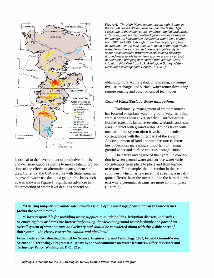
Long-term observation-well networks areneeded to provide data to monitor areas of ground-water depletion. Water allocation and developmentdecisions must be based on an accurate set of factsabout the changing status of the resource. Water-levelmonitoring takes place for many aquifer systemswithin States, but with the exception of the HighPlains aquifer (Figure 6), coordinated water-levelmonitoring generally has not been done for ground-water systems that cross State boundaries. In orderto provide the information needed on large aquifers,a rotational assessment of water-level changes onthese major systems should take place at least every5 to 10 years.
Information on the amounts of ground waterpumped from different aquifers is needed to charac-terize areas of overdraft. This water-use information
“The western states need good information about groundwater to make informed water managementdecisions. The resources to perform these studies vary by state, and the federal government’s role in provid-ing information can be critical. The USGS, in conjunction with state officials, should help quantify existingdata bases and should make available any computer models, geophysical methodology, seismic informa-tion, or other tools that could be used to assist decisionmakers. The USGS should also engage in analysisof groundwater resources and provide policy relevant information such as forecasts of aquifer life to thewater resources community.”
From: Western Water Policy Review Advisory Commission, 1998, Final Report—Water in the West: Challengefor the Next Century: Western Water Policy Review Advisory Commission, Denver, Colorado, p. xxx.
8 Strategic Directions for the U.S. Geological Survey Ground-Water Resources Program
is critical to the development of predictive modelsand decision-support systems to make realistic projec-tions of the effects of alternative management strate-gies. Currently, the USGS works with State agenciesto provide water-use data on a geographic basis suchas was shown in Figure 1. Significant advances inthe prediction of water-level declines depend on
obtaining more accurate data on pumping, consump-tive use, recharge, and surface-water return flow usingremote sensing and other advanced techniques.
Ground-Water/Surface-Water Interactions
Traditionally, management of water resourceshas focused on surface water or ground water as if theywere separate entities. Yet, nearly all surface-waterfeatures (streams, lakes, reservoirs, wetlands, and estu-aries) interact with ground water. Actions taken withone part of the system often have had unintendedconsequences with the other parts of the system.As development of land and water resources intensi-fies, it becomes increasingly important to manageground water and surface water as a single entity.
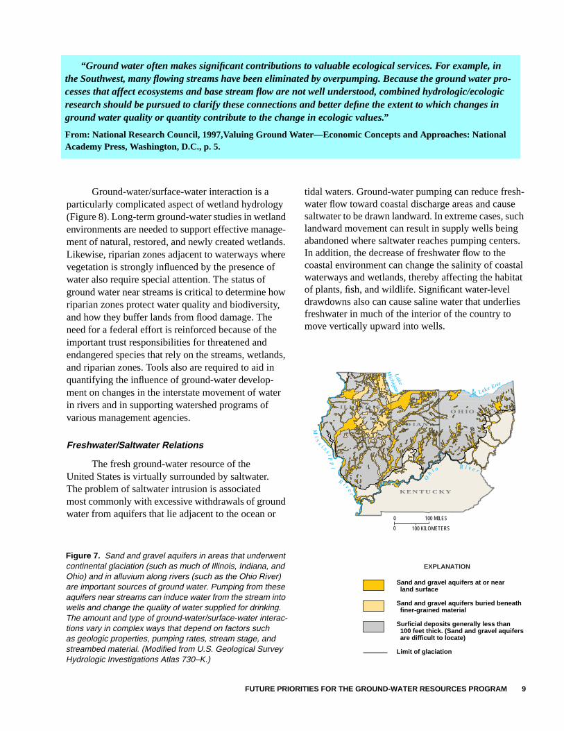
The nature and degree of the hydraulic connec-tion between ground water and surface water variesconsiderably from place to place and from terraneto terrane. For example, the interaction in the aridsouthwest, which has few perennial streams, is usuallyquite different from the interaction in the humid north-east where perennial streams are more commonplace(Figure 7).
NEW MEXICO
COLORADO
TEXAS
NEBRASKA
WYOMING SOUTH DAKOTA
OKLAHOMA
KANSAS
North
PlatteR.
S. Platte
R.Platte
River
River
Republican
River
Missouri
ArkansasRiver
Canadian
River
105°
40°
35°
100°
Water-level change in feet, 1980 to 1995
EXPLANATION
More than 4020 to 4010 to 20
Boundary of the High Plains Aquifer
Declines
10 to 2020 to 40More than 40
Rises
Less than 10 foot change
0
0 150 KILOMETERS
150 MILES
Figure 6. The High Plains aquifer covers eight States inthe central United States. Irrigation has made the HighPlains one of the Nation’s most important agricultural areas.Extensive pumping has depleted ground-water storage inthe aquifer, as indicated by this map of water-level changefrom 1980 to 1995. Although ground-water pumping hasdecreased over the past decade in much of the High Plains,water levels have continued to decline significantly insome areas because withdrawals still exceed recharge.Ground-water levels have risen in other areas as a resultof decreased pumping or recharge from surface-waterirrigation. (Modified from U.S. Geological Survey Water-Resources Investigations Report 97–4081.)
“Assuring long-term ground-water supplies is one of the most significant natural resource issuesfacing the Nation today.”
“Those responsible for providing water supplies to municipalities, irrigation districts, industries,or entire regions or States are increasingly taking the view that ground water is simply one part of anoverall system of water storage and delivery and should be considered along with the visible parts ofthat system—the rivers, reservoirs, canals, and pipelines.”
From: Federal Coordinating Council for Science, Engineering, and Technology, 1992, Federal Ground-WaterScience and Technology Programs: A Report by the Subcommittee on Water Resources, Office of Science andTechnology Policy, Washington, D.C., 82 p.
FUTURE PRIORITIES FOR THE GROUND-WATER RESOURCES PROGRAM 9
Ground-water/surface-water interaction is aparticularly complicated aspect of wetland hydrology(Figure 8). Long-term ground-water studies in wetlandenvironments are needed to support effective manage-ment of natural, restored, and newly created wetlands.Likewise, riparian zones adjacent to waterways wherevegetation is strongly influenced by the presence ofwater also require special attention. The status ofground water near streams is critical to determine howriparian zones protect water quality and biodiversity,and how they buffer lands from flood damage. Theneed for a federal effort is reinforced because of theimportant trust responsibilities for threatened andendangered species that rely on the streams, wetlands,and riparian zones. Tools also are required to aid inquantifying the influence of ground-water develop-ment on changes in the interstate movement of waterin rivers and in supporting watershed programs ofvarious management agencies.
Freshwater/Saltwater Relations
The fresh ground-water resource of theUnited States is virtually surrounded by saltwater.The problem of saltwater intrusion is associatedmost commonly with excessive withdrawals of groundwater from aquifers that lie adjacent to the ocean or
tidal waters. Ground-water pumping can reduce fresh-water flow toward coastal discharge areas and causesaltwater to be drawn landward. In extreme cases, suchlandward movement can result in supply wells beingabandoned where saltwater reaches pumping centers.In addition, the decrease of freshwater flow to thecoastal environment can change the salinity of coastalwaterways and wetlands, thereby affecting the habitatof plants, fish, and wildlife. Significant water-leveldrawdowns also can cause saline water that underliesfreshwater in much of the interior of the country tomove vertically upward into wells.
Figure 7. Sand and gravel aquifers in areas that underwentcontinental glaciation (such as much of Illinois, Indiana, andOhio) and in alluvium along rivers (such as the Ohio River)are important sources of ground water. Pumping from theseaquifers near streams can induce water from the stream intowells and change the quality of water supplied for drinking.The amount and type of ground-water/surface-water interac-tions vary in complex ways that depend on factors suchas geologic properties, pumping rates, stream stage, andstreambed material. (Modified from U.S. Geological SurveyHydrologic Investigations Atlas 730–K.)
�y��yy�y�y�y�y�y
Mi s
s
i s s i pp
i
R i v er
Oh
i o R i v e r
Lake Erie
O HI O
K ENTUC K Y
I ND I A NA
I LL I NO I S
Lake
Michigan
0 100 MILES
0 100 KILOMETERS
Sand and gravel aquifers at or near land surface
Sand and gravel aquifers buried beneath finer-grained material
Surficial deposits generally less than 100 feet thick. (Sand and gravel aquifers are difficult to locate) Limit of glaciation
EXPLANATION
“Ground water often makes significant contributions to valuable ecological services. For example, inthe Southwest, many flowing streams have been eliminated by overpumping. Because the ground water pro-cesses that affect ecosystems and base stream flow are not well understood, combined hydrologic/ecologicresearch should be pursued to clarify these connections and better define the extent to which changes inground water quality or quantity contribute to the change in ecologic values.”
From: National Research Council, 1997,Valuing Ground Water—Economic Concepts and Approaches: NationalAcademy Press, Washington, D.C., p. 5.
10 Strategic Directions for the U.S. Geological Survey Ground-Water Resources Program
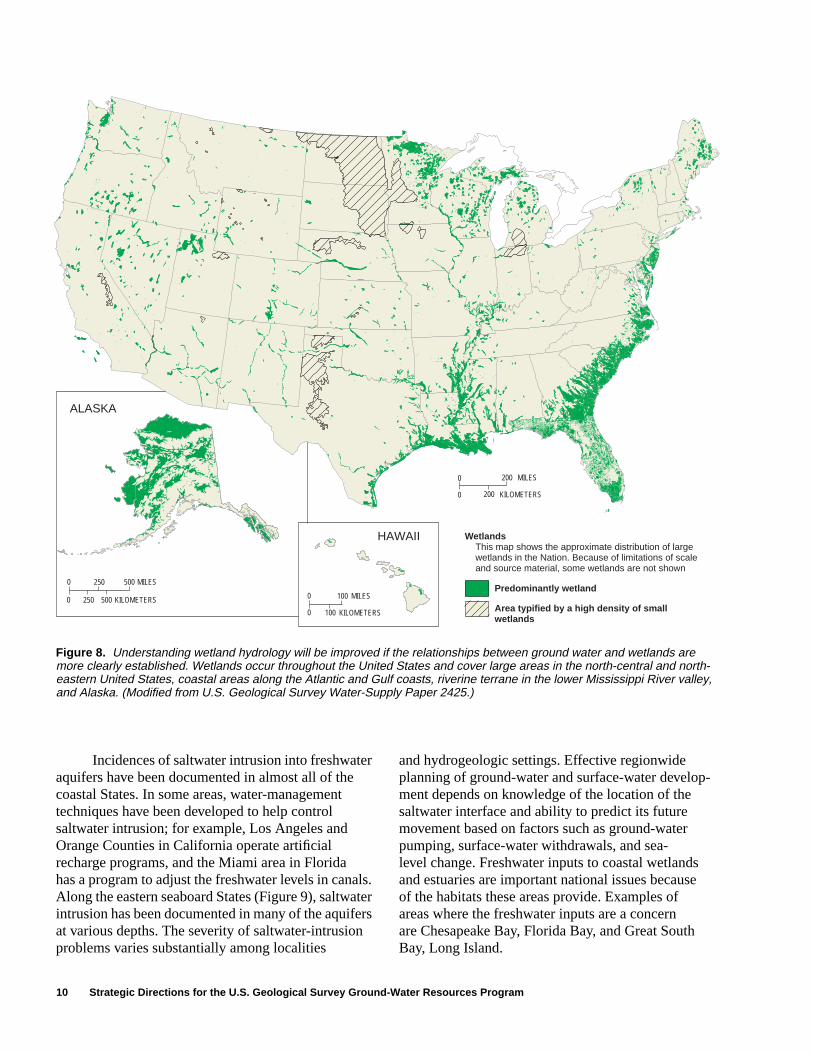
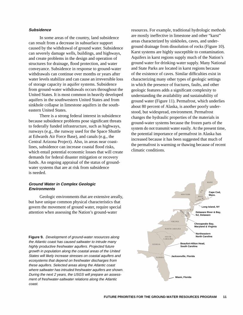
Incidences of saltwater intrusion into freshwateraquifers have been documented in almost all of thecoastal States. In some areas, water-managementtechniques have been developed to help controlsaltwater intrusion; for example, Los Angeles andOrange Counties in California operate artificialrecharge programs, and the Miami area in Floridahas a program to adjust the freshwater levels in canals.Along the eastern seaboard States (Figure 9), saltwaterintrusion has been documented in many of the aquifersat various depths. The severity of saltwater-intrusionproblems varies substantially among localities
and hydrogeologic settings. Effective regionwideplanning of ground-water and surface-water develop-ment depends on knowledge of the location of thesaltwater interface and ability to predict its futuremovement based on factors such as ground-waterpumping, surface-water withdrawals, and sea-level change. Freshwater inputs to coastal wetlandsand estuaries are important national issues becauseof the habitats these areas provide. Examples ofareas where the freshwater inputs are a concernare Chesapeake Bay, Florida Bay, and Great SouthBay, Long Island.
Wetlands This map shows the approximate distribution of largewetlands in the Nation. Because of limitations of scale and source material, some wetlands are not shown
Predominantly wetland
Area typified by a high density of small wetlands
0 100 MILES
0 100 KILOMETERS
0 500 MILES
0 500 KILOMETERS
250
250
ALASKA
HAWAII
0 MILES
0 KILOMETERS
200
200
Figure 8. Understanding wetland hydrology will be improved if the relationships between ground water and wetlands aremore clearly established. Wetlands occur throughout the United States and cover large areas in the north-central and north-eastern United States, coastal areas along the Atlantic and Gulf coasts, riverine terrane in the lower Mississippi River valley,and Alaska. (Modified from U.S. Geological Survey Water-Supply Paper 2425.)
FUTURE PRIORITIES FOR THE GROUND-WATER RESOURCES PROGRAM 11
Subsidence
In some areas of the country, land subsidencecan result from a decrease in subsurface supportcaused by the withdrawal of ground water. Subsidencecan severely damage wells, buildings, and highways,and create problems in the design and operation ofstructures for drainage, flood protection, and waterconveyance. Subsidence in response to ground-waterwithdrawals can continue over months or years afterwater levels stabilize and can cause an irreversible lossof storage capacity in aquifer systems. Subsidencefrom ground-water withdrawals occurs throughout theUnited States. It is most common in heavily developedaquifers in the southwestern United States and fromsinkhole collapse in limestone aquifers in the south-eastern United States.
There is a strong federal interest in subsidencebecause subsidence problems pose significant threatsto federally funded infrastructure, such as highways,runways (e.g., the runway used for the Space Shuttleat Edwards Air Force Base), and canals (e.g., theCentral Arizona Project). Also, in areas near coast-lines, subsidence can increase coastal flood risks,which entail potential economic losses that will createdemands for federal disaster mitigation or recoveryfunds. An ongoing appraisal of the status of ground-water systems that are at risk from subsidenceis needed.
Ground Water in Complex GeologicEnvironments
Geologic environments that are extensive areally,but have unique common physical characteristics thatgovern the movement of ground water, require specialattention when assessing the Nation’s ground-water
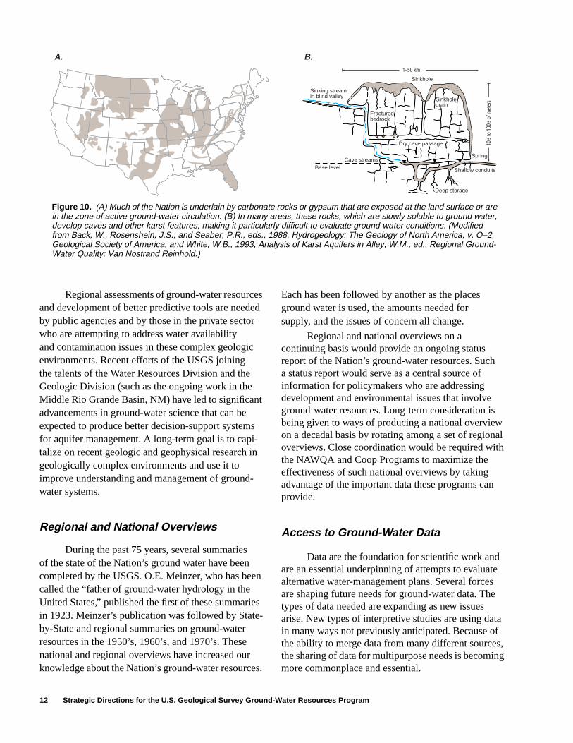
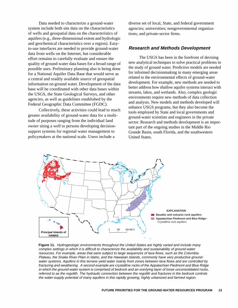
resources. For example, traditional hydrologic methodsare mostly ineffective in limestone and other “karst”areas characterized by sinkholes, caves, and under-ground drainage from dissolution of rocks (Figure 10).Karst systems are highly susceptible to contamination.Aquifers in karst regions supply much of the Nation’sground water for drinking-water supply. Many Nationaland State Parks are located in karst regions becauseof the existence of caves. Similar difficulties exist incharacterizing many other types of geologic settingsin which the presence of fractures, faults, and othergeologic features adds a significant complexity tounderstanding the availability and sustainability ofground water (Figure 11). Permafrost, which underliesabout 80 percent of Alaska, is another poorly under-stood, but widespread, environment. Permafrostchanges the hydraulic properties of the materials inground-water systems because the frozen parts of thesystem do not transmit water easily. At the present time,the potential importance of permafrost in Alaska hasincreased because it has been suggested that much ofthe permafrost is warming or thawing because of recentclimatic conditions.
Cape Cod,Mass.
Long Island, NY
Delaware River & Bay,NJ, Delaware
Chesapeake Bay,Maryland & Virginia
NortheasternNorth Carolina
Beaufort-Hilton Head,South Carolina
Jacksonville, Florida
Miami, Florida
MA I NE
MASS .
CONN.
NEW YORK
V IRG IN IA
FLOR IDA
GEORG IA
NORTH CAROL INA
SOUTHCAROL INA
N.H.
N . J .
DEL.
MARYLAND
R.I.
Figure 9. Development of ground-water resources alongthe Atlantic coast has caused saltwater to intrude manyhighly productive freshwater aquifers. Projected futuregrowth in population along the coastal areas of the UnitedStates will likely increase stresses on coastal aquifers andecosystems that depend on freshwater discharges fromthese aquifers. Selected areas along the Atlantic coastwhere saltwater has intruded freshwater aquifers are shown.During the next 2 years, the USGS will prepare an assess-ment of freshwater-saltwater relations along the Atlanticcoast.
12 Strategic Directions for the U.S. Geological Survey Ground-Water Resources Program
Regional assessments of ground-water resourcesand development of better predictive tools are neededby public agencies and by those in the private sectorwho are attempting to address water availabilityand contamination issues in these complex geologicenvironments. Recent efforts of the USGS joiningthe talents of the Water Resources Division and theGeologic Division (such as the ongoing work in theMiddle Rio Grande Basin, NM) have led to significantadvancements in ground-water science that can beexpected to produce better decision-support systemsfor aquifer management. A long-term goal is to capi-talize on recent geologic and geophysical research ingeologically complex environments and use it toimprove understanding and management of ground-water systems.
Regional and National Overviews
During the past 75 years, several summariesof the state of the Nation’s ground water have beencompleted by the USGS. O.E. Meinzer, who has beencalled the “father of ground-water hydrology in theUnited States,” published the first of these summariesin 1923. Meinzer’s publication was followed by State-by-State and regional summaries on ground-waterresources in the 1950’s, 1960’s, and 1970’s. Thesenational and regional overviews have increased ourknowledge about the Nation’s ground-water resources.
Each has been followed by another as the placesground water is used, the amounts needed forsupply, and the issues of concern all change.
Regional and national overviews on acontinuing basis would provide an ongoing statusreport of the Nation’s ground-water resources. Sucha status report would serve as a central source ofinformation for policymakers who are addressingdevelopment and environmental issues that involveground-water resources. Long-term consideration isbeing given to ways of producing a national overviewon a decadal basis by rotating among a set of regionaloverviews. Close coordination would be required withthe NAWQA and Coop Programs to maximize theeffectiveness of such national overviews by takingadvantage of the important data these programs canprovide.
Access to Ground-Water Data
Data are the foundation for scientific work andare an essential underpinning of attempts to evaluatealternative water-management plans. Several forcesare shaping future needs for ground-water data. Thetypes of data needed are expanding as new issuesarise. New types of interpretive studies are using datain many ways not previously anticipated. Because ofthe ability to merge data from many different sources,the sharing of data for multipurpose needs is becomingmore commonplace and essential.
Sinkhole
1–50 km
Cave streamsBase level
Dry cave passage
Spring
Shallow conduits
Deep storage
Sinkholedrain
Fracturedbedrock
Sinking streamin blind valley
10's
to 1
00's
of m
eter
s
A. B.
Figure 10. (A) Much of the Nation is underlain by carbonate rocks or gypsum that are exposed at the land surface or arein the zone of active ground-water circulation. (B) In many areas, these rocks, which are slowly soluble to ground water,develop caves and other karst features, making it particularly difficult to evaluate ground-water conditions. (Modifiedfrom Back, W., Rosenshein, J.S., and Seaber, P.R., eds., 1988, Hydrogeology: The Geology of North America, v. O–2,Geological Society of America, and White, W.B., 1993, Analysis of Karst Aquifers in Alley, W.M., ed., Regional Ground-Water Quality: Van Nostrand Reinhold.)
FUTURE PRIORITIES FOR THE GROUND-WATER RESOURCES PROGRAM 13
Data needed to characterize a ground-watersystem include both site data on the characteristicsof wells and geospatial data on the characteristics ofaquifers (e.g., three-dimensional extent and hydrologicand geochemical characteristics over a region). Easy-to-use interfaces are needed to provide ground-waterdata from wells on the Internet, but considerableeffort remains to carefully evaluate and ensure thequality of ground-water data bases for a broad range ofpossible uses. Preliminary planning also is being donefor a National Aquifer Data Base that would serve asa central and readily available source of geospatialinformation on ground water. Development of the database will be coordinated with other data bases withinthe USGS, the State Geological Surveys, and otheragencies, as well as guidelines established by theFederal Geographic Data Committee (FGDC).
Collectively, these activities could lead to muchgreater availability of ground-water data for a multi-tude of purposes ranging from the individual landowner siting a well to persons developing decision-support systems for regional water management topolicymakers at the national scale. Users include a
diverse set of local, State, and federal governmentagencies; universities; nongovernmental organiza-tions; and private-sector firms.
Research and Methods Development
The USGS has been in the forefront of devisingnew analytical techniques to solve practical problems inthe study of ground water. Predictive models are neededfor informed decisionmaking in many emerging areasrelated to the environmental effects of ground-waterdevelopment. For example, new methods are needed tobetter address how shallow aquifer systems interact withstreams, lakes, and wetlands. Also, complex geologicenvironments require new methods of data collectionand analysis. New models and methods developed willenhance USGS programs, but they also become thetools employed by State and local governments andground-water scientists and engineers in the privatesector. Research and methods development is an impor-tant part of the ongoing studies in the Middle RioGrande Basin, south Florida, and the southwesternUnited States.
Figure 11. Hydrogeologic environments throughout the United States are highly varied and include manycomplex settings in which it is difficult to characterize the availability and sustainability of ground-waterresources. For example, areas that were subject to large sequences of lava flows, such as the ColumbiaPlateau, the Snake River Plain in Idaho, and the Hawaiian Islands, commonly have very productive ground-water systems. Aquifers in this terrane yield water mainly from zones between lava flows and are controlled byfracturing and weathering. A second example are crystalline rocks of the Appalachian Piedmont and Blue Ridgein which the ground-water system is comprised of bedrock and an overlying layer of loose unconsolidated rocks,referred to as the regolith. The hydraulic connection between the regolith and fractures in the bedrock controlsthe water-supply potential of many aquifers in this rapidly growing, highly urbanized and farmed region.
��������������
0 200 400 MILESPrincipal Islands of
HAWAII
Basaltic and volcanic-rock aquifersAppalachian Piedmont and Blue Ridge– Crystalline rock aquifers
EXPLANATION
14 Strategic Directions for the U.S. Geological Survey Ground-Water Resources Program
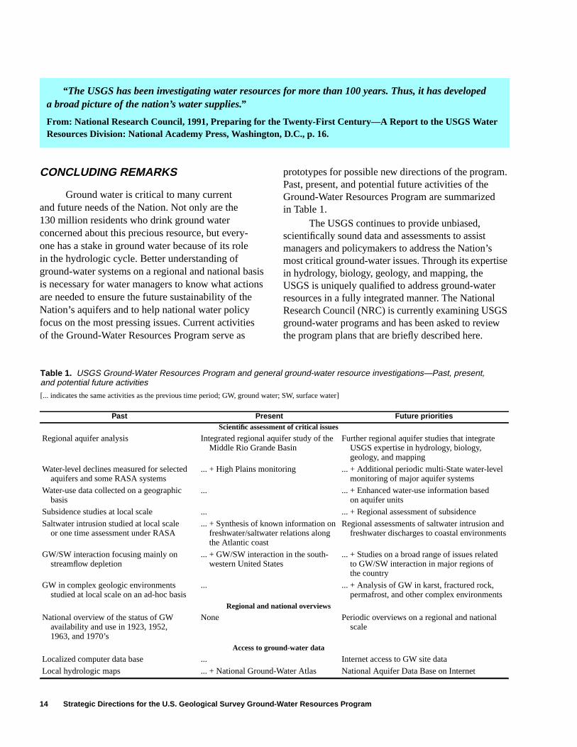
CONCLUDING REMARKS
Ground water is critical to many currentand future needs of the Nation. Not only are the130 million residents who drink ground waterconcerned about this precious resource, but every-one has a stake in ground water because of its rolein the hydrologic cycle. Better understanding ofground-water systems on a regional and national basisis necessary for water managers to know what actionsare needed to ensure the future sustainability of theNation’s aquifers and to help national water policyfocus on the most pressing issues. Current activitiesof the Ground-Water Resources Program serve as
prototypes for possible new directions of the program.Past, present, and potential future activities of theGround-Water Resources Program are summarizedin Table 1.
The USGS continues to provide unbiased,scientifically sound data and assessments to assistmanagers and policymakers to address the Nation’smost critical ground-water issues. Through its expertisein hydrology, biology, geology, and mapping, theUSGS is uniquely qualified to address ground-waterresources in a fully integrated manner. The NationalResearch Council (NRC) is currently examining USGSground-water programs and has been asked to reviewthe program plans that are briefly described here.
Table 1. USGS Ground-Water Resources Program and general ground-water resource investigations—Past, present,and potential future activities
[... indicates the same activities as the previous time period; GW, ground water; SW, surface water]
Past Present Future prioritiesScientific assessment of critical issues
Regional aquifer analysis Integrated regional aquifer study of theMiddle Rio Grande Basin
Further regional aquifer studies that integrateUSGS expertise in hydrology, biology,geology, and mapping
Water-level declines measured for selectedaquifers and some RASA systems
... + High Plains monitoring ... + Additional periodic multi-State water-levelmonitoring of major aquifer systems
Water-use data collected on a geographicbasis
... ... + Enhanced water-use information basedon aquifer units
Subsidence studies at local scale ... ... + Regional assessment of subsidence
Saltwater intrusion studied at local scaleor one time assessment under RASA
... + Synthesis of known information onfreshwater/saltwater relations alongthe Atlantic coast
Regional assessments of saltwater intrusion andfreshwater discharges to coastal environments
GW/SW interaction focusing mainly onstreamflow depletion
... + GW/SW interaction in the south-western United States
... + Studies on a broad range of issues relatedto GW/SW interaction in major regions ofthe country
GW in complex geologic environmentsstudied at local scale on an ad-hoc basis
... ... + Analysis of GW in karst, fractured rock,permafrost, and other complex environments
Regional and national overviews
National overview of the status of GWavailability and use in 1923, 1952,1963, and 1970’s
None Periodic overviews on a regional and nationalscale
Access to ground-water data
Localized computer data base ... Internet access to GW site data
Local hydrologic maps ... + National Ground-Water Atlas National Aquifer Data Base on Internet
“The USGS has been investigating water resources for more than 100 years. Thus, it has developeda broad picture of the nation’s water supplies.”
From: National Research Council, 1991, Preparing for the Twenty-First Century—A Report to the USGS WaterResources Division: National Academy Press, Washington, D.C., p. 16.