strain partitioning in the transition area between oblique...
TRANSCRIPT

TECTONICS, VOL. 17, NO. 4, PAGES 534-557, AUGUST 1998
Strain partitioning in the transition area between oblique subduction and continental collision, Hikurangi margin, New Zealand
Philip M. Barnes,' Bernard Mercier de LCpinay,* Jean-Yve C ~ l l o t , ~ - ~ Jean Delteil,? J and Jean-Christophe Audruz*s
Abstract. Spatial differences in late Quaternary structural style and deformation rates indicate a complex pattern of strain partitioning within the transition area from oblique subduction beneath southern North Island to oblique continental collision in northern South Island, New Zealand. The late Quaternary structure of the offshore southern Hikurangi margin is determined here using seismic reflection profiles, MR1 side-scan sonar swath images, EM 12Dual multibeam swath bathymetry and backscatter images, and sediment core and dredge samples. Where oblique (50") subduction of the oceanic Hikurangi Plateau is occurring beneath southern Wairarapa region, the steep, dissected, upper margin consists of a wedge of rocks that are being deformed by strike-slip and reverse faults. Beneath the lower margin an accretionary wedge of Quaternary age has developed rapidly by frontal accretion of a thick succession of turbidites on the Pacific Plate. Estimates of late Quaternary geological strain rates have been made on two margin-perpendicular transects across southern North Island and the offshore margin to budget the predicted NUVEL-IA plate motion. More than 33-55 % of the total plate motion is expressed in the offshore part of the upper plate above the subduction detachment in the central Hikurangi margin between 40"s and 41"s. This offshore deformation could potentially include margin-parallel fault slip of up to 14-15 "/yr. Across the upper plate, strain is partitioned into zones of folding and thrust faulting and possibly more than one zone of strike-slip faulting, but the partitioning may be incomplete with oblique-slip thrusting an important component of the deformation. The wide distribution of deformation within the upper plate partially reflects strong coupling between the subducting oceanic plateau and the leading edge of the overriding plate. This coupling increases toward the southwest, where the continental part of the subduction zone beneathMarlborough may now be inactive or very strongly coupled. Toward the southwest the transpressive deformation style of the upper Wairarapa margin continues into the upper Marlborough margin and onshore into the strike-slip Marlborough Fault System of northern South Island. In contrast, the accretionary wedge narrows to the southwest and terminates in southeastern Cook Strait, approximately above the .
'National Institute of Water and Atmospheric Research, Wellington,
WoSciences Azur, CNRS - Université de Nice,Vaibonne, France. 'Institut Français de Recherche Scientifique pour le Développement
4 0 n sabbatical at Institute of Geological and Nuclear Sciences,
'Now at Ecole et Observatoire de Physique du globe, Strasbourg,
New Zealand.
en Coopération (ORSTOM), Villefranche-sur-Mer, France.
Wellington, New Zealand.
France.
Copyright 1998 by the American Geophysical Union.
transition from subducted oceanic crust to subducted continental crust of the Pacific Plate. Farther southwest beneath the lower Marlborough margin, low-strain folding and thrust faulting is occurring, but the style of deformation is not typical of the accretionary wedge. This shortening results either from a small amount of subduction slip beneath Marlborough a n d o r from contractional strain partitioned to the southeast of the continental transpression zone. Whereas the initial onset of continental collision occurs in Marlborough, the surface expression of deformation of the Pacific Plate occurs south of 42"30'S. Normal faulting of the northwestern margin of the continental Chatham Rise possibly reflects flexural extension of the Pacific Plate crust at the southern end of the subduction zone, whereas folding and thrust faulting of the north Canterbury coastal region results from NW-SE contraction of the delaminated upper crust entering the Southern Alps collision zone.
'
1. Introduction Obliquely convergent plate boundaries typically exhibit wide
zones of deformation characterized by block rotations and complex patterns of contractional, extensional, and strike-slip faulting. Where oblique subduction occurs, the relative plate motion is partitioned between trench-parallel and trench-orthogonal defor- mation of the overriding plate and slip on the subduction interface [Fitch, 1972; Yu et al., 19931. In the overriding plate the trench- parallel component of displacement commonly occurs on strike- slip faults that dissect the forearc into elongate slivers by displace- ments subparallel to the boundary [e.g.,Ryan and Coleman, 19921. The orthogonal component commonly is accommodated by thrust faulting and folding toward the lower trench slope. The degree of strain partitioning within such boundaries depends largely on the strength of the overriding plate and the degree of interplate coupling [Jarrard, 1986; McCaffrey, 19921. Generally, as convergence obliquity (the' angle between the plate motion vector and the direction normal to the plate boundary) increases, the cumulative rate of strike-slip displacement within the forearc increases.
The tectonic character of some plate boundaries changes along the margin from subduction to transform as a result of increasing convergence obliquity associated with a change in the trend of the boundary toward parallelism with the convergence vector [Forsyth, 1975; Hamburger and Isach, 1987; Geist et al., 1988; Curray, 1989; Masson qnd Scanlon, 19911. Other margins change along the boundary from subduction to continental collision and/or intracontinental strike-slip deformation because of variations in crustal structure and thickness of the convergent plates [Walcott, 1978; Teng, 1990; Aubouin, 1990;Reyners and Cowan. 1993;Abers and McCaflrey, 19941. Whether or not subduction or continental collision occurs at a convergent plate boundary depends largely on the relative strength profile, crustal thickness, and buoyancy of
Paper number 98TC00974. 027X-7407/98/98TC-00974$ I2.00 1
_. - -

C ’
I

~ _ _ ~ - - Y
\ 1
BARNES ET AL.: STRAIN PARTITIONING, CENTRAL NEW ZEALAND 535
each plate. Whereas continental subduction can occur to at least 200 km depth [Cltemenda et al., 19961, convergent continental plates invariably result in wide and complex zones of continental collision or transpression [Molnar and Chen, 1982; McKenzie and Jachon, 19831.
On a large scale the Pacific -Australian plate boundary in the New Zealand region is roughly linear, but the tectonic style along the boundary varies in response to changes both in the thickness of the crust undergoing convergence and the obliquity of convergence (Figure 1) [ Walcott, 1978; Collot et al., 1995a].Alongthenortheastern (Hikurangi) margin, anomalously thick oceanic crust of the Pacific Plate (Hikurangi Plateau) is subducting obliquely at about 40- 50 mm/yr beneath continental North Island, and some of the margin-parallel motion is accommodated by active strike-slip faulting of the overriding plate [Davey et al., 1986a, b; Berryman and Beanland, 1988; Smith et al., 1989; Cashman et al., 1992; LewisandPettinga, 1993; Collot et al., 1995a, 19961. In thecentral South Island region, both plates consist of continental crust undergoing very oblique collision, which is expressed at the surface by dextral displacement on the Alpine Fault system and uplift of the Southern Alps [e.g., Norris et al., 19901. The nature of active tectonic deformation of the transitional Marlborough and southern Wairarapa region between these two segments reflects the south- ward increase in crustal thickness of the Pacific Plate, associated with the change from oceanic to continental crust, together with a gradual southward increase in the obliquity of plate convergence.
Several workers have discussed the evolution and clockwise rotation of the plate boundary zone in response to changes in relative plate motion through the late Cenozoic [e.g., Walcott, 1984a; Lamb and Bibby, 1989; Little and Roberts, 19971. Other workers have discussed the structure, shortening rates, and mechanics of frontal accretion on the Wairarapa margin [Lewis and Pettinga, 1993; Collot et al., 1996; Barnes and Mercier de Lépinay, 19971. The primary objective of our study presented in this paper is to investigate the complex late Quaternary fault interactions and partitioning of strain within the transition zone from oblique sub- duction to continental collision. We evaluate in detail the Quaternary structures and morphology of the offshore southern Hikurangi margin (Figure 1) using EM12Dual multibeam bathymetry and sonar backscatter data, acquired in 1993 and described briefly by Collot et al. [ 1995a, 19961, together with new MRI side-scan sonar images, a variety of new and archived seismic reflection profiles, sediment cores, and rock dredge samples. We investigate the partitioning of strain across the plate boundary by synthesizing our results from the offshore region with published seismological data and fault slip rates determined on land.
A subsidiary objective in the northeastern (Wairarapa) part of the study area (Figure l), where oblique subduction occurs and where deformation is distributed across the upper plate, is to deter- mine the style of active faulting beneath the upper margin and to establish the relationship of these faults with the lower margin accretionary wedge. In the southwestern part of the region, approaching the onset of continental collision, a second subsidiary objective is to evaluate the relationships between structures beneath the Marlborough margin and ( I ) the Wairarapa margin to the northeast, (2) the strike-slip Marlborough Fault System onshore to the west, and (3) active contractional and extensional fault systems that deform the continental part of the Pacific Plate south of the trench.
2. Regional Tectonic Setting
2.1. The Hikurangi Margin
The Hikurangi margin of North Island has been an active plate boundary for 25 Myr and now is composed of a broad zone of active deformation in excess of 200 km wide [Walcott, 1978; Lewis and Pettinga, 19931. On land a system of active strike-slip faults occurs at the back of the subduction margin (Figure l), uplifting and exposing Mesozoic basement rocks in the central ranges of southern North Island [Berrytnan and Beanland, 19881. The late Quaternary cumulative dextral slip rate within this zone increases toward the south from about 8 m d y r near40'30'S to about 21 mm/ yr at the southern end of North Island [Beanland, 1995; Van Dissen and Berryman, 19961. To the east lies a forearc (Wairarapa) basin composed of reverse and strike-slip faulted Neogene manne and late Quaternary terrestrial sediments overlying Mesozoic basement or Upper Cretaceous-Paleogene rocks [Cape et al., 1990; Ballance, 1993; Laniarche et al., 19951. This basin is flanked to the east by coastal ranges exposing basement rocks and complexly deformed sequences of Cretaceous and Paleogene age that were originally deposited on the presubduction passive continental margin, together with Neogene flysch basins [Chanier and Ferriere, 1991; Chanier et al., 1992; Lewis and Pettinga, 1993; Delteil et al., 19961. During the Holocene the southeastern coastal ranges have been folded and uplifted at average rates typically of 1-3 m d y r [Gliani, 1978; Berryman et al., 1989, Dunkin, 1995; K. Berryman, personal communication, February 19971.
The offshore margin narrows from about 150 km near 41's to about 35 km off the southeastern comer of North Island and ranges from about 35 to75 km wide off eastern Marlborough (Figure I). The shelf and upper slope are underlain by deformed Neogene and
Figure 1. (a) Major structural elements of the Pacific - Australian plate-boundary zone in central New Zealand. Abbreviations include AF, Awatere Fault; AR, Aorangi Range; C, Cheviot; CF, Clarence Fault; CP, Cape Palliser; CSC, Cook Strait Canyon; CT, Conway Trough; HC, Hikurangi Channel; HF, Hope Fault; KC, Kaikoura Canyon; KF, Kekerengu Fault; JT, Jordan Thrust; MFS, Marlborough Fault System; NC, North Canterbury; NIDFB, North Island Dextral Fault Belt; NMFZ, North Mernoo Fault Zone; NWN, Northwest Nelson; PPAFZ, Porter's Pass - Amberley Fault Zone; W, Westport; WB, Wairarapa Basin: WF, Wairau Fault; and WRF, Wairarapa Fault, Subregions 1-4 include 1. accretionary wedge (lightly shaded); 2, transpressive upper Wairarapa margin; 3, transpressive upper Marlborough margin; and 4, weakly contractional lower Marlborough slope. Stippled area offshore is the subducting oceanic Hikurangi Plateau (Pacific Plate). Vectors of motion of the Pacific Plate relative to the Australian Plate are from DeMets et al. [ 19941; PB is the average orientation of the plate boundary. PDF is the orientation of the principal deformation front at the toe of the accretionary wedge. Asterisks in the Hikurangi Trough are the positions of seamounts. Isobaths are given in meters. Selected contours of the depth of the Benioff zone beneath North and South islands are data from Ansell and Bannister [I9961 and Eberhart-Phillips and Reyners [1997]. Boxes indicate the regions shown in Figures 2, 3 ,7 , and 9. (b) Geometry and major features of the Pacific-Australia plate boundary. Shaded region is the approximate extent of submerged continental plateau.

.... . , ..... , f I t . ’ . ,
CHATHAM RISE I
O 1 O0 km
. ..
160” 17D’E l aw I I l
I

BARNES ET AL.: STRAIN PARTITIONING, CENTRAL NEW ZEALAND 537
Quaternary sediments deposited on a foundation of Cretaceous and Paleogene rocks [Lewis, 1973; Lewis and Pcftinga. 1993; Uritski, 19941. The latter serve as a deformable backstop to an accretionary wedge of mainly late Pliocene-Recent age developing beneath the lower continental slope [Lewis and Petfinga. 1993; Collot et al.. 1996; Barnes and Mercier de Lépinajl, 19971.
Neogene plate reconstructions indicate that the transition from the Hikurangi margin to the continental Alpine Fault has been located in the study region throughout the last 20 Myr, but the shape of the plate boundary has changed significantly through time [Walcort, 1984al. The Chatham Rise on the Pacific Plate has not swept down a subduction margin of constant orientation. Instead, the Hikurangi forearc has rotated clockwise from a WNW trend in the early Miocene to its present NE azimuth. This rotation has resulted from the long-term pinning of the southern end ofthe subduction zone at the northern margin ofthe continental Chatham Rise [Little atidRoberts, 19971, together with back arc extension in the northem part of the North Island, and eastward movement of the forearc over the subducting Pacific Plate.
2.2. Marlborough Fault System and Southeastern Cook Strait
A zone of active dextral strike-slip faults, commonly referred to as the Marlborough Fault System, accommodates > 80% of the NUVEL-IA predicted (38 mm/yr) plate motion [DeMets et al., 19941 [e.g., Bibby, 1981; Walcott, 1984b; Lamb, 1988; f i n Diisen and Yeats, 199 1 ; Pettinga arid Wise, 1994; Holt and Haines, 19951. A small component of marginal-orthogonal contraction resulting from the obliquity of convergence is partitioned into zones of mainly thrust faulting and folding both to the northwest [e.g., Beriyman, 1980; Anderson et al., 1993; Pettinga and R e , 1994; Holt and Haines, 19951 and southeast [Nicol, 1991; Nicol et al., 1995; Barnes, 19961 (Figure 1). The location of strike-slip faulting has migrated southward with time [e.g., Campbell, 19911. During the late Quaternary the most active strike-slip fault has been the Hope Fault, with a slip rate typically of 20-25 m d y r [ f i n Dissen and Yeats. 1991; Knuepfer: 1992; Wood et al., 1994; Cowan et al., 19961. It is largely the Hope Fault that accommodates the movement of continental rocks of the Pacific Plate into the Southem Alps collision zone.
Near the northeastern Marlborough coast a significant com- ponent (65-90%) of fault slip is transferred from the Hope Fault to the Kekerengu Fault via the Jordan Thrust and a complex strike- slip splay [Van Dissen and Eats, 19911. Uplift rates of up to 10 m d y r occur in the Seaward KaikouraRange [ Wellman, 1979; Lamb and Bibby, 19891. Both the Hope and Kekerengu faults project off- shore onto the eastern Marlborough shelf with inferred mean slip
rates of 3-7 m d y r [e.g., Y,, Disseti arid Yeats, 1991; Holt and Haines, 19951 and possibly > 10 mm/yr (R. Van Dissen, personal communication, August 1995), respectively. Strike-slip faults have been inferred to continue into the southem end of the Hikurangi margin [Lewis and Bennett, 1985; Urilski, 1992; Collot et al., 1995a, 19961. However, the continuity and connection of the faults across Cook Strait remain unclear, with the possible exception of the Wairau Fault (Figure 1) [Carter et al., 19891. Cook Strait has been interpreted as a disrupted, clockwise-rotated fault zone that once linked the Alpine and Wairau faults with the Hikurangi margin in Miocene and early Pliocene times [Wahrt , 1978; Lewis et al., 1994; Little arid Roberts, 19971.
2.3. The Pacific Plate: Chatham Rise, Hikurangi Plateau, and Hikurangi Trough
The Pacific Plate subducting obliquely beneath eastem North Island incorporates the IO- to 15 km-thick oceanic Hikurangi Plateau (Figure 1) [Davy arid Wood, 19941. Because of the buoyancy of this anomalously thick crust, the subduction décollement and Benioff zone dip gently (<So) for about 200 km from the Hikurangi Trough before steepening gradually to almost vertical beneath western North Island and northwestem South Island [Reyners, 1983; Anderson and Webb, 1994; Ansell and Bannister: 19961. South of the trough the westem end of the submerged Chatham Rise at about 43"30'S consists of continental crust about 27 km thick [Reyners and Cowan, 1993; Davy and Wood, 1994l.Analysis of three-dimensional crustal velocity structure indicates that the' transition from subducted oceanic crust of the Hikurangi Plateau to subducted continental crust of the Chatham Rise occurs in the southeastem Cook Strait region at about 42"s (Figure 1) [Reyneri and Cowan, 1993; Eberhart-Phillips and Reyners, 19971. Farther southwest the southem extent of deep seismic activity associated with continental subduction beneath Marlborough occurs approxi- mately along a SE trending line between Westport and Cheviot [Robinson, 199 I].
Although there is an active Benioffzone indicative of > 200 km of subduction beneath Marlborough, it is not clear whether interplate thrusting is presently active [Bibby, 1981; Collot et al., 19961. The Benioff zone is defined only by extensional events with T axes oriented downdip within the subducted slab, and no interplate thrust earthquakes beneath Marlborough have been instrumentally recorded [Robinson, 1986; Reyners and Cowan, 1993; Eberhart- Phillips and Reyners, 19971. Furthermore, during the late Quater- nary almost all of the relative plate motion predicted by " V E L - I A has been accommodated within the upper plate by distributed right-lateral strike;slip faulting [Arabasz and Robinson, 1976; Bibby, 1981; Lamb, 1988; Campbell, 1991; Pettinga and Wise, 1994; Holt and Haines, 19951. This raises the possibility that the
Figure 2. Morphology, bathymetry, and data coverage used in this study. (a) Simplified description of key bathymetric features and summary of side-scan sonar - backscatter imagery. Enclosed blank areas within the region of swath imagery are gaps in data. (b) Bathymetry of the continental margin compiled from EM12D multibeam and MRI swath data of the continental slope, together with archived narrow-beam soundings of the continental shelf. Labeled isobaths are in kilometers. Abbreviations include AB, Adams Bank; AR, Aorangi Ridge; BK, Bennett Knoll; CP, Cape Palliser; CRS, deepwater current scours [Barnes, 1994~1; CSC, Cook Strait Canyon; CT, Conway Trough; FB, Flaxbourne Basin; FP, Flat Point; HC, Honeycomb Canyon; HKC, Hikurangi Channel; KB, Kekerengu Bank; KB, Kaiwhata Bank; KC, Kaikoura Canyon; KSV, Kowhai Seavalleys; KUB, Kaukau Bank; MB, Mernoo Bank; OP, Opouawe Canyon; PC, Pukaki Canyon; PGC, Pegasus Canyon; PHC, Pahaua Canyon; PLC, Palliser Canyon; PR, Pukeroro Ridge; UB, Uruti Basin; UR, Uruti Ridge; and WB, Whareama Bank. (c) Seismic retlection profiles and swath imagery distribution.

N m F > z tr
i
BARNES ET AL.: STRAIN PARTITIONING, CENTRAL NEW ZEALAND 539
interplate thrust beneath Marlborough may have been inactive for a period of geological time much longer than part of an individual interseismic cycle.
The southem Hihrangi Trough is characterized by a thick succession of sediment on the subducting plate, increasing south- westward from about 4 km thick (>3.5 s two-way travel time (TWT)) off the central Wairarapa coast [ D a y et al., 1986a, b] to about 7 km thick (5 s TWT) off the northeastem Marlborough coast [Henrys et al., 19951. This sediment includes voluminous turbidite sand and mud of Pliocene-Quatemary age, derived largely from the Southem Alps [Lewis, 1980; Davey et al.. 1986a; Lewis and Pettinga, 1993; Lewis, 19941. The sediment has been trans- ported to the trough via submarine canyons on the eastem South Island margin and along the deep-sea Hihrangi Channel system [Lewis, 19941.
3. Swath Images, Seismic Reflection Profiles, and Samples
SIMRAD EM12Dual multibeam bathymetry and sonar back- scatter images were acquired during a collaborative France - New Zealand GeodyNZ-Sud cruise of the R N L 'Atalante in 1993 (Figure 2c) and were processed onboard and in France by Institut Francais de Recherche pour l'Exploitation de la Mer (IFREMER) [Collot et al.. 1995a, b, 19961. In some areas of the Wairarapa margin not covered by EM12Dual data, MR1 side-scan sonar and bathymetry data were acquired from the vessel GiQanes in 1994 under contract to National Institute of Water and Atmospheric Research (NIWA) and Seabed Mapping New Zealand, Ltd., and were processed at Hawaii Institute of Geophysics and NIWA.
A variety of air gun seismic reflection data and 3.5-kHzprofiles have been compiled (Figure 2c) and interpreted in this study, including (1) multi-channel and single-channel profiles obtained by Mobil, Magellan, and Gulfrex oil companies in 1969 and 1972; (2) single-channel profiles acquired by Glotiiar Challenger during Deep Sea Drilling Project (DSDP) Leg 90 and by NIWA and the former Department of Scientific and Industrial Research on R/V Rapzrhia and R/V Tangaroa cruises between the late 1970s and 1992; and (3) six-channel air gun profiles obtained on the R N L 'Atalante GeodyNZ-Sud cruise. Collectively, seismic line spacing is typically 6-1 2 km on the Wairarapa margin and 3-5 km on the Marlborough slope. Structural and bathymetric maps were compiled at a scale of 1 :200,000. Bathymetric maps were interpreted with contour inter- vals of 25 m and 50 m. Foraminifera and coccolith nannoflora analysis of several dredge and core samples provide some age control of various structural and stratigraphic units.
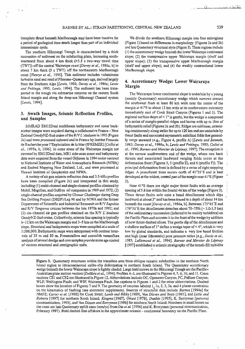
We divide the southem Hikurangi margin into four subregions (Figure 1)based on differences in morphology (Figures 2a and 2b) and late Quatemary structural style (Figure 3). These regions include ( 1) the accretionary wedge beneath the lowerwairarapa continental slope; (2) the transpressive upper Wairarapa margin [shelf and upper slope); (3) the transpressive upper Marlborough margin (shelf and upper slope); and (4) the weakly contractional lower Marlborough slope.
4. Accretionary Wedge: Lower Wairarapa Margin
The Wairarapa lower continental slope is underlain by a young (mainly Quaternary) accretionary wedge which narrows toward the southwest from at least 80 km wide near the center of the margin at 41"s to about 13 km wide at its southwestem extremity immediately east of Cook Strait Canyon (Figures 1 and 3). The regional surface slope of < 1 O is gentle, but the wedge is composed of a series of margin-parallel ridges and basins with up to 1 km of bathymetric relief (Figures 2a and 2b). Ridges are sublinear, extend- ing continuously along strike for up to 120 km and are underlain by thrust faults and associated asymmetric anticlinal folds that general- ly verge seaward (e.g., Figure 4, profile A) [Lavis and Bennert, 1985; Davey et al., 1986a, b; Lewis and Pettinga, 1993; Collot et al., 1996; Barnes and Mercier de Lépinay, 19971. The exception is at the narrow southwestem end of the wedge, where two back thrusts and associated landward verging folds occur at the deformation front (Figures 3 ,5 (profile E), and 6 (profile F)). The principal deformation front is defined by a series of right-stepping ridges. A protothrust zone occurs north of 41'35's and is best developed at the widest, central part of the margin near 41 "S (Figure
Near 41"s there are eight major thrust faults with an average spacing of 5.8 km within the frontal 46 km ofthe wedge (Figure 3). These thrust faults sole. onto a basal décollement which dips landward at about 3" and has been traced to a depth of about 14 km beneath the coast [Davey eral., 1986a, b]. Between 175"45'E and 176'30'E the décollement detaches about 70-75% (- 3.0-3.5 km) of the sedimentary succession (inferred to be mainly turbidites) on the Pacific Plate and accretes it to the front of the wedge by addition of new thrust-faulted slices. The gentle dip of the décollement and a shallow surface of 1 O define a wedge taper of < 4", which is very low by global standards, and indicates a very low basal friction and high (near lithostatic) pore pressure ratios [e.g., Davis et al., 1983; Lallemand et al., 19941. Barnes and Mercier de Lépinay [ 19971 established a seismic stratigraphy of the trench-fill turbidite
3).
Figure 3. Quaternary structures within the transition area from oblique oceanic subduction in the southem North Island region to intracontinental strike-slip deformation in northem South Island. The Quaternary accretionary wedge beneath the lower Wairarapa slope is lightly shaded. Large bold arrows in the Hikurangi Trough are the Pacific- Australian plate motion vectors [DeMets et al., 19941. Protiles A-L are illustrated in Figures 4,5,6, 1 O, and 11. Cross sections CS 1 and CS2 are illustrated in Figure 12. Abbreviations include OC, Opouawe Canyon; PC, Palliser Canyon; WLF, Wellington Fault; and WIF, Wairarapa Fault. See captions to Figures 1 and 2 for other abbreviations. Dashed boxes show the location of Figures 7 and 9. The geometry of canyons labeled 1 la, 2,3,3a, and 4 places constraints on the kinematics of faulting (see electronic supplement). Sources of structural data include Barnes [ 1994al for NMFZ; Carter et al. [ 19881 for Cook Strait; h m b and Bibby [ 19891, Van Dissen and Yeas [ 19911, and Little and Roberts [ 19971 for northern South Island; Kingma [1967], Ghani [1978], Dunkiti [1995], K. Berryman [personal communication, 19951, and Van Dissen and Berryman [ 19961 for southern North Island. Numbers in small boxes on the coast are late Quaternary uplift rates (mrdyr) from Ora et al. [ 19961 and K. Berryman (personal communication, February 1997). Bold dashed line offshore is the approximate oceanic - continental boundary on the Pacit-ic Plate.

2 O
Hikurangi Platea
a i--+-+ Anticline
I--ti Syncline
--'I- Thrust I reverse fault (dashed where inferred from morphology)
-A--LA Prominent protothrust
.A - _ _ _ -, Fault with observed or inferre displacement
Normal Fault with seabed dis, - i i Buried normal fault
Slumpscarp
---b.-/' Canyon axis
/. ".* I.+ Shelf edge
sediment core I dredge sampl
178"
Figure 3.
BARNES ET AL.: STRAIN PARTITIONING, CENTRAL NEW ZEALAND
Upper margin I I Accretionary wedge 4
54 1
SE
2 Hikurangi Trough g 3 z 4
5
6
. . , . .. .. . . . . . . : . . Y. . . I . . .. . . . . .. . J , . : '. 5.0
SE Strike-slip faulted upper margin Accretionary wedge
Pukeroro Ridge
\ 5 km ,
c
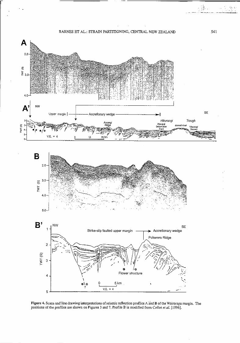
\'. , -
Figure 4. Scans and line drawing interpretations of seismic reflection profiles A'and B of the Wairarapa margin. The positions of the profiles are shown on Figures 3 and 7. Profile B is modified from Collot et al. [ 19961.

E
6-
S Landward vergent folds
--?,E\, LG
. ,
k 6 - '*Back thrusts O 5 l okm '%
-- -- propagatmg decollement -/-----
V.E. = 4
N Upper margin I QAW -1
4 - ' i "I , * , 5 -
Fault 9 Pahaua 1 Fault
Figure 5. Scans and line drawing interpretations of seismic reflection profiles d, D, and E of the Wairarapa margin. The positions of the profiles are shown on Figure 3. T119 is a dredge sample from the Opouawe-Uruti Fault scarp, projected along strike onto profile C. Abbreviations include AST, axial surface trace of fault-propagation folds above thrust faults; BSR; bottom simulating reflector; and QAW, Quaternary accretionary wedge. The following ages have been inferred for the labeled reflectors on profile E [Barnes and Mercier de Lépinuy, 19971: reflector #1, 0.2 Ma; retlector #2,0.4 Ma; retlector #3,0.8 Ma; reflector #4, 2.0 Ma; and reflector #5,5.1 Ma.

QAW - I Upper margin1 F' Fold
N growth strata
3 *fi? 74- =-
Pahaua Fault
4
. A.S.T & a
S
V.E. = 4
O 5 10 km 1 I . I
Hikurangi Channel - -
G
NW O 5 10 km - VE. = 4
trench-fill turbidites
-2,
'I
I I
Pahaua Fault seauences
Figure 6. Scans and line drawing interpretations of seismic reflection profiles F.and G of the southern Wairarapa margin. The positions of the profiles are shown on Figure 3. See caption to Figure 5 for abbreviations. The following ages have been inferred for the labeled reflectors [Bumes und Mercier de Lépinuy, 19971: reflector #1, 0.2 Ma; reflector #2, 0.4 Ma; reflector #3, 0.8 Ma; reflector #4,2.0 Ma; and reflector #5,5.1 Ma.

544 BARNES ET AL.: STRAIN PARTITIONING, CENTRAL NEW ZEALAND
sequence and frontal part of the wedge to analyze the timing and growth of the frontal ridges. Their results show that despite plate convergence obliquity of 50" in the central part of the margin, rapid and efficient frontal accretion has occurred during the late Quaternary with the principal deformation front migrating seaward up to 50 km within the last 0.5 Myr (i.e., at a rate of 100 km/Myr).
5. Transpressive Upper Wairarapa Margin The gently sloping ridge and basin morphology of the accretion-
ary wedge is separated from a steeper (2.5" to 5.0"), upper margin by a discontinuous scarp extending along the middle continental slope typically between 1600 m and 2100 m water depth (Figures 2a and 2b). The upper margin narrows south-westward from about 70 km wide near 41"S, where the continental shelf is about 20 km wide, to 24 km wide off Cape Palliser where the continental shelf is < 4 km wide.
Three NE trending faults', here named the Palliser-Kaiwhata Fault, the Opouawe-Uruti Fault, and the Pahaua Fault, dominate the structure of the upper margin between Cook Strait Canyon and 176'45'E (Figure 3). The Palliser-Kaiwhata Fault underlies the outer continental shelf and the upper continental slope and, is interpreted to be a major strike-slip fault. The Opouawe-Uruti and Pahaua faults underlie the upper and middle continental slope, and both are interpreted to be thrust faults with possible oblique-slip displacement.
5.1. Strike-Slip Palliser-Kaiwhata Fault
The strike-slip Palliser-Kaiwhata Fault extends for at least 160 km from near Cape Palliser to the northeastern end of Uruti Ridge (Figures 3 and 7). South of Cape Palliser the fault projects down the axis of Palliser Canyon, which is an anomalously linear tributary of Cook Strait Canyon and may be structurally controlled. The discontinuous section of the fault between Cape Palliser (175"15'E) and Adams Bank (176'05'E) lies 3-10 km from the coast and extends along the outer continental shelf (e.g., Figure 5, profile D) with an average strike of 063". AtAdams Bank the fault diverges from the shelf, changes strike to an average of OSO", and crosses obliquely the southern end of the large (20 x 40 km) flat- floored Uruti Basin and the uplifted hanging wall block of the Opouawe-Uruti Fault (Figures 3 and 7). Farther northeast the fault projects into the southern end of a zone of complex structural morphology on the upper continental slope behind the accretionary wedge (Figure 4, profiles A and B), which has been attributed to distributed strike-slip faulting [Collot et al., 19961.
Strike-slip displacement on the Palliser-Kaiwhata Fault is indicated by the combination of (1) the significant variation in vertical displacement of the continental shelf along the strike of the fault (Figure 8); (2) variation in the sense of throw (which side of the fault is down thrown) along strike (Figures 3 and 7), indicating that the fault is subvertical (see also Figure 5, profile C) and that the surface of both the northwestern and southeastem blocks has been gently folded; and (3) the occurrence of large-scale pop-up
struchires at Kaukau Bank and Kaiwhata Bank (Figure 7), where shxctural complexity is associated with step over between segments and with changes in strike [e.g., Sjhester, 19881.
5.2. Opouawe-Uruti and Pahaua Thrust Faults I
Both the Opouawe-Uruti and Pahaua thrust faults(see electronic supplement) exhibit a geomorphology that is wellexpressed in the swath bathymetry and side-scan sonar imagery (Figures 2a, 2b, 3, and 7). From these data, together with our seismic profiles, we interpret both faults to dip to the northwest (e.g., Figures 5 (profile C), and 6 (profile F)). In contrast, S. Henrys (personal communi- cation, December 1996) interprets the southern end of the Pahaua Fault on an unpublished seismic profile between lines G and H (Figures 3, 6, and lo), as a'southeast dipping back thrust. The surface traces of the faults are nonlinear, have an average strike of 065", lie about 4-14 km apart, and can be mapped for about 200 km and 180 km, respectively. There is no conclusive (unambiguous) evidence for significant (>300400 m) dextral displacement of several submarine canyons that cross the faults. Because of the morphology and inferred age of the canyons and the resolution of the swath data, however, the data do not negate the possibility of postglacial dextral displacement and/or oblique slip thrusting occurring on these faults at a potential rate of at least several millimeters per year.
The Pahaua Fault separates the rapidly developing Quaternary accretionary wedge (shaded on Figures 1 and 3) from the upper margin [Collot et al.. 1996; Barnes and Mercier de Lépinay, 19971 and thus represents the "active buttress" of von Hicene and Scholl [1991]. That is, it is the dynamic position within the imbricated wedge, seaward of the basement (core) backstop and landward of which there is a decrease in active shortening of frontally accreted trench-fill sediment. The present data do not constrain the litho- stratigraphy of the faulted unit between the Opouawe-Uruti and Pahaua faults. This unit may be composed of deformed slope sedi- ments and/or trench-fill turbidites accreted to the margin during the late Miocene and Pliocene [Lewis, 1985; Chanier et al., 1992; Lewis and Pettinga, 19931.
.
6. Transpressive Upper Marlborough Margin The southern end of the Hikurangi margin near Kaikoura is dis-
sected by numerous submarine canyons, including Kaikoura Canyon and the Kowhai Seavalleys (Figures 2a and 2b) [e.g., Carter et al., 1982; Lewis, 19941. Between the Kowhai Seavalleys and Cook Strait Canyon the slope is divided by a major reverse fault, here referred tqas the Kekerengu Bank Fault, into a transpressively deformed upper margin and a weakly contractional lower margin (Figures 1, 3, 9, IO, and 11) [Lewis, 1980; Lewis and Peftinga, 1993; Collot et al., 1995b, 19961. Two other major fault zones, here referred to as the Upper Slope Fault Zone and the Outer Shelf Fault Zone, dominate the structure of the upper margin. The latter includes strike-slip and oblique-slip structures associated with the offshore extension of the Hope Fault.
I Supporting tcxt discussion and rcfercnces arc available on diskctte or via Anonymous FTP from kosmos.agu.org, directory. APEND(Uscr- namc=anonymous, Password=gucst). Diskette may be ordered by mail from AGU, 2000 Florida Avc., NW, Washington, DC 20009 or by phone at 800-966-2481; $15.00. Payment must accompany order.
6.1. Kekerengh Bank Thrus t Fault
The Kekerengu Bank Fault (see electronic supplement) underlies a steep seaward facing scarp, which has > 1 km of bathymetric relief and dominates the central Marlborough slope (Figures 2 and 9). The fault strikes 045" and extends for at least 70 km from

41" S
A I O nn*
Figure 7.
1

546 BARNES ET AL.: STRAIN PARTITIONING, CENTRAL NEW ZEALAND
10
c
: 2
'Oo
m
i i i j j i I
I
I \
- I -p , . .
o m > - - - - /
3 5 0 % ~ E I qf I \
i / . I ' I . /
SOUTHERNY' ' ~ .\\ SIDE I / i I
. . .
I74'07'E in the Kowhai Seavalleys to where it branches into the Pahaua and Opouawe-Uruti faults at 174'45'E about 20 km west of Cook Strait Canyon. Seismic reflection profiles show that the Kekerengu Bank Fault is uplifting and actively folding the strata northwest of the scarp (e.g., Kekerengu Bank). The structural
' morphology implies that the fault is reverse and dips to the northwest (Figures 10 (profiles H and J), 11 (profiles K and L)) [Lewis and Bennett, 1985; Collot et al., 19961, but the fault tip is blind along some of its length. Southwest of 174'07'E the fault steps over into two seaward vergent structures of similar trend, each about 19 km in length, which deform the slope beneath the Kowhai Seavalleys (Figure 3) [Lewis andpettinga, 1993;Barnes. 1994al. Considering the morphology of several submarine canyons that cross the Kekerengu Bank Fault (see electronic supplement), there is no strong evidence for significant late Quaternary strike- slip motion on the fault. With the present data, however, we cannot resolve any potential dextral offset of < 300 m that could result from oblique-slip displacement.
,
w O m
3 W In' O
' 42'
42'
' S
20- S
Figure 9. Hillshade image of the Marlborough continental margin showing the locations of seismic profiles H-L illustrated in Figures 10 and 11. Location of area is shown on Figures 1, 2, and 3.: Abbreviations include KB, Kekerengu Bank; KBF, Kekerengu Bank Fault; PF, Pahaua Fault; and USFZ, Upper SlopeFault Zone.'Image is illuminated from the northeast.
6.2. Upper Slope Fault Zone
The Upper Slope Fault Zone, lying between the Kekerengu Bank Fault and the edge of the continental shelf, is a 40-km-long, 035"-trending,deformation zone (Figure 3), in which at least two main faults are inferred. The southeastern fault creates a prominent, seaward facing bathymetric scarp (Figures 2b and 9) and is probably a reverse fault dipping to the northwest (e.g., Figures 1 O (profile J) and 1 1 (profile K)). The northwestern fault or faults within the zone appear to be extensional, and their sense of throw varies from down thrown to the southeast at the southern end of the zone (Figure 11, profile L) to down thrown to the northwest near the northeastern end of the zone (Figure 1 1, profile K). These north- western elements deform early Quaternary sediment correlated
Figure 7. Structure of part of the upper Wairarapa margin showing the relationships between the strike-slip Palliser- Kaiwhata Fault, the reverse 0pouawe.-Uruti and Pahaua faults, and the Uruti Basin. Location of area is shown on Figures 1, 2, and 3. Fault symbols are labeled on Figure 3. The swath of MR1 side-scan sonar data illustrates the seabed lineation associated with the Palliser-Kaiwhata Fault trace where ifi'crosses the southwestern end of the Uruti Basin. Profiles B and C are illustrated in Figures 4 and 5. V479 and T1191 are dredge samples used to constrain the seismic stratigraphy (see electronic supplement). Structures shown onshore are late Quaternary folds from Bhani [1978]. Numbers in small boxes on the coast are late Quaternary uplift rates (mm/yr) from K. Berryman (personal communication, February 1997). East of the Pahaua Fault is the Quaternary (approximately < 1 Myr old) accretionary
. wedge. Isobath depths indicated are in kilometers. . .
I
' from the synclinal basin, but they are buried by late Quaternary ' slope sediments and have no trace expressed at the seabed.
6.3. Strike-Slip Outer Shelf Fault Zone
The Outer Shelf Fault Zone is composed of a 1 10-km-long discontinuous structural high incorporating steeply dipping strike- slip faults, oblique-slip reverse faults, and numerous folds. The zone crosses the southwestern end of the Marlborough shelf, extends along the outer shelf between 174'05'E and about 174"30'E, and crosses the upper continental slope between 174'30'E and 175"E (Figure 3). The two major southwestern structural segments are parallel, Gending 070°, and incorporate the immediate offshore section of the strike-slip Hope Fault (Figure 3). In detail, these two offshore structures exhibit repeated geometric changes along

1.0-
5 2.0-
z SE 3.0-
4.0 - - 1.0-
8 s *.O- 30-
-
- 40-
S
O 3km .
I I’ 1 ,
, NW
SE
I
Figure 10. Scans and line drawing interpretations of seismic reflection profiles H, I, and J of the Marlborough margin. Abbreviations include BSR, bottom simulating reflector; KBF, Kekerengu Bank Fault; O S E , Outer Shelf Fault Zone: and USFZ, Upper Slope Fault Zone. The positions of the profiles are shown on Figures 3 and 9.

54á
- 1.0 -
- 5 -
- 2.0-
3.0-
-
1.0-
5. Y
2.0- z
- -q=---->y-
complex folding SE
'O
BARNES ET AL.: STRAIN PARTITIONING, CENTRAL NEW ZEALAND
OSFZ
1.0-
-
2.0-
-
3.0 -I I .+
e I
3.04 -
-t I
KI3 ORF7 L' NW
I

r
BARNES ET AL.: STRAIN PARTITIONING, CENTRAL NEW ZEALAND 549
their strike, both in the facing direction of the fault plane and also in the sense of motion from local areas of extension to local areas of contraction (Figure 3). These observations are consistent with the structural styles documented on other steeply dipping strike-slip faults [e.g., Sylvester, 19881.
At about 174"IO'E these two strike-slip faults project directly along strike into a structural high that extends up the outer continental shelf. The 050°-trending, southern 30 km of this high is characterized by complex folding of late Miocene to early Pleisto- cene strata (e.g., Figures 3 and 1 I (profile L)). Farther northeast between 174" 17'E and 174'30'E the high is controlled by a 22 km- long northwest dipping reverse fault, whose 50- to 70-m-high sea- bed scarp (e.g., Figure IO, profile K) trends 055" (Figure 3). At its northern end this structure changes to a more easterly (085") trend, crossing the upper continental slope as a steeply dippi.ng fault that flowers upward into two, major splays within the core of a symmetrical anticline (Figure 1 O, profile I). Still farther north, the fault swings into a pair of 060"-trending, southeast verging reverse faults and associated asymmetric folds at about 174'45'E (Figure 1 O, profile H).
On the basis of the above variations in three-dimensional structural style the Outer Shelf Fault Zone may be interpreted as a complex strike-slip tectonic zone composed of steeply dipping fault segments trending 070"-085", linking with oblique-slip sections that trend 055"-060". In the northeast the oblique-slip faults project into a very sinuous part of the Cook Strait Canyon and align with the Palfiser Canyon lineation and southwestem end of the strike-slip Palliser-Kaiwhata Fault (Figure 3).
I
7. The Weakly Contractional Lower Marlborough Slope
The lower Marlborough slope domain, between the Kekerengu Bank Fault and the southem Hikurangi Channel, is composed of a gently sloping (1 O f 0.5") terrace lying at a water depth ranging from about 1600 m to 2200-2500 m (Figures 2b and 9). The terrace narrows toward the southwest from about 28 km wide at 174"50'E to zero at 174"E. On the southeastem edge of the terrace, prominent slump scarps flank the Hikurangi Channel (Figures 2,3,9, and I l (profile L)).
Despite thick (> 4 km) trench-fill sediment on the Pacific Plate southeast of the Pahaua and Kekerengu Bank faults, an accretionary wedge typical of the Wairarapa margin is not well developed in this region (Figure 3) [Lewis andPettinga, 1993; Collot et al.. 19961. Beneath the mouth of Cook Strait Canyon (between 175"E and 175'13'E) the southem end of the Pahaua Fault represents the deformation front (Figure 6, profile G). However, southwest of about 175"E, gentle uplift and folding attest to minor contraction of the lower Marlborough margin southeast of the eekerengu Bank Fault. The anticlinal folds beneath the lower margin are asymmetric with steepèr southeastem limbs and are interpreted to be fault propagation folds developing over blind thrust faults (e.g., Figures 3, IO (profile J) and 11 (profile L)). The most prominent of these thrusts is about 60 km long and underlies two discrete anticlines with variable orientations. In contrast to the accretionary wedge to the northeast, one of these folds at 174'30'E trends OXO", almost orthogonal to the regional structure, and imparts a subtle east- west trending fabric to the lower margin morphology (Figures 2b and 3).
8. Discussion 8.1. Strain Partitioning Associated With Oblique Oceanic Subduction Beneath Southern North Island: Strong Coupling of the Pacific and Australian Plates
Our structural observations offshore have implications for the partitioning of geological strain across the entire southem Hikurangi margin. We integrate the offshore results with onshore observations by other workers and discuss the implications for two, boundary- perpendicular transects across the central (transect$ and southern (transect y ) parts of the Wairarapa margin (Figures l a and Ib).
8.1.1. Central Wairarapa transect x. Across transect .Y the NUVEL-IA plate motion vector of 40 m d y r at an azimuth of 083" [DeMers et al., 19941 reduces to components of orthogonal contraction and margin-parallel motion of about 27 mm/yr and 29 mm/yr, respectively (assuming an average plate boundary trend of 040"). Here the obliquity of plate convergence is 48". Barties and Mercier de Lépinay [ 19971 showed that at this latitude, late Quaternary horizontal shortening within the frontal 30 km of the accretionary wedge and the protothrust zone has occurred at a rate of 12 f 3 mm/yr (about 6 km of shortening in about 0.5 Myr), which accounts for 33-55% of the predicted orthogonal contraction across the entire plate boundary. Because these frontal thrusts ramp offthe décollement [Dave), et al., 1986a, b], their displacement must reflect some of the long-term slip across the subduction interplate thrust, which has been imaged beneath North Island as the top of the Benioff zone (Figure 1). The remaining 15 Z!Z 3 mm/ yr of margin-orthogonal shortening could be distributed between additional slip on the subduction thrust and associated upper plate thrusts and reverse faults that ramp off the décollement and contractional faulting occurring entirely within the upper plate.
That the upper plate is shortening behind the accretionary wedge is evidenced by late Quaternary reverse faulting, folding, and associated uplift within the forearc basin onshore close to this transect [e.g., Melhuish, 1990; Lamarche et al., 19951 and also beneath the continental shelf and upper margin offshore [Davey et al., 1986a, b; Lewis andPettinga, 19931. Furthermore, geodetic tri- angulation data for a 50-year period indicate an axis o f maximum horizontal shortening oriented at 110" [Reilly, 19901, which is 27" clockwise of the MJVEL-I A azimuth.As the Benioff zone deepens inland across transect x, there will be a location where the upper plate faults are no longer in contact with the subduction zone, and shortening on such faults will therefore no longer reflect shortening across the interplate thrust (but they would still accommodate a component of the plate motion vector within the plate boundary zone). Melhuish [ 19901 determined a late Quaternary (0.5-0.1 Ma) rate of shortening of'the Dannevirke (forearc) basin (Figure 1) of the order of 3 "/yr. Because this basin lies 30-40 km above the Benioff zone [Ansell and Bannister, 19961, slip on these con- iractional faults within the basin and on any other ieverse faults farther to the northwest, may not reflect slip on the interplate thrust. We infer that 12-24 m d y r of margin-orthogonal shortening occurs on the subduction thrust, 12 f 3 m d y r of which is expressed in the accretionary wedge close to the deformation front.
Whereas most histodcal earthquakes beneath the east coast occur within the subducting Pacific Plate [e.g., Reyners, 1983; Andeisotz and Webb, 19941, thrust earthquakes at the plate interface confirm that the subduction thrust is slipping in this region [Bannister, 1988; Ansell and Bannister, 19961. Webb and Anderson [1998]
.

550 BARNES ET AL.: STRAIN PARTITIONING, CENTRAL NEW ZEALAND
modeled earthquake source parameters and slip vectors, identifying six events of magnitude M>5 from the 14- to 25 km-deep section of the plate interface beneath the Hikurangi margin. The average slip vector is rotated clockwise from the NUVEL-IA azimuth to 1 1 So, close to parallelism with the geodetic axis of maximum hori- zontal shortening, and 12" anticlockwise from trench normal. This is consistent with subduction thrust earthquakes at other obliquely convergent margins, which typically have slip vectors in the range of Oo-40" from trench normal [McCafrey, 1992; Ri et al., 1993; McCafiey and Goldfinger, 19951. If 12-24 mm/yr of the margin- orthogonal shortening occurs on the subduction thrust and if the seismogenic part of the subduction zone ruptures with slip vector, on average, - 12" from plate-boundary normal, then oblique slip in the subduction zone accounts for only 5-6 m d y r of margin-parallel motion. The remaining 23-24 mm/yr of margin-parallel motion must be partitioned into the upper plate.
Across transectx distributed late Quaternary strike-slip faulting within the North Island Dextral Fault Belt (Figure 1) sums to 8.5 m d y r [Beanland, 19951, which leaves a deficit of margin- parallel upper plate motion of 14.5-15.5 mm/yr (50%) (i.e., (23- 24) - 8.5 mm/yr) to be accounted for onshore and offshore east of the North Island Dextral Fault Belt. Beanland [ 19961 inferred from horizontal kinematic modeling of measured late Quaternary uplift and fault-slip rates onshore that up to 10 m d y r ofmargin-parallel motion on transect x results from clockwise rotation of the north- eastern part of the Hikurangi margin as a result of southward diminishing back arc extension rates in northern and central North Island thus leaving a deficit of margin-parallel motion of only 4- 5 "/yr. We considered here that some proportion of the 14.5- 15.5 m d y r not accounted for by oblique slip on the subduction thrust nor by strike-slip displacement within the North Island Dextral Fault Belt could be accommodated offshore ( I ) by right- lateral transpressive faulting beneath the continental shelf [ Urziski and Wood, 19931 and the upper continental slope northeast of the Palliser-Kaiwhata Fault (e.g., at 41"s and 177"E, Figures 3 and 7) [Collot et al., 19961 and (2) by oblique slip on thrust faults within the upper margin and perhaps also within the frontal accretionary wedge [Barnes and Mercier de Lépinay, 19971. Such transpressive deformation has been observed at several other obliquely convergent plate boundaries [Ryan and Coleman, 19921, modeled in laboratory sandbox experiments of oblique convergence [Pinet and Cobbold, 1992; Lallemand et al., 19951, and predicted by numerical models [Braun and Beaumont, 19951.
8.1.2. Southern Wairarapa transecty. Across transect y at the southern end ofNorth Island (Figures 1 and 12), about 150 km south of transectx, the"VEL-1A Pacific-Australian plate motion vector at 175"E and 42"s [DeMets et al., 19941 reduces to 3 1 m d yr margin-parallel motion and 22 m d y r orthogonal convergence. This assumes an average plate boundary trend of 045", based on both onshore and offshore structural trends (Figure I) , together with the orientàtion of the shallow depth (< 25 km) contours on the subducted Pacific Plate [Ansell and Bannister, 19961. Barnes and Mercier de Lépinay [ 19971 showed that both the total amount and the rate of horizontal shortening within the frontal part of the accretionary wedge decrease southwestward toward the southern end of the subduction zone.At the narrow southwestern end of the wedge south of Cape Palliser the two frontal back thrusts and landward vergent folds have accommodated not more than 0.5 km of horizontal shortening at a rate of < 1 m d y r . This implies that
< 5 % of the total plate motion is expressed at the deformation front and that orthogonal contraction of the order of 21 m d y r must be distributed between additional interplate slip on the sub- duction thrust and associated upper plate faulting across the southern end of North Island and beneath the upper Wairarapa margin offshore.
Thrust earthquakes on the plate interface beneath Wellington and Cape Palliser (Figure 1) at depths of about 25 km and 14 km, respectively, indicate that the subduction thrust across transect y is active [Ltro, 1992; Darby and Beanland, 1992; Eberhart-Phillips arid Reyners, 19971. Late Quaternary crustal shortening of the upper plate is indicated by thrust faulting, folding, and uplift both onshore [Ghani, 1978; Berryman et al., 1989; Cape et al., 1990; Clianier et al., 1992; Darby and Beanland, 1992; Grapes and Wellmati, 1993; Dunkin, 19951 and offshore (e.g., Opouawe-Uruti and Pahaua fault, Figure 3, and cross section CSI in Figure 12). Considering the shallow depth of the Benioffzone beneath southern North Island, we assume that all of the upper plate contraction east ofWellington (Figure 1) results from the long term (Quaternary) geological slip on the subduction thrust and the coupling between the two plates. The total rate of horizontal shortening of the upper plate across southern North Island, determined from fault and fold growth rates, is ofthe order of 6-10 "/y (K. Berryman, personal communication, February 1997), which is consistent with prelim- inary Global Positioning System surveying data that suggests that one third to one half of the predicted plate motion is presently béing accommodated onshore [Darby et al., 19951.
Strike-slip displacement within the southern end of the North Island Dextral Fault Belt (Figure 1) sums to 21 * 4 mm/yr [Bean- land, 1995; Van Dissen and Berryman, 19961, which accounts for 5540% of the predicted margin-parallel motion. If all 22 m d y r of orthogonal shortening occurs on the interplate thrust and if the thrust ruptures with a slip vector rotated to - 17" anticlockwise from normal to the plate boundary (i.e., 315"-298") [Webb and Anderson, 19981, then the oblique slip accounts for about 6 m d y r of margin-parallel motion. If this slip occurs independently of the upper plate strike-slip fault displacements, then there would be a deficit of margin-parallel motion of 0-8 m d y r (i.e., 3 1 - ((21 * 4) + 6) m d y r ) not accounted for by oblique slip on the seismogenic part of the subduction thrust nor by strike-slip faulting within the North Island Dextral Fault Belt. In contrast, some or all of the margin-parallel slip Ón the interplate thrust may also contribute to the upper plate strike-slip fault rates if those faults rupture together with part of the interplate thrust, as has been suggested for the M>8 Wairarapa earthquake of 1855, which ruptured the Wairarapa Fault (Figures 3 and 12) [DarbyandBeanland, 19921. In this case the deficit Õf margin-parallel motion could be as high as 14 m d y r (i.e., 31-17 mm/yr). Thus we conclude that there is a range of possible deficit in margin-parallel motion of 0-14 m d y r in right- lateral motion that may occur on faults east of the Wairarapa Fault (Figures 1 and 3).
The Aorangi Range has been interpreted as a large pop-up structure, uplifting at about 2 mñdyr on active reverse faults (Figure 3, and cross section CSI in Figure 12), but no evidence has been documented for dextral motion on these faults [Dunkin, 19951. We infer that some of the deficit in margin-parallel motion is accommo- dated offshore by active strike-slip displacement on the Palliser- Kaiwhata Fault (cross section CSl in Figure 12). Furthermore, we acknowledge the possibility that oblique slip could have occurred

BARNES ET AL.: STRAIN PARTITIONING, CENTRAL NEW ZEALAND
WAIRARAPA CONTRACTIONAL : ACCRETIONARY SE STRIKE-SUP MARGIN 1 (TRANSPRESSIVE?) : WEDGE
(WEAKLY CONTRACTIONAL) . UPPER MARGlN : INW Walmmpa
Fault Palli<er-Kahvhats OpcuawaU~U Pahatie I Aomngi .Fault Faun Fault
St0 Rswe coesul"*:. * COvrr-uen- '
CROSS SECTION CSI I
predwn!nanUy stniceslip tectonics Contractional (and pmbabiytmnspressive on upper Hikurangi margin
Ametionary *e (Quaternary)
Mdbomugh margin + offshore Canterbury
Axla! channel - turbidtte piam
Weak mntinental extension (NW Chatham Rise)
weakly mntracbonal (lower
TRANSPRESSIVE 1 LOWER MARGIN : N M R UPPER MARGIN : CONTRACTIONAL : MTENSIONAL
: DOMAIN : DOMAIN Outer Shelf : Faun &ne. .
Kekerengu Hope Upperslope Kekekgu HIKURANGI : CHATHAM Fault FaultZone FaultZone BankF'uR C-WNEI. : RISE , Coas///na 1 Cover pequenys ,
Chatham } ase Cover
E .Y
B 'D
E
I
E
r r- E
z x
'D I CROSS SECTION CS2
55 1
5 52 BARNES ET AL.: STRAIN PARTITIONING, CENTRAL NEW ZEALAND
on the reverse Opouawe-Uruti and Pahaua faults during the late Quaternary (see electronic supplement), as well as on the frontal thrusts within the southern part of the accretionary wedge [Collot et al., 1996; Barnes and Mercier de Lépitiay, 19971. Oblique-slip reverse faulting (of, say, a few millimeters per year) and associated folding would be difficult to recognize in our offshore data if complex vertical slip partitioning occurred on these faults, with the deeper crustal levels being dominated by dextral motion and the shallow structural levels being dominated by reverse faulting and folding (see cross section CSI in Figure 12) [e.g., Cowan, 1992; Cowan et al., 19961.
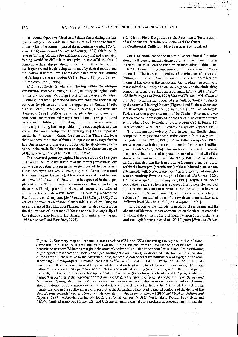
8.1.3. Synthesis: Strain partitioning within the oblique subduction Hikurangi margin. Late Quatemary geological strain within the southern (Wairarapa) part of the oblique subduction Hikurangi margin is partitioned both vertically and horizontally between the plates and within the upper plate [ Walcott, 1984b; Cashnian et al., 1992; Urnski, 1994; Collot et al., 1996; Webb arid Anderson, 19981. Within the upper plate the components of orthogonal contraction and margin-parallel motion are partitioned into zones of folding and thrusting and more than one zone of strike-slip faulting, but the partitioning is not complete, and we suspect that oblique-slip reverse faulting may be an important mechanism in accommodating the plate motion (Figure 12). Note that the above estimates of fault slip represent an average for the late Quatemary and therefore smooth out the short-term fluctu- ations in the strain field that are associated with the seismic cycle of the subduction thrust [Walcott, 1978, 1984bI.
The structural geometry depicted in cross section CS1 (Figure 12) has similarities to the structure of the central part of obliquely convergent Aleutian margin in the westem part of the Andreanof Block [see Ryan and Scholl, 1989, Figure 91. Across the central Hikurangi margin (transectx), at least one third and possibly more than one half of the total plate motion is expressed in the upper plate offshore. This component diminishes southwestward along the margin. The high proportion of the total plate motion distributed across the upper plate results from strong coupling between the Pacific andAustralian plates [Smith et al., 1989;Daq 19921. This reflects the subduction of anomalously thick (10-1 5 km), buoyant oceanic c r k t of the Hikurangi Plateau, which is also expressed in the shallowness of the trench (3000 m) and the low-angle dip of the subducted slab beneath the Hikurangi margin [Davey et al., 1986a, b; Ansell and Bannister, 19961.
8.2. Strain Field Responses to the Southward Termination of a Continental Subduction Zone and the Onset of Continental Collision: Northeastern South Island
South of North Island the nature of upper plate deformation along the Hikurangi margin changes primarily because of changes in the thickness and composition of the subducting Pacific Plate.
8.2.1. Transition to continental subduc4ion beneath Marl- borough. The increasing southward dominance of strike-slip faulting in northeastern South Island reflects the southward increase in crustal thickness of the subducting Pacific Plate, the southward increase in the obliquity of plate convergence, and the diminishing component of margin orthogonal shortening [Bibbx 198 1 ; JValcott, 1984b; Pettinga and Wise, 1994; Holt arid Haines, 1995; Collot et al., 19961. Whereas the subducted slab north of about 42"s makes up the oceanic Hikurangi Plateau (Figures 1 and 3), the slab beneath Marlborough is composed of an upper section of Mesozoic Torlesse terrane greywacke rocks of the Chatham Rise and a lower section of oceanic crust onto which theTorlesse rocks were accreted at the edge of Gondwanaland (cross section CS2 in Figure 12) [Reyners and Cowan, 1993; Eberhart-Phillips andReyners. 19971.
The deformation velocity field in northern South Island, computed from geodetic shear strains derived from 100 years of triangulation data [Bibby, 1981; Falcott, 1984b; Bibby etal.. 19861, agrees closely with the plate motion model for the last 3 million years [DeMets et al., 19941. This has been interpreted to indicate that the subduction thrust is presently locked and that all of the strain is occurring in the upper plate [Bibby, 1981; Walcott, 1984bI. Earthquakes defining the Benioff zone (Figures 1 and 12) occur within the lower part (oceanic crust) of the subducted plate and are extensional, with NW-SE oriented 7' axes indicative of downdip tension resulting from the weight of the slab [Robinson, 1986, 199 1; Eberhart-Phillips and Reyners, 19971. Despite > 200 km of subduction in the past there is an absence of instrumentallyrecorded thrust earthquakes on the continental-continental plate interface (cross section CS2 in Figure 12), and there is no seismological evidence for reestablishment of a new detachment surface at a different level [Eberhart-Phillips and Reyners,'1997].
In addition to the short-term geodetic shear strains and the absence of historical thqust earthquakes on the plate interface the geological shear strains derived from inversion of faults slip rates and rock uplift over a period of 103-104 years [Holt and Haines,
~~
Figure 12. Summary map and schematic cross sections (CSI and CS2) illustrating the regional styles of three- dimensional structure and inferred kinematics within the transition area from oblique subduction of the Pacific Plate beneath the southern Wairarapa margin to the onset of continental collision in northern South Island. The partitioning of geological strain across transects y andz (see location; also on Figure I ) are discussed in the text. Vectors of motion of the Pacific Plate relative to the Australian Plate, reduced to components (in millimeters) of margin-orthogonal shortening and margin-parallel motion, are from DeMets et al. [1994]; PB is the average orientation of the plate boundary; PDF is the orientation of the principal deformation front at the toe of the accretionary wedge. Numbers within the accretionary wedge represent estimates of horizontal shortening (in kilometers) within the frontal part of the wedge southeast of the dashed line up the center of the wedge (the deformation front about 1 Myr ago), whereas numbers in brackets at the deformation front are late Quaternary rates of orthogonal shortening [from Barnes and Mericer de Lépinay,1997]. Bold solid arrows are speculative average slip directions on the major faults in different structural domains. Solid arrows in the northeast offshore are with respect to the Pacific Plate fixed; Dashed arrows mainly onshore in the southwest are with respect to the Australian Plate fixed. Selected contours of the depth of the Benioff zone beneath North and South islands are data from Ansell and Bannister [ I9961 and Eberharf-Phillips and Reyners [1997]. Abbreviations include ECR, East Coast Ranges; NIDFB, North Island Dextral Fault Belt; and NMFZ, North Mernoo Fault Zone. CSl and CS2 are schematic crustal cross sections at approximately true scale.

L ~. 7'' L' .. :...i--. A S A '*.J., ~ ~ , ~ , ~ ~ - . - , . , ~ ~ . ~ , ~ - ~ ~ ~ .
BARNES ET AL.: STRAIN PARTITIONING, CENTRAL NEW ZEALAND 553
19951 indicate that during the late Quatemary the major strike-slip faults in the Marlborough Fault System have accommodated 80- 100% of the total plate motion. This raises the question ofwhether the subduction thrust beneath Marlborough has been active at all throughout the late Quatemary or whether all of the required plate motion during this time has been progressively transferred from the subduction zone beneath southemNorth Island and Cook Strait into the continental rocks of the South Island via the Marlborough Fault System.
The offshore data confirm that the classical accretionary wedge beneath the lower Wairarapa margin essentially narrows to zero directly south of Cape Palliser, despite a thick trench-fill succession east ofMarlborough (Figures 3 and 12) [Collot et al., 19961. Instead, the Marlborough margin is composed of a relatively narrow belt dominated by transpressive structure (including the Outer Shelf Fault Zone). Collot et al. [ 19961 considered the absence of a large accretionary wedge indicated that the subduction décollement beneath Marlborough may have been locked throughout the depo- sition of the trench-fill turbidite sequence, which we estimate strati- graphically to be at least 5 i 1 Myr old (Figure 6, profile G). If this were so, the 100-200 km ofrequired plate convergence during this period would have been accommodated by the southwestward motion of the Pacific Plate via the Marlborough strike-slip faults into the Southem Alps collision zone.
There is, however, some contraction being accommodated on the reverse Kekerengu Bank and Pahaua faults, which represent the principal deformation front on the eastern Marlborough margin, and also on thrust faults south of the Kekerengu Bank Fault (Figure 3). Whether or not the Quaternary growth of these faults results from active interplate slip depends on whether or not they flatten at depth onto the intracontinental subduction décollement (cross section CS2 in Figure 12). If the subduction thrust is no longer active, then these reverse faults together with the upper margin strike-slip faults might penetrate through the now inactive sub- duction interface into the subducted crustal rocks of the north- western Chatham Rise and need not flatten onto the former detachment (cross section CS2 in Figure 12).
8.2.2. Onset of continental collision. Offshore, surface deformation of Pacific Plate continental crust occurs south of about 42"30'S, where the thrust faults on the southernmost Marlborough margin interact with two other fault systems over the southem end of thestructural trench (Figure 1). This complex structural junction coincides with a cluster of recorded earthquakes less than 15 km deep [Anderson and Webb, 1994; Cowan et al., 19961 and approxi- mately with the southem extent of deep seismic activity within the Benioff zone (dashed line between Westport and Cheviot, in Figure 1). It also coincides approximately with the NW-SE trending Kaikoura Canyon (Figures 1 and 3), which may be structurally controlled.
Deformation of the continental Pacific Plate in this region takes two forms, each with a different kinematic implication: (1) extension * of the northwestern Chatham Rise margin by normal faulting within the North Mernoo Fault Zone (NMFZ) (Figures 1 and 3) [Lewis et al., 1986; Barnes, 1994al and (2) shortening of the north Canterbury coastal margin by thrust faulting and folding [Nicol, 199 1; Barnes, 19961. The NMFZ is a large (100 x 300 km) region of east-west trending, mainly southward dipping, basement-involved normal faults (Figures 1 and 3). The east-west geometry of the zone partly reflects a strong degree of structural inheritance from two previous phases of extension of the crust [Barnes, 1994bl. Recent activity
as far west as 174'50'E is evidenced by subsurface displacement of late Quatemary stratigraphic units, by widespread seabed fault scarps, and by sparse earthquakes throughout the region. The bathymetry of the slope (Figure 2b), however, reflects nothing of the deformation but instead relates to Quaternary processes of sedimentation and current erosion [Barnes, 1994~1.
Barnes [ 1994al showed that the extensional strain in the NMFZ is small (< 3% over 1 O0 km since the mid-Pliocene) and considered that the faulting could be a response to continental flexure of the Chatham Rise crust into the southern end of the subduction zone [Lewis et al., 19861. The fact that a small amount of extension has continued throughout the Plio-Pleistocene, while transpressive deformation in northeastern Marlborough was evolving, indicates that the NMFZ plays a negligible role in the collision process and in the transfer of plate motion from the Hikurangi margin to the Alpine Fault system (Figure 1). Only in the northwestern comer of the NMFZ at 42"45'S and 174"E, where two late Quatemary thrust faults of the lower Marlborough margin domain occur in an area that was previously extending in the late Pliocene-early Pleisto- cene (Figure 3) [Barnes, 1994a1, is there clear evidence for a recent reversal from extensional to contractional tectonics. This over- printing coincides with the southward migration of the major strike- slip faults in the Marlborough Fault System [e.g., Campbell, 1991; Cowan, 1992; Cowan et al., 19961.
Whereas the initial onset of oblique continental collision occurs in northeastern Marlborough contemporaneously with flexure and extension of the northwestern Chatham Rise, it is in the north Canterbury region, west of the NMFZ and south of the Hope Fault (Figure 1). where the onset of deformation of Pacific Plate crust entering the alpine collision zone occurs [e.g., Nicol, 1991; Reyners and Cowan, 1993; Barnes, 1996; Cowan et al.. 19961. Transpressive structures of the Porters Pass - Amberley Fault Zone are prominent in the eastern foothills of the Southern Alps (Figure l), whereas NE-SW trending, mainly NW verging folds and thrust faults dominate beneath the coastal ranges and offshore continental shelf. It has been proposed (1) that the crust is delami- nating, with the upper crustal deformation decoupled from the lower crust entering the collision zone [ Wellman, 1979; Nicol, 199 1; Cowan, 1992; Reyners and Cowan, 1993;Pettinga und Wise, 19941, and (2) that NW-SE shortening in north Canterbury at a rate of about 6 m d y r accounts for a significant component of the plate boundary-perpendicular shortening predicted from reduction of the plate motion vector [Nicol, 19911. Thus the upper part of the Pacific Plate in the north Canterbury coastal region is shortening in response to strain partitioning across the obliquely convergent northern South Island, whereas the northwestern Chatham Rise, still lying outside of the collision zone, is extending, possibly because of continental flexure, at the southern end of the now inactive or very strongly coupled subduction zone.
9. Synthesis 1. In the northeastem South Island and southeastern North
Island region of New Zealand the late Quatemary deformation styles of various domains indicate a complex partitioning of strain within the transitton zone from oblique subduction to oblique continental collision.
2. On the oblique-subduction southeastem Wairarapa offshore margin the southwestward narrowing, rapidly developing, frontal accretionary wedge of mainly Quaternary age lies in thrust contact
~
554 BARNES ET AL.: STRAIN PARTITIONING, CENTRAL NEW ZEALAND
with a steeper, dissected, actively deforming upper margin that is dominated by three major late Quatemary faults. The most landward of these is the Palliser-Kaiwhata Fault, which lies close to the eastern exposure of Mesozoic basement rocks at the southeastem corner of North Island, and is interpreted to be a major dextral strike-slip fault responsible for high rates of coastal uplift. The Pahaua thrust fault represents the active buttress within the back of the accretionary wedge and together with the Opouawe-Uruti thrust fault deforms upper slope sequences and possibly older accreted rocks behind the actively developing wedge.
3. Compilation of late Quaternary geological strain in a transect across the central Hikurangi margin, combined with seismological data of Webb and Anderson [ 19981, suggests that the subduction thrust accounts for not more than 20% of the margin-parallel motion predicted from the NUVEL- IA plate motion vector. At least one third and possibly more than one half of the total plate motion is expressed in the upper plate offshore. This could include margin- parallel motion on strike-slip and oblique-slip reverse faults, potentially of 0-14 m d y r offthe southeast comer ofNorth Island and up to a maximum of 14.5-15.5 mm/yr beneath the central part of the margin between 40" and 41"s. The wide distribution of upper plate deformation reflects strong coupling between the sub- ducted oceanic Hikurangi Plateau and the overriding plate.
4. The accretionary wedge terminates south of Cape Palliser, approximately over the transition zone from oceanic to continental crust of the subducted Pacific Plate. The upper Marlborough margin off the northeastern coast of South Island is dominated by trans- pressive structures, including the newly described Outer Shelf Fault Zone. This tectonic zone encompasses the offshore extension of the Hope Fault and appears to merge into the southwestern con- tinuation of the Palliser-Kaiwhata Fault. This zone contributes to the transfer of relative plate motion from the oblique subduction Hikurangi margin into the northern end of the continental conver- gence zone in northern South Island. The upper margin is separated from a weakly deforming lower margin by the reverse Kekerengu Bank Fault, which merges into the Pahaua Fault to the northeast and into distributed folds and thrust faults developing over the southern end of the trench.
5. It is questionable whether or not the intracontinental subduction thrust beneath Marlborough has been active during the late Quaternary. The late Quaternary growth of thrust faults on the margin, including the Kekerengu Bank Fault, could reflect contemporaneous slip on the subduction zone if the faults flatten at depth onto the décollement (as major faults are inferred to do onto the oceanic-continental interface beneath the southeastem
References Abers, G.A., and R. McCaffrey, Active arc-
continent collision: Earthquakes, gravity anomalies, and fault kinematics i n the Huon-Finisterre collision zone, Papua New Guinea, Tectonics, 13, 227-245, 1994.
Anderson, H., and T. Webb, New Zealand seismicity: Patterns revealed by the up- graded National Seismograph Network, N. Z. J. Ceo[ . Geciphys., 37, 477-493, 1994.
Anderson, H., T. Webb, and J. Jackson, Focal mechanisms of large earthquakes in the South Island, New Zealand; Implications for the accommodation of Pacific-Aus- tralia plate motion, Geophys. J. fnt., 125, 1032-1054. 1993.
Wairarapa margin). If this were the case, the subduction zone must be very strongly coupled because the component of margin- orthogonal shortening accommodated on the offshore margin is unlikely to represent more than a few millimeters per year, and the onshore structures are predominantly strike-slip. If, however, the subduction interface has not been active during the late Quatemary and the late Quaternary thrust faults on the slope root either in the Mesozoic greywacke crust of the subducted Chatham Rise or in the overriding crust, then the shortening accommodated by the offshore structures may represent partitioning of the margin- perpendicular contractional component of the plate motion vector.
6. Whereas the initial onset of continental collision occurs in northeastern Marlborough, the surface expression of deformation of the Pacific Plate entering the collision zone occurs south of 42"30'S, where mainly NW verging folding and thrust faulting of the north Canterbury coastal region, south of the Hope Fault, is a response to crustal delamination and partitioning 'of NW-SE contractional strain outside of the strike-slip Marlborough Fault System. In contrast, to the east, active normal faults of the North Mernoo Fault Zone on the northwestern comer of the Chatham Rise accommodate minor extension, possibly in response to continental flexure, at the southern end of the subduction zone. The complex junction between the SE vergent lower Marlborough fold-thrust domain, the NW vergent north Canterbury shelf fold- thrust domain, and the extensional North Mevoo Fault Zone coincides with the southern extent of the structural trench and approximately with the southem extent of deep seismic activity in the subducted Pacific Plate.
Acknowledgments. We thank the New Zealand Foundation for Research Science and Technology, INSU, and the French Ministry of Foreign Affairs for funding, IFREMER for providing R/V I'Atulante ship time and equipment, and the officers, technicians and crews on the L'Atulunte and Giljunes Geodynz-south cruises, and on the Department of Scientific and Industrial Research cruises 201 9, 2022, 2034, and 2055. P. Barnes thanks the Director and Jean Delteil at Géosciences Azur for facilities and hospitality during study leave in 1994-1 995. J.-Y. Collot thanks ORSTOM for supporting collaborative work in New Zealand. Thanks go to the late Sara Beanland, and to John Haines, Keith Lewis, Martin Reyners, Helen Anderson, and Jarg Pettinga for discussions about the data and interpretations. Graeme Mackay, Richard Garlick, Peter Bennett, and Matt Dell assisted with production of the figures. Tony Edwards performed the biostratigraphic analyses. The manuscript was improved after reviews by Kelvin Berryman, Jarg Pettinga, Keith Lewis, Marc-André Gutscher and Paul Mann.
morphology of the subducted plate along the Hikurangi margin, New Zealand, Phys. E(irth Planet. Infect 93. 3-20, 1996.
Arabasz, W.J., &id R. Robinson, Micro- seismicity and geological structure in the northern South Island, New Zealand, N. 2. J. Ceol. Ceophys., 19, 569-601, 1976.
Aubouin, J., The west Pacific geodynamic model, Tectoncipphysics, 183, 1-7, 1990.
Ballance, P.F., The New Zealand Neogene forearc basins, in Sedimentury Busins of the World, vol. 2 , South Pucific Sedi- mentury Busins, edited by P.F. Ballance, pp. 177-193, Elsevier Sci., New York, 1993.
structure in the Hawkes Bay region, New Zealand: Fine structure of the subducting Pacific Plate. Geophys. J. fnt., 95, 45- 62, 1988.
Barnes, P.M., Continental extension of the Pacific Plate at the southern termination of the Hikurangi subduction zone: The North Mernoo Fault Zone, offshore New Zealand, Tectanics, 13, 735-754, 1994a.
Barnes, P.M., Inherited structural control from repeated Cretaceous to Recent exten- sion in the North Mernoo Fault Zone, western Chatham Rise, New Zealand, Tectonciphysics, 237, 27-46, I994b.
Barnes, P.M.. Pliocene-Pleistocene deoo-
\
Ansell, J.H., and S.C. Bannister, Shallow Bannister, S., Microseismicity and velocity sitional units on the continental slope off
I C
1.. ' . . Y ' . !?.IO , , , . . . . . . . .- .. . ,_ _, , :q.-*;'k~81.?.*.;&-L. .&i&2i.LL.2A.iL
BARNES ET AL.: STRAIN PARTITIONING, CENTRAL NEW ZEALAND 555
central New Zealand: Control by slope currents and global climate cycles, Mur: Geol., 127, 155-175. 1994~.
Barnes, P.M., Active folding of Pleistocene unconformities on the edge of the Australian-Pacific plate boundary zone, offshore North Canterbury, New Zealand, Tectonics. 15, 623-640, 1996.
Barnes, P.M., and B. Mercier de Lépinay, Rates and mechanics o f rapid frontal accretion along the very oblique1 convergent south- ern Hikurangi margin, New Zealand, J. Geaphys. R e s , 102, 24.93 l-24,952, 1997.
Beanland, S., Role of the North Island Shear Belt in the Hikurangi Margin, paper pre- sented at New Zealand Geophysical Society Symposium, N. Z. Geophys. Soc., Wellington, 1995.
Beanland, S., A kinematic model of active deformation in the North Island, New Zealand, determined from geological strain rates, paper presented at New Zealand Geophysical Society Symposium, N. Z. Geophys. Soc., Wellington, 1996.
Berryman. K.R., Late Quaternary movement on the White Creek Fault, South Island, New Zealand, N. Z J. Geol. Geciphys., 23,
Berryman, K.R., and S. Beanland, Ongoing deformation of New Zealand: Rates of tectonic movement from geological evi- dence, Tmns. Inst. Prc$ Eng. N. Z., 15,
Berryman, K.R., Y. Ota, and A.G. Hull, Holo- cene paleoseismicity in the fold and thrust belt of the Hikurangi subduction zone, eastern North Island, New Zealand, Tec- tonophysics, 163, 185-195, 1989.
Bibby, H.M., Geodetically determined strain across the southern end of the Tonga- Kermadec-Hikurangi subduction zone, Geophys. J. R. Astron. Soc., 66, 513- 533, 1981.
Bibby, H.M., A.J. Haines, and R.I. Walcott, Geodetic strain and the present day plate boundary through New Zealand, Bull. R.
Braun, J.. and C. Beaumont, Three-dimen- sional numerical experiments of strain partitioning at oblique plate boundaries: Implications for the contrasting styles in the southern Coast Ranges, California, and the central South Island, New Zealand, J. Geophys. Res., 100, 18,059-18,074. 1995.
Campbell, J.K., Styles of deformation associated with the Marlborough Fault System, in Structural Trunsition From Alpine Fuult to Hikurungi Murgin in Spuce und Time, Misc. Publ. 56, pp.10-13, Geol. Soc. of N. Z., Lower Hutt, 1991.
Cape, C.D., S.H. Lamb, P. Vella, P.E. Wells, and D.J. Woodward, Geological structure of Wairarapa Valley, New Zealand, from seismic reflection profiling, J. R. Soc. N.
Carter, L., R.M. Carter, and G.B. Griggs, Sedimentation in the Conway Trough, a deep near-shore marine basin at a junction of the Alpine transform and Hikurangi subduction plate boundary, New Zealand,
93-101, 1980.
25-34, 1988.
SOC. N. Z . . 24, 427-438, 1986.
Z., . 20, 85-105, 1990.
Carter. L., K.B. Lewis, and EJ. Davey, Faults in Cook Strait and their bearing on the structure of central New Zealand, N. Z. J. Geol. Geophys., 31, 43 1-446, 1988.
Cashman. S.M.. H.M. Kelsey. C.F. Erdman, H.N.C. Cutten, and K.R. Berryman, Strain partitioning between structural domains in the forearc of the Hikurangi subduction zone. New Zealand, Tectonics, II. 242- 257. 1992.
Chanier. F., and J. Ferriere, From a passive to an active margin: Tectonic and sedimen- tary processes linked to the birth of an accretionary prism (Hikurangi margin, New Zealand), Bull. Soc. Geol. Fr.. 162,
Chanier, F., J. Ferriere, and J. Anglier, Exten- sion et érosion tectonique dans un prisme d'accrétion: L'exemple du Prisme Hiku- rangi (Nouvelle Zélande), C.R. Acud. Sci., Se: II . 315. 741-747, 1992.
Chemenda, A.I., M. Mattauer, and A.N. Bokun, Conti-nental subduction and a mechanism for exhumation of high-pres- sure metamorphic rocks: New modeling and field data from Oman, Eurth Planet. Sci. Lett., 143, 173-182, 1996.
Collot, J.-Y., J. Delteil, R.H. Herzer, R. Wood, K.B. Lewis, and Shipboard Party, Sonic imaging reveals new plate boundary struc- tures offshore New Zealand, Eos Truns.,
Collot, J.-Y., J. Delteil, K. Lewis, and I'equipe scientifique, De la fosse de Kermedec a la termi-naision sud du fosse d'Hikurangi: Resultat de la campagne de cartographie multi faisceaux GEO-DYNZ-SUD,Leg I , C.R. Acud. Sci., Se: II, 320. 295-302, 1995b.
Collot, J.-Y., et al., From oblique subduction to intra-continental transpression: Struc- tures of the southern Kermadec-Hiku- rangi margin from multibeam bathymetry, side-scan sonar and seismic reflection, Mar . Geophys. Res., 18, 357-381, 1996.
Cowan, H.A., Structure, seismicity and tec- tonics of the Porter's Pass-Amberley Fault Zone, North Canterbury, New Zea- land, Ph.D thesis, Univ. of Canterbury, Christchurch, New Zealand, 1992.
Cowan, H.A., A. Nicol, and P. Tonkin, A comparison of historical and paleo- seismicity in a newly formed fault zone and a mature fault zone, North Canterbury, New Zealand, J. Geophys. Res. , 101,
Curray, J.R., The Sunda arc: A model for oblique plate convergence, Neth. J. Seu Res., 24. 131-140, 1989.
Darby, D.J., and S. Beanland, Possible source models for the 1855 Wairarapa earth- quake, New Zealand, J. Ge~phys . Res., 97,
Darby,-D.J., J. Beaven, W. Welsch, and R. Hollmann, The emergence of a defor- mation signal from GPS surveys of the Wellington and Wairarapa. regions, paper presented at New Zealand Geophysic41 Society Symposium, N. 2. Geophys. Soc., Wellington, 1995.
Davey, F.J., M. Hampton, J. Childs, M.A. Fisher, K.B. Lewis, and J.R. Pettinga,
649-660, 199 I.
76, 1, 4-5, 1995a.
6021-6036, 1996.
12,375-12,389, 1992.
Serlimentol~~gy, 29, 475-497, 1982. Structure of a growing accretionary prism,
Hikurangi margin, New Zealand, Geology, 14. 663-666, 1986a.
Davey, F.J., K.B. Lewis. J. Childs, and M. Hampton, Convergent margin off the east coast of North Island, New Zealand, Parts I and I I , i n Seisrnic 1muge.s (if Modern CoriverSyent Mar,qin Tectonic Structure, edited by R.E. von Huene, AAPG Stud. Geol., 26, 49-53, 1986b.
Davis, D., J. Suppe, and EA. Dahlen, Mechan- ics of fold and thrust belts and accretionary wedges, J. Gecip11y.s. Res., 88, 1253-1272, 1983.
Davy, B.W., The influence of subducting plate buoyancy on subduction of the Hiku- rangkchatham Plateau beneath the North Island, New Zealand, in Advances in the ,yeology und gecip11ysic.s of the continental inurgiti, AAPG Mem., 53, 75-92, 1992.
Davy, B.W, and R. Wood, Gravity and niagnctic modeling o f thc Hikurangi Platcau, Mat: Geol., 1.28, 139-151, 1994.
Delteil, J., H.E.G. Morgans, J.I. Raine, B.D. Field, and H.N.C. Cutten, Early Miocene thin-skinned tectonics and wrench faulting in the Pongaroa district, Hikurangi margin. North Island, New Zealand, N. Z. J. Geol. Geophys., 39, 211-282, 1996.
DeMets, C., R.G. Gordon, D.F. Argus, and S. Stein, Effect of recent revisions to the geoinagnetic reversal time-scale on esti- mates of current plate motions, Geophys. Res. Lett., 21, 2191-2194, 1994.
Dunkin, D.M.A., Active range front thrusts and uplift of the Aorangi Mountains, MSc thesis, Victoria Univ. of Wellington, Wellington, New Zealand, 1995.
Eberhart-Phillips, D., and M. Reyners, Continental subduction and three- dimensional crustal structure: The north- ern South Island, New Zealand, J. Geophys. Res., 102, 11,843-11,861, 1997.
Fitch, T.J., Plate convergence, transcurrent '
faults and internal deformation adjacent ' to southeast Asia and the Western Pacific, J. Geophys. Res., 77, 4432-4460, 1972.
Forsyth, D.W., Fault plane solutions and tectonics of the South Atlantic and Scotia Sea, J. Geophys. Res., 80, 1429-1443, 1975.
Geist, E.L., J.R. Childs, and D.W. Scholl, The origin of summit basins of the Aleutian Ridgq: Implications for blo,ck rotation of an arc massif, Tecronics. 7, 327-341, 1988.
Ghani, M.A., Late Cenozoic vertical crustal movements in southern North Island, New Zealand, N. Z. J. Geol. Getiphys., 21, 117- 125, 1978.
Grapes, R., and H. Wellman, Field guide to the Wharekauhau Thrust (Palliser Bay) and Wairarapa Fault (Pigeon Bush), Misc. Publ. 798, pp. 27-44, Geol. Soc. of N. Z., Wellington, 1993.
Hamburger, M.W., and B.L. Isacks, Deep earthquakes in the Southwest Pacific: A tectonic interpretation, J. Geriphys. Res.,
Henrys, S.A., EJ. Davey, and B. O'Brien, Crustal structure of the southern Hikunngi subduction zone: Chatham Rise to Marl- borough, paper presented at New Zealand Geophysical Society Symposium, N. Z. Geophys. Soc., Wellington, 1995.
92, 13,841-13.854, 1987.
556 BARNES ET AL.: STRAIN PARTITIONING, CENTRAL NEW ZEALAND
Holt, W.E., and A.J. Haines, The kinematics of the northern South Island, New Zea- land, determined from geologic strain rates, J . Ceophys. Res., 100, 17.99 1- 18,O 1 O, 1995.
Jarrard, R.D., Terrane motion by strike-slip faulting of forearc slivers, G e o h g y , 14,
Kingma. J.T., Sheet 12, Wellington ( I ” ‘ Ed.), Geo/og icu / M a p of’ New Zetrltind 1:250,000, Department of Scientific and Industrial Research, Wellington, 1967.
Kneupfer. P.L.K.. Temporal variations in latest Quaternary slip across the Aus- tralian-Pacific plate boundary, north- eastern South Island, New Zealand, Tec- tonics, II, 449-464, 1992.
Lallemand, S., P. Schnurle, and J. Malavieille, Coulomb theory applied to accretionary and non-accretionary wedges: Possible causes for tectonic erosion andlor frontal accretion, J . Geophys. Res., 99, 12,033- 12,055, 1994.
Lallemand, S.E., K. Lewis, R. Meftahi, and J.-Y. Collot, Oblique seamount subduction: New insights from sandbox modeling and application to the Hikurangi subduction zone, paper presented at New Zealand Geophysical Society Symposium, N. Z. Geophys. Soc., Wellington, 1995.
Lamarche, G., S. Beanland, and J. Ravens, Deformation style and history of the Eke- tahuna region, Hikurangi forearc, New Zealand, from shallow seismic reflection data, N. Z. J . Geol. Geophys., 38, 105- 125, 1995.
Lamb, S., Tectonic rotations about vertical axes during the last 4 Ma in part of the New Zealand plate-boundary zone, J . Strucf. Ceol., IO. 875-893, 1988.
Lamb, S., and H. Bibby, The last 25 Ma of rotational deformation in part of the New Zealand plate boundary zone, J . Struct. Geol., 12, 473-492, 1989.
Lewis, K.B., Erosion and deposition on a tilting continental shelf during Quatern- ary oscillations of sealevel, N. 2. J. Geol. Geophys., 16, 281- 301, 1973.
Lewis, K.B.. Quaternary sedimentation on the oblique-subduction and transform margin, New Zealand, in Sedimentation in Oblique S l i p Mobile Zones, edited by P.F. Ballance and H.G. Reading, Spec. Pub¿., Int. Assoc. Sedimenrol., 4 , 171-189, 1980.
Lewis, K.B., New rock samples and cores from Hikurangi Margin geology cruise
. 1221, in New Seismic Profiles, Cores und Dated Rocks Q o m the Hikurangi Margin, New Zealand, compiled by K.B. Lewis, Field Rep., 22, pp. 37-49, N. Z. Oceanogr. Inst., Wellington, 1985.
Lewis, K.B., The 1500-km-long Hikurangi Channel: Trench-axis channel that escapes its trench, crosses a plateau, and feeds a fan drift, Ceo Mur. Lett., 14, 19-28, 1994.
Lewis, K.B., and D.J. Bennett, Structural patterns on the Hikurangi margin: an interpretation of new seismic data, in New Seismic Projïles, Cores und Duted Rocks From the Hikurungi Murgin, New Zeulmd, compiled by K.B. Lewis, Field Rep., 22, pp. 3-26, N. Z. Oceanogr. Inst., Welling- ton, 1985.
780-783, 1986.
Lewis, K.B., and J.R. Pettinga, The emerging, imbricated frontal wedge of the Hikurangi margin, in South Pacif ic Sedimentury Busins, edited by P.F. Ballance, Sedimen- tary basins of the world, 2, pp. 225-250, Elsevier Sci., New York.1993.
ewis, K.B., D.J. Bennett, R.H. Herzer, and C.C. von der Borch, Seismic stratigraphy and structure adjacent to an evolving plate boundary, western Chatham Rise, New Zedand, Initiul Rep. Deep Seu Drill. Proj.,
ewis. K., L. Carter, and F. Davey, The opening of Cook Strait: Interglacial tidal scour and aligning basins at a subduction to transform plate edge, Mar. Geol., 126,
Little, T. A., and A.P. Roberts, Distribution and mechanism of Neogene to present- day vertical axis rotations, Pacific-Aus- tralian plate boundary, South Island, New Zealand, J . Geophys. Res.. 102, 20,447- 20.468, 1997.
Luo, X., Subduction interface and crustal structure in the Cape Palliser region, North Island, New Zealand, from observations of Cape Palliser earthquakes, N. Z. J. Geol. Geophys.. 35, 491-499, 1992.
Masson, D.G., and K.M. Scanlon, The neo- tectonic setting of Puerto Rico, Geol. Soc. Am. Birll. . 103, 144-154, 1991.
McCaffrey, R., Oblique plate convergence, slip vectors, .and forearc deformation, J. Geo- phys. Res., 97, 8905-8915, 1992.
McCaffrey, R., and C. Goldfinger, Forearc deformation and great subduction earth- quakes: Implications for Cascadia offshore earthquake potential, Science, 267, 856- 859, 1995.
McKenzie, D., and J.A., Jackson, The relationship between strain rates, crustal thickening, paleomagnetism, finite strain and fault movements within a deforming zone, Eurth. Planet. Sci. Left., 65, 182- 202,1983.
Melhuish, A., Late Cenozoic deformation along the Pacific-Australian plate margin, Dannevirke region, New Zealand, M.Sc thesis, Victoria Univ. of Wellington, Well- ington, New Zealand, 1990.
Molnar, P., and W.-P. Chen, Seismicity and mountain building, in Mounfuin Euilding Processes, edited by U. Briegel and K.J. Hsu, p. 41-57, Academic, San Diego, Calif., 1982.
Nicol, A., Structural styles and kinematics of deformation on the edge of the New Zealand plate boundary zone, mid Waipara region, north Canterbury, Ph.D thesis, Univ. of Canterbury, Christchurch, New Zealand, 1991.
Nicol, A., H. Cqwan, J. Campbell, and J. Pettinga, Folding and the development of small sedimentary basins along the New Zealand plate boundary, Tectonophysics,
Norris, R.J., P.O. Koons, and A.F. Cooper, The obliquely-convergent plate boundary in the South Island of New Zealand: Implications for ancient collision zones, J . Sfruct. Geol.. 12. 715-725, 1990.
Ota, Y., P. Pillans, K. Berryman, A. Beu, T. Fujimori, T. Miyauchi, and G. Berger,
90, 1325-1327, 1986.
293-312, 1994.
241, 47-54, 1995.
Pleistocene coastal terraces of Kaikoura Peninsula and the Marlborough coast, South Island, New Zealand, N. Z. J. Geol. Geophys., 39, 51-74, 1996.
Pettinga, J.R., and D.U. Wise, Paleostress adjacent to the Alpine Fault: Broader implications from fault analysis near Nelson, South Island, New Zealand, J. Geophys. Res., 99. 2727-2736, 1994.
Pinet, N., and P.R. Cobbold, Experimental insights into the partitioning of motion within zones of oblique subduction, Tec- totiophysics, 206, 371-388, 1992.
Reilly, W.I., Horizontal crustal deformation on thc Hikurangi margin, N .Z. J. Geol. Geophys., 33, 393-400, 1990.
Rcyncrs, M.. Latcral segnicntation of the subductcd platc at the Hikurangi Margin, New Zealand: Seismological cvidence, Tectonophysics, 96, 203-223, 1983.
Reyners, M., and H.A. Cowan, The transition from subduction to continental collision: Crustal structure in the north Canterbury region, New Zealand, Geophys. J. lnt., 125,
Robinson, R., Seismicity, structure and tectonics of the Wellington region, New Zealand, Geophys. J . R. Astron. Soc., 87,
Robinson, R., Extent and geometry of sub- duction in the northern South Island and Wellington regions, in Structural Trun- sition From Alpine Fault to Hikurangi Murgin in Spuce and Time, Misc. Publ. 56, pp. 44-46, Geol. Soc. of N. Z., Lower Hutt, 1991.
Ryan, H.F., and P.J. Coleman, Composite transform-convergent plate boundaries: description and discussion, Mar. Pet. Geol.,
Ryan, H.F,, and D.W. Scholl, The evolution of forearc structures along an oblique con- vergent margin, central Aleutian arc, Tectonics, 8, 497-516, 1989.
Smith, E.G.C., T. Stern, and M. Reyners, Subduction and back-arc activity at the Hikurangi convergent margin, New Zea- land, Pure Appl. Geophys., 129, 203-231, 1989.
Sylvcster, AG., Strike-slip faults, Geol. Soc. Am. Bull . , 100, 1666-1703, 1988.
Teng, L.S., Geotectonic evolution of late Cenozoic arc-continental collision in Taiwan, Tectonophysics, 183, 57-76, 1990.
Uruski, C., Sedimentary basins and structure of Cook Strait. Sci. Rep. 92/3, 18 pp., Inst. of Geol. Nucl. Sci., Lower Hutt, 1992.
Uruski, C., Structural zoning offshore, the East Coast Basin, North Island, New Zea- land, paper presented at New Zealand Petroleum Conference, Minist. of Comm., Wellington, 1994.
Uruski, C., and R. Wood, The Hikurangi Triangle and its effects on the petroleum geology of East Coast Basin, Petrol. Expl. N. Z. News, July, 8-17, 1993.
Van Dissen, R.J., and K.R. Berryman, Surface rupture earthquakes ovcr the last -1000 years in the Wellington region, New Zea- land, and implications for ground shaking
~
I
1224-1236, 1993.
379-409, 1986.
9, 89-97, 1992.
,
I

BARNES ET AL.: STRAIN PARTITIONING, CENTRAL NEW ZEALAND
hazard, J. Geophys. Res., 101, 5999-6019, 1996.
Van Dissen, R., and R.S. Yeats, Hope fault, Jordan thrust, and uplift of the seaward Kaikoura Rangc, Ncw Zealand, Geolog)!
von Huene, R., and D.W. Scholl, Observations at convergcnt margins concerning sedi- ment subduction, subduction erosion, and thc growth of continental crust, Rev.
Walcott, R.I., Present tectonics and late Ccnozoic evolution of Ncw Zealand, Geo- phys. J . R. Astron. Soc., 52, 131-164, 1978.
Walcott, R.I., Reconstruction of the New Zcaland region for the Neogene, Palaeo- geogr. Palaeoclimatol. Pulueoccol., 46, 2 17-23 I , 1984a.
Walcott, R.I., The kinematics of the plate boundary through New Zealand: A com- parison of short- and long-term defor-
19, 393-396, 1991.
Geopliys.. 29, 219-316, 1991.
mations, Geopliys. J. R. Astron. Soc., 79,
Wcbb, T.H., and H. Anderson, Focal mechanisms of large earthquakes in the North Island o f New Zealand: Slip par- titioning at an active oblique margin, Geo- pliys. J. Int . , in prcss, 1998.
Wcllman, H.W., An uplift map of the South Island of Ncw Zealand and a model for the origin of the Southern Alps, in Origin o/' the Sorrtliern Alps, edited by R.I. Walcott and M.M. Cresswell. Bii1l.R. Soc. N . Z.,
Wood, R.A., J.R. Pcttinga, S. Bannistcr, G. Lamarche. and T.J. McMorran, Structure of the Hamner strike-slip basin, Hope fault, New Zcaland, Geol. Soc. Am. Bull., 106,
Yu, G., S.G. Wesnousky, and G. Ekstrom, Slip partitioning along major convergcnt plate boundarics, Piire Appl. Geophys., 140,
613-633, 1984b.
18, 13-20, 1979.
1459-1473, 1994.
183-210, 1993.
557
J.-C. Audru. Ecole et Observatoire de Physique du globe. 67084, Strasbourg. France. (e-mail: [email protected])
P.M. Barnes, National Institute of Water and Atmospheric Research. P.O.BOX 14901. Kilbirnie, Wellington, New Zealand. (e-mail: [email protected])
J.-Y. Collot, Institut Français de Recherche Scientifique pour le Dtveloppement en Coopiration (ORSTOM), France. (e-mail: collot @ obs-vlfr.Fr)
J . Delteil and B. Mercier de Ltpinay, GCoSciences Azur, CNRS - Universitd de Nice, Sophia Antipolis, 06560 Valbonne, France. (e-mail: [email protected]; mercier@ Faillle.unice.Fr)
(Received June 13, 1997; revised March 11. 1998; accepted March 23, 1998.)
