stephenville master drainage plan … master drainage plan for ... easement cost and/or house buy...
TRANSCRIPT

STEPHENVILLE MASTER DRAINAGE PLAN October 2001 Prepared for
STEPHENVILLE MASTER DRAINAGE PLAN 010401.010.2.0001
777 Main Street Fort Worth, Texas 76102 817-735-6000 817-735-6418 Fax [email protected]
The City of Stephenville
STEPHENVILLE MASTER DRAINAGE PLAN
THE CITY OF STEPHENVILLE
ERATH COUNTY, TEXAS
Prepared for:
City of Stephenville 298 W. Washington Street Stephenville, Texas 76401
October 2001
Prepared by:
777 Main Street Fort Worth, Texas 76102-5300
(817) 735-6000
C&B No. 010401.010.2.0001

STEPHENVILLE MASTER DRAINAGE PLAN
FOR CITY OF STEPHENVILLE
TABLE OF CONTENTS
Page
I. INTRODUCTION .................................................................................................................1
II. METHODOLOGY ................................................................................................................1 A. Hydrology.................................................................................................................1 B. Hydraulics ................................................................................................................2
III. COST ESTIMATES ..........................................................................................................3
IV. DRAINAGE AREAS DESCRIPTION .............................................................................3 A. Methodist Branch.....................................................................................................3 B. Rowland Drainage ...................................................................................................4 C. Oak Tree Drainage ..................................................................................................5 D. Lockhart Road Drainage..........................................................................................6 E. Tarleton Drainage ....................................................................................................6 F. Alexander Drainage.................................................................................................7 G. Graham Street Drainage .........................................................................................7 H. Other Areas..............................................................................................................8
V. PERMITTING.....................................................................................................................8
VI. CONCLUSION...................................................................................................................9
APPENDICES A – EXHIBITS 1 - Vicinity Map 2 - Drainage Area Map 3 - West/East Proposed Improvements Map B – COST ESTIMATES

01040101.R01 Page 1
I. INTRODUCTION
The City of Stephenville completed a Drainage Master Plan (DMP) in 1990 that recommended Capitol Improvement Projects (CIP) valued at $9.6 million dollars. The plan listed six specific areas within the city where CIP ranging from pipes to concrete lined channels were necessary to relieve local flooding. The city has continued to grow since 1990, but the proposed improvements have yet to be implemented. In April 2000, Carter & Burgess, Inc. was asked to reevaluate the 1990 Drainage Master Plan because of changes to federal and state regulatory constraints; recent development and redevelopment within the city limits; and continued flooding complaints. The City of Stephenville is in Erath County and drains to the Bosque River. A vicinity map is included in Appendix A, Exhibit 1. The Federal Emergency Management Agency (FEMA) displays the flood plain boundaries in the Stephenville vicinity on the Flood Insurance Rate Map (FIRM) panel number 48022. Town Creek and Storm Drain, studied streams on the FIRM, are Bosque River tributaries. Detailed flood studies, which calculate 100-year storm water surface elevations, are available for all three of these waterways on the FIRM. The 1990 DMP, drainage complaints and flooding records were reviewed during our planning process. No topographic data was available, so site visits were performed to gather data and determine drainage characteristics of the city. The 1990 DMP review included observations about additional basin development, changes in physical conditions of existing structures, additional drainage complaints, new mapping information and permitting issues. Some modifications were made to the drainage areas to reflect recent development. The rational method was used to determine storm water runoff quantities, and culvert sizes were estimated using culvert charts. Major elements in the watersheds were developed. The city drainage areas have been prioritized based on the flood hazard risk and level of development for CIP scheduling purposes. A preliminary design and construction schedule for the CIP program has been developed that includes cost estimates and phasing options. The cost estimates were developed for storm water drainage structures designed to convey the 100-year storm event. The 1990 DMP did not anticipate current Section 404 permitting issues. The Section 404 permitting regulations of the Clean Water Act require a permit from the U.S. Corps of Engineers for any activity that results in the discharge of dredge and fill materials into the jurisdictional waters of the U.S. Section 404 permitting frequently impacts new development. This plan addresses how Section 404 permitting could affect the storm water CIP, but a more detailed analysis is required to determine actual permit costs and impacts. A more detailed explanation of Section 404 permitting is addressed later in this report.
II. METHODOLOGY A. Hydrology
The City of Stephenville, Erath County, Texas participates in the National Flood Insurance Program (NFIP) to establish flood hazards for floodplain management and flood insurance purposes. FEMA prepared a Flood Insurance Study (FIS)

01040101.R01 Page 2
for the Bosque River and many of its tributaries effective July 5, 1977. This study included detailed information for Town Creek and Storm Drain. In 1989, the Soil Conservation Service completed a hydrology and hydraulic analysis for an unnamed tributary of the Bosque River. The Unnamed Tributary is in the City of Stephenville Oak Tree drainage area as indicated in Appendix A, Exhibit 2. Town Creek, Storm Drain and the Unnamed Tributary are tributaries within Stephenville that have detailed flood studies completed. These tributaries are designated FIRM Zone AE, which means that base flood elevations and floodways are determined. Rainfall runoff data from the detailed study for the Unnamed Tributary and Town Creek are available in the FIS for comparison to this plan. No rainfall runoff data was available in the FIS for Storm Drain. The Unnamed Tributary flood study from 1989 determined an overall discharge of 2019 cfs, while the existing discharge is now 2009. The Rowland drainage area drains to Town Creek, and there has been significant development since the last FEMA study in 1977. The FEMA study indicates an overall discharge of 2500 cfs while the existing discharge is 2900 cfs. A new FEMA flood study is required to revise the FIRM to reflect the actual 100-year floodplain.
The 1990 DMP did not include hydrologic calculations that explained how the storm water discharges were determined. The drainage areas, as developed in the 1990 DMP, were provided in AutoCAD format by the City of Stephenville. No comprehensive topographic data was available except through USGS maps. Individual drainage areas were identified through pedestrian site visits that resulted in some drainage area modifications and the addition of one drainage area. Each major drainage area was also divided into sub-areas to facilitate accurate flood flow modeling. Once the drainage area limits were determined, calculations for each drainage area were made. The drainage area map is shown in Appendix A, Exhibit 2. For this limited study, the rational method was used to calculate flows. A coefficient (C) value was determined to incorporate the hydrologic factors affecting rainfall infiltration and runoff. The times of concentration were estimated for the time required for runoff to travel from the most hydraulically remote point in the watershed. Existing detention structures in the more recently developed areas were taken into account when developing the storm water runoff. Flows were calculated for the 5-year and 100-year storm events.
B. Hydraulics
Determining the hydraulics for the drainage areas were limited to major system components. Hydraulic analyses, utilizing Hydrocalc software, were performed to determine proposed storm water channel and culvert sizes. The existing culverts were evaluated for the 5-year and 100-year storm flows. Most existing culverts were found to have insufficient capacity to convey the 5-year flows, except in the more recently developed areas. Many of the more recently constructed culverts can convey the 5-year storm event, but very few culverts can adequately handle the 100-year storm. Cost estimates for upgrading the major culverts in the master plan are provided in Appendix B.

01040101.R01 Page 3
The proposed channels are assumed to be trapezoidal with 4 to 1 side slopes. Many variations to channel designs could be developed in a more detailed master plan. The 1990 DMP proposed all concrete channels for the CIP. Current Section 404 regulations make it more difficult to get a concrete channel approved. This master plan evaluated both grass-lined and concrete channels for the drainage areas that require channel improvements. Grass-lined channels have a lower initial cost, but require regular maintenance and need erosion control techniques in high velocity areas. These channels are generally larger than equivalent concrete channels, but flow velocities tend to be much lower. All proposed storm water improvements are shown in Appendix A, Exhibit 3, Sheets 1 &2. Based on available information, storm water detention options were evaluated and potential regional detention sites were reviewed. The drainage areas with commercial development have the greatest potential for detention facility redevelopment. A detailed detention analysis is beyond the scope of this plan. To prevent increased flood hazards a storm water detention ordinance could be developed for Stephenville. A detention requirement for new development would also help to reduce future flooding.
III. COST ESTIMATES
A variety of cost estimates are provided for this study. Cost estimates are based on the current rate for material and labor. Options are provided in phases with grass-lined channels and 5-year culverts or 100-year culverts. All prices for this study utilize 100-year grass–lined channels. Areas that require storm drains are priced for 5-year storm capacity in accordance with City ordinances. Utility and water line adjustment costs have been included for areas that may need adjustments. Estimated costs for removal and replacement of roadways have been included. Easement cost and/or house buy out costs are not included in these estimates. Permitting costs are estimated within a range in this master drainage plan, but not included in the overall cost. Permitting costs will vary according to the types of channels and Section 404 permits required. The approximate cost for this Drainage Plan is $18.5 million. All cost estimates are located in Appendix B.
IV. DRAINAGE AREA DESCRIPTION
The city drainage areas have been prioritized based on flood hazard risks and the level of development for CIP scheduling purposes. They are described in the following paragraphs starting with the area judged most critical and ending with the least critical.
A. Methodist Branch
The Methodist Branch is a highly populated area with a mixture of residential and commercial areas. Tarleton State University is a large portion of this drainage area. Drainage problems in this branch will continue to compound with the growth of Tarleton State University. This area has a history of property damage due to flooding. Specifically, the streets west of the railroad tracks have the

01040101.R01 Page 4
greatest impacts including Frey, Cain, Ollie, Sloan, Neblett and Jones. This is an old neighborhood that does not have a storm water drainage system.
A proposed storm water system from the Chamberlin Area south to the Railroad is proposed for this drainage area. A City ordinance requires storm water systems to convey the 5-year storm event. It has been determined that the existing storm water system downstream of the railroad tracks cannot convey the 5-year storm. To allow the upstream storm water system to work properly, the Washington Street culvert will also need improvement. A culvert designed to convey the 100-year storm is recommended. The Washington Street culvert drains to the “Storm Drain” Tributary. Since the last detailed study for this tributary; was completed in 1977, a new detailed study that reflects existing conditions is recommended. The Methodist Branch drainage area could be improved in two phases. Phase One would include storm water system improvements downstream of the Railroad through to Washington Street. Phase Two would improve the storm water system from the Chamberlin area to the Railroad tracks. Cost estimates for these recommendations are included in Appendix B. The cost estimates include estimates for the previously described improvement phases and Section 404 permitting based on current prices for labor and materials. Phase One is estimated to be approximately $2.1 million and Phase Two would be approximately $4.4 million.
B. Rowland Drainage
The Rowland Drainage area is a priority because of development on the upstream end of the area. The new Junior High School and Frey Street construction have resulted in modifications to this drainage area from the 1990 DMP. The Junior High School includes on-site storm water detention that has been accounted for in our study. Town Creek is the receiving waterway for this drainage area. A detailed Flood Study was conducted for Town Creek in 1977. Development since 1977 has impacted the flood plain and potential flood hazards. A new detailed flood study and subsequent FEMA map revision is recommended for Town Creek. Proposed improvements include channel improvements from Frey Street to the Railroad. The culverts at Frey Street are sized to convey the 5-year storm. The channel downstream of Frey Street needs minor improvements to convey the 100-year storm, including minor excavation and erosion control. A grass-lined channel is recommended for aesthetic and permitting purposes.
Improvements to the Brenda Street culverts are needed to adequately convey even the 5-year storm. The City has determined it would be more beneficial to close Brenda Street and remove the culverts rather than improve the culverts. The channel that runs from Brenda Street to the Railroad also needs improvement. The proposed channel size and type are dependent on the easements the city can obtain for the channel. Easement restrictions may result in the need for a concrete channel between Brenda and Washington Streets.
01040101.R01 Page 5
This may increase Section 404 permitting costs and the time necessary to obtain the permit. A small drainage channel from Rowland Street to Town Creek is needed to relieve flooding on Rowland Street. The City will need to obtain an easement from two homeowners on Rowland Street for the drainage channel. This would be a small grass-lined channel that would tie into the proposed concrete channel. The grass-lined channel requires excavation improvements and erosion control between Washington Street and the Railroad. This plan recommends keeping all channels grass-lined where possible due to currently stringent Section 404 permitting requirements.
The existing channel just upstream of the railroad is blocked by fill material that has been dumped into the channel. This channel blockage causes flooding in the mobile home park adjacent to the channel. Maintaining and cleaning the channel can alleviate many complaints that originate from residents of the mobile home park. Recommendations for Rowland drainage area are in one phase. Approximate cost is $2.3 million for channel and culvert improvements throughout this drainage area. Detailed cost estimates are available in Appendix B.
C. Oak Tree Drainage
Oak Tree Drainage area is fairly large and a number of subdivisions are being developed on the upper portion of the area. The priority ranking of this area has been changed from the 1990 DMP because of the new development and large number of residences. Two improvement phases are proposed. Phase One proposes improvements at Prairie Wind Road and downstream to the Bosque River. Phase Two includes channel improvements upstream of Prairie Wind Road and excavation of the Spicewood channel. The existing culverts at Prairie Wind Road do not have the capacity to convey the existing 5-year storm event. Modifications to these culverts are recommended to alleviate flooding of houses immediately upstream of Prairie Wind Road caused by backwater. Downstream of Prairie Wind Road the channel requires maintenance to the Bosque River. A drop structure from this channel into the Bosque River is also recommended. The drop structure is needed to prevent further erosion damage at the confluence. The grass-lined channel downstream of Highway 8 (Lingleville Hwy.) through Prairie Wind Road needs improvement. This channel splits upstream of Prairie Wind Road. Channel improvements are needed just downstream of Good Tree Road and near the intersection of the North Loop and Lingleville Hwy. The Spicewood Street sub-drainage area is located within the Oak Tree Drainage area. It is upstream of the area described above. Currently, there is a concrete-lined channel that conveys the flow. The concrete channel is about 30 yards long and it flows into a small grass channel that is blocked with debris. The
01040101.R01 Page 6
channel becomes smaller as it flows downstream into a ditch near the Lingleville Hwy. To prevent flooding upstream, the channel needs to be improved and maintained from its origin through to the Lingleville Highway. Recommendations for Oak Tree drainage area are based on two phases. Approximate cost for Phase One is $541,300 and Phase Two is approximately $1,121,200. Detailed cost estimates are available in Appendix B.
D. Lockhart Road Drainage
The Lockhart Road Drainage area contains a large number of industrial developments. This drainage area was evaluated with existing conditions and future, more developed, conditions. This area is predicted to grow quickly in the future. The requirement of new development storm water detention is recommended. Proposed improvements are in two phases. Phase One recommends channel improvements in the downstream area at the mobile home park. Phase Two includes culvert and channel improvements at Lockhart Road and upstream. It is recommended that this Phase be accomplished with future development. Upstream of Washington Street the drainage area includes many new businesses. Wal-Mart has on-site detention. Downstream from Wal-Mart, Nortons also has on-site detention that seems to be adequate to control local runoff. Phase One recommendations consist of excavation, channel maintenance and erosion prevention measures from the confluence to the Railroad. Channel improvements should keep the water flowing to the Railroad and prevent flooding in the mobile home park. The small channel downstream of Washington Street near the Coca-Cola plant is the major concern of the Lockhart drainage. The grass-lined channel upstream of Washington is well established and provides adequate drainage. An improved grass-lined channel is proposed from Washington Street south to Lockhart Road. The small bridge at Lockhart Road is inadequate to convey the 5-year storm event. A storm water structure that conveys the 5-year flow is included in the cost estimates. The proposed improvements discussed will greatly decrease flood hazards now and with future development. Cost estimates for each phase are included in Appendix B. Phase One and Phase Two have estimated cost at approximately $212,000 and $741,000, respectively.
E. Tarleton Drainage
The Tarleton Drainage area includes approximately half of Tarleton State University properties. Tarleton State includes urban areas and athletic fields. Washington Street has an large volume of traffic and therefore flooding is a major concern. Modifications are recommended to the 1990 DMP. The proposed improvements can be completed in one phase.
01040101.R01 Page 7
The existing Washington Street culverts will not convey the 5-year storm event. This culvert contains the storm water runoff from the Tarleton State University properties. This culvert should be replaced expeditiously. Tarleton State may be financially responsible for this culvert rather than the City of Stephenville according to City ordinances since all flow originates on University properties.
The existing channel downstream of Washington Street stops a few feet downstream of the street. This causes water to stand next to the road. A small drainage ditch starts a short distance downstream just past a privacy fence. Improvements to this area would help convey storm water and decrease flood hazards. The proposed channel would need to extend from Washington Street to the Railroad. A culvert should also be placed at Swan Street. Improvement costs were not included for the Tarleton Drainage area in the 1990 DMP. Cost estimates for these proposed channel and culvert improvements are included in Appendix B. The Tarleton drainage area recommendations are in one phase. Approximate cost is $397,000 for channel and culvert improvements throughout this drainage area.
F. Alexander Drainage
There are a large number of residential subdivisions in the Alexander Drainage area. Recommendations for this area have been modified from the 1990 DMP addressing the flooding and road erosion upstream of Alexander Road by recommending an Alexander Road culvert. This culvert would not entirely alleviate the storm water problems. With current development in this area a storm water drainage system would be more appropriate. A 5-year capacity storm drain from Cain and Second Street to Alexander Road would be adequate for this area. Alexander Road is proposed as a future thoroughfare for the city. This area should become a high priority when the thoroughfare is built. The Alexander Road culvert would extend through Alexander Road into the channel that discharges to the Bosque River. The channel will need minimal improvements to convey the flows from upstream to the Bosque River. The 5-year storm drain size is available in the cost estimates in Appendix B. The cost estimate for the improvements is approximately $1.4 million in one phase.
G. Graham Street Drainage
The Graham Street Drainage area was not addressed in the 1990 DMP. No formal complaints have been recorded for this area, but runoff from future development is a concern. Therefore, this drainage area is a low priority. This area is growing primarily through commercial development near Graham Street. Upstream of Graham Street the drainage basin is entirely residential. The roads in the residential area are being damaged by surface water runoff because there is no subsurface drainage system. Implementation in two phases is logical.

01040101.R01 Page 8
Section 404 permitting for this area will depend upon a determination of jurisdictional waters. Phase One consists of the storm water system from Graham Street through the channel to the Bosque River. A house is located at Graham Street that is flooded often. Purchasing this house will be necessary to accomplish the proposed storm water system improvements. The proposed storm water drainage system should extend downstream through a small channel to the Bosque River. Excavation of the channel is required as part of the improvements. It is recommended that storm drains for each sub-basin area be placed in the residential area for Phase Two. One storm water line would begin at Park and Paddock Streets, while the other would start at Pecan and Paddock. The storm water drains would tie together at Graham Street with the larger drainage system in Phase One. These storm drains would relieve this developing area of future erosion and flood hazards.
Cost estimates for a storm water sys tem that conveys the 5-year storm are available in Appendix B. Recommendations for Graham Street drainage area are separated into two phases. Approximate cost for Phase One is $664,000 and Phase Two is approximately $4.5 million.
H. Other Areas
The 1990 DMP contains some isolated areas, which are low priority due to modifications made since 1990. The North Isla Street was a concern in the past. Since that time improvements to Lingleville Highway have been made, which addressed some drainage issues. In the future, the downstream channel may need improvement. Other areas of concern were Clark Lane and Tejas Street. Clark Lane has a ditch for low-flow in this area that needs regular maintenance to be effective. Tejas Street drainage was also addressed in the 1990 DMP, but no costs were estimated. The golf course may have made modifications that addressed this problem. Regardless, there are now no drainage concerns for Tejas Street. These low priority areas have not been included in the cost estimate for this Drainage Plan. These are the only isolated areas that have reported complaints or were reviewed in the 1990 DMP.
V. PERMITTING
The City of Stephenville may be required to submit one or more permit applications under the Section 404 requirements for the proposed channel improvements. Section 404 of the Clean Water Act requires a permit from the U.S. Army Corps of Engineers (USACE) for any activity that results in the discharge of dredge and fill material into jurisdictional waters of the U.S. Jurisdictional waters of the U.S. include lakes, ponds, wetlands, streams, rivers, and many other types of water bodies.
01040101.R01 Page 9
Several types of permit are available. These include the Nationwide General Permit, Regional General Permit, Letter of Permission, and Individual Permit. The Nationwide and Regional General Permits are activity specific and, as of June 7, 2000, there are 47 such permits. These types of permits are intended to expedite the permitting process for those projects that have minimal impacts to the aquatic environment and are similar in nature. Mitigation for impacts is generally a requirement of all general permits. In today’s current regulatory climate, one can expect to spend two months to a year processing a General Permit application. Factors that determine time frames for a successful General Permit application are the USACE’s workload, project design flexibility, and amount/types of impacts. USACE and other regulatory agencies are increasing their protection of streams and riparian corridors. As a result, the use of traditional engineering methods of flood attenuation, such as the use of concrete, have been curtailed unless absolutely necessary or for minor repairs. Getting a concrete channel permitted may increase the time of the permit and the cost. As of June 7, 2000, almost all of the permits within the Nationwide General Permits program are limited to no more than 0.5-acre and 300 linear feet of streambed impacts - cumulative. If either of these thresholds is exceeded, an applicant would have to go through the Individual Permit process. The Individual Permit is a much more complicated case-by-case permitting process and includes a public review process, interagency coordination, and often times an extensive alternatives analysis. Mitigation is generally a requirement of these permits. Mitigation is usually in-kind and replacement is generally at greater than a 1:1 ratio. In addition to the 404 permit, an applicant must also obtain 401-water quality certification from the Texas Natural Resource Conservation Commission. These types of permits can take from six months to two years to obtain and require three years of mitigation monitoring to ensure survival. A Letter of Permission is a form of Individual Permit that has already gone through the public review process. Permitting costs will include a detailed study to determine jurisdictional waters of the U.S. The cost estimate provides a basic price for a general permit. A mitigation plan will be included in these basic cost estimates, but detailed mitigation can only be determined by a detailed analysis. Some areas may not require permitting once the extent of jurisdictional waters has been determined.
VI. CONCLUSION Carter & Burgess has reviewed the 1990 DMP for the City of Stephenville, Texas, in Erath County. Close attention was paid to basin development, changes in physical conditions of existing structures, additional drainage complaints, new mapping information and permitting issues. Where appropriate, drainage information and project priorities have been revised. Each drainage area has been reviewed and a new preliminary Master Drainage Plan for the City of Stephenville has been prepared. Using the rational method, 5-year and 100-year storm event runoff quantities have been calculated. Many channel and culvert changes have been proposed in this plan. Due to more stringent permitting regulations,
01040101.R01 Page 10
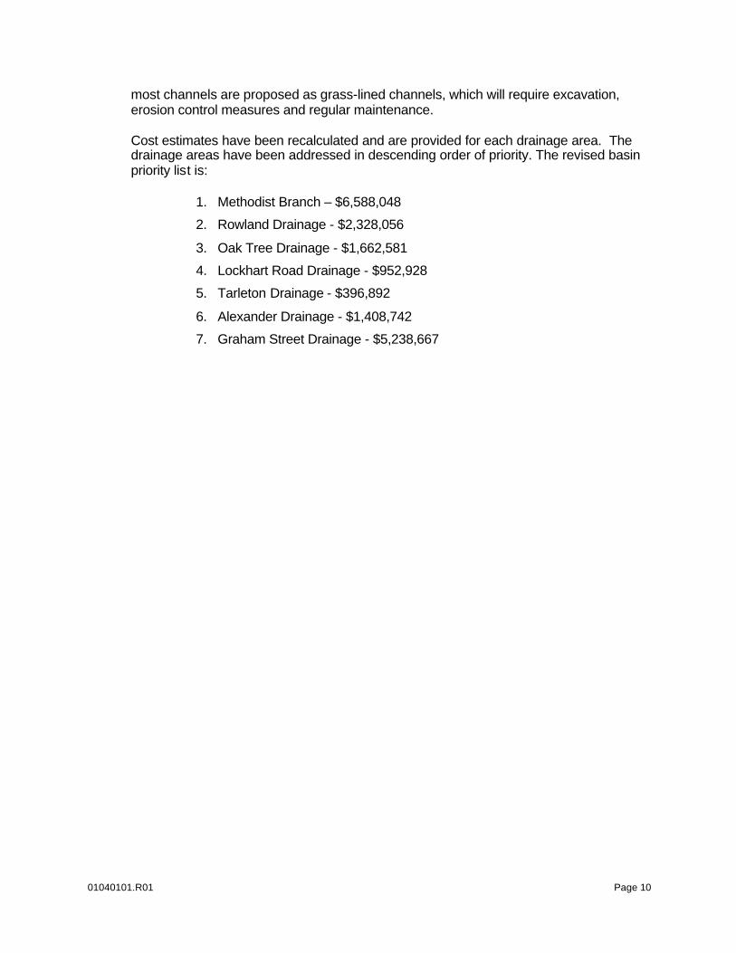
most channels are proposed as grass-lined channels, which will require excavation, erosion control measures and regular maintenance. Cost estimates have been recalculated and are provided for each drainage area. The drainage areas have been addressed in descending order of priority. The revised basin priority list is:
1. Methodist Branch – $6,588,048
2. Rowland Drainage - $2,328,056
3. Oak Tree Drainage - $1,662,581
4. Lockhart Road Drainage - $952,928
5. Tarleton Drainage - $396,892
6. Alexander Drainage - $1,408,742
7. Graham Street Drainage - $5,238,667
APPENDIX A - EXHIBITS
List of Exhibits
1 - Vicinity Map 2 - Drainage Area Map 3 - West/East Proposed Improvements Maps

Vicinity Map City of Stephenville Texas, Erath County
C&B Project No. 010401e1
Source: Precision Mapping
4.0
Exhibit
1
0 10 miles
Project Site

EXHIBITS ARE AVAILABLE AT THE CITY OFFICES

APPENDIX B – COST ESTIMATE
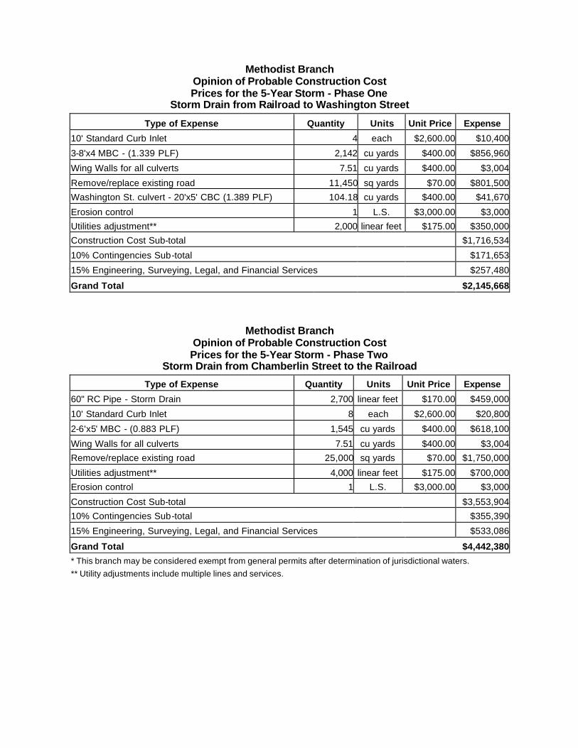
Methodist Branch
Opinion of Probable Construction Cost Prices for the 5-Year Storm - Phase One
Storm Drain from Railroad to Washington Street
Type of Expense Quantity Units Unit Price Expense
10' Standard Curb Inlet 4 each $2,600.00 $10,400
3-8'x4 MBC - (1.339 PLF) 2,142 cu yards $400.00 $856,960
Wing Walls for all culverts 7.51 cu yards $400.00 $3,004
Remove/replace existing road 11,450 sq yards $70.00 $801,500
Washington St. culvert - 20'x5' CBC (1.389 PLF) 104.18 cu yards $400.00 $41,670
Erosion control 1 L.S. $3,000.00 $3,000
Utilities adjustment** 2,000 linear feet $175.00 $350,000
Construction Cost Sub-total $1,716,534
10% Contingencies Sub-total $171,653
15% Engineering, Surveying, Legal, and Financial Services $257,480
Grand Total $2,145,668
Methodist Branch Opinion of Probable Construction Cost Prices for the 5-Year Storm - Phase Two
Storm Drain from Chamberlin Street to the Railroad
Type of Expense Quantity Units Unit Price Expense
60" RC Pipe - Storm Drain 2,700 linear feet $170.00 $459,000
10' Standard Curb Inlet 8 each $2,600.00 $20,800
2-6'x5' MBC - (0.883 PLF) 1,545 cu yards $400.00 $618,100
Wing Walls for all culverts 7.51 cu yards $400.00 $3,004
Remove/replace existing road 25,000 sq yards $70.00 $1,750,000
Utilities adjustment** 4,000 linear feet $175.00 $700,000
Erosion control 1 L.S. $3,000.00 $3,000
Construction Cost Sub-total $3,553,904
10% Contingencies Sub-total $355,390
15% Engineering, Surveying, Legal, and Financial Services $533,086
Grand Total $4,442,380
* This branch may be considered exempt from general permits after determination of jurisdictional waters. ** Utility adjustments include multiple lines and services.

Rowland Drainage Opinion of Probable Construction Cost
Prices for the 100-Year Storm
Type of Expense Quantity Units Unit Price Expense
5-8'x6' MBC - (2.523 PLF) @ Brenda St 164 cu yards $400.00 $65,598 1Excavation of Channel* to Brenda St 4,815 cu yards $5.00 $24,074
Permanent erosion control for channels 37,044 sq yards $10.00 $370,444 2Excavation of Channel* to Washington St 6,741 cu yards $5.00 $33,704
Concrete channel to Washington St 10,889 sq yards $50.00 $544,444 3Excavation of Channel* to Railroad 32,333 cu yards $5.00 $161,667
Wing Walls for all culverts 7.95 cu yards $400.00 $3,180
Remove/replace existing road 722 sq yards $50.00 $36,111
Utility adjustment 3,500 linear feet $175.00 $612,500 4Drainage ditch between Rowland street & channel 544 cu yards $5.00 $2,722
Construction Erosion control 1 L.S. $8,000.00 $8,000
Construction Cost Sub-total $1,862,445
10% Contingencies Sub-total $186,244
15% Engineering, Surveying, Legal, and Financial Services $279,367
Permitting - 5Ranges from $25,000 to $50,000
Grand Total $2,328,056 *Channels are 100-year grass lined channels and concrete from Brenda to Washington St.
1 Channel Size = 50' Bottom, 5' Deep, 4:1 SS 2 Channel Size = 29' Bottom, 4' Deep, 4:1 SS 3 Channel Size = 80' Bottom, 5' Deep, 4:1 SS
4 Channel Size = 5' Bottom, 4' Deep, 3:1 SS 5 Permit cost is estimated on an individual 404 permit.
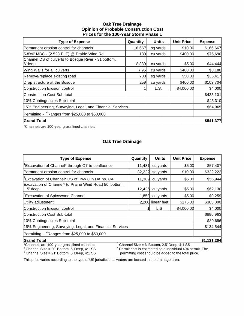
Oak Tree Drainage Opinion of Probable Construction Cost Prices for the 100-Year Storm Phase 1
Type of Expense Quantity Units Unit Price Expense
Permanent erosion control for channels 16,667 sq yards $10.00 $166,667
5-8'x6' MBC - (2.523 PLF) @ Prairie Wind Rd 189 cu yards $400.00 $75,690 Channel DS of culverts to Bosque River - 31'bottom, 6'deep 8,889 cu yards $5.00 $44,444
Wing Walls for all culverts 7.95 cu yards $400.00 $3,180
Remove/replace existing road 708 sq yards $50.00 $35,417
Drop structure at the Bosque 259 cu yards $400.00 $103,704
Construction Erosion control 1 L.S. $4,000.00 $4,000
Construction Cost Sub-total $433,101
10% Contingencies Sub-total $43,310
15% Engineering, Surveying, Legal, and Financial Services $64,965
Permitting - 4Ranges from $25,000 to $50,000
Grand Total $541,377 *Channels are 100-year grass lined channels
Oak Tree Drainage
Type of Expense Quantity Units Unit Price Expense 1Excavation of Channel* through O7 to confluence 11,481 cu yards $5.00 $57,407
Permanent erosion control for channels 32,222 sq yards $10.00 $322,222 2Excavation of Channel* DS of Hwy 8 in DA no. O4 11,389 cu yards $5.00 $56,944 Excavation of Channel* to Prairie Wind Road 50' bottom,
5' deep 12,426 cu yards $5.00 $62,130 3Excavation of Spicewood Channel 1,852 cu yards $5.00 $9,259
Utility adjustment 2,200 linear feet $175.00 $385,000
Construction Erosion control 1 L.S. $4,000.00 $4,000
Construction Cost Sub-total $896,963
10% Contingencies Sub-total $89,696
15% Engineering, Surveying, Legal, and Financial Services $134,544
Permitting - 4Ranges from $25,000 to $50,000
Grand Total $1,121,204 *Channels are 100-year grass lined channels 1 Channel Size = 20' Bottom, 5' Deep, 4:1 SS 2 Channel Size = 21' Bottom, 5' Deep, 4:1 SS
3 Channel Size = 6' Bottom, 2.5' Deep, 4:1 SS 4 Permit cost is estimated on a individual 404 permit. The
permitting cost should be added to the total price.
This price varies according to the type of US jurisdictional waters are located in the drainage area.
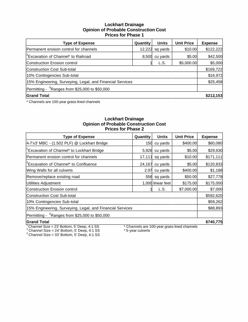
Lockhart Drainage Opinion of Probable Construction Cost
Prices for Phase 1
Type of Expense Quantity Units Unit Price Expense
Permanent erosion control for channels 12,222 sq yards $10.00 $122,222 3Excavation of Channel* to Railroad 8,500 cu yards $5.00 $42,500
Construction Erosion control 1 L.S. $5,000.00 $5,000
Construction Cost Sub-total $169,722
10% Contingencies Sub-total $16,972
15% Engineering, Surveying, Legal, and Financial Services $25,458
Permitting - 5Ranges from $25,000 to $50,000
Grand Total $212,153
* Channels are 100-year grass lined channels
Lockhart Drainage Opinion of Probable Construction Cost
Prices for Phase 2
Type of Expense Quantity Units Unit Price Expense
4-7'x3' MBC - (1.502 PLF) @ Lockhart Bridge 150 cu yards $400.00 $60,080 1Excavation of Channel* to Lockhart Bridge 5,926 cu yards $5.00 $29,630
Permanent erosion control for channels 17,111 sq yards $10.00 $171,111 2Excavation of Channel* to Confluence 24,167 cu yards $5.00 $120,833
Wing Walls for all culverts 2.97 cu yards $400.00 $1,188
Remove/replace existing road 556 sq yards $50.00 $27,778
Utilities Adjustment 1,000 linear feet $175.00 $175,000
Construction Erosion control 1 L.S. $7,000.00 $7,000
Construction Cost Sub-total $592,620
10% Contingencies Sub-total $59,262
15% Engineering, Surveying, Legal, and Financial Services $88,893
Permitting - 5Ranges from $25,000 to $50,000
Grand Total $740,775 1 Channel Size = 23' Bottom, 5' Deep, 4:1 SS 2 Channel Size = 24' Bottom, 5' Deep, 4:1 SS 3 Channel Size = 33' Bottom, 5' Deep, 4:1 SS
* Channels are 100-year grass lined channels * 5-year culverts
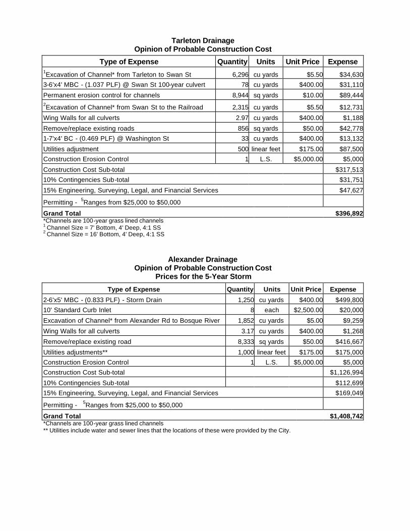
Tarleton Drainage Opinion of Probable Construction Cost
Type of Expense Quantity Units Unit Price Expense 1Excavation of Channel* from Tarleton to Swan St 6,296 cu yards $5.50 $34,630
3-6'x4' MBC - (1.037 PLF) @ Swan St 100-year culvert 78 cu yards $400.00 $31,110
Permanent erosion control for channels 8,944 sq yards $10.00 $89,444 2Excavation of Channel* from Swan St to the Railroad 2,315 cu yards $5.50 $12,731
Wing Walls for all culverts 2.97 cu yards $400.00 $1,188
Remove/replace existing roads 856 sq yards $50.00 $42,778
1-7'x4' BC - (0.469 PLF) @ Washington St 33 cu yards $400.00 $13,132
Utilities adjustment 500 linear feet $175.00 $87,500
Construction Erosion Control 1 L.S. $5,000.00 $5,000
Construction Cost Sub-total $317,513
10% Contingencies Sub-total $31,751
15% Engineering, Surveying, Legal, and Financial Services $47,627
Permitting - 5Ranges from $25,000 to $50,000
Grand Total $396,892 *Channels are 100-year grass lined channels 1 Channel Size = 7' Bottom, 4' Deep, 4:1 SS 2 Channel Size = 16' Bottom, 4' Deep, 4:1 SS
Alexander Drainage Opinion of Probable Construction Cost
Prices for the 5-Year Storm
Type of Expense Quantity Units Unit Price Expense
2-6'x5' MBC - (0.833 PLF) - Storm Drain 1,250 cu yards $400.00 $499,800
10' Standard Curb Inlet 8 each $2,500.00 $20,000
Excavation of Channel* from Alexander Rd to Bosque River 1,852 cu yards $5.00 $9,259
Wing Walls for all culverts 3.17 cu yards $400.00 $1,268
Remove/replace existing road 8,333 sq yards $50.00 $416,667
Utilities adjustments** 1,000 linear feet $175.00 $175,000
Construction Erosion Control 1 L.S. $5,000.00 $5,000
Construction Cost Sub-total $1,126,994
10% Contingencies Sub-total $112,699
15% Engineering, Surveying, Legal, and Financial Services $169,049
Permitting - 5Ranges from $25,000 to $50,000
Grand Total $1,408,742 *Channels are 100-year grass lined channels ** Utilities include water and sewer lines that the locations of these were provided by the City.

Graham Drainage Opinion of Probable Construction Cost
Prices for the 5-Year Storm Phase 1
Type of Expense Quantity Units Unit Price Expense
10' Standard Curb Inlet 2 each $2,500.00 $5,000
2-7'x4' MBC (0.844 PLF) Storm Drain DS of Graham St 675 cu yards $400.00 $270,080
Wing Walls for all culverts 2.17 cu yards $400.00 $868
Remove/replace existing road 4,444 sq yards $50.00 $222,227 1Channel downstream to the Bosque River 5,741 cu yards $5.00 $28,704
Construction Erosion Control 1 L.S. $4,000.00 $4,000
Construction Cost Sub-total $530,878
10% Contingencies Sub-total $53,088
15% Engineering, Surveying, Legal, and Financial Services $79,632
Permitting 2Ranges from $10,000 to $15,000
Grand Total $663,598
Graham Drainage Opinion of Probable Construction Cost
Prices for the 5-Year Storm Phase 2 Type of Expense Quantity Units Unit Price Expense
2-54" RC Pipe - @ Park and Paddock 4,200 linear feet $150.00 $630,000
2-60" RC Pipe - @ Pecan and Paddock 5,200 linear feet $170.00 $884,000
10' Standard Curb Inlet 6 each $2,500.00 $15,000
Remove/replace existing road 26,111 sq yards $50.00 $1,305,556
Utilities adjustments** 4,700 linear feet $175.00 $822,500
Construction Erosion Control 1 L.S. $3,000.00 $3,000
Construction Cost Sub-total $3,660,056
10% Contingencies Sub-total $366,006
15% Engineering, Surveying, Legal, and Financial Services $549,008
Permitting 2Ranges from $10,000 to $15,000
Grand Total $4,575,069 * This estimate does not include cost of the house and property at Graham St. ** Utilities include water and sewer lines that the location of these were provided by the City. 1 Channel size = 11' Bottom, 5' Deep, 4:1 SS 2 Permit cost is estimated based on the stream being jurisdictional waters.