statutory instruments. - dfa
TRANSCRIPT
STATUTORY INSTRUMENTS.
S.I. No. 22 of 2016
————————
MARITIME JURISDICTION (STRAIGHT BASELINES) ORDER 2016
2 [22]
S.I. No. 22 of 2016
MARITIME JURISDICTION (STRAIGHT BASELINES) ORDER 2016
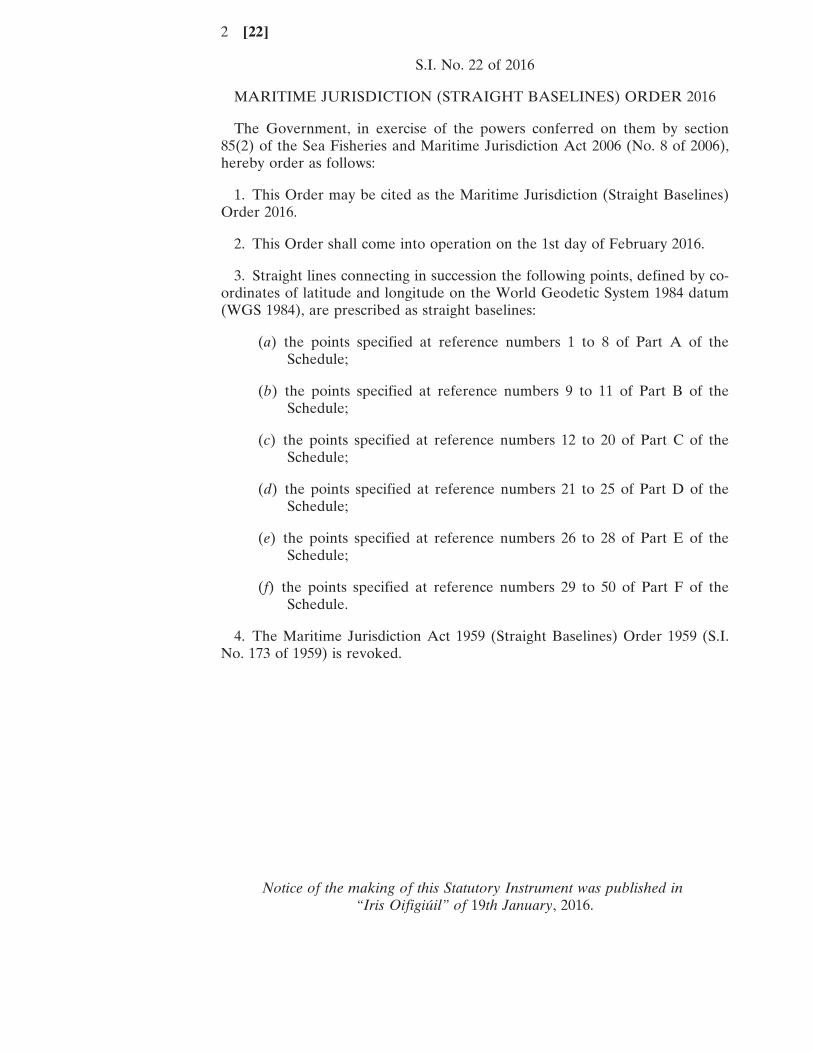
The Government, in exercise of the powers conferred on them by section85(2) of the Sea Fisheries and Maritime Jurisdiction Act 2006 (No. 8 of 2006),hereby order as follows:
1. This Order may be cited as the Maritime Jurisdiction (Straight Baselines)Order 2016.
2. This Order shall come into operation on the 1st day of February 2016.
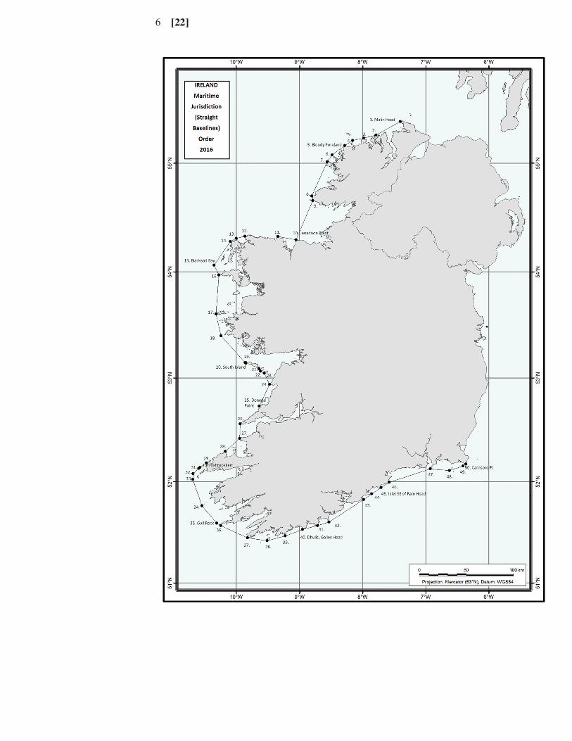
3. Straight lines connecting in succession the following points, defined by co-ordinates of latitude and longitude on the World Geodetic System 1984 datum(WGS 1984), are prescribed as straight baselines:
(a) the points specified at reference numbers 1 to 8 of Part A of theSchedule;
(b) the points specified at reference numbers 9 to 11 of Part B of theSchedule;
(c) the points specified at reference numbers 12 to 20 of Part C of theSchedule;
(d) the points specified at reference numbers 21 to 25 of Part D of theSchedule;
(e) the points specified at reference numbers 26 to 28 of Part E of theSchedule;
(f) the points specified at reference numbers 29 to 50 of Part F of theSchedule.
4. The Maritime Jurisdiction Act 1959 (Straight Baselines) Order 1959 (S.I.No. 173 of 1959) is revoked.
Notice of the making of this Statutory Instrument was published in“Iris Oifigiúil” of 19th January, 2016.
[22] 3
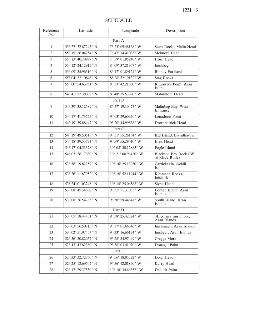
SCHEDULE
Reference Latitude Longitude DescriptionNo.
Part A
1 55° 22' 32.87293" N 7° 24' 09.48168" W Scart Rocks, Malin Head
2 55° 15' 26.04254" N 7° 47' 14.42085" W Melmore Head
3 55° 13' 40.78997" N 7° 59' 01.05940" W Horn Head
4 55° 12' 24.12915" N 8° 09' 37.21957" W Inishbeg
5 55° 09' 35.96316" N 8° 17' 01.89121" W Bloody Foreland
6 55° 04' 32.10846" N 8° 28' 52.19132" W Stag Rocks
7 55° 00' 54.63951" N 8° 33' 42.21630" W Rinrawros Point, AranIsland
8 54° 41' 57.38032" N 8° 48' 25.53870" W Malinmore Head
Part B
9 54° 39' 35.12589" N 8° 47' 19.10427" W Malinbeg Bay, WestEntrance
10 54° 17' 41.73725" N 9° 03' 29.60920" W Lenadoon Point
11 54° 19' 39.88447" N 9° 20' 44.99838" W Downpatrick Head
Part C
12 54° 19' 49.50515" N 9° 51' 55.26154" W Kid Island, Broadhaven
13 54° 18' 39.55771" N 9° 59' 55.29010" W Erris Head
14 54° 17' 04.53378" N 10° 05' 30.12885" W Eagle Island
15 54° 03' 38.17630" N 10° 21' 00.96420" W Blacksod Bay (rock SWof Black Rock)
16 53° 58' 19.82759" N 10° 16' 25.13030" W Carrickakin, AchillIsland
17 53° 36' 11.87952" N 10° 18' 52.11944" W Kimmeen Rocks,Inishark
18 53° 24' 01.03246" N 10° 14' 25.06583" W Slyne Head
19 53° 08' 45.34880" N 9° 51' 31.37033" W Eeragh Island, AranIslands
20 53° 08' 26.54765" N 9° 50' 59.44841" W South Island, AranIslands
Part D
21 53° 05' 18.44451" N 9° 38' 25.42724" W SE corner Inishmore,Aran Islands
22 53° 03' 56.50713" N 9° 37' 01.66646" W Inishmaan, Aran Islands
23 53° 02' 51.97453" N 9° 33' 16.66174" W Inisheer, Aran Islands
24 52° 56' 20.82657" N 9° 28' 34.97449" W Cregga More
25 52° 43' 43.82360" N 9° 38' 03.41970" W Donegal Point
Part E
26 52° 33' 32.72760" N 9° 56' 18.05722" W Loop Head
27 52° 25' 12.69702" N 9° 56' 42.01840" W Kerry Head
28 52° 17' 29.37530" N 10° 10' 34.66357" W Deelick Point
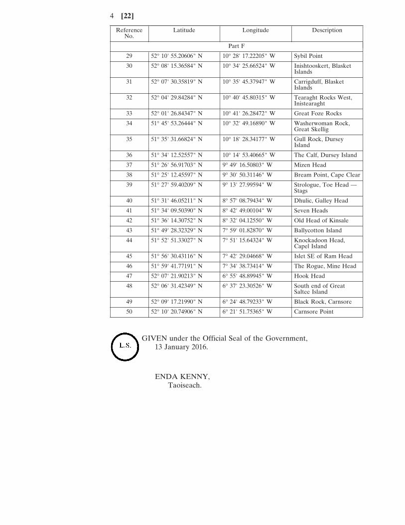
4 [22]
Reference Latitude Longitude DescriptionNo.
Part F
29 52° 10' 55.20606" N 10° 28' 17.22205" W Sybil Point
30 52° 08' 15.36584" N 10° 34' 25.66524" W Inishtooskert, BlasketIslands
31 52° 07' 30.35819" N 10° 35' 45.37947" W Carrigduff, BlasketIslands
32 52° 04' 29.84284" N 10° 40' 45.80315" W Tearaght Rocks West,Inistearaght
33 52° 01' 26.84347" N 10° 41' 26.28472" W Great Foze Rocks
34 51° 45' 53.26444" N 10° 32' 49.16890" W Washerwoman Rock,Great Skellig
35 51° 35' 31.66824" N 10° 18' 28.34177" W Gull Rock, DurseyIsland
36 51° 34' 12.52557" N 10° 14' 53.40665" W The Calf, Dursey Island
37 51° 26' 56.91703" N 9° 49' 16.50803" W Mizen Head
38 51° 25' 12.45597" N 9° 30' 50.31146" W Bream Point, Cape Clear
39 51° 27' 59.40209" N 9° 13' 27.99594" W Strologue, Toe Head —Stags
40 51° 31' 46.05211" N 8° 57' 08.79434" W Dhulic, Galley Head
41 51° 34' 09.50390" N 8° 42' 49.00104" W Seven Heads
42 51° 36' 14.30752" N 8° 32' 04.12550" W Old Head of Kinsale
43 51° 49' 28.32329" N 7° 59' 01.82870" W Ballycotton Island
44 51° 52' 51.33027" N 7° 51' 15.64324" W Knockadoon Head,Capel Island
45 51° 56' 30.43116" N 7° 42' 29.04668" W Islet SE of Ram Head
46 51° 59' 41.77191" N 7° 34' 38.73414" W The Rogue, Mine Head
47 52° 07' 21.90213" N 6° 55' 48.89945" W Hook Head
48 52° 06' 31.42349" N 6° 37' 23.30526" W South end of GreatSaltee Island
49 52° 09' 17.21990" N 6° 24' 48.79233" W Black Rock, Carnsore
50 52° 10' 20.74906" N 6° 21' 51.75365" W Carnsore Point
GIVEN under the Official Seal of the Government,13 January 2016.
ENDA KENNY,Taoiseach.
[22] 5
EXPLANATORY NOTE
(This note is not part of the Instrument and does not purport to be a legalinterpretation.)
The Order prescribes straight baselines for the purposes of the Sea Fisheriesand Maritime Jurisdiction Act 2006. A map showing the prescribed straightbaselines for illustrative purposes is annexed.
6 [22]
BAILE ÁTHA CLIATHARNA FHOILSIÚ AG OIFIG AN tSOLÁTHAIR
Le ceannach díreach óFOILSEACHÁIN RIALTAIS,
52 FAICHE STIABHNA, BAILE ÁTHA CLIATH 2(Teil: 01 - 6476834 nó 1890 213434; Fax: 01 - 6476843)
nó trí aon díoltóir leabhar.
——————
DUBLINPUBLISHED BY THE STATIONERY OFFICE
To be purchased fromGOVERNMENT PUBLICATIONS,
52 ST. STEPHEN'S GREEN, DUBLIN 2.(Tel: 01 - 6476834 or 1890 213434; Fax: 01 - 6476843)
or through any bookseller.
——————
€2.54
Wt. (B31804). 285. 1/16. Essentra. Gr 30-15.