status of road transport and transit facilitation in ... · mirpur sarial nashingdi katchpur dhaka...
TRANSCRIPT

Status of Road Transport and Transit Facilitation in
Bangladesh
Shishir Kanti RouthSuperintending EngineerRoads and Highways DepartmentMinistry of Road Transport and Bridges

Status of Road Infrastructure in Bangladesh
Initiatives for upgrading of cross border connectivity
Regional Initiatives for MVA
Challenges and way forward
Outline

Init
iati
ves
Asian Highway
(AH)
(SHC) SAARC Highway Corridor
SASEC Road Corridor
(SHC)
BIMSTEC Road Corridor
(BRC)
BCIM Route
(BCIM)
Regional and Subregional Initiatives for connectivity
BBIN Motor Vehicle Agreement (2015)

National -- 3,570 km
Regional -- 4,323 km
Zilla -- 13,678 km
Total Roads 21,571 km
National 17%
Regional 20%
Zilla 63%
Bridges: 4,507 nos
Culverts: 13,678 nos 4
RHD Road Network
Source: HDM, Roads and Highways Department

AH1
AH2
AH41
3 Routes in Bangladesh
Asian Highway and Bangladesh
Bangladesh singed the Instrument of Accession in 2009 while the Intergovernmental Agreement on the Asian Highway Network entered into force in 2003

Asian Highway 1
Dawki/Tamabil
Benapole/Petrapole
Tamabil
Sylhet
Shaistaganj
Mirpur
Sarial
Nashingdi
Katchpur
Dhaka (S)
Mawa
Janjira
Bhanga
Bhatiapara
Kalna FG (E)
Kalna FG (W)
Narail
55 km
40 km
43 km
61 km
52 km
33 km
8 km
7.65 km
30.35 km
38 km
2.32 km
0.68 km
24 km
Total 500 km
35
km
32 km
Jessore
II
I, II
II
II
I, II
I, II
I
ML
II
II
II
ML
II
II
I, II
Benapole
38 kmII
6%
92%
2%
Class I Class II ML
Class I : 31 kmClass II : 460.67 kmMissing Link : 8.33 km
Dhaka
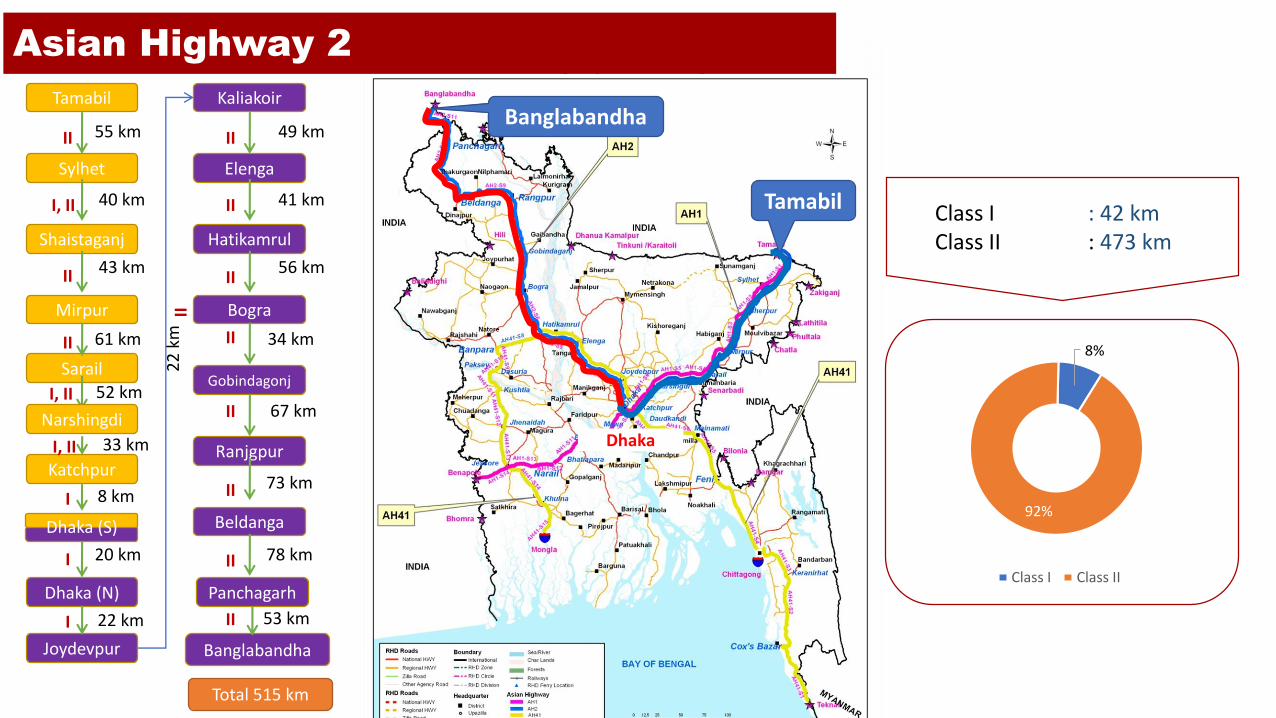
Asian Highway 2
Tamabil
BanglabandhaTamabil
Sylhet
Shaistaganj
Mirpur
Sarail
Katchpur
Dhaka (N)
Kaliakoir
Elenga
Hatikamrul
Bogra
Gobindagonj
Ranjgpur
Beldanga
55 km
40 km
43 km
61 km
52 km
8 km
20 km
49 km
41 km
56 km
34 km
67 km
73 km
Panchagarh
78 km
Banglabandha
53 km
Joydevpur
22
km
Total 515 km
22 km
Narshingdi
33 km
Dhaka (S)
II
I, II
II
II
I, II
I, II
I
I
I
II
II
II
II
II
II
II
II
II
8%
92%
Class I Class II
Class I : 42 kmClass II : 473 km
Dhaka

Asian Highway 41
Teknaf
Mongla
Chittagong
Teknaf
Cox’s Bazar
Keranihat
Chittagong
Feni
Moinamoti
Daudkandi
Bhogra
Joydevpur
Kaliakoir
Elenga
Banpara
Dasuria
80 km
92 km
57 km
88 km
64 km
44 km
26 km
1 km
22 km
49 km
41 km
51 km
22 km
Paksey
12 km
Kushtia
24 km
Bhulta
33
km
Total 803 km
Jhenaidah
Jessore
Khulna
Mongla
44 km
62 km
44 km
13 km
46
km
Madanpur
Hatikamrul
II
II
II
I
I
I
II
II
II
II
II
II
II
II
II
II
II
II
II
II
28%
72%
Class I Class II
Class I: 227 kmClass II: 576 km
Dhaka

Tamabil
Construction of 680m Kalna Bridge to commence soon (Ongoing)
Construction of Padma Bridge (6.2 Km )(Ongoing)
Upgrading of Dhaka-Sylhet Highway (Proposed)
[237 km]
Dhaka-Mawa Expressway (Ongoing)
[32 km]
Upgrading of Jessore-Benapole Highway (Proposed)
[38 km]
31 km(6%)
338 km(67.6%)
With completion of projects Class II Roads will increase
There will be No Missing Links on AH-1
Upgrading infrastructures along AH-1
Tamabil
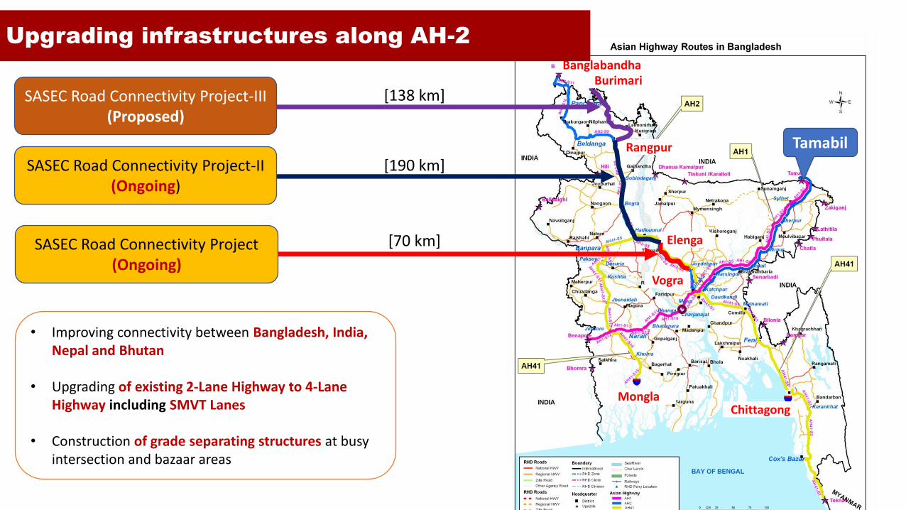
SASEC Road Connectivity Project(Ongoing)
• Improving connectivity between Bangladesh, India, Nepal and Bhutan
• Upgrading of existing 2-Lane Highway to 4-Lane Highway including SMVT Lanes
• Construction of grade separating structures at busy intersection and bazaar areas
SASEC Road Connectivity Project-II(Ongoing)
[190 km]
[70 km]
Vogra
Elenga
Rangpur
MonglaChittagong
BurimariBanglabandha
Upgrading infrastructures along AH-2
SASEC Road Connectivity Project-III(Proposed)
[138 km]
[191 km]
MonglaChittagong
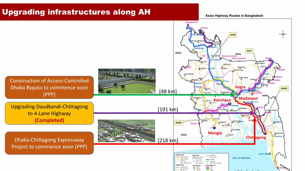
Upgrading infrastructures along AH
Kanchpur
Upgrading Daudkandi-Chittagong to 4-Lane Highway
(Completed)
Dhaka-Chittagong Expressway Project to commence soon (PPP)
[218 km]
Madanpur
Vogra
Construction of Access-Controlled Dhaka Bypass to commence soon
(PPP)[48 km]
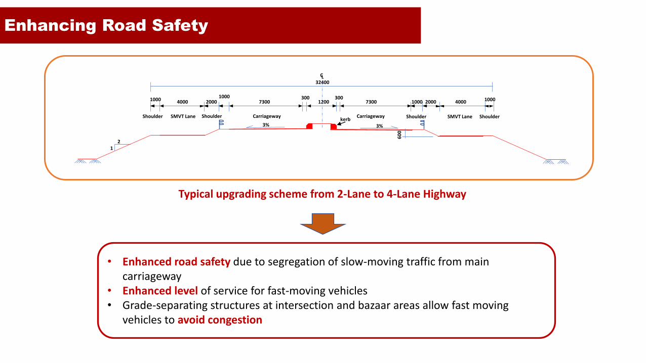
Enhancing Road Safety
Carriageway CarriagewayShoulder Shoulder SMVT LaneSMVT Lane
73007300 1200300300
1000 2000 4000 1000
Shoulder
1000 4000 20001000
Shoulder
60
0
32400
CL
21
kerb3% 3%
Typical upgrading scheme from 2-Lane to 4-Lane Highway
• Enhanced road safety due to segregation of slow-moving traffic from main carriageway
• Enhanced level of service for fast-moving vehicles• Grade-separating structures at intersection and bazaar areas allow fast moving
vehicles to avoid congestion
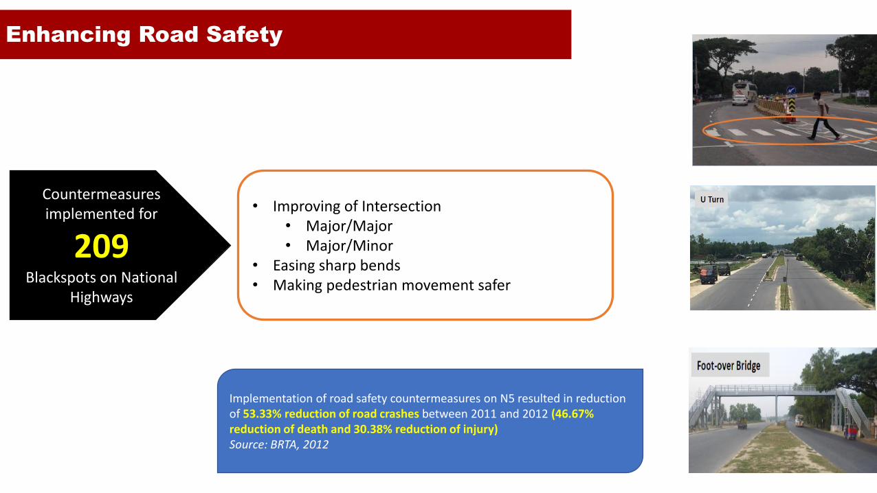
Enhancing Road Safety
Countermeasures implemented for
209 Blackspots on National
Highways
• Improving of Intersection• Major/Major• Major/Minor
• Easing sharp bends• Making pedestrian movement safer
Implementation of road safety countermeasures on N5 resulted in reduction of 53.33% reduction of road crashes between 2011 and 2012 (46.67% reduction of death and 30.38% reduction of injury) Source: BRTA, 2012

BBIN Motor Vehicle Agreement
Signed on 15 June 2015 in Thimpu (Bhutan), BBIN MVA is a an
agreement to allow vehicles to enter each other’s territory for
passengers and cargo.
Three countries—Bangladesh, India and Nepal—ratified the MVA and
are considering implementation of the MVA with Bhutan join it after it
ratifies the Agreement.
The three countries agreed to conduct trial runs of cargo vehicles
before finalizing the protocol for cargo vehicle movement.
The implementation of the MVA is expected to improve economic
cooperation and connectivity among member countries. It will also
help landlocked countries to integrate more efficiently with global
economy
Source: The Daily Star

BBIN Motor Vehicle Agreement
Signed on 15 June 2015 in Thimpu (Bhutan), BBIN MVA
is a an agreement to allow vehicles to enter each
other’s territory for passengers and cargo.
Three countries—Bangladesh, India and Nepal—ratified
the MVA and are considering implementation of the
MVA with Bhutan join it after it ratifies the Agreement.
The three countries agreed to conduct trial runs of
cargo vehicles before finalizing the protocol for cargo
vehicle movement.
The implementation of the MVA is expected to improve
economic cooperation and connectivity among
member countries. It will also help landlocked
countries to integrate more efficiently with global
economy
BBIN Routes
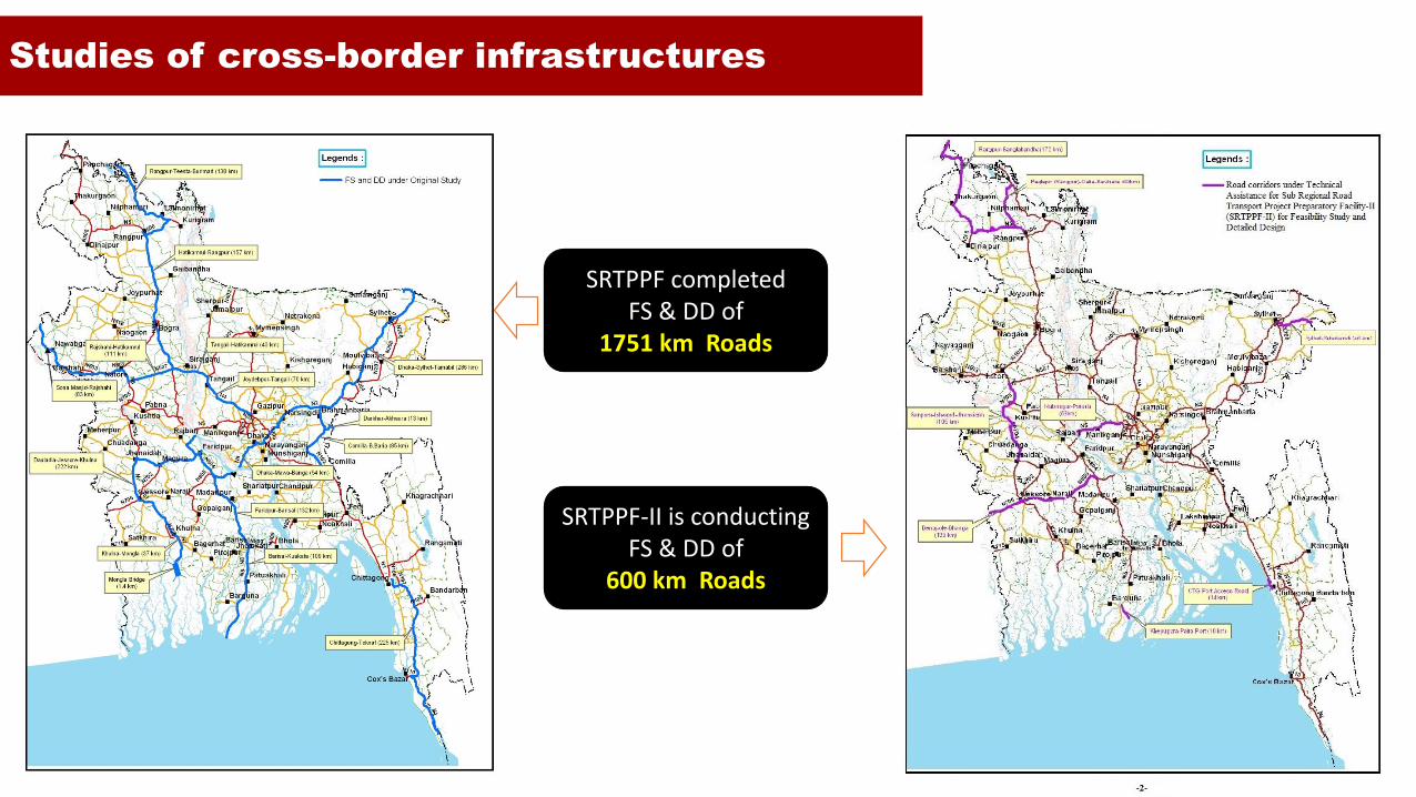
Studies of cross-border infrastructures
SRTPPF completed FS & DD of
1751 km Roads
SRTPPF-II is conductingFS & DD of
600 km Roads

Combating overloading of vehicles
Motor Vehicle Ordinance 1983 (as amended)Notification no. RRD/BRTA/Overload-38/96(P-1)-653,
dated 16 November 2003
Maximum Permissible Weight limits for Motor Vehicles
Axle Load Station Axle Load Control Station Operation Policy 2012
Assigns RHD the task of setting up weigh stations at strategic places; Stipulates that a separate enforcement unit for weigh stations;
Specifies a web-based monitoring system; Allows for changing policies by Gazette notice
Schedule of fine for overloading of vehicles
Government Notification no. 35.00.0000.030.22.003.14-225, dated 16-08-2016
Legal
Framework

Combating overloading of vehicles
RHD
Bangladesh
Police
BRTA
BLPA
RHD controls overloads as it has a
vested interest in protecting its roads
and bridges
BRTA provides the regulatory
framework and takes legal measures
against overloading (BRTA Act 2017)
RHD installs axle load system on
highways and penalizes vehicles for
overloading
Bangladesh Police enforces laws
against overloading
Weighbridges are in operation at dry
ports under BLPA
Administrative
control of
overloading
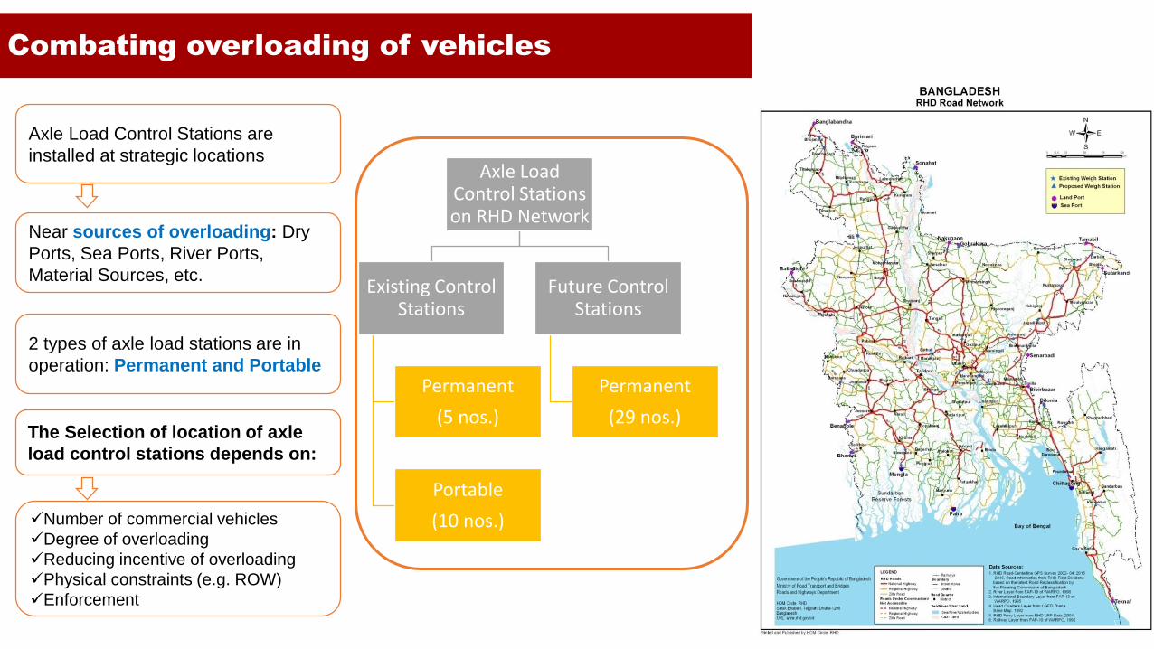
Combating overloading of vehicles
Axle Load Control Stations are
installed at strategic locations
Near sources of overloading: Dry
Ports, Sea Ports, River Ports,
Material Sources, etc.
2 types of axle load stations are in
operation: Permanent and Portable
The Selection of location of axle
load control stations depends on:
✓Number of commercial vehicles
✓Degree of overloading
✓Reducing incentive of overloading
✓Physical constraints (e.g. ROW)
✓Enforcement
Axle Load Control Stations on RHD Network
Existing Control Stations
Permanent
(5 nos.)
Portable
(10 nos.)
Future Control Stations
Permanent
(29 nos.)

• The construction of Padma Bridge (6.15 km) will eliminate the longest missing link on AH1
• Construction of Kalna Bridge (680 m) is included in JICA assisted Cross Bridge Road Network Improvement Project
Missing links & Sub-standard sections
• Projects are financed by Government and Development partners
• Where possible, PPP options is being explored
• Support from development partners need to continue to bridge financing gap
Financing
• Road Geometry to allow regional traffic
• Harmonization of Standards
• Border facilities
• Multimodal integration
Infrastructure
Challenges for Bangladesh

Thank you