station precinct review joyce … · east side of joyce-collingwood station (kiss and ride) why is...
TRANSCRIPT
vancouver.ca/joycestation
JOYCE-COLLINGWOOD STATION PRECINCT REVIEW
October 2015
1
The Precinct Review
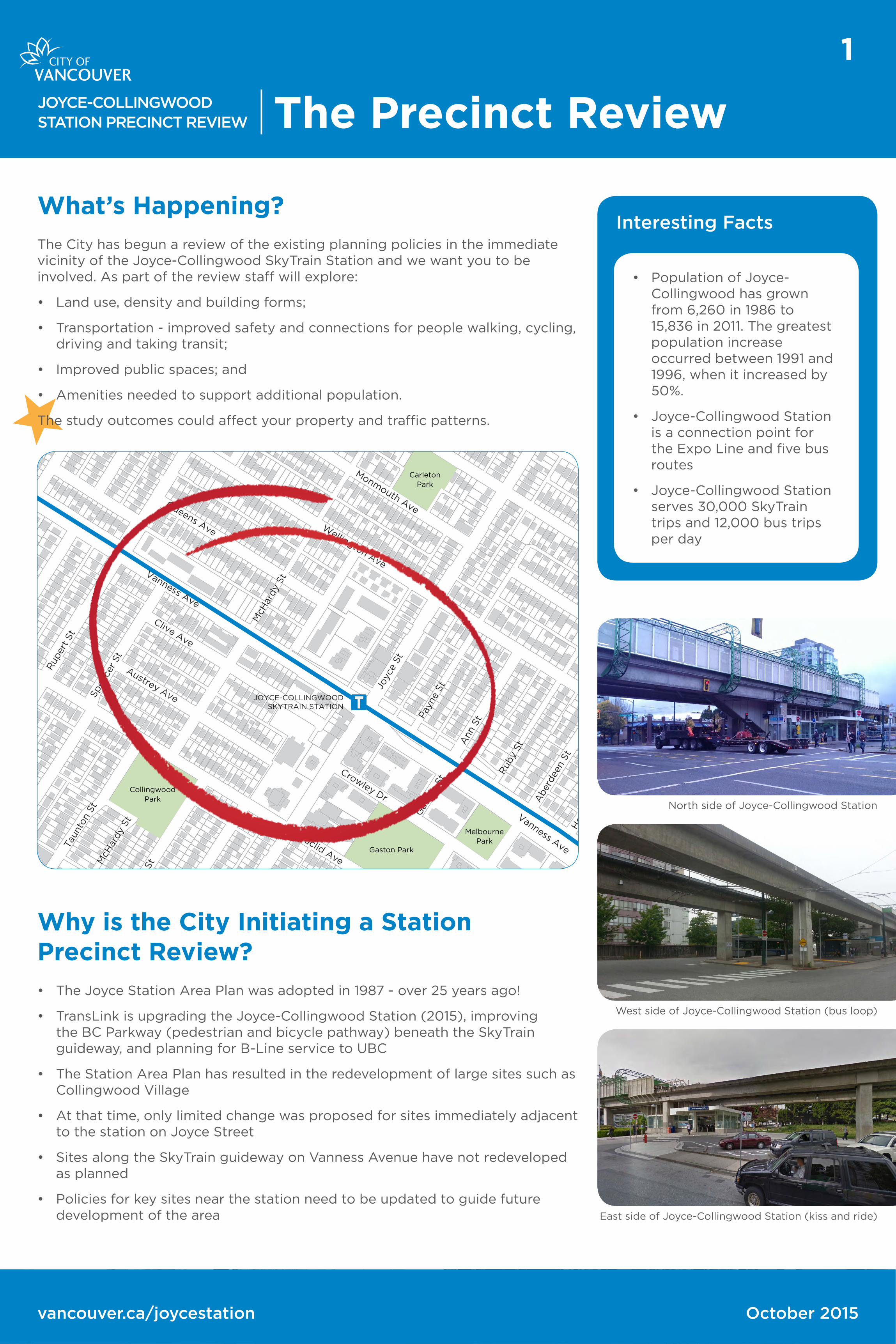
What’s Happening?
The City has begun a review of the existing planning policies in the immediate vicinity of the Joyce-Collingwood SkyTrain Station and we want you to be involved. As part of the review staff will explore:
• Land use, density and building forms;
• Transportation - improved safety and connections for people walking, cycling, driving and taking transit;
• Improved public spaces; and
• Amenities needed to support additional population.
The study outcomes could affect your property and traffic patterns.
CollingwoodPark
CarletonPark
MelbournePark
Gaston Park
JOYCE-COLLINGWOODSKYTRAIN STATION
Wellington Ave
Queens Ave
Clive Ave
McH
ardy
St
Ann
St
Vanness Ave
Rup
ert St
Cha
tham
St
Man
or
St
Spen
cer
St
Crowley Dr
Joyc
e St
Rub
y St
Aber
dee
n St
Hoy
St
Monmouth Ave
McK
inno
n St
Austrey Ave
Euclid Ave
Vanness AveTau
nton
St
McH
ardy
St
Pay
ne S
t
Gas
ton
St
North side of Joyce-Collingwood Station
West side of Joyce-Collingwood Station (bus loop)
East side of Joyce-Collingwood Station (kiss and ride)
Why is the City Initiating a Station Precinct Review?
• The Joyce Station Area Plan was adopted in 1987 - over 25 years ago!
• TransLink is upgrading the Joyce-Collingwood Station (2015), improving the BC Parkway (pedestrian and bicycle pathway) beneath the SkyTrain guideway, and planning for B-Line service to UBC
• The Station Area Plan has resulted in the redevelopment of large sites such as Collingwood Village
• At that time, only limited change was proposed for sites immediately adjacent to the station on Joyce Street
• Sites along the SkyTrain guideway on Vanness Avenue have not redeveloped as planned
• Policies for key sites near the station need to be updated to guide future development of the area
Interesting Facts
• Population of Joyce-Collingwood has grown from 6,260 in 1986 to 15,836 in 2011. The greatest population increase occurred between 1991 and 1996, when it increased by 50%.
• Joyce-Collingwood Station is a connection point for the Expo Line and five bus routes
• Joyce-Collingwood Station serves 30,000 SkyTrain trips and 12,000 bus trips per day

vancouver.ca/joycestation
JOYCE-COLLINGWOOD STATION PRECINCT REVIEW
October 2015
2
History & Background
1891Interurban Railway Opened
Connected downtown Vancouver to New Westminster, opening the Collingwood area up to new residents
1981ALRT Selected
The Provincial Government announced the selection of Advanced Light Rail Transit (ALRT) system for Greater Vancouver
1986 First Phase of ALRT (SkyTrain) Opened
First phase opened, covering 21.4 km running between downtown Vancouver and New Westminster
1981ALRT Planning Program Initiated
To address the problems, issues and opportunities arising from rapid transit, Council initiated the ALRT Planning program in December
1983Planning Guidelines Approved
Council approved basic public objectives and broad planning guidelines as a basis for further planning in the ALRT Station Areas
1987Station Area Plan Approved
Council adopted the Joyce Station Area Plan in May, which focused on impacts that required specific mitigation measures to minimize the negative impacts of ALRT on nearby property1990-2006
Collingwood Village
After SkyTrain opened, industrial and rail uses declined, providing the opportunity for a new residential community. Eleven hectares were assembled and rezoned for 2,800 residential units and a significant range of community amenities, which included:
• Neighbourhood House
• community gymnasium
• childcare facility
• elementary school
• parks
• provision and endowment for Community Policing Office (CPO)
2004Community Vision Approved
In 2004, the Renfrew-Collingwood Community Vision was adopted for the larger area bounded by Broadway, Nanaimo Street, Boundary Road and 41st Avenue. The document explored a number of infill housing options, ways to create neighbourhood centres, and improvements to parks, streets lanes and public spaces. The Norquay Village Neighbourhood Centre Plan (2010) was completed as an important part of the implementation of the Renfrew-Collingwood Vision.
2011Wall Centre - Central Park
Rezoning was approved in 2011 to permit the development of a mixed-use multi-family project containing over 1,100 residential units and on-site community amenity facilities for the Multi-Cultural Opportunity and Social Awareness Interest Community (MOSAIC) and Collingwood Neighbourhood House
1960Vanness Industrial District
B.C Electric began operating freight service along the abandoned Interurban tracks and encouraged light industrial firms, primarily warehouse activities, to locate along the rail tracks in the Vanness Industrial District

vancouver.ca/joycestation October 2015
3
JOYCE-COLLINGWOOD STATION PRECINCT REVIEW The Review Area
Primary Focus
The Review is focusing on:
• Blocks of Joyce Street near the SkyTrain station between Wellington Avenue and Crowley Drive (sub-areas J1 and J2)
• Blocks on Vanness Avenue fronting the SkyTrain guideway between Joyce Street and Rupert Street (sub-areas V1 and V2)
• These areas are zoned for commercial and multi-family residential.
NOTE: Future planning for the St. Mary’s Parish site (sub-area J3) will be determined with school renewal.
Transition Areas
The Review will also consider adjacent single-family properties north of Vanness Avenue and east of Joyce Street. Land use change will be explored for these adjacent areas to provide a suitable transition from larger scale buildings to single-family areas.
Initially, staff proposed only two Transition Areas. T1 and T2. In response to comments from the community, and in consideration of proximity to the station and anticipated changes along Vanness Avenue, a third Transition Area south of Clive Avenue (sub-area T3) was added to the review. The Wellington Mews townhouse site was not originally included in the scope of the Station Review because of the age (1993) and the strata ownership, which poses challenges to redevelopment. However, as the site is within one block of the station and the owners have expressed an interest in being included in the Review, it is now included as Transition Area 4 (T4).
The majority of the surrounding neighbourhood remains as single-family zoning (RS-1).
Collingwood
Park
Carleton
Park
Melbourne
ParkGaston Park
Wellington Ave
Queens Ave
Clive Ave
McH
ardy
St
Ann
St
Vanness Ave
Rup
ert St
Spen
cer
St
Crowley Dr
Joyc
e St
Rub
y St
Aber
dee
n St
Hoy
St
Monmouth Ave
Austrey Ave
Euclid Ave
Vanness Ave
Tau
nton
St
McH
ardy
St
McG
eer St
T4
T3
T2
T1
V1
V2
J3
J2
J1
202018
11
Neighbourly Transitions
High
Low
• Providing more housing options for a diverse, growing population
• Provide built-form transition to surrounding single-family residential areas

vancouver.ca/joycestation
JOYCE-COLLINGWOOD STATION PRECINCT REVIEW
October 2015
4
Land Use & Zoning
The Joyce Station Area Plan (1987) has shaped the development of the Joyce-Collingwood Area over the past 25 years.
What Worked?
Most notable is Collingwood Village, a high-density mixed-use village. It is considered a highly successful transit-oriented development.
Collingwood Village includes:
• mixed housing forms ranging from 4 to 26 storeys
• commercial shops
• Neighbourhood House
• child care
• Community Policing Centre
• parks
NorquayPark
Earles Park
CollingwoodPark
Price Park
CarletonPark
Cariboo Park
MelbournePark
Slocan Park
Gaston Park
FosterPark
M-1
CD-1 (118)
CD-1 (545)
CD-1(302)
CD-1 (162)
CD-1(194) C-2
CD-1 (172)
C-1
CD-1(121)
CD-1 (351)
CD-1(246)
CD-1 (217)
RT-2
CD-1 (175)
RT-2
CD-1 (327)
CD-1 (213)
RT-4N
RT-4AN
CD-1 (222)
CD-1 (225)
C-2C
C-2
CD-1 (56B)
CD-1 (223)
CD-1 (291)
CD-1 (60)
CD-1(245)
RS-1
CD-1 (176)
CD-1 (5)
CD-1(304)
CD-1 (314)
CD-1 (215)
CD-1 (214)
RM-4N
CD-1 (54)
RT-4A
CD-1 (352)
CD-1 (216)
CD-1 (241)
CD-1 (218)
C-2C
C-1
C-1
CD-1 (201)
CD-1 (219)
C-1
RT-2
CD-1 (171)
C-2
C-2
CD-1 (529)
CD-1(530)
C-1
C-1
RM-7
RM-7
RS-1
RS-1
RM-7
RT-11
RT-11
RT-11
RS-1
RT-11N
RT-11N
RS-1
RS-1
RS-1
RS-1
RS-1
Moscrop St
Tanner St
Wellington Ave
Price St
Queens Ave
Clive Ave
McH
ardy
St
Ann
St
Duke St
Euclid Ave
E 29th Ave
Moss
St
Fai
rmont
St
Kill
arne
y St
Bur
sill
St
Vanness Ave
Rup
ert StC
hath
am S
t
Man
or
StKill
arne
y St
Spen
cer
St
E 43rd Ave
Wale
s S
t
Todd S
tRav
ine
St
Crowley Dr
Joyc
e St
Orm
idale
St
Lin
co
ln S
t
Rub
y St
Aber
dee
n St
Hoy
St
Rae Ave
Monmouth Ave
Bo
un
dary
Rd
Pen
ticto
n S
t
McK
inno
n St
Marmion Ave
Austrey Ave
Cec
il St
Euclid Ave
Vanness Ave
Kingsway
School Ave
Har
old
St
Wes
sex
St
Sen
lac
St
Kingsway
Ob
en
St
Me
lbo
urn
e S
tTy
ne S
t
Church St
Cherry St
Archimedes St
Co
lleg
e S
t
Slo
can
St
Earl
es
St
Kingsway
E 37th Ave
E 34th Ave
Ward St
Cheyenne Ave
Horley St
Ear
les
St
Fai
rmont
St
Duc
hess
St
E 29th Ave
Rh
od
es
St
Ch
am
bers
St
E 42nd Ave
E 41st Ave
E 38th Ave
Du
nd
ee S
t
Kill
arn
ey S
t
Tau
nton
St
McH
ardy
St
School Ave
Ru
pert
St
Ivanhoe St
E 41st Ave
Jo
yce S
t
Kerr
St
Mckin
no
n S
t
Lan
cast
er
St
Ab
erd
een
St
E 28th Ave
Atl
in S
t
Pay
ne S
t
JOYCE-COLLINGWOODSKYTRAIN STATION
29TH AVENUESKYTRAIN STATION
Collingwood Neighbourhood
House
St. Mary’sParish
LEGEND
One-family residential
Two-family residential
Multi-family residential
Commercial
Institutional
Industrial
Park/open space
Sir Wilfred GrenfellElementary
Sir Guy CarletonElementary
What Didn’t Work?
Minor changes to the zoning for sites on Joyce Street between Wellington Avenue and Crowley Drive were created to strengthen the shopping area and encourage housing above shops [now zoned C-2C (commercial) and RM-4N (multiple dwelling)]. In the past 20 years only a limited amount of lower-scaled buildings have been built.
The blocks on Vanness Avenue fronting the SkyTrain guideway were zoned to encourage development of multi-family housing designed to mitigate the impacts of the SkyTrain. The zoning did not provide sufficient economic incentive for change and very few sites have redeveloped on Vanness Avenue.
The highly suitable location of these sites on a commercial street adjacent to the transit station warrants reconsideration of the current zoning.

vancouver.ca/joycestation October 2015
5
JOYCE-COLLINGWOOD STATION PRECINCT REVIEW Aspirations & Directions
T2
T3
V1
V2
J1
J2
J3
T111
14
14
4
4
3
2
2
2
2 4
6
6
6
6
6
6
6
4
44
4
4
4
44
4
4 104
4
2518 24
29
4
44
3
33
3
3
3
31
31
21
3
16
17
20
9
17
2020
20
20
44
44
3
3
312
4
2.5
4
Ann St
Wellington Ave
Wellington Ave
Queens Ave
McH
a
McH
ardy S
t
McG
eer S
t
rdy S
t
Rupert S
t
Cli
Austrey Ave
Yardley Ave
ve Ave
Crowley Dr
Ru
Payne St
by St
Aberdeen St
Hoy St
Euclid Ave
Kingsway
Monmouth Ave
Price St
Tanner St
Boun
dary
Rd
Orm
idal
e
Obe
n St
Abe
rdee
n St
Linc
oln
St
St
Vanness Ave
Vanness St
Joyce
St
Joyce
St
Archimedes StCherry St
Chu
Tyne St Melbourne St
Mel
bour
ne S
tStanford
St
rch St
Cecil St
McKinnon S
Taunto
n St
Spencer S
t
t
CarletonPark
Graham BruceCommunity Elementary
Sir Wilfred Grenfell Elementary School
Sir Guy Carleton Elementary School
Library
Cariboo Park
CollingwoodPark
GastonPark
MelbournePark
Price Park
AberdeenPark
FosterPark
YMCA
Euclid Sq
CollingwoodNeighb. House
School
SkyTrain Station
St Mary’s Parish
S3
S3
S2S2
P2
P2
P3
P1
P4
P4
S1
S1
S1
S4
11
14
14
4
4
3
2
2
2
2 4
6
6
6
6
6
6
6
4
44
4
4
4
44
4
4 104
4
2518 24
29
4
44
3
33
3
3
3
31
31
21
3
16
17
20
9
17
2020
20
20
44
44
3
3
312
4
2.5
4
Ann St
Wellington Ave
Wellington Ave
Queens Ave
McH
a
McH
ardy S
t
McG
eer S
t
rdy S
t
Rupert S
t
Cli
Austrey Ave
Yardley Ave
ve Ave
Crowley Dr
Ru
Payne St
by St
Aberdeen St
Hoy St
Euclid Ave
Kingsway
Monmouth Ave
Price St
Tanner St
Boun
dary
Rd
Orm
idal
e
Obe
n St
Abe
rdee
n St
Linc
oln
St
St
Vanness Ave
Vanness St
Joyce
St
Joyce
St
Archimedes StCherry St
Chu
Tyne St Melbourne St
Mel
bour
ne S
tStanford
St
rch St
Cecil St
McKinnon S
Taunto
n St
Spencer S
t
t
CarletonPark
Graham BruceCommunity Elementary
Sir Wilfred Grenfell Elementary School
Sir Guy Carleton Elementary School
Library
Cariboo Park
CollingwoodPark
GastonPark
MelbournePark
Price Park
AberdeenPark
FosterPark
YMCA
Euclid Sq
CollingwoodNeighb. House
School
SkyTrain Station
St Mary’s Parish
Joyce-Collingwood Station: Precinct Review – Emerging Ideas, Aspirations + Directions
V1
V2
T1
T2
T3Tran
sitio
nVa
nnes
s
J2
J3
Transition building heights on Joyce St down to lower forms north of the station
Explore 6 to 12 storey buildings on both sides of Vanness Ave between McHardy St and McGeer St
Create a continuous and improved pedestrian experience
Require mixed-use buildings with retail on the first storey
Explore 4 to 6 storey apartments on both sides of Vanness Ave between McHardy St and Rupert St
(Payne and Ann) Explore a range of building types that transition down from the SkyTrain station
(Clive and Austrey) Explore townhouses and some apartments
(Queens Ave) Explore townhouses west of McHardy St and 4 to 6 storey apartments east to McGeer St
(St Mary’s Parish) Explore school replacement and other opportunities
Directions: Land Use + Built Form Directions: Connections + Transportation
Aspirations: Key Ideas Aspirations: Future Planning + Development Should• Create a more active, vibrant local
shopping street• Create a more physically and socially
connected neighbourhood with opportunities for improved public life
• Improve access to transit
• Create more compact, mixed-use and walkable development around the SkyTrain Station.
• Review and prioritize neighbourhood needs to respond to growth
• Create more opportunities for affordable and family housing
A: Transition Heights from Transit B: Increase NeighbourhoodConnectivity
C: Create Vibrant Streets
P2
P3
P4
P1
S4
S2
S3
S1
Stat
ion
Are
a Co
nnec
tions
Pede
stri
an +
Bik
e Li
nks Explore improved and new pedestrian and
bike linkages near SkyTrain guideway
Explore stronger north-south connections under the guideway
Improve accessibility and safety near the guideway
Improve safety and simplicity at the Joyce St and Vanness Ave intersection
Explore restricting vehicle movements to and from laneways on Joyce St north of the station
Explore opportunities to reduce vehicle speed and volume on Vanness Ave
Explore introducing pedestrian connections through larger sites on Joyce St
Work towards completing the sidewalk network near the station
Widen and improve the sidewalk on the south side of Vanness Ave
Support TransLink’s extension of the BC Parkway across Joyce St
Joyc
e J1 Explore mixed-use tower forms on the four corners of the SkyTrain Station
July 2015
An outdoor event was held at the Collingwood Neighbourhood House on July 23rd to share the emerging directions identified with the community during the initial phase of this planning program. The event drew almost 100 people, giving staff the opportunity to speak directly to residents and seek feedback on the directions to guide the creation of land use, built form and street network options.
Feedback from the community check-in included support for three (3) key ideas:
A. Transition heights from transit
B. Increase neighbourhood connectivity
C. Create vibrant streets
Other feedback from the community check-in event included:
• Support for more compact, mixed-use and walkable development around the SkyTrain station
• Some concerns regarding additional height and density, including the number of towers and impact on single-family areas
• Support for a more physically and socially connected neighbourhood, and specifically the need to improve sidewalks around the station to encourage walking and transit
• Support for a more active, vibrant local shopping street including more retail and services for the convenience of residents and transit users
• Concerns that existing local busineses will be lost through redevelopment and will change the character of the neighbourhood
Community Check-in Event: July 23
Summary of the Emerging Ideas, Aspirations and Directions

vancouver.ca/joycestation October 2015
6
JOYCE-COLLINGWOOD STATION PRECINCT REVIEW Creating the Options
Context
In developing the proposed options for building form and height around the station, staff considered the Joyce-Vanness Station Precinct in the context of:
City-wide Objectives
Since 2007, the City of Vancouver has developed several key strategies and action plans to achieve objectives related to housing, the economy, sustainability and the environment. Staff have been exploring changes around the Joyce-Collingwood Station to better utilize land near the SkyTrain station and make a more significant contribution to the City’s goals.
Vancouver and Rapid Transit
Downtown Vancouver is well-served with four rapid transit stations. Residential tower development in Vancouver’s downtown over the past two decades has typically been up to about 300 to 350 feet in height, and more recently range upwards to 600 feet and 58 storeys. Outside the downtown, on large sites associated with rapid transit, Vancouver has approved a mix of building types including towers at:
Wall Centre - Central Park Boundary Road and Vanness Avenue (up to 31 storeys)Marine Landing
Cambie Street and Southwest Marine Drive on the Canada Line (up to 35 storeys)
1. Vancouver and rapid transit
2. Local surroundings and planning policies
Joyce-Collingwood
BROADWAY
W 41ST AVE
KN
IGH
T S
T
GR
AN
VIL
LE
ST
Municipal Town Centre
Regional Town Centre
Commercial- Broadway
Collingwood Village Vanness Avenue on the Expo Line (17 to 26 storeys)
KINGSWAY
Oakridge-41st Ave
Oakridge Centre Cambie Street on the Canada Line (up to 44 storeys)
CAMBIE CORRIDOR PLAN | 574. NEIGHBOURHOODS |
Artist’s illustration of what Marine Landing could look like in the future showing no changes to the surrounding neighbourhood (such changes would be subject to Phase 3 work). The illustration shows a scenario where most sites on Cambie Street and Marine Drive have been developed; in reality, development and change will happen incrementally over several decades and will be subject to many variables including the economy, the real estate market and the choices of individual property owners. View north from the Fraser River.
$

vancouver.ca/joycestation
JOYCE-COLLINGWOOD STATION PRECINCT REVIEW
October 2015
7
Creating the Options
KensingtonPark
KingscrestPark
Clark Park
BrewersPark
GeneralBrockPark
John Hendry Park
KasloPark
NorquayPark
Slocan Park
RenfrewRavinePark
RenfrewPark
BeaconsfieldPark
McSpaddenPark
EarlesPark
PricePark
CollingwoodPark
FosterPark
GastonPark
MelbournePark
CarletonPark
CaribooPark
FalaisePark
Jones Park
Cedar CottagePark
China CreekSouthPark
Norquay VillageNeighbourhood
Centre
JoyceStation Area
Grandview BoundaryMixed Employment Area
Kensington-Cedar Cottage
Vision Area
Joyce StationPrecinct
Nanaimo/29th AvenueStation Area
Broadway Station Area Plan
Renfrew-CollingwoodVision Area
Grandview Hwy
Euclid Ave
Kill
arney
St
Vanness Ave
Kingsway
Co
mm
erc
ial D
r
Cla
rk D
r
Bo
und
ary
Rd
Rup
ert
St
Knig
ht
St
E King Edward Ave
Loug
heed
Hw
y
Bo
und
ary
Rd
E Broadway
KingswayE 41st Ave
Gla
dst
one
St
E 29th Ave
Na
na
imo
St
E 41st Ave
Na
na
imo
St
E 28th Ave
Rup
ert S
t
Joyc
e St
Other Policies
Grandview Boundary Mixed Employment Area Plan (2002)
The Grandview Boundary Mixed Employment Area (GBMEA) Plan envisions a transition from industrial and large format retail to a mixed employment area accommodating a variety of land uses.
City-Wide Policies
Transportation 2040 Plan (2012)
Transportation 2040 is a long-term strategic vision for the city that will help guide decisions on transportation, land use and public investments.
Greenest City 2020 Action Plan (2011)
The plan outlines actions required for Vancouver to be healthy, prosperous and resilient, with the goal of becoming the world’s greenest city by 2020.
Local Area Plans, Policies and Visions
Renfrew-Collingwood Community Vision (2004)
The Community Visions program was launched in 1997 and targeted single-family neighbourhoods that did not have a Local Area Plan. The program involved communities working with City staff to create their visions for the future, based on CityPlan directions and community needs and aspirations.
Norquay Village Neighbourhood Centre Plan (2010)
The Norquay Village Neighbourhood Centre Plan is an important part of the implementation of CityPlan and the Renfrew-Collingwood Community Vision. The Plan provides a policy framework for revitalizing Kingsway and for new housing choices in the surrounding neighbourhoods.
Station Area Plans (1987)
In 1981, Council initiated the ALRT (Advanced Light Rapid Transit) planning program to enhance opportunities and assist in mitigating any negative impacts.
• Joyce Station Area Plan
• Nanaimo/29th Avenue Station Area Plan
• Broadway Station Area Plan
Joyce Station Precinct Review (underway)
The City is reviewing the planning policies in the immediate vicinity of the Joyce-Collingwood SkyTrain Station. The review will look at land use, density, built form, improved safety and connections for people walking, cycling, driving and taking transit, improved public spaces, and amenity needs.
The following map shows approved policy areas and ongoing planning programs in the local and general area.
Local Surroundings and Planning Policies