statewide - state of michigan · statewide system interconnect ... mdot initiated a project to...
TRANSCRIPT

Amendment to the
Regional ITS Architecture
Statewide
November 2014 | Version 2
Prepared By:


TABLE OF CONTENTS
1 Introduction ...................................................................................................................................... 1
1.1 Project Overview ...................................................................................................................... 1
1.2 National Architecture ................................................................................................................ 1
1.3 Document Overview ................................................................................................................. 2
1.4 Geographic Information ............................................................................................................ 3
2 Administrative Update Process ......................................................................................................... 5
2.1 Customization .......................................................................................................................... 6
2.1.1 ITS Inventory by Stakeholder ................................................................................................ 7
2.1.2 Top Level Regional System Interconnect Diagram .............................................................. 19
2.1.3 Service Packages ............................................................................................................... 21
3 Application of the Regional ITS Architecture ................................................................................... 21
3.1 Standards .............................................................................................................................. 21
3.2 Operational Concepts ............................................................................................................. 22
4 Use and Maintenance ..................................................................................................................... 25
4.1 Conformity.............................................................................................................................. 26
4.2 Maintenance .......................................................................................................................... 27
APPENDIX A – NATIONAL ITS ARCHITECTURE SERVICE PACKAGE DEFINITIONS
APPENDIX B – CUSTOMIZED SERVICE PACKAGES
APPENDIX C – ARCHITECTURE MAINTENANCE DOCUMENTATION FORM
__________________________________________________________________________________________________________________ Amendment to the Statewide ITS Architecture i November 2014 | V2

LIST OF FIGURES
Figure 1. Statewide ITS Architecture Boundary Area ................................................................................ 4 Figure 2. ITS Architecture Administrative Update Process........................................................................ 6 Figure 3. Statewide System Interconnect Diagram ................................................................................. 20 Figure 4. Steps to Determining Architecture Conformity ......................................................................... 26 Figure 5. Time Lapse between Architecture Updates ............................................................................. 28
LIST OF TABLES
Table 1. Statewide Stakeholders.............................................................................................................. 7 Table 2. Statewide Inventory of ITS Elements .......................................................................................... 9 Table 3. Statewide Applicable ITS Standards ......................................................................................... 21 Table 4. Statewide Stakeholder Roles and Responsibilities .................................................................... 23 Table 5. Version History ........................................................................................................................ 28
______________________________________________________________________________________________________ ii Amendment to the Statewide ITS Architecture
November 2014 | V2

1 INTRODUCTION The Michigan Department of Transportation (MDOT) has continued to strive to be a leader in the application of technology to improve transportation. Projects that are selected to implement these technological solutions are required to conform to a Statewide ITS Architecture if they utilize federal funds. Prior to 2005, the focus of technology deployments was in the urban areas, but needs began to arise that warranted solutions for other areas of the state. In 2008, the Department completed an effort that supplemented existing documentation and completed regional intelligent transportation systems (ITS) architectures and deployment plans that comprehensively covered all seven regions and provide a statewide vision for MDOT’s ITS program. In 2014, MDOT initiated an administrative update for all but two of the regional ITS architectures, the two omitted were completed more recently and cover the metropolitan planning organizations (MPOs) around Grand Rapids and Lansing.
The National ITS Architecture is the standard template that regions and statewide ITS architectures customize to bridge together stakeholders, needs, and solutions for ITS projects. The architecture represents a shared view between agencies on how to integrate information and resources in order to provide solutions that help move travelers through the region safely and efficiently. It is the long range vision for what could be implemented without being technology specific. The architecture is a foundation of that vision and allows stakeholders to derive strategies that can be implemented through more specific ITS projects that benefit the current regional transportation system.
1.1 Project Overview MDOT initiated a project to perform an administrative update to all but two (2) regional ITS architectures within the state. It is recommended that a full architecture update occurs every 5-7 years however MDOT has decided an administrative update could address the changes and shift in focus for the region. The administrative update incorporates revisions in the National ITS Architecture, updates to portions of the architecture that have been completed, and recent changes in the focus of the region.
The Statewide ITS Architecture previously was completed in 2010, using version 6.0 of the National Architecture and version 4.1 for the Turbo Architecture Database. The Amendment to the Statewide ITS Architecture focuses on the following:
• Format changes – conforming the Statewide ITS Architecture with the National ITS Architecture and Turbo Architecture Database versions 7
• Content update – adding or revising agency names and inventory statuses, revising current stakeholder relationships, and identifying new stakeholders and their relationships
• Project confirmation – confirming completed projects have been incorporated into the Statewide ITS Architecture and identifying upcoming short term projects (5-6 years) conform to the Statewide ITS Architecture
This update does not include an update to the Deployment Plan.
1.2 National Architecture The National ITS Architecture and the Turbo Architecture database were updated to Version 7 in January 2012. Version 7 adds a planning view to provide additional details on the connection between the Statewide ITS Architecture and how it can be used to support transportation planning through project development. Version 7 also continues to be consistent with the connected vehicle program. As the program changes, the National ITS Architecture is updated to be aligned with the current direction. Other
__________________________________________________________________________________________________ _______________ Amendment to the Statewide ITS Architecture 1 November 2014 | V2

new focuses of the National ITS Architecture includes enhancements, additional service packages for active traffic management strategies, alignment with the Federal Motor Carrier Safety Administration (FMCSA) Commercial Vehicle Information Systems and Networks (CVISN), and the synchronization with the Canadian Architecture by updated verbiage and outputs.
To support integration with the planning process, the National ITS Architecture now encompasses a new planning view. This view is highlighting the connection between the services packages within the National ITS Architecture and characteristics of the planning process. The characteristics include performance measures, cost/benefit (http://www.itsbenefits.its.dot.gov/), and goal setting (as identified in 23 CFR 450).
The National ITS Architecture version 7 was updated with minor terminology changes to reflect the connected vehicle program. The connected vehicles topic has emerged with increasing focus on technology and test beds around the world. The updated version continues to accommodate and incorporate these changes to ensure upcoming ITS projects are in compliant. In part with the National ITS Architecture, a new research effort was released known as the Connected Vehicle Reference Implementation Architecture (CVRIA). The website is http://www.iteris.com/cvria/. This effort is to help produce a standardization plan for connected vehicles which in turn will align with the National ITS Architecture both in defining and implementing.
1.3 Document Overview The Amendment to the Statewide ITS Architecture is assembled into four main sections. These sections present the consolidation of information collected during administrative update. To a large extent the document is an abridged version of the current Statewide ITS Architecture. Some supplemental information that was not revised during the administrative update can be accessed in the version that is available on the external MDOT ITS Planning website (www.MDOTITSPlanning.com). The sections within the Amendment include:
1 – Introduction
This section provides a project overview and geographic information regarding the boundary for the Statewide ITS Architecture.
2 – Administrative Update Process
This section highlights the process taken to develop the Amendment to the Statewide ITS Architecture. It also identifies the stakeholders who provided comments regarding the administrative updates as well as the updated inventory of the region.
3 – Application of the Regional ITS Architecture
This section reviews standards per the Statewide ITS Architecture and updates to operational concepts identified by stakeholders.
4 – Use and Maintenance
This section highlights the importance of conforming to the Statewide ITS Architecture as well as maintaining the current version. After a period of time, the architecture should be updated with either an administrative or a full update.
The Amendment to the Statewide ITS Architecture also contains three appendices:
______________________________________________________________________________________________________ 2 Amendment to the Statewide ITS Architecture
November 2014 | V2

- Appendix A – National ITS Architecture Service Package Definitions - Appendix B – Customized Service Packages - Appendix C – Architecture Maintenance Documentation Form
1.4 Geographic Information The Statewide ITS Architecture geographic boundary includes the same boundary as the State of Michigan. The boundary for the Statewide ITS Architecture is shown in Figure 1.
NOTE: Additional details on the characteristics and existing infrastructure within these defined boundaries can be found in Section 1.4.2 of the Statewide ITS Architecture (2010).
__________________________________________________________________________________________________ _______________ Amendment to the Statewide ITS Architecture 3 November 2014 | V2

Figure 1. Statewide ITS Architecture Boundary Area
_____________________________________________________________________________________________________ _ 4 Amendment to the Statewide ITS Architecture
November 2014 | V2

2 ADMINISTRATIVE UPDATE PROCESS The administrative update relied heavily on stakeholder input to reflect the changes within the region. The feedback includes input focused on recently completed projects, upcoming projects, and new or modified agency relationships. These relationships either were within MDOT or between MDOT and another stakeholder. Since this was not a full update, documentation efforts were focused on upcoming projects that are anticipated within the next five years. As newer technological applications are continuously being implemented around the world, stakeholders are often assessing these applications that may have once been disregarded. The administrative update integrates the addition of these newer strategies so projects will be in conformance with the Statewide ITS Architecture when funding becomes available.
The administrative process is less intensive than a full update and focused within a considerably short duration of time. To accommodate the abbreviated process, a majority of the coordination and communication with the stakeholders was conducted either via email or made available on the MDOT ITS Planning website.
It was important to determine a method for the abbreviated process that gathers the most effective information and feedback with limited face-to-face coordination with the stakeholders. The complete approach involved:
- Project Level Kick-off Workshop – conference call with primary MDOT regional ITS coordinators to discuss the overall project scope of work, schedule, and the expectations of this effort. Also, preliminary discussions reviewed known projects that could influence the updates.
- Preliminary Revision List – the project list included within the current Statewide ITS Architecture was revised. Revisions included the identification of completed and newly defined projects based on recent project programming documentation and the team’s experience of ITS projects in the area.
- Stakeholder Workshop– a conference call with a range of stakeholders from multiple agencies across the state to discuss the changes within the Statewide ITS Architecture. Stakeholders provided comments on the revised project list, agency name changes, identification of projects within the next five years, changes with interagency connections, newly implemented technology, and new technology applications the stakeholders have identified for near term implementations.
- Revised Inventory Table – information gathered during the workshop was used to update the current architecture inventory table.
o The table presents all of the stakeholders within the region, the elements belonging to that stakeholder, a description of the element, and a status (existing or future)
- Draft Final Amendment Architecture Document – comments received from the revised inventory table were used to update both the service package diagrams within the Statewide ITS Architecture document and the Turbo Architecture Database. The document was provided to the stakeholders for their review.
o The document included updated tables exported from the Turbo Architecture Database. - Final Deliverable – comments on the Draft Final Amendment Architecture Document were used
to assemble the final deliverables, which included a final Amendment to the Statewide ITS Architecture Document and Statewide Turbo Architecture database.
Figure 2 below illustrates the process followed.
__________________________________________________________________________________________________ _______________ Amendment to the Statewide ITS Architecture 5 November 2014 | V2

Figure 2. ITS Architecture Administrative Update Process
2.1 Customization As with the previous architecture process, the administrative update includes an established inventory table of existing ITS elements and elements identified as part of future systems. Stakeholder input was key to an accurate update of this table.
The National ITS Architecture has eight groups of ITS service areas. They include:
- Traffic Management (ATMS) – includes transportation operations centers, detection systems, closed circuit television (CCTV) cameras, dynamic message signs (DMS), portable changeable message signs (PCMS), and other related technologies.
- Emergency Management (EM) – includes emergency operations/management centers, improved information sharing among traffic and emergency services, automated vehicle location (AVL) on emergency vehicles, traffic signal preemption for emergency vehicles, and wide-area alerts.
- Maintenance and Construction Management (MC) – includes work zone management, roadway maintenance and construction information, winter maintenance, and road weather information systems (RWIS).
- Public Transportation Management (APTS) – includes transit and paratransit AVL, dispatch systems, transit travel information systems, electronic fare collection, and transit security.
Kick-Off Workshop
Preliminary Revision List
Stakeholder Workshop
Revised Inventory Table
Draft Final Architecture Document
Revised Turbo Database
Final Deliverables
_____________________________________________________________________________________________________ _ 6 Amendment to the Statewide ITS Architecture
November 2014 | V2

- Commercial Vehicle Operations (CVO) – includes coordination with Commercial Vehicle
Information Systems and Networks (CVISN) efforts, hazardous material (HAZMAT) management, weigh-in motion (WIM) technology, and security technology, including driver authentication.
- Traveler Information (ATIS) – includes broadcast traveler information such as web sites, traveler information kiosks, and highway advisory radio (HAR).
- Archived Data Management (AD) – includes electronic data management and archiving systems.
- Vehicle Safety (AVSS) – includes connected vehicle technology such as collision avoidance and vehicle automation, specifically speed and steering.
As mentioned above, customizing the elements was based on the previous inventory table and feedback captured during the Statewide ITS Architecture Workshop. The local agency elements were used to capture agencies with longer term planned implementations versus calling each out specifically at this time. If an agency has implemented a project, and their elements should be updated to existing, the agency then is documented separately. This strategy allows the Statewide ITS Architecture to cover those agencies and remain eligible for federal funds for an ITS deployments.
NOTE: Additional details regarding subsystems and terminators can be found in Section 3.3.1 of the Statewide ITS Architecture.
2.1.1 ITS Inventory by Stakeholder Each stakeholder is associated with one or more systems or elements that together comprise the transportation system in the Statewide. Input from the stakeholders was critical to ensure the information within the architecture is accurate and easily reviewed to demonstrate project conformance. A listing of stakeholders, description of the agency, and contact information of those stakeholders who assisted with achieving this goal is found in Table 1.
Table 1. Statewide Stakeholders
Organization Name Email Centra/Ambassador Bridge Corporation Skip McMahon [email protected]
Detroit Windsor Tunnel LLC Robert Howell [email protected]
FHWA - Michigan Morrie Hoevel [email protected]
Freight (MDOT) Jason Firman [email protected]
International Bridge Authority Phil Becker [email protected]
Mackinac Bridge Authority Jim Laakko [email protected]
MDOT Angie Kremer [email protected]
MDOT - Bay Region Kim Zimmer [email protected]
MDOT - Blue Water Region Michael Szuch [email protected]
MDOT - Data Collection Lansing Kevin Krzeminski [email protected]
MDOT - Grand Region Suzette Peplinski [email protected]
MDOT - ITS Program Office Luke Biernbaum [email protected]
MDOT - ITS Program Office Collin Castle [email protected]
MDOT - ITS Program Office Elise Kapphahn [email protected]
MDOT - ITS Program Office Matt Smith [email protected]
__________________________________________________________________________________________________ _______________ Amendment to the Statewide ITS Architecture 7 November 2014 | V2

Organization Name Email MDOT - Lansing Asset Management Josh Bocks [email protected]
MDOT - LAP Lynnette Firman [email protected]
MDOT - Metro Region Michele Mueller [email protected]
MDOT - North Region Garrett Dawe [email protected]
MDOT - Operations Hilary Owen [email protected]
MDOT - Southwest Region Steve Brink [email protected]
MDOT - Superior Region Dawn Gustafson [email protected]
MDOT - University Region Stephanie Palmer [email protected]
MDOT Planning Larry Whiteside [email protected]
MIOC Eileen Phifer [email protected]
MSP Gaylord Regional Ann Vogel [email protected]
MSP Headquarters - East Lansing Pamela Matelski [email protected]
MSP Negaunee Regional Dispatch Brian McEachern [email protected]
MSP Second District Regional Dispatch Mike Morenko [email protected]
National Oceanic and Atmospheric Administration John Kowaleski [email protected]
Office of Passenger Transportation Jill Adams Office of Passenger Transportation Andy Brush [email protected]
Rest Areas Lynn Lynwood [email protected]
SEMCOG Tom Bruff [email protected]
Table 2 sorts the inventory by stakeholder so that each stakeholder can easily identify and review all of the architecture elements associated with their agency and its status. An added feature of the inventory table is an element’s association with the service areas. This feature helps to quickly identify the relationship between the elements and the service it is providing. However, if an element status is considered existing this does not necessarily equate to the flows within a service package as existing.
For example, the elements: MDOT Maintenance Decision Support Software and MBA TOC are existing elements, but currently the flow of information between the elements are not automated, so this is considered a planned flow.
KEY for Table 2
ATMS Traffic Management CVO Commercial Vehicle Operations EM Emergency Management ATIS Traveler Information MC Maintenance & Construction Management AD Archived Data Management APTS Public Transportation AVSS Vehicle Safety
_____________________________________________________________________________________________________ _ 8 Amendment to the Statewide ITS Architecture
November 2014 | V2

Table 2. Statewide Inventory of ITS Elements
Stakeholder Element Name Element Description Element Status A
TMS
EM
MC
CVO
ATI
S
AD
AVS
S
Local Agency County Road Commission (CRC)
Contract agency managed by a county that oversees road maintenance and snow removal on local and MDOT facilities.
Existing X
Local Agency 911 Dispatch
Answers all 911 calls made from within the local area and then forwards the call to the appropriate dispatcher. It is inclusive of all local dispatches throughout the State. Existing X X X
Local Agency CCTV Cameras
Closed circuit television cameras operated by the Local Agency TOC for traffic condition monitoring and management of incidents. Planned X
Local Agency DPW Department of Public Works run by individual local agencies. Existing X
Local Agency Emergency Operations Center (EOC)
Central command and control facility responsible for carrying out the principles of emergency preparedness and emergency management; or disaster management functions at a strategic level in an emergency situation.
Planned X
Local Agency TOC Local Traffic Operations Center responsible for municipal signal system operations and sharing of CCTV video images.
Existing X X X
Local Agency Vehicle Detectors
Roadway equipment used to detect vehicle volumes and/or speeds. Includes equipment such as MVDS, RTMS or traditional loops. Existing X
Local Agency Website Transportation information website for each local agency. In the future will include real-time construction, work zone, special event, incident, and traffic information. Existing X
_________________________________________________________________________________________________ ___________________________________________________________ _ Amendment to the Statewide ITS Architecture 9 November 2014 | V2

Stakeholder Element Name Element Description Element Status A
TMS
EM
MC
CVO
ATI
S
AD
AVS
S
Local Agency Local Transit Agency Dispatch
Provides local public transportation and associated facilities. It is inclusive of all local transit dispatches throughout the State.
Existing X X X
MDOT MDOT Asset Management Database
Statewide database that collects and tracks the assets throughout the state, including the connection between devices, when a device was installed, and maintenance information.
Existing X
MDOT ATMS Advanced Transportation Management System Software - Statewide software that integrates the operations of ITS field devices via a single interface. The information collected and disseminated is for construction and maintenance activities, incidents, and special events. Existing X X X X X
MDOT Automated Equipment for Connected Vehicles
Equipment within the vehicle that enables automated operations of the vehicle along portions of the highway.
Planned X
MDOT Bay Region TSCs
MDOT Transportation Service Centers are field offices that oversee road construction and maintenance on MDOT facilities. Most maintenance and snow removal in this region is achieved through contract agencies.
Existing X X X X X
MDOT Blue Water Bridge TOC
Traffic Operations Center responsible for bridge system operations at the Blue Water Bridge. Existing X X X
MDOT CCTV Cameras Roadside equipment located on local roadways used for traffic condition monitoring and management of incidents.
Existing X
MDOT Commercial Vehicle Permitting System
System to direct the electronic application, processing, fee collection, issuance, and distribution of commercial vehicle operation credentials and tax filings. Existing X
______________________________________________________________________________________________________ _______________________________________ 10 Amendment to the Statewide ITS Architecture
November 2014 | V2

Stakeholder Element Name Element Description Element Status A
TMS
EM
MC
CVO
ATI
S
AD
AVS
S
MDOT MDOT Curve Warning Detectors
Roadside detectors that provide information to a central location to warn drivers of potential curve hazard ahead
X
MDOT DMS Roadside equipment on MDOT routes used to share traveler information with motorists through dynamic messaging.
Existing X X
MDOT DUAP Centralized depository to collect data for connected vehicles. Existing X
MDOT ESS Environmental sensor stations maintained by the Michigan Department of Transportation that are installed in the field to gather information about the roadways such as temperature and moisture levels. The ESS stations feed the RWIS (road weather information system) program.
Existing X
MDOT Grand Region TSCs
MDOT Transportation Service Centers are field offices that oversee road construction and maintenance on MDOT facilities. Most maintenance and snow removal in this region is achieved through contract agencies.
Existing X X X X X
MDOT HAR Highway advisory radio allows roadway conditions, incidents, etc. to be broadcast to travelers. Existing X X
MDOT Lane Control Signals
Roadside equipment on MDOT freeways used to manage traffic dynamically by providing available lanes for use.
Planned X
MDOT Maintenance Decision Support Software
System that collects RWIS data and distributes the information to maintenance garages to determine maintenance needs in real time. Existing X
MDOT Maintenance Vehicles
Michigan Department of Transportation vehicles used in maintenance operations. Existing X
_________________________________________________________________________________________________ ___________________________________________________________ _ Amendment to the Statewide ITS Architecture 11 November 2014 | V2

Stakeholder Element Name Element Description Element Status A
TMS
EM
MC
CVO
ATI
S
AD
AVS
S
MDOT MDOT Metro Region TSCs
MDOT Transportation Service Centers are field offices that oversee road construction and maintenance on MDOT facilities. Most maintenance and snow removal in this region is achieved through contract agencies.
Existing X X X X X
MDOT MI Drive Website
MDOT website for dissemination of real-time traveler information for travel conditions for unplanned and planned events. Existing X X
MDOT North Region TSCs
MDOT Transportation Service Centers are field offices that oversee road construction and maintenance on MDOT facilities. Most maintenance and snow removal in this region is achieved through contract agencies.
Existing X X X X X
MDOT Office of Communication
Michigan Department of Transportation office responsible for the dissemination of traffic information to the media and public.
Existing X
MDOT On-Board Monitoring System
Sensors that monitor the sides, front, and rear of the vehicles to detect and warn the driver of potential hazards.
Planned X
MDOT Planning Division Data Warehouse
Archive that contains historical traffic data such as volume and speed information.
Existing X
MDOT Roadside Equipment for Connected Vehicles
Equipment located along MDOT routes that allows communication between roadside devices and vehicles.
Existing X
MDOT Roadside Intersection Collision Avoidance Equipment
Equipment located along MDOT routes that communicate between multiple roadside devices and vehicles to alert of unsafe travel conditions or conditions conducive to crashes. Planned X
______________________________________________________________________________________________________ _______________________________________ 12 Amendment to the Statewide ITS Architecture
November 2014 | V2

Stakeholder Element Name Element Description Element Status A
TMS
EM
MC
CVO
ATI
S
AD
AVS
S
MDOT MDOT Roadside Signing Equipment
Equipment located along MDOT routes that provide data through dynamic messaging or in-vehicle messaging.
Planned X
MDOT SEMTOC MDOT traffic operations center located in the Detroit. SEMTOC operates the freeway management system and ITS deployments within the Metro Region. Existing X X X X
MDOT Southwest Region TSCs
MDOT Transportation Service Centers are field offices that oversee road construction and maintenance on MDOT facilities. Existing X X X X X
MDOT STOC MDOT statewide traffic operations center located in Lansing. The STOC operates the freeway management system and statewide ITS deployments outside the areas of SEMTOC and WMTOC. The STOC does operate WMTOC system during off-hours and weekends. The STOC also dispatches freeway courtesy patrol vehicles for those areas covered by STOC operations.
Existing X X X X X X
MDOT Superior Region TSCs
MDOT Transportation Service Centers are field offices that oversee road construction and maintenance on MDOT facilities. Most maintenance and snow removal in this region is achieved through contract agencies.
Existing X X X X X
MDOT TDM Application A COTS tool to process all traffic data (TDM), including WIM data) Planned X X
MDOT Traveler Information Kiosks
Interactive kiosks that provide users the ability to request and receive transportation information. Planned X
MDOT University Region TSCs
MDOT Transportation Service Centers are field offices that oversee road construction and maintenance on MDOT facilities. Most maintenance and snow removal in this region is achieved through contract agencies.
Existing X X X X X
_________________________________________________________________________________________________ ___________________________________________________________ _ Amendment to the Statewide ITS Architecture 13 November 2014 | V2

Stakeholder Element Name Element Description Element Status A
TMS
EM
MC
CVO
ATI
S
AD
AVS
S
MDOT MDOT Vehicle Detectors
Roadway equipment located on MDOT roadways used to detect vehicle volumes and/or speeds. This information is used in the operation of the traffic signal system and collected by the TOC. MDOT vehicle detectors include MVDS and any other vehicle detection.
Existing X
MDOT Weigh-in-Motion Michigan Department of Transportation's device to capture and record truck axle weights and gross vehicle weights as the driver drives over a sensor. Existing X
MDOT WMTOC MDOT traffic operations center located in Grand Rapids. WMTOC is responsible for the operations along the freeway around the Grand Rapids area. Existing X X X X
Media Local Print and Broadcast Media
Local media that provide traffic or incident information to the public. Existing X X X
MSP CJIC Database Database for the archiving of crash data and crime reporting information that can be accessed by multiple agencies.
Existing X
MIOC The Michigan Intelligence Operations Center. Provides 24-hours a day statewide information sharing among local, state and federal public safety agencies and private sector organizations in order to facilitate the collection, analysis and dissemination of intelligence relevant to terrorism and public safety.
Existing X X X X
MSP Commercial Vehicle Enforcement Division (CVED)
Responsible for monitoring commercial vehicle regulations on MDOT routes.
Existing X
MSP Gaylord Regional Dispatch
Dispatch center providing additional service support within District 3, 7, and a small portion of Oakland County. Also answers 911 calls within Otsego County. Existing X X X
______________________________________________________________________________________________________ _______________________________________ 14 Amendment to the Statewide ITS Architecture
November 2014 | V2

Stakeholder Element Name Element Description Element Status A
TMS
EM
MC
CVO
ATI
S
AD
AVS
S
MSP MSP Lansing Regional Dispatch
Michigan State Police dispatch center providing additional support within District 5, 6, and 1. Existing X X X X
MSP Negaunee Regional Dispatch
Provides commercial support within District 8. Also provides additional support to local 911 dispatch centers.
Existing X X X
MSP Office of Highway Safety Planning
Create programs to increase safety along Michigan's roadways and facilitate partnerships with public and private organizations. Existing X
MSP Second District Regional Dispatch
Answers all 911 calls made from within the county and then forwards the call to the appropriate dispatcher. Existing X X X
MSP Vehicles Public Safety vehicles owned and operated by the Michigan State Police. Includes the ITS equipment installed on the cruisers (AVL, MDTs, etc.). Existing X
MSP Winter Travel Advisory Website
Traveler Information website operated by Michigan State Police for dissemination of winter weather advisories.
Existing X
MSP Winter Travel Toll Free Number
Winter weather information operated from November through March to share winter weather conditions as received.
Existing X
Other Agencies
GLRTOC Great Lakes Regional Transportation Operations Coalition is a partnership of great Lakes agencies that collaborate on initiatives that improve cross-regional transportation operations in support of regional economic competitiveness and improved quality of life.
Existing X X
LMIGA Lake Michigan Interstate Gateway Alliance (LMIGA) focusing on traffic operations along major corridor in the greater Chicago region to improve safety and mobility. Existing X X
National Weather Service
Provides official US weather, marine, fire and aviation forecasts, warnings, meteorological products, climate forecasts, and information about meteorology. Existing X
_________________________________________________________________________________________________ ___________________________________________________________ _ Amendment to the Statewide ITS Architecture 15 November 2014 | V2

Stakeholder Element Name Element Description Element Status A
TMS
EM
MC
CVO
ATI
S
AD
AVS
S
Other Agencies
US Coast Guard Military unit responsible for maritime and coastal patrol. Existing X
USACE Detroit District Headquarters
US Army Corp of Engineers District Headquarters office responsible for investigating, planning, designing, constructing, operating, and maintaining authorized water resource projects related to navigation, flood control, beach erosion, and other activities.
Existing X
Other Elements
Ambassador Bridge Operations Center
Operations Center responsible for bridge system operations at the Ambassador Bridge. Existing X X X
ASOS Weather Stations
Automated Surface Observing System operated and maintained through a partnership of FAA, NWS, and DoD. Stations are located at airports able to detect significant changes in the weather pattern for aviation operations and weather forecasting.
Existing X
AWOS Weather Stations
Automated Weather Observing System operated and maintained by FAA. Stations typically located at airports collecting weather data used for aviation operations as well as weather forecasting
Existing X
Detroit Windsor Tunnel TOC
Traffic Operations Center responsible for tunnel system operations at the Detroit Windsor Tunnel. Existing X X X
DNR Weather Stations Department of Natural Resources field equipment that collects weather data such as temperature and visibility. Planned X
IBA TOC Traffic Operations Center responsible for bridge system operations on the International Bridge. Existing X X X
Location Data Source Electronic devices that provide accurate positioning information (GPS, traveler input, etc.). Existing X
Mackinac Bridge Authority TOC
Traffic Operations Center responsible for bridge system operation at the Mackinac Bridge. Existing X X X
Map Update Provider Third party provider or internal agency that produces map data for agency use (i.e. display maps, navigation maps, etc.) Existing X
______________________________________________________________________________________________________ _______________________________________ 16 Amendment to the Statewide ITS Architecture
November 2014 | V2

Stakeholder Element Name Element Description Element Status A
TMS
EM
MC
CVO
ATI
S
AD
AVS
S
Other Elements
Potential Obstacles Obstacles that could interfere with the safe operation of vehicles. Existing X
Roadway Environment All objects and conditions in the vicinity of the traveler that can affect the operations of the traveler. Existing X
Other States and Countries
Illinois DOT The Illinois Department of Transportation is responsible for the construction, maintenance, and operation of roadways in the State of Illinois. Existing X X
Illinois Tollway Illinois State Toll Highway Authority is responsible for the construction, maintenance, and operations of toll highways in the State of Illinois. Existing X
Indiana DOT The Indiana Department of Transportation is responsible for the construction, maintenance, and operation of roadways in the State of Indiana. Existing X X
Minnesota DOT The Minnesota Department of Transportation is responsible for the construction, maintenance, and operation of roadways in the State of Minnesota. Existing X X
Ohio DOT The Ohio Department of Transportation is responsible for the construction, maintenance, and operation of roadways in the State of Minnesota.
Existing X X
Province of Ontario Ministry of Transportation (MTO)
Agency in charge of transportation concerns, issues, and development in Ontario, Canada. Existing X X
Wisconsin DOT The Wisconsin Department of Transportation is responsible for the construction, maintenance, and operation of roadways in the State of Wisconsin.
Existing X X
Private Information Service Provider
Private Sector ISP Private entities that collect and disseminate traffic information.
Existing X X X
Private Sector Traveler Information Services
Website sponsored by a private entity. Often this information is provided through a subscription. Existing X
_________________________________________________________________________________________________ ___________________________________________________________ _ Amendment to the Statewide ITS Architecture 17 November 2014 | V2

Stakeholder Element Name Element Description Element Status A
TMS
EM
MC
CVO
ATI
S
AD
AVS
S
Private Operators
Private Fleet Operations
Private companies that proactively manage and operate their fleet routing. Includes reactions to incidents and possible delays. Existing X
Third Party RWIS Provider
Contract provider of road weather information statewide. Existing X
Third Party Traffic Data Provider
Private vendor providing real-time information for distribution of weather, travel times, and traffic information to the public. Existing X
System Users Archived Data Users Those who request information from the data archive systems. Existing X
Commercial Vehicle Privately owned commercial vehicles that travel throughout the Region. Included in the architecture to cover HAZMAT incident reporting.
Existing X
Commercial Vehicle Driver
Individual operating a vehicle on roadways within the region. Existing X
Other Vehicle Vehicles outside of the control of the traveler. Existing X System Users Private Travelers
Personal Computing Devices
Computing devices that travelers use to access public information.
Planned X
Private Vehicle Vehicles operated by the public. Planned X X Remote Vehicles Vehicles capable of communicating with other connected
vehicles. Represents all modes of connected vehicles (i.e. transit, commercial, private, etc.). Planned X
Traveler Individual using the transportation network Existing X
______________________________________________________________________________________________________ _______________________________________ 18 Amendment to the Statewide ITS Architecture
November 2014 | V2

2.1.2 Top Level Regional System Interconnect Diagram A system interconnect diagram, or “sausage diagram”, shows the systems and primary interconnects in the Region. The National ITS Architecture interconnect diagram has been customized for Statewide based on the system inventory and information gathered from the stakeholders. Figure 3 summarizes the existing and planned ITS elements for Statewide in the context of a physical interconnect. Subsystems and elements specific to the Statewide ITS Architecture are called out in the boxes surrounding the main interconnect diagram, and these are color-coded to the subsystem with which they are associated. Subsystems and terminators are the entities that represent systems in ITS.
Subsystems are the highest level building blocks of the physical architecture, and the National ITS Architecture groups them into four major classes: Centers, Field, Vehicles, and Travelers. Each of these major classes includes various components that represent a set of transportation functions (or processes). Each set of functions is grouped under one agency, jurisdiction, or location, and correspond to physical elements such as: traffic operations centers, traffic signals, or vehicles. Communication functions between the subsystems are represented in the ovals. Fixed-point to fixed-point communications include not only twisted pair and fiber optic technologies, but also wireless technologies such as microwave and spread spectrum.
Terminators are the people, systems, other facilities, and environmental conditions outside of ITS that need to communicate or interface with ITS subsystems. Terminators help define the boundaries of the National ITS Architecture as well as a regional system. Examples of terminators include: drivers, weather information providers, and information service providers.
_________________________________________________________________________________________________ ________________ Amendment to the Statewide ITS Architecture 19 November 2014 | V2

Figure 3. Statewide System Interconnect Diagram
_____________________________________________________________________________________________________ _______________________________________________________________________________________________________________________________________ 20 Amendment to the Statewide ITS Architecture
November 2014 | V2

2.1.3 Service Packages The National ITS Architecture Version 7.0 references services as service packages. This is a revision from the previous version where services were called market packages. The primary catalyst in this revision is to align the National ITS Architecture with the Canadian ITS Architecture. Service packages can include several stakeholders and elements that work together to provide a service in the Region. They are customized to reflect the unique systems, subsystems, and terminators in the Statewide. Each service package is shown graphically with the service package name, agencies and elements involved, and desired data flows included.
For the administrative update, the focus included revisions to existing service packages and the inclusion of any additional services packages currently not included. The Statewide ITS Architecture provides a more extensive overview of service packages. The document discusses how service packages were identified and selected and then prioritized by functional area. It also presents examples on how the service packages were customized with element interfaces based on needs within the region (reference Section 3.4 and Section 3.5). Appendix A provides definitions for all of the service packages available in the National ITS Architecture Version 7.0. Appendix B includes the service packages that have been updated specific to the Statewide.
3 APPLICATION OF THE REGIONAL ITS ARCHITECTURE
Once a region or state has identified the desired components of ITS for their area and established which agencies and systems need to be connected, the structure of the National ITS Architecture assists with the region’s planning and implementation. This section addresses the application of the Statewide ITS Architecture across the State of Michigan. The National ITS Architecture provides recommendations for standards that should be considered when implementing ITS elements. In addition, an operational concept has been developed for Statewide and documents the roles and responsibilities of stakeholders in the operation of the Statewide ITS Architecture. Both sections have been updated to reflect changes within the architecture.
3.1 Standards Standards are an important tool that will allow efficient implementation of the elements in the Statewide ITS Architecture over time. Standards facilitate deployment of interoperable systems at local, regional, and national levels without impeding innovation as technology advances, vendors change, and as new approaches evolve. Table 3 identifies each of the ITS standards that could apply to the Statewide ITS Architecture.
Table 3. Statewide Applicable ITS Standards
Document ID Standard Title SDO APTA TCIP-S-001 3.0.4 Standard for Transit Communications Interface Profiles APTA
ASTM E2468-05 Standard Practice for Metadata to Support Archived Data Management Systems
ASTM
ATIS General Use Advanced Traveler Information Systems (ATIS) General Use Standards Group
SAE
ATIS Low Bandwidth Advanced Traveler Information Systems (ATIS) Bandwidth Limited Standards Group
SAE
DSRC 5GHz Dedicated Short Range Communication at 5.9 GHz ASTM/IEEE/SAE
_____________________________________________________________________________ ____________________________________ Amendment to the Statewide ITS Architecture 21 November 2014 | V2

Document ID Standard Title SDO
Standards Group
DSRC 915MHz Dedicated Short Range Communication at 915 MHz Standards Group
ASTM
IEEE 1455-1999 Standard for Message Sets for Vehicle/Roadside Communications
IEEE
IEEE IM Incident Management Standards Group IEEE
ITE TMDD Traffic Management Data Dictionary (TMDD) and Message Sets for External Traffic Management Center Communications (MS/ETMCC)
AASHTO/ITE
Mayday On-board Vehicle Mayday Standards Group SAE
NTCIP 1201 Global Object Definitions AASHTO/ITE/NEMA
NTCIP 1205 Object Definitions for Closed Circuit Television (CCTV) Camera Control
AASHTO/ITE/NEMA
NTCIP 1208 Object Definitions for Closed Circuit Television (CCTV) Switching
AASHTO/ITE/NEMA
NTCIP 1209 Data Element Definitions for Transportation Sensor Systems (TSS)
AASHTO/ITE/NEMA
NTCIP 1211 Object Definitions for Signal Control and Prioritization (SCP) AASHTO/ITE/NEMA
NTCIP C2C NTCIP Center-to-Center Standards Group AASHTO/ITE/NEMA
NTCIP C2F NTCIP Center-to-Field Standards Group AASHTO/ITE/NEMA
SAE J2735 Dedicated Short Range Communications (DSRC) Message Set Dictionary
SAE
3.2 Operational Concepts An operational concept documents each stakeholder’s current and future roles and responsibilities. It spans across a range of transportation services, as grouped in the Operational Concepts section of Turbo Architecture Database. The services covered are:
- Arterial Management – The development of signal systems that react to changing traffic conditions and provide coordinated intersection timing over a corridor, an area, or multiple jurisdictions.
- Highway Management – The development of systems to monitor freeway (or tollway) traffic flow and roadway conditions, and provide strategies such as ramp metering or lane access control to improve the flow of traffic on the freeway. Includes systems to provide information to travelers on the roadway.
- Incident Management – The development of systems to provide rapid and effective response to incidents. Includes systems to detect and verify incidents, along with coordinated agency response to the incidents.
- Emergency Management – The development of systems to provide emergency call taking, public safety dispatch, and emergency operations center operations.
- Maintenance and Construction Management – The development of systems to manage the maintenance of roadways in the Region, including winter snow and ice clearance. Includes the managing of construction operations.
- Transit Management – The development of systems to more efficiently manage fleets of transit vehicles or transit rail. Includes systems to provide transit traveler information both pre-trip and during the trip.
- Electronic Payment – The development of electronic fare payment systems for use by transit and other agencies (e.g., parking).
_____________________________________________________________________________________________________ _ 22 Amendment to the Statewide ITS Architecture
November 2014 | V2

- Commercial Vehicle Operations – The development of systems to facilitate the management of
commercial vehicles (e.g., electronic clearance). - Traveler Information – The development of systems to provide static and real time
transportation information to travelers. - Archived Data Management – The development of systems to collect transportation data for use
in non-operational purposes (e.g., planning and research). - Advanced Vehicle Safety – The development of systems to support private sector vehicle safety
initiatives (e.g., intersection collision avoidance)
Table 4 identifies the roles and responsibilities of key stakeholders for a range of transportation services.
Table 4. Statewide Stakeholder Roles and Responsibilities
Transportation Service Stakeholder Roles/Responsibilities
Arterial Management
MDOT Operate network surveillance equipment including CCTV cameras and field sensors on MDOT routes not managed by local agencies to facilitate traffic signal operations.
Provide traffic information to regional agencies including transit, emergency management, maintenance and construction, and the media.
Coordinate traffic information and control with local agency TOCs and other MDOT TOCs.
Highway Management
Centra Ambassador Bridge Corporation
Coordinate traffic information and traffic control with other MDOT TOCs.
Detroit and Canada Tunnel Corporation
Coordinate traffic information and traffic control with other MDOT TOCs.
Mackinac Bridge Authority Coordinate traffic information and traffic control with other MDOT TOCs.
International Bridge Authority
Coordinate traffic information and traffic control with other MDOT TOCs.
MDOT Blue Water Bridge Authority
Coordinate traffic information and traffic control with other MDOT TOCs.
MDOT Coordinate traffic information and traffic control with other MDOT TOCs
Province of Ontario Ministry of Transportation
Coordinate traffic information and traffic control with other MDOT TOCs.
Incident Management (Traffic)
MDOT Perform network surveillance for detection and verification of incidents on MDOT routes.
Provide incident information to travelers via traffic information devices on highways (e.g. MDOT DMS).
Responsible for coordination with other traffic operations centers and emergency management agencies for coordinated incident management.
Coordinate maintenance resources for incident response with MDOT TSC Construction and Maintenance Operations.
Responsible for the development, coordination, and execution of special traffic management strategies during an evacuation.
_____________________________________________________________________________ ____________________________________ Amendment to the Statewide ITS Architecture 23 November 2014 | V2

Transportation Service Stakeholder Roles/Responsibilities
Local Agency Provide incident information to regional emergency responders, including the MSP and MDOT.
Incident Management (Emergency)
MSP Receive emergency calls for incidents on all routes.
Coordinate incident response with other public safety agencies (local police, fire, EMS, sheriff) as well as MDOT.
Coordinate public safety resources for incident response on local routes.
Perform incident detection and verification for the highways within the region and provide this information to traffic and other public safety agencies.
Local Agency Receive emergency calls for incidents on local routes.
Coordinate public safety resources for incident response on local routes.
Coordinate incident response with other public safety agencies (fire, EMS, ambulance, etc.).
Perform incident detection and verification on local routes and provide this information to the Local Agency TOC.
Emergency Management
MSP Receive AMBER Alert and other Wide Area Alert information from MSP Headquarters.
Receive early warning information and threat information from the NWS and Local Agencies.
Coordinate with regional emergency management providers, maintenance and construction providers, and regional traffic management providers for emergency plans and evacuation and reentry plans.
Disseminate disaster information to other agencies and the traveling public.
Provide security monitoring of critical infrastructure for MDOT.
MIOC Participate in the incident response, coordination, and reporting.
Local Agency Participate in the incident response, coordination, and reporting.
Receive AMBER Alert and other wide area alert information from MSP.
Maintenance and Construction Management
Local Agency Receive a request for maintenance resources for incident response from regional emergency management agencies.
MDOT Receive requests for maintenance resources for incident response from regional emergency management agencies.
Supports coordinated response to incidents.
Collect road weather information with MDOT equipment and distribute it to regional traffic, maintenance, and transit agencies.
Provide maintenance of state highways within the regions, including pavement maintenance, winter maintenance, and construction activities.
_____________________________________________________________________________________________________ _ 24 Amendment to the Statewide ITS Architecture
November 2014 | V2

Transportation Service Stakeholder Roles/Responsibilities
Maintenance and Construction Management
MDOT Coordinate maintenance and construction activities with other regional maintenance and construction agencies.
Commercial Vehicle Operations
MSP Provide enforcement of permits for overheight/overweight or HAZMAT commercial vehicles.
Provide first response to commercial vehicle incidents and coordinate for HAZMAT conditions/clean-up.
MDOT Provide route restriction information to private fleet systems.
Provide automated weigh-in-motion inspections for private fleet operations.
Provide permit information to regional emergency management providers and regional enforcement agencies.
Traveler Information
MDOT Collection, processing, storage, and broadcast dissemination of traffic, transit, maintenance and construction, and weather information to travelers via the 511 Traveler Information System and MI Drive website.
Provide traveler information to private travelers through in vehicle, personal computing devices or kiosks upon request.
Provide traveler information to the media.
MSP Collect traffic information (road network conditions), work zone information, travel times, and weather information.
Local Agency Collect traffic information (road network conditions), work zone information, travel times, and weather information.
Archived Data Management
MDOT Collect and archive asset status information from all MDOT maintenance offices and MDOT asset management systems.
Collect and archive traffic information from regional traffic management providers and centers, emergency information from MSP and Local Agency Police, and transit information from regional transit agencies for planning purposes.
Coordinate with MDOT Transportation Planning Division.
MSP Collect and archive asset status information from all MDOT maintenance offices and MDOT asset management systems.
Advanced Vehicle Safety
MDOT Collect and share traffic safety information that is distributed from vehicle to vehicle.
Collect and share potential dangers with the driver of the vehicles.
4 USE AND MAINTENANCE As the State grows, needs change, and, as technology progresses, new ITS opportunities arise. Shifts in needs, changes in the focus, and revisions to the National ITS Architecture will necessitate that the Statewide ITS Architecture be updated to remain a useful resource. If the resources are not available,
_____________________________________________________________________________ ____________________________________ Amendment to the Statewide ITS Architecture 25 November 2014 | V2

and the changes within a region do not warrant a full update, an administrative update or abbreviated update process can facilitate the integration of the minor updates. The administrative update for the Statewide addresses the region’s changes since 2010.
4.1 Conformity To satisfy federal requirements and remain eligible to use federal funds, a project must be accurately documented and in conformity with the regional ITS architecture. MDOT ITS Program Office (IPO) oversees the Statewide ITS Architecture maintenance conformance forms. These forms document any necessary changes to the architecture affected by a project. If there are no revisions, the project is in conformance; if there are changes required within the architecture, the form provides an opportunity to describe and illustrate the modifications. Once the form has been completed, it is submitted to the MDOT IPO for approval. Once approved, the form is sent to FHWA/FTA as a record of conformity. During updates to the architecture all existing maintenance forms are referenced so documented changes can be incorporated.
Figure 4 illustrates the process project managers take to determine architecture conformity. The Statewide ITS Architecture provides additional details regarding this process and each step (see Section 5.1).
Figure 4. Steps to Determining Architecture Conformity
Identifying ITS Components
Identifying Corresponding
Service Packages
Identifying Components
within Service Packages
Evaluating the Connections
and Flows
Relevant Standards
Documenting Required Changes
_____________________________________________________________________________________________________ _ 26 Amendment to the Statewide ITS Architecture
November 2014 | V2

4.2 Maintenance MDOT ITS Program Office will be responsible for leading the maintenance of the Statewide ITS Architecture in coordination with each of the regional contact. The Statewide ITS Architecture describes the maintenance plan put in place for a full update. However it does not describe the administrative update as part of this overall plan.
Regional/Statewide ITS architectures are not static documents. The documents represent regional/statewide visions and should be amended as needs change, names change, new stakeholders are introduced, or if updates to one architecture affect an adjoining architecture. Updates are completed to incorporate those changes along with necessary format changes driven by newer versions of the National ITS Architecture. There are no set time limits on when to perform an update, but they should be considered if considerable changes have occurred within a region or state.
In between the scheduled updates, stakeholders should continue to update using the ITS Architecture Maintenance Documentation Form (Appendix C) and submitting to the MDOT IPO. Additional details on this are included within Section 6 of the Statewide ITS Architecture.
If cost and resources are an issue, the easiest and quickest way to update the architecture is through an administrative update. An administrative update typically is less intensive, requiring fewer in-person interactions and less demanding on available resources, whether funding or time. Most of the updates are driven by project implementation with documented changes within maintenance forms or updates to the National ITS Architecture. The information updated is focused around agency name changes, element changes, and flow status. The changes must be documented within both the service packages and the Turbo architecture database. The accompanying document is more concise than one developed as part of a full architecture development, as it is intended to highlight the changes driving the update.
A full update focuses on updating all facets of a regional architecture. It requires more interactions with the stakeholders over several workshops. The workshops begin at a much higher planning level, looking at the long term vision; asking the stakeholder where they see transportation needs in 20 years. The needs are used to select and prioritize service packages that build the structure for the regional ITS architecture. A full update typically warrants twice the amount of time to complete due to the amount of data collection and stakeholder involvement necessary to accurately capture all components of the architecture.
Table 5 documents the version history of the Statewide ITS Architecture and Turbo architecture database. Figure 5 illustrates a timeline capturing the last revision, the administrative update, and forecasting for the next full architecture update.
_____________________________________________________________________________ ________________________________________________________________________________ Amendment to the Statewide ITS Architecture 27 November 2014 | V2

Table 5. Version History
Statewide Version History Architecture Version Turbo Version
Last Revision February 2010 V6.0 v4.1
New Revision August 2014 v7.0 v7.0
Figure 5. Time Lapse between Architecture Updates
_____________________________________________________________________________________________________ ________________________________________ 28 Amendment to the Statewide ITS Architecture
November 2014 | V2

APPENDIX A – SERVICE PACKAGE DEFINITIONS


Service Package Definitions A - 1 July 2014
Service Package
Service Package Name Description
Traffic Management Service Area ATMS01 Network Surveillance Collects and transmits data to a traffic management center from devices
such as traffic detectors, CCTV cameras, and other surveillance equipment.
ATMS02 Traffic Probe Surveillance
Provides road network conditions such as average speed and congestion conditions using position and speed information from probe vehicles.
ATMS03 Traffic Signal Control Provides the control and monitoring, communications, and signal control equipment to support local street and/or arterial traffic management. Consistent with urban traffic signal control systems.
ATMS04 Traffic Metering Provides the control and monitoring, communications, and field equipment to support metering of traffic. Such strategies include ramp, interchange, and mainline metering. It also incorporates instrumentation from ATMS01 to support traffic monitoring so responsive and adaptive strategies can be implemented.
ATMS05 HOV Lane Management
Manages HOV lanes by coordinating freeway ramp meters and connector signals with HOV lane usage signals.
ATMS06 Traffic Information Dissemination
Provides drivers with traffic information using roadway equipment; most frequently dynamic message signs or highway advisory radio. Information can include road conditions, closures, detour information, incident information, emergency alerts, and advisories.
ATMS07 Regional Traffic Management
Shares traffic information and control among traffic management centers. Examples include: coordinated signal operations across jurisdictional boundaries; coordination between freeway operations and arterial signal control; and sharing of congestion or incident information.
ATMS08 Traffic Incident Management System
Manages both unexpected incidents and planned events by coordinating with other agencies to support traffic operations personnel in developing an appropriate response to minimize the impact to the transportation network and traveler safety. Includes coordination with emergency management and roadway maintenance agencies to support a coordinated response.
ATMS09 Traffic Decision Support and Demand Management
Recommends courses of action based on an assessment of the current and forecast road network performance as well as information on special events, parking, or transit operations if applicable. Example responses include predefined incident response plans, transit strategies, and congestion management strategies.
ATMS10 Electronic Toll Collection
Provides the ability to collect tolls electronically and detect and process violations. Toll tags and roadside readers also can be used to collect road use statistics for highway authorities.
ATMS11 Emissions Monitoring and Management
Collects and monitors air quality data collected by wide area or point emissions monitoring sensors.
ATMS12 Roadside Lighting System Control
Monitors operational conditions along the roadway to vary the amount of light that is provided along the roadside.
ATMS13 Standard Railroad Grade Crossing
Manages highway traffic at highway-rail intersections (HRIs) where operational requirements do not dictate more advanced features (typically where rail operational speeds are less than 80 miles per hour).
ATMS14 Advanced Railroad Grade Crossing
Manages highway traffic at highway-rail intersections (HRIs) where operational requirements demand advanced features (typically where rail operational speeds are greater than 80 miles per hour).
ATMS15 Railroad Operations Coordination
Provides an additional level of strategic coordination between freight rail operations and traffic management centers. Could include train schedules, maintenance schedules or any other anticipated HRI closures.
ATMS16 Parking Facility Management
Provides enhanced monitoring and management of parking facilities. Market package assists in the management of parking operations, coordinates with transportation authorities, and supports electronic collection of parking fees.
ATMS17 Regional Parking Management
Supports communication and coordination between parking facilities as well as coordination between parking facilities and traffic and transit management systems.

Service Package Definitions A - 2 July 2014
Service Package
Service Package Name Description
Traffic Management Service Area (continued) ATMS18 Reversible Lane
Management Provides the management of reversible lane facilities. Includes the field equipment, lane access controls, and associated electronics.
ATMS19 Speed Warning and Enforcement
Monitors the speeds of vehicles traveling through a roadway system and warns the driver when their speed is excessive. This service can also support notifications to an enforcement agency to enforce the speed limit and roadside safe speed advisories based on current roadway conditions.
ATMS20 Drawbridge Management
Supports systems that manage drawbridges at rivers and canals and other multimodal crossings. Includes control devices as well as traveler information systems.
ATMS21 Roadway Closure Management
Closes roadways to vehicular traffic automatically or using remote activation when driving conditions are unsafe, maintenance must be performed, or in other situations where access must be prohibited. Includes gates or barriers to control access, control and monitoring systems, and field devices.
ATMS22 Variable Speed Limits
Sets variable speed limits along a roadway to create more uniformed speeds, promote safer driving during adverse conditions, and reduce air pollution. This service monitors traffic and environmental conditions along the roadway to then calculate and set suitable speed limits. Can be monitored and controlled by a management center or autonomous.
ATMS23 Dynamic Lane Management and Shoulder Use
Provides lane configuration changes on the roadway according to traffic demands and lane destination along a section. Can be used to allow temporary or interim use of shoulders as travel lanes. Lanes can be designated for use by special vehicles (buses), HOV, or special event, etc.
ATMS24 Dynamic Roadway Warning
Provides warning to the driver of approaching hazards on the roadway dynamically. Warnings can be warning signs, flashing lights, in-vehicle messages, etc. This service does not include speed warnings considered by roadway geometry limitations – see ATMS19.
ATMS25 VMT Road User Payment
Supports charging fees to vehicle owners traveling on a specific roadway with potentially different rates based on a number of considerations – time of day, roadway used, class of vehicles, etc. Owners register with a single payment entity and pay according to the policy set in place.
ATMS26 Mixed Use Warning Systems
Supports the sensing and warning systems used to interact with pedestrians, bicyclists, and other vehicles that operate on the main vehicle roadway or those that intersect with the main roadway. These systems are either automated warnings or active protection for the user.
Emergency Management Service Area EM01 Emergency Call -
Taking and Dispatch Provides basic emergency call-taking and dispatch services. Includes emergency vehicle equipment, dispatch centers, communications, and coordination between emergency management agencies.
EM02 Emergency Routing Provides special priority and other specific emergency traffic control strategies to help improve the response of a vehicles en-route as well as coordination between emergency management agencies. Includes traffic information, road conditions, and signal preemption.
EM03 Mayday and Alarms Support
Supports user request for emergency assistance. The assistance includes gathering information about the location and incident, and then determining the appropriate response.
EM04 Roadway Service Patrols
Provides roadway services to vehicles for minor incidents, such as flat tires, out of gas, etc. Incident information is collected and shared with traveler information systems, traffic management, and maintenance and construction.
EM05 Transportation Infrastructure Protection
Supports monitoring of transportation infrastructure such as bridges, tunnels, and TMCs for potential threats and provides safeguards against them or strategies to minimize the impact if one should occur.
EM06 Wide-Area Alert Provides information about alerts to the public in emergency situations such as child abductions, severe weather, or other life threatening situations.

Service Package Definitions A - 3 July 2014
Service Package
Service Package Name Description
Emergency Management Service Area EM07 Early Warning
System Monitors and detects potential or actual natural or man-made disaster and notifies appropriate responding agencies.
EM08 Disaster Response and Recovery
Supports the coordination of emergency response plans to address natural or man-made disasters. It identifies key points of integration between agencies and their basic responses to address the transportation system and maintain awareness.
EM09 Evacuation and Reentry Management
Supports coordination of evacuation plans of the general public for all types of disasters. Information is shared amongst all agencies involved to implement specific strategies to effectively implement resources at the right time and right place.
EM10 Disaster Traveler Information
Provides disaster-related information to the public during a disaster. It is used to assist the public by providing evacuation route information, emergency instructions, roadway conditions and other traveler information.
Maintenance and Construction Management Service Area MC01 Maintenance and
Construction Vehicle and Equipment Tracking
Tracks the location of maintenance and construction vehicles and other equipment to ascertain the progress of their activities.
MC02 Maintenance and Construction Vehicle Maintenance
Performs routine and corrective vehicle maintenance scheduling using on-board sensors that automatically perform diagnostics on the vehicles.
MC03 Road Weather Data Collection
Collects current road and weather conditions from sensors placed alongside the roadway. Data may also be requested or received from other meteorological systems (i.e. National Weather Service)
MC04 Weather Information Processing and Distribution
Uses the environmental data collected to help detect hazards, such as icy roads, high winds, or dense fog. The data can be used to help make decisions and keep operators updated on current condition information.
MC05 Roadway Automated Treatment
Automatically treats a section of road based on conditions detected by environmental sensors. Treatment options could include anti-icing chemical or, fog dispersion techniques, among others.
MC06 Winter Maintenance Supports winter road maintenance. Monitors environmental conditions and weather forecasts and uses the information to schedule winter maintenance activities.
MC07 Roadway Maintenance and Construction
Supports management of scheduled and unscheduled maintenance and construction services on the roadway.
MC08 Work Zone Management
Manages work zones by monitoring traffic conditions, coordinating with other agencies, and providing speed and delay information to the public prior to the work zone.
MC09 Work Zone Safety Monitoring
Detects intrusions in the work zone and warns workers of the potential hazards. Crews are monitored to warn those who leave the designated safety zone. Supports both mobile and stationary work zones.
MC10 Maintenance and Construction Activity Coordination
Supports the dissemination of maintenance and construction activity to centers that can utilize it as part of their operations. (i.e., traffic management, transit, emergency management)
MC11 Environmental Probe Surveillance
Collects real-time data from on-board vehicle systems about environmental conditions on the roadway.
MC12 Infrastructure Monitoring
Monitors the condition of pavement, bridges, tunnels, associated hardware, and other transportation-related infrastructure using fixed and vehicle-based monitoring sensors.
Public Transportation Service Area APTS1 Transit Vehicle
Tracking Monitors current transit vehicle locations using an automated vehicle location (AVL) system. Location data may be used to determine real time schedule adherence.

Service Package Definitions A - 4 July 2014
Service Package
Service Package Name Description
Public Transportation Service Area APTS2 Transit Fixed-Route
Operations Performs automated dispatch and system monitoring for fixed-route and flexible-route transit services. This service performs scheduling activities including the creation of schedules, as well as operator assignment.
APTS3 Demand Response Transit Operations
Performs vehicle routing and scheduling, as well as operator assignment and system monitoring for demand response transit services.
APTS4 Transit Fare Collection Management
Manages transit fare collection on-board transit vehicles and at transit stops using electronic means.
APTS5 Transit Security Provides for the physical security of transit passengers and transit vehicle operators. Includes on-board security cameras and panic buttons.
APTS6 Transit Fleet Management
Provides on-board monitoring of vehicle status. Information is processed and transmitted to schedule preventative and corrective maintenance.
APTS7 Multi-modal Coordination
Establishes two-way communications between multiple transit and traffic agencies to improve service coordination and operating efficiency.
APTS8 Transit Traveler Information
Provides transit information for those at transit stops and on-board transit vehicles. Also provides transit trip itineraries and other tailored information services that may occur pre-trip.
APTS9 Transit Signal Priority Determines the need for transit priority on routes and at certain intersections and requests transit vehicle priority at these locations through coordination between traffic and transit management centers.
APTS10 Transit Passenger Counting
Counts the number of passengers entering and exiting a transit vehicle using sensors mounted on the vehicle and communicates the collected passenger data back to the management center.
APTS11 Multimodal Connection Protection
Supports the coordination of multimodal services to optimize the travel time of travelers as they move from one mode to another mode (or different routes within a single mode). Agencies coordinate routes so passengers have the opportunity to transfer with minimum wait time to either another route or mode of transportation.
Commercial Vehicle Operations Service Area CVO01 Carrier Operations
and Fleet Management
Provides the capabilities to manage a fleet of commercial vehicles. Vehicle routing and tracking as well as notification of emergency management of any troublesome route deviations (such as a HAZMAT vehicle) are part of this market package.
CVO02 Freight Administration
Tracks the movement of cargo and monitors the cargo condition.
CVO03 Electronic Clearance Provides for automatic clearance at roadside check facilities. Allows a good driver/vehicle/carrier to pass roadside facilities at highway speeds using transponders and dedicated short range communications to the roadside.
CVO04 CV Administrative Processes
Provides for electronic application, processing, fee collection, issuance and distribution of CVO credentials and tax filing.
CVO05 International Border Electronic Clearance
Provides for automated clearance at international border crossings. Works in coordination with the electronic clearance (CVO 03) services to gather data about the vehicle, cargo, and driver.
CVO06 Weigh-In-Motion Provides for high speed weigh-in-motion with or without automated vehicle identification (AVI) capabilities. Works in conjunction with CVO03.
CVO07 Roadside CVO Safety
Provides for automated roadside safety monitoring and reporting by automating commercial vehicle safety inspections at the roadside check locations.
CVO08 On-board CVO Safety
Provides for on-board commercial vehicle safety monitoring and reporting as well as roadside support for reading on-board safety data via tags.
CVO09 CVO Fleet Maintenance
Supports maintenance of CVO fleet vehicles with on-board monitoring equipment and automated vehicle location capabilities by recording vehicle mileage, repairs, and safety violations.

Service Package Definitions A - 5 July 2014
Service Package
Service Package Name Description
Commercial Vehicle Operations Service Area CVO10 HAZMAT
Management Supports coordination between incident management response and commercial vehicle tracking to ensure HAZMAT materials are effectively treated during an incident.
CVO11 Roadside HAZMAT Security Detection and Mitigation
Provides the capability to detect and classify security sensitive HAZMAT on commercial vehicles using roadside sensing and imaging technology. Credentials information can be accessed to verify if the commercial driver, vehicle and carrier are permitted to transport the identified HAZMAT.
CVO12 CV Driver Security Authentication
Provides the ability to detect when an unauthorized driver attempts to drive a vehicle using stored identity information. If an unauthorized driver has been detected, the commercial vehicle can be disabled.
CVO13 Freight Assignment Tracking
Provides tracking, and monitoring of the commercial vehicle, freight equipment, and commercial vehicle driver during a shipment.
Traveler Information Service Area ATIS01 Broadcast Traveler
Information Collects traffic conditions, advisories, general public transportation information, toll and parking information, incident information, roadway maintenance and construction information, and air quality and weather information for dissemination through wide area digital broadcast services such as using radio or internet websites.
ATIS02 Interactive Traveler Information
Provides the traveler with current information regarding traffic conditions, roadway maintenance and construction, transit services, parking management, detours and pricing information based on the request made by the traveler. 511 services are included in this market package.
ATIS03 Autonomous Route Guidance
Enables route planning and detailed route guidance based on static, stored information.
ATIS04 Dynamic Route Guidance
Offers advanced route planning and guidance that is responsive to current conditions.
ATIS05 ISP Based Trip Planning and Route Guidance
Provides pre-trip route planning and route guidance based on traveler preference and constraints. May or may not utilize real-time network conditions.
ATIS06 Transportation Operations Data Sharing
Provides current traffic and travel conditions to transportation system operators to facilitate information exchange between agencies.
ATIS07 Travel Services Information and Reservation
Provides travel information and reservation services to the user through multiple ways for accessing information.
ATIS08 Dynamic Ridesharing Provides near real time ridesharing/ride matching services to travelers. ATIS09 In Vehicle Signing Provides sign and signal information directly to the driver through in-vehicle
devices. Information includes static sign information and dynamic information.
ATIS10 VII Traveler Info Provides location-specific information including travel times, incident information, road conditions, and emergency traveler information to travelers in vehicles using Vehicle Infrastructure Integration (VII).
Archived Data Management Service Area AD01 ITS Data Mart Houses archived data from a single agency/organization. Data is typically
focused on a single transportation mode or one jurisdiction. AD02 ITS Data Warehouse Includes all data collection and management of ITS Data Mart, but includes
data from multiple agencies/organizations across modal and jurisdictional boundaries.
AD03 ITS Virtual Data Warehouse
Includes all data collection and management of ITS Data Warehouse, but supports access between several archives in different physical locations.
Advanced Vehicle Safety AVSS01 Vehicle Safety
Monitoring Monitors the vehicle’s condition, performance, on-board safety data, and display information using on-board sensors.

Service Package Definitions A - 6 July 2014
Service Package
Service Package Name Description
Advanced Vehicle Safety AVSS02 Driver Safety
Monitoring Monitors the driver’s condition, performance, on-board safety data, and display information using on-board sensors.
AVSS03 Longitudinal Safety Monitoring
Utilizes safety and collision sensors to monitor in front of and behind the vehicle to warn the driver of potential hazards.
AVSS04 Lateral Safety Warning
Utilizes safety and collision sensors to monitor the sides of the vehicle to warn the driver of potential hazards.
AVSS05 Intersection Safety Warning
Monitors potential conflicts between approaching vehicles to an intersection and provides a warning to those vehicles involved using short range communications and/or signs/signals in the intersection.
AVSS06 Pre-Crash Restraint Deployment
Monitors the vehicle’s local environment using in-vehicle sensors and on-board communications to determine collision probability. If needed it will deploy a pre-crash safety system.
AVSS07 Driver Visibility Improvement
Enhances the driver’s visibility using an enhanced vision system. On-board display hardware is needed
AVSS08 Advanced Vehicle Longitudinal Control
Utilizes safety and collision sensors to measure longitudinal gaps and a processor for controlling the vehicle speed and throttle.
AVSS09 Advanced Vehicle Lateral Control
Utilizes safety and collision sensors to measure the vehicle’s lane position and lateral deviations and a processor for controlling the vehicle steering.
AVSS10 Intersection Collision Avoidance
Utilizes roadway sensors and communications equipment to assess vehicle locations and speeds near an intersection to determine the probability of a collision. Timely warnings are provided and avoidance actions are taken.
AVSS11 Automated Vehicle Operations
Enables communications between vehicles and between vehicles and supporting infrastructure for check-in and check-out from the automated highway system.
AVSS12 Cooperative Vehicle Safety Systems
Enhances stand-alone warning systems by exchanging messages with surrounding vehicles and roadside equipment. Special messages from approaching emergency vehicles also may be received and processed.

APPENDIX B – CUSTOMIZED SERVICE PACKAGES


ATMS01 – Network SurveillanceMDOT
Information Service Provider
MDOT MI Drive Website
+Private Sector
Traveler Information Services
Roadway
MDOT CCTVCameras
Roadway
MDOT Vehicle Detectors
planned/future flowexisting flow
user defined flow
traffic images
traffic flow
video surveillance control
traffic sensor control
Note: MDOT Vehicle Detectors include MVDS, RTMS, and any other type of vehicles detection.Any connection to field equipment is intended for after-hours control or back-up control in an emergency situation
road network conditions
Traffic Management
MDOT STOC
Amendment Statewide November 2014

ATMS01 – Network Surveillance Local Agency
Information Service Provider
Local Agency Website
+Private Sector
Traveler Information Services
Roadway
Local Agency CCTV
Traffic Management
Local Agency TOC
Roadway
Local Agency Vehicle Detectors
planned/future flowexisting flow
user defined flow
road network conditions
traffic images
traffic flow +
traffic images
video surveillance control
traffic sensor control
Note:Local Agency Vehicle Detectors include MVDS and any other type of vehicle detection.
Local Agencies include the RCOC, MCDR, City of Detroit, City of Grand Rapids, etc.
ATMS02 – Probe SurveillanceMDOT
planned/future flowexisting flow
user defined flow
Traffic Management
MDOT STOC
Information Service Provider
MDOT MI Drive Website
Information Service Provider
Private Sector ISProad network
traffic probe data
Note: Currently HERE (Private Sector ISP) is providing MDOT probe data information
ISP Coordination
Amendment Statewide November 2014

ATMS06 – Traffic Information DisseminationMDOT
Roadway
MDOT DMS
Media
Local Print and Broadcast Media
roadway information system data
Emergency Management
MIOC road network conditions
Information Service Provider / Traffic
Management
MDOT ATMS
roadway information system status
planned/future flowexisting flow
user defined flow
Roadway
MDOT HAR
Note: HAR usage in MDOT Superior and North Regions only.Any connection to field equipment is intended for after-hours control or back-up control in an emergency situation.
roadway information system data
roadway information system status
Other Traffic Management
MDOT WMTOC+
MDOT SEMTOC+
MDOT STOC
traffic information coordination
+traffic control coordination
road networkconditions
ATMS07 - Regional Traffic ManagementMDOT
Traffic Management
MDOT STOC
planned/future flowexisting flow
user defined flow
Other Traffic Management
Wisconsin DOT+
Ohio DOT+
Indiana DOT+
Illinois DOT+
Minnesota DOT+
Illinois Tollway+
LMIGA+
GLRTOC
traffic information coordination
Traffic Management
MDOT WMTOC+
MDOT SEMTOC+
Local Agency TOC
Other Traffic Management
MBA TOC+
IBA TOC+
MDOT BWB TOC+
Ambassador Bridge Operations Center
+Detroit Windsor
Tunnel TOC
traffic information coordination
+traffic control coordination
traffic information coordination
+traffic control coordination
Amendment Statewide November 2014

ATMS08 – Incident ManagementMDOT
Traffic Management
MDOT STOC
Emergency Management
MSP Lansing Regional Dispatch
+MIOC
planned/future flowexisting flow
user defined flow
traffic information coordination
Other Traffic Management
MDOT WMTOC+
MDOT SEMTOC+
Local Agency TOC
Information Service Provider
MDOT ATMS
road networkconditions
Maintenance and Construction Management
MDOT Superior Region TSCs
+MDOT North Region
TSCs+
MDOT Grand Region TSCs
+MDOT Bay Region
TSCs+
MDOT Southwest Region TSCs
+MDOT University
Region TSCs+
MDOT Metro Region TSCs
incident information
+maint and const
resource response
incident information
+maint and
const resource request
incident information+
resource request
incident information+
resource deployment status
+road network
conditions+
traffic images
ATMS09 – Transportation Decision Support and Demand ManagementMDOT
Traffic Management
MDOT TDM Application
planned/future flowexisting flow
user defined flow
road network conditions
Other Traffic Management
MDOT STOC+
MDOT WMTOC+
MDOT SEMTOC+
Local Agency TOC
Information Service Provider
MDOT ATMS
road networkconditions
map updates
map update request
Roadway
MDOT Vehicle Detectors
traffic flow +
traffic images
traffic sensor control
Map Update Provider
Amendment Statewide November 2014

ATMS23 – Dynamic Lane Management and Shoulder UseMDOT
Traffic Management
MDOT STOC
planned/future flowexisting flow
user defined flow
traffic information coordination
+traffic control coordination
Other Traffic Management
MDOT SEMTOC+
MDOT WMTOC
Roadway
MDOT Vehicle Detector+
MDOT DMS
Roadway
MDOT CCTV Camerastraffic images
shoulder management information
Roadway
MDOT Lane Control Signals
lane management information
lane management control
shoulder management
control
Enforcement Agency
MSP Lansing Regional Dispatch
request for enforcement
+ traffic violation
notification
ATMS24 – Dynamic Roadway WarningMDOT
Traffic Management
MDOT STOC
planned/future flowexisting flow
user defined flow
traffic information coordination
+traffic control coordination
Other Traffic Management
MDOT SEMTOC+
MDOT WMTOC+
City of Ann Arbor TOC
Roadway
MDOT Vehicle Detector
Roadway
MDOT CCTV Camerastraffic images + traffic flow
Roadway
MDOT Queue Warning System
roadway warning system status
roadway warning system control
environmental conditions
Amendment Statewide November 2014
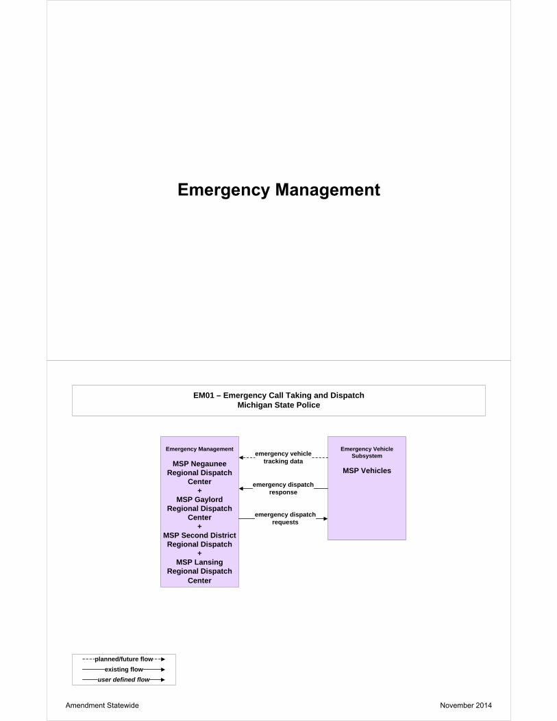
EM01 – Emergency Call Taking and DispatchMichigan State Police
planned/future flowexisting flow
user defined flow
Emergency Management
MSP Negaunee Regional Dispatch
Center+
MSP Gaylord Regional Dispatch
Center+
MSP Second District Regional Dispatch
+MSP Lansing
Regional Dispatch Center
Emergency Vehicle Subsystem
MSP Vehicles
emergency dispatch requests
emergency vehicle tracking data
emergency dispatch response
Amendment Statewide November 2014

EM06 – Wide-Area AlertAMBER Alert
Traffic Management
MDOT STOC+
MDOT WMTOC+
MDOT SEMTOC
planned/future flowexisting flow
user defined flow
alert status
Roadway Subsystem
MDOT DMS(Existing)
+MDOT HAR
Emergency Management
MSP Lansing Regional Dispatch
alert notification coordinationroadway
information system status
alert notification
roadway information system
dataEmergency Management
MSP Negaunee Regional Dispatch
+MSP Gaylord
Regional Dispatch+
MSP Second District Regional Dispatch
+MIOC
Note: Statewide TMC would activate AMBER Alerts for Regions after hours.
Information Service Provider / Traffic
Management
MDOT ATMS
traffic information coordination
+traffic control coordination
EM07 – Early Warning SystemMDOT
Emergency Management
MSP Lansing Regional Dispatch
planned/future flowexisting flow
user defined flow
secure area sensor control
+secure area
surveillance controlthreat information
Traffic Management
MDOT STOCSecurity Monitoring
MBA TOC+
IBA TOC+
MDOT Blue Water Bridge TOC
+Ambassador Bridge Operations Center
+Detroit Windsor
Tunnel TOC
incident information secure area sensor data
+secure area
surveillance data
Other Emergency Management
USACE Detroit District Headquarters
+US Coast Guard
incident report
threat information coordination
Amendment Statewide November 2014

EM08 – Disaster Response and RecoveryMIOC
Traffic Management
MDOT STOC
planned/future flowexisting flow
user defined flow
emergency traffic control information
+ resource deployment status+ road network conditions
+ road network status assessment
Emergency Management
MIOC
resource coordination+
incident response coordination
+ emergency plan coordination
+ incident command
information coordination+
transportation system status
emergency traffic control request + incidentresponse status
+ resource request+ transportation system status
Other Emergency Management
Local Agency 911 Dispatch
+Local Agency EOC
+MSP Lansing Regional
Dispatch+
MSP Negaunee Regional Dispatch
+MSP Gaylord Regional
Dispatch+
MSP Second District Regional Dispatch
Note: Local EOC’s handle coordination with Local 911 Dispatch and transit agencies.
emergency plan coordination
Maintenance and Construction Management
MDOT Superior Region TSCs
+MDOT North Region
TSCs+
MDOT Grand Region TSCs
+MDOT Bay Region TSCs
+MDOT Southwest Region
TSCs+
MDOT University Region TSCs
+MDOT Metro Region
TSCs
maint andconstr resource
response +road network
Statusassessment
TransportationSystem status
+ incidentresponse status
+ maint and constrresource request
emergency plan coordination
EM09 – Evacuation and Reentry ManagementMIOC
Emergency Management
MIOC
planned/future flowexisting flow
user defined flow
Traffic Management
MDOT STOC
Other Emergency Management
Local Agency EOC+
MSP Lansing Regional Dispatch
+MSP Negaunee
Regional Dispatch+
MSP Gaylord Regional Dispatch
+MSP Second District Regional Dispatch
Note: Local EOC’s handle coordination with Local 911 Dispatch
emergency plan coordination
+evacuation
coordination
Other Traffic Management
Wisconsin DOT+
Ohio DOT+
Indiana DOT+
Illinois DOT+
Minnesota DOT+
MTO+
LMIGA+
GLRTOC
traffic information coordination
emergency traffic control information
emergency traffic control request
+evacuation information
emergency plan coordination
Amendment Statewide November 2014

EM10 – Disaster Traveler InformationMDOT
planned/future flowexisting flow
user defined flow
Media
Local Print and Broadcast Media
Traffic Management
MDOT STOC+
MDOT WMTOC+
MDOT SEMTOC
Information Service Provider
MDOT MI Drive Websiteincident
information for media
transportation system status
evacuation information
incident information
emergency transit schedule information
road network conditions
Emergency Management
MIOC
Transit Management
Local Transit Agency Dispatch
Information Service Provider
MDOT ATMS
ISP coordination
Amendment Statewide November 2014

MC03 – Road Weather Data CollectionMDOT
environmental conditions
data
planned/future flowexisting flow
user defined flow
environmentalsensorscontrol
Traffic Management
MDOT STOC
environmentalsensors control
environmental conditions
data
Roadway
MDOT ESSenvironmental
conditions data
environmental sensor
data
Maintenance and Construction Vehicles
MDOT Maintenance Vehicles
environmental conditions
data+
environmental conditions
data status
environmental conditions
data
environmental condition
data
environmental conditions data+
environmental conditions data status
Maintenance and Construction Management
MDOT Superior Region TSCs
+MDOT North Region
TSCs+
MDOT Grand Region TSCs
+MDOT Bay Region TSCs
+MDOT Southwest Region
TSCs+
MDOT University Region TSCs
+MDOT Metro Region
TSCs
Weather Service
National Weather Service
Surface Transportation Weather Service
ASOS Weather Stations+
AWOS Weather Stations+
DNR Stations+
MAWN Stations+
RAWS Stations
environmental conditions data
MC04 – Weather Information Processing and DistributionThird Party RWIS Provider
Maintenance and Construction Management
Third Party RWIS Provider
Emergency Management
Local Agency 911 Dispatch
+MIOC
Weather Service
National Weather Service
road weather information
road network conditions
Media
Local Print and Broadcast Media
weather information
road weather information
planned/future flowexisting flow
user defined flow
Traffic Management
MDOT WMTOC+
MDOT SEMTOC+
MDOT STOCroad weather information Traffic Management
MBA TOC+
IBA TOC+
MDOT Blue Water Bridge TOC
+Ambassador Bridge Operations Center
+Detroit Windsor
Tunnel TOC
road weather information
Amendment Statewide November 2014

MC04 – Weather Information Processing and DistributionMSP
Emergency Management/Traffic Management
MSP Lansing Regional Dispatch
Information Service Provider
MDOT ATMS
road network conditions
road network conditions
planned/future flowexisting flow
user defined flow
Emergency Management/Traffic Management
MSP Negaunee Regional Dispatch
+MSP Gaylord
Regional Dispatch+
MSP Second District Regional Dispatch
Information Service Provider
MSP Winter Travel Advisory Website
+MSP Winter Travel Toll Free Number
road network conditions
road network conditions
road network conditions
planned/future flowexisting flow
user defined flow
MC06 – Winter Maintenance MDOT
Maintenance and Construction Management
MDOT Maintenance Decision Support
Software
Emergency Management
MSP Lansing Regional Dispatch
Traffic Management
MDOT STOC
maint and constr resource response
+roadway maint
status
maint and constr resource request
+road network
conditions
maint and constr resource response
+roadway maint
status
maint and constr resource request
weather information
Weather Service
National Weather Service
road weather information
maint and constr dispatch status Maintenance and
Construction Vehicle
MDOT Maintenance Vehicles
maint and constr dispatch
information
Amendment Statewide November 2014

MC07 – Roadway Maintenance and Construction MDOT
Maintenance and Construction Management
MDOT Superior Region TSCs
+MDOT North Region
TSCs+
MDOT Grand Region TSCs
+MDOT Bay Region
TSCs+
MDOT Southwest Region TSCs
+MDOT University
Region TSCs+
MDOT Metro Region TSCs
planned/future flowexisting flow
user defined flow
Emergency Management
Local Agency 911 Dispatch
+MSP Lansing
Regional Dispatch
Traffic Management
MDOT STOCequipment
maintenance status
field equipment status
security field equipment status
maint and constr vehilce system control
weather information
Weather Service
National Weather Service
Maintenance and Construction Vehicle
MDOT Maintenance Vehicles
maint and constr vehicle operational
data
asset status update
Asset Management
MDOT Asset Management Database
+MDOT DUAP
asset inventory+
asset restrictions +
maintenance and repair needs
Amendment Statewide November 2014

CVO01 – Fleet Administration Private Fleet Operations
planned/future flowexisting flow
user defined flow
Fleet and Freight Management
Private Fleet Operations
Information Service Provider
Private Sector ISP
trip log information
+alerts
route requestCommercial Vehicle Subsystem
Commercial Vehicle road network conditions
+route plan
traveler alert response
+traveler to fleet
request+
on-board vehicle data
+trip log
+route deviation
alert
fleet to traveler update
+on-board vehicle
request+
trip log requestCVO traveler initialization
+alert response
alarm Emergency Management
MSP Lansing Regional Dispatch
Commercial Vehicle Driver
Commercial Vehicle Driver
CVO02 – Freight Administration Private Fleet Operations
planned/future flowexisting flow
user defined flow
Fleet and Freight Management
Private Fleet Operations
Commercial Vehicle Subsystem
Commercial Vehicle
traveler alert response
+commercial vehicle
breach+
on-board vehicle data
+freight equipment
information
on-board vehicle request
alarm
Emergency Management
MSP Lansing Regional Dispatch
+MSP Negaunee
Regional Dispatch+
MSP Gaylord Regional Dispatch
+MSP Second District Regional Dispatch
+MIOC
alerts
CVO traveler initialization
+alert response
Commercial Vehicle Driver
Commercial Vehicle Driver
Amendment Statewide November 2014

CVO03 – Electronic ClearanceMDOT
Commercial Vehicle Check
MDOT Weigh-in-Motion
Commercial Vehicle Administration
MDOT Commercial Vehicle Permitting
System
CVO pass/pull-in message
screening event record
Commercial Vehicle Driver
Commercial Vehicle Driver
credentials information
+credentials status
information+
safety status information
CVO pass/pull-in
message
CVO traveler
initialization
Commercial Vehicle Administration / Enforcement
Agency
MSP CVED
electronic screening request
pass/pull-in
Fleet and Freight Management
Private Fleet Operations
information on violators
+safety status information
citation+daily site activity
data +violation
notification
citation
Commercial Vehicle
Commercial Vehicle
planned/future flowexisting flow
user defined flow
CVO04 – CV Administration ProcessMDOT
planned/future flowexisting flow
user defined flow
Commercial Vehicle Administration
MDOT Commercial Vehicle Permitting
System+
MSP CVED
Fleet and Freight Management
Private Fleet Operations
route restrictionsMaintenance and Construction Management
MDOT Superior Region TSCs
+MDOT North Region
TSCs+
MDOT Grand Region TSCs
+MDOT Bay Region
TSCs+
MDOT Southwest Region TSCs
+MDOT University
Region TSCs+
MDOT Metro Region TSCs
current asset restrictions
credentials information
credential application
Information Service Provider / Maintenance
and Construction Management
MDOT ATMS
current asset restrictions
Amendment Statewide November 2014

CVO06 – Weigh-In-MotionMDOT
planned/future flowexisting flow
user defined flow
Commercial Vehicle Check
MDOT Weigh-in-Motion
Commercial Vehicle Subsystem
Commercial Vehicle
CVO pass/pull-in message
Commercial Vehicle Driver
Commercial Vehicle Driver
pass/pull-in
CVO pass/pull-in message
tag data
screening event record
request tag data
electronic screening request
CVO10 – HAZMAT Management
planned/future flowexisting flow
user defined flow
Commercial Vehicle Subsystem / Vehicle
Commercial Vehicle
hazmat spill notification
emergency data request
emergency acknowledge
emergency notification
Emergency Management
Local Agency 911 Dispatch
+MSP Negaunee
Regional Dispatch+
MSP Gaylord Regional Dispatch
+MSP Second District Regional Dispatch
+MSP Lansing
Regional Dispatch
Fleet and Freight Management
Private Fleet Operations
hazmat information
hazmat information request
Amendment Statewide November 2014

ATIS01 – Broadcast Traveler InformationMDOT
planned/future flowexisting flow
user defined flow
Information Service Provider
MDOT ATMS
Media
Local Print and Broadcast Media
Information Service Provider
MDOT Office of Communications
ISP coordination
incident information
Traffic Management
MDOT WMTOC+
MDOT SEMTOC+
MDOT STOC
road network conditions
Maintenance and Construction Management
MDOT Superior Region TSCs
+MDOT North Region TSCs
+MDOT Grand Region TSCs
+MDOT Bay Region TSCs
+MDOT Southwest Region
TSCs+
MDOT University Region TSCs
+MDOT Metro Region TSCs
maintenance and construction work
plans+
work zoneinformation
+roadway
maintenancestatus
Emergency Management
Local Agency 911 Dispatch+
MSP Lansing Regional Dispatch+
MSP Negaunee Regional Dispatch +
MSP Gaylord Regional Dispatch +
MSP Second District Regional
traveler informationfor media
road network
conditions
ISP coordination
Other ISP
MDOT MI Drive Website
Amendment Statewide November 2014

Information Service Provider
MDOT ATMS traveler request
interactive traveler information
ATIS02 – Interactive Traveler InformationMDOT
planned/future flowexisting flow
user defined flow
Remote Traveler Support
MDOT Traveler Information Kiosks
Information Service Provider
MDOT MI Drive Website
ISP coordination
Information Service Provider
MDOT ATMS
Personal Information Access
Private Traveler Personal Computing
Devices
interactive traveler information
ATIS02 – Interactive Traveler InformationMDOT
transit and fare schedules
planned/future flowexisting flow
user defined flow
traveler request
Transit Management
Local Transit Agency Dispatch
Amendment Statewide November 2014

ATIS04 – Dynamic Route GuidancePrivate Sector ISP
planned/future flowexisting flow
user defined flow
Information Service Provider
Private Sector ISP
Personal Information Access
Private Traveler Personal Computing
Devices
ISP coordination
broadcast traveler information
Note: 3rd party system will provide dynamic route guidance. MDOT will provide data.
Information Service Provider
MDOT ATMS
Vehicle
Private Vehicle broadcast traveler information
ATIS05 – ISP Based Route GuidancePrivate Sector ISP
Information Service Provider
Private Sector ISP
Personal Information Access
Private Traveler Personal Computing
Devices
trip request
Vehicle
Private Vehicle
trip confirmation
trip plan
trip confirmation
trip plan
Information Service Provider
MDOT ATMS
ISP coordination
trip request
planned/future flowexisting flow
user defined flow
Amendment Statewide November 2014

ATIS6 – Transportation Operations Data SharingMDOT
planned/future flowexisting flow
user defined flow
incident information
Emergency Management
Local Agency 911 Dispatch
+MSP Lansing Regional
Dispatch+
MSP Negaunee Regional Dispatch
+MSP Gaylord Regional
Dispatch +
MSP Second District Regional
Traffic Management
MDOT SEMTOC+
MDOT STOC+
MDOT WMTOC
transportation information for
operations
maint and constr work plans
transportation information for
operations
Maintenance and Construction Management
MDOT Superior Region TSCs
+MDOT North Region
TSCs+
MDOT Grand Region TSCs
+MDOT Bay Region TSCs
+MDOT Southwest
Region TSCs+
MDOT University Region TSCs
+MDOT Metro Region
TSCs
road network conditions
transportation information for
operations
roadway maintenance
status
work zone information
Information Service Provider
MDOT ATMS
road network conditions
Other ISP
Third Party Traffic Data Provider
ATIS09 – In Vehicle SigningMDOT
planned/future flowexisting flow
user defined flow
Traffic Management
MDOT STOCshort range
communications status vehicle
signage data
Roadway
MDOT Roadside Signing Equipment
Vehicle
Private Vehicle
vehicle signage data
Amendment Statewide November 2014

AD01 – ITS Data MartCriminal Justice Information Center
planned/future flowexisting flow
user defined flow
Archived Data Management
CJIC Database
Archived Data User Systems
Archived Data Users
Emergency Management
MSP Office of Highway Safety
Planning
archived data product requests
archived data products
emergency archive data
archive requests+
archive status
Amendment Statewide November 2014

AD1 – ITS Data MartMDOT
planned/future flowexisting flow
user defined flow
Archived Data Management
MDOT Data Warehouse
Archived Data User Systems
Archived Data Users
Traffic Management
MDOT TDM Application
archived data product requests
archived data products
traffic archive data
archive requests+
archive status
AD03 – ITS Virtual Data WarehouseMDOT
planned/future flowexisting flow
user defined flow
Archived Data Management
MDOT Planning DivisionData Warehouse
Archived Data User Systems
Archived Data Users
Other Archives (Traffic Management)
MDOT STOC+
MDOT WMTOC+
MDOT SEMTOC+
Local Agency TOC
archived data product requests
archived data products
Other Archives (Transit Management)
Local Transit Agency Dispatch
Other Archives (Maintenance and Construction
Management)
MDOT Superior Region TSCs
+MDOT North Region TSCs
+MDOT Grand Region TSCs
+MDOT Bay Region TSCs
+MDOT Southwest Region
TSCs+
MDOT University Region TSCs
+MDOT Metro Region TSCs
+County Road Commission
+Local Agency DPW
archive coordination
archive coordination
archive coordination
Amendment Statewide November 2014

AVSS03 – Longitudinal Safety WarningMDOT
planned/future flowexisting flow
user defined flow
Vehicle
MDOT On-Board Monitoring System
Travelerdriver updates
Potential Obstaclesphysical presence
Location Data Sourceposition fix
Roadway Environment
roadway characteristics
driver inputs
Amendment Statewide November 2014

AVSS04 – Lateral Safety WarningMDOT
planned/future flowexisting flow
user defined flow
Vehicle
MDOT On-Board Monitoring System
Travelerdriver updates
Potential Obstaclesphysical presence
Roadway Environment
roadway characteristics
driver inputs
Location Data Sourceposition fix
AVSS05 – Intersection Safety WarningMDOT
planned/future flowexisting flow
user defined flow
Vehicle
Private VehiclesPotential Obstacles
intersection status
physical presence
Roadway
MDOT Roadside Intersection
Collision Avoidance Equipment
vehicle intersection safety status
Other Vehiclesvehicle intersection safety data
Amendment Statewide November 2014

AVSS06 – Pre-Crash Restraint DeploymentMDOT
planned/future flowexisting flow
user defined flow
Vehicle
Private Vehicles Potential Obstaclesphysical presence
Other Vehiclesvehicle safety data
Remote Vehicles
vehicle location and motion+
vehicle control event
AVSS10 – Intersection Collision AvoidanceMDOT
planned/future flowexisting flow
user defined flow
Vehicle
Private Vehicles Potential Obstacles
intersection status
physical presence
Roadway
MDOT Roadside Intersection
Collision Avoidance Equipment
vehicle intersection safety data
Other Vehiclevehicle intersection safety data
Traveler
driver updates
driver inputs
driver information
Amendment Statewide November 2014

AVSS11 – Automated Vehicle OperationsMDOT
planned/future flowexisting flow
user defined flow
Vehicle
Private Vehicles
Roadway Environmentautomated vehicle
control data
roadway characteristics
Roadway
MDOT Automated Equipment for
Connected Vehicles
Traffic Management
MDOT STOC
automated roadway
status
automated roadway
control data
Other Vehiclevehicle control coordination
Potential Obstaclesphysical presence
automated vehicle status
AVSS12 – Cooperative Vehicle Safety SystemMDOT
planned/future flowexisting flow
user defined flow
Roadway Environment
roadway safety date
roadway characteristics
Roadway
MDOT Roadside Equipment for
Connected Vehicles
Traffic Management
MDOT STOC
short range
communications status
vehicle signage
data
Other Vehiclevehicle safety data
driver input
driver updates
position fixvehicle safety
date
Other Roadway
MDOT Curve Warning Detectors
roadway equipment
coordination
Emergency Vehicle
MSP Vehicles
Traveler
Location Data Source
Vehicle
Private Vehicles
emergency vehicle alerts
Amendment Statewide November 2014

APPENDIX C – ARCHITECTURE CONFORMANCE AND MAINTENANCE
FORM

Michigan Department Of Transportation
2560 (10/12) REGIONAL ITS
ARCHITECTURE CONFORMANCE AND MAINTENANCE DOCUMENTATION FORM
Page 1 of 3
Please complete the following questionnaire to document conformance or changes for the Regional ITS Architecture. Modifications will be made during the next architecture update. AGENCY AGENCY CONTACT PERSON STREET ADDRESS
CITY
STATE
ZIP CODE
TELEPHONE
FAX
PROJECT INFORMATION PROJECT NAME
PROJECT DESCRIPTION
PROJECT SPONSOR (Agency providing funds)
ESTIMATED COST
DEPLOYMENT PLAN PROJECT NUMBER (if applicable)
MDOT OR LOCAL AGENCY PROJECT NUMBER (If applicable)
MDOT JOB NUMBER (If applicable)
MDOT CONTROL SECTION (If applicable)
CONFORMANCE TO REGIONAL ITS ARCHITECTURE REGION
This project conforms to the existing Regional ITS Architecture. No changes are required.
This project does not conform to the existing Regional ITS Architecture. Requested changes are noted in the next section.
CHANGE INFORMATION Please indicate the type of change:
Level 1: Basic changes that does not affect the structure of the architecture. Examples include: Changes to the stakeholder or element name, element status, or data flow status.
Level 2: Structural changes that impact only one agency. Examples include: Addition of a new market package or modifications to an existing market package that affects only your agency.
Level 3: Structural changes that have the potential to impact multiple agencies. Examples include: Addition of a new market package or modifications to an existing market package that involves multiple agencies, incorporation of a new stakeholder into the architecture.
DESCRIBE REQUESTED CHANGE IF THE PROPOSED CHANGE IMPACTS ANY MARKET PACKAGES, LIST THOSE MARKET PACKAGES (NOTE: If the proposed change involves creating or modifying a market package please attach a sketch of the new or modified market package.) IF THE PROPOSED CHANGE AFFECTS ANY STAKEHOLDERS, LIST THOSE STAKEHOLDERS

MDOT 2560 (10/12) Page 2 of 3 IF COORDINATION WITH IMPACTED STAKEHOLDERS HAS OCCURRED, DESCRIBE THE RESULTS
Approved by regional contact REGIONAL CONTACT NAME
DATE
Approved by ITS Program Office ITS PROGRAM OFFICE NAME
DATE
Forwarded to FHWA DATE
Please submit change forms to: [email protected]
Transit-related projects should also be sent to: MDOT – Bureau of Passenger Transportation and Federal Transit Authority (FTA)

MDOT 2560 (10/12) Page 3 of 3
Process for Documenting Regional ITS Architecture Conformance and Maintenance
□ The project manager evaluates the projects conformance to the Regional ITS Architecture. □ The project manager then completes the architecture conformance and maintenance documentation
form and submits it to ITS Program Office. □ If the form is approved by the ITS Program Office, it is then submitted to the FHWA, the regional
contact, the project manager and if applicable, the corresponding Metropolitan Planning Organization (MPO).
□ If the form is rejected, the ITS Program Office coordinates with the project manager and the regional contact to then re-submit the new form for approval.
□ To request a new form Contact your business area Forms Coordinator or Connie Bretes, MDOT FMO at (517) 335-2520.