state of qf conservation and ecqmomhc ......c. w. lauman r co., lame -new york co., parkhurs t well...
TRANSCRIPT
State of New Jersey
DEFARTlQEN'k" QF CONSERVATION
AND ECQMOMHC DEVELOPMENT
I Division of Water Policy and Supply I
SPECIAL REPORT 10
PRELIhfINAW REPORT ON THE GEOLOGY AND GROUND-WATER
SUPPLY OF THE NEWARK, NEW JERSEY, AREA
NEW JERSEY GEOLOGICAL SURVEY

NEW JERSEY GEOLOGICAL SURVEY

STATE OF NEW JERSEP
DEPARTMENT OF CONSERVATION ANXJ ECONOMIC DEVELOPMENT
CHARLES R, EWIMAN, J R I COMMISSIONER
DIWSlON OF WATER POLICY AND SUPPLY
HOWARll T. CRlTCHLOW, DIRECTOR AND CHIEF ENGINEER
SPECIAL REPORT 10
P R E L I ~ N A H Y RE W R T
ON THE
GEOLOGY Am) GROUND-WATER SUPPLY OF THE
NEWARK, NEW JERSEY, AREA
Henry Htrptra
and
Renrg C. B a r t s d n l c
Prepmred in coopcrrtion w i t h t h e
United S t a t c s k p a r t m e n t of t h e I n t e r i o r
. &ologicnl Survey
NEW JERSEY GEOLOGICAL SURVEY

NEW JERSEY GEOLOGICAL SURVEY

LETTER OF TRANSbl T T A L
Honorable Charles R. Erdman, Jr., Coma issioner Dept. of Conservation & Econon?ic Development
Mar Sir:
I am transmitting herewith a report on the ground- water sup l~ l i e s af the Newark, h'ew Jersey, area eregared by Henry Herpers o f the State Geologic a Topographic Survey, and Heni-y C. Barksdale. 3 i s t r i c t Engineer of the United States Geological Survey. 'ZIlis report has been prepared in cooperation with the United states Geological Survey as a part of the cooperative in- vestigation of the ground water rBources of the State.
The report describes the geology and ground-water conditions i n the City of Newark and its vic ini ty . I t def in# the limits of a grave l-f i l led preglacf a1 channel, the existence of which h m only k e n inferred heretofore. f t describes the cr i t ica l lowering of the water levels in the eastern part of Newark, and the rather general intrusion of salt water into the water-bearing formations in that area. The report points aut that the. safe yie ld of .the water-bearing formations in parts of the ares m y have been exceeded, and that further large developments in other parts of the area should be mnde w i t h great caution, if at all.
I , theref ore, recornend that this report be as a Special Report of the Division of water Policy & Supply, in order that the inforrnaticn oontafned therein m a y be mde available to the people of the State.
hcl. October 22, 1951
NEW JERSEY GEOLOGICAL SURVEY

NEW JERSEY GEOLOGICAL SURVEY

DEPARTMENT OF CONSERVATION AND ECONOMIC DEYEMPMENT
DIVISION OF WATER POLICY AND SUPPLY
520 EAST STATE STREET, TRENTON 9, N. J.
WATER POLICY AND SUPPLl COUNCIL
Thtlr loa C . Nelson, Chairman..;. ........ .Highland -Park
......................... l a x Grossman.... Atlantic City
...... Kenneth.H. Murray. ; . . . . . . . . . . . . . . . . . . . . S e a B i r t
Joseph H: Palmer.. ............ .... .......... tuckertom
John Roach, -Jr,,,,,................m.~~.,..m.~..D~~er
Roswell I. Roper east Orange -
Herbert K. Salmon ............................. Stanhope
........................... August C. Scl~ul tes . Woodbury
................... Lillian M., Schwartz.. ... .-. Patesson
John Wyack, 'Secretary .
Howard T. C r i t a h l o w , D i r e c t o r and Ch ie f Engineer
Charles R. Erdman, J r . , Commissioner of C o n s e m a t i o n . and Ecoftamic Develofirnent
NEW JERSEY GEOLOGICAL SURVEY

NEW JERSEY GEOLOGICAL SURVEY
C O N T E N T S
......................................... AbStmct 9
Intmluctian. .................................... I1 Purpoge and scope of investi@tfon ............. 11 bcknowl&gments ................................ 14
Outline of geology ................................ 15
..... Hydrology and geology of the rock formations 19 Recbnt deposits ................................. 19 ........................... PlefStmene deposits 19 Kewark g r o u p . . . . . . . . . . . . . . . . . . . . . . . . . . . . . . . . . . . 22
Brunsw ick f tmm tion .......................... 22 Geology .................................... 22
.................................. IiydmloB 24 ............ I;emml ..................... 24 Pumping tests ............................. 28 hng-term fluctmtfons of water levels
md p u m ~ @ . . . . * . . . * * * * * . - * * * * * . . . . . * * * ' 31 ...................... Artificial recharge 35 ........... Chemical quality of the ground mter 36 ........................... Salt-wabr i n t m i o n 40 ................ . Temperature of the ground water 44
Appendfx I . Selecbd we11 logs .................. 46
'1 . Driver Ihrris Co.. Harrison. well 2 ......... 46
. . ................. 2 John Nieder. Newark well 2 47
.... . 3 &lanese rorpoI*atf on of America. we l l 27 48
4 . New Jersey State Nightoay Demrtment test boring 19 ................................ 49
NEW JERSEY GEOLOGICAL SURVEY
l L L U S T R A T I ONS
Figure 1, Map of n o r t h e a s t e r n New. Jersey ' showing location of the Newark area.
Figure 2. Map showing elevation and conf igura- t i o n o f bedrock beneath Newark, N. J., and vicinity. ...............
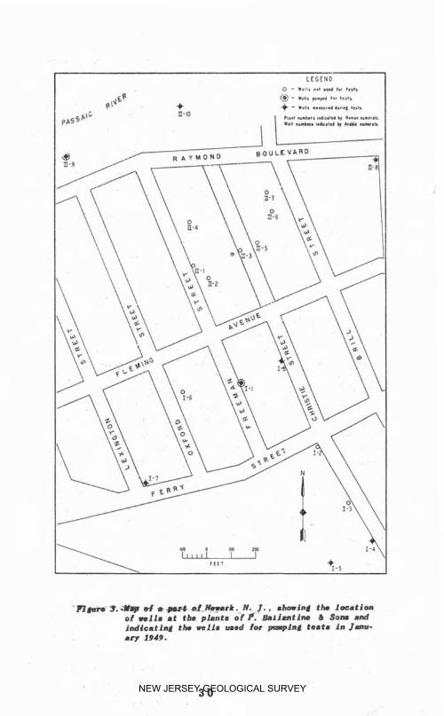
Figure 3, Map o f a P a r t of Newark, Pi. d . , showing the location of wells at t he p l a n t s of P, gallanline & Sons and ind icat ing the wells used f o r pump- i n g tests in January 1949. .........
Figure 4. Diagram s h o w i n g Eluctuat i o n s of pumpage a n d water leve 1s in t h e eastern part o f Newark, the monthly p r e c i p i t a t i o n , and the cumulstive departure from normal grecipitatf on, ...................... t o 1940.
Figure 5 . Map shoeing chloride content of the ground water beneath Newark, N, J. ,
..................... and v i c i n i t y .
Table 1. S t r a t i g r a p h i c table i n thc Newark .............................. area.
Table 2, Analyses of water from rock wells ............... in the N~srtrlc area..
Page
13
NEW JERSEY GEOLOGICAL SURVEY

PRELIHIYARY REPORT ON T%E GEOLOGY AND W W h ' D -
WATER SUPPLY OF TlIE NEIARK. NEW JERSEY, AHEA
SF Henry Herpers and Henry C. mrksdale
ABSTRACT
In the Newark area, grourtd water is used chiefly for industrial cooling, air-conditioning, general process- ing, and for sanitary purmses. A smll amount is used in the manufacture of beverages. Total ground -water pumpage in Newark i s es timated a t n o t less than 20,000,000 gallons daily.
The Newark area is underlain by formations o f aecent, Pleistocene and T r i a s s i c age; a n d t h e geology and hydrologic properties of thele ff orat ions are discussed. Attent ion is c a l l e d t o t h e important influence of a buried v a l l e y in the rock f l o o r beneath the Newark area on the y i e l d of wells located wi th in it. Data on t h e f luctuation of the water levels and the variation i n pumpage are presented. and their signifimnce d i a - cussed. The results o f a pumping t e s t made during the investigation were inconclusive. The Seneficial results of ar t i f i c i a l l y recharging the aquifers in one part of the area are descritled,
The i n t r u s i o n of salt water into certain parts of t h e ground-water body is descr ibed and graph i c ~ l ly portrayed by a map showing the chlor ide concentration of t h e ground water in various parts of t h e C i t y . In- sofar as available data permit, the chemical quality of the mound water is discussed and records are given of the ground-water temperatures i n various parts of the City.
There has k e n marked lowering of the water table in the eastern gart of t h e area, accorngrnieti by salt water intrusion, indicating t h a t the safe rield o f the forma- t i o ~ ~ s in t h f a mr t of Xewark h a s ~sprbbsly k e n exceeded. I t is recmm~i~led that t h e study of t h e ground-water resources of t h i s area b? continued, and tha t a r t i f i c i a l recharging of the aquifers be increased over a5 ?ide an area as p s s i b l e .
9 NEW JERSEY GEOLOGICAL SURVEY

NEW JERSEY GEOLOGICAL SURVEY

INTRODUCTION
Purpose and scope of investigation
In the Newark area, the chief uses o f ground water are for c o o l ~ n g by i r idustr ies , for a ir-condit ioning, and f o r general processing and sanitary purposes. Several beverage manufacturers use ground w a t e r as an ingredient i n their products , and the water from a few wells i s used for drinking. As oneresu l toE a recently comple ted survey of a l l known w e l l s , i t i s estimated that not less than 20 mill ion gallons of ground water i s used I n t h i s area ger day. In summer an est imated one t o one and a h a l f mil l i o n gallons o f ground water is used for air-conditioning alone.
Records kept by various well owners and by State and Federal agencies have sbown a marked lowering o f t h e water level i n many Mwark wells, as well as a diminution i n t h e y i e l d o f some. They have a l s o shown t h a t t h e ground water in certain parts of the area has become brack i sh because of heavy pumpage and the in f i l t ra t ion of salt water from surface sources. These conditions are particularly severe i n the eastern part of Newark, i n what is known local ly as t h e "Ironbound District." In order t o give some conception of the seriousness of these conditions, it may be mentioned t h a t i n the gear ln70 the water level i n wells i n eastern Newark ranged f r o m a few feet above to 25 feet below the surface of t h e mound, and several n- inch wells y i e l d e d as much as 500 gallons per minute when pumped by direct suct ion. Analyses o f the water from t h e s e wells showed t h a t i t contained only 10 t o 25 parts per million of chloride. 1
I/AnnueI report of the S t a t e Geologfst, g . 126 f f . , 1879.
NEW JERSEY GEOLOGICAL SURVEY

Analyses made by t h e C i t y Chemist of Newark showed chloride contents ranging from 250 t o 2,500 parts per m i l l i o n i n water t a k e n from wells i n 1942, in t h i s same area, Moreover, in 1947 the general water l e v e l ranged from 125 t o 200 feet beneath the land surface, and pumping levels i n wells ranged from 135 t o 290 f e e t , depending upon the amount o f water pumped and the season of the year. In view of these facts. it was decided t o make an intensive s t u d s of the geology and ground water of the Newark area, and to publish a report on the f indings , in order to summarize and mke generally avai lable our knowledge o f the q u a n t i t y and quality of ground-water rssources of the area, and t o faci l i tate the planning of ground-water gumpage in the future.
Thc area included l o the present study and referred t o h e r e i n as the Newark area is shown on f igure 1. I t lies principally in Essex County. but inclcdes small parts of IIudson and Unf on Counties. It includes a11 of the c i t y of Newark, except the extreme western part; the greater part o f Harrison; and parts of Kearny, Irvington, East Orange, Bloomf ield, and Elizabeth.
The Newark area iies wholly within the phvsiographic province known as the Piedmont Plain. The southeastern part of the area is a lowland w i t h considerable tidal marsh, and thC balance of t h e area is characterfzed ch ie f ly by low ridges trending i n n northeasterly d i - rection. The average annual rainfall at Newark is ap- proximately 47 inches, and the m a n annual temperature is about 53'~.
NEW JERSEY GEOLOGICAL SURVEY

NEW JERSEY GEOLOGICAL SURVEY
Acknowledgments
T h i s r e p o r t is t h e resul t o f c o o p e r a t i v e work by t h e G e o l o g i c and Topograph ic Survey and t h e Division of Water Pol icy and S U P P ~ ~ , M t h of t h e New J e r s e y Depart- ment of Conserva t ion and Economic Devslopment, and by the Uni ted S t a t e s G ~ o l o g i c r i l Survey. :>I. E . Johnson, S ta te Geolog i s t , II. T . Critchlow, Direc to r of the Dtvi- s i o n of !Yater P o l i c y and Supply, and A, K. Sayre, Geol- o g i s t i n Charge, Ground Water 3ranch, U, S, Geological Survey, have e x e r c i s e d g e n e r a l s u p e r v i s i o n o v e r t h e work since its h e s i n n i n e . 5Ir, Johnson and Henry C. Barksdale, District Engineer of the Grouml l a t e r Branch, U. s. ~ e o l o g i c a l Survey, have s h a r e d l o c a l responsi - b i l i t y f o r t h e p r o g r e s s and d e t a i l s of t h e work. The gathering of the data neceasarg fo r t h e p r e p a r a t i o n o f t h i s r e p o r t has been l a r g e l y i n t h e hands o f Henry Herpers o f t h e ~ e o l o g i c and Topograph ic Survey and Jerome !II. tud low of t h e tl. S. G e o l o g i c a l survey . T!re greater part of this report was w r i t t e n by Mr. l ierpers . The s e c t i o n s on the hydrology of the various format ions were written by Mr. arkadale.
Needing the h e l p of t h e c i t i z e n s and i n d u s t r i e s o f Newark, and b e l i e v i n g that they would g l a d l y c o o p e r a t e i f t h e y knew t h e facts, the Newark Chamber of Commerce was advised o f the proposed survey and r e p o r t , and a s t o r y g i v i n g t h e reasons for t h e work and i n d i c a t i n g i t s importance was given the press ear ly I N 7 . It is now t h e authorsy pleasure t o express t h e i r s incere a p p r e c i a t i o n o f t h e h e l p given the p r o j e c t by almost everyone approached. The work o f gathering data was mater ia l ly fac i l i ta ted by the assistance o f the fol lowing wgll c o n t r a c t o r s : A r t e s i a n Well and Epuipment C o , , C. W. Lauman R Co., Lame -New York Co., Parkhurs t Well and Pump Co., Rin5rand Well Dril l ing Co., Samuel Stothoff Co., and William Stothoff Co. Especiallx va luab le data on t h e operat ing c h a r a c t e r i s t i c s of their w e l l s , and other a i d , were f r e e l y given by Mr, B. H. B i shop and o t h e r engineer ing personnel of P. Ballantine & Sons and by .Mr. Wm. E. Helmstaedter. Mechanical Engineer. and o t h e r s of t h e Celanese C o r g o r a t i e n o f America. P a r t i c u l a r acknowledgment i s made of t h e a s s is tance
14 NEW JERSEY GEOLOGICAL SURVEY

rendered by P. Ballant i n e g Sons i n making their well f i e l d a v a i l a b l e f o r p~irnping tests and a l t e r i n g t t e f r p l a n t routine t o meet t h e requirements of the t e s t . The Divis ion of Vatex rtnd the DePartmnt of Health of tlie City of Newark have assisted mater ia l ly i n l o c a t i n g wells and i n furnishing records of analyses o f well water.
OUTLINE OF GEOLOGY
The Newark area l ies wholly within the section of Xewf Jersey underlain by the Newark group of rocks of Triassic age. These rwks form a bel t extending from the Hudson R i v e r a c r o s s central N e w Jersey , P e n n s y l v a n i a , and Varyland, and into Virginia. They consist of shale, sands tone, a r z i l l i t e , and conglomerate with inc luded s h e e t s , s i l l s , and d i k e s o f trap rock (basa l t and diabaqe ) .
In New Jersey, the sedimentary rocks of the Newark group bave ;ken d i v i d e d on the b m i s of their l i t h o l o g y in to three units. The lowest is c h i e f l y r e d , o u f f , or gray arkosic sandstone and is called t h e Stockton formation; the m i d d l e u n i t , called t he Locksttong forma- tion, i s composed l a r g e l y o f g a y , g u r p l i s h - g r a y , or dull-red arg ill ite ; and t h e u p p e m s t u n i t , the 8runsw ic k formation: consists chief ly of s o f t red s h ~ l e and red s a n d s t o n e . "he 3rnnswick formation i s t h e bedrock throughout t h e Fiewark area. I n general , t h e s t r a t a have been t i l t e d norttwestaard anrl localls they have been warm into gentle flexures w i t h occasional faulting The harder beds form ridges, most of which trend north- eastward.
T h e northern part of the klt of Triassic rocks was glaciated in l a t e gea log ic t ime , so t ha t much of the surface is c a v e r e d w i t h a mantle o f glacial d r i f t , which i n nan:i plqces is t h i c k enough to conceal the bedrock surface. Although the hedroci.; crops o u t in only a few p l a c e s , i t accounts for the relief En the western Part of the Newark area. There the covering o f glacial d r i f t is t h i n . In t h e eastern section the bedrock is concea led by t h i c k d e p o s i t s o f sf lt a n d c lay with
15 NEW JERSEY GEOLOGICAL SURVEY

NEW JERSEY GEOLOGICAL SURVEY

t h i n n e r k d s of sand anr? gravel. and, a l t h o u g h toga- g raph i ca l l y t h i s region is a p l a i n , borinss have shown t h a t t h e surface of t h e u n d e r l y i n g bedrock does not conform with the ground surface. (See f igure 2). The valleys of many of the streams in the glaciated area contain terraces of sand and gravel o f glacial o r i g i n .
The geologic h i s t o r y o f the area since t h e beg inn ing of Triassic time is re lat ive ly s imple . During Trimsic time, sands and muds were deposited in an arid basin. Near the end of Triassic time the beds were faulted and t i l t e d taward the northwest. Lakr erosion reduced the surface t o a lai in, over which the sea then advanced an indeterqinata distance to t h e northwest. Sands and clays, such as those found ~II the coastal p l a h , were depositd!.' in this sea. S t i l l later, the sea withdrew and the forces of erosion removed t h e sediments of the coastal glain and then etched out the Larger topographic features that we see today. During t h e Pleistocene epoch the details of the togagra~hy were altered by the ice. Hills were srmothed somewhat and much d r i f t was depos i ted , The d r i f t in some places f i l l e d valleys e x i s t i n g prior t o glaciation and effected important changes in drainage. A general rise of sea level at the c lo se of the Pleistocene epoch flooded low areas ad- jacent t o the coast, forming Newark Bay at the junction of theHackensackand Passaic Rivers. Since then t h e meadows have been formed by stream d e p o s i t s , and very, very recently -- in terms of the geologic calendar -- much meadowland has been reclaimed by suitable drain- age and by f i l l i n g . k typ ica l example of such "made" land i s t h e area upon which Newark Airport has been bui l t .
The successian o f formations i n the Newark area, arranged in normal sequence (i. e. , youngest formation at tog) is shown in the following table:
NEW JERSEY GEOLOGICAL SURVEY

TRUP 1. --3tratimxohfc table in the Pewark area
Cenozoic era Quaternary system
Recent series Alluvium and meztdorv muck
P l e i ~ tocene series Glacial till and s trat i f ied deposits oT glacial o r i g i n
UNCONFOEM ITY hiesozoic era
Triassic system Newark group
arunswi ck format ion
2 UNCONFORBITY Ol:ler rocks
2/Tha deepest well dri f led in Newsrk f a i l e d t o pass throqdh the red aha l e and sandstone s t 2,538 f e e t . It cmnot, therefore, be stated w i t h certainty what sort of rock l i es below the c i t y at g;reat depths. Pram the general $eology of the Triassic rocka, presumably thcPal iaarle diebaaa vdirId be fouml a t greet depth. and rmre rocks o F the Newark group helow f he diabase . Belo* the Triassic racks l i e crystalline rocka o f very great age which ex tend to an undetermircd depth.
NEW JERSEY GEOLOGICAL SURVEY

HYDROLOGY AND GEOLOGY OF THE ROCK FORMATIONS
Recent deposits Recent Repusi ts are found mainly i n the eastern part
of the Newark area where they occur i n the t i d a l marshes or meadow lands along Passaic itiver and bordering Newark Ray, They consist l a r g e l y o f unconsolidated mud and s i l t tv i t h inclusions of peat and other organic materials and occasional lenses o f . sand and gravel. They have been d e p a s i tad on top of the Pleistocene sediments , a r pe rhaps i n places d irect lr on the Triass ic rocks, b y t h p Passa i c and Hackensack Rivers and by smaller stream f l o w i n g across the area and discharging into those r ivers , or into Vewark Bay. The Recent deposits range i n thickness from a feather edge to 35 feet.
I~lydro1ogi~ally, the Recent d e p o s i t s are of relatively l i t t l e importance excep t as they may transmit water to the under ly ing rocks or exclude S t from them. Their permeability i s re la t ive ly law and they occur i n the parts o f the area that are exposed to salt water. There- fore their action as a barrier in retarding the per- co la t ion o f s k l t water in to the u n d e r l y i n g rocks is qrhaps their m a s t important function, In this respect t h e y perform imperfectly because there probably are breaks i n the cover that they provide a t critical p o i n t s , such as the s h i p channels i n the river and i n the bay.
Pleistocene deposits
The Pleistocene deposits i n the Newark area are a l l o f g l a c i a l o r i g i n . They c o n s i s t of t i l l - - a n uncon- so l idated , unstratf f i e d , heterogeneous mixture o f clay. boulders , and sand--and s trat i f ied glacial d r i f t , which i s composed o f sand and gravel that have been more or l e s s s o r t e d and s t ra t t r i ed by the a c t i o n of glacial waters. The deposits of glacial origin overlie the bed- rock throughout pract ical ly a i l the Newark area, the bedrock cropping out only in a few more or less isolated spots. The thickness of the Pleistocene deposits varies greatly. In the western part of t h e area they are only a few f e e t thick, forming a thin veneer over the under- lying bedrock, hut i n the eastern p a n o f the area they
NEW JERSEY GEOLOGICAL SURVEY

are so thick that t h e y mask entirely t h e topography of the u n d e r l y i n g rock. The mag of t h e elevation and configuration o f t!le bedrock kneath Newark, N. J., and v i c i n i t y ( f i g n ? 3 j shows t h a t , i n the area e a s t of Broad Street, there is a lnrge deep valley cut i n the bedrock, which is entirely covered oy g l a c i a l d r i f t . A t the surface t M s area present.?, the aspect of a plain. The depth t o rock in the buried valley ranges from 125 feet t o more than 190 feet in Newark, and to as much as 300 feet in Harrison. Farther east i n the Newark area, bedrock l i es at lesser depths. The buried valley exten& northeastward across the c i t y from its s o u t h - western boundary, crossing Frel inghuysen Avenue near its nort inrn end, and then extends east of and roughly parallel to Broad Street, finally crosslng over into Harrison, where i t bends eastward. I t has n o t y e t become possible: to show the extension o f the valley to the southwest or to the east hcause of the lack of s u f f i c i e n t reliable borin g data, but its course and s hap? across t h e c i t y of Newark is faLrly accurately known. From its shape as shown on glate 1, i t is ap- parent that the valley slopes toward the northeast, and this direc t ian is therefore the probable direction of f l o w of the r iver that c u t t h e v a l l e y prior t o the Plef stocene epoch.
The character of t h e Pleistocene deposits varies throughout: the Newark area. I n s n e r a l , these deposits consist c h i e f l y o f ti l l i n that part of the area lying west of Broad Street , whereas the c u t t i n g s taken from many test boring3 and wells in the eastern part of the area show that the Pleistocene deposits there consist largely of stratified materials with interbedded lenses of till. (See logs 1 to 4 in appendix.)
The Pleistocene d e p o s i t s i n the bottom of the buried valley are wort& of special attention. In the south- =stern part of the Newark area they cons i s t for She most part o f f i n e sand and clayey sand, but in the northeas tern part the bottom of the v a l l e y contains deposits of coarse sand and gravel which in many glaces contain much wter. (See logs 1 and 2 in appendix. ) In fact, some of the best wells i n the Newark area pump fran these d e p o s i t s .
Other coarse deposits o f glacial origin are found in the valley of the Passaie Rfver nqrth of the point where
2 0 NEW JERSEY GEOLOGICAL SURVEY

the river makes its great eastward bend.
The Pleistocene deposi ts are one of the t w o major aquifers i n the area. Their h y d r o l o g i c function is twofold. fn t h e f i r s t place. under f ~ v o r a b l e c i r - cumstances they yield water In substantial quant i t ies d i r e c t l y to wel ls . fn the second place, they absorb and s tore water from precipi tat ion and from surface sources and transmit i t t o the underlying rocks,
Where the deposits contain beds of sand and gravel t h a t are thick enough and extensive enough, they yield large quantities of water t o w e l l s f i n i s h e d i n thev. Insofar as is $no%, these conditions are 1 irnited a h s t e n t i r e l y t o the buried v a l l e y , where several wells y i e l d i n g from 175 t o more than 600 gallons per minute have h e n developed. For example, a well dri l led for the Driwr Harris CO. i n Harrison near t h e locality where the buried v a l l e y crosses t h e Fassaic R i v e r yielded 6013 g. p.m. w i t h a draw down of agprox imately 60 feet.
Detailed and extended records of water levels im and o f pumpage from wells i n t h i s aquifer tire not available. It is therefore imgossible t o say at t h i s time whether water k$ being withdrawn from t h i s aquifer a t a rate l e s s than, equal to, or greater than the rate a t which recharge is available. The fact that ,two' or three m i l - l i o n a l l o n s of water have been withdrawn da i ly for a number of years from t he sand and gravel i n t h e buried valley suggests that a large quantity of recharge occurs. On t h e other hand, the fact that the static water levels in some wells tapping t h i s aquifer are now sub&tantially below sea level suggests caution before further devefop- ments are made.
A more definite and immediate threa t t o the safe y ie ld of the gravels of Pleistocene age is t h e apgarent i n - trusion of salt water from surface sources. Wells near the p o i n t where the huried.+yalley crosses the ~ a s s a i c River are y i e l d i n g water that contains 200 t o 500 parts ger mil l ion o f chloride and i s already unsuitable for some uses. Inasmuch as there I s hydraulic continuity between the gravels and the underlying rocks, the Iicohlem o f =It-water intrusion w i l l be discussed i n more d e t a i l i n a sect ion of t h i s report that deals primarily with the water supply frm the rocks.
NEW JERSEY GEOLOGICAL SURVEY

The second function of the P l e i s t o c e n e d e p o s i t s , t h a t of absorbing, storing, and t r a n s m i t t i n g water t o t h e underlying rocks, i s , i n the aggregate, aore fmportant than the i r y i e l d i n g water d i r e c t l y to sel ls . As already indicated, they overlie the rocks to varying thicknesses throlrghout most of t h e area. In general, there appears to be some c o r r e l a t i o n between the thickness and nature o f t h e P l e i s t o c e n e d e p o s i t s and the y i e l d o f wells ta p p i ~ g t h e underlying rocks. T h i s I s t o he expected because the storage capacity of the rocks is relat ive ly low and sustair.erl large yields can be a b t a i n d from them only i f some adeqaate source of recharge is available, Where t h e overlying' depos i t s are t h i c k and moderately porous and permeable, they supply t h e necessary recharge. On the other hand, where they are thin or relat ively impermeable, they may f a i l to supply recharge to the rocks or may even retard the movement of water into them.
Newark group
Brunsr i ek format i o n
Geology
As mentioned previously i n t h e outline of the geology o f the Newark area, the sedimentary rocks oI the Newark group o f Triass ic age in New Jersey have been divided upon the basis of their lithology in to three units--the lower, or Stockton form&tlon, the middle, or Lockatong formatian, and the upper, or ~ i u n s w i c k formation. I t should now be pointed out that whereas these l i t h o l o g i c dis t inc t ions can be made i n central New Jersey, they are n o t apparent i n the n o r t h e r n part of t h e belt' of Triassic rocks, The Locka tong formation does not continue f a r t h e r nart heas tward t h a n Franklin Park, Middlesex County, and the d i s t i n c t i o n between the Stockton - - and Brunswick formations i s no Longer obvious, as it is farther sou thwes twar3, because the whale Newark group becomes, in general, coarser-grained. In the northern part of the State, particularly i n Bergen County, these sediments becme predorn i~ant ly sandy and even conslam- eratlc. In the Newark &rep., t he tendency of the rocks to increase In coarseness towad the northeast i s shwr! I::? the fact t h ~ t aeYls dr i2 : r i : i n t.!::! cnt-",be-> ;a:.;.,
NEW JERSEY GEOLOGICAL SURVEY

near the Elizabeth line, have genetrated rock t h a t i s =hief ly soft red s h a l e , whereas i n n o r t h Newark, espe- cially near the r3elleville l i n e , the roeks are g r i n c i p a l l y sandstone w i t h interbedded shale. I n f a c t , dur ing the l a t t e r p a r t of the last c e n t u r y several sandstone quar- r ies were operated i n north Newark, espec ia l ly along Bloomf ie ld Avenue and i n the southern p a r t of Branch Brook Park. The change from s o f t shale tb hard sand- s t o n e is ref Iected i n t h e change i n topography from a r a t h e r f l a t , low-lying p l a i n w i t h few r o c k h i l l s i n s o u t h e r n Newark to h i l l s w i t h ra ther pronounced re l i e f In the northern part of t h e city. In the Newark area, t h e r e f o r e , the bedrock is a l l designated as a r u n s - wick format ion. A r e p r e s e n t a t i v e s e c t i o n showing the v a r i a t i o n s i n t h e rock under Newark is shown i n l o g 3. (See apwnd i x 1. )
The bedrock o r i g i n a t e d as sand, silt, and mud which were der ived from t h e e r o s i o n of alder rock$ northwest and s o u t h e a s t o f t he great hasin In which t h e sediments were laid down dur ing t h e Triassic period. Three t i m e s during the period o f depos i t ion g rea t sheets of h s a l t i c lava were poured out on the surface and were then buried by sediments later i n t h e Triassic. The remnants of t h e f lows now form t he Watchung Mountains, but i t i s irnpoxs ible t o s tate whether o r n o t t h e flows ever ex- tended as far , e a s t as the Newark area, f o r t h e r e a re no igneous rocks of t h i s t y p e inhibat area, s o far as is known. Toward the end of the Triassic period, the sedi- ments were intruded by similar magma which a p p a r e n t l y d i d n o t have enough force to push through to t h e surface but sp read o u t beneath the surface i n a great sill some 900 f e e t or more t h i c k , usually f o l l o w i n g t h e bedd ing p l a n e s of t h e sed iments bu t -frequently c u t t i n g across them. Because of erosion, t h e si l l is exposed today in the Palisades i n eastern Hudson and Bergen Count ies and also i n certain mountains i n c e n t r a l New Jersey. A t t h e close of Triassic time, the entire Newark group o f rocks were t i l t e d toward the nor thwest , which i s their attitude today and in t h e process they were fau l ted and greatly f r a c t u m d .
The t o t a l t k i c k n e s s of t h e rocks o f Triassic age in t h e Newark area is unknown b u t is e s t i m a t e d a t a b o u t 5,000 t o 7,000 feet.
NEW JERSEY GEOLOGICAL SURVEY
The deepest well d r i l l e d i n Yewark reached a d e p t h of 2,53r1 feet and f a i l e d t o pass through the normal red shales and sandstones. I t is therefore impossible to state with accuracy what lies below that d e p t h , b u t presumably a well d r i l l e d to great depth i n Newark would eventually s tr ike the Falfsade diabase, and below that mould s tr ike nore sedimentary rocks of T r i a s s i c age before entering the c r y s t a l l i n e basement rocks upon which the Triassic sediments were degosited.
Hydrnlogy
The Brunsw ick formation y i e Ids water primarf ly and almost exclusivels Irom the cracks in the rocks of which i t is comwsed. The primary pore spaces in the rocks are s n e r a l l y so small that water moves through them very slowly, i f at all, under the hydraulic gradients t h a t are established by pumping. Were it not for the frtct that the form tion has been extensively cracked and fractured, and has thus acquired a kind of secondary permeability, it would yie ld very l i t t le water,
There i s i n the Srvnsaick formation a k i n d of modified water-table condition wherein t h e water is generally free t o move In any direction and seek the leve l deter- mined by the factors affecting recharge and discharge. The mrfous systems of cracks in te r sec t so that water can move more or less freely in a13 directions. However, the cracks are not of uniform size and capacity in a l l d i r ec t i ons , and &ter 'is likely to move more freely in some directions than in others. For t h e area as a whole, there may be no one direction that is generally more favorable ta f lor than others. It probably dif- fers from place to glace.
The capacity of the formtion to store and transmit w a t e r decreases w i t h d e p t h . As greater depths are reached, the weight of the overlying materials Increases a d tends t o close the cracks, Thus less and less space is available t o store water and the resishnce to its movement i s increased. It is probable that the cracks that are hor izonhl , or nearly so, are f i r s t affected
NEW JERSEY GEOLOGICAL SURVEY

and most affected i n t h i s way. The horizontal craclrs tend t o d i s t r i b u t e wate'r uniformly in all direct ions , so that the- tendencjof the water to flow i n the direction of the p r e v a i l i n g vertical cracks is probably accenta- ated with depth. The cracks along the bedding planes, w h i c h appear t o be very numerous neat the surface and are more nearly horizontal tha~i vertical, probably are less and Less important w i t h depth.
There is, therefore, l i t t l e foundation for the common be l i e f t h a t water is transmitted f o r long distances underyround . t h mr~gh the 3runsw ick forrmtlon, particularly along t h e Mdding planes of the rocks. 1 t I s u n l i k e l y that the bedding planes, or mther the horizontal cracks along them, provide t h e path of least resistance to the flow of water. Actually, water prob! ) ly flows through the formation mst readily i n vertical or n a r l g vertical cracks. Except along major faults, i n d i v i d u a l vertical cracks are not likels' to extend very far without inter- ruption, and are not l i k e l y to transmit water for GIs- tames greater than 2 or 3 miles. Furthermore, as t h e vertical cracks necessarily Intersect the rock surface locally, they will rece ive recharge or discharge ra te r locally depending upon the hydrrialic gradient.
Certain characteristics o f i n d i v i d u a l wells in the area m a y be better understood in the l i g h t of t h e fore- going geneml description of the rocks from which they draw t h e i r water . The y i e l d of a well tapping the Srunswick formation depends primarf 1s upon the number and s i z e o f the cracks that it encounters below the water t a b l e , or more s p e c i f i c a l l y upon their capacity t o transmit mter. Thus, two adjacent wells may pass through almost ident ical layers a f rock, and one may y i e ld a substantial quant i ty of water whereas the o ther mag y i e l d v e r y l i t t l e , dependkng upon the character of t h e cracks encountered i n esch, It is therefore i m - possible to predict the y i e l d of a proposed well except In general terms based upon the average y ie ld o f other wel ls in the vicinity. Furthermore, a l l predictions o f y i e l d of wlls i n the Brunswick formation should be qua l i f Led by a statement that the f inal proof must be the actual yield of the finished well. hecause the number and capacity of the cracks encountered cannot be deter- mined in advance.
NEW JERSEY GEOLOGICAL SURVEY

There is usually little or nothing to be g a i n e d by deeoening a n unsuccessfuL well below the average depth of the productive wells in the area, because the cracks become smaller and groba b ly less numerous with increased d e p t h . I t is almost always wiser tc move t o another site, even i f only a s h o r t distance away, and t o drill another well, rather than t a double the depth of a poor well in the hope of improving it5 yield. I t is o b v i o u s l ~ irnwssible to determine the nature and pattern of t h e deeply buried cracks at a n y s i t e from observations a t the surface. There are, o f course, rare exceptions t o t h i s general rule, but i t h o l d s wel l enough t o make i t s observsnce sound economic PO licy. Po r example, i t has already been nent inner ! that one well i n Newark was drilled to a depth o f more then 2 , 5 0 0 feet. That we1 l, though ve rg expens ivc? , was unproductive.
As a general rule , i n the Brunswicli formation most of the product fve cracks occur w i t h i n t h e f i r s t 200 or 300 feet of t h e rock. In some mrts of the Newark area, however, most o f the productive wells penetrate the rock 400 o r even 500 feet. S u f f i c i e n t data are not available to indicate whether the rock there is un- usually productive at great degths or whether many of these wells are ulineeessarily deep, because most of them were n o t tested before they had been drilled t o the i r f u l l depth, I t i s gossfble that the bottom parts o f many of these holes are not very prodirctive.
An f n teres tinr: though probably extreme example o f a well t h a t mas unproductive a t depth is one about no0 feet d e e p thut was observed i n the course of the studies precetting t h i s r e ~ o r t . Then t h e regional water l e v e l d e c l i n e d , t h e y i e l d o f t h i s well d r o p g e d sharply. W i t h t h e t h o u g h t t h a t some of the p r o d u c t i v e cracks might have k e n clogged e i ther in t h e d r i l l i n g or suo- sequently, t h e owner e w ~ l o y e d a d r i l l e r to clean o u t and red eve lo^ the w e l l . A thoroug l~ job was done and i t i s unlikely that there r e m i n d any cracks t ha t were sealed w i t h mud or otherwise clogged. Nevertheless, t h e yield of the well d i d n o t inlprove s u b s t a n t i a l l y . I t was therefore abandoned nnd made a v a i l a b l e as an observation wel l . During the spring and early summer of 29.47 the water level i n the well declined normally to a l eve l o f 141 feet below mean sea level , where it s t o p p e d a b r u p t l ~ . While the water levels in other
NEW JERSEY GEOLOGICAL SURVEY

observation wells in t he v i c i n i t y continued t o decline t o about 230 f e e t k l o v mean sea l e v e l and the pumging levels i n same adjacent wells were still lower, t h e water l eve l En th i s ive l l remained a t I51 feet. X I ? the late f a l l and winter , after t h e r eg iona l water l cve l had recovered to 1r;l feet, this well again became re- sponsive t o var ia t f on in puamge and f :>c tua ted normal ly, The same performance was repeated i n the summer of 1948 and a g a i n took p l a c e i n 1949. Apparent ly t h e o n l y e x p l a n a t i o n for t h e pecu l i a r b e h a v i o r of t h e water level is t h a t no cracks were encollntered below l r j l f e e t and that therefore the sell is water-tight at greater d e p t h s . This i s , no doubt, an urrusnal case, but f t does ce rve t o en~ghasize the dependence of t h e y ie ld of rock wells u p n cracks, rts well as the relative unfmportsnce oE hor izonta l cracks at depth and the de- creased chancs of h i t t i n g good cracks a t increased depth.
The character of the Rrunwick formt ion as an aquifer a l so explains another p e c u l i a r i t y o f t h e wells t h a t tap it. Ordinarily, in a r e l a t i v e l y uniform aqu ipe r , the interference between two or more wells is dependent mainly upon the distance between them. In the l3runswick formation, as i n siwilar aqukfers , a pumping well often affects the water level in a second w e l l su:~stant ia lIg more t h a n that In a t h i r d well a t t h e same distance btit i n a d i f f e r e n t direction. The explsnation of t h i s peculiari ty, of course, lies i n the fact that t h e d i f - ferent systems of cracks d i f f e r i n t k t r capacity to transmit rvater,
The Srunswicb f o n a t i o n does not pfeld water as freely aa some o f the other important wa t ~ r - b e a r i n g formations in the State, especial ly those that yielrl water fro* the go re spaces i t : we1 1-sorted med iua- t o coarse - gra i n e d sand and gravei . T h i s is rille primarily t o tllc f a c t t ha t its capacity t o store and transmit water is smaller. The deficiency is most azrked ir: regard t o its camci ty t o stew mter. The spec i f ic y i e l d { the s t o n t g ~ capacity expresser1 a s a perrsnmge cf the volume c;f the aquifer) of a cearqe, well-sorted s a n d is frequently as ~ t u c ) ~ as 25 percent. The specif ic y i e l d of the rrp:>er 300 feet of the 2rmssfck formation, baser: upon t h e vclume ef cracks, I s ~robsblp more nearly in t h e order of 1 o r 2 p e r c e n t . Therefore, it is easy t o understand the 11s-
NEW JERSEY GEOLOGICAL SURVEY

d r o l o ~ i c importance of sources of reads recharge such as b o d i ~ o f surface water o r of r e l a t i v e l y permeable sand and gravel i n areas where large quantities o f ground water are withdrawn from t h e formation, T ~ F ! capacity of individuaI cracks to transmit water is probably larger t h ~ n t h a t o f a cornpnraSle volume of pore spaces in a sanl. It is not: surpris ing, therefore, to f i n d that the capne its of the 4runswick formation to transmit water is about one-fourth of that of sone o f 011s important sand aquifers in spite of the relatively limited volume of cracks.
hn:hing T ~ s t s - In January 1949, tbrou,sh the cooperation of the of f ie faZs of P. Ballantine pt Sons, t w o pumping tests were run on wells tapping the Erunswick formation. For several days al l tlie comwwFs wells were oaerated to s u i t the requirements of t h e test. A t each of their t w o p l a ~ t s two wells were run continuously until con- d i tions approaching equilibrium were established. This involved wasting water at some times of the day i n order t o have an adequate supply available a t others, but it seemed to b the only practical way of reaching an approximate state of equilibrium. After about 24 hours, t h e e f fects o f c ,kng ing the rates of pumping a t the p l a n t appeared to have Seen eliminated, a n d , with one exception which w i l l be discnssed later , the e f f e c t s o f pumping at other plants in the area seemed t o be of l i t t l e importance.
The w e l l s pumped during the two tests are shown on figure 3. They were s e l e c t e d to gravide the S ~ s t p o s s i b l e spread of observation wells in as many d i - r ec t ions as p o s s i b l e . The f i r s t t e s t was made 59 pumping well 1 a t p l a n t I . T h i s well i s central ly located, and water l e v e l s se re observed in seven other we 11s at various distances and directions from it. In the second test, well 9 at p l a n t 2 was pumped and water levels were observed i n the same group of obser- vat ion w e l l s . In this test, however, the pumping well was i n one corner of the we1 l field so that the r l isbnces to the observation wells were greater and the i r direc- tions sere less varied,
2 8 NEW JERSEY GEOLOGICAL SURVEY

During the pumping t ~ s t s , water-stage recorders were maintained on well 5 a t p l a n t 1 and on wells 8 and 10 at plant 2 . . The water levels i n well 7 a t p l a n t 1 were measured by a i r pressure, u s i n g an 0-inch pressure gage on w h i c h it was possible to note changes of water level of one- or two-tenths of a foot. The water levels i n the o the r wells were measured by air pressure. tlsfng ord fnary pxesscre gages that would prolsablg not indicate changes of water level o f less than one foot . There were only four wells, therefore, in which watcr'levels could be otsserved accurately; of these wells 5 and 7 ~t p l a n t L appear t o h v e been drawn da1llrl? &low t he most productive cracks encountered in tiiem. The best obser- vat ians were therefore obtained in wlls 8 and 10 at p l a n t 2. Two df t h e wells observed, ncils 4 and 8 a t p l a n t 1 , were operated corrtinuons ly d u r i n g both t e s t s t o su~p lg ; water for mmufacturing purposes.
Dur ing the f i rs t test a prompt and distinct effect was observed in well O, p lan t 2, when well I , plant 1, was started and a g a i n when it was shut down. This seemed t o i n d i c a t e that these two wells tapped t h e same a3stem of cratks. No d i s t inet effect webs obsei-ved in a'G of t he other wells during this first t e s t , even though it was ccnt hued for several hours. Well 7 at plant 1 is almost in a s t r a i g h t l ine w i t h well 8, plant 2, and well I , plant I. It is in the ogposite d i rec t ion from well 1 and only about, ha l f as far away, g e t no e f f e c t was observed ia i t . No d e f i n i t e e f f e c t s o f pumping or ekut-dam were -observed i n allr of t h e o the r wells.
During the second t e s t , when well 9, p l a n t 2, was ~ u n p e d a prompt and d i s t i n c t e f f e c t was observed in well 10, plant 2, both a t the beginning and at the find of pumping. None of the ether wells being .observed showed any distinct effect. It I s i n t e r e s t i n g t o note, however, t h a t the,recorder on well 10 showed a small but d e f i n i t e effect whenever w e l l 27 a t the plant of the Celanese corporat ion of hmerica was' s t a r t e d or stopped. This well. is approximately southwest of well 10 and about 2,400 fee t from it, a distarce snbsfantiallg greater t h a n t h a t between any o f t h e wella at the Ballant f ne placts .
It is believed t o be s i g n i f t c a n t that a l l t h e wells that. were obs~rved to a f f e c t one another d u ~ i n g the
NEW JERSEY GEOLOGICAL SURVEY
' R m 3. -- m f u +IKC . a l - h t k . _ M - f. . .hain# fh lar t ion of -11. m t thw ppLntm of P. Balrlmtlns 4 Som and iBdicaflu# fh. nll8 mad for m l n # teat. ir Jm- rm 1949.
NEW JERSEY GEOLOGICAL SURVEY

t w o t e s t s at the Ballantine plants lay a long l ines trending i n a genera l northeasterly d irec tipn, This seems t o indica5e that In the vicinity o f the Ballantine and Celanese plants there is a dominant system of cracks in that direction. No doubt there are cracks in trans- verse direct ions, but their capacity to transmit w a t e r appears to be much smaller. Conseuuentb, water moves through the cracks that trend northeast much more easily than i t does i n o the r directions and the primary inter- ference between wel l s is to the northeast or southwest.
One r e s u l t of t h i s distribution of cracks is t h a t the formulae used to compute coef ffcients of transmissibility and storage are n o t app l i cab le t o this area. These formulae are based upon the assumgtlon, among others , tha t water can move free l v through the aquifer i n all directions. In sow other localities where the distrfbu- t ion and character of the crackz; are m ~ r e nearly equal in transverse d i r e c t ions, it is bel ieved that these formulae can be applied 6 & i f i c a n t l y to wells in the Brunswick ,formation. In t h i s part of Xewark, however, thes do mt appiv.
The t e s t s were n o t without s i g n i f Icant r e s u l t s , however, merely because i t was impossible t o compute t h e usual coef f Fcfen t s from them. ,For example, in glsnnlng t h e locations of future weils, ' it shou ld he useful t o know the direction i n which they will in ter fere most w i t h each ather or w i t h ex i s t ing wells. Similarly, i t might be possible t o plan an operating schedule t h a t would miniaim interference between wells and thus de- crease somewhat the pumping l i f t . Art i f icial recharge w i l l be most effective i f i t is distr ibuted in a direction transverse t o the major craclis, thus supplying more of them without depending upon the poorer cracks t o d i s - t r i b n t e t h e water. T h e movement o f c o n t a m i n a t i n g materials such as S a l t water from t h e river or bay is probably most e a s i l y accomplished in a northeasterly o r southwestosly d i r e c t i o n af ter it r e a c h ~ t s the rock. T h e s t r a c t u r e of t h e rock does n o t . o f course, a f f ec t apgrec iably t h e movement o f snct! contzmirtants thraueh the materials s5ot'e t h e rwA.
Long-te m ~ l u c t u a t :&s of wcter Seve Is cnd fiun$age - In Ule i n v e s t l g s t i ~ n that preceded t h i s regart, i t WBS
found that rp!.?t ively few u l s i l owners ":d kept zcmra';e nc' corltf"*:~;!' rec.:-+{'s of g:iw.3.~- e::L c42:: s t r i l ;'c*?sr
NEW JERSEY GEOLOGICAL SURVEY

had more v a n an 'occasional rbeorn of the water' levels in the1 r wells, Fortunately, important exceptions to . . this general rule were some of the larger users of ground mter. In only one p r t of the area, however - the so-called "Ironbound D i strictw in eastern Newark - was it gossible to obtain sufficient data to justify a long-time estimate of gumpage rates and to compare i t w i t h similar records of mter levels. In t h i s area the two largest users of ground water are P, Ballantine & Sons and the Celanese Corgoration' cYf America. These comganies are keeping excellent records of gumpage and water levels and have dme so for same time.
When the recmds that these two companies furnished were combined with other data available in the area, it was possible t o prepare a diagram (ffgure 4) that shows some signif i c i a n t trends of water, l eve l s and pumpage.
Probably the w s t striking features of figure 4 are the long-term trends toward greatex: pumpage and lower wstcrr levels . These two trends go t o e ther, o f course, and from the s t u d i e s made thus far it is n o t passl'ble t o say whether the lowering of water leve l s indicates a ~urnp ' in~ rate in excess of natural recharge or merely t h e lowering necessary to induce flow into the area a t t h e increasing rhtes. The apgarent reversal of the downward trend of water levels in 1948 and 1949 I s due t o unusually goad natural recharge cauple'd with arti- ficial recharge that w i l l be diseu_ased later.
Almost equally striking are the seasonal fluctuatfons of water l eve l and pumpage, which are related to each other and are due prirnariXy t o seasonal demands for water. Much of the water taken f m the grourhd In the area is used for cool fng and the demrrnd is nat uxally greater in the slmmer. Furthermre, there is a seasonal demand, which is greatest i n summer, for t h e products of some of the users of ground waters. This tends to accentuate . the seasonal use of water, There is , of course, a greater recharge from precipitation during the winter when t h e demands of vegetation are a t a minimum, but this probably accounts for only a few feet of the total fluctuation of water levels.
There is a notable similarity tytween the fluctuations of-water 1eve.l in the different wells shown i n t h e 'diagram. T h i s indicates t h a t there! i s an over-al l
32 NEW JERSEY GEOLOGICAL SURVEY

Fdrll*. C.-Dialr.r +bh# flwatwmtlom o f p-@ d rrtmr I m l a In the amfern plrt of No-rk, th. m n t h l g praclpifmfim, md th cmmvlatim ddmrtarm Y r m nornnl proeipitation, 1941 t o 1919.
NEW JERSEY GEOLOGICAL SURVEY
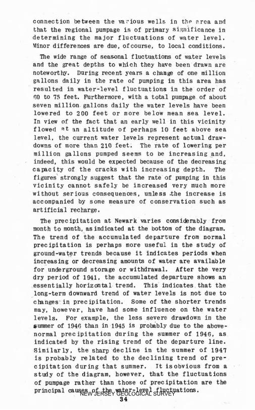
c o n n e c t i o n between the v a r i o u s wells i n t h p r rea and tha t the regfonal pumgage is of primary significance i n determining the major f l u c t u a t i o n s of water level. Winor differences are due, of course, t o local cond i t f ons.
The wide mnge of seasonal f luctuat ions of water levels and the great depths t o which they have been drawn are noteworthy. Daring recent years a chams of one mill ion gallons d a i l y i n t h e r a t e o f pumping i n this area has r e su l t ed i n w a t e r - l e v e l f luc tua t ions I n t h e o rde r of 60 to 75 feet. Furthermore, with a to ta l Bumpage of about seven m i l l i o n gallons aaily t h e water levels have been lowered t o 200 f e e t o r more be low mean sea l e v e l . In view of the fact t h a t an early well i n t h i s v i c i n i t y f lowed n t %n a l t i t u d e o f p e r h a ~ s 10 f e e t above sea l e v e l , t h e current water l e v e l s r e p r e s e n t actual draw- downs of more than 210 f e e t . The rate of lowering per m i l l i o n g a l l a n s pumped seems t o W increasing .+rid, indeed, t h f s would be expected because of the decreasing camcity of the cracks with increasing depth . The figures' s t rong ly suggest that the rate of pumping i n t h f s v i c i n i t y cannot safely be i n c r e a s e d very much more w i t h o u t s e r ioas consequences, unless t h e increase is accompanied by some measure of c o n s e r v a t i o n s u c h ss art if icial recharge.
The p r e c i p i t a t i o n a t Newark varies emiderably from m n t h t o month, BS indicated at the botbom of t h e diagram. The t r e n d o f t h e a c c u m u l a t e d depar tu re from normal p r e c i p f t a t i o n is perhaps more u s e f u l i n t h e s t u d y of ground -ws ter t r ends because It i n d i c a t e s periods when increasing or decreasing amounts of water a r e available f o r underground s t o r a g e o r withdrawal. After the very dry period of 1N1, the accumulated d e p a r t u r e shows an e s s e n t i a l l y h o r i z o n t a l trend. This l n d i c a t e s . t h a t the long-term downward trend of water levels is not due t o cbnges . in precipitation. Some o f t he s h o r t e r t r e n d s may, however, have bad some i n f l-uence on t h e water levels. For wample, the less severe drawdown i n t h e summer of 1946 than i n 1845 is prokbly due t o t h e above- normal p r e c i p i t a t i o n d u r i n g t h e summer of 1946, as i n d i c a t e d by t h e r i s i n g trend of the departure line. Similar ly , the sharp dec l ine i n t h e summer of 1947 is probab ly re la ted t o t h e d e c l i n i n g : t r e n d of pre- c i p i t a t i o n d u r i n g t h a t summer. It i s o b v i o u s from a s t u d y of t h e diagram, however, that the f l u c t u a t i o n s of pumpage rat her than those of precipi ta t ion are the pr inc ipa l muses of the m t e r - l e v e l f l u c t u a t f o m .
34 NEW JERSEY GEOLOGICAL SURVEY

Art if jcia L recharge.- The graphs of water l eve l s i n flgure 3 show a sharp and abrupt r.fse i n March 1948 a n d again in February 1949, both without any corre- sgonrl ing decrease in pumpage. These aprarent anomalies are caused by art i f ic ial recharging through wells, con- ducted experimentally by P. Sallant ine $Soas w i t h the cooprat ion of t h e Newark Fater Wpartment. On occasions during the winter when t h e temgerature of the c i ty water was as low as or lower than that 01 the ground water and when the c i t y ' s reservoirs were overflowing, con- ditions were ideal for recharging. Water that would otherwise have gone t o waste was stored underground and conserved f o r future use. Recharge was accomplished through seieral wells. In 194s about 168 million gal- lons was stored in the ground in t h i s way and in 1949 about 236 million gallons.
It had been hoped that the resu l t s of the pumping tests discussed earlier in this repert would furnish accurate data far evaluating the effects of recharging. Unfortunately, i t developed that condit ions i n t h i s vicinity were unsuited t o analysis fn t h i s ww. Hmever, the evaluation of the artif ic ial recharge is not wholly dependent upon gumping tests.,
As a r e s u l t of the recharging, t h e rater l eve 1s i n t h e area as a whole were higher at the beginning of the season of heavy demanr' than they would otherwise have been. The greatest benefit occurred in the immediate area of the recharging, that is, in the mllantine well f i e ld , but there were substantial gains at considerable distances. For example, during the recharging i n 1949 a recorder was maintained on a well of the Ce lanese Corporation o f America approximately half a mile from t h e center o f recharging antl water leve 1s there rose sharply and promptly when the recharging was begun.
The water used for recharging probably did not d r i f t very far away from the area in which i t was introduced i n t o the aquifer. Previous pumping had e s t a b l i s h e d a deer, depression in the water table tkre and the effect of the recharging was t o f i l l t h e depress ion partly. The improved water leve 1 s obsened e lsewbere occurred before water could possibly have moved through the "aquifer from t h e p o i n t of recharge t o the p o i n t of
NEW JERSEY GEOLOGICAL SURVEY
observatioll. They represented a backing up of watel that had previously been flowing i r t t o tlte Rallantine wel l f i e l d and that kcarne available for withdrawal else- where when recharging began. The e f f e c t outs ide t h e Ral lant ine w e l l f i e l d was exactly t h e same as i f the rate of pumping at Ballantine' s hall been decreased by t h e amunt that was recharged, ~ n d indeed t h e demand upon natural recharge was dec rea s~ ,d by exactly that
much. Much o f t h e recharge natcr probably circulated d i r e c t l y t o other w e l l s i n t h e Ballantine w e l l f i e l d during t h e recharging. The remainder was almost cer- tainly drawn into then soon after recharging ceased. Whatever benef i t s were derived from the higher sua l i ty and lower temperature of the recharge water were probably restricted ent i re ly to t h e Ballantine well ffeld. The gain in head and therefore In water stored In the ground extended to other nearby parts of the area.
Observat Ions mude during the recharging experiments indicated that the water levels i n parts of t h e mllan- t i n e well f i e l d m a y have risen above the top of the rock. T h i s is not surprising In V i e w of the l i m i t e d c a ~ a c i t y of the cracks in t h e rack. A s soon as t h e water levels rose into the overlying glacial material the st orage capaelty w a s much greater. A t no time d i d the head rise far enough t o cacse aw loss of recharge water out of the system o f aquifers. The highest water l e v e l s during the recharging were st ill more than 50 feet belm mean sea level.
Chemical quality of the groand water
The chemical qual i ty of the ground water from rock wells in the Kewark area is shown by the analyses in t a b l e 1 , ah page 49. Analyses A and B are o f water taken from w e l l s i n the western part o f the area far- thes t reroved from t he Passaic River and Neaar k Bay. The water is hard, principally because of its calcium and magnesium content. It is t;oo hard for boiler use. but i s suitable for most other uses, particularly for cooling, Seveml tanneries using ground water i n their operations report that the qual i ty o f the water has a nfsvowblew ef fect on their processes. One producer of carbonated water reported t h a t the ground water
36 NEW JERSEY GEOLOGICAL SURVEY

imparted a p l e a s i n g taste t o h i s product. Where not contaminated by btcterial or other harmful impurities, the water is potable.
The general utmli ty o f water Pumped from wells in the areas nearer the river and 5 % ~ is show11 in a n a l s s e a and D. T h i s water is generally reported t o be far more corrosf ve than the ground water in the areas f a r t h e r from the river and k y , and where the c h l o r i d e content is high the necessity o f freqt~ent replacement. of ordinary i~ronse impellers on pumps has been reported. One user has apparently solved t h i s Problem by the use cf impellers and Bump bowls constructed a f a h i ~ h - n i c k e l - c o e e e t
a l l o y . The h i g h l y mineralized water, of course, is genera I Ly not p t a b l ~ .
The h igh s u l h t e content af waters f r a some rock wells may re a function of the d e p t h of t h e w e l l . This may be explaii led by t h e fact that gyFsum (calcium sulfate) has been observed in the cut t in= t aken from very deep welld. (see log of w l l 3 , i n appendix . ) Gypsum has a l i c k * n o b e r v ~ r i hy the! senior 'author i n t h e c u t t i n g s fra3 a n o t h e r deep w e l l i n New$rk, and Mered i th E. Johqscn. New Jersey S t a t e G e o l o g i s t , has observed gypsum in c u t t i ~ e t a h n at 558 f e e t from a .*!elf d r i l l d in t h e Armswick formation near Westfield, New Jersey. In the cutt ings from the bottom of the Ceixmse Carpora- tion wcll, &he dygsuw Wcurred as largo plates (I. :/Z by 1J2 by l / B inches] which had every appcanner! of-having been the f i l l i n g s of cracks. Presumably, kherefore, p s u m , origiaally dewsited in the cracks in the rock, has remlned in t h e deeper cracks kecause it was not exgosed t o the circulation of meteoric waters .
Occasionally, wells d r i l l e d Into t he rocks of t h e Rrunsw i c k formation have yielded water of high mineral content upon con~letion. In such wells, i t has some- times been possible t o lows the mineral content of the water by pumping the well heavily for a prolongd period. High mineral coneantratlons' of t h i s sort are probably caused by t h e ground aater having been more or less stationary long enough t o dissolve' t he mineral m a t t e r from the rm k. Heavy pumping permits circulation of ground, water :and may induce a f low of water of lower mineral content towad the well. So far as is known, no instances of t h i s sort. Rave been reported i n the Newark area ,
3 7 NEW JERSEY GEOLOGICAL SURVEY

m o w 4 c3 t.3
M
b 4
Z 2 $ W O O L U W
NEW JERSEY GEOLOGICAL SURVEY

Table 2. --Analyses o f water from rock wells in the Newark are a (continued )
A ) Fram 310-foot sell, Frick Rros. Creamery, Xrvington, N. J.
Analysis by U.S.G.S., January 19QB.
B l From 300-foot well, Hoaton Chocolate Co., Newark, N. 3.
Analysis by u . s .G . s . , ~anuarg 194n.
C) From 55n-foot well. Kresge Dent. Store, Newark, N. J.
Analysis by U. S.G.S., January IMB.
Dl Frclrn 805-foot well, P. Ballantine & Sons, we l l 1, plant 1, Newark, N. J. dnalrsjs by the U.G.G.S. , January 1 MI?.
E*) Prom 25n-foot well, Ce l lu lo id Works, Newark, M. J. 4nalyais by F. Ballantins B Sons, 1879. (See Ann. Rept. New Jersey S t a t e Geologist for 1879, p. 127.)
F;*) From 515-foot well, L i s t e r Bros., Nevsrk, N. J. Analysis by P. Ballantine D Sons, l f l70 . {See Ann. Rept. New Jersey State G ~ o ~ o R ~ s ~ for IlI70, D. 127.)
* Recalculated to P.P.m. by H. Flerpers.
NEW JERSEY GEOLOGICAL SURVEY
Reliable and detailed analyses o f waters irom wells pumping from the sand and grave 1 in t h e buried valles are not available a t the present writiqg.
Salt-water intrusion The infiltration of sa l t water I n t o the hody o f fresh
ground water is referred to as salt-water i n t r u s i o n . fn t h e Newark area i t is bel ieved ta be caused p r i n c i - mlLj' Sy heavy pumping i n areas adjacent t o Newark say and t he Prtssaic River. lleavy pumping lowers the general ground-mter Levels, creating s difference i n head be- tween the g r o l l n d - w t ~ r body and the nearby bay 'and river, i n d u c i n g a f LOW o f sal t wat.er into the water-bearinq format ions. Another f~~!or that, probably cofitribntes t o sal't-water 'iiniirnsion is the dredging of s h i p channels in the Pmsaic Riwr and Rewark 3ay. As mentioned prWiaus- ly i n the discussior! of the lwdrolom of t h e Recent de- posits, those dews its a c t as an imperfect barrier to the infiltration of salt water Into the underlying materials. I t is cot improbable, therefore , that the deepening of s h i p channels in t h e river and bag has contributed to the breaking of the imperfect seal formed by the Recent {and, i n some places , Pleistocene) depos i t s . In the areas of salt-water intrusion, the water in b o t h the unconsolidated mterials and the rocks is affected.
The attached map ( f i gure 5 ) shows t h e d i s t r i b u i f o n of t h e chloride content of the ground water i n the area. Most o f t h e data u p o n which t h e mag was based were provided by the Newark City Chemist. through the courtesy o f Dr. Charles V. Craster, Health Officer of the C i t y o f Kezvark. As almost a l l the analyses'were made in 1942, when the C i t y of Newark made a survey of certain qualities of the waters from w e l l s in the city, the map presents a picture of t h e c h l o r i d e con.tent of the ground water at that time. Recent check analyses made in t h e i n v e s t i g a t i o n greced i n g t h i s report. confirm generally the d i s t r i b u t i o n of chloride shown. The curved lines represent points o f equal chloride con- cen t r a t ion.
Several areas of g ~ o u n d water with h i g h chloride con- centrations are shown, and a l l are in areas of relatively heavy pumpage. The f irst of these is alclng the Passaic River near the northern boundary of Newark, where there are several industries that IIS@ well water i n processing.
40 NEW JERSEY GEOLOGICAL SURVEY
The pummge here is n o t as heavy as in t h p other areas, and ~ * e a t amounts nf r i ve r water have not been drawn i n t o the grmind-water body. !;lention mizht here 1~ mwte of the s i n g l e well near the bank of the Passafc River , just south of the area, marked A on figure 5 , the water frrn which contaiaed I , 710 pr ts of chluride Per million. This well pumgs frnnl a gravel, * A ahotlt 4 5 f e e t . b ~ l o w the s11rFar.e which i~ nroha!)ly i n direct hydraulic con- nection with t h e river.
The second area o f h i z h c h l o r i d e concentration is near the i n iPrcec t l o n of h r r ison Avenue and McCarter Mighway. Here, f a i r l y heavy puntgage has induced an i n f l o w of w t e r from the river.
The t h i r d area, near the intersection of Ragmonrl Boulevard and Woad Street, contains several wells that pump large amounts of water. principally for air-con- di t ion ing .
The fourth and largest area w i t h 31igI-1 concentrations of chloride in wel l watess is ' i n the caqtern part of the Yewark arm an3 i s SRuntled roughly by Harrison Avenue an the n o r t h ; by Fourth Street, extended to Port Street on the west; by Port Street on the south; and by fAe Passaic Riwr and Newark Sag on the east. The area contains many i n d u s t r i s t h a t require large amounts of ground water fo r cooling and processing. Heavy pumping, continued over a period of maw- years, has causer! the depression of the upper surface of the ground-water body, which has, i n turn. Led t o river-water intrus ion on a large scale. That the present character of the water in this area is materially d i f f e r e n t from its original character can be seen by comwrison of analyses IS. E. and F (See tab le 2 on g. 38 ) Analysis D wcs made of water taken from a sell of P. Zallantine ~r Sons in January 1348 , whereas analyses E and F, made in 1079, are of water taken from wells not far from the Ballantine plant. Analyses E and F show that the gound water in this section originally had td ahlorick content comparable t o tlnt of water taken frm wells in areas away from the river and bay.
About 4,000 feet northeast of the intersection of State Highway 25 and Port Street a great concentration o f chloride was found in three wells belonging: to a s ing le company. Some of the differences in chloride content in this area mag be due t o differences in depth. The
4 1 NEW JERSEY GEOLOGICAL SURVEY

h i z h e s t conee ntration (2,700 p. P. m, ) was enconritered i n a we11 53 5 f e e t deep , whereas lower -concentrations sere found in nearby shal lower wel l s , A t the t i m e the deep well was d r i l l e d , i t was t hough t that the I i i ~ h l ~ saline water might be causqd by a pocket o f stationary gramd water, which had acquired its high s a l t content from the f o r m a t i o n because o f a l ack of n o r m a l ground-water movement in the vicinity. On t h e basis of this as- sumption, the we1 1 was pumped. fleadily at a hip!\ rate of discharge for a few weeks w i t h the idea of pumping out t h e pocket of h i g h l y mineralized wnter and i n d u c i n g a f low of fresh rn t e r into the well. The rest11 ts were inconclusive and t h e we 11 was f inal ly abandoned because of the unsatisfactory qmlf t y of the water.
NEW JERSEY GEOLOGICAL SURVEY
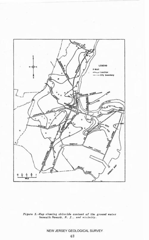
Plguro J.-Hap shoring chloride content o r t h &round ra te r bcnsath Newark, H. I . . a d riclnd t y .
43 NEW JERSEY GEOLOGICAL SURVEY

Temperature of the ground water
The average temperature of the ground water in the Nemrk area is approximately 55" F. The temperature o f ground wd ter, except as explained below, i s largely a function of the depth of the aquifer from which it is drawn. and of the mean annual tempe~ature of the air , which a t Newark is 52,3' F. Vater from very shallow wel ls will ustlally vary i n temperature over the gear. Water from somewhat deeper wells, however, has a tempera- ture t h a t , for ai l practical purposes, is eqilal to the mean annual temperaturn. The effect of the mean annual tempem ture on the t emperature of ground w a t e r does n o t extend to great depths. I t i s known from numerous deep we lls, mines, and test borins that the temRrature oS the earth1 s crust increases with depth . The rate a t h l c h t he ground temperature increases w i t h depth. known as the geothermal grad ient , wries, depending upon many conditions, but generally an increase or 50 t o 1 5 0 f e e t i n d e p t h w i l l r a i s e t h e temperature lo F. Of course, in regions of active volcanism this rate of increase does not apply. In the Newark area t h e normal geothermal gradient is not known as a l l temperature measurements have been made at the point of discharge of the pumps. Each measurement, therefore, represents merely the temperature of the water i s s u i n g from the well , which is probably an average # O f the temperatures of water at a l l grodueine levels.
CONCLUSIONS
TRe studies that preceded this report were not detailed or prolonged enough t o arrive a t d e f i n i t e answers to important questions that arise with regard t o the safe yield of the aquifers i n the Newark area. Only very tentative conclusions can 5e made a t this time. Obser- vat ions and studies should be continued over a per iod of years in order that t he saSe yield may he def ined.
Continuing observations should be made of the pumping rates in every well i n t h e area agd of the water l eve l s in an adequate number of observation wells so that t h e s a t e and d i r e c t i o n o f f l o w in t h e a q u i f e r s and the
4 4 NEW JERSEY GEOLOGICAL SURVEY
amount of recharge t o t'hern may be def ined . Periodic analpsea of the mter from representative wells thmugh- out the area should IE made in order t o detect changes i n its qua l i ty and especial ly t o define the intrusion oP s a l t water. Geologic infornation should be sought t o e x t e n d aur knowledge .of the buried channel tha t passes through the area and of the materials that f i l l it. Whenever wells or other deep excavations are made, particular attention should be given to the nature of the material overlying the rock i n order t o establ ish its geologic and hydrologic character isties more ful ly . and ult imately to define the hest areas of recl~arge.
In many garts of the area conclusive data are n o t available, but it seem probable that there are local - i t i e s where a d d i t i o n a l quantities o f ground water maF be oGta i n d . It also seems mobable that in some heavily pumped parts of t!re area the safe y i e l d is b e i n g ap- proached or has already k e n exceeded. For example, in the area around the plants of P. Qallantine 6 Sons and the elanese Corporation of America, the water levels have h e n l~wered to such an extent t h a t i t seems un- likely that any xuhqtantial xlditioml quantity of water can Ix wi'ihdrawo horn f&e groqnd safel:r or ecanomica?ly. The qllality of the ground rater in this area is already unf j t for some uses.
The e x p e r i n a n k w i t h a r t i f i c i a I recharge at the Ballantine p l a n t during the last fxo years offer promise of ~ a a t improvement I n t h e ground-water c o n d i t i o n s in some parts of the area if water is available for con- t inuing such recharge. T h i s is certainly sound con- servat ion practice and shouE d he expanded as much as poss ib le . Whenever r e c h a r g i n g i s undertaken in t h e future, careful observatioas shou ld be made of water l e v e l s and of the qual i ty and quant l t y of water re- charged and wit!!drawn. fn order t o evaluate tiie effects more closely and t~ trace the marwent o f the water.
NEW JERSEY GEOLOGICAL SURVEY
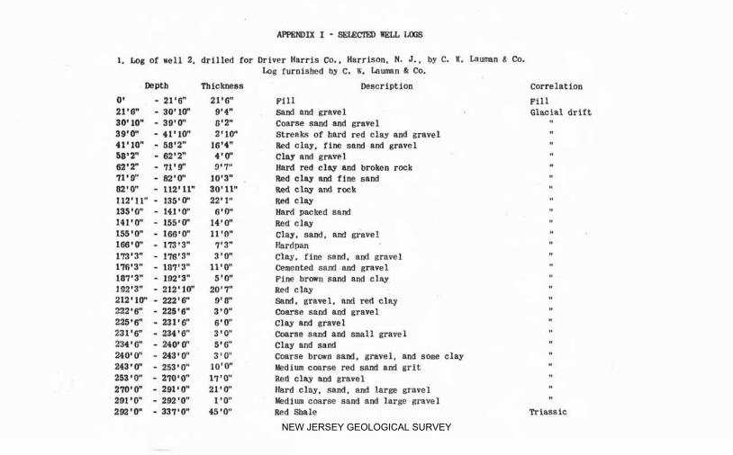
1. Lag of well 2, drilled for Driver Harris Co.. Harrison. N. J. , by C. K. human 8 Co. k g furnished by c. a. Lumn Q Co.
D?)eIrtb Thickness Descrl~tion Correlation
0' - 21'8" 21'8" Pill Fi l l 21'l3" - 30'1Cf' 9'4" sand and gravel Glacial dri f t 30'10" - 30'0" 0'2" Coarse sand and gravel 89'0" - 41'10" 2'10" Streak.. of hard red clay and gravel 41'10" - 51?*2" 16'4" Red clay. fine sand and gravel 58'2" - 82'2" 4 ' 0'' Clay end gravel 62'2" - 71'9" 9.7" Hard red clay and broken rock 71'0" - w*O'O" 10'3" Red elm and f rne sand 02'0" - 112'11" 30'11" Red clay and rock I12'fl" - 135'0' 22'1" Red clay 135'0" - 141'0" 0'0" Hard packed sand 1 4 1 ' 6 - 155'0" 14'0" Red clag n
155'0" - X6R'OW 11'0" Clay, sand, and gravel 166'0" - 173'3" 7'3" Pardpan 173'3" - 178'3" 3'6' Clay. fine sand. and gravel 176'3" - 117'3" t l S O " Cemented sand and gravel 187'3" - 192'3" I ' 0" Fine brown sand and clay 10.2'3" - 212q10" 20'7" Red clay " 212'16 - 222'6" 9'8" Sand. gravel. and red clay 222.8" - 225'6" 3'0" Coarse sand and ravel 225*RR" - 23118 6'0" Clay and g m e l 231'6" - 234'6" 3'0" Coarse sand and small qawX 234'6" -MQiLT' 5'C Clay and sand 240'0" -243'0" 3'V' Coarse brown saml, gravel. and som clay 243'0" -253'0" 10'Q" L d i m conrse red sand and gri t 253'0" - 270'0" 17'0" Red clay am3 gmvel 270'0" - 291t0" 21'4' Hard clay. sand. and large gravel 201'0" - 292'0" 1'0" Medium coarse sand and large gravel 202'F -331 '0" 45'0" Red Sarale Tr iaas kc
NEW JERSEY GEOLOGICAL SURVEY

APPEND ZX I - SELECTED FELL COGS (CONT.
2. b g of well 2 d r i l l e d fo r John Hieder, 247 fmt Street, Newark, N. J., by h n e - New York Co. Log furnished hg Mr. W. A. North of Lam-New York Co.
Depth Thickness Deseriptio~. Corrzlat ion
0' - 3' 2' Concrete Recent
3' - 5 @ 2' Cinders Ff ll
5' - 15' 10" Yellow c 2 ~ Recent ?
1st - 27' 1 Z 1 Fine red sand Glacial dr i f t
27' - 55' 28' Red quieksmd "
Fled sandy clay "
210' - 215r 5; Ear!! pan 1
215' - 2 2 8 ' 16: & ! ! d ~ l K ! c l k y '
225' - Y08' 183" ~ e d rock Trimsic
NEW JERSEY GEOLOGICAL SURVEY

cab u G ."I ,-i k Ql CJ z 4 h
NEW JERSEY GEOLOGICAL SURVEY

APPENDIX 1 - .SEUCTED WELL LOGS ECONT.
4 , Log of t e s t boring No. Ig, made a t cross-
ing of Route 2 5 addition and Lehigh Valley
R. R, yards by Giles Drilling Co, for S t a t e
Highway Department. Compiled by H. Hergers
from i n s p e c t ion of samples.
Depth Description Correlation
0' - 3' Cinders
4' - 5 ' Cinders and meadow muck
10' - I I ' Cinders. gray clay, and meadow muck
16' - 17' Gray. slightly sandy clay
20' - 21 "d and gray clay and medium sand
30' - 3 1 ' Fine red silty sand
40' - Y I Red clay
50' - 51 Red sandy clay
60' - 61 ' Red sandy clay and red shale (top of rock)
6 1 ' - 7 1 ' Red shale (core 1
F i l l
Fill and Recent u
Recent
Recent (reworked glacial d r i f t )
Glacial d r i f t n
Triass ie
NEW JERSEY GEOLOGICAL SURVEY

Abstract. ..................................... Acknowledments ............................... .. Analyses of u ~ t e r ...........................
........... Agwnrlix ......................... Aquifers. rmjor.. .............................
........................ Area covered by report .......................... Artificial recharge
PAGE 9 14
38-39 46-49 21. 24
12 3 7.
B . Bedrock
Q e p t h i n b u r i e d r a l l e y ...................... 20 Ahlap showing depths .......................... 16
Brunswick formation mtent ...................................... 22
..................................... Geolcgu 22 Hydrolow. .................................. 24
.............................. Specific yield 27 Y i e l d of water .............................. 24
Buried valle J. Depth to bedrack ............................ 20
2 0 C .
................ Chemical quality. ground water 36 Chloride content
Ground Water ................................ 12. 22 l lRa~ ...............*......................... 43 ................................... Conclusions 14
D . Deepest sell .................................. 18.24
F . Fluctuations. water-level ..................... 31 Formations. gealogic .......................... 15
B . Geelogic histors-'. ............................ 17 Geology ................................ Newark group 22 ........................ Pleistocene deposits 19 ............................ Recent' deposits 19 ...................... Ground-mter temperature 44
5 0
NEW JERSEY GEOLOGICAL SURVEY
X . In t rus ion . saIt.water ......................... 21. 40 Ironbound District ........................... 11. 32
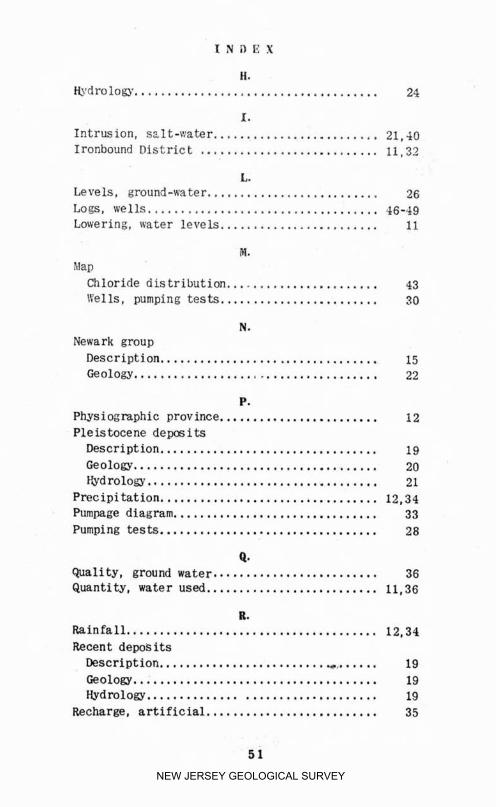
L . Levels. ground-wa ter .......................... 26 Logs. wells.. ................................. 46-49 Lawering. water levels ........................ 11
1W . Map
Chloride distr ibution ....................... 43 \Yells. pumping tes ts ........................ 30
N . Newark group Description ............... ..,...... . . 15 Geolow ..................................... 22
P . Physiograghic province ........................ 12 Pleistocene depos i t s
Description ... . . . . . . . . . .m...a.. . . . . . . . . . . . .. 19 Geology ..................................... 20 b d r 0 1 0 ~ ................................... 21
Precipitation ................................. 12. 34 Pumpage diagram ............................... 33
................................. Pumping tests 28
Q . Quality. ground water. ........................ 36 Quantity. water used ......................... 11. 36
R . Rainfall ...................................... 12. 34 Recent dews its
Description .........................,....... 19 Geology .................................... 19 t iydmlo~. . . ............................... 19
Recharge. artiff cia1 .......................... 35
NEW JERSEY GEOLOGICAL SURVEY

S . PAGE
Salt-water intrusion .......................... 21-40
Specific j i e l d . Brunswick fonnatiori. .......... 27 Stratigntrhic table ........................... 18
T . Temperature '
Ereund water .............................. 44 Air. mean annual ............................ 12. 44
Triassic b e l t . description ..................... 15 Triassic rocks. thickness ..................... 23
U . Uses. water .................................... 11
1 . Water-level
D i a g m ..................................... 33 F l u c t u a ~ i o n s ................................. 31 Lowering .................................... 11
We11 logs. . . ................................... 46-49
Y . Yield
......... . Diminution .................... 11 Water. Brunswiclr formation ................... 24 Water. Pleis tmene deposits .................. 21
NEW JERSEY GEOLOGICAL SURVEY

NEW JERSEY GEOLOGICAL SURVEY

NEW JERSEY GEOLOGICAL SURVEY