state of hawaii motor vehicle accident report dot-1 …
TRANSCRIPT

STATE OF HAWAII MOTOR VEHICLE ACCIDENT REPORTDOT-1-174 (HWY-T) Revised 06-08
INVESTIGATING OFFICER'S TRAFFIC ACCIDENT REPORTING MANUAL
1st. REVISION - SEPTEMBER 2009
Original Publication - May 2008
Prepared by the State of Hawaii Traffic Records Coordinating Committee


TABLE OF CONTENTS
Page No.
Introduction ……………………………………………………………………………………………………. 1
State of Hawaii Motor Vehicle Accident Report Form ……………………………………………………. 11
General Guidelines …………………………………………………………………………………………… 31
Specific Instructions ………………………………………………………………………………………….. 37
SECTION I. Page One Instructions ………………………………………………………………………… 43
SECTION II. Page Two, Unit Information Instructions ……………………………………………………. 57
SECTION III. Page Three, Unit Information (Cont.) Instructions ………………………………………… 71
SECTION IV. Diagram Page Instructions …………………………………………………………………. 81
SECTION V. All Persons Page Instructions ……………………………………………………………… 85
SECTION VI. Narrative Page Instructions …………………………………………………………………. 91
SECTION VII. CMV Supplement Instructions …………………………………………………………….. 95
GLOSSARY …………………………………………………………………………………………………… 101
APPENDIX A, What is a Motor Vehicle Traffic Accident? ……………………………………………….. 125
APPENDIX B, The State Highway System, List of Highways by Island,by Route Number and by Highway Name ……………………………………………………………….. 141
APPENDIX C, County Highways, List of Highways by Island, by Route Number,and by Highway Name …………………………………………………………………………………….. 161
APPENDIX D, State of Hawaii Motor Vehicle Accident Report Sample ……………………………….. 171
APPENDIX E, State of Hawaii Routes by Highway Name and Milepost Reference ………………….. 183
APPENDIX F, Locating Major Traffic Accidents……………………………………….………………….. 191
SUPPLEMENT, State Highways by Honolulu Police District
iii


INTRODUCTION Investigating Officer’s Reporting Manual
State of Hawaii Motor Vehicle Accident Report DOT-1-174(HWY-T) Revised 06-08

INTRODUCTION
The State Traffic Records Coordinating Committee (TRCC) has designed this manual to provide instructions and guidance to complete the revised State of Hawaii Motor Vehicle Accident Report (MVAR), DOT-1-174(HWY-T) Revised 06-08. This is the first major revision of the MVAR since 1985. The changes were made to standardize the collection of data at the motor vehicle traffic accident scene. Accurate and uniform reporting on the MVAR will provide the data needed for the development of traffic safety projects to lessen the number and severity of motor vehicle traffic accidents in the State of Hawaii. The data derived from the MVAR will also help to develop proper traffic safety laws and ordinances. The manual includes guidelines from the Model Minimum Uniform Crash Criteria (MMUCC). The purpose of the MMUCC is to provide a data set for describing motor vehicle accidents in a process that will generate the information necessary to improve highway safety within each state and nationally. The implementation of MMUCC is a collaborative effort involving the National Highway Traffic Safety Administration (NHTSA), the Federal Highway Administration (FHWA), the Federal Motor Carrier Safety Administration (FMCSA) and the Governors Highway Safety Association (GHSA – formerly NAGHSR). The American National Standard, Manual on Classification of Motor Vehicle Traffic Accidents, 7th Edition, (ANSI D16.1-2007), is also used in this manual as a guideline to define and classify motor vehicle traffic accidents. The primary purpose of the Manual on Classification of Motor Vehicle Traffic Accidents is to promote uniformity and comparability of motor vehicle traffic accident data. This manual is designed to give simple instructions and references to complete the MVAR. However, there will be times when the instructions in this manual may not be adequate to help record unusual accidents. If such a situation occurs, use your best judgment and experience to complete the MVAR. Please remember that this manual cannot cover every type of question which might be raised about a motor vehicle accident. Examples will be provided in the manual whenever possible to clarify the instructions. The MVAR will be used if the motor vehicle traffic accident is a major traffic accident. A major traffic accident is an accident in which the total property damage (damages to all involved vehicles, fixed objects, animals, etc.) on a public trafficway amounts to more than $3,000, or one in which an accident involves injury or death. A copy of the MVAR must be sent to the State of Hawaii, Department of Transportation, Highways Division, Traffic Branch. The copy of the MVAR may be either a hard copy or an electronic copy. The MVAR can be used for minor motor vehicle traffic accidents if the police agency wishes to use this report form. If the MVAR is used to report a minor motor vehicle traffic accident, the bubble for Minor 02, Field 8, Report Type, must be filled in. No copy of a

minor should be sent to the State of Hawaii, Department of Transportation, Highways Division, Traffic Branch, unless it involves damage to government property (guardrails, traffic signs, traffic control signs and devices, bridge railings etc.). Statutory Requirements for the MVAR The State of Hawaii must collect motor vehicle traffic accident data to meet the mandated requirements of the U.S. Department of Transportation under 23 USC 148, Highway Safety Improvement Program. The State of Hawaii must also meet the requirements of the Hawaii Administrative Rules, Title 19, Department of Transportation, Subtitle 5, Motor Vehicle Safety Office, Chapter 126, Identification and Surveillance of Accident Locations. The purpose of the MVAR is also required by HRS, Chapter 291C, (Statewide Traffic Code), Part II, Accidents and Accident Reports. Section 291C-16, Immediate notice of accident, states: “(a) The driver of a vehicle involved in an accident resulting in injury or death of any or total damage to all property to an extent of $3,000 or more shall immediately by the quickest means of communication give notice of the accident to the nearest police office. If sent to the site of the accident, a responding police officer shall file a written report if it appears at the time that the accident has resulted in the injury or death of any person, or total damage to all property to an apparent extent of $3,000 or more. (b) Whenever the driver of a vehicle is physically incapable of giving an immediate notice of an accident as required in subsection (a) and there was another occupant in the vehicle at the time of the accident capable of doing so, such occupant shall make or cause to be given the notice not given by the driver.” Four Components of the Motor Vehicle Accident Report (MVAR) The motor vehicle accident report (MVAR) records the data needed at the scene of a motor vehicle involved traffic accident. The report classifies information about the four components of a motor vehicle traffic accident: the road, the vehicle, the people involved and the sequential unstabilized events of the accident. The MVAR reporting is strictly fact finding. Therefore, include only factual information on the report. Do not include opinions. Road Component The road component is an important part of a traffic accident investigation. Identifying the location of an accident is necessary for the engineer to determine where inadequacies in the road, traffic control devices and the environment may have contributed to the frequency or severity of accidents.

There are four steps to identify the location of an accident:
1. Determine where the accident occurred.
Determine where the first harmful event occurred (where the first damage or injury took place). The first harmful event may not be where the most serious damage or injury occurred. The first harmful event may not be on the road (roadway or shoulder) but on the roadside. The first harmful event is usually the first contact between vehicles, or contact with non-motorists (pedestrian or bicyclist) or with a fixed object.
2. Name of the road on which the accident occurred.
Record the name of the highway or street on which the accident occurred. Use the name on street signs or on maps. If a route number is known, also record this information on the report. If a highway is divided, add the nominal direction of traffic flow on the highway name. For example, an accident on a section of H-1 might be noted as “H-1 Westbound” or “H-1 Eastbound”. Accidents at intersections require designating one of the intersecting roads as the one which the accident occurred. If each vehicle were traveling on the same road, locate the accident on this road. If the vehicles involved in the accident were on different roads approaching the intersection, the accident is located on the most important roadway according to the following list of priorities:
1. Interstate (H-1, H-2, or H-3). 2. Other U.S. route numbered highway (H201, Rt 61, Rt 63, etc.). 3. Other state route numbered highway (Puuloa Road, Radford Drive,
etc.). 4. County numbered road (Kaukonahua Road, Waikoloa Road, etc.). 5. Other county or city street. 6. All others.
If two roads are in the same category of importance, locate the accident on the road from which vehicle initiating the harmful event approached the intersection.
3. Referencing the accident location on the road.
Report at what location on the specified road the accident (first harmful event) occurred. If an accident occurred at an intersection, simply name the intersecting roads. For example, “Rt 92, Nimitz Highway at Kalihi Street”, or “Kapiolani Boulevard at Ward Avenue”.

If an accident occurred between intersections, locate the accident by distance and direction from some permanent and identifiable landmark such as the following: Milepost Marker Tunnels Overpasses or Underpasses of major highways or streets Named intersecting roads Named bridges over important rivers or other significant geographical feature.
Do not use utility pole numbers or addresses to locate accidents. Examples of how to locate accidents by distance and direction: H-1 Westbound, 0.5 mile east of Kaonohi Street overpass. Route 61, Pali Highway Northbound, 150 feet north of Pali Tunnel (north end). Route 19, Hawaii Belt Road, 0.2 mile north of Milepost Marker 25. Route 83, Kamehameha Highway, 200 feet south of Waikane Valley Road. King Street, 250 east of Pensacola Street.
Measure reference distance in feet if less than 1,000 feet and in miles if longer. Use an automobile odometer for longer distances (it registers to 1/10 of a mile).
4. Name of the city or town.
Record the name of the geographical area where the accident occurred. Examples: Kailua Kalihi Hawaii Kai Waikane Kaimuki Kapolei
Vehicle Component The motor vehicle involved in a traffic accident is identified by the following: Registered owner’s name Vehicle license number Vehicle Identification Number (VIN) Vehicle make

Vehicle model Vehicle model year Vehicle body type Vehicle color The amount of damage is one measure of the severity of an accident. The following are levels of damage severity: Disabling damage Functional damage Minor damage No damage The following are additional motor vehicle data that are recorded: Commercial vehicle use Initial impact point Vehicle direction of travel prior to the accident Vehicle factors contributing to the accident People Component There are four types of people who are part of the people component of a motor vehicle traffic accident: Driver of the involved motor vehicle Passenger in the involved motor vehicle Non-motorist involved in the accident (bicyclist or pedestrian) Witness who was at the scene of the accident All persons involved in the accident must be identified. The driver license is used to identify the driver of the involved motor vehicle. The following information are required of all drivers and non-motorist involved in the accident: Name Age Sex Address Phone number Occupation (driver, bicyclist or pedestrian) Driver license number or other official identification (driver, bicyclist or pedestrian) Employer’s name and phone number (driver, bicyclist or pedestrian) Auto insurance company name (driver only)

Auto insurance policy number and expiration date (driver only) Driver license class, restrictions, endorsements (driver only) Driver license status (driver only) A driver or non-motorist (bicyclist or pedestrian) will be given an alcohol and/or drug test if required. Each person involved will be identified by their position (motorist and non-motorist). The following are the additional information that will be collected about each person involved in the accident: Unit number which the involved person is assigned Position location Age Sex Ejection (does not apply to pedestrian) Safety equipment usage (does not apply to pedestrian) Air bag deployment (does not apply to bicyclist or pedestrian) Injury severity Area of injury Medical care at the scene Transport to medical facility Injury condition EMS number Human behavior (driver, bicyclist or pedestrian) Distractions (driver, bicyclist or pedestrian) Vision obstruction (driver, bicyclist or pedestrian) Other contributing factors (driver, bicyclist or pedestrian) Sequential Unstabilized Events Component The sequential unstabilized events component identifies what happened during the motor vehicle traffic accident and indicates the first harmful event which caused damage or injury. This component describes the vehicle action(s) from the first unstabilized event to final stabilized condition. Vehicle actions include: Direction of travel prior to the accident. Vehicle maneuver before and during the accident.

The first harmful event includes: Non-collision events such as overturning, fire/explosion, submersion, run-off roadway, etc. Collision with fixed objects such as guardrail, median, fence, curb, tree, traffic Signal, traffic sign, fire hydrant, mailbox, etc. Collision with animal. Collision with pedestrian or bicyclist. Collision with other motor vehicle in transport such as head-on, rear-end, Broadside, sideswipe, and angle accidents.


STATE OF HAWAII MOTOR VEHICLE ACCIDENT REPORT FORM DOT-1-174(HWY-T) Revised 06-08

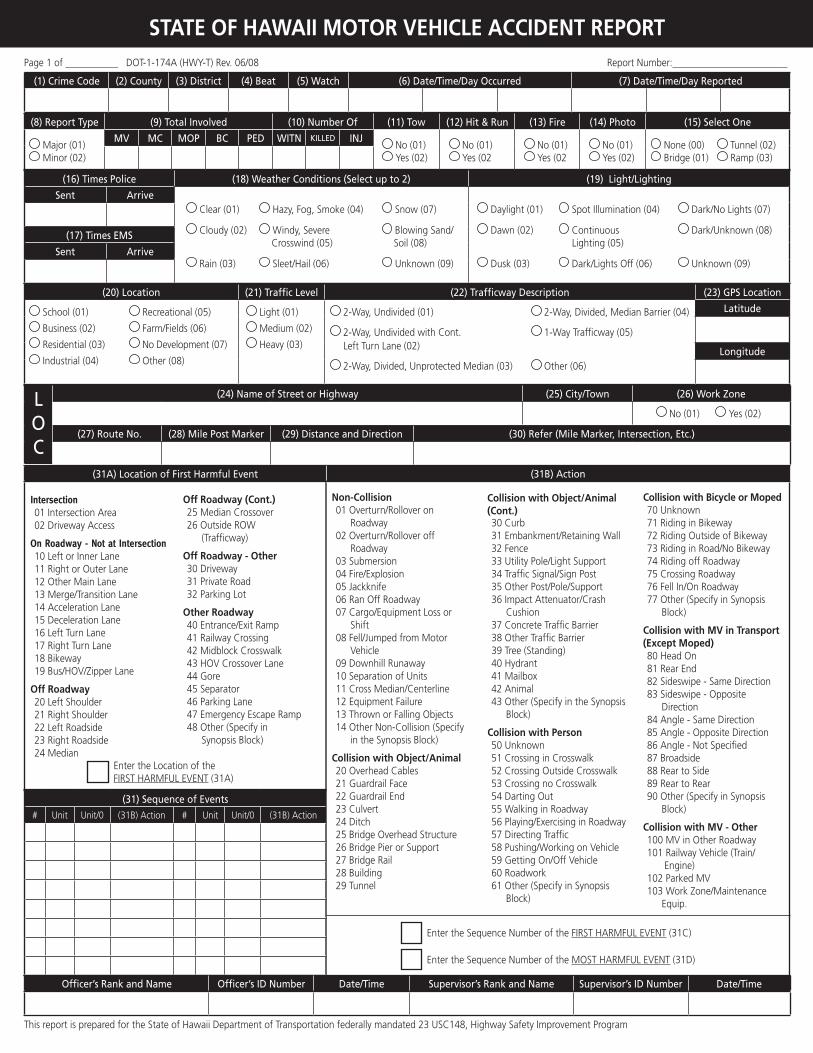
Page 1 of ___________ DOT-1-174A (HWY-T) Rev. 06/08 Report Number:________________________
(1) Crime Code (2) County (3) District (4) Beat (5) Watch (6) Date/Time/Day Occurred (7) Date/Time/Day Reported
(8) Report Type (9) Total Involved (10) Number Of (11) Tow (12) Hit & Run (13) Fire (14) Photo (15) Select One
Major (01) Minor (02)
MV MC MOP BC PED WITN KILLED INJ No (01) Yes (02)
No (01) Yes (02
No (01) Yes (02
No (01) Yes (02)
None (00) Tunnel (02) Bridge (01) Ramp (03)
(16) Times Police (18) Weather Conditions (Select up to 2) (19) Light/Lighting
Sent Arrive Clear (01) Hazy, Fog, Smoke (04) Snow (07)
Cloudy (02) Windy, Severe Blowing Sand/ Crosswind (05) Soil (08)
Rain (03) Sleet/Hail (06) Unknown (09)
Daylight (01) Spot Illumination (04) Dark/No Lights (07)
Dawn (02) Continuous Dark/Unknown (08) Lighting (05)
Dusk (03) Dark/Lights Off (06) Unknown (09)
(17) Times EMS
Sent Arrive
(20) Location (21) Traffic Level (22) Trafficway Description (23) GPS Location
School (01) Recreational (05)
Business (02) Farm/Fields (06)
Residential (03) No Development (07)
Industrial (04) Other (08)
Light (01)
Medium (02)
Heavy (03)
2-Way, Undivided (01) 2-Way, Divided, Median Barrier (04)
2-Way, Undivided with Cont. 1-Way Trafficway (05) Left Turn Lane (02)
2-Way, Divided, Unprotected Median (03) Other (06)
Latitude
Longitude
Intersection 01 Intersection Area 02 Driveway Access
On Roadway - Not at Intersection 10 Left or Inner Lane 11 Right or Outer Lane 12 Other Main Lane 13 Merge/Transition Lane 14 Acceleration Lane 15 Deceleration Lane 16 Left Turn Lane 17 Right Turn Lane 18 Bikeway 19 Bus/HOV/Zipper Lane
Off Roadway 20 Left Shoulder 21 Right Shoulder 22 Left Roadside 23 Right Roadside 24 Median
Off Roadway (Cont.) 25 Median Crossover 26 Outside ROW
(Trafficway)
Off Roadway - Other 30 Driveway 31 Private Road 32 Parking Lot
Other Roadway 40 Entrance/Exit Ramp 41 Railway Crossing 42 Midblock Crosswalk 43 HOV Crossover Lane 44 Gore 45 Separator 46 Parking Lane 47 Emergency Escape Ramp 48 Other (Specify in
Synopsis Block)
Enter the Location of the FIRST HARMFUL EVENT (31A)
Collision with Object/Animal (Cont.)
(31) Sequence of Events
# Unit Unit/0 (31B) Action # Unit Unit/0 (31B) Action
This report is prepared for the State of Hawaii Department of Transportation federally mandated 23 USC148, Highway Safety Improvement Program
(31A) Location of First Harmful Event
STATE OF HAWAII MOTOR VEHICLE ACCIDENT REPORT
Officer’s Rank and Name Officer’s ID Number Date/Time Supervisor’s Rank and Name Supervisor’s ID Number Date/Time
Enter the Sequence Number of the FIRST HARMFUL EVENT (31C)
Enter the Sequence Number of the MOST HARMFUL EVENT (31D)
LOC
(24) Name of Street or Highway (25) City/Town (26) Work Zone
No (01) Yes (02)
(27) Route No. (28) Mile Post Marker (29) Distance and Direction (30) Refer (Mile Marker, Intersection, Etc.)
(31B) Action
Non-Collision 01 Overturn/Rollover on
Roadway 02 Overturn/Rollover off
Roadway 03 Submersion 04 Fire/Explosion 05 Jackknife 06 Ran Off Roadway 07 Cargo/Equipment Loss or
Shift 08 Fell/Jumped from Motor
Vehicle 09 Downhill Runaway 10 Separation of Units 11 Cross Median/Centerline 12 Equipment Failure 13 Thrown or Falling Objects 14 Other Non-Collision (Specify
in the Synopsis Block)
Collision with Object/Animal 20 Overhead Cables 21 Guardrail Face 22 Guardrail End 23 Culvert 24 Ditch 25 Bridge Overhead Structure 26 Bridge Pier or Support 27 Bridge Rail 28 Building 29 Tunnel
30 Curb 31 Embankment/Retaining Wall 32 Fence 33 Utility Pole/Light Support 34 Traffic Signal/Sign Post 35 Other Post/Pole/Support 36 Impact Attenuator/Crash
Cushion 37 Concrete Traffic Barrier 38 Other Traffic Barrier 39 Tree (Standing) 40 Hydrant 41 Mailbox 42 Animal 43 Other (Specify in the Synopsis
Block)
Collision with Person 50 Unknown 51 Crossing in Crosswalk 52 Crossing Outside Crosswalk 53 Crossing no Crosswalk 54 Darting Out 55 Walking in Roadway 56 Playing/Exercising in Roadway 57 Directing Traffic 58 Pushing/Working on Vehicle 59 Getting On/Off Vehicle 60 Roadwork 61 Other (Specify in Synopsis
Block)
Collision with Bicycle or Moped 70 Unknown 71 Riding in Bikeway 72 Riding Outside of Bikeway 73 Riding in Road/No Bikeway 74 Riding off Roadway 75 Crossing Roadway 76 Fell In/On Roadway 77 Other (Specify in Synopsis
Block)
Collision with MV in Transport (Except Moped) 80 Head On 81 Rear End 82 Sideswipe - Same Direction 83 Sideswipe - Opposite
Direction 84 Angle - Same Direction 85 Angle - Opposite Direction 86 Angle - Not Specified 87 Broadside 88 Rear to Side 89 Rear to Rear 90 Other (Specify in Synopsis
Block)
Collision with MV - Other 100 MV in Other Roadway 101 Railway Vehicle (Train/
Engine) 102 Parked MV 103 Work Zone/Maintenance
Equip.


STATE OF HAWAII MOTOR VEHICLE ACCIDENT REPORT
(49) Occupation
(32) Unit No. (33) No. of Occ. UNIT INFORMATION
(34) Unit Class (35) Race
Passenger Car (01)
Passenger Van (02)
Pickup Truck (03)
SUV/MPVH (04)
Cargo Van < 10,001 lbs. (05)
Other Truck < 10,001 lbs. (06)
Truck > 10,000 lbs. (07)
Transit Bus (08)
School Bus (09)
Other Bus (10)
Motorcycle (11)
Motor Scooter (12)
Moped (13)
Bicycle (14)
Pedestrian (15)
Maint./Construct. Equipment (16)
Farm Vehicle/Equipment (17)
Motor Coach (18)
Motor Home (19)
Recreational Vehicle (20)
Other (21)
Unknown (22)
White (01)
Black (02)
American Indian (03)
Chinese (04)
Japanese (05)
Korean (06)
Puerto Rican (07)
Hawaiian (08)
Samoan (09)
Tongan (10)
Vietnamese (11)
Filipino (12)
Unknown (13)
Other (14)
(36) Last Name (37) First Name (38) MI (39) Sex (40) DOB
M (01) F (02)
(41) Street No. (42) Street Name (43) St., Pl., Blvd., Etc. (44) Apt/Suite Number
(45) City (46) State (47) Zip Code (48) Home Phone Number
( ) -
Unemployed (00)
U.S. Army (01)
U.S. Navy (02)
U.S. Air Force (03)
U.S. Marines (04)
U.S. Coast Guard (05)
Other Military (06)
Fed. Govt. Civ. (07)
State Govt. (08)
County Govt. (09)
Foreign Govt./Civ. (10)
Retired (11)
Student - Elem. (12)
Student - Inter. (13)
Student - H.S. (14)
Student - Col. (15)
U.S. Tourist (16)
Foreign Tourist (17)
Police Officer (18)
Other (19)
Not Stated (20)
(50) Employer/Company Name
(51) Work Phone Number (52) Other Phone/Pager Number
( ) - ( ) -
(53) Driver’s License Number (54) St./Juris. (55) Class (56) Restrict. (57) Endorse.
(58) CDL Type (59) Driver’s License Status
Non-CDL (01)
Non-CDL/Restricted (02)
CDL (03)
Valid (01)
Not Licensed (02)
Canceled (03)
Denied (04)
Expired (05)
Revoked (06)
Suspended (07)
Provisional (08)
Permit (09)
Disqualified [CDL] (10)
Page ___________ of ___________ DOT-1-174B (HWY-T) Rev. 06/08 Report Number:___________________
(85) SFST GIVEN (86) SFST Results
No (01) Refused (03)
Yes (02)
Passed (01) Does Not Apply (03)
Failed (02)
(87) Alcohol Test Results
(87A) Status (87B) Type (87C) Results
None (00)
Refused (01)
Given (02)
Blood (01)
Breath (02)
Other (03)
Value (01)
Pending (02)
(88) Drug Test Results
(88A) Status (88B) Type (88C) Results
None (00)
Refused (01)
Given (02)
Blood (01)
Urine (02)
Other (03)
Positive (01)
Negative (02)
Pending (03)
(60) Insurance Policy Number (61) Exp. Date (62) Insurance Carrier
(63) Registered Owner Name (64) Phone Number
( ) -
(65) Str. No. (66) Street Name (67)St., Pl. (68) Ste. #
(69) City (70) State (71) Zip Code
(72) Vehicle Body Type
2-DSD (01) 2-DSW (04) SUV/MPVH (07) Bus (10) Moped (13)
4-DSD (02) 4-DSW (05) Van (08) PCMC (11) Bicycle (14)
2-DCV (03) P/U Truck (06) Truck (09) M-Scooter (12) Other (15)
(73) Vehicle Year (74) Veh. Color (Top/Bottom) (75) Vehicle Make (76) Vehicle Model (77) Lic. Plate No. (78) Trailer Plate (79) Lic. Plate St.
(80) Vehicle VIN Number (81) Emer. Veh. In Use (82) Vehicle Stolen
No (01) Yes (02) No (01) Yes (02)
(83) Special Use (84) Trailer/Cargo Type
None (00)
Driver Trng. (01)
Construction/ Maintenance (02)
Taxi (03)
Fire Truck (04)
Tow Truck (05)
Ambulance (06)
Police-On Duty (07)
Police-Off Duty (08)
Military (09)
Government (10)
Farm Use (11)
U-Drive (12)
School Bus (13)
Other Bus (14)
Other (15)
None (00)
Boat (01)
Flatbed (02)
Horse (03)
Livestock (04)
House (05)
Van/Encl. Box (06)
Dump (07)
Veh. Tow Veh. (08)
Other (09)
N/A (10)
Officer’s Initials: Supervisor’s Initials:


(95B) (Object 1) Owner’s Name (96B) (Object 2) Owner’s Name
(95C) (Object 1) Owner’s Phone Number (96C) (Object 2) Owner’s Phone Number
( ) - ( ) -
(94) Direction (95D) Estimated Damages to Object 1 (96D) Estimated Damages to Object 2
From To $3,000 or Greater (01)
Less than $3,000 (02)
$3,000 or Greater (01)
Less than $3,000 (02)(97) Motor Vehicle Maneuver/Action (98) Reason for Maneuver (99) Traffic Control Device Type
Straight Ahead (01)
Changing Lanes (02)
Merging (03)
Overtaking/
Passing (04)
Slowing/Stopping (05)
Backing (06)
Parking (07)
Parked (08)
Start from Parked (09)
Stopped in Traffic (10)
Start in Traffic (11)
Right Turn on Red (12)
Turning Right (13)
Turning Left (14)
U-Turn (15)
Entering Traffic (16)
Negotiating a
Curve (17)
Other (18)
Avoid Pedestrian (05)
Avoid Bicycle (06)
Avoid Obj./ Animal (07)
Avoid Prior MVA (08)
Other (09)
No Controls (00)
Traffic Signal (01)
Stop Sign (02)
Yield Sign (03)
Flashing Red (04)
Flashing Amber (05)
Person (06)
School Zone Sign/
Device (07)
Warning Sign (08)
Railway X-ing
Device (09)
Other (10)
Intended Maneuver (01)
Traffic Controls (02)
Mechanical Failure (03)
Avoid Other Vehicle (04)
STATE OF HAWAII MOTOR VEHICLE ACCIDENT REPORTUnit No.
UNIT INFORMATION (Cont.)
Page ___________ of ___________ DOT-1-174C (HWY-T) Rev. 06/08 Report Number:___________________
(89) Citations (90) Est. Damages (91) Extent of Damage (92) Is this a CMV or Other QUALIFYING Vehicle?
No (01) Yes (02)If yes, go to
CMV SUPPLEMENT
Citation Number Offense Code (H.R.S./R.O. Section No.) $3,000 or Greater (01)
Less than $3,000 (02)
None (00) Functional (02)
Minor (01) Disabling (03)
(95A) Object (1) Struck/Damage Description (96A) Object (2) Struck/Damage Description
18
7
65
4
3
2
W E
S
N(93) Using the Diagram to the Right, Indicate Initial Impact Point in block
below:
1
2 3 4
5
678
9 = top
10 = bottom
Circle Damaged Areas
(100) Traffic Control Condition (101) Guidance/Pavement Markings (102) Delineator Present (103) Bikeway
Lft Rgt
None (00)
Solid Yellow (01)
Skip-Dash Yellow (02)
Solid White (03)
Skip-Dash White (04)
Solid Double Yellow (05)
Lft Rgt
No Passing, Yellow (06)
Curb/Median, Etc. (07)
Bikeway Marking (08)
Crosswalk Marking (09)
Turn Lane (10)
None (00)
Right (01)
Left (02)
Both Sides (03)
None (00)
Bike Route [Signed] (01)
Bike Lane Stripe (02)
Separate Path/Lane (03)
Functioning Properly (01)
Knocked Down (02)
Obscured (03)
Red Malfunction (04)
Yellow Malfunction (05)
Green Malfunction (06)
Arrow Malfunction (07)
Lights Not Changing (08)
Other Malfunction (09)
(104) Vehicle Factors (Select Up to 2) (105) Vision Obstruction (Select up to 2) (106) Human Factors (Select up to 2) (107) Driver Distracted By
None (00)
Worn Tires (01)
Tire Failure (02)
Brakes (03)
Headlights (04)
Taillights (05)
Signals (06)
Steering (07)
None (00)
Trees/Brush/Fence (01)
Embankment (02)
Building (03)
Moving Vehicle (04)
Parked/Stopped Vehicle (05)
Suspension (08)
Wheels (09)
Power Train (10)
Window/Windshield (11)
Mirrors (12)
Wipers (13)
Trailer Coupling (14)
Other (15)
None (00)
Inattention (01)
Misjudgment (02)
Fatigue (03)
Alcohol (04)
Illegal Drugs (05)
Illness (06)
Legal Meds. (07)
Emotional (08)
Phys. Impaired (09)
Other (10)
Not Distracted (00)
Cellular Phone (01)
Other Elect. Comm. Device (02)
Other Electronic Device (03)
Other Inside Vehicle (04)
Other Outside Vehicle (05)
Other Occupant (06)
Glare (06)
Weather Condition (07)
Pedestrian (08)
Animal(s) in Road (09)
Other (10)
(111) Other Roadway Conditions (112) Roadway Alignment (Horizontal) (113) Roadway Alignment (Vertical)
Straight (01)
Curve Left (02)
Curve Right (03)
Level (01) Downhill (04)
Hillcrest (02) Sag (05)
Uphill (03)
None (00)
Ruts, Holes, Etc. (01)
No Shoulder (02)
Low Shoulder (03)
Soft Shoulder (04)
High Shoulder (05)
Loose Material (06)
Worn, Polished (07)
Other (08)
(108) Other Factors (Select up to 4) (109) Roadway Comp. (110) Roadway Surface
Dry (01)
Wet (02)
Mud, Dirt, Gravel (03)
Debris (04)
Oil (05)
Snow (06)
Slush (07)
Ice/Frost (08)
Water (09)
Sand (10)
No Improper Action (00)
Drove too Fast for Conditions (01)
Exceed Posted Speed Limit (02)
Disregard Traffic Signals (03)
Disregard Red Light (04)
Disregard Other Trfc. Ctrl. Dev. (05)
Failure to Yield (06)
Wrong Side/Way (07)
Crossed Centerline (08)
Ran Off Road (09)
Failure to Keep in Proper Lane (10)
Improper Turn (11)
Improper Passing (12)
Improper Backing (13)
Followed too Closely (14)
Aggressive, Reckless Driving (15)
Swerved to Avoid Obstacle (16)
Over Correcting or Over Steering (17)
Concrete (01)
Asphalt (02)
Gravel (03)
Dirt (04)
Other (05)
Other Improper Action (18)
Illegally in Roadway (19)
Improper Crossing (20)
Pedestrian Viol. (21)
Inattention [Talking, Etc.] (22)
Bicycle Violation (23)
Clothing not Visible (24)
Officer’s Rank and Name Officer’s ID Number Date/Time Supervisor’s Rank and Name Supervisor’s ID Number Date/Time


STATE OF HAWAII MOTOR VEHICLE ACCIDENT REPORTDIAGRAM
Page ___________ of ___________ DOT-1-174D (HWY-T) Rev. 06/08 Report Number:___________________
(114) Tire Skid Marks (Feet)Wheel Unit Unit Unit Unit
Rgt-R
Lft-F
Rgt-F
Lft-R
(115) REFERENCE POINT IS ________________ (feet) ____________ (direction) ____________________________________________________(Object/Landmark)
ALL OBJECTS ARE MEASURED FROM POINT OF REFERENCE
Object N S E W
(116) Intersection Related
No (01) Yes (02)
(117) Main Road
(A) No. of Lanes (B) Speed Limit
(118) Side Road
(A) No. of Lanes (B) Speed Limit
(119) Indicate the Type of Intersection (Check one)
Not at Intersection (01) “Y” Intersection (04) Roundabout (07)
4-Way Intersection (02) Part of Interchange (05) 5 (or more legs) Intersection (08)
“T” Intersection (03) Traffic Circle (06) Other (09)
Place an arrow in the above circle to
indicate North.Draw Object, Directions, Etc. According to Current Practices.
Synopsis (Accident Description. Refer to units by number):
Officer’s Rank and Name Officer’s ID Number Date/Time Supervisor’s Rank and Name Supervisor’s ID Number Date/Time


STATE OF HAWAII MOTOR VEHICLE ACCIDENT REPORT
(120) ALL PERSONS
Page ___________ of ___________ DOT-1-174E (HWY-T) Rev. 06/08 Report Number:___________________
E - Ejection 00 Not Ejected 01 Ejected, Total 02 Ejected, Partial 03 N/A Non-motorist 04 Unknown
F - Safety Equipment Use00 Not Present 01 Not Used 02 Shoulder/Lap Belt Used 03 Lap Belt Only Used 04 Shoulder Belt Only Used 05 Not Able to Determine 06 Child Restraint (Forward) 07 Child Restraint (Rear) 08 Booster Seat 09 Child Restraint (Unk. Type) 10 Child Restraint (Improper) 11 Helmet Used 12 N/A (Non-Motorist) 13 Unknown
G - Air Bag Deployed 00 Not Present 01 Not Deployed 02 Deployed - Front 03 Deployed - Side 04 Deployed - Other 05 Deployed - Combination 06 Deployed - Curtain
J - Accident Site Care 00 None 01 First Aid 02 Resuscitation 03 Extrication 04 Both 1 & 2 05 Both 1 & 3 06 Both 2 & 3 07 Other 08 Refused
K - Trans. to Med. Facility 00 Not Transported 01 EMS 02 Police 03 Helicopter 04 Private Vehicle 05 Other
L - Medical Facility
Hawaii County01 Hilo Medical Center 02 Kona Hospital 03 Kau Hospital 04 Kohala Hospital 05 Honokaa Hospital 06 N. Hawaii Comm. Hosp.
Maui County07 Kula General Hospital 08 Maui Mem. Med. Ctr. 09 Kaiser Clinic 10 Hana Clinic
Molokai/Lanai11 Molokai General Hosp. 12 Lanai Comm. Hospital
Kauai County 13 Wilcox Memorial Hosp. 14 Kauai Vet. Mem. Hosp.
C&C Honolulu 15 Castle Medical Center 16 Shriner’s Hosp. for
Children 17 Kahuku Hospital 18 Kaiser Permanente 19 Kaiser Clinic - Honolulu
20 Kaneohe State Hospital 21 Kapiolani Medical Ctr. 22 Kapiolani Med. - Pali
Momi 23 Kuakini Med. Ctr. 24 Hawaii Med. Ctr.25 Hawaii Med. Ctr. West 26 Queen’s Medical Center 27 Straub Cinic & Hosp. 28 Tripler Army Med. Ctr. 29 Wahiawa General Hosp. 30 Waianae Comp. Ctr.
99 Other
C&C Honolulu (cont.)
70
80
90
40
50
60
10
20
30
92
93
95
94
Motor VehicleFor lap positions use 1 in place of 0
13 12
14
B - Position in Unit
Motorcycle/Moped/Bicycle Pedestrian
15
M - Condition 01 Refused Treatment 02 Released 03 Good, Fair 04 Serious, Guarded 05 Critical 06 Dead on Arrival 07 Dead Other
Name andAddress
AUnit
BPosit.
CAge
DSex
EEject
FSafety
GAir Bag
HInjury
IArea
JCare
KTrans
LHosp.
MCond.
NEMS No.
H - Injury Class 00 None 01 Possible 02 Non-Incapaci-tating 03 Incapacitating 04 Fatal 05 Unknown
I - Injury Area 00 None 01 Head 02 Face 03 Eye 04 Neck 05 Thorax (Chest) 06 Spine/Back 07 Shoulder/Upper Arm 08 Elbow/Lower Arm/Hand 09 Abdomen/Pelvis 10 Hip/Upper Leg 11 Knee/Lower Leg/Foot 12 Entire Body
Officer’s Rank and Name Officer’s ID Number Date/Time Supervisor’s Rank and Name Supervisor’s ID Number Date/Time

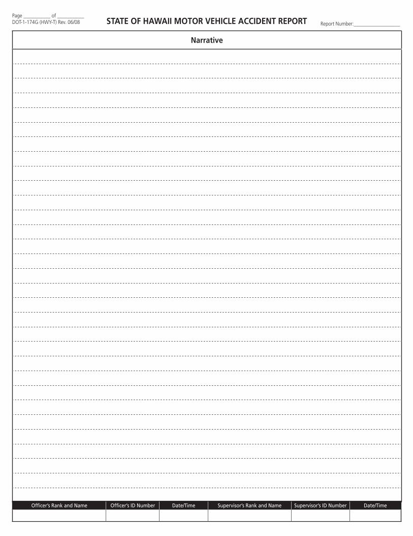
STATE OF HAWAII MOTOR VEHICLE ACCIDENT REPORTPage ___________ of ___________ DOT-1-174G (HWY-T) Rev. 06/08 Report Number:___________________
Narrative
Officer’s Rank and Name Officer’s ID Number Date/Time Supervisor’s Rank and Name Supervisor’s ID Number Date/Time

STATE OF HAWAII MOTOR VEHICLE ACCIDENT REPORT FORM Commercial Motor Vehicle Supplement
DOT-1-174F (HWY-T) Revised 06-08

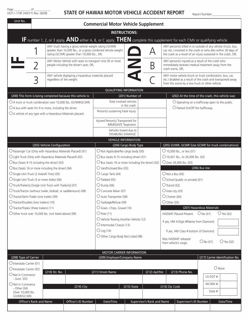
STATE OF HAWAII MOTOR VEHICLE ACCIDENT REPORTPage ___________ of ___________ DOT-1-174F (HWY-T) Rev. 06/08 Report Number:___________________
Unit No. Commercial Motor Vehicle Supplement
INSTRUCTIONS:
IF number 1, 2, or 3 apply, AND either A, B, or C apply; THEN complete this supplement for each CMV or qualifying vehicle.
1ANY truck having a gross vehicle weight rating (GVWR) greater than 10,000 lbs., or a gross combined vehicle weight rating (GCWR) greater than 10,000 lbs., OR; A
ANY person(s) killed in or outside of any vehicle (truck, bus, car, etc.) involved in the crash or who dies within 30 days of the crash as a result of an injury sustained in the crash, OR;
2ANY Motor Vehicle with seats to transport nine (9) or more people including the driver’s seat; OR, B
ANY person(s) injured as a result of the crash who immediately receives medical treatment away from the crash scene, OR;
3ANY vehicle displaying a hazardous materials placard regardless of the weight. C
ANY motor vehicle (truck or truck combination, bus, car, etc.) disabled as a result of the crash and transported away from the scene by a tow truck or other vehicle.
IF
AN
D
QUALIFYING INFORMATION
(200) This form is being completed because this vehicle is: (201) Number of (202) At the time of the crash, this vehicle was:
A truck or truck combination over 10,000 lbs. (GVWR/GCWR)
A bus with seats for 9 or more, including the driver.
A vehicle of any type with a Hazardous Materials placard.
Total involved vehicles in the crash:
Operating on a trafficway open to the public.
Parked On/Off the trafficway.Person(s) sustaining Fatal injury:
Injured Person(s) Transported for IMMEDIATE Treatment:
Vehicles towed due to DISABLING DAMAGE:
VEHICLE INFORMATION
(203) Vehicle Configuration (204) Cargo Body Type (205) GVWR, GCWR (Use GCWR for truck combinations)
Passenger Car (Only with Hazardous Materials Placard) (01)
Light Truck (Only with Hazardous Materials Placard) (02)
Bus (Seats 9-15 including the driver) (03)
Bus (Seats 16 or more including the driver) (04)
Single Unit Truck (2 Axles/6 Tires) (05)
Single Unit Truck (3 or more Axles) (06)
Truck/Trailer(s) [Single Unit Truck with Trailer(s)] (07)
Truck/Tractor (without trailer, bobtail, or saddlemount) (08)
Tractor/Semi-Trailer (one trailer) (09)
Tractor/Doubles (two trailers) (10)
Tractor/Triples (three trailers) (11)
Other truck over 10,000 lbs. (not listed above) (99)
Not Applicable/No cargo body (00)
Bus (seats 9-15 including driver) (01)
Bus (seats 16 or more including the driver) (02)
Van/Enclosed Box (03)
Cargo Tank (04)
Flatbed (05)
Dump (06)
Concrete Mixer (07)
Auto Transporter (08)
Garbage/Refuse (09)
Grain, Chips, Gravel (10)
Pole (11)
Vehicle Towing Another Vehicle (12)
Intermodal Chassis (13)
Log (14)
Other Cargo Body Not Listed (98)
10,000 lbs., or less (01)
10,001 lbs., to 26,000 lbs. (02)
Over 26,000 lbs. (03)
(206) Bus Use
Not a Bus (00)
School [public or private] (01)
Transit (02)
Inter-city (03)
Charter (04)
Other (05)
(207) Hazardous Materials
HAZMAT Placard Present No (01) Yes (02)
If yes, HM 4-Digit #/Name from Diamond:
If yes, HM Class # bottom of Diamond:
Was HAZMAT released from vehicle’s cargo: No (01) Yes (02)
MOTOR CARRIER INFORMATION
(208) Type of Carrier (209) Employer/Company Name (217) Carrier Identification No.
Interstate Carrier (01)
Intrastate Carrier (02)
Not in Commerce - Govt. (03)
Not in Commerce - Other (04) (Over 10,000 lbs. GVWR/GCWR)
None(210) Str. No. (211) Street Name (212) Apt/Ste (213) Phone No.
(214) City (215) State (216) Zip Code
US DOT #:
MC/MX #:
State #:
Officer’s Rank and Name Officer’s ID Number Date/Time Supervisor’s Rank and Name Supervisor’s ID Number Date/Time


Commercial Motor Vehicle Supplement


GENERAL GUIDELINES Investigating Officer’s Reporting Manual
State of Hawaii Motor Vehicle Accident Report DOT-1-174(HWY-T) Revised 06-08

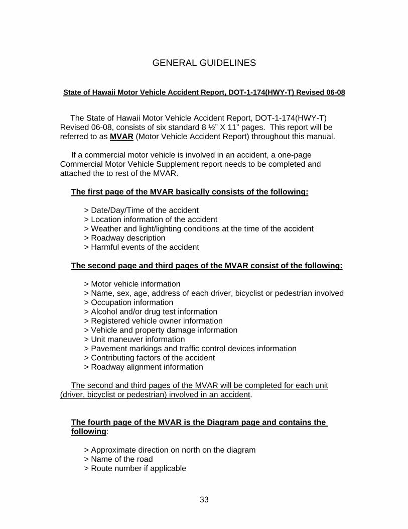
GENERAL GUIDELINES
State of Hawaii Motor Vehicle Accident Report, DOT-1-174(HWY-T) Revised 06-08
The State of Hawaii Motor Vehicle Accident Report, DOT-1-174(HWY-T) Revised 06-08, consists of six standard 8 ½” X 11” pages. This report will be referred to as MVAR (Motor Vehicle Accident Report) throughout this manual. If a commercial motor vehicle is involved in an accident, a one-page Commercial Motor Vehicle Supplement report needs to be completed and attached the to rest of the MVAR. The first page of the MVAR basically consists of the following: > Date/Day/Time of the accident > Location information of the accident > Weather and light/lighting conditions at the time of the accident > Roadway description > Harmful events of the accident The second page and third pages of the MVAR consist of the following: > Motor vehicle information > Name, sex, age, address of each driver, bicyclist or pedestrian involved > Occupation information > Alcohol and/or drug test information > Registered vehicle owner information > Vehicle and property damage information > Unit maneuver information > Pavement markings and traffic control devices information > Cont ributing factors of the accident > Roadway alignment information The second and third pages of the MVAR will be completed for each unit (driver, bicyclist or pedestrian) involved in an accident. The fourth page of the MVAR is the Diagram page and contains the following: > Approximate direction on north on the diagram > Name of the road > Route number if applicable

> Date and time of the accident > Identification of all motor vehicles, bicycles and pedestrians by unit number > Reference point (Intersection, milepost marker, etc.) > Distance and direction from reference point. > Location of first harmful event > Travel direction of each unit involved > Pavement markings > Location of fixed objects > Posted speed limit > Traffic signs and traffic control devices > Number of travel lanes > Accident synopsis The fifth page of the MVAR is the All Persons section and contains the the following information: > Name and address of each person involved in an accident. > Unit number assigned to each person > Position of each person involved > Age and sex of each person involved > Ejection information > Safety equipment usage by each person involved > Air bag deployment information > Injury severity information > Area of injury information > Medical care given at the scene of the accident information > Transport of injured to medical facility information > Name of medical facility > Condition of injured person > EMS number Every person involved in an accident is listed on this page. If more persons are involved in an accident than the space provided on this page, use additional All Persons pages to complete the accident report. The sixth page is the Narrative page and contains the following information: Write a narrative to describe what happened prior to the first harmful event of an accident, to describe the sequential events of the accident and to describe what happened after the accident has stabilized.

Information to be included in the Narrative page: > Identify vehicles, bicyclists, and pedestrians by unit number. > Describe the direction of travel and maneuver of each unit. > Describe the unstabilized sequence of events of each unit. > Describe the results of the accident after all units have stabilized and come to a rest position. > Statements by people involved in an accident and statements of witnesses of the accident should be included on the Narrative page. Attach additional Narrative pages to the MVAR if necessary. Commercial Motor Vehicle Supplement If a commercial motor vehicle is involved in an accident, a Commercial Motor Vehicle Supplement must be completed. The Commercial Motor Vehicle Supplement contains the following: > Type of commercial motor vehicle and type of vehicle configuration > Cargo body type of the commercial motor vehicle > GVWR and GCWR information > Bus use information > Hazardous materials information > Motor carrier information and motor carrier identification number


SPECIFIC INSTRUCTIONS Investigating Officer’s Reporting Manual
State of Hawaii Motor Vehicle Accident Report
DOT-1-174(HWY-T) Revised 06-08


SPECIFIC INSTRUCTIONS
When to Use a Motor Vehicle Traffic Accident Report (MVAR),
(DOT-1-174, HWY-T, Revised 06-08) The State of Hawaii Motor Vehicle Accident Report, DOT-1-174(HWY-T) Revised 06-08 is used when the following conditions occur during a motor vehicle traffic accident: > The accident is a major motor vehicle traffic accident involving total damages greater than $3,000 and/or the accident involves an injury or fatality. > There were at least one or more occurrences of unintentional damage or injury. > There was at least one occurrence of damage or injury which was not a direct result of a cataclysm. > There was at least one motor vehicle involved that was in transport at the time of the accident. > There was an unstabilized situation during the accident. > The unstabilized situation originated on a trafficway or the damage or injury of the accident occurred on the trafficway. > The unstabilized situation and harmful event are not the result of deliberate intent or legal intervention. > The accident did not involve an aircraft or railway train or watercraft in transport. If all of the above conditions are met, a State of Hawaii Motor Vehicle Accident Report (MVAR) form must be completed. Entering the Information on the MVAR A. Print in capital block letters using a black ball-point pen when filling in the MVAR. Include spaces between names. Capital Block Letters: ABCDEFGHIJKLMNOPQRSTUVWXYZ Capital Block Numbers: 1234567890

B. Categories requiring a marked bubble should be filled in as follows: Example: Field (18) Weather Conditions (Select up to 2) Clear weather condition Clear (01) C. Enter all information to the best of your knowledge. D. Page Numbers: The “Page ___ of ___ “ notation at the top left corner of the MVAR should be Completed for each page of the MVAR and if necessary the Commercial Motor Vehicle Supplement. Fasten together all pages pertaining to the same motor vehicle traffic accident. E. Use MVAR pages two and three for each unit involved in the same accident. An involved unit is a motor vehicle, a bicycle or a pedestrian. F. Amended Report Enter on the top of the MVAR the words “Amended Report” if the report is amended. In order to link an amended report to the original, the report number, the date and time of the accident as well the location of the accident must be consistent. In the narrative page of the MVAR describe what information was added or corrected on the amended report. G. Collision Diagram A collision diagram must be included on every accident report except when an investigation was not made at the scene (delayed report). If an investigation was not made at the scene and no collision diagram was made, a full description of the accident must be made on the narrative page.

Basic information to be included on the collision diagram: 1.) Identify: roadway, all units involved (motor vehicles, pedestrians, bicyclists, property owners etc.) 2.) Locate point(s) of impact. 3.) Locate motor vehicles, pedestrians, bicyclists, property or objects at the time of impact. 4.) Indicate motor vehicle, pedestrian, bicyclist paths of travel before and after the collision. 5.) Show positions and locations of motor vehicles, pedestrians, and bicyclists at point of rest. 6.) Record measurements. H. Narrative Page Basic information to include on the narrative page:
1.) Indicate what happened before, during and after the accident. 2.) Specify what “Other” is when this is filled in on the coded sections
of the report. 3.) Indicate if the driver, pedestrian or bicyclist had any disability
and/or impairment. Indicate also if there were any visual obstructions at the scene of the accident.
4.) Describe any driving conditions that may have contributed to the accident. Describe only facts not opinions.
5.) If the accident occurred in a work zone area, describe the type of construction, repair, utility work, or maintenance work being done at that time.
6.) Record statements of persons involved in the accident and statements of witnesses of the accident.


SECTION I. PAGE ONE INSTRUCTIONS
STATE OF HAWAII MOTOR VEHICLE ACCIDENT REPORTDOT-1-174A (HWY-T) Rev. 06-08


Page One of the State of Hawaii Motor Vehicle Accident ReportList of Field Numbers and Field Names
FieldNumber Field Name
Report Number(1) Crime Code(2) County(3) District (police district)(4) Beat(5) Watch(6) Date/Time/Day Occurred(7) Date/Time/Day Reported(8) Report Type(9) Total Involved (motor vehicles/motorcycles/mopeds/bicycles/pedestrians)(10) Number of (witnesses/persons killed/persons injured)(11) Tow(12) Hit & Run(13) Fire(14) Photo(15) Select One(16) Times Police (time sent/time arrive)(17) Times EMS (time sent/time arrive)(18) Weather Conditions (Select up to 2)(19) Light/Lighting(20) Location(21) Traffic Level(22) Trafficway Description(23) GPS Location (Latitude/Longitude)(24) Name of Street or Highway(25) City/Town(26) Roadwork(27) Route No.(28) Mile Post Marker(29) Distance and Direction(30) Refer (Mile Marker, Intersection, Etc.)(31A) Location of Harmful Event(31B) Action(31) Sequence of Events (Sequence No./Unit No./(31A) Location/(31B) Action
Sequence Number of the Most Harmful Event)


STATE OF HAWAII MOTOR VEHICLE ACCIDENT REPORTDOT-1-174A(HWY-T) Rev. 06-08
Page One Instructions
FieldNo. Field Name Instructions(1) Crime Code Code to be provided by Records. (HPD)
(2) County Enter the appropriate County Code.
HAW County of HawaiiHON City & County of HonoluluKAU County of KauaiMAU County of Maui
(3) District Enter the appropriate police District Code in which the accident occurred.
(4) Beat Enter the Beat Number in which the accident occurred.
(5) Watch Enter the appropriate Watch Code the accident occurred.
1 First Watch 23:00 - 06:592 Second Watch 07:00 - 14:593 Third Watch 15:00 - 22:59
(6) Date/Time/Day Occurred Enter the Date Codes for the Month/Date/Year the accident occurred.
Enter the appropriate Month Code - 01 through 12.
01 January 07 July02 February 08 August03 March 09 September04 April 10 October05 May 11 November06 June 12 December
Enter the appropriate Date of Month 01 through 31.
Enter the four-digit Year Code.
Enter the military time the accident occurred.
Time 00:00 through 23:59.
Enter the Day Code of the accident.
SU Sunday TH ThursdayMO Monday FR FridayTU Tuesday SA SaturdayWE Wednesday
Example: February 29, 2008 02/29/2008/04:30/FR4:30 AM, Friday

Page One Instructions (continued)
FieldNo. Field Name Instructions
(7) Date/Time/Day Reported Use the same procedures as Field (6).
(8) Report Type Enter the appropriate Report Type Code. (Fill in thebubble.)Major Traffic Accident (An accident involving a fatality oran injury or property damages totaling $3,000 and higher.)
Minor Traffic Accident (A Non-Major traffic accident.)
(9) Total Involved Enter the Total Number of Units Involved in the accident.MV Enter the total number of Motor Vehicles Involved.MC Enter the total number of Motorcycles or Motor
Scooters involved.MOP Enter the total number of Mopeds involved.BC Enter the total number of Bicycles involved.PED Enter the total number of Pedestrians involved.Enter 0 in any of the category if no unit is involved.
(10) Number of Enter the Total Number of Persons Involved.Wtn. Enter the total number of witnesses involved.Killed Enter the total number of persons killed.Inj. Enter the total number of persons injured.Enter 0 if no persons is involved in any of the category.
(11) Tow Select No (01), if no motor vehicle was towed as a result of the accident.Select Yes (02), if any motor vehicle was towed as a result of the accident.
(12) Hit & Run Select No (01), if no motor vehicle fled the scene of the accident.Select Yes (02), if any motor vehicle fled the scene of the accident.Note: Applies to all Felony (Failure to Render Aid) and Misdemeanor (Leaving the Scene) type of Motor Vehicle Traffic Accidents.
(13) Fire Select No (01), if no fire was involved as a result of the accident.Select Yes (02), if a fire was involved as a result of the accident.
(14) Photo Select No (01), if no police photograph was taken at the accident scene.Select Yes (02), if any police photograph was taken at the accident scene.
(15) Select One Select None (00), if the location of the accident is not at a bridge, at atunnel, or at a ramp.Select Bridge (01), if the location of the accident is at a bridge.Select Tunnel (02), if the location of the accident is in a tunnel.Select Ramp (03), if the location of the accident is at a freeway ramp.

Page One Instructions (continued)
FieldNo. Field Name Instructions(16) Times Police Sent - Enter the time the police is sent to the accident scene.
Arrive - Enter the time the police arrives at the accident scene.
(17) Times EMS Sent - Enter the time the EMS is sent to the accident scene.Arrive - Enter the time the EMS arrives at the accident scene.
(18) Weather Conditions Select up to two (2) Codes relating to the Weather Condition at the(Select up to 2) accident location.
01 Clear 07 Snow02 Cloudy 08 Blowing Sand/Soil03 Rain 09 Unknown04 Hazy, Fog, Smoke05 Windy, Severe Crosswinds06 Sleet/Hail
(19) Light/Lighting Select the Light or Lighting (street light) Code at the accident scene.
01 Daylight02 Dawn03 Dusk04 Spot Illumination05 Continuous Lighting06 Dark/Lights Off07 Dark/No Lights08 Dark/Unknown09 Unknown
(20) Location Select the most predominant land use Code of the accident location.
01 School 05 Recreational02 Business 06 Farm/Fields03 Residential 07 No Development04 Industrial 08 Other
(21) Traffic Level Select the appropriate Traffic Level (volume) Code at the accident scene.
01 Light02 Medium03 Heavy
(22) Trafficway Description Select the appropriate Trafficway Description Code to classify the type ofroadway the accident occurred on.
01 2-Way, Undivided02 2-Way, Undivided with Continuous Left Turn Lane03 2-Way, Divided, Unprotected Median (painted or grass median)04 2-Way Divided, Median Barrier05 1-Way Trafficway06 Other

Page One Instructions (continued)
FieldNo. Field Name Instructions
(23) GPS Location This space will be used in the future when GPS devices become available.
Latitude - Enter the GPS latitude measurement.
Longitude - Enter the GPS longitude measurement.
(24) Name of Street or Highway Enter the name of the street or highway that the accident occurred on.
Enter in (parenthesis) the general direction of the lane of travel of dividedhighways, on which the accident occurred.
Examples: General direction of divided highways.
H1 Eastbound or H1 Westbound (Kokohead or Waianae)H2 Northbound or H2 SouthboundLikelike Hwy Northbound or Likelike Hwy SouthboundKanoelehua Ave Northbound or Kanoelehua Ave Southbound
(25) City/Town Enter the name of the geographic area where the accident occurred.
Examples: Hilo Honolulu Lihue KahuluiKainaliu Pearl City Kapaa WailukuKailua-Kona Kalihi Koloa LahainaKamuela Kaimuki Waimea KaunakakaiNaalehu Waikiki Hanalei Lanai CityNinole Kapolei Anahola HanaKawaihae Kaneohe Poipu Pukalani
(26) Work Zone Enter No (01), if there is no construction or maintenance work being done(see Glossary page 124, at the accident location.for definition of Work Zone) Enter Yes (02), if there is construction or maintenance work being done at
the accident location.
(27) Route No. Enter the Route Number of State Highways.
Examples: 1 (H1 Freeway)93 (Farrington Highway19 (Hawaii Belt Road)50 (Kaumualii Highway)30 (Honoapiilani Highway)
(28) Mile Post Marker Enter the nearest Mile Post Marker located from the accident scene.This entry is only for state or county highways with posted mile markers.
(29) Distance and Direction Enter the Distance (in feet or in miles) and Direction from the nearestmile post marker or named intersecting street or road to locate the accident.
Examples: 0.5 Mile East of Mile Post Marker 575 Feet North of Ward Avenue1.5 Miles West of Kaonohi Overpass

Page One Instructions (continued)
FieldNo. Field Name Instructions(30) Reference (Mile Marker, Enter the Reference such as the following:
Intersection, Etc.)Mile Post Marker (such as Mile Post 25)Named Overpass (such as Ward Ave. Overpass, Kaonohi St Overpass, etc.)Named Street (such as King Street, Nanakuli Ave., etc.)Named Tunnel (such as Wilson Tunnel, Harano Tunnel)
If a loop road is used as a reference, indicate which end is being used asthe reference point. For example, Kupuna Loop (North End or South End).
If a same named street or road intersects a state highway more than once,indicate which intersection is being referenced. For example, KalanianaoleHighway (Route 72) at Halemaumau St (East end) or at Halemaumau St(West end).
Note: Do not use Utility Pole Numbers and Addresses as reference. Do not also use unnamed roads as reference.
(31) Sequence of Events
(31) # - Sequence Number Enter numerically in ascending order the sequence of events of theaccident.Sequence Number should always begin with 1.
(31) Unit Enter the number of the Unit (motor vehicle, motorcycle, moped,bicycle, pedestrian) involved in the accident. The first unit number beginswith 01.
(31) Unit/0 Enter 00 if there is no second unit (single motor vehicle collision).Enter 02 if there is a collision with a second unit, 03 if there is a thirdunit, and so forth.
(31A) Location of First Harmful Enter the appropriate Location Code where the first harmful event tookEvent place in the Box labeled, "Enter the Location of the FIRST HARMFUL
EVENT (31A)".Intersection01 Intersection Area02 Driveway Access
On Roadway-Not at Intersection 10 Left or Inner Lane11 Right or Outer Lane12 Other Main Lane13 Merge/Transition Lane14 Acceleration Lane15 Deceleration Lane16 Left Turn Lane17 Right Turn Lane18 Bikeway19 Bus/HOV/Zipper Lane

Page One Instructions (continued)
FieldNo. Field Name Instructions
(31A) Location (Continued) Off Roadway20 Left Shoulder21 Right Shoulder22 Left Roadside23 Right Roadside24 Median25 Median Crossover26 Outside ROW (Trafficway)
Off Roadway - Other30 Driveway31 Private Road32 Parking Lot
Other Roadway40 Entrance/Exit Ramp41 Railway Crossing42 Midblock Crosswalk43 HOV Crossover Lane44 Gore45 Separator46 Parking Lane47 Emergency Escape Ramp48 Other (Specify in Synopsis Block)
(31B) Action Enter the appropriate Action Code of what type of motor vehicle accidentaccident occurred.
Non-Collision01 Overturn/Rollover on Roadway02 Overturn/Rollover Off Roadway03 Submersion04 Fire/Explosion05 Jackknife06 Ran Off Roadway07 Cargo/Equipment Loss or Shift08 Fell/Jumped from Motor Vehicle09 Downhill Runaway10 Separation of Units11 Cross Median/Centerline12 Equipment Failure13 Thrown or Falling Objects14 Other Non-Collision (Specify in Synopsis Block)

Page One Instructions (continued)
FieldNo. Field Name Instructions
(31B) Action (Continued) Collision with Object/Animal20 Overhead Cables21 Guardrail Face22 Guardrail End23 Culvert24 Ditch25 Bridge/Overhead Structure26 Bridge Pier or Support27 Bridge Rail28 Building29 Tunnel30 Curb31 Embankment/Retaining Wall32 Fence33 Utility Pole/Light Support34 Traffic Signal/Sign Post35 Other Post/Pole/Support36 Impact Attenuator/Crash Cushion37 Concrete Traffic Barrier38 Other Traffic Barrier39 Tree (Standing)40 Hydrant41 Mailbox42 Animal43 Other (Specify in Synopsis Block)
Collision with Person (Pedestrian Action)50 Unknown51 Crossing in Crosswalk52 Crossing Outside Crosswalk53 Crossing No Crosswalk54 Darting Out55 Walking in Roadway56 Playing/Exercising in Roadway57 Directing Traffic58 Pushing/Working on Vehicle59 Getting On/Off Vehicle60 Roadwork61 Other (Specify in Synopsis Block)
Collision with Bicycle or Moped70 Unknown71 Riding in Bikeway72 Riding Outside of Bikeway73 Riding in Road/No Bikeway74 Riding off Roadway75 Crossing Roadway76 Fell In/On Roadway77 Other (Specify in Synopsis Block)

Page One Instructions (continued)
FieldNo. Field Name Instructions
(31B) Action (Continued) Collision with Motor Vehicle in Transport80 Head On81 Rear End82 Sideswipe - Same Direction83 Sideswipe - Opposite Direction84 Angle - Same Direction85 Angle - Opposite Direction86 Angle - Not Specified87 Broadside88 Rear to Side89 Rear to Rear90 Other (Specify in Synopsis Block)
Collision with Motor Vehicle - Other100 Motor Vehicle in Other Roadway101 Railway Vehicle (Train/Engine)102 Parked MV (motor vehicle)103 Work Zone/Maintenance Equipment
(31C) Sequence Number of the Enter the sequence number of the first harmful event to causeFirst Harmful Event severe damage or injury, in the Box labeled "Enter the Sequence
Number of the FIRST HARMFUL EVENT (31C)."
(31D) Sequence Number of the Enter the sequence number of the most harmful event of the traffic Most Harmful Event accident, in the Box labeled "Enter the Sequence Number of the
MOST HARMFUL EVENT (31D)."

Example 1Unit 01 traveling south bound on Likelike Highway (Route 63), in the right lane of the roadway,suddenly veered to the right and ran off the roadway and consequently collided with the guardrailface.
Example 1 - Single Motor Vehicle Traffic Accident
Enter the Location of the First Harmful Event (31A)
(31) Sequence of Events# Unit Unit/0 (31B) Action # Unit Unit/0 (31B Action)
1 01 00 062 01 00 21
Enter the Sequence Number of the FIRST HARMFUL EVENT (31C)
Enter the Sequence Number of the MOST HARMFUL EVENT (31D)
Example 2Unit 01 heading East on King Street disregarded the traffic signal (red light for East bound traffic) andcrossed the intersection of Punahou Street. Unit 02 heading South to East on Punahou Street (left turn green light arrow indicated for South bound traffic). Unit 01 collided with Unit 02 at an anglein the intersection of King Street and Punahou Street.
Example 2 - Motor Vehicle Traffic Accident Involving Two Motor Vehicles
Enter the Location of the FIRST HARMFUL EVENT (31A)
(31) Sequence of Events# Unit Unit/0 (31B) Action # Unit Unit/0 (31B Action)
1 01 00 142 01 02 85
Enter the Sequence Number of the FIRST HARMFUL EVENT (31C)
Enter the Sequence Number of the MOST HARMFUL EVENT (31D)
21
1
2
01
1
2

Example 3Unit 01 a pickup truck heading West on Dillingham Boulevard approximately 0.1 mile East of KalihiStreet. Unit 02 a pedestrian crossing Dillingham Boulevard from North to South with no crosswalk present.Unit 01 hit Unit 02 in the left lane of Dillingham Boulevard
Example 3 - Motor Vehicle Collision With Pedestrian Accident
10 Enter the Location of the First Harmful Event (31A)
(31) Sequence of Events# Unit Unit/0 (31B) Action # Unit Unit/0 (31B Action)
1 01 02 53
Enter the Sequence Number of the FIRST HARMFUL EVENT (31C)
Enter the Sequence Number of the MOST HARMFUL EVENT (31D)
Example 4Unit 01 a moped traveling North on University Avenue approximately 150 feet South of Dole Street,collided with Unit 02, a bicyclist who was also traveling North in the bike path.
Example 4 - Moped Striking A Bicyclist Traffic Accident
Enter the Location of the FIRST HARMFUL EVENT (31A)
(31) Sequence of Events# Unit Unit/0 (31B) Action # Unit Unit/0 (31B Action)
1 01 02 71
Enter the Sequence Number of the FIRST HARMFUL EVENT (31C)
Enter the Sequence Number of the MOST HARMFUL EVENT (31D)
10
1
1
18
1
1

SECTION II. PAGE TWO, UNIT INFORMATION INSTRUCTIONS
STATE OF HAWAII MOTOR VEHICLE ACCIDENT REPORTDOT-1-174B (HWY-T) Rev. 06-08


Page Two of the State of Hawaii Motor Vehicle Accident ReportUnit Information
List of Field Numbers and Field Names
FieldNumber Field Name
Report Number(32) Unit No.(33) No. of Occ. (Number of Occupants)(34) Unit Class(35) Race(36) Last Name(37) First Name(38) MI (Middle Initial)(39) Sex(40) DOB (Date of Birth)(41) Street No.(42) Street Name(43) St., Pl., Blvd., Etc.(44) Apt/Suite Number(45) City(46) State(47) ZIP Code(48) Home Phone Number(49) Occupation(50) Employer/Company Name(51) Work Phone Number(52) Other Phone/Pager Number(53) Driver's License Number(54) St/Juris.(55) Class(56) Restrict. (Driver License Restriction)(57) Endorse. (Driver License Endorsement)(58) Driver's License Type(59) Driver's License Status(60) Insurance Policy Number(61) Exp. Date (Insurance Expiration Date)(62) Insurance Carrier(63) Registered Owner Name(64) Phone Number (Registered Owner)(65) Street No. (Registered Owner)(66) Street Name (Registered Owner)(67) Pl., St. (Registered Owner)(69) City (Registered Owner)(70) State (Registered Owner)(71) ZIP Code (Registered Owner)(72) Vehicle Body Type(73) Vehicle Year(74) Veh. Color (Top/Bottom)(75) Vehicle Make(76) Vehicle Model(77) Lic. Plate No.(78) Trailer Plate

Page Two of the State of Hawaii Motor Vehicle Accident ReportUnit Information
List of Field Numbers and Field Names (Continued)
FieldNumber Field Name
(79) Lic. Plate St.(80) Vehicle VIN Number (Vehicle Identification Number)(81) Emer. Veh. In Use (Emergency Vehicle In Use)(82) Vehicle Stolen(83) Special Use (Special Use of Vehicle)(84) Trailer/Cargo Type(85) SFST Given (Standardized Field Sobriety Test(86) SFST Results(87) Alcohol Test Results(87A) Status(87B) Type(87C) Results(88) Drug Test Results(88A) Status(88B) Type(88C) Results
STATE OF HAWAII MOTOR VEHICLE ACCIDENT REPORTDOT-1-174B (HWY-T) Rev. 06-08
Page Two, Unit Information Instructions
FieldNo. Field Name Instructions
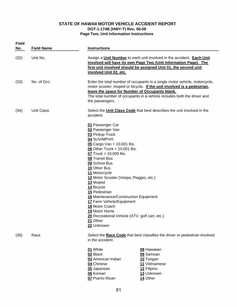
(32) Unit No. Assign a Unit Number to each unit involved in the accident. Each Unitinvolved will have its own Page Two (Unit Information Page). Thefirst unit involved should be assigned Unit 01, the second unitinvolved Unit 02, etc.
(33) No. of Occ. Enter the total number of occupants in a single motor vehicle, motorcycle,motor scooter, moped or bicycle. If the unit involved is a pedestrian,leave the space for Number of Occupants blank.The total number of occupants in a vehicle includes both the driver andthe passengers.
(34) Unit Class Select the Unit Class Code that best describes the unit involved in theaccident.
01 Passenger Car02 Passenger Van03 Pickup Truck04 SUV/MPVH05 Cargo Van < 10,001 lbs.06 Other Truck < 10,001 lbs.07 Truck > 10,000 lbs.08 Transit Bus09 School Bus10 Other Bus11 Motorcycle12 Motor Scooter (Vespa, Piaggio, etc.)13 Moped14 Bicycle15 Pedestrian16 Maintenance/Construction Equipment17 Farm Vehicle/Equipment18 Motor Coach19 Motor Home20 Recreational Vehicle (ATV, golf cart, etc.)21 Other22 Unknown
(35) Race Select the Race Code that best classifies the driver or pedestrian involvedin the accident.
01 White 08 Hawaiian02 Black 09 Samoan03 American Indian 10 Tongan04 Chinese 11 Vietnamese05 Japanese 12 Filipino06 Korean 13 Unknown07 Puerto Rican 14 Other
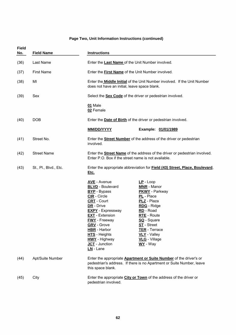
Page Two, Unit Information Instructions (continued)
FieldNo. Field Name Instructions
(36) Last Name Enter the Last Name of the Unit Number involved.
(37) First Name Enter the First Name of the Unit Number involved.
(38) MI Enter the Middle Initial of the Unit Number involved. If the Unit Numberdoes not have an initial, leave space blank.
(39) Sex Select the Sex Code of the driver or pedestrian involved.
01 Male02 Female
(40) DOB Enter the Date of Birth of the driver or pedestrian involved.
MM/DD/YYYY Example: 01/01/1989
(41) Street No. Enter the Street Number of the address of the driver or pedestrianinvolved.
(42) Street Name Enter the Street Name of the address of the driver or pedestrian involved.Enter P.O. Box if the street name is not available.
(43) St., Pl., Blvd., Etc. Enter the appropriate abbreviation for Field (43) Street, Place, Boulevard,Etc.
AVE - Avenue LP - LoopBLVD - Boulevard MNR - ManorBYP - Bypass PKWY - ParkwayCIR - Circle PL - PlaceCRT - Court PLZ - PlazaDR - Drive RDG - RidgeEXPY - Expressway RD - RoadEXT - Extension RTE - RouteFWY - Freeway SQ - SquareGRV - Grove ST - StreetHBR - Harbor TER - TerraceHTS - Heights VLY - ValleyHWY - Highway VLG - VillageJCT - Junction WY - WayLN - Lane
(44) Apt/Suite Number Enter the appropriate Apartment or Suite Number of the driver's orpedestrian's address. If there is no Apartment or Suite Number, leavethis space blank.
(45) City Enter the appropriate City or Town of the address of the driver orpedestrian involved.
62

Page Two, Unit Information Instructions (continued)
FieldNo. Field Name Instructions
(46) State Enter the appropriate State or County abbreviation for Field (46) State.
U.S. States and U.S. Possessions
AL - AlabamaAK - AlaskaAS - American SamoaAZ - ArizonaAR - ArkansasCA - CaliforniaCO - ColoradoCT - ConnecticutDE - DelawareDC - District of ColumbiaFM - Federated States of MicronesiaFL - FloridaGA - GeorgiaGU - GuamHI - HawaiiID - IdahoIL - IllinoisIN - IndianaIA - IowaKS - KansasKY - KentuckyLA - LouisianaME - MaineMH - Marshall IslandsMD - MarylandMA - MassachusettsMI - MichiganMN - MinnesotaMO - MissouriMS - MississippiMT - MontanaNE - NebraskaNV - NevadaNH - New HampshireNJ - New JerseyNM - New MexicoNY - New YorkNC - North CarolinaND - North DakotaMP - Northern Mariana IslandsOH - OhioOK - OkalahomaOR - OregonPW - PalauPA - PennsylvaniaPR - Puerto Rico

Page Two, Unit Information Instructions (continued)
FieldNo. Field Name Instructions
(46) State U.S. States and U.S. Possessions (Continued)
RI - Rhode IslandSC - South CarolinaSD - South DakotaTN - TennesseeTX - TexasUT - UtahVT - VermontVI - Virgin IslandsVA - VirginiaWA - WashingtonWV - West VirginiaWI - WisconsinWY - Wyoming
Foreign Countries
AUT - AustraliaBRA - BrazilCAN - CanadaCHN - ChinaFRA - FranceDEU - GermanyHKG - Hong KongISR - IsraelITA - ItalyJPN - JapanKOR - Republic of KoreaMYS - MalaysiaMEX - MexicoNZL - New ZealandNLD - Netherlands (Holland)PHL - PhilippinesSGP - SingaporeSWE - SwedenTWN - TaiwanTHA - ThailandGBR - United Kingdom ( Great Britain/England/Scotland/Wales)
Other Countries - Specify
(47) ZIP Code Enter the appropriate ZIP Code for the address of the driver orpedestrian involved.
(48) Home Phone Number Enter the appropriate Home Phone Number of the driver or pedestrian involved.

Page Two, Unit Information Instructions (continued)
FieldNo. Field Name Instructions
(49) Occupation Select the most appropriate Occupation Code of the driver or pedestrianinvolved.
00 Unemployed01 U.S. Army02 U.S. Navy03 U.S. Air Force04 U.S. Marines05 U.S. Coast Guard06 Other Military07 Federal Government Civilian08 State Government09 County Government10 Foreign Government/Civilian11 Retired12 Student - Elementary13 Student - Intermediate (Middle School)14 Student - High School15 Student - College (University/Community College, Etc.)16 U.S. Tourist17 Foreign Tourist18 Police Officer19 Other (Other employed person including self-employed)20 Not Stated or Unknown
Note: If a driver or pedestrian involved is disabled and notemployed, this person's occupation status is unemployed.
(50) Employer/Company Name Enter the Employer or the Company Name of the driver's or pedestrian'splace of employment.
(51) Work Phone Number Enter the Work Phone Number of the involved driver or pedestrian.
(52) Other Phone/Pager Number Enter the Other Phone/Pager Number (or Cell Number) of the employeror company.
(53) Driver's License Number Enter the Driver's License Number of the motor vehicle driver involved inthe accident.
(54) St./Juris. Enter the State, Jurisdiction or Country which issued the driver's license.Use the same abbreviations as Field (46) State.
(55) Class Enter the Driver's License Class Code. (Hawaii Drivers License Only)
2 Motorcycles & Motor Scooters3 Passenger Vehicles of any GVWR, Buses designed to transport
fifteen or fewer occupants. Trucks and vans w/15,000 lbs. GVWRor less.
4 Trucks 15,001 lbs. through 26,000 lbs. GVWR and Type 3.
65

Page Two, Unit Information Instructions (continued)
FieldNo. Field Name Instructions
(55) Class Driver's License Class Code (Continued)
A Combination vehicles 26,001 lbs. GVWR or more; towed vehicles in excess of 10,000 lbs.B Single vehicle 26,001 lbs. GVWR or more; towed vehicle not in excess of 10,000 lbs.C Vehicle less than 26,001 lbs. GVWR; designed to transport sixteen or more passengers; or placarded for hazardous materials.
(56) Restrict. Enter the appropriate Driver License Restriction Code if applicable.
A Corrective LensesB Outside MirrorC Automatic TransmissionD Daylight Hours OnlyE Full Hand EquipmentF Mechanical SignalsG TaxiH Power SteeringI Hearing AidJ Power BrakesK Vehicles Without Air BrakesL Steering KnobM CushionN MedicalO Any Other RestrictionsP Three-wheel motorcycleQ Mechanical AidR Prosthetic AidS Limit to EmploymentT Limited - OtherV CDL Interstate OnlyX Except Class A BusY Except Class A and BusZ Except Tractor-TrailerAHCD Advance Health Care Directive
(57) Endorse. Enter the appropriate CDL Driver's License Endorsement Codeif applicable.
H (CDL) Hazardous MaterialN (CDL) Tank VehiclesP (CDL) PassengerS (CDL) School BusT (CDL) Double/Triple TrailersX (CDL) Combination of H & N
Page Two, Unit Information Instructions (continued)
FieldNo. Field Name Instructions
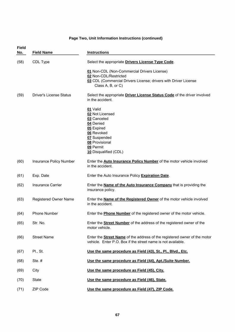
(58) CDL Type Select the appropriate Drivers License Type Code.
01 Non-CDL (Non-Commercial Drivers License)02 Non-CDL/Restricted03 CDL (Commercial Drivers License; drivers with Driver License
Class A, B, or C)
(59) Driver's License Status Select the appropriate Driver License Status Code of the driver involvedin the accident.
01 Valid02 Not Licensed03 Canceled04 Denied05 Expired06 Revoked07 Suspended08 Provisional09 Permit10 Disqualified (CDL)
(60) Insurance Policy Number Enter the Auto Insurance Policy Number of the motor vehicle involvedin the accident.
(61) Exp. Date Enter the Auto Insurance Policy Expiration Date.
(62) Insurance Carrier Enter the Name of the Auto Insurance Company that is providing theinsurance policy.
(63) Registered Owner Name Enter the Name of the Registered Owner of the motor vehicle involvedin the accident.
(64) Phone Number Enter the Phone Number of the registered owner of the motor vehicle.
(65) Str. No. Enter the Street Number of the address of the registered owner of themotor vehicle.
(66) Street Name Enter the Street Name of the address of the registered owner of the motorvehicle. Enter P.O. Box if the street name is not available.
(67) Pl., St. Use the same procedure as Field (43), St., Pl., Blvd., Etc.
(68) Ste. # Use the same procedure as Field (44), Apt./Suite Number.
(69) City Use the same procedure as Field (45), City.
(70) State Use the same procedure as Field (46), State.
(71) ZIP Code Use the same procedure as Field (47), ZIP Code.
67

Page Two, Unit Information Instructions (continued)
FieldNo. Field Name Instructions
(72) Vehicle Body Type Select the appropriate Vehicle Body Type Code for the motor vehicleinvolved in the accident.
01 2-DSD (2-door passenger sedan)02 4-DSD (4-door passenger sedan)03 2-DVC (2-door convertible)04 2-DSW (2-door station wagon)05 4-DSW (4-door station wagon)06 P/U Truck (Pickup truck)07 SUV/MPVH (Sports utility vehicle/Multi-purpose vehicle)08 Van (Passenger van)09 Truck (All trucks and cargo vans. Do not include pick-up trucks and passenger vans in this category.)10 Bus (Include all types of buses.)11 PCMC (Include all types of motorcycles.)12 M-scooter (Include all types of motor scooters.)13 Moped (Include all types of mopeds.)14 Bicycle (Include all types of bicycles.)15 Other (Include in this category other vehicles such as ATVs, Golf Carts, unknown vehicle, etc.)
(73) Vehicle Year Enter the Vehicle Year of the motor vehicle involved in the accident.
(74) Veh. Color (Top/Bottom) Enter the Vehicle Color Code of the unit involved in the accident.Select the color for the top of the vehicle and the bottom of the vehicle.
01 Black02 Blue03 Light Blue04 Brown05 Cream06 Gold07 Gray08 Green09 Light Green10 Maroon11 Orange12 Pink13 Purple14 Red15 Silver16 Tan17 White18 Yellow19 Other
(75) Vehicle Make Enter the Vehicle Make (Name of Manufacturer) of the unit involved inthe accident.
Examples: Chrysler, Chevrolet, Ford, Honda, Hyundai, Nissan, Etc.

Page Two, Unit Information Instructions (continued)
FieldNo. Field Name Instructions
(76) Vehicle Model Enter the Vehicle Model name of the unit involved in the accident.
Examples: Corolla, Charger, Impala, Mustang, Expedition, F-150,Rabbit, etc.
(77) Lic. Plate No. Enter the License Plate Number of the unit involved in the accident.
(78) Trailer Plate Enter the Trailer Plate Number if applicable.
(79) Lic. Plate St. Enter the State of the License Plate of the unit involved in the accident.
(80) Vehicle VIN Number Enter the Vehicle VIN Number (Vehicle Identification Number). The VINnumber can be obtained from the vehicle registration card or from thevehicle body, or sometimes from the motor vehicle insurance card.
(81) Emer. Veh. In Use Select No (01), if the vehicle involved in the accident is not an EmergencyVehicle in use.
Select Yes (02), if the vehicle involved in the accident is an EmergencyVehicle in use.
(82) Vehicle Stolen Select No (01), if the vehicle involved in the accident is not stolen.
Select Yes (02), if the vehicle involved in the accident is stolen.
(83) Special Use Select the appropriate Special Use of Vehicle Code.
00 None01 Driver Training02 Construction/Maintenance03 Taxi04 Fire Truck05 Tow Truck06 Ambulance07 Police - On Duty08 Police - Off Duty09 Military10 Government (County, City. State, Federal)11 Farm Use12 U-Drive13 School Bus14 Other Buss15 Other
Page Two, Unit Information Instructions (continued)
FieldNo. Field Name Instructions
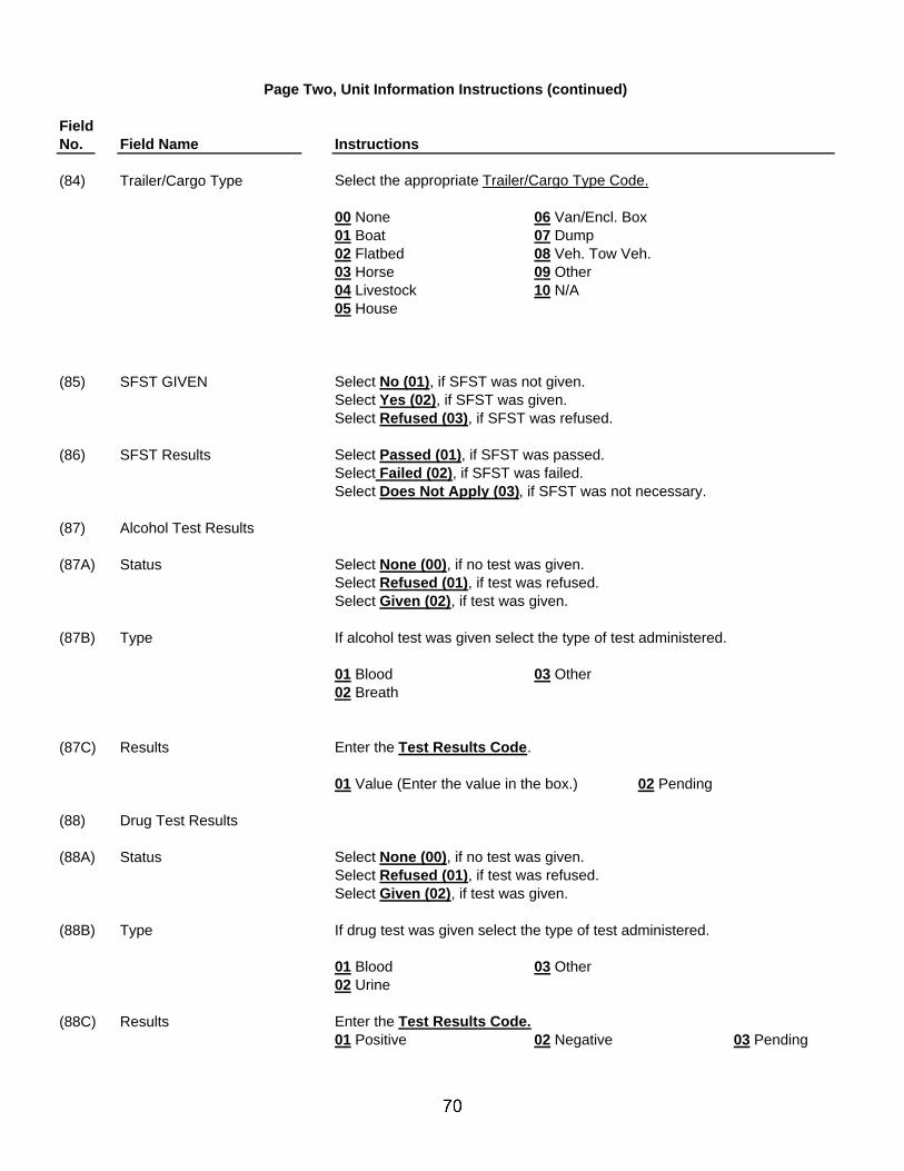
(84) Trailer/Cargo Type Select the appropriate Trailer/Cargo Type Code.
00 None 06 Van/Encl. Box01 Boat 07 Dump02 Flatbed 08 Veh. Tow Veh.03 Horse 09 Other04 Livestock 10 N/A05 House
(85) SFST GIVEN Select No (01), if SFST was not given.Select Yes (02), if SFST was given.Select Refused (03), if SFST was refused.
(86) SFST Results Select Passed (01), if SFST was passed.Select Failed (02), if SFST was failed.Select Does Not Apply (03), if SFST was not necessary.
(87) Alcohol Test Results
(87A) Status Select None (00), if no test was given.Select Refused (01), if test was refused.Select Given (02), if test was given.
(87B) Type If alcohol test was given select the type of test administered.
01 Blood 03 Other02 Breath
(87C) Results Enter the Test Results Code.
01 Value (Enter the value in the box.) 02 Pending
(88) Drug Test Results
(88A) Status Select None (00), if no test was given.Select Refused (01), if test was refused.Select Given (02), if test was given.
(88B) Type If drug test was given select the type of test administered.
01 Blood 03 Other02 Urine
(88C) Results Enter the Test Results Code.01 Positive 02 Negative 03 Pending
SECTION III. PAGE THREE, UNIT INFORMATION (CONT.) INSTRUCTIONS
STATE OF HAWAII MOTOR VEHICLE ACCIDENT REPORTDOT-1-174C (HWY-T) Rev. 06-08

Page Three of the State of Hawaii Motor Vehicle Accident ReportUnit Information (Cont.)
List of Field Numbers and Field Names
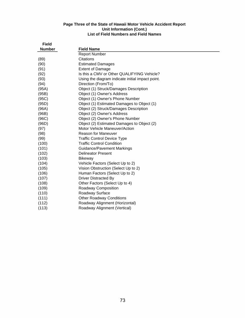
Field Number Field Name
Report Number(89) Citations(90) Estimated Damages(91) Extent of Damage(92) Is this a CMV or Other QUALIFYING Vehicle?(93) Using the diagram indicate initial impact point.(94) Direction (From/To)(95A) Object (1) Struck/Damages Description(95B) Object (1) Owner's Address(95C) Object (1) Owner's Phone Number(95D) Object (1) Estimated Damages to Object (1)(96A) Object (2) Struck/Damages Description(96B) Object (2) Owner's Address(96C) Object (2) Owner's Phone Number(96D) Object (2) Estimated Damages to Object (2)(97) Motor Vehicle Maneuver/Action(98) Reason for Maneuver(99) Traffic Control Device Type(100) Traffic Control Condition(101) Guidance/Pavement Markings(102) Delineator Present(103) Bikeway(104) Vehicle Factors (Select Up to 2)(105) Vision Obstruction (Select Up to 2)(106) Human Factors (Select Up to 2)(107) Driver Distracted By(108) Other Factors (Select Up to 4)(109) Roadway Composition(110) Roadway Surface(111) Other Roadway Conditions(112) Roadway Alignment (Horizontal)(113) Roadway Alignment (Vertical)

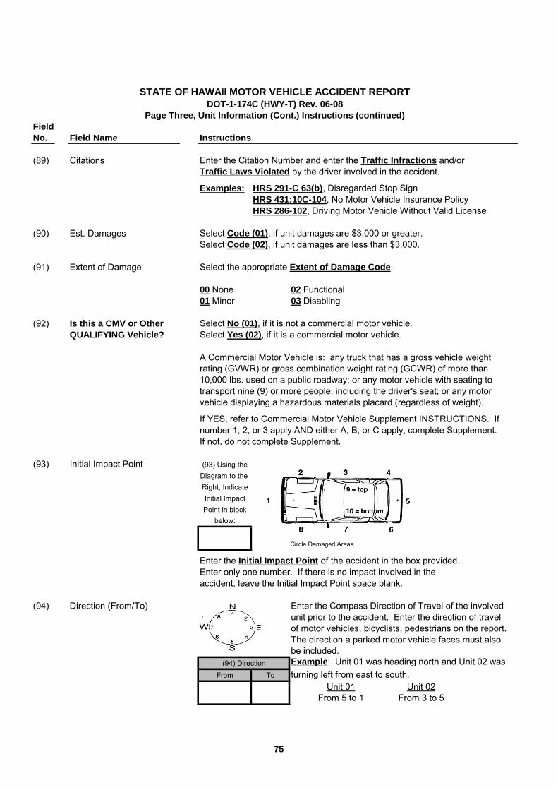
STATE OF HAWAII MOTOR VEHICLE ACCIDENT REPORTDOT-1-174C (HWY-T) Rev. 06-08
Page Three, Unit Information (Cont.) Instructions (continued)FieldNo. Field Name Instructions
(89) Citations Enter the Citation Number and enter the Traffic Infractions and/orTraffic Laws Violated by the driver involved in the accident.
Examples: HRS 291-C 63(b), Disregarded Stop SignHRS 431:10C-104, No Motor Vehicle Insurance PolicyHRS 286-102, Driving Motor Vehicle Without Valid License
(90) Est. Damages Select Code (01), if unit damages are $3,000 or greater.Select Code (02), if unit damages are less than $3,000.
(91) Extent of Damage Select the appropriate Extent of Damage Code.
00 None 02 Functional01 Minor 03 Disabling
(92) Is this a CMV or Other Select No (01), if it is not a commercial motor vehicle.QUALIFYING Vehicle? Select Yes (02), if it is a commercial motor vehicle.
A Commercial Motor Vehicle is: any truck that has a gross vehicle weightrating (GVWR) or gross combination weight rating (GCWR) of more than10,000 lbs. used on a public roadway; or any motor vehicle with seating totransport nine (9) or more people, including the driver's seat; or any motorvehicle displaying a hazardous materials placard (regardless of weight).
If YES, refer to Commercial Motor Vehicle Supplement INSTRUCTIONS. Ifnumber 1, 2, or 3 apply AND either A, B, or C apply, complete Supplement.If not, do not complete Supplement.
(93) Initial Impact Point (93) Using theDiagram to theRight, IndicateInitial ImpactPoint in block
below:
Circle Damaged Areas
Enter the Initial Impact Point of the accident in the box provided.Enter only one number. If there is no impact involved in theaccident, leave the Initial Impact Point space blank.
(94) Direction (From/To) Enter the Compass Direction of Travel of the involvedunit prior to the accident. Enter the direction of travelof motor vehicles, bicyclists, pedestrians on the report.The direction a parked motor vehicle faces must alsobe included.
(94) Direction Example: Unit 01 was heading north and Unit 02 wasFrom To turning left from east to south.
Unit 01 Unit 02From 5 to 1 From 3 to 5
75

Page Three, Unit Information (Cont.) Instructions (continued)
FieldNo. Field Name Instructions
(95A) Object (1) Struck/DamageDescription Describe the type of Object Struck and the extent of the Damage.
(95B) Object (1) Owner's Name Enter the Owner's Name.
(95C) Object (1) Owner's PhoneNumber Enter the Owner's Phone Number.
(95D) Estimated Damages toObject (1) Select (01), - if $3,000 or greater.
Select (02), - if less than $3,000.
(96A) Object (2) Struck/DamageDescription Describe the type of Object Struck and the extent of the Damage.
(96B) Object (2) Owner's Name Enter the Owner's Name
(96C) Object (2) Owner's Phone Enter the Owner's Phone Number.
(96D) Estimated Damages to Select (01), - if $3,000 or greater.Object (2) Select (02), - if less than $3,000.
(97) Motor VehicleManeuver/Action Select the appropriate Motor Vehicle Maneuver/Action Code.
01 Straight Ahead 10 Stopped in Traffic02 Changing Lanes 11 Start in Traffic03 Merging 12 Right Turn on Red04 Overtaking 13 Turning Right05 Slowing/Stopping 14 Turning Left06 Backing 15 U-Turn07 Parking 16 Entering Traffic08 Parked 17 Negotiating a Curve09 Start from Parking 18 Other
(98) Reason for Maneuver Select the appropriate Reason for Maneuver Code.
01 Intended Maneuver 06 Avoid Bicyclist02 Traffic Controls 07 Avoid Object/Animal03 Mechanical Failure 08 Avoid Prior Motor Vehicle Accident04 Avoid Other Vehicle 09 Other05 Avoid Pedestrian
(99) Traffic Control Device Type Select the appropriate Traffic Control Device Type Code.
00 No Controls 05 Flashing Yellow 10 Other01 Traffic Signal 06 Person02 Stop Sign 07 School Zone Sign03 Yield Sign 08 Warning Sign04 Flashing Red 09 Railway Crossing Device
76

Page Three, Unit Information (Cont.) Instructions (continued)
FieldNo. Field Name Instructions
(100) Traffic Control Condition Select the appropriate Traffic Control Condition Code.
01 Functioning Properly 06 Green Malfunction02 Knocked Down 07 Arrow Malfunction03 Obscured 08 Lights Not Changing04 Red Malfunction 09 Other Malfunction05 Yellow Malfunction
(101) Guidance/Pavement Markings Select the appropriate Guidance/Pavement Markings Code that indicatesthe pavement marking to the left and right of the involved motor vehicleprior to the accident.
00 None 06 No Passing, Yellow01 Solid Yellow 07 Curb, Median, Etc.02 Skip-Dash Yellow 08 Bikeway Markings03 Solid White 09 Crosswalk Marking04 Skip-Dash White 10 Turn Lane05 Solid Double Yellow
(102) Delineator Present Select the appropriate Delineator Present Code. Delineators arereflecting posts mounted at regular intervals along the side of theroad to indicate the horizontal alignment of the roadway.
00 None 02 Left01 Right 03 Both Sides
(103) Bikeway Select the appropriate Bikeway Code. A Bikeway is any road, path,or way which is specifically designated as being open to bicycle travel.
00 None 02 Bike Lane Stripe01 Bike Route (Signed) 03 Separate Path/Lane
(104) Vehicle Factors(Select Up to 2) Select the appropriate Vehicle Factors Code. The Vehicle Factors are
the pre-existing motor vehicle defects or maintenance conditions thatmay have contributed to the accident.
00 None 08 Suspension01 Worn Tires 09 Wheels02 Tire Failure 10 Power Train03 Brakes 11 Window/Windshield04 Headlights 12 Mirrors05 Taillights 13 Wipers06 Signals 14 Trailer Coupling07 Steering 15 Other
77

Page Three, Unit Information (Cont.) Instructions (continued)
FieldNo. Field Name Instructions(105) Vision Obstruction
(Select up to 2) Select the appropriate Vision Obstruction Code.00 None 06 Glare01 Tree/Bush/Fence 07 Weather Condition02 Embankment 08 Pedestrian03 Building 09 Animal(s) in Road04 Moving Vehicle 10 Other05 Parked/Stopped Vehicle
(106) Human Factors Select the appropriate Human Factors Code.(Select up to 2) 00 None 06 Illness
01 Inattention 07 Legal Medication02 Misjudgment 08 Emotional03 Fatigue 09 Physically Impaired04 Alcohol 10 Other05 Illegal Drugs
(107) Driver Distracted By Select the appropriate Driver Distracted By Code.00 Not Distracted 04 Other Inside Vehicle01 Cellular Phone 05 Other Outside Vehicle02 Other Electronic Communication Device 06 Distracted by Vehicle03 Other Electronic Device Occupant
(108) Other Factors Select the appropriate Other Factors Code.(Select up to 4) 00 No Improper Action
01 Drove Too Fast for Condition02 Exceeded Posted Speed Limit03 Disregarded Traffic Signals04 Disregarded Red Light05 Disregarded Other Traffic Control Device06 Failure to Yield07 Wrong Side/Way08 Crossed Centerline09 Ran Off Road10 Failure to Keep in Proper Lane11 Improper Turn12 Improper Passing13 Improper Backing14 Followed Too Closely15 Aggressive, Reckless Driving16 Swerved to Avoid Obstacle17 Over Correcting or Over Steering18 Other Improper Action19 Illegally in Road (Can also be used for pedestrians or bicyclists.)20 Improper Crossing (Use for pedestrians or bicyclists.)21 Pedestrian Violation22 Inattention (Talking, Etc.)23 Bicycle Violation24 Clothing Not Visible (Use for pedestrians or bicyclists.)

Page Three, Unit Information (Cont.) Instructions (continued)
FieldNo. Field Name Instructions
(109) Roadway Comp. Select the appropriate Roadway Composition Code.
01 Concrete 04 Dirt02 Asphalt 05 Other03 Gravel
(110) Roadway Surface Select the appropriate Roadway Surface Code
01 Dry02 Wet03 Mud, Dirt, Gravel04 Debris05 Oil06 Snow07 Slush08 Ice/Frost09 Water10 Sand
(111) Other Roadway Conditions Select the appropriate Other Roadway Conditions Code.
00 None01 Ruts, Holes, Etc.02 No Shoulder03 Low Shoulder04 Soft Shoulder05 High Shoulder06 Loose Material07 Worn, Polished08 Other

Page Three, Unit Information (Cont.) Instructions (continued)
FieldNo. Field Name Instructions
(112) Roadway Alignment(Horizontal) Select the appropriate Roadway Alignment (Horizontal) Code.
01 Straight02 Curve Left03 Curve Right
(113) Roadway Alignment(Vertical) Select the appropriate Roadway Alignment (Vertical) Code.
01 Level02 Hillcrest03 Uphill04 Downhill05 Sag (bottom)
SECTION IV. DIAGRAM PAGE INSTRUCTIONS
STATE OF HAWAII MOTOR VEHICLE ACCIDENT REPORTDOT-1-174D (HWY-T) Rev. 06-08


STATE OF HAWAII MOTOR VEHICLE ACCIDENT REPORTDOT-1-174D (HWY-T) Rev 06-08
Diagram Page Instructions
The Diagram Page is the most important part of the entire report. The diagram contributes to the understandingof how a traffic accident occurred because it brings together important facts in an easy to comprehendformat.
The following are some important information that must be on the motor vehicle traffic accident diagram:
1. Accident Report Number2. Date, time and day of the accident.3. Name of roadways and highway route number and milepost location if applicable.4. City, town or geographical name of the accident area.5. Approximate direction of North.6. Identify the units involved by their unit numbers assigned.7. Indicate the direction of travel of all units prior to the accident.8. Indicate the first point of impact.9. Draw the roadway features such as the number of lanes, curbs, shoulders, guardrails
bridge rails, medians, etc.10. Draw any significant roadside objects such as fences, embankments, ditches, trees,
shrubs, buildings, utility poles, fire hydrants, mailboxes, streams, etc.11. Draw any traffic control devices such as pavement markers, traffic signs, traffic signals,
pavement reflectors, etc.12. Indicate the name of the person who made the diagram and the date the drawing was
completed.
Field Number Field Name Instructions
(114) Tire Skid Marks (Feet) Measure and enter length of Tire Skid Marks
(in feet) and identify the correspondingreference point. The Unit headings correspond tothe applicable units in ascending order.
(115) Reference Point Draw on the Diagram the Reference Point,
and measure the distance and directionfrom the location of the first harmful eventof the accident. All measurements andand direction must be indicated on thediagram.
Examples:
The accident on King Street is 150 feetWest of Piikoi Street.
The accident on Route 30, HonoapiilaniHighway, is 0.3 Mile North of Mile Marker24.
The accident of Route 19, Hawaii BeltRoad, is 200 feet North of Kolekole Bridge.
83

STATE OF HAWAII MOTOR VEHICLE ACCIDENT REPORTDOT-1-174D (HWY-T) Rev 06-08
Diagram Page Instructions
Field Number Field Name Instructions
(115) Object Indentify the Object being measured.
(115) N Distance North of the reference point.
(115) S Distance South of the reference point.
(115) E Distance East of the reference point.
(115) W Distance West of the reference point.
(116) Intersection Related Select No (01) if the accident location is notintersection related.
Select Yes (02) if the accident location isintersection related.
(117) Main Road
(117A) No. of Lanes Enter the number of lanes on the main road.
(117B) Speed Limit Enter the speed limit of the main road.Also, indicate the main road speed limit(s) on theDiagram.
(118) Side Road
(118A) No. of Lanes Enter the number of lanes on the side road.
(118B) Speed Limit Enter the speed limit of the side road.Also, indicate the side road speed limit(s) on theDiagram.
(119) Type of Intersection 01 Not at Intersection(Select One) 02 4-Way Intersection
03 "T" Intersection04 "Y" Intersection05 Part of Interchange06 Traffic Circle07 Roundabout08 5 (or more legs) Intersection09 Other
Synopsis Briefly summarize the facts of the accident.Refer to units involved by Unit Number. If morespace is required use the Narrative Page.
84

SECTION V. ALL PERSONS PAGE INSTRUCTIONS
STATE OF HAWAII MOTOR VEHICLE ACCIDENT REPORTDOT-1-174E (HWY-T) Rev. 06-08


STATE OF HAWAII MOTOR VEHICLE ACCIDENT REPORTDOT-1-174E (HWY-T) Rev. 06-08Page Five, All Persons Instructions
(120) ALL PERSONS
E - Ejection H - Injury Class I - Injury Area J - Accident Site Care L - Medical Facility
00 Not Ejected 00 None 00 None 00 None Hawaii County Molokai/Lanai C & C Honolulu (cont.)
01 Ejected, Total 01 Possible 01 Head 01 First Aid 20 Kaneohe State Hospital
02 Ejected, Partial 02 Non-Incapacitating 02 Face 02 Resuscitation 01 Hilo Medical Center 11 Molokai General Hosp. 21 Kapiolani Medical Ctr.
03 N/A Non-motorist 03 Incapacitating 03 Eye 03 Extrication 02 Kona Hospital 12 Lanai Comm. Hosp. 22 Kapiolani Med. - Pali
04 Unknown 04 Fatal 04 Neck 04 Both 1 & 2 03 Kau Hospital Momi
05 Unknown 05 Thorax (Chest) 05 Both 1 & 3 04 Kohala Hospital Kauai County 23 Kuakini Med. Ctr.
F - Safety Equipment Use 06 Spine/Back 06 Both 2 & 3 05 Honokaa Hospital 24 Hawaii Med. Ctr.
07 Shoulder/Upper Arm 07 Other 06 N. Hawaii Comm. Hosp. 13 Wilcox Memorial Hosp. 25 Hawaii Med. Ctr.
00 Not Present 08 Elbow/Lower Arm/Hand 08 Refused 14 Kauai Vet. Mem. Hosp. West
01 Not Used 09 Abdomen/Pelvis Maui County 26 Queen's Medical Center
02 Shoulder/Lap Belt Used 10 Hip/Upper Leg K - Trans. To Med. Facility C & C Honolulu 27 Straub Clinic & Hosp.
03 Lap Belt Only Used 11 Knee/Lower Leg/Foot 07 Kula General Hospital 28 Tripler Army Med. Ctr.
04 Shoulder Belt Only Used 12 Entire Body 00 Not Transported 08 Maui Mem. Med. Ctr. 15 Castle Medical Center 29 Wahiawa General Hosp.
05 Not Able to Determine 01 EMS 09 Kaiser Clinic 16 Shriner's Hosp.for 30 Waianae Comp. Ctr.
06 Child Restraint (Forward) 02 Police 10 Hana Clinic Children
07 Child Restraint (Rear) 03 Helicopter 17 Kahuku Hospital
08 Booster Seat 04 Private Vehicle 18 Kaiser Permanente
09 Child Restraint (Unk. Type) 05 Other 19 Kaiser Clinic - Honolulu 99 Other
10 Child Restraint (Improper)
11 Helmet Used
12 N/A (Non-Motorist) M - Condition
13 Unknown 92 B - Position in Unit
01 Refused Treatment
G - Air Bag Deployed Motorcycle/Moped/Bicycle Pedestrian 02 Released
93 91 03 Good, Fair
00 Not Present 04 Serious, Guarded
01 Not Deployed 05 Critical
02 Deployed - Front 94 06 Dead on Arrival
03 Deployed - Side 07 Dead Other
04 Deployed - Other Motor Vehicle
05 Deployed - Combination For lap positions use 1 in place of 0
06 Deployed - Curtain
Name and A B C D E F G H I J K L M N
Address Unit Position Age Sex Eject Safety Air Bag Injury Area Care Trans. Hosp. Cond. EMS No.
Field Number Field Name Instructions
(120) Name and Address Enter the Name and Address of all persons involved in the traffic accident.
(120A) Unit Enter the Unit Number for each occupant of a motor vehicle involved in theaccident. Example: There are three occupants in motor vehicle unit number 01,the driver of the vehicle and two passengers. Each occupant in this vehicle will beassigned Unit Number 01 in Block A, Unit. Enter 01 for each occupant in
Block A, Unit.
A pedestrian or bicyclist involved in an accident will also be assigned a Unit
Number. Example: Unit 01, a passenger van, collides with Unit 02, a pedestrian.The occupants of the passenger van will be assigned Unit Number 01 and thepedestrian will be assigned Unit Number 02 in Block A, Unit. Enter 01 in Block
A Unit, for each occupant in the passenger van and enter 02 in Block A Unit,
for the pedestrian.
(120B) Position Enter the Position Number Code for each person involved in the accident. Use theabove diagram to determine the position code.
Use code number 10 for drivers of motor vehicles.
Use code numbers 20 through 94 for passengers of motor vehicles.
Use code numbers 91 through 94 for passengers who are on the outside of the
motor vehicle (passenger on the hood, roof, trunk, bumper, etc. of the vehicle).
Use code number 12 for drivers of motorcycles, motor scooters, mopeds and
bicycles.
70 40 10
80 50 20
90 60 30 13 12
14
15
87

STATE OF HAWAII MOTOR VEHICLE ACCIDENT REPORTDOT-1-174E (HWY-T) Rev. 06-08
Page Four, All Persons Instructions (Continued)
93 B - Position in Unit
Motorcycle/Moped/Bicycle Pedestrian
94 92
95
Motor Vehicle
For lap positions use 1 in place of 0
Name and A B C D E F G H I J K L M N
Address Unit Position Age Sex Eject Safety Air Bag Injury Area Care Trans. Hosp. Cond. EMS No.
Field Number Field Name Instructions
(120B) Position (Continued) Use code number 13 for passengers of motorcycles, motor scooters, mopeds
and bicycles.
Use code number 14 for passengers in the side-car of a motorcycle.
Use code number 15 for pedestrians.
(120C) Age Enter the Age of each person involved in an accident.
(120D) Sex Enter the Sex of each person involved in an accident.M Male F Female
(120E) Eject Select the appropriate Eject code for each person involved in an accident.
00 Not Ejected01 Ejected, Total02 Ejected, Partial03 N/A, Non-Motorist (Pedestrian)04 Unknown
(120F) Safety Select the appropriate Safety Code for each occupant of a vehicle.
00 Not Present01 Not Used02 Shoulder/Lap Belt Used03 Lap Belt Only Used04 Shoulder Belt Only Used05 Not Able to Determine06 Child Restraint (Forward Facing)07 Child Restraint (Rear Facing)08 Booster Seat09 Child Restraint (Unknown Type)10 Child Restraint (Improper Use)11 Helmet Used12 N/A, Non-Motorist (Pedestrian)13 Unknown
(120G) Air Bag Deployed 00 Not Present01 Not Deployed02 Deployed - Front03 Deployed - Side04 Deployed - Other05 Deployed - Combination06 Deployed - Curtain
70 40 10
80 50 20
90 60 30 13 12
14
15
88

STATE OF HAWAII MOTOR VEHICLE ACCIDENT REPORTDOT-1-174E (HWY-T) Rev. 06-08
Page Five, All Persons Instructions (Continued)
Name and A B C D E F G H I J K L M N
Address Unit Position Age Sex Eject Safety Air Bag Injury Area Care Trans. Hosp. Cond. EMS No.
Field Number Field Name Instructions
(120H) Injury Class Select the appropriate Injury Class Code of all persons involved in the accident.
00 None01 Possible (Any non-visible injury reported or claimed that is not fatal, incapacitating or non-incapacitating injury.)02 Non-Incapacitating (Any evident injury, other than fatal or incapacitating.)03 Incapacitating (Any injury, other than fatal, which prevents the injured person from walking, driving or normally continuing the activities the person was capable of performing prior to the accident.) 04 Fatal (An injury received at the scene of the accident that results in death during or after the accident.)05 Unknown
(120I) Injury Area Select the appropriate Injury Area Code of all persons involved in the accident.
00 None01 Head02 Face03 Eye04 Neck05 Thorax (Chest)06 Spine/Back07 Shoulder/Upper Arm08 Elbow/Lower Arm/Hand09 Abdomen/Pelvic10 Hip/Upper Leg11 Knee/Lower Leg/Foot12 Entire Body
(120J) Accident Site Care Select the appropriate Accident Site Care Code of all persons involved in theaccident.
00 None01 First Aid02 Resuscitation03 Extrication04 Both 1 & 205 Both 1 & 306 Both 2 & 307 Other08 Refused
(120K) Transport to Medical Select the appropriate Transport to Medical Facility Code for all persons involvedFacility in the accident.
00 Not Transported01 EMS02 Police03 Helicopter04 Private Vehicle05 Other

STATE OF HAWAII MOTOR VEHICLE ACCIDENT REPORTDOT-1-174E (HWY-T) Rev. 06-08
Page Five, All Persons Instructions (Continued)
Name and A B C D E F G H I J K L M N
Address Unit Position Age Sex Eject Safety Air Bag Injury Area Care Trans. Hosp. Cond. EMS No.
Field Number Field Name Instructions
(120L) Medical Facility Select the appropriate Medical Facility Code if a person involved in the accidentwas transported to a medical facility.
Hawaii County
01 Hilo Medical Center02 Kona Hospital03 Kau Hospital04 Kohala Hospital05 Honokaa Hospital06 North Hawaii Community Hospital
Maui County
07 Kula General Hospital08 Maui Memorial Medical Center09 Kaiser Clinic10 Hana Clinic
Molokai/Lanai
11 Molokai General Hospital12 Lanai Community Hospital
Kauai County
13 Wilcox Memorial Hospital14 Kauai Veterans Memorial Hospital
City & County of Honolulu
15 Castle Medical Center16 Shriner's Hospital for Children17 Kahuku Hospital18 Kaiser Permanente19 Kaiser Clinic - Honolulu20 Kaneohe State Hospital21 Kapiolani Medical Center22 Kapiolani Medical Center - Pali Momi23 Kuakini Medical Center24 Hawaii Medical Center25 Hawaii Medical Center West26 Queen's Medical Center27 Straub Clinic & Hospital28 Tripler Army Medical Center29 Wahiawa General Hospital30 Waianae Coast Comprehensive Health Center
(120M) Condition Select the appropriate Condition Code for each injured person involved in theaccident.
01 - Refused Treatment02 - Released03 - Good, Fair04 - Serious, Guarded05 - Critical06 - Dead on Arrival07 - Dead Other
(120N) EMS Number Enter the EMS Number if appropriate.
Use CAD Number

SECTION VI. NARRATIVE PAGE INSTRUCTIONS
STATE OF HAWAII MOTOR VEHICLE ACCIDENT REPORTDOT-1-174G (HWY-T) Rev. 06-08

Narrative PageDOT-1-174G (HWY-T) Rev. 06-08
Describe the motor vehicle traffic accident in an accurate and concise manner. State only factsand do not write any opinions.
The narrative should include the following:
Direction of travel of all motor vehicles (pedestrians/bicyclists) prior to the accident.
Vehicle maneuver of all motor vehicles involved in the accident prior to the crash.
Type of motor vehicle accident.
If it is a fixed object collision, identify what type of fixed object.
Describe the location of the accident (name of highway or street, route number, mile markerreference or distance from a named street or highway structure, etc.).
Time and date of the accident.
Weather and lighting condition at the scene of the accident.
Roadway surface condition (dry, wet, muddy, etc.).
State contributing factors (speeding, drinking, mechanical problem, etc.).
State the number of persons killed or injured in the accident.
Identify any vehicle defects prior to the accident.


SECTION VII. CMV SUPPLEMENT INSTRUCTIONS(Commercial Motor Vehicle Supplement Report Form)
STATE OF HAWAII MOTOR VEHICLE ACCIDENT REPORTDOT-1-174F (HWY-T) Rev. 06-08


STATE OF HAWAII MOTOR VEHICLE ACCIDENT REPORTDOT-1-174F (HWY-T) Rev. 06-08
COMMERCIAL MOTOR VEHICLE SUPPLEMENT
INSTRUCTIONS: If number 1, 2 , or 3 apply, and either A, B, or C apply; then complete this Commercial Motor Vehicle Supplement for each CMV or qualifying vehicle.
Field Number Field Name Instructions
Unit No. Enter the Unit Number of the involvedcommercial motor vehicle.
(200) This form is being completed Select the type of Commercialbecause this vehicle is: Motor Vehicle Involved.
A truck or truck combination isover 10,000 lbs. (GVWR/GCWR)
A bus with seats for 9 or more, includingthe driver.
A vehicle of any type with a HazardousMaterials placard.
(201) Number of Persons & Vehicles Enter the total number of vehiclesinvolved in the accident.
Enter the total number of personssustaining a fatal injury.
Enter the total number of personsinjured who were immediatelytransported for treatment.
Enter the total number of vehicles toweddue to disabling damage.
(202) At the time of the accident, this Select one of the following:vehicle was:
Operating on a trafficway open to thepublic.
Parked On/Off the trafficway.

STATE OF HAWAII MOTOR VEHICLE ACCIDENT REPORTDOT-1-174F (HWY-T) Rev. 06-08
COMMERCIAL MOTOR VEHICLE SUPPLEMENT (Continued)
Field Number Field Name Instructions
(203) Vehicle Configuration Select the appropriate VehicleConfiguration Code.
01 Passenger Car (Only with Hazardous Materials Placard)02 Light Truck (Only with Hazardous Materials Placard.03 Bus ( Seats 9-15 including the driver.)04 Bus (Seats 16 or more including the driver.) 05 Single Unit Truck (2 Axles/6 Tires)06 Single Unit Truck (3 or more Axles)07 Truck/Trailer(s) [Single Unit Truck with with Trailer(s)]08 Truck/Tractor (without trailer, bobtail, or saddlemount)09 Tractor/Semi-Trailer (one trailer)10 Tractor/Doubles (two trailers)11 Tractor/Triples (three trailers)99 Other truck over 10,000 lbs. (not listed above)
(204) Cargo Body Type Select the appropriate Cargo Body TypeCode.
00 Not Applicable/No cargo body01 Bus (seats 9-15 including driver)02 Bus (seats 16 or more including the driver)03 Van/Enclosed box04 Cargo Tank05 Flatbed06 Dump07 Concrete Mixer08 Auto Transporter09 Garbage/Refuse10 Grain, Chips, Gravel11 Pole12 Vehicle towing another vehicle13 Intermodal Chassis14 Log98 Other Cargo Body Not Listed

STATE OF HAWAII MOTOR VEHICLE ACCIDENT REPORTDOT-1-174F (HWY-T) Rev. 06-08
COMMERCIAL MOTOR VEHICLE SUPPLEMENT (Continued)
Field Number Field Name Instructions
(205) GVWR; GCWR (Use GCWR for Select the appropriate Weight Class Code.truck-combinations)
01 10,000 lbs. or less
02 10,001 lbs. To 26,000 lbs.
03 Over 26,000 lbs.
(206) Bus Use Select the appropriate Bus Use Code.
00 Not a Bus01 School (public or private)02 Transit03 Inter-city04 Charter05 Other
(207) Hazardous Materials Select the appropriate Hazardous MaterialsCodes.
Select 01 (No), if HAZMAT Placard is notpresent.
Select 02 (Yes), if HAZMAT Placard ispresent.
If Yes, enter the HAZMAT 4-digit numberand name (from Diamond Placard).
If Yes, enter the HAZMAT Class numberlocated at the bottom of the DiamondPlacard.
Select 01 (No), if HAZMAT material was notreleased from the vehicle's cargo.
Select 02 (Yes), if HAZMAT material wasreleased from the vehicle's cargo.
(208) Type of Carrier Select the appropriate Type of Carrier Code.
01 Interstate Carrier02 Intrastate Carrier03 Not in Commerce - Government04 Not in Commerce - Other (Over 10,000 lbs. GVWR/GCWR)

STATE OF HAWAII MOTOR VEHICLE ACCIDENT REPORT
DOT-1-174F (HWY-T) Rev. 06-08
COMMERCIAL MOTOR VEHICLE SUPPLEMENT (Continued)
Field Number Field Name Instructions
(209) Employer/Company Name Enter the Name of the Employer orthe Company.
(210) Street Number Enter the Street Number of the employer orcompany.
(211) Street Name Enter the Street Name of the address of theemployer or the company. Enter P.O. Box ifthe street name is not available.
(212) Apartment/Suite Number Enter the Apartment of Suite Number ofthe employer or the company if applicable.
(213) Phone Number Enter the Phone Number of the employer orthe company.
(214) City Enter the name of the City or Town of theaddress of the employer or the company.
(215) State Enter the State of the address of theemployer or the company.
(216) Zip Code Enter the appropriate Zip Code.
(217) Carrier Identification Number Enter the appropriate Carrier Identification
Number.
Enter None if there are no CarrierIdentification Numbers.
Enter the U.S. DOT Number if applicable.
100

100

GLOSSARY(Most of the definitions in the Glossary are derived from the ANSI D-16 Manual or the MMUCC Guideline)
STATE OF HAWAII MOTOR VEHICLE ACCIDENT REPORTDOT-1-174 (HWY-T) Rev. 06-08


STATE OF HAWAII MOTOR VEHICLE ACCIDENT REPORTDOT-1-174(HWY-T) Rev. 06-08
GLOSSARY
Accident An accident is an unstabilized situation which includes at leastone harmful event.
Access Control The degree that access to abutting land in connection with a highway isfully, partially, or not controlled by public authority.
Air Bag Deployed Deployment status of an air bag relative to the position of an occupant.
Alcohol Involvement Law enforcement suspected, and documented, that at least one driver ornon-motorist (pedestrians, occupants of transport vehicles other than motorvehicles, or occupants of motor vehicles not in transport) involved in theaccident had used alcohol.
Alcohol Test Indication of the presence of alcohol by test, type, and result. One test usedis the SFST (standardized field sobriety test).
Alignment The geometrical characteristics or layout of a roadway. Alignment isusually subdivided into horizontal alignment and vertical alignment.Horizontal alignment includes straight, curve left, and curve right. Verticalalignment includes level, hillcrest, uphill, downhill and sag (bottom).
Angle Accident An accident where two motor vehicles impact at an angle.
Area(s) of Impact The areas of damage to the motor vehicle caused by the crash. These areasshould include the area of the motor vehicle that received the initial impactand the area that was most damaged.
Automobile An automobile is a motor vehicle other than a motorcycle or utility vehicleconsisting of a transport device designed for carrying eight or fewer persons.
Auto Transporter A single-unit truck, truck/trailer, or tractor/semi-trailer having a cargo bodyspecifically designed to transport other motor vehicles.
BAC Blood Alcohol Concentration.
Backing A start from a parked or stopped position in the direction of the rear of themotor vehicle.
Bicycle Lane A bicycle lane is a bikeway which (1) is contiguous with a parallel roadwayand (2) has been designated for preferential or exclusive use by pedalcycles.
Bicycle Violation The disregard, intentionally or unintentionally, of the rules or laws governingthe operation of a bicycle as a transport device in the location where theviolation occurred.
Bikeway Any road, path, or way which is specifically designated as being open tobicycle travel.
Bicycle Trail A bicycle trail is a bikeway reserved exclusively for pedalcycles andseparated from roadways by open space or barriers.

STATE OF HAWAII MOTOR VEHICLE ACCIDENT REPORTDOT-1-174(HWY-T) Rev. 06-08
GLOSSARY
Booster Seat A "belt-positioning seat" that positions a child on a vehicle seat to improvethe fit of the lap and shoulder seat belt system. This seat is recommendedfor a child who weighs 40 pounds or more.
Bridge A structure, including supports, carrying a roadway, railroad etc., over anobstruction such as water, a valley, a railway, or another roadway, having anopening of 20 feet (6 meters) or more measured along the center of thestructure. A bridge structure includes highway overpasses and highwayviaducts.
Bridge - Overhead Structure Any part of a bridge that is over the reference or subject roadway. In accidentreporting, this typically refers to the beams or other structural elementssupporting a bridge deck.
Bridge - Pier or Support Support for a bridge structure other than at the ends.
Bridge Rail A barrier attached to a bridge deck or bridge parapet to restrain motorvehicles, pedestrians or other users.
Bus A bus is a motor vehicle with seating for transporting nine (9) or morepersons, including the driver.
Cargo Van A cargo van is a motor vehicle less than 10,000 lbs. that is configured to carry cargo.
Cataclysm A cataclysm is an avalanche, cloudburst, downburst, cyclone, earthquake,flood, hurricane, landslide, lightning, tidal wave, tornado, torrential rain orvolcanic eruption.
Avalanche: A mass of snow, rock, and/or ice falling down amountain or incline.
Cloudburst: An extreme rainfall sometimes mixed with hail andthunder, which normally lasts no longer than a few minutes,but is capable of creating minor flooding conditions.
Cyclone: A large-scale circulation of winds around a centralregion of low atmospheric pressure, counterclockwise in theNorthern Hemisphere.
Earthquake: Shock waves detectable and sometimes causingviolent tremors at the earth's surface, generally originating bymovements along deep seated fault planes.
Downburst: A strong downdraft current of air from acumulonimbus cloud, often associated with intense thunderstorms. Downdrafts may produce damaging winds atthe surface.
Flood: The inundation of a normally dry area caused by anincreased water level in an established watercourse, such as a

STATE OF HAWAII MOTOR VEHICLE ACCIDENT REPORTDOT-1-174(HWY-T) Rev. 06-08
GLOSSARY
Cataclysm (continued) river, stream, or drainage ditch. A flash flood is caused byheavy or excessive rainfall in a short period of time, generallyless than six hours. Also, at times a dam failure can causea flash flood, depending on the type of dam and time periodduring which the break occurs.
Hurricane: A tropical cyclone with surface winds in excess of32 m/s (64 knots or 74 mph) in the Western Hemisphere. Thereare various regional names for these storms.
Landslide/Mudslide: Fast moving soil, rocks and water thatflow down hills, mountain slopes and canyons.
Lightning: A visible electrical discharge produced by athunderstorm. The discharge may occur within or betweenclouds, between the cloud and air, between a cloud and theground or between the ground and a cloud.
Tornado: A violently rotating column of air, usually pendant toa cumulonimbus, with circulation reaching the ground. It nearlyalways starts as a funnel cloud and may be accompanied by aloud roaring noise. On a local scale, it is the most destructiveof all atmospheric phenomena.
Torrential Rain: Very heavy rain, downpours produced by atorrent. Oftentimes with raindrops of greater than 1/5" indiameter.
Volcanic Eruption: Formed by the partial melting of existingrock and dissolved gases; the liberation of this gas and magmaunder considerable pressure is considered an eruption. Products of the volcanic eruption include lava flows, pyroclasticmaterials (volcanic glass), volcanic dust/ash and gases.
Inclusion: Any wind above the minimum speed associated witha category one hurricane (75 mph or more).
Exclusions: Natural events not listed above.
Examples:
1.) Rain, snow, fog, hail, ice, smog, etc.2.) Winds below the minimum speed associatedwith a category one hurricane (74 mph or less).3.) A few small falling rocks not associated with alandslide or avalanche.4.) An old tree falling only due to a rotting rootsystem.5.) Shallow standing water.

STATE OF HAWAII MOTOR VEHICLE ACCIDENT REPORTDOT-1-174(HWY-T) Rev. 06-08
GLOSSARY
Centerline A centerline is a pavement marking used to separate traffic traveling inopposite directions. A centerline need not be at the geometrical center ofthe pavement.
Centerline, Broken A broken centerline is a pavement marking indicating that passing ispermitted.
Centerline, Double A double centerline is a pavement marking indicating that passing isprohibited.
Centerline, Solid and A solid and broken centerline is a pavement marking indicating that passingBroken Line is permitted in one direction.
Changing Lanes Shift from one traffic lane to another traffic lane moving in the same direction.
Channelized Intersection A channelized intersection is an at-grade intersection in which traffic isdiverted into definite paths by raised or painted traffic islands.
Child Restraint System - A child passenger faces forward in the child restraint system. This systemForward Facing is recommended for a child who weighs between 20 and 40 pounds.
Child Restraint System - A child passenger faces the rear in the child restraint system. This systemRear Facing is recommended for a child from birth to 30 pounds.
Collision Accident A collision accident is a motor vehicle accident other than an overturningaccident in which the first harmful event is a collision of a motor vehicle intransport with another road vehicle, other property or pedestrians.
Collision With Fixed Object A collision involving a fixed object is a collision accident in which the firstharmful event is the striking of a fixed object by a motor vehicle in transport.Fixed objects include such objects as guardrails, bridge railings orabutments, construction barricades, impact attenuators, trees, embeddedrocks, utility poles, ditches, embankments, culverts, fences, mailboxes,and buildings.
Collision With Object Not Fixed A collision involving an object not fixed is when a motor vehicle in transportstrikes a non-fixed object. Non-fixed objects include pedestrians, animals,bicyclists, another motor vehicle in transport, parked motor vehicle, workzone/maintenance equipment, other movable objects or struck by falling,shifting cargo or anything set in motion by a motor vehicle.
Commercial Driver License A driver license issued to a person who has been examined and approved(CDL) to operate a commercial motor vehicle.
Commercial Motor Vehicle Any motor vehicle used on a highway to transport passengers or propertywhen the vehicle (1) has a gross vehicle weight rating or gross combinationweight rating or gross vehicle weight or gross combination weight, of morethan 10,000 lbs.; or (2) used for commercial transport of 9 passengersor more, including the driver; or (3) is used for non-commercial transportof more than 15 passengers, including the driver; or (4) is used in transportingmaterial found by the Secretary of Transportation to be hazardous under
106

STATE OF HAWAII MOTOR VEHICLE ACCIDENT REPORTDOT-1-174(HWY-T) Rev. 06-08
GLOSSARY
Commercial Motor Vehicle 49 U.S.C. 5103 and transporting in a quantity requiring placarding under(continued) regulations prescribed by the Secretary under 49 CFR, subtitle B, chapter
I, subchapter C.
Commercial Motor Vehicle Indicates the general configuration of a commercial motor vehicle (truck,Configuration bus, van, etc.).
Commercial Motor Vehicle Issued to drivers after successfully completing a specialized test thatEndorsements qualifies them to operate a specific type of commercial motor vehicle.
Contact Vehicle Any vehicle which comes in contact with a vehicle, property or non-motorist.
County Road A county road is a trafficway within a county trafficway system that is notan Interstate highway, other U.S. route numbered highway, or other stateroute numbered highway.
Crossover Area in the median of a divided trafficway where motor vehicles arepermitted to travel across the opposing lanes of traffic or do a U-turn.
Culvert An enclosed structure providing free passage of water under a roadway witha clear opening of less than twenty feet measured along the center of theroadway.
Curb A raised edge or border to a roadway. Curbs may be constructed of concrete, asphalt, or wood and typically have a face height of less than 9 inches.
Damage Damage is harm to property that reduces the monetary value of that property.
Deliberate Intent Deliberate intent is the classification given to the cause of an event whichoccurs when a person acts deliberately to cause the event or deliberatelyrefrains from prudent acts which would prevent occurrence of the event.
Inclusions:SuicideSelf-Inflicted InjuryHomicideInjury or damage purposely inflicted
Exclusions:Injury or damage beyond that which was intended.
Examples:1.) When a driver intentionally kills or injures himself with amotor vehicle, by driving it against a fixed object or into a bodyof water, for example, the driver's death or injury is a result ofdeliberate intent.
2.) When a driver intentionally kills or injures another personwith a motor vehicle, by running into a pedestrian, for example,the death or injury is a result of deliberate intent.

STATE OF HAWAII MOTOR VEHICLE ACCIDENT REPORTDOT-1-174(HWY-T) Rev. 06-08
GLOSSARY
Deliberate Intent (continued) 3.) When a driver intentionally causes damage with a motorvehicle, by ramming another vehicle, for example, the damageis a result of deliberate intent.
Delineator Presence Delineators are reflecting posts mounted at regular intervals along the sideof the road to indicate the horizontal alignment of the roadway.
Deployed - Combination More than one air bag deploys, including front and side, front and other,side and other, or front, side and other, etc.
Deployed - Front Air bag for the driver or front passenger is deployed out of its cover andprotruding into driver compartment. Bag is fully or partially deflated or inflated.
Deployed - Side Air bag on side of motor vehicle is deployed out of its cover and protrudinginto occupant compartment. Bag is fully or partially deflated or inflated.
Deployed - Other A knee air bag, air belt, or other new air bag technology is deployed.
Deployed - Unknown Not known if air bag is deployed out of its cover and protruding into occupantcompartment.
Direction of Travel Before Usually the general direction of the motor vehicle on the roadway prior to theCrash accident. However, on state and federal roads that have a designated
direction, it is this designated direction. For example, the direction of astate designated north-south highway must be either northbound orsouthbound even though a motor vehicle may have been traveling due eastas a result of a short segment of the highway having an east-west orientation.
Disabling Damage Disabling Damage is a road vehicle damage which precludes departure of thevehicle from the scene of the accident in its usual operating manner bydaylight after simple repairs. As a result, the damaged motor vehicle mustbe towed, or carried from the accident scene, or assisted by an emergencymotor vehicle.
Inclusions:A vehicle which could be driven but would be further damagedthereby.
Exclusions:Damage which can be remedied temporarily at the scenewithout special tools or parts other than tires.
Tire disablement without other damage even if no spare tire isavailable.
Headlamp or taillight damage, which would make night drivinghazardous but would not affect daytime driving.
108
STATE OF HAWAII MOTOR VEHICLE ACCIDENT REPORTDOT-1-174(HWY-T) Rev. 06-08
GLOSSARY
Divided Trafficway Roadway travel in opposite directions that is physically separated by amedian. Excludes two-way continuous left turn lanes.
Driver An occupant who is in actual physical control of a motor vehicle or, for anout-of-control motor vehicle, an occupant who was in control until controlwas lost.
Driver Actions at Time of The actions by the driver at the time of the accident.Accident
Driver Condition at Time of Any relevant condition of the driver that is directly related to the accident.Accident
Driver Distracted By Distractions that may have influenced driver performance. The distractionscan occur inside the motor vehicle (internal) or outside the motor vehicle(external).
Driver License Jurisdiction The geographic or political entity issuing a driver license. For example,a state or country.
Driver License Restrictions Restrictions assigned to an individual's driver license by the license examiner.
Examples:Corrective lenses
Daylight hours only
Limit to employment
Driver License Status The current status of an individual's driver license.
Driveway Access A driveway access is a roadway providing access to property adjacent to atrafficway.
Driveway Access Accident A driveway access accident is a traffic accident in which the first harmfulevent occurs when a motor vehicle is entering or leaving a roadway by wayof the driveway access.
Driving Too Fast for Conditions A vehicle traveling at a speed that was unsafe for the road, weather, trafficor other environmental conditions at the time of the accident.
Drug Involvement Law enforcement suspected, and documented, that at least one driver ornon-motorist involved in the crash had used drugs.
Drug Test Indication of the presence of drug test, type and result. Excludes drugsadministered post-accident.
Drug Test Result Results of drug tests performed to determine presence of drugs.
Edge Line A pavement marking used to mark the edge of pavement for driver guidance.
STATE OF HAWAII MOTOR VEHICLE ACCIDENT REPORTDOT-1-174(HWY-T) Rev. 06-08
GLOSSARY
Ejection An occupant who is completely or partially thrown from the motor vehicleas a result of an accident.
Electronic Communication Includes cell phone, pager, two-way radio and other devices enabling theDevice driver and/or occupants of the vehicle to communicate with others not located
in the vehicle.
Emergency Motor Vehicle Indicates official motor vehicles, such as military, law enforcement, Use ambulance, fire, etc., that are involved in an accident on an emergency
response. Emergency refers to an official motor vehicle that is usuallytraveling with physical emergency signals in use, typically red lightblinking, siren sounding, etc.
EMS Response Agency Identifier for EMS agency that responds.Identifier
EMS Response Run Number Usually documented on EMS run report.
Extent of Motor Vehicle Estimation of total damage to the motor vehicle caused by the accident.Damage Disabling damage implies damage to the motor vehicle that is sufficient to
require the motor vehicle to be towed or carried from the scene.
Failure to Keep in Proper Driver did not maintain position in appropriate travel lane.Lane
Failed to Yield Right-of-Way Driver failed to yield right-of-way to another motor vehicle or non-occupant(pedestrian or bicyclist) as required.
Fatal Injury Any injury that results in death within a 30-day period after the accidentoccurred.
Fell Asleep, Fainted, Driver experienced a temporary loss of consciousness or was operating inFatigued, etc. a reduced physical and mental capacity due to weariness, medication or
other drugs.
Fetus A fetus is considered to be part of a pregnant woman rather than a separateindividual.
Fire/Explosion Fire/explosion that was the cause of result of the accident.
First Harmful Event The first injury or damage-producing event that characterizes the accident.
Fixed Object Fixed objects include such objects as guardrail, bridge railing or abutments,construction barricades, impact attenuators, trees, embedded rocks, utilitypoles, ditches, embankments, culverts, fences, buildings, mailboxes,traffic signs, traffic signals, overhead cables, medians, curbs, fire hydrants,buildings and others.
Flagger Traffic control person controlling traffic with a flag applicable to the motorvehicle at the accident location.

STATE OF HAWAII MOTOR VEHICLE ACCIDENT REPORTDOT-1-174(HWY-T) Rev. 06-08
GLOSSARY
Flashing Traffic Control Traffic control signal that is flashing or a single light flashing red or yellow.Signal
Followed Too Closely Driver was positioned at a distance behind another motor vehicle or non-occupant that was too close to permit safe response to any change inmovement or behavior by the other motor vehicle or non-occupant.
Frontage Road A frontage road is a roadway generally paralleling an expressway, freeway,parkway, or through street so designed as to intercept, collect and distributetraffic desiring to cross, enter or leave such facility and to furnish accessto property which otherwise would be isolated as a result of controlled-access features.
Full Access Control Authority to control access is exercised to give preference to through trafficby providing access connections with selected public roads only, and byprohibiting crossings at grade or direct private driveway connections.
Functional Damage Damage that is not disabling, but affects operation of the motor vehicle orits parts.
Geographic Positioning System of satellites that transmit geographic locations in terms of latitudeSystem (GPS) and longitude.
Gore An area of land where two roadways diverge or converge. The area is bounded on two sides by the edges of the roadways, which join at thepoint of divergence or convergence. The direction of traffic must be the sameon both sides of these roadways. The area includes shoulders or markedpavement, if any, between the roadways.
Grade The inclination of a roadway, expressed in the rate of rise or fall in feet per100 feet of horizontal distance. Includes level, hillcrest, up hill, down hill,and sag (bottom).
Gross Combination Weight The sum of all GVWRs for each unit in a combination-unit motor vehicle.Rating (GCWR) Thus, for single-unit trucks there is no difference between the GVWR and
the GCWR. For combination trucks (truck tractors pulling a single semi-trailer, truck tractors pulling double or triple trailers, trucks pulling trailers,and trucks pulling other motor vehicles), the GCWR is the sum of theGVWRs of all units in the combination.
Gross Vehicle Weight The amount recommended by the manufacturer as the upper limit to theRating (GVWR) operational weight for a motor vehicle and any cargo (human or other) to be
carried.
Guardrail A longitudinal barrier consisting of posts and rails or cables.
Guardrail End The end of the guardrail.
Guardrail Face Other than the end of the guardrail.

STATE OF HAWAII MOTOR VEHICLE ACCIDENT REPORTDOT-1-174(HWY-T) Rev. 06-08
GLOSSARY
Harmful Event A harmful event is an occurrence of injury or damage.
Hazardous Materials Any substance or material which has been determined by the U.S. Secretaryof Transportation to be capable of posing an unreasonable risk to health, safety, and property when transported in commerce and which has been sodesigned under regulations of the U.S. DOT.
Hazardous Materials Placard A diamond-shaped sign that must be affixed to any motor vehicle that carries(Cargo Only) hazardous materials. It usually contains a four digit number in the middle
of the placard and a one digit number at the bottom that indicates hazardclass and specific material being carried.
Hazardous Materials Released Indication whether hazardous materials were released from the cargo Involvement (Cargo Only) compartment.
Helmet Use Safety helmet worn by non-motorist (bicyclist) or driver (moped operator,motorcyclist).
Highway Traffic Sign A sign intended to guide, regulate, or inform highway users.
Highway Traffic Sign Post A pole, or structure constructed to support a highway sign intended toguide, regulate, or inform highway users.
Hillcrest Top of the hill.
Hit and Run Accidents where the vehicle, or the driver of the vehicle in transport is acontact vehicle in the accident, and departs the scene without stopping torender aid.
Hopper A truck body designed to carry grain, chips, gravel, etc.
Horizontal Alignment The change in horizontal direction of a roadway determined at the point ofcurvature and expressed in terms of direction, degree of curve and length.
lmmersion Object or person covered completely by liquid.
Impact Attenuator/Crash A barrier at a spot location, designed to prevent an errant motor vehicle fromCushion impacting a fixed object hazard by gradually decelerating the motor vehicle to
a safe stop or by redirecting the motor vehicle away from the hazard.
Injury An injury is bodily harm to a person.
Exclusions:Effects of diseases such as a stroke, heart attack, diabeticcoma, epileptic seizure.
Incapacitating Injury Any injury, other than a fatal injury, which prevents the injured person fromwalking, driving or normally continuing the activities the person was capableof performing before the injury occurred. Often defined as "needing help fromthe scene."

STATE OF HAWAII MOTOR VEHICLE ACCIDENT REPORTDOT-1-174(HWY-T) Rev. 06-08
GLOSSARY
Incapacitating Injury Inclusions:(continued) Severe lacerations
Broken or distorted limbs
Skull or chest injuries
Abdominal injuries
Unconsciousness at or when taken from the accident scene.
Unable to leave the accident scene without assistance.
Exclusions:Momentary unconsciousness
Injury Accident An injury accident is any road vehicle accident that results in one or moreinjuries.
Injury Area The primary or most obvious area of the person's body injured during theaccident.
Interchange A system of interconnecting roadways in conjunction with one or more gradeseparations, providing for the movement of traffic between two or moreroadways on different levels.
Intersection An area which contains a crossing or connection of two or more roadwaysnot classified as a driveway access.
Interstate System The Interstate System is the National System of the Interstate and DefenseHighways as defined in Section 101, Title 23, United States Code.
Interstate Highway An Interstate Highway is a trafficway on the Interstate System.
Examples:H-1H-2H-3
In Transport The term "in transport" denotes the state or condition of a transport vehiclewhich is in motion or within the portion of a transport way ordinarily used bysimilar transport vehicles. When applied to motor vehicles, "in transport"means in motion or on roadway or in motion within the trafficway.
Inclusions:Motor vehicle in traffic on a highway
Driverless motor vehicle in motion
Legal Intervention Legal intervention is a category of deliberate intent in which the person whoacts or refrains from acting is a law-enforcing agent or other official.

STATE OF HAWAII MOTOR VEHICLE ACCIDENT REPORTDOT-1-174(HWY-T) Rev. 06-08
GLOSSARYLight Condition The type/level of light that exists at the time of a motor vehicle accident.
Location of the First Harmful The location of the first harmful event as it relates to its position withinEvent or outside the trafficway.
Low Speed Vehicle (LSV) A low speed vehicle is a motor vehicle with four or more wheels whose topspeed is greater than 20 mph, but not greater than 25 mph. LSVs arerequired to be equipped with basic items of safety equipment: headlamps,stop lamps, turn signal lamps, tail lamps, reflex reflectors, parking brake,windshields of either type AS-1 or AS-5 glazing, rearview mirrors, seat beltsand vehicle identification numbers (VINs).
LSVs will be subject to Federal Motor Vehicle Safety Standard (FMVSS),No. 500, Low Speed Vehicles.
Inclusions:A conventional golf cart that was modified, after its originalmanufacture, so as to increase its top speed into the 20-25mph range.
Originally manufactured custom golf carts (that are not modifiedconventional golf carts) that have a top speed above 20 mphbut not greater than 25 mph.
Neighborhood Electric Vehicles (NEV)
Exclusions:Conventional golf carts not modified or originally custommanufactured to achieve top speeds above 20 mph.
Automobiles
Any personal conveyance (motorized wheelchairs, motorizedskateboards, motorized handicapped scooters, personaltransport devices such as the Segway.)
Any size slow moving farm tractor/equipment
Light Support A pole or post constructed to support highway lighting.
Marked Crosswalk That portion of the roadway that is distinctly indicated for pedestrian crossingby lines or other markings on the surface of the roadway.
Median An area of trafficway between parallel roads separating travel in oppositedirections. A median should be four or more feet wide.
Examples:A depressed grassy median separating directions of travel of adivided highway.
A median with a concrete traffic barrier, guardrail or otherphysical barrier, separating roads of a multi-lane divided highway.

STATE OF HAWAII MOTOR VEHICLE ACCIDENT REPORTDOT-1-174(HWY-T) Rev. 06-08
GLOSSARY
Median (continued) A flush, painted median of four or more feet of a divided highway.
Medical Facility Hospital, clinic, trauma center that received patient fortreatment.
Moped A moped is a speed limited motor-driven cycle which may bepropelled by pedaling and which has two or three wheels incontact with the ground. A moped has a motor output of twohorsepower or less and a maximum engine displacement of 50cubic centimeters. The maximum speed of a moped is 30 mph.
Most Harmful Event for this Event that resulted in the most severe injury or greatest property damageVehicle for this motor vehicle.
Motor Carrier A for-hire motor carrier or a private motor carrier. The term includes a motorcarrier's agents, officers and representatives as well as employees responsible for hiring, supervising, training, assigning or dispatching ofdrivers and employees concerned with the installation, inspection, andmaintenance of motor vehicle equipment and/or accessories.
Motor Carrier Cargo Loss, The loss or release of the goods being transported from the cargoShift, or Release compartment of the truck, or the change in the position of the goods within
the cargo compartment.
Motor Carrier Cargo Tank A single-unit truck, truck/trailer, or tractor/semi-trailer having a cargo bodydesigned to transport dry bulk (ash, etc..), liquid bulk (gasoline, milk, etc.)or gas bulk (propane, etc.).
Motor Carrier Identification The identification number name and address of an individual partnership orcorporation responsible for the transportation of persons or property asindicated on the shipping manifest.
Motor Coach A bus designed to travel long distances between cities.
Motor Home A van where a frame-mounted recreational unit is added behind the driver orcab area or mounted on a bus/truck chassis that is suitable to live in and drive across the country.
Motor Vehicle Body Type The general configuration or shape of a motor vehicle distinguished byCategory characteristics such as number of doors, seats, windows, roof line, hard top
or convertible.
Motor Vehicle Make The distinctive (coded) name applied to a group of motor vehicles by a manufacturer. This information also can be obtained separately from theMotor Vehicle Registration data file.
Motor Vehicle Maneuver/Action The controlled maneuver for this motor vehicle prior to the beginning of thesequence of unstabilized events.
Motor Vehicle Model The manufacturer-assigned code denoting a family of motor vehicles (withina make) that has a degree of similarity in construction, such as body,

STATE OF HAWAII MOTOR VEHICLE ACCIDENT REPORTDOT-1-174(HWY-T) Rev. 06-08
GLOSSARY
Motor Vehicle Model chassis, etc. This information also can be obtained separately from the(continued) Motor Vehicle Registration data file.
Motor Vehicle Model Year The year that is assigned to a motor vehicle by the manufacturer. Usually itis the year in which the model change occurs. This information also can beobtained separately from the Motor Vehicle Registration data file.
Motor Vehicle Unit Number A number assigned to uniquely identify each motor vehicle involved in theaccident.
Motorist Any occupant of a motor vehicle in transport.
Non-Traffic Motor Vehicle A non-traffic motor vehicle accident is an accident in which the unstabilizedAccident situation did not originate on a trafficway or a harmful event did not occur on
a trafficway.
No Improper Driving Driver operated motor vehicle in an apparently correct manner.
Non-Collision Accident Any motor vehicle accident not involving a collision.
Inclusions:Overturn/rollover accident
Jackknife accident
Accidental poisoning from carbon monoxide generated by aroad vehicle in transport.
Breakage of any part of a motor vehicle in transport, resulting ininjury or in further property damage.
Explosion of any part of a road vehicle in transport
Fire starting in a motor vehicle in transport
Fall or jump from a motor vehicle in transport
Occupant hit by an object in, or thrown against some part of amotor vehicle in transport.
Injury or damage from moving part of a motor vehicle in transport.
Object falling from, or in, a motor vehicle in transport.
Object falling on a motor vehicle in transport.
Toxic or corrosive chemicals leaking out of a motor vehicle intransport.
Injury or damage involving only the motor vehicle that is of anon-collision nature, such as a bridge giving way under the
STATE OF HAWAII MOTOR VEHICLE ACCIDENT REPORTDOT-1-174(HWY-T) Rev. 06-08
GLOSSARY
Non-Collision Accident weight of a motor vehicle, striking holes or bumps on the(continued) surface of the trafficway, or driving into water, without overturning
or colliding.
Separation of motor vehicle units, such as separation of atrailer from a motor vehicle.
Ran off road.
Immersion/submersion
Downhill runaway
Non-Contact Vehicle A non-contact vehicle is any vehicle other than a contact vehicle.A non-contact vehicle is indirectly involved in an accident.
Examples:A vehicle changes lanes into the path of another vehicle(without making contact) causing an accident. The vehiclechanging lanes is a non-contact vehicle.
A pedestrian darts into the roadway causing a motor vehicle tostop suddenly without striking the pedestrian. A following vehicle swerves to avoid the stopped vehicle and collides witha fixed object. The first vehicle is a non-contact vehicle.
Non-Incapacitating Injury Any injury, other than fatal injury or an incapacitating injury, which is evidentto observers at the scene of the accident, such as a lump on the head,abrasions, bruises and minor lacerations.
Non-Motorist A non-motorist is any person other than an occupant of a motor vehicle intransport.
Inclusions:Pedestrians
Bicyclists
Occupants of other motor vehicles not in transport.
Occupants of transport vehicles other than motor vehicles.
Non-Motorist, Action Prior The action of the non-motorist prior to the accident.to Accident
Non-Motorist, Action at The action of the non-motorist at the time of the accident such as improperTime of Accident crossing, darting out, lying on roadway, wearing dark clothing, failure to
obey traffic signs, signals or officer, and failure to yield right-of-way.
Non-Motorist Conditions at Any relevant condition of the non-motorist that is directly related to theTime of Accident accident such as intoxication.

STATE OF HAWAII MOTOR VEHICLE ACCIDENT REPORTDOT-1-174(HWY-T) Rev. 06-08
GLOSSARY
Non-Motorist Location at The non-motorist's location with respect to the trafficway at the time of theTime of Accident accident.
Non-Motorist Number The unique, sequential number assigned to the non-motorist involved in theaccident.
Non-Motorist Safety Safety equipment used by the non-motorist, including retro-reflectiveEquipment clothing, lighting, protective pads, helmet, etc.
Non-Motorist Type Type of non-motorist involved in an accident (pedestrian, bicyclist, etc.).
Number of Fatalities The count of fatalities (motorists and non-motorists) that resulted frominjuries, within 30 days, sustained as the result of a specific motor vehicleaccident.
Number of Motor The count of motor vehicles (automobiles, single unit trucks, truckVehicles Involved combinations, motorcycles, mopeds) that were in motion prior to the
accident or parked on a roadway and involved in the accident.
Number of Occupants The count of occupants in the motor vehicles in transport involved in theaccident.
Number of Non-Fatally The count of persons injured in a specific traffic accident, excluding fatalities.Injured Persons
Number of Non-Motorists The count of non-occupants (pedestrians, bicyclists, etc.) involved in anaccident.
Obstruction in Roadway A blockage in the roadway.
Occupant An occupant is any person who is part of a motor vehicle.
Occupant's Motor Vehicle The unique number assigned for this accident to the motor vehicle in whichUnit Number this person was an occupant.
Occupant Protection The safety restraint equipment in use by the occupant, or the helmet useSystem Use by a cyclist at the time of the accident.
Other Distractions Inside Other distractions inside the vehicle include eating, drinking, smoking,the Vehicle reading, etc.
Other Distractions Outside Other distractions which occur outside the vehicle such as an accident in the Vehicle the next lane or on the other side of the median, automated highway signs,
interesting objects in the sky, fire off the roadway, etc.
Other Electronic Device Includes devices which are part of the vehicle such as a navigation device,radio, VCR/DVD/tape player, etc., and devices which are not part of thevehicle such as a palm pilot, computer, etc.
Overturn/Rollover A motor vehicle that has overturned at least 90 degrees to its side.
STATE OF HAWAII MOTOR VEHICLE ACCIDENT REPORTDOT-1-174(HWY-T) Rev. 06-08
GLOSSARY
Parked Motor Vehicle A parked motor vehicle is a motor vehicle that is not in motion or on aroadway.
Passenger A passenger is any occupant of a motor vehicle other than its driver.
Pavement Markings Markings set into the surface of, applied upon, or attached to the pavementfor the purpose of regulating, warning, or guiding traffic. Markings aretypically paint, or plastic but may include devices of various materials.
Pedestrian A pedestrian is any person who is not an occupant.
Inclusions:Persons on foot
Persons walking, running, jogging, hiking, sitting, laying,within the trafficway or on private property, etc.
Persons in building.
Persons on personal conveyances.
A person ejected from a motor vehicle that has come to reston the trafficway during a prior unstabilized situation isconsidered a pedestrian when struck in a second or subsequentunstabilized situation.
Exclusion:A person ejected from motor vehicle during an unstabilizedsituation is still considered an occupant and not a pedestrianfor the purpose of that unstabilized situation.
Person A person is any living human. Within the context of this manual, a fetus isconsidered to be part of a pregnant woman rather than a separate individual.After death, a human body is not considered to be a person.
Personal Conveyance A personal conveyance is a device used by a pedestrian for personalmobility assistance or recreation. These devices can be motorized orhuman powered, but not propelled by pedaling.
Inclusions:Rideable Toys
Roller skates, inline skatesSkateboardsIce SkatesBaby CarriageScootersToy Wagons
Motorized Rideable ToysMotorized skateboardsMotorized toy car

STATE OF HAWAII MOTOR VEHICLE ACCIDENT REPORTDOT-1-174(HWY-T) Rev. 06-08
GLOSSARY
Personal Conveyance Devices for Personal Mobility Assistance(continued) Segway-style devices
Motorized and non-motorized wheelchairsHandicapped scooters
Exclusions:Golf Cart
Low Speed Vehicles
Go-carts
Minibike
"Pocket" Motorcycles
Motor Scooters
Moped
Placard Number A number included on the hazardous material placard displayed on trucksthat are carrying hazardous materials. Many placards have two numbers,a four-digit number in the middle, and a one-digit number at the bottom.
Possible Injury A possible injury is any injury reported or claimed which is not a fatal injury,incapacitating injury or non-incapacitating injury.
Inclusions:Momentary unconsciousness
Claim of injuries not evident
Limping, complaint of pain, nausea, hysteria
Property Damage Only An accident which results in damage to the motor vehicle or other propertyAccident but without injury to any occupants or non-motorist.
Ramp A ramp is an auxiliary roadway used for entering or leaving through-trafficlanes (usually located at freeway interchanges).
Raised Pavement Marker Reflectorized or non-reflectorized marker generally less than one-inch inheight, attached to and extending above the normal pavement surface for the purpose of regulating, warning, or guiding traffic.
Ran Off Road Failure of the driver to keep the motor vehicle on the roadway.
Riding on Vehicle Exterior Person outside of a motor vehicle (on hood, running board, trunk, etc.)while riding.
Right-of-Way Area within the trafficway.
STATE OF HAWAII MOTOR VEHICLE ACCIDENT REPORTDOT-1-174(HWY-T) Rev. 06-08
GLOSSARY
Road That part of a trafficway that includes both the roadway and any shoulderalongside the roadway.
Roadside Roadside is the outermost part of the trafficway from the property line orother boundary to the edge of the first road.
Roadway That part of a trafficway designed, improved, and ordinarily used for motorvehicle travel.
Roadway Alignment and The geometric or layout and inclination characteristics of the roadway in theGrade direction of travel for this vehicle.
Roadway Functional Class The character of service or function of streets or highways. The classificationof rural and urban is determined by state and local officials in cooperationwith each other and approved by the Federal Highway Administration, U.S.Department of Transportation.
Roadway Lighting The type of roadway illumination on the roadway.
Roundabout Circular intersection in which yield control is used on all entries. Circulatingvehicles have the right-of-way, pedestrian access is allowed only across thelegs of the roundabout behind the yield line and circulation is counter-clockwise and passes to the right of the central island.
Sag Bottom of the hill.
School Bus A motor vehicle used for the transportation of any school pupil at or below the12th-grade level to or from a public or private school or school-related activity. It is externally identifiable by the color yellow, the words "schoolbus," flashing red lights located on the front and rear, and lettering on bothsides identifying the school or school district served, or the company operating the bus.
School Bus Accident A school bus accident is a motor vehicle accident in which a school bus,with or without a pupil on board, is involved directly as a contact vehicle.
School Zone Signs Signs which change the speed limit on roads adjacent to a school onschool days; signs which give advance warning of a school; and signs whichwarn of children crossing the road.
Seating Position Location for this occupant in, on, or outside of a motor vehicle prior to theaccident.
Segway Low speed vehicle that serves as a personal motorized conveyance.
Separator A separator is the area of a trafficway between parallel roads separatingtravel in the same direction or separating a frontage road from other roads.
Sequence of Events The events in sequence related to a motor vehicle involved in a trafficaccident.

STATE OF HAWAII MOTOR VEHICLE ACCIDENT REPORTDOT-1-174(HWY-T) Rev. 06-08
GLOSSARY
Shoulder A shoulder is that part of a trafficway contiguous with the roadway foremergency use, for accommodation of stopped motor vehicles, and forlateral support of the roadway structure.
Shoulder and Lap Belt Used Use of occupant restraint system where both the shoulder belt and lap beltportions are connected to a buckle.
Shoulder Belt Only Used In a two-part occupant restraint system, only the shoulder belt portionconnected to a buckle is used.
Special Use of Motor Vehicle Indicates the type of special function being served by this vehicle regardlessin Transport of whether the function is marked on the vehicle.
Sport Utility Vehicle (SUV) or A motor vehicle other than a motorcycle or bus consisting primarily of aMulti-Purpose Vehicle (MPVH) transport device designed for carrying ten or fewer persons, and generally
considered a multi-purpose vehicle that is designed to have off-roadcapabilities. These vehicles are generally four-wheel-drive (4X4) and haveincreased ground clearance.
Superelevation The degree to which the outside edge of a roadway is higher than the insideedge at a specified point on a curve; the change in elevation per unitdistance across the roadway from inside to outside edge.
Thrown or Falling Object Object that is thrown or falls on or near a motor vehicle in transport at thetime of the accident.
Total Lanes in Roadway Total number of lanes in the roadway on which this motor vehicle wastraveling.
Total Occupants in Motor Total number of occupants in a motor vehicle involved in an accident includingVehicle in Transport persons in or on the motor vehicle at the time of the accident.
Total Ejection An occupant completely thrown from the motor vehicle as a result of anaccident.
Traffic Accident A traffic accident is a motor vehicle accident in which the unstabilized situation originates on a trafficway or a harmful event occurs on a trafficway.
Traffic Circle A circular shaped intersection usually with a central island. Traffic enteringthe circle has the right-of-way.
Trafficway Any land way open to the public as a matter of right or custom for movingpersons or property from one place to another. The trafficway includeseverything between the property lines (right-of-way). The trafficway includesthe roadside, road, shoulder, roadway and the median.
Trafficway Description An indication of whether or not a trafficway is divided and whether it servesone-way or two-way traffic. (A divided trafficway is one on which roadwaysfor travel in opposite direction is physically separated by a median.

STATE OF HAWAII MOTOR VEHICLE ACCIDENT REPORTDOT-1-174(HWY-T) Rev. 06-08
GLOSSARY
Trailer A trailer is a road vehicle designed to be drawn by another motor vehicle.
Transition Area The transition area is where the lanes are shifted or tapered for lane closure.
Truck A truck is a motor vehicle designed primarily for carrying property.
Truck Combination A truck combination is a truck consisting primarily of a transportation devicewhich is a single unit truck or truck/tractor together with one or moreattached trailers.
Truck Tractor A truck tractor is a motor vehicle consisting of a single motorized transportdevice designed primarily for drawing trailers.
Turn Lane Lane designated for motor vehicles turning from one trafficway to another.
Type of Intersection An intersection consists of two or more roadways that intersect at the samelevel. Configurations include four-way, "T", "Y", five or more roadways,traffic circle, and roundabout.
Type of Work Zone Refers to lane closure or shift, work on shoulder or median, intermittent ormoving work, or other.
Underride/Override An underride refers to a motor vehicle sliding under another motor vehicleduring an accident. An override refers to a motor vehicle riding up overanother motor vehicle.
Unstabilized Situation An unstabilized situation is a set of events not under human control.It originates when control is lost and terminates when control is regained or,in the absence of persons who are able to regain control, when all personsand property are at rest.
Exclusions:Sets of events which are the result of deliberate intent or legalintervention.
Examples:In a motor vehicle utility pole collision, live electric wires fall ona motor vehicle, but there is no injury from the electric currentwhile the occupants remain in the motor vehicle. The unstabilizedsituation ends with the occupants in a temporary position ofsafety. Any subsequent injury resulting from attempts by theoccupants to leave the motor vehicle, or attempts by others torescue the occupants, is part of a new unstabilized situation.
A pedestrian is struck by a motor vehicle in transport whichleaves the scene. The pedestrian comes to rest in the roadway.Any subsequent injury resulting from contact with another vehiclein transport is part of a new unstabilized situation.
A pedestrian is struck by a motor vehicle and thrown into thepath of another motor vehicle and the pedestrian is struck a

STATE OF HAWAII MOTOR VEHICLE ACCIDENT REPORTDOT-1-174(HWY-T) Rev. 06-08
GLOSSARY
Unstabilized Situation second time before coming to rest. There is only one(continued) unstabilized situation.
A motor vehicle in transport brakes, attempting to avoid apedestrian crossing the roadway. The motor vehicle in transportstrikes the pedestrian. At the same time (i.e., when the firstvehicle started to brake and before it came to rest), a secondmotor vehicle in transport swerves to avoid a collision with thebraking vehicle, striking a utility pole. The two motor vehiclesin transport do not strike each other, but these events are allwithin one unstabilized situation.
NOTE: If thorough investigation fails to establish whether an accidentscene is the result of one or more unstabilized situations, thenit should be treated as a single unstabilized situation.
Utility Pole The utility pole is constructed for the primary function of supporting anelectric line, telephone line or other electrical-electronic transmission lineor cable.
Urban Area An urban area is an area whose boundaries shall be those fixed by responsiblestate and local officials in cooperation with each other and approved by theFederal Highway Administration, U.S. Department of Transportation. Suchboundaries are established in accordance with the provisions of Title 23 of theUnited States Code. Urban area boundary information is available fromstate highway or transportation departments. In the event that boundaries havenot been fixed as above for any urban place designated by the Bureau of theCensus having a population of 5,000 or more, the area within the boundariesfixed by the Bureau of the Census shall be an urban area.
Vehicle Identification The VIN is a unique combination of alphanumeric characters assigned to aNumber (VIN) specific motor vehicle and formulated by the manufacturer. When the
technology is available, this number can be obtained by using a bar codereader while the motor vehicle is at the scene.
Work Zone A work zone is an area of a highway with highway construction, maintenance,or utility work activities. A work zone is typically marked by signs, channelizing devices, barriers, pavement markings, and/or work vehicles.It extends from the first warning sign or flashing lights on a vehicle to theEND ROAD WORK sign or the last traffic control device. A work zone mayexist for short or long durations and may include stationary or moving activities.
Work Zone Accident A work zone accident is an accident in which the first harmful event occurswithin the boundaries of a work zone or on an approach to or exit from a work zone, resulting from an activity, behavior or control related to themovement of the traffic units through the work zone.

APPENDIX A What is a Motor Vehicle Traffic Accident?
State of Hawaii Motor Vehicle Accident Report DOT-1-174(HWY-T) Revised 06-08


APPENDIX A
WHAT IS A MOTOR VEHICLE TRAFFIC ACCIDENT? What is an Accident? An accident is an unstabilized situation which includes at least one harmful event. What is a Motor Vehicle Traffic Accident? (The following information is from ANSI D-16-2007) A motor vehicle traffic accident has a number of characteristics which are used to distinguish between motor vehicle traffic accidents and other events such as non-accidents, aircraft or railway accidents, cataclysms and non-traffic accidents. The questions below address all of the distinguishing characteristics of motor vehicle traffic accidents. If the answer to each of the questions below is “yes”, the incident is a motor vehicle traffic accident.
1.) Did the incident include one or more occurrences of injury or damage? 2.) Was there at least one occurrence of injury or damage which was not a direct
result of a cataclysm? (A cataclysm is an avalanche, cloudburst, downburst, cyclone, earthquake, flood, hurricane, landslide/mudslide, lightning, tidal wave, tornado, torrential rain or volcanic eruption.)
3.) Did the incident involve one or more motor vehicles? 4.) Of the motor vehicles involved, was at least one in transport? 5.) Was the incident an unstabilized situation? (An unstabilized situation is a set of
events not under human control. It originates when control is lost and terminates when control is regained, or when all persons and property are at rest.)
6.) Did the unstabilized situation originate on a trafficway or did injury or damage occur on a trafficway?
7.) If the incident involved a railway train in transport, did a motor vehicle in transport become involved prior to any injury or damage involving the train? (If there was no railway train involved, skip question number 7.)
8.) Is it true that neither an aircraft in transport nor a watercraft in transport was involved in the incident?
What is a Trafficway? A trafficway is any land space within property lines or boundary lines open to the public as a matter of right or custom for moving persons or property from one place to another.

APPENDIX A The trafficway includes: > Roadside – The roadside is the outermost part of the trafficway from the property line or other boundary in to the edge of the first road. > Shoulder – A shoulder is that part of a trafficway contiguous with the roadway for emergency use, for accommodation of stopped road vehicles, and for lateral support of the roadway structure. > Road – The road is that part of a trafficway which includes both the roadway and any shoulder alongside the roadway. Inclusion: Designated parking areas on a roadway or between the roadway and curb. > Median – A median is an area of a trafficway between parallel roads separating travel in opposite directions. A flush or painted median should be four or more feet wide between inside roadway edge lines. Medians fewer than four feet wide must have a barrier to be considered a median. > Roadway – A roadway is that part of a trafficway designed, improved, and Ordinarily used for motor vehicle travel (travel lane). What is a Motor Vehicle in Transport? The term “in transport” denotes the state or condition of a motor vehicle which is in motion or within the trafficway. Inclusions: Motor vehicle in traffic on a roadway. Driverless motor vehicle in motion on the shoulder, roadside or median. A school bus stopped in travel lane with signs and/or lights activated. When is a Motor Vehicle Not in Transport? Inclusions: Legally parked motor vehicles or motionless vehicles off the roadway. Working motor vehicles that are performing construction

APPENDIX A
or maintenance work. What is a Motor Vehicle? A motor vehicle is any motorized (mechanically or electrically powered) road vehicles not operated on rails. Inclusions: Automobiles Trucks Buses Vans Low Speed Vehicles (LSV) Motor-driven Cycles (motorcycles, motor scooters, mopeds) Electrically powered buses attached to cables All Working Vehicles (construction and maintenance vehicles) Exclusions: Motorized Personal Conveyances Examples: > Motorized Skate Board > Motorized Toy Car > Motorized Wheelchairs or Handicapped Scooters > Segway-style Devices What is a Low Speed Vehicle (LSV)? A low speed vehicle (LSV) is a motor vehicle with four or more wheels whose top speed is greater than 20 miles per hour, but not greater than 25 miles per hour. LSVs are required to be equipped with basic items of safety equipment: headlamps, stop lamps, turn signal lamps, tail lamps, reflex reflectors, parking brake, windshields or either, type AS-1 or AS-5 glazing, rearview mirrors, seat belts and vehicle identification numbers (VIN). Examples: > Neighborhood Electric Vehicles (NEV) > Personal golf carts, sold to individual persons that have been modified to increase their top speed to 20 miles per hour but not greater than 25 miles per hour.

APPENDIX A
Exclusions: > Any Personal Conveyance > Any slow moving form tractor/equipment > Conventional golf carts not modified or originally custom Manufactured to achieve top speeds above 20 miles per hour. What is a Working Motor Vehicle? A working motor vehicle is a motor vehicle in the act of performing construction, maintenance, or utility work related to the trafficway. What is a Personal Conveyance? A personal conveyance is a device used by a pedestrian for personal mobility assistance or recreation. These devices can be motorized or human powered, but not propelled by pedaling. Inclusions:
1.) Rideable Toys > Roller skates > Skateboard > Baby carriage > Scooter > Toy wagon
2.) Motorized Rideable Toys > Motorized skateboard > Motorized toy car
3.) Devices for Personal Mobility Assistance
> Segway-style device > Motorized and non-motorized wheelchair > Handicapped scooter
Exclusions: > Golf cart > Low Speed Vehicle (LSV) > Go-cart > Minibike > “Pocket” motorcycle

APPENDIX A > Motor scooter > Moped What is a Cataclysm? A cataclysm is an avalanche, cloudburst, down burst, cyclone, earthquake, flood, hurricane, landslide/mudslide, lightning, tidal wave, tornado, torrential rain or volcanic eruption. Exclusions: > Rain, snow, fog, hail, smog, etc. > Winds below the minimum speed associated with a category one hurricane (74 miles per hour or less). > A few small falling rocks not associated with a landslide or avalanche. > An old tree falling only due to a rotting root system. > Shallow standing water. What is a Non-Traffic Motor Vehicle Accident? A non-traffic motor vehicle accident is an accident where a motor vehicle in transport has both its unstabilized situation and harmful events occur on private property. Non-traffic motor vehicle traffic accidents will not be entered into the state traffic accident database. What is an Unstabilized Situation? An unstabilized situation is a set of events not under human control. It originates when control is lost and terminates when control is regained or, in the absence of persons who are able to regain control, when all persons and property are at rest. Exclusions: Sets of events which are the result of deliberate intent or legal intervention.

APPENDIX A What is a Harmful Event? A harmful event is an occurrence of an injury or property damage. What is Deliberate Intent? A deliberate intent is the classification given to the cause of an event which occurs when a person acts deliberately to cause the event or deliberately refrains from prudent acts which would prevent the occurrence of an event. A harmful event caused by deliberate intent is not a motor vehicle traffic accident. Inclusions: > Suicide > Self-inflicted injury > Homicide > Injury or damage purposely inflicted > Others Examples of Deliberate Intent:
1.) When driver intentionally kills or injures himself with a motor vehicle, by driving it against a fixed object or into a body of water, for example, the driver’s death or injury is a result of deliberate intent and not an accident.
2.) When a driver intentionally kills or injures another person with a
motor vehicle, by running into a pedestrian, for example, the death or injury is a result of deliberate intent.
3.) When a driver intentionally causes damage with a motor vehicle,
by ramming another vehicle, for example, the damage is a result of deliberate intent and not an accident.
What is Legal Intervention? Legal intervention is a category or deliberate intent in which the person who acts or refrains from acting is a law-enforcing agent or other official.
APPENDIX A
Examples of Legal Intervention:
1.) If a lawbreaker crashes either intentionally or unintentionally into a a road block set up by police to stop that person, the crash is considered a result of legal intervention. The crash is not a motor vehicle traffic accident. If a driver other than the lawbreaker crashes into the road block, the crash is not considered to be a result of legal intervention. This crash is a motor vehicle traffic accident.
2.) If a police car is intentionally driven into another vehicle, the crash Is considered a result of legal intervention and not a motor vehicle traffic accident.
3.) If during the course of the pursuit, the police vehicle strikes a motor Vehicle, a non-motorist, or property other than the subject of the pursuit, then the harmful event is not legal intervention. The crash is classified as a motor vehicle traffic accident.
What is a Collision Accident? A collision accident is a motor vehicle accident in which the first harmful event is a collision of a motor vehicle in transport with another motor vehicle, other property, or non-motorist. What is a Non-Collision Accident? A non-collision accident is any motor vehicle accident other than a collision accident. Inclusions: > Overturning accident > Jackknife accident > Accidental poisoning from carbon monoxide generated by a motor vehicle in transport. > Breakage of any part of a motor vehicle in transport, resulting in an injury or further property damage. > Explosion of any part of a motor vehicle in transport. > Occupant fall or jump from a motor vehicle in transport. > Fire starting in a motor vehicle in transport.
APPENDIX A > Occupant hit by an object in, or thrown against some part of a motor vehicle in transport. > Object falling from, or in, a motor vehicle in transport. > Injury or damage from moving part of a motor vehicle in transport. > Toxic or corrosive chemicals leaking out of a road vehicle in transport. > Injury of damage involving only the motor vehicle in transport, such as a bridge giving way under the weight of the motor vehicle; striking holes or bumps on the surface of the trafficway; or driving into water without overturning or collision. What is a Contact Vehicle? A contact vehicle is directly involved in an accident. A contact vehicle is any motor vehicle which comes into contact with one or more motor vehicles, non-motorist, or property in a collision. What is a Non-Contact Vehicle? A non-contact vehicle is any vehicle indirectly involved in an accident. A non-contact motor vehicle or “phantom vehicle” is not counted as one of the motor vehicles involved in an accident. Non-contact vehicles may or may not be recorded on accident reports but should not be counted when classifying accidents by the number of vehicles involved. Information about a non-contact vehicle may be recorded for legal purposes, but such vehicles are not counted for statistical purposes. Information on the non-contact vehicles should be recorded in the narrative section of the MVAR. Examples: 1.) A motor vehicle changes lanes into the path of another motor vehicle (without making contact) causing an accident. The vehicle changing lanes is a non-contact vehicle. 2.) A school bus is stopped on the roadway picking up or discharging pupils and one of the pupils is struck by another motor vehicle in transport without the bus being struck. The school bus is a non- contact vehicle. Who is an Occupant? An occupant is any person who is part of the motor vehicle.

APPENDIX A
Who is a Driver? A driver is an occupant who is in actual physical control of a motor vehicle or, for an out-of-control vehicle, an occupant who was in control until control was lost. Who is a Passenger? A passenger is any occupant of a motor vehicle other than its driver. Who is a Pedestrian? A pedestrian is any person who is not an occupant. Inclusions: > Persons on foot > Persons walking, running, jogging, hiking, sitting, or laying within the trafficway or on private property, etc. > Persons in buildings > Persons on personal conveyances > A passenger or driver ejected from a motor vehicle that has come to rest on the trafficway during a prior unstabilized situation, and is struck in a second or subsequent unstabilized situation is now considered to be a pedestrian. Exclusions: > A person ejected from a motor vehicle during one unstabilized situation is still considered to be an occupant and not a pedestrian for the purpose of that unstabilized situation. Examples:
1.) Vehicle #1 heading north, rear ends Vehicle #2 also heading north. Passenger in Vehicle #2 is ejected out of the vehicle and lands on the south bound portion of the roadway. Vehicle #3 traveling south instantaneously runs over the ejected passenger. The ejected passenger from Vehicle #2 remains to be an occupant and not a pedestrian.

APPENDIX A
2.) Vehicle #1 heading north, rear ends Vehicle #2 also heading north. passenger in Vehicle #2 is ejected out of the vehicle and lands on the south bound portion of the roadway. The accident stabilizes and all vehicles and persons come to a rest. Couple of minutes later, a vehicle heading south runs over the ejected person on the roadway. The person is now considered to be a pedestrian and not an occupant (passenger). There are now two separate accidents. The first is a rear end collision with an ejected passenger, and the second is a pedestrian collision accident.
Who is a Motorist? A motorist is any occupant of a motor vehicle in transport (driver and passengers). Who is a Non-Motorist? A non-motorist is any person other than a motorist. Inclusions: > Pedestrians > Occupants of motor vehicles not in transport (occupants of parked vehicles). > Bicyclists Examples of What Are Considered Motor Vehicle Traffic Accidents
1.) A driver heading down a road when an earthquake occurred. The driver stopped the car until the earthquake stopped. The driver started again and came across a stretch of roadway that had buckled. The car went out of control and veered to the right where it hit a tree. This is a motor vehicle traffic accident. The unstabilized situation was not due to the cataclysm. The earthquake had stabilized prior to the loss control of the vehicle. The crash could have been avoided.
2.) A driver was heading north on an undivided two-lane road with his pregnant wife. A head-on collision occurred with a vehicle heading south. Everyone involved in the accident in the accident was injured. The next day, the wife lost her baby. This is a
APPENDIX A motor vehicle traffic accident, however, the baby is not counted as a person involved in the collision. The baby is not counted as a person because it was unborn at the time of the accident. According to ANSI D-16, 2.1.1, a fetus is considered to be part of a pregnant woman rather than a separate individual.
3.) A man was repairing his disabled car on the shoulder of the highway. Another car hydroplaned on the wet surface of the roadway, lost control, hitting the disabled car, this as a result ran into the man repairing the car, injuring him. This is a motor vehicle traffic accident. The unstabilized situation began on the roadway involving a motor vehicle in transport, resulting in injury and damage caused by the unstabilized situation.
4.) Cargo, on a truck traveling north, fell off and struck a pedestrian who was crossing at an intersection. This is a motor vehicle traffic accident. The cargo load is part of the truck. Load means persons or property on, or set in motion by the motor vehicle. The load struck the pedestrian on the roadway.
5.) A pedestrian darts out into the roadway causing vehicle #1 to stop suddenly without striking the pedestrian. Vehicle #2 swerves to avoid the stopped vehicle and collides with a fixed object. This is a single motor vehicle traffic accident and not a pedestrian involved accident. Vehicle #1 is a non-contact vehicle.
6.) A motor vehicle traveling on the roadway experiences a tire failure. The vehicle runs off the road and collides with a traffic sign. This is a motor vehicle traffic accident. The first unstabilized situation occurred on the roadway and the first harmful event took place within the trafficway.
7.) An ATV (All Terrain Vehicle) is traveling on a roadway, rear ends a motor vehicle traveling in the same direction. This is a motor vehicle traffic accident. The first harmful event took place within the trafficway and it involved a motor vehicle in transport.

APPENDIX A Examples of What Are Not Motor Vehicle Traffic Accidents
1.) When an ATV driven outside of a trafficway (driven off-road) has an accident, it is not a motor vehicle traffic accident.
2.) A bicycle involved accident is not a motor vehicle traffic accident unless it involves a motor vehicle in transport.
3.) A driver of a motor vehicle intentionally killed himself by driving it against a fixed object. This is not a motor vehicle traffic accident. The driver deliberately drove the vehicle into a fixed object to intentionally commit suicide.
4.) A car being driven on a roadway is damaged by a tree knocked over by a tornado. This is not a motor vehicle traffic accident. The damage to the car was caused by a cataclysm, a tornado, therefore it is not classified as a motor vehicle traffic accident.
5.) A pedestrian crossing an intersection is hit by a bicyclist. This is not a motor vehicle traffic accident because there was no motor vehicle involved in this accident. 6.) A road grader was smoothing out the edges of a road. As the road grader
reached the edge of the road, one wheel dropped off the road pulling the vehicle into the ditch and causing it to roll, injuring the operator. This is not a motor vehicle traffic accident. The road grader was in the process of performing maintenance along the trafficway. The road grader, therefore, is a working motor vehicle not in transport at the time the accident occurred.
7.) The police chased a perpetrator at a very high speed on a two-lane road. The police car forced the perpetrator’s car off the road, where it hit a tree, injuring the perpetrator. This is not a motor vehicle traffic accident. If a police car is intentionally driven into another vehicle, the crash is considered to result from legal intervention. 8.) A driver, in a car with a loaded gun in the glove compartment, stopped abruptly, causing to gun to go off. The gun accidentally shot the driver and causing injury. This is not a motor vehicle traffic accident. A sudden stop is not a harmful event. The cause of the injury was a bullet wound; it was not caused by a motor vehicle in transport. The first harmful event was produced by the discharge of a firearm.
138

APPENDIX A
9.) A car backing out of a parking stall in a private parking lot and collided with another motor vehicle traveling in the parking lot aisle. This is not a motor vehicle traffic accident. The unstabilized situation did not occur with in a trafficway and the first harmful event did not occur within a trafficway. 10.) An unattended car, parked in a private driveway, suddenly rolls down the driveway and crosses the roadway without striking any vehicle or person. The unattended car enters the neighbor’s yard and collides with the tree in the yard. The car is damaged by there is no injury. This is not a motor vehicle traffic accident. The unstabilized situation occurred on private property and the harmful event occurred on private property. 11.) A car entered a portion of a trafficway closed to the public due to construction. the unstabilized situation occurred within the work zone when the car fell into a hole in the pavement. This is not a motor vehicle traffic accident because the first unstabilized situation did not occur on a trafficway opened to the public.


APPENDIX B THE STATE HIGHWAY SYSTEM
List of Highways by Island, by Route Number and by Highway Name
State of Hawaii Motor Vehicle Accident Report DOT-1-174(HWY-T) Revised 06-08


APPENDIX B
HIGHWAYS ON THE STATE HIGHWAY SYSTEMList of Highways by Island, by Route Number, and by Highway Name
Route Beginning and Ending of RouteIsland Number Highway Name Begin End
Hawaii 11 Kanoelehua Ave. Begin Rt. 11, Kanoelehua Ave. End Rt. 11, Kanoelehua Ave.at the intersection of Rt. 19, at the intersection of MakalikaKamehameha Ave. St.
11 Volcano Rd. Begin Rt. 11, Volcano Rd. at End Rt. 11, Volcano Rd. at thethe intersection of Makalika St. intersection of Volcano National
Park Rd.
11 Mamalahoa Hwy. Begin Rt. 11, Mamalahoa Hwy. End Rt. 11, Mamalahoa Hwy.at the intersection of Volcano at the intersections of the OldNational Park Rd. Mamalahoa Hwy. and Kuakini
Hwy.
11 Kuakini Hwy. Begin Rt. 11, Kuakini Hwy. at End Rt. 11, Kuakini Hwy. at thethe intersections of the Old intersection of Kuakini Hwy.Mamalahoa Hwy. and Rt. 11, and Queen Kaahumanu Ext.Mamalahoa Hwy.
11 Queen Kaahumanu Ext. Begin Rt. 11, Queen End Rt. 11, Queen KaahumanuKaahumanu Extension at the Extension at the intersectionintersection of Kuakini Hwy. of Rt. 190, Palani Rd.
Hawaii 19 Kuhio St. Begin Rt. 19, Kuhio St. at the End Rt. 19, Kuhio St. at theentrance of Kuhio Wharf. intersection of Kalanianaole St.
19 Kalanianaole St. Begin Rt. 19, Kalanianaole St. End Rt. 19, Kalanianaole St. atat the intersection of Kuhio St. the intersection of Kamehameha
Ave.
19 Kamehameha Ave. Begin Rt. 19, Kamehameha Ave. End Rt. 19, Kamehameha Ave.at the intersection of at the intersection of Pauahi St.Kalanianaole St.
19 Pauahi St. Begin Rt. 19, Pauahi St. at the End Rt. 19, Pauahi St. at theintersection of Kamehameha intersection of Bay Front Hwy.Ave.
19 Bay Front Hwy. Begin Rt. 19, Bay Front Hwy. End Rt. 19, Bay Front Hwy. atat the intersection of Pauahi St. Wailuku Bridge.
19 Hawaii Belt Rd. Begin Rt. 19, Hawaii Belt Rd. End Rt. 19, Hawaii Belt Rd. atat Wailuku Bridge. the intersections of Mud Lane
and Mamalahoa Hwy.
19 Mamalahoa Hwy. Begin Rt. 19, Mamalahoa Hwy. End Rt. 19, Mamalahoa Hwy. atat the intersection of Hawaii the intersections of Lindsey Rd.

APPENDIX B
HIGHWAYS ON THE STATE HIGHWAY SYSTEMList of Highways by Island, by Route Number, and by Highway Name
Route Beginning and Ending of RouteIsland Number Highway Name Begin End
Hawaii 19 Mamalahoa Hwy. Belt Rd. and Rt. 190, Mamalahoa Hwy.
19 Lindsey Rd. Begin Rt. 19, Lindsey Rd. at the End Rt. 19, Lindsey Rd. at theintersections of Rt. 190, intersections of Rt 19, KawaihaeMamalahoa Hwy. and Rt. 19, Rd. and Lindsey Rd.Mamalahoa Hwy.
19 Kawaihae Rd. Begin Rt. 19, Kawaihae Rd. at End Rt. 19, Kawaihae Rd. atthe intersection of Lindsey Rd. the intersections of Rt. 19
Queen Kaahumanu Hwy. andRt. 270, Kawaihae Rd.
19 Queen Kaahumanu Hwy. Begin Rt. 19, Queen End Rt. 19, Queen KaahumanuKaahumanu Hwy. at the Hwy. at the intersection of Rt.intersections of Rt.19, Kawaihae 190 Palani Rd.Rd. and Rt. 270, Kawaihae Rd.
Hawaii 130 Keaau-Pahoa Rd. Begin Rt. 130, Keaau-Pahoa Rd. End Rt. 130, Keaau-Pahoa Rd.at the intersection of Rt. 11, at the intersections of Rt. 132,Volcano Rd. Pahoa-Kapoho Rd. and Rt. 130,
Pahoa-Kalapana Rd.
130 Pahoa-Kalapana Rd. Begin Rt. 130, Pahoa-Kalapana End Rt. 130, Pahoa-KalapanaRd. at the intersections of Rt. Rd. at the intersections of Rt.130, Keaau-Pahoa Rd. and Rt. 130 Kaimu-Chain of Craters Rd.132, Pahoa-Kapoho Rd. and Pahoa-Kalapana Access
Rd.
130 Kaimu-Chain of Craters Begin Rt. 130, Kaimu-Chain of End Rt. 130, Kaimu-Chain ofRd. Craters Rd. at the intersections Craters Rd. at the Hawaii
of Rt. 130, Pahoa-Kalapana Rd. Volcano National Park boundaryand Pahoa-Kalapana Access near Queen's Bath.Rd.
Hawaii 139 Old Keaau-Pahoa Rd. Begin Rt. 139, Old Keaau-Pahoa End Rt 139, Old Keaau-PahoaRd. at the intersection of Rt. 11, Rd. at the intersection of Rt.Volcano Rd. 130, Keaau-Pahoa Rd.
Hawaii 160 Ke-Ala-O-Keawe Rd. Begin Rt. 160, Ke-Ala-O-Keawe End Rt. 160, Ke-Ala-O-KeaweRd. at the intersection of Rt. 11, Rd. at the End of State Hwy.Mamalahoa Hwy. Sign, 1,800 feet West of access
to City of Refuge.

APPENDIX B
HIGHWAYS ON THE STATE HIGHWAY SYSTEMList of Highways by Island, by Route Number, and by Highway Name
Route Beginning and Ending of RouteIsland Number Highway Name Begin End
Hawaii 190 Mamalahoa Hwy. Begin Rt. 190, Mamalahoa Hwy. End Rt. 190, Mamalahoa Hwy.at the intersections of Rt. 19, at the intersections of Rt. 180,Mamalahoa Hwy. and Lindsey Mamalahoa Hwy. and Rt. 190,Rd. Palani Rd.
190 Palani Rd. Begin Rt. 190, Palani Rd. at the End Rt. 190, Palani Rd. at theintersections of Rt. 180, intersection of Kuakini Hwy.Mamalahoa Hwy. and Rt. 190,Mamalahoa Hwy.
Hawaii 197 Kealakehe Parkway Begin Rt. 197, Kealakehe Pkwy. End Rt. 197, Kealakehe Pkwy.at the intersection of Rt. 19, at the intersection of KeanalehuQueen Kaahumanu Hwy. Dr.
Hawaii 200 Saddle Rd. Begin Rt. 200, Saddle Rd. at the End Rt. 200 Saddle Rd. at theHilo Urban boundary. intersection of Rt. 190,(Approximately 897 feet Mamalahoa Hwy.Southeast of Nahele St.)
Hawaii 220 Honomu Rd. Begin Rt. 220, Honomu Rd. at End Rt. 220, Honomu Rd. atthe intersection of Rt. 19, the intersections of OldHawaii Belt Rd. Mamalahoa Hwy. and Old
Akaka Falls Rd.
220 Mamalahoa Hwy. Begin Rt. 220, Mamalahoa Hwy. End Rt. 220, Mamalahoa Hwy.at the intersection of Old at the intersection of AkakaAkaka Falls Rd. Falls Rd.
220 Akaka Falls Rd. Begin Rt. 220, Akaka Falls Rd. End Rt. 220, Akaka Falls Rd. atat the intersection of Mamalahoa the entrance to Akaka Falls Rd. parking lot.
Hawaii 240 Honokaa-Waipio Rd. Begin Rt. 240, Honokaa-Waipio End Rt. 240, Honokaa-WaipioRd. at the intersection of Rt. 19, Rd. at the intersections of OhiaHawaii Belt Rd. St. and Mamane St.
240 Mamane St. Begin Rt. 240, Mamane St. at End Rt. 240, Mamane St. at thethe intersections of Honokaa- intersections of Lehua St. andWaipio Rd. and Ohea St. Plumeria St.
240 Honokaa-Waipio Rd. Begin Rt. 240, Honokaa-Waipio End Rt. 240, Honokaa-WaipioRd. at the intersections of Rd. at the Waipio Valley Lehua St. and Plumeria St. Lookout.
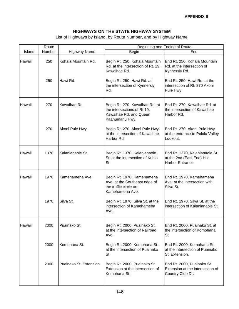
APPENDIX B
HIGHWAYS ON THE STATE HIGHWAY SYSTEMList of Highways by Island, by Route Number, and by Highway Name
Route Beginning and Ending of RouteIsland Number Highway Name Begin End
Hawaii 250 Kohala Mountain Rd. Begin Rt. 250, Kohala Mountain End Rt. 250, Kohala MountainRd. at the intersection of Rt. 19, Rd. at the intersection ofKawaihae Rd. Kynnersly Rd.
250 Hawi Rd. Begin Rt. 250, Hawi Rd. at End Rt. 250, Hawi Rd. at thethe intersection of Kynnersly intersection of Rt. 270 AkoniRd. Pule Hwy.
Hawaii 270 Kawaihae Rd. Begin Rt. 270, Kawaihae Rd. at End Rt. 270, Kawaihae Rd. atthe intersections of Rt 19, the intersection of KawaihaeKawaihae Rd. and Queen Harbor Rd.Kaahumanu Hwy.
270 Akoni Pule Hwy. Begin Rt. 270, Akoni Pule Hwy. End Rt. 270, Akoni Pule Hwy.at the intersection of Kawaihae at the entrance to Pololu ValleyHarbor Rd. Lookout.
Hawaii 1370 Kalanianaole St. Begin Rt. 1370, Kalanianaole End Rt. 1370, Kalanianaole St.St. at the intersection of Kuhio at the 2nd (East End) HiloSt. Harbor Entrance.
Hawaii 1970 Kamehameha Ave. Begin Rt. 1970, Kamehameha End Rt. 1970, KamehamehaAve. at the Southeast edge of Ave. at the intersection withthe traffic circle on Silva St.Kamehameha Ave.
1970 Silva St. Begin Rt. 1970, Silva St. at the End Rt. 1970, Silva St. at theintersection of Kamehameha intersection of Kalanianaole St.Ave.
Hawaii 2000 Puainako St. Begin Rt. 2000, Puainako St. End Rt. 2000, Puainako St. atat the intersection of Railroad the intersection of Komohana Ave. St.
2000 Komohana St. Begin Rt. 2000, Komohana St. End Rt. 2000, Komohana St.at the intersection of Puainako at the intersection of PuainakoSt. St. Extension.
2000 Puainako St. Extension Begin Rt. 2000, Puainako St. End Rt. 2000, Puainako St.Extension at the intersection of Extension at the intersection ofKomohana St. Country Club Dr.

APPENDIX B
HIGHWAYS ON THE STATE HIGHWAY SYSTEMList of Highways by Island, by Route Number, and by Highway Name
Route Beginning and Ending of RouteIsland Number Highway Name Begin End
Oahu H-1 H-1 Fwy. Begin Rt. 1, H-1 Fwy. at Rt. 93, End Rt. 1, H-1 Fwy. at Rt. 72,Farrington Hwy., 322 feet West Kalanianaole Hwy. (West edgeof Palalai Interchange. pavement of Ainakoa Ave.)
Oahu H-2 H-2 Fwy. Begin Rt. 2, H-2 Fwy. at the End Rt.2, H-2 Fwy. at theWaiawa Interchange on the connection with Rt. 99, WilikinaNorthbound lanes under the Dr.Farrington Hwy. Overpasscarrying Honolulu bound traffic.
Oahu H-3 H-3 Fwy. Begin Rt. 3, H-3 Fwy. at the End Rt. 3, H-3 Fwy. at theconnection with H-1 Kaneohe Marine Corps Base
gate.
Oahu H-201 Moanalua Fwy. Begin Rt. H-201, Moanalua Fwy. End Rt. H-201, Moanalua Fwy.at Rt. 78, Moanalua Fwy. and Eastbound, at the merge withat the beginning of H-1 Under- the H-1, Middle St. tunnel. Endpass and Eastbound off-ramp Rt. H-201, Moanalua Fwy.from H-1. Westbound at the merge with
H-1 Westbound, Middle St. off-ramp.
Oahu 61 Pali Hwy. Begin Rt. 61, Pali Hwy. at the End Rt. 61, Pali Hwy. at theintersection with Rt. 98, intersections of Auloa Rd. andVineyard Blvd. Rt. 83, Kamehameha Hwy.
61 Kalanianaole Hwy. Begin Rt. 61, Kalanianaole End Rt. 61, Kalanianaole Hwy.Hwy. at the intersections of Rt. at the intersections of Kailua83, Kamehameha Hwy. and Rd. and entrance to CastleAuloa Rd. Hospital.
61 Kailua Rd. Begin Rt. 61, Kailua Rd. at the End Rt. 61, Kailua Rd. at theintersections of the entrance to Northeast end of KawainuiCastle Hospital and Rt. 61, bridge.Kalanianaole Hwy.
Oahu 63 Kalihi St. Begin Rt. 63, Kalihi St. at the End Rt. 63, Kalihi St. at theintersection of Rt. 92, Nimitz intersection of School St.Hwy.

APPENDIX B
HIGHWAYS ON THE STATE HIGHWAY SYSTEMList of Highways by Island, by Route Number, and by Highway Name
Route Beginning and Ending of RouteIsland Number Highway Name Begin End
Oahu 63 Likelike Hwy. Begin Rt. 63, Likelike Hwy at End Rt. 63, Likelike Hwy. atthe intersection of School St. Rt. 83, Kahekili Hwy.
Oahu 64 Sand Island Pkwy. Begin Rt. 64, Sand Island Pkwy. End Rt. 64, Sand Island Pkwy.at the entrance to Sand Island at the North end of the BasculePark. Bridge.
64 Sand Island Access Rd. Begin Rt. 64, Sand Island Acc. End Rt. 64, Sand Island Acc.Rd. at the North end of the Rd. at the intersection of Rt. 92,Bascule Bridge. Nimitz Hwy.
Oahu 65 Kaneohe Bay Dr. Begin Rt. 65, Kaneohe Bay Dr. End Rt. 65, Kaneohe Bay Dr.at the intersection of Rt. 83, at the intersection withKamehameha Hwy. Nanamoana St. (East end).
65 Mokapu Saddle Rd. Begin Rt. 65, Mokapu Saddle End Rt. 65, Mokapu SaddleRd. at the intersection with Rd. at the intersections ofNanamoana St (East end). Oneawa St. and Ilipilo St.
65 Mokapu Blvd. Begin Rt. 65, Mokapu Blvd. at End Rt. 65, Mokapu Blvd. at thethe intersections of Oneawa St. intersections of Kalaheo Ave.and Ilipilo St. and Kaneohe Bay Dr.
Oahu 72 Kalanianaole Hwy. Begin Rt. 72, Kalanianaole Hwy. End Rt. 72, Kalanianaole Hwy.at the intersection of Rt. 61, at the West edge of AinakoaKailua Rd. Ave.
Oahu 76 Ft. Weaver Rd. Begin Rt. 76, Ft. Weaver Rd. at End Rt. 76, Ft. Weaver Rd. atthe Fort Weaver Gate. the Rt. 7101, Farrington Hwy.
underpass.
76 Kunia Rd. Begin Rt. 76, Kunia Rd. at the End Rt. 76, Kunia Rd. at theRt. 7101, Farrington Hwy. H-1 overpass.underpass.
Oahu 78 Moanalua Fwy. Begin Rt. 78, Moanalua Fwy. End Rt. 78, Moanalua Fwy. atWestbound, at Laulima St. H-1 Underpass.Begin Rt. 78, Moanalua Fwy.Eastbound, at the ramp fromRt. 99, Kamehameha Hwy.

APPENDIX B
HIGHWAYS ON THE STATE HIGHWAY SYSTEMList of Highways by Island, by Route Number, and by Highway Name
Route Beginning and Ending of RouteIsland Number Highway Name Begin End
Oahu 80 Kamehameha Hwy. Begin Rt. 80, Kamehameha End Rt. 80, Kamehameha Hwy.Hwy, at the intersection of Rt. at the intersection of Rt. 99,99, Wilikina Dr. Kamananui Rd.
Oahu 83 Joseph P. Leong Hwy. Begin Rt. 83, Joseph P. Leong End Rt. 83, Joseph P. LeongHwy. at the intersection of Rt. Hwy. at the intersection of99, Kamehameha Hwy. Kamehameha Hwy. at the
North end of Haleiwa town.
Oahu 83 Kamehameha Hwy. Begin Rt. 83, Kamehameha End Rt. 83, Kamehameha Hwy.Hwy. at Joseph P. Leong Hwy. at Kahekili Hwy.
83 Kahekili Hwy. Begin Rt. 83, Kahekili Hwy. at End Rt. 83, Kahekili Hwy atKamehameha Hwy. the intersection of Rt. 63,
Likelike Hwy.
83 Likelike Hwy. Begin Rt. 83, Likelike Hwy. at End Rt. 83, Likelike Hwy. atthe intersection of Kahekili Hwy. intersections of Rt. 65, Kaneohe
Bay Drive and Rt. 83,Kamehameha Hwy.
83 Kamehameha Hwy. Begin Rt. 83, Kamehameha End Rt. 83, Kamehameha Hwy.Hwy. at the intersections of at the intersections or Rt 61,Rt 65, Kaneohe Bay Dr. and Pali Hwy. and KalanianaoleRt 83, Likelike Hwy. Hwy.
Oahu 92 Nimitz Hwy. Begin Rt. 92, Nimitz Hwy. at End Rt. 92, Nimitz Hwy. atthe Pearl Harbor Main Gate Valkenburgh St.
92 Kamehameha Hwy. Begin Rt. 92, Kam-Nimitz Hwy. End Rt. 92, Kam-Nimitz Hwy. at(Westbound) and Nimitz at the intersection of Kalihi Bridge.Hwy. (Eastbound) Valkenburgh St.
92 Nimitz Hwy. Begin Rt. 92, Nimitz Hwy. at End Rt. 92, Nimitz Hwy. at theKalihi Bridge. intersections of Richards St.
and Halekauwila St.
92 Ala Moana Blvd. Begin Rt. 92, Ala Moana Blvd. End Rt. 92, Ala Moana Blvd. atat the intersections of Richards the intersection of KalakauaSt. and Halekauwila St. Ave.

APPENDIX B
HIGHWAYS ON THE STATE HIGHWAY SYSTEMList of Highways by Island, by Route Number, and by Highway Name
Route Beginning and Ending of RouteIsland Number Highway Name Begin End
Oahu 93 Farrington Hwy Begin Rt. 93, Farrington Hwy. End Rt. 93, Farrington Hwy. at322 feet West of Palalai Inter- Kaena Point State Park Gate.change.
Oahu 95 Kalaeloa Blvd. Begin Rt. 95, Kalaeloa Blvd. at End Rt. 95, Kalaeloa Blvd. atH-1 underpass. the intersection of Malakole St.
95 Malakole St. Begin Rt. 95, Malakole St. at End Rt. 95, Malakole St., 190the intersection of Kalaeloa feet Southeast of Malakole St.Blvd. Extension.
Oahu 98 Halona St. (Westbound) Begin Rt. 98, Halona St. at End Rt. 98, Halona St. at thePalama St. Westbound ramp to H-1.
98 Olomea St. (Eastbound) Begin Rt. 98, Olomea St. at the End Rt. 98, Olomea St. at theend of the H-1 Eastbound intersection of Palama St.off-ramp to Vineyard Blvd.
98 Vineyard Blvd. Begin Rt. 98, Vineyard Blvd. End Rt. 98, Vineyard Blvd. atat the intersection of Palama St. the H-1 on-ramp and off-ramp.
Oahu 99 Kamehameha Hwy. Begin Rt. 99, Kamehameha End Rt. 99, Kamehameha Hwy.Hwy. at the intersection of Rt. at the intersection of Kamananui83, Joseph P. Leong Hwy. Rd.
99 Kamananui Rd. Begin Rt. 99, Kamananui Rd. End Rt. 99, Kamananui Rd. atat the intersection of the intersection of Wilikina Dr.Kamehameha Hwy.
99 Wilikina Dr. Begin Rt. 99, Wilikina Dr. at the End Rt. 99, Wilikina Dr. at theintersection of Kamananui Rd. intersection of Kamehameha
Hwy.
99 Kamehameha Hwy. Begin Rt. 99, Kamehameha End Rt. 99, Kamehameha Hwy.Hwy. at Wilikina Dr. at the intersection of Rt. 7101,
Farrington Hwy.
99 Farrington Hwy. Begin Rt. 99, Farrington Hwy. End Rt. 99, Farrington Hwy. atat the intersection of Rt. 99, the intersection of KamehamehaKamehameha Hwy. (Waipahu) Hwy. (Pearl City)
99 Kamehameha Hwy. Begin Rt. 99, Kamehameha End Rt. 99, Kamehameha Hwy.Hwy. at Farrington Hwy. at Pearl Harbor Interchange.

APPENDIX B
HIGHWAYS ON THE STATE HIGHWAY SYSTEMList of Highways by Island, by Route Number, and by Highway Name
Route Beginning and Ending of RouteIsland Number Highway Name Begin End
Oahu 750 Kunia Rd. Begin Rt. 750, Kunia Rd. at the End Rt. 750, Kunia Rd. at theH-1 overpass. intersection of Rt. 99, Wilikina
Dr.
Oahu 901 Fort Barrette Rd. Begin Rt. 901, Ft. Barrette Rd. End Rt. 901, Ft. Barrette Rd. atat the Barbers Point Naval the H-1 underpass.Reservation Gate.
Oahu 930 Farrington Hwy. Begin Rt. 930, Farrington Hwy. End Rt. 930, Farrington Hwy.at the Kaena Point State Park. at the intersection of Rt. 803,
Kaukonahua Rd.
930 Kaukonahua Rd. Begin Rt. 930, Kaukonahua Rd. End Rt. 930, Kaukonahua Rd.at the intersection of Rt. 803, at the intersection of WeedKaukonahua Rd. Junction.
930 Kamehameha Hwy. Begin Rt. 930, Kamehameha End Rt. 930, KamehamehaHwy. at Weed Junction. Hwy. at Rt. 83, Joseph P.
Leong Hwy.
Oahu 7012 Whitmore Ave. Begin Rt. 7012, Whitmore Ave. End Rt. 7012, Whitmore Ave.at the intersection of Rt. 80, at the West boundary of theKamehameha Hwy. Naval Communication Station.
Oahu 7101 Farrington Hwy. Begin Rt. 7101, Farrington Hwy. End Rt. 7101, Farrington Hwy.at the intersection of Rt. 76, at the ramps or Rt. 99,Kunia Rd. Kamehameha Hwy.
Oahu 7110 Farrington Hwy Begin Rt. 7110, Farrington Hwy. End Rt. 7110, Farrington Hwy.at the Rt. 76, Ft. Weaver Rd. at the intersection of the Oldoverpass Ft. Weaver Rd.
Oahu 7141 Iroquois Rd. Begin Rt. 7141, Iroquois Rd. at End Rt. 7141, Iroquois Rd. atthe intersection of Rt. 76, Ft. the West Loch MilitaryWeaver Rd. Reservation boundary.
Oahu 7239 Ulune St. Begin Rt. 7239, Ulune St. at the End Rt. 7239, Ulune St. at theintersection of Kahuapaani St. intersection of Halawa Valley
Rd.
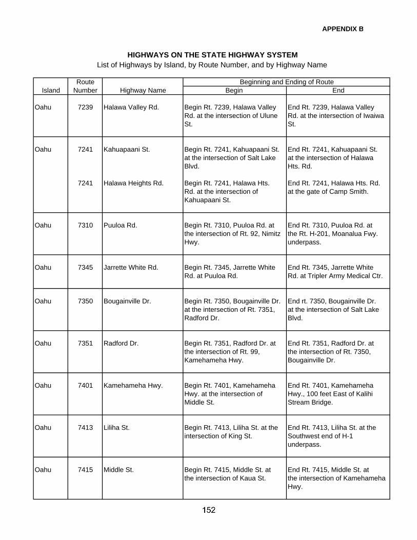
APPENDIX B
HIGHWAYS ON THE STATE HIGHWAY SYSTEMList of Highways by Island, by Route Number, and by Highway Name
Route Beginning and Ending of RouteIsland Number Highway Name Begin End
Oahu 7239 Halawa Valley Rd. Begin Rt. 7239, Halawa Valley End Rt. 7239, Halawa Valley Rd. at the intersection of Ulune Rd. at the intersection of IwaiwaSt. St.
Oahu 7241 Kahuapaani St. Begin Rt. 7241, Kahuapaani St. End Rt. 7241, Kahuapaani St.at the intersection of Salt Lake at the intersection of HalawaBlvd. Hts. Rd.
7241 Halawa Heights Rd. Begin Rt. 7241, Halawa Hts. End Rt. 7241, Halawa Hts. Rd.Rd. at the intersection of at the gate of Camp Smith.Kahuapaani St.
Oahu 7310 Puuloa Rd. Begin Rt. 7310, Puuloa Rd. at End Rt. 7310, Puuloa Rd. atthe intersection of Rt. 92, Nimitz the Rt. H-201, Moanalua Fwy.Hwy. underpass.
Oahu 7345 Jarrette White Rd. Begin Rt. 7345, Jarrette White End Rt. 7345, Jarrette WhiteRd. at Puuloa Rd. Rd. at Tripler Army Medical Ctr.
Oahu 7350 Bougainville Dr. Begin Rt. 7350, Bougainville Dr. End rt. 7350, Bougainville Dr.at the intersection of Rt. 7351, at the intersection of Salt LakeRadford Dr. Blvd.
Oahu 7351 Radford Dr. Begin Rt. 7351, Radford Dr. at End Rt. 7351, Radford Dr. atthe intersection of Rt. 99, the intersection of Rt. 7350,Kamehameha Hwy. Bougainville Dr.
Oahu 7401 Kamehameha Hwy. Begin Rt. 7401, Kamehameha End Rt. 7401, KamehamehaHwy. at the intersection of Hwy., 100 feet East of KalihiMiddle St. Stream Bridge.
Oahu 7413 Liliha St. Begin Rt. 7413, Liliha St. at the End Rt. 7413, Liliha St. at theintersection of King St. Southwest end of H-1
underpass.
Oahu 7415 Middle St. Begin Rt. 7415, Middle St. at End Rt. 7415, Middle St. atthe intersection of Kaua St. the intersection of Kamehameha
Hwy.
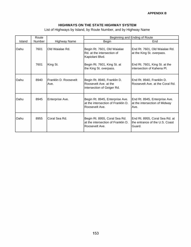
APPENDIX B
HIGHWAYS ON THE STATE HIGHWAY SYSTEMList of Highways by Island, by Route Number, and by Highway Name
Route Beginning and Ending of RouteIsland Number Highway Name Begin End
Oahu 7601 Old Waialae Rd. Begin Rt. 7601, Old Waialae End Rt. 7601, Old Waialae Rd.Rd. at the intersection of at the King St. overpass.Kapiolani Blvd.
7601 King St. Begin Rt. 7601, King St. at End Rt. 7601, King St. at thethe King St. overpass. intersection of Kahena Pl.
Oahu 8940 Franklin D. Roosevelt Begin Rt. 8940, Franklin D. End Rt. 8940, Franklin D.Ave. Roosevelt Ave. at the Roosevelt Ave. at the Coral Rd.
intersection of Geiger Rd.
Oahu 8945 Enterprise Ave. Begin Rt. 8945, Enterprise Ave. End Rt. 8945, Enterprise Ave.at the intersection of Franklin D. at the intersection of MidwayRoosevelt Ave. Ave.
Oahu 8955 Coral Sea Rd. Begin Rt. 8955, Coral Sea Rd. End Rt. 8955, Coral Sea Rd. atat the intersection of Franklin D. the entrance of the U.S. CoastRoosevelt Ave. Guard.

APPENDIX B
HIGHWAYS ON THE STATE HIGHWAY SYSTEMList of Highways by Island, by Route Number, and by Highway Name
Route Beginning and Ending of RouteIsland Number Highway Name Begin End
Kauai 50 Kaumualii Hwy. Begin Rt. 50, Kaumualii Hwy. at End Rt 50,Kaumualii Hwy. atthe intersection of Kuhio Hwy. Kao Rd. near the north entrance
gate of the Pacific MissileRange Facility.
Kauai 51 Wapaa Rd. Begin Rt. 51, Wapaa Rd. at End Rt 51, Wapaa Rd. at Ricethe intersection of Nawiliwili Rd. St. near Lala Rd.
51 Rice St. Begin Rt. 51, Rice St. at End Rt. 51, Rice St. at KapuleWapaa Rd. near Lala Rd. Hwy.
51 Kapule Hwy. Begin Rt. 51, Kapule Hwy. at End Rt. 51, Kapule Hwy. atRice St. Kuhio Hwy.
Kauai 56 Kuhio Hwy. Begin Rt. 56, Kuhio Hwy. at End Rt. 56, Kuhio Hwy. at Rt.the intersection of Kaumualii 560, Kuhio Hwy. at Princeville.Hwy.
Kauai 58 Nawiliwili Rd. Begin Rt. 58, Nawiliwili Rd. at End Rt. 58, Nawiliwili Rd. at thethe intersection of Wapaa Rd. intersection of Kaumualii Hwy.
Kauai 540 Halewili Rd. Begin Rt. 540, Halewili Rd at the End Rt. 540 Halewili Rd at the intersection of Kaumualii Hwy. intersection of Kaumualii Hwy.(near Haku Hale St. in Kalaheo) (near Huehu Rd. in Eleele)
Kauai 541 Waialo Rd. Begin Rt. 541, Waialo Rd. at the End Rt. 541, Waialo Rd. at Portintersection of Kaumualii Hwy. Allen.Waialo Rd. intersectsKaumualii Hwy. twice, at theWest approach and at the Eastapproach.
Kauai 550 Waimea Canyon Dr. Begin Rt. 550, Waimea Canyon End Rt. 550, Waimea CanyonDr. at the intersection of Dr. at intersection of Kokee Rd.Kaumualii Hwy.
550 Kokee Rd. Begin Rt. 550, Kokee Rd at the End Rt. 550, Kokee Rd. at theintersection of Waimea Canyon entrance of Kokee State Park.Dr.

APPENDIX B
HIGHWAYS ON THE STATE HIGHWAY SYSTEMList of Highways by Island, by Route Number, and by Highway Name
Route Beginning and Ending of RouteIsland Number Highway Name Begin End
Kauai 560 Kuhio Hwy. Begin Rt. 560, Kuhio Hwy. at End Rt. 560, Kuhio Hwy at theRt. 56 Kuhio Hwy. at Princeville. end of the paved highway
section near mile maker 10.
Kauai 570 Ahukini Rd. Begin Rt. 570, Ahukini Rd. at End Rt. 570, Ahukini Rd at thethe intersection of Kuhio Hwy. intersection of Kapule Hwy.
Kauai 580 Kuamoo Rd. Begin Rt. 580, Kuamoo Rd. at End Rt. 580, Kuamoo Rd. at thethe intersection of Rt. 56, Kuhio beginning of ford crossing nearHwy. Kulau Ridge Trail.
Kauai 583 Maalo Rd Begin Rt. 583, Maalo Rd. at the End Rt. 583, Maalo Rd. at theintersection of Rt. 56, Kuhio end of pavement near WailuaHwy. Falls Park.
Kauai 5600 Kapaa Bypass Rd. Begin Rt. 5600, Kapaa Bypass End Rt 5600, Kapaa Bypass Rd.Rd. at the intersection of Rt. 56, at the intersection of Rt. 581Kuhio Hwy. near Papaloa Rd. Olohena Rd.

APPENDIX B
HIGHWAYS ON THE STATE HIGHWAY SYSTEMList of Highways by Island, by Route Number, and by Highway Name
Route Beginning and Ending of RouteIsland Number Highway Name Begin End
Maui 30 High St. Begin High St. at the End High St. at the intersectionintersection of Rt. 32, Main St. of Kahookele St.
30 Honoapiilani Hwy. Begin Honoapiilani Hwy. at the End Honoapiilani Hwy. at intersection of Kahookele St. Honokohau Bridge.
30 Kahekili Hwy. Begin Kahekili Hwy. at End Kahekili Hwy. at the end of Honokohau Bridge. State Highway signs. (0.35 mi.
East of Papanahoa Stream Bridge)
Maui 31 Piilani Hwy. Begin Piilani Hwy. at the End Piilani Hwy. at theintersection of Rt. 310, Mokulele intersection of Wailea Ike Dr.Hwy.
Maui 32 Main St. Begin Main St. at the End Main St. at the intersectionintersection of Rt. 30, High St. of Kinipopo St.
32 Kaahumanu Ave. Begin Kaahumanu Ave. at the End Kaahumanu Ave. at theintersection of Kinipopo St. intersection of Rt 32A, Hobron
Ave.
Maui 32A Hobron Ave. Begin Hobron Ave. at the End Hobron Ave. the gateintersection of the Northeast to Pier #1, Kahului Harbor.edge of Rt. 36, Hana Hwy.
Maui 32B Wharf St. Begin Wharf St. at the End Wharf St. at the Southintersection of Kaahumanu Ave. Boundary of the Harbors Division
Lot at Pier #2.
Maui 36 Hana Hwy. Begin Rt. 36, Hana Hwy. at the End Rt 36, Hana Hwy. at theintersection of Kaahumanu Ave. intersection of Kaupakalua Rd.
Maui 36A Haleakala Hwy. Begin Rt. 36A, Haleakala Hwy. End Rt. 36A, Haleakala Hwy.at the intersection of Hana Hwy. at the intersection of Dairy Rd.in Kahului.
36A Keolani Place Begin Rt. 36A, Keolani Pl. at End Rt 36A, Keolani Pl. at thethe intersection of Dairy Rd. Kahului Airport Boundary
(concrete ditch).
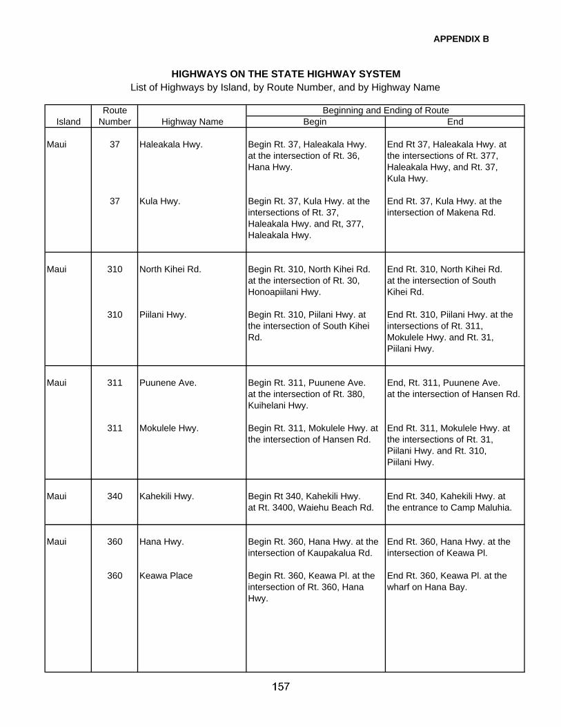
APPENDIX B
HIGHWAYS ON THE STATE HIGHWAY SYSTEMList of Highways by Island, by Route Number, and by Highway Name
Route Beginning and Ending of RouteIsland Number Highway Name Begin End
Maui 37 Haleakala Hwy. Begin Rt. 37, Haleakala Hwy. End Rt 37, Haleakala Hwy. atat the intersection of Rt. 36, the intersections of Rt. 377, Hana Hwy. Haleakala Hwy, and Rt. 37,
Kula Hwy.
37 Kula Hwy. Begin Rt. 37, Kula Hwy. at the End Rt. 37, Kula Hwy. at theintersections of Rt. 37, intersection of Makena Rd.Haleakala Hwy. and Rt, 377,Haleakala Hwy.
Maui 310 North Kihei Rd. Begin Rt. 310, North Kihei Rd. End Rt. 310, North Kihei Rd.at the intersection of Rt. 30, at the intersection of SouthHonoapiilani Hwy. Kihei Rd.
310 Piilani Hwy. Begin Rt. 310, Piilani Hwy. at End Rt. 310, Piilani Hwy. at thethe intersection of South Kihei intersections of Rt. 311,Rd. Mokulele Hwy. and Rt. 31,
Piilani Hwy.
Maui 311 Puunene Ave. Begin Rt. 311, Puunene Ave. End, Rt. 311, Puunene Ave.at the intersection of Rt. 380, at the intersection of Hansen Rd.Kuihelani Hwy.
311 Mokulele Hwy. Begin Rt. 311, Mokulele Hwy. at End Rt. 311, Mokulele Hwy. at the intersection of Hansen Rd. the intersections of Rt. 31,
Piilani Hwy. and Rt. 310, Piilani Hwy.
Maui 340 Kahekili Hwy. Begin Rt 340, Kahekili Hwy. End Rt. 340, Kahekili Hwy. atat Rt. 3400, Waiehu Beach Rd. the entrance to Camp Maluhia.
Maui 360 Hana Hwy. Begin Rt. 360, Hana Hwy. at the End Rt. 360, Hana Hwy. at theintersection of Kaupakalua Rd. intersection of Keawa Pl.
360 Keawa Place Begin Rt. 360, Keawa Pl. at the End Rt. 360, Keawa Pl. at theintersection of Rt. 360, Hana wharf on Hana Bay.Hwy.

APPENDIX B
HIGHWAYS ON THE STATE HIGHWAY SYSTEMList of Highways by Island, by Route Number, and by Highway Name
Route Beginning and Ending of RouteIsland Number Highway Name Begin End
Maui 377 Haleakala Hwy. Begin Rt. 377, Haleakala Hwy. End Rt. 377, Haleakala Hwy.at the intersection of Rt. 37, at the intersection of Rt. 378,Kula Hwy. Haleakala Crater Rd.
377 Kekaulike Ave. Begin Rt. 377, Kekaulike Ave. End Rt. 377, Kekaulike Ave.at the intersection of Rt. 378, at the intersection of Rt. 37,Haleakala Crater Rd. Kula Hwy.
Maui 378 Haleakala Crater Rd. Begin Rt. 378, Haleakala Crater End Rt. 378, Haleakala CraterRd. at the intersection of Rd. at the National ParkRt. 377, Kekaulike Ave. boundary.
Maui 380 Dairy Rd. Begin Rt. 380, Dairy Rd. at the End Rt. 380, Dairy Rd. at theintersections of Rt 36A, intersection of Puunene Ave.Haleakala Hwy. and Keolani Pl.
380 Kuihelani Hwy. Begin Rt. 380, Kuihelani Hwy. End Rt. 380, Kuihelani Hwy.at the intersection of Puunene at the intersection of Rt. 30,Ave. Honoapiilani Hwy.
Maui 3400 Kahului Beach Rd. Begin Rt. 3400, Kahului Beach End Rt 3400, Kahului Beach Rd.Rd. at the intersection Rt. 32, at the intersection of EastKaahumanu Ave. Main St.
3400 Waiehu Beach Rd. Begin Rt. 3400, Waiehu Beach End Rt. 3400, Waiehu BeachRd. at the intersection of East Rd. at the intersection of Rt.Main St. 340, Kahekili Hwy.
Maui 3500 Puunene Ave. Begin Rt. 3500, Puunene Ave. End Rt. 3500, Puunene Ave.at the intersection of Rt. 32, at the intersection of Rt 380,Kaahumanu Ave. Dairy Rd. and Kuihelani Hwy.

APPENDIX B
HIGHWAYS ON THE STATE HIGHWAY SYSTEMList of Highways by Island, by Route Number, and by Highway Name
Route Beginning and Ending of RouteIsland Number Highway Name Begin End
Molokai 450 Kamehameha V Hwy. Begin Rt. 450, Kamehameha V End Rt. 450, Kamehameha VHwy. at the intersection of Hwy. at the end of pavementRt. 460, Kaunakakai Pl. near Halawa Bay.
Molokai 460 Kaunakakai Place Begin Rt. 460, Kaunakakai Pl. End Rt. 460, Kaunakakai Pl. atat the beginning of Kaunakakai intersection of Ala Malama Rd.Wharf.
460 Maunaloa Hwy. Begin Rt. 460, Maunaloa Hwy. End Rt. 460, Maunaloa Hwy. atat the intersection of Ala the West end of Maunaloa Malama Rd. Village St.
Molokai 465 Airport Loop Begin Rt. 465, Airport Loop at End Rt. 465, Airport Loop at thethe intersection of Rt. 460, intersection of Rt. 460,Maunaloa Hwy. (Near mile Manualoa Hwy. (Launui St.)marker 7).
Molokai 470 Kalae Hwy. Begin Rt. 470, Kalae Hwy. at End Rt. 470, Kalae Hwy. at thethe intersection of Rt 460, entrance to the new KalaupapaMaunaloa Hwy. Lookout parking lot.
Molokai 480 Farrington Ave. Begin Rt. 480, Farrington Ave. End Rt. 480, Farrington Ave. atat the intersection of Rt. 470, the intersection of PuupeeluaKalae Hwy. Ave.
480 Puupeelua Ave. Begin Rt. 480, Puupeelua Ave. End Rt. 480, Puupeelua Ave.at the intersection of Farrington at the intersection of Rt. 460,Ave. Maunaloa Hwy.

APPENDIX B
HIGHWAYS ON THE STATE HIGHWAY SYSTEMList of Highways by Island, by Route Number, and by Highway Name
Route Beginning and Ending of RouteIsland Number Highway Name Begin End
Lanai 440 Kaumalapau Hwy. Begin Rt. 440, Kaumalapau End Rt. 440, Kaumalapau Hwy.Hwy. at Kaumalapau Harbor. at the intersection of Manele Rd.
440 Manele Rd. Begin Rt. 440, Manele Rd. at End Rt. 440, Manele Rd. at thethe intersection of Kaumalapau entrance to Hulopoe BeachHwy. Park.
Lanai 440A Airport Rd. Begin Rt 440A, Airport Rd. at End Rt 440A, Airport Rd. at thethe airport entrance. intersection of Rt. 440,
Kaumalapau Hwy.

APPENDIX C COUNTY HIGHWAYS
List of Highways by Island, by Route Number and by Highway Name
State of Hawaii Motor Vehicle Accident Report DOT-1-174(HWY-T) Revised 06-08


APPENDIX C
HIGHWAYS ON THE COUNTY HIGHWAY SYSTEMList of Highways by Island, by Route Number, and by Highway Name
Route Beginning and Ending of RouteIsland Number Highway Name Begin End
Hawaii 132 Pahoa-Kapoho Rd. Begin Rt. 132, Pahoa-Kapoho End Rt. 132, Pahoa-Kapoho Rd.Rd. at the intersection of Rt. 130 at the intersection of Rt. 137, Keaau-Pahoa Rd. Kapoho-Kaimu Rd.
Hawaii 137 Kapoho-Kaimu Rd. Begin Rt. 137, Kapoho-Kaimu End Rt. 137, Kapoho-Kaimu Rd.Rd. at the intersection of Rt. at the intersection of Rt. 130,132, Pahoa-Kapoho Rd. Pahoa-Kalapana Rd.
Hawaii 160 Puuhonua Rd. Begin Rt. 160, Puuhonua Rd. End Rt. 160, Puuhonua Rd.at the access to City of Refuge. at the intersection of Napoopoo
Rd.
160 Napoopoo Rd. Begin Rt. 160, Napoopoo Rd. End Rt. 160, Napoopoo Rd. atat the intersection of Puuhonua the intersection with Rt. 11,Rd. Mamalahoa Hwy.
Hawaii 180 Haawina St. Begin Rt. 180, Haawina St. at End Rt. 180, Haawina St. atthe intersection of Rt. 11, the intersection of MamalahoaKuakini Hwy. Hwy.
180 Mamalahoa Hwy. Begin Rt. 180, Mamalahoa Hwy. End Rt. 180, Mamalahoa Hwy.at the intersection of Haawina at the intersection of Rt. 190,St. Palani Rd.
Hawaii 185 Kamehameha III Rd. Begin Rt. 185, Kamehameha End Rt. 185, Kamehameha IIIIII Rd. at the intersection of Rt. Rd. at the intersection of Alii Dr.11, Kuakini Hwy.
Hawaii 186 Palani Rd. Begin Rt. 186, Palani Rd. at the End Rt. 186, Palani Rd. at theintersection of Kuakini Hwy. entrance to the wharf.
186 Alii Dr. Begin Rt. 186, Alii Dr. at the End Rt. 186, Alii Dr. at theentrance to the wharf. intersection of Kamehameha
III Rd.
Hawaii 191 Waikoloa Rd. Begin Rt. 191, Waikoloa Rd. at End Rt. 191, Waikoloa Rd. atthe intersection of Rt. 19, the intersection of Rt. 190,Queen Kaahumanu Hwy. Mamalahoa Hwy.

APPENDIX C
HIGHWAYS ON THE COUNTY HIGHWAY SYSTEMList of Highways by Island, by Route Number, and by Highway Name
Route Beginning and Ending of RouteIsland Number Highway Name Begin End
Oahu 801 Kaukonahua Rd. Begin Rt. 801, Kaukonahua Rd. End Rt. 801, Kaukonahua Rd.at the intersection of Rt. 80, at the intersection with Rt. 803,Kamehameha Hwy. Wilikina Dr.
Oahu 803 Wilikina Dr. Begin Rt. 803, Wilikina Dr. at End Rt. 803, Wilikina Dr. atthe intersection of Rt 99, the intersection of Rt 801,Kamananui Rd. Kaukonahua Rd.
803 Kaukonahua Rd. Begin Rt. 803, Kaukonahua Rd. End of Rt. 803, Kaukonahua Rd.at the intersections of Rt. 801, at the intersection of Rt. 930,Kaukonahua Rd. and Rt. 803, Farrington Hwy.Wilikina Dr.
Oahu 7414 Middle St. Begin Rt. 7414, Middle St. at End Rt. 7414, Middle St. at thethe intersection of Haumana Pl. Northeast edge of Kaua St.

APPENDIX C
HIGHWAYS ON THE COUNTY HIGHWAY SYSTEMList of Highways by Island, by Route Number, and by Highway Name
Route Beginning and Ending of RouteIsland Number Highway Name Begin End
Kauai 520 Maluhia Rd. Begin Rt. 520, Maluhia Rd. at End Rt. 520, Maluhia Rd. atthe intersection of Rt. 50, the intersection of Rt. 530 KoloaKaumualii Hwy. Rd.
520 Koloa Rd. Begin Rt. 520, Koloa Rd. at the End Rt. 520, Koloa Rd. at theintersection of Rt. 520, Maluhia intersection of Rt. 520, PoipuRd. Rd.
520 Poipu Rd. Begin Rt. 520, Poipu Rd. at the End Rt. 520, Poipu Rd. at theintersection of Rt. 520, Koloa intersections of Ala Kinoike Wy.Rd. and Pee Rd.
Kauai 530 Koloa Rd. Begin Rt. 530, Koloa Rd. at the End Rt. 530, Koloa Rd. at theintersection of Rt. 50, Kaumualii intersection of Rt. 520, PoipuHwy. Rd.
Kauai 581 Kukui St. Begin Rt. 581, Kukui St. at the End Rt. 581, Kukui St. atintersection of Rt. 56, Kuhio Olohena Rd.Hwy.
581 Olohena Rd. Begin Rt. 581, Olohena Rd. at End Rt. 581, Olohena Rd. atKukui St. the intersection of Kamalu Rd.
581 Kamalu Rd. Begin Rt. 581, Kamalu Rd. at End Rt. 581, Kamalu Rd. at thethe intersection of Olohena Rd. intersection of Rt. 580, Kuamoo
Rd.

APPENDIX C
HIGHWAYS ON THE COUNTY HIGHWAY SYSTEMList of Highways by Island, by Route Number, and by Highway Name
Route Beginning and Ending of RouteIsland Number Highway Name Begin End
Maui 305 Waiko Rd. Begin Rt. 350 Waiko Rd. at the End Rt. 350, Waiko Rd. at theintersection of Rt. 30, intersection of Rt. 380,Honoapiilani Hwy. Kuihelani Hwy.
Maui 3200 West Main St. Begin Rt. 3200, West Main St. End Rt. 3200, West Main St. atat the intersection of Rt. 30, the intersections of Alu Rd. andHigh St. Iao Valley Rd.
3200 Iao Valley Rd. Begin Rt. 3200, Iao Valley Rd. End Rt. 3200, Iao Valley Rd.at the intersections of Alu Rd. at the Iao Valley Park.and West Main St.
Maui 3405 Market St. Begin Rt. 3405, Market St. at End Rt. 3405, Market St. atthe intersection of Wells St. the intersections of Mokuhau
Rd. and Piihana Rd.
3405 Kahekili Hwy. Begin Rt. 3405, Kahekili Hwy. End Rt. 3405, Kahekili Hwy. atat the intersections of Mokuhau the intersections of Rt. 3400,Rd. and Piihana Rd. Waiehu Bch. Rd. and Rt. 340,
Kahekili Hwy.
Maui 364 Holomua Rd. Begin Rt. 364, Holomua Rd. at End Rt. 364, Holomua Rd. atthe intersection of Rt. 36, Hana the intersection of Rt. 390,Hwy. Baldwin Ave.
Maui 365 Makawao Ave. Begin Rt. 365, Makawao Ave. End Rt. 365. Makawao Ave. atat the intersection of Old the intersections of Kokomo Rd.Haleakala Hwy. and Kailiili Rd.
365 Kaupakalua Rd. Begin Rt. 365, Kaupakalua Rd. End Rt. 365, Kaupakalua Rd. atat the intersections of Kokomo the intersection of Rt. 36, HanaRd. and Kailiili Rd. Hwy.
Maui 366 Haiku Rd. Begin Rt. 366, Haiku Rd. at the End Rt. 366, Haiku Rd. at theintersection of Rt. 36, Hana intersection of Rt. 36, HanaHwy. (East end) Hwy. (West end, milepost 11.0)
Maui 367 Kauhikoa Rd. Begin Rt. 367, Kauhikoa Rd. End Rt. 367, Kauhikoa Rd. atat the West Kuiaha Rd. the intersection of Haiku Rd.

APPENDIX C
HIGHWAYS ON THE COUNTY HIGHWAY SYSTEMList of Highways by Island, by Route Number, and by Highway Name
Route Beginning and Ending of RouteIsland Number Highway Name Begin End
Maui 368 West Kuiaha Rd. Begin Rt. 368, West Kuiaha Rd. End Rt. 368, West Kuiaha Rd.at the intersection of Rt. 365, at the intersection of Rt. 36,Kaupakalua Rd. Hana Hwy.
Maui 369 East Kuiaha Rd. Begin Rt. 369, East Kuiaha Rd. End Rt. 369, East Kuaiaha Rd.at the intersection of Rt. 365, at the intersection of Rt. 36,Kaupakalua Rd. Hana Hwy.
Maui 370 Pulehu Rd. Begin Rt. 370, Pulehu Rd. at End Rt. 370, Pulehu Rd. atthe intersections of Rt. 37, Kula the intersection of Rt. 36, HanaHwy. and Pulehuiki Rd. Hwy.
Maui 371 Haliimaile Rd. Begin Rt. 371, Haliimaile Rd. End Rt. 371, Haliimaile Rd. at at the intersection of Rt. 37, the intersection of Rt. 390,Haleakala Hwy. Baldwin Ave.
Maui 372 Omaopio Rd. Begin Rt. 372, Omaopio Rd. at End Rt. 372, Omaopio Rd. atthe intersection or Rt. 37, Kula the intersection of Rt. 370,Hwy. Pulehu Rd.
Maui 390 Baldwin Ave. Begin Rt. 390, Baldwin Ave. at End Rt. 390, Baldwin Ave. atthe intersection of Rt. 36, Hana the intersection of Rt. 365,Hwy. Makawao Ave.
390 Olinda Rd. Begin Rt. 390, Olinda Rd. at End Rt. 390, Olinda Rd. at thethe intersection of Rt. 365, intersection of Rt. 394, PiiholoMakawao Ave. Rd.
Maui 394 Piiholo Rd. Begin Rt. 394, Piiholo Rd. at the End Rt. 394, Piiholo Rd. at theintersection of Rt. 365, intersection of Rt. 390, OlindaMakawao Ave. Rd.
Maui 398 Kokomo Rd. Begin Rt. 398, Kokomo Rd. at End Rt. 398, Kokomo Rd. atthe intersection of Rt. 365, the intersection of Rt. 366, Makawao Ave. Haiku Rd.
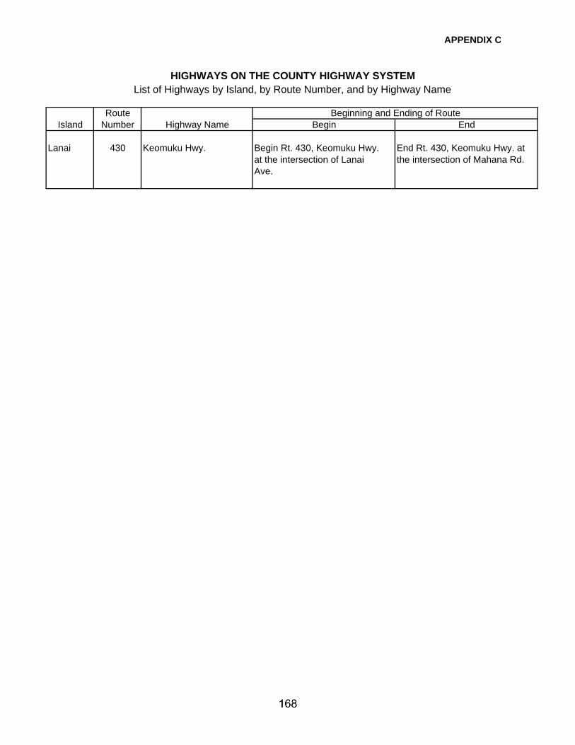
APPENDIX C
HIGHWAYS ON THE COUNTY HIGHWAY SYSTEMList of Highways by Island, by Route Number, and by Highway Name
Route Beginning and Ending of RouteIsland Number Highway Name Begin End
Lanai 430 Keomuku Hwy. Begin Rt. 430, Keomuku Hwy. End Rt. 430, Keomuku Hwy. atat the intersection of Lanai the intersection of Mahana Rd.Ave.

APPENDIX C
HIGHWAYS ON THE COUNTY HIGHWAY SYSTEMList of Highways by Island, by Route Number, and by Highway Name
Route Beginning and Ending of RouteIsland Number Highway Name Begin End
Molokai 490 Lihi Pali Ave Begin Rt. 490, Lihi Pali Ave. End Rt. 490, Lihi Pali Ave. atat the intersection of Farrington the intersection of Puu KapeleAve. Ave.
490 Puu Kapele Ave. Begin Rt. 490, Puu Kapele Ave. End Rt. 490, Puu Kapele Ave.at the intersection of Lihi Pali at the intersection of HaukeaAve. Ave.


APPENDIX D State of Hawaii Motor Vehicle Accident Report Sample
State of Hawaii Motor Vehicle Accident Report DOT-1-174(HWY-T) Revised 06-08
Note: This sample MVAR is based upon an actual Maui County traffic accident. The names, addresses, driver’s license numbers, telephone numbers, VIN numbers, motor vehicle license plate numbers of the persons and motor vehicles involved in this accident have been changed for privacy concerns.


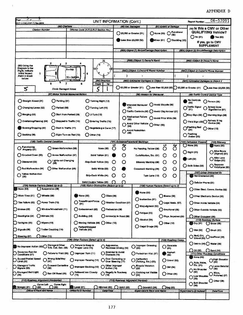


APPENDIX E State of Hawaii Routes by Highway Name and Milepost Reference
State of Hawaii Motor Vehicle Accident Report DOT-1-174(HWY-T) Revised 06-08


HONOLULU COUNTY - STATE ROUTES APPENDIX E
ROUTE NO. ROUTE NAME MILEPOST REFERENCE1 H-1 Freeway 0.0 Farrington Highway (RTE 93)
27.2 Kalanianaole Highway (RTE 72) & Ainakoa road2 H-2 Freeway 0.0 Farrington Highway Overpass
8.3 Wilikina Drive3 H-3 Freeway 0.0 H-1 Freeway
15.3 Centerline Box Culvert61 Pali Highway 0.0 Vineyard Boulevard (RTE 98)
Kalanianaole Highway 7.7 Kamehameha Highway (RTE 83) & Auloa RoadKailua Road 9.5 Entrance to Castle Medical Center
10.6 Kawainui Bridge63 Kalihi Street 0.0 Nimitz Highway (RTE 92)
Likelike Highway 1.2 School Street8.3 Kahekili Highway (RTE 83)
64 Sand Island Parkway 0.0 Entrance to Sand Island ParkSand Island Access Road 1.5 Bascule Bridge
2.6 Nimitz Highway (RTE 92)65 Kaneohe Bay Drive 0.0 Kamehameha Highway (RTE 83)
Mokapu Saddle Road 2.0 Nanamoana StreetMokapu Boulevard 3.2 Ilipilo Street
4.2 Kalaheo Avenue & Kaneohe Bay Drive72 Kalanianaole Highway 0.0 Kailua Road (RTE 61)
18.4 H-1 Freeway & Ainakoa Avenue76 Fort Weaver Road 0.0 Fort Weaver Gate
Kunia Road 6.0 Farrington Highway (RTE 7101)6.6 H-1 Freeway Overpass
78 Moanalua Freeway 0.0 Aiea Interchange Ramp #2 (RTE 99)0.7 Moanalua Freeway (H-201)
80 Kamehameha Highway 0.0 Wilikina Drive (RTE 99)1.9 Kamananui Road (RTE 99)
83 Joseph P. Leong Highway 0.0 Kamehameha Highway (RTE 99) & Kaukonahua Road Kamehameha Highway 1.9 Kamehameha Highway
Kahekili Highway 36.3 Kamehameha HighwayLikelike Highway 40.7 Likelike Highway (RTE 63)Kamehameha Highway 41.6 Kaneohe Bay Drive
43.9 Pali Highway (RTE 61)92 Nimitz Highway 0.0 Pearl Harbor Main Gate
Ala Moana Boulevard 6.5 Richards Street9.3 Kalakaua Avenue
93 Farrington Highway 0.0 H-1 Freeway19.5 Satellite Tracking Station Road
95 Kalaeloa Boulevard 0.0 H-1 FreewayMalakole Street 1.5 End of Divided Road
2.7 Access Road to Storage Yard98 Halona Street/Olomea Street 0.0 End of H-1 Freeway Off-ramp
Vineyard Boulevard 0.2 Palama Street1.8 End of H-1 Freeway On-ramp
99 Kamehameha Highway 0.0 Joseph P. Leong Highway (RTE 83)Kamananui Road 6.6 Kamehameha Highway (RTE 80)Wilikina Drive 7.7 Wilikina DriveKamehameha Highway 9.7 Kamehameha Highway (RTE 80)Farrington Highway 17.4 Farrington Highway (RTE 7101)

HONOLULU COUNTY - STATE ROUTES APPENDIX E
ROUTE NO. ROUTE NAME MILEPOST REFERENCEKamehameha Highway 18.1 Kamehameha Highway
23.8 Pearl Harbor Interchange201 Moanalua Freeway 0.0 H-1 Freeway Underpass
4.1 H-1 Freeway Tunnel750 Kunia Road 0.0 H-1 Freeway
8.1 Wilikina drive (RTE 99)901 Fort Barrette Road 0.0 Naval Reservation Gate
1.4 Makakilo Overpass (H-1 Freeway)930 Farrington Highway 0.0 Kaena Point State Park
Kaukonahua Road 6.7 Kaukonahua Road (RTE 803)Kamehameha Highway 7.7 Begin of Weed Junction
7.9 Kamehameha Highway7012 Whitmore Avenue 0.0 Kamehameha Highway (RTE 80)
1.9 Naval Communication Station7101 Farrington Highway 0.0 Kunia Road (RTE 76)
3.0 Kamehameha Highway Off-ramp7110 Farrington Highway 0.0 Fort Weaver Road Overpass
0.6 Access Road to Old Fort Weaver Road7141 Iroquois Road 0.0 Fort Weaver Road (RTE 76)
1.5 Military Reservation Boundary West Loch7239 Ulune street 0.0 Kahuapaani Street
Halawa Valley Road 0.1 Freeway On-ramp0.3 Iwaiwa Street
7241 Kahuapaani Street 0.0 Salt Lake BoulevardHalawa Heights Road 1.0 Halawa Heights Road
2.3 Camp Smith Gate #37310 Puuloa Road 0.0 Kamehameha Highway (RTE 92)
1.0 Puuloa Road Overpass7345 Jarrette White Road 0.0 Puuloa Road Overpass
0.6 Gate to Tripler Hospital7350 Bougainville Drive 0.0 Radford Drive (RTE 7351)
0.6 Salt Lake Boulevard7351 Radford Drive 0.0 Kamehameha Highway (RTE 99)
0.2 Bougainville Drive (RTE 7350)7401 Kamehameha Highway 0.0 Middle Street
0.1 Kalihi Stream Bridge7413 Liliha Street 0.0 King Street
0.4 H-1 Freeway Overpass7415 Middle Street 0.0 Kaua Street
0.5 Kamehameha Highway7601 Old Waialae Road 0.0 Kapiolani Boulevard
King Street 0.4 Access to King Street0.4 End of Divided Section
8940 Franklin D. Roosevelt Avenue 0.0 Geiger Road3.4 West Perimeter Fence Boundary
8945 Enterprise Avenue 0.0 Franklin D. Roosevelt Avenue (RTE 8940)1.0 Midway Avenue
8955 Coral Sea Road 0.0 Franklin D. Roosevelt Avenue (RTE 8940)2.7 Barbers Point Air Station Gate
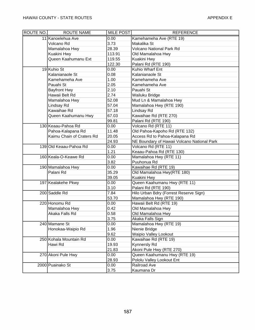
HAWAII COUNTY - STATE ROUTES APPENDIX E
ROUTE NO. ROUTE NAME MILE POST REFERENCE11 Kanoelehua Ave 0.00 Kamehameha Ave (RTE 19)
Volcano Rd 3.73 Makalika StMamalahoa Hwy 28.39 Volcano National Park RdKuakini Hwy 113.91 Old Mamalahoa HwyQueen Kaahumanu Ext 119.55 Kuakini Hwy
122.30 Palani Rd (RTE 190)19 Kuhio St 0.00 Kuhio Wharf Ent
Kalanianaole St 0.08 Kalanianaole StKamehameha Ave 1.00 Kamehameha AvePauahi St 2.05 Kamehameha AveBayfront Hwy 2.10 Pauahi StHawaii Belt Rd 2.74 Wailuku BridgeMamalahoa Hwy 52.08 Mud Ln & Mamalahoa HwyLindsay Rd 57.04 Mamalahoa Hwy (RTE 190)Kawaihae Rd 57.18 Lindsay RdQueen Kaahumanu Hwy 67.03 Kawaihae Rd (RTE 270)
99.81 Palani Rd (RTE 190)130 Keaau-Pahoa Rd 0.00 Volcano Rd (RTE 11)
Pahoa-Kalapana Rd 11.48 Old Pahoa-Kapoho Rd (RTE 132)Kaimu Chain of Craters Rd 20.05 Access Rd to Pahoa-Kalapana Rd
24.93 NE Boundary of Hawaii Volcano National Park139 Old Keaau-Pahoa Rd 0.00 Volcano Rd (RTE 11)
1.21 Keaau-Pahoa Rd (RTE 130)160 Keala-O-Keawe Rd 0.00 Mamalahoa Hwy (RTE 11)
3.82 Puuhonua Rd190 Mamalahoa Hwy 0.00 Kawaihae Rd (RTE 19)
Palani Rd 35.29 Old Mamalahoa Hwy(RTE 180)39.05 Kuakini Hwy
197 Kealakehe Pkwy 0.00 Queen Kaahumanu Hwy (RTE 11)3.10 Palani Rd (RTE 190)
200 Saddle Rd 7.84 Hilo Urban Bdry (Forrest Reserve Sign)53.70 Mamalahoa Hwy (RTE 190)
220 Honomu Rd 0.00 Hawaii Belt Rd (RTE 19)Mamalahoa Hwy 0.42 Old Mamalahoa HwyAkaka Falls Rd 0.58 Old Mamalahoa Hwy
3.75 Akaka Falls Sign240 Mamane St 0.00 Mamalahoa Hwy (RTE 19)
Honokaa-Waipio Rd 1.96 Nienie Bridge9.62 Waipio Valley Lookout
250 Kohala Mountain Rd 0.00 Kawaihae Rd (RTE 19)Hawi Rd 19.93 Kynnersly Rd
21.83 Akoni Pule Hwy (RTE 270)270 Akoni Pule Hwy 0.00 Queen Kaahumanu Hwy (RTE 19)
28.93 Pololu Valley Lookout Ent2000 Puainako St 0.00 Railroad Ave
3.75 Kaumana Dr

MAUI COUNTY - STATE ROUTES APPENDIX E
ROUTE NO. ROUTE NAME MILE POST REFERENCE30 High St 0.0 Main St (RTE 32)
Honoapiilani Hwy 0.3 Kahookele StKahekili Hwy 36.4 Honokohau Bridge
42.3 "End State Hwy" sign31 Piilani Hwy 3.5 Mokulele Hwy (RTE 310)
10.9 Wailea Ike Dr32 Main St 0.0 High St (RTE 30)
Kaahumanu Ave 0.4 Kinipopo St2.9 Hobron Ave (RTE 32A)
32A Hobron Ave 0.0 Hana Hwy (RTE 36)0.4 Kahului Harbor Gate to Pier #1
32B Wharf St 0.0 Kaahumanu Ave (RTE 32)0.2 Pier #2
36 Hana Hwy 0.0 Kaahumanu Ave (RTE 32)16.2 Kaupakalua Rd
36A Haleakala Hwy 0.0 Hana Hwy (RTE 36)Keolani Pl 0.3 Dairy Rd (RTE 380) & Haleakala Hwy
0.5 Kahului Airport Boundary37 Haleakala Hwy 0.0 Hana Hwy (RTE 36)
Kula Hwy 7.8 Haleakala Hwy (RTE 377) & Old Haleakala Hwy21.1 Makena Rd
310 North Kihei Rd 0.0 Honoapiilani Hwy (RTE 30)Piilani Hwy 3.4 Kihei Rd
3.5 Mokulele Hwy (RTE 31)311 Puunene Ave 0.0 Kuihelani Hwy (RTE 380)
Mokulele Hwy 0.7 Hansen Rd6.7 Piilani Hwy (RTE 31)
340 Kahekili Hwy 2.6 Waiehu Beach Rd (RTE 3400)6.9 Camp Maluhia Ent
360 Hana Hwy 0.0 Kaupakalua RdKeawa Pl 34.5 Hana Hwy
35.0 Wharf on Hana Bay377 Haleakala Hwy 0.0 Kula Hwy (RTE 37)
Kekaulike Ave 6.0 Haleakala Crater Rd (RTE 378)9.2 Kula Hwy (RTE 37)
378 Haleakala Crater Rd 0.0 Kekaulike Ave (RTE 377)10.2 National Park Boundary ("End State Hwy" sign)
380 Dairy Rd 0.0 Keolani PlKuihelani Hwy 1.0 Puunene Ave
6.4 Honoapiilani Hwy (RTE 30)440 Kaumalapau Hwy 0.0 Kaumalapau Harbor
Manele Rd 6.0 Kaumalapau Hwy13.2 Hulopoe Beach Park Ent
450 Kamehameha V Hwy 0.0 Kanakakai Pl (RTE 460) & Ala Malama Rd27.5 End of Pavement
460 Kaunakakai Pl 0.0 Kaunakakai WharfMaunaloa Hwy 0.3 Ala Malama Rd & Kamehameha V Hwy (RTE 450)
17.0 Maunaloa Village St465 Airport Loop 0.0 Maunaloa Hwy (RTE 460)
2.1 Maunaloa Hwy (RTE 460)470 Kalae Hwy 0.0 Maunaloa Hwy (RTE 460)

MAUI COUNTY - STATE ROUTES APPENDIX E
ROUTE NO. ROUTE NAME MILE POST REFERENCE5.8 New Kalaupapa Lookout Ent
480 Farrington Ave 0.0 Kalae Hwy (RTE 470)Puupeelua Ave 2.4 Farrington Ave
3.7 Maunaloa Hwy (RTE 460)3400 Kahului Beach Rd 0.0 Kaahumanu Ave (RTE 32)
Waiehu Beach Rd 1.1 Main St2.6 Kahekili Hwy (RTE 340)
3500 Puunene Ave 0.0 Kaahumanu Hwy (RTE 32)1.1 Kuihelani Hwy (RTE 380)

KAUAI COUNTY - STATE ROUTES APPENDIX E
ROUTE NO. ROUTE NAME MILEPOST REFERENCE50 Kaumualii Highway 0.0 Kuhio Highway (RTE 56) & Rice Street
Lio Road 32.6 Highway SpurKao Road 32.9 Kao Road
32.9 Gate to Pacific Missile Range Facility51 Waapa Road 0.0 Nawiliwili Road (RTE 58)
Rice Street 0.1 Lala RoadKapule Highway 0.9 End Divided Rice Street
3.4 Kuhio Highway (RTE 56) 56 Kuhio Highway 0.0 Kaumualii Highway (RTE 50) & Rice Street
28.1 Kuhio Highway (RTE 560)58 Nawiliwili Road 0.0 Waapa Road (RTE 51)
2.1 Kaumualii Highway (RTE 50) 540 Halewili Road 0.0 Kaumualii Highway (RTE 50)
3.9 Kaumualii Highway (RTE 50) 541 Waialo Road 0.0 Kaumualii Highway (RTE 50)
0.4 Port Allen550 Waimea Canyon Drive 0.0 Kaumualii Highway (RTE 50)
Kokee Road 6.7 Kokee Road14.1 Entrance to Kokee State Park
560 Kuhio Highway 0.0 Kuhio Highway (RTE 56)10.0 The Paved Higway Section
570 Ahukini Road 0.0 Kuhio Highway (RTE 56) 1.1 Kapule Highway (RTE 51)
580 Kuamoo Road 0.0 Kuhio Highway (RTE 56)6.7 Ford Crossing
583 Maalo Road 0.0 Kuhio Highway (RTE 56)3.9 The End of Pavement
5600 Kapaa By-pass Road 0.0 Kuhio Highway (RTE 56)3.1 Kuhio Highway (RTE 56)
APPENDIX F LOCATING MAJOR TRAFFIC ACCIDENTS
State of Hawaii Motor Vehicle Accident Report DOT-1-174(HWY-T) Revised 06-08


APPENDIX F
INTRODUCTION
The purpose of the mileposts on highways is to provide a uniform and systematic meansfor accurately locating all points along the State Highway System. The milepost system isused on the State of Hawaii Motor Vehicle Accident Report (MVAR) to provide a referencingmethod to locate traffic accidents occurring on the State Highway System.
PROCEDURE FOR RECORDING TRAFFIC ACCIDENT LOCATION ON THE MVAR
Field (24) Name of Street or Highway
1. Enter the name of the street or highway.
Examples: H-1 Fwy., Nimitz Hwy., Kamehameha Hwy., Hawaii Belt Rd., Kuhio Hwy., Honoapiilani Hwy., etc.
Field (25) City/Town
1. Enter the name of the city or town.
Examples: Aiea, Anahola, Captain Cook, Ewa Beach, Haiku, Hilo, Wailuku, etc.
Field (27) Route No.
1. Enter the Route Number of the Street or Highway.
Examples: H-1, H-201, 19, 30, 56, 72, 83, 130, 311, 560, 750, 2000, 3400, etc.
2. If the Street or Highway does not have a Route Number, leave Field (27) Route No. blank.
Field (28) Mile Post Marker
1. Enter the nearest mile post marker if the street or highway is mile-posted.
Examples: If the traffic accident occurred 200 feet south of mile post marker 25, enter 25 in Field (28) Mile Post Marker.
2. If the Street or Highway is not mile-posted, leave Field (28) Mile Post Marker blank.

APPENDIX F
Field (29) Distance and Direction
1. Enter the measured distance and direction from the nearest mile post marker to the traffic accident location. Measure the distance in feet if less than 1,000 feet and in miles if longer. Use automobile odometer for longer distances (it registers to 1/10 of a mile).
2. If the street or highway is not mile-posted, measure the distance and direction from the nearest named intersecting street or road.
3. Measure the distance and direction from other permanent structures such as named overpasses, underpasses, bridges, or tunnels.
4. Enter the Direction information by using the compass direction of travel (such as north, south, east and west). If the compass direction is difficult to determine use the general direction such as Ewa, Waianae, Kokohead, Wailuku, Lahaina, Lihue, Kapaa, Hilo, Honokaa, etc.
5. Record in parenthesis the distance from the milepost marker to the accident scene and also record the reference milepost in parenthesis. For example, 0.3 miles West of Milepost 5 is recorded as: (0.3 mile) West (MP-5).
Field (30) Refer (Mile Marker, Intersection, Etc.)
1. Enter the Reference such as the following:
a.) Mile Post Marker (such as Mile Post 25)b.) Named Overpass (such as Ward Ave. Overpass, Aala St. Overpass, etc.)c.) Named Underpass (such as Paiwa St. Underpass, Kalo Pl. Underpass, etc.)d.) Named Tunnel (such as Wilson Tunnel, Harano Tunnel, etc.)e.) Named Street (such as King St., Nanakuli Ave., Ward Ave., etc.)
2. If a named tunnel is used as a reference, indicate which end of the tunnel is being used as the reference point (north or south end, Honolulu side or Kaneohe side, etc.)
3. If a loop road is used as a reference, indicate which end is being used as the reference point. For example, Kupuna Loop (north end or south end).
4. If a same named street or road intersects a state highway more than once, indicate which intersection is being referenced. For example, Kalanianaole Highway (Route 72) at Halemaumau St. (east end) or at Halemaumau St. (west end).
Note: Do not use Utility Pole Number or Address as reference. Dot not also use unnamed roads as reference.
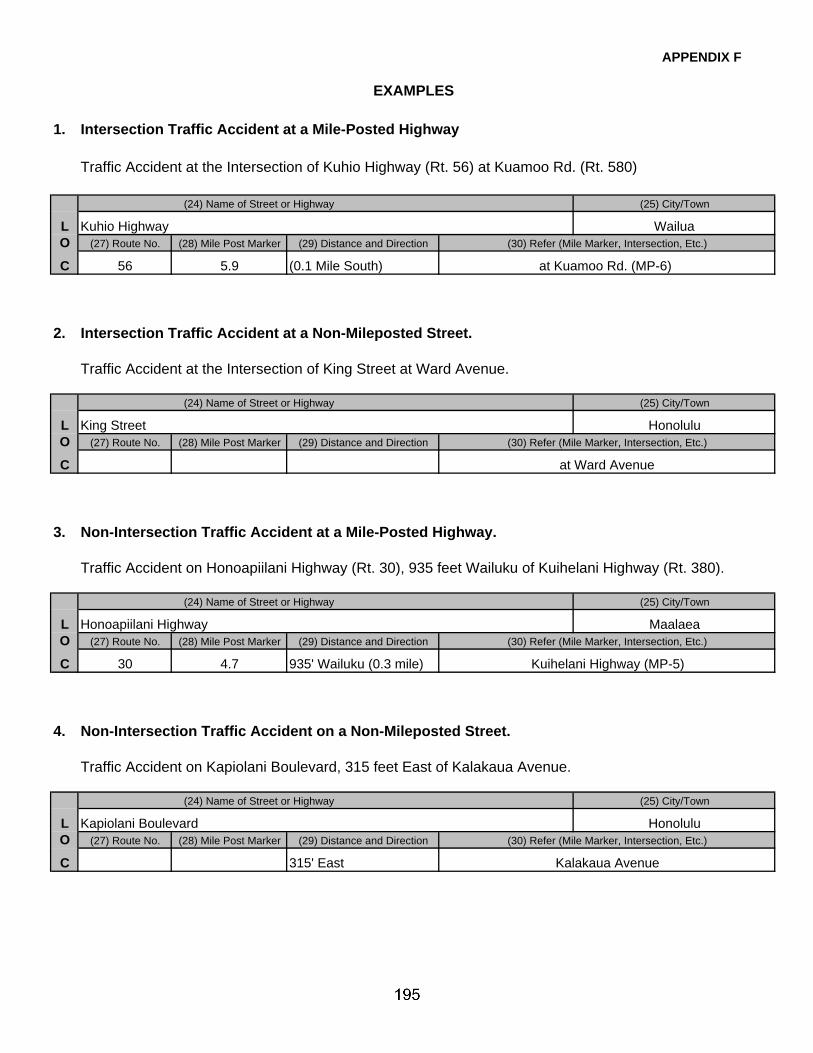
APPENDIX F
EXAMPLES
1. Intersection Traffic Accident at a Mile-Posted Highway
Traffic Accident at the Intersection of Kuhio Highway (Rt. 56) at Kuamoo Rd. (Rt. 580)
(24) Name of Street or Highway (25) City/Town
L Kuhio Highway WailuaO (27) Route No. (28) Mile Post Marker (29) Distance and Direction (30) Refer (Mile Marker, Intersection, Etc.)
C 56 5.9 (0.1 Mile South) at Kuamoo Rd. (MP-6)
2. Intersection Traffic Accident at a Non-Mileposted Street.
Traffic Accident at the Intersection of King Street at Ward Avenue.
(24) Name of Street or Highway (25) City/Town
L King Street HonoluluO (27) Route No. (28) Mile Post Marker (29) Distance and Direction (30) Refer (Mile Marker, Intersection, Etc.)
C at Ward Avenue
3. Non-Intersection Traffic Accident at a Mile-Posted Highway.
Traffic Accident on Honoapiilani Highway (Rt. 30), 935 feet Wailuku of Kuihelani Highway (Rt. 380).
(24) Name of Street or Highway (25) City/Town
L Honoapiilani Highway MaalaeaO (27) Route No. (28) Mile Post Marker (29) Distance and Direction (30) Refer (Mile Marker, Intersection, Etc.)
C 30 4.7 935' Wailuku (0.3 mile) Kuihelani Highway (MP-5)
4. Non-Intersection Traffic Accident on a Non-Mileposted Street.
Traffic Accident on Kapiolani Boulevard, 315 feet East of Kalakaua Avenue.
(24) Name of Street or Highway (25) City/Town
L Kapiolani Boulevard HonoluluO (27) Route No. (28) Mile Post Marker (29) Distance and Direction (30) Refer (Mile Marker, Intersection, Etc.)
C 315' East Kalakaua Avenue

APPENDIX F
EXAMPLES
5. Non-Intersection Traffic Accident on a Divided, Mileposted Highway.
Traffic Accident on H-1 Freeway, Westbound, 0.5 Mile East of Milepost 7.
(24) Name of Street or Highway (25) City/Town
L H-1 Westbound WaipahuO (27) Route No. (28) Mile Post Marker (29) Distance and Direction (30) Refer (Mile Marker, Intersection, Etc.)
C 1 7.5 (0.5 Mile East) (MP-7)
6. Non-Intersection Accident on a Mileposted Highway, occurring at a named bridge location.
Traffic Accident on Hawaii Belt Road, (Route 19), 27 feet Hilo of Manoloa Bridge.
(24) Name of Street or Highway (25) City/Town
L Hawaii Belt Road NinoleO (27) Route No. (28) Mile Post Marker (29) Distance and Direction (30) Refer (Mile Marker, Intersection, Etc.)
C 19 20.0 27' Hilo Manoloa Bridge (MP-20)
7. Intersection Traffic Accident at a State Highway and a County Street.
Traffic Accident at Kahului Beach Road (Rt. 3400) at Kanaloa Avenue.
(24) Name of Street or Highway (25) City/Town
L Kahului Beach Road KahuluiO (27) Route No. (28) Mile Post Marker (29) Distance and Direction (30) Refer (Mile Marker, Intersection, Etc.)
C 3400 0.9 (0.1 Mile South) at Kanaloa Avenue (MP-1)
8. Traffic Accident Occurring on an Off-Ramp Location.
Traffic Accident on the H-1 Westbound, Waikele Off-Ramp, 80 feet East of Paiwa Street.
(24) Name of Street or Highway (25) City/Town
L H-1 Westbound, Waikele Off-Ramp to Paiwa Street (Exit 7, Waikele, Waipahu) WaikeleO (27) Route No. (28) Mile Post Marker (29) Distance and Direction (30) Refer (Mile Marker, Intersection, Etc.)
C 1 7.0 80' East Paiwa Street (MP-7)
The Ramp Exit Number posted on a sign should also be used for location identification of an exit ramptraffic accident. For example, if a traffic accident occurred on the H-1 Westbound exit to Waikele, theposted Ramp Exit Number is Exit 7. Enter Exit 7 on the MVAR.

HIGHWAYS ON THE STATE HIGHWAY SYSTEM
List of Highways by Honolulu Police District and by Highway Name
State of HawaiiDepartment of TransportationHighways DivisionTraffic Branch/Traffic Safety Section26-Jun-08

HIGHWAYS ON THE STATE HIGHWAY SYSTEMList of Highways by Honolulu Police District and by Highway Name
Honolulu Police District 1(Liliha Street to Punahou Street; the ocean to Pacific Heights, Pauoa Valley, and Makiki/Tantalus area)
Route Beginning and Ending of RouteHighway Name Number Begin End
Ala Moana Blvd. 92 Begin Rt. 92, Ala Moana Blvd. End Rt.92, Ala Moana Blvd. atat the intersection of Richards Ala Wai Canal.St. and Halekauwila St.
H-1 Fwy. 1 Begin Rt. 1, H-1 Fwy. at Liliha End Rt. 1, H-1 Fwy. at PunahouSt. Overpass. St. Overpass.
Liliha St. 7413 Begin Rt. 7413, Liliha St. at End Rt. 7413, Liliha St. atthe intersection of King St. the southwest end of H-1
underpass.
Nimitz Hwy. 92 Begin Rt. 92, Nimitz Hwy. at End Rt. 92, Nimitz Hwy. at theNuuanu Stream. intersection of Richards St. and
Halekauwila St.
Pali Hwy. 61 Begin Rt. 61, Pali Hwy. at the End Rt. 61, Pali Hwy. at theintersection with Rt. 98, vicinity of Pacific Heights Rd.Vineyard Blvd.
Vineyard Blvd. 98 Begin Rt. 98, Vineyard Blvd. at End Rt. 98, Vineyard Blvd. atthe intersection with Liliha St. the H-1 on-ramp and off-ramp.
Page 1

HIGHWAYS ON THE STATE HIGHWAY SYSTEMList of Highways by Honolulu Police District and by Highway Name
Honolulu Police District 2(Kipapa Gulch, Waiahole Ditch, Wahiawa, Mililani, Whitmore Village, Waialua, Mokuleia, Haleiwa,
Schofield Barracks, Wheeler Army Field, Kaena Point to Sunset Beach)Route Beginning and Ending of Route
Highway Name Number Begin End
Farrington Hwy. 930 Begin Rt. 930, Farrington Hwy. End Rt. 930, Farrington Hwy.at the Kaena Point State Park. at the intersection of Rt. 803,
Kaukonahua Rd.
H-2 Fwy. H-2 Begin Rt. H-2, H-2 Fwy. at End Rt. H-2, H-2 Fwy. at theKipapa Gulch. connection with Rt. 99, Wilikina
Dr.
Joseph P. Leong Hwy. 83 Begin Rt. 83, Joseph P. Leong End Rt. 83, Joseph P. LeongHwy. at the intersection of Rt. Hwy. at the intersection of99, Kamehameha Hwy. Kamehameha Hwy. at the north
end of Haleiwa town.
Kamehameha Hwy. 83 Begin Rt. 83, Kamehameha End Rt. 83, Kamehameha Hwy.Hwy. at Joseph P. Leong Hwy. at Waialee Stream vicinity of
Sunset Beach.
Kamehameha Hwy. 99 Begin Rt. 99, Kamehameha End Rt. 99, Kamehameha Hwy.Hwy. at the intersection of Rt. at the intersection of Kamananui83, Joseph P. Leong Hwy. Rd.
Kamehameha Hwy. 99 Begin Rt. 99, Kamehameha End Rt. 99, Kamehameha Hwy.Hwy. at Wilikina Dr. at Kipapa Gulch.
Kamehameha Hwy. 930 Begin Rt. 930, Kamehameha End Rt. 930, KamehamehaHwy. at Weed Junction. Hwy. at Rt. 83, Joseph P. Leong
Hwy.
Kamananui Rd. 99 Begin Rt. 99, Kamananui Rd. End Rt. 99, Kamananui Rd. atat the intersection of Rt. 99, the intersection of Wilikina Dr.Kamehameha Hwy.
Kaukonahua Rd. 930 Begin Rt. 930, Kaukonahua Rd. End Rt. 930, Kaukonahua Rd. at the intersection of Rt. 803, at the intersection of Weed Kaukonahua Rd. Junction.
Kunia Rd. 750 Begin Rt. 750, Kunia Rd. at the End Rt. 750, Kunia Rd at theWaiahole Ditch. intersection of Rt. 99, Wilikina
Dr.
Wilikina Dr. 99 Begin Rt. 99, Wilikina Dr. at the End Rt. 99, Wilikina Dr. at theintersection of Kamananui Rd. intersection of Rt. 80,
Kamehameha Hwy.
Page 2

HIGHWAYS ON THE STATE HIGHWAY SYSTEMList of Highways by Honolulu Police District and by Highway Name
Honolulu Police District 2 (continued)(Kipapa Gulch, Waiahole Ditch, Wahiawa, Mililani, Whitmore Village, Waialua, Mokuleia, Haleiwa,
Schofield Barracks, Wheeler Army Field, Kaena Point to Sunset Beach)Route Beginning and Ending of Route
Highway Name Number Begin End
Whitmore Ave. 7012 Begin Rt. 7012, Whitmore Ave. End Rt. 7012, Whitmore Ave. atat the intersection of Rt. 80, the west boundary of the NavalKamehameha Hwy. Communication Station.
Page 3

HIGHWAYS ON THE STATE HIGHWAY SYSTEMList of Highways by Honolulu Police District and by Highway Name
Honolulu Police District 3(Village Park to Red Hill, Pearl Harbor, Halawa, Aiea, Pearl City, Waipio, Waikele, and Waipahu)
Route Beginning and Ending of RouteHighway Name Number Begin End
Bougainville Dr. 7350 Begin Rt. 7350, Bougainville End Rt. 7350, Bougainville Dr.Dr. at the intersection of Rt. at the intersection of Salt Lake7351, Radford Dr. Blvd.
Farrington Hwy. 99 Begin Rt. 99, Farrington Hwy. End Rt. 99, Farrington Hwy. atat the intersection of Rt. 99, the intersection of KamehamehaKamehameha Hwy. (Waipahu). Hwy. (Pearl City).
Farrington Hwy. 7101 Begin Rt. 7101, Farrington Hwy. End Rt. 7101, Farrington Hwy.at the intersection of Rt. 76, at the ramps of Rt. 99, Kunia Rd. Kamehameha Hwy.
H-1 Fwy. H-1 Begin Rt. H-1, H-1 Fwy. at the End Rt. H-1, H-1 Fwy. at theKunia Rd. underpass. Pearl Harbor Interchange.
H-2 Fwy. H-2 Begin Rt. H-2, H-2 Fwy. at End Rt. H-2, H-2 Fwy. at theKipapa Gulch. H-1 merge.
H-3 Fwy. H-3 Begin Rt. H-3, H-3 Fwy. at the End Rt. H-3, H-3 Fwy. atconnection with H-1. Harano Tunnel.
Halawa Heights Rd. 7241 Begin Rt. 7241, Halawa Heights End Rt. 7241, Halawa HeightsRd. at the intersection of Rd. at the gate of Camp Smith.Kahuapaani St.
Halawa Valley Rd. 7239 Begin Rt. 7239, Halawa Valley End Rt. 7239, Halawa ValleyRd. at Ulune St. Rd. at Iwaiwa St.
Kahuapaani St. 7241 Begin Rt. 7241, Kahuapaani St. End Rt. 7241, Kahuapaani St.at the intersection of Salt Lake at the intersection of HalawaBlvd. Heights Rd.
Kamehameha Hwy. 99 Begin Rt. 99, Kamehameha End Rt. 99, Kamehameha Hwy.Hwy. at Kipapa Gulch. at the intersection of Rt. 7101,
Farrington Hwy.
Kamehameha Hwy. 99 Begin Rt. 99, Kamehameha End Rt. 99, Kamehameha Hwy.Hwy. at Farrington Hwy. (Pearl at the Pearl Harbor Interchange.City).
Kunia Rd. 76 Begin Rt. 76, Kunia Rd. at Rt. End Rt. 76, Kunia Rd. at the7101, Farrington Hwy. H-1 overpass.
Kunia Rd. 750 Begin Rt. 750, Kunia Rd. at the End Rt. 750, Kunia Rd. at theH-1 overpass. Waiahole Ditch.
Page 4

HIGHWAYS ON THE STATE HIGHWAY SYSTEMList of Highways by Honolulu Police District and by Highway Name
Honolulu Police District 3 (continued)(Village Park to Red Hill, Pearl Harbor, Halawa, Aiea, Pearl City, Waipio, Waikele, and Waipahu)
Route Beginning and Ending of RouteHighway Name Number Begin End
Moanalua Fwy. 78 Begin Rt. 78, Moanalua Fwy. End Rt. 78, Moanalua Fwy. atWestbound, at Laulima St. H-1 underpass.Begin Rt. 78, Moanalua Fwy.Eastbound, at the ramp fromRt. 99, Kamehameha Hwy.
Moanalua Fwy. H-201 Begin H-201, Moanalua Fwy. End Rt. H-201, Moanalua Fwy.at Rt. 78, Moanalua Fwy. and at the vicinity of Red Hill.at the beginning of H-1 under-pass and Eastbound off-rampfrom H-1.
Radford Dr. 7351 Begin Rt. 7351, Radford Dr. at End Rt. 7351, Radford Dr. atthe intersection of Rt. 99, the intersection of Rt. 7350,Kamehameha Hwy. Bougainville Dr.
Ulune St. 7239 Begin Rt. 7239, Ulune St. at the End Rt. 7239, Ulune St. at theintersection of Kahuapaani St. Intersection of Halawa Valley
Rd.
Page 5

HIGHWAYS ON THE STATE HIGHWAY SYSTEMList of Highways by Honolulu Police District and by Highway Name
Honolulu Police District 4(Waialee Stream just past Kawela Bay to Makapuu Point)
Route Beginning and Ending of RouteHighway Name Number Begin End
H-3 Fwy. H-3 Begin H-3, H-3 Fwy. at Harano End Rt. H-3, H-3 Fwy. at theTunnel. Kaneohe Marine Corps Base
gate.
Kahekili Hwy. 83 Begin Rt. 83, Kahekili Hwy. End Rt. 83, Kahekili Hwy. atat Rt. 83, Kamehameha Hwy. the intersection of Rt. 63,
Likelike Hwy.
Kailua Rd. 61 Begin Rt. 61, Kailua Rd. at the End Rt. 61, Kailua Rd. at theintersections of the entrance to northeast end of Kawainui Castle Hospital and Rt. 61, Bridge.Kalanianaole Hwy.
Kalanianaole Hwy. 61 Begin Rt. 61, Kalanianaole Hwy. End Rt. 61, Kalanianaole Hwy.at the intersections of Rt. 83, at the intersections of KailuaKamehameha Hwy. and Auloa Rd. and the entrance to CastleRd. Hospital.
Kalanianaole Hwy. 72 Begin Rt. 72, Kalanianaole Hwy. End Rt. 72, Kalanianaole Hwy.at the intersection of Rt. 61, at Makapuu Point.Kailua Rd.
Kamehameha Hwy. 83 Begin Rt. 83, Kamehameha End Rt. 83, Kamehameha Hwy.Hwy. at Wailee Stream near at Rt . 83, Kahekili Hwy.Kawela Bay.
Kamehameha Hwy. 83 Begin Rt. 83, Kamehameha End Rt. 83, Kamehameha Hwy.Hwy. at the intersections of at the intersection of Rt. 61,Rt. 65, Kaneohe Bay Dr. and Pali Hwy. and KalanianaoleRt. 83, Likelike Hwy. Hwy.
Kaneohe Bay Dr. 65 Begin Rt. 65, Kaneohe Bay Dr. End Rt. 65, Kaneohe Bay Dr.at the intersection of Rt. 83, at the intersection withKamehameha Hwy. Nanamoana St. (east end).
Likelike Hwy. 63 Begin Rt. 63, Likelike Hwy. at End Rt. 63, Likelike Hwy. atWilson Tunnel. the intersections with Rt. 83,
Kahekili Hwy.
Likelike Hwy. 83 Begin Rt. 83, Likelike Hwy. at End Rt. 83, Likelike Hwy. at thethe intersection of Rt. 83, intersections of Rt. 65 KaneoheKahekili Hwy. Bay Dr. and Rt. 83, Kam. Hwy.
Page 6

HIGHWAYS ON THE STATE HIGHWAY SYSTEMList of Highways by Honolulu Police District and by Highway Name
Honolulu Police District 4 (continued)(Waialee Stream just past Kawela Bay to Makapuu Point)
Route Beginning and Ending of RouteHighway Name Number Begin End
Mokapu Blvd. 65 Begin Rt. 65, Mokapu Blvd. at End Rt. 65, Mokapu Blvd. at thethe intersections of Oneawa St. intersections of Kalaheo Ave.and Ilipilo St. and Kaneohe Bay Dr.
Mokapu Saddle Rd. 65 Begin Rt. 65, Mokapu Saddle End Rt. 65, Mokapu Saddle Rd.Rd. at the intersection with at the intersections of OneawaNanamoana St. (east end). St. and Ilipilo St.
Pali Hwy. 61 Begin Rt. 61, Pali Hwy. at the End Rt. 61, Pali Hwy. at thetunnels. intersections of Auloa Rd. and
Rt. 83, Kamehameha Hwy.
Page 7
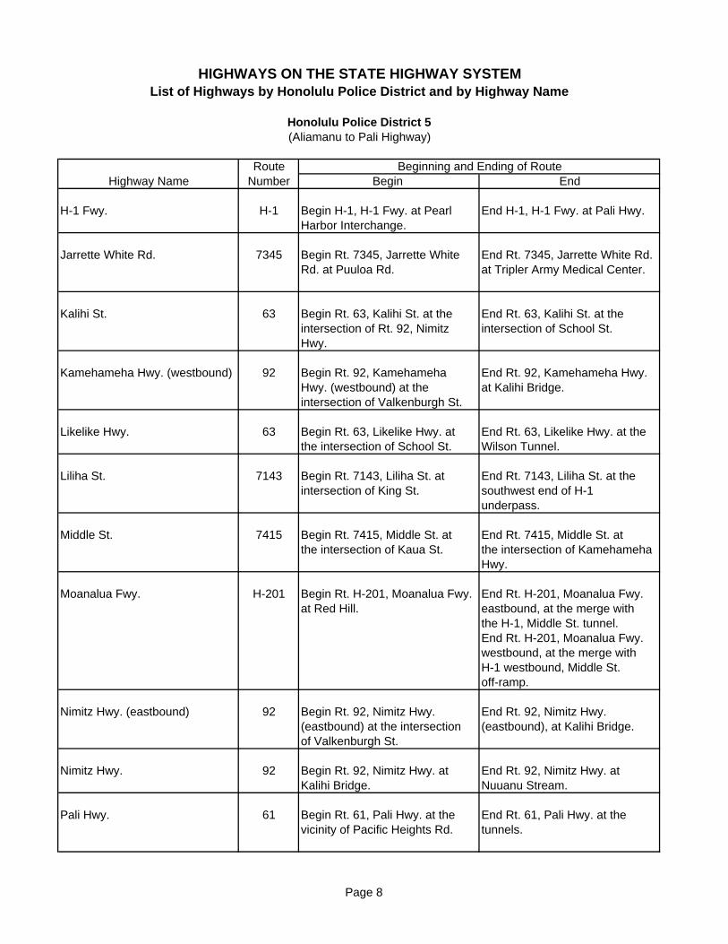
HIGHWAYS ON THE STATE HIGHWAY SYSTEMList of Highways by Honolulu Police District and by Highway Name
Honolulu Police District 5(Aliamanu to Pali Highway)
Route Beginning and Ending of RouteHighway Name Number Begin End
H-1 Fwy. H-1 Begin H-1, H-1 Fwy. at Pearl End H-1, H-1 Fwy. at Pali Hwy.Harbor Interchange.
Jarrette White Rd. 7345 Begin Rt. 7345, Jarrette White End Rt. 7345, Jarrette White Rd.Rd. at Puuloa Rd. at Tripler Army Medical Center.
Kalihi St. 63 Begin Rt. 63, Kalihi St. at the End Rt. 63, Kalihi St. at theintersection of Rt. 92, Nimitz intersection of School St.Hwy.
Kamehameha Hwy. (westbound) 92 Begin Rt. 92, Kamehameha End Rt. 92, Kamehameha Hwy.Hwy. (westbound) at the at Kalihi Bridge.intersection of Valkenburgh St.
Likelike Hwy. 63 Begin Rt. 63, Likelike Hwy. at End Rt. 63, Likelike Hwy. at thethe intersection of School St. Wilson Tunnel.
Liliha St. 7143 Begin Rt. 7143, Liliha St. at End Rt. 7143, Liliha St. at theintersection of King St. southwest end of H-1
underpass.
Middle St. 7415 Begin Rt. 7415, Middle St. at End Rt. 7415, Middle St. atthe intersection of Kaua St. the intersection of Kamehameha
Hwy.
Moanalua Fwy. H-201 Begin Rt. H-201, Moanalua Fwy. End Rt. H-201, Moanalua Fwy.at Red Hill. eastbound, at the merge with
the H-1, Middle St. tunnel.End Rt. H-201, Moanalua Fwy.westbound, at the merge withH-1 westbound, Middle St.off-ramp.
Nimitz Hwy. (eastbound) 92 Begin Rt. 92, Nimitz Hwy. End Rt. 92, Nimitz Hwy.(eastbound) at the intersection (eastbound), at Kalihi Bridge.of Valkenburgh St.
Nimitz Hwy. 92 Begin Rt. 92, Nimitz Hwy. at End Rt. 92, Nimitz Hwy. atKalihi Bridge. Nuuanu Stream.
Pali Hwy. 61 Begin Rt. 61, Pali Hwy. at the End Rt. 61, Pali Hwy. at thevicinity of Pacific Heights Rd. tunnels.
Page 8

HIGHWAYS ON THE STATE HIGHWAY SYSTEMList of Highways by Honolulu Police District and by Highway Name
Honolulu Police District 5 (continued)(Aliamanu to Pali Highway)
Route Beginning and Ending of RouteHighway Name Number Begin End
Puuloa Rd. 7310 Begin Rt. 7310, Puuloa Rd. at End Rt. 7310, Puuloa Rd. atthe intersection of Rt. 92, the Moanalua Fwy. Underpass.Nimitz Hwy.
Sand Island Access Rd. 64 Begin Rt. 64, Sand Island End Rt. 64, Sand Island AccessAccess Rd. at the north end Rd. at the intersection of Rt. 92,of the Bascule Bridge. Nimitz Hwy.
Sand Island Parkway 64 Begin Rt. 64, Sand Island Pkwy. End Rt. 64, Sand Island Pkwy.at the entrance to Sand Island at the north end of the BasculePark. Bridge.
Vineyard Blvd. 98 Begin Rt. 98, Vineyard Blvd. End Rt. 98, Vineyard Blvd. atat the intersection of Palama St. the intersection of Liliha St.
Page 9
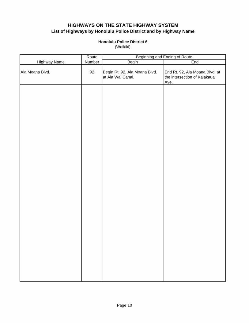
HIGHWAYS ON THE STATE HIGHWAY SYSTEMList of Highways by Honolulu Police District and by Highway Name
Honolulu Police District 6(Waikiki)
Route Beginning and Ending of RouteHighway Name Number Begin End
Ala Moana Blvd. 92 Begin Rt. 92, Ala Moana Blvd. End Rt. 92, Ala Moana Blvd. atat Ala Wai Canal. the intersection of Kalakaua
Ave.
Page 10

HIGHWAYS ON THE STATE HIGHWAY SYSTEMList of Highways by Honolulu Police District and by Highway Name
Honolulu Police District 7(Punahou Street to Makapuu Point; Manoa, McCully, Kaimuki, Palolo, Diamond Head, Waialae, Kahala,
Aina Haina, Kuliouou, Hawaii Kai, Sandy Beach and Makapuu lookout)Route Beginning and Ending of Route
Highway Name Number Begin End
H-1 Fwy. H-1 Begin Rt. H-1, H-1 Fwy at the End Rt. H-1, H-1 Fwy. at Rt. 72,Punahou St. overpass. Kalanianaole Hwy. (West edge
pavement of Ainakoa Ave.)
Kalanianaole Hwy. 72 Begin Rt. 72, Kalanianaole Hwy. End Rt. 72, Kalanianaole Hwy.at Makapuu Point. at the west edge of Ainakoa
Ave.
King St. 7601 Begin Rt. 7601, King St. at the End Rt. 7601, King St. at theKing St. overpass. intersection of Kahena Pl.
Old Waialae Rd. 7601 Begin Rt. 7601, Old Waialae Rd. End Rt. 7601, Old Waialae Rd.at the intersection of Kapiolani at the King St. overpass.Blvd.
Page 11

HIGHWAYS ON THE STATE HIGHWAY SYSTEMList of Highways by Honolulu Police District and by Highway Name
Honolulu Police District 8(Ewa, Ewa Beach, West Loch, Kalaeloa, Kapolei, Makakilo, Campbell Industrial Park, Honokai Hale,
Ko'Olina, Nanakuli, Lualualei, Maili, Waianae, Makaha, Keaau, Makua, and Kaena Point)Route Beginning and Ending of Route
Highway Name Number Begin End
Coral Sea Rd. 8955 Begin Rt. 8955, Coral Sea Rd. End Rt. 8955, Coral Sea Rd. atat the intersection of Franklin D. the entrance of the U.S. CoastRoosevelt Ave. Guard.
Enterprise Ave. 8945 Begin Rt. 8945, Enterprise Ave. End Rt. 8955, Enterprise Ave.at the intersection of Franklin D. at the intersection of MidwayRoosevelt Ave. Ave.
Farrington Hwy. 93 Begin Rt. 93, Farrington Hwy. End Rt. 93, Farrington Hwy.322 feet west of Palalai Inter- at Kaena Point State Park gate.change.
Franklin D. Roosevelt Ave. 8940 Begin Rt. 8940, Franklin D. End Rt. 8940, Franklin D.Roosevelt Ave. at the Roosevelt Ave. at Coral Rd.intersection of Geiger Rd.
Ft. Barrette Rd. 901 Begin Rt. 901, Ft. Barrette Rd. End Rt. 901, Ft Barrette Rd. atat the Barbers Point Naval the H-1 underpass.Reservation gate.
Ft. Weaver Rd. 76 Begin Rt. 76, Ft. Weaver Rd. at End Rt. 76, Ft. Weaver Rd. atthe Ft. Weaver gate. the Rt. 7101, Farrington Hwy.
underpass.
H-1 Fwy. H-1 Begin Rt. H-1, H-1 Fwy. at Rt. End Rt. H-1, H-1 Fwy. at Kunia93, Farrington Hwy., 322 feet Rd. underpass.west of Palalai Interchange.
Iroquois Rd. 7141 Begin Rt. 7141, Iroquois Rd. at End Rt. 7141. Iroquois Rd. atthe intersection of Rt. 76, Ft. the West Loch MilitaryWeaver Rd. Reservation boundary.
Kalaeloa Blvd. 95 Begin Rt. 95, Kalaeloa Blvd. at End Rt. 95, Kalaeloa Blvd. atthe H-1 underpass. the intersection of Malakole St.
Malakole St. 95 Begin Rt. 95, Malakole St. at End Rt. 95, Malakole St., 190the intersection of Kalaeloa Blvd. feet southeast of Malakole St.
Extension.
Page 12