state of georgia tier 2 tmdl implementation plan: …
TRANSCRIPT

June 30, 2006 Plan for Potato Creek Watershed Revision #1 HUC :03130005
1
STATE OF GEORGIA TIER 2 TMDL IMPLEMENTATION PLAN: REVISION #1
June 30, 2006 Potato Creek
Flint River Basin
Spalding County Lamar County Upson County Pike County City of Griffin
City of Thomaston McIntosh Trail Regional Development Center
I. INTRODUCTION Total Maximum Daily Load (TMDL) Implementation Plans are platforms for evaluating and tracking water quality protection and restoration. These plans have been designed to accommodate continual updates and revisions as new conditions and information warrant. In addition, field verification of watershed characteristics and listing data has been built into the preparation of the plans. The overall goal of the plans is to define a set of actions that will help achieve water quality standards in the State of Georgia. This implementation plan addresses the general characteristics of the watershed, the sources of pollution, stakeholders and public involvement, and education/outreach activities. In addition, the plan describes regulatory and voluntary practices/control actions (management measures) to reduce pollutants, milestone schedules to show the development of the management measures (measurable milestones), and a monitoring plan to determine the efficiency of the management measures.
Table 1: Impairments
Impaired Stream Segment Impaired Segment Location Impairment Evaluation TMDL ID
Potato Creek Hwy 41 to Upson County Line Fecal Coliform Non-supporting
The following paragraphs provide a history of this Revised TMDL Implementation Plan (TMDL IP) including the process, the community, and what the stakeholders went through to develop the TMDL IP, the parties involved in water quality monitoring, bacterial sources tracing and the Environmental Action Committee; and a summary of important findings that influenced how the plan emerged.
June 30, 2006 Plan for Potato Creek Watershed Revision #1 HUC :03130005
2
A. Background The Potato Creek Watershed covers approximately 231 square miles (147,950 acres) and flows in a generally north to south direction from the City of Griffin to a confluence with the Flint River in Upson County. Potato Creek is located in the Upper Flint River Watershed (HUC-03130005). The Upper Flint River Watershed is identified by the EPD as one of Georgia’s 17 Category I Watersheds. Potato Creek traverses 50 miles through three counties: Spalding, Lamar, and Upson. A major portion of tributary drainage to Potato Creek originates in Pike County to the west of the main reach. Please refer to the map in Figure 1. The lower 22 miles of Potato Creek were on the 2000 Section 303(d) list of impaired waters for partially supporting its designated use of fishing due to elevated levels of fecal coliform. This listing was a result of water quality tests that showed elevated levels of fecal coliform above the accepted levels as established by the State of Georgia Water Quality Standards. A TMDL was established by the EPA for Potato Creek with a TMDL target level of 175 CFU per 100 ml, and a recommendation was made for further study of fecal bacteria sources within the watershed. The upstream reach from the City of Griffin to U.S. Highway 41 (identified as Hwy 333 by EPD) in Lamar was also listed for impaired biota. The 2002 Section 303(d) list of impaired waters removed the lower reach of Potato Creek and added a middle reach from Highway 41 (identified as Hwy 333 by EPD) to the Lamar County line as non-supporting its designated fishing use due to fecal coliform. Subsequent 303(d) lists in 2004 and 2006 (proposed) continue to list the middle segment of Potato Creek for exceeding fecal coliform standards. B. Project Partners An Environmental Advisory Committee (EAC) was established by the McIntosh Trail RDC early in 2001 to address the fecal coliform TMDL. This EAC consisted of Potato Creek Watershed stakeholders, including the six participating governmental entities and RDC members: City of Griffin, City of Thomaston, Lamar County, Spalding County, Pike County, and Upson County. Other EAC members included the Technical Partners and the Natural Resources Conservation Service. A preliminary TMDL IP for Potato Creek was produced by the RDC and submitted to EPD in March of 2001. This plan incorporated input and comment from the EAC and reflected the desire of the EAC to address fecal bacterial pollution throughout the Potato Creek Watershed. The RDC and EAC were unaware of the specific source(s) of fecal bacteria, so the most appropriate BMPs for reducing source inputs were unknown at that time. Therefore, the RDC committed to sponsoring a project, with the assistance of the EAC, to first identify the sources of fecal bacterial pollution in the Potato Creek Watershed, and then to identify the appropriate BMPs to achieve the desired pollutant load reduction. Specific project objectives, as identified in the 319 grant application, included:
• Characterize all fecal coliform sources to the Potato Creek Watershed through a Bacterial Source Tracking (BST) program • Identify appropriate watershed-wide and site-specific BMPs that will be used to effectively control and reduce the inputs of fecal coliform
identified under Objective A • Through coordination with the EAC, produce a revised Potato Creek TMDL IP

GRIFFIN
ZEBULON
BARNESVILLE
THOMASTON
MILNER
MEANSVILLE
WILLIAMSON
CONCORD
MOLENA
UPSONCOUNTY
PIKECOUNTY
PIKECOUNTY
UPSONCOUNTY
SPALDINGCOUNTY
TalbotCounty
CowetaCounty
FayetteCounty
PIKECOUNTY
LAMARCOUNTY
SPALDINGCOUNTY
LAMARCOUNTY
P o t a t o C r e e k T M D L P l a n - P r o j e c t M a pP o t a t o C r e e k T M D L P l a n - P r o j e c t M a p
LegendRoadsPotato Creek WatershedCitiesCounties
°
June 30, 2006 Plan for Potato Creek Watershed Revision #1 HUC :03130005
4
C. Technical Partners Integrated Science & Engineering, Inc. (ISE) was contracted by the McIntosh Trail RDC to perform replicate sampling to identify the specific areas of concern within the Potato Creek Watershed. Results of this sampling indicated three reaches of Potato Creek with potential fecal contamination: a) an unnamed tributary along Grandview Drive in Griffin (henceforth, Griffin reach); b) a reach between Turner Bridge Road and C. W. Allen Bridge (henceforth, Meansville reach); and c) a reach between County Road and Route 19 in Thomaston (henceforth, Thomaston reach). The University of Georgia (UGA) was contracted by the McIntosh Trail RDC to identify the specific sources of fecal contamination within these three reaches. D. Study Methodology and Results To accomplish this task, targeted sampling was combined with three different BST methods: fluorometry, Enterococcus speciation, and detection of the enterococcal surface protein (esp) gene. Targeted sampling is a prelude to BST and finds sources of fecal contamination by continued sampling and re-sampling, much like the children’s game of “hot” and “cold.” Samples are analyzed for the fecal indicator bacterium Escherichia coli (E. coli). Fluorometry identifies human fecal contamination by detecting the presence of fluorescing compounds, like optical brighteners, in water from laundry and dishwashing detergents. Enterococcus speciation identifies sources of fecal contamination by determining the percentage of one of the fecal enterococci, Enterococcus faecalis (Ent. Faecalis), present in a water or sediment sample. A high percentage of Ent. faecalis (≥30%) indicates human and bird fecal contamination. Detection of the esp gene in Enterococcus faecium (Ent. Faecium) indicates human fecal contamination. Results of the target sampling and BST indicate that in the Griffin reach the most likely fecal sources were a sanitary sewer overflow, pets, and urban wildlife. In the Meansville reach, the most likely fecal sources were grazing cattle and wildlife. In the Thomaston reach, the most likely fecal sources were dogs, specifically a kennel located on the banks of a tributary to Potato Creek, and wildlife. E. Identified Issues All major and most minor tributaries of Potato Creek above Thomaston were sampled as well. High numbers of E. coli were observed on many of these tributaries (e.g., pastures below Meansville on Little Potato Creek), and these data suggest that additional tributary sampling should be included in any future Potato Creek assessment. Large numbers of E. coli were also observed in Potato Creek sediment, a reservoir of fecal bacteria that needs to be taken into account, particularly when sediment is disturbed (e.g., during runoff events). This study was the first trial of targeted sampling in fresh water during baseflow and stormflow conditions. Although each of the BST methods had limitations, targeted sampling combined with the BST methods identified most sources of fecal contamination quickly and inexpensively.

June 30, 2006 Plan for Potato Creek Watershed Revision #1 HUC :03130005
5
F. Recommendations The fecal coliform sources identified through this BST exercise – including sanitary sewer overflow, grazing cattle, dogs (individual pets and kennels), and wildlife – will require the implementation of the BMPs identified below:
• Sanitary Sewer Overflow: Repair/replace pipe. Implement illicit discharge, detection and elimination program and a sanitary sewer inspection program.
• Grazing Cattle: Grazing Management Plan that includes exclusion fencing, removed watering systems, and riparian buffer restoration and protection.
• Pets: Public awareness campaign, dog posts, and site inspections for dog kennels. • Wildlife: Not applicable. Due to the presence of wildlife, there will always be a residual amount of fecal bacteria loading in healthy
waterways. This is not a cause for concern, and no BMP is necessary.
June 30, 2006 Plan for Potato Creek Watershed Revision #1 HUC :03130005
6
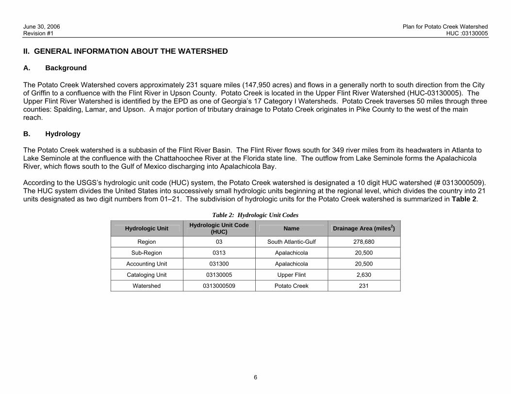
II. GENERAL INFORMATION ABOUT THE WATERSHED A. Background The Potato Creek Watershed covers approximately 231 square miles (147,950 acres) and flows in a generally north to south direction from the City of Griffin to a confluence with the Flint River in Upson County. Potato Creek is located in the Upper Flint River Watershed (HUC-03130005). The Upper Flint River Watershed is identified by the EPD as one of Georgia’s 17 Category I Watersheds. Potato Creek traverses 50 miles through three counties: Spalding, Lamar, and Upson. A major portion of tributary drainage to Potato Creek originates in Pike County to the west of the main reach. B. Hydrology The Potato Creek watershed is a subbasin of the Flint River Basin. The Flint River flows south for 349 river miles from its headwaters in Atlanta to Lake Seminole at the confluence with the Chattahoochee River at the Florida state line. The outflow from Lake Seminole forms the Apalachicola River, which flows south to the Gulf of Mexico discharging into Apalachicola Bay. According to the USGS’s hydrologic unit code (HUC) system, the Potato Creek watershed is designated a 10 digit HUC watershed (# 0313000509). The HUC system divides the United States into successively small hydrologic units beginning at the regional level, which divides the country into 21 units designated as two digit numbers from 01–21. The subdivision of hydrologic units for the Potato Creek watershed is summarized in Table 2.
Table 2: Hydrologic Unit Codes
Hydrologic Unit Hydrologic Unit Code (HUC) Name Drainage Area (miles2)
Region 03 South Atlantic-Gulf 278,680
Sub-Region 0313 Apalachicola 20,500
Accounting Unit 031300 Apalachicola 20,500
Cataloging Unit 03130005 Upper Flint 2,630
Watershed 0313000509 Potato Creek 231
June 30, 2006 Plan for Potato Creek Watershed Revision #1 HUC :03130005
7
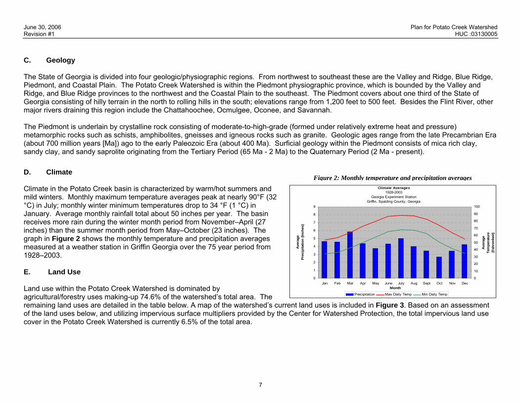
C. Geology The State of Georgia is divided into four geologic/physiographic regions. From northwest to southeast these are the Valley and Ridge, Blue Ridge, Piedmont, and Coastal Plain. The Potato Creek Watershed is within the Piedmont physiographic province, which is bounded by the Valley and Ridge, and Blue Ridge provinces to the northwest and the Coastal Plain to the southeast. The Piedmont covers about one third of the State of Georgia consisting of hilly terrain in the north to rolling hills in the south; elevations range from 1,200 feet to 500 feet. Besides the Flint River, other major rivers draining this region include the Chattahoochee, Ocmulgee, Oconee, and Savannah. The Piedmont is underlain by crystalline rock consisting of moderate-to-high-grade (formed under relatively extreme heat and pressure) metamorphic rocks such as schists, amphibolites, gneisses and igneous rocks such as granite. Geologic ages range from the late Precambrian Era (about 700 million years [Ma]) ago to the early Paleozoic Era (about 400 Ma). Surficial geology within the Piedmont consists of mica rich clay, sandy clay, and sandy saprolite originating from the Tertiary Period (65 Ma - 2 Ma) to the Quaternary Period (2 Ma - present). D. Climate Figure 2: Monthly temperature and precipitation averages
Climate in the Potato Creek basin is characterized by warm/hot summers and mild winters. Monthly maximum temperature averages peak at nearly 90°F (32 °C) in July; monthly winter minimum temperatures drop to 34 °F (1 °C) in January. Average monthly rainfall total about 50 inches per year. The basin receives more rain during the winter month period from November–April (27 inches) than the summer month period from May–October (23 inches). The graph in Figure 2 shows the monthly temperature and precipitation averages measured at a weather station in Griffin Georgia over the 75 year period from 1928–2003. E. Land Use Land use within the Potato Creek Watershed is dominated by agricultural/forestry uses making-up 74.6% of the watershed’s total area. The remaining land uses are detailed in the table below. A map of the watershed’s current land uses is included in Figure 3. Based on an assessment of the land uses below, and utilizing impervious surface multipliers provided by the Center for Watershed Protection, the total impervious land use cover in the Potato Creek Watershed is currently 6.5% of the total area.
Climate Averages1928-2003
Georgia Experiment StationGriffin, Spalding County, Georgia
0
1
2
3
4
5
6
7
8
9
Jan Feb Mar Apr May June July Aug Sept Oct Nov DecMonth
Ave
rage
Pr
ecip
itatio
n (In
ches
)
0
10
20
30
40
50
60
70
80
90
100
Ave
rage
Te
mpe
ratu
re
(Fah
renh
eit)
Precipitation Max Daily Temp Min Daily Temp

June 30, 2006 Plan for Potato Creek Watershed Revision #1 HUC :03130005
8
Table 3: Percentage Land Use within the Potato Creek Watershed
Land Use Area (Acres) Percentage
Trans./Comm./Util. 17.9 0.0%
Park/Recreation/Cons 386.1 0.3%
High Density Residential 788.0 0.5%
Public/Institutional 940.4 0.6%
Commercial 2,307.0 1.6%
Industrial 4,359.5 2.9%
Medium Density Residential 4,952.0 3.3%
Undeveloped/Unused 9,096.7 6.1%
Low Density Resident 21,468.7 14.5%
Agriculture/Forestry 103,633.7 70.0%
SUM 147,950.0 100.0% Agricultural land use is by far the most common land use/ land cover within the Potato Creek watershed, totaling 74.6% of the total area based on the land use produced by the McIntosh Trail RDC. The majority of this agricultural land is used for grazing livestock or producing hay for feed. Of the 537 miles of streams within the Potato Creek Watershed, approximately 322 miles lie adjacent to grazing or hay producing lands.
P o t a t o C r e e k T M D L - E x i s t i n g L a n d U s eP o t a t o C r e e k T M D L - E x i s t i n g L a n d U s e
Land Use ClassificationsAgriculture/ForestryLow Density ResidentialMedium Density ResidentialHigh Density ResidentialCommercialIndustrialPublic/InstitutionalPark/Recreation/ConservationTrans./Comm./Util.Undeveloped/UnusedRoadsCities °
June 30, 2006 Plan for Potato Creek Watershed Revision #1 HUC :03130005
10
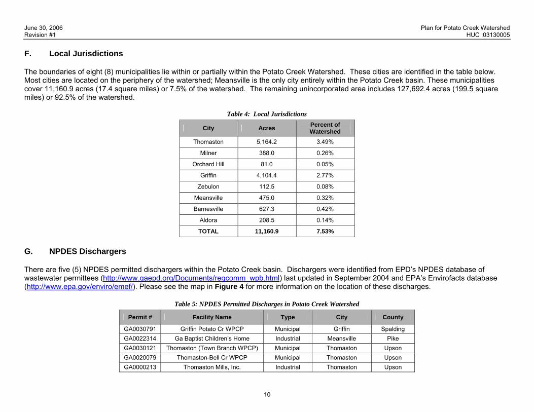
F. Local Jurisdictions The boundaries of eight (8) municipalities lie within or partially within the Potato Creek Watershed. These cities are identified in the table below. Most cities are located on the periphery of the watershed; Meansville is the only city entirely within the Potato Creek basin. These municipalities cover 11,160.9 acres (17.4 square miles) or 7.5% of the watershed. The remaining unincorporated area includes 127,692.4 acres (199.5 square miles) or 92.5% of the watershed.
Table 4: Local Jurisdictions
City Acres Percent of Watershed
Thomaston 5,164.2 3.49%
Milner 388.0 0.26%
Orchard Hill 81.0 0.05%
Griffin 4,104.4 2.77%
Zebulon 112.5 0.08%
Meansville 475.0 0.32%
Barnesville 627.3 0.42%
Aldora 208.5 0.14%
TOTAL 11,160.9 7.53%
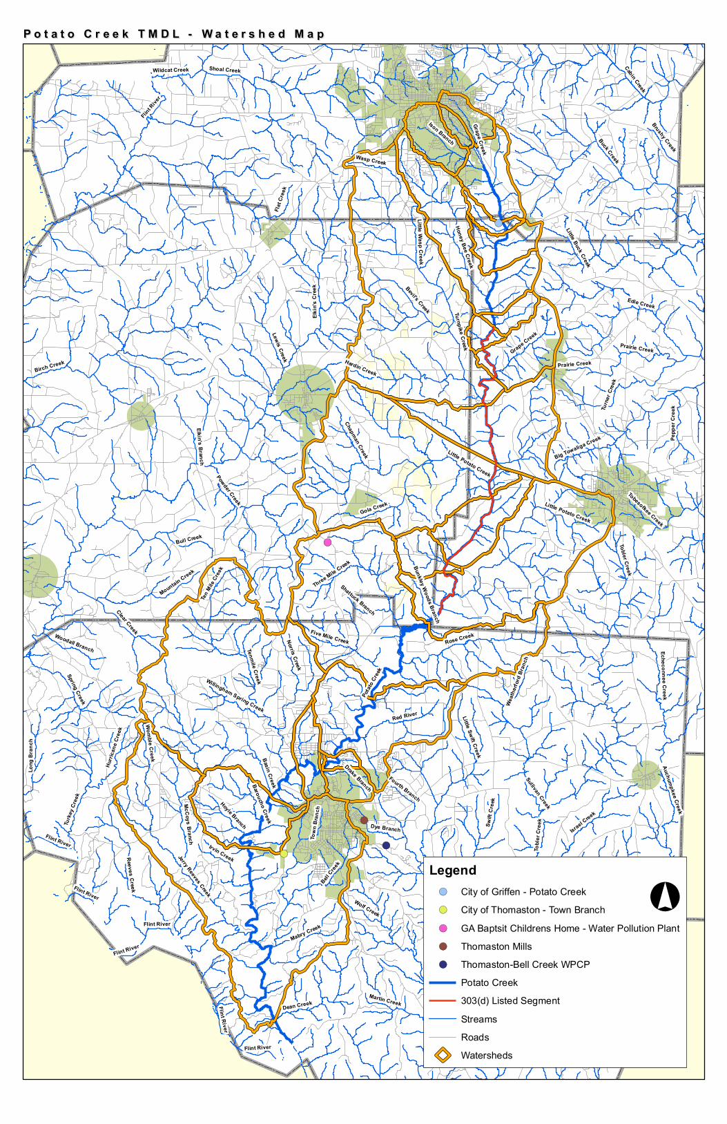
G. NPDES Dischargers There are five (5) NPDES permitted dischargers within the Potato Creek basin. Dischargers were identified from EPD’s NPDES database of wastewater permittees (http://www.gaepd.org/Documents/regcomm_wpb.html) last updated in September 2004 and EPA’s Envirofacts database (http://www.epa.gov/enviro/emef/). Please see the map in Figure 4 for more information on the location of these discharges.
Table 5: NPDES Permitted Discharges in Potato Creek Watershed
Permit # Facility Name Type City County
GA0030791 Griffin Potato Cr WPCP Municipal Griffin Spalding GA0022314 Ga Baptist Children’s Home Industrial Meansville Pike GA0030121 Thomaston (Town Branch WPCP) Municipal Thomaston Upson GA0020079 Thomaston-Bell Cr WPCP Municipal Thomaston Upson GA0000213 Thomaston Mills, Inc. Industrial Thomaston Upson
!(
!(
!(
!(
!(
Elkin'
s Cree
k
Swift
Cree
k
Birch Creek
Cabin Creek
Little Swift Creek
Potat
o Cree
k
Bell Cree
k
Basin Creek
Edie Creek
Buck Creek
Rose Creek
Wolf Creek
Auchumpkee Creek
Sullivan Creek
Wasp Creek
Bull Creek
Womble Creek
Gola Creek
Flint R
iver
Israel Creek
Dean Creek
Turne
r Cree
k
Reeves Creek
Turke
y Cree
k
Big Towaliga Creek
Powder Creek
Hardin Creek
Little Potato Creek
Mountain Creek
Echeconnee Creek
Red River
Turnpike Creek
Shoal Creek
Little Buck Creek
Town
Bran
ch
McCoys Branch
Tenmile Creek
Bevil's Creek
Norris Creek
Kendall Branch
Little
Bran
ch
Five Mile Creek
Toble
r Cre
ek
Little Creek
Mabry Creek
Ison Branch
Chapman Creek
Lewis Creek
Long
Bra
nch
Grape Creek
Martin Creek
Fourth Branch
Irvin Creek
Spring Creek
Dye Branch
Jerry Reeves Creek
Pepp
er C
reek
Clear Creek
Elkin's Branch
Three Mile Creek
Ten M
ile Cr
eek
Hurri
cane
Cree
k
Hoyle BranchTobesofkee Creek
Woodall Branch
Drake BranchBaroucho Creek
Flat C
reek
Hors
eley B
ranch
Wildcat Creek
Little Wasp Creek
Brushy Creek
Honey Bee Creek
Willingham Spring Creek Weath
erford
Bran
ch
Prairie Creek
Bunkley Woods Branch
Shattuck Branch
Flint River
Flint River
Flint River
Tobler Creek
Prairie CreekGrape Creek
Flint River
Flint River
Little Potato Creek
Flint River
Auchumpkee CreekP o t a t o C r e e k T M D L - W a t e r s h e d M a pP o t a t o C r e e k T M D L - W a t e r s h e d M a p
Legend!( City of Griffen - Potato Creek!( City of Thomaston - Town Branch!( GA Baptsit Childrens Home - Water Pollution Plant!( Thomaston Mills!( Thomaston-Bell Creek WPCP
Potato Creek303(d) Listed SegmentStreamsRoadsWatersheds
°

June 30, 2006 Plan for Potato Creek Watershed Revision #1 HUC :03130005
12
III. SOURCES AND CAUSES OF STREAM SEGMENT IMPAIRMENT LISTED IN TMDLs In accordance with the 2004 303(d) List of Impaired Waterways and the Draft 2006 303(d) List of Impaired Waterways, the following stream segment within the Potato Creek Watershed is listed as not supporting its designated use of fishing due to a fecal coliform violation. Stream segment(s) not supporting their designated use:
Table 6: 303(d) Listing Information
Stream Segment Name Location Violation Miles/Area Designated Use UR/NS
Potato Creek Hwy 41 to Upson County Line FC 11 miles Fishing UR In February 2003, the Georgia EPD submitted a TMDL Report for fecal coliform that addressed the listing in Potato Creek. The information in the table below is a summary of the information included in the TMDL Report. It is important to note that the TMDL Report was written for all listed segments within the Flint River Basin, so that the sources identified in the report and summarized below are not necessarily specific to the middle segment of Potato Creek (Hwy 41 to Upson County Line).
Table 7: Sources of Impairment as Indicated in TMDLs
Parameter 1 WQ Standard Sources of Impairment* Needed Reduction from TMDL
Point Sources
Wastewater Treatment Plants Permitted Stormwater Discharges Confined Animal Feeding Operations
Fecal Coliform
Water quality samples collected within a 30-day period should have a geometric mean less than 200 counts per 100 milliliters during the period May through October, or less than 1000 counts per 100 milliliters during the period November through April. In addition, no single sample should be in excess of 4000 counts per 100 milliliters during the period November through April.
Non-Point Sources Wildlife Urban Development Grazing Livestock
72%

June 30, 2006 Plan for Potato Creek Watershed Revision #1 HUC :03130005
13
IV. IDENTIFICATION AND RANKING OF POTENTIAL SOURCES OR CAUSES OF IMPAIRMENT A. Introduction
This section will identify known or probable causes of water quality impairments and threats, as identified through the sampling program conducted as part of the Potato Creek Revised TMDL IP 319 grant Work Plan. In order to develop this Revised TMDL IP, water quality monitoring was conducted to identify the specific sources of fecal contamination within the Potato Creek Watershed. Through a combination of replicate sampling, targeted sampling and BST, fecal coliform “hotspots” and specific sources were identified within the Potato Creek Watershed. The ultimate goal of this sampling effort was to identify the sources of fecal contamination such that a source-specific TMDL IP could be developed. By identifying specific sources, the local stakeholders responsible for implementing the plan can choose targeted BMPs that make the most efficient use of available resources. Ultimately, this approach, as opposed to a generalized TMDL IP, will have the greatest impact on water quality within the Potato Creek Watershed. McIntosh Trail RDC coordinated the sampling team, which consisted of ISE and UGA. Data collected by ISE during replicate sampling allowed UGA to further refine the identification of bacterial source areas for targeted sampling and BST. Sampling methodology and results of this study are summarized below. For a detailed description of the EPA approved sampling methodology, please see the approved Quality Assurance Protection Plan in Appendix C. For a full description of the sampling results, please see Technical Addendum A: Potato Creek Technical Report.
Figure 5: Replicate Sampling Sites
#Y
#Y
#Y
#Y
#Y
#Y
#Y#Y#Y
#Y
#Y
#Y
#Y
#Y
B. Replicate Sampling Replicate sampling was conducted by ISE to identify stream reaches with high fecal coliform and E. coli concentrations. Four sampling events were conducted at each of the 24 sample sites over a 45-day period. Ideally the sampling would have been completed in a 30-day period to have a true geometric mean (geomean) calculation, but due to weather issues that was not possible. Only dry weather events (defined as no stormwater runoff occurring in the previous 72 hours) were sampled. The laboratory results were used to calculate a geometric mean for each sample site for both fecal coliform and E. coli. Since there has been discussion by the Georgia EPD on shifting the bacterial standard from fecal coliform to E. coli, laboratory analysis was conducted for both constituents. The replicate sampling locations are shown in Figure 5. The rationale for selection of the site locations was based on initial ease of sampling at road crossings and at base points of watersheds. This method of site location would isolate watersheds that were loading significantly more bacteria to Potato Creek than other watersheds. The targeted sampling sites were located along some tributaries within the sub basins to determine precise areas of bacteria loading.
#Y##Y
#Y
#Y
#Y#Y
#Y
#Y
#Y
Y
PIKE
UPSON
LAMAR
SPALDING
21 22 23
20
19 18
17
16 15
14 13 12
11 10
9 8
7
6
5a
5
4
3
2
1
By comparing the results of the target sampling it became apparent that there were three areas of concern within the Potato Creek Watershed including the Grandview tributary in Griffin
June 30, 2006 Plan for Potato Creek Watershed Revision #1 HUC :03130005 (Griffin reach), the middle reach of Potato Creek (Meansville reach), and the lower reach of Potato Creek (Thomaston reach). The majority of the high bacteria results were located in the center of the Potato Creek Watershed, as originally thought by the initial 303(d) monitoring data. The middle reach of Potato Creek includes watersheds that are primarily located within the counties of Pike and Lamar. These counties have a high agricultural and farming land use, which could contribute to higher levels of bacteria presence. The Town of Meansville is also located within the identified watershed. C. Targeted Sampling and Bacterial Source Tracking
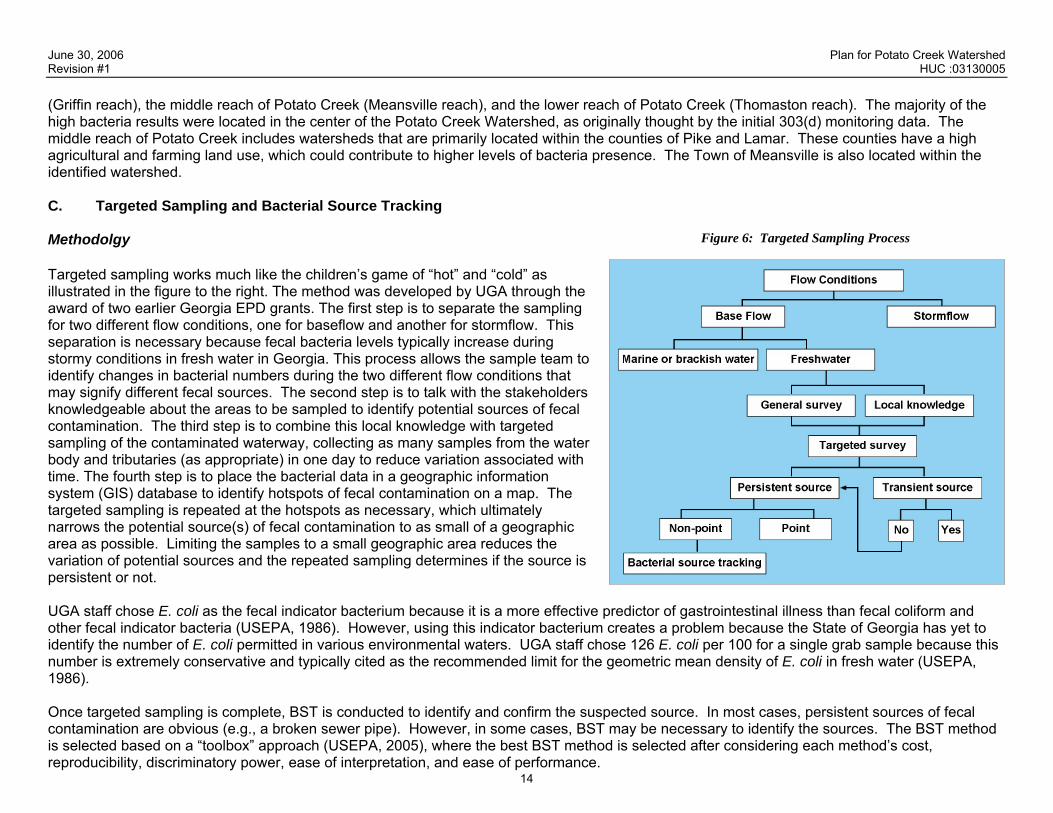
Figure 6: Targeted Sampling Process Methodolgy Targeted sampling works much like the children’s game of “hot” and “cold” as illustrated in the figure to the right. The method was developed by UGA through the award of two earlier Georgia EPD grants. The first step is to separate the sampling for two different flow conditions, one for baseflow and another for stormflow. This separation is necessary because fecal bacteria levels typically increase during stormy conditions in fresh water in Georgia. This process allows the sample team to identify changes in bacterial numbers during the two different flow conditions that may signify different fecal sources. The second step is to talk with the stakeholders knowledgeable about the areas to be sampled to identify potential sources of fecal contamination. The third step is to combine this local knowledge with targeted sampling of the contaminated waterway, collecting as many samples from the water body and tributaries (as appropriate) in one day to reduce variation associated with time. The fourth step is to place the bacterial data in a geographic information system (GIS) database to identify hotspots of fecal contamination on a map. The targeted sampling is repeated at the hotspots as necessary, which ultimately narrows the potential source(s) of fecal contamination to as small of a geographic area as possible. Limiting the samples to a small geographic area reduces the variation of potential sources and the repeated sampling determines if the source is persistent or not. UGA staff chose E. coli as the fecal indicator bacterium because it is a more effective predictor of gastrointestinal illness than fecal coliform and other fecal indicator bacteria (USEPA, 1986). However, using this indicator bacterium creates a problem because the State of Georgia has yet to identify the number of E. coli permitted in various environmental waters. UGA staff chose 126 E. coli per 100 for a single grab sample because this number is extremely conservative and typically cited as the recommended limit for the geometric mean density of E. coli in fresh water (USEPA, 1986).
14
Once targeted sampling is complete, BST is conducted to identify and confirm the suspected source. In most cases, persistent sources of fecal contamination are obvious (e.g., a broken sewer pipe). However, in some cases, BST may be necessary to identify the sources. The BST method is selected based on a “toolbox” approach (USEPA, 2005), where the best BST method is selected after considering each method’s cost, reproducibility, discriminatory power, ease of interpretation, and ease of performance.

June 30, 2006 Plan for Potato Creek Watershed Revision #1 HUC :03130005
15
The BST methods combined with targeted sampling for this study were Enterococcus speciation, detection of the esp (enterococcal surface protein) gene in Enterococcus faecium, and fluorometry. In fluorometry, water is analyzed for the presence or absence of optical brighteners, which are added to most dishwashing and laundry detergents and fluoresce under ultraviolet light. Because they are associated with human wastewater, the sources of these brighteners are leaking sewer pipes, sewer lines improperly cross-connected to storm drains, and malfunctioning septic drain fields. Fluorometry combined with targeted fecal bacteria monitoring can provide compelling evidence as to the source of the contamination. In addition, it is a relatively inexpensive method. The table below provides a guide for interpreting fluorometry and targeted sampling results.
Table 8: Fluorometry and Target Sampling Interpretation Guide
Fecal Bacterial Levels Optical Brightener Likely Cause(s)
High High Failing septic system or leaking sewer pipe
High Low Human (e.g., outhouse) or other warm-blooded animals
Low High Gray water in the stormwater system
Low Low No evidence of fecal contamination
Enterococcus speciation is conducted by using another set of fecal indicator bacteria, fecal enterococci. These bacteria are speciated phenotypically, and the percentage of Ent. faecalis is determined. High percentages (≥30%) of Ent. faecalis are usually associated only with humans and some wild birds. In esp gene detection, the gene associated with human fecal sources is detected in Ent. faecium isolates with a polymerase chain reaction (PCR) assay. Sampling Protocol The sampling program was designed to determine the source of the fecal coliform loadings in the Griffin, Meansville, and Thomaston reaches of Potato Creek using targeted sampling and one or more of the three BST methods described above: fluorometry, Enterococcus speciation, and detection of the esp gene. In addition, sediment samples were collected and tested for E. coli to determine if the substrate may serve as reservoirs for fecal bacteria. UGA performed analysis on these samples to determine if E. coli could survive or regrow in desiccated sediments. Sediments and water samples were taken above and below the Griffin Wastewater Treatment Plant to ascertain whether or not fecal coliform contamination was due to effluent from this facility. Griffin Reach: The Griffin Reach consists of a narrow (between 1 and 2 meters wide), shallow (typically, <20 cm deep), unnamed tributary of Potato Creek that flows past Grandview Drive. This reach had been previously identified as having chronic high numbers of fecal coliforms, and located in a residential neighborhood serviced by sanitary sewer. Many drainage pipes and a few small tributaries (<0.2 meters wide) outfall into this reach. Sampling three times during baseflow and twice during stormflow conditions fluorometry was conducted for one baseflow sampling event and two stormflow sampling events. Meansville Reach: This reach consists of Potato Creek east of Meansville between Turner Bridge Road and C.W. Allen Road. Farms, especially cattle and dairy farms, are present in this largely rural area. The reach is fenced to prevent cattle from accessing Potato Creek, however the tributaries are not. The area is predominantly rural, and all residential homes are served by septic systems. The reach was sampled once during

June 30, 2006 Plan for Potato Creek Watershed Revision #1 HUC :03130005
16
dry weather and once during stormflow conditions. Tributaries near C. W. Allen Road and “West” Little Potato Creek were also sampled twice during baseflow. Thomaston Reach: This Reach officially consists of Potato Creek between County Road and Route 19. However, for the sake of convenience, the reach was extended to Hannahs Mill Road. The reach is located in a mixed neighborhood consisting of both residential and commercial properties, and it is notable because it contains the intake for the Thomaston Water Treatment Plant. The creek is deeper and wider compared to the Griffin reach. A small number of outfalls of undetermined origin were observed during sampling events. Samples were collected both during one baseflow event and one stormflow event. Figure 7: Griffin Reach Fecal Bacteria Sources Potato Creek Tributaries: Targeted sampling included sampling of all major Potato Creek tributaries between Griffin and Thomaston. Some of these tributaries were considered more important than others by virtue of their proximity to the Griffin, Meansville, and Thomaston reaches, and these tributaries were sampled more extensively. These tributaries include Grape Creek and Ison Branch in the Griffin reach, and “Little Potato Creek” and its tributaries of the Meansville reach. All tributaries were sampled once during baseflow and stormflow conditions. Results Griffin Reach The Griffin reach was persistently contaminated with high numbers of E. coli during both base and stormflow conditions. As expected, fecal contamination was worse during stormflow than during baseflow conditions because such increases have been observed in fresh waters elsewhere in Georgia (e.g., Gregory and Frick, 2001; Hartel et al., 2004) as runoff brings new sources of fecal material into the reach. Targeted sampling quickly identified a broken home sewer line as a potential source of fecal contamination during both baseflow and stormflow conditions. Other sources of potential fecal contamination included discarded feces-laden kitty litter, dog kennels, and urban wildlife during stormflow conditions, see Figure 7. In contrast to targeted sampling, there were significant problems with each of the three BST methods in the Griffin reach. First, the percentage of Ent. faecalis was high (33%) during baseflow conditions and a percentage ≥30% for Ent. faecalis is indicative of human or bird fecal contamination (Kuntz et al., 2004). This result would be consistent with the broken sewer pipe. However, Enterococcus species percentage standards have not yet been developed for dog feces, and, due to their close proximity to humans, it is unclear of the degree to which dogs confound any human fecal signal in the Griffin reach.

June 30, 2006 Plan for Potato Creek Watershed Revision #1 HUC :03130005
17
Second, the esp gene was not detected in the Griffin Reach. The most likely reason for this failure was that the water sample was collected too far downstream from the sewer line break on Springer Drive, such that the Enterococcus faecium species with the esp gene were too diluted with other enterococci from other sources of fecal contamination upstream (e.g., feces from dog kennels bordering the creek). Third, high fluorometric values, suggestive of the presence of optical brighteners, were not observed during baseflow conditions. The most likely reason for this failure is that the broken sewer line came from a single home and the flow was episodic. An episodic flow would make sample timing critical, particularly when the sewer line break is directly over the water and the sewage is diluted and transported away quickly. To make matters worse, the presence of high amounts of organic matter in the water during stormflow conditions caused fluorometry to have a high background. Organic matter is known to fluoresce and experiments with Suwannee River natural organic matter confirm this. One way to avoid this high background may be simply to increase the background limit. Under these circumstances, only the Griffin reach among the three reaches would be identified as likely having human fecal contamination during stormflow conditions. The source of optical brighteners during stormflow could potentially result from inflow and infiltration (I&I) into the sanitary sewer system. Stormflow conditions would likely submerge the broken sewer pipe increasing the likelihood that sanitary wastewater would be flushed into the waterway. This exposure would not only explain some of the extremely high counts of E. coli (10 of the 16 sites with >1,000 E. coli per 100 mL during the first stormflow sampling and 17 out of 19 samples with >1,000 E. coli per 100 mL during the second stormflow sampling), but also how fluorescence values exceeded 250 fluorometric units in 4 of 19 water samples. As expected, higher numbers of E. coli were observed during the summer than in winter. This result is likely because conditions for bacterial survival are better in summer than in winter. Even though E. coli has long been known to survive best in cool, moist conditions (Van Donsel et al., 1967), any freezing would reduce E. coli numbers significantly. Meansville Reach The initial sampling showed that fecal contamination to the Meansville reach was not coming from Potato Creek upstream, but potentially from “West” Little Potato Creek. Therefore, the tributaries to “West” Little Potato Creek were extensively studied. The source of fecal contamination to this reach was likely to be animal wastes, particularly cattle. First, cattle and other agricultural animals were observed near Meansville during targeted sampling. Gola Creehad high numbers of E. coli in particular and this reach has cattle pastures directly adjacenthe stream. Second, although problems of high fluorometric values persisted during baseflow sampling, all samples were consistently low (≤170 fluorometric units). Third, the percentage of Ent. faecalis was 28%, which is below the cutoff for identifying human fecal contamination. Finally, detection of the esp gene was negative. Therefore, human fecal contamination is unlikely in this reach. High numbers were also observed coming from McCards Lake. In this instance, the most reasonable source was wildlife attracted to the lake. Finally, a sample taken from a small tributary to Gola Creek near the lake had extremely high numbers, but this was likely to be a transitory source because Gola Creek did not have high numbers downstream of this tributary’s confluence with Gola Creek.
k t to Courtesy of the University of Georgia

June 30, 2006 Plan for Potato Creek Watershed Revision #1 HUC :03130005 Along the main stem of Potato Creek, in the Meansville Reach, cows were likely the major source of contamination. Targeted sampling required sampling of the tributaries near C. W. Allen Bridge where high E. coli numbers were observed and cows were seen standing in the tributary. Hoof prints on the banks indicated that they done this in the past. These results suggest that BMPs such as cattle exclusion fencing, non-riparian shading areas, and providing cattle with alternative water sources away from the tributaries (Byers et al., 2005) would be helpful. Relatively high fluorometric values were observed in these tributaries, but the source of the fluorometric values is likely to be organic matter. This result would be consistent with no human habitation near the tributaries. Thomaston Reach The major source of identifiable fecal contamination to the Thomaston was likely a pit bull kennel located on Hillside drive (see photo below). High numbers of E. coli in the unnamed tributary were not obtained in er above this kennel, but were obtained in the water and sediment below the kennel and where the tributary enters Potato Creek during b eflow and stormflow conditions. The percentage of Ent. faecalis was 42%, indicative of human or bird fecal contamination, but the source w kely to be human because the fluorometric values were only slightly over 100 units and the detection of the esp gene was negative. Highefluorometric values (>200 units) would be expected this close to the source. The idea of birds as a dominant source of fecal contaminationlikely misleading because dogs have never been tested for their fecal enterococcal percentages. Given the intimacy between humans and dogs, a high percentage of Ent. faecalis would be unsurprising. In addition to this identifiable source, other unidentifiable sources (e.g.wildlife) were likely to contribute fecal contamination to this Potato Crereach during baseflow conditions. For example, high numbers of E. cowere observed in Potato Creek above the point where the unnamed tributary from Hillside Drive enters Potato Creek. High numbers of E. coli were observed consistently over the entire reach during stormflow compared with baseflow conditions. The most likely sources of these numbers were from pets and urban wildlife. Husamples were <110 fluorometric units. The one exception was Samplecenter parking lot. In this instance, fluorescence may have come fromknown to fluoresce highly (C. Hagedorn, personal communication, 200which is what was observed (41 E. coli per 100).
reach the watoth basas unlir
is
18
, ek li
man fecal contamination was unlikely, because with one exception, all the 15B, which was runoff sampled during stormflow conditions from a shopping
car washing detergents or organic compounds like diesel fuel, which are 5). This fluorescence would also be consistent with low numbers of E. coli,
Courtesy of the University of Georgia
June 30, 2006 Plan for Potato Creek Watershed Revision #1 HUC :03130005
19
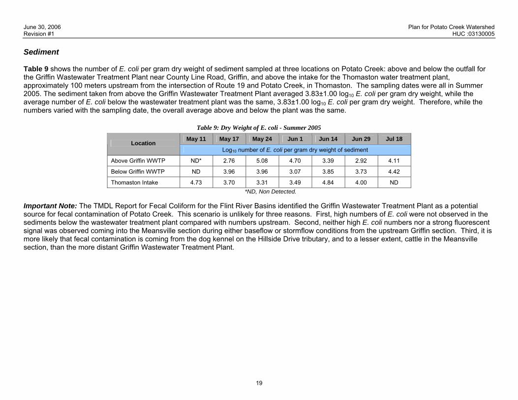
Sediment Table 9 shows the number of E. coli per gram dry weight of sediment sampled at three locations on Potato Creek: above and below the outfall for the Griffin Wastewater Treatment Plant near County Line Road, Griffin, and above the intake for the Thomaston water treatment plant, approximately 100 meters upstream from the intersection of Route 19 and Potato Creek, in Thomaston. The sampling dates were all in Summer 2005. The sediment taken from above the Griffin Wastewater Treatment Plant averaged 3.83±1.00 log10 E. coli per gram dry weight, while the average number of E. coli below the wastewater treatment plant was the same, 3.83±1.00 log10 E. coli per gram dry weight. Therefore, while the numbers varied with the sampling date, the overall average above and below the plant was the same.
Table 9: Dry Weight of E. coli - Summer 2005
May 11 May 17 May 24 Jun 1 Jun 14 Jun 29 Jul 18 Location
Log10 number of E. coli per gram dry weight of sediment
Above Griffin WWTP ND* 2.76 5.08 4.70 3.39 2.92 4.11
Below Griffin WWTP ND 3.96 3.96 3.07 3.85 3.73 4.42
Thomaston Intake 4.73 3.70 3.31 3.49 4.84 4.00 ND*ND, Non Detected.
Important Note: The TMDL Report for Fecal Coliform for the Flint River Basins identified the Griffin Wastewater Treatment Plant as a potential source for fecal contamination of Potato Creek. This scenario is unlikely for three reasons. First, high numbers of E. coli were not observed in the sediments below the wastewater treatment plant compared with numbers upstream. Second, neither high E. coli numbers nor a strong fluorescent signal was observed coming into the Meansville section during either baseflow or stormflow conditions from the upstream Griffin section. Third, it is more likely that fecal contamination is coming from the dog kennel on the Hillside Drive tributary, and to a lesser extent, cattle in the Meansville section, than the more distant Griffin Wastewater Treatment Plant.

June 30, 2006 Plan for Potato Creek Watershed Revision #1 HUC :03130005
20
Summary The following revised table summarizes the suspected sources of fecal coliform contamination as identified through the sampling and bacterial source tracking program described above.
Table 10: Revised Sources of Impairment as Indicated in TMDLs
Parameter 1 WQ Standard Sources of Impairment* Needed Reduction from TMDL
Point Sources Sanitary Sewer Overflows Thomaston Dog Kennel
Fecal Coliform
Water quality samples collected within a 30-day period should have a geometric mean less than 200 counts per 100 milliliters during the period May through October, or less than 1000 counts per 100 milliliters during the period November through April. In addition, no single sample should be in excess of 4000 counts per 100 milliliters during the period November through April.
Non-Point Sources Wildlife Pet Waste Grazing Livestock
72%
Table 11 identifies the potential sources or causes most likely to contribute to the fecal coliform impairment in Potato Creek as established through the BST project described above. The table lists the significant potential sources or causes of each impairment and provides an estimate of the geographic extent of each potential source as well as the relative contribution of each major source to the fecal coliform impairment.
Table 11: Conclusions Made of Potential Sources of Stream Segment Impairment Parameter 1: Fecal Coliform
Estimated Extent of Contribution Estimated Portion of Contribution Potential Sources or Causes Comments Rating
(A) Comments Rating
(B)
Impact Rating (A x B)
Sanitary Sewer Overflows Identified through visual sightings, targeted sampling, and BST. Rating is based on percentage of watershed that is urbanized and likely to be served by sanitary sewer, and would therefore have the potential for SSOs. Approximately 9% of the total watershed is urbanized according to the Department of Community Affairs.
1 Although SSOs are currently being addressed by local programs, SSOs should still be considered a medium source of impairment. A single SSO can contribute a significant amount of fecal bacteria.
5 5
Identified Dog Kennel A large kennel was identified through targeted sampling and field survey directly adjacent to a tributary of Potato Creek.
0.5 This source, while not widespread, is significant. 100 dogs can contribute enough feces in 2–3 days to close a 20 mi2 drainage basin to swimming or fishing (US EPA, 1993).
3 1.5

June 30, 2006 Plan for Potato Creek Watershed Revision #1 HUC :03130005
21
Estimated Extent of Contribution Estimated Portion of Contribution Potential Sources or Causes Comments Rating
(A) Comments Rating
(B)
Impact Rating (A x B)
Wildlife Since large areas of the watershed are undeveloped or agricultural, it is likely that there is a great deal of wildlife that potentially contribute to fecal coliform loadings in Potato Creek. The GA Wildlife Resources Division’s 2000 census estimated a concentration of deer of 50/mi2 in each of the four counties. Based on the total area of the Potato Creek Watershed (231 mi2), this would result in approximately 11,550 deer within the watershed.
5 According to the Flint River Fecal Coliform TMDL Report, the GA WRD estimates the relative contribution of fecal coliform bacteria from deer to be “less significant” than that of other wildlife.
1 5
Pet Waste The American Veterinary Medical Association estimates that 39% of US households have dogs, and that each of those households’ averages 1.7 dogs per house. The US census listed 42,708 households in the four county area. Since 24.5% of the four County area lies within the Potato Creek watershed, there are an estimated 10,463 households within the watershed. If 39% of these households have 1.7 dogs, there are approximately 6,937 dogs in the Potato Creek Watershed. These numbers account for dogs alone and do not account for other species of pets.
3 This source has the potential to be significant. 100 dogs can contribute enough feces in 2–3 days to close a 20 mi2 drainage basin to swimming or fishing (US EPA, 1993).
3 9
Grazing Livestock Based on the 2000 NRCS census of grazing livestock in the four county area, there are approximately 8,000 grazing animals, including cattle, sheep, swine, goats, and horses. Since the Potato Creek Watershed encompasses 24.5% of the four County area, we can estimate approximately 2,000 grazing animals within the watershed. Additionally, it should be noted that according to the GIS information provided by the McIntosh Trail RDC, 75% of the watershed has a land use of agriculture or forestry. Additionally, out of 528.8 linear miles of streams, 322.3 miles (or 61%) lie adjacent to pastureland.
5 Grazing animals allowed access to the riparian environment not only contribute fecal bacteria directly to streams, they destroy the riparian buffer’s ability to filter out contaminated runoff, essentially doubling their impact to the stream.
3 15
The following key provides guidance for rating the estimated extent and portion of the contribution from each potential source and cause.
Estimated Geographic Extent of the Source Estimated Contribution of the Source or Cause Rating None or Negligible (approximately 0-5%) None or Negligible (approximately 0-5%) 0.5 Scattered or Low (approximately 5-20%) Scattered or Low (approximately 5-20%) 1 Medium (approximately 20-50%) Medium (approximately 20-50%) 3 Widespread or High (approximately 50% or more) Widespread or High (approximately 50% or more) 5 Unknown Unknown Unk

June 30, 2006 Plan for Potato Creek Watershed Revision #1 HUC :03130005
22
V. STAKEHOLDERS Public involvement and the active participation of stakeholders is essential to the process of preparing TMDL IPs and improving water quality. Stakeholders can provide valuable information and data regarding their community, impaired water bodies, potential causes of impairments, and management practices and activities which may be employed to reduce the impacts of the causes of impairment. The following section provides an overview of the stakeholder program that was implemented as part of the TMDL Revision Process. There are four major public involvement programs that have been, or will be implemented as part of the Revised TMDL IP development:
• Environmental Advisory Committee (EAC): This group has served as the technical steering committee for the 319 grant application, BST effort, and development of the Revised TMDL IP recommendations. It will continue to serve as the technical steering committee during the implementation of the recommended BMP.
• Public Meetings: After the BMPs for reduction of fecal coliform loadings in Potato Creek were proposed by the EAC, the McIntosh Trail RDC went to each of the six stakeholder communities and presented the results of the BST effort and the recommended BMPs to the elected officials and public.
• Public Hearings: The McIntosh Trail RDC will host two public hearings (one in Griffin and one in Thomaston) to present the Draft Revised TMDL IP. These meetings will take place prior to TMDL IP submittal to EPD in June 2006.
• Newspaper Write-ups: This revision if the TMDL IP for Potato Creek has been publicized routinely in local newspapers. Five articles are included in Appendix D.
Environmental Advisory Committee (EAC): The EAC was established by the McIntosh Trail RDC early in 2001 to address the fecal coliform TMDL on Potato Creek. The EAC was intended to ensure that effective public communication was maintained throughout the project. The EAC members relayed information to their communities, which facilitated public acceptance and participation in the TMDL IP. The EAC membership is summarized in Table12 below.
Table 12: Environmental Advisory Committee Members Name/Org Address City State Zip Phone
McIntosh Trail RDC 120 North Hill Street Griffin GA 30224 770.227.6349 City of Griffin 134 North Hill Street Griffin GA 30224 770.233.4138 City of Thomaston 250 E. Lee Street Thomaston GA 30286 706.647.4242 Upson County P.O. Box 889 Thomaston GA 30286-0012 706.647.7012 Spalding County P.O. Box 1087 Griffin GA 30224-0028 770.467.4200 Pike County P.O. Box 377 Zebulon GA 30295-0377 770.567.3406 Lamar County 326 Thomaston Street Barnesville GA 30204-1669 770.358.5146 Peter Hartel/UGA 3111 Miller Plant Sciences Bldg Athens GA 30602-7272 706.542.0898 Integrated Science & Engineering 105 McIntosh Crossing Fayetteville GA 30214 770.461.4292 Natural Resources Conservation Service 201 W. Solomon Street Griffin GA 30223 770.227.1511 Georgia Forestry Commission 187 Corinth Road Newnan GA 30263 770.254.7218

June 30, 2006 Plan for Potato Creek Watershed Revision #1 HUC :03130005
23
A preliminary TMDL IP for Potato Creek was produced by the RDC, with input and comment from the EAC, and submitted to EPD in March of 2001. The RDC was subsequently awarded a 319 grant by EPD to perform BST to determine the exact nature of the fecal coliform sources in Potato Creek. The EAC acted as the technical steering and review committee for implementation of the grant Workplan. The EAC considered and approved the recommended BMPs that were developed to address the identified sources. The EAC met periodically (approximately semi-annually) throughout the BST project implementation and has met twice since January 2006 (January 20th and May 2nd) to review the results of the study and recommended BMPs. All meetings were held at McIntosh Trail RDC office in Griffin. Public Meetings: The McIntosh Trail RDC presented the recommended BMPs to the elected officials of the stakeholder communities listed above. The presentations were made at public meetings so that the elected officials and citizens of each of these communities could be afforded the opportunity to ask questions and provide comments on the TMDL IP. Comments made at these meetings were incorporated in the Technical Addendum and the recommended BMPs. The schedule of public meetings is included below:
• City of Griffin: April 11, 2006 • City of Thomaston: February 7, 2006 • Spalding County: March 6, 2006 • Pike County: February 28, 2006 • Upson County: March 14, 2006
Public Hearings: The McIntosh Trail RDC will hold two public hearings during June of 2006 to present the draft Revised TMDL IP to the public before its submission to the EPD. Comments made by the public at these meetings will be considered and appropriate amendments will be made to the TMDL IP. These meetings will be advertised in advance to notify the public and encourage participation. One meeting will be held in Griffin and one will be held in Thomaston to provide a convenient location for all stakeholders in the Potato Creek Watershed.
June 30, 2006 Plan for Potato Creek Watershed Revision #1 HUC :03130005
24
he
sewage
as
VI. MANAGEMENT MEASURES AND ACTIVITIES The final step in the development of the revised TMDL IP for Potato Creek is the establishment of management measures and activities or BMPs that target the specific fecal bacteria sources identified through the BST described in the previous section. These BMPs will be the foundation of the Revised TMDL IP, and are designed to improve water quality by reducing or eliminating the sources of bacterial loading. By addressing the specific sources rather than implementing a generalized, watershed-wise program, the local governments within the Potato Creek Watershed will make the most effective use of their limited resources while simultaneously getting the greatest possible benefit. The following chapter includes a description of the proposed source-specific BMPs. Source-Specific Best Management Practices The following section will outline BMPs to address the sources identified through the BST including a broken sanitary sewer pipe, grazing cattle, pet waste, and a dog kennel. Sanitary Sewer Overflow (SSO)
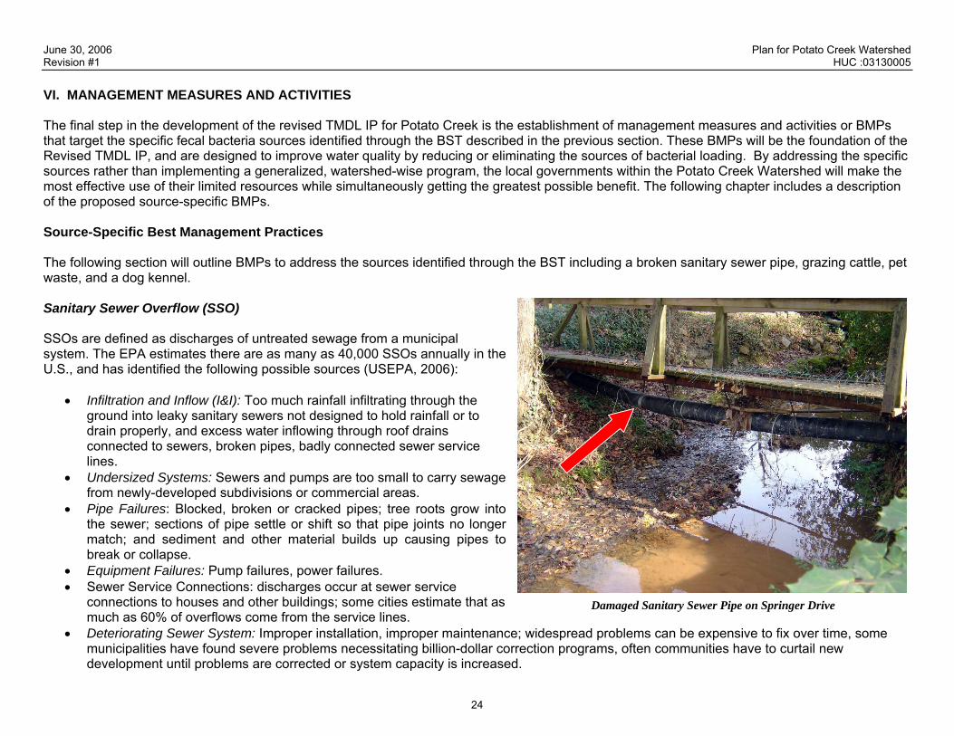
Damaged Sanitary Sewer Pipe on Springer Drive
SSOs are defined as discharges of untreated sewage from a municipal system. The EPA estimates there are as many as 40,000 SSOs annually in tU.S., and has identified the following possible sources (USEPA, 2006):
• Infiltration and Inflow (I&I): Too much rainfall infiltrating through the ground into leaky sanitary sewers not designed to hold rainfall or to drain properly, and excess water inflowing through roof drains connected to sewers, broken pipes, badly connected sewer service lines.
• Undersized Systems: Sewers and pumps are too small to carry from newly-developed subdivisions or commercial areas.
• Pipe Failures: Blocked, broken or cracked pipes; tree roots grow into the sewer; sections of pipe settle or shift so that pipe joints no longer match; and sediment and other material builds up causing pipes to break or collapse.
• Equipment Failures: Pump failures, power failures. • Sewer Service Connections: discharges occur at sewer service
connections to houses and other buildings; some cities estimate that much as 60% of overflows come from the service lines.
• Deteriorating Sewer System: Improper installation, improper maintenance; widespread problems can be expensive to fix over time, some municipalities have found severe problems necessitating billion-dollar correction programs, often communities have to curtail new development until problems are corrected or system capacity is increased.
June 30, 2006 Plan for Potato Creek Watershed Revision #1 HUC :03130005
25
Through their last round of fluorometry in the Grandview tributary to Potato Creek, UGA staff has positively identified at least one SSO (a failed sanitary sewer pipe) pictured above. In addition, UGA target sampling during stormflow and baseflow conditions indicates that I&I into the sanitary sewer system could be causing sporadic SSOs. I&I is caused when rain or groundwater flow or seep into the sanitary sewer system, overloading the system and potentially causing SSOs. Sampling results show higher levels of E. coli and higher fluorometry during stormflow. Additionally, the percentage of Ent. Faecalis along this stretch is greater than 30%. These findings all indicate the potential presence of sanitary sewage during stormflow, which can be interpreted as a sign that I&I from stormwater may be causing SSOs. Identified Management Measures The City of Griffin will immediately repair or replace the sanitary sewer pipe to eliminate the leak identified as contributing to the fecal coliform loading problem. In order to identify any additional current or future sanitary sewer leaks, the City of Griffin will continue to implement the illicit discharge detection and elimination programs (as described in the City’s approved Notice of Intent (NOI) for the Phase II MS4 NPDES Stormwater Permit). The Cities of Griffin and Thomaston will also implement the sanitary sewer inspection program, as required by their NPDES Wastewater Discharge permits. Illicit Discharge Detection and Elimination The City of Griffin’s Phase II MS4 NPDES Stormwater Permit NOI includes the following program description:
“The Stormwater Department’s Environmental Technicians will conduct stream walks to inspect outfalls for illicit discharges and to look for illegal connections to the stream. The Stormwater Department has purchased a field test kit and developed a “Stream Walk Protocol” (copy attached) that gives the background on typical contaminants that we will be field testing and laboratory testing for. The protocol also details what to look for to find the illicit discharges and connections, how to sample, decontaminate, etc. The City has also passed an Illicit Discharge and Connections Ordinance providing the authority and enforcement power to eliminate the discharges. The ordinance contains the authority to enter property, issue citations and levy fines. The Stormwater Department has resources at its disposal from the Wastewater Department to [televise storm sewer lines] and do dye testing to locate the source of Illicit Discharges. The Stormwater Department also has access to the City’s Wastewater Department laboratory and a commercial laboratory to do testing on water samples such as fluoride, fecal coliform, TPH, BTEX, etc., to help us locate the source of discharge. Stream corridors walked will be plotted on a map located in the Stormwater Department. All illicit discharges are plotted on the City’s GIS database.”
This program is designed to identify and eliminate sources of pollution, including sanitary sewer leaks. In addition, this program is a requirement, so as long as Griffin is permitted by the Phase II MS4 NPDES Permit, staff will continue to conduct stream walks and trace the source of any suspected illicit discharges. In addition, the permit requires that Griffin report any illicit discharges discovered, trace and eliminate the source(s), and report their activities in an Annual Report to the EPD. This program is intended to address the kind of pollutant sources identified here, and will therefore be the most logical, efficient, and effective BMP.

June 30, 2006 Plan for Potato Creek Watershed Revision #1 HUC :03130005
26
Sanitary Sewer Inspection Program Local jurisdictions with sanitary sewer systems should implement a sanitary sewer inspection program to address sanitary sewer leaks and I&I in accordance with the NPDES Wastewater Discharge Permit or LAS permit requirements. A recommended sanitary sewer inspection program would likely include the following elements:
• Visual inspections of manholes and sewer pipes; • Building inspections; • Smoke testing; • Dye-water testing; • Flow isolation and measurement; • Closed Circuit Television Inspection (CCTV); • Sonar Inspection/Totally Integrated Sonar and CCTV Inspection Technique (TISCIT); and • Right-of-way/easement inspection.
Implementation The City of Griffin has already dedicated staff and resources to the implementation of both programs, which are funded through the City’s Stormwater and Wastewater User Fees. Implementation of the Illicit Discharge and Detection Program is a requirement of the NPDES Phase II Stormwater Permit, while implementation of the Sanitary Sewer Inspection Program is a requirement of the NPDES Wastewater Permit for both the Cities of Griffin and Thomaston. Cattle Grazing UGA staff identified grazing cattle as the main source of fecal contamination within the Meansville Reach. High E. coli numbers, relatively low fluorometry, a percentage of Ent. faecalis below 30%, and the absence of the esp gene indicate a non-human fecal bacteria source. Agriculture is a major land use within this watershed, and cows were positively identified in tributaries to Potato Creek by UGA sampling teams (as evidenced by the photo to the right.) Courtesy of the University of Georgia Cows that are allowed to graze adjacent to or within a waterway will no doubt contribute fecal matter directly to the waterway. In addition, cattle traffic along the stream bed will stir up sediments and release the reservoir of fecal bacteria. Fecal bacteria can attach to grains of sediment, and when that sediment is disturbed, the bacteria are released. The USGS reports, “Bacteria also may be deposited, colonize, and (or) remain dormant within fluvial sediments for long periods of time. As fluvial sediments are transported during periods of high flow, the bacteria within the sediment are transported as well. This results in the fluvial sediment becoming a source of bacterial contamination and accounts for a portion of the elevated levels of bacteria often seen during high flows.” (Chester County Water Resources Authority and the Chester County Health Department, 2003.)

June 30, 2006 Plan for Potato Creek Watershed Revision #1 HUC :03130005
27
Cattle traffic on stream banks and stream beds will cause erosion, which contributes additional fecal bacteria to the waterway. Cattle traffic will also damage the stream bank, further accelerating the rate of erosion. The EPA reports, “Excessive grazing on riparian vegetation can result in changes in plant community composition and density and can negatively impact bank stability and the filtering capacity of the vegetation” (USEPA, 1993.) If riparian buffers are not properly functioning, runoff from the grazed land will not be adequately filtered, and will be an additional source of bacteria to the stream. Identified Management Measures In order to keep grazing cattle out of the streams within the Potato Creek Watershed, farmers within the Potato Creek Watershed should be encouraged to implement a Grazing Management System. The EPA defines a Grazing Management Systems as “a strategy or system designed to manage the timing, intensity, frequency, and duration of grazing to protect and/or enhance environmental values while maintaining or increasing the economic viability of the grazing operation. This applies to both upland and riparian management.” (USEPA, 1993) To control fecal bacteria loading in nearby streams, the Grazing Management System must include the following practices. Grazing Management System Cattle Exclusion Fencing: First and foremost, cattle exclusion fencing is needed along streams to physically prevent cattle from entering the stream bed and the buffer area. Other potential exclusionary methods exist including hedgerows; however, fencing (either conventional or electric) often provides for easier installation and maintenance. Alternative Watering Sources: Grazing cattle cannot be allowed to access streams as their direct drinking source. Farmers that currently allow this practice must seek alternative water sources that are disconnected from the stream. Alternative sources identified by the National Resources Conservation Service include:
• A pipeline installed for pumping water to livestock. • A water impoundment made by constructing a dam or by excavation of a dugout. • A trough or tank designed to provide drinking water for livestock. It should address water control and wastewater disposal. • A well utilized to provide water for livestock. • Improved springs created by excavating, cleaning, capping, and providing collection and storage facilities.
Stream Crossings: In situations where cattle require access to both sides of a stream, a stable stream crossing (i.e. bridge) must be constructed. It must be sturdy enough to support any animals or farm equipment that may use it to cross the stream, and must prevent access to the stream itself. Alternate Shading Area: In order to encourage cattle to congregate outside of the riparian buffer area, farmers should plant or designate an existing shaded area to provide a place for shading and loafing.

June 30, 2006 Plan for Potato Creek Watershed Revision #1 HUC :03130005
28
Riparian Buffer Restoration: To mitigate damage done by allowing grazing cattle access to the riparian buffer, it will be necessary to implement some or all of the practices listed below. A healthy riparian buffer area will act as a filter to polluted stormwater runoff, and will ensure the ecological integrity of the stream.
• To stabilize the grade and control erosion in natural or artificial channels, a grade stabilization structure can be constructed to prevent the formation and advance of gullies, and to enhance environmental quality and reduce pollution hazards.
• Modified or damaged streams can be restored to a more natural state using bioengineering techniques to stabilize the banks and reestablish the riparian vegetation. In some cases, the altered channels may be returned to a more natural course.
• Appropriate, native vegetation should be replanted where it has been removed or eroded away. Streambank vegetation prevents scouring and erosion of stream channels.
• Drained or degraded wetlands that lie adjacent or are hydrological connected to the stream should be returned to their natural condition to the extent practicable.
Sediment Basin: Sediment basins can be used to collect and treat polluted runoff before it reaches the stream. A sediment basin will slow the release of stormwater, allowing time for particle to settle out of the water column before being discharged to the nearby stream. This will prevent the introduction of large particle of organic mater and sediments, both of which would likely contain fecal bacteria. BMP Implementation Implementation of this BMP will require cooperation by the State, local governments, and private property owners. Local governments may not have the ability to require farmers in their community to develop and implement Grazing Management Plans. However, by utilizing available State resources and working with various outreach programs, local government will ensure that many of the practices described above are implementation at local farms. The following program will be able to provide assistance to local governments and farmers as they develop their Grazing Management Plan. Georgia Farm*A*Syst This voluntary program is administered by the Agricultural Pollution Prevention Program through the UGA Cooperative Extension Service, and is funded by the Department of Natural Resources Pollution Prevention Assistance Division. Its main function is to provide risk assessments and technical assistance to farmers, free of charge. The Farm*A*Syst website, http://www.engr.uga.edu/service/extension/agp2/env_assess/about.php, provides the following information on this program: “The Georgia Farm*A*Syst is a voluntary and confidential program that offers:
• Risk assessments that rank and prioritize the highest risk for causing environmental, health, economic, and/or regulatory problems, • Personalize results that are specific to each farm and its needs, • Information on corrective and/or prevention measures that reduce liability risks, and • An opportunity for farmers and rural residents to become environmentally proactive.” (AGP2, 2006)

June 30, 2006 Plan for Potato Creek Watershed Revision #1 HUC :03130005
29
To encourage involvement in this program, local governments in the Potato Creek Watershed should work to identify cattle farms within their jurisdictions that are located adjacent to Potato Creek or a tributary of Potato Creek. Local governments will then be able to function as a liaison between the Farm*A*Syst program, and the identified farmers. Local government should look to provide incentives to farmers participating in the Farm*A*Syst program and implementing a Grazing Management Plan. Incentives can range from public recognition/awards to cost sharing. King County, WA is implementing a cost sharing program (up to $5,000) with farmers who install BMPs such as those listed above. Please see their website at the following address for more information on the cost sharing program http://dnr.metrokc.gov/wlr/LANDS/livestoc.htm. National Resources Conservation Service (NRCS) Conservation Innovation Grants (CIG): The NRCS website states, “CIG is a voluntary program intended to stimulate the development and adoption of innovative conservation approaches and technologies while leveraging Federal investment in environmental enhancement and protection, in conjunction with agricultural production. Under CIG, Environmental Quality Incentives Program funds are used to award competitive grants to non-Federal governmental or non-governmental organizations, Tribes, or individuals. CIG enables NRCS to work with other public and private entities to accelerate technology transfer and adoption of promising technologies and approaches to address some of the Nation's most pressing natural resource concerns. CIG will benefit agricultural producers by providing more options for environmental enhancement and compliance with Federal, State, and local regulations. NRCS administers CIG.” State Soil and Water Conservation Commission (SS&WCC) Federal Clean Water Act funding (319 Best Management Practices Cost-Share Assistance): The CSWCC website states, “This program funds installation of BMPs on farms to protect and improve water quality within hydrologic unit areas (map delineated) identified as "not supporting", "partially supporting", or "potentially impacted" streams. Cost shares of up to 60% to a maximum of $20,000 are offered through the SS&WCC’s water quality contracts to improve water quality. (i.e.: rotational grazing, fencing, streambank fencing, tree planting, critical area planting, culverts for stream crossings, agricultural chemical mix stations, and development of alternate water systems.)

June 30, 2006 Plan for Potato Creek Watershed Revision #1 HUC :03130005
30
Pet Waste Fecal bacteria contamination from runoff containing pet waste, specifically dog feces, is a major problem in urban waterway, as reported by www.stormwatercenter.net. This site reports on several studies, including genetic studies by Alderiso et al. (1996) and Trial et al. (1993) that indicate 95% of the fecal coliform found in urban stormwater was of non-human origin. BST work that was conducted in Seattle, Washington, demonstrated that approximately 20% of the bacteria isolates that could be matched with host animals were matched with dogs. The USEPA estimates that for a 20-square mile drainage basin draining to a coastal bay, two to three days of droppings from a population of about 100 dogs would contribute enough bacteria and nutrients to temporarily close a bay to swimming and shellfishing (US EPA, 1993a). Pet fecal contamination can easily be eliminated by properly disposing of pet waste, however, the difficulty lies in getting citizens to change their behavior. The recommended BMPs below are designed to educate the public about the health risks of not properly disposing of their pets’ waste, making pet waste disposal as convenient as possible, and providing local governments the authority to prohibit the dumping of pet wastes to local waterways. Courtesy of www.Earth911.com
Identified Management Measures These recommendations are designed to both address household pets, as well as larger pet facilities including kennels and veterinary clinics. Public Education Campaign The local governments within the Potato Creek Watershed should work together with the McIntosh Trail RDC to launch a public education campaign to: a) inform the public about the potential dangers associated with pet waste pollution, and b) to educate the public on how to avoid contributing to the problem. The following methods are effective ways of communicating with the public:
• Media Kit (Press Package: A media kit is a packet of information given to the press so that they may obtain all of the information/facts to write an article (or a series of several articles) on the program. These packets usually contain a fact sheet, informational brochures, press releases, and testimonials:
• Informational Brochure(s): These brochures must be simple and straightforward in order to adequately explain the serious nature of pet waste pollution issues: There may be more than one brochure created to target different audiences. For example, the brochure developed for homeowners may not be adequate for a kennel owner.
• Bill Stuffers: This inexpensive approach to information dissemination will reach a very wide range of recipients since many residents and businesses receive some form of government provided service. Information should be very concise and easy to understand.

June 30, 2006 Plan for Potato Creek Watershed Revision #1 HUC :03130005
31
Courtesy
June 30, 2006 Plan for Potato Creek Watershed Revision #1 HUC :03130005
31
• Local Cable TV: Videos are an excellent way of getting information out to groups of people. They are effective when they run for no more than five to ten minutes. They can be shown as public information spots on local access cable channels or at civic association meetings. The video should talk about the need to properly dispose of pet waste and the benefits that the public will receive if everyone picks up after their pet.
• Websites: Websites are also another great method of getting information out to a large group of people. A section should be added to the various communities and agencies’ websites to allow for the quick dissemination of information to the public. This page may include information on the program, a question and answer portion, contact information, and a link to e-mail any questions or concerns. This website address should be listed in all materials designed for the program.
• Posters/Billboards: Posters and billboards can be a very effective way to get a simple message out to the public such as in the Earth911’s poster displayed above. Posters could be placed in public places as well as veterinary offices and kennels.
Pet Posts Pet posts are stations designed to provide a place for pet waste disposal in public areas. Local governments should place pet posts, such as the one displayed in the picture indicated to the right, in public areas to provide a convenient way for pet owners to dispose of waste. The lack of a sanitary way to pick up waste or a nearby disposal method may discourage people who would otherwise pick up waste. In addition, the post provides an opportunity to educate the public and remind them why it is important to properly dispose of waste. Illicit Discharge Ordinance Courtesy of Dogipot.©
All local governments should adopt an Illicit Discharge Ordinance that prohibits the passing of anything but uncontaminated stormwater to drainage systems and waterways. This ordinance would establish the local government’s authority to perform onsite inspections, monitor water quality, and issue violations to ensure compliance with the regulations. Illicit discharge regulations are a requirement of the NPDES stormwater program and establish the basis for an illicit discharge detection and elimination program. Some of the local governments within the Potato Creek Watershed are not currently subject to the requirements of this program. However, it is likely that at some future point they may be required to comply with the requirements of the Phase II NPDES MS4 stormwater permits. A provision that specifically references pet and farm animal waste should be included in this ordinance or adopted as a separate ordinance. Facility Inspections One of the specific sources identified through the BST are dog kennels in the Thomaston and Grandview areas. In order to address this source and other similar potential sources including veterinary facilities, local governments should include these facilities in an industrial inspection program. By performing a stormwater inspection at these facilities, local governments will be able to determine if they are contributing fecal matter to surrounding waterways. If they do not have proper disposal methods in place, the inspection will provide an opportunity to educate facility operators on the illicit

June 30, 2006 Plan for Potato Creek Watershed Revision #1 HUC :03130005
32
discharge regulations and proper waste disposal methods. Inspections will also allow local governments to ensure that all facilities operating within their jurisdiction are properly operated and licensed, and are abiding by the requirements of the Illicit Discharge Ordinance. Implementation The local governments participating in the Public Education Campaign need not “re-invent the wheel.” There are several organizations that can provide materials at no or low cost including:
• Pollution Prevention Assistance Division (P2AD), Georgia Department of Natural Resources • www.Earth911.org • Non-Point Source Education for Municipal Officials (NEMO)
Local governments can bolster their available resources by utilizing materials provided by these groups. Since the campaign will require a regional effort, a regional agency such as the McIntosh Trail RDC would be the ideal place to house this campaign. The RDC would be able to disseminate materials and information to the various communities, and provide a coordinated approach to the campaign. Similarly, there are plenty of examples of Illicit Discharge Ordinances within the State that could be used as models by the local governments. Specifically, the North Georgia Metropolitan Water Planning District has developed a model Illicit Discharge Ordinance, and the City of Griffin has already adopted and begun enforcement of a similar ordinance.
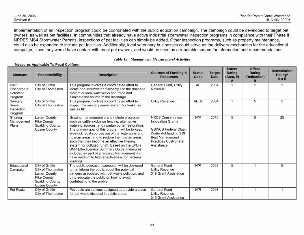
June 30, 2006 Plan for Potato Creek Watershed Revision #1 HUC :03130005
33
Implementation of an inspection program could be coordinated with the public education campaign. The campaign could be developed to target pet owners, as well as pet facilities. In communities that already have active industrial stormwater inspection programs in compliance with their Phase II NPDES MS4 Stormwater Permits, inspections of pet facilities can simply be added. Other inspection programs, such as property maintenance, could also be expanded to include pet facilities. Additionally, local veterinary businesses could serve as the delivery mechanism for the educational campaign, since they would have contact with most pet owners, and would be seen as a reputable source for information and recommendations.
Table 13: Management Measures and Activities Measures Applicable To Fecal Coliform
Measure Responsibility Description Sources of Funding & Resources
Status Code
Target Date
Extent Rating
(Area, #) A
Effect Rating
(Reduction) B
Remediation Rating* A x B
Illicit Discharge & Detection Program
City of Griffin City of Thomaston
This program involves a coordinated effort to locate non-stormwater discharges to the drainage system or local waterways and trace and eliminate the source of the discharge.
General Fund, Utility Revenue
AE 2004 1 1 1
Sanitary Sewer Inspection Program
City of Griffin City of Thomaston
This program involves a coordinated effort to inspect the sanitary sewer system for leaks, as well as I&I.
Utility Revenue AE, R 2004 1 5 5
Grazing Management Plans
Lamar County Pike County Spalding County Upson County
Grazing management plans include programs such as cattle exclusion fencing, alternative watering sources, and riparian buffer restoration. The primary goal of this program will be to keep livestock fecal sources out of the waterways and riparian areas, and to restore the riparian areas such that they become an effective filtering system for polluted runoff. Based on the EPD’s BMP Effectiveness Summary Guide, measures included as part of a Grazing Management plan have medium to high effectiveness for bacteria loadings.
NRCS Conservation Innovation Grants GSWCS Federal Clean Water Act funding 319 Best Management Practices Cost-Share Assistance
N/R 2010 5 5 25
Educational Campaign
City of Griffin City of Thomaston Lamar County Pike County Spalding County Upson County
The public education campaign will be designed to: a) inform the public about the potential dangers associated with pet waste pollution, and b) to educate the public on how to avoid contributing to the problem.
General Fund Utility Revenue 319 Grant Assistance
N/R 2008 5 1 5
Pet Posts City of Griffin City of Thomaston
Pet posts are stations designed to provide a place for pet waste disposal in public areas.
General Fund Utility Revenue 319 Grant Assistance
N/R 2008 1 1 1

June 30, 2006 Plan for Potato Creek Watershed Revision #1 HUC :03130005
34
Measure Responsibility Description Sources of Funding & Resources
Status Code
Target Date
Extent Rating
(Area, #) A
Effect Rating
(Reduction) B
Remediation Rating* A x B
Illicit Discharge/ Pet Waste Ordinance
City of Griffin City of Thomaston Lamar County Pike County Spalding County Upson County
All local governments should adopt an Illicit Discharge Ordinance that prohibits the passing of anything but uncontaminated stormwater to drainage systems and waterways. This ordinance would establish the local government’s authority to perform onsite inspections, monitor water quality, and issue violations to ensure compliance with the regulations.
General Fund Utility Revenue
AE 2007 5 1 5
Facility Inspections
City of Griffin City of Thomaston Lamar County Pike County Spalding County Upson County
In order to address sources such as the dog kennel identified by BST and other similar potential sources including veterinary or per boarding facilities, local governments should include these facilities in an industrial inspection program.
General Fund Utility Revenue
N/R 2007 1 3 3
* The “Remediation Rating” metric has been added to allow for quantified comparison between source impact and BMP remediation potential. The following key provides guidance for rating the estimated extent and portion of the contribution for each significant potential source and cause.
Estimated Extent of Application or Percentage of Individual Sources to Which the Management Measure or Activity Has or Will be Applied in the
Contributing Watershed
Estimated Effectiveness or Percent Removal of Constituent (Percent of load) Rating
None or Negligible (approximately 0-5%) None or Negligible (approximately 0-5%) .5 Scattered or Low (approximately 5-20%) Low to Medium (approximately 5-25%) 1 Medium (approximately 20-50%) Medium to High (approximately 25-75%) 3 Widespread or High (approximately 50% or more) High (approximately 75% or more) 5 Unknown Unknown Unk

June 30, 2006 Plan for Potato Creek Watershed Revision #1 HUC :03130005
35
Table 14: Evaluation Of Management Measures And Activities Applied To Specific Sources Or Causes
APPLICABLE TO FECAL COLIFORM Significant Potential Source(s)
or Cause(s)
(From Table 10)
Impact Rating (From
Table 11)
Existing, Currently Proposed, or Required
Management Measures or Enhancements
Applicable to Each Significant Source
(From Table 5A)
Remediation Rating (Total from
Table 13)
Evaluation: Will the estimated extent of application and effectiveness of existing,
currently proposed, and required management measures be adequate to
achieve the source reduction specified by the TMDL?
If management measures are estimated to be insufficient, recommend additional
management measures and activities which could effectively reduce loads
from significant sources
Sanitary Sewer Overflows
5 Illicit Discharge Detection and Elimination Sanitary Sewer Inspections
6 While it would be impossible to completely eradicate SSOs, local governments and utility operators can be vigilant in finding and repairing any leaks in the sanitary system. By implementing comprehensive and effective IDDE and Sanitary Sewer Inspection programs, fecal coliform loadings from SSOs will be kept to a minimum.
These BMPs are estimated to be sufficient to address this source, as the Remediation Rating is higher than the Impact Rating.
Identified Dog Kennel
1.5 Facility Inspections 3 An active inspection program that targets pet facilities will help to find and eliminate pet waste point sources such as the identified dog kennel.
These BMPs are estimated to be sufficient to address this source, as the Remediation Rating is higher than the Impact Rating.
Pet Waste 9 Education Campaign Pet Posts Illicit Discharge/Pet Waste Ordinance
11 Pet waste can be a significant source of fecal coliform, and owners need to pickup and properly dispose of their pets waste. An educational campaign will help owners to understand why this is necessary; pet posts will give owners the opportunity to properly dispose of waste, and the Ordinance will provide local governments with the authority necessary to compel people to pick up their pet’s waste.
These BMPs are estimated to be sufficient to address this source, as the Remediation Rating is higher than the Impact Rating.
Grazing Livestock
15 Grazing ManagementPlans
25 74.6 % of the Potato Creek Watershed has an agricultural or forestry land use, and approximately 61% or 322.3 miles of streams run adjacent to agricultural pasture land, which indicates that fecal coliform loadings from grazing livestock is potentially significant. If properly implemented, GMP should eliminate fecal loadings from these sources.
These BMPs are estimated to be sufficient to address this source, as the Remediation Rating is equal than the Impact Rating.

June 30, 2006 Plan for Potato Creek Watershed Revision #1 HUC :03130005
36
Significant Potential Source(s)
or Cause(s)
(From Table 10)
Impact Rating (From
Table 11)
Existing, Currently Proposed, or Required
Management Measures or Enhancements
Applicable to Each Significant Source
(From Table 5A)
Remediation Rating (Total from
Table 13)
Evaluation: Will the estimated extent of application and effectiveness of existing,
currently proposed, and required management measures be adequate to
achieve the source reduction specified by the TMDL?
If management measures are estimated to be insufficient, recommend additional
management measures and activities which could effectively reduce loads
from significant sources
Wildlife 5 None N/A Wildlife will always be a natural source of fecal coliform loadings. Grazing Management Plans will lead to improvement of the riparian buffer, which could potentially filter out fecal sources in runoff. However, wildlife is also likely to live within the buffer such that the net effect will be negligible.
N/A

June 30, 2006 Plan for Potato Creek Watershed Revision #1 HUC :03130005
37
VII. MONITORING PLAN The purposes of monitoring are to obtain more data to determine the sources of pollution, describe baseline conditions, and evaluate the effects of management and activities on water quality. Describe any sampling activities or other surveys - active, planned or proposed (including monitoring required for watershed assessments, or stormwater permits) - and their intended purpose. A Sample Quality and Assurance Plan (SQAP) will be submitted for any monitoring for listing decisions. A long-term monitoring program within the Potato Creek Watershed will be implemented to determine the effectiveness of the BMPs recommended within this document. The monitoring program will also be useful to document the effects of continued development on water quality within the Potato Creek Watershed. Monitoring conducted as part of the BST will be considered baseline data. Monitoring Locations Long term monitoring will be performed at the locations listed below and shown in the map in Figure 8. These locations were chosen to address 22 sub-watersheds, including those segments where fecal coliform sources were identified.
Table 15: Long Term Monitoring Sites
ID Number Road Name Stream Name
1 Pobiddy Road Potato Creek 2 Woodland Road Potato Creek 3 Crest Highway Potato Creek 4 Hannah’s Mill Road Potato Creek 5 Highway 19 Potato Creek / Drake Branch
5a 120 ft Northeast of U.S. Highway 19 Crossing Potato Creek 6 W Moores Crossing Road Potato Creek 7 Delray Road Potato Creek 8 Mud Bridge Road Potato Creek
10 Allen Road Potato Creek 11 Turner Bridge Road Potato Creek 12 State Route 18 Potato Creek 13 Zebulon Road Potato Creek 14 Ethridge Mill Road Potato Creek 17 Trice Road Potato Creek 18 Phillip Weldon Road Potato Creek 20 County Line Road Potato Creek 21 East College Street Grape Creek

June 30, 2006 Plan for Potato Creek Watershed Revision #1 HUC :03130005
38
ID Number Road Name Stream Name
22 Grandview Drive Potato Creek Tributary 23 Maple Drive Ison Branch
Methodology Water samples will be collected and analyzed according to the procedures outlined in the Sample Quality Assurance Plan, as approved by EPD prior to the beginning of the long-term monitoring. Water quality will be determined by analyzing water samples for the water quality parameters listed in the following table.
Table 16: Chemical Parameters
Parameter Rationale EPD Standard
Temperature Elevated temperatures will reduce water’s ability to hold oxygen. Can be effected by soil erosion and urban runoff. 32.2°C
pH Effects toxicity of metals. 6.0 – 8.5
Turbidity
Excessive turbidity can increase water temperature, decrease oxygen, and impact biology. Often results from soil erosion and urban runoff. Good indicator of poor land development practices and effectiveness of stormwater management activities.
(1)
Conductivity Presence of contaminating ions can indicate wastewater (sanitary or industrial). (1)
Fecal Coliform Used as indicator of presence of other forms of microbes, which may be harmful to humans. Results from sewage effluent, animal waste, urban runoff, and failing septic systems.
Summer: 200 Winter: 1,000
CFU/100ml (2)
E. coli Bacteria that can survive in salt water and are common to fecal material from warm blooded animals including human. (1)
Fluorometry Fluorometer is a relatively inexpensive sampling method that will determine if any fecal bacteria loading detected is the result of wastewater discharge.
(1)
(1) EPD has not established a standard for this parameter (2) Geometric mean
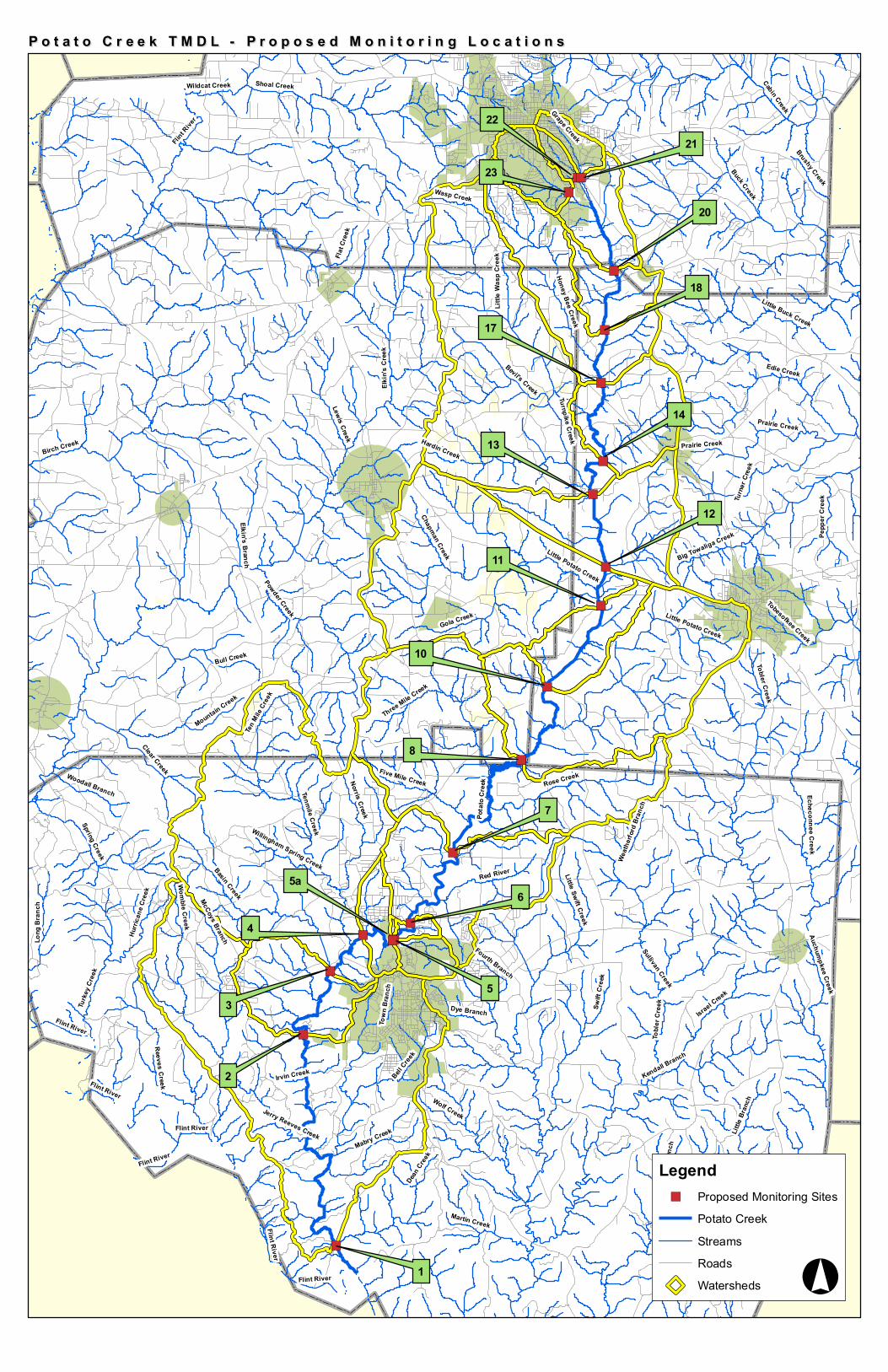
")
")
")
")
")
")
")
")
")
")
")
")
")")
")
")
")
")
")
")
1
2
3
4
5a
5
6
8
7
10
11
12
13
14
17
18
20
2221
23
Elkin'
s Cree
k
Swift
Cree
k
Birch Creek
Cabin Creek
Little Swift Creek
Pota
to Cr
eek
Bell Cree
k
Basin Creek
Edie Creek
Buck Creek
Rose Creek
Wolf Creek
Auchumpkee Creek
Sullivan Creek
Wasp Creek
Bull Creek
Womble Creek
Gola Creek
Flint R
iver
Israel Creek
Dean Cree
k
Turne
r Cree
k
Reeves Creek
Turke
y Cree
k
Big Towaliga Creek
Powder Creek
Hardin Creek
Little Potato Creek
Mountain Creek
Echeconnee Creek
Red River
Turnpike Creek
Shoal Creek
Little Buck Creek
Town
Bran
ch
McCoys Branch
Tenmile Creek
Bevil's Creek
Norris Creek
Kendall Branch
Little
Bran
ch
Five Mile Creek
Toble
r Cre
ek
Little Creek
Mabry Creek
Chapman Creek
Lewis Creek
Long
Bra
nch
Grape Creek
Martin Creek
Fourth Branch
Irvin Creek
Spring Creek
Dye Branch
Jerry Reeves Creek
Pepp
er C
reek
Clear Creek
Elkin's Branch
Three Mile Creek
Ten M
ile Cr
eek
Hurri
cane
Cree
k
Tobesofkee Creek
Woodall Branch
Flat C
reek
Hors
eley B
ranch
Wildcat Creek
Little
Was
p Cre
ek
Brushy Creek
Honey Bee Creek
Willingham Spring Creek Weath
erford
Bran
ch
Prairie Creek
Flint River
Flint River
Flint River
Tobler Creek
Prairie Creek
Flint River
Flint River
Little Potato Creek
Flint River
Auchumpkee CreekP o t a t o C r e e k T M D L - P r o p o s e d M o n i t o r i n g L o c a t i o n sP o t a t o C r e e k T M D L - P r o p o s e d M o n i t o r i n g L o c a t i o n s
Legend") Proposed Monitoring Sites
Potato CreekStreamsRoadsWatersheds °

June 30, 2006 Plan for Potato Creek Watershed Revision #1 HUC :03130005
40
Schedule Bacteria sampling will be based on a geomean requiring the collection of four samples over a 30-day period. Bacteria sampling will be performed to calculate two geomeans per year including one geomean during the summer period from May through October and one in the winter period from November to April. Four geomeans will be calculated at the EPD monitoring station on Potato Creek, near Piedmont, such that the data could be used for possible reassessment. This will be addressed in the SQAP submitted to EPD prior to the start of the monitoring program. Sampling for all other parameters will be conducted in conjunction with the bacterial sampling although geomeans will not be calculated.
Table 17: Monitoring Plan
Time Frame Parameter(s) to be Monitored Organization
Status (Current, Proposed,
Planned) Start End
Purpose (If for delisting, date of SQAP submission)
Temperature McIntosh Trail RDC Proposed 2008 2013 2007 pH McIntosh Trail RDC Proposed 2008 2013 2007 Turbidity McIntosh Trail RDC Proposed 2008 2013 2007 Conductivity McIntosh Trail RDC Proposed 2008 2013 2007 Fecal Coliform* McIntosh Trail RDC Proposed 2008 2013 2007 * Delisting Sampling at EPD Site McIntosh Trail RDC Proposed 2008 2008 2007 E. Coli McIntosh Trail RDC Proposed 2008 2013 2007 Flourometry McIntosh Trial RDC Proposed 2008 2012 2007
June 30, 2006 Plan for Potato Creek Watershed Revision #1 HUC :03130005
41
VIII. PLANNED OUTREACH FOR IMPLEMENTATION The following table lists and describes outreach activities that will be conducted to support this plan and the implementation of it.
Table 18: Planned Outreach
Responsibility Description Audience Date Public Hearings The MTRDC will conduct public hearings to introduce
this TMDL IP to the public, and give the public a chance for meaningful input.
General Public June 2006
Press Release Upon approval of the TMDL IP the MTRDC will issue a press release detailing the recommended BMPs.
General Public Dec 2006
Educational Campaign The MTRDC will lead the effort to launch an education program for pet owners.
General Public, Pet Owners, Pet Facilities Dec 2008
Grazing Management Plan Outreach
In an effort to encourage the implementation of this BMP, the MTRDC will lead an outreach effort to inform the agricultural community of the need to implement grazing management plans, and the resources available to help with the cost.
Agricultural Community Dec 2009

June 30, 2006 Plan for Potato Creek Watershed Revision #1 HUC :03130005
42
IX. MILESTONES/ MEASURES OF PROGESS OF BMPs AND OUTREACH Table 19 will be used to periodically track and report progress of significant management practices and activities identified or recommended in Tables 11 and 13, including outreach, additional monitoring and assessments, and the enhancement or installation of management measures and activities. This table can be "pulled out" of this template and used to report and track progress.
Table 19: Milestones Management Measure or
Activity Responsible Organizations Status Proposed Installed Comment
Illicit Discharge Detection and Elimination City of Griffin City of Thomaston
2004 The City of Griffin implemented this program in 2004. The City of Thomaston will work to implement this program.
Sanitary Sewer Inspection Program City of Griffin City of Thomaston
2004 This program is ongoing for the Cities of Griffin and Thomaston and is a requirement of their wastewater permits.
Grazing Management Plans Lamar County Pike County Spalding County Upson County McIntosh Trail RDC
2010 The MTRDC will work with the member Counties to secure funding to hire a coordinator for this program. The coordinator will provide outreach to local farmers, and will ask as a liaison between local farmers and funding agencies including the NRCS and GSWCC.
Educational Campaign McIntosh Trail RDC 2008 The MTRDC will develop and launch an educational campaign for pet owners. The MTRDC will seek grant funding to implement this program.
Pet Posts City of Griffin City of Thomaston
2008 These BMPs are to be installed in public areas where pet owners walk their dogs.
Illicit Discharge/Pet Waste Ordinance City of Griffin City of Thomaston Lamar County Pike County Spalding County Upson County
2007 All local governments will adopt or amend an applicable ordinance to address this BMP.
Facility Inspections City of Griffin City of Thomaston Lamar County Pike County Spalding County Upson County
2007 After adoption of the ordinance, local governments should begin inspecting pet facilities including kennels and vet offices to ensure that pet wastes are properly disposed.
Long Term Monitoring City of Griffin City of Thomaston Lamar County Pike County Spalding County Upson County McIntosh Trail RDC
2008 Water quality monitoring will be conducted to assess the effectiveness of the BMPs included in this report. Additional monitoring will be conducted in an effort to de-list Potato Creek. A SQAP will be submitted for approval before monitoring program begins. The monitoring data will be interpreted at the end of a five-year implementation period to determine BMP effectiveness.

June 30, 2006 Plan for Potato Creek Watershed Revision #1 HUC :03130005
43
PROJECTED ATTAINMENT DATE
The projected date to attain and maintain water quality standards in this watershed is 10 years from acceptance of the TMDL Implementation Plan by Georgia EPD.
◊
1999 2000 2001 2002 2003 2004 2005 2006 2007 2008 2009 2010 2011 2012 2013 2014 2015 2016
Scheduled EPD Basin Group Monitoring TMDL Completed
Revised or Updated TMDL Implementation Plan Accepted ◊ Evaluation of Implementation Plan/Water Quality Improvement Project Attainment for Plans Prepared in 2006
June 30, 2006 Plan for Potato Creek Watershed Revision #1 HUC :03130005
44
X. BIBLIOGRPAHY Agriculture Pollution Prevention Program (AGP2). 2006. Environmental Assessments. [online] Accessed at www.AGP2.org/env_assess/. (Verified 5
Jan 2006)
Alderserio, K., D. Wait and M. Sobsey. 1996. Detection and Characterization of Male-Specific RNA Coliphages in a New York City Reservoir to Distinguish Between Human and Non-human Sources of Contamination. Proceedings of a Symposium on New York City Water Supply Studies, ed. McDonnell et al. TPS-96-2. American Water Resources Association. Herndon, VA.
Byers, H. L., M. L. Cabrera, M. K. Matthews, D. H. Franklin, J. G. Andrae, D. E. Radcliffe, M. A. McCann, H. A. Kuykendall, C. S. Hoveland, and V. H. Calvert, II. 2005. Phosphorus, sediment, and Escherichia coli loads in unfenced streams of the Georgia Piedmont, USA. J. Environ. Qual. 34:2293-2300.
Chester County Water Resources Authority and the Chester County Health Department, 2003. Identification of Potential Sources, Modes of Transport, and Storage Properties of E. coli, Enterococcus, and Fecal Coliform Bacteria in West Branch Brandywine Creek, Chester County Pennsylvania. [online] Accessed at http://pa.water.usgs.gov/malvern/west_branch_bacteria.html (Verified 5 Jan 2006).
Griffith, G.E., Omernik, J.M., Comstock, J.A., Lawrence, S., Martin, G., Goddard, A., Hulcher, V.J., and Foster, T., 2001, Ecoregions of Alabama and Georgia, (color poster with map, descriptive text, summary tables, and photographs): Reston, Virginia, U.S. Geological Survey (map scale 1:1,700,000).
Kuntz, R. L., P. G. Hartel, K. Rodgers, and W. I. Segars. 2004. Presence of Enterococcus faecalis in broiler litter and wild bird feces for bacterial
source tracking. Water Res. 38:3551-3557.
Trial, W. et al. 1993. Bacterial Source Tracking: Studies in an Urban Seattle Watershed. Puget Sound Notes. 30:1-3.
U.S. Environmental Protection Agency (USEPA). 1986. Ambient water quality criteria for bacteria–1986. USEPA Rep. 440/5-84-002. USEPA, Cincinnati, OH.
US Environmental Protection Agency (USEPA,). 1993. National Management Measures to Control Nonpoint Source Pollution from Agriculture. Available at http://www.epa.gov/owow/nps/agmm/ (accessed 28 Dec 2005; verified 6 Jan 2006.)
US Environmental Protection Agency (USEPA,). 1993a. Guidance Specifying Management Measures for Sources of Nonpoint Pollution in Coastal Waters. USEPA, Office of Water. Washington, DC.
U.S. Environmental Protection Agency (USEPA). 2005. Microbial source tracking guide document. EPA/600-R-05-064. Office of Research and Development, Cincinnati, OH.
U.S. Environmental Protection Agency (USEPA). 2006. Webpage, “Sanitary Sewer Overflows” Available at http://cfpub.epa.gov/npdes/home.cfm?program_id=4 (accessed 10 Jan 2006). USEPA, Office of Water, Washington, DC.
Van Donsel, D. J., E. E. Geldreich, and N. A. Clarke. 1967. Seasonal variations in survival of indicator bacteria in soil and their contribution to storm water pollution. Appl. Microbiol. 15:1362-1370.

June 30, 2006 Plan for Potato Creek Watershed Revision #1 HUC :03130005
45
Prepared By: Courtney Power Agency: Integrated Science & Engineering
105 McIntosh Crossing Address: City: Fayetteville ST: GA ZIP: 30214 E-mail: [email protected] Date Submitted to EPD: June 30, 2006 Revision: I
The preparation of this report was financed in part through a grant from the U.S. Environmental Protection Agency under the provisions of Section 106 of the Federal Water Pollution Control
Act, as amended.

June 30, 2006 Plan for Potato Creek Watershed Revision #1 HUC :03130005
46
APPENDIX A.
STAKEHOLDERS
List the names, addresses, telephone numbers, and e-mail addresses for local governments, agricultural or commercial forestry organizations, significant landholders, businesses and industries, and local organizations including environmental groups and individuals with a major interest in this watershed.
NAME/ORG ADDRESS CITY STATE ZIP PHONE E-MAIL Milton McCarthney/ City of Griffin
134 North Hill Street Griffin GA 30224 770.233.4138
Clint Ozier/ Georgia Forestry Commission
187 Corinth Road Newnan GA 30263 770.254.7218 [email protected]
Peter Hartel/ University of Georgia
3111 Miller Plant Sciences Bldg Athens GA 30602-7272 706.542.0898
Paul Rogers/ Upson County
P.O. Box 889 Thomaston GA 30286-0012 706.647.7012
Carol Oliver/ NRCS Barnesville
231 Highway 41 North, Suite B Barnesville GA 30204 770.358.0787 [email protected]
Courtney Power/ Integrated Science & Engineering
105 McIntosh Crossing Fayetteville GA 30214 770.461.4292 [email protected]
Joel Pots/ Upson County
P.O. Box 889 Thomaston GA 30286-0012 706.647.7012
Steve Hudson/ Upson County
P.O. Box 889 Thomaston GA 30286-0012 706.647.7012
William Wilson/ Spalding County
P.O. Box 1087 Griffin GA 30224-0028 770.467.4200
D Jay Arnold/ City of Thomaston
250 E. Lee Street Thomaston GA 30286 706.647.4242
Patrick Cumiskey/ City of Thomaston
250 E. Lee Street Thomaston GA 30286 706.647.4242
Eddie Travis/ Butts County
625 West 3rd Street, Suite 4 Jackson GA 30233 770.775.8200 N/A
Burt D. Kivis/ City of Griffin
134 North Hill Street Griffin GA 30224 770.233.4138
Dan Davis/ Integrated Science & Engineering
105 McIntosh Crossing Fayetteville GA 30214 770.461.4292 [email protected]
Abby Barnes/ Integrated Science & Engineering
105 McIntosh Crossing Fayetteville GA 30214 770.461.4292 [email protected]
June 30, 2006 Plan for Potato Creek Watershed Revision #1 HUC :03130005
47
Charles Absher/ PBS&J
5665 New Northside Drive, Suite 400
Atlanta GA 30328-4617 770 933-0280
Lanier Boatwright/ McIntosh Trail RDC
120 North Hill Street Griffin GA 30224 770.227.6349
Brant Keller/ City of Griffin
134 North Hill Street Griffin GA 30224 770.233.4138
E. Wendell Becker/ Pike County
P.O. Box 377 Zebulon GA 30295-0377 770.567.3406
Randy Ekerberg/ City of Thomaston
250 E. Lee Street Thomaston GA 30286 706.647.4242
Patrick Barber/ McIntosh Trail RDC
120 North Hill Street Griffin GA 30224 770.227.6349
Adam Hazell/ McIntosh Trail RDC
120 North Hill Street Griffin GA 30224 770.227.6349
Karen Rogers/ University of Georgia
3111 Miller Plant Sciences Bldg Athens GA 30602-7272 706.542.0898
Chuck Taylor/ Spalding County
P.O. Box 1087 Griffin GA 30224-0028 770.467.4200

June 30, 2006 Plan for Potato Creek Watershed Revision #1 HUC :03130005
48
APPENDIX B.
UPDATES TO THIS PLAN Describe any updates made to this plan. Include the date, section or table updated, and a summary of what was changed and why.

June 30, 2006 Plan for Potato Creek Watershed Revision #1 HUC :03130005
49
APPENDIX C
APPROVED QUALITY ASSURANCE PROTECTION PLAN
June 30, 2006 Plan for Potato Creek Watershed Revision #1 HUC :03130005
50
APPENDIX D
PUBLIC INVOLVEMENT DOCUMENTATION