state of california state water … feather river sacramento river 07/01-09/30 from the confluence...
TRANSCRIPT

STATE OF CALIFORNIA
STATE WATER RESOURCES CONTROL BOARD
EXHIBIT A
WATER RIGHT ORDER 98-08
DECLARATION OF FULLY APPROPRIATED STREAM SYSTEMS
NOVEMBER 19, 1998
Notes: (1) This order should be consulted for other conditions under which applications to appropriate water fromthe listed stream systems may be accepted for filing.
(2) Applicable statutes and regulations provide for revision of a declaration that a stream system is fullyappropriated. The State Water Resources Control Board, Division of Water Rights, should be contacted to obtainthe version of this declaration which is currently in effect.

STATE WATER RESOURCES CONTROL BOARDDECLARATION OF FULLY APPROPRIATED STREAM SYSTEMS
EXPLANATION OF NOTATIONS IN THE DECLARATION
Attached are the revisions to Exhibit A, Declaration of Fully Appropriated Stream Systems by the State Water Resources Control Board dated November 19, 1998.
Footnotes:
(1) including all tributaries where hydraulic continuity exists.
(2) In accordance with the Public Resources Code, Division 5 Chapter 1.4, California Wild and Scenic Rivers Act, section 5093 et seq. it is the policy of the State of California, that certain rivers which possess extraordinary scenic, recreational,fishery, or wildlife values shall be preserved in their free-flowing state, together with their immediate environments, for the benefit and enjoyment of the people of the state. The Legislature declares that such use of these rivers is the highestand most beneficial use and is a reasonable and beneficial use of water within the meaning of section 2 of Article X of the California Constitution.
(3) In accordance with U.S.C.S., Title 16, Chapter 28, Federal Wild and Scenic Rivers Act, section 1271 et seq. it is hereby declared to be the policy of the United States that certain selected rivers of the Nation which, with their immediateenvironments, possess outstandingly remarkable scenic, recreational, geologic, fish and wildlife, historic, cultural, or other similar values, shall be preserved in free-flowing condition, and that they and their immediate environments shall beprotected for the benefit and enjoyment of present and future generations. The Congress declares that the established national policy of dam and other construction at appropriate sections of the rivers of the United States needs to becomplemented by a policy that would preserve other selected rivers or sections thereof in their free-flowing condition to protect the water quality of such rivers and to fulfill other vital national conservation purposes.
Note: Additional footnotes are included at the bottom of each page where noted.
Miscellaneous Notations:
* Water Code, Chapter 5, Article 1.5, section 1345 et seq. provides that the State Water Resources Control Board (SWRCB) Division of Water Rights shall conduct a field investigation and issue a decision /order of all minor protestedapplications.
** California Wild and Scenic Rivers Act, section 5093 et seq.
*** Federal Wild and Scenic Rivers Act, section 1271 et seq.
0000 Adjudicated Water Rights
Abbreviations:
Decision No. = decision number (refers to a water right decision.)
A = application
WR = water right (refers to a number on a water right order.)
Stream = name of stream
Tributary = source to which the stream is tributary.
Season of Unavailability = The dates reflect the beginning and ending dates when unappropriated water is unavailable for appropriation, based on a prior water right decision.
Sec. = Section on U.S. Geological Survey Quadrangle Map afa = acre-feet annuallyT = Township cfs = cubic feet per secondR = Range gpd = gallons per dayMDB&M = Mount Diablo Base and MeridianHB&M = Humboldt Base and MeridianSBB&M = San Bernardino Base and Meridian

DECLARATION OF FULLY APPROPRIATED STREAM SYSTEMS
County November 19, 1998
Decision Stream Tributary Season Critical ReachNo. Begin-End
Alameda Agua Caliente Creek San Francisco Bay 04/15-09/30 from where Agua Caliente Creek enters0375 tidal marsh in San Francisco Bay upstream (1)
Alameda1629 Kellogg Creek Old River 01/01-12/31 from Los Vaqueros Dam on Kellogg Creek located within the NW¼ of NW¼ of Projected Section 23, T1S, R2E, MDB&M upstream (1)
1

DECLARATION OF FULLY APPROPRIATED STREAM SYSTEMS
County November 19, 1998
Decision Stream Tributary Season Critical ReachNo. Begin-End
Alpine** Carson River 01/01-12/31(2) the East Fork from the Hangman's Bridge crossing of State Highway Route 89 to the California-Nevada border
Alpine0000 East Fork Carson River Carson River 04/01-11/30 from the Nevada County line upstream (1)
Alpine0000 West Fork Carson River Carson River 04/01-11/30 from the Nevada County line upstream (1)
Alpine0000 Stanislaus River Stream System San Joaquin River 04/01-11/30 from the confluence with the San Joaquin River upstream (1)
Alpine0609 Shay Creek East Fork Carson River 01/01-12/31 from the confluence with Hot Springs Creek upstream (1)
Alpine1527, Mokelumne River San Joaquin River 03/01-11/30 (n) from the Woodbridge Irrigation District's1109, point(s) of diversion upstream (1)0858
Alpine1422 Stanislaus River San Joaquin River 07/01-10/31 from the confluence with the San Joaquin River upstream (1)
Alpine1594 Sacramento-San Joaquin Delta Delta above 06/15-08/31 (a) from the Delta upstream (1) Collinsville
(a) For diversions less then one cfs or less than 100 afa of storage, no diversion is allowed from June 16 through August 31.
(n) During the months of March through June, the Declaration does not apply to proposed conjunctive use projects which are notdependent upon unappropriated water being available from the Mokelumne River in most years but which could utilize unappropriated waterin years when it is available. Applications for that type of project, if any, may be accepted for processing, and evidence of wateravailability shall be evaluated by the State Water Resources Control Board in the course of processing the applications.
2

DECLARATION OF FULLY APPROPRIATED STREAM SYSTEMS
County November 19, 1998
Decision Stream Tributary Season Critical ReachNo. Begin-End
Amador0684 South Fork Cosumnes River Middle Fork Cosumnes 04/15-10/31 from the confluence with Middle Fork River Cosumnes River upstream (1)
Amador0976, Jackson Creek Dry Creek thence 04/01-11/30 from the confluence with Dry Creek1109 Mokelumne River upstream (1)
Amador1527, Mokelumne River San Joaquin River 03/01-11/30 (n) from the Woodbridge Irrigation1109, District's point(s) of diversion0858 upstream (1)
Amador1311 Unnamed Stream Jackson Creek 04/01-09/30 from the confluence of New York Ranch (NW¼ NW¼, Sec 6, T6N, R12E, MDB&M) Gulch with Jackson Creek upstream (1)
Amador1369 Cosumnes River Mokelumne River 07/01-10/31 from the confluence with the Mokelumne River upstream (1)
Amador1397, Pioneer Creek Sutter Creek 04/01-12/01 from the confluence with Sutter Creek1219 upstream (1)
Amador1594 Sacramento-San Joaquin Delta Delta above 06/15-08/31 (a) from the Delta upstream (1) Collinsville
(a) For diversions less then one cfs or less than 100 afa of storage, no diversion is allowed from June 16 through August 31.
(n) During the months of March through June, the Declaration does not apply to proposed conjunctive use projects which are notdependent upon unappropriated water being available from the Mokelumne River in most years but which could utilize unappropriated waterin years when it is available. Applications for that type of project, if any, may be accepted for processing, and evidence of wateravailability shall be evaluated by the State Water Resources Control Board in the course of processing the applications.
3

DECLARATION OF FULLY APPROPRIATED STREAM SYSTEMS
County November 19, 1998
Decision Stream Tributary Season Critical ReachNo. Begin-End
Butte*** Middle Fork Feather River Feather River 01/01-12/31 (3) the entire Middle Fork downstream from the confluence of its tributary streams one kilometer south of Beckwourth, CA
Butte0000 Butte Creek Butte Slough 04/01-11/30 from the confluence of Butte Sink located in T17N, R1E, MDB&M upstream (1)
Butte0000 Dry Creek Cherokee Canal 04/01-11/30 from the confluence of Butte Sink located in T17N, R1E, MDB&M upstream (1)
Butte0000 Pine Creek Sacramento River 04/01-11/30 from the confluence of Pine Creek and the Sacramento River upstream (1)
Butte0367 Empire Creek W.Branch of N.F. 06/01-10/31 from the confluence with the West Branch Feather River of the North Fork Feather River upstream(1)
Butte0528 Honcut Creek Feather River 04/01-10/31 from the confluence of the Feather River upstream (1)
Butte0844 West Branch Feather River Feather River 07/01-11/30 from the upper Miocene Canal Head Dam on West Branch Feather River located in Section 30, T23N, R4E, MDB&M, upstream (1)
Butte1275 Feather River Sacramento River 07/01-09/30 from the confluence of the FeatherRiver and Sacramento River upstream (1)
Butte1329 Butte Creek Butte Slough thence 06/01-09/30 from the confluence with Butte Slough Sacramento River upstream (1)
Butte1594 Sacramento-San Joaquin Delta Delta above 06/15-08/31 (a) from the Delta upstream (1) Collinsville
ButteWR 96-04 Rock Creek Mud Creek tributary 06/01-09/30 from Keefer Ditch located within the SE¼ Big Chico Creek thence of NE¼, Section 14, T23N, R1E, MDB&M on Sacramento River Rock Creek upstream (1)
(a) For diversions less then one cfs or less than 100 afa of storage, no diversion is allowed from June 16 through August 31.
4

DECLARATION OF FULLY APPROPRIATED STREAM SYSTEMS
County November 19, 1998
Decision Stream Tributary Season Critical ReachNo. Begin-End
Calaveras0000 Stanislaus River Stream System San Joaquin River 04/01-11/30 from the confluence with the San Joaquin River upstream (1)
Calaveras0648 Campo Flores Gulch Middle Fork Mokelumne 06/01-11/30 from the confluence with the MokelumneRiver River upstream (1)
Calaveras0775 Cowell Creek San Antonio Creek thence 05/01-11/30 from the confluence with San Antonio Creek S.F. Calaveras River upstream (1)
Calaveras1037 Bear Creek Disappointment Slough 05/01-11/30 from the confluence with the San Joaquin thence San Joaquin River River at Disappointment Slough upstream (1)
Calaveras1527, Mokelumne River San Joaquin River 03/01-11/30 (n) from the Woodbridge Irrigation District's1109, point(s) of diversion upstream (1)858
Calaveras1123 Unnamed Stream Sullivan Creek 06/01-10/31 from the confluence with Sullivan Creek (SW¼ NW¼, Sec 8, T2N, R16E, MDB&M) upstream (1)
Calaveras1179 Calaveras River San Joaquin River 05/01-10/31 (k) from the confluence with the San Joaquin
River upstream (1)
Calaveras1422 Stanislaus River San Joaquin River 07/01-10/31 from the confluence with the San Joaquin River upstream (1)
Calaveras1594 Sacramento-San Joaquin Delta Delta above 06/15-08/31 (a) from the Delta upstream (1) Collinsville
(a) For diversions less then one cfs or less than 100 afa of storage, no diversion is allowed from June 16 through August 31.
(k) Except for reasonable quantities of water for stockwatering purposes within the Calaveras River Watershed due to a reservationabove New Hogan.
(n) During the months of March through June, the Declaration does not apply to proposed conjunctive use projects which are notdependent upon unappropriated water being available from the Mokelumne River in most years but which could utilize unappropriated waterin years when it is available. Applications for that type of project, if any, may be accepted for processing, and evidence of wateravailability shall be evaluated by the State Water Resources Control Board in the course of processing the applications.
5
DECLARATION OF FULLY APPROPRIATED STREAM SYSTEMS
County November 19, 1998
Decision Stream Tributary Season Critical ReachNo. Begin-End
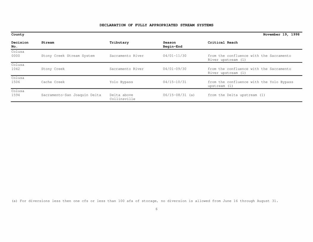
Colusa0000 Stony Creek Stream System Sacramento River 04/01-11/30 from the confluence with the Sacramento River upstream (1)
Colusa1042 Stony Creek Sacramento River 04/01-09/30 from the confluence with the Sacramento River upstream (1)
Colusa1506 Cache Creek Yolo Bypass 04/15-10/31 from the confluence with the Yolo Bypass upstream (1)
Colusa1594 Sacramento-San Joaquin Delta Delta above 06/15-08/31 (a) from the Delta upstream (1) Collinsville
(a) For diversions less then one cfs or less than 100 afa of storage, no diversion is allowed from June 16 through August 31.
6

DECLARATION OF FULLY APPROPRIATED STREAM SYSTEMS
County November 19, 1998
Decision Stream Tributary Season Critical ReachNo. Begin-End
Contra Costa0058 Walnut Creek Suisun Bay 05/01-11/30 from the confluence with Suisun Bay upstream (1)
Contra Costa0927 San Leandro Creek San Francisco Bay 01/01-12/31 from the confluence with San Francisco Bay upstream (1)
Contra Costa1594 Sacramento-San Joaquin Delta Delta above 06/15-08/31 (a) from the Delta upstream (1) Collinsville
Contra Costa1629 Kellogg Creek Old River 01/01-12/31 from Los Vaqueros Dam on Kellogg Creek located within the NW¼ of NW¼, Projected Section 23, T1S, R2E, MDB&M upstream (1)
(a) For diversions less then one cfs or less than 100 afa of storage, no diversion is allowed from June 16 through August 31.
7
DECLARATION OF FULLY APPROPRIATED STREAM SYSTEMS
County November 19, 1998
Decision Stream Tributary Season Critical ReachNo. Begin-End
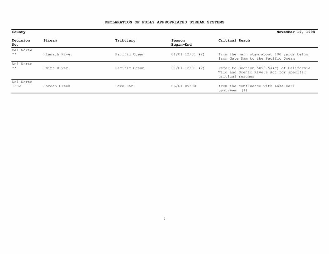
Del Norte** Klamath River Pacific Ocean 01/01-12/31 (2) from the main stem about 100 yards below Iron Gate Dam to the Pacific Ocean
Del Norte** Smith River Pacific Ocean 01/01-12/31 (2) refer to Section 5093.54(c) of California Wild and Scenic Rivers Act for specific critical reaches
Del Norte1382 Jordan Creek Lake Earl 06/01-09/30 from the confluence with Lake Earl upstream (1)
8

DECLARATION OF FULLY APPROPRIATED STREAM SYSTEMS
County November 19, 1998
Decision Stream Tributary Season Critical ReachNo. Begin-End
El Dorado0163, Silver Creek South Fork American 07/01-12/31 from the confluence with the South Fork1211 River American River upstream (1)
El Dorado0258 Alder Creek South Fork American 06/15-11/30 from the confluence with the South Fork River American River upstream (1)
El Dorado0392 Unnamed Stream Unnamed Stream thence 05/01-10/31 from the confluence of the unnamed stream (NW¼, Sec 4, T10N, R12E, MDB&M) Iowa Canyon tributary to the unnamedstream tributary to Iowa Canyon upstream (1)
El Dorado0429 Unnamed Stream Randolph Canyon 04/01-10/31 from the confluence with Randolph Canyon (S½, Sec 4, T10N, R11E, MDB&M) upstream (1)
El Dorado0684 South Fork Cosumnes Middle Fork Cosumnes 04/15-10/31 from the confluence with the Middle Fork River River Cosumnes River upstream (1)
El Dorado0698 Unnamed Stream Black Rock Creek 04/15-10/31 from the confluence with Black RockCreek (W½, Sec 28, T12N, R29E, MDB&M) (formerly Fish Creek) upstream (1)
El Dorado0707 Unnamed Stream Hangtown Creek thence 06/01-10/31 from the confluence with Hangtown Creek (SW¼ NW¼, Sec 12, T10N, Webber Creek upstream (1) R10E, MDB&M)
El Dorado0776 Sugar Loaf Creek South Fork American 06/15-10/31 from the confluence with the South Fork River American River upstream (1)
El Dorado1041 Unnamed Stream Coloma Canyon thence 05/01-10/31 from the confluence with Coloma Canyon (NW¼ NE¼, Sec 28, T12N, R10E, South Fork American upstream (1) MDB&M) River
El Dorado1166 Johntown Creek Dutch Creek thence 06/01-10/31 on Johntown Creek located approximately S.F. American River one-half mile downstream from the applicants point of diversion located within the N½, Section 4, T11N, R10E, MDB&M upstream (1)
9
DECLARATION OF FULLY APPROPRIATED STREAM SYSTEMS
County November 19, 1998
Decision Stream Tributary Season Critical ReachNo. Begin-End
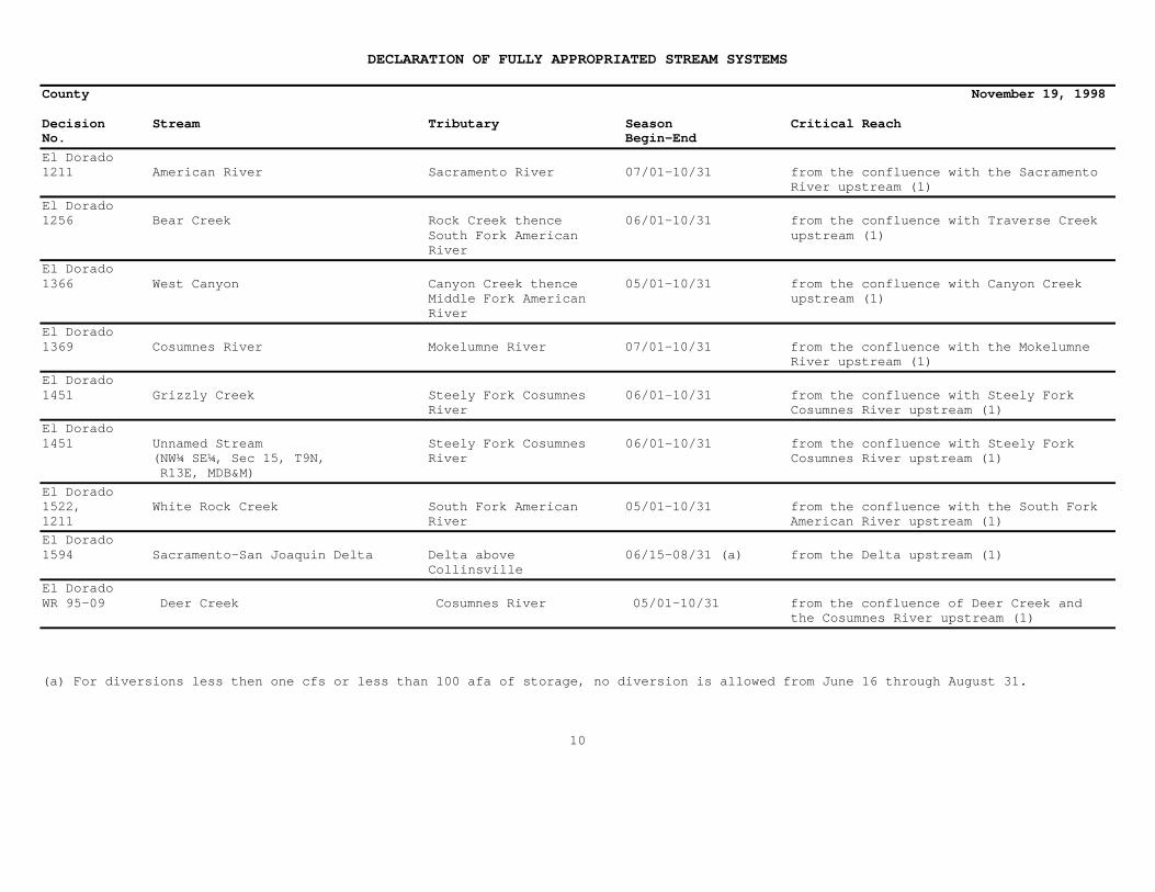
El Dorado1211 American River Sacramento River 07/01-10/31 from the confluence with the Sacramento River upstream (1)
El Dorado1256 Bear Creek Rock Creek thence 06/01-10/31 from the confluence with Traverse Creek South Fork American upstream (1) River
El Dorado1366 West Canyon Canyon Creek thence 05/01-10/31 from the confluence with Canyon Creek Middle Fork American upstream (1) River
El Dorado1369 Cosumnes River Mokelumne River 07/01-10/31 from the confluence with the Mokelumne River upstream (1)
El Dorado1451 Grizzly Creek Steely Fork Cosumnes 06/01-10/31 from the confluence with Steely Fork River Cosumnes River upstream (1)
El Dorado1451 Unnamed Stream Steely Fork Cosumnes 06/01-10/31 from the confluence with Steely Fork (NW¼ SE¼, Sec 15, T9N, River Cosumnes River upstream (1) R13E, MDB&M)
El Dorado1522, White Rock Creek South Fork American 05/01-10/31 from the confluence with the South Fork1211 River American River upstream (1)
El Dorado1594 Sacramento-San Joaquin Delta Delta above 06/15-08/31 (a) from the Delta upstream (1) Collinsville
El DoradoWR 95-09 Deer Creek Cosumnes River 05/01-10/31 from the confluence of Deer Creek and the Cosumnes River upstream (1)
(a) For diversions less then one cfs or less than 100 afa of storage, no diversion is allowed from June 16 through August 31.
10

DECLARATION OF FULLY APPROPRIATED STREAM SYSTEMS
County November 19, 1998
Decision Stream Tributary Season Critical ReachNo. Begin-End
Fresno*** Kings River Tulare Lake Basin 01/01-12/31 (3) the main stem of the Kings River from the confluence of the Middle Fork and the South Fork to the point at elevation 1,595 feet above mean sea level
Fresno*** Middle Fork Kings River Kings River 01/01-12/31 (3) the Middle Fork of the Kings River from its headwaters at Lake Helen betweenMuir Pass and Black Giant Mountain to its confluence with the main stem
Fresno*** South Fork Kings River Kings River 01/01-12/31 (3) the South Fork of the Kings River from its headwaters at Lake 11599 to its confluence with the main stem
Fresno0935 San Joaquin River Delta 01/01-12/31 from the confluence with Mendota Pool upstream (1)
Fresno1290, Kings River System Tulare Lake Basin 01/01-12/31 from Tulare Lake Basin upstream (1)1505
Fresno1290 Fresno Slough San Joaquin River 01/01-12/31 from the confluence with the San Joaquin River upstream to the Kings River and including the upstream watershed of the Kings River
Fresno1435, Tule River System Tulare Lake Basin 01/01-12/31 from the terminus at Tulare Lake Basin1018, upstream including all tributaries in the1432 Tule River System where hydraulic continuity exists during any part of the year
Fresno1594 Sacramento-San Joaquin Delta Delta above 06/15-08/31 (a) from the Delta upstream (1) Collinsville
(a) For diversions less then one cfs or less than 100 afa of storage, no diversion is allowed from June 16 through August 31.
11

DECLARATION OF FULLY APPROPRIATED STREAM SYSTEMS
County November 19, 1998
Decision Stream Tributary Season Critical ReachNo. Begin-End
Glenn0000 Stony Creek Stream System Sacramento River 04/01-11/30 from the confluence of the Sacramento River upstream (1)
Glenn0879 Unnamed Stream Colusa Drain thence 04/01-10/31 from the Colusa Drain at California (SW¼ NE¼, Sec 2, T21N, R3W, MDB&M) Sacramento River Coordinates 82,000 east and 75,000 north following a northwesterly course upstream (1)
Glenn1031 Unnamed Drain Glenn Colusa Canal 04/01-09/30 from the junction of the unnamed drain (SW¼ SE¼, Sec 3, T22N, R2W, MDB&M) and the Glenn Colusa Canal, located in Projected Section 12, T22N, R2W, MDB&M upstream (1)
Glenn1594 Sacramento-San Joaquin Delta Delta above 06/15-08/31 (a) from the Delta upstream (1) Collinsville
(a) For diversions less then one cfs or less than 100 afa of storage, no diversion is allowed from June 16 through August 31.
12

DECLARATION OF FULLY APPROPRIATED STREAM SYSTEMS
County November 19, 1998
Decision Stream Tributary Season Critical ReachNo. Begin-End
Humboldt** Eel River Pacific Ocean 01/01-12/31 (2) the main stem from 100 yards below Van Arsdale Dam to the Pacific Ocean
Humboldt** Klamath River Pacific Ocean 01/01-12/31 (2) from the main stem about 100 yards below Iron Gate Dam to the Pacific Ocean
Humboldt** South Fork Eel River Eel River 01/01-12/31 (2) the South Fork of the Eel from the mouth of Section Four Creek near Branscomb to the river mouth below Weott
Humboldt** South Fork Trinity River Trinity River 01/01-12/31 (2) South Fork of the Trinity from the junction of the river with State Highway Route 36 to the river mouth near Salver
Humboldt** Trinity River Klamath River 01/01-12/31 (2) the main stem from 100 yards below Lewiston Dam to the river mouth at Weitchpec
Humboldt** Van Duzen River Eel River 01/01-12/31 (2) Van Duzen River from Dinsmore Bridge downstream to the river mouth near Fortuna
Humboldt0531 Jacoby Creek Humboldt/Arcata Bay 08/01-09/30 from the confluence of Jacoby Creek and Humboldt/Arcata Bay upstream (1)
Humboldt1259 Mad River Pacific Ocean 06/01-10/31 from the mouth of the Mad River at the Pacific Ocean upstream (1)
13

DECLARATION OF FULLY APPROPRIATED STREAM SYSTEMS
County November 19, 1998
Decision Stream Tributary Season Critical ReachNo. Begin-End
Inyo0000 Oak Creek Owens River 04/01-11/30 from the confluence of the Owens River upstream (1)
Inyo0001 Warm Springs Owens River 04/01-10/31 from the confluence of the Owens River upstream (1)
Inyo0165 Thompson Canyon Panamint Valley 01/01-12/31 at the spring sources (Sec 10, T20S, R42E, MDB&M)
Inyo0402 Birch Creek Tinemaha Creek thence 01/01-12/31 from the confluence of Tinemaha Creek Owens River upstream (1)
Inyo0402 Milk Creek Tinemaha Creek thence 05/01-08/31 from the confluence of Tinemaha Creek Owens River upstream (1)
Inyo0694 Darwin Wash Panamint Valley 01/01-12/31 from a point on Darwin Wash located within the NE¼ SE¼, Sec 17, T19S, R41E, MDB&M upstream (1)
14
DECLARATION OF FULLY APPROPRIATED STREAM SYSTEMS
County November 19, 1998
Decision Stream Tributary Season Critical ReachNo. Begin-End
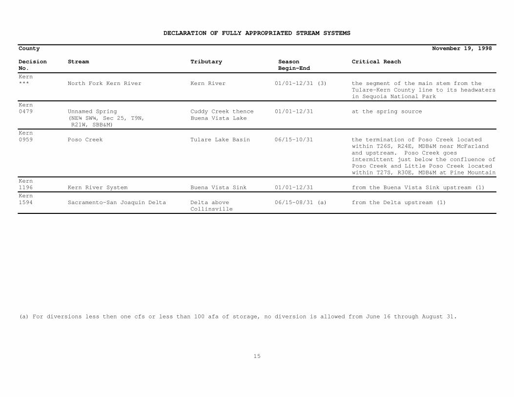
Kern*** North Fork Kern River Kern River 01/01-12/31 (3) the segment of the main stem from the Tulare-Kern County line to its headwaters in Sequoia National Park
Kern0479 Unnamed Spring Cuddy Creek thence 01/01-12/31 at the spring source (NE¼ SW¼, Sec 25, T9N, Buena Vista Lake R21W, SBB&M)
Kern0959 Poso Creek Tulare Lake Basin 06/15-10/31 the termination of Poso Creek located within T26S, R24E, MDB&M near McFarland and upstream. Poso Creek goes intermittent just below the confluence of Poso Creek and Little Poso Creek located within T27S, R30E, MDB&M at Pine Mountain
Kern1196 Kern River System Buena Vista Sink 01/01-12/31 from the Buena Vista Sink upstream (1)
Kern1594 Sacramento-San Joaquin Delta Delta above 06/15-08/31 (a) from the Delta upstream (1) Collinsville
(a) For diversions less then one cfs or less than 100 afa of storage, no diversion is allowed from June 16 through August 31.
15

DECLARATION OF FULLY APPROPRIATED STREAM SYSTEMS
County November 19, 1998
Decision Stream Tributary Season Critical ReachNo. Begin-End
Kings1290 Kings River System Tulare Lake Basin 01/01-12/31 from Tulare Lake Basin upstream (1)
Kings1435, Tule River System Tulare Lake Basin 01/01-12/31 from the terminus at Tulare Lake Basin1018, upstream including all tributaries in1432 the Tule River System where hydraulic continuity exists during any part of the yearKings1594 Sacramento-San Joaquin Delta Delta above 06/15-08/31 (a) from the Delta upstream (1) Collinsville
(a) For diversions less then one cfs or less than 100 afa of storage, no diversion is allowed from June 16 through August 31.
16

DECLARATION OF FULLY APPROPRIATED STREAM SYSTEMS
County November 19, 1998Decision Stream Tributary Season Critical ReachNo. Begin-End
Lake0050 Putah Creek Sacramento River 07/15-10/31 from the confluence of Coyote Creek located in Section 20, T11N, R6W, MDB&M upstream (1)
Lake0869, Putah Creek Yolo Bypass 01/01-12/31 (c) from Monticello Dam upstream (1)WR 96-002
Lake0956 Long Valley Creek North Fork Cache Creek 04/01-09/30 from the confluence of North Fork Cache Creek upstream (1)
Lake1441 Scotts Creek Clear Lake 05/15-09/30 from the confluence of Clear Lake upstream (1)
Lake1506 Cache Creek Yolo Bypass 04/15-10/31 from the confluence with the Yolo Bypass upstream (1)
Lake1594 Sacramento-San Joaquin Delta Delta above 06/15-08/31 (a) from the Delta upstream (1) Collinsville
(a) For diversions less then one cfs or less than 100 afa of storage, no diversion is allowed from June 16 through August 31.
(c) Applications to appropriate water above Monticello Dam in Lake and Napa counties will not be processed by the State Water Resources Control Board without first determining the availability of water under the Condition 12 Settlement Agreement dated March 10, 1995.
17

DECLARATION OF FULLY APPROPRIATED STREAM SYSTEMS
County November 19, 1998
Decision Stream Tributary Season Critical ReachNo. Begin-End
Lassen0000 Baxter Creek Stream System Honey Lake 04/01-11/30 from the confluence of Honey Lake upstream (1)
Lassen0000 Baxter Creek Spring Baxter Creek 04/01-11/30 at the spring
Lassen0000 Hallett Creek Honey Lake 04/01-11/30 from the confluence of Honey Lake (Sections 22-24 and 27-28, T28N, upstream (1) R13E, MDB&M)
Lassen0000 Mill Creek Honey Lake 04/01-11/30 from the confluence of Honey Lake upstream (1)
Lassen0000 Parker Creek Honey Lake 04/01-11/30 from the confluence of Honey Lake upstream (1)
Lassen0000 Pit River in Big Valley Pit River 04/01-11/30 from the confluence of the Pit River in Big Valley and the Pit River upstream except for Ash Creek
Lassen0000 South Fork Pit River Pit River 04/01-11/30 from the confluence of the South Fork Pit River and Pit River upstream (1)
Lassen0000 Ash Creek Pit River 03/15-10/31 from the confluence of the Pit River1237 upstream (1)
Lassen0000, Long Valley Creek Honey Lake 03/01-09/30 from the confluence of Honey Lake1444 upstream (1)
Lassen0000, Susan River Honey Lake 03/01-10/31 from the confluence of Honey Lake1572 upstream (1)
Lassen0000, Tule Lake Reservoir Cedar Creek 01/01-12/31 from the Tule Lake Reservoir1618 upstream (1)
18
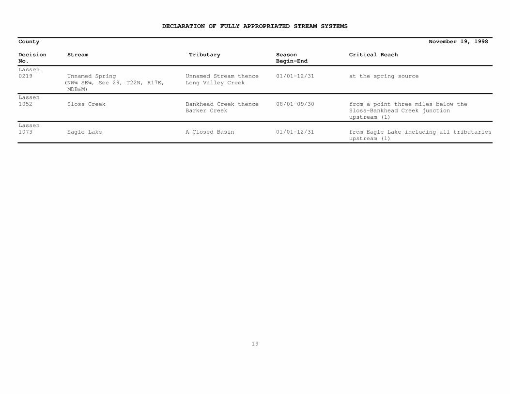
DECLARATION OF FULLY APPROPRIATED STREAM SYSTEMS
County November 19, 1998
Decision Stream Tributary Season Critical ReachNo. Begin-End
Lassen0219 Unnamed Spring Unnamed Stream thence 01/01-12/31 at the spring source (NW¼ SE¼, Sec 29, T22N, R17E, Long Valley Creek MDB&M)
Lassen1052 Sloss Creek Bankhead Creek thence 08/01-09/30 from a point three miles below the Barker Creek Sloss-Bankhead Creek junction upstream (1)
Lassen1073 Eagle Lake A Closed Basin 01/01-12/31 from Eagle Lake including all tributaries upstream (1)
19
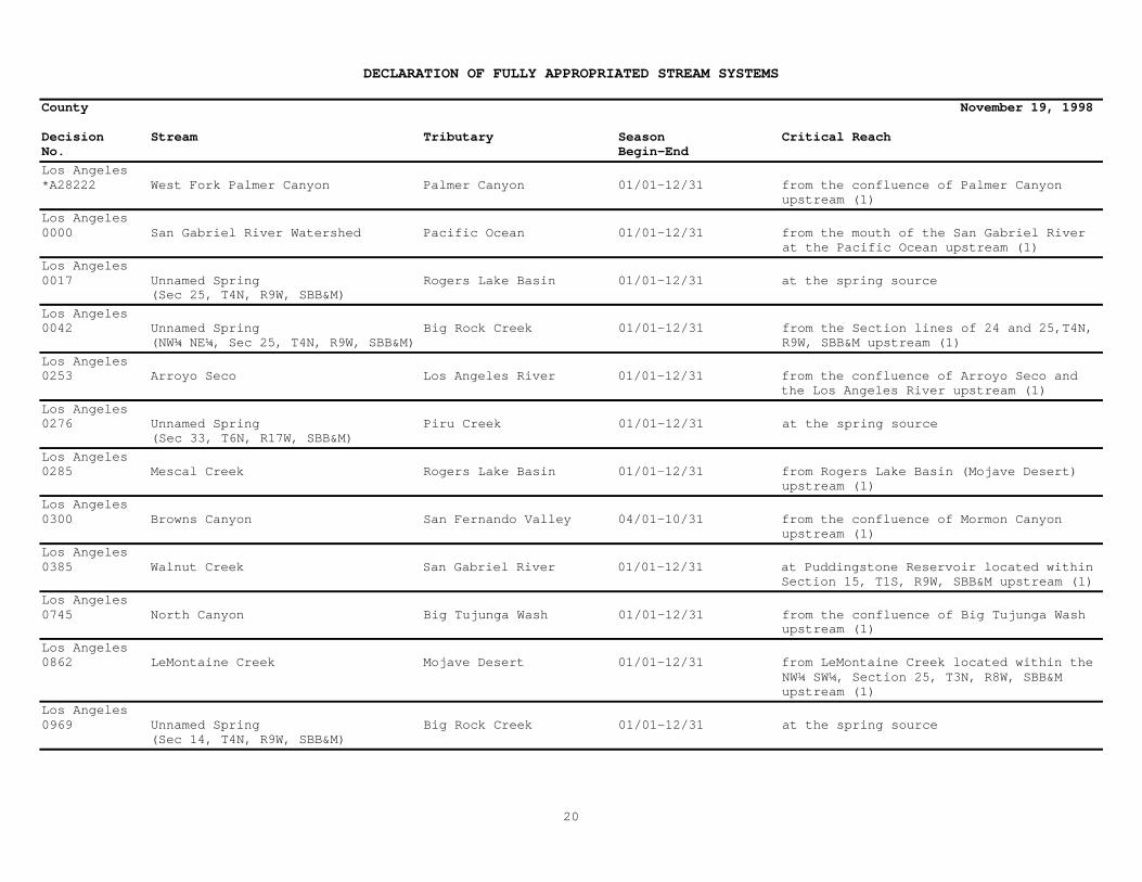
DECLARATION OF FULLY APPROPRIATED STREAM SYSTEMS
County November 19, 1998
Decision Stream Tributary Season Critical ReachNo. Begin-End
Los Angeles*A28222 West Fork Palmer Canyon Palmer Canyon 01/01-12/31 from the confluence of Palmer Canyon upstream (1)
Los Angeles0000 San Gabriel River Watershed Pacific Ocean 01/01-12/31 from the mouth of the San Gabriel River at the Pacific Ocean upstream (1)
Los Angeles0017 Unnamed Spring Rogers Lake Basin 01/01-12/31 at the spring source (Sec 25, T4N, R9W, SBB&M)
Los Angeles0042 Unnamed Spring Big Rock Creek 01/01-12/31 from the Section lines of 24 and 25,T4N, (NW¼ NE¼, Sec 25, T4N, R9W, SBB&M) R9W, SBB&M upstream (1)
Los Angeles0253 Arroyo Seco Los Angeles River 01/01-12/31 from the confluence of Arroyo Seco and the Los Angeles River upstream (1)
Los Angeles0276 Unnamed Spring Piru Creek 01/01-12/31 at the spring source (Sec 33, T6N, R17W, SBB&M)
Los Angeles0285 Mescal Creek Rogers Lake Basin 01/01-12/31 from Rogers Lake Basin (Mojave Desert) upstream (1)
Los Angeles0300 Browns Canyon San Fernando Valley 04/01-10/31 from the confluence of Mormon Canyon upstream (1)
Los Angeles0385 Walnut Creek San Gabriel River 01/01-12/31 at Puddingstone Reservoir located within Section 15, T1S, R9W, SBB&M upstream (1)
Los Angeles0745 North Canyon Big Tujunga Wash 01/01-12/31 from the confluence of Big Tujunga Wash upstream (1)
Los Angeles0862 LeMontaine Creek Mojave Desert 01/01-12/31 from LeMontaine Creek located within the NW¼ SW¼, Section 25, T3N, R8W, SBB&M upstream (1)
Los Angeles0969 Unnamed Spring Big Rock Creek 01/01-12/31 at the spring source (Sec 14, T4N, R9W, SBB&M)
20

DECLARATION OF FULLY APPROPRIATED STREAM SYSTEMS
County November 19, 1998
Decision Stream Tributary Season Critical ReachNo. Begin-End
Los Angeles1096 Unnamed Spring Santa Clara River 06/01-10/31 from the confluence of the Santa Clara (SW¼, Sec 11, T4N, R14W, SBB&M) River upstream (1)
21

DECLARATION OF FULLY APPROPRIATED STREAM SYSTEMS
County November 19, 1998
Decision Stream Tributary Season Critical ReachNo. Begin-End
Madera*** Merced River San Joaquin River 01/01-12/31 (3) the main stem from its sources (including Red Peak Fork, Merced Peak Fork, Triple Peak Fork, and Lyell Fork) on the south side of Mount Lyell in Yosemite National Park to a point 300 feet upstream of the confluence with Bear Creek
Madera*** South Fork Merced River Merced River 01/01-12/31 (3) the south fork of the river from its source near Triple Divide Peak in Yosemite National Park to the confluence with the main stem
Madera0935 San Joaquin River Delta 01/01-12/31 from the confluence with the Mendota Pool upstream (1)
Madera1365 Chowchilla River San Joaquin River 01/01-12/31 (b) from the confluence with the San Joaquin River upstream (1)
Madera1407 Fresno River San Joaquin River 05/01-11/30 from Hidden Dam and the Fresno River upstream (1). There is a 10 afa stockwatering reservation included in this decision.
Madera1594 Sacramento-San Joaquin Delta Delta above 06/15-08/31 (a) from the Delta upstream (1) Collinsville
(a) For diversions less then one cfs or less than 100 afa of storage, no diversion is allowed from June 16 through August 31.
(b) Except for future appropriations by storage for stockwatering and recreational purposes providing that storage in reservoirs of a capacity not in excess of 10 af each and further providing that such reservoirs are kept free of phreatophytes.
22

DECLARATION OF FULLY APPROPRIATED STREAM SYSTEMS
County November 19, 1998
Decision Stream Tributary Season Critical Reach
Marin1081 Unnamed Stream Walker Creek 06/01-10/31 from the confluence of Walker Creek and (SW¼ SW¼, Sec 32, T5N, R9W, MDB&M) thence Tomales Bay Keyes Creek upstream (1)
Marin1453 Unnamed Stream Pacific Ocean 01/01-12/31 from the mouth of the unnamed stream at (NW¼ NW¼, Sec 26, T1N, R8W, MDB&M) the Pacific Ocean upstream (1)
Marin1458 Unnamed Stream (aka Fish Tomales Bay 01/01-12/31 from the confluence of Fish Hatchery
Hatchery Creek) Creek and Tomales Bay upstream (1) (NW¼ NE¼, Sec 34, T3N, R9W, MDB&M)
Marin1582 Lagunitas Creek Tomales Bay 05/01-11/30 from the confluence of Lagunitas Creek and Tomales Bay upstream (1)
23

DECLARATION OF FULLY APPROPRIATED STREAM SYSTEMS
County November 19, 1998
Decision Stream Tributary Season Critical Reach
Mariposa*** Merced River San Joaquin River 01/01-12/31 (3) the main stem from its sources (including Red Peak Fork, Merced Peak Fork, Triple Peak Fork, and Lyell Fork) on the south side of Mount Lyell in Yosemite National Park to a point 300 feet upstream of the confluence with Bear Creek
Mariposa*** South Fork Merced River Merced River 01/01-12/31 (3) the south fork of the river from its source near Triple Divide Peak in Yosemite National Park to the confluence with the main stem
Mariposa0000 Oliver Creek East Fork 04/01-11/30 from the confluence of Oliver Creek and Chowchilla River the East Fork Chowchilla River upstream (1)
Mariposa0650 South Fork Dry Creek Dry Creek thence 04/01-10/31 600 feet below the confluence of South Merced River Fork Dry Creek and Dry Creek upstream(1)
Mariposa1047 Carter Creek Miami Creek 06/01-06/30 from the confluence of Miami Creek and the Fresno River upstream (1)
Mariposa1365 Chowchilla River San Joaquin River 01/01-12/31 (b) from the confluence with the San Joaquin River and Chowchilla River upstream (1)
Mariposa1407 Fresno River San Joaquin River 05/01-11/30 from Hidden Dam and the Fresno River upstream (1). There is a 10 afa stockwatering reservation included in this decision.
Mariposa1594 Sacramento-San Joaquin Delta Delta above 06/15-08/31 (a) from the Delta upstream (1) Collinsville
(a) For diversions less then one cfs or less than 100 afa of storage, no diversion is allowed from June 16 through August 31.
(b) Except for future appropriations by storage for stockwatering and recreational purposes providing that storage in reservoirs of a capacity not in excess of 10 af each and further providing that such reservoirs are kept free of phreatophytes.
24

DECLARATION OF FULLY APPROPRIATED STREAM SYSTEMS
County November 19, 1998
Decision Stream Tributary Season Critical ReachNo. Begin-End
Mendocino* Unnamed Stream Pacific Ocean 06/01-09/30 from the mouth of the unnamed stream at (SE¼ NE¼ Sec 13, T17N, R18W, MDB&M) the Pacific Ocean upstream (1)
Mendocino*A26951, Brush Creek Pacific Ocean 05/01-10/31 from the mouth of Brush Creek at the A27929 Pacific Ocean upstream (1)
Mendocino** Eel River Pacific Ocean 01/01-12/31 (2) the main stem from 100 yards below Van Arsdale Dam to the Pacific Ocean
Mendocino** Middle Fork Eel River Eel River 01/01-12/31 (2) the Middle Fork of the Eel from the intersection of the river with the southern boundary of the Middle Eel-Yolla Bolly Wilderness Area to the river mouth at Dos Rios
Mendocino** North Fork Eel River Eel River 01/01-12/31 (2) the North Fork of the Eel from the Old Gilman Ranch downstream to the river mouth near Ramsey
Mendocino** South Fork Eel River Eel River 01/01-12/31 (2) the South Fork of the Eel from the mouth of Section Four Creek near Branscomb to the river mouth below Weott
Mendocino0944 Unnamed Stream Pacific Ocean 04/01-10/31 from the mouth of the unnamed stream at (SE¼ SW¼ Sec 12, T14N, R17W, MDB&M) the Pacific Ocean upstream (1)
Mendocino1007 Mill Creek Middle Fork Eel River 06/15-10/31 from the SE corner of Section 16, T22N, R12W, MDB&M where the accretion flow comes into Mill Creek upstream (1)
Mendocino1009 Unnamed Stream Navarro River 05/15-10/31 from the confluence of the unnamedstream (Sec 12, T14N, R15W, MDB&M) and the Navarro River upstream (1)
Mendocino1107 Reynolds Creek Pacific Ocean 06/01-10/31 from the mouth of Reynolds Creek at the Pacific Ocean upstream (1)
25

DECLARATION OF FULLY APPROPRIATED STREAM SYSTEMS
County November 19, 1998
Decision Stream Tributary Season Critical ReachNo. Begin-End
Mendocino1110, Russian River Pacific Ocean 07/01-10/31 refer to footnote (e)1610,WR 74-30
Mendocino1198 Unnamed Spring Unnamed Stream 05/15-11/30 from the confluence of the unnamed
stream(NW¼ SE¼, Sec 20, T16N,R11W, MDB&M)thence Cold Creek and Cold Creek upstream (1)
Mendocino1215 Slick Rock Creek Pacific Ocean 07/01-10/31 from the mouth of Slick Rock Creek at the
Pacific Ocean upstream (1)
Mendocino1281 Anderson Creek Navarro River 08/01-09/30 from the confluence of Clow Canyon and Anderson Creek upstream (1)
Mendocino1516 Robinson Creek Russian River 07/01-10/31 from the confluence of Robinson Creek and the Russian River upstream (1)
Mendocino1545 Feliz Creek Russian River 08/01-10/31 from the confluence of Feliz Creek and the Russian River upstream (1)
Mendocino1555 Marsh Creek Albion River 04/01-10/31 from the confluence of Marsh Creek and the Albion River upstream (1)
(e) At the point where the boundary area of the Mendocino County Russian River Flood Control and Water ConservationImprovement District crosses the Russian River which is located a short distance north of the Mendocino/Sonoma County lineupstream, excluding all tributaries with the exceptions of (1) the West Fork Russian River and (2) the East Fork Russian Riverexcluding Potter Valley (refer to SWRCB Order WR 74-30). The above restrictions on the main stem of the Russian River do not applyto uses commences prior to January 28, 1949.
26

DECLARATION OF FULLY APPROPRIATED STREAM SYSTEMS
County November 19, 1998
Decision Stream Tributary Season Critical ReachNo. Begin-End
Merced0650 South Fork Dry Creek Dry Creek thence 04/01-10/31 600 feet below the confluence of South Merced River Fork Dry Creek and Dry Creek upstream (1)
Merced0765 Snake Slough Marshy area 04/01-10/31 from the confluence of Snake and Duck sloughs upstream (1)
Merced1150 Duck Slough Deadman Creek 06/01-10/31 from the confluence of the East Side Canal and Duck Slough upstream (1)
Merced1365 Chowchilla River San Joaquin River 01/01-12/31 (b) from the confluence of the San Joaquin River and Chowchilla River upstream (1)
Merced1594 Sacramento-San Joaquin Delta Delta above 06/15-08/31 (a) from the Delta upstream (1) Collinsville
(a) For diversions less then one cfs or less than 100 afa of storage, no diversion is allowed from June 16 through August 31.
(b) Except for future appropriations by storage for stockwatering and recreational purposes providing that storage in reservoirs of a capacity not in excess of 10 af each and further providing that such reservoirs are kept free of phreatophytes.
27

DECLARATION OF FULLY APPROPRIATED STREAM SYSTEMS
County November 19, 1998
Decision Stream Tributary Season Critical ReachNo. Begin-End
Modoc0000 Bidwell Creek Upper Alkali Lake 04/01-11/30 from the confluence of Upper Alkali Lake upstream (1)
Modoc0000 Cottonwood Creek Goose Lake 04/01-11/30 from the confluence of Goose Lake upstream (1)
Modoc0000 Davis Creek Goose Lake 04/01-11/30 from the confluence of Goose Lake upstream (1)
Modoc0000 Eagle Creek Lower Alkali Lake 04/01-11/30 from the confluence of Lower Alkali Lake upstream (1)
Modoc0000 Emerson Creek Lower Alkali Lake 04/01-11/30 from the confluence of Lower Alkali Lake upstream (1)
Modoc0000 Franklin Creek North Fork Pit River 04/01-11/30 from the confluence of the North Fork Pit River upstream (1)
Modoc0000 Mill Creek Upper Alkali Lake 04/01-11/30 from the confluence of Upper Alkali Lake upstream (1)
Modoc0000 New Pine Creek Goose Lake 04/01-11/30 from the confluence of Goose Lake upstream (1)
Modoc0000 North Fork Pit River Pit River 04/01-11/30 from the confluence of the North Fork Pit River and Pit Rivers upstream (1)
Modoc0000 Owl Creek Middle Alkali Lake 04/01-11/30 from the confluence of Middle Alkali Lake upstream (1)
Modoc0000 Pine Creek Middle Alkali Lake 04/01-11/30 from the confluence of Middle Alkali Lake upstream (1)
Modoc0000 Pit River in Big Valley Pit River 04/01-11/30 from the confluence of the Pit River in Big Valley and the Pit River upstream except for Ash Creek
Modoc0000 Raider Creek Middle Alkali Lake 04/01-11/30 from the confluence of Middle Alkali Lake upstream (1)
28

DECLARATION OF FULLY APPROPRIATED STREAM SYSTEMS
County November 19, 1998
Decision Stream Tributary Season Critical ReachNo. Begin-End
Modoc0000 South Fork Pit River Pit River 04/01-11/30 from the confluence of the South Fork Pit River and Pit River upstream (1)
Modoc0000, Cedar Creek Middle Alkali Lake 03/01-11/30 from the confluence of Middle Alkali Lake0297 upstream (1)
Modoc0000, Deep Creek Middle Alkali Lake 03/01-11/30 from the confluence of Middle Alkali Lake0038 upstream (1)
Modoc0000, Soldier Creek Upper Alkali Lake 01/01-12/31 from the confluence of Upper Alkali Lake0756 upstream (1)
Modoc0000, Ash Creek Pit River 03/15-10/31 from the confluence of the Pit River1237 upstream (1)
Modoc0015 High Rock Creek Lower Lake 04/01-10/31 from the confluence of High Rock Creek and Lower Lake upstream (1)
Modoc0301 Thoms Creek North Fork Pit River 03/15-10/31 from the confluence of Thoms Creek and the North Fork Pit River upstream (1)
Modoc0427 Unnamed Spring Silver Creek 04/01-10/31 from the confluence of Silver Creek and (SW¼ SW¼, Sec 36, T39N, R16E, MDB&M) the Unnamed Spring upstream (1)
Modoc1236 Little Juniper Creek Fitzhugh Creek 04/01-11/30 from the confluence of Little Juniper Reservoir and Little Juniper Creek upstream (1)
Modoc1236 Unnamed Stream Fitzhugh Creek 04/01-11/30 from the confluence of the unnamed stream (NW¼ NE¼, Sec 26, T41N, R13E, MDB&M) and Fitzhugh Creek upstream (1)
Modoc1437 Crooks Creek South Fork Pit River 04/15-10/31 from the confluence of the unnamed stream and the South Fork Pit River upstream (1)
Modoc1583 Unnamed Stream North Fork Pit River 06/01-12/31 from the confluence of the unnamedstream (SE¼ SE¼, Sec 11, T43N, R13E, MDB&M) and the North Fork Pit River upstream(1)
29

DECLARATION OF FULLY APPROPRIATED STREAM SYSTEMS
County November 19, 1998
Decision Stream Tributary Season Critical ReachNo. Begin-End
Mono** Leavitt Creek West Walker River 01/01-12/31 (2) Leavitt Creek from Leavitt Falls to the confluence with the main stem of the West Walker River
Mono** West Walker River Walker River 01/01-12/31 (2) the main stem from its source to the confluence with Rock Creek near the town of Walker
Mono0000 East Walker River Walker River 04/01-11/30 Nevada County line upstream (1)
Mono0000 West Walker River Walker River 04/01-11/30 Nevada County line upstream (1)
Mono0206 Mammoth Tunnel Lake Mary 01/01-12/31 Mammoth Tunnel (NW¼ SE¼, Sec 9, T4S, R27E, MDB&M)
Mono0455 Leevining Creek Mono Lake 01/01-12/31 from the confluence of Leevining Creek and Mono Lake upstream (1)
Mono0455 Mill Creek Mono Lake 01/01-12/31 from the confluence of Mill Creek and Mono Lake upstream (1)
Mono0455 Parker Creek Rush Creek 01/01-12/31 from the confluence of Parker Creek and Rush Creek upstream (1)
Mono0455 Walker Creek Rush Creek 01/01-12/31 from the confluence of Walker Creek and Rush Creek upstream (1)
Mono0731 Wilson Creek Mono Lake 03/15-11/30 from the confluence of Wilson Creek and Mono Lake upstream (1)
30

DECLARATION OF FULLY APPROPRIATED STREAM SYSTEMS
County November 19, 1998
Decision Stream Tributary Season Critical ReachNo. Begin-End
Monterey*A28199 Unnamed Stream Salinas River 01/01-12/31 from the confluence of the Unnamed Stream1614 (NE¼ SW¼, Sec 4, T17S, R4E, MDB&M) located within the NE¼ of SW¼ of Section 4, T17S, R4E, MDB&M and Salinas River upstream (1)
Monterey0287 Palo Corona (aka Seneca Creek) Pacific Ocean 07/01-10/31 from the mouth of San Jose Creek at the Pacific Ocean upstream (1)
Monterey0287 San Jose Creek Pacific Ocean 07/01-10/31 from the mouth of San Jose Creek at the Pacific Ocean upstream (1)
Monterey0524 Cholame Creek Estrella River 03/01-10/31 from the confluence of Cholame Creek and Little Cholame Creek upstream (1)
Monterey1585 Salinas River Pacific Ocean 05/15-12/31 (i) from the upper Salinas River at the Salinas Dam down to the Nacimiento River including any accretion flows where hydraulic continuity exists
Monterey1632, Carmel River System (m) Pacific Ocean 05/01-12/31 from the mouth of the Carmel River at theWR 95-10 Pacific Ocean upstream (1)
(i) Except diversions greater than 1 mile from the Salinas River on Huerhuero Creek, Estrella River and Mustard Creek and 2.5 miles onVineyard Canyon.
(m) Water flowing in the aquifer that closely parallels the Carmel River is subject to the State Water Resources Control Board’sjurisdiction. Subsurface jurisdiction extends from the mouth of the Pacific Ocean upstream at least as far as river mile 15, locatednear the confluence of Tularcitos Creek, and perhaps as far as the Sleepy Hollow Gage at mile point 17.2 (Order WR 95-10, Pages 4,5,11-13, and 38-39). Thus, water flowing in the aquifer is subject to the Declaration of Fully Appropriated Stream Systems determination asto availability of water. However, Applications listed in Table 13 of Decision 1632 or applications filed in accordance withCondition 10 of Decision 1632 are not subject to this Declaration of Fully Appropriated Stream Systems determination as to theavailability of water (Decision 1632, Pages 41-50 and 97-98).
31
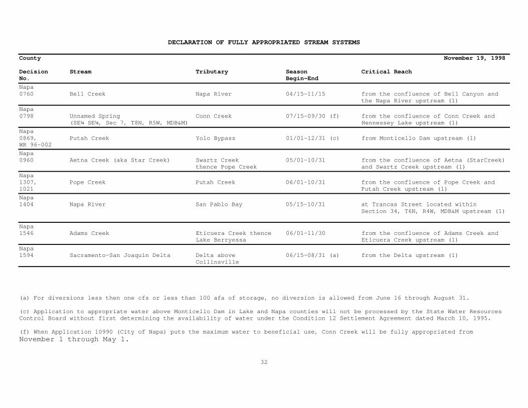
DECLARATION OF FULLY APPROPRIATED STREAM SYSTEMS
County November 19, 1998
Decision Stream Tributary Season Critical ReachNo. Begin-End
Napa0760 Bell Creek Napa River 04/15-11/15 from the confluence of Bell Canyon and the Napa River upstream (1)
Napa0798 Unnamed Spring Conn Creek 07/15-09/30 (f) from the confluence of Conn Creek and (SE¼ SE¼, Sec 7, T8N, R5W, MDB&M) Hennessey Lake upstream (1)
Napa0869, Putah Creek Yolo Bypass 01/01-12/31 (c) from Monticello Dam upstream (1)WR 96-002
Napa0960 Aetna Creek (aka Star Creek) Swartz Creek 05/01-10/31 from the confluence of Aetna (StarCreek) thence Pope Creek and Swartz Creek upstream (1)
Napa1307, Pope Creek Putah Creek 06/01-10/31 from the confluence of Pope Creek and1021 Putah Creek upstream (1)
Napa1404 Napa River San Pablo Bay 05/15-10/31 at Trancas Street located within Section 34, T6N, R4W, MDB&M upstream (1)
Napa1546 Adams Creek Eticuera Creek thence 06/01-11/30 from the confluence of Adams Creek and Lake Berryessa Eticuera Creek upstream (1)
Napa1594 Sacramento-San Joaquin Delta Delta above 06/15-08/31 (a) from the Delta upstream (1) Collinsville
(a) For diversions less then one cfs or less than 100 afa of storage, no diversion is allowed from June 16 through August 31.
(c) Application to appropriate water above Monticello Dam in Lake and Napa counties will not be processed by the State Water ResourcesControl Board without first determining the availability of water under the Condition 12 Settlement Agreement dated March 10, 1995.
(f) When Application 10990 (City of Napa) puts the maximum water to beneficial use, Conn Creek will be fully appropriated fromNovember 1 through May 1.
32

DECLARATION OF FULLY APPROPRIATED STREAM SYSTEMS
County November 19, 1998
Decision Stream Tributary Season Critical ReachNo. Begin-End
Nevada0000 Shady Creek South Fork Yuba 04/01-11/30 from Shady Creek located within Section 27, T17N, R7E, MDB&M and upstream (1)
Nevada0307 Donner Creek Truckee River 07/01-03/31 from the confluence of Donner Creek and the Truckee River upstream (1)
Nevada0383 South Fork Poormans Creek Poormans Creek 06/01-11/30 from the confluence with Poormans Creek upstream (1)
Nevada0934 Yuba River Feather River 08/01-10/31 from Englebright Dam upstream (1)
Nevada1059, South Wolf Creek Wolf Creek 04/15-11/30 from Wolf Creek upstream (1)1091 thence Bear River
Nevada1091 Bear River Feather River 05/01-11/30 from Camp Far West Reservoir upstream(1)
Nevada1124 Deer Creek Yuba River 06/01-09/30 from the confluence at Deer Creek-Gold Creek and U.S. Geological Survey gaging station "near Smartville" upstream (1)
Nevada1374 Unnamed Stream Clear Creek thence 04/01-09/30 from the confluence at Deer Creek-Gold (SW¼ SE¼, Sec 6, T15N, R8E, MDB&M) Yuba River and U.S. Geological Survey gaging station "near Smartville" upstream (1)
Nevada1394 Willow Valley Creek Deer Creek 06/01-10/31 from the confluence of Willow Valley Creek and Deer Creek upstream. In accordance with Decision 1124 from the confluence at Deer Creek-Gold Creek and U.S. Geological Survey gaging station "near Smartville" upstream (1)
Nevada1402 Magnolia Creek Bear River 04/01-10/31 from Magnolia Creek to Camp Far West Reservoir upstream (1)
Nevada1419 Unnamed Spring South Yuba River 01/01-12/31 from the confluence of the unnamed spring (SE¼ SE¼, Sec 2, T17N, R9E, MDB&M) and the South Yuba River upstream (1)
33
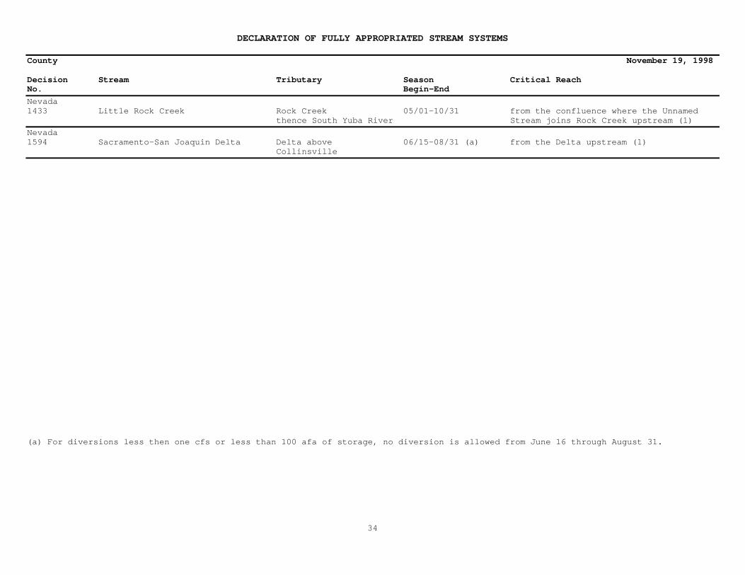
DECLARATION OF FULLY APPROPRIATED STREAM SYSTEMS
County November 19, 1998
Decision Stream Tributary Season Critical ReachNo. Begin-End
Nevada1433 Little Rock Creek Rock Creek 05/01-10/31 from the confluence where the Unnamed thence South Yuba River Stream joins Rock Creek upstream (1)
Nevada1594 Sacramento-San Joaquin Delta Delta above 06/15-08/31 (a) from the Delta upstream (1) Collinsville
(a) For diversions less then one cfs or less than 100 afa of storage, no diversion is allowed from June 16 through August 31.
34
DECLARATION OF FULLY APPROPRIATED STREAM SYSTEMS
County November 19, 1998
Decision Stream Tributary Season Critical ReachNo. Begin-End
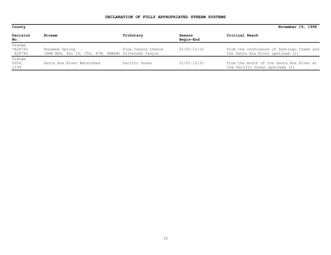
Orange*A28743 Unnamed Spring Pine Canyon thence 01/01-12/31 from the confluence of Santiago Creek and A28744 (SW¼ NE¼, Sec 14, T5S, R7W, SBB&M) Silverado Canyon the Santa Ana River upstream (1)
Orange0000, Santa Ana River Watershed Pacific Ocean 01/01-12/31 from the mouth of the Santa Ana River at1194 the Pacific Ocean upstream (1)
35

DECLARATION OF FULLY APPROPRIATED STREAM SYSTEMS
County November 19, 1998
Decision Stream Tributary Season Critical ReachNo. Begin-End
Placer** North Fork American River American River 01/01-12/31 (2) the North Fork from its source to the Iowa Hill Bridge
Placer*** North Fork American River American River 01/01-12/31 (3) the North Fork American River from a point 0.3 mile above Heath Springs downstream to a point approximately 1,000 feet upstream of the Colfax-Iowa Hill Bridge, including the Gold Run Addition Area
Placer0642 Antelope Creek Secret Ravine 04/01-10/31 from the confluence of Antelope Creek and Miners Ravine upstream (1)
Placer0682 Live Oak Creek Bunch Canyon thence 05/15-10/31 from the confluence of Live Oak Creek North Fork American River and Bunch Canyon upstream (1)
Placer0871 Unnamed Spring Bear River 01/01-12/31 at the spring source (SW¼ NE¼,Sec 36,T16N,R10E,MDB&M)
Placer0901 Doty Ravine Coon Creek thence 04/01-10/31 from the confluence of Doty Ravine East Side Canal located within NW¼ of NE¼, Section 36, T13N, R6E, MDB&M upstream (1)
Placer0943 Unnamed Stream (aka Ingram Slough) Orchard Creek thence 04/01-10/31 from the SW corner of Section 21, (NE¼ SE¼, Sec 21,T12N,R6E,MDB&M) Auburn Ravine T12N, R6E, MDB&M upstream (1)
Placer0977 Dry Creek Coon Creek 04/15-10/31 from the confluence of Dry Creek and Camp Far West Ditch located within Section 13, T13N, R7E, MDB&M upstream (1)
Placer1087 Unnamed Stream Secret Ravine 06/01-10/31 from the confluence of the Unnamed Stream (NW¼ NE¼,Sec 31,T12N,R8E,MDB&M) and the Boardman Canal located within Section 31, T12N, R8E, MDB&M upstream (1)
Placer1091 Bear River Feather River 05/01-11/30 from Camp Far West Reservoir upstream(1)
Placer1108 American River Sacramento River 07/01-10/31 from the Delta upstream (1)
36

DECLARATION OF FULLY APPROPRIATED STREAM SYSTEMS
County November 19, 1998
Decision Stream Tributary Season Critical ReachNo. Begin-End
Placer1158 Dutch Ravine Auburn Ravine thence 06/01-10/31 from the Dutch Ravine junction and at East Side Canal Hemphill Dam located approximately four miles downstream from the junction
Placer1214 Unnamed Stream Antelope Creek 04/01-11/30 from the confluence of the Unnamed Stream (SW¼ SW¼, Sec 26, T12N, R7E, MDB&M)thence Sacramento River and Antelope Ravine upstream (1)
Placer1560 Coon Creek East Side Canal 06/01-09/30 from the confluence of Coon Creek thence Sacramento River and the East Side Canal from 06/01-06/30 and 09/01-09/30 and from the confluence of the Sacramento River from 07/01-08/31 upstream (1)
Placer1594 Sacramento-San Joaquin Delta Delta above 06/15-08/31 (a) from the Delta upstream (1) Collinsville
(a) For diversions less then one cfs or less than 100 afa of storage, no diversion is allowed from June 16 through August 31.
37

DECLARATION OF FULLY APPROPRIATED STREAM SYSTEMS
County November 19, 1998
Decision Stream Tributary Season Critical ReachNo. Begin-End
Plumas*** Middle Fork Feather River Feather River 01/01-12/31 (3) the entire Middle Fork downstream from the confluence of its tributary streams one kilometer south of Beckwourth, CA
Plumas0000 Indian Creek North Fork Feather River 04/01-11/30 from the North Fork Feather River upstream (1)
Plumas0025 South Fork Feather River Feather River 03/01-10/31 from the confluence of Oroville Dam and Middle Fork and South Fork Feather River upstream (1)
Plumas0831 Middle Fork Feather River Feather River 05/15-09/30 from Middle Fork Feather River at Beckwourth upstream (1)
Plumas1002 Clear Creek North Fork Feather River 07/01-10/31 from the confluence with Clear Creek upstream (1)
Plumas1002 Owl Creek Clear Creek thence 07/01-10/31 from the confluence with Clear Creek North Fork Feather River upstream (1)
Plumas1162 Haskins Creek Bucks Lake 07/01-09/30 from the confluence of Haskins Creek and Bucks Lake upstream (1)
Plumas1253 Unnamed Stream Rabbit Creek thence 08/01-09/30 from the confluence of the Unnamed (SW¼ SW¼, Sec 8, T21N, R9E, MDB&M) Slate Creek Stream and Rabbit Creek upstream (1)
Plumas1275 Feather River Sacramento River 07/01-09/30 from the confluence of the Feather River and Sacramento River upstream (1)
Plumas1391 Sierra Valley Channels Middle Fork Feather 04/15-09/30 from the confluence of the Middle Fork River Feather River at Beckwourth upstream (1)
Plumas1594 Sacramento-San Joaquin Delta Delta above 06/15-08/31 (a) from the Delta upstream (1) Collinsville
(a) For diversions less then one cfs or less than 100 afa of storage, no diversion is allowed from June 16 through August 31.
38
DECLARATION OF FULLY APPROPRIATED STREAM SYSTEMS
County November 19,1998
Decision Stream Tributary Season Critical ReachNo. Begin-End
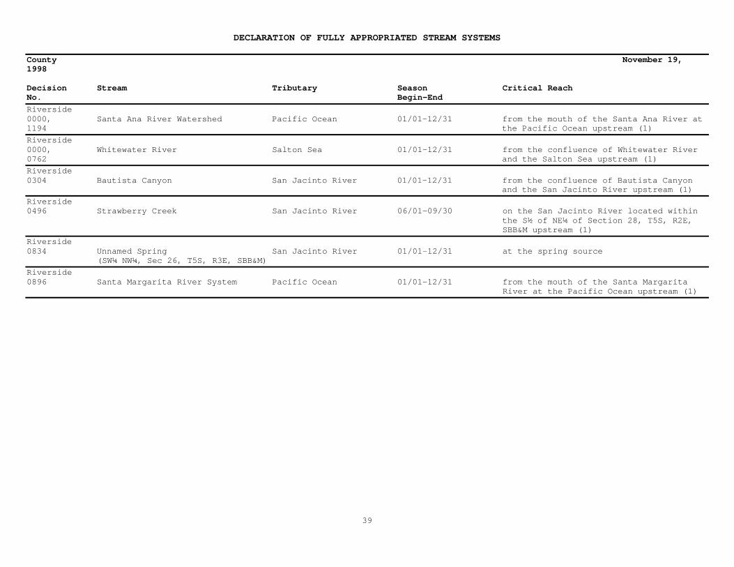
Riverside0000, Santa Ana River Watershed Pacific Ocean 01/01-12/31 from the mouth of the Santa Ana River at1194 the Pacific Ocean upstream (1)
Riverside0000, Whitewater River Salton Sea 01/01-12/31 from the confluence of Whitewater River0762 and the Salton Sea upstream (1)
Riverside0304 Bautista Canyon San Jacinto River 01/01-12/31 from the confluence of Bautista Canyon and the San Jacinto River upstream (1)
Riverside0496 Strawberry Creek San Jacinto River 06/01-09/30 on the San Jacinto River located within the S½ of NE¼ of Section 28, T5S, R2E, SBB&M upstream (1)
Riverside0834 Unnamed Spring San Jacinto River 01/01-12/31 at the spring source (SW¼ NW¼, Sec 26, T5S, R3E, SBB&M)
Riverside0896 Santa Margarita River System Pacific Ocean 01/01-12/31 from the mouth of the Santa Margarita River at the Pacific Ocean upstream (1)
39

DECLARATION OF FULLY APPROPRIATED STREAM SYSTEMS
County November 19, 1998
Decision Stream Tributary Season Critical ReachNo. Begin-End
Sacramento** American River Sacramento River 01/01-12/31 (2) the Lower American from Nimbus Dam to its junction with the Sacramento River
Sacramento0000 Dry Creek Mokelumne River 04/01-11/30 from the confluence of Dry Creek located within Section 19, T5N, R8E, MDB&M upstream (1)
Sacramento0740 Dry Creek Sacramento River 06/01-10/31 from Dry Creek located within the SW¼ of NW¼, Section 33, T10N, R5E, MDB&M upstream (1)
Sacramento0925 Elk Grove Creek Laguna Creek thence 04/01-10/31 from the confluence of Elk Grove Creek Morrison Creek thence and Laguna Creek upstream (1) Sacramento River
Sacramento1062 Unnamed Stream Cosumnes River 07/01-09/30 from the point where the Cosumnes River (SE¼ SE¼, Sec 6, T7N, R8E, MDB&M) crosses the aqueduct located in T7N,R7E, MDB&M upstream (1)
Sacramento1108, American River Sacramento River 07/01-10/31 from the confluence with the1211 Sacramento River upstream (1)
Sacramento1186 Morrison Creek Sacramento River 06/01-10/31 from the confluence of Morrison Creek and the Sacramento River upstream (1)
Sacramento1219 Mokelumne River San Joaquin River 07/01-09/30 from the confluence with the San Joaquin River upstream to the point(s) of diversion of the Woodbridge Irrigation District including all tributaries within this reach where hydraulic continuity exists
Sacramento1369 Cosumnes River Mokelumne River 07/01-10/31 from the confluence with the Mokelumne River upstream (1)
40

DECLARATION OF FULLY APPROPRIATED STREAM SYSTEMS
County November 19, 1998
Decision Stream Tributary Season Critical ReachNo. Begin-End
Sacramento1547 Badger Creek Cosumnes River 04/15-10/31 from Badger Creek located in Section 30, T6N, R7E, MDB&M upstream (1)
Sacramento1594 Sacramento-San Joaquin Delta Delta above 06/15-08/31 (a) from the Delta upstream (1) Collinsville
SacramentoWR 95-09 Deer Creek Cosumnes River 05/01-10/31 from the confluence of Deer Creek and the Cosumnes River upstream (1)
(a) For diversions less then one cfs or less than 100 afa of storage, no diversion is allowed from June 16 through August 31.
41

DECLARATION OF FULLY APPROPRIATED STREAM SYSTEMS
County November 19, 1998
Decision Stream Tributary Season Critical ReachNo. Begin-End
San Benito*A28156 Unnamed Stream & Harlan Creek Indian Canyon tributary 06/01-10/31 from the point where Indian Canyon enters to Pescadero Creek Pescadero Creek upstream (1) thence San Benito River
42

DECLARATION OF FULLY APPROPRIATED STREAM SYSTEMS
County November 19, 1998
Decision Stream Tributary Season Critical ReachNo. Begin-End
San Bernardino* Crystal Creek Lucerne Valley 01/01-12/31 from the confluence of the unnamed stream and Crystal Creek located within the NE corner of Section 1, T3N, R1W, SBB&M upstream (1)
San Bernardino0000, Santa Ana River Watershed Pacific Ocean 01/01-12/31 from the mouth of the Santa Ana River1194 at the Pacific Ocean upstream (1)
San Bernardino0000,0762 Whitewater River Salton Sea 01/01-12/31 from the confluence of Whitewater River and the Salton Sea upstream (1)
San Bernardino0121 Unnamed Spring Big Bear Lake 06/01-11/30 at the spring source (Sec 22, T2N, R1W, SBB&M)
San Bernardino0484 Unnamed Spring(aka Poupart Spring) Big Bear Lake 01/01-12/31 at the spring source (NW¼ NE¼, Sec 22, T2N, R1W, SBB&M)
San Bernardino0556 Unnamed Spring Mojave Desert 01/01-12/31 at the spring source (SE¼ SW¼, Sec 4, T15N, R14E, SBB&M)
San Bernardino0628 Van Dusen Canyon Baldwin Lake 01/01-12/31 Van Dusen Canyon upstream (1)
San Bernardino0802 Unnamed Spring Piute Wash thence 01/01-12/31 at the spring source (SE¼ SE¼, Sec 3,T9N,R21E,SBB&M) Colorado River
San Bernardino0819 Mescal Spring Ivanpah Valley 01/01-12/31 at the spring source (SW¼ NE¼, Sec 24, T16N, R13E, SBB&M)
San Bernardino1246 Unnamed Spring Arrastre Canyon thence 01/01-12/31 at the spring source (NE¼ NE¼, Sec 6, T3N, R2W, SBB&M) Rabbit Lake
San Bernardino1619 Mojave River System 01/01-12/31 Mojave River System
43
DECLARATION OF FULLY APPROPRIATED STREAM SYSTEMS
County November 19, 1998
Decision Stream Tributary Season Critical ReachNo. Begin-End
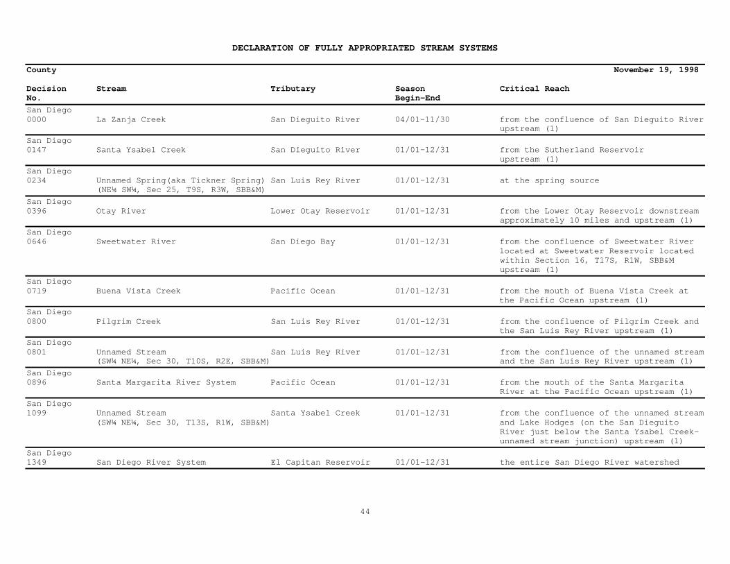
San Diego0000 La Zanja Creek San Dieguito River 04/01-11/30 from the confluence of San Dieguito River upstream (1)
San Diego0147 Santa Ysabel Creek San Dieguito River 01/01-12/31 from the Sutherland Reservoir upstream (1)
San Diego0234 Unnamed Spring(aka Tickner Spring) San Luis Rey River 01/01-12/31 at the spring source (NE¼ SW¼, Sec 25, T9S, R3W, SBB&M)
San Diego0396 Otay River Lower Otay Reservoir 01/01-12/31 from the Lower Otay Reservoir downstream approximately 10 miles and upstream (1)
San Diego0646 Sweetwater River San Diego Bay 01/01-12/31 from the confluence of Sweetwater River located at Sweetwater Reservoir located within Section 16, T17S, R1W, SBB&M upstream (1)
San Diego0719 Buena Vista Creek Pacific Ocean 01/01-12/31 from the mouth of Buena Vista Creek at the Pacific Ocean upstream (1)
San Diego0800 Pilgrim Creek San Luis Rey River 01/01-12/31 from the confluence of Pilgrim Creek and the San Luis Rey River upstream (1)
San Diego0801 Unnamed Stream San Luis Rey River 01/01-12/31 from the confluence of the unnamed stream (SW¼ NE¼, Sec 30, T10S, R2E, SBB&M) and the San Luis Rey River upstream (1)
San Diego0896 Santa Margarita River System Pacific Ocean 01/01-12/31 from the mouth of the Santa Margarita River at the Pacific Ocean upstream (1)
San Diego1099 Unnamed Stream Santa Ysabel Creek 01/01-12/31 from the confluence of the unnamed stream (SW¼ NE¼, Sec 30, T13S, R1W, SBB&M) and Lake Hodges (on the San Dieguito River just below the Santa Ysabel Creek- unnamed stream junction) upstream (1)
San Diego1349 San Diego River System El Capitan Reservoir 01/01-12/31 the entire San Diego River watershed
44
DECLARATION OF FULLY APPROPRIATED STREAM SYSTEMS
County November 19, 1998
Decision Stream Tributary Season Critical ReachNo. Begin-End
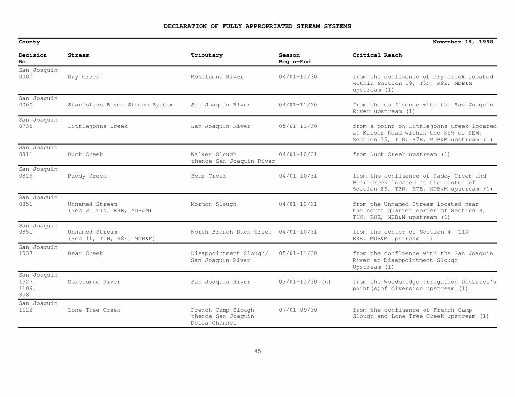
San Joaquin0000 Dry Creek Mokelumne River 04/01-11/30 from the confluence of Dry Creek located within Section 19, T5N, R8E, MDB&M upstream (1)
San Joaquin0000 Stanislaus River Stream System San Joaquin River 04/01-11/30 from the confluence with the San Joaquin River upstream (1)
San Joaquin0738 Littlejohns Creek San Joaquin River 05/01-11/30 from a point on Littlejohns Creek located at Kaiser Road within the NE¼ of SE¼, Section 35, T1N, R7E, MDB&M upstream (1)
San Joaquin0811 Duck Creek Walker Slough 04/01-10/31 from Duck Creek upstream (1) thence San Joaquin River
San Joaquin0829 Paddy Creek Bear Creek 04/01-10/31 from the confluence of Paddy Creek and Bear Creek located at the center of Section 23, T3N, R7E, MDB&M upstream (1)
San Joaquin0851 Unnamed Stream Mormon Slough 04/01-10/31 from the Unnamed Stream located near (Sec 2, T1N, R8E, MDB&M) the north quarter corner of Section 8, T1N, R8E, MDB&M upstream (1)
San Joaquin0851 Unnamed Stream North Branch Duck Creek 04/01-10/31 from the center of Section 4, T1N, (Sec 11, T1N, R8E, MDB&M) R8E, MDB&M upstream (1)
San Joaquin1037 Bear Creek Disappointment Slough/ 05/01-11/30 from the confluence with the San Joaquin San Joaquin River River at Disappointment Slough Upstream (1)
San Joaquin1527, Mokelumne River San Joaquin River 03/01-11/30 (n) from the Woodbridge Irrigation District's1109, point(s)of diversion upstream (1)858
San Joaquin1122 Lone Tree Creek French Camp Slough 07/01-09/30 from the confluence of French Camp thence San Joaquin Slough and Lone Tree Creek upstream (1) Delta Channel
45

DECLARATION OF FULLY APPROPRIATED STREAM SYSTEMS
County November 19, 1998
Decision Stream Tributary Season Critical ReachNo. Begin-End
San Joaquin1179 Calaveras River San Joaquin River 05/01-10/31 from the confluence with the San Joaquin River upstream (1)
San Joaquin1219 Mokelumne River San Joaquin River 07/01-09/30 from the confluence with the San Joaquin River upstream to the point(s) of diversion of the Woodbridge Irrigation District including all tributaries within this reach where hydraulic continuity exists
San Joaquin1422 Stanislaus River San Joaquin River 07/01-10/31 from the confluence with the San Joaquin River upstream (1)
San Joaquin1594 Sacramento-San Joaquin Delta Delta above 06/15-08/31 (a) from the Delta upstream (1) Collinsville
(a) For diversions less then one cfs or less than 100 afa of storage, no diversion is allowed from June 16 through August 31.
(n) During the months of March through June, the Declaration does not apply to proposed conjunctive use projects which are notdependent upon unappropriated water being available from the Mokelumne River in most years but which could utilize unappropriated waterin years when it is available. Applications for that type of project, if any, may be accepted for processing and evidence of wateravailability shall be evaluated by the State Water Resources Control Board in the course of processing the applications.
46
DECLARATION OF FULLY APPROPRIATED STREAM SYSTEMS
County November 19, 1998
Decision Stream Tributary Season Critical ReachNo. Begin-End
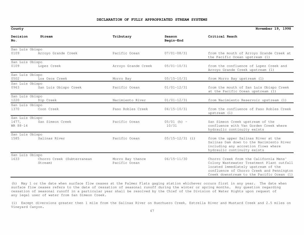
San Luis Obispo0109 Arroyo Grande Creek Pacific Ocean 07/01-08/31 from the mouth of Arroyo Grande Creek at the Pacific Ocean upstream (1)
San Luis Obispo0109 Lopez Creek Arroyo Grande Creek 05/01-10/31 from the confluence of Lopez Creek and Arroyo Grande Creek upstream (1)
San Luis Obispo0502 Los Osos Creek Morro Bay 05/15-10/31 from Morro Bay upstream (1)
San Luis Obispo0963 San Luis Obispo Creek Pacific Ocean 01/01-12/31 from the mouth of San Luis Obispo Creek at the Pacific Ocean upstream (1)
San Luis Obispo1220 Dip Creek Nacimiento River 01/01-12/31 from Nacimiento Reservoir upstream (1)
San Luis Obispo1370 Coon Creek Paso Robles Creek 04/15-10/31 from the confluence of Paso Robles Creek upstream (1)
San Luis Obispo1477, San Simeon Creek Pacific Ocean 05/01 (h) - San Simeon Creek upstream of theWR 88-14 10/31 confluence with Van Gorden Creek where hydraulic continuity exists
San Luis Obispo1585 Salinas River Pacific Ocean 05/15-12/31 (i) from the upper Salinas River at the Salinas Dam down to the Nacimiento River including any accretion flows where hydraulic continuity exists
San Luis Obispo1633 Chorro Creek (Subterranean Morro Bay thence 06/15-11/30 Chorro Creek from the California Mens' Stream) Pacific Ocean Colony Wastewater Treatment Plant outfall located immediately upstream of the confluence of Chorro Creek and Pennington Creek downstream to the Pacific Ocean (1)
(h) May 1 or the date when surface flow ceases at the Palmer Flats gaging station whichever occurs first in any year. The date whensurface flow ceases refers to the date of cessation of seasonal runoff during the winter or spring months. Any question regardingcessation of seasonal runoff in a particular year shall be resolved by the Chief of the Division of Water Rights upon request ofany legal user of water from San Simeon Creek.
(i) Except diversions greater then 1 mile from the Salinas River on Huerhuero Creek, Estrella River and Mustard Creek and 2.5 miles onVineyard Canyon.
47

DECLARATION OF FULLY APPROPRIATED STREAM SYSTEMS
County November 19, 1998
Decision Stream Tributary Season Critical ReachNo. Begin-End
San Mateo0000 Purisima Creek Pacific Ocean 04/01-11/30 from the mouth of Purisima Creek at the Pacific Ocean upstream (1)
San Mateo0000 San Gregorio Stream System Pacific Ocean 06/01-10/31 San Gregorio Stream System upstream (1)
San Mateo0194 Pescadero Creek Pacific Ocean 06/15-10/31 from the mouth of Pescadero Creek at the Pacific Ocean upstream (1)
San Mateo0315 Peters Creek Pescadero Creek 05/15-11/30 from the confluence of Peters Creek and Pescadero Creek located within Section 8, T8S, R3W, MDB&M upstream (1)
San Mateo1472,0928 San Pedro Creek Watershed Pacific Ocean 05/01-11/30 from the mouth of San Pedro Creek at the Pacific Ocean upstream (1)
San Mateo1373 Pilarcitos Creek Pacific Ocean 06/01-10/31 from the mouth of Pilarcitos Creek at the Pacific Ocean upstream (1). Pilarcitos Creek goes underground just before Half Moon Bay.
San Mateo1567 Butano Creek Pacific Ocean 04/15-11/30 from the mouth of Butano Creek at the Pacific Ocean upstream (1)
48

DECLARATION OF FULLY APPROPRIATED STREAM SYSTEMS
County November 19, 1998
Decision Stream Tributary Season Critical ReachNo. Begin-End
Santa Barbara0000 San Antonio Creek Pacific Ocean 04/01-11/30 from the mouth of San Antonio Creek at the Pacific Ocean upstream (1)
Santa Barbara1539 San Jose Creek Pacific Ocean 06/01-10/31 the San Jose Creek system upstream (1)
49
DECLARATION OF FULLY APPROPRIATED STREAM SYSTEMS
County November 19, 1998
Decision Stream Tributary Season Critical ReachNo. Begin-End
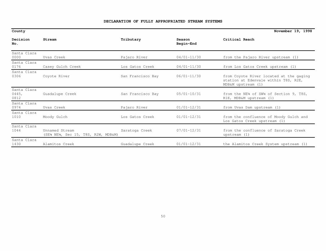
Santa Clara0000 Uvas Creek Pajaro River 04/01-11/30 from the Pajaro River upstream (1)
Santa Clara0176 Casey Gulch Creek Los Gatos Creek 04/01-11/30 from Los Gatos Creek upstream (1)
Santa Clara0306 Coyote River San Francisco Bay 06/01-11/30 from Coyote River located at the gaging station at Edenvale within T8S, R2E, MDB&M upstream (1)
Santa Clara0445, Guadalupe Creek San Francisco Bay 05/01-10/31 from the NE¼ of SW¼ of Section 9, T8S,0812 R1E, MDB&M upstream (1)
Santa Clara0974 Uvas Creek Pajaro River 01/01-12/31 from Uvas Dam upstream (1)
Santa Clara1010 Moody Gulch Los Gatos Creek 01/01-12/31 from the confluence of Moody Gulch and Los Gatos Creek upstream (1)
Santa Clara1044 Unnamed Stream Saratoga Creek 07/01-12/31 from the confluence of Saratoga Creek (SE¼ NE¼, Sec 15, T8S, R2W, MDB&M) upstream (1)
Santa Clara1430 Alamitos Creek Guadalupe Creek 01/01-12/31 the Alamitos Creek System upstream (1)
50
DECLARATION OF FULLY APPROPRIATED STREAM SYSTEMS
County November 19, 1998
Decision Stream Tributary Season Critical ReachNo. Begin-End
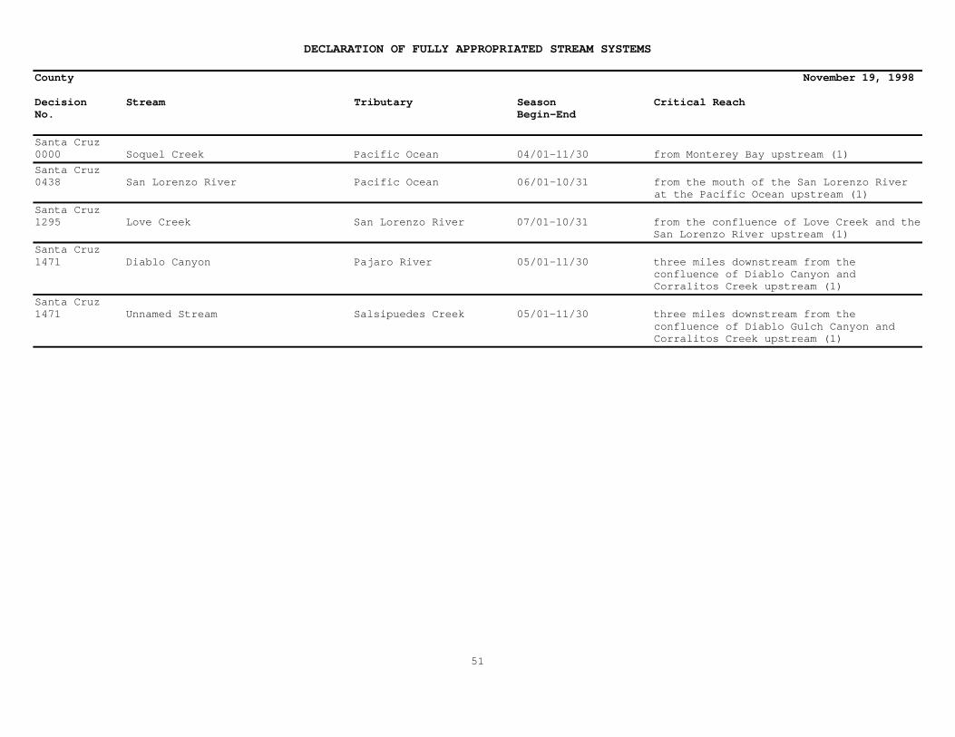
Santa Cruz0000 Soquel Creek Pacific Ocean 04/01-11/30 from Monterey Bay upstream (1)
Santa Cruz0438 San Lorenzo River Pacific Ocean 06/01-10/31 from the mouth of the San Lorenzo River at the Pacific Ocean upstream (1)
Santa Cruz1295 Love Creek San Lorenzo River 07/01-10/31 from the confluence of Love Creek and the San Lorenzo River upstream (1)
Santa Cruz1471 Diablo Canyon Pajaro River 05/01-11/30 three miles downstream from the confluence of Diablo Canyon and Corralitos Creek upstream (1)
Santa Cruz1471 Unnamed Stream Salsipuedes Creek 05/01-11/30 three miles downstream from the confluence of Diablo Gulch Canyon and Corralitos Creek upstream (1)
51

DECLARATION OF FULLY APPROPRIATED STREAM SYSTEMS
County November 19, 1998
Decision Stream Tributary Season Critical ReachNo. Begin-End
Shasta** McCloud River Shasta Lake 01/01-12/31 (2) the main stem from Algoma to the confluence with Lake McCloud; the main stem from McCloud Dam to Shasta Lake
Shasta** Squaw Valley Creek McCloud River 01/01-12/31 (2) Squaw Valley Creek from the northern boundary of Section 14, T38N, R3W to its
confluence with the main stem of the McCloud River
Shasta0000 Burney Creek Lake Britton 04/01-11/30 from the confluence of Burney Creek and Lake Britton upstream (1)
Shasta0000 Clover Creek Little North Cow Creek 04/01-11/30 from the confluence of Clover Creek and Old Cow Creek upstream (1)
Shasta0000 Cow Creek Sacramento River 04/01-11/30 from the confluence of Cow Creek and the Sacramento River upstream (1)
Shasta0000 Hat Creek Lake Britton 04/01-11/30 from the junction of Hat Creek and Rising River upstream (1)
Shasta0000 North Fork Cottonwood Creek Cottonwood Creek 04/01-11/30 from the confluence of North Fork Cottonwood Creek and Cottonwood Creek upstream (1)
Shasta0000 Oak Run Creek Cow Creek 04/01-11/30 at Gage #9 located in Section 3, T32N, R2W, MDB&M upstream (1)
Shasta0000 Roaring Creek Pit River 04/01-11/30 from Roaring Creek located at Big Bend Road Bridge (or confluence with Richardson Creek) upstream (1)
Shasta0000 Willow Creek Stream System Montgomery Creek 04/01-11/30 from the confluence of Willow Creek Stream System and Montgomery Creek upstream (1)
52

DECLARATION OF FULLY APPROPRIATED STREAM SYSTEMS
County November 19, 1998
Decision Stream Tributary Season Critical ReachNo. Begin-End
Shasta0000, North (Little) Cow Creek Cow Creek 06/01-10/31 from the confluence of North (Little)0576 Cow Creek and Old Cow Creek upstream (1)
Shasta0518 Middle Fork Cottonwood Creek Sacramento River 07/01-09/30 from a point on Middle Fork Cottonwood Creek located within the SW¼ of SW¼ of Section 16, T29N, R9W,MDB&M (approximately 2 miles below the applicants' point of diversion) upstream (1)
Shasta0705 South Fork Montgomery Creek Pit River 05/15-09/30 from the ditch known as the "Bowley, (aka Johnson Creek) Childs and Calkins Ditch" located within the SW¼ NE¼, Section 15, T34N, R1E, MDB&M upstream (1)
Shasta0946 Unnamed Stream Shasta Lake 05/01-11/30 from the confluence of the (NW¼ SW¼, Sec 26, T35N, R5W, MDB&M) unnamed stream and Shasta Lake upstream (1)
Shasta1243 Beegum Creek Middle Fork Cottonwood 06/15-07/31 from the Section lines of Sections Creek 17-18, T29N, R4W, MDB&M upstream (1)
Shasta1398 Ash Creek Sacramento River 04/01-10/31 Ash Creek approximately 1¼ miles below the NW¼ of SE¼, Section 1, T30N, R1W, MDB&M upstream (1)
Shasta1594 Sacramento-San Joaquin Delta Delta above 06/15-08/31 (a) from the Delta upstream (1) Collinsville
(a) For diversions less then one cfs or less than 100 afa of storage, no diversion is allowed from June 16 through August 31.
53

DECLARATION OF FULLY APPROPRIATED STREAM SYSTEMS
County November 19, 1998
Decision Stream Tributary Season Critical ReachNo. Begin-End
Sierra0000 Middle Fork Feather River Feather River 05/15-09/30
Sierra0000, Long Valley Creek Honey Lake 03/01-09/30 from the confluence of Honey Lake1444 upstream (1)
Sierra0831 Middle Fork Feather River Feather River 05/15-09/30 from Middle Fork Feather River at Beckwourth upstream (1)
Sierra0994 East Fork Indian Creek Indian Creek thence 09/01-11/30 from the point of diversion(s) to North Yuba River the confluence with Indian Creek upstream (1)
Sierra0994 Grant Ravine North Yuba River 09/01-11/30 from the point of diversion(s) to the confluence with Indian Creek upstream(1)
Sierra0994 South Fork Indian Creek Indian Creek thence 09/01-11/30 from the point of diversion(s) to the North Yuba River confluence with Indian Creek upstream(1)
Sierra1160 Oregon Creek Middle Yuba River 07/01-10/31 from the confluence of Oregon Creek and the Middle Yuba River upstream (1)
Sierra1270 Perazzo Canyon Little Truckee River 07/01-10/31 from the confluence of Perazzo Canyon and the Little Truckee River upstream (1)
Sierra1323 Unnamed Stream Buckeye Ravine thence 01/01-12/31 from the confluence of Buckeye Ravine Kanaka Creek and Kanaka Creek upstream (1)
Sierra1368 Unnamed Stream Sacketts Gulch thence 05/01-10/31 from the confluence of the unnamed (NE¼ NW¼, Sec 7, T21N, R10E, MDB&M)Slate Creek stream and Slate Creek upstream (1)
Sierra1391 Sierra Valley Channels Middle Fork Feather 04/15-09/30 from the confluence of the Middle River Fork Feather River at Beckwourth upstream (1)
54

DECLARATION OF FULLY APPROPRIATED STREAM SYSTEMS
County November 19, 1998
Decision Stream Tributary Season Critical ReachNo. Begin-End
Sierra1594 Sacramento-San Joaquin Delta Delta above 06/15-08/31 (a) from the Delta upstream (1) Collinsville
(a) For diversions less then one cfs or less than 100 afa of storage, no diversion is allowed from June 16 through August 31.
55

DECLARATION OF FULLY APPROPRIATED STREAM SYSTEMS
County November 19, 1998
Decision Stream Tributary Season Critical ReachNo. Begin-End
Siskiyou** Klamath River Pacific Ocean 01/01-12/31 (2) from the main stem about 100 yards below Iron Gate Dam to the Pacific Ocean
Siskiyou** McCloud River Shasta Lake 01/01-12/31 (2) the main stem from Algoma to the confluence with Lake McCloud; the main stem from McCloud Dam to Shasta Lake
Siskiyou** North Fork of the Salmon River Salmon River 01/01-12/31 (2) the North Fork of the Salmon River from the intersection of the river with the south boundary of the Marble Mountain Wilderness Area to the River mouth
Siskiyou** Salmon River Klamath River 01/01-12/31 (2) the Salmon River from Cecilville Bridge to the river mouth near Somesbar
Siskiyou** Scott River Klamath River 01/01-12/31 (2) the Scott River from the mouth of Shackleford Creek west of Fort Jones to the river mouth near Hamburg
Siskiyou** Squaw Valley Creek McCloud River 01/01-12/31 (2) Squaw Valley Creek from the northern boundary of Section 14, T38N, R3W to its confluence with the main stem of the McCloud River
Siskiyou** Wooley Creek Salmon River 01/01-12/31 (2) Wooley Creek from the western boundary of the Marble Mountain Wilderness Area to its confluence with the Salmon River
Siskiyou0000 Cold Creek Bogus Creek 04/01-11/30 from Copco Lake upstream (1)
56

DECLARATION OF FULLY APPROPRIATED STREAM SYSTEMS
County November 19, 1998
Decision Stream Tributary Season Critical ReachNo. Begin-End
Siskiyou0000 French Creek Scott River 04/01-11/30 from the confluence of French Creek and the Scott River upstream (1)
Siskiyou0000 Scott River Klamath River 04/01-11/30 at the U.S. Geological Survey gage located on the Scott River near Fort Jones upstream (1)
Siskiyou0000 Shackleford Creek Scott River 04/01-11/30 from the confluence of Shackleford Creek and the Scott River upstream (1)
Siskiyou0000 Willow Creek Klamath River 04/01-11/30 from the York Road Bridge located within Section 8, T46N, R5W, MDB&M upstream (1)
Siskiyou0000, Seiad Creek Klamath River 07/01-10/31 from the confluence of Seiad Creek and the
1273 Klamath River upstream (1)
Siskiyou0000, Shasta River Klamath River 05/01-10/31 from the confluence of the Shasta River1367 and the Klamath River upstream (1)
Siskiyou0068 Shasta River Klamath River 06/15-10/31 from the confluence of Willow Creek located within Section 23, T44N, R6W, MDB&M upstream (1)
Siskiyou0381 McKinney Creek Klamath River 03/01-10/31 about 1-l/2 miles downstream from the point of diversion on McKinney Creek upstream (1)
Siskiyou0416 East Fork of South Fork Salmon Salmon River 07/15-11/30 at a point on the East Fork of South Fork River Salmon River located within T39N, R10W (Shadow Creek Campground) upstream (1)
57
DECLARATION OF FULLY APPROPRIATED STREAM SYSTEMS
County November 19, 1998
Decision Stream Tributary Season Critical ReachNo. Begin-End
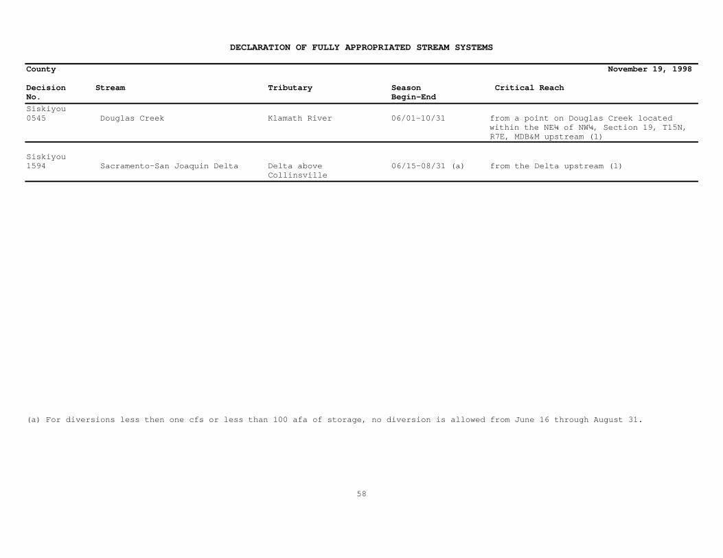
Siskiyou0545 Douglas Creek Klamath River 06/01-10/31 from a point on Douglas Creek located within the NE¼ of NW¼, Section 19, T15N, R7E, MDB&M upstream (1)
Siskiyou1594 Sacramento-San Joaquin Delta Delta above 06/15-08/31 (a) from the Delta upstream (1) Collinsville
(a) For diversions less then one cfs or less than 100 afa of storage, no diversion is allowed from June 16 through August 31.
58

DECLARATION OF FULLY APPROPRIATED STREAM SYSTEMS
County November 19, 1998
Decision Stream Tributary Season Critical ReachNo. Begin-End
Solano0424 Miller Canyon Creek Pleasants Creek 06/01-10/31 from a point where Pleasants Creek and thence Putah Creek Pleasants Valley Road intersect located within Section 1, T7N, R2W, MDB&M upstream (1)
Solano1289 Union Creek Hill Slough thence 03/01-10/31 from the point of diversion on Union Creek Suisun Bay downstream about ¼ mile upstream (1)
Solano1594 Sacramento-San Joaquin Delta Delta above 06/15-08/31 (a) from the Delta upstream (1) Collinsville
(a) For diversions less then one cfs or less than 100 afa of storage, no diversion is allowed from June 16 through August 31.
59

DECLARATION OF FULLY APPROPRIATED STREAM SYSTEMS
County November 19, 1998
Decision Stream Tributary Season Critical ReachNo. Begin-End
Sonoma0302 Mark West Creek Russian River 05/01-10/31 Mark West Creek from where it crosses Highway 101 located in Section 29, T8N, R8W, MDB&M upstream (1)
Sonoma0663 Green Valley Creek Russian River 06/15-10/31 from the confluence of Green Valley Creek and the Russian River upstream (1)Sonoma0709 Atascadero Creek Green Valley Creek 06/15-10/31 from the confluence of Green Valley Creek upstream (1)
Sonoma0852, Laguna De Santa Rosa Mark West Creek 06/01-10/31 from Laguna De Santa Rosa and North0691 thence Russian River of Molino (Occidental) Road located within Section 26, T7N, R9W, MDB&M upstream (1)
Sonoma1004 Sonoma Creek San Pablo Bay 07/01-09/30 on Sonoma Creek below the gaging station located at Boyes Hot Springs upstream (1)
Sonoma1038 Santa Rosa Creek Laguna De Santa Rosa 06/01-10/31 from Santa Rosa Creek located at thepoint within Section 18, T7N, R8W, MDB&M upstream (1)
Sonoma1537 Unnamed Stream Russian River 06/01-10/31 from the point of diversion immediately (SW¼ SW¼,Sec 5,T9N,R8W,MDB&M) downstream and upstream (1)
Sonoma1608 Unnamed Stream Gill Creek thence 06/01-09/30 from the confluence of Gill Creek and (SE¼ SE¼,Sec 36,T11N,R10W,MDB&M) Russian River the unnamed stream located within Projected Section 1, T10N, R10W, MDB&M upstream (1)
60

DECLARATION OF FULLY APPROPRIATED STREAM SYSTEMS
County November 19, 1998
Decision Stream Tributary Season Critical ReachNo. Begin-End
Stanislaus0000 Stanislaus River Stream System San Joaquin River 04/01-11/30 from the confluence with the San Joaquin River upstream (1)
Stanislaus1179 Calaveras River San Joaquin River 05/01-10/31 from the confluence with the San Joaquin River upstream (1)
Stanislaus1422 Stanislaus River San Joaquin River 07/01-10/31 from the confluence with San Joaquin River upstream (1)
Stanislaus1594 Sacramento-San Joaquin Delta Delta above 06/15-08/31 (a) from the Delta upstream (1) Collinsville
(a) For diversions less then one cfs or less than 100 afa of storage, no diversion is allowed from June 16 through August 31.
61
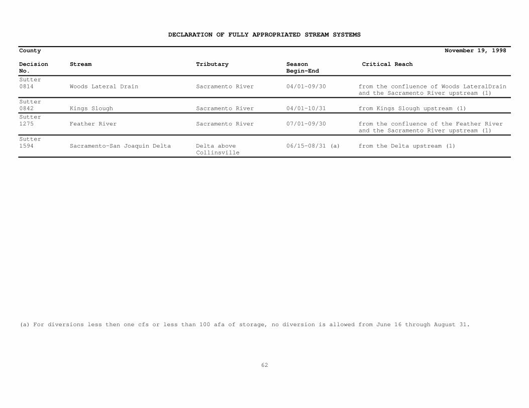
DECLARATION OF FULLY APPROPRIATED STREAM SYSTEMS
County November 19, 1998
Decision Stream Tributary Season Critical ReachNo. Begin-End
Sutter0814 Woods Lateral Drain Sacramento River 04/01-09/30 from the confluence of Woods LateralDrain and the Sacramento River upstream (1)
Sutter0842 Kings Slough Sacramento River 04/01-10/31 from Kings Slough upstream (1)
Sutter1275 Feather River Sacramento River 07/01-09/30 from the confluence of the Feather River and the Sacramento River upstream (1)
Sutter1594 Sacramento-San Joaquin Delta Delta above 06/15-08/31 (a) from the Delta upstream (1) Collinsville
(a) For diversions less then one cfs or less than 100 afa of storage, no diversion is allowed from June 16 through August 31.
62

DECLARATION OF FULLY APPROPRIATED STREAM SYSTEMS
County November 19, 1998
Decision Stream Tributary Season Critical ReachNo. Begin-End
Tehama0000 Pine Creek Sacramento River 04/01-11/30 from the confluence of Pine Creek and the Sacramento River upstream (1)
Tehama0000 Stony Creek Stream System Sacramento River 04/01-11/30 from the confluence of the Sacramento River upstream (1)
Tehama1100 Stony Creek Sacramento River 05/01-10/31 from the confluence of Stony Creek andthe Sacramento River upstream (1)
Tehama1243 Beegum Creek Middle Fork Cottonwood 06/15-07/31 from Section lines of Sections 17-18, Creek T29N, R4W, MDB&M upstream (1)
Tehama1500 Truckee Creek McClure Creek 04/01-10/31 from a point located within the SE¼ SE¼, Sec.14, T25N, R3W, MDB&M upstream (1)
Tehama1594 Sacramento-San Joaquin Delta Delta above 06/15-08/31 (a) from the Delta upstream (1) Collinsville
(a) For diversions less then one cfs or less than 100 afa of storage, no diversion is allowed from June 16 through August 31.
63
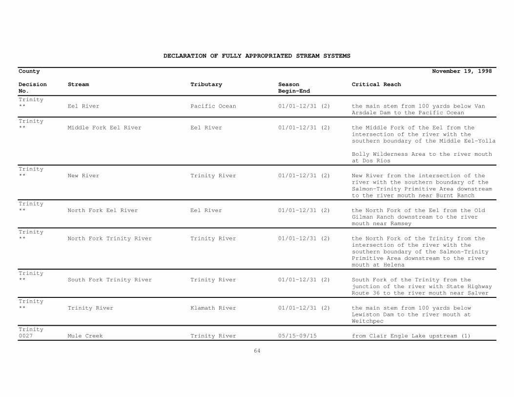
DECLARATION OF FULLY APPROPRIATED STREAM SYSTEMS
County November 19, 1998
Decision Stream Tributary Season Critical ReachNo. Begin-End
Trinity** Eel River Pacific Ocean 01/01-12/31 (2) the main stem from 100 yards below Van Arsdale Dam to the Pacific Ocean
Trinity** Middle Fork Eel River Eel River 01/01-12/31 (2) the Middle Fork of the Eel from the intersection of the river with the southern boundary of the Middle Eel-Yolla
Bolly Wilderness Area to the river mouth at Dos Rios
Trinity** New River Trinity River 01/01-12/31 (2) New River from the intersection of the river with the southern boundary of the Salmon-Trinity Primitive Area downstream to the river mouth near Burnt Ranch
Trinity** North Fork Eel River Eel River 01/01-12/31 (2) the North Fork of the Eel from the Old Gilman Ranch downstream to the river mouth near Ramsey
Trinity** North Fork Trinity River Trinity River 01/01-12/31 (2) the North Fork of the Trinity from the intersection of the river with the southern boundary of the Salmon-Trinity Primitive Area downstream to the river mouth at Helena
Trinity** South Fork Trinity River Trinity River 01/01-12/31 (2) South Fork of the Trinity from the junction of the river with State Highway Route 36 to the river mouth near Salver
Trinity** Trinity River Klamath River 01/01-12/31 (2) the main stem from 100 yards below Lewiston Dam to the river mouth at Weitchpec
Trinity0027 Mule Creek Trinity River 05/15-09/15 from Clair Engle Lake upstream (1)
64
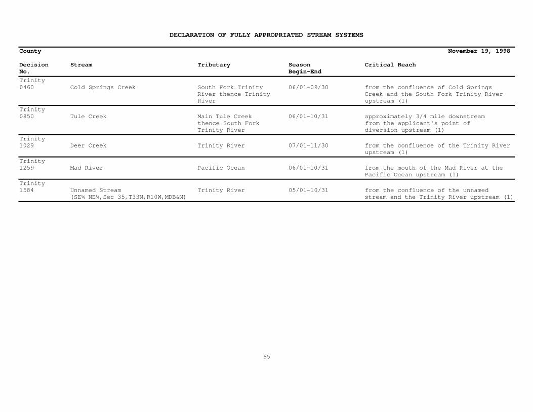
DECLARATION OF FULLY APPROPRIATED STREAM SYSTEMS
County November 19, 1998
Decision Stream Tributary Season Critical ReachNo. Begin-End
Trinity0460 Cold Springs Creek South Fork Trinity 06/01-09/30 from the confluence of Cold Springs River thence Trinity Creek and the South Fork Trinity River River upstream (1)
Trinity0850 Tule Creek Main Tule Creek 06/01-10/31 approximately 3/4 mile downstream thence South Fork from the applicant's point of Trinity River diversion upstream (1)
Trinity1029 Deer Creek Trinity River 07/01-11/30 from the confluence of the Trinity River upstream (1)
Trinity1259 Mad River Pacific Ocean 06/01-10/31 from the mouth of the Mad River at the Pacific Ocean upstream (1)
Trinity1584 Unnamed Stream Trinity River 05/01-10/31 from the confluence of the unnamed (SE¼ NE¼,Sec 35,T33N,R10W,MDB&M) stream and the Trinity River upstream (1)
65

DECLARATION OF FULLY APPROPRIATED STREAM SYSTEMS
County November 19, 1998
Decision Stream Tributary Season Critical ReachNo. Begin-End
Tulare*** North Fork Kern River Kern River 01/01-12/31 (3) the segment of the main stem from the Tulare-Kern County line to its headwaters in Sequoia National Park
Tulare*** South Fork Kern River Kern River 01/01-12/31 (3) the segment of its headwaters in the Inyo National Forest to the southern boundary of the Domelands Wilderness in the Sequoia National Forest
Tulare0959 Poso Creek Tulare Lake Basin 06/15-10/31 the termination of Poso Creek located within T26S, R24E, MDB&M near McFarland and upstream. Poso Creek goes intermittent just below the confluence of Poso Creek and Little Poso Creek located within T27S, R30E, MDB&M at PineMountain
Tulare1290 Kings River System Tulare Lake Basin 01/01-12/31 from Tulare Lake Basin upstream (1)
Tulare1435, Tule River System Tulare Lake Basin 01/01-12/31 from the terminus at Tulare Lake Basin1018, upstream including all tributaries in the1432 Tule River System where hydraulic continuity exists during any part of the year
Tulare1594 Sacramento-San Joaquin Delta Delta above 06/15-08/31 (a) from the Delta upstream (1) Collinsville
(a) For diversions less then one cfs or less than 100 afa of storage, no diversion is allowed from June 16 through August 31.
66

DECLARATION OF FULLY APPROPRIATED STREAM SYSTEMS
County November 19, 1998
Decision Stream Tributary Season Critical ReachNo. Begin-End
Tuolumne*** Tuolumne River San Joaquin River 01/01-12/31 (3) the main river from its sources on Mount Dana and Mount Lyell in Yosemite National Park to Don Pedro Reservoir consisting of approximately 83 miles as depicted on the proposed boundary map entitled "Alternative A" contained in the Draft Tuolumne Wild and Scenic River Study and Environmental Impact Statement
Tuolumne0000 Stanislaus River Stream System San Joaquin River 04/01-11/30 from the confluence with the San Joaquin River upstream (1)
Tuolumne0995 Tuolumne River San Joaquin River 07/01-10/31 from Don Pedro Reservoir upstream (1)
Tuolumne1023 Turnback Creek Tuolumne River 05/15-10/31 from the Tuolumne Indian Rancheria upstream (1)
Tuolumne1123 Sullivan Creek Tuolumne River 06/01-10/31 from the confluence with Sullivan Creek upstream (1)
Tuolumne1157 Mormon Creek Stanislaus River 05/01-10/31 from a point located within the S½ of Section 22, T2N, R14E, MDB&M upstream (1)
Tuolumne1422 Stanislaus River San Joaquin River 07/01-10/31 from the confluence with the San Joaquin River upstream (1)
Tuolumne1594 Sacramento-San Joaquin Delta Delta above 06/15-08/31 (a) from the Delta upstream (1) Collinsville
(a) For diversions less then one cfs or less than 100 afa of storage, no diversion is allowed from June 16 through August 31.
67

DECLARATION OF FULLY APPROPRIATED STREAM SYSTEMS
County November 19, 1998
Decision Stream Tributary Season Critical ReachNo. Begin-End
Ventura*A27762 Cozy Dell Canyon Ventura River 01/01-12/31 from the confluence of Cozy Dell Canyon and the Ventura River upstream (1)
Ventura0721 Reeves Creek Thatcher Creek thence 06/01-10/31 from Section 3, T4N, R22W, SBB&M San Antonio Creek upstream (1)
Ventura0741 Santa Ana Creek Lake Casitas 01/01-12/31 from Lake Casitas upstream (1)
68

DECLARATION OF FULLY APPROPRIATED STREAM SYSTEMS
County November 19, 1998
Decision Stream Tributary Season Critical ReachNo. Begin-End
Yolo1079 Willow Slough Yolo Bypass 04/01-10/31 from the confluence of Willow Slough and the Yolo Bypass upstream (1)
Yolo1506 Cache Creek Yolo Bypass 04/15-10/31 from the confluence with the Yolo Bypass upstream (1)
Yolo1594 Sacramento-San Joaquin Delta Delta above 06/15-08/31 (a) from the Delta upstream (1) Collinsville
(a) For diversions less then one cfs or less than 100 afa of storage, no diversion is allowed from June 16 through August 31.
69

DECLARATION OF FULLY APPROPRIATED STREAM SYSTEMS
County November 19, 1998
Decision Stream Tributary Season Critical ReachNo. Begin-End
Yuba0528 Honcut Creek Feather River 04/01-10/31 from the confluence of the Feather River upstream (1)
Yuba1091 Bear River Feather River 05/01-11/30 from Camp Far West Reservoir upstream (1)
Yuba1275 Feather River Sacramento River 07/01-09/30 from the confluence of the Feather River and the Sacramento River upstream (1)
Yuba1476 South Honcut Creek Honcut Creek 04/15-10/31 from the confluence of South Honcut Creek and the Feather River upstream (1)
Yuba1594 Sacramento-San Joaquin Delta Delta above 06/15-08/31 (a) from the Delta upstream (1) Collinsville
(a) For diversions less then one cfs or less than 100 afa of storage, no diversion is allowed from June 16 through August 31.
70