state cartographer’s office university of wisconsin-madison [email protected] wisconsin land...
TRANSCRIPT

WLIP Report2013
State Cartographer’s OfficeUniversity of [email protected]
Wisconsin Land Information ProgramWisconsin Department of Administration

Program Requirements
• County land info council• County land info plan • Annual expenditure report• Land Info listserv participation• Detailed grant application• 2017 deadline for posting certain parcel
info online• WLIP Annual Survey
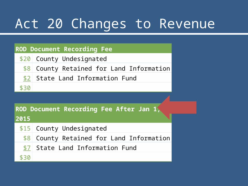
Act 20 Changes to RevenueROD Document Recording Fee
$20 County Undesignated$8 County Retained for Land Information$2 State Land Information Fund
$30
ROD Document Recording Fee After Jan 1, 2015$15 County Undesignated$8 County Retained for Land Information$7 State Land Information Fund
$30

BB Eligibility Changes

Base Budget Grant History
2007 2008 2009 2010 2011 2012 2013 2014 2015$0
$500,000
$1,000,000
$1,500,000
$2,000,000
$2,500,000
Total Base Budget Grants Awarded
Projected Awards If Fully Funded (Actual Amounts TBD)

2012 Fees Retained + WLIP Grants =$10.4 million total in 2012
WLIP Funding
Fees Retained by Counties for County
Land Info Use$9,652,384
Training & Educa-tion Grants
$21,300
Base Budget Grants$718,713
MenomineeIronFlorence
PepinBuffaloForestKewauneeAshlandTaylorPriceCrawfordRuskMarquetteLafayetteBayfieldRichlandGreen LakeLangladeIowa
SawyerJacksonVernonWausharaAdamsWashburnLincolnBurnettJuneau
DunnClarkTrempealeauDouglas
PierceGreen
VilasGrantShawanoMonroeMarinetteOconto
BarronDoorCalumetWaupaca
OneidaPolk
WoodPortageColumbiaChippewaManitowocDodgeJeffersonEau Claire
SaukOzaukeeFond du LacSt. CroixSheboyganWalworthLa CrosseMarathonKenoshaWashingtonRockWinnebago
RacineOutagamieBrownWaukesha
DaneMilwaukee
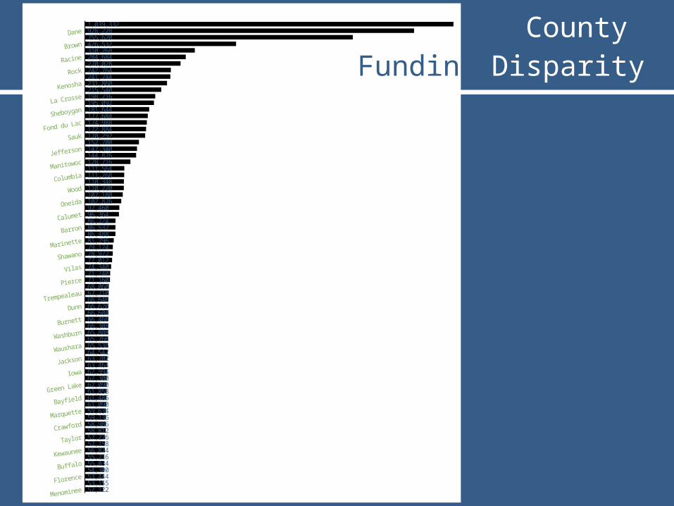
52,12253,15553,44454,30055,03455,21656,87457,15857,27658,81258,98659,13659,63461,09061,48661,85862,09062,30062,99463,46463,70264,54265,53665,76665,80866,30866,46666,60466,62066,64667,71068,06071,16071,74074,34077,01278,97279,12481,79686,48886,53286,72496,36497,460102,876107,180110,220110,348111,268111,564128,716144,876147,340152,700170,292172,884174,988177,684181,644195,092198,716215,540231,860241,244242,764270,028284,684310,268426,532755,620928,2281,039,332 County
Funding Disparity
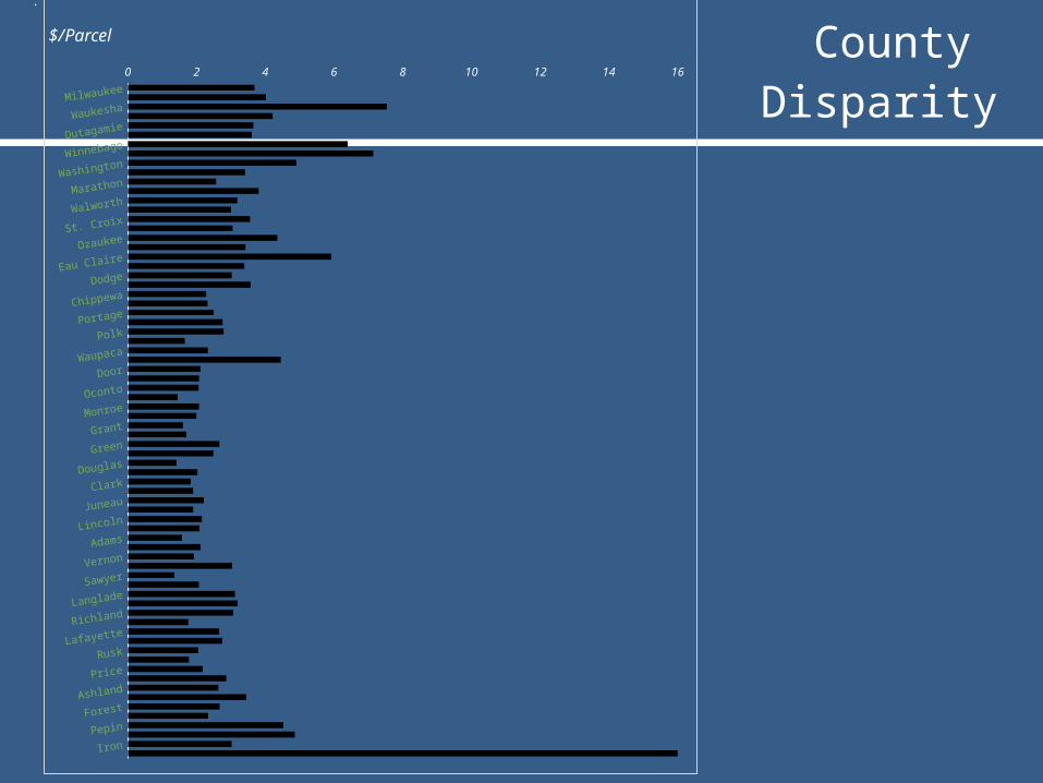
County Funding Disparity
Milwaukee
Waukesha
Outagamie
Winnebago
Washington
Marathon
Walworth
St. Croix
Ozaukee
Eau Claire
Dodge
Chippewa
Portage
Polk
Waupaca
Door
Oconto
Monroe
Grant
Green
Douglas
Clark
Juneau
Lincoln
Adams
Vernon
Sawyer
Langlade
Richland
Lafayette
Rusk
Price
Ashland
Forest
Pepin
Iron
0 2 4 6 8 10 12 14 16
$/Parcel

WLIP County Expenditures
Digital Parcel Mapping16%
Other Hardware/Software
17%
Other16%
Web Mapping In-frastructure and
Apps14%
PLSS Remonumentation12%
Other Parcel Work10%
County Land Info Office Admin.
5%
Address Points3%
Street Centerlines3%
Orthophotography2%
LIDAR2%
Emergency Service Districts
1%

Charting progress - parcels
1994 1995 1997 1998 1999 2000 2001 2002 2003 2008 20130%
1000%
2000%
3000%
4000%
5000%
6000%
7000%
8000%
9000%
10000%
Statewide Percent of Parcels Digitized and
Maintained by Counties
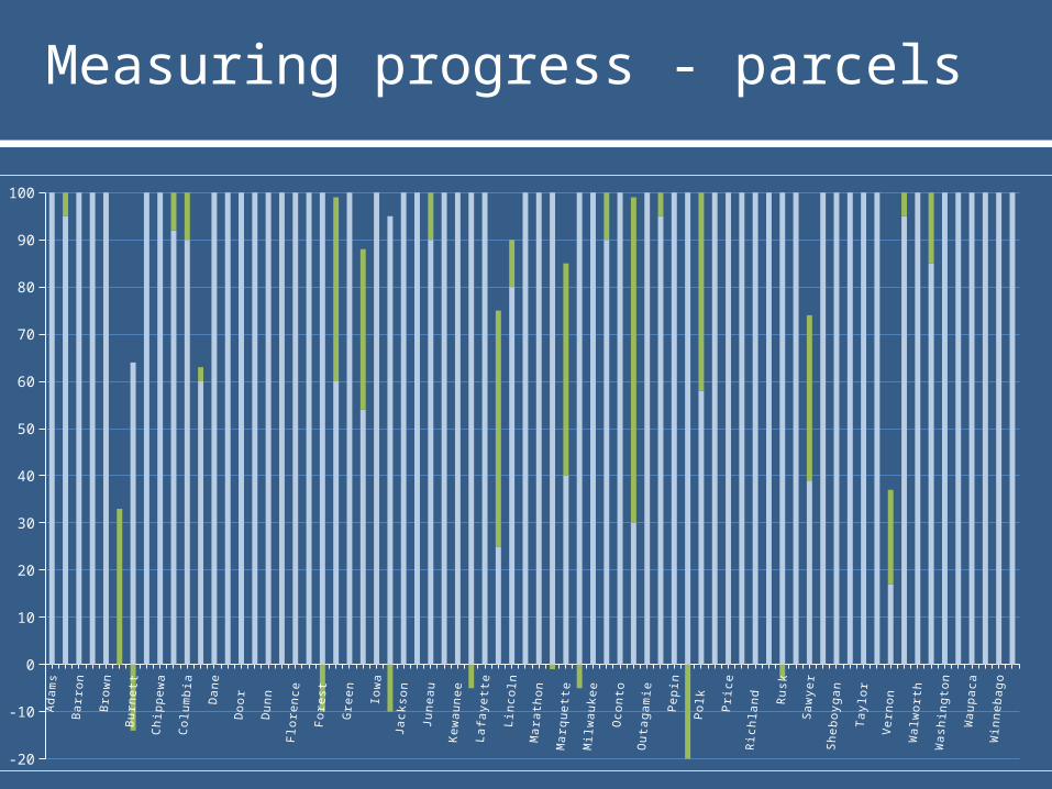
Measuring progress - parcelsA
da
ms
As
hla
nd
Ba
rron
Ba
yfie
ldB
row
nB
uff
alo
Bu
rnet
tC
alu
me
tC
hip
pe
wa
Cla
rkC
olu
mb
iaC
raw
ford
Da
ne
Do
dg
eD
oo
r
Do
ug
las
Du
nn
E
au
Cla
ire
F
lore
nc
e
Fo
nd
du
La
c
Fo
rest
G
rant
G
reen
G
reen
La
ke
Io
wa
Iro
n
Ja
cks
on
J
effe
rso
nJ
une
au
K
en
osh
a
Ke
wau
ne
e
La
Cro
ss
eL
afa
yett
eL
ang
lade
Lin
co
lnM
an
itow
oc
M
ara
tho
n
Ma
rine
tte
Ma
rqu
ett
e M
en
omin
ee
M
ilwau
ke
e
Mo
nro
e
Oc
ont
o
On
eid
a
Ou
tag
am
ie
Oz
auk
ee
P
ep
inP
ierc
eP
olk
P
ort
ag
e P
ric
eR
ac
ine
R
ich
lan
d
Ro
ck
R
us
kS
au
k S
aw
yer
Sh
aw
an
o
Sh
ebo
yg
an
St.
Cro
ix
Ta
ylo
r T
rem
pea
lea
u V
ern
on
Vila
sW
alw
ort
h
Was
hb
urn
W
ash
ing
ton
Wau
ke
sh
a
Wau
pa
ca
Wau
sh
ara
W
inn
eb
ag
oW
ood
-20
-10
0
10
20
30
40
50
60
70
80
90
100

Public Land Survey Corners

Major investments - Orthos
Planned Projects2013 – 3 counties2014 – 3 counties2014/2015 – 4 2015 – 45 counties2016 – 2 counties2017 – 1 countyTotal: 58 counties in next 3 years(~ 80%)

Major investments - LIDAR

Critical Themes – Address Pts
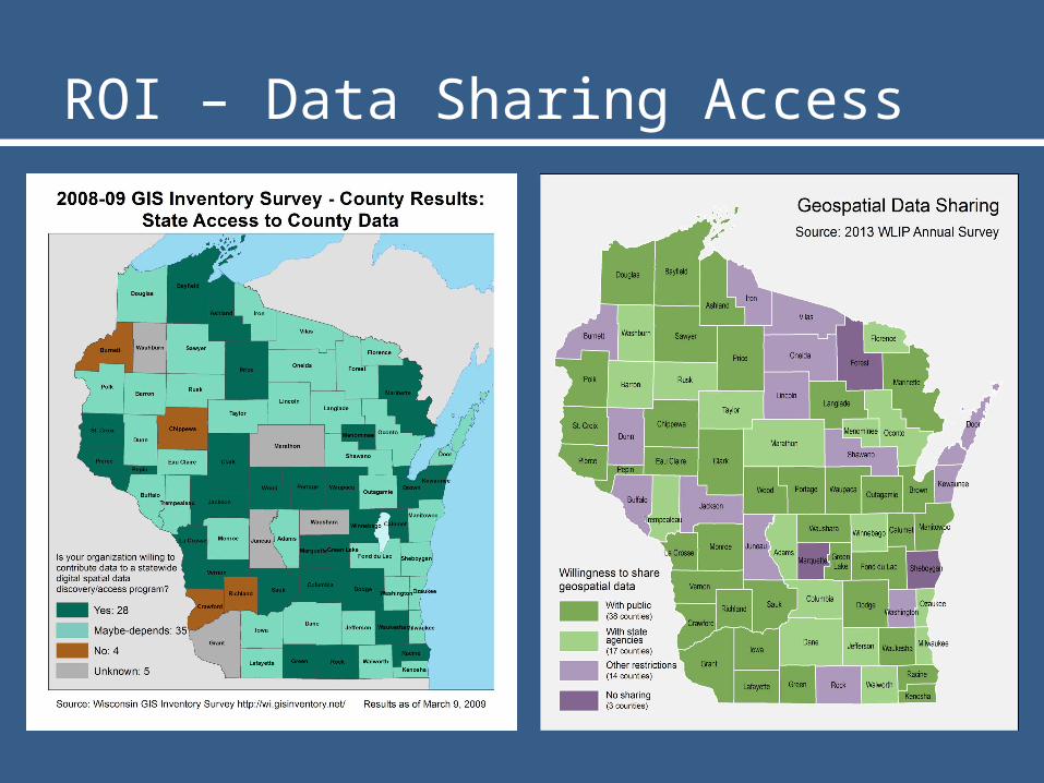
ROI – Data Sharing Access

• Statewide data aggregation & integration– Current, accurate inventory (incl. municipal)– Gaps in data completion– Lack of emphasis on seamless interoperability
• Data Sharing• State-level initiatives (e.g. Act 20, PSC)• Communication & coordination
Challenges & Opportunities
