starch grain and phytolith evidence of seed and tuber processing
TRANSCRIPT

Starch Grain and Phytolith Evidence of Seed and Tuber Processing from the Gray Farm Site (7K-F-11/159) on the Murderkill River in Central Delaware
Prepared in Conjunction with:
Presentation Given at the 13th Annual Byways to the Past Conference in Lancaster, Pennsylvania, July 2012
Prepared and Presented By:
David J. Rue, PhD Rue Environmental LLC

Starch Grain and Phytolith Evidence of Seed and Tuber Processing from the Gray Farm Site (7K-F-11/159)
on the Murderkill River in Central Delaware
By: David J. Rue, PhD Rue Environmental LLC
Based on a Presentation Presented at the 13th Annual Byways to the Past Conference
Lancaster, Pennsylvania, July 2012
Abstract Site 7K-F-11/169 (Gray Farm Site) was occupied most heavily from about 2800-800 BC and AD 900-1300. There were distinct pockets of Late Archaic, Early Woodland, and Late Woodland activity. Late Archaic period (2800 – 1500 BC) steatite and other groundstone items yielded starch grains/phytoliths of Setaria sp. (bristlegrass, a millet), Poaceae (grass), and Asteraceae (either sunflower or marsh elder). Early Woodland (Marcey Creek and Selden Island) sherds yielded Setaria sp., Hordeum sp. (wild barley), Sagittaria sp. (likely Sagittaria latifolia, duck potato), and Cyperaceae (sedge family, likely Scirpus, bulrush). The latter two taxa produce edible tubers/rhizomes. Late Woodland ceramics (Townsend and Killens) yielded Setaria sp. and Hordeum sp.

Phase III investigations were completed at the Gray Farm Site (7K-F-11/169) in 2009 for the Delaware Department of Transportation (Diamanti et al. 2012). The work was done as part of the permitting process for a project involving improvements to the SR 1/SR 12 Frederica North intersection in Kent County, Delaware. Phase III field work was completed in three stages (Figures 1 and 2). Stage 1 included excavation of 1 m x 1 m test units on a 15 m grid, Stage 2 involved block excavations and Stage 3 consisted of plow zone removal of over approximately 3,000 square meters in five areas (“trenches”), to identify anomalies at the B horizon interface, a large sample of which were explored through various research strategies.
Investigations of site chronology were based on diagnostic artifacts and radiocarbon dating. Roughly thirty samples were submitted for radiocarbon analysis, including organic fragments, bulk sherds with organic residues, and shell. The analyses suggested that the site was most heavily occupied in the early and middle portions of the Woodland I period, the traditional Late Archaic and Early Woodland periods (3000 – 1500 BC and 1500 BC – AD 1), with decreased occupation during the late Woodland I and Woodland II (Middle and Late Woodland) periods. Occupation before 3000 BC was present at trace levels only. The early Woodland I was marked by use of steatite vessels and projectile points including narrow stemmed varieties such as Rossville, Bare Island, Poplar Island, and Piney Island.
Figure 1. Layout of Field Investigations at the Gray Farm Site (Data Recovery Area in Lower Right)

Figure 2. Gray Farm Site During Excavation The period was also characterized by use of distinctive tools including small chipped stone implements (micro-tools) and ground stone shaft abraders. The middle Woodland I period saw the introduction of ceramics after 1,500 B.C., including Marcey Creek, Selden Island, and Dames Quarter. The dated contexts for the most part did not include projectile points associated with the ceramics of the middle Woodland I. Occupation in the later Woodland I (AD 1 - 900) was present, marked by Hell Island and Mockley ceramics, but occurred more sporadically than in the early parts of the Woodland I. Woodland II occupation (AD 900 – 1600) was more prevalent than in the preceding period but not as dominant at the site as in the early and middle Woodland I. It was marked by use of Townsend ceramics, although the expected triangular projectile points were present but not numerous. Feature analysis resulted in several categories covering a total of 81 prehistoric features. For the most part, feature function definition was elusive. Pits and basins (Figure 3), by far the most numerous, were likely the result of numerous storage and processing activities. Cylindrical Pits likely served as storage features but the lack of context remnants in the feature fill made any further determination problematic. However, the features provided numerous discrete contexts for artifact and radiocarbon associations. Many of the soil anomalies were diagnosed as tree falls and other natural features.

Figure 3. Excavation of Pit Feature

Analysis of spatial distributions generated several significant results (Figure 4). An area with high lithic densities was noted and further explored with Excavation Block 5, resulting in definition of an early Woodland I concentration area. Cultural features clustered most densely in Trench 5, in the southwestern part of the site. Three distinct activity areas were defined there, representing the early Woodland I, Middle Woodland I, and Woodland II. An early Woodland I concentration area was also defined in Trench 2. In addition to their association with Rossville projectile points, the early Woodland I occupation areas were significantly correlated with ground stone shaft abraders and micro-tools.
Figure 4. Activity Areas in Trench 5, including Early Woodland I (Late Archaic), Middle Woodland I
(Early Woodland, and Woodland II (Late Woodland).
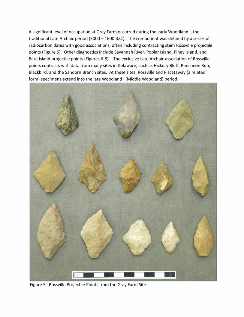
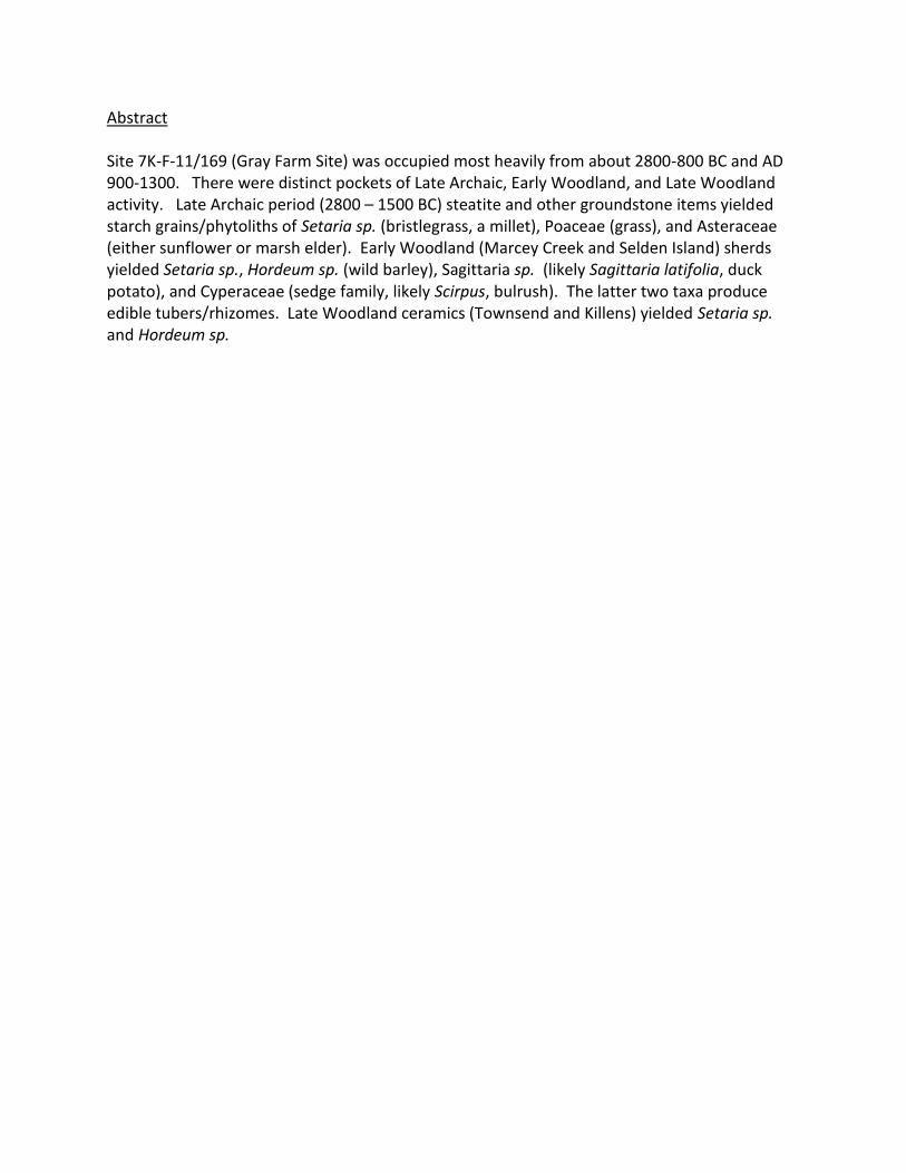
A significant level of occupation at Gray Farm occurred during the early Woodland I, the
traditional Late Archaic period (3000 – 1600 B.C.). The component was defined by a series of
radiocarbon dates with good associations, often including contracting stem Rossville projectile
points (Figure 5). Other diagnostics include Savannah River, Poplar Island, Piney Island, and
Bare Island projectile points (Figures 6-8). The exclusive Late Archaic association of Rossville
points contrasts with data from many sites in Delaware, such as Hickory Bluff, Puncheon Run,
Blackbird, and the Sandorn Branch sites. At these sites, Rossville and Piscataway (a related
form) specimens extend into the late Woodland I (Middle Woodland) period.
Figure 5. Rossville Projectile Points from the Gray Farm Site
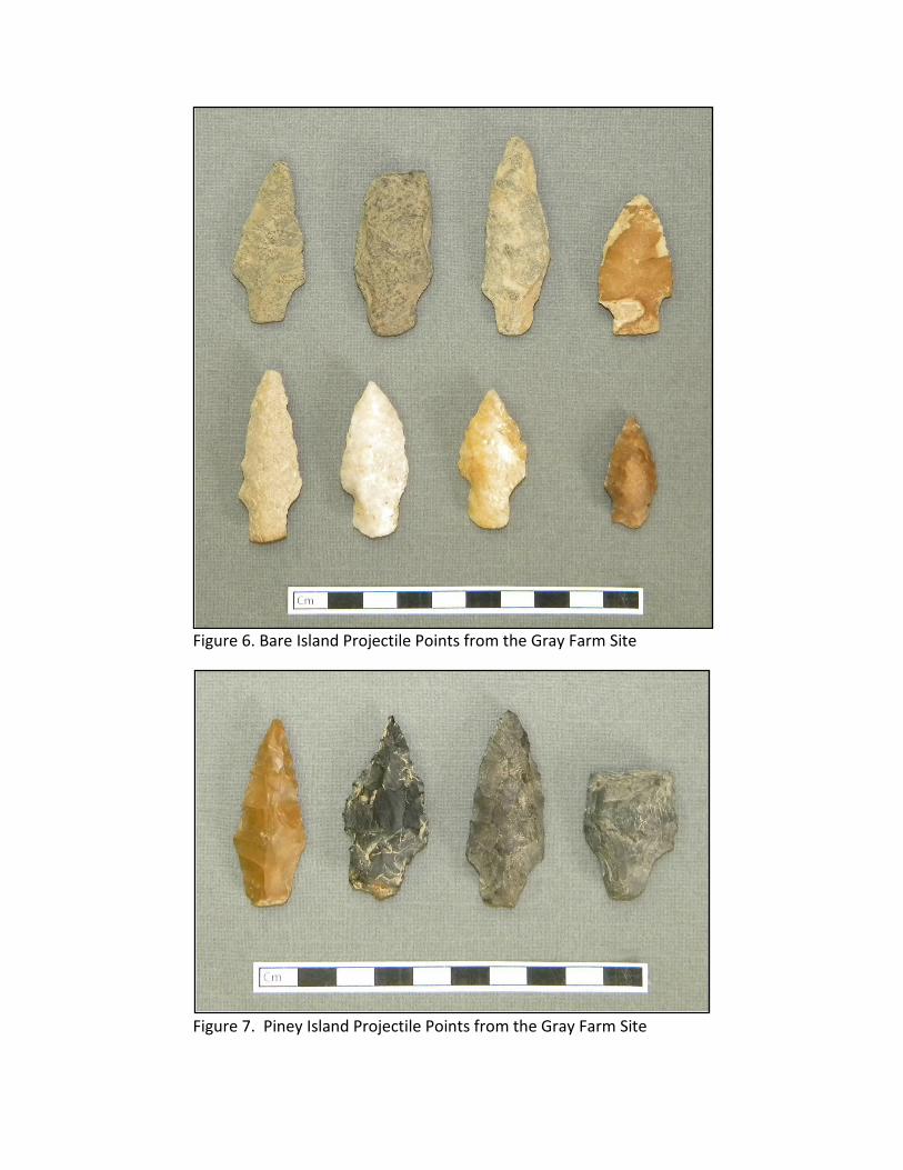
Figure 6. Bare Island Projectile Points from the Gray Farm Site
Figure 7. Piney Island Projectile Points from the Gray Farm Site
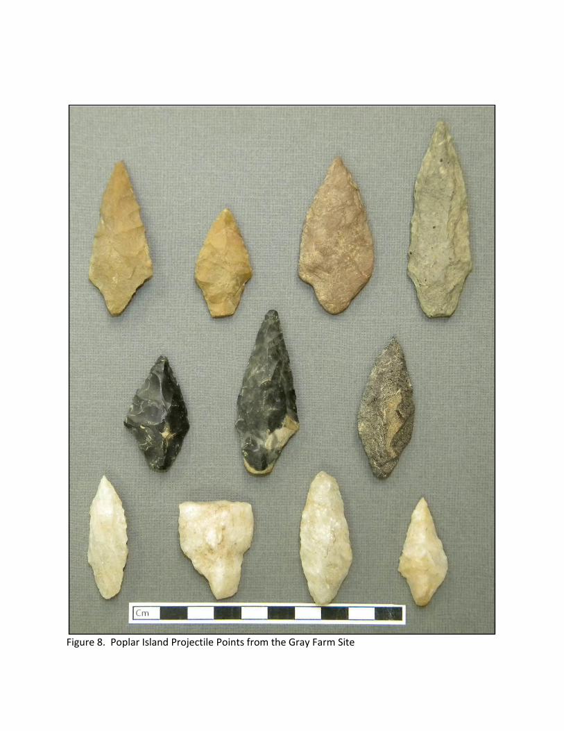
Figure 8. Poplar Island Projectile Points from the Gray Farm Site

By 3000 BC, the post-Ice Age rise in sea level had advanced to the point where the boundary between tidally influenced environments and freshwater environments extended through the area of the APE. The result was a band of terrain rich in fish, terrestrial game, and plant food resources. The number of locations occupied by hunter-gatherers increased dramatically, and the margins of the Murderkill River and Spring Creek are lined with sites dating to this period and later (Dan Griffith, personal communication. These numerous loci were the scene of repeated relatively short-term occupation episodes for resource procurement and processing activities. (Schindler 2006). Evidence of the hunting of terrestrial game was obtained at the Gray Farm Site based on microwear studies of stone tools and residues observed as part of that study. No evidence for fishing was identified but such evidence has been elusive in general except where blood residue analysis has been positive for fish, as was the case at Puncheon Run. The people of the Delaware Valley used fish weirs to collect fish from rivers and streams, an activity that leaves little material evidence.

Figure 9. Steatite Vessel from Early Woodland I (Late Archaic) Activity Area at the Gray Farm
Site
Other associated artifact categories included steatite vessels (Figure 9), grinding stones, shaft abraders, and microtools. Three distinct occupation areas were identified as belonging to this component; one (in Excavation Block 5) associated with particularly high lithic artifact densities. Deep cylindrical pits clustered in these areas, along with pit and basin features. Charred hickory nutshell fragments were identified in some of the features associated with this component. A series of steatite vessel fragments and groundstone tools yielded starch grains and/or phytoliths of Setaria (bristle grass), Poaceae (grass), and Asteraceae (sunflower or marsh elder).
A variety of tools for multiple purposes were found as shown in Figures 10, 11 and 12.

Figure 10. Jasper Drills from the Gray Farm Site
Figure 11. Ground Stone Axe from Gray Farm Site
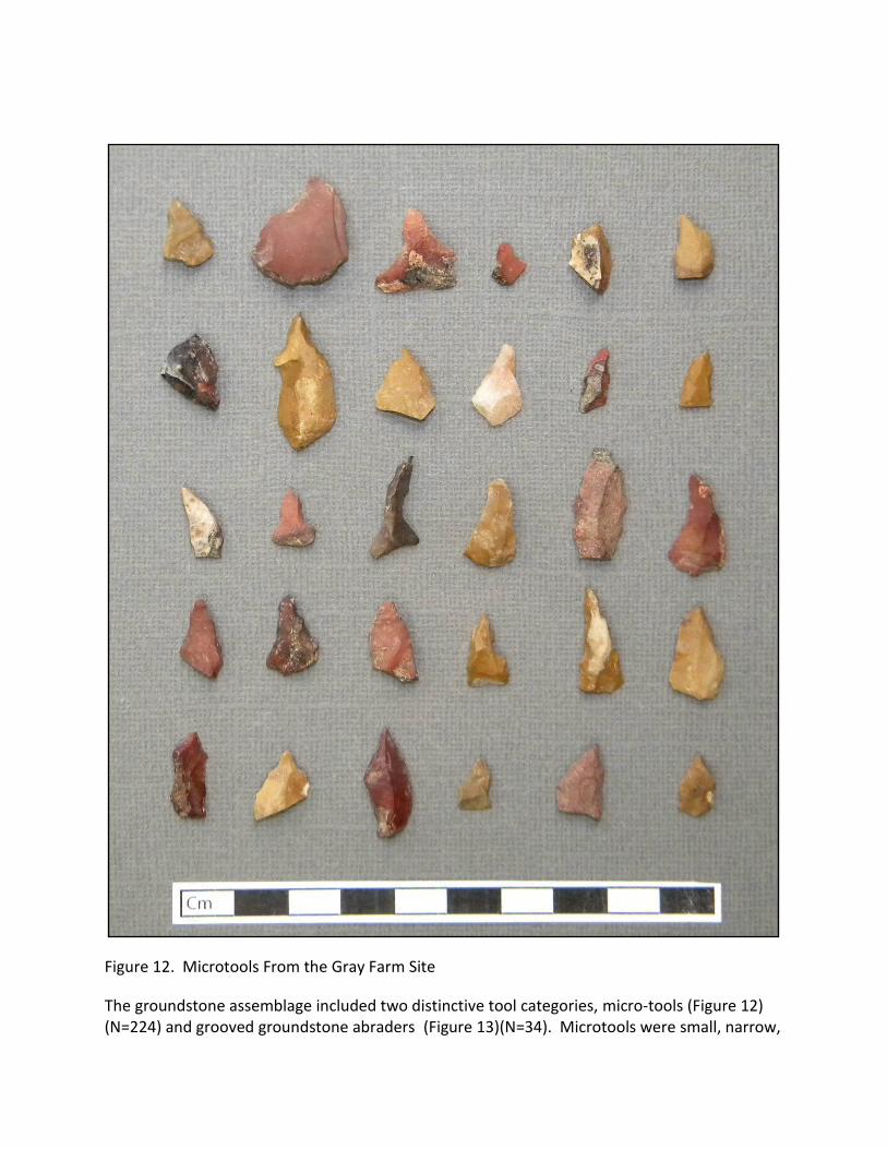
Figure 12. Microtools From the Gray Farm Site
The groundstone assemblage included two distinctive tool categories, micro-tools (Figure 12) (N=224) and grooved groundstone abraders (Figure 13)(N=34). Microtools were small, narrow,

chipped stone tools made on flakes, with an unusual bias toward jasper. A preliminary hypothesis was that these served a very specialized function. However, microwear analysis indicated that they were used for a wide variety of cutting, piercing, and scraping activities. No evidence of hafting was found, although it was noted that resin may have been so utilized. Consideration was also given to the possibility that they might have been a component in a composite tool, such as a grater or edged implement.
Figure 13. Grooved Shaft Abraders from the Gray Farm Site
Grooved abraders were made of sandstone, characterized by U-shaped grooves mostly in the range of 1-7 mm in diameter. A lesser frequency of specimens occurred in two distinct ranges; 8-10 mm and 16-20 mm. Reference was made to independent studies, collectively suggesting that the tools were used to smooth shafts to be used as projectiles and handles.
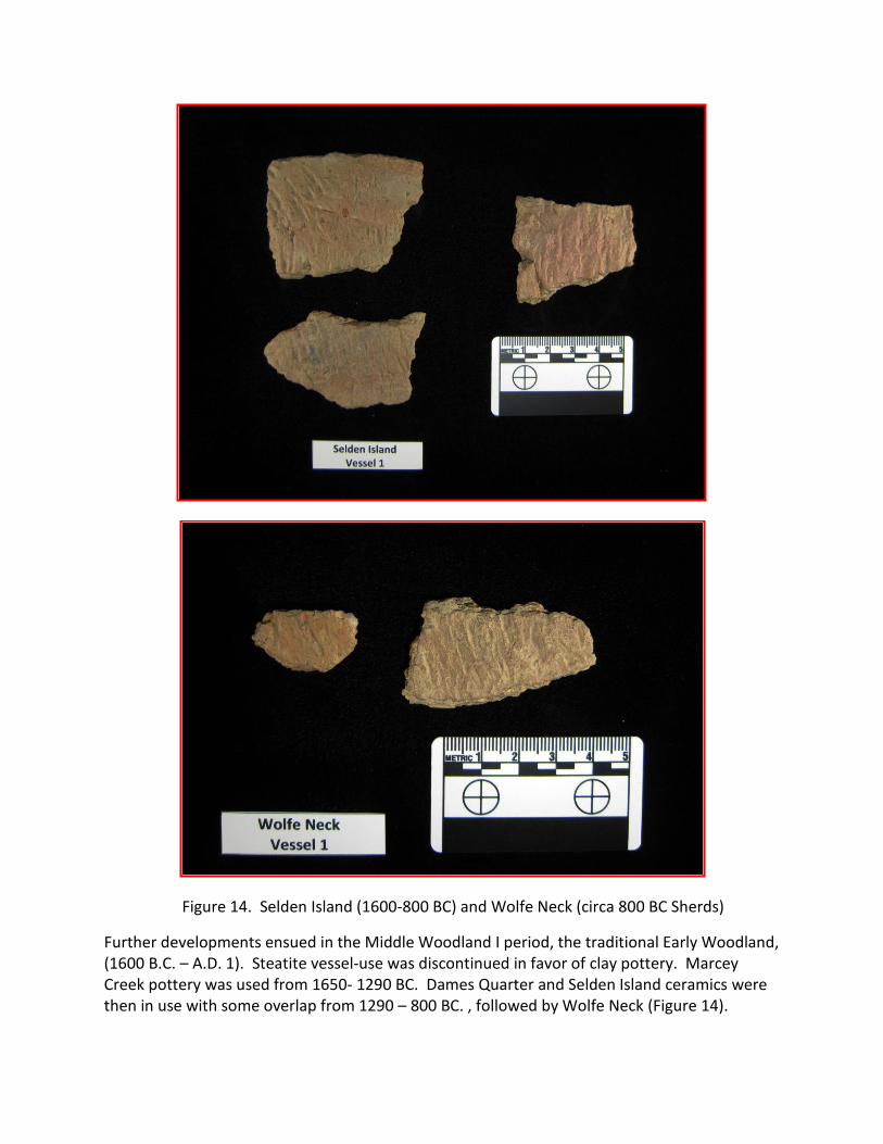
Figure 14. Selden Island (1600-800 BC) and Wolfe Neck (circa 800 BC Sherds)
Further developments ensued in the Middle Woodland I period, the traditional Early Woodland, (1600 B.C. – A.D. 1). Steatite vessel-use was discontinued in favor of clay pottery. Marcey Creek pottery was used from 1650- 1290 BC. Dames Quarter and Selden Island ceramics were then in use with some overlap from 1290 – 800 BC. , followed by Wolfe Neck (Figure 14).

Figure 15. Coulbourne (200-0 BC) and Hell Island Sherds
Radiometrically, Wolfe Neck and Coulbourne ceramics (Figure 15) fall between 358 – 107 BC and 55 BC – AD 300 respectively. The ceramics from the early part of the period are more numerous than the two later types. Vessel counts are relatively low across all types though, so it is unclear whether the time between Selden Island and Wolfe Neck dates is a hiatus or the result of sampling issues. An untyped narrow-stemmed projectile point was the only other diagnostic lithic artifact from a securely dated context, with a radiocarbon date range of 1050 –

800 BC. However, it was not in direct association with ceramics. It is presumed that narrow stemmed points continued to be used during this period, based on analogy to other regional sites. Four distinct middle Woodland I occupation areas were defined, including one in Block 8, two in Trench 5, and one in Trench 4. As in the previous period, these were associated with a variety of pits, basins, and FCR concentration features, although cylindrical pits were not associated with this component, nor were microtools and grooved abraders.
Late Woodland I period (Middle Woodland) utilization of the locality of the Gray Farm Site was much reduced in comparison to the preceding two periods. The component is marked by a very low frequency of Mockley and Hell Island ceramics and Jacks Reef projectile points. The two relevant radiocarbon dates placed use of both ceramic types at the end of the period, in the range of AD 800-950. Few Mockley ceramics were recovered and none were submitted for starch grain analysis.
Figure 16. Townsend Sherds from the Late Woodland
Woodland II (Late Woodland) occupation was marked by two limited site use episodes and use of Townsend ceramics (Figure 16). Particularly important information was generated in the research topics of site function and subsistence. Macrobotanical analysis identified charred wood, nutshell, and seeds. Oak charcoal was dominant, followed by hickory, maple, pine, and chestnut, and charcoal in general was seen to be associated with cylindrical pits. Far more effective was starch grain and phytolith analysis of 15 samples of residues from ceramics and ground stone pieces (Figure 17).
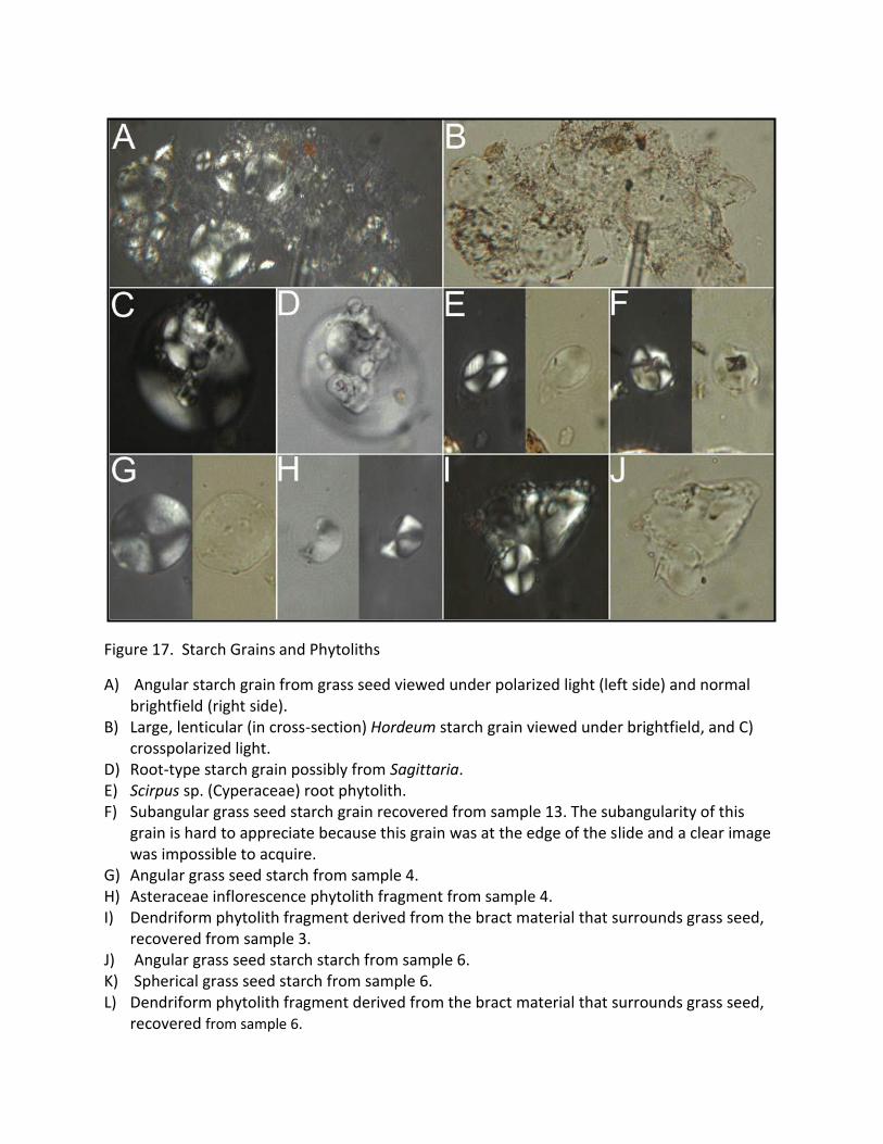
Figure 17. Starch Grains and Phytoliths
A) Angular starch grain from grass seed viewed under polarized light (left side) and normal brightfield (right side).
B) Large, lenticular (in cross-section) Hordeum starch grain viewed under brightfield, and C) crosspolarized light.
D) Root-type starch grain possibly from Sagittaria. E) Scirpus sp. (Cyperaceae) root phytolith. F) Subangular grass seed starch grain recovered from sample 13. The subangularity of this
grain is hard to appreciate because this grain was at the edge of the slide and a clear image was impossible to acquire.
G) Angular grass seed starch from sample 4. H) Asteraceae inflorescence phytolith fragment from sample 4. I) Dendriform phytolith fragment derived from the bract material that surrounds grass seed,
recovered from sample 3. J) Angular grass seed starch starch from sample 6. K) Spherical grass seed starch from sample 6. L) Dendriform phytolith fragment derived from the bract material that surrounds grass seed,
recovered from sample 6.
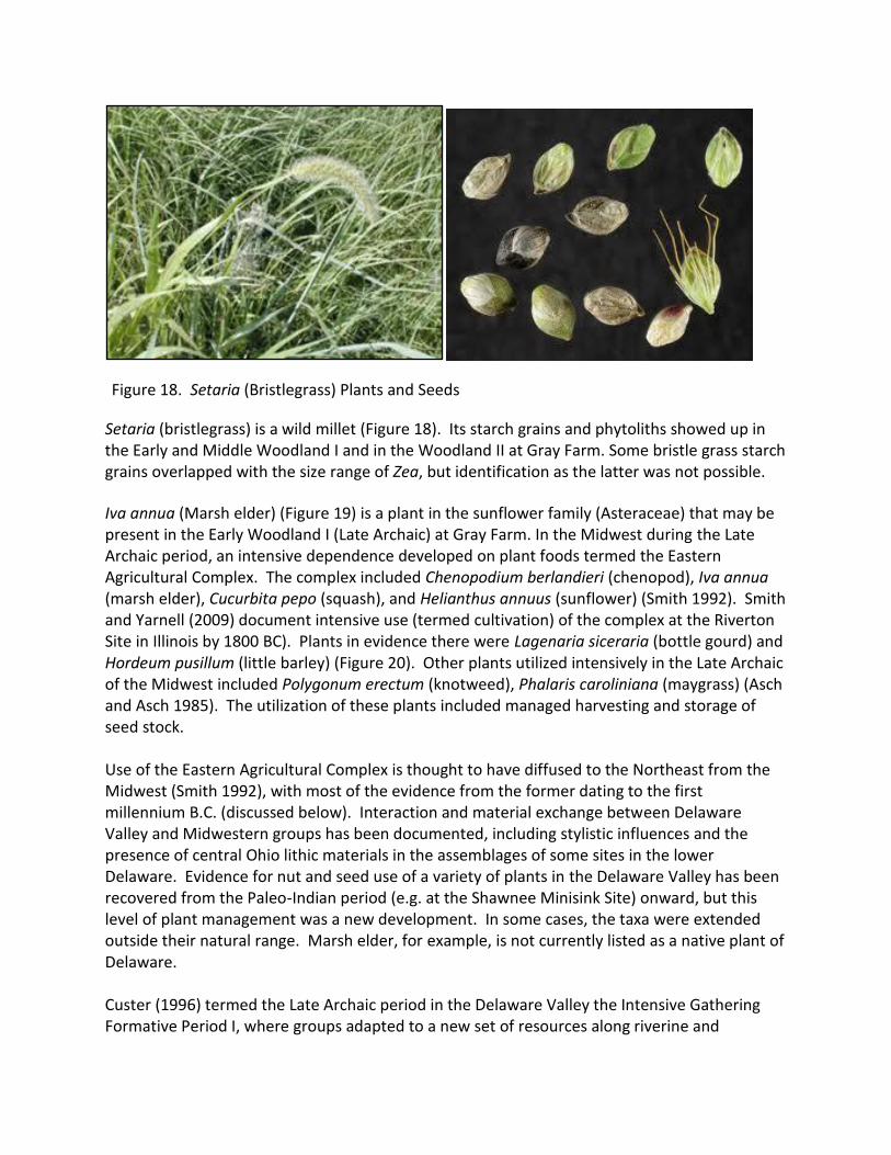
Figure 18. Setaria (Bristlegrass) Plants and Seeds
Setaria (bristlegrass) is a wild millet (Figure 18). Its starch grains and phytoliths showed up in the Early and Middle Woodland I and in the Woodland II at Gray Farm. Some bristle grass starch grains overlapped with the size range of Zea, but identification as the latter was not possible.
Iva annua (Marsh elder) (Figure 19) is a plant in the sunflower family (Asteraceae) that may be present in the Early Woodland I (Late Archaic) at Gray Farm. In the Midwest during the Late Archaic period, an intensive dependence developed on plant foods termed the Eastern Agricultural Complex. The complex included Chenopodium berlandieri (chenopod), Iva annua (marsh elder), Cucurbita pepo (squash), and Helianthus annuus (sunflower) (Smith 1992). Smith and Yarnell (2009) document intensive use (termed cultivation) of the complex at the Riverton Site in Illinois by 1800 BC). Plants in evidence there were Lagenaria siceraria (bottle gourd) and Hordeum pusillum (little barley) (Figure 20). Other plants utilized intensively in the Late Archaic of the Midwest included Polygonum erectum (knotweed), Phalaris caroliniana (maygrass) (Asch and Asch 1985). The utilization of these plants included managed harvesting and storage of seed stock. Use of the Eastern Agricultural Complex is thought to have diffused to the Northeast from the Midwest (Smith 1992), with most of the evidence from the former dating to the first millennium B.C. (discussed below). Interaction and material exchange between Delaware Valley and Midwestern groups has been documented, including stylistic influences and the presence of central Ohio lithic materials in the assemblages of some sites in the lower Delaware. Evidence for nut and seed use of a variety of plants in the Delaware Valley has been recovered from the Paleo-Indian period (e.g. at the Shawnee Minisink Site) onward, but this level of plant management was a new development. In some cases, the taxa were extended outside their natural range. Marsh elder, for example, is not currently listed as a native plant of Delaware. Custer (1996) termed the Late Archaic period in the Delaware Valley the Intensive Gathering Formative Period I, where groups adapted to a new set of resources along riverine and
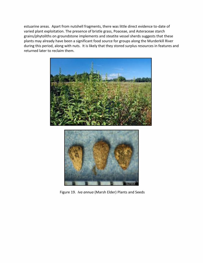
estuarine areas. Apart from nutshell fragments, there was little direct evidence to-date of varied plant exploitation. The presence of bristle grass, Poaceae, and Asteraceae starch grains/phytoliths on groundstone implements and steatite vessel sherds suggests that these plants may already have been a significant food source for groups along the Murderkill River during this period, along with nuts. It is likely that they stored surplus resources in features and returned later to reclaim them.
Figure 19. Iva annua (Marsh Elder) Plants and Seeds

Figure 20. Hordeum pusillum (Little Barley) Plants and Seeds
Sagittaria latifolia (duck potato) (Figure 21) is a wetland plant with an edible tuber, found at the site in Middle Woodland I (traditional Early Woodland) contexts. Until recently, use of wild tubers for food in prehistoric North America has been cited in ethno-historic sources, but physical evidence has been elusive. Messner (2011) identified Peltandra sp. (arrow arum) and Sagittaria starch grains in artifact residues from a number of sites in the Delaware Valley. Peltandra is a hydrophytic plant with a tuber similar to Sagittaria.

Figure 21. Sagittaria sp. (Indian potato) Plants and Tubers
The evidence for exploitation of plant foods during the early Woodland I (Late Archaic) at the Gray Farm Site is of particular significance. Macro-botanical analysis provided evidence that hickory nuts were utilized, as they had been since the Middle Archaic period across the Middle Atlantic region. In addition, a number of plants, including Setaria sp., Poaceae, and Asteraceae were being procured, processed, and consumed at the site during that period. In the middle Woodland I (Early Woodland) period, the array of plants utilized became more diverse, as evidenced by starch grain and phytolith analyses. The plant taxa identified included Setaria sp. (bristle grass, a wild millet), Hordeum sp. (wild barley), Sagittaria sp (duck potato), and Cyperaceae (sedge, likely Scirpus - bulrush) (Figure 22). Sagittaria has an edible tuber and Scirpus an edible rhizome. The seeds of Scirpus and its immature stalk/shoots are also edible. In addition to the seed-bearing plants mentioned, exploitation of these taxa evidence a continuation of adaptations from the early Woodland I. This development is in line with other regional findings. Messner (2011) conducted starch grain analysis on artifacts from a set of sites in the Delaware Valley, from middle and late Woodland I and Woodland II contexts. The Williamson Site in northern New Jersey yielded starch grains of Nymphaea odorata (water lily, Peltandra virginica (arrow arum), and Castanea sp. (chestnut) from middle Woodland I contexts. The samples were collected from groundstone implements and ceramic sherds. The Wilgus Site in Sussex County, Delaware yielded unidentifiable starch grains. Artifacts from the Gully Site in Monmouth County, New Jersey yielded starch grains of Castanea (chestnut), Hordeum elymus (little barley), and cf. Chasmanthium sp. (Indian wood oats). An end-scraper

from the Hickory Bluff Site yielded starch grains thought to be from a starchy tuber with no more definitive idenfication The lithic evidence suggests that hunting continued to be an important part of the subsistence system, and, as in the early Woodland I, fishing was almost certainly an important activity. In terms of site function, subsistence, and settlement patterns, it appears that there was a high degree of continuity from the preceding period. Regionally, there was an imprint of external ideas characterized by the Delmarva Adena Complex, which was expressed in trade and interaction with the Ohio Valley and adoption of some ritual elements (e.g., mortuary behaviors). However, at a resource procurement processing locus like the Gray Farm Site, those influences are hard to detect. Generally in the Delaware Valley, exploitation of the Eastern Agricultural Complex increased. Messner’s (2011) analysis of artifacts from Late Woodland I contexts at five sites in New Jersey and Pennsylvania yielded starch grains of Peltandra virginica (arrow arum), Nelumba lutea (American lotus tuber), Poaeceae, Polygonuum (knotweed), Quercus, Sagittaria (duck potato, Nymphaea onorata (water lily rhizome). It is likely that these kinds of adaptations continued to evolve along the Murderkill River. It is unclear whether the paucity of evidence of this component at the Gray Farm Site is related to sampling factors or whether local site selection preferences shifted during the period. Woodland II period (Late Woodland, AD 900 - 1600) occupation was evidenced at the site by Townsend and Killens ceramics, centered in a relatively large occupation area in the central part of Trench 5 and associated with a cylindrical pit. Diagnostic lithic material included three triangular Levanna projectile points. Two relatively tightly circumscribed occupation periods were noted based on radiocarbon analysis; in the mid-twelfth and mid-sixteenth centuries AD. With the general Woodland II occupation area, Griffith defined three sub-concentrations. In addition to the cylindrical pit, the occupation was also associated with a number of pits and basins. Starch grain analysis of Townsend and Killens sherds from secure feature contexts yielded distinctive results. Starch grains were present in much higher frequencies, and only grasses were present. Large quantities of Hordeum sp. (wild barley) and Setaria (bristle grass) starch grains were identified in a concentrated manner. Some of the latter were overlapped the size range of Zea, but no definitive identification as Zea could be made. Relatively numerous macrobotanical remains of maize and squash have been recovered from Woodland II contexts in the upper and middle Delaware Valley and Susquehanna Valley sites. Messner (2011) conducted starch grain analysis of artifacts from seven sites in the Delaware Valley. Six of the sites were in the upper and middle Delaware Valley. One site, the Total Turf Site, is in the lower part of the valley in southwestern New Jersey about 100 km northeast of the Gray Farm Site. Starch grains of Zea mays were identified conclusively at the six more northern sites but not at Total Turf. Other taxa included numerous occurrences of Hordeum (wild barley), water lily, other grass, acorn, beech, Dioscorea (wild potato), and legume. The Total Turf site yielded evidence of Hordeum, acorn, beech, and legume.
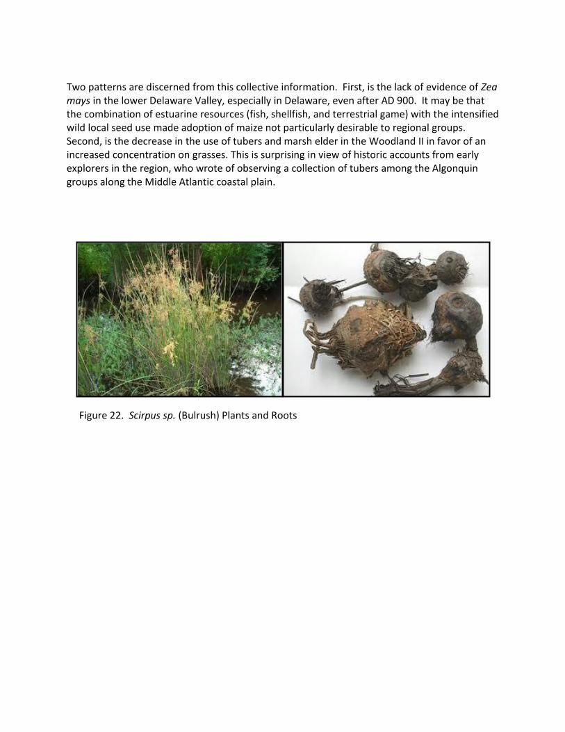
Two patterns are discerned from this collective information. First, is the lack of evidence of Zea mays in the lower Delaware Valley, especially in Delaware, even after AD 900. It may be that the combination of estuarine resources (fish, shellfish, and terrestrial game) with the intensified wild local seed use made adoption of maize not particularly desirable to regional groups. Second, is the decrease in the use of tubers and marsh elder in the Woodland II in favor of an increased concentration on grasses. This is surprising in view of historic accounts from early explorers in the region, who wrote of observing a collection of tubers among the Algonquin groups along the Middle Atlantic coastal plain.
Figure 22. Scirpus sp. (Bulrush) Plants and Roots

Figure 23. Southwestern Woman Grinding Corn
The analysis of starch grains from a small number of samples yielded unprecedented information about prehistoric subsistence in Delaware. Further analysis of remaining material will likely yielded more important data. The Delaware Department of Transportation is a leader in promotion of cutting edge strategies for archaeological investigations.

References Cited Asch D. and N. Asch 1985 Prehistoric Plant Cultivation in West Central Illinois. In Prehistoric Food Production in
North America, Vol. 75, Edited by R. Ford, pp. 149-205. Museum of Anthropology, University of Michigan, Ann Arbor.
Custer, J. 1996 Prehistoric Cultures of Eastern Pennsylvania. Anthropological Series 7. Pennsylvania
Historical and Museum Commission. Diamanti, M., C. Hay, and D. Rue 2012 Draft Phase II and III Excavations on the Murderkill River (Sites 7K-F-11 and 7K-F-169) SR
1 Frederica North Grade Separated Intersection, Kent County, Delaware, Report by A&HC submitted to the Delaware Department of Transportation.
Messner, T. 2011 Acorns and Bitter Roots: Starch Grain Research in the Prehistoric Eastern Woodlands.
University of Alabama Press, Tuscaloosa. Schindler, B. 2006 Middle Woodland Exploitation of Migratory Fish in the Delaware Valley. Unpublished
Ph.D. dissertation, Department of Anthropology, Temple University, Philadelphia. Smith, B. D. 1992 Rivers of Change: Essays on Early Agriculture in Eastern North America. Smithsonian
Institution Press, Washington, DC. Smith, B. D., and R. A. Yarnell 2009 Initial Formation of an Indigenous Crop Complex in Eastern North America at 3800 BP,
Papers of the National Academy of Science 106:6561-6566.