standards and guidelines - fs.fed.us
TRANSCRIPT

Standards and Guidelinesfor
Management of Habitat for Late-Successionaland Old-Growth Forest Related Species
Within the Range of the Northern Spotted Owl
Attachment A
to the Record of Decision for Amendments to Forest Serviceand Bureau of Land Management Planning Documents
Within the Range of the Northern Spotted Owl
i
Standards and Guidelinesfor Management of Habitat for Late-Successional and Old-GrowthForest Related Species Within the Range of the Northern Spotted
Owl
Attachment A to the Record of Decision forAmendments to Forest Service and Bureau of Land Management
Planning Documents Within the Range of the Northern Spotted Owl
OutlineAll sections of this document, considered together, are the complete compilation of standardsand guidelines. However, these standards and guidelines are broken down into the followingsections for clarity and ease of reference.
A. Introduction - This section includes introduction, purpose, definition of the planningarea, relationship to existing agency plans, introduction to the various land allocation categoriesused elsewhere in these standards and guidelines, identification of appurtenant maps, andtransition standards and guidelines.
B. Basis for Standards and Guidelines - This section includes a backgrounddiscussion of the objectives and considerations for managing for a network of terrestrialreserves. This section also contains the Aquatic Conservation Strategy, which includesdiscussions of the objectives and management emphases for Riparian Reserves, KeyWatersheds, watershed analysis, and watershed restoration.
C. Standards and Guidelines - This section includes specific standards andguidelines applicable to all land allocation categories. It also contains descriptions of, andstandards and guidelines applicable to, all designated areas, matrix, and Key Watersheds.
D. Adaptive Management Areas - This section contains a description of theAdaptive Management Area concept, overall objectives, and information for organizing toaccomplish those objectives. A description of each Adaptive Management Area and itsparticular emphasis is included.
E. Implementation - This section includes the monitoring plan, a description of theadaptive management process, and a description of the interagency structure to ensureconsistent and timely implementation of these standards and guidelines. The RegionalEcosystem Office and Regional Interagency Executive Committee, referenced elsewhere in thesestandards and guidelines, is described here.
F. Index - This section includes a word/topic index designed for readers who are interested ina particular activity.

ii
Table of Contents
Standards and Guidelines
A. Introduction . . . . . . . . . . . . . . . . . . . . . . . . . . . . . . . . . . . . . . . . . . . . . . . . . . . . . . . . . . . . . . . . . . A-1
Purpose and Need for these Standards and Guidelines . . . . . . . . . . . . . . . . . . . . . . . . . . . . . . . . . . . . A-1
The Planning Area . . . . . . . . . . . . . . . . . . . . . . . . . . . . . . . . . . . . . . . . . . . . . . . . . . . . . . . . . . . . . . . . A-1
Relationship to Existing FS and BLM Management Plans . . . . . . . . . . . . . . . . . . . . . . . . . . . . . . . . A-2Forest Service . . . . . . . . . . . . . . . . . . . . . . . . . . . . . . . . . . . . . . . . . . . . . . . . . . . . . . . . . . . . . A-2BLM . . . . . . . . . . . . . . . . . . . . . . . . . . . . . . . . . . . . . . . . . . . . . . . . . . . . . . . . . . . . . . . . . A-2Current Plans and Draft Plan Preferred Alternatives . . . . . . . . . . . . . . . . . . . . . . . . . . . . . . A-2Consultation - Endangered Species Act . . . . . . . . . . . . . . . . . . . . . . . . . . . . . . . . . . . . . . . . . A-2Critical Habitat for Northern Spotted Owl . . . . . . . . . . . . . . . . . . . . . . . . . . . . . . . . . . . . . . A-3Physiographic Provinces . . . . . . . . . . . . . . . . . . . . . . . . . . . . . . . . . . . . . . . . . . . . . . . . . . . . A-3
Land Allocations . . . . . . . . . . . . . . . . . . . . . . . . . . . . . . . . . . . . . . . . . . . . . . . . . . . . . . . . . . . . . . . . . A-4Designated Areas and Matrix . . . . . . . . . . . . . . . . . . . . . . . . . . . . . . . . . . . . . . . . . . . . . . . . . . . . A-4
Congressionally Reserved Areas . . . . . . . . . . . . . . . . . . . . . . . . . . . . . . . . . . . . . . . A-4Late-Successional Reserves . . . . . . . . . . . . . . . . . . . . . . . . . . . . . . . . . . . . . . . . . . . A-4Adaptive Management Areas . . . . . . . . . . . . . . . . . . . . . . . . . . . . . . . . . . . . . . . . . . A-4Managed Late-Successional Areas . . . . . . . . . . . . . . . . . . . . . . . . . . . . . . . . . . . . . . A-4Administratively Withdrawn Areas . . . . . . . . . . . . . . . . . . . . . . . . . . . . . . . . . . . . . A-4Riparian Reserves . . . . . . . . . . . . . . . . . . . . . . . . . . . . . . . . . . . . . . . . . . . . . . . . . . . A-5Matrix . . . . . . . . . . . . . . . . . . . . . . . . . . . . . . . . . . . . . . . . . . . . . . . . . . . . . . . . . . . . A-5
Key and Non-Key Watersheds . . . . . . . . . . . . . . . . . . . . . . . . . . . . . . . . . . . . . . . . . . . . . . . . . . . A-5Land Allocation Hierarchy . . . . . . . . . . . . . . . . . . . . . . . . . . . . . . . . . . . . . . . . . . . . . . . . . . . . . . A-5Standards and Guidelines . . . . . . . . . . . . . . . . . . . . . . . . . . . . . . . . . . . . . . . . . . . . . . . . . . . . . . . A-6Maps . . . . . . . . . . . . . . . . . . . . . . . . . . . . . . . . . . . . . . . . . . . . . . . . . . . . . . . . . . . . . . . . . A-6Transition Standards and Guidelines . . . . . . . . . . . . . . . . . . . . . . . . . . . . . . . . . . . . . . . . . . . . . . A-7
B. Basis for Standards and GuidelinesIntroduction . . . . . . . . . . . . . . . . . . . . . . . . . . . . . . . . . . . . . . . . . . . . . . . . . . . . . . . . . . . . . . B-1
Ecological Principles for Management of Late-Successional Forests . . . . . . . . . . . . . . . . . . . . . . . . B-1General Ecological Basis for Forest Management . . . . . . . . . . . . . . . . . . . . . . . . . . . . . . . . B-1
Structure and Composition . . . . . . . . . . . . . . . . . . . . . . . . . . . . . . . . . . . . . . . . . . . . . . . B-2Ecological Processes . . . . . . . . . . . . . . . . . . . . . . . . . . . . . . . . . . . . . . . . . . . . . . . . . . . . B-2Ecosystem Function . . . . . . . . . . . . . . . . . . . . . . . . . . . . . . . . . . . . . . . . . . . . . . . . . . . . B-4
Late-Successional Reserves . . . . . . . . . . . . . . . . . . . . . . . . . . . . . . . . . . . . . . . . . . . . . . . . . . B-4
iii
Role of Silviculture . . . . . . . . . . . . . . . . . . . . . . . . . . . . . . . . . . . . . . . . . . . . . . . . . . . . . . . . B-5Stand Management . . . . . . . . . . . . . . . . . . . . . . . . . . . . . . . . . . . . . . . . . . . . . . . . . . . . . . . . . B-6Management of Disturbance Risks . . . . . . . . . . . . . . . . . . . . . . . . . . . . . . . . . . . . . . . . . . . . B-7Management After Natural Disturbance . . . . . . . . . . . . . . . . . . . . . . . . . . . . . . . . . . . . . . . . B-8
Aquatic Conservation Strategy . . . . . . . . . . . . . . . . . . . . . . . . . . . . . . . . . . . . . . . . . . . . . . . . . . . . . . B-9
Aquatic Conservation Strategy Objectives . . . . . . . . . . . . . . . . . . . . . . . . . . . . . . . . . . . . . . . . . . . . B-11
Components of the Aquatic Conservation Strategy . . . . . . . . . . . . . . . . . . . . . . . . . . . . . . . . . . . . . B-121) Riparian Reserves . . . . . . . . . . . . . . . . . . . . . . . . . . . . . . . . . . . . . . . . . . . . . . . . . . . . . . . . . . B-12
Riparian Reserve Widths . . . . . . . . . . . . . . . . . . . . . . . . . . . . . . . . . . . . . . . . . . . . . . . . . . . B-14Intermittent Streams . . . . . . . . . . . . . . . . . . . . . . . . . . . . . . . . . . . . . . . . . . . . . . . . . . . . . . . B-14Wetlands . . . . . . . . . . . . . . . . . . . . . . . . . . . . . . . . . . . . . . . . . . . . . . . . . . . . . . . . . . . . . . . . B-16Summary of the Aquatic Conservation Strategy for Riparian Reserves . . . . . . . . . . . . . . . B-17
2) Key Watersheds . . . . . . . . . . . . . . . . . . . . . . . . . . . . . . . . . . . . . . . . . . . . . . . . . . . . . . . . . . . B-18Roadless Areas and Key Watersheds . . . . . . . . . . . . . . . . . . . . . . . . . . . . . . . . . . . . . . . . . . B-19Summary of Aquatic Conservation Strategy for Key Watersheds . . . . . . . . . . . . . . . . . . . B-19
3) Watershed Analysis . . . . . . . . . . . . . . . . . . . . . . . . . . . . . . . . . . . . . . . . . . . . . . . . . . . . . . . . B-20Summary of Aquatic Conservation Strategy for Watershed Analysis . . . . . . . . . . . . . . . . B-30
4) Watershed Restoration . . . . . . . . . . . . . . . . . . . . . . . . . . . . . . . . . . . . . . . . . . . . . . . . . . . . . . B-30Roads . . . . . . . . . . . . . . . . . . . . . . . . . . . . . . . . . . . . . . . . . . . . . . . . . . . . . . . . . . . . . . . . B-31Riparian Vegetation . . . . . . . . . . . . . . . . . . . . . . . . . . . . . . . . . . . . . . . . . . . . . . . . . . . . . . . B-31In-stream Habitat Structures . . . . . . . . . . . . . . . . . . . . . . . . . . . . . . . . . . . . . . . . . . . . . . . . B-31Summary of Aquatic Conservation Strategy for Watershed Restoration . . . . . . . . . . . . . . B-32
Monitoring . . . . . . . . . . . . . . . . . . . . . . . . . . . . . . . . . . . . . . . . . . . . . . . . . . . . . . . . . . . . . . . . B-32
C. Standards and GuidelinesExisting Laws and Regulations . . . . . . . . . . . . . . . . . . . . . . . . . . . . . . . . . . . . . . . . . . . . . . . C-1Hierarchy of Standards and Guidelines . . . . . . . . . . . . . . . . . . . . . . . . . . . . . . . . . . . . . . . . . C-1
Standards and Guidelines Common to all Land Allocations . . . . . . . . . . . . . . . . . . . . . . . . . . . . . . . C-2Current Plans and Draft Plan Preferred Alternatives . . . . . . . . . . . . . . . . . . . . . . . . . . . . . . C-2
Exceptions . . . . . . . . . . . . . . . . . . . . . . . . . . . . . . . . . . . . . . . . . . . . . . . . . . . . . . . . . . . . C-3Unmapped Late-Successional Reserves . . . . . . . . . . . . . . . . . . . . . . . . . . . . . . . . . . . . . . . . C-3Watershed Analysis . . . . . . . . . . . . . . . . . . . . . . . . . . . . . . . . . . . . . . . . . . . . . . . . . . . . . . . . C-3Research . . . . . . . . . . . . . . . . . . . . . . . . . . . . . . . . . . . . . . . . . . . . . . . . . . . . . . . . . . . . . . . . . C-4Oregon-California Border . . . . . . . . . . . . . . . . . . . . . . . . . . . . . . . . . . . . . . . . . . . . . . . . . . . C-4Survey and Manage . . . . . . . . . . . . . . . . . . . . . . . . . . . . . . . . . . . . . . . . . . . . . . . . . . . . . . . . C-4Manage Recreation Areas to Minimize Disturbance to Species . . . . . . . . . . . . . . . . . . . . . . C-6Protect Sites From Grazing . . . . . . . . . . . . . . . . . . . . . . . . . . . . . . . . . . . . . . . . . . . . . . . . . . C-6
Standards and Guidelines for Key Watersheds . . . . . . . . . . . . . . . . . . . . . . . . . . . . . . . . . . . . . . . . . . C-7Description . . . . . . . . . . . . . . . . . . . . . . . . . . . . . . . . . . . . . . . . . . . . . . . . . . . . . . . . . . . . . . . C-7Standards and Guidelines . . . . . . . . . . . . . . . . . . . . . . . . . . . . . . . . . . . . . . . . . . . . . . . . . . . . C-7
Standards and Guidelines for Designated Areas and Matrix . . . . . . . . . . . . . . . . . . . . . . . . . . . . . . . C-8Congressionally Reserved Areas . . . . . . . . . . . . . . . . . . . . . . . . . . . . . . . . . . . . . . . . . . . . . . . . . C-8
Acres . . . . . . . . . . . . . . . . . . . . . . . . . . . . . . . . . . . . . . . . . . . . . . . . . . . . . . . . . . . . . . . . . C-8

iv
Description . . . . . . . . . . . . . . . . . . . . . . . . . . . . . . . . . . . . . . . . . . . . . . . . . . . . . . . . . . . . . . . C-8Standards and Guidelines . . . . . . . . . . . . . . . . . . . . . . . . . . . . . . . . . . . . . . . . . . . . . . . . . . . . C-8
Late-Successional Reserves . . . . . . . . . . . . . . . . . . . . . . . . . . . . . . . . . . . . . . . . . . . . . . . . . . . . . C-9Acres . . . . . . . . . . . . . . . . . . . . . . . . . . . . . . . . . . . . . . . . . . . . . . . . . . . . . . . . . . . . . . . . . C-9Description . . . . . . . . . . . . . . . . . . . . . . . . . . . . . . . . . . . . . . . . . . . . . . . . . . . . . . . . . . . . . . . C-9
1. Mapped Late-Successional Reserves . . . . . . . . . . . . . . . . . . . . . . . . . . . . . . . . . . . . . C-92. LS/OG 1s and 2s . . . . . . . . . . . . . . . . . . . . . . . . . . . . . . . . . . . . . . . . . . . . . . . . . . . . C-103. Occupied Marbled Murrelet Sites . . . . . . . . . . . . . . . . . . . . . . . . . . . . . . . . . . . . . . . C-104. Spotted Owl Activity Centers . . . . . . . . . . . . . . . . . . . . . . . . . . . . . . . . . . . . . . . . . . C-105. Protection Buffers . . . . . . . . . . . . . . . . . . . . . . . . . . . . . . . . . . . . . . . . . . . . . . . . . . . C-11
Standards and Guidelines . . . . . . . . . . . . . . . . . . . . . . . . . . . . . . . . . . . . . . . . . . . . . . . . . . . C-11Objectives . . . . . . . . . . . . . . . . . . . . . . . . . . . . . . . . . . . . . . . . . . . . . . . . . . . . . . . . C-11Exceptions, RNAs and recovery plans . . . . . . . . . . . . . . . . . . . . . . . . . . . . . . . . . . C-11Management Assessment for Late-Successional Reserves . . . . . . . . . . . . . . . . . . C-11Occupied marbled murrelet sites . . . . . . . . . . . . . . . . . . . . . . . . . . . . . . . . . . . . . . C-12
Silviculture . . . . . . . . . . . . . . . . . . . . . . . . . . . . . . . . . . . . . . . . . . . . . . . . . . . . . . . . . . C-12West of Cascades . . . . . . . . . . . . . . . . . . . . . . . . . . . . . . . . . . . . . . . . . . . . . . . . . . C-12East of Cascades . . . . . . . . . . . . . . . . . . . . . . . . . . . . . . . . . . . . . . . . . . . . . . . . . . . C-12 Guidelines to Reduce Risk of Large-scale Disturbance . . . . . . . . . . . . . . . . . C-12
Guidelines for Salvage . . . . . . . . . . . . . . . . . . . . . . . . . . . . . . . . . . . . . . . . . . . . . . . . . C-13S & Gs for Multiple-use Activities other than Silviculture . . . . . . . . . . . . . . . . . . . . . C-16
Introduction . . . . . . . . . . . . . . . . . . . . . . . . . . . . . . . . . . . . . . . . . . . . . . . . . . . . . . C-16Road Construction and Maintenance . . . . . . . . . . . . . . . . . . . . . . . . . . . . . . . . . . . C-16Fuelwood Gathering . . . . . . . . . . . . . . . . . . . . . . . . . . . . . . . . . . . . . . . . . . . . . . . . C-16American Indian Uses . . . . . . . . . . . . . . . . . . . . . . . . . . . . . . . . . . . . . . . . . . . . . . C-16Mining . . . . . . . . . . . . . . . . . . . . . . . . . . . . . . . . . . . . . . . . . . . . . . . . . . . . . . . . . . C-17Developments . . . . . . . . . . . . . . . . . . . . . . . . . . . . . . . . . . . . . . . . . . . . . . . . . . . . . C-17Land Exchanges . . . . . . . . . . . . . . . . . . . . . . . . . . . . . . . . . . . . . . . . . . . . . . . . . . . C-17Habitat Improvement Projects . . . . . . . . . . . . . . . . . . . . . . . . . . . . . . . . . . . . . . . . C-17Range Management . . . . . . . . . . . . . . . . . . . . . . . . . . . . . . . . . . . . . . . . . . . . . . . . C-17Fire Suppression and Prevention . . . . . . . . . . . . . . . . . . . . . . . . . . . . . . . . . . . . . . C-17Special Forest Products . . . . . . . . . . . . . . . . . . . . . . . . . . . . . . . . . . . . . . . . . . . . . C-18Recreational Uses . . . . . . . . . . . . . . . . . . . . . . . . . . . . . . . . . . . . . . . . . . . . . . . . . . C-18Research . . . . . . . . . . . . . . . . . . . . . . . . . . . . . . . . . . . . . . . . . . . . . . . . . . . . . . . . . C-18Rights-of-Way, Contracted Rights, Easements, & Special Use Permits . . . . . . . . C-19Nonnative species . . . . . . . . . . . . . . . . . . . . . . . . . . . . . . . . . . . . . . . . . . . . . . . . . . C-19Other . . . . . . . . . . . . . . . . . . . . . . . . . . . . . . . . . . . . . . . . . . . . . . . . . . . . . . . . . . . . C-19
Protection Buffers . . . . . . . . . . . . . . . . . . . . . . . . . . . . . . . . . . . . . . . . . . . . . . . . . . . . . C-19
Adaptive Management Areas . . . . . . . . . . . . . . . . . . . . . . . . . . . . . . . . . . . . . . . . . . . . . . . . . . . C-21Acres . . . . . . . . . . . . . . . . . . . . . . . . . . . . . . . . . . . . . . . . . . . . . . . . . . . . . . . . . . . . . . . . C-21Introduction . . . . . . . . . . . . . . . . . . . . . . . . . . . . . . . . . . . . . . . . . . . . . . . . . . . . . . . . . . . . . C-21Selection of Adaptive Management Areas . . . . . . . . . . . . . . . . . . . . . . . . . . . . . . . . . . . . . C-22Hierarchy of S&Gs Within Adaptive Management Areas . . . . . . . . . . . . . . . . . . . . . . . . . C-22
Managed Late-Successional Areas . . . . . . . . . . . . . . . . . . . . . . . . . . . . . . . . . . . . . . . . . . . . . . . C-22Acres . . . . . . . . . . . . . . . . . . . . . . . . . . . . . . . . . . . . . . . . . . . . . . . . . . . . . . . . . . . . . . . . C-22Description . . . . . . . . . . . . . . . . . . . . . . . . . . . . . . . . . . . . . . . . . . . . . . . . . . . . . . . . . . . . . . C-23
1. Managed Pair Areas (E.WA & CA Cascades) . . . . . . . . . . . . . . . . . . . . . . . . . . . . . C-232. Protection Buffers . . . . . . . . . . . . . . . . . . . . . . . . . . . . . . . . . . . . . . . . . . . . . . . . . . . C-23
v
Standards and Guidelines . . . . . . . . . . . . . . . . . . . . . . . . . . . . . . . . . . . . . . . . . . . . . . . . . . . C-26Silviculture . . . . . . . . . . . . . . . . . . . . . . . . . . . . . . . . . . . . . . . . . . . . . . . . . . . . . . . . . . C-26Management Assessment . . . . . . . . . . . . . . . . . . . . . . . . . . . . . . . . . . . . . . . . . . . . . . . C-26Multiple-Use Activities Other Than Silviculture . . . . . . . . . . . . . . . . . . . . . . . . . . . . . C-26Protection Buffers . . . . . . . . . . . . . . . . . . . . . . . . . . . . . . . . . . . . . . . . . . . . . . . . . . . . . C-26
Administratively Withdrawn Areas . . . . . . . . . . . . . . . . . . . . . . . . . . . . . . . . . . . . . . . . . . . . . . C-29Acres . . . . . . . . . . . . . . . . . . . . . . . . . . . . . . . . . . . . . . . . . . . . . . . . . . . . . . . . . . . . . . . . C-29Description . . . . . . . . . . . . . . . . . . . . . . . . . . . . . . . . . . . . . . . . . . . . . . . . . . . . . . . . . . . . . . C-29Standards and Guidelines . . . . . . . . . . . . . . . . . . . . . . . . . . . . . . . . . . . . . . . . . . . . . . . . . . . C-29
Riparian Reserves . . . . . . . . . . . . . . . . . . . . . . . . . . . . . . . . . . . . . . . . . . . . . . . . . . . . . . . . . . . . C-30Acres . . . . . . . . . . . . . . . . . . . . . . . . . . . . . . . . . . . . . . . . . . . . . . . . . . . . . . . . . . . . . . . . C-30Description - Riparian Reserve Widths . . . . . . . . . . . . . . . . . . . . . . . . . . . . . . . . . . . . . . . . C-30Standards and Guidelines . . . . . . . . . . . . . . . . . . . . . . . . . . . . . . . . . . . . . . . . . . . . . . . . . . . C-31
Timber Management . . . . . . . . . . . . . . . . . . . . . . . . . . . . . . . . . . . . . . . . . . . . . . . . . . . C-31Roads Management . . . . . . . . . . . . . . . . . . . . . . . . . . . . . . . . . . . . . . . . . . . . . . . . . . . . C-32Grazing Management . . . . . . . . . . . . . . . . . . . . . . . . . . . . . . . . . . . . . . . . . . . . . . . . . . C-33Recreation Management . . . . . . . . . . . . . . . . . . . . . . . . . . . . . . . . . . . . . . . . . . . . . . . . C-34Minerals Management . . . . . . . . . . . . . . . . . . . . . . . . . . . . . . . . . . . . . . . . . . . . . . . . . . C-34Fire/Fuels Management . . . . . . . . . . . . . . . . . . . . . . . . . . . . . . . . . . . . . . . . . . . . . . . . . C-35Lands . . . . . . . . . . . . . . . . . . . . . . . . . . . . . . . . . . . . . . . . . . . . . . . . . . . . . . . . . . . . . . . C-36General Riparian Area Management . . . . . . . . . . . . . . . . . . . . . . . . . . . . . . . . . . . . . . . C-37Watershed and Habitat Restoration . . . . . . . . . . . . . . . . . . . . . . . . . . . . . . . . . . . . . . . C-37Fish and Wildlife Management . . . . . . . . . . . . . . . . . . . . . . . . . . . . . . . . . . . . . . . . . . . C-37Research . . . . . . . . . . . . . . . . . . . . . . . . . . . . . . . . . . . . . . . . . . . . . . . . . . . . . . . . . . . . C-38
Matrix . . . . . . . . . . . . . . . . . . . . . . . . . . . . . . . . . . . . . . . . . . . . . . . . . . . . . . . . . . . . . . . . C-39Acres . . . . . . . . . . . . . . . . . . . . . . . . . . . . . . . . . . . . . . . . . . . . . . . . . . . . . . . . . . . . . . . . C-39Description . . . . . . . . . . . . . . . . . . . . . . . . . . . . . . . . . . . . . . . . . . . . . . . . . . . . . . . . . . . . . . C-39Standards and Guidelines . . . . . . . . . . . . . . . . . . . . . . . . . . . . . . . . . . . . . . . . . . . . . . . . . . . C-39
Provide specified amounts of coarse woody debris in matrix . . . . . . . . . . . . . . . . . . . C-40Emphasize clumped green tree and snag retention in matrix . . . . . . . . . . . . . . . . . . . . C-41
Standards and Guidelines Specific to Spotted Owl Habitat for BLM . . . . . . . . . . C-42Provide Additional protection for Caves, Mines, etc. for bats . . . . . . . . . . . . . . . . . . . C-43Modify fire and pesticide use, minimize soil and litter disturbance . . . . . . . . . . . . . . . C-44Provide for retention of old-growth fragments where little remains . . . . . . . . . . . . . . . C-44Known Northern Spotted Owl Activity Centers . . . . . . . . . . . . . . . . . . . . . . . . . . . . . . C-45Current Plans and Draft Plan Preferred Alternatives . . . . . . . . . . . . . . . . . . . . . . . . . . C-45Protection Buffers . . . . . . . . . . . . . . . . . . . . . . . . . . . . . . . . . . . . . . . . . . . . . . . . . . . . . C-45Fire and Fuels Management . . . . . . . . . . . . . . . . . . . . . . . . . . . . . . . . . . . . . . . . . . . . . C-48
D. Adaptive Management Areas . . . . . . . . . . . . . . . . . . . . . . . . . . . . . . . . . . . . . . . . . . . . . . . . . . . D-1Acres . . . . . . . . . . . . . . . . . . . . . . . . . . . . . . . . . . . . . . . . . . . . . . . . . . . . . . . . . . . . . . . . . D-1Introduction . . . . . . . . . . . . . . . . . . . . . . . . . . . . . . . . . . . . . . . . . . . . . . . . . . . . . . . . . . . . . . D-1Selection of Adaptive Management Areas . . . . . . . . . . . . . . . . . . . . . . . . . . . . . . . . . . . . . . D-2Technical Objectives . . . . . . . . . . . . . . . . . . . . . . . . . . . . . . . . . . . . . . . . . . . . . . . . . . . . . . . D-3Social Objectives . . . . . . . . . . . . . . . . . . . . . . . . . . . . . . . . . . . . . . . . . . . . . . . . . . . . . . . . . . D-4Agency Approaches and Management Review . . . . . . . . . . . . . . . . . . . . . . . . . . . . . . . . . . . D-5

vi
Adaptive Management Area Implementation Guidelines . . . . . . . . . . . . . . . . . . . . . . . . . . . D-5Role of Agencies . . . . . . . . . . . . . . . . . . . . . . . . . . . . . . . . . . . . . . . . . . . . . . . . . . . . D-5Local Communities . . . . . . . . . . . . . . . . . . . . . . . . . . . . . . . . . . . . . . . . . . . . . . . . . . D-5Participation in Adaptive Management Areas . . . . . . . . . . . . . . . . . . . . . . . . . . . . . D-6Project Development and Implementation . . . . . . . . . . . . . . . . . . . . . . . . . . . . . . . . D-6Area Assessment . . . . . . . . . . . . . . . . . . . . . . . . . . . . . . . . . . . . . . . . . . . . . . . . . . . D-6Plan . . . . . . . . . . . . . . . . . . . . . . . . . . . . . . . . . . . . . . . . . . . . . . . . . . . . . . . . . . . . . . D-7Monitoring and Research . . . . . . . . . . . . . . . . . . . . . . . . . . . . . . . . . . . . . . . . . . . . . D-7Review . . . . . . . . . . . . . . . . . . . . . . . . . . . . . . . . . . . . . . . . . . . . . . . . . . . . . . . . . . . D-7Legal . . . . . . . . . . . . . . . . . . . . . . . . . . . . . . . . . . . . . . . . . . . . . . . . . . . . . . . . . . . . . D-8Other Issues . . . . . . . . . . . . . . . . . . . . . . . . . . . . . . . . . . . . . . . . . . . . . . . . . . . . . . . D-8
Fire and Fuels Management . . . . . . . . . . . . . . . . . . . . . . . . . . . . . . . . . . . . . . . . . . . . . . . . . . D-8Timber Supply . . . . . . . . . . . . . . . . . . . . . . . . . . . . . . . . . . . . . . . . . . . . . . . . . . . . . . . . . . . . D-8Education . . . . . . . . . . . . . . . . . . . . . . . . . . . . . . . . . . . . . . . . . . . . . . . . . . . . . . . . . . . . . . . . D-9Standards and Guidelines . . . . . . . . . . . . . . . . . . . . . . . . . . . . . . . . . . . . . . . . . . . . . . . . . . . . D-9
Provide additional protection for caves, mines.....roost sites for bats . . . . . . . . . . . . . D-10Modify treatments, e.g. fire, pesticides, harvest to min. soil disturbance . . . . . . . . . . D-11Provide for old-growth fragments in watersheds where little remains . . . . . . . . . . . . . D-11Hierarchy of Standards and Guidelines in Adaptive Management Areas . . . . . . . . . . D-11
Descriptions of Adaptive Management Areas . . . . . . . . . . . . . . . . . . . . . . . . . . . . . . . . . . . D-12Applegate, Central Cascades . . . . . . . . . . . . . . . . . . . . . . . . . . . . . . . . . . . . . . . . . . . . D-12Cispus, Finney, . . . . . . . . . . . . . . . . . . . . . . . . . . . . . . . . . . . . . . . . . . . . . . . . . . . . . . . D-13Goosenest, Hayfork, Little River, . . . . . . . . . . . . . . . . . . . . . . . . . . . . . . . . . . . . . . . . D-14Northern Coast Range, Olympic, . . . . . . . . . . . . . . . . . . . . . . . . . . . . . . . . . . . . . . . . . D-15Snoqualmie Pass. . . . . . . . . . . . . . . . . . . . . . . . . . . . . . . . . . . . . . . . . . . . . . . . . . . . . . . D-16
Delineation and Management of Reserved Pair Areas . . . . . . . . . . . . . . . . . . . . . . . . . . . . D-16
E. Implementation . . . . . . . . . . . . . . . . . . . . . . . . . . . . . . . . . . . . . . . . . . . . . . . . . . . . . . . . . . . . . . . E-1
Introduction . . . . . . . . . . . . . . . . . . . . . . . . . . . . . . . . . . . . . . . . . . . . . . . . . . . . . . . . . . . . . . . . . E-1
Monitoring . . . . . . . . . . . . . . . . . . . . . . . . . . . . . . . . . . . . . . . . . . . . . . . . . . . . . . . . . . . . . . . . . E-1
Monitoring and Evaluation Plan . . . . . . . . . . . . . . . . . . . . . . . . . . . . . . . . . . . . . . . . . . . . . . . . . . . . . E-3Conceptual Framework . . . . . . . . . . . . . . . . . . . . . . . . . . . . . . . . . . . . . . . . . . . . . . . . . . . . . . . . . E-3
Scope . . . . . . . . . . . . . . . . . . . . . . . . . . . . . . . . . . . . . . . . . . . . . . . . . . . . . . . . . . . . . . . . . E-3Relationship to Adaptive Management, Research, & Watershed Analysis . . . . . . . . . . . . . E-3
Adaptive Management . . . . . . . . . . . . . . . . . . . . . . . . . . . . . . . . . . . . . . . . . . . . . . . . . . E-3Research . . . . . . . . . . . . . . . . . . . . . . . . . . . . . . . . . . . . . . . . . . . . . . . . . . . . . . . . . . . . . E-3Watershed Analysis . . . . . . . . . . . . . . . . . . . . . . . . . . . . . . . . . . . . . . . . . . . . . . . . . . . . . E-4
Components of the Monitoring and Evaluation Plan . . . . . . . . . . . . . . . . . . . . . . . . . . . . . . . . . . E-4Types of Monitoring . . . . . . . . . . . . . . . . . . . . . . . . . . . . . . . . . . . . . . . . . . . . . . . . . . . . . . . E-4
Evaluation Questions . . . . . . . . . . . . . . . . . . . . . . . . . . . . . . . . . . . . . . . . . . . . . . . . . . . E-41. Implementation Monitoring . . . . . . . . . . . . . . . . . . . . . . . . . . . . . . . . . . . . . . . . . . . . E-4
Late-Successional Reserves . . . . . . . . . . . . . . . . . . . . . . . . . . . . . . . . . . . . . . . . . . . E-5Riparian Reserves . . . . . . . . . . . . . . . . . . . . . . . . . . . . . . . . . . . . . . . . . . . . . . . . . . . E-5Matrix . . . . . . . . . . . . . . . . . . . . . . . . . . . . . . . . . . . . . . . . . . . . . . . . . . . . . . . . . . . . E-5Adaptive Management Areas . . . . . . . . . . . . . . . . . . . . . . . . . . . . . . . . . . . . . . . . . . E-6Key Watersheds . . . . . . . . . . . . . . . . . . . . . . . . . . . . . . . . . . . . . . . . . . . . . . . . . . . . E-6

vii
Watershed Analysis . . . . . . . . . . . . . . . . . . . . . . . . . . . . . . . . . . . . . . . . . . . . . . . . . E-6Participation . . . . . . . . . . . . . . . . . . . . . . . . . . . . . . . . . . . . . . . . . . . . . . . . . . . . . . . E-6
2. Effectiveness Monitoring . . . . . . . . . . . . . . . . . . . . . . . . . . . . . . . . . . . . . . . . . . . . . . E-6Aquatic Ecosystems - Evaluation Question . . . . . . . . . . . . . . . . . . . . . . . . . . . . . . . E-7Biological diversity, Late-Succ. & Old-Growth Forest Ecosystems . . . . . . . . . . . . E-8Use Levels of Natural Resources . . . . . . . . . . . . . . . . . . . . . . . . . . . . . . . . . . . . . . . E-9Rural Economies and Communities . . . . . . . . . . . . . . . . . . . . . . . . . . . . . . . . . . . . . E-9American Indians and Their Culture . . . . . . . . . . . . . . . . . . . . . . . . . . . . . . . . . . . . E-9
3. Validation Monitoring . . . . . . . . . . . . . . . . . . . . . . . . . . . . . . . . . . . . . . . . . . . . . . . . E-10Special Monitoring Issues and Situations . . . . . . . . . . . . . . . . . . . . . . . . . . . . . . . . . . . E-10
Natural and induced Environmental Stressors . . . . . . . . . . . . . . . . . . . . . . . . . . . . E-10Rare and Declining Species . . . . . . . . . . . . . . . . . . . . . . . . . . . . . . . . . . . . . . . . . . E-11
Steps to Develop an Interagency monitoring Network . . . . . . . . . . . . . . . . . . . . . . . . . . . . . . . . E-12
Adaptive Management . . . . . . . . . . . . . . . . . . . . . . . . . . . . . . . . . . . . . . . . . . . . . . . . . . . . . . . . . . . . E-12Overview . . . . . . . . . . . . . . . . . . . . . . . . . . . . . . . . . . . . . . . . . . . . . . . . . . . . . . . . . . . . . . . E-12Adaptive Management Process . . . . . . . . . . . . . . . . . . . . . . . . . . . . . . . . . . . . . . . . . . . . . . E-13
Interagency Coordination . . . . . . . . . . . . . . . . . . . . . . . . . . . . . . . . . . . . . . . . . . . . . . . . . . . . . . . . . . E-15Interagency Groups . . . . . . . . . . . . . . . . . . . . . . . . . . . . . . . . . . . . . . . . . . . . . . . . . . . . . . . . . . . E-15
Interagency Steering Committee . . . . . . . . . . . . . . . . . . . . . . . . . . . . . . . . . . . . . . . . . . . . . E-15Regional Interagency Executive Committee (RIEC) . . . . . . . . . . . . . . . . . . . . . . . . . . . . . . E-16Regional Ecosystem Office (REO) . . . . . . . . . . . . . . . . . . . . . . . . . . . . . . . . . . . . . . . . . . . E-16Research and Monitoring Committee . . . . . . . . . . . . . . . . . . . . . . . . . . . . . . . . . . . . . . . . . E-16Province Teams . . . . . . . . . . . . . . . . . . . . . . . . . . . . . . . . . . . . . . . . . . . . . . . . . . . . . . . . . . E-17
Planning . . . . . . . . . . . . . . . . . . . . . . . . . . . . . . . . . . . . . . . . . . . . . . . . . . . . . . . . . . . . . . . . E-17Key Watersheds as a non-interchangeable component of PSQ . . . . . . . . . . . . . . . E-18
Watershed Analysis . . . . . . . . . . . . . . . . . . . . . . . . . . . . . . . . . . . . . . . . . . . . . . . . . . . . . . . . . . . . . . E-20
Information Resource Management . . . . . . . . . . . . . . . . . . . . . . . . . . . . . . . . . . . . . . . . . . . . . . . . . E-21
Consultation and Coordination . . . . . . . . . . . . . . . . . . . . . . . . . . . . . . . . . . . . . . . . . . . . . . . . . . . . . E-21
F. References, Index, and Glossary
References F-1Index . . . . . . . . . . . . . . . . . . . . . . . . . . . . . . . . . . . . . . . . . . . . . . . . . . . . . . . . . . . . . . . . . F-2Glossary . . . . . . . . . . . . . . . . . . . . . . . . . . . . . . . . . . . . . . . . . . . . . . . . . . . . . . . . . . . . . . . . . F-4

viii
Standards and Guidelines
List of Figures
Figure A-1 Terrestrial ecosystems physiographic provinces . . . . . . . . . . . . . . . . . . . . . . . . . . . . . . . . . A-3
Figure B-1 Ecological protection needs for intermittent streams, by slopeclass and rock type . . . . . . . . . . . . . . . . . . . . . . . . . . . . . . . . . . . . . . . . . . . . . . . . . . . . . . . . . . B-15
Figure B-2 Relationship between levels of analysis . . . . . . . . . . . . . . . . . . . . . . . . . . . . . . . . . . . . . . . B-22
Figure B-3 Augusta Creek basin watershed with Riparian Reserve Scenario1 modified by slope stability considerations . . . . . . . . . . . . . . . . . . . . . . . . . . . . . . . . . . . . . . B-25
Figure B-4 Landslide potential with stream network, Augusta Creek basin,Willamette National Forest . . . . . . . . . . . . . . . . . . . . . . . . . . . . . . . . . . . . . . . . . . . . . . . . . . . B-26
Figure B-5 Distribution of stream reaches with channel gradients greater thanand less than 3 degrees, Augusta Creek basin, Willamette National Forest . . . . . . . . . . . . . . B-27
Figure B-6 Stream network for Augusta Creek watershed, Willamette NationalForest, showing high-angle tributary junctions greater than 70 degrees . . . . . . . . . . . . . . . . . B-28
Figure B-7 Debris flow potential for Augusta Creek basin, Willamette NationalForest, based on slope stability and potential for debris flow runout fromstream gradient and tributary junction analysis . . . . . . . . . . . . . . . . . . . . . . . . . . . . . . . . . . . . B-29
Figure E-1 Basic adaptive management model as represented in Forest Ecosystem Management Assessment Team Report (Appendix A of the Final SEIS) . . . . . . . . . . . . . . . . . . . . . . E-14
Figure E-2 Relationships of interagency groups . . . . . . . . . . . . . . . . . . . . . . . . . . . . . . . . . . . . . . . . . E-17
Figure E-3 Province planning and analysis areas . . . . . . . . . . . . . . . . . . . . . . . . . . . . . . . . . . . . . . . . E-19
List of Tables
Table C-1 Annual home range areas of northern spotted owl pairs in differentstates, physiographic provinces, and study areas . . . . . . . . . . . . . . . . . . . . . . . . . . . . . . . . . C-24
Table C-2 Amounts of old-growth and mature forest in annual pair home rangesof spotted owls, by state, physiographic provinces, and study areas . . . . . . . . . . . . . . . . . . C-25
Table C-3 Species to be protected through survey and management standards andguidelines. Each of the four survey strategies is described in the text . . . . . . . . . . . . . . . . . C-49

Introduction A-1
Standards and Guidelinesfor
Management of Habitat for Late-Successional and Old-GrowthForest Related Species Within the Range of the Northern Spotted Owl
Attachment A to the Record of Decision forAmendments to Forest Service and Bureau of Land Management
Planning Documents Within the Range of the Northern Spotted Owl
A. IntroductionThis document is attached to and a part of the Record of Decision for Amendments to ForestService and Bureau of Land Management Planning Documents Within the Range of theNorthern Spotted Owl, 1994. It presents a combination of land allocations managed primarily toprotect and enhance habitat for late-successional and old-growth forest related species, andstandards and guidelines for the management of the land allocations. Except as identifiedelsewhere in the Record of Decision or otherwise changed since the Final SEIS was released,these standards and guidelines are intended to be consistent with those of Alternative 9 in theFinal Supplemental Environmental Impact Statement (February 1994).
Purpose and Need for these Standards and Guidelines
The purpose, which includes President Clinton's mandate and principles as expressed at the April2, 1993, Forest Conference, is to take an ecosystem management approach to forest management,with support from scientific evidence; meet the requirements of existing laws and regulations;maintain a healthy forest ecosystem with habitat that will support populations of native species(particularly those associated with late-successional and old-growth forests), including protectionfor riparian areas and waters; and maintain a sustainable supply of timber and other forestproducts that will help maintain the stability of local and regional economies on a predictable andlong-term basis.
The Planning Area
These standards and guidelines apply to lands administered by the USDA Forest Service and theUSDI Bureau of Land Management within the range of the northern spotted owl. These lands arelocated in Washington, Oregon, and northern California. While the influence of landsadministered by the Fish and Wildlife Service, National Park Service, and Department ofDefense, as well as private, state, and tribal lands, was considered in these standards andguidelines, no new management direction for them is presented here. These standards andguidelines assume these other federal lands will be managed according to existing managementplans and applicable federal law.
Introduction A-2
Relationship to Existing Forest Service and BLM Plans
The direction established by these standards and guidelines (as an attachment to the Record ofDecision) is added to the existing management direction for those administrative units withoutadopted Forest or District Plans, and will supersede management direction contained in existingplans where it differs for specific resources or areas, except as otherwise specifically provided.Standards and guidelines and land allocations in the existing plans not directly superseded willremain in effect. These standards and guidelines and land allocations will be incorporated intoplans which are being developed. Resource management and the quantity of timber offered forsale will reflect the implications of these standards and guidelines and the land allocations.Additional agency details are provided below.
Forest Service
These standards and guidelines amend the Pacific Northwest and Pacific Southwest RegionalGuides. They amend the standards and guidelines of approved National Forest Land andResource Management Plans. For those National Forests without approved Forest Plans(Klamath, Shasta-Trinity, Six Rivers, and Mendocino), these standards and guidelines applydirectly to management activities, and will be incorporated into Forest Plans as they aredeveloped.
Bureau of Land Management
The existing plans for the Redding Resource Area, the Arcata Resource Area, and the King RangeNational Conservation Area of the Ukiah District, as well as the Management Framework Plansfor western Oregon Districts, are amended by the direction established in these standards andguidelines. These standards and guidelines supplement the BLM Draft Resource ManagementPlans of August 1992 for the Salem, Eugene, Coos Bay, Roseburg, and Medford Districts, andthe Klamath Falls Resource Area of the Lakeview District, and the seven alternatives consideredin the Draft EISs appurtenant to those plans.
Current Plans and Draft Plan Preferred Alternatives
Although these standards and guidelines supplement existing plans, they also incorporate certainstandards and guidelines from Draft National Forest Plans and the revised Draft BLM ResourceManagement Plans. When these standards and guidelines were prepared, beginning in April 1993,BLM Districts and National Forests either had completed (current) Forest and ResourceManagement Plans, or they were in the process of developing such plans. For those units that hadnot completed their plans, the then-current version, or draft, of the unit's preferred alternative wasidentified (see page C-2). These current plans and draft plan preferred alternatives were used asthe base or starting point for these standards and guidelines. Therefore, except as specificallyexcepted (see page C-3), standards and guidelines from current plans and draft plan preferredalternatives apply where they are more restrictive or provide greater benefits to late-successionalforest related species than the provisions of these standards and guidelines.
Consultation - Endangered Species Act
Management direction and land allocations of these standards and guidelines are intended to

constitute the Forest Service and BLM contribution to the recovery of the northern spotted owl.Actions proposed to implement these standards and guidelines will undergo consultation, eitherformal or informal, as appropriate. Consultation for the northern spotted owl is not required foractivities consistent with these standards and guidelines if those activities will not result inincidental take. Consultation that may be required but that does not involve take is expected to beinformal. Where incidental take would occur, incidental take statements will be provided throughformal consultation.
Critical Habitat for Northern Spotted Owl
In January 1992, the Fish and Wildlife Service determined the lands that comprise critical habitatfor the northern spotted owl. The Fish and Wildlife Service may review and revise its criticalhabitat designation for the northern spotted owl, based upon the provisions of these standards andguidelines. In the interim, the combination of, and standards and guidelines for, Late-SuccessionalReserves, Managed Late-Successional Areas, Riparian Reserves, and matrix, should allow criticalhabitat to perform the biological function for which it was designated. Any site-specificconsiderations of critical habitat in the matrix are considered minimal and will be evaluatedthrough watershed analysis and addressed in area-specific plans, as appropriate.
Physiographic Provinces
Portions of these standards and guidelines, particularly thosefor silvicultural treatments, refer to one or morephysiographic provinces. The use of provinces allowsdifferentiation between areas of common biological andphysical processes. The twelve physiographic provincesused in these standards and guidelines are shown in FigureA-1.
Figure A-1. Terrestrial ecosystems physiographic provinces
1. WA Olympic Peninsula2. WA Western Lowlands3. WA Western Cascades4. WA Eastern Cascades5. OR Western Cascades6. OR Eastern Cascades7. OR Coast Range8. OR Willamette Valley9. OR Klamath10. CA Klamath11. CA Coast Range12. CA Cascades.
These provinces differ from the planning provinces whichextend outside the range of the northern spotted owl, and arebased more on major river basins (see Section E of thesestandards and guidelines).

Introduction A-4
Land Allocations
Designated Areas and Matrix
All 24.4 million acres of Forest Service, BLM, and other federally-administered lands withinthe range of the northern spotted owl are allocated to one of the following six designated areasor to matrix.
Congressionally Reserved Areas - Thisincludes Wildernesses, Wild and Scenic Rivers,National Monuments, as well as other federallands not administered by the Forest Service orBLM.
Late-Successional Reserves - Late-SuccessionalReserves are identified with an objective toprotect and enhance conditions of late-successional and old-growth forest ecosystems,which serve as habitat for late-successional andold-growth forest related species including thenorthern spotted owl. Limited stand managementis permitted, subject to review by the RegionalEcosystem Office.
Adaptive Management Areas - Ten AdaptiveManagement Areas are identified, each with anobjective to develop and test new managementapproaches to integrate and achieve ecologicaland economic health, and other social objectives.
Managed Late-Successional Areas - ManagedLate-Successional Areas are similar to Late-Successional Reserves but are identified forcertain owl locations in the drier provinces whereregular and frequent fire is a natural part of theecosystem. Certain silvicultural treatments andfire hazard reduction treatments are allowed tohelp prevent complete stand destruction fromlarge catastrophic events such as high intensity,high severity fires; or disease or insect epidemics.
Administratively Withdrawn Areas - Administratively Withdrawn Areas are identified incurrent Forest and District Plans or draft plan preferred alternatives and include recreation andvisual areas, back country, and other areas where management emphasis precludes scheduledtimber harvest.
Introduction A-5
Riparian Reserves - As a key element of the Aquatic Conservation Strategy (see Section B ofthese standards and guidelines), the Riparian Reserves provide an area along all streams,wetlands, ponds, lakes, and unstable and potentially unstable areas where riparian-dependentresources receive primary emphasis. Riparian Reserves are important to the terrestrialecosystem as well, serving, for example, as dispersal habitat for certain terrestrial species.
Matrix - The matrix consists of those federal lands outside the six categories of designatedareas listed above.
Key and Non-Key Watersheds
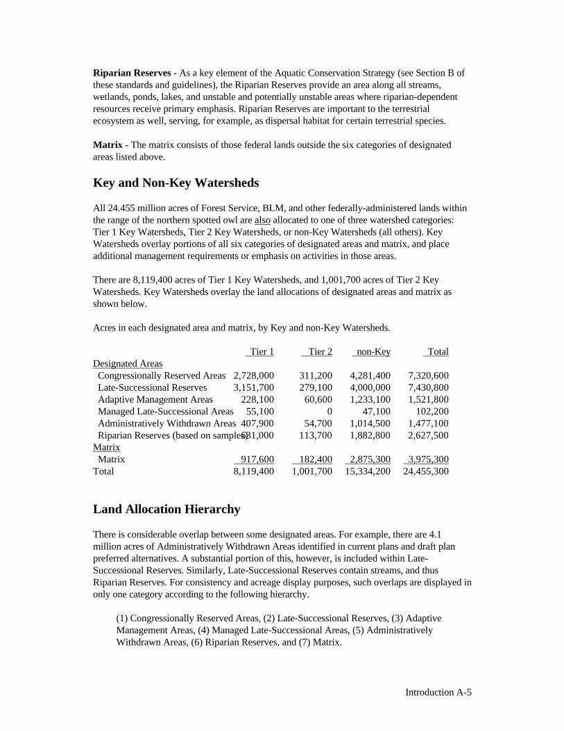
All 24.455 million acres of Forest Service, BLM, and other federally-administered lands withinthe range of the northern spotted owl are also allocated to one of three watershed categories:Tier 1 Key Watersheds, Tier 2 Key Watersheds, or non-Key Watersheds (all others). KeyWatersheds overlay portions of all six categories of designated areas and matrix, and placeadditional management requirements or emphasis on activities in those areas.
There are 8,119,400 acres of Tier 1 Key Watersheds, and 1,001,700 acres of Tier 2 KeyWatersheds. Key Watersheds overlay the land allocations of designated areas and matrix asshown below.
Acres in each designated area and matrix, by Key and non-Key Watersheds.
Tier 1 Tier 2 non-Key TotalDesignated Areas Congressionally Reserved Areas 2,728,000 311,200 4,281,400 7,320,600 Late-Successional Reserves 3,151,700 279,100 4,000,000 7,430,800 Adaptive Management Areas 228,100 60,600 1,233,100 1,521,800 Managed Late-Successional Areas 55,100 0 47,100 102,200 Administratively Withdrawn Areas 407,900 54,700 1,014,500 1,477,100 Riparian Reserves (based on samples) 631,000 113,700 1,882,800 2,627,500Matrix Matrix 917,600 182,400 2,875,300 3,975,300Total 8,119,400 1,001,700 15,334,200 24,455,300
Land Allocation Hierarchy
There is considerable overlap between some designated areas. For example, there are 4.1million acres of Administratively Withdrawn Areas identified in current plans and draft planpreferred alternatives. A substantial portion of this, however, is included within Late-Successional Reserves. Similarly, Late-Successional Reserves contain streams, and thusRiparian Reserves. For consistency and acreage display purposes, such overlaps are displayed inonly one category according to the following hierarchy.
(1) Congressionally Reserved Areas, (2) Late-Successional Reserves, (3) AdaptiveManagement Areas, (4) Managed Late-Successional Areas, (5) AdministrativelyWithdrawn Areas, (6) Riparian Reserves, and (7) Matrix.

Introduction A-6
Note as a result of this hierarchy, there are land allocation categories that are not completelyrepresented by acreage figures listed in these standards and guidelines. For example,Administratively Withdrawn Areas within Late-Successional Reserves are shown only in theLate-Successional Reserve category. The calculation of Riparian Reserves is done after allother designated areas; therefore, acres shown for Riparian Reserves only reflect thoseRiparian Reserves that are interspersed throughout the matrix. In practice, where overlapsoccur, the standards and guidelines of both allocations apply.
Note also that Key and non-Key Watersheds are not part of this hierarchy, because theirdesignations overlap, and do not preclude, all of the above categories. Therefore, there areacres of all categories of designated areas and matrix both inside and outside KeyWatersheds, as shown above.
Standards and Guidelines
Designated areas, matrix, and Key Watersheds all have specific management directionregarding how those lands are to be managed, including actions that are prohibited anddescriptions of the conditions that should occur there. This management direction is knownas “standards and guidelines”— the rules and limits governing actions, and the principlesspecifying the environmental conditions or levels to be achieved and maintained. Althoughthe direction in all sections of this document constitutes standards and guidelines, standardsand guidelines specific to particular land allocation categories, or relative to specific types ofmanagement activities, are included in Section C of these standards and guidelines.
Additional direction to management agencies includes, but is not limited to directives,policy, handbooks, manuals, as well as other plans, regulations, laws and treaties. Thestandards and guidelines presented here supersede other direction except treaties, laws, andregulations unless that direction is more restrictive or provides greater benefits to late-successional forest related species. These standards and guidelines do not apply where theywould be contrary to existing law or regulation, or where they would require the agencies totake actions for which they do not have authority.
Maps
The essential features of these standards and guidelines are shown on maps as follows.
Key Watersheds, Marbled Murrelet Zones 1 and 2, the five terrestrial designated areas,matrix, and samples of the Riparian Reserves, are shown on the 1:500,000 scale mapincluded with the Final SEIS (1994).
Maps at 1/2-inch to the mile scale showing all of the above elements are available foreach Forest Service and BLM administrative unit at the individual unit offices.
The official maps of the elements of these standards and guidelines are maintained as partof the administrative record and are also stored electronically in the Spatially UnifiedDatabase (SPUD) maintained by the Interagency Geographic Information System (GIS)staff in the Regional Ecosystem Office at 333 SW 1st St., Portland, OR 97204.
To more accurately define the zone in which marbled murrelet surveys are required, themarbled murrelet zone is being remapped in some areas to more closely parallel the

Introduction A-7
coastline, consistent with the narrative description of these zones on page C-10 of thesestandards and guidelines.
Transition Standards and Guidelines
As described in the Record of Decision, the following direction is adopted to provide forimplementation of certain interim procedures in order to realize the goals and objectives ofthe management strategy while making project decisions with reasonable promptness that donot preclude long-term options or impair resources sought to be protected.
1. Watershed Analysis - In the initial years of implementation, the process for watershedanalysis is expected to evolve to meet long-term goals described in these standards andguidelines. However, some projects proposed for the first few years of implementation are inareas that require watershed analysis prior to approval of the projects (i.e., Key Watersheds,Riparian Reserves, and inventoried roadless areas). In F.Y.s 1994-96, watershed analysisdone for these projects may be less detailed than analyses that are completed in later years.Regardless, analysis done during the initial years (F.Y. 1994-96) will comply with thefollowing guidance:
- The goal of the analysis is to determine whether the proposed actions are consistentwith the objectives of the standards and guidelines.
- Existing information will be used to the greatest extent possible, with new informationcollected, to the maximum extent practicable, to fill crucial data gaps.
- Analysis will address the entire watershed, even though some areas may be analyzed ata lower level of precision, and the analysis of issues may be prioritized.
- Information from the analysis will flow into the NEPA documentation for specificprojects, and will be used where practicable to facilitate Endangered Species Act and CleanWater Act compliance.
- Restoration opportunities will be identified.
As described elsewhere in these standards and guidelines, watershed analysis is an ongoing,iterative process. Watershed analyses will expand as appropriate to consider additionalavailable information, changing conditions and potential effects associated with long-termmanagement issues and needed actions.
2. Green Tree Retention Requirements - National forest timber sales already laid out at thetime of the Record of Decision may use green tree retention requirements in the Draft SEISif this eliminates the need to rework, redesign, or recruise a sale. All sales laid out after thedate of the Record of Decision will comply with green tree retention requirements in thesestandards and guidelines.
3. Assessments for Late-Successional Reserves - Projects and activities within Late-Successional Reserves (including restoration, recreation, projects for public safety, thinningand salvage) may proceed in fiscal years 1994-96 using initial Late-Successional Reserveassessments done at a level of detail sufficient to assess whether the activities are consistentwith the objectives of the Late-Successional Reserves.

Basis for Standards and.. B-1
B. Basis for Standards and GuidelinesIntroduction
This section of the standards and guidelines is adapted from the FEMAT Report to provideadditional information on the objectives and assumptions regarding management to protectand enhance habitat for late-successional and old-growth forest related species, and to protectand enhance riparian ecosystems. It clarifies the intent of the standards and guidelines inorder to provide guidance for situations not specifically covered by the standards andguidelines. It has two primary parts: (1) Ecological Principles for Management of Late-Successional Forests (below), and (2) the Aquatic Conservation Strategy (beginning on pageB-9).
Ecological Principles for Management ofLate-Successional Forests
General Ecological Basis for Forest Management
Late-successional forests are those forest seral stages that include mature and old-growth ageclasses. One goal of these standards and guidelines is to maintain late-successional and old-growth species habitat and ecosystems on federal lands. Another goal of forest managementon federal lands is to maintain biological diversity associated with native species andecosystems in accordance with laws and regulations. Forest ecosystems are quite variablethroughout the range of the northern spotted owl. Therefore, site-specific knowledge ofecosystems will be incorporated into watershed-level analysis and integrated into Forest andDistrict plans and province-level planing.
In Late-Successional Reserves, standards and guidelines are designed to maintain late-successional forest ecosystems and protect them from loss due to large-scale fire, insect anddisease epidemics, and major human impacts. The intent is to maintain natural ecosystemprocesses such as gap dynamics, natural regeneration, pathogenic fungal activity, insectherbivory, and low-intensity fire. These standards and guidelines encourage the use ofsilvicultural practices to accelerate the development of overstocked young plantations intostands with late-successional and old-growth forest characteristics, and to reduce the risk toLate-Successional Reserves from severe impacts resulting from large-scale disturbances andunacceptable loss of habitat.
The matrix is an integral part of the management direction included in these standards andguidelines. Production of timber and other commodities is an important objective for thematrix. However, forests in the matrix function as connectivity between Late-SuccessionalReserves and provide habitat for a variety of organisms associated with both late-

Basis for Standards and.. B-2
successional and younger forests. Standards and guidelines for the matrix are designed toprovide for important ecological functions such as dispersal of organisms, carryover of somespecies from one stand to the next, and maintenance of ecologically valuable structuralcomponents such as down logs, snags, and large trees. The matrix will also add ecologicaldiversity by providing early-successional habitat.
Structure and Composition
The structure and composition of late-successional and old-growth forest ecosystems havebeen detailed in numerous publications. Four major structural attributes of old-growthDouglas-fir forests are: live old-growth trees, standing dead trees (snags), fallen trees or logson the forest floor, and logs in streams. Additional important elements typically includemultiple canopy layers, smaller understory trees, canopy gaps, and patchy understory.Structural characteristics of late-successional and old-growth forests vary with vegetationtype, disturbance regime, and developmental stage. For example, in many Douglas-fir standsin western Oregon and Washington, the mature phase of stand development begins around 80years and is characterized by relatively large live and dead trees, although multiple canopylayers may not yet be well developed. In some forest types subject to frequent, low-intensityfire, such as ponderosa pine, the late-successional and old-growth stages are typicallycharacterized by relatively open understories and relatively few large fallen trees (incomparison to more moist Douglas-fir/western hemlock types). Standards and guidelinesdesigned to promote the desired conditions vary among physiographic provinces becausecharacteristics of the natural structure and composition of late-successional and old-growthforests also vary among the provinces.
Ecological Processes
Ecological processes include those natural changes that are essential for the development andmaintenance of late-successional and old-growth forest ecosystems. Although the processesthat created the current late-successional and old-growth ecosystems are not completelyunderstood, they include: (1) tree growth and maturation, (2) death and decay of large trees,(3) low-to-moderate intensity disturbances (e.g., fire, wind, insects, and diseases) that createcanopy openings or gaps in the various strata of vegetation, (4) establishment of treesbeneath the maturing overstory trees either in gaps or under the canopy, and (5) closing ofcanopy gaps by lateral canopy growth or growth of understory trees. These processes result inforests moving through different stages of late-successional and old-growth conditions thatmay span 80 to 1,200 years for forests dominated by long-lived species.
Several authors have described these stages, and one has expanded these descriptions toinclude the protracted nature of stand development in forests dominated by long-lived treessuch as Douglas-fir. Following stand-replacing disturbance, these stages can be described as:(1) establishment, (2) thinning, (3) maturation, (4) transition, and (5) shifting gap.
The maturation stage (3) is characterized by a slowed rate of height growth and crownexpansion. Heavy limbs begin to form; gaps between crowns become larger and more stable,or expand as a result of insect and pathogen mortality. Large dead and fallen trees begin to

Basis for Standards and.. B-3
accumulate, and the understory may be characterized by seedlings and saplings of shade-tolerant tree species. In Douglas-fir stands west of the Cascade Range, this stage typicallybegins between 80 and 140 years, depending on site conditions and stand history.
During the transition stage (4), the original component of overstory trees approaches itsmaximum height and diameter, and growth is slow. Tree crowns become more open, irregularin shape and contain heavy limbs. Broken, dead, and decaying portions of tree crowns arecommon. Old trees become relatively resistant to low-to-moderate intensity fire and,depending on species, crown bases are high above the understory and bark is relatively thick.During this stage, understory trees form multiple canopy layers. Coarse woody debrisaccumulates to relatively high levels, and low-to-moderate intensity disturbances frominsects, diseases, wind, and fire create patchy openings and accumulations of standing deadtrees. These disturbances also frequently promote establishment or advancement ofunderstory trees that eventually fill the holes in the canopy. In Douglas-fir stands west of theCascade Range, this stage begins between 150 to 250 years, and may last for an additional300 to 600 years depending on site conditions and species.
The shifting-gap stages begin when the last of the original component of overstory old-growth trees dies and all trees in the canopy have been established following various smallergap-type disturbances. Forests in the last two stages of development (4 and 5) actuallycontain all of the stand developmental stages in a relatively fine-grained mosaic of smallerstands. The later three stages (3, 4, and 5) embody the late-successional and old-growthconditions that are the focus of these standards and guidelines.
Some of the stand development processes, such as tree growth and mortality, and understoryestablishment, can be accelerated through silvicultural manipulations in younger stands.Other processes such as tree crown maturation, bark thickening, and tree bole decay are notreadily accelerated through silviculture. Because of limitations in knowledge of late-successional and old-growth forest processes and lack of silvicultural experience in oldstands, it is not certain that old-growth ecosystems can be completely replicated.
Most of the current late-successional and old-growth stands developed from naturalregeneration following wildfire events that occurred during the last 500 to 600 years. Thesefires covered large areas--frequently many thousands of acres. Although these fires werelarge, they burned in patches of variable intensity and severity, and left many areas ofunburned or lightly burned forest. The natural regime of patchy fires that leave an abundanceof large dead trees and lesser amounts of scattered live trees, as individuals and in patches, isthe basis for silvicultural methods such as retention of green trees as individuals and inpatches.
In some cases, however, natural reburns occurred, resulting in relatively little carryover of livetrees as a legacy from the old-growth condition. Where considerable live and dead materialwas left following fires, young stands contained many old-growth structures and presumablyold-growth associated organisms, including organisms associated with coarse woody debrison the forest floor.
Large fires and relatively long fire return intervals in the moist northern and western

Basis for Standards and.. B-4
physiographic provinces resulted in periods during which landscapes contained large areas ofrelatively unbroken forest cover. In the warmer, drier physiographic provinces (i.e., theWashington and Oregon Eastern Cascades, the California Cascades, and the Oregon andCalifornia Klamath Provinces), fire is more frequent, less intense, and is an integral part ofthe internal dynamics of a typical stand (tens to hundreds of acres). In the drier provinces, firecontrol and timber harvest have decreased the abundance of some types of old growth, suchas ponderosa pine, that are dependent on frequent, low-intensity fires. Other types of late-successional forest that are less fire resistant or are less desirable for harvest have becomemore widely distributed. In these areas, the potential for stand-replacing wildfires hasincreased, resulting in a higher risk to the stability of current stands reserved for late-successional species.
At a landscape scale and spanning long periods of time, stand-replacing wildfires have animportant role in resetting successional processes and developing new areas of late-successional forests to replace those lost through succession or disturbance. Silviculturalpractices designed to imitate natural processes may be able to reset succession to achievestand and landscape-level goals. This type of silviculture may meet a variety of ecosystemobjectives. However, experience in applying silviculture for late-successional objectives islimited. Until more experience and knowledge about active management to produce late-successional ecosystems is gained, sustaining late-successional ecosystems in the landscapewill be best accomplished through retention of existing areas of late-successional forest.Given the relatively low remaining proportion of late-successional ecosystems in thelandscape at the present time, these older forests should be protected from fire and otherstand-resetting disturbances.
Ecosystem Functions
Late-successional ecosystems perform several ecological functions that appear to be lacking,or less well developed, in younger natural forests and managed plantations. These functionsinclude buffering microclimates during seasonal climatic extremes, producing food for thoseconsumer organisms that occupy late-successional forests, storing carbon, providing nutrientand hydrological cycling, and providing sources of arthropod predators and organismsbeneficial to other ecosystems or successional stages. Old-growth ecosystems appear to havehigh retention of nutrients and low soil erosion potential, although differences in thesefunctions between stand developmental stages may not be large when canopy closure hasoccurred. Tall, deep canopies of late-successional forests can also intercept more moisturefrom clouds and fog than young plantations.
Late-Successional Reserves
These standards and guidelines include reserves designed to maintain and enhance late-successional forests as a network of existing old-growth forest ecosystems, although theirsize, distribution, and management varies. These reserves represent a network of existing old-growth forests that are retained in their natural condition with natural processes, such as fire,allowed to function to the extent possible. The reserves are designed to serve a number ofpurposes. First, they provide a distribution, quantity, and quality of old-growth forest

Basis for Standards and.. B-5
habitat sufficient to avoid foreclosure of future management options. Second, they providehabitat for populations of species that are associated with late-successional forests. Third,they will help ensure that late-successional species diversity will be conserved.
Late-successional forest communities are the result of a unique interaction of disturbance,regeneration, succession, and climate that can never be recreated in their entirety throughmanagement. The structure, species composition, and function of these forests are, in theirentirety, not fully understood. However, silvicultural restoration in early-successional forestscan accelerate the development of some of the structural and compositional features of late-successional forests. Because early-successional forests will regenerate by different processesduring a different time period than existing late-successional forests, silviculturally createdstands may look and function differently from current old-growth stands that developed overthe last 1,000 years. Consequently, conservation of a network of natural old-growth standsmaintains biodiversity into the future.
Desired late-successional and old-growth characteristics that will be created as youngerstands change through successional development include: (1) multispecies and multilayeredassemblages of trees, (2) moderate-to-high accumulations of large logs and snags, (3)moderate-to-high canopy closure, (4) moderate-to-high numbers of trees with physicalimperfections such as cavities, broken tops, and large deformed limbs, and (5) moderate-to-high accumulations of fungi, lichens, and bryophytes. Although they may not be duplicates ofexisting old-growth forests, these stands could provide adequate habitat for many species inthe long term.
The Role of Silviculture
Silviculture is the art and science of managing forest stands to provide or maintain structures,species composition, and growth rates that contribute to forest management goals.Silvicultural practices under these standards and guidelines will vary considerably because ofthe broad variety of forest species and ecosystems within the range of the northern spottedowl. The ecosystems range from coastal temperate rain forests where fire occurs infrequently,but where wind may have a major impact, to forests on dry interior sites where disturbance bywildfires and insects is common. Within specific locales, the silvicultural practices will bestrongly influenced by such factors as nearby residential areas, local wildlife habitatrequirements, and fire management constraints.
Silvicultural systems proposed for Late-Successional Reserves have two principal objectives:(1) development of old-growth forest characteristics including snags, logs on the forest floor,large trees, and canopy gaps that enable establishment of multiple tree layers and diversespecies composition; and (2) prevention of large-scale disturbances by fire, wind, insects, anddiseases that would destroy or limit the ability of the reserves to sustain viable forest speciespopulations. Small-scale disturbances by these agents are natural processes, and will beallowed to continue.
Matrix objectives for silviculture should include: (1) production of commercial yields ofwood, including those species such as Pacific yew and western red cedar that require

Basis for Standards and.. B-6
extended rotations, (2) retention of moderate levels of ecologically valuable old-growthcomponents such as snags, logs, and relatively large green trees, and (3) increasing ecologicaldiversity by providing early-successional habitat.
Stand Management
Forests within Late-Successional Reserves are composed of managed stands from 2 to morethan 80 years old, as well as unmanaged, late-successional, and old-growth stands. Theyounger stands were usually established following fire or timber harvest. Some of thesestands will develop old-growth characteristics without silvicultural intervention. However,current stocking and structure of some of these stands were established to produce high yieldsof timber, not to provide for old-growth-like forests. Consequently, silviculture can acceleratethe development of young stands into multilayered stands with large trees and diverse plantspecies, and structures that may, in turn, maintain or enhance species diversity.
Stand management in Late-Successional Reserves should focus on stands that have beenregenerated following timber harvest or stands that have been thinned. These include standsthat will acquire late-successional characteristics more rapidly with treatment, or are prone tofire, insects, diseases, wind, or other disturbances that would jeopardize the reserve.Depending on stand conditions, treatments could include, but should not be limited to: (1)thinning or managing the overstory to produce large trees; release advanced regeneration ofconifers, hardwoods, or other plants; or reduce risk from fire, insects, diseases, or otherenvironmental variables; (2) underplanting and limiting understory vegetation control tobegin development of multistory stands; (3) killing trees to make snags and coarse woodydebris; (4) reforestation; and (5) use of prescribed fire. Thinning prescriptions shouldencourage development of diverse stands with large trees and a variety of species in theoverstory and understory. Prescriptions should vary within and among stands.
Stands in the matrix can be managed for timber and other commodity production, and toperform an important role in maintaining biodiversity. Silvicultural treatments of foreststands in the matrix can provide for retention of old-growth ecosystem components such aslarge green trees, snags and down logs, and depending on site and forest type, can provide fora diversity of species. Retention of green trees following timber harvest in the matrixprovides a legacy that bridges past and future forests. Retaining green trees serves severalimportant functions including snag recruitment, promoting multistoried canopies, andproviding shade and suitable habitat for many organisms in the matrix.
Retaining green trees of various sizes, ages, and species, in well-distributed patches as well asdispersed individuals, will promote species diversity. These trees may also act as refugia orcenters of dispersal for many organisms including plants, fungi, lichens, small vertebrates,and arthropods. Patches of trees may provide protection for special microsites such as seeps,wetlands, or rocky outcrops. Trees retained within the Riparian Reserves can contribute tooverall retention objectives, but will generally not be sufficiently dispersed across thelandscape to fully satisfy these objectives. Diversity of tree structure should be consideredwhen selecting trees for retention. Complex canopy structure and especially leaning boles arebeneficial for some lichens. Trees that are asymmetrical provide a diversity of habitat

Basis for Standards and.. B-7
substrates, and often have more lichen and moss epiphytes on large lateral limbs thansymmetrical trees. Location of green trees is also important (e.g., ridgelines are optimallocations for lichen dispersal).
Coarse woody debris is essential for many species of vascular plants, fungi, liverworts,mosses, lichens, arthropods, salamanders, reptiles and small mammals. Because of driermicroclimates, logs in the matrix may be occupied by species different from those found oncoarse woody debris in late-successional forests. However, these logs may providetransitional islands for the maintenance and eventual recovery of some late-successionalorganisms in the matrix.
Adequate numbers of large snags and green trees are especially critical for bats because thesetrees are used for maternity roosts, temporary night roosts, day roosts, and hibernacula. Largesnags and green trees should be well distributed throughout the matrix because bats competewith primary excavators and other species that use cavities. Day and night roosts are oftenlocated at different sites, and migrating bats may roost under bark in small groups. Thermalstability within a roost site is important for bats, and large snags and green trees provide thatstability. Individual bat colonies may use several roosts during a season as temperature andweather conditions change. Large, down logs with loose bark may also be used by some batsfor roosting.
Management of Disturbance Risks
Natural disturbance is an important process within late-successional forest ecosystems, buthumans have altered the disturbance regimes. Management may be required to reintroducenatural disturbance, such as fire, or to minimize socially unacceptable impacts. Firesuppression has resulted in significant increases in accumulated fuels within some forests,particularly in the Washington and Oregon Eastern Cascades Provinces, the CaliforniaCascades Province, and the Oregon and California Klamath Provinces. At the same time,these forests may have become much more vulnerable to insects and diseases.
In Late-Successional Reserves in the Washington Western Cascades and coastal areas ofOregon and Washington, manipulation of natural stands to reduce fire hazard is generally notnecessary due to a lower occurrence of fire. However, fuel management may be desirable inplantations.
In Late-Successional Reserves in the Eastern Cascades or Klamath Provinces, silvicultureaimed at reducing the risk of stand-replacing fires may be appropriate. Treatments mayinclude thinning and underburning. Due to fire suppression, some forests have become quitedense and multistoried, primarily from the invasion of shade-tolerant species. Densityreduction in mid-level canopy layers by thinning may reduce the probability of crown fires.
Underburning can be used to reduce fuel loading and vertical fuel continuity. Wildfires instands that are managed using underburning are generally less severe, and fire suppression isaided. To increase effectiveness, underburning should be implemented over large areas. Suchactivities in older stands in westside provinces may be warranted when levels of fire

Basis for Standards and.. B-8
risk are high. Compartmentalized landscape units of reduced fuel allow safe access for firesuppression crews and provide strategic locations for efficient and effective fire suppression.Stands are manipulated to reduce continuity of canopies, boles are pruned on residual trees,and significant quantities of understory fuels are removed. Many of these treatments mayreduce the quality of habitat for late-successional organisms. Thus, managers need to seek abalanced approach that reduces risk of fire while protecting large areas of fire-prone late-successional forest.
Silvicultural systems within the matrix contribute to management of the Late-SuccessionalReserves. Fire and fuels management in the matrix can reduce the risk of fire and other large-scale disturbances that would jeopardize the reserves. Harvesting trees immediately adjacentto Late-Successional Reserves may result in increased wind damage along boundaries. Insuch cases, "feathering" stands within harvest units may be appropriate to reduce this risk.Local expertise will be essential in designing meaningful strategies for wind protection.
Management After Natural Disturbance
Fire, wind, insects, and diseases have greatly influenced the development of PacificNorthwest forests. Fine-scale disturbances, generally by insects or diseases, cause deaths ofsingle trees or small groups of trees which result in small patches of early-successionalvegetation embedded in a larger portion of older forest. Coarse-scale disturbances, such asfire and wind, result in more extensive areas of early-successional vegetation. Many nativeforest organisms have adapted to these cycles and scales of disturbance and regrowth.
These standards and guidelines have provisions for management following naturaldisturbances in Late-Successional Reserves. Direct silvicultural management is appropriatefollowing disturbances such as extensive, high-severity fires. Smaller scale disturbances, suchas those caused by insects, diseases, and wind, create small gaps in the overstory thatcharacterize the transition and shifting-gap stages of old-growth forest development.
Tree mortality is an important and natural process within a forest ecosystem. Diseased anddamaged trees and logs are key structural components of late-successional and old-growthforests. Salvage of dead trees affects the development of future stands and habitat quality fora number of organisms. Snag removal may result in long-term influences on forest standsbecause large snags are not produced in natural stands until trees become large and begin todie from natural mortality. Snags are used extensively by cavity-nesting birds and mammalssuch as woodpeckers, nuthatches, chickadees, squirrels, red tree voles, and American marten.Removal of snags following disturbance can reduce the carrying capacity for these species formany years.
Coarse woody debris is a necessary component of forest ecosystems. This wood provideshabitat for a broad array of vertebrates, invertebrates, fungi, mosses, vascular plants, andmicro-organisms. Arthropods, salamanders, reptiles, and small mammals live in or underlogs; woodpeckers forage on them; and vascular plants and fungi grow on rotting logs.Provision for retention of snags and logs normally should be made, at least until the new

Basis for Standards and.. B-9
stand begins to contribute coarse woody debris.
Many natural disturbances do not result in complete mortality of stands. For example, recentfires in the Oregon Western Cascades Province killed 25 to 50 percent of trees within theareas burned, leaving 50 to 75 percent of the stands intact. The surviving trees are importantelements of the new stand. They provide structural diversity and provide a potential source ofadditional large snags during the development of new stands. Furthermore, trees injured bydisturbance may develop cavities, deformed crowns, and limbs which are habitat componentsfor a variety of wildlife species.
In the matrix, objectives for management after stand-replacing events will generally differfrom those for Late-Successional Reserves. Economic benefits of timber production willreceive greater consideration. For example, the commercial salvage of dead trees will be lessconstrained, and replanting disturbed areas will be a high priority.
Aquatic Conservation StrategyThe Aquatic Conservation Strategy was developed to restore and maintain the ecologicalhealth of watersheds and aquatic ecosystems contained within them on public lands. Thestrategy would protect salmon and steelhead habitat on federal lands managed by the ForestService and Bureau of Land Management within the range of Pacific Ocean anadromy.
This conservation strategy employs several tactics to approach the goal of maintaining the“natural” disturbance regime. Land use activities need to be limited or excluded in those partsof the watershed prone to instability. The distribution of land use activities, such as timberharvest or roads, must minimize increases in peak streamflows. Headwater riparian areasneed to be protected, so that when debris slides and flows occur they contain coarse woodydebris and boulders necessary for creating habitat farther downstream. Riparian areas alonglarger channels need protection to limit bank erosion, ensure an adequate and continuoussupply of coarse woody debris to channels, and provide shade and microclimate protection.Watersheds currently containing the best habitat or those with the greatest potential forrecovery should receive increased protection and receive highest priority for restorationprograms.
Any species-specific strategy aimed at defining explicit standards for habitat elements wouldbe insufficient for protecting even the targeted species. The Aquatic Conservation Strategymust strive to maintain and restore ecosystem health at watershed and landscape scales toprotect habitat for fish and other riparian-dependent species and resources and restorecurrently degraded habitats. This approach seeks to prevent further degradation and restorehabitat over broad landscapes as opposed to individual projects or small watersheds. Becauseit is based on natural disturbance processes, it may take decades, possibly more than acentury, to accomplish all of its objectives. Some improvements in aquatic ecosystems,however, can be expected in 10 to 20 years.
The important phrases in these standards and guidelines are "meet Aquatic Conservation
Basis for Standards and.. B-10
Strategy objectives," "does not retard or prevent attainment of Aquatic Conservation Strategyobjectives," and "attain Aquatic Conservation Strategy objectives." These phrases, coupledwith the phrase "maintain and restore" within each of the Aquatic Conservation Strategyobjectives, define the context for agency review and implementation of managementactivities. Complying with the Aquatic Conservation Strategy objectives means that anagency must manage the riparian-dependent resources to maintain the existing condition orimplement actions to restore conditions. The baseline from which to assess maintaining orrestoring the condition is developed through a watershed analysis. Improvement relates torestoring biological and physical processes within their ranges of natural variability.
The standards and guidelines are designed to focus the review of proposed and certainexisting projects to determine compatibility with the Aquatic Conservation Strategyobjectives. The standards and guidelines focus on "meeting" and "not preventing attainment"of Aquatic Conservation Strategy objectives. The intent is to ensure that a decision makermust find that the proposed management activity is consistent with the Aquatic ConservationStrategy objectives. The decision maker will use the results of watershed analysis to supportthe finding. In order to make the finding that a project or management action "meets" or "doesnot prevent attainment" of the Aquatic Conservation Strategy objectives, the analysis mustinclude a description of the existing condition, a description of the range of natural variabilityof the important physical and biological components of a given watershed, and how theproposed project or management action maintains the existing condition or moves it withinthe range of natural variability. Management actions that do not maintain the existingcondition or lead to improved conditions in the long term would not "meet" the intent of theAquatic Conservation Strategy and thus, should not be implemented.

Basis for Standards and.. B-11
Aquatic Conservation Strategy ObjectivesForest Service and BLM-administered lands within the range of the northern spotted owl willbe managed to:
1. Maintain and restore the distribution, diversity, and complexity of watershed andlandscape-scale features to ensure protection of the aquatic systems to which species,populations and communities are uniquely adapted.
2. Maintain and restore spatial and temporal connectivity within and between watersheds.Lateral, longitudinal, and drainage network connections include floodplains, wetlands,upslope areas, headwater tributaries, and intact refugia. These network connections mustprovide chemically and physically unobstructed routes to areas critical for fulfilling lifehistory requirements of aquatic and riparian-dependent species.
3. Maintain and restore the physical integrity of the aquatic system, including shorelines,banks, and bottom configurations.
4. Maintain and restore water quality necessary to support healthy riparian, aquatic, andwetland ecosystems. Water quality must remain within the range that maintains thebiological, physical, and chemical integrity of the system and benefits survival, growth,reproduction, and migration of individuals composing aquatic and riparian communities.
5. Maintain and restore the sediment regime under which aquatic ecosystems evolved.Elements of the sediment regime include the timing, volume, rate, and character ofsediment input, storage, and transport.
6. Maintain and restore in-stream flows sufficient to create and sustain riparian, aquatic,and wetland habitats and to retain patterns of sediment, nutrient, and wood routing. Thetiming, magnitude, duration, and spatial distribution of peak, high, and low flows must beprotected.
7. Maintain and restore the timing, variability, and duration of floodplain inundation andwater table elevation in meadows and wetlands.
8. Maintain and restore the species composition and structural diversity of plantcommunities in riparian areas and wetlands to provide adequate summer and winterthermal regulation, nutrient filtering, appropriate rates of surface erosion, bank erosion,and channel migration and to supply amounts and distributions of coarse woody debrissufficient to sustain physical complexity and stability.
9. Maintain and restore habitat to support well-distributed populations of native plant,invertebrate, and vertebrate riparian-dependent species.

Basis for Standards and.. B-12
Components of the Aquatic Conservation Strategy1. Riparian Reserves: Lands along streams and unstable and potentially unstable areas
where special standards and guidelines direct land use.
2. Key Watersheds: A system of large refugia comprising watersheds that are crucial toat-risk fish species and stocks and provide high quality water.
3. Watershed Analysis: Procedures for conducting analysis that evaluates geomorphic andecologic processes operating in specific watersheds. This analysis should enablewatershed planning that achieves Aquatic Conservation Strategy objectives. WatershedAnalysis provides the basis for monitoring and restoration programs and the foundationfrom which Riparian Reserves can be delineated.
4. Watershed Restoration: A comprehensive, long-term program of watershed restorationto restore watershed health and aquatic ecosystems, including the habitats supporting fishand other aquatic and riparian-dependent organisms.
These components are designed to operate together to maintain and restore the productivityand resiliency of riparian and aquatic ecosystems. Late-Successional Reserves are also animportant component of the Aquatic Conservation Strategy. The standards and guidelinesunder which Late-Successional Reserves are managed provide increased protection for allstream types. Because these reserves possess late-successional characteristics, they offer coreareas of high quality stream habitat that will act as refugia and centers from which degradedareas can be recolonized as they recover. Streams in these reserves may be particularlyimportant for endemic or locally distributed fish species and stocks.
1. Riparian Reserves
There are an estimated 2,627,500 acres of Riparian Reserves interspersed within the matrix.(Acres for matrix listed elsewhere in these standards and guidelines do not include RiparianReserves.) Riparian Reserves and their appurtenant standards and guidelines also applywhere these reserves overlap with any other land allocations. Acres of Riparian Reserveswithin other land allocations is not calculated, but is estimated to encompass 40 percent(based on a sample) of those allocations. The percent of area in Riparian Reserves variesmarkedly among administrative units, from a high of approximately 74 percent on theSiuslaw National Forest, to a low of approximately 4 percent on the Deschutes NationalForest.
Riparian Reserves are portions of watersheds where riparian-dependent resources receiveprimary emphasis and where special standards and guidelines apply. Standards and guidelinesprohibit and regulate activities in Riparian Reserves that retard or prevent attainment of theAquatic Conservation Strategy objectives. Riparian Reserves include those portions of awatershed directly coupled to streams and rivers, that is, the portions of a watershed requiredfor maintaining hydrologic, geomorphic, and ecologic processes that directly affect standingand flowing waterbodies such as lakes and ponds, wetlands, streams,

Basis for Standards and.. B-13
stream processes, and fish habitats. Riparian Reserves include areas designated in currentplans and draft plan preferred alternatives as riparian management areas or streamsidemanagement zones and primary source areas for wood and sediment such as unstable andpotentially unstable areas in headwater areas and along streams. Riparian Reserves occur atthe margins of standing and flowing water, intermittent stream channels and ephemeralponds, and wetlands. Riparian Reserves generally parallel the stream network but alsoinclude other areas necessary for maintaining hydrologic, geomorphic, and ecologicprocesses.
Under the Aquatic Conservation Strategy, Riparian Reserves are used to maintain and restoreriparian structures and functions of intermittent streams, confer benefits toriparian-dependent and associated species other than fish, enhance habitat conservation fororganisms that are dependent on the transition zone between upslope and riparian areas,improve travel and dispersal corridors for many terrestrial animals and plants, and providefor greater connectivity of the watershed. The Riparian Reserves will also serve asconnectivity corridors among the Late-Successional Reserves.
Interim widths for Riparian Reserves necessary to meet Aquatic Conservation Strategyobjectives for different waterbodies are established based on ecologic and geomorphicfactors. These widths are designed to provide a high level of fish habitat and riparianprotection until watershed and site analysis can be completed. Watershed analysis willidentify critical hillslope, riparian, and channel processes that must be evaluated in order todelineate Riparian Reserves that assure protection of riparian and aquatic functions. RiparianReserves are delineated during implementation of site-specific projects based on analysis ofthe critical hillslope, riparian, and channel processes and features. Although Riparian Reserveboundaries may be adjusted on permanently-flowing streams, the prescribed widths areconsidered to approximate those necessary for attaining Aquatic Conservation Strategyobjectives. Post-watershed analysis Riparian Reserve boundaries for permanently-flowingstreams should approximate the boundaries prescribed in these standards and guidelines.However, post-watershed analysis Riparian Reserve boundaries for intermittent streams maybe different from the existing boundaries. The reason for the difference is the high variabilityof hydrologic, geomorphic and ecologic processes in a watershed affecting intermittentstreams. At the same time, any analysis of Riparian Reserve widths must also consider thecontribution of these reserves to other, including terrestrial, species. Watershed analysisshould take into account all species that were intended to be benefited by the prescribedRiparian Reserve widths. Those species include fish, mollusks, amphibians, lichens, fungi,bryophytes, vascular plants, American marten, red tree voles, bats, marbled murrelets, andnorthern spotted owls. The specific issue for spotted owls is retention of adequate habitatconditions for dispersal.
The prescribed widths of Riparian Reserves apply to all watersheds until watershed analysisis completed, a site-specific analysis is conducted and described, and the rationale for finalRiparian Reserve boundaries is presented through the appropriate NEPA decision-makingprocess.

Basis for Standards and.. B-14
Riparian Reserve Widths
Riparian Reserves are specified on page C-30 of these standards and guidelines for thefollowing five categories of streams or waterbodies:
Fish-bearing streams
Permanently flowing nonfish-bearing streams
Constructed ponds and reservoirs, and wetlands greater than 1 acre
Lakes and natural ponds
Seasonally flowing or intermittent streams, wetlands less than 1 acre, and unstable andpotentially unstable areas
Standards and guidelines specific to Riparian Reserves begin on page C-31.
Intermittent Streams
Intermittent streams are defined as any nonpermanent flowing drainage feature having adefinable channel and evidence of annual scour or deposition. This includes what aresometimes referred to as ephemeral streams if they meet these two physical criteria.
Including intermittent streams and wetlands within Riparian Reserves is important forsuccessful implementation of the Aquatic Conservation Strategy. Accurate identification ofthese features is critical to the correct implementation of the strategy and protection of theintermittent stream and wetland functions and processes. Identification of these features isdifficult at times due to the lack of surface water or wet soils during dry periods. Thefollowing discussion provides guidance on steps to identify these features for inclusion withinRiparian Reserves.
Fish-bearing streams are distinguished from intermittent streams by the presence of anyspecies of fish for any duration. Many intermittent streams may be used as spawning andrearing streams, refuge areas during flood events in larger rivers and streams or travel routesfor fish emigrating from lakes. In these instances, the standards and guidelines for fish-bearing streams would apply to those sections of the intermittent stream used by the fish.
The following discussion pertains to Riparian Reserve widths on intermittent streams andwetlands necessary to meet Aquatic Conservation Strategy objectives. Other RiparianReserve objectives, such as providing wildlife dispersal corridors, could lead to RiparianReserve widths different than those necessary to protect the ecological integrity of theintermittent stream or wetland. These other objectives could yield wider Riparian Reservesthan those necessary to meet Aquatic Conservation Strategy objectives. There can never beinstances where Riparian Reserves would be narrower than the widths necessary to meetAquatic Conservation Strategy objectives.
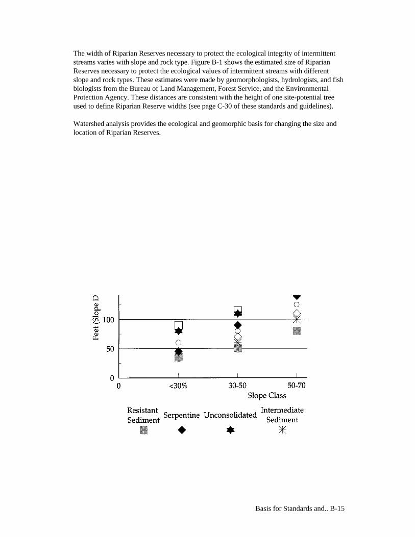
Basis for Standards and.. B-15
The width of Riparian Reserves necessary to protect the ecological integrity of intermittentstreams varies with slope and rock type. Figure B-1 shows the estimated size of RiparianReserves necessary to protect the ecological values of intermittent streams with differentslope and rock types. These estimates were made by geomorphologists, hydrologists, and fishbiologists from the Bureau of Land Management, Forest Service, and the EnvironmentalProtection Agency. These distances are consistent with the height of one site-potential treeused to define Riparian Reserve widths (see page C-30 of these standards and guidelines).
Watershed analysis provides the ecological and geomorphic basis for changing the size andlocation of Riparian Reserves.
Basis for Standards and.. B-16
The prescribed widths for Riparian Reserves apply to all streams, lakes, ponds and wetlandson lands administered by the Forest Service and BLM within the range of the northernspotted owl until a watershed analysis is completed. Watershed analysis is expected to yieldthe contextual information needed to define ecologically and geomorphically appropriateRiparian Reserves. Analysis of site-specific characteristics may warrant Riparian Reservesthat are narrower or wider than the prescribed widths. Thus, it is possible to meet theobjectives of at least the Aquatic Conservation Strategy portion of these standards andguidelines with post-watershed analysis reserve boundaries for intermittent streams that arequite different from those conforming to the prescribed widths. Regardless of stream type,changes to Riparian Reserves must be based on scientifically sound reasoning, and be fullyjustified and documented.
Wetlands
The combinations of hydrology, soils, and vegetative characteristics are the primary factorsinfluencing the development of wetland habitats. There must be the presence of surface wateror saturated soils to significantly reduce the oxygen content in the soils to zero or near zeroconcentrations. These low or zero soil oxygen conditions must persist for sufficient durationto promote development of plant communities that have a dominance of species adapted tosurvive and grow under zero oxygen conditions. These wetland characteristics apply whendefining wetlands for regulatory jurisdiction or for technical analysis when conductinginventories or functional assessments. Seeps and springs can be classified as streams if theyhave sufficient flow in a channel or as seasonal or perennial wetlands under the criteriadefined in the 1987 Corps of Engineers Wetlands Manual. The standards and guidelines forwetlands, which are based on the hydrologic, physical and biologic characteristics describedin the manual, apply to seeps and springs regardless of their size.
Formal definition for implementing section 404 of the Clean Water Act, adopted by theEnvironmental Protection Agency, is as follows:
The term wetlands means those areas that are inundated or saturated by surface orground water at a frequency and duration sufficient to support, and that under normalcircumstances do support, a prevalence of vegetation typically adapted for life insaturated soil conditions. Wetlands generally include swamps, marshes, bogs andsimilar areas.
Detailed technical methods have been developed to assist in identification of wetlands thatmeet the above definition. Currently, the field manual being used for implementing the CleanWater Act is the "1987 Corps Manual."
For purposes of conducting the National Wetland Inventory, the Fish and Wildlife Servicehas broadly defined both vegetated and nonvegetated wetlands as follows:
Wetlands are lands transitional between terrestrial and aquatic systems where the watertable is usually at or near the surface or the land is covered by shallow water. Forpurposes of this classification wetlands must have one or more of the following three

Basis for Standards and.. B-17
attributes: (1) at least periodically, the land supports predominantly hydrophytes, (2) thesubstrate is predominantly undrained hydric soil, and (3) the substrate is nonsoil and issaturated with water or covered by shallow water at some time during the growing season ofeach year.
Wetlands typically occur within and adjacent to riparian zones. It is frequently difficult todifferentiate wetlands from riparian areas based on the definitions. Most typically, andparticularly in forested landscapes, the riparian zone is defined by its spatial relation toadjacent streams or rivers. However, riparian zones are also commonly considered to be landsintegrally related to other aquatic habitats such as lakes, reservoirs, intermittent streams,springs, seeps, and wetlands.
Because of such conceptual and definitional vagaries, there is spatial overlap betweenwetlands and riparian zones. This then results in only a portion of the riparian zoneassociated with rivers and streams being considered as wetlands. The extent of that portionwill depend on the specifics of hydrologic, vegetation, and soil features. The functions of thewetland portion may also be distinct from the nonwetlands. For example, wetlands mayprovide habitat for specialized plant species or reproductive habitat for amphibians or otherorganisms that would not be provided by riparian areas.
Once the Riparian Reserve width is established, either based on existing widths or watershedanalysis, then land management activities allowed in the Riparian Reserve will be directed bystandards and guidelines for managing Riparian Reserves (see page C-31). The standards andguidelines for Riparian Reserves prohibit or regulate activities in Riparian Reserves thatretard or prevent attainment of the Aquatic Conservation Strategy objectives.
Summary of Aquatic Conservation Strategy for Riparian Reserves:
Involves portions of the landscape where riparian-dependent and stream resourcesreceive primary emphasis.
Riparian Reserves are designated for all permanently-flowing streams, lakes,wetlands, and intermittent streams.
Riparian Reserves include the body of water, inner gorges, all riparian vegetation,100-year floodplain, landslides and landslide prone areas.
Reserve widths are based on some multiple of a site-potential tree or a prescribedslope distance, whichever is greater. Reserve widths may be adjusted based onwatershed analysis to meet Aquatic Conservation Strategy objectives.
Standards and guidelines prohibit programmed timber harvest, and manage roads,grazing, mining and recreation to achieve objectives of the Aquatic ConservationStrategy (see page C-31).

Basis for Standards and.. B-18
2. Key Watersheds
There are 8,119,400 acres of Tier 1 Key Watersheds, and 1,001,700 acres of Tier 2 KeyWatersheds within the range of the northern spotted owl. Key Watersheds overlay the landallocations of designated areas and matrix as follows:
Acres in each designated area and matrix, by Key and non-Key Watersheds.
Tier 1 Tier 2 non-Key TotalDesignated Areas Congressionally Reserved Areas 2,728,000 311,200 4,281,400 7,320,600 Late-Successional Reserves 3,151,700 279,100 4,000,000 7,430,800 Adaptive Management Areas 228,100 60,600 1,233,100 1,521,800 Managed Late-Successional Areas 55,100 0 47,100 102,200 Administratively Withdrawn Areas 407,900 54,700 1,014,500 1,477,100 Riparian Reserves (based on sample) 631,000 113,700 1,882,800 2,627,500Matrix Matrix 917,600 182,400 2,875,300 3,975,300 Total 8,119,400 1,001,700 15,334,200 24,455,300
Refugia are a cornerstone of most species conservation strategies. They are designated areasthat either provide, or are expected to provide, high quality habitat. A system of KeyWatersheds that serve as refugia is crucial for maintaining and recovering habitat for at-riskstocks of anadromous salmonids and resident fish species. These refugia include areas of highquality habitat as well as areas of degraded habitat. Key Watersheds with high qualityconditions will serve as anchors for the potential recovery of depressed stocks. Those oflower quality habitat have a high potential for restoration and will become future sources ofhigh quality habitat with the implementation of a comprehensive restoration program (seeWatershed Restoration later in this section of these standards and guidelines). The Aquatic Conservation Strategy includes two designations for Key Watersheds. Tier 1(Aquatic Conservation Emphasis) Key Watersheds contribute directly to conservation ofat-risk anadromous salmonids, bull trout, and resident fish species. They also have a highpotential of being restored as part of a watershed restoration program. Tier 1 Key Watershedsconsist primarily of watersheds identified previously by the Scientific Panel on Late-Successional Forest Ecosystems (1991), and in the Scientific Analysis Team Report (1993).The network of 143 Tier 1 Key Watersheds ensures that refugia are widely distributed acrossthe landscape. While 21 Tier 2 (other) Key Watersheds may not contain at-risk fish stocks,they are important sources of high quality water.
Long-term management within Key Watersheds requires watershed analysis prior to furtherresource management activity. In the short term, until watershed analysis can be completed,minor activities such as those that would be Categorically Excluded under NationalEnvironmental Policy Act regulations (except timber harvest) may proceed if they areconsistent with Aquatic Conservation Strategy objectives and apply Riparian Reserves and

Basis for Standards and.. B-19
standards and guidelines. Timber harvest, including salvage, can not occur in KeyWatersheds without a watershed analysis. Key Watersheds that currently contain poorquality habitat are believed to have the best opportunity for successful restoration and willreceive priority in any watershed restoration program.
Roadless Areas and Key Watersheds
Management activities in inventoried roadless areas with unstable land will increase the riskto aquatic and riparian habitat, impair the capacity of Key Watersheds to function asintended, and limit the potential to achieve Aquatic Conservation Strategy objectives.Standards and guidelines that refer to inventoried roadless areas (or simply "roadless areas")apply only to those portions of such areas that would still qualify as roadless under theguidelines used to originally designate the areas under the second Forest Service RoadlessArea Review and Evaluation (RARE II).
To protect the remaining high quality habitats, no new roads will be constructed ininventoried roadless areas in Key Watersheds. Watershed analysis must be conducted in allnon-Key Watersheds that contain roadless areas before any management activities can occurwithin those roadless areas. The amount of existing system and nonsystem roads within Key Watersheds should bereduced through decommissioning of roads. Road closures with gates or barriers do notqualify as decommissioning or a reduction in road mileage. If funding is insufficient toimplement reductions, there will be no net increase in the amount of roads in KeyWatersheds. That is, for each mile of new road constructed, at least one mile of road shouldbe decommissioned, and priority given to roads that pose the greatest risks to riparian andaquatic ecosystems.
Summary of Aquatic Conservation Strategy for Key Watersheds:
Tier 1 Key Watersheds were selected for directly contributing to anadromoussalmonid and bull trout conservation.
Tier 2 Key Watersheds were selected as sources of high quality water and may notcontain at-risk fish stocks
No new roads will be built in roadless areas in Key Watersheds.
Reduce existing system and nonsystem road mileage outside roadless areas. Iffunding is insufficient to implement reductions, there will be no net increase in theamount of roads in Key Watersheds.
Key Watersheds are highest priority for watershed restoration.
Watershed analysis is required prior to management activities, except minoractivities such as those Categorically Excluded under NEPA (and not includingtimber harvest).

Basis for Standards and.. B-20
Timber harvest cannot occur in Key Watersheds prior to completing a watershedanalysis.
Standards and guidelines specific to Key Watersheds are summarized on page C-7 of thesestandards and guidelines.
3. Watershed Analysis
Watershed analysis, as described here, focuses on implementing the Aquatic ConservationStrategy. The broader role of watershed analysis in relation to implementing the ecosystemmanagement objectives proposed by these standards and guidelines is described in Section E,Implementation. Watershed analysis is one of the principal analyses that will be used inmaking decisions on implementation of the Aquatic Conservation Strategy.
Watershed analysis is required in Key Watersheds, for roadless areas in non-Key Watersheds,and Riparian Reserves prior to determining how proposed land management activities meetAquatic Conservation Strategy objectives. Watershed analyses must be completed beforeinitiating actions within a Key Watershed, except that in the short term, until watershedanalysis can be completed, minor activities such as those that would be categorically excludedunder National Environmental Policy Act regulations (except timber harvest) may proceed ifthey are consistent with Aquatic Conservation Strategy objectives and Riparian Reserves andstandards and guidelines are applied. Timber harvest, including salvage, cannot occur in KeyWatersheds without a watershed analysis. Ultimately, watershed analyses should beconducted in all watersheds on federal lands as a basis for ecosystem planning andmanagement.
Watershed analysis has a critical role in providing for aquatic and riparian habitat protection.In planning for ecosystem management and establishing Riparian Reserves to protect andrestore riparian and aquatic habitat, the overall watershed condition and the array ofprocesses operating there need to be considered. Watershed condition includes more than justthe state of the channel and riparian area. It also includes the condition of the uplands,distribution and type of seral classes of vegetation, land use history, effects of previousnatural and land-use related disturbances, and distribution and abundance of species andpopulations throughout the watershed. These factors strongly influence the structure andfunctioning of aquatic and riparian habitat. Effective protection strategies for riparian andaquatic habitat on federal lands must accommodate the wide variability in landscapeconditions present across the Pacific Northwest. Watershed analysis plays a key role in theAquatic Conservation Strategy, ensuring that aquatic system protection is fitted to specificlandscapes.
Watershed analysis will focus on collecting and compiling information within the watershedthat is essential for making sound management decisions. It will be an analytical process, nota decision-making process with a proposed action requiring NEPA documentation. It will

Basis for Standards and.. B-21
serve as the basis for developing project-specific proposals, and monitoring and restorationneeds for a watershed. Some analysis of issues or resources may be included in broader scaleanalyses because of their scope. The information from the watershed analyses will contributeto decision making at all levels. Project-specific NEPA planning will use informationdeveloped from watershed analysis. For example, if watershed analysis shows that restoringcertain resources within a watershed could contribute to achieving landscape or ecosystemmanagement objectives, then subsequent decisions will need to address that information.
The results of watershed analyses may include a description of the resource needs,capabilities, opportunities, the range of natural variability, spatially explicit information thatwill facilitate environmental and cumulative effects analyses for NEPA, and the processesand functions operating within the watershed. Watershed analysis will identify potentiallydisjunct approaches and conflicting objectives within watersheds. The information fromwatershed analysis will be used to develop priorities for funding, and implementing actionsand projects, and will be used in developing monitoring strategies and objectives. Theparticipation of adjacent landowners, private citizens, interest groups, industry, variousgovernment agencies, and others in watershed analyses will be promoted.
Watershed analysis is a systematic procedure for characterizing watershed and ecologicalprocesses to meet specific management and social objectives. This information will supportdecisions for implementing management prescriptions, including setting and refiningboundaries of Riparian Reserves and other reserves, developing restoration strategies andpriorities, and revealing the most useful indicators for monitoring environmental changes.Watershed analysis is an important analytical step supporting ecosystem planning forwatersheds of approximately 20 to 200 square miles (Figure B-2). It is a key componentsupporting watershed planning and analyzing the blending of social expectations with thebiophysical capabilities of specific landscapes. Watershed analysis is the appropriate level foranalyzing the effects of transportation systems on aquatic and riparian habitats within thetarget watershed. In contrast, issues pertaining to stocks at risk would generally be moreapplicable at the province or river basin analytical levels, as discussed in Section E of thesestandards and guidelines, rather than the 20 to 200 square mile watershed level.
Watershed analysis consists of technically rigorous and defensible procedures designed toidentify processes that are active within a watershed, how those processes are distributed intime and space, the current upland and riparian conditions of the watershed, and how all ofthese factors influence riparian habitat and other beneficial uses. The analysis is conducted byan interdisciplinary team consisting of geomorphologists, hydrologists, soil scientists,biologists and other specialists as needed. Information used in this analysis includes: maps oftopography, stream networks, soils, vegetation, and geology; sequential aerial photographs;field inventories and surveys including landslide, channel, aquatic habitat, and ripariancondition inventories; census data on species presence and abundance; water quality data;disturbance and land use history; and other historical data (e.g., streamflow records, oldchannel surveys).

Basis for Standards and.. B-22
Basis for Standards and.. B-23
Watershed analysis is organized as a set of modules that examine biotic and abiotic processesinfluencing aquatic habitat and species abundance (e.g., landslides, surface erosion, peak andlow streamflows, stream temperatures, road network effects, coarse woody debris dynamics,channel processes, fire, limiting factor analysis for key species). Results from these modulesare integrated into a description of current upland, riparian, and channel conditions; maps oflocation, frequency, and magnitude of key processes; and descriptions of location andabundance of key species.
Watershed analysis provides the contextual basis at the site level for decision makers to setappropriate boundaries of Riparian Reserves, plan land use activities compatible withdisturbance patterns, design road transportation networks that pose minimal risk, identifywhat and where restoration activities will be most effective, and establish specific parametersand activities to be monitored. More detailed site-level analysis is conducted to provide theinformation and designs needed for specific projects (e.g., road siting or timber sale layout)so that riparian and aquatic habitats are protected.
Watershed analysis provides the ecologic and geomorphic basis for changing the size andlocation of Riparian Reserves necessary to meet Aquatic Conservation Strategy objectives.Ultimate design of Riparian Reserves is likely to be a hybrid of decisions based onconsideration of sites of special ecological value, slope stability, wildlife dispersal corridors,endemic species considerations and natural disturbance processes.
Figure B-3 illustrates how slope stability and debris flow runout models may be used as partof watershed analysis for adjusting Riparian Reserves. The result is that the basin is stratifiedinto areas that may require wider or narrower Riparian Reserves than those conforming toRiparian Reserve Scenario 1 for intermittent streams. For example, on intermittent streams inunstable areas with high potential to generate slides and debris flows, Riparian Reserveswider than those conforming to the definition may be necessary to ensure ecological integrity.Riparian Reserves in more stable areas may be less extensive, managed under uplandstandards and guidelines (e.g., levels of green-tree retention as either single trees or in patchesof a specific size), or a combination of these.
Slope stability analysis for Augusta Creek is an example in which likely impact mechanismsare identified (Figure B-4). Distribution of areas subject to slope instability was interpretedfrom information contained within the Willamette National Forest Soil Resource Inventory.Slope data for each mapped unit was extracted from the Willamette National Forest SoilResource Inventory based on whether hillslope gradients were less than 30 percent, between30 and 60 percent, and greater than 60 percent. Geologic descriptions from the WillametteNational Forest Soil Resource Inventory were used to determine whether underlying bedrockwas hard, moderately hard, or soft. A hazard rating of low, moderate, or high slide potentialwas assigned to each mapped unit based on hillslope gradient and geologic description(Figure B-4). Predicted hazard ratings were tested and found to be in excellent agreementwith the historical pattern of landslides observed on aerial photographs. This analytical stepensures that field and analysis time will be used efficiently to address the most importantprocesses and issues in the watershed.
Using the results from the slope stability analysis, watersheds were stratified into subareas in
Basis for Standards and.. B-24
order to evaluate the watersheds as uniform response units for each of the processes or issuesof concern. The process of determining debris flow susceptibility for Augusta Creek is anexample of how a watershed might be stratified and how this stratification may be used as abasis for mapping Riparian Reserves (Figure B-3). To determine the susceptibility ofdifferent stream reaches to debris flows, a stream network map was overlaid on the slidepotential map (Figure B-4). Areas with high slope instability were assumed to be most likelyto generate debris flows. First-order channels (headward channels without tributaries) wereassigned a debris flow hazard rating equal to the slide potential of the surrounding landscape(Figure B-4). Debris flow hazard to higher order channels downstream was assumed to be afunction of two factors: channel gradient (Figure B-5) and tributary junction angle (Figure B-6). Debris flow hazard was reduced on the class where channel gradient was less than 3degrees or tributary junction angle exceeded 70 degrees, to produce a map of debris flowpotential (Figure B-7). The stratification will vary according to process or issue. Within agiven physiographic province, similar geographic and topographic features control drainagenetwork and hillslope stability patterns. These features may exert a strong influence on thedesign of Riparian Reserves. For example, in the highly dissected southern Oregon CoastRange, debris flows originating in channel heads are the primary mass movement process.Large, slow-moving earthflows are dominant in the western Oregon Cascades. Earthflowsqualify as unstable and potentially unstable areas and would be analyzed for inclusion withinRiparian Reserves for intermittent streams. To adequately protect the aquatic system frommanagement induced landsliding, Riparian Reserve design may vary as a result of thesedifferences. In the Coast Range, Riparian Reserves would tend to be in narrow bandsassociated with intermittent streams, relatively evenly distributed throughout the basin, whilethose in the Cascades may be locally extensive and centered around earthflows. Stable areasin other parts of the watershed may have reduced Riparian Reserves on intermittent streams.
Earthflows can cover extensive amounts of land within a watershed. As such, they largelyinfluence the resulting landscape and directly affect aquatic and riparian habitat quality,structure and function. For example, streams flowing through active earthflows would tend tocut the toes of the inner gorges. Thus, the earthflow would serve as a chronic source ofsediment to the channel. The effects of constructing roads or harvesting timber on the rate ofsediment delivery to the channel on the earthflow would need to be considered during thedesign of the Riparian Reserve. Thus, the amount of a particular earthflow incorporated into aRiparian Reserve, as identified through watershed analysis, depends on the risk ofmanagement-induced disturbances and meeting Aquatic Conservation Strategy objectives.The risk will be determined based on an analysis of the projected instability of the earthflowrelative to the recovery rate of aquatic and riparian ecosystems. There will be cases whereentire earthflows will be incorporated into Riparian Reserves and cases where only thoseportions determined to directly affect the rate of achieving Aquatic Conservation Strategyobjectives will be incorporated.
The efficacy of many previous analyses at the watershed level suffered from unclear logicused in weighting or combining individual elements, reliance on simple indices to explaincomplex phenomena, and assumptions of direct or linear relations between land use intensityand watershed response. These previous watershed analyses typically did not consider howkey processes are distributed over watersheds within a given landscape and, in many cases,did not distinguish between physiographic provinces, which can vary widely in theimportance of individual processes. Furthermore, most of the previous approaches lacked anymethod to validate their assumptions or results.


Basis for Standards and.. B-30
While watershed analysis can provide essential information for designing land use activitiesover the entire watershed, it can also highlight uncertainties in knowledge or understandingthat need to be addressed. Watershed analysis is emerging as a new standard for assessingwatershed condition and land use impacts. The process described in these standards andguidelines builds on more recent, comprehensive approaches, including the Water ResourcesEvaluation of Nonpoint Silvicultural Sources program; the watershed analysis proceduredeveloped by the Washington State Timber, Fish and Wildlife program; and the cumulativeeffects methods being developed by the National Council on Air and Stream Improvement.Analysis modules in Watershed Analysis are patterned after the first two approaches becausea modular approach allows flexibility in selecting methods appropriate to a particularwatershed and facilitates modification of specific techniques as improved methods becomeavailable. Unique aspects of the watershed analysis procedure described in the FEMATReport include explicit consideration of biological as well as physical processes, and the jointconsideration of upland and riparian areas.
Watershed analysis is one of the important aspects of effectively implementing ecosystemplanning and management on a watershed basis. Information gained through watershedanalysis will be vital to adaptive management over broad physiographic provinces. Whencurrent plans and draft plan preferred alternatives are revised, information gathered throughwatershed analysis will, in part, be the basis of these revisions.
Summary of Aquatic Conservation Strategy for WatershedAnalysis:
Watershed analysis is a systematic procedure to characterize watersheds. Theinformation is used to guide management prescription and monitoring programs, setand refine Riparian Reserve boundaries, and develop restoration.
It is required in Key Watersheds prior to resource management.
It is required in all roadless areas prior to resource management.
It is recommended in all other watersheds.
It is required to change Riparian Reserve widths in all watersheds.
Earthflows qualify as unstable and potentially unstable areas and would be analyzedfor inclusion within Riparian Reserves.
Watershed analysis is important in developing monitoring strategies.
4. Watershed Restoration
Watershed restoration will be an integral part of a program to aid recovery of fish habitat,riparian habitat, and water quality. Restoration will be based on watershed analysis andplanning. Watershed analysis is essential to identify areas of greatest benefit-to-costrelationships for restoration opportunities and greatest likelihood of success. Watershedanalysis can also be used as a medium to develop cooperative projects involving various

Basis for Standards and.. B-31
landowners. In many watersheds the most critical restoration needs occur on private landsdownstream from federally managed lands. Decisions to apply a given treatment depend onthe value and sensitivity of downstream uses, transportation needs, social expectations, riskassessment of probable outcomes for success at correcting problems, costs, and other factors.Watershed analysis, including the use of sediment budgets, provides a framework forconsidering benefit-to-cost relations in a watershed context. Thus, the magnitude ofrestoration needs within the planning area will be based on watershed analysis.
The most important components of a watershed restoration program are control andprevention of road-related runoff and sediment production, restoration of the condition ofriparian vegetation, and restoration of in-stream habitat complexity. Other restorationopportunities exist, such as meadow and wetland restoration and mine reclamation, and thesemay be quite important in some areas. Regionally however, these opportunities are much lessextensive than the three components listed above.
Roads
Road treatments range from full decommissioning (closing and stabilizing a road to eliminatepotential for storm damage and the need for maintenance) to simple road upgrading, whichleaves the road open. Upgrading can involve practices such as removing soil from locationswhere there is a high potential of triggering landslides, modifying road drainage systems toreduce the extent to which the road functions as an extension of the stream network, andreconstructing stream crossings to reduce the risk and consequences of road failure orwashing out at the crossings.
The decision to apply a given treatment depends on the value and sensitivity of downstreamuses, transportation needs, social expectations, assessment of probable outcomes for successat correcting problems, costs, and other factors. Watershed analysis, including the use ofsediment budgets, provides a framework for considering benefit-to-cost relations in awatershed context. Thus, the magnitude of regional restoration needs will be based onwatershed analysis.
Riparian Vegetation
Active silvicultural programs will be necessary to restore large conifers in Riparian Reserves.Appropriate practices may include planting unstable areas such as landslides along streamsand flood terraces, thinning densely-stocked young stands to encourage development of largeconifers, releasing young conifers from overtopping hardwoods, and reforesting shrub andhardwood-dominated stands with conifers. These practices can be implemented along withsilvicultural treatments in uplands areas, although the practices will differ in objective and,consequently, design.
In-Stream Habitat Structures
In-stream restoration, based on the interpretation of physical and biological processes anddeficiencies during watershed analysis, can be an important component of an overall programfor restoring fish and riparian habitat. In-stream restoration measures are inherently shortterm and must be accompanied by riparian and upslope restoration to achieve

Basis for Standards and.. B-32
long-term watershed restoration. Maintaining desired levels of channel habitat complexity,for example, may best be achieved in the short term by introducing structures. However, ariparian area with the complete array of functions and processes should provide coarse woodydebris to the channel in the long term.
In-stream restoration will be accompanied by riparian and upslope restoration if watershedrestoration is to be successful. In-stream restoration, including in-channel structures, will notbe used to mitigate for management actions that degrade existing habitat, as a substitute forhabitat protection, or to justify risky land management activities and practices. Priority mustbe given to protecting existing high quality habitat.
Summary of Aquatic Conservation Strategy for WatershedRestoration:
Watershed restoration restores watershed processes to recover degraded habitat.
Watershed restoration should focus on removing and upgrading roads.
Silvicultural treatments may be used to restore large conifers in Riparian Reserves.
Watershed restoration should restore channel complexity. In-stream structures shouldonly be used in the short term and not as a mitigation for poor land managementpractices.
Monitoring
The following monitoring section is specific to achieving the stated objectives of the AquaticConservation Strategy. Implementation, effectiveness, and validation monitoring need to beconducted consistent with the monitoring discussion in Section E of these standards andguidelines.
Watershed analysis will support decisions for a variety of planned ecosystem managementactions within watersheds. Specific actions may include habitat restoration, sedimentreduction programs, road removal and management, timber harvesting, development of arecreation facility, or any of a multitude of activities. Monitoring will be an essentialcomponent of these management actions and will be guided by the results of watershedanalysis.
General objectives of monitoring will be to: (1) determine if Best Management Practices havebeen implemented, (2) determine the effectiveness of management practices at multiplescales, ranging from individual sites to watersheds, and (3) validate whether ecosystemfunctions and processes have been maintained as predicted. In addition, monitoring willprovide feedback to fuel the adaptive management process.
Specific monitoring objectives will be derived from results of the watershed analysis andtailored to each watershed. Monitoring at the 20 to 200 square mile watershed level will linkmonitoring for ecosystem management objectives for multiple scales of province, river basin,smaller watershed and site-specific levels. Specific locations of unstable and potentiallyunstable areas, roads, and harvest activities will be identified. In addition, the spatialrelationship of potentially unstable areas and management actions to sensitive habitats such

Basis for Standards and.. B-33
as wetlands will be determined. This information provides a basis for targeting watershedmonitoring activities to assess outcomes associated with risks and uncertainties identifiedduring watershed analyses.
Under natural conditions, river and stream habitats on federal forest lands exhibit anextremely wide diversity of conditions depending on past disturbances, topography,geomorphology, climate and other factors. Consequently, riparian area monitoring must bedispersed among the various landscapes rather than concentrated at a few sites and thenextrapolated to the entire forest. Logistical and financial constraints require a stratifiedmonitoring program that includes:
Post-project site review
Reference to subdrainages
Basin monitoring
A water quality network
Landscape integration of monitoring data
A stratified monitoring program examines watersheds at several spatial and temporal scales.Information is provided on hillslope, floodplain, and channel functions, water quality, fishand wildlife habitat and populations, and vegetation diversity and dynamics.
Parameters selected for monitoring depend on the activities planned for a given watersheddesigned to specifically address forest practices and associated activities such as roadconstruction and maintenance. Two of the more extensive activities related to water qualityare timber harvest and road related operations. Other activities such as mining and in-streamchannel alterations to improve habitat can affect water quality in localized areas. In additionto chemical and physical parameters, biological criteria may be appropriate to monitor usingtechniques such as Rapid Bioassessment Protocols for macroinvertebrates or the index ofbiotic integrity for fish diversity.
Long-term systematic monitoring in selected watersheds will be necessary to providereference points for effectiveness and validation monitoring. These watersheds shouldrepresent a range of forest and stream conditions that have been exposed to natural andinduced disturbance. Reference watersheds, subbasins, and individual sites will be selected aspart of the overall adaptive management process described as part of these standards andguidelines.
Study plans will be cooperatively developed based on province, river basin, and/or watershedlevel analyses. Long-term data sets from reference watersheds will provide an essential basisfor adaptive management and a gauge by which to assess trends in in-stream condition.
Monitoring plans must be tailored for each watershed. Significant differences in type andintensity of monitoring will occur based on watershed characteristics and managementactions. For example, carefully targeted restoration activities may only require effectivenessmonitoring of single activities, whereas watershed-scale restoration would be accompanied

Basis for Standards and.. B-34
by extensive riparian and in-stream monitoring. The specific design of monitoring programscan best be accomplished by the local interdisciplinary teams working in cooperation withstate programs. Pooling the monitoring resources of federal and state agencies is a necessityto provide interagency consistency and to increase available resources.
Monitoring will be conducted and results will be documented, analyzed and reported by theagency or agencies responsible for land management in any particular watershed. Reports willbe reviewed by local interdisciplinary teams. In addition, water resource regulatory agenciesmay review results to determine compliance with appropriate standards, and province andriver basin-level strategies. A cross-section of team members that includes participants fromstates and regulatory agencies should assess monitoring results and recommend changes inBest Management Practices or the mechanisms for Best Management Practiceimplementation.

Standards and Guidelines C-1
C. Standards and GuidelinesAlthough the direction in all sections of this document constitutes standards and guidelines,standards and guidelines specific to particular land allocation categories, or relative tospecific types of management activities, are included (or referenced) in this section, SectionC, of these standards and guidelines.
All land allocations have specific management direction regarding how those lands are to bemanaged, including actions that are prohibited and descriptions of the conditions that shouldoccur there. This management direction for specific lands is known as “standards andguidelines”— the rules and limits governing actions, and the principles specifying theenvironmental conditions or levels to be achieved and maintained.
Existing Laws and Regulations
Additional direction to management agencies includes, but is not limited to directives, policy,handbooks, manuals, as well as other plans, regulations, laws and treaties. The standards andguidelines presented in this document supersede other direction except treaties, laws, andregulations unless that direction is more restrictive or provides greater benefits to late-successional forest related species. None of these standards and guidelines applies where theywould be contrary to existing law or regulation, or where they would require the agencies totake actions for which they do not have authority.
Hierarchy of Standards and Guidelines
In some areas, land allocations overlap. Standards and guidelines for CongressionallyReserved Areas must be met first. Second, Riparian Reserve standards and guidelines applyand are added to the standards and guidelines of other designated areas. For example, whereRiparian Reserves occur within Late-Successional Reserves, the standards and guidelines ofboth designations apply. Key Watershed designations may overlay any of the allocations(Congressionally Reserved Areas, Late-Successional Reserves, Managed Late-SuccessionalAreas, Adaptive Management Areas, Administratively Withdrawn Areas, or the matrix). Inthis case, the standards and guidelines for the allocations apply, and the Key Watersheddesignation adds additional requirements. In all allocations, standards and guidelines incurrent plans and draft plan preferred alternatives apply where they are more restrictive orprovide greater benefits to late-successional forest related species (see page C-3 for fourspecific exceptions). For example, thinning in a Late-Successional Reserve would bepermitted only if it is consistent with the standards and guidelines in this document, and alsois consistent with the standards and guidelines of the underlying current plan or draft planpreferred alternative.

Standards and Guidelines C-2
Standards and Guidelines Common to all LandAllocations
Current Plans and Draft Plan Preferred Alternatives
Although these standards and guidelines supplement existing plans, these standards andguidelines also incorporate certain standards and guidelines from Draft National Forest Plansand Draft BLM Resource Management Plans. When these standards and guidelines wereprepared, beginning in April 1993, BLM Districts and National Forests either had completed(current) Forest and Resource Management Plans, or they were in the process of developingsuch plans. For those units that had not completed their plans, the then-current version, ordraft, of the unit's preferred alternative was identified. These current plans and draft planpreferred alternatives were used as the base or starting point for these standards andguidelines. Therefore, except as specifically excepted below (see page C-3), standards andguidelines (including Administratively Withdrawn Areas) from current plans and draft planpreferred alternatives apply where they are more restrictive or provide greater benefits to late-successional forest related species than other provisions of these standards and guidelines.
The standards and guidelines from the following current plans and draft plan preferredalternatives apply where they are more restrictive or provide greater benefits to late-successional forest related species than other provisions of these standards and guidelines:
Forest Service in Oregon and Washington - 1984 Regional Guide as amended in 1988.Existing Forest Plans for the Olympic, Mt. Baker-Snoqualmie, Gifford Pinchot,Okanogan, Wenatchee, Siuslaw, Mt. Hood, Willamette, Deschutes, Winema, Umpqua,Rogue River, and Siskiyou National Forests, approved 1988-1991.
Bureau of Land Management, Oregon - The April 1993 Revised Preferred Alternative tothe Draft Resource Management Plans and EISs originally released August 1992 for theSalem, Eugene, Coos Bay, Roseburg, and Medford Districts, and the Klamath FallsResource Area of the Lakeview District.
Forest Service, California - 1984 Regional Guide. Existing Forest Plans for the Lassenand Modoc National Forests. The Preferred Alternative as of May 1993 for Draft ForestPlans being developed for the Klamath, Shasta-Trinity, Mendocino, and Six RiversNational Forests.
Bureau of Land Management, California - Existing Resource Management Plans for theArcata and Redding Resource Areas, approved 1992 and 1993, respectively. ExistingManagement Plan for the King Range National Conservation Area, approved 1974.
Related approved plans such as those for National Scenic Areas or Wild and ScenicRivers are similarly assumed to apply where they are more restrictive or provide greaterbenefits for late-successional forest related species.

Standards and Guidelines C-3
Exceptions
Exceptions to the above rule consists of those provisions of these standards and guidelinesthat are specifically designed to replace direction in current plans and draft plan preferredalternatives. These exceptions are:
1. Direction specific to management for the northern spotted owl and its habitat. Because ofprotection provided by these standards and guidelines, the BLM (Oregon) directionadapted from the Recovery Plan for the Northern Spotted Owl-Draft has been modified(see other provisions of these standards and guidelines), and the Forest Service directionadopting elements of A Conservation Strategy for the Northern Spotted Owl has beendropped.
2. Administratively Withdrawn Areas that are specified in current plans and draft planpreferred alternatives to benefit American martens, pileated woodpeckers, and other late-successional species are returned to the matrix unless local knowledge indicates thatother allocations and these standards and guidelines will not meet management objectivesfor these species.
3. Green-tree retention standards for the matrix exceeding 15 percent in current plans anddraft plan preferred alternatives for National Forests are superseded by the 15 percentretention direction in these standards and guidelines unless local knowledge indicatessuch direction must be retained to meet management objectives.
4. As described for Adaptive Management Areas elsewhere in these standards andguidelines, standards and guidelines within current plans and draft plan preferredalternatives need to be considered during planning and implementation of activitieswithin Adaptive Management Areas, and they may be modified in Adaptive ManagementArea plans based on site-specific analysis. Coordination with the Regional EcosystemOffice is required.
Unmapped Late-Successional Reserves
Standards and guidelines for unmapped Late-Successional Reserves and Managed Late-Successional Areas prohibit or limit activities that otherwise appear to be within the matrix,Adaptive Management Area, or some other land allocation. Unmapped Late-SuccessionalReserves are identified for all LS/OG 1s and 2s within Marbled Murrelet Zone 1, aroundoccupied marbled murrelet sites, and for 100 acres around known spotted owl activitycenters. Unmapped Late-Successional Reserves and Managed Late-Successional Areas areidentified for certain Protection Buffers. See the Late-Successional Reserve and ManagedLate-Successional Area descriptions later in this section of these standards and guidelines forspecific information.
Watershed Analysis
Watershed analysis is required in all Key Watersheds and all roadless areas prior to resourcemanagement. Watershed analysis is required to change Riparian Reserves widths in allwatersheds. See the Aquatic Conservation Strategy starting on page B-9 of these standardsand guidelines for additional information about watershed analysis.

Standards and Guidelines C-4
Research
A variety of wildlife and other research activities may be ongoing and proposed in all landallocations. These activities must be assessed to determine if they are consistent with theobjectives of these standards and guidelines. Some activities (including those withinexperimental forests) not otherwise consistent with the objectives may be appropriate,particularly if the activities will test critical assumptions of these standards and guidelines,will produce results important for habitat development, or if the activities representcontinuation of long-term research. Every effort should be made to locate non-conformingactivities in land allocations where they will have the least adverse effect upon the objectivesof these standards and guidelines.
Current, funded, agency-approved research that meets the above criteria, is assumed tocontinue if analysis ensures that a significant risk to Aquatic Conservation Strategyobjectives does not exist. Research Stations and other Forest Service and BLM units will,within 180 days of the signing of the Record of Decision, submit a brief project summary tothe Regional Ecosystem Office of ongoing research projects that are potentially inconsistentwith other standards and guidelines in this document but are expected to continue under theabove research exception. The Regional Ecosystem Office may choose to more formallyreview specific projects, and may recommend to the Regional Interagency ExecutiveCommittee modification, up to and including cancellation, of those projects that have anunacceptable risk the objectives of these standards and guidelines.
Oregon-California Border
Where standards and guidelines vary between northern California and Oregon, managementalong administrative unit boundaries instead of the state line is acceptable as long as it isconsistent, is stated as the intent of the unit, involves only a slight fraction of the unit, anddoes not violate a clear assumption of these standards and guidelines.
Survey and Manage
These measures may apply within any land allocations. However, the survey and manageprovision for each species will be directed to the range of that species and the particularhabitats that it is known to occupy. The "survey and manage" standard and guideline willprovide benefits to amphibians, mammals, bryophytes, mollusks, vascular plants, fungi,lichens, and arthropods. Table C-3 at the end of this section of these standards and guidelinesshows what species are covered by the survey and manage provision, and which of thefollowing four categories is to be applied to each. The standard and guideline contains fourcomponents, and priorities differ among them.
1. Manage known sites. Management of known species sites should receive the highestpriority of these four categories. Efforts must be undertaken to acquire information onthese known sites and to manage this information so that it is available to all projectplanners. An effective way to accomplish this is to compile the information in a GIS database. Those efforts should be coordinated by the Regional Ecosystem Office, and shouldbe completed expeditiously. As soon as the information becomes available, it should beused in the design or modification of activities. Activities that are implemented in 1994should use this information to the greatest degree possible. Activities implemented in1995 and later must include provisions for these known sites. In most cases, the

Standards and Guidelines C-5
appropriate action will be protection of relatively small sites, on the order of tens ofacres. For some species, including some vascular plants, the appropriate action willinclude the use of specific management treatments such as prescribed fire. For rare andendemic fungus species, areas of 160 acres should be temporarily withdrawn fromground-disturbing activities around known sites until those sites can be thoroughlysurveyed and site-specific measures prescribed. For one fungus species, Oxyporousnobilissimus, there are only six known sites and two of these do not currently have aprotected status. Management areas of all useable habitat up to 600 acres are to beestablished around these two sites for the protection of those populations until the sitescan be thoroughly surveyed and site-specific measures prescribed. The actions to protectOxyporous must be undertaken immediately.
2. Survey prior to ground-disturbing activities. Measures to survey for species andmanage newly discovered sites are to be phased-in over a somewhat longer timeframethan the measures specified for currently known sites (see above). For some species,these efforts have been ongoing through rare and sensitive species programs. Where suchefforts have been ongoing, they should continue. However, protocols have not beendeveloped for surveys for all of these species, and the expertise needed to conduct them isnot readily available in some cases. Efforts to design protocols and implement surveysshould be started immediately. Where surveys are completed, the information gatheredfrom them should be used to establish managed sites for species. Within the known orsuspected ranges and within the habitat types or vegetation communities associated withthe species, surveys for Del Norte, Larch Mountain, Shasta, Siskiyou Mountains, andVan Dyke's salamanders, and red tree voles (and lynx, see page C-47), must precede thedesign of all ground-disturbing activities that will be implemented in 1997 or later.Development of survey protocols for the other 71 species listed in Table C-3 must beginin 1994 and proceed as soon as possible. These surveys must be completed prior toground disturbing activities that will be implemented in F.Y. 1999 or later. Work toestablish habitat requirements and survey protocols may be prioritized relative to theestimated threats to the species as reflected in the SEIS. Management standards will bedeveloped to manage habitat for the species on sites where they are located. Thesesurveys may be conducted at a scale most appropriate to the species. For most species,this survey would start at the watershed analysis level with identification of likely specieslocations based on habitat. Those likely locations would then be thoroughly searchedprior to implementation of activities. For other species, the identification of likely sitesmay be most appropriately done at the scale of individual projects. Surveys should bedesigned for maximum efficiency, focusing on the likely range and habitats of the targetspecies. Multispecies surveys should be used wherever they would be most efficient. Tothe degree possible, surveys should be designed to minimize the number of site visitsneeded to acquire credible information. Survey protocols and proposed site managementshould be incorporated into interagency conservation strategies developed as part ofongoing planning efforts coordinated by the Regional Ecosystem Office.
3. Extensive surveys. Conduct extensive surveys for the species to find high-priority sitesfor species management. Specific surveys prior to ground-disturbing activities are not arequirement. Rather, the surveys will be done according to a schedule that is mostefficient, and sites will be identified for protection at that time. This strategy entails somerisk because some species sites may be disturbed prior to completion of surveys. It isrecommended primarily for species whose characteristics make site and time-specificsurveys difficult. For example, some fungi only produce fruiting bodies under specific
Standards and Guidelines C-6
climatic conditions, so finding their location may take several to many years. It would bemost efficient to do broad surveys for these species during times of appropriateconditions rather than attempting annual, site-specific surveys. Surveys under thisstrategy must be underway by 1996. As with surveys described in item 2 above, surveysshould be designed for efficiency and standardized protocols should be developed.
4. General regional surveys. The objective is to survey for the species to acquire additionalinformation and to determine necessary levels of protection. Species intended to benefitfrom this standard and guideline are the arthropods, the fungi species that were notclassed as rare and endemic, bryophytes, and lichens. These groups of species areparticularly poorly known. Many species have likely not yet been identified, and there isonly general information available on the abundance and distribution of known species.The information gathered through these efforts may be useful in refining these standardsand guidelines to better provide for these species as part of the adaptive managementprocess. These surveys are expected to be both extensive and expensive, but theinformation from them is critical to successful implementation of ecosystemmanagement. They will be initiated no later than F.Y. 1996 and are to be completedwithin ten years.
Annual status reports are to be submitted to the Regional Ecosystem Office for reviewbeginning at the end of F.Y. 1995. As experience is acquired with these requirements,agencies may propose changes to the Regional Ecosystem Office for analysis. These changescould include changing the schedule, moving a species from one survey strategy to another, ordropping this mitigation requirement for any species whose status is determined to be moresecure than originally projected. The Regional Ecosystem Office will forward such proposals,along with recommendations, to the Regional Interagency Executive Committee for action asappropriate.
Manage Recreation Areas to Minimize Disturbance to Species
This standard and guideline applies throughout all land allocations. This standard andguideline will benefit a number of fungi and lichen species whose known locations arepredominantly within established recreation sites. This standard and guideline falls within thecategory of the survey and manage standard and guideline above, and species to be protectedthrough this standard and guideline are among those shown in Table C-3 at the end of thissection of these standards and guidelines. Additional information on the habitat requirementsof these species are discussed in Appendix J of the Final SEIS.
Protect Sites From Grazing
This standard and guideline applies throughout all land allocations. This standard andguideline is designed to benefit mollusks and vascular plants. Known and newly discoveredsites of these species will be protected from grazing by all practicable steps to ensure that thelocal populations of the species will not be impacted. Species to be protected through thisstandard and guideline are:
Mollusks: Ancotrema voyanum, Monadenia fidelis klamathica, Monadenia fidelisochromphalus, Pristiloma articum crateris, Fluminicola n. sp. 1, Fluminicola n. sp. 11,Fluminicola n. sp. 19, Fluminicola n. sp. 20, Fluminicola n. sp. 3, Fluminicolaseminalis
Vascular Plants: Pedicularis howellii

Standards and Guidelines C-7
Standards and Guidelines for Key Watersheds
Description
Key Watersheds are not a designated area or matrix, but overlay all of these allocations (seealso the Aquatic Conservation Strategy starting on page B-9 of these standards andguidelines). All 24.455 million acres of Forest Service, BLM, and other federally-administered lands within the range of the northern spotted owl are allocated to one of threewatershed categories: Tier 1 Key Watersheds, Tier 2 Key Watersheds, or non-KeyWatersheds (all others). Key Watersheds overlay portions of all six categories of designatedareas and matrix as shown below, and place additional management requirements oremphasis on activities in those areas.
Acres in each designated area and matrix, by Key and non-Key Watersheds.
Tier 1 Tier 2 non-Key TotalDesignated Areas Congressionally Reserved Areas 2,728,000 311,200 4,281,400 7,320,600 Late-Successional Reserves 3,151,700 279,100 4,000,000 7,430,800 Adaptive Management Areas 228,100 60,600 1,233,100 1,521,800 Managed Late-Successional Areas 55,100 0 47,100 102,200 Administratively Withdrawn Areas 407,900 54,700 1,014,500 1,477,100 Riparian Reserves (based on sample) 631,000 113,700 1,882,800 2,627,500Matrix Matrix 917,600 182,400 2,875,300 3,975,300 Total 8,119,400 1,001,700 15,334,200 24,455,300
Standards and Guidelines
Inside Roadless Areas - No new roads will be built in remaining unroaded portions ofinventoried (RARE II) roadless areas.
Outside Roadless Areas - Reduce existing system and nonsystem road mileage. If funding isinsufficient to implement reductions, there will be no net increase in the amount of roads inKey Watersheds.
Key Watersheds are highest priority for watershed restoration.
Watershed analysis is required prior to management activities, except minor activities such asthose Categorically Excluded under NEPA (and not including timber harvest).
Watershed analysis is required prior to timber harvest.
Standards and Guidelines C-8
Standards and Guidelines for Designated Areas andMatrix
In addition to the general standards and guidelines and management considerations describedelsewhere in this document, the six categories of designated areas, and matrix, are describedbelow, along with applicable standards and guidelines for each.
Congressionally Reserved Areas
Acres
Key and non-Key Watersheds are specified for all areas, and therefore overlay all other landallocations. Where Key Watersheds occur within Congressionally Reserved Areas, standardsand guidelines for Key Watersheds (see Key Watersheds on page C-7, and the AquaticConservation Strategy starting on page B-9 of these standards and guidelines) apply to theextent they are consistent with the legislated direction for the Congressionally Reserved Area.See additional detail under Hierarchy of Standards and Guidelines on page C-1.
Congressionally Reserved within Tier 1 Key Watersheds . . . . . . . . . . . . 2,728,000Congressionally Reserved within Tier 2 Key Watersheds . . . . . . . . . . . . . 311,200Congressionally Reserved within non-Key (other) Watersheds . . . . . . . . 4,281,400Total Congressionally Reserved acres . . . . . . . . . . . . . . . . . . . . . . . . 7,320,600
Acreage of Riparian Reserves is not calculated within Congressionally Reserved Areas forthese standards and guidelines. However, Riparian Reserves occur in approximately 40percent of Congressionally Reserved Areas, and Riparian Reserve standards and guidelinesapply to the extent they are consistent with the legislative direction for the CongressionallyReserved Area.
Description
These standards and guidelines retain existing land allocations for Congressionally ReservedAreas. These include lands with congressional designations that normally preclude timberharvest, as well as other federal lands not administered by the Forest Service or BLM,including National Parks and Monuments, Wildernesses, Wild and Scenic Rivers, NationalWildlife Refuges, and military reservations.
Standards and Guidelines
Management of these lands follows direction written in the applicable legislation or plans. Direction from these standards and guidelines also applies where it is more restrictive orprovides greater benefits to late-successional forest related species, unless the application ofthese standards and guidelines would be contrary to legislative or regulatory language orintent.
Standards and Guidelines C-9
Late-Successional Reserves
Acres
Key and non-Key Watersheds are specified for all areas, and therefore overlay all other landallocations. For the portion of Late-Successional Reserves located within Key Watersheds,standards and guidelines for Key Watersheds (see Key Watersheds on page C-7, and theAquatic Conservation Strategy starting on page B-9 of these standards and guidelines), aswell as standards and guidelines for Late-Successional Reserves (listed below) apply. Seeadditional detail under Hierarchy of Standards and Guidelines on page C-1.
Late-Successional Reserves within Tier 1 Key Watersheds . . . . . . . . . . . . . . 3,151,700Late-Successional Reserves within Tier 2 Key Watersheds . . . . . . . . . . . . . . . 279,100Late-Successional Reserves within non-Key (other) Watersheds . . . . . . . . . . 4,000,000Total Late-Successional Reserves . . . . . . . . . . . . . . . . . . . . . . . . . . . 7,430,800
Acreage of Riparian Reserves is not calculated within Late-Successional Reserves for thesestandards and guidelines. However, Riparian Reserve standards and guidelines affectapproximately 40 percent of Late-Successional Reserves.
Description
The objective of Late-Successional Reserves is to protect and enhance conditions of late-successional and old-growth forest ecosystems, which serve as habitat for late-successionaland old-growth related species including the northern spotted owl.
Late-Successional Reserves have been designated based on five elements: (1) areas mappedas part of an interacting reserve system; (2) LS/OG 1 and 2 areas within Marbled MurreletZone 1, and certain owl additions, mapped by the Scientific Panel on Late-SuccessionalForest Ecosystems (1991); (3) sites occupied by marbled murrelets; (4) known owl activitycenters; and (5) Protection Buffers for specific endemic species identified by the ScientificAnalysis Team (SAT)(1993). Additional areas, such as 600 acres around known sites offungus species Oxyporous nobilissimus, are protected under the survey and managementstandards and guidelines starting on page C-4 of these standards and guidelines. Details areas follows.
1. Mapped Late-Successional Reserves
Most Late-Successional Reserves are mapped areas, shown on the Alternative 9 map that wasincluded with the Final SEIS and described on page A-6 of these standards and guidelines.They were designed to incorporate Key Watersheds to the extent possible, while remainingconsistent with other objectives. They also incorporate some or parts of LS/OG1s andLS/OG2s (most ecologically significant, and ecologically significant late-successional andold-growth forests, respectively, from the Scientific Panel on Late-Successional ForestEcosystems [1991] and some or parts of the Designated Conservation Areas (DCAs) fromthe Final Draft Spotted Owl Recovery Plan in the western portion of the range of the northernspotted owl.

Standards and Guidelines C-10
2. LS/OG 1s and 2s
Also shown on the Alternative 9 map, all LS/OG1s and LS/OG2s within Marbled MurreletZone 1, except in the Quinault Special Management Area, are Late-Successional Reserve, asare owl additions mapped by the Scientific Panel on Late-Successional Forest Ecosystems(1991) within the Finney and Northern Coast Adaptive Management Areas. Where LS/OGstatus is used to define the boundaries of a Late-Successional Reserve, the boundaries arefixed regardless of the future condition of those (or other) stands.
3. Occupied Marbled Murrelet Sites
The area close to marine environments associated with most marbled murrelet activity isreferred to as Marbled Murrelet Zone 1. Zone 1 extends approximately 40 miles inland inWashington, 35 miles inland in Oregon, 25 miles inland in California north of Fort Bragg,and 10 miles inland south of Fort Bragg. Zone 2 is defined for survey purposes and does notaffect land allocations. Both Marbled Murrelet Zones 1 and 2 are shown on the Alternative 9map that was included with the Final SEIS. However, for survey purposes only, someportions of these zones are being remapped to be consistent with the above description. (Seealso page A-6. This remapping does not LS/OGs reserved under #2 above.)
Preproject surveys of marbled murrelet habitat are required according to protocol currentlyused by the federal agencies. Current protocol requires 2 years of surveys to assure that nomarbled murrelet nests exist in areas planned for timber harvest. If behavior indicatingoccupation is documented (described below), all contiguous existing and recruitment habitatfor marbled murrelets (i.e., stands that are capable of becoming marbled murrelet habitatwithin 25 years) within a 0.5-mile radius will be protected. The 0.5-mile radius circle shouldbe centered on either the behavior indicating occupation, or within 0.5 mile of the location ofthe behavior, whichever maximizes interior old-growth habitat. When occupied areas areclose to each other, the 0.5-mile circles may overlap.
Behavior indicating marbled murrelet occupation includes at least one of the following: (1)discovery of an active nest or a recent nest site as evidenced by a fecal ring or eggshellfragments; (2) discovery of a chick or eggshell fragments on the forest floor; (3) birds flyingbelow, through, into, or out of the forest canopy within or adjacent to a stand; (4) birdsperching, landing, or attempting to land on branches; (5) birds calling from a stationarylocation within the stand; (6) birds flying in small or large radius circles above the canopy.
4. Known Spotted Owl Activity Centers
This standard and guideline applies to known spotted owl activity centers that are notprotected by Congressionally Reserved Areas, Late-Successional Reserves, RiparianReserves, Managed Late-Successional Areas, or Administratively Withdrawn Areas. Onehundred acres of the best northern spotted owl habitat will be retained as close to the nest siteor owl activity center as possible for all known (as of January 1, 1994) spotted owl activitycenters located on federal lands in the matrix and Adaptive Management Areas. This isintended to preserve an intensively used portion of the breeding season home range. "Activitycenter" is defined as an area of concentrated activity of either a pair of spotted owls or aterritorial single owl. Timber management activities within the 100-acre area should complywith management guidelines for Late-Successional Reserves. Management around this areawill be
Standards and Guidelines C-11
designed to reduce risks of natural disturbance. Because these areas are considered importantto meeting objectives for species other than spotted owls, these areas are to be maintainedeven if they become no longer occupied by spotted owls.
5. Protection Buffers
Unmapped Late-Successional Reserves result from the application of Protection Buffers (seestandards and guidelines below).
Standards and Guidelines
Also see Standards and Guidelines Common to all Land Allocations starting on page C-2 ofthese standards and guidelines.
Objectives - Late-Successional Reserves are to be managed to protect and enhanceconditions of late-successional and old-growth forest ecosystems, which serve as habitat forlate-successional and old-growth related species including the northern spotted owl. Thesereserves are designed to maintain a functional, interacting, late-successional and old-growthforest ecosystem. See additional information in the Ecological Principles for Management ofLate-Successional Forests discussion in Section B of these standards and guidelines.
Exceptions - Research Natural Areas and activities required by recovery plans for listedthreatened and endangered species take precedence over Late-Successional Reserve standardsand guidelines.
Management Assessment for Late-Successional Reserves - A management assessmentshould be prepared for each large Late-Successional Reserve (or group of smaller Late-Successional Reserves) before habitat manipulation activities are designed and implemented.Land management agencies may choose to develop these assessments as components oflegally-mandated plans (e.g., Forest or District Plans), as part of province-level planning, oras stand-alone assessments. If developed to stand alone, the assessments should be closelycoordinated with subsequent watershed analysis and province-level planning. Standards andguidelines should be refined at the province level, prior to development of Late-SuccessionalReserve assessments. Late-Successional Reserve assessments should generally include: (1) ahistory and inventory of overall vegetative conditions within the reserve, (2) a list ofidentified late-successional associated species known to exist within the Late-SuccessionalReserve and information on their locations, (3) a history and description of current land useswithin the reserve, (4) a fire management plan, (5) criteria for developing appropriatetreatments, (6) identification of specific areas that could be treated under those criteria, (7) aproposed implementation schedule tiered to higher order (i.e., larger scale) plans, and (8)proposed monitoring and evaluation components to help evaluate if future activities arecarried out as intended and achieve desired results. Only in unusual circumstances wouldsilvicultural treatments, including prescribed fire, precede preparation of this managementassessment. Late-Successional Reserve assessments are subject to review by the RegionalEcosystem Office. Until Late-Successional Reserve assessments are completed, firesuppression activities should be guided by land allocation objectives in coordination withlocal resource management specialists.

Standards and Guidelines C-12
Occupied Marbled Murrelet Sites - Timber harvest is prohibited within occupied marbledmurrelet habitat at least until completion of the Marbled Murrelet Recovery Plan.Silvicultural treatments in non-habitat within the 0.5-mile circle must protect or enhance thesuitable or replacement habitat. When objectives of the Marbled Murrelet Recovery Planhave been identified, management direction will be amended or revised as appropriate.
Silviculture
Thinning or other silvicultural treatments inside reserves are subject to review by theRegional Ecosystem Office to ensure that the treatments are beneficial to the creation oflate-successional forest conditions. The Regional Ecosystem Office may develop criteria thatwould exempt some activities from review. Stand and vegetation management of any kind,including prescribed burning, is considered a silvicultural treatment. Excepted from revieware reforestation activities legally required by, and planned as part of, existing sold timbersales, where the reforestation prescription has been modified as appropriate to meet theobjectives of the Late-Successional Reserve.
Activities permitted in the western and eastern portions of the northern spotted owl's rangeare described separately below. Salvage of dead trees is described separately below, and islimited to stand-replacing disturbance events exceeding 10 acres.
West of the Cascades - There is no harvest allowed in stands over 80 years old (110 years inthe Northern Coast Adaptive Management Area). Thinning (precommercial and commercial)may occur in stands up to 80 years old regardless of the origin of the stands (e.g., plantationsplanted after logging or stands naturally regenerated after fire or blowdown). The purpose ofthese silvicultural treatments is to benefit the creation and maintenance of late-successionalforest conditions. Examples of silvicultural treatments that may be considered beneficialinclude thinnings in existing even-age stands and prescribed burning. For example, someareas within Late-Successional Reserves are actually young single-species stands. Thinningthese stands can open up the canopy, thereby increasing diversity of plants and animals andhastening transition to a forest with mature characteristics.
East of the Cascades and in the Oregon and California Klamath Provinces - Given theincreased risk of fire in these areas due to lower moisture conditions and the rapidaccumulation of fuels in the aftermath of insect outbreaks and drought, additionalmanagement activities are allowed in Late-Successional Reserves. Guidelines to reduce risksof large-scale disturbance are as follows:
Guidelines to Reduce Risks of Large-Scale Disturbance - Large-scale disturbances arenatural events, such as fire, that can eliminate spotted owl habitat on hundreds orthousands of acres. Certain risk management activities, if properly planned andimplemented, may reduce the probability of these major stand-replacing events. There isconsiderable risk of such events in Late-Successional Reserves in the Washington andOregon Eastern Cascades, and California Cascades Provinces and a lesser risk in theOregon and California Klamath Provinces. Elevated risk levels are attributed to changesin the characteristics and distribution of the mixed-conifer forests resulting from pastfire

Standards and Guidelines C-13
protection. These forests occur in drier environments, have had repeated insectinfestations, and are susceptible to major fires. Risk reduction efforts are encouragedwhere they are consistent with the overall recommendations in these guidelines.
Silvicultural activities aimed at reducing risk shall focus on younger stands in Late-Successional Reserves. The objective will be to accelerate development of late-successional conditions while making the future stand less susceptible to naturaldisturbances. Salvage activities should focus on the reduction of catastrophic insect,disease, and fire threats. Treatments should be designed to provide effective fuel breakswherever possible. However, the scale of salvage and other treatments should notgenerally result in degeneration of currently suitable owl habitat or other late-successional conditions.
In some Late-Successional Reserves in these provinces, management that goes beyondthese guidelines may be considered. Levels of risk in those Late-Successional Reservesare particularly high and may require additional measures. Consequently, managementactivities designed to reduce risk levels are encouraged in those Late-SuccessionalReserves even if a portion of the activities must take place in currently late-successionalhabitat. While risk-reduction efforts should generally be focused on young stands,activities in older stands may be appropriate if: (1) the proposed management activitieswill clearly result in greater assurance of long-term maintenance of habitat, (2) theactivities are clearly needed to reduce risks, and (3) the activities will not prevent theLate-Successional Reserves from playing an effective role in the objectives for whichthey were established.
Such activities in older stands may also be undertaken in Late-Successional Reserves inother provinces if levels of fire risk are particularly high.
Guidelines for Salvage
Salvage of dead trees is based on the following standards and guidelines, and is subject toreview by the Regional Ecosystem Office. The Regional Ecosystem Office may developcriteria that would exempt some activities from review. Salvage of dead trees is not generallyconsidered a silvicultural treatment within the context of these standards and guidelines.
Salvage is defined as the removal of trees from an area following a stand-replacing event suchas those caused by wind, fires, insect infestations, volcanic eruptions, or diseases. Salvageguidelines are intended to prevent negative effects on late-successional habitat, whilepermitting some commercial wood volume removal. In some cases, salvage operations mayactually facilitate habitat recovery. For example, excessive amounts of coarse woody debrismay interfere with stand regeneration activities following some disturbances. In other cases,salvage may help reduce the risk of future stand-replacing disturbances. While priority shouldbe given to salvage in areas where it will have a positive effect on late-successional foresthabitat, salvage operations should not diminish habitat suitability now or in the future.
Tree mortality is a natural process in a forest ecosystem. Diseased and damaged trees are keystructural components of late-successional forests. Accordingly, management planning forLate-Successional Reserves must acknowledge the considerable value of retaining dead and

Standards and Guidelines C-14
dying trees in the forest as well as the benefits from salvage activities.
In all cases, planning for salvage should focus on long-range objectives, which are based ondesired future condition of the forest. Because Late-Successional Reserves have beenestablished to provide high quality habitat for species associated with late-successional forestconditions, management following a stand-replacing event should be designed to accelerate ornot impede the development of those conditions. The rate of development of this habitat willvary among provinces and forest types and will be influenced by a complex interaction ofstand-level factors that include site productivity, population dynamics of live trees and snags,and decay rates of coarse woody debris. Because there is much to learn about thedevelopment of species associated with these forests and their habitat, it seems prudent toonly allow removal of conservative quantities of salvage material from Late-SuccessionalReserves and retain management opportunities until the process is better understood.
The following guidelines are general. Specific guidelines should be developed for eachphysiographic province, and possibly for different forest types within provinces.
1. The potential for benefit to species associated with late-successional forest conditionsfrom salvage is greatest when stand-replacing events are involved. Salvage in disturbedsites of less than 10 acres is not appropriate because small forest openings are animportant component of old-growth forests. In addition, salvage should occur only instands where disturbance has reduced canopy closure to less than 40 percent, becausestands with more closure are likely to provide some value for species associated with theseforests.
2. Surviving trees will provide a significant residual of larger trees in the developing stand. In addition, defects caused by fire in residual trees may accelerate development ofstructural characteristics suitable for associated species. Also, those damaged trees thateventually die will provide additional snags. Consequently, all standing live trees shouldbe retained, including those injured (e.g., scorched) but likely to survive. Inspection of thecambium layer can provide an indication of potential tree mortality.
3. Snags provide a variety of habitat benefits for a variety of wildlife species associated withlate-successional forests. Accordingly, following stand-replacing disturbance,management should focus on retaining snags that are likely to persist until late-successional conditions have developed and the new stand is again producing large snags.Late-successional conditions are not associated with stands less than 80 years old.
4. Following a stand-replacing disturbance, management should retain adequate coarsewoody debris quantities in the new stand so that in the future it will still contain amountssimilar to naturally regenerated stands. The analysis that determines the amount of coarsewoody debris to leave must account for the full period of time before the new stand beginsto contribute coarse woody debris. As in the case of snags, province-level specificationsmust be provided for this guideline. Because coarse woody debris decay rates, forestdynamics, and site productivity undoubtedly will vary among provinces and forest types,the specifications also will vary.
Province-level plans will establish appropriate levels of coarse woody debris and decay

Standards and Guidelines C-15
rates to be used. Levels will be "typical" and will not require retention of all materialwhere it is highly concentrated, or too small to contribute to coarse woody debris over thelong timeframes discussed. This standard and guideline represents one item to beconsidered and may indeed result in no salvage following windthrow in low density stands.As for other management activities, it is expected that salvage standards and guidelineswill be refined through the implementation and adaptive management processes.
5. Some salvage that does not meet the preceding guidelines will be allowed when salvage isessential to reduce the future risk of fire or insect damage to late-successional forestconditions. This circumstance is most likely to occur in the eastern Oregon Cascades,eastern Washington Cascades, and California Cascades Provinces, and somewhat lesslikely to occur in the Oregon Klamath and California Klamath Provinces. It is important tounderstand that some risk associated with fire and insects is acceptable because they arenatural forces influencing late-successional forest development. Consequently, salvage toreduce such risks should focus only on those areas where there is high risk of large-scaledisturbance.
6. Removal of snags and logs may be necessary to reduce hazards to humans along roads andtrails, and in or adjacent to campgrounds. Where materials must be removed from the site,as in a campground or on a road, a salvage sale is appropriate. In other areas, such asalong roads, leaving material on site should be considered. Also, material will be leftwhere available coarse woody debris is inadequate.
7. Where green trees, snags, and logs are present following disturbance, the green-tree andsnag guidelines will be applied first, and completely satisfied where possible. The biomassleft in snags can be credited toward the amount of coarse woody debris biomass needed toachieve management objectives.
8. These basic guidelines may not be applicable after disturbances in younger stands becauseremnant coarse woody debris may be relatively small. In these cases, diameter andbiomass retention guidelines should be developed consistent with the intention ofachieving late-successional forest conditions.
9. Logs present on the forest floor before a disturbance event provide habitat benefits thatare likely to continue. It seldom will be appropriate to remove them. Where these logs arein an advanced state of decay, they will not be credited toward objectives for coarse woodydebris retention developed after a disturbance event. Advanced state of decay should bedefined as logs not expected to persist to the time when the new stand begins producingcoarse woody debris.
10. The coarse woody debris retained should approximate the species composition of the original stand to help replicate preexisting suitable habitat conditions.
11. Some deviation from these general guidelines may be allowed to provide reasonableaccess to salvage sites and feasible logging operations. Such deviation should occur on assmall a portion of the area as possible, and should not result in violation of the basic

Standards and Guidelines C-16
intent that late-successional forest habitat or the development of such habitat in the futureshould not be impaired throughout the area. While exceptions to the guidelines may beallowed to provide access and operability, some salvage opportunities will undoubtedly beforegone because of access, feasibility, and safety concerns.
Standards and Guidelines for Multiple-Use Activities Other Than Silviculture
The following standards and guidelines apply to Late-Successional Reserves and ManagedLate-Successional Areas.
Introduction - As a general guideline, nonsilvicultural activities located inside Late-Successional Reserves that are neutral or beneficial to the creation and maintenance of late-successional habitat are allowed.
While most existing uses and development are envisioned to remain, it may be necessary tomodify or eliminate some current activities in Late-Successional Reserves that pose adverseimpacts. This may require the revision of management guidelines, procedures, or regulationsgoverning these multiple-use activities. Adjustments in standards and guidelines must bereviewed by the Regional Ecosystem Office.
Road Construction and Maintenance - Road construction in Late-Successional Reservesfor silvicultural, salvage, and other activities generally is not recommended unless potentialbenefits exceed the costs of habitat impairment. If new roads are necessary to implement apractice that is otherwise in accordance with these guidelines, they will be kept to a minimum,be routed through non-late-successional habitat where possible, and be designed to minimizeadverse impacts. Alternative access methods, such as aerial logging, should be considered toprovide access for activities in reserves.
Road maintenance may include felling hazard trees along rights-of-way. Leaving material onsite should be considered if available coarse woody debris is inadequate. Topping treesshould be considered as an alternative to felling.
Fuelwood Gathering - Fuelwood gathering will be permitted only in existing cull decks,where green trees are marked by silviculturists to thin (consistent with standards andguidelines), to remove blowdown blocking roads, and in recently harvested timber sale unitswhere down material will impede scheduled post-sale activities or pose an unacceptable riskof future large-scale disturbances. In all cases these activities should comply with thestandards and guidelines for salvage and silvicultural activities.
American Indian Uses - The exercise of tribal treaty rights will not be restricted by thesestandards and guidelines unless the Regional Interagency Executive Committee determinesthat the restriction is (1) reasonable and necessary for preservation of the species at issue, (2)the conservation purpose of the restriction cannot be achieved solely by regulation of non-Indian activities, (3) the restriction is the least restrictive available to achieve the requiredconservation purpose, (4) the restriction does not discriminate against Indian activities eitheras stated or as applied, and (5) voluntary tribal conservation measures are not adequate toachieve the necessary conservation purpose.

Standards and Guidelines C-17
Mining - The impacts of ongoing and proposed mining actions will be assessed, and mineralactivity permits will include appropriate stipulations (e.g., seasonal or other restrictions)related to all phases of mineral activity. The guiding principle will be to design mitigationmeasures that minimize detrimental effects to late-successional habitat.
Developments - Development of new facilities that may adversely affect Late-SuccessionalReserves should not be permitted. New development proposals that address public needs orprovide significant public benefits, such as powerlines, pipelines, reservoirs, recreation sites,or other public works projects will be reviewed on a case-by-case basis and may be approvedwhen adverse effects can be minimized and mitigated. These will be planned to have the leastpossible adverse impacts on Late-Successional Reserves. Developments will be located toavoid degradation of habitat and adverse effects on identified late-successional species.Existing developments in Late-Successional Reserves such as campgrounds, recreationresidences, ski areas, utility corridors, and electronic sites are considered existing uses withrespect to Late-Successional Reserve objectives, and may remain, consistent with otherstandards and guidelines. Routine maintenance of existing facilities is expected to have lesseffect on current old-growth conditions than development of new facilities. Maintenanceactivities may include felling hazard trees along utility rights-of-way, trails, and otherdeveloped areas.
Land Exchanges - Land exchanges involving Late-Successional Reserves will be consideredif they provide benefits equal to or better than current conditions. Consider land exchangesespecially to improve area, distribution, and quality (e.g., connectivity, shape, contribution tobiodiversity) of Late-Successional Reserves, especially where public and private lands areintermingled (e.g., checkerboard ownership).
Habitat Improvement Projects - Projects designed to improve conditions for fish, wildlife,or watersheds should be considered if they provide late-successional habitat benefits or iftheir effect on late-successional associated species is negligible. Projects required forrecovery of threatened or endangered species should be considered even if they result in somereduction of habitat quality for other late-successional species. For example, watershedrehabilitation projects, such as felling trees along streams, will be coordinated with a wildlifebiologist and may include seasonal restrictions. Design and implement watershed restorationprojects in a manner that is consistent with Late-Successional Reserve objectives.
Range Management - Range-related management that does not adversely affect late-successional habitat will be developed in coordination with wildlife and fisheries biologists.Adjust or eliminate grazing practices that retard or prevent attainment of reserve objectives.Evaluate effects of existing and proposed livestock management and handling facilities inreserves to determine if reserve objectives are met. Where objectives cannot be met, relocatelivestock management and/or handling facilities.
Fire Suppression and Prevention - Each Late-Successional Reserve will be included in firemanagement planning as part of watershed analysis. Fuels management in Late-SuccessionalReserves will utilize minimum impact suppression methods in accordance with guidelines forreducing risks of large-scale disturbances. Plans for wildfire suppression will emphasizemaintaining late-successional habitat. During actual fire suppression activities, fire managers

Standards and Guidelines C-18
will consult with resource specialists (e.g., botanists, fisheries and wildlife biologists,hydrologists) familiar with the area, these standards and guidelines, and their objectives, toassure that habitat damage is minimized. Until a fire management plan is completed for Late-Successional Reserves, suppress wildfire to avoid loss of habitat in order to maintain futuremanagement options.
In Late-Successional Reserves, a specific fire management plan will be prepared prior to anyhabitat manipulation activities. This plan, prepared during watershed analysis or as anelement of province-level planning or a Late-Successional Reserve assessment, shouldspecify how hazard reduction and other prescribed fire applications will meet the objectivesof the Late-Successional Reserve. Until the plan is approved, proposed activities will besubject to review by the Regional Ecosystem Office. The Regional Ecosystem Office maydevelop additional guidelines that would exempt some activities from review. In all Late-Successional Reserves, watershed analysis will provide information to determine the amountof coarse woody debris to be retained when applying prescribed fire.
In Riparian and Late-Successional Reserves, the goal of wildfire suppression is to limit thesize of all fires. When watershed analysis, province-level planning, or a Late-SuccessionalReserve assessment are completed, some natural fires may be allowed to burn underprescribed conditions. Rapidly extinguishing smoldering coarse woody debris and duff shouldbe considered to preserve these ecosystem elements.
Special Forest Products - Special forest products include but are not limited to posts, poles,rails, landscape transplants, yew bark, shakes, seed cones, Christmas trees, boughs,mushrooms, fruits, berries, hardwoods, forest greens (e.g., ferns, huckleberry, salal,beargrass, Oregon grape, and mosses), and medicinal forest products. In all cases, evaluatewhether activities have adverse effects on Late-Successional Reserve objectives. Sales willensure resource sustainability and protection of other resource values such as special statusplant or animal species. Where these activities are extensive (e.g., collection of Pacific Yewbark or fungi), it will be appropriate to evaluate whether they have significant effects on late-successional habitat. Restrictions may be appropriate in some cases.
Recreational Uses - Dispersed recreational uses, including hunting and fishing, generally areconsistent with the objectives of Late-Successional Reserves. Use adjustment measures suchas education, use limitations, traffic control devices, or increased maintenance when dispersedand developed recreation practices retard or prevent attainment of Late-Successional Reserveobjectives.
Research - A variety of wildlife and other research activities may be ongoing and proposedin late-successional habitat. These activities must be assessed to determine if they areconsistent with Late-Successional Reserve objectives. Some activities (including those withinexperimental forests) not otherwise consistent with the objectives may be appropriate,particularly if the activities will test critical assumptions of these standards and guidelines,will produce results important for habitat development, or if the activities representcontinuation of long-term research. These activities should only be considered if there are noequivalent opportunities outside Late-Successional Reserves.
Standards and Guidelines C-19
Current, funded, agency-approved research that meets the above criteria is assumed tocontinue if analysis ensures that a significant risk to Aquatic Conservation Strategyobjectives does not exist. Research Stations and other Forest Service and BLM units will,within 180 days of the signing of the Record of Decision for these standards and guidelines,submit a brief project summary to the Regional Ecosystem Office of ongoing researchprojects that are potentially inconsistent with other standards and guidelines of this document,but are expected to continue under the above research exception. The Regional EcosystemOffice may choose to more formally review specific projects, and may recommend to theRegional Interagency Executive Committee modification, up to and including cancellation, ofthose projects having an unacceptable risk to Late-Successional Reserve objectives.
Rights-of-Way, Contracted Rights, Easements, and Special Use Permits - Access tononfederal lands through Late-Successional Reserves will be considered and existing right-of-way agreements, contracted rights, easements, and special use permits in Late-Successional Reserves will be recognized as valid uses. New access proposals may requiremitigation measures to reduce adverse effects on Late-Successional Reserves. In these cases,alternate routes that avoid late-successional habitat should be considered. If roads must berouted through a reserve, they will be designed and located to have the least impact on late-successional habitat. Review all special use permits and when objectives of Late-SuccessionalReserves are not being met, reduce impacts through either modification of existing permits oreducation.
Nonnative Species - In general nonnative species (plant and animal) should not beintroduced into Late-Successional Reserves. If an introduction of nonnative species isproposed, complete an assessment of impacts and avoid any introduction that would retard orprevent achievement of Late-Successional Reserve objectives. Evaluate impacts of nonnativespecies (plant and animal) currently existing within reserves, and develop plans andrecommendations for eliminating or controlling nonnative species that are inconsistent withLate-Successional Reserve objectives. These will include an analysis of the effects ofimplementing such programs to other species or habitats within Late-Successional Reserves.
Other - Other activities should be evaluated by local interdisciplinary teams and appropriateguidelines should be written and documented. Activities deemed to have potentially adverseeffects on Late-Successional Reserve objectives are subject to review of the RegionalEcosystem Office. The Regional Ecosystem Office may develop additional criteria forexempting some additional activities from review.
Protection Buffers
Protection Buffers are additional standards and guidelines from the Scientific Analysis TeamReport for specific rare and locally endemic species, and other specific species in the uplandforest matrix. The following rare and locally endemic species are likely to be assured viabilityif they occur within reserves. However, there might be occupied locations outside these areasthat will be important to protect as well. Protocols for surveys will be developed that willensure a high likelihood of locating these occupied sites, and such surveys will be conductedprior to ground-disturbing activities within the known or suspected ranges and within thehabitat types or vegetation communities occupied by these species, according to the

Standards and Guidelines C-20
implementation schedule for Survey and Manage components 1 and 2 on pages C-4 and C-5of these standards and guidelines. When located, the occupied sites need to be protected asfollows.
Nonvascular Plants:
Ptilidium californicum (Liverwort) - This species is rare and has a very limited distributionin old white fir forests with fallen trees. It occurs on trunks of trees at about 5000-feetelevation. Mitigation options include finding locations and maintaining stands of overmaturewhite fir at about 5000-feet elevation for inoculum and dispersal along corridors; andstudying specific distribution patterns. Protect known occupied locations if distributionpatterns are disjunct and highly localized by deferring timber harvest and avoiding removal offallen trees and logs.
Ulota meglospora (Moss) - This species occurs in northern California and southwestOregon. It is best developed (locally abundant) in very old stands of tanoak, Douglas-fir, andother conifer species further north, but is generally scarce throughout its range. The species ispoorly known ecologically. Mitigation activities include conducting basic ecological studies,and surveying for presence, particularly in Oregon. Protect known occupied sites ifdistribution patterns are disjunct and highly localized. Defer timber harvest or other activitieswhich would not maintain desired habitat characteristics and population levels.
Aleuria rhenana (Fungus) - This mushroom is widely distributed but rare and little knownthroughout its range, known from one collection from Mt. Rainier National Park. It is aconifer litter decomposer. Mitigation activities include conducting ecological studies andsurveys to determine localities. Protect known populations if surveys continue to indicate thatthe population is rare. Defer ground-disturbing activities.
Otidea leporina, O. onotica, and O. smithii (Fungi) - These mushrooms occur in coniferduff, and are widespread in distribution but uncommon. They are dependent on older-ageforests. Specific mitigation options include protecting older forests from ground disturbancewhere the species are located.
For the plants listed above, it is recommended that Regional or state office-level ecologists orbotanists should: (1) maintain a spatially explicit data base of all known sites in NationalForests and BLM Districts, and (2) develop species or area management plans, to beimplemented under the guidance of the regional botany programs.
Amphibians:
Shasta Salamander - This species is very narrowly distributed, occurring only in localizedpopulations on the Shasta-Trinity National Forest. Only a small part of its range is includedwithin Habitat Conservation Areas identified by the Interagency Scientific Committee (1990)(status within Late-Successional Reserves has not been determined). It occurs in associationwith limestone outcrops, protected by an overstory canopy. All known and future localitiesmust be delineated and protected from timber harvest, mining, quarry activity, and roadbuilding within the delineated site, and a buffer of at least the height of one site-potential treeor 100 feet horizontal distance, whichever is greater, should surround the outcrop. Additionalsurveys conducted using a standardized protocol must be undertaken to identify

Standards and Guidelines C-21
and delineate all occupied sites within the species' potential range.
Birds:
Great Gray Owl - Within the range of the northern spotted owl, the great gray owl is mostcommon in lodgepole pine forests adjacent to meadows. However, it is also found in otherconiferous forest types. In some locations, such as on the Willamette National Forest west ofthe crest of the Cascade Range, at least some shelterwood harvesting seems to be beneficialfor the species by opening up otherwise closed canopy cover for foraging. In doing so,consequences to species such as northern goshawk and American marten must be evaluated.Specific mitigation measures for the great gray owl, within the range of the northern spottedowl, include the following: provide a no-harvest buffer of 300 feet around meadows andnatural openings and establish 1/4-mile protection zones around known nest sites. Within oneyear of the signing of the Record of Decision for these standards and guidelines, develop andimplement a standardized protocol for surveys; survey for nest locations using the protocol.Protect all future discovered nest sites as previously described.
Adaptive Management Areas
Acres
Key and non-Key Watersheds are specified for all areas, and therefore overlay all other landallocations. For the portion of Adaptive Management Areas located within Key Watersheds,standards and guidelines for Key Watersheds (see Key Watersheds on page C-7, and theAquatic Conservation Strategy starting on page B-9 of these standards and guidelines), aswell as standards and guidelines for Adaptive Management Areas (listed below) apply.
Adaptive Management Areas within Tier 1 Key Watersheds . . . . . . . . . . . . 228,100Adaptive Management Areas within Tier 2 Key Watersheds . . . . . . . . . . . . . 60,600Adaptive Management Areas within non-Key (other) Watersheds . . . . . . 1,233,100Total Adaptive Management Areas . . . . . . . . . . . . . . . . . . . . . . . . . . . . . . . 1,521,800
Acreage of Riparian Reserves is not calculated within Adaptive Management Areas for thesestandards and guidelines. However, Riparian Reserve standards and guidelines affectapproximately 40 percent of Adaptive Management Areas.
Introduction
Adaptive Management Areas are landscape units designated to encourage the developmentand testing of technical and social approaches to achieving desired ecological, economic, andother social objectives. Ten areas ranging from about 92,000 to nearly 500,000 acres offederal lands have been identified. The areas are well distributed in the physiographicprovinces. Most are associated with subregions impacted socially and economically byreduced timber harvest from the federal lands. The areas provide a diversity of biologicalchallenges, intermixed land ownerships, natural resource objectives, and social contexts.

Standards and Guidelines C-22
Selection of the Adaptive Management Areas
Adaptive Management Areas were selected to provide opportunities for innovation, provideexamples in major physiographic provinces, and provide a range of technical challenges, froman emphasis on restoration of late-successional forest conditions and riparian zones tointegration of commercial timber harvest with ecological objectives.
Hierarchy of Standards and Guidelines Within AdaptiveManagement Areas
Standards and guidelines for Adaptive Management Areas are on pages D-9 through D-12and elsewhere in Section D of these standards and guidelines. Also see Standards andGuidelines Common to all Land Allocations starting on page C-2 of these standards andguidelines.
Overall, management activities in all the Adaptive Management Areas will be conducted toachieve the objectives described in these standards and guidelines. Standards and guidelinesfor Congressionally Reserved Areas or Late-Successional Reserves must be followed whenthey occur within Adaptive Management Areas, except that the Adaptive Management Areaplans for the Finney and Northern Coast Adaptive Management Areas may change the Late-Successional Reserves in those areas. Flexibility is provided to meet objectives for RiparianReserves and Key Watersheds. Full watershed analysis will be conducted prior to newmanagement activities in identified Key Watersheds within Adaptive Management Areas.Standards and guidelines of current plans and draft plan preferred alternatives (withexceptions noted on page C-3 of these standards and guidelines) need to be considered duringplanning and implementation of activities within Adaptive Management Areas, and they maybe modified in Adaptive Management Area plans based on site-specific analysis. Otherwise,standards and guidelines are to be developed to meet the objectives of the AdaptiveManagement Area and the overall strategy. Coordination with the Regional Ecosystem Officeis required.
More detailed information regarding Adaptive Management Areas, including completestandards and guidelines, and a description of each of the ten areas along with the particularmanagement emphasis for each, is found in Section D of these standards and guidelines.
Managed Late-Successional Areas
Acres
Key and non-Key Watersheds are specified for all areas, and therefore overlay all other landallocations. For the portion of Managed Late-Successional Areas located within KeyWatersheds, standards and guidelines for Key Watersheds (see Key Watersheds on page C-7,and the Aquatic Conservation Strategy starting on page B-9 of these standards andguidelines), as well as standards and guidelines for Managed Late-Successional Areas (listedbelow) apply. See additional detail under Hierarchy of Standards and Guidelines on page C-1of these standards and guidelines.
Standards and Guidelines C-23
Managed Late-Successional Areas within Tier 1 Key Watersheds . . . . . . . . 55,100Managed Late-Successional Areas within Tier 2 Key Watersheds . . . . . . . . . . . . . 0Managed Late-Successional Areas within non-Key (other) Watersheds . . . . . 47,100Total Managed Late-Successional Area acres . . . . . . . . . . . . . . . . . . . . . . 102,200
Acreage of Riparian Reserves is not calculated within Managed Late-Successional Areas forthese standards and guidelines. However, Riparian Reserve standards and guidelines affectapproximately 40 percent of Managed Late-Successional Areas.
Because the data for the Modoc National Forest are not in the data base for these standardsand guidelines, three Managed Late-Successional Areas on that forest are not included in theabove acreage.
Description
Managed Late-Successional Areas are similar to Late-Successional Reserves but areidentified for certain owl activity centers on the eastside where regular and frequent fire is anatural part of the ecosystem. Certain silvicultural treatments and fire hazard reductiontreatments are permitted to help prevent complete stand destruction from large catastrophicevents such as high intensity, high severity fires; or disease or insect epidemics.
Managed Late-Successional Areas have been designated for these standards and guidelinesbased on two elements: (1) Managed Pair Areas for known owl pairs and resident singles inthe California Cascades and Washington Eastern Cascades Provinces, from the Final DraftSpotted Owl Recovery Plan; and (2) Protection Buffers for specific endemic speciesidentified by the Scientific Analysis Team (1993). Details are as follows.
1. Managed Pair Areas
Managed Late-Successional Areas are specified as shown on the land allocation map (seepage A-6) for known (as of January 1, 1994) northern spotted owl activity centers outside ofother designated areas within the California Cascades and Washington Eastern CascadesProvinces to supplement the spotted owl reserve network. This includes about 9 known pairsin California, and 12 known pairs or resident singles in eastern Washington. Delineate anarea surrounding the owl activity center with an acreage at least equal to the median homerange size for pairs. The size of this area will be determined from median home range data forthe province (Table C-1). Use data from the spotted owl study area that is most similar to thesite being considered. The delineated area should be configured so that it contains an amountof suitable habitat that approximates at least the median amount observed in pair homeranges for the province (Table C-2).
2. Protection Buffers
Unmapped Managed Late-Successional Areas result from the application of ProtectionBuffers (see standards and guidelines below).

Table C-1. Annual home range areas (in acres) of northern spotted owl pairs in different states,physiographic provinces, and study areas 1
Range State Number Forest Physiographic Province of Pairs Type Median Min. Max Sources 2 3
Study Area California Klamath Province Ukonom 9 MC 3,314 2,056 7,823 1 Mad River 12 MC 2,975 1,803 4,685 1 Willow Creek 2 MC 1,692 1,258 2,126 2
Oregon Klamath Province South Umpqua 3 MC 1,411 1,035 1,504 3 Cow Creek 6 MC 4,106 2,499 7,494 3 Chetco 4 ME 5,614 5,327 6,197 1 Coast Range Province Tyee 5 DF/HEM 3,387 1,880 8,272 3 Peterson 4 DF/HEM 6,318 3,483 10,189 3 Eugene BLM 4 DF/HEM 6,390 3,715 5,180 4 Other 4 DF/HEM 4,183 2,849 9,748 54
Kellogg 5 MC 4,072 1,618 6,281 35
Western Cascades Province 11 DF/HEM 2,955 1,443 9,758 6,7
Washington Western Cascades Province 11 DF/HEM 6,657 2,969 17,942 8,9,10 Olympic Peninsula Province 10 HEM/DF 14,271 4,497 27,309 9,11 Eastern Cascades Province 7 MC 7,124 3,694 15,587 11
Note: this table follows Thomas et al. (1990) with changes based on Forsman (pers. comm., as cited in USDIunpub.) and Hays (pers. comm., as cited in USDI unpub.). Pair home ranges were calculated by delineating 100 percent MCP (minimum convex polygons): total =1
exclusive area of male and exlusive area of female and the area of overlap shared by the two sexes. MC = mixed conifer, ME = mixed conifer/evergreen, DF/HEM = Douglas-fir, western hemlock, HEM/DF2
= mostly western hemlock with Douglas-fir intermixed. 1= Paton et al. (1990), 2 = Solis (1983), 3 = Carey (pers. comm., as cited in USDI unpub.), 4 = Thrailkill3
(pers. comm., as cited in USDI unpub.) and Meslow (pers. comm., as cited in USDI unpub.), 5 = Carey et al.(1990), 6 = Forsman and Meslow (1985), 7 = Miller (pers. comm., as cited in USDI unpub.), 8 = Allen et al.(1989), 9 = Hays et al. (1989), 10 = Hamer (pers. comm., as cited in USDI unpub.), 11= Forsman (pers. comm., as cited in USDI unpub.). Includes four sites in the Oregon Coast Range Province near Roseburg.4
This is a relatively dry area bordering the Umpqua River valley, characterized by mixed-conifer forest5
more typical of the Oregon Klamath Province than the Oregon Coast Range Province.
Source: USDI unpub. p. 27.
Standards and Guidelines C-24

Table C-2. Amounts of old-growth and mature forest (in acres) in annual pair home ranges ofspotted owls, by state, physiographic province and study area
Range State Number Forest Physiographic Province of Pairs Type Median Min. Max Sources1 2
Study Area California Klamath Province Ukonom 9 MC 2,484 1,030 5,654 1,2 Mad River 12 MC 1,365 835 1,953 1,2 Willow Creek 2 MC 800 367 1,233 3
Oregon Klamath Province South Umpqua 3 MC 615 563 768 4 Cow Creek 6 MC 1,549 1,450 1,983 4 Chetco 4 ME - - - 13
Coast Range Province Tyee 5 DF/HEM 2,031 1,645 3,984 4 Peterson 4 DF/HEM 2,609 1,284 3,196 4 Eugene BLM 4 DF/HEM 1,783 799 3,580 5 Other 4 DF/HEM 2,375 1,795 2,625 64
Kellogg 5 MC 1,018 697 1,983 45
Western Cascades Province 9 DF/HEM 1,796 1,050 3,786 7,8
Washington Western Cascades Province 11 DF/HEM 3,281 1,715 8,998 9,10,11 Olympic Peninsula Province 7 HEM/DF 4,579 2,787 8,448 12 Eastern Cascades Province 7 MC - - - 12
Note: this table follows Thomas et al. (1990) with changes based on Forsman (pers. comm., as cited in USDIunpub.) and Hays (pers. comm., as cited in USDI unpub.). MC = mixed conifer, ME = mixed conifer/evergreen, DF/HEM = Douglas-fir, western hemlock, 1
HEM/DF= mostly western hemlock with Douglas-fir intermixed 1 = Paton et al. (1990), 2 = Paton (pers. Comm., as cited in USDI unpub.), 3 = Solis, (1983), 4 = Carey (pers.2
comm., as cited in USDI unpub.), 5 = Thrailkill (pers. comm., as cited in USDI unpub.) and Meslow (pers. comm., as cited in USDI unpub.), 6 = Carey et al. (1990), 7 = Forsman and Meslow (1985), 8 = Miller (pers.comm., as cited in USDI unpub.), 9 = Allen et al. (1989), 10 = Hays et al. (1989), 11 = Hamer ((pers. comm., ascited in USDI unpub.), 12 = Forsman (pers. comm., as cited in USDI unpub.) Studies provided data for annual home range size; amounts of old-growth and mature forest not yet 3
available Includes four sites in the Oregon Coast Range Province near Roseburg.4
This is a relatively dry area bordering the Umpqua River valley, characterized by mixed-conifer forest more5
typical of the Oregon Klamath Province than the Oregon Coast Range Province.
Source: USDI unpub. p. 28.
Standards and Guidelines C-25
Standards and Guidelines C-26
Standards and Guidelines
Also see Standards and Guidelines Common to all Land Allocations starting on page C-2 ofthese standards and guidelines.
Silviculture
Management activities proposed are subject to review by the Regional Ecosystem Office. TheRegional Ecosystem Office may develop criteria that would exempt some activities fromreview. This review is especially important because innovative silvicultural techniques maybe applied to manage suitable northern spotted owl habitat through time. These techniquesmay benefit from technical review by the Regional Ecosystem Office.
Managed Late-Successional Areas are identified in areas where regular and frequent fire is anatural part of the ecosystem. The objective for these areas is to produce and maintain anoptimum level of late-successional and old-growth stands on a landscape scale. In thesedesignated areas, certain silvicultural treatments and fire hazard reduction treatments wouldbe allowed to help prevent complete stand destruction from large catastrophic events such ashigh intensity, high severity fires; or disease or insect epidemics.
Suitable northern spotted owl habitat should be maintained through time using variousmanagement techniques. The objective will be to always maintain an amount of suitablehabitat equal to median amounts observed in pair home ranges in the province. The locationof this acreage may change through time as management is rotated through the area. Someuncertainty will be accepted in management to provide habitat in these areas. The intent toaccommodate some risk in the managed pair areas should be considered in any Section 7consultations in these areas.
Silviculture, salvage, and other multiple-use activities for these areas always should be guidedby the objective of maintaining adequate amounts of suitable habitat.
Management Assessment
Each Managed Late-Successional Area or group of smaller Managed Late-SuccessionalAreas should have a management assessment, as described for Late-Successional Reserves.
Multiple-Use Activities Other Than Silviculture
Standards and guidelines for multiple-use activities other than silviculture, which are found inthe standards and guidelines for Late-Successional Reserves, also apply to Managed Late-Successional Areas.
Protection Buffers
The following standards and guidelines incorporated from the Scientific Analysis TeamReport will result in adding unmapped areas to Managed Late-Successional Areas that shouldbe managed as indicated below. These standards and guidelines are to be applied whereverthe species occurs outside of designated areas.

Standards and Guidelines C-27
The following rare and locally endemic species are likely to be assured viability if they occurwithin designated areas. However, there might be occupied locations outside these areas thatwill be important to protect as well. Protocols for surveys will be developed that will ensure ahigh likelihood of locating these occupied sites, and such surveys will be conducted prior toground-disturbing activities within the known or suspected ranges and within the habitattypes or vegetation communities occupied by these species, according to the implementationschedule for Survey and Manage components 1, 2, 3, and/or 4 on pages C-4 through 6 ofthese standards and guidelines. When located, the occupied sites need to be protected asfollows.
Nonvascular Plants:
Brotherella roellii (Moss) - This very rare species is endemic to the Washington Cascadesnorth of Snoqualmie Pass. It occupies rotting logs in low-to-mid elevation old-growth standshaving dense shade, closed canopies, and high humidity. Mitigation options include locatingspecific populations and protection of large decay class 3, 4, and 5 logs and canopy closuregreater than 70 percent. Defer management activities that conflict with maintaining suitablehabitat characteristics and known populations levels. The implementation schedule for thisspecies is the same as for survey and manage components 1 and 3.
Buxbaumia piperi, B. viridis, Rhizomnium nudum, Schistostega pennata, and Tetraphisgeniculata (Mosses) - Most of these species are fairly rare (the exception is B. piperi). Theyoccur on rotten logs and some organic soil, and are shade dependent, occurring in old-growthforests. S. pennata occurs only in mature western red cedar forests in the Olympic NationalForest and in the Washington Cascades. Mitigation activities include surveying to determinepresence and distribution; and, where located, maintaining decay class 3, 4, and 5 logs andgreater than 70 percent closed-canopy forest habitats for shade. Shelterwood and thinningprescriptions for timber harvest will cause their demise, as logs dry out. The implementationschedule for this species is the same as for survey and manage components 1 and 3.
Polyozellus multiplex (Fungus) - Ecologically, this mushroom was considered in the samespecies group as Albatrellus caeryliopus and others, listed earlier in the SAT Report underspecies aided by marbled murrelet mitigation measures. However, P. multiplex occurs inhigher elevations of the Cascades in silver fir and mixed conifer (and is thus outside the rangeof marbled murrelet mitigations). It can be locally abundant and is a mycorrhizal speciesimportant to forest health. Like its group associates, it is a good indicator of old-growthforests. Mitigation activities for this species include conducting surveys to define itsdistribution, and studies to assess its habitat requirements. The implementation schedule forthis species is the same as for survey and manage components 1 and 3.
Sarcosoma mexicana (Fungus) - This mushroom occurs in deep conifer litter layers in olderforests. It is uncommon to rare and is found in the Oregon and Washington Coast Range intoBritish Columbia. Mitigation activities include surveying for locations and protecting deeplitter layers of older forests where found. Defer prescribed burning of understory or otheractivities which would not retain a deep litter layer. The implementation schedule for thisspecies is the same as for survey and manage component 3.
For the plants listed above, it is recommended that regional and state ecologists or botanistsshould: (1) maintain a spatially explicit data base of all known sites in National Forests andBLM Districts, and (2) develop species or area management plans, to be implemented under

Standards and Guidelines C-28
the guidance of the regional botany programs.
Amphibians:
Larch Mountain Salamander - Because of the narrow distribution of this species, mostlywithin the Columbia River Gorge, primary emphasis should be to survey and protect allknown sites. Sites must be identified based on fall surveys conducted using a standardizedprotocol. Known sites are included within boundaries of conservation areas and under theseguidelines, are not to be disturbed. Surveys are needed at additional sites in the forest matrixalong the Columbia River Gorge. Key habitat is mossy talus protected by overstory canopy.Avoiding any ground-disturbing activity that would disrupt the talus layer where this speciesoccurs is the primary means of protection. Once sites are identified, maintain 40 percentcanopy closure of trees within the site and within a buffer of at least the height of one site-potential tree or 100 feet horizontal distance, whichever is greater, surrounding the site.Larger buffer widths are appropriate upslope from protected sites on steep slopes. Partialharvest may be possible if canopy closure can be retained; in such cases logging must beconducted using helicopters or high-lead cable systems to avoid disturbance of the talus layer.The implementation schedule for this species is the same as for survey and managecomponents 1 and 2.
Siskiyou Mountain Salamander - this species occurs within an extremely narrow range on theRogue River, Siskiyou, and Klamath National Forests. Its range does not fall within any ofthe Habitat Conservation Areas identified by the Interagency Scientific Committee in Oregon.Additional surveys conducted using a standardized protocol must be undertaken to delineaterange and identify subpopulations. All populations must be protected by delineating anoccupied site and avoiding disturbance of talus throughout the site, especially on moist,north-facing slopes, particularly in Oregon where Habitat Conservation Areas do notincorporate species' range. Because this species seems to require cool, moist conditions, abuffer of at least the height of one site-potential tree or 100 feet horizontal distance,whichever is greater, surrounding the site, must be retained around the outer periphery ofknown sites. Overstory trees must not be removed within the boundary of this buffer. Theimplementation schedule for this species is the same as for survey and manage components 1and 2.
Del Norte Salamander - This species occurs in talus slopes protected by overstory canopythat maintains cool, moist conditions on the ground. The species is a slope-valley inhabitant,and sometimes occurs in high numbers near riparian areas. Riparian Reserves, in combinationwith Late-Successional Reserves and other reserves, will offer some protection to the speciesbut significant numbers also occur in upland areas. Additional mitigation options in thisupland matrix include identifying locations (talus areas inhabited by the species) by using astandardized survey protocol, then protecting the location from ground-disturbing activities.Designate a buffer of at least the height of one site-potential tree or 100-feet horizontaldistance, whichever is greater, surrounding the location. Within the site and its surroundingbuffer, maintain 40 percent canopy closure and avoid any activities that would directlydisrupt the surface talus layer. Partial harvest within the buffer may be possible if 40 percentcanopy closure can be maintained; in such cases, tree harvest must be conducted usinghelicopters or high-lead cable systems to avoid compaction or other disturbance of talus. Theimplementation schedule for this species is the same as for survey and manage components 1and 2.

Standards and Guidelines C-29
Administratively Withdrawn Areas
Acres
Key and non-Key Watersheds are specified for all areas, and therefore overlay all other landallocations. For the portion of Administratively Withdrawn Areas located within KeyWatersheds, standards and guidelines for Key Watersheds (see Key Watersheds on page C-7,and the Aquatic Conservation Strategy starting on page B-9 of these standards andguideline), as well as standards and guidelines for Administratively Withdrawn Areas (seebelow) apply. See additional detail under Hierarchy of Standards and Guidelines on page B-1of these standards and guidelines.
Administratively Withdrawn Areas within Tier 1 Key Watersheds . . . . . . . . 407,900Administratively Withdrawn Areas within Tier 2 Key Watersheds . . . . . . . . 54,700Administratively Withdrawn Areas within non-Key (other) Watersheds . . . 1,014,500Total Administratively Withdrawn Area acres . . . . . . . . . . . . . . . . . . . . . . . 1,477,100
Acreage of Riparian Reserves is not calculated within Administratively Withdrawn Areas forthese standards and guidelines. However, Riparian Reserve standards and guidelines affectapproximately 40 percent of Administratively Withdrawn Areas.
Description
Administratively Withdrawn Areas are identified in current Forest and District Plans or draftplan preferred alternatives and include recreation and visual areas, back country, and otherareas where management emphasis precludes scheduled timber harvest and which are notincluded in calculations of allowable sale quantity (ASQ).
Standards and Guidelines
Also see Standards and Guidelines Common to all Land Allocations starting on page C-2.
Except for the four specific exceptions listed on page C-3 of these standards and guidelines,Administratively Withdrawn Areas and all other standards and guidelines of the current plansand draft plan preferred alternatives apply where they are more restrictive or provide greaterbenefits to late-successional and old-growth forest related species than other provisions ofthese standards and guidelines. (Current plans and draft plan preferred alternatives includedirection from unpublished drafts for some administrative units. See the Current Plans andDraft Plan Preferred Alternatives discussion on page C-2 of these standards and guidelines.)
While it is recognized that changes in administrative withdrawals may happen during futureplan amendments, many assumptions within these standards and guidelines are based in parton existing administrative withdrawals. Plan amendments that propose to significantly reduceprotection for late-successional or old-growth forest related species, or reduce protection foraquatic ecosystems, are subject to review by the Regional Ecosystem Office to determine ifthe objectives of these standards and guidelines would be significantly adversely affected.
Standards and Guidelines C-30
Riparian Reserves
Acres
Key and non-Key Watersheds are specified for all areas, and therefore overlay all other landallocations. For the portion of Riparian Reserves located within Key Watersheds, standardsand guidelines for Key Watersheds (see Key Watersheds on page C-7, and the AquaticConservation Strategy starting on page B-9 of these standards and guidelines), as well asstandards and guidelines for Riparian Reserves (listed below) apply. See additional detailunder Hierarchy of Standards and Guidelines on page C-1 of these standards and guidelines.
Riparian Reserves within Tier 1 Key Watersheds . . . . . . . . . . . . . . . . . . . . . 631,000Riparian Reserves within Tier 2 Key Watersheds . . . . . . . . . . . . . . . . . . . . 113,700Riparian Reserves within non-Key (other) Watersheds . . . . . . . . . . . . . . 1,882,800Total Riparian Reserve acres (based on samples). . . . . . . . . . . . . . . . . . . . .2,627,500
Acreage of Riparian Reserves is calculated after all other designated areas have beencalculated. Thus, the acres shown here are only those acres that are interspersed with matrix.However, Riparian Reserve standards and guidelines apply in the other designated areacategories.
Description - Riparian Reserve Widths
Riparian Reserves, as described in detail in the Aquatic Conservation Strategy starting onpage B-9 of these standards and guidelines, are specified for five categories of streams orwaterbodies as follows:
Fish-bearing streams - Riparian Reserves consist of the stream and the area on eachside of the stream extending from the edges of the active stream channel to the top of theinner gorge, or to the outer edges of the 100-year floodplain, or to the outer edges ofriparian vegetation, or to a distance equal to the height of two site-potential trees, or 300feet slope distance (600 feet total, including both sides of the stream channel),whichever is greatest.
Permanently flowing nonfish-bearing streams - Riparian Reserves consist of thestream and the area on each side of the stream extending from the edges of the activestream channel to the top of the inner gorge, or to the outer edges of the 100-yearfloodplain, or to the outer edges of riparian vegetation, or to a distance equal to theheight of one site-potential tree, or 150 feet slope distance (300 feet total, including bothsides of the stream channel), whichever is greatest.
Constructed ponds and reservoirs, and wetlands greater than 1 acre - RiparianReserves consist of the body of water or wetland and: the area to the outer edges of theriparian vegetation, or to the extent of seasonally saturated soil, or the extent of unstableand potentially unstable areas, or to a distance equal to the height of one site-potentialtree, or 150 feet slope distance from the edge of the wetland greater than

Standards and Guidelines C-31
1 acre or the maximum pool elevation of constructed ponds and reservoirs, whichever isgreatest.
Lakes and natural ponds - Riparian Reserves consist of the body of water and: the areato the outer edges of the riparian vegetation, or to the extent of seasonally saturated soil,or to the extent of unstable and potentially unstable areas, or to a distance equal to theheight of two site-potential trees, or 300 feet slope distance, whichever is greatest.
Seasonally flowing or intermittent streams, wetlands less than 1 acre, and unstableand potentially unstable areas - This category applies to features with high variabilityin size and site-specific characteristics. At a minimum, the Riparian Reserves mustinclude:
The extent of unstable and potentially unstable areas (including earthflows),
The stream channel and extend to the top of the inner gorge,
The stream channel or wetland and the area from the edges of the streamchannel or wetland to the outer edges of the riparian vegetation, and
Extension from the edges of the stream channel to a distance equal to theheight of one site-potential tree, or 100 feet slope distance, whichever isgreatest.
A site-potential tree height is the average maximum height of the tallest dominant trees (200years or older) for a given site class.
Intermittent streams are defined as any nonpermanent flowing drainage feature having adefinable channel and evidence of annual scour or deposition. This includes what aresometimes referred to as ephemeral streams if they meet these two physical criteria.
Standards and Guidelines
Also see Standards and Guidelines Common to all Land Allocations starting on page C-2 ofthese standards and guidelines.
As a general rule, standards and guidelines for Riparian Reserves prohibit or regulateactivities in Riparian Reserves that retard or prevent attainment of the Aquatic ConservationStrategy objectives. Watershed analysis and appropriate NEPA compliance is required tochange Riparian Reserve boundaries in all watersheds.
Timber Management
TM-1. Prohibit timber harvest, including fuelwood cutting, in Riparian Reserves, except asdescribed below. Riparian Reserve acres shall not be included in calculations of the timberbase.

Standards and Guidelines C-32
a. Where catastrophic events such as fire, flooding, volcanic, wind, or insect damage resultin degraded riparian conditions, allow salvage and fuelwood cutting if required to attainAquatic Conservation Strategy objectives.
b. Salvage trees only when watershed analysis determines that present and future coarsewoody debris needs are met and other Aquatic Conservation Strategy objectives are notadversely affected.
c. Apply silvicultural practices for Riparian Reserves to control stocking, reestablish andmanage stands, and acquire desired vegetation characteristics needed to attain AquaticConservation Strategy objectives.
Roads Management
RF-1. Federal, state, and county agencies should cooperate to achieve consistency in roaddesign, operation, and maintenance necessary to attain Aquatic Conservation Strategyobjectives.
RF-2. For each existing or planned road, meet Aquatic Conservation Strategy objectives by:
a. minimizing road and landing locations in Riparian Reserves.
b. completing watershed analyses (including appropriate geotechnical analyses) prior toconstruction of new roads or landings in Riparian Reserves.
c. preparing road design criteria, elements, and standards that govern construction andreconstruction.
d. preparing operation and maintenance criteria that govern road operation, maintenance,and management.
e. minimizing disruption of natural hydrologic flow paths, including diversion ofstreamflow and interception of surface and subsurface flow.
f. restricting sidecasting as necessary to prevent the introduction of sediment to streams.
g. avoiding wetlands entirely when constructing new roads.
RF-3. Determine the influence of each road on the Aquatic Conservation Strategyobjectives through watershed analysis. Meet Aquatic Conservation Strategy objectives by:
a. reconstructing roads and associated drainage features that pose a substantial risk.
b. prioritizing reconstruction based on current and potential impact to riparian resourcesand the ecological value of the riparian resources affected.

Standards and Guidelines C-33
c. closing and stabilizing, or obliterating and stabilizing roads based on the ongoing andpotential effects to Aquatic Conservation Strategy objectives and considering short-termand long-term transportation needs.
RF-4. New culverts, bridges and other stream crossings shall be constructed, and existingculverts, bridges and other stream crossings determined to pose a substantial risk to riparianconditions will be improved, to accommodate at least the 100-year flood, includingassociated bedload and debris. Priority for upgrading will be based on the potential impactand the ecological value of the riparian resources affected. Crossings will be constructed andmaintained to prevent diversion of streamflow out of the channel and down the road in theevent of crossing failure.
RF-5. Minimize sediment delivery to streams from roads. Outsloping of the roadwaysurface is preferred, except in cases where outsloping would increase sediment delivery tostreams or where outsloping is unfeasible or unsafe. Route road drainage away frompotentially unstable channels, fills, and hillslopes.
RF-6. Provide and maintain fish passage at all road crossings of existing and potentialfish-bearing streams.
RF-7. Develop and implement a Road Management Plan or a Transportation ManagementPlan that will meet the Aquatic Conservation Strategy objectives. As a minimum, this planshall include provisions for the following activities:
a. inspections and maintenance during storm events.
b. inspections and maintenance after storm events.
c. road operation and maintenance, giving high priority to identifying and correcting roaddrainage problems that contribute to degrading riparian resources.
d. traffic regulation during wet periods to prevent damage to riparian resources.
e. establish the purpose of each road by developing the Road Management Objective.
Grazing Management
GM-1. Adjust grazing practices to eliminate impacts that retard or prevent attainmentof Aquatic Conservation Strategy objectives. If adjusting practices is not effective, eliminategrazing.
GM-2. Locate new livestock handling and/or management facilities outside RiparianReserves. For existing livestock handling facilities inside the Riparian Reserve, ensure thatAquatic Conservation Strategy objectives are met. Where these objectives cannot be met,require relocation or removal of such facilities.
Standards and Guidelines C-34
GM-3. Limit livestock trailing, bedding, watering, loading, and other handling effortsto those areas and times that will ensure Aquatic Conservation Strategy objectives are met.
Recreation Management
RM-1. New recreational facilities within Riparian Reserves, including trails and dispersedsites, should be designed to not prevent meeting Aquatic Conservation Strategy objectives.Construction of these facilities should not prevent future attainment of these objectives. Forexisting recreation facilities within Riparian Reserves, evaluate and mitigate impact toensure that these do not prevent, and to the extent practicable contribute to, attainment ofAquatic Conservation Strategy objectives.
RM-2. Adjust dispersed and developed recreation practices that retard or prevent attainmentof Aquatic Conservation Strategy objectives. Where adjustment measures such as education,use limitations, traffic control devices, increased maintenance, relocation of facilities, and/orspecific site closures are not effective, eliminate the practice or occupancy.
RM-3. Wild and Scenic Rivers and Wilderness management plans will address attainment ofAquatic Conservation Strategy objectives.
Minerals Management
MM-1. Require a reclamation plan, approved Plan of Operations, and reclamation bond forall minerals operations that include Riparian Reserves. Such plans and bonds must addressthe costs of removing facilities, equipment, and materials; recontouring disturbed areas tonear pre-mining topography; isolating and neutralizing or removing toxic or potentially toxicmaterials; salvage and replacement of topsoil; and seedbed preparation and revegetation tomeet Aquatic Conservation Strategy objectives.
MM-2. Locate structures, support facilities, and roads outside Riparian Reserves. Where noalternative to siting facilities in Riparian Reserves exists, locate them in a way compatiblewith Aquatic Conservation Strategy objectives. Road construction will be kept to theminimum necessary for the approved mineral activity. Such roads will be constructed andmaintained to meet roads management standards and to minimize damage to resources in theRiparian Reserve. When a road is no longer required for mineral or land managementactivities, it will be closed, obliterated, and stabilized.
MM-3. Prohibit solid and sanitary waste facilities in Riparian Reserves. If no alternative tolocating mine waste (waste rock, spent ore, tailings) facilities in Riparian Reserves exists,and releases can be prevented, and stability can be ensured, then:
a. analyze the waste material using the best conventional sampling methods and analytictechniques to determine its chemical and physical stability characteristics.

Standards and Guidelines C-35
b. locate and design the waste facilities using best conventional techniques to ensure massstability and prevent the release of acid or toxic materials. If the best conventionaltechnology is not sufficient to prevent such releases and ensure stability over the longterm, prohibit such facilities in Riparian Reserves.
c. monitor waste and waste facilities after operations to ensure chemical and physicalstability and to meet Aquatic Conservation Strategy objectives.
d. reclaim waste facilities after operations to ensure chemical and physical stability and tomeet Aquatic Conservation Strategy objectives.
e. require reclamation bonds adequate to ensure long-term chemical and physical stabilityof mine waste facilities.
MM-4. For leasable minerals, prohibit surface occupancy within Riparian Reserves for oil,gas, and geothermal exploration and development activities where leases do not alreadyexist. Where possible, adjust the operating plans of existing contracts to eliminate impactsthat retard or prevent the attainment of Aquatic Conservation Strategy objectives.
MM-5. Salable mineral activities such as sand and gravel mining and extraction withinRiparian Reserves will occur only if Aquatic Conservation Strategy objectives can be met.
MM-6. Include inspection and monitoring requirements in mineral plans, leases or permits.Evaluate the results of inspection and monitoring to effect the modification of mineral plans,leases and permits as needed to eliminate impacts that retard or prevent attainment ofAquatic Conservation Strategy objectives.
Fire/Fuels Management
FM-1. Design fuel treatment and fire suppression strategies, practices, and activities to meetAquatic Conservation Strategy objectives, and to minimize disturbance of riparian groundcover and vegetation. Strategies should recognize the role of fire in ecosystem function andidentify those instances where fire suppression or fuels management activities could bedamaging to long-term ecosystem function.
FM-2. Locate incident bases, camps, helibases, staging areas, helispots and other centers forincident activities outside Riparian Reserves. If the only suitable location for such activitiesis within the Riparian Reserve, an exemption may be granted following review andrecommendation by a resource advisor. The advisor will prescribe the location, useconditions, and rehabilitation requirements. Use an interdisciplinary team to predeterminesuitable incident base and helibase locations.
FM-3. Minimize delivery of chemical retardant, foam, or additives to surface waters. Anexception may be warranted in situations where overriding immediate safety imperativesexist, or, following review and recommendation by a resource advisor, when an escapewould cause more long-term damage.

Standards and Guidelines C-36
FM-4. Design prescribed burn projects and prescriptions to contribute to attainment ofAquatic Conservation Strategy objectives.
FM-5. Immediately establish an emergency team to develop a rehabilitation treatment planneeded to attain Aquatic Conservation Strategy objectives whenever Riparian Reserves aresignificantly damaged by wildfire or a prescribed fire burning outside prescribed parameters.
Other - In Riparian Reserves, the goal of wildfire suppression is to limit the size of all fires.When watershed and/or landscape analysis, or province-level plans are completed andapproved, some natural fires may be allowed to burn under prescribed conditions. Rapidlyextinguishing smoldering coarse woody debris and duff should be considered to preservethese ecosystem elements. In Riparian Reserves, water drafting sites should be located andmanaged to minimize adverse effects on riparian habitat and water quality, as consistentwith Aquatic Conservation Strategy objectives.
Lands
LH-1. Identify in-stream flows needed to maintain riparian resources, channel conditions,and fish passage. LH-2. Tier 1 Key Watersheds: For hydroelectric and other surface water developmentproposals, require in-stream flows and habitat conditions that maintain or restore riparianresources, favorable channel conditions, and fish passage. Coordinate this process with theappropriate state agencies. During relicensing of hydroelectric projects, provide written andtimely license conditions to the Federal Energy Regulatory Commission (FERC) that requireflows and habitat conditions that maintain or restore riparian resources and channel integrity.Coordinate relicensing projects with the appropriate state agencies.
For all other watersheds: For hydroelectric and other surface water development proposals,give priority emphasis to in-stream flows and habitat conditions that maintain or restoreriparian resources, favorable channel conditions, and fish passage. Coordinate this processwith the appropriate state agencies. During relicensing of hydroelectric projects, providewritten and timely license conditions to FERC that emphasize in-stream flows and habitatconditions that maintain or restore riparian resources and channel integrity. Coordinaterelicensing projects with the appropriate state agencies.
LH-3. Locate new support facilities outside Riparian Reserves. For existing supportfacilities inside Riparian Reserves that are essential to proper management, providerecommendations to FERC that ensure Aquatic Conservation Strategy objectives are met.Where these objectives cannot be met, provide recommendations to FERC that such supportfacilities should be relocated. Existing support facilities that must be located in the RiparianReserves will be located, operated, and maintained with an emphasis to eliminate adverseeffects that retard or prevent attainment of Aquatic Conservation Strategy objectives.

Standards and Guidelines C-37
LH-4. For activities other than surface water developments, issue leases, permits,rights-of-way, and easements to avoid adverse effects that retard or prevent attainment ofAquatic Conservation Strategy objectives. Adjust existing leases, permits, rights-of-way,and easements to eliminate adverse effects that retard or prevent the attainment of AquaticConservation Strategy objectives. If adjustments are not effective, eliminate the activity.Priority for modifying existing leases, permits, rights-of-way and easements will be based onthe actual or potential impact and the ecological value of the riparian resources affected.
LH-5. Use land acquisition, exchange, and conservation easements to meet AquaticConservation Strategy objectives and facilitate restoration of fish stocks and other species atrisk of extinction.
General Riparian Area Management
RA-1. Identify and attempt to secure in-stream flows needed to maintain riparian resources,channel conditions, and aquatic habitat.
RA-2 Fell trees in Riparian Reserves when they pose a safety risk. Keep felled trees on-sitewhen needed to meet coarse woody debris objectives.
RA-3. Herbicides, insecticides, and other toxicants, and other chemicals shall be appliedonly in a manner that avoids impacts that retard or prevent attainment of AquaticConservation Strategy objectives.
RA-4. Locate water drafting sites to minimize adverse effects on stream channel stability,sedimentation, and in-stream flows needed to maintain riparian resources, channelconditions, and fish habitat.
Watershed and Habitat Restoration
WR-1. Design and implement watershed restoration projects in a manner thatpromotes long-term ecological integrity of ecosystems, conserves the genetic integrity ofnative species, and attains Aquatic Conservation Strategy objectives.
WR-2. Cooperate with federal, state, local, and tribal agencies, and privatelandowners to develop watershed-based Coordinated Resource Management Plans or othercooperative agreements to meet Aquatic Conservation Strategy objectives.
WR-3. Do not use mitigation or planned restoration as a substitute for preventinghabitat degradation.
Fish and Wildlife Management
FW-1. Design and implement fish and wildlife habitat restoration and enhancementactivities in a manner that contributes to attainment of Aquatic Conservation Strategyobjectives.

Standards and Guidelines C-38
FW-2. Design, construct and operate fish and wildlife interpretive and otheruser-enhancement facilities in a manner that does not retard or prevent attainment of AquaticConservation Strategy objectives. For existing fish and wildlife interpretative and otheruser-enhancement facilities inside Riparian Reserves, ensure that Aquatic ConservationStrategy objectives are met. Where Aquatic Conservation Strategy objectives cannot be met,relocate or close such facilities.
FW-3. Cooperate with federal, tribal, and state wildlife management agencies to identify andeliminate wild ungulate impacts that are inconsistent with attainment of AquaticConservation Strategy objectives.
FW-4. Cooperate with federal, tribal, and state fish management agencies to identify andeliminate impacts associated with habitat manipulation, fish stocking, harvest and poachingthat threaten the continued existence and distribution of native fish stocks occurring onfederal lands.
Research
RS-1. A variety of research activities may be ongoing and proposed in Key Watersheds andRiparian Reserves. These activities must be analyzed to ensure that significant risk to thewatershed values does not exist. If significant risk is present and cannot be mitigated, studysites must be relocated. Some activities not otherwise consistent with the objectives may beappropriate, particularly if the activities will test critical assumptions of these standards andguidelines; will produce results important for establishing or accelerating vegetation andstructural characteristics for maintaining or restoring aquatic and riparian ecosystems; or theactivities represent continuation of long-term research. These activities should be consideredonly if there are no equivalent opportunities outside of Key Watersheds and RiparianReserves.
RS-2. Current, funded, agency-approved research, which meets the above criteria, isassumed to continue if analysis ensures that a significant risk to Aquatic ConservationStrategy objectives does not exist. Research Stations and other Forest Service and BLMunits will, within 180 days of the signing of the Record of Decision adopting these standardsand guidelines, submit a brief project summary to the Regional Ecosystem Office of ongoingresearch projects that are potentially inconsistent with other standards and guidelines but areexpected to continue under the above research exception. The Regional Ecosystem Officemay choose to more formally review specific projects, and may recommend to the RegionalInteragency Executive Committee modification, up to and including cancellation, of thoseprojects having an unacceptable risk to Key Watersheds and Riparian Reserves. Risk will beconsidered within the context of the Aquatic Conservation Strategy objectives.

Standards and Guidelines C-39
Matrix
Acres
Key and non-Key Watersheds are specified for all areas, and therefore overlay all other landallocations. For the portion of matrix located within Key Watersheds, standards andguidelines for Key Watersheds (see Key Watersheds on page C-7, and the AquaticConservation Strategy starting on page B-9 of these standards and guidelines), as well asstandards and guidelines for matrix (listed below) apply. See additional detail underHierarchy of Standards and Guidelines on page C-1 of these standards and guidelines.
Matrix within Tier 1 Key Watershed . . . . . . . . . . . . . . . . . . . . . . . . . . . . . . . 917,600Matrix within Tier 2 Key Watershed . . . . . . . . . . . . . . . . . . . . . . . . . . . . . . . 182,400Matrix within non-Key (other) Watershed . . . . . . . . . . . . . . . . . . . . . . . . 2,875,300Total matrix acres . . . . . . . . . . . . . . . . . . . . . . . . . . . . . . . . . . . . . . . . . . . 3,975,300
The above acreage is calculated after the Riparian Reserve acreage has been estimated anddisplayed elsewhere in these standards and guidelines, and thus does not include anyRiparian Reserves.
Description
The matrix consists of those federal lands outside the six categories of designated areas(Congressionally Reserved Areas, Late-Successional Reserves, Adaptive ManagementAreas, Managed Late-Successional Areas, Administratively Withdrawn Areas, and RiparianReserves). Most timber harvest and other silvicultural activities would be conducted in thatportion of the matrix with suitable forest lands, according to standards and guidelines. Mostscheduled timber harvest (that contributing to the probable sale quantity [PSQ] not takingplace in Adaptive Management Areas) takes place in the matrix. The matrix includesnonforested areas, and forested areas that are technically unsuitable for timber production,and therefore do not contribute to PSQ.
Standards and guidelines for unmapped Late-Successional Reserves and Managed Late-Successional Areas prohibit or limit activities that otherwise appear to be within the matrix.Unmapped Late-Successional Reserves are identified for all LS/OG 1s and 2s withinMarbled Murrelet Zone 1, around occupied marbled murrelet sites, and for 100 acres aroundknown spotted owl activity centers. Unmapped Late-Successional Reserves and ManagedLate-Successional Areas are identified for certain Protection Buffers. See the Late-Successional Reserve and Managed Late-Successional Area descriptions earlier in thissection for specific information.
Standards and Guidelines
Also see Standards and Guidelines Common to all Land Allocations starting on page C-2 ofthese standards and guidelines.

Standards and Guidelines C-40
Provide specified amounts of coarse woody debris in matrix management.
A renewable supply of large down logs is critical for maintaining populations of fungi,arthropods, bryophytes and various other organisms that use this habitat structure. Provisionof coarse woody debris is also a key standard and guideline for American marten, fisher, twoamphibians, and two species of vascular plants. The objective is to provide coarse woodydebris well distributed across the landscape in a manner which meets the needs of speciesand provides for ecological functions. Standards and guidelines should provide forappropriate coarse woody debris quantity, quality (such as species, decay stage and size) anddistribution. Models for computing expected numbers and sizes of logs should be developedfor groups of plant associations and stand types which can be used as a baseline formanagers to develop prescriptions for landscape management. An important factor is toprovide the coarse woody debris within a forest patch so that the appropriate microclimatefor various organisms that use this substrate is available. Coarse woody debris that isalready on the ground needs to be retained and protected from disturbance to the greatestextent possible during logging and other land management activities that might destroy theintegrity of the substrate. Scattered green trees will provide a future supply of down woodymaterial as the stand regenerates and are important in providing for the distribution of thissubstrate throughout the managed landscape.
Specific measures for coarse woody debris follow. These measures are intended to beapplied in matrix forests. The intent of the measures must also be met in AdaptiveManagement Areas, but specific standards and guidelines are not prescribed for those areas.
A. Manage to provide a renewable supply of large down logs well distributed across thematrix landscape in a manner that meets the needs of species and provides for ecologicalfunctions. Develop models for groups of plant associations and stand types that can beused as a baseline for developing prescriptions.
B. Until standards are developed as described above, the following guidelines apply inareas of regeneration harvests: for northern California National Forests, use the DraftForest Plan standards and guidelines for down logs; for western Oregon and Washingtonnorth of and including the Willamette National Forest and the Eugene BLM District,leave 240 linear feet of logs per acre greater than or equal to 20 inches in diameter. Logsless than 20 feet in length cannot be credited toward this total. In eastern Oregon andWashington, and western Oregon south of the Willamette National Forest and theEugene BLM District, a minimum of 120 linear feet of logs per acre greater than orequal to 16 inches in diameter and 16 feet long should be retained. Decay class 1 and 2logs can be counted towards these totals. Down logs should reflect the species mix of theoriginal stand. In all cases, standards and guidelines from current plans and draft planpreferred alternatives apply if they provide greater amounts. In areas of partial harvest,the same basic guidelines should be applied, but they should be modified to reflect thetiming of stand development cycles where partial harvesting is practiced.
C. Coarse woody debris already on the ground should be retained and protected to thegreatest extent possible from disturbance during treatment (e.g., slash burning andyarding) which might otherwise destroy the integrity of the substrate.

Standards and Guidelines C-41
D. Down logs should be left within forest patches that are retained under green-treeretention guidelines in order to provide the microclimate that is appropriate for variousorganisms that use this substrate.
E. As with all standards and guidelines, these guidelines are meant to provide initialguidance, but further refinement will be required for specific geographic areas. This canbe accomplished through planning based on watershed analysis, and the adaptivemanagement process.
Emphasize green-tree and snag retention in matrix management.
For many species, benefits will be greatest if trees are retained in patches rather than singly.Because very small patches do not provide suitable microclimates for many of theseorganisms, patches should generally be larger than 2.5 acres.
Although many species would benefit from retention of patches, others may be favored byretention of single trees. Within the minimum constraints described in item C below, therelative proportion of patches vs. single trees retained must reflect local knowledge ofindividual species needs.
Retained patches should be protected for multiple rotations to provide support for thoseorganisms that require very old forests.
Specific measures for green tree and snag retention follow. These measures are intended tobe applied throughout the matrix forests. Their intent should be met in AdaptiveManagement Areas, but standards and guidelines are not prescribed for those areas.
A. For lands administered by the BLM in Oregon, follow standards and guidelinesdescribed separately for those lands below. For lands administered by the BLM inCalifornia, manage according to existing District Plans, which emphasize retention ofold growth.
B. For all other lands, retain at least 15 percent of the area associated with each cutting unit(stand) except within the Oregon Coast Range and Olympic Peninsula Provinces. On theMt. Baker-Snoqualmie National Forest, this retention guideline does not apply, but site-specific prescriptions should be developed to maintain biological diversity andecosystem function, including retention of green trees (singly and in patches), snags anddown logs. Exceptions are made for the Oregon Coast Range and Olympic PeninsulaProvinces because substantial retention is provided by marbled murrelet and riparianprotection measures. If, as a result of watershed analysis or any future delisting of themurrelet, protection is reduced significantly, green-tree retention standards andguidelines may be required in these provinces. Only matrix lands count toward the 15percent.
This limitation does not apply to intermediate harvests (thinnings) in even-age youngstands because leaving untreated portions of young stands would retard standdevelopment and be detrimental to the objective of creating late-successional patches.
C. As a general guide, 70 percent of the total area to be retained should be aggregates ofmoderate to larger size (0.2 to 1 hectare or more) with the remainder as dispersed

Standards and Guidelines C-42
structures (individual trees, and possible including smaller clumps less than 0.2 ha.)Larger aggregates may be particularly important where adjacent areas have little late-successional habitat. To the extent possible, patches and dispersed retention shouldinclude the largest, oldest live trees, decadent or leaning trees, and hard snags occurringin the unit. Patches should be retained indefinitely.
D. As a minimum, snags are to be retained within the harvest unit at levels sufficient tosupport species of cavity-nesting birds at 40 percent of potential population levels basedon published guidelines and models. The objective is to meet the 40 percent minimumstandard throughout the matrix, with per-acre requirements met on average areas nolarger than 40 acres. To the extent possible, snag management within harvest unitsshould occur within the areas of green-tree retention. The needs of bats should also beconsidered in these standards and guidelines as those needs become better known. Snagrecruitment trees left to meet an identified, near-term (less than 3 decades) snag deficitdo not count toward green-tree retention requirements.
Standards and Guidelines Specific to Northern Spotted Owl Habitat for LandsAdministered by the Bureau of Land Management in Oregon - For lands administeredby the BLM in Oregon north of Grants Pass (see General Forest Management Areaboundary in the Medford District Draft Resource Management Plan), and including theentire Coos Bay District, provide 640-acre blocks (Connectivity/Diversity Blocks) ascurrently spaced, that are managed on 150-year rotation. When an area is cut, 12 to 18 greentrees per acre will be retained. There must be 25 to 30 percent of each block inlate-successional forest at any point in time. Late-successional stands within RiparianReserves contribute toward this percentage. In the remainder of the matrix (General ForestManagement Area), retain 6 to 8 green trees per acre in harvest units.
For lands administered by the BLM in Oregon south of Grants Pass, retain 16 to 25 largegreen trees per acre in harvest units.
Designated Conservation Areas, Reserved Pair Areas, and Residual Habitat Areas from theFinal Draft Recovery Plan for the Northern Spotted Owl and other standards andguidelines of the BLM's Revised Preferred Alternative that are specific to northern spottedowls do not apply except as described below.
a. For lands administered by the BLM north of the Grants Pass line, and including all ofthe Coos Bay District, outside of the South Willamette-North Umpqua Area of Concern,implement the Connectivity/Diversity Block design from the Revised PreferredAlternative with District modifications that have been approved by the ScientificAdvisory Group.
b. Apply additional matrix standards and guidelines to maintain the connectivity value ofthe I-5 Corridor (South Willamette/North Umpqua Area of Concern) in the EugeneDistrict. Specifically, apply the Connectivity/Diversity Block standards and guidelines toall lands in the area designated as Deferred and Non-Deferred Old-Growth EmphasisAreas in the BLM's Revised Preferred Alternative.
Connectivity/Diversity Block standards or guidelines call for 150-year area controlrotations. Overall, 25 to 30 percent of each block will be maintained in late-successional

Standards and Guidelines C-43
condition, and periodic timber sales will leave 12 to 18 green trees per acre. RiparianReserves count toward the 25 to 30 percent if they are in late-successional condition.Riparian Reserves do not count toward the 150-year rotation of the area control.
c. Apply Connectivity/Diversity Block standards and guidelines to the entire area of sevenManaged Pair Areas and two Reserved Pair Areas near the Medford/Roseburg Districtboundary and on a portion of the Coos Bay District surrounding DesignatedConservation Area OD-33.
Provide additional protection for caves, mines, and abandoned wooden bridges andbuildings that are used as roost sites for bats.
Most bat species occurring in the Pacific Northwest roost and hibernate in crevices inprotected sites. Suitable roost sites and hibernacula, however, fall within a narrow range oftemperature and moisture conditions. Sites commonly used by bats include caves, mines,snags and decadent trees, wooden bridges, and old buildings. Additional provisions for theretention of large snags and decadent trees are included in the standard and guideline forgreen tree patches in the matrix. Caves, mines, and abandoned wooden bridges andbuildings, however, are extremely important roost and hibernation sites, and requireadditional protection to ensure that their value as habitat is maintained.
This provision is intended to apply in matrix forests and Adaptive Management Areas, andelements such as protection of known occupied caves should be considered for other landallocations. Conduct surveys of crevices in caves, mines, and abandoned wooden bridges andbuildings for the presence of roosting bats, including fringed myotis, silver-haired bats, long-eared myotis, long-legged myotis, and pallid bats. For the purposes of this standard andguideline, caves are defined as in the Federal Cave Resources Protection Act of 1988 as "anynaturally occurring void, cavity, recess, or system of interconnected passages which occurbeneath the surface of the earth or within a cliff or ledge ( . . . but not including any . . . man-made excavation) and which is large enough to permit an individual to enter, whether or notthe entrance is naturally formed or man-made." Searches should be conducted during the dayin the summer (to locate day roosts and maternity colonies), at night during the late summerand fall (to locate night roosts, which are important for reproduction), and during the day inthe winter (to locate hibernacula). If bats are found, identify the species using the site anddetermine for what purpose it is being used by bats. As an interim measure, timber harvest isprohibited within 250 feet of sites containing bats. Management standards and guidelinesthat may be included as mitigation measures in project or activity plans will be developed forthe site. These standards will be developed following an inventory and mapping of resources.The purpose of the standards and guidelines will be protection of the site from destruction,vandalism, disturbance from road construction or blasting, or any other activity that couldchange cave or mine temperatures or drainage patterns. The size of the buffer, and types ofactivities allowed within the buffer, may be modified through the standards developed for thespecific site. Retention of abandoned bridges or buildings must be made contingent on safetyconcerns.

Standards and Guidelines C-44
Townsend's big-eared bats are of concern to state wildlife agencies in both Washington andOregon. These bats are strongly associated with caves, and are extremely sensitive todisturbance, especially from recreational cavers. When Townsend's big-eared bats are foundoccupying caves or mines on federal land, the appropriate agency should be notified, andmanagement prescriptions for that site should include special consideration for potentialimpacts on this species.
Modify site treatment practices, particularly the use of fire and pesticides, and modifyharvest methods to minimize soil and litter disturbance.
Many species of soil and litter-dwelling organisms, such as fungi and arthropods, aresensitive to soil and litter disturbance. Site treatments should be prescribed which willminimize intensive burning, unless appropriate for certain specific habitats, communities orstand conditions. Prescribed fires should be planned to minimize the consumption of litterand coarse woody debris. Other aspects to this standard and guideline include minimizingsoil and litter disturbance that may occur as a result of yarding and operation of heavyequipment, and reducing the intensity and frequency of site treatments. Soil compaction, andremoval or disturbance of humus layers and coarse woody debris, may impact populations offungi and arthropods. These provisions are intended to apply throughout the matrix forestsand within the Adaptive Management Areas.
Provide for retention of old-growth fragments in watersheds where little remains.
The distribution of old-growth stands throughout the landscape is an important componentof ecosystem diversity, and plays a significant role in providing for biological and structuraldiversity across the landscape. Isolated remnant old-growth patches are ecologicallysignificant in functioning as refugia for a host of old-growth associated species, particularlythose with limited dispersal capabilities that are not able to migrate across large landscapesof younger stands. These include, but are not limited to, many species of fungi, lichens,bryophytes, arthropods, and vascular plants, and will likely include vertebrate species suchas small mammals and amphibians, and various bird species. Isolated patches will functionas refugia where old-growth associated species are able to persist until conditions becomesuitable for their dispersal into adjacent stands. Loss of these old-growth stands may resultin local extirpation of an array of species. It is prudent to retain what little remains of thisage class within landscape areas where it is currently very limited. This will ensure futureoptions for management and enhancement of the diversity within adjacent developing stands
Landscape areas where little late-successional forest persists should be managed to retainlate-successional patches. This standard and guideline will be applied in fifth fieldwatersheds (20 to 200 square miles) in which federal forest lands are currently comprised of15 percent or less late-successional forest. This assessment should include all allocations inthe watershed. Within such an area, all remaining late-successional stands should beprotected. Protection of these stands could be modified in the future, when other portions ofthe watershed have recovered to the point where they could replace the ecological roles ofthese stands.
Standards and Guidelines C-45
In Adaptive Management Areas, less than 15 percent of federal forest land in fifth fieldwatershed in late-successional forest should be considered as a threshold for analysis ratherthan a strict standard and guideline. A proposal to modify such stands should only beimplemented following an analysis that considers the ecological function of the remaininglate-successional forest and its location in the landscape.
Known Northern Spotted Owl Activity Centers
Standards and guidelines in the Late-Successional Reserve portion of these standards andguidelines specify the protection of 100-acres of owl habitat around all known owl activitycenters. Management of stands in the matrix surrounding these areas will be designed toreduce risks of natural disturbance.
Current Plans and Draft Plan Preferred Alternatives
Except as specified in this paragraph or elsewhere in this section (and summarized underexceptions listed on page C-3), other allocations and standards and guidelines of currentplans and draft plan preferred alternatives will be applied in the matrix where they providegreater benefits to late-successional forest related species than the provisions of thesestandards and guidelines. However, Administratively Withdrawn Areas that are specified inthe current plans and draft plan preferred alternatives to benefit American martens, pileatedwoodpeckers, and other late-successional species are returned to the matrix unless localknowledge indicates that other allocations and these standards and guidelines will not meetmanagement objectives for these species.
Protection Buffers
These standards and guidelines incorporated from the Scientific Analysis Team Report willresult in protection for specific species. The following rare and locally endemic species arelikely to be assured viability if they occur within designated areas. However, where thesespecies occur in the matrix, the following standards and guidelines will be applied. For thebirds listed below, activities that are implemented in 1994 should use this information to thegreatest degree possible. Activities implemented in 1995 and later must include theseprovisions. For the Lynx, implementation should follow the schedule described for surveyand manage component 2 on page C-5 or these standards and guidelines.
Birds:
White-headed Woodpecker, Black-backed Woodpecker, Pygmy Nuthatch, and FlammulatedOwl - These species will not be sufficiently aided by application of mitigation measures forriparian habitat protection or for marbled murrelets alone. They all occur on the periphery ofthe range of the northern spotted owl on the east slope of the Cascade Range in Washingtonor Oregon. Additionally, the white-headed woodpecker and flammulated owl occur in theKlamath Province in northwestern California and southwestern Oregon. The viability of all

Standards and Guidelines C-46
four species within the range of the northern spotted owl was rated as a medium risk onNational Forests, although they each are much more widely distributed elsewhere.
Apply the following mitigation standards and guidelines to ensure that the distribution andnumbers of all four species do not severely decline on National Forests and BLM Districtswithin the range of the northern spotted owl. These guidelines apply to the forest matrixoutside designated habitat for the northern spotted owl and Riparian Reserves. Maintainadequate numbers of large snags and green-tree replacements for future snags within thefour species’ ranges in appropriate forest types. Where feasible, green-tree replacements forfuture snags can be left in groups to reduce blowdown. Specifically, the Scientific AnalysisTeam recommends that no snags over 20 inches dbh be marked for cutting. The ScientificAnalysis Team recognizes, however, that safety considerations may prevent always retainingall snags. Use of standardized definitions of hazard trees is required. For the longer term,provide for sufficient numbers of green trees to provide for the full (100 percent) populationpotential of each species.
As depicted by Neitro in Management of Wildlife and Fish Habitats in Forest of WesternOregon and Washington (1985), the 100 percent population potential for white-headedwoodpeckers is 0.60 conifer snags (ponderosa pine of Douglas-fir) per acre in foresthabitats; these snags must be at least 15 inches dbh (or largest available if 15 inch dbh snagsare not available) and in soft decay stages, and must be provided in stands of ponderosa pineand mixed pine/Douglas-fir. The 100 percent population potential for black-backedwoodpeckers is 0.12 conifer snags per acre in forest habitats; these snags must be at least 17inches dbh (or largest available if 17 inch dbh snags are not available) and in hard decaystages, and must be provided in stands of mixed conifer and lodgepole pine in higherelevations of the Cascade Range. Provision of snags for other cavity-nesting species,including primary cavity-nesters, must be added to the requirements for these twowoodpecker species. Site-specific analysis, and application of a snag recruitment model(specifically, the Forest Service’s Snag Recruitment Simulator) taking into account treespecies, diameters, falling rates, and decay rates, will be required to determine appropriatetree and snag species mixes and densities. If snag requirements cannot be met, then harvestmust not take place.
As identified by the expert panel, black-backed woodpeckers also require beetle infestedtrees for foraging; some such trees should be provided in appropriate habitat, and sanitationharvest of all such trees would be detrimental to the species. More information is needed onhabitat use, seasonal occurrence, and use of forest age classes and burns, for theblack-backed woodpecker.
Pygmy nuthatches use habitat very similar to those of white-headed woodpeckers. Pygmynuthatches require large trees, typically ponderosa pine within the range of the northernspotted owl, for roosting. Provision of snags for white-headed woodpeckers is assumed toprovide for the needs of pygmy nuthatch, as no species-specific guidelines for the specieshave been developed. Additional information on ecology of pygmy nuthatch within the rangeof the northern spotted owl is needed to develop more precise standards and guidelines.
Flammulated owls are secondary cavity-nesters and use cavities, in snags and live trees,

Standards and Guidelines C-47
created by woodpeckers or, less often, that occur naturally. It is assumed that standards andguidelines for snags and green-tree replacements for woodpeckers and other primarycavity-nesting species, as provided by existing National Forest and BLM District Land andResource Management Plans and for the woodpeckers in this species group, would providefor flammulated owls.
Note: The snag recommendations above are based on the model presented by Neitro andothers (1985). In that model, snag requirements for individual species were treated asadditive in developing snag requirements for the overall community of cavity excavators. Asnoted above, "provision of snags for other cavity-nesting species, including primary cavitynesters, must be added to the requirements for these two woodpecker species" (black-backedand white headed woodpeckers).
Snag requirements are developed by the National Forests and BLM Districts for specificforest cover types, and these may be further broken down by geographic location. The intentis to tailor the requirements to those species that are actually expected to occur in an area. Todetermine if the protection buffer requirements should be added to existing Forest or BLMDistrict Plan requirements, the basis for those existing requirements should be analyzed todetermine if they include the species identified by SAT at the specified level of percentpopulation potential. If they do not, then the SAT requirements must be added to the existingForest and BLM District Plan requirements.
Mammals:
Lynx - Lynx are rare within the range of the northern spotted owl, occurring primarily in theOkanogan area of Washington. The lynx is currently listed by the Fish and Wildlife Serviceas a Category 2 candidate (a species for which additional information is needed to proposelisting as threatened or endangered). A petition was filed to list the lynx as endangeredwithin the northern Cascades of Washington, based on small population size, populationisolation, and lack of adequate prey base (snowshoe hare). However, the Fish and WildlifeService ruled that available information does not warrant listing the lynx in Washington.
Three primary habitat components for lynx are (1) foraging habitat (15 to 35 year oldlodgepole pine) to support snowshoe hare and provide hunting cover, (2) denning sites(patches of greater than 200-year old spruce and fir, generally less than 5 acres), and (3)dispersal/travel cover (variable in vegetation composition and structure). The major limitingfactor is abundance of snowshoe hare, which in turn is limited by availability of winterhabitat (primarily early-successional lodgepole pine with trees at least 6 feet tall). Pastexcessive trapping of lynx and incidental mortality of lynx from hunting of other specieshave depressed populations and may have been detrimental to local lynx populations inWashington. Roads provide access to hunters and trappers and thus road density may berelated to lynx mortality.
The reserves and other designated areas in these standards and guidelines will providedenning habitat within protected forest stands in juxtaposition with early-successionalvegetation in the forest matrix. Connectivity between many of the denning patches will beprovided by the network of buffers along streams under the Riparian Reserves.

Standards and Guidelines C-48
In addition, the Scientific Analysis Team proposed development of site-specific timberharvest, roading, and fire management plans in known lynx range. These plans should bedeveloped in consultation with state wildlife agencies and should address: (1) minimizingroad construction, closing unused roads, and maintaining roads to the minimum standardpossible; (2) using prescribed fire to maintain forage for snowshoe hare in juxtaposition withhunting cover; (3) designating areas as closed to kill trapping of any furbearer to avoidincidental lynx mortality to maintain population refugia for lynx in key areas; (4) planningfor kill trapping closure on a wider basis if data indicate a declining lynx population as aresult of incidental trapping mortality; and (5) developing and implementing a crediblesurvey and monitoring strategy to determine the distribution of lynx throughout its potentialrange.
Fire and Fuels Management
For areas in the matrix that are located in the rural interface, fire management activitiesshould be coordinated with local governments, agencies, and landowners during watershedanalysis to identify additional factors which may affect hazard reduction goals. Hazardreduction may become more important in the rural interface and areas adjacent to structures,dwellings or other amenities. Fire suppression actions in the matrix will have no additionalstandards and guidelines.

Table C-3. Species to be protected through survey and management standards andguidelines. Each of the four survey strategies is described in the text.
Survey StrategiesSpecies 1 2 3 4
FungiMycorrhizal FungiBoletes Gastroboletus subalpinus x xGastroboletus turbinatus x
Boletes, low elevation Boletus piperatus xTylopilus pseudoscaber x x
Rare Boletes Boletus haematinus x xBoletus pulcherrimus x xGastroboletus imbellus x xGastroboletus ruber x x
False Truffles Nivatogastrium nubigenum x xRhizopogon abietis xRhizopogon atroviolaceus xRhizopogon truncatus xThaxterogaster pingue x
Uncommon False TruffleMacowanites chlorinosmus x x
Rare False Truffles Alpova alexsmithii x xAlpova olivaceotinctus x xArcangeliella crassa x xArcangeliella lactarioides x xDestuntzia fusca x xDestuntzia rubra x xGautieria magnicellaris x xGautieria otthii x xLeucogaster citrinus x xLeucogaster microsporus x xMacowanites lymanensis x xMacowanites mollis x xMartellia fragrans x xMartellia idahoensis x xMartellia monticola x x
Survey Strategies: 1 = manage known sites; 2 = survey prior to activities and manage3 = conduct extensive surveys and manage sites; 4 = conduct general regional surveys
Standards and Guidelines C-49

Table C-3. (continued)
Survey StrategiesSpecies 1 2 3 4
Rare False Truffles (continued)Octavianina macrospora x xOctavianina papyracea x xRhizopogon brunneiniger x xRhizopogon evadens var. subalpinus x xRhizopogon exiguus x xRhizopogon flavofibrillosus x xRhizopogon inquinatus x xSedecula pulvinata x x
Undescribed Taxa, Rare Truffles & False truffles Alpova sp. nov. #Trappe 9730 x xAlpova sp. nov. #Trappe 1966 x xArcangeliella sp. nov. #Trappe 12382 x xArcangeliella sp. nov. #Trappe 12359 x xChamonixia pacifica sp. nov. #Trappe 12768 x xElasomyces sp. nov. #Trappe 1038 x xGastroboletus sp. nov. #Trappe 2897 x xGastroboletus sp. nov. #Trappe 7515 x xGastrosuillus sp. nov. #Trappe 7516 x xGastrosuillus sp. nov. #Trappe 9608 x xGymnomyces sp. nov. #Trappe 4703, 5576 x xGymnomyces sp. nov. #Trappe 5052 x xGymnomyces sp. nov. #Trappe 1690,1706,1710 x xGymnomyces sp. nov. #Trappe 7545 x xHydnotrya sp. nov. #Trappe 787, 792 x xHydnotrya subnix sp. nov. #Trappe 1861 x xMartellia sp. nov. #Trappe 649 x xMartellia sp. nov. #Trappe 1700 x xMartellia sp. nov. #Trappe 311 x xMartellia sp. nov. #Trappe 5903 x xOctavianina sp. nov. #Trappe 7502 x xRhizopogon sp. nov. #Trappe 9432 x xRhizopogon sp. nov. #Trappe 1692 x xRhizopogon sp. nov. #Trappe 1698 x xThaxterogaster sp. nov. #Trappe x xTuber sp. nov. #Trappe 2302 x xTuber sp. nov. #Trappe 12493 x x
Rare Truffles Balsamia nigra x xChoiromyces alveolatus x xChoiromyces venosus x x
Survey Strategies: 1 = manage known sites; 2 = survey prior to activities and manage3 = conduct extensive surveys and manage sites; 4 = conduct general regional surveys
Standards and Guidelines C-50

Table C-3. (continued)
Survey StrategiesSpecies 1 2 3 4
Rare Truffles (continued)Elaphomyces anthracinus x xElaphomyces subviscidus x x
Chanterelles Cantharellus cibarius x xCantharellus subalbidus x xCantharellus tubaeformis x x
Chanterelles - Gomphus Gomphus bonarii xGomphus clavatus xGomphus floccosus xGomphus kauffmanii x
Rare Chanterelle Cantharellus formosus x xPolyozellus multiplex x x
Uncommon Coral Fungi Ramaria abietina xRamaria araiospora x xRamaria botryis var. aurantiiramosa x xRamaria concolor f. tsugina xRamaria coulterae xRamaria fasciculata var. sparsiramosa x xRamaria gelatiniaurantia x xRamaria largentii x xRamaria rubella var. blanda x xRamaria rubrievanescens x xRamaria rubripermanens x xRamaria suecica xRamaria thiersii x x
Rare Coral Fungi Ramaria amyloidea x xRamaria aurantiisiccescens x xRamaria celerivirescens x xRamaria claviramulata x xRamaria concolor f. marri x xRamaria cyaneigranosa x xRamaria hilaris var. olympiana x xRamaria lorithamnus x x
Survey Strategies: 1 = manage known sites; 2 = survey prior to activities and manage3 = conduct extensive surveys and manage sites; 4 = conduct general regional surveys
Standards and Guidelines C-51
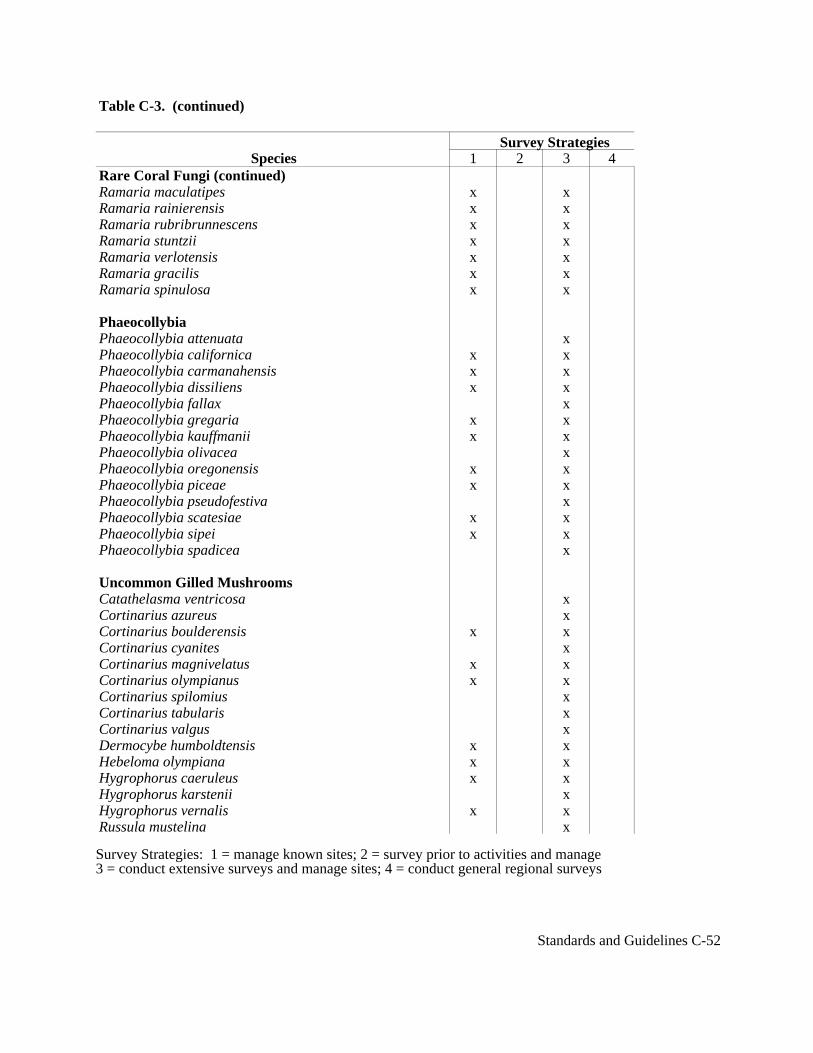
Table C-3. (continued)
Survey StrategiesSpecies 1 2 3 4
Rare Coral Fungi (continued)Ramaria maculatipes x xRamaria rainierensis x xRamaria rubribrunnescens x xRamaria stuntzii x xRamaria verlotensis x xRamaria gracilis x xRamaria spinulosa x x Phaeocollybia Phaeocollybia attenuata xPhaeocollybia californica x xPhaeocollybia carmanahensis x xPhaeocollybia dissiliens x xPhaeocollybia fallax xPhaeocollybia gregaria x xPhaeocollybia kauffmanii x xPhaeocollybia olivacea xPhaeocollybia oregonensis x xPhaeocollybia piceae x xPhaeocollybia pseudofestiva xPhaeocollybia scatesiae x xPhaeocollybia sipei x xPhaeocollybia spadicea x
Uncommon Gilled Mushrooms Catathelasma ventricosa xCortinarius azureus xCortinarius boulderensis x xCortinarius cyanites xCortinarius magnivelatus x xCortinarius olympianus x xCortinarius spilomius xCortinarius tabularis xCortinarius valgus xDermocybe humboldtensis x xHebeloma olympiana x xHygrophorus caeruleus x xHygrophorus karstenii xHygrophorus vernalis x xRussula mustelina x
Survey Strategies: 1 = manage known sites; 2 = survey prior to activities and manage3 = conduct extensive surveys and manage sites; 4 = conduct general regional surveys
Standards and Guidelines C-52
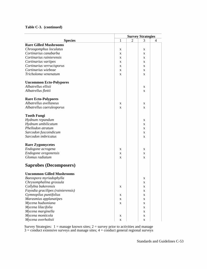
Table C-3. (continued)
Survey StrategiesSpecies 1 2 3 4
Rare Gilled Mushrooms Chroogomphus loculatus x xCortinarius canabarba x xCortinarius rainierensis x xCortinarius variipes x xCortinarius verrucisporus x xCortinarius wiebeae x xTricholoma venenatum x x
Uncommon Ecto-Polypores Albatrellus ellisii xAlbatrellus flettii x
Rare Ecto-Polypores Albatrellus avellaneus x xAlbatrellus caeruleoporus x x
Tooth Fungi Hydnum repandum xHydnum umbilicatum xPhellodon atratum xSarcodon fuscoindicum xSarcodon imbricatus x
Rare Zygomycetes Endogone acrogena x xEndogone oregonensis x xGlomus radiatum x x
Saprobes (Decomposers)
Uncommon Gilled Mushrooms Baeospora myriadophylla xChrysomphalina grossula xCollybia bakerensis x xFayodia gracilipes (rainierensis) xGymnopilus puntifolius x xMarasmius applanatipes x xMycena hudsoniana x xMycena lilacifolia xMycena marginella xMycena monticola x xMycena overholtsii x x
Survey Strategies: 1 = manage known sites; 2 = survey prior to activities and manage3 = conduct extensive surveys and manage sites; 4 = conduct general regional surveys
Standards and Guidelines C-53

Table C-3. (continued)
Survey StrategiesSpecies 1 2 3 4
Uncommon Gilled Mushrooms (continued)Mycena quinaultensis x xMycena tenax xMythicomyces corneipes xNeolentinus kauffmanii x xPholiota albivelata x xStagnicola perplexa x
Rare Gilled Mushrooms Clitocybe subditopoda x xClitocybe senilis x xNeolentinus adherens x xRhodocybe nitida x xRhodocybe speciosa x xTricholomopsis fulvescens x x
Noble Polypore (rare and endangered)Oxyporus nobilissimus x x x
Bondarzewia PolyporeBondarzewia montana x x x
Rare Resupinates and Polypores Aleurodiscus farlowii x xDichostereum granulosum x xCudonia monticola xGyromitra californica x xGyromitra esculenta x xGyromitra infula x xGyromitra melaleucoides x xGyromitra montana (syn. G. gigas) x xOtidea leporina xOtidea onotica xOtidea smithii x xPlectania melastoma xPodostroma alutaceum xSarcosoma mexicana xSarcosphaera eximia xSpathularia flavida x
Rare Cup Fungi Aleuria rhenanaBryoglossum gracile
Survey Strategies: 1 = manage known sites; 2 = survey prior to activities and manage3 = conduct extensive surveys and manage sites; 4 = conduct general regional surveys
Standards and Guidelines C-54

Table C-3. (continued)
Survey StrategiesSpecies 1 2 3 4
Rare Cup Fungi (continued) x xGelatinodiscus flavidusHelvella compressa x xHelvella crassitunicata x xHelvella elastica x xHelvella maculata x xNeournula pouchetii x xPithya vulgaris x xPlectania latahensis x xPlectania milleri x xPseudaleuria quinaultiana x x
Club Coral Fungi Clavariadelphus ligula x xClavariadelphus pistilaris x xClavariadelphus truncatus x xClavariadelphus borealis x xClavariadelphus lovejoyae x xClavariadelphus sachalinensis x xClavariadelphus subfastigiatus x x
Jelly MushroomPhlogoitis helvelloides x x
Branched Coral Fungi Clavulina cinerea x xClavulina cristata x xClavulina ornatipes x x
Mushroom Lichen Phytoconis ericetorum x x
Parasitic Fungi Asterophora lycoperdoides xAsterophora parasitica xCollybia racemosa xCordyceps capitata xCordyceps ophioglossoides xHypomyces luteovirens x
Cauliflower MushroomSparassis crispa x
Survey Strategies: 1 = manage known sites; 2 = survey prior to activities and manage3 = conduct extensive surveys and manage sites; 4 = conduct general regional surveys
Standards and Guidelines C-55

Table C-3. (continued)
Survey StrategiesSpecies 1 2 3 4
Moss Dwelling Mushrooms Cyphellostereum laeve xGalerina atkinsoniana x
Galerina cerina xGalerina heterocystis xGalerina sphagnicola xGalerina vittaeformis xRickenella setipes x
Coral FungiClavicorona avellanea x
LichensRare Forage LichenBryoria tortuosa x x
Rare Leafy (arboreal) LichensHypogymnia duplicata x x xTholurna dissimilis x x
Rare Nitrogen-fixing Lichens Dendriscocaulon intricatulum x xLobaria hallii x xLobaria linita x x xNephroma occultum x xPannaria rubiginosa x xPseudocyphellaria rainierensis x x x
Nitrogen-fixing Lichens Lobaria oregana xLobaria pulmonaria xLobaria scrobiculata xNephroma bellum xNephroma helveticum xNephroma laevigatum xNephroma parile xNephroma resupinatum xPannaria leucostictoides xPannaria mediterranea xPannaria saubinetii x
Survey Strategies: 1 = manage known sites; 2 = survey prior to activities and manage3 = conduct extensive surveys and manage sites; 4 = conduct general regional surveys
Standards and Guidelines C-56

Table C-3. (continued)
Survey StrategiesSpecies 1 2 3 4
Nitrogen-fixing Lichens (continued)Peltigera collina xPeltigera neckeri xPeltigera pacifica xPseudocyphellaria anomala xPseudocyphellaria anthraspis xPseudocyphellaria crocata xSticta beauvoisii xSticta fuliginosa xSticta limbata x
Pin Lichens Calicium abietinum xCalicium adaequatum xCalicium adspersum xCalicium glaucellum xCalicium viride xChaenotheca brunneola xChaenotheca chrysocephala xChaenotheca ferruginea xChaenotheca furfuracea xChaenotheca subroscida xChaenothecopis pusilla xCyphelium inquinans xMicrocalicium arenarium xMycocalicium subtile xStenocybe clavata xStenocybe major x
Rare Rock Lichens Pilophorus nigricaulis x xSticta arctica x x
Riparian Lichens Cetrelia cetrarioides xCollema nigrescens xLeptogium burnetiae var. hirsutum xLeptogium cyanescens xLeptogium saturninum xLeptogium teretiusculum xPlatismatia lacunosa xRamalina thrausta xUsnea longissima x
Survey Strategies: 1 = manage known sites; 2 = survey prior to activities and manage3 = conduct extensive surveys and manage sites; 4 = conduct general regional surveys
Standards and Guidelines C-57

Table C-3. (continued)
Survey StrategiesSpecies 1 2 3 4
Aquatic Lichens Dermatocarpon luridum x xHydrothyria venosa x xLeptogium rivale x x
Rare Oceanic Influenced Lichens Bryoria pseudocapillaris x xBryoria spiralifera x xBryoria subcana x xBuellia oidalea x xErioderma sorediatum x xHypogymnia oceanica x xLeioderma sorediatum x xLeptogium brebissonii x xNiebla cephalota x xPseudocyphellaria mougeotiana x xTeloschistes flavicans x xUsnea hesperina x x
Oceanic Influenced LichensCetraria californica x xHeterodermia leucomelos x xLoxospora sp. nov. "corallifera" (Brodo in edit) x xPyrrhospora quernea x x
Additional Lichen SpeciesCladonia norvegica xHeterodermia sitchensis xHygomnia vittiata xHypotrachyna revoluta xRamalina pollinaria xNephroma isidiosum x
BryophytesAntitrichia curtipendula xBartramiopsis lescurii x xBrotherella roelli x xDiplophyllu albicans x xDiplophyllum plicatum x xDouinia ovata xEncalypta brevicolla var. crumiana x xHerbertus aduncus x xHerbertus sakurali x x
Survey Strategies: 1 = manage known sites; 2 = survey prior to activities and manage3 = conduct extensive surveys and manage sites; 4 = conduct general regional surveys
Standards and Guidelines C-58
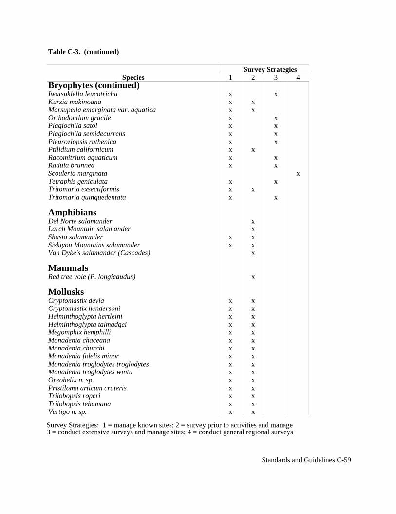
Table C-3. (continued)
Survey StrategiesSpecies 1 2 3 4
Bryophytes (continued)Iwatsuklella leucotricha x xKurzia makinoana x xMarsupella emarginata var. aquatica x xOrthodontlum gracile x xPlagiochila satol x xPlagiochila semidecurrens x xPleuroziopsis ruthenica x xPtilidium californicum x xRacomitrium aquaticum x xRadula brunnea x xScouleria marginata xTetraphis geniculata x xTritomaria exsectiformis x xTritomaria quinquedentata x x
AmphibiansDel Norte salamander xLarch Mountain salamander xShasta salamander x xSiskiyou Mountains salamander x xVan Dyke's salamander (Cascades) x
MammalsRed tree vole (P. longicaudus) x
MollusksCryptomastix devia x xCryptomastix hendersoni x xHelminthoglypta hertleini x xHelminthoglypta talmadgei x xMegomphix hemphilli x xMonadenia chaceana x xMonadenia churchi x xMonadenia fidelis minor x xMonadenia troglodytes troglodytes x xMonadenia troglodytes wintu x xOreohelix n. sp. x xPristiloma articum crateris x xTrilobopsis roperi x xTrilobopsis tehamana x xVertigo n. sp. x x
Survey Strategies: 1 = manage known sites; 2 = survey prior to activities and manage3 = conduct extensive surveys and manage sites; 4 = conduct general regional surveys
Standards and Guidelines C-59
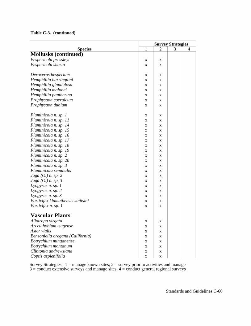
Table C-3. (continued)
Survey StrategiesSpecies 1 2 3 4
Mollusks (continued)Vespericola pressleyi x xVespericola shasta x x
Deroceras hesperium x xHemphillia barringtoni x xHemphillia glandulosa x xHemphillia malonei x xHemphillia pantherina x xProphysaon coeruleum x xProphysaon dubium x x
Fluminicola n. sp. 1 x xFluminicola n. sp. 11 x xFluminicola n. sp. 14 x xFluminicola n. sp. 15 x xFluminicola n. sp. 16 x xFluminicola n. sp. 17 x xFluminicola n. sp. 18 x xFluminicola n. sp. 19 x xFluminicola n. sp. 2 x xFluminicola n. sp. 20 x xFluminicola n. sp. 3 x xFluminicola seminalis x xJuga (O.) n. sp. 2 x xJuga (O.) n. sp. 3 x xLyogyrus n. sp. 1 x xLyogyrus n. sp. 2 x xLyogyrus n. sp. 3 x xVorticifex klamathensis sinitsini x xVorticifex n. sp. 1 x x
Vascular PlantsAllotropa virgata x xArceuthobium tsugense x xAster vialis x xBensoniella oregana (California) x xBotrychium minganense x xBotrychium montanum x xClintonia andrewsiana x xCoptis asplenifolia x x
Survey Strategies: 1 = manage known sites; 2 = survey prior to activities and manage3 = conduct extensive surveys and manage sites; 4 = conduct general regional surveys
Standards and Guidelines C-60
Table C-3. (continued)
Survey StrategiesSpecies 1 2 3 4
Vascular Plants (continued)Coptis trifolia x xCorydalis aquae-gelidae x xCypripedium fasciculatum (Klamath) x xCypripedium montanum (west Cascades) x xGalium kamtschaticum x xHabenaria orbiculata x xPedicularis howellii x xPedicularis howellii x xScoliopus biglovei x x
ArthropodsCanopy herbivores (south range) xCoarse wood chewers (south range) xLitter and soil dwelling species (south range) xUnderstory and forest gap herbivores x
Survey Strategies: 1 = manage known sites; 2 = survey prior to activities and manage3 = conduct extensive surveys and manage sites; 4 = conduct general regional surveys
Standards and Guidelines C-61

Adaptive Management Areas D-1
D. Adaptive Management AreasAcres
Key and non-Key Watersheds are specified for all areas, and therefore overlay all other landallocations. For the portion of Adaptive Management Areas located within Key Watersheds,standards and guidelines for Key Watersheds, as well as standards and guidelines forAdaptive Management Areas, apply, with some flexibility as described below (see additionaldetail under Hierarchy of Standards and Guidelines Within Adaptive Management Areaslater in this section).
Adaptive Management Areas within Tier 1 Key Watersheds . . . . . . . . . . . . . 228,100Adaptive Management Areas within Tier 2 Key Watersheds . . . . . . . . . . . . . . 60,600Adaptive Management Areas within non-Key (other) Watersheds . . . . . . . 1,233,100Total Adaptive Management Areas . . . . . . . . . . . . . . . . . . . . . . . . . . . . . . . . 1,521,800
Acreage of Riparian Reserves is not calculated within Adaptive Management Areas for thesestandards and guidelines. However, Riparian Reserve standards and guidelines affectapproximately 40 percent of Adaptive Management Areas. The above acres are net federal,not including Congressionally Reserved Areas or Late-Successional Reserves. Acreage foreach Adaptive Management Area listed later in this section includes all ownerships and allland allocations within the Adaptive Management Area boundary.
Introduction
Adaptive Management Areas are landscape units designated to encourage the developmentand testing of technical and social approaches to achieving desired ecological, economic, andother social objectives. Ten areas ranging from about 92,000 to nearly 500,000 acres offederal lands have been identified. The areas are well distributed in the physiographicprovinces. Most are associated with subregions impacted socially and economically byreduced timber harvest from the federal lands. The areas provide a diversity of biologicalchallenges, intermixed land ownerships, natural resource objectives, and social contexts. Inthe Applegate Adaptive Management Area in Oregon, grassroots community-basedactivities have already begun.
The overall objective for Adaptive Management Areas is to learn how to manage on anecosystem basis in terms of both technical and social challenges, and in a manner consistentwith applicable laws. It is hoped that localized, idiosyncratic approaches that may achievethe conservation objectives of these standards and guidelines can be pursued. Theseapproaches rely on the experience and ingenuity of resource managers and communitiesrather than traditionally derived and tightly prescriptive approaches that are generallyapplied in management of forests.

Adaptive Management Areas D-2
The Adaptive Management Areas are intended to contribute substantially to the achievementof objectives for these standards and guidelines. This includes provision of well-distributedlate-successional habitat outside of reserves, retention of key structural elements of late-successional forests on lands subjected to regeneration harvest, and restoration andprotection of riparian zones as well as provision of a stable timber supply.
The Adaptive Management Area concept incorporates the three adaptive managementmodels/objectives discussed in the FEMAT Report--technical, administrative, andcultural/social.
Key features of the Adaptive Management Areas:
The areas are well-distributed geographically, represent a mix of technical and socialchallenges and are of sufficient size to provide for landscape-level managementapproaches.
The areas provide for development and demonstration of monitoring protocols and newapproaches to land management that integrate economic and ecological objectives basedon credible development programs and watershed and landscape analysis.
Opportunities exist for education, including technical training, to qualify localcommunity residents for employment in monitoring and other management programs.
Innovation in community involvement is encouraged, including approaches toimplementation of initial management strategies and perhaps, over the longer term,development of new forest policies.
Innovation is expected in developing adequate and stable funding sources formonitoring, research, retraining, restoration and other activities.
Innovation in integration of multi-ownership watersheds is encouraged among federalagencies and is likewise encouraged among state and federal agencies, and privatelandowners.
Innovation in agency organization and personnel policies might include individualcertification requirements, and modification of recruitment and promotion procedures toencourage local longevity among the federal workforce.
Selection of the Adaptive Management Areas
Adaptive Management Areas were selected to provide opportunities for innovation, toprovide examples in major physiographic provinces, and to provide a range of technicalchallenges, from an emphasis on restoration of late-successional forest conditions andriparian zones to integration of commercial timber harvest with ecological objectives.
The Adaptive Management Areas have been geographically located to minimize risk to
Adaptive Management Areas D-3
achieving the conservation objectives of these standards and guidelines. The designation ofAdaptive Management Areas was intended to provide a mixture of public and private lands.In locating the Adaptive Management Areas, the proximity of communities that were subjectto adverse economic impacts resulting from reduced federal timber harvest was considered.The social and economic analysis of the Forest Ecosystem Management Assessment Teamwas a major source of information that helped guide these decisions.
The Adaptive Management Areas incorporate a mix of ownerships and administrativeresponsibilities. Six areas include lands administered by the Forest Service and BLM. In twoareas (Northern Coast Range and Olympic) there are significant opportunities for the statesto participate in a major cooperative adaptive management effort. The majority of areas alsohave interspersed privately owned forest lands that could be incorporated into an overallplan if landowners so desired.
Establishment of the Adaptive Management Areas is not intended to discourage thedevelopment of innovative social and technical approaches to forest resource issues in otherlocales. They are intended to provide a geographic focus for innovation and experimentationwith the intent that such experience will be widely shared. The array of areas provides abalance between having a system of areas that is: (1) so large and diffuse that it lacks focusand adequate resources; and has extensive management constraints because of its size andoverall impact on regional conservation strategies; and (2) too small to allow for meaningfulecological and social experimentation.
Technical Objectives
The Adaptive Management Areas have scientific and technical innovation andexperimentation as objectives. The guiding principle is to allow freedom in forestmanagement approaches to encourage innovation in achieving the goals of these standardsand guidelines. This challenge includes active involvement by the land management andregulatory agencies early in the planning process.
The primary technical objectives of the Adaptive Management Areas are development,demonstration, implementation, and evaluation of monitoring programs and innovativemanagement practices that integrate ecological and economic values. Experiments, includingsome of large scale, are likely. Demonstrations and pilot projects alone, while perhapssignificant, useful, and encouraged in some circumstances, may not be sufficient to achievethe objectives.
Monitoring is essential to the success of any plan and to an adaptive management program.Hence, development and demonstration of monitoring and training of the workforce aretechnical challenges and should be emphasized.
Technical topics requiring demonstration or investigation are a priority for AdaptiveManagement Areas and cover a wide spectrum, from the welfare of organisms to ecosystemsto landscapes. Included are development, demonstration, and testing of techniques for:

Adaptive Management Areas D-4
Creation and maintenance of a variety of forest structural conditions including late-successional forest conditions and desired riparian habitat conditions.
Integration of timber production with maintenance or restoration of fisheries habitat andwater quality.
Restoration of structural complexity and biological diversity in forests and streams thathave been degraded by past management activities and natural events.
Integration of the habitat needs of wildlife (particularly of sensitive and threatenedspecies) with timber management.
Development of logging and transportation systems with low impact on soil stability andwater quality.
Design and testing of effects of forest management activities at the landscape level.
Restoration and maintenance of forest health using controlled fire and silviculturalapproaches.
Each Adaptive Management Area will have an interdisciplinary technical advisory panel,including specialists from outside government agencies, that will provide advice and supportto managers and local communities involved with this effort.
Social Objectives
The primary social objective of Adaptive Management Areas is the provision of flexibleexperimentation with policies and management. These areas should provide opportunitiesfor land managing and regulatory agencies, other government entities, nongovernmentalorganizations, local groups, landowners, communities, and citizens to work together todevelop innovative management approaches. Broadly, Adaptive Management Areas areintended to be prototypes of how forest communities might be sustained.
Innovative approaches include social learning and adaptation, which depend upon localcommunities having sufficient political capacity, economic resources, and technical expertiseto be full participants in ecosystem management. Similarly, management will need to becoordinated and characterized by collaboration across political jurisdictions and diverseownerships. This will require mediating across interests and disciplines, strengthening localpolitical capability, and enhancing access to technical expertise. Adaptive management is, bydefinition, information dependent. Setting objectives, developing management guidelines,educating and training a workforce, organizing interactive planning and managementinstitutions, and monitoring accomplishments all require reliable, current inventories. Newinformation technologies can be used to provide such information. Local people might beideally suited to this task if appropriately trained.

Adaptive Management Areas D-5
Agency Approaches and Management Review
Federal agencies are expected to use Adaptive Management Areas to explore alternativeways of doing business internally, and with each other, other organizations, local and stategovernment, and private landowners. In effect, the areas should be used to "learn to manage"as well as to "manage to learn."
Agencies are expected to develop plans (jointly, where multiple agencies are involved) forthe Adaptive Management Areas. Development of a broad plan that identifies generalobjectives and roles, and provides flexibility should be the goal. Such a plan could be used incompeting for financial resources, garnering political support, providing a shared vision, andidentifying experiences to be tracked.
If the Adaptive Management Areas are to make timely contributions to the objectives ofthese standards and guidelines, and to the communities, it is absolutely critical that initiationof activities not be delayed by requirements for comprehensive plans or consensusdocuments beyond those required to meet existing legal requirements for activities.Development of such documents can proceed simultaneously with other activities; the onlyarea in which detailed planning must precede most activities is the Snoqualmie PassAdaptive Management Area. Current plans and draft plan preferred alternatives, as modifiedby the direction established in these standards and guidelines, can provide the starting pointfor activities. Initial involvement of user groups and communities would emphasize how thestrategy and plans should be implemented. In the Snoqualmie Pass Adaptive ManagementArea, minor activities such as those Categorically Excluded under NEPA (except timbersales) and watershed restoration projects may precede detailed planning.
Initial direction and continuing review should be provided by the Regional InteragencyExecutive Committee. It is important that the interagency coordination involve both theregulatory and management agencies, and that the regulatory agencies participate in planningand regular review processes.
Adaptive Management Area Implementation Guidelines
Role of Agencies - The agencies will facilitate collaborative efforts, partnerships, mutuallearning and innovation. They will provide staff work to the process of managing theAdaptive Management Areas. This could include providing meeting places, meetingfacilitation, and expert analysis. Agency scientists are expected to provide scientific designof monitoring and experiments, though the decision is reserved for the federal land manager.
Although the agencies have a facilitation role, the land management agencies retain theauthority and responsibility to make decisions and the regulatory agencies retain theauthority and responsibility to regulate. Nothing in these guidelines is intended to changethose authorities or responsibilities.
Local Communities - Specific community roles with public agencies and subject matterexperts (such as the technical advisory panels) will include helping find innovative ways toset objectives, develop plans, implement projects, and monitor accomplishments. Forexample, Subtitle G of the 1990 Farm Bill gives criteria to identify "natural resourcedependent communities" which may be used if appropriate when identifying local
Adaptive Management Areas D-6
communities.
Participation in Adaptive Management Areas - Although the emphasis is on theparticipation of people who are actively involved with that geographic location, nothing inthese guidelines should be construed to suggest that the interests of people living outside"local communities" should not be considered in making agency decisions. Participation willbe self identifying, to the extent possible. Experiments to address how this might happen areencouraged.
Project Development and Implementation - Specific project planning must:
* Involve the public early* Coordinate with overall activities within the province* Begin some projects as soon as practicable to respond to and facilitate public interest
and involvement* Begin some projects prior to completing an entire watershed analysis* Begin watershed analysis as soon as possible* Develop early plans and projects with the best available information* Identify needs for improved inventory* Proceed simultaneously with activities and Adaptive Management Area planning* Assign priority status to watershed restoration projects that can be completed quickly * Begin projects in nonsensitive sections of the Adaptive Management Area
Area Assessment - The Adaptive Management Area plans need to be based on informationabout historical, current and desired future conditions of the biophysical, social, andeconomic aspects of the area. The plans will rely largely on existing information. The areaassessment will be a concise working document. The following is provided as a suggestedframework:
Biophysical: Consider disturbance history, terrestrial and aquatic conditions, sensitiveplant and animal species and/or habitat, capability of the system to produce a variety offorest products. A description of the desired future condition or a range of acceptableconditions for the biophysical system is needed. For example, what functions areimportant to maintain at the landscape level? What structure, species, age classes,and/or arrangement will maintain those functions? Consider both coarse and fine detailover time. What does the community want the Adaptive Management Area to be like inthe future? What actions are needed to create that desired future condition?
Social: Consider historical and extant communities, their use patterns, uses of the land,issues, resources, and opportunities. In some areas, other demographic data will behelpful as well. What networks for communications are at work? How can the agenciesbetter interact with these? What collaborative process will work best for thecommunities of interest to effectively participate in managing the Adaptive ManagementArea? What does the community want to look like in the future? Desired future socialcondition can be considered in terms of composition, structure, and/or functions overtime.
Economic: A description of current economic conditions might include an inventory of

Adaptive Management Areas D-7
local employment, resource workers, skills, and access to technology. Desired futureconditions could describe the future employment opportunities (e.g., what forest workwill be needed in the future?) and skills needed to seize those opportunities. As thedesired future condition of the ecosystem is better understood, the future forest work willalso be more clear. Identification of needed knowledge, skills, abilities, and technologyfor the future may be useful in developing training programs as well as business ormarketing assistance.
Plans - All Adaptive Management Areas will have a plan. An individual public, interagencyapproach to planning will be developed for each Adaptive Management Area. The planshould address or provide:
* A shared vision of the Adaptive Management Area, (e.g., the kind of knowledge the participants hope to gain). Identification of the desired future conditions may be developed in collaboration with communities, depending on the area.
* Learning that includes social and political knowledge, not just biological and physicalinformation.
* A strategy to guide implementation, restoration, monitoring and experimental activities.
* A short-term (3 to 5 year) timber sale plan and long-term yield projections.* Education of participants.* A list of communities influenced by the Adaptive Management Area projects and
outputs.* An inventory of community strategies, and resources and partners being used.* Coordination with overall activities within the province.* A funding strategy.* Integration of the community strategies and technical objectives.
Monitoring and Research - The Monitoring and Evaluation Plan (included in Section E ofthis plan) and watershed analysis present the framework and some required actions for eachAdaptive Management Area. Additional efforts and specificity may be developed for eachAdaptive Management Area. The learning opportunity provided by Adaptive Management Areas will be enhanced if clear,measurable goals and objectives are set, monitored, and conveyed into the planning ofprojects or into the appropriate component of the Adaptive Management Area plan or Forestor District Plan. Shared synthesis of monitoring results will help provide a multiple-perspective assessment on whether social and ecosystem goals are being met, help identifyproblems to avoid in subsequent projects, and help gain consensus on what data gaps existand what changes to the monitoring and research programs are needed.
Review - Monitoring and research, with careful experimental design, will be conducted inAdaptive Management Areas. Research in forest ecology and management as well as social,biological, and earth sciences may be conducted. Each Adaptive Management Area will havean interdisciplinary technical advisory panel that will provide advice to managers and thelocal communities involved with this effort. The technical advisory panels will provideadvice and information on the appropriateness of the project.

Adaptive Management Areas D-8
Direction and review are provided by the Regional Interagency Executive Committee,through the Regional Ecosystem Office. This review will help assure that plans and projectsdeveloped for the various Adaptive Management Areas will be both scientifically andecologically credible. It will assure that new, innovative approaches are used, that the lawsand the goals of the plan are met, and that validation monitoring is incorporated.
The Regional Ecosystem Office will facilitate and coordinate the implementation of theAdaptive Management Area program. Federal agencies are expected to use the AdaptiveManagement Areas to explore new ways of working internally and externally.
Legal - All activities must comply with existing laws such as Endangered Species Act,National Environmental Policy Act, National Forest Management Act, Forest Land Policyand Management Act, Federal Advisory Committee Act, National Historic Preservation Act,Clean Water Act, Clean Air Act, and treaty rights. Management and regulatory agenciesshould work together to determine ways to expedite management while ensuring compliance,to improve cooperation through planning and on-the-ground consultation, and to avoidconfrontation.
Other Issues - Some issues are beyond the authority of the agencies or the RegionalInteragency Executive Committee. These include:
* Use of receipts from timber sales and other products derived from Adaptive Management Areas to develop programs and projects within the areas
* Employment targets for local people for special jobs like planning, training, and monitoring
* Special land management or stewardship contracts* Restricted local use of wood and other products derived from Adaptive Management
Areas.
Fire and Fuels Management
In Adaptive Management Areas, fire managers are encouraged to actively explore andsupport opportunities to research the role and effects of fire management on ecosystemfunctions. Cooperation across agency and ownership boundaries should be emphasized. Thestandards and guidelines in current plans and draft plan preferred alternatives for hazardreduction should be followed until approved Adaptive Management Area plans areestablished. Fire management experts will participate on the local Interdisciplinary TechnicalAdvisory Panel on all Adaptive Management Areas. Management of Adaptive ManagementAreas is intended to be innovative and experimental. Wildfire suppression actions, however,should use accepted strategies and tactics, and conform with specific agency policy.
Timber Supply
One reason for locating Adaptive Management Areas adjacent to communities experiencingadverse economic impacts is to provide opportunity for social and economic benefits to theseareas. Adaptive Management Areas are expected to produce timber as part of their program

Adaptive Management Areas D-9
of activities consistent with their specific direction under these standards and guidelines. Therates and methods of harvest will be determined on an area-by-area basis. Each areamanagement team is expected to develop a strategy for ecosystem management as part of theAdaptive Management Area plan to guide implementation, restoration, monitoring, andexperimental activities involving timber sales. The strategy should contain a short-term (3 to5 year) timber sale component and an assessment of long-term outputs of timber.
Education
Each Adaptive Management Area was located adjacent to one or more communities witheconomies and culture long associated with utilization of forest resources. As a result, thepeople have a "sense of place" and desire for involvement. Many of these local workersalready possess timber/forest-related skills and knowledge, as well as that sense of place,which in combination make them natural participants in ecosystem-based management andmonitoring. Here adaptive management can bring indigenous knowledge together withformal studies, the local communities and the land management agencies in a mix that mayprovide creative common-sense approaches to complicated problems.
Technical and scientific training of a local workforce should be an educational priority of theAdaptive Management Area Program. Formal schooling and field apprenticeship mightprovide the workforce needed to help implement ecosystem management, particularly in thearea of monitoring. This program might be based on collaborations among local communitycolleges, state universities, and the agencies.
Standards and Guidelines
Also see Standards and Guidelines Common to all Land Allocations starting on page C-2 ofthese standards and guidelines, and other standards and guidelines elsewhere in this section.
Late-Successional Reserves within Adaptive Management Areas will be managed accordingto the standards and guidelines for such reserves except as provided elsewhere in thissection. Management of these areas will comply with the standards and guidelines for Late-Successional Reserves, and management around these areas will be designed to reduce riskof natural disturbances. Unmapped Late-Successional Reserves are specified for spotted owlactivity centers, certain LS/OG 1s and 2s, occupied marbled murrelet sites, and for certainProtection Buffers (see Section C of these standards and guidelines).
Riparian protection in Adaptive Management Areas should be comparable to that prescribedfor other federal land areas. For example, Key Watersheds with aquatic conservationemphasis within Adaptive Management Areas must have a full watershed analysis and initialRiparian Reserves comparable to those for Tier 1 Key Watersheds. Riparian objectives (interms of ecological functions) in other portions of Adaptive Management Areas should haveexpectations comparable to Tier 2 Key Watersheds where applicable. However, flexibility isprovided to achieve these conditions, if desired, in a manner different from that prescribedfor other areas and to conduct bonafide research projects within riparian zones.
Adaptive Management Areas D-10
At the same time, any analysis of Riparian Reserve widths must also consider thecontribution of these reserves to other, including terrestrial, species. Watershed analysisshould take into account all species that were intended to be benefited by the prescribedRiparian Reserve widths. Those species include fish, mollusks, amphibians, lichens, fungi,bryophytes, vascular plants, American marten, red tree voles, bats, marbled murrelets, andnorthern spotted owls. The specific issue for spotted owls is retention of adequate habitatconditions for dispersal.
Standards and guidelines for matrix management in Section C of these standards andguidelines (there is no matrix in Adaptive Management Areas) provide specific measures forcoarse woody debris, and for green tree and snag retention, for the matrix. The intent of themeasures must also be met in Adaptive Management Areas, but specific standards andguidelines are not prescribed for these areas.
Provide additional protection for caves, mines, and abandoned wooden bridges andbuildings that are used as roost sites for bats.
Most bat species occurring in the Pacific Northwest roost and hibernate in crevices inprotected sites. Suitable roost sites and hibernacula, however, fall within a narrow range oftemperature and moisture conditions. Sites commonly used by bats include caves, mines,snags and decadent trees, wooden bridges, and old buildings. Additional provisions for theretention of large snags and decadent trees are included in the standard and guideline forgreen tree patches in the matrix. Caves, mines, and abandoned wooden bridges andbuildings, however, are extremely important roost and hibernation sites, and requireadditional protection to ensure that their value as habitat is maintained.
This provision is intended to apply in matrix forests and Adaptive Management Areas, andelements such as protection of known occupied caves should be considered for other landallocations. Conduct surveys of crevices in caves, mines, and abandoned wooden bridges andbuildings for the presence of roosting bats, including fringed myotis, silver-haired bats, long-eared myotis, long-legged myotis, and pallid bats. For the purposes of this standard andguideline, caves are defined as in the Federal Cave Resources Protection Act of 1988 as "anynaturally occurring void, cavity, recess, or system of interconnected passages which occurbeneath the surface of the earth or within a cliff or ledge ( . . . but not including any . . . man-made excavation) and which is large enough to permit an individual to enter, whether or notthe entrance is naturally formed or man-made." Searches should be conducted during the dayin the summer (to locate day roosts and maternity colonies), at night during the late summerand fall (to locate night roosts, which are important for reproduction), and during the day inthe winter (to locate hibernacula). If bats are found, identify the species using the site anddetermine for what purpose it is being used by bats. As an interim measure, timber harvest isprohibited within 250 feet of sites containing bats. Management standards and guidelinesthat may be included as mitigation measures in project or activity plans will be developed forthe site. These standards will be developed following an inventory and mapping of resources.The purpose of the standards and guidelines will be protection of the site from destruction,vandalism, disturbance from road construction or blasting, or any other activity that couldchange cave or mine temperatures or drainage patterns. The size of the

Adaptive Management Areas D-11
buffer, and types of activities allowed within the buffer, may be modified through thestandards developed for the specific site. Retention of abandoned bridges or buildings mustbe made contingent on safety concerns.
Townsend's big-eared bats are of concern to state wildlife agencies in both Washington andOregon. These bats are strongly associated with caves, and are extremely sensitive todisturbance, especially from recreational cavers. When Townsend's big-eared bats are foundoccupying caves or mines on federal land, the appropriate agency should be notified, andmanagement prescriptions for that site should include special consideration for potentialimpacts on this species.
Modify site treatment practices, particularly the use of fire and pesticides, and modifyharvest methods to minimize soil and litter disturbance.
Many species of soil and litter-dwelling organisms, such as fungi and arthropods, aresensitive to soil and litter disturbance. Site treatments should be prescribed which willminimize intensive burning, unless appropriate for certain specific habitats, communities orstand conditions. Prescribed fires should be planned to minimize the consumption of litterand coarse woody debris. Other aspects to this standard and guideline include minimizingsoil and litter disturbance that may occur as a result of yarding and operation of heavyequipment, and reducing the intensity and frequency of site treatments. Soil compaction, andremoval or disturbance of humus layers and coarse woody debris, may impact populations offungi and arthropods. These provisions are intended to apply throughout the matrix forestsand within the Adaptive Management Areas.
Provide for old-growth fragments in watersheds where little remains.
Matrix standards and guidelines on page C-44 of these standards and guidelines specifyretention of old-growth fragments in fifth field watersheds containing less than 15 percent ofsuch stands. In Adaptive Management Areas, less than 15 percent of fifth field watershed inlate-successional forest should be considered as a threshold for analysis rather than a strictstandard and guideline, and the role of remaining stands of late-successional forests must befully considered in watershed analysis before they can be modified.
Hierarchy of Standards and Guidelines Within Adaptive Management Areas
In summary, management activities in all the Adaptive Management Areas will be conductedto achieve the objectives described in these standards and guidelines. Standards andguidelines for Congressionally Reserved Areas or Late-Successional Reserves must befollowed when they occur within Adaptive Management Areas, except that the AdaptiveManagement Area plans for the Finney and Northern Coast Adaptive Management Areasmay change the Late-Successional Reserve designations in those areas. Flexibility isprovided to meet objectives for Riparian Reserves and Key Watersheds. Full watershedanalysis will be conducted prior to new management activities in identified Key Watershedswithin Adaptive Management Areas. Standards and guidelines of current plans and draftplan preferred alternatives (see exceptions on page C-3 of these standards and guidelines)need to be considered during planning and implementation of activities within AdaptiveManagement

Adaptive Management Areas D-12
Areas, and they may be modified in Adaptive Management Area plans based on site-specificanalysis. Otherwise, standards and guidelines are to be developed to meet the objectives ofthe Adaptive Management Area and the overall strategy. Coordination with the RegionalEcosystem Office through the Regional Interagency Executive Committee is required.
Descriptions of the Adaptive Management Areas
Adaptive Management Areas are shown on the maps described on page A-6 of thesestandards and guidelines. Adaptive Management Areas would contribute to accomplishingthe objectives of these standards and guidelines, such as protection or enhancement ofriparian habitat and provision for well-distributed late-successional forest habitat. Detailedprescriptions for achieving such objectives are not provided, however, in order to permitmanagers to develop and test alternative approaches applicable to their areas and in amanner consistent with existing environmental and other laws.
Unlike tables elsewhere in these standards and guidelines that show only Federal Acresoutside of Late-Successional Reserves and Congressional Reserves, the sizes listed belowinclude all acres within the Adaptive Management Area boundaries, including all landallocations and ownerships.
Name: Applegate Adaptive Management Area, Oregon
Size: 277,500 acresOwnership: Medford District Bureau of Land Management; Rogue River and
Siskiyou National Forests; potentially state and private lands.Associated Communities: Grants Pass and Medford, Oregon; Jackson and Josephine
Counties, Oregon; and Siskiyou County, California.Emphasis: Development and testing of forest management practices,
including partial cutting, prescribed burning, and low impactapproaches to forest harvest (e.g., aerial systems) that provide for a broad range of forest values, including late-successionalforest and high quality riparian habitat. Late-SuccessionalReserves are included in the Adaptive Management Areaboundaries.
Name: Central Cascades Adaptive Management Area, Oregon
Size: 155,700 acresOwnership: Willamette National Forest; Eugene District Bureau of Land
Management; potentially state and private lands.Associated Communities: Eugene, Springfield, and Sweet Home, Oregon. Emphasis: Intensive research on ecosystem and landscape processes and its
application to forest management in experiments anddemonstrations at the stand and watershed level; approaches forintegrating forest and stream management objectives and onimplications of natural disturbance regimes; and management of
Adaptive Management Areas D-13
young and mature stands to accelerate development of late-successional conditions, a specific management objective for theforests within the Moose Lake block as well as in other portionsof the Adaptive Management Area to be selected. Current statusof the H.J. Andrews Experimental Forest as an ExperimentalForest (i.e., maintenance of control areas and full flexibility toconduct experiments, is retained). One Late-SuccessionalReserve is included in the area.
Name: Cispus Adaptive Management Area, Washington
Size: 143,900 acresOwnership: Gifford Pinchot National Forest; potentially state and private
lands.Associated Communities: Randle, Morton, and Packwood, Washington; Lewis and
Skamania Counties, Washington.Emphasis: Development and testing of innovative approaches at stand,
landscape, and watershed level to integration of timber production with maintenance of late-successional forests, healthyriparian zones, and high quality recreational values.
Name: Finney Adaptive Management Area, Washington
Size: 98,400 acresOwnership: Mt. Baker-Snoqualmie National Forest; potentially state and
private lands.Associated Communities: Darrington, Washington; Skagit and Snohomish Counties,
Washington.Emphasis: Restoration of late-successional and riparian habitat components.
Because most late-successional forests have already beenharvested, requirements for marbled murrelet include: (1)surveying for and protecting all occupied murrelet sites; (2)retaining LS/OG1s, LS/OG2s, and owl additions (from theScientific Panel on Late-Successional Forest Ecosystems, 1991)as Late-Successional Reserves within the Adaptive ManagementAreas. These reserves should be managed as stipulated for suchreserves under these standards and guidelines. However, becausemuch of the Adaptive Management Area is Late-SuccessionalReserve, primarily designated for a single species about whichinformation is still being developed, the designation and/orstandards and guidelines for Late-Successional Reserves may bereconsidered in the Adaptive Management Area plan. Relaxationof the Late-Successional Reserve status is not necessarilyassumed; proposals will require careful analysis to assureconsistency with the Endangered Species Act and NationalForest Management Act requirements,

Adaptive Management Areas D-14
new marbled murrelet information, and overall objectives ofthese standards and guidelines. Sites occupied by spotted owls(pairs or territorial singles) will be protected by establishingLate-Successional Reserves using procedures to delineateReserved Pair Areas described on page D-16 of these standardsand guidelines.
Name: Goosenest Adaptive Management Area, California
Size: 172,900 acresOwnership: Klamath National Forest; potentially private lands.Associated Communities: Yreka, Montague, Dorris, and Hornbrook California; Siskiyou
County, California.Emphasis: Development of ecosystem management approaches, including
use of prescribed burning and other silvicultural techniques, formanagement of pine forests, including objectives related to foresthealth, production and maintenance of late-successional forestand riparian habitat, and commercial timber production.
Name: Hayfork Adaptive Management Area, California
Size: 488,500 acresOwnership: Shasta-Trinity and Six Rivers National Forests and Yreka
District Bureau of Land Management; potentially private andstate lands.
Associated Communities: Hayfork, California; Trinity and Humboldt Counties, California.Emphasis: Development, testing, and application of forest management
practices, including partial cutting, prescribed burning, and low-impact approaches to forest harvest, which provide for a broadrange of forest values, including commercial timber productionand provision of late-successional and high quality riparianhabitat. Maintain identified Late-Successional Reserves; conductfull watershed analysis in critical watersheds.
Name: Little River Adaptive Management Area, Oregon
Size: 91,800 acresOwnership: Umpqua National Forest and Roseburg District Bureau of Land
Management; potentially private and state lands.Associated Communities: Roseburg and Myrtle Creek, Oregon; Douglas County, Oregon.Emphasis: Development and testing of approaches to integration of
intensive timber production with restoration and maintenance ofhigh quality riparian habitat.

Adaptive Management Areas D-15
Name: Northern Coast Range Adaptive Management Area, Oregon
Size: 250,000 acresOwnership: Siuslaw National Forest and Salem District Bureau of Land
Management; with potential participation by the Oregon Department of Forestry and private landowners.
Associated Communities: Tillamook, Willamina, and Grand Ronde, Oregon; Polk,Yamhill, Tillamook, and Washington Counties, Oregon.
Emphasis: Management for restoration and maintenance of late-successional forest habitat, consistent with marbled murreletguidelines noted below. Conduct watershed analysis of theNestucca River drainage. Subsequently, the Oregon Departmentof Forestry will be invited to collaborate in development of acomprehensive strategy for conservation of the fisheries andother elements of biological diversity in the northern OregonCoast Ranges. Because most late-successional forests havealready been harvested, requirements for marbled murreletinclude: (1) surveying for and protecting all occupied murreletsites; (2) retaining LS/OG1s, LS/OG2s, and owl additions (fromthe Scientific Panel on Late-Successional Forest Ecosystems,1991) as Late-Successional Reserves within the AdaptiveManagement Areas. These reserves should be managed asstipulated for such reserves under these standards and guidelines.However, because much of the Adaptive Management Area isLate-Successional Reserve, primarily designated for a singlespecies about which information is still being developed, thedesignation and/or standards and guidelines for Late-Successional Reserves may be reconsidered in the AdaptiveManagement Area plan. Relaxation of the Late-SuccessionalReserve status is not necessarily assumed; proposals will requirecareful analysis to assure consistency with the EndangeredSpecies Act and National Forest Management Act requirements,new marbled murrelet information, and overall objectives ofthese standards and guidelines. In the interim, the maximum agefor thinning within Late-Successional Reserves in this AdaptiveManagement Area is 110 years. Northern spotted owl sites willbe protected by establishing Reserved Pair Areas described onpage D-16 of these standards and guidelines.
Name: Olympic Adaptive Management Area, Washington
Size: 150,400 acresOwnership: Olympic National Forest and potentially Washington
Department of Natural Resources, Indian Reservations, andprivate lands.
Associated Communities: Jefferson, Clallam, Grays Harbor, and Mason Counties,

Adaptive Management Areas D-16
Washington.Emphasis: Create a partnership with the Olympic State Experimental Forest
established by Washington Department of Natural Resources.Develop and test innovative approaches at the stand andlandscape level for integration of ecological and economicobjectives, including restoration of structural complexity tosimplified forests and streams and development of more diversemanaged forests through appropriate silvicultural approachessuch as long rotations and partial retention. All occupied marbledmurrelet sites will be surveyed for and protected. LS/OG 1 andLS/OG 2 are to be managed as Late-Successional Reserve exceptin the Quinault Special Management Area. The Quinault SpecialManagement Area included within this Adaptive ManagementArea will continue to be managed in accordance with Public Law100-638 which designated the area.
Name: Snoqualmie Pass Adaptive Management Area, Washington
Size: 212,700 acresOwnership: Wenatchee and Mt. Baker-Snoqualmie National Forests; Plum
Creek Timber Company and other private landowners; state.Associated Communities: Cle Elum and Roslyn, Washington; Kittitas and King Counties,
Washington.Emphasis: Development and implementation, with the participation of the
U.S. Fish and Wildlife Service, of a scientifically credible,comprehensive plan for providing late-successional forest on the"checkerboard" lands. This plan should recognize the area as a critical connective link in north-south movement of organisms inthe Cascade Range.
Delineation and Management of Reserved Pair Areas
The following standards and guidelines apply to Reserved Pair Areas specified for theFinney and Northern Coast Range Adaptive Management Areas.
1. For each Reserved Pair Area, delineate an area surrounding the owl activity center withan acreage at least equal to the median home range size for pairs in that province. Usedata from the spotted owl study area that is most similar to the site being considered (seeTable C-1 on page C-24 of these standards and guidelines). This area will be delineatedto encompass as much suitable northern spotted owl habitat as possible, and the habitatwill be as close to the owl activity center as possible. Reserve all suitable habitat in thatarea from timber harvest. If the habitat acreage does not at least equal the medianamount found for owl pairs in the province (see Table C-2 on page C-25 of thesestandards and guidelines), additional habitat must be provided from the next best habitatavailable in the home range area, or by expanding the area to incorporate additionalsuitable northern spotted owl habitat. Use logical physical boundaries to facilitatemanagement of the area.
Adaptive Management Areas D-17
Late-Successional Reserve management standards and guidelines for salvage and othermultiple-use activities would generally apply in the suitable habitat portion of theReserved Pair Area.
2. In the Reserved Pair Areas, allow for management of currently unsuitable areasconsistent with Late-Successional Reserve management standards and guidelines forsilviculture and salvage. Management of other multiple-use activities in the unsuitablehabitat should follow standards and guidelines from current plans and draft planpreferred alternatives (see Section C of these standards and guidelines), which mayallow some activities that would not be consistent with Late-Successional Reservemanagement standards and guidelines.

Implementation E-1
E. ImplementationIntroductionThese standards and guidelines will be implemented on lands administered by the ForestService and BLM within the range of the northern spotted owl. Under these standards andguidelines, management activities will meet National Environmental Policy Act (NEPA)requirements. Resource management activities will be subject to site-specific environmentalanalysis and appropriate public participation before they are conducted. This will involveanalysis of cumulative and other environmental effects.
These standards and guidelines provide a strategy for the entire range of the northern spottedowl that includes land allocations, and standards and guidelines that cross physiographicprovinces, and Forest Service and BLM administrative boundaries. Management activitieswill be in accordance with the land allocations, and standards and guidelines prescribed inthese standards and guidelines.
MonitoringMonitoring is an essential component of natural resource management because it providesinformation on the relative success of management strategies. The implementation of thesestandards and guidelines will be monitored to ensure that management actions are meetingthe objectives of the prescribed standards and guidelines, and that they comply with laws andmanagement policy. Monitoring will provide information to determine if the standards andguidelines are being followed (implementation monitoring), verify if they are achieving thedesired results (effectiveness monitoring), and determine if underlying assumptions aresound (validation monitoring). Some effectiveness and most validation monitoring will beaccomplished by formal research.
Monitoring results will provide managers with the information to determine whether a goalhas been met, and whether to continue or to modify the management direction. Findingsobtained through monitoring, together with research and other new information, will providea basis for adaptive management changes to the selected alternative. The processes ofmonitoring and adaptive management share the goal of improving effectiveness andpermitting dynamic response to increased knowledge and a changing landscape. Themonitoring program itself will also not remain static. The monitoring plan will beperiodically evaluated to ascertain whether the monitoring questions and standards are stillrelevant, and will be adjusted as appropriate. Some monitoring items may be discontinuedand others added as knowledge and issues change with implementation.
Monitoring will be conducted at multiple levels and scales. These may include site-specificprojects; designated areas such as Late-Successional Reserves, Riparian Reserves and thematrix; watersheds; administrative units; physiographic provinces or river basins; states;and the planning area or region. At the project level, monitoring will examine how wellspecific

Implementation E-2
standards and guidelines have been applied on the ground and how effectively they produceexpected results. Monitoring at broader levels will measure how successfully projects andother activities have achieved the objectives, goals, and/or desired future conditions of thosemanagement areas. Monitoring will be conducted in a manner to accommodate the multiplelevels and scales so that localized information may be compiled and considered in a broaderregional context, and thereby address both local and regional issues.
The monitoring process will collect information on a sample basis. Monitoring could be socostly as to be prohibitive if it is not carefully and reasonably designed. It will not benecessary or desirable to monitor each standard and guideline of every project. Unnecessarydetail and unacceptable costs will be avoided by focusing on key monitoring questions andproper sampling methods. The level and intensity of monitoring will vary, depending on thesensitivity of the resource or area and the scope of the management activity.
Monitoring will be coordinated among appropriate agencies and organizations in order toenhance the efficiency and usefulness of the results across a variety of administrative unitsand provinces. The approach will build on past and present monitoring work. Currentmonitoring plans will continue to be used where appropriate. In addition, specific monitoringprotocols, criteria, goals, and reporting formats will be developed for these standards andguidelines, subject to review and guidance of the Regional Ecosystem Office. This guidancewill be used to revise current monitoring plans and facilitate the process of aggregating andanalyzing information on province or regional levels. Each administrative unit will continueto be responsible for the collection, compilation, and analysis of much of the data gainedthrough monitoring activities. Province teams and the Regional Ecosystem Office willcompile and analyze information at larger scales.
The monitoring program will involve a long-term commitment to gathering and evaluatingdata on environmental conditions and management implementation. In the Forest ServicePacific Northwest Region's Forest Monitoring and Evaluation Guide (1993), the RegionalForester stated, "All programs and projects should contain appropriate levels of monitoringfunds in their costs ---or they should not be undertaken." Similar commitments to monitoringwere made in the BLM western Oregon Draft Resource Management Plans andEnvironmental Impact Statements. For example, the Roseburg District Draft RMP/EISstates, "Timber sale volumes and associated programs will be reduced if annual funding isnot sufficient to support the relevant actions assumed in these standards and guidelines,including mitigation and monitoring. The extent of the reduction will be based on theprinciple of program balance as envisioned in the plan." The current monitoring plans andcommitments will remain in effect, although they will be revised to reflect the direction inthese standards and guidelines.
Current plans and draft plan preferred alternatives require monitoring of resources,activities, or effects, and will continue to do so under all alternatives. The monitoring itemsor elements of the current plans and draft plan preferred alternatives include soil, water, air,vegetation, Wild and Scenic Rivers, visual resources, cultural resources, lands, minerals,range, wildlife, fisheries, timber, and special areas (e.g., Areas of Critical EnvironmentalConcern and Research Natural Areas). These broad categories include monitoring forspecies listed under the Endangered Species Act, and activities subject to the Clean WaterAct, Clean Air Act and other laws, regulations and policies. Where relevant, these currentmonitoring plans include monitoring objectives or questions, sampling methods ortechniques, criteria, standards,

Implementation E-3
frequency of monitoring, evaluation and reporting procedures, and associated costs for eachitem or element. The various aspects of these current plans and draft plan preferredalternatives will remain in effect, and may be revised as appropriate to reflect the direction inthese standards and guidelines. The results of monitoring and associated evaluations willcontinue to be shared with the public.
Monitoring and Evaluation PlanMonitoring is an important component in implementing the ecosystem management strategyprescribed in these standards and guidelines. Due to the broad scope of ecosystemmanagement, the monitoring effort emphasizes coordination and cooperation betweenvarious federal, state, and local agencies; American Indian tribes; and other interests.
Conceptual Framework
Scope
One of the challenges in designing a monitoring network is accommodating a variety ofgeographic scales (e.g., region, province, watershed, and site) and land ownerships in amanner that allows localized information to be compiled and placed in a broader, regionalcontext.
Monitoring at any scale should:
* Detect changes in ecological systems from both individual and cumulative managementactions and natural events
* Provide a basis for natural resource policy decisions * Provide standardized data* Compile information systematically* Link overall information management strategies for consistent implementation* Ensure prompt analysis and application of data in the adaptive management process* Distribute results in a timely manner
Relationship to Adaptive Management Process, Research, andWatershed Analysis
Adaptive Management
Adaptive management is based on monitoring that is sufficiently sensitive to detect relevantecological changes. In addition, the success of adaptive management depends on theaccuracy and credibility of information obtained through inventories and monitoring.
Research
Close coordination and interaction between monitoring and research also are essential for theadaptive management process to succeed. Data obtained through systematic and statistically

Implementation E-4
valid monitoring can be used by scientists to develop research hypotheses related to priorityissues. Conversely, the results obtained through research can be used to further refine theprotocols and strategies used to monitor and evaluate the effectiveness of these standardsand guidelines.
Watershed Analysis
Watershed analysis is a technically rigorous procedure with the purpose of developing anddocumenting a scientifically-based understanding of the ecological structure, functions,processes, and interactions occurring within a watershed (see Section B of these standardsand guidelines). Watershed analysis is one of the principal analyses that will be used to meetthe ecosystem management objectives of these standards and guidelines. Information fromwatershed analysis will be used in developing monitoring strategies and objectives.
Specific to monitoring and evaluation, the results and findings from watershed analysis areused to reveal the most useful indicators for monitoring environmental change, detectmagnitude and duration of changes in conditions, formulate and test hypotheses about thecauses of the changes, understand these causes and predict impacts, and manage theecosystem for desired outcomes. Watershed analysis may result in additional monitoringquestions. Watershed analysis will provide information about patterns and processes withina watershed and provide information for monitoring at that scale.
Components of the Monitoring and Evaluation Plan
The following framework focuses on the purposes for monitoring and proposes units ofmeasure for the monitoring process.
Types of Monitoring
Three basic types of monitoring (implementation, effectiveness, and validation) will beapplied to meet the objectives of these standards and guidelines and evaluate the efficacy ofmanagement practices. These three types of monitoring encompass a spectrum ofmonitoring, although some agencies use different terminology (e.g., trend, programevaluation).
Evaluation Questions
Each basic monitoring question can be expressed in more definite terms that will lead tomore specific and directed measurements, as explained in the following text.
1. Implementation Monitoring
Implementation monitoring determines if the standards and guidelines were followed.
Implementation monitoring asks: Does the project and/or activity follow the direction in itsmanagement plan? Generally, implementation monitoring answers this question bydetermining if the standards and guidelines were correctly applied and followed.
Implementation monitoring considers three strategies: aquatic, terrestrial, and social and
Implementation E-5
economic. The components of these strategies include:
* Land allocations with specific boundaries* Standards and guidelines for managing the land allocations, including Key Watersheds* Watershed analysis* Social and economic effects* An adaptive management process, or learning framework
EVALUATION QUESTION: Are the aquatic, terrestrial, and social and economic resourcesbeing managed according to the standards and guidelines? To address this question,implementation monitoring is organized around land allocations, including types of activitiesallowed and projected conditions within each allocation. For the most part, this approachfocuses on areas broader than specific project sites and restricts evaluation questions to thefundamental elements and components of these standards and guidelines. This broader scopeis consistent with the ecosystem approach.
Key items that require specific monitoring include standards and guidelines of:
* Late-Successional Reserves * Riparian Reserves* Matrix * Adaptive Management Areas* Key Watersheds* Watershed analysis
Late-Successional Reserves - Key items to monitor include:
* Timber harvests consistent with standards and guidelines and with Regional EcosystemOffice review requirements.
* Other management activities in the Late-Successional Reserve consistent with thestandards and guidelines (e.g., prescribed fire and resulting emissions)
* Late-Successional Reserve assessment completed* Management activities consistent with the Late-Successional Reserve assessment?
Riparian Reserves - Key items to monitor include:
* Width and integrity of Riparian Reserves (i.e., did the conditions that existed beforemanagement activities were conducted, change in ways that are not in accordance withthe standards and guidelines?)
* Completion of watershed analysis prior to management activities where required* Management activities in Riparian Reserves consistent with standards and guidelines
Matrix - Key items to be monitored include:
* Number and distribution of green trees left in harvested areas* Snags, coarse woody debris* Completion of watershed analysis prior to harvesting late-successional stands in
watersheds with less than 15 percent late-successional forest remaining

Implementation E-6
* Prescribed burning and resulting emissions
Adaptive Management Areas - In Adaptive Management Areas, implementationevaluations of the standards and guidelines are required, including the requirement that anAdaptive Management Area plan be developed that establishes future desired conditions.
Key items to monitor in Adaptive Management Areas include:
* Completion of an Adaptive Management Area plan* Measurement of conditions that have been agreed to in the Adaptive Management Area
plan
Key Watersheds - Key items to monitor include:
* Watershed analysis prior to management activities* Presence and timing of activities, including restoration projects* No new roads in roadless areas* No net increase in roads
In evaluating these questions, it is necessary to consider the roles Key Watersheds play in theAquatic Conservation Strategy: refugia for at-risk stocks of anadromous salmonids andresident fish species, and sources of high quality water.
Watershed Analysis - Key item to monitor:
* Presence and timing of watershed analysis
Participation - Key items to monitor include:
* Involvement of multiple agencies, the public, and others in planning, implementing, andmonitoring watershed analysis
* Opportunities to share information (applicable to all parties such as agencies, publics,communities)
* Identification of clear expectations and responsibilities* Active partnerships
2. Effectiveness Monitoring
Effectiveness monitoring takes a step further by evaluating if application of the managementplan achieved the desired goals, and if the objectives of these standards and guidelines weremet. Success may be measured against the standard of desired future condition (sometimesreferred to as reference condition). For example: Does the management of this resourcemaintain or restore the habitat for late-successional associated species?
Effectiveness monitoring will be undertaken at a variety of reference sites in geographicallyand ecologically similar areas. These sites will be located on a number of different scales,and will require the assistance of research statisticians to design an appropriate samplingregime.

Implementation E-7
Aquatic Ecosystems - Evaluation Question: Is the ecological health of the aquaticecosystems recovering or sufficiently maintained to support stable and well-distributedpopulations of fish species and stocks?
While many factors influence aquatic ecosystem integrity, the variables to be monitored willinclude important habitat requirements identified by research and watershed analysis, andrepresent a range of values indicative of a healthy system. Variables may be surrogatesrepresenting other physical, biological, and/or ecological processes. Variables must bequantifiable and measurable in a repeatable way. A range of values for the variablesmeasured will often result from the spatial and temporal variability found in a particulargeographic area. Variables must describe conditions for functional, healthy aquaticecosystems.
A core set of inventory elements will be collected for streams. Core inventory elements arethe minimum set of variables to be collected at all scales. In all cases, standardizedmeasurement and reporting protocols will be determined and are essential for consistency.
The health of aquatic and riparian ecosystems is dependent on water quality. Effectivenessmonitoring that assesses the physical, chemical, and biological integrity of aquaticecosystems is necessary to ensure conditions that will maintain water quality and supportaquatic organisms. The Clean Water Act directs that states adopt water quality standardsand criteria as necessary to protect designated beneficial uses. The standards and criteria ofthe Clean Water Act, which apply to both federal and nonfederal lands, will be used ineffectiveness monitoring to determine if water quality and the health of aquatic systems arebeing maintained.
An emphasis of the monitoring of aquatic ecosystems will be to determine if actions aremeeting the Aquatic Conservation Strategy objectives. The Aquatic Conservation Strategyemphasizes watershed health and maintenance of the natural physical and biological integrityof aquatic and riparian habitats and watersheds. As such, monitoring will include aquatic,riparian, and watershed conditions and the processes in a watershed to determine if theyachieve Aquatic Conservation Strategy objectives.
The wide range of natural variation and complex interaction of individual stream habitatcomponents (e.g., numbers of pools, pieces of large wood, percent fine sediment, and watertemperature) makes it difficult to establish relevant quantitative management directives forstream habitat components. Because of individual stream and watershed diversity anddifferences, it is also difficult to quantify direct linkages among processes and functionsoutside the stream channel to in-channel conditions and biological components. Watershed-specific objectives, based on watershed analysis, are necessary to accommodate the naturalvariation among individual streams and watersheds.
Key monitoring items include:
* Pool frequency and quality (width, depth, and cover)* Percent fine sediment* Coarse woody debris (size and quantity)* Water temperature

Implementation E-8
* Width-to-depth ratio* Bank stability and lower bank angle
Biological Diversity, Late-Successional and Old-Growth Forest Ecosystems - Thepurpose and need of these standards and guidelines includes, ". . . to take an ecosystemapproach to forest management; maintain and restore biological diversity as it applies tolate-successional and old-growth forest ecosystems." This purpose includes forest processesas well as forest species.
Evaluation questions:
* Is the forest ecosystem functioning as a productive and sustainable ecological unit?* Is the use of prescribed fire or fire suppression maintaining the natural processes of the
forest ecosystem?* Are desired habitat conditions for the northern spotted owl and the marbled murrelet
maintained where adequate, and restored where inadequate?* Are habitat conditions for late-successional forest associated species maintained where
adequate, and restored where inadequate?* Are desired habitat conditions for at-risk fish stocks maintained where adequate, and
restored where inadequate?* Is a functional interacting, late-successional ecosystem maintained where adequate, and
restored where inadequate?* Did silvicultural treatments benefit the creation and maintenance of late-successional
conditions?* Will the overall conditions of the watersheds and provinces continue to be productive
over the long term?
To address these questions, chemical, physical, and biological indicators may need to beevaluated. A variety of variables can be monitored within each of these categories, and thoseselected will address the objectives of specific monitoring plans. The Clean Air Act directsfederal agencies to monitor air pollution emissions from prescribed burning on federal landsin order to manage prescribed fire operations, verify air quality models, and assess airquality impacts.
Indicators for assessing the condition and trends include:
* Land use data* Seral development and shifts of forest plant communities* Locations and concentrations of plant diseases and insect infestations* Amount of fuels by category * Air quality* Riparian and stream habitat condition by stream class* Water quality
Key monitoring items include:
* Size, location, spatial distribution, species composition, and development of late-successional and old-growth forests
* Retention of snags and coarse woody debris

Implementation E-9
* Abundance and diversity of species associated with late-successional forest communities* Species presence (to calculate species richness i.e., numbers and diversity)* Percent of land area effected by exotic species* Structure and composition* Ecological processes* Ecosystem functions* Air quality
Use Levels of Natural Resources - Evaluation Question: Are predictable levels of timberand nontimber resources available and being produced?
Key items to monitor include:
* Timber harvest levels* Special forest products (e.g., mushrooms, boughs, and ferns)* Livestock grazing * Mineral extraction* Recreation* Scenic quality (including air quality)* Commercial fishing
Rural Economies and Communities - Evaluation Question: Are local communities andeconomies experiencing positive or negative changes that may be associated with federalforest management? Key items to monitor include:
* Demographics* Employment (timber, recreation, forest products, fishing, mining, and grazing)* Government revenues (Forest Service and BLM receipts)* Facilities and infrastructure* Social service burden (welfare, poverty, aid to dependent children, and food stamps)* Federal assistance programs (loans and grants to state, counties, and communities)* Business trends (cycles, interest rates, and business openings and closings)* Taxes (property, sales, and business)
Information for these items are collected by local, county, state, and federal agencies. Thisinformation will be used through the adaptive management process in future planningefforts. Because of the complexity of the relationships and the number of factors involved inthese items, it is not possible to set specific or definite thresholds or values that would causea reevaluation of the goals and overall strategy of these standards and guidelines.
American Indians and Their Culture - Evaluation Questions:
* For those trust resources identified in treaties with American Indians, what are theirconditions and trends?
* Are sites of religious and cultural heritage adequately protected?* Do American Indians have access to and use of forest species, resources, and places

Implementation E-10
important for cultural, subsistence, or economic reasons, particularly those identified intreaties?
Key monitoring items include: * Condition and trends of the American Indian trust resources* Effectiveness of the coordination or liaison to assure protection of religious or cultural
heritage sites* Adequacy of access to resources and to the vicinity of religious or cultural sites
3. Validation Monitoring
Validation monitoring determines if a cause and effect relationship exists betweenmanagement activities and the indicators or resource being managed. Validation monitoringasks: Are the underlying management assumptions correct? Do the maintained or restoredhabitat conditions support stable and well-distributed populations of late-successionalassociated species?
Among the key set of assumptions that need to be validated is the relationships betweenhabitat and populations. This requires a strong mix of inventory, monitoring, and research.Where knowledge gaps exist, research and/or inventory may be needed. Hypotheses can beproposed and tested through a combination of research and monitoring.
There is one primary evaluation question with regard to the northern spotted owl, themarbled murrelet, and at-risk fish stocks: Is the population stable or increasing?
Key items to monitor include:
* Northern spotted owls by physiographic province* Marbled murrelets within their known nesting range* Populations of fish species and stocks that are listed under the Endangered Species Act
or are considered sensitive or at risk by land management agencies* Rare species* The relationship between levels of management intervention and the health and
maintenance of late-successional and old-growth ecosystems
Special Monitoring Issues and Situations
Natural and Induced Environmental Stressors- A preliminary step in designing anymonitoring scheme is development of a premonitoring assessment or baseline data to definethe natural and management-induced environmental stressors which could act as outsideinfluences on the outcome of monitoring. Examples of natural stressors are large-scaledisease cycles, climatic cycles, and hot, expansive fires.
Management-induced stressors include habitat simplification; reduced habitat connectivity;high fire frequency resulting from fire suppression activities; forest diseases resulting fromincreased abundance of susceptible host species, loss of natural controls, and introduced
Implementation E-11
pests; acid precipitation; introduced competitor species; and changes in predator-preydynamics.
Rare and Declining Species - Monitoring will address rare and declining species - Rarespecies are plants or animals classified as:
* Federally threatened or endangered species* Federally proposed threatened or endangered species* Federal Candidate Species* State listed species* Forest Service sensitive species* BLM special status species* Other infrequently encountered species not considered by any agency or group as
endangered or threatened and classified in the FEMAT Report as rare
Monitoring for the type, number, size, and condition of special habitats over time willprovide a good indication of the potential health of special habitat-dependent species.Although all special habitat areas do not support rare species, there is overwhelmingevidence that special habitat types are closely related to the continued existence of certainrare species.
Since many rare species are associated with riparian habitats, the Riparian Reserve systemoffers potential protection. However, some rare species often are closely associated with orrestricted to specific habitats that are outside Riparian Reserves.
It is also important to recognize that many species' habitat requirements vary considerablywith age or size of the individual, and with the season. In some cases, more than one specialhabitat must be available for the species to successfully complete its life cycle.
While a stable special habitat type through time is not proof that a special habitat-dependentspecies population is stable, a decrease in a special habitat type does indicate increased riskto that species population. Widely-dispersed species not associated with special habitats usually are associated with asyet undefined habitats within the general upland environment. Species with this type ofdistribution are difficult to assess and monitor. Efforts will be made to identify key habitatcomponents of existing species locations.
A monitoring program for rare and declining species will help to:
* Identify perceived present and future threats* Increase future possibilities of discovering new locations* Track their status and trends over time* Ensure that, in times of limited agency resources, priority attention will be given to
species most at risk
Inventoried locations and special habitats of rare species will be registered in themultiagency GIS data base. This information will be shared with the State Natural HeritagePrograms.

Implementation E-12
Steps to Develop an Interagency Monitoring Network
An interagency monitoring network will be developed and implemented using a commondesign framework and common indicators (or environmental measurements). This effort willbuild on existing agency research and monitoring efforts, and will be accomplished throughthe Research and Monitoring Committee established by the Memorandum of Understandingfor Forest Ecosystem Management (see page E-16).
Specific indicators will be identified within each monitoring component or activity, alongwith protocols and methodologies for their measurement and quality assurance. A requiredlevel of detectability, data quality objectives, and precision will be established.
Based on these details, a design framework will be established that permits resulting data tobe integrated through statistical or modeling approaches to provide quantitative inputs to theadaptive management process. The design framework will accommodate multiple scales andprovide a consistent process for establishing monitoring sites, frequency of sampling, scaleof sampling, and specific techniques for analysis and reporting.
This approach will ensure that consistent collection, integration, and evaluation of data occuramong projects, watersheds, provinces, agencies, and over long time periods.
The following four-step process will be used to establish such a monitoring network:
1. Identify information needs and develop them into quantitative monitoring objectives.2. Survey and evaluate existing monitoring activities relevant to monitoring objectives,
focusing on both the indicators and design components.3. Develop a comprehensive monitoring strategy including statistical designs, indicators,
quality assurance plan, and sampling protocols.4. Establish linkages between and among agencies and groups.
Adaptive Management
Overview
Adaptive management is a continuing process of action-based planning, monitoring,researching, evaluating and adjusting with the objective of improving the implementationand achieving the goals of these standards and guidelines. These standards and guidelinesare based on current scientific knowledge. To be successful, it must have the flexibility toadapt and respond to new information. Under the concept of adaptive management, newinformation will be evaluated and a decision will be made whether to make adjustments orchanges. These standards and guidelines incorporate the concept of adaptive management.This approach will enable resource managers to determine how well management actionsmeet their objectives and what steps are needed to modify activities to increase success orimprove results.
The adaptive management process will be implemented to maximize the benefits and
Implementation E-13
efficiency of these standards and guidelines. This may result in the refinement of standardsand guidelines, land-use allocations, or amendments to Forest and District Plans. Adaptivemanagement decisions may vary in scale from individual watersheds, specific forest types,physiographic provinces, or the entire planning area or region. Adaptive managementmodifications that require changes to Regional Guides, or Forest or District Plans will beadopted following applicable regulatory procedures. However, many adaptive managementmodifications may not require changes to Regional Guides, or Forest or District Plans.
The adaptive management concept applies to all lands administered by the Forest Serviceand BLM. The 10 Adaptive Management Areas described in Section D of these standardsand guidelines, however, are specific areas dedicated primarily to the objective ofdevelopment and testing of new approaches for integration and achievement of ecologicaland economic health, and other social objectives.
Adaptive Management Process
This discussion outlines the general concepts of the adaptive management process. Anunderstanding of what adaptive management means, and does not mean, is importantbecause the concept applies to all land allocations. The concept of adaptive management isstraightforward and simple: new information is identified, evaluated, and a determination ismade whether to adjust the strategy or goals. Adaptive management is a process of action-based planning, monitoring, researching, evaluating, and adjusting with the objective ofimproving the implementation and achieving the goals of these standards and guidelines.
While the concept of adaptive management is straightforward, applying it to complexmanagement strategies requires a more in-depth explanation. What new information wouldcompel an adjustment to the management strategy? Who decides when and how to makeadjustments? What are the definitions and thresholds of acceptable results?
The concept of adaptive management acknowledges the need to manage resources undercircumstances that contain varying degrees of uncertainty, and the need to adjust to newinformation. Different management strategies, resources, and geographic locations havedegrees of confidence that vary from very high to very low. Although there areacknowledged gaps in information, there is enough reliable information, field experience,and research data to proceed with implementation of these standards and guidelines.Although formal experimentation and research is an important part of the adaptivemanagement process, application of these standards and guidelines does not constitutewidespread experiments on large areas of public lands and resources.
Adaptive management is a process that can be associated with any particular managementstrategy. The process can be applied successfully to management with differing or changinggoals. Adaptive management is designed to improve implementation and increase thelikelihood of achieving the goals and objectives of these standards and guidelines.
Essential requirements for adaptive management include:
* Clear goals* Clear standards and guidelines

Implementation E-14
* A process for changing standards and guidelines or goals* Monitoring and/or research aimed at adaptive management questions
The model displayed in Figure E-1 identifies the various steps, activities, and outline of aprocedure for the adaptive management process. This diagram conveys the general concept,and is valuable as a starting point, for understanding adaptive management. A full anddetailed explanation of the model, which is beyond the scope of this discussion, wouldrequire that each step be further broken down and defined.
The personnel, organizations, and members of the public who are involved at different stepsof the adaptive management process will vary with the issue being considered. Issues may bevery local; the organization and personnel involved may constitute a Ranger District or BLMResource Area, or a work group within them. Issues may also have Forest or BLM District,province, or regional scope involving personnel and organizations from many levels, units,and/or agencies. Some issues, such as a technical engineering concern may involve very fewprofessional disciplines, while others such as an ecosystem concern may involve a broadinterdisciplinary approach. New information that could be the basis for changes through theadaptive management process may come from many different sources.
These concepts and model provide the means to answer questions about the what, who, andhow of adaptive management.
Figure E-1. Basic adaptive management model
What new information would compel an adjustment of strategy? New information may comefrom monitoring, research, statutory or regulatory changes, organizational or processassessments, or any number of additional sources. During the evaluation process, personnelwill analyze the information to determine the nature, scope, and importance of the new

Implementation E-15
information.
Who decides when to adjust the strategy or goals? The answer will depend on the characterand scope of the issue. While public interest and participation will differ with the issue beingconsidered, the authority to manage the public lands and resources remains by law with theland management agencies. On a local issue of limited scope, the decision maker may be thelocal manager. Broader issues and/or issues of regional scope may involve the RegionalForester, State Director, Regional Interagency Executive Committee, or Interagency SteeringCommittee.
How are adjustments made to strategies or goals? Any changes in federal land managementdecisions, whether arising from adaptive management or any other process, will be subject toexisting regulatory and statutory requirements such as the National Environmental PolicyAct (NEPA). Most adjustments will be within the realm of administrative change, whileothers may need to meet formal NEPA requirements. A few adjustments may be beyond thescope of agency authority and would require statutory changes.
The adaptive management process can be used for large-scale, highly-complex problemssuch as ecosystem management, localized technical problems, and organizational problems.Fundamentally, adaptive management is the application of the scientific principle offeedback and adjustment, of identifying and evaluating new information, and adjusting toimprove implementation and to achieve the goals and the objectives of these standards andguidelines.
Interagency Coordination These standards and guidelines call for a high level of coordination and cooperation amongagencies during implementation. Issues will be discussed, objectives clarified, and problemssolved in collaboration. The Memorandum of Understanding for Forest EcosystemManagement established a framework for coordinated implementation of these standardsand guidelines. The parties to this memorandum of understanding are the Director of theWhite House Office on Environmental Policy, the Secretary of the Interior, the Secretary ofAgriculture, the Administrator of the Environmental Protection Agency, and the UnderSecretary of Commerce for Oceans and Atmosphere.
Interagency Groups
The following interagency groups have been established to develop, monitor, and oversee theimplementation of these standards and guidelines. These interagency groups are identified inthe Memorandum of Understanding for Forest Ecosystem Management. They do notsubstitute or alter the line of authority of individual agencies (see Figure E-2).
Interagency Steering Committee
The Interagency Steering Committee will establish overall policies governing the prompt,coordinated and effective implementation of this plan by all relevant federal agencies, andaddress and resolve issues referred to it by the Regional Interagency Executive Committee.The committee consists of representatives from the offices of the Secretary of the Interior,Secretary of Agriculture, Administrator of the Environmental Protection Agency, UnderSecretary of Commerce for Oceans and Atmosphere, and is chaired by the Director of the

Implementation E-16
White House Office on Environmental Policy or the director's designee. A White Houseappointed representative of the Interagency Steering Committee serves as interagencycoordinator to provide general oversight and guidance of regional activities.
Regional Interagency Executive Committee (RIEC)
This group consists of the Pacific Northwest federal agency heads of the Forest Service,Bureau of Land Management, Fish and Wildlife Service, National Marine Fisheries Service,Bureau of Indian Affairs, and Environmental Protection Agency. Other participants on thiscommittee include: the National Park Service; Soil Conservation Service; the States ofWashington, Oregon, and California; and three tribal organizations. The RIEC will serve asthe senior regional entity to assure the prompt, coordinated, and successful implementationof these standards and guidelines. It serves as the principal conduit for communicationsbetween the Interagency Steering Committee and the agencies in the planning area. It will beresponsible for implementing the directives of the Interagency Steering Committee, reportingregularly on implementation progress, and referring issues relating to the policies orprocedures for implementing these standards and guidelines to the Interagency SteeringCommittee. The RIEC's policy and planning decisions and recommendations will be madecollaboratively, and will be consistent with federal and state laws, federal trustresponsibilities, and government-to-government relationships with American Indian tribes.The RIEC provides direction to the Regional Ecosystem Office, province teams, and theResearch and Monitoring Committee (see below). The RIEC also works with the RegionalCommunity Economic Revitalization Team (RCERT) to develop criteria and priorities forecosystem investment opportunities.
Regional Ecosystem Office (REO)
This office provides staff work and support to facilitate RIEC decision making and promptinteragency issue resolution in support of implementation of these standards and guidelines.It will also be responsible for evaluation of major modifications arising from the adaptivemanagement process and will coordinate the formulation and implementation of datastandards. This office reports to the RIEC and will be responsible for developing, evaluating,and resolving consistency and implementation issues with respect to specific topicsincluding, but not limited to, Geographic Information Systems (GIS), pilot watershedanalyses, restoration guidelines, Endangered Species Act requirements, adaptivemanagement guidelines, monitoring and research.
Although the standards and guidelines variously refer to the Regional Ecosystem Office forreviews and other actions, it is understood that the Regional Ecosystem Office recommendsto the Regional Interagency Executive Committee who has responsibility for the decisions.The decision-making responsibility of the Regional Interagency Executive Committeedescribed in these standards and guidelines is generally limited to interpretation of standardsand guidelines. Individual land management and consultation agencies retain the decision-making authority that is vested in them by statute.
Research and Monitoring Committee
This committee, comprised of full time scientists in the Regional Ecosystem Office and astanding group of agency liasons provides recommendations to the RIEC on implementationof these standards and guidelines through monitoring and research plans. The Research and
Implementation E-17
Monitoring Committee will review and evaluate ongoing research; develop a research plan toaddress critical natural resource issues; address biological, social, economic, and adaptivemanagement research topics; and develop and review scientifically credible, cost efficientmonitoring plans; and facilitate scientific review of proposed changes to the standards andguidelines. The Research and Monitoring Committee is under the direction of, and isresponsible to, the Regional Interagency Executive Committee, and reports to the RIECthrough the Regional Ecosystem Office.
Province Teams
These teams consist of representatives of federal agencies, states, American Indian tribes,and others. These teams will provide or coordinate analyses at the province level that canprovide the basis for amendments to Forest and District Plans and will provide monitoringreports for provinces. Province teams will also encourage and facilitate informationexchange and complementary ecosystem management among federal and nonfederal landmanagers. The Interagency Steering Committee and the Regional Interagency ExecutiveCommittee will continue to develop and refine the appropriate role for these teams at thelevel of physiographic provinces, Adaptive Management Areas, or specific watersheds.
Figure E-2. Relationships of interagency groups
PlanningAssessments of ecosystem issues may require analysis beyond existing political oradministrative boundaries. At the same time, current statutes, regulations and administrativeresponsibilities governing federal land management agencies must recognize, and are basedupon, political and administrative boundaries. A major challenge in ecosystem managementis providing a planning regime in which these fundamentally different perspectives can beintegrated, a task that is especially difficult in the current statutory and regulatory planning

Implementation E-18
structure.
As experience is gained in ecosystem management, statutes and regulations may be changedto provide for different decision points. Until statutes and regulations are changed, province-level "plans" or considerations will consist of analysis and coordination to help interpret oramend existing Forest Plans or District Resource Management Plans. The area delineationappropriate to this planning structure is shown in Figure E-3, Province planning and analysisareas.
The term "planning" is often used colloquially to include assessments, analysis, or otherprocesses that are related to, but distinct from, the planning decision-making process definedby laws and regulations. Decisions on standards and guidelines and land allocations will beadopted using the planning structure of existing regulations, which provides for three levelsof plans for the Forest Service (Regional Guides, Forest Plans and project plans) and twolevels of plans for the BLM (District Plans and activity plans). Decisions to change landallocations, or standards and guidelines will be made only through the adoption, revision, oramendment of these documents following appropriate public participation, NEPAprocedures, and coordination with the Regional Interagency Executive Committee.
The FEMAT Report and the SEIS for these standards and guidelines illustrate how differenttypes of planning-related activities can be used to practice ecosystem management byassessing relevant issues from a variety of perspectives and facilitating a coordinatedimplementation of these standards and guidelines. Ecological "assessments" or "analyses"are aimed at viewing management issues from ecological perspectives, such as described inEcological Principles for Management of Late-Successional Forests in Section B of thesestandards and guidelines. Assessments may include other perspectives relevant to landmanagement decision making such as economic or social factors. These standards andguidelines also propose coordinating planning activities across administrative boundaries,such as province plans, Adaptive Management Area plans and Late-Successional Reserveassessments. Decisions will be made to adopt, revise or amend appropriate decisiondocuments only when procedures for public participation and decision making have beenfollowed.
The Record of Decision (with these standards and guidelines) amends existing ForestService and BLM management plans. The responsibility for implementing these standardsand guidelines rests with the managers of the Forest Service and BLM units in the planningarea. The interagency structure identified in the Memorandum of Understanding for ForestEcosystem Management designates the Interagency Steering Committee and RegionalInteragency Executive Committee to assure the coordinated and effective implementation ofthese standards and guidelines, and to support the development and implementation of futureor revised Land and Resource Management Plans. Changes or adjustments to thesestandards and guidelines may be made through amendments to those plans required byregulations as described above. The authority to change or amend those plans remains asspecified in the applicable regulations. The amendments will be reviewed by the RegionalInteragency Executive Committee to assure consistency with the objectives of thesestandards and guidelines.
Key Watersheds as a Non-interchangeable Component of PSQ
As Forest and District Plans are completed or amended in the future to reflect the addition of

Implementation E-19
Figure E-3. Province planning and analysis areas.
The province planning andanalysis areas shown here andidentified for province planningpurposes only, are distinct fromthe physiographic provincesdescribed in Section A andreferenced elsewhere in thesestandards and guidelines. TheEastern Washington Cascades,Yakima, Deschutes, Klamathand Northwest Sacramentoprovince planning and analysisareas shown on this map includeareas that extend beyond therange of the northern spottedowl and are therefore outside thescope of these standards andguidelines. These standards andguidelines (including landallocations) apply only to therange of the northern spottedowl, and there is no requirementin these standards and guidelinesto do analysis or planning forthose areas outside the range.

Implementation E-20
these standards and guidelines, units should disaggregate and display Probable Sale Quantity(PSQ ) as a non-interchangeable component between Key and non-Key Watersheds.
Although no difference in PSQ between these two categories could be identified in the SEIS,it is recognized that the Aquatic Conservation Strategy objectives and the requirement to dowatershed analysis before management activities can take place implies a higher level ofuncertainty and a potential for future change with respect to future levels of sale offeringswithin key Watersheds. In this way, offerings affected by any changes or concerns in KeyWatersheds, or dependent upon Key Watershed-related funding such as that needed forWatershed Analysis, can be identified and monitored.
Watershed AnalysisWatershed analysis is one of the principal analyses that will be used to meet the ecosystemmanagement objectives of these standards and guidelines. Watershed analyses will be themechanism to support ecosystem management described in these standards and guidelines atapproximately the 20 to 200 square mile watershed level. Watershed analysis, as describedhere, focuses on its broad role in implementing the ecosystem management objectivesprescribed by these standards and guidelines. The use of watershed analysis, as described inthe Aquatic Conservation Strategy (starting on page B-9 of these standards and guidelines),is a more narrow focus and is just one aspect of its role.
Watershed analysis will focus on collecting and compiling information within the watershedthat is essential for making sound management decisions. It will be an analytical process, nota decision-making process with a proposed action requiring NEPA documentation. It willserve as the basis for developing project-specific proposals, and determining monitoring andrestoration needs for a watershed. Some analysis of issues or resources may be included inbroader scale analyses because of their scope. The information from the watershed analyseswill contribute to decision making at all levels. Project-specific NEPA planning will useinformation developed from watershed analysis. For example, if watershed analysis showsthat restoring certain resources within a watershed could contribute to achieving landscape orecosystem management objectives, then subsequent decisions will need to address thatinformation.
The results of watershed analyses may include a description of the resource needs, issues, therange of natural variability, spatially explicit information that will facilitate environmentaland cumulative effects analyses to comply with NEPA regulations, and the processes andfunctions operating within the watershed. Watershed analysis will identify potentiallydisjunct approaches and conflicting objectives within watersheds. The information fromwatershed analysis will be used to develop priorities for funding and implementing actionsand projects, and will be used to develop monitoring strategies and objectives. Theparticipation in watershed analysis of adjacent landowners, private citizens, interest groups,industry, government agencies, and others will be promoted.
Watershed analysis will be an ongoing, iterative process that will help define importantresource and information needs. As watershed analysis is further developed and refined, itwill describe the processes and interactions for all applicable resources. It will be aninformation-gathering and analysis process, but will not be a comprehensive inventoryprocess. It will build on information collected from detailed, site-specific analyses.Information gathering and analysis will be related to management needs, and not be

Implementation E-21
performed for their own sake. While generally watershed analysis will organize, collate, anddescribe existing information, there may be critical information needs that must be metbefore completing the analysis. In those instances, the additional information will becollected before completing the watershed analysis. In other instances, information needsmay be identified that are not required for completing the watershed analysis but should bemet for subsequent analyses, planning, or decisions.
Watershed analysis is a technically rigorous procedure with the purpose of developing anddocumenting a scientifically-based understanding of the ecological structures, functions,processes and interactions occurring within a watershed (see the Aquatic ConservationStrategy in Section B of these standards and guidelines). The scope of the analysis forimplementing the ecosystem management objectives of these standards and guidelines mayinclude all aspects of the ecosystem. Some of these aspects include beneficial uses;vegetative patterns and distribution; flow phenomena such as vegetation corridors, streams,and riparian corridors; wind; fire (wild and prescribed fire, and fire suppression); wildlifemigration routes; dispersal habitat; terrestrial vertebrate distribution; locally significanthabitats; human use patterns throughout the ecosystem; cumulative effects; and hydrology.The number and detail of these aspects considered will depend on the issues pertaining to agiven watershed.
Information Resource ManagementAn interagency Geographic Information System (GIS) data base will be developed tocoordinate efforts in the collection of data and the development of information to supportplanning within watersheds, provinces, and the region.
Consultation and Coordination ProcessConsultation under the Endangered Species Act will emphasize an integrated ecosystemapproach. This will include involving the Fish and Wildlife Service and the National MarineFisheries Service when the land management agencies begin to develop their plans for aparticular area so their views can be made known. Concurrent coordination with theEnvironmental Protection Agency on water quality standards and beneficial userequirements of the Clean Water Act will minimize planning and project impacts.
The analysis and planning efforts used in implementing ecosystem management on landsadministered by the BLM and Forest Service will comply with existing policies and lawsrelating to American Indian off-reservation trust resources. The analysis will identify Indiantrust resources that would be effected, and identify potential conflicts between proposedfederal actions and treaty rights or tribal plans and policies. Consultation on a government-to-government basis will be conducted early in the planning process with any effected tribes.Conflicts will be resolved consistent with the Federal Government's trust responsibilities.

References/Index/Glossary F-1
F. References, Index, Glossary
References
Allen, H.L.; Dixon, K.R.; Knutsen, K.L. 1989. Cooperative administrative study to monitorspotted owl management areas in national forests in Washington. Olympia, WA:Washington Department of Wildlife.
Carey, A.B.; Reid, J.A.; Horton, S.P. 1990. Spotted owl home range and habitat use insouthern Oregon coast ranges. Journal of Wildlife Management 54:11-17.
Forsman, E.D.; Meslow, E.C. 1985. Old-growth forest retention for spotted owls-how muchdo they need? Pages 58-59 in: Gutiérrez, R.J.; Carey, A.B., eds. Ecology andmanagement of the spotted owl in the Pacific Northwest. GTR-PNW-185. Portland, OR:U.S. Department of Agriculture, Forest Service, Pacific Northwest Forest and RangeExperiment Station.
Hays, D.W.; Allen, H.L.; Egtvedt, L.H. 1989. Spotted owl surveys of randomly selectedtransects in Washington. Olympia, WA: Washington Department of Wildlife, WildlifeManagement, Nongame Section.
Johnson, K.N.; Franklin, J.F.; Thomas, J.W.; Gordon, J. 1991. Alternatives for managementof late-successional forests of the Pacific Northwest. A report to the AgricultureCommittee and the Merchant Marine and Fisheries Committee of the U.S. House ofRepresentatives. 59 p.
Paton, P.W.C; Zabel, C.J.; Gingham, B. [and others]. 1990. Examination of home range sizeand habitat use of the northern spotted owl in the Klamath Province. Arcata, CA: U.S.Department of Agriculture, Forest Service, Pacific Southwest Forest and RangeExperiment Station.
Solis, D.M. 1983. Summer habitat ecology of spotted owls in northwestern California.Arcata, CA: Humboldt State University. 168 p. M.S. thesis.
Thomas, J.W.; Forsman, E.D.; Lint, J.B., [and others]. 1990. A conservation strategy for thenorthern spotted owl: a report of the Interagency Scientific Committee to address theconservation of the northern spotted owl. Portland, OR: U.S. Department of Agriculture,Forest Service; U.S. Department of the Interior, Bureau of Land Management, Fish andWildlife Service, and National Park Service. 427 p.
USDI. 1992 [unpublished]. Final draft recovery plan for the northern spotted owl. Portland,OR: U.S. Department of the Interior. 2 vols.

References/Index/Glossary F-2
IndexAdaptive Management: E-3, E-12 Adaptive Management Areas: A-4, C-3, C-12, D-1, E-6Administratively Withdrawn Areas: A-4, C-3, C-29American Indian: C-16, E-9Aquatic Conservation Strategy: B-9, C-30Bald Eagle: C-11Bats: C-43, D-10Coarse Woody Debris: C-40Congressionally Reserved Areas: A-4, C-8Consultation: A-2, E-21Current Plans and Draft Plan Preferred Alternatives: A-2, C-2, C-29, C-45Designated Areas: A-4Fire Management: C-17, C-35, C-44, C-48, D-8, D-11Green Tree Retention: C-3, C-41Intermittent Stream: B-14, C-31Key Watersheds: A-5, B-18, C-7, E-6 Lands and Minerals: C-17, C-34, C-36Late-Successional Reserves: A-4, B-4, C-3, C-9, C-11, E-5Laws, priority of: A-6, C-1Managed Late-Successional Areas: A-4, C-3, C-22Managed Pair Areas: C-23-25Marbled Murrelet:C-3, C-10, C-12Marbled Murrelet Zone: A-6, C-10Matrix: A-5, C-39, E-5Maps: A-6Monitoring: B-32, D-7, E-1C E-12, E-16Planning Area: A-1Protection Buffers: C-3, C-11, C-19, C-23, C-26, C-45Provinces: A-3, E-18Range/grazing: C-6, C-17, C-33Recreation Resources: C-6, C-18, C-34Regional Ecosystem Office: C-4, C-12, C-13, C-29, E-16Regional Interagency Executive Committee: E-16Research: C-4, C-18, C-38, D-7, E-3, E-16Research Natural Areas: C-11Reserved Pair Areas: D-16Restoration (see Watershed Restoration)

References/Index/Glossary F-3
Rights-of-way: C-19Riparian Reserves: A-5, B-12, C-30, E-5Riparian Reserve Widths: C-30Roadless Areas: B-19, C-7Roads: B-19, B-31, C-7, C-16, C-32Salvage: C-13Soil Disturbance: C-44, D-11Special Forest Products: C-18Spotted Owl Activity Center: C-3, C-10, C-45Standards and Guidelines hierarchy: A-6, C-1, C-22, D-9Timber Harvest/silviculture: B-5, C-12, C-26, C-31, C-39, D-8, D-11Unstable Areas: C-31Watershed Analysis: B-20, C-3, C-7, E-4, E-6, E-20Watershed Restoration: B-30, C-7Wetlands: B-16

References/Index/Glossary F-4
GlossarySelected terms important to the understanding of the standards and guidelines and nototherwise defined within these standards and guidelines. Additional glossary terms areincluded with the Final SEIS for these standards and guidelines.
Known Pairs or Resident Singles [owls] - Northern spotted owl activity centers identified asof January 1, 1994.
Local Knowledge - Refers to the planning unit level. Retaining administratively withdrawnareas based on "local knowledge" is a Forest Plan or District Resource Management Plan-leveldecision.
LS/OG 1s and 2s - Most significant old-growth, and significant old-growth, as mapped bythe Scientific Panel on Late-Successional Forest Ecosystems, Johnson et. al. 1991, andmaintained in the electronic data base for these standards and guidelines (see Section A). These are mapped units, and therefore do not change over time.
Coarse Woody Debris (CWD) - Portion of a tree that has fallen or been cut and left in thewoods. Usually refers to pieces at least 20 inches in diameter. FEMAT
Fish-Bearing Streams - Any stream containing any species of fish for any period of time.
Green Tree Retention - A stand management practice in which live trees as well as snags andlarge down wood are left as biological legacies within harvest units to provide habitatcomponents over the next management cycle.
Old-Growth Forest - A forest stand usually at least 180-220 years old with moderate to highcanopy closure; a multilayered, multispecies canopy dominated by large overstory trees; highincidence of large trees, some with broken tops and other indications of old and decayingwood (decadence); numerous large snags; and heavy accumulations of wood, including largelogs on the ground. FEMAT
Spotted Owl Additions - Areas mapped by the Scientific Panel on Late-Successional ForestEcosystems that when added to LS/OG 1s, provided a level of protection for spotted owlscomparable to that of the Interagency Scientific Committee's 1990 Conservation Strategy forthe Northern Spotted Owl.
Standards and Guidelines - The rules and limits governing actions, and the principlesspecifying the environmental conditions or levels to be achieved and maintained.
Regional Ecosystem Office - Although the standards and guidelines refer to the RegionalEcosystem Office for reviews and other actions, it is understood that the Regional EcosystemOffice typically recommends to the Regional Interagency Executive Committee who hasresponsibility for the decisions. These groups and their responsibilities are described inSection E of these standards and guidelines and in the Memorandum of Understandingincluded in Appendix E of the Final SEIS.