staff report action required ashbridges bay landform ... · staff report . action required ....
TRANSCRIPT

STAFF REPORT ACTION REQUIRED
Ashbridges Bay Landform Project - Erosion and Sediment Control Class Environmental Assessment
Date: April 28, 2014
To: Public Works and Infrastructure Committee
From: General Manager, Toronto Water
Wards: Ward 30 – Toronto-Danforth Ward 32 – Beaches-East York
Reference Number: P:\2014\Cluster B\TW\pw14005
SUMMARY In 2012, City Council authorized a joint initiative between the City and Toronto and Region Conservation Authority (TRCA) to undertake an Environmental Assessment study to support the advancement of the Ashbridges Bay landform project, south of the Ashbridges Bay Wastewater Treatment Plant. The Ashbridges Bay landform will provide for erosion and sediment control in Ashbridges Bay and for the construction of planned City facilities including a combined sewer overflow (CSO) high-rate treatment facility and a stormwater treatment wetland. The purpose of this report is to report back to Council on the Ashbridges Bay Erosion and Sediment Control Conservation Ontario Class Environmental Assessment (Class EA) Study and an estimated implementation schedule and costs for the project. The Class EA study has been completed by TRCA and City staff and has identified a preferred alternative consisting of erosion and sediment control structures to be integrated with the lakefill area required for the City's future stormwater and CSO treatment facilities that will form the Ashbridges Bay landform. The preferred alternative for erosion and sediment control has been selected based on input from a Steering Committee consisting of staff from TRCA, Toronto Water, Parks, Forestry and Recreation, Waterfront Secretariat, and Waterfront Toronto. Extensive consultation during the Class EA study has included the establishment and meetings with a Community Liaison Committee, two Public Information Centres, and individual meetings with review agencies and stakeholder groups including local boating clubs.
Staff report for action on Ashbridges Bay Landform Project 1

This report recommends the filing of the Environmental Study Report (ESR) for the Class EA study for a mandatory minimum 30-day review period, and the commencement of the next step of the project, which is detailed design of the Ashbridges Bay landform in 2014 as a joint initiative to be led by TRCA. RECOMMENDATIONS The General Manager, Toronto Water, recommends that: 1. City Council authorize the General Manager, Toronto Water as a co-proponent
with the TRCA, to finalize the Environmental Study Report and issue a Notice of Study Completion for the Ashbridges Bay Erosion and Sediment Control Class EA, which will be placed on the public record for minimum 30 day review period in accordance with the requirements of the Class EA for Remedial Flood and Erosion Control Projects.
2. Subject to completion of the Class EA process for the Ashbridges Bay Erosion and Sediment Control Class EA study, City Council authorize the General Manager, Toronto Water to:
a. proceed to undertake the detailed design of the Ashbridges Bay landform project in 2014 as a joint initiative to be led by the TRCA; and
b. report back, through the 2015 Capital Budget process, on an implementation plan for the Ashbridges Bay landform project including a construction phasing schedule, costs and revenues, and other implementation details.
3. City Council authorize the General Manager, Toronto Water, to negotiate, enter into and execute any agreement(s) as may be necessary to give effect to Recommendation 2, including an agreement with the Toronto and Region Conservation Authority, on terms and conditions satisfactory to the General Manager, Toronto Water and in a form satisfactory to the City Solicitor.
Implementation Points Pending Council approval, the Environmental Study Report (ESR) will be filed on the public record for a minimum 30-day public review period. Pending completion of the Class EA process, the City may proceed with detailed design and implementation of the Ashbridges Bay landform project. Upon completion of the Class EA process, it is proposed that Toronto Water will enter into an Agreement with TRCA to complete the detailed design process for the Ashbridges Bay landform project. Financial Impact The estimated cost for the completion of the detailed design of the Ashbridges Bay landform project, which includes the preferred alternative (Alternative 3), by TRCA is
Staff report for action on Ashbridges Bay Landform Project 2

$0.348 million. Funding is available in Toronto Water's 2014 Capital Budget and 2015-2023 Capital Plan, the Wet Weather Flow Master Plan Implementation project (CWW 447-06). It is recommended that Toronto Water report back, through the 2015-2024 Capital Budget Process on an implementation plan for the Ashbridges Bay landform project, including a construction phasing schedule, costs and revenues and other implementation details. The remaining implementation costs (not including detailed design costs) are currently estimated at approximately $33.2 million gross, to be partially offset by potential revenues of $6.1 million generated by accepting lakefill materials, are not included in Toronto Water's 2014 Capital Budget and 2015-2023 Capital Plan. The Deputy City Manager and Chief Financial Officer has reviewed this report and agrees with the financial impact information. DECISION HISTORY City Council, at its meeting of September 21, 2011 adopted the recommendations contained in the "Wet Weather Flow Master Plan and Basement Flooding Protection Program Update Report" (August 12, 2011) from the General Manager, Toronto Water to the Public Works and Infrastructure Committee, which included the finalization of the Class EA Environmental Study Report for the Don River and Central Waterfront Project. A key component of the Don River and Central Waterfront Project is a new wet weather flow facility that will provide high-rate treatment of combined sewer overflows from the Don River and Central Waterfront, and will be located on future lakefill in the waterlot south of the Ashbridges Bay Treatment Plant. A copy of the staff report can be found at: http://www.toronto.ca/legdocs/mmis/2011/pw/bgrd/backgroundfile-40671.pdf; and the Council Decision Document can be found at: http://app.toronto.ca/tmmis/viewAgendaItemHistory.do?item=2011.PW7.6 City Council, at its meeting on April 10 and 11, 2012 adopted recommendations contained in the "Waterfront Landforms Study" Report from the General Manager, Toronto Water to the Public Works and Infrastructure, which included entering into a joint initiative with TRCA to undertake a Waterfront Landforms Environmental Assessment Study to include:
a) Humber Bay Islands Landform directed at improving water quality conditions at Sunnyside Beach and protecting the shoreline from erosion;
b) Ashbridges Bay Landform, south of the Ashbridges Bay Wastewater Treatment Plant, to provide for the construction of a stormwater wetland and combined sewer overflow high-rate treatment facility, integrated with other projects planned for the area;
c) An assessment of impacts on surrounding water quality, sediment transport, flood levels, fish and wildlife habitat, shoreline protection, recreational opportunities, marine navigation and recreational boating; and,
d) Broad public consultation with affected stakeholders.
Staff report for action on Ashbridges Bay Landform Project 3

City Council directed the General Manager, Toronto Water, to report to the Public Works and Infrastructure Committee upon completion of the Waterfront Landforms Environmental Assessment Study, prior to filing a formal public Notice of Completion for the EA study. A copy of the staff report can be found at: http://www.toronto.ca/legdocs/mmis/2012/pw/bgrd/backgroundfile-45684.pdf; and the Council Decision Document can be found at: http://app.toronto.ca/tmmis/viewAgendaItemHistory.do?item=2012.PW13.2 ISSUE BACKGROUND In 2003, Toronto City Council approved the City-wide Wet Weather Flow Master Plan (WWFMP) to reduce and ultimately eliminate the impacts of polluted stormwater runoff and combined sewer overflow (containing a mixture of untreated sewage and stormwater) discharges to Toronto's waterways and waterfront. The 25-year Plan identified a series of projects for implementation, with the ultimate goal of improving water quality and ecosystem health in the City's watersheds and along the waterfront; and thereby advancing the delisting of Toronto's waterfront as an Area of Concern in the Great Lakes Basin. Since 2003, Class EA studies have been completed to further projects recommended in the WWFMP. Two significant projects include the Don River and Central Waterfront Project (EA completed in 2012), and the Coatsworth Cut CSO and Stormwater Outfalls Control Project (EA completed in 2008) to improve water quality in the Don River and Central Waterfront area, and the Coatsworth Cut area, immediately west of Woodbine Beach, respectively. A key future component of the Don River and Central Waterfront Project is a new wet weather flow treatment facility that will provide high-rate treatment of CSOs intercepted from the 50 CSO outfalls along the lower Don River, Taylor Massey Creek, and the central waterfront through an integrated system of tunnels that is currently being designed. The Coatsworth Cut CSO and Stormwater Outfalls Control Project includes a stormwater treatment wetland to treat CSOs from outfalls discharging to Coatsworth Cut. Both facilities are to be constructed on lakefill immediately south of the Ashbridges Bay Wastewater Treatment Plant, within the City's waterlot, as shown in Figure 1.
Staff report for action on Ashbridges Bay Landform Project 4
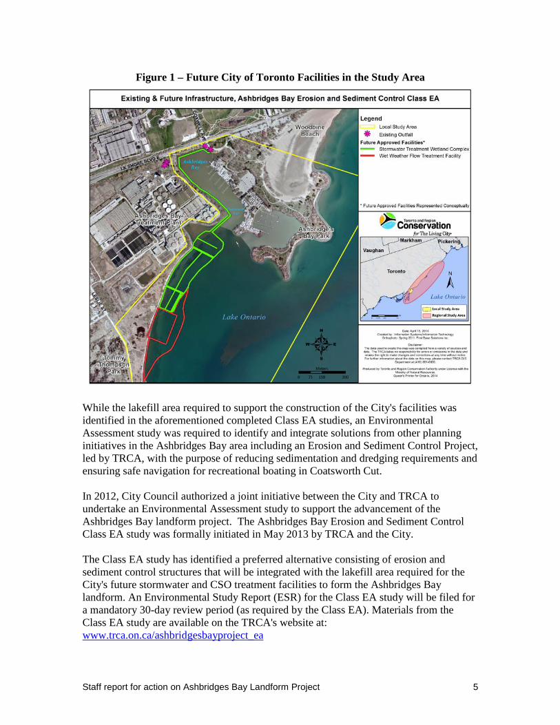
Figure 1 – Future City of Toronto Facilities in the Study Area
While the lakefill area required to support the construction of the City's facilities was identified in the aforementioned completed Class EA studies, an Environmental Assessment study was required to identify and integrate solutions from other planning initiatives in the Ashbridges Bay area including an Erosion and Sediment Control Project, led by TRCA, with the purpose of reducing sedimentation and dredging requirements and ensuring safe navigation for recreational boating in Coatsworth Cut. In 2012, City Council authorized a joint initiative between the City and TRCA to undertake an Environmental Assessment study to support the advancement of the Ashbridges Bay landform project. The Ashbridges Bay Erosion and Sediment Control Class EA study was formally initiated in May 2013 by TRCA and the City. The Class EA study has identified a preferred alternative consisting of erosion and sediment control structures that will be integrated with the lakefill area required for the City's future stormwater and CSO treatment facilities to form the Ashbridges Bay landform. An Environmental Study Report (ESR) for the Class EA study will be filed for a mandatory 30-day review period (as required by the Class EA). Materials from the Class EA study are available on the TRCA's website at: www.trca.on.ca/ashbridgesbayproject_ea
Staff report for action on Ashbridges Bay Landform Project 5

COMMENTS Ashbridges Bay Sediment and Erosion Control Class EA Study Problem/Opportunity, Purpose, and Objectives Over the past many decades, ongoing sediment deposition at the harbour entrances of Coatsworth Cut has resulted in a significant risk to navigation thereby requiring dredging of the Coatsworth Cut entrance to maintain safe navigation and public safety since the 1980s. Dredging frequency has increased over the past two decades, with dredging now required on an annual basis at a significantly higher cost. As part of the Ashbridges Bay landform project, the City of Toronto in partnership with TRCA has undertaken the Ashbridges Bay Sediment and Erosion Control Class EA with the purpose of identifying a preferred alternative that will mitigate erosion and sediment deposition at the harbour entrance to Coatsworth Cut in order to ensure safe navigation. The Class EA local study area is shown in Figure 2.
Staff report for action on Ashbridges Bay Landform Project 6

Figure 2 – Local Study Area for the Ashbridges Bay Erosion and Sediment Control
Class EA
The Class EA study has built upon the work completed by TRCA in previous erosion and sediment control studies in 2002 and 2009 and has considered the following:
• Integration of the City's future stormwater management facilities (as per the facility concepts identified in completed EAs) just south of the Ashbridges Bay Wastewater Treatment Plant;
• The creation of coastal and terrestrial habitats; and, • Improvements in public and ecological connectivity to and along the waterfront as
per the objectives of the Lake Ontario Master Plan and the Tommy Thompson Park Master Plan.
Staff report for action on Ashbridges Bay Landform Project 7

The Class EA study furthers the Ashbridges Bay landform project by identifying the necessary sediment and erosion control structures that will be integrated with the lakefill area required for the City's stormwater and CSO treatment facilities, to form the Ashbridges Bay landform. Therefore, a general configuration or perimeter for the entire Ashbridges Bay landform has been identified to be carried forward for the next step in the project, which is detailed design of the entire landform. Conservation Ontario Class Environmental Assessment Process The Class EA study has been completed in accordance with the requirements of the Conservation Ontario Class Environmental Assessment for Remedial and Erosion Control Projects (2002, amended in 2013). This process includes:
• Initiation of the Class EA (Issuing of a Notice of Intent); • Establishment of a Community Liaison Committee; • The preparation of a Baseline Environmental Inventory that presents the current
environmental conditions in the study area; • The evaluation of alternatives to address the problem/opportunity, which includes
an detailed analysis of environmental, social-economic, technical considerations, and other impacts;
• Identification of mitigation measures; • Preparation of an Environmental Study Report (ESR); and, • Filing the ESR on the public record for a 30-day review period and issuing a
Notice of Study Completion. Public and Stakeholder Consultation Throughout the Class EA study process, extensive consultation has taken place with the public, local community and interested parties, and other stakeholders, as well as regulatory agencies, City divisions and agencies. First Nations were invited to participate and were engaged through correspondence throughout the Class EA study process. A Community Liaison Committee (CLC) comprised of various local stakeholder groups was formed to provide a forum for ongoing local community involvement and input into the planning of the project, and to identify issues and concerns for response. The membership of the CLC is provided in Attachment 1. Internally, a Steering Committee was established to help guide the Class EA study and to ensure that information was disseminated and input was received from City divisions and agencies with interests in the study area. The Steering Committee included staff from TRCA, Toronto Water, Parks, Forestry and Recreation, and Waterfront Secretariat, and Waterfront Toronto. Consultation activities included:
• Two Public Information Centres (PICs) in June 2013 and February 2014, to receive input on the alternatives and evaluation criteria, and the evaluation of alternatives and the preliminary preferred alternative, respectively;
Staff report for action on Ashbridges Bay Landform Project 8

• Three meetings with the Community Liaison Committee in 2013 to receive input
on the development of alternatives, the alternatives evaluation including criteria, and the preliminary preferred alternative;
• A presentation to Aquatic Habitat Toronto (AHT) in December 2013. AHT is a consensus based partnership between agencies with an interest in the improvement of aquatic habitat on the Toronto Waterfront. Partners include Fisheries and Oceans Canada, Ministry of Natural Resources, Toronto and Region Conservation, Waterfront Toronto with key participants from Environment Canada; and
• Individual meetings and briefings with the Ontario Ministry of the Environment, local City Councillors, and the Ashbridges Bay Yacht Club, among others.
Alternatives Considered The Class EA study has built on the work undertaken in previous initiations of erosion and sediment control studies in the area by TRCA. Past studies identified a number of alternatives for erosion and sediment control. These alternatives were screened to ensure they met the scope of work for the current Class EA. Those that did were carried forward and refined to allow for integration with the City's future stormwater and CSO treatment facilities, just south of the Ashbridges Bay Wastewater Treatment Plant. A key consideration in developing the alternatives was the operation of the seawall gates for the Ashbridges Bay Wastewater Treatment Plant (ABTP), to allow for secondary "bypasses" from the ABTP that are discharged from the seawall gates on occasion during severe storm events, when the system becomes overloaded. Four erosion and sediment control alternatives were evaluated in the Class EA study. One of the alternatives was the "Do Nothing" alternative that entails maintaining ongoing dredging as is currently required to keep the navigational channel open (i.e. no sediment and erosion control structures). The other three alternatives - Alternatives 1, 2 and 3, as shown in Figure 3, consist of common elements including:
• a number of breakwaters connected to the shore (in proximity to the ABTP's sea walls gates and at the Ashbridges Bay Park headland) that are designed to keep sediment from entering the Coatsworth Cut channel; and,
• a cobble beach that integrates the breakwaters with the lakefill areas for the City's future stormwater and CSO treatment facilities.
Staff report for action on Ashbridges Bay Landform Project 9

Figure 3 – Alternatives 1, 2, and 3 for Erosion and Sediment Control
Alternative 1
Alternative 2
Alternative 3
Staff report for action on Ashbridges Bay Landform Project 10

The difference between these alternatives is the positioning of the main breakwater in proximity to the ABTP's sea wall gates, as follows:
• Alternative 1: The main breakwater is positioned on the western side of the ABTP's sea wall gates.
• Alternative 2: The main breakwater is positioned on the western side of the ABTP's sea wall gates and a smaller breakwater is positioned on the east side of the seawall gates to act as a deflector.
• Alternative 3: The main breakwater is positioned on the eastern side of the ABTP's seawall gates and a secondary berm is positioned on the west side to form a channel for discharges from the seawall gates.
The three Alternatives, along with the “Do Nothing” alternative were evaluated using evaluation criteria developed with input from the public at Public Information Centre #1 and the Community Liaison Committee. The evaluation assessed impacts in five broad criteria categories, and was informed by detailed water quality and coastal processes modeling. The five broad criteria categories were:
• Physical Environment - impacts on sediment transport, water quality, etc.; • Natural and Biological Environment - impacts on aquatic and terrestrial habitat,
fisheries, migratory birds, and species of interest; • Socio-economic and Cultural Heritage - impacts on park use and infrastructure,
boat club facilities and operations, accessibility and scenic views, recreational uses, and First Nations;
• Feasibility and Costs - capital and maintenance costs, construction and implementation, impacts on other projects; and,
• Technical Considerations – impacts on public safety, safe boat passage, shoreline stability, and dredging.
The Preferred Alternative The preferred alternative - Alternative 3, as shown in Figure 4, consists of the following components, which are all to be located within City of Toronto or TRCA property:
• A main breakwater (approximately 650 metres in length) to the east of the sea wall gates;
• A central channel berm (approximately 300 metres in length) to the west of the sea wall gates;
• An east breakwater (approximately 100 metres in length) that extends from Headland C of Ashbridges Bay Park; and,
• A central cobble beach to the west of the central channel berm.
Staff report for action on Ashbridges Bay Landform Project 11

Figure 4 – Preferred Alternative for Erosion and Sediment Control
Alternative 3 was selected as the preferred alternative based on the alternatives evaluation and support from stakeholders and the public. The key factor in the selection of Alternative 3 was the potential positive impact on water quality in the recreational boating areas in comparison to Alternatives 1 and 2 that could potentially have negative impacts on Phosphorus and E-Coli levels in the boating areas. The potential positive water quality impact of Alternative 3 is achieved by the separation of the sea wall gate discharges from the recreational boating areas. In addition to the water quality aspects, Alternative 3:
• Offers the best integration of existing and planned City of Toronto infrastructure, including the future stormwater and CSO treatment facilities;
• Provides for ongoing safe navigation in Coatsworth Cut without the requirement for on-going annual dredging;
• Provides for future public access or connectivity across the Ashbridges Bay landform (to be further explored during the detailed design phase of the project); and,
• Requires minimal annual maintenance.
Upon identification of the preferred solution, a detailed environmental analysis was undertaken to determine mitigation measures to mitigate temporary impacts during construction and permanent impacts due to operation and maintenance of the project after
Central Cobble Beach East
Breakwater Main Breakwater
Central Channel Berm
Staff report for action on Ashbridges Bay Landform Project 12

construction. Mitigation measures will include construction staging, off-season construction, and the identification of access roads and staging areas, among other measures, that will minimize impacts to the surrounding area. Compensation for fish habitat loss will be required and a construction and post-construction monitoring program will be implemented. Project Costs and Implementation The estimated total gross cost for the implementation of the Ashbridges Bay landform project is approximately $33.5 million, which includes a 20% contingency. The estimated cost for each implementation component is presented below.
Component Estimated Cost (millions $)
Detailed design of the Ashbridges Bay landform $0.348 M Landform materials and construction costs $18.6 M Start-up fees $1 M Fill Operation, Site Management, Project Management and administration costs
$10 M
Fish habitat compensation $3.6 M** Estimated Total Cost $ 33.5 M ** To be determined in consultation with the Department of Fisheries and Oceans Potential revenue for the Ashbridges Bay landform project to be generated by accepting lakefilling materials is conservatively estimated at $6.1 million. The revenue would offset costs and bring the estimated net total cost of the project to $ 27.4 million. The estimated costs and potential revenues have been identified based on the best available estimates; however these costs and revenues are market driven and may change due to the availability of construction materials, the demand for lakefill materials, and the implementation timing of the project. During the detailed design process (pending Council approval and completion of the EA process), costs and revenues will be reviewed and refined based on the final design of the Ashbridges Bay landform, with an emphasis on finding cost efficiencies and confirming revenue opportunities. Given the scope of the Ashbridges Bay landform project, the project will require a phased construction over an estimated five year time frame that can commence in 2015. A potential timeline for construction phasing for the various components of the Ashbridges Bay landform is shown in Figure 5. An implementation plan will be developed during detailed design of the project that will include a final phased construction timeline and annual capital costs.
Staff report for action on Ashbridges Bay Landform Project 13

Figure 5 – Potential Implementation Phasing
Next Steps Following the approval of this report by City Council, the ESR for the Ashbridges Bay Erosion and Sediment Control Class EAwill be filed on the public record for a minimum 30-day review period, and a Notice of Study Completion will be advertised in local newspapers across the study area and sent to the study contact list. City and TRCA staff will address any issues that may arise in the course of the review period through the provisions of the Class EA process. Upon the completion of the Class EA process, the next step for the project is the detailed design of the Ashbridges Bay landform. Given the expertise of TRCA in sediment and erosion control and lakefilling projects and their involvement in leading the Class EA study, it is recommended that the TRCA lead the detailed design process for the project. The detailed design process is expected to take approximately five months to complete. The detailed design will integrate the recommended erosion and sediment control structures with the lakefilling components required for the construction of the City's stormwater and CSO treatment facilities to create one landform structure.
Staff report for action on Ashbridges Bay Landform Project 14
The detailed design process will identify a final design for the integrated landform and a more detailed implementation plan for the Ashbridges Bay landform project. The detailed design phase will include:
• Examining public access options and further exploring the potential for establishing a connection from Tommy Thompson Park to Ashbridges Bay Park;
• Recommending the aesthetic elements of the landform, such as plantings, as well as potential amenities;
• Recommending a method of shoreline protection for the City's CSO and stormwater treatment facilities;
• Confirming on-site and off-site fish habitat compensation required for the landform as per the federal Fisheries Act;
• Securing Department of Fisheries and Oceans, Transport Canada and any other necessary permits; and,
• Refinement of the landform implementation budget and construction phasing with emphasis on identifying further financial and timeline efficiencies.
Consultation mechanisms to receive input on the detailed design components of the Ashbridges Bay landform project will include:
• Community Liaison Committee (CLC) - meetings with the CLC established for the Class EA study;
• Public Information Centre with the general public; • Individual meetings with stakeholders and groups in the local area and upon
request; and, • Meetings with regulatory agencies and other review agencies.
Funding for the implementation of the Ashbridges Bay landform project will be considered in the Toronto Water 2015-2024 Capital Plan. It is recommended that Toronto Water report back, through the 2015 Capital Budget process, on an implementation plan for the Ashbridges Bay landform project including a construction phasing schedule, costs and revenues, and other implementation details. CONTACTS Ted Bowering, P.Eng. Acting Director Water Infrastructure Management Toronto Water Tel: 416-338-5473 Fax: 416-338-2828 E-mail: [email protected]
David Kellershohn, P.Eng. Acting Manager, Stormwater Management Water Infrastructure Management Toronto Water Tel.: (416) 392-8255 Fax: (416) 338-2828 E-mail: [email protected]
Staff report for action on Ashbridges Bay Landform Project 15

SIGNATURE _______________________________ Lou Di Gironimo General Manager, Toronto Water ATTACHMENTS
1. Ashbridges Bay Erosion and Sediment Control Class EA – Community Liaison Committee
Staff report for action on Ashbridges Bay Landform Project 16

Attachment 1 – Ashbridges Bay Erosion and Sediment Control Class EA - Community Liaison Committee The following organizations were invited to participate on the CLC:
• Ashbridge's Bay Yacht Club • Balmy Beach Canoe Club • Council of Commodores • Friends of the Spit • Greater Beach Neighbourhood • Greening Ward 32 • Navy League of Canada • Portlands Action Committee • South Riverdale Health Centre • Toronto Beaches Lions Club • Toronto Field Naturalists • Toronto Hydroplane & Sailing Club • Toronto Ornithological Club
In addition, the City Councillors, MPs and MPPs for each of the following wards or ridings were circulated on study information and invited to attend CLC meetings if interested:
• Councillor, Ward 32 (Beaches-East York) • Councillor, Ward 30 (Toronto Danforth) • MPP, Beaches-East York • MPP, Toronto Danforth • MP, Beaches-East York • MP, Toronto Danforth
The following organizations agreed to assign representatives to participate in the CLC: • Ashbridge's Bay Yacht Club • Balmy Beach Canoe Club • Friends of the Spit • Greening Ward 32 (attended one meeting only and then withdrew member) • Navy League of Canada • Toronto Beaches Lions Club • Toronto Field Naturalists • Toronto Hydroplane & Sailing Club • Toronto Ornithological Club
Staff report for action on Ashbridges Bay Landform Project 17