st. croix river escarpment gully inventory · as the glacial waters created the river valley seen...
TRANSCRIPT

St. Croix River Escarpment Gully Inventory Erosion Along the St. Croix River
2011 Inventory of Erosion Along the
St. Croix River Prepared by the Chisago
Soil & Water Conservation District
IDENTIFY
VERIFY
CORRECT

Clean Water Fund 2011: St Croix River Escarpment Gully Inventory
2 Chisago SWCD March 2012
Contents Executive Summary ................................................................................................................................................................. 4
Project Objective ................................................................................................................................................................. 4
Background ......................................................................................................................................................................... 4
Geology ............................................................................................................................................................................... 5
Vegetation ........................................................................................................................................................................... 5
Project Methodology .............................................................................................................................................................. 5
Survey Process .................................................................................................................................................................... 5
Desktop Gully Identification................................................................................................................................................ 5
Mass Mailing Outreach ....................................................................................................................................................... 8
Field Search and Review ..................................................................................................................................................... 8
Gully Watershed Mapping ................................................................................................................................................ 10
Gully Watershed Priority Ranking ..................................................................................................................................... 11
Pollution Reduction Estimation ........................................................................................................................................ 12
Roadblocks ............................................................................................................................................................................ 14
Project Findings ..................................................................................................................................................................... 14
Gully 1 ............................................................................................................................................................................... 15
Gully 2 ............................................................................................................................................................................... 16
Gully 3 ............................................................................................................................................................................... 17
Gully 4 ............................................................................................................................................................................... 18
Gully 5 ............................................................................................................................................................................... 19
Gully 6 ............................................................................................................................................................................... 20
Gully 7 ............................................................................................................................................................................... 21
Gully 8 ............................................................................................................................................................................... 22
Gully 9 ............................................................................................................................................................................... 23
Gully 10 ............................................................................................................................................................................. 24
Gully 11 ............................................................................................................................................................................. 25
Gully 12 ............................................................................................................................................................................. 26
Gully 13 ............................................................................................................................................................................. 27
Gully 14 ............................................................................................................................................................................. 28
Gully 15 ............................................................................................................................................................................. 29
Gully 16 ............................................................................................................................................................................. 30
Gully 17 ............................................................................................................................................................................. 31

Clean Water Fund 2011: St Croix River Escarpment Gully Inventory
3 Chisago SWCD March 2012
Gully 18 ............................................................................................................................................................................. 32
Gully 19 ............................................................................................................................................................................. 33
Gully 20 ............................................................................................................................................................................. 34
Gully 21 ............................................................................................................................................................................. 35
Gully 22 ............................................................................................................................................................................. 36
Gully 23 ............................................................................................................................................................................. 37
Gully 24 ............................................................................................................................................................................. 38
Gully 25 ............................................................................................................................................................................. 39
Gully 26 ............................................................................................................................................................................. 40
Gully 27 ............................................................................................................................................................................. 41
Gully 28 ............................................................................................................................................................................. 42
Gully 29 ............................................................................................................................................................................. 43
Gully 30 ............................................................................................................................................................................. 44
Gully 31 and 32 ................................................................................................................................................................. 45
Gully 33 ............................................................................................................................................................................. 46
Gully 34 ............................................................................................................................................................................. 47
Gully 35 ............................................................................................................................................................................. 48
Gully 36 ............................................................................................................................................................................. 49
Conclusion ............................................................................................................................................................................. 50
Implementation Projects .................................................................................................................................................. 50
References ............................................................................................................................................................................ 52
Appendix A: Table of GIS Tools Used .................................................................................................................................... 53
Appendix B: Letter to Landowners ....................................................................................................................................... 54
Appendix C: Post Card to Landowners .................................................................................................................................. 55
Appendix D: Second Letter to Landowners .......................................................................................................................... 56
Appendix E: Gully Inventory Sheet ....................................................................................................................................... 57
Appendix F: Landowner Visit Notice ..................................................................................................................................... 58

Clean Water Fund 2011: St Croix River Escarpment Gully Inventory
4 Chisago SWCD March 2012
Executive Summary The Chisago Soil and Water Conservation District (SWCD) received a Clean Water Fund grant through the Minnesota Clean Water, Land and Legacy Amendment to conduct an inventory of actively eroding gullies along the Minnesota side of the St. Croix River escarpment. The escarpment is a steep slope that runs parallel to the St. Croix River. It separates two relatively level areas of Minnesota and Wisconsin. The escarpment essentially marks the bank of the glacial St. Croix River. The project area extended from the Wild River State Park entrance near Almelund, MN, south to the Chisago County line, a distance of about 15 miles.
Aerial photography was studied using a Geographic Information System (GIS). ESRI’s ArcGIS program ArcMap was used to integrate hardware, software, and data to display and mark potential gullies. Landscape features that appeared to be a gully based on review of contours and other information were marked with a point and a line to trace the gully. There were 618 potential gullies identified. Landowners with a potential gully on their property were mailed a letter explaining that the SWCD staff would like to view the gully to verify if it was actively eroding.
A field review was conducted of 494 gullies that were accessible (on public land or access was allowed by the landowner). Information was gathered about each gully. Of these gullies, 112 were identified as eroding at some scale. The survey information was then used to highlight the most severely eroding gullies in the project area. There were 36 gullies identified as severely eroding for this project.
These 36 gullies were then ranked using information including water quality risk, erosion risk, habitat quality, and land cover. The gullies were ranked high, medium, and low. This ranking could be used to help determine which gullies should be funded first when funding is limited.
The Chisago SWCD applied for and received funding through another Clean Water Fund grant to begin implementing Best Management Practices (BMPs) that will correct the gullies identified in this report. All of the identified gullies are good projects; however, if funding is not available to correct all gullies, the information gathered in this report will be used to determine which gullies receive funding for stabilization.
Project Objective The objective of the project was to identify all actively eroding gullies along the escarpment and gather information on the severity of erosion of each gully. This information can be used to determine which gullies are contributing the most pollution to the St. Croix River and to help decide which gullies should receive available funding to be corrected. The inventory will be utilized to contact landowners with major actively eroding gullies on their property to begin the process of developing a plan to implement BMPs to correct the erosion problem.
This project is important for several reasons. First, identifying gully sites and implementing BMPs to stop active erosion will reduce phosphorus loading to the St. Croix River by hundreds of pounds per year. By collecting and infiltrating runoff water on-site, the volume and rate of water will be drastically reduced. The amount of phosphorus and sediment carried in runoff water entering the St. Croix River will thereby be reduced as well.
Background The Upper St. Croix River was one of the original 8 rivers designated as a National Scenic Riverway, a system of riverways federally protected for their natural beauty. The Upper St. Croix extends from the source near Gordon, WI, to Taylors Falls, MN/St. Croix Falls, WI, a distance of 200 miles and includes the Namekagon River in northwestern Wisconsin. The Lower St. Croix River was added to the National Scenic Riverway program in 1972. This portion extends 52 miles from Taylors Falls, MN/St. Croix Falls, WI, to the confluence with the Mississippi River at Point Douglas, MN/Prescott, WI (MN DNR; NPS). The Lower St. Croix River has also been listed on the American Rivers

Clean Water Fund 2011: St Croix River Escarpment Gully Inventory
5 Chisago SWCD March 2012
“Top Ten Endangered Rivers List” (American Rivers). The portion of the Lower St. Croix River from Stillwater, MN, to Prescott, WI, is listed on the Environmental Protection Agency (EPA) 303d Impaired Waters List for excessive nutrients (MPCA). Steep slopes, land management practices, and unmanaged forests account for these impairments. In addition, the U.S. Department of Agriculture (USDA) Natural Resources Conservation Service (NRCS) has determined that the St. Croix River corridor wildlife habitat biodiversity is very high to outstanding. Greater than 90% of the non-agricultural and undeveloped land along the escarpment is currently classified as a high quality native plant community. These natural resources are threatened by sedimentation caused by erosion and water quality degradation caused by contaminants that enter the river from the watershed. The St. Croix River escarpment is also home to many rare and endangered species, including bald eagles, gray wolves, and numerous birds and insects. Erosion of the escarpment area results in continued degradation to the habitat of these species. By stabilizing major gullies in the area, the rare and native plant and animal species will continue to thrive in their natural environment. The St. Croix River itself is also home to rare species, including native mussels. These organisms will benefit from the reduction in phosphorus and sediment reaching the St. Croix River as eroding gullies are stabilized.
Geology According to the Minnesota Department of Natural Resources (MN DNR), during the last glacial period, about 10,000 years ago, the St. Croix River valley was a major drainage channel draining glacial meltwater from Lake Superior. Along the ancient Glacial St. Croix River valley, many ravines were formed. Some of these ravines are quite large. In the many years since the end of the ice age, these ravines have self-healed and are no longer actively eroding. The banks have been stabilized with vegetation and trees. As the glacial waters created the river valley seen today, they left behind a variety of soils and sediment that cover the ancient lava bedrock buried far below the surface. Many springs, or seeps, occur along the escarpment banks where the river valley has eroded through to release water trapped between the sediments (MN DNR). These seeps contribute to rare and unique plant communities.
Vegetation Many vegetative communities are facing heavy pressure from introduced invasive species. In some cases, these species can affect the erosion and runoff volume of a site by reducing native plant cover and exposing bare soil. Two of the most prevalent woody species in the St. Croix River escarpment area are European Buckthorn (Rhamnus cathartica) and Tatarian Honeysuckle (Lonicera tatarica). Both of these species were introduced as part of the horticultural trade and have escaped cultivation. As they invade a native community, they shade out understory vegetation and prevent seedlings of native trees from germinating.
Project Methodology
Survey Process This project was completed in several distinct phases, including desktop gully identification, mass mailing outreach, field search and review, gully watershed mapping, gully watershed priority ranking, and pollution reduction estimation. See Appendix A for a list of all GIS tools used in this project.
Desktop Gully Identification The desktop gully identification portion of the process was conducted using ArcGIS Figure 1: Contours

Clean Water Fund 2011: St Croix River Escarpment Gully Inventory
6 Chisago SWCD March 2012
with 2007 LiDAR imaging as the primary aerial photography. Other layers that were imported and found to be helpful included: roads, parcels, township lines, section lines, contours (1-foot contours; See Figure 1), newer aerial photography (FSA or NAIP), rivers, and streams. To get an idea of the age of the gully, 1938 MN DNR aerial photographs were brought in and georeferenced. It was also helpful to have several different years of aerial photographs to compare as some photos seem to show different aspects better.
A helpful tool that wasn’t used for this project, but in hindsight would be helpful, was the hillshade tool (See Figure 2). To use this tool, the DEM GRIDs for the area must be added to the project. It creates a nearly 3-dimensional view of the landscape that helps pick out areas that could be gullies. This could be especially helpful if a person is not experienced at reading contours.
With these layers added to the project in ArcGIS, the St. Croix Escarpment area included in the project description was analyzed closely for features that appeared to be gullies or ravines. When an area was identified as a potential gully based on contours and aerial photography, it was marked at the top and bottom of the gully with points (creating a new shapefile with all the gully points). There were internal qualifications required for a potential gully to be marked. For the Chisago SWCD office, the gully needed to be over 100’ in length to be marked with a point. Shorter gullies could be added if they appeared particularly severe, at staff discretion.
Many potential gullies were actually a combination of many connecting channels. For these gullies, a point was placed at the top of each gully arm or head that was over 100’ from the head to the main stem or appeared particularly severe. One point was placed at the bottom of the main stem of the gully. The gully bottom was determined to be where the gully reached surface water or where the contours flattened out (often this was a sediment delta). The head of a gully was placed at the point where it appeared the erosive cutting began, or the point where the contours changed from being evenly spaced to showing exaggerated slope.
After all potential gullies were identified with a point file, the stems of the gullies were identified with a polyline file (See Figure 3). A polyline was drawn from the bottom point, following the main stem of the gully up to the head. For gullies with multiple heads, the initial line was drawn on what appeared to be the main or original stem of the gully. Secondary lines were then drawn off the main stem to connect to the points at the head of the potential gullies branching off the main stem. In cases where a gully went under a road via a culvert, the line continued over the roadway.
Once each potential gully in the escarpment area was identified with both point and line files, an attribute table was created. For this project, the attribute table was created in the point file. Additional fields were added to the table, including:
• Point o Since there are points at both the tops and bottoms of the gullies, this field was used to identify what part
of the gully the point signifies. Example entries were Head (the head of a gully with one stem), Co-Head (the head of a gully with multiple stems), and Bottom (the bottom of a gully).
• Source o This field was used to identify what land use or land cover occurred at the head of the gully. This field
was not filled in for bottom points. Example entries were Agricultural, Wooded, Farmstead, Residential, Urban, Open, Pasture, and Road.
Figure 3: Identified Gullies
Figure 2: Hillshade

Clean Water Fund 2011: St Croix River Escarpment Gully Inventory
7 Chisago SWCD March 2012
• Status o This field was used to predict, based on the aerial photography, if a gully was actively eroding or stable.
Example entries were Appears Active, Active, or Appears Stable. • Field Check
o This field is an update to the Status field. After the field check process, this field was completed with the actual status of the gully. Example entries were Active or Stable.
• Field Date o This field records the date that the gully was field verified.
• With Stream o Some gullies were found to be formed where a stream (seasonal or permanent) ran. This field was used to
indicate if a certain gully was associated with an identified stream. Entries were Yes or No. • Notes
o This field was used to note anything important that didn’t fit in any other field. • Length
o This field was used to record the approximate length of a gully. For gullies with a single head, the entire length was recorded. For complex gullies, the full length from top to bottom was recorded for the head that appeared to be the original or main stem. The length from the co-heads to the main stem was recorded for the other points.
• Width o This field was used to record the average width of a gully. The width was determined by measuring from
the top of one side of the gully to the top of the other side of the gully. For gullies with multiple stems, the width was determined for each of the individual stems and recorded with the appropriate point.
• Depth o This field was used to record the approximate depth of the gully channel. This was determined by
identifying the contour at the top of the gully and then identifying the bottom of the gully at the same point in the channel. Do not measure the total fall of the gully from the head to the bottom. For multiple-stem gullies, the depth was determined for each branch.
• Rank o This field was filled in after the priority ranking process was completed. The ranking only applied to the
gullies that were included in the highest priority category. • Point ID
o This field was used to name each head or co-head point. The naming system was based on township. In this project, there were three townships involved (Amador, Shafer, and Franconia). The first letter of the township was used in the point ID name. The range number was also used. The gullies in each township and range were numbered, starting at 1. Each point was also given a letter to identify the head or co-head individually. An example label was A9-3A. This point was found in Amador township (A), range 9 (9), and was the third gully in that range (-3). The gully only had a single head (A). A more complex gully may have labels of A20-13A, A20-13B, A20-13C, and A20-13D for the four different co-heads included on the gully complex. The bottom point was simply identified without the last letter. For the above example, the bottom point would simply be A20-13.
• Line ID o This field was used to name each gully line or stem. For this project, we used a separate name for the
lines and points. The lines were named based on the automatically generated FID field. In hindsight, this became confusing and it is recommended to stick to one naming convention. The line name should correspond to the name given to the point at the head of the gully or stem. For instance, the line drawn

Clean Water Fund 2011: St Croix River Escarpment Gully Inventory
8 Chisago SWCD March 2012
from point A20-13A to A20-13 should be named A20-13A. The side branch A20-13B to the main stem should be named A20-13B.
At the conclusion of this first step in the process, a list and map could be generated with all the potential gullies along the St. Croix escarpment area.
Mass Mailing Outreach The next step was to identify who the landowners with potential active gullies were so they could be contacted for permission to field check the gully. In ArcGIS, the gully point and line layers were turned on and the parcel data layer was overlaid on it. Using the identify tool, any parcels that had any portion of a gully in them were recorded in an Excel spreadsheet. The name of the landowner and the address were recorded. For this project, this information was not recorded in the attribute table, but it may be useful to do so in future projects.
With the Excel list of landowners with potential gullies built, the next step was to send out a mass mailing to everyone on the list. Letters were not sent to government owned parcels or parcels listed as owned by a bank or mortgage lender. Only one letter was sent per person, although a person may have been identified as having several potential gullies on their land.
Each landowner received a letter with a postcard enclosed (See Appendix B). The letter explained the project briefly and emphasized that just because a gully was identified on a property, it did not obligate the landowner to do anything. The letter also explained how the landowner was asked to follow up by returning the enclosed postcard by the deadline. Included in the letter was contact information for landowners with questions.
The postcard (See Appendix C) listed three choices and asked the landowner to check one of them. The choices were:
• Please do not check gullies on my property. • I give permission to check gullies on my property without an appointment. • I give permission to check gullies on my property with an appointment.
The postcard also asked the landowner to identify their property by giving the address. This is very important information for identifying which landowners have given permission and which had not.
The yes/no/with appointment responses were entered into the ArcGIS project by creating a new point file and color coding the answers. There was also a color given to “no response” landowners. This information could be entered into the attribute table for the gully points. This would save the step of creating a new shapefile and the results could still be sorted by the different responses.
A second follow-up letter (See Appendix D) was sent to those landowners who did not respond to the first mailing. Another post card was enclosed with the same instructions. This mailing did elicit additional responses and was worthwhile.
Field Search and Review After the final deadline for returning postcards had passed, the next step in the process was to begin the field checks of all the identified gullies. The gullies were checked in a systematic manner, starting at the northern extent of the project area and working south.
About a week before a visit was planned for a property with permission to access, the landowners that requested an appointment were contacted by phone. They were notified by phone or answering machine that someone would be out to look at the gully within a certain range of dates (usually a week’s time). For landowners who requested an appointment, a

Clean Water Fund 2011: St Croix River Escarpment Gully Inventory
9 Chisago SWCD March 2012
call was given to set up a specific time and date to meet on the property and view the gully. Those that replied with a “yes” were not contacted before going out to the property.
Before going out to the field, there were several steps to get ready. Maps printed out from ArcGIS were a very important resource out in the field. A map that showed the area that would be checked within a week was found to be useful. The map should include: roads (labeled), gully points and lines (labeled), aerial photography, parcel lines, and a north arrow. Additional maps that are zoomed in to provide a better view of individual gullies or gully complexes were also helpful. These maps should include parcels and be identified as yes or no for permission to enter the property. They could also include contours and soil data, if desired.
A standardized field inventory form (See Appendix E) was created and would be filed in the large 3-ring binder for storage. The form included space to fill in the following information:
• Landowner, field identification number (FID), legal description: • Is the gully actively eroding: Y / N • If yes, what is the Width, Depth and Length of cut? • Current land use above gully, that drains into it: • Are there any livestock above the gully in the drainage area that could be causing phosphorus loading into the
drainage area? If yes, explain. • What is the vegetation cover type and quality that the gully runs through? • Are there any invasive species present and how much? • Are there any other resource concerns? • If there is erosion or other resource concerns, is the landowner receptive to correcting it?
Before leaving the office, access points to gullies were also identified. This produced a plan for the day and reduced the amount of time spent in the field driving around to find the best way to access a gully. Common access points included driveways, field roads, or parking in a safe location along a road to walk the shortest route to a gully.
Other materials and tools that were found to be helpful in field work were binoculars, camera, tape measure, business cards, and a clipboard. Although not used for this project, a GPS may be useful in recording actual head of gully or actively eroding portions of a gully.
An identified Chisago SWCD truck was used for transportation to all field check locations. If a gully was located on a property with a house, the house was visited first to see if anyone was home. If so, the landowner could be notified that someone would be on their property and what the reason was. Since these landowners had already agreed to allow permission onto the property without notification, there were usually no problems encountered in this step. If no one was home, a letter (See Appendix F) was left at the door after the survey was completed. The letter had two options:
• You were not home so I did not go on your property to check it. • You responded to our mailing stating YES, we could enter your property, so I went out to the gully and this is
what I observed (notes were then recorded).
During the actual inspection of a potential gully, the information required on the inventory sheet was recorded. Each gully was visited from top to bottom because some sections may be eroding while others were not. If only certain sections were eroding, this was noted on the inventory sheet. A separate sheet was filled out for each individual gully. During the visit, the area surrounding the gully was also considered because it may provide information about what is causing erosion.
A gully was defined as “actively eroding” if there was bare soil present on the sides or bottom of the gully, if recent sloughing of the banks was apparent, if roots were exposed due to bank undercutting, or if a combination of factors made

Clean Water Fund 2011: St Croix River Escarpment Gully Inventory
10 Chisago SWCD March 2012
it apparent that the gully was actively eroding. Beyond this, there was also a notation of the severity of the erosion. When appropriate, pictures of the gully were taken.
Occasionally, new gullies were identified during the field check. These gullies were not identified on the map, either having been missed or not meeting the criteria to be marked. If the severity of the new gully warranted it, the gully was added to the map and given a new name. The name would be out of numerical sequence and, therefore, a note was added to the note field of the attribute table that this gully was added during the field search. In this project, there were two gullies added this way.
Sometimes, a gully crossed several different parcels and the permission to access the properties was mixed. This meant that portions of the gully were off limits. For these gullies, the condition of the non-accessible parts of the gullies was assumed based on the condition of the rest of the gully and on what could be observed from the area that was accessible.
Once back in the office, the information was transferred from the inventory sheet to the appropriate fields in the point attribute table. All of the paper inventory sheets were kept in a three-ring binder. When all field checking and computer updating was completed, the gullies were examined and sorted. The goal was to focus on only those gullies that are actively eroding and, beyond that, those gullies that were most severely eroding.
In order to sort the gullies in this manner, the “Rank” field of the attribute table was used. Non-eroding gullies were not given a number (the Rank field was left blank). Eroding gullies were reviewed and given a rank of 1, 2, or 3. A ranking of 1 was least severe and 3 was most severe. This ranking was determined by the staff person who field checked the gullies. There were not specific criteria for what constituted a specific ranking. It was a decision based on the knowledge of the staff person who viewed all of the gullies. Loosely, the gullies ranked with a 1 were actively eroding, but not posing a threat to water quality. They may be very slowly eroding or only eroding a very small amount each year. The ranking of 3 was reserved for the worst of the gullies. These gullies were eroding severely and contributing large sediment loads to surface water. It was apparent these gullies would continue to erode severely without intervention. The gullies ranked with a 2 were in between these two extremes.
Depending on internal goals, the number of gullies to be included in the next step may vary. In this project, only those gullies ranked with a 3 were included in the next step.
Gully Watershed Mapping In this step, the goal was to identify the watershed area for each individual gully or in the case of complex gullies with multiple heads, the watershed area for each individual stem of the gully. This process was done in ArcGIS using GIS tools and was only conducted on the gullies with a ranking of 3. In this project, this was 36 gullies.
The tool that was used to create the watersheds was the Basin tool (See Figure 4), which required several steps before using. The DEM GRIDS for the areas including the gullies were added to the project and merged together. This process caused ArcGIS to become non-responsive several times. To avoid this, the project was broken into three separate project files, one for each of the three townships. This reduced the number of GRIDS needed for each project and allowed the merging to be conducted without problem. Once all of the GRIDS were merged into one file, the Filter tool was used. This smoothed out the data.
Next, the Flow Accumulation tool was run on the Filtered DEM. This tool highlights the areas of the highest flow accumulation. Then, the Basin tool was used to break the area into smaller basins. At this point, the basins were converted from a raster to a polygon shapefile.
Figure 4: Basins

Clean Water Fund 2011: St Croix River Escarpment Gully Inventory
11 Chisago SWCD March 2012
The next step requires using the contours overlaid on the basin polygon file to make informed decisions. The basin tool often breaks the polygons down into smaller areas than are desired for this project. To get the true watershed for each individual gully point, several basin polygons may need to be merged together. The goal is to merge all the basin polygons together that drain through the gully.
When all of the gully head or co-head points have an associated watershed, the remaining basin polygons can be deleted from the shapefile. The only polygons that should remain are those merged watersheds for each gully head or co-head point (See Figure 5).
At this point, multiple polygon files may need to be merged together into one single file. In this project, there were three separate polygon files for the watersheds (one for each township). To be able to rank the watersheds in the next step, the polygons must all be in one file. Use the Geoprocessing toolbar to open the Merge tool. The output should create a new shapefile that has all of the gully watersheds in one file.
Gully Watershed Priority Ranking The next step in this process will focus on the shapefile that contains all of the gully watersheds. These watersheds will be ranked to highlight the watersheds that are of the highest priority and that funds should be directed to.
For this project, ranking criteria included the Environmental Benefit Index (EBI) and GAP Land cover Data. The EBI is a combination of three criteria and is ranked from high to low on a scale of 100. The three components of the EBI are:
• Soil Sustainability Risk o The soil sustainability risk is based on bare soil condition and is calculated from the RKLS factors of the
USLE using SSURGO soils polygons where R=rainfall factor, K=soil erodability factor, L=slope length factor, and S=slope gradient factor. This layer was downloaded from the DNR Data Deli and had already been calculated.
• Water Quality Risk o The water quality risk is a combination of the proximity to surface water and the Stream Power Index
(SPI). Proximity to water is the distance between each pixel and the nearest lake, river, or stream and was calculated using the ArcGIS Cost Distance tool. The SPI was determined using the formula SPI=Ln (Flow Accumulation x Slope). High SPI values indicate areas on the landscape that have the high potential to erode during runoff events. The combination of these factors creates the water quality risk layer, which was downloaded from the DNR Data Deli.
• Habitat Quality Rating o The habitat quality ranking ranks the value of land for habitat. A high ranking indicates a high habitat
value. This layer was downloaded from the DNR Data Deli.
The GAP Land cover Data breaks the land cover down into a variety of different categories. It is not ranked on any scale.
The criteria used in ranking the watersheds and the weight assigned to each criterion are internal decisions. For this project, the EBI was weighted with Soil Sustainability Risk and Water Quality Risk given a factor of 2 and the Habitat Quality Ranking given a factor of 1. Added to this ranking system was the GAP Land cover data, at a factor of 3 (See Figure 6).
Since the GAP land cover data is not ranked in any way, a ranking system was devised on a scale of 0-100 with 0 being the least likely land cover to contribute to
Figure 5: Watersheds
Figure 6: EBI Ranking
Clean Water Fund 2011: St Croix River Escarpment Gully Inventory
12 Chisago SWCD March 2012
erosion and 100 being the most likely land cover to contribute to erosion. A column was added to the attribute table and a ranking between 0 and 100 was assigned to each unique land cover class. The Level 3 Classification was used because it identified a difference between Cropland and Grassland, where Level 2 classified both these categories as Grassland. The GAP Land Cover data must be converted from a polygon to a raster after the ranking has been completed.
To create the weighted ranking criteria with all factors, the Raster Calculator was used. This produced a raster that combined all factors into one and could be displayed with scaled colors. In order to apply this ranking to the watershed polygons, a Zonal Statistics Table was created. The resulting table was then joined to the attribute table for the watershed polygons. The polygons were then displayed based on the MEAN field in the joined table. This applied the calculated number (an arbitrary number except when compared to the others in the same shapefile) to each watershed polygon and applied a color that visualized the ranking process. Red was chosen as the color to signify the highest priority watersheds.
Although this process ranked the 36 Level 3 gullies identified in the inventory into a list of highest priority to lowest, the Chisago SWCD feels that all 36 gullies are good projects. The priority ranking will be used for assigning funds if there is not funding available to finance all gully stabilization projects.
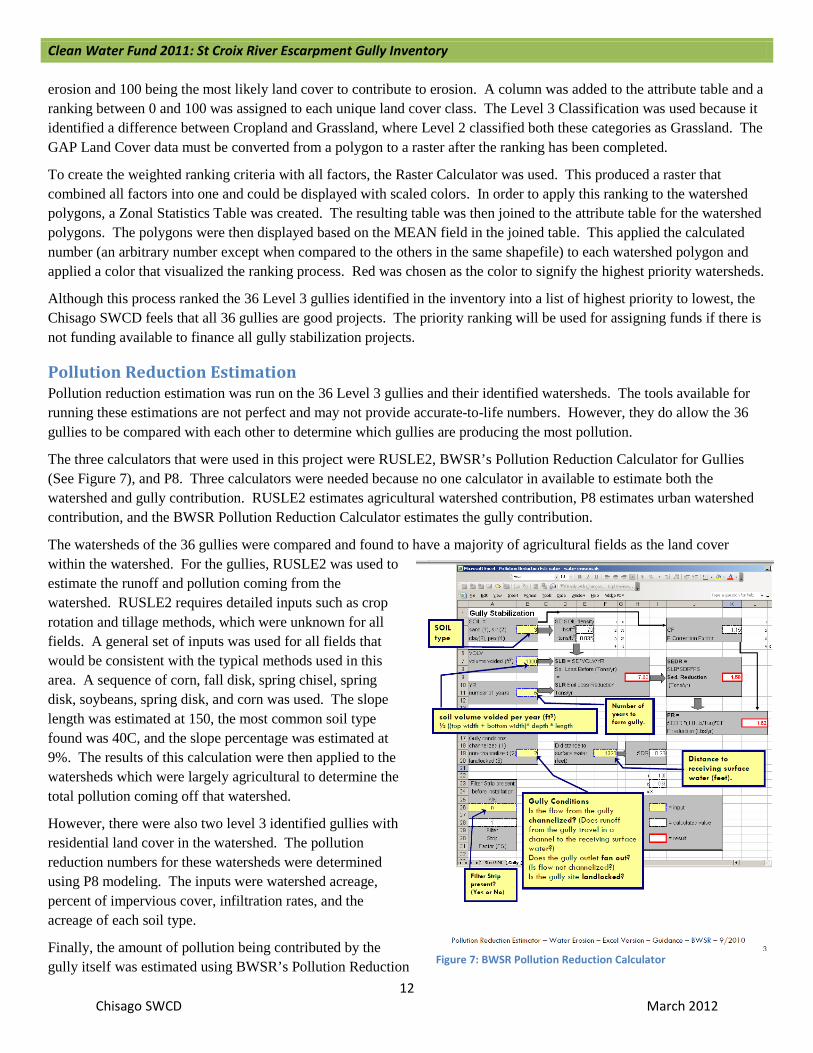
Pollution Reduction Estimation Pollution reduction estimation was run on the 36 Level 3 gullies and their identified watersheds. The tools available for running these estimations are not perfect and may not provide accurate-to-life numbers. However, they do allow the 36 gullies to be compared with each other to determine which gullies are producing the most pollution.
The three calculators that were used in this project were RUSLE2, BWSR’s Pollution Reduction Calculator for Gullies (See Figure 7), and P8. Three calculators were needed because no one calculator in available to estimate both the watershed and gully contribution. RUSLE2 estimates agricultural watershed contribution, P8 estimates urban watershed contribution, and the BWSR Pollution Reduction Calculator estimates the gully contribution.
The watersheds of the 36 gullies were compared and found to have a majority of agricultural fields as the land cover within the watershed. For the gullies, RUSLE2 was used to estimate the runoff and pollution coming from the watershed. RUSLE2 requires detailed inputs such as crop rotation and tillage methods, which were unknown for all fields. A general set of inputs was used for all fields that would be consistent with the typical methods used in this area. A sequence of corn, fall disk, spring chisel, spring disk, soybeans, spring disk, and corn was used. The slope length was estimated at 150, the most common soil type found was 40C, and the slope percentage was estimated at 9%. The results of this calculation were then applied to the watersheds which were largely agricultural to determine the total pollution coming off that watershed.
However, there were also two level 3 identified gullies with residential land cover in the watershed. The pollution reduction numbers for these watersheds were determined using P8 modeling. The inputs were watershed acreage, percent of impervious cover, infiltration rates, and the acreage of each soil type.
Finally, the amount of pollution being contributed by the gully itself was estimated using BWSR’s Pollution Reduction Figure 7: BWSR Pollution Reduction Calculator

Clean Water Fund 2011: St Croix River Escarpment Gully Inventory
13 Chisago SWCD March 2012
Calculator, using the tab labeled Gully. This calculator requires the inputs of soil type (sand, silt, clay, or peat), volume voided, years the gully has existed, if the gully is channelized or not, distance to surface water, and if a filter strip is present. The actual soil type was found from the soil layer in ArcGIS. The number of years the gully has existed was consistent for all calculations. The number of years used was 100 because it is assumed that all of these gullies began around the time of settlement, after the fields were logged and were converted to agriculture. All of these gullies were channelized and did not have a filter strip.
The remaining field inputs varied for each gully. The distance to surface water was a linear measurement from the bottom of the gully to the point where it meets the nearest river, lake, or stream. For this project, this point was sometimes the St. Croix River and sometimes a stream that was identified running through the base of the ravine.
It was decided that all ravines within the escarpment were created several thousand years ago during the last glacial melt and that any current erosion has started within the last 100 years during the time of homesteading. Using these determinations gives the perspective that only the current actively eroding gully measurements should be utilized to determine volume voided. The volume voided was calculated using the length, width, and depth measurements taken in the field of the active eroding gully portion. The width and depth given was the average or mean of the actively eroding portion. The calculator requires the input number be determined using the following formula:
Average width * depth * length=soil volume voided per year (cubic feet)
The width in the attribute table was the top to top measurement only. To convert this to fit the formula, the bottom measurement was assumed to be zero. Thus, the top to top measurement was divided in half and then multiplied by length and depth.
On complex gullies with multiple heads, a protocol was designed to distribute the main stem of the gully evenly among all the branches. First, the length from the bottom of the gully to the first branch was measured. The width and depth were also measured for this portion of the gully only. The cubic volume was determined and then divided by the number of heads (not including heads that were determined to be stable; only count eroding gully branches). Complete the cubic feet calculation for each of the branches individually, taking into account only the branch portion of the gully. This number can then be added to the number that represents the evenly divided gully stem contribution to arrive at the total pollution from that gully branch.
This will evenly distribute the pollution contributed from the main stem of the gully to the side branches. Without completing this process, the “main stem” would have a disproportionately large number while the smaller branches would have much smaller numbers.
There were several extremely large ravines that only had portions of the bottom area eroding in a gully. Since running the calculator on the entire gully (often caused during the glacial meltwater and being quite stable except in the very bottom of the channel) produced astronomically large numbers, it was decided that these gullies should be treated differently. In this case, only eroding portions of the ravine would be counted as the gully and the corresponding measurements would be based only on that gully part. If, as was often the case, it was also a complex gully that needed to have the main stem broken up, this was done as described above. The only difference was that only the eroding portions of the gully were used.
The pollution reduction numbers determined by this calculator that were used in the report include Sediment (Total Suspended Solids) in Ton/Year, Soil in Ton/Year, and Phosphorus in Pounds/Year. The numbers for Sediment and Phosphorus often come out the same because the calculator assumes that 1 pound of phosphorus is found in 1 ton of sediment. The difference between Sediment and Soil is important. Sediment is a measurement of the particles in solution that are carried off the field, while Soil is the total amount of soil (both in solution and not) that may be lost.
Clean Water Fund 2011: St Croix River Escarpment Gully Inventory
14 Chisago SWCD March 2012
Roadblocks The landowners that did not respond or that responded with “no access” to the mailing inhibited the field survey of gullies on their property. Additional time and travel to check gullies around these parcels was required and delayed the field review portion of the project.
In many instances, the terrain of the escarpment limited access and mobility. Steep slopes and rough terrain slowed progress of the staff member conducting field verifications and inhibited the survey of some ravines altogether.
During the desktop GIS portion of the project, a lot of time was spent determining the watershed of each gully. This process was also imperfect because it relies on a person making informed decisions about the contours of an area. Although a Watershed tool currently exists, it would usually only identify a single parcel as the watershed and was, therefore, not useful in this application. A tool that accurately identified watersheds would be very helpful in speeding this process and improving accuracy. There is a tool under development by the Natural Resource Conservation Service (NRCS) that is proposed to delineate watersheds that may be perfect for this application.
Project Findings Out of 618 identified ravines, 494 were field surveyed. Of those surveyed, 112 (23%) were documented with current erosion; a total of 36 (7% of total surveyed gullies) of those identified as eroding were considered severe. If we extrapolate these percentages to cover those gullies that were not field surveyed, we can assume that there are approximately 28 more eroding gullies, and that 9 are severely eroding.
In the following pages, each of the 36 severely eroding gullies is identified. Information that was gathered and calculated about each individual gully is documented, along with a map of the gully and a picture (if available). There are also recommendations for BMPs that will stabilize the gully. These gullies are not ranked in any order.

Clean Water Fund 2011: St Croix River Escarpment Gully Inventory
15 Chisago SWCD March 2012
Gully 1
Table 1-Gully Summary
Approximate Length (Feet) 800 Approximate Width (Feet) 10 Approximate Depth (Feet) 8 Volume Removed (Cubic Yards)
64,000
Priority High Table 2-Watershed Summary (*Calculated using RUSLE2)
Drainage Area (Acres) 52 Dominant Land Use/Cover Agricultural Crop Field Soil Type 928 C/D; Loamy Sand Number of Parcels 8 Soil Loss (Tons/Year)* 421.2 Table 3-Pollution Reduction Numbers for Gully 1
Sediment (Tons/Year) 18 Soil (Tons/Year) 35 Phosphorus (Pounds/Year) 15
GULLY DESCRIPTION
This gully has been identified as two separate gullies linked with a dotted line on the map but is essentially the same drainage way bisected by County Road 81. The top of this gully starts at the edge of an agricultural field that is currently row-cropped for corn and soybeans. The head of the gully is creeping further into the field, eroding more of the field area each year. Down slope, the gully tends to spread out and slow down, reducing the cutting before reaching the road. Much of the sediment deposits in a large delta. From there, the gully continues under the road through a culvert. Some of the water and sediment travel over the road, causing the road to erode. The lower portion of the gully has severe erosion at the head and throughout the channel, but tends to stop and deposit sediment towards the end, well before the surface water. The land use and cover that the gully runs through is undisturbed dense forest. A number of trees have fallen into the gully as a result of eroding side banks. There is about 5% each of European Buckthorn and Tatarian Honeysuckle in the shrub layer.
RECOMMENDATION
• Install a water and sediment control basin at the head of the gully with an underground pipe to a stable outlet.
• Install ditches along the road to capture and convey the water to a stable outlet.
• Implement agricultural best management practices that help reduce runoff from the farm field and stabilize the gully.
Figure 8: Gully Head

Clean Water Fund 2011: St Croix River Escarpment Gully Inventory
16 Chisago SWCD March 2012
Gully 2
Table 4-Gully Summary
Approximate Length (Feet) 640 Approximate Width (Feet) 13 Approximate Depth (Feet) 11 Volume Removed (Cubic Yards)
91,520
Priority Medium Table 5-Watershed Summary (*Calculated using RUSLE2)
Drainage Area (Acres) 30 Dominant Land Use/Cover Agriculture Crop Field Soil Type 204B; Loam Number of Parcels 5 Soil Loss (Tons/Year)* 243 Table 6-Pollution Reduction Numbers for Gully 2
Sediment (Tons/Year) 27 Soil (Tons/Year) 54 Phosphorus (Pounds/Year) 23
GULLY DESCRIPTION
Gully 2 stems from an agricultural field that is currently in a row crop rotation. The head of the gully is multi-stemmed, creating a larger gap which erodes more soil. The head of Gully 2 is considered the “original” head of this entire gully. Further down the gully, there are three other smaller gullies (two of them are severe) that run into the main gully and are contributing to the overall erosion and impact to the main stem of this gully. There is massive erosion at the head of the gully which continues down the channel. The sides of the channel are steep and sloughing off, continuing to erode large amounts of soil every year. The watershed is moderately sloped and is an agricultural field. Before drainage gets to the head of the gully, there is a 50 – 75 foot wide grass buffer that is not farmed. It is unknown when this buffer was established. The land use and cover type that the gully runs through is a fairly dense mature hardwood forest. There is approximately 5% European Buckthorn in the shrub layer of the forest.
RECOMMENDATION
• Install a water and sediment control basin at the head of the gully with an underground pipe to a stable outlet.
• Implement agricultural best management practices that help reduce runoff from the farm field and stabilize the gully.

Clean Water Fund 2011: St Croix River Escarpment Gully Inventory
17 Chisago SWCD March 2012
Gully 3
Table 7-Gully Summary
Approximate Length (Feet) 510 Approximate Width (Feet) 5 Approximate Depth (Feet) 6 Volume Removed (Cubic Yards)
72,890
Priority High Table 8-Watershed Summary (*Calculated using RUSLE2)
Drainage Area (Acres) 7.6 Dominant Land Use/Cover Agriculture Crop Field Soil Type 204C; Loam Number of Parcels 4 Soil Loss (Tons/Year)* 61.6 Table 9-Pollution Reduction Numbers for Gully 3
Sediment (Tons/Year) 15 Soil (Tons/Year) 31 Phosphorus (Pounds/Year) 15
GULLY DESCRIPTION
Gully 3 is a tributary to the main stem of Gully 2. It has a smaller drainage area, but the slope is greater and it has no grass buffer. The erosion is severe and is starting to cut back into the field. The drainage area consists of 90% agricultural row crop field and about 10% undisturbed woodlands that are of good quality. The land use and cover type that the gully runs through is a fairly dense hardwood forest. There is about 5% cover of European Buckthorn in the shrub layer.
RECOMMENDATION
• Install a water and sediment control basin at the head of the gully with an underground pipe to a stable outlet.
• Implement agricultural best management practices that help reduce runoff from the farm field and stabilize the gully.
Clean Water Fund 2011: St Croix River Escarpment Gully Inventory
18 Chisago SWCD March 2012
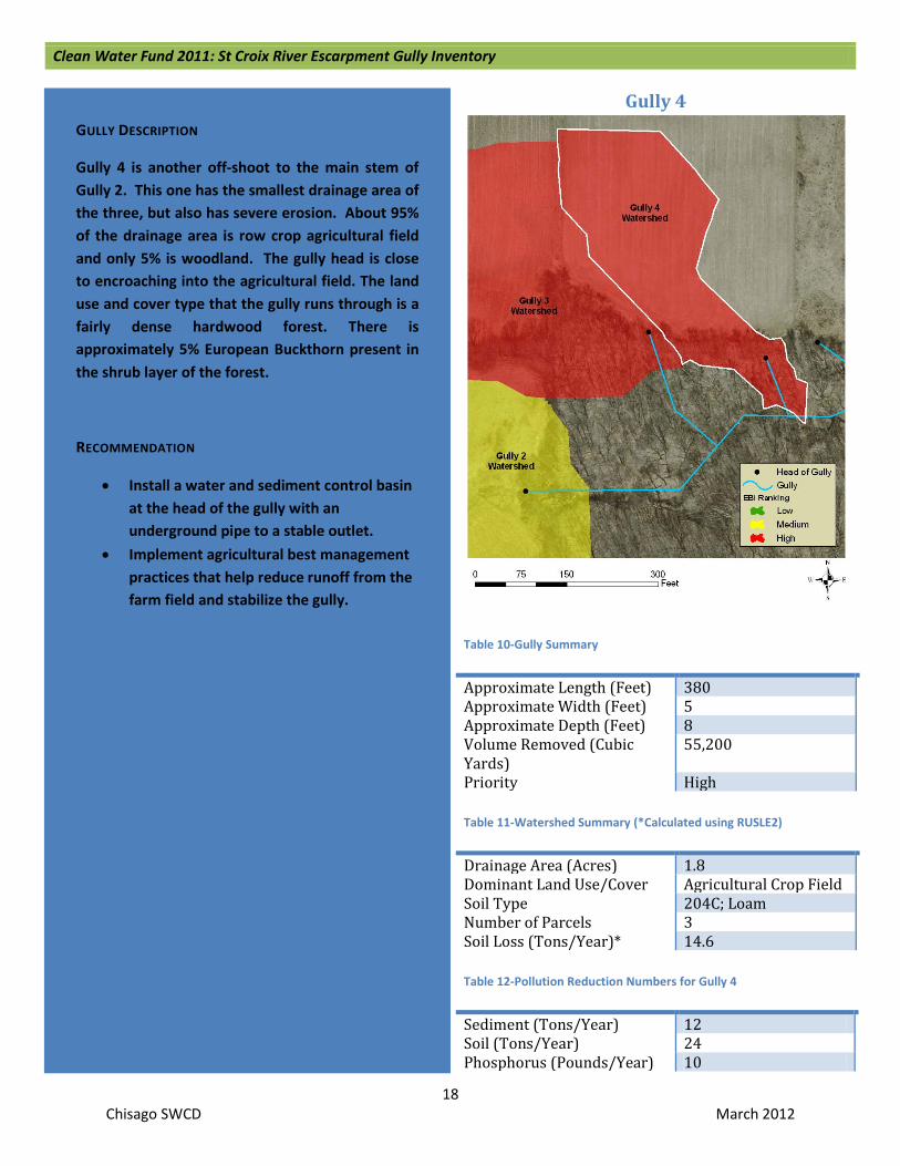
Gully 4
Table 10-Gully Summary
Approximate Length (Feet) 380 Approximate Width (Feet) 5 Approximate Depth (Feet) 8 Volume Removed (Cubic Yards)
55,200
Priority High Table 11-Watershed Summary (*Calculated using RUSLE2)
Drainage Area (Acres) 1.8 Dominant Land Use/Cover Agricultural Crop Field Soil Type 204C; Loam Number of Parcels 3 Soil Loss (Tons/Year)* 14.6 Table 12-Pollution Reduction Numbers for Gully 4
Sediment (Tons/Year) 12 Soil (Tons/Year) 24 Phosphorus (Pounds/Year) 10
GULLY DESCRIPTION
Gully 4 is another off-shoot to the main stem of Gully 2. This one has the smallest drainage area of the three, but also has severe erosion. About 95% of the drainage area is row crop agricultural field and only 5% is woodland. The gully head is close to encroaching into the agricultural field. The land use and cover type that the gully runs through is a fairly dense hardwood forest. There is approximately 5% European Buckthorn present in the shrub layer of the forest.
RECOMMENDATION
• Install a water and sediment control basin at the head of the gully with an underground pipe to a stable outlet.
• Implement agricultural best management practices that help reduce runoff from the farm field and stabilize the gully.

Clean Water Fund 2011: St Croix River Escarpment Gully Inventory
19 Chisago SWCD March 2012
Gully 5
Table 13-Gully Summary
Approximate Length (Feet) 400 Approximate Width (Feet) 15 Approximate Depth (Feet) 10 Volume Removed (Cubic Yards)
60,000
Priority High Table 14-Watershed Summary (*Calculated using RUSLE2)
Drainage Area (Acres) 10.4 Dominant Land Use/Cover Agricultural Crop Field Soil Type 40C; Loam Number of Parcels 4 Soil Loss (Tons/Year)* 84.2 Table 15-Pollution Reduction Numbers for Gully 5
Sediment (Tons/Year) 13 Soil (Tons/Year) 25 Phosphorus (Pounds/Year) 13
GULLY DESCRIPTION
Gully 5 starts in an agricultural field that is row cropped. The gully actually starts about 50 feet from the wood line as a small channelized gully that appears to be farmed through every year. Once it gets into the woodland, the slope increases as does the size of the gully. The lower half of the drainage area consists of agricultural row cropland and the remainder is fallow with undisturbed grasses, scattered shrubs, and occasional trees. The gully flows through a dense hardwood forest. There were no invasive species observed. There is some trash and numerous tires that are in the bottom of the gully.
RECOMMENDATION
• Install a water and sediment control basin at the head of the gully with an underground pipe to a stable outlet.
• Implement agricultural best management practices that help reduce runoff from the farm field and stabilize the gully.
• Remove trash and debris from the channel.
Figure 9. Upper Section of Gully

Clean Water Fund 2011: St Croix River Escarpment Gully Inventory
20 Chisago SWCD March 2012
Gully 6
Table 16-Gully Summary
Approximate Length (Feet) 250 Approximate Width (Feet) 6 Approximate Depth (Feet) 12 Volume Removed (Cubic Yards)
18,000
Priority High Table 17-Watershed Summary (*Calculated using RUSLE2)
Drainage Area (Acres) 8.4 Dominant Land Use/Cover Agricultural Crop Field Soil Type 40B; Loam Number of Parcels 4 Soil Loss (Tons/Year)* 68 Table 18-Pollution Reduction Numbers for Gully 6
Sediment (Tons/Year) 4 Soil (Tons/Year) 8 Phosphorus (Pounds/Year) 4
GULLY DESCRIPTION
Gully 6 has many drop cuts and washouts along the length of the gully. This gully intersects Gully 5 and contributes to erosion in that gully. The gully initially starts approximately 50 feet into an agricultural field. The gully runs through a dense hardwood forest. In the upper portions of this forest, the shrub layer consists of about 15% Tartarian Honeysuckle and less than 5% European Buckthorn. The drainage area consists primarily of fallow agricultural field that is currently grass and other herbaceous species. The area seems to be platted for development. The remaining lower portion (20%) of the drainage area is agricultural field in a row crop rotation.
RECOMMENDATION
• Install a water and sediment control basin at the head of the gully with an underground pipe to a stable outlet.
• Implement agricultural best management practices that help reduce runoff from the farm field and stabilize the gully.
Figure 10. Erosion at Gully Head

Clean Water Fund 2011: St Croix River Escarpment Gully Inventory
21 Chisago SWCD March 2012
Gully 7
Table 19-Gully Summary
Approximate Length (Feet) 200 Approximate Width (Feet) 20 Approximate Depth (Feet) 10 Volume Removed (Cubic Yards)
40,000
Priority High Table 20-Watershed Summary (*Calculated using RUSLE2)
Drainage Area (Acres) 0.9 Dominant Land Use/Cover Agricultural Crop Field Soil Type 40B; Loam Number of Parcels 2 Soil Loss (Tons/Year)* 7.3 Table 21-Pollution Reduction Numbers for Gully 7
Sediment (Tons/Year) 14 Soil (Tons/Year) 28 Phosphorus (Pounds/Year) 12
GULLY DESCRIPTION
Gully 7 is a very large gully, but is not very long. It is located at the edge of an agricultural field and wood line, where the slope drops off very steeply. Once Gully 7 intersects with the main channel of a larger ravine, the slope is less steep and there is little erosion. Most of the erosion is at the head, which is approximately 50 feet across at the top. The sides then taper down gradually as the gully continues downhill. The actual depth of the gully was difficult to determine because it is full of trash and debris. This gully was viewed from a neighboring property since the landowner did not allow access to the property. The gully runs through a dense hardwood forest. There were no invasive species observed immediately around Gully 7, but there are European Buckthorn and Tartarian Honeysuckle populations in the area. The drainage area is small and the slope is not steep, but over 95% of the watershed is an active agricultural field being cropped in a row crop rotation.
RECOMMENDATION
• Install a water and sediment control basin at the head of the gully with an underground pipe to a stable outlet.
• Implement agricultural best management practices that help reduce runoff from the farm field and stabilize the gully.
• Remove trash and debris from the channel.

Clean Water Fund 2011: St Croix River Escarpment Gully Inventory
22 Chisago SWCD March 2012
Gully 8
Table 22-Gully Summary
Approximate Length (Feet) 375 Approximate Width (Feet) 12 Approximate Depth (Feet) 10 Volume Removed (Cubic Yards)
45,000
Priority High Table 23-Watershed Summary (*Calculated using RUSLE2)
Drainage Area (Acres) 8.0 Dominant Land Use/Cover Agricultural Crop Field Soil Type 40C; Loam Number of Parcels 2 Soil Loss (Tons/Year)* 64.8 Table 24-Pollution Reduction Numbers for Gully 8
Sediment (Tons/Year) 12 Soil (Tons/Year) 25 Phosphorus (Pounds/Year) 11
GULLY DESCRIPTION
Gully 8 erosion starts at the head and continues down until just before it meets the main channel. At that point, the erosion seems to subside and there is a fair amount of sedimentation throughout the bottom. There is a small amount of trash and some debris in the gully, mostly at the top. The gully runs through a fairly dense forest that has been invaded by a number of Boxelder (Acer negundo) trees and the understory has approximately 15% cover of Tartarian Honeysuckle. Most of the drainage area is agricultural field with a row crop rotation. The remaining portion is undisturbed trees and grasses.
RECOMMENDATION
• Install a water and sediment control basin at the head of the gully with an underground pipe to a stable outlet.
• Implement agricultural best management practices that help reduce runoff from the farm field and stabilize the gully.
• Remove trash and debris from the channel.

Clean Water Fund 2011: St Croix River Escarpment Gully Inventory
23 Chisago SWCD March 2012
Gully 9
Table 25-Gully Summary
Approximate Length (Feet) 600 Approximate Width (Feet) 6 Approximate Depth (Feet) 8 Volume Removed (Cubic Yards)
28,800
Priority High Table 26-Watershed Summary (*Calculated using RUSLE2)
Drainage Area (Acres) 40.5 Dominant Land Use/Cover Agricultural
Field/Pasture Soil Type 682C; Sandy Loam Number of Parcels 3 Soil Loss (Tons/Year)* 328.1 Table 27-Pollution Reduction Numbers for Gully 9
Sediment (Tons/Year) 8 Soil (Tons/Year) 16 Phosphorus (Pounds/Year) 7
GULLY DESCRIPTION
Gully 9 has extensive erosion in the upper portion with sporadic erosion throughout the remainder of the ravine. The erosion is down cutting the channel, with some bank and side slope sloughing. The gully begins to flow through a pasture of mostly grass and continues through dense hardwood forest. Along the gully there is less than 5% shrub layer cover of European Buckthorn and Tartarian Honeysuckle. The drainage area is half pasture and half agricultural field with a row crop rotation.
RECOMMENDATION
• Install a water and sediment control basin at the head of the gully with an underground pipe to a stable outlet.
• Implement agricultural best management practices that help reduce runoff from the farm field and stabilize the gully.

Clean Water Fund 2011: St Croix River Escarpment Gully Inventory
24 Chisago SWCD March 2012
Gully 10
Table 28-Gully Summary
Approximate Length (Feet) 75 Approximate Width (Feet) 25 Approximate Depth (Feet) 15 Volume Removed (Cubic Yards)
28,125
Priority Low Table 29-Watershed Summary (*Calculated using RUSLE2)
Drainage Area (Acres) 0.2 Dominant Land Use/Cover Agricultural Crop Field Soil Type 207B; Loamy Sand Number of Parcels 2 Soil Loss (Tons/Year)* 0.9 Table 30-Pollution Reduction Numbers for Gully 10
Sediment (Tons/Year) 8 Soil (Tons/Year) 15 Phosphorus (Pounds/Year) 7
GULLY DESCRIPTION
Gully 10 is a very short, but very deep and wide gully. The erosion starts at the top and it appears that the side slope has just recently collapsed and washed away. It is very steep and is continuing to slough off. The gully runs through a dense hardwood forest. There were no invasive species observed. The drainage area is very small and the runoff is not channelized until it gets to the head of the gully. The drainage area consists primarily of herbaceous grasses with sporadic trees that appears to have been an agricultural field that has not been farmed for at least the last 10 years.
RECOMMENDATION
• Due to the succession of farming on the field above to permanent vegetation, it is likely that the gully will eventually correct itself. Because the erosion is so severe, the time frame for self-correction will be several years. It appears that the actual erosion was more likely caused by gravity than runoff water.

Clean Water Fund 2011: St Croix River Escarpment Gully Inventory
25 Chisago SWCD March 2012
Gully 11
Table 31-Gully Summary
Approximate Length (Feet) 1,200 Approximate Width (Feet) 20 Approximate Depth (Feet) 10 Volume Removed (Cubic Yards)
240,000
Priority Low Table 32-Watershed Summary (*Calculated using RUSLE2)
Drainage Area (Acres) 23.3 Dominant Land Use/Cover Agricultural Crop Field Soil Type 540; Muck Number of Parcels Approximately 25 Soil Loss (Tons/Year)* 0.013 Table 33-Pollution Reduction Numbers for Gully 11
Sediment (Tons/Year) 51 Soil (Tons/Year) 102 Phosphorus (Pounds/Year) 51
GULLY DESCRIPTION
Gully 11 is located within the city of Taylors Falls, MN. It has sporadic erosion throughout its length, starting at the head. Most of the gully runs through a residential area before passing through downtown and then meeting the St. Croix River. The drainage area is primarily a Type 7 wooded wetland that drains into the gully. The cover type of the drainage area consists of lowland shrubs and trees with a mix of lowland herbaceous species. About 10% of the shrub layer has Tartarian Honeysuckle. It is unknown if this gully is the initial draining of the wetland or if it is just an overflow drainage way when the wetland fills up. There is also some direct drainage from impervious roads and buildings from the sides and there are a number of pipes, probably draining streets, parking lots, and other impervious surfaces, that are coming into the gully in various locations, adding to the flow and erosion.
RECOMMENDATION
• Create controlled outlet points for culvert road crossings and other drainage pipes that are coming into the gully.
• Install Best Management Practices such as rock-lined channels and rock checks to slow water running off from impervious surfaces.

Clean Water Fund 2011: St Croix River Escarpment Gully Inventory
26 Chisago SWCD March 2012
Gully 12
Table 34-Gully Summary
Approximate Length (Feet) 150 Approximate Width (Feet) 15 Approximate Depth (Feet) 12 Volume Removed (Cubic Yards)
27,000
Priority High Table 35-Watershed Summary (*Calculated using P8)
Drainage Area (Acres) 2.7 Dominant Land Use/Cover Residential Soil Type 1069C; Silt Loam/Rock
Outcrops Number of Parcels Approximately 10 Soil Loss (Pounds/Year)* 1,208 Table 36-Pollution Reduction Numbers for Gully 12
Sediment (Tons/Year) 6 Soil (Tons/Year) 11 Phosphorus (Pounds/Year) 6
GULLY DESCRIPTION
Gully 12 is steep with sporadic large erosion cuts starting at the head. The erosion is under-cutting, causing bank erosion and sloughing off of the side slopes. This gully forks into the lower portion of Gully 11. The drainage area is mostly within the city of Taylors Falls, MN. It is a residential area with a combination of lawn grass, sporadic trees and shrubs, and impervious surfaces like streets and houses. Less than 5% of the drainage area is at the edge of the heavily forested region. There is European Buckthorn present in the shrub layer at less than 5% cover and there is at least 5% Tartarian Honeysuckle present.
RECOMMENDATION
• Install Best Management Practices such as rock-lined channels and rock checks to slow water running off from impervious surfaces.

Clean Water Fund 2011: St Croix River Escarpment Gully Inventory
27 Chisago SWCD March 2012
Gully 13
Table 37-Gully Summary
Approximate Length (Feet) 1,600 Approximate Width (Feet) 20 Approximate Depth (Feet) 5 Volume Removed (Cubic Yards)
160,000
Priority High Table 38-Watershed Summary (*Calculated using P8)
Drainage Area (Acres) 3.8 Dominant Land Use/Cover Agricultural Crop
Field Soil Type 169C; Loamy Sand Number of Parcels 2 Soil Loss (Pounds/Year)* 530 Table 39-Pollution Reduction Numbers for Gully 13
Sediment (Tons/Year) 32 Soil (Tons/Year) 64 Phosphorus (Pounds/Year) 32
GULLY DESCRIPTION
Gully 13 runs through Minnesota Department of Natural Resources (MN DNR) land in Interstate State Park. The gully runs through a dense hardwood forest. Less than 5% of the shrub layer cover is made up of European Buckthorn and Tatarian Honeysuckle. Most of the erosion is occurring at the top of the gully. The erosion is under-cutting the bank and washing out the sides. The drainage area is mostly city property that has large maintenance and fire hall buildings and a large gravel/asphalt parking area. The runoff from the main building seems to be piped directly into the gully and the roof runoff from the rest of the buildings also runs into the gully. There is a small portion of the surrounding forest land that is within the drainage area.
RECOMMENDATION
• Install Best Management Practices such as rain gardens to capture and infiltrate water running off from impervious surfaces.

Clean Water Fund 2011: St Croix River Escarpment Gully Inventory
28 Chisago SWCD March 2012
Gully 14
Table 40-Gully Summary
Approximate Length (Feet) 400 Approximate Width (Feet) 10 Approximate Depth (Feet) 8 Volume Removed (Cubic Yards)
32,000
Priority Medium Table 41-Watershed Summary (*Calculated using RUSLE2)
Drainage Area (Acres) 7.9 Dominant Land Use/Cover Agricultural Crop Field Soil Type 40B; Loam Number of Parcels 3 Soil Loss (Tons/Year)* 64 Table 42-Pollution Reduction Numbers for Gully 14
Sediment (Tons/Year) 7 Soil (Tons/Year) 14 Phosphorus (Pounds/Year) 7
GULLY DESCRIPTION
Gully 14 is eroding most severely at the top, with some side slope and bank sloughing located sporadically throughout the rest of gully. The gully runs through a mature hardwood forest in fair to good condition. There is at least 20% cover of Tartarian Honeysuckle in the shrub layer. European Buckthorn and Barberry (Berberis sp.) are present as well. The drainage area is fairly flat and approximately 90% of it is within an agricultural field that has a rotation of row crops on it. Once the gully begins, the slope increases dramatically.
RECOMMENDATION
• Install a water and sediment control basin at the head of the gully with an underground pipe to a stable outlet.
• Implement agricultural best management practices that help reduce runoff from the farm field and stabilize the gully.
Figure 11: Looking Up the Gully

Clean Water Fund 2011: St Croix River Escarpment Gully Inventory
29 Chisago SWCD March 2012
Gully 15
Table 43-Gully Summary
Approximate Length (Feet) 60 Approximate Width (Feet) 20 Approximate Depth (Feet) 15 Volume Removed (Cubic Yards)
18,000
Priority High Table 44-Watershed Summary (*Calculated using RUSLE2)
Drainage Area (Acres) 1.3 Dominant Land Use/Cover Agricultural Crop
Field Soil Type 40B; Loam Number of Parcels 3 Soil Loss (Tons/Year)* 10.5 Table 45-Pollution Reduction Numbers for Gully 15
Sediment (Tons/Year) 8 Soil (Tons/Year) 8 Phosphorus (Pounds/Year) 8
GULLY DESCRIPTION
Gully 15 is a short but steep gully with a wide top. It is broad and the side slopes are sloughing off. The gully runs through a somewhat open hardwood forest. The shrub layer consists of 10% Tartarian Honeysuckle and 5% European Buckthorn. The drainage area is very small and has a gentle slope, but starting at the head of the gully, the grade drops off to extreme steepness. The drainage area consists of mostly grasses, half in a pasture and half in a hay field. There are also some trees and shrubs in the pasture portion of the drainage area.
RECOMMENDATION
• Install a water and sediment control basin at the head of the gully with an underground pipe to a stable outlet.
• Implement agricultural best management practices that help reduce runoff from the farm field and stabilize the gully.
Clean Water Fund 2011: St Croix River Escarpment Gully Inventory
30 Chisago SWCD March 2012
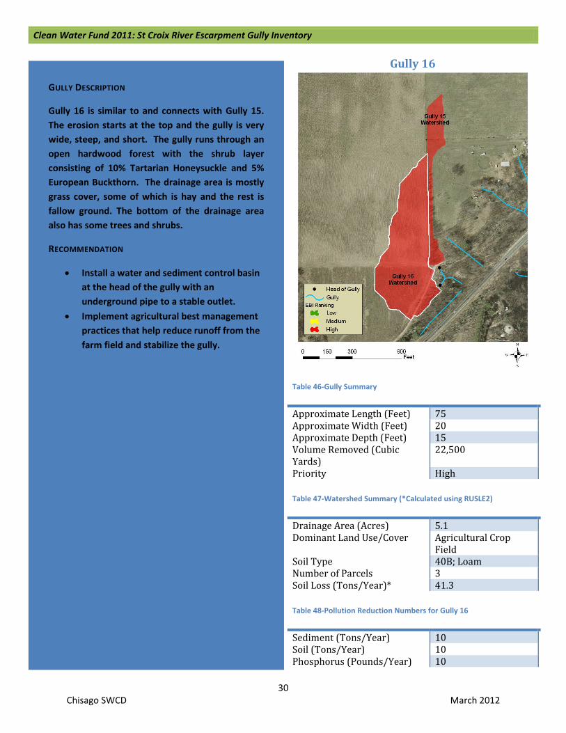
Gully 16
Table 46-Gully Summary
Approximate Length (Feet) 75 Approximate Width (Feet) 20 Approximate Depth (Feet) 15 Volume Removed (Cubic Yards)
22,500
Priority High Table 47-Watershed Summary (*Calculated using RUSLE2)
Drainage Area (Acres) 5.1 Dominant Land Use/Cover Agricultural Crop
Field Soil Type 40B; Loam Number of Parcels 3 Soil Loss (Tons/Year)* 41.3 Table 48-Pollution Reduction Numbers for Gully 16
Sediment (Tons/Year) 10 Soil (Tons/Year) 10 Phosphorus (Pounds/Year) 10
GULLY DESCRIPTION
Gully 16 is similar to and connects with Gully 15. The erosion starts at the top and the gully is very wide, steep, and short. The gully runs through an open hardwood forest with the shrub layer consisting of 10% Tartarian Honeysuckle and 5% European Buckthorn. The drainage area is mostly grass cover, some of which is hay and the rest is fallow ground. The bottom of the drainage area also has some trees and shrubs.
RECOMMENDATION
• Install a water and sediment control basin at the head of the gully with an underground pipe to a stable outlet.
• Implement agricultural best management practices that help reduce runoff from the farm field and stabilize the gully.

Clean Water Fund 2011: St Croix River Escarpment Gully Inventory
31 Chisago SWCD March 2012
Gully 17
Table 49-Gully Summary
Approximate Length (Feet) 200 Approximate Width (Feet) 10 Approximate Depth (Feet) 4 Volume Removed (Cubic Yards)
8,000
Priority High Table 50-Watershed Summary (*Calculated using RUSLE2)
Drainage Area (Acres) 1.3 Dominant Land Use/Cover Agricultural Crop
Field Soil Type 40B; Loam Number of Parcels 1 Soil Loss (Tons/Year)* 10.5 Table 51-Pollution Reduction Numbers for Gully 17
Sediment (Tons/Year) 4 Soil (Tons/Year) 8 Phosphorus (Pounds/Year) 4
GULLY DESCRIPTION
Gully 17 has some minor erosion at the top for the first 15 feet, but most of the erosion is within the bottom 200 feet. The gully falls within the boundaries of the Minnesota Department of Natural Resources (MN DNR) Franconia Bluffs Scientific and Natural Area (SNA). The gully runs through a dense hardwood forest. There is less than 5% cover of both Tartarian Honeysuckle and European Buckthorn in the shrub layer. The drainage area is all contained in a small field above the gully that appears to be an old agricultural field that is no longer farmed. It is currently growing grasses and other herbaceous plants and it was planted with oak seedlings by the MN DNR in the spring of 2011.
RECOMMENDATION
• Install a water and sediment control basin at the head of the gully with an underground pipe to a stable outlet.

Clean Water Fund 2011: St Croix River Escarpment Gully Inventory
32 Chisago SWCD March 2012
Gully 18
Table 52-Gully Summary
Approximate Length (Feet) 650 Approximate Width (Feet) 23 Approximate Depth (Feet) 10 Volume Removed (Cubic Yards)
149,500
Priority High Table 53-Watershed Summary (*Calculated using RUSLE2)
Drainage Area (Acres) 1.7 Dominant Land Use/Cover Agricultural Crop Field Soil Type 40B; Loam Number of Parcels 1 Soil Loss (Tons/Year)* 13.8 Table 54-Pollution Reduction Numbers for Gully 18
Sediment (Tons/Year) 54 Soil (Tons/Year) 108 Phosphorus (Pounds/Year) 54
GULLY DESCRIPTION
Gully 18 starts with massive erosion at the head, where it is very wide and very steep. The erosion seems to taper out, becoming less extreme as the gully continues downhill, but there is still erosion present. This gully is the main ravine that Gully 17 connects with. The gully falls within the boundaries of the MN DNR Franconia Bluffs SNA. The gully runs through a dense hardwood forest. The shrub layer consists of about 10% Tartarian Honeysuckle and 5% European Buckthorn. The drainage area is all contained in a small field above the gully that appears to be an old agricultural field that is no longer farmed. It is currently growing grasses and other herbaceous plants and it was planted by the MN DNR with oak seedlings in the spring of 2011.
RECOMMENDATION
• Install a water and sediment control basin at the head of the gully with an underground pipe to a stable outlet.
Figure 12: View of the Gully Head
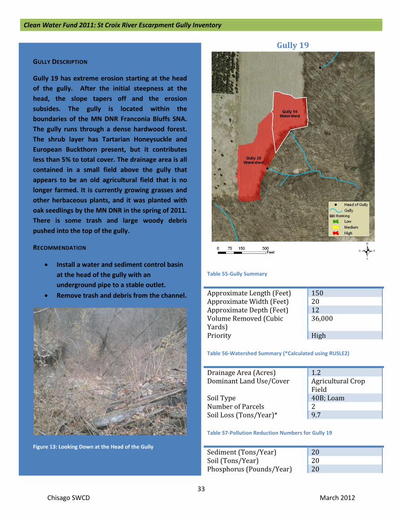
Clean Water Fund 2011: St Croix River Escarpment Gully Inventory
33 Chisago SWCD March 2012
Gully 19
Table 55-Gully Summary
Approximate Length (Feet) 150 Approximate Width (Feet) 20 Approximate Depth (Feet) 12 Volume Removed (Cubic Yards)
36,000
Priority High Table 56-Watershed Summary (*Calculated using RUSLE2)
Drainage Area (Acres) 1.2 Dominant Land Use/Cover Agricultural Crop
Field Soil Type 40B; Loam Number of Parcels 2 Soil Loss (Tons/Year)* 9.7 Table 57-Pollution Reduction Numbers for Gully 19
Sediment (Tons/Year) 20 Soil (Tons/Year) 20 Phosphorus (Pounds/Year) 20
GULLY DESCRIPTION
Gully 19 has extreme erosion starting at the head of the gully. After the initial steepness at the head, the slope tapers off and the erosion subsides. The gully is located within the boundaries of the MN DNR Franconia Bluffs SNA. The gully runs through a dense hardwood forest. The shrub layer has Tartarian Honeysuckle and European Buckthorn present, but it contributes less than 5% to total cover. The drainage area is all contained in a small field above the gully that appears to be an old agricultural field that is no longer farmed. It is currently growing grasses and other herbaceous plants, and it was planted with oak seedlings by the MN DNR in the spring of 2011. There is some trash and large woody debris pushed into the top of the gully.
RECOMMENDATION
• Install a water and sediment control basin at the head of the gully with an underground pipe to a stable outlet.
• Remove trash and debris from the channel.
Figure 13: Looking Down at the Head of the Gully

Clean Water Fund 2011: St Croix River Escarpment Gully Inventory
34 Chisago SWCD March 2012
Gully 20
Table 58-Gully Summary
Approximate Length (Feet) 400 Approximate Width (Feet) 12 Approximate Depth (Feet) 6 Volume Removed (Cubic Yards)
28,800
Priority High Table 59-Watershed Summary (*Calculated using RUSLE2)
Drainage Area (Acres) 1.9 Dominant Land Use/Cover Agricultural Crop
Field Soil Type 40B; Loam Number of Parcels 1 Soil Loss (Tons/Year)* 15.4 Table 60-Pollution Reduction Numbers for Gully 20
Sediment (Tons/Year) 12 Soil (Tons/Year) 12 Phosphorus (Pounds/Year) 12
GULLY DESCRIPTION
Gully 20 erosion starts at the head of the gully and continues down the ravine uniformly. The gully is located within the boundaries of the MN DNR Franconia Bluffs SNA and the bottom of the ravine flows into federally owned land. The gully runs through a dense hardwood forest. The shrub layer has Tartarian Honeysuckle and European Buckthorn present, but they contribute less than 5% of total cover. The drainage area is all contained in a small field above the gully that appears to be an old agricultural field that is no longer farmed. It is currently growing grasses and other herbaceous plants and it was planted with oak seedlings by the MN DNR in the spring of 2011. There is some trash and large woody debris pushed into the top of the gully.
RECOMMENDATION
• Install a water and sediment control basin at the head of the gully with an underground pipe to a stable outlet.
• Remove trash and debris from the channel.
Figure 14: Looking Down at the Gully Head
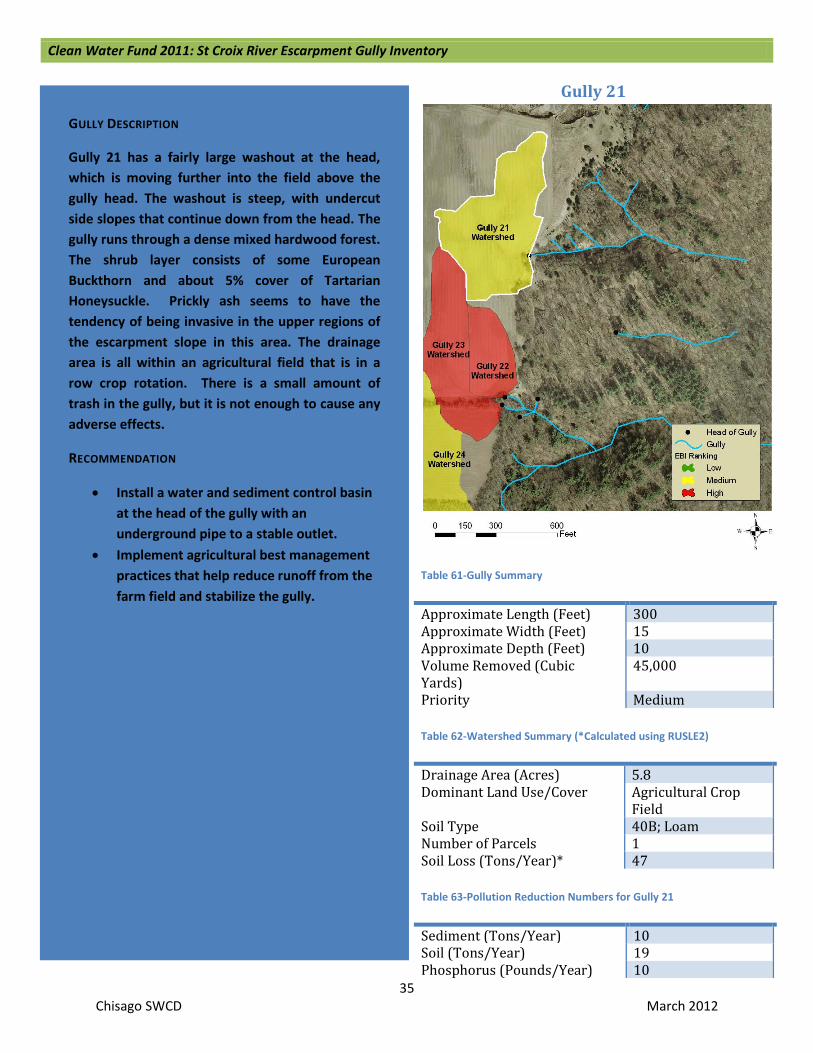
Clean Water Fund 2011: St Croix River Escarpment Gully Inventory
35 Chisago SWCD March 2012
Gully 21
Table 61-Gully Summary
Approximate Length (Feet) 300 Approximate Width (Feet) 15 Approximate Depth (Feet) 10 Volume Removed (Cubic Yards)
45,000
Priority Medium Table 62-Watershed Summary (*Calculated using RUSLE2)
Drainage Area (Acres) 5.8 Dominant Land Use/Cover Agricultural Crop
Field Soil Type 40B; Loam Number of Parcels 1 Soil Loss (Tons/Year)* 47 Table 63-Pollution Reduction Numbers for Gully 21
Sediment (Tons/Year) 10 Soil (Tons/Year) 19 Phosphorus (Pounds/Year) 10
GULLY DESCRIPTION
Gully 21 has a fairly large washout at the head, which is moving further into the field above the gully head. The washout is steep, with undercut side slopes that continue down from the head. The gully runs through a dense mixed hardwood forest. The shrub layer consists of some European Buckthorn and about 5% cover of Tartarian Honeysuckle. Prickly ash seems to have the tendency of being invasive in the upper regions of the escarpment slope in this area. The drainage area is all within an agricultural field that is in a row crop rotation. There is a small amount of trash in the gully, but it is not enough to cause any adverse effects.
RECOMMENDATION
• Install a water and sediment control basin at the head of the gully with an underground pipe to a stable outlet.
• Implement agricultural best management practices that help reduce runoff from the farm field and stabilize the gully.

Clean Water Fund 2011: St Croix River Escarpment Gully Inventory
36 Chisago SWCD March 2012
Gully 22
Table 64-Gully Summary
Approximate Length (Feet) 125 Approximate Width (Feet) 15 Approximate Depth (Feet) 10 Volume Removed (Cubic Yards)
1,865
Priority High Table 65-Watershed Summary (*Calculated using RUSLE2)
Drainage Area (Acres) 2.0 Dominant Land Use/Cover Agricultural Crop
Field Soil Type 40C; Loam Number of Parcels 1 Soil Loss (Tons/Year)* 16.2 Table 66-Pollution Reduction Numbers for Gully 22
Sediment (Tons/Year) 4 Soil (Tons/Year) 9 Phosphorus (Pounds/Year) 4
GULLY DESCRIPTION
Gully 22 has a very deep cut starting at the head and has steep side slopes. There are a few side branch gullies, including Gully 22, that flow into the main stem. After Gully 22 intersects with the main stem (Gully 24), there is almost no erosion. The channel appears to be cut down to a bedrock shelf layer, so there is no more apparent erosion in the main ravine. The gully runs through a dense mixed hardwood forest. The shrub layer contains less than 5% cover of Tartarian Honeysuckle and European Buckthorn. The drainage area all falls within an agricultural field that has a row crop rotation.
RECOMMENDATION
• Install a water and sediment control basin at the head of the gully with an underground pipe to a stable outlet.
• Implement agricultural best management practices that help reduce runoff from the farm field and stabilize the gully.
Figure 15: Looking Up at the Gully Head

Clean Water Fund 2011: St Croix River Escarpment Gully Inventory
37 Chisago SWCD March 2012
Gully 23
Table 67-Gully Summary
Approximate Length (Feet) 200 Approximate Width (Feet) 8 Approximate Depth (Feet) 10 Volume Removed (Cubic Yards)
16,000
Priority High Table 68-Watershed Summary (*Calculated using RUSLE2)
Drainage Area (Acres) 4.2 Dominant Land Use/Cover Agricultural Crop Field Soil Type 40B; Loam Number of Parcels 2 Soil Loss (Tons/Year)* 34 Table 69-Pollution Reduction Numbers for Gully 23
Sediment (Tons/Year) 3 Soil (Tons/Year) 5 Phosphorus (Pounds/Year) 3
GULLY DESCRIPTION
Gully 23 has a very deep cut starting at the head and has steep side slopes. It is one of the gullies that branch off the main stem (Gully 24). After Gully 23 connects with the main stem, there is almost no erosion. The channel appears to be cut down to a bedrock shelf layer, so there is no more apparent erosion in the main ravine. The gully runs through a dense mixed hardwood forest. The shrub layer contains less than 5% cover of Tartarian Honeysuckle and European Buckthorn. The drainage area all falls within an agricultural field that has a row crop rotation.
RECOMMENDATION
• Install a water and sediment control basin at the head of the gully with an underground pipe to a stable outlet.
• Implement agricultural best management practices that help reduce runoff from the farm field and stabilize the gully.
Figure 16: Looking Down at the Gully Head

Clean Water Fund 2011: St Croix River Escarpment Gully Inventory
38 Chisago SWCD March 2012
Gully 24
Table 70-Gully Summary
Approximate Length (Feet) 350 Approximate Width (Feet) 5 Approximate Depth (Feet) 3 Volume Removed (Cubic Yards)
5,250
Priority Medium Table 71-Watershed Summary (*Calculated using RUSLE2)
Drainage Area (Acres) 57.5 Dominant Land Use/Cover Agricultural Crop
Field Soil Type 40C; Loam Number of Parcels 7 Soil Loss (Tons/Year)* 465.8 Table 72-Pollution Reduction Numbers for Gully 24
Sediment (Tons/Year) 1 Soil (Tons/Year) 3 Phosphorus (Pounds/Year) 1
GULLY DESCRIPTION
Gully 24 has a number of trouble spots that start at the top head of the gully and continue sporadically for the next 500 feet. The top of the gully starts out fairly flat and the erosion is minor, but after a couple hundred feet, the slope steepens and the erosion gets worse. There are a number of undercut banks and a couple of washouts. After another few hundred feet, the channel turns into a 50 foot drop off. The gully runs through fairly dense mixed hardwood stand. The forest starts out in poor quality at the top of the slope and gradually turns to good quality downslope. There is about 15% cover each of Tartarian Honeysuckle and European Buckthorn in the shrub layer. The drainage area is larger than any other drainage area in this report, but the upper portions of the watershed are planted with permanent dense grasses with sporadic trees. The lower portion of the watershed is several agricultural fields with a row crop rotation or hay plantings.
RECOMMENDATION
• Install a water and sediment control basin at the head of the gully with an underground pipe to a stable outlet.
• Implement agricultural best management practices that help reduce runoff from the farm field and stabilize the gully.
Figure 17: Lower Portion of Gully

Clean Water Fund 2011: St Croix River Escarpment Gully Inventory
39 Chisago SWCD March 2012
Gully 25
Table 73-Gully Summary
Approximate Length (Feet) 100 Approximate Width (Feet) 20 Approximate Depth (Feet) 12 Volume Removed (Cubic Yards)
24,000
Priority High Table 74-Watershed Summary (*Calculated using RUSLE2)
Drainage Area (Acres) 2.5 Dominant Land Use/Cover Agricultural Crop
Field Soil Type 40C; Loam Number of Parcels 1 Soil Loss (Tons/Year)* 20.3 Table 75-Pollution Reduction Numbers for Gully 25
Sediment (Tons/Year) 5 Soil (Tons/Year) 10 Phosphorus (Pounds/Year) 5
GULLY DESCRIPTION
Gully 25 is a very large gully that is wide and deep, but not very long. It is difficult to determine the true size of this gully because most of the gully is filled with trash and large woody debris. The gully runs through somewhat open mixed woodland that is pastured. There are cows that rotate on this pasture. Since this pasture is immediately next to the farmstead, it is grazed more heavily than a typical rotation. The shrub layer consists of about 5% European Buckthorn. The drainage area is a bare soil pasture for cows. This causes an increase in sediment load and animal fecal matter contributing to the gully.
RECOMMENDATION
• Install a water and sediment control basin at the head of the gully with an underground pipe to a stable outlet.
• Implement agricultural best management practices that help reduce runoff from the farm field and stabilize the gully.
• Remove trash and debris from the channel.

Clean Water Fund 2011: St Croix River Escarpment Gully Inventory
40 Chisago SWCD March 2012
Gully 26
Table 76-Gully Summary
Approximate Length (Feet) 200 Approximate Width (Feet) 25 Approximate Depth (Feet) 3 Volume Removed (Cubic Yards)
15,000
Priority High Table 77-Watershed Summary (*Calculated using RUSLE2)
Drainage Area (Acres) 2.6 Dominant Land Use/Cover Agricultural Crop Field Soil Type 40C; Loam Number of Parcels 2 Soil Loss (Tons/Year)* 21.1 Table 78-Pollution Reduction Numbers for Gully 26
Sediment (Tons/Year) 6 Soil (Tons/Year) 6 Phosphorus (Pounds/Year) 6
GULLY DESCRIPTION
Gully 26 is a multi-stemmed gully with a wide head. It is very difficult to determine size and shape due to the massive amounts of debris, trash, and large woody material that fill this gully. The gully runs through open, somewhat poor quality woodland that is pastured. There is approximately 5% cover of Tartarian Honeysuckle in the shrub layer.
RECOMMENDATION
• Install a water and sediment control basin at the head of the gully with an underground pipe to a stable outlet.
• Implement agricultural best management practices that help reduce runoff from the farm field and stabilize the gully.
• Remove trash and debris from the channel.
Figure 18: At the Bottom of the Gully Looking Up
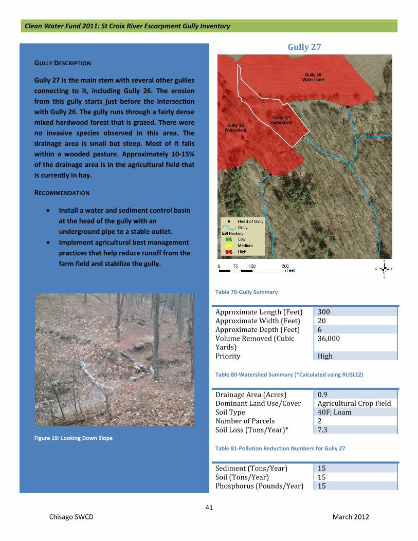
Clean Water Fund 2011: St Croix River Escarpment Gully Inventory
41 Chisago SWCD March 2012
Gully 27
Table 79-Gully Summary
Approximate Length (Feet) 300 Approximate Width (Feet) 20 Approximate Depth (Feet) 6 Volume Removed (Cubic Yards)
36,000
Priority High Table 80-Watershed Summary (*Calculated using RUSLE2)
Drainage Area (Acres) 0.9 Dominant Land Use/Cover Agricultural Crop Field Soil Type 40F; Loam Number of Parcels 2 Soil Loss (Tons/Year)* 7.3 Table 81-Pollution Reduction Numbers for Gully 27
Sediment (Tons/Year) 15 Soil (Tons/Year) 15 Phosphorus (Pounds/Year) 15
GULLY DESCRIPTION
Gully 27 is the main stem with several other gullies connecting to it, including Gully 26. The erosion from this gully starts just before the intersection with Gully 26. The gully runs through a fairly dense mixed hardwood forest that is grazed. There were no invasive species observed in this area. The drainage area is small but steep. Most of it falls within a wooded pasture. Approximately 10-15% of the drainage area is in the agricultural field that is currently in hay.
RECOMMENDATION
• Install a water and sediment control basin at the head of the gully with an underground pipe to a stable outlet.
• Implement agricultural best management practices that help reduce runoff from the farm field and stabilize the gully.
Figure 19: Looking Down Slope

Clean Water Fund 2011: St Croix River Escarpment Gully Inventory
42 Chisago SWCD March 2012
Gully 28
Table 82-Gully Summary
Approximate Length (Feet) 150 Approximate Width (Feet) 20 Approximate Depth (Feet) 8 Volume Removed (Cubic Yards)
24,000
Priority High Table 83-Watershed Summary (*Calculated using RUSLE2)
Drainage Area (Acres) 7.4 Dominant Land Use/Cover Agricultural Crop Field Soil Type 40F; Loam Number of Parcels 4 Soil Loss (Tons/Year)* 59.9 Table 84-Pollution Reduction Numbers for Gully 28
Sediment (Tons/Year) 10 Soil (Tons/Year) 10 Phosphorus (Pounds/Year) 10
GULLY DESCRIPTION
The watershed of Gully 28 connects to a ditch that empties a wetland in the upper escarpment. There is some erosion occurring in the ditch itself. At the head of the ravine, the slope gets steeper and the erosion increases. The erosion is wide at the head and then narrows after about 75 feet. It continues for another 75 feet beyond this point. There is some trash at the top of the gully. The gully runs through a dense mixed hardwood forest that is pastured. There is a very small amount of European Buckthorn in the understory. Most of the drainage area is within the pasture and the cover type is an open mixed hardwood forest with dense to thin grass cover. The remaining small portions of the drainage area include homes, yards, and a small area of a hay field.
RECOMMENDATION
• Restore the drained wetland by putting in a ditch plug.
• Install a water and sediment control basin at the head of the gully with an underground pipe to a stable outlet.
• Remove trash and debris from the channel.
• Install Best Management Practices such as rain gardens to capture and infiltrate water running off from impervious surfaces.
Figure 20: Middle Portion of Gully

Clean Water Fund 2011: St Croix River Escarpment Gully Inventory
43 Chisago SWCD March 2012
Gully 29
Table 85-Gully Summary
Approximate Length (Feet) 75 Approximate Width (Feet) 25 Approximate Depth (Feet) 20 Volume Removed (Cubic Yards)
37,500
Priority High Table 86-Watershed Summary (*Calculated using RUSLE2)
Drainage Area (Acres) 1.1 Dominant Land Use/Cover Agricultural Crop Field Soil Type 40B; Loam Number of Parcels 1 Soil Loss (Tons/Year)* 8.9 Table 87-Pollution Reduction Numbers for Gully 29
Sediment (Tons/Year) 8 Soil (Tons/Year) 16 Phosphorus (Pounds/Year) 8
GULLY DESCRIPTION
Gully 29 has an extreme amount of erosion starting at the top, but the length of the gully is fairly short. The head is wide and deeply cut. It is difficult to determine the actual depth because a lot of old hay and composted manure has been pushed into the gully. The gully runs through a mixed hardwood forest that is pastured occasionally. No invasive species were observed. The drainage area is almost completely in an agricultural field that is currently planted with hay. The remaining 5% of the watershed is within the tree line.
RECOMMENDATION
• Install a water and sediment control basin at the head of the gully with an underground pipe to a stable outlet.
• Implement agricultural best management practices that help reduce runoff from the farm field and stabilize the gully.
Figure 21: Gully Head; Note Old Hay and Composted Manure in Bottom Right of Photograph

Clean Water Fund 2011: St Croix River Escarpment Gully Inventory
44 Chisago SWCD March 2012
Gully 30
Table 88-Gully Summary
Approximate Length (Feet) 400 Approximate Width (Feet) 5 Approximate Depth (Feet) 3 Volume Removed (Cubic Yards)
6,000
Priority High Table 89-Watershed Summary (*Calculated using RUSLE2)
Drainage Area (Acres) 2.7 Dominant Land Use/Cover Agricultural Crop Field Soil Type 40C; Loam Number of Parcels 2 Soil Loss (Tons/Year)* 21.9 Table 90-Pollution Reduction Numbers for Gully 30
Sediment (Tons/Year) 3 Soil (Tons/Year) 3 Phosphorus (Pounds/Year) 3
GULLY DESCRIPTION
Gully 30 has a couple heads at the top. The grade is not steep for the first couple hundred feet, but it still has significant erosion. The erosion starts in a field border and is steadily working its way back into the field. Further down the length of the gully, the side slopes are sloughing severely. The gully runs through a mixed hardwood forest. The upper portion of the forest is in poor to fair quality. As the grade continues down the escarpment, quality of the forest increases. There was less than 5% cover of European Buckthorn and Tartarian Honeysuckle in the shrub layer. The drainage area is part of an agricultural field that is in a row crop rotation.
RECOMMENDATION
• Install a water and sediment control basin at the head of the gully with an underground pipe to a stable outlet.
• Implement agricultural best management practices that help reduce runoff from the farm field and stabilize the gully.

Clean Water Fund 2011: St Croix River Escarpment Gully Inventory
45 Chisago SWCD March 2012
Gully 31 and 32
Table 91-Gully Summary
Approximate Length (Feet) 250 Approximate Width (Feet) 20 each Approximate Depth (Feet) 12-15 Volume Removed (Cubic Yards)
69,000
Priority High Table 92-Watershed Summary (*Calculated using RUSLE2)
Drainage Area (Acres) 0.55 Dominant Land Use/Cover Agricultural Crop
Field Soil Type 40C; Loam Number of Parcels 1 Soil Loss (Tons/Year)* 4.5 Table 93-Pollution Reduction Numbers for Gully 31
Sediment (Tons/Year) 29 Soil (Tons/Year) 29 Phosphorus (Pounds/Year) 29
GULLY DESCRIPTION
Gully 31 and 32 share the same watershed. The two gully heads are so close together that the surface runoff flows towards both of them and splits somewhere very near the openings. Gully 31 has major erosion beginning at the top. The gully also has multiple heads. The erosion is sporadic after the first 50 feet. Gully 32 is similar to Gully 31 in size, except that the erosion is continual. The gullies run through a mixed hardwood forest. Tartarian Honeysuckle is present in the area, accounting for less than 5% of the shrub layer cover. The drainage area is primarily dense mixed hardwood forest with a small upper portion being an agricultural field in a row crop rotation. The numbers at right are for both gullies combined.
RECOMMENDATION
• Install a water and sediment control basin at the head of the gully with an underground pipe to a stable outlet.
• Implement agricultural best management practices that help reduce runoff from the farm field and stabilize the gully.

Clean Water Fund 2011: St Croix River Escarpment Gully Inventory
46 Chisago SWCD March 2012
Gully 33
Table 94-Gully Summary
Approximate Length (Feet) 200 Approximate Width (Feet) 30 Approximate Depth (Feet) 15 Volume Removed (Cubic Yards)
90,000
Priority High Table 95-Watershed Summary (*Calculated using RUSLE2)
Drainage Area (Acres) 11.3 Dominant Land Use/Cover Agricultural Crop
Field Soil Type 40C; Loam Number of Parcels 2 Soil Loss (Tons/Year)* 91.5 Table 96-Pollution Reduction Numbers for Gully 33
Sediment (Tons/Year) 38 Soil (Tons/Year) 38 Phosphorus (Pounds/Year) 38
GULLY DESCRIPTION
Gully 33 has very significant erosion at the head. The slope and the cut are both very steep and continue throughout the gully. The gully runs through dense woodlands; however, the area around the gully is fairly open due to the large width of the gully and trees falling into it. There were no invasive species observed. The drainage area is coming from an agricultural field that has a row crop rotation. At the edge of the field, it appears that there is a swale designed to catch more drainage from the field and direct it into this gully. This swale continues through mixed hardwood forest at the field edge, but doesn’t erode until reaching the gully head.
RECOMMENDATION
• Install a water and sediment control basin at the head of the gully with an underground pipe to a stable outlet.
• Implement agricultural best management practices that help reduce runoff from the farm field and stabilize the gully.

Clean Water Fund 2011: St Croix River Escarpment Gully Inventory
47 Chisago SWCD March 2012
Gully 34
Table 97-Gully Summary
Approximate Length (Feet) 400 Approximate Width (Feet) 10 Approximate Depth (Feet) 6 Volume Removed (Cubic Yards)
24,000
Priority High Table 98-Watershed Summary (*Calculated using RUSLE2)
Drainage Area (Acres) 2.1 Dominant Land Use/Cover Agricultural Crop
Field Soil Type 40C; Loam Number of Parcels 2 Soil Loss (Tons/Year)* 17 Table 99-Pollution Reduction Numbers for Gully 34
Sediment (Tons/Year) 5 Soil (Tons/Year) 10 Phosphorus (Pounds/Year) 5
GULLY DESCRIPTION
Gully 34 erosion starts at the head and continues for 250 feet. It then stops for a couple hundred feet before starting once again for another 150 feet. The gully runs through a dense hardwood forest. There is approximately 5% cover of European Buckthorn in the shrub layer. The drainage area is smaller than originally assumed because of a swale redirecting runoff into gully 33. The upper half of the drainage area is within the agricultural field that is planted with a rotational row crop. The lower portion is in the dense mixed hardwood forest.
RECOMMENDATION
• Install a water and sediment control basin at the head of the gully with an underground pipe to a stable outlet.
• Implement agricultural best management practices that help reduce runoff from the farm field and stabilize the gully.

Clean Water Fund 2011: St Croix River Escarpment Gully Inventory
48 Chisago SWCD March 2012
Gully 35
Table 100-Gully Summary
Approximate Length (Feet) 30 Approximate Width (Feet) 20 Approximate Depth (Feet) 10 Volume Removed (Cubic Yards)
6,000
Priority High Table 101-Watershed Summary (*Calculated using RUSLE2)
Drainage Area (Acres) 2.1 Dominant Land Use/Cover Agricultural Crop Field Soil Type 1070D; Loamy Sand Number of Parcels 2 Soil Loss (Tons/Year)* 17 Table 102-Pollution Reduction Numbers for Gully 35
Sediment (Tons/Year) 3 Soil (Tons/Year) 3 Phosphorus (Pounds/Year) 3
GULLY DESCRIPTION
Gully 35 is an offshoot of the main ravine that runs along Old Highway 243 into Osceola, WI. The highway is not in use. The gully is a short but very wide and deeply cut starting at the head. There is a culvert crossing beneath the highway; most of the drainage area flow is coming through this culvert. The gully runs through a dense mixed hardwood forest. There is less than 5% cover of Tartarian Honeysuckle and European Buckthorn. The drainage area consists of portions of the old highway, about 35% mixed hardwood forest, and 35% hay field.
RECOMMENDATION
• Block the culvert going under the highway and re-direct runoff to the existing ditch along the north side of the road.
• Install a water and sediment control basin at the head of the gully with an underground pipe to a stable outlet.
Old Highway 243
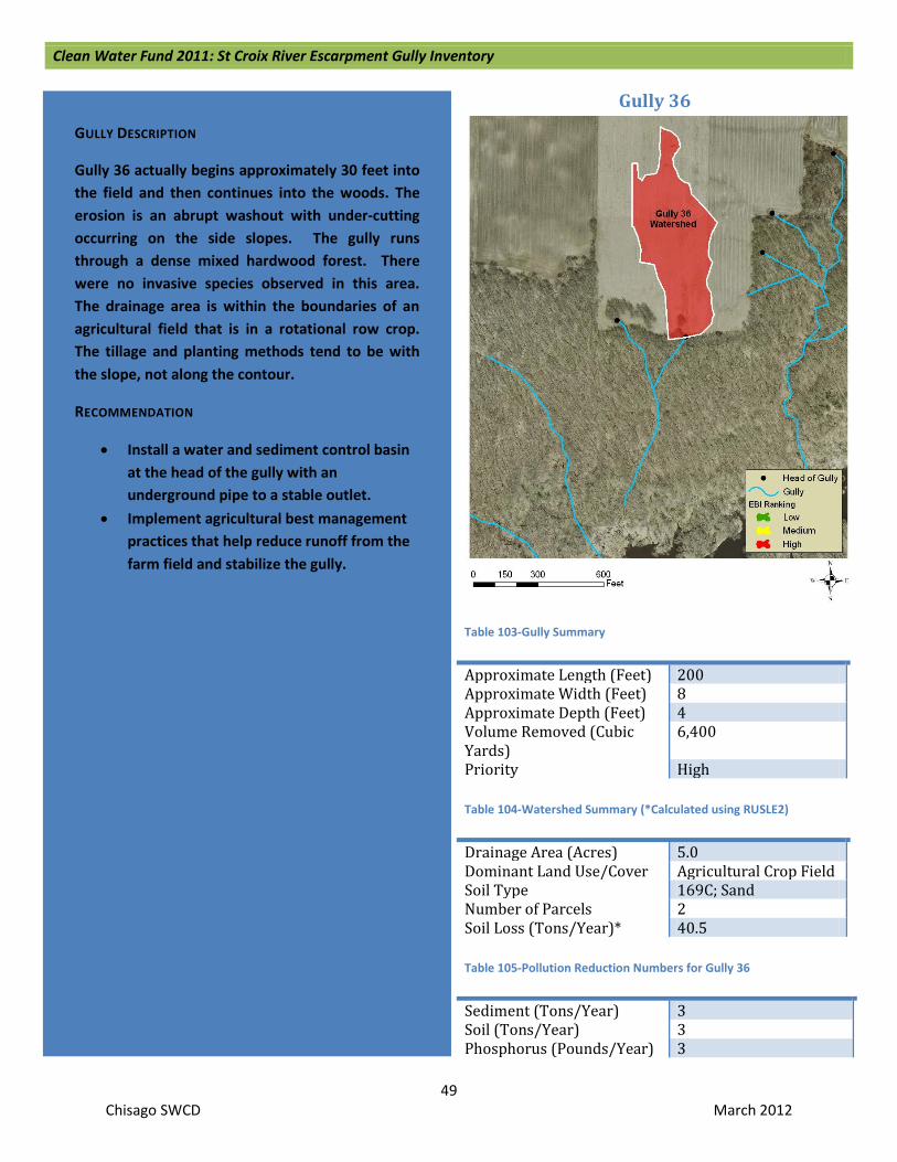
Clean Water Fund 2011: St Croix River Escarpment Gully Inventory
49 Chisago SWCD March 2012
Gully 36
Table 103-Gully Summary
Approximate Length (Feet) 200 Approximate Width (Feet) 8 Approximate Depth (Feet) 4 Volume Removed (Cubic Yards)
6,400
Priority High Table 104-Watershed Summary (*Calculated using RUSLE2)
Drainage Area (Acres) 5.0 Dominant Land Use/Cover Agricultural Crop Field Soil Type 169C; Sand Number of Parcels 2 Soil Loss (Tons/Year)* 40.5 Table 105-Pollution Reduction Numbers for Gully 36
Sediment (Tons/Year) 3 Soil (Tons/Year) 3 Phosphorus (Pounds/Year) 3
GULLY DESCRIPTION
Gully 36 actually begins approximately 30 feet into the field and then continues into the woods. The erosion is an abrupt washout with under-cutting occurring on the side slopes. The gully runs through a dense mixed hardwood forest. There were no invasive species observed in this area. The drainage area is within the boundaries of an agricultural field that is in a rotational row crop. The tillage and planting methods tend to be with the slope, not along the contour.
RECOMMENDATION
• Install a water and sediment control basin at the head of the gully with an underground pipe to a stable outlet.
• Implement agricultural best management practices that help reduce runoff from the farm field and stabilize the gully.

Clean Water Fund 2011: St Croix River Escarpment Gully Inventory
50 Chisago SWCD March 2012
Conclusion Throughout this project, from desktop analysis to the field survey to the prioritization process, a better understanding of the amount and source of sediment and phosphorus entering the St. Croix River has been gained. It is clear that certain land use practices in critical areas can cause erosion problems, such as causing actively eroding gullies. Agricultural practices, specifically annual row cropping that involves some form of annual tillage, was identified as the cause to a majority of the severely eroding gullies in this project. The remaining severe gullies that don’t have agriculture in their drainage area appear to have had it there in the past, or there are other contributing factors such as extreme slope and highly erodible soils. Those gullies that were found to be stable were generally wooded or had permanent vegetation established within the watershed.
In conclusion, erosion in the form of active gullies within the St. Croix River escarpment is not as severe as first assumed. Out of the 494 field verified gullies, only 112 were found to be actively eroding and 36 of those were considered severe. If we extrapolate the percentages to cover the remaining 124 unvisited gullies, it is likely that there are another 9 severely eroding gullies, for a total of 45 in the entire project area. The reduction in active gullies may be due to a reduction in acres being farmed in the county than there has been in the past. In addition, some of the old agricultural fields have reverted back to vegetative cover (including some native plants as well as invasive weedy species) and have been stabilized. This suggests that changing tillage practices, in combination with filter strips and grassed waterways, could reduce a majority of the gully erosion in the escarpment. In some cases, more extreme practices such as sediment basins will be needed to correct erosion.
Implementation Projects One of the objectives of this report was to identify which gullies would provide the most pollution reduction to the St. Croix River if they were stabilized. Clean Water Funding, through the Minnesota Clean Water, Land and Legacy Amendment, is available to implement practices that will stop the erosion of gullies identified in this report. Since funds are limited, it may not be possible to stabilize all 36 identified severe gullies. In order to determine which gullies receive funding, the SWCD staff will utilize Table 106 (next page) to compare methods of prioritization to select the best projects for the funding available.
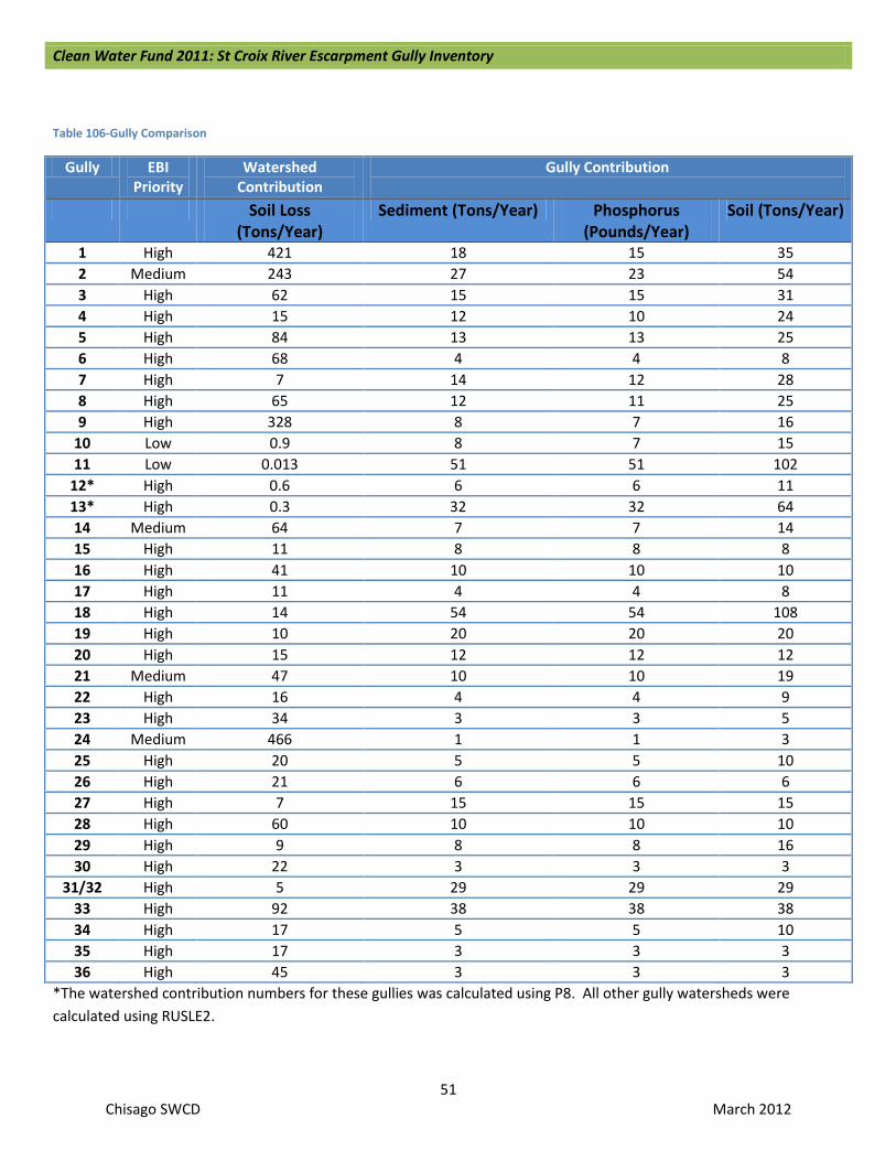
Clean Water Fund 2011: St Croix River Escarpment Gully Inventory
51 Chisago SWCD March 2012
Table 106-Gully Comparison
Gully EBI Priority
Watershed Contribution
Gully Contribution
Soil Loss (Tons/Year)
Sediment (Tons/Year) Phosphorus (Pounds/Year)
Soil (Tons/Year)
1 High 421 18 15 35 2 Medium 243 27 23 54 3 High 62 15 15 31 4 High 15 12 10 24 5 High 84 13 13 25 6 High 68 4 4 8 7 High 7 14 12 28 8 High 65 12 11 25 9 High 328 8 7 16
10 Low 0.9 8 7 15 11 Low 0.013 51 51 102
12* High 0.6 6 6 11 13* High 0.3 32 32 64 14 Medium 64 7 7 14 15 High 11 8 8 8 16 High 41 10 10 10 17 High 11 4 4 8 18 High 14 54 54 108 19 High 10 20 20 20 20 High 15 12 12 12 21 Medium 47 10 10 19 22 High 16 4 4 9 23 High 34 3 3 5 24 Medium 466 1 1 3 25 High 20 5 5 10 26 High 21 6 6 6 27 High 7 15 15 15 28 High 60 10 10 10 29 High 9 8 8 16 30 High 22 3 3 3
31/32 High 5 29 29 29 33 High 92 38 38 38 34 High 17 5 5 10 35 High 17 3 3 3 36 High 45 3 3 3
*The watershed contribution numbers for these gullies was calculated using P8. All other gully watersheds were calculated using RUSLE2.

Clean Water Fund 2011: St Croix River Escarpment Gully Inventory
52 Chisago SWCD March 2012
References Minnesota Department of Natural Resources (MN DNR). 3/28/2012. Park Info. http://www.dnr.state.mn.us/state_parks/st_croix/narrative.html.
Minnesota Department of Natural Resources (MN DNR). 3/28/2012. St. Croix National Scenic Riverway. http://www.dnr.state.mn.us/waters/watermgmt_section/wild_scenic/wsrivers/stcroix_upper.html.
National Park Service (NPS). 3/28/2012. Saint Croix National Scenic Riverway. http://www.nps.gov/sacn/index.htm.
Minnesota Pollution Control Agency (MPCA). 3/28/2012. Minnesota’s Impaired Waters and TMDLs. http://www.pca.state.mn.us/index.php/water/water-types-and-programs/minnesotas-impaired-waters-and-tmdls/assessment-and-listing/303d-list-of-impaired-waters.html.
American Rivers. 3/28/2012. 2011: St. Croix River. http://www.americanrivers.org/our-work/protecting-rivers/endangered-rivers/endangered-stcroix.html.

Clean Water Fund 2011: St Croix River Escarpment Gully Inventory
53 Chisago SWCD March 2012
Appendix A: Table of GIS Tools Used
Tool Pathway Hillshade Spatial Analyst Tools, Surface, Hillshade Filter Spatial Analyst Tools, Neighborhood, Filter Flow Accumulation Spatial Analyst Tools, Hydrology, Basin Convert Raster to Polygon Conversion Tools, From Raster, Raster to Polygon Zonal Statistics Table Spatial Analyst Tools, Zonal, Zonal Statistics as Table

Clean Water Fund 2011: St Croix River Escarpment Gully Inventory
54 Chisago SWCD March 2012
Appendix B: Letter to Landowners
April 28, 2011 Dear Landowner, The Chisago Soil & Water Conservation District (SWCD) has identified erosion along the St. Croix River escarpment as a high priority resource concern. In 2011 the Chisago SWCD received funding through a MN Board of Water and Soil Resources Clean Water Fund grant to inventory the existing active gullies along the St. Croix River escarpment from the Wild River State Park entrance near Almelund south to the Chisago County line. The inventory will be utilized to contact landowners to discuss the process of developing a management plan to implement best management practices to correct the erosion problem. Gullies can be formed naturally by streams draining the area above the escarpment, but they can also be caused or accelerated by human activities. Active gullies, or gullies that have fresh erosion each year, can contribute large amounts of sediment to the St. Croix River. Sediment carries phosphorus to the St. Croix River. In the water, phosphorus is used by plants and contributes to algae blooms. Although each project is unique, one gully stabilization project along the escarpment that was finished in 2008 was estimated to reduce the amount of phosphorus entering the St. Croix River by approximately 35 pounds per year. One pound of phosphorus can produce as much as 1,000 pounds of algae. To put a pound of phosphorus into perspective, five garbage bags full of leaves equals about one pound of phosphorus. As a part of this project, desktop analysis of aerial photos has already been conducted and possible gully locations have been identified. The next step in the process is to verify that these gullies exist on the ground and to determine if they are actively eroding or they have been stabilized naturally. With the inventory complete, the SWCD will be able to apply for future funding to help interested landowners correct active gullies on their property. You are not obligated in any way to fix a gully on your property. The desktop analysis identified one or more possible gullies on your property. This does not obligate you to correct the gully or to spend any money on this project. The Chisago SWCD would like permission to inspect the gully(s) on your property. If allowed, staff members from the Chisago SWCD will walk or drive to the gully to visually verify its existence and may take some measurements and/or photographs. Please fill out and return the enclosed self-addressed stamped postcard to the Chisago SWCD by May 20, 2011. If you have further questions, call the Chisago SWCD staff at 651-674-2333. Sincerely, Jason Rehn Resource Conservationist

Clean Water Fund 2011: St Croix River Escarpment Gully Inventory
55 Chisago SWCD March 2012
Appendix C: Post Card to Landowners
Regarding the gully inventory project on the St. Croix River, please choose one of the following options:
______ Please do not check gullies on my property.
______I give permission to check gullies on my property without an appointment.
______I give permission to check gullies on my property with an appointment. (The SWCD will call to set up an appointment).
Name, Address & Phone Number
Please return postcard by June 10, 2011. Thank you!
If you have questions or concerns, please contact the Chisago SWCD
Chisago Soil & Water Conservation District 38814 Third Avenue North Branch, MN 55056 651-674-2333 www.chisagoswcd.org

Clean Water Fund 2011: St Croix River Escarpment Gully Inventory
56 Chisago SWCD March 2012
Appendix D: Second Letter to Landowners May 26, 2011
Dear Landowner, In late April we sent you a letter explaining a project we are working on the St. Croix River escarpment along with a postcard requesting permission to access your property to verify the extent of the gully(s) on your property. Thank you to all who took the time to complete the postcard and send it back to our office. If you are receiving this letter it means as of today’s date we have not received your postcard. If you have already sent in your postcard please call our office at 651-674-2333 to confirm that we received your card. If you call during non-business hours please leave your name, address, and phone number on our answering machine along with either a yes or no response regarding allowing our office permission to inspect the gully(s) on your property. If possible, please submit your postcard with your name and address or call our office to confirm that we have received your postcard by Friday June 10th. If we do not hear from you by June 10th we will assume your answer is: Please do not check the gullies on my property. Again, thank you for helping us achieve our goal of identifying and verifying potential gully erosion sites along the St. Croix River. If you have further questions, please call the Chisago SWCD staff at 651-674-2333. Sincerely, Jason Rehn Resource Conservationist

Clean Water Fund 2011: St Croix River Escarpment Gully Inventory
57 Chisago SWCD March 2012
Appendix E: Gully Inventory Sheet
St Croix River Escarpment Gully Stabilization
Inventory & Outreach Program
Escarpment Field Data Survey Form Date:
1) Landowner, FID, legal description:
2) Is the gully actively eroding: Y / N
3) If yes, what is the Width, Depth and Length of cut?
4) Current land use above gully, that drains into it:
5) Are there any livestock above the gully in the drainage area that could be causing phosphorus loading
into the drainage area? If yes, explain.
6) What is the vegetation cover type and quality that the gully runs through?
7) Are there any invasive species present and how much?
8) Are there any other resource concerns?
9) If there is erosion or other resource concerns, is the landowner receptive to correcting it?

Clean Water Fund 2011: St Croix River Escarpment Gully Inventory
58 Chisago SWCD March 2012
Appendix F: Landowner Visit Notice
St Croix River Escarpment Gully Stabilization
Inventory & Outreach Program
Visit and Follow-Up
Date: __________________________________
Dear: __________________________________
I visited your property to conduct the gully inventory:
o You were not home so I did not go on your property to check it o You responded to our mailing stating YES, we could enter your property, so I went out to the gully and
this is what I observed:
____________________________________________________________________________________
______________________________________________________________________
o Read Comments on back of this page.
If you would like more information or have any questions regarding this project please contact
me at (651) 674-2333 / [email protected]
Sincerely,
Jason Rehn
Resource Conservationist
Chisago Soil & Water Conservation District
38814 3rd Avenue
North Branch, MN 55056

Clean Water Fund 2011: St Croix River Escarpment Gully Inventory
59 Chisago SWCD March 2012