spring valley rab meeting
TRANSCRIPT

SPRING VALLEY FORMERLY USED DEFENSE SITE PROJECT RAB Meeting
March 10, 2015 THE VESTRY MEETING ROOM
7:00 – 9:00 p.m. METROPOLITAN MEMORIAL UNITED METHODIST CHURCH
3401 NEBRASKA AVE. NW, WASHINGTON, DC
Agenda
7:00 p.m. I. Administrative Items
Co-Chair Updates
Introductions, Announcements
Task Group Updates
7:10 p.m. II. USACE Program Updates
Groundwater Study
Glenbrook Road
Site-Wide Remedial Investigation Document Process & Conclusions
8:00 p.m. III. Community Items
Site-Wide Remedial Investigation Document by Peter deFur, Technical
Consultant under the Technical Assistance for Public Participation
Program (TAPP)
8:30 p.m. IV. Open Discussion & Future RAB Agenda Development
Upcoming Meeting Topics:
4825 Glenbrook Road Health Consultation Update (ATSDR)
*Next meeting: May 12, 2015
8:40 p.m. V. Public Comments
9:00 p.m. VI. Adjourn
*Note: The RAB meets every odd month.

US Army Corps of Engineers BUILDING STRONG®
Spring Valley Formerly Used Defense Site
“The USACE Mission in Spring Valley is to
identify, investigate and remove or remediate
threats to human health, safety or to the environment resulting from past Department of Defense activities in
the area.”
Restoration Advisory Board Meeting
March 10, 2015

BUILDING STRONG®
Agenda Review
Co-Chair Updates Introductions, Announcements
USACE Updates
Groundwater Study Glenbrook Road Site-Wide Remedial Investigation Document Process &
Conclusions
Community Items Site-Wide Remedial Investigation Document by Peter deFur, Technical Consultant under the Technical
Assistance for Public Participation Program (TAPP)
Open Discussion & Future RAB Agenda Development
Public Comments

BUILDING STRONG®
Co-Chair Updates
Introductions

BUILDING STRONG®
Co-Chair Updates
Announcements
Website Updates:
January & February Monthly Site-Wide Project Updates
Weekly 4825 Glenbrook Rd Project Updates with photos
December Partnering meeting minutes
January RAB meeting minutes
Remedial Investigation Factsheet

BUILDING STRONG®
Task Group Updates

BUILDING STRONG®
Groundwater Update

BUILDING STRONG®
Groundwater Groundwater Investigation Efforts
The first sampling of the deep groundwater monitoring well (MP-5) on Rockwood Parkway was completed in January 2015.
All samples were non-detect for perchlorate, and less than 1 parts per billion for arsenic, well below the arsenic drinking water standard of 10 parts per billion (ppb). *
MP-5 will be sampled again in the spring.
During the partial day sampling event, Rockwood Parkway was only open to
local traffic. Detour signs directed commuters to Indian Lane and
Glenbrook Road.
* Spring Valley groundwater is not used for drinking water
BUILDING STRONG®
Groundwater Groundwater Investigation Efforts
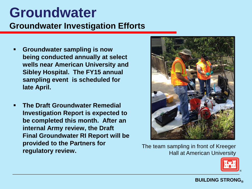
Groundwater sampling is now being conducted annually at select wells near American University and Sibley Hospital. The FY15 annual sampling event is scheduled for late April.
The Draft Groundwater Remedial Investigation Report is expected to be completed this month. After an internal Army review, the Draft Final Groundwater RI Report will be provided to the Partners for regulatory review.
The team sampling in front of Kreeger Hall at American University

BUILDING STRONG®
4825 Glenbrook Road
Update

BUILDING STRONG®
4825 Glenbrook Road High Probability
The crews safely recovered two open cavity, unfired, unfuzed, empty 4.7" projectiles. Both 4.7" projectiles were ‘non-detect’ for chemical agent.
The items were packaged and transported to Federal Property. There have been no detections of chemical agents or industrial compounds in the air monitors since beginning work in the second tent location.

BUILDING STRONG®
4825 Glenbrook Road High Probability
On February 11, the crews safely recovered a 75mm closed cavity item with a small amount of liquid fill. The assessment of the 75mm indicated that the fill is water, not Chemical Warfare Materiel.
Additionally, some American University Experiment Station-related broken
glassware was recovered.
On March 3, crews safely recovered another 75mm round in the same location as the previous items -- behind the backyard retaining wall. The initial assessment showed that the 75mm round is an empty, unfuzed and unfired, closed cavity.

BUILDING STRONG®
4825 Glenbrook Road High Probability
The crews also safely recovered an American University Experiment Station-related test tube with an open top. It was about five inches long containing a white to yellowish solid. The test tube was packaged and sent to the Chemical Transfer Facility at Edgewood Chemical Biological Center, Maryland, to be analyzed. Analysis indicated that the unknown sample is likely a mixture of compounds. The compound identified with the highest peak area percentage was Diphenyl sulfide.

BUILDING STRONG®
4825 Glenbrook Road Summary of Findings Recovered Under Tent 2
For the high probability excavation operation under the second tent, as of last week :
Roll-offs and Drums: 21 roll-offs of soil, zero drums of soil and 4 roll-offs of rubble have been removed. Soil Removed: ~168 yds3 out of the 329 yds3 projected for Area D.
13.25 lbs. of glass: Cleared headspace analysis. No intact glass containers, three 75mm munitions debris items, and two 4.7” projectiles material deemed as safe (empty).
No intact containers found since March 3, 2015.
There have been no readings for chemical agent on the MINICAMS (near real time continuous air monitoring system) at the pre-filter (inlet to the Chemical Agent Filtration System, or CAFS) under the second tent.

BUILDING STRONG®
4825 Glenbrook Road New Fence Installation Activities
Last month crews installed the new fencing along the Glenbrook Road side of the project site. Much of the fence screening was damaged during shipping, so the replacement screens will be installed in March. This new fence is off the street, with stable in-ground fence posts, and will secure the site until completion. It also provides a more neat and clean appearance along this residential street.

BUILDING STRONG®
December 2012 through May 2013
Site Preparation/ Initial Low Probability Work Test pits in backyard and re-locating utilities Install soldier piles to support embankments
May 2013 through September 2013 ECS Set Up, High Probability training, and Pre-Operational Exercises
→ September 2013 through Winter 2016/2017 High Probability Excavation
Winter 2017 through Spring 2017 Final Low Probability Excavation
Spring 2017 through Summer 2017 Site Restoration
4825 Glenbrook Road Schedule Update

BUILDING STRONG®
Site-Wide Remedial Investigation (RI)
Document Process & Conclusions
USACE Updates

BUILDING STRONG®
CERCLA Process (The Comprehensive Environmental Response, Compensation, and Liability Act )

BUILDING STRONG®
The CERCLA Process

BUILDING STRONG®
This RI is notably different from traditional RIs because no singular set of objectives or work plan was established.
While typical RIs follow the CERCLA sequence of events, this RI is an extremely complex site involving several ongoing and concurrent activities over many years, focusing on different potential hazards and/or investigation types or locations, as well as time-critical and non-time critical removal actions.
Each of these ongoing and concurrent activities resulted in completed standalone reports documenting the findings.
Spring Valley FUDS Site-Wide RI Introduction

BUILDING STRONG®
BUILDING STRONG®
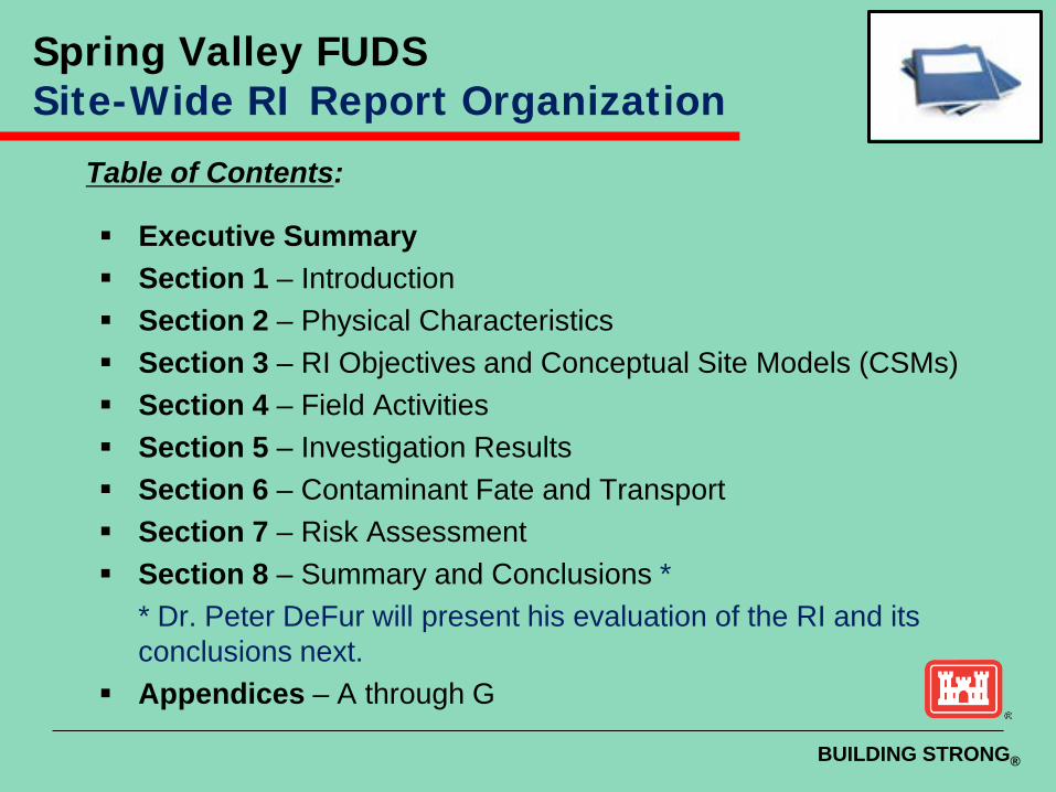
Table of Contents:
Executive Summary Section 1 – Introduction Section 2 – Physical Characteristics Section 3 – RI Objectives and Conceptual Site Models (CSMs) Section 4 – Field Activities Section 5 – Investigation Results Section 6 – Contaminant Fate and Transport Section 7 – Risk Assessment Section 8 – Summary and Conclusions *
* Dr. Peter DeFur will present his evaluation of the RI and its conclusions next.
Appendices – A through G
Spring Valley FUDS Site-Wide RI Report Organization

BUILDING STRONG®
The conclusions of the Spring Valley RI are:
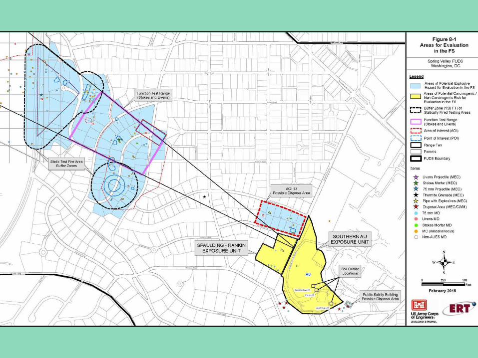
Certain areas will proceed to the Feasibility Study (FS) due to potential concerns with risks identified in the Human Health Risk Assessment (HHRA).
Southern American University Exposure Unit, and the Spaulding and Captain Rankin Area (SCRA).
Certain areas will proceed to the Feasibility Study (FS) due to potential concerns with hazards identified in the Munition and Explosives of Concern Hazard Assessment (MEC HA)
Function Test Range, Static Test Fire Area, Area of Interest (AOI) 13, and the Public Safety Building.
23
Spring Valley FUDS Section 8 Summary and Conclusions

March 10 USACE and Dr. Peter DeFur brief the RI conclusions at the RAB meeting.
Early-April Tentative start of the formal 45-day public comment period.
Late-April Community meeting to brief the community on the RI document’s content and conclusions.
Late-May Public comment period ends. USACE addresses public comments and finalizes the report.
Next Steps
• Feasibility Study to be conducted to evaluate alternatives for addressing any unacceptable risks or hazards identified in the Final RI Report in Fall 2015. • Prepare the Proposed Plan and start public comment period in Winter 2015/2016. • Prepare and sign the Decision Document in Summer 2016 • Begin remedial design/remedial action plan/conduct clean-up action from ~2017-2020
Spring Valley FUDS Tentative Schedule for Site-Wide RI Report

BUILDING STRONG®
Community Items:
Site-Wide Remedial Investigation Document
by Peter deFur, Technical Consultant under the
Technical Assistance for Public Participation Program (TAPP)
Spring Valley FUDS Restoration Advisory Board

BUILDING STRONG®
SPRING VALLEY: Site Wide Remedial Investigation Report
March 2015 Dr. Peter deFur President, Environmental Stewardship Concepts,
LLC Henrico VA
SPRING VALLEY: Site Wide Remedial Investigation ReportMarch 2015Dr. Peter deFurPresident, Environmental Stewardship Concepts, LLCHenrico VA

The Cleanup Process (CERCLA)
Site assessme
nt
Remedial investigati
on
Feasibility Study
Risk Assessment
Record of
decision
Remedial design
Work plans
Construction
Spring Valley is here
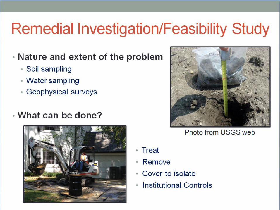
Remedial Investigation/Feasibility Study
Nature and extent of the problem ►Soil sampling ►Water sampling ►Geophysical surveys
What can be done? Photo from USGS
web

What is risk assessment?
Evaluation of the environmental and human health impacts that may result from exposure to contaminants Part of the remedial investigation

Spring Valley

Remedial Investigation (RI)

POIs, AOIs, and Range Fan

Exposure Units with Remaining COPCs
(chemicals of potential concern)

Exposure Units Recommended for Human Health Risk Assessment

Human Health Risk Assessment (HHRA)
Estimates the nature and probability of future health impacts to people who may be exposed to the contaminants at the site
Munitions and Explosives of Concern Hazard Assessment (MEC HA)
•Estimates threats to people from MEC
(Munitions and Explosives of Concern)
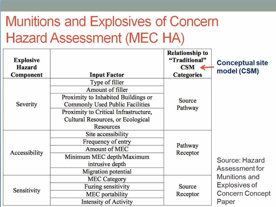
Conceptual site model

Spring Valley MEC HA -example
Source: Munitions and Explosives of Concern Hazard Assessment Methodology, by EPA, DoD, DoI

Table 7-23. MEC HA Scoring Summary Site-wide RI for SV 12/2014 (Draft Final)
Safety Buffer Livens
Function Test Range Stokes
Mortar
Function Test Range Livens
Generic Disposal Area
Hazard Level
Category Score
Hazard Level
Category Score
Hazard Level
Category Score
Hazard Level
Category Score
Current Use 4 505 3 710 3 640 3 670 Land Use Controls 4 440 3 645 3 575 3 605 Sub-surface Cleanup 4 345 4 435 4 300 4 405

Recommendations

Questions?
Dr. Peter deFur Environmental Stewardship Concepts, LLC
www.estewards.com

March 10 USACE and Dr. Peter DeFur brief the RI conclusions at the RAB meeting.
Early-April Tentative start of the formal 45-day public comment period.
Late-April Community meeting to brief the community on the RI document’s content and conclusions.
Late-May Public comment period ends. USACE addresses public comments and finalizes the report.
Next Steps
• Feasibility Study to be conducted to evaluate alternatives for addressing any unacceptable risks or hazards identified in the Final RI Report in Fall 2015. • Prepare the Proposed Plan and start public comment period in Winter 2015/2016. • Prepare and sign the Decision Document in Summer 2016 • Begin remedial design/remedial action plan/conduct clean-up action from ~2017-2020
Spring Valley FUDS Tentative Schedule for Site-Wide RI Report
BUILDING STRONG®
Reminder: Our next meeting will be May 12th
Upcoming Agenda Items
Suggestions? ___________
4825 Glenbrook Road Health Consultation Update (ATSDR) - TBD
Spring Valley FUDS Restoration Advisory Board

BUILDING STRONG®
Public Comments
Wrap-Up
Spring Valley FUDS Restoration Advisory Board

Final Minutes of March 10, 2015 RAB Meeting Page 1 of 19
U.S. Army Corps of Engineers Spring Valley Joint Restoration Advisory Board Meeting
Metropolitan Memorial United Methodist Church Minutes of the March 10, 2015 RAB Meeting
RESTORATION ADVISORY BOARD MEMBERS PRESENT AT THIS MEETING Dan Noble Military Co-Chair/USACE, Spring Valley MMRP Manager Greg Beumel Community Co-Chair Paul Dueffert Community Member Lee Monsein Community Member George Vassiliou Community Member Tom Smith Community Member Mary Bresnahan Community Member Mary Douglas Community Member
Dr. Peter deFur Environmental Stewardship Concepts/RAB TAPP Consultant Alma Gates At Large Representative – Horace Mann Elementary School
James Sweeney Agency Representative – District Department of the Environment Linda Argo At Large Representative – American University
Steve Hirsh Agency Representative – US Environmental Protection Agency Region III
William Krebs Community Member Malcolm Pritzker Community Member Kathleen Connell Community Member Lawrence Miller Community Member Ralph Cantral Community Member
RESTORATION ADVISORY BOARD MEMBERS NOT PRESENT AT THIS MEETING
John Wheeler Community Member
ATTENDING PROJECT PERSONNEL Chris Augsburger USACE, Corporate Communications Office
Brenda Barber USACE, Spring Valley Project Manager
Todd Beckwith USACE, Spring Valley Project Manager
David Jerger USACE, Office of Counsel
Final Minutes of March 10, 2015 RAB Meeting Page 2 of 19
Cliff Opdyke USACE, Risk Assessor
Lan Reeser USACE, Spring Valley Technical Manager Andrea Takash USACE, Corporate Communications Office Tom Bachovchin ERT, Project Manager
Carrie Johnston Spring Valley Community Outreach Program Rebekah McCoy ERT Maya Werner ERT
Rebecca Yahiel Spring Valley Community Outreach Program
HANDOUTS FROM THE MEETING I. Final Agenda for the March 10, 2015 RAB Meeting II. Army Corps of Engineers Presentation, including Site-Wide RI Report Presentation by Dr. Peter deFur III. Spring Valley Project Timeline IV. CERCLA Factsheet V. Remedial Investigation Factsheet VI. February Monthly Project Summary
AGENDA
Starting Time: The March 10, 2015 RAB meeting began at 7:05 PM.
I. Administrative Items A. Co-Chair Updates Greg Beumel, Community Co-Chair, opened the meeting. He turned the meeting over to Dan Noble, Spring Valley Project Manager and Military Co-Chair.
D. Noble welcomed the group and stated there was more community attendance than usual due to letters sent to residents which included invitations to the Restoration Advisory Board (RAB) meeting. As a result some regular RAB operating procedures will be suspended for the meeting.
D. Noble reviewed the evening's agenda and noted that the RAB is a formal process that occurs nationwide at military installations and Formerly Used Defense Sites (FUDS) where RABs are determined to be helpful. USACE offered to stay after the meeting for as long as the community would like in order to speak with anyone with questions.
D. Noble introduced Officer Tony McElwee with the Metropolitan Police Department’s (MPD) Second District.
Officer T. McElwee explained to the community that U.S. Army Corps of Engineers (USACE) and the Community Outreach team have attended a couple meetings to help inform the officers MPD2 on the Shelter-in-Place program for the project on Glenbrook Road and noted no

Final Minutes of March 10, 2015 RAB Meeting Page 3 of 19
incidents have been reported to date. He thanked the group for having him and turned the meeting back over to D. Noble.
B. Introduce Guests D. Noble, Senior Project Manager for the Spring Valley FUDS, introduced project personnel.
[NOTE: Introductions were made prior to the start of the USACE presentation of the Remedial Investigation (RI) report. Attending project personnel are listed at the beginning of the minutes.]
C. General Announcements D. Noble announced the latest website updates. The January and February 2015 updates are now on the website. The weekly updates on the activities on Glenbrook Road are also posted. The January RAB minutes have also been posted. Additionally, a two page fact sheet on the RI report was prepared and posted on the project website.
The December Partnering Meeting minutes have been posted. USACE meets on a regular basis with the District Department of the Environment (DDOE) and the U.S. Environmental Protection Agency (EPA) Region III for technical meetings to discuss various project issues. The Partner Meeting minutes are posted to the project website after they are finalized.
D. Task Group Updates No task group updates were presented.
II. USACE Updates T. Beckwith, Spring Valley Project Manager, provided a brief status update on the groundwater investigation, focused on the first sampling event results at the new well (MP-5) on Rockwood Parkway, the upcoming spring sampling event, and the draft Groundwater RI.
B. Barber, Spring Valley Project Manager provided an update on the activities at 4825 Glenbrook Road.
A. Groundwater Study Background: The groundwater investigation is an effort to determine if the Army’s activities during WWI have a negative impact on groundwater. Over 50 groundwater monitoring wells have been installed and more than 25 surface water locations have been sampled across Spring Valley in the past 10 years. These sampling locations help USACE determine the nature and extent of contamination in the groundwater, determine what contaminants are in the groundwater, and where that contamination is located. Based on the results of the study to date, perchlorate has been detected in groundwater above drinking water standards at American University (AU), along Glenbrook Road, and near Sibley Hospital. Groundwater in Spring Valley is not used as a drinking water source, but the drinking water standards are used for comparison purposes. Arsenic has also been detected in the groundwater above drinking water standards in the Glenbrook Road area. MP-5 Monitoring Well: Last fall, a new monitoring well was installed on Rockwood Parkway, off the ‘island,’ in the road. MP-5 is a deep well that reached 200 feet below ground surface (bgs) and has five sampling ports at different depths. This well was first sampled in January

Final Minutes of March 10, 2015 RAB Meeting Page 4 of 19
2015. The analytical data from this sampling event was just received from the laboratory. All samples were non-detect for perchlorate, and less than one part-per-billion (ppb) for arsenic, well below the arsenic drinking water standards of 10 ppb. MP-5 will be sampled again this spring to confirm these initial results. The purpose of this new well, and of two wells nearby, was to help determine if there was a connection between the perchlorate in the groundwater at AU and the perchlorate in the groundwater near Sibley Hospital. Based on the results from MP-5 and the results from adjacent wells, the data is indicating that there is no current connection between the two plumes. Annual Groundwater Sampling: The annual groundwater sampling of a select number of existing monitoring wells is tentatively scheduled for late-April. The monitoring program is focused on those wells where perchlorate and arsenic were detected in the past. The team is continuing to keep track of the concentrations in those wells to see if there are any trends in the groundwater. The Groundwater RI report is being drafted separately from the Site-Wide RI report. The first draft is expected this month. USACE will conduct an internal Army review and then deliver the draft Groundwater RI to the regulatory partners later in the spring.
B. 4825 Glenbrook Road Background: B. Barber gave a brief history on the 4825 Glenbrook Road Site. This property was removed from the overall site-wide project in the RI report. The primary reason this project was removed from the site-wide project was because of the nature and extent of the contamination that was found at this particular property. USACE decided to fast track the remediation at this property, completed an RI, Feasibility Study (FS), Proposed Plan (PP), and ultimately a Decision Document (DD), which allowed the team to implement the remedy at this property ahead of the overall Spring Valley project. In late 2012, the implementation of the remedial action began at the property. The team completed one phase of high probability operations and is currently in the second phase of high probability operations.
High Probability: High probability operations under the second tent location began in December. The team is currently working in the back yard behind a retaining wall. American University Experiment Station (AUES) debris has been found at the property in the second tent location. Two unfired, unfused, empty 4.7” projectiles were discovered recently. Both items were non-detect for chemical agent and were packaged and transported to the federal property behind Sibley Hospital for storage. They will be disposed of at the end of the project. A 75 mm munition item was recovered on February 11th. This item had a liquid fill, so a complete assessment was done. The fill was determined to be water, not chemical agent. Another 75 mm munition item was found on March 3rd behind the retaining wall. This closed cavity item was also unfused, unfired, and empty. These two items, classified as munition debris, have also been packaged and moved to federal property for storage. The crews are recovering extensive amounts of AUES-related glassware.
A recently discovered open test tube was segregated and sent to the Chemical Transfer Facility at Edgewood Chemical Biological Center, Maryland, to be analyzed. The analysis indicated that the tube contained a mixture of compounds; the highest peak area percentage was diphenyl sulfide, which was a chemical that can be used to synthesize organics.

Final Minutes of March 10, 2015 RAB Meeting Page 5 of 19
To date under the second tent, 21 roll-offs have been filled with soil, no drums of soil and 7 roll-offs of rubble have been recovered. We have removed approximately 168 cubic yards of material with an anticipated amount of 329 cubic yards just in the backyard. 13.25 lbs. of glassware associated with the AUES has been recovered and all have cleared headspace. No chemical agent has been detected under the second tent. No intact glass containers have been found. As previously discussed, three 75mm debris items and the two 4.7 projectile debris items have been recovered. No intact containers have been found since March 3rd and there have been no readings for chemical agent in the air on any of the MINICAMS (near real time continuous air monitoring system) at the pre-filter under the second tent.
Fencing: Recently, as part of the tent relocation and the start of the second phase of high-probability, a new fence was installed at the property. This fence is more robust and was installed in respect for the residents who live near the site. Part of the screen needs to be replaced but this ongoing process is expected to be completed within the next month. Schedule: The project remains on schedule with an anticipated completion of the current high-probability investigations in the current tent location and third tent location during the winter of 2016/2017. The remaining low probability work and site restoration will be completed in the summer of 2017.
C. Site-Wide Remedial Investigation (RI) Document Process and Conclusions D. Noble presented the conclusions and recommendations of the Draft-Final Site-Wide RI report, which addresses the soil portion of the Spring Valley FUDS. The groundwater portion of the project is going to be addressed in a separate RI report that will be released at a later date.
Background: Spring Valley is a FUDS. Meaning, the Army was here, but is no longer. Spring Valley is a 650 acre site in Northwest Washington, D.C. Spring Valley was under the control of the American University Experiment Station (AUES) during World War I (WWI), as well as another co-located facility, Camp Leach which was a camp training center. The WWI activity is the main focus but there was activity from other time frames that have occurred here as well, including Civil War and World War II (WWII).
USACE Presentation: D. Noble reviewed the regulatory framework USACE operates under for FUDS. The Comprehensive Environmental Response, Compensation, and Liability Act (CERCLA) is the environmental regulation that guides the Spring Valley project. The RI is written in accordance with this environmental regulation.
The CERCLA process is a multi-phased process and it typically takes years to complete. The CERCLA process begins with a preliminary assessment, which has steps that are laid out in the regulation, with site closeout as the ultimate goal. The preliminary assessment establishes characteristics and the issues of the site. During the RI more comprehensive investigations are performed which may result in the identification of additional potential site issues as the goal of the RI is to determine the nature and extent of contamination at the site. Once the RI phase is completed, the RI report looks at all the information and data gathered to determine what areas of the site may present unacceptable risks or hazards. Very often once the RI is completed, the remainder of the CERCLA process can progress relatively quickly compared to the initial portion of the process.
Final Minutes of March 10, 2015 RAB Meeting Page 6 of 19
D. Noble pointed out that the Spring Valley RI process has been conducted over the last several years. At certain times, USACE identified issues that needed attention and action right away. There is a mechanism in the CERCLA process in order accomplish this kind of work. Under a Removal Action, you can conduct cleanup work while you are conducting the RI investigation.
Part of the community involvement and making decisions in the CERCLA process is in the Proposed Plan (PP) phase. The PP will say what USACE wants to do about these remaining issues identified. There is a requirement to hold a formal public comment period on the PP, respond to any public comments, and adjust the PP accordingly. If it is has been a long and complex process with lots of issues at the RI report stage, then it is encouraged to share the RI document with the public and allow them to submit comments. That is what we intend to do. We hope to release the report in the very near future for a public comment period.
The CERCLA process also includes community involvement requirements to ensure interested communities are informed of data collection results and as well as USACE and regulatory partners evaluation of the results. USACE strives to be as transparent as possible through several mechanisms including the RAB.
The Spring Valley FUDS project is a large, complex project which included remedial investigation activities as well as removal actions performed concurrently over a period of many years.
D. Noble briefly reviewed the project timeline covering major project efforts from 1993 to present day. In 1993, the original discovery of military munitions was made at 52nd Court. The timeline is a visual depiction summarizing the 22 year project. The challenge of the RI report is that it must review and evaluate all the information that has been gathered during the 22 year process. Ultimately, the RI report will recommend activities necessary for USACE to complete the CERCLA process at the site.
The RI report is laid out following CERCLA regulatory guidance. There is a detailed 20 page Executive Summary. This summarizes the more than 300 page RI report.
Section 8 of the RI includes the Summary and Conclusions of the report. The RI report reaches two conclusions. The first conclusion states that certain areas need to proceed to the Feasibility Study (FS) phase because of potential concerns with risks identified in the Human Health Risk Assessment (HHRA) with respect to chemical contaminants in the soil. When we discuss low levels of chemicals left behind in soil that might pose future health risks we refer to them as ‘risks.’ There are two areas identified at the site where these potential unacceptable ‘risks’ exist with respect to future human health. One of these locations is on the southern part of the AU Exposure Unit (EU). The second location is adjacent to the AU campus, and is a large private property on Woodway Lane that is referred to as the Spaulding Captain Rankin Area (SCRA).
The second conclusion of the report states that certain areas need to proceed to a FS due to concerns with munitions potentially left behind by the military during WWI. These concerns are addressed as ‘hazards.’ Chemicals left behind in soil are considered ‘risks’ and the possibility of munitions being left at the FUDS are ‘hazards.’ It is a way to distinguish between the two, because they represent two different things. For the Spring Valley FUDS, locations where we have ‘hazard’ concerns include the test range, a few static test fire areas, Area of Interest (AOI) 13, and the area immediately around and underneath the Public Safety Building (PSB) on AU campus.

Final Minutes of March 10, 2015 RAB Meeting Page 7 of 19
D. Noble noted that areas recommended for further evaluation in the FS do not focus on a specific property, but with the entire area to be evaluated. An RI report takes a very long, conservative view of risks and hazards when evaluating possible future health impacts.
D. Noble mentioned that he did not want to alarm anyone when he talks about ‘risks’ and ‘hazards’ because they are talking about the relatively small ability for these ‘risks’ and ‘hazards’ to cause harm over a long time period. USACE took a very conservative interpretation of the data when evaluating and identifying areas for further evaluation.
D. Noble described some of the areas requiring further evaluation in the FS. The function test range represents the impact area where munitions may have been fired into from a firing point located within the AUES. Within the range fan, there are target or impact areas for different types of munitions (3 inch Stokes mortars, 4 inch Stokes mortars, and Livens projectiles) tested from the firing point.
AOI 13 is located next to the AU campus, and the campus was where the AUES was located. AOI 13, just outside the historic AUES fence line, is an area where various storage sheds were located. The Public Safety Building (PSB) at AU is another identified area. There was a debris field that ran through a portion of the campus. The PSB was built on the debris field after WWI was over. USACE is fairly confident that there is WWI debris under that building and so that area is identified where debris items are and where hazards might be mixed in with that debris.
Question from Audience member – USACE previously performed munitions investigations at my property, so I put off re-landscaping until USACE performed their work. I asked every inch of the property be looked at including the beds, the non-beds, grass because I didn’t want anyone digging up any munitions. After the work was done which said there was nothing but nails, I re-landscaped. Are you going to dig it up again or is my property safe?
D. Noble replied the issue is how we investigated these areas. We went to certain property owners and requested permission to investigate their property to look for possible munitions as part of the remedial investigation phase. About half of the 96 properties included in areas which are recommended for further evaluation in the FS were investigated during the RI phase. During this phase, the purpose of the individual property investigations was to evaluate the area, to see if there was a potential hazard in the area the property was located in. Therefore the RI report identifies large areas that are a potential concern; it is not a property-by-property evaluation of hazards.
The FS and PP phase is where we will look into what was already done at each individual property and ask ourselves on a property-by-property basis what needs to be done. As we go along this road, we narrow and focus in on the details for the future. Reasons that would lead USACE to revisiting a previously investigated property include the amount of geophysical coverage, and changes in investigation techniques. At time goes by technology improves and there are methods and techniques available now that we feel might support more efficient evaluation of buried metallic objects. It does not mean that the techniques we used were not good, they were very good, and they might be good enough. However, it is a decision that USACE must make with [the community] and the regulators. We may not have to come back to all of the properties in the designated areas, but we do have to reconsider your property as part of the whole area that has been identified.

Final Minutes of March 10, 2015 RAB Meeting Page 8 of 19
Question from Audience Member – What types of rounds were fired into the function test range? Were they inert, just to do ballistic tests, or did they have toxic payloads? How many were fired? What did you find out from your archival research?
D. Noble replied that the investigation included both archival research and actual investigation at half of these properties. The Army had some interest in ballistics at the experiment station, because WWI was the first time the Army was using chemical weapons. Most chemicals at the time were liquids, while most explosives at the time were solids. They were going from conventional solid explosive munitions to a chemical munitions that might be liquid filled. They were mainly interested in the payload within the munition, how the munitions could deliver these payloads, and how would the payload disperse once the munition arrived on target. Since this was an experiment station, we expect that a lot of the debris was picked up as they fired it in order to determine the effectiveness of the payload delivery.
On the 46 residential properties that USACE performed a geophysical survey investigation, we dug 2,700 holes in the ground where the geophysical survey equipment told us something metallic was in the ground. Out of those 2,700 digs, a total of 52 munitions debris (MD) items were found. MD items are pieces of metal that came from munitions; they are not intact munition items and may not resemble a munition. However, the teams who perform the work are trained to recognize MD.
Additionally, out of the 2,700 digs, we found four intact munitions that had some level of a hazard associated with them. As a statistical comparison, 46 of the 96 properties were evaluated. If USACE were to go to the other half of those properties and do the same level of investigation, another four items (approximately) containing a hazard would probably be found. The question for USACE moving into the FS is: is it worth addressing those potential four hazardous items that may yet to be recovered? When you take a very conservative long view, the answer is yes, it is worth it. That is what the RI report concludes and proposes. That even though it is a very small number of hazards, USACE believes it is worth the attempt to recover them. The remainder of the CERCLA process will work to determine the best approach to do so.
Question from Allen Hengst, Audience Member – I searched the Spring Valley FUDS website yesterday looking for information on AOI 13, and I also looked through the archive website. Other than 2 maps, I could not find anything on AOI 13. Will I be able to find some documentation on AOI 13 at the Information Repository at Tenley-Friendship Library?
D. Noble confirmed this. If you look in the binder that has the AOI memoranda, there should be an AOI 13 memorandum that sums up what we know about AOI 13. When the RI report is released, there will be a lot of information on AOI 13 and what the results of the investigation are on this area.
Question from Wesley Boatwright, Audience Member –I thought ‘risk’ means chemical risk and ‘hazard’ means unexploded munitions. It sounds to me that the munitions could have chemicals in them as well; I am unsure why that isn’t both a hazard and a risk.
D. Noble agreed it was confusing to differentiate. ‘Risk’ has to do with trace levels of chemicals that are in the soil that could potentially cause health problems down the road. ‘Hazard’ is related to munitions items. All of the munitions that were found were all conventional.
W. Boatwright asked what the difference is between a conventional hazard and a regular hazard.

Final Minutes of March 10, 2015 RAB Meeting Page 9 of 19
D. Noble stated that a conventional hazard is an explosive hazard, from something like a high explosive or black powder contained in a munition. Chemical weapons are seen more rarely. The chemicals pose risks, and if they are contained within a munition then they can also pose a hazard.
W. Boatwright stated that it sounds like word smithing and that it sounds like they are all risks. Your first comment suggested that one was an explosive hazard and the other was a chemical risk, but you just said that they didn’t care about ballistics they were actually firing loaded weapons.
D. Noble replied that the Army was very interested in how to use conventional explosives to disperse the agent. A lot of what they fired had a conventional hazard in it as well as a chemical hazard.
Question from Audience Member – Do you know whether any of these hazards might also contain potential releases that would be categorized as risks?
D. Noble explained that it is always a possibility that one of the items may still have its chemical payload in it. We have not found that yet, except in disposal pits [like at 4825 Glenbrook Road or 52nd Court]. We will be looking for individual items that might be in the ground as well as any additional disposal areas that might have been associated with the activities at some of these facilities.
Question from Audience Member – With respect to the releases that did occur and are identified as risks now, do you know how those releases occurred, were those from explosions of munitions or were they dump sites, or something else?
D. Noble explained that they were both. There were some disposal sites where you could see that releases of these chemicals have occurred into the soil. If there is a disposal pit, there is a very good chance that the chemicals that were in the items that were in the disposal pits are in the environment. We also have concern because they did test these live loaded munitions. When those munitions did function and did disperse the chemical, the chemical was spread out over the environment and over time it has weathered and broken down but certain portions of it do remain behind. You can get elevated levels of certain chemical contaminants in the soil from that.
Question from Audience Member – My property is in the static test fire area, near Dalecarlia; where they were exploding things in a stationary location. So, there is virtually no chance they will find an unexploded munition in that area, correct?
D. Noble replied that would be true if they hit the targets in the range fan 100 percent of the time. We know that there are over-flights and munitions that go off-target. The whole range fan [which overlaps with the static test fire area near Dalecarlia] represents the firing area.
Question from Audience Member – About 15 years ago, USACE came out and did core soil samples at my property. However, no one came and did munitions investigations on my property. We put in a swimming pool, a retaining wall, and it is mostly covered in patios. So how do you look for munitions considering that?
D. Noble explained that there are instruments now that can see through patios. There are factors for each individual property that will have to be taken into account. For instance, if you have a lot of rebar reinforcement in the patio, or if reinforced concrete pads were poured and then the patio was put down on top of the concrete. If the patio has metal, then it is possible we won’t be

Final Minutes of March 10, 2015 RAB Meeting Page 10 of 19
able to see through it. If it is just masonry, then there is a possibility we will be able to see beneath it. New equipment is available where if we identify a metallic anomaly with one instrument, we can go back with the additional instrument. That different piece of equipment can provide pretty good idea if that signal is coming from a munitions item or something that closely resembles a munitions item such as a horseshoe. There are a lot of different ways to approach this situation. We will not be able to cover 100% of the area in anything we do at Spring Valley because there are man-made things in the way. These will impact the decisions as to what is going to be done.
Question from Audience Member –How many munitions were fired with chemical payloads into that functional test range area? If there is a ball park a range of how many munitions were fired - are we talking dozens, hundreds, or thousands? What does that mean for soil toxicity in that area and to what extent have you adjusted for the likelihood for error in targeting? Is there a buffer zone designed to capture the possibility of munitions missing the targets?
D. Noble replied that it is unknown how many munitions were fired. The records that were kept by the Army at the time were not that detailed. We only know that they did that kind of testing. A typical Army installation that has a firing range in existence for decades where they are training troops on how to use weapons, they fire millions of rounds. When that firing range is finally taken out of commission, it is a huge cleanup problem. The AUES was in operation for about two years and when it came to the firing and testing, it was a small-scale operation compared to a normal range. D. Noble noted that if he had to ballpark, around a few thousand or less were probably fired or statically tested in the two years of operation.
In terms of soil toxicity, D. Noble explained that the soil has all been tested and the RI concluded that this area does not contain risks associated with soil toxicity. Areas in the neighborhood that will be further evaluated in the FS are areas where there might be munitions items left behind that represent a potential hazard.
Question from Audience Member - How recent was the testing and how confident are you in the data? What about the buffer zone?
D. Noble explained that these were not the only areas that were looked at for the RI, and the 46 properties were not the only properties that were investigated to find munitions. We feel that we have looked at enough properties in and around these areas to determine where the hazards potentially are in general. The soil testing was comprehensive and we have high confidence in our conclusion that with respect to chemical risk.
Question from Audience Member – At the properties across the street from me, USACE came and dug and large trees were removed from the avenue that was called ‘the oaks’ because it had large historic oak trees. We were not informed of what was going on. We moved to Spring Valley for the trees and when you left, three properties were scalped and the trees that were put in were small. Why can’t digging be done around trees?
D. Noble stated that most of the trees in the neighborhood that were removed were removed as a result of a soil removal action focused on arsenic contamination. This work went from about 2001 to 2012. We went to quite a few properties with identified elevated levels of arsenic and worked with the property owner to remove the contaminated soil. Our approach to a large tree, if it was growing in a contaminated area, was to offer the property owner an assessed value of the tree, determined by an arborist, because we acknowledged that we could not replace a 100-year-

Final Minutes of March 10, 2015 RAB Meeting Page 11 of 19
old tree. We showed that tree’s assessment to the homeowner, made the agreement that if they would like us to clean up the contamination, it would mean that they would lose that tree and would receive the assessed value for the tree.
Statement from Audience Member - It causes devaluation when you remove the trees from the streets like that.
D. Noble explained that USACE did try to identify which areas needed to be cleaned up and where the property owner wanted the tree to remain. We were occasionally able to leave the tree.
Clarification from Audience Member – The trees on across the street were not on a residential property but rather were on DC property along the street. It looks pretty bad when multiple trees are removed in one area.
D. Noble stated that the city was interested in the soil remediation. The agreement with the city was for every trunk inch we removed we would replace in trunk inches with new plantings. You are right that they are small and will take time to regrow. However, we did replace every trunk inch we removed from city property.
III. Community Items Dr. Peter deFur presented his conclusions on the RI Report.
A. Site Wide Remedial Investigation Document by Peter deFur P. deFur introduced himself. He is an independent scientific consultant to the Spring Valley RAB. Thirteen years ago this month he responded to a request from the RAB and was brought onboard as their technical advisor. He has been providing these technical services for about 20 years and is currently involved with about 20 different projects across the country from Georgia, to the Pacific Northwest, to New England, and a number of places in between. He works for communities that face similar sorts of issues with chemical contamination, a few of them with munitions and number of them with groundwater problems, contaminated sediment and contaminated rivers.
His bottom line assessment of the Spring Valley FUDS RI is that he basically agrees with the USACE recommendations; there are areas that remain to be evaluated in an FS.
1. Overview Dr. deFur briefly revisited the CERCLA process previously reviewed by D. Noble. The process includes; an initial investigation, a detailed site investigation, a detailed examination of various properties, soil and water samples, which may entail a number of years gathering data, examining records, and reaching an evaluation decision, coming up with technical evaluations involving the public and community. The same steps are taken whether it is a federal cleanup, state cleanup, city cleanup, or local cleanup. The CERCLA process is a step-by-step guidepost.
There are two features that are unique about this site, in comparison with other sites. The Spring Valley FUDS provides opportunities for more community involvement than at almost any other site. The community involvement is one positive thing about the process and the way that we obtain the information upon reaching the recommendations. The other difference is the level of involvement and duration of his involvement. Dr. deFur was part of the Area of Interest Task Force (AOITF) which was composed of representatives from the regulatory agencies and
Final Minutes of March 10, 2015 RAB Meeting Page 12 of 19
USACE who reviewed documentation to identify areas to focus further investigations. In 1993, the Army Corps went back and looked at the records from AUES. They looked at photographs, reports, maps, and all of the documentation that they could get. The AOITF used those same sources of information to search for additional areas that needed investigation and when they needed investigation, the Army with their Partners, the EPA and the District Department of the Environment (DDOE), decided what action was appropriate to take. There will be several extensive chapters in the RI on remediation activities that have already been conducted in Spring Valley. Dr. deFur noted that these two unique features are very important and mean that he has more confidence in a more reliable end result.
Dr. deFur noted that when this project started in 1993, GIS technology was crude by today’s comparison; nobody had a smart-phone in 1993. Improvements in GIS throughout the years allowed for continuous reevaluation of existing information obtained in 1993. When new information was obtained, that new information could be assessed with better techniques and technology. This is also true for analyses of soil samples. In 1993, methods could not test for one part per billion (ppb) of arsenic.
The RI is frequently conducted in close conjunction with an FS. The RI is intended to determine the nature and extend of the problem and the FS determines what to do about the problem(s). There are different activities that go along with both of these reports. The process for a CERCLA investigation usually means that the data is collected first and after the RI report is issued the cleanup activities begin. In the case of the Spring Valley FUDS, one of the benefits and one of the challenges is that simple sequence has not necessarily been followed. As the USACE collected data in Spring Valley, indicating that properties where people lived had elevated concentrations of arsenic, they took action with Time Critical Removal Actions (TCRAs) and Non-Time Critical Removal Actions (NTCRAs). In the CERCLA process, these (TCRAs and NTCRAs) are mechanisms built into the CERCLA process (which can be implemented at any phase of the process) where the agency has the ability to make a very prudent, wise decision to start taking actions where they know, and everyone agrees, problems exists.
2. RI Activities and Evaluation Results One of the critical issues that D. Noble mentioned is that part of the RI requires determining what chemicals detected present a risk and what non-chemicals detected present a health hazard. Typically, this analysis occurs in a chemical Human Health Risk Assessment (HHRA). This assessment looks at what chemicals are present, and where and how much in soil, in water, in air and in groundwater. The HHRA is designed specifically to predict the current and future health risks from current actions and it names other alternative actions. If you leave things the way they are with no further action, this is what we predict the risks are and these types of actions would be necessary in order to reduce those risks.
The remedial investigation primarily included soil sampling and removal actions, geophysical anomaly investigations, and investigations of pits and trenches. These activities are summarized in the RI report. Since 1993, approximately 178 properties were remediated for arsenic contamination in soil. There have been a large number of properties (around 100) where some sort of investigation has been conducted to determine if there were any munitions-related items. A few anomalies turned out to be munitions items [as previously described by D. Noble].

Final Minutes of March 10, 2015 RAB Meeting Page 13 of 19
The RI is intended to determine the nature and extent of contamination and bring that information forward into the report as a summary of what we know about the site. The historical information goes back to 1918 but the document research began shortly after 1993. In 1995, the technical analysis from the USACE, EPA, and DDOE experts resulted in a number of areas that were called Points of Interests (POIs) where maps and photographs and other such reports indicated activities were conducted, or were likely conducted by the Army, leaving behind chemicals, munitions, or both. For example, a photograph confirmed the firing of mortars from a firing point on the AUES after the concrete gun pit was found. All of this information was collected and the Army made sure that it was reviewed by not only the Army’s experts but also the EPA’s, who have whole offices that deal with munitions and hazards, independent consultants and other people from around the country. USACE also did trials on which technologies and techniques worked. The POIs, AOIs, and Range Fan [Function Test Range] provided a lot of information. The soil sampling was another great source of information. Over 1,600 properties and lots have been tested for soil contamination, principally for arsenic.
The RI report accurately takes all of that investigation information and tries to determine potential current and future problems which are then categorized. One of those categories is chemical risk, which is analyzed in the HHRA. Through the HHRA, which was conducted in a phased process, USACE identified two areas that will require further evaluation in the FS; the SCRA and southern AU. The Partners are still discussing details about the Spaulding Captain Rankin Area.
The other category is explosive hazard, which is analyzed with a Munitions of Explosive Concern (MEC) Hazard Assessment (HA). The EPA gathered an expert panel to develop a step-by-step regularized approach for looking at these sorts of problems. This resulted in the development of the MEC HA. It is like a risk assessment, but you can’t take a soil or water sample for munitions. The MEC HA takes the features of possibly having the munitions in an area, the severity, the interactions, and the accessibility of the area (is it remote, in the woods, behind a fence or is it in someone’s backyard). The area is ranked accordingly and given scores. For each one of the places that may have MD or MEC, because of the POI and AOI analysis, maps and photographs that indicate where many activities were conducted, as well as the finds of the MD and MEC, we can base this analysis not on speculation but on better information.
MEC HAs for every area that was scored for Spring Valley are located in an appendix in the RI report. The intent is to show how the scoring changes with different land use and clean up scenarios. The Partners and technical reviewers were consulted about how this was going to be done.
One of the limitations is that we do not know how to combine certain hazards and risks. We make an attempt by inserting uncertainty factors. Until our knowledge increases a great deal, we will be limited in our ability to combine certain risks, threats, and hazards. Much of the munitions and arsenic contaminated soil have been removed already.
3. Discussion Question from Tom Smith, Community Member – When are we going to be able to see the actual report? For those residents that are in the neighborhood that are not in one of the areas recommended for further evaluation, we had previously received notices that our property is fine. How reliable are the letters? Could we also be told that additional investigations of our property might need to be made?

Final Minutes of March 10, 2015 RAB Meeting Page 14 of 19
P. deFur stated the RAB and the public will get to see the RI report in about a month. EPA will make sure that the Army comes back if there is some change in regulation or some new information is found.
D. Noble explained that once the site close-out phase of the CERCLA process is achieved, there is still an ongoing requirement for the Army to conduct five-year reviews of the site which are also reviewed and require approval from regulators (EPA Region III and DDOE). Every five years, in perpetuity, the Army will review everything it found, the actions that were taken, and will have to determine if those actions were appropriate. The USACE will always retain responsibility of a FUDS site. Once an area is a FUDS, it always remains a FUDS. The comfort or results letters that you have received from the Army Corps do have limitations because they are based on what was known on the day the letter was written.
Question from Malcolm Pritzker, Community Member – As I understand it, there are two circumstances that might call the comfort letters into question. One is if, down the road, a scientist states that it should not have been 1 ppb it should have been something else. The other circumstance is if the owner of the property discovers something in his lawn that looks ominous. Are there any other circumstances that could put those comfort letters into question?
D. Noble stated perhaps if some additional piece of historical information, document, or photograph that becomes known that shows something occurring somewhere on the site that we had not considered before - this might require us to look at that area further.
Question from Mary Bresnahan, Community Member – If a site is going to be disrupted during, for example, new construction, it could provide additional information. For instance, there is an asphalt covered area that has been that way for a long time. Now, developers are looking for approval to tear up that asphalt and construct new buildings. What happens when that asphalt comes up? Does USACE get involved? Does the soil underneath get investigated?
P. deFur stated that USACE and their Partners have discussed many areas with hardscape cover, like asphalt, roads or patios. In every case discussed, there were soil samples taken within the vicinity that did not have any elevated levels of arsenic or any other reason to be of concern. The areas where there were elevated levels of arsenic did not include an adjacent piece of hardscape.
D. Noble stated that there is no requirement for a FUDS that states that if you want to conduct a project you have to involve and coordinate with the Army. USACE believes that the extent of the testing has been adequate to identify the areas where there are still concerns. There are sections of the RI report that address uncertainties and unknowns about the site.
M. Bresnahan explained that this area was a fill area, with fill dirt from other parts of Spring Valley, before it was covered with asphalt. How do you know if you start digging down that deep there could be possible exposure?
D. Noble stated that the idea of the RI report is that you take the right number of representative samples in the right areas to reveal problems. If there was a concern that there was going to be areas that required further evaluation, you would take samples to determine that. There is uncertainty; however USACE worked to sample enough to reduce the uncertainty to an acceptable level. In the end, there is no absolute guarantee.
M. Bresnahan questioned whether the particular situation she was referencing could be an exception to that since it is an extremely large area and was filled with soil from other areas in the neighborhood, and major construction is planned.

Final Minutes of March 10, 2015 RAB Meeting Page 15 of 19
T. Smith stated that AU is required to notify and consult with USACE before it builds. I realize that that is a function of zoning and zoning laws, why doesn’t the DDOE require people to do some type of consultation with USACE. If the Army cannot do it as part of an RI, it doesn’t mean that there isn’t a problem that we aren’t going to experience in the future.
P. deFur stated that he has seen similar situations at other sites. That was a military site on which they had large amounts of soil movement, transferring it from one spot to another. They did a certain amount of work until they placed a land use restriction on the entire multi-acre site. Any activity that went below two feet below ground surface required notification so that there would be somebody available to respond if anything was found.
M. Bresnahan explained that this area is where the Crate & Barrel is located and added that USACE could not do any sampling there because of all of the asphalt surrounding the area.
J. Sweeny, DDOE, stated he was not familiar with that location but explained that it is possible to take samples if there is good reason to take samples, regardless of whether there is asphalt.
Comment from Lee Monsein, Community Member - When you do the risk assessment, it is based on the current use of the land and potential future uses. Uses of certain areas change with time and sometimes you cannot predict what is going to happen. For example, there are plenty of roads where you might think that there is contamination under the road right now but you don’t do anything because the benefit/risk is not enough. It is the same thing here; if there is asphalt in a particular area, then this area wasn’t going to be where people were digging holes and planting gardens. Things change with time; what is built into the CERCLA process for change in land use?
P. deFur confirmed this. There are a couple of different components of the risk assessment that consider and evaluate uncertainties in land use. The eventuality of changes in land use is part of the calculations documented in the RI report.
Question from William Krebs, Community Member - For the people who own properties in areas that will be further evaluated in the FS, do they now have to disclose that to a potential buyer? Are they going to be able to freely transfer, because whatever you are doing with this process is going to take years to certify?
D. Noble confirmed this; a homeowner is free to transfer their parcel. There are disclosure requirements regarding what a property owner knows about the parcel at the time of transfer. If a property owner is in receipt of a letter from USACE stating that the property is in an area that will be further evaluated, then that is something known about the parcel, and is something to pass along to a prospective buyer.
Question from W. Boatwright, Audience Member - What is going to happen if our homes get devalued because you gave us a ‘comfort letter’ when we bought our house and now you are saying that you didn’t do it right and you have to do it again.
D. Noble stated that if you have a comfort letter, that comfort letter relates to arsenic and the value of that letter is unchanged.
W. Boatwright explained that he has one for arsenic and one for munitions and questioned whether his munitions letter was still accurate.
D. Noble stated yes, the results that are relayed in the letter about the munitions investigation are still accurate. It details what was looked at and what was found. That is still accurate. He noted

Final Minutes of March 10, 2015 RAB Meeting Page 16 of 19
that he could not answer real estate questions but stated that one item that has remained unchanged in the 22 year history of this site is that this area is a FUDS. Many different actions taken at the site over the years have been situations where USACE informed people about the upcoming action and took years to complete activities. Real estate transactions have continued to occur and the values of properties at Spring Valley have remained stable and have done well.
W. Boatwright stated that Spring Valley is a big area and we are talking about a small triangle of that area. For those who bought a house relying on a ‘comfort letter’ that they received from USACE now are finding out that the ‘comfort letter’ does not provide comfort anymore. Will a homeowner be compensated because they may have lost in equity in their house due to these results?
D. Noble stated that he wouldn’t want to term it that way.
Statement from Dr. Kathleen Connell, RAB Member – I am concerned that we are dismissing the concern regarding changes in property use within the community rather frequently. I assume that working in a collaborative manner, you will want to provide those answers to us as soon as possible.
G. Beumel, Community Co-Chair- Is the question if the builders should be allowed to develop on the old Garfunkel site or is the question whether that was addressed in the RI?
Dr. K. Connell explained that there will be a number of sites’ land use over the years that are going to be changing. If they have had a hard surface on them, what is going to be the practical action that will be taken by USACE to verify that those sites indeed are safe? The second question is what is going to be done to deal with this issue of valuation. When people have ‘comfort letters’ that evidently are no longer comfort letters when people are expecting to sell property within a period of time that may be shorter than the time in which the project is concluded.
G. Beumel agreed and suggested that the RAB should request USACE to bring their attorney to answer these types of real estate questions regarding potential requests for compensation instead of technical personnel. However, as far as I know, no one has been compensated for lost property value. P. deFur can answer question regarding changes in land use and land use restrictions associated with the CERCLA process as well as the level of confidence ascribed to saying an area does not require further investigation. The RAB can request that Dr. deFur have the answer to that at the next meeting.
Question from Allen Hengst, Audience Member – Is there a legend somewhere that someone can go to and find out what different number POIs stand for or represent?
D. Noble stated that all POIs and AOIs would be described in the RI report. Information is available online or at the information repository at Tenley-Friendship Library. If you are interested, we will help you find a specific piece of information that you want. We will work hard to get the RI report out the door as soon as we can so the information will be all in one place, which will hopefully be more convenient.
D. Noble noted and agreed with G. Beumel’s suggestions. USACE could host a homeowner’s only meeting to sit down with the property owners to discuss property concerns. They would also see about bringing a lawyer and a real estate professional.

Final Minutes of March 10, 2015 RAB Meeting Page 17 of 19
Question from Audience Member – What is the tentative schedule after this RI report is done? Is there a timeline for these homeowners to be told what you are going to do about the property and when that will be done?
D. Noble explained that USACE wants to finalize the RI report by the end of the summer; complete the FS by the end of the year; by next spring have the Proposed Plan available for public review; and by the end of summer 2016, have the Decision Document (DD) signed and begin Remedial Design. The expectation is to start remedial actions, beginning in calendar year 2017.
Question from Audience Member- Would the DD say property-by-property what the action is and when those actions would be applied?
D. Noble stated that a lot of the property-by-property information would come in the Remedial Design. There will be a work plan for each property. The DD would have enough detail to direct USACE what to do in each area.
Question from Audience Member – When you were talking about the ordnance that might be underground, you had said that you have tested about half of 96 potentially impacted properties. Did you pick the half that was most likely to have munitions or was it random? Is there going to be investigation of the other half of the properties and/or will USACE go back to the others with better technology? If so, what is the time frame? I know you said that there were only four intact munition items found, but if it is in your backyard, it is pretty critical.
D. Noble explained that the properties were selected in order to investigate the identified POIs and AOIs. For instance, the function test range of the impact area, the properties selected were specifically in that area. Enough properties were selected and investigated to provide the information needed to make a decision about that entire area.
Question from Ginny Durrin, Audience Member –In 1986, the Army, the EPA, and AU did an investigation about munitions at AU and came up with a report that wasn’t public until 1993 after the first discovery. I respectfully submit that you put this on your timeline as being part of the Army’s ongoing investigation.
D. Noble stated that he would put that on the timeline.
Question from Nan Wells, ANC Commissioner – You are choosing to separate the groundwater study from the other RI that you just released. Can you expect that the groundwater study would help identify other areas that might be investigated? In other words if you have high soil contamination levels in certain areas, does that indicate a source of groundwater contamination?
D. Noble stated that the Groundwater RI report will address that question. For the most part, the Groundwater RI will discuss what we know already. It will describe the contamination that is in the groundwater and describe reasons why that groundwater became contaminated. He does not believe that it indicates any areas that we would need to go back to or take additional samples to determine why the groundwater was contaminated. The Groundwater RI is not going to recommend more soil samples for the purpose of looking for other source areas.
Question from Audience Member – What steps do you recommend a homeowner undertake if he or she is thinking about adding onto the property, further disturbing the soil, and moving soil around the property?
Final Minutes of March 10, 2015 RAB Meeting Page 18 of 19
D. Noble explained that it is fine to undertake that kind of project – they are constantly occurring in Spring Valley. With anything, as you conduct your project, if you come across something you don’t understand or find something you think is a munition, call 911.
Question from Audience Member – Will the RI include the conceptual site model that addresses vapor intrusion as a particular exposure pathway into people’s basements?
D. Noble stated that there are many conceptual site models in the RI.
T. Bachovchin confirmed that the RI does talk about the sampling that has been done in the past with respect to vapor intrusion.
D. noble explained that vapor intrusion has been investigated in certain homes that were in close proximity to burials and debris. Those investigations are discussed in the RI. The chemicals of potential concern (COPCs) that are identified in the RI report are not the kinds of chemicals that represent vapor intrusion threats. Many of them are non-volatile types of organics or are metals. We have not found chemical agent in the ground (with the exception of the 4825 Glenbrook Road). We found chemical agent in munitions and sometimes in non-volatile remnants of chemical agent in the ground near disposal areas. There are homes where sampling was done in a variety of different ways and techniques. The RI summarizes this sampling effort.
Question from Audience Member – The range fan may have been perfectly accurate at one point in time with the lab and the experiment running over a couple of years. What is the confidence level that you have that documented accurately? What is the error bar on the boundaries of the range fan?
D. Noble stated that the range fan was constructed with some buffer. There are three areas identified as target areas in the center of the range fan. One of the firing points is a permanent concrete structure such that when they went to fire a particular type of mortar tube, it could only be mounted in one direction downrange from that single point. That gives a very accurate rendition of the major directional pathway. There were other types of mortars that they used, that could be moved, where they are setup on tripods, but the available evidence is that even those were fired at the targets in the center of the range fan.
Question from Audience Member – For those of us with small children who are in the yard a lot or for those of us who garden and are working in the soil, if we decide that we would like to do additional testing, is that something where we can work with the USACE to have that done or does USACE recommend certain private providers to do that? What is the recommendation for those of us who need to get an additional level of comfort in working with the soil?
D. Noble stated that USACE has done a complete job of assessing and addressing risks that are in soils at the site. The work to address identified risks in soil is complete except for at the SCRA and southern AU areas. No additional remaining chemical risks are identified which would need to be addressed. There are firms out there that can come and test. However, basically, one cannot come to the Army and request further testing. USACE worked with the EPA and DC regulators and we believe we have conducted thorough testing that is necessary to look into and answer questions such as you are asking. The risk assessment in the RI report looks at different types of exposures even to sensitive individuals in conservative exposure scenarios. For example, it looks at whether there is an unacceptable risk to a hypothetical child resident who lives in an area for a so many years, spends so much time out side, and contacts and

Final Minutes of March 10, 2015 RAB Meeting Page 19 of 19
or ingests a certain amount of soil over the certain period of years. The conclusions of the RI report are that no, such a risk does not exist outside of the two areas (SCRA and southern AU).
IV. Open Discussion and Agenda Development A. Upcoming Meeting Topics 4825 Glenbrook Road Health Consultation Update (Agency for Toxic Substances and
Disease Registry (ATSDR)) - tbd
B. Next Meeting: Tuesday May 5, 2015 Question from Larry Miller, Community Member – Is the RAB meeting again about two weeks before the end of the public comment period? Would that meeting be similar to this meeting where there would be a provision for extra public participation and discussion of the RI?
G. Beumel confirmed this. There will also be a separate public meeting at a similar time to give people a chance to read the RI. There will be a RAB meeting and a public meeting to focus on the RI report all within the 45 day comment period.
Statement from Ralph Cantral, Community Member – I am concerned about having the public meeting before the RAB meeting. We would like to make sure that the RAB meeting is before the public meeting so the RAB can discuss this and then be able to talk to our neighbors and folks before the community meeting to let them know what is going on.
Dr. K. Connell asked if it was possible to have the RAB meeting in April. I think we should be briefed by P. deFur and engaged in a discussion prior to the next community meeting.
R. Cantral stated that the report is coming out around April 10th. I would want some time to look at the RI before we meet and not just rush into a meeting. I think our RAB chairs can work it out to where it makes sense to have an opportunity to where everyone can read the report, and for the RAB to discuss it, and then have the public meeting afterwards.
C. Open Discussion No additional agenda topics were shared.
V. Public Comments D. Noble thanked everyone for attending.
VI. Adjourn The meeting was adjourned at 9:35 PM.