spot6 s4-2 mahlatse kganyago
TRANSCRIPT

Site Suitability Mapping of Water Harvesting Using
Remote Sensing and GIS, Musina, South Africa
SPOT 6 EO-Innovation workshop
M. Kganyago & P. Sibandze
South African National Space Agency (SANSA)
Agricultural crops production depend on
availability of water and nutrients - Lack of water
results into threatened crop production.
The demand for other purposes (industrial,
domestic & urban) aggravates the water shortage
in semi-arid areas.
Other problems: Over-abstraction, Deteriorated
surface water resources
Intro. & Background
A need to explore, exploit and develop ‘taken for
granted’ water resource (i.e. Rain Water)
RWH offers an alternative to augment irrigation
water demands in semi-arid areas
Environmentally sound, socially acceptable and
economically viable technology for ensuring
optimum utilization of the available natural
resource for sustainable crop production.
Introduction & Background cont…
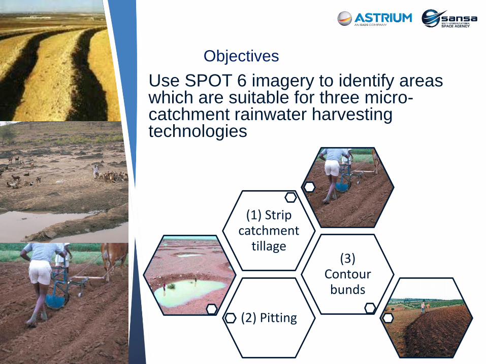
Use SPOT 6 imagery to identify areas which are suitable for three micro-catchment rainwater harvesting technologies
Objectives
(2) Pitting
(3) Contour bunds
(1) Strip catchment
tillage

Sustainable food security (MDG 1) - Improving
human livelihoods
Preserve soil and water conservation (MDG 7)
Improvement of agricultural production,
regeneration of degraded landscapes and
supplying water for small horticulture and
livestock thereby improving income and food
security
Promotes rural development, when RWH is
practised for subsistence farming
New data - supports informed decision making
Societal Benefits

Northern most SA
town,
Semi-arid climate-
hot all year, wet
summers & dry
winters
Savanna
vegetation-low
shrubs & thorny
trees
Study area

Methods

Land cover product derived from SPOT 6

Slope

Flow length

Drainage
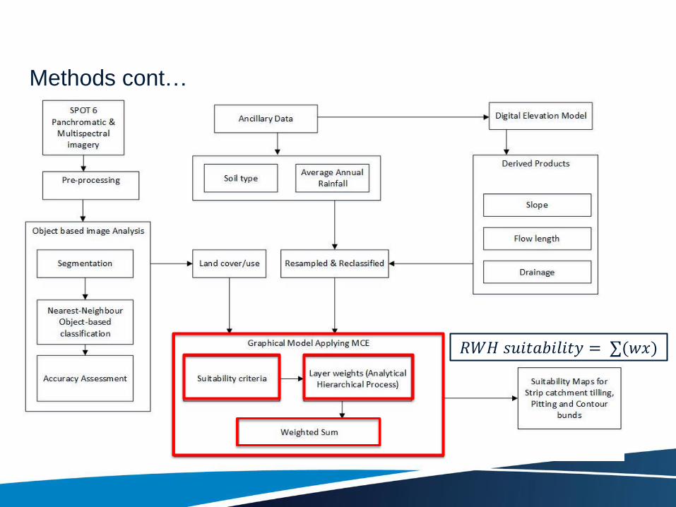
Methods cont…
𝑅𝑊𝐻 𝑠𝑢𝑖𝑡𝑎𝑏𝑖𝑙𝑖𝑡𝑦 = ∑(𝑤𝑥)
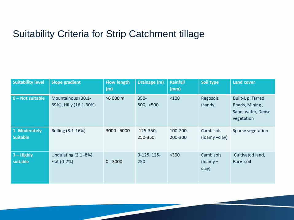
Suitability Criteria for Strip Catchment tillage

Analytical Hierarchy Process (AHP) for Strip Catchment
Tillage

Suitable sites for Strip catchment tillage
suitable sites for Contour bunds
Suitable sites for Pitting
Results
Strip Catchment Tillage
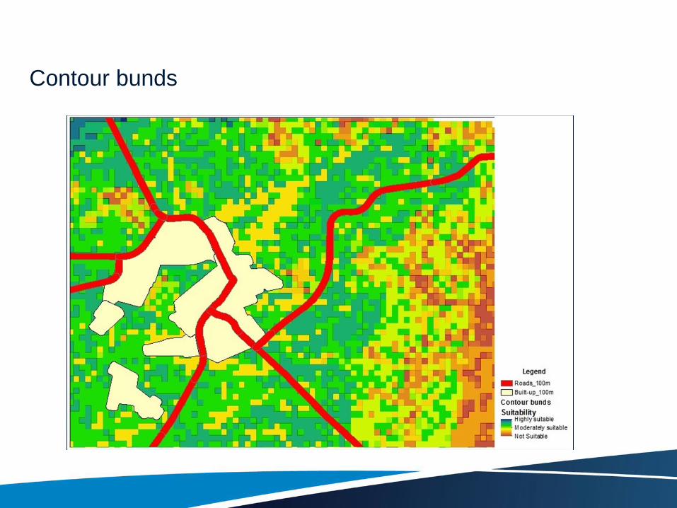
Contour bunds

Pitting

SPOT 6 contributed significantly in determining the suitable sites for
RWH
High spatial resolution allow object-based classification, and high
resolution land cover map (80% overall accuracy) for RWH site
suitability analysis
Multi-criteria RWH Model has potential in contributing to decision
making related to water use and conservation in the agricultural sector.
Conclusion

• Use of high resolution rainfall and soil data
• Use SPOT 6 stereo-pair to extract high resolution DEM (Slope,
drainage, flow length, etc.)
• Field verification of land cover derived from SPOT 6
Future work
