species evaluated for coverage under the mscp - city of san diego
TRANSCRIPT

Species evaluatedfor coverage
under the MSCP
App
endi
x A

- 107 -
SPECIES EVALUATED FOR COVERAGE UNDER THE MSCP
Scientific NameCommon NameStatus
Conserved3
(Based on theMSCP Plan)
PotentiallyImpacted/Developed
(Based on theMSCP Plan)
General Basis forAnalysis of Coverage
Monitoring Method(s)(Monitoring Plan
and/or ManagementPlans/Directives)
Meets Stateand Federal
AuthorizationStandards
Plants
Acanthomintha ilicifolia 85% of 8 majorpopulations
15% of major populations Site-specific preserve designand special measures/management
Monitoring Plan – SiteSpecific (4 populations)and ManagementPlan/Directives
YES
DETAILS OF RATIONALE FOR IDENTIFYING SPECIES AS COVERED
This species will be covered by the MSCP because all major populations are within the MHPA and each of the eight major populations will be conserved from 80-100 percent, with 85 percent conserved overall. This species is on the list of narrow endemics1 which requires jurisdictions to specify and implement measures intheir Subarea Plans to avoid or minimize impacts to all populations (including Asphalt, Inc., Sky Mesa, El Capitan sites) during project design.
Notes: This species occurs on clay and gabbro soils which will be conserved at 28+ percent and 43+ percent respectively
Conditions: Area specific management directives and the SPA for the Otay Lakes Resort area must include specific measures to protect against detrimental edgeeffects from the surrounding development.
Agave shawiiShaw’s agavenone
100% of majorpopulations
No major populationsPreserve design/landscapelevel
Monitoring Plan –Habitat Based
YES

- 108 -
SPECIES EVALUATED FOR COVERAGE UNDER THE MSCP
Scientific NameCommon NameStatus
Conserved3
(Based on theMSCP Plan)
PotentiallyImpacted/Developed
(Based on theMSCP Plan)
General Basis forAnalysis of Coverage
Monitoring Method(s)(Monitoring Plan
and/or ManagementPlans/Directives)
Meets Stateand Federal
AuthorizationStandards
DETAILS OF RATIONALE FOR IDENTIFYING SPECIES AS COVERED
This species will be covered by the MSCP because all known extant populations are within protected public land (Torrey Pines State Preserve and Border Field StatePark).
This species is on the MSCP’s list of narrow endemics and therefore participating jurisdictions must specify in their Subarea Plans additional specific conservationmeasures1 for the species.
Notes: Additional important populations are found on military lands (Pt. Loma) which are not part of the MSCP. Populations at Pt. Loma aer not part of the MSCP,but will be conserved at a minimum of 91 percent in the Pt. Loma Ecological Reserve Area.
Conditions: Area specific management directives must include specific measures to protect against detrimental edge effects.
Ambrosia pumilaSan Diego ambrosianone
90% of the onlymajor population
10% of the only majorpopulation
Site-specific preserve designand specialmeasures/management
Monitoring Plan – SiteSpecific (majorpopulation) andManagementPlans/Directives
YES
DETAILS OF RATIONALE FOR IDENTIFYING SPECIES AS COVERED
This species will be covered because 90 percent of the only major population in the MSCP will be conserved and the adjoining population at the radio tower site willbe 100 percent conserved. This major population occurs on public lands in the Mission Trails Regional Park. This species is on the MSCP’s list of narrow endemicsand therefore participating jurisdictions must specify in their Subarea Plans additional specific conservation measures1 for species.
Notes: The conservation level of this species has changed due to new information. Occurrences in the Spring Canyon, Otay Mesa (East of Otay Lakes), Otay Valley(along the Otay River), and Hidden Trails were misidentified and are now known to be a common species of Ambrosia. The small population within the Sna DiegoNational Wildlife Refuge (Rancho San Diego) will also be conserved and managed by the USFWS.
Conditions: If more than 10 percent of the populations at the Mission Trails Regional Park is impacted, this species will no longer be a covered species. Areaspecific management directives must include monitoring of`transplanted populations, and specific measures to protect against detrimental edge effects.

- 109 -
SPECIES EVALUATED FOR COVERAGE UNDER THE MSCP
Scientific NameCommon NameStatus
Conserved3
(Based on theMSCP Plan)
PotentiallyImpacted/Developed
(Based on theMSCP Plan)
General Basis forAnalysis of Coverage
Monitoring Method(s)(Monitoring Plan
and/or ManagementPlans/Directives)
Meets Stateand Federal
AuthorizationStandards
Aphanisma blitoidesAphanismaNone
90% of potentialhabitat (261+ acres) –92% of southernforedunes (123+acres), 88% ofsouthern coastal bluffscrub (138+ acres)
10% of potential habitat(28+ acres) – 8% ofsouthern foredunes (9+acres), 12% of southerncoastal bluff scrub (17+acres)
Preserve design/landscapelevel with site-specificconservations(s)/management
Monitoring Plan –Habitat Based andIncidental
YES
DETAILS OF RATIONALE FOR IDENTIFYING SPECIES AS COVERED
This species will be covered by the MSCP because 90 percent of its potential habitat will be conserved.
Notes: Additional potential habitat occurs on military lands (Silver Strand, Imperial Beach) which are not a part of the MSCP. There are no known populations ofthis species.
Arctostaphylosglandulosa var.crassifoliaDel Mar manzanitaFE/
91% of majorpopulations and 67%of southern maritimechaparral habitat
9% of major populations Preserve design/landscapelevel with site-specificconsideration(s)/management
Monitoring Plan – SiteSpecific
YES

- 110 -
SPECIES EVALUATED FOR COVERAGE UNDER THE MSCP
Scientific NameCommon NameStatus
Conserved3
(Based on theMSCP Plan)
PotentiallyImpacted/Developed
(Based on theMSCP Plan)
General Basis forAnalysis of Coverage
Monitoring Method(s)(Monitoring Plan
and/or ManagementPlans/Directives)
Meets Stateand Federal
AuthorizationStandards
Astragalus deaneiDean’s milk vetchNone
Unknown conservation level and therefore not covered by the plan. NO
Astrogalus tener var. titiCoastal dunes milkvetchPE/CE
92% of southernforedunes (123+acres)
8% of southern foredunes(11+ acres)
Preserve design/landscapelevel
Monitoring Plan –Habitat Based andIncidental
YES
DETAILS OF RATIONALE FOR IDENTIFYING SPECIES AS COVERED
This species will be covered by the MSCP because 92 percent of the vegetative community that is potential habitat for this species will be conserved.
Notes: This species is not known to occur within the MSCP.
Conditions: Area specific management directives must provide for reintroduction opportunities, identify potential reintroduction sites, and include measures toprevent non-native species introductions. Any newly found populations shall be evaluated for inclusion in the preserve strategy through acquisition, like exchange,etc.Baccharis vanessaeEncinitas baccharisFT/CE
92% of majorpopulations
8% of major populations Preserve design/landscapelevel with site-specificconsideration(s)/management
Monitoring Plan – SiteSpecific (1 population)and ManagementPlans/Directives
YES

- 111 -
SPECIES EVALUATED FOR COVERAGE UNDER THE MSCP
Scientific NameCommon NameStatus
Conserved3
(Based on theMSCP Plan)
PotentiallyImpacted/Developed
(Based on theMSCP Plan)
General Basis forAnalysis of Coverage
Monitoring Method(s)(Monitoring Plan
and/or ManagementPlans/Directives)
Meets Stateand Federal
AuthorizationStandards
DETAILS OF RATIONALE FOR IDENTIFYING SPECIES AS COVERED
This species will be covered by the MSCP because 92 percent of the major populations will be conserved. This species is on the MSCP’s list of narrow endemics andtherefore participating jurisdictions must specify in their Subarea Plans additional specific conservation measures1 for the species.
Conditions: Based on BMPs, area specific management directives must include specific management measures to address the autecology and natural history of thespecies and to reduce the risk of catastrophic fire; and appropriate male/female plant ratios. Management measures to accomplish this may include prescribed fire.
Berberis neviniiNevin’s barberrynone
100% of populations(occurrences are allpersisting cultivars)
No natural populationspresent
Site-specific preserve designand specialmeasures/management
Monitoring Plan –Habitat Based
YES
DETAILS OF RATIONALE FOR IDENTIFYING SPECIES AS COVERED.
This species will be covered by the MSCP because persisting cultivars occurring in Spring Valley and Torrey Pines State Reserve will be conserved. This species ison the MSCP’s list of narrow endemics and therefore participating jurisdictions must specify in their Subarea Plans additional specific conservation measures1 for thespecies.
Notes: Since no known natural populations occur within the plan area, development covered by the plan will not impact the species. Persistence of naturallyoccurring populations in the San Diego County is dependent on conservation efforts outside the MSCP area.
Brodiaea filifoliaThread-leaved brodiaeaPT/CE
88% of vernal poolhabitat, 38% ofgrassland
12% of vernal pool habitatmay be impacted, but hishabitat is subject to no netloss of function and valueand 404(b)1 guidelines
Preserve design/landscapelevel
Monitoring Plan –Habitat based
YES

- 112 -
SPECIES EVALUATED FOR COVERAGE UNDER THE MSCP
Scientific NameCommon NameStatus
Conserved3
(Based on theMSCP Plan)
PotentiallyImpacted/Developed
(Based on theMSCP Plan)
General Basis forAnalysis of Coverage
Monitoring Method(s)(Monitoring Plan
and/or ManagementPlans/Directives)
Meets Stateand Federal
AuthorizationStandards
DETAILS OF RATIONALE FOR IDENTIFYING SPECIES AS COVERED
This species will be covered by the MSCP because 88 percent of the vernal pool habitat and 38 percent of grassland habitat that are potential habitat for this specieswill be conserved.
This species is on the MSCP’s list of narrow endemics and therefore participating jurisdictions must specify in their Subarea Plans additional specific conservationmeasures1 for the species if a population is identified in the future.
Notes: This species is not known to occur within the MSCP area.
Brodiaea orcuttiiOrcutt’s brodiaeaNone
All majorpopulations in theMSCP area, 88% ofvernal pool habitat,38% of grassland
12% of vernal pool habitatmay be impacted, but thishabitat is subject to no netloss of function and valueand 404(b)1 guidelines.
Preserve design/landscapelevel with site-specificconsideration(s)/management
Monitoring Plan – SiteSpecific (4 populations)and ManagementPlans/Directives
YES
DETAILS OF RATIONALE FOR IDENTIFYING SPECIES AS COVERED
This species will be covered by the MSCP because all of the major populations in the MSCP plan area (4 populations) will be conserved. This is Group A species inthe County’s proposed BMO2.
Notes: Three major populations occur on Miramar military lands which are not part of the MSCP. Participating jurisdiction’s guidelines and ordinances, and stateand federal wetland regulations will provide additional habitat protection resulting in no net loss of wetlands.
Conditions: The San Vincente population is identified as a critical population in the County’s Subarea Plan and must be 100 percent conserved. Area specificmanagement directives must include specific measures to protect against detrimental edge effects.

- 113 -
SPECIES EVALUATED FOR COVERAGE UNDER THE MSCP
Scientific NameCommon NameStatus
Conserved3
(Based on theMSCP Plan)
PotentiallyImpacted/Developed
(Based on theMSCP Plan)
General Basis forAnalysis of Coverage
Monitoring Method(s)(Monitoring Plan
and/or ManagementPlans/Directives)
Meets Stateand Federal
AuthorizationStandards
Calamagrostis densaDense reed grass
91% of majorpopulations
9% of major populations Preserve design/landscapelevel
Monitoring Plan –Habitat Based
YES
DETAILS OF RATIONALE FOR IDENTIFYING SPECIES AS COVERED
This species will be covered by the MSCP because 91% of major populations will be conserved.
Notes: Taxonomic reclassification has combined this taxon in a more common taxon, (Calamagrostis koeleriodes) which is widespread.
Conditions: Trail maintenance/placement to avoid human impacts must be addressed in area specific management directives. Enhancement opportunities usingprescribed fire should be evaluated in the management plans. Area specific management directives must include specific management measures to address theautecology and natural history of the species and to reduce the risk of catastrophic fire.Calochortus dunniiDunn’s mariposa lily*/CR
100% of majorpopulations
No major populations Preserve design/landscapelevel with site-specificconsideration(s)/management
Monitoring Plan –Habitat Based andPhoto Plot andManagementPlans/Directives
YES

- 114 -
SPECIES EVALUATED FOR COVERAGE UNDER THE MSCP
Scientific NameCommon NameStatus
Conserved3
(Based on theMSCP Plan)
PotentiallyImpacted/Developed
(Based on theMSCP Plan)
General Basis forAnalysis of Coverage
Monitoring Method(s)(Monitoring Plan
and/or ManagementPlans/Directives)
Meets Stateand Federal
AuthorizationStandards
DETAILS OF RATIONALE FOR IDENTIFYING SPECIES AS COVERED
This species will be covered by the MSCP because 100 percent of the major populations will be conserved. This species is on the MSCP’s list of narrow endemicsand therefore participating jurisdictions must specify in their Subarea Plans additional specific conservation measures1 for the species if a population is identified inthe future.
Notes: Fifty-two percent of one of the three major populations occurs within a major amendment area in the Otay Mountain area. (Take authorization amendmentswill be subject to public review through CEWZ and NEPA processes and require approval by CDFG and USFWS.) This species occurs on gabbro and metavolcanicsoils and 43+ percent of the gabbro soils in the MSCP plan area are within the MHPA.
Caulanthus stenocarpusSlender-podjewelflower/CR
75% of majorpopulations
25% of major populations Site-specific preserve designand specialmeasures/management
Monitoring Plan –Habitat Based andIncidental andManagement/Directives.
YES
DETAILS OF RATIONALE FOR IDENTIFYING SPECIES AS COVERED
This species will be covered by the MSCP because 3 or 4 (75 percent) of the major populations and 89 percent of occurrences will be conserved. The WildcatCanyon, Poway/Sanrex, and Fortuna Mountain populations are identified as critical and will be 100 percent protected (San Diego County Subarea Plan requirement).
Note: This tax has been combined with the more widespread and common Caulanthus heterophyllus var. heterophyllus.
Conditions: Area specific management directives must include specific management measures to address the autecology and natural history of the species and toreduce the risk of catastrophic fire. Management measures to accomplish this may include prescribed fire.

- 115 -
SPECIES EVALUATED FOR COVERAGE UNDER THE MSCP
Scientific NameCommon NameStatus
Conserved3
(Based on theMSCP Plan)
PotentiallyImpacted/Developed
(Based on theMSCP Plan)
General Basis forAnalysis of Coverage
Monitoring Method(s)(Monitoring Plan
and/or ManagementPlans/Directives)
Meets Stateand Federal
AuthorizationStandards
Ceanothus cyaneusLakeside ceanothusnone
75% of majorpopulations
25% of major populations Site-specific preserve designand specialmeasures/management
Monitoring Plan –Habitat Based andPhoto Plot
YES
DETAILS OF RATIONALE FOR IDENTIFYING SPECIES AS COVERED
This species will be covered by the MSP because 3 of 4 (75 percent) of the major populations will be conserved. This species is on the MSCP’s list of narrowendemics and therefore participating jurisdictions must specify in their Subarea Plans additional specific measures1 for the species if a population is identified in thefuture. This is a Group A species in the County’s proposed BMO2.
Conditions: Area specific management directives must include specific management measures to address the autecology and natural history of the species and toreduce the risk of catastrophic fire. Management measures to accomplish this may include prescribed fire.
Ceanothus verrucosusWart-stemmedceanothusnone
67% of majorpopulations, and 64%of known localities
33% of major populations,and 36% of knownlocalities
Site-specific preserve designand specialmeasures/management
Monitoring Plan –Habitat Based andPhoto Plot andManagement Plan/sDirectives
YES
- 116 -
SPECIES EVALUATED FOR COVERAGE UNDER THE MSCP
Scientific NameCommon NameStatus
Conserved3
(Based on theMSCP Plan)
PotentiallyImpacted/Developed
(Based on theMSCP Plan)
General Basis forAnalysis of Coverage
Monitoring Method(s)(Monitoring Plan
and/or ManagementPlans/Directives)
Meets Stateand Federal
AuthorizationStandards
DETAILS OF RATIONALE FOR IDENTIFYING SPECIES AS COVERED
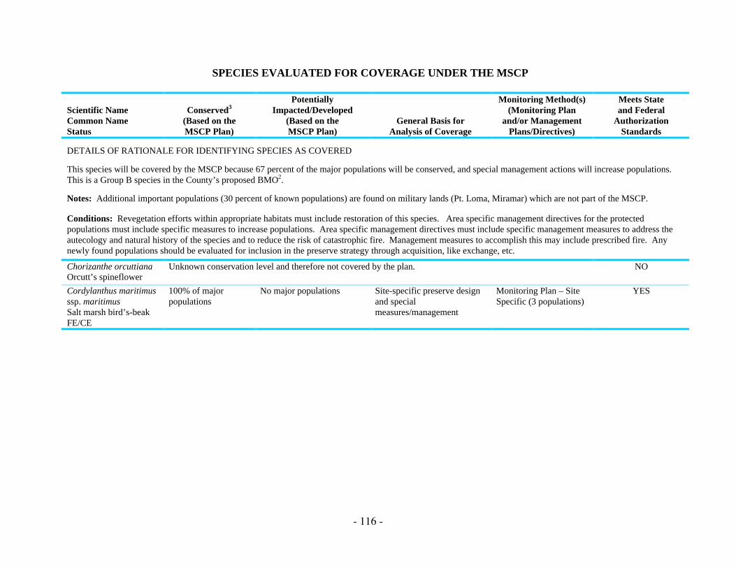
This species will be covered by the MSCP because 67 percent of the major populations will be conserved, and special management actions will increase populations.This is a Group B species in the County’s proposed BMO2.
Notes: Additional important populations (30 percent of known populations) are found on military lands (Pt. Loma, Miramar) which are not part of the MSCP.
Conditions: Revegetation efforts within appropriate habitats must include restoration of this species. Area specific management directives for the protectedpopulations must include specific measures to increase populations. Area specific management directives must include specific management measures to address theautecology and natural history of the species and to reduce the risk of catastrophic fire. Management measures to accomplish this may include prescribed fire. Anynewly found populations should be evaluated for inclusion in the preserve strategy through acquisition, like exchange, etc.
Chorizanthe orcuttianaOrcutt’s spineflower
Unknown conservation level and therefore not covered by the plan. NO
Cordylanthus maritimusssp. maritimusSalt marsh bird’s-beakFE/CE
100% of majorpopulations
No major populations Site-specific preserve designand specialmeasures/management
Monitoring Plan – SiteSpecific (3 populations)
YES

- 117 -
SPECIES EVALUATED FOR COVERAGE UNDER THE MSCP
Scientific NameCommon NameStatus
Conserved3
(Based on theMSCP Plan)
PotentiallyImpacted/Developed
(Based on theMSCP Plan)
General Basis forAnalysis of Coverage
Monitoring Method(s)(Monitoring Plan
and/or ManagementPlans/Directives)
Meets Stateand Federal
AuthorizationStandards
DETAILS OF RATIONALE FOR IDENTIFYING SPECIES AS COVERED
This species will be covered by the MSCP because 100 percent of major populations within the MSCP plan area will be conserved.
Note: Participating jurisdictions’ guidelines and ordinances, and state and federal wetland regulations will provide additional protection. One population of thisspecies also occurs on military lands (Naval Radar Receiving Facility) which are not part of the MSCP.
Conditions: Area specific management directives must 1) include measures to reduce threats and stabilize populations (e.g., relocation of footpaths, establishmentof buffer areas, etc.), 2) address opportunities for reintroduction, and 3) include measures to enhance existing populations (e.g., protect and improve upland habitatfor pollinators). There is a federal recovery plan for this species and management activities should to the extent possible help achieve the specified goals. Any newlyfound populations shall be evaluated for inclusion in the preserve strategy through acquisition, like exchange, etc.
CordylanthusorcuttianusOrcutt’s bird’s-beakNone
75% of majorpopulations
25% of major populations Preserve design/landscapelevel with site-specificconsideration(s)/management
Monitoring Plan – SiteSpecific (4 populations)and Management Plans/Directives
YES
DETAILS OF RATIONALE FOR IDENTIFYING SPECIES AS COVERED
This species will be covered by the MSCP because 3 of 4 (75 percent) major populations will be conserved. A portion of the Otay River Valley population liesoutside of the MHPA but will be subject to the County’s Biological Mitigation Ordinance (80-100 percent conservation). The Otay Ranch population (southeast ofLower Otay Lake) is considered conserved subject to landowner and agency agreement.
Condition: AT the time permit amendments are proposed, strategies to provide protection for this species within the amendment area must be included. (Takeauthorization amendments are subject to public review through CEWX and NEPA processes and require approval by CDFG and USFWS.)

- 118 -
SPECIES EVALUATED FOR COVERAGE UNDER THE MSCP
Scientific NameCommon NameStatus
Conserved3
(Based on theMSCP Plan)
PotentiallyImpacted/Developed
(Based on theMSCP Plan)
General Basis forAnalysis of Coverage
Monitoring Method(s)(Monitoring Plan
and/or ManagementPlans/Directives)
Meets Stateand Federal
AuthorizationStandards
Corethrogynefilaginifolia var.linifoliaDel Mar Mesa sandasternone
48% of majorpopulations, 57% ofknown localities and67% of southernmaritime chaparral
52% of major populations,43% of known localitiesand 33% of southernmaritime chaparral
Preserve design/landscapelevel with site-specificconsideration(s)/management
Monitoring Plan – SiteSpecific
YES
DETAILS OF RATIONALE FOR IDENTIFYING SPECIES AS COVERED
This species will be covered by the MSCP because 48 percent of major populations and 67 percent of its potential habitat (southern maritime chaparral) will beconserved. This is a Group A species in the County’s proposed BMO2.
Notes: This taxon has been merged with two other Corethrogyne filaginifolia varieties, and has been determined not to meet the taxonomic standards for listing.
Conditions: Area specific management directives for the protected populations must include specific measures to protect against detrimental edge effects to thisspecies. Area specific management directives must include specific management measures to address the autecology and natural history of the species and to reducethe risk of catastrophic fire. Management measures to accomplish this may include prescribed fire.
Cupressus forbessiTecate cypressnone
98% Tecate cypressforest
2% Tecate cypress forest Preserve design/landscapelevel
Monitoring Plan –Habitat Based andPhoto Plot
YES

- 119 -
SPECIES EVALUATED FOR COVERAGE UNDER THE MSCP
Scientific NameCommon NameStatus
Conserved3
(Based on theMSCP Plan)
PotentiallyImpacted/Developed
(Based on theMSCP Plan)
General Basis forAnalysis of Coverage
Monitoring Method(s)(Monitoring Plan
and/or ManagementPlans/Directives)
Meets Stateand Federal
AuthorizationStandards
DETAILS OF RATIONALE FOR IDENTIFYING SPECIES AS COVERED
This species will be covered by the MSCP because 98 percent of major populations will be conserved, primarily on lands administered by BLM.
Conditions: Area specific management directives for the protected populations will include specific measures to maintain or increase populations. Area specificmanagement directives must include specific management measures to address the autecology and natural history of the species and to reduce the risk of catastrophicfire. Management measures to accomplish this may include prescribed fire.
Dudleya blochmaniaessp. brevifoliaShort-leaved dudleyaPE/CE
100% of majorpopulations
No major populations Site-specific preserve designand specialmeasures/management
Monitoring Plan –SiteSpecific (3 populations)and ManagementPlans/Directives
YES
DETAILS OF RATIONALE FOR IDENTIFYING SPECIES AS COVERED
This species will be covered by the MSCP because 100 percent of major populations will be conserved. This species is on the MSCP’s list of narrow endemics andtherefore participating jurisdictions must specify in their Subarea Plans additional conservation measures1 for the species.
Notes: The populations on Del Mar Mesa, Carmel Mountain, and Crestview Canyon are subject to considerable edge effects. The wildlife agencies will work withthe University of California, San Diego to protect and manage the University of California property adjacent to Skeleton Canyon for this species.
Conditions: Area specific management directives must include 1) specific measures to protect against detrimental edge effects to this species, 2) species-specificmonitoring and 3) maintenance of surrounding habitat for pollinators.

- 120 -
SPECIES EVALUATED FOR COVERAGE UNDER THE MSCP
Scientific NameCommon NameStatus
Conserved3
(Based on theMSCP Plan)
PotentiallyImpacted/Developed
(Based on theMSCP Plan)
General Basis forAnalysis of Coverage
Monitoring Method(s)(Monitoring Plan
and/or ManagementPlans/Directives)
Meets Stateand Federal
AuthorizationStandards
Dudleya variegataVariegated dudleyanone
56% of majorpopulations, 75% ofknown localities
44% of major populations,25% of known localities
Site-specific preserve designand specialmeasures/management
Monitoring Plan – SiteSpecific (5 populations)and ManagementPlans/Directives
YES
DETAILS OF RATIONALE FOR IDENTIFYING SPECIES AS COVERED
This species will be covered by the MSCP because 56 percent of major populations and 75 percent of known localities will be conserved. This species is on theMSCP’s list of narrow endemics and therefore participating jurisdictions must specify in their Subarea Plans additional conservation measures1 for the species.
Conditions: Area specific management directives must include species-specific monitoring and specific measures to protect against detrimental edge effects to thisspecies, including effects caused by recreational activities. Some populations now occur within a major amendment area (Otay Mountain) and at the time permitamendments aer proposed, strategies to provide protection for this species within the amendment area must be included. (Proposed take authorization amendmentswill have public review through CEWX and NEPA processes and require approval by CDFG and USFWS.)
Dudleya viscidaSticky dudleyanone
100% of majorpopulation
No major populations Preserve design/landscapelevel
Monitoring Plan –Habitat Based
YES
DETAILS OF RATIONALE FOR IDENTIFYING SPECIES AS COVERED
This species will be covered by the MSCP because 100 percent of the only major population within the MSCP will be conserved.
Notes: Persistence of this species in San Diego County depends largely on conservation efforts in the MHCP and Camp Pendleton areas.
Conditions: Area specific management directives must address specific measures to protect against detrimental edge effects.

- 121 -
SPECIES EVALUATED FOR COVERAGE UNDER THE MSCP
Scientific NameCommon NameStatus
Conserved3
(Based on theMSCP Plan)
PotentiallyImpacted/Developed
(Based on theMSCP Plan)
General Basis forAnalysis of Coverage
Monitoring Method(s)(Monitoring Plan
and/or ManagementPlans/Directives)
Meets Stateand Federal
AuthorizationStandards
Ericameria palmeri ssp.palmeriPalmer’s ericameriaNone
66% of majorpopulations
34% of major populations Site-specific preserve designand specialmeasures/management
Monitoring Plan –Habitat based and PhotoPlot and ManagementPlans/Directives
YES
DETAILS OF RATIONALE FOR IDENTIFYING SPECIES AS COVERED
This species will be covered by the MSCP because 66 percent of major populations will be conserved. This species is on the MSCP’s list of narrow endemics andtherefore participating jurisdictions must specify in their Subarea Plans additional conservation measures1 for the species.
Notes: Impacts from these projects will be fully mitigated through avoidance, minimization and compensation. Two of the six major populations are subject topotential impacts from proposed road widening projects (Jamacha Blvd., Highways 54/94).
Eryngium aristulatumvar. parishiiSan Diego button-celeryFE/CE
82% of majorpopulations, 88% ofvernal pool habitat
18% of major populationsmay be impacted, butvernal pool habitat issubject to no net loss offunction and value and404(b)1 guidelines
Preserve design/landscapelevel with site-specificconsideration(s)/management
Area SpecificManagement Directives(wetlands)
YES

- 122 -
SPECIES EVALUATED FOR COVERAGE UNDER THE MSCP
Scientific NameCommon NameStatus
Conserved3
(Based on theMSCP Plan)
PotentiallyImpacted/Developed
(Based on theMSCP Plan)
General Basis forAnalysis of Coverage
Monitoring Method(s)(Monitoring Plan
and/or ManagementPlans/Directives)
Meets Stateand Federal
AuthorizationStandards
DETAILS OF RATIONALE FOR IDENTIFYING SPECIES AS COVERED
This species will be covered by the MSCP because 82 percent of major populations and 8 percent of vernal pool habitat will be conserved.
Notes: Additional important populations are found on military lands (Miramar) which are not part of the MSCP. Four populations (Proctor Valley, Otay RiverValley, Del Mar Mesa, Spring Canyon) are likely to be subject to edge effects. This species has been added to the City of San Diego’s list of narrow endemicspecies. Vernal pools which become part of the National Wildlife Refuge would be managed for the recovery of this species.
Conditions: Area specific management directives must include specific measures to protect against detrimental edge effects.
Erysimum ammophilumCoast wallflowernone
92% of southernforedunes, 67^ ofsouthern maritimechaparral
8% of southern foredunes,33% of southern maritimechaparral
Preserve design/landscapelevel
Monitoring Plan –Habitat Based andIncidental
YES
DETAILS OF RATIONALE FOR IDENTIFYING SPECIES AS COVERED
This species will be covered by the MSCP because 92 percent of southern foredunes and 67 percent of southern maritime chaparral vegetation communities (that arepotential habitat for this species) will be conserved.
Notes: Populations from San Diego County aer now being treated as Erysimum capitatum, a common species of wallflower.
Ferocactus viridescensSan Diego barrel cactusnone
81% of majorpopulations
19% of major populations Preserve design/landscapelevel
Monitoring Plan –Habitat Based andPhoto Plot
YES

- 123 -
SPECIES EVALUATED FOR COVERAGE UNDER THE MSCP
Scientific NameCommon NameStatus
Conserved3
(Based on theMSCP Plan)
PotentiallyImpacted/Developed
(Based on theMSCP Plan)
General Basis forAnalysis of Coverage
Monitoring Method(s)(Monitoring Plan
and/or ManagementPlans/Directives)
Meets Stateand Federal
AuthorizationStandards
DETAILS OF RATIONALE FOR IDENTIFYING SPECIES AS COVERED
This species will be covered by the MSCP because 81 percent of major populations will be conserved. This is a Group B species in the County’s proposed BMO2.
Notes: This is an abundant species that will be protected at varying levels in several subareas: Carmel Mountain, 64 percent; East Elliot, 75 percent; Marron Valley,90 percent; Mission Trails Regional Park, 94 percent; Otay Mesa, 70 percent; Otay River Valley, 100 percent; Sweetwater Reservoir, 100 percent; SycamoreCanyon-Fanita Ranch, 50 percent.Conditions: Area specific management directives must include measures to protect this species from edge effects, unauthorized collection, and include appropriatefire management/control practices to protect against a too frequent fire cycle.
FremontodendronmexicanumMexican flannel bushPE/CR
Insufficient distribution data and unknown conservation level; therefore, the species is not covered by the plan. NO
Githopsis diffusa ssp.filicaulisMission Canyonbluecupnone
Unknown conservation level and therefore not covered by the plan. NO
Hemizonia conjugensOtay tarplantPE/CE
66% of majorpopulations
34% of major populations Site-specific preserve designand specialmeasures/management
Monitoring Plan – SiteSpecific (5 populations)and ManagementPlans/Directives
YES

- 124 -
SPECIES EVALUATED FOR COVERAGE UNDER THE MSCP
Scientific NameCommon NameStatus
Conserved3
(Based on theMSCP Plan)
PotentiallyImpacted/Developed
(Based on theMSCP Plan)
General Basis forAnalysis of Coverage
Monitoring Method(s)(Monitoring Plan
and/or ManagementPlans/Directives)
Meets Stateand Federal
AuthorizationStandards
DETAILS OF RATIONALE FOR IDENTIFYING SPECIES AS COVERED
This species will be covered by the MSCP because 66 percent of major populations will be conserved. This species is on the MSCP’s list of narrow endemics andtherefore participating jurisdictions must specify in their Subarea Plans additional conservation measures1 for the species.
Conditions: MSCP coverage of this species requires avoidance of populations in the Otay River Valley through sensitive design and development of the activerecreations areas as described in the Otay Ranch RMP and GDP. One of the seven major populations occurs within an amendment area (Proctor Valley). AT thetime permit amendments are proposed, strategies to provide protection for this species within the amendment area must be include (proposed take authorizationamendments will be subject to public review through CEWA and NEPA processes and take authorization amendments require approval by CDFG and USFWS).Area specific management directives must include specific measures for monitoring of populations and adaptive management of preserves (taking into considerationthe extreme population fluctuations from year to year), and specific measures to protect against detrimental edge effects to this species.
Hemizonia floribundaTecate tarplantnone
Unknown conservation levels and therefore not covered by the plan. NO
Lepechinia cardiophyllaHeart-leaved pitchersagenone
85% of majorpopulations
15% of major populations Preserve design/landscapelevel
Monitoring Plan –Habitat Based andPhoto Plot
YES

- 125 -
SPECIES EVALUATED FOR COVERAGE UNDER THE MSCP
Scientific NameCommon NameStatus
Conserved3
(Based on theMSCP Plan)
PotentiallyImpacted/Developed
(Based on theMSCP Plan)
General Basis forAnalysis of Coverage
Monitoring Method(s)(Monitoring Plan
and/or ManagementPlans/Directives)
Meets Stateand Federal
AuthorizationStandards
DETAILS OF RATIONALE FOR IDENTIFYING SPECIES AS COVERED
This species will be covered by the MSCP because 85 percent of major populations will be conserved. The Iron Mountain population falls within a 100 percentconservation area. The other three major populations fall within the County’s area of undetermined development status and will receive 80-100 percent conservationbased on the County’s proposed BMO2 (Group A species).
Conditions: Area specific management directives must include: 1) specific measures to protect against detrimental edge effects; 2) specific measures to promoteincrease of populations; and 3) specific management measures to address the autecology and natural history of the species and to reduce the risk of catastrophic fire (management measures to accomplish this may include prescribed fire).
Lepechinia ganderiGander’s pitcher sagenone
All known locations No known locations Preserve design/landscapelevel with site-specificconsideration(s)/management
Monitoring Plan –Habitat Based andPhoto Plot andManagementPlans/Directives
YES
DETAILS OF RATIONALE FOR IDENTIFYING SPECIES AS COVERED
This species will be covered by the MSCP because 100 percent of the known locations will be conserved. This species is on the MSCP’s list of narrow endemics andtherefore participating jurisdictions must specify in their Subarea Plans additional conservation measures1 for the species.
Conditions: Area specific management directives must include: 1) specific measures to protect against detrimental edge effects and uncontrolled access; 2)measures to promote the increase of populations; and 3) specific management measures to address the autecology and natural history of the species and to reduce therisk of catastrophic fire (management measures to accomplish this may include prescribed fire). One of the five major populations occurs within a major amendment(Otay Mountain). At the time permit amendments are proposed, strategies to provide protection for this species within the amendment area must be included(proposed take authorization amendments are subject to public review through CEWX and NEPA processes and require approval by CDFG and USFWS).

- 126 -
SPECIES EVALUATED FOR COVERAGE UNDER THE MSCP
Scientific NameCommon NameStatus
Conserved3
(Based on theMSCP Plan)
PotentiallyImpacted/Developed
(Based on theMSCP Plan)
General Basis forAnalysis of Coverage
Monitoring Method(s)(Monitoring Plan
and/or ManagementPlans/Directives)
Meets Stateand Federal
AuthorizationStandards
Lotus nuttallianusNuttal’s lotusnone
80-100% of majorpopulations; 92% ofsouthern foredunehabitat
0-20% of majorpopulations; 8% ofsouthern foredune habitat
Preserve design/landscapelevel
Monitoring Plan – SiteSpecific (1 population)
YES
DETAILS OF RATIONALE FOR IDENTIFYING SPECIES AS COVERED
This species will be covered by the MSCP because 80-100 percent of the major populations will be conserved and 92 percent of the habitat (southern foredunes) willbe conserved.
Notes: Additional important populations are found on military lands (Imperial Beach, Silver Strand) which are not part of the MSCP . The USFWS is currentlyworking with the Navy to provide protection for this species on Silver Strand.
Conditions: Area specific management directives must include specific measures to protect against detrimental edge effects.
Monardella hypoleucassp. lanataFelt-leaved monardellanone
89% of majorpopulations
11% of major populations Preserve design/landscapelevel with site-specificconsideration(s)/management
Monitoring Plan –Habitat Based andPhoto Plot andManagementPlans/Directives
YES

- 127 -
SPECIES EVALUATED FOR COVERAGE UNDER THE MSCP
Scientific NameCommon NameStatus
Conserved3
(Based on theMSCP Plan)
PotentiallyImpacted/Developed
(Based on theMSCP Plan)
General Basis forAnalysis of Coverage
Monitoring Method(s)(Monitoring Plan
and/or ManagementPlans/Directives)
Meets Stateand Federal
AuthorizationStandards
DETAILS OF RATIONALE FOR IDENTIFYING SPECIES AS COVERED
This species will be covered by the MSCP because 89 percent of major populations will be conserved. The Sequan Peak and Iron Mountain populations areidentified as critical populations which will be 100 percent protected (San Diego County Subarea Plan). This species is on the MSCP’s list of narrow endemics andtherefore participating jurisdictions must specify in their Subarea Plans additional specific conservation measures1 for this species. This is a Group A species in theCounty’s proposed BMO2.
Notes: Persistence of this species in San Diego County depends, in part, on conservation effects outside the MSCP area.
Conditions: Area specific management directives must also include measures to protect against detrimental edge effects and uncontrolled access.
Monardella linoidesssp. vimineaWillowy monardellaPE/CE
100% of majorpopulations
No major populations Preserve design/landscapelevel
Monitoring Plan – SiteSpecific (2 populations)and ManagementPlans/Directives
YES
DETAILS OF RATIONALE FOR IDENTIFYING SPECIES AS COVERED
This species will be covered by the MSCP because 100 percent of major populations will be conserved. Additional important populations are found on military lands(Miramar) which are not included as part of the MSCP. This species occurs in drainages and would receive protected based on Fish and Game Code 1600agreements and federal wetlands permitting. This is a Group A species in the County’s proposed BMO2.
Conditions: Area specific management directives must include specific measures to protect against detrimental edge effects.
Muilla clevelandiiSan Diego goldenstarnone
73% of majorpopulations and 38%of grasslands
27% of major populations Preserve design/landscapelevel with site-specificconsideration(s)/management
Monitoring Plan – SiteSpecific (4 populations)
YES

- 128 -
SPECIES EVALUATED FOR COVERAGE UNDER THE MSCP
Scientific NameCommon NameStatus
Conserved3
(Based on theMSCP Plan)
PotentiallyImpacted/Developed
(Based on theMSCP Plan)
General Basis forAnalysis of Coverage
Monitoring Method(s)(Monitoring Plan
and/or ManagementPlans/Directives)
Meets Stateand Federal
AuthorizationStandards
DETAILS OF RATIONALE FOR IDENTIFYING SPECIES AS COVERED
This species will be covered by the MSCP because 8 of 11 major populations, 125 of 144 occurrences, and 38 percent of the grassland vegetation community will beconserved. The City of San Diego will avoid populations within its 25 percent encroachment area. The 4S Ranch population will be transplanted into an appropriatepreserve area. This is a Group A species in the County’s proposed BMO2.
Conditions: Area specific management directives must include monitoring of the transplanted population(s), and specific measures to protect against detrimentaledge effects to this species.
Myosurus minimus ssp.apusLittle mousetailnone
The MSCP preserve does not include adequate habitat to conserve the species. NO
Navarretia fossalisProstrate navarretiaPT/
63% of only majorpopulation, 88% ofvernal pool habitat
37% of only majorpopulation, 12% of vernalpool habitat may beimpacted, but this habitat issubject to no net loss offunction and value and404(b)1 guidelines
Site-specific preserve designand specialmeasures/management
Area SpecificManagement Directives(wetlands)
YES

- 129 -
SPECIES EVALUATED FOR COVERAGE UNDER THE MSCP
Scientific NameCommon NameStatus
Conserved3
(Based on theMSCP Plan)
PotentiallyImpacted/Developed
(Based on theMSCP Plan)
General Basis forAnalysis of Coverage
Monitoring Method(s)(Monitoring Plan
and/or ManagementPlans/Directives)
Meets Stateand Federal
AuthorizationStandards
DETAILS OF RATIONALE FOR IDENTIFYING SPECIES AS COVERED
This species will be covered by the MSCP because 63 percent of the one major population and 88 percent of vernal pool habitat will be conserved. Federal wetlandregulations will provide additional protection for vernal pool habitats. This is a Group A species in the County’s proposed BMO2.
Notes: State and federal transportation agencies will need to avoid or adequately mitigate the impacts to this species from the extension of State Route125. Anadditional small population is found on military lands (Miramar) and is not included as part of the MSCP. Vernal pools incorporated into the National WildlifeRefuge System would be managed for the recovery of this species.
Conditions: Area specific management directives must include specific measures to protect against detrimental edge effects to this species, and must incorporatemeasures to conserve and maintain surrounding habitat for 1) pollinators and 2) as part of the hydrological system for the vernal pools.
Nolina interrataDehesa bear-grassPT/CE
90-100% of majorpopulations
<10% of major populations Preserve design/landscapelevel
Monitoring Plan –Habitat Based andPhoto Plot andManagementPlans/Directives
YES

- 130 -
SPECIES EVALUATED FOR COVERAGE UNDER THE MSCP
Scientific NameCommon NameStatus
Conserved3
(Based on theMSCP Plan)
PotentiallyImpacted/Developed
(Based on theMSCP Plan)
General Basis forAnalysis of Coverage
Monitoring Method(s)(Monitoring Plan
and/or ManagementPlans/Directives)
Meets Stateand Federal
AuthorizationStandards
DETAILS OF RATIONALE FOR IDENTIFYING SPECIES AS COVERED
This species will be covered by the MSCP because: 100 percent of the McGinty Mountain population will be conserved; half of the Sequan Peak population is underprotected ownership and 80-100 percent of the other half will be conserved; and 80-100 percent of the Dehesa Peak population will be conserved under the County’sproposed BMO (Group A species)2. This species is on the MSCP’s list of narrow endemics and therefore participating jurisdictions must specify in their SubareaPlans additional specific conservation measures1 for this species.
Notes: Acquisition of the remaining portions of the population on Sequan Peak is important and efforts are underway by CDFG.
Conditions: Area specific management directives must include specific measures to protect against detrimental edge effects and management measures to maintainsurrounding habitats for pollinators.
Opuntia parryi var.serpentinaSnake chollanone
75% of majorpopulations and 67%of southern maritimechaparral
25% of major populationsand 33% of southernmaritime chaparral
Preserve design/landscapelevel with site-specificconsideration(s)/management
Area SpecificManagement Directives
YES

- 131 -
SPECIES EVALUATED FOR COVERAGE UNDER THE MSCP
Scientific NameCommon NameStatus
Conserved3
(Based on theMSCP Plan)
PotentiallyImpacted/Developed
(Based on theMSCP Plan)
General Basis forAnalysis of Coverage
Monitoring Method(s)(Monitoring Plan
and/or ManagementPlans/Directives)
Meets Stateand Federal
AuthorizationStandards
DETAILS OF RATIONALE FOR IDENTIFYING SPECIES AS COVERED
This species will be covered by the MSCP because 75 percent of major populations and 67 percent of the southern maritime chaparral vegetation community will beconserved. This species is on the MSCP’s list of narrow endemics and therefore participating jurisdictions must specify in their Subarea Plans additional specificconservation measures1 for this species.
Notes: Additional important populations are found on military lands (Pt. Loma) which are not part of the MSCP.
Conditions: Area specific management directives must include specific measures to protect against detrimental edge effects to this species, and promotetranslocation opportunity where appropriate. The Otay Ranch project GDP and RMP require protection of 80 percent of existing occurrences, and transplantation ofany impacted occurrences to restored areas of comparable size.
Orcuttia californicaCalifornia Orcutt grassFE/CE
86% of only majorpopulation, 88% ofvernal pool habitat
14% of only majorpopulation may beimpacted, but vernal poolhabitat is subject to no netloss of function of valueand 404(b)1 guidelines
Preserve design/landscapelevel with site-specificconsideration(s)/management
Area SpecificManagement Directives(wetlands)
YES

- 132 -
SPECIES EVALUATED FOR COVERAGE UNDER THE MSCP
Scientific NameCommon NameStatus
Conserved3
(Based on theMSCP Plan)
PotentiallyImpacted/Developed
(Based on theMSCP Plan)
General Basis forAnalysis of Coverage
Monitoring Method(s)(Monitoring Plan
and/or ManagementPlans/Directives)
Meets Stateand Federal
AuthorizationStandards
DETAILS OF RATIONALE FOR IDENTIFYING SPECIES AS COVERED
This species will be covered by the MSCP because 86 percent of the one major population will be conserved. This species is on the MSCP’s list of narrow endemicsand therefore participating jurisdictions must specify in their Subarea Plans additional specific conservation measures1 for this species.
Notes: A population outside of the MHPA (J-13N pool complex) is conserved with dedicated open space as mitigation for the Ramona K-mart. The USFWS willwork with the border patrol to minimize impacts to this species. An additional small population is found on military lands (Miramar) and is not part of the MSCP.
Conditions: Area specific management directives must include specific measures to protect against detrimental edge effects to this species and measures to maintainsurrounding habitats for pollinators.
Pinus torreyanaTorrey pinenone
100% of nativepopulation
No major populations Preserve design/landscapelevel
Monitoring Plan –Habitat Based
YES
DETAILS OF RATIONALE FOR IDENTIFYING SPECIES AS COVERED
This species will be covered by the MSCP because the single naturally occurring population at Torrey Pines State Reserve will be conserved and appropriatelymanaged.
Pogogyne abramsiiSan Diego mesa mintFE/CE
88% of vernal poolhabitat
12% of vernal pool habitatmay be impacted, but thishabitat is subject to no netloss of function and valueand 404(b)1 guidelines
Preserve design/landscapelevel with site-specificconsideration(s)/management
Area SpecificManagement Directives
YES

- 133 -
SPECIES EVALUATED FOR COVERAGE UNDER THE MSCP
Scientific NameCommon NameStatus
Conserved3
(Based on theMSCP Plan)
PotentiallyImpacted/Developed
(Based on theMSCP Plan)
General Basis forAnalysis of Coverage
Monitoring Method(s)(Monitoring Plan
and/or ManagementPlans/Directives)
Meets Stateand Federal
AuthorizationStandards
DETAILS OF RATIONALE FOR IDENTIFYING SPECIES AS COVERED
This species will be covered by the MSCP because 88 percent of its potential habitat (vernal pool habitat) will be conserved. Federal wetland regulations willprovide additional protection for vernal pool habitats.
Notes: The three major populations in the county occur on military lands (Miramar) which are not part of the MSCP. The City of San Diego has added this speciesto its narrow endemics list. The population at Montgomery Field was mistakenly omitted from the original mapping and now has been included. This population willbe conserved and managed by the City of San Diego. Vernal pools included in the National Wildlife Refuge would be managed for recovery of this species.
Conditions: Preserve management plan must include measures to: 1) protect against detrimental effects; 2) maintain surrounding habitat for pollinators; and 3)maintain pool watershed areas.
Pogogyne nudiusculaOtay Mesa mintFE/CE
91% of the majorpopulation, 88% ofvernal pool habitat
0% of the major populationmay be impacted, and thishabitat is subject to no netloss of function and valueand 404(b)1 guidelines
Preserve design/landscapelevel with site-specificconsideration(s)/management
Area SpecificManagement Directives
YES

- 134 -
SPECIES EVALUATED FOR COVERAGE UNDER THE MSCP
Scientific NameCommon NameStatus
Conserved3
(Based on theMSCP Plan)
PotentiallyImpacted/Developed
(Based on theMSCP Plan)
General Basis forAnalysis of Coverage
Monitoring Method(s)(Monitoring Plan
and/or ManagementPlans/Directives)
Meets Stateand Federal
AuthorizationStandards
DETAILS OF RATIONALE FOR IDENTIFYING SPECIES AS COVERED
This species will be covered by the MSCP because 91 percent of the one major population will be conserved, and federal wetland regulations will provide additionalprotection for vernal pool habitats.
Notes: Twenty-six percent of the stockpan soils will be conserved, which will provide for enhancement opportunities for this species. The City of San Diego hasadded this species to their narrow endemics list. Vernal pools included in the National Wildlife Refuge would be managed for recovery of this species. The RMP forthe Otay Ranch project includes protection for vernal pools with sensitive species.
Conditions: Preserve management plan must include measures to: protect against detrimental edge effects; maintain surrounding habitat for pollinators; andmaintain pool watershed areas.
Rosa minutifoliaSmall-leaved rose/CE
Only known MSCPoccurrencetransplanted intopreserve, propagationand restoration inappropriate habitat
Site-specific preserve designand specialmeasures/management
Area SpecificManagement Directives(1 population)
YES

- 135 -
SPECIES EVALUATED FOR COVERAGE UNDER THE MSCP
Scientific NameCommon NameStatus
Conserved3
(Based on theMSCP Plan)
PotentiallyImpacted/Developed
(Based on theMSCP Plan)
General Basis forAnalysis of Coverage
Monitoring Method(s)(Monitoring Plan
and/or ManagementPlans/Directives)
Meets Stateand Federal
AuthorizationStandards
DETAILS OF RATIONALE FOR IDENTIFYING SPECIES AS COVERD
There is only one known occurrence of this species in the MSCP on Otay Mesa near Dennery Canyon. The occurrence may be a single clone, and some evidencesuggests it may be a cultivar. This species will be covered by the MSCP because the only known occurrence will be conserved through the California Terracesproject.
The following conditions for small-leaved rose conservation are required in the CDFG 2081 as part of the California Terraces project:
1. The rose population shall be salvaged, propagated, and transplanted to a new location that will support a healthy, reproducing population in perpetuity. Thisgoal shall be achieved through a five year program that includes site improvement, propagation, transplantation, and monitoring. (a) The rose population shallbe transplanted to a suitable open space preserve location on the Otay Mesa or to an alternative location subject to Department approval. Criteria in siteselection shall include similar habitat, slope, aspect, soils, and hydrology as present on the existing rose site. (b) Propagation and transplanting of the rosepopulation shall be implemented by a qualified native plant nursery/habitat restoration contractor (hereinafter Restoration Contractor), acceptable to thedepartment, and under supervision of a qualified botanist. The rose propagation shall take place over a two year period. Rose plants to be extirpated shall besalvaged through: (i) seed collection; (ii) preparation of cuttings from rose canes; and (iii) salvage of underground parts and transplantation. (d) Transplantationof the rose clone shall commence during the period of October-December 1997. The remaining rose clone shall be cut into a minimum of 200 clumps. Eachclump possessing roots and de-caned stems shall be planted on the HM lands as prescribed by a qualified botanist.
2. No removal of the rose population for a two (2) year period commencing from the date of planting propagated rose plants at the approved locations.
3. The progress of the rose mitigation effort shall be assessed through measurements and observations for a period of at least five (5) years followingimplementation of rose transplantation commencing in December 1997 and ending in July 2002. Factors to be monitored shall include growth, survival and/orestablishment rate of the species, presence of introduced weeds, erosion, effects of herbivores, and any other factors important to the success of the mitigationeffort. Community structure and species diversity at the mitigation site shall also be assessed. (a) Transplant success criteria over a five (5) year period shallinclude: (i) measurable annual growth on a minimum of 50 percent of the rose plants; and (ii) flowering of 50 percent of the rose plants during a minimum ofone flowering season. In the event that success criteria are not met, the project applicant shall implement remedial measures subject to department approval.

- 136 -
SPECIES EVALUATED FOR COVERAGE UNDER THE MSCP
Scientific NameCommon NameStatus
Conserved3
(Based on theMSCP Plan)
PotentiallyImpacted/Developed
(Based on theMSCP Plan)
General Basis forAnalysis of Coverage
Monitoring Method(s)(Monitoring Plan
and/or ManagementPlans/Directives)
Meets Stateand Federal
AuthorizationStandards
Santureja chandleriSan Miguel savorynone
80-100% of futureidentifiedoccurrences
0-20% Preserve design/landscapelevel with site-specificconsideration(s)/management
Monitoring Plan –Habitat Based andPhoto Plot
YES
DETAILS OF RATIONALE FOR IDENTIFY SPECIES AS COVERED
This species will be covered by the MSCP because it will be conserved at the 80+ percent level. The County will add this species to Group A or B of the County’sproposed BMO2.
Conditions: Area specific management directives must include specific management measures to address the autecology and natural history of the species and toreduce the risk of catastrophic fire. Management measures to accomplish this may include prescribed fire. This species will be conserved at the 80+ percent level.
Senecio ganderiGander’s butterweed*/CR
90-100% of majorpopulations
<10% of major populations Preserve design/landscapelevel with site-specificconsideration(s)/management
Monitoring Plan –Habitat Based andPhoto Plot
YES

- 137 -
SPECIES EVALUATED FOR COVERAGE UNDER THE MSCP
Scientific NameCommon NameStatus
Conserved3
(Based on theMSCP Plan)
PotentiallyImpacted/Developed
(Based on theMSCP Plan)
General Basis forAnalysis of Coverage
Monitoring Method(s)(Monitoring Plan
and/or ManagementPlans/Directives)
Meets Stateand Federal
AuthorizationStandards
DETAILS OF RATIONALE FOR IDENTIFYING SPECIES AS COVERED
This species will be covered by the MSCP because 90-100 percent of known major populations would be conserved. Half of the Sequan Peak population is underprotected ownership and 80-100 percent of the other half will be conserved, and 90-100 percent of the McGinty Mountain populations will be conserved. The ElCajon Mountain (between El Capitan and San Vicente Reservoir) population is identified as critical which requires 100 percent protection based on the San DiegoCounty Subarea Plan. Occurrences in the County’s areas of undetermined development status will receive 80-100 percent protection under the County’s proposedBMO2 (Group A species).
Notes: This species is often associated with gabbro soils which will be conserved at the 43+ percent level. Acquisition of the remaining portions of the populationon Sequan Peak is important and efforts are underway by CDFG.
Conditions: Area specific management directives must include: 1) specific measures to protect against detrimental edge effects to this species; and 2) measures toaddress the autecology and natural history of the species.
Solanum tenuilobatumNarrow-leavednightshadenone
90% of majorpopulations
10% of major populations Preserve design/landscapelevel with site-specificconsideration(s)/management
Monitoring Plan –Habitat Based andPhoto Plot andManagementPlans/Directives
YES
DETAILS OF RATIONALE FOR IDENTIFYING SPECIES AS COVERED
This species will be covered by the MSCP because 90 percent of major populations will be conserved. Two smaller populations, Silverwood and Fernbrook, areidentified as critical and will be 100 percent protected in the San Diego County Subarea Plan.
Notes: This species is now taxonomically included in Solanum xanti.

- 138 -
SPECIES EVALUATED FOR COVERAGE UNDER THE MSCP
Scientific NameCommon NameStatus
Conserved3
(Based on theMSCP Plan)
PotentiallyImpacted/Developed
(Based on theMSCP Plan)
General Basis forAnalysis of Coverage
Monitoring Method(s)(Monitoring Plan
and/or ManagementPlans/Directives)
Meets Stateand Federal
AuthorizationStandards
Tetracoccus dioicusParry’s tetracoccusnone
80-100% of majorpopulations
0-20% of major populations Preserve design/landscapelevel
Monitoring Plan –Habitat Based andPhoto Plot
YES
DETAILS OF RATIONALE FOR IDENTIFYING SPECIES AS COVERED
This species will be covered by the MSCP because 80-100 percent of major populations will be conserved.
Notes: Fourteen of 33 (43 percent) small populations are already under protected ownership. The Dehesa population is identified as critical and will be 100 percentprotected in the San Diego County Subarea Plan. Occurrences in the County’s areas of undetermined development status will receive 80-100 percent protectionunder the County’s proposed BMO2 (Group A species). Acquisition of the remaining portions of the population on Sequan Peak is important and efforts areunderway by CDFG. This species is often associated with gabbro soils and 43+ percent of the gabbro soils are within the MHPA.
Conditions: Area specific management directives must include specific measures to protect against detrimental edge effects to this species.
ANIMALS
Invertebrates
Euphydryas edithaquinoQuino checkerspotbutterflyPE/
Unknown conservation level and lack of assurances that plan will protect preferred habitat (mesatops/grassland) and connection to known sources populations. Therefore, not covered by the plan.
NO
Euphyes vestriesharbisoniHarbison’s dun skippernone
Unknown conservation level and therefore not covered by the plan based on insufficient distribution and lifehistory data.
NO

- 139 -
SPECIES EVALUATED FOR COVERAGE UNDER THE MSCP
Scientific NameCommon NameStatus
Conserved3
(Based on theMSCP Plan)
PotentiallyImpacted/Developed
(Based on theMSCP Plan)
General Basis forAnalysis of Coverage
Monitoring Method(s)(Monitoring Plan
and/or ManagementPlans/Directives)
Meets Stateand Federal
AuthorizationStandards
Lycaena thorneiHermes copper butterflynone
Unknown conservation level and therefore not covered by the plan based on insufficient distribution and lifehistory data.
NO
Mitoura throneiThorne’s hairstreakbutterflynone
98% of Tecatecypress forest (larvalhost plant)
2% of Tecate cypress forest Preserve design/landscapelevel with site-specificconsideration(s)/management
Monitoring Plan –Habitat Based
YES
DETAILS OF RATIONALE FOR IDENTIFYING SPECIES AS COVERED
This species will be covered by the MSCP because 98 percent of the major populations of its larval host plant, Tecate cypress, will be conserved. Most of the Tecatecypress forest occurs on BLM lands.
Conditions: Area specific management directives must manage for the host species (Tecate cypress). Management measures to accomplish this may includeprescribed fire.
Panoquina erransSalt marsh skippernone
93% of salt marshhabitat (1,700+ acres)
7% of salt marsh habitat(120+ acres) may beimpacted, but is subject tono net loss of function andvalue and 404(b)1guidelines
Preserve design/landscapelevel
Monitoring Plan –Habitat Based
YES

- 140 -
SPECIES EVALUATED FOR COVERAGE UNDER THE MSCP
Scientific NameCommon NameStatus
Conserved3
(Based on theMSCP Plan)
PotentiallyImpacted/Developed
(Based on theMSCP Plan)
General Basis forAnalysis of Coverage
Monitoring Method(s)(Monitoring Plan
and/or ManagementPlans/Directives)
Meets Stateand Federal
AuthorizationStandards
DETAILS OF RATIONALE FOR IDENTIFYING SPECIES AS COVERED
This species will be covered by the MSCP because 93 percent of its potential habitat will be conserved.
Conditions: Area specific management directives must include measures to: control exotic weeds and invertebrate predators (where appropriate), and control accessto saltmarsh habitat.
BranchinectasandiegoensisSan Diego fairy shrimpPE/
88% of vernal poolhabitat
12% of vernal pool habitatmay be impacted, but thishabitat is subject to no netloss of function and valueand 404(b)1 guidelines
Preserve design/landscapelevel
Area SpecificManagement Directives
YES
DETAILS OF RATIONALE FOR IDENTIFYING SPECIES AS COVERED
This species will be covered by the MSCP because 88 percent of its potential habitat (vernal pool habitat) will be conserved. Federal and local wetland regulationswill provide additional protection for vernal pool habitats. The Otay Ranch project RMP and GDP require protection for vernal pools with sensitive species.
Notes: Additional important habitat for this species occurs on military lands (Miramar) and is not part of the MSCP.
Conditions: Area specific management directives must include specific measures to protect against detrimental edge effects to this species.

- 141 -
SPECIES EVALUATED FOR COVERAGE UNDER THE MSCP
Scientific NameCommon NameStatus
Conserved3
(Based on theMSCP Plan)
PotentiallyImpacted/Developed
(Based on theMSCP Plan)
General Basis forAnalysis of Coverage
Monitoring Method(s)(Monitoring Plan
and/or ManagementPlans/Directives)
Meets Stateand Federal
AuthorizationStandards
StreptocephaluswoottoniiRiverside fairy shrimpFE/
88% of vernal poolhabitat
12% of vernal pool habitatmay be impacted, but thishabitat is subject to no netloss of function and valueand 404(b)1 guidelines
Preserve design/landscapelevel
Area SpecificManagement Directives
YES
DETAILS OF RATIONALE FOR IDENTIFYING SPECIES AS COVERED
This species will be covered by the MSCP because 88 percent of its potential habitat (vernal pool habitat) will be conserved. Federal and local wetland regulationswill provide additional protection for vernal pool habitats. The Otay Ranch project RMP and GDP require protection for vernal pools with sensitive species.
Notes: Additional important habitat for this species occurs on military lands (Miramar) and is not part of the MSCP.
Conditions: Area specific management directives must include specific measures to protect against detrimental edge effects to this species.
Reptiles and Amphibians

- 142 -
SPECIES EVALUATED FOR COVERAGE UNDER THE MSCP
Scientific NameCommon NameStatus
Conserved3
(Based on theMSCP Plan)
PotentiallyImpacted/Developed
(Based on theMSCP Plan)
General Basis forAnalysis of Coverage
Monitoring Method(s)(Monitoring Plan
and/or ManagementPlans/Directives)
Meets Stateand Federal
AuthorizationStandards
Bufo microscaphuscalifornicusArroyo southwesterntoadFE/SSC
All known locations(Cottonwood Creekin Marron Valley,San Vicente Creekand Santa YsabelCreek in San PasqualValley, SweetwaterRiver, and OtayRiver), 78% riparianwetland areas insuitable habitat
Upland habitats adjacent toriparian wetlands (potentialhabitat) in undeterminedstatus areas in SloanCanyon – wetlands aresubject to no net loss offunction and value and404(b)1 guidelines
Preserve design/landscapelevel with site-specificconsideration(s)/management
Monitoring Plan – SiteSpecific (7 locations)and ManagementPlans/Directives
YES
DETAILS OF RATIONALE FOR IDENTIFYING SPECIES AS COVERED
This species will be covered by the MSCP because the MHPA preserves all known locations, and 90-95 percent of the upland habitats within the Marron Valley areawill be conserved. Impacts to upland habitats within 1 km of riparian corridors within the MHPA will be minimized during project review by CDFG and USFWS.Take authorization holders must minimize impacts to upland habitats which provide habitat for this species which are: within the MHPA and are within 1 km ofriparian habitat which supports or is likely to support Arroyo toad. Participating jurisdictions’ guidelines and ordinances, and state and federal wetland regulationswill provide additional habitat protection resulting no net loss of wetlands.
Notes: Important habitat areas include the San Diego River below El Capitan Reservoir, San Vicente Creek between Sweetwater Reservoir and Loveland Reservoir,Dulzura Creek, San Pasqual Valley from Lake Hodges to Boden Canyon, Otay River, Jamul Creek, Cedar Creek and Sycamore Creek.
Conditions: Area specific management directives must address the maintenance of Arroyo toad through control of non-native predators, protection and maintenanceof sufficient suitable low gradient sandy stream habitat (including appropriate water quality) to meet breeding requirements, and preservation of sheltering andforaging habitat within 1 km of occupied breeding habitat within preserved lands. Area specific management directives must include measures to control humanimpacts to the species within the preserve (e.g., public education, patrol, etc.).

- 143 -
SPECIES EVALUATED FOR COVERAGE UNDER THE MSCP
Scientific NameCommon NameStatus
Conserved3
(Based on theMSCP Plan)
PotentiallyImpacted/Developed
(Based on theMSCP Plan)
General Basis forAnalysis of Coverage
Monitoring Method(s)(Monitoring Plan
and/or ManagementPlans/Directives)
Meets Stateand Federal
AuthorizationStandards
Rana aurora draytoniCalifornia red0-leggedfrogFT/SSC
72% of riparianhabitats and freshwater marsh (9,500+acres
28% of riparian habitatsand fresh water marsh(3,800+ acres) - ) wetlandsare subject to no net loss offunction and value and404(b)1 guidelines
Preserve design/landscapelevel
Monitoring Plan –Habitat Based
YES
DETAILS OF RATIONALE FOR IDENTIFYING SPECIES AS COVERED
This species is believed to be extirpated from the County. Although unlikely, additional survey effort may detect red-legged frog. Therefore, this species will becovered by the MSCP because 70 percent of its potential habitat will be conserved. Participating jurisdictions’ guidelines and ordinances, and state and federalwetland regulations will provide additional habitat protection resulting in no net loss of wetlands.
Conditions: Area specific management directives must provide for management of any new discovered populations within the preserve.
Clemmys marmoratapallidaSouthwestern pondturtle/SSC
72% of riparianhabitats and freshwater marsh (9,501acres)
28% of riparian habitatsand fresh water marsh(3,800+ acres) – wetlandsare subject to no net loss offunction and value and404(b)1 guidelines
Preserve design/landscapelevel with site-specificconsideration(s)/management
Monitoring Plan –Habitat Based andManagementPlans/Directives
YES

- 144 -
SPECIES EVALUATED FOR COVERAGE UNDER THE MSCP
Scientific NameCommon NameStatus
Conserved3
(Based on theMSCP Plan)
PotentiallyImpacted/Developed
(Based on theMSCP Plan)
General Basis forAnalysis of Coverage
Monitoring Method(s)(Monitoring Plan
and/or ManagementPlans/Directives)
Meets Stateand Federal
AuthorizationStandards
DETAILS OF RATIONALE FOR IDENTIFYING SPECIES AS COVERED
This species will be covered by the MSCP because 72 percent of its potential habitat will be conserved. Participating jurisdictions’ guidelines and ordinances, andstate and federal wetland regulations will provide additional habitat protection resulting in no net loss of wetlands.
Conditions: Maintain and manage a 1500 foot area around known locations within preserve lands for the species. Within this impact avoidance area, humanimpacts will be minimized, non-native species detrimental to pond turtles controlled/removed and habitat restoration/enhancement measures implemented.
Cnemidophorushyperythrus beldingiOrange-throatedwhiptail/SSC
59% of potentialhabitat (129,600+acres) – 38% ofknown pointoccurrences
41% of potential habitat(89,800+ acres) – 38% ofknown point occurrences
Preserve design/landscapelevel
Monitoring Plan – SiteSpecific (pit traps at 12locations)
YES

- 145 -
SPECIES EVALUATED FOR COVERAGE UNDER THE MSCP
Scientific NameCommon NameStatus
Conserved3
(Based on theMSCP Plan)
PotentiallyImpacted/Developed
(Based on theMSCP Plan)
General Basis forAnalysis of Coverage
Monitoring Method(s)(Monitoring Plan
and/or ManagementPlans/Directives)
Meets Stateand Federal
AuthorizationStandards
DETAILS OF RATIONALE FOR IDENTIFYING SPECIES AS COVERED
This species will be covered by the MSCP because 59 percent of its potential habitat and 62 percent of known point occurrences will be conserved. Habitat linkagesbetween large blocks of protected lands are conserved in a functional manner. Monitoring of populations and adaptive management of preserves will occur as aresult of plan implementation.
Notes: This species also occurs extensively on military lands.
Conditions: Area specific management directives must address edge effects.
Phrynosoma coronatumblainvilleiSan Diego horned lizard/SSC
60% of potentialhabitat (132,000+acres) – 64% ofcoastal sage scrub,54% of chaparral,44% of coastalsage/chapparal, 80%of riparian scrub –63% of known pointoccurrences
40% of potential habitat(89,700+ acres) – 37% ofknown point occurrences
Preserve design/landscapelevel
Monitoring Plan – SiteSpecific (pit traps at 12locations)
YES
DETAILS OF RATIONALE FOR IDENTIFYING SPECIES AS COVERED
This species will be covered by the MSCP because 60 percent of its potential habitat and 63 percent of known point occurrences will be conserved. Habitat linkagesbetween large blocks of protected lands are conserved in a functional manner. Monitoring of populations and adaptive management of preserves will occur as aresult of plan implementation.
Conditions: Area specific management directives must include specific measures to maintain native ant species, discourage the Argentine ant, and protect againstdetrimental edge effects to this species.

- 146 -
SPECIES EVALUATED FOR COVERAGE UNDER THE MSCP
Scientific NameCommon NameStatus
Conserved3
(Based on theMSCP Plan)
PotentiallyImpacted/Developed
(Based on theMSCP Plan)
General Basis forAnalysis of Coverage
Monitoring Method(s)(Monitoring Plan
and/or ManagementPlans/Directives)
Meets Stateand Federal
AuthorizationStandards
Birds
Pelecanus occidentaliscalifornicusCalifornia brownpelicanFE/CE
91% of roosting andforaging habitat(2,800+ acres) – 93%of southern coastalsaltmarsh, 88% ofnatural flood channel,90-95% of beachoutside of intensivelyused recreationalbeaches
9% of roosting and foraginghabitat (270+ acres) –wetlands are subject to nonet loss of function andvalue and 404(b)1guidelines
Preserve design/landscapelevel
Monitoring Plan –Habitat Based
YES
DETAILS OF RATIONALE FOR IDENTIFYING SPECIES AS COVERED
This species will be covered by the MSCP because 91 percent of roosting and foraging habitat within the plan area will be conserved. No new development ofbeaches is authorized which will result in 90-95 percent protection of beach habitat that is outside of intensively used beach areas.
Notes: Most of the important roosting and foraging habitat occurs on military lands and waters under Port Authority jurisdiction which are not included as part ofthe MSCP. Participating jurisdictions’ guidelines and ordinances, and state and federal wetland regulations will provide additional habitat protection resulting in nonet loss of wetlands. This species is a common to very common non-breeding visitor which uses mud flats, piers, jetties, etc., to roost and forages primarily incoastal ocean waters and San Diego.

- 147 -
SPECIES EVALUATED FOR COVERAGE UNDER THE MSCP
Scientific NameCommon NameStatus
Conserved3
(Based on theMSCP Plan)
PotentiallyImpacted/Developed
(Based on theMSCP Plan)
General Basis forAnalysis of Coverage
Monitoring Method(s)(Monitoring Plan
and/or ManagementPlans/Directives)
Meets Stateand Federal
AuthorizationStandards
Egretta rufescensReddish egretnone
92% of potentialhabitat (2,700+ acres)– 93% of southerncoastal saltmarsh,99% of salt pan, 88%of natural floodchannel
8% of potential habitat(230+ acres) – wetlands aresubject to no net loss offunction and value and404(b)1 guidelines
Preserve design/landscapelevel
Monitoring Plan –Habitat Based
YES
DETAILS OF RATIONALE FOR IDENTIFYING SPECIES AS COVERED
This species will be covered by the MSCP because 90 percent of its potential habitat will be conserved.
Notes: Additional important habitat occurs in waters under Port Authority and military jurisdiction which are not included as part of the MSCP. Participatingjurisdictions’ guidelines and ordinances, and state and federal wetland regulations will provide additional habitat protection resulting in no net loss of wetlands. Thisspecies forages is shallow lagoons, mud flats, tidal channels and salt marsh. This species is a rare visitor in fall and winter and a casual visitor in spring and summer,but does not nest in San Diego County.
Plegadis chihiwhite-faced ibis*/SSC
78% of potentialhabitat (1,200+ acres)– 68% of freshwatermarsh, 88% ofnatural flood channel,additionally 1,800+acres of potentiallyhabitat agriculturalland will beconserved
26% of potential habitat(300+ acres) – wetlands aresubject to no net loss offunction and value and404(b)1 guidelines
Preserve design/landscapelevel
Monitoring Plan –Habitat Based
YES

- 148 -
SPECIES EVALUATED FOR COVERAGE UNDER THE MSCP
Scientific NameCommon NameStatus
Conserved3
(Based on theMSCP Plan)
PotentiallyImpacted/Developed
(Based on theMSCP Plan)
General Basis forAnalysis of Coverage
Monitoring Method(s)(Monitoring Plan
and/or ManagementPlans/Directives)
Meets Stateand Federal
AuthorizationStandards
DETAILS OF RATIONALE FOR IDENTIFYING SPECIES AS COVERED
This species will be covered by the MSCP because 78 percent of its potential habitat will be conserved. Participating jurisdictions’ guidelines and ordinances, andstate and federal wetland regulations will provide additional habitat protection resulting in no net loss of wetlands. The preserve management plan for the City ofSan Diego cornerstone lands must include protection and management of potential nesting habitat at Lake Hodges.
Conditions: Area specific management directives must include specific measures to protect against detrimental edge effects to this species.
Branta canadensisCanada goosenone
8,200+ acres ofpotencial habitat
1,100+ acres of potentialhabitat – wetlands aresubject to no net loss offunction and value and404(b)1 guidelines
Preserve design/landscapelevel
Monitoring Plan –Habitat Based
YES
DETAILS OF RATIONALE FOR IDENTIFYING SPECIES AS COVERED
Although not considered sensitive, this species has aesthetic and intrinsic values, and is a regulated game species thereby being an important species to protect. Thisspecies will be covered by the MSCP because 8,200+ acres of its potential habitat will be conserved, including open water areas for loafing. Participatingjurisdiction’s guidelines and ordinances, and state and federal wetland regulations will provide additional habitat protection resulting in no net loss of wetlands.

- 149 -
SPECIES EVALUATED FOR COVERAGE UNDER THE MSCP
Scientific NameCommon NameStatus
Conserved3
(Based on theMSCP Plan)
PotentiallyImpacted/Developed
(Based on theMSCP Plan)
General Basis forAnalysis of Coverage
Monitoring Method(s)(Monitoring Plan
and/or ManagementPlans/Directives)
Meets Stateand Federal
AuthorizationStandards
HaliaeetusleucocephalusBald eagleFT/CE
89% of potentialforaging habitat(wetlands) (5,719+acres), 68% offreshwater marsh,92% of open water.In addition, foragingopportunities(carrion, etc.) on100,000+ acres willbe conserved.
11% of potential foraginghabitat (wetlands) (692+acres) – wetlands aresubject to no net loss offunction and value and404(b)1 guidelines
Preserve design/landscapelevel
Monitoring Plan –Habitat Based
YES
DETAILS OF RATIONALE FOR IDENTIFYING SPECIES AS COVERED
This species will be covered by the MSCP because 89 percent of its potential foraging habitat (open water and freshwater marsh) will be conserved. Bald eagles area rare winter visitor which require perching and roosting sites adjacent to open water and marshes. Participating jurisdictions’ guidelines and ordinances, and stateand federal wetland regulations will provide additional habitat protection resulting in no net loss of wetlands.
Circus cyaneusNorthern harrier/SSC
42% of potentialnesting habitat(12,000+ acres) –93% of saltmarsh,68% of freshwatermarsh and 38% ofgrasslands, - 85,000+acres of potentialforaging habitat
48% of potential nestinghabitat (16,300+ acres) –wetlands are subject to nonet loss of function andvalue and 404(b)1guidelines
Preserve design/landscapelevel with site-specificconsideration(s)/management
Monitoring Plan –Habitat Based andManagementPlans/Directives (nestsites)
YES

- 150 -
SPECIES EVALUATED FOR COVERAGE UNDER THE MSCP
Scientific NameCommon NameStatus
Conserved3
(Based on theMSCP Plan)
PotentiallyImpacted/Developed
(Based on theMSCP Plan)
General Basis forAnalysis of Coverage
Monitoring Method(s)(Monitoring Plan
and/or ManagementPlans/Directives)
Meets Stateand Federal
AuthorizationStandards
DETAILS OF RATIONALE FOR IDENTIFYING SPECIES AS COVERED
This species is an uncommon migrant and winter visitor, and rare summer resident/breeder. This species will be covered by the MSCP because 42 percent of itspotential nesting habitat, and 85,000+ acres of its potential foraging habitat will be conserved. The plan will not adversely affect the species’ long-term survival.
Notes: Harriers tolerate patchiness in their habitat, exhibit nest area fidelity, and forage within four miles of their nests. Additional conservation of grasslandhabitats should be a priority and one of the primary factors in the design of preserves in the major amendment areas. Participating jurisdiction’s guidelines andordinances, and state and federal wetland regulations will provide additional habitat protection resulting in no net loss of wetlands. Active nesting areas include:
Tijuana River Valley – The City of San Diego Subarea Plan includes conservation of two known nesting sites in the Tijuana River Valley, and maintenance of someagricultural lands (available for foraging harriers) within the Tijuana River Valley Regional Park. The Tijuana National Estuarine Sanctuary will continue to enhancemarshlands and manage for nesting harriers. Some existing grasslands and agricultural lands at the outer limits of the foraging distance for nesting harriers will bedeveloped. With the addition of over 4,000 acres of agricultural and disturbed lands to the City of San Diego’s preserve (in comparison with the March 1995preserve design), adequate foraging areas within this area are conserved. Food production for harriers on preserve lands can be enhanced.
South San Diego Bay/Sweetwater Marsh – The City of San Diego Subarea Plan includes conservation of one known nesting site in the Sweetwater Marsh area. Allnesting and foraging habitat within four miles of the known nesting site will be preserved. Upland habitat enhancement exist at the D Street fill area.
Proctor Valley – Proctor Valley includes an historical nesting location (1970s). Over 80 percent of the Proctor Valley area will be conserved with most of thedevelopment occurring in the upper portion of the valley, away from the more likely nesting areas.
Conditions: Area specific management directives must: manage agricultural and disturbed lands (which become part of the preserve) within four miles of nestinghabitat to provide foraging habitat; include an impact avoidance area (900 foot or maximum possible within the preserve) around active nests; and include measuresof maintaining winter foraging habitat in preserve areas in Proctor Valley, around Sweetwater Reservoir, San Miguel Ranch, Otay Ranch east of Wueste Road, LakeHodges, and San Pasqual Valley. The preserve management coordination group shall coordinate efforts to manage for wintering northern harriers’ foraging habitatwithin the MSCP preserves.

- 151 -
SPECIES EVALUATED FOR COVERAGE UNDER THE MSCP
Scientific NameCommon NameStatus
Conserved3
(Based on theMSCP Plan)
PotentiallyImpacted/Developed
(Based on theMSCP Plan)
General Basis forAnalysis of Coverage
Monitoring Method(s)(Monitoring Plan
and/or ManagementPlans/Directives)
Meets Stateand Federal
AuthorizationStandards
Accipiter cooperiiCooper’s hawk/SSC
59% of potentialforaging habitat(133,400+ acres)(47% of oakwoodland, 58% ofoak riparian, 64% ofcoastal sage scrub,54% of chapparal,44% of coastal sagescrub/chaparral –57% of knownlocalities) and 52%(5,705+ acres) ofpotential nestinghabitat (58% of oakriparian and 47% ofoak woodland)
41% of potential foraging(93,900+ acres) and 48% ofpotential nesting habitat(5,200+ acres)
Preserve design/landscapelevel with the site-specificconsideration(s)/management
Monitoring Plan –Habitat Based andManagementPlans/Directives (sitespecific nest territories)
YES
DETAILS OF RATIONALE FOR IDENTIFYING SPECIES AS COVERED
This species will be covered by the MSCP because 59 percent of potential foraging and 52 percent of potential nesting habitat and 92 percent of known occurrenceswill be conserved.
Conditions: In the design of future projects within the Metro-Lakeside-Jamul segment, design of preserve areas shall conserve patches of oak woodland and oakriparian forest of adequate size for nesting and foraging habitat. Area specific management directives must include 300-foot impact avoidance areas around theactive nests, and minimization of disturbance in oak woodlands and oak riparian forests.

- 152 -
SPECIES EVALUATED FOR COVERAGE UNDER THE MSCP
Scientific NameCommon NameStatus
Conserved3
(Based on theMSCP Plan)
PotentiallyImpacted/Developed
(Based on theMSCP Plan)
General Basis forAnalysis of Coverage
Monitoring Method(s)(Monitoring Plan
and/or ManagementPlans/Directives)
Meets Stateand Federal
AuthorizationStandards
Buteo swainsoniSwainson’s hawk/CT
22% of foraginghabitat (11,600+acres) – 38% ofgrassland, 6% ofagricultural fields
78% of foraging habitat(42,000+ acres)
Preserve design/landscapelevel
Monitoring Plan –Habitat Based (10grassland locations)
YES
DETAILS OF RATIONALE FOR IDENTIFYING SPECIES AS COVERED
This species is an extremely rare visitor during migration which forages in grasslands and agricultural fields. This species will be covered by the MSCP becausemore than 11,000 acres of potential foraging habitat will be conserved.
Notes: The plan will not adversely affect the species’ long-term survival. Additional conservation of grassland habitats should be a priority and one of the primaryfactors in the design of preserves in the major amendment areas. This species is a rare migrant through the area.
Buteo regalisFerruginous hawk*/SSC
22% of foraginghabitat (11,600+acres) – 38% ofgrassland, 6% ofagricultural fields
78% of foraging habitat(42,000+ acres)
Preserve design/landscapelevel
Monitoring Plan –Habitat Based (10grassland locations)
YES
DETAILS OF RATIONALE FOR IDENTIFYING SPECIES AS COVERED
This species will be covered because 11,600+ acres of potential foraging habitat will be conserved. This species is an uncommon winter visitor which forages ingrasslands and agricultural fields.
Notes: The plan will not adversely affect the species’ long-term survival. Additional conservation of grassland habitats should be a priority and one of the primaryfactors in the design of preserves in the major amendment areas. This species is not known to nest within the MSCP study area.

- 153 -
SPECIES EVALUATED FOR COVERAGE UNDER THE MSCP
Scientific NameCommon NameStatus
Conserved3
(Based on theMSCP Plan)
PotentiallyImpacted/Developed
(Based on theMSCP Plan)
General Basis forAnalysis of Coverage
Monitoring Method(s)(Monitoring Plan
and/or ManagementPlans/Directives)
Meets Stateand Federal
AuthorizationStandards
Aquila chrysaetosGolden eagleBEPA/SSC
53% of potentialforaging/nestinghabitat (coastal sagescrub, chaparral,grassland and oakwoodland) 139,000+acres) – large blocksof habitat conservedin the eastern portionof the plan areawhere active nestingterritories exist. Ofthe 11 active nestingterritories (based oninformation from theGolden Eagle SurveyProject, San Diego)which are fully orpartially within theMSCP plan area, 7nesting territoriesshould remain viable.
Viability of 4 of the 11active nesting territories(partially or fully within theplan area)
Preserve design/landscapelevel with the site-specificconsideration(s)/management
Monitoring Plan –Habitat Based andManagementPlans/Directives (sitespecific nest territories)
YES

- 154 -
SPECIES EVALUATED FOR COVERAGE UNDER THE MSCP
Scientific NameCommon NameStatus
Conserved3
(Based on theMSCP Plan)
PotentiallyImpacted/Developed
(Based on theMSCP Plan)
General Basis forAnalysis of Coverage
Monitoring Method(s)(Monitoring Plan
and/or ManagementPlans/Directives)
Meets Stateand Federal
AuthorizationStandards
DETAILS OF RATIONALE FOR IDENTIFYING SPECIES AS COVERED
This species will be covered by the MSCP because 53 percent of potential foraging and nesting habitat will be conserved. Local populations are not critical to, andthe plan will not adversely affect the species’ long-term survival.
Notes: Fourteen active nesting territories occur primarily outside of the MSCP area (east and northeast of the plan area). Plans developed for these areas shouldinclude measures to conserve adequate habitat to maintain their viability. The following is an analysis of the plan’s effects on each nesting territory.
1. Rancho San Diego – development under the plan will result in <10 percent loss of habitat in the nesting territory, nesting territory should remain viable;2. East Otay Mountain – development under the plan will result in <5 percent loss of habitat in the nesting territory, nesting territory should remain viable;3. Sequan Peak – between 30 percent and 40 percent of the habitat in the nesting territory could be developed, the nesting territory may not remain viable, but the
steepness of the areas which could be developed may preclude enough development to keep the territory viable;4. Loveland Reservoir – development of under the plan will result in >20 percent loss of habitat in the nesting territory, nesting territory should remain viable;5. Lake Jennings – between 40 percent and 60 percent of the habitat in the nesting territory could be developed under the plan, the nesting territory may not remain
viable;6. El Capitan territory – development under the plan will result in <15 percent loss of habitat within the nesting territory, the territory should remain viable;7. San Vicente Reservoir – development under the plan will result in <30 percent of the high quality golden eagle habitat being developed, although low quality
habitat (steep chaparral) could be developed resulting in greater habitat loss within the nesting territory (although high density development is not likely tooccur because of the steep sloes), the nesting territory is may not be viable;
8 and 9. San Pasqual (two nesting territories) – development under the plan will result in <20 percent loss of habitat in the nesting territory and both nestingterritories should remain viable:
10. Santee – development under the plan could result in 30 percent-40 percent loss of habitat in the nesting territory and the nesting territory may not remainviable, although a significant amount of foraging habitat (Miramar and Mission Trails) occurs just outside of the territory and within normal foragingdistances; and
11. Lake Hodges – development under the plan will result in <20 percent loss of habitat in the nesting territory, the nesting territory should remain viable.
Conditions: Area specific management directives for areas with nest sites must include measures to avoid human disturbance while the nest is active, includingestablishing a 4,000 foot disturbance avoidance area within preserve lands. Area specific management directives must also include monitoring of nest sites todetermine use/success.

- 155 -
SPECIES EVALUATED FOR COVERAGE UNDER THE MSCP
Scientific NameCommon NameStatus
Conserved3
(Based on theMSCP Plan)
PotentiallyImpacted/Developed
(Based on theMSCP Plan)
General Basis forAnalysis of Coverage
Monitoring Method(s)(Monitoring Plan
and/or ManagementPlans/Directives)
Meets Stateand Federal
AuthorizationStandards
Falco peregrinusanatumAmerican peregrinefalconFE/CE
61% of historicnesting sites – 58%of foraging habitat(89,400+ acres) –93% southern coastalsaltmarsh, 99% ofsaltpan, 68% offreshwater marsh,91% of open water,88% of natural floodchannel, 64% ofcoastal sage scrub,38% of grassland
39% of foraging habitat(57,000+ acres) – wetlandsare subject to no net loss offunction and value and404(b)1 guidelines
Preserve design/landscapelevel
Monitoring Plan –Habitat Based
YES
DETAILS OF RATIONALE FOR IDENTIFYING SPECIES AS COVERED
This species will be covered by the MSCP because more than 89,000 acres of potential foraging habitat will be conserved.
Notes: This species has very low population numbers in the County, being primarily a rare fall and winter visitor. All three nest sites occur outside of the MHPA:one on Coronado Bridge, one on a crane in Port Authority jurisdiction, and one on Pt. Loma federal lands. Participating jurisdictions; guidelines and ordinances, andstate and federal wetland regulations will provide additional habitat protection resulting in no net loss of wetlands.
Rallus longirostrislevipesLight-footed clapper railFE/CE
93% of potentialhabitat (1,700+ acresof southern coastalsaltmarsh)
7% of potential habitat(120+ acres) – wetlands aresubject to no net loss offunction and value and404(b)1 guidelines
Site-specific preserve designand specialmeasures/management
ManagementPlans/Directives
YES

- 156 -
SPECIES EVALUATED FOR COVERAGE UNDER THE MSCP
Scientific NameCommon NameStatus
Conserved3
(Based on theMSCP Plan)
PotentiallyImpacted/Developed
(Based on theMSCP Plan)
General Basis forAnalysis of Coverage
Monitoring Method(s)(Monitoring Plan
and/or ManagementPlans/Directives)
Meets Stateand Federal
AuthorizationStandards
DETAILS OF RATIONALE FOR IDENTIFYING SPECIES AS COVERED
This species will be covered by the MSCP because 93 percent of its habitat will be conserved.
Notes: Additional important habitat is found on military lands (Silver Strand) which are not included as part of the MSCP. Participating jurisdictions’ guidelinesand ordinances, and state and federal wetland regulations will provide additional habitat protection resulting in no net loss of wetlands.
Conditions: Area specific management directives must include active management of wetlands to ensure a healthy tidal saltmarsh environment, and specificmeasures to protect against detrimental edge effects to this species.
Charadriusalexandrinus nivosusWestern snowy ploverFT/SSC
93% of potentialhabitat (650+ acres)99% of saltpan, 90-95% of beach outsideof intensively usedrecreational beaches
7% of potential habitat(467% of potential habitat(46+ acres) –wetlands aresubject to no net loss offunction and value and404(b)1 guidelines
Preserve design/landscapelevel with site-specificconsideration(s)/management
Area SpecificManagement Directives
YES

- 157 -
SPECIES EVALUATED FOR COVERAGE UNDER THE MSCP
Scientific NameCommon NameStatus
Conserved3
(Based on theMSCP Plan)
PotentiallyImpacted/Developed
(Based on theMSCP Plan)
General Basis forAnalysis of Coverage
Monitoring Method(s)(Monitoring Plan
and/or ManagementPlans/Directives)
Meets Stateand Federal
AuthorizationStandards
DETAILS OF RATIONALE FOR IDENTIFYING SPECIES AS COVERED
This species will be covered by the MSCP because 93 percent of its potential habitat will be conserved. All breeding activity of western snowy plovers in the Countyoccurs in saltpan habitat. No new development of beaches is authorized which will result in 90-95 percent conservation of beach habitat that is outside of intensivelyused beach areas.
Notes: Additional important habitat is found on military lands (Silver Strand) which are not part of the MSCP. Participating jurisdictions’ guidelines andordinances, and state and federal wetland regulations will provide additional habitat protection resulting in no net loss of wetlands.
Conditions: Area specific management directives must include protection of nesting sites from human disturbance during the reproductive season, and specificmeasures to protect against detrimental edge effects to this species. Incidental take (during the breeding season) associated with maintenance/removal of levees/dikesis not authorized except as specifically approved on a case-by-case basis by the wildlife agencies.
Charadrius montanusMountain ploverC/SSC
22% of potentialforaging habitat(11,600+ acres) –38% of grassland,6% of agriculturalfields
78% of potential foraginghabitat (41,100+ acres)
Preserve design/landscapelevel
Monitoring Plan –Habitat Based
YES

- 158 -
SPECIES EVALUATED FOR COVERAGE UNDER THE MSCP
Scientific NameCommon NameStatus
Conserved3
(Based on theMSCP Plan)
PotentiallyImpacted/Developed
(Based on theMSCP Plan)
General Basis forAnalysis of Coverage
Monitoring Method(s)(Monitoring Plan
and/or ManagementPlans/Directives)
Meets Stateand Federal
AuthorizationStandards
DETAILS OF RATIONALE FOR IDENTIFYING SPECIES AS COVERED
This species will be covered by the MSCP because over 11,000 acres of potential foraging habitat will be conserved. The plan will not adversely affect the species’long-term survival.
Notes: This species is an uncommon winter visitor (primarily in the Tijuana River Valley) which forages in grasslands and agricultural fields. The MSCPconservation requirement for the Tijuana River Valley area is primarily 94 percent with a small area identified as 75 percent.
Conditions: Management Plans for the Tijuana River Valley should specifically address the habitat requirements for this species.
Numenius americanusLong-billed curlew*/SSC
24% of potentialforaging habitat(13,500+ acres) –93% of southerncoastal saltmarsh,99% of salt pan, 38%of grassland, 6% ofagricultural fields
77% of potential foraginghabitat (42,800+ acres) –wetlands are subject to nonet loss of function andvalue and 404(b)1guidelines
Preserve design/landscapelevel
Monitoring Plan –Habitat Based
YES
DETAILS OF RATIONALE FOR IDENTIFYING SPECIES AS COVERED
This species is a fairly common migrant and winter visitor.
Notes: This species will be covered by the MSCP because more than 13,500 acres of potential foraging habitat will be conserved. The plan will not adversely affectthe species’ long-term survival. Additional conservation of grassland habitats should be a priority and one of the primary factors in the design of preserves in themajor amendment areas. Additional habitat occurs on military lands (Silver Strand, San Diego Bay) which are not part of the MSCP. Participating jurisdictions’guidelines and ordinances, and state and federal wetland regulations will provide additional habitat protection resulting in no net loss of wetlands.

- 159 -
SPECIES EVALUATED FOR COVERAGE UNDER THE MSCP
Scientific NameCommon NameStatus
Conserved3
(Based on theMSCP Plan)
PotentiallyImpacted/Developed
(Based on theMSCP Plan)
General Basis forAnalysis of Coverage
Monitoring Method(s)(Monitoring Plan
and/or ManagementPlans/Directives)
Meets Stateand Federal
AuthorizationStandards
Sterna elegansElegant tern*/SSC
93% of potentialhabitat (650+ acres)99% of saltpan, 90-95% of beach outsideof intensively usedrecreational beaches
10% of potential habitat(46+ acres) – wetlands aresubject to no net loss offunction and value and404(b)1 guidelines
Preserve design/landscapelevel with site-specificconsideration(s)/management
Area SpecificManagement Directives
YES
DETAILS OF RATIONALE FOR IDENTIFYING SPECIES AS COVERED
This species will be covered by the MSCP because 93 percent of its potential habitat will be conserved.
Notes: All breeding activity of elegant terns in the County occurs in saltpan habitat. No new development of beaches is authorized which will result in 90-95percent protection of beach habitat that is outside of intensively used beach areas. Additional important foraging habitat (bay waters) is under the jurisdiction of thePort Authority and military, and are not part of the MSCP. Participating jurisdictions’ guidelines and ordinances, and state and federal wetland regulations willprovide additional habitat protection resulting in no net loss of wetlands.
Conditions: Area specific management directives must include protection of nesting sites from human disturbance during reproductive season, and specificmeasures to protect against detrimental edge effects to this species. Incidental take (during the breeding season) associated with maintenance/removal of levees/dikesis not authorized except as specifically approved on a case-by-case basis by the wildlife agencies.
Sterna antillarumbrowniCalifornia least ternFE/CE
93% of potentialhabitat (650+ acres)99% of saltpan, 90-90% of beach outsideof intensively usedrecreational beaches
7% of potential habitat(46+ acres) – wetlands aresubject to no net loss offunction and value and404(b)1 guidelines
Preserve design/landscapelevel
Area SpecificManagement Directives
YES

- 160 -
SPECIES EVALUATED FOR COVERAGE UNDER THE MSCP
Scientific NameCommon NameStatus
Conserved3
(Based on theMSCP Plan)
PotentiallyImpacted/Developed
(Based on theMSCP Plan)
General Basis forAnalysis of Coverage
Monitoring Method(s)(Monitoring Plan
and/or ManagementPlans/Directives)
Meets Stateand Federal
AuthorizationStandards
DETAILS OF RATIONALE FOR IDENTIFYING SPECIES AS COVERED
This species will be covered by the MSCP because 93 percent of its potential habitat will be conserved.
Notes: No new development of beaches is authorized which will result in 90-95 percent conservation of beach habitat that is outside of intensively used beach areas.Additional important breeding habitat occurs on military lands (North Beach, Silver Strand, Naval Training Center) and are not part of the MSCP. Additionalimportant foraging habitat (bay waters) is under the jurisdiction of the Port Authority and the military, and are not part of the MSCP. Participating jurisdictions’guidelines and ordinances, and state and federal wetland regulations will provide additional habitat protection resulting in no net loss of wetlands.
Conditions: Area specific management directives must include protection of nesting sites from human disturbance during reproductive season, predator control, andspecific measures to protect against detrimental edge effects to this species. Incidental take (during the breeding season) associated with maintenance/removal ofdikes/levees, beach maintenance/enhancement is not authorized except as specifically approved on a case-by-caser basis by the wildlife agencies.
Speotyto cuniculariahypugaeaBurrowing owl*/SSC
4 known locations(Spring Canyon,northeast of BrownField, Lake Hodges),8 known locationswithin majoramendment area(south Countysegment), 4,000+acres of knownhabitat
8 known locations (OtayRanch, San Pasqual Valleyand South County atborder), 5,000+ of knownhabitat
Site-specific preserve designand specialmeasures/management
Monitoring Plan – (10grassland locations) andArea SpecificManagement Directives
YES

- 161 -
SPECIES EVALUATED FOR COVERAGE UNDER THE MSCP
Scientific NameCommon NameStatus
Conserved3
(Based on theMSCP Plan)
PotentiallyImpacted/Developed
(Based on theMSCP Plan)
General Basis forAnalysis of Coverage
Monitoring Method(s)(Monitoring Plan
and/or ManagementPlans/Directives)
Meets Stateand Federal
AuthorizationStandards
DETAILS OF RATIONALE FOR IDENTIFYING SPECIES AS COVERED
This species will be covered by the MSCP because 5,770+ acres of potential and 4,000+ acres of known suitable habitat (grassland vegetation community) will beconserved, including portions of Spring Canyon, San Pasqual Valley, Lake Hodges, Otay Mesa northeast of Brown Field, Otay Ranch, Otay River Valley, and FutureUrbanizing Area 4.
Notes: Habitat enhancement opportunities for the species occur in the Spring Canyon, San Pasqual Valley, Lake Hodges, Otay Mesa northeast of Brown Field, OtayRanch, Otay River Valley and Future Urbanizing Area 4. The wildlife agencies will enhance and manage lands within their ownership to allow for relocation ofburrowing owls, particularly in conjunction with burrowing owl removal programs in areas where their presence conflicts with nesting of California least terns. Thewildlife agencies will attempt to achieve additional conservation of occupied burrowing owl habitat or habitat suitable for restoration using state and federalacquisition resources. Persistence of the species in San Diego County is also dependent on adequate conservation of known concentrations in the San Maria Valleyin the vicinity of Ramona.
Conditions: During the environmental analysis of proposed projects, burrowing owl surveys (using appropriate protocols) must be conducted in suitable habitat todetermine if this species is present and the location of active burrows. If burrowing owls are detected, the following mitigation measures must be implemented:within the MSHPA, impacts must be avoided; outside of the MHPA, impacts to the species must be avoided to the maximum extent practicable; any impactedindividuals must be relocated out of the impact area using passive or active methodologies approved by the wildlife agencies; mitigation for impacts to occupiedhabitat (at the Subarea Plan specified ratio) must be through the conservation of occupied burrowing owl habitat or conservation of lands appropriate for restoration,management and enhancement of burrowing owl nesting and foraging requirements.
Management plans/directives must include: enhancement of known, historical and potential burrowing owl habitat; and management for ground squirrels (theprimary excavator of burrowing owl burrows). Enhancement measures may include creation of artificial burrows and vegetation management to enhance foraginghabitat. Management plans must also include: monitoring of burrowing owl nest sites to determine use and nesting success; predator control; establishing a 300 foot-wide impact avoidance area (within the preserve) around occupied burrows.
Eight known burrowing owl location occur within major amendment areas of the South County Segment of the County Subarea Plan and the conservation ofoccupied burrowing owl habitat must be one of the primary factors preserve design during the permit amendment process.

- 162 -
SPECIES EVALUATED FOR COVERAGE UNDER THE MSCP
Scientific NameCommon NameStatus
Conserved3
(Based on theMSCP Plan)
PotentiallyImpacted/Developed
(Based on theMSCP Plan)
General Basis forAnalysis of Coverage
Monitoring Method(s)(Monitoring Plan
and/or ManagementPlans/Directives)
Meets Stateand Federal
AuthorizationStandards
Empidonax trailliiextimusSouthwestern willowflycatcherFE/CE
76% of potentialhabitat (4,900+ acres)– 90% of riparianwoodland, 80% ofriparian scrub – 88%of known localities
24% of potential habitat(1,400+ acres) – wetlandsare subject to no net loss offunction and value and404(b)1 guidelines
Preserve design/landscapelevel with site-specificconsideration(s)/management
Monitoring Plan –Habitat Based and Area– Specific ManagementDirectives
YES
DETAILS OF RATIONALE FOR IDENTIFYING SPECIES AS COVERED
This species will be covered by the MSCP because 4,900+ acres (76 percent) of potential habitat will be conserved.
Conditions: Jurisdictions must require surveys (using appropriate protocols) during the CEQA review process in suitable habitat proposed to be impacted andincorporate mitigation measures consistent with the 404(b)1 guidelines into the project. Participating jurisdictions’ guidelines and ordinances, and state and federalwetland regulations will provide additional habitat protection resulting in no net loss of wetlands. For new developments adjacent to preserve areas that createconditions attractive to brown-headed cowbirds, jurisdictions must require monitoring and control of cowbirds. Area specific management directives must includemeasures to provide appropriate successional habitat, upland buffers for all known populations, cowbird control, and specific measures to protect against detrimentaledge effects to this species. Any clearing of occupied habitat must occur between September 1 and May 1 (i.e., outside of the nesting period).
Camphylorhynchusbrunneicapillus couesiCoastal cactus wren*/SSC
60% of maritimesucculent scrubhabitat in largecontiguous blocks(850)+ acres)
40% of maritime succulentscrub habitat in smallisolated blocks (580+ acres)
Site-specific preserve designand specialmeasures/management
Monitoring Plan – SiteSpecific (31 locations)and ManagementPlans/Directives
YES

- 163 -
SPECIES EVALUATED FOR COVERAGE UNDER THE MSCP
Scientific NameCommon NameStatus
Conserved3
(Based on theMSCP Plan)
PotentiallyImpacted/Developed
(Based on theMSCP Plan)
General Basis forAnalysis of Coverage
Monitoring Method(s)(Monitoring Plan
and/or ManagementPlans/Directives)
Meets Stateand Federal
AuthorizationStandards
DETAILS OF RATIONALE FOR IDENTIFYING SPECIES AS COVERED
This species is covered because four of five major populations are conserved, including populations at Lake Hodges/San Pasqual Valley, Lake Jennings, SouthSweetwater Reservoir/San Miguel Ranch and Salt Creek/Otay Mesa and 60 percent (850+ acres) will be conserved allowing for expansion of the populations withmanagement.
Notes: This species also uses other habitat types (coastal sage scrub and chaparral) containing cactus patches. Small clusters of birds at Black Mountain and SpringValley will also be conserved. Conservation of the Salt Creek population is critical to the persistence of the species in San Diego County and it would only beconserved under the city of Chula Vista’s “Modified GDP B” alternative. The existing distribution of cactus wrens in the MSCP plan area has been greatly reducedand restoration of suitable cactus wren habitat and its management are important components of the MSCP plan. Significant opportunities for restoration within theMHPA occur on Otay Ranch, Spring Canyon (and adjacent areas), Dennery Canyon, San Miguel Ranch, Lake Hodges/San Pasqual Valley, Otay River Valley andSantee/Lake Jennings. The participating jurisdictions should seek OHV funds for restoration since much of these areas have been heavily impacted by OHVs. TheCity of San Diego has already acquired habitat in Spring Canyon as mitigation. The City of San Diego and the wildlife agencies have agreed to make restorationmaritime succulent scrub in Spring Canyon a high priority. The USFWS will also make restoration of maritime succulent scrub a high priority on any lands itacquires in Spring Canyon.
Conditions: The restoration of maritime succulent scrub habitat as specified in the Otay Ranch RMP and GDP must occur at the specified 1:1 ratio. Area specificmanagement directives must include restoration of maritime succulent scrub habitat, including propagation of cactus patches, active/adaptive management of cactuswren habitat, monitoring of populations within preserves and specific measures to reduce or eliminate detrimental edge effects. No clearing of occupied habitat mayoccur from the period February 15 through August 15.
Polioptila californicacalifornicaCalifornia gnatcatcherFT/SSC
73,300+ acres ofcoastal sage scruband interdigitatedhabitats in aninterconnectednetwork of preserves
67,300+ acres of coastalsage scrub andinterdigitated habitats
Preserve design/landscapelevel
Area SpecificManagement Directives(31 locations)
YES

- 164 -
SPECIES EVALUATED FOR COVERAGE UNDER THE MSCP
Scientific NameCommon NameStatus
Conserved3
(Based on theMSCP Plan)
PotentiallyImpacted/Developed
(Based on theMSCP Plan)
General Basis forAnalysis of Coverage
Monitoring Method(s)(Monitoring Plan
and/or ManagementPlans/Directives)
Meets Stateand Federal
AuthorizationStandards
DETAILS OF RATIONALE FOR IDENTIFYING SPECIES AS COVERED
This species will be covered by the MSCP because: over 73,300 acres of existing and potential gnatcatcher habitat will be conserved and linked together; over 81percent of the core areas where the species occurs (Otay, San Miguel, Mission Trails, Santee, Kearny Mesa, Poway, San Pasqual and Lake Hodges) will beconserved; and 65 percent (1,819 of 2,814) of the known locations will be conserved.
Notes: Sixty-eight percent (57,874 acres) of habitat supporting core gnatcatcher populations and 70 percent (30,273 acres) of very high value and 62 percent highvalue (4,609 acres) gnatcatcher coastal sage scrub habitat would be conserved. Critical habitat linkages between core areas conserved in a function manner with aminimum of 75 percent of the habitat within identified linkages conserved. Populations of this species also occur on military lands which are not part of the MSCP.
Conditions: Area specific management directives must include measures to reduce edge effects and minimize disturbance during the nesting period, fire protectionmeasures to reduce the potential for habitat degradation due to unplanned fire, and management measures to maintain or improve habitat quality including vegetationstructure. No cleaning of occupied habitat within the cities’ MHPAs and within the County’s Biological Resource Core Areas may occur between March 1 andAugust 15.
Sialia mexicanaWestern bluebirdnone
59% of potentialhabitat (15,500+acres) – 57% of oakriparian forest, 47%of oak woodland,34% of grassland
41% of potential habitat(12,100+ acres) – wetlandsare subject to no net loss offunction and value and404(b)1 guidelines
Preserve design/landscapelevel
Monitoring Plan –Habitat Based
YES
DETAILS OF RATIONALE FOR IDENTIFYING SPECIES AS COVERED
This species will be covered by the MSCP because over 15,000 acres of habitat will be conserved.
Notes: Persistence of this species in San Diego County depends largely on conservation of existing large populations on public lands east of the plan area.

- 165 -
SPECIES EVALUATED FOR COVERAGE UNDER THE MSCP
Scientific NameCommon NameStatus
Conserved3
(Based on theMSCP Plan)
PotentiallyImpacted/Developed
(Based on theMSCP Plan)
General Basis forAnalysis of Coverage
Monitoring Method(s)(Monitoring Plan
and/or ManagementPlans/Directives)
Meets Stateand Federal
AuthorizationStandards
Vireo bellii pusillusLeast Bell’s vireoFE/CE
81% of potentialhabitat (1,700+ acres)– 93% of riparianwoodland, 58% ofoak riparian forest –82-100% of majorpopulations
19% of potential habitat(400+ acres) – wetlands aresubject to no net loss offunction and value and404(b)1 guidelines
Preserve design/landscapelevel with site-specificconsideration(s)/management
Monitoring Plan –Habitat Based andManagementPlans/Directives
YES
DETAILS OF RATIONALE FOR IDENTIFYING SPECIES AS COVERED
This species will be covered by the MSCP because 1,700+ acres (81 percent) of potential habitat will be conserved.
Conditions: Jurisdictions will require surveys (using appropriate protocols) during the CEQA review process in suitable habitat proposed to be impacted andincorporate mitigation measures consistent with the 404(b)1 guidelines into the project. Participating jurisdictions’ guidelines and ordinances, and state and federalwetland regulations will provide additional habitat protection resulting in no net loss of wetlands. Jurisdictions must require new developments adjacent to preserveareas that create conditions attractive to brown-headed cowbirds to monitor and control cowbirds. Area specific management directives must include measures toprovide appropriate successional habitat, upland buffers for all known populations, cowbird control, and specific measures to protect against detrimental edge effectsto this species. Any clearing of occupied habitat must occur between September 15 and March 15 (i.e., outside of the nesting period).

- 166 -
SPECIES EVALUATED FOR COVERAGE UNDER THE MSCP
Scientific NameCommon NameStatus
Conserved3
(Based on theMSCP Plan)
PotentiallyImpacted/Developed
(Based on theMSCP Plan)
General Basis forAnalysis of Coverage
Monitoring Method(s)(Monitoring Plan
and/or ManagementPlans/Directives)
Meets Stateand Federal
AuthorizationStandards
Aimophilia ruficepscanescensCalifornia rufous-crowned sparrow*/SSC
61% of potentialhabitat (73,600+acres) – 64% ofcoastal sage scrub,60% of maritimesucculent scrub, 44%of coastalsage/chaparral – 71%of mapped localities
39% of potential habitat(46,600+ acres) – 29% ofmapped localities
Preserve design/landscapelevel
Monitoring Plan –Habitat Based
YES
DETAILS OF RATIONALE FOR IDENTIFYING SPECIES AS COVERED
This species will be covered by the MSCP because 61 percent (73,600+ acres) of potential habitat (including 71 percent of mapped localities) will be conserved.
Notes: This species is tolerant of edge effects, small habitat patches, low shrub volume, and short-term habitat disturbance.
Conditions: Area specific management directives must include maintenance of dynamic processes, such as fire, to perpetuate some open phases of coastal sagescrub with herbaceous components.
Passerculussandwichensis beldingiBelding’s savannahsparrow*/CE
93% of potentialhabitat (1,700+ acresof southern coastalsaltmarsh) – 71% ofmapped localities
7% of potential habitat(120+ acres) – wetlands aresubject to no net loss offunction and value and404(b)1 guidelines
Preserve design/landscapelevel
Monitoring Plan –Habitat Based andManagementPlans/Directives
YES

- 167 -
SPECIES EVALUATED FOR COVERAGE UNDER THE MSCP
Scientific NameCommon NameStatus
Conserved3
(Based on theMSCP Plan)
PotentiallyImpacted/Developed
(Based on theMSCP Plan)
General Basis forAnalysis of Coverage
Monitoring Method(s)(Monitoring Plan
and/or ManagementPlans/Directives)
Meets Stateand Federal
AuthorizationStandards
DETAILS OF RATIONALE FOR IDENTIFYING SPECIES AS COVERED
This species will be covered by the MSCP because 93 percent (1,700+ acres) of potential habitat (including 71 percent of mapped localities) will be conserved andthe remaining acres (120+) are subject to no net loss of value and function.
Notes: Additional important habitat is found on military lands (Silver Strand, North Island, etc.) which are not part of the MSCP. Participating jurisdictions’guidelines and ordinances, and state and federal wetland regulations will provide additional habitat protection resulting in no net loss of wetlands.
Conditions: Area specific management directives must include specific measures to protect against detrimental edge effects to this species.
Passerculussandwichensis rostratusLarge-billed savannahsparrow*/SSC
93% of potentialhabitat (1,700+ acresof southern coastalsaltmarsh) – 50% ofmapped localities
7% of potential habitat(120+ acres) – wetlands aresubject to no net loss offunction and value and404(b)1 guidelines
Preserve design/landscapelevel
Monitoring Plan –Habitat Based andManagementPlans/Directives
YES
DETAILS OF RATIONALE FOR IDENTIFYING SPECIES AS COVERED
This species will be covered by the MSCP because 93 percent (1,700+ acres) of potential habitat (including 50 percent of mapped localities) will be conserved andthe remaining acres (120+) are subject to no net loss of value and function.
Notes: Additional important habitat is found on military lands (Silver Strand, North Island, etc.) which are not part of the MSCP. Participating jurisdictions’guidelines and ordinances, and state and federal wetland regulations will provide additional habitat protection resulting in no net loss of wetlands.
Conditions: Area specific management directives must include specific measures to protect against detrimental edge effects to this species.

- 168 -
SPECIES EVALUATED FOR COVERAGE UNDER THE MSCP
Scientific NameCommon NameStatus
Conserved3
(Based on theMSCP Plan)
PotentiallyImpacted/Developed
(Based on theMSCP Plan)
General Basis forAnalysis of Coverage
Monitoring Method(s)(Monitoring Plan
and/or ManagementPlans/Directives)
Meets Stateand Federal
AuthorizationStandards
AmmodramussavannarumGrasshopper sparrownone
This species will not be covered by the MSCP because insufficient information is available to determine ifadequate habitat is conserved.
NO
Agelaius tricolorTricolored blackbird*/SSC
77% of breedinghabitat (4,800+ acres)– 61% of freshwatermarsh, 80% ofriparian scrub – 59%of known localities
23% of breeding habitat(1,400+ acres)
Preserve design/landscapelevel
ManagementPlans/Directives
YES
DETAILS OF RATIONALE FOR IDENTIFYING SPECIES AS COVERED
This species will be covered by the MSCP because 77 percent of potential habitat (including 59 percent of mapped localities) will be conserved. Breeding coloniesmove from season to season, and with a goal of no net loss of wetlands, most of the suitable breeding sites will continue to be available. This species forages ingrasslands and agricultural fields near its breeding habitat. Foraging habitat near the known nesting colonies will be conserved at 70-100 percent. Additionally,foraging opportunities will continue to be provided and created in turfed areas such as golf courses and cemeteries. Jurisdictions will require surveys during theCEQA review process in suitable breeding habitat proposed to be impacted. Participating jurisdictions’ guidelines and ordinances, and state and federal wetlandregulations will provide additional habitat protection resulting in no net loss of wetlands.
Conditions: Project approvals must require avoidance of active nesting areas during the breeding season. Area specific management directives must includemeasures to avoid impacts to breeding colonies, and specific measures to protect against detrimental edge effects to this species.

- 169 -
SPECIES EVALUATED FOR COVERAGE UNDER THE MSCP
Scientific NameCommon NameStatus
Conserved3
(Based on theMSCP Plan)
PotentiallyImpacted/Developed
(Based on theMSCP Plan)
General Basis forAnalysis of Coverage
Monitoring Method(s)(Monitoring Plan
and/or ManagementPlans/Directives)
Meets Stateand Federal
AuthorizationStandards
Plecotus townsendiiTownsend’s westernbig-eared bat*/SSC
Unknown/Insufficient data on distribution and life history. NO
Eumops perotiscalifornicusCalifornia mastiff bat*/SSC
Unknown/Insufficient data on distribution and life history.
Perognathuslongimembris pacificusPacific pocket mouseFE/SSC
Unknown/Only 3 to 4 known populations in Southern California.Insufficient data on distribution and life history.
NO
Taxidea taxusAmerican badger/SSC
58% of potentialhabitat (82,500+acres) – 38% ofgrassland, 64% ofcoastal sage scrub,44% of coastalsage/chaparral
42% of potential habitat(58,300+ acres)
Preserve design/landscapelevel
Monitoring Plan –Habitat Based
YES

- 170 -
SPECIES EVALUATED FOR COVERAGE UNDER THE MSCP
Scientific NameCommon NameStatus
Conserved3
(Based on theMSCP Plan)
PotentiallyImpacted/Developed
(Based on theMSCP Plan)
General Basis forAnalysis of Coverage
Monitoring Method(s)(Monitoring Plan
and/or ManagementPlans/Directives)
Meets Stateand Federal
AuthorizationStandards
DETAILS OF RATIONALE FOR IDENTIFYING SPECIES AS COVERED
This species will be covered by the MSCP because 82,000+ acres (58 percent) of its potential habitat will be conserved.
Notes: This species has a wide range, and the plan will not adversely affect the species’ long-term survival. Additional conservation of grassland habitats should bea priority and one of the primary factors in the design of preserves in the major amendment areas.
Conditions: Area specific management directives must include measures to avoid direct human impacts to this species if it is present or likely to be present.
Felis concolorMountain lion/protected
81% of core areas 5,6, 7, 8, 9, 11, and 12(105,000+ acres) –connected bylinkages C, D, N
19% of core areas (24,000+acres)
Preserve design/landscapelevel
Monitoring Plan –Habitat Based andCorridor Sites
YES
DETAILS OF RATIONALE FOR IDENTIFYING SPECIES AS COVERED
This species will be covered by the MSCP because 81 percent of the core areas (105,000+ acres) which support its habitat will be conserved.
Notes: Although not considered sensitive, this species has aesthetic and intrinsic values, thereby being an important species to protect. This species has a widerange, and the plan will not adversely affect the species’ long-term survival. The criteria used to define core and linkage areas involves maintaining ecosystemfunction and processes, including large animal movement. Each core area is connected to other core areas or to habitat areas outside of the MSCP either throughcommon boundaries or through linkages. Core areas have multiple connections to help ensure that the balance in the ecosystem will be maintained. An extensivemonitoring program will also be implemented by the wildlife agencies to detect unanticipated changes in ecosystem function and allow for adaptive management ofthe preserve system. Specific design criteria for linkages, road crossings/undercrossings are included in Subarea Plans.

- 171 -
SPECIES EVALUATED FOR COVERAGE UNDER THE MSCP
Scientific NameCommon NameStatus
Conserved3
(Based on theMSCP Plan)
PotentiallyImpacted/Developed
(Based on theMSCP Plan)
General Basis forAnalysis of Coverage
Monitoring Method(s)(Monitoring Plan
and/or ManagementPlans/Directives)
Meets Stateand Federal
AuthorizationStandards
Odocoileus hemionusfuliginataSouthern mule deernone
81% of core areas 5,6, 7, 8, 9, 11, and 12(105,000+ acres) –connected bylinkages C, D, N
19% of core areas (24,000+acres)
Preserve design/landscapelevel
Monitoring Plan –Habitat Based andCorridor Sites YES
DETAILS OF RATIONALE FOR IDENTIFYING SPECIES AS COVERED
This species will be covered by the MSCP because 81 percent of the core areas (105,000+ acres) which support its habitat will be conserved.
Notes: Although not considered sensitive, this broadly distributed species has aesthetic and intrinsic values, and is the only large native herbivore in the plan areathereby making it an important species to protect. The criteria used to define core and linkage areas involves maintaining ecosystem function and processes,including large animal movement. Each core area is connected to other core areas or to habitat areas outside of the MSCP either through common boundaries orthrough linkages. Core areas have multiple connections to help ensure that the balance in the ecosystem will be maintained. An extensive monitoring program willalso be implemented by the wildlife agencies to delete unanticipated changes in ecosystem function and allow for adaptive management of the preserve system.Specific design criteria for linkages, road crossings/undercrossings are included in the Subarea Plans.

- 172 -
SPECIES EVALUATED FOR COVERAGE UNDER THE MSCP
1Measures to conserve population of species on the MSCP plan’s narrow endemic list must be incorporated into the Subarea Plans which do not havepreserve/development areas specifically delineated based on site specific surveys. The City of San Diego’s and the County of San Diego’s Subarea Plan areas areprimarily where this requirement is applicable and both Subarea Plans specify how MSCP narrow endemic species conservation measures.
Within the City of San Diego’s MHPA, populations of MSCP narrow endemic species will be avoided.
The County will conserve MSCP narrow endemic species using a process which: first, requires avoidance to the maximum extent possible (avoidance); second,allows for a maximum 20 percent encroachment into a population if total avoidance is not possible (minimize); and third, requires mitigation at 1:1 to 3:1 ratio (in-kind) for impacts if avoidance and minimization of impacts would result in no reasonable use of the property. The County requirements for avoidance,minimization and mitigation are specifically described in the County’s proposed BMO.2The County’s proposed BMO includes a list of sensitive plant species (Groups A and B) which require special consideration in project design. The County willconserve Group A and B species using a process which: first, requires avoidance to the maximum extent possible (avoidance); second, allows for a maximum 20percent encroachment into a population if total avoidance is not possible (minimize); and third, requires mitigation at 1:1 to 3:1 ration (in-kind) for impacts ifavoidance and minimization of impacts would result in no reasonable use of the property.3This column indicates the conservation level of the species. Not all major populations are in the GIS database, i.e., if specific locality data are lacking. In thesecases, the percentage of major populations preserved is determined or estimated from the percentage of associated habitat in the MHPA.
Status Federal/State
FE = Federally endangered BEPA = Bald Eagle Protection Act
PE = Proposed for federal listing as endangered CE = State endangered
FT = Federally threatened CR = State rare
PT = Proposed for federal listing as threatened CT = State threatened
C = Candidate for federal listing SSC = State Species of Special Concern
*= Formerly Category 2 or Category 3 candidate for federal listing; no current federal status.
Protected = moratorium on hunting
None = no federal or state status
Shading indicates priority species (federally and state listed species, species proposed for listing, Category 1 candidate species, and NCCP target species).
Findings Definitions
Note: Area specific management directives for preserve areas will include specific guidelines for managing and monitoring covered species and their habitats,including following best management practices. Edge effects may include (but are not limited to) trampling, dumping, vehicular traffic, competition with invasivespecies, parasitism by cowbirds, predation by domestic animals, noise, collecting, recreational activities, and other human intrusion.Source: 1996 MSCP GIS database. Military lands excluded from analysis.