“spatial model of tourism in high mountains: an example
TRANSCRIPT

28 Current Issues of Tourism Research
“Spatial Model of Tourism in High Mountains: an Example from the High Tatras and the Low Tatras, Slovakia”
Bohuslava Gregorová — Department of Geography, Geology and Landscape Ecology, Matej Bel University, Banská Bystrica, Slovakia,
AbstractModels of tourism have been extensively researched. They have been mainly used in spatial planning of development for recreation centres. Our ambition was to create a spatial tourism model generally applicable to the high mountains in Slovakia. The starting point of our approach was studying of spatial patterns and creating spatial models of tourism in the High Tatras and Low Tatras. The application of the models resulted into new knowledge that were used for formulation of the rules and criteria of creating spatial tourism models.
Key words: spatial model, tourism, high mountains, High Tatras, Low Tatras
Paper Type: Scientific paper
1 Introduction
In a study of the phenomenon of tourism there are many ap-proaches and concepts that seek a comprehensive description of the principle of its behavior, the spatial extension or spatial relation-ships and linkages between a recreation center and its hinterland.
A systemic approach to the study of tourism can have a graphic dimension in the form of models. Formulation of models repre-sents one of the stages of inductive thought process which leads to the creating of theory that generalizes objective reality and is expressed in the following scheme: observation → data collection → data analysis → models formulating → creation of hypoth-eses → theory (Gregorová, 2012). The model is thus a tool of scientific knowledge, which through symbolic or graphic represen-tation shows the structure and way of functioning of the phenom-enon, in this case tourism. The principle of modeling consists in reducing of selected properties of phenomenon and the result is a diagram or concept, simulating the behavior and characteristics of the phenomenon (Gúčik, 2010; Krogmann, 2006).
2 Theoretical overview
Models of tourism are characterized by certain features which are essential for their creation. These include: spatial structure, spatial relationships and linkages, hierarchical development (Dredge, 1999) and functions of space. The first attempts to build tourism models were recognised in 1930s and 1940s in the works of Poser (1939), Hunziker and Krapf (1942). The aim of those schemes was to organise the preconditions of tour-ism in terms of their impact on the emergence and develop-ment of tourism. While Poser used the functional approach,
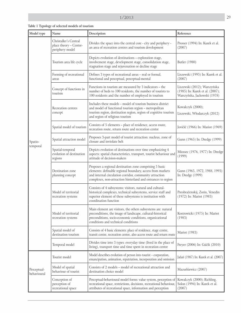
Hunziker and Krapf identified a human as the centre of their approach that had the greatest influence on its functioning (Gúčik, 2010). Currently, there are several models of tourism, which we tried to group by common properties and characteris-tics and thus create their universal typology (Table 1).
3 Spatial models of tourism
Spatial, respectively, spatio-temporal models were con-structed first, because these were based on the gist of tourism. Its main feature is the different environment of the place of residence of the tourists and the place of their recreation. The movement between two points defines spatial linkages and spatial relations. On the one hand, there is a relatively fixed point (place of residence) and on the other hand, occasionally selected secondary residence (visiting place) and between them exists a spatial dimension couched in the access or the return route (Mariot, 1969).
Thus, the spatial models of different type and extent create three basic elements: 1) the place of residence, 2) the transport area and 3) the destination. In the place of residence the prepar-ing for the journey is enacted, the destination is chosen and the important items for traveling are bought. The distance between the place of residence and the destination is covered by different vehicles depending on the distance and the type of tours. The journey itself can be enlivened by short trips with or without overnight stay. Environment of destination is unknown to the visitors and they are looking for the options of implementation of recreational activities depending on the season (Freyer, 2006 In: Gúčik, 2010). The oldest spatial models are shown on Figure 1 (Jovičič, 1966 In: Mariot, 1969) and Figure 2 (Mariot, 1983).
291/2013
Model type Name Description Reference
Spatio-temporal
Christaller’s Central place theory – Centre-periphery model
Divides the space into the central core - city and periphery - an area of recreation centres and tourism development
Prosser (1994) In: Kurek et al. (2007)
Tourism area life cycleDepicts evolution of destinations – exploration stage, involvement stage, development stage, consolidation stage, stagnation stage and rejuvenation or decline stage
Butler (1980)
Forming of recreational areas
Defines 3 types of recreational areas – real or formal, functional and perceptual, perceptual-mental
Liszewski (1995) In: Kurek et al. (2007)
Concept of functions in tourism
Functions in tourism are measured by 3 indicators – the number of beds to 100 residents, the number of tourists to 100 residents and the number of employed in tourism
Liszewski (2012); Warszyńska (1985) In: Kurek et al. (2007); Warszyńska, Jackowski (1978)
Recreation centres concept
Includes these models – model of tourism business district and model of functional tourism region – metropolitan tourism region, destination region, region of cognitive tourism and region of religious tourism
Kowalczyk (2000);
Liszewski, Włodarczyk (2012)
Spatial model of tourism Consists of 5 elements – place of residence, access route, recreation route, return route and recreation centre Jovičič (1966) In: Mariot (1969)
Spatial attraction model Proposes 3-part model of tourist attraction: nucleus, zone of closure and inviolate belt Gunn (1965) In: Dredge (1999)
Spatial-temporal evolution of destination regions
Depicts evolution of destinations over time emphasizing 4 aspects: spatial characteristics, transport, tourist behaviour and attitude of decision-makers
Miossec (1976, 1977) In: Dredge (1999)
Destination zone planning concept
Proposes a regional destination zone comprising 5 basic elements: definable regional boundary, access from markets and internal circulation corridor, community attraction complexes, non-attraction hinterland and entrances to region
Gunn (1965, 1972, 1988, 1993) In: Dredge (1999)
Model of territorial recreation systems
Consists of 4 subsystems: visitors, natural and cultural-historical complexes, technical subsystems, service staff and superior element of these subsystems is institution with coordination function
Preobraženskij, Zorin, Venedin (1972) In: Mariot (1983)
Model of territorial recreation systems
Main element are visitors, the others subsystems are: natural preconditions, the image of landscape, cultural-historical preconditions, socio-economic conditions, organizational conditions and technical conditions
Kostrowicki (1975) In: Mariot (1983)
Spatial model of destination tourism
Consists of 4 basic elements: place of residence, stage centre, transit centre, recreation centre, also access route and return route Mariot (1983)
Temporal model Divides time into 3 types: everyday time (lived in the place of living), transport time and time spent in recreation centre Freyer (2006) In: Gúčik (2010)
Perceptual-behavioural
Tourist model Model describes evolution of person into tourist – corporation, emancipation, animation, repatriation, incorporation and omission Jafari (1987) In: Kurek et al. (2007)
Model of spatial behaviour of tourist
Consists of 2 models – model of recreational attraction and destination choice model Mazurkiewicz (2007)
Conception of perception of recreational space
Perceptual-behavioural model forms: value system, perception of recreational space, restrictions, decisions, recreational behaviour, attributes of recreational space, information and perception
Kowalczyk (2000); Richling, Solon (1994) In: Kurek et al. (2007)
Table 1 Typology of selected models of tourism

30 Current Issues of Tourism Research
Economical
Tourism product model Model of development of tourism product has the following phases: discovery, launch, stagnation, decline
Čuka, Zimmermann (1995); Kaczmarek, Stasiak, Włodarczyk (2005); Jakubíková (2009) In: Čuka (2011)
Economic model of tourism system
System of tourism forms 2 subsystems – object of tourism and tourism subject; or 4 subsystems – destination, transport, agents, demand
Kaspar (1975) In: Gúčik (2010); Bieger (2004) In: Gúčik (2010)
Model of tourism management
Model determines as the main functions of management - planning, organizing, selection and deployment of employee, leadership, check
Gúčik et al. (2006)
Cultural
Socio-cultural model of tourism
Model is characteristic by 2 subsystems: ordinary (home) world (typical by daily life) and nonordinary (touristic) world (typical by recreational time)
Jafari (1987) In: Kurek et al. (2007)
Cultural model of tourism
Tourism is the process of penetration of cultures –destination culture and culture of visitors; model distinguishes 3 types of culture – tourists’ culture, corporate culture and local culture
Jafari (1982) In: Gúčik (2010)
Conception of religious tourism
Model of evolution of religion – primitive religion, archaic religion, historical pre-modern religion and modern religion
Jackowski (2003), Matlovič (2001)
Concept of tourism as a meeting of communities and cultures
Model describes the evolution of a conflict of tourists with local cultures; has 4 phases – euphoria, apathy, irritation, antagonism
Ćwiklińska (2009) In: Čuka (2011)
Models also represent spatial functional tourism schemes indicating the direction of relations between the place of resi-dence (dispersion zone) and the place for recreation (concentra-tion zone). These form two opposite poles of the scheme and identify the spatial dimensions type core and the periphery, in which the opposite directions of flows are functioning (Fig. 3).
Another characteristic of the spatial scheme is the emphasis on transport relations. While Jovičič (1966 In: Mariot, 1969) and Mariot (1983) recognise three types of routes – access, rec-reational and return, Lue et al. (1993 In: Dredge, 1999) describe five types which is related to their widespread understanding of multinodal recreational regions. These are: the single destina-tion pattern, en-route pattern, pattern base-camp, regional tour pattern and chaining pattern.
Spatial models based on the emphasis on transport links are blamed with their low applicability. To be used when describ-ing other types of destination regions the models must be de-signed in coherence with physical-geographical characteristics of the area and must take into the consideration for example the accessability of tourism centres, transport costs, distances and other conditions (e. g. road conditions between the two points of interest). Physical-geographical characteristics tend to be generalised to an acceptable form and by means of induc-tive logic procedures then explain the historical process of their creation and development. The development of destinations is studied through spatial characteristics, transport, behaviour of tourists and attitude of decision-makers (Dredge, 1999).
In this paper, we consider in the developing of tourism mod-els of the High Tatras and the Low Tatras all the above men-tioned factors, so that we formulate rules for creating schemes generally applicable to the mountainous regions of Slovakia.
Source: author4 The research methodology
The aim of this paper is to analyse the spatial relationships in destination regions of high mountains (High Tatras and Low Tatras) and to create a spatial model of tourism functioning in them. Our model is based on Mariot’s (1969) and Jovičič’s spatial models (1966 In: Mariot, 1969), Christaller’s centre-pe-riphery model (Kurek, 2007), Butler’s model of the life cycle of recreation centre (Butler, 1980), the model of functional types of tourism regions (Liszewski, Włodarczyk, 2012) and the nodal model of destination regions (Dredge, 1999). The spatial models were used to study relationships between nucleus (tour-ist centre) and its hinterland (zones and directions of influ-ence). Christaller’s model helped us to clarify the relationship of the core (tourist centre) and the periphery (urbanised areas - places of residence of tourists). Based on these two models, we determined the size of the tourist centres (in our studied des-tination regions) and made their categorisation. Butler’s model defines the phases of the recreation centre development, and therefore on its base we construct our classification of tourist centres. Model of functional types of regions became a platform for functional typification of recreational centres and spatial the model of destination regions helped us in clarifying the relation-ships between node (destination region) and corridor (system of transport links of destination regions).
All the necessary quantitative datas for modeling destination regions and classification of recreational centres we obtained from the Statistical Office of the Slovak Republic, the tourist information office of the town High Tatras and from terrain research. Terrain research we consider as the most important research method, because we created on its basis classification, typification and hierarchy of tourist centres, found out linkages

311/2013
Figure 3 Spatial functional scheme of tourism(Source: Jovičič, 1966 In: Mariot, 1969)
Figure 1 Spatial model of tourism(Source: Jovičič, 1966 In: Mariot, 1969)
Figure 2 Spatial model of tourism(Source: Mariot, 1983)

32 Current Issues of Tourism Research
between centres, explained the traffic conditions in the desti-nation regions and eventually directly verified created spatial models.
Our ambition is to formulate rules for creating general mod-els of tourism of high mountains in Slovakia, as well as general model itself, and therefore we generalised the model of tourism in the High Tatras and the Low Tatras to an applicable form.
5 General geographical characteristic of high mountains in Slovakia
In terms of altitude zonation the mountains in Slovakia are divided into low and high. Low mountains are below of 1500m above see level and extend to a wide peripheral part of the Car-pathians. High mountains are grouped in the central part of the Western Carpathians and their peaks exceed timber-line (above 1500 m in Slovakia). These are the High Tatras (Tatry moun-tains), the Low Tatras (Nízke Tatry mountains) and the moun-tains Malá Fatra, Veľká Fatra, Chočské vrchy and peaks Babia Hora and Pilsko in the Oravské Beskydy mountains (see map 1).
Relief of high mountains is vertically very rugged. The high-est part is the main range or ridge. Lateral ridges are separated by deep valleys. The highest mountains – the High Tatras and the Low Tatras – are in the top parts typical by glacial relief which creates beautiful sceneries, other mountains have denud-ed relief. All belong to the cold climate zone with a long winter period with a minimum number of summer days. Enough snow and rainfall is the source of water for river flows, which are abundant in all seasons.
High vertical zonation causes the arrangement of plants to vegetation zones. Zone of forest is substituting by scrub pines, which became thin then passes into alpine zone typical by oc-
Map 1 Location of high mountains in Slovakia
currence of plant communities diversified debris and rocks (Lukniš, Plesník, 1961). High mountains are especially suitable for tourism development thanks to natural conditions - relief, clean air, mineral springs, caves etc., therefore in them can be implemented most of recreational activities.
6 Spatial model of tourism in the High Tatras
When creating a spatial model of tourism in the High Tatras, we applied the all principles and rules used in creating mod-els mentioned above. Core of the model are the tourist centres located at the root of the mountain range (geomorphological subdivision Tatranské podhorie and Ždiarska brázda). Depend-ing on the functions, the number of beds and the number of attractions are the recreation centres categorized to transit cen-tres (Tatranská Lesná, Kežmarské Žľaby), stage centres (Horný and Dolný Smokovec) and destination centres (Štrbské Pleso, Vysoké Tatry). Centres are characterized by a different size of hinterlands and spheres of influence within the hinterland may overlap with the neighboring centre (e. g. Vysoké Tatry – Štrbské Pleso – Tatranská Lomnica). In the hinterland are located holi-day villages, cottages, chalets, or another tourist attractions, whether tourist suprastructure in the form of ski-lifts and ski tracks (Štrbské Pleso, Ždiar). All recreation centres are intercon-nected by Road of Liberty, which begins in Podbanské and ends in Lysá Poľana (roads nr. I/67 and II/537). Local roads inside of the centres lead from the centres to the selected tourist attrac-tions (e. g. Starý Smokovec – Hrebienok; Štrbské Pleso – Chata pod Soliskom) and thus define spheres of influence and size of linkages inside the centre. The southern slopes of the High Ta-tras and the Western Tatras are connected by Tatra’s arterial road – the main tourist path with a length of about 72 km.

331/2013
Picks of mountain range and lateral ridges are connected by local hiking paths leading into the valleys and to particular recreation centres. All these elements of the scheme create a destination region which is delimitated by conceptual limit. En-trance to the destination region provides gates that constitute places of the direction flows between the region and its recre-ation hinterland (Fig. 4).
In the creating of tourist model of the High Tatras we delib-erate the historical and spatial specificities of this destination region. One is the state border which from the north markedly determines the limit of the destination region and sphere of influence of particular tourist centres. Then it is the histori-cal development of tourism in the area. In the region as the first were built various medical centers and climatic spas with sanatoriums. Later, as the next activity, hiking began to develop thanks to the Ugrian-Carpathian association. In many Tatra settlements during the period of socialism were built sanato-riums for corporate recreation. After 1989, the sanatoriums ei-ther transformed into a modern complexes, or were abolished and were built another. A specific of Tatra settlements are that they have been artificially merged into the town called High Tatras in 1947.
7 Spatial model of tourism in the Low Tatras
The Low Tatras are the central mountains in the middle of Slovakia, which have significantly modeled mountain range in the west-east. Along the northern and southern slopes of the
Figure 4 Spatial model of tourism in the High Tatras
mountains are located almost all recreation centres. The core of recreational space creates massif of Chopok with its north-ern and southern slopes, where resorts Chopok – north Jasná and Chopok – south Srdiečko are located. The most attractive valleys are Demänovská dolina and Bystrianska dolina which both are also located below Chopok. Valleys are the most ur-banised recreational areas, which present destination regions. Their spheres of influence greatly interfere with nearby recre-ation centres because in their hinterlands are located holiday villages (Tále, Krpáčovo, Demänovská Dolina), suprastructure (ski-lifts and ski tracks in the localities Záhradky, Biela púť, Otupné, Kosodrevina, Srdiečko) and other recreational attrac-tions (caves – Demänovská jaskyňa, Demänovská jaskyňa slo-body, Bystrianska jaskyňa, golf course Grey bear). From this concentration area to the west and east the tourist centres change to stage centres (Bystrá, Čertovica, Vyšná Boca), respec-tively transit centres (Jarabá, Malužiná). The Low Tatras massif from the north and south surrounds two basins – Podtatranská kotlina and Horehronské podolie by which lead the main tran-sit communications (D1 motorway and road nr. I/66) providing entrance into the destination region and its connection with recreational hinterland. The destination region is specifically di-vided into western and eastern part, at which boundary forms road nr. I/72. Internal communications within the centre and its recreational hinterland can be found in the centres such as Chopok-sever and Chopok - juh.
The highest peaks of the mountains connects SNP heroes path, the most important tourist artery in Slovakia, which has a

34 Current Issues of Tourism Research
length of more than 720 km and extends from the west to the east of the republic. Other hiking trails lead from peaks to valleys and to recreation centres situated on the foothill of the massif (Fig. 5).
In case of the Low Tatras tourist model was also necessary to regard some spatial specifications. E. g. mountain range is
Figure 5 Spatial model of tourism in the Low Tatras
shaped east-west, but the concentration core consisting of the recreation centres Chopok – sever Jasná and Chopok – south Srdiečko, which are located in Demänovská dolina and Bystri-anska dolina, is shaped north-south. North and south slopes of the massif Chopok, which form the recreational core, are inter-

351/2013
connected by mountain transport facilities, and therefore the sphere of influences of recreation centres overlap significantly. In general we can say that the eastern part of the mountains is from the point of view of tourism undersized and the vast ma-jority of recreation centres and recreational activities are located in the western part. Even in the Low Tatras was the first type of spa tourism evolved, later recreational tourism and hiking.
8 Results
When creating spatial models of tourism in the High Tatras and the Low Tatras we attained to the formulation of these rules and principles:
each model consists of points, lines and areas; •creation of model has hierarchical rules, first are delineated •centres, than the areas of internal linkages, communications and at the end the destination region with its conceptual limit and recreational hinterland;arrangement of points, lines and areas depend on the shape •of mountains and on the location of recreation centres;typification of recreation centres should be based on quantita- •tive parameters (e. g. number of visitors, number of beds, etc..);each recreation centre has its own sphere of influence where •core-periphery linkages are applied;hinterland size is determined by the localization of infra- •structure, suprastructure and recreational attractions;
recreation centres create destination region; •destination region is delineated by conceptual border; •recreation centres are linked by communications of different •levels;the most important communications are those that connect •the destination region and its recreational hinterland, among which the core and periphery relationship are applied.
Recreation centres are the nodes formed by complex of attractions, services and infrastructure. Their character var-ies depending on the size of the infrastructure, the number of attractions in the hinterland and from recreational func-tions. Therefore, we distinguish transit centre (without over-night stay), stage centre (with or without overnight stay) and destination centre (final point of tour). Centres create in the surroundings spheres of influence, in which internal relations type core - periphery are applied and represent recreational subdestinations. All recreation centres together form a destination region which with its environment cre-ates a linkages type core - periphery. Periphery is character-ised by urbanised areas, which are the places of residence of visitors. The destination region is delineated by conceptual limit. Communications interconnect centres themselves, these may have different hierarchical levels. Main roads (highways) connect destination region with its hinterland and include the gateways, which are the entrances to the destination region (Fig. 6).
Figure 6 Theoretical spatial model of tourism in the high mountains in Slovakia
36 Current Issues of Tourism Research
9 Conclusions
In this paper we tried to outline the issue of tourism models. Our interest was focused on the spatial models that we cre-ated in an application to the recreation areas of the High Tatras and the Low Tatras. Our main task was to formulate the rules and criteria for the creating of tourism models that will be ap-plicable to any high mountains in Slovakia. The basis of our model is the node the core – recreation centre surrounded by its hinterland, in which are important elements of tourism situ-ated. Several cores create a destination region which has a close relationship with its recreational hinterland.
The High Tatras and the Low Tatras are situated at all com-munication lines which interconnect the main destination re-
gions in Slovakia and are the main axes of tourism development (Mišunová, 1994):
1. Bratislava-Trnava-Piešťany-Trenčín-Žilina-Ružomberok-Poprad-Prešov-Košice,
2. Bratislava-Nitra-Banská Štiavnica-Zvolen-Banská Bystri-ca-Dobšiná-Betliar-Košice,
3. Dolný Kubín-Ružomberok-Banská Bystrica-Zvolen-Šahy.
Research of spatial models of tourism brings many new knowledge that are irrecoverable to the creating of concepts and models for further development of tourism in the recreation centres, particularly in relation to the sustainable development and environment protection in these centres.
References:1. BUTLER, R. W. (1980): The concept of a tourism areas cycle of evolution: implications for the management of recourses. In:
Canadian Geographer, 1980, roč. 24, č. 1, s. 5 – 14, ISSN 1541-0064 2. ČUKA, P. (2011): Základy teórie, metodológie a regionalizácie cestovného ruchu. 1. vyd. Prešov : Vydavateľstvo Prešovskej univer-
zity v Prešove, 2011, 93 s. ISBN 978-80-555-0471-1 3. ČUKA, P. – ZIMMERMANN, F. N. (1995): Využitie rakúskych skúseností pri tvorbe konceptu cestovného ruchu Banskej
Bystrice. In: Ekonomická revue cestovného ruchu, roč. 28, č. 3, s. 115-126. ISSN 0139-86604. DREDGE, D. (1999): Destination planning and design. In: Annals of tourism research, č. 26, s. 772-791. ISSN 0160-73835. GREGOROVÁ, B. (2012): Priestorové zákonitosti cestovného ruchu v Nízkych Tatrách na príklade modelového územia Chopok – juh.
Dizertačná práca. Prešov : FHPV, 2012, 306 s.6. GÚČIK, M. et al. (2006): Cestovný ruch, hotelierstvo, pohostinstvo. 1. vyd. Bratislava : SPN, 2006, 216 s. ISBN 80-10003-60-37. GÚČIK, M. (2010): Cestovný ruch. 1. vyd. Banská Bystrica : DALI-BB, 2010, 307 s. ISBN 978-80-89090-80-88. JACKOWSKI, A. (2001): Święta rzestrzeń świata. 1. vyd. Kraków : Wydawnictwo Uniwersytetu Jagiellońskiego, 2001, 253 s.
ISBN 83-233-1717-89. KACZMAREK, J. – STASIAK, A. – WŁODARCZYK, B (2005): Produkt turystyczy: pomysł, organizacja, zarządzanie. 1. vyd.
Warszawa : Polskie Wydawnictwo Ekonomiczne, 2005, 389 s. ISBN 83-208-1564-9 10. KOWALCZYK, A. (2000): Geografia turyzmu. 1. vyd. Warszawa : Wydawnictwo Naukowe PWN, 2000, 287 s. ISBN 83-01-
13047-4 11. KROGMANN, A. (2006): Využitie modelov v geografii cestovného ruchu na príklade pohraničných miest Komárno a Štúro-
vo. In: Acta Oeconomica Nr. 19, 2006, s. 109-114. ISBN 80-8083-211-012. KUREK et al. (2007): Turystyka. 1. vyd. Warszawa : Wydawnictwo Naukowe PWN, 2007, 541 s. ISBN 978-83-01-15294-913. LISZEWSKI, S. (2012): Przestrzeń turystyczna Polski. Koncepcja regionalizacji turystycznej.
Online: http://wtir.awf.krakow.pl/attachments/article/34/folia_21.pdf 14. LISZEWSKI, S. – WŁODARCZYK, B. (2012): Badania regionalne ruchu turystycznego jako podstawa nowej regionalizacji turytycznej
Polski. Online: www.pot.gov.pl/index.php?option=com_ruberdoc15. LUKNIŠ, M. – PLESNÍK, P. (1961): Nížiny, kotliny a pohoria Slovenska. 1. vyd. Bratislava : Osveta, 1961. 135 s.16. MARIOT, P. (1983): Geografia cestovného ruchu. 1. vyd. Bratislava : Veda, 1983, 248 s.17. MARIOT, P. (1969): Priestorové aspekty cestovného ruchu a otázky gravitačného zázemia návštevných miest. In: Ge-
ografický časopis, roč. XXI., č. 4, 1969. s. 287-31118. MATLOVIČ, R. (2001): Geografia relígií. 1. vyd. Prešov : FHPV PU, 2001. 375 s. ISBN80-8068-062-019. MAZURKIEWICZ, L. (2007): Model przestrzennego zachowania turystów. In: Przegląd geograficzny, roč. 79, č. 1, 2007. s.
99-113. ISSN 0033-214320. MIŠÚNOVÁ, E. (1994): Priestorový model zájazdového cestovného ruchu. In: Geografický časopis, roč. XXXXIV, č. 3,
1994. s. 333-34821. Nízke Tatry – Kráľova hoľa (2010): turistická mapa v mierke 1:50 000. 5. vyd. Harmanec : VKÚ, 2010. ISBN 80-85510-94-4 22. Nízke Tatry – Chopok (2009): turistická mapa v mierke 1:50 000. 5. vyd. Harmanec : VKÚ, 2009. ISBN 80-85510-08-1 23. Vysoké Tatry (2012): turistická mapa v mierke 1:50 000. 11. vyd. Harmanec : VKÚ, 2012. ISBN 80-8042-410-124. Západné Tatry – Roháče (2012): turistická mapa v mierke 1:50 000. 8. vyd. Harmanec : VKÚ, 2012. ISBN 978-80-8042-541-825. WARSZYŃSKA, J. – JACKOWSKI, A. (1978): Podstawy geografii turyzmu. 1. vyd. Warszawa : Państwowe Wydawnictwo
Naukowe, 1978, 332 s.
Bohuslava Gregorová – Department of Geography, Geology and Landscape Ecology, Matej Bel University, Banská Bystrica, Slovakia