spatial literacy for the health sciences
TRANSCRIPT

Spatial Literacy for the Health Sciences:Capacity Building for the 21st Century
PresenterHamish Robertson
PhD CandidateAustralian Institute of Health innovation
University of NSW

Contents
• Background• Why spatial skills matter in healthcare• Spatial science considered – big, bigger,
biggest• Space, place and health care• Knowledge and skills issues• Some applications and examples• Conclusion

Background
• Possibly the most under-utilised interdisciplinary scientific domain in healthcare – with the exception of today’s session!
• Societies and human beings all exhibit spatial and spatially patterned behaviours – health and illness are spatial
• Scientific knowledge and society are co-productive (Jasanoff etc) – space is included in this process
• Growth in data quantity, quality and analytical methods are all spatial – the original ‘big data’
• Ubiquitous spatial technology – but health informatics has been largely aspatial!

Why Spatial Knowledge Matters


More GIScience in Time Team than Health!

Viewing Social
Inequalities from Space

Female Life Expectancy by LGA- Victoria
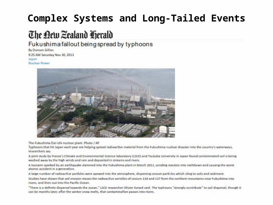
Complex Systems and Long-Tailed Events

Historical Literacy Wouldn’t Hurt Either

Three approaches to qualitative researchSource: Seamon and Gill, 2014

Tobler’s First Law
"Everything is related to everything else, but near things are more related than distant things.”
Tobler W., (1970) "A computer movie simulating urban growth in the Detroit region” Economic Geography, 46(2): 234-240.

Why Spatial Skills and Knowledge Matter -1
• Because space is a central factor in human experience, cognition and behaviour
• Space is intrinsic to human activities of all kinds including healthcare systems, epidemiology, funding, policy etc
• Spatial technology is everywhere, increasingly sophisticated and growing rapidly
• Spatial data and its analysis is the original ‘big data’• Maps and mapping are fully digital i.e. mathematico-statistical
in nature (map-ematical – Joseph Berry)• Healthcare patients, providers and facilities operate in spatial
ways and produce spatial patterns including health inequalities (Dartmouth Atlas)

Why Spatial Knowledge and Skills Matter - 2• Health informatics technology cannot negate space, only
incorporate it in more useful and meaningful ways• Broader social and environmental changes all have significant
spatial implications• All natural sub-systems can be aggregated upwards to our total
environment – interconnections matter and so does scale – poorly addressed in much health research/policy
• Linking total health to other policy domains has value and utility in terms of purported aims and desired outcomes – can be done through space
• Spatial technology is almost universally pervasive but completely under-utilised in healthcare
• Rising complexity in natural-human system interactions demand it e.g. climate change, pollution, urban heat sinks etc
Medical and Health Geography
• Deep cultural notions of space, place and health interactions – healing places, places of illness e.g. ‘Shinrinyoku’ or ‘forest bathing’, pilgrimage, philosophers who walk e.g Immanuel Kant
• Homer – The Iliad (special places) and the Odyssey (special journeys)• Airs, Waters, Places – Hippocrates’ environmental associations
between places and health/illness• 18th century France – Royal Medical Society of Paris proposal for a
medical geography of France – nation-building, maps and health• Germany – Finke’s first ever world medical atlas 1792–95• Yellow fever maps, military medicine, medical policing etc• Healthy ageing – often special places identified e.g. islands such as
Okinawa and Sardinia (utopian tropes)• Recent science correlating health status in urban environments with
access to green space and blue space etc

Key Spatial Concepts for Health Research
• Human beings are innately spatial – cognition, memory and behavior => brains, languages, cultures, evolutionary development (Keith Clarke, 2011)
• Settlement patterns, agriculture, urban processes, travel patterns, service logistics etc are all spatially constituted
• Most social constructs involve explicit or implicit spatial characteristics (e.g. society, population, social networks, embodiment)
• Maps and mapping are both data analysis and visualisation processes – back to spatial cognition
• Health policy and research use terms like ‘ageing in place’ in largely atheoretical ways
• Often clear that health researchers don’t know what they don’t know about space and place constructs

Spatial Knowledge Production
• Spatial technology is ubiquitous – IT technology includes spatial tech by default e.g. GPS
• More and more software environments permit spatial data capture and analysis including qualitative methods
• Concept maps and data visualisation rely on spatial cognition, colour awareness etc
• Kotusopoulos (2011) proposes a paradigm shift to a fully interdisciplinary spatial domain

Paradigm Shift?

Qualitative Research is Going Spatial

NVivo and
Virtual Earth
Technology

Also Critical Spatial Skills
• Place is not just a proxy for location – weak conceptualisation and analysis (absence of knowledge and skills – see above)
• Un- or ill-defined use of spatial terminology is not scientific e.g. environment, landscape, neighbourhood, place etc
• Maps can be and often are propaganda – we also need to be able to unpack spatial representations (Monmonier, 1991)
• Lines, areas, shadings etc can tell alternative stories but often are singular, monolithic and absolute = instruments of power
• Spatial literacy needs to cover the use and abuse of spatial methods and technologies
Conclusion• Spatial science is integral to modern health policy, health research and
delivery• Producing digital versions of analogue maps is often weak and lazy science
– under-use of the technical capabilities already available, failure to adapt = failure of knowledge and ethics
• Spatial technology is advancing at such a rate that spatial illiteracy is a growing problem – if this was any other domain there’d be an outcry (maybe)...
• Paradigm shifts are needed in health research to improve (a) philosophical literacy (key concepts) and (b) spatial literacy because they intersect at numerous points e.g. spatial entities, spatial ontologies, semantic ontologies, metaontology etc
• In an era of increasingly complex and interconnected problems we need to improve the interdisciplinary awareness and understanding of spatial science
• If 10 year olds can produce working KML data files, why can’t most of healthcare and what does this bode for the future?

Multidimensionality and MappingSource: http://www.espconference.org/ESP_Conference/75210/9/0/60
"Westerners maps in three dimensions: longitude, latitude, and altitude," explained Plotkin. "Indians think in six: longitude, latitude, altitude, historical context, sacred sites, and spiritual or mythological sites, where invisible creatures mark watersheds and areas of high biodiversity as off-limits to exploitation."
A model map created by Indians in Brazil. Image courtesy of ACT. Their maps are also meticulously detailed, including virtually everything associated with a place.
"Indians mark where they get materials for houses, bamboo, specific vines, places where they find honey and wood for canoes, anything they eat in terms of palm nuts, brazil nuts, Açaí -- rich palm fruit. For example we're working with the Wayana, a warrior tribe. They have marked two specific parts of the forest where they can find wood hard enough for arrow points. They've marked another point on the other side of the reserve where they get hollow wood to craft the arrow shaft," added van Roosmalen.
The Indians also chart the distribution of medicinal plants -- they use hundreds -- but for security reasons, some highly coveted medicinal plants are not published. In the past there have been problems with biopiracy where outsiders trespass on lands to illegally collect these plants for export. The Indians saw nothing in return.