spatial data integrity behind sis a #1 wild cat exploration discovery
TRANSCRIPT

8/20/2019 SPATIAL DATA INTEGRITY BEHIND SIS A #1 WILD CAT EXPLORATION DISCOVERY
http://slidepdf.com/reader/full/spatial-data-integrity-behind-sis-a-1-wild-cat-exploration-discovery 1/13
PROCEEDING OF THE INDONESIAN ASSOCIATION OF GEOLOGISTS CONVENTION JCB 2015
HAGI-IAGI Joint Convention, Balikpapan October 5-8, 2015
SPATIAL DATA INTEGRITY BEHIND SIS A #1 WILD CAT EXPLORATION DISCOVERY
Yudi Syahnur – Sr Geomatics Engineer, PT Saka Indonesia Sesulu
Keywords: Spatial Data, Geomatics, Exploration
ABSTRACT
Spatial Data, also known as geospatial data, is information about a physical object that can be
represented by numerical values in a geographic or projected coordinate system (Surve & Kathane,
2014). Conceptually, Spatial Data can be described as Points, Lines, Areas, Surfaces or Volumes thatare connected to a place in the Earth. It is estimated that more than 90% data and information used
in Energy Sector is spatially referenced. From Block concession to Seismic lines to Well data, they all
pertaining to specific geographic location.
Science and technology to collect, process, manage, analyze and display geospatial data and
information defined as Geomatics. It includes the tools and techniques used in land and marine
surveying, remote sensing, cartography, geographic information systems (GIS), global navigation
satellite systems (GNNS).
Since 1990's Oil and Gas companies have been using Global Positioning System (GPS), as well as
airborne and space observation remote sensing technologies to effectively find hydrocarbon. Marine
surveying techniques have been extensively used to perform comprehensive Geohazard study prior
to offshore drilling activities. Up until now, more and more oil and gas companies use Geographic
Information System (GIS) to help extracting hydrocarbon in a more efficient manner.
Since the PSC signing in May 2009 Geomatics have been integral part of South Sesulu Exploration
activites, located in the most southern part of Kutei Basin. From planning and execution of 550 km
square 3D Seismic Survey to Jackup Rig positioning activity, this paper will illustrate the importance
of Spatial Data Integrity behind the SIS A #1 Gas discovery.
Spatial Data Integrity ensure oil companies working in a safe and efficient manner. It allows people
from multi-discipline and different backgrounds to collaborate easily, and then contribute to the
success of South Sesulu Block PSC Exploration activities.

8/20/2019 SPATIAL DATA INTEGRITY BEHIND SIS A #1 WILD CAT EXPLORATION DISCOVERY
http://slidepdf.com/reader/full/spatial-data-integrity-behind-sis-a-1-wild-cat-exploration-discovery 2/13
INTRODUCTION
Spatial Data can be describes as information that identifies the geographic location of features and
boundaries on Earth, such as natural or constructed features, oceans, and more. Conceptually,
Spatial Data can be described as Points, Lines, Areas, Surfaces or Volumes that are connected to a
place in the Earth. It is estimated that more than 90% data and information used in Energy Sector is
spatially referenced. From Block concession to Seismic lines to Well data, they all pertaining tospecific geographic location (Figure 1)
Figure 1. Typical spatial data and information related to Oil and Gas Industry (Chandrasekhar , 2013)
In recent years, Spatial Data representation have evolved from sets of hardcopy maps into layers of
thematic information stored in digital database. Based on the structure, they are divide into 2 type
namely Vector and Raster. Vector data have better location accuracy and also less voluminous. But
Raster data have more superior appearances and also ideal to represent continuous data over a largearea. Different types of description and Spatial Data is presented in Figure 2.
Figure 2. Different types and descriptions of Spatial Data

8/20/2019 SPATIAL DATA INTEGRITY BEHIND SIS A #1 WILD CAT EXPLORATION DISCOVERY
http://slidepdf.com/reader/full/spatial-data-integrity-behind-sis-a-1-wild-cat-exploration-discovery 3/13
Sources of Spatial Data can be varied. The first option (and arguably cost-effective) is to extract
internally –owned existing Spatial Data. Most commonly source is from old hardcopy maps published
by Authorities/Mapping Agencies that area being scanned, georefferenced and then digitized using
specialized software. Other option is import georefferenced coordinate points from other thematic
tabular information or databases. But whenever Spatial Data is not yet exist, the last option is to
conduct new survey or acquire spatial data from external data provider.
Science and technology to collect, process, manage, analyze and display Spatial Data and information
is known as Geomatics (Figure 3). It includes the tools and techniques used in land and marine
surveying, remote sensing, cartography, geographic information systems (GIS), global navigation
satellite systems (GPS, GLONASS, Galileo, Compass).
Figure 3. Science and technology to collect, process, manage, analyze and display Spatial Data
The added value of Geomatics to the E&P business lies in the assurance of the integrity of spatial
data and the mitigation of the associated risks resulting from potential Integrity violations. And
Spatial Data Integrity should be able to return reliable and accurate position, and retrieve all the
information required within 7-10 years’ time period of the E&P life circle (Figure 4).

8/20/2019 SPATIAL DATA INTEGRITY BEHIND SIS A #1 WILD CAT EXPLORATION DISCOVERY
http://slidepdf.com/reader/full/spatial-data-integrity-behind-sis-a-1-wild-cat-exploration-discovery 4/13
Figure 4. Geomatics activities within Oil and Gas life-cycle (modified after Whitcombe, 2006)
Spatial Data is expressed explicitly via the use of Coordinate Reference System (CRS), but inadequate
control of these CRS can lead to potentially serious risks for business, reputation, and Health, Safety
& Environment (OGP, 2008). In most cases, spatial integrity failures arise from incorrect assumptions,
poor or non-existent labelling of coordinates or a lack of awareness of the geodetic complexities.
Many individuals are not aware for instance, that latitude and longitude are not unique.
Furthermore, International Association of Oil and Gas Producer in 2008 drawn a list consist of
implications of what can go wrong when geodetic issues are not given due diligence. The list is shown
on table 1 below.
Operation Scenario Root Cause Business Impact
Seismic Interpretation Whilst merging two separate
3D seismic datasets observed
on different CRS, a
cumulative error was made
of 250 m due to incorrect
and coordinate
transformations.
Lack of knowledge of the
proper transformation
method.
Use of different geology
and geophysics (G&G)
software packages that
did not handle CRS data
properly.
Lack of quality control
(QC).
• Resources spent on
investigating error.
• Expensive
reprocessing which
took 3 months.
•
Knock on effect on
subsequent
operations e.g well
planning or drilling
sequence.
Jack-up Rig Positioning During a rig move in theNorth Sea. The surveyor
went off shift, leaving his
engineer to look after the
navigation. The engineer did
familiarize himself with the
software, but didn’t realize
he had inadvertently
changed the reference
•
The projected gridcoordinates generated by
the navigation software
were incorrect.
• By selecting the wrong
ellipsoid, the software
generated incorrect
geographical and
•
Rig 1.5 km offlocation, in another
company’s block.
•
Anchor handling
vessels recalled to
site.
• Rig had to be
repositioned.
• Cost: $750,000.

8/20/2019 SPATIAL DATA INTEGRITY BEHIND SIS A #1 WILD CAT EXPLORATION DISCOVERY
http://slidepdf.com/reader/full/spatial-data-integrity-behind-sis-a-1-wild-cat-exploration-discovery 5/13
ellipsoid. Surveyor arrived
back on shift whilst
approaching location,
navigation appeared fine so
rig was positioned and
moored up accordingly.
Radar checks on a localplatform revealed
inconsistent positions.
The wrong ellipsoid had been
used i.e Everest was applied
instead of International.
subsequently the wrong
grid coordinates.
•
No offshore survey
representative present
to perform relevant QC.
• Reputation issues.
• Government reviewed
license arrangements.
Facility Construction A proposed position for a
new subsea manifold was
issued via an E&P operator
on the ED50 datum. The
Subsea Installation
contractor wrongly assumed
that these coordinates wererelated to the WGS84 datum
and positioned accordingly.
The pile driven manifold was
therefore positioned 136
meters away from the
intended location.
Error only discovered when a
pre-lay survey vessel did not
find the manifold in the
expected position.
• Incorrect assumptions
were made (common
geodetic problem).
•
The CRS was not properly
identified.
• European Petroleum
Survey Group (EPSG)codes were not used to
identify the two CRS
systems.
• No offshore survey
representative present.
•
Staff not competent to
perform task i.e had not
received correct
awareness training
• Significant delay to
project.
• Re-routing of pipeline
approach.
• Reputation issues with
government &
environmental bodies.•
Contract dispute with
installation
contractor.
• Contract Variation
issued at as cost of
$500,000.
Table 1. List of implications of what can go wrong due to spatial integrity failures (modified after
International Association of Oil and Gas Producer , 2008)
Since the PSC signing in May 2009, Geomatics have been integral part of South Sesulu Exploration
activities. From basin and play assessment, planning and execution of 550 km square 3D Seismic
Survey to Jackup Rig positioning activity, this paper will illustrate the importance of Spatial Data
Integrity behind the SIS A #1 Gas discovery. This paper will also describe how Spatial Data Integrity
have played small but critical roles during exploration phases of South Sesulu PSC.
BASIN AND PLAY ASSESMENT
At the time when South Sesulu PSC was signed on May 2009 by previous operator, Play Based
Exploration (PBE) approach was extensively used to effectively and efficiently run its petroleum play
assessment. PBE is an evaluation process to arrive at an understanding of the fundamental logic of
Hidrocarbon plays, as a sound technical basis for ranking and prioritizing all exploration projects and
activities (de Jager , 2014).

8/20/2019 SPATIAL DATA INTEGRITY BEHIND SIS A #1 WILD CAT EXPLORATION DISCOVERY
http://slidepdf.com/reader/full/spatial-data-integrity-behind-sis-a-1-wild-cat-exploration-discovery 6/13
PBE simply a method to build and leverage an understanding of the basins and petroleum systems
in which a company works, and the geological plays they contain. The benefits lie in providing better
early Focus to a range of exploration activities.
The PBE methodology is encapsulated in the “Exploration Pyramid: Basin-Play-Prospect”, where the
initial focus is on the basics - the determination and description of the regional context and the basinframework leading to an understanding of the working petroleum system(s). Petroleum system
understanding forms the basis for the subsequent play focus - quantifying the various aspects of the
system within each play, and using tools such as common risk segment mapping to highlight sweet
spots within each play.
Geographic Information System (GIS) tools was extensively used to create Charge, Reservoir and Seal
Common Risk Segment (CRS) maps using advance Spatial Analysis techniques (Exprodat , 2013). GIS
tools was also being deployed to validate play chance maps against post-well results (Figure 5),
analyses basin activity over time, analyze basin and play volume statistics, create creaming curves,
and estimate yet-to-find (YTF) or undiscovered reserves.
Figure 4. CRS Map of Mid Miocene Clastics Play (Putrohari , 2012)
When the plays have been mapped and where possible, quantified, then the focus shifts again to use
more detailed geological and geophysical analysis to define prospects within each play, and build the
portfolio. It’s including making estimates of volumetrics, risk and uncertainty. It was concluded that
the main risk for generated prospects at South Sesulu PSC was Source (Charging), while
Reservoir/Trap deemed as moderate risk.
3D SEISMIC SURVEY
3D seismic mapping is crucial to better understand the lead structures and analogues to adjacent
discovery fields, as well as reduce risk and uncertainty for drilling. 3D seismic inversion and sequence
stratigraphy may also help in further understanding of the reservoir distribution.

8/20/2019 SPATIAL DATA INTEGRITY BEHIND SIS A #1 WILD CAT EXPLORATION DISCOVERY
http://slidepdf.com/reader/full/spatial-data-integrity-behind-sis-a-1-wild-cat-exploration-discovery 7/13
Previous operator conducted 3D seismic survey for a duration of 3 weeks in October 2010. It’s
covered a 580 km2 area on a relatively shallow water depth between 32 to 65 meters below MSL
(Figure 5), with shallow target around 1200ms. The survey using 6 streamers @ 4 km long each, with
75 m streamer separation lowered to 6 meters below sea line. Common Mid-Point (CMP) Bin size is
18.75 x 6 m.
Figure 5. South Sesulu 3D Seismic Area of Interest (Setiawan, 2010)
From Spatial Data Integrity point of view, Seismic Survey is arguably the most important one as the
Navigation Data will be used as main spatial reference for further Exploration and Production
activities within South Sesulu PSC. The quality and reliability of the seismic navigation data will
directly impact on the ability to accurately relate the physical of a well location to the geophysical
interpretation.
Surveys that have been poorly specified, inadequately quality controlled or where there is
insufficient information available to quantify the accuracy of the data, are all potential error sources
and may not be suitable to support detailed well planning (OGP, 2006). The verification of Coordinate
Reference System (CRS), geodetic parameters, bin grid definition and so on should always be by
comparison to original source material, for example: acquisition, QC and processing report; UKOOA
P1, P2 and P6 format files.
All navigation data acquired during South Sesulu 3D Seismic survey was using Real Time Differential
Global Positioning System (DGPS), thus WGS 1984 datum was chosen as geodetic reference.
Meanwhile Universal Transverse Mercator (UTM) Zone 50 South was defined as projected
coordinate system.
Prior to loading seismic data to a workstation, the following check should be made to ensure Spatial
Data Integrity of seismic interpretation (OGP, 2006):
•
Verify the CRS of the data to be loaded against the acquisition parameters, and ensure that
this is identical to the project, license or country data that the data relates to.
• Verify the CRS definition in the input project database is correct.
8/20/2019 SPATIAL DATA INTEGRITY BEHIND SIS A #1 WILD CAT EXPLORATION DISCOVERY
http://slidepdf.com/reader/full/spatial-data-integrity-behind-sis-a-1-wild-cat-exploration-discovery 8/13
•
For 3D surveys; verify the bin grid definition against the acquisition parameters.
•
If transformation of geodetic datum is required; verify that the coordinates have been
correctly transformed.
• If the positioning data is to be loaded from SEG Y header; verify that the positions and extent
of the lines correspond exactly to the UKOOA P1 data.
•
Verify the geographic location and inter-relationships of the seismic data after loading (e.g.by comparison with SP base maps, remote sensing images, etc.)
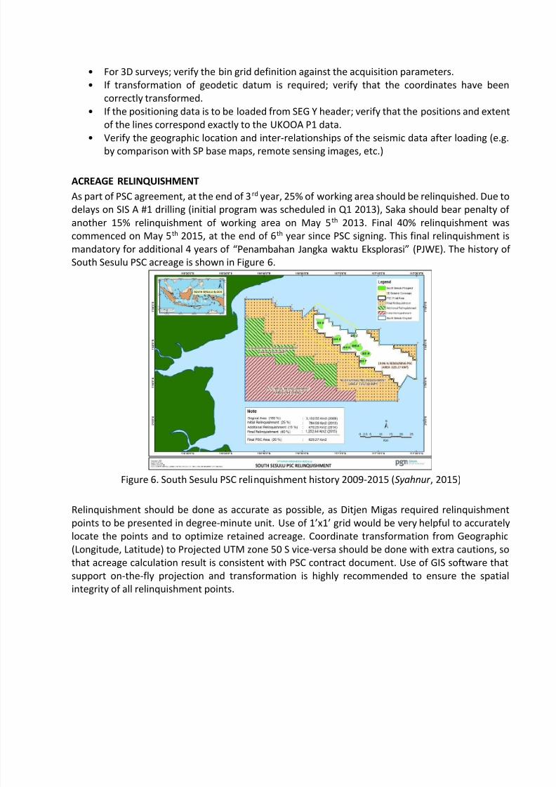
ACREAGE RELINQUISHMENT
As part of PSC agreement, at the end of 3rd year, 25% of working area should be relinquished. Due to
delays on SIS A #1 drilling (initial program was scheduled in Q1 2013), Saka should bear penalty of
another 15% relinquishment of working area on May 5th 2013. Final 40% relinquishment was
commenced on May 5th 2015, at the end of 6th year since PSC signing. This final relinquishment is
mandatory for additional 4 years of “Penambahan Jangka waktu Eksplorasi” (PJWE). The history of
South Sesulu PSC acreage is shown in Figure 6.
Figure 6. South Sesulu PSC relinquishment history 2009-2015 (Syahnur , 2015)
Relinquishment should be done as accurate as possible, as Ditjen Migas required relinquishment
points to be presented in degree-minute unit. Use of 1’x1’ grid would be very helpful to accurately
locate the points and to optimize retained acreage. Coordinate transformation from Geographic
(Longitude, Latitude) to Projected UTM zone 50 S vice-versa should be done with extra cautions, sothat acreage calculation result is consistent with PSC contract document. Use of GIS software that
support on-the-fly projection and transformation is highly recommended to ensure the spatial
integrity of all relinquishment points.
8/20/2019 SPATIAL DATA INTEGRITY BEHIND SIS A #1 WILD CAT EXPLORATION DISCOVERY
http://slidepdf.com/reader/full/spatial-data-integrity-behind-sis-a-1-wild-cat-exploration-discovery 9/13
DRILLING PREPARATION
Offshore drilling activity have been relies heavily on spatial data integrity for decades. Offshore
drilling site preparation requires hazard site surveys consist of geophysical and hydrographic site
surveys of proposed offshore well locations. And later on Real-time Differential Global Positioning
System (DGPS) technology will be utilized to accurately guide Mobile Offshore Drilling Units (MODUs)
to the intended drilling location.
Site surveys are performed to minimize the risk of harm to personnel and equipment, and to protect
the natural environment. The objective of any site survey is to identify all possible constraints and
hazards from man-made, natural and geological features which may affect the operational or
environmental integrity of a proposed drilling operation, and to allow appropriate operational
practices to be put in place to mitigate any risks identified (OGP, 2011).
Any site survey must include a review of all seafloor conditions and geology to a depth at least 200m
below the preferred setting depth of the first pressure containment string, or to a depth of 1000m
below seabed, whichever is greater. In addition, the proposed site survey area should be of adequatecoverage to plan any potential relief well locations, and provide sufficient data to fully assess
potential top-hole drilling hazards at these locations.
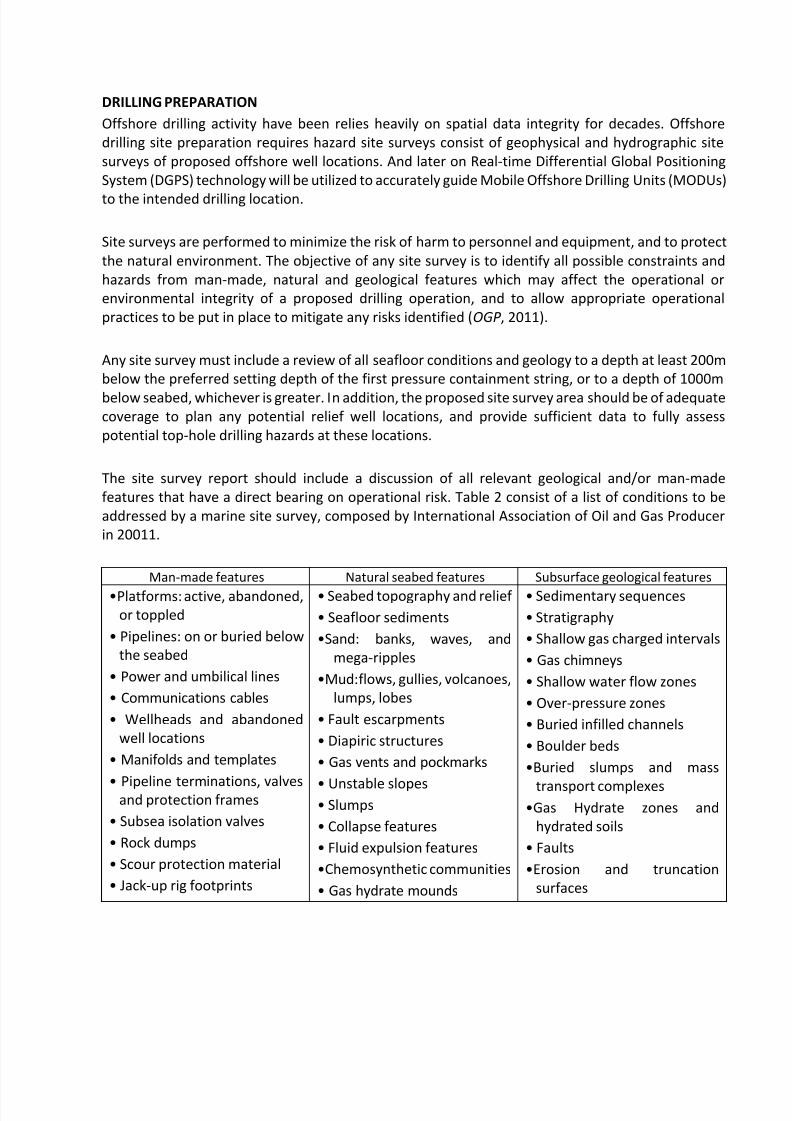
The site survey report should include a discussion of all relevant geological and/or man-made
features that have a direct bearing on operational risk. Table 2 consist of a list of conditions to be
addressed by a marine site survey, composed by International Association of Oil and Gas Producer
in 20011.
Man-made features Natural seabed features Subsurface geological features
•Platforms: active, abandoned,
or toppled
• Pipelines: on or buried below
the seabed
• Power and umbilical lines
• Communications cables
• Wellheads and abandoned
well locations
• Manifolds and templates
• Pipeline terminations, valvesand protection frames
• Subsea isolation valves
• Rock dumps
• Scour protection material
• Jack-up rig footprints
• Seabed topography and relief
• Seafloor sediments
•Sand: banks, waves, and
mega-ripples
•Mud:flows, gullies, volcanoes,
lumps, lobes
• Fault escarpments
• Diapiric structures
• Gas vents and pockmarks
• Unstable slopes • Slumps
• Collapse features
• Fluid expulsion features
•Chemosynthetic communities
• Gas hydrate mounds
• Sedimentary sequences
• Stratigraphy
• Shallow gas charged intervals
• Gas chimneys
• Shallow water flow zones
• Over-pressure zones
• Buried infilled channels
• Boulder beds
•Buried slumps and mass
transport complexes•Gas Hydrate zones and
hydrated soils
• Faults
•Erosion and truncation
surfaces

8/20/2019 SPATIAL DATA INTEGRITY BEHIND SIS A #1 WILD CAT EXPLORATION DISCOVERY
http://slidepdf.com/reader/full/spatial-data-integrity-behind-sis-a-1-wild-cat-exploration-discovery 10/13
• Non-oil & gas infrastructure
such as navigation buoys,
wind turbines etc.
• Shipwrecks
•Ordnance and chemical
dumping grounds
• Archaeological remains
• Miscellaneous debris
• Rock outcrops, pinnacles and
boulders
• Reefs
• Hard grounds
• Seabed channels and scours
•Salt or mud diapirs and
diatremes
Table 2. Examples of site survey results, presented in thematic spatial data (modified after
International Association of Oil and Gas Producer , 2011)
Saka conducted South Sesulu SIS-A site surveys survey for a duration of 10 days in August 2014. It’s
covered a 12 km2 area on a relatively shallow water depth between 34 to 62 meters below MSL. The
site survey consist of analog geophysical survey (Sub Botttom Profiler, Multibeam Echo Sounder and
Side Scan Sonar) and digital geophysical survey also known as 2D High Resolution seismic for a total120 km long using 600 m long streamer and 48 channel receiver (Figure 7).
Figure 7. Illustration of SIS-A Site Survey activities in 2014 (MGS, 2014)
The survey successfully provided Saka with valuable information regarding Seabed features aroundSIS-A prospects, as well as the latest Shallow and Intermediate Zone Geology, Anchoring and Top
Hole conditions (Figure 8). Detailed bathymetry data also confirm the water depth of SIS-A #1
location is more than 50 meter, thus ex-situ dumping permit would not be needed.

8/20/2019 SPATIAL DATA INTEGRITY BEHIND SIS A #1 WILD CAT EXPLORATION DISCOVERY
http://slidepdf.com/reader/full/spatial-data-integrity-behind-sis-a-1-wild-cat-exploration-discovery 11/13
Figure 8. Results of SIS-A Site Survey: Seabed features (top-left); Shallow geology profile (top-right);
bathymetry (bottom-right); shallow gas hazard potential (bottom-left) (MGS, 2014)
Based on site survey assessment and soil boring investigation, the proposed SIS-A #1 drilling location
was then considered safe. With regards to water depth, Jack Up drilling rig was deemed suitable for
drilling operation. Once again Real Time Differential Global Positioning System (DGPS) method was
employed in the rig positioning.
DGPS result was subsequently displayed on monitor, overlaid with the proposed SIS-A #1 drilling
location and the intended rig heading. This system allows rig mover to adjust direction and speed of
tug boats in order to positioned drill stem as close as possible to the intended SIS-A #1 drilling
location (Figure 9). Rowan Gorilla II was finally well positioned for drilling operation, with accuracy
of 1.8 meter to intended location and rig heading of 122° 28’.
Figure 9. DGPS provide rig mover with real time rig position and heading

8/20/2019 SPATIAL DATA INTEGRITY BEHIND SIS A #1 WILD CAT EXPLORATION DISCOVERY
http://slidepdf.com/reader/full/spatial-data-integrity-behind-sis-a-1-wild-cat-exploration-discovery 12/13
CONCLUTION AND RECOMMENDATION
Spatial Data Integrity have been well established during South Sesulu Exploration activities,
culminated by SIS-A #1 gas discovery. From 3D seismic to rig positioning, Spatial Data Integrity have
played small but critical roles to South Sesulu Exploration activities. It may not be the key factor to
the finding of a working petroleum system, but it certainly help to eliminate uncertainty with regards
to spatial aspect in every phase of exploration activities.
Geographic Information System (GIS) have been widely used as main tools to maintain Spatial Data
Integrity. It is time to leveraging the capabilities of GIS system owned by companies by implementing
industry standard for storing and managing oil and gas spatial data such as OGP P6/11 for seismic
bin grid exchange format or OGP SSDM (Seabed Survey Data Model) for site survey data. By
implement this industry standard, spatial data integrity within company can be managed in more
consistent and easy manner.
REFERENCES
Chandrasekhar, T. 2013. Geospatial Data Management BP North America Gas. DMS Presentation
Material. Not Published.
De Jager, J. 2014. Play-based Exploration. Course Material. PetroEdge Singapore.
Exprodat. 2013. Petroleum Play Assessment and Play Based Exploration. Available at:
http://www.exprodat.com/Software/TGEA/ (accessed 15 December 2013)
International Organization of Oil and Gas Producer (OGP), 2006. Surveying & PositioningGuidance note 16- Quality Control of Proposed Well Co-ordinates. Available at:
http://info.ogp.org.uk/geodesy/ (accessed 28 November 2014)
International Organization of Oil and Gas Producer (OGP), 2008. Surveying & Positioning Guidance
note 1-Geodetic awareness guidance note. Available at:
http://info.ogp.org.uk/geodesy/ (accessed 28 November 2014)
International Organization of Oil and Gas Producer (OGP), 2011. Surveying & Positioning
Guidance note 18-
Guidelines for the conduct of offshore drilling hazard site surveys. Available at:
http://info.ogp.org.uk/geodesy/ (accessed 28 November 2014)
Putrohari, R.D. 2012. Hess ELT South Sesulu. Presentation Material. Not Published.
Setiawan, D. 2010. 3D Seismic Survey Hess (Indonesia -South Sesulu) Ltd & Western Geco.
Presentation Material. Not Published.

8/20/2019 SPATIAL DATA INTEGRITY BEHIND SIS A #1 WILD CAT EXPLORATION DISCOVERY
http://slidepdf.com/reader/full/spatial-data-integrity-behind-sis-a-1-wild-cat-exploration-discovery 13/13
Surve & Kathane. 2014. “Disparity of Spatial and Non Spatial Data”. International Journal of Advance
Foundation and Research in Computer (IJAFRC) Volume 1, Issue 8, August2014. ISSN 2348 - 4853 35
(3): 262.
PT Mahakarya Geo Survey, 2014. Analogue and Digital Geophysical Site Survey For Proposed SIS-A
Well Location, South Sesulu Makassar Strait Indonesia. Report Number: MGS-R/228/14/SS-01, Dated
13th September 2014. Not Published.
Whitcombe, D. 2006. An Overview of Geomatics Involvement in the Offshore Oil & Gas Industry.
Hydro Fest Presentation Material. Not Published.