spatial data explorer web portal 2007-09 biennium...
TRANSCRIPT
Report for Phase 1 Oregon Spatial Data Library, Measure 49 tool, and Phase 1 Oregon Hazards Explorer
1
Spatial Data Explorer Web Portal
2007-09 Biennium
PROJECT COMPLETION REPORT
July 31, 2009
In accordance with the requirements of Interagency Agreement OSU 51112, the Institute for Natural
Resources (INR) at Oregon State University and OSU Libraries (OSUL) are pleased to submit this project
completion report for Phase 1 of the Spatial Data Explorer Web Portal project. This project included the
beginning development and implementation of the Oregon Spatial Data Library, the Measure 49 Reporter
tool, and Phase 1 development of the Oregon Hazards Explorer. The Oregon Spatial Data Library is
available online at http://spatialdata.oregonexplorer.info/GPT9/catalog/main/home.page, the Measure 49
Reporter tool is available online at: http://www.oregonexplorer.info/landuse/M49MapViewer/, and the
Oregon Hazards Explorer is available online at http://oregonexplorer.info/hazards.
EXECUTIVE SUMMARY
The Department of Administrative Services (DAS) and Oregon State University (OSU) are collaborating
to develop applications to allow for the distribution of spatial data for the State of Oregon. Near-term
objectives of this project are to develop the following:
Spatial Data Explorer Web Portal (the Oregon Spatial Data Library) that serves the public domain
Framework data (i.e., complete statewide geographic themes) and other available datasets as possible.
The targeted primary users for the Oregon Spatial Data Library are staff of agencies participating in
the Oregon Geographic Information Council (OGIC), including Federal, State, and local governments
and tribes.;
Oregon Hazards Explorer topic portal that allows users to access available hazards data and report on
known hazards for specific areas of interest. The targeted primary users for the Oregon Hazards
Explorer are staff of the Department of Land Conservation and Development and the general public;
Measure 49 Reporter tool and update the Land Use Explorer portal to allow Measure 49 claimants
and DLCD staff to generate maps and reports for potential claims.
The Oregon Spatial Data Library includes multiple phases. Phase 1 is the project scoping by staff from
OSU and includes an assessment of ESRI’s GIS Portal Toolkit (GPT 9.3), design work, and the beginning
development and implementation of the Oregon Spatial Data Library. Future phases may include such
deliverables as serving additional spatial data beyond framework data and enhancing features for viewing,
accessing or editing data.
Using a list of high-level functional requirements provided by OGIC representatives and the Oregon
Spatial Data Library planning team, the OSU team refined this list to articulate required and desired
functionality for the portal in the areas of 1) searching, 2) map viewing, 3) output/downloading, and 4)
other. The team then gathered information about ESRI’s GIS Portal Toolkit (GPT 9.3) and assessed the
ability of this software to meet functional requirements and desirables.
The team evaluated the ESRI’s solution relative to four criteria: 1) architecture, 2) searching, 3) map
viewer, and 7) downloading. The OSU Team found ESRI’s solution (GPT 9.3) did not meet all of the
functional requirements. The ESRI solution (GPT 9.3) provides acceptable searching, harvesting and
managing of metadata but requires custom development to meet the clip, zip and ship functionality and

Report for Phase 1 Oregon Spatial Data Library, Measure 49 tool, and Phase 1 Oregon Hazards Explorer
2
general usability. Thus, assuming that the State is willing to consider solutions that include some custom
development, results of Phase I scoping of ESRI’s GIS Portal Toolkit (GPT 9.3) are summarized as
follows:
Architecture requirements: meets all needs for metadata management
Clip, zip, and ship functionality requirements: requires customization
Usability requirements: requires customization
Amendments to this project also included development of the Measure 49 tool on the Land Use Explorer
(Amendment 1) and phase 1 development of the Oregon Hazards Explorer (Amendment 2).
Working in partnership with the Department of Land Conservation and Development (DLCD), the OSU
team developed a Measure 49 tool
(http://www.oregonexplorer.info/landuse/M49MapViewer/Overview.aspx) featured on the Land Use
Explorer (www.oregonexplorer.info/landuse). The tool includes the ability to draw a user-defined
polygon, search for tax lots, view tax lots overlaid upon maps of restrictive natural resources (high-value
forestland and farmlands, and restricted groundwater areas) and calculate the percentages of these natural
resources with the selected potential Measure 49 claim area.
Working in collaboration with the Hazard/Preparedness Framework Implementation Team (FIT) the OSU
team developed an Oregon Hazards Explorer portal (www.oregonexplorer.info/hazards) that displays
authorized hazards data layers and associated metadata and generates and produces hazard reports based
on address information provided by the user. Phase 1 of Oregon Hazards Explorer portal was made
public in June of 2009.
BACKGROUND AND OVERALL PROJECT OBJECTIVES
Geospatial data use is now a part of routine operations for Oregon government agencies. As a result,
agencies receive many requests from organizations throughout the state for geospatial data. Maintaining
that geographic data in an efficient and coherent manner is critical to today’s complex and demanding
service environment. A Web-based Internet portal application providing access to and distribution of
public domain, statewide Framework data would meet the majority of users’ needs.
The Department of Administrative Services (DAS) and Oregon State University are collaborating to
develop web sites to allow for the distribution of spatial data for the State of Oregon. The near-term
objective of this project is to develop an Oregon Spatial Data Library that serves statewide Framework
data and other spatial data and to develop the Oregon Hazards Explorer that servers authorized hazard
data layers. These websites will be integrated into the Oregon Explorer Natural Resources Digital Library
and the State of Oregon’s navigatOR initiative.
The Oregon Spatial Data Library portal includes multiple phases, all of which can occur as an OSU-DAS
cooperative effort. Phase 1 is the project scoping, which includes an assessment of how well ESRI’s GIS
Portal Toolkit (GPT 9.3) can meet the required and desired needs of the portal and the beginning
development and implementation of the Oregon Spatial Data Library. Future phases of the Oregon
Spatial Data Library will include such deliverables as serving additional spatial data beyond framework
data, enhancing features for viewing, and accessing or editing data.
The targeted primary users for the Oregon Spatial Data Library are staff of agencies participating in the
Oregon Geographic Information Council (OGIC), including Federal, State, and local governments and
tribes. Secondary users include the general public. The intent is that the portal will be developed to
enable spatial data access (searching, viewing and downloading) by anyone from anywhere.

Report for Phase 1 Oregon Spatial Data Library, Measure 49 tool, and Phase 1 Oregon Hazards Explorer
3
The Measure 49 tool is considered complete. The targeted primary users for the Measure 49 tool are
potential Measure 49 claimants and DLCD staff.
The Oregon Hazards Explorer includes multiple phases. Phase 1 is developing and hosting a Hazards
Explorer topic portal. Key features of the Hazards Explorer portal include a functional hazard reporting
tool, access to Oregon hazard-related digital documents, and explanatory information about what a
landowner can do about various know hazards. Future phases will address enhancements to the Oregon
hazards reporting tool and associated content (e.g., new data, reports, stories, etc.) The targeted primary
users for the Oregon Hazards Explorer are staff of the Department of Land Conservation and
Development and the general public.
PROCESS FOR OREGON SPATIAL DATA LIBRARY PHASE 1 SCOPING AND
PRELIMININARY IMPLEMENTATION
The intent of the Phase 1 scoping and preliminary implementation was to scope the required and desired
features of the Oregon Spatial Data Library, to complete an assessment of how well ESRI’s GPT 9.3 met
the required and desired functionality identified, and begin developing and implementing a working
version of GPT 9.3 to serve Framework data at a minimum. In addition, process and tools used by other
states were scoped for addressing the required functionality not met from GPT 9.3. INR and OSUL
convened a planning team consisting of key players to lead the Phase 1 scoping for the Oregon Spatial
Data Library. Team members included:
Jimmy Kagan, INR Information Program Direct, Principal Investigator, Bioscience FIT Lead, and
Land Cover FIT Lead
Janine Salwasser, OSUL Oregon Explorer Program Manager and Workshop Facilitator
Kuuipo Walsh, INR Faculty Research Assistant and Project Manager
Marc Rempel, OSUL Programmer and Technical Project Manager
Cy Smith, DAS Project Sponsor and Statewide GIS Coordinator
Milt Hill, DAS Framework Coordinator
David Mather, DAS Data Administrator
Bob Harmon, Oregon Water Resource Department GIS Coordinator and Hydrography FIT Lead
Eric Brandt, Lane Council of Governments (LCOG) and Land Use FIT Lead
Theresa Valentine, US Forest Service (USFS), OSU
Dennis Scofield, Oregon Department of Transportation (ODOT) and Transportation FIT Lead
Sheri Schneider, US Geological Survey (USGS) Oregon Geospatial Liaison
Jon Jablonski, University of Oregon (UO) David and Nancy Petrone MAP/GIS Librarian
Ed Arabas, DAS, Operations and Policy Analyst
Michael Guzy, OSU, Department Biological & Ecological Engineering
Additional input was obtained from the Oregon Geographic Information Council (OGIC). OGIC provided
input on the initial functional requirements and characteristic of the Oregon Spatial Data Portal.
Report for Phase 1 Oregon Spatial Data Library, Measure 49 tool, and Phase 1 Oregon Hazards Explorer
4
REQUIRED AND DESIRED FEATURES OF THE OREGON SPATIAL DATA LIBRARY
Phase 1 scoping includes articulation of the required and desired functionality relative to software that
currently is available to serve as the foundation for the Web site, satisfying as many of the needs of DAS
and other State agency partners and Oregon users as possible.
We have drafted the initial functional requirements and characteristics of the Oregon Spatial Data
Library, based on the workshop findings, input from the planning team, and the online survey results.
Initial Functional Requirements
1. The application will be integrated into the Oregon Explorer and the navigatOR initiative and
provide access to framework spatial data.
2. The spatial data portal architecture will be designed to support future geospatial data access and
distribution, beyond framework spatial data.
3. The application will allow a user to select an area of interest (AOI), clip that area from the
database, compress those images for efficient transfer, and electronically ship them to the user.
Once received, users will have the option to uncompress the data. Metadata will accompany all
shipments.
4. The application will support multiple projections and datums.
5. The application will adhere to Federal Geographic Data Committee (FGDC) and Open Geospatial
Consortium (OGC) standards.
6. The application will provide 24-hour/7-day-a-week operational accessibility.
Initial Major Characteristics
Browsing. The application will have a simple viewing mode where users can browse datasets
alphabetically or by category, similar to what is available now at the Geospatial Enterprise Office (GEO)
Spatial Data Library.
Searching. The search feature will support several methods of defining an AOI, including by interactive
map and by database query.
Processing. The application will be able to clip data to the AOI
Output. The application will be able to generate:
1. Custom datasets generated from a user-defined AOI
2. Output in multiple projections (including Oregon Lambert), compressed and combined with
metadata
Recommendations from April 29, 2008 Planning Team Meeting
During the April 29, 2008 Spatial Data Planning Team meeting, we asked for specific recommendations
concerning required or desired functionality, including functionality related to searching, map viewing,
and downloading. The planning team feedback is summarized below in Tables 1-14.
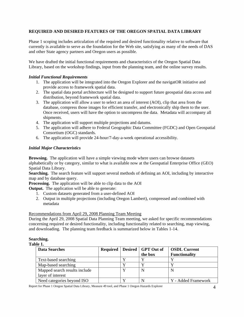
Searching.
Table 1.
Data Searches Required Desired GPT Out of
the box
OSDL Current
Functionality
Text-based searching Y Y Y
Map-based searching Y Y Y
Mapped search results include
layer of interest
Y N N
Need categories beyond ISO Y N Y - Added Framework

Report for Phase 1 Oregon Spatial Data Library, Measure 49 tool, and Phase 1 Oregon Hazards Explorer
5
pre-set themes Categories
Keyword-based searching
(“roads” -> roads layer)
Y Y Y
Table 2.
User interface Required Desired GPT Out
of the box
OSDL
Current
Functionality
Navigate via map interface Y Y Y
Simpler interfaces are preferred Y Y Y
Advanced search features are better located
on a separate tab or page
Y Y
Mimic widely used web pages (Google,
etc.)
Y Y and N Y and N
Quick, intuitive Y Y Y
Table 3.
Metadata Formats Required Desired GPT Out
of the box
OSDL
Current
Functionality
ESRI XML, XML Y Y Y
HTML Y Y Y
PDF Y N N
TXT Y N N
SGML Y N N
Table 4.
Data Sources Required Desired GPT Out
of the box
OSDL
Current
Functionality
Distinguish Framework data from other
spatial data
Y N Y - preset
search link
Link back to original source Y Y Y
Data of certain scales Y N N
Data of broad (national) coverage Y Y Y
Source (Agency) clear at the interface level Y Y Y
Map Viewing. Note: our Web application is not a solution for viewing data—another application
would be needed
Table 5.
Map interface Required Desired GPT Out
of the box
OSDL Current
Functionality
Add local shapefiles NO NO N N
Save/send map extent Y Y
Save/send map view Y Y
Markup maps Y Y
Connect to additional WMS Y Y
Connect to additional WCS Y Y
Connect to additional WFS Y Y

Report for Phase 1 Oregon Spatial Data Library, Measure 49 tool, and Phase 1 Oregon Hazards Explorer
6
Table 6.
Determining Area of Interest Required Desired GPT Out
of the box
OSDL Current
Functionality
Draw on map Y Y Y
Enter coordinates Y N N
Enter address Y N N
Quad name (Ohio code) Y N N
Township, range and section Y N N
County Name Y N N
City Name Y Y Y
4th Field Hydrologic Unit Y N N
5th Field Hydrologic Unit Y N N
Zip Code Y N N
Signed Route Milepost Y N N
Highway Number and Milepoint Y N N
Output/Downloading.
Table 7.
Defining Clip Extent Required Desired GPT Out
of the box
OSDL Current
Functionality
Clip to view extent Y N N
User defined bounding box Y Y Y
Clip to predefined region Y N N
Clip to multiple regions Y (very) N N
Clip to user uploaded region Y N N
Table 8.
Available projections Required Desired GPT Out
of the box
OSDL Current
Functionality
Geographic (GCS83) Y Y Y
Oregon Lambert Y Y Y
UTM Y Y Y
State Plane Y Y Y
Local datums/Custom Y Y Y
NAD27, NAD83, NAD? Y Y Y
Albers (2 versions: USFS and BLM) Y Y Y
Table 9.
Export File Formats Required Desired GPT Out
of the box
OSDL Current
Functionality
ESRI Shape/Geodatabase Y N Y
ArcInfo Export/Coverage Y N Y
MicroStation DNG Y N Y
MapInfo MID/MIF/TAB Y N Y
AutoCAD DWF/DWG Y N Y
GeoTIFF/JPEG Y N Y
GML/KML/KMZ Y Y - GML
only
Y
Report for Phase 1 Oregon Spatial Data Library, Measure 49 tool, and Phase 1 Oregon Hazards Explorer
7
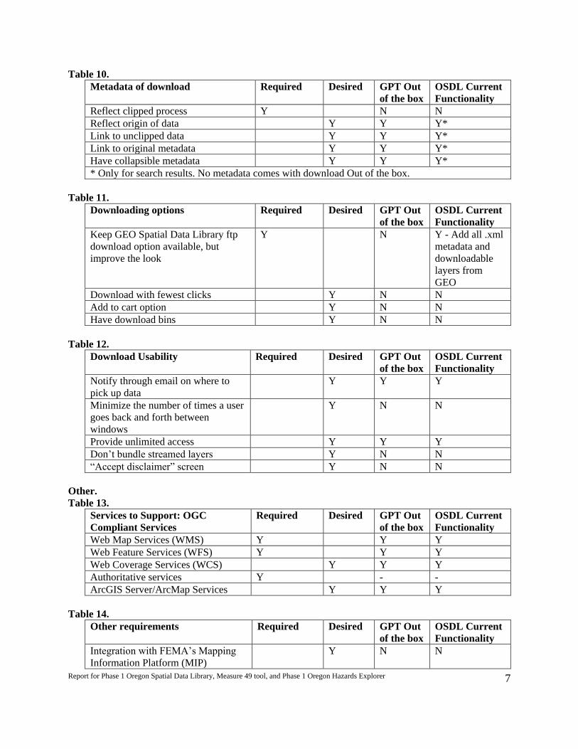
Table 10.
Metadata of download Required Desired GPT Out
of the box
OSDL Current
Functionality
Reflect clipped process Y N N
Reflect origin of data Y Y Y*
Link to unclipped data Y Y Y*
Link to original metadata Y Y Y*
Have collapsible metadata Y Y Y*
* Only for search results. No metadata comes with download Out of the box.
Table 11.
Downloading options Required Desired GPT Out
of the box
OSDL Current
Functionality
Keep GEO Spatial Data Library ftp
download option available, but
improve the look
Y N Y - Add all .xml
metadata and
downloadable
layers from
GEO
Download with fewest clicks Y N N
Add to cart option Y N N
Have download bins Y N N
Table 12.
Download Usability Required Desired GPT Out
of the box
OSDL Current
Functionality
Notify through email on where to
pick up data
Y Y Y
Minimize the number of times a user
goes back and forth between
windows
Y N N
Provide unlimited access Y Y Y
Don’t bundle streamed layers Y N N
“Accept disclaimer” screen Y N N
Other.
Table 13.
Services to Support: OGC
Compliant Services
Required Desired GPT Out
of the box
OSDL Current
Functionality
Web Map Services (WMS) Y Y Y
Web Feature Services (WFS) Y Y Y
Web Coverage Services (WCS) Y Y Y
Authoritative services Y - -
ArcGIS Server/ArcMap Services Y Y Y
Table 14.
Other requirements Required Desired GPT Out
of the box
OSDL Current
Functionality
Integration with FEMA’s Mapping
Information Platform (MIP)
Y N N

Report for Phase 1 Oregon Spatial Data Library, Measure 49 tool, and Phase 1 Oregon Hazards Explorer
8
No plug-ins (Flash, Active-X) Y Y Y
Browser independent Y Y Y
Fill out form to keep track of who is
downloading
N N N N
Give warning about size of download
and time to download
Y N N
Works in Firefox and IE Y Y Y
Data set: Irrigation Districts Y N N
Simpler interfaces preferred Y - -
Use Open Source Software Y N N
Post framework standards Y N N
Use COTS if cost benefits Y - -
Compatible: Imagery portal Y N N
Support decision support apps Y N N
ASSESSMENT OF GIS PORTAL TOOLKIT 9.3 RELATIVE TO USER NEEDS
The process used to assess the functionality and fit of the ESRI GIS Portal Toolkit 9.3 against the
required and desired functionality involved numerous steps:
scoping the necessary hardware required for installation,
purchasing additional hardware (one server),
configuring a database,
installing the software,
installation of ArcGIS Server (JAVA),
creation of map services,
establishing an ArcSDE data connection to GEO,
loading metadata,
configuring the data download functionality, and
final user interface customizations.
The supporting documentation for GPT 9.3 recommends having minimally two servers to support the
toolkit. Based on this recommendation, a new server was purchased and an existing map server at OSU
Library was configured to support the GPT 9.3 application.
GPT 9.3 stores harvested metadata in ArcSDE tables. Working with ESRI support, it was determined that
the best solution was to use an existing OSU Library ArcSDE database and add a specific user to access
the GPT metadata tables created in the existing ArcSDE instance at the OSU Library.
Installation of the software included a metadata service, a harvesting service and web applications. Each
of these services and applications required individual installation and configuration of their respective
files as there was no single installation utility for all of the pieces. For the ability to logon to the site as
different users with various roles, Lightweight Directory Access Protocol (LDAP) authentication was
setup to grant the appropriate permissions.
ESRI documentation specified that ArcGIS Server 9.3 (JAVA edition) be installed to support the map
services in the portal application. After installation of ArcGIS Server 9.3 JAVA, the supporting map
and geo-processing services were also created. Data used to support these map services required being
accessible to the ArcGIS Server user accounts.

Report for Phase 1 Oregon Spatial Data Library, Measure 49 tool, and Phase 1 Oregon Hazards Explorer
9
In order to test the feasibility of creating a distributed framework for data access, an ArcSDE data
connection was opened up between GEO and OSU Library. This connection required the involvement of
system administration staff at both locations to open up the necessary firewall permissions.
To load metadata into the GPT 9.3 several options are available. One is to setup a metadata service or a
WebDAV directory on a publishing entities server which is harvested from the GPT 9.3. Another option
is to grant publishers permission to connect to the GPT 9.3 metadata service and selectively publish
content via ArcCatalog utilities. The final option is to have publishers manually import metadata via the
web application and upload one metadata record at a time. For the testing of this first phase of this
project, the approach taken was to open up the ArcSDE connection and import metadata from GEO and
on the OSU side manipulate the metadata to add required fields to ensure proper functioning (see
Metadata Configurations below). For future phases, it is recommended that publishers conform to the
requirements of publishing to the portal.
To enable the clip, zip and ship functionality of the GPT 9.3 two ArcGIS Server services were required
along with the licensing of the Data Interoperability Extension for ArcGIS Server. (See Data Download
configurations below)
The final step was to customize and make the web application contextually relevant to Oregon. See list of
modifications in Web Application customizations below.
Scoping of processes and tools used by other states to address the required functionality not met
from GPT 9.3.
Given that not all of the required functionality was natively present with the GPT 9.3, the planning team
requested that several alternatives be scoped for consideration as models on which to base the Oregon
implementation. The options scoped included:
1. Other states/sites that have implemented GPT 9.3 with additional modifications.
2. Other states/sites that have implemented a non-GPT 9.3 solution (open source).
3. Feasibility of creating a hybrid solution with GPT 9.3 for metadata management, but a different
front-end.
Option 1: Other States/sites using GPT 9.3 - Group on Earth Observations
As the GPT 9.3 was a new generation release for the portal toolkit (previous releases were based on GPT
3.x), there were not many other sites to examine for their implementation. The best example of another
GPT 9.3 implementation was by the Group on Earth Observations
http://geoss.esri.com/geoportal/catalog/main/home.page . This site was recently updated to a pre-release
version of 9.3.1, so it also demonstrates some of the future functionality that will be available with the
next release. The biggest modifications were the addition of two new menu tabs (maps and browse) and
removal of the download tab. Assessing what pieces would be applicable in helping the Oregon effort
meet the functional requirements would be to consider adding more menu tabs to reflect
framework\featured data themes.
Option 2: Other States/sites implementing open source solution - Delaware DATAMIL
In looking at the second option for how to meet the functional requirements, the Delaware DATAMIL-
ICF site (http://datamil.delaware.gov/geonetwork/srv/en/main.home) stood out as an alternative open

Report for Phase 1 Oregon Spatial Data Library, Measure 49 tool, and Phase 1 Oregon Hazards Explorer
10
source option. The DataMIL application uses GeoNetwork OpenSource for the metadata management
and web interface components.
A test version was installed at OSU to test some basic functionality. The test application installation was
very easy to install with configurations able to be made through a user interface either through the site or
through a utility. The installation process compared favorably over the more cryptic way that the ESRI
GPT 9.3 requires configuration at the file level. In conversations with John Callahan, lead developer of
DATAMIL-ICF, he expressed widespread satisfaction with GeoNetwork OpenSource and recommended
that if the Oregon project chose this path to wait for the next release (2.4) due to greater stability and
increased functionality.
Metadata loading was tested with the GeoNetwork OpenSource test installation at OSU and ran into some
hurdles importing ESRI FGDC metadata. Given that this was a cursory exploration of the tool, further
troubleshooting was not conducted.
The Delaware DATAMIL model with GeoNetwork OpenSource was comparable to the GPT 9.3 in terms
of extent of required functionality supported out of the box with the notable exception of no built-in user
generated data download capability. Further customization would be required to enable a solution for
user generated downloads and the supporting metadata reflecting the clip process and the
exporting/viewing metadata in non-xml formats. The site offers an arguably better user experiences with
easier live map previews and better site organization. It should be noted, however, that with the release of
ESRI's 9.3.1 some of the usability concerns at 9.3 will be addressed.
Option 3: Hybrid solutions
The third option was to consider what it would take to create a hybrid application that uses the GPT 9.3 as
the metadata management engine and create a custom front-end. Since GPT 9.3 exposes the metadata
search results through either CSW 2.0.2 or a REST API, creating secondary applications that search
against the GPT 9.3 is a feasible alternative.
One option of an alternative front-end was to explore the work of ODOT and the regional transportation
work that Washington State has done with GeoCortex Essentials (a proprietary map application).
GeoCortex Essentials provides a highly featured map viewer based on a .NET platform and ESRI ArcGIS
Server. The Washington State Transportation tool extended the GeoCortex Essentials map interface to
provide the ability for a user to select an area, download data, edit the data, and check it back in.
Additional customization would need to occur to create a search interface for discovering data and then
integrating into the map viewer if this were to be a one tool solution. There could also be costs of
implementing the GeoCortex Essentials application, though there was the possibility of leveraging the
ODOT partnership to develop further.
A second option would be to create a lightweight javascript or FLEX mapping application that leverages
the GPT 9.3 with a searching widget and mimics the data download functionality exposed through the
ArcGIS Server services. The advantages of this approach are that development could occur on a platform
that is consistent with other applications at Oregon Explorer and provide a highly customizable interface
to evolve with changing needs and to build in the required functionality.
After having scoped out the three alternate options, it was decided that for this initial phase of
development, minor customization to the GPT 9.3 would allow for a building block for subsequent phases
with the least amount of effort. It is recommended that for subsequent phases of the project that further

Report for Phase 1 Oregon Spatial Data Library, Measure 49 tool, and Phase 1 Oregon Hazards Explorer
11
scoping be done on the feasibility of creating a one tool hybrid solution that brings together vector and
raster download capability by building off of the functionality of the Imagery Explorer.
Modifications to the GIS Portal Toolkit 9.3 for the Oregon Spatial Data Library (OSDL) beta site.
The customizations that Oregon Explorer staff implemented in the beta version of the Oregon Spatial
Data Library can be broken into three main areas:
1. Metadata configurations
2. Data Download configurations
3. Web application customizations
1. Metadata configurations
In order to successfully publish and search FGDC metadata numerous modifications were required. It is
expected that with the GPT extension 9.3.1, some of these issues have been addressed. The changes
required included:
a. Changes to two configuration files (esri-fgdc-definition.xml and propertymeanings.xml). These
two files dictate what gets indexed for searching, displayed as a result and displayed in the
detailed metadata link.
b. To publish FGDC metadata there are five required tags that must be filled out. (title, publisher,
spatial extent, ISO theme and content type). For some of these tags to display as expected in the
GPT, the metadata was updated primarily around the ISO themes and content type sections.
2. Data Download configurations
The data download functionality is dependent on two ArcGIS Server services (map service and
geoprocessing service). To enable the data download section the following modifications were necessary.
a. After much testing and troubleshooting, it was discovered that the Data Interoperability Extension
was required for multiple format and projection downloads. This was not a known limitation to
ESRI at the time of release of 9.3, but has since been clarified. We acquired the license keycode
from DAS to enable this functionality.
b. To enable shapefiles (or any multi file format) to download in a folder view display on the data
download page, customization of the python scripts supporting the zip folder were required.
c. To add additional formats for download from out of the box options, two configuration files
needed to have entries added. Shapefiles, E00, KML, KMZ, GeoJSON formats were added.
d. To add multiple projections, one configuration file needed to have entries added along with the
.prj file added to a folder in the geoprocessing task.
e. The ability to define area by a rectangle was added through customization.
f. The extracted spatial data does not include metadata. Future phases will need to explore what it
would take to do this further.
3. Web Application customizations
The out of the box version of the interface for the portal toolkit is a JAVA application that uses Apache
Tiles for layouts. It is heavily reliant on making configuration settings in various files. The application
comes with two style themes (red and blue). Extending the tile template system requires modifying the
source code for changes beyond what words are placed at key spots.
Customization of the web application involved modification primarily to three pages, (home, search and
download). The banner that appears on all pages was modified to include linkable logos. The home
page was modified to create a feature data section with the idea being that framework data could be
rotated through that section to feature data available for that framework. In addition premade search links
for framework data were created. For the premade keyword searches to work, additional keywords were

Report for Phase 1 Oregon Spatial Data Library, Measure 49 tool, and Phase 1 Oregon Hazards Explorer
12
added to the framework data for quick, unambiguous retrieval. The search page also implemented the
quick search for framework data at the top of the page along with graphic thumbnail and hover support.
The download page code was modified to add some instructions and to make the layer display in
collapsible folders.
Recommended Future Enhancements
As this was the initial beta development of the GPT 9.3, some additional customizations are
recommended both to help meet the user functional requirements and increase overall usability. These
recommendations assume that the ESRI portal toolkit (GPT 9.3) will serve as the foundation for future
phases of this project.
Functional requirements not-met and recommended enhancement strategy
a. Metadata formats- TXT and SGML
This requirement is understood to mean that it is required that users be able to view metadata as TXT and
SGML files. Currently, there is a link to the metadata that displays the metadata in a pretty html page, or
a raw xml view. To enable other views of the metadata for viewing/downloading to display in the search
results would likely require modification to JAVA classes in the ESRI source code. It is recommended
that a re-evaluation of this requirement be done to further understand the importance of viewing the
metadata in non-XML, HTML formats.
b. Data sources- Distinguish Framework data from other spatial data
In the beta version of the portal, the framework data has been made quickly distinguishable through
modification of the metadata and creating pre-made search links. To further identify framework data
through the search results that happen to retrieve some framework data would require modification to the
JAVA classes in the ESRI source code which again may be prohibitive depending on the desired
denotation. A simple option would be to change the title of Framework layers to start with an identifier,
i.e. Oregon Hydrography Framework.
c. Determining Area of Interest- searching
The portal toolkit uses an ESRI geocoding service to find places of interest. To enable searching by
coordinates, address, quad name (Ohio code), Township, range section, county, city, 4th or 5th HUC, zip,
signed route milepost or highway number and mile point will require both developing a more robust
Oregon centric geocoding service along with some user interface modification. The imagery explorer
extraction tool offers a good example of one way to develop this section more fully by querying a
mapping service and returning the feature coordinates.
d. User generated area of interest for downloads-
The out of the box options for users to generate an area of interest included drawing a polygon for the
area of interest. The ability to define area by a rectangle was added through customization. To enable
selection of predefined areas (i.e. counties, watersheds, state), modification to the download page would
be required calling either live map service to return the predefined areas coordinates for extraction, or
creating static .json files for each type of predefined area would be another alternative.
e. Metadata of downloads- Reflect clipped process
When a user downloads data from the download page, no accompanying metadata is included. To enable
this functionality it is likely that potentially substantial modification will be required of the geoprocessing
python scripts and may require some assistance from ESRI as metadata is not included by default in the
clip, zip and ship processing.
f. Downloading options- Browse page of all GEO spatial data

Report for Phase 1 Oregon Spatial Data Library, Measure 49 tool, and Phase 1 Oregon Hazards Explorer
13
Depending on the extent of integration of the GEO spatial data library site with the Oregon Spatial Data
Library site, a canned search of everything can be performed to allow users to have the browse
experience. Alternatively, a link on the homepage can send users to the GEO spatial data library page.
g. Other requirements- Warning of size limits.
There is theoretically a 5 MB size limit on data downloads via the extraction tool. Through testing,
however, downloads of greater than 5 MB were successfully performed. Through more testing, we can
both determine the actual limit and alert users to this on the download page.
Additional recommended improvements
a. Add more instructions and usability enhancements throughout site. Some of this will be
addressed in 9.3.1 release (see below).
b. Integrate search results in Oregon Explorer sites via CSW 2.0.2 metadata harvesting so that users
of any Oregon Explorer site can get results from the portal.
c. Scope what it would take to create a unified tool with a single mapping interface for searching
and downloading which incorporates raster data extractions from the imagery explorer as well.
This tool could be built in an open source platform (to be in-line with the future strategic path of
Oregon Explorer) and leverage the ESRI portal toolkit REST API for incorporating search results.
9.3.1 Improvements
ESRI is releasing the ArcGIS Server Geoportal extension 9.3.1 at the time of the conclusion of Phase I of
this project. Improvements in 9.3.1 that may influence future phases of this project include:
a. Base architecture shift away from using ArcIMS metadata service to a direct database model.
The implication is that a re-import of the metadata in the beta site will need to occur though the
understanding is that this can occur through a harvest of the current site.
b. Increased usability changes most notably to the advanced searching options.
c. Ability to launch a unique map viewer. Current version requires the JAVA map viewer to launch.
d. Quick preview of live services through a lightweight javascript map viewer.
e. Federated searching of other portals. This will allow for easy searching of GOS or user defined
portals to be returned in search results.
Summary
Completion of Phase I of this project involved the scoping, installation and implementation of a
customized beta version of the ESRI Geoportal Toolkit 9.3. Modifications that were made to get the beta
version of the site running included customizing the metadata and metadata configuration files, extensive
troubleshooting with ESRI to enable the data download with support for shapefiles and customizing the
web application interface to improve some baseline usability. The next version of the portal toolkit (now
an extension for ArcGIS Server) will provide some useful enhancements over the beta version
implemented including a shift to a lighter-weight database model, usability enhancements and federated
searching. For future phases of this project, some initial recommended next steps are:
a. Migrate the beta site to 9.3.1.
b. Scope feasibility of creating a one-tool solution that integrates raster and vector data using the
underlying architecture of GPT 9.x and the ER Mapper Imagery Explorer for data extraction but
that has a unified user interface.
c. Create a publishing document for new contributors to use in adding their metadata/data to the
portal.
d. Market to prospective publishers for data inclusion on the site.
e. Perform usability testing and evaluation with the beta site to inform future OSDL development
phases

Report for Phase 1 Oregon Spatial Data Library, Measure 49 tool, and Phase 1 Oregon Hazards Explorer
14
STRATEGY AND NEXT STEPS FOR THE OREGON SPATIAL DATA LIBRARY
Tasks that are not addressed due to insufficient funds are:
a. Develop final design and estimate costs and timeline for portal development and implementation
in multiple phases;
b. Test access to Framework data from a few distributed providers;
c. Exploring/resolving security issues; and
d. Provide access to other DAS/OSU enterprise tools as appropriate.
Plans are in place to convene a group to discuss the strategy and next steps in the coming months.
FISCAL AND ACCOUNTING INFORMATION
A full accounting of the expenditures of DAS monies was sent directly to DAS from the OSU Office of
Post Award Administration on July 30, 2009.

Report for Phase 1 Oregon Spatial Data Library, Measure 49 tool, and Phase 1 Oregon Hazards Explorer
15
APPENDIX 1. Agenda and Notes from Workshops/Planning Team Meetings
Oregon Explorer and NavigatOR Meeting Notes OSU Valley Library, Corvallis, Oregon
October 31, 2007
Meeting Purpose: Review scope of work for Spatial Data Explorer Web Portal Present: Cy Smith, DAS/GEO; Gail Ewart, DAS/GEO; Milton Hill, DAS/GEO; Janine Salwasser, OSU; Jimmy Kagan, OSU; Tim Fiez, OSU; Kuuipo Walsh, OSU; and Marc Rempel, OSU. Updates and announcements: DAS is in the process of finalizing the Interagency Agreement. INR has conducted interviews for the Spatial Data portal project manager position. The top three candidates have been identified and the search committee is checking references. INR anticipates hiring someone soon. Milt Hill is rotating into Gail’s Framework Coordinator position for 6 months. Milt’s email is: [email protected]. There has been no DAS response to the OE briefing on 10/26/07, but Cy thought the meeting went well. The press release for the public launch of the Oregon Imagery Explorer is on Cy’s plate. The director’s office asked Cy to make substantive changes to the press release. Review Interagency Agreement and scope of work: The team reviewed the interagency agreement and scope of work. The project begins as soon as the interagency agreement between DAS and OSU is finalized. The project end date is September 30, 2008. Janine will come up with a Gantt chart of milestones for the project. Scoping/user workshops: We are anticipating having 2 to 3 workshops to scope the project. The purpose of the workshops is to get feedback from users on the needed functionality of the Spatial Data portal and prototypes. We also need to show them how the portal will help them and make sure they support this project. In addition to the larger group of users, Janine suggested having a smaller core group to work with throughout the project. We would want the core group to attend the workshops and responding to our email requests over a 6-12 month time period. The core group will include the chairs of the framework committees and selected federal representatives, one or two local representatives and possibly a private sector consultant. We plan to send this core group an initial email describing the time commitment we need from them and our strategy document. The proposed core group is:
1. Diana Walker, Administrative Boundaries FIT Lead, ODA 2. Jimmy Kagan, Bioscience FIT Lead, Land Cover FIT Lead, OUS 3. Cress Bates, Cadastral FIT Lead, Lane Co. 4. George Taylor, Climate FIT Lead, OSU 5. Emmor Nile, Elevation FIT Lead, Utilities FIT Lead, ODF

Report for Phase 1 Oregon Spatial Data Library, Measure 49 tool, and Phase 1 Oregon Hazards Explorer
16
6. Ken Bays (Geodetic Control FIT Lead) or Dennis Scofield (Transportation FIT Lead), ODOT
7. Ian Madin, Geoscience FIT Lead, DOGAMI 8. Krista Dillon, Hazards FIT Lead, ONHW/UO 9. Robert Harmon, Hydro FIT Lead, OWRD 10. Randy Sounhein, Ortho FIT Lead, DSL 11. Eric Brandt, Land Use FIT Lead, LCOG 12. Gillien Duvall, Preparedness FIT Lead, OEM 13. Tom Pansky, BPA 14. Sherri Schneider, USGS 15. Orrin Frederick or Duane Dippon, BLM 16. Brady Callahan, OPRD 17. Theresa Valentine, USFS, OSU 18. ?, Private Sector Consultant 19. ?, Metro 20. ?, Tribal 21. ?, Local, Dan Stark, GIS Manager for Wilsonville? 22. ?, Local
Janine will coordinate the workshops. The first workshop is slated for mid- to late-February. For future workshops, we will plan to coordinate with the Framework Forum slated for mid-late March and the GIS in Action 2008/ASPRS meeting (April 28th to May 2nd in Portland). These events could help us reach a larger audience for briefing users on the Spatial Data Portal and getting feedback. Action Items:
1. Identify two local people and possibly one private sector consultant for core group of users – Cy
2. Finalize interagency agreement – Cy 3. Create Gantt chart of milestones for the project - Janine 4. Propose target dates for workshops and propose the purpose for each workshop
– Janine 5. Check all calendars and finalize workshop dates – Milt 6. Draft an initial email for core users, including time commitment requirements. –
Kuuipo 7. Create strategy document and engaging name for core team – Jimmy 8. Send out initial email for core users, including signed contract and strategy
document as attachments – PM 9. Hold first workshop with users in late February in Salem – Janine 10. Evaluate GIS Portal Toolkit in early February – Tim, Marc, Kuuipo 11. Coordinate with Dennis/Chad to test distributing ODOT’s road layer – Milt 12. Summarize notes from looking at different spatial data sites – Jimmy 13. Address outreach needs (build off of existing DAS communication strategy) –
Milt and Janine Next meeting: TBD.. Note: need to get an update on the additional $100K from GEO. Is this still coming in two installments between October and April?

Report for Phase 1 Oregon Spatial Data Library, Measure 49 tool, and Phase 1 Oregon Hazards Explorer
17
Agenda Spatial Data Explorer
OSU Valley Library, Corvallis, Oregon Kelley Conference Room (Valley 4168)
March 5, 2008, 1:00 p.m. - 2:30 p.m.
Meeting Purpose: Obtain feedback from selected chairs of the framework committees and selected federal, state, local, and university representatives on the needed functionality of the Spatial Data Portal. Meeting Deliverables: Develop a list of requirements for Spatial Data Portal. Introductions: (1:00-1:05)
Names and roles of team members - all Review of the Spatial Data Portal: (1:05-1:30)
Problem description and proposed solution– Jimmy or Cy Target Audience/Summary/Any questions? – Kuuipo Indiana Spatial Data Portal functionality – Kuuipo Pennsylvania Spatial Data Access (PASDA) functionality – Kuuipo Arkansas GeoStor 5.0 functionality – Kuuipo
Review of the GIS Portal Tookit: (1:30-2:10)
GIS Portal Toolkit 3.1 functionality – Marc Northwest Environmental Data Network functionality - Marc Mississippi Geospatial Clearinghouse functionality – Marc Plans for the Portal Toolkit at 9.3 – Marc Review Geospatial One-Stop - Marc
Required/Desired Functionality: (2:10-2:15)
Which metadata services? Search by what? Download data through linking to download site? Save queries, maps? Clip & Zip data distribution/download? Connect to Map Services? Private/restricted content?
Wrap Up: (2:15-2:30)
Timeline of project – Kuuipo Spatial Data Explorer Workshop at Framework Forum March 13th – Janine Next steps
Report for Phase 1 Oregon Spatial Data Library, Measure 49 tool, and Phase 1 Oregon Hazards Explorer
18
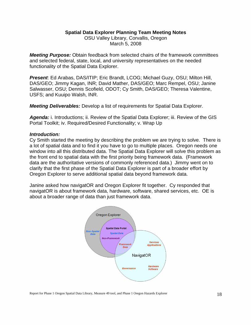
Spatial Data Explorer Planning Team Meeting Notes OSU Valley Library, Corvallis, Oregon
March 5, 2008
Meeting Purpose: Obtain feedback from selected chairs of the framework committees and selected federal, state, local, and university representatives on the needed functionality of the Spatial Data Explorer. Present: Ed Arabas, DAS/ITIP; Eric Brandt, LCOG; Michael Guzy, OSU; Milton Hill, DAS/GEO; Jimmy Kagan, INR; David Mather, DAS/GEO; Marc Rempel, OSU; Janine Salwasser, OSU; Dennis Scofield, ODOT; Cy Smith, DAS/GEO; Theresa Valentine, USFS; and Kuuipo Walsh, INR. Meeting Deliverables: Develop a list of requirements for Spatial Data Explorer. Agenda: i. Introductions; ii. Review of the Spatial Data Explorer; iii. Review of the GIS Portal Toolkit; iv. Required/Desired Functionality; v. Wrap Up Introduction: Cy Smith started the meeting by describing the problem we are trying to solve. There is a lot of spatial data and to find it you have to go to multiple places. Oregon needs one window into all this distributed data. The Spatial Data Explorer will solve this problem as the front end to spatial data with the first priority being framework data. (Framework data are the authoritative versions of commonly referenced data.) Jimmy went on to clarify that the first phase of the Spatial Data Explorer is part of a broader effort by Oregon Explorer to serve additional spatial data beyond framework data. Janine asked how navigatOR and Oregon Explorer fit together. Cy responded that navigatOR is about framework data, hardware, software, shared services, etc. OE is about a broader range of data than just framework data.

Report for Phase 1 Oregon Spatial Data Library, Measure 49 tool, and Phase 1 Oregon Hazards Explorer
19
Kuuipo suggested that the purpose of this meeting is to review existing State spatial data portals to use as a springboard for defining requirements for the Spatial Data Explorer. The goal is to gain agreement on what the portal should be and produce a list of requirements we could use to begin development. In order to get a site up quickly and inexpensively, it is assumed we will be relying largely on ESRI’s GIS Portal Toolkit version 3.1 software. Recommend Requirements: Throughout the meeting, we compiled a list of possible requirements for the Spatial Data Explorer. KEY: Bold = Required; Normal = Desired
Must distinguish framework data from other spatial data
Must provide access to spatial data with first priority access to framework data.
Must stream data (WMS, WFS, WCS)
Must be quick enough to use
Must provide users options for both text-based and map-based searching (PASDA search is a text based search only)
If the search result takes you to a map, the map must show the layer of interest (PASDA search for local roads did not show local roads, even when zoomed in.)
Allow users to clip data before downloading (see PASDA)
Allow users to reproject data before downloading (see PASDA)
Ask users to fill out form to keep track of who is downloading (see Arkansas GeoStor 5.0)
Give warning about size of download and how long it will take to download
For on-the-fly clip-ship-zip, provide access to the original metadata and the metadata for the clipped area
Web site should work in Firefox and Internet Explorer
Must have collapsible metadata (see Arkansas GeoStor 5.0)
Give notification through email where to pick up data
Need categories beyond ISO pre-set themes
When you “View Details”, the “Go To Website” should say “Go To Source Website” (See NED)
Minimize the number of times a user goes back and forth between windows. For example in NED, the user can “Launch Map Viewer to Draw Box” and then can go back to Advanced Search to “Get Box already drawn on Viewer.” This is confusing.
Does the GIS Portal Toolkit have to be driven by metadata? Can it be based on keyword? For example in NED, we did a search on roads and the result was a “StreamNet Northwest Critical Habitat Map” which probably had the word “roads” somewhere in the metadata, but really isn’t a roads layer.
Users want to connect to authoritative service. But they don’t want to go to multiple sites to steam data. Instead, can we hand off links in a transparent way?

Report for Phase 1 Oregon Spatial Data Library, Measure 49 tool, and Phase 1 Oregon Hazards Explorer
20
Review of GIS Portal Toolkit Our development site is http://vaduz.library.oregonstate.edu:8080/Portal/. Using the GIS Portal Toolkit (GPT) technology, users can discover data resources produced by others, view data through the map viewer, make unique maps, obtain data, and add data. The GPT can consume data that is being exposed from other WMS services. A new version of GPT is coming out with the release of ArcGIS 9.3 later this year. [Side note: ArcGIS Server at 9.3 will be able to manage replicated copies of geodatabase in distributed environments.] Issues to Resolve:
Metadata copied into ArcSDE. When metadata changed at the source, may not be updated in the GIS Portal Toolkit
Unclear about the definition of “channel” (like a theme)
How easy will it be to translate metadata from GPT 3.1 to GPT 9.3?
Find out what can be offered through GEO and not through portal
What do we lose by implementing GPT now versus waiting for 9.3? What are other site migration plans?
Need a master list of all WMS servers to be able to link to
Next steps and proposed timeline The timeline is currently in flux due to our Senior Programmer, Tim Fiez, leaving OSU. Janine is currently working on hiring a new Senior Programmer. Janine is coordinating the Spatial Data Explorer workshop on 3/13. At the workshop we will continue to refine the specifications for the Spatial Data Explorer by getting input from a larger group of users. Note: John Sharrard from ESRI is expected to be at the workshop on 3/13. A list of next steps with proposed dates:
1. Ask USGS (Ginny at the National Map) about their migration plans. -Jimmy (3/10)
2. Determine which functionality is out-of-the box Toolkit functionality – Marc (3/13)

Report for Phase 1 Oregon Spatial Data Library, Measure 49 tool, and Phase 1 Oregon Hazards Explorer
21
Spatial Data Explorer Web Portal Workshop Thursday, March 13, 2008 from 10:30 am to 12:00 pm
Workshop Purpose: discuss the scope of the OSU planning work and develop functional requirements for the Spatial Data Explorer. Workshop Facilitator: Janine Salwasser, OSU Libraries Project Manager: Kuuipo Walsh, Institute for Natural Resources GIS Analyst/Programmer: Marc Rempel, OSU Libraries
A G E N D A
1. Context of OSU role and Oregon Explorer – Janine Salwasser, OSUL 10:30–10:35 a.m.
2. Purpose and outcomes of Phase I scoping – Kuuipo Walsh, INR 10:35– 10:50 a.m.
3. Functionality of existing data portals (via demonstrations) – Marc Rempel, OSUL 10:50 – 11:15 a.m.
4. Identifying functional requirements (via brainstorm exercise) – Janine Salwasser,
OSUL 11:15–11:50 a.m.
5. Next steps– Janine Salwasser, OSUL 11:50–12:00 p.m.
Handouts: Reference list of spatial data portals Planning team meeting notes Slide handouts User questionnaire

Report for Phase 1 Oregon Spatial Data Library, Measure 49 tool, and Phase 1 Oregon Hazards Explorer
22
Spatial Data Explorer Web Portal Workshop Notes LaSells Stewart Center, Corvallis, Oregon
March 13, 2008
Meeting Purpose: Discuss the scope of the OSU planning work and develop functional requirements for the Spatial Data Explorer. Present: Eric Brandt, LCOG; John Bowers, ODFW; Brady Callahan, OPRD; Jeff Comstock, Port of Portland; Mike Englemann, UO; Stan Frazier, BLM; Orrin Frederick, BLM; Darlene Gowen, ODOT; Michael Guzy, OSU; Bob Harmon, OWRD; Milton Hill, DAS/GEO; Steve Lucker, DOR; Ian Madin, DOGAMI, David Mather, DAS/GEO; Phil McClellan, DOR; Jay Noller, OSU; John Prychun, DOR; Ian Reid, USDA-NRCS; Marc Rempel, OSU; Janine Salwasser, OSU (Workshop Facilitator); Rick Schack, DOR; Sheri Schneider, USGS; Dennis Scofield, ODOT; John Sharrard, ESRI; Philip Smith, ODOT; Randall Sounhein, DSL; Rod Therriault DOR; and Kuuipo Walsh, INR. Meeting Deliverables: Develop a list of requirements for Spatial Data Explorer. Meeting Handouts: Reference list of spatial data portals, planning team meeting notes, slide handouts, and user questionnaire. Agenda:
1. Context of OSU role and Oregon Explorer; 2. Purpose and outcomes of Phase I scoping; 3. Functionality of existing data portals (via demonstrations); 4. Identifying functional requirements (via brainstorm exercise); and 5. Next Steps
Summary: Janine started the meeting by describing the workshop objectives. We want potential users to understand the Phase 1 scope of work and to further identify their requirements for the Spatial Data Explorer. Janine read a quote from Cy that stated that the Spatial Data Explorer will be the one window to Oregon’s distributed spatial data with the first priority being framework data. Kuuipo explained that the Spatial Data Explorer portal project is a multi-phase project. Phase 1 has been funded and comprises project scoping, which includes articulation of the required and desired functionality satisfying as many user needs as possible. Evaluation of the ESRI Portal Toolkit will also occur in Phase 1. Marc reviewed the functionality of existing data portals via live demonstrations. In the brainstorming session, a workshop participant indicated he/she liked the Pennsylvania Spatial Data Access (PASDA) site. He/she liked the options of ftp download, application

Report for Phase 1 Oregon Spatial Data Library, Measure 49 tool, and Phase 1 Oregon Hazards Explorer
23
viewer, add to cart, and stream via WMS/WFS. Another participant thought the download bins on the Arkansas GeoStor site was nice. Comments, Questions and Suggestions from Participants:
The Spatial Data Explorer should not allow download without “accept disclaimer” screen
The portal should not duplicate other portals or services
Will there be any vetting of data sets offered for quality, or will you just take whatever you can find?
How to deal with sensitive data? Secure login?
Is KML so widespread that it must be supported? If so, are there other formats that should be addressed? What about future formats?
Download Bins on Arkansas site are nice.
Kentucky has a good site. British Geological Survey does too.
Proliferation of “Explorers” is confusing to users
Diagram:
Images WMS
Streaming ??
Geometries WFS, WCS
Batch Shp. Gdb….
Can you add local .shp files?
PASDA site – what is output format? Put commonly used formats at top of list.
Any other COTS? Beyond DLCD NO (GPT not COTS either)
Consider requirements as components
GPT = development product
What’s the level of enhancement between 9.2 and 9.3 (evolutionary not revolutionary)
Long term $ stream for stewardship and hosting Recommend Requirements: During a brainstorm exercise, we compiled a list of possible requirements for the Spatial Data Explorer. KEY: Bold = Required; Normal = Desired
Streaming o Portal must consume WMS, WFS & WCS and publish WMS, WFS &
WCS o Stream data must be fast. Cached? o Each layer should be streamed as single WMS/WFS service. Not
“bundled” with other layers. o Ability to add portal service directly to our ArcGIS server application. In
order to do that in 9.2 the data needs to be in the same coordinate system (Oregon Lambert). Bob Harmon, OWRB
Clipping o Must provide interactive clip by user-drawn bounding box o Multiple selection of clipping boundaries

Report for Phase 1 Oregon Spatial Data Library, Measure 49 tool, and Phase 1 Oregon Hazards Explorer
24
o Metadata for clipped data updated to reflect origin of data; and the fact it was interactively clipped from portal; plus link to full dataset
o Need to be able to select format and projection when using clip and ship
o Desired: Add local datum planes to clip, zip, and ship. o Desired: Include Transformations to Local Datum Plane and custom
scaling factors with clip, zip, and ship for Microstation, CAD, and engineering users.
Formats o Must require all current standard data formats o Desired: Multiple formats of delivered data
Look for all COTS options. Make decision about which COTS to select based on costs and benefits
Portal must be compatible with Orthoimagery portal
Must provide unlimited access to data
Money [Must have long term funding]
Source of data, e.g., agency, should be clear at the interface level, not buried in metadata
Downloading o Need to be able to download data with the same ease as now exists
in the Spatial Library o Get to Download of Data as quickly and easily as possible. Fewest
clicks.
Location search by township, range, section
Ability to save and send a map extent or view
Ability to markup maps and send to others
Web apps must be browser agnostic(?). Must not require proprietary add ons like Flash or Active-X
Use Open Source Software to greatest extent possible. OSU is a leader in that area.
Must be intuitive to use
Provide easy link from data on portal to steward agency
Stewardship: Need to assure mechanism of future stewardship
Pennsylvania Spatial Data Access (PASDA): like options of ftp download, application/viewer, add to cart, and stream via WMS/WFS.
Exclude data of certain scales and broad (national) coverage
Support for decision support applications e.g., a web-based tool for prioritization of conservation of restoration requires streaming of actual pixel data of a raster contained by a polygon zone of my choice
Post all standards along with data, if it is framework data
Harvest from other sites or locations and link back to original source
Add external layers to map from either a local drive or ability to connect to additional WMS
Data set: Irrigation District, Boundaries and Labels with water sources
Report for Phase 1 Oregon Spatial Data Library, Measure 49 tool, and Phase 1 Oregon Hazards Explorer
25
Simpler interfaces are preferred; Advanced Search features are better located on a separate tab or page.
Mimic widely used web pages where possible: o Queries – google o Maps – MapQuest, GoogleMaps o Spatial Search- Caldwell Brokers and Realtors
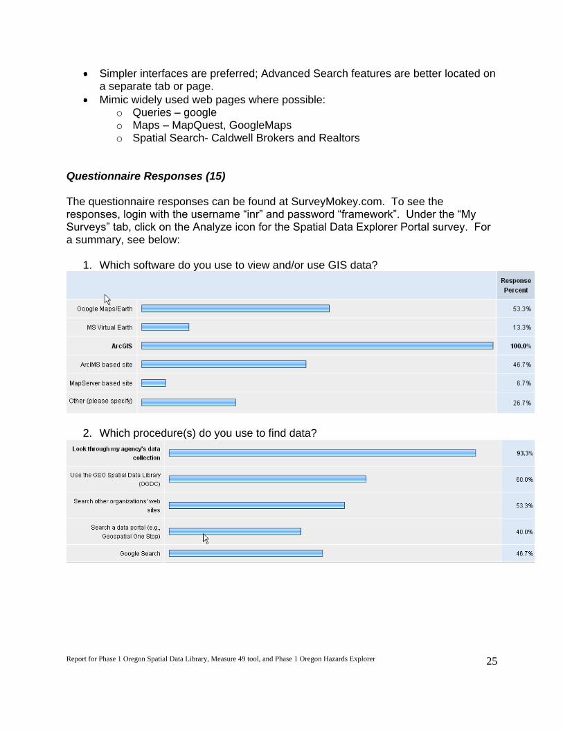
Questionnaire Responses (15) The questionnaire responses can be found at SurveyMokey.com. To see the responses, login with the username “inr” and password “framework”. Under the “My Surveys” tab, click on the Analyze icon for the Spatial Data Explorer Portal survey. For a summary, see below:
1. Which software do you use to view and/or use GIS data?
2. Which procedure(s) do you use to find data?

Report for Phase 1 Oregon Spatial Data Library, Measure 49 tool, and Phase 1 Oregon Hazards Explorer
26
3. Through what means do you prefer to receive data/metadata from another data provider?
4. Have you used a GIS portal powered by ESRI’s GIS Portal Toolkit before (e.g.,
Geospatial One Stop)
5. Did you find what you were looking for?
6. How easy was it to find the datasets you wanted?
7. When you download metadata, what export format do you want?
8. Do you want the option to reproject the data before you download it?

Report for Phase 1 Oregon Spatial Data Library, Measure 49 tool, and Phase 1 Oregon Hazards Explorer
27
9. Which projection(s) need to be available?
10. When you download data, which export format do you want?
Next steps A list of next steps with proposed dates:
3. Send out workshop notes to planning team (4/9/08) 4. Conduct online survey of OGIC/FIT members not in attendance at workshop
(4/10-4/21) 5. Combine recommended requirements from planning team, workshop findings
and survey responses (4/22) 6. Hold second spatial data explorer planning team meeting to review Workshop
Findings and prioritize requirements (4/29/08)

Report for Phase 1 Oregon Spatial Data Library, Measure 49 tool, and Phase 1 Oregon Hazards Explorer
28
Oregon Hazards Framework Implementation Team Meeting OSU Valley Library, Corvallis, Oregon
Drinkward Conference Room – 4th floor
Wednesday, August 13, 2008 from 2:00 pm to 4:00 pm
(Amendment 2)
Invitees: DAS GEO DLCD
DOGAMI Emergency Management
FEMA INR
LCOG Oregon Military Department
ODF ODOT
OSU Libraries State Fire Marshall
State Police University of Oregon
USGS
Meeting Purpose: Hazards Framework Implementation Team (FIT) general business;
Determine need and potential scope of an all Hazards Explorer
Facilitator: Janine Salwasser, OSU Libraries
Agenda
2:00-2:10 p.m. Welcome and Introductions - Milt Hill, DAS GEO
New Hazards FIT Lead:
Ian Madin, Chief Scientist
Oregon Department of Geology and Mineral Industries
2:10-2:30 p.m. Hazards FIT overview - Milt Hill, DAS GEO
Spatial Data Portal Discussion: Hazards focus
2:30-2:40 p.m. Introduction to the Spatial Data portal concept - Cy Smith, DAS GEO and
Jimmy Kagan, INR
2:40-2:50 p.m. Context of OSU role and Oregon Explorer - Janine Salwasser, OSUL
2:50-3:00 p.m. Options for providing access to hazards information - Kuuipo Walsh, INR
3:00-3:45 p.m. Discussion of options - All
3:45-4:00 p.m. Next Steps and Wrap Up
Potential role of Hazards FIT - Kuuipo Walsh, INR
Next steps and timeline - Janine Salwasser, OSUL
Next meeting and wrap up - Milt Hill, DAS GEO

Report for Phase 1 Oregon Spatial Data Library, Measure 49 tool, and Phase 1 Oregon Hazards Explorer
29
Agenda Spatial Data Explorer Meeting
OSU Valley Library, Corvallis, Oregon Drinkward Conference Room
February 19, 2009, 1:00-2:00 p.m.
Invitees: Cy Smith, DAS/GEO; Milt Hill, DAS/GEO; David Mather, DAS/GEO; Jimmy Kagan, INR; Janine Salwasser, OSU Libraries; Kuuipo Walsh, INR; Marc Rempel, OSU Libraries, Kevin Johnsrude, OSU Libraries; Ruth Vondracek, OSU Libraries; Dylan Keon, NACSE Meeting Purpose: The objective for this meeting is to determine if we are on track and on schedule with this project. Discuss relevant topics to keep us moving forward. Meeting Outcomes: 1) Revised timeline with any red flags identified 2) List of questions regarding overall management of metadata/data; Identify plan for
answering questions 3) Draft planning team meeting agenda Reference: The Spatial Data Explorer will be integrated with Oregon Explorer and the navigatOR initiative.
1:00 Introductions: (all)
Team: o Cy Smith - DAS/GEO - Statewide GIS Coordinator o Milt Hill - DAS/GEO - Framework Coordinator o David Mather - GIS Data Administrator o Jimmy Kagan - Project Advisor, PI, INR/FIT Project liaison o Kuuipo Walsh - Project Manager, Web Developer, GIS Analyst o Marc Rempel - Lead Programmer o Kevin Johnsrude - Programmer o Janine Salwasser - Project Advisor, Workshop Facilitator, Usability testing

Report for Phase 1 Oregon Spatial Data Library, Measure 49 tool, and Phase 1 Oregon Hazards Explorer
30
o Ruth Vondracek - Head of Reference Consulting & Innovative Services o Jennifer Cunningham - Student GIS support o Travis Powell - Student web design support o Matthew Gonzales - IT support
1:05 Review of Meeting Objectives and Agenda: (Kuuipo) 1:10 Review of Timeline of Spatial Data Explorer tasks: (all)
List of Framework Data (by March 2) Case studies focusing on processes and tools used by other states, e.g. Cal-Atlas
Geospatial Clearinghouse Web site (by March 16) Assess how well ESRI’s GIS Portal Toolkit can meet the required and desired needs of
the portal - by March 16 Milestone: Planning team meeting (March ____________) Implementation of Spatial Data Explorer portal accessing available hazards data
authorized by Hazard FIT: March Creation of Hazard Explorer topic portal shell: March 2009 Creation of Beta version of hazards reporting tool (Hazards Reporter): April 2009 Complete final design of Spatial Data Explorer web portal (April 2009) Milestone: Workshop with users to review final design and present recommendations
(first week in May _________________) Usability Testing (May) Revise final design as needed based on feedback from workshop and usability (May) Enable access to a Framework data at the GEO Spatial Data Library
(http://gis.oregon.gov/DAS/EISPD/GEO/alphalist.shtml) (May) Test access to Framework data from a few distributed providers (May)
1:20 Future Management of Metadata/Data: (Marc)
1:35 Hazards Explorer portal: (Kuuipo)
Status on Amendment Questions regarding Hazards Reporter
1:45 Planning Team Meeting: (Kuuipo)
Agenda 1. Confirm preferred portal name, tagline, portal goal statement 2. Assessment of how well ESRI’s GIS Portal Toolkit meets the required and
desired needs of the portal 3. Distinction between Framework and other data
1:55 Wrap Up: (Kuuipo)
Next steps 1. Next planning team meeting in March? 2. Workshop in May? FIT event?
Attachments: Timeline; Mockup of Hazard Reporter

Report for Phase 1 Oregon Spatial Data Library, Measure 49 tool, and Phase 1 Oregon Hazards Explorer
31
Spatial Data Navigator/Explorer Planning Team Meeting (#3)
(DRAFT site: http://oregonexplorer.info/spatialdata/)
When: Friday, March 13, 2009 from
1:30 pm to 3:00 pm
Where: Anderson Readiness Center (ARC), 3225 State Street, Salem
Room: 115 (follow signs to FIT meeting; knock or use call box for entry)
Draft Agenda
Confirmed participants: Eric Brandt, Lane Council of Governments; Bob Harmon, Water Resources
Department; Milt Hill, Geospatial Enterprise Office; Jimmy Kagan, Institute for Natural Resources;
David Mather, Geospatial Enterprise Office; Marc Rempel, OSU Libraries; Janine Salwasser, OSU
Libraries; Sheri Schneider, USGS; Theresa Valentine, USDA Forest Service; Kuuipo Walsh, Institute
for Natural Resources
Objectives of Meeting: The purpose of the meeting is to discuss decisions that will affect the final
design and implementation of the Spatial Data portal.
1:30 Introductions (all)
1:40 Review of Meeting Objectives and Agenda (Kuuipo Walsh)
1:45 Demonstration of the GIS Portal Toolkit 9.3 (Marc Rempel)
“Out-of-the-box” functionality
Functionality that would require customization
2:10 Feedback from the Planning Team on required and desired features of the portal based on
the assessment of the GIS Portal Toolkit (all)
2:30 Review of a limited number of other spatial data web sites (Kuuipo Walsh)
Best sites:
o Delaware DataMIL
o Cal-Atlas Geospatial Clearinghouse
o West Virginia GIS Technical Center
o Montana Geographic Information Clearinghouse and Montana GIS
Portal
2:40 Agreement on portal name and site identify (including distinction between Framework and
other data) (all)
2:50 Identification of next steps / assignments / Wrap-up (Kuuipo Walsh)
3:00 Adjourn

Report for Phase 1 Oregon Spatial Data Library, Measure 49 tool, and Phase 1 Oregon Hazards Explorer
32
Attachments: Spatial Data Portal Requirements document; Spatial Data Portals - Reference List 2009;
Names List
Facility Information:
Access to the Donald N. Anderson Readiness Center is via a controlled gate on Kettle Way, west of
the building. A guard will ask for identification when you reach the entrance to the parking
lot. Once inside the fence, standard entry to OEM’s facility is through the double doors (use
the portico walkway) on the east end of the building (Hawthorne Avenue side). There is an
access control phone from which you can call OEM and we will electronically allow you to
access the building. Please do not park inside the chain-link fenced area on the east end.
You may park anywhere outside of the chain-link fenced area.
The meeting location is accessible to persons with disabilities. A request for an interpreter for the
hearing impaired or for other accommodations for persons with disabilities should be made
at least 48 hours before the meeting to Cherie Zastoupil at 503-378-2911, ext. 22221 or
TDD/TTY 503-373-7857.
Report for Phase 1 Oregon Spatial Data Library, Measure 49 tool, and Phase 1 Oregon Hazards Explorer
33
Spatial Data Explorer Planning Team Meeting Notes Anderson Readiness Center (ARC), Salem, Oregon
March 13, 2009 Meeting Purpose: The purpose of the meeting is to discuss decisions that will affect the final design and implementation of the Spatial Data portal using the GIS Portal Toolkit (GPT):
o How to address requirements not met by GPT 9.3 “out-of-the-box” o Identifying the most critical requirements needing GPT customization o Determining whether to consider other systems to address requirements
not met by GPT 9.3 . Present: Eric Brandt, LCOG; Bob Harmon, Water Resources Department; Milton Hill, DAS/GEO; Jon Jablonski, University of Oregon; Jimmy Kagan, INR; David Mather, DAS/GEO; Marc Rempel, OSU; Janine Salwasser, OSU; Cy Smith, DAS/GEO; Theresa Valentine, USFS; and Kuuipo Walsh, INR. Dennis Scofield and Chad Brady of ODOT attended a run-through of the meeting on March 12th. Sheri Schneider was invited, but unable to attend. Agenda: i. Introductions and review of meeting objectives and agenda; ii. Demonstration of the GIS Portal Toolkit 9.3; iii. Feedback from the Planning Team on required features of the portal based on the assessment of the GIS Portal Toolkit; iv. Identification of next steps / assignments / wrap-up The OSU team has assessed how well ESRI’s GIS Portal Toolkit can meet the required and desired needs of the portal. We conclude that the GIS Portal Toolkit (GPT) works well for metadata management, but a number of requirements are not supported, including functionality related to searching, map viewing and downloading, particularly the “clip-zip-ship” functionality. Feedback from the Planning Team: Search Comments:
1. Can we add to other services (e.g. ArcMap)? Not just map service. 2. Can Additional Options be placed higher and be collapsible/renamed? 3. Metadata “details” need to show attributes (what codes mean). This requires
customization. Map Viewer Comments:
4. Is there a memory limit for a session? 5. Display in a projection that makes sense for Oregon (i.e., Oregon Lambert)
Download Comments:
6. Need to figure out how to get more than gml (need shp format) 7. Find out if extension give you more clipping options

Report for Phase 1 Oregon Spatial Data Library, Measure 49 tool, and Phase 1 Oregon Hazards Explorer
34
Regarding specific recommendations concerning the GIS Portal Toolkit, the planning team overall feedback is summarized in the points below:
Team is not satisfied with GPT out-of-the-box functionality
Balance effort and time and look at options measured against requirements
“Clip-zip-ship” functionality may not be a high priority
Searching by geography is key
Compare Montana functionality with our requirements
Simple alphabetical list is needed
Bring in 2005 half-meter orthoimagery into viewer The planning team suggested three different solutions to address requirements not met:
1) Do not use the GIS Portal Toolkit 9.3. For example, Delaware’s DataMIL uses GeoNetwork Opensource.
2) Use the GPT for metadata management only and use another approach for other functionality like mapping and clip, zip, and ship. For example, use Geocortex, APIs, mashups.)
3) Customize the GIS Portal Toolkit 9.3. Next steps and proposed timeline
1. Look into sharing customization tools with Montana (Kuuipo) - by 5/15 2. Contact John Sharrard at ESRI regarding new development and system
architecture (Kuuipo) by 4/30

Report for Phase 1 Oregon Spatial Data Library, Measure 49 tool, and Phase 1 Oregon Hazards Explorer
35
Discussion of Status and Direction of navigatOR and Oregon Explorer and
Wrap-Up of Phase 1 of Oregon Spatial Data Library, Measure 49 Reporter tool
and Oregon Hazards Explorer
(http://spatialdata.oregonexplorer.info/GPT9/catalog/main/home.page)
http://www.oregonexplorer.info/landuse/M49MapViewer/)
(http://oregonexplorer.info/hazards/)
When: Wednesday, July 29, 2009 from
1:00 pm to 3:15 pm
Where: Drinkward Conference Room, OSU Valley Library, Corvallis
Room: 4960 (Ask at Front Desk on 4th floor for directions)
Agenda
Invited participants: Renee Davis-Born, Oregon Watershed Enhancement Board; Milt Hill,
Geospatial Enterprise Office; Kevin Johnsrude, OSU Libraries; Jimmy Kagan, Institute for Natural
Resources; David Mather, Geospatial Enterprise Office; Terry Reese, OSU Libraries; Marc Rempel,
OSU Libraries; Cy Smith, Geospatial Enterprise Office; Janine Salwasser, OSU Libraries; Ruth
Vondracek, OSU Libraries; Kuuipo Walsh, Institute for Natural Resources
Objectives of Meeting:
1. Wrap up of Spatial Data Explorer Web Portal project (Oregon Spatial Data Library phase 1,
measure 49 tool, and Oregon Hazards Explorer phase 1)
2. Discuss strategy(s) for moving forward with development of spatial data portal
3. Bring each other up-to-date on related efforts
4. Plan for next navigatOR/OE integration meeting with broader group of partners/users and
discuss potential for Oregon Spatial Data Library phase 2 project.
1:00 Introductions (all)/Review of Meeting Objectives and Agenda (Kuuipo Walsh)
1:05 Overview of phase 1 of the Oregon Spatial Data Library, Oregon Hazards Explorer and
Measure 49 tool deliverables (Kuuipo Walsh, Janine Salwasser)
1:15 Demonstration and discussion of Oregon Spatial Data Library, Oregon Hazards Explorer,
and Measure 49 tool (Marc Rempel, all)
Feedback from DAS
Suggested functional enhancements
1:45 General Updates
OSUL plan for Oregon Explorer (OE) re-architecture (Ruth Vondracek)
DAS Geo stimulus tracking; 2009 NAIP image acquisition and access plans (Cy Smith)
OWEB (Renee Davis-Born)

Report for Phase 1 Oregon Spatial Data Library, Measure 49 tool, and Phase 1 Oregon Hazards Explorer
36
2:30 Planning for navigatOR and OE integration strategy meeting (Cy Smith)
• Meeting scope and objective(s)
• Participants to invite
• When and where
3:00 Identification of next step / assignments / Wrap-up (Kuuipo Walsh)
3:15 Adjourn
Attachments: DAS final report (draft); List of known issues

Report for Phase 1 Oregon Spatial Data Library, Measure 49 tool, and Phase 1 Oregon Hazards Explorer
37
Wrap-up Meeting Notes OSU Valley Library, Corvallis, Oregon
July 29, 2009 Meeting Purpose: The purpose of the meeting is to: .
Wrap up of Spatial Data Explorer Web Portal project (Oregon Spatial Data Library phase 1, measure 49 tool, and Oregon Hazards Explorer phase 1)
Discuss strategy(s) for moving forward with development of spatial data portal
Bring each other up-to-date on related efforts
Plan for next navigatOR/OE integration meeting with broader group of partners/users and discuss potential for Oregon Spatial Data Library phase 2 project.
Present: Renee Davis-Born, OWEB; Milton Hill, DAS/GEO; Kevin Johnsrude, OSU Libraries; Jimmy Kagan, INR; Marc Rempel, OSU Libraries; Janine Salwasser, OSU Libraries; Cy Smith, DAS/GEO; Ruth Vondracek, OSU Libraries; and Kuuipo Walsh, INR. Issues to be addressed in Phase 1 by August 15, 2009: :
Default layer list should be expanded and alphabetized [OSU]
Address unpopulated framework themes [DAS]
Maintain an A-Z alphabetized list (link or recreate0 [OSU]
Address zip files and firewall email issue (rename zip or make output available somewhere else [OSU]
In Hazards Reporter tool, change text in layer list from “metadata” to ?
Measure 49 tool - need final statement from DLCD regarding making tool public
Merge GEO spatial data library with Oregon Spatial Data Library [Marc, Dave, Eric]
Issues to be addressed in Phase 2 :
Rename climate in Hazard FIT list?
Swap downloading of data from OSU to DAS
Expose metadata through catalog web service (CWS)
Promote more WMS from partners
Investigate performance of multiple WMS merged together vs. one instance with layers already loaded
How to present multiple layers or service (WMS) for a theme (e.g. Administrative Services)
Maintain A-Z list. Should only be framework data. Add all other data to ODSL.
User Interface for addressing framework, non-framework and all data

Report for Phase 1 Oregon Spatial Data Library, Measure 49 tool, and Phase 1 Oregon Hazards Explorer
38
Next steps and proposed timeline
1. Final Report to DAS by July 31, 2009. [Kuuipo] 2. Cy is ready to integrate A-Z list with ODSL but work needs to be done before that
can happen. See above “Issues to be addressed in Phase 1”. 3. Send NACSE documentation to Cy [Ruth] 4. Set up meeting with NACSE (Ms. Pancake), OSU Libraries (Ms. Butcher), INR
(Ms. Davis-Born), and DAS (Mr. Smith and one other person) in August [Ruth]

Report for Phase 1 Oregon Spatial Data Library, Measure 49 tool, and Phase 1 Oregon Hazards Explorer
39
APPENDIX 2. Spatial Data Portal Online Survey
Subject: Tell us what you think about the Spatial Data Explorer portal
Dear OGIC and FIT members,
The Department of Administrative Services and Oregon State University, specifically the Institute for
Natural Resources (INR) and OSU Libraries, is developing a web site to serve and allow distribution of
spatial data for the state of Oregon, and to integrate this Spatial Data Explorer into the Oregon Explorer
project and the navigatOR initiative.
In order to guide the future development of the Spatial Data Explorer portal, we need your feedback
and input. Please take a few minutes to complete a short survey about spatial data access by clicking
here: http://www.surveymonkey.com/s.aspx?sm=b0sEJX1mxw0zBN9hsAqPpA_3d_3d
The survey will be available until April 25, 2008.
Questions? Please call Kuuipo Walsh at (541) 737-3795.
Thank you for your time,
Kuuipo
---------------------------------------------------------
Kuuipo Walsh
Spatial Data Explorer Project Manager
Faculty Research Assistant
Institute for Natural Resources
210 Strand Agriculture Hall
Corvallis, Oregon 97331-2208
541-737-3795
www.inr.oregonstate.edu
---------------------------------------------------------

Report for Phase 1 Oregon Spatial Data Library, Measure 49 tool, and Phase 1 Oregon Hazards Explorer
40
How can we meet your data needs? Please take a few minutes to fill out this survey on the functional requirements for the Spatial Data Explorer. The targeted users for the Spatial Data Explorer are staff of agencies participating in OGIC, including State, federal and local governments and tribes. We welcome your feedback. Please return the questionnaire to Kuuipo Walsh (210 Strand Hall, Corvallis, OR 97331 or fax: 541-737-1887 or [email protected]). Thank you for your participation.
General User Information
Which software do you use to view and/or use GIS data?
Maps/Earth
MS Virtual
Earth
ArcGIS ArcIMS based
site
MapServer
based site
Other ______
Which procedure(s) do you use to find data?
Look through my agency’s data collection
Use the GEO Spatial Data Library (OGDC)
Search other organizations’ web sites
Search a data portal (e.g., Geospatial One Stop)
Google Search
Through what means do you prefer to receive data/metadata from another data provider?
Email CD/DVD FTP site Web site Streaming Other ______
Data Provider Questions
How often do you respond to data requests?
Every day One a Week Occasionally Once or never
Which procedure(s) are used to access your data?
CD/DVD
FTP site

Report for Phase 1 Oregon Spatial Data Library, Measure 49 tool, and Phase 1 Oregon Hazards Explorer
41
Web site
Streaming
Do you charge a fee for your data?
Yes No
Do you have restrictions on your data?
Yes No
General Spatial Data Portal Questions
Have you used a GIS portal powered by ESRI’s GIS Portal Toolkit before (e.g., Geospatial One Stop)?
Yes No I don’t know
Did you find what you were looking for?
Yes No
How easy was it to find the datasets you wanted?
Very easy Very difficult
Data Download Questions
When you download metadata, what export format do you want?
HTML XML PDF TXT Other________

Report for Phase 1 Oregon Spatial Data Library, Measure 49 tool, and Phase 1 Oregon Hazards Explorer
42
Do you want the option to reproject the data before you download it?
Yes No
Which projection(s) need to be available?
Geographic (GCS83)
Oregon Lambert
UTM
State Plane
Other ______________
When you download data, what export format do you want?
ArcInfo
Export/Coverage
ESRI
Shape/Geodatabase
GML/KML/KMZ MapInfo
MID/MIF/TAB
geoTIFF/JPEG AutoCAD
DWF/DWG
The Oregon Imagery Explorer
How often do you go to the Oregon Imagery Explorer?
Every day Once a Week Occasionally Once or Never
How would you rate the usefulness of the Oregon Imagery Explorer?
Outstanding Good Adequate Needs improvement Poor N/A
Additional Feedback
Please list any additional required or desired functionality you would like to see in the Spatial Data Explorer.
______________________________________________________________________________________
______________________________________________________________________________________
______________________________________________________________________________________
______________________________________________________________________________

Report for Phase 1 Oregon Spatial Data Library, Measure 49 tool, and Phase 1 Oregon Hazards Explorer
43
______________________________________________________________________________
______________________________________________________________________________
______________________________________________________________________________
______________________________________________________________________________
Personal Information
Providing the following information is optional.
First Name: Last Name:
Email address:
City: State: ZIP Code:
Telephone: Job Title: ________________________________
Would you like someone to contact you regarding your responses on this survey?
Yes No
Thank you for taking the time to fill out our survey. We rely on your feedback to help us improve Oregon Explorer. Your input is greatly appreciated.

Report for Phase 1 Oregon Spatial Data Library, Measure 49 tool, and Phase 1 Oregon Hazards Explorer
44
Questionnaire Responses (15) The questionnaire responses can be found at SurveyMokey.com. To see the responses, login with the username “inr” and password “framework”. Under the “My Surveys” tab, click on the Analyze icon for the Spatial Data Explorer Portal survey. For a summary, see below:
1. Which software do you use to view and/or use GIS data?
2. Which procedure(s) do you use to find data?

Report for Phase 1 Oregon Spatial Data Library, Measure 49 tool, and Phase 1 Oregon Hazards Explorer
45
3. Through what means do you prefer to receive data/metadata from another data provider?
4. Have you used a GIS portal powered by ESRI’s GIS Portal Toolkit before (e.g.,
Geospatial One Stop)
5. Did you find what you were looking for?
6. How easy was it to find the datasets you wanted?
7. When you download metadata, what export format do you want?
8. Do you want the option to reproject the data before you download it?

Report for Phase 1 Oregon Spatial Data Library, Measure 49 tool, and Phase 1 Oregon Hazards Explorer
46
9. Which projection(s) need to be available?
10. When you download data, which export format do you want?