spatial analysis of farmers attitude in defending ...ksgrrsek/luccprague/publications/...spatial...
TRANSCRIPT

SPATIAL ANALYSIS OF FARMERS ATTITUDE IN
DEFENDING AGRICULTURAL LAND AT SLEMAN
REGENCY- INDONESIA
Rika Harini*, Hadi Sabari Yunus*, Kasto*, Slamet Hartono**
*Faculty of Geography Gadjah Mada University
** Faculty of Agriculture Gadjah Mada University
32ND INTERNATIONAL GEOGRAPHICAL CONGRESS IN COLOGNE
26-30 AUGUST 2012

Research Location

Peta Lokasi

Background
• The phenomenon of the conversion of land currently has become the attention, this especially happens in Java – Indonesia.
• Development of physical infrastructure and facilities continue to increase so does the rise in non economic activities in agriculture.
• Increased population mainly in the urban areas will give effect to fulfillment needs of the land.
• Based on the research results of the World Bank in 2000, shows that at the beginning of the 21st century more than half of Indonesia's population will live in urban areas.
• Urbanization in the DIY in 1990 amounted to 44, 64% rose to 59, 42% in 2005. Likewise occurred in Sleman Regency of 51, 48% in 1990, up about 30% in 2005
• That condition if not immediately anticipated will cause problems in the area of urban social issues, economy and environment.

Urbanization Rate in Indonesia (1990-2020)
Year
Population Percentage of City
Population (%)
Total
City
Village
1990 180.383.700 51.932.467 128.451.233 28,79
1995 195.755.600 63.679.181 132.076.303 32,53
2000 210.263.800 76.662.181 133.601.619 36,46
2005 223.183.300 90.344.600 132.838.700 40,48
2010 235.110.800 104.577.284 130.533.516 44,48
2015 245.388.200 118.792.228 126.595.772 48,41
2020 253.667.600 132.465.221 121.202.379 52,22

Level of Urbanization in The Province of Yogyakarta
Location
Year
Total
Population
City
Population
Percentage of City
Population
Sleman Regency
1990 723742 372584 51,48
2000 564377 401623 71,16
2005 433539 816283 82,59
Yogyakarta Province
1990 2686478 1199230 44,64
2000 2783478 1461513 52,51
2005 3337095 1973631 59,42

Area of Agricultural Land Use Changes in Sleman
Regency 1987-2006
Year
Type
Agriculture
(Wetland+
Dryland)
(ha)
%
Yard &
Housing
(ha)
%
Others
(ha)
%
Total
(ha)
%
1987 31782 55,29 17549 30,53 8151 14,18 57482 100
1990 31155 54,19 18152 31,58 8175 14,23 57482 100
1995 30846 53,65 18234 31,73 8402 14,62 57482 100
2000 29877 51,97 18772 32,66 8833 15,37 57482 100
2006 25486 44,33 23121 40,23 8875 15,44 57482 100

Population relationships with Wetland in the Province
Yogyakarta Special Region
Regency/City
Wetland Area
(ha)
Population
Growth per year
(%)
Percentage of land area
to Total Population
(%)
1987 2007 1987 2007 wetland Populati
on
1987 2007 Change
Kulon Progo 10944 10215 374445 417456 -0,34 0,55 2.92 2.45 -0.48
Bantul 17725 15804 685527 896994 -0,57 1,35 2.59 1.76 -0.82
Gunung Kidul 8002 7964 685210 704469 -0,02 0,14 1.17 1.13 -0.04
Sleman 26463 23062 730889 1026767 -0,68 1,71 3.62 2.25 -1.37
Yogyakarta 397 98 432410 451118 -6,75 0,21 0.09 0.02 -0.07

This research is a research survey, by combining the primary and
secondary data analysis in research
Primary data by using a questionnaire as tool with interviews 383
respondents
Secondary Data used for the determination of the area of land use data
conversion with land use change of image of the Regency of Sleman,
Landsat ETM imagery Alos in 1992 and 2009
The land conversion measurement was based on satellite image overlay
of Landsat TM, Landsat ETM+ and Alos, recorded in 1992 and 2009.
The subject area for this study on farmers attitude in preserving their
land in Sleman Regency was determined based on the size of the
converted land
Research Method
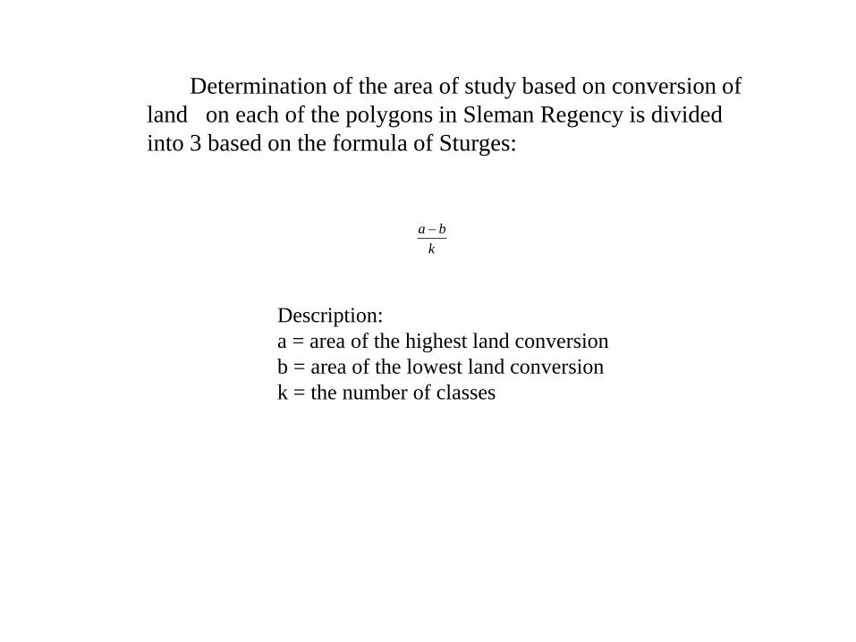
Determination of the area of study based on conversion of
land on each of the polygons in Sleman Regency is divided
into 3 based on the formula of Sturges:
k
ba
Description:
a = area of the highest land conversion
b = area of the lowest land conversion
k = the number of classes


Analysis
• Descriptive
• Statistical tests
1. Binary Logistic Regression Model
This analysis is used to predict whether farmers will
convert agricultural land or maintaining agricultural
activity. Selected category in this research is: 1 = farmers
will convert the entire agricultural land, 0 = farmers are not
going to convert agricultural land

Yj = +X1+ X2+ X3+X4+X5+X6+X7 +X8 +X9+X10 + u
Description:
Yj = Probability decision whether farmers defending in agricultural sector or
Converted agricultural land. (1 = farmers convert agricultural land, 0 = farmers
not convert agricultural land)
= Constant
X1 = Age (year)
X2 = Level of education
X3 = Number of family members
X4 = Extensive land use
X5 = Non Agricultural sector
X6 = Income in the agricultural sector
X7 = Income outside of the agricultural sector
X8 = Land agricultural location
X9 = Price of land
X10 = Long efforts in the agricultural sector
u = disturbance term

2. Seemingly Unrelated Regression
Y1,2,3 = Bo +X1+ X2+ X3+X4+X5+X6+X7 +X8 +X9+X10 + u
Description:
Y1 = Farmers will defend wet land
Y2 = Farmers will defend dry land
Y3 = Farmers will defend the farm yard
Bo = Intersept
Bo = Constant
X1 = Age (year)
X2 = Level of education
X3 = Number of family members
X4 = Extensive land use
X5 = Non Agricultural sector
X6 = Income in the agricultural sector
X7 = Income outside of the agricultural sector
X8 = Land agricultural location
X9 = Price of land
X10 = Long efforts in the agricultural sector
u = disturbance term


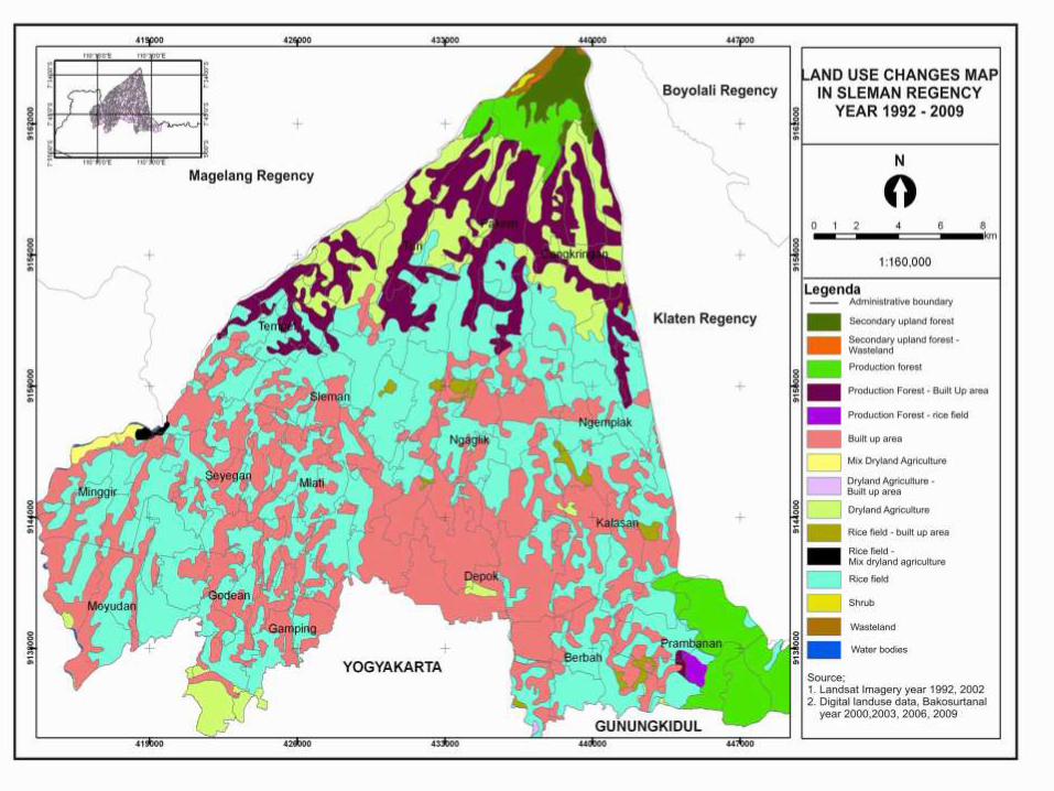
Map of Land use chage

Agricultural Land Conversion in Sleman Regency
1992 – 2009
District
Year
(ha) Growth of Land Conversion
1992-2009 (%) 1992 – 2001 2001 - 2009 1992 - 2009
1. Berbah 242,05 74,60 316,65 0.05
2. Cangkringan 54,21 172,88 227,09 0.18
3. Depok 326,24 212,58 538,83 0.09
4. Gamping 379,65 85,47 465,13 0.04
5. Godean 122,65 305,04 427,69 0.24
6. Kalasan 79,06 238,54 317,60 0.27
7. Minggir 109,09 163,94 273,03 0.17
8. Mlati 238,58 178,45 417,03 0.10
9. Moyudan 47,69 183,96 231,64 0.01
10.Ngaglik 77,89 231,62 309,51 0.26
11.Ngemplak 75,99 118,75 194,74 0.17
12.Pakem 54,14 148,67 202,81 0.25
13.Prambanan 146,12 142,09 288,22 0.12
14.Seyegan 131,82 45,49 177,31 0.05
15.Sleman 84,00 80,14 164,14 0.12
16.Tempel 126,37 194,44 320,81 0.17
17.Turi 143,05 184,67 184,72 0.04
Source : Data Process

Result • Based overlay Landsat and Alos images of the year 1992 and 2009
indicated that out of 17 districts in Sleman, there were four districts which belonged to the category of high-conversion of agricultural lands, four districts belonged to the category of moderate and the other nine to the category of low conversion.
– four districts which belonged to the category of high-conversion of agricultural lands (zone one) comprises the Districts of Depok, Mlati, Gamping and Godean
– four districts belonged to the category of medium (zone two), which is the area with a medium conversion of agricultural land, comprises the Districts of Tempel, Ngaglik, Kalasan and Berbah.
– Areas with low agricultural land conversion are included in the third zone, made up of Districts of Sleman, Pakem, Prambanan, Moyudan, Seyegan, Minggir, Turi, Ngemplak and Cangkringan

Classification of Agricultural Land Conversion in Sleman
Regency 1992-2009 No. Zone District Sub District
1.
Zone 1(High Land
Conversion)
Gamping Nogotirto
Depok Caturtunggal
Mlati Sinduadi
Godean Sidoarum
2.
Zone 2 (Medium Land
Conversion)
Tempel Merdikorejo
Ngaglik Sardonoharjo
Kalasan Purwomartani
Berbah Sendangtirto
3.
Zone 3 (Low land Conversion)
Sleman Tridadi
Pakem Pakembinangun
Prambanan Sambirejo
Moyudan Sumberarum
Seyegan Margoluwih
Minggir Sendangsari
Turi Donokerto
Ngemplak Wedomartani
Cangkringan Umbulharjo

Map of zone

Results Estimation Binary Logistic Model of The farmers to defending in
Agricultural Land
Variable
Zone 1 Zone 2 Zone 3
COEFFICIEN
T P-Value
COEFFICIE
NT P-Value
COEFFICIE
NT P-Value
1.Age 0.00069802 0.793 0.0026480 0.259 -0.0003643 0.686
2.Education 0.011780 0.043 0.0044454 0.530 0.0035368 0.200
3.Jnumber of
ART
0.18461* 0.000 0.22648* 0.000 0.11901* 0.000
4.Extensive
Land use
0.00010330 0.462 0.00025774 0.176 0.00070997* 0.000
5.Dummy
non Peasant
0.19929* 0.001 0.038299 0.507 0.0021959 0.930
6.Peasant
Income
-0.00032949* 0.013 -
0.00032377
*
0.008 -
0.00011593*
*
0.070
7.Income non
Peasant
0.00030982* 0.030 0.00027440
*
0.039 0.00099882* 0.000
8.Dummy
Location
Land Farm
-0.013773 0.891 0.082685 0.407 0.0069338** 0.912
9.Land Prices 0.00024780** 0.093 0.0010276* 0.033 0.00031867* 0.028
10.Time of
Peasant
Labor
-0.0047005 0.226 -0.013930* 0.012 -0.0035982** 0.098
Constant -0.065073 0.739 0.26673 0.207 -0.070162 0.585

• The test results show that in general the farmers still want to keep and preserve their agricultural land, either rice fields, dry lands, or yards
• The results of the analysis are using the binary logistic model show that the factors significantly affecting the attitudes of farmers in preserving their agricultural land:
– In zone one are variables of the number of household members, non farming activities, income from agricultural activities, land price and the number of years of farming experience
– In zone two, variables that have a significant effect are the number of household members, income from agricultural activities, income from non-agricultural activities, land price, and the number of years of farming experience
– In zone three, the significant variables are the number of household members, land size, income from agricultural activities, income from non-agricultural activities, land location, land price and the number of years of farming experience.

• The results of the estimation of the second model, which is the SUR model (Seemingly Unrelated Regression), showed that there were variations of factors that affected the attitudes of farmers in preserving their agricultural lands (rice field, dry land, and yard) in zone 1,2 and 3.SUR.doc
– In zone one are variable of number of household members, income from agricultural activities, income from non-agricultural activities, land location and land price have a positive effect on the attitudes of farmers in preserving the rice field
– In zone two, the number of household members and income from non-agricultural activities significantly have a positive effect.
– In zone three, land area, non-farm income and land prices significantly affected the conversion of wetland

• The attitudes of farmers in terms of preserving their dry lands suggest:
– In zone one, the number of household members and their number of years of farming experience are variables which have a significant effect
– In zone two, they are income from non-agricultural activities and the number of years of farming experience
– In zone three, the variables which significantly have a positive effect are variables of education, number of household members, land size, income from non-agricultural activities and land price. Meanwhile, variable of income from agricultural activities has a negative effect.
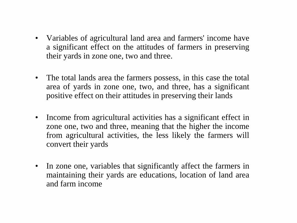
• Variables of agricultural land area and farmers' income have a significant effect on the attitudes of farmers in preserving their yards in zone one, two and three.
• The total lands area the farmers possess, in this case the total area of yards in zone one, two, and three, has a significant positive effect on their attitudes in preserving their lands
• Income from agricultural activities has a significant effect in zone one, two and three, meaning that the higher the income from agricultural activities, the less likely the farmers will convert their yards
• In zone one, variables that significantly affect the farmers in maintaining their yards are educations, location of land area and farm income
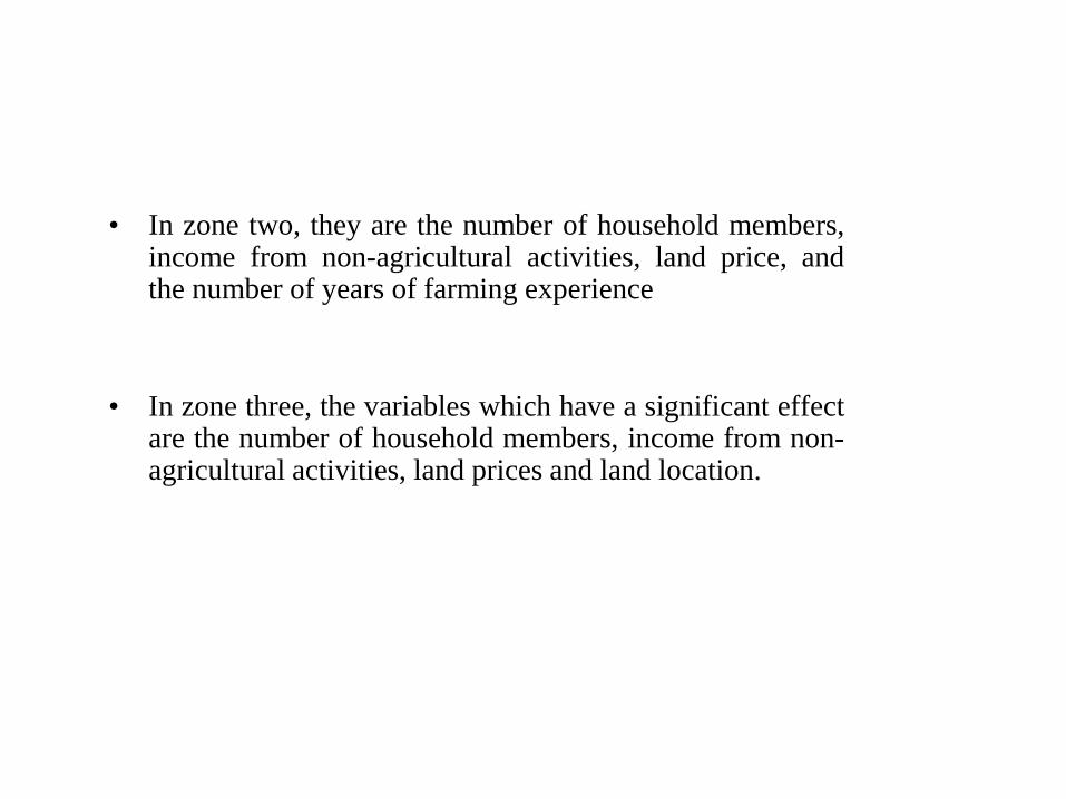
• In zone two, they are the number of household members, income from non-agricultural activities, land price, and the number of years of farming experience
• In zone three, the variables which have a significant effect are the number of household members, income from non-agricultural activities, land prices and land location.


CONCLUSION
• Variation of farmland conversion in Sleman
– Districts that high levels of conversion of agricultural
land is Depok district, Mlati, Godean and Gamping
– Region with the conversion rate is the District
Ngaglik, Tempel, and Kalasan Berbah
– District that is a region with a low conversion of
agricultural land consists of nine districts, including
District, Sleman, Moyudan, Minggir, Seyegan,
Prambanan, Ngemplak, Pakem, Turi and
Cangkringan

• The results of estimation of the attitude of farmers to maintain agricultural land through binary logistic models
– In zone one a variable number of household members, dummy non-farm employment, farm income, non-farm income and land prices are significantly affected
– In the area of zone two variables that significantly affect the number of household members, farm income, non farm income, the price of farmland and old
– Zone three the number of significant variables on the attitude of many farmers over the number of household members, farmland, farm income, non farm income, dummy field sites, the price of farmland and old
• The results of the estimation model SUR (Seemingly Unrelated Regression) showed that the variation of factors that influence the attitudes of farmers to maintain agricultural land (paddy fields, dry lands and yards) in the area of zone one, two and zone three

Field Photo
• Photo\foto lapangan.doc
• Photo\foto lapangan zone 2.doc
• Photo\foto lapangan zone 3doc.doc

THANK YOU