spath: finding the safest walking path in smart cities
TRANSCRIPT

0018-9545 (c) 2019 IEEE. Personal use is permitted, but republication/redistribution requires IEEE permission. See http://www.ieee.org/publications_standards/publications/rights/index.html for more information.
This article has been accepted for publication in a future issue of this journal, but has not been fully edited. Content may change prior to final publication. Citation information: DOI 10.1109/TVT.2019.2918576, IEEETransactions on Vehicular Technology
1
SPATH: Finding the Safest Walking Path in SmartCities
Yawei Pang, Lan Zhang, Haichuan Ding, Yuguang Fang, Fellow, IEEE, Shigang Chen, Fellow, IEEE
Abstract—Given the fact that more than 1 million crimeshappened in U.S. every year, public safety becomes one ofthe most important concerns. Although many public safetyrelated applications have been commercialized, how to guaranteesafely walking to a destination, especially in an unfamiliarcity is still challenging. To provide a safe walking navigationin smart cities, we design a novel application, SPATH (theSafest PATH). To support this service, wireless cameras, existingcellular infrastructure, and vehicles with underutilized computingresources are utilized to process and transmit surveillance videos,which can be viewed by users to check the current safetystatus of walking paths. Noting the long-distance transmissionof a large volume of videos may cause network congestion,video summarizing technology, which is realized by utilizingthe underutilized computing capability in vehicles, is applied toextract valuable information from a video file while effectivelycompressing its data size. Since the quality of service for thisapplication is strongly correlated with the latency of deliveringvideos, we formulate a latency minimization problem by jointlyconsidering the computing resource allocation and computingtask assignment. A Fast Iterative Matching (FIM) is proposedwith low complexity to effectively solve the optimization problem.Simulation results demonstrated the effectiveness and efficiencyof our solution.
Index Terms—Public safety, Smart city, Edge computing,Resource allocation.
I. INTRODUCTION
Public safety is one of the most important concerns in theUnited States. According to the annual compilation of crimesreported by the law enforcement agencies, there were esti-mated 1,247,321 violent crimes committed in 2017. Moreover,there were estimated 319,356 robberies all the year round [1].That is to say, nearly 38 robberies were reported every hour. Infact, most robberies occur in urban areas, especially at night.To improve public safety in cities, technology companieshave already taken steps to design safety related applications.Recently, Mobile Software AS designs a new application,bsafe [2], which allows a user to add contacts as the guardians.When an imminent danger is perceived, a user can activate this
Copyright (c) 2015 IEEE. Personal use of this material is permitted.However, permission to use this material for any other purposes must beobtained from the IEEE by sending a request to [email protected].
This research was partially supported by the U.S. National Science Foun-dation under grants CNS-1409797 and CNS-1343356. The work of S. Chenwas also partially supported by the U.S. National Science Foundation undergrants CNS-1718708.
Y. Pang, L. Zhang, H. Ding, and Y. Fang are with the Department of Electri-cal and Computer Engineering, University of Florida, Gainesville, FL 32611,USA (email: [email protected], [email protected], [email protected],[email protected]).
S. Chen is with the Department of Computer and Information Scienceand Engineering, University of Florida, Gainesville, FL 32611 USA (e-mail:[email protected]).
application, which automatically sends alert to the recordedguardian. Similarly, Safe Apps Ltd. launches a StaySafe [3],which involves a new safety feature, called timed sessions.A user can set check-in intervals as their estimated sessiontime. Once the user misses the session time deadline, thisapplication will notify the corresponding contacts. However,all those applications are the post-crime services. Thus, howto offer a pre-crime warning is still an open problem.
Open crime dataset is considered by many researchersrecently to identify the safest and shortest path for users [4]–[7]. In [4], Galbrun et al. utilize a crime probability modelbased on the existing crime data to measure the safety status ofa walking path. Given historical crime locations, the estimateddensity of crime at a point can be quantified with GaussianKernel Density Estimation (KDE). Then, the estimated crimedensity of a walking path can be measured by aggregatingcrime occurring points on walking path. Goel et al. improveGalbrun’s model in [5]. They design a safety model based onboth the static and dynamic information. The static informationis composed of crime related dataset belongs to differentadministrations. Dynamic information involves feedback re-ceived from users (crowdsourced). Users update the safetystatus of any point on their walking paths. Different fromprevious works, Garvey et al. [7] integrate pre-crime warningand post-crime support to design a novel safety applicationcalled PASSAGE. PASSAGE not only recommends safe pathsto a user but also allows the user to share her current walkinglocation with a friend.
However, the previous models suffer from the followinglimitations: (a) The historical crime data may be outdated;(b) The crime estimation model is not adapted well to smalltime scale; (c) Crowdsourced data cannot guarantee sufficientfeedback; (d) User feedback based on personal experienceis not accurate. In order to overcome these limitations, wepropose to utilize street cameras with high resolution andwireless communication capability as the “remote eye” sincestreet cameras has been widely deployed for many applicationsin smart cities. For example, Moscow has installed 160,000outdoor cameras to support several public services such astrash removal, traffic management and crime monitoring [8].Chicago has developed two public safety related programs,which has deployed over 32,000 cameras in the city in orderto respond to traffic-related issues, monitor large crowds suchas parades, and validate calls for fires or EMS [9].
Even though utilizing street cameras can overcome thelimitations of previous design, long latency caused by thetransmissions of large volumes of videos will impose restric-tions on the use of these cameras. Edge computing provides

0018-9545 (c) 2019 IEEE. Personal use is permitted, but republication/redistribution requires IEEE permission. See http://www.ieee.org/publications_standards/publications/rights/index.html for more information.
This article has been accepted for publication in a future issue of this journal, but has not been fully edited. Content may change prior to final publication. Citation information: DOI 10.1109/TVT.2019.2918576, IEEETransactions on Vehicular Technology
2
Fig. 1: System Architecture
a popular solution to this issue, which pairs data source withpowerful edge servers [10]–[12]. Such servers are deployedat the proximity of data source to perform task computing orprocessing, data storage, and caching. For example, Rodrigueset al. [12] present a method by utilizing virtual machinemigration and transmission power control to minimize servicedelay. As a result, their approach based on simultaneouslylowering the time for transmission and the time for processingdoes reduce service delay significantly, particularly whenthe application involves with transmitting a large amount ofdata. Furthermore, in order to deal with communication andcomputing demands at edge more efficiently and conveniently,recent works propose a novel idea, which leverages vehiclesas a service [13]–[18]. Apart from the edge computing char-acteristics, such as proximity to end users, computing, andstorage, employing vehicles as a service distinguishes itselffrom dense geographical distribution of communication andcomputing devices and support for mobility [13]. In [15], Dinget al. propose a V-CCHN (Vehicular Cognitive Capability Har-vesting Network) architecture. In this work, Cognitive Radio(CR) router enabled vehicles are employed to utilize harvestedspectrum resources to opportunistically transmit large volumeof data. Furthermore, with the built-in computing capabilityof CR routers, vehicles serve as edge cloud servers for localdata processing and aggregation to solve network congestionproblems and reduce long latency caused by the long-distancetransmissions for large volumes of data.
Inspired by all previous works, we propose SPATH toeffectively find the safest walking path in smart cities (asshown in Figure 1). The potential walking path of a user isdivided into several road segments. To indicate the estimatedsafety status, each road segment is labeled by a numericalvalue, namely crime index. We utilize the historical crimedata and kernel density estimation to estimate the crimeindex of each road segment. Wireless street cameras areemployed to capture the street view of each road segmentto provide fresh on-time street safety status. Based on thecrime index, the captured videos are transmitted through thecellular infrastructure to users for identifying the safety status.It is reasonable to consider the slowly moving and parkedvehicles (such as connected and autonomous vehicles) haveplentiful and underutilized computing resources, which can
be used to provide public services [13], [15], [19]. In orderto handle the huge volume data of captured videos whileavoiding potential network congestion, vehicles are treated aslocal computing units to summarize captured videos, whichcan effectively extract valuable information while reducing thedata size of captured videos significantly [20]. The rationalityof studying this problem is that utilizing the local computingunits could reduce the latency for video delivery, which furtherimproves the quality of safety. Thus, we formulate a latencyminimization problem involving computing resource allocationand computing task assignment. Furthermore, we design a FastIterative Matching (FIM) algorithm with low complexity toeffectively solve the latency minimization problem. The maincontributions of this paper are listed as follows.
• A new application, SPATH, has been proposed to identifythe safety status of a user’s walking path. With thedesigned application, the videos of street cameras firstare summarized on local computing units and then aretransmitted to users for reviewing. We utilize vehicleswith underutilized computing resources to reduce thelatency for video analytics.
• Quality of safety for users is correlated with overalllatency for video delivery and video analytics, and thuswe formulate a latency minimization problem by jointlyconsidering computing resource allocation and computingtask assignment. Furthermore, due to the hardness of theoriginal optimization problem, we develop a novel FIMalgorithm, which can significantly reduce the complexity,to provide a suboptimal solution for the optimizationproblem.
• Simulation results show that the FIM algorithm outper-forms other algorithms with low complexity. In addition,our proposed scheme can effectively reduce the latency.
The rest of this paper is organized as follows. Section IIdiscusses the related work. Section III introduces systemmodels. Section IV formulates the optimization problem. Themixed integer non-linear programming problem under multipleconstraints is solved by a FIM algorithm in Section V. Per-formance of the proposed scheme is evaluated in Section VI.Finally, conclusions are drawn in Section VII.

0018-9545 (c) 2019 IEEE. Personal use is permitted, but republication/redistribution requires IEEE permission. See http://www.ieee.org/publications_standards/publications/rights/index.html for more information.
This article has been accepted for publication in a future issue of this journal, but has not been fully edited. Content may change prior to final publication. Citation information: DOI 10.1109/TVT.2019.2918576, IEEETransactions on Vehicular Technology
3
II. RELATED WORK
In this section, we discuss the related work from twoaspects, namely pre-crime warning applications and vehicleas a resource.
A. Pre-crime Warning Applications
Early works on the pre-crime warning applications, suchas [4]–[7], are focused on utilizing historical crime data andcrowdsourced feedbacks to assess the safety status. In [4],Galbrun et al. develop a crime probability model based onthe historical crime data in Chicago and Philadelphia. Theyestimate the possible crime hot spots with Gaussian kerneldensity estimation. In order to measure the safety status of thenavigation path, crime activity density is proposed, which isquantified by aggregating crime probability of each point onthe walking path. Moreover, they design an algorithm to offercandidate paths for users with a different tradeoff betweendistance and safety.
By observing the drawbacks of the approach in [4], Goel etal. improve the safety model with two types of data, namelystatic and dynamic [5]. The static data is open data includinghistorical crime data, road quality information, locations ofpolice stations, and schedule of public transport, etc. Infor-mation in static data can be used to measure a navigationpath is safe to walk or not. However, the static data may notaccurately capture the actual situation as the information maybe outdated. Therefore, the authors build a dynamic datasetto adapt to the information change. Dynamic data includesfeedback from users in near real time, which is gathered in acrowdsourced manner. Users can report the safety status of anypoint on their walking path. Following the design of Goel etal., Mata et al. identify the crime level of the walking path withthe official crime data and the useful information from onlinesocial media as in [6]. Criminal data repository is first builtfrom tweets related to crime events. Then, the crime recordsare classified based on crime type, time, and location. Finally,a safe route is obtained from the estimation of crime rates.
Different from previous works, Garvey et al. [7] integratepre-crime warning and post-crime service. In order to over-come the inaccuracy of the estimation of safety status, theydevelop the PASSAGE, a safety application. In [7], Garveyet al. also offer possible walking path of a user by applyingestimation model of crime points and allows the user to addfriends or relatives as the guardians, who receive the currentlocation of the user.
B. Vehicle as a Resource
More recent studies focus on exploring better utilizationof resources on connected and autonomous vehicles (CAVs).Vehicle as a resource is a novel idea leveraging vehiclesto provide service of sensing, data storage, computing, andcommunications, etc. In [14], Zhang et al. propose a sys-tem architecture, where vehicles are service providers forsmartphones. When infrastructure-based cloud does not haveenough resource to support the service for users, residualcomputing in vehicles is allocated to accomplish mobile
application offloading. In [15], [21], Ding et al. design a V-CCHN (Vehicular Cognitive Capability Harvesting Network)architecture, which utilizes CR routers enabled vehicles tohandle the explosively growing wireless data traffic. The V-CCHN involves some new features, such as the capacity ofreconfiguring agile communication interfaces to interoperatewith other devices and mobility to realize data exchange withinproximity, to fully exploit available vehicles. For more detailsof this architecture, readers are referred to [15].
To overcome the drawbacks of the previous works and betterexplore the benefits of residual communication and computingresources in vehicles, we propose SPATH, which transmitssurveillance videos from street cameras to users to identifythe safety status on walking paths and utilizes vehicles withunderutilized computing resources as local computing units tosummarize the videos to reduce the service latency.
III. SYSTEM ARCHITECTURE
In this section, we first present an overview of our proposedapplication, SPATH. Thereafter, communication, computing,and crime index model are explained in detail.
A. Architecture Overview
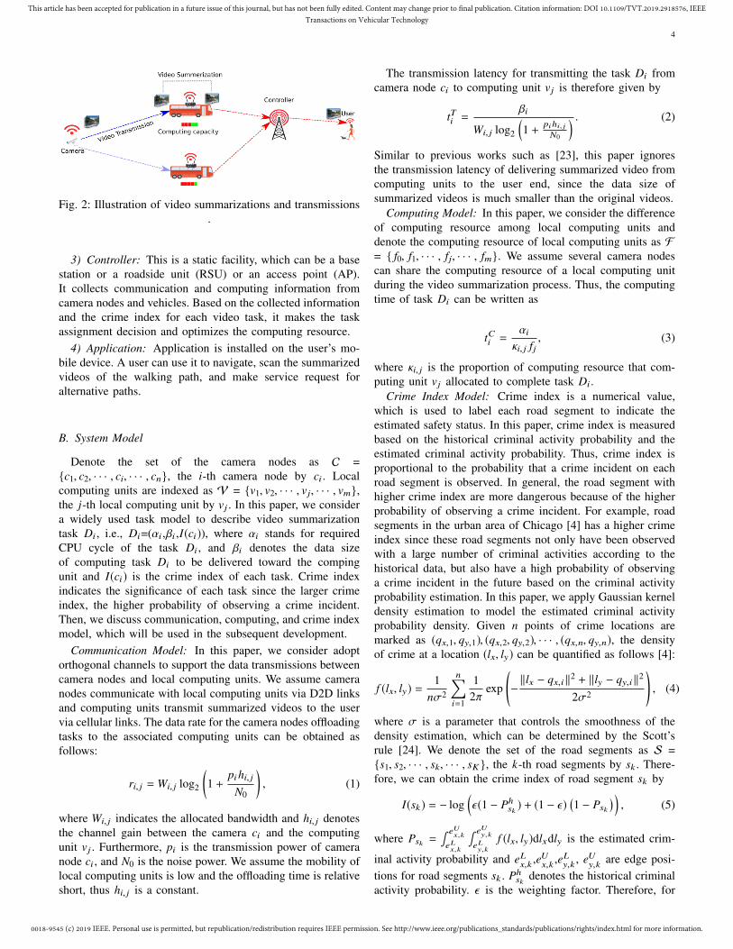
In this paper, we consider a scenario in Fig. 2. Whena user launches the SPATH, the controller will activate thecamera nodes to capture videos according to the user’s walkingpath information and search for available vehicles near theactivated camera nodes as the local computing units. Then,the controller gathers communication, computing, and safetyrelated information (crime index) to make the task assignmentdecision and computing resource optimization. According tothe control information, camera nodes transmit the pendingvideos to associated local computing units via appropriatecommunications technologies for video summarization anal-ysis. Finally, the summarized videos are delivered to the uservia the existing cellular infrastructure. The user could scanall the summarized videos to identify the safety status of thewalking path. If the user considers the walking path is notsafe enough, she can select alternative paths and make servicerequest again. In this paper, we ignore the latency for requestand control information message because of the small size ofrequest and control information packet.
The architecture of our SPATH is shown in Fig. 2, whichconsists of four components: application, local computingunits, camera nodes, and the controller.
1) Camera node: This can be a new wireless camera or atraditional street camera with communication radio interfaceand it can offload its captured videos to nearby computingunits within the scope of a certain distance via D2D commu-nications [22].
2) Local computing unit: This can be a moving or parkingvehicle with sufficient computing and storage capability andit can perform video summarization task. Each vehicle can bematched with several camera nodes to summarize videos.
0018-9545 (c) 2019 IEEE. Personal use is permitted, but republication/redistribution requires IEEE permission. See http://www.ieee.org/publications_standards/publications/rights/index.html for more information.
This article has been accepted for publication in a future issue of this journal, but has not been fully edited. Content may change prior to final publication. Citation information: DOI 10.1109/TVT.2019.2918576, IEEETransactions on Vehicular Technology
4
Controller
Camera
Computing capacity
Fig. 2: Illustration of video summarizations and transmissions.
3) Controller: This is a static facility, which can be a basestation or a roadside unit (RSU) or an access point (AP).It collects communication and computing information fromcamera nodes and vehicles. Based on the collected informationand the crime index for each video task, it makes the taskassignment decision and optimizes the computing resource.
4) Application: Application is installed on the user’s mo-bile device. A user can use it to navigate, scan the summarizedvideos of the walking path, and make service request foralternative paths.
B. System Model
Denote the set of the camera nodes as C ={c1, c2, · · · , ci, · · · , cn}, the i-th camera node by ci . Localcomputing units are indexed as V = {v1, v2, · · · , vj, · · · , vm},the j-th local computing unit by vj . In this paper, we considera widely used task model to describe video summarizationtask Di , i.e., Di=(αi ,βi ,I(ci)), where αi stands for requiredCPU cycle of the task Di , and βi denotes the data sizeof computing task Di to be delivered toward the compingunit and I(ci) is the crime index of each task. Crime indexindicates the significance of each task since the larger crimeindex, the higher probability of observing a crime incident.Then, we discuss communication, computing, and crime indexmodel, which will be used in the subsequent development.
Communication Model: In this paper, we consider adoptorthogonal channels to support the data transmissions betweencamera nodes and local computing units. We assume cameranodes communicate with local computing units via D2D linksand computing units transmit summarized videos to the uservia cellular links. The data rate for the camera nodes offloadingtasks to the associated computing units can be obtained asfollows:
ri, j = Wi, j log2
(1 +
pihi, jN0
), (1)
where Wi, j indicates the allocated bandwidth and hi, j denotesthe channel gain between the camera ci and the computingunit vj . Furthermore, pi is the transmission power of cameranode ci , and N0 is the noise power. We assume the mobility oflocal computing units is low and the offloading time is relativeshort, thus hi, j is a constant.
The transmission latency for transmitting the task Di fromcamera node ci to computing unit vj is therefore given by
tTi =βi
Wi, j log2
(1 + pihi, j
N0
) . (2)
Similar to previous works such as [23], this paper ignoresthe transmission latency of delivering summarized video fromcomputing units to the user end, since the data size ofsummarized videos is much smaller than the original videos.
Computing Model: In this paper, we consider the differenceof computing resource among local computing units anddenote the computing resource of local computing units as F= { f0, f1, · · · , fj, · · · , fm}. We assume several camera nodescan share the computing resource of a local computing unitduring the video summarization process. Thus, the computingtime of task Di can be written as
tCi =αiκi, j fj
, (3)
where κi, j is the proportion of computing resource that com-puting unit vj allocated to complete task Di .
Crime Index Model: Crime index is a numerical value,which is used to label each road segment to indicate theestimated safety status. In this paper, crime index is measuredbased on the historical criminal activity probability and theestimated criminal activity probability. Thus, crime index isproportional to the probability that a crime incident on eachroad segment is observed. In general, the road segment withhigher crime index are more dangerous because of the higherprobability of observing a crime incident. For example, roadsegments in the urban area of Chicago [4] has a higher crimeindex since these road segments not only have been observedwith a large number of criminal activities according to thehistorical data, but also have a high probability of observinga crime incident in the future based on the criminal activityprobability estimation. In this paper, we apply Gaussian kerneldensity estimation to model the estimated criminal activityprobability density. Given n points of crime locations aremarked as (qx,1, qy,1), (qx,2, qy,2), · · · , (qx,n, qy,n), the densityof crime at a location (lx, ly) can be quantified as follows [4]:
f (lx, ly) =1
nσ2
n∑i=1
12π
exp
(−‖lx − qx,i ‖2 + ‖ly − qy,i ‖2
2σ2
), (4)
where σ is a parameter that controls the smoothness of thedensity estimation, which can be determined by the Scott’srule [24]. We denote the set of the road segments as S ={s1, s2, · · · , sk, · · · , sK }, the k-th road segments by sk . There-fore, we can obtain the crime index of road segment sk by
I(sk) = − log(ε(1 − Ph
sk) + (1 − ε)
(1 − Psk
) ), (5)
where Psk =∫ eU
x,k
eLx,k
∫ eUy,k
eLy,k
f (lx, ly)dlxdly is the estimated crim-
inal activity probability and eLx,k
,eUx,k
,eLy,k
, eUy,k
are edge posi-tions for road segments sk . Ph
skdenotes the historical criminal
activity probability. ε is the weighting factor. Therefore, for

0018-9545 (c) 2019 IEEE. Personal use is permitted, but republication/redistribution requires IEEE permission. See http://www.ieee.org/publications_standards/publications/rights/index.html for more information.
This article has been accepted for publication in a future issue of this journal, but has not been fully edited. Content may change prior to final publication. Citation information: DOI 10.1109/TVT.2019.2918576, IEEETransactions on Vehicular Technology
5
TABLE I: Symbols and definitions
Symbol DefinitionC Set of camera nodesB Set of local computing unitsS Set of road segmentsDi Video summarization task for camera node cici i-th camera nodevj j-th computing unitsk k-th road segmentpi Transmission power for camera cihi, j Channel gainfj Computing resource of local computing unit vjN0 Noise powerαi Amount of the taskβi Data size of computing taskWi, j BandwithtTi Transmission latency for video summarization task Di
tCi Computing latency for video summarization task Di
f (lx, ly ) Probability density of crimes at location (lx, ly )I (sk ) Crime index of road segment skε Weighting factor
each camera node ci located in the road segment sk , the crimeindex can be written as
I(ci) = I(sk), (6)
which means all camera nodes located in the same roadsegment sk has the same crime index. The main notationsadopted in this paper are presented in Table I
IV. PROBLEM FORMULATION
By leveraging communication, computing, and storage(CCS) capability, together with the crime index model pro-posed in the previous section, we design our SPATH by formu-lating a latency minimization problem considering computingtask assignment and computing resource optimization. Wefirst discuss several constraints for the latency minimizationproblem.
Task Assignment: To be specific, we define the integraldecision matrix x = (xi, j) with xi, j ∈ {0, 1}, where xi, j = 1indicates camera node ci is associated with computing unit vjfor video summarization while xi, j = 0 otherwise. Since weassume the captured video cannot be split, the camera node cican only be matched with one computing unit. This matchingconstraint can be written as follows:∑
j∈V
xi, j ≤ 1. (7)
Maximum Computing Power Limitation: In this paper, weconsider the total amount of computing resource assignedto each task placed on computing unit vj cannot exceed itslimitation, that is, ∑
i∈C
xi, j κi, j ≤ 1. (8)
Maximum Communication Channel Limitation: We con-sider each computing unit has limited available frequency sub-channels to communicate with camera nodes, we introduce theconstraint as ∑
i∈C
xi, j ≤ Q. (9)
Safety Guarantee: We consider that if a camera node isassociated with a computing unit for video summarization, thestatus of this road segment is safest for a user since the usercan obtain the fresh safety information. Thus, we redefine thecrime index of selected camera node is I(ci) = 0. In order toguarantee the safety of a user, we introduce the crime indexrequirement for a user’s walking path as∑
i∈C
(1 − xi, j)I(ci) ≤ Ith . (10)
Latency MinimizationUnder the above setup, we pursue a latency minimization
problem by jointly considering computing resource allocationand computing task assignment, which is formulated as
OPT :minx,κ
∑i∈C
xi, j(tTi + tCi ) (11)
s.t.∑i∈C
xi, j κi, j ≤ 1∑i∈C
xi, j ≤ Q∑i∈C
(1 − xi, j)I(ci) ≤ Ith∑j∈V
xi, j ≤ 1
xi, j ∈ {0, 1}
It is clear that the proposed latency minimization problem isa mixed integer non-linear programming (MINLP) problemsince it contains both binary variables x and continuousvariables κ. In the next section, we adopt matching theorywith low complexity to find an approximate solution to theproposed optimization problem because of the hardness of theoriginal optimization problem.
V. ALGORITHM
In this section, a FIM algorithm is proposed to solve theoptimization problem, since the MINLP optimization problemhas a high complexity with the increasing number of cameranodes and computing units. The objective function can berewritten as follows:
g(κ,x) =∑i∈C
xi, j(βiri, j+
αiκi, j fj
). (12)
We consider the original problem can be decoupled intotwo sub-problems, computing resource optimization problemand task assignment problem. Given xi, j = x̂i , which meansxi, j is fixed, the original latency minimization problem in (11)is converted as a computing resource optimization problem,which is a convex problem. Therefore, optimal solution, κ∗i, j , ofcomputing resource optimization can be obtained by adoptingthe Karush-Kuhn-Tucker (KKT) conditions. With the optimalsolution, κ∗i, j , obtained from the computing resource optimiza-tion problem, the latency minimization problem is convertedas task assignment problem, which is an integer programmingproblem. Then, we adopt the matching theory to obtain thesolution.

0018-9545 (c) 2019 IEEE. Personal use is permitted, but republication/redistribution requires IEEE permission. See http://www.ieee.org/publications_standards/publications/rights/index.html for more information.
This article has been accepted for publication in a future issue of this journal, but has not been fully edited. Content may change prior to final publication. Citation information: DOI 10.1109/TVT.2019.2918576, IEEETransactions on Vehicular Technology
6
A. Computing Resource Optimization
We consider the OPT with the following OPT-RA whenxi = x̂i , a fixed value.
OPT-RA :minκ
g(κ, x̂) =∑i∈C
x̂i, j(βiri, j+
αiκi, j fj
) (13)
s.t.∑i∈C
x̂i, j κi, j ≤ 1
Therefore, the Hessian matrix of the OPT-RA can be derivedas follows:
H =
∂2g∂2κ1, j
∂2g∂κ1, j∂κ2, j
. . .∂2g
∂κ1, j∂κn, j∂2g
∂κ2, j∂κ1, j
∂2g∂2κ2, j
. . .∂2g
∂κ2, j∂κn, j...
.... . .
...∂2g
∂κn, j∂κ1, j
∂2g∂κn, j∂κ2, j
. . .∂2g∂2κn, j
(14)
Further, we can obtain each specific element of the Hessianmatrix is:
∂2g
∂κp, j∂κq, j=
{ 2αi
κ3i, j fj
if p = q
0 otherwise(15)
It is observed that all parameters in (15) are positive since2αi
κ3i, j fj≥ 0. We conclude that OPT-RA is convex because the
Hessian matrix H is a positive definite matrix [25]. Since theconstraints are linear, optimal solution of OPT-RA can beobtained with the KKT conditions.
We introduce the Lagrange function of OPT-RA accordingto the previous analysis, which can be written as follows:
L(κ, γ) =∑i∈C
x̂i, j(βiri, j+
αiκi, j fj
) +∑j∈V
γj(∑i∈Cj
κi, j − 1), (16)
where γ = (γ1, · · · , γm) are the Lagrange multipliers corre-sponding to the inequality constraints. Since Slater’s conditionholds for OPT-RA, then the KKT conditions provide neces-sary and sufficient conditions for optimality [26]. If κ∗ and γ∗
is the optimal point with zero duality gap, then the gradientfor L(κ, γ) must vanish at point κ∗. Therefore, we can obtain:
∇(∑i∈C
x̂i, j(βiri, j+
αiκ∗i, j fj
)) +∑j∈V
γ∗j∇(∑i∈Cj
κ∗i, j − 1) = 0, (17)
γ∗j (∑i∈C
x̂i, j κi, j − 1) = 0.
Moreover, we can derive the optimal value of κ∗i, j form (17),which can be written as follows:
κ∗i, j =
√αi∑
i∈C
√x̂i, jαi
. (18)
B. Task Assignment
After obtaining the optimal computing resource allocation,we develop an algorithm based on the matching theory [27] tosolve the task assignment problem. Matching theory providestractable solution to the problem of multiple agents in twodistinct groups. Each agent wants to match with one or
multiple agents in the opposite group. Mathematically, themany to one matching can be defined as follows.
Definition 1: [28] Given two distinct set M and W, amatching µ is a mapping function from M∪W into 2M∪W ,such that: µ(mi) ⊆ W and |µ(mi)| ≤ 1 for all mi ∈ M;µ(wj) ⊆ M and |µ(wj)| ≤ Nj for all wj ∈ W, where Nj isthe capacity of agent wj ∈ W; µ(mi) = {wj} if and only ifwj ⊆ µ(mi) for all (mi,wj) ∈ M ×W
To better describe a matching, the preference lists of agentsshould be defined. Each agent holds a preference list toopposite group. All the actions, such as proposal, acceptance,and rejection are according to the preference list. In this paper,we establish each agent’s preference list as follows.
1) Preferences of camera nodes: From the camera node’sperspective, each camera node seeks the minimum of itstransmission time to a local computing unit. Therefore, wepropose a utility function for a camera node to form itspreference list among computing units as follows:
φCi, j =βi
Wi, j log2
(1 + pihi, j
N0
) . (19)
Thus, the preference list �Ci, j of camera node ci can beconstructed by using (19).
2) Preferences of computing units: The preference list oflocal computing units can be established according to thetime cost of the video summarization for a matched cameranode. The utility function for a local computing unit can becalculated as follows:
φVi, j =αiκi, j fj
. (20)
According to the above utility function, the preference list forcomputing unit vj among camera nodes in the opposite groupcan be constructed as �Vj,i .
C. Fast Iterative Matching (FIM) algorithm
We now introduce our proposed FIM algorithm, which isillustrated Algorithm 1. The FIM algorithm operates in aniterative way until achieving the stability. Initially, each cameranode forms its preference list �Ci, j . The whole FIM algorithmconsists of two major phases: one is for matching and the otheris for optimizing. At the beginning of matching in each round,each camera node ci proposes to its most preferred computingunit vj and removes vj from its preference list �Ci, j . Whenreceiving ci’s proposal, vj may face two conditions: eitherenough available communication channels for the transmissionof ci’s video have been found or there are not enough availablechannels to support the ci’s video transmission. Computingnodes vj first forms its preference list �Vi, j with the optimizedcomputing resource, which can be calculated by (18). If vjfinds enough available communication channels to support thevideo transmission, it accepts the most preferred proposal andthe matched camera node is removed from unmatched set Cun.If vj does not find enough communication channels to supportits video transmission, it discards the worst camera node andthe discarded camera node is added to the unmatched set Cun.At the end of each round, if the constraint (10) is not satisfied,

0018-9545 (c) 2019 IEEE. Personal use is permitted, but republication/redistribution requires IEEE permission. See http://www.ieee.org/publications_standards/publications/rights/index.html for more information.
This article has been accepted for publication in a future issue of this journal, but has not been fully edited. Content may change prior to final publication. Citation information: DOI 10.1109/TVT.2019.2918576, IEEETransactions on Vehicular Technology
7
Algorithm 1 FIM Algorithm
Input: Imin, Q, fj ,�Ci, j , C,V,l(ci);Output: Matching µ
Initialization;Set Q j = Q for all vjConstruct set Cun,set Cun=C;
Matching;for each ci ∈ Cun do
Proposes to the first vj in its preference list and removevj from �Ci, j ;
end forfor vj ∈ V do
Forms its preference list �Vj,i with the κ∗i, j by (18).if Q j > 0 then
vj keeps the most preferred cpi among proposals;Removes c∗i from CunQ j = Q j − 1
elsevj rejects the worst cdi and keeps the rest;Add cdi to Cun
end ifend forif constraint (10) is not satisfied then
if Q j > 0 for any vj thenGo back toMatching;
elsefor vj ∈ V do
Discards cdi with the smallest crime indexGo back toMatching;
end forend if
end if
then camera nodes conduct next iteration. When there are noavailable communication channels for all computing units inthe new iteration, all computing units discard the camera nodeswith the smallest crime index. The matching and optimizingprocess iterates until safety related constraint (10) is satisfied,or all cameras are matched.
VI. PERFORMANCE EVALUATION
In this section, we evaluate the performance of the proposedscheme in three aspects: (i) The comparison among differenttask assignment schemes; (ii) The impact of available comput-ing power; (iii) The impact of key parameters, such as the datasize of videos and the bandwidth of communication channels.We introduce the simulation setup at first. Then extensivesimulations are provided and analyzed.
A. Simulation Setup
We consider that the camera nodes are placed in the gridtopology and a group of local computing units are randomly
deployed. We assume the communication range of local com-puting units is up to 100 m. The data size and computingamount of tasks follow uniform distribution with a mean valueof 5 MB and 1 Gigacycles, respectively [29]. The computingresources of computing units are distributed within the range[10, 20] GHz. The channel fading of the communication linksis modeled by the complex normal distribution, CN(0, 1) [30].
The FIM, proposed in this paper, is compared with two taskassignment schemes:• Greedy assignment scheme: each camera node sends the
proposal to match with the most powerful computingunit in its communication range. If a computing unit hasenough communication channels to support all cameranodes, it will hold all video summarization task. Ifthe received proposals have reached the limitation, thecomputing unit will accept the proposal according to thecrime index. The computing resource allocation for eachcomputing unit is according to (18).
• Random assignment scheme: camera nodes match withcomputing units randomly. If the communication limita-tion is reached, computing units are matched with cameranodes with respect to the crime index. The computingresource optimization is carried out according to (18).
5 10 15 20 25
Number of Camera Nodes
0
20
40
60
80
100
120
140
La
ten
cy (
s)
FIM
GRE
RAN
Fig. 3: The comparison between the proposed scheme withtask assignment schemes with network size increasing.
B. Results and Analysis
Comparison among different task assignment schemes: Theperformance comparison among our FIM, greedy scheme, andrandom scheme is illustrated in Fig. 3. We let the number ofcamera nodes vary in [5, 25]. The density of the computingnodes is set to be a constant value with respect to the numberof camera nodes. Results in Fig. 3 demonstrate that theproposed FIM achieves significantly better performance overthe other two schemes. This is because the available numberof computing units for each camera node is increasing withthe network size increases. Therefore, FIM algorithm couldexploit more benefits from the diverse choices. However,greedy and random schemes ignore the possible gain from theincreasing number of computing units. Moreover, resourceoptimization for FIM can enhance the gain from diversechoices, since the matching choice is based on the result of

0018-9545 (c) 2019 IEEE. Personal use is permitted, but republication/redistribution requires IEEE permission. See http://www.ieee.org/publications_standards/publications/rights/index.html for more information.
This article has been accepted for publication in a future issue of this journal, but has not been fully edited. Content may change prior to final publication. Citation information: DOI 10.1109/TVT.2019.2918576, IEEETransactions on Vehicular Technology
8
resource optimization. Noticing that resource optimizationcan also achieve performance gain for greedy and randomschemes. However, the benefit of resource optimization doesnot compensate for the loss of matching scheme.
2 4 6 8 10
Average Computing power (Gigacycles)
0
20
40
60
80
100
La
ten
cy (
s)
FIM
GRE
RAN
Fig. 4: Impact of available computing power.
Impact of available computing power: We further comparethe performance of the FIM algorithm with two heuristicschemes under different available computing power. We setthe number of camera nodes to 15 and the computing powerin each local unit to be varying in [2, 10] Gigacycles. Figure 4shows that FIM scheme achieves significantly higher perfor-mance gain over the other two schemes, particularly whenthe number of computing units is small. Noticing that FIM isintroduced to adjust the matching choice according to availablecomputing power when computing resource is insufficient, it isnot surprising that a more significant performance gain can beobserved when the computing power is smaller. Moreover, thelatency of all schemes is reduced slowly when the number ofcomputing units is large. The reason is that sufficient comput-ing resource makes all task assignment schemes achieve lessbenefit with respect to the variation of computing resource.
Impact of data size : In Fig. 5, we investigate the latency ofdifferent task assignment schemes with respect to the varyingdata size of captured videos. The parameter settings are thesame as those in Fig. 4 and the data size of the video varieswithin [1, 9] MB. The results shown in Fig. 5 demonstrate thatthree algorithms have the same relationship between latencyand the data size of videos. The result shows that the largerof the data size, the longer of the latency. The result alsodemonstrates that the impact of the data size is evident,especially at large data size. The reason is that when thedata size is large, FIM algorithm not only reduces the latencyin terms of the choice of computing units but also achievessignificant benefits from the transmissions of videos.
Impact of bandwidth: We also consider the impact of thebandwidth of communication channels. In this evaluation, Theparameter settings are the same as those in Fig. 4 and thebandwidth of communication channels is set to the range[0.5, 2.5] MHz. The results shown in Fig. 6 demonstrate thatthe performance gaps of three task assignment schemes arenarrowing along with the increasing of bandwidth. When thecommunication resource is sufficient, FIM can only achieve
1 3 5 7 9
Average Data Size (MB)
0
20
40
60
80
100
120
140
Late
ncy (
s)
FIM
GRE
RAN
Fig. 5: Impact of data size
0.5 1 1.5 2 2.5
Bandwidth (MHz)
0
20
40
60
80
100
120
140
La
ten
cy (
s)
FIM
GRE
RAN
Fig. 6: Impact of bandwidth.
benefits from computing resource and the loss of greedy andrandom schemes is less for transmissions of videos. Fig. 6 alsoshows that the impact of bandwidth is more significant whenbandwidth is small. The proposed FIM can achieve 85.6%better performance compared with random assignment schemeand 87.3% compared with greedy assignment scheme whenbandwidth is 1 MHz. The reason is that when bandwidth issmall, FIM can obtain more benefit from better communicationchannels.
VII. CONCLUSION
In this paper, we have proposed a safety application,SPATH, to handle safety issues in smart cities. We haveutilized existing cellular infrastructures to transmit surveil-lance videos from street cameras to the users to identify thesafety status. To handle the large volume of videos, we haveleveraged the vehicles with underutilized computing resourcesas the local computing units to summarize videos. Since thequality of safety provisioning is strongly correlated with thelatency of delivering the videos, we have formulated a latencyminimization problem by jointly considering computing re-source allocation and computing task assignment. Moreover,we have developed a Fast Iterative Matching (FIM) algorithmto solve the latency optimization problem. Simulation results

0018-9545 (c) 2019 IEEE. Personal use is permitted, but republication/redistribution requires IEEE permission. See http://www.ieee.org/publications_standards/publications/rights/index.html for more information.
This article has been accepted for publication in a future issue of this journal, but has not been fully edited. Content may change prior to final publication. Citation information: DOI 10.1109/TVT.2019.2918576, IEEETransactions on Vehicular Technology
9
show that our proposed scheme can effectively reduce thelatency.
REFERENCES
[1] FBI. 2017 crimes in the United States. [September 24,2018]. [Online]. Available: https://ucr.fbi.gov/crime-in-the-u.s/2017/crime-in-the-u.s.-2017/topic-pages/violent-crime
[2] Smartertravel.com. Best Apps to Prevent Travel Disasters. [December06, 2017]. [Online]. Available: https://www.huffpost.com/entry/best-apps-to-prevent-trav_n_5606425
[3] C. Mercer. How the StaySafe app is keeping lone workers safe. [April 02,2018]. [Online]. Available: https://www.techworld.com/apps-wearables/how-staysafe-app-is-keeping-lone-workers-safe-3674452/
[4] E. Galbrun, K. Pelechrinis, and E. Terzi, “Urban navigation beyondshortest route: The case of safe paths,” Information Systems, vol. 57,pp. 160–171, 2016.
[5] N. Goel, R. Sharma, N. Nikhil, S. Mahanoor, and M. Saini, “A crowd-sourced adaptive safe navigation for smart cities,” in Multimedia (ISM),2017 IEEE International Symposium on, 2017, pp. 382–387.
[6] F. Mata, M. Torres-Ruiz, G. Guzmán, R. Quintero, R. Zagal-Flores,M. Moreno-Ibarra, and E. Loza, “A mobile information system basedon crowd-sensed and official crime data for finding safe routes: A casestudy of mexico city,” Mobile Information Systems, vol. 2016, 2016.
[7] M. Garvey, N. Das, J. Su, M. Natraj, and B. Verma, “Passage: Atravel safety assistant with safe path recommendations for pedestrians,”in Companion Publication of the 21st International Conference onIntelligent User Interfaces, 2016, pp. 84–87.
[8] Matt Hamblen. Moscow’s smart tech includes 160,000outdoor cameras. [February 28, 2017 ]. [Online].Available: https://www.computerworld.com/article/3175063/moscows-smart-tech-includes-160000-cameras-to-detect-traffic-violators.html
[9] Scott Goldfine. 32K Surveillance Cameras Aim toKeep Chicago Safe. [October 31, 2018]. [On-line]. Available: https://www.campussafetymagazine.com/technology/surveillance-cameras-keeping-chicago-safe/
[10] T. G. Rodrigues, K. Suto, H. Nishiyama, N. Kato, and K. Temma,“Cloudlets activation scheme for scalable mobile edge computing withtransmission power control and virtual machine migration,” IEEE Trans-actions on Computers, vol. 67, no. 9, pp. 1287–1300, 2018.
[11] W. Shi, J. Cao, Q. Zhang, Y. Li, and L. Xu, “Edge computing: Visionand challenges,” IEEE Internet of Things Journal, vol. 3, no. 5, pp.637–646, 2016.
[12] T. G. Rodrigues, K. Suto, H. Nishiyama, and N. Kato, “Hybrid methodfor minimizing service delay in edge cloud computing through vmmigration and transmission power control,” IEEE Transactions on Com-puters, vol. 66, no. 5, pp. 810–819, 2017.
[13] X. Hou, Y. Li, M. Chen, D. Wu, D. Jin, and S. Chen, “Vehicularfog computing: A viewpoint of vehicles as the infrastructures,” IEEETransactions on Vehicular Technology, vol. 65, no. 6, pp. 3860–3873,2016.
[14] H. Zhang, Q. Zhang, and X. Du, “Toward vehicle-assisted cloud com-puting for smartphones,” IEEE Transactions on Vehicular Technology,vol. 64, no. 12, pp. 5610–5618, 2015.
[15] H. Ding, C. Zhang, Y. Cai, and Y. Fang, “Smart cities on wheels: anewly emerging vehicular cognitive capability harvesting network fordata transportation,” IEEE Wireless Communications, vol. 25, no. 2, pp.160–169, 2018.
[16] J. A. Guerrero-Ibanez, S. Zeadally, and J. Contreras-Castillo, “Inte-gration challenges of intelligent transportation systems with connectedvehicle, cloud computing, and internet of things technologies,” IEEEWireless Communications, vol. 22, no. 6, pp. 122–128, 2015.
[17] S. Abdelhamid, H. Hassanein, and G. Takahara, “Vehicle as a resource(vaar),” IEEE Network, vol. 29, no. 1, pp. 12–17, 2015.
[18] L. Zhang, Z. Zhao, Q. Wu, H. Zhao, H. Xu, and X. Wu, “Energy-awaredynamic resource allocation in uav assisted mobile edge computing oversocial internet of vehicles,” IEEE Access, vol. 6, pp. 56 700–56 715,2018.
[19] M. Whaiduzzaman, M. Sookhak, A. Gani, and R. Buyya, “A surveyon vehicular cloud computing,” Journal of Network and Computerapplications, vol. 40, pp. 325–344, 2014.
[20] Y. J. Lee, J. Ghosh, and K. Grauman, “Discovering important peopleand objects for egocentric video summarization,” pp. 1346–1353, 2012.
[21] H. Ding, C. Zhang, B. Lorenzo, and Y. Fang, “Access point recruitmentin a vehicular cognitive capability harvesting network: How much datacan be uploaded?” IEEE Transactions on Vehicular Technology, vol. 67,no. 7, pp. 6438–6445, 2018.
[22] Y. Pang, H. Ding, J. Liu, Y. Fang, and S. Chen, “A uhf rfid-based systemfor children tracking,” IEEE Internet of Things Journal, vol. 5, no. 6,pp. 5055–5064, 2018.
[23] C. Long, Y. Cao, T. Jiang, and Q. Zhang, “Edge computing frameworkfor cooperative video processing in multimedia iot systems,” IEEETransactions on Multimedia, vol. 20, no. 5, pp. 1126–1139, 2018.
[24] D. W. Scott, Multivariate density estimation: theory, practice, andvisualization. John Wiley & Sons, 2015.
[25] D. P. Bertsekas and A. Scientific, Convex optimization algorithms.Athena Scientific Belmont, 2015.
[26] S. Boyd and L. Vandenberghe, Convex optimization. Cambridgeuniversity press, 2004.
[27] L. Lovász and M. D. Plummer, Matching theory. American Mathe-matical Soc., 2009, vol. 367.
[28] T. Sönmez, “Strategy-proofness in many-to-one matching problems,”Economic Design, vol. 1, no. 1, pp. 365–380, 1994.
[29] X. Lyu, H. Tian, W. Ni, Y. Zhang, P. Zhang, and R. P. Liu, “Energy-efficient admission of delay-sensitive tasks for mobile edge computing,”IEEE Transactions on Communications, vol. 66, no. 6, pp. 2603–2616,2018.
[30] F. Wang, J. Xu, X. Wang, and S. Cui, “Joint offloading and computingoptimization in wireless powered mobile-edge computing systems,”IEEE Transactions on Wireless Communications, vol. 17, no. 3, pp.1784–1797, 2018.
Yawei Pang received the B.Eng. degree from Hefei University of Technologyin 2010, and he is currently working towards the Ph.D. degree in theDepartment of Electrical and Computer Engineering at University of Florida.His research interests include wireless networking and Internet of Things.
Lan Zhang recieved B.S. and M.S. degree from University of ElectronicScience and Technology of China (UESTC) in 2013 and 2016, respectively.She is currently pursuing her Ph.D. degree at the Department of Electricaland Computer Engineering, University of Florida, FL, USA. Her researchinterests include Networking, Privacy and Machine Learning issues in futurecommunication systems and cyber-physical systems.
Haichuan Ding received the B.Eng. and M.S. degrees in electrical engineeringfrom the Beijing Institute of Technology, Beijing, China, in 2011 and 2014,respectively. He is currently pursuing the Ph.D. degree at the Universityof Florida, Gainesville, FL, USA. From 2012 to 2014, he was with theDepartment of Electrical and Computer Engineering, University of Macau, asa Visiting Student. During his M.S. studies, he mainly worked on the analysisof HARQ techniques using the tools of stochastic geometry. His currentresearch is focused on cognitive radio networks and vehicular networks.
Yuguang Fang received an MS degree from Qufu Normal University, Shan-dong, China in 1987, a PhD degree from Case Western Reserve Universityin 1994, and a PhD degree from Boston University in 1997. He joined theDepartment of Electrical and Computer Engineering at University of Floridain 2000 and has been a full professor since 2005. He received the 2015IEEE Communications Society CISTC Technical Recognition Award andthe 2014 IEEE Communications Society WTC Recognition Award. He wasthe Editor-in-Chief of IEEE Transactions on Vehicular Technology (2013-2017), the Editor-in-Chief of IEEE Wireless Communications (2009-2012),and serves/served on several editorial boards of journals. He is a fellow ofthe IEEE and a fellow of the American Association for the Advancement ofScience (AAAS).
Shigang Chen ([email protected]) is a professor with Department ofComputer and Information Science and Engineering at University of Florida.His research interests include computer networks, big data, Internet security,RFID, cyber-physical systems, and wireless communications. He holds Uni-versity of Florida Research Foundation (UFRF) Professorship and Universityof Florida Term Professorship. He is a Fellow of IEEE and an ACMDistinguished Member.