spanish geological mapping at scale 1/50.000: from …
TRANSCRIPT

SPANISH GEOLOGICAL MAPPING AT SCALE 1/50.000: FROM THE PAPER TO THE GEOINFORMATICS
Iniesto Alba, M. J.(1), Segura Redondo, M. (2), Carballo Cruz, P. (3)
(1) University of Santiago de Compostela. Lugo, Spain. E_mail: [email protected] (2) University of Alcalá. Alcalá de Henares. Madrid, Spain. E_mail: [email protected]
(3) Camilo José Cela University. Madrid, Spain. E_mail: [email protected]
ABSTRACT
The geologic maps can be defined as the graphical expression of the characteristics, distribution and structural relations of the materials that form the surface of the terrestrial crust. Exists a vast literature about the geologic cartography, but centred, in most of the cases, in geologic aspects, surprising that nobody has undertaken a study from the cartographic view point, that is, of the cartographic product in self. The main intention of this work on Spanish geological mappong is to offer a revision the most complete that is possible of the series and editions of the geologic map to a 1/50.000 scale, published by the Spanish Geologic Institute (IGME) from its origin until the present days. Beginning by the study of the printed series, through the automatization of the cartography until the present state of the art with the use the new technologies that could facilitate on demand cartography in a near future. INTRODUCTION The geologic maps can be defined as the graphical expression of the characteristics, distribution and structural relations of the materials that form the surface of the terrestrial crust. The Spanish geologic maps to a 1/50.000 scale are an irreplaceable tool, since, not exist other cartographic source at great scale that, of systematic form and with general character, covers the geology of the national territory. The utility of the geologic maps is widely justified and its benefit in the social yield demonstrated. Nevertheless, its use is limited to a minority sector of expert users, perhaps by the complex graphical language of the maps and the technical language of the memories, and also by the poor formation of the public in general in geologic sciences. Exists a vast literature about the geologic cartography, but centred, in most of the cases, in purely geologic aspects, surprising that nobody has undertaken a study from the cartographic point of view, that is, of the cartographic product in self. In concrete the different series and editions of the map have not been catalogued or studied as a whole. We think that a study of these characteristics is necessary. In this sense, the main intention of this work on Spanish geologic cartography is to offer a revision the most complete that is possible of the series and editions of the geologic map to a 1/50.000 scale. The work includes all the maps, on this scale, published by the Spanish Geologic Institute (IGME) from its origin until the present days. Beginning by the study of the printed series, through the automatization of the cartography until the present state of the art with the use the new technologies that could facilitate a geologic cartography on demand in a near future. The work includes an interactive DVD like part of the empirical work in which is offered a repertoire of the Spanish geological mapping at the scale 1/50.000. We don�t try to make a general history, our objective is simpler, we try to offer to the user a reference work that facilitates its handling and understanding and, makes these maps more useful, in these aspects, this work tries to deepen to optimise the transmission of the contained information is these maps. But, we cannot, to avoid the exposition of the main steps of the cartographic process nor to include the references to explain the historical frame in which each different series were developed. Our work is structured in two phases, the first and most important one includes an extensive catalogue for looking up geologic maps of Spain to a 1/50.000 scale which have been obtained by the IGME, in both digital and printed format. The catalogue includes a pictures library and can be used to locate a particular map, not only by its geographic name or sheet number, but also by its date, author and even the geological area the map is related according to the cartographic series it belongs to. Once the map has been located, if its picture is available we will be able to visualize it, or with its

data, metadata, to contact IGME in order to get information about the selected map. We will also be able to get access through Internet to digital maps or a dynamic map since its corresponding URL is available. Once cataloguing has been carried out, we will be ready to face the second phase, the analysis and the evolution of the cartographic product in itself. The catalogue is a prototype which is thought to integrate access and visualization of all data from a geological map to a 1/50.000 scale and could be available to public not only for the existing cartography information, but also for cartographic projects under way and geological maps to this scale, which are carried out by other public institutions, private companies and universities. This could also enable the appropriate cartographic regulation, so that different institutions producing cartography to this scale can create more homogenous and standardized maps, as it is expected for cartography which has to cover continuously the national territory. A good example of it can be observed in Soller &Berg (2002). GEOLOGICAL MAPS SERIES Geological cartography to a 1/50.000 scale has played an important role for the Spanish Geological Institute�s targets, practically since its foundation in 1849 and could achieve a first programming for geological maps to this scale in 1866 (Huerga Rodriguez, 2000). But not until 1927, just after its reorganization when it was known as the Spanish Geological and Mining Institute, through the 7th March Royal Act. This is when a decision was taken to face the necessity to create a geological map of the national territory to an adequate scale, which could inform with precision not only about stratigraphy and petrology of earth�s surface layers but also about the structure of earth crust in depth for mining purpose. The decision to apply the 1/50000 scale is taken, among other reasons, for being the one used by the Geographic and Statistics Institute, currently known as the National Geographic Institute (IGN), for sheets publishing of national topographic maps, which is an excellent starting point to locate geologic data. The national geological map to this scale will thus consist of 1130 sheets where geological characteristics will be represented graphically and other reports in which the above characteristics will be described in full details. In order to know exactly the importance of the task which would have to be performed and to evaluate the difficulties which might hinder the correct achievement of the planned programmes, the Institute Board decided to carry out a geological uplifting of an area mentioned in one of the sheets to a 1/50.000 scale. With the help of this piece of information a testing sheet could be produced for a new geological map. A team made up of two engineers for each of the 7 sections started to study the geological areas. Finally, in 1927 a report and the map corresponding to the Cantillana sheet were published as a model of the Geological Map of Spain to a scale 1/50.000. This work, which was improved afterwards, is a good reference of what the Geological and Mining Institute wanted to carry out at that time (Gavala, 1927). The above mentioned sheet, which neither corresponds to any of the sheets grids of the IGN nor to the new ones from the new geological map, is a combination of contiguous pieces of 4 different sheets that try to demonstrate a variety of fields and a coal mining area with a real industrial interest. Based on those results, five first geological sheets were published for this ambitious project and, thus began the first series of the geological map of Spain at scale 1/50.000. The first sheet publishing was in 1928, Alcalá de Henares, sheet number 560. In 1968 the first series was updated and this enabled the publishing of a map model for four years which could be even be considered as a new series and thanks to the analysed sheets, it seems to be a transit series where a modernization of cartographied units could be envisaged. This first series could not be completed and was finally over with the last sheet printing in 1977. Only about 433 sheets were published, which represented 40% out of the total. From 1970 to 1971, facing the heterogeneity of the first part, and thanks to the new techniques and methodologies and a bigger funding support, a new plan of cartography to scale 1/50.000 was designed. The MAGNA plan which gave rise to 2nd geological map series of Spain to a 1/50.000 scale, could achieve the 10 first sheets considered as a pilot attempt in different geological areas and its final publishing in 1972 (García Cortes, 2000). Due to its scientific characteristics, the MAGNA programme had two main targets: first, to offer a support and a basic document to the scientific community for their researches and secondly to propose a useful starting point for the development of some sectors playing an important economic part such as mining, agriculture, civil engineering and territory planning and management.
During this second series we can distinguish three different stages for the development of cartography. Since its beginning, the first stage started in 1980 when the geological map was not only made up of the map sheet and its reports but also was an important part of complementary information about the material used as a reference for making such a map (field samples, photographs, detail sections�) This piece of information will assist users interested in enlarging and deepening their knowledge and consequently can guarantee the correct implementation of the sheet. A significant modification can be observed as for the legend which has become chronometric and lithostratigraphic. The composition and format of the map sheet also changed appreciably with the inclusion of new marginal information. Besides the operational regulations had been fully checked and structural symbols had been altered as well. In 1986 the second MAGNA stage started with the inclusion of geomorphologic map in black and white to the 1/50.000 scale. However, it was published with a 1/100.000 scale with the report. Finally, in 1991 the last modification of the second series took place, whose main advantages consist of the addition a colour geomorphologic map which was published in a separate sheet to the 1/50.000 scale (Rodríguez Fernández, 2000). As opposed to the optimistic forecasts that initially considered the elaboration of MAGNA plan in 16 years, the 2nd series of the geologic map to 1/50.000 scale finally was completed in 2002, although all the sheets have not been published, being thus incomplete their printed series. In parallel with the last modification of MAGNA, the establishment of a geographic information system (GIS) in 1989 allowed a significant change for both geological map production and its own information management. The ARCINFO system software programme by ESRI company was chosen, which is widely spread and commercialised in Spain. Since its launching in 1992, a standardized and systematic treatment of all the cartographic information has been possible, not only for geological digital map making to 1/50.000 and 1/200.000 scale, but also for geo-thematic maps and derived ones and, maintenance and management from other databases have also improved considerably. The inclusion of new technologies and the access to information through Internet was a challenge for the future during the 150 anniversary of the IGME foundation and, could be finally achieved in 2003 with the public access to digital cartography information and the data base linked to GIS. Many sheets to a 1/50.000 scale are available in digital formats suitable for printed output or for use within GIS. Besides, the geological map has become interactive by the means of the called MapaIms, which enables to add and to eliminate information so that cartography can be adjusted to user�s needs. Today, the geological cartography is undergoing an updating phase in priority areas where there is a significant social demand. The elaboration of a continuous digital map, with an unique legend and homogenous criteria, is still at its first steps. This continuous map and the possibility of the new thematic maps, thanks to new technologies enable mainly, to include a superposition of new layers according to user�s needs for a customized cartography in the nearest future. CARTOGRAPHIC ANALYSIS OF THE SERIES The length of this article doesn't allows a deeper analysis of all cartographic aspects which need to be taken into account to make such cartography. This is why we will only try to deal briefly with its main characteristics. Regarding the cartographic databases, it is worth mentioning that they have been used, ones made by both the Geographic Service of the Army (SGE - series L) and the National Geographic Institute (IGN - MTN50), without distinction, the latter under its different names. It did not consider a unique criteria for map representing, by using different colours according the different series and, without performing any processing or adaptation from the cartographic map for the geologic map needs (omitting texts or symbols, elements generalization, ...) Sometimes the used cartography database is not updated and there is a big discrepancy between the publishing date of the topographic database and the geologic one. On the other hand, the digital map and the one available through Internet don�t contain a cartographic database adaptable to the different levels of map visualization and there is no agreement between the IGME and the IGN for its distribution with the digital format of the cartographic database, which makes this document incomplete since it lacks of essential information for its interpretation. Regarding the cartographic projections, reference systems and grids or graticules to be used, some changes have been observed all over those past years especially with the organization providing the cartographic database. The three used projections have been polyhedronic, UTM and Lambert. During the first series these datum were omitted, and therefore they make its geo-references difficult to understand.

(a)
(b)
(c)
(d) Figure 1. Details of different series and editions of one sheet of the National Geologic Map to a 1/50.000 Scale. �Pastrana�, Sheet n. 561. (a)1st Series (b) Modification of 1st Series (2nd edition). (c) 2nd Series-MAGNA. (d) Digital Map (Spanish Geologic Institute � IGME).
Cartographic regulation At the beginning of 1927 the 1st series, some rules were written out but they were used to perform observations on the field, commonly used during geologic works on the field. They were not cartographic or specific rules to the implementation of this kind of maps. On the other hand, its existence is practically unknown to most geologists dedicated to map making. The individuality of authors, the variety and diversity of geologic elements had gradually introduced some variations in comparison with original models, the Cantillana sheet with the first ones published afterwards. And, to some extent these variations were unavoidable and even desirable, they might often exceed the adequate limits by provoking some disorder and incongruence since they were supposed to keep their unitary features. In 1949 the Institute Board, taking advantage of the past experience with its 114 published sheets so far, decided to examine the new-raised problems and published the �Regulations for implementation and presentation of national geologic map sheets in Spain to scale 1:50.000�. The regulation starts with thinking and justifying the object and the characteristics of the above mentioned map. It criticises the map structure which divides the representation of the National territory into rectangles with analogue measurements, without considering any geologic criteria. It considers that sheets with this structure, with its geologic map and an independent explanation must be considered as autonomous, that is to say, each sheet consists of an independent cartographic product without any need to be referred to the contiguous ones. According to knowledge from that time, it turned out to be impossible its union for the representation as a whole. The achievement of a continuous map would be only known at present time. On the other hand, those sheets are obviously necessary as they constitute the same geologic natural entity. At least each sheet should correspond to its contiguous one. Therefore, to get the highest rate of uniformity and considering at the same time the singularity of each sheet and the authors� criteria, it is essential the keep the existence of such uniformity for its usefulness and efficiency as contents and presentation are concerned for all those sheets which belong to the same geologic unit and then to all the Spanish territory. Another question has been raised concerning the popular aspect of the map, which for being a national production, is at everybody�s service and apart from its highest geologic concepts, it must use an understandable vocabulary and expressions, especially regarding those chapters which are supposed to arouse people�s interest and curiosity. The regulation includes chapters referring to the structure of the memoirs, the content of the cover and back cover, the initial sheets, and the chapters included in it. Regarding the map and the geologic sections and even instructions and recommendations about data taking, the way of handing documents to the publishing board. The systematic classification of geologic formations and its naming, the colour keys which represent the geologic formations, the patterns and designing of minor stratigraphic divisions, its lithologic symbols, and most frequently used conventional symbols and instructions for its application. With the MAGNA plan, the implementation of this kind of map so different from the 1st series compels us to develop new regulations about the cartographic composition, its memoirs and its complementary documentation, previously mentioned, when they were published in 1973 under the name of �National Geologic Map, scale 1:50.000: MAGNA. Sheet model�. As well as the previous regulations, they start by presenting justification and objectives in order to reach the present model. The issue of a single sheet is not raised anymore, it tends to establish a unified nomenclature and representation, to improve the cartographic quality of the map sheet in relation with colours application, patterns and adaptation to cartographic database, to enable the interpretation of cartographic series and the sheet location within its geographic and geologic area. Finally, the inclusion of consulted foreign cartographic regulations lead us to consider a new basic series of national geologic map which is to be carried with modern criteria and methods within an European context. The regulation includes chapters referring to the sheet format, to the memoirs and the complementary documentation. It includes a model with the cartographic composition, all the symbols, texture and patterns to be applied, index cards and reports for samples, stratigraphic columns and complementary documentation. In 1980 a revision of implementation regulations was carried out based on updated cards and reports on complementary documentation, on a modification of structural symbols and on the identification system for geologic units, which led to a publication of the new regulation. Finally, after the enlargement and precisions of the 1990 regulation, a new modification was made in 1991 for the MAGNA plan regulation, mainly caused by the introduction of the geomorphologic map and by taking in account aspects of the applied geology such as geotechnics, hydrogeology, mineral resources and relevant geologic points which require a modification for the composition and cartographic symbols.
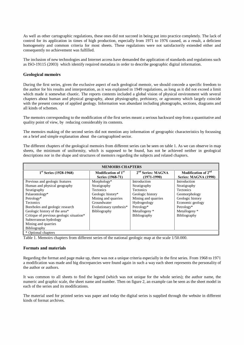
As well as other cartographic regulations, these ones did not succeed in being put into practice completely. The lack of control for its application in times of high production, especially from 1971 to 1976 caused, as a result, a deficient homogeneity and common criteria for most sheets. These regulations were not satisfactorily extended either and consequently no achievement was fulfilled. The inclusion of new technologies and Internet access have demanded the application of standards and regulations such as ISO-19115 (2003) which identify required metadata in order to describe geographic digital information. Geological memoirs During the first series, given the exclusive aspect of each geological memoir, we should concede a specific freedom to the author for his results and interpretation, as it was explained in 1949 regulations, as long as it did not exceed a limit which made it somewhat chaotic. The reports contents included a global vision of physical environment with several chapters about human and physical geography, about physiography, prehistory, or agronomy which largely coincide with the present concept of applied geology. Information was abundant including photographs, sections, diagrams and all kinds of schemes. The memoirs corresponding to the modification of the first series meant a serious backward step from a quantitative and quality point of view, by reducing considerably its contents. The memoirs making of the second series did not mention any information of geographic characteristics by focussing on a brief and simple explanation about the cartographied sector. The different chapters of the geological memoirs from different series can be seen on table 1. As we can observe in map sheets, the minimum of uniformity, which is supposed to be found, has not be achieved neither in geological descriptions nor in the shape and structures of memoirs regarding the subjects and related chapters.
MEMOIRS CHAPTERS 1st Series (1928-1968) Modification of 1st
Series (1968-71) 2nd Series: MAGNA
(1971-1990) Modification of 2nd
Series: MAGNA (1990) Previous and geologic features Human and physical geography Stratigraphy Palaeontology* Petrology* Tectonics Boreholes and geologic research Geologic history of the area* Critique of previous geologic situation* Subterranean hydrology Mining and quarries Bibliography
Morphology* Stratigraphy Tectonics Geologic history* Mining and quarries Groundwater Evolutionary synthesis* Bibliography
Introduction Stratigraphy Tectonics Geologic history Mining and quarries Hydrogeology Petrology* Metallogeny * Bibliography
Introduction Stratigraphy Tectonics Geomorphology Geologic history Economic geology Petrology* Metallogeny * Bibliography
* Optional chapters Table 1. Memoirs chapters from different series of the national geologic map at the scale 1/50.000. Formats and materials Regarding the format and page make up, there was not a unique criteria especially in the first series. From 1968 to 1971 a modification was made and big discrepancies were found again in such a way each sheet represents the personality of the author or authors. It was common to all sheets to find the legend (which was not unique for the whole series); the author name, the numeric and graphic scale, the sheet name and number. Then on figure 2, an example can be seen as the sheet model in each of the series and its modifications. The material used for printed series was paper and today the digital series is supplied through the website in different kinds of format archives.

(a) (b)
(c) (d)
(e) (f) Figure 2. Example of different style sheets and, formats of the series of the National Geologic Map to a 1/50.000 scale. (a) 1st Series, sheet n. 44, �Carballo�. (b) Modification of 1st Series, sheet n. 561, �Pastrana�. (c) 2nd Series: MAGNA, sheet n. 768, �Ayora�. (d) Last modification of the MAGNA, sheet n. 561, �Pastrana�. (e) Digital map, format .pdf, sheet n. 561, �Pastrana�. (f) Interactive map, Mapa IMS, sheet n. 561, �Pastrana� (Spanish Geologic Institute � IGME). Legend and symbols The simplicity of wide world used legends in drawn boxes from the first series, contrasts with the complexity of Magna series which has been criticised and praised by different authors from different areas. The Chrono-lithostratigraphic Magna series legend, of double entry according to age and type of material, appears to be quite complex to enable an interpretation of geology for beginners (on figure 3, an example can be seen as the legend model in each of the series).

(a)
(b)
(c) Figure 3. Differentent type of legend of the series of the National Geologic Map to a 1/50.000 Scale. �Pastrana�, Sheet n. 561. (a)1st Series, (b) 2nd Series-MAGNA, (c) Digital Map (Spanish Geologic Institute � IGME). Regarding the symbols, it is true that each sheet has its particular requirements and this is why it should be allowed freedom, although it is essential to have a common relation of symbols which make them easy to remember and, that the disorderly use of new symbols and interpretations for the same grounds and phenomena does not need a detailed and confusing study for each sheet. In the first series few symbols and patterns were introduced to be applied to distinguish the different categories and geologic elements. Little by little they had increased in number as geologic knowledge became more important and new contents were added to the new geologic maps, which can be observed in previous cartographic regulations. The information in the margin of the map with its legend show the different used symbols.

From the digital map point of view, the enormous variety of symbols has raised a problem from its cataloguing process since many of them were not mentioned in its own regulations and from the computer processing as well. Schemes and sections The schemes, sections and stratigraphic columns help to understand and integrate the information and relations between the different units and to enrich the geologic cartography. Its use, as for the rest of elements as well, has progressively improved with series. In the first series, the geologic cross sections were included in separate sheets and with a sheet scheme to variable scale in order to determine their situations. Other schemes, transversal profiles and stratigraphic columns also appear to be part of the geological memoirs. During the transition period between the first and second series (1968 and 1971) some geological sections start to appear as marginal information in the map sheet itself and a tectonic scheme in black and white. Yet, the irregularities of these series make some sheets of coast areas appear in the very field of the map. Since the second series, the introduction of geological sections as marginal information have been regulated and also stratigraphic columns in the main areas, a tectonic or morphostrutural scheme to 1/250.000 scale, a regional scheme to 1/1.000.000 scale. During the nineties a hydrogeologic scheme is added with the previous ones to 1/200.000 scale. On the digital and the dynamic map, available on the Internet, this kind of information is not included It would be interesting to achieve geological sections in an interactive way in the future but this process means a three-dimensional map and the production of computer applications for the visualization and recovery of 3D information. The complementary information As mentioned before, since the MAGNA series, the complementary information used for map sheets making, has been part of the process. Today the information referring to samples and preparations of samples, chemical and granule metric analysis on one hand and, boreholes and achieved stratigraphic columns on the other hand, are at public disposal through Internet and the corresponding georeferenced database, MAGNA and SONDEOS, respectively. CONCLUSION There is a great heterogeneity regarding sheets of the National geologic map to 1/50.000 scale, especially between different series and even in spite of the apparent homogeneity of the Magna series, there are still discrepancies about contents, memoirs making and purely cartographic aspects. Thus, they have been classified as an heterogeneous group of maps as a whole and/or groups of sheets independent from each other. The important advantages of new technologies of information such as the interoperability process, data integration, interconnection and possibility to deliver and supply information from a geologic map, for its scientific use and application as well, depend on the continuity and consistency of data beyond frontiers imposed by cartographic maps limits and/or administrative boundaries. The interactive digital map is available yet, being still at an incipient state, MapaIMS could improve some aspects such as the inclusion a cartographic database adjusted to the level of the map visualization, the inclusion of a dynamic legend and the possibility to achieve geologic cross sections in an interactive way. But it will be necessary to deepen the visualization techniques especially from the three-dimensional aspect and data structures which enable their application. To conclude, a publishing effort will be necessary to inform about the possibility to get access to reports and complementary documents included in the geologic map, since it is not possible to get access to them from the window and the map browsing page. Furthermore, the new continuous map will enable to order on-demand cartography and this represents a real challenge for the future regarding the geological memoirs issues, explanation and description. REFERENCES RODRIGUEZ FERNÁNDEZ, L.R. (2000) - The Geologic Maps produced by the ITGE: evolution, present time and future. Bull. Geologic and Mining. Special number, 15-36. GAVALA, J. (1927) - Geologic map from Spain at the scale 1/50.000. Memoir corresponding to the Cantillana sheet. Bull. of the Geologic and Mining Institute of Spain. Volume XLIX, IX of 3rd Series.

GARCÍA CORTÉS, A. (2000) - The Geologic Cartography of the ITGE: Lines of future performance. 150 Years: Study and research in Earth sciences. Technological and Geomining Institute of Spain. (IGME), Madrid. 103-132. SOLLER, D. & Berg, T. (2002) - The National Geologic Map Database: A Progress Report. Digital mapping techniques '02. Workshop proceedings: U.S. Geological Survey Open-file Report 02-370. HUERGA RODRÍGUEZ, A. (2000) � Chronology. 150 Years: Study and research in Earth sciences. Technological and Geomining Institute of Spain. (IGME), Madrid. 19-34. IGME - Geologic map of Spain at scale 1/50.000. Sheets n. 44, 561 and 768. Geologic and Mining Institute of Spain. Madrid. http://www.igme.es/internet/sistemas_infor/SidC.htm BIOGRAPHY OF THE PRESENTING AUTHOR María J. Iniesto is an assistant lecturer in the Department of Agroforestry Engeenering, area of Cartographic, Geodetic and Fotogrametric Engineering, at the University of Santiago de Compostela (Galicia � Spain).
She have two undergraduate degrees: one in Survey Engineering (Intermediate Level, three years) and other in Geodetic and Cartographic Engineering (Higher Level, two years more), with a specialization in thematic cartography. She finished the taught courses (Advanced Studies Title) of the Doctoral Program in Geodesics and Geomatics at the Madrid Polytechnic University in December 2002. From 1996 till 2002 she worked in private companies and at the University, in topics related to the topography and the cartography. From hers incorporation, in 2002, at the University of Santiago de Compostela, she wokrs in hers teaching assignments, Cartography I and II in Survey Engineering, and is integrated in �the Land, Underground, Biodiversity� research group. Currently, apart from hers teaching commitments at the university, she is carrying out hers PhD research on Geothematic Cartography.

July 9-18 A Coruña 2005
1
FEATURES AND OPERABILITY OF THE AIRPORT TOPOGRAPHICAL CONTROL NETWORK IMPLEMENTED IN AENA AIRPORTS. López-Pantoja Lamarca, A. , Suárez Suárez, M. and Aranda Molina, T. Aena has implemented, through the Infrastructure Planning Directorate, an Airport Topographical Control Network (RCTA) in all the Spanish airports, in order to satisfy existing needs regarding the interrelation of the reference systems used in the different Aena Units and to have a single reference for all topographic and cartographic works to be carried out in each airport complex. Background First started in 1993, Aena carried out a project called Aeronautical Geodetic Network consisting of a minimum of four control points and other points indicating different aeronautical facilities, implemented inside the airport complex. These points were linked to the ETRF89 Reference Framework in Spain, EUREF89 and IBERIA95, with coordinates assigned to them in the WGS84 system. In the case of the Canary Islands, the System and Reference Framework is the so-called REGCAN95, based on the International Terrestrial Reference System (ITRS). Besides these points, Aena defined a local two-dimensional coordinate system, generally established with the origin coinciding with one of the runway thresholds, X axis in the longitudinal runway direction, and Y axis perpendicular to X at the system origin. This is merely a local system, used to execute works in the airports and not related, through any transformation, either to the WGS84 Reference System or to the official cartography of each airport in the ED50 System.
July 9-18 A Coruña 2005
2
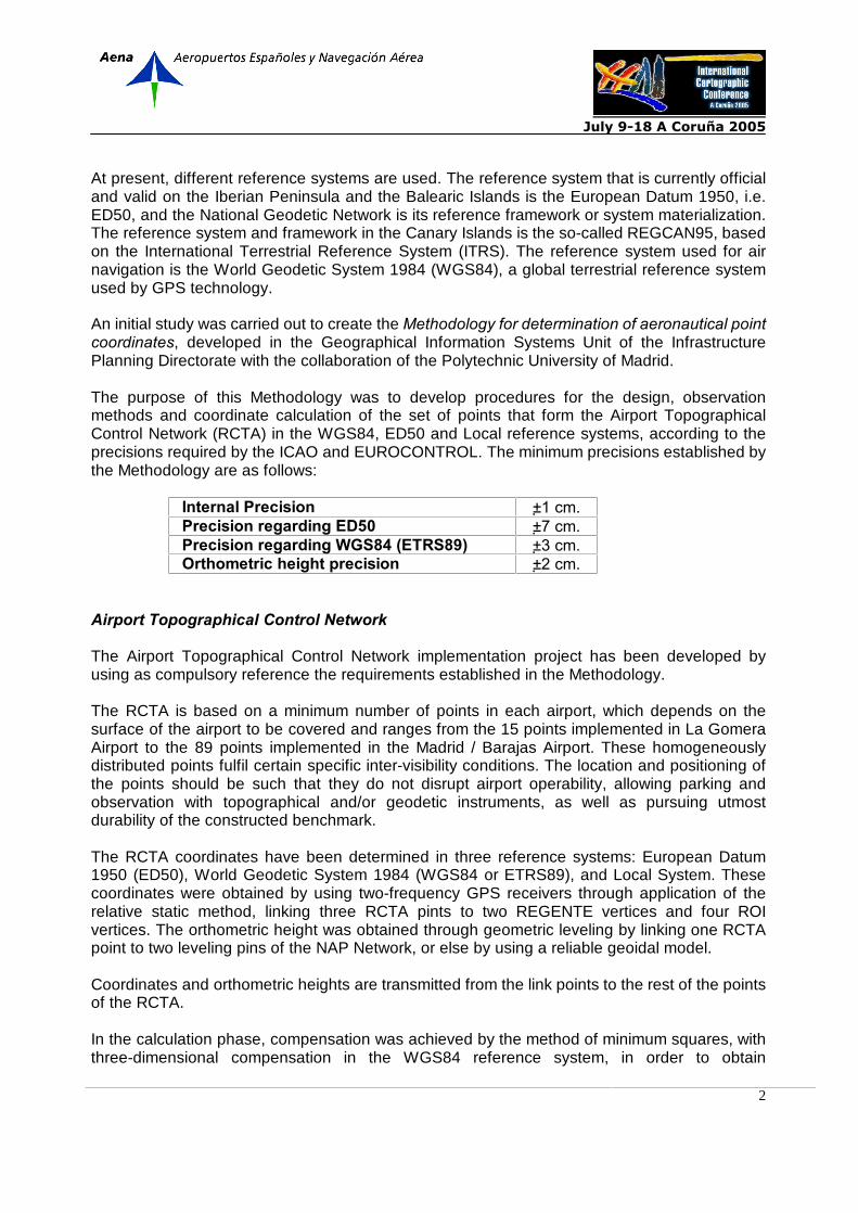
At present, different reference systems are used. The reference system that is currently official and valid on the Iberian Peninsula and the Balearic Islands is the European Datum 1950, i.e. ED50, and the National Geodetic Network is its reference framework or system materialization. The reference system and framework in the Canary Islands is the so-called REGCAN95, based on the International Terrestrial Reference System (ITRS). The reference system used for air navigation is the World Geodetic System 1984 (WGS84), a global terrestrial reference system used by GPS technology. An initial study was carried out to create the Methodology for determination of aeronautical point coordinates, developed in the Geographical Information Systems Unit of the Infrastructure Planning Directorate with the collaboration of the Polytechnic University of Madrid. The purpose of this Methodology was to develop procedures for the design, observation methods and coordinate calculation of the set of points that form the Airport Topographical Control Network (RCTA) in the WGS84, ED50 and Local reference systems, according to the precisions required by the ICAO and EUROCONTROL. The minimum precisions established by the Methodology are as follows:
Internal Precision ±1 cm. Precision regarding ED50 ±7 cm. Precision regarding WGS84 (ETRS89) ±3 cm. Orthometric height precision ±2 cm.
Airport Topographical Control Network The Airport Topographical Control Network implementation project has been developed by using as compulsory reference the requirements established in the Methodology. The RCTA is based on a minimum number of points in each airport, which depends on the surface of the airport to be covered and ranges from the 15 points implemented in La Gomera Airport to the 89 points implemented in the Madrid / Barajas Airport. These homogeneously distributed points fulfil certain specific inter-visibility conditions. The location and positioning of the points should be such that they do not disrupt airport operability, allowing parking and observation with topographical and/or geodetic instruments, as well as pursuing utmost durability of the constructed benchmark. The RCTA coordinates have been determined in three reference systems: European Datum 1950 (ED50), World Geodetic System 1984 (WGS84 or ETRS89), and Local System. These coordinates were obtained by using two-frequency GPS receivers through application of the relative static method, linking three RCTA pints to two REGENTE vertices and four ROI vertices. The orthometric height was obtained through geometric leveling by linking one RCTA point to two leveling pins of the NAP Network, or else by using a reliable geoidal model. Coordinates and orthometric heights are transmitted from the link points to the rest of the points of the RCTA. In the calculation phase, compensation was achieved by the method of minimum squares, with three-dimensional compensation in the WGS84 reference system, in order to obtain

July 9-18 A Coruña 2005
3
compensated coordinates with their reliability and precision parameters for each point of the network. To determine the coordinates in the ED50 system, it was necessary to determine the parameters of transformation between the WGS84 and ED50 systems, calculated by means of a three-dimensional Helmert similarity transformation. These parameters are unique for each airport. Finally, the coordinates in the Local System were determined by a two-dimensional Helmert similarity transformation between the UTM coordinates (X, Y) in the ED50 System and the plane coordinates in the Local System. In parallel, a series of Points of Interest in each airport, such as runway thresholds, were defined. The features of these points are less restrictive as regards signaling, observation methods and precisions. Their coordinates are obtained from those obtained for the RCTA. The internal precision to be achieved in the Points of Interest is ±1 cm. The work carried out in each airport was submitted to an external Quality Control conducted by the Topographical Technical Engineering University School of the Polytechnic University of Madrid by means of a collaboration agreement with the General Foundation of this University. This supervision verified compliance with the Methodology, both in the field work and laboratory calculation phases, and also the delivered information and documentation formats.

July 9-18 A Coruña 2005
4
Results This project has been carried out over two years, during which the RCTA has been implemented in a total of 44 airports and one heliport of the Aena network. The significant results obtained from this project for every airport are as follows: Coordinates in the ED50, WGS84 and Local reference systems for the RCTA points,
with known precisions, being a unique, necessary reference for the topographic and cartographic work to be carried out in the airports.
Transformation parameters specific for each airport between all the mentioned reference
systems, which ensure homogeneity and precision in the conversion of coordinates. Local Geoidal Model, based on the wave values obtained in the calculations. All information is available via the Aena Intranet, with direct access to the data and the
unique transformation parameters, so that users can converse coordinates between the different systems.
The results of this project are being highly satisfactory in terms of recognition of their quality and reliability and the extent to which they are being used by users, thus covering the needs that gave rise to the RCTA implementation project. Their use extends to different fields of action within the company and, as concrete results, users have access to: reliable data on singular points to be published in the AIP such as thresholds; capability of referencing information from other areas of work on official drawings (ED50), such as Air Navigation data (WGS84), works projects (Local System), etc., thanks to obtaining information via Intranet for coordinate transformation; use of the RCTA as a reference for the layout of different works; support for the preparation of digital ground models (MDT) in Aena airports by using airborne LIDAR; geo-referencing of cartography existing prior to this implementation; etc.