southern freight rail corridor/media/projects/s/southern freight rail... · figure 4 route options...
TRANSCRIPT

Chapter 4
Project Description
Proj
ect D
escr
ipti
on

4.0 Project Description The purpose of this section of the Draft Assessment Report is to provide a description of the project through the various project phases of planning, operation and construction. Particular emphasis has been given to the background of the SFRC and its relationship with other proposed projects. Other issues reported include: • The alignment development and engineering process including discussion of the guiding design
criteria; • Detailed description of the proposed alignment; and • Project substantiation, discussion of alternatives and the need for the project. It should be recognised that the level of detail provided in various sections of the project description reflects the preliminary level of alignment design that has been undertaken as part of the study. Where appropriate, suitable recommendations have been made through the Environmental Management Plan (EMP) for impact mitigation measures required to be addressed during the detailed design phase.
4.1 Background The Southern Freight Rail Corridor was first identified as a concept with the release in 2005 of the South East Queensland Regional Plan 2005-2026 (SEQRP) and subsequent South East Queensland Infrastructure Plan and Program 2005-2026 (SEQIPP). The project was at that stage known as the Southern Infrastructure Corridor (SIC), with the corridor seen as potentially supporting a variety of infrastructure including, road, rail and utilities. The SEQRP and SEQIPP did not show an accurate route for the SIC with the included plans intended to illustrate, at a regional scale, a potential connection between a possible future intermodal freight terminal at Purga (also identified in the SEQRP) and the SGR.
4.1.1 Previous Studies
Parallel to the release of the SEQRP and SEQIP&P, the then Office of Urban Management (OUM) commissioned the Southern Infrastructure Corridor Study (Maunsell, 2005b) which investigated at a broad level, potential routes for the SIC. The study focused on the feasibility of routes for a freight railway as this infrastructure is more highly constrained by terrain (horizontal and vertical geometry) when compared to road and other utilities (such as pipelines and powerlines). At a similar time, The Coordinator-General (CG) commissioned the Purga Site Investigation Study (Maunsell, 2005a) which investigated the pre-feasibility of the Purga Investigation Area, as identified in the SEQRP, for industrial land uses including an Intermodal Freight Terminal (IFT) and a possible extension of the proposed Amberley Aerospace Park. The Southern Infrastructure Corridor Study investigated eight (8) route options in total, all of which included allowance for a potential IFT within the Purga Investigation Area and connected to the existing western railway via the Ebenezer rail loop (see Figure 4). The study recommended that further investigation be undertaken with the focus being on options N1 and C3. The N1 option was subsequently deemed to be undesirable by Government, due to its proximity to existing urban areas and the planned future residential areas of Springfield, Ripley and Camira that were identified in the SEQRP. The N1 route option also posed potential conflict with the proposed Darra to Springfield passenger-only line. It was considered that of the options considered, the C3 route option represented the optimum route option for further investigation as it was removed from existing and planned urban areas, would avoid freight rail conflicting with the passenger network, and would ensure that both freight and passenger services could be operated in a timely and efficient manner. Accordingly, the C3 route option was selected by Government to form the basis for the current study.
D R A F T D R A F T D R A F T D R A F T D R A F T D R A F T D R A F T D R A F T D R A F T D R A F T D R A F T D R A F T D R A F T D R A F T D R A F T D R A F T
Southern Freight Rail Corridor Study Draft Assessment Report 26 September 2008 Page 24

Figure 4 Route Options from the Southern Infrastructure Corridor Study, 2005
D R A F T D R A F T D R A F T D R A F T D R A F T D R A F T D R A F T D R A F T D R A F T D R A F T D R A F T D R A F T D R A F T D R A F T D R A F T D R A F T
Southern Freight Rail Corridor Study Draft Assessment Report 26 September 2008 Page 25

4.1.2 Inland Rail
Background
In June 2006 the Australian Government released the North-South Rail Corridor Study (Ernst & Young, 2006), which presented a high level analysis of the various corridors and routes which had been proposed for a new inland railway between Melbourne and Brisbane. A large number of route (and in some cases alignment) options had been generated by various parties prior to 2006. From this base the study developed a wide range of route combinations and then calculated the costs and benefits of various permutations and options. The study found that the preferred route for further investigation was the far western sub-corridor as shown in Figure 5. The study also found that: “Rail freight market share on the Melbourne to Brisbane route is estimated to increase from 30% to approximately….73% for the inland route. The rail tonnage is projected to increase to 8.6 million tonnes for the inland route (7.9 million tonnes on the inland route and a residual 0.7 million tonnes on the coastal route) by 2029. These tonnages would be somewhat lower with one of the route variants: namely, constructing an inland route from Melbourne to a point near Toowoomba and transferring the freight to trucks for the remainder of the journey to Brisbane. It is unlikely that building and operating a terminal close to Toowoomba and completing journeys through to Brisbane by truck would meet the expectations and requirements of customers.” (Ernst & Young, 2006) On the 28th of March 2008 the Federal Government announced $15million in funding for the Australian Rail Track Corporation (ARTC) to undertake further investigations focused on the far western sub-corridor. The study will build upon the earlier work and determine the optimum alignment of any future inland railway after taking into account the needs of potential users as well as possible engineering, planning and environmental considerations. As well as determining the route alignment, the ARTC study will provide both the Government and private sector with information that will help guide their future investment decisions, including likely demand and an estimated construction cost. The stated objectives of the study from the advertised Terms of Reference are to determine: • The optimum alignment of the inland railway, taking into account user requirements and the
economic, engineering, statutory planning and environmental constraints. The alignment will be sufficiently proven up so it can be quickly taken through the statutory planning and approval process and into detailed engineering design and construction, should a decision be taken to proceed;
• The likely order of construction costs +/- 20%; • The likely order of below rail (infrastructure) operating and maintenance costs; • Above rail operational benefits; • The level and degree of certainty of market take up of the alignment; • A project development and delivery timetable; and • A basis for evaluating the level of private sector support for the project. Since 2005, Queensland Transport has been exploring options for alternative routes for a future dual gauge connection to a possible inland rail based on the difficulty that would be associated with upgrading the existing route, including conflicts associated with the electrified passenger network, impacts on urban areas and existing capacity constraints (see below).
D R A F T D R A F T D R A F T D R A F T D R A F T D R A F T D R A F T D R A F T D R A F T D R A F T D R A F T D R A F T D R A F T D R A F T D R A F T D R A F T
Southern Freight Rail Corridor Study Draft Assessment Report 26 September 2008 Page 26

Figure 5 Far Western Sub-Corridor Option from North-South Rail Corridor Study, (Ernst & Young, 2005)
D R A F T D R A F T D R A F T D R A F T D R A F T D R A F T D R A F T D R A F T D R A F T D R A F T D R A F T D R A F T D R A F T D R A F T D R A F T D R A F T
Southern Freight Rail Corridor Study Draft Assessment Report 26 September 2008 Page 27

Relationship to SFRC
As mentioned above, the North-South Rail Corridor Study outlined that connection of a future inland railway to Toowoomba with connection by road to Brisbane is unlikely to meet the expectations and requirements of potential users. Connection by rail from Toowoomba to Brisbane and specifically Acacia Ridge and the Port of Brisbane consists of two main sections: • Upgrade of the existing narrow gauge rail alignment from Gowrie (west of Toowoomba) to
Grandchester (west of Rosewood); and • Provision of a new linkage from Grandchester to the existing interstate standard gauge route. Rail freight (including coal) travelling from south-western Queensland to Acacia Ridge and the Port of Brisbane currently travels via Toowoomba, Rosewood, Corinda and Yeerongpilly. Upgrade of the western line from Rosewood to Yeerongpilly to cater for standard gauge trains and double-stacked container freight is not considered feasible given the highly urbanised nature of the corridor, capacity constraints and conflicts with the passenger network and inadequate clearance for double-stacked container trains from existing electrification infrastructure and the numerous existing bridge crossings. Upgrade of the alignment from Gowrie to Grandchester has been subject to previous study by Queensland Rail and Queensland Transport in 2003. The study produced a preferred alignment for the corridor which removed the significant existing constraints on vertical and horizontal geometry through curve easing and the use of substantial lengths of tunnel at both the Toowoomba and Little Liverpool Ranges (see Figure 6). The proposed alignment of the SFRC would tie in with the eastern extent of the proposed Gowrie to Grandchester alignment completing the linkage between a future inland rail route to Toowoomba and the existing SGR. Future consideration would need to be given to required upgrades of the SGR between Bromelton and Acacia Ridge to allow for possible double-stacking (clearance) and the increase in anticipated freight volume (duplication/passing loops).
Figure 6 Proposed alignment from Gowrie to Grandchester Study (QR, QT, 2003)
D R A F T D R A F T D R A F T D R A F T D R A F T D R A F T D R A F T D R A F T D R A F T D R A F T D R A F T D R A F T D R A F T D R A F T D R A F T D R A F T
Southern Freight Rail Corridor Study Draft Assessment Report 26 September 2008 Page 28

4.1.3 Intermodal Freight Terminals
Queensland Transport have recently completed Stage 2 of the SEQ Intermodal Freight Terminal Study (QT, 2008). The study examined and evaluated the need and preferred locations for additional intermodal land transport (road-rail) freight terminals within south east Queensland over the next 20 years. Key findings of the Study were as follows: • Inbound movements (including freight in transit though SEQ) will increase from 29Mt to 73Mt,
whilst outbound movements will increase from 26Mt to 46Mt in 2026. This imbalance has the potential to change the cost structure of transport and influence the future location of industrial development and freight corridors required to service demand;
• This imbalance is expected to result in changing cost structures for road and rail and will see rail capture a larger share of interstate freight traffic by 2026. By 2026 rail's percentage of the total freight task is expected to be Brisbane to Melbourne (50 - 65%), Brisbane to Sydney (20 - 30%) and North Queensland (40 – 50%);
• Projected interstate freight movements passing through intermodal terminals are expected to increase to between 1.02 million and 1.38 million Twenty Foot Equivalent Containers (TEUs) per annum in 2026;
• The Acacia Ridge terminal has the potential for expansion however existing road and rail constraints will limit capacity to 0.5 million TEUs per annum;
• As a result of increasing import / export trade, the capacity of the Brisbane Multimodal Terminal (BMT) at Port of Brisbane to handle domestic intermodal traffic is expected to reduce to between 0.06 million and 0.18 million TEUs per annum by 2026; and
• A new IFT is expected to be needed between 2010 and 2020. In light of these findings the study made the following recommendations regarding the short, medium and long term solutions for providing additional IFT capacity in the region:
• Short term solutions (current to 2010)
An improvement in the operations and efficiency of the Acacia Ridge terminal and BMT will serve likely needs and provide adequate capacity to meet the increasing intermodal demands including Australia Trade Coast development.
• Medium term solutions (2010-2020)
An additional site will be required to cater for approximately 650,000 TEU movements per annum, as a maximum. The most suitable existing site without substantial investment in additional infrastructure is Bromelton (assuming adequate non-transport infrastructure can be provided).
• Long term solutions (beyond 2020)
Options include the development of a site at Greenbank (dependant on the long term strategy for the Greenbank Army Reserve) and the development of a site at Ebenezer (dependent on industry relocation and take-up of proposed industrial land to be developed south-west of Ipswich as well as a dual gauge rail line to the site either from the existing interstate line or the proposed inland rail line when it occurs).
As a key connection between a future inland Melbourne-Brisbane railway and the SGR, construction of the SFRC will play a potentially significant role in the determination of the preferred medium and long term solutions for IFT capacity in the region. In particular, a terminal option at Ebenezer would be highly contingent upon the inland rail and SFRC proceeding. Likewise the relative attraction of a Bromelton terminal option would increase if the inland rail and SFRC were to proceed. Passive allowance has been made in the alignment design for the SFRC (by way of vertical and horizontal gradients), for a future IFT west of the Cunningham Highway at Ebenezer. The proposed junction of the SFRC with the SGR is located immediately to the north of the suggested IFT location (South of Undullah Road) in the proposed Bromelton State Development Area (SDA) Draft Development Scheme.
D R A F T D R A F T D R A F T D R A F T D R A F T D R A F T D R A F T D R A F T D R A F T D R A F T D R A F T D R A F T D R A F T D R A F T D R A F T D R A F T
Southern Freight Rail Corridor Study Draft Assessment Report 26 September 2008 Page 29

Further detailed consideration of terminal layout and design at these two locations is beyond the scope of the current study and will be subject to further consideration in the future should either site be required. Further consideration of land use planning issues at Ebenezer and Bromelton is provided in Technical Paper 5 – Land Use and Planning (Volume 2).
4.2 Preliminary Alignment Development Process As discussed in Section 4.1.1, the C3 alignment from the Southern Infrastructure Corridor Study (2005) was used as a starting point for the SFRC Study (see Figure 7).
Figure 7 C3 Alignment from SIC Study (2005)
4.2.1 Initial Alignment Review
The initial task undertaken for the study was a broad review of the C3 alignment aimed at determining its appropriateness for further investigation and the need for any modifications. It should be noted that the 2005 study was undertaken using relatively coarse topographic data and as such there was an inherent need to refine the alignments considered at that time. Key issues investigated included: • The western connection point, including issues associated with connection to the Ebenezer loop; • Opportunities to provide rail access to future industrial land at Ebenezer (South of Paynes Road); • Future IFT locations at Purga/Ebenezer; and • Potential elimination of the proposed tunnel in the Washpool area through the adoption of a
southern alignment variation. These issues were investigated and then reported back to the PSC for discussion and resolution.
D R A F T D R A F T D R A F T D R A F T D R A F T D R A F T D R A F T D R A F T D R A F T D R A F T D R A F T D R A F T D R A F T D R A F T D R A F T D R A F T
Southern Freight Rail Corridor Study Draft Assessment Report 26 September 2008 Page 30

Preliminary Alignment Options North-West of Peak Crossing
In relation to the western connection a range of issues were identified with the concept of connection to the Ebenezer loop, including: • Proximity to existing and committed large lot residential development north of Coopers Rd,
Willowbank; • Potential ground stability issues associated with backfilled open cut coal mining operations to the
west of the Cunningham Highway and south of Coopers Road; • Flood risk (alignment is not designed to 1 in 100 year recurrence level); • Conflict with the existing electrified passenger network at Rosewood, both in terms of operation
and vertical clearance for double-stacked freight under electrification infrastructure; and • Increased noise impacts for residences adjacent to the existing rail corridor at Rosewood. In light of the above issues, consideration was given to alternative alignments, principally connecting to the existing western railway west of Rosewood before passing through Ebenezer to the south of Paynes Road and Willowbank Raceway (see Figure 8). The options consisted of a number of sub-routes but can be broadly grouped as northern options, retaining a possible IFT footprint at Purga (shown in yellow, green and orange) and a southern option which involved an alternative IFT location at Ebenezer (shown in blue).
Figure 8 Preliminary Alternative Western Connection Options
D R A F T D R A F T D R A F T D R A F T D R A F T D R A F T D R A F T D R A F T D R A F T D R A F T D R A F T D R A F T D R A F T D R A F T D R A F T D R A F T
Southern Freight Rail Corridor Study Draft Assessment Report 26 September 2008 Page 31

In analysis of these options, the study team and PSC made the following findings: • Regardless of previous investigations into the suitability of Purga as an IFT site there was no
significant reason why a facility could not instead be located at Ebenezer; • The provision of rail access to future industrial land, including a possible IFT south of Paynes
Road at Ebenezer would act as a significant catalyst for development of that area, particularly in relation to rail-dependant uses such as freight forwarding and logistics;
• The southern (blue) alignment option provided for a significantly more direct and therefore shorter alignment (95% of average length) thus providing whole of life cost benefits from an operational perspective and direct impact on a lesser number of properties;
• Partially due to its shorter length, the southern (blue) alignment option requires significantly less earthworks (83% of base option) thus providing benefits in terms of constructability and total capital expenditure; and
• The southern (blue) alignment impacted more significantly on areas of potential environmental significance however these issues were unlikely to be insurmountable.
Given these findings the southern (blue) alignment was selected as the preferred alignment for further investigation.
Preliminary Alignment Options at Washpool
The other significant alignment variation considered at this preliminary stage was located south of Washpool Road at Washpool (see Figure 9). The options in this locality consisted of a base case option (shown in yellow) and a southern deviation (shown in green) which was developed with the specific aim of removing the need for a tunnel.
Figure 9 Preliminary Alignment Options at Washpool
D R A F T D R A F T D R A F T D R A F T D R A F T D R A F T D R A F T D R A F T D R A F T D R A F T D R A F T D R A F T D R A F T D R A F T D R A F T D R A F T
Southern Freight Rail Corridor Study Draft Assessment Report 26 September 2008 Page 32

In consideration of these options the study team and PSC made the following findings: • The southern deviation would likely shorten the length of tunnel required but would not eliminate
the need for a tunnel altogether; • The southern deviation would add approximately 1.73km (3%) in length to the overall route; and • The southern deviation would require greater earthworks volumes - 108% of base option. In consideration of these issues, the study team determined that a significant percentage of cost associated with construction of a rail tunnel is associated with the setup and commissioning of the necessary plant (i.e. tunnel construction cost is not directly proportional to tunnel length). Therefore, given that the southern deviation would not remove the need for a tunnel, further investigations were not warranted given its overall longer length and greater earthwork volumes.
Outcome
The outcome of the initial alignment review was the adoption of a relatively coarse preliminary alignment, based on the preferred route sub-options, which would inform the geographic scope of the investigations to follow (see Figure 10).
Figure 10 Preliminary Alignment used for Determination of Study Area
4.2.2 Study Area Determination
Using the preliminary alignment as a centreline, a 2km wide Corridor of Interest was adopted (based on a 1km wide buffer either side of the preliminary alignment – see Figure 11). Large-scale maps of the Corridor of Interest, as referenced during previous community engagement activities, are included in Appendix C.
D R A F T D R A F T D R A F T D R A F T D R A F T D R A F T D R A F T D R A F T D R A F T D R A F T D R A F T D R A F T D R A F T D R A F T D R A F T D R A F T
Southern Freight Rail Corridor Study Draft Assessment Report 26 September 2008 Page 33
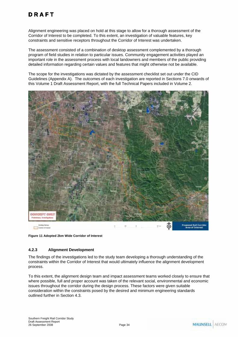
Alignment engineering was placed on hold at this stage to allow for a thorough assessment of the Corridor of Interest to be completed. To this extent, an investigation of valuable features, key constraints and sensitive receptors throughout the Corridor of Interest was undertaken. The assessment consisted of a combination of desktop assessment complemented by a thorough program of field studies in relation to particular issues. Community engagement activities played an important role in the assessment process with local landowners and members of the public providing detailed information regarding certain values and features that might otherwise not be available. The scope for the investigations was dictated by the assessment checklist set out under the CID Guidelines (Appendix A). The outcomes of each investigation are reported in Sections 7.0 onwards of this Volume 1 Draft Assessment Report, with the full Technical Papers included in Volume 2.
Figure 11 Adopted 2km Wide Corridor of Interest
4.2.3 Alignment Development
The findings of the investigations led to the study team developing a thorough understanding of the constraints within the Corridor of Interest that would ultimately influence the alignment development process. To this extent, the alignment design team and impact assessment teams worked closely to ensure that where possible, full and proper account was taken of the relevant social, environmental and economic issues throughout the corridor during the design process. These factors were given suitable consideration within the constraints posed by the desired and minimum engineering standards outlined further in Section 4.3.
D R A F T D R A F T D R A F T D R A F T D R A F T D R A F T D R A F T D R A F T D R A F T D R A F T D R A F T D R A F T D R A F T D R A F T D R A F T D R A F T
Southern Freight Rail Corridor Study Draft Assessment Report 26 September 2008 Page 34

A full and detailed description of the preferred alignment developed as an outcome of this process, including description of the key environmental, social and economic values taken into account at individual localities as provided in Section 4.4.
4.3 Alignment Engineering The design criteria to be adopted for the alignment are dictated by the future freight traffic likely to use the facility. Accordingly for the purposes of determining the appropriate alignment design standards the following assumptions were made: • The SFRC will form part of the proposed Melbourne-Brisbane Inland Railway; • The SFRC will be a dual gauge facility (narrow and standard gauges) and the existing SGR
between Bromelton and Acacia Ridge will be upgraded to dual gauge at some future point; • As passenger operations on the existing electrified urban network increase the opportunity for
narrow gauge freight from south-western Queensland to use existing routes will decrease and the SFRC will increasingly become the primary route to Acacia Ridge and the Port of Brisbane; and
• Ongoing growth in coal exports from the Port of Brisbane to an upper limit of 12 to 15 million tonnes per year will lead to the SFRC being an increasingly attractive option for narrow gauge coal freight.
As such, it is anticipated that the SFRC will support the following services: • Standard gauge intermodal freight traffic (potentially double-stacked – see Figures 12 A & B),
travelling from Melbourne and potentially Perth and Adelaide via the proposed Inland Railway to Acacia Ridge, the BMT and possible future terminals at Ebenezer and/or Bromelton; and
• Standard gauge freight traffic from Sydney to a possible future terminal at Ebenezer. The SFRC may also become an alternative route for the following services: • General purpose narrow gauge freight from south-western Queensland to Brisbane; • Narrow gauge bulk grain, containerised cotton and agricultural products from south-western
Queensland to the Port of Brisbane; • Narrow gauge bulk petroleum products from Brisbane to the south-west; and • Narrow gauge coal freight from western Queensland and Rosewood/Jeebropilly to the Port of
Brisbane.
Figure 12 A & B
Double-stacked Container Trains in North America
D R A F T D R A F T D R A F T D R A F T D R A F T D R A F T D R A F T D R A F T D R A F T D R A F T D R A F T D R A F T D R A F T D R A F T D R A F T D R A F T
Southern Freight Rail Corridor Study Draft Assessment Report 26 September 2008 Page 35

4.3.1 Design Standards
The infrastructure criteria developed to enable the design of a suitable alignment includes: • Operational requirements, including speeds, train mass and axle loads, train dimensions
(including double-stacking) and track spacing; • Geometric alignment, including curve radii and gradients; • Track components, including railway formation, rail, sleepers, ballast, track installation, turnouts,
and fencing; • Passing lanes and crossing loops; and • Other infrastructure requirements, including underbridges and overbridges, grade separations,
level crossings and tunnels.
Summary of Adopted Design Criteria
Whilst QR may not be the “rail owner” or “rail manager” in the event that the SFRC is constructed, for the purposes of this study, QR design and construction standards have been adopted where appropriate. The determining design criteria adopted for the Study are based on the current Code of Practice for the Defined Interstate Rail Network as adopted for the North-South Rail Corridor Study (2005). Key design criteria are listed in Tables 4 and 5.
Table 4 Adopted Design Criteria
Criteria Adopted Standard Desirable maximum speed 115 km/h Maximum axle load 30 tonnes Minimum vertical clearance above top of rail 7.4 metres Horizontal geometry radius for 115km/h 1,200 metres Maximum desirable compensated gradient 1% Maximum allowable compensated gradient 1.50% Passing loops/train length To be determined Rail specification 60 kg/m Sleepers Concrete Ballast 300mm below sleeper
Table 5 Maximum train speeds and corresponding minimum curve radii
Maximum Train Speed (km/h) Minimum Radius (m) 80 540 100 840 115 1,200
4.3.2 Railway Formation
It is intended that the SFRC would initially be constructed as a single track railway with suitably located passing loops. For planning purposes this study has adopted a dual track earthworks formation for the entire length of the alignment. This will ensure that the corridor is suitable for future upgrading to two tracks and also provides flexibility when locating passing loops, when operating as a single track. The location of any passing loops would be determined during detailed design phase when there exists greater certainty regarding train consistency, length and frequency.
D R A F T D R A F T D R A F T D R A F T D R A F T D R A F T D R A F T D R A F T D R A F T D R A F T D R A F T D R A F T D R A F T D R A F T D R A F T D R A F T
Southern Freight Rail Corridor Study Draft Assessment Report 26 September 2008 Page 36

The standard corridor cross section adopted for the study, including service roads, is shown in Plans SK038 & SK039 in Appendix B. It should be noted that the actual final corridor width may vary following detailed design, as may the location of realigned local roads, fencing and acoustic treatments, stock crossings and drainage infrastructure. For the purposes of the current study a conservatively wide corridor has been adopted to ensure that the corridor adopted for CID retains a degree of flexibility for incorporation of design changes during detailed design (the earthworks footprint may increase or decrease in some areas). Whilst increasing up-front costs related to land acquisition, this ensures that the detailed design (informed by rigorous geotechnical and hydraulic investigations) will fit within the original CID area. It is not anticipated that active acquisition of property for the SFRC will occur until such time as the detailed design is completed and there is a firm commitment to construct the SFRC. However, it is acknowledged that there may be some land acquired prior to this through landowners initiating the hardship application process. Consequently, it is not possible to determine the cost implications related to land acquisition of having a conservatively wide corridor for the CID area at this stage. Significant embankments and cuttings will also be required along the length of the alignment. Further refinement of these works will be required once detailed geotechnical investigations of the alignment have been completed. For the purposes of the study a nominal slope of 1V:2H has been adopted for all embankments and cuttings with stepping included at every 7.5m for large slopes. Where the geotechnical characteristics of the underlying material permits, steeper slopes may be achievable, thus reducing the overall width of the alignment footprint. The alignment development process has targeted a nominal balance of earthworks across sections of the alignment in order to minimise any excess/shortage of material. Where this has been difficult to achieve precedence has been given to maintaining safe geometric design standards.
4.3.3 Other Considerations
Flooding and Drainage
The major water courses within the study area including the Bremer River, Western, Warrill, Purga, Woolooman and Wild Pig Creeks and Teviot Brook will require bridging. At these crossings the bridge levels have been set to allow a flood with a corresponding probability of 1 in 100 years to pass under the soffit of the structure. These streams typically have relatively wide flood plains and will in some instances require the structures to span significantly beyond the top of bank. Where possible effort has been made to reduce the length of bridges required through the selection of crossing points at locations where the floodplain is relatively narrow. The rail corridor will also intercept a number of ephemeral creeks and drainage lines which generally flow into one of the higher order streams mentioned above. A preliminary assessment of the types of drainage structures required for the project to provide 1 in 100 year flood immunity to the top of rail formation has been completed as part of the preliminary design phase. Different sizes and numbers of culverts will be used to accommodate the smaller drainage lines along the alignment. As the project is still within the planning phase, detailed information is not available on stormwater drainage systems for construction and operation phases. Provisions are provided in the EMP (see Section 19.0) to address stormwater and sediment and erosion control and these are to be incorporated in the detailed design phase for the project.
Bridges
All bridges are to be designed in accordance with the Australian Bridge Design Code and QR Standards. At major creek and river crossings allowance should be incorporated for stock and vehicles to pass beneath the bridge in order to maintain access to fragmented portions of properties.
D R A F T D R A F T D R A F T D R A F T D R A F T D R A F T D R A F T D R A F T D R A F T D R A F T D R A F T D R A F T D R A F T D R A F T D R A F T D R A F T
Southern Freight Rail Corridor Study Draft Assessment Report 26 September 2008 Page 37

Tunnels
Due to severe terrain, two sections of tunnel have been incorporated into the alignment in the Washpool/Woolooman area. Design of these features will require considerable refinement in response to detailed geotechnical investigations during later design phases. Some verification for smoke control will be allowed for in the tunnel, but would generally not require operation under normal operating conditions.
Level crossings
The preferred alignment interfaces with existing roads throughout the study area. A basic planning criterion adopted for the SFRC is that level crossings (road/rail) are to be avoided where possible. Accordingly, grade separation of all major road crossings has been assumed for planning purposes. In some instances where a road serves a limited number of properties it may be more suitable to provide a realignment of an existing local road or a new road to enable access via an alternative route. At this stage, no investigation of these interfaces has been undertaken, as it is likely that the roles and relative importance of these roads will change between now and the detailed design phase of the project. Indeed, future structure plans for areas such as Purga and Ebenezer are likely to include a reappraisal of the form and function of some of these local roads. As such, an analysis of the interfaces between the preferred alignment and local roads will be undertaken during the detailed design phase, when more informed solutions are likely to be identified. At this time, options for maintaining local access are included in the description of the preferred alignment. Accordingly, the alignment has been designed to ensure that no level crossings are required for access from private property to public roads. In some instances this necessitates the realignment existing roads or construction of new roads. Points where the alignment is in cutting or on embankment have been used as opportunities for over/underpasses as appropriate (see Table 7). Where an individual property is fragmented or isolated by the alignment, an at-grade, single user occupational crossing has been assumed. These would be designed generally in accordance with QR standards.
Services
A preliminary inventory and assessment of services impacts has been undertaken as part of the alignment design process. Where possible, conflicts with major infrastructure such as the Moonie Oil pipeline, major water mains and Powerlink high voltage powerlines has been avoided through adjustment of the alignment. Where not possible, the conflict has been identified and suitable treatment proposed. The Santos Moonie-Brisbane Oil Pipeline travels in a north-easterly direction, through the Lanefield area. The pipeline transports oil 330km from the Moonie Oilfield to the Lytton Storage Facility, located at the mouth of the Brisbane River. The preferred alignment of the SFRC traverses this pipeline south of Western Creek, and includes a cutting in this area sufficiently deep that it would directly interface with the pipeline. The detailed design phase of this project will require an appraisal of this interface. With the possibility that the role or status of the Santos pipeline may change between now and the detailed design phase, a judgement about the pipeline’s interface with the preferred alignment has not been made at this time. Solutions may involve the diversion or reconstruction of the pipeline in this area, however these solutions will be more adequately informed based on consultation with the pipeline operators during development of detailed design.
D R A F T D R A F T D R A F T D R A F T D R A F T D R A F T D R A F T D R A F T D R A F T D R A F T D R A F T D R A F T D R A F T D R A F T D R A F T D R A F T
Southern Freight Rail Corridor Study Draft Assessment Report 26 September 2008 Page 38

4.3.4 Operational Considerations
Speed
The North-South Rail Corridor Study (2005) recognised that to improve transit times, reliability and availability on the Melbourne-Brisbane Corridor it is necessary to provide a network capable of higher travel speeds. The report went on to suggest that to be competitive with road services in these markets, it is expected that the maximum speed for freight trains will need to be up to 115 km/h. Such a maximum speed will enable options to be developed that achieve average speeds of about 80 km/h. Whilst not achievable across the entire length of the SFRC due to topographic constraints, particularly in the Washpool area, 115km/h remains a suitable maximum speed for the SFRC. It should be noted that considerably slower speed limits will be required for turnouts onto the SGR and existing western railway and also in the vicinity of any future IFT at Ebenezer and/or Bromelton.
Train length
The North-South Rail Corridor Study adopted a maximum train length of 1,800m based on the current maximum train length on the ARTC interstate network. The maximum future train length on the SGR is unlikely to exceed 1,500m due to cost factors and the difficulty of working long trains through the congested network north of Sydney. Whilst this may suggest that an adopted maximum train length of 1,800m would also be suitable for the SFRC it can be envisaged that longer trains, perhaps as long as 2,400m could be possible on the inland route between Melbourne and Brisbane. The key constraint to this being achieved would appear to be the terminal and marshalling facilities at each terminus (1500m at Acacia Ridge, Brisbane and 900/1800m at Dyson/Tottenham, Melbourne). Should new terminals be developed in Melbourne and Brisbane/SEQ capable of handling trains up to 2,400m it is therefore conceivable that this train length could be required on the SFRC.
Corridor Capacity
Preliminary corridor operations modelling suggests that a single track alignment with passing loops would be capable of supporting in excess of 30 trains per day before double-tracking would be required. Assuming that the key determinant of train volumes on the alignment at the time of opening would be the capacity of existing and proposed terminals at Acacia Ridge, Bromelton and Ebenezer it is not expected that any more than 10 trains per day (5 in each direction) would use the SFRC in the short to medium term, depending on when the line is actually commissioned. This number would increase towards the capacity of the corridor over time as demand increases on the Melbourne - Brisbane corridor and other freight (including coal) currently transported to Acacia Ridge and the Port of Brisbane on the narrow gauge network is switched to the SFRC.
Passing loops
Initially, up to four passing loops may be required for initial rail operations before eventual double- tracking is pursued. Passing loops are expected at each end of the SFRC and in two intermediate locations at approximately 15-20km spacing. The final position of proposed tunnels and terminals would influence the location of proposed passing loops. These will fit within the proposed corridor width shown on the CID plans in Appendix B.
D R A F T D R A F T D R A F T D R A F T D R A F T D R A F T D R A F T D R A F T D R A F T D R A F T D R A F T D R A F T D R A F T D R A F T D R A F T D R A F T
Southern Freight Rail Corridor Study Draft Assessment Report 26 September 2008 Page 39
4.4 Detailed Alignment Description Based on the design criteria outlined above and the investigations of the relevant environmental, social and economic factors reported in Sections 7.0 to 18.0 of this report and the Technical Papers in Volume 2, a preferred alignment for the SFRC was developed. Detailed CID Plans are provided at Appendix B (CID Plan Sheets 1-33). The drawings include long sections which illustrate the position of the railway relative to natural ground level as well as annotations of key features such as bridges, road realignments and creek crossings. The alignment design has been progressed to a level suitable to enable an appropriate level of confidence in the defined rail corridor boundaries. For this to be achieved a preliminary earthworks footprint for the alignment was developed along with details of necessary structures for grade separation of roads and river/creek crossings. This preliminary earthworks footprint is considered to be acceptable for this stage of the project. Future investigations relating to geotechnical and drainage aspects of the preferred alignment (during the detailed design phase) will inform the final alignment design, which is likely to be slightly different from the preliminary alignment design in some areas (i.e. the footprint may narrow or widen in some areas, depending upon geotechnical and hydraulic characteristics). This degree of change is not likely to be significant, and is not expected to alter the boundaries of the CID area. It should be noted that the design illustrated on the Plans in Appendix B consist of two key components: • the proposed alignment footprint including the rail formation and earthworks; and • the proposed railway corridor (CID area) which varies in width and includes allowance for
drainage infrastructure, service roads, passing loops, acoustic treatments and landscaping. Detailed design and location of these features within the rail corridor has not been undertaken as part of the current study.
The rail corridor as described above represents the area proposed for CID. Land acquired for the SFRC in the future may extend beyond the defined rail corridor dependant on the circumstances of individual properties including the relative location of residences, property management arrangements and property fragmentation. It is important to note that at this early stage only preliminary consideration has been given to the access and stock movement requirements of individual properties. Because the SFRC is not expected to be constructed for a considerable time, it is appropriate for solutions to these issues to be developed through consultation with individual landowners during the detailed design phase. During this process the following principles should be adopted: • Access to be maintained to all properties; • Where practical, access to be grade separated. Where not achievable, suitable at-grade
occupational crossing to be used; • Stock crossings to be provided for all grazing properties to ensure connectivity between
fragmented properties, particularly between grazing areas and water sources; • Stock crossings preferably to be via an underpass of suitable width to allow unimpeded
movement of stock; and • Consideration to be given to length of underpass and functionality. Table 6 provides a detailed description of the proposed alignment (working west to east) including the key considerations of environmental, social and economic factors that were incorporated into its design. Chainages are provided for key locations, representing distance (in metres from the western end of the alignment).
D R A F T D R A F T D R A F T D R A F T D R A F T D R A F T D R A F T D R A F T D R A F T D R A F T D R A F T D R A F T D R A F T D R A F T D R A F T D R A F T
Southern Freight Rail Corridor Study Draft Assessment Report 26 September 2008 Page 40
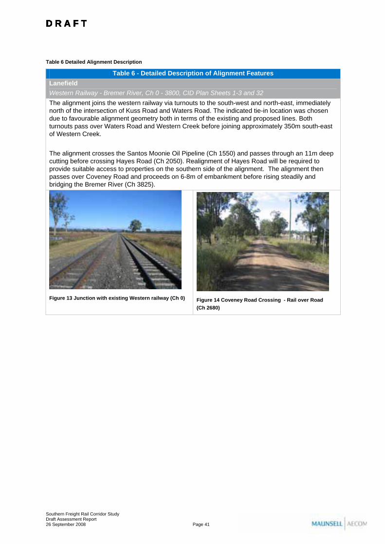
Table 6 Detailed Alignment Description
Table 6 - Detailed Description of Alignment Features Lanefield Western Railway - Bremer River, Ch 0 - 3800, CID Plan Sheets 1-3 and 32 The alignment joins the western railway via turnouts to the south-west and north-east, immediately north of the intersection of Kuss Road and Waters Road. The indicated tie-in location was chosen due to favourable alignment geometry both in terms of the existing and proposed lines. Both turnouts pass over Waters Road and Western Creek before joining approximately 350m south-east of Western Creek. The alignment crosses the Santos Moonie Oil Pipeline (Ch 1550) and passes through an 11m deep cutting before crossing Hayes Road (Ch 2050). Realignment of Hayes Road will be required to provide suitable access to properties on the southern side of the alignment. The alignment then passes over Coveney Road and proceeds on 6-8m of embankment before rising steadily and bridging the Bremer River (Ch 3825).
Figure 13 Junction with existing Western railway (Ch 0)
Figure 14 Coveney Road Crossing - Rail over Road (Ch 2680)
D R A F T D R A F T D R A F T D R A F T D R A F T D R A F T D R A F T D R A F T D R A F T D R A F T D R A F T D R A F T D R A F T D R A F T D R A F T D R A F T
Southern Freight Rail Corridor Study Draft Assessment Report 26 September 2008 Page 41

Table 6 - Detailed Description of Alignment Features Mount Forbes Bremer River - Mount Forbes Road, Ch 3800 - 8250, CID Plan Sheets 3-5 The alignment remains elevated and passes over Rosewood-Aratula Road (Ch 4050). The alignment then turns gradually south, avoiding endangered vegetation on Lot 261 on CH3159 before passing under the Powerlink Middle Ridge - Greenbank high voltage transmission line (Ch 5850). The alignment then turns back to the east, crossing unconstructed sections of Lairhopes Road and Manning Road. Teves Road is then crossed before the alignment enters a significant cutting which extends for a length of approximately 1.3km at a maximum depth of 21m. Teves Road will need to be constructed south of the alignment to Hedricks Road in order to maintain property access. The alignment crosses Mount Forbes Road (Ch 8245) whilst in cutting and a significant road overpass will be required (approximately 100m long). Opportunities to deviate Mount Forbes Road around the cutting should be considered during later design phases.
Figure 15 Crossing of Rosewood-Aratula Road looking west towards the Bremer River (Ch 4050)
Figure 16 Photo taken in the vicinity of proposed crossing of Mt Forbes Road (Ch 8245)
Ebenezer Mount Forbes Road - Cunningham Highway, Ch 8250 - 14550, CID Plan Sheets 5-9 The alignment then continues east through the Ebenezer Major Development Area with crossings of Brass Road (Ch 9675) and M Hines Road (Ch 10455). It is not anticipated that road crossings would be required at either of these intersections, with upgrades of existing road corridors allowing access north of the alignment to Paynes Road and south to M Goebels Road. Final access arrangements in this area will be dictated by the preferred development layout for Ebenezer and the outcomes of appropriate structure planning. There are a number of sensitive land uses and areas of environmental significance within this part of the study area. In particular, the alignment passes within 50m of the Ipswich Koala Protection Society’s facility on Brass Road. An alternative location for the facility will need to be identified and secured as part of the implementation of the project. Consideration would also need to be given to the co-location of the facility with the operator’s private residence. Any alignment within this area will require some clearing of significant vegetation including areas of koala habitat and the critically endangered ecological community, swamp tea tree forest of south east Queensland (Melaleuca irbyana). Efforts have been made to reduce these impacts by keeping the width of the corridor to a minimum and co-locating with existing road reserves where possible (Tea Tree Avenue). East of Tea Tree Avenue the alignment passes through an extensive cleared area before reaching the Cunningham Highway. The horizontal and vertical geometry of the alignment in this locality has been developed to allow for the future development of an intermodal freight terminal in this area (Ch 11800-14500). Accordingly, the alignment is straight with vertical gradients no greater then 0.5%.
D R A F T D R A F T D R A F T D R A F T D R A F T D R A F T D R A F T D R A F T D R A F T D R A F T D R A F T D R A F T D R A F T D R A F T D R A F T D R A F T
Southern Freight Rail Corridor Study Draft Assessment Report 26 September 2008 Page 42

Table 6 - Detailed Description of Alignment Features
Figure 17 Photo taken in the vicinity of proposed intersection (closure) with Brass Road (Ch 9675)
Figure 18 Photo taken in the vicinity of proposed intersection (closure) with M Hines Road (Ch 10455)
Mutdapilly/Purga Cunningham Highway - Middle Road, Ch 14550 - 19150, CID Plan Sheets 9-11 The proposed crossing of the Cunningham Highway (Ch 14550) will require significant works including construction of a new road overpass at a clearance of approximately 8m above the rail alignment. Further consultation with the Department of Main Roads will be required during detailed design in order to ensure that adequate allowance is made for any planned upgrade of the highway. East of the Cunningham Highway the alignment travels to the south of a large wetland area before meeting the Middle Ridge - Greenbank high voltage transmission line and crossing Warrill Creek (Ch 16350). The alignment then stays to the south of the transmission line and heads east, crossing Middle Road approximately 200m to the south of Purga Nature Reserve. Middle Road will be required to pass over the rail alignment at suitable clearance as the rail is in cutting in this area. Efforts have been made to minimise further fragmentation of properties in this area by co-locating with the existing Powerlink easement. This avoided the need for any additional crossings of the transmission line and enabled the maintenance of a suitable physical buffer from the Purga Nature Reserve.
Figure 19 Proposed crossing of Cunningham highway looking west towards possible IFT site (Ch 14550)
Figure 20 Photo taken in the vicinity of proposed crossing of Middle Road - Road over Rail (Ch 19165)
D R A F T D R A F T D R A F T D R A F T D R A F T D R A F T D R A F T D R A F T D R A F T D R A F T D R A F T D R A F T D R A F T D R A F T D R A F T D R A F T
Southern Freight Rail Corridor Study Draft Assessment Report 26 September 2008 Page 43

Table 6 - Detailed Description of Alignment Features Purga Middle Road - Ipswich-Boonah Road, Ch 19150 - 23000, CID Plan Sheets 11-14 After crossing Middle Road the alignment continues in cutting before diverging south-east from the transmission line and rising to cross Purga Creek. Purga Creek has a very wide floodplain in this location and does not have a defined channel. Two separate bridge structures have been incorporated into the design to allow for suitable passage of overland flow associated with Purga Creek (Ch 20700 - 20900 and Ch 21200 - 21400). The alignment then passes to the south of T. Morrows Road before crossing under Ipswich-Boonah Road which will need to be elevated by approximately 9m. The alignment in this area has been located in order to maintain maximum possible separation from the Santrev poultry farms in order to mitigate the possible effects of vibration on the operation of the facility. A minimum 600m separation distance has been achieved.
Figure 21 Proposed crossing of Middle Road looking east towards Mt Flinders (Ch 19165)
Figure 22 Proposed crossing of Ipswich-Boonah Road (Ch 22980) - Santrev Poultry Farms visible in background
Peak Crossing Ipswich-Boonah Road - Sandy Creek, Ch 23000 - 26000, CID Plan Sheets 14-15 After crossing Ipswich-Boonah Road the alignment enters a large cutting (maximum depth approximately 13m) and commences a gradual turn to the south. The alignment crosses Castle Hill Lane at chainage 23580 requiring the closure of that road and the removal of a number of houses and outbuildings. The alignment then proceeds to the south-west of the Purga Quarry before crossing Truloff Road (Ch 24830) and Mount Flinders Road (Ch 25155). Truloff Road will be closed and realigned on the eastern side of the alignment. The alignment will be elevated at the Mount Flinders Road crossing by approximately 6m thus allowing the road to pass under the rail formation before continuing on embankment and bridging Sandy Creek (Ch 25975). In this area the alignment has been positioned as far as practical to the north-east of the Corridor of Interest in order maximise separation from sensitive land uses including Peak Crossing State School and the residential areas of Peak Crossing itself.
D R A F T D R A F T D R A F T D R A F T D R A F T D R A F T D R A F T D R A F T D R A F T D R A F T D R A F T D R A F T D R A F T D R A F T D R A F T D R A F T
Southern Freight Rail Corridor Study Draft Assessment Report 26 September 2008 Page 44

Table 6 - Detailed Description of Alignment Features
Figure 23 Proposed crossing of Mt Flinders Road - looking east (Ch 25155)
Figure 24 Proposed crossing of Mt Flinders Road - looking west (Ch 25155)
Peak Crossing Sandy Creek - Washpool Road, Ch 26000 - 31250, CID Plan Sheets 15-18 Heading south from Sandy Creek the alignment has been located east in order to minimise impacts on areas of active cultivation including areas of good quality agricultural land. Moving the alignment any further east than what has been achieved becomes problematic due to the severity of the terrain. From chainage 27200 onwards the alignment has been co-located with existing road reserve in order to minimise the fragmentation of property. The alignment passes through a large cutting (maximum depth 17.5m) before running parallel to Dwyers Road. A realignment of Dwyers Road and the provision of a new overpass will be required to ensure the maintenance of suitable property access. The earthworks footprint will also impact on a number of outbuildings and water storages. Consultation should be undertaken with individual land owners in this area to develop the most appropriate design solution to ensure that impacts on property management are minimised. This may include the construction of new farm buildings and or water storages in alternative locations. The alignment then crosses Dwyers Road (Ch 29150) which turns to the east, before heading towards Washpool. There is limited flexibility from an alignment perspective in this area due to the constraints of the Purga Creek floodplain to the west and steep terrain to the east. A new underpass for a realignment of Washpool Road on the eastern side of the alignment is proposed at chainage 31250.
Figure 25 Proposed crossing of Dwyers Road (Ch 29150)
Figure 26 Facing north towards proposed crossing of Unnamed Road off Washpool Road. Purga Quarry in background.
D R A F T D R A F T D R A F T D R A F T D R A F T D R A F T D R A F T D R A F T D R A F T D R A F T D R A F T D R A F T D R A F T D R A F T D R A F T D R A F T
Southern Freight Rail Corridor Study Draft Assessment Report 26 September 2008 Page 45

Table 6 - Detailed Description of Alignment Features Washpool Washpool Road - Western End of First Tunnel, Ch 31250 - 37100, CID Plan Sheets 18-22 Washpool Road will need to be reconstructed on the eastern side of the alignment from chainage 31250 - 32300. The alignment then runs between Purga Creek and the existing path of Washpool Road, climbing steadily before turning east and crossing Washpool Road (Ch 33600), Washpool Road will again need to be reconstructed on the north-eastern side of the alignment from 33500 - 34900 with a new underpass being provided at chainage 33720. The alignment then leaves Washpool Road, turns to the south and climbs towards the proposed range crossing. At the approach to the first tunnel a significant cutting will be required to a maximum depth of approximately 26m.
Figure 27 Proposed crossing of Washpool Road - (Ch 34700)
Figure 28 Looking south from Washpool Road towards the western tunnel portal.
Woolooman/Undullah Western End of First Tunnel - Wild Pig Creek, Ch 37100 - 44900, CID Plan Sheets 22-26 The first tunnel is nominally 1,050m in length (Ch 37100-38150) and has been shown as twin 8m bored shafts. Land above the tunnel would not likely be required for acquisition although an easement would be needed. The provision of a tunnel in this location will maintain vegetation corridor connectivity and promote fauna movement. The alignment then leaves the first tunnel and enters a significant cutting (max depth 25m) before crossing Dugandan Creek for the first time and then entering a second shorter tunnel at chainage 39950. This second tunnel is 200m long and was required as a result of the alignment being moved south to avoid a large waterhole on Dugandan creek that was considered to be of cultural heritage, ecological and scenic amenity value. The alignment continues east, descending steadily, before crossing a major ridgeline at chainage 40450. The alignment then proceeds to descend on embankment up to 20m in height, crossing Dugandan Creek a further two times before joining Wild Pig Creek Road near the junction of Dugandan and Woolooman Creeks. Wild Pig Creek Road is generally not constructed within the indicated road reserve in this area. Although the alignment stays primarily on the southern side of Wild Pig Creek Road some new section of road will be required to maintain connectivity (Ch 42050-42500 and Ch 42900-43250). The alignment then passes over Wild Pig Creek Road at chainage 44200 before proceeding through an existing residence which will need to be removed and crossing Wild Pig Creek at chainage 44890.
D R A F T D R A F T D R A F T D R A F T D R A F T D R A F T D R A F T D R A F T D R A F T D R A F T D R A F T D R A F T D R A F T D R A F T D R A F T D R A F T
Southern Freight Rail Corridor Study Draft Assessment Report 26 September 2008 Page 46

Table 6 - Detailed Description of Alignment Features
Figure 29 Significant waterhole on Dugandan Creek to the north of the alignment.
Figure 30 Proposed crossing point on Wild Pig Creek Road - road under rail (Ch 44200)
Undullah Wild Pig Creek - Undullah Road, Ch 44900 - 51200, CID Plan Sheets 26-30 After crossing Wild Pig Creek, the alignment continues through short sections of cutting before again crossing Wild Pig Creek Road at chainage 47330. A realignment of the road will be required to ensure a suitable alignment for an overpass. The terrain through this area undulates considerably, giving rise to a considerable number of shifts from cutting to embankment. A further crossing of the Wild Pig Creek Road is then required at chainage 48880. The alignment proceeds to the east through further short sections of cutting and embankment on the southern side of Woolooman Creek before crossing over Undullah Road near Teviot Brook (Ch 51200).
Figure 31 Proposed crossing point on Wild Pig Creek Road - road over rail (Ch 47330)
Figure 32 Proposed crossing point on Wild Pig Creek Road - road under rail (Ch 48880)
Kagaru Undullah Road - Interstate Railway (SGR), Ch 51200 - 53200, CID Plan Sheets 30-31 and 33 A slight realignment of Undullah road has been shown at the proposed crossing point in order to maintain suitable sight lines. This is particularly important in this area given the number of heavy vehicles that use the road. The alignment then crosses Teviot brook (Ch 51420) before rejoining Undullah Road. The alignment runs parallel to the road before splitting into its northern and southern tie-ins. The northern tie-in passes through an existing residence before joining the interstate SGR at chainage 53200. The southern tie-in passes back under Undullah road before joining the interstate SGR. A slight regrade of Undullah Road will be required to maintain clearance and sight lines.
D R A F T D R A F T D R A F T D R A F T D R A F T D R A F T D R A F T D R A F T D R A F T D R A F T D R A F T D R A F T D R A F T D R A F T D R A F T D R A F T
Southern Freight Rail Corridor Study Draft Assessment Report 26 September 2008 Page 47

Table 6 - Detailed Description of Alignment Features
Figure 33 Proposed crossing point on Undullah Road (Ch 51200)
Figure 34 Proposed northern tie in with interstate SGR (Ch 53200)
4.4.1 Proposed Road Crossings and Major Drainage Structures
Table 7 provides a summary of the proposed road crossings, new access roads and road realignments as well as major drainage structures along the alignment. These features are also shown schematically on Plans SK032-SK034 in Appendix B.
D R A F T D R A F T D R A F T D R A F T D R A F T D R A F T D R A F T D R A F T D R A F T D R A F T D R A F T D R A F T D R A F T D R A F T D R A F T D R A F T
Southern Freight Rail Corridor Study Draft Assessment Report 26 September 2008 Page 48

Table 8 provides a summary of the proposed major drainage structures along the alignment. It is important to note that these tables do not include detail of required occupational crossings and/or minor drainage structures. The location and design of these will be finalised during detailed design and in response to consultation with individual land owners where appropriate.
Table 7 Summary of Road Crossings
Summary of Road Crossings Note that occupational crossings are not included in this schedule
Chainage Road name Road type Road under/over Description
500 Waters Road Unsealed road Under
Lower road to provide 4.5m clearance under structure (drain to Western Creek) - Alternate routes via Calvert and Lanefield for high vehicles
480 (Roswood tie-in) Waters Road Unsealed road Under
Lower road to provide 4.5m clearance under structure (drain to Western Creek) - Alternate routes via Calvert and Lanefield for high vehicles
2050 Hayes Road Property access New access
Construct new road (850m) from Coveney Road underpass
2680 Coveney Road Property access Under Construct underpass with minimum 4.5m clearance
4070 Rosewood - Aratula Road
Sealed Main road (100km/h) Under Construct 3 span rail bridge over
7230 Teves Road Property access New access
Construct Teves Road from Hedricks Road to the south (approximately 500m)
8245 Mount Forbes Road
Sealed Main road (100km/h) Over Construct road bridge across 16m deep cutting
9675 Brass Road Property access New access
Construct Brass Road from Murrimo Road to the north (approximately 700m)
10450 to 12100 Tea Tree Avenue Unsealed road New road
Construct new Tea Tree Avenue on north side of railway from M Hines Road (approximately 1600m)
10455 M Hines Road Property access New access
Construct M Hines Road from end of formation to the north (approximately 600m)
14550 Cunningham Highway
Sealed Highway (100km/h) Over Raise highway approx 8m and construct bridge over rail
19165 Middle Road
Sealed Main road (100km/h) Over Raise road approx 6m and construct bridge over rail
22980 Ipswich - Boonah Road
Sealed Main road (100km/h) Over Raise road approx 9m and construct bridge over rail
23580 Castle Hill Lane Property access nil Construct cul-de-sac
24830 Truloff Road Property access New access
Construct new road from Mt Flinders Road underpass (approximately 500m)
25155 Mount Flinders Road
Sealed road (100km/h) Under
Lower road 2m and construct single span rail bridge over
28270 Dwyers Road Property access Over
Construct road bridge across cutting - construct new road 175m from Dwyers Road
29150 Dwyers Road Property access nil
Reconstruct Dwyers Road from Ch 28270 to Ch 29260 on east side of railway (large dam to be relocated)
30720 Un-named Road Property nil Construct property access track from Ch 30250 to Ch
D R A F T D R A F T D R A F T D R A F T D R A F T D R A F T D R A F T D R A F T D R A F T D R A F T D R A F T D R A F T D R A F T D R A F T D R A F T D R A F T
Southern Freight Rail Corridor Study Draft Assessment Report 26 September 2008 Page 49
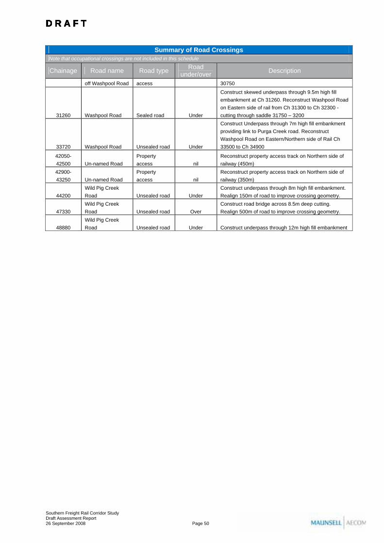
Summary of Road Crossings Note that occupational crossings are not included in this schedule
Chainage Road name Road type Road under/over Description
off Washpool Road access 30750
31260 Washpool Road Sealed road Under
Construct skewed underpass through 9.5m high fill embankment at Ch 31260. Reconstruct Washpool Road on Eastern side of rail from Ch 31300 to Ch 32300 - cutting through saddle 31750 – 3200
33720 Washpool Road Unsealed road Under
Construct Underpass through 7m high fill embankment providing link to Purga Creek road. Reconstruct Washpool Road on Eastern/Northern side of Rail Ch 33500 to Ch 34900
42050-42500 Un-named Road
Property access nil
Reconstruct property access track on Northern side of railway (450m)
42900-43250 Un-named Road
Property access nil
Reconstruct property access track on Northern side of railway (350m)
44200 Wild Pig Creek Road Unsealed road Under
Construct underpass through 8m high fill embankment. Realign 150m of road to improve crossing geometry.
47330 Wild Pig Creek Road Unsealed road Over
Construct road bridge across 8.5m deep cutting. Realign 500m of road to improve crossing geometry.
48880 Wild Pig Creek Road Unsealed road Under Construct underpass through 12m high fill embankment
D R A F T D R A F T D R A F T D R A F T D R A F T D R A F T D R A F T D R A F T D R A F T D R A F T D R A F T D R A F T D R A F T D R A F T D R A F T D R A F T
Southern Freight Rail Corridor Study Draft Assessment Report 26 September 2008 Page 50

Table 8 Summary of Major Drainage Structures
Summary of Major Drainage Structure Note that regular drainage structures (culverts etc) are not included in this schedule
Watercourse Chainage Approximate Description
Western Creek 350 - 850 500m Structure to span a farm dam, Waters Road and Western Creek
Western Creek 300 - 800 (Rosewood tie-in) 500m Structure to span Waters Road and Western Creek
Bremer River 3825 42m 3 span skewed structure
Warrill Creek 16350 42m 3 span skewed structure
Purga Creek 20700 - 20900 200m Purga creek
Purga Creek 21200 - 21400 200m Purga creek floodplain
Sandy Creek 25975 56m 4 span structure
Dugandan Creek 40750 14m Single span structure
Dugandan Creek 40900 14m Single span structure
Wild Pig Creek 44890 14m Single span structure
Teviot Brook 51420 42m 3 span skewed structure
4.4.2 Number of Properties subject to land requirements for the project
Properties subject to land requirements for the project are those that are traversed by the area subject to the CID, while adjoining parcels are those which are directly abutting (or directly across the road from) these parcels. These two definitions are important for the CID process, as it is a requirement that all traversed and adjoining properties are identified, and their landowners consulted appropriately during the process. Table 9 shows the numbers of both categories of properties. Adjoining properties are defined as per the CID Guidelines as any property directly abutting (or directly across the road from) a property subject to land requirements.
Table 9 Properties subject to land requirements and adjoining properties
Number of Properties Properties subject to land requirements for the project
105
Adjoining properties 242
4.5 Project Justification and Need This section of the Draft Assessment Report provides details that justify the need for the project in the context of the impacts discussed elsewhere in the Draft Assessment Report. This discussion is complemented by the findings of the preliminary Cost Benefit Analysis undertaken in Section 18.0 of this report, and Technical Paper 12 – Economic Analysis (Volume 2). It should be noted that the current study does not include a business case assessment for the project, the completion of which would need to be undertaken separately in accordance with Queensland Government Treasury requirements.
D R A F T D R A F T D R A F T D R A F T D R A F T D R A F T D R A F T D R A F T D R A F T D R A F T D R A F T D R A F T D R A F T D R A F T D R A F T D R A F T
Southern Freight Rail Corridor Study Draft Assessment Report 26 September 2008 Page 51

4.5.1 Need for the Project
The SEQRP and SEQIPP both outline that freight volumes across Queensland are expected to double by 2020 as a consequence of sustained economic growth and population growth. The SEQ Intermodal Freight Terminal Study (QT, 2008, see Section 4.1.3) more specifically states with regards to South East Queensland that by 2026: • Inbound freight movements (including freight in transit though SEQ) will increase from 29Mt to
73Mt, whilst outbound movements will increase from 26Mt to 46Mt in 2026. This imbalance has the potential to change the cost structure of transport and influence the future location of industrial development and freight corridors required to service demand; and
• This imbalance is expected to result in changing cost structures for road and rail and will see rail capture a larger share of interstate freight traffic by 2026. By 2026 rail's percentage of the total freight task is expected to be Brisbane to Melbourne (50 - 65%), Brisbane to Sydney (20 - 30%) and North Queensland (40 – 50%).
If rail is to capture this potential increase in freight task share over the next two decades there is a need for significant investment in infrastructure to ensure that existing and likely capacity constraints are removed. In particular, achieving a 50-65% share of the Brisbane-Melbourne freight task would be largely contingent on the completion of the Inland Railway as discussed above (Section 4.1.2). Importantly, without construction of the SFRC, any future Inland Railway would not be able to access the existing urban network due to capacity constraints on the existing network, the urbanised nature of the existing corridors and conflicts between double-stacked containers and existing electrification infrastructure. The SFRC provides a crucial link between a future Inland Railway and the existing Standard Gauge network thus allowing access to existing terminals at Acacia Ridge and the Port of Brisbane. The SFRC also has an important role to play in the development of additional Intermodal Freight Terminal capacity in SEQ. In particular, as a key connection between a future Inland Railway and the SGR, construction of the SFRC will play a potentially significant role in the determination of the preferred medium and long term solutions for IFT capacity in the region. Specifically, a terminal option at Ebenezer would be highly contingent upon the Inland Rail and SFRC proceeding. Likewise, the relative attraction of a Bromelton terminal option would increase if the Inland Rail and SFRC were to proceed.
D R A F T D R A F T D R A F T D R A F T D R A F T D R A F T D R A F T D R A F T D R A F T D R A F T D R A F T D R A F T D R A F T D R A F T D R A F T D R A F T
Southern Freight Rail Corridor Study Draft Assessment Report 26 September 2008 Page 52
4.5.2 Alternatives to the Project
In considering the justification for proceeding with the project it is important to give consideration to available alternatives, including a ‘do-nothing’ case.
Do-nothing case
The ‘do-nothing’ case for this assessment (i.e. not proceeding with the SFRC) would have a number of possible implications. Options for the proposed Inland Railway would likely terminate at Charlton, west of Toowoomba and rely on road freight for transport to Brisbane. Under this scenario the Inland Railway would not have connectivity to existing terminals at Acacia Ridge and the Port of Brisbane, except via the existing narrow gauge network. Ernst& Young gave consideration to this scenario in the North-South Rail Corridor Study (2006) and as discussed in section 3.1.2, found that: “tonnages on the route would be somewhat lower with one of the route variants: namely, constructing an inland route from Melbourne to a point near Toowoomba and transferring the freight to trucks for the remainder of the journey to Brisbane. It is unlikely that building and operating a terminal close to Toowoomba and completing journeys through to Brisbane by truck would meet the expectations and requirements of customers.” Accordingly, it is considered that the do-nothing case for the SFRC would reduce the effectiveness and efficiency of a future Inland Railway. Without connectivity to the Inland Railway there would also be limited justification for a future Intermodal Freight Terminal at Ebenezer.
Upgrade of Western Line
An alternative option to the SFRC is for the existing western line to be upgraded to allow for standard gauge, double-stacked trains between Rosewood, Corinda, Yeerongpilly and Acacia Ridge. This upgrade would consist of the construction of a new standard gauge line adjacent to the existing corridor for its entire length. Upgrade of existing lines to dual gauge is not considered feasible due to height conflicts between double-stacked containers and existing electrification infrastructure and capacity constraints associated with existing passenger operations and narrow gauge freight movements. Constructing a new standard gauge line adjacent to the existing corridor would be extremely difficult to achieve. The corridor in question is highly urbanised with development built immediately adjacent to the corridor in many instances. Areas of particular conflict would include the Ipswich CBD, Darra-Corinda (currently being upgraded to four passenger tracks) and Tennyson. The property acquisition implications alone are considered a fatal flaw to this alternative. There are physical horizontal clearance issues associated with platforms and a dual gauge track, axle load limitations of the existing bridge structures, and clearance issues with existing substantial overhead structures including the Ipswich City Square development and numerous road and pedestrian overpasses. Other issues that would be significantly difficult to overcome would include the upgrade of a large number of level crossings, bridges and junctions along the alignment.
Alternative Northern Options
During public consultation for the current study a number of community members suggested that further consideration should be given to alternative northern options based largely on variations of the alignments previously considered in the 2005 Southern Infrastructure Corridor Study (2005) (see Section 4.1.1). In particular, it was suggested that consideration should be given to a hybrid option consisting of a combination of alignment options N1 and C1 via a new link following low lying land through the Ripley Valley (see Figure 4).
D R A F T D R A F T D R A F T D R A F T D R A F T D R A F T D R A F T D R A F T D R A F T D R A F T D R A F T D R A F T D R A F T D R A F T D R A F T D R A F T
Southern Freight Rail Corridor Study Draft Assessment Report 26 September 2008 Page 53

The Ripley Valley was identified prior to the 2005 study as future location for significant residential development over the next 20 years as a key component of the SEQRP’s western corridor growth strategy. In the intervening time the Ipswich City Council has adopted the Ripley Valley Structure Plan which sets out a strategy for the development of the Ripley Valley as a home for as many as 120,000 people (see Figure 35). Any proposed freight rail alignment through the Ripley Valley would have a significant impact on the development proposed for the area. Any such proposal therefore represents a significant conflict with the objectives of the SEQRP and local planning instruments.
Figure 35 Ripley Valley Structure Plan
It was also suggested by members of the community that an alignment through this area would provide an opportunity to have a freight terminal located directly adjacent to a significant future distribution area rather than at Ebenezer. Evidence suggests that locating a freight terminal amongst residential development that form part of the ultimate user group of the freight does not bring benefit to either consumer or freight transporters. It is considered that a freight terminal in the Ripley Valley would be significantly constrained from an operations perspective due to its impact on surrounding urban areas, as has been a long term issue for the operators of the Acacia Ridge terminal, for example. Furthermore, Ebenezer is suitably located from a transport infrastructure perspective to be able to service surrounding areas such as Ripley Valley as well as other major markets throughout South East Queensland. The siting and development of any freight terminal along the SFRC is beyond the scope of this study and this study provides a passive provision for such a terminal.
D R A F T D R A F T D R A F T D R A F T D R A F T D R A F T D R A F T D R A F T D R A F T D R A F T D R A F T D R A F T D R A F T D R A F T D R A F T D R A F T
Southern Freight Rail Corridor Study Draft Assessment Report 26 September 2008 Page 54