southeast queensland fire and biodiversity consortium fire ...dennismccart/fire...
TRANSCRIPT

Southeast Queensland Fire and Biodiversity Consortium
Fire ManagementOperational Manual
Guidelines for planning and conducting fuel reduction and ecological burns on your property

Best Practice Fire Management Manual
OPERATIONAL LEVEL
GUIDELINES AND PROCEDURES
Cuong Tran
SEQ Fire and Biodiversity Consortium
The Southeast Queensland Fire and Biodiversity Consortium aims to gatherand disseminate information on fire management practices that will supportconservation of the region’s biological diversity.
The project covers the area from Noosa Shire in the north to the New SouthWales border, and from the islands of Moreton Bay to the Great DividingRange in the west.
January 2002

Flowchart of Fire and Biodiversity Consortium Products…where does this product sit in the big scheme of things?
Strategic Fire Management Manual– Aimed at local government to plan a
city-wide fire management plan– Aspects include strategic overview,
infrastructure needs, hazard mapping,ecological role of fire etc.
– Highest level document coveringbroad aspects of fire managementacross region
Operational FireManagement Manual
– Aimed at landownersand local govt. to planand conduct hazardreduction orecological burns onproperty
– Aspects covered incl.fire-line construction,fire behaviour, fireprescriptions,ecological fire regimesetc.
Fire Monitoring Manual– Aimed at local govt. to
monitor and evaluatefire managementobjectives on councilland (landowners canuse and adapt also)
– Aspects covered incl.monitoring methodslinked to questions,advantages anddisadvantages ofmethods etc.
– Adaptive management
Individual Property FireManagement Planning
Kit– Aimed at landowners
and local govt. to doproperty firemanagement plan
– Aspects covered incl.identifying fire risk,fire regimes,preparedness, fire-lines etc.
Research Projects List– Identifies and priortises fire-
ecology research in SEQ– Research will assist with
clarification of fire frequenciesto maintain biodiversity etc.
Ecological Guidelines– Relate current knowledge/info.
to SEQ region– Summaries information and
provides ‘best-guest’ firefrequencies for vegetationtypes in SEQ
Literature Review– Review of current information
on fire ecology and regimes– Adapt information for forest
types in SEQ– Identify knowledge gaps
Level–2 Brochure– Educational booklet with fire
ecology and management info.– Aimed at landowners with
developing interest in fireecology / fire management
Level–1 Brochure– Introductory fact-sheet on fire
and nature conservation– Contains basic fire ecology
concepts and importantmessages
THIS DOCUMENT

Table of Contents
PageAcknowledgments......................................................................................................... i
Purpose of Operational Manual....................................................................... 2Glossary of Terms........................................................................................... 3
Introduction ........................................................................................................ 4Vegetation Types–Outcomes from Ecological Guidelines .......................................... 6Fuel Reduction Burning .............................................................................................. 7
Objective of Fuel Reduction............................................................................ 7Objective of Ecological Burning ..................................................................... 7Clearing and Zoning ....................................................................................... 8Concept of Property Protection Zones (PPZ)................................................... 9Concept of Fuel Management–Monitoring and Other Aspects to Consider ...... 9
What is Fuel and How Do You Measure It? ............................................................. 10How Do I Measure The Fuels on My Land?.................................................. 11
What is Fire Behaviour and the Effects of the Weather on Fires?........................... 12Fire Behaviour? ............................................................................................ 12Wind Speed and Fire Behaviour.................................................................... 13
Changes in Wind Direction ............................................................ 14A Note About Project Vesta on Fire Behaviour .............................. 14
Relative Humidity......................................................................................... 14Atmospheric Instability................................................................................. 15Topography .................................................................................................. 15The Influence of Slope.................................................................................. 15
Fire Danger Rating – Using the Fire Danger Meter................................................. 16Calculating the McArthur Fire Danger Index................................................. 17What Fire Management Practices can be conducted with Low DI? ................ 18What Fire Management Practices can be conducted with High DI? ............... 18A Quick and Easy Way to Measure the Drought Index.................................. 19
Ecological Regeneration Burning.............................................................................. 20Fuel Reduction Options Without Use of Burning..................................................... 21
Manual Removal of Fuel............................................................................... 21Stock Management for Managing Fuel Loads ............................................... 21Replacement Planting with Less-Flammable Plants....................................... 22
Fire-lines ...................................................................................................... 23Purpose of Fire-lines ...................................................................................... 23Location of Fire-lines.................................................................................... 24Other Important Considerations .................................................................... 28
Removal of Fuel............................................................................. 28Allocation of Fire-lines .................................................................. 28Use of Existing Infrastructure......................................................... 28Maintenance of Fire-lines............................................................... 29Rehabilitation of Fire-lines............................................................. 29
Preparing Fire-lines on Your Property..................................................................... 30What’s Involved in Making a Fire-line? ......................................... 32What If We Have Less Than 5 People Available?........................... 34
Water Sources ...................................................................................................... 36Weather Prescriptions for Low Intensity Burning................................................... 37
Timing of Burns–Points to Consider ............................................................. 39Summer or Winter Burning? ......................................................................... 40Smoke Management and Weather Conditions ............................................... 41
Low Intensity Planned Burning ................................................................................ 42Use the Concept of a Multi-Year Burn Schedule ........................................... 42
Incorporating Unplanned Burns into Your Burn Schedule ............................. 42Incorporating Variations in Weather/Rainfall into the Burn Schedule ............ 42Types of Low Intensity Planned Burns.......................................................... 43
Medium–High Intensity Planned Burning................................................................ 44Preparation Prior to Day of Burn ............................................................................. 46
Your Approach to Burning............................................................................ 46Safety Issues................................................................................................. 47Inspection of Area(s) to be Burnt .................................................................. 47Preparation of Burning Plans ........................................................................ 48Are the Weather and Fuel Conditions Suitable to Burn? ................................ 50
Procedure on the Day of the Burn............................................................................. 51Post-Burn Follow-Up.................................................................................... 52
Conducting the Planned Burn................................................................................... 53Lighting Patterns .......................................................................................... 53
Burning Operations Guide........................................................................................ 56Who should light?......................................................................................... 56When to light? .............................................................................................. 56
Mopping Up and Patrol............................................................................................. 59Fighting the Fire ........................................................................................... 61Fire Extinguishing Practices.......................................................................... 61Procedure After the Burn .............................................................................. 63
Recording–An Essential Element of Fire Management ................... 63Adaptive Management–How Can We Do Better?.......................................... 64Implications for your Individual Property Fire Management Planning Kit ..... 64Rehabilitation of Fire-lines & Other Areas .................................................... 65Equipment Checks and Repairs After the Fire ............................................... 65Fire Behaviour Calculation & Monitoring ..................................................... 66
Notification of the Public........................................................................................... 68Planned Burning Notification Checklist ................................................................... 70Escapes and Accidental Fires Report Checklist ....................................................... 71Fire Competency–Training Options ......................................................................... 73Other Important Information ................................................................................... 74Final Checklist Before You Light.............................................................................. 76References ...................................................................................................... 95Consortium Products................................................................................................. 96
Appendices1–Fuel Assessment Guide....................................................................................... 79–802–McArthur Fire Wheel (Steps to Use) ........................................................................ 813–Firecom Contacts..................................................................................................... 834–Day of Burn Record................................................................................................. 845–Fuel Reduction and Ecological Burning Reduction Form .................................... 85–906–Beaufort Scale (Wind Speed) ................................................................................... 927–Comprehensive First Aid Kit ................................................................................... 94

LIST OF TABLESTable 1–Fire Intensity and Rate of Spread are Affected by:.......................................... 12Table 2–Forest Fire Danger Index Ranges.................................................................... 16Table 3–Explanation of Drought Index and Soil Conditions ......................................... 17Table 4–Desgin Standards for Fire-lines ...................................................................... 26Table 5–Cross/Side Drain spacing ............................................................................... 27Table 6–Cross-drain Spacings Based on Slope............................................................. 34Table 7–Operational Parameters for Burning in SEQ ................................................... 37Table 8–Operational Parameters for Late Summer/Autumn Burning in SEQ ................ 39Table 9–Spot fire spacing calculator ............................................................................ 54
LIST OF FIGURESFigure 1–Clearing and Zoning Patterns for Property Protection...................................... 8Figure 2–Visual Estimation for Fuel ............................................................................ 11Figure 3–A Fire is Influenced by… ............................................................................. 13Figure 4–The Effect of Slope....................................................................................... 16Figure 5–The ‘Step Up’ Method of Fire-line construction ............................................ 31Figure 6–Fire-break construction for logs .................................................................... 33Figure 7–Preparation of fire-lines around habitat trees ................................................. 34Figure 8–Single leaf tests for flammability................................................................... 50Figure 9–Single spot fires ............................................................................................ 53Figure 10–Line of fires down spurs.............................................................................. 54Figure 11–Line of fires across slopes ........................................................................... 55Figure 12–Fires for well-spaced spots .......................................................................... 55

Southeast Queensland Fire and Biodiversity Consortium – Operational Manual i
Acknowledgments
A number of people contributed to the material contained in this report. Firstly, I thankPenny Watson for her insight into the world of fire ecology and for her meticulous workethic, making the transition stress and hassle-free.
Thanks for everyone who provided comment on the draft manual, but in particular to CarmelPeacock, Mark Webster, Neil Gourley and Geoff Borschmann for making this a better andmore useful document. To Mark Webster and Neil Gourley – thank you for letting me putyour experience and knowledge to paper, and for the use of your training manuals,photographs etc.
The Fire Management Planning Working Group, chaired by Sharyn French were an excellentsupport for me and provided wonderful feedback in the development process of the Strategicand Operational Manuals. The Steering Committee, as always, provided wonderful supportthroughout the whole process – Kate Kraschnefski, Bernie Trembath, Paul Donatiu,Christine Pfitzner, Joe Purcell, Clyde Wild and Carmel Peacock – are a great working teamand helped guide me through an exhaustive process for this manual and the other remainingproducts, I am indebted to all of you.
To the wider Consortium, I thank you for your continued support and enthusiasm.
Finally, to Anne-Marie Lindesay and my family for their love and support.

Southeast Queensland Fire and Biodiversity Consortium – Operational Manual Page 2
Purpose of Operational Manual
The primary target group of the “Operational Manual” is private property owners who wish toconduct planned burns for the purposes of hazard reduction and/or ecological purposes. It mayalso be of use to councils and other land management agencies wishing to conduct burns.Furthermore, it could also be of use for fire wardens, rural fire brigades, councils, and large stateagencies in working with community members.
The document provides information on preparing your property for prescribed burning, theprocedures and requirements to follow and what weather conditions are most suitable for thefire. The Operational Manual also covers aspects of fire monitoring and evaluation, andemergency procedures to follow.
This is not a training manual. It will assist you with the planning and provisions that you willneed to cover before you conduct a burn.
The Operational Manual and the Individual Property Fire ManagementPlanning Kit
These two manuals from the Fire and Biodiversity Consortium are accompanying documents.
They have been designed to help landowners develop a fire management plan (IndividualProperty Fire Management Planning Kit) through to implementing and conducting a burn(Operational Manual).
When you have completed your fire management plan, you should submit a copy to:
1. Your local Rural Fire Brigade
2. Your local Council – Environment Services (or similar)
3. (if you are close or next to large conservation areas like a National Park or State Forest)the Queensland Parks and Wildlife Service or Department of Primary Industries.
If these organisations know your burn schedule, then there will be increased cooperation andcoordination which will be extremely valuable for risk/hazard reduction and biodiversityconservation.
Southeast Queensland Fire and Biodiversity Consortium – Operational Manual Page 3
GLOSSARY OF TERMS
Firebreaks – are constructed breaks of discontinuity (irregular or patchy) of the fuel bed usedto segregate, stop and control the spread of wildfire or to provide a fireline from which tosuppress a fire. Firebreaks should be located in areas where fuel levels are lowest, which willincrease the chances of successfully containing a fire. Compare with vegetative firebreaks.
Fire trails – are usually roads constructed and maintained for fire management purposes to anappropriate standard. Fire trails are likely to be more trafficable than tracks and are also used forprescribed burning and other fire management practices.
Fire tracks – are tracks or roads constructed and maintained expressly for fire managementpurposes. They are generally of a lower standard of construction than trails. Some examplesinclude: tracks to water sources and strategic access routes for fire suppression.
Vegetative Firebreaks – also known as ‘green firebreaks’. These are areas that contain lowerflammability vegetation (groundcovers, shrubs and trees) which can be used similarly to regularfirebreaks. These firebreaks can vary in length and width. The advantages of these firebreaks arethat in addition to arresting the spread of fire due to inherent characteristics, they can absorbradiant heat, trap embers and reduce wind intensity.
Mop–Up – is the process of ensuring all fires, smouldering logs, branches and any othermaterial that is still in combustion is completely and properly extinguished. This term alsorefers to the patrolling that is required. To ‘mop-up’ is to patrol and put out any fires.
Rakehoe – is a tool that has been specifically designed for fire-fighting, preparing andconstructing fire-lines.
Spotover – (or flashover) is a term that is given to a situation where fire that has escaped into anarea beyond your fire-line or perimeter. Essentially, a spotover has the potential to become alarge wildfire, as it has progressed beyond control lines and personnel. During wildfires,spotovers can occur over many kilometres.
Incident Controllers – are fire-fighting personnel who have been specifically trained inmanaging and handling fire–suppression and reduction burn procedures. Incident Controllershave excellent knowledge of (a) fire behaviour, (b) operations plans, (c) weather forecasts, and(d) logistics of operation. Incident Controllers form one part of the ‘Fire Team’.
Headfire – is the term given to the main front of the fire. A headfire burns with the direction ofthe spread of the fire (which closely follows the wind direction).
Flankfire – refers to the ‘sides’ of a fire. This is generally perpendicular to the direction of thefire spread. Flankfires can quickly form into a headfire, given a wind change. This can be highlydangerous.

Southeast Queensland Fire and Biodiversity Consortium – Operational Manual Page 4
Introduction
Fire is a characteristic and influential part of the Australian environment and has been for manymillions of years (Moran and Watson 2000).
As Watson (2001) and others (eg Tran and Wild 2000) have stated, the major vegetation typesthroughout Australia are characterised by particular natural fire frequencies. Depending uponthe type of understorey, dry eucalypt forests have frequent fires with fire intervals ranging from3–6 years (grassy understorey) and 7–25 years (shrubby understorey). The majority of fires arelow intensity and often burn in patches amongst the forest, which ultimately results in a multi-aged stand containing seedling, saplings, regrowth and mature trees. Wet-sclerophyll (or wet-eucalypt) forests often have dense understoreys with fire intervals ranging from 20–100 years.Fires in these forest types are usually of high intensity, and is characterised by eucalyptregeneration which is largely even aged. Coastal heathlands cover a wide ranges of vegetationtypes and composition, with some heathlands often treeless and may be both ‘wet’ and ‘dry’often depending on the relationship with the water table. Typically, coastal heathlands have afire frequency of 7–20 years. The fire frequencies of mountainous rocky heath is very dependenton the surrounding vegetation complexes. With this in mind, a fire frequency of 15–50 yearsgenerally occurs in these areas. Melaleuca wetlands often adjoins heath and eucalyptwoodlands. Similar to rocky heath, the capacity for Melaleuca to burn is quite often dependenton the neighbouring vegetation types. It would seem apparent that fire frequencies between 15–30 years are suggested for this vegetation type, but this is still very speculative.
Some vegetation communities, such as rainforest can be very fire sensitive and dominant treesshow no clear adaptation to fire. Even though there is empirical evidence to suggest rainforestcan often regenerate quite vigorously after fire, in general, fires should be excluded from theseareas. The distribution of this forest type is quite dynamic and changes in the fire intervals insome areas may cause a change in the species composition and structure of the forest.
With fire exerting such a dominant influence on the local vegetation, the use of fire in nativeforests needs to take account and notice of the natural fire frequencies in the forest type beingmanaged. Previous management practices of exclusion of fire from a forest (other thanrainforest and associated complexes) especially in fire-adapted and dependent ecosystems canoften result in the very large accumulation of fuel. When a fire occurs is such forests, the resultis often uncontrollable, highly destructive fires rather than a lower intensity fire which would dolittle damage to the dominant trees. Therefore, in fire-adapted vegetation, it is neither desirablenor feasible to exclude fires. The better solution is to ensure that the fire-adapted forests burnswithin a fire regime consistent with its ecological requirements, that also lowers fire risk.
This document outlines the procedures of conducting burns on your property. The purposes ofburning are either to:
1. Reduce fuel loads of surrounding vegetation (lowering fire risk, reducing fire intensityof fires etc.), or
2. To achieve ecological objectives (eg the area has reached its maximum recommendedfire interval etc.).
This document will outline the procedures required to perform fuel reduction/ecological burnson your property. It provides detailed information on the pre-burn procedures, fire-weather andpredicting fire-behaviour of burns, fire-mitigation procedures such as firebreaks and fire-lines,

Southeast Queensland Fire and Biodiversity Consortium – Operational Manual Page 5
and post-burn procedures. The document also outlines the procedures to follow should burnsescape, what resources and access points are required and the necessary legal requirements(permits etc.) that are necessary to obtain before burns are conducted.
This Operational Manual fulfils one of the objectives of the South-east Queensland (SEQ) Fireand Biodiversity Project. This project, which is funded by the National Heritage Trust throughthe Bushcare program, is managed by Logan City Council on behalf of the SEQ Fire andBiodiversity Consortium (FABC). The Consortium includes representatives from localauthorities throughout SEQ, the Rural Fire Service, the Queensland Parks and Wildlife Service(Parks and Forest Management divisions), the Department of Primary Industries, Landcare,Greening Australia Queensland, and Universities. Other Consortium products include anindividual property fire management planning kit, ecological guidelines with recommended fireregimes and fact sheets targeted to private landholders (list is available at end of the document).

Southeast Queensland Fire and Biodiversity Consortium – Operational Manual Page 6
Vegetation Types—Outcomes from Ecological Guidelines
We have extensively covered the importance of fire in the Australian landscape (Watson 2001,Tran and Wild 2000). There is no need to repeat this information, however it is worthwhilesummarising the recommended fire-regimes for the different vegetation community typesoccurring in the southeast Queensland region. To reiterate one of our key messages: “Differentvegetation types will require different fire frequencies”. Therefore, if you have a variety ofvegetation types on your property, it is important to recognise the distinct ecological andmanagement requirements of each vegetation type. This is particularly significant when you areplanning ecological burning to conserve biodiversity.
NOTE: Remember you must decide what the objective of your burning program is. If it ispurely for ecological management purposes, then you should try to maintain variability in fireregimes and use the fire-frequency regimes as we have outlined below. Alternatively, if you areburning to promote grass-growth or purely for protection purposes, you may have to sacrificesome ecological values. This is the same message we have used in the Individual Property FireManagement Planning Kit, providing a balance between property protection and biodiversityconservation.
In the table below, recommended fire-intervals for vegetation types are summarised. It is highlyrecommended that landholders read the ‘The Role and Use of Fire for Biodiversity Conservation in
South-east Queensland: Fire Management Guidelines Derived from Ecological Research’ by PennyWatson (2001) to gain a better understanding of the concepts of fire ecology and the role of firein the Australian environment.
Suggested Fire Intervals for Vegetation Types in SEQVEGETATION COMMUNITY TYPE SUGGESTED FIRE INTERVALS
Rainforest Fire exclusionWet-Sclerophyll Forest 20–100+ yearsDry Sclerophyll Forest & Woodlands 3–6 years (grassy understorey)
7–25 years (shrubby understorey)Heathlands 7–20 years (coastal heath)
15–50 years (rocky heath)Melaleuca quinquenervia (Paperbark)woodlands
15–30 years
Adapted from Watson (2001)
The other key point for fire frequencies and biodiversity conservation is variability, both inseason and time. Creating a mosaic (or patchwork) of different ages of forest exposed todifferent time-since-fire will provide the most varied environments which will support thehighest species diversity.

Southeast Queensland Fire and Biodiversity Consortium – Operational Manual Page 7
Fuel Reduction Burning
Low intensity planned burning is best defined as “…(planned) burning that is undertaken whereweather conditions and the state of the fuels are such that fire intensity is restricted, resulting inonly target light fuels being burnt without damage to other values (property or ecological) andthe fires can be controlled or go out overnight” (adapted from Tasmania Parks and WildlifeService 1998). The DPI (Forestry) Fire Manual (1998) describes ‘prescribed burning’ as “theskilful application of fire to natural fuels under conditions of weather, fuel moisture and soilmoisture that will allow confinement of the fire to a predetermined area, at rates of spread andintensity appropriate to providing planned benefits with minimum damage at an acceptablecost”.
Objectives of Fuel Reduction
The most common objective of fuel reduction burning is to reduce fuels safely and withminimum damage to the remaining standing vegetation to reduce wildfire intensity, rate ofspread and damage and make fire-suppression efforts quicker, cheaper and most importantlysafer. To achieve this objective, every burn must aim to:
(a) minimise (fire) escapes
(b) reduce fuel on 70% or more of the planned burning area
(c) cover 60–80% of planned burn area in a mosaic (or patchwork) pattern
(d) keep the area of the total crown scorch to less than 10% of burnt area
(e) ideally, no significant scorch with average flames no greater than 1.0 m in height
(f) fire rates of spread in the range of 40–100 m/hr and intensities below 500 kw/m
Objective for Ecological Burning
The objective of this type of understorey/habitat manipulation is to maintain an environmentbecause:
(a) the area has reached its maximum suggested fire intervals as specified in theEcological Guidelines (Watson 2001), or
(b) has been scheduled to be burnt to maximise variability and patchiness (mosaic) – ifthis is the case, it may not have reached the maximum recommended fire intervals
(c) there are rare or endangered plants in the area which are scheduled to be burnt
(d) it contains poorly conserved plant communities
(e) the area contains rare or endangered wildlife that requires the maintenance of avegetation community that is dependent upon a particular fire regime.
(f) there are weeds which may be controlled with fire, which will assist habitatreinstatement, or to
(g) promote seed activation of fire-adapted species.

Southeast Queensland Fire and Biodiversity Consortium – Operational Manual Page 8
CLEARING & ZONING ETC.
As the next section will illustrate, a zoning pattern is the only method to maximise protectionfrom fire risk in addition to maintaining suitable areas for conservation. This will include somelevel of clearing, especially in the close proximity of any built asset (home, shed, drive oraccess-way etc.). It has been recommended that these “inner zones” be completely removed ofcanopy-tree species, but can be maintained with shrubby/small tree species. In areas of high firerisk, safety issues warrant the removal of canopy species. If, however, the canopy species maybe significant in terms of providing refuges or habitat for wildlife then you may considerkeeping the species after some appropriate management (eg selective clearing of lower branchesand manual removal of fuel). The Individual Property Fire Management Planning Kit uses thiszonation concept for developing a fire management plan for your property. A depiction of this isshown below. The distances are useful only as a guide and not a rule (a useful rule of thumb –the tree height = distance from house). Use your own local knowledge and draw upon localexpertise to help determine the different zones and spacings required.
Figure 1 – Clearing and Zoning Patterns for Property Protection (from Gold CoastCity Council 1998)

Southeast Queensland Fire and Biodiversity Consortium – Operational Manual Page 9
CONCEPT OF PROPERTY PROTECTION ZONES (PPZ) – POINT TO INFORMATIONCOVERED IN THE INDIVIDUAL PROPERTY FIRE MANAGEMENT PLANNING KIT
Achieving the objectives of property protection and conservation of biodiversity is a difficulttask. In many instances these two objectives are mutually exclusive. The Individual PropertyFire Management Planning Kit covers the concepts of ‘property protection zones’ where werecommend that areas surrounding your assets become the primary protection zone, where mostwork will be required in vegetation management. It should be noted that not all of the vegetationwithin this zone require complete removal – rather the opposite, where some appropriate specieshave ‘fire-retardant’ characteristics assisting in slowing fire spread or intensity. The IndividualProperty Fire Management Planning Kit has some broad characteristics you should look for inassessing which trees or shrubs will be useful to maintain within your protection zone (refer toIndividual Property Fire Management Planning Kit – Step 3).
For other areas outside property assets, these outer zones will also require maintenance, whichmay include prescribed burning, the primary objective in these areas may be the conservation ofthe bushland, and therefore biodiversity, or other values associated with your forests such asfarm forestry.
Remember to consult your maps which shows all your assets and risks when planning a burnand to ensure the proper precautions are in place well before any fires are conducted.
CONCEPT OF FUEL MANAGEMENT–MONITORING AND OTHER ASPECTS TO CONSIDER
Fuels and how they can be measured will be discussed in the next section. It is important tomonitor the fuel loads of any high-fire risk areas that you have identified on your property. Thiswill assist you in planning burns in the future (in addition to contributing to your multi-yearburn schedules). Step 2 of the Individual Property Fire Management Planning Kit is assigned toassessing your ‘fire-risks’ and this section will provide some guidance on determining this levelof risk.
Monitoring fuel loads can be a laborious and time-consuming task. Typically, this involvessampling multiple areas of similar vegetation (to provide more representative sites) to sample,gravimetric (which is an analysis in which the amounts of the constituents, in this case fuels, aredetermined by weight) analysis of fuel and repeated sampling over a period of time (usuallymany months). However, for many landowners, it is not necessary to have such an involvedprocess with monitoring fuel loads. There are a couple of simpler methods available, whichinclude:
– visual assessment of fuel loads using a general guide (refer Figure 2)– visual assessment of ground and elevated fuel according to Victorian guidelines
(please refer to Appendix 1 at end of document – follow easy-to-understanddirections), or
– initiate photo-monitoring at fixed photo-points on your property, where points 2–3m apart are used as guides for photos.

Southeast Queensland Fire and Biodiversity Consortium – Operational Manual Page 10
WHAT IS FUEL AND HOW DO YOU MEASURE IT?
Trees and shrubs, regardless of the specific vegetation community type in which they occur,constantly produce fuels. In general, all plant material both living and dead can be considered as‘fuel’, because provided there is enough heat, all plant material will burn. There are threedifferent aspects of fuel, which will affect the fire behaviour during a fire. Fire behaviour will becovered in greater detail in the next section. These three aspects are:
1. FUEL TYPE
Obviously, plant material from various sources will burn with different degrees of intensities,and can be divided into broad categories (below):
PEAT OR HUMUS LITTER SHRUBS TREES CURED GRASSIncreasing fire intensity
NB: Cured grass may burn intensely, but usually very quickly. Large bushfires (eg Ash Wednesday 1983) arealways associated with crowning fires in trees.
2. FUEL CONDITION
The fuel condition relates to the fuel’s moisture content. Whether the fuel is ‘wet’ or ‘dry’ willdramatically affect the intensity of a fire. For example, some grasses will not burn even whengreen, but burns quite rapidly when fully cured (dried).
3. FUEL ARRANGEMENT
The arrangement of fuel has a dramatic effect on the way in which fuel burns. Twigs packedclose together will burn quite rapidly, but separate the twigs, and in all probability the fire willgo out. In planning your burn, study and locate the area for places where fuel is concentratedwhich could become a problem situation during a fire. If this is the case, additional resources orpreparation may be required to lower the risk of flare-ups, excessive scorch or escapes.
There is a fourth aspect which is a combination of the three key aspects outlined above. This isknown as fuel quantity…
4. FUEL QUANTITY – FUEL LOAD
Typically, the total accumulated fuel is known as the fuel quantity or fuel load. This is usuallyestimated over a particular area and is measured in tonnes per hectare (t/ha). The composition ofthis fuel load also has a significant effect on the fire behaviour. Fuels up to pencil thickness (6mm) such as dead leaves, twigs and bark are called ‘FINE’ fuels and quite possibly has one ofthe greatest effect on the rate-of-spread of fires (elevated or above-ground fuels being the other).In general, the doubling of the quantity of fine fuels will double flame height and rate of spreadand quadruples fire intensity and damage on each hectare. It also quadruples the area burntwithin a given time. As these effects are additive, the doubling of fine fuel quantity effectivelyincreases the damage by a staggering SIXTEEN TIMES (Tasmania Parks and Wildlife Service1998).
However, for some forests such as sub-tropical rainforests, the high decomposition rates resultsin small amounts of fuel load accumulating on the ground, which is one reason for the lower firerisk of these forest types. Conversely, in dry forests (such as eucalypt) decomposition cannotmatch the production, which allows fine fuels to accumulate and in general, more than 10tonnes of fuel per hectare will amass just 10 years following the last burn. Even though finefuels do stabilise over this period of time, heavier fuels, such as larger branches, logs, and deadroots will continue to accumulate until the next fire.

Southeast Queensland Fire and Biodiversity Consortium – Operational Manual Page 11
HOW DO I MEASURE THE FUELS ON MY LAND?
Fine fuels occur mostly as litter on the ground as standing scrub and their quantity can be easilymeasured and assessed without the laborious task of weighing and drying fuels.
The simplest method to estimate the fuel load in the area you plan to burn is:
1. Find a typical or representative patch (of land) within your planned area
2. Estimate (visually) the percentage (%) cover (amount of ground shaded by the fuel) in acircle approximately 2 m in diameter. Use a 1 m stick (such as a broomstick handle) to‘draw’ a circle around you to visualise this 2 m circle.
3. Record this information on your map of the planned burn.
4. Use the diagram (below) to estimate the fuel load in that area.
5. Repeat process for areas of different vegetation composition in your planned burn area.
Note: Choosing a representative area is not an easy task. Your local knowledge and expertisewill be very valuable in these circumstances. Alternatively, your local council or conservationgroup can assist in determining this.
Figure 2 – Visual estimation for fuel (from Tasmania Parks and WildlifeService 1998)
Another visual fuel estimation technique is also available (see Appendix). This technique hasbeen used widely used in southeast Queensland, by Queensland Parks & Wildlife Service(Wayne Kington, pers. comm.) and compares favourably (ie, produced accurate results) withmore traditional methods (gravimetric analysis etc.) from a number of studies (Kington, unpubl.data and Tran, unpubl. data). The step-step guide in the Appendix was developed in Victoria,and for many of the criteria is comparable to vegetation types that we have in southeastQueensland, with the notable exception, that of bark-hazard. In southeast Queensland, the bark-hazard is not as influential as in Victoria, and in most cases, bark-hazard will rank ‘low’ on thisfuel assessment scale.

Southeast Queensland Fire and Biodiversity Consortium – Operational Manual Page 12
What is Fire Behaviour and the Effects of the Weather onFires?
The prevailing weather conditions have the greatest influence on fires. Even if you havecompleted the best fire management planning possible, periods of prolonged drought or rain willmost certainly prevent you from burning during your scheduled times. Changes to someconditions such as relative humidity, temperature and windspeed will dramatically alter howfires will ‘behave’. In this section, we will introduce the concepts of fire behaviour and howthese environmental variables influence the way in which a fire will burn and what you need todo to measure these variables prior to and during your planned burn.
FIRE BEHAVIOUR?
We have already covered how fuels (and attributes such as compactness, fuel moisture andquantity) can affect fire behaviour. Fire behaviour is essentially a term describing how a firereacts to changes in environmental and physical conditions. For a fire to start there needs to bethree key ingredients which must be linked, and is commonly known as the ‘fire triangle’…
Remember, one of the prime objectives of your fire management plan is the reduction of fuel(the other being ecological purposes). The other two elements are beyond our control, but theycan be measured. Sound planning can take advantage of variations in oxygen (wind speed) andheat (temperature and relative humidity) that occur in a daily cycle or that can be predictedfrom prevailing weather patterns.
Fires are measured in terms of intensity (rate of energy released per metre of fire), ROS or RateOf Spread, size (extent or area burnt) and other variables including flame height, flame angleand flame depth. Webster (2000) summarised the factors that can affect fire behaviour as:
Table 1 – Fire intensity and rate of spread are affected by:1. type of vegetation
dryness of vegetationdensity of vegetationdepth of shrub layer
fuel
2. temperature of the daywind directionwind speedlow relative air humidityunstable atmospheric pressure
weather
3. slopes or complicated building shape topography4. width of ignition line
size and shapefire itself
Changing any factor – fuel, weather, or how the fire is lit – and the intensity,shape and speed and ‘controllability’ of a fire is also changed.

Southeast Queensland Fire and Biodiversity Consortium – Operational Manual Page 13
The manner in which fires can be lit and how this affects the landscape is discussed in thesection (Procedure on the Day of the Burn) below.
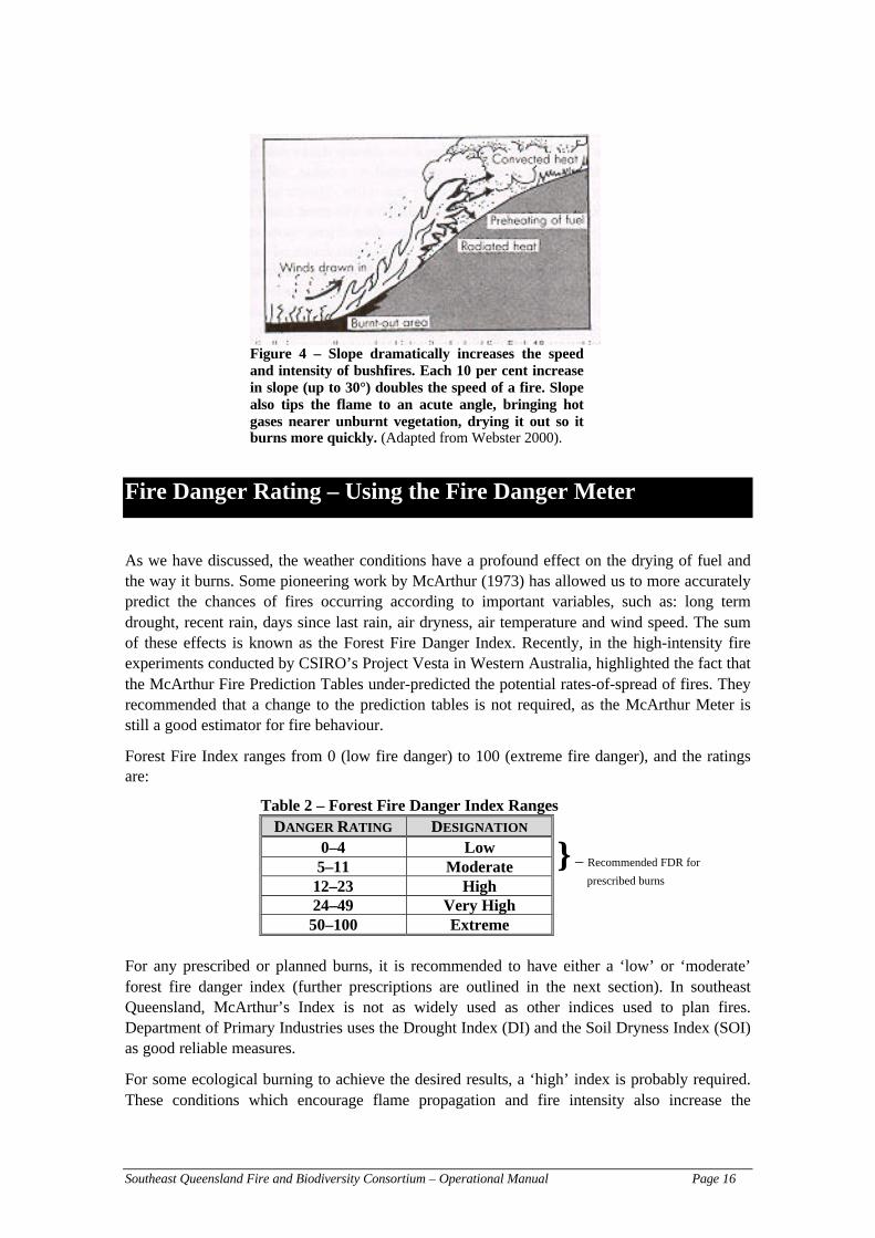
Figure 3 – A fire which is influenced by changing vegetation, windor topography will spread steadily in a widening circle, like aburning doughnut with a black, incinerated circle. Once thesefactors change, the shape of a spreading fire becomes elongated andthe fire front moves faster than the rear. (Adapted from Webster2000).
WIND SPEED AND FIRE BEHAVIOUR
Recent studies (Gould et al. 2001, Tran and Pyrke 1999) have shown that wind speed has thegreatest influence on fire behaviour. High wind speeds provide more oxygen for fires, angles thefire which allows a greater amount of preheating adding to combustion, can cause spotting (orsending firebrands or embers large distances downwind) and has a direct effect on relativehumidity. Winds that are the fastest and strongest have travelled over long flat distances(Webster 2000). The general rule for wind speed is a mathematical formula that predicts a fire’sspeed (or rate of spread) if the wind speed is known:
‘Wind speed increases fire speed by its square’ (adapted from Webster 2000)
For example: a fire is spreading at 50 m/hr with a wind speed of 5 km/hr. If the wind speedincreases to 10 km/hr, then the fire will spread at a rate of 200 m/hr. For this example the windspeed increased by a factor of 2 (ie doubling) – therefore, the fire will increase its rate-of-spreadby 2-squared (2²) or 4 times (ie 50 × 4 = 200 m/hr).
For wind speed to be accurately measured requires specialised equipment (vane or handheldanemometers) and a wide open clearing as any surrounding vegetation directly affects windspeeds. In many cases, this type of equipment or clearing is not available. It is generallyaccepted that the ‘Beaufort Scale’ ranging from 0 (calm conditions) to 12 (hurricane conditions)which was devised in the 1800s is an accurate estimator of the wind speed and today remainswidely used. This scale uses visual cues such as the effect of the wind on local vegetation(movement of twigs, branches) and other noticeable features (smoke, dust etc.) to estimate windspeeds. The Beaufort Scale is included in the Appendices.
Southeast Queensland Fire and Biodiversity Consortium – Operational Manual Page 14
CHANGES IN WIND DIRECTION
In addition to wind speed, changes in the direction where the wind is travelling from will alsohave a strong influence on fire behaviour. As stated above, it is the hot, dry winds that flowacross the continent that cause most fires. For southeast Queensland, it is the westerly or north-westerly winds which are associated with worsening fire weather (ie, increase chances of fireescapes and wildfires). The other meteorological phenomenon associated with the fire-seasonthat may be significant to changes in fire-behaviour is the passage of a cold front. This is usuallylinked to a wind change to the W-SW, that could cause an eastern fire flank becoming the mainfront, that will result in a substantial increase in the fire area and increase danger to personneland fire-fighters.
NB: when you talk about wind direction, it means where the wind originates from, NOT wherethe wind is blowing too.
A NOTE ABOUT PROJECT VESTA (MEDIUM-HIGH INTENSITY EXPERIMENTAL FIRES
CONDUCTED BY CSIRO), AND HOW FIRE BEHAVIOUR IS AFFECTED BY CHANGING WIND
SPEEDS
Results from this project, conducted in the dry-eucalypt forests in Western Australia, shows thatthere is threshold of 12–15 km/hr for wind speed and fire behaviour. At wind speeds belowthis threshold, fire ROS may appear deceptively slow, but as wind speeds pass this threshold,there can be a large increase in fire behaviour. Be wary of this wind speed threshold!
More information on this project can be found on the Internet at:http://www.ffp.csiro.au/nfm/fbm/vesta/index.html
RELATIVE HUMIDITY
Relative humidity (RH) is the relative degree of dampness in the air at any particulartemperature, and the air’s ability to hold moisture rapidly increases with temperature (Webster2000). Relative humidity strongly influences bushfire behaviour, as much as temperature andwind speed. As Webster (2000) explains, even in mild temperature conditions, low relativehumidity encourages the spread of bushfires by evaporating moisture from vegetation, and anyspark will quickly set grass and other understorey alight. If wind speed increases or a change inwind direction is present, control becomes increasing difficult.
The general guidelines are as follows:
Relative Humidity usually reaches its lowest between midday (12 p.m.) and 3p.m.
Relative Humidity of 30% or less is the danger mark. At 30% RH, sparkscan be given off burning material which may cause spotting. Relative humidityvalues below 15% usually become a critical situation (after Webster 2000).
As Webster (2000) explains “vegetation is the fuse that leads to bushfire, and low relativehumidity is the match. It adds the vital ingredient to the recipe for extremely dangerous bushfireweather and has been the distinguishing attribute of all major conflagrations.”
Measuring the relative humidity requires some prior knowledge of meteorology and the use of awet and dry bulb hygrometer. The Bureau of Meteorology can also provide relative humidity
Southeast Queensland Fire and Biodiversity Consortium – Operational Manual Page 15
readings from the closest weather station to your property. Their details are provided in the‘Procedures on the Day of the Burn’ section.
ATMOSPHERIC INSTABILITY
In the worst fire conditions, atmospheric instability causes ‘high-reaching’ flames, crown firesand long spotting distances, which is usually detectable from accompanying gusty winds thatmake fire behaviour very difficult to predict and control (Webster 2000). Webster (2000) furtherexplains that in calm conditions, an inversion layer (a layer of stable air) inhibits the rising ofwarm air convection currents. However, before and after a cold front and wind-change, theupper atmosphere in unstable and the inversion layer is not there, and therefore if a bushfireoccurs, heat rises unhindered (Webster 2000). The increased oxygen available and the unstableatmospheric conditions can cause firestorm conditions. This column of hot rising air, called theconvection column, can send burning embers and other fire-brands many kilometres downwind,starting spot fires.
What this information shows is that comprehensive prior planning and updated weatherinformation is crucial for a successful burn to proceed.
TOPOGRAPHY
The physical conditions (terrain, slope) will influence other important fire behaviourcharacteristics such as wind speed and direction, and the rate of fire spread. Variations in terraincan cause eddying of the wind, increasing turbulence and making fires unpredictable anduncontrollable. The increased turbulence and gusty eddying that occurs at the peaks of hills isthe primary factor behind the recommendations to limit or prevent residential developments atthese sites.
THE INFLUENCE OF SLOPE
“For each 10 per cent increase in slope, up to 30 degrees, doubles the speed of bushfire”(Webster 2000)
For example, a fire travelling up a 20-degree slope travels four times faster than on flat ground.This is the reason why it is dangerous to attempt to outrun a fire up a hill, with many deathshaving been attributed to this. Fires travelling downhill will go proportionally slower (Webster2000). Slope also has an effect on ‘tipping’ the flame to a very acute angle (refer figure below),which brings flame and hot gases closer to unburnt vegetation (Webster 2000). This has anadded effect of preheating vegetation, drying it out, making it burn quicker.
Webster (2000 p58) succinctly concludes that “as the more complex the bushland, dense theundergrowth, the more hilly a bush block or overgrown the country property, the more unstablewill be the eddying of air currents, and the more intense the bushfire. As we keep arranging theancient pattern of vegetation by adding houses to it, we increase the complexity and the dangersof the bushfires that happen within it” (italics – my emphasis).
Southeast Queensland Fire and Biodiversity Consortium – Operational Manual Page 16
} – Recommended FDR for
prescribed burns
Figure 4 – Slope dramatically increases the speedand intensity of bushfires. Each 10 per cent increasein slope (up to 30°) doubles the speed of a fire. Slopealso tips the flame to an acute angle, bringing hotgases nearer unburnt vegetation, drying it out so itburns more quickly. (Adapted from Webster 2000).
Fire Danger Rating – Using the Fire Danger Meter
As we have discussed, the weather conditions have a profound effect on the drying of fuel andthe way it burns. Some pioneering work by McArthur (1973) has allowed us to more accuratelypredict the chances of fires occurring according to important variables, such as: long termdrought, recent rain, days since last rain, air dryness, air temperature and wind speed. The sumof these effects is known as the Forest Fire Danger Index. Recently, in the high-intensity fireexperiments conducted by CSIRO’s Project Vesta in Western Australia, highlighted the fact thatthe McArthur Fire Prediction Tables under-predicted the potential rates-of-spread of fires. Theyrecommended that a change to the prediction tables is not required, as the McArthur Meter isstill a good estimator for fire behaviour.
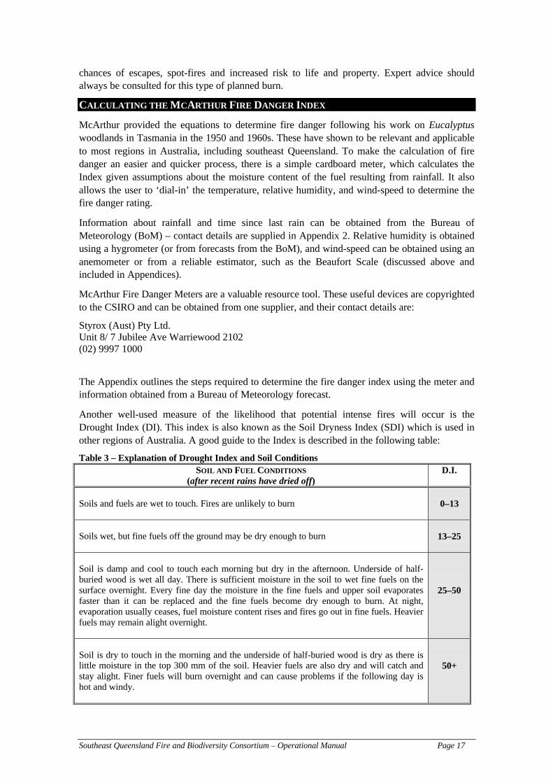
Forest Fire Index ranges from 0 (low fire danger) to 100 (extreme fire danger), and the ratingsare:
Table 2 – Forest Fire Danger Index RangesDANGER RATING DESIGNATION
0–4 Low5–11 Moderate
12–23 High24–49 Very High50–100 Extreme
For any prescribed or planned burns, it is recommended to have either a ‘low’ or ‘moderate’forest fire danger index (further prescriptions are outlined in the next section). In southeastQueensland, McArthur’s Index is not as widely used as other indices used to plan fires.Department of Primary Industries uses the Drought Index (DI) and the Soil Dryness Index (SOI)as good reliable measures.
For some ecological burning to achieve the desired results, a ‘high’ index is probably required.These conditions which encourage flame propagation and fire intensity also increase the
Southeast Queensland Fire and Biodiversity Consortium – Operational Manual Page 17
chances of escapes, spot-fires and increased risk to life and property. Expert advice shouldalways be consulted for this type of planned burn.
CALCULATING THE MCARTHUR FIRE DANGER INDEX
McArthur provided the equations to determine fire danger following his work on Eucalyptuswoodlands in Tasmania in the 1950 and 1960s. These have shown to be relevant and applicableto most regions in Australia, including southeast Queensland. To make the calculation of firedanger an easier and quicker process, there is a simple cardboard meter, which calculates theIndex given assumptions about the moisture content of the fuel resulting from rainfall. It alsoallows the user to ‘dial-in’ the temperature, relative humidity, and wind-speed to determine thefire danger rating.
Information about rainfall and time since last rain can be obtained from the Bureau ofMeteorology (BoM) – contact details are supplied in Appendix 2. Relative humidity is obtainedusing a hygrometer (or from forecasts from the BoM), and wind-speed can be obtained using ananemometer or from a reliable estimator, such as the Beaufort Scale (discussed above andincluded in Appendices).
McArthur Fire Danger Meters are a valuable resource tool. These useful devices are copyrightedto the CSIRO and can be obtained from one supplier, and their contact details are:
Styrox (Aust) Pty Ltd.Unit 8/ 7 Jubilee Ave Warriewood 2102(02) 9997 1000
The Appendix outlines the steps required to determine the fire danger index using the meter andinformation obtained from a Bureau of Meteorology forecast.
Another well-used measure of the likelihood that potential intense fires will occur is theDrought Index (DI). This index is also known as the Soil Dryness Index (SDI) which is used inother regions of Australia. A good guide to the Index is described in the following table:
Table 3 – Explanation of Drought Index and Soil ConditionsSOIL AND FUEL CONDITIONS
(after recent rains have dried off)D.I.
Soils and fuels are wet to touch. Fires are unlikely to burn 0–13
Soils wet, but fine fuels off the ground may be dry enough to burn 13–25
Soil is damp and cool to touch each morning but dry in the afternoon. Underside of half-buried wood is wet all day. There is sufficient moisture in the soil to wet fine fuels on thesurface overnight. Every fine day the moisture in the fine fuels and upper soil evaporatesfaster than it can be replaced and the fine fuels become dry enough to burn. At night,evaporation usually ceases, fuel moisture content rises and fires go out in fine fuels. Heavierfuels may remain alight overnight.
25–50
Soil is dry to touch in the morning and the underside of half-buried wood is dry as there islittle moisture in the top 300 mm of the soil. Heavier fuels are also dry and will catch andstay alight. Finer fuels will burn overnight and can cause problems if the following day ishot and windy.
50+

Southeast Queensland Fire and Biodiversity Consortium – Operational Manual Page 18
This index is a measure of moisture deficiency (corresponding to the dryness of the soil), andworks on the assumption that 200 mm of rain is enough to fully saturate the soil. Therefore, theDI is an expression of the moisture deficiency on a scale from 0–200, where 0 = totallysaturated, and 200 (very dry requiring 200 mm of rain to reach saturation). As you can tell, thisindex is quite reliable, as prolonged drought always proceeds damaging bushfire periods.
Determining the DI is not an easy process, even though there is a stepwise procedure (Appendix2 provides you with the instructions required to determine the DI). It requires the use of updatedinformation about the last amounts and timing of recent rainfall, current temperature and the useof drought tables (relevant to your area) and other indices.
Information on DI are available from the BoM, either by phone or over the Internet. The contactdetails for the BoM are listed in the section ‘Procedure on the Day of the Burn’. In thepreparation of your property for burning, we recommend that you contact the BoM to obtaininformation on the DI and use their forecasts accordingly.
Drought Index – A Quick Estimation Method
Mark Webster, Brisbane City Council Bushfire Management Officer, describes a method, whereyou get a shovel or use your boots to dig (or kick) the dirt until you find damp soil. If possible,repeat this method in a number of places. This will provide a good estimator of the condition ofthe soil.
Fire, Soil Conditions and Effects on Biodiversity
Fires can smoulder underground for many days following the passing of the fire-front, and thiscan have damaging effects on old trees, undermining their root systems and eventually topplingthem over. As Mark Webster (pers. comm.) mentions, “this is the main difference betweenprescribed and wildfires. The soil moisture protects the root systems of older trees, maintainingvital habitat trees and biodiversity”. When you are preparing your property for planned burns orfor the fire season, we have a few recommendations that will assist in preparing these oldertrees, and hollow logs and other important habitat areas for the fire. This is outlined in the ‘Fire-lines’ section.
What fire management practises can be conducted if there is a LOW Drought Index?
Conducting a burn during low DI conditions can be ideal for:
– Fire sensitive areas (plants and certain habitats)
– Areas which are difficult to control fire in good situations – especially if there is asteep slope, high fuel load, high fuel quantity or is adjacent to vulnerable areas,
– Fires in ridge tops. Along with the low DI, the time of day and seasonality, firealong a ridge top can be achieved. Middle slope to bottom slope fire regimes canfollow a mosaic with the use of higher DI and suitable weather conditions, so thereis a staggered burning regime.
– Low intensity fires, where only light fuels will be burnt (including grasses).
What fire management practises can be conducted if there is a HIGH Drought Index?
– As stated above, mid- and lower-slope fires.

Southeast Queensland Fire and Biodiversity Consortium – Operational Manual Page 19
– Higher intensity fires for weed management or regeneration objectives,
– Burning ‘wetter’ or moister areas such as wet-sclerophyll forests, and
– Reducing overall fuel loads, including larger diameter fuels
A quick and easy way to measure the Drought Index…
Even though we highly recommend obtaining Drought Indices from the Bureau of Meteorologyor calculating the index prior to any burning, according to Mark Webster (Brisbane CityCouncil Bushfire Management Officer), the telltale sign of an increasing drought index is thepresence of many green Eucalyptus leaves on the ground.
Coupled with the calculated Drought Index figures and local effects (presence of greenEucalyptus leaves) will provide an accurate estimation of the Drought Index in your area.

Southeast Queensland Fire and Biodiversity Consortium – Operational Manual Page 20
Ecological Regeneration Burning
As previously stated, not all planned burns are aimed to reduce fuel loads and fire risk on yourproperty. Burning may be planned for ecological reasons. These reasons could be the use of fireto:
Weed Control
– reduce the population and spread of weeds like lantana (Lantana sp.) or mother-of-millions (Bryophyllum delagoense). Fires for the use of weed control is the subjectof intensive research. The Department of Natural Resources and Mines haveproduced a number of fact-sheets on control methods for many weeds in southeastQueensland. They are available on the Internet at: http://www.dnr.qld.gov.au/
Be wary that some fires may increase weed populations. Research has shown thatfire intensity plays an important role in controlling weeds like lantana (whichrequires hot fires).
Stimulation of Regeneration
– open up the canopy and stimulate regeneration (this will require medium to highintensity fires – consultation and coordination with relevant experts is required forthese types of planned burns).
Influence Vegetation Community Structure and Composition
– remove (or thin out) single dominant stand of plants (which could be native) onyour property to promote diversity and different aged stands of native vegetation.Similar to the point above, this may require higher intensity fires, which will requirethe assistance and experience of local experts! An example where this has occurredare the planned high intensity fires to thin and remove some stands of the BlackShe-Oak (Allocasuarina littoralis) groves at Downfall Creek conducted by BrisbaneCity Council. The stands of Black She-Oak dominated the area from the lack offire, resulting in a mono-specific stand with low biodiversity. Due to the higherintensities involved, more planning and personnel were required, and the area burntwas small in extent (to limit potential escapes). Post-fire assessment of the plotsshowed increased diversity of other species with remaining stands of Black She-Oaks.
– meet objectives of maintaining variability (in fire frequencies) and mosaic burningthroughout your property. As explained in the ‘Ecological Guidelines’ creating andmaintaining different aged (since fire) vegetation communities is required tomaintain a diverse and vibrant community. Varying planned burns over a range offire frequencies will provide a variety of different community types to serve ashabitats and refuges for a multitude of plants and animals. In some instances,wildfires will occur and burn a portion of your property where you had planned anecological burn. Cases where this occurs should not be considered as detrimental,moreover the opposite, as this increases the natural variation in fire regimes andwill most likely increase the variability of vegetation communities and maximisesdiversity (this relates to Step 5 – Individual Property Fire Management PlanningKit).
Southeast Queensland Fire and Biodiversity Consortium – Operational Manual Page 21
Fuel Reduction Options Without Use of Burning
Even though the proper application of fire is very effective in reducing fuel loads, it is not theonly means to reduce fuel on your property. As this document shows, a great deal of planningand resources are required to complete a burn successfully. In your pre-operational planning toreduce fuel loads, you may wish to investigate other effective methods that are certainly lessresource-intensive and ‘risky’ options available to reduce fuel loads. These include:
MANUAL REMOVAL OF FUEL – the Individual Property Fire Management Planning Kit (a Fireand Biodiversity Consortium product, see last page) recommends and outlines a zoning patternto apply to your property based upon geographical characteristics and the location of assets. Insome areas, burning may not be required and the manual removal of fuel may be adequate toreduce the fire risk. In areas, where the continuity of fuel is sparse (widely spaced canopy treesor large shrubs) and there are natural fire barriers (creeks, gullies etc.) on your property, burningwill provide only limited efficiency in reducing fuel loads. Though this method is physicallydemanding, it is far more beneficial from an ecological and fire-risk perspective. The methodinvolves the manual removal of large braches and dead fuels from the ground, trimming deadbranches on large trees and shrubs up to 2 m in height, trimming on taller braches on canopytrees to limit the interlocking of tall branches. Local knowledge has an important role here. Allfuel within a 2 m radius of known habitat trees (with hollows etc.) or culturally significantvegetation should be cleared regardless of your fuel reduction options (to burn or not to burn).Care should be taken when manually removing fallen tree logs. These logs may be an importanthabitat for many fauna species and should be retained wherever possible. You may also riskyour personal safety by removing these logs.
STOCK MANAGEMENT FOR MANAGING FUEL LOADS – In some instances, the introduction ofgrazing animals (goats, cattle etc.) may adequately reduce fuel loads within your property. Thisis particularly effective in more grassy regions. Bill Mollison’s (1983) Permaculturerecommends the use of less-flammable plants (discussed below and elsewhere) and the use ofanimals (namely goats) as two extremely valuable and cost-effective measures of reducing firerisk, without the need for burning. The number of animals required depends upon the size of thearea, which needs to be enclosed, but the general guide is:
– Native Forest Areas/Tall Open Forests with 500–700 mm mean annual rainfall, 1animal per 16 ha
– Grassy Open Ridges/Forested Areas, 1 animal per 15 ha,– Well-Grassed Open Forest (eg D’Aguilar Ranges), 1 animal per 5–10 ha
Again this is just a guide to provide all year-round grazing for your animal. In goodproduction years, these numbers can be tripled (Gourley pers. comm.). These refer tolarger animals, like cattle, so if you use smaller animals such as goats, you can increasethe number accordingly and still provide enough stock for the animals. If you requiremore assistance with stock management, the Department of Primary IndustriesAgricultural Production section will be able to assist.
A note about the use of stock animals and biodiversity values:
If one of your primary objectives is the conservation of biodiversity, then you may wish toreconsider the use of stock animals for managing fuel levels. There are a number of impacts thatare caused by these animals (such as trampling) which could be to the detriment of nativeanimal species. The impact of grazing and fire and its effects on biodiversity is currently being

Southeast Queensland Fire and Biodiversity Consortium – Operational Manual Page 22
researched. We aim to provide you with a number of options for fire management on yourproperty. Remember to think about the consequences (ecologically and otherwise) of all yourland management practice.
REPLACEMENT PLANTING WITH LESS-FLAMMABLE PLANTS – Research by others (Tran et al.2001, Sheridan 1996, Bellamy 1985) has shown that vegetation can be used to effectivelyreduce fire risk. The utilisation of lower-flammability vegetation confers many advantages overconventional fire risk reduction methods. Properly sited, this band of low flammabilityvegetation form an effective fire barrier which can slow/stop fire spread, reduce and absorbradiant heat, reduce wind speed, and ‘catch’ burning embers. It should be noted that under themost extreme fire-weather conditions, even this low-flammability vegetation would beconsidered as fuel. It should also be noted that these so called ‘green firebreaks’ will requiremany years for the trees to reach maturity and constant maintenance is required if they are to befully effective. Generally, large leaved, succulent (high moisture content) plants with minimalor no bark are the more effective green firebreak species. Native plants within the region shouldonly ever be used as a potential firebreak plant-species (eg it would be useless planting plantsthat occur in sub-tropical rainforests in a western district). Some well-documented examplesinclude: Moreton Bay Fig (Ficus macrophylla), Flooded Gum (Eucalyptus grandis), SpottedGum (Eucalyptus maculata), and Sweet Pittosporum (Pittosporum undulatum). Please note,Sweet Pittosporum has been listed as a weed in some areas of New South Wales (native speciescan be considered weeds as well).
Natural green firebreaks have been successfully and extensively used by Mike Hall (SeniorRanger) from Springbrook National Park, in which they ‘lead’ the highly intense fires (in 1994,1981 etc.) into sub-tropical rainforests sections of the Park, where the fires self extinguished. Itis worth reiterating that caution should be taken when selecting the appropriate species to form afirebreak. Also, do not solely depend upon these green firebreaks as your only fire managementstrategy, it must be incorporated into and accompanied by other strategies to maximise yourpreparedness for the fire season. Green firebreaks also offer an ecological advantage. Thesevegetated areas provide a natural refuge for animals and plants, increasing the conservationvalue of that property. If you have any of these areas on your property, ensure that they areproperly identified on your fire management plans and to ensure neighbouring properties arenotified. They may be useful for evacuation and escape routes, and could less-flammablebuffers adjacent to back-burning operations.
A note about the use of less flammable vegetation:
It is also important to note that if you live in an area where these less flammable plant speciesdo not occur naturally, then it is not recommended that these be planted. This will not only alterthe ecological balance of your landscape, but is fraught with difficulties (especially if planted ina large area which may increase its chances of becoming an environmental weed). The localconditions and lower rainfall in the drier regions of southeast Queensland will not support manyof the less-flammable species. These plants will not only perform poorly, they will also add tothe fire risk.

Southeast Queensland Fire and Biodiversity Consortium – Operational Manual Page 23
Fire-lines
Fire-lines, as the name suggests are tracks that are prepared and managed to serve a variety ofpurposes for your planned burns. The majority of this information has been collated from theDepartment of Natural Resources (1998) Forestry Fire Manual, which is currently under review(Tony Baker DNR, pers. comm. 2001). They can be used to break the continuity of fuel that canassist in segregating, slowing or stopping the spread of a fire (firebreak) or providing a ‘safe’line to suppress a fire, or are specific roads constructed and maintained for fire managementpurposes (fire-trail), or are roads or tracks constructed and maintained (generally lowerstandard) for other fire management purposes like a track to water source etc. (fire-track). Fire-lines can vary dramatically in grading and quality to suit the definitions just outlined – and isimportant to differentiate between the intended uses of each of these types of fire-lines.
Note: fire-access trails need to be considered on two levels … one for vehicle and on foot,where vehicles will not be able to access.
PURPOSE OF FIRE-LINES
The main purposes of fire-lines is providing: (1) access and (2) to break the continuity of(potential) fuel. Fire-lines serve many other recognised and equally important functions (escaperoutes, back-burning operations etc.). As such, all fire-lines, regardless of grading and type forman essential component of your fire management infrastructure. It is therefore essential that allyour fire-lines and that of the adjoining properties be regularly assessed and properlymaintained. The location of all fire-lines should also be properly located and recorded on firemanagement plan maps.
WHAT FIRE-LINES CAN AND CANNOT DO
Fire-lines can be very effective and should form an important (but not the only) aspect of yourfire management infrastructure planning. However, it should be noted that fire-lines will notprovide you with complete protection or be absolutely effective in certain conditions. With mostfire management mitigation strategies currently available, there are limitations to their use, evenif they are perfectly planned and implemented. This has been well demonstrated locally and inother areas throughout Australia. The footage of the wildfires ‘jumping’ and crossing overhighways in New South Wales in 1994 not only shows the enormous power of high-wind drivenfires, but also the total ineffectiveness of a 30–40 m wide fire-break (such as the highway) inslowing the spread of a fire. This is of course an extreme example of what can happen withexisting infrastructure arrangements. You must remember that all the strategies that we employsimply reduces the risk of damaging fires to life and property, but we are never able to totallyeliminate the risk of fire. As we have mentioned previously in other documents, we live in anenvironment where fires will always have an important role, and no matter what we do, fireswill occur. Please keep this in mind when planning to construct fire-lines or any other form ofinfrastructure.
Fire-lines can be:
– effective in slowing or stopping the spread of a low intensity fire from one area toanother (this is dependent on the fuel type and width of the fire-line). Typically,only grassfires are effectively managed by fire-lines.

Southeast Queensland Fire and Biodiversity Consortium – Operational Manual Page 24
– used as an area where the low (or nil) fuel load can be used to perform back-burning operations
– used as an access route for fire vehicles and other appliances. The standard of thefire-line will influence the type of equipment (also known as an ‘appliance’) thatcan access these lines.
– used as an escape route or evacuation or (temporary) assembly area for firepersonnel (dependent on fuel types and fire intensity)
– used to separate different compartments or areas of different vegetation or fueltypes or areas with different ecological-burn requirements.
However, fire-lines cannot be:
– used to stop or slow the spread of medium–high intensity fires. Cheney (1981)showed that firebreak widths needed to be much wider to slow/stop grassfires,which usually burn with high intensity but also very quickly.
– used as a recognised assembly area for personnel during a fire. It may be usedtemporarily, but with a high amount of traffic and proximity to the fire, has anincreased risk of causing injury and harm. Fire-lines are usually areas of lower fuelloads and/or usually cleared of all vegetation, which when burnt, directly exposespersonnel and equipment to the fire and maximum radiant heat exposure. Radiantheat is recognised as the most dangerous threat to human safety (Webster 2000).
LOCATION OF FIRE-LINES
The Queensland Parks and Wildlife Service Draft Code for Fire Management (Schedule 7) hasestablished some general standards to the planning, constructing, using, maintaining anddecommissioning on ground fire management infrastructure. This infrastructure may includefirebreaks, fire trails, tracks and other ‘disturbed’ areas (helipads or ramps).
In wildfire situations, it may be difficult to construct fire management infrastructure withoutcompromising environmental values, but all efforts should be taken into account whenconstructing this type of infrastructure.
Fire management infrastructure should be located to avoid areas of:
– steep slopes/unstable areas,– landscape values,– rare/threatened flora and fauna– highly erodible soil, and– cultural heritage
The construction of firebreaks (defined in Glossary of Terms) must be developed andmaintained to:
– reduce the levels of radiant heat to firefighters and buildings,– provide a refuge and escape route for firefighters– provide adequate width that allows firefighting vehicles to pass and turn safely
(except for hand-constructed fire-lines), and– arrest the spread of fire and provide a safe line to perform backburning operations
In general, fire-lines should be constructed so that the firebreak, trail or track should:
– not follow watercourses– be located to minimise the area disturbed

Southeast Queensland Fire and Biodiversity Consortium – Operational Manual Page 25
– not exceed widths of 4 m (except in strategic areas, or to provide an adequate andsafe turn around for vehicles and passing points–which should also be recorded onyour fire management plan)
– utilise natural crossfall to where is no crossfall or other natural drainage features,construct cross drains as required
– retains the maximum amount of surface vegetation, litter and organic matterconsistent with safety and access considerations
To achieve the functions required in fire-lines, roads, tracks and trails should aim to:
– use any existing access where possible (fence-lines, property boundaries etc.)– meets the necessary access requirements with minimum required infrastructure (ie
minimal impact)– minimise adverse visual impact– avoid exclusion zone (of ecological, commercial or cultural heritage importance)
and areas prone to instability or flooding (minimise erosion of fire-line)– uses existing geographic features (such as ridge-tops, benches and gentle slopes)
– avoiding where possible, the use of ‘box-cuts’ (explained below), which aredifficult to drain, unless there is no other alternative
– minimises side cutting and avoids potential instability through the limitedconstruction to side slopes less than 30°
– minimises watercourse crossings and interference with natural drainage– consult the relevant authorities where proposed access joins a gazetted road
Some general standards apply for the construction of all types of fire-lines. The design of fire-lines, should achieve the desired function, and must be able to carry the anticipated type andfrequency of traffic safely whilst protecting environmental values. It should also suit siteconditions and function to maintain its integrity and stability. Some acceptable standards forfire-lines, are shown in the table (below). This information has been drawn from the QueenslandParks and Wildlife Service Draft Code for Fire Management (Schedule 3–Inland Cypress PinePlantations), but is applicable to the region.

Southeast Queensland Fire and Biodiversity Consortium – Operational Manual Page 26
Road and Track Formation Types (Draft Code for Fire Management. QPWS 2000)
Table 4 – Design Standard for Fire-linesAccess TypeDesign Parameter
Main Access General Access Minor Access Track(1)
Use Standard Two lane,All weather
Single lane, Goodweather
Single lane, Goodweather
Single lane,Dry weather(2)
Formation A or B A or B A,B or C Minimal DPavement Surface(3) Gravel Gravel
Patch gravelPatch gravel Natural
Pavement Width 6 metres+ 4 metres 4 metres 4 metresClearing Width(4) 1 metre beyond earthworks plus safety considerations
Maximum Grade(5) 7 degrees (12%) 7 degrees(12%)
9 degrees(16%)
10 degrees(17.5%)
Cross Drainage Type(6) Culverts CulvertsInverts(7)
Inverts(7)
Water bars (8)Natural
Inverts(7)
Water bars(8)
Notes:(1) Lessee Track requirements should be negotiated between the lessee and other authority, eg DPI–
Forestry. These will commonly be flat bladed tracks. Surface drainage should avoid the use of waterbars, where possible, and particularly where the track has to remain trafficable. Firstly locate toutilise natural drainage. Secondly ensure the edge berm is breached at water bar spacings to permitside drainage. Thirdly consider the use of inverts where cross drainage is required. Water bars wouldbe used where the track is no longer required. Wet spots in the track surface should be either drained,filled and raised or corded to avoid bypasses.
(2) Temporary Tracks – Limit clearing and earthworks to the absolute minimum–use the naturalsurface. Avoid box cuts unless absolutely necessary. Blading-off of track surfaces should be minimaland must not leave a continuous edge berm. Break berm at water bar spacings to permit sidedrainage. Stabilise with necessary side and cross drainage on completion of use.
(3) Pavement Surface must be matched to road use. Gravelling as necessary to ensure traction, avoidrutting and to maintain effective drainage.
(4) Clearing width may be extended to avoid a safety risk. Extend by the minimum necessary, subject toadvice from experts, to correct the risk or consider alternatives such as restricting traffic to “oneway”.
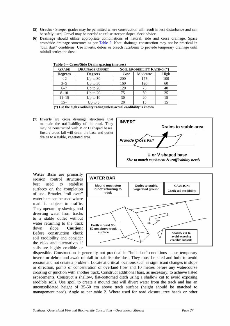
Southeast Queensland Fire and Biodiversity Consortium – Operational Manual Page 27
(5) Grades - Steeper grades may be permitted where construction will result in less disturbance and canbe safely used. Gravel may be needed to utilise steeper slopes. Seek advice.
(6) Drainage should utilise appropriate combinations of natural, side and cross drainage. Spacecross/side drainage structures as per Table 2. Note: drainage construction may not be practical in“bull dust” conditions. Use inverts, debris or breech ruts/berm to provide temporary drainage untilrainfall settles the dust.
Table 5 – Cross/Side Drain spacing (metres)GRADE DRAINAGE OFFSET SOIL ERODIBILITY RATING (*)Degrees Degrees Low Moderate High
< 2 Up to 30 200 175 1003–5 Up to 30 160 120 606–7 Up to 20 120 75 40
8–10 Up to 20 75 50 2511–15 Up to 10 30 20 1515+ Up to 5 20 15 15
(*) Use the high erodibility rating unless actual erodibility is known
(7) Inverts are cross drainage structures thatmaintain the trafficability of the road. Theymay be constructed with V or U shaped bases.Ensure cross fall will drain the base and outletdrains to a stable, vegetated area.
Water Bars are primarilyerosion control structuresbest used to stabilisesurfaces on the completionof use. Broader “roll over”water bars can be used whereroad is subject to traffic.They operate by slowing anddiverting water from tracksto a stable outlet withoutwater returning to the trackdown slope. Caution!Before construction checksoil erodibility and considerthe risks and alternatives ifsoils are highly erodible ordispersible. Construction is generally not practical in “bull dust” conditions – use temporaryinverts or debris and await rainfall to stabilise the dust. They must be sited and built to avoiderosion and not create a problem. Locate at critical locations such as significant changes in slopeor direction, points of concentration of overland flow and 10 metres before any watercoursecrossing or junction with another track. Construct additional bars, as necessary, to achieve listedespacements. Construct a shallow, flat-bottomed ditch using a shallow cut to avoid exposingerodible soils. Use spoil to create a mound that will divert water from the track and has anunconsolidated height of 35-50 cm above track surface (height should be matched tomanagement need). Angle as per table 2. Where used for road closure, tree heads or other
INVERTDrains to stable area
Provide Cross Fall
U or V shaped baseSize to match catchment & trafficability needs
WATER BAR
Shallow cut toavoid exposing
erodible subsoils
Outlet to stable,vegetated ground
Mound must stoprunoff returning to
track
CAUTION!
Check soil erodibility
Earth mound 35-50 cm above track
surface

Southeast Queensland Fire and Biodiversity Consortium – Operational Manual Page 28
obstacles should be pulled over the top of the mound where there is a risk of cattle tramplingand vehicle disturbance.
OTHER IMPORTANT CONSIDERATIONS
Removal of Fuel – As the recommendations show, the minimum width of a fire-line is 4 m (seenote below). The main aim is the reduction of fuel (but not always total removal to baremineral earth) – as this may have adverse environmental effects (namely weedintroduction and increase erosion). There is also the risk of feral animal invasion withthe increase in the number of tracks. Therefore, only construct fire-lines where is theleast environmental impact (direct and indirect). If you have tall canopy trees on yourproperty, the fire-lines should avoid the overhanging branches of these taller trees.There is an increase in danger from falling branches causing injury in fire events.
Note: The 4 meter minimum width applies to machine constructed fire-lines, and not tohand-constructed fire-lines. It would be both too impractical and time consuming tobuild such a wide hand-line. Typically, a hand-constructed fire-line is usually only 1–1.5 m in width.
Allocation of Fire-lines – Ideally, fire-lines should be located to suit the surrounding vegetationtypes. Fire management plans for National Parks use this theory to separate their‘burning blocks’ not according to access, but by the different vegetation types. Theadvantage of doing this is that the fire-lines help allocating the timing of the burningblocks in accordance to some ecological requirements, so it assists in increasing thevariability within fire regimes. If you have a variety of vegetation types but they are ofrelatively small size, it may be worthwhile clumping these smaller areas together intoone burning block until a minimum of 1 hectare blocks is achieved. Increasing thefragmentation of the landscape by installing too many fire-lines is an undesirable andunnecessary outcome. Remember that these areas (because they are smaller) can containhigh biodiversity with a number of rare or threatened species.
An alternative option – the use of vegetation types for locating fire-lines wasdiscussed for use and implementation for Brisbane City Council (Mark Webster, pers.comm.). This was not approved, but Brisbane City Council has decided to use fuel-moisture and Drought Index (discussed earlier) differentials to imitate naturalconditions. The boundaries, therefore, remain flexible (important for biodiversity) andexpand/shrink similar to natural systems and are changed by events such as fire.
You should consider which option is more appropriate for your property, but for smallerproperties, Drought Index differentials to determine ‘natural’ fire-lines will be moresuitable.
Use of Existing Infrastructure –The planning and construction guidelines for fire-lines can beexhaustive and expensive to implement. It is recommended that landowners use existinginfrastructure as potential locations for fire-lines. These include fences/fence lines,property boundaries, vegetation boundaries (discussed above), and general geographicsimilarities (slope, aspect) for construction of firebreak or fire-lines.
Probably the most useful existing infrastructure that can be serve as a fire-line, areroads – as they are generally well trafficked, known to many people and regularlymaintained. Roads have the width and clearance to be used for all types of fire-lines,and are the perfect areas to conduct back-burning or clean-up operations. If you areintending to use the roads near your property as fire-lines, please note that you are

Southeast Queensland Fire and Biodiversity Consortium – Operational Manual Page 29
required to provide appropriate notification and signage to warn drivers about thesmoke and potential reduced visibility during the day of burning (other requirements arespecified below).
A note about the use of roads as fire-lines. Most roads will be under the jurisdiction ofyour local government authority. Your local government may then have their own firemanagement plan in place with these roads, and with that will have their own conditionsof use that you will be required to abide by. In your pre-burn planning, contact yourlocal authority to inform them you are in the process of developing a fire managementplan for your property which may incorporate planned burns. If the road/s you intend touse have no fire management plan in place, work with your local authority to developone. Not only will this meet your objectives, it enhances cooperation with your council.
Maintenance of Fire-Lines – fire-lines will be effective if they are properly and regularlymaintained. Overgrown and poorly maintained fire-lines will not stop fires, nor willthey allow safe access to personnel, making the fire-line useless and dangerous. Fire-lines should be clearly marked on the maps that accompany your fire managementplans, and prior to each fire season, they should all be checked to ensure that theyremain in good working condition (eg cleared of vegetation, properly graded ofadequate width etc.). Firebreaks should be maintained to reduce vegetation that mayincrease the rate of spread of fire or fire intensity. To determine if the width of thefirebreak is adequate, picture the vegetation on each side of the firebreak lying flat – ifthis can link the two areas separated by the firebreak, then you may need to considerwidening the length of the firebreak OR remove more vegetation. If you have ‘habitat’trees on your property (large tree hollows, generally older trees), then these serve animportant ecological role and should be maintained within reasonable fire-riskparameters. The fuel around all habitat trees should be removed to a 2 m radius. Thisshould reduce the chances of fire reaching the tree possibly causing further damage.Other trees that will require additional clearing at the base are those ribbon-barkedspecies (namely eucalypts) and young-hollow stage trees.
Rehabilitation of Fire-Lines – fire-lines should be situated in areas where they will be used ona semi-permanent or permanent basis. This requires good planning and local knowledge(your local Rural Fire Brigade should be able to assist you in this regard). If, in somecases, fire-lines are no longer required due to changed management requirements, thesefire-lines will require rehabilitation. Most fire-lines are along cleared tracks thatintersects property boundaries, and left unattended, the disused fire-lines will beextremely prone to weed infestations which may result in an increase of the area’s firerisk and loss of biodiversity values. Another undesirable outcome from abandoned fire-lines is the increase chances of erosion, which may affect water quality and loss ofproductivity. To limit these effects, a recovery plan for all decommissioned fire-linesshould be initiated. Replanting with local native species, mulching and regularlywatering and weed removal should be considered to return the area to natural conditionsin areas where natural regeneration is likely to be inadequate. In time, areas previously‘fragmented’ by these fire-lines will be ‘connected’ again, benefiting local biodiversity.It may be unfeasible to rehabilitate an entire fire-line. Areas that are prone to increasedchances of erosion or weed infestation should be given priority.

Southeast Queensland Fire and Biodiversity Consortium – Operational Manual Page 30
Preparing Fire-Lines on Your Property
This section relates to Step 6 of the Individual Property Fire Management Planning KitIt is important to prepare and maintain fire-lines on your property to ensure maximumefficiency. The following section describes different methods of constructing fire-lines inpreparation of planned burns. As the previous section showed, the location of fire-lines isimportant not only for effective fire management, but also to limit erosion or risk of weedinvasion.
Remember also that fire-lines and firebreaks can be naturally occurring features such as wetgullies, rainforest vegetation, and commonly are features such as roads, mown areas, dozedtracks or hand-constructed tracks. In complex terrain, such as steep, stony wet orenvironmentally sensitive or where there is limited time to use machinery, hand fire-lineconstruction using trained personnel is an efficient system of firebreak construction (Gourley1996).
You will note the in the terminology (below) there are references to fire-crews, bosses and fireleaders, which refers to a group within a fire-fighting unit (from the Rural Fire Service, or Dept.Primary Industries–Forestry etc.). Expert advice is recommended when preparing fire-lines, asthese experts will also be helping you conduct any hazard reduction burning or fire suppression.
The following method is called the “Step-Up” Method of Hand Fire-Line Construction, andfollows guidelines used in Level-1 Fire Training in a Manual written by Gourley (1996):
– It is the most versatile and efficient method of line construction for most fire situations,by ensuring a clean line of control is established when the last person passes any point.
– It is a safe method, as people are not passing one another with sharp tools, and arealways well spaced apart whilst working.
– This method differs from previous methods in that each person maintains the sameposition in relation to other personnel throughout the line construction.
– It is named the ‘step-up’ method because the underlying principle is that each person onthe line has a definite task to accomplish and will continue to work that section or untilthe person behind finishes and asks the next person to move (or step) up. Then, ALL thecrewmembers will move forward to new ground.
– SPACING – usually 3 metres between each crewmember along the line location.
– NUMBER OF CREW REQUIRED – usually 5 to 6 people are required to operateefficiently. Work efficiency rates decline with larger groups, as the system becomes toocomplicated. Conversely, smaller groups also work less efficiently, whereas the 5–6people that is recommended remains manageable whilst maintaining a good work rate.
PROCEDURE (assume 5 people in line)
– Leader walks 15 metres to starting point, number two person 12 metres, with thefollowing people (numbers three, four and five) spacing themselves the required threemetres apart,
– Once the crew line is out, work should begin simultaneously on order of the crew leader

Southeast Queensland Fire and Biodiversity Consortium – Operational Manual Page 31
– Everyone will work at a different rate according to a combination of personal physicalcondition and the type of terrain they are working in. This will invariably result in oneor more people reaching the starting point of the person ahead before the rest of thecrew can all complete the sections.
– When a person finishes the section, they call out “step up!”, where each person willthen move forward one space to the next incomplete section of the line. The leader willmove forward another 5 or so metres.
– This means any person behind the team leaders who has to move up will continue towork to complete the sections.
– When two people have completed their sections simultaneously, the first will call ‘upone’ and the second then call ‘up two’, which will trigger each person ahead of them tomove up two spaces to leave some uncompleted sections for the two who are ready tomove along…
– The last person in the crew must ensure all the sections in the line are complete andclean to a nominated standard. The Crew Leaders position must be allocated to anexperienced operator to ensure the quality and effectiveness of the fire-lines.
Figure 5 – The ‘Step-Up’ method of fire-line construction (photo: NeilGourley).
Things to note in the construction & location of the fire-line
Again, the key word here is preparation. By paying close attention to the location offire-lines, valuable time and energy can be saved. Typically, the Crew Boss or leaderwill choose the fire-line location. Some points to consider in the location of fire-linesare:
• try to pick the easiest way through heavy undergrowth,• keep to open spaces as much as possible, but do not wander offline too much,• use natural barriers as much as is allowable. These include areas of very low fuel,
breaks, streams, paths, roads, even areas of old burns. Prior planning and mappingwill assist in identifying these areas, and may greatly reduce the amount of workrequired,

Southeast Queensland Fire and Biodiversity Consortium – Operational Manual Page 32
• try to avoid rocky areas, stumps, fallen trees etc. all of which will add to the amountof work required,
• steer fire-lines away from the most dangerous fuels (typically fibrous/stringybarkand paperbark trees, any elevated fuels such as dead or flammable shrub layers, anddead or live hollow trees especially those that have elevated exit hollows that mayform ‘roman candles’ or ‘fire/spark chimneys’, with the ability to throw sparks orspots over your control lines),
• avoid sudden turns and sharp corners in a line. Any sharp turns may increase radiantheat exposure at that point increasing the chances of spotover,
• Always ‘anchor’ the fire-line on a safe and sure fire barrier such as a stream, road,or area of low-flammable scrub etc.,
• Though this should not occur, if the location of a fire-line is required in going firesituations, good knowledge of the rates of spread, work-rate of the available crew,general topography and weather conditions is crucially important – to maintain safecontrol of your personnel and the fire,
• Avoid steep slopes,• Avoid locating fire-lines across steep slopes, as falling/rolling burning material may
easily cross this line.• Straight lines are the easiest fire-lines, to patrol and monitor due to the ability to
see clearly by one person over a distance, particularly at night.
WHAT’S INVOLVED IN MAKING A FIRE-LINE?
As Gourley (1996) explains, the job of preparing fire-lines consists of:
1. Cut and remove all shrubs, branches, small saplings, bushes, vines and other lightmaterial from the line for easy walking and raking. The minimum width of thisclearing is one metre (1 m).
2. Raking all groundcover and ‘debris’ along the line down to mineral soil. Allmaterial should be raked and removed to the OUTSIDE of the line away from thefire. The width of this ‘rake line’ will vary from 0.5–1 m, depending on theheaviness of the fuel at that point.
3. If you have any heavy timber across the line, it should be cross-cut with a chainsawor ace and rolled out. If this cannot be done, all loose bark and decayed woodshould be trimmed off the log (and underneath it) to make it as fireproof aspossible. If the break is 1 m in width, clear up and down the log for 1 m, therefore, atotal of 3 m is now the width of the line at the log. If the log does catch on fire, itwill provide added time for a cross cutting before the protected areas are alsoignited (refer photo below).

Southeast Queensland Fire and Biodiversity Consortium – Operational Manual Page 33
Figure 6 – Fire break constructed to mineral earth, 1 m wide. At the log,break must be 1 m up & down on both sides of log, with loose debris on topand beneath the log to be removed. Photo shows litter beside log and onlybreak constructed down the log. (Photo & explanatory note: Neil Gourley).
4. All fibrous bark tree and dead stags near the fire-line should be raked around and made assafe as possible to prevent it catching alight. Highly dangerous trees may need to be felled.Spread out the material that has been removed from the base of the trees so it doesn’t impact(locally) on the heat intensity/flame height from the build-up of additional fuel. This isparticularly important in areas involving slope (ie on the downhill side). For biodiversityconservation, it may be useful to do this procedure for habitat trees and other ecologically orculturally significant trees. Refer to figure-7 (below) for an indication of how to preparetree-base cleared areas.
Note: It may be necessary to have a chainsaw operator to handle the removal of largerbranches and trees. In fire-suppression activities, qualified chainsaw operators are essentialmembers of the fire-crew, and serve an equally important role in fire-line preparation. Thedesignated Crew Leader must coordinate all activities of the chainsaw operator and to notifythe crew of chainsaw activities.

Southeast Queensland Fire and Biodiversity Consortium – Operational Manual Page 34
Figure 7 – Preparation around habitat trees or hollows. Provide at least 1 mwide mineral earth break surrounding with additional width on downhillside. It is important to remove litter from the base of the tree. (Photo andexplanatory note: Neil Gourley).
A NOTE ABOUT FIRE-LINES AND EROSION
As Gourley (1996) importantly points out, fire-lines may be prepared by removing alllitter and fuel down to mineral earth. This, can in some instances, lead to increased ratesof erosion. As described above, the location of fire-lines is important to maximiseefficiency and limit environmental damage. Cross-drains have already been described,the following information below is a guide for the spacing of these cross-drainsaccording to the slope of the terrain where the fire-line is constructed.
The drains should be cut below the soil surface at 30° to the break, opening intovegetation which will allow free drainage. As a guide, Table 5 lists the spacings thatshould be adhered to depending on the slope of the land.
Table 6 – Cross-drain spacings based on slopeDegree of Slope Cross-drain spacingUp to 5° Every 40 mBetween 5° — 15° Every 30 mBetween 15° — 35° Every 20 m
Remember: the crew leader/boss will help you determine the most appropriate positionof the fire-line. They should be well aware of these cross-drainage spacings, but it isgood for everyone to have a good knowledge of these spacing details.
WHAT IF WE HAVE LESS THAN 5 PEOPLE AVAILABLE?
The fire-line preparation above requires a minimum of 5 people to be effective (though 2–3people can still do the Step Up Method, but not as quickly…). If you have only 2 or 3 peopleavailable, then it is recommended you follow this method:

Southeast Queensland Fire and Biodiversity Consortium – Operational Manual Page 35
1. One person to make a bare-earth line. Continue fire-line preparation to designated end-point.
2. Second person to work off this clean-edge and increase width of fire-line by working at 30°to this edge. This increases the rate of fire-line preparation. This method is also known asthe ‘Daylesford Method’.
Note: the landowner can use an existing bare-earth path, such as a cow-trodden path etc.
(to bare earth)
person #1
person #2
30°
(walking along clean edge = quick process)

Southeast Queensland Fire and Biodiversity Consortium – Operational Manual Page 36
Water Sources
Water is the most effective means of controlling a fire. It helps break the fire-triangle that wehave discussed earlier.
Here are a few general guidelines to water sources and your fire fighting capacity:
– Locating the sources of water on your property is described in your IndividualProperty Fire Management Planning Kit (Step 1). It is a good idea to identify watersources according to seasonal availability of water, which is especially important intimes of drought, where some water sources can dry up. Therefore, on your firemanagement maps, remember to list those water sources and dams where you canalways source water and if possible, provide approximate capacities of these watersources.
Remember fire-lines also described access tracks to water sources, roads, escaperoutes etc. and are equally as important as fire control lines and fire-breaks. Ensurethat an open, safe and easy access is maintained to all water supplies.
– You may wish to consider the construction of a dam (standard guideline is 10,000L) for fire management procedures. This is an expensive exercise to undertake butwill provide a reliable source of water in times of high fire hazard. You shouldknow the contact details of your local water-carriers, include their phone numbersand availability on your fire management planning sheets.
Ensure your tanks have compatible coupling to suit Rural Fire Service’s vehiclesand appliances.
– Make sure those people attending your planned burn are well aware of the watercarrying capacity of the vehicles they are using. Make sure these are recorded andverified by the Rural Fire Brigade–Fire Boss or Incident Controller.
– Make sure all personnel attending your planned burn know the exact location of allthe water sources (providing a map to each person is highly recommended).

Southeast Queensland Fire and Biodiversity Consortium – Operational Manual Page 37
Weather Prescriptions for Low Intensity Burning
Remember that the objective of prescribed burning is to reduce the amount of fuel in the area by70–75% and to achieve a 60–80% coverage of the area with ‘manageable’ flame heights withminimal amounts of tree scorch. To successfully fulfil these objectives requires good planningand a good degree of luck, especially in relation to prevailing weather conditions. It may seemthat the opportunities for performing planned burns are limited. Indeed, this may be true as thereare clearly outlined requirements on air-quality issues (namely smoke management) and priornotification (to Firecom etc.) which will need to be met before any burning is permitted.
However, in most cases, since your planned burns are usually small in size (limited to a fewhectares), these burns will be allowed, given favourable weather conditions. It should be notedthat if you do not achieve all the objectives of your planned burn, it may be possible to completethese objectives for a burn on the following day(s) (Please remember to ensure you haveupdated weather forecasts and adequate resources and facilities).
For most generic fuel reduction burning activities, the typical “window of opportunity” (adaptedfrom the DPI Forestry Fire Manual the operational parameters) for conducting a planned burnare:
Table 7 – Operational Parameters for Burning in SEQPERIOD OF BURNING May–August
DROUGHT INDEX Wet Sclerophyll Forest: 50–75Dry Sclerophyll Forest: 20–75
TEMPERATURE RANGE 22°C–30°C
RELATIVE HUMIDITY 30%–60%
WIND STRENGTH 1–3 Beaufort Scale(between 1–20 km/hr)
NB: Remember the 12–15km/hr threshold for wind speeds from Project Vesta
WIND DIRECTION SE–NE (no W. comp)
AVAILABLE FUEL WEIGHT 10–30 t/ha
BURN INTERVAL Wet Sclerophyll Forest: min 7–10 yearsDry Sclerophyll Forest: min 3–5 years
BLOCK SIZE Wet Sclerophyll Forest: 2–5 haDry Sclerophyll Forest: 2–5 ha
See Note (below)* AIM FOR 60%–80% COVERAGE OF AREA DURING BURN
NOTE ABOUT BLOCK SIZE
This recommendation is only a guide. The size of the planned burn depends onmany factors, not least of which is the area of your property. If your property is lessthan 2 ha, then you will need to consider involving your neighbours into theplanning of the burn. Always remember to keep in mind the aims and objectives ofyour planned burn when considering the extent of your burn. In general, larger areasneed to be burnt if your aim is to reduce weeds. Biodiversity related burns willinvolve longer fire intervals and larger block sizes. Cooperation between yourneighbouring properties will also influence the extent of your planned burn.
Southeast Queensland Fire and Biodiversity Consortium – Operational Manual Page 38
The DPI Forestry Fire Manual recommends some variation in the time of conducting burns. Theidea of conducting burns during this “late summer–autumn” period confers many advantages forboth fuel reduction and ecological purposes. By alternating the timing of scheduled burns (fromWinter to include Summer periods), increases the variability in fire intervals and regimes, arecommendation by Watson (2001) and others (Tran and Wild 2000, and references within),adds to the landscape level mosaic pattern, and permits safer burning conditions in wetter foresttypes (which typically contains greater fuel loads). Furthermore, burning at this time is favouredby the Department (Neil Gourley pers. comm. 2001) as opposed to burning in September–October when higher risk fire weather conditions can be expected, which may cause relights andpossible severe damage to the forest, as well as compromising the safety of fire-crews.
Even though this late-summer/autumn burning schedule is favoured (see following table), it isnot always possible to achieve. This is important to note if you have developed a multiple-burnschedule in accordance with neighbouring areas which prescribes burning a different area everyyear over a set number of years. The DPI Forestry Manual advises that this type of burningregime later in the season may only be possible once every five–seven years. If the September–October option is chosen, it is important to light some test-fires (see section ‘Preparation on Dayof Burn’) to ensure the fire behaviour characteristics are within the parameters set out below.Furthermore, ensure that you have obtained an updated weather forecast information from theBureau of Meteorology on the day of the burn to ensure a stabilised temperature pattern isestablished over the region. When this has been completed, the following operationalparameters (table below) should be adhered to. It is important to recognise that expert localknowledge will be an important factor in the success of these planned burns.

Southeast Queensland Fire and Biodiversity Consortium – Operational Manual Page 39
Table 8 – Operational Parameters for ‘Late Summer/Autumn’ Burningin SEQPERIOD OF BURNING Late January–April
DROUGHT INDEX Wet Sclerophyll Forest: 25–75
TEMPERATURE RANGE 22°C–30°C
RELATIVE HUMIDITY 30%–60%
WIND STRENGTH 1–3 Beaufort Scale(between 1–20 km/hr)
NB: Remember the 12–15km/hr threshold for wind speeds from Project Vesta
WIND DIRECTION SE–NE (no W. comp)
AVAILABLE FUEL WEIGHT 10–30 t/ha
BURN INTERVAL Wet Sclerophyll Forest: min 7–10 years
TIMING OF BURN & RAINFALL
REQUIREMENT
Within 10 days of a minimum of 15 mmrainfall
BLOCK SIZE Wet Sclerophyll Forest: Variable, butgenerally below 5 ha
See Note (below)* AIM FOR 60%–80% COVERAGE OF AREA DURING BURN
NOTE ABOUT BLOCK SIZE
This recommendation is only a guide. The size of the planned burn depends on manyfactors, not least of which is the area of your property. If your property is less than 2ha, then you will need to consider involving your neighbours into the planning of theburn. Always remember to keep in mind the aims and objectives of your plannedburn when considering the extent of your burn. In general, larger areas need to beburnt if your aim is to reduce weeds. Biodiversity related burns will involve longerfire intervals and larger block sizes. Cooperation between your neighbouringproperties will also influence the extent of your planned burn.
You can see from these operational parameters, that in southeast Queensland, the acceptabletimes for burning cover late January to the end of August. There has been some emphasis on the‘summer’ burning as per the parameters in the table above. This is an effort by DPI–Forestry toincrease variability in fire seasons, and is also recommended for your property planned burns.
TIMING OF BURNS – POINTS TO CONSIDER
The operational parameters shown above cover the timing of the burns for southeastQueensland. However, we should point out that you should be mindful of the following factorsand should be considered in planning your burn, especially if it is to achieve ecologicalobjectives:
(a) the known presence of rare or endangered species
(b) the likely occurrence of suitable burning weather and the number of burns planned

Southeast Queensland Fire and Biodiversity Consortium – Operational Manual Page 40
(c) the seasons that other recent burns in that (and surrounding) areas were conducted
It is important to emphasise that a diversity of season of burns in any one area should bemaintained where possible to minimise the risks and impacts on breeding populations of smallmammals and birds, in addition to any flowering plant communities.
In areas where particular rare or endangered plant or animals occur, find some informationabout their regeneration or breeding habits, so your planned burn will not affect them whenthere are young plants or animals likely to be severely affected by a fire. The Queensland Parksand Wildlife Service, Environmental Protection Agency, local Council bushland/environmentofficer, Greening Australia or a local Landcare or Bushcare group can help you withinformation on any rare/threatened species. One cannot make allowances for every plant oranimal in the planning of a prescribed fire, and it is always wise to consider the overallcommunity diversity. However, in the instances where your objectives are to provide suitablehabitats for a rare or threatened species, then you will need to adjust your burning plans to suittheir specific requirements.
When planning ecological burns, remember that season of burn is particularly important here.We have previously discussed the need for higher intensity fires to meet some ecologicalobjectives. In southeast Queensland, the high-fire danger periods occur from October to mid-November. If you have planned a prescribed burn during this period, remember to takeparticular care and observe the upper limits of the Drought Index (DI) – which we havediscussed in a previous section.
Timing is also crucial when fires can affect the safety and lifestyle of the residents. Rememberto take high priority if you are planning a fire near public roads – where smoke and heat can bea safety hazard, eg if the road is a bus route etc. Use your forecasts from the Bureau ofMeteorology to use prevailing winds, and the time of day to facilitate the best outcomes andrestrict safety issues. Furthermore, be wary of any key times for residents when planning yourburn, in particular if there are periods where more traffic is expected on the roads. Someexamples include: public events, school holiday periods, school times, shows like the BrisbaneExhibition or other events.
The Fire and Biodiversity Consortium advocates the use of adaptive management in thepreparation of any fire management plan. If you have planned a burn and for some reason it hasnot been conducted, consider moving it to another day, week – do not just shelve your plans…iedo not be tied into a strict deadline or schedule, and maintain flexibility. If your plans are notachieved in one day it is not considered a failure, it has only failed if your fire escapes (NeilGourley, pers. comm.).
SUMMER OR WINTER BURNING?
In this section, we will provide some outlines to assist you in determining which season is moreappropriate to conduct your burns.
– Remember that burning in winter means shorter availability of actual burning timehours. In winter, there is usually quite heavy dews which increases moisture uptakeby the fuels (making it more difficult to burn, and achieving a lower than requiredintensity to achieve objectives). Actual burning time will vary, but generally rangesfrom 11:00am to 3:00pm.
– Burning in summer will usually allow an effective burning ‘window’ from 9:30amto 7:00pm.

Southeast Queensland Fire and Biodiversity Consortium – Operational Manual Page 41
– Keep in mind that the time between 1:00 – 2:00pm is the highest fire danger period,with higher temperature, lower relative humidity and changing wind direction.
– Any fires lit prior to this time will CHANGE in behaviour, as this period isusually referred to as an ‘increasing hazard’ – where we know theconditions will worsen
– A fire lit AFTER 3:00pm is seen as burning to a decreasing hazard astemperatures are reducing, with coastal sea breezes and winds are moreeasterly in influence, and fuel moistures increases with the relativehumidity, which means better control measures.
– WINTER BURNING – lower temperatures, usually lower relative humidity andhigher westerly winds, whereas in
– SUMMER BURNING – higher temperature, more stable relative humidity ancalmer winds
SMOKE MANAGEMENT AND WEATHER CONDITIONS
‘Where’s there smoke, there’s fire’
As we have discussed, be aware of prevailing wind conditions and influences. During themonths of September and October and into November, southeast Queensland is under a westerlywind influence, which commonly initiates the start of the fire season.
Burning in winter with its shorter burning hours and higher moisture usually produces moresmoke and commonly, there are inversion layers which trap smoke in the early–mid mornings.Currently, most of the fuel reduction burning operations in southeast Queensland occur duringthis winter period, resulting in high smoke pollution that can be mixed with urban pollution. TheEnvironmental Protection Agency has some strict guidelines with smoke management. Whenyou are planning a burn, please take caution and note these circumstances.

Southeast Queensland Fire and Biodiversity Consortium – Operational Manual Page 42
Low Intensity Planned Burning
USE THE CONCEPT OF A MULTI-YEAR BURN SCHEDULE
You will have used the Individual Property Fire Management Planning Kit to develop a firemanagement plan for your property. We have already discussed the objectives of planned burns.In the development of your fire management plan, you will have assigned a number of differentzones, whether they be property-protection zones or bushland-protection zones.
For those areas you have set aside for bushland protection, specific fire regimes will be requireddepending on their specific vegetation type. A number of documents which discuss the optimalfire frequencies in vegetation types that occur in our region are available. This information issummarised further above (Section ‘Vegetation Types–Outcomes from Ecological Guidelines’),but it is highly recommended that you obtain these documents for your own perusal. TheIndividual Property Fire Management Planning Kit uses the zoning pattern to identify BOTHproperty protection and bushland conservation zones. The list of products available from theFire and Biodiversity Consortium is shown on the last page.
One of the important messages we are conveying is the idea of increasing the amount ofvariability (in terms of fire intensities and frequencies) in your landscape. This idea ofvariability extends to your burning schedule. We have recommended a number of ranges in thefire regimes for vegetation types occurring in southeast Queensland, eg 7–25 years forEucalyptus woodlands with a shrubby understorey. For example, if the last fire in yourbushland-protection zone was in 1994, then you may want to a planned burn in 2002, some 8years since the last fire. If you do get to conduct the burn in 2002, then you may want to leavethis zone free from fire for another 14 years, and then maybe 7 years (a wildfire may meet theseobjectives for you, so you will not need to plan a burn). Varying the time since the last firecreates more areas supporting a greater diversity of plant and animal species. The point here isto consider your burning schedule over a number of burning cycles, and not just till then nextplanned burn.
INCORPORATING UNPLANNED BURNS INTO YOUR BURN SCHEDULE
Fires will occur irrespective of our planning. If the necessary precautions are taken to ensureprotection of your life and property, then this should not be considered as a ‘bad’ outcome.
Unplanned burns, namely from wildfires, and even events that are caused by humans should beused and incorporated into your burn schedule. This helps increase the variability within yourfire regimes and frequencies (NB: It has been well demonstrated, too frequent fires aredetrimental to biodiversity). While every effort will be used to control and suppress wildfires,consider that these fires may be achieving your objectives. If a wildifre burns your bushlandprotection zone in 1999, and you had planned to do a burn in that area in 2000/1, then there isno need for you to do a planned burn. Adapting your management plan to incorporate theseunexpected events will be beneficial to your objectives of fire risk reduction and for conservingbiodiversity.
INCORPORATING VARIATIONS IN WEATHER/RAINFALL INTO THE BURN SCHEDULE
As for the incorporation of wildfires and other unplanned fire events into your schedule,scheduling your planned burns to different climatic conditions will also be useful in creating

Southeast Queensland Fire and Biodiversity Consortium – Operational Manual Page 43
mosaic patterns in your bushland areas. This is particularly so for ecological burning rather thanfuel reduction objectives.
Incorporating variations in weather and rainfall into your burn schedule should not be associatedwith extreme weather events. You will not be permitted to burn after a prolonged drought, as thefire danger and risk of escape is too great, nor would a fire be likely to burn following recentrains. Scheduling your planned burn at different times since the last rain or in a different seasonfrom your last burn will assist with improving the biodiversity of your region and is somethingyou should consider in your planning process.
TYPES OF LOW INTENSITY PLANNED BURNS
1. Spot Burning or Small-Heaps Burning
This is defined as the burning of small patches of fine fuels without burning the generallitter layer, peat or heavy fuels. SDI 5–20, litter moist, elevated fuels dry, weatherconditions RH 40%, temperature < 20°C, wind speed < 15 km/hr, with Drought Index andFDR both: low.
This type of burning is particularly useful in grassy areas.
2. “Under-Burning” – The Most Common Application of Fuel Reduction Burning
This is defined as the burning of litter and other natural accumulations of fine fuels undertrees and large shrubs (in all forest types) without scorching the trees. Achieving 75%coverage (varies from 70–80%) of the area is sufficient (remember: an area can be burnt inone or more stages–this is particularly important if resources, equipment and experience islacking). Heavier fuels should not be burnt and the fires should go out at night. However,please note that this should not lessen your mop-up and patrol procedures of the burn area–remember a good burn requires good planning and obtaining up to date weather forecastswill allow you to be confident in using the weather to contain a fire. Caution should also betaken if the dominant understorey vegetation in the planned burn area is over 2–3 m inheight. This may increase the chances of excessive tree scorch and less manageable firebehaviour, risking escapes.
Typical weather conditions are: RH – 40%, temperature < 25°C, wind speed < 20 km/hr,SDI 25–50 and FDR: low.

Southeast Queensland Fire and Biodiversity Consortium – Operational Manual Page 44
Medium–High Intensity Planned Burning
In some instances, fuel reduction is not the primary objective of a planned burn. There may bewell-founded ecological reasons to burn a specific area. One of the products from the SoutheastQueensland Fire and Biodiversity Consortium, is the ‘Ecological Guidelines’ (Watson 2001)which outlines recommended fire regimes from the existing fire-ecology literature. Details forobtaining this document are located on the last page. Depending on the specific vegetation typeof your area, there are well-referenced suggestions on what fire regimes (minimum andmaximum fire intervals) are appropriate to maintain the overall biodiversity of that community.If this is the case, low-intensity burning of the area may not be adequate to produce the requiredresults. This is especially important in wet-sclerophyll forest types, where a common aim is toachieve a higher intensity fire to open up the canopy and initiate regeneration.
There are many other reasons for planning a burn to suit ecological objectives. These are moreclearly outlined and discussed in ‘Ecological Regeneration Burning’ on page 19.
Planned burns designed to produce ecological outcomes usually require:
• some degree of high-tree scorch (aiming to open up the canopy, eg in the sub-tropical rainforests of Springbrook to rejuvenate the rare cycadLepidozamia peroffskyana). This involves substantial risks which could lead to ofloss of control of the fire, leading to escapes, spotting and increased safety hazards.To achieve this high degree of scorch and fuel consumption also requires weatherconditions which can also lead to loss of control of the fire.
• high consumption of fine fuels (included elevated fuels). Again, this requiressuitable weather conditions to sustain rapid fuel consumption, and may lead to theloss of control of the fire.
Please remember that in some cases, low-intensity burns may be adequate to achieve yourecological objectives. There is no set rule which states that an ecological burn equates to therequirement for medium-high intensity fires. Usually, if you follow the guidelines set out in theIndividual Property Fire Management Planning Kit, life and property protection is of utmostimportance and your fire management plans should reflect this, but the other property protectionzones (FMP Sheet 1) in your property should be reserved for conservation purposes. One pointto note: Scorch Height = 7× Flame Height (eg a 1 m flame = 8 m Scorch, which can lead toaerial fuel removal), so in some cases, low intensity burns may reach your objectives.
With the risks involved in these types of burns, for most instances, these burns will not bepermitted (a requirement of the Permit-to-Light notification system) due to the increaseddangers and risks. Therefore, if you are planning this type of burn:
• NEVER ATTEMPT to implement this type of burn as you would for a low intensityburn, and
• it is ABSOLUTELY ESSENTIAL to always refer and consult an expert in the planningand implementation process. Inevitably, you will need these experts on hand toassist with the burn.
Many property owners wishing to conduct ecological-related burns are likely to share theirproperty-boundaries with larger conservation areas, state forests, gazetted National Parks orother similar areas. Areas such as National Parks, some State Forests and council-controlled

Southeast Queensland Fire and Biodiversity Consortium – Operational Manual Page 45
conservation areas will already have existing fire management plans. Ensuring that you areaware of the relevant authority’s plans for burning would allow your own plans to be includedand a coordinated approach to be achieved. If you have a Land for Wildlife property, then yourlocal Land for Wildlife Officer, or local council can assist you with coordinating ecologicalburns.
During consultation with the appropriate experts, ensure you are well aware of the need for thedifferent operational parameters (ie different burn times, extent etc.) which may apply to yourarea and the necessity to have adequate resources and personnel available.
In the planning process for these higher intensity fires, it is absolutely essential you have:
– identified the location of fire-lines and fire-breaks (if escapes occur in these moreheavier fuel vegetation types, then fires can be very difficult to contain),
– a back-up plan for emergency situations. The chances of escapes are increased andso you will need to have made enough contingencies for these situations.
Another thing to consider in the planning of higher intensity burns is the location of previouslyburnt regions. If an area adjacent to your planned burn was burnt (either through prescribedburning or wildfire) then this will provide an ideal ‘firebreak’ and edge for your burn. With areduced fuel load and hazard, the likelihood of escapes is further minimised and you will have agood firebreak edge to conduct this type of burn.
We have covered the aspects you will need to consider in planning a burn for your property. Thekey point we have emphasised is preparation. Ensuring you have the latest details on weatherforecasts, the location of fire-lines, water sources and escape routes and fall-back plans/areasand that you have consulted the appropriate experts are all essential elements for a successfulburn. There are a few more items you must attend to, before you light any fires. The nextsection covers these remaining items…
Southeast Queensland Fire and Biodiversity Consortium – Operational Manual Page 46
Preparation Prior to Day of Burn
There are a few essential steps involved prior to conducting a planned burn. These include:
1. Obtain burning permit from the local Rural Fire Service Fire Warden
2. Review your Fire Management Plan that you completed using the Individual PropertyFire Management Planning Kit.
Ask yourself…
– Has a fire occurred in the area, so that a fire is now not required?
– Does your fire fit in with the recommended fire regimes for that vegetationtype?
3. Ensure all necessary equipment and people are available and both in good workingorder!
4. Contact neighbours to inform of intent to burn (as required by the Permit)
5. Conduct edge burning if specified in the burning plan. Edge-burning involves lightingthe area immediately bordering your fire control lines, to provide added bufferingcapacity, and to decrease the chances of escapes. Perform this task as you would for aspot-fire, but extended along your fire-lines.
6. Obtain latest weather forecast information for day of the burn.
YOUR APPROACH TO BURNING
We cannot stress enough that meticulous and professional planning is needed well before anyburn is actually lit. The Coronial Inquiries into the deaths of New South Wales – National Parksand Wildlife Service staff (the Ku-Ring-Gai Chase National Parks fire) and the VictorianCountry Fire Authority volunteers near Linton, and its consequent recommendations showedthat poor planning and inadequate preparation (such as maps) were contributing factors to theirdeaths. Do not ‘relax’ just because your planned burn will be a lower intensity fire (andtherefore considered less dangerous). As we have discussed, even the slightest changes in fireweather can lead to large changes in fire behaviour … do not let complacency from any personinvolved in the fire become the cause of any serious accidents.
This should be the approach you should take to all burns and all the aspects involved in theburn. Otherwise, an inadequately planned or poorly executed burn may cause one or more of thefollowing problems:
• adverse reactions from the public and adjacent landholders,
• EITHER excessive scorch, crown damage and reduced growth, OR insufficientfuel reduction,
• unnecessary bole (stem/trunk) damage,
• increased risk of escapes, and
• pose danger to lives and property

Southeast Queensland Fire and Biodiversity Consortium – Operational Manual Page 47
Remember, you are responsible for any fires using the Permit to Light system. You can beliable for any costs incurred for suppressing fires that escape or cause damage to otherproperty/assets.
SAFETY ISSUES
Remember that safety always starts at the planning stage and ends when the burns arecompletely out. Your planning of the burn should identify areas where there are public risks andthe appropriate agencies to be involved in the planned burn to ensure maximum safety. Thisshould be emphasised: ALWAYS THINK SAFETY! To ensure this is done, the followingactions must be undertaken:
(a) Notification/warning signs must be displayed in areas planned for burning at least 2weeks prior to the expected ignition date (we acknowledge this may be difficult toarrange such an advanced warning time, but try to provide as MUCH time aspossible of the planned burn). For example, this could in the form of a letter to allneighbouring properties that states your permit allows a burn between eg May 4–May 16 and that you have made preparations to burn between these dates etc.
(b) On the day of the burn the area must be thoroughly checked to ensure no otherpeople other than the fire-crew and helpers are present in the burn area. Check thatsigns are placed to warn of smoke hazards where they are necessary.
(c) Familiarise each person present with the burning plan and the area to be burnt.Provide each crew leader (if any) with a copy of the burning plan and map,
(d) Point out significant features in and near the burning unit such as swamps, creeks,steep or rocky slopes and water sources,
(e) NEVER send people into dangerous places; such as steep slopes, areas of high fuelloads or difficult access, or areas where fire are burning below them
(f) Ensure all crews know the escape route and fall-back areas,
(g) Consider any likely wind changes (this is where updated weather forecastinformation is vitally important to obtain) and the possible effects of fire behaviour.
(h) Give CLEAR and CONCISE instructions at all times and ensure the chain-of-command is well defined in the briefing and made known to all participants, and
(i) Maintain COMMUNICATION throughout burn process.
(j) Ensure you have the proper protective equipment (clothing etc.)
(k) Maintain safety at all times!
INSPECTION OF AREA(S) TO BE BURNT
There are many aspects to consider and map well in advance of the burn, and these include:
(a) TYPES OF VEGETATION AND THEIR EFFECT ON FIRE BEHAVIOUR – particularly anytypes that may produce adverse fire behaviour such as spotting or high intensityfire.

Southeast Queensland Fire and Biodiversity Consortium – Operational Manual Page 48
(b) ACCEPTABLE SCORCH HEIGHTS and areas of young (less mature) trees/shrubs whichwould require lower intensity fires. These less-mature areas may be adverselyaffected with a fire, so ensure your plans define these areas clearly, and wherescorch heights are higher than acceptable, then appropriate action (ie extinguishingthe fire) will be required etc.
(c) FUEL QUANTITY AND DISTRIBUTION: Assess the area for your prediction of fireintensity and flame heights. As we have explained, scorch height is approximatelyseven times flame height (×7). Flame heights can be accurately estimated using thetable on the back of the Forest Fire Danger Metre.
(d) DANGER AREAS, which may be due to extraordinary fuel quantities orarrangements, dead trees, overgrown tracks etc. If there are overgrown tracks, youwill need to manually clear these to provide a safe fire line for personnel andequipment.
(e) ‘PROBLEM EDGES AND BOUNDARIES’ which could include boundaries that arelocated at the top of steep slopes or boundaries adjacent to areas of regeneration,fire-exclusion areas, plantations etc.
(f) LOCATION OF INTERNAL TRACKS/ACCESS
(g) STEEP SLOPES
(h) TEST FIRE SITES: it is recommended to light a test fire before the main burn in anarea REPRESENTATIVE of the whole burning unit. However, in some instanceswhere conditions may be highly variable, or where there is a particularly sensitivearea to be burnt then more than one test fire is required.
Selecting a test fire site is not easy…but it should be representative of:
(1) ground and aerial fuels;(2) fuel moisture on the day. Generally, gullies will be moister and ridges drier; and(3) general geography such as aspect, slope and exposure to sun and wind.
This is one area where your local knowledge and experience will be extremelyvaluable and useful in selecting test sites.
Furthermore, test sites should be located at least 20 m away from roads and tracksto limit the influences of edge-drying effects. Test fires should also be locatedwithin an area where the fire can be easily extinguishable if the conditions do notpermit the main burn to proceed.
PREPARATION OF BURNING PLANS
The map(s) prepared during your detailed assessment of the burning unit will be used in thepreparation of the ‘burning plan’. The burning plan should cover the following details:
(a) GENERAL DESCRIPTION OF BURNING UNIT AND ADJACENT AREAS. This includesgeography (topography, slope and aspect), vegetation type(s), ground and scrubfuels, tracks and boundaries. This should also include adjacent areas, shouldemergency procedures be required.

Southeast Queensland Fire and Biodiversity Consortium – Operational Manual Page 49
(b) LIGHTING METHOD:
These options include:
– handlighting
– aerial lighting with fixed wing aircraft or helicopter (uncommon insoutheast Queensland, but it does happen). This would occur when largeareas (eg 1000 ha) will be burnt (or in steep and dangerous terrain). Theobjective is to complete your burn in 2-hour window, so for these areas,aerial ignition is needed. Large costs are involved with aerial lighting.
– one, two or more stage burning (only in large planned burn plots)
(c) WEATHER CONDITIONS. Within the burning guidelines outlined in the weatherprescriptions section (page 32) there exists a considerable flexibility in the range,where ‘hotter’ burns can be achieved by ensuring all weather parameters are at thetop end of the range, whereas ‘cooler’ burns can be achieved by selectingconditions at the lower end of the range.
(d) CREW AND EQUIPMENT NEEDED
The size of crews required at the burn can be gauged from the following guidelines:
Edge Lighting: 2 or 3 people/500 m/hr
This is adequate only for GRASSY areas;In FORESTED areas, the crew would be:2 or 3 people/200 m/hr
– these are only a guide and will vary according to fuel, windspeed and weather conditions– the number of people required at the fire will be specified inyour Permit, so abide by those requirements also
The following equipment will be required at burning operations:
– latest weather forecast from the Bureau of Meteorology, or weatherkit (desirable).
– drip torches, fuel and matches
– fire fighting tools (see section ‘Other Important Information’)
– tanker(s) (if applicable) plus operator(s)
– First aid kit (see section ‘Equipment Checks and Repairs’)
(e) LOCATION OF TEST FIRE(S)
Indicate on the map the location and extent of test fire sites. On the map, also statethe time of proposed lighting (typically around midday), the maximum acceptableflame heights (usually 1 m) and the rate of spread (ROS), below which the plannedburn will not proceed.

Southeast Queensland Fire and Biodiversity Consortium – Operational Manual Page 50
ARE THE WEATHER AND FUEL CONDITIONS SUITABLE TO BURN?
You will have already read how much influence the weather conditions have on fire.
Make sure you have an updated forecast from the Bureau of Meteorology. Ensure theseforecasts are within the limits recommended (previously discussed) in the prescriptions forburning. If any of these variables are outside the recommended guidelines, do not proceed withthe burn.
If you have the necessary equipment available (thermometers, hygrometer, anemometer etc.) onthe morning of the planned burn, ascertain and record the prevailing conditions of temperature,relative humidity and wind-speed. Use these forecasts or newly recorded information todetermine if the weather conditions are appropriate to conduct the burn safely and effectively.
The type and arrangement of fuel is another critical factor in determining a ‘good’ time to beconducting a burn. The figure below outlines a simple, effective way to test that the fuels are inthe right condition to perform a prescribed burn. It is known as the ‘Single Leaf Test’ (see figure7, below).
PROCEDURE
1. In a sheltered area away from wind, light the end of a dead leaf (sometimes you can act as ashield to wind)
2. Once lit, take ignition source away.3. The main aim here is to discover the angle at which a small flame neither goes out nor
flares up. Refer to Figure for further descriptions.
Figure 8 – Single leaf tests for flammability. (Adapted from TasmaniaParks and Wildlife Service 1998).

Southeast Queensland Fire and Biodiversity Consortium – Operational Manual Page 51
Procedure on the Day of the Burn
TIME FUNCTION/PROCEDURE
0700–0800
OR
Day Before
♦ Phone Bureau of Meteorology for weather forecast and ‘further outlook’forecast. The Bureau’s Weathercall (Voicecall) number for the SEQ Forecastis [1900 969 929], and the Weather-by-Fax SEQ Number is[1902 935 272] or on the Internet [http://www.bom.gov.au]
♦ Modify burning plan to suit prevailing weather conditions if necessary
THEN ♦ Confirm Permit (using Permit to Light from RFS)♦ Inform neighbours, police, rural fire authorities etc.♦ Check proper operation of all equipment♦ Take first-aid kit and ample drinking fluids♦ Check boundaries for fallen trees and those defined by vegetation type and
fuel moisture content to have a suitable fuel moisture content to facilitateburning according to objectives
♦ Use a wet and dry bulb thermometer and monitor temperatures and relativehumidity throughout the proposed burn
♦ Brief people involved in burn on command structure and the burning plan♦ After 1030 – Phone Bureau of Meteorology for updated weather forecast. The
Bureau provides a precise update after this time.
Remember:Use a timingappropriate toyourobjectives…
– for selfextinguishingfires – performyour burn in theearly evening– for hot fires, beprepared andearly
eg: 1100–1200
♦ Light test fire as a 3 m line along the contour (or across wind direction).♦ After 15 minutes, measure the flame height of the head fire (refer notes
above). If it is too high (typically over 1 m) STOP.Consider postponement until after 1300 hrs or another dayTypical Rate of Spread [ROS] of test-fire is 50 m/hr.Test fire ROS above 80 m/hr is too high. STOP and Reconsider.
♦ Measure the Rate of Spread of the test fire over a 10 minute interval AFTERthe initial 15 minute build up period
♦ From the table (below: Spot Fire Spacing Calculation Table) estimate thespacing between spot fires for the main burn. Recalculate spot fire spacingevery hour until lighting is complete
NOTE: This depends upon the size of the area to be burnt. Larger burns willprobably require you to do a test burn earlier, though under the Permit system,there will be NO burning before 1430.
DANGER ♦ Do not reduce the calculated distance between spot fires (unless the actual rateof spread is much less than the test fire indicates). Spots lit too closely along acontour will quickly join up to become a line of fire. The part burnt by theheadfire rises from one third to five-sixths or more of the area. Head flameheights may double and fire whirlwinds will occur as two spots join up(known as the Junction Zone Effect). This will lead to unacceptable highlevels of scorch and control of fire may become difficult.
♦ Start edge burning (if applicable)
1300-1400 ♦ NOTE: REFER TO PERMIT – In most cases, you will not be permitted toburn before 1400 [after the peak of fire-hazard].
Light DOWNHILL [ie start at the ‘worse’ area and burn to ‘easiest’ area] edgesand ridges, if not previously burnt, using close spaced spots or line of fire close tothe top
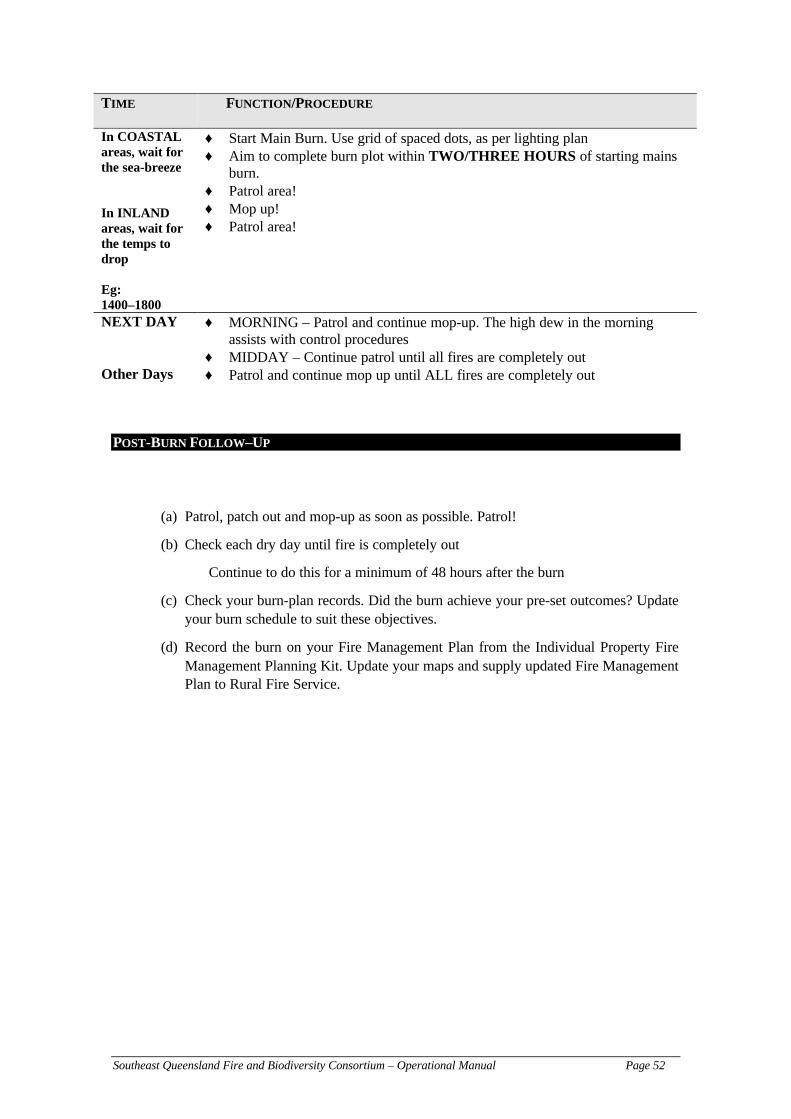
Southeast Queensland Fire and Biodiversity Consortium – Operational Manual Page 52
TIME FUNCTION/PROCEDURE
In COASTALareas, wait forthe sea-breeze
In INLANDareas, wait forthe temps todrop
Eg:1400–1800
♦ Start Main Burn. Use grid of spaced dots, as per lighting plan♦ Aim to complete burn plot within TWO/THREE HOURS of starting mains
burn.♦ Patrol area!♦ Mop up!♦ Patrol area!
NEXT DAY ♦ MORNING – Patrol and continue mop-up. The high dew in the morningassists with control procedures
♦ MIDDAY – Continue patrol until all fires are completely outOther Days ♦ Patrol and continue mop up until ALL fires are completely out
POST-BURN FOLLOW–UP
(a) Patrol, patch out and mop-up as soon as possible. Patrol!
(b) Check each dry day until fire is completely out
Continue to do this for a minimum of 48 hours after the burn
(c) Check your burn-plan records. Did the burn achieve your pre-set outcomes? Updateyour burn schedule to suit these objectives.
(d) Record the burn on your Fire Management Plan from the Individual Property FireManagement Planning Kit. Update your maps and supply updated Fire ManagementPlan to Rural Fire Service.

Southeast Queensland Fire and Biodiversity Consortium – Operational Manual Page 53
Conducting the planned burn
Remember, the purpose of the burn is either to reduce fuel loads or for sound ecologicalpurposes. It is also important to note that these procedures cannot fully eliminate fires. Planned(also known as prescribed or controlled) burning is effective in lowering the risk of higherintensity fires occurring (as there will be less fuel available and lowered chances of firesreaching the canopies) and are the safest areas to contain wildfire but this does not mean fireswon’t occur in the area following planned burning. This is an important distinction worthnoting.
Lighting Patterns
The manner in which a fire is lit will dramatically affect the rate that it covers an area and the“damage” it causes. Ideally, the fire should be slow burning and of low intensity to minimisedamage and also burn out to safe boundaries on the day of lighting minimising the chances of afire escaping. In general, for areas one hectare or larger in size, the one fire cannot do both.
Outlined below are a few methods for lighting fires with associated diagrams to illustrate theadvantages and disadvantages of each method. Consultation with an appropriate expert, such asa member of the Rural Fire Service, is useful to help determine which type of lighting is mostsuitable for your purposes.
1. Single Spot Fires (ideal for TEST FIRES)
As mentioned, single spot fires make ideal ‘test fires’. Note that the fast-moving head-fire has the highest flames but that the back-fire and the two side-fires together accountfor two-thirds of the area burnt.
Figure 9 – Single spot fires (adapted from Tasmania Parksand Wildlife Service 1998)
If you intend to use the spot lighting method, then it is often a much safer and cost effectiveoption to use ‘Fusee’ matches – with no need to use drip-torches, which can exacerbate theextent of planned fires.

Southeast Queensland Fire and Biodiversity Consortium – Operational Manual Page 54
To determine the spacing requirements of your spot fires, please consult the following table:
Table 9 – Spot fire spacing calculator
SPACING OF SPOT FIRES (METRES)
AvailableTime (hrs) Rate of Spread of Head of Test Fire (m/min)
0.2 0.4 0.6 0.8 1.0
1 10 20 30 40 502 20 40 60 80 1003 30 60 100 130 1604 40 80 130 170 2205 50 100 160 220 270
It is important to recalculate the spot fire spacing every hour until lighting is completed.
Also note – all planned burns should be completed within 2–3 hours of initial lighting.
2. Line of Fire Straight Down Spurs
This method is suitable for areas where any head-fire is likely to cause unacceptablescorch. It is not widely used, as the main concerns are that any sudden wind changescould turn it all to head-fires. For this reason, it is only recommended on relatively calmdays (Low Fire Danger Index). When successfully implemented, 90% of the area isburnt by the side-fire. Flame heights and rates of spread can be partially controlled bythe rate of lighting down each spur.
A safety warning: be wary of crossed spurs when lighting! This means you need tohave good mapping and communications. If you have more than one lighter, watch foreach other smoke pattern from their fires and keep a watch on their lighting patterns(speed etc.)
Figure 10 – Line of fires down spurs.
3. Line of Fire (or ‘closed-spaced spots’) across the slope (or on the flat)
This method is best employed along ridge tops to reinforce an uphill fireline where thehead-fire will die because of lack of available fuel, and the back-fire moves slowlydownhillNB.
NB: It is not recommended to light a line of fire at the foot of a forested slope because this willmaximise the scorch and other possible damage, in addition to increasing the risks of escape as

Southeast Queensland Fire and Biodiversity Consortium – Operational Manual Page 55
the fires race up the hill. This is known as ‘Lazy Line’ lighting, and should only be used incircumstances where;
(a) there is nothing to scorch,(b) there are light winds, or(c) there is only a short run to a good firebreak(d) keep in mind, the safety of your lighters!
Figure 11 – Line of fires across slopes
4. Well-spaced spots (for all large burns) – also known as the Forward BurningTechnique
Spots spaced so that they only join up as their flames die down in the evening are ideallighting patterns for covering an area in one day. The pattern is usually a square grid.The row of spots furthest up the hill is always lit first with successive rows of spotsdownhill and parallel to it. Ideally each row follows one contour. Where the wind issignificant on the day, particularly in flat or undulating country, light the downwardedge first to prevent smoke obscuring your vision.
Figure 12 – Fires for well-spaced spots (Forward Burning)
5. Grid Ignition Technique
As Gourley (1996) explains, this is the favoured technique to achieve a mosaic of burntand unburnt areas. As the name suggests, fires are lit in a grid pattern at somepredetermined spacing. The spacing of the fires is dependent on factors such as fuelloads, wind velocity, humidity and air temperature. With this burning technique, the aimis to complete the burn within 2 hours of initial lighting (Gourley 1996).
This burning technique is very similar to figure 10, where the difference is thedetermination of spacings between the fires, which then depends on the objective ofyour mosaic burn and your vegetation types.

Southeast Queensland Fire and Biodiversity Consortium – Operational Manual Page 56
Burning Operations Guide
The following procedure is for conducting a burn to suit southeast Queensland conditions,according to Gourley (1996).
Who should light?The actual lighting of the fire should be conducted by an experienced person with a detailedknowledge of fire behaviour, and is knowledgable enough to use the topography, fuel andweather conditions to their advantage.
When to light?As we have stated above, lighting should only occur in the mid-afternoon, after the test fireshave been lit and the results deem that the fires will be safe to proceed with. Remember, thepeak times for hazard lies between 12:00 pm and 2:30 pm (with 1–1:30 pm the highest hazard).Lighting the main burn after the peak hazard period will allow for more stable conditions andweather patterns, with wind direction in southeast Queensland coastal areas predominantlyeasterly which provides higher relative humidity. There is also a reduction in temperature and asthe afternoon progresses, the wind usually drops with some dew to assist with maintainingsufficient fuel moisture content. Lighting a fire after the main peak in fire-hazard also meansthat any flare ups will occur early so control will be easier as the fire will be smaller (becausethe fire has only just started).
The key word when lighting up is patrolling. You will need to keep a close eye on theprogression of the fire, and to ensure there are sufficient staff to monitor each zone to mop upand to prevent spot fires and escapes. In particular, these staff should be stationed to monitor theinitial fire zones. At the initial fire lighting edge – the most vulnerable point for spot-over due toflame height and width of the fire-line – at least one person is required on foot (with theassistance of a vehicle mop-up unit if available) for patrol and monitoring (Gourley 1996).
Personnel are also required away from the initial firing zones to monitor and patrol. Fire-fighting units from the Rural Fire Service, DPI–Forestry, QPWS are also needed if yourneighbouring land is under their control. It is always important to seek expert advice in yourburns! Typically, the minimum number would be the vehicle (with 2 people) and an additional 2people on foot.
Gourley (1996) points out that with any burning, it is the intention to use existing firebreaks,whether they are natural (creeks, moist vegetation types etc.) or prepared (roads, tracks,constructed breaks, dozer/hand lines) as much as possible, without the need to construct newfire-lines. Remember to remain in control of your planned burn, even if a fire has escaped. Forfires that have escaped, send fire-fighters after it (if you have enough personnel), but the burnarea MUST be completed before it can be deemed safe.
To reiterate the important messages for the correct burning procedures:
– Always burn from the top down
– Be aware and watch for sudden wind changes (these have been the main cause ofdeaths for fire-fighting personnel)

Southeast Queensland Fire and Biodiversity Consortium – Operational Manual Page 57
– Be aware and identify close burning trees/stags (especially those close to fire-lines)
– Be aware of topographic features that may influence local wind direction
– PATROL PATROL PATROL!
– Don’t hurry the burning process – this only increases the heat intensity
– “Be patient, be skilled, be aware of changes (fire behaviour or meteorological), beprepared, have an alternative strategy if things go wrong…be planned!”
– A continuous burnt edge is essential against the break to eliminate the risk of apossible run lower in the fire from running back and spotting over
– Ensure you have done the proper pre-fire preparation – the person lighting the fireshould carry a rakehoe to clear around trees susceptible to catching fire on the edgeof the fire-line. Raking the litter around trees vulnerable to lighting or are habitattrees you want to keep will reduce patrol/mop up time, and the initial chances ofspot overs quite dramatically.
– If an area to be burnt is not large (which would apply to most landowners), theleader should be aware that the backburn face of the fire will progress across thearea and may lead to the other side of the area. This will occur with changing windconditions, topography and time of day. It is important that this other edge andprotected areas are monitored as the fire progresses to limit spotovers and escapes.
– Remember that in all planned fires to ensure you have secured all edges and breaksand to employ the ‘grid ignition system’ to burn out the area if time (or lackthereof) is an important criteria.
– As we have previously mentioned, it is absolutely essential to keep and maintaindetailed fire management maps of all fires, whether they are planned/prescribed orwildfires. This will assist you for planning for wildfire suppression tactics inaddition to any future planned burning of blocks where any schedules may havebeen altered (Gourley 1996). In addition to size and extent of recent fire, weatherdetails and fire observations are also to be kept.
– This obviously depends upon the severity of the wildfire. You local expertise andjudgements will assist you greatly in determining the best way to handle thesituation. Advice from the Rural Fire Service should be sought and adhered too.
– From experience, the fire that YOU light is probably the one that will escape, notfires coming into your property. Remember these fires should be under yourcontrol.
If a fire escapes (also known as a ‘breakaway’ or ‘spot-over’) occurs, as we explained on theprevious page, complete the burn, and send fire-fighting units to contain the spot-over.However, if the escape is minor and will not require significant resources, continuing lightingmay be the best option to minimise the size of the escape fire. Seek professional opinion fromthe Incident Controllers or other senior officials at your planned burn to decide the best courseof action if a fire has escaped from your planned burn. The recommended option is to halt alllighting, suppress or contain the escape fire, reassess the situation (ask yourself, what caused theescape, was there a change in the weather conditions, are your fire control lines coping etc.)before relighting. It is dangerous leaving a high intensity fire burn to its own devices, whereas inmost cases, low intensity fires are ok to self-extinguish, but remember to make sure it is beingwatched.

Southeast Queensland Fire and Biodiversity Consortium – Operational Manual Page 58
NEVER PERFORM ANY PLANNED BURNS FOR WILDFIRE CONTROL — In theevent that a wildfire is approaching, do not attempt to backburn to control the fire…call 000 andensure you are properly prepared for the oncoming fire. The Rural Fire Service will decide ifbackburning is required. If you are a member of the local Rural Fire Brigade, then you can assistand provide vital expertise to control the fire. If you are not a member of the Rural FireBrigades, remember to consult your Fire Management Plan that you developed using theIndividual Property Fire Management Planning Kit (Step 7 and Fire Management Plan Sheet 4)to ensure you are properly prepared for the oncoming fire.
Southeast Queensland Fire and Biodiversity Consortium – Operational Manual Page 59
Mopping up and patrol
The key word again is preparation. If you have prepared the property thoroughly enough, theamount of mopping up, which covers all the procedures required to render an area safe, will beminimal.
Mopping up is an essential and critical aspect of the planned burn, especially for many forestedareas and great care and skill is necessary for it to be completely successful. And its an area offire control which is “difficult to impress the importance of this operation on even trainedstaff” (Gourley 1996).
The procedure of mopping up may carry on for many days after the initial timing of the plannedfires depending on the current weather conditions. This is important in times of high droughtindex when larger pieces of vegetation (such as logs, stumps) can catch fire and continue toburn. In areas with high amounts of decomposing plant material, such as peat swamps, fire maysmoulder for days, sometimes weeks, and could cross into unburnt areas.
As Gourley (1996) states, in many instances where fires escapes from an area in which a burnhas been properly conducted and controlled and meticulously prepared are caused by poormopping up standards.
When the fire has stopped, the perimeter must be secured. The width of these strips where totalfire extinction is needed varies according to local conditions. It is usual to deal with ALLsmouldering or burning material within 10 m of the fire-line and to treat only the moredangerous hazards within 100 m or possibly more on steep sloping ground (Gourley 1996).
While forest fires will require more attention than grass fires, smouldering material close theperimeters of ANY fire should be thoroughly mopped up. The following points should beattended too:
– Mop-up could closely follow initial lighting up – but we recommend you save yourresources for any possible escapes (there is no use using up valuable water or mop-up when a spot-over occurs). Commence mop-up once lighting is finished.Remember to PATROL, PATROL and PATROL!
– Water and earth can often be used to cool down material sufficiently to permithandling,
– The spreading of piles of fuel will help reduce heat, making mopping up quicker,
– Some fuels may be allowed to burn out of they do so quickly and safely,
– Small branches and logs should be dragged well back inside the fire-line. Rakes,axes, saws and levers can be used to make this procedure more efficient,
– Longer pieces of fuel too heavy to carry should be rolled around so that they lie upand down hill slopes,
– If small pieces of plant material are likely to roll downhill, trenches should be dug,
– Stags, rotten logs and stumps will require additional treatment especially if close tothe fire-line (this may involve use of foam retardant, additional clearing or completeremoval). Extreme caution is necessary felling dead or hollow trees and should onlybe undertaken by qualified operators,

Southeast Queensland Fire and Biodiversity Consortium – Operational Manual Page 60
– If complete extinction of such material is doubtful, it is wise to widen the fire-lineat this point, or construct a ‘backstop’ trail connecting to the main fire-line,
– Roots burning underground are dangerous (much like peat fires) and will requiredigging up or other suitable treatment (such as considerable use of water etc.),
Remember we previously mentioned the importance of the Drought Index to assistyou with controlling fires in roots.
– In some cases, it may be necessary to wet down or cover with earth flammable fuelson the unburnt side of the line. This is where the use of ‘backstop’ fire-lines may beuseful,
– Watching for ‘spot overs’ is an important duty for all mop-up crews,
– For safety and economy, water should be used to cool down the fuel to allowfurther handling and separation,
– A cool fire edge is essential. The only real test for signs of heat at possible dangerpoints is by checking with the back of a bare hand,
– Pay close attention to hollow logs close to the edge which can funnel and act like ablow torch, possibly sparking across to unburnt vegetation,
– You may wish to maintain hollow logs for conservation purposes, and if this is thecase, then be sure to provide additional treatment to these logs with wider clearingand the use of water where necessary. Otherwise, hollow logs which are alight canact like a fire funnel or ‘Roman candle’ sparking across into unburnt vegetation.
Constant patrolling is the key here. Once the perimeter has been mopped-up, patrols arenecessary to ensure the fire-lines remain secure. Patrols and mop-up are intricately linkedtogether (Gourley 1996). Once mop-up is complete, only smaller crews are required to deal withany problems which may arise. If the weather conditions are favourable, the frequency ofpatrols may be reduced.
Even though the work of any mop-up and patrol is mechanical, dirty and monotonous (Gourley1996), it is nevertheless one of the most important aspects of fire-control and planned burningprocedures. There must be NO possibility for a fire to escape or relight.

Southeast Queensland Fire and Biodiversity Consortium – Operational Manual Page 61
FIGHTING THE FIRE
As Gourley stated (1996) remember the fire triangle, the three required elements for fires tostart. To prevent fires starting and spreading, the fire triangle must be broken by removing oneor more elements. Quite simply, this is achieved by:
1. Reducing the oxygen by smothering
Even though we can do nothing about stopping the wind, once the fire has started we cansmother the fire using foam or soil, preventing oxygen getting to the fuel. This is onlyfeasible if the fire is small, which is applicable to most of the burns you will be conducting.
2. Removing the fuel with fire breaks
This is self-explanatory and is covered in detail elsewhere. Most fire breaks have allavailable fuel removed and if the fire is low in intensity, will burn itself out (this does notmean leave fire breaks unattended to an oncoming fire!).
3. Reducing the heat using water
This is also self-explanatory, where fire-fighters can use knapsacks and pumps to suppress afire. In situations where there are large fires, it may become quite difficult to control withwater, so a combination of water and fire breaks is needed.
This is explained in further detail below.
If a fire that you have lit has escaped, ensure the proper authorities are alerted. Call 000 andprovide as much detailed information as possible.
You will most likely have expertise on hand, and if they see a fire has escaped will takeappropriate action.
NEVER ATTEMPT TO FIGHT THE FIRE YOURSELF!
Not only will this place your life in danger, but it may put others trying to help you at risk aswell. It cannot be stressed strongly enough, joining your local rural fire brigade will not onlyprovide you with the experience and training required to assist with fire control, they willprobably be the first emergency personnel to arrive and assist with fire suppression.
FIRE EXTINGUISHING PRACTICES
It is helpful though to list the ways that fires can be suppressed. Having this type of informationavailable will help you understand the type of equipment and procedures required to suppressfires. There are a number of methods available to suppress fires, and the use of any method, or acombination of them, will depend upon the extent of the fire situation, the number of personnel,tools and equipment at your disposal.
Use of water to suppress fires
Properly applied, water is by far the best and quickest tool to stop fires. It can besupplied from a number of methods, ranging from trucks, to backpacks and even the useof buckets. Water is applied to the base of fires (sprayed parallel to fire edge), and onceflames are extinguished, mopping up with hand tools is required. Conservation of wateris vital, so shutting off the flow at every opportunity is important. Remember that youwill need to patrol and keep an eye on the fire-line, even after the application of water,to ensure all fires are completely extinguished.

Southeast Queensland Fire and Biodiversity Consortium – Operational Manual Page 62
Some facts about conserving water
A standard knapsack carries between 16–18 litres of water. The spraying capacity of theknapsack spray pump is approximately 3 litres per minute. Therefore, if the knapsack issprayed continuously, the knapsack will empty in about 5 minutes. Please take this intoconsideration so you take note of your refilling point (so you are not too far away)
The Rural Fire Service operates a number of pumps to supply water to suppress fires.Lets consider the smallest pump (3.75 kW – 5 hp) can pump 225 litres per minute. Astandard 650 litre tank will be emptied in only 3 minutes! Larger tank capacities, forexample 3 000 litres, could be emptied in about 13 minutes. Also remember to note thatrefilling will also take time. This is particularly evident when the water source is somedistance away.
How to conserve water?
(1) use a rakehoe and other hand-tools to attack and remove fuel (mostimportant),
(2) use appropriate hoses and always select the smallest nozzle to effectively completethe job,
(3) shut off the nozzle when water is not required,
(4) use a jet-stream for the initial knock down of the fire, but then change to spray sowater covers greatest area possible,
(5) direct the water where it will have maximum effect – at the fuel, not the flame,
(6) break up solid burning material, eg logs, so the water can penetrate into the centrewhere it will have the greatest cooling effect,
(7) if using a pump, operate the pump at the speed necessary to complete thetask…operating the pump above the required speed will waste water and may causedamage to the pump,
(8) if possible, use a wetting agent in the water. Wetting agents are chemicals which areadded to water to aid in breaking the surface tension allowing water to spread outand cover a greater area.
(9) use of foam. Foams have been very useful and act exactly like a wetting agent, butholding onto fuel, increases surface area and creates a thermal barrier. Theenvironmental effects of foam use is not well understood. However, there arerecommendations that limit the use of foam near watercourses, where the foam mayenter the water catchment.
Use of dirt/soil to suppress fires
Very similar to water, soil can help cool and smother fires. The soil should be thrown ina swinging motion to scatter it in a thin layer at the base of the flames along the fireedge. A fast continual action will provide the best results.
Use of green tree branches or gunnysacks – ONLY IN EMERGENCIES

Southeast Queensland Fire and Biodiversity Consortium – Operational Manual Page 63
In some instances (grass fires or low shrub fires) you can use green tree branches to stopthe fire, by cooling the edge of a fire in advance of fire-line construction. However, itshould be noted that the use of branches should be limited.
The method is to swing the branch (also known as bough) toward the fire so that anyembers or sparks are thrown back into the burnt rather than unburnt areas. Gunnysacksare operated in the same way. These are usually wetted first to increase it effectiveness.Remember, this is a very physically stressing activity, and there is a danger with your‘backstroke’ which can flick embers back into unburnt areas.
PROCEDURE AFTER THE BURN
As this document shows, a lot of prior planning is required for any burn to run smoothly andtrouble-free. Once the burn has been completed, there are many things to do to ensure your nextplanned burn are more effective.
Recording – An Essential Element of Fire Management
As we have reported in the Individual Property Fire Management Planning Kit, it is vital that allfires, whether planned or wildfires are properly reported. Remember this document ties inclosely with the Individual Property Fire Management Planning Kit. After you completed theFire Management Plan, we suggest you inform your local Rural Fire Brigade about your plans.Keep a personal copy of the fires. Many local councils are in the process of recording firehistories for their regions, and will require as much assistance as possible, so your records maycontribute to this.
This information provides a written account of the path and extent of the fires and over time canassist you in understanding the fire frequencies and regimes occurring on your land. Having agood record of past fires will help you plan future fires, and will assist you and the local ruralfire brigade with expert knowledge on where fires may travel and how to control any fires.
Recording fires is also important from an ecological perspective. You may want to startcollecting information on how some species (which could be rare or threatened species) respondto fires. You may want to see if the fire regimes that you employ are effective in controlling anyweed species you may wish to control or eliminate. Additionally, you may wish to startmonitoring which animal species recolonise an area following your planned fire or wildfire. TheFire and Biodiversity Consortium has produced a monitoring manual that can help youdetermine the appropriate method to monitor fire and its effect on your land. Contact your localcouncil’s conservation officer for further assistance. These are a small selection of the multitudeof questions you may want to answer following fires on your land.
Recording fire behaviour is an aspect of fire management that is often neglected, but equally asimportant as plant/animal responses etc. Accurately recording the fire in terms of scorch height,estimated rate of spread, and particulars about the headfire itself, will provide enoughinformation to estimate fire intensity and other important fire behaviour characteristics. In otherdocuments we have expressed the significance of variability for maintaining biodiversity. Thisalso applies to fire intensity, and provides another reason that keeping records is a worthwhileactivity. We have provided a number of sheets for you to record fire behaviour (see yellowsheets). Please photocopy these pages for future fire reporting.
The other important reason for record-keeping is to provide a link between the fire and theweather conditions. Again, this will help you guide any future burns and will help you ‘predict’and choose which weather patterns will be best suited to the objectives of your planned burn. It
Southeast Queensland Fire and Biodiversity Consortium – Operational Manual Page 64
also provides you some forewarning about which conditions are potentially more hazardous.Recording should be completed as soon as possible after the fires have been controlled and allyour maintenance schedules are completed. The longer you take to write fire reports, the morelikely it is you will forget some specific and important information which will only assist youwith better planning.
An example of this type of recording proforma is included in the appendices (blue pages). It isrecommended that all fields are completed soon after the fire. Keep these sheets as your master-copy and photocopy the sheets for all your fire records.
ADAPTIVE MANAGEMENT OF YOUR BURNING PLAN.…HOW WE COULD THIS BETTER NEXT TIME?
There is no perfect rule or list of guidelines to perform the ideal prescribed burning plan. Eventhough we have a good idea of how fires move and behave, it is also an intrinsically random andvariable force. Add to this mix, an uneven landscape with a high level of vegetation diversityand of course the human factor…something may occur that is outside of our original intentions.
To ensure that the next planned burn accounts for these variations, after the burning and mop uphas concluded, write down on the burn record:
– what procedures went well during the day,– what effect did the weather have? This is why a thorough and accurate reporting
process is needed,– what procedures didn’t go so well and– what could be done to ensure it went better the next time you do a planned burn.
These could include such aspects as equipment, resources, personnel, priorpreparation, communication strategies, notification etc. It is essential to provide anaccurate account of the aspects which can be enhanced or streamlined.
IMPLICATIONS FOR YOUR INDIVIDUAL PROPERTY FIRE MANAGEMENT PLANNING KIT
In keeping with adaptive management practice, you should update your Fire Management Planthat you have completed using the Fire & Biodiversity Consortium’s Individual Property FireManagement Planning Kit.
The map should be updated to show the extent of the planned burn.
Other things to consider (much like Step 9 of your Individual Property Fire ManagementPlanning Kit) include:
– Are your land uses still the same?– Do you have any additional assets?– Do any of your fire-lines require adjustment or rehabilitation?– What has the fire taught you about the fire regimes required in your bushland?– How will this fire fit in with you multi-year burn schedule?– Has the burn allowed you to reach a balance between property protection and
biodiversity conservation?
Update your plan to suit any changes occurring after the fire. We also recommend you updatethe plan yearly.

Southeast Queensland Fire and Biodiversity Consortium – Operational Manual Page 65
REHABILITATION OF FIRE-LINES & OTHER AREAS
Fire-lines must be maintained for them to remain effective outside of the planned burn times.For most fire-lines, this means that the break must be cleared of all vegetation. All your fire-lines must be mapped, recorded and checked well in advance of the upcoming fire season(starting in September).
As you can see from this document, a successfully executed prescribed burn requires a lot ofpre-planning. Ensuring your fire-lines remain effective is a laborious task, especially if you havea large property which may require a number of fire-lines, but the effort you put in will certainlypay off when you do your planned burn or you encounter wildfires. In your post-burn records,you should describe the effectiveness of your fire-lines. For those fire-lines which were lesseffective or not required, consider if you would like to change the fire-line in some aspect(width, grading, location etc.) or to discard them. If you do decide to discard them or changeexisting fire-lines, remember to update your records and mapping system to reflect thesechanges.
In the instances where you do not require existing fire-lines, rehabilitation of these fire-lines ishighly recommended. Rehabilitation will require some work on your part to restore the fire-linesto its ‘natural’ conditions. Leaving a cleared line unattended to revegetate is fraught with manydifficulties, namely from weed invasion. Therefore, you will need to invest time to replant withspecies native to your area and to ensure the conditions are suitable for growth. Your localLandcare or Bushcare group can provide you with plant-species list native to your region, andcan assist you with replanting. In time, with your assistance, these formerly bare-earth lines willbe fully restored. Weed invasion will only occur in areas where there are existing sources ofweed seeds. In situations where there is an intact native vegetation community, free of exotics,weed invasion is unlikely and natural regeneration may require little or no assistance.
EQUIPMENT CHECKS AND REPAIRS AFTER THE FIRE
An essential element to any coordinated approach to fire management is the use of the properequipment. This is especially important in relation to hose fittings for firefighting vehicles.Therefore, ensure your tanks and other supplies of water have the correct fitting so any RuralFire Service hose can connect to your tanks. Your local Rural Fire Brigade can help withproviding these requirements.
Once all the patrols and mop-ups and maintenance has occurred, equipment that you have usedin the preparation for the planned burns, the control, and mop-up will require maintenance.
Proper upkeep and repair of equipment is essential. In emergency situations, equipment failurefrom improper or inadequate maintenance may injure personnel and endanger people’s lives.
Maintenance may be as simple as ensuring the equipment is cleaned and stored properly, or tomake sure drip-torches nozzles are cleaned and the fuel is topped up. Other equipment mayrequire oiling to keep moving parts from rusting and seizing up. This type of maintenance alsorefers to personal protective equipment, such as helmets, face-masks should also be cleaned andproperly stored. Make sure all first-aid kits are checked and restocked where necessary.
Keep an ‘Equipment Maintenance Schedule’ which lists all your equipment and update this toshow when it was last used and cleaned. Other easily forgotten maintenance requirementsinclude:

Southeast Queensland Fire and Biodiversity Consortium – Operational Manual Page 66
– all pumps should be started once every fortnight and checked that all parts are inworking order. This regular use of the pumps will ensure they will start when youneed them, especially in emergency situations,
– knapsacks should be regularly maintained.
– carry spares (hose clamps, o-rings etc.) with a spare set of screwdrivers and pliers.Again remember you may need them in emergency situations.
Most of the firefighting equipment and resources will be made available through the Rural FireService, but you may wish to keep some equipment on your property (these may include rake-hoes, axes, shovels, brush hooks etc.). There is a list of equipment suppliers at the end of thedocument should you want to purchase any of this equipment.
Here is a list of recommended first aid equipment to have available:
2–3 crepe bandages of each of sizes: 5 cm, 7/5 cmand 10 cm wide
Leucoplast adhesive tape to secure dressings andbandages
3 melolin/melolite non-stick dressings Space blanket2 triangular bandages Safety pins2–3 combine dressings of each of various sizesavailable
Scissors
Betadine antiseptic TweezersStaminade or other electrolyte replacementsatchels
Probe
Saline solution (9%) in small vials or ampoules Notebook and pencils
(adapted from QPWS Fire Management System 2000)
You can obtain a standard Red Cross Vehicle First-Aid Kit that will cover three people forabout $75. A more comprehensive list of personal protective equipment that each personnelshould have in preparation for the planned burn is included in the Appendix. There is noobligation to obtain all this equipment personally. The local firefighting authorities such as theRural Fire Service who will most likely assist you with the implementation of your plannedburn will have this personal and other safety equipment available. This again stresses theimportance of joining your local Rural Fire Brigade.
For many landowners, the most easily forgotten personal protective equipment is a helmet.There are many overhead hazards (falling limbs/trees etc.) so it is especially important to have asuitable helmet. Helmets will also provide suitable protection from radiant heat, which has beenrecognised as the greatest human killer in fires (Webster 2000).
FIRE BEHAVIOUR CALCULATION & MONITORING
It is difficult to monitor everything during a planned burn. One aspect of fire monitoring whichis often neglected is the measurement of fire behaviour. Recording fire behaviour provides someimportant information on the fire intensity and rate of spread of the fire. This in turn providesimportant information on the variability of the fires in your land, which is an important aspect tomaintaining biodiversity. We have discussed above the importance of keeping accurate recordsof your burns.
Appendix 4 – Day of Burn Record outlines some generic information you should record duringthe burn. This should be done at half-hourly intervals following the initial lighting of the fire.

Southeast Queensland Fire and Biodiversity Consortium – Operational Manual Page 67
Flame heights, significant events such as scorch height, spotting and other significant eventsshould be recorded. Any changes in weather conditions should also be noted.

Southeast Queensland Fire and Biodiversity Consortium – Operational Manual Page 68
Notification of the Public
In Queensland, the unique ‘Permit-to-Light’ system applies. If you want to light a fire in theopen, then you will, by law, be required to obtain a permit. This applies to any planned burns.Your local Rural Fire Service Fire Warden issues permits. In preparing your Individual PropertyFire Management Plan, you will have obtained the name and contact for your fire-warden.
However, before obtaining a permit, your Fire Warden will advise you that it is a requirementthat you:
– inform all neighbours–including government departments and absenteelandholders–of your intention to burn,
– inform Firecom of the time/s of your planned burn (the number will be on thepermit, but we have included a list of Firecom phone contacts at the end of thedocument),
– prepare or obtain signs notifying motorists of burning off,– organise a sufficient number of people to help control the fire,– have firefighting equipment ready and in good working order, and– comply with all the conditions set out on the permit.
(adapted from Rural Fire Service Fire Warden’s Manual 2000)
Permits are issued for different lengths of time depending upon each individual situation and theweather conditions. If there is likely to be a smoke issue causing potential safety problems onroads, you will need to arrange appropriate warning signs and traffic control provisions (ifrequired). This is something the Rural Fire Service will assist you with, given a small donation.Communication throughout this process is crucial. Linking up with your neighbours, agencies inadjoining land and the RFS will not only encourages camaraderie between landholders, but thecoordinated approach ensures all possibility of success.
Prior notification of your intention to burn will also include:
– Queensland Fire & Rescue Authority – Firecom– Fire Warden,– Neighbours, and– Media (only if the burn is done in conjunction with local council).
Your Fire Warden will let you know the responsibilities and conduct required of you forobtaining the permit. Your application for a permit may be approved even if a neighbour objectsto your plan to burn, but the Fire Warden must inform the objector of the reasons for approvingthe permit. Permits may be cancelled at any time, but must be in writing.
Local Government Nuisance Laws
As the Fire Warden Manual (2000) states, many local governments have introduced nuisancelaws and many other councils are considering similar legislation. Typically, these local lawsaddress issues related to smoke, noise, odour and visual amenity. An example of such a locallaw is Redland Shire Council Local Law No. 18 (Control of Nuisances), which allows the localgovernment to restrict or prohibit the lighting of fires in the open.
Under the Queensland Fire and Rescue Authority Act 1990, the legislation that grants theauthority and power to Chief Fire Wardens and Fire Wardens is superior legislation to Local

Southeast Queensland Fire and Biodiversity Consortium – Operational Manual Page 69
Government Nuisance laws and overrides those laws. This is reflected in the Redland ShireCouncil example, where that local law cannot restrict or prohibit fires with a valid permit.
There is a requirement for any Fire Warden to consider the intent and implication of these LocalGovernment Nuisance Laws when processing any permit applications. As the Fire WardenManual (2000) states, in most situations a win/win situation is possible through the “judicialconditioning” of any Permit to Light issued.
We have supplied a checklist (next page) for you to record the names of people/organisations tocontact prior to the burn.

Southeast Queensland Fire and Biodiversity Consortium – Operational Manual Page 70
Planned Burning Notification Checklist
Below is a list of names and contacts you should contact before you conduct your planned burn.Keep this list regularly updated and easily accessible.
TYPE OF CONTACT NAME ADDRESS TELEPHONE OTHER INFO.
Fire Warden
Queensland Fire &Rescue Authority
Neighbours
Media –(only if burn is inconjunction withlocal council)
Other

Southeast Queensland Fire and Biodiversity Consortium – Operational Manual Page 71
Escapes and Accidental Fires Report Checklist
Reporting of fires is essential to facilitate better planning. This includes all fires, regardless ofthe level of control. We have outlined how reporting can assist you to better plan and execute afuture fire, but it is as important if a fire escapes.
You will need expert input in the implementation of any planned burns on your property.However, since fires are almost impossible to completely control despite our best intentions, insome circumstances, with some adverse or unexpected changes in the weather or terrain, firesmay sometimes escape.
In the event of an escape, the proper authorities will be notified so emergency action can beimplemented to suppress the fires. Experienced personnel from the Rural Fire Service, DPIForestry, QPWS and local government with incident management training will take over thesuppression activities. If you have a fire which escapes:
– Call Firecom – inform them if the fire is containable using the available personneland resources, otherwise, let Firecom know the location and extent of the fire
– Keep Firecom informed of fire-suppression details, and finally
– If the fire is beyond your control, call 000.
Note: we have asked you to employ some value judgment here for controlling escapes.Don’t try to tackle an escaping fire if you do not have the resources at hand.
Following the containment of any breakaway fires, you should write a formal report which is tobe sent to the Rural Fire Service so that the cause(s) can be taken and appropriate action taken toimprove fire management practices. This report should address the points below:
1. Identifying Information
– Planned burn number– Fire Season, eg 1998/99– Type of Planned Burn– Area of Planned Burn– Accident location– Type of accident
2. Weather
Report the weather conditions,– at the time of ignition– the outlook (forecast) obtained– at the time of escape/accident– subsequent to escape/accident– Drought Index and Soil Dryness Index
3. Ignition
Briefly describe how the burn was lit noting changes that were made to the lighting plan,any problems you encountered and the fire behaviour
4. Boundaries
Describe the boundary to the planned burn where the fire escaped and any other factors usedto contain the burn, eg differences in fuel moisture etc.

Southeast Queensland Fire and Biodiversity Consortium – Operational Manual Page 72
5. Fuel Type (Internal)
Describe the type, quantity and distribution of fuels from where the fire escaped
6. Fuel Type (External) and Fire Behaviour
Describe the type, quantity and distribution of fuels into which the fire escaped. Note fuelmoisture conditions (if possible) and how the fire spread.
7. Resources
Indicate your resources present at time of escape.
8. Listing Losses
List any items damaged, burnt or lost in the escaped fire.
9. Contributing Factors to Escape
Summarise how the fire escaped and how it is likely to have occurred and the factors likelyto have contributed.
10. Recommendations Arising
Every effort should be made to assess causes of all escapes and the resultant damage.Consider the contributing factors and how these eventualities may have been avoided orotherwise dealt with in future burns to prevent the same situation occurring again.
Southeast Queensland Fire and Biodiversity Consortium – Operational Manual Page 73
Fire Competency – Training Options
It is important for landowners to understand the requirement of appropriate training in firefighting. Nationally, there exists a competency-based learning system for fire training. Thissystem is commonly known as Level–1 and Level–2 Competency training, but is also known asthe ‘Fire Management Level 1 and 2 Training). There are a few avenues to attain this type oftraining. Level–1 competency covers aspects such as fire behaviour, fire weather, safety issues,personal safety, methods of fire suppression, communication and the appropriate legislation.Higher level training includes risk management, incident control systems and focuses oncommunication and control of other crew members.
As we have strongly advocated throughout this document, we highly recommend thatlandowners join the local Rural Fire Brigade. Not only will the Rural Fire Brigade provide theappropriate training, it will instil a better sense of your community by joining the Rural FireService (RFS). As most of the planned burning operations will likely involve the assistance andexpertise of the local brigade, by being an active member, will be beneficial for all concerned.Rural fire brigades regularly maintain training-days to ensure all members remain familiar withthe procedures require during planned burn and fire suppression efforts. In addition to beingable to maintain a competent level of training, it also provides an opportunity to attend andassist in wildfire and planned burning suppression efforts.
To maintain your level of competency, you must attend a fire every 12 months.This is another benefit for joining the Rural Fire Service.
For some landowners, where attaining accreditation for fire fighting forms an essential part oftheir job, then it may be useful to do this training at a commercial centre. The same type ofinformation is provided with training from the RFS. Some places in southeast Queensland thatprovide this type of training includes, the Gympie Training Centre (operated by the Departmentof Primary Industries) and the Nudgee College Outdoor Education Centre offers both Levels oftraining and some TAFE colleges offer the basic level of training.

Southeast Queensland Fire and Biodiversity Consortium – Operational Manual Page 74
Other Important Information
Personal and Crew Safety Issues
Here is some information to help with the procedures to follow if someone is injured at the fire.These are not training notes, and it is recommended you do a certified first aid course. In allcases where injury occurs, immediately contact emergency services and stay with the patient.The following information is adapted from Gourley’s (1996) ‘Fire Training Manual’.
1. No pulse – Perform CPR (if appropriately trained). Seek medical help.
2. Bleeding
– Place person at rest – reassure – restrict their movement– Apply dressing and constrictive bandage– Raise injured part (if possible)– If severe – apply direct pressure plus above. Seek medical help.– For severed parts – place in clean plastic bag – keep cool and do not immerse
directly in water.3. Fractures
– Immobilise part – patient’s comfort– Seek Medical help
4. Smoke Inhalation
Symptoms include – Stress to eyes, lungs and throat– Excessive coughing– (Extreme cases) possible throat and lungs burnt
Treatment includes:– Remove person from fire front and rest them– Be aware of possible burn to throat. Seek medical help if serious.
5. Burns
There are three types: 1st, 2nd and 3rd degree burns. In fire fighting, usually 1st and 2nd degreeburns result from direct contact with flames or touching hot objects:
– In these cases, remove patient– Cool the burnt area and surrounds – 10–15 minutes cool running water (not
pressure)– Cover the area with clean cotton material (NOT bandages)– Seek medical helpDO NOT – Break blisters
– Use antiseptic preparations– Remove charred clothing or particles from burnt area
6. Heat Stress
– Caused by restriction of airflow, sometimes from Protective Clothing (Overalls)– Body needs to sweat and cool by evaporation– Needs large and frequent amounts of cool water (1.8 L per hour)If body does not sweat/cool, circulation is overloaded and dehydration occurs
Symptoms include: feeling weak, dizzy, weak pulse, shallow breathing, clammy skinand pale face
Treatment includes:
Southeast Queensland Fire and Biodiversity Consortium – Operational Manual Page 75
– Move person to cooler area– Give small frequent amounts of cool water– Remove restrictive clothing– NEVER give alcohol or carbonated drinks – these will increase dehydration!
7. Snake or Spider Bites
Identify snake/spider if possible
Red-Back Spider Bites
– Apply cold pack, immediately seek medical help– DO NOT BANDAGE
Snake and others
– Do not wash area– Apply constrictive bandage – up and down bit limb– Immobilise limb and person– Seek medical help– Reassure
Some suppliers for equipment include:
McArthur Fire Meters – are a registered product from the CSIRO. Styrox (Aust.) Pty Ltd. arethe only registered company to supply the McArthur FDI meters. They are located at Unit 8/7Jubilee Avenue, Warriewood NSW 2102, phone (02) 9997–1000.

Southeast Queensland Fire and Biodiversity Consortium – Operational Manual Page 76
Final Checklist Before You Light
Have you…
1. A valid Permit to Light from your Fire Warden,
2. Obtained the latest available weather information and forecasts, such as wind
speed and direction, humidity and rainfall,
3. Located, outlined and recorded where the different types of fuel occur on your
property,
4. Located, outlined and recorded where your fire-lines are situated (do you have a
contingency plan if these control lines are breached),
5. All the available and functioning firefighting and fire-lighting equipment,
6. All available firefighters and personnel required for the burn,
7. All appropriate personal safety equipment. These can be either overalls (ideal) or
cotton pants and long sleeve shirt, along with heat resistant boots, and suitable
head protection,
8. A comprehensive first aid kit
9. An available supply of water (for fire suppression efforts, and for personal use),
10. Updated your fire management plan for your property, and
11. A readily available list of contacts of assistance is needed.
12. Notified your Neighbours, Firecomm of your intention to burn?
If you answered NO to any of these questions, then you cannot proceed with the planned burn.
It may be worthwhile reiterating that under the Permit to Light system, that you can be liablefor any costs incurred for suppressing fires that escape or cause damage to other property/assets.

Southeast Queensland Fire and Biodiversity Consortium – Operational Manual Page 77
Appendices
1. Fuel Assessment Guide (from McCarthy 2000)
2. McArthur Wheel (Steps to Use)
3. Firecom Phone Numbers for Southeast Queensland
4. Day of Burn Record
5. Fuel Reduction and Ecological Planning Burning Form (from Tasmania Parks and WildlifeService 1998)
6. Beaufort Scale
7. Comprehensive First Aid Kit

Southeast Queensland Fire and Biodiversity Consortium – Operational Manual Page 78
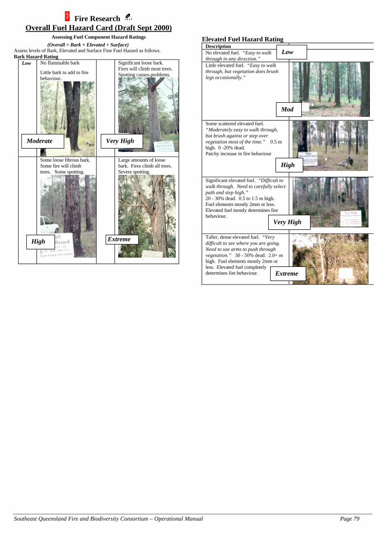
Southeast Queensland Fire and Biodiversity Consortium – Operational Manual Page 79
Fire Research Overall Fuel Hazard Card (Draft Sept 2000)
Assessing Fuel Component Hazard Ratings
(Overall = Bark + Elevated + Surface)Assess levels of Bark, Elevated and Surface Fine Fuel Hazard as follows.Bark Hazard Rating
Low No flammable bark
Little bark to add to firebehaviour.
Significant loose bark.Fires will climb most trees.Spotting causes.problems.
Some loose fibrous bark.Some fire will climbtrees. Some spotting.
Large amounts of loosebark. Fires climb all trees.Severe spotting.
Elevated Fuel Hazard RatingDescriptionNo elevated fuel. “Easy to walkthrough in any direction.”Little elevated fuel. “Easy to walkthrough, but vegetation does brushlegs occasionally.”
Some scattered elevated fuel.“Moderately easy to walk through,but brush against or step overvegetation most of the time.” 0.5 mhigh. 0 -20% dead.Patchy increase in fire behaviour
Significant elevated fuel. “Difficult towalk through. Need to carefully selectpath and step high.”20 - 30% dead. 0.5 to 1.5 m high.Fuel elements mostly 2mm or less.Elevated fuel mostly determines firebehaviour.
Taller, dense elevated fuel. “Verydifficult to see where you are going.Need to use arms to push throughvegetation.” 30 - 50% dead. 2.0+ mhigh. Fuel elements mostly 2mm orless. Elevated fuel completelydetermines fire behaviour.
Extreme
Very HighModerate
High
Low
Mod
High
Very High
Extreme

Southeast Queensland Fire and Biodiversity Consortium – Operational Manual Page 80
Surface Fine Fuel HazardRating System based onLitter Bed Height (measure withgauge)
Surface FineFuel Hazard
Low Mod High VeryHigh
Extreme
Litter Bed Height(mm)
<15 15-25 25-35 35-50 >50
Equivalent SurfaceLoad (t/ha)
<4 4-8 8-12 12-20 >20
Combining Bark, Elevated and Surface Fine FuelHazards to give an Overall Fuel Hazard for a site:
Table 1. Bark Hazard: Low or Moderate Surface Fine Fuel Hazard
L M H VH EL L M M H H
Elevated M L M M H HFuel H L M H VH VH
Hazard VH VH VH VH VH VHE E E E E E
Table 2. Bark Hazard: High Surface Fine Fuel Hazard
L M H VH EL L M H H H
Elevated M L M H H HFuel H L H H VH VH
Hazard VH VH VH VH VH EE E E E E E
Table 3. Bark Hazard: Very High/Extreme Surface Fine Fuel Hazard
L M H VH EL M VH VH VH E
Elevated M M VH VH E EFuel H M VH E E E
Hazard VH E E E E EE E E E E E
Equivalent Fuel Loads (t/ha) for given Hazard ratings(Insert total of components into McArthur Meter forpredictions of forward rate of spread and flame height)
Fuel Low Mod High V High ExtremeBark 0 0 2 5 7
Litter/Surface
2 6 10 16 20
Elevated 0 0 2 6 10
e.g. High Bark High Surface V. High Elevated 2 + 10 + 6 = 18 t/ha Overall
Suggested Overall Hazard levels for Fuel ManagementZones
FMZ 1 (P1) - ModerateFMZ 2 (P2) - HighFMZ 3 (P3) - High on 50% of total area. (i.e.
other 50% may be higher)
Probability of First Attack Success
0%
10%
20%
30%
40%
50%
60%
70%
80%
90%
100%
0 20 40 60 80 100
Forest Fire Danger Index
Prob
abili
ty o
f Fi
rst A
ttack
Suc
cess
Overall Fuel Hazard
1 Low
2 Moderate
3 High
4 Very High
5 Extreme
2.5
3.54.55.5
This graph isbased on datafrom FireResearch ReportNo.45. Therewere no firstattack failures onHigh Overallsites, butExtended FirstAttack (15+ men,big dozers, bigtankers, aircraftetc.) wasrequired on someOverall Highsites at higherFDIs
For further information:Fire Research Officers Orbost 03 51541208 , Creswick 03 53214181.Refs : Fire Research Reports No. 45 & 47. Prepared by : Greg McCarthy Sept 2000.

Southeast Queensland Fire and Biodiversity Consortium – Operational Manual Page 81

Southeast Queensland Fire and Biodiversity Consortium – Operational Manual Page 82

Southeast Queensland Fire and Biodiversity Consortium – Operational Manual Page 83
Firecom Contact Details
REGION / LOCALITY PHONE NUMBER
Brisbane (Central) 1–800–017029
Southport (Southern)
Offices
1–800–689958
5583–7500 (#5)
Kawana (North Coast)
Offices
1–800–354621
5493–4964
Caboolture Rural Fire Service (Northern) 5499–1009
Ipswich Rural Fire Service (Western) 3202–1444
Other Important Contacts:
Bureau of Meteorology (Weather Forecast) 3239–8705 (#3)
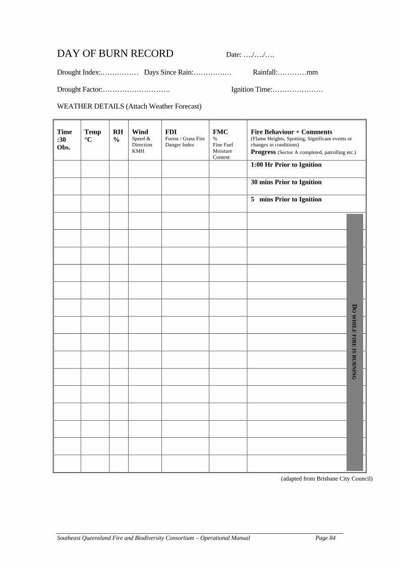
Southeast Queensland Fire and Biodiversity Consortium – Operational Manual Page 84
DAY OF BURN RECORD Date: …./…./….
Drought Index:.…………… Days Since Rain:………….… Rainfall:…………mm
Drought Factor:………………………. Ignition Time:…………………
WEATHER DETAILS (Attach Weather Forecast)
Time:30Obs.
Temp°C
RH%
WindSpeed &DirectionKMH
FDIForest / Grass FireDanger Index
FMC%Fine FuelMoistureContent
Fire Behaviour + Comments(Flame Heights, Spotting, Significant events orchanges in conditions)
Progress (Sector A completed, patrolling etc.)
1:00 Hr Prior to Ignition
30 mins Prior to Ignition
5 mins Prior to Ignition
(adapted from Brisbane City Council)
DO
WH
ILE
FIR
E IS B
UR
NIN
G

Southeast Queensland Fire and Biodiversity Consortium – Operational Manual Page 85
Fuel Reduction and Ecological Burning Reduction Form
(adapted from Tasmania Parks and Wildlife Service 1998)
Contact DetailsBurn Planned Prepared By:..................................................................................................Contact No.:...........................................................................................................................
Location and ObjectivesDistrict: ...................................................... Location (grid reference): ...............................Tenure: ...................................................... Location (describe):.........................................Year/Month(s) of Burn:.............................. Gross Area (ha):..............................................Fire Permit No.:.....................................................................................................................Objective:............................................................................................................................................................................................................................................................................................................................................................................................................................................................................................................................................................................Origin of Burn (fire management plan, neighbour request, coordinated burn with RFS, DPIetc.).......................................................................................................................................................................................................................................................................................................................................................................................................................................
Fuels to be BurntVegetation
TypeLocation
(eg N slopes)Fuel Type
(litter, shrubetc.)
Area(ha)
Fuel Age(yrs)
Fuel Qty(t/ha)
Special Planning ConsiderationsRare and Threatened Species Present: .............................................................................................................................................................................................................................................................................................................................................................................................................................................................................................................................Other Planning Constraints (eg nearby assets, hazards, fuel distributions, neighbours etc.) ..............................................................................................................................................................................................................................................................................................................................................................................................................................................................................................................................................................................................

Southeast Queensland Fire and Biodiversity Consortium – Operational Manual Page 86
Boundary Preparation
BoundaryType
Length(meters)
Work Required DateCompleted
Other Pre-Burn Preparation
Work Required(eg waterholes, fence lines, line construction, edge burning)
DateCompleted
Weather PrescriptionsMax Flame Height (m): ................... Max Rate of Spread (m/min): ..................................Temperature (°C): ...... to ............. SDI (mm): .................................. to .........................Humidity (%): ...... to ............. Forest FDR: ................................ to .........................Wind (km/hr): ...... to .............Wind Direction: ...... to .............Other (eg sunshine, days since rain):......................................................................................................................................................................................................................................Outlook: ................................................................................................................................................................................................................................................................................
Lighting and Patrol Strategy
Lighting Method (state): .......................................................................................................
Lighting Strategy:..................................................................................................................
...............................................................................................................................................
...............................................................................................................................................
...............................................................................................................................................
Mop Up and Patrol Strategy (eg, resources, timing, next high FDR day): ............................
...............................................................................................................................................
...............................................................................................................................................
...............................................................................................................................................

Southeast Queensland Fire and Biodiversity Consortium – Operational Manual Page 87
Lighting Plan
Attach/Consult: Topographic Map (name, scale, and North point)
Indicate: – Access – Assets – Potential Hazards– Boundary Types – Test fire locations – Water stations/points– Fuel types, dist. & quantity – Crew placement/assembly points – Lighting pattern
Resources
Fire Controller (name):................................. Ignition Equip (No): .....................................
Navigator (name): .................................... Ignition Fuel (litres/caps):..............................
Slipons (No.): .................................... Pumps (No.): .................................................
Other Personnel (No.): ................................. Other: ............................................................
Notification Checklist
To Contact(tick box)
Names Phone No. Done(Date/Time)
Fire Warden
Local Brigade
Local Council
Local Police
Adjoininglandowners
Neighbours
Other

Southeast Queensland Fire and Biodiversity Consortium – Operational Manual Page 88
Pre-burn Monitoring
DateRainfall (mm)
Peat/Soil(wet, moist, dry)Leaf Litter Bottom(wet, moist, dry)Leaf Litter Top(wet, moist, dry)Aerial Fuel(wet, moist, dry)
Weather Forecast for Day of Burn
Obtain the latest information for:
Rainfall to 9am (mm): ............................. Days Since Rain: ........................SDI (mm): ............................. Drought Factor: ........................Max Temperature (°C): ............................. Haines Index (if appl):.......................Relative Humidity (%): ............................. Dew Point (°C): ........................Wind Speed (km/hr): ............................. Wind Direction: ........................Forest FDR: .............................
Briefing Check-List
A briefing is essential for all planned burns. Deliver briefing in sections, each covering oneaspect of the burn plan. Involving the input of experts is essential here. Obtain feedback at theend of the briefing. Briefings should cover:
1. Objectives2. Chain of Command3. Lighting & control strategy4. Allocation of crews to tasks5. Coordinating Instructions
– timing– communication channels– command signals– reporting requirements
6. Logistics– water and turning points
7. Safety– safety equipment– hazards– escape routes
8. Recording requirements

Southeast Queensland Fire and Biodiversity Consortium – Operational Manual Page 89
Test Fires
Record fire behaviour for a 10 minute period after test fire has been alight for 10 minutes
No.1 No.2 No.3Time Test Fire Lit: ................................ .................................. ...................................Headfire Rate of Spread (m/min) ............................. .................................. ...................................Flankfire ROS (m/min) ................................ .................................. ...................................Backfire ROS (m/min) ................................ .................................. ...................................Headfire Flame Height (m) ................................ .................................. ...................................Hours to 1800 hrs EST ................................ .................................. ...................................Ignition Spacing (see table below)............................. .................................. ...................................
Forward Rate of Spread of Test Fire0.2 0.4 0.6 0.8 1.0
Hours to1800 Hrs
EST Spacing of Spots (m)1 10 20 30 40 502 20 46 60 80 1003 30 60 100 130 1604 40 80 130 170 2205 50 100 160 220 270
Lighting Up
Date: .................................. Time Light-Up Commenced:............
Ignition Spacing (m): .................................. Time Light-Up Completed: ..............
Time to Burnout (hrs):................................
Weather and Fire Behaviour Observations
Time (24 hr clock)Temperature (dry bulb) °CTemperature (wet bulb) °CRelative humidity (%)Tree top Wind Speed (km/h)1.7 m Wind Speed (km/h)Wind DirectionCloud (%)Forest FDRVegetation TypeLocation (eg N slopes)Fuel TypesRate of Spread (m/min)Flame Height (m)
What effect did the weather have on your burn?.................................................................
...............................................................................................................................................
...............................................................................................................................................
...............................................................................................................................................
...............................................................................................................................................

Southeast Queensland Fire and Biodiversity Consortium – Operational Manual Page 90
Post Burn EvaluationVegetation
TypeLocation
Eg N slopes
Fuel Type Area Burnt
%
Fuel LoadRemaining
t/ha
OverstoreyScorched
%
Comments on Light Up (note modifications to burning plan or lighting pattern as a result ofconditions on the day): ............................................................................................................
...............................................................................................................................................
...............................................................................................................................................
Comments and Recommendations: ......................................................................................
...............................................................................................................................................
...............................................................................................................................................
...............................................................................................................................................
What procedures went well during the day? ...................................................................
...............................................................................................................................................
...............................................................................................................................................
...............................................................................................................................................
...............................................................................................................................................
What procedures didn’t go so well?.................................................................................
...............................................................................................................................................
...............................................................................................................................................
...............................................................................................................................................
...............................................................................................................................................
Date Burn Declared Out: ......................................................................................................
Escapes
Did the burn escape? Yes / No
If the burn escape, please file report

Southeast Queensland Fire and Biodiversity Consortium – Operational Manual Page 91

Southeast Queensland Fire and Biodiversity Consortium – Operational Manual Page 92
Beaufort Scale for Estimating Wind Velocity
BeaufortNumber
Term Wind Speed(km/hr)
Description
0 Calm 0 Smoke rises vertically
1 Light air 1–5 Smoke drifts slowly; wind vanes notaffected
2 Light breeze 6–11 Wind felt on face; leaves rustle;ordinary wind vanes move
3 Gentle breeze 12–19 Leaves and twigs in motion; windextends light flag
4 Moderate breeze 20–28 Dust and loose paper raised; smallbranches move
5 Fresh breeze 29–38 Small trees sway6 Strong breeze 39–49 Large branches in motion; whistling
heard in telephone wires7 Near gale 50–61 Whole trees in motion; inconvenience
felt when walking against wind8 Gale 62–74 Twigs broken off trees; progress of
walkers impeded9 Strong gale 75–88 Branches broken off trees, slight
damage to buildings10 88–10111
Whole gale102–120
Trees uprooted; much damage tobuildings
12 Hurricane 120+

Southeast Queensland Fire and Biodiversity Consortium – Operational Manual Page 93

Southeast Queensland Fire and Biodiversity Consortium – Operational Manual Page 94
COMPREHENSIVE FIRST AID KIT
MANDATORYIdeal – Proban* Overalls as per standard issueSatisfactory – long sleeve cotton pants and shirt
Helmet with chin-strap (check replacement dateof helmet and harness)
Fire resistant boots (steel cap is desirable) withfire resistant sole (Nitrile or similar)
Goggles
Triangular bandage or face mask Leather gloves (eg riggers gloves)Personal water bottle/s (enough for 1 L/hr) TorchPersonal first aid kit (see below)
HIGHLY DESIRABLEMatches Pocket knife (Leatherman Tool or equivalent)Compass (in vehicle) Broad brim to attach to helmet
DESIRABLEWaist pack or belt to carry water, first aid kit,radio, matches etc.
Earplugs and spares
Emergency ration pack / thermos
CONTENTS FOR PERSONAL FIRST AID KIT3 large combine dressing pads 2 melolin/melolite non-stick dressings1 triangular bandage 1 crepe bandage (5 cm wide)2 crepe bandages (7.5 cm wide) 2 crepe bandages (10 cm wide)1 chlorhexidine/centrimide aqueous irrigationampoule (30 ml)
1 dressing strip (6 cm × 1 cm)
Skin closure (8 cm)
*Proban is a chemical treatment to increase the fire-retardance of fabric.(adapted from QPWS Fire Management System 2000)

Southeast Queensland Fire and Biodiversity Consortium – Operational Manual Page 95
References
Bellamy, C. 1985. The use of plants to minimise risk of bushfire damage to buildings in thenorth coast of New South Wales. University of New England, Diploma of Urban andRegional Planning Thesis.
DPI. 1998. Department of Primary Industries (Forestry) Fire Manual. Department of PrimaryIndustries.
Gold Coast City Council. 1998. Gold Coast City Bushfire Management Strategy. Gold CoastCity Council. 122 pp (plus 5 maps and 5 appendices).
Gourley, N. 1996. Fire Training Notes – Level 1. Department of Primary Industries (Forestry).Training Manual.
McArthur, A.G. 1973. Forest Fire Danger Meter (Mark 5). Forest Research Institute, Forestand Timber Bureau, Canberra.
Sheridan, J. 1996. The flammability of common garden plants and Australian natives: a searchfor fire retardant plants. University of Tasmania, Dept. of Geography & EnvironmentalStudies, Honours Thesis. 113 pp.
Tasmania Parks and Wildlife Service. 1998. Fuel Reduction – Burning Operations Guide.Tasmania Parks and Wildlife Service. 61 pp (plus 6 page appendix).
Tran, C. and C. Wild. 2000. A Review of Current Knowledge and Literature to Assist inDetermining Ecologically Sustainable Fire Regimes for the Southeast QueenslandRegion. 106 pp.
Tran, C. Wild, C. and Zubrinich, T. 2001. Testing Mutch’s Hypothesis in southeast Queensland:plant flammability revisited. In [Eds] Pearce, G. and Lester, L. Proceedings of JointBushfire2001/FRFANZ Conference, Christchurch, New Zealand. Pp 43–52.
Watson, P. 2001. The Role and Use of Fire for Biodiversity Conservation in South-eastQueensland: Fire Management Guidelines Derived from Ecological Research. 49 pp.
Webster, J. 2000. The Complete Bushfire Safety Book. Random House (Aust) Pty Ltd. 352pages. ISBN –174051-034-8.

Southeast Queensland Fire and Biodiversity Consortium – Operational Manual Page 96
Consortium publicationsThe SEQ Fire and Biodiversity Consortium has produced a suite of materials to support landmanagers and those who work with them. Materials completed, or nearing completion as ofFebruary 2002 include:
A comprehensive literature reviewTran, C. and C. Wild. 2000. A Review of Current Knowledge and Literature to Assist inDetermining Ecologically Sustainable Fire Regimes for the Southeast Queensland Region.106pp.
A database of fire ecology literatureTran, C. 2000. CD-Rom of Fire Regime Literature.
A database of SEQ fire research and monitoring projectsTran, C. and P. Maidens. 2000. Southeast Queensland Fire and Biodiversity Research StudiesDatabase.
Ecological guidelines, for professionals who want a moderately in-depth summary of themanagement implications of the fire ecology literature
Watson, P. 2001. The Role and Use of Fire for Biodiversity Conservation in South-eastQueensland: Fire Management Guidelines Derived from Ecological Research. 49pp.
A list of potential research projectsList of potential fire ecology research projects and contacts. 16pp.
An introductory fact sheet for private landholders and the general public (Level-1 brochure)Watson, P. 2001. Fire and Nature Conservation in Southeast Queensland: an Introduction. 4pp.
A more comprehensive fact sheet for landholders and community group members (Level-2brochure)
Watson, P. and Tran, C. 2001. Fire in Bushland Conservation. 20 pp.
A fact sheet for Land for Wildlife landholders, produced in conjunction with Land for WildlifeMoran, C. and Watson, P. 2000. Fire as a Wildlife Habitat Management Tool. Land for WildlifeNote No. 14. Land for Wildlife Program Southeast Queensland. 8pp.
A kit to assist landholders develop a fire management plan for their propertyIndividual Property Fire Management Planning Kit: Balancing Fire Safety with Conservation ofBushland Plants and Animals. 41pp.
A manual to assist local government and landowners plan and conduct hazard reduction/ecologicalburning for their property
Tran, C. 2002. Best Practice Fire Management Manual – Operational Level: Guidelines and
Procedures. 100 pp.
A manual to assist local government plan and develop a fire management strategy for council-administered land
Tran, C. 2002. Best Practice Fire Management Manual –Strategic Level: Guidelines and
Procedures. 35 pp.
A manual to assist local government officers with various methodologies that can be used tomonitor and evaluate fire management of council-owned land.
Fire Monitoring Manual: Methods and Decision Matrices. 2002.
Copies of these materials can be obtained from the Southeast Queensland Regional BushcareFacilitator, Queensland Parks and Wildlife Service, phone (07) 3202-0223.