south ridgeline habitat study final report
DESCRIPTION
South Ridgeline Habitat Study Final Report, City of EugeneTRANSCRIPT

South
Ridgeline Habitat Study
FINAL REPORT For the City of Eugene, Oregon August 2007 By Salix Associates With Tim Brooks (Winterbrook Planning) Jim Reed, PhD. Katie Mitchell Nancy Holzhauser (Environm. Solutions LLC) Christie Galen (SWCA Environm. Consultants) Barbara Wilson, PhD. Dan Gleason Marc Hayes, PhD. Erika Beyer
Salix Associates August 2007
South Ridgeline Habitat Study Final Report p. 1
South Ridgeline Habitat Study Final Report
August 2007
1.0 Executive Summary..................................................................................................................... 2
2.0 Purpose of the Study.................................................................................................................... 3
3.0 Background .................................................................................................................................. 3
3.1 Landscape Context..................................................................................................................... 3
3.2 Ecological History. .................................................................................................................... 5
3.3 Existing Habitat Conditions....................................................................................................... 7 3.31 Vegetation. ........................................................................................................................... 7 3.32 Wildlife. ............................................................................................................................... 8 3.33 Ecological Functions............................................................................................................ 9
4.0 Methodology ............................................................................................................................... 10
4.1 Meetings................................................................................................................................... 10
4.2 Map and Data Transfer and Acquisition ................................................................................. 10
4.3 Methodology Development and Application............................................................................ 10
5.0 Inventory and Assessment Results ........................................................................................... 26
5.1 Inventory Summary. ................................................................................................................. 26 5.11 Cover Type Analysis.......................................................................................................... 26 5.12 Vegetation Layer Observations.......................................................................................... 29 5.13 Habitat Changes. ................................................................................................................ 29 5.14 Narrative Summary of HAU Inventory Observations. ...................................................... 31
5.15 Uncommon and Rare Species Documentation and Habitat Suitability. ................................ 39 5.2 Assessment Results. ............................................................................................................. 42
6.0 Conclusions................................................................................................................................. 46
7.0 Recommendations ...................................................................................................................... 47
References.......................................................................................................................................... 48
Individual and Agency Contacts...................................................................................................... 51
Glossary ............................................................................................................................................. 52
Appendices......................................................................................................................................... 55

Salix Associates August 2007
South Ridgeline Habitat Study Final Report p. 2
List of Tables and Figures
TABLES Table 1. Acreage of 1851 vs. 1936-44 vs. 2006 inventoried habitats within the SRHS area. ............. 7 Table 2. Common native vascular and invasive, exotic vascular plant species of the SRHS area by
layer (tree, shrub, forbs/grasses). ....................................................................................... 8 Table 3. Examples of common native and exotic wildlife of the SRHS area by category. ................. 8 Table 4. Original number of parcels, and acreage of original SRHS study area.............................. 11 Table 5. Potentially-occurring and documented (shown in bold type) uncommon and rare species of
the SRHS area. .................................................................................................................. 14 Table 6. SRHS inventory tools and products. .................................................................................... 15 Table 7. Original (A), developed (B), added (C), and total surveyed (D) acres. .............................. 18 Table 8. Rare Species Suitability Index for each SRHS inventoried cover type, in order from highest
to lowest. ........................................................................................................................... 22 Table 9. Acreage of 2006 cover types inventoried in the SRHS area. .............................................. 27 Table 5. Key habitats identified prior to SRHS, and findings within the study area. ........................ 27 Table 11. Activities and processes impacting habitats throughout the SRHS inventory area.......... 29 Table 12. Target uncommon and rare species documented within the SRHS area. .......................... 39 Table 13. Documented uncommon and rare species (with SRHS value) by HAU............................. 40 Table 14. VMU scores by HAU (top 3 VMU highest, average, sum, and HAU score and survey acres
in bold face type)............................................................................................................... 43 Table 15. HAU scores in order from highest to lowest...................................................................... 44 FIGURES Figure 1. Original SRHS study area.................................................................................................... 4 Figure 2. Historic (ca. 1851) vegetation of the SRHS area................................................................. 6 Figure 3. Habitat Assessment Unit (generalized) outline map.......................................................... 12 Figure 4. Graph of Rare Species Suitability scores by cover (habitat) type ..................................... 23 Figure 5. HAU scores in geographic order west (left) to east (right). .............................................. 45 Figure 6. HAU scores in scoring order, highest (left) to lowest (right) ............................................ 45

Salix Associates August 2007
South Ridgeline Habitat Study Final Report p. 3
********************************************************************************* Title: South Ridgeline Habitat Study Location: City of Eugene, Oregon Purpose: Inventory and assess habitat values of upland areas Area: Approximately 2600 acres, southern edge of City Time Frame: May – October 2006; final report August 2007 City Project Mgr.: Neil Björklund, Senior Planner, Planning and Development Department Consultant Project Mgr.: Bruce Newhouse, Salix Associates Consultant Team: Bruce Newhouse, Dick Brainerd (Salix Associates)
Tim Brooks, Greg Winterowd (Winterbrook Planning) Christie Galen (SWCA Consultants) Nancy Holzhauser (Environmental Solutions LLC) Jim Reed and Erika Beyer (GIS) Barbara Wilson (Data Management and Entry) Katie Mitchell (Database Design and Reporting) Dan Gleason (Advisor: Pileated Woodpecker) Marc Hayes (Advisor: Northern Red-legged Frog)
*********************************************************************************

Salix Associates August 2007
South Ridgeline Habitat Study Final Report p. 2
1.0 Executive Summary This report contains documentation of a five-month inventory and assessment of over 2600 acres of upland habitats on public and private land in the South Ridgeline area of Eugene, Oregon. The South Ridgeline Habitat Study (SRHS) was undertaken to document the location, quantity, and quality of upland habitat, and suitability of habitat for uncommon and rare species in the area, and to do so in a way that meets the inventory standards contained in the administrative rules for Statewide Planning Goal 5. This study began in May 2006 with the City of Eugene leading preparatory meetings between staff and consultants, hosting a public information meeting, and sending out 1581 individual property owner requests for access for the field inventory along with information about the overall project. The inventory methodology was refined during this period with particular attention to the vegetation and wildlife communities found in Eugene. The consultants then conducted on- and off-site field inventories, completed spatial and text data entry and analysis, assessed (rated) site values, and prepared a draft report (dated November 2006). After public submittal of comments and review by the City and consultants, this final report was revised and submitted to the City. The inventory and analysis was conducted in 21 Habitat Assessment Units (HAU) (Figure 3), which consisted of larger blocks or patches of habitat with generally well-defined boundaries. Each HAU was divided into sub-areas termed Vegetation Mapping Units (VMUs), each containing habitat with fairly homogeneous vegetation characteristics. Three hundred twenty (324) vegetation units were mapped within the study area, comprised of 22 different habitat (or cover) types (Table 9). Each VMU and each “parent” HAU were then assessed (rated) for uncommon and rare species and habitat elements, as well as for other habitat qualities such as size and diversity. Where access was not permitted, off-site inventories were conducted from adjacent lands, and assessments were completed using aerial photos, previous site analyses and data from similar reference sites. Individual VMU inventory forms and rating tables are in Appendix E, and HAU/VMU maps are in Appendix J. This study provides a snapshot of habitat values present at the time of the inventory. Because some of the inventory areas are being actively developed for residential use or management is changing, they may no longer exist in the states in which they were evaluated. Many valuable natural resource sites that were inventoried are publicly owned and, therefore, not subject to the development pressure of nearby privately-owned properties – although there may be other stress factors that affect them. Of the habitat types inventoried, the remnant savanna and grassland (prairie) sites rate the highest both because they are among the rarest in the Willamette Valley, and because they provide habitat to numerous rare species. This study includes an assessment of the uncommon and rare species as evaluated by several agencies, and an evaluation of their likelihood of occurrence in the habitat types inventoried in the SRHS area. This report contains: 1) background information about the study area, including ecological history; 2) methodology for inventory and assessment ratings; and 3) a summary of results. The major appendices to this report include: 1) a table of uncommon and rare species with status and preferred habitat of each; 2) a set of matrices illustrating affinities of each uncommon and rare species for each

Salix Associates August 2007
South Ridgeline Habitat Study Final Report p. 3
habitat type in the SRHS area; 3) individual vegetation mapping unit inventory and rating forms; 4) HAU maps showing vegetation mapping units within each; and 5) site photographs.
2.0 Purpose of the Study The purpose of the SRHS is to “identify, map and evaluate the relative quality of predominantly native forest and shrub communities, oak savanna, and natural prairies and balds… and to address rare plants … their habitats, and the habitats of state-designated sensitive-critical or sensitive-vulnerable animal and bird species known to live within the study area” (City of Eugene 2006a). The City identified two objectives in addition to the purpose:
1) Create an up-to-date and accurate inventory and assessment of habitat features in the South Hills that will enable the City of Eugene to expand its Goal 5 inventory consistent with administrative rules for Statewide Planning Goal 5 related to wildlife habitat (as set forth in OAR 660-023-0110), and
2) Enable the community, city staff, the Eugene Planning Commission and the
Eugene City Council to conduct an informed review of the existing habitat, and make clear and reasoned decisions regarding conservation of significant wildlife habitats and plant communities that are important to the community.
The City of Eugene identified the need for a more ecologically-based habitat inventory than previous Goal 5 inventories in order to recognize a broader range of ecosystem features and species are useful indicators of native biodiversity and ecological health, and are consistent with the intent of Goal 5. Additional background on previous Goal 5 planning in the Eugene area is available on the City’s web site (http://www.eugenenr.org/Eug_G5/default.htm) (City of Eugene 2006b).
3.0 Background 3.1 Landscape Context. The SRHS is located on the ridgeline generally defining the southern limits of the City of Eugene (Figure 1). The majority of the SRHS area drains into the Upper Amazon subbasin of the Long Tom Watershed, while a few areas outside the UGB drain south into Spencer Creek, Camas Swale Creek, and Russell Creek – the latter two feed directly into the Willamette River. Thus, the SRHS lands are headwater basins for Amazon Creek and its tributaries, and to a small extent, other Willamette basin streams.

Salix Associates August 2007
South Ridgeline Habitat Study Final Report p. 4
Figure 1. Original SRHS study area.
Source: City of Eugene web site. Within the hierarchy of the Environmental Protection Agency’s ecoregion mapping system, the SRHS area lies within the Willamette Valley Level III Ecoregion, and within the Valley Foothills Level IV subregion of that ecoregion (Thorson et al. 2003). Habitats within the study area are most closely allied with those of other foothill areas bordering the southern portion of Willamette Valley. The Soil Survey of Lane County Area, Oregon (NRCS 1981) defines all or nearly all of the study area within the Bellpine – Hazelaire – Philomath Mapping Unit, which is characteristic of Willamette Valley foothills. This unit is described as follows:
Moderately deep and shallow, well drained and moderately well drained, gently sloping to steep silty clay loam, cobbly silty clay loam, and cobbly silty clay that formed in material weathered from sandstone or in mixed material weathered from igneous and sedimentary rock.
Most slopes in the study area face in a northerly (from northwest to northeast) direction, but a few are oriented to other directions City park ownerships outside the UGB have mostly southerly or westerly aspects. Slopes range from nearly flat (e.g., portions of HAU 6, Morse Ranch) to extremely steep (e.g., rocky cliffs in HAU 11, Spencer Butte Park). Most slopes are gentle to moderate.

Salix Associates August 2007
South Ridgeline Habitat Study Final Report p. 5
3.2 Ecological History. Prehistoric and historic changes in vegetation and associated wildlife in the Willamette Valley are well studied and analyzed. (See: Franklin & Dyrness 1989, Johannessen et al. 1971, Kagan & Wiley 2002, ODFW 2006, ORNHIC 2003, PNWERC 2002, Thelenius 1968, Thieman 2000, TNC 2004, Vesely & Tucker 2004, Wilson 1998, Wilson 2002, et al.). Little is known about initial settlement of western North America by the earliest human inhabitants after the crossing of the Bering land bridge at least 10 to 12 thousand years ago, but for the several millennia preceding EuroAmerican settlement in the mid-1800s, the Willamette Valley was inhabited by the Kalapuya people. Their land management activities greatly influenced the ecology of the area, and the effects of their practices remain visible in a few places today. For example, prairie and savanna habitats around Fern Ridge Reservoir and in the west Eugene wetlands area often are considered legacies of Kalapuya land management. The Kalapuya relied on foods available in their local environment, and migrated around the Valley seasonally to utilize these foods as they became available. In the process, they likely moved seeds of some plants to new locations. Some important food sources included camas, tarweed, oak acorns and grasshoppers – all associates of open prairie and savanna habitats. To maintain abundance of these open habitats and their associated food species, the Kalapuya regularly burned the Valley floor and foothills to reduce encroachment by trees and shrubs. Burning also provided hunting opportunities when wildlife fled during fires, concentrated deer, elk and other wildlife species in the remaining forest patches, and likely made travel easier and reduced poison-oak. Fire-adapted plant communities such as prairie and savanna came to dominate the landscape of the lower elevations of the Willamette Valley and wildlife and other species associated with these plant communities were common. Frequent burning eliminated accumulation of living and dead vegetation and duff, leaving little fuel. Regular, historic burns likely were relatively quick, generally cool, and varied in intensity over the landscape. Herbaceous (ground layer) vegetation in savanna and woodland habitats likely was comprised of perennial species that survived the frequent, cool burns, and annual species that could produce seed before the fires were set. Most seedlings and many sprouts of shrubs and trees likely succumbed to burning, so woody plant encroachment was kept in check. Larger trees (especially those with fire-resistant bark), and occasional small seedlings, escaped the relatively cool, patchy burns resulting in the scattered trees in prairies and savannas which were commonly noted in the mid-1800s. Oregon white oak is known to have occurred most commonly in many of these habitats, and Ponderosa pine, Douglas-fir, California black oak, and other species were present in smaller amounts. Although the cooler, moister north slopes likely burned less often, they may have burned hotter and more completely when they did burn because of the buildup of fuels (Stringer, pers. comm.). The following excerpts summarize the practice of aboriginal burning and subsequent change after EuroAmerican settlement.
“As climate turned cooler and moister 4,000 [years ago], oak savanna and prairie ecosystems were maintained only by frequent fires set by native people to stimulate food plants and help in hunting. The period that ended with Euro-American settlement is a natural historical benchmark.” (Wilson 2002)

Salix Associates August 2007
South Ridgeline Habitat Study Final Report p. 6
“The extent and pace of human disturbance increased with Euro-American settlement in the mid-1800s. Intensive trapping essentially eradicated beaver populations by the early 1830s, dramatically changing the basin’s hydrology, vegetation, fish, and wildlife. As settlers displaced a native population decimated by disease, grassland burning stopped and farming began. (Pacific Northwest Ecosystem Research Consortium 2002, in NPCC 2004.)”
The US Government Land Office surveyors mapping the Willamette Valley in about 1851 kept detailed notes and sketches of the vegetation they encountered, which recently have been translated into generalized maps. In the SRHS area, a matrix of savanna/prairie habitats is depicted for the majority of the study area (Figure 2). The primary exception is woodland and forest that was mapped for much of the Spencer Butte area. (Definitions of these general habitat types can be found in the Glossary at the end of this report.)
Figure 2. Historic (ca. 1851) vegetation of the SRHS area.
Source: ORNHIC 2005 data. The following table summarizes the changes in habitat structure that have occurred within the SRHS study area since the mid-1800s. The acreages in this table do not include areas with minimal habitat value that were determined to be “developed,” and were not included as inventoried habitat.
Salix Associates August 2007
South Ridgeline Habitat Study Final Report p. 7
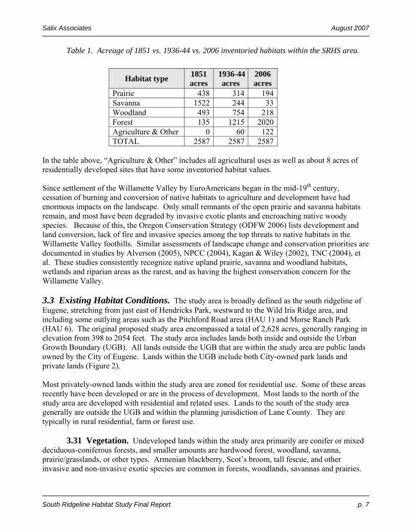
Table 1. Acreage of 1851 vs. 1936-44 vs. 2006 inventoried habitats within the SRHS area.
Habitat type 1851 acres
1936-44acres
2006 acres
Prairie 438 314 194Savanna 1522 244 33Woodland 493 754 218Forest 135 1215 2020Agriculture & Other 0 60 122TOTAL 2587 2587 2587
In the table above, “Agriculture & Other” includes all agricultural uses as well as about 8 acres of residentially developed sites that have some inventoried habitat values. Since settlement of the Willamette Valley by EuroAmericans began in the mid-19th century, cessation of burning and conversion of native habitats to agriculture and development have had enormous impacts on the landscape. Only small remnants of the open prairie and savanna habitats remain, and most have been degraded by invasive exotic plants and encroaching native woody species. Because of this, the Oregon Conservation Strategy (ODFW 2006) lists development and land conversion, lack of fire and invasive species among the top threats to native habitats in the Willamette Valley foothills. Similar assessments of landscape change and conservation priorities are documented in studies by Alverson (2005), NPCC (2004), Kagan & Wiley (2002), TNC (2004), et al. These studies consistently recognize native upland prairie, savanna and woodland habitats, wetlands and riparian areas as the rarest, and as having the highest conservation concern for the Willamette Valley. 3.3 Existing Habitat Conditions. The study area is broadly defined as the south ridgeline of Eugene, stretching from just east of Hendricks Park, westward to the Wild Iris Ridge area, and including some outlying areas such as the Pitchford Road area (HAU 1) and Morse Ranch Park (HAU 6). The original proposed study area encompassed a total of 2,628 acres, generally ranging in elevation from 398 to 2054 feet. The study area includes lands both inside and outside the Urban Growth Boundary (UGB). All lands outside the UGB that are within the study area are public lands owned by the City of Eugene. Lands within the UGB include both City-owned park lands and private lands (Figure 2). Most privately-owned lands within the study area are zoned for residential use. Some of these areas recently have been developed or are in the process of development. Most lands to the north of the study area are developed with residential and related uses. Lands to the south of the study area generally are outside the UGB and within the planning jurisdiction of Lane County. They are typically in rural residential, farm or forest use. 3.31 Vegetation. Undeveloped lands within the study area primarily are conifer or mixed deciduous-coniferous forests, and smaller amounts are hardwood forest, woodland, savanna, prairie/grasslands, or other types. Armenian blackberry, Scot’s broom, tall fescue, and other invasive and non-invasive exotic species are common in forests, woodlands, savannas and prairies.

Salix Associates August 2007
South Ridgeline Habitat Study Final Report p. 8
After many decades of grazing, farming, development, and lack of fire, nearly all the savanna and prairie habitats which were common prior to EuroAmerican settlement now either are converted to other uses or forested. The few open habitats that remain are small in size with ground layer vegetation commonly dominated by exotic species. These invasive, exotic plant species have been introduced intentionally in some cases (for food, forage or landscaping, for example), while others have been introduced inadvertently. Examples of common native and invasive species that occur in the study area are shown in the following table.
Table 2. Common native vascular and invasive, exotic vascular plant species of the SRHS area by layer (tree, shrub, forbs/grasses).
Category Common native species Common invasive, exotic species
Trees Douglas fir, bigleaf maple, Oregon white oak
Sweet cherry
Shrubs Snowberry, poisonoak, oceanspray, tall Oregongrape
Armenian blackberry, Scot’s broom
Forbs Sword fern, trailing blackberry, Oregon iris, bracken fern
English/Irish ivy, narrow-leaf plantain, false dandelion, wild carrot
Grasses Blue wildrye, Columbia brome Tall fescue, sweet vernalgrass, creeping bentgrass
The overall change in vegetation in undeveloped portions of this urbanizing area since the middle of the 19th century has been from open prairie and savanna habitats dominated by native plant species, to forested habitats dominated by native trees, or to small, remnant open habitats dominated by exotic species. As encroaching, native, woody plants and invasive, exotic plant species begin to dominate in open habitats, native plant diversity in those habitats drops. Because of the decline in native plant diversity, native insects and other wildlife dependent on those species decline as well. The native species and open habitats unique to the Willamette Valley are declining. In the SRHS area this local native biodiversity associated with open habitats is being replaced by a more common and less diverse set of native forest habitat plants and wildlife, and by exotic plants and wildlife. 3.32 Wildlife. As native prairie and savanna vegetation communities have declined in the SRHS area, associated wildlife populations also have declined. Many of the species on the list of target uncommon and rare species assembled for this project (Appendix B) are associated with those rare open habitats. Conversely, as forest habitats have expanded in the SRHS area, common species associated with those habitats have increased. The following table lists examples of common, familiar wildlife species found within the study area.
Table 3. Examples of common native and exotic wildlife of the SRHS area by category.
Wildlife category Common native species Common exotic species
Year-round Winter Wren, Spotted Towhee, Wild Turkey, European

Salix Associates August 2007
South Ridgeline Habitat Study Final Report p. 9
resident birds Song Sparrow, Common Flicker Starling, House Sparrow Seasonal or migrant birds
Western Wood Pewee, Orange-crowned Warbler
None
Large and medium sized
mammals
Black-tailed Deer, Raccoon Virginia Opossum
Small mammals Western Gray Squirrel, Deer Mouse
Eastern Fox Squirrel, House Mouse
Amphibians and reptiles
Pacific Tree Frog, Ensatina Salamander, Western Terrestrial Garter Snake
Eastern Bullfrog
Invertebrates (e.g., insects,
spiders, worms, snails)
Western Tiger Swallowtail Butterfly, Dragonflies, Bumblebees, Many Others; Some Very Mobile
Cabbage White Butterfly, European Honey Bee, Brown Garden Snail
Records of species presence are not as complete for fauna that are smaller, less well-known or more difficult to observe. It is likely that some of these species, including many invertebrates and some amphibians, reptiles and birds, have disappeared locally and in some cases, regionally. Water features are important habitat components for both fish and wildlife. Historically, some headwater streams feeding Amazon Creek probably supported native fish populations, including native cutthroat trout. Over the past 50 years, urban development has disconnected these headwater streams from their receiving streams, so that today, very few to no fish species are present there. Two or three small ponds are present in or near the study area, likely originally constructed for livestock use. These ponds are small and shallow, and are unlikely to contain any fish populations, but they may be used as breeding habitat by Northern Red-legged Frogs as well as other amphibians, and invertebrates, and provide habitat for aquatic or emergent plants. Within habitats in the SRHS area that change from undeveloped to developed, only those native wildlife species tolerant of humans and residential uses persist (see Common Native Species, Table 3). Some of the native wildlife species that persist are viewed by human residents as pests or welcomed guests, depending on individual perspectives. Noteworthy in this category are Black-tailed Deer and Raccoons. Exotic wildlife species are introduced either intentionally or accidentally, or they move in from nearby areas. Many exotic species in the table above also are viewed as pests and/or guests by human residents of the area. 3.33 Ecological Functions. Despite past impacts, SRHS area habitats host a suite of native species, and functional (or partly functional) ecosystems. Ecological functions associated with undeveloped areas which have some native vegetation in the SRHS area include the following:
• Provide habitat for native plants, animals, fungi and microbial life • Provide habitat for rare species • Provide connectivity for native species movement and gene flow • Contribute to maintaining surface water quality and quantity by providing infiltration and
slow release into surface streams • Contribute to slope stabilization and erosion control

Salix Associates August 2007
South Ridgeline Habitat Study Final Report p. 10
• Contribute to air quality by taking in carbon dioxide and releasing oxygen • Provide special habitat features needed by certain plant, wildlife and fungi species,
including: rocky areas, snags and logs, wetlands, large trees, etc.
4.0 Methodology The following paragraphs discuss the preliminary meetings and data transfer, the development of all stages of the project and methodology, and how the methodology was applied. 4.1 Meetings. The City held a public information meeting on May 2, 2006 to introduce the project, answer questions and take feedback from the public. The City created a project web site and developed a process and guidelines for additional, individual citizen input on potential habitat resources that might be relevant to the SRHS. Regular meetings were held between the City Project Manager and the consulting team in order to refine and revise portions of the methodology and the assessment and rating system, with the intent to assure that the City’s project goals were met. The City and consultant team met with numerous interested citizens and landowners throughout the inventory phase, including meetings on private properties where access had been granted. Additional meetings between the City Project Manager and the consultant team took place through the duration of the project to keep the City Project Manager apprised of the consulting team’s progress, and to seek feedback and approval of final methodology development. After preparation of the draft report and inventory, two methodology meetings were held at the public library. Subsequently, the City held several neighborhood and other meetings to explain the methodology and draft results to the community, and to solicit feedback. 4.2 Map and Data Transfer and Acquisition. The City provided general information (rare species location data, etc.) and mapped Geographic Information System (GIS) data (study area boundary, tax lot lines, roads, etc.) soon after the project commenced. Several base layers of GIS data and base color aerial orthophoto imagery from 2004 were transferred to the consultant GIS specialist, who used them to create field maps for the inventory. Updated aerial photos from 2005 were later incorporated into the study. Additional documents received during the study included information and natural resource studies submitted as part of site-specific planned unit development (PUD) applications (see Site-Specific Reports bibliographic section at the end of this report). 4.3 Methodology Development and Application. Inventory and assessment methods were developed in collaboration with the City. The methods were designed to be consistent with state-acknowledged Goal 5 methodology applied by Eugene and other Oregon communities, and were broadened to provide a more ecologically-based approach that addressed habitats and species of special interest within the study area. The procedures followed by the consulting team for preparing and conducting the SRHS inventory are listed here, and addressed in detail in subsequent sections.
1. Identification of Goals 2. Identification of Study Area 3. Private Property Access Protocol 4. Analysis of Existing Information

Salix Associates August 2007
South Ridgeline Habitat Study Final Report p. 11
5. Design of Inventory and Mapping System 6. Field Inventory 7. Data Entry (GIS) 8. Data Entry (Database) 9. Incorporation of Supplemental Data 10. Map Review and Historic Vegetation Analysis 11. Design of Vegetation Mapping Unit Report Form 12. Design of Ratings System and Report Form 13. Habitat Suitability Mapping 14. Draft Report Preparation 15. Public Comments 16. Final Report Revision and Submittal
Each numbered item above is explained in the following paragraphs. 1. Identification of Goals The goals of the inventory were contained in the original project Scope of Work. These included the purpose of the inventory and assessment, a recommended study area (Figure 1), and a list of habitats and species of interest. The purpose was addressed previously in this report (see Section 2.0), and the following two sections address the inventory area and target habitats and species. 2. Identification of Study Area The original proposed SRHS area included 2,628 acres in three ownership categories, as shown in Table 4, below.
Table 4. Original number of parcels, and acreage of original SRHS study area.
Ownership Category # Parcels Acreage
Parcels within the UGB > 0.5 ac in size (includes public land) 720 1940Parcels within the UGB ≤ 0.5 ac in size 1200 156Adjacent publicly-owned lands outside the UGB 17 532
ORIGINAL STUDY AREA TOTAL: 2628 After the project began, the City requested that the consulting team add to the proposed inventory any small areas that were contiguous to the study area and contained similar habitat, but were outside the original study area boundaries. These added areas are shown in Table 8. The City also requested identification of adjacent or nearby areas that might be included in a future inventory project, but were not within the scope of this project due to size, limited access, location, lack of connectivity with vegetation mapping units with the proposed study area or other factors. These “potential future additions” are shown on individual Habitat Assessment Unit maps in Appendix J. The study area was subdivided on paper by the City Project Manager into 21 units to facilitate inventory and assessment. These were termed “Habitat Assessment Units” and are abbreviated
Salix Associates August 2007
South Ridgeline Habitat Study Final Report p. 12
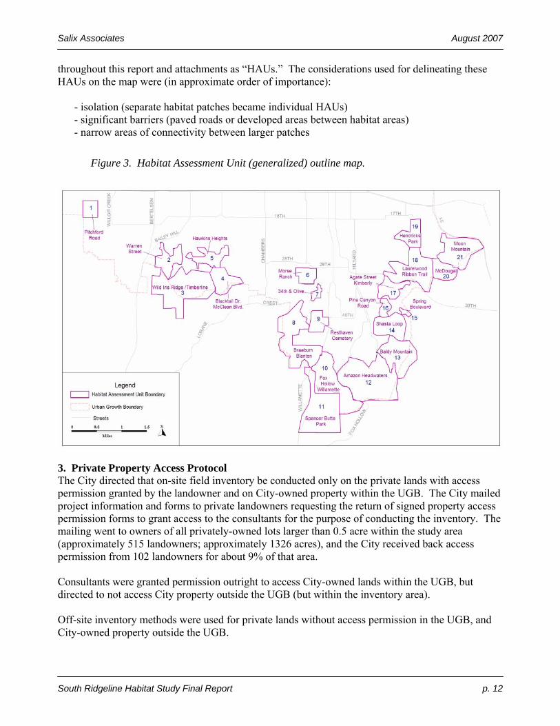
throughout this report and attachments as “HAUs.” The considerations used for delineating these HAUs on the map were (in approximate order of importance):
- isolation (separate habitat patches became individual HAUs) - significant barriers (paved roads or developed areas between habitat areas) - narrow areas of connectivity between larger patches
Figure 3. Habitat Assessment Unit (generalized) outline map.
3. Private Property Access Protocol The City directed that on-site field inventory be conducted only on the private lands with access permission granted by the landowner and on City-owned property within the UGB. The City mailed project information and forms to private landowners requesting the return of signed property access permission forms to grant access to the consultants for the purpose of conducting the inventory. The mailing went to owners of all privately-owned lots larger than 0.5 acre within the study area (approximately 515 landowners; approximately 1326 acres), and the City received back access permission from 102 landowners for about 9% of that area. Consultants were granted permission outright to access City-owned lands within the UGB, but directed to not access City property outside the UGB (but within the inventory area). Off-site inventory methods were used for private lands without access permission in the UGB, and City-owned property outside the UGB.

Salix Associates August 2007
South Ridgeline Habitat Study Final Report p. 13
4. Analysis of Existing Information A previously-used cover type classification system was adapted for the field inventory, and lists of rare habitats, uncommon and rare species and invasive species were developed, as described in the following sections. Cover Type Classification. For use in a similar project in Corvallis, the consulting team successfully adapted and utilized a cover type (also called “habitat type”) classification system defined in Adamus, et al. (2000). This system contains brief summaries of the general type of vegetation that is in the tallest layer, which is the most visible layer to see both in the field and on aerial photographs. The system classifies vegetation by the density (or “percent cover”) of the tree layer into four categories, listed here in descending order of tree density: forest, woodland, savanna and prairie (or grassland). The system was adapted to address local conditions in Eugene. As it was initially designed, the system was intended for use in categorizing cover types using regional-scale aerial or satellite photography, whereas for the Corvallis and Eugene projects, it was adapted for on-the-ground use supplemented with local scale aerial photography. An explanation and definitions of the cover type codes used in the inventory are in Appendix A. Target Rare, Sensitive and Uncommon Habitats and Species. The City sought to obtain information about the existence of rare habitat types, and the existence or potential for uncommon and rare plant or animal species in the study area. The habitat types of primary interest identified by the City included: native-dominated forest, shrub and forb communities, including old growth Douglas fir/western hemlock, Oregon white oak/California black oak woodland, Oregon white oak savanna, ponderosa pine, old growth grand fir, and upland native prairie communities and natural balds. The City-identified plant species of interest included: Kincaid’s lupine, shaggy horkelia, tall bugbane, thin-leaved peavine, Thompson’s mistmaiden, wayside aster, white-top aster and Willamette Valley daisy. The City-identified wildlife species of concern for this study included northern red-legged frog and pileated woodpecker. Appendix B contains background information on these species, and Appendix F contains a crosswalk between the common plant and animal names used in this report and their respective scientific (Latin) names. The City’s emphasis on a more ecological approach led to development of a more complete list of rare habitats and species. To create a list of rare habitats potentially occurring in the area, the consulting team relied primarily on published sources – most particularly the Oregon Conservation Strategy (Strategy) (ODFW 2006). The team also consulted other studies that identify rare habitats of the Willamette Valley: Campbell (2004), Kagan and Wiley (2002), NPCC (2004), PNWERC (2002), and TNC (2004). There is strong agreement among all the sources consulted as to which habitats are rarest in the Willamette Valley ecoregion. The field team recorded and assessed mature to old growth grand fir and Douglas fir/hemlock forest, which are not on the Strategy list for the Willamette Valley and generally not listed as rare here by the sources listed above. Retention of these habitats on the target list recognizes that there are portions of the study area which are transitional to adjacent montane ecoregions, and that these habitats may contain uncommon to rare biodiversity elements. An expanded uncommon and rare species list was developed to more completely recognize plants and animals that may occur in or near the study area. These species have been identified as either
Salix Associates August 2007
South Ridgeline Habitat Study Final Report p. 14
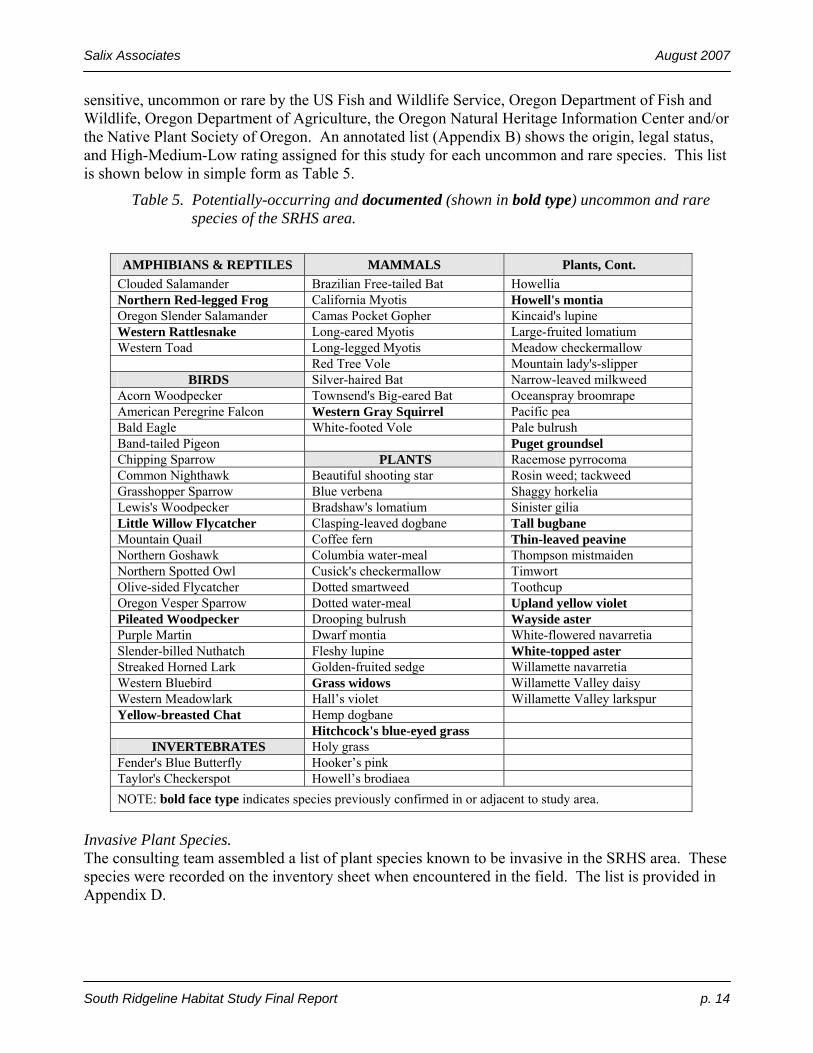
sensitive, uncommon or rare by the US Fish and Wildlife Service, Oregon Department of Fish and Wildlife, Oregon Department of Agriculture, the Oregon Natural Heritage Information Center and/or the Native Plant Society of Oregon. An annotated list (Appendix B) shows the origin, legal status, and High-Medium-Low rating assigned for this study for each uncommon and rare species. This list is shown below in simple form as Table 5.
Table 5. Potentially-occurring and documented (shown in bold type) uncommon and rare species of the SRHS area.
AMPHIBIANS & REPTILES MAMMALS Plants, Cont.
Clouded Salamander Brazilian Free-tailed Bat Howellia Northern Red-legged Frog California Myotis Howell's montia Oregon Slender Salamander Camas Pocket Gopher Kincaid's lupine Western Rattlesnake Long-eared Myotis Large-fruited lomatium Western Toad Long-legged Myotis Meadow checkermallow Red Tree Vole Mountain lady's-slipper
BIRDS Silver-haired Bat Narrow-leaved milkweed Acorn Woodpecker Townsend's Big-eared Bat Oceanspray broomrape American Peregrine Falcon Western Gray Squirrel Pacific pea Bald Eagle White-footed Vole Pale bulrush Band-tailed Pigeon Puget groundsel Chipping Sparrow PLANTS Racemose pyrrocoma Common Nighthawk Beautiful shooting star Rosin weed; tackweed Grasshopper Sparrow Blue verbena Shaggy horkelia Lewis's Woodpecker Bradshaw's lomatium Sinister gilia Little Willow Flycatcher Clasping-leaved dogbane Tall bugbane Mountain Quail Coffee fern Thin-leaved peavine Northern Goshawk Columbia water-meal Thompson mistmaiden Northern Spotted Owl Cusick's checkermallow Timwort Olive-sided Flycatcher Dotted smartweed Toothcup Oregon Vesper Sparrow Dotted water-meal Upland yellow violet Pileated Woodpecker Drooping bulrush Wayside aster Purple Martin Dwarf montia White-flowered navarretia Slender-billed Nuthatch Fleshy lupine White-topped aster Streaked Horned Lark Golden-fruited sedge Willamette navarretia Western Bluebird Grass widows Willamette Valley daisy Western Meadowlark Hall’s violet Willamette Valley larkspur Yellow-breasted Chat Hemp dogbane Hitchcock's blue-eyed grass
INVERTEBRATES Holy grass Fender's Blue Butterfly Hooker’s pink Taylor's Checkerspot Howell’s brodiaea NOTE: bold face type indicates species previously confirmed in or adjacent to study area.
Invasive Plant Species. The consulting team assembled a list of plant species known to be invasive in the SRHS area. These species were recorded on the inventory sheet when encountered in the field. The list is provided in Appendix D.

Salix Associates August 2007
South Ridgeline Habitat Study Final Report p. 15
5. Design of Inventory and Mapping System To produce a more ecologically balanced inventory, a field inventory data sheet was designed to be inclusive of a broader, more balanced range of values than the previous habitat assessment methodologies used elsewhere – that is, less focused on habitat suitability for vertebrate wildlife, and more oriented towards observing and recording detailed current and historic features so as to allow a more accurate and complete description of habitats of both plant and wildlife species and the condition of those habitats. The following paragraphs describe these methods in more detail. Timing. The seasonal timing of the surveys was intended to allow for observation of plant communities in the growing season, and provide opportunity for incidental observation of uncommon and rare plant species which might occur within the study area. Uncommon and rare plant species of open areas, such as prairies and savannas, tend to flower and be most visible in May and June, so consultants targeted those areas first. Uncommon and rare species of forested habitats tend to flower and remain visible later, so those areas were inventoried later. Scientifically-rigorous surveys to systematically determine presence or absence of uncommon and rare plant or wildlife species were not included as part of this project. Instead, the project was oriented towards identifying rare habitats and suitable habitats for uncommon and rare/sensitive species. The order of site visits in the early portion of the inventory required coordination with the City of Eugene Public Works Department and private landowners striving to meet the City’s requirements for mowing (to meet fire safety objectives on undeveloped properties). Consultants worked to “keep ahead of the mowers,” responding to City Project Manager direction resulting from contacts either from the Public Works Department or private owner’s wishing to have inventory completed on their sites before mowing. All requests were addressed as quickly as possible by the consulting team. Team. Before the inventory, two regionally-known expert advisors were consulted for input on two species highlighted by the City for inclusion in the inventory (Northern Red-legged Frog and Pileated Woodpecker). Their recommendations were included in the inventory and assessment methodology. Five field biologists conducted the inventory. The field team members received field calibration training on the entire methodology to maximize consistency in observation and recording of data. Inventory Tools and Products. The following table lists the tools that were developed and used, and the products which resulted. Many are referenced as attachments to this report.
Table 6. SRHS inventory tools and products.
INVENTORY TOOLS PURPOSE / DESCRIPTION
FIELD TOOLS Field inventory data form and instructions
Appendix A A two-page field data form for recording Vegetation Mapping Unit data provided for recording of the following features: cover type, vegetation layer (tree, shrub, herb) nativeness and cover, uncommon and rare and invasive plant and animal species, special habitat features, and general information such as size and location. Information was entered into a database at completion of inventory,
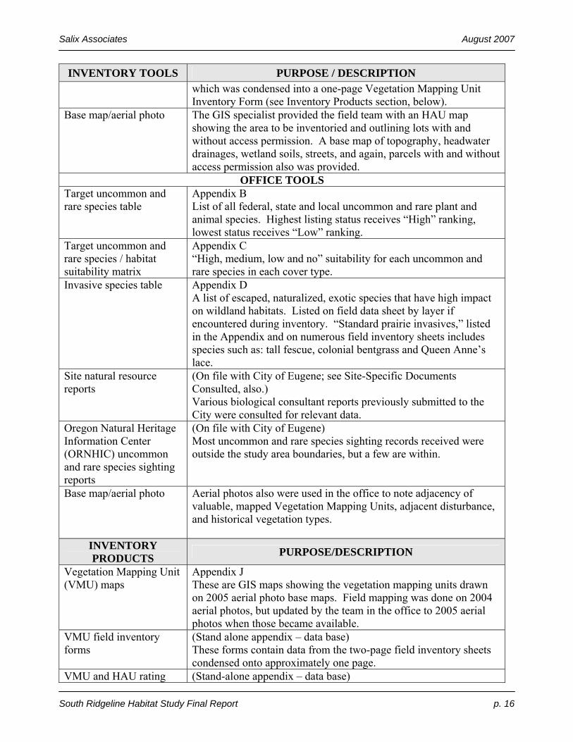
Salix Associates August 2007
South Ridgeline Habitat Study Final Report p. 16
INVENTORY TOOLS PURPOSE / DESCRIPTION which was condensed into a one-page Vegetation Mapping Unit Inventory Form (see Inventory Products section, below).
Base map/aerial photo The GIS specialist provided the field team with an HAU map showing the area to be inventoried and outlining lots with and without access permission. A base map of topography, headwater drainages, wetland soils, streets, and again, parcels with and without access permission also was provided.
OFFICE TOOLS Target uncommon and rare species table
Appendix B List of all federal, state and local uncommon and rare plant and animal species. Highest listing status receives “High” ranking, lowest status receives “Low” ranking.
Target uncommon and rare species / habitat suitability matrix
Appendix C “High, medium, low and no” suitability for each uncommon and rare species in each cover type.
Invasive species table Appendix D A list of escaped, naturalized, exotic species that have high impact on wildland habitats. Listed on field data sheet by layer if encountered during inventory. “Standard prairie invasives,” listed in the Appendix and on numerous field inventory sheets includes species such as: tall fescue, colonial bentgrass and Queen Anne’s lace.
Site natural resource reports
(On file with City of Eugene; see Site-Specific Documents Consulted, also.) Various biological consultant reports previously submitted to the City were consulted for relevant data.
Oregon Natural Heritage Information Center (ORNHIC) uncommon and rare species sighting reports
(On file with City of Eugene) Most uncommon and rare species sighting records received were outside the study area boundaries, but a few are within.
Base map/aerial photo Aerial photos also were used in the office to note adjacency of valuable, mapped Vegetation Mapping Units, adjacent disturbance, and historical vegetation types.
INVENTORY PRODUCTS PURPOSE/DESCRIPTION
Vegetation Mapping Unit (VMU) maps
Appendix J These are GIS maps showing the vegetation mapping units drawn on 2005 aerial photo base maps. Field mapping was done on 2004 aerial photos, but updated by the team in the office to 2005 aerial photos when those became available.
VMU field inventory forms
(Stand alone appendix – data base) These forms contain data from the two-page field inventory sheets condensed onto approximately one page.
VMU and HAU rating (Stand-alone appendix – data base)
Salix Associates August 2007
South Ridgeline Habitat Study Final Report p. 17
INVENTORY TOOLS PURPOSE / DESCRIPTION tables Each VMU field inventory data sheet is followed by a table
showing the assessment/rating of habitat values for that VMU, and each HAU is rated for the VMUs within and other aspects.
Report This report, discussing the ecological history of the study area, the methodology used to inventory upland habitats, and the results of the study.
6. Field Inventory. The field inventory was conducted from May through August of 2006. All portions of all 21 HAUs which had access permission were inventoried on-site. When possible, lands for which access permission had not been obtained were viewed from adjacent parcels with access permission or from public streets. Included with this report as Appendix A is a blank template copy of the field Vegetation Mapping Unit (VMU) Inventory Form, and the associated instructions and standards used by crew members for the inventory. Access. Many of the parcels where access permission was granted were relatively small, and not always in areas providing views of adjacent properties for which the team did not have access permission. Most of the returned forms granting permission directed the field team to call ahead to the owner to coordinate access for individual property visits, and some landowners escorted biologists during the inventory of their site. In general, the lack of access required that most privately-owned properties had to be inventoried using a combination of off-site methods. These included viewing from adjacent private property where access was granted or from adjacent public lands or rights-of-way, or using aerial photos and/or previously submitted land use permit application reports on file with the City. (See On-site/Off-site section below.) Mapping. While visiting a field site, areas within each HAU with homogeneous vegetation were mapped as Vegetation Mapping Units (VMUs) and given a unique letter label within the HAU. Minimum Vegetation Mapping Unit size was generally 2 acres, but rare habitat types were mapped to a 1 acre minimum. Within each VMU, some newly-built homes or developing areas with little to no habitat values were marked in the field as “developed,” (“DV” on the maps in Appendix J) and are not included in habitat area calculations. Boundaries were drawn around each VMU area on a transparent overlay on a 2004 aerial photo base map. The letter code was then assigned to the VMU and written on an Inventory Form for the text data recording. The City provided a study area boundary, but encouraged the inclusion of adjacent areas with suitable habitat. The considerations used for inclusion vs. exclusion for this inventory included the following.
Salix Associates August 2007
South Ridgeline Habitat Study Final Report p. 18
Included. Land inside designated inventory areas with substantial habitat values were included, particularly if they contained potential habitat for any target species. Some areas where substantial habitat values remain are included, even though houses may have been constructed within the inventory area. Tree layers occasionally are left intact in areas where a single house is built in an otherwise undeveloped area, providing potential habitat for Western Gray Squirrels and/or other uncommon or rare wildlife species. Occasionally, the shrub and/or ground (herbaceous) vegetation layers were observed to be intact also, providing habitat for more target plant and wildlife species.
Excluded. Most areas with existing residential development were excluded from the inventory by outlining them on the aerial photo, and marking them “DV” to signify “developed.” Some residential sites where development seemed imminent (such as newly graded places in a developing area with recently dumped gravel), also were excluded. Manicured, grassy areas between development areas were excluded in some instances, if no suitable habitat was present for native (especially target) plant or wildlife species.
An additional 188 developed acres with little habitat value were mapped within the original study area boundaries but are not included in habitat acreage totals on the following table. Included in the inventory acreage total are 159 additional, adjacent acres proposed to be added to the original study area. In the table below, A – B + C = D.
Table 7. Original (A), developed (B), added (C), and total surveyed (D) acres.
HAU
A: Original
survey acres (w/ DV)
B: DV
Acres
C: Added survey acres
D. Surveyed
Acres (w/o DV)
1 35 0 0.73 35 2 85 7 28.00 106 3 251 23 4.95 233 4 65 37 3.01 31 5 74 7 6.88 74 6 32 4 3.68 32 7 17 1 0.00 16 8 221 2 1.05 221 9 44 23 1.03 22
10 243 14 13.37 242 11 320 1 0.05 319 12 399 7 19.49 412 13 160 19 9.45 150 14 87 6 16.47 97 15 6 3 0.00 3 16 18 0 3.73 22 17 46 2 4.68 48 18 187 19 10.64 178 19 81 4 1.09 78

Salix Associates August 2007
South Ridgeline Habitat Study Final Report p. 19
20 88 0 4.77 93 21 158 8 26.43 176
TOTAL 2618 188 159 2589 Note that the total acres for “Original survey acres w/ DV” in Table 8 above (2,618) is less than the total acres shown in Table 4 for the original proposed study area (2,628). The difference of 10 acres is due to: (1) corrections to the boundaries of publicly owned park lands outside the Urban Growth Boundary based on updated, more accurate tax lot boundaries for those areas that became available during the project, and (2) many very small corrections throughout the study area based on the revised tax lot boundaries, where extremely narrow strips were created on lots that are not meaningful at the scale of the habitat mapping. On-Site vs. Off-Site Data Recording. VMUs were inventoried on-site, off-site with a view, and off-site without any view (primarily using aerial photo interpretation). Many VMUs were inventoried using some combination of these observation categories. Ideally, all field inventory would be conducted on site, but in reality, because the consulting team was granted permission to access only a small fraction of private lands, only those properties, and City-owned public lands, could be inventoried on site. Off-site inventories were conducted using several methods and information sources. Initially, view into private lands with no access permission granted was sought from adjacent public streets, public property, or private lands where access permission had been granted. These parcels were identified on data sheets as “off-site/view.” In some cases, where only a portion of a VMU could be viewed, only a part of the inventory data sheet could be filled out in the field, so these were labeled as a combination of off-site with view and without view. Aerial photos also were used to add data for off-site inventories. Off-site inventory of public lands outside the UGB was conducted similarly, except views from outside the UGB generally were limited to adjacent public streets. Again, aerial photos were consulted to provide necessary data. On-site mapping allowed completion of all portions of the Inventory Form, but off-site inventory of many sites required use of a different system. For those situations where key data was missing because of a lack of access and/or poor view from adjacent sites, the rating team used a “reference site” system. Initially, the rating team used their best professional judgment to identify the nearest Vegetation Mapping Unit with features similar to the VMU with missing or incomplete data. This “reference” area was called a Reference Vegetation Mapping Unit, or RV. Information from an RV identified for the rating of another Vegetation Mapping Unit then was used as a surrogate for recorded, on-site data, and displayed on the Inventory Forms in the database with an “RV” label. In the best professional judgment of the consulting team, the limited and careful use of reference information was the best surrogate available for the missing information. Consultants used reference information cautiously so as to not overly inflate or under-rate the potential value of a VMU. In all on-and off-site inventories, tree layers were easiest to assess, mid layers (shrubs and understory trees) moderately easy to difficult, and ground layers (herbaceous vegetation) much more difficult to assess for the simple reason that the taller vegetation is easier to see at a distance and on aerial photographs.

Salix Associates August 2007
South Ridgeline Habitat Study Final Report p. 20
Limitations. The largest limitation to the inventory was the lack of access to most private land. Lands with no access were inventoried and assessed using several methods: viewing wherever possible from adjacent lands with access, interpreting aerial photos (which sometimes lack detail in tree shadows), and for sections of the report form where information was needed for assessment and scoring, using nearby reference sites with similar habitats to supply information that could not otherwise be obtained The other primary limitation noted during the project was the lack of inventory information available for uncommon and rare species, as systematic surveys for uncommon and rare species have not been conducted in most of the SRHS area. To accommodate this limitation, presence or absence of target species was not used in numerical site scoring. Known occurrences, however, are listed on the Inventory Form for each site: both field observations and ORNHIC recorded sightings. 7. Data Entry (GIS) The VMU boundaries delineated by field inventory team members on the transparent overlay were digitally entered into a Geographic Information System (GIS) data layer. Additional information that may have been mapped in the field (e.g., uncommon and rare species sites) was digitally entered into other layers. Draft HAU/VMU maps were checked for errors and boundaries were updated to the newer 2005 aerial photos where necessary. Corrections then were supplied to the GIS specialist, and the affected data layers were corrected. 8. Data Entry (Relational Database) All field data was checked for consistency and completeness, and then entered by a biologist into a relational database entry form that was developed for the project. The data was checked again after entry. Several brief follow-up field visits were made to resolve questions. 9. Incorporation of Supplemental Data Several background reports provided by the City were used to supplement field observations. These are listed at the end of this report as “Site Specific Documents Consulted.” Rare species site information was ordered from the Oregon Natural Heritage Information Center by the City of Eugene, and was available for use in this project. Recorded sightings of uncommon and rare species are noted on the Vegetation Mapping Unit Rating Table where applicable. No additional information was available from state and federal wildlife agencies, as they now primarily rely on ORNHIC for record keeping. After the draft SRHS inventory and assessment was introduced at numerous public meetings in late 2006 and early 2007, approximately 37 public comments were submitted. These were compiled and transferred to the consultant team in late spring of 2007, and the team considered each one individually. Nearly all comments were directed at property-specific concerns. Many submittals did not specify if a specific action was desired, so it was inferred in those cases that more information was being submitted for consideration. Several map and database changes resulted from the review of the submittals, and those are itemized in an accompanying data set listed at the end of this document. Where supplemental information was available, it was entered into the appropriate section of the Inventory Form and/or Rating Table, and the source was cited on the form.

Salix Associates August 2007
South Ridgeline Habitat Study Final Report p. 21
10. Map Review and Historic Vegetation Analysis Draft maps of each HAU showing all delineated Vegetation Mapping Units were produced, and edited by the field team for accuracy, then revised maps were produced by the GIS specialist. Maps of each HAU showing the VMUs were overlaid on 1936 or 1944 aerial photo coverage and historic ca. 1850 vegetation mapping to show vegetation change over time. 11. Design of Vegetation Mapping Unit Inventory Form. An “output” report form (Vegetation Mapping Unit Inventory Form) was created to show the field data in a concise and readable format. 12. Design of Ratings System and Report Form The rating team developed a system for assessment and scoring at local (Vegetation Mapping Unit) and landscape (HAU and larger) scales. The details of the methodology used for this scoring are contained in Appendix E. The assessment and scoring system was designed to score large VMUs comprised of rare habitat types in good condition highest, and small VMUs with common habitat types in poor condition lowest. Similarly, at the coarser landscape scale, the system scores HAUs with many large, high-scoring VMUs within them highest, and those with few, small, low-scoring VMUs within them, lowest. Weighting of the scores for individual elements in the VMU and HAU rating system directly affects total scores. The consulting team attempted to weight scores to best represent the City’s desires for recognizing rare habitats and species, while also utilizing the latest scientific and regional conservation planning information available. Vegetation Mapping Unit Rating Table. Each VMU Inventory Form contains the field inventory data, and each associated Rating Table uses the field information, combined with some GIS information such as size (acreage), to produce a rating table using weighted scoring formulas. VMU scores were based on habitat suitability for uncommon and rare species (Rare Species Suitability Index, see following paragraph), and overall habitat rarity, condition and size. Additional, specific habitat suitability values for Northern Red-legged Frogs and Pileated Woodpeckers were shown on the report separately because of demonstrated interest from the public, but were rated within the context of the RSS system described below. Rare Species Suitability (RSS) Index. Within the context of a landscape scale assessment and comparative rating system, it is more logical and useful to assess potential habitat suitability for uncommon and rare species, because observable habitat characteristics – rather than specific presence vs. absence – can be used to make that assessment. Documenting presence of species that are nocturnal, small, reclusive or visible only for restricted periods can be very difficult, time-consuming and costly, and documentation of other species often requires extremely thorough coverage (with multiple visits) of an entire study area. Therefore, uncommon and rare species detection is unlikely in a study of this nature and impossible on properties for which no access is granted. For all these reasons, systematic and comprehensive surveys for uncommon and rare species were not included as a part of the SRHS.

Salix Associates August 2007
South Ridgeline Habitat Study Final Report p. 22
The base information used to arrive at potential habitat suitability for uncommon and rare species for the SRHS is the process developed for vertebrate wildlife species by Adamus et al. (2000). First, the 10-point scoring range from Adamus was distilled to a 3 point range. Common species then were eliminated from the list, and then it was expanded to include uncommon and rare invertebrates (2 species) and plants (45 species) relevant to this project. Although some assessment systems have been developed in the Willamette Valley for vertebrate wildlife, no previous system known to the consultant team incorporates plants and vertebrate and invertebrate wildlife and rates them equitably. The RSS index was arrived at by adding the high-medium-low (equivalent to 3-2-1 points) status of each species on the target uncommon and rare species list, to the relative suitability of each habitat type for each of those uncommon and rare species. These two factors (status plus suitability) were summed for each uncommon and rare species occurring in each habitat. The RSS index for each habitat was determined by totaling the individual species sums for that habitat. The RSS values are listed below in Table 7.
Table 8. Rare Species Suitability Index for each SRHS inventoried cover type, in order from highest to lowest.
Cover Type # Cover Type Score
13 Oak savanna 308 12 Other savanna 272 21 Natural grass 245 11 Hardwood woodland 149 10 Mixed woodland 145
1-5 Conifer forest, combined high scores 137 9 Conifer woodland 125
1-5 Conifer forest, comb. avg. scores 110 7 Mixed forest 103 5 Conifer forest 81-200 100
14 Upland shrub 96 4 Conifer forest 61-80 90 8 Hardwood forest 90
26 Seasonal wetlands 82 3 Conifer forest 41-60 80 2 Conifer forest 21-40 77
27 Permanent water 76 1 Conifer >0-20 yrs 75
24 Rock 64 33 Residential habitat 63 15 Wet shrub 62 17 Orchards 38 22 Tall grass 37 20 Short grass 30
The RSS values in the above table are graphed in Figure 4 for comparison to one another. The scores from top to bottom on the table above coincide with left to right on the graph in Figure 4. The alternating shades of blue in Figure 4 correspond to the different RSS point score ranges on the

Salix Associates August 2007
South Ridgeline Habitat Study Final Report p. 23
VMU rating table: the left three cover types (light blue) each scored 5 points (none scored four points, thus the large drop on the figure to cover type 11), the next five cover types to the right (dark blue) each scored 3 points, the next ten to the right (light blue) scored 2 points, and the last six cover types on the right (dark blue) each scored 1 point.
Figure 4. Graph of Rare Species Suitability scores by cover (habitat) type
SRHS Rare Species Suitability Index by Cover (Habitat) Type
0
50
100
150
200
250
300
350
13 12 21 11 10 1-5hi
9 1-5avg.
7 5 14 4 8 26 3 2 27 1 24 15 33 17 22 20
Cover (Habitat) Type Number
RSS
Inde
x
This graph illustrates the relatively higher RSS value of savanna, prairie and woodland habitats (far left) compared to forest and other habitats. The RSS of oak savanna is 308, other savanna is 272, natural grassland is 245, hardwood woodland is 149 and the highest combined conifer RSS is 137. To arrive at the coniferous forest “combined high” scores, all the conifer forest types were combined, and the highest suitability score for each rare species in any conifer forest type was used for the “combined” score. Similarly, for the “combined average,” all the conifer forest types were combined, and for each species, the suitability scores for each species in each type were averaged. Complete RSS scoring tables are contained in Attachment C. Habitat Rarity. As discussed above, certain habitats are widely recognized by public and private land management agencies as being rare in the Willamette Valley ecoregion. Specifically, oak savanna and woodlands, upland prairies, wetlands and riparian areas are recognized in the Oregon Conservation Strategy as being particularly rare and valuable. The consulting team assigned value in the ratings process to these rare habitats, and also to late successional forest habitats to recognize their value, as expressed by both the City and the general public

Salix Associates August 2007
South Ridgeline Habitat Study Final Report p. 24
Habitat Condition. The native component of the herbaceous vegetation layer is a good indicator of the degree to which a prairie, savanna, woodland or wetland habitat is impacted by non-native species. The exotic component is a better indicator in other habitats. Habitats with a higher proportion of native herbs and a lower proportion of exotics score higher in this category. Direct human disturbance of habitat was evaluated by noting any recent, large-scale disturbance of soil or vegetation by grading, application of herbicides, heavy grazing, or similar activities. A lack of disturbance scores higher in the SRHS VMU rating system to reflect higher habitat values. Special Habitat Features. Fine scale habitat features provide niches for many plant and animal species. Example species categories include: cavity dwellers (which need snags and logs), rotten wood dwellers (which also need snags and logs), mature tree bark dwellers (which need mature and older trees), rock dwellers (which need cliffs or rock piles), and pond or stream breeders (which need temporary or permanent water). These features were recorded during inventories, and VMUs were scored based on how many special feature categories were present. Habitat Size. At the end of the VMU scoring table an acreage multiplier is used to adjust the VMU score to reflect the higher value a larger VMU would have over a similar but smaller VMU. Uncommon and Rare Species. Typically, scoring for uncommon and rare species presence is biased toward sites that have been surveyed and have positive reports. Because most of the SRHS area has not been systematically surveyed for uncommon and rare species, or not surveyed to scientific protocols, some areas where no records exist may contain uncommon and rare species populations. Therefore, the presence of any uncommon and rare species was included with the appropriate Vegetation Mapping Unit report, but was not part of the numerical scoring system, in order to avoid automatically lowering the score of an area simply because it had not been adequately surveyed. Because of the specific interest in Northern Red-legged Frog and Pileated Woodpecker occurrence and habitat, specific indicators and habitat suitability features for these species were noted in the field. As above, these factors were noted and rated, but not included in VMU scoring. Habitat Assessment Unit Rating Table. HAU scores primarily were based on a composite value of the VMUs within the HAU, and were supplemented with three geographic considerations: 1) the overall size of the patch of habitat available at a landscape scale, including adjacent, connected habitats; 2) the juxtaposition within the HAU of rare habitats; and 3) the overall condition of the HAU regarding internal barriers (roads, developed areas, etc.) and shape (compactness). Large landscape scale habitat patches, containing proximate rare habitat patches, lacking barriers and having a compact shape, scored highest using this rating system. Habitat Patch Size and Connectivity. Larger habitat patches generally contain a greater variety of habitat types, higher number of species, and larger population sizes, however, there are many variables which can limit one or all of these factors. Connected, small patches may function in many ways like similarly-sized large patches, but this can vary greatly based on the life cycle needs and population dynamics of the plant and wildlife species using those habitat patches. Large habitat blocks may have better resilience to disturbances such as wildfire and flooding, but some small, isolated patches of unique habitat types may be of important conservation concern (ODFW 2006).

Salix Associates August 2007
South Ridgeline Habitat Study Final Report p. 25
Habitats in urbanizing areas that remain undeveloped often become “islands” of habitat, surrounded by development, and the plants, animals and other life that reside in them may become isolated from other populations. Although fragmentation of habitat patches in urbanizing areas often is considered only from a wildlife perspective, it can impact plants as well. Plant and animal populations which need larger, more connected habitats may suffer as development or other changes reduce the amount of available, connected habitat. Habitat size can affect health of individual plants and animals, as well as populations. In general, isolated sites function as smaller habitat patches because they are disconnected, except in cases where species can move from these isolated sites to other habitats in spite of barriers. For example, wind-pollinated plants which can shed pollen to be carried by wind, or songbirds which can fly between habitats, may be able to cross some barriers. A complex of connected habitat patches may function similarly to a single, large patch, providing better long term prospects for healthy populations of both rare and common flora and fauna than those habitat patches which become fragmented. Habitat patch size and functionality can decrease if land is developed or significant barriers are constructed, or can change if encroaching or invasive plant species achieve dominance. Plants and animals may suffer from inadequate habitat patch size and diversity if they need different types of habitats at different times in their life cycles for breeding, dispersal, feeding and cover. For example, access to compatible mates – which may apply to plants as well as animals – is important for long term survival of a population, and may be dependent both on habitat size and diversity. Because many native species in a functional ecosystem are interdependent, loss of any species in a habitat patch may have a “cascading” negative effect on other species. For this study, the consulting team did not integrate specific habitat size needs for certain species into scoring. Rather, the team rated larger size habitat patches higher to correlate with the combined positive benefits listed above. HAUs with large connections to adjacent habitats and no barriers were rated higher than those with poor connections, such as narrow habitat areas divided by busy roads. Internal Connectivity and Shape. Connectivity and clustering of patches of habitat is valuable for native plants, wildlife and invertebrates that live within them – for reasons similar to those presented in the previous section. Cohesiveness (lack of barriers) and compact shape (as opposed to long, narrow configurations) of the HAU can benefit wildlife and possibly some plant species which need larger habitat blocks. Lack of large habitat blocks is limiting, particularly for many species using the habitats ranked “uncommon or rare” for this study. VMU and HAU Scoring. Numerical scores for each VMU and HAU represent a combined value of the resources evaluated, and are suitable for overall comparison and ranking. Such numeric scoring cannot accurately convey importance of individual, local features or habitats too small or atypical to be addressed by a systematic rating at a landscape scale – or in other words, only an extremely complex rating system could account for every detail of importance. Therefore, consideration of additional values not used in the scoring is advised by the consulting team if knowledge of specific characteristics is desired. For example, a small, inventoried VMU of rare prairie habitat may not be evident in the numerical rating of a much larger, mostly forested HAU. Additionally, interest in known uncommon or rare target species sightings, not included in the rating system for the reasons mentioned earlier, may warrant future field inventory and assessment beyond the scope of the SRHS.

Salix Associates August 2007
South Ridgeline Habitat Study Final Report p. 26
13. Habitat Suitability Mapping Maps of potentially suitable habitat were developed for the original eight target plant species and two target animal species (Pileated Woodpecker and Red-legged Frog; Appendix I). These maps were developed based on ratings for each cover type from the species-habitat matrix (Adamus et al. 2000 for vertebrates; Salix Associates for invertebrates and plants), based on each VMU cover type. A second set of potentially-suitable habitat maps was produced for the two animal species, using finer scale habitat features that were recorded during the field observation. For VMUs without access and views in, we again utilized information from a nearby reference site. 14. Draft Report Preparation For the draft report, the field inventory data were compiled, summarized, and used to generate assessments, and the methodology of the project was explained in detail. Accompanying the report were appendices, a database, GIS shape files, and digital photographs. 15. Public Comments The City received 37 public comments submitted on the draft report and mapping, nearly all relating to specific vegetation mapping unit boundary issues. No comments were submitted on the report, and none were submitted directly commenting on the methodology. The public comments were forwarded to the consultants, and after careful review, several adjustments were made to the draft inventory and report to reflect minor changes. Most notably, four new VMUs were delineated, inventoried and assessed as a result of the comments. 16. Final Report After incorporation of the adjustments resulting from public comments, this final report was updated and delivered to the City.
5.0 Inventory and Assessment Results The following sections discuss the results of the inventory phase and the assessment/rating phase of the SRHS project. 5.1 Inventory Summary. Consultants inventoried and mapped 324 VMUs in 21 HAUs, totaling 2589 acres. Inventory forms and rating tables were produced for each VMU, and a rating table was generated for each HAU. Habitat suitability maps were produced for the 10 original target uncommon and rare species based on potential occurrence within each of the mapped cover types within each VMU, and for 2 of those species (Northern Red-legged Frog and Pileated Woodpecker), a second map was produced based on inventoried special habitat features. The complete set of VMU inventory forms and associated rating tables and HAU rating tables is contained in a relational database program which generates the forms and rating tables on demand. This database resides with the City of Eugene Planning Division. 5.11 Cover Type Analysis. Table 9 illustrates the acreage of each cover type mapped during the inventory (by cover type number). Descriptions of each cover type are in Attachment A.
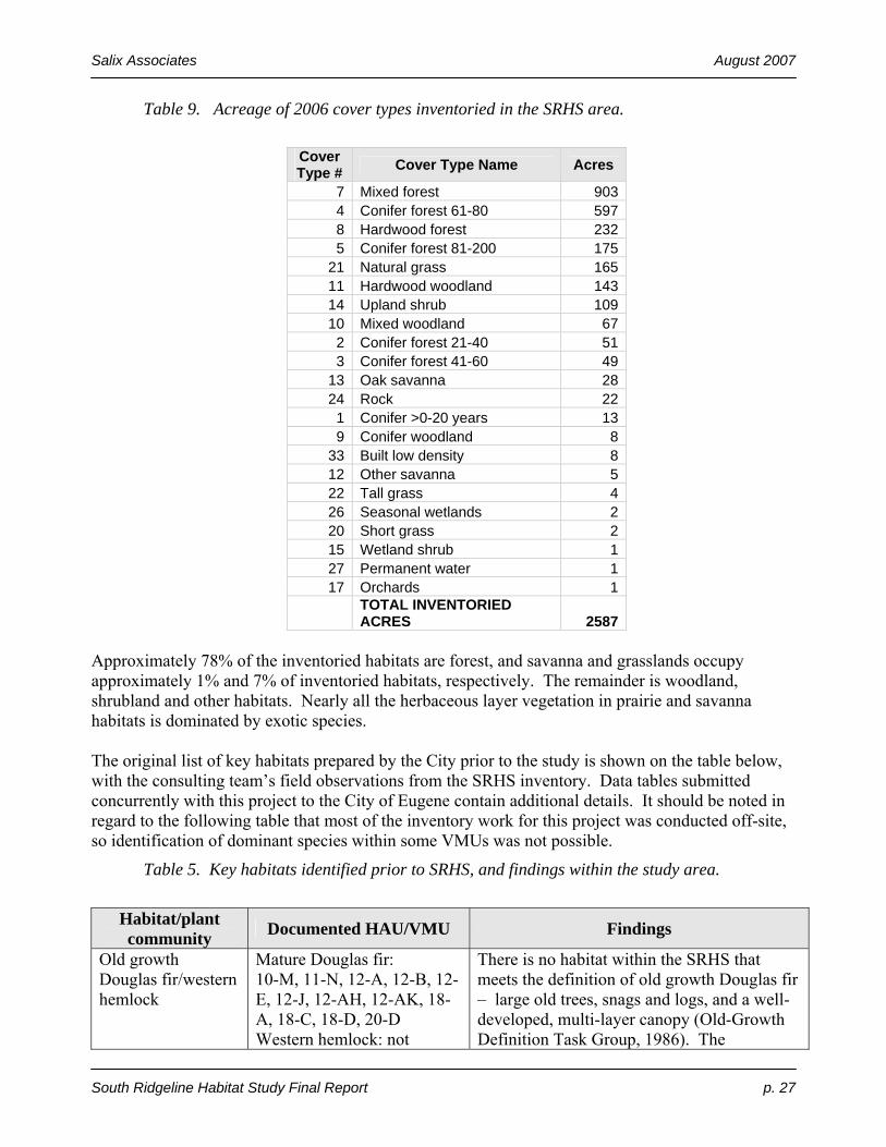
Salix Associates August 2007
South Ridgeline Habitat Study Final Report p. 27
Table 9. Acreage of 2006 cover types inventoried in the SRHS area.
Cover Type # Cover Type Name Acres
7 Mixed forest 9034 Conifer forest 61-80 5978 Hardwood forest 2325 Conifer forest 81-200 175
21 Natural grass 16511 Hardwood woodland 14314 Upland shrub 10910 Mixed woodland 67
2 Conifer forest 21-40 513 Conifer forest 41-60 49
13 Oak savanna 2824 Rock 22
1 Conifer >0-20 years 139 Conifer woodland 8
33 Built low density 812 Other savanna 522 Tall grass 426 Seasonal wetlands 220 Short grass 215 Wetland shrub 127 Permanent water 117 Orchards 1
TOTAL INVENTORIED ACRES 2587
Approximately 78% of the inventoried habitats are forest, and savanna and grasslands occupy approximately 1% and 7% of inventoried habitats, respectively. The remainder is woodland, shrubland and other habitats. Nearly all the herbaceous layer vegetation in prairie and savanna habitats is dominated by exotic species. The original list of key habitats prepared by the City prior to the study is shown on the table below, with the consulting team’s field observations from the SRHS inventory. Data tables submitted concurrently with this project to the City of Eugene contain additional details. It should be noted in regard to the following table that most of the inventory work for this project was conducted off-site, so identification of dominant species within some VMUs was not possible.
Table 5. Key habitats identified prior to SRHS, and findings within the study area.
Habitat/plant community Documented HAU/VMU Findings
Old growth Douglas fir/western hemlock
Mature Douglas fir: 10-M, 11-N, 12-A, 12-B, 12-E, 12-J, 12-AH, 12-AK, 18-A, 18-C, 18-D, 20-D Western hemlock: not
There is no habitat within the SRHS that meets the definition of old growth Douglas fir – large old trees, snags and logs, and a well-developed, multi-layer canopy (Old-Growth Definition Task Group, 1986). The
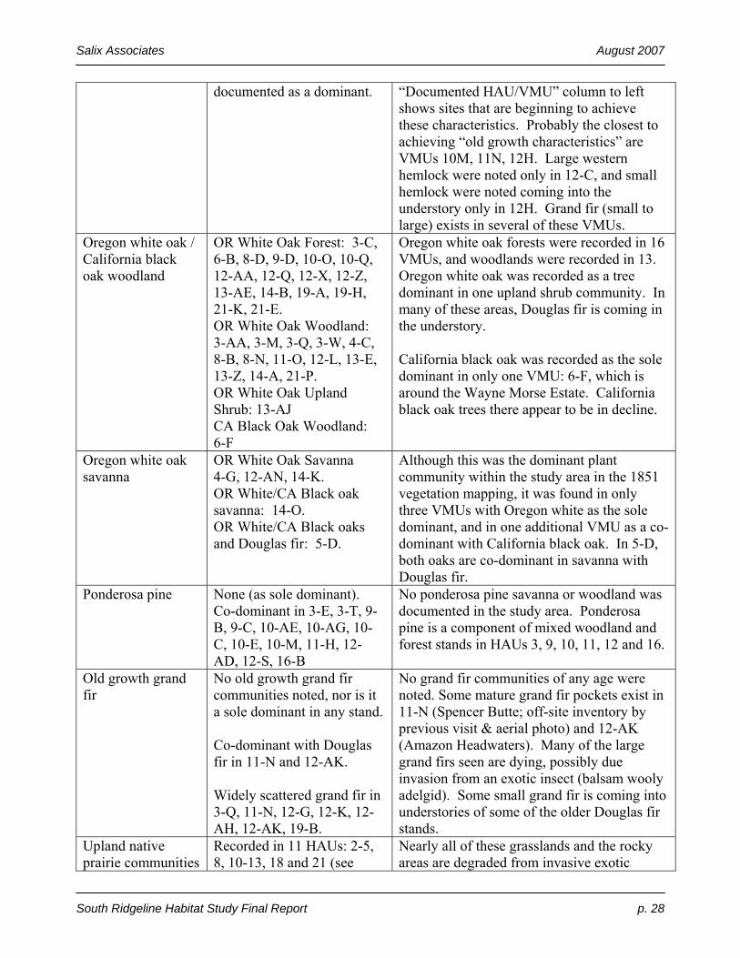
Salix Associates August 2007
South Ridgeline Habitat Study Final Report p. 28
documented as a dominant.
“Documented HAU/VMU” column to left shows sites that are beginning to achieve these characteristics. Probably the closest to achieving “old growth characteristics” are VMUs 10M, 11N, 12H. Large western hemlock were noted only in 12-C, and small hemlock were noted coming into the understory only in 12H. Grand fir (small to large) exists in several of these VMUs.
Oregon white oak / California black oak woodland
OR White Oak Forest: 3-C, 6-B, 8-D, 9-D, 10-O, 10-Q, 12-AA, 12-Q, 12-X, 12-Z, 13-AE, 14-B, 19-A, 19-H, 21-K, 21-E. OR White Oak Woodland: 3-AA, 3-M, 3-Q, 3-W, 4-C, 8-B, 8-N, 11-O, 12-L, 13-E, 13-Z, 14-A, 21-P. OR White Oak Upland Shrub: 13-AJ CA Black Oak Woodland: 6-F
Oregon white oak forests were recorded in 16 VMUs, and woodlands were recorded in 13. Oregon white oak was recorded as a tree dominant in one upland shrub community. In many of these areas, Douglas fir is coming in the understory. California black oak was recorded as the sole dominant in only one VMU: 6-F, which is around the Wayne Morse Estate. California black oak trees there appear to be in decline.
Oregon white oak savanna
OR White Oak Savanna 4-G, 12-AN, 14-K. OR White/CA Black oak savanna: 14-O. OR White/CA Black oaks and Douglas fir: 5-D.
Although this was the dominant plant community within the study area in the 1851 vegetation mapping, it was found in only three VMUs with Oregon white as the sole dominant, and in one additional VMU as a co-dominant with California black oak. In 5-D, both oaks are co-dominant in savanna with Douglas fir.
Ponderosa pine None (as sole dominant). Co-dominant in 3-E, 3-T, 9-B, 9-C, 10-AE, 10-AG, 10-C, 10-E, 10-M, 11-H, 12-AD, 12-S, 16-B
No ponderosa pine savanna or woodland was documented in the study area. Ponderosa pine is a component of mixed woodland and forest stands in HAUs 3, 9, 10, 11, 12 and 16.
Old growth grand fir
No old growth grand fir communities noted, nor is it a sole dominant in any stand. Co-dominant with Douglas fir in 11-N and 12-AK. Widely scattered grand fir in 3-Q, 11-N, 12-G, 12-K, 12-AH, 12-AK, 19-B.
No grand fir communities of any age were noted. Some mature grand fir pockets exist in 11-N (Spencer Butte; off-site inventory by previous visit & aerial photo) and 12-AK (Amazon Headwaters). Many of the large grand firs seen are dying, possibly due invasion from an exotic insect (balsam wooly adelgid). Some small grand fir is coming into understories of some of the older Douglas fir stands.
Upland native prairie communities
Recorded in 11 HAUs: 2-5, 8, 10-13, 18 and 21 (see
Nearly all of these grasslands and the rocky areas are degraded from invasive exotic
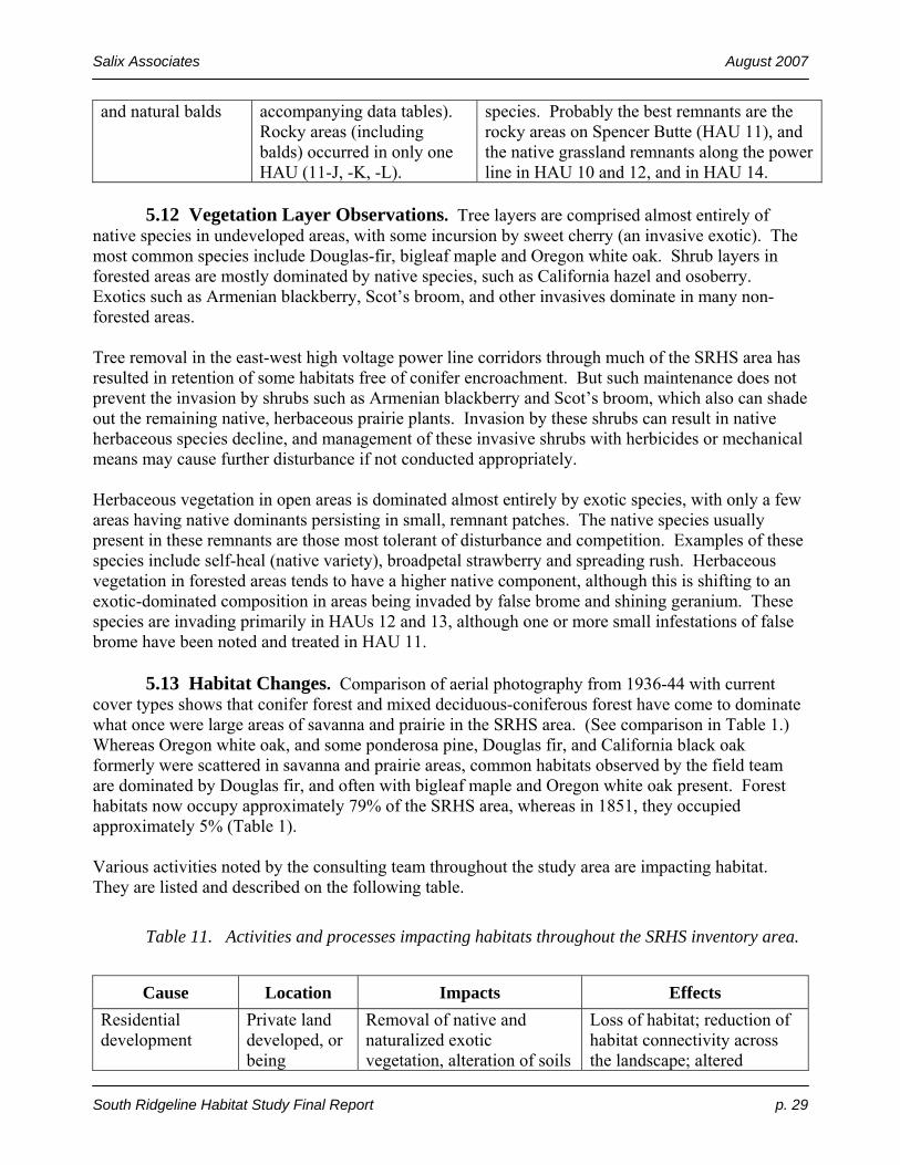
Salix Associates August 2007
South Ridgeline Habitat Study Final Report p. 29
and natural balds accompanying data tables). Rocky areas (including balds) occurred in only one HAU (11-J, -K, -L).
species. Probably the best remnants are the rocky areas on Spencer Butte (HAU 11), and the native grassland remnants along the power line in HAU 10 and 12, and in HAU 14.
5.12 Vegetation Layer Observations. Tree layers are comprised almost entirely of native species in undeveloped areas, with some incursion by sweet cherry (an invasive exotic). The most common species include Douglas-fir, bigleaf maple and Oregon white oak. Shrub layers in forested areas are mostly dominated by native species, such as California hazel and osoberry. Exotics such as Armenian blackberry, Scot’s broom, and other invasives dominate in many non-forested areas. Tree removal in the east-west high voltage power line corridors through much of the SRHS area has resulted in retention of some habitats free of conifer encroachment. But such maintenance does not prevent the invasion by shrubs such as Armenian blackberry and Scot’s broom, which also can shade out the remaining native, herbaceous prairie plants. Invasion by these shrubs can result in native herbaceous species decline, and management of these invasive shrubs with herbicides or mechanical means may cause further disturbance if not conducted appropriately. Herbaceous vegetation in open areas is dominated almost entirely by exotic species, with only a few areas having native dominants persisting in small, remnant patches. The native species usually present in these remnants are those most tolerant of disturbance and competition. Examples of these species include self-heal (native variety), broadpetal strawberry and spreading rush. Herbaceous vegetation in forested areas tends to have a higher native component, although this is shifting to an exotic-dominated composition in areas being invaded by false brome and shining geranium. These species are invading primarily in HAUs 12 and 13, although one or more small infestations of false brome have been noted and treated in HAU 11. 5.13 Habitat Changes. Comparison of aerial photography from 1936-44 with current cover types shows that conifer forest and mixed deciduous-coniferous forest have come to dominate what once were large areas of savanna and prairie in the SRHS area. (See comparison in Table 1.) Whereas Oregon white oak, and some ponderosa pine, Douglas fir, and California black oak formerly were scattered in savanna and prairie areas, common habitats observed by the field team are dominated by Douglas fir, and often with bigleaf maple and Oregon white oak present. Forest habitats now occupy approximately 79% of the SRHS area, whereas in 1851, they occupied approximately 5% (Table 1). Various activities noted by the consulting team throughout the study area are impacting habitat. They are listed and described on the following table.
Table 11. Activities and processes impacting habitats throughout the SRHS inventory area.
Cause Location Impacts Effects
Residential development
Private land developed, or being
Removal of native and naturalized exotic vegetation, alteration of soils
Loss of habitat; reduction of habitat connectivity across the landscape; altered
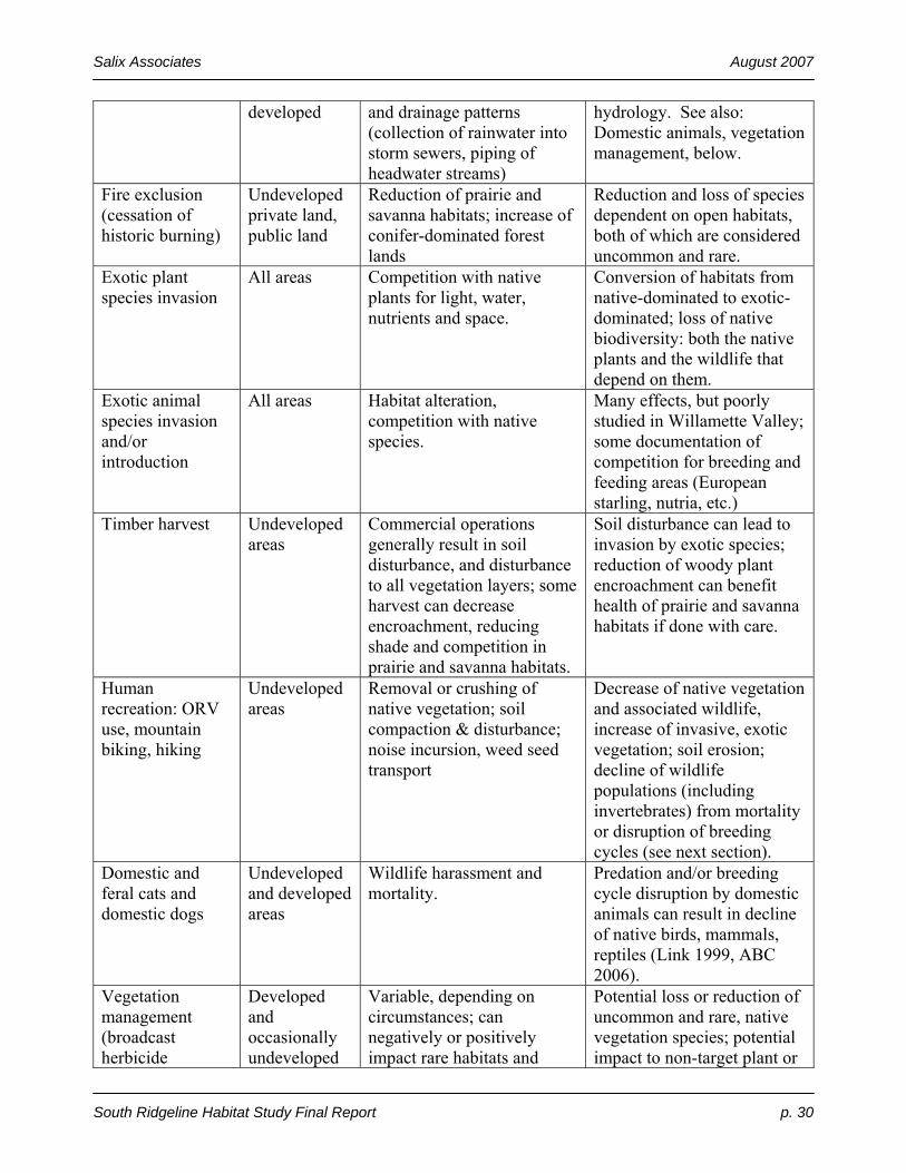
Salix Associates August 2007
South Ridgeline Habitat Study Final Report p. 30
developed and drainage patterns (collection of rainwater into storm sewers, piping of headwater streams)
hydrology. See also: Domestic animals, vegetation management, below.
Fire exclusion (cessation of historic burning)
Undeveloped private land, public land
Reduction of prairie and savanna habitats; increase of conifer-dominated forest lands
Reduction and loss of species dependent on open habitats, both of which are considered uncommon and rare.
Exotic plant species invasion
All areas Competition with native plants for light, water, nutrients and space.
Conversion of habitats from native-dominated to exotic-dominated; loss of native biodiversity: both the native plants and the wildlife that depend on them.
Exotic animal species invasion and/or introduction
All areas Habitat alteration, competition with native species.
Many effects, but poorly studied in Willamette Valley; some documentation of competition for breeding and feeding areas (European starling, nutria, etc.)
Timber harvest Undeveloped areas
Commercial operations generally result in soil disturbance, and disturbance to all vegetation layers; some harvest can decrease encroachment, reducing shade and competition in prairie and savanna habitats.
Soil disturbance can lead to invasion by exotic species; reduction of woody plant encroachment can benefit health of prairie and savanna habitats if done with care.
Human recreation: ORV use, mountain biking, hiking
Undeveloped areas
Removal or crushing of native vegetation; soil compaction & disturbance; noise incursion, weed seed transport
Decrease of native vegetation and associated wildlife, increase of invasive, exotic vegetation; soil erosion; decline of wildlife populations (including invertebrates) from mortality or disruption of breeding cycles (see next section).
Domestic and feral cats and domestic dogs
Undeveloped and developed areas
Wildlife harassment and mortality.
Predation and/or breeding cycle disruption by domestic animals can result in decline of native birds, mammals, reptiles (Link 1999, ABC 2006).
Vegetation management (broadcast herbicide
Developed and occasionally undeveloped
Variable, depending on circumstances; can negatively or positively impact rare habitats and
Potential loss or reduction of uncommon and rare, native vegetation species; potential impact to non-target plant or

Salix Associates August 2007
South Ridgeline Habitat Study Final Report p. 31
spraying, mowing, fertilizing, etc.)
areas species. animal species; potential contamination of waterways. Sensitive management of invasives can produce positive impacts.
5.14 Narrative Summary of HAU Inventory Observations. The following section is a narrative description of general findings for each HAU. HAU 1: Pitchford Road The Pitchford Road HAU lies just northwest of the west end of West 18th, and just south of the Westlawn Cemetery, south of West 11th. Most of the HAU is forested, and Douglas fir, bigleaf maple, Oregon white oak and California black oak are dominant. Where Douglas fir and oaks are mixed, the fir is overtopping the oaks. The southwest corner of the HAU is dominated by oak woodland which includes some very large oaks 30+ inches in diameter. Good sized madrone are also scattered in this area. Understory vegetation for most of the area could not be viewed due to lack of access. In the southwest corner it appears to be dominated by exotic species. Small openings in the oak woodland have potential to contain remnant native upland prairie. No uncommon or rare species are known to be present in the HAU. This HAU has a compact shape, no fragmentation and good connectivity to undeveloped lands to the east, west and southwest. HAU 2: Warren Street The Warren Street HAU is located along the north side of the UGB. A high voltage power line easement and maintenance corridor runs along the southwest side of the HAU. Most of the HAU is either conifer or mixed forest dominated by Douglas fir, oak and bigleaf maple. Oaks are being overtopped and shaded out by Douglas fir in many of the mixed stands. A small stand of oak forest is located at the northeast corner. Several meadow areas scattered through the HAU have potential to harbor remnant native prairie although most are dominated by introduced pasture grasses. Sweet cherry is a common invasive tree in moister forests. Armenian blackberry impacts forest understories and open areas. Meadows have been invaded by a variety of weedy grasses and forbs. Active development is occurring along the southeastern edge of the HAU and new streets have recently been built into the southern portion. HAU 3: Wild Iris Ridge / Timberline The Wild Iris Ridge HAU is owned by the City and is one of the largest HAU’s with valuable habitats within the study area. A high voltage power line easement and maintenance corridor runs northwest/southeast through this HAU. Hitchcock’s blue-eyed grass and white-topped aster were previously recorded in or adjacent to the corridor. The property was logged before it was purchased by the City, leaving much of the historic oak/hardwood and mixed forest character intact, although the understory has been invaded by exotics. City maintenance and management is addressing problems. Armenian blackberry is a major problem in much of the power line corridor. East and north of the power line corridor the HAU is a mix of forested and open habitats, with active development occurring at edges and within the HAU boundaries. Young to mature conifer and mixed forest are interspersed with open meadow areas, many of which are currently being developed. Dominant tree species include Douglas-fir, bigleaf maple, Oregon white oak and California black oak. Oaks are being overtopped and shaded out by Douglas fir in many of the

Salix Associates August 2007
South Ridgeline Habitat Study Final Report p. 32
mixed stands. Pileated Woodpeckers are present in mature Douglas-fir forest in the northeastern portion of the HAU. Armenian blackberry is invading forest understories and meadow areas. HAU 4: Blacktail Drive / McClean Boulevard Most of this HAU has been developed, or is being developed. A population of Hitchcock’s blue-eyed grass was found during the survey in Videra Park, and the site was shown to City maintenance staff. Some narrowleaf wild onion and other native herbaceous plants are scattered throughout the open area of the park and adjacent property. Oak woodlands are present on private lands adjacent to the southeast end of the park. Grassland habitat, with some oak savanna, is present north-northwest of the park, where a flowering population of mule’s ears (a native herbaceous species) was observed being mowed. Other native herbaceous species may be present but could not be viewed because of access limitations. A small riparian corridor and City-constructed stormwater detention ponds provide small but valuable wetland and riparian habitats for plants and wildlife, including dragonflies and other invertebrates. Armenian blackberry and Scot’s broom are present in the park and in other portions of the HAU. HAU 5: Hawkins Heights Most of this HAU is conifer or mixed forest dominated by Douglas fir, bigleaf maple, Oregon white oak and California black oak. Oaks are being overtopped and shaded out by Douglas fir in many of the mixed stands. Large mature Douglas fir trees are present in the city park area in the northeast corner of the site and in mature forest throughout much of the rest of the HAU, and foraging excavations of Pileated Woodpeckers are present in these stands. The few open areas that exist are highly disturbed (bladed or filled) and very weedy. Development has occurred and is ongoing along the southern edge and in the western part of the HAU, and considerable habitat fragmentation has occurred in the western portion from development and roads. Forest understories are impacted by a variety of invasive plant species including Armenian blackberry, English/Irish ivy, English holly, sweet cherry, English hawthorn, spurge laurel, Robert’s geranium and shining geranium. HAU 6: Morse Ranch The Oregon white oaks and California black oaks, particularly around the historic Wayne Morse home, but elsewhere on site as well, are important habitat features of the local area. The black oaks appear to be in slow decline, possibly due to anthracnose. The landscaping around the house contains some species that can be invasive in wildland habitats. Vegetation in the unmaintained areas below the house to the north frequently is dominated in the ground and shrub layers by non-native, invasive species. The park contains an off-leash dog run that was not included in the original inventory area, but is adjacent. A wildlife rehabilitation group resides in the barn. Open habitats are dominated by exotic herbaceous species, but trace native populations may be present. HAU 7: 34th & Olive The 34th and Olive HAU is mostly forested with a small grassy area in the east-center. Mixed forest of Douglas-fir, bigleaf maple and Oregon ash occupies most of the site. A stream flows northeast through the southeast corner of the site forming braided channels through an Oregon ash riparian forest. Based on aerial photography the grassy area appears to be mowed and lawn-like, although it may be within the riparian corridor and portions may be wetlands. No access was allowed to this area. Armenian blackberry, English/Irish ivy, reed canarygrass and a variety of other invasives are impacting habitats. Lands adjacent to this HAU are fully developed.

Salix Associates August 2007
South Ridgeline Habitat Study Final Report p. 33
HAU 8: Braeburn / Blanton Blanton Ridgeline Park system, and other elements of the City’s Ridgeline Trail system, comprise much of this HAU. The majority of the HAU is mixed forest dominated by Douglas fir with bigleaf maple or Oregon white oak and California black oak. Douglas fir is overtopping oaks in stands in which they grow together. There are several areas of hardwood forest including moist riparian corridors dominated by Oregon ash. Small patches of oak woodland and oak forest also are present. Large Douglas fir, oak, madrone and ponderosa pine are scattered in forest stands. Open habitats are more limited and are concentrated in the northwest part of the HAU. The open area at the western edge of the HAU has a few remnant prairie species, but is dominated by exotic species. Western Gray Squirrel and Pileated Woodpecker were documented in several areas and a population of tall bugbane was documented in Douglas fir-bigleaf maple forest in the southern half of the HAU. Yellow-breasted Chat and Mountain Quail have been documented in the area by local birders, although they were not observed during this inventory. Spurred lupine, an uncommon species in the Willamette Valley was noted on private land and Eugene Water and Electric Board land in the southern portion of the area. This species is a potential host for Fender’s Blue Butterfly, but surveys during the flight season would be required to ascertain their presence or absence. Forest invasives include sweet cherry, Armenian blackberry, English/Irish ivy, English holly, English hawthorn, shining geranium and Robert’s geranium. Meadow habitats have been impacted by exotic grasses and forbs. This HAU has a very long narrow shape and has been fragmented by development in the north, middle and south parts. However, it retains good connectivity to undeveloped habitats to the west and southwest. HAU 9: Resthaven Cemetery The fringes of this cemetery retain some mixed forest values, including some large Oregon white and California black oak, and ponderosa pine. Suitable wayside aster habitat is present on the north edge, and possibly elsewhere. Oak habitats at the south end of the site were not accessible for this inventory. Active logging, in conjunction with an approved cemetery development permit, was occurring over much of the southern half of the site. The site has no connectivity to other habitats. HAU 10: Fox Hollow / Willamette HAU 10 is a diverse area located between Willamette and Donald Streets at the north end and between Fox Hollow Road and Spencer Butte Park at the south end. Most of this HAU is forested with conifer, mixed and hardwood forests. Oaks are being overtopped and shaded out by Douglas fir in some of the mixed stands. A high voltage power line corridor passes east-west through the area near the intersection of Donald Street and Fox Hollow Road. Several headwater streams originate within the HAU and feed upper Amazon Creek and other drainages. A few open habitats exist in the power line corridor and along the southern edge of the HAU. Periodic clearing of the power line corridor has helped to maintain open habitats. All open habitats have potential for remnant upland prairie elements to be present. Moist Oregon ash forest is found in the middle portion of the site and is bisected by Owl Road. Western coneflower and ample-leaved sedge, uncommon in the Willamette Valley, are both present the understory of this area. The north end of the HAU is fragmented by development and streets, and scattered development and individual residences occur throughout much of the southern half of the area. Despite this, there are

Salix Associates August 2007
South Ridgeline Habitat Study Final Report p. 34
large areas of unbroken natural habitat present and excellent connections to adjacent large blocks of habitat in Spencer Butte Park (HAU 11). This HAU also provides good connectivity between undeveloped areas to the south and HAU 8 to the north and HAU 12 to the east. Uncommon or rare species that have been documented within the HAU include Little Willow Flycatcher, Mountain Quail, Olive-Sided Flycatcher, Pileated Woodpecker, Northern Red-legged Frog, wayside aster, and tall bugbane. Armenian blackberry is impacting habitats throughout the HAU, including tall bugbane habitat. A large false brome infestation is present in forested habitats between Owl Road and the power line corridor. Shining geranium, Robert’s geranium, English/Irish ivy and introduced grasses are invading forest understories. Despite the presence of a diversity of invasive species, many forest understory communities are dominated by native species and are in good condition. HAU 11: Spencer Butte Park The northern end of this HAU primarily is disturbed prairie, but it does contain potential habitat for several uncommon to rare prairie species. The narrow section of the HAU containing the Ridgeline Trail access to Spencer Butte currently is dominated by a stand of Oregon white oak and ponderosa pine, including some very large trees, which is being encroached upon by Douglas fir. Most of the VMUs comprising the main portion of Spencer Butte Park are forested, but there are several rocky openings near and at the summit, that provide a habitat unique in the SRHS area. Although those areas are dominated in many places by invasive and other exotics, they still hold remnant populations of significant native species. Comparing the early 1930s plant list with current listings, it is evident that some native plant species have disappeared from the rocky and open areas, and that new exotic species have appeared. Western rattlesnakes have been sighted recently in the rocky area near the summit, and the seepy are to the east of the summit has several plant species otherwise not known from the SRHS area. Spencer Butte is the highest point in the SRHS area, at 2054 feet in elevation. This height, combined with the open habitat, makes it an important migratory bird site; several uncommon to rare migrants have been noted there, including White-throated Swifts. The designated trails, and much of the rocky area at the top (which lacks a designated trail), receive heavy recreational hiker use, leading to trampling of plants and off-leash dog impacts. Tall bugbane and wayside aster were previously known from several sites in the park, and several of those were seen again during this inventory. Armenian blackberry is likely the invasive species with the highest existing impact in the HAU. A very invasive grass, false brome, has been pulled from an area near the meadow just southeast of the summit. The forest stand on the northeast slope of the Butte contains some of the largest Douglas fir and grand fir in the SRHS area. HAU 12: Amazon Headwaters Located between Fox Hollow Road and Dillard Road, this HAU encompasses most of the headwaters of Amazon Creek. Much of the area is occupied by mature conifer and mixed forest dominated by large Douglas fir and bigleaf maple. Large grand fir are present in drainage bottoms

Salix Associates August 2007
South Ridgeline Habitat Study Final Report p. 35
although many of these trees have died recently or appear to be in decline, possibly due to an introduced adelgid (insect) which has infested Willamette Valley grand fir. A high voltage power line corridor passes east-west through the area. Most of the power line corridor and a large forested block to the south of it is city park land. Clearing activities for the power line have maintained both open and shrubby habitats. The open habitats contain remnant native upland prairie with Roemer’s fescue, California fescue, field checkermallow and other native prairie and savanna species present. Most grassland areas are quite weedy with introduced grasses and forbs. Dry conifer and mixed forest grow along the ridgeline on the southern edge of the HAU, and along the northern edge of the power line corridor in the northeast part of the area. Very large ponderosa pines are scattered among younger, smaller Douglas firs in these stands, remnants of pine-oak savanna that occupied this area 150 years ago. A few remaining oaks are in decline from being overtopped by Douglas fir. Wayside aster, tall bugbane, field checkermallow, Northern Red-legged Frog, Little Willow Flycatcher, Mountain Quail and Western Gray Squirrel have been documented in HAU 12. Understory plant communities in many of the forested areas are in good condition although Armenian blackberry is spreading aggressively in some areas, threatening some tall bugbane populations and native understories. A large infestation of false brome is located in forest communities south and west of Fox Hollow School in the northwest corner of the site. Patches of shining geranium are scattered throughout the HAU and a heavy infestation of this species is negatively impacting understory vegetation along Dillard Road in the northeast part of the HAU. Some fragmentation caused by development has occurred in the western part of the HAU along Fox Hollow Road and West Amazon Drive. Otherwise, this HAU provides good connection with undeveloped habitats to the east, south and southwest. HAU 13: Mt. Baldy The southeast section of HAU 13 is a large public park (Mt. Baldy). Conifer encroachment into historic prairie, savanna and oak woodland habitats is common. A few interesting native plants exist in prairie areas, but past grazing history has resulted in overwhelming dominance of exotics in those habitats. An Oregon ash riparian area (VMU 13-F) is in surprisingly good native condition considering its proximity to the urban area, but creeping buttercup is an invasive dominant in the herb layer there. Otherwise, dominants are native in most forest understories. Exotics dominate most prairie, savanna and woodland habitats. A pond (VMU 13-D) located on the southwest side of Mt. Baldy, appears to be a significant breeding site for Northern Red-legged Frogs, but is threatened by encroaching reed canarygrass. Bullfrog tadpoles also were sighted, but they may not survive annual low water or drying of the pond. There is significant trampling by humans and dog intrusion into the pond on the west edge, where a trail from the meadows provides access through large Armenian blackberry mounds. Many young and mature oaks are impacted by encroachment of Douglas-fir; Oregon white oak is most abundant, but there are quite a few California black oak as well (many of these appear to be in decline, possibly due to infection by anthracnose). Roadsides have significant populations of invasive shining geranium: especially along Dillard Road, Old Dillard Road, Barber Drive and Skyline Loop. One backyard pond was noted off the north side of North Skyline Park Loop. Several seepy drainages in the area may be suitable for Northern Red-legged Frog dispersal and foraging. Western Gray Squirrels were noted at several locations, particularly near the intersection

Salix Associates August 2007
South Ridgeline Habitat Study Final Report p. 36
of Barber Drive and Skyline Park Loop. A roadside population of wayside aster, with other interesting native herbaceous species, was discovered during this survey along Dillard Road adjacent to the HAU. HAU 14: Shasta Loop The Shasta Loop HAU lies between Spring Boulevard and East Amazon Drive. It is mostly comprised of small blocks of mixed forest dominated by Douglas fir, Oregon white oak, California black oak and bigleaf maple. Oak woodland and oak forest containing some large, older oaks are present in the northern part of the HAU. Oaks in the mixed stands are being overtopped and shaded out by Douglas fir. Pileated Woodpeckers are present in forested and woodland areas with mature Douglas fir. Degraded savanna and prairie are present, the largest area occurring along the eastern side of the site. A small strip of oak savanna in the northern part of the HAU has rock outcrops and patches of native Lemmon’s needlegrass. Sweet cherry is a common invasive tree in forest areas. Understory invasives include Armenian blackberry, Scot’s broom, and Robert’s geranium. Maltese starthistle, an uncommon exotic in the Willamette Valley, grows in the rocky savanna area noted above. This HAU is highly fragmented by development and roads. Active development is occurring within the HAU along the east side in an area bounded by 43rd Street, Spring Boulevard and Knoll Drive. HAU 15: Spring Boulevard The Spring Boulevard site is a small HAU located between Spring Boulevard and Woodson Street. It is comprised of 3 small patches of young Douglas fir forest with scattered oaks and maples. Oaks in these stands are in decline from overtopping by larger Douglas firs. Invasive species include sweet cherry, English/Irish ivy, English holly and Armenian blackberry. Fresh Pileated Woodpecker foraging excavations were observed in the northeast corner of the HAU. This site is highly fragmented by residential development, and surrounding areas are fully developed. HAU 16: Pine Canyon Road HAU 16 lies north and south of Pine Canyon Road. Most of the site is dry mixed forest dominated by Douglas fir, Oregon white oak and California black oak. Pacific madrone is common in some areas. Scattered large, older oaks are present in several of the stands, reflecting the more open woodland and savanna conditions that once existed here. Many oaks are in decline from overtopping by Douglas fir. Western Gray Squirrels were observed in forested areas north of Pine Canyon Road and likely inhabit all forested areas in the HAU. Sweet cherry has invaded forest stands and understory vegetation is generally weedy with introduced grasses, Armenian blackberry and English/Irish ivy. Sweet cherry, English hawthorn, Armenian blackberry, Scot’s broom, spurge laurel and weedy grasses occupy a woodland area at the south end of the site. This HAU is moderately fragmented by development and streets. Surrounding areas are fully developed. HAU 17: Agate Street / Kimberly The Agate Street / Kimberly site is located along the south side of 30th Avenue between Onyx Street and Spring Boulevard. The area is mostly mature Douglas fir and mixed forest dominated by large Douglas fir and bigleaf maple. Oregon white oak is overtopped by Douglas fir in small forest stands in the northwest corner of the site. A mowed grassy area in the northern part of the HAU is the only

Salix Associates August 2007
South Ridgeline Habitat Study Final Report p. 37
open habitat present. Pileated woodpecker nesting and foraging excavations were observed in several forested locations within the HAU. Sweet cherry has invaded forest overstories, and understories are impacted by a variety of invasive plants including Armenian blackberry, English hawthorn, English/Irish ivy, English holly, laurel spurge, and introduced grasses. Cotoneaster, an escaped ornamental, is scattered throughout the site. HAU 17 is quite fragmented by development and streets. Surrounding areas are developed for residential use except along the north side which is bordered by 30th Avenue, a busy four lane road. HAU 18: Laurelwood / Ribbon Trail The Laurelwood / Ribbon Trail HAU is located along the north side of 30th Avenue and is bordered on the west and north by the Laurelwood Golf Course and adjacent developed areas, and to the northeast by the Floral Hill neighborhood. Hendricks Park is located directly north of this HAU. The area is characterized by a variety of forested habitats including mixed conifer forest dominated by large mature Douglas fir and bigleaf maple or Oregon white oak/California black oak, dry hardwood forest of Oregon white oak, sometimes mixed with bigleaf maple, young Douglas fir forest and mixed woodlands of Douglas fir and oak. Both white and black oak are being overtopped and shaded out of forest stands where they grow with the taller Douglas fir. A woodland area in the eastern portion of the HAU was logged to remove large Douglas fir several decades ago, and is dominated by smaller Douglas fir and white and black oak. A forested riparian area with a black cottonwood overstory drains northerly into the Floral Hill area. A small grassland area is located in the northwest point of the HAU. Pileated Woodpecker calls and foraging excavations were observed in several areas within the HAU, and nesting excavations were observed in mature Douglas fir forest on the east side of the golf course. Tall bugbane was documented in the north part of the site. The riparian area has potential breeding and dispersal habitat for Northern Red-legged Frog. Sweet cherry has infested overstories in forested areas. Most forest understory areas are predominantly native, but English holly, English hawthorn, English/Irish ivy, Armenian blackberry, spurge laurel and Robert’s geranium are present and will continue to impact native plant communities. Old skid trails visible on aerial photos likely have dense Armenian blackberry and have served as introduction corridors for other invasives. The grassland area is dominated by weedy introduced grasses. HAU 18 is somewhat fragmented by development and roads, but contains some large blocks of contiguous habitat. It provides good connectivity to the Moon Mountain area to the east and a narrow connection to Hendricks Park to the north. 30th Avenue constitutes a major barrier along the southern edge of the area. HAU 19: Hendricks Park Hendricks Parks comprises this entire HAU. An active Pileated woodpecker nest was sighted in the park in summer 2006 ( personal communication, Gleason). Many excavations are visible at the bases of large trees. Two small, northerly-flowing drainages are present, with small amounts of ponding at road crossings. Northern Red-legged Frog breeding is unlikely there, but the forests probably provide dispersal habitat. Some large Douglas fir are present near the drainages.

Salix Associates August 2007
South Ridgeline Habitat Study Final Report p. 38
The Oregon white oaks in the rhododendron garden are large and in good condition because of a careful irrigation plan. A tall bugbane population was confirmed in the southeast portion of the park, and is somewhat threatened by Armenian blackberry and shade encroachment. Bigleaf maple and sweet cherry exist in many portions of the forest understory. Trails are present throughout the forested area, but are not heavily used. The southwest ridge is dominated by Oregon white oak, and the City is considering removal of encroaching fir, invasive Armenian blackberry and other herbaceous species (English/Irish ivy, periwinkle, nipplewort, Robert’s geranium, etc.). There is connectivity to the south to HAU 18, but the majority of the HAU is surrounded by residential development. HAU 20: McDougal The McDougal site is located southwest of Moon Mountain and is nearly all private land except for a small patch of city park land at the northeast corner. Most of the HAU is cutover hardwood forest that resulted from logging of Douglas fir within the last 30 to 40 years. Dominant tree species include bigleaf maple and Oregon white oak. Douglas fir is present in the stand at subdominant levels. Limited views of the understory suggest that it is probably infested with dense Armenian blackberry. Two patches of uncut conifer and mixed forest are present in the center and western parts of the HAU. The understory along the western edge is in good condition. A small patch of shrubland is located on the city parkland at the northeast corner, and contains bits of remnant prairie with Roemer’s fescue, California oatgrass, Hall’s aster, Oregon sunshine, barestem lomatium, rose checkermallow, narrowleaf mule’s ears and farewell-to-spring. A high voltage power line corridor passes north-south through the eastern edge of the HAU. A Yellow-breasted Chat was documented in shrubby vegetation in the northern part of the site. Meadow openings are dominated by exotic grasses and are impacted by invading woody species. Armenian blackberry is severely impacting large portions of the site, especially the cutover forest areas and the power line corridor. Shining geranium is present at the western edge of the area and may extend further into the interior of the site. Connectivity within the site is excellent, and this HAU provides good connections to undeveloped areas to the west, south, east and northeast. Adjacent development is concentrated on the northwest corner of the HAU. HAU 21: Moon Mountain The Moon Mountain HAU is located south and southeast of the Glenwood – I-5 interchange. A portion of the area at the southern end is City parkland. A powerline corridor passes north-south through the HAU. Access to the public land in the southern portion, and other parts of this HAU, was very limited. Most of the site is vegetated by mixed forest and oak woodlands. Much of the area has been cut over in recent years and appears to have dense Armenian blackberry infestations. The powerline corridor is likewise heavily infested with blackberry. The south and west parts of the HAU have significant areas of upland prairie and savanna, although these areas were not accessible for inventory. From aerial photo interpretation it appears that they have been partially colonized by Armenian blackberry and other woody vegetation. However, they may retain good potential to harbor remnant prairie species. Areas near the Glenwood – I-5 interchange are disturbed by dumping, grading and invasives. ORV disturbance is evident near the interchange, and based on

Salix Associates August 2007
South Ridgeline Habitat Study Final Report p. 39
aerial photo interpretation, may be present in the southern portions of the HAU. Wayside aster previously was found in this HAU as noted in a site planning document. Tall bugbane is known from nearby, but potential habitat in the HAU was not accessible for this inventory. The northern and western edges of the HAU are developed, or are developing and along with the powerline corridor this has resulted in some fragmentation. Nonetheless, large, unfragmented areas remain and there is excellent connectivity with undeveloped habitats to the south. 5.15 Uncommon and Rare Species Documentation and Habitat Suitability. The following table shows the species from the original and expanded lists of SRHS target uncommon and rare species that either were seen during the inventory or noted by a biological consultant in a report to the City, or listed in ORNHIC records in the study area. The table is sorted to illustrate the relative frequency of SRHS documentation (from highest to lowest) of the uncommon and rare species or signs of their presence. It does not show their complete occurrence, however, as structured surveys have not been conducted and some species are more easily detectable than others. Additionally, some detections may represent multiple recordings of a single individual. More information on occurrence, habitat and range is in Appendix B.
Table 12. Target uncommon and rare species documented within the SRHS area.
Species Value Source list
ORNHIC record
HAUs by SRHS #
Total # of
HAUs
Total # of
VMUs
Pileated Woodpecker H Original No
3, 5, 6, 8, 9, 10, 11, 12, 13, 14, 15, 17, 18,
19
14 62
Hitchcock's blue-eyed grass H Expanded Yes 3, 4, 13 3 11
Western Gray Squirrel H Expanded No 6, 8, 13, 14, 16, 19 6 11
tall bugbane H Original Yes 8, 10, 11, 12, 18, 19 6 8
wayside aster H Original Yes 10, 11, 13, 21 4 8
Mountain Quail M Expanded No 8, 10, 12 3 7 meadow checkermallow H Expanded No 12 1 3 Northern Red-legged Frog H Original No 10, 12, 13 3 4 Olive-sided Flycatcher H Expanded No 10, 21 2 3 Little Willow Flycatcher H Expanded No 10, 12 2 2 upland yellow violet M Expanded No 11, 13 2 2 Yellow-breasted Chat H Expanded No 8, 20 2 2 grass widows M Expanded No 11 1 1 Western Rattlesnake H Expanded No 11 1 1

Salix Associates August 2007
South Ridgeline Habitat Study Final Report p. 40
White-breasted Nuthatch H Expanded No 6 1 1 Pileated woodpeckers or their activity were documented in 14 of the 21 HAUs, and in 63 of the 324 VMUs. Tall bugbane and Western Gray Squirrel each have been documented in 6 HAUs, and wayside aster in 4. The remaining species on the table were recorded in 3 or fewer HAUs. The next table lists the uncommon and rare species documented in each HAU during this study, or previously recorded
Table 13. Documented uncommon and rare species (with SRHS value) by HAU.
HAU Species
3 Pileated Woodpecker (M) Hitchcock's blue-eyed grass (H)
4 Hitchcock's blue-eyed grass (H) 5 Pileated Woodpecker (M)
6 Western Gray Squirrel (H) White-breasted Nuthatch (H) Pileated Woodpecker (M)
8
Pileated Woodpecker (M) Western Gray Squirrel (H) Mountain Quail (M) Yellow-breasted Chat (H) tall bugbane (H)
9 Pileated Woodpecker (M)
10
Mountain Quail (M) Northern Red-legged Frog (H) tall bugbane (H) Olive-sided Flycatcher (H) Pileated Woodpecker (M) Little Willow Flycatcher (H) wayside aster (H)
11
Pileated Woodpecker (M) Western Rattlesnake (H) wayside aster (H) tall bugbane (H) upland yellow violet (M) grass widows (M)
12
Northern Red-legged Frog (H) Mountain Quail (M) Little Willow Flycatcher (H) meadow checkermallow (H) Pileated Woodpecker (M) tall bugbane (H)
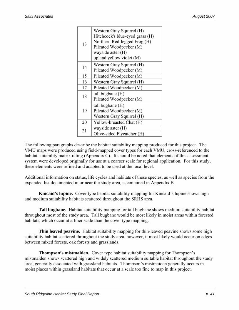
Salix Associates August 2007
South Ridgeline Habitat Study Final Report p. 41
13
Western Gray Squirrel (H) Hitchcock's blue-eyed grass (H) Northern Red-legged Frog (H) Pileated Woodpecker (M) wayside aster (H) upland yellow violet (M)
14 Western Gray Squirrel (H) Pileated Woodpecker (M)
15 Pileated Woodpecker (M) 16 Western Gray Squirrel (H) 17 Pileated Woodpecker (M)
18 tall bugbane (H) Pileated Woodpecker (M)
19 tall bugbane (H) Pileated Woodpecker (M) Western Gray Squirrel (H)
20 Yellow-breasted Chat (H) wayside aster (H) 21 Olive-sided Flycatcher (H)
The following paragraphs describe the habitat suitability mapping produced for this project. The VMU maps were produced using field-mapped cover types for each VMU, cross-referenced to the habitat suitability matrix rating (Appendix C). It should be noted that elements of this assessment system were developed originally for use at a coarser scale for regional application. For this study, these elements were refined and adapted to be used at the local level. Additional information on status, life cycles and habitats of these species, as well as species from the expanded list documented in or near the study area, is contained in Appendix B. Kincaid’s lupine. Cover type habitat suitability mapping for Kincaid’s lupine shows high and medium suitability habitats scattered throughout the SRHS area. Tall bugbane. Habitat suitability mapping for tall bugbane shows medium suitability habitat throughout most of the study area. Tall bugbane would be most likely in moist areas within forested habitats, which occur at a finer scale than the cover type mapping. Thin leaved peavine. Habitat suitability mapping for thin-leaved peavine shows some high suitability habitat scattered throughout the study area, however, it most likely would occur on edges between mixed forests, oak forests and grasslands. Thompson’s mistmaiden. Cover type habitat suitability mapping for Thompson’s mistmaiden shows scattered high and widely scattered medium suitable habitat throughout the study area, generally associated with grassland habitats. Thompson’s mistmaiden generally occurs in moist places within grassland habitats that occur at a scale too fine to map in this project.

Salix Associates August 2007
South Ridgeline Habitat Study Final Report p. 42
Wayside aster. Cover type habitat suitability mapping for wayside aster shows low suitability habitat for much of the study area, with some high and medium suitability areas occurring occasionally throughout. Suitable habitat occurs in savanna habitats, as well as in forest gaps and on edges. Suitable habitat for the following two wildlife species from the original list were mapped using the same coarse scale cover type suitability method that was used for plants, and a second map was produced for each using finer scale features recorded during the inventory. Northern Red-legged Frog. Because Northern Red-legged Frogs have different requirements for breeding (aquatic) and for foraging/dispersal (terrestrial) portions of their life cycles, these two habitats are mapped separately. Habitat suitability mapping using the coarser scale method shows four small, aquatic (breeding) habitats as “high suitability.” The paucity of seasonal ponds in the SRHS area (because of the primarily ridgeline and hillslope topography) likely is the reason for the low amount of suitable aquatic habitat. A large amount of high suitability terrestrial foraging/dispersal habitat was mapped, based simply on presence of forests. This map could be modified in the future assessing finer scale features such as proximity to suitable breeding habitats. A second habitat suitability map set, based on finer scale assessment of special habitat features, shows widely scattered high and medium potentially suitable habitat for breeding, and a fairly even one-third split between high-medium-low suitability foraging/dispersal habitat. It should be noted that because of a lack of access, some features are assumed based on best professional judgment in comparison with similar, viewed habitat nearby. Again, this suitability mapping could be refined by including inventory and assessment of nearby habitat features. Pileated woodpecker. Cover type habitat suitability mapping for the Pileated Woodpecker shows high suitability habitats for most of the SRHS area, reflecting forested areas with potential tree size to meet the needs of this large bird. A second habitat suitability map based on finer scale observations of special habitat features such as snags and logs, as well as stand type and age, shows concentrations of suitable habitat near Hendricks Park (where there is confirmed breeding) and the Spencer Butte – Amazon Headwaters area. Other, smaller areas also are mapped. Nest excavations of Pileated woodpeckers were noted in 6 VMUs, within 5 HAUs: 6A, 10B, 12A, 12AI, 17F, 18H and 19B, but consultants lacked access to much of the inventory area, resulting in a rate of detection that likely is lower than reality. Some of these nest excavations may have been used during the 2006 nesting season, and some may be older and may not have been used recently. Foraging evidence was detected in 56 VMUs within 11 HAUs: 3, 5, 8, 10, 11, 12, 13, 14, 15, 17, 18 and 19. As above, it is likely that lack of access led to under-representation of actual occurrences. 5.2 Assessment Results. Across the project area, VMU scores ranged from a low of 2 to a high of 27, (average 13.8) before an acreage multiplier was applied. With the application of the acreage multiplier, scores ranged from a low of 2 to a high of 76.5 (average 23.5). Highest scoring VMUs were usually rare habitat types (prairie, savanna, wetlands, etc.), were large in size, and often had a significant component of native vegetation.

Salix Associates August 2007
South Ridgeline Habitat Study Final Report p. 43
Table 14. VMU scores by HAU (top 3 VMU highest, average, sum, and HAU score and survey acres in bold face type)
HAU #
# of VMUs
Lowest VMU score
Highest VMU score
Average VMU score
Sum of VMU scores
HAU score
HAU survey acres
1 3 30 37.5 32.5 97.5 21.8 35.4 2 17 6 31.5 22.4 380.5 50.1 106.0 3 30 5 72 29.8 892.5 101.8 232.6 4 9 9 46 25.2 226.5 33.2 31.2 5 15 2 26 16.5 247.5 28.8 73.9 6 7 6 30 17.7 124 14.4 31.6 7 3 5 30 21.2 63.5 8.9 16.2 8 22 12 50 26.1 573.5 69.4 220.6 9 4 10.5 32.5 17.1 68.5 8.4 22.5
10 33 9 62.5 27.1 893.5 101.9 242.3 11 15 5 76.5 31.7 475.5 60.6 318.6 12 40 4.5 57.5 24.8 994 112.4 411.6 13 38 6 45 19.8 753 87.8 150.1 14 18 7 57.5 25.3 455.5 49.6 97.3 15 3 9 11 9.7 29 3.9 3.1 16 7 6 24 13.9 97.5 10.8 21.7 17 12 3 30 13.4 160.5 17.1 48.2 18 12 15 45 29.3 352 47.7 178.0 19 9 8 35 14.1 126.5 17.7 78.2 20 4 7 56 32.8 131 25.1 93.2 21 23 7.5 65 22.4 515.5 64.6 176.5
TOTAL 324 --- --- --- --- --- 2588.6 The number of VMUs within an HAU varied from a low of 3 (HAU 1) to a high of 40 (HAU 12). The three highest individual VMU scores were in HAUs 3, 10 and 21 (shown in bold above). The highest VMU average scores were in HAUs 1, 11, and 20. HAUs 3, 10 and 12 had the highest sum total VMU scores and highest HAU scores. The three largest HAUs were 10, 11 and 12. HAU scores ranged from 3.9 (HAU 15) to 112.4 (HAU 12), with an average of 44.5. Larger HAUs with more rare habitats mapped within them, and greater connectivity to large habitat patches scored highest. Because in some areas HAU boundaries were created arbitrarily, primarily in recognition of development barriers, the HAUs vary greatly in size: the smallest (excluding DV areas) is 3.1 acres (HAU 15), and the largest is 412 acres (HAU 12). HAUs that are significantly larger will score higher than smaller HAUs that score equal in other aspects. This is intentional, as larger habitat areas have more values than smaller areas – other factors being equal. The potential limitation of this method is that valuable VMUs may be overlooked if they are contained within smaller, lower-scoring HAUs. To more accurately compare HAU values within the SRHS, both the HAU scores and the individual VMU scores within the HAU should be consulted and it is recommended that individual qualities shown on each VMU rating table be considered when comparing VMU scores. Some VMUs have values that may not stand out when simply comparing total VMU scores.
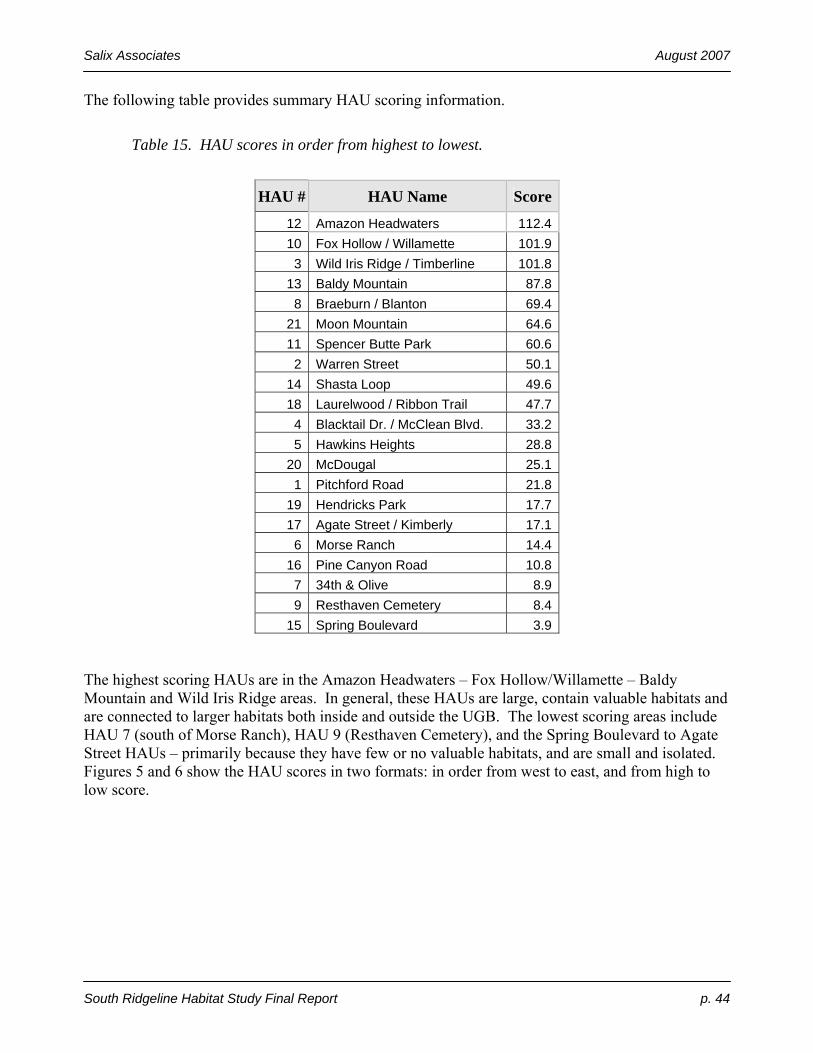
Salix Associates August 2007
South Ridgeline Habitat Study Final Report p. 44
The following table provides summary HAU scoring information.
Table 15. HAU scores in order from highest to lowest.
HAU # HAU Name Score
12 Amazon Headwaters 112.410 Fox Hollow / Willamette 101.9
3 Wild Iris Ridge / Timberline 101.813 Baldy Mountain 87.8
8 Braeburn / Blanton 69.421 Moon Mountain 64.611 Spencer Butte Park 60.6
2 Warren Street 50.114 Shasta Loop 49.618 Laurelwood / Ribbon Trail 47.7
4 Blacktail Dr. / McClean Blvd. 33.25 Hawkins Heights 28.8
20 McDougal 25.11 Pitchford Road 21.8
19 Hendricks Park 17.717 Agate Street / Kimberly 17.1
6 Morse Ranch 14.416 Pine Canyon Road 10.8
7 34th & Olive 8.99 Resthaven Cemetery 8.4
15 Spring Boulevard 3.9 The highest scoring HAUs are in the Amazon Headwaters – Fox Hollow/Willamette – Baldy Mountain and Wild Iris Ridge areas. In general, these HAUs are large, contain valuable habitats and are connected to larger habitats both inside and outside the UGB. The lowest scoring areas include HAU 7 (south of Morse Ranch), HAU 9 (Resthaven Cemetery), and the Spring Boulevard to Agate Street HAUs – primarily because they have few or no valuable habitats, and are small and isolated. Figures 5 and 6 show the HAU scores in two formats: in order from west to east, and from high to low score.
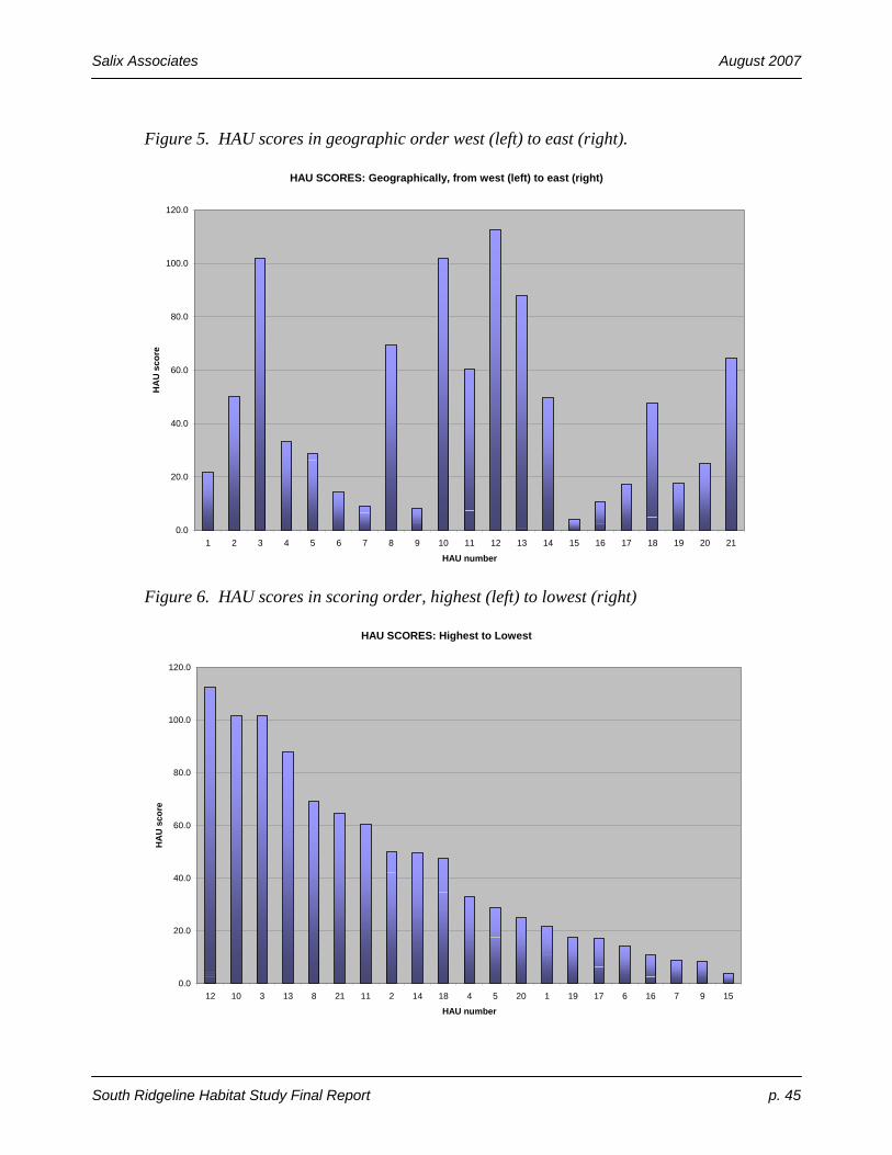
Salix Associates August 2007
South Ridgeline Habitat Study Final Report p. 45
Figure 5. HAU scores in geographic order west (left) to east (right).
HAU SCORES: Geographically, from west (left) to east (right)
0.0
20.0
40.0
60.0
80.0
100.0
120.0
1 2 3 4 5 6 7 8 9 10 11 12 13 14 15 16 17 18 19 20 21
HAU number
HA
U s
core
Figure 6. HAU scores in scoring order, highest (left) to lowest (right)
HAU SCORES: Highest to Lowest
0.0
20.0
40.0
60.0
80.0
100.0
120.0
12 10 3 13 8 21 11 2 14 18 4 5 20 1 19 17 6 16 7 9 15
HAU number
HA
U s
core

Salix Associates August 2007
South Ridgeline Habitat Study Final Report p. 46
6.0 Conclusions The most important conclusion to be drawn from this study is the rarity of savanna and prairie habitats in the SRHS area. This is most obvious in the comparison of 1851 acreage of those two categories to the 2006 acreages (Table 1), demonstrating the decline of the open habitat types and increase of forested habitat types. The local decline in these rare habitat types evidently is representative of habitat changes occurring on a larger scale throughout the Willamette Valley. Evaluation and comparison of the rare habitats using the uncommon and rare species suitability indices (RSS) matches regional assessments of uncommon and rare species. The highest value RSS indices calculated in this study are for oak savanna (308) other savanna (272), and natural grasslands (245) habitats. By comparison, the highest RSS for a conifer forest category mapped during this study is the combined high scores at 137. This difference is not surprising, in that the reduced acreages of the rare, open habitats directly cause the decline in associated species dependent on those habitat types – such as Fender’s Blue Butterfly, Kincaid’s lupine, and Willamette daisy. It also is noteworthy that some of the uncommon and rare species (Spotted Owl, Red Tree Vole, Pileated Woodpecker, etc.) that add to higher scores in forested habitats are more widespread in neighboring ecoregions (e.g., Western Cascades and Coast Range) where forested habitats have been more common historically. Other uncommon and rare species present in the SRHS area often are found in forested habitats associated with oaks (e.g., Western Gray Squirrel), or in gaps and on edges (tall bugbane, wayside aster). Some of the oak-associated species more commonly use woodlands or savannas (Western Gray Squirrel, wayside aster, etc.), and they score higher habitat suitability in those habitats. It is evident that the rare species values of the open habitats being lost in the SRHS area greatly exceed the values of the forested habitats that are increasing. This shift has resulted in a large reduction in native biodiversity in the SRHS area. Although many invertebrates are known to associate with open habitats, they are very seldom inventoried, and their local extirpations usually go unnoticed. For example, in this ecoregion, there are approximately 400 pollinators known in open areas, of which about 300 may be at risk – and vastly fewer are present in forested areas (Moldenke, pers. comm.). The decrease in open habitats that has occurred since the mid-1800s likely has resulted in an associated decrease in the number of invertebrate species present in the SRHS area. As observed during this field inventory, private lands are undergoing rapid residential development. Impacts to habitats are direct, primarily from conversion to other uses, and also, indirect, such as from the introduction of invasive plant and animal species. The City of Eugene presently owns many of the lands with the highest habitat value within the study area (for example, all or portions of HAUs 3, 11, 12, 13). The highest value habitats include open prairie and savanna remnants (including rocky areas), woodlands, wetlands and late successional (old growth) forests. Most of these areas, particularly the historic prairie and savanna habitats, are degraded from encroachment of native woody vegetation, and invasion by exotic plant species. Some of the high-value habitats remain in private ownership (for example, HAUs 10-14, 18, 20, 21), and are subject to development pressure not expected in publicly-owned parcels.
Salix Associates August 2007
South Ridgeline Habitat Study Final Report p. 47
The consensus of all recent regional studies of habitat trends, is that the once-widespread, but now rare prairie and savanna habitats and the species associated with them are the most important conservation priority for the Willamette Valley (some wetland and riparian habitats are high value as well). Many federal and state agencies and private landowners have undertaken restoration of prairie and savanna habitat remnants to address this concern.
7.0 Recommendations The following recommendations are offered to the City of Eugene and the general public by the consulting team, based on past ecological planning experience, including field inventory and assessment completed for this project. These recommendations coincide with general and specific direction provided in the various regional ecological studies cited previously in this report:
• continue inventory and assessment for additional lands which provide important habitat; include lands both within the SRHS where onsite access was not obtained for this survey, and expand to nearby upland habitats
• examine historic cultural landscape restoration and education opportunities with Native American groups
• survey periodically for uncommon and rare plant, animal (vertebrate and invertebrate) and fungi species and rare habitats on all City-owned lands; encourage surveys on privately-owned lands
• work to prevent entry of new invasive species to the site (“exclusion”) and survey periodically for “early detection” of invasive species on all City-owned lands; encourage surveys on privately-owned lands
• respond rapidly to detection of invasive species, especially where rare habitats or species may be at risk; coordinate with private landowners
• comprehensively plan and implement conservation and ecological restoration of rare habitats and associated rare species populations on private and public lands, focusing on Strategy Habitats identified in the Oregon Conservation Strategy (ODFW 2006)
• develop habitat protection, restoration, and enhancement guidelines for residential development and individual homeowners in the SRHS area to improve habitat values within the developed area (e.g., planting native species) and to reduce impacts in adjacent habitat areas (e.g., from exotic plant and animal species, including pets).
.

Salix Associates August 2007
South Ridgeline Habitat Study Final Report p. 48
References ABC. 2006. Impacts of Feral and Free-Ranging Cats on Bird Species of Conservation Concern.
American Bird Conservancy. Adamus, P.R., J.P. Baker, D. White, M. Santelmann, and P. Haggerty. 2000. Terrestrial Vertebrate
Species of the Willamette River Basin: Species-Habitat Relationships Matrix. Internal Report. U.S. Environmental Protection Agency, Corvallis, OR. http://www.fsl.orst.edu/pnwerc/wrb/access.html (select “Related Data”)
Alverson, Ed. 2005. Preserving Prairies and Savannas in a Sea of Forest: a Conservation Challenge
in the Pacific Northwest. Plant Talk, Vol.40. http://www.plant-talk.org/stories/40forest.html Aubrey, K and C. Raley. 2002. The Pileated Woodpecker as a Keystone Habitat Modifier in the
Pacific Northwest. USDA Forest Service Gen. Tech. Rep. PSW-GTR-181. Campbell, B. 2004. Restoring Rare Native Habitats in the Willamette Valley. Defenders of
Wildlife. West Linn, OR. City of Eugene. 2006a. Request for Proposal: South Hills Upland Habitat Study. City of Eugene.
Eugene, OR. City of Eugene. 2006b. South Ridgeline Habitat Study web site. City of Eugene. Eugene, OR.
http://www.eugenenr.org/ DLCD. 1996. Statewide Planning Goal 5. Department of Land Conservation and Development.
Salem, OR. http://www.lcd.state.or.us/LCD/docs/goals/goal5.pdf Gabrielson, Ira and Stanley Jewett. 1944. Birds of Oregon. Oregon State College. Corvallis, OR. Hayes, M., T. Quinn, K. Richter, J. Schuett-Hames, J. Serra Shean. 2006. Maintaining Lentic-
Breeding Amphibians in Urbanizing Landscapes: The Case Study of the Northern Red-Legged Frog (Rana aurora). Herpetological Conservation Volume 3.
Johannessen, C. L., W. A. Davenport, A. Millet, and S. McWilliams. 1971. The vegetation of the
Willamette Valley. Annals of the Association of American Geographers 61: 286-302. Kagan, J. and P. Wiley. 2002. DRAFT Report and Recommendations: OWEB Land Acquisition
Priorities. Oregon Natural Heritage Information Center. Corvallis, OR. Link, Russell. 1999. Landscaping for Wildlife in the Pacific Northwest. Washington Department
of Fish and Wildlife. Olympia, WA. Marshall, D., M. Hunter, A. Contreras editors. 2002. Birds of Oregon: A General Reference.
Oregon State University Press. Corvallis, OR>

Salix Associates August 2007
South Ridgeline Habitat Study Final Report p. 49
NRCS. 1981. Soil Survey of Lane County Area, Oregon. Natural Resources Conservation Service (formerly Soil Conservation Service). Eugene, OR.
NPPC. 2004. Willamette Subbasin Plan. Northwest Power and Conservation Council. Portland,
OR. Old-Growth Definition Task Group. 1986. Interim Definitions for Old-Growth Douglas-Fir and
Mixed-Conifer Forests in the Pacific Northwest and California. USFS – PNW Research Station. PNW-447.
ODFW. 1997. Oregon Sensitive Species List. Oregon Department of Fish and Wildlife. Keizer,
OR. ODFW. 2006. Oregon Conservation Strategy. Oregon Department of Fish and Wildlife. Keizer,
OR. ORNHIC. 2003. Oregon Natural Heritage Plan. Oregon Natural Heritage Information Center.
Corvallis, OR. ORNHIC. 2004. Rare, Threatened and Endangered Species of Oregon. Oregon Natural Heritage
Information Center. Corvallis, OR. http://oregonstate.edu/ornhic/2004_t&e_book.pdf Pearl, C. and M. Adams, N. Leuthold, R. B. Bury. 2005. Amphibian Occurrence and Aquatic
invaders in a Changing Landscape: Implications for Wetland Mitigation in the Willamette Valley, Oregon, USA. Wetlands, Vol. 25 No. 1. Society of Wetland Scientists.
PNWERC (Hulse, D. et al., editors). 2002. Willamette River Basin Atlas (2nd. Ed.). Oregon State
University Press. Corvallis, OR. (Pacific Northwest Environmental Research Consortium) Secretary of State. 2006. OAR 660-023-0000: Land Conservation and Development Department,
Division 23 Procedures and Requirements for Complying with Goal 5 (http://arcweb.sos.state.or.us/rules/OARS_600/OAR_660/660_023.html). Oregon Secretary of State. Salem, OR.
Thieman, C. 2000. Long Tom Watershed Assessment. Report to Long Tom Watershed Council.
Eugene, OR. http://www.longtom.org/assessment2.html Thilenius, J. 1968. The Quercus garryana Forests of the Willamette Valley, Oregon. Ecology. Vol
49, No. 6. Thorson, T.D et al. 2003. Ecoregions of Oregon map. Reston, Virginia, U.S. Geological
http://www.epa.gov/wed/pages/ecoregions/or_eco.htm Titus, J. et al. 1996. Native Wetland, Riparian, and Upland Plant Communities and their Biota in
the Willamette Valley, Oregon. Oregon Natural Heritage Program (now ORNHIC) and The Nature Conservancy. Portland, OR.

Salix Associates August 2007
South Ridgeline Habitat Study Final Report p. 50
TNC. 2004. Willamette Valley – Puget Trough – Georgia Straight Ecoregional Assessment. The Nature Conservancy.
Vesely, D. & G. Tucker. 2004. A Landowner’s Guide for Restoring and Managing Oregon White
Oak Habitats. Pacific Wildlife Research. Corvallis, OR. Wilson, M. V. 1998. Upland Prairie: contributed chapter to Part I of the US Fish and Wildlife
Service Willamette Basin Recovery Plan. US Fish and Wildlife Service. Portland, OR. Wilson, M. V. 2002. Value and limits of understanding early human cultural impacts on the
Willamette Valley landscape. Invited presentation in the seminar “Can human cultural activities be included in reference ecosystems?” Bulletin of the Ecological Society of America (Supplement).
Winterbrook Planning. 2004. City of Corvallis Natural Features Inventory: Wildlife Habitat
Assessment. Winterbrook Community and Resource Planning report to City of Corvallis. Portland, OR.
Site-Specific Documents Consulted
Document Name Applicable HAU/VMU
City of Eugene. 2004. Environmental Assessment for the Dillard Hollow Acquisition. Prepared by Public Works Department, Parks and Open Space Division. (Citizen submittal #1.)
12
City of Eugene. 2006. Mariposa Woodland Oak Habitat Enhancement Project. Prepared by Public Works Department, Parks and Open Space Division.
11
City of Eugene. 2007. Public comments submitted on draft SRHS. Planning and Development Department, Planning Division.
Several
Environmental Consultants Oregon. 2005. Natural Resource Assessment for Dillard Heights PUD. Prepared for Metro Planning, Land Use and Consulting Services / Olson & Morris. (On file with the City of Eugene.)
12
Environmental Solutions LLC. 2004a. Rare Plant Survey for Wild Iris Ridge. City of Eugene Parks and Open Space Division, Public Works Department. (On file with the City of Eugene.)
3
Environmental Solutions LLC. 2004b. Wildlife Assessment Report for the Proposed Timberline Hills Subdivision Project, Eugene, Lane County, Oregon, T18S, R4W, Sections 10 and 11. Prepared for Breeden Homes. (On file with the City of Eugene.)
3
Environmental Solutions. 2006. Natural Features Assessment for the Green Valley Glen PUD Site, Master Plan Concept "N," T18S, R3W, sections 17 and 20, Tax Lot 101, Eugene, Lane County, Oregon. Prepared for Joe Green Investments, Inc. (On file with the City of Eugene.)
12
Integrated Resource Management. 1999. Transplanting Aster vialis from a region of proposed development to a conservation sanctuary in the southern Eugene, Oregon area of the Willamette Valley. Prepared for Leslie Beverly of
12

Salix Associates August 2007
South Ridgeline Habitat Study Final Report p. 51
South Park Associates, LLC. (On file with the City of Eugene.) Lane Council of Governments. 2004. Wild Iris Ridge Interim Management Plan. Prepared for the City of Eugene Parks and Open Space Division.
3
Newhouse, B. 2006. Vascular Plant List for Spencer Butte (composite list, including 1934 – present). Personal collection, and on file with the City of Eugene. Eugene, OR.
11
Salix Associates. 2000. Natural Resources of Hendricks Park. Salix Associates report to City of Eugene. Eugene, Oregon.
19
Salix Associates. 1995. Vascular Plant List for Mountain Bike Trail corridor of Baldy Ridge. Report to City of Eugene. Eugene, Oregon.
13
Satre Associates. 2005. Moon Mountain Planned Unit Development Wetland Delineation Report. Prepared for Mark Vukanovich, The Reid Company, LLC. (On file with the City of Eugene.)
21
Satre Associates. 2006. Moon Mountain Planned Unit Development Natural Features Assessment. Prepared for Mark Vukanovich, The Reid Company, LLC. (On file with the City of Eugene.)
21
Wilson, Loverna. 1999. Letter to Martin and Leslie Beverly of South Park Associates, LLC regarding wayside aster transplanting. (On file with the City of Eugene.)
12
Individual and Agency Contacts Alton, Cliff. Oregon Natural Heritage Information Center, OSU, Corvallis, OR. Alverson, Ed. The Nature Conservancy, Eugene, OR. Boulay, Margaret. Oregon Department of Fish and Wildlife, Keizer, OR. DeWitt, D. Birder. Eugene, OR. Mickel, T. Birder. Eugene, OR. Moldenke, Andy. Entomologist, Oregon State University. Corvallis, OR. Oregon Birders on Line (internet list-serve information request). Stringer, Darin. Forest Ecologist, Integrated Resources Management. Eugene, OR. Yee, Chris. Oregon Department of Fish and Wildlife, Springfield, OR. US Fish and Wildlife Service, Oregon State Office, Portland, OR.

Salix Associates August 2007
South Ridgeline Habitat Study Final Report p. 52
Glossary ARA number ARA stands for Adamus Resource Associates. A publication cited in the
references (Adamus et al. 2000) contains a list of cover (habitat) types (therein called “ARA cover types”) that were modified for use in this project. That publication also contains a matrix of species-habitat suitability for vertebrates, which was expanded for SRHS use by adding invertebrates and plants.
Cover type Synonymous in this report with “Habitat Type.” Cover type generally refers to
what one would see in a bird’s-eye or airplane view looking down at the landscape. Cover types can include vegetation such as forest, woodland, savanna, prairie, orchards and row crops, and non-vegetation, such as water, buildings and roads. A cover type has similarity in vegetation structure (e.g., prairie, savanna, woodland, forest) where associated native plants, vertebrates, invertebrates, fungi, and other life occur together. We break down these cover types where possible, into more detailed subcategories.
Dbh Diameter at breast height (4.5 feet above the ground). This is a common way to
measure or estimate the diameter of a tree trunk. DLCD Oregon Department of Land Conservation and Development. See:
http://www.lcd.state.or.us/ Dominant A dominant plant species covers 20% or more of the ground, looking down from a
bird’s-eye view. A list of the dominant species in an area generally can be used to describe a plant community.
Ecosystem A general term used to refer to physically-associated habitats functioning at a
landscape scale. Exotic An exotic species, as used in this report, refers to a non-native species introduced
generally at or after the time of EuroAmerican settlement in the mid-1850s. Forest Generally, habitats with over 70% tree cover (See Prairie.) GIS Geographic Information Systems are a standard, computer-based technique where
each stored layer of information for a study area graphically depicts a specific type of information which can be linked to text or tabular information. See also: http://www.nww.usace.army.mil/gis/definition.htm
Goal 5 Statewide Land Planning Goal 5, which requires “To protect natural resources and
conserve scenic and historic areas and open spaces.” See: http://www.oregon.gov/LCD/goal5explan.shtml Habitat In this study, “habitat” refers to an undeveloped area where flora, fauna and fungi
exist. In other contexts, “habitat” (though not necessarily correctly), is used as a synonym for “wildlife habitat.”
Habitat type See Cover type.

Salix Associates August 2007
South Ridgeline Habitat Study Final Report p. 53
Habitat Assessment Unit Sub-areas (21) delineated within the SRHS by City of Eugene staff to create units to facilitate inventory and assessment.
Herbaceous Refers to non-woody vegetation that generally grows low to the ground, or in some
cases, climbs on other vegetation or on structures. Invasive As used here, “invasive” refers to a subset of exotic species that tend to move into
areas previously dominated by native species, and become a dominant species. Invertebrates Animals without backbones, including arthropods (includes insects and spiders),
mollusks, crustaceans, etc. LCDC Oregon Land Conservation and Development Commission. See:
http://www.lcd.state.or.us/ Native habitat Native habitats are dominated by native species. “Native” in this report generally
refers to species and habitats that existed in the southern Willamette Valley before EuroAmerican settlement, as widely used by ecologists.
Native species A species that exists in an area without having been transported by human activity.
In general, ecologists in the Willamette Valley consider as native those species present here before EuroAmerican settlement in the mid 1800s. See Exotic, also.
NRLF Northern Red-legged Frog
ODFW Oregon Department of Fish and Wildlife. See: http://www.dfw.state.or.us/ Odonates Members of the order Odonata, which consists of dragonflies and damselflies. PIWO Pileated Woodpecker Polygon Synonymous with VMU. Areas within HAUs mapped for this study that have
generally homogeneous vegetation. Polygon boundaries primarily were determined by field observation and examination of aerial photos.
Prairie Generally, prairie habitats have less than 5% tree cover. Areas with 5 – 30% tree
cover are called “savanna,” with 31-70%, “woodland,” and over 70%, “forest.” These divisions generally follow the National Vegetation Inventory standards, as well as the habitat type definitions modified from Adamus et al. 2000 used for this study.
RFP Request for Proposal. The City issued an RFP last spring seeking proposals from
consultants to conduct the SRHS. RSS Index Rare Species Suitability Index. This index was devised for each habitat by totaling
scores for each uncommon and rare species potentially using the habitat. Each species score is the sum of two numbers: the species status (3, 2 or 1, which equates to high, medium or low on the Target Uncommon and Rare Species Table, Appendix B), and the suitability (3, 2 and 1, high, medium and low) from the species-habitat matrix (Appendix C).
Savanna Habitats with 5% - 30% tree cover. See: Prairie.
Salix Associates August 2007
South Ridgeline Habitat Study Final Report p. 54
SRHS South Ridgeline Habitat Study. UGB Urban Growth Boundary Vegetation Mapping Unit Sub-areas (polygons) within HAUs that were mapped for this study, and which
have generally homogeneous vegetation. Vegetation Mapping Unit boundaries primarily were determined by field observation and examination of aerial photos.
VMU See Vegetation Mapping Unit and Polygon. Wildlife As used in this report, wildlife includes wild, terrestrial vertebrates and birds,
invertebrates, and where applicable, fish. In other contexts, “wildlife” commonly is used in a restricted sense to mean wild mammals and birds.
Woodland Habitats with tree cover of 31% - 70%. See also: Prairie.
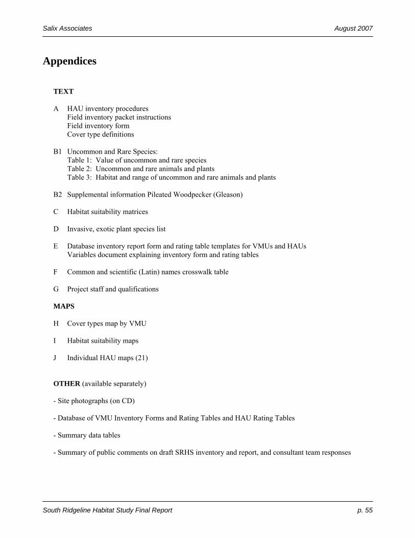
Salix Associates August 2007
South Ridgeline Habitat Study Final Report p. 55
Appendices TEXT A HAU inventory procedures Field inventory packet instructions Field inventory form Cover type definitions B1 Uncommon and Rare Species: Table 1: Value of uncommon and rare species Table 2: Uncommon and rare animals and plants Table 3: Habitat and range of uncommon and rare animals and plants B2 Supplemental information Pileated Woodpecker (Gleason) C Habitat suitability matrices D Invasive, exotic plant species list E Database inventory report form and rating table templates for VMUs and HAUs Variables document explaining inventory form and rating tables F Common and scientific (Latin) names crosswalk table G Project staff and qualifications MAPS H Cover types map by VMU I Habitat suitability maps J Individual HAU maps (21) OTHER (available separately) - Site photographs (on CD) - Database of VMU Inventory Forms and Rating Tables and HAU Rating Tables - Summary data tables - Summary of public comments on draft SRHS inventory and report, and consultant team responses
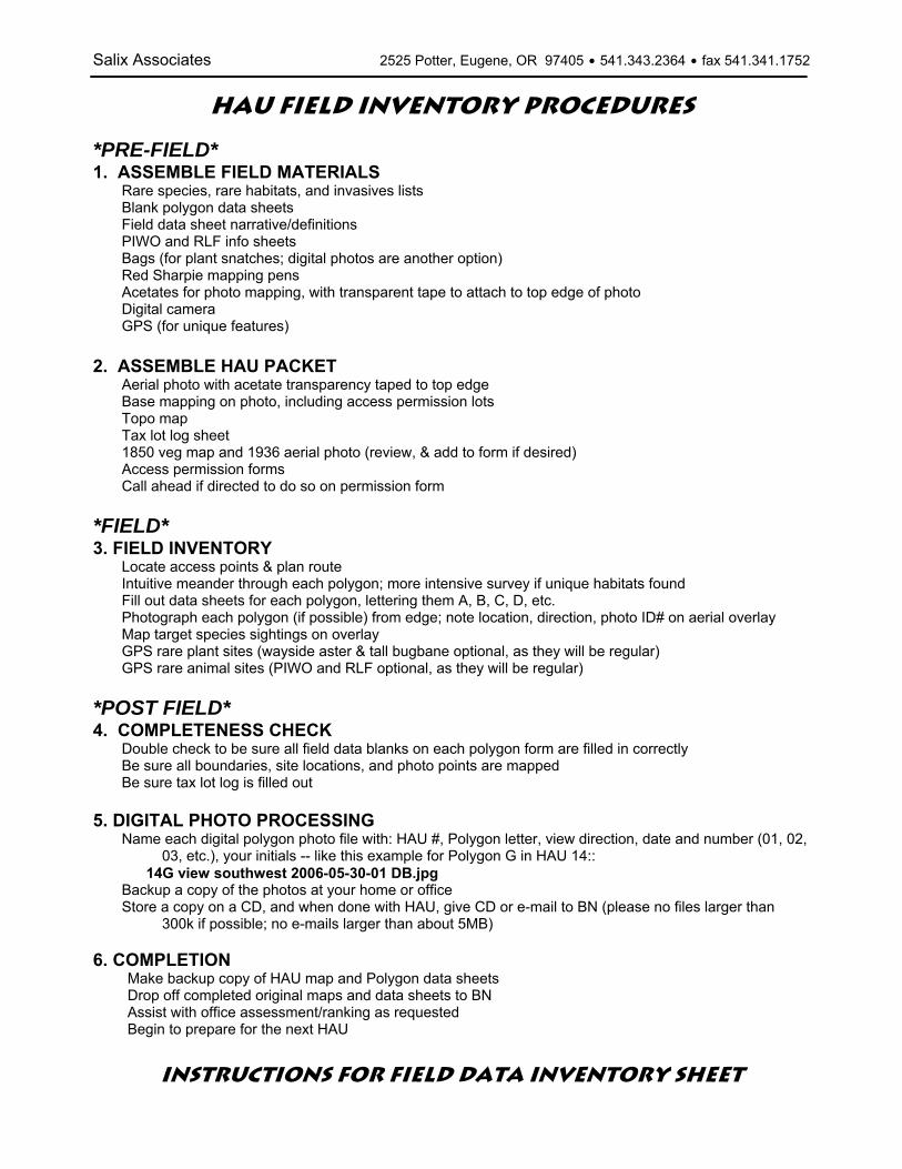
Salix Associates 2525 Potter, Eugene, OR 97405 $ 541.343.2364 $ fax 541.341.1752
HAU FIELD INVENTORY PROCEDURES
*PRE-FIELD* 1. ASSEMBLE FIELD MATERIALS
Rare species, rare habitats, and invasives lists Blank polygon data sheets Field data sheet narrative/definitions PIWO and RLF info sheets Bags (for plant snatches; digital photos are another option) Red Sharpie mapping pens Acetates for photo mapping, with transparent tape to attach to top edge of photo Digital camera GPS (for unique features)
2. ASSEMBLE HAU PACKET
Aerial photo with acetate transparency taped to top edge Base mapping on photo, including access permission lots Topo map Tax lot log sheet 1850 veg map and 1936 aerial photo (review, & add to form if desired) Access permission forms Call ahead if directed to do so on permission form
*FIELD* 3. FIELD INVENTORY
Locate access points & plan route Intuitive meander through each polygon; more intensive survey if unique habitats found Fill out data sheets for each polygon, lettering them A, B, C, D, etc. Photograph each polygon (if possible) from edge; note location, direction, photo ID# on aerial overlay Map target species sightings on overlay GPS rare plant sites (wayside aster & tall bugbane optional, as they will be regular) GPS rare animal sites (PIWO and RLF optional, as they will be regular)
*POST FIELD* 4. COMPLETENESS CHECK
Double check to be sure all field data blanks on each polygon form are filled in correctly Be sure all boundaries, site locations, and photo points are mapped Be sure tax lot log is filled out
5. DIGITAL PHOTO PROCESSING
Name each digital polygon photo file with: HAU #, Polygon letter, view direction, date and number (01, 02, 03, etc.), your initials -- like this example for Polygon G in HAU 14::
14G view southwest 2006-05-30-01 DB.jpg Backup a copy of the photos at your home or office Store a copy on a CD, and when done with HAU, give CD or e-mail to BN (please no files larger than
300k if possible; no e-mails larger than about 5MB) 6. COMPLETION
Make backup copy of HAU map and Polygon data sheets Drop off completed original maps and data sheets to BN Assist with office assessment/ranking as requested Begin to prepare for the next HAU
INSTRUCTIONS for FIELD DATA INVENTORY SHEET

Salix Associates 2525 Potter, Eugene, OR 97405 $ 541.343.2364 $ fax 541.341.1752
• Page 1 of FIELD FORM
HABITAT ASSESSMENT UNIT (HAU) NUMBERS These are pre-numbered in the office. Copy onto each Veg Polygon (VMU) form. POLYGON NUMBERS Letter these in the field for areas of fairly homogeneous vegetation. Fill out a Polygon Habitat Assessment Form for each one. (If you exceed 26 polygons in an HAU, start over with AA, AB, etc.) SHADING Shaded areas generally are filled out in the office, or are headings. OFFICE Includes GIS acreage, polygon centroid, average slope/aspect. Historic vegetation cover, 1936 veg cover and ARA land cover class will all be added in the office if not done in field. (Note the ARA classes and definitions following.) INVENTORY METHOD Note whether the site was inventoried on-site, off site adjacent, or off site with no view. Many polygons likely will be a combination. A summary table of tax lots with access permission and actual on-site visitation (or no visitation) will be attached separately. If there is a combination, check all appropriate boxes. For “off-site no view,” a nearby, similar reference polygon will be listed in the office. LAYERS Tree: all vegetation >20’ tall. Shrub: all woody vegetation 3’ to 20’ tall. Consider Armenian blackberries as woody, so if taller than 3’, record in shrub layer, and if shorter than 3’, record in herb layer. Herb: woody veg <3’ tall, and all herbaceous (may be taller). COVER Actual cover is “bird’s eye view” looking straight down on the polygon, with the polygon acreage being 100%. If there is 60% Doug fir cover, and 50% bigleaf maple cover with half of it under the Doug fir, the TREE LAYER ACTUAL COVER = 85% (60% + 25%). For each category (evergreen, deciduous, native, exotic) record cover class as “bird’s eye view” (actual cover) as if there is no taller vegetation obscuring the view. OBSERVED SPECIES Dominants are 20% cover or greater, and subdominants are 5-19% cover. Rare and Invasive are from species lists in the field packet. List only those seen. For dominant and subdominant trees, estimate the average dbh (diameter breast height, 4.5’ above ground level) for trees in the stand. For scattered large trees, note them in the large block below. DISTURBANCE Note how much of the soil and/or herb layer vegetation is/was disturbed, the nature of the disturbance and if it was recent or historic. NOTES

Salix Associates 2525 Potter, Eugene, OR 97405 $ 541.343.2364 $ fax 541.341.1752
Describe rare species or habitats or invasive species observed (population sizes, distributions, etc.), habitat quality, large trees (if any). The minimum polygon mapping size generally is 2 acres for any cover type, except wherever possible, rare habitats and developed areas (where little to no native habitat values remain) will be mapped down to a size of 1 acre. COVER TYPES The EPA/Adamus Resource Assessment (ARA) used for satellite interpretation served as a basis, but required modification for field use – so there is not a 1 to 1 correspondence. Details of natural vegetation and development cover type categories as adapted for our on-the-ground application follows. (All covers are actual, not relative.) An “R” suffix added after a number indicates a “riparian/wetland” element.
Cover Type Code Description
1-6 Conifer forest
7 Mixed conifer/hardwood forest (each > 30% cover of tree layer)
FOREST (>70% tree cover)
8 Hardwood forest 9 Conifer woodland (conifer cover >60% of tree layer)
10 Mixed conifer/hardwood woodland – (each not > 30% cover)
WOODLAND (31-70% tree cover)
11 Hardwood woodland (hardwood cover >60%) 12 Other savanna (not oak) SAVANNA
(5-30% tree cover) 13 Oak savanna - trees scattered (white and/or black) 14 Shrub – upland (tree cover to 70%) SHRUBLAND
(shrub cover >30-100%) 15 Shrub – wetland AGRICULTURE 17 Orchard
20 Grass short - lawn, heavily grazed pasture
21 Grass natural - native and introduced, but not cultivated, mowed or grazed
22 Grass tall - cultivated grass and grass-like vegetation including ryegrass, orchard grass, fescue, wheat, hayfields, and lightly grazed pasture
PRAIRIE/GRASSLAND/ROCK (shrub cover <30%, tree cover <5%)
24 Rock – large outcrops, balds; open rocky areas 26 Seasonal wetlands WETLANDS 27 Permanent wetlands
RESIDENTIAL HABITAT 33 Low density residential (≤ 4 dwelling units/acre) w/habitat
• Page 2 of FIELD FORM TARGET or UNUSUAL SPECIES Observed species from the rare list can be listed here, along with any other sighting considered to be unusual by the surveyor. PIWO and NRLF DETECTION and HABITAT FEATURES Pileated Woodpeckers (PIWO) and Northern Red-legged Frogs (NRLF or RLF) are previously identified as the two target wildlife species for this inventory. They are highlighted here to be sure that their sign and habitat requirements are noted during the inventory if they are encountered. Because the woodpecker and woodpecker sign are visible (and audible), PIWO entries on the form are oriented more toward detection, whereas NRLF entries are oriented toward habitat suitability. PIWO: If one is seen or heard tapping, check Y. If characteristic foraging excavations are seen, check Y and describe. Same for nesting excavations. Clearly note if an active nest is detected.
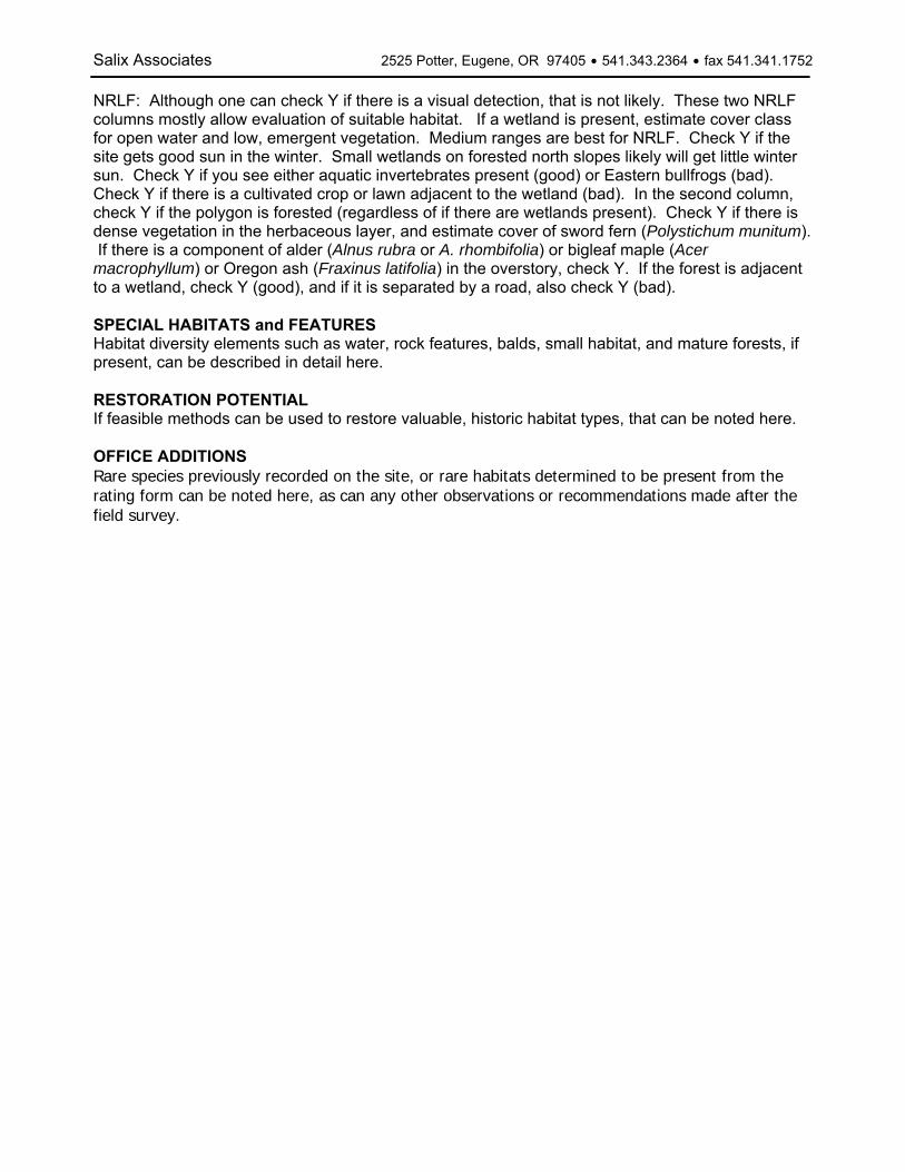
Salix Associates 2525 Potter, Eugene, OR 97405 $ 541.343.2364 $ fax 541.341.1752
NRLF: Although one can check Y if there is a visual detection, that is not likely. These two NRLF columns mostly allow evaluation of suitable habitat. If a wetland is present, estimate cover class for open water and low, emergent vegetation. Medium ranges are best for NRLF. Check Y if the site gets good sun in the winter. Small wetlands on forested north slopes likely will get little winter sun. Check Y if you see either aquatic invertebrates present (good) or Eastern bullfrogs (bad). Check Y if there is a cultivated crop or lawn adjacent to the wetland (bad). In the second column, check Y if the polygon is forested (regardless of if there are wetlands present). Check Y if there is dense vegetation in the herbaceous layer, and estimate cover of sword fern (Polystichum munitum). If there is a component of alder (Alnus rubra or A. rhombifolia) or bigleaf maple (Acer macrophyllum) or Oregon ash (Fraxinus latifolia) in the overstory, check Y. If the forest is adjacent to a wetland, check Y (good), and if it is separated by a road, also check Y (bad). SPECIAL HABITATS and FEATURES Habitat diversity elements such as water, rock features, balds, small habitat, and mature forests, if present, can be described in detail here. RESTORATION POTENTIAL If feasible methods can be used to restore valuable, historic habitat types, that can be noted here. OFFICE ADDITIONS Rare species previously recorded on the site, or rare habitats determined to be present from the rating form can be noted here, as can any other observations or recommendations made after the field survey.

Salix Associates 2525 Potter, Eugene, OR 97405 $ 541.343.2364 $ fax 541.341.1752
Cover Type Descriptions # Cover Type: Map Designation Description
1 Conifer forest 0-20 yrs
Forests are defined as having more than 70% of the mapped area covered by trees, as viewed from above. Conifer forests have at least 60% to 80% of this tree layer covered by trees with needles (rather than leaves, such as Douglas fir, and up to 40% covered with hardwood trees (which have leaves, such as maple or oak). This category was judged to contain primarily conifer trees from 0 to 20 years old.
2 Conifer forest 21 - 40 yrs
Forests are defined as having more than 70% of the mapped area covered by trees, as viewed from above. Conifer forests have at least 60% to 80% of this tree layer covered by trees with needles (rather than leaves, such as Douglas fir, and up to 40% covered with hardwood trees (which have leaves, such as maple or oak). This category was judged to contain primarily conifer trees from 21 to 40 years old.
3 Conifer forest 41 - 60 yrs
Forests are defined as having more than 70% of the mapped area covered by trees, as viewed from above. Conifer forests have at least 60% to 80% of this tree layer covered by trees with needles (rather than leaves, such as Douglas fir, and up to 40% covered with hardwood trees (which have leaves, such as maple or oak). This category was judged to contain primarily conifer trees from 41 to 60 years old.
4 Conifer forest 61 - 80 yrs
Forests are defined as having more than 70% of the mapped area covered by trees, as viewed from above. Conifer forests have at least 60% to 80% of this tree layer covered by trees with needles (rather than leaves, such as Douglas fir, and up to 40% covered with hardwood trees (which have leaves, such as maple or oak). This category was judged to contain primarily conifer trees from 61 to 80 years old.
5 Conifer forest 81 - 200 yrs
Forests are defined as having more than 70% of the mapped area covered by trees, as viewed from above. Conifer forests have at least 60% to 80% of this tree layer covered by trees with needles (rather than leaves, such as Douglas fir, and up to 40% covered with hardwood trees (which have leaves, such as maple or oak). This category was judged to contain primarily conifer trees from 81 to 200 years old. "Old growth" conifer forests are generally defined by presence of large trees, snags and logs, and presence of multiple canopy layers, and are generally much older than 200 years. No "old growth" forests were identified in the SRHS inventory.
7 Mixed forest
Forests are defined as having more than 70% of the mapped area covered by trees, as viewed from above. Mixed forests generally have less than 60% of this tree layer covered by trees with needles (rather than leaves, such as Douglas fir), and less than 60% covered with hardwood trees (which have leaves, such as bigleaf maple or Oregon white oak).
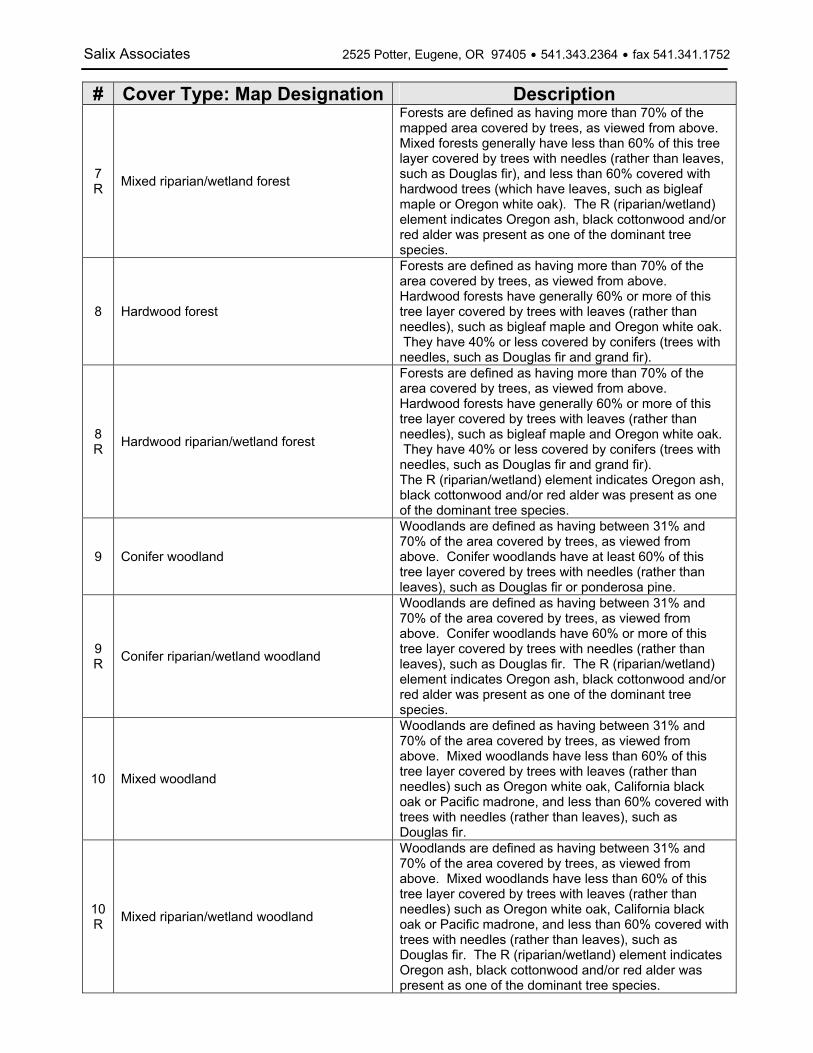
Salix Associates 2525 Potter, Eugene, OR 97405 $ 541.343.2364 $ fax 541.341.1752
# Cover Type: Map Designation Description
7R Mixed riparian/wetland forest
Forests are defined as having more than 70% of the mapped area covered by trees, as viewed from above. Mixed forests generally have less than 60% of this tree layer covered by trees with needles (rather than leaves, such as Douglas fir), and less than 60% covered with hardwood trees (which have leaves, such as bigleaf maple or Oregon white oak). The R (riparian/wetland) element indicates Oregon ash, black cottonwood and/or red alder was present as one of the dominant tree species.
8 Hardwood forest
Forests are defined as having more than 70% of the area covered by trees, as viewed from above. Hardwood forests have generally 60% or more of this tree layer covered by trees with leaves (rather than needles), such as bigleaf maple and Oregon white oak. They have 40% or less covered by conifers (trees with needles, such as Douglas fir and grand fir).
8R Hardwood riparian/wetland forest
Forests are defined as having more than 70% of the area covered by trees, as viewed from above. Hardwood forests have generally 60% or more of this tree layer covered by trees with leaves (rather than needles), such as bigleaf maple and Oregon white oak. They have 40% or less covered by conifers (trees with needles, such as Douglas fir and grand fir). The R (riparian/wetland) element indicates Oregon ash, black cottonwood and/or red alder was present as one of the dominant tree species.
9 Conifer woodland
Woodlands are defined as having between 31% and 70% of the area covered by trees, as viewed from above. Conifer woodlands have at least 60% of this tree layer covered by trees with needles (rather than leaves), such as Douglas fir or ponderosa pine.
9R Conifer riparian/wetland woodland
Woodlands are defined as having between 31% and 70% of the area covered by trees, as viewed from above. Conifer woodlands have 60% or more of this tree layer covered by trees with needles (rather than leaves), such as Douglas fir. The R (riparian/wetland) element indicates Oregon ash, black cottonwood and/or red alder was present as one of the dominant tree species.
10 Mixed woodland
Woodlands are defined as having between 31% and 70% of the area covered by trees, as viewed from above. Mixed woodlands have less than 60% of this tree layer covered by trees with leaves (rather than needles) such as Oregon white oak, California black oak or Pacific madrone, and less than 60% covered with trees with needles (rather than leaves), such as Douglas fir.
10R Mixed riparian/wetland woodland
Woodlands are defined as having between 31% and 70% of the area covered by trees, as viewed from above. Mixed woodlands have less than 60% of this tree layer covered by trees with leaves (rather than needles) such as Oregon white oak, California black oak or Pacific madrone, and less than 60% covered with trees with needles (rather than leaves), such as Douglas fir. The R (riparian/wetland) element indicates Oregon ash, black cottonwood and/or red alder was present as one of the dominant tree species.
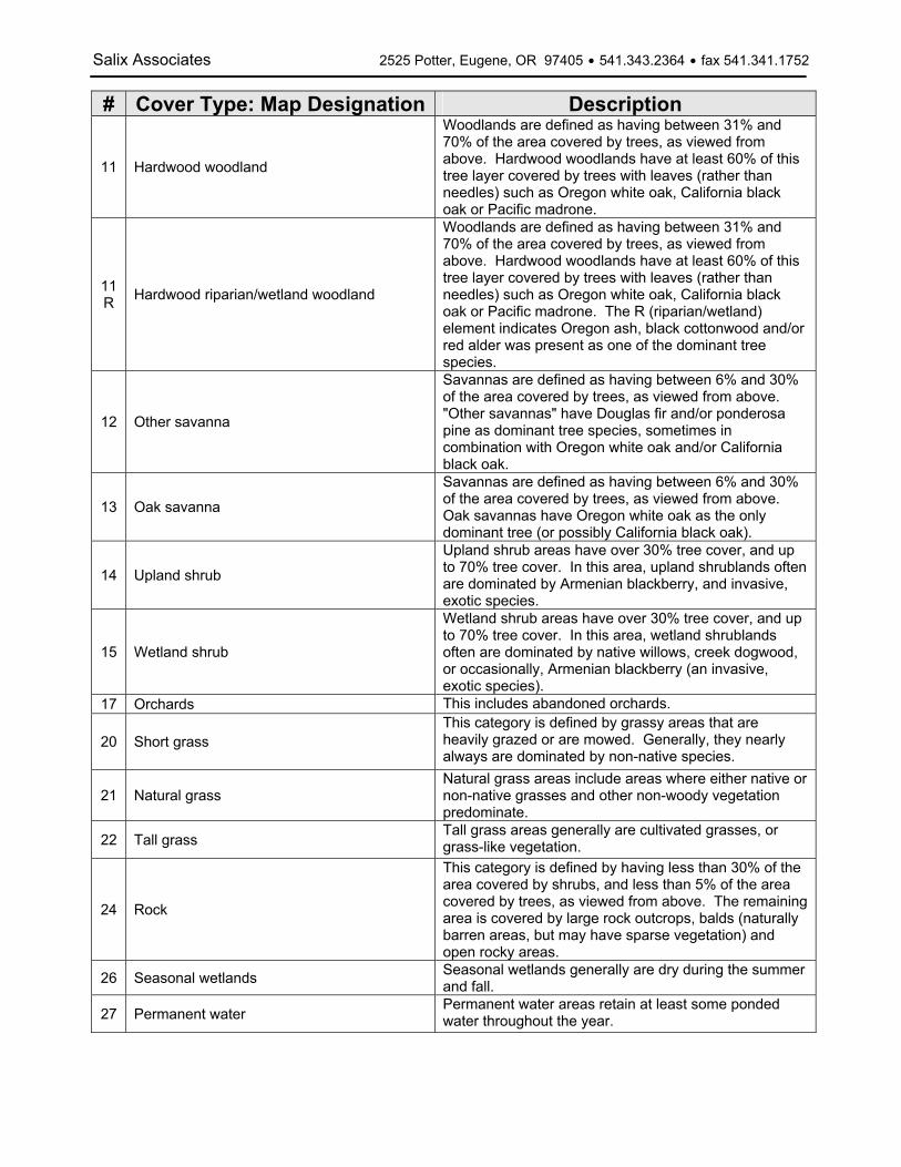
Salix Associates 2525 Potter, Eugene, OR 97405 $ 541.343.2364 $ fax 541.341.1752
# Cover Type: Map Designation Description
11 Hardwood woodland
Woodlands are defined as having between 31% and 70% of the area covered by trees, as viewed from above. Hardwood woodlands have at least 60% of this tree layer covered by trees with leaves (rather than needles) such as Oregon white oak, California black oak or Pacific madrone.
11R Hardwood riparian/wetland woodland
Woodlands are defined as having between 31% and 70% of the area covered by trees, as viewed from above. Hardwood woodlands have at least 60% of this tree layer covered by trees with leaves (rather than needles) such as Oregon white oak, California black oak or Pacific madrone. The R (riparian/wetland) element indicates Oregon ash, black cottonwood and/or red alder was present as one of the dominant tree species.
12 Other savanna
Savannas are defined as having between 6% and 30% of the area covered by trees, as viewed from above. "Other savannas" have Douglas fir and/or ponderosa pine as dominant tree species, sometimes in combination with Oregon white oak and/or California black oak.
13 Oak savanna
Savannas are defined as having between 6% and 30% of the area covered by trees, as viewed from above. Oak savannas have Oregon white oak as the only dominant tree (or possibly California black oak).
14 Upland shrub
Upland shrub areas have over 30% tree cover, and up to 70% tree cover. In this area, upland shrublands often are dominated by Armenian blackberry, and invasive, exotic species.
15 Wetland shrub
Wetland shrub areas have over 30% tree cover, and up to 70% tree cover. In this area, wetland shrublands often are dominated by native willows, creek dogwood, or occasionally, Armenian blackberry (an invasive, exotic species).
17 Orchards This includes abandoned orchards.
20 Short grass This category is defined by grassy areas that are heavily grazed or are mowed. Generally, they nearly always are dominated by non-native species.
21 Natural grass Natural grass areas include areas where either native or non-native grasses and other non-woody vegetation predominate.
22 Tall grass Tall grass areas generally are cultivated grasses, or grass-like vegetation.
24 Rock
This category is defined by having less than 30% of the area covered by shrubs, and less than 5% of the area covered by trees, as viewed from above. The remaining area is covered by large rock outcrops, balds (naturally barren areas, but may have sparse vegetation) and open rocky areas.
26 Seasonal wetlands Seasonal wetlands generally are dry during the summer and fall.
27 Permanent water Permanent water areas retain at least some ponded water throughout the year.

Salix Associates 2525 Potter, Eugene, OR 97405 $ 541.343.2364 $ fax 541.341.1752
# Cover Type: Map Designation Description
33 Residential Habitat
Low density residential development at 4 dwelling units per acre or less. These areas were contained within the original study area, and are mapped as habitat generally because a native tree layer (and occasionally, a shrub or herb layer as well) still provides habitat values.
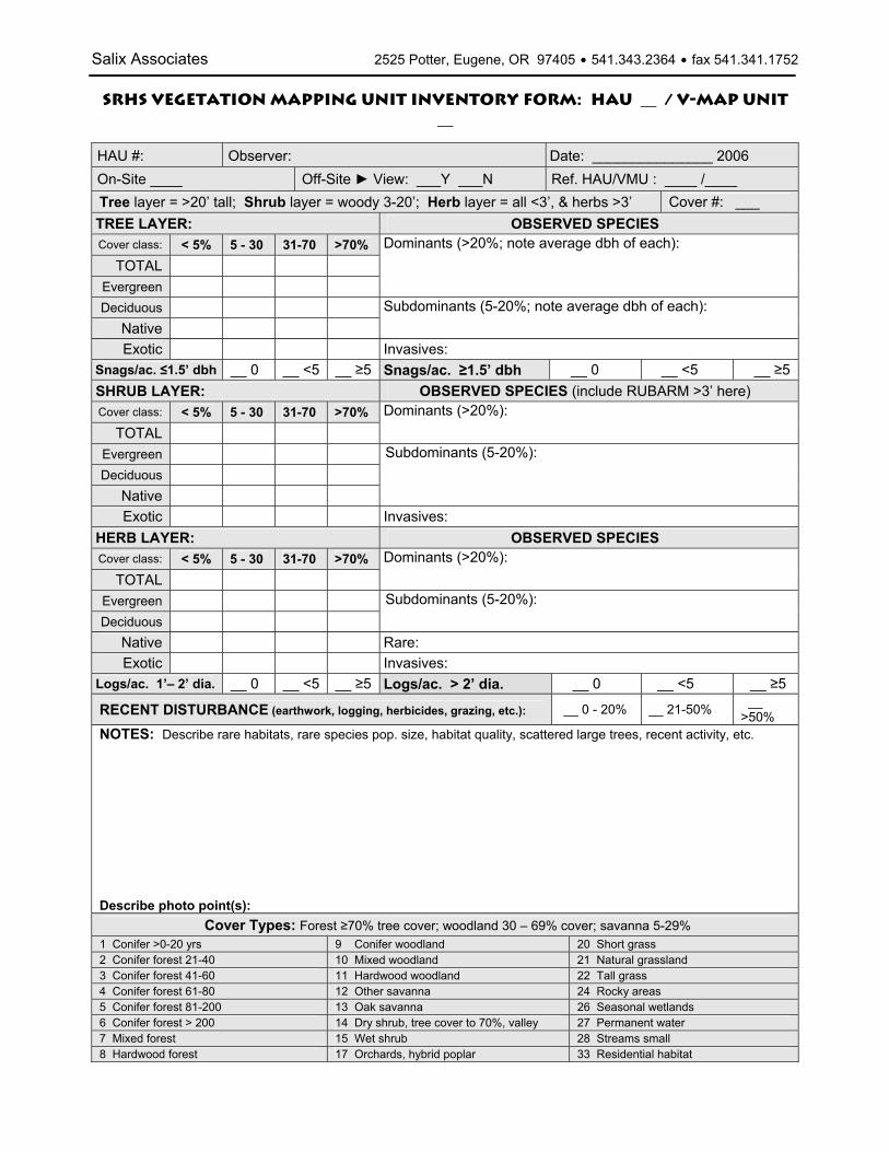
Salix Associates 2525 Potter, Eugene, OR 97405 $ 541.343.2364 $ fax 541.341.1752
SRHS Vegetation Mapping Unit Inventory Form: HAU __ / V-Map Unit __
HAU #: Observer: Date: _______________ 2006 On-Site ____ Off-Site ► View: ___Y ___N Ref. HAU/VMU : ____ /____ Tree layer = >20’ tall; Shrub layer = woody 3-20’; Herb layer = all <3’, & herbs >3’ Cover #: ___ TREE LAYER: OBSERVED SPECIES Cover class: < 5% 5 - 30 31-70 >70%
TOTAL Evergreen
Dominants (>20%; note average dbh of each):
Deciduous Native
Subdominants (5-20%; note average dbh of each):
Exotic Invasives: Snags/ac. ≤1.5’ dbh __ 0 __ <5 __ ≥5 Snags/ac. ≥1.5’ dbh __ 0 __ <5 __ ≥5SHRUB LAYER: OBSERVED SPECIES (include RUBARM >3’ here) Cover class: < 5% 5 - 30 31-70 >70%
TOTAL Dominants (>20%):
Evergreen Deciduous
Native
Subdominants (5-20%):
Exotic Invasives: HERB LAYER: OBSERVED SPECIES Cover class: < 5% 5 - 30 31-70 >70%
TOTAL Dominants (>20%):
Evergreen Deciduous
Subdominants (5-20%):
Native Rare: Exotic Invasives:
Logs/ac. 1’– 2’ dia. __ 0 __ <5 __ ≥5 Logs/ac. > 2’ dia. __ 0 __ <5 __ ≥5
RECENT DISTURBANCE (earthwork, logging, herbicides, grazing, etc.): __ 0 - 20% __ 21-50% __ >50%
NOTES: Describe rare habitats, rare species pop. size, habitat quality, scattered large trees, recent activity, etc. Describe photo point(s):
Cover Types: Forest ≥70% tree cover; woodland 30 – 69% cover; savanna 5-29% 1 Conifer >0-20 yrs 9 Conifer woodland 20 Short grass 2 Conifer forest 21-40 10 Mixed woodland 21 Natural grassland 3 Conifer forest 41-60 11 Hardwood woodland 22 Tall grass 4 Conifer forest 61-80 12 Other savanna 24 Rocky areas 5 Conifer forest 81-200 13 Oak savanna 26 Seasonal wetlands 6 Conifer forest > 200 14 Dry shrub, tree cover to 70%, valley 27 Permanent water 7 Mixed forest 15 Wet shrub 28 Streams small 8 Hardwood forest 17 Orchards, hybrid poplar 33 Residential habitat

Salix Associates 2525 Potter, Eugene, OR 97405 $ 541.343.2364 $ fax 541.341.1752
HAU ___ VMU ___ p. 2TARGET RARE PLANT & WILDLIFE SPECIES
SPECIAL PIWO/RLF DETECTION & HABITAT FEATURES PIWO: Y N RLF: Y N RLF, con’t. Y N
Visual Visual Forested upland Aural Stillwater wetland If yes, then: Foraging excavation % open water :__<25 __25-50 __>50 % POLMUN/ low veg: _<⅓ _ ⅓-⅔ _>⅔ Nesting excavation % low emrgnt: __<25 __25-50 __>50 w/ dense u-story
winter sun Alder, maple, ash, cottnwd o-story
aquatic inverts present wetland adjacent bullfrogs present * road between UL & WL * cultivated crop/lawn adjacent * (Office) ≥10 acres (4 ha)
Describe:
* yes = negative factor (Office) compact shape
ADDITIONAL INFORMATION WATER: __Y __ N Describe headwater streams, ponds, seeps, etc.
ROCK/BALDS: __Y __ N Describe balds, outcrops, caves, etc.
SMALL HABITAT PATCHES: __Y __ N Describe forest gaps, tree islands in prairies, etc.
MATURE FOREST: __Y __ N Describe large tree dbh, age, species composition, layers, etc.
Restoration potential, other comments:
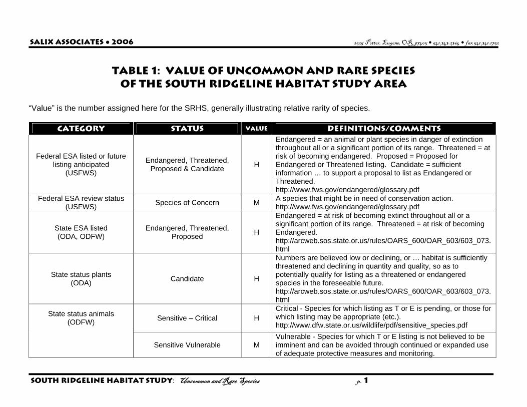
Salix Associates ● 2006 2525 Potter, Eugene, OR 97405 $ 541.343.2364 $ fax 541.341.1752
South Ridgeline Habitat Study: Uncommon and Rare Species p. 1
TABLE 1: value Of Uncommon and Rare Species of the South Ridgeline Habitat Study Area
“Value” is the number assigned here for the SRHS, generally illustrating relative rarity of species.
CATEGORY STATUS VALUE Definitions/COMMENTS
Federal ESA listed or future listing anticipated
(USFWS)
Endangered, Threatened, Proposed & Candidate H
Endangered = an animal or plant species in danger of extinction throughout all or a significant portion of its range. Threatened = at risk of becoming endangered. Proposed = Proposed for Endangered or Threatened listing. Candidate = sufficient information … to support a proposal to list as Endangered or Threatened. http://www.fws.gov/endangered/glossary.pdf
Federal ESA review status (USFWS) Species of Concern M A species that might be in need of conservation action.
http://www.fws.gov/endangered/glossary.pdf
State ESA listed (ODA, ODFW)
Endangered, Threatened, Proposed H
Endangered = at risk of becoming extinct throughout all or a significant portion of its range. Threatened = at risk of becoming Endangered. http://arcweb.sos.state.or.us/rules/OARS_600/OAR_603/603_073.html
State status plants (ODA) Candidate H
Numbers are believed low or declining, or … habitat is sufficiently threatened and declining in quantity and quality, so as to potentially qualify for listing as a threatened or endangered species in the foreseeable future. http://arcweb.sos.state.or.us/rules/OARS_600/OAR_603/603_073.html
Sensitive – Critical H Critical - Species for which listing as T or E is pending, or those for which listing may be appropriate (etc.). http://www.dfw.state.or.us/wildlife/pdf/sensitive_species.pdf
State status animals (ODFW)
Sensitive Vulnerable M Vulnerable - Species for which T or E listing is not believed to be imminent and can be avoided through continued or expanded use of adequate protective measures and monitoring.

Salix Associates ● 2006 2525 Potter, Eugene, OR 97405 $ 541.343.2364 $ fax 541.341.1752
South Ridgeline Habitat Study: Uncommon and Rare Species p. 2
Sensitive – Undetermined L Status unclear. http://www.dfw.state.or.us/wildlife/pdf/sensitive_species.pdf
List 1 H Threatened or endangered throughout range http://oregonstate.edu/ornhic/index.html
List 2 H Threatened, endangered or extirpated from OR, secure elsewhere http://oregonstate.edu/ornhic/index.html
List 3 M ORNHIC
List 4 L
List 3 (Review): may be T or E, but more information is needed. List 4 (Watch): too common to be categorized as T or E, but very rare. http://oregonstate.edu/ornhic/index.html
ODFW Conservation Strategy Strategy Species H Declining or at-risk in the ecoregion. http://www.dfw.state.or.us/conservationstrategy/
Emerald Chapter NPSO List B M Generally 10 or fewer sites known in Lane County, and with identified threats. This list is an indicator of local biodiversity.
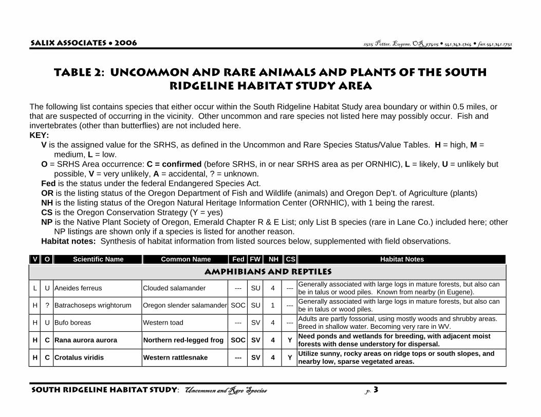
Salix Associates ● 2006 2525 Potter, Eugene, OR 97405 $ 541.343.2364 $ fax 541.341.1752
South Ridgeline Habitat Study: Uncommon and Rare Species p. 3
Table 2: uncommon and Rare Animals and Plants of the South Ridgeline Habitat Study Area
The following list contains species that either occur within the South Ridgeline Habitat Study area boundary or within 0.5 miles, or that are suspected of occurring in the vicinity. Other uncommon and rare species not listed here may possibly occur. Fish and invertebrates (other than butterflies) are not included here. KEY:
V is the assigned value for the SRHS, as defined in the Uncommon and Rare Species Status/Value Tables. H = high, M = medium, L = low.
O = SRHS Area occurrence: C = confirmed (before SRHS, in or near SRHS area as per ORNHIC), L = likely, U = unlikely but possible, V = very unlikely, A = accidental, ? = unknown.
Fed is the status under the federal Endangered Species Act. OR is the listing status of the Oregon Department of Fish and Wildlife (animals) and Oregon Dep’t. of Agriculture (plants) NH is the listing status of the Oregon Natural Heritage Information Center (ORNHIC), with 1 being the rarest. CS is the Oregon Conservation Strategy (Y = yes) NP is the Native Plant Society of Oregon, Emerald Chapter R & E List; only List B species (rare in Lane Co.) included here; other
NP listings are shown only if a species is listed for another reason. Habitat notes: Synthesis of habitat information from listed sources below, supplemented with field observations.
V O Scientific Name Common Name Fed FW NH CS Habitat Notes
AMPHIBIANS and REPTILES
L U Aneides ferreus Clouded salamander --- SU 4 --- Generally associated with large logs in mature forests, but also can be in talus or wood piles. Known from nearby (in Eugene).
H ? Batrachoseps wrightorum Oregon slender salamander SOC SU 1 --- Generally associated with large logs in mature forests, but also can be in talus or wood piles.
H U Bufo boreas Western toad --- SV 4 --- Adults are partly fossorial, using mostly woods and shrubby areas. Breed in shallow water. Becoming very rare in WV.
H C Rana aurora aurora Northern red-legged frog SOC SV 4 Y Need ponds and wetlands for breeding, with adjacent moist forests with dense understory for dispersal.
H C Crotalus viridis Western rattlesnake --- SV 4 Y Utilize sunny, rocky areas on ridge tops or south slopes, and nearby low, sparse vegetated areas.

Salix Associates ● 2006 2525 Potter, Eugene, OR 97405 $ 541.343.2364 $ fax 541.341.1752
South Ridgeline Habitat Study: Uncommon and Rare Species p. 4
V O Scientific Name Common Name Fed FW NH CS Habitat Notes
BIRDS
H A Accipiter gentilis Northern goshawk SOC SC 4 --- Need large stands of large conifer, with other stand types and openings mixed in.
H V Ammodramus savannarum Grasshopper sparrow --- SP 2 Y Nest in areas with low to moderate grass height and few shrubs. H V Chordeiles minor Common nighthawk --- SC 4 Y Nests in short grassy areas or on gravel bars.
H U Contopus cooperi Olive-sided flycatcher SOC SV 4 --- Need older stands, especially with large, older trees near openings. Migration, yes. Nesting, unlikely.
M C Dryocopus pileatus Pileated woodpecker --- SV --- --- Late successional, mixed forest with large diameter trees and snags. Also forages in other forest types.
H C Empidonax traillii brewsteri Little willow flycatcher --- SV 4 Y Prefers willow and other shrub thickets, especially near water. H V Eremophila alpestris strigata Streaked horned lark C SC 1 Y Needs large expanses of short-grass habitat. H A Falco peregrinus anatum American peregrine falcon --- LE 2 --- Nest on large cliffs, or occasionally large buildings or bridges.
H U Haliaeetus leucocephalus Bald eagle LT LT 4 --- Nests in large trees near water. Roost in large trees, sometimes farther from water.
H C Icteria virens Yellow-breasted chat SOC SC 4 Y Prefers dense, tall, shrubby habitats, usually near water.
H U Melanerpes formicivorus Acorn woodpecker SOC --- 4 Y Colonial; use cavities in large-diameter oaks. Need oak woodlands with soft snags and open understories.
H U Melanerpes lewis Lewis's woodpecker SOC SC 2 --- Primary habitat is oak savanna; nest in cavities. Generally only in WV as post-breeding dispersers.
M C Oreortyx pictus Mountain quail SOC --- 4 --- Need shrubby habitats and open places nearby to forage.
M L Patagioenas fasciata Band-tailed pigeon SOC --- 4 --- Need mineral sites, and large conifer forest landscape, with mixed age and structure within.
H U Pooecetes gramineus affinis Oregon vesper sparrow SOC SC 2 Y Need grasslands with patches of bare ground for foraging and nesting; scattered shrubs/trees for perching.
H U Progne subis Purple martin SOC SC 2 Y Use cavities in snags or nest boxes; usually near water. H L Sialia mexicana Western bluebird SV 4 Y Primary habitat is oak savanna; nest in cavities.
H L Sitta carolinensis aculeata White-breasted nuthatch --- --- 4 Y Aka white-breasted nuthatch. Prefers mature oak savanna and woodland habitats, with oaks >22”dbh.
H l Spizella passerine Chipping sparrow --- --- --- Y Oak woodlands & savanna; likely oak-pine (& Doug-fir?) savanna.
H U Strix occidentalis caurina Northern spotted owl LT LT 1 --- Nest in old growth conifer stands. Nesting unlikely, but known from nearby.
H V Sturnella neglecta Western meadowlark --- SC 4 Y Needs 40 ac or more of prairie or other open habitat for nesting.
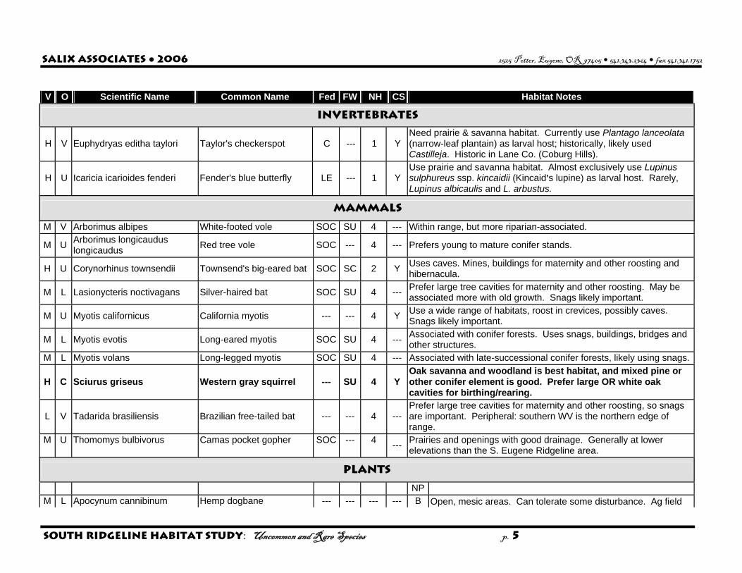
Salix Associates ● 2006 2525 Potter, Eugene, OR 97405 $ 541.343.2364 $ fax 541.341.1752
South Ridgeline Habitat Study: Uncommon and Rare Species p. 5
V O Scientific Name Common Name Fed FW NH CS Habitat Notes
INVERTEBRATES
H V Euphydryas editha taylori Taylor's checkerspot C --- 1 Y Need prairie & savanna habitat. Currently use Plantago lanceolata (narrow-leaf plantain) as larval host; historically, likely used Castilleja. Historic in Lane Co. (Coburg Hills).
H U Icaricia icarioides fenderi Fender's blue butterfly LE --- 1 Y Use prairie and savanna habitat. Almost exclusively use Lupinus sulphureus ssp. kincaidii (Kincaid=s lupine) as larval host. Rarely, Lupinus albicaulis and L. arbustus.
MAMMALS
M V Arborimus albipes White-footed vole SOC SU 4 --- Within range, but more riparian-associated.
M U Arborimus longicaudus longicaudus Red tree vole SOC --- 4 --- Prefers young to mature conifer stands.
H U Corynorhinus townsendii Townsend's big-eared bat SOC SC 2 Y Uses caves. Mines, buildings for maternity and other roosting and hibernacula.
M L Lasionycteris noctivagans Silver-haired bat SOC SU 4 --- Prefer large tree cavities for maternity and other roosting. May be associated more with old growth. Snags likely important.
M U Myotis californicus California myotis --- --- 4 Y Use a wide range of habitats, roost in crevices, possibly caves. Snags likely important.
M L Myotis evotis Long-eared myotis SOC SU 4 --- Associated with conifer forests. Uses snags, buildings, bridges and other structures.
M L Myotis volans Long-legged myotis SOC SU 4 --- Associated with late-successional conifer forests, likely using snags.
H C Sciurus griseus Western gray squirrel --- SU 4 Y Oak savanna and woodland is best habitat, and mixed pine or other conifer element is good. Prefer large OR white oak cavities for birthing/rearing.
L V Tadarida brasiliensis Brazilian free-tailed bat --- --- 4 --- Prefer large tree cavities for maternity and other roosting, so snags are important. Peripheral: southern WV is the northern edge of range.
M U Thomomys bulbivorus Camas pocket gopher SOC --- 4 --- Prairies and openings with good drainage. Generally at lower elevations than the S. Eugene Ridgeline area.
PLANTS
NP M L Apocynum cannibinum Hemp dogbane --- --- --- --- B Open, mesic areas. Can tolerate some disturbance. Ag field

Salix Associates ● 2006 2525 Potter, Eugene, OR 97405 $ 541.343.2364 $ fax 541.341.1752
South Ridgeline Habitat Study: Uncommon and Rare Species p. 6
V O Scientific Name Common Name Fed FW NH CS Habitat Notes edges may be OK.
M U Apocynum sibiricum var. salignum Clasping-leaved dogbane --- --- --- --- B Open, mesic areas. Can tolerate some disturbance. Ag field
edges may be OK.
M U Asclepias fasicularis Narrow-leaved milkweed --- --- --- --- B Open, mesic areas. Can tolerate some disturbance. Ag field edges may be OK.
M L Calycadenia truncata Rosin weed; tackweed --- --- --- --- B Dry prairies and savannas. (Added 2006.) M U Carex aurea Golden-fruited sedge --- --- --- --- B Dry prairies and savannas. (Added 2006.)
H U Cicendia quadrangularis Timwort --- --- 2 --- A Vernal pools, pond edges; sparsely-vegetated parts of wet prairie when drying out in spring.
H C Cimicifuga elata Tall bugbane --- C 1 --- A Slightly moist north slopes in conifer forest, usually with bigleaf maple in the understory. Rare on E and W slopes. Often in small gaps.
M U Cypripedium montanum Mountain lady's-slipper --- --- 4 --- B Dry, open mixed deciduous/coniferous forests. Historic sighting in SRHS area; likely extirpated.
H V Delphinium oreganum Willamette Valley larkspur SOC C 1 --- A Floodplain forest edges and gaps. Possibly moist prairie.
M U Dodecatheon pulchellum var. macrocarpum Beautiful shooting star --- --- --- --- B Wet to moist prairies.
H U Erigeron decumbens var. decumbens Willamette Valley daisy LE LE 1 Y A Moist to upland prairie, possibly savanna.
H C Eucephalus (Aster) vialis Wayside aster SOC LT 1 Y A Oak savanna, mixed forest gaps and edges. M U Gilia sinistra ssp. sinistra Sinister gilia --- --- 3 --- C Historic sighting in SRHS area. M V Hierochloe odorata Holy grass --- --- 3 --- --- Moist slopes, meadows and streambanks.
H V Horkelia congesta ssp. congesta Shaggy horkelia SOC C 1 --- A Moist to upland prairie and savanna.
H U Howellia aquatilis howellia LT --- 1 Y C Low elevation pond shorelines.
H C Lathyrus holochlorus Thin-leaved peavine SOC --- 1 --- A Often associated with moist OR white oak / OR ash forest, on edges. Usually on floodplains, can be on hillsides or hilltops.
M U Lathyrus vestitus var. ochropetalus Pacific pea --- --- --- --- B Forest openings and edges.
H U Lomatium bradshawii Bradshaw's lomatium LE LE 1 Y A Wet prairie; occasionally gaps in wet, Oregon ash forest. M U Lomatium macrocarpum Large-fruited lomatium --- --- --- --- B Dry prairies and savannas. (Added 2006.) M C Lupinus affinus Fleshy lupine --- --- --- --- B Meadows, prairies.
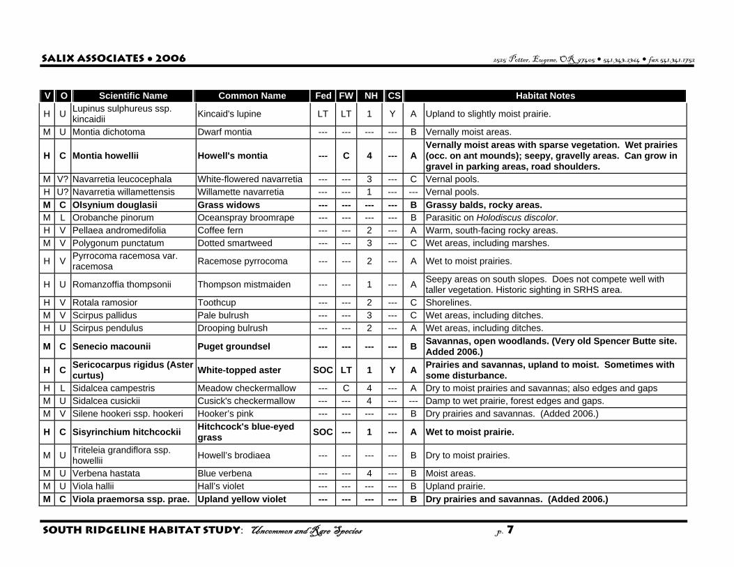
Salix Associates ● 2006 2525 Potter, Eugene, OR 97405 $ 541.343.2364 $ fax 541.341.1752
South Ridgeline Habitat Study: Uncommon and Rare Species p. 7
V O Scientific Name Common Name Fed FW NH CS Habitat Notes
H U Lupinus sulphureus ssp. kincaidii Kincaid's lupine LT LT 1 Y A Upland to slightly moist prairie.
M U Montia dichotoma Dwarf montia --- --- --- --- B Vernally moist areas.
H C Montia howellii Howell's montia --- C 4 --- A Vernally moist areas with sparse vegetation. Wet prairies (occ. on ant mounds); seepy, gravelly areas. Can grow in gravel in parking areas, road shoulders.
M V? Navarretia leucocephala White-flowered navarretia --- --- 3 --- C Vernal pools. H U? Navarretia willamettensis Willamette navarretia --- --- 1 --- --- Vernal pools. M C Olsynium douglasii Grass widows --- --- --- --- B Grassy balds, rocky areas. M L Orobanche pinorum Oceanspray broomrape --- --- --- --- B Parasitic on Holodiscus discolor. H V Pellaea andromedifolia Coffee fern --- --- 2 --- A Warm, south-facing rocky areas. M V Polygonum punctatum Dotted smartweed --- --- 3 --- C Wet areas, including marshes.
H V Pyrrocoma racemosa var. racemosa Racemose pyrrocoma --- --- 2 --- A Wet to moist prairies.
H U Romanzoffia thompsonii Thompson mistmaiden --- --- 1 --- A Seepy areas on south slopes. Does not compete well with taller vegetation. Historic sighting in SRHS area.
H V Rotala ramosior Toothcup --- --- 2 --- C Shorelines. M V Scirpus pallidus Pale bulrush --- --- 3 --- C Wet areas, including ditches. H U Scirpus pendulus Drooping bulrush --- --- 2 --- A Wet areas, including ditches.
M C Senecio macounii Puget groundsel --- --- --- --- B Savannas, open woodlands. (Very old Spencer Butte site. Added 2006.)
H C Sericocarpus rigidus (Aster curtus) White-topped aster SOC LT 1 Y A Prairies and savannas, upland to moist. Sometimes with
some disturbance. H L Sidalcea campestris Meadow checkermallow --- C 4 --- A Dry to moist prairies and savannas; also edges and gaps M U Sidalcea cusickii Cusick's checkermallow --- --- 4 --- --- Damp to wet prairie, forest edges and gaps. M V Silene hookeri ssp. hookeri Hooker’s pink --- --- --- --- B Dry prairies and savannas. (Added 2006.)
H C Sisyrinchium hitchcockii Hitchcock's blue-eyed grass SOC --- 1 --- A Wet to moist prairie.
M U Triteleia grandiflora ssp. howellii Howell’s brodiaea --- --- --- --- B Dry to moist prairies.
M U Verbena hastata Blue verbena --- --- 4 --- B Moist areas. M U Viola hallii Hall’s violet --- --- --- --- B Upland prairie. M C Viola praemorsa ssp. prae. Upland yellow violet --- --- --- --- B Dry prairies and savannas. (Added 2006.)

Salix Associates ● 2006 2525 Potter, Eugene, OR 97405 $ 541.343.2364 $ fax 541.341.1752
South Ridgeline Habitat Study: Uncommon and Rare Species p. 8
V O Scientific Name Common Name Fed FW NH CS Habitat Notes H V Wolffia borealis Dotted water-meal --- --- 2 --- A Stagnant water. H V Wolffia columbiana Columbia water-meal --- --- 2 --- A Stagnant water.

Salix Associates ● 2006 2525 Potter, Eugene, OR 97405 $ 541.343.2364 $ fax 541.341.1752
South Ridgeline Habitat Study: Uncommon and Rare Species p. 9
Table 3: habitat and range of uncommon and Rare Animals and Plants
of the South Ridgeline Habitat Study Area The following paragraphs contain narratives addressing research and field findings for the original target species of this study, plus any others that were documented to occur within or very close to the study area. As previously noted, field observation of these species was limited to incidental detection during general habitat surveys. Plant ranges are from sources listed at the end of this appendix. Additional plant range information from Flora of North America and the Oregon Flora Project (both on the web). Notes: V = Value, from Uncommon and Rare Animals and Plants of the South Ridgeline Study Area (Table 2). 06 = Seen (Y) or not seen (N) during the summer 2006 SRHS inventory.
Common name V 06 SRHS area population information Habitat & range
PLANTS Fleshy lupine M N Seen roadside (mowed, in public ROW)
adjacent to HAU 11. Known in HAU 11 from previous record.
Open areas. Endemic to SW OR and NW CA.
Grass widows M N Only population known in SRHS area is in rocky habitat at top of Spencer Butte, where hundreds are present. Early flowering. Not visited as a part of SRHS study.
Open areas, usually rocky. Small, historic population on Skinner Butte likely extirpated by trail construction or use. Small population known on Mt. Pisgah. Scattered in western N. America.
Hitchcock’s blue-eyed grass
H Y Seems to be most common in HAU 2 habitats that were opened up from logging. Found in two other HAUs.
Large population in upper Amazon basin, on valley floor near creek. Widely scattered elsewhere in moist, open habitats in our area. Endemic to southern Willamette Valley (Lane Co.), Roseburg area (Douglas Co.), and Humboldt Co. (CA).
Howell’s montia H N Known from near the SRHS area. Wet prairies (rare); moist, low spots in gravel
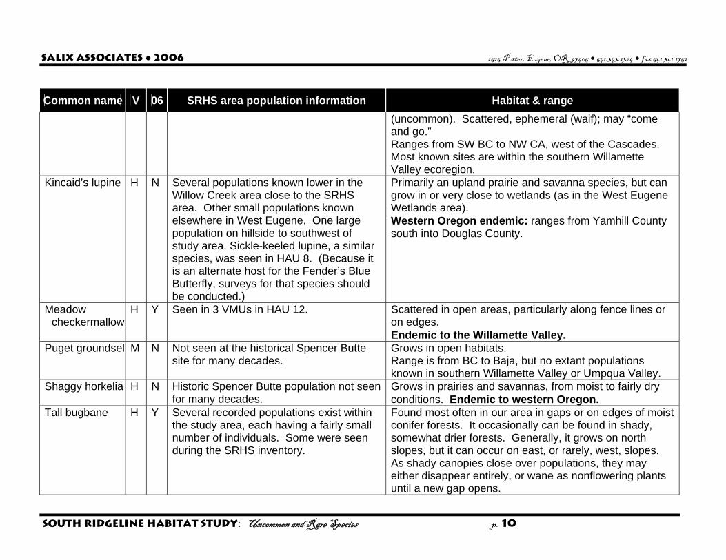
Salix Associates ● 2006 2525 Potter, Eugene, OR 97405 $ 541.343.2364 $ fax 541.341.1752
South Ridgeline Habitat Study: Uncommon and Rare Species p. 10
Common name V 06 SRHS area population information Habitat & range (uncommon). Scattered, ephemeral (waif); may “come and go.” Ranges from SW BC to NW CA, west of the Cascades. Most known sites are within the southern Willamette Valley ecoregion.
Kincaid’s lupine H N Several populations known lower in the Willow Creek area close to the SRHS area. Other small populations known elsewhere in West Eugene. One large population on hillside to southwest of study area. Sickle-keeled lupine, a similar species, was seen in HAU 8. (Because it is an alternate host for the Fender’s Blue Butterfly, surveys for that species should be conducted.)
Primarily an upland prairie and savanna species, but can grow in or very close to wetlands (as in the West Eugene Wetlands area). Western Oregon endemic: ranges from Yamhill County south into Douglas County.
Meadow checkermallow
H Y Seen in 3 VMUs in HAU 12. Scattered in open areas, particularly along fence lines or on edges. Endemic to the Willamette Valley.
Puget groundsel M N Not seen at the historical Spencer Butte site for many decades.
Grows in open habitats. Range is from BC to Baja, but no extant populations known in southern Willamette Valley or Umpqua Valley.
Shaggy horkelia H N Historic Spencer Butte population not seen for many decades.
Grows in prairies and savannas, from moist to fairly dry conditions. Endemic to western Oregon.
Tall bugbane H Y Several recorded populations exist within the study area, each having a fairly small number of individuals. Some were seen during the SRHS inventory.
Found most often in our area in gaps or on edges of moist conifer forests. It occasionally can be found in shady, somewhat drier forests. Generally, it grows on north slopes, but it can occur on east, or rarely, west, slopes. As shady canopies close over populations, they may either disappear entirely, or wane as nonflowering plants until a new gap opens.

Salix Associates ● 2006 2525 Potter, Eugene, OR 97405 $ 541.343.2364 $ fax 541.341.1752
South Ridgeline Habitat Study: Uncommon and Rare Species p. 11
Common name V 06 SRHS area population information Habitat & range Endemic to western Oregon and Washington (small overlap into SW BC), occurring mostly in western Oregon. If the two varieties gain recognition by the Oregon Flora Project, only var. elata will be in our area, ranging from Douglas County northward.
Thin-leaved peavine
H N Known from nearby to the west. Typical habitat for this species in our area includes edges, riparian areas, oak savanna and woodland, fencerows and roadsides. It tends to climb weakly on other vegetation. Essentially a Willamette Valley endemic, with a small extension into WA, and possibly, Douglas County.
Thompson’s mistmaiden
H N This species has not been seen in the study area for many years, and only one location was noted historically. It is possible that grazing, development, woody encroachment, invasion by exotics, and other impacts resulted in local extirpation of this species.
The exact site of the historic location is not known (at the “base of Spencer Butte”), and the nearest known population is on BLM land several miles to the east. Normally, it prefers moist seeps in southerly-sloping prairie areas. Endemic to the W. Cascades of Oregon from Marion Co. south to Jackson Co. Few populations to the west in the Willamette Valley ecoregion.
Upland yellow violet
M N Known previously from HAU 11 and 13. Upland prairies, and possibly savannas. Grows from SW BC to CA. Quite a few sites with small numbers in the Willamette Valley, and scattered throughout mountainous areas of Oregon.
Wayside aster H Y Several recorded populations exist within the study area. Some were seen during the SRHS inventory. Two new populations were recorded: one in HAU 10, one adjacent to HAU 13.
It grows in forest openings and edges, woodlands and savannas. It is somewhat difficult to identify because it has nondescript foliage, and flowers without petals. Endemic to SW Oregon, from southern Linn County, to Jackson and Josephine counties. Vast majority of recorded populations are in Willamette Valley foothills of southern Lane County.

Salix Associates ● 2006 2525 Potter, Eugene, OR 97405 $ 541.343.2364 $ fax 541.341.1752
South Ridgeline Habitat Study: Uncommon and Rare Species p. 12
Common name V 06 SRHS area population information Habitat & range Willamette daisy H N Known only in the SRHS area from the
Willow Creek Preserve and other West Eugene Wetlands sites.
Grows in prairies and savannas, from moist to fairly dry conditions. A Willamette Valley endemic.
White-top aster H N One site that was recorded recently in HAU 3 was not seen during the SRHS inventory. Other sites are in the W. Eugene Wetlands area.
Grows in prairies and savannas, from moist to fairly dry conditions. Endemic to the Willamette Valley – Puget Trough ecoregion, with the vast majority in the Willamette Valley, and a few in WA at the south end of Puget Sound.
WILDLIFE Little willow
flycatcher H Y Found erratically in and near the SRHS
area. Prefers shrubby habitats, such as willow thickets, clearcuts, etc. Known in 19 counties in 4 ecoregions in western OR. Also known in WA and CA.
Mountain quail M Y Found erratically in and near the SRHS area.
Prefers shrubby areas bordering on open habitats. Ranges from WA and ID south to Baja California.
Northern red-legged frog
H Y Population size and density unknown in the SRHS area, but there have been several sightings in recent history. (See Supplemental Information at the end of this document.) Incidental sightings during the SRHS in HAUs 12 and 13.
Need shallow water for breeding, with adjacent forests with dense understories for dispersal. Ranges from BC south to Baja California, generally in or west of the Cascade-Sierra mountains. The Northern subspecies ranges south into northern CA, and the CA subspecies ranges south from that point.
Olive-sided flycatcher
H Y Occasional on ridge tops in and near the study area. Particularly noticeable if singing from an exposed perch (although usually high in a tree).
Nests in forests; perches and flycatches from conspicuous snag. Ranges across North America.
Pileated woodpecker
H Y Found with some regularity in mature forests in the SRHS area. (See Supplemental Information at the end of this document.)
Associated with forest habitats. Ranges across northern North America, all of U.S. east of Mississippi, down W. Coast to central California.
Western gray H Y Found with some regularity in drier forests, Associated with oak habitats from WA, through OR to CA,

Salix Associates ● 2006 2525 Potter, Eugene, OR 97405 $ 541.343.2364 $ fax 541.341.1752
South Ridgeline Habitat Study: Uncommon and Rare Species p. 13
Common name V 06 SRHS area population information Habitat & range squirrel and occasionally in developed areas, in
and near the SRHS area. and a small part of NV.
Western rattlesnake
H Y Known only from Spencer Butte in the study area. Mostly extirpated from Willamette Valley.
Open, rocky areas and dry forests. Found mostly to the south and east, but broad ranging.
White-breasted nuthatch
H Y Occurrence is irregular in the area. Known to occur in the white and black oaks near the Morse Ranch.
In our area, generally associated with oaks, especially if there are some larger diameter individuals present. Ranges across the US, and also in western Canada and in Mexico. The subspecies that occurs west of the Cascades is the slender-billed.
Yellow-breasted chat
H Y Noted in 2 HAUs during the SRHS inventory, and seen in a third previous to the project.
Occurs in dense, brushy areas and thickets, especially near water. Ranges across the US and into Mexico.

Salix Associates ● 2006 2525 Potter, Eugene, OR 97405 $ 541.343.2364 $ fax 541.341.1752
South Ridgeline Habitat Study: Uncommon and Rare Species p. 14
Supplemental information for Northern Red-legged Frog and Pileated Woodpecker
The following two wildlife species receive more detailed treatment here at the request of the City, because they had been highlighted by citizens interested in the SRHS inventory. Northern red-legged frog. Much of the background information below was obtained from Hayes et al. 2006 and Pearl et al. 2005. These and additional sources are noted where specifically applicable. Northern red-legged frogs breed in wetlands and spend non-breeding time in moist forests at lower elevations. In particular, their aquatic, breeding habitats have declined due to development, encroaching woody and invasive exotic vegetation, introduction of predacious, exotic species, and hydrologic changes. Northern red-legged frogs prefer seasonal ponds for breeding, and attach their eggs in late winter to submerged vegetation or sticks. After hatching, and metamorphosing through the tadpole stage to adults in spring and early summer, they leave the aquatic habitat and disperse into moist forests to forage until the next winter breeding cycle begins. The herpetologist for this project developed inventory protocols for recording suitable habitat features for this species. Suitability mapping then was produced using this “fine scale,” observed features, and a second suitability map was produced using a “coarse scale” method tied to the recorded vegetation cover type. Context and importance regionally and in the SRHS study area. Northern red-legged frogs are a federal Species of Concern, and an ODFW Sensitive Vulnerable species and Strategy Species for the Willamette Valley (ORNHIC 2004, ODFW 2006), as they are known to have been more common historically, but have declined as their wetland habitats have been drained, converted to other uses, or altered by invasive, exotic vegetation, fish and possibly bullfrogs (Pearl et al. 2005). The moist, deciduous forest areas near breeding areas used for post-breeding dispersal and feeding (Hayes et al. 2006) could be maintained in conditions favorable for this species so as to preserve existing populations, and potentially, restore them where feasible. Because roads can lead to adult mortality (Hayes et al. 2006), their construction between breeding and dispersal/feeding habitats should be minimized if possible.
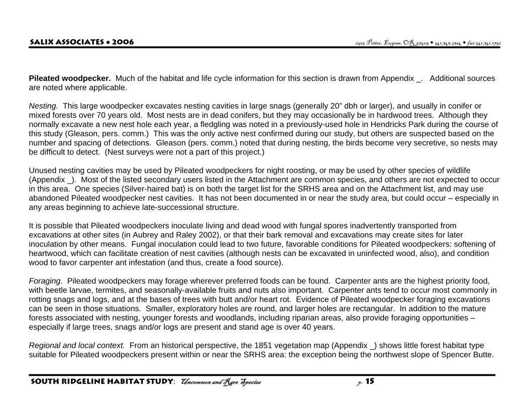
Salix Associates ● 2006 2525 Potter, Eugene, OR 97405 $ 541.343.2364 $ fax 541.341.1752
South Ridgeline Habitat Study: Uncommon and Rare Species p. 15
Pileated woodpecker. Much of the habitat and life cycle information for this section is drawn from Appendix _. Additional sources are noted where applicable. Nesting. This large woodpecker excavates nesting cavities in large snags (generally 20” dbh or larger), and usually in conifer or mixed forests over 70 years old. Most nests are in dead conifers, but they may occasionally be in hardwood trees. Although they normally excavate a new nest hole each year, a fledgling was noted in a previously-used hole in Hendricks Park during the course of this study (Gleason, pers. comm.) This was the only active nest confirmed during our study, but others are suspected based on the number and spacing of detections. Gleason (pers. comm.) noted that during nesting, the birds become very secretive, so nests may be difficult to detect. (Nest surveys were not a part of this project.) Unused nesting cavities may be used by Pileated woodpeckers for night roosting, or may be used by other species of wildlife (Appendix _). Most of the listed secondary users listed in the Attachment are common species, and others are not expected to occur in this area. One species (Silver-haired bat) is on both the target list for the SRHS area and on the Attachment list, and may use abandoned Pileated woodpecker nest cavities. It has not been documented in or near the study area, but could occur – especially in any areas beginning to achieve late-successional structure. It is possible that Pileated woodpeckers inoculate living and dead wood with fungal spores inadvertently transported from excavations at other sites (in Aubrey and Raley 2002), or that their bark removal and excavations may create sites for later inoculation by other means. Fungal inoculation could lead to two future, favorable conditions for Pileated woodpeckers: softening of heartwood, which can facilitate creation of nest cavities (although nests can be excavated in uninfected wood, also), and condition wood to favor carpenter ant infestation (and thus, create a food source). Foraging. Pileated woodpeckers may forage wherever preferred foods can be found. Carpenter ants are the highest priority food, with beetle larvae, termites, and seasonally-available fruits and nuts also important. Carpenter ants tend to occur most commonly in rotting snags and logs, and at the bases of trees with butt and/or heart rot. Evidence of Pileated woodpecker foraging excavations can be seen in those situations. Smaller, exploratory holes are round, and larger holes are rectangular. In addition to the mature forests associated with nesting, younger forests and woodlands, including riparian areas, also provide foraging opportunities – especially if large trees, snags and/or logs are present and stand age is over 40 years. Regional and local context. From an historical perspective, the 1851 vegetation map (Appendix _) shows little forest habitat type suitable for Pileated woodpeckers present within or near the SRHS area: the exception being the northwest slope of Spencer Butte.
Salix Associates ● 2006 2525 Potter, Eugene, OR 97405 $ 541.343.2364 $ fax 541.341.1752
South Ridgeline Habitat Study: Uncommon and Rare Species p. 16
Gabrielson and Jewett (1940; quoting Woodcock 1902, for Oregon) state that Pileated woodpeckers were hunted by native peoples, and after EuroAmerican settlement, “the birds are now on the increase.” They mention in 1940 that the bird was “fairly common and widely distributed for so large and conspicuous a bird.” In addition to the noted decrease in aboriginal hunting, these observations apply well to the SRHS area because of the increase in area of forest habitat after EuroAmerican settlement (and throughout the ecoregion) discussed earlier likely provided suitable habitat where it did not previously exist. Marshall et al. (2003) in Birds of Oregon identify the Pileated woodpecker as “an uncommon, permanent resident in older forests” in the Willamette Valley and elsewhere in Oregon “limited altitudinally by habitat availability; higher and lower elevations may lack large enough trees for nesting, roosting, and foraging.” ODFW listed the Pileated woodpecker as Sensitive-Vulnerable in 1998, but they did not include it as a Strategy Species (ODFW 2006) for the Willamette Valley ecoregion as it did not meet the criteria. (Similarly, mature conifer forest did not meet the criteria as a Strategy Habitat in the Willamette Valley ecoregion.) Revised ODFW sensitive species listings are expected in late 2006 or early 2007. ORNHIC (2004) did not include the species on any list in their triennial rare species publication. The ornithological expert consulted for this study evaluates the presence of Pileated woodpeckers in the overall SRHS area as “uncommon,” but “common” within areas of suitable habitat (Gleason, pers. comm.)
Salix Associates ● 2006 2525 Potter, Eugene, OR 97405 $ 541.343.2364 $ fax 541.341.1752
South Ridgeline Habitat Study: Uncommon and Rare Species p. 17
Sources: Alverson, Ed. 2006. Personnel communication. The Nature Conservancy. Eugene, OR. WNHP. 2006. Washington Natural Heritage Program web site. Department of Natural Resources, State of Washington. Klinkenberg, Brian. (Editor). 2006. E-Flora BC: Electronic Atlas of the Plants of British Columbia [www.eflora.bc.ca]. Lab for Advanced
Spatial Analysis, Department of Geography, University of British Columbia. Vancouver, BC. Marshall, David B. et al. (editors). 2003. Birds of Oregon. Oregon State University Press. Corvallis, Oregon. Maser, Chris. 1998. Mammals of the Pacific Northwest. Oregon State University Press. Corvallis, Oregon. Meinke, Robert. 1982. Threatened and Endangered Vascular Plants of Oregon: an Illustrated Guide. US Fish and Wildlife Service. Portland,
OR. NPSO. 2006. Rare and endangered vascular plant list for Lane County. Native Plant Society of Oregon web site: EmeraldNPSO.org ODFW. 2006. The Oregon Conservation Strategy. Oregon Department of Fish and Wildlife. Keizer, OR. ORNHIC. 2004. Rare, threatened and endangered species of Oregon. Oregon Natural Heritage Information Center. Corvallis, OR. ORNHIC. 2006. Unpublished data for the SRHS area: sighting reports and map. Oregon Natural Heritage Information Center. Corvallis, OR. Simpson, C. J. et al. 2002. Vascular Plants of Lane County: An Annotated Checklist (and 4 on-line updates). Emerald Chapter, Native Plant
Society of Oregon. Eugene, OR. Verts, B. J. and Carraway, Leslie. 1998. Land Mammals of Oregon. UC Press. Berkeley, CA. WNHP. 2006 (accessed). Rare Plant Field Guide (on0line). Washington Natural Heritage Program. Seattle, WA.
http://www.dnr.wa.gov/nhp/refdesk/fguide/htm/fsfgabc.htm

Salix Associates ● 2006 2525 Potter, Eugene, OR 97405 $ 541.343.2364 $ fax 541.341.1752
South Ridgeline Habitat Study: Uncommon and Rare Species p. 18
Wilson, Mark V. et al. 1997. The Interdependence of Native Plants and the Fender’s Blue Butterfly. In: Conservation and Management of
Native Flora and Fungi. Native Plant Society of Oregon, Corvallis, Oregon. 1997. http://oregonstate.edu/ornhic/plants/index.html Verts, B. J. and Carraway, L. N. 1998. Land Mammals of Oregon. University of California Press. Berkeley, CA. Xerces Society. 2002. Petition to Emergency List Taylor’s (Whulge) Checkerspot Butterfly. Xerces Society. Portland, OR.
http://www.xerces.org/documents/Taylors_Checkerspot_Petition.pdf

Pileated Woodpecker, Dryocopus pileatus Dan Gleason Nest sites:
Most nests are in dead conifers found in mature coniferous forests. Occasionally nests are in old, rotting deciduous trees, mostly big leaf maple and alder, but sometimes old oak trees may be used. In Douglas-fir forests, nest holes average about 20 m above the ground but are often much lower in deciduous trees. I have seen nests as low as 1.5 m in oak trees. Nest trees average dbh is 69 cm. (Bull & Jackson, 1995). Enough habitat must be available for new nests to be excavated by a resident pair each year. Old nest sites are never reused for nesting but may be enlarged for roosting in subsequent years.
Nest hole: Usually oval; approximately 9 cm horizontal by 11.5 cm vertical and frequently faces south or east.
Roost site:
Entrance hole is similar is size and shape to nest hole but cavity within is typically larger than nest cavity and may have multiple entrances which helps birds elude predators. Most of the cavity itself is not excavated by the woodpeckers but is the hollow formed as the tree ages and rots from fungal activity.
Habitat: In western Oregon, mature Douglas-fir forests are preferred. Nesting and roosting occurs in coniferous forests with stands greater than 70 years of age, and closed canopies. Often forages in riparian areas of mixed coniferous and deciduous woodlands where the conifers average age is greater than 40 years.
Foraging excavations:
Large rectangular holes deep into the trunk and often more than 30 cm in length. As the birds continue to excavate, these holes may merge into one another, forming even larger holes. Exploratory excavations and early holes are round (2.5 to 8 cm), shallow and conical and there is usually evidence of newly exposed bark around the hole. Often, these holes are clustered together. Foraging holes may be at any height but are usually near the base of the tree or on a fallen, decaying log.
Food:
The primary food is carpenter ants. Wood-boring beetle larvae, some termites and other insects are also eaten. Fruits and nuts are frequently eaten as they become available. These fruits include: blackberry (Rubus sp), poisonoak (Rhus diversiloba), American holly (Ilex opaca), dogwood (Cornus spp.) and others.
Non-vocal sounds:
Drumming is irregular and much slower than other woodpeckers. It is usually loud and resonant but can be soft, especially when excavating in soft, rotting wood. Single and double taps are heard at times. These short tappings are various forms of communication between mates. When Pileated Woodpeckers are not directly seen or heard, their presence is detectable by the presence of large foraging holes. Once carpenter ants are found, a pair of birds will usually continue to feed on them for several years. If carpenter ants are found in appropriate habitat, it is likely that evidence of Pileated Woodpeckers will be nearby, either foraging holes or roost and nest cavities. Pileated Woodpeckers are non-migratory and mate for life. A mated pair will maintain a territory throughout the year. If one of the pair dies, the other remains in the territory and awaits the arrival of an unmated bird that is not yet on an established territory. Foraging territories may have some overlap but nesting territories do not.

Bull, E. L., and J. E. Jackson. 1995. Pileated Woodpecker (Dryocopus pileatus). In The Birds of North America, No. 148 (A. Poole and F. Gill, eds.). The Academy of Natural Sciences, Philadelphia, PA, and The American Ornithologists’ Union, Washington, D.C.
Pileated Woodpecker – Additional notes of requirements in western Oregon. Dan Gleason Nesting and foraging habitats of Pileated Woodpeckers, Dryocopus pileatus, overlap to a considerable degree but foraging requirements are not as narrow as nesting. Pileated Woodpeckers will forage in younger forests with adequate cover and availability of food. Carpenter ants are the primary food eaten. This requires large trees with thickened bark near the base where the ants are typically found or snags and downed logs that may sustain a population of these ants. Foraging in younger and more open areas may be more frequent late summer or early fall as some alternate foods become available. These foods include the berries of poison-oak, dogwood, holly and some other fruits that are occasionally taken. Beetle larvae are also eaten and are second only to ants in importance. Nuts, such as acorns, are also eaten in season. Habitats lacking these foods will be avoided. All regularly used foraging areas (including the nesting habitat) must have a constant supply of food as Pileated Woodpeckers are not known to store food. The primary nesting sites are mid to late successional forests. Young stands can be used if they contain a significant number of large remnant trees or snags. Trees typically selected for nesting are usually in early stages of heart-rot. With late stages of rot, the trees cannot provide enough structural support and are at risk of breaking at the site of the excavation. This means that it is usually the larger trees that are selected. Older trees can also provide more structure around the nest and
increase thermal retention where smaller diameter trees result in thinner walls (after excavation) and have lower heat retention. Since Pileated Woodpeckers excavate a new cavity each year, a large supply of snags or suitable trees must always be available. Studies of birds in eastern portions of North America show use of trees with smaller diameter than those used by birds in the Pacific Northwest. In Oregon, habitats should contain snags or suitable nest trees greater than 20 inch dbh and these snags should be of sound character so that they can support the type of excavation done by Pileated Woodpeckers. Within the territory of a nesting pair, at least three snags per year are needed to meet nesting and roosting requirements and it is suggested that a reserve of fifteen snags (per year) be available as all snags will not be used or found acceptable by the birds. (Schroeder, 1982) One to two roost cavities are excavated each year in addition to the nest cavity. Throughout the year, a closed canopy is of higher value to woodpeckers. This is more important at higher elevations when snow can cover stumps and downed foraging logs during the winter months. This is much less of an issue here in the Willamette Valley. Large, open tracts of woodlands are typically avoided by woodpeckers. I have seen Pileated Woodpeckers in open regions that are adjacent to the forest, using old snags or even powerline poles. These resonate loudly when struck and are sometimes used for communication drumming. In additional to the woodpeckers themselves, the cavities that they excavate are also used in later years by other species. I do not know which, if any species, may use old woodpecker holes, although I would be very surprised if none did. Species know to use excavations in Oregon or other western localities include (from Schroeder, 1982): Wood Duck, Aix sponsa Common Goldeneye, Bucephala clangula Bufflehead, Bucephala albeola Hooded Merganser, Lophodytes cucullatus Common Merganser, Mergus merganser American Kestrel, Falco sparverius Flammulated Owl, Otus flammeolus Western Screech-Owl, Megascops kennicottii Northern Pygmy-Owl, Glaucidium gnoma Weste Boreal Owl, Aegolius funereus Northern Saw-whet Owl, Aegolius acadicus Vaux’s Swift, Chaetura vauxi Hairy Woodpecker, Picoides villosus Northern Flicker, Colaptes auratus Brown Creeper, Certhia americana Silver-haired bat, Lasionycteris noctivagans Big brown bat, Eptesicus fuscus Douglas’ squirrel, Tamiasciurus douglasii Red squirrel, Tamiasciurus hudsonicus Northern flying squirrel, Glaucomys sabrinus Bushy-tailed woodrat, Neotoma cinerea Ringtail, Bassariscus astutus American marten, Martes americana Fisher, Martes pennanti Schroeder, R. L. 1982. Habitat suitability index models: Pi1eated woodpecker. U.S. Dept. Int., Fish Wildl. Serv. FWS/OBS-82/10.39.

Appendix C - Species-habitat matrices 2007-08-30.xls
Common Name Form
Bre
edin
g/Fe
edin
gC
onife
r 0-2
0 yr
s (1
)
BF
mul
tiplie
r
Adj
uste
d S
uita
bilit
y
Rar
e V
alue
Sui
tabi
lity
+ V
alue
Conifer 0-20 yrs (1)COVER TYPE NUMBER 1 CommentsMountain Quail B BF 3 1.0 3 2 5 Open habitats with shrub patches are best.Common Nighthawk B B 3 0.8 2.4 3 5.4 May nest in open areas, but becoming very rare.Common Nighthawk B F 3 0.2 0.6 3 3.6 Forage widely.Willow Flycatcher B BF 3 1.0 3 3 6 Prefer upland and riparian shrub thickets for nesting (can be exotic-dominated).Western Bluebird B BF 3 1.0 3 3 6 Nest in cavities in snags in open habitats.Long-Eared Myotis M B 3 0.8 2.4 2 4.4 Buildings, hollow trees.Western Toad H F 2 0.2 0.4 3 3.4 Forage widely, seek shelter underground or under large debris or vegetation.Red-Legged Frog H F 2 0.2 0.4 3 3.4 Disperse widely, mostly in moist forests.Western Rattlesnake H F 2 0.2 0.4 1.5 1.9 May forage in dry forests as well as in breeding habitats; edited H for 24.Peregrine Falcon B F 2 0.2 0.4 1.5 1.9 Birds are a primary food, but mammals and some insects eaten, also.Band-Tailed Pigeon B BF 2 1.0 2 2 4 Breed in denser forests, forage in more open. Supplement diet by visiting mineral sites.Olive-Sided Flycatcher B BF 2 1.0 2 3 5 Prefer scattered, large trees and snags, at forest edges and openings; often near water.Purple Martin B B 2 0.8 1.6 1.5 3.1 Nests in cavities in open habitats, including snags. Often near water.Purple Martin B F 2 0.2 0.4 1.5 1.9 Forages over open water, grasslands, and forests.Long-Eared Myotis M F 2 0.2 0.4 1 1.4 Buildings, hollow trees, crevices.Long-Legged Myotis M F 2 0.2 0.4 1 1.4 Forage widely, use caves, buildings, etc. for roosting.California Myotis M B 2 0.8 1.6 1 2.6 No information available.California Myotis M F 2 0.2 0.4 1 1.4 Forage widely, night roost in crevices.Silver-Haired Bat M B 2 0.8 1.6 1 2.6 Breed more in mature & OG stands.Silver-Haired Bat M F 2 0.2 0.4 1 1.4 Use mines, buildings in winter; also roost in tree cavities, under barkWhite-Footed Vole M BF 2 1.0 2 2 4 Little known. Seems to prefer moist, forested areas near streams; possibly edges.Clouded Salamander H BF 1 1.0 1 1 2 Large logs; has been found in a basement and in a wood pile in our area.Pileated Woodpecker B BF 1 1.0 1 2 3 Nest in cavities in large trees, usually in conifer forests.Yellow-Breasted Chat B BF 1 1.0 1 3 4 Nest in thickets near water.Chipping Sparrow B BF 1 1.0 1 3 4 Breed and forage in forest openings.Long-Legged Myotis M B 1 0.8 0.8 2 2.8 Buildings, hollow trees.Townsend's Big-Eared Bat M F 1 0.2 0.2 1.5 1.7 Caves, buildings; sensitive to disturbanceWestern Gray Squirrel M BF 1 1.0 1 3 4 Oak-pine (or occ. Doug fir) associated; need large diameter snags with cavities.Camas Pocket Gopher M BF 1 1.0 1 2 3 Generally well-drained open or shrubby areas, ag fields and orchards. Bulb and tuber foods important.Red Tree Vole M BF 1 1.0 1 2 3 Mature conifer forests preferred.Tall bugbane P 1 1.0 1 3 4 Moist areas, not dry forest. Gaps best.Mountain lady's-slipper P 1 1.0 1 2 3 Filtered shade, but not too dense.Wayside aster P 1 1.0 1 3 4 On edges and in gaps.Coffee fern P 1 1.0 1 3 4 South-facing rocky areas.
75 TOTAL RARE SPECIES SUITABILITY INDEX
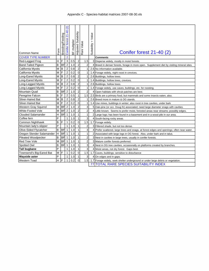
Appendix C - Species-habitat matrices 2007-08-30.xls
Common Name Form
Bree
ding
/Fee
ding
Con
ifer f
ores
t 21-
40 (2
)
BF
mul
tiplie
rA
djus
ted
Sui
tabi
lity
Rar
e V
alue
Sui
tabi
lity
+ V
alue
Conifer forest 21-40 (2)COVER TYPE NUMBER 2 CommentsRed-Legged Frog H F 3 0.5 2 1.5 3 Disperse widely, mostly in moist forests.Band-Tailed Pigeon B BF 2 1.0 2 2 4 Breed in denser forests, forage in more open. Supplement diet by visiting mineral sites.California Myotis M B 2 0.8 2 1 2.6 No information available.California Myotis M F 2 0.2 0 1 1.4 Forage widely, night roost in crevices.Long-Eared Myotis M B 2 0.8 2 1 2.6 Buildings, hollow trees.Long-Eared Myotis M F 2 0.2 0 1 1.4 Buildings, hollow trees, crevices.Long-Legged Myotis M B 2 0.8 2 1 2.6 Buildings, hollow trees.Long-Legged Myotis M F 2 0.2 0 1 1.4 Forage widely, use caves, buildings, etc. for roosting.Mountain Quail B BF 2 1.0 2 2 4 Open habitats with shrub patches are best.Peregrine Falcon B F 2 0.5 1 1.5 2.5 Birds are a primary food, but mammals and some insects eaten, also.Silver-Haired Bat M B 2 0.8 2 1 2.6 Breed more in mature & OG stands.Silver-Haired Bat M F 2 0.2 0 1 1.4 Use mines, buildings in winter; also roost in tree cavities, under barkWestern Gray Squirrel M BF 2 1.0 2 3 5 Oak-pine (or occ. Doug fir) associated; need large diameter snags with cavities.White-Footed Vole M BF 2 1.0 2 2 4 Little known. Seems to prefer moist, forested areas near streams; possibly edges.Clouded Salamander H BF 1 1.0 1 1 2 Large logs; has been found in a basement and in a wood pile in our area.Coffee fern P 1 1.0 1 3 4 South-facing rocky areas.Common Nighthawk B F 1 0.2 0 1.5 1.7 Forage widely.Mountain lady's-slipper P 1 1.0 1 2 3 Filtered shade, but not too dense.Olive-Sided Flycatcher B BF 1 1.0 1 3 4 Prefer scattered, large trees and snags, at forest edges and openings; often near water.Oregon Slender Salamander H BF 1 1.0 1 1 2 Associated with large logs in OG forest. Also, under bark and in talus.Pileated Woodpecker B BF 1 1.0 1 2 3 Nest in cavities in large trees, usually in conifer forests.Red Tree Vole M BF 1 1.0 1 2 3 Mature conifer forests preferred.Spotted Owl B BF 1 1.0 1 3 4 Nest in OG tree cavities, occasionally on platforms created by branches.Tall bugbane P 1 1.0 1 3 4 Moist areas, not dry forest. Gaps best.Townsend's Big-Eared Bat M F 1 0.2 0 1.5 1.7 Caves, buildings; sensitive to disturbanceWayside aster P 1 1.0 1 3 4 On edges and in gaps.Western Toad H F 1 0.2 0 1.5 1.7 Forage widely, seek shelter underground or under large debris or vegetation.
77 TOTAL RARE SPECIES SUITABILITY INDEX

Appendix C - Species-habitat matrices 2007-08-30.xls
Common Name Form
Bre
edin
g/Fe
edin
gC
onife
r for
est 4
1-60
(3)
BF
mul
tiplie
rA
djus
ted
Sui
tabi
lity
Rar
e V
alue
Sui
tabi
lity
+ V
alue
Conifer forest 41-60 (3)COVER TYPE NUMBER 3 CommentsRed-Legged Frog H F 3 0.2 1 1.5 2.1 Disperse widely, mostly in moist forests.Band-Tailed Pigeon B BF 3 1.0 3 2 5 Breed in denser forests, forage in more open. Supplement diet by visiting mineral sites.Clouded Salamander H BF 2 1.0 2 1 3 Large logs; has been found in a basement and in a wood pile in our area.Oregon Slender Salamander H BF 2 1.0 2 1 3 Associated with large logs in OG forest. Also, under bark and in talus.Peregrine Falcon B F 2 0.2 0 1.5 1.9 Birds are a primary food, but mammals and some insects eaten, also.Pileated Woodpecker B BF 2 1.0 2 2 4 Nest in cavities in large trees, usually in conifer forests.Long-Eared Myotis M B 2 0.8 2 1 2.6 Buildings, hollow trees.Long-Eared Myotis M F 2 0.2 0 1 1.4 Buildings, hollow trees, crevices.Long-Legged Myotis M B 2 0.8 2 1 2.6 Buildings, hollow trees.Long-Legged Myotis M F 2 0.2 0 1 1.4 Forage widely, use caves, buildings, etc. for roosting.California Myotis M B 2 0.8 2 1 2.6 No information available.California Myotis M F 2 0.2 0 1 1.4 Forage widely, night roost in crevices.Silver-Haired Bat M B 2 0.8 2 1 2.6 Breed more in mature & OG stands.Silver-Haired Bat M F 2 0.2 0 1 1.4 Use mines, buildings in winter; also roost in tree cavities, under barkWestern Gray Squirrel M BF 2 1.0 2 3 5 Oak-pine (or occ. Doug fir) associated; need large diameter snags with cavities.White-Footed Vole M BF 2 1.0 2 2 4 Little known. Seems to prefer moist, forested areas near streams; possibly edges.Red Tree Vole M BF 2 1.0 2 2 4 Mature conifer forests preferred.Tall bugbane P 2 1.0 2 3 5 Moist areas, not dry forest. Gaps best.Western Toad H F 1 0.2 0 1.5 1.7 Forage widely, seek shelter underground or under large debris or vegetation.Mountain Quail B BF 1 1.0 1 2 3 Open habitats with shrub patches are best.Spotted Owl B BF 1 1.0 1 3 4 Nest in OG tree cavities, occasionally on platforms created by branches.Common Nighthawk B F 1 0.2 0 1.5 1.7 Forage widely.Olive-Sided Flycatcher B BF 1 1.0 1 3 4 Prefer scattered, large trees and snags, at forest edges and openings; often near water.Townsend's Big-Eared Bat M F 1 0.2 0 1.5 1.7 Caves, buildings; sensitive to disturbanceMountain lady's-slipper P 1 1.0 1 2 3 Filtered shade, but not too dense.Wayside aster P 1 1.0 1 3 4 On edges and in gaps.Coffee fern P 1 1.0 1 3 4 South-facing rocky areas.
80 TOTAL RARE SPECIES SUITABILITY INDEX
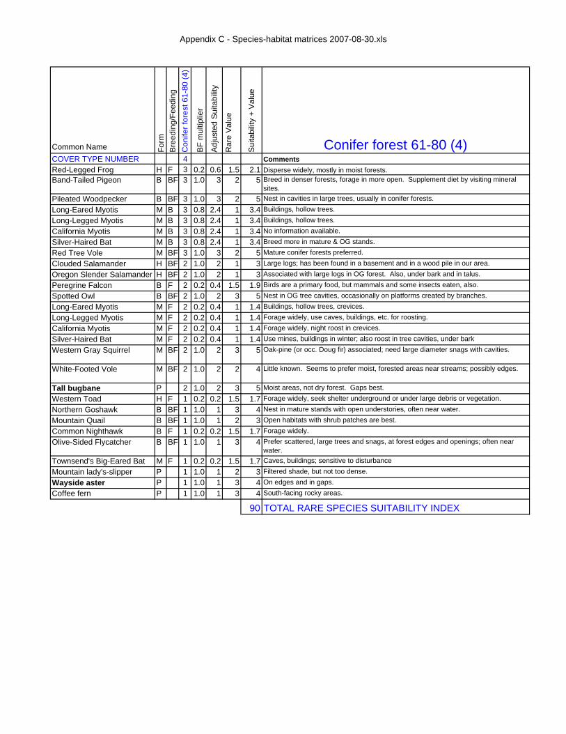
Appendix C - Species-habitat matrices 2007-08-30.xls
Common Name Form
Bree
ding
/Fee
ding
Con
ifer f
ores
t 61-
80 (4
)
BF m
ultip
lier
Adju
sted
Sui
tabi
lity
Rar
e Va
lue
Suita
bilit
y +
Valu
e
Conifer forest 61-80 (4)COVER TYPE NUMBER 4 CommentsRed-Legged Frog H F 3 0.2 0.6 1.5 2.1 Disperse widely, mostly in moist forests.Band-Tailed Pigeon B BF 3 1.0 3 2 5 Breed in denser forests, forage in more open. Supplement diet by visiting mineral
sites.Pileated Woodpecker B BF 3 1.0 3 2 5 Nest in cavities in large trees, usually in conifer forests.Long-Eared Myotis M B 3 0.8 2.4 1 3.4 Buildings, hollow trees.Long-Legged Myotis M B 3 0.8 2.4 1 3.4 Buildings, hollow trees.California Myotis M B 3 0.8 2.4 1 3.4 No information available.Silver-Haired Bat M B 3 0.8 2.4 1 3.4 Breed more in mature & OG stands.Red Tree Vole M BF 3 1.0 3 2 5 Mature conifer forests preferred.Clouded Salamander H BF 2 1.0 2 1 3 Large logs; has been found in a basement and in a wood pile in our area.Oregon Slender Salamander H BF 2 1.0 2 1 3 Associated with large logs in OG forest. Also, under bark and in talus.Peregrine Falcon B F 2 0.2 0.4 1.5 1.9 Birds are a primary food, but mammals and some insects eaten, also.Spotted Owl B BF 2 1.0 2 3 5 Nest in OG tree cavities, occasionally on platforms created by branches.Long-Eared Myotis M F 2 0.2 0.4 1 1.4 Buildings, hollow trees, crevices.Long-Legged Myotis M F 2 0.2 0.4 1 1.4 Forage widely, use caves, buildings, etc. for roosting.California Myotis M F 2 0.2 0.4 1 1.4 Forage widely, night roost in crevices.Silver-Haired Bat M F 2 0.2 0.4 1 1.4 Use mines, buildings in winter; also roost in tree cavities, under barkWestern Gray Squirrel M BF 2 1.0 2 3 5 Oak-pine (or occ. Doug fir) associated; need large diameter snags with cavities.
White-Footed Vole M BF 2 1.0 2 2 4 Little known. Seems to prefer moist, forested areas near streams; possibly edges.
Tall bugbane P 2 1.0 2 3 5 Moist areas, not dry forest. Gaps best.Western Toad H F 1 0.2 0.2 1.5 1.7 Forage widely, seek shelter underground or under large debris or vegetation.Northern Goshawk B BF 1 1.0 1 3 4 Nest in mature stands with open understories, often near water.Mountain Quail B BF 1 1.0 1 2 3 Open habitats with shrub patches are best.Common Nighthawk B F 1 0.2 0.2 1.5 1.7 Forage widely.Olive-Sided Flycatcher B BF 1 1.0 1 3 4 Prefer scattered, large trees and snags, at forest edges and openings; often near
water.Townsend's Big-Eared Bat M F 1 0.2 0.2 1.5 1.7 Caves, buildings; sensitive to disturbanceMountain lady's-slipper P 1 1.0 1 2 3 Filtered shade, but not too dense.
Wayside aster P 1 1.0 1 3 4 On edges and in gaps.Coffee fern P 1 1.0 1 3 4 South-facing rocky areas.
90 TOTAL RARE SPECIES SUITABILITY INDEX

Appendix C - Species-habitat matrices 2007-08-30.xls
Common Name Form
Bree
ding
/Fee
ding
Con
ifer f
ores
t 81-
200
(5)
BF m
ultip
lier
Adju
sted
Sui
tabi
lity
Rar
e Va
lue
Suita
bilit
y +
Valu
e
Conifer forest 81-200 (5)COVER TYPE NUMBER 5 CommentsClouded Salamander H BF 3 1.0 3 1 4 Large logs; has been found in a basement and in a wood pile in our area.Oregon Slender Salamander H BF 3 1.0 3 1 4 Associated with large logs in OG forest. Also, under bark and in talus.Red-Legged Frog H F 3 0.2 0.6 1.5 2.1 Disperse widely, mostly in moist forests.Northern Goshawk B BF 3 1.0 3 3 6 Nest in mature stands with open understories, often near water.Band-Tailed Pigeon B BF 3 1.0 3 2 5 Breed in denser forests, forage in more open. Supplement diet by visiting mineral
sites.Spotted Owl B BF 3 1.0 3 3 6 Nest in OG tree cavities, occasionally on platforms created by branches.Pileated Woodpecker B BF 3 1.0 3 2 5 Nest in cavities in large trees, usually in conifer forests.Olive-Sided Flycatcher B BF 3 1.0 3 3 6 Prefer scattered, large trees and snags, at forest edges and openings; often near
water.Long-Eared Myotis M B 3 0.8 2.4 1 3.4 Buildings, hollow trees.Long-Legged Myotis M B 3 0.8 2.4 1 3.4 Buildings, hollow trees.California Myotis M B 3 0.8 2.4 1 3.4 No information available.Silver-Haired Bat M B 3 0.8 2.4 1 3.4 Breed more in mature & OG stands.Red Tree Vole M BF 3 1.0 3 2 5 Mature conifer forests preferred.Bald Eagle B B 2 0.8 1.6 1 2.6 Mosts nests are near water. Large, old trees used.Peregrine Falcon B F 2 0.2 0.4 1 1.4 Birds are a primary food, but mammals and some insects eaten, also.Mountain Quail B BF 2 1.0 2 2 4 Open habitats with shrub patches are best.Long-Eared Myotis M F 2 0.2 0.4 1 1.4 Buildings, hollow trees, crevices.Long-Legged Myotis M F 2 0.2 0.4 1 1.4 Forage widely, use caves, buildings, etc. for roosting.California Myotis M F 2 0.2 0.4 1 1.4 Forage widely, night roost in crevices.Silver-Haired Bat M F 2 0.2 0.4 1 1.4 Use mines, buildings in winter; also roost in tree cavities, under barkTownsend's Big-Eared Bat M F 2 0.2 0.4 1 1.4 Caves, buildings; sensitive to disturbanceWestern Gray Squirrel M BF 2 1.0 2 3 5 Oak-pine (or occ. Doug fir) associated; need large diameter snags with cavities.
White-Footed Vole M BF 2 1.0 2 2 4 Little known. Seems to prefer moist, forested areas near streams; possibly edges.
Tall bugbane P 2 1.0 2 3 5 Moist areas, not dry forest. Gaps best.Western Toad H F 1 0.2 0.2 1.5 1.7 Forage widely, seek shelter underground or under large debris or vegetation.
Common Nighthawk B F 1 0.2 0.2 1.5 1.7 Forage widely.Mountain lady's-slipper P 1 1.0 1 2 3 Filtered shade, but not too dense.
Wayside aster P 1 1.0 1 3 4 On edges and in gaps.Coffee fern P 1 1.0 1 3 4 South-facing rocky areas.
100 TOTAL RARE SPECIES SUITABILITY INDEX
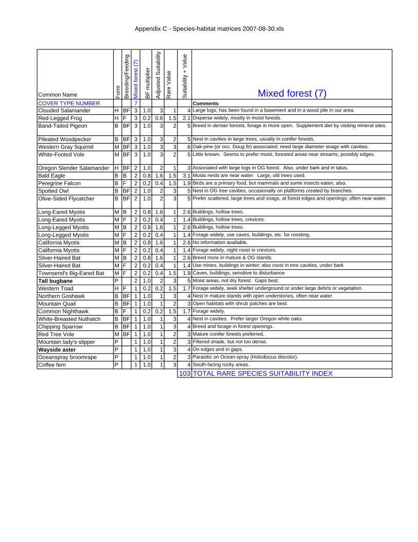
Appendix C - Species-habitat matrices 2007-08-30.xls
Common Name Form
Bree
ding
/Fee
ding
Mix
ed fo
rest
(7)
BF
mul
tiplie
r
Adj
uste
d S
uita
bilit
y
Rar
e V
alue
Sui
tabi
lity
+ V
alue
Mixed forest (7)COVER TYPE NUMBER 7 CommentsClouded Salamander H BF 3 1.0 3 1 4 Large logs; has been found in a basement and in a wood pile in our area.Red-Legged Frog H F 3 0.2 0.6 1.5 2.1 Disperse widely, mostly in moist forests.Band-Tailed Pigeon B BF 3 1.0 3 2 5 Breed in denser forests, forage in more open. Supplement diet by visiting mineral sites.
Pileated Woodpecker B BF 3 1.0 3 2 5 Nest in cavities in large trees, usually in conifer forests.Western Gray Squirrel M BF 3 1.0 3 3 6 Oak-pine (or occ. Doug fir) associated; need large diameter snags with cavities.White-Footed Vole M BF 3 1.0 3 2 5 Little known. Seems to prefer moist, forested areas near streams; possibly edges.
Oregon Slender Salamander H BF 2 1.0 2 1 3 Associated with large logs in OG forest. Also, under bark and in talus.Bald Eagle B B 2 0.8 1.6 1.5 3.1 Mosts nests are near water. Large, old trees used.Peregrine Falcon B F 2 0.2 0.4 1.5 1.9 Birds are a primary food, but mammals and some insects eaten, also.Spotted Owl B BF 2 1.0 2 3 5 Nest in OG tree cavities, occasionally on platforms created by branches.Olive-Sided Flycatcher B BF 2 1.0 2 3 5 Prefer scattered, large trees and snags, at forest edges and openings; often near water.
Long-Eared Myotis M B 2 0.8 1.6 1 2.6 Buildings, hollow trees.Long-Eared Myotis M F 2 0.2 0.4 1 1.4 Buildings, hollow trees, crevices.Long-Legged Myotis M B 2 0.8 1.6 1 2.6 Buildings, hollow trees.Long-Legged Myotis M F 2 0.2 0.4 1 1.4 Forage widely, use caves, buildings, etc. for roosting.California Myotis M B 2 0.8 1.6 1 2.6 No information available.California Myotis M F 2 0.2 0.4 1 1.4 Forage widely, night roost in crevices.Silver-Haired Bat M B 2 0.8 1.6 1 2.6 Breed more in mature & OG stands.Silver-Haired Bat M F 2 0.2 0.4 1 1.4 Use mines, buildings in winter; also roost in tree cavities, under barkTownsend's Big-Eared Bat M F 2 0.2 0.4 1.5 1.9 Caves, buildings; sensitive to disturbanceTall bugbane P 2 1.0 2 3 5 Moist areas, not dry forest. Gaps best.Western Toad H F 1 0.2 0.2 1.5 1.7 Forage widely, seek shelter underground or under large debris or vegetation.Northern Goshawk B BF 1 1.0 1 3 4 Nest in mature stands with open understories, often near water.Mountain Quail B BF 1 1.0 1 2 3 Open habitats with shrub patches are best.Common Nighthawk B F 1 0.2 0.2 1.5 1.7 Forage widely.White-Breasted Nuthatch B BF 1 1.0 1 3 4 Nest in cavities. Prefer larger Oregon white oaks.Chipping Sparrow B BF 1 1.0 1 3 4 Breed and forage in forest openings.Red Tree Vole M BF 1 1.0 1 2 3 Mature conifer forests preferred.Mountain lady's-slipper P 1 1.0 1 2 3 Filtered shade, but not too dense.Wayside aster P 1 1.0 1 3 4 On edges and in gaps.Oceanspray broomrape P 1 1.0 1 2 3 Parasitic on Ocean-spray (Holodiscus discolor).Coffee fern P 1 1.0 1 3 4 South-facing rocky areas.
103 TOTAL RARE SPECIES SUITABILITY INDEX

Appendix C - Species-habitat matrices 2007-08-30.xls
Common Name Form
Bree
ding
/Fee
ding
Har
dwoo
d fo
rest
(8)
BF
mul
tiplie
r
Adj
uste
d S
uita
bilit
y
Rar
e V
alue
Sui
tabi
lity
+ V
alue
Hardwood forest (8)COVER TYPE NUMBER 8 CommentsRed-Legged Frog H F 3 0.2 0.6 1.5 2.1 Disperse widely, mostly in moist forests.Bald Eagle B B 3 0.8 2.4 1.5 3.9 Mosts nests are near water. Large, old trees used.Acorn Woodpecker B BF 3 1.0 3 3 6 Need stands with large oaks with some dead limbs, and open understory.Pileated Woodpecker B BF 3 1.0 3 2 5 Nest in cavities in large trees, usually in conifer forests.White-Breasted Nuthatch B BF 3 1.0 3 3 6 Nest in cavities. Prefer larger Oregon white oaks.Western Gray Squirrel M BF 3 1.0 3 3 6 Oak-pine (or occ. Doug fir) associated; need large diameter snags with cavities.White-Footed Vole M BF 3 1.0 3 2 5 Little known. Seems to prefer moist, forested areas near streams; possibly edges.
Western Rattlesnake H F 2 0.2 0.4 1.5 1.9 May forage in dry forests as well as in breeding habitats.Peregrine Falcon B F 2 0.2 0.4 1.5 1.9 Birds are a primary food, but mammals and some insects eaten, also.Long-Eared Myotis M B 2 0.8 1.6 1 2.6 Buildings, hollow trees.Long-Eared Myotis M F 2 0.2 0.4 1 1.4 Buildings, hollow trees, crevices.Long-Legged Myotis M B 2 0.8 1.6 1 2.6 Buildings, hollow trees.Long-Legged Myotis M F 2 0.2 0.4 1 1.4 Forage widely, use caves, buildings, etc. for roosting.California Myotis M B 2 0.8 1.6 1 2.6 No information available.California Myotis M F 2 0.2 0.4 1 1.4 Forage widely, night roost in crevices.Silver-Haired Bat M B 2 0.8 1.6 1 2.6 Breed more in mature & OG stands.Silver-Haired Bat M F 2 0.2 0.4 1 1.4 Use mines, buildings in winter; also roost in tree cavities, under barkTownsend's Big-Eared Bat M F 2 0.2 0.4 1.5 1.9 Caves, buildings; sensitive to disturbanceTall bugbane P 2 1.0 2 3 5 Moist areas, not dry forest. Gaps best.Clouded Salamander H BF 1 1.0 1 1 2 Large logs; has been found in a basement and in a wood pile in our area.Western Toad H F 1 0.2 0.2 1.5 1.7 Forage widely, seek shelter underground or under large debris or vegetation.Mountain Quail B BF 1 1.0 1 2 3 Open habitats with shrub patches are best.Band-Tailed Pigeon B BF 1 1.0 1 2 3 Breed in denser forests, forage in more open. Supplement diet by visiting mineral sites.Common Nighthawk B F 1 0.2 0.2 1.5 1.7 Forage widely.Chipping Sparrow B BF 1 1.0 1 3 4 Breed and forage in forest openings.Mountain lady's-slipper P 1 1.0 1 2 3 Filtered shade, but not too dense.Wayside aster P 1 1.0 1 3 4 On edges and in gaps.Oceanspray broomrape P 1 1.0 1 2 3 Parasitic on Ocean-spray (Holodiscus discolor).Coffee fern P 1 1.0 1 3 4 South-facing rocky areas.
90 TOTAL RARE SPECIES SUITABILITY INDEX

Appendix C - Species-habitat matrices 2007-08-30.xls
Common Name Form
Bre
edin
g/Fe
edin
gC
onife
r woo
dlan
d (9
)
BF
mul
tiplie
r
Adj
uste
d S
uita
bilit
y
Rar
e V
alue
Sui
tabi
lity
+ V
alue
Conifer woodland (9)COVER TYPE NUMBER 9 CommentsBand-Tailed Pigeon B BF 3 1.0 3 2 5 Breed in denser forests, forage in more open. Supplement diet by visiting mineral sites.
Olive-Sided Flycatcher B BF 3 1.0 3 3 6 Prefer scattered, large trees and snags, at forest edges and openings; often near water.
Wayside aster P 3 1.0 3 3 6 On edges and in gaps.
Puget groundsel P 3 1.0 3 2 5 Savanna, possibly prairie.
Western Toad H F 2 0.2 0.4 1.5 1.9 Forage widely, seek shelter underground or under large debris or vegetation.
Red-Legged Frog H F 2 0.2 0.4 1.5 1.9 Disperse widely, mostly in moist forests.
Bald Eagle B B 2 0.8 1.6 1.5 3.1 Mosts nests are near water. Large, old trees used.
Northern Goshawk B BF 2 1.0 2 3 5 Nest in mature stands with open understories, often near water.
Peregrine Falcon B F 2 0.2 0.4 1.5 1.9 Birds are a primary food, but mammals and some insects eaten, also.
Mountain Quail B BF 2 1.0 2 2 4 Open habitats with shrub patches are best.
Pileated Woodpecker B BF 2 1.0 2 2 4 Nest in cavities in large trees, usually in conifer forests.
Long-Eared Myotis M B 2 0.8 1.6 1 2.6 Buildings, hollow trees.
Long-Eared Myotis M F 2 0.2 0.4 1 1.4 Buildings, hollow trees, crevices.
Long-Legged Myotis M B 2 0.8 1.6 1 2.6 Buildings, hollow trees.
Long-Legged Myotis M F 2 0.2 0.4 1 1.4 Forage widely, use caves, buildings, etc. for roosting.
California Myotis M B 2 0.8 1.6 1 2.6 No information available.
California Myotis M F 2 0.2 0.4 1 1.4 Forage widely, night roost in crevices.
Silver-Haired Bat M B 2 0.8 1.6 1 2.6 Breed more in mature & OG stands.
Silver-Haired Bat M F 2 0.2 0.4 1 1.4 Use mines, buildings in winter; also roost in tree cavities, under bark
Townsend's Big-Eared Bat M F 2 0.2 0.4 1.5 1.9 Caves, buildings; sensitive to disturbance
Western Gray Squirrel M BF 2 1.0 2 3 5 Oak-pine (or occ. Doug fir) associated; need large diameter snags with cavities.
White-Footed Vole M BF 2 1.0 2 2 4 Little known. Seems to prefer moist, forested areas near streams; possibly edges.
Tall bugbane P 2 1.0 2 3 5 Moist areas, not dry forest. Gaps best.
Mountain lady's-slipper P 2 1.0 2 2 4 Filtered shade, but not too dense.
Large-fruited lomatium P 2 1.0 2 2 4 Upland prairies, savannas and woodlands.
Oceanspray broomrape P 2 1.0 2 2 4 Parasitic on Ocean-spray (Holodiscus discolor).
Clouded Salamander H BF 1 1.0 1 1 2 Large logs; has been found in a basement and in a wood pile in our area.
Oregon Slender Salamander H BF 1 1.0 1 1 2 Associated with large logs in OG forest. Also, under bark and in talus.
Western Rattlesnake H F 1 0.2 0.2 1.5 1.7 May forage in dry forests as well as in breeding habitats.
Spotted Owl B BF 1 1.0 1 3 4 Nest in OG tree cavities, occasionally on platforms created by branches.
Common Nighthawk B F 1 0.2 0.2 1.5 1.7 Forage widely.
Western Bluebird B BF 1 1.0 1 3 4 Nest in cavities in snags in open habitats.
Chipping Sparrow B BF 1 1.0 1 3 4 Breed and forage in forest openings.
Camas Pocket Gopher M BF 1 1.0 1 2 3 Generally well-drained open or shrubby areas, ag fields and orchards. Bulb and tuber foods important.
Red Tree Vole M BF 1 1.0 1 2 3 Mature conifer forests preferred.
Thin-leaved peavine P 1 1.0 1 3 4 Likes edges, particularly in riparian areas.
Coffee fern P 1 1.0 1 3 4 South-facing rocky areas.
Meadow checkermallow P 1 1.0 1 3 4 Upland prairies, savannas and woodlands.
125 TOTAL RARE SPECIES SUITABILITY INDEX

Appendix C - Species-habitat matrices 2007-08-30.xls
Common Name Form
Bree
ding
/Fee
ding
Mix
ed fo
rest
woo
dlan
d (1
0)
BF
mul
tiplie
r
Adj
uste
d S
uita
bilit
y
Rar
e V
alue
Sui
tabi
lity
+ V
alue
Mixed forest woodland (10)COVER TYPE NUMBER 10 CommentsRed-Legged Frog H F 3 0.2 0.6 1.5 2.1 Disperse widely, mostly in moist forests.Band-Tailed Pigeon B BF 3 1.0 3 2 5 Breed in denser forests, forage in more open. Supplement diet by visiting mineral sites.
Olive-Sided Flycatcher B BF 3 1.0 3 3 6 Prefer scattered, large trees and snags, at forest edges and openings; often near water.
Western Gray Squirrel M BF 3 1.0 3 3 6 Oak-pine (or occ. Doug fir) associated; need large diameter snags with cavities.White-Footed Vole M BF 3 1.0 3 2 5 Little known. Seems to prefer moist, forested areas near streams; possibly edges.
Wayside aster P 3 1.0 3 3 6 On edges and in gaps.
Puget groundsel P 3 1.0 3 2 5 Savanna, possibly prairie.Clouded Salamander H BF 2 1.0 2 1 3 Large logs; has been found in a basement and in a wood pile in our area.Western Toad H F 2 0.2 0.4 1.5 1.9 Forage widely, seek shelter underground or under large debris or vegetation.Bald Eagle B B 2 0.8 1.6 1.5 3.1 Mosts nests are near water. Large, old trees used.Peregrine Falcon B F 2 0.2 0.4 1.5 1.9 Birds are a primary food, but mammals and some insects eaten, also.Mountain Quail B BF 2 1.0 2 2 4 Open habitats with shrub patches are best.Pileated Woodpecker B BF 2 1.0 2 2 4 Nest in cavities in large trees, usually in conifer forests.Western Bluebird B BF 2 1.0 2 3 5 Nest in cavities in snags in open habitats.Chipping Sparrow B BF 2 1.0 2 3 5 Breed and forage in forest openings.Long-Eared Myotis M B 2 0.8 1.6 1 2.6 Buildings, hollow trees.Long-Eared Myotis M F 2 0.2 0.4 1 1.4 Buildings, hollow trees, crevices.Long-Legged Myotis M B 2 0.8 1.6 1 2.6 Buildings, hollow trees.Long-Legged Myotis M F 2 0.2 0.4 1 1.4 Forage widely, use caves, buildings, etc. for roosting.California Myotis M B 2 0.8 1.6 1 2.6 No information available.California Myotis M F 2 0.2 0.4 1 1.4 Forage widely, night roost in crevices.Silver-Haired Bat M B 2 0.8 1.6 1 2.6 Breed more in mature & OG stands.Silver-Haired Bat M F 2 0.2 0.4 1 1.4 Use mines, buildings in winter; also roost in tree cavities, under barkTownsend's Big-Eared Bat M F 2 0.2 0.4 1.5 1.9 Caves, buildings; sensitive to disturbance
Tall bugbane P 2 1.0 2 3 5 Moist areas, not dry forest. Gaps best.Mountain lady's-slipper P 2 1.0 2 2 4 Filtered shade, but not too dense.Large-fruited lomatium P 2 1.0 2 2 4 Upland prairies, savannas and woodlands.Oceanspray broomrape P 2 1.0 2 2 4 Parasitic on Ocean-spray (Holodiscus discolor).Hooker’s pink P 2 1.0 2 2 4 Oak savanna, or woodlands along edges or in gaps.Oregon Slender Salamander H BF 1 1.0 1 1 2 Associated with large logs in OG forest. Also, under bark and in talus.Western Rattlesnake H F 1 0.2 0.2 1.5 1.7 May forage in dry forests as well as in breeding habitats.Northern Goshawk B BF 1 1.0 1 3 4 Nest in mature stands with open understories, often near water.Spotted Owl B BF 1 1.0 1 3 4 Nest in OG tree cavities, occasionally on platforms created by branches.Common Nighthawk B F 1 0.2 0.2 1.5 1.7 Forage widely.White-Breasted Nuthatch B BF 1 1.0 1 3 4 Nest in cavities. Prefer larger Oregon white oaks.Camas Pocket Gopher M BF 1 1.0 1 2 3 Generally well-drained open or shrubby areas, ag fields and orchards. Bulb and tuber foods
important.Taylor's checkerspot I 1 1.0 1 3 4 Native prairie with host and nectar plants best.Fender's blue butterfly I 1 1.0 1 3 4 Native prairie with host and nectar plants best.
Thin-leaved peavine P 1 1.0 1 3 4 Likes edges, particularly in riparian areas.Pacific pea P 1 1.0 1 2 3 Likes edges, particularly in riparian areas.Coffee fern P 1 1.0 1 3 4 South-facing rocky areas.Meadow checkermallow P 1 1.0 1 3 4 Upland prairies, savannas and woodlands.
145 TOTAL RARE SPECIES SUITABILITY INDEX

Appendix C - Species-habitat matrices 2007-08-30.xls
Common Name Form
Bre
edin
g/Fe
edin
gH
ardw
ood
woo
dlan
d (1
1)
BF
mul
tiplie
r
Adj
uste
d S
uita
bilit
y
Rar
e V
alue
Sui
tabi
lity
+ V
alue
Hardwood woodland (11)COVER TYPE NUMBER 11 CommentsRed-Legged Frog H F 3 0.2 0.6 1.5 2.1 Disperse widely, mostly in moist forests.
Western Rattlesnake H B 3 0.8 2.4 1.5 3.9 Inhabitat dry, rocky, brushy areas; savannas.
Western Rattlesnake H F 3 0.2 0.6 1.5 2.1 May forage in dry forests as well as in breeding habitats.
Bald Eagle B B 3 0.8 2.4 1.5 3.9 Mosts nests are near water. Large, old trees used.
Acorn Woodpecker B BF 3 1.0 3 3 6 Need stands with large oaks with some dead limbs, and open understory.
White-Breasted Nuthatch B BF 3 1.0 3 3 6 Nest in cavities. Prefer larger Oregon white oaks.
Western Gray Squirrel M BF 3 1.0 3 3 6 Oak-pine (or occ. Doug fir) associated; need large diameter snags with cavities.
White-Footed Vole M BF 3 1.0 3 2 5 Little known. Seems to prefer moist, forested areas near streams; possibly edges.
Wayside aster P 3 1.0 3 3 6 On edges and in gaps.
Thin-leaved peavine P 3 1.0 3 3 6 Likes edges, particularly in riparian areas.
Pacific pea P 3 1.0 3 2 5 Likes edges, particularly in riparian areas.
Puget groundsel P 3 1.0 3 2 5 Savanna, possibly prairie.
Western Toad H F 2 0.2 0.4 1.5 1.9 Forage widely, seek shelter underground or under large debris or vegetation.
Peregrine Falcon B F 2 0.2 0.4 1.5 1.9 Birds are a primary food, but mammals and some insects eaten, also.
Lewis' Woodpecker B BF 2 1.0 2 3 5 Oak-pine associated; need large diameter snags with cavities.
Western Bluebird B BF 2 1.0 2 3 5 Nest in cavities in snags in open habitats.
Chipping Sparrow B BF 2 1.0 2 3 5 Breed and forage in forest openings.
Long-Eared Myotis M B 2 0.8 1.6 1 2.6 Buildings, hollow trees.
Long-Eared Myotis M F 2 0.2 0.4 1 1.4 Buildings, hollow trees, crevices.
Long-Legged Myotis M B 2 0.8 1.6 1 2.6 Buildings, hollow trees.
Long-Legged Myotis M F 2 0.2 0.4 1 1.4 Forage widely, use caves, buildings, etc. for roosting.
California Myotis M B 2 0.8 1.6 1 2.6 No information available.
California Myotis M F 2 0.2 0.4 1 1.4 Forage widely, night roost in crevices.
Silver-Haired Bat M B 2 0.8 1.6 1 2.6 Breed more in mature & OG stands.
Silver-Haired Bat M F 2 0.2 0.4 1 1.4 Use mines, buildings in winter; also roost in tree cavities, under bark
Townsend's Big-Eared Bat M F 2 0.2 0.4 1.5 1.9 Caves, buildings; sensitive to disturbance
Mountain lady's-slipper P 2 1.0 2 2 4 Filtered shade, but not too dense.
Large-fruited lomatium P 2 1.0 2 2 4 Upland prairies, savannas and woodlands.
Oceanspray broomrape P 2 1.0 2 2 4 Parasitic on Ocean-spray (Holodiscus discolor).
Hooker’s pink P 2 1.0 2 2 4 Oak savanna, or woodlands along edges or in gaps.
Clouded Salamander H BF 1 1.0 1 1 2 Large logs; has been found in a basement and in a wood pile in our area.
Mountain Quail B BF 1 1.0 1 2 3 Open habitats with shrub patches are best.
Band-Tailed Pigeon B BF 1 1.0 1 2 3 Breed in denser forests, forage in more open. Supplement diet by visiting mineral sites.
Common Nighthawk B F 1 0.2 0.2 1.5 1.7 Forage widely.
Pileated Woodpecker B BF 1 1.0 1 2 3 Nest in cavities in large trees, usually in conifer forests.
Yellow-Breasted Chat B BF 1 1.0 1 3 4 Nest in thickets near water.
Camas Pocket Gopher M BF 1 1.0 1 2 3 Generally well-drained open or shrubby areas, ag fields and orchards. Bulb and tuber foods important.
Taylor's checkerspot I 1 1.0 1 3 4 Native prairie with host and nectar plants best.
Fender's blue butterfly I 1 1.0 1 3 4 Native prairie with host and nectar plants best.
Tall bugbane P 1 1.0 1 3 4 Moist areas, not dry forest. Gaps best.
Coffee fern P 1 1.0 1 3 4 South-facing rocky areas.
Meadow checkermallow P 1 1.0 1 3 4 Upland prairies, savannas and woodlands.
149 TOTAL RARE SPECIES SUITABILITY INDEX
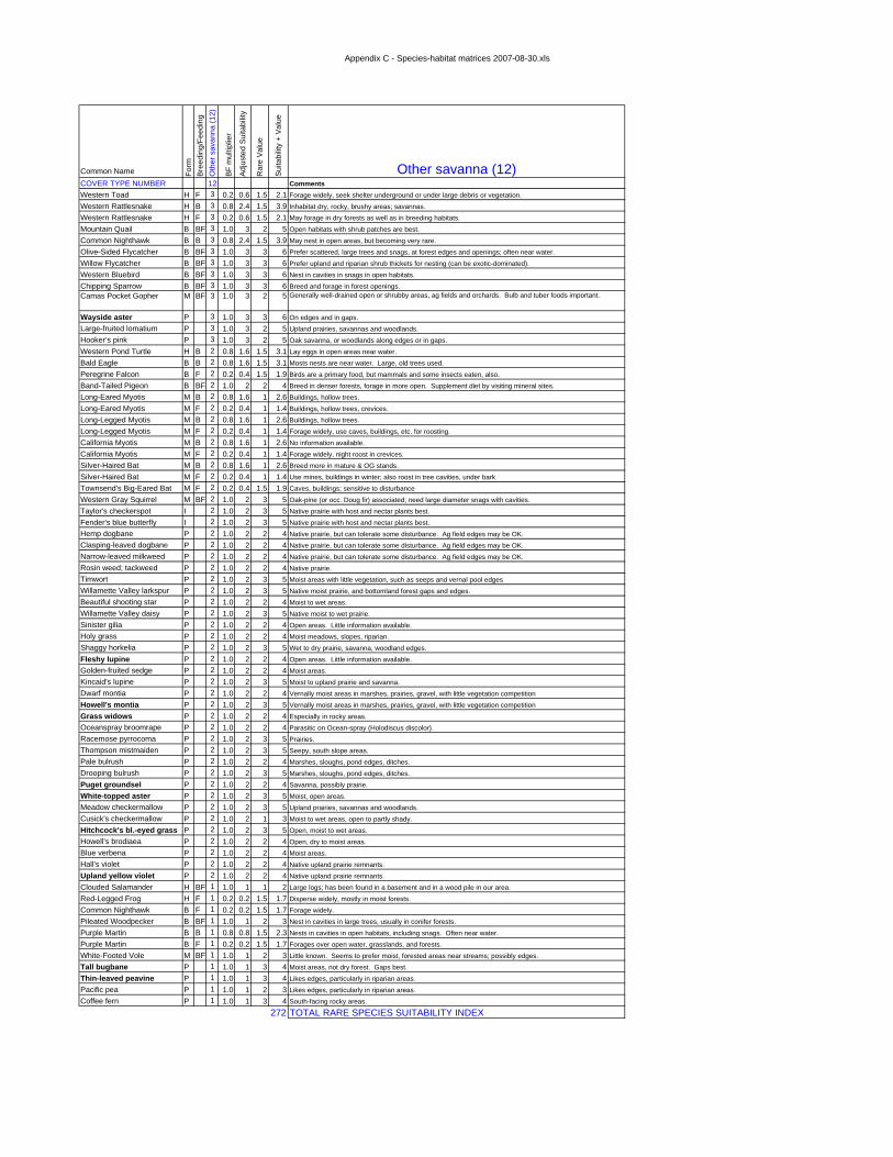
Appendix C - Species-habitat matrices 2007-08-30.xls
Common Name Form
Bree
ding
/Fee
ding
Oth
er s
avan
na (1
2)
BF m
ultip
lier
Adju
sted
Sui
tabi
lity
Rar
e Va
lue
Suita
bilit
y +
Valu
e
Other savanna (12)COVER TYPE NUMBER 12 CommentsWestern Toad H F 3 0.2 0.6 1.5 2.1 Forage widely, seek shelter underground or under large debris or vegetation.
Western Rattlesnake H B 3 0.8 2.4 1.5 3.9 Inhabitat dry, rocky, brushy areas; savannas.
Western Rattlesnake H F 3 0.2 0.6 1.5 2.1 May forage in dry forests as well as in breeding habitats.
Mountain Quail B BF 3 1.0 3 2 5 Open habitats with shrub patches are best.
Common Nighthawk B B 3 0.8 2.4 1.5 3.9 May nest in open areas, but becoming very rare.
Olive-Sided Flycatcher B BF 3 1.0 3 3 6 Prefer scattered, large trees and snags, at forest edges and openings; often near water.
Willow Flycatcher B BF 3 1.0 3 3 6 Prefer upland and riparian shrub thickets for nesting (can be exotic-dominated).
Western Bluebird B BF 3 1.0 3 3 6 Nest in cavities in snags in open habitats.
Chipping Sparrow B BF 3 1.0 3 3 6 Breed and forage in forest openings.Camas Pocket Gopher M BF 3 1.0 3 2 5 Generally well-drained open or shrubby areas, ag fields and orchards. Bulb and tuber foods important.
Wayside aster P 3 1.0 3 3 6 On edges and in gaps.Large-fruited lomatium P 3 1.0 3 2 5 Upland prairies, savannas and woodlands.Hooker’s pink P 3 1.0 3 2 5 Oak savanna, or woodlands along edges or in gaps.
Western Pond Turtle H B 2 0.8 1.6 1.5 3.1 Lay eggs in open areas near water.
Bald Eagle B B 2 0.8 1.6 1.5 3.1 Mosts nests are near water. Large, old trees used.
Peregrine Falcon B F 2 0.2 0.4 1.5 1.9 Birds are a primary food, but mammals and some insects eaten, also.
Band-Tailed Pigeon B BF 2 1.0 2 2 4 Breed in denser forests, forage in more open. Supplement diet by visiting mineral sites.
Long-Eared Myotis M B 2 0.8 1.6 1 2.6 Buildings, hollow trees.
Long-Eared Myotis M F 2 0.2 0.4 1 1.4 Buildings, hollow trees, crevices.
Long-Legged Myotis M B 2 0.8 1.6 1 2.6 Buildings, hollow trees.
Long-Legged Myotis M F 2 0.2 0.4 1 1.4 Forage widely, use caves, buildings, etc. for roosting.
California Myotis M B 2 0.8 1.6 1 2.6 No information available.
California Myotis M F 2 0.2 0.4 1 1.4 Forage widely, night roost in crevices.
Silver-Haired Bat M B 2 0.8 1.6 1 2.6 Breed more in mature & OG stands.
Silver-Haired Bat M F 2 0.2 0.4 1 1.4 Use mines, buildings in winter; also roost in tree cavities, under bark
Townsend's Big-Eared Bat M F 2 0.2 0.4 1.5 1.9 Caves, buildings; sensitive to disturbance
Western Gray Squirrel M BF 2 1.0 2 3 5 Oak-pine (or occ. Doug fir) associated; need large diameter snags with cavities.
Taylor's checkerspot I 2 1.0 2 3 5 Native prairie with host and nectar plants best.
Fender's blue butterfly I 2 1.0 2 3 5 Native prairie with host and nectar plants best.Hemp dogbane P 2 1.0 2 2 4 Native prairie, but can tolerate some disturbance. Ag field edges may be OK.Clasping-leaved dogbane P 2 1.0 2 2 4 Native prairie, but can tolerate some disturbance. Ag field edges may be OK.Narrow-leaved milkweed P 2 1.0 2 2 4 Native prairie, but can tolerate some disturbance. Ag field edges may be OK.Rosin weed; tackweed P 2 1.0 2 2 4 Native prairie.Timwort P 2 1.0 2 3 5 Moist areas with little vegetation, such as seeps and vernal pool edgesWillamette Valley larkspur P 2 1.0 2 3 5 Native moist prairie, and bottomland forest gaps and edges.Beautiful shooting star P 2 1.0 2 2 4 Moist to wet areas.Willamette Valley daisy P 2 1.0 2 3 5 Native moist to wet prairie.Sinister gilia P 2 1.0 2 2 4 Open areas. Little information available.Holy grass P 2 1.0 2 2 4 Moist meadows, slopes, riparian.Shaggy horkelia P 2 1.0 2 3 5 Wet to dry prairie, savanna, woodland edges.
Fleshy lupine P 2 1.0 2 2 4 Open areas. Little information available.Golden-fruited sedge P 2 1.0 2 2 4 Moist areas.Kincaid's lupine P 2 1.0 2 3 5 Moist to upland prairie and savanna.Dwarf montia P 2 1.0 2 2 4 Vernally moist areas in marshes, prairies, gravel, with little vegetation competition
Howell's montia P 2 1.0 2 3 5 Vernally moist areas in marshes, prairies, gravel, with little vegetation competition
Grass widows P 2 1.0 2 2 4 Especially in rocky areas.Oceanspray broomrape P 2 1.0 2 2 4 Parasitic on Ocean-spray (Holodiscus discolor).Racemose pyrrocoma P 2 1.0 2 3 5 Prairies.Thompson mistmaiden P 2 1.0 2 3 5 Seepy, south slope areas.Pale bulrush P 2 1.0 2 2 4 Marshes, sloughs, pond edges, ditches.Drooping bulrush P 2 1.0 2 3 5 Marshes, sloughs, pond edges, ditches.
Puget groundsel P 2 1.0 2 2 4 Savanna, possibly prairie.
White-topped aster P 2 1.0 2 3 5 Moist, open areas.Meadow checkermallow P 2 1.0 2 3 5 Upland prairies, savannas and woodlands.Cusick's checkermallow P 2 1.0 2 1 3 Moist to wet areas, open to partly shady.
Hitchcock's bl.-eyed grass P 2 1.0 2 3 5 Open, moist to wet areas.Howell’s brodiaea P 2 1.0 2 2 4 Open, dry to moist areas.Blue verbena P 2 1.0 2 2 4 Moist areas.Hall’s violet P 2 1.0 2 2 4 Native upland prairie remnants.
Upland yellow violet P 2 1.0 2 2 4 Native upland prairie remnants.
Clouded Salamander H BF 1 1.0 1 1 2 Large logs; has been found in a basement and in a wood pile in our area.
Red-Legged Frog H F 1 0.2 0.2 1.5 1.7 Disperse widely, mostly in moist forests.
Common Nighthawk B F 1 0.2 0.2 1.5 1.7 Forage widely.
Pileated Woodpecker B BF 1 1.0 1 2 3 Nest in cavities in large trees, usually in conifer forests.
Purple Martin B B 1 0.8 0.8 1.5 2.3 Nests in cavities in open habitats, including snags. Often near water.
Purple Martin B F 1 0.2 0.2 1.5 1.7 Forages over open water, grasslands, and forests.
White-Footed Vole M BF 1 1.0 1 2 3 Little known. Seems to prefer moist, forested areas near streams; possibly edges.
Tall bugbane P 1 1.0 1 3 4 Moist areas, not dry forest. Gaps best.
Thin-leaved peavine P 1 1.0 1 3 4 Likes edges, particularly in riparian areas.Pacific pea P 1 1.0 1 2 3 Likes edges, particularly in riparian areas.Coffee fern P 1 1.0 1 3 4 South-facing rocky areas.
272 TOTAL RARE SPECIES SUITABILITY INDEX

Appendix C - Species-habitat matrices 2007-08-30.xls
Common Name Form
Bree
ding
/Fee
ding
Oak
sav
anna
(13)
BF m
ultip
lier
Adju
sted
Sui
tabi
lity
Rar
e Va
lue
Suita
bilit
y +
Valu
e
Oak savanna (13)COVER TYPE NUMBER 13 CommentsWestern Pond Turtle H B 3 0.8 2.4 1.5 3.9 Lay eggs in open areas near water.Western Rattlesnake H B 3 0.8 2.4 1.5 3.9 Inhabitat dry, rocky, brushy areas; savannas; edited H for Type 24.Western Rattlesnake H F 3 0.2 0.6 1.5 2.1 May forage in dry forests as well as in breeding habitats; edited H for 24.Lewis' Woodpecker B BF 3 1.0 3 3 6 Oak-pine associated; need large diameter snags with cavities.Acorn Woodpecker B BF 3 1.0 3 3 6 Need stands with large oaks with some dead limbs, and open understory.White-Breasted Nuthatch B BF 3 1.0 3 3 6 Nest in cavities. Prefer larger Oregon white oaks.Western Bluebird B BF 3 1.0 3 3 6 Nest in cavities in snags in open habitats.Chipping Sparrow B BF 3 1.0 3 3 6 Breed and forage in forest openings.Vesper Sparrow B BF 3 1.0 3 3 6 Need grasslands with occasional shrubs for singing perches.Western Meadowlark B BF 3 1.0 3 3 6 Nest in short grass areas, but need patchiness with a few shrubs.Western Gray Squirrel M BF 3 1.0 3 3 6 Oak-pine (or occ. Doug fir) associated; need large diameter snags with cavities.Camas Pocket Gopher M BF 3 1.0 3 2 5 Generally well-drained open or shrubby areas, ag fields and orchards. Bulb and tuber foods important.Wayside aster P 3 1.0 3 3 6 On edges and in gaps.Thin-leaved peavine P 3 1.0 3 3 6 Likes edges, particularly in riparian areas.Pacific pea P 3 1.0 3 2 5 Likes edges, particularly in riparian areas.Large-fruited lomatium P 3 1.0 3 2 5 Upland prairies, savannas and woodlands.Hooker’s pink P 3 1.0 3 2 5 Oak savanna, or woodlands along edges or in gaps.Western Toad H F 2 0.2 0.4 1.5 1.9 Forage widely, seek shelter underground or under large debris or vegetation.Peregrine Falcon B F 2 0.2 0.4 1.5 1.9 Birds are a primary food, but mammals and some insects eaten, also.Band-Tailed Pigeon B BF 2 1.0 2 2 4 Breed in denser forests, forage in more open. Supplement diet by visiting mineral sites.Pileated Woodpecker B BF 2 1.0 2 2 4 Nest in cavities in large trees, usually in conifer forests.Yellow-Breasted Chat B BF 2 1.0 2 3 5 Nest in thickets near water.Long-Eared Myotis M B 2 0.8 1.6 1 2.6 Buildings, hollow trees.Long-Eared Myotis M F 2 0.2 0.4 1 1.4 Buildings, hollow trees, crevices.Long-Legged Myotis M B 2 0.8 1.6 1 2.6 Buildings, hollow trees.Long-Legged Myotis M F 2 0.2 0.4 1 1.4 Forage widely, use caves, buildings, etc. for roosting.California Myotis M B 2 0.8 1.6 1 2.6 No information available.California Myotis M F 2 0.2 0.4 1 1.4 Forage widely, night roost in crevices.Silver-Haired Bat M B 2 0.8 1.6 1 2.6 Breed more in mature & OG stands.Silver-Haired Bat M F 2 0.2 0.4 1 1.4 Use mines, buildings in winter; also roost in tree cavities, under barkTownsend's Big-Eared Bat M F 2 0.2 0.4 1.5 1.9 Caves, buildings; sensitive to disturbanceTaylor's checkerspot I 2 1.0 2 3 5 Native prairie with host and nectar plants best.Fender's blue butterfly I 2 1.0 2 3 5 Native prairie with host and nectar plants best.Hemp dogbane P 2 1.0 2 2 4 Native prairie, but can tolerate some disturbance. Ag field edges may be OK.Clasping-leaved dogbane P 2 1.0 2 2 4 Native prairie, but can tolerate some disturbance. Ag field edges may be OK.Narrow-leaved milkweed P 2 1.0 2 2 4 Native prairie, but can tolerate some disturbance. Ag field edges may be OK.Rosin weed; tackweed P 2 1.0 2 2 4 Native prairie.Timwort P 2 1.0 2 3 5 Moist areas with little vegetation, such as seeps and vernal pool edgesWillamette Valley larkspur P 2 1.0 2 3 5 Native moist prairie, and bottomland forest gaps and edges.Beautiful shooting star P 2 1.0 2 2 4 Moist to wet areas.Willamette Valley daisy P 2 1.0 2 3 5 Native moist to wet prairie.Sinister gilia P 2 1.0 2 2 4 Open areas. Little information available.Holy grass P 2 1.0 2 2 4 Moist meadows, slopes, riparian.Shaggy horkelia P 2 1.0 2 3 5 Wet to dry prairie, savanna, woodland edges.Fleshy lupine P 2 1.0 2 2 4 Open areas. Little information available.Golden-fruited sedge P 2 1.0 2 2 4 Moist areas.Kincaid's lupine P 2 1.0 2 3 5 Moist to upland prairie and savanna.Dwarf montia P 2 1.0 2 2 4 Vernally moist areas in marshes, prairies, gravel, with little vegetation competitionHowell's montia P 2 1.0 2 3 5 Vernally moist areas in marshes, prairies, gravel, with little vegetation competitionGrass widows P 2 1.0 2 2 4 Especially in rocky areas.Oceanspray broomrape P 2 1.0 2 2 4 Parasitic on Ocean-spray (Holodiscus discolor).Racemose pyrrocoma P 2 1.0 2 3 5 Prairies.Thompson mistmaiden P 2 1.0 2 3 5 Seepy, south slope areas.Pale bulrush P 2 1.0 2 2 4 Marshes, sloughs, pond edges, ditches.Drooping bulrush P 2 1.0 2 3 5 Marshes, sloughs, pond edges, ditches.Puget groundsel P 2 1.0 2 2 4 Savanna, possibly prairie.White-topped aster P 2 1.0 2 3 5 Moist, open areas.Meadow checkermallow P 2 1.0 2 3 5 Upland prairies, savannas and woodlands.Cusick's checkermallow P 2 1.0 2 1 3 Moist to wet areas, open to partly shady.Hitchcock's bl.-eyed grass P 2 1.0 2 3 5 Open, moist to wet areas.Howell’s brodiaea P 2 1.0 2 2 4 Open, dry to moist areas.Blue verbena P 2 1.0 2 2 4 Moist areas.Hall’s violet P 2 1.0 2 2 4 Native upland prairie remnants.Upland yellow violet P 2 1.0 2 2 4 Native upland prairie remnants.Clouded Salamander H BF 1 1.0 1 1 2 Large logs; has been found in a basement and in a wood pile in our area.Red-Legged Frog H F 1 0.2 0.2 1.5 1.7 Disperse widely, mostly in moist forests.Bald Eagle B B 1 0.8 0.8 1.5 2.3 Mosts nests are near water. Large, old trees used.Mountain Quail B BF 1 1.0 1 2 3 Open habitats with shrub patches are best.Common Nighthawk B B 1 0.8 0.8 1.5 2.3 May nest in open areas, but becoming very rare.Common Nighthawk B F 1 0.2 0.2 1.5 1.7 Forage widely.Olive-Sided Flycatcher B BF 1 1.0 1 3 4 Prefer scattered, large trees and snags, at forest edges and openings; often near water.Willow Flycatcher B BF 1 1.0 1 3 4 Prefer upland and riparian shrub thickets for nesting (can be exotic-dominated).Grasshopper Sparrow B BF 1 1.0 1 3 4 Need grasslands with occasional shrubs for singing perches.Brazilian Free-Tailed Bat M B 1 0.8 0.8 0.5 1.3 Caves, buildingsBrazilian Free-Tailed Bat M F 1 0.2 0.2 0.5 0.7 Caves, buildingsWhite-Footed Vole M BF 1 1.0 1 2 3 Little known. Seems to prefer moist, forested areas near streams; possibly edges.Tall bugbane P 1 1.0 1 3 4 Moist areas, not dry forest. Gaps best.Coffee fern P 1 1.0 1 3 4 South-facing rocky areas.
308 TOTAL RARE SPECIES SUITABILITY INDEX

Appendix C - Species-habitat matrices 2007-08-30.xls
Common Name Form
Bree
ding
/Fee
ding
Upl
and
shru
b (1
4)
BF m
ultip
lier
Adj
uste
d S
uita
bilit
y
Rar
e Va
lue
Sui
tabi
lity
+ V
alue
Upland shrub (14)COVER TYPE NUMBER 14 CommentsWestern Toad H F 3 0.2 0.6 1.5 2.1 Forage widely, seek shelter underground or under large debris or vegetation.Western Rattlesnake H F 3 0.2 0.6 1.5 2.1 May forage in dry forests as well as in breeding habitats.Willow Flycatcher B BF 3 1.0 3 3 6 Prefer upland and riparian shrub thickets for nesting (can be exotic-dominated).Yellow-Breasted Chat B BF 3 1.0 3 3 6 Nest in thickets near water.Chipping Sparrow B BF 3 1.0 3 3 6 Breed and forage in forest openings.Western Gray Squirrel M BF 3 1.0 3 3 6 Oak-pine (or occ. Doug fir) associated; need large diameter snags with cavities.Camas Pocket Gopher M BF 3 1.0 3 2 5 Generally well-drained open or shrubby areas, ag fields and orchards. Bulb and tuber foods important.Western Rattlesnake H B 3 0.8 2.4 1.5 3.9 Inhabitat dry, rocky, brushy areas; savannas.Peregrine Falcon B F 2 0.2 0.4 1.5 1.9 Birds are a primary food, but mammals and some insects eaten, also.Long-Eared Myotis M F 2 0.2 0.4 1 1.4 Buildings, hollow trees, crevices.Long-Legged Myotis M F 2 0.2 0.4 1 1.4 Forage widely, use caves, buildings, etc. for roosting.California Myotis M F 2 0.2 0.4 1 1.4 Forage widely, night roost in crevices.Brazilian Free-Tailed Bat M F 2 0.2 0.4 0.5 0.9 Caves, buildingsVesper Sparrow B BF 2 1.0 2 3 5 Need grasslands with occasional shrubs for singing perches.Western Pond Turtle H B 2 0.8 1.6 1.5 3.1 Lay eggs in open areas near water.Wayside aster P 2 1.0 2 3 5 On edges and in gaps.Oceanspray broomrape P 2 1.0 2 2 4 Parasitic on Ocean-spray (Holodiscus discolor).Red-Legged Frog H F 1 0.2 0.2 1.5 1.7 Disperse widely, mostly in moist forests.Common Nighthawk B F 1 0.2 0.2 1.5 1.7 Forage widely.Silver-Haired Bat M F 1 0.2 0.2 1 1.2 Use mines, buildings in winter; also roost in tree cavities, under barkTownsend's Big-Eared Bat M F 1 0.2 0.2 1.5 1.7 Caves, buildings; sensitive to disturbanceMountain Quail B BF 1 1.0 1 2 3 Open habitats with shrub patches are best.White-Breasted Nuthatch B BF 1 1.0 1 3 4 Nest in cavities. Prefer larger Oregon white oaks.Western Bluebird B BF 1 1.0 1 3 4 Nest in cavities in snags in open habitats.Western Meadowlark B BF 1 1.0 1 3 4 Nest in short grass areas, but need patchiness with a few shrubs.White-Footed Vole M BF 1 1.0 1 2 3 Little known. Seems to prefer moist, forested areas near streams; possibly edges.Long-Eared Myotis M B 1 0.8 0.8 1 1.8 Buildings, hollow trees.Long-Legged Myotis M B 1 0.8 0.8 1 1.8 Buildings, hollow trees.California Myotis M B 1 0.8 0.8 1 1.8 No information available.Brazilian Free-Tailed Bat M B 1 0.8 0.8 0.5 1.3 Caves, buildingsCoffee fern P 1 1.0 1 3 4 South-facing rocky areas.
96 TOTAL RARE SPECIES SUITABILITY INDEX

Appendix C - Species-habitat matrices 2007-08-30.xls
Common Name Form
Bree
ding
/Fee
ding
Wet
land
shr
ub (1
5)
BF m
ultip
lier
Adju
sted
Sui
tabi
lity
Rar
e Va
lue
Suita
bilit
y +
Valu
e
Wetland shrub (15)COVER TYPE NUMBER 15 CommentsWestern Toad H F 3 0.2 0.6 1.5 2.1 Forage widely, seek shelter underground or under large debris or vegetation.Red-Legged Frog H B 3 0.8 2.4 1.5 3.9 Breed in shallow ponds with winter sun exposure and submerged vegetation.Red-Legged Frog H F 3 0.2 0.6 1.5 2.1 Disperse widely, mostly in moist forests.Willow Flycatcher B BF 3 1.0 3 3 6 Prefer upland and riparian shrub thickets for nesting (can be exotic-dominated).Yellow-Breasted Chat B BF 3 1.0 3 3 6 Nest in thickets near water.Long-Eared Myotis M F 3 0.2 0.6 1 1.6 Buildings, hollow trees, crevices.Long-Legged Myotis M F 3 0.2 0.6 1 1.6 Forage widely, use caves, buildings, etc. for roosting.California Myotis M F 3 0.2 0.6 1 1.6 Forage widely, night roost in crevices.Brazilian Free-Tailed Bat M F 3 0.2 0.6 0.5 1.1 Caves, buildingsWestern Pond Turtle H F 2 0.2 0.4 1.5 1.9 Bask and eat vegetation in ponds, sloughs, etc.Peregrine Falcon B F 2 0.2 0.4 1.5 1.9 Birds are a primary food, but mammals and some insects eaten, also.Wayside aster P 2 1.0 2 3 5 On edges and in gaps.Western Rattlesnake H F 1 0.2 0.2 1.5 1.7 May forage in dry forests as well as in breeding habitats.Bald Eagle B F 1 0.2 0.2 1.5 1.7 Fish are most important element of diet, but many other things are consumed.Common Nighthawk B F 1 0.2 0.2 1.5 1.7 Forage widely.Purple Martin B F 1 0.2 0.2 1.5 1.7 Forages over open water, grasslands, and forests.Western Bluebird B BF 1 1.0 1 3 4 Nest in cavities in snags in open habitats.Long-Eared Myotis M B 1 0.8 0.8 1 1.8 Buildings, hollow trees.Long-Legged Myotis M B 1 0.8 0.8 1 1.8 Buildings, hollow trees.California Myotis M B 1 0.8 0.8 1 1.8 No information available.Silver-Haired Bat M F 1 0.2 0.2 1 1.2 Use mines, buildings in winter; also roost in tree cavities, under barkTownsend's Big-Eared Bat M F 1 0.2 0.2 1.5 1.7 Caves, buildings; sensitive to disturbanceBrazilian Free-Tailed Bat M B 1 0.8 0.8 0.5 1.3 Caves, buildingsCamas Pocket Gopher M BF 1 1.0 1 2 3 Generally well-drained open or shrubby areas, ag fields and orchards. Bulb and tuber foods important.
Coffee fern P 1 1.0 1 3 4 South-facing rocky areas.
62 TOTAL RARE SPECIES SUITABILITY INDEX

Appendix C - Species-habitat matrices 2007-08-30.xls
Common Name Form
Bre
edin
g/Fe
edin
gO
rcha
rds
(17)
BF
mul
tiplie
r
Adj
uste
d S
uita
bilit
y
Rar
e V
alue
Sui
tabi
lity
+ V
alue
Orchards (17)COVER TYPE NUMBER 17 CommentsChipping Sparrow B BF 2 1.0 2 3 5 Breed and forage in forest openings.Camas Pocket Gopher M BF 2 1.0 2 2 4 Generally well-drained open or shrubby areas, ag fields and orchards. Bulb and tuber foods important.
Western Rattlesnake H F 1 0.2 0.2 1.5 1.7 May forage in dry forests as well as in breeding habitats.Mountain Quail B BF 1 1.0 1 2 3 Open habitats with shrub patches are best.Common Nighthawk B F 1 0.2 0.2 1.5 1.7 Forage widely.Acorn Woodpecker B BF 1 1.0 1 3 4 Need stands with large oaks with some dead limbs, and open understory.Pileated Woodpecker B BF 1 1.0 1 2 3 Nest in cavities in large trees, usually in conifer forests.Western Bluebird B BF 1 1.0 1 3 4 Nest in cavities in snags in open habitats.Long-Eared Myotis M F 1 0.2 0.2 1 1.2 Buildings, hollow trees, crevices.Long-Legged Myotis M F 1 0.2 0.2 1 1.2 Forage widely, use caves, buildings, etc. for roosting.California Myotis M F 1 0.2 0.2 1 1.2 Forage widely, night roost in crevices.Silver-Haired Bat M F 1 0.2 0.2 1 1.2 Use mines, buildings in winter; also roost in tree cavities, under barkTownsend's Big-Eared Bat M F 1 0.2 0.2 1.5 1.7 Caves, buildings; sensitive to disturbanceBrazilian Free-Tailed Bat M F 1 0.2 0.2 0.5 0.7 Caves, buildingsWestern Gray Squirrel M BF 1 1.0 1 3 4 Oak-pine (or occ. Doug fir) associated; need large diameter snags with cavities.
38 TOTAL RARE SPECIES SUITABILITY INDEX

Appendix C - Species-habitat matrices 2007-08-30.xls
Common Name Form
Bre
edin
g/Fe
edin
gS
hort
gras
s (2
0)
BF
mul
tiplie
r
Adj
uste
d S
uita
bilit
y
Rar
e V
alue
Sui
tabi
lity
+ V
alue
Short grass (20)COVER TYPE NUMBER 20 CommentsCamas Pocket Gopher M BF 2 1.0 2 2 4 Generally well-drained open or shrubby areas, ag fields and orchards. Bulb and tuber foods important.
Western Pond Turtle H B 2 0.8 1.6 1.5 3.1 Lay eggs in open areas near water.Bald Eagle B F 1 0.2 0.2 1.5 1.7 Fish are most important element of diet, but many other things are consumed.Common Nighthawk B F 1 0.2 0.2 1.5 1.7 Forage widely.Long-Eared Myotis M F 1 0.2 0.2 1 1.2 Buildings, hollow trees, crevices.Long-Legged Myotis M F 1 0.2 0.2 1 1.2 Forage widely, use caves, buildings, etc. for roosting.California Myotis M F 1 0.2 0.2 1 1.2 Forage widely, night roost in crevices.Silver-Haired Bat M F 1 0.2 0.2 1 1.2 Use mines, buildings in winter; also roost in tree cavities, under barkTownsend's Big-Eared Bat M F 1 0.2 0.2 1.5 1.7 Caves, buildings; sensitive to disturbanceBrazilian Free-Tailed Bat M F 1 0.2 0.2 0.5 0.7 Caves, buildingsHorned Lark B BF 1 1.0 1 3 4 Nest in bare ground patches in short grassy habitats.Western Bluebird B BF 1 1.0 1 3 4 Nest in cavities in snags in open habitats.Western Gray Squirrel M BF 1 1.0 1 3 4 Oak-pine (or occ. Doug fir) associated; need large diameter snags with cavities.
30 TOTAL RARE SPECIES SUITABILITY INDEX

Appendix C - Species-habitat matrices 2007-08-30.xls
Common Name Form
Bree
ding
/Fee
ding
Nat
ural
gra
ss (2
1)
BF m
ultip
lier
Adj
uste
d S
uita
bilit
y
Rar
e Va
lue
Sui
tabi
lity
+ V
alue
Natural grass (21)COVER TYPE NUMBER 21 CommentsRed-Legged Frog H F 3 0.2 0.6 1.5 2.1 Disperse widely, mostly in moist forests.Western Pond Turtle H B 3 0.8 2.4 1.5 3.9 Lay eggs in open areas near water.Horned Lark B BF 3 1.0 3 3 6 Nest in bare ground patches in short grassy habitats.Vesper Sparrow B BF 3 1.0 3 3 6 Need grasslands with occasional shrubs for singing perches.Grasshopper Sparrow B BF 3 1.0 3 3 6 Need grasslands with occasional shrubs for singing perches.Western Meadowlark B BF 3 1.0 3 3 6 Nest in short grass areas, but need patchiness with a few shrubs.Camas Pocket Gopher M BF 3 1.0 3 2 5 Generally well-drained open or shrubby areas, ag fields and orchards. Bulb and tuber foods important.Taylor's checkerspot I 3 1.0 3 3 6 Native prairie with host and nectar plants best.Fender's blue butterfly I 3 1.0 3 3 6 Native prairie with host and nectar plants best.Hemp dogbane P 3 1.0 3 2 5 Native prairie, but can tolerate some disturbance. Ag field edges may be OK.Clasping-leaved dogbane P 3 1.0 3 2 5 Native prairie, but can tolerate some disturbance. Ag field edges may be OK.Narrow-leaved milkweed P 3 1.0 3 2 5 Native prairie, but can tolerate some disturbance. Ag field edges may be OK.Rosin weed; tackweed P 3 1.0 3 2 5 Native prairie.Timwort P 3 1.0 3 3 6 Moist areas with little vegetation, such as seeps and vernal pool edgesWillamette Valley larkspur P 3 1.0 3 3 6 Native moist prairie, and bottomland forest gaps and edges.Beautiful shooting star P 3 1.0 3 2 5 Moist to wet areas.Willamette Valley daisy P 3 1.0 3 3 6 Native moist to wet prairie.Sinister gilia P 3 1.0 3 2 5 Open areas. Little information available.Holy grass P 3 1.0 3 2 5 Moist meadows, slopes, riparian.Shaggy horkelia P 3 1.0 3 3 6 Wet to dry prairie, savanna, woodland edges.Bradshaw's lomatium P 3 1.0 3 3 6 Wet prairies.Large-fruited lomatium P 3 1.0 3 2 5 Upland prairies, savannas and woodlands.Fleshy lupine P 3 1.0 3 2 5 Open areas. Little information available.Golden-fruited sedge P 3 1.0 3 2 5 Moist areas.Kincaid's lupine P 3 1.0 3 3 6 Moist to upland prairie and savanna.Dwarf montia P 3 1.0 3 2 5 Vernally moist areas in marshes, prairies, gravel, with little vegetation competitionHowell's montia P 3 1.0 3 3 6 Vernally moist areas in marshes, prairies, gravel, with little vegetation competitionGrass widows P 3 1.0 3 2 5 Especially in rocky areas.Racemose pyrrocoma P 3 1.0 3 3 6 Prairies.Thompson mistmaiden P 3 1.0 3 3 6 Seepy, south slope areas.Pale bulrush P 3 1.0 3 2 5 Marshes, sloughs, pond edges, ditches.Drooping bulrush P 3 1.0 3 3 6 Marshes, sloughs, pond edges, ditches.White-topped aster P 3 1.0 3 3 6 Moist, open areas.Meadow checkermallow P 3 1.0 3 3 6 Upland prairies, savannas and woodlands.Cusick's checkermallow P 3 1.0 3 1 4 Moist to wet areas, open to partly shady.Hitchcock's bl.-eyed grass P 3 1.0 3 3 6 Open, moist to wet areas.Howell’s brodiaea P 3 1.0 3 2 5 Open, dry to moist areas.Hall’s violet P 3 1.0 3 2 5 Native upland prairie remnants.Upland yellow violet P 3 1.0 3 2 5 Native upland prairie remnants.Western Rattlesnake H B 2 0.8 1.6 1.5 3.1 Inhabitat dry, rocky, brushy areas; savannas.Western Rattlesnake H F 2 0.2 0.4 1.5 1.9 May forage in dry forests as well as in breeding habitats.Blue verbena P 2 1.0 2 2 4 Moist areas.Common Nighthawk B F 1 0.2 0.2 1.5 1.7 Forage widely.Western Bluebird B BF 1 1.0 1 3 4 Nest in cavities in snags in open habitats.Long-Eared Myotis M F 1 0.2 0.2 1 1.2 Buildings, hollow trees, crevices.Long-Legged Myotis M F 1 0.2 0.2 1 1.2 Forage widely, use caves, buildings, etc. for roosting.California Myotis M F 1 0.2 0.2 1 1.2 Forage widely, night roost in crevices.Silver-Haired Bat M F 1 0.2 0.2 1 1.2 Use mines, buildings in winter; also roost in tree cavities, under barkTownsend's Big-Eared Bat M F 1 0.2 0.2 1.5 1.7 Caves, buildings; sensitive to disturbanceBrazilian Free-Tailed Bat M F 1 0.2 0.2 0.5 0.7 Caves, buildingsThin-leaved peavine P 1 1.0 1 3 4 Likes edges, particularly in riparian areas.Coffee fern P 1 1.0 1 3 4 South-facing rocky areas.Puget groundsel P 1 1.0 1 2 3 Savanna, possibly prairie.Hooker’s pink P 1 1.0 1 2 3 Oak savanna, or woodlands along edges or in gaps.
245 TOTAL RARE SPECIES SUITABILITY INDEX
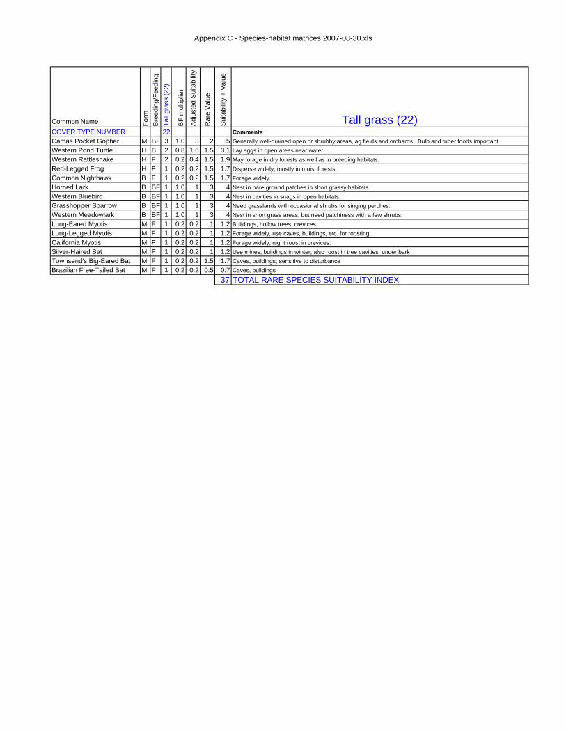
Appendix C - Species-habitat matrices 2007-08-30.xls
Common Name Form
Bre
edin
g/Fe
edin
gTa
ll gr
ass
(22)
BF
mul
tiplie
r
Adj
uste
d S
uita
bilit
y
Rar
e V
alue
Sui
tabi
lity
+ V
alue
Tall grass (22)COVER TYPE NUMBER 22 CommentsCamas Pocket Gopher M BF 3 1.0 3 2 5 Generally well-drained open or shrubby areas, ag fields and orchards. Bulb and tuber foods important.Western Pond Turtle H B 2 0.8 1.6 1.5 3.1 Lay eggs in open areas near water.Western Rattlesnake H F 2 0.2 0.4 1.5 1.9 May forage in dry forests as well as in breeding habitats.Red-Legged Frog H F 1 0.2 0.2 1.5 1.7 Disperse widely, mostly in moist forests.Common Nighthawk B F 1 0.2 0.2 1.5 1.7 Forage widely.Horned Lark B BF 1 1.0 1 3 4 Nest in bare ground patches in short grassy habitats.Western Bluebird B BF 1 1.0 1 3 4 Nest in cavities in snags in open habitats.Grasshopper Sparrow B BF 1 1.0 1 3 4 Need grasslands with occasional shrubs for singing perches.Western Meadowlark B BF 1 1.0 1 3 4 Nest in short grass areas, but need patchiness with a few shrubs.Long-Eared Myotis M F 1 0.2 0.2 1 1.2 Buildings, hollow trees, crevices.Long-Legged Myotis M F 1 0.2 0.2 1 1.2 Forage widely, use caves, buildings, etc. for roosting.California Myotis M F 1 0.2 0.2 1 1.2 Forage widely, night roost in crevices.Silver-Haired Bat M F 1 0.2 0.2 1 1.2 Use mines, buildings in winter; also roost in tree cavities, under barkTownsend's Big-Eared Bat M F 1 0.2 0.2 1.5 1.7 Caves, buildings; sensitive to disturbanceBrazilian Free-Tailed Bat M F 1 0.2 0.2 0.5 0.7 Caves, buildings
37 TOTAL RARE SPECIES SUITABILITY INDEX
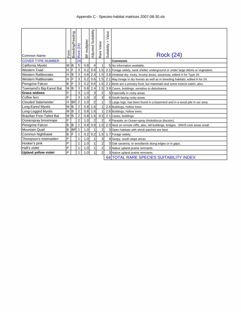
Appendix C - Species-habitat matrices 2007-08-30.xls
Common Name Form
Bree
ding
/Fee
ding
Roc
k (2
4)
BF m
ultip
lier
Adju
sted
Sui
tabi
lity
Rar
e Va
lue
Suita
bilit
y +
Valu
e
Rock (24)COVER TYPE NUMBER 24 CommentsCalifornia Myotis M B 5 0.8 4 1 5 No information available.Western Toad H F 3 0.2 0.6 1.5 2.1 Forage widely, seek shelter underground or under large debris or vegetation.Western Rattlesnake H B 3 0.8 2.4 1.5 3.9 Inhabitat dry, rocky, brushy areas; savannas; edited H for Type 24.Western Rattlesnake H F 3 0.2 0.6 1.5 2.1 May forage in dry forests as well as in breeding habitats; edited H for 24.Peregrine Falcon B F 3 0.2 0.6 1.5 2.1 Birds are a primary food, but mammals and some insects eaten, also.Townsend's Big-Eared Bat M B 3 0.8 2.4 1.5 3.9 Caves, buildings; sensitive to disturbanceGrass widows P 3 1.0 3 2 5 Especially in rocky areas.Coffee fern P 3 1.0 3 3 6 South-facing rocky areas.Clouded Salamander H BF 2 1.0 2 1 3 Large logs; has been found in a basement and in a wood pile in our area.Long-Eared Myotis M B 2 0.8 1.6 1 2.6 Buildings, hollow trees.Long-Legged Myotis M B 2 0.8 1.6 1 2.6 Buildings, hollow trees.Brazilian Free-Tailed Bat M B 2 0.8 1.6 0.5 2.1 Caves, buildingsOceanspray broomrape P 2 1.0 2 2 4 Parasitic on Ocean-spray (Holodiscus discolor).Peregrine Falcon B B 1 0.8 0.8 1.5 2.3 Nest on remote cliffs; also, tall buildings, bridges. SRHS rock areas small.Mountain Quail B BF 1 1.0 1 2 3 Open habitats with shrub patches are best.Common Nighthawk B F 1 0.2 0.2 1.5 1.7 Forage widely.Thompson's mistmaiden P 1 1.0 1 3 4 Seepy, south slope areas.Hooker’s pink P 1 1.0 1 2 3 Oak savanna, or woodlands along edges or in gaps.Hall’s violet P 1 1.0 1 2 3 Native upland prairie remnants.Upland yellow violet P 1 1.0 1 2 3 Native upland prairie remnants.
64 TOTAL RARE SPECIES SUITABILITY INDEX

Appendix C - Species-habitat matrices 2007-08-30.xls
Common Name Form
Bre
edin
g/Fe
edin
gS
easo
nal w
etla
nds
(26)
BF
mul
tiplie
r
Adj
uste
d S
uita
bilit
y
Rar
e V
alue
Sui
tabi
lity
+ V
alue
Seasonal wetlands (26)COVER TYPE NUMBER 26 CommentsRed-Legged Frog H B 3 0.8 2.4 1.5 3.9 Breed in shallow ponds with winter sun exposure and submerged vegetation.Western Pond Turtle H F 3 0.2 0.6 1.5 2.1 Bask and eat vegetation in ponds, sloughs, etc.Common Nighthawk B F 3 0.2 0.6 1.5 2.1 Forage widely.Purple Martin B F 3 0.2 0.6 1.5 2.1 Forages over open water, grasslands, and forests.Long-Eared Myotis M F 3 0.2 0.6 1 1.6 Buildings, hollow trees, crevices.Long-Legged Myotis M F 3 0.2 0.6 1 1.6 Forage widely, use caves, buildings, etc. for roosting.California Myotis M F 3 0.2 0.6 1 1.6 Forage widely, night roost in crevices.Silver-Haired Bat M F 3 0.2 0.6 1 1.6 Use mines, buildings in winter; also roost in tree cavities, under barkTownsend's Big-Eared Bat M F 3 0.2 0.6 1.5 2.1 Caves, buildings; sensitive to disturbanceBrazilian Free-Tailed Bat M F 3 0.2 0.6 0.5 1.1 Caves, buildingsDotted smartweed P 3 1.0 3 2 5 Wet areas.Pale bulrush P 3 1.0 3 2 5 Marshes, sloughs, pond edges, ditches.Drooping bulrush P 3 1.0 3 3 6 Marshes, sloughs, pond edges, ditches.Blue verbena P 3 1.0 3 2 5 Moist areas.Western Toad H F 2 0.2 0.4 1.5 1.9 Forage widely, seek shelter underground or under large debris or vegetation.Bald Eagle B F 2 0.2 0.4 1.5 1.9 Fish are most important element of diet, but many other things are consumed.Peregrine Falcon B F 2 0.2 0.4 1.5 1.9 Birds are a primary food, but mammals and some insects eaten, also.Horned Lark B BF 2 1.0 2 3 5 Nest in bare ground patches in short grassy habitats.Toothcup P 2 1.0 2 3 5 Aquatic, most visible on mud when water recedes in late summer.Dotted water-meal P 2 1.0 2 3 5 Marshes, sloughs, pond edgesColumbia water-meal P 2 1.0 2 3 5 Marshes, sloughs, pond edgesWestern Toad H B 1 0.8 0.8 1.5 2.3 Lay eggs in ponds or lakes.Red-Legged Frog H F 1 0.2 0.2 1.5 1.7 Disperse widely, mostly in moist forests.Grasshopper Sparrow B BF 1 1.0 1 3 4 Need grasslands with occasional shrubs for singing perches.Western Meadowlark B BF 1 1.0 1 3 4 Nest in short grass areas, but need patchiness with a few shrubs.Camas Pocket Gopher M BF 1 1.0 1 2 3 Generally well-drained open or shrubby areas, ag fields and orchards. Bulb and tuber foods important.
82 TOTAL RARE SPECIES SUITABILITY INDEX

Appendix C - Species-habitat matrices 2007-08-30.xls
Common Name Form
Bree
ding
/Fee
ding
Perm
anen
t wat
er (2
7)
BF
mul
tiplie
r
Adj
uste
d S
uita
bilit
y
Rar
e V
alue
Sui
tabi
lity
+ V
alue
Permanent water (27)COVER TYPE NUMBER 27 CommentsWestern Toad H B 3 0.8 2.4 1.5 3.9 Lay eggs in ponds or lakes.Western Toad H F 3 0.2 0.6 1.5 2.1 Forage widely, seek shelter underground or under large debris or vegetation.Red-Legged Frog H B 3 0.8 2.4 1.5 3.9 Breed in shallow ponds with winter sun exposure and submerged vegetation.Red-Legged Frog H F 3 0.2 0.6 1.5 2.1 Disperse widely, mostly in moist forests.Western Pond Turtle H F 3 0.2 0.6 1.5 2.1 Bask and eat vegetation in ponds, sloughs, etc.Bald Eagle B F 3 0.2 0.6 1.5 2.1 Fish are most important element of diet, but many other things are consumed.Common Nighthawk B F 3 0.2 0.6 1.5 2.1 Forage widely.Purple Martin B F 3 0.2 0.6 1.5 2.1 Forages over open water, grasslands, and forests.Long-Eared Myotis M F 3 0.2 0.6 1 1.6 Buildings, hollow trees, crevices.Long-Legged Myotis M F 3 0.2 0.6 1 1.6 Forage widely, use caves, buildings, etc. for roosting.California Myotis M F 3 0.2 0.6 1 1.6 Forage widely, night roost in crevices.Silver-Haired Bat M F 3 0.2 0.6 1 1.6 Use mines, buildings in winter; also roost in tree cavities, under barkTownsend's Big-Eared Bat M F 3 0.2 0.6 1.5 2.1 Caves, buildings; sensitive to disturbanceBrazilian Free-Tailed Bat M F 3 0.2 0.6 0.5 1.1 Caves, buildingshowellia P 3 1.0 3 3 6 Aquatic, most visible on mud when water recedes in late summer.Dotted smartweed P 3 1.0 3 2 5 Wet areas.Toothcup P 3 1.0 3 3 6 Aquatic, most visible on mud when water recedes in late summer.Dotted water-meal P 3 1.0 3 3 6 Marshes, sloughs, pond edgesColumbia water-meal P 3 1.0 3 3 6 Marshes, sloughs, pond edgesPeregrine Falcon B F 2 0.2 0.4 1.5 1.9 Birds are a primary food, but mammals and some insects eaten, also.Purple Martin B B 2 0.8 1.6 1.5 3.1 Nests in cavities in open habitats, including snags. Often near water.Pale bulrush P 2 1.0 2 2 4 Marshes, sloughs, pond edges, ditches.Drooping bulrush P 2 1.0 2 3 5 Marshes, sloughs, pond edges, ditches.Blue verbena P 1 1.0 1 2 3 Moist areas.
76 TOTAL RARE SPECIES SUITABILITY INDEX
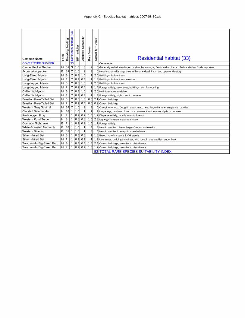
Appendix C - Species-habitat matrices 2007-08-30.xls
Common Name Form
Bre
edin
g/Fe
edin
gR
esid
entia
l hab
itat (
33)
BF
mul
tiplie
r
Adj
uste
d S
uita
bilit
y
Rar
e V
alue
Sui
tabi
lity
+ V
alue
Residential habitat (33)COVER TYPE NUMBER 33 CommentsCamas Pocket Gopher M BF 3 1.0 3 2 5 Generally well-drained open or shrubby areas, ag fields and orchards. Bulb and tuber foods important.Acorn Woodpecker B BF 2 1.0 2 3 5 Need stands with large oaks with some dead limbs, and open understory.Long-Eared Myotis M B 2 0.8 1.6 1 2.6 Buildings, hollow trees.Long-Eared Myotis M F 2 0.2 0.4 1 1.4 Buildings, hollow trees, crevices.Long-Legged Myotis M B 2 0.8 1.6 1 2.6 Buildings, hollow trees.Long-Legged Myotis M F 2 0.2 0.4 1 1.4 Forage widely, use caves, buildings, etc. for roosting.California Myotis M B 2 0.8 1.6 1 2.6 No information available.California Myotis M F 2 0.2 0.4 1 1.4 Forage widely, night roost in crevices.Brazilian Free-Tailed Bat M B 2 0.8 1.6 0.5 2.1 Caves, buildingsBrazilian Free-Tailed Bat M F 2 0.2 0.4 0.5 0.9 Caves, buildingsWestern Gray Squirrel M BF 2 1.0 2 3 5 Oak-pine (or occ. Doug fir) associated; need large diameter snags with cavities.Clouded Salamander H BF 1 1.0 1 1 2 Large logs; has been found in a basement and in a wood pile in our area.Red-Legged Frog H F 1 0.2 0.2 1.5 1.7 Disperse widely, mostly in moist forests.Western Pond Turtle H B 1 0.8 0.8 1.5 2.3 Lay eggs in open areas near water.Common Nighthawk B F 1 0.2 0.2 1.5 1.7 Forage widely.White-Breasted Nuthatch B BF 1 1.0 1 3 4 Nest in cavities. Prefer larger Oregon white oaks.Western Bluebird B BF 1 1.0 1 3 4 Nest in cavities in snags in open habitats.Silver-Haired Bat M B 1 0.8 0.8 1 1.8 Breed more in mature & OG stands.Silver-Haired Bat M F 1 0.2 0.2 1 1.2 Use mines, buildings in winter; also roost in tree cavities, under barkTownsend's Big-Eared Bat M B 1 0.8 0.8 1.5 2.3 Caves, buildings; sensitive to disturbanceTownsend's Big-Eared Bat M F 1 0.2 0.2 1.5 1.7 Caves, buildings; sensitive to disturbance
53 TOTAL RARE SPECIES SUITABILITY INDEX

Salix Associates 2525 Potter, Eugene, OR 97405 $ 541.343.2364 $ fax 541.341.1752
Invasive Exotic Plants of the
South Ridgeline Study Area 15 June 2006
Invasive Exotic Plant Species tend to form monocultures, or become dominant with 20% cover or more within a short time in any plant community. There likely will be a few additional species that could be listed here, as this is meant not to be an exhaustive list, but a list of the most common invasive species. Also, some species may grow in other habitats than the one they are listed under (i.e., Armenian blackberry grows in all these habitats). IMPORTANT NOTE: The first group (in italics, below) is so widely established, there is no need to list them individually on a field data sheet under” Invasives” in the herb layer section. Instead, merely list “SPI” for “Standard Prairie Invasives.” I. SPECIES OF PRAIRIE/MEADOW, SAVANNA & WOODLAND HABITATS
(UPLAND TO MESIC) Invasives – Herbs (established: do not list!) Common name Agrostis: capillaris, stolonifera Bentgrass: colonial, creeping Aira caryophyllea var. caryophyllea Silver hairgrass (tiny; often beneath other
plants) Anthoxanthum odorata Sweet vernalgrass Bromus: diandrus, hordeaceus, secalinus, sterilis Brome: ripgut, soft, rye, sterile Cynosurus echinatus Hedgehog dogtail Dactylis glomerata orchardgrass Daucus carota Queen Anne’s Lace, wild carrot Festuca arundinacea Tall fescue Geranium: dissectum, molle Geranium: cutleaf, soft Hypochaeris radicata False dandelion, cat’s ear Leucanthemum vulgare Oxeye daisy Taeniatherum caput-medusae medusahead Vicia: cracca, hirsuta, sativa, tetrasperma Cat peas, hairy vetch, common vetch,
slender vetch Invasives – Shrubs (established) Common name Cytisus scoparius Scot’s broom Rosa eglanteria; multiflora Rose: sweetbriar, multiflora Rubus armeniacus Armenian blackberry (aka Himalaya
blackberry) Rubus laciniatus Evergreen blackberry Invasives – herbs & shrubs (new invaders) Common name Arrhenatherum elatius Tall oatgrass Brachypodium sylvaticum False brome Lathyrus: latifolius, sylvestris Perennial sweetpea, narrowleaf pea Cotoneaster, Pyracantha, Ligustrum, Prunus, Pyrus
Ornamental shrubs/trees: cotoneasters, pyracanthas, privets, cherries, pear

Salix Associates 2525 Potter, Eugene, OR 97405 $ 541.343.2364 $ fax 541.341.1752
II. SPECIES OF PRAIRIE/MEADOW, SAVANNA & OPEN WOODLAND
HABITATS (MESIC TO WETLAND) Invasives – Herbs (Established) Common name Cirsium arvense Canada thistle Holcus lanatus Velvetgrass Parentucellia viscosa Parentucellia Phalaris arundinacea Reed canarygrass
III. SPECIES OF FOREST HABITATS Invasives – Herbs (established) Common name Hedera helix/hibernica English/Irish ivy Lactuca muralis Wall lettuce Lapsana communis Nipplewort Melissa officinalis Lemon mint Ranunculus repens Creeping buttercup Invasives – Herbs (new invaders) Common name Brachypodium sylvaticum False brome Geranium: lucidum, robertianum Geranium: shining, Robert’s (aka stinky Bob) Invasives – Shrubs (new invaders) Common name Daphne laureola Spurge laurel Ilex aquifolium English holly Prunus: laurocerasus, lusitanica Laurel: English, Portugal Invasives – Trees (new invaders) Common name Acer platanoides Norway maple Aesculus hippocastanum horsechestnut Prunus avium Sweet (or Mazzard or bird) cherry Prunus domestica, cerasifera Plum: garden, Thundercloud Umbellularia californica California bay laurel

Salix Associates ● 2006
SRHS Vegetation Mapping Unit Inventory Form HAU: [2] V-Map Unit: [2]
2006 veg cover: [21] 1936 veg cover: [10] 1850 veg cover: [10]
HAU#: [2] Polygon: [2] Observer: [2] Date: [8]
Method On-Site: [1] Off-Site, View: [1] Off-Site, No View: [1]
Acreage: [2] UTM WGS84 Zone 10T:Centroid: [6] mECentroid : [7] mN Ref HAU/VMU#: [4]
LAYER TOT Evrg Dec Nat Exot Species Species Tree: [4] [6] [6] [6] [6] [20] [2]” dbh avg [20] [2]” dbh avg [20] [2]” dbh avg [20] [2]” dbh avg Shrub: [4] [6] [6] [6] [6] [20] [20] [20] [20] Herb: [4] [6] [6] [6] [6] [20] [20]
[20] [20] [20] [20] Additional herbs: [20] [20]
Invasv [20] [20] [20] Invasv [20] [20] [20] Invasv [20] [20] [20] Invasv [20] [20] [20] RECENT DISTURBANCE (earthwork, logging, herbicides, grazing, etc.): [6]
KNOWN UNCOMMON AND RARE SPECIES OCCURRENCES [24] [24] [24] [24] [24]
SPECIFIC PIWO/RLF DETECTION & HABITAT FEATURES
Pileated Woodpecker: Red-legged Frog: aquatic (breeding)
Red-legged Frog: terrestrial (foraging/dispersal)
Visual detection [1] Visual detection [1] Forested upland [1]Aural detection [1] Stillwater wetland [1] If yes, then: Foraging excavation [1] % open water [6] % sword fern / other low veg [6] Nesting excavation [1] % low emergent vegetation [6] w/alder or biglf maple dom. in o-story [1]
winter sun [1] breeding habitat adjacent [1]aquatic inverts present [1] road between UL & breeding habitat* [1]bullfrogs present* [1] (Office) ≥10 acres (4 ha) [1]cultivated crop/lawn adjacent* [1] (Office) compact shape [1]
Describe: [F]
* yes = negative factor
OTHER SPECIAL HABITAT FEATURES Snags/ac. ≤1.5’ dbh [2] Snags/ac. >1.5’ dbh [2] Logs/ac. 1 - 2’ dia. [2] Logs/ac. > 2’ dia. [2] WATER: [1] Describe: [F] ROCK/BALDS: [1] Describe: [F]
SMALL HABITAT PATCHES: [1] Describe: [F] SCATTERED LARGE TREES: [1] Describe: [F]
Comments: Disturbance, Herb layer, Photo points, Polygon Restoration potential, Shrub layer, Target species in general, Tree layer, View
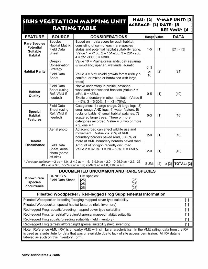
Salix Associates ● 2006
Srhs Vegetation Mapping Unitrating TABLE
Hau: [2] V-MAP UNIT: [2]Acreage: [2] Date: [8 ]
Ref VMU: [4 ]
FEATURE SOURCE CONSIDERATIONS Range Value DATA
Rare Species Potential Suitable Habitat
Species Habitat Matrix, Field Data Sheet
Based on matrix score for each habitat, consisting of sum of each rare species status and potential habitat suitability rating. Value 1 = <150; 2 = 151-200; 3 = 201- 250; 4 = 251-300; 5 = >300.
1-5 [1] [21] = [3]
Oregon Conservation Strategy
Value 10 = Prairie/grasslands, oak savanna & woodland, riparian, wetlands, aquatic
Habitat Rarity Field Data Sheet
Value 3 = Mature/old growth forest (>80 y.o. conifer; or mixed or hardwood with large trees)
0, 3 or 10
[2] [21]
Habitat Quality
Field Data Sheet (using Ref. VMU if needed)
Native understory in prairie, savanna, woodland and wetland habitats (Value 5 = ≥5%, 0 = <5%). Exotic understory in other habitats: (Value 5 = <5%, 3 = 5-30%, 1 = >31-70%).
0-5 [1] [40]
Special Habitat
Features
Field Data Sheet (using Ref. VMU if needed)
Categories: 1) large snags, 2) large logs, 3) small snags AND logs, 4) water feature, 5) rocks or balds, 6) small habitat patches, 7) scattered large trees. Three or more categories recorded, Value = 3, two or more = 2, one = 1.
0-3 [1] [16]
Aerial photo Adjacent road can affect wildlife use and movement. Value 2 = <5% of VMU boundary borders paved road, 0 = 5% or more of VMU boundary borders paved road.
2-0 [1] [18]
Habitat Disturbance Field Data
Sheet, aerial photo (some off-site)
Amount of polygon recently disturbed. Value 2 = <20%; 1 = 20 – 50%; 0 = >50% 2-0 [1] [40]
* Acreage Multiplier: <2 ac = 1.0, 2-4.9 ac = 1.5, 5-9.9 ac = 2.0, 10-25.9 ac = 2.5, 26-49.9 ac = 3.0, 50-74.9 ac = 3.5; 75-99.9 ac = 4.0, ≥100 = 4.5 SUM: [2] x [3] TOTAL: [2]
DOCUMENTED UNCOMMON AND RARE SPECIES
Known rare species
occurrence
ORNHIC & Field Data Sheet
List species: [25] [25] [25] [25] [25] [25]
Pileated Woodpecker / Red-legged Frog Supplemental Information
Pileated Woodpecker: breeding/foraging mapped cover type suitability [1] Pileated Woodpecker: special habitat features (field inventory) [1] Red-legged Frog: aquatic/breeding mapped cover type suitability [1] Red-legged Frog: terrestrial/foraging/dispersal mapped habitat suitability [1] Red-legged Frog aquatic/breeding suitability (field inventory) [1] Red-legged Frog terrestrial/foraging/dispersal suitability (field inventory) [1] Note: Reference VMU (RV) is a nearby VMU with similar characteristics. In the VMU rating, data from the RV is used as a substitute for data that was unavailable due to lack of site access permission. All RV data is labeled as such on this Inventory Form.
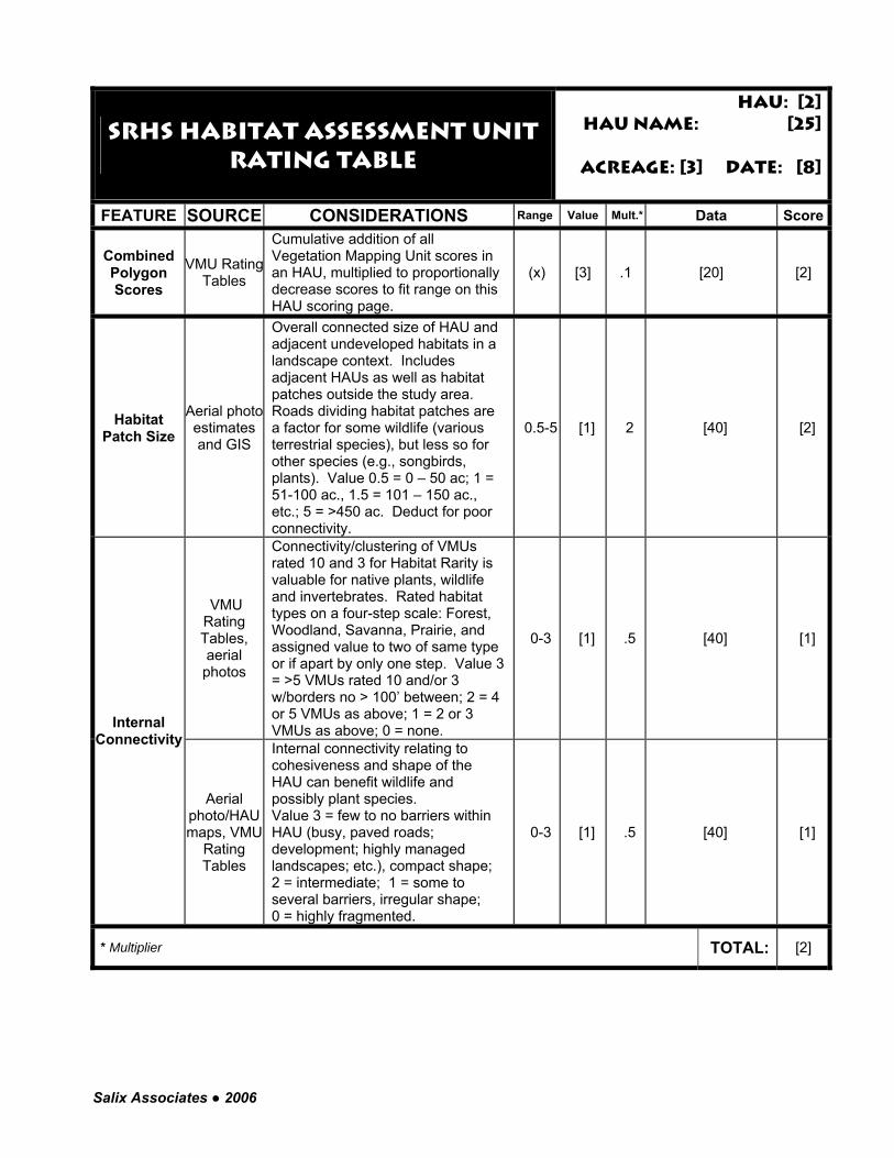
Salix Associates ● 2006
SRHS Habitat Assessment Unit Rating table
HAU: [2]HAU name: [25]
Acreage: [3] Date: [8]
FEATURE SOURCE CONSIDERATIONS Range Value Mult.* Data Score
Combined Polygon Scores
VMU RatingTables
Cumulative addition of all Vegetation Mapping Unit scores in an HAU, multiplied to proportionally decrease scores to fit range on this HAU scoring page.
(x) [3] .1 [20] [2]
Habitat Patch Size
Aerial photo estimates and GIS
Overall connected size of HAU and adjacent undeveloped habitats in a landscape context. Includes adjacent HAUs as well as habitat patches outside the study area. Roads dividing habitat patches are a factor for some wildlife (various terrestrial species), but less so for other species (e.g., songbirds, plants). Value 0.5 = 0 – 50 ac; 1 = 51-100 ac., 1.5 = 101 – 150 ac., etc.; 5 = >450 ac. Deduct for poor connectivity.
0.5-5 [1] 2 [40] [2]
VMU Rating Tables, aerial photos
Connectivity/clustering of VMUs rated 10 and 3 for Habitat Rarity is valuable for native plants, wildlife and invertebrates. Rated habitat types on a four-step scale: Forest, Woodland, Savanna, Prairie, and assigned value to two of same type or if apart by only one step. Value 3 = >5 VMUs rated 10 and/or 3 w/borders no > 100’ between; 2 = 4 or 5 VMUs as above; 1 = 2 or 3 VMUs as above; 0 = none.
0-3 [1] .5 [40] [1]
Internal Connectivity
Aerial photo/HAU maps, VMU
Rating Tables
Internal connectivity relating to cohesiveness and shape of the HAU can benefit wildlife and possibly plant species. Value 3 = few to no barriers within HAU (busy, paved roads; development; highly managed landscapes; etc.), compact shape; 2 = intermediate; 1 = some to several barriers, irregular shape; 0 = highly fragmented.
0-3 [1] .5 [40] [1]
* Multiplier TOTAL: [2]
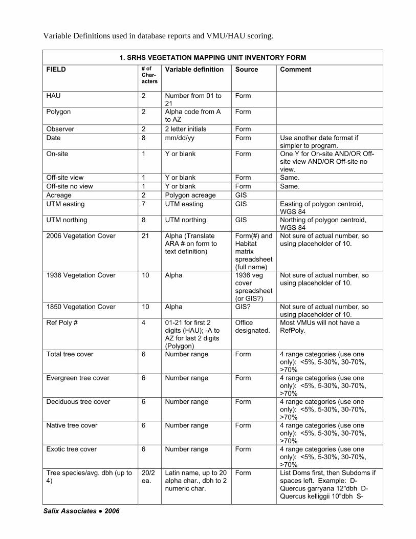
Salix Associates ● 2006
Variable Definitions used in database reports and VMU/HAU scoring.
1. SRHS VEGETATION MAPPING UNIT INVENTORY FORM FIELD # of
Char-acters
Variable definition Source Comment
HAU 2 Number from 01 to 21
Form
Polygon 2 Alpha code from A to AZ
Form
Observer 2 2 letter initials Form Date 8 mm/dd/yy Form Use another date format if
simpler to program. On-site 1 Y or blank Form One Y for On-site AND/OR Off-
site view AND/OR Off-site no view.
Off-site view 1 Y or blank Form Same. Off-site no view 1 Y or blank Form Same. Acreage 2 Polygon acreage GIS UTM easting 7 UTM easting GIS Easting of polygon centroid,
WGS 84 UTM northing 8 UTM northing GIS Northing of polygon centroid,
WGS 84 2006 Vegetation Cover 21 Alpha (Translate
ARA # on form to text definition)
Form(#) and Habitat matrix spreadsheet (full name)
Not sure of actual number, so using placeholder of 10.
1936 Vegetation Cover 10 Alpha 1936 veg cover spreadsheet (or GIS?)
Not sure of actual number, so using placeholder of 10.
1850 Vegetation Cover 10 Alpha GIS? Not sure of actual number, so using placeholder of 10.
Ref Poly # 4 01-21 for first 2 digits (HAU); -A to AZ for last 2 digits (Polygon)
Office designated.
Most VMUs will not have a RefPoly.
Total tree cover 6 Number range Form 4 range categories (use one only): <5%, 5-30%, 30-70%, >70%
Evergreen tree cover 6 Number range Form 4 range categories (use one only): <5%, 5-30%, 30-70%, >70%
Deciduous tree cover 6 Number range Form 4 range categories (use one only): <5%, 5-30%, 30-70%, >70%
Native tree cover 6 Number range Form 4 range categories (use one only): <5%, 5-30%, 30-70%, >70%
Exotic tree cover 6 Number range Form 4 range categories (use one only): <5%, 5-30%, 30-70%, >70%
Tree species/avg. dbh (up to 4)
20/2 ea.
Latin name, up to 20 alpha char., dbh to 2 numeric char.
Form List Doms first, then Subdoms if spaces left. Example: D-Quercus garryana 12"dbh D-Quercus kelliggii 10"dbh S-

Salix Associates ● 2006
Pinus ponderosa 14"dbh (use X or ? for unspecified dbh)
Total shrub cover 6 Number range Form 4 range categories: <5%, 5-30%, 30-70%, >70%
Evergreen shrub cover 6 Number range Form 4 range categories: <5%, 5-30%, 30-70%, >70%
Deciduous shrub cover 6 Number range Form 4 range categories: <5%, 5-30%, 30-70%, >70%
Native shrub cover 6 Number range Form 4 range categories: <5%, 5-30%, 30-70%, >70%
Exotic shrub cover 6 Number range Form 4 range categories: <5%, 5-30%, 30-70%, >70%
Shrub species (up to 4) 20 ea.
Latin name Form List doms first, then subdoms if spaces left.
Total herb cover 6 Number range Form 4 range categories: <5%, 5-30%, 30-70%, >70%
Evergreen herb cover 6 Number range Form 4 range categories: <5%, 5-30%, 30-70%, >70%
Deciduous herb cover 6 Number range Form 4 range categories: <5%, 5-30%, 30-70%, >70%
Native herb cover 6 Number range Form 4 range categories: <5%, 5-30%, 30-70%, >70%
Exotic herb cover 6 Number range Form 4 range categories: <5%, 5-30%, 30-70%, >70%
Herb species (up to 8) 20 ea.
Latin name Form List doms first, then subdoms if spaces left.
Invasive species (up to 12) 20 ea.
Latin name Form List with prefix designating Tree, Shrub, Herb. Example: T-Prunus avium S-Rubus armeniacus S-Ilex aquifolium H-Geranium lucidum H-Brachypodium sylvaticum.
Recent disturbance 6 Number range Form 3 range categories: <20%, 20-50%, >50%
Known rare species occurrence (up to 5)
20 ea.
Alpha Form; rare species table
Multiple species possible. Use common names for animals, Latin for plants.
PIWO visual 1 Y or N Form Pileated Woodpecker seen. If Y, then list under Known rare species occurrence.
PIWO aural 1 Y or N Form Pileated Woodpecker heard. If Y, then list under Known rare species occurrence.
PIWO foraging excavation 1 Y or N Form Pileated Woodpecker foraging excavation seen. If Y, then list under Known rare species occurrence.
PIWO nesting excavation 1 Y or N Form Pileated Woodpecker nesting excavation seen. If Y, then list under Known rare species occurrence.
PIWO comments * Alpha Form Use # of characters from form. RLF visual 1 Y or N Form Red-legged frog seen. If Y,
then list under Known rare species occurrence.
Stillwater wetland 1 Y or N Form

Salix Associates ● 2006
% open water 6 Number range Form 3 range categories: <25%, 25-50%, >50%
% low emergent 6 Number range Form 3 range categories: <25%, 25-50%, >50%
Winter sun 1 Y or N Form Aquatic inverts 1 Y or N Form Aquatic inverts present Bullfrogs 1 Y or N Form Bullfrogs present Cultivated crop/lawn adjacent
1 Y or N Form
Forested upland 1 Y or N Form % POLMUN/low veg cover 6 Number range Form 3 range categories: <1/3, 1/3-
2/3, >2/3 Dense understory 1 Y or N Form w/alder or biglf maple dom. in o-story
1 Y or N Form
Wetland adjacent 1 Y or N Form Road between upland and wetland
1 Y or N Form
≥ 10 acres 1 Y or N Form (office assigned)
Compact shape 1 Y or N Form (office assigned)
Snags/ac ≤ 1.5 ft dbh 2 Number range Form 3 range categories: 0, <5, ≥5 Snags/ac > 1.5 ft dbh 2 Number range Form 3 range categories: 0, <5, ≥5 Logs/ac 1-2 ft dia 2 Number range Form 3 range categories: 0, <5, ≥5 Logs/ac >2 ft dia 2 Number range Form 3 range categories: 0, <5, ≥5 Water 1 Y or N Form Water description * Alpha Form Use # of characters from form. Rock/balds 1 Y or N Form Rock/balds description * Alpha Form Use # of characters from form. Small habitat patches 1 Y or N Form Small habitat patches description
* Alpha Form Use # of characters from form.
Scattered large trees 1 Y or N Form Photo points * Alpha Form Use # of characters from form. Comments * Alpha Form Use # of characters from form.
2. VEGETATION MAPPING UNIT RATING TABLE
HAU 2 Number from 01 to 21
Form
Polygon 2 Alpha code from A to AZ
Form
Acreage 2 Polygon acreage GIS Same as Inventory Form. Date 8 mm/dd/yy Form Same comment as Inventory
Form. Ref. Poly 2 Y or N Y (yes) if
used.
Ref Poly # 4 01-21 for first 2 digits; -A to AZ for last 2 digits
Repeat from Inventory Form
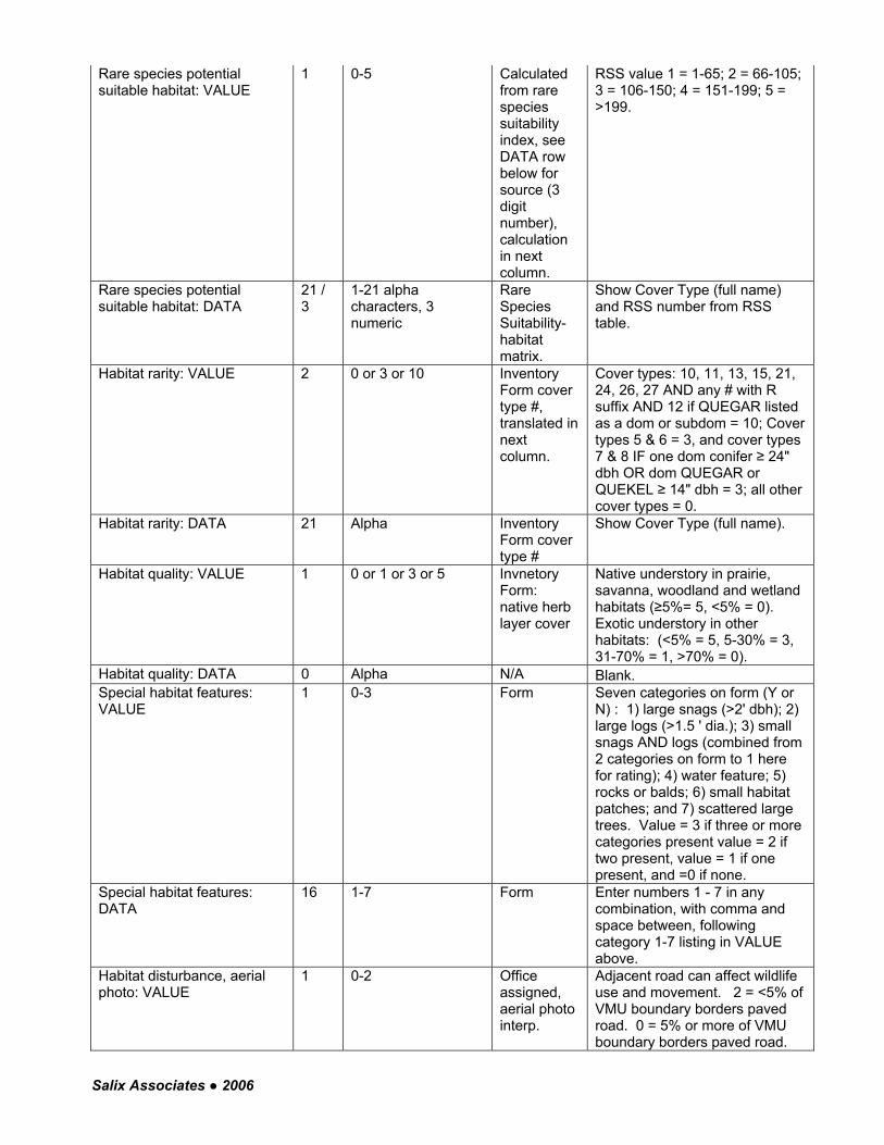
Salix Associates ● 2006
Rare species potential suitable habitat: VALUE
1 0-5 Calculated from rare species suitability index, see DATA row below for source (3 digit number), calculation in next column.
RSS value 1 = 1-65; 2 = 66-105; 3 = 106-150; 4 = 151-199; 5 = >199.
Rare species potential suitable habitat: DATA
21 / 3
1-21 alpha characters, 3 numeric
Rare Species Suitability-habitat matrix.
Show Cover Type (full name) and RSS number from RSS table.
Habitat rarity: VALUE 2 0 or 3 or 10 Inventory Form cover type #, translated in next column.
Cover types: 10, 11, 13, 15, 21, 24, 26, 27 AND any # with R suffix AND 12 if QUEGAR listed as a dom or subdom = 10; Cover types 5 & 6 = 3, and cover types 7 & 8 IF one dom conifer ≥ 24" dbh OR dom QUEGAR or QUEKEL ≥ 14" dbh = 3; all other cover types = 0.
Habitat rarity: DATA 21 Alpha Inventory Form cover type #
Show Cover Type (full name).
Habitat quality: VALUE 1 0 or 1 or 3 or 5 Invnetory Form: native herb layer cover
Native understory in prairie, savanna, woodland and wetland habitats (≥5%= 5, <5% = 0). Exotic understory in other habitats: (<5% = 5, 5-30% = 3, 31-70% = 1, >70% = 0).
Habitat quality: DATA 0 Alpha N/A Blank. Special habitat features: VALUE
1 0-3 Form Seven categories on form (Y or N) : 1) large snags (>2' dbh); 2) large logs (>1.5 ' dia.); 3) small snags AND logs (combined from 2 categories on form to 1 here for rating); 4) water feature; 5) rocks or balds; 6) small habitat patches; and 7) scattered large trees. Value = 3 if three or more categories present value = 2 if two present, value = 1 if one present, and =0 if none.
Special habitat features: DATA
16 1-7 Form Enter numbers 1 - 7 in any combination, with comma and space between, following category 1-7 listing in VALUE above.
Habitat disturbance, aerial photo: VALUE
1 0-2 Office assigned, aerial photo interp.
Adjacent road can affect wildlife use and movement. 2 = <5% of VMU boundary borders paved road. 0 = 5% or more of VMU boundary borders paved road.

Salix Associates ● 2006
Habitat disturbance, aerial photo: DATA
18 Alpha Office assigned, aerial photo interp.
Two options, depending on score in last variable. If it = 2, say "Adjacent road boundary <5%." If it = 0, say "Adjacent road boundary 5% or greater."
Habitat disturbance, Field Data Sheet, etc.: VALUE
1 0-2 Form Amount of polygon recently disturbed 2 = <20%; 1 = 20 – 50%; 0 = >50%;
Habitat disturbance, Field Data Sheet, etc.: DATA
40 Alpha Office assigned, data sheet comments
Explain, if present
Sum 2 Numeric Sum of cells above
Acreage multiplier 3 1.0, 1.5, 2.0, 2.5, 3.0, 3.5, 4.0, 4.5
GIS acres, transposed in column to right
<2 ac = 1.0, 2-4.9 ac = 1.5, 5-9.9 ac = 2.0, 10-25.9 ac = 2.5, 26-49.9 ac = 3.0, 50-74.9 ac = 3.5; 75-99.9 ac = 4.0, ≥100 = 4.5
TOTAL 2 Numeric Product of SUM x Acreage Multiplier
Known uncommon and rare species occurrence
20 ea.
Alpha Field or Office Assigned
Possible to list up to six species, with -H, -M or -L status from Target Uncommon and Rare Species list.
Pileated Woodpecker: breeding/foraging mapped cover type suitability
1 H. M,L or 0 Habitat matrix
Pull H-M-L or 0 from Habitat matrix for PIWO for this Cover type
Pileated Woodpecker: special habitat features (field inventory)
H H, M, L or 0 Form Inventoried features used in the ranking: 1. Large logs (<5 OR ≥5 per acre) 2. Large snags (<5 OR ≥5 per acre) 3. Any dom or subdom tree species > 20" dbh 4. Scattered large trees present 5. Small logs (<5 OR ≥5) and small snags (<5 OR ≥5) H = Any 3 of the first 4 features (1+2+3 OR 1+2+4 OR 1+3+4 OR 2+3+4); M = Any 2 of the first 3 features (1+2 OR 1+3 OR 2+3); L = Any 1 of any of the 5 features
Red-legged Frog: aquatic/breeding mapped cover type suitability
1 H. M,L or 0 Habitat matrix
Pull H-M-L or 0 from Habitat matrix for RLF B (breeding) for this Cover type
Red-legged Frog: terrestrial/foraging/dispersal mapped habitat suitability
1 H. M,L or 0 Habitat matrix
Pull H-M-L or 0 from Habitat matrix for RLF F (foraging) for this Cover type
Red-legged Frog aquatic/breeding suitability (field inventory)
1 H. M,L or 0 Form, calculated in next column
If Stillwater wetland present: % open water <25 = 1, 25-50 = 2, >50 = 1; % low emergent <25 = 1, 25-50 = 2, >50 = 1; winter sun Y=1, N = 0; aquatic inverts Y = 1, N = 0; bullfrogs Y=0, N=1; crop/lawn adj Y = 0, N = 1; Total possible points = 8; 1-2 = L, 3-4 = M, 5-8 = H.
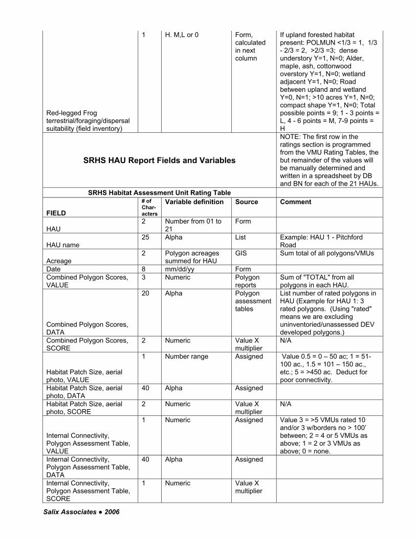
Salix Associates ● 2006
Red-legged Frog terrestrial/foraging/dispersal suitability (field inventory)
1 H. M,L or 0 Form, calculated in next column
If upland forested habitat present: POLMUN <1/3 = 1, 1/3 - 2/3 = 2, >2/3 =3; dense understory Y=1, N=0; Alder, maple, ash, cottonwood overstory Y=1, N=0; wetland adjacent Y=1, N=0; Road between upland and wetland Y=0, N=1; >10 acres Y=1, N=0; compact shape Y=1, N=0; Total possible points = 9; 1 - 3 points = L, 4 - 6 points = M, 7-9 points = H
SRHS HAU Report Fields and Variables
NOTE: The first row in the ratings section is programmed from the VMU Rating Tables, the but remainder of the values will be manually determined and written in a spreadsheet by DB and BN for each of the 21 HAUs.
SRHS Habitat Assessment Unit Rating Table
FIELD
# of Char-acters
Variable definition Source Comment
HAU 2 Number from 01 to
21 Form
HAU name 25 Alpha List Example: HAU 1 - Pitchford
Road
Acreage 2 Polygon acreages
summed for HAU GIS Sum total of all polygons/VMUs
Date 8 mm/dd/yy Form Combined Polygon Scores, VALUE
3 Numeric Polygon reports
Sum of "TOTAL" from all polygons in each HAU.
Combined Polygon Scores, DATA
20 Alpha Polygon assessment tables
List number of rated polygons in HAU (Example for HAU 1: 3 rated polygons. (Using "rated" means we are excluding uninventoried/unassessed DEV developed polygons.)
Combined Polygon Scores, SCORE
2 Numeric Value X multiplier
N/A
Habitat Patch Size, aerial photo, VALUE
1 Number range Assigned Value 0.5 = 0 – 50 ac; 1 = 51-100 ac., 1.5 = 101 – 150 ac., etc.; 5 = >450 ac. Deduct for poor connectivity.
Habitat Patch Size, aerial photo, DATA
40 Alpha Assigned
Habitat Patch Size, aerial photo, SCORE
2 Numeric Value X multiplier
N/A
Internal Connectivity, Polygon Assessment Table, VALUE
1 Numeric Assigned Value 3 = >5 VMUs rated 10 and/or 3 w/borders no > 100’ between; 2 = 4 or 5 VMUs as above; 1 = 2 or 3 VMUs as above; 0 = none.
Internal Connectivity, Polygon Assessment Table, DATA
40 Alpha Assigned
Internal Connectivity, Polygon Assessment Table, SCORE
1 Numeric Value X multiplier
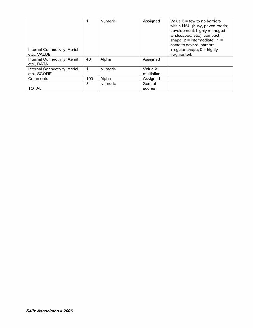
Salix Associates ● 2006
Internal Connectivity, Aerial etc., VALUE
1 Numeric Assigned Value 3 = few to no barriers within HAU (busy, paved roads; development; highly managed landscapes; etc.), compact shape; 2 = intermediate; 1 = some to several barriers, irregular shape; 0 = highly fragmented.
Internal Connectivity, Aerial etc., DATA
40 Alpha Assigned
Internal Connectivity, Aerial etc., SCORE
1 Numeric Value X multiplier
Comments 100 Alpha Assigned
TOTAL 2 Numeric Sum of
scores
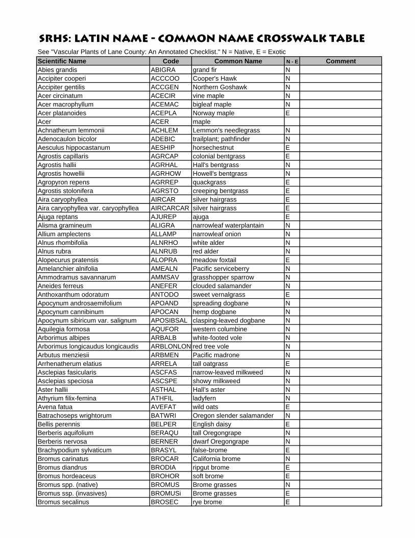
SRHS: Latin Name - Common Name Crosswalk TableSee "Vascular Plants of Lane County: An Annotated Checklist." N = Native, E = ExoticScientific Name Code Common Name N - E CommentAbies grandis ABIGRA grand fir NAccipiter cooperi ACCCOO Cooper's Hawk NAccipiter gentilis ACCGEN Northern Goshawk NAcer circinatum ACECIR vine maple NAcer macrophyllum ACEMAC bigleaf maple NAcer platanoides ACEPLA Norway maple EAcer ACER mapleAchnatherum lemmonii ACHLEM Lemmon's needlegrass NAdenocaulon bicolor ADEBIC trailplant; pathfinder NAesculus hippocastanum AESHIP horsechestnut EAgrostis capillaris AGRCAP colonial bentgrass EAgrostis hallii AGRHAL Hall's bentgrass NAgrostis howellii AGRHOW Howell's bentgrass NAgropyron repens AGRREP quackgrass EAgrostis stolonifera AGRSTO creeping bentgrass EAira caryophyllea AIRCAR silver hairgrass EAira caryophyllea var. caryophyllea AIRCARCAR silver hairgrass EAjuga reptans AJUREP ajuga EAlisma gramineum ALIGRA narrowleaf waterplantain NAllium amplectens ALLAMP narrowleaf onion NAlnus rhombifolia ALNRHO white alder NAlnus rubra ALNRUB red alder NAlopecurus pratensis ALOPRA meadow foxtail EAmelanchier alnifolia AMEALN Pacific serviceberry NAmmodramus savannarum AMMSAV grasshopper sparrow NAneides ferreus ANEFER clouded salamander NAnthoxanthum odoratum ANTODO sweet vernalgrass EApocynum androsaemifolium APOAND spreading dogbane NApocynum cannibinum APOCAN hemp dogbane NApocynum sibiricum var. salignum APOSIBSAL clasping-leaved dogbane NAquilegia formosa AQUFOR western columbine NArborimus albipes ARBALB white-footed vole NArborimus longicaudus longicaudis ARBLONLON red tree vole NArbutus menziesii ARBMEN Pacific madrone NArrhenatherum elatius ARRELA tall oatgrass EAsclepias fasicularis ASCFAS narrow-leaved milkweed NAsclepias speciosa ASCSPE showy milkweed NAster hallii ASTHAL Hall’s aster NAthyrium filix-femina ATHFIL ladyfern NAvena fatua AVEFAT wild oats EBatrachoseps wrightorum BATWRI Oregon slender salamander NBellis perennis BELPER English daisy EBerberis aquifolium BERAQU tall Oregongrape NBerberis nervosa BERNER dwarf Oregongrape NBrachypodium sylvaticum BRASYL false-brome EBromus carinatus BROCAR California brome NBromus diandrus BRODIA ripgut brome EBromus hordeaceus BROHOR soft brome EBromus spp. (native) BROMUS Brome grasses NBromus ssp. (invasives) BROMUSi Brome grasses EBromus secalinus BROSEC rye brome E

See "Vascular Plants of Lane County: An Annotated Checklist." N = Native, E = ExoticScientific Name Code Common Name N - E CommentBromus sitchensis BROSIT Sitka brome NBromus sterilis BROSTE sterile brome EBromus vulgaris BROVUL Columbia brome NBufo boreas BUFBOR western toad NCalystegia atriplicifolia ssp. atriplicifoliaCALATR night-blmg morning glory NCalocedrus decurrens CALDEC incense-cedar NCalycadenia truncata CALTRU rosin weed, tackweed NCamassia leichtlinii CAMLEI Lechtlin’s camas NCamassia quamash camqua camas NCarex amplifolia CARAMP bigleaf sedge NCarex aurea CARAUR golden-fruited sedge NCarex densa CARDEN dense sedge NCarex deweyana CARDEW Dewey’s sedge NCarex hendersonii CARHEN Henderson’s sedge NCarex leptopoda CARLEP taperfruit shortscale sedge NCardamine nuttallii CARNUT spring beauty NCardamine nuttallii var. dissecta CARNUTDIS dissected toothwort NCardamine nuttallii var. nuttallii CARNUTNUT spring beauty NCarex obnupta CAROBN slough sedge NCarex tumulicola CARTUM foothill sedge NCentaurea melitensis CENMEL Maltese star-thistle ECentaurea pratensis CENPRA meadow knapweed ECephalanthera austiniae CEPAUS ghost orchid NChamaecyparis lawsoniana CHALAW Port Orford cedar NChordeiles minor CHOMIN common nighthawk NCicendia quadrangularis CICQUA timwort NCimicifuga elata var. elata CIMELA tall bugbane NCircaea alpina CIRALP enchanter's nightshade NCirsium arvense CIRARV Canada thistle ECirsium vulgare CIRVUL bull thistle EClarkia amoena CLAAMO farewell-to-spring NClaytonia perfoliata CLAPER miner's lettuce NClaytonia sibirica CLASIB candyflower; miner's lettuce NClematis vitalba CLEVIT old man's beard ECollomia grandiflora COLGRA large-flowered collomia NContopus cooperi CONCOO olive-sided flycatcher NConium maculatum CONMAC poison hemlock ECorylus cornuta var. californica CORCORCALCalifornia hazelnut NCorallorhiza maculata CORMAC spotted coralroot NCornus nuttallii CORNUT western dogwood NCornus sericea CORSER red twig dogwood NCorynorhinus townsendii CORTOW Townsend's big-eared bat NCotoneaster COTON cotoneaster (ornamental) ECrataegus douglasii CRADOU Douglas’ hawthorn N C. suksdorfii in SRHS areaCrataegus monogyna CRAMON English hawthorne ECrotalus viridis CROVIR western rattlesnake NCynosurus cristatus CYNCRI crested dogtail grass ECynosurus echinatus CYNECH hedgehog dogtail ECypripedium montanum CYPMON mountain lady's-slipper NCytisus scoparius CYTSCO Scot’s broom EDactylis glomerata DACGLO orchardgrass EDanthonia californica DANCAL California oatgrass NDaphne laureola DAPLAU spurge laurel E

See "Vascular Plants of Lane County: An Annotated Checklist." N = Native, E = ExoticScientific Name Code Common Name N - E CommentDaucus carota DAUCAR Queen Anne’s lace EDelphinium oreganum DELORE Willamette Valley larkspur NDelphinium trolliifolium DELTRO tall larkspur NDeschampsia cespitosa DESCES tufted hairgrass NDeschampsia elongata DESELO slender hairgrass NDichelostemma congestum DICCON ookow NDipsacus fullonum DIPFUL common teasel EDodecatheon hendersonii DODHEN Henderson’s shooting star NDodecatheon pulchellum var. macroca DODPULMACbeautiful shooting star NDryopteris arguta DRYARG coastal shield fern NDryocopus pileatus DRYPIL pileated woodpecker NEleocharis palustris ELEPAL creeping spikerush NElymus glaucus ELYGLA blue wildrye NElymus trachycaulus ELYTRA Slender Wheatgrass NEmpidonax traillii brewsteri EMPTRABRE little willow flycatcher NEnemion stipitatum ENESTI dwarf enemion; rue-anemone NEpilobium brachycarpum EPIBRA tall annual willowherb NEquisetum arvensis EQUARV common horsetail NEquisetum sp. EQUIS horsetail NEquisetum telmateia EQUTEL giant horsetail NEremophila alpestris strigata EREALPSTR streaked horned lark NErigeron decumbens var. decumbens ERIDECDEC Willamette daisy NEriophyllum lanatum ERILAN Oregon sunshine NErigeron philadelphicus ERIPHI Philadelphia daisy NErythronium oreganum ERYORE yellow fawn lily NEucephalus (Aster) vialis EUCVIA wayside aster NEuphydryas editha taylori EUPEDITAY Taylor's checkerspot NExotic Fruit Trees ExFruit exotic fruit trees EFalco peregrinus anatum FALPERANA American peregrine falcon NFestuca arundinacea FESARU tall fescue EFestuca californica FESCAL California fescue NFestuca occidentalis FESOCC western Fescue NFestuca roemeri FESROE Roemer’s fescue NFraxinus latifolia FRALAT Oregon ash NFragaria vesca FRAVES woods strawberry NFragaria virginiana ssp. platypetala FRAVIRPLA broadpetal strawberry NFritillaria affinis FRIAFF rice-root lily; Chocolate lily NGalium aparine GALAPA cleavers NGeranium dissectum GERDIS cutleaf geranium EGeranium lucidum GERLUC shining geranium EGeranium molle GERMOL soft geranium EGeranium oreganum GERORE Oregon geranium NGeranium robertianum GERROB herb Robert, stinky Bob EGeum macrophyllum GEUMAC large-leaved avens NGilia sinistra ssp. sinistra GILSINSIN sinister gilia NGlyceria occidentalis GLYOCC western mannagrass NGlyceria striata GLYSTR tall mannagrass NGoodyera oblongifolia GOOOBL rattlesnake plantain NHaliaeetus leucocephalus HALLEU bald eagle NHedera HEDER ivy EHedera helix HEDHEL English ivy EHedera hibernica HEDHIB Irish ivy EHeracleum lanatum HERLAN cow parsnip N

See "Vascular Plants of Lane County: An Annotated Checklist." N = Native, E = ExoticScientific Name Code Common Name N - E CommentHierochloe odorata HIEODO holy grass NHolodiscus discolor HOLDIS oceanspray NHolcus lanatus HOLLAN common velvetgrass EHolcus mollis HOLMOL creeping velvetgrass EHorkelia congesta HORCON shaggy horkelia NHorkelia congesta ssp. congesta HORCONCONshaggy horkelia NHowellia aquatilis HOWAQU howellia NHydrophyllum tenuipes HYDTEN waterleaf NHypericum perforatum HYPPER common St. Johnswort EHypochaeris radicata HYPRAD false dandelion, cat’s ear EIcaricia icarioides fenderi ICAICAFEN Fender's blue butterfly NIcteria virens ICTVIR yellow-breasted chat NIlex aquifolium ILEAQU English holly EIris pseudacorus IRIPSE yellow Iris EIris tenax IRITEN Oregon iris NJuglans nigra JUGNIG black walnut EJuncus bufonius JUNBUF toad rush NJuncus effusus JUNEFF Pacific rush NJuncus patens JUNPAT spreading rush NJuncus tenuis JUNTEN slender rush NKoeleria macrantha KOEMAC prairie junegrass NLactuca muralis LACMUR wall lettuce ELapsana communis LAPCOM nipplewort ELasionycteris noctivagans LASNOC silver-haired bat NLathyrus aphaca lataph yellow vetchling ELathyrus holochlorus LATHOL thin-leaved peavine NLathyrus latifolius LATLAT perennial sweetpea ELathyrus nevadensis LATNEV Sierra pea NLathyrus sphaericus LATSPH grass pea ELathyrus sylvestris LATSYL narrowleaf pea ELathyrus vestitus var. ochropetalus LATVESOCH Pacific pea NLeontodon taraxacoides ssp. tarax. LEOTARTAR hairy hawkbit ELeucanthemum vulgare LEUVUL oxeye daisy ELigusticum apiifolium LIGAPI celery-leaved lovage NLigustrum LIGUS privet (ornamental) ELigustrum vulgare LIGVUL common privet ELilium columbianum LILCOL Columbia lily NLinum bienne LINBIE blue flax ELithophragma parviflora LITPAR prairie star NLolium multiflorum LOLMUL annual ryegrass ELolium perenne LOLPER perennial ryegrass ELomatium bradshawii LOMBRA Bradshaw's lomatium NLomatium macrocarpum LOMMAC large-fruited lomatium NLomatium nudicaule LOMNUD barestem lomatium NLonicera ciliata LONCIL orange honeysuckle NLonicera hispidula LONHIS hairy honeysuckle NLupinus affinus LUPAFF fleshy lupine NLupinus polyphyllus LUPPOL many-leaved lupine NLupinus rivularis LUPRIV riverbank lupine NLupinus sulphureus ssp. kincaidii LUPSULKIN Kincaid's lupine NLychnis LYCHN campion EMadia glomerata MADGLO mountain tarweed NMadia madioides MADMAD woodland tarweed N = Ansiocarpus madioides

See "Vascular Plants of Lane County: An Annotated Checklist." N = Native, E = ExoticScientific Name Code Common Name N - E CommentMadia sativa MADSAT coast tarweed NMaianthemum racemosum MAIRAC false Solomon’s seal NMaianthemum stellatum MAISTE star-flwrd. false Soloman's seal NMalus x domestica MALDOM domestic apple EMarah oregana MARORE Oregon bigroot NMelanerpes formicivorus MELFOR acorn woodpecker NMelanerpes lewis MELLEW Lewis's woodpecker NMelissa officinalis MELOFF lemon balm EMelica subulata melsub Alaska oniongrass NMentha pulegium MENPUL pennyroyal EMertensia platyphylla MERPLA blue bells NMimulus guttatus MIMGUT monkeyflower NMontia dichotema MONDIC dwarf montia NMontia howellii MONHOW Howell's montia NMyosotis arvensis MYOARV field forget-me-not EMyotis californicus MYOCAL California myotis NMyosotis discolor MYODIS yellow & blue forget-me-not EMyotis evotis MYOEVO long-eared myotis NMyotis volans MYOVOL long-legged myotis NNavarretia leucocephala NAVLEU white-flowered navarretia ENavarretia willamettensis NAVWIL Willamette navarretia Eoak-associated species OAS oak-associated species NOemleria cerasiformis OEMCER osoberry NOenanthe sarmentosa OENSAR water parsley NOlsynium douglasii OLSDOU grass widows NOreortyx pictus OREPIC mountain quail NOrnamental shrubs ORNAM ornamental shrubs EOrobanche pinorum OROPIN oceanspray broomrape NOsmorhiza berteroi OSMBER mountain sweet cicely NOtus kennicottii OTUKEN western screech-owl NPanicum occidentale PANOCC western witchgrass NParentucellia viscosa PARVIS parentucellia EPatagioenas fasciata PATFAS band-tailed pigeon NPellaea andromedifolia PELAND coffee fern NPhalaris arundinacea PHAARU reed canarygrass EPhleum pratense PHLPRA timothy EPhysocarpus capitatus PHYCAP Pacific ninebark NPinus contorta PINCON lodgepole pine NPinus ponderosa PINPON ponderosa pine NPlectritis congesta PLECON sea pink NPoa palustris POAPAL fowl bluegrass ?Poa pratensis POAPRA Kentucky bluegrass EPolypodium glycerrhiza POLGLY licorice fern NPolystichum munitum POLMUN western swordfern NPolygonum punctatum POLPUN dotted smartweed NPooecetes gramineus affinis POOGRAAFF Oregon vesper sparrow NPopulus balsamifera = P. trichocarpa POPBAL black cottonwood NPopulus nigra POPNIG black poplar EPopulus trichocarpa POPTRI black cottonwood NPotentilla gracilis POTGRA slender cinquefoil NPotamogeton natans POTNAT pondweed NProsartes hookeri PROHOO Hooker’s fairybells NProgne subis PROSUB purple martin N
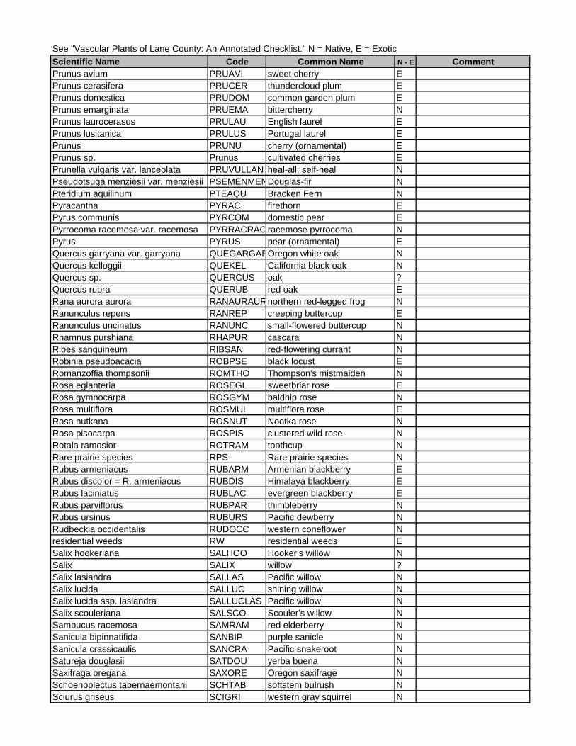
See "Vascular Plants of Lane County: An Annotated Checklist." N = Native, E = ExoticScientific Name Code Common Name N - E CommentPrunus avium PRUAVI sweet cherry EPrunus cerasifera PRUCER thundercloud plum EPrunus domestica PRUDOM common garden plum EPrunus emarginata PRUEMA bittercherry NPrunus laurocerasus PRULAU English laurel EPrunus lusitanica PRULUS Portugal laurel EPrunus PRUNU cherry (ornamental) EPrunus sp. Prunus cultivated cherries EPrunella vulgaris var. lanceolata PRUVULLAN heal-all; self-heal NPseudotsuga menziesii var. menziesii PSEMENMENDouglas-fir NPteridium aquilinum PTEAQU Bracken Fern NPyracantha PYRAC firethorn EPyrus communis PYRCOM domestic pear EPyrrocoma racemosa var. racemosa PYRRACRAC racemose pyrrocoma NPyrus PYRUS pear (ornamental) EQuercus garryana var. garryana QUEGARGAROregon white oak NQuercus kelloggii QUEKEL California black oak NQuercus sp. QUERCUS oak ?Quercus rubra QUERUB red oak ERana aurora aurora RANAURAURnorthern red-legged frog NRanunculus repens RANREP creeping buttercup ERanunculus uncinatus RANUNC small-flowered buttercup NRhamnus purshiana RHAPUR cascara NRibes sanguineum RIBSAN red-flowering currant NRobinia pseudoacacia ROBPSE black locust ERomanzoffia thompsonii ROMTHO Thompson's mistmaiden NRosa eglanteria ROSEGL sweetbriar rose ERosa gymnocarpa ROSGYM baldhip rose NRosa multiflora ROSMUL multiflora rose ERosa nutkana ROSNUT Nootka rose NRosa pisocarpa ROSPIS clustered wild rose NRotala ramosior ROTRAM toothcup NRare prairie species RPS Rare prairie species NRubus armeniacus RUBARM Armenian blackberry ERubus discolor = R. armeniacus RUBDIS Himalaya blackberry ERubus laciniatus RUBLAC evergreen blackberry ERubus parviflorus RUBPAR thimbleberry NRubus ursinus RUBURS Pacific dewberry NRudbeckia occidentalis RUDOCC western coneflower Nresidential weeds RW residential weeds ESalix hookeriana SALHOO Hooker’s willow NSalix SALIX willow ?Salix lasiandra SALLAS Pacific willow NSalix lucida SALLUC shining willow NSalix lucida ssp. lasiandra SALLUCLAS Pacific willow NSalix scouleriana SALSCO Scouler’s willow NSambucus racemosa SAMRAM red elderberry NSanicula bipinnatifida SANBIP purple sanicle NSanicula crassicaulis SANCRA Pacific snakeroot NSatureja douglasii SATDOU yerba buena NSaxifraga oregana SAXORE Oregon saxifrage NSchoenoplectus tabernaemontani SCHTAB softstem bulrush NSciurus griseus SCIGRI western gray squirrel N

See "Vascular Plants of Lane County: An Annotated Checklist." N = Native, E = ExoticScientific Name Code Common Name N - E CommentScirpus pallidus SCIPAL pale bulrush NScirpus pendulus SCIPEN drooping bulrush NSenecio jacobaea SENJAC tansy ragwort ESenecio macounii SENMAC Puget groundsel NSequoiadendron gigantea SEQGIG giant sequoia ESequoia sempervirens SEQSEM coast redwood ESericocarpus rigidus (Aster curtus) SERRIG white-topped aster NSherardia arvensis SHEARV sherardia ESialia mexicana SIAMEX western bluebird NSidalcea campestris SIDCAM meadow sidalcea NSidalcea cusickii SIDCUS Cusick's mallow NSidalcea nelsoniana SIDNEL Nelson’s checkermallow NSidalcea virgata SIDVIR Rosy Checkermallow NSilene hookeri ssp. hookeri SILHOOHOO Hooker's pink NSilene menziesii SILMEN Menzie's catchfly NSisyrinchium hitchcockii SISHIT Hitchcock's blue-eyed grass NSitta carolinensis SITCAR White-breasted Nuthatch NSitta carolinensis aculeata SITCARACU White-breasted Nuthatch NSolidago canadensis SOLCAN Canada goldenrod NSolanum dulcamara SOLDUL bitter nightshade EStandard Prairie Invasives SPI Standard Prairie Invasives ESpiraea douglasii SPIDOU Douglas’ spiraea NSpizella passerine SPIPAS chipping sparrow NStachys chamissonis var. cooleyae STACOO Cooley's hedgenettle NStrix occidentalis caurina STROCCCAUnorthern spotted owl NSturnella neglecta STUNEG western meadowlark NSymphoricarpos albus SYMALB snowberry NTadarida brasiliensis TADBRA Brazilian free-tailed bat NTaeniatherum caput-medusae TAECAP medusahead ETaraxacum officinale TAROFF common dandelion ETellima grandiflora TELGRA fringecup NThomomys bulbivorus THOBUL camas pocket gopher NThuja plicata THUPLI western red cedar NTolmiea menziesii TOLMEN youth-on-age NTorilis arvensis TORARV torilis EToxicodendron diversilobum TOXDIV poison oak NTrillium albidum TRIALB sessile trillium NTrifolium dubium TRIDUB least hop clover ETriteleia grandiflora ssp. howellii TRIGRAHOW Howell's brodiaea NTriteleia hyacinthina TRIHYA white brodiaea NTrientalis latifolia TRILAT starflower NTrillium ovatum TRIOVA western trillium NTsuga heterophylla TSUHET western hemlock NTurfgrasses TURFG turfgrasses ETypha latifolia TYPLAT cattail NUlmus americana ULMAME American elm EUmbellularia californica UMBCAL California bay laurel EUrtica dioica URTDIO stinging nettle NUtricularia gibba UTRGIB humped bladderwort NVancouveria hexandra VANHEX inside-out flower NVentenata dubia VENDUB ventenata EVeronica americana VERAME American speedwell NVeratrum sp. VERAT corn lily N

See "Vascular Plants of Lane County: An Annotated Checklist." N = Native, E = ExoticScientific Name Code Common Name N - E CommentVerbena hastata VERHAS blue verbena NVicia americana VICAME American vetch NVicia cracca VICCRA cat peas EVicia hirsuta VICHIR hairy vetch EVicia sativa VICSAT common vetch EVicia tetrasperma VICTET slender vetch EVinca major VINMAJ periwinkle EVinca minor VINMIN dwarf periwinkle EViola glabella VIOGLA stream violet NViola hallii VIOHAL Hall's violet NViola praemorsa ssp. praemorsa VIOPRAPRA upland yellow violet NWolffia borealis WOLBOR dotted water-meal NWolffia columbiana WOLCOL Columbia water-meal NWyethia angustifolia WYEANG mule's ears NZigadenus venenosus ZIGVEN death camas N
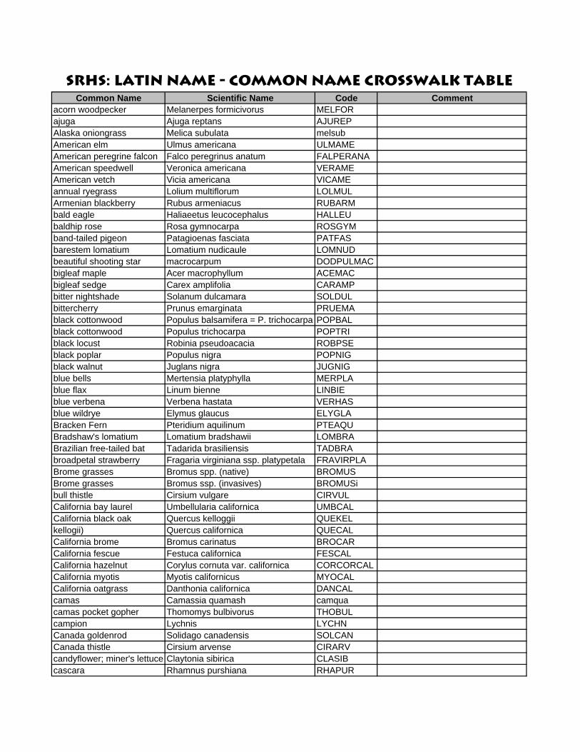
SRHS: Latin Name - Common Name Crosswalk TableCommon Name Scientific Name Code Comment
acorn woodpecker Melanerpes formicivorus MELFORajuga Ajuga reptans AJUREPAlaska oniongrass Melica subulata melsubAmerican elm Ulmus americana ULMAMEAmerican peregrine falcon Falco peregrinus anatum FALPERANAAmerican speedwell Veronica americana VERAMEAmerican vetch Vicia americana VICAMEannual ryegrass Lolium multiflorum LOLMULArmenian blackberry Rubus armeniacus RUBARMbald eagle Haliaeetus leucocephalus HALLEUbaldhip rose Rosa gymnocarpa ROSGYMband-tailed pigeon Patagioenas fasciata PATFASbarestem lomatium Lomatium nudicaule LOMNUDbeautiful shooting star macrocarpum DODPULMACbigleaf maple Acer macrophyllum ACEMACbigleaf sedge Carex amplifolia CARAMPbitter nightshade Solanum dulcamara SOLDULbittercherry Prunus emarginata PRUEMAblack cottonwood Populus balsamifera = P. trichocarpa POPBALblack cottonwood Populus trichocarpa POPTRIblack locust Robinia pseudoacacia ROBPSEblack poplar Populus nigra POPNIGblack walnut Juglans nigra JUGNIGblue bells Mertensia platyphylla MERPLAblue flax Linum bienne LINBIEblue verbena Verbena hastata VERHASblue wildrye Elymus glaucus ELYGLABracken Fern Pteridium aquilinum PTEAQUBradshaw's lomatium Lomatium bradshawii LOMBRABrazilian free-tailed bat Tadarida brasiliensis TADBRAbroadpetal strawberry Fragaria virginiana ssp. platypetala FRAVIRPLABrome grasses Bromus spp. (native) BROMUSBrome grasses Bromus ssp. (invasives) BROMUSibull thistle Cirsium vulgare CIRVULCalifornia bay laurel Umbellularia californica UMBCALCalifornia black oak Quercus kelloggii QUEKELkellogii) Quercus californica QUECALCalifornia brome Bromus carinatus BROCARCalifornia fescue Festuca californica FESCALCalifornia hazelnut Corylus cornuta var. californica CORCORCALCalifornia myotis Myotis californicus MYOCALCalifornia oatgrass Danthonia californica DANCALcamas Camassia quamash camquacamas pocket gopher Thomomys bulbivorus THOBULcampion Lychnis LYCHNCanada goldenrod Solidago canadensis SOLCANCanada thistle Cirsium arvense CIRARVcandyflower; miner's lettuce Claytonia sibirica CLASIBcascara Rhamnus purshiana RHAPUR
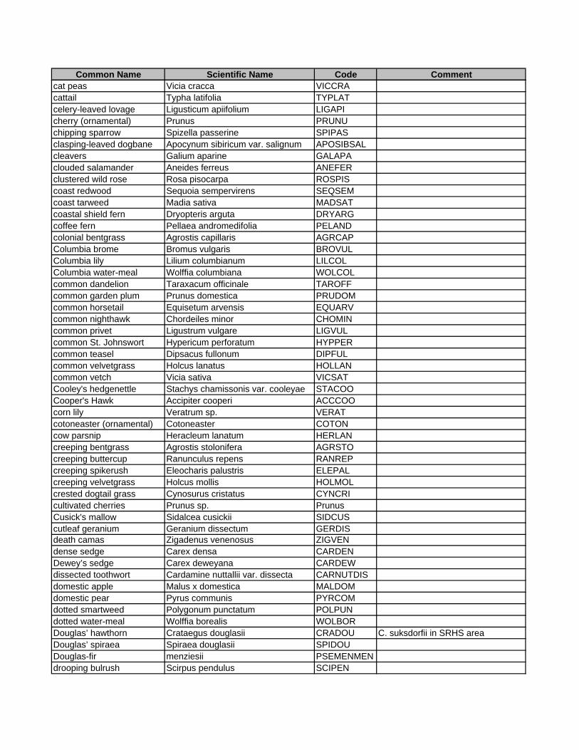
Common Name Scientific Name Code Commentcat peas Vicia cracca VICCRAcattail Typha latifolia TYPLATcelery-leaved lovage Ligusticum apiifolium LIGAPIcherry (ornamental) Prunus PRUNUchipping sparrow Spizella passerine SPIPASclasping-leaved dogbane Apocynum sibiricum var. salignum APOSIBSALcleavers Galium aparine GALAPAclouded salamander Aneides ferreus ANEFERclustered wild rose Rosa pisocarpa ROSPIScoast redwood Sequoia sempervirens SEQSEMcoast tarweed Madia sativa MADSATcoastal shield fern Dryopteris arguta DRYARGcoffee fern Pellaea andromedifolia PELANDcolonial bentgrass Agrostis capillaris AGRCAPColumbia brome Bromus vulgaris BROVULColumbia lily Lilium columbianum LILCOLColumbia water-meal Wolffia columbiana WOLCOLcommon dandelion Taraxacum officinale TAROFFcommon garden plum Prunus domestica PRUDOMcommon horsetail Equisetum arvensis EQUARVcommon nighthawk Chordeiles minor CHOMINcommon privet Ligustrum vulgare LIGVULcommon St. Johnswort Hypericum perforatum HYPPERcommon teasel Dipsacus fullonum DIPFULcommon velvetgrass Holcus lanatus HOLLANcommon vetch Vicia sativa VICSATCooley's hedgenettle Stachys chamissonis var. cooleyae STACOOCooper's Hawk Accipiter cooperi ACCCOOcorn lily Veratrum sp. VERATcotoneaster (ornamental) Cotoneaster COTONcow parsnip Heracleum lanatum HERLANcreeping bentgrass Agrostis stolonifera AGRSTOcreeping buttercup Ranunculus repens RANREPcreeping spikerush Eleocharis palustris ELEPALcreeping velvetgrass Holcus mollis HOLMOLcrested dogtail grass Cynosurus cristatus CYNCRIcultivated cherries Prunus sp. PrunusCusick's mallow Sidalcea cusickii SIDCUScutleaf geranium Geranium dissectum GERDISdeath camas Zigadenus venenosus ZIGVENdense sedge Carex densa CARDENDewey’s sedge Carex deweyana CARDEWdissected toothwort Cardamine nuttallii var. dissecta CARNUTDISdomestic apple Malus x domestica MALDOMdomestic pear Pyrus communis PYRCOMdotted smartweed Polygonum punctatum POLPUNdotted water-meal Wolffia borealis WOLBORDouglas’ hawthorn Crataegus douglasii CRADOU C. suksdorfii in SRHS areaDouglas’ spiraea Spiraea douglasii SPIDOUDouglas-fir menziesii PSEMENMENdrooping bulrush Scirpus pendulus SCIPEN
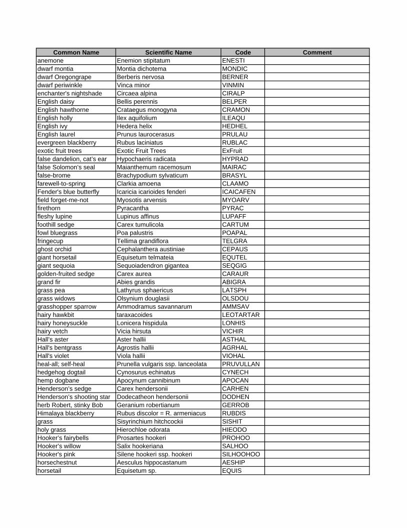
Common Name Scientific Name Code Commentanemone Enemion stipitatum ENESTIdwarf montia Montia dichotema MONDICdwarf Oregongrape Berberis nervosa BERNERdwarf periwinkle Vinca minor VINMINenchanter's nightshade Circaea alpina CIRALPEnglish daisy Bellis perennis BELPEREnglish hawthorne Crataegus monogyna CRAMONEnglish holly Ilex aquifolium ILEAQUEnglish ivy Hedera helix HEDHELEnglish laurel Prunus laurocerasus PRULAUevergreen blackberry Rubus laciniatus RUBLACexotic fruit trees Exotic Fruit Trees ExFruitfalse dandelion, cat’s ear Hypochaeris radicata HYPRADfalse Solomon’s seal Maianthemum racemosum MAIRACfalse-brome Brachypodium sylvaticum BRASYLfarewell-to-spring Clarkia amoena CLAAMOFender's blue butterfly Icaricia icarioides fenderi ICAICAFENfield forget-me-not Myosotis arvensis MYOARVfirethorn Pyracantha PYRACfleshy lupine Lupinus affinus LUPAFFfoothill sedge Carex tumulicola CARTUMfowl bluegrass Poa palustris POAPALfringecup Tellima grandiflora TELGRAghost orchid Cephalanthera austiniae CEPAUSgiant horsetail Equisetum telmateia EQUTELgiant sequoia Sequoiadendron gigantea SEQGIGgolden-fruited sedge Carex aurea CARAURgrand fir Abies grandis ABIGRAgrass pea Lathyrus sphaericus LATSPHgrass widows Olsynium douglasii OLSDOUgrasshopper sparrow Ammodramus savannarum AMMSAVhairy hawkbit taraxacoides LEOTARTARhairy honeysuckle Lonicera hispidula LONHIShairy vetch Vicia hirsuta VICHIRHall’s aster Aster hallii ASTHALHall's bentgrass Agrostis hallii AGRHALHall's violet Viola hallii VIOHALheal-all; self-heal Prunella vulgaris ssp. lanceolata PRUVULLANhedgehog dogtail Cynosurus echinatus CYNECHhemp dogbane Apocynum cannibinum APOCANHenderson’s sedge Carex hendersonii CARHENHenderson’s shooting star Dodecatheon hendersonii DODHENherb Robert, stinky Bob Geranium robertianum GERROBHimalaya blackberry Rubus discolor = R. armeniacus RUBDISgrass Sisyrinchium hitchcockii SISHITholy grass Hierochloe odorata HIEODOHooker’s fairybells Prosartes hookeri PROHOOHooker’s willow Salix hookeriana SALHOOHooker's pink Silene hookeri ssp. hookeri SILHOOHOOhorsechestnut Aesculus hippocastanum AESHIPhorsetail Equisetum sp. EQUIS

Common Name Scientific Name Code Commenthowellia Howellia aquatilis HOWAQUHowell's bentgrass Agrostis howellii AGRHOWHowell's brodiaea Triteleia grandiflora ssp. howellii TRIGRAHOWHowell's montia Montia howellii MONHOWhumped bladderwort Utricularia gibba UTRGIBincense-cedar Calocedrus decurrens CALDECinside-out flower Vancouveria hexandra VANHEXIrish ivy Hedera hibernica HEDHIBivy Hedera HEDERKentucky bluegrass Poa pratensis POAPRAKincaid's lupine Lupinus sulphureus ssp. kincaidii LUPSULKINladyfern Athyrium filix-femina ATHFILlarge-flowered collomia Collomia grandiflora COLGRAlarge-fruited lomatium Lomatium macrocarpum LOMMAClarge-leaved avens Geum macrophyllum GEUMACleast hop clover Trifolium dubium TRIDUBLechtlin’s camas Camassia leichtlinii CAMLEILemmon's needlegrass Achnatherum lemmonii ACHLEMlemon balm Melissa officinalis MELOFFLewis's woodpecker Melanerpes lewis MELLEWlicorice fern Polypodium glycerrhiza POLGLYlittle willow flycatcher Empidonax traillii brewsteri EMPTRABRElodgepole pine Pinus contorta PINCONlong-eared myotis Myotis evotis MYOEVOlong-legged myotis Myotis volans MYOVOLMaltese star-thistle Centaurea melitensis CENMELmany-leaved lupine Lupinus polyphyllus LUPPOLmaple Acer ACERmeadow foxtail Alopecurus pratensis ALOPRAmeadow knapweed Centaurea pratensis CENPRAmeadow sidalcea Sidalcea campestris SIDCAMmedusahead Taeniatherum caput-medusae TAECAPMenzie's catchfly Silene menziesii SILMENminer's lettuce Claytonia perfoliata CLAPERmonkeyflower Mimulus guttatus MIMGUTmountain lady's-slipper Cypripedium montanum CYPMONmountain quail Oreortyx pictus OREPICmountain sweet cicely Osmorhiza berteroi OSMBERmountain tarweed Madia glomerata MADGLOmule's ears Wyethia angustifolia WYEANGmultiflora rose Rosa multiflora ROSMULnarrowleaf onion Allium amplectens ALLAMPnarrowleaf pea Lathyrus sylvestris LATSYLnarrowleaf waterplantain Alisma gramineum ALIGRAnarrow-leaved milkweed Asclepias fasicularis ASCFASNelson’s checkermallow Sidalcea nelsoniana SIDNELnight-blmg morning glory atriplicifolia CALATRnipplewort Lapsana communis LAPCOMNootka rose Rosa nutkana ROSNUTNorthern Goshawk Accipiter gentilis ACCGENnorthern red-legged frog Rana aurora aurora RANAURAUR
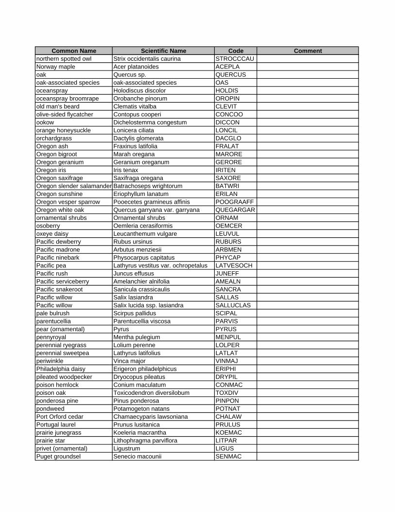
Common Name Scientific Name Code Commentnorthern spotted owl Strix occidentalis caurina STROCCCAUNorway maple Acer platanoides ACEPLAoak Quercus sp. QUERCUSoak-associated species oak-associated species OASoceanspray Holodiscus discolor HOLDISoceanspray broomrape Orobanche pinorum OROPINold man's beard Clematis vitalba CLEVITolive-sided flycatcher Contopus cooperi CONCOOookow Dichelostemma congestum DICCONorange honeysuckle Lonicera ciliata LONCILorchardgrass Dactylis glomerata DACGLOOregon ash Fraxinus latifolia FRALATOregon bigroot Marah oregana MAROREOregon geranium Geranium oreganum GEROREOregon iris Iris tenax IRITENOregon saxifrage Saxifraga oregana SAXOREOregon slender salamander Batrachoseps wrightorum BATWRIOregon sunshine Eriophyllum lanatum ERILANOregon vesper sparrow Pooecetes gramineus affinis POOGRAAFFOregon white oak Quercus garryana var. garryana QUEGARGARornamental shrubs Ornamental shrubs ORNAMosoberry Oemleria cerasiformis OEMCERoxeye daisy Leucanthemum vulgare LEUVULPacific dewberry Rubus ursinus RUBURSPacific madrone Arbutus menziesii ARBMENPacific ninebark Physocarpus capitatus PHYCAPPacific pea Lathyrus vestitus var. ochropetalus LATVESOCHPacific rush Juncus effusus JUNEFFPacific serviceberry Amelanchier alnifolia AMEALNPacific snakeroot Sanicula crassicaulis SANCRAPacific willow Salix lasiandra SALLASPacific willow Salix lucida ssp. lasiandra SALLUCLASpale bulrush Scirpus pallidus SCIPALparentucellia Parentucellia viscosa PARVISpear (ornamental) Pyrus PYRUSpennyroyal Mentha pulegium MENPULperennial ryegrass Lolium perenne LOLPERperennial sweetpea Lathyrus latifolius LATLATperiwinkle Vinca major VINMAJPhiladelphia daisy Erigeron philadelphicus ERIPHIpileated woodpecker Dryocopus pileatus DRYPILpoison hemlock Conium maculatum CONMACpoison oak Toxicodendron diversilobum TOXDIVponderosa pine Pinus ponderosa PINPONpondweed Potamogeton natans POTNATPort Orford cedar Chamaecyparis lawsoniana CHALAWPortugal laurel Prunus lusitanica PRULUSprairie junegrass Koeleria macrantha KOEMACprairie star Lithophragma parviflora LITPARprivet (ornamental) Ligustrum LIGUSPuget groundsel Senecio macounii SENMAC
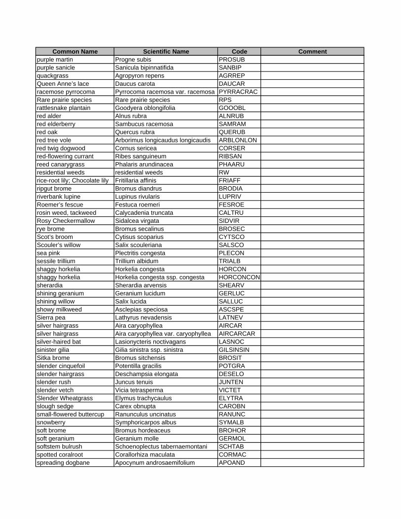
Common Name Scientific Name Code Commentpurple martin Progne subis PROSUBpurple sanicle Sanicula bipinnatifida SANBIPquackgrass Agropyron repens AGRREPQueen Anne’s lace Daucus carota DAUCARracemose pyrrocoma Pyrrocoma racemosa var. racemosa PYRRACRACRare prairie species Rare prairie species RPSrattlesnake plantain Goodyera oblongifolia GOOOBLred alder Alnus rubra ALNRUBred elderberry Sambucus racemosa SAMRAMred oak Quercus rubra QUERUBred tree vole Arborimus longicaudus longicaudis ARBLONLONred twig dogwood Cornus sericea CORSERred-flowering currant Ribes sanguineum RIBSANreed canarygrass Phalaris arundinacea PHAARUresidential weeds residential weeds RWrice-root lily; Chocolate lily Fritillaria affinis FRIAFFripgut brome Bromus diandrus BRODIAriverbank lupine Lupinus rivularis LUPRIVRoemer’s fescue Festuca roemeri FESROErosin weed, tackweed Calycadenia truncata CALTRURosy Checkermallow Sidalcea virgata SIDVIRrye brome Bromus secalinus BROSECScot’s broom Cytisus scoparius CYTSCOScouler’s willow Salix scouleriana SALSCOsea pink Plectritis congesta PLECONsessile trillium Trillium albidum TRIALBshaggy horkelia Horkelia congesta HORCONshaggy horkelia Horkelia congesta ssp. congesta HORCONCONsherardia Sherardia arvensis SHEARVshining geranium Geranium lucidum GERLUCshining willow Salix lucida SALLUCshowy milkweed Asclepias speciosa ASCSPESierra pea Lathyrus nevadensis LATNEVsilver hairgrass Aira caryophyllea AIRCARsilver hairgrass Aira caryophyllea var. caryophyllea AIRCARCARsilver-haired bat Lasionycteris noctivagans LASNOCsinister gilia Gilia sinistra ssp. sinistra GILSINSINSitka brome Bromus sitchensis BROSITslender cinquefoil Potentilla gracilis POTGRAslender hairgrass Deschampsia elongata DESELOslender rush Juncus tenuis JUNTENslender vetch Vicia tetrasperma VICTETSlender Wheatgrass Elymus trachycaulus ELYTRAslough sedge Carex obnupta CAROBNsmall-flowered buttercup Ranunculus uncinatus RANUNCsnowberry Symphoricarpos albus SYMALBsoft brome Bromus hordeaceus BROHORsoft geranium Geranium molle GERMOLsoftstem bulrush Schoenoplectus tabernaemontani SCHTABspotted coralroot Corallorhiza maculata CORMACspreading dogbane Apocynum androsaemifolium APOAND

Common Name Scientific Name Code Commentspreading rush Juncus patens JUNPATspring beauty Cardamine nuttallii CARNUTspring beauty Cardamine nuttallii var. nuttallii CARNUTNUTspurge laurel Daphne laureola DAPLAUStandard Prairie Invasives Standard Prairie Invasives SPIstarflower Trientalis latifolia TRILATSolomon’s seal Maianthemum stellatum MAISTEsterile brome Bromus sterilis BROSTEstinging nettle Urtica dioica URTDIOstreaked horned lark Eremophila alpestris strigata EREALPSTRstream violet Viola glabella VIOGLAsweet cherry Prunus avium PRUAVIsweet vernalgrass Anthoxanthum odoratum ANTODOsweetbriar rose Rosa eglanteria ROSEGLtall annual willowherb Epilobium brachycarpum EPIBRAtall bugbane Cimicifuga elata CIMELAtall fescue Festuca arundinacea FESARUtall larkspur Delphinium trolliifolium DELTROtall mannagrass Glyceria striata GLYSTRtall oatgrass Arrhenatherum elatius ARRELAtall Oregongrape Berberis aquifolium BERAQUtansy ragwort Senecio jacobaea SENJACtaperfruit shortscale sedge Carex leptopoda CARLEPTaylor's checkerspot Euphydryas editha taylori EUPEDITAYthimbleberry Rubus parviflorus RUBPARthin-leaved peavine Lathyrus holochlorus LATHOLThompson's mistmaiden Romanzoffia thompsonii ROMTHOthundercloud plum Prunus cerasifera PRUCERtimothy Phleum pratense PHLPRAtimwort Cicendia quadrangularis CICQUAtoad rush Juncus bufonius JUNBUFtoothcup Rotala ramosior ROTRAMtorilis Torilis arvensis TORARVTownsend's big-eared bat Corynorhinus townsendii CORTOWtrailplant; pathfinder Adenocaulon bicolor ADEBICtufted hairgrass Deschampsia cespitosa DESCESturfgrasses Turfgrasses TURFGupland yellow violet Viola praemorsa ssp. praemorsa VIOPRAPRAventenata Ventenata dubia VENDUBvine maple Acer circinatum ACECIRwall lettuce Lactuca muralis LACMURwater parsley Oenanthe sarmentosa OENSARwaterleaf Hydrophyllum tenuipes HYDTENwayside aster Eucephalus (Aster) vialis EUCVIAwestern bluebird Sialia mexicana SIAMEXwestern columbine Aquilegia formosa AQUFORWestern Coneflower Rudbeckia occidentalis RUDOCCwestern dogwood Cornus nuttallii CORNUTwestern Fescue Festuca occidentalis FESOCCwestern gray squirrel Sciurus griseus SCIGRIwestern hemlock Tsuga heterophylla TSUHET

Common Name Scientific Name Code Commentwestern mannagrass Glyceria occidentalis GLYOCCwestern meadowlark Sturnella neglecta STUNEGwestern rattlesnake Crotalus viridis CROVIRwestern red cedar Thuja plicata THUPLIwestern screech-owl Otus kennicottii OTUKENwestern swordfern Polystichum munitum POLMUNwestern toad Bufo boreas BUFBORwestern trillium Trillium ovatum TRIOVAwestern witchgrass Panicum occidentale PANOCCwhite alder Alnus rhombifolia ALNRHOwhite brodiaea Triteleia hyacinthina TRIHYAWhite-breasted Nuthatch Sitta carolinensis SITCARWhite-breasted Nuthatch Sitta carolinensis aculeata SITCARACUwhite-flowered navarretia Navarretia leucocephala NAVLEUwhite-footed vole Arborimus albipes ARBALBwhite-topped aster Sericocarpus rigidus (Aster curtus) SERRIGwild oats Avena fatua AVEFATWillamette daisy decumbens ERIDECDECWillamette navarretia Navarretia willamettensis NAVWILWillamette Valley larkspur Delphinium oreganum DELOREwillow Salix SALIXwoodland tarweed Madia madioides MADMAD = Ansiocarpus madioideswoods strawberry Fragaria vesca FRAVESyellow & blue forget-me-not Myosotis discolor MYODISyellow fawn lily Erythronium oreganum ERYOREyellow Iris Iris pseudacorus IRIPSEyellow vetchling Lathyrus aphaca lataphyellow-breasted chat Icteria virens ICTVIRyerba buena Satureja douglasii SATDOUyouth-on-age Tolmiea menziesii TOLMEN

PPRROOJJEECCTT MMAANNAAGGEERR:: BBRRUUCCEE NNEEWWHHOOUUSSEE
Professional Employment
• Principal, Salix Associates. Eugene, Oregon, 1992 to
present.
• Principal Planner, City of Springfield Planning and
Development Department. Springfield, Oregon, 1981-89.
• Land Use Planner, Josephine County Planning Department. Grants Pass,
Oregon, 1979-81.
Education
• Bachelor of Science, Landscape Architecture / Environmental Planning, Oregon State University,
Corvallis, Oregon.
• Post-Bac, Soil Morphology, Oregon State University.
Instruction
• Nature in the Urban Park, Department of Landscape
Architecture. University of Oregon, 2001-02, 2002-03.
• Grasses, Sedges and Rushes, Hortus West and numerous other locations.
Salem, Eugene, Bend, Ontario, etc. 1995 - present.
Publications
• Sedges of the Pacific Northwest (in prep). Carex Working Group. Expected public. 2007.
• Atlas of Oregon Carex. Carex Working Group. 1998.
Bruce Newhouse is a partner and principal in Salix Associates. He has 27 years of experience in field ecology and natural resource planning in Oregon, including 10 years in city and county planning offices, and 17 years in private consulting. He is active in both professional and volunteer activities in natural resources and related disciplines. Bruce’s education and experience focus on botany, ecology, and ecological relationships between plants, wildlife, fungi and other organisms. He has conducted numerous botanical and multi-disciplinary inventories and assessments with his partner in Salix Associates (Richard Brainerd), and they have developed restoration and management plans for several large sites in the southern Willamette Valley. They have conducted Goal 5 Natural Resource inventories for the City of Portland and the Metro area, the City of Corvallis and the City of Eugene, and have inventoried rare and invasive plants and mapped plant communities for several thousand acres of public and private lands. Bruce has been conducting Environmental Assessments for the City of Eugene’s Community Development Division for 15 years. Bruce is an experienced instructor in botany (particularly graminoids), butterfly identification and ecology (particularly host and nectar plant use), and fungal identification and ecology, for universities, community colleges, professional organizations and nonprofits. Bruce’s natural science photographs have been published in state and national publications, including the Oregon Conservation Strategy and two publications by the Xerces Society, as well as in both Eugene newspapers.
Contact Information Salix Associates, 2525 Potter, Eugene, OR 97405
Tele 541: 343.2364, fax 341.1752, cell 521.0962 E-mail: [email protected]

AASSSSIISSTTAANNTT PPRROOJJEECCTT MMAANNAAGGEERR:: RRIICCHHAARRDD BBRRAAIINNEERRDD
Professional Employment
• Principal, Salix Associates. Eugene, Oregon, 1992 to
present.
• Research Associate, Oregon State University,
Department of Forest Science. Corvallis, Oregon,
1988-91.
• Reforestation Forester, Africare, Chad, Africa
Education
• Master of Science, Forest Science, Oregon State
University, Corvallis, Oregon.
• Bachelor of Science, Botany, Oregon State
University, Corvallis, Oregon.
• Bachelor of Science, Forest Management, Oregon State
University. Corvallis, Oregon.
Instruction
• Sedge Identification, Prineville, Corvallis.
Publications
• Sedges of the Pacific Northwest (in prep). Carex Working Group. Expected public. 2007.
• Atlas of Oregon Carex. Carex Working Group. 1998.
Dick Brainerd is a partner and principal in Salix Associates. He has 20 years of experience in natural resource management and planning, field ecology and forest ecological research in Oregon, Washington, California, and Nevada, including 15 years as a private consultant, and 5 years in long-term forest ecological research. In addition, he spent 2 years in Sub-Saharan Africa as a reforestation forester for a USAID development project. Dick’s education and experience focus on botany and ecology of Pacific Northwest and Great Basin ecosystems with emphasis on rare species, rare plant communities, invasive weeds and restoration of native ecosystems. He has conducted numerous botanical and multi-disciplinary inventories and assessments with his partner in Salix Associates (Bruce Newhouse), and they have developed restoration and management plans for several large sites in the central and southern Willamette Valley. They have conducted Goal 5 Natural Resource inventories for the City of Portland and the Metro area, the City of Corvallis and the City of Eugene, and have inventoried rare and invasive plants and mapped plant communities for several thousand acres of public and private lands. Dick has done comprehensive vascular plant inventories in the Jackson Creek Mountains of northern Nevada and the Dry Creek Drainage in Owyhee country of southeastern Oregon. Dick is a consultant to the Willamette Valley Endangered Species Recovery Team and led the effort by the Native Plant Society of Corvallis to compile a list of Rare and Endangered Vascular Plants of Benton County, Oregon.
Contact Information Salix Associates, 1377 NW Alta Vista Drive,
Corvallis, OR 97330 Tele 541: 760.2419, fax 753.3098
E-mail: [email protected]

AADDDDIITTIIOONNAALL SSRRHHSS TTEEAAMM MMEEMMBBEERRSS
Winterbrook Planning: Tim Brooks (Assistant Project Manager) Tim Brooks is principal of Winterbrook Planning. He has 20 years of experience in urban and natural resource planning with 17 years of work focused on the development and implementation of conservation plans complying with Oregon’s Goal 5. Tim’s Goal 5 planning experience includes preparation of a broad range of upland and riparian habitat inventories, local wetland inventories, sensitive species surveys, and natural resource management plans. Recent projects include work for Metro, Multnomah County, and the cities of Corvallis, Medford, Portland, St. Helens, and West Linn. Tim’s work has earned local, state, and national awards for natural resource management and policy innovation.
Winterbrook played a primary role in Corvallis’ multi-year urban natural resource planning project. Winterbrook led a team of professionals in preparing detailed methodologies, field inventories and inventory reports for stream corridors, wetlands, wildlife habitat, significant vegetation and tree groves. Then, Winterbrook worked closely with Corvallis and Benton County to determine the “significance” of inventoried natural features and to develop an innovative analysis of the economic, social, environmental and energy consequences of alternative levels of protection for significant Goal 5 resources. Tim managed a series of projects for the City of Portland preparing detailed Goal 5 inventories, ESEE analyses, and local conservation policies and regulations. For the City of West Linn, Winterbrook led a team of consultants to complete Goal 5 inventories and significance determinations for seven resources: wetlands, riparian corridors, wildlife habitat, natural areas, historic and cultural resources, open spaces, and scenic views and sites. Subsequently, Winterbrook worked with City staff to develop a Goal 5 conflict resolution program for each of these resources and is now drafting amendments to the West Linn Development Code.
The Hydrologic Group: Jim Reed, PhD. (GIS) From his GIS shop (The Hydrologic Group) on the southwest edge of Springfield, Jim has produced highest quality GIS products for a variety of governmental and private clients. Jim is a very proficient GIS “shop” manager, and has an assistant available when needed. He maintains an extensive GIS map library, the EPA LULC cover types (as discussed elsewhere in this proposal), and is ready to produce the base mapping needed for this project. Jim has worked on numerous similar projects for Salix Associates, including mapping of plant communities for the Green Island and Baskett Butte projects. His work with watershed councils and the Friends of Buford Park and other groups is received with highest acclaim. Jim was ably assisted in this project by Erica Beyer, who is fluent in mapping and database programs and use. Katie Mitchell (Database Programming) Katie is a botanist and the Data Manager for the Oregon Flora Project at Oregon State University. She is fluent in in Access, MySQL, and Sybase and has utilized various tools to develop and perform advanced database and geographical analyses, including writing custom algorithms and functions in Visual Basic and using ArcGIS to perform quality checks and data analysis. Katie previously worked on projects (or was employed by) Olympic National Park, the Lake Roosevelt National Recreation Area, the Wenatchee National Forest, the Oregon Department of Agriculture, and the Carex Working Group. Katie worked with the Project Manager to create the interactive database in Access for this project.
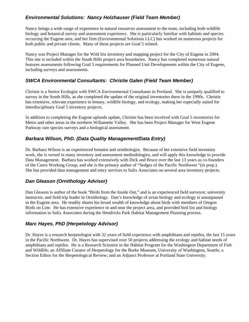
Environmental Solutions: Nancy Holzhauser (Field Team Member) Nancy brings a wide range of experience in natural resources assessment to the team, including both wildlife biology and botanical survey and assessment experience. She is particularly familiar with habitats and species occurring the Eugene area, and her firm (Environmental Solutions LLC) has worked on numerous projects for both public and private clients. Many of these projects are Goal 5 related. Nancy was Project Manager for the Wild Iris inventory and mapping project for the City of Eugene in 2004. This site is included within the South Hills project area boundaries. Nancy has completed numerous natural features assessments following Goal 5 requirements for Planned Unit Developments within the City of Eugene, including surveys and assessments. SWCA Environmental Consultants: Christie Galen (Field Team Member) Christie is a Senior Ecologist with SWCA Environmental Consultants in Portland. She is uniquely qualified to survey in the South Hills, as she completed the update of the original inventories there in the 1990s. Christie has extensive, relevant experience in botany, wildlife biology, and ecology, making her especially suited for interdisciplinary Goal 5 inventory projects. In addition to completing the Eugene uplands update, Christie has been involved with Goal 5 inventories for Metro and other areas in the northern Willamette Valley. She has been Project Manager for West Eugene Parkway rare species surveys and a biological assessment. Barbara Wilson, PhD. (Data Quality Management/Data Entry) Dr. Barbara Wilson is an experienced botanist and ornithologist. Because of her extensive field inventory work, she is versed in many inventory and assessment methodologies, and will apply this knowledge to provide Data Management. Barbara has worked extensively with Dick and Bruce over the last 13 years as co-founders of the Carex Working Group, and she is the primary author of “Sedges of the Pacific Northwest “(in prep.). She has provided data management and entry services to Salix Associates on several area inventory projects. Dan Gleason (Ornithology Advisor) Dan Gleason is author of the book “Birds from the Inside Out,” and is an experienced field surveyor, university instructor, and field trip leader in Ornithology. Dan’s knowledge of avian biology and ecology is unsurpassed in the Eugene area. He readily shares his broad wealth of knowledge about birds with members of Oregon Birds on Line. He has extensive experience in and near the project area, and provided bird list and biology information to Salix Associates during the Hendricks Park Habitat Management Planning process. Marc Hayes, PhD (Herpetology Advisor) Dr. Hayes is a research herpetologist with 32 years of field experience with amphibians and reptiles, the last 15 years in the Pacific Northwest. Dr. Hayes has supervised over 50 projects addressing the ecology and habitat needs of amphibians and reptiles. He is a Research Scientist in the Habitat Program for the Washington Department of Fish and Wildlife; an Affiliate Curator of Herpetology for the Burke Museum, University of Washington, Seattle; a Section Editor for the Herpetological Review; and an Adjunct Professor at Portland State University.