south china sea and the gulf of thailand
DESCRIPTION
Sailing directions (en route) to the South China Sea and the Gulf of Thailand, published by NATIONAL GEOSPATIAL-INTELLIGENCE AGENCY (United State)TRANSCRIPT

PUB.
(ENROUTE)SAILING DIRECTIONS
★
★
2011
161
SOUTH CHINA SEA AND THE GULF OF THAILAND
Prepared and published by theNATIONAL GEOSPATIAL-INTELLIGENCE AGENCY
Bethesda, Maryland
© COPYRIGHT 2011 BY THE UNITED STATES GOVERNMENTNO COPYRIGHT CLAIMED UNDER TITLE 17 U.S.C.
THIRTEENTH EDITION
For sale by the Superintendent of Documents, U.S. Government Printing Office
Internet: http://bookstore.gpo.gov Phone: toll free (866) 512-1800; DC area (202) 512-1800Fax: (202) 512-2250 Mail Stop: SSOP, Washington, DC 20402-0001
2
Pub. 161
Preface
0.0 Pub. 161, Sailing Directions (Enroute) South China Sea andthe Gulf of Thailand, Thirteenth Edition, 2011, is issued foruse in conjunction with Pub. 120, Sailing Directions (PlanningGuide) Pacific Ocean and Southeast Asia. Companion volumesare Pubs. 162, 163, and 164.0.0 Digital Nautical Charts 3, 11 and 23 provide electronic chartcoverage for the area covered by this publication. 0.0 This publication has been corrected to 05 February 2011, in-cluding Notice to Mariners No. 6 of 2011.
Explanatory Remarks
0.0 Sailing Directions are published by the National Geospatial-Intelligence Agency (NGA), under the authority of Departmentof Defense Directive 5105.40, dated 12 December 1988, andpursuant to the authority contained in U. S. Code Title 10,Sections 2791 and 2792 and Title 44, Section 1336. SailingDirections, covering the harbors, coasts, and waters of theworld, provide information that cannot be shown graphicallyon nautical charts and is not readily available elsewhere.0.0 Sailing Directions (Enroute) include detailed coastal andport approach information which supplements the largest scalechart produced by the National Geospatial-IntelligenceAgency. This publication is divided into geographic areascalled “Sectors.”0.0 Bearings.—Bearings are true, and are expressed in degreesfrom 000° (north) to 360°, measured clockwise. Generalbearings are expressed by initial letters of points of the com-pass (e.g. N, NNE, NE, etc.). Adjective and adverb endingshave been discarded. Wherever precise bearings are intendeddegrees are used.0.0 Charts.—Reference to charts made throughout this publi-cation refer to both the paper chart and the Digital NauticalChart (DNC).0.0 Coastal Features.—It is assumed that the majority of shipshave radar. Available coastal descriptions and views, useful forradar and visual piloting are included in geographic sequencein each Sector.0.0 Corrective Information.—Users should refer corrections,additions, and comments to NGA’s Maritime Operations Desk,as follows: 0.0 1. Toll free: 1-800-362-62890.0 2. Commercial: 301-227-31470.0 3. DSN: 287-31470.0 4. DNC web site: http://msi.nga.mil/NGAPortal/DNC.portal0.0 5. Maritime Do-0.0 main web site: http://msi.nga.mil/NGAPortal/MSI.portal0.0
0.0 6. E-mail: [email protected] 7. Mailing address: Maritime Domain0.0 National Geospatial-Intelligence0.0 Agency
Mail Stop D-440.0 4600 Sangamore Road0.0 Bethesda MD 20816-5003
0.0 New editions of Sailing Directions are corrected through thedate of the publication shown above. Important information toamend material in the publication is available as a PublicationDigital Update (PDU) from the NGA Maritime Domain web-site.
0.0NGA Maritime Domain Websitehttp://msi.nga.mil/NGAPortal/MSI.portal
0.0
0.0 Courses.—Courses are true, and are expressed in the samemanner as bearings. The directives “steer” and “make good” acourse mean, without exception, to proceed from a point oforigin along a track having the identical meridianal angle as thedesignated course. Vessels following the directives must allowfor every influence tending to cause deviation from such track,and navigate so that the designated course is continuouslybeing made good.0.0 Currents.—Current directions are the true directions towardwhich currents set.0.0 Dangers.—As a rule outer dangers are fully described, butinner dangers which are well-charted are, for the most part,omitted. Numerous offshore dangers, grouped together, arementioned only in general terms. Dangers adjacent to a coastalpassage or fairway are described.0.0 Distances.—Distances are expressed in nautical miles of 1minute of latitude. Distances of less than 1 mile are expressedin meters, or tenths of miles.0.0 Geographic Names.—Geographic names are generallythose used by the nation having sovereignty. Names in paren-theses following another name are alternate names that mayappear on some charts. In general, alternate names are quotedonly in the principal description of the place. Diacritical marks,such as accents, cedillas, and circumflexes, which are related tospecific letters in certain foreign languages, are not used in theinterest of typographical simplicity. Geographic names or theirspellings do not necessarily reflect recognition of the politicalstatus of an area by the United States Government.0.0 Heights.—Heights are referred to the plane of referenceused for that purpose on the charts and are expressed in meters.0.0 Index-Gazetteer.—Navigational features and place-namesare listed alphabetically in the back of the book. The approxi-mate position, along with the Sector and paragraph numbers(e.g. 1.1), facilitate location in the text.0.0 Internet Links.—This publication provides internet links toweb sites concerned with maritime navigational safety, includ-ing but not limited to, Federal government sites, foreign Hy-drographic Offices, and foreign public/private port facilities.NGA makes no claims, promises, or guarantees concerning theaccuracy, completeness, or adequacy of the contents of the websites and expressly disclaims any liability for errors and omis-sions of these web sites.0.0 Light and Fog Signals.—Lights and fog signals are not de-scribed, and light sectors are not usually defined. The LightLists should be consulted for complete information.0.0 Ports.—Directions for entering ports are depicted whereappropriate by means of chartlets, sketches, and photos, whichfacilitate positive identification of landmarks and navigational

3
Pub. 161
aids. These chartlets and sketches are not always to scale, how-ever, and should be used only as a general informational guidein conjunction with the best scale chart. Specific port facilitiesare omitted from the standard format. They are tabulated inPub. 150, World Port Index.0.0 Radio Navigational Aids.—Radio navigational aids are notdescribed in detail. Publication No. 117 Radio NavigationalAids and NOAA Publication, Selected Worldwide MarineBroadcasts, should be consulted.0.0 Soundings.—Soundings are referred to the datum of thecharts and are expressed in meters.0.0 Special Warnings.—A Special Warning may be in force forthe geographic area covered by this publication. SpecialWarnings are printed in the weekly Notice to Mariners uponpromulgation and are reprinted annually in Notice to MarinersNo. 1. A listing of Special Warnings currently in force isprinted in each weekly Notice to Mariners, Section III, Broad-cast Warnings, along with the notice number of promulgation.Special Warnings are also available on the Maritime Divisionwebsite.
0.0 Wind Directions.—Wind directions are the true directionsfrom which winds blow.
Reference List
0.0 The principal sources examined in the preparation of thispublication were:0.0 British Hydrographic Department Sailing Directions.0.0 Canadian Hydrographic Service Sailing Directions.0.0 Various port handbooks.0.0 Reports from United States naval and merchant vessels andvarious shipping companies.0.0 Other U.S. Government publications, reports, and docu-ments.0.0 Charts, light lists, tide and current tables, and other docu-ments in possession of the Agency.0.0

4
Pub. 161
0.0SECTOR LIMITS—PUB. 161

Pub. 154 5
Conversion Tables
Feet to MetersFeet 0 1 2 3 4 5 6 7 8 9 0 0.00 0.30 0.61 0.91 1.22 1.52 1.83 2.13 2.44 2.74 10 3.05 3.35 3.66 3.96 4.27 4.57 4.88 5.18 5.49 5.79 20 6.10 6.40 6.71 7.01 7.32 7.62 7.92 8.23 8.53 8.84 30 9.14 9.45 9.75 10.06 10.36 10.67 10.97 11.28 11.58 11.89 40 12.19 12.50 12.80 13.11 13.41 13.72 14.02 14.33 14.63 14.93 50 15.24 15.54 15.85 16.15 16.46 16.76 17.07 17.37 17.68 17.98 60 18.29 18.59 18.90 19.20 19.51 19.81 20.12 20.42 20.73 21.03 70 21.34 21.64 21.95 22.25 22.55 22.86 23.16 23.47 23.77 24.08 80 24.38 24.69 24.99 25.30 25.60 25.91 26.21 26.52 26.82 27.13 90 27.43 27.74 28.04 28.35 28.65 28.96 29.26 29.57 29.87 30.17
Fathoms to MetersFathoms 0 1 2 3 4 5 6 7 8 9
0 0.00 1.83 3.66 5.49 7.32 9.14 10.97 12.80 14.63 16.46 10 18.29 20.12 21.95 23.77 25.60 27.43 29.26 31.09 32.92 34.75 20 36.58 38.40 40.23 42.06 43.89 45.72 47.55 49.38 51.21 53.03 30 54.86 56.69 58.52 60.35 62.18 64.01 65.84 67.67 69.49 71.32 40 73.15 74.98 76.81 78.64 80.47 82.30 84.12 85.95 87.78 89.61 50 91.44 93.27 95.10 96.93 98.75 100.58 102.41 104.24 106.07 107.90 60 109.73 111.56 113.39 115.21 117.04 118.87 120.70 122.53 124.36 126.19 70 128.02 129.85 131.67 133.50 135.33 137.16 138.99 140.82 142.65 144.47 80 146.30 148.13 149.96 151.79 153.62 155.45 157.28 159.11 160.93 162.76 90 164.59 166.42 168.25 170.08 171.91 173.74 175.56 177.39 179.22 181.05
Meters to FeetMeters 0 1 2 3 4 5 6 7 8 9
0 0.00 3.28 6.56 9.84 13.12 16.40 19.68 22.97 26.25 29.53 10 32.81 36.09 39.37 42.65 45.93 49.21 52.49 55.77 59.06 62.34 20 65.62 68.90 72.18 75.46 78.74 82.02 85.30 88.58 91.86 95.14 30 98.42 101.71 104.99 108.27 111.55 114.83 118.11 121.39 124.67 127.95 40 131.23 134.51 137.80 141.08 144.36 147.64 150.92 154.20 157.48 160.76 50 164.04 167.32 170.60 173.88 177.16 180.45 183.73 187.01 190.29 193.57 60 196.85 200.13 203.41 206.69 209.97 213.25 216.54 219.82 223.10 226.38 70 229.66 232.94 236.22 239.50 242.78 246.06 249.34 252.62 255.90 259.19 80 262.47 265.75 269.03 272.31 275.59 278.87 282.15 285.43 288.71 291.99 90 295.28 298.56 301.84 305.12 308.40 311.68 314.96 318.24 321.52 324.80
Meters to FathomsMeters 0 1 2 3 4 5 6 7 8 9
0 0.00 0.55 1.09 1.64 2.19 2.73 3.28 3.83 4.37 4.92 10 5.47 6.01 6.56 7.11 7.66 8.20 8.75 9.30 9.84 10.39 20 10.94 11.48 12.03 12.58 13.12 13.67 14.22 14.76 15.31 15.86 30 16.40 16.95 17.50 18.04 18.59 19.14 19.68 20.23 20.78 21.33 40 21.87 22.42 22.97 23.51 24.06 24.61 25.15 25.70 26.25 26.79 50 27.34 27.89 28.43 28.98 29.53 30.07 30.62 31.17 31.71 32.26 60 32.81 33.36 33.90 34.45 35.00 35.54 36.09 36.64 37.18 37.73 70 38.28 38.82 39.37 39.92 40.46 41.01 41.56 42.10 42.65 43.20 80 43.74 44.29 44.84 45.38 45.93 46.48 47.03 47.57 48.12 48.67 90 49.21 49.76 50.31 50.85 51.40 51.95 52.49 53.04 53.59 54.13

Pub. 161 6
Abbreviations
The following abbreviations may be used in the text:
Units°C degree(s) Centigrade km kilometer(s)cm centimeter(s) m meter(s)cu.m. cubic meter(s) mb millibarsdwt deadweight tons MHz megahertzFEU forty-foot equivalent units mm millimeter(s)grt gross registered tons nrt net registered tonskHz kilohertz TEU twenty-foot equivalent units
DirectionsN north S southNNE northnortheast SSW southsouthwestNE northeast SW southwestENE eastnortheast WSW westsouthwestE east W westESE eastsoutheast WNW westnorthwestSE southeast NW northwestSSE southsoutheast NNW northnorthwest
Vessel typesLASH Lighter Aboard Ship ro-ro Roll-on Roll-offLNG Liquified Natural Gas ULCC Ultra Large Crude CarrierLPG Liquified Petroleum Gas VLCC Very Large Crude CarrierOBO Ore/Bulk/Oil
TimeETA estimated time of arrival GMT Greenwich Mean TimeETD estimated time of departure UTC Coordinated Universal Time
Water levelMSL mean sea level LWS low water springsHW high water MHWN mean high water neapsLW low water MHWS mean high water springsMHW mean high water MLWN mean low water neapsMLW mean low water MLWS mean low water springsHWN high water neaps HAT highest astronomical tideHWS high water springs LAT lowest astronomical tideLWN low water neaps
CommunicationsD/F direction finder MF medium frequencyR/T radiotelephone HF high frequencyGMDSS Global Maritime Distress and Safety System VHF very high frequencyLF low frequency UHF ultra high frequency
NavigationLANBY Large Automatic Navigation Buoy SPM Single Point MooringNAVSAT Navigation Satellite TSS Traffic Separation SchemeODAS Ocean Data Acquisition System VTC Vessel Traffic CenterSBM Single Buoy Mooring VTS Vessel Traffic Service
MiscellaneousCOLREGS Collision RegulationsIALA International Association of Lighthouse
AuthoritiesNo./Nos.PA
Number/NumbersPosition approximate
IHO International Hydrographic Office PD Position doubtfulIMO International Maritime Organization Pub. Publicationloa length overall St./Ste. Saint/Sainte

Pub. 161 9
Contents
Preface. . . . . . . . . . . . . . . . . . . . . . . . . . . . . . . . . . . . . . . . . . . . . . . . . . . . . . . . . . . . . . . . . . . . . . . . . . . . . . . . . . . . . . . . . . . . . . . . . 2Chartlet—Sector Limits . . . . . . . . . . . . . . . . . . . . . . . . . . . . . . . . . . . . . . . . . . . . . . . . . . . . . . . . . . . . . . . . . . . . . . . . . . . . . . . . . . . 3Conversion Tables. . . . . . . . . . . . . . . . . . . . . . . . . . . . . . . . . . . . . . . . . . . . . . . . . . . . . . . . . . . . . . . . . . . . . . . . . . . . . . . . . . . . . . . . 5Abbreviations . . . . . . . . . . . . . . . . . . . . . . . . . . . . . . . . . . . . . . . . . . . . . . . . . . . . . . . . . . . . . . . . . . . . . . . . . . . . . . . . . . . . . . . . . . . 6
Sector 1
The South China Sea—Central Part . . . . . . . . . . . . . . . . . . . . . . . . . . . . . . . . . . . . . . . . . . . . . . . . . . . . . . . . . . . . . . . . . . . . . . . . . . 1
Sector 2
Coast of China—Dapeng Jiao to Dajin, including Hong Kong and Macau . . . . . . . . . . . . . . . . . . . . . . . . . . . . . . . . . . . . . . . . . . 15
Sector 3
Coast of China—Dajin to Jiaowei Jiao, Including HainanTao . . . . . . . . . . . . . . . . . . . . . . . . . . . . . . . . . . . . . . . . . . . . . . . . . . . . 53
Sector 4
Coast of Vietnam—The Gulf of Tonkin . . . . . . . . . . . . . . . . . . . . . . . . . . . . . . . . . . . . . . . . . . . . . . . . . . . . . . . . . . . . . . . . . . . . . 75
Sector 5
Vietnam—Central and South Coasts . . . . . . . . . . . . . . . . . . . . . . . . . . . . . . . . . . . . . . . . . . . . . . . . . . . . . . . . . . . . . . . . . . . . . . . . 97
Sector 6
The Gulf of Thailand (Coasts of Cambodia and Thailand) and Malaysia—East Coast . . . . . . . . . . . . . . . . . . . . . . . . . . . . . . . . 119
Glossaries . . . . . . . . . . . . . . . . . . . . . . . . . . . . . . . . . . . . . . . . . . . . . . . . . . . . . . . . . . . . . . . . . . . . . . . . . . . . . . . . . . . . . . . . . . . . 153
Index—Gazetteer . . . . . . . . . . . . . . . . . . . . . . . . . . . . . . . . . . . . . . . . . . . . . . . . . . . . . . . . . . . . . . . . . . . . . . . . . . . . . . . . . . . . . . 161

1
Pub. 161
1. The South China Sea—Central Part
1.0Additional chart coverage may be found in NGA/DLIS Catalog of Maps, Charts, and Related Products (Unlimited Distribution).SECTOR 1 — CHART INFORMATION

3
Pub. 161
SECTOR 1
THE SOUTH CHINA SEA—CENTRAL PART
1.0 Plan.—This sector describes the central part of the SouthChina Sea, from Pratas Reef to Scawfell Shoal, about 1,100miles SW, including Dangerous Ground. The description isfrom NE to SW.
General Remarks
1.1 Winds—Weather.—Typhoons occur mostly fromJuly to November, but have developed at other times. Most arefound N of 15°N when passing through the South China Seaand follow W to WNW track lines. Typhoons have been knownto form in the South China Sea and move on a NW to NEcourse out of the area. 1.1 Typhoons of the western North Pacific Ocean are tropicalcyclones and do not differ from the cyclonic storms of othertropical waters. The winds of the typhoon blowcounterclockwise and incline toward the center of lowbarometric pressure.1.1 The Northeast Monsoon is much stronger and morepersistent than the Southwest Monsoon. Over the open sea theNortheast Monsoon is rarely interrupted, while the SouthwestMonsoon is often weak and irregular. Winds from the E andSE, which may last for 1 or 2 days, are usually the winds thatbreak the storm system.1.1 The change from one monsoon season to another is notabrupt, but takes place in a series of surges extending over aperiod of 4 to 6 weeks. Transitional months may vary slightlywith latitude. The Northeast Monsoon starts earlier and lastslonger in the N latitudes, and the Southwest Monsoon startsearlier and lasts longer in the S part of the area.1.1 Advance warning of an approaching tropical depression ortyphoon may be had by observing such items as swell,barometric pressure, cloud cover, and squall activity.1.1 Tides—Currents.—In the open sea, tidal currents areovershadowed by the monsoon drifts. In the vicinity of the landor on banks and shoals, the tidal currents must be considered.Moreover, when near the banks and shoals, there is apt to be adeflection of the monsoon currents as well as a markedincrease in velocities.1.1 September is the transition month, commencing the SW setof the Northeast Monsoon currents in the W areas of the SouthChina Sea. This current reaches its maximum velocity andconstancy in the months of December and January. The time ofthe onset of the Southwest Monsoon varies, so that in someyears the transitional stage may be up to the middle of May. 1.1 On the average the NE current of this monsoon attains itsgreatest velocity and constancy from June to August.1.1 The foregoing remarks are strictly averages for the entirearea. Some degree of variation is noted such as between the Sand N areas of the South China Sea, as well as between the Eand W portions. 1.1 Also of profound effect on the current is the proximity oftropical storms that will produce a marked difference from thenormal flow.
The South China Sea
1.2 The central portion of the South China Sea is enteredfrom the N through the Luzon Strait and Taiwan Strait, fromthe S through the Singapore Strait, and from the E from theSulu Sea. This area is bounded on the E by the Philippines, onthe S by the island of Borneo, on the W by Vietnam, and on theNW and N by China.1.2 Care should be taken not to violate restricted waters or toapproach too closely to the shores of the countries borderingthe South China Sea without clearance from the properauthorities. Additionally, jurisdictional disputes at timesinvolve the islands in the open sea area and may cause aconflict should a vessel approach too closely.1.2 The choice of routes and passages in the South China Seamust take into consideration the monsoon season, as well asthe size and power of the vessel. 1.2 Most dangers in the South China Sea are surrounded by deepwater, thus rendering soundings useless when approachingthem. The approach toward a danger should be made with thesun astern so as to make shoal water or breakers readilydistinguishable.1.2 It is considered only probable that all dangers have beenlocated, except in the areas indicated as unsurveyed on thechart, and the positions of many dangers may be as much as 2or 3 miles in error. Additionally, many reported dangers havenot been confirmed, hence their existence and exact locationare in doubt. It is prudent to give these types of dangers a wideberth. With the exception of North Danger Reef, Tizard Bank,and the W side of Pratas Reef, the central part of the SouthChina Sea has not been wire dragged.1.2 Accurate fixes are essential before attempting any passagesthat diverge from the recommended routes. All navigationalequipment should be exploited to the fullest extent; however,navigators must depend mainly on lookouts aloft and favorableweather when in the vicinity of reefs or possible dangers.Vessels intending to enter lagoons should be assisted by leadboats equipped to lay temporary buoys.1.2 There are no ports, with the exception of some offshoremarine terminals, and only a few protected anchorages withinthe limits of this sector.1.2 Pipelines lead between structures within a field, between thevarious fields, and to the shore collecting stations. Gaspipelines contain high pressure flammable natural gas.Navigation is restricted and anchoring or trawling is prohibitedin these areas. 1.2 Vessels causing damage to a pipeline by anchoring ortrawling risk prosecution, fire hazard, and loss of buoyancy tothe vessel.1.2 Floating or fixed drilling rigs may be encountered in someareas covered by this publication. The emitted flares from thesestructures may be seen from distances exceeding 20 miles. 1.2 Buoys and lighted buoys associated with drilling operationsare frequently moored in the vicinity of the rigs. The positions

4 Sector 1. The South China Sea—Central Part
Pub. 161
of these rigs and buoys are subject to change, and whereknown, the changes are promulgated by NAVAREA XI RadioNavigational Warning Messages. 1.2 Permanent platforms, structures, and buoys are usuallycharted. These structures exhibit lights (Mo (U) 15 seconds)and sound fog signals (Mo (U) 30 seconds). Numerous below-water obstructions, some marked by buoys, lie in the gas fields. 1.2 The limits of the gas fields are charted, but not all of thefeatures are contained within a field. Special care should beexercised when navigating in the vicinity. Anchoring within agas field is prohibited, except where designated.1.2 Fishing is a major industry and one of the main sources offood in many countries bordering the South China Sea. Thereis little evidence of fish migration, but certain grounds haveseasonal fishing due to their exposure to the NortheastMonsoon and the Southwest Monsoon. Traps, seine and driftnets, lines, lures, and bottom trawls are used. 1.2 Sizes of craft vary from rowing or sailing boats (3m inlength), to larger, powered craft. In the coastal waters, thefishing fleet may number from 3 to 50 vessels, with net andline fishing out to the 10m curve, and trawling in deeperwaters.1.2 Enormous fleets of fishing junks are met off the coast ofChina. As a rule, the junks have their smallest sail forward.Large trading junks have five masts, with two small sails aft. 1.2 Chinese junks do not carry the regulation lights.1.2 Vessels fishing for squid may be encountered in the vicinityof the Taiwan Strait, principally from July to October. Brightlights may be shown at night to attract the fish. 1.2 Fish havens and Fish Aggregating Devices (FADS) aregenerally established within 5 miles of the shoreline and aremarkedly frequented by fishing vessels. Fish traps have beenreported well offshore despite their generally being set in fairlyshallow waters. Marine farms may be moored up to 30 milesoffshore and may be attended by service vessels. As theirplacement may be temporary, they are not necessarily charted.
Pratas Island
1.3 Pratas Island (20°42'N., 116°43'E.), lying on the Wcentral edge of Pratas Reef, lies 160 miles SE of Hong Kongand constitutes a danger to vessels en route between Manilaand Hong Kong or transiting the Taiwan and Singapore Straits.1.3 Pratas Island is composed of sand, covered with scrubbybrush, and attains a height of about 12m to the top of thevegetation. There is a small settlement with a weather stationlocated near the center of the E part of the island. 1.3 Landing is possible on the S side of the E extremity of PratasIsland. The shallow inlet at the W end of the island isaccessible to small boats only. A reef, which dries, extends offthe W side of the island with several detached coral patchesbeing found between this reef and the main reef to the NW.1.3 Pratas Reef is a classic example of a coral atoll, beingroughly ring-shaped and about 13 miles in diameter. Thelagoon within the reef is coral-studded with depths of up toabout 16m. The N, S, and E sides uncover and are steep-to; theW side has submerged dangers through which a channel leadsinto the lagoon.1.3 The lagoon entrance channel leads from a position about 3miles S of the W end of Pratas Island in a NE direction for
about 4 miles. The channel is reported to have depths of over2.7m, but crosses charted areas of lesser depth. Buoys andrange beacons mark the fairway. It is bordered on the N by awhite sand spit and passes to the SE of the ordnance dumpingarea within the reef.1.3 Several wrecks lie stranded on Pratas Reef. One of thesewrecks lies about 7.5 miles, bearing 050°, from the E extremityof the island. A light is shown from a position near the SEextremity of Pratas Island and an airfield control tower standsabout 0.5 mile WNW of the light. In hazy weather, the island isseldom seen beyond 5 or 6 miles, and the breakers on the reefmay not be seen until within 1 mile.1.3 In fair weather, anchorage in the swept area to the W of theisland is available to vessels with prior clearance. Theanchorage has various depths and a sandy bottom. A vessel oflight draft might anchor on the reef, in the middle of thechannel entrance, in a depth of 5.5m, or cross the reef andanchor inside the lagoon.1.3 Caution.—During the strength of the monsoons, vesselsshould pass leeward of the reef because the currents invariablyset with the wind. The weather is frequently thick and hazynear the reef and soundings give no warning of close approachto it. A wide berth is recommended.1.3 A 9.2m patch lies 3 miles WSW of the W end of the island. 1.3 Currents and rips have been reported to be strong in thesector extending 20 to 50 miles NW through NE and E ofPratas Reef and are sometimes mistaken for breakers.1.3 Circular ammunition dumping areas are located about 5.25miles SW, 1 mile SW, and 1.75 miles SSE of the SE point ofPratas Island.
1.4 Huizhou Oil Terminal (21°21'N., 115°25'E.)consists of two offshore oil platforms and three tanker mooringbuoys 90 miles SE of Hong Kong. A platform and tankermooring buoy, which lies about 14 miles NE, are connected bya submarine pipeline. 1.4 Xijiang Terminal (21°18'N., 114°59'E.), developed 20miles W of Huizhou Oil Terminal, consists of three offshoretanker mooring buoys connected by a submarine pipeline.Pilotage is compulsory; the pilot boards by helicopter no lessthan 4 miles from the terminal. Vessels should notify agentsand the terminal with an ETA 96 hours, 72 hours, 48 hours, 24hours, and 12 hours prior to arrival.1.4 Caution.—Several well heads, with varying depths best seenon chart, exist in the area around these terminals.
1.5 Vereker Banks (21°00'N., 116°00'E.) consists of twosteep-to coral banks 45 miles NW of Pratas Reef. Heavy tiderips and overfalls have been reported in this area. During themonth of February, the set of the current in the vicinity of thebanks varies between WSW and WNW. At times it sets towindward although, with calms or light SW winds it setsbetween SSE and ESE. Normal rates of drift are 0.2 to 1 knot.1.5 North Vereker Bank has a least known depth of 11m (1972),with general depths of 60 to 90m over the remainder of thebank. About 2 to 3 miles of deep water separates North VerekerBank from South Vereker Bank, which has a least known depthof 58m. 1.5 A well head, with a depth of 4.1m, lies 30m off NorthVereker Bank and is charted.

Sector 1. The South China Sea—Central Part 5
Pub. 161
1.5 A well head, in a depth of over 100m, lies 28 miles N ofVereker Banks, in position 21°38'N, 116°03'E. The associatedproduction platform and SPM form Lu Feng Terminal, whichis enclosed by a restricted area. Exploration for oil is takingplace in this vicinity.1.5 Lan Shui Terminal (Liuhua Field) (20°50'N., 115°41'E.)(World Port Index No. 57775) is a purpose-built FloatingProduction Storage and Off-loading vessel (FPSO).1.5 A restricted area extends a radius of 2 miles around JiaziOffshore Platform in position 21°22'15"N, 116°09'25"E. Theplatform 3 miles N of it has been removed and the restrictedarea withdrawn.
1.6 Saint Esprit Shoal (19°33'N., 113°03'E.) is anisolated coral shoal, with a least depth of 10.8m, lying 35 milesW of the customary track from Hong Kong. Strong rips havebeen observed in the vicinity of the shoal. Currents generallyset with the wind.1.6 Helen Shoal (19°12'N., 113°52'E.) lies 50 miles SE of SaintEsprit Shoal and 15 miles E of the usual route from HongKong. The shoal is steep-to, breaks in bad weather, and ischarted with a least depth of 10.2m. A depth of 18.3m has beenreported to lie 6 miles SE of the shoal.1.6 Strong rips have been observed in the vicinity of HelenShoal, but upon further investigation deep water was found. 1.6 The current is little affected by the shoal and usually setswith the prevailing monsoon.
The Paracel Islands
1.7 The Paracel Islands (16°40'N., 112°20'E.) are madeup of the Amphitrite Group, the Crescent Group, and severaloff-lying islands and coral reefs lying W of the main HongKong-Singapore route. The islets are of low elevation; someare covered with trees or vegetation. 1.7 Navigation through the area presents little difficulty in fairweather provided a good lookout is kept, preferably high on themast. Breakers are often visible on many of the reefs andabove-water rocks. The use of radar is encouraged as manywrecks lying stranded on the surrounding reefs are radarconspicuous. 1.7 In poor weather, unless seeking anchorage, the ParacelIslands should be avoided. Currents generally correspond tothe prevailing monsoon, but with a light wind, continuallychange direction over the reefs attaining a rate of 2 knots.Anchorages, though available, are mostly open and offer onlyslight protection when leeward of the islands.
1.8 North Reef (17°06'N., 111°30'E.) is thenorthwesternmost danger in the area. The reef is about 7 mileslong on its E-W axis, 2.5 miles wide at its broadest width, andsteep-to. Rocks break the surface all around the edge of thereef and at certain times the breakers on the reef can be heard ata considerable distance. A boat passage on the SW side of thereef is marked on its E side.1.8 North Reef is reported to be a good radar target, possibly dueto the breakers and wreckage on the reef.
The Amphitrite Group (16°53'N., 112°17'E.) is thenortheasternmost cluster of islands, reefs, and shoals in theParacel Islands and consists of two parts separated by a deep
channel 3.5 miles wide. The N portion has two main reefsbisected by Zappe Pass. Several small islands stand on thesetwo reefs. 1.8 The S portion consists of Woody Island and Rocky Island,which lie upon a common reef.1.8 Zappe Pass is about 0.5 mile wide between the reefs and hasa least known depth of 4.6m. It is available only for small craftduring favorable conditions. With a fresh breeze, breakersextend across the pass and there is usually a strong currentrunning through it.1.8 West Sand is a low sandy cay lying near the W extremity ofthe northernmost reef. Tree Island (16°59'N., 112°16'E.) lies 4miles E of West Sand and about 1 mile from the E extremity ofthe reef. The island is covered with mangrove bushes,surrounded by a white sand beach, and has a palm tree near itscenter.1.8 Tides—Currents.—Currents of 6 to 7 knots have beenreported E of the Amphitrite Group during springs.
1.9 North Island (16°58'N., 112°18'E.) lies 2 miles ESEof Tree Island across Zappe Pass. A reef extends nearly 0.5mile NW from North Island and 4 miles SE. Several smallbuildings stand on the island. 1.9 To the SE of North Island lie Middle Island, South Island,and South Sand (16°56'N., 112°20'E.). Anchorage may betaken, in depths of 20 to 29m, SSW of North Island and MiddleIsland, over a bottom of sand. A depth of 20m lies 3 miles NEof South Sand.
1.10 Woody Island (16°50'N., 112°20'E.) lies 9 miles SSEof Tree Island in the Amphitrite Group; it is the southernmostand largest of the islands. It is about 1 mile in length, coveredwith trees, and surrounded by a white sand beach. Guano isshipped from the island.1.10 Aspect.—Two mooring buoys lie close N of Woody Island. 1.10 In the vicinity of the settlement on the island are a squaretower, two temples, a meteorological station, and several largebuildings. On the S side of the island stands an observationtower and four whip antennas situated about 0.3 mile N of thistower. 1.10 A light is shown from a white round stone tower with blackbands. Landing can be effected on the SW side of WoodyIsland. This island is connected to Rocky Island to the NE byan overhead cable. There are depths of 14.6m 5 miles SSE ofWoody Island.1.10 Anchorage.—During S winds, anchorage can be taken in aposition about 0.5 mile from the reef fringing the N side ofWoody Island, in a depth of 24m, sand. In NE winds there isgood anchorage about 0.5 mile off the SW shore of WoodyIsland, in 33 to 37m, sand.1.10 Rocky Island, 14m high, lies on the same drying reef as doesWoody Island. There are a few houses on the S end and aconcrete pier on the N end of the island. 1.10 Two red mooring buoys, No. I and No. II, lie outside the 20mcurve, 0.8 mile NW of Rocky Island. A depth of 14.6m existsin approximate position 16°46'N, 112°21'E.
1.10 Iltis Bank (16°46'N., 112°13'E.), with depths of 10.6 to14.8m, lies 7 miles SW of Woody Island. The bank is about 3miles long, 1.5 miles wide, and is fairly steep-to.

6 Sector 1. The South China Sea—Central Part
Pub. 161
1.10 Caution.—Caution is advised when anchoring due to thelack of shelter available and imperfect surveys of the area.
The Crescent Group
1.11 The Crescent Group consists of several low sand isletsand numerous reefs which form a crescent open to the S. Theylie 45 miles SW of the Amphitrite Group. 1.11 The principal islands are covered with thick vegetation andhave been reported to be visible from 10 miles. The lagoon,partly enclosed within the islands and reefs, is about 20 squaremiles in extent and provides suitable shelter for most classes ofvessels.1.11 Caution.—Navigation at night between the islets of thisgroup is dangerous.
1.12 The Duncan Islands (16°27'N., 111°43'E.) is actuallytwo coral islets joined by a sand spit and surrounded by a coralreef that is steep-to. It lies on the SE horn of the crescent and isseparated from Drummond Island to the E by the SE lagoonentrance channel which is deep and about 1.5 miles wide. Arock, with a depth less than 1.8m, lies close SE of the E island.1.12 Drummond Island, covered with mangroves and bushes, is3m high and lies on the SW tip of a continuous reef thatextends NE about 4 miles, then curves NW about 4 miles toObservation Bank.1.12 Observation Bank constitutes the N extremity of theCrescent Group. It is a sand cay on a reef about 2 miles longoriented in a SE-NW direction. A detached reef extends about3.2 miles WSW from the N end of the main reef. The area ofthe lagoon within the bight of this detached reef and the reefstretching NE and NW of Drummond Island is foul.
1.13 Pattle Island (16°32'N., 111°36'E.), 9m high, iscovered with brush and mangroves. A reef surrounding theisland extends about 1.7 miles NE. On either side of the reefthere is a clear channel. Boats can land at LW in a bight on theS side of the island, taking care to avoid the rocks close toshore. 1.13 There is a large three-story building in the center of theisland with another large building close E. Atop the W buildingis a skeleton tower surmounted by a flag staff. 1.13 A prominent pylon stands about 0.1 mile WSW of thebuildings and a conspicuous shrine lies on the SW extremity ofthe island. There is a meteorological station and a well fromwhich water is available on Pattle Island.1.13 A rock jetty, 183m long, is usable by small boats and extendsfrom the E side of the island, terminating seaward in a small T-head. A red building is situated at the root of the jetty. Depthsalongside the face of the T-head range from 1.5 to 2.7m at HW.1.13 The climate at Pattle Island is precarious after a rainfall,when a noxious gas arises from the guano deposits.1.13 Robert Island lies 2 miles SW of Pattle Island. It is 8m high,fringed by a reef, and covered with vegetation. There is aconspicuous observation tower on the S end of the island.Landing can be effected on its E side and well water can beobtained here. 1.13 A bank, with depths of 4m and less, extends about 0.8 mileN from Robert Island and another bank, with depths of 1 to 6m,lies within 0.3 mile of the shore on the SE side.
1.13 Caution.—Anchorage is not recommended in the area dueto the coral bottom.
1.14 Antelope Reef (16°27'N., 111°35'E.), which partiallydires, forms the SW horn of the crescent. A sand cay is locatedon the SE extremity of this reef.1.14 The lagoon entrance, between Duncan Island and AntelopeReef, is about 5 miles wide and deep. There is a 3.7m patchand an 8.5m patch located 3.5 and 2.8 miles W, respectively, ofDuncan Island.1.14 Anchorage.—There is a good choice of anchorages withinthe lagoon to suit any prevailing conditions. Depths range from7.3 to 12.8m over the coral heads to 20.1 to 47.6m in the moreopen portions. There is good shelter during the NortheastMonsoon, but a swell can develop during the strength of theSouthwest Monsoon. The tidal current in the SE entrance to thelagoon has been observed to be about 1.5 knots, but within theanchorage the tidal current is inappreciable.1.14 Anchorage can be taken near the reef off the N side ofDuncan Island, in 18 to 27m, where there are broad patches ofsandy bottom.1.14 Money Island (16°27'N., 111°30'E.), 6m high and brushcovered, lies at the W end of a reef which is separated from theSW horn of the crescent by a channel about 1.5 miles wide.Several sand cays lie E of Money Island on the same reef. Theisland is reported to be a good radar target.
Reefs and Islands
1.15 Dido Bank (16°49'N., 112°53'E.), with a depth of23m, is steep-to, with depths of 146m and more around it.1.15 Lincoln Island (16°40'N., 112°44'E.) is the easternmostisland of the Paracel Islands and lies 40 miles W of the mainHong Kong-Singapore route. The island is 5m high and brush-covered, about 1.25 miles long, and fringed by a drying reef. 1.15 A tower stands on the NE end of the island; the NE face ofthe island is bluff. It is reported that water can be found onLincoln Island and that the island is a good radar target.1.15 Anchorage.—Anchorage can be taken leeward of LincolnIsland about 0.5 mile offshore, in 18m, coral.1.15 Caution.—Mariners are advised not to cross the bank whichextends 14 miles S, then 5 miles WSW from the SE end of theisland as it has not been completely examined. This narrowcoral bank is studded with rocks. A wreck, reported to be radarconspicuous, lies stranded on the bank about 1.8 miles SE ofthe SE extremity of the island. 1.15 A 15.1m patch and a 13.2m patch lie about 1 mile S and 1.5miles W, respectively, of the S end of this coral bank. Furthershoaling in this vicinity appears highly probable because of theirregular bottom, with visible coral reefs running E and W. 1.15 Another bank, with depths of less than 18m, extends about1.2 miles NW from the island.
1.16 Pyramid Rock (16°35'N., 112°39'E.), 5m high andcone-shaped, is located 7.2 miles SW of Lincoln Island. Whenseen from a distance, this islet could be mistaken for a junk.1.16 A 12m patch and 16.5m patch lie 6.5 miles and 10 milesWSW, respectively, of Pyramid Rock in the area close N ofNeptuna Banks. Another patch of 20m lies 2 miles SSW of theabove 16.5m depth.

Sector 1. The South China Sea—Central Part 7
Pub. 161
1.16 Bremen Bank lies 15 miles N of Bombay Reef; it is 14.5miles long and ENE-WSW oriented, having a least depth of11.4m near its SW end. In 1954, the bank was reported to beextending W.1.16 Jehangire Reefs lie about 5 miles ENE of Bremen Bank.There are three detached patches with the least depth being12.8m on the SW part of the S patch. The depths among thepatches are very irregular.1.16 Bombay Reef (16°02'N., 112°31'E.), the southeasternmostknown danger of the Paracel Islands, is a steep-to reef 10 mileslong E and W that surrounds a rock-strewn lagoon. The seabreaks on the reef where there are several rocks awash, fourabove-water rocks, and the remains of many old wrecks. Thestranded wreck on the NE extremity of the reef was reported tobe radar conspicuous up to 15 miles. A light is shown from theSW extremity of this reef.1.16 Caution.—Caution is necessary when navigating in thevicinity of Bombay Reef.1.16 There is a 1.2m bore at HW which resembles breakers on areef between Bombay Reef and Vuladdore Reef.1.16 Vuladdore Reef lies about 35 miles NW of Bombay Reef. Itis 7 miles long, a little over 2 miles wide, and has a few rocksabove-water. At times, the sea breaks heavily over this reef.1.16 Discolored water is reported (2008) to lie approximately 87miles ENE of Bombay Reef light in position 16°38.1'N,113°48.0'E.
1.17 Discovery Reef (16°14'N., 111°40'E.) takes the formof a large atoll lying about 20 miles WSW of Vuladdore Reef.The reef is steep-to and marked by heavy overfalls. Severalabove-water rocks lie on the reef which has barely 3.7m ofwater over any part of it. Boats can enter the lagoon throughchannels on the N and S sides of Discovery Reef, the narrowerchannel being the one on the N side. A stranded wreck lies onthe S side of the reef.1.17 Passu Keah (16°03'N., 111°46'E.) is a sand cay located onthe W end of a steep-to reef which is 5 miles long in an E-Wdirection. It is located about 8 miles S of Discovery Reef.1.17 Triton Island (15°47'N., 111°12'E.) is the southwesternmostdanger in the Paracel Islands. It is a sand cay about 3m highand less than 1 mile in diameter. The surrounding reef is steep-to, with at most 1.8m of water over it; it extends about 1 mile Nand NE and about 0.5 mile in other directions. The island is abreeding place for birds. In 1986, a square white building wasreported to be conspicuous near the center of the island.1.17 Caution.—Triton Island is extremely difficult to distinguishwhen approaching the Paracel Islands from the SW. A wideberth to the W is recommended. It has been reported that TritonIsland has not shown on radar when vessels have been as closeas 1 mile.
Macclesfield Bank
1.18 Macclesfield Bank (15°45'N., 114°20'E.) is asubmerged atoll about 75 miles long on its NE-SW axis andabout half that wide at its broadest part. Its W edge lies about35 miles SE of the main Hong Kong-Singapore route.1.18 Caution.—Caution should be exercised in the vicinity ofMacclesfield Bank. Although the bank can usually be seenfrom aloft due to the fact that in heavy weather the sea along its
edge is high and confused, the W part of the reef and lagoonhave been only partially examined. Shoals other than thosecharted may exist. It is recommended that vessels pass eitherwell W or E of the bank.1.18 The coral rim of Macclesfield Bank, with an average widthof 3 miles, has depths of 11.8m at Pygmy Shoal on the NE endof the bank and depths of 11.6 to 18m elsewhere. Many othershoals lie around the rim with their depths best seen on thechart. Within the lagoon, Walker Shoal is the shallowest knowndanger, with a depth of 9.2m.
1.19 Truro Shoal (16°20'N., 116°43'E.), with a depth of18.2m, lies 110 miles E of Pygmy Shoal. In 1983, the positionof the shoal was reported to be doubtful.1.19 Scarborough Reef (Scarborough Shoal) (15°08'N.,117°45'E.) consists of a narrow belt of barely submerged reefenclosing a lagoon. On the belt are scattered rocks which arevisible at a considerable distance. A score or more of theserocks, standing 1.5 to 2.5m high, are found on the SW cornerof the reef with South Rock, the highest of these scatteredrocks, on its SE extremity. In 1986, the reef was reported to lie2 miles N of its charted position. Scarborough Reef Light isshown from the NE side of the reef.1.19 Close N of South Rock is a channel about 0.2 mile wide withgeneral depths of 7.3 to 9.2m leading into the lagoon. 1.19 This channel is encumbered with reef patches as shallow as2.7m; the lagoon is almost completely filled with subsurfacecoral heads at about 15m intervals.1.19 A radar-conspicuous stranded wreck, used as a bombingtarget, is located on the SE side of the reef in approximateposition 15°05'30"N, 117°50'00"E. Fishing vessels frequentthe reef.1.19 The ruins of an iron tower stand close to the above channelopening. A line of breakers marking the reef has been seen at adistance of 10 miles. Currents in the vicinity of the reef varywith the monsoons, setting NE during the Southwest Monsoon,and in a W or NW direction during the Northeast Monsoon.
Dangerous Ground
1.20 In the SE part of the South China Sea lies an oblongarea about 52,000 square miles in extent, known as DangerousGround. Dangerous Ground is a large area to the NW of thePalawan Passage which is known to abound with dangers. Nosystematic surveys have been carried out in the area, and theexistence of uncharted patches of coral and shoals is likely.1.20 Sovereignty over some of the islands in Dangerous Groundis subject to competing claims which may be supported by aforce of arms. Vessels are warned not to pass through this area.1.20 The area is studded with sunken reefs and coral atolls awash.The major axis of the area bears about 045°-225° for a distanceof 340 miles with a maximum breadth along its minor axis of175 miles. For the approximate limits of Dangerous Ground,the appropriate charts should be consulted.1.20 Squalls frequently arise temporarily reducing visibility tozero. The sea is usually a greenish-blue color with atransparency to depths of 24 to 42m, and on clear days with thesun behind the observer at an altitude of more than 30°, it ispossible to make out the bottom clearly at a depth of 29m. 1.20 Sunken reefs may not show discoloration when the sun is

8 Sector 1. The South China Sea—Central Part
Pub. 161
low, the sea is mirror like, or the sky is overcast. Close to shoalwater, discoloration may not be apparent, but the flow ofcurrents against the wind may cause a belt of rips. 1.20 Occasionally the presence of an atoll may be detected byreflection of the discolored water on the underside of cloudsdirectly above it. At low tide, drying patches and rocks aremore easily located. With a gentle or moderate breeze, breakersbecome visible, marking reefs awash.1.20 Winds—Weather.—During the Northeast Monsoon, thereare very few squalls and these are of short duration. Theweather is comparatively dry and fair with prevailing windsfrom the NE. Little or no swell was observed during theNortheast Monsoon. When circumstances require, this is thebest season for navigating in the region of Dangerous Ground.1.20 The onslaught of the Southwest Monsoon brings increasingcloud cover and squall activity. The wind velocity ranges froma dead calm to a strong breeze, becoming variable in direction. 1.20 As the Southwest Monsoon gathers strength, the seabecomes rough and the sky overcast. A fresh SW breeze,accompanied by a moderate to rough SW sea and heavy rains,prevails during the middle months of this monsoon. Amoderate SW swell may arise that is usually greater in the Wthan in the E of Dangerous Ground. 1.20 There are many days during the Southwest Monsoon when itis impossible to obtain celestial observations. Considerableatmospheric disturbance to long wave radio broadcasts may beexperienced. The high humidity may cause some damage toradio apparatus.1.20 Tides—Currents.—Accurate information on ocean currentsis not available in the region of Dangerous Ground.1.20 Caution.—Throughout the area of Dangerous Ground,vessels must rely heavily on seaman’s eye navigation andshould not normally enter the area other than in daylight. 1.20 Radar is of little value. The reefs rise abruptly from oceandepths, hence, soundings give no warning. An unchartedsounding of less than 1,100m should at once call for extremecaution. Difficulty may be experienced with celestialobservations because of false horizons. In April or May, duringfair weather, mirages are frequently encountered.1.20 Vessels are cautioned not to enter the area other than in anemergency. Little advantage can be had in deviating from therecommended routes in the South China Sea to cross this areain view of the extensive dangers to be encountered. Due to theconflicting dates and accuracy of the various partial surveys ofDangerous Ground, certain shoals and reefs may appear on onechart, but not on another regardless of the scales involved. 1.20 Charted depths and their locations may present considerableerror in the lesser known regions of this area. Avoidance ofDangerous Ground is the mariner’s only assurance of safety.
1.21 North Danger Reef (11°25'N., 114°21'E.) is a steep-to coral formation lying to the NW of Dangerous Ground. It isabout 8.5 miles long and encloses, but does not shelter, alagoon. This lagoon is remarkably flat in the inner portionswhere it has been wire dragged to a depth of 18m, with theexception of an isolated coral head, wire-dragged to a depth of14.6m, in about the center of the lagoon. The surrounding reefis shallow and variable in width. There are many dangers withdepths of less than 9.2m. All known dangers are plainly visiblein suitable conditions of light.
1.21 North Reef, at the NE end of North Danger Reef, dries inpatches. The sea breaks heavily on its weather side during theNortheast Monsoon. North Pass separates North Reef fromNorth East Cay, but is recommended only for small craftentering the lagoon.1.21 North East Cay (11°27'N., 114°21'E.) is about 0.4 mile longin a NE-SW direction and fringed by a drying reef extending0.5 mile NE. It is 3m high, 91m across at its widest point, andcovered with shrubs. A light is shown close NE of North EastCay. Shira Islet, a conspicuous hummock, lies about 0.2 mileSE of the observation spot on the SE end of North East Cay.1.21 Middle Pass separates North East Cay from South West Cay.The pass is about 0.75 mile wide and has been wire dragged toa depth of 6.4m in its middle part. 1.21 Tidal currents, having a rate of about 1.8 knots, have beenexperienced in this pass. 1.21 South West Cay, located toward the SE part of a drying reef,is thickly wooded. A mast stands near the center of the cay anda gray metal tripod supports a radar reflector on the NE end ofSouth West Cay. Landings have been effected on the SE side ofthe cay and are possible during the Southwest Monsoon. Thereare a few buildings on the cay. The cay is marked by a light.1.21 West Pass is divided into two parts. The N part lies betweenJenkins Patches and South West Cay and is wire dragged to10m through its center to the lagoon. Jenkins Patches have aleast known depth of 3.7m and occasionally break. The S partof West Pass separates Jenkins Patches from South Reef. Thispass is dragged to 8.4m and is about 0.5 mile wide.
1.22 South Reef (11°23.3'N., 114°17.9'E.), at the SW endof North Danger, dries in patches. A rock, that dries 1m, standson the SE side of the reef. The sea breaks heavily on theweather side of this reef during the Southwest Monsoon. Boththis reef and North Reef appear greenish-white and can beeasily distinguished in fine weather.1.22 The remainder of the encircling reef, to the E then N ofSouth Reef to North Reef, contains two more passes andseveral named shoals. 1.22 South Pass, dragged to 8.5m, is about 0.5 mile wide and isseparated from East Pass by Sabine and Farquharson Patches.East Pass, about 1.2 miles wide, has clear depths of 7.7 to9.3m. Day Shoal, which always breaks in rough weather, andIroquois Ridge lie N and NW, respectively, of East Pass.1.22 Tides—Currents.—The tides are almost entirely diurnal,with a large diurnal inequality.1.22 The currents near and within North Danger Reef seldomexceed 1.5 knots. The currents appear to be mainly seasonal,depending on the prevailing monsoon and there is very littlerelation between the tides and the currents. Near the reef,currents having rates of a little over 1 knot may be experienced,with the direction depending on the prevailing wind.1.22 Anchorage.—Ships have anchored about 0.5 mile S ofNorth East Cay during the Northeast Monsoon and 1.25 milesSSE of South West Cay after proceeding through West Pass.Throughout the lagoon there is good holding ground, coralsand. There is little shelter, however, as the depths over thesunken rim of the atoll are too great to restrict the seas.1.22 Trident Shoal (11°28'N., 114°40'E.) is a submerged coralatoll lying 16 miles E of North Danger Reef. A reef, awash, liesat the N end of the shoal. Depths of 3.9m and 7.3m lie E and

Sector 1. The South China Sea—Central Part 9
Pub. 161
W, respectively, of this drying reef. No entrance to the lagooncan be recommended due to the lack of complete informationconcerning the atoll.1.22 Lys Shoal, with a least depth of 4.9m, is steep-to and lies tothe SSW of Trident Shoal.
Thitu Island and and its adjacent reefs consist of severaldangerous patches upon two coral banks extending 12 miles inan E-W direction and separated by a deep narrow channel.
1.23 Thitu Island (11°03'N., 114°17'E.) lies near the SWpart of a drying reef on the E end of the W of the two coralbanks. It is 4m high and overgrown with grass and scrub brush. 1.23 A light is shown from the SW end of the island near a palmgrove and a well is found near the beach through the palms.Occasionally, fishermen inhabit the island as it is possible toeffect a landing during the Northeast Monsoon in the middle ofthe W side where there is an opening in the fringing reef. 1.23 Anchorage can be taken outside the reef, about 1 mile SW ofthe island, in a depth of 18m, from which position the reef isvisible.1.23 The W reefs of Thitu Island are composed of several dryingreefs and shoal patches. A sand cay lies on one of these dryingreefs about 3.5 miles W of the island. Entrance to the lagooncan be taken through the passage to the E of the sand cay, witha least depth of 9m in the center of the channel. Many of thesurrounding reefs are marked by breakers.1.23 The E reef, its W edge lying about 0.7 mile E of Thitu Island,is a mass of drying coral and shoal water. This reef extendsabout 4.5 miles in a NE direction.1.23 Subi Reef (10°54'N., 114°06'E.) is located 14 miles SW ofThitu Island. It dries, surrounds a lagoon, is steep-to, andusually breaks. There is no apparent entrance into the lagoon.1.23 Loaita Bank, comprised of shoals, reefs, an island, and twosand cays that lie on the perimeter of a lagoon, is about 20miles in length on its NE-SW axis which extends to the NW ofDangerous Ground.
1.24 Loaita Island (10°41'N., 114°25'E.), 2m high, is on adrying reef at the S edge of Loaita Bank. The island is coveredwith mangrove, bushes, trees, and coconut palms.1.24 Two reefs lie about 5 miles NW of Loaita Island, with a sandcay on the N drying reef, and a stranded wreck marking thereef to the SW. Between these reefs and the island are severalshoals, some with least depths of 5.5m. 1.24 About 2.3 miles ENE of the island is a reef, which partiallydries, and 4.5 miles farther to the ENE, lies Lankiam Cay, asand cay in the middle of another drying coral patch. Twodrying reefs lie 3.2 miles ENE and 4.5 miles NE, respectively,from Lankiam Cay.1.24 Least depths of 7.3m have been found along the NW edge ofLoaita Bank, NW of the SW drying reefs of the bank. Noknown depths of less than 11m are found N of a position about1 mile N of the easternmost drying reef and for a distance ofabout 7.5 miles along the E edge of the bank to its N extremity.1.24 Anchorage can be taken on Loaita Bank with Loaita Islandbearing 260°, distant 0.4 miles. The reef is visible from thisposition.
Tizard Bank, 30 miles S of Loaita Bank, is over 30 miles inlength. It consists of a lagoon bordered by shoals of irregulardepth, and by reefs which dry. There are islets on two of the
reefs and a sand cay on another. Several coral heads withdepths of 6.8 to 12.8m lie in the lagoon. Fishermen fromHainan Dao visit the islands annually around December andJanuary, and leave at the commencement of the SouthwestMonsoon.1.24 Caution.—There are several passes through the fringingreefs and the lagoon within, each of which contain numerousdangers which require local knowledge. 1.24 These entrances should be used only under the mostfavorable conditions of light, sea, and weather.1.24 Depths of up to 3.7m less than charted can be expected overthe coral shoals and that the shapes of the drying reefs havealso changed considerably. Mariners should navigate withextreme caution in this vicinity.
1.25 Namyit Island (10°11'N., 114°22'E.), on the S side ofTizard Bank, about 12 miles S of Itu Aba, is 18m high andcovered with small trees and brush. It lies on a reef whichextends a little over 1 mile W and 0.5 mile E.1.25 Gaven Reefs (10°12'N., 114°13'E.) is comprised of tworeefs which cover at HW and lie 7 miles W and 8.5 milesWNW, respectively, of Namyit Island. They are the SWdangers of Tizard Bank. The N of the two reefs is marked by awhite sand dune about 2m high.1.25 Anchorage can be taken, in 13 to 18m, between Sand Cayand the drying reef to the W. Vessels having local knowledgecan anchor in convenient depths within the various passes ofTizard Bank, having due regard for conditions of wind and sea.1.25 Caution.—An ammunition dumping ground lies about 6.7miles N of Itu Aba Island.
1.26 Itu Aba Island (10°23'N., 114°22'E.), 2m high, lieson the NW corner of Tizard Bank. It is surrounded by a reefthat usually breaks and on which a wreck lies stranded. Theisland is covered with scrub brush and trees whose tops areabout 30m high. There are a few buildings, some in ruins, and atower-like structure on the island. A lookout mast stands nearthe E end, and a concrete landing jetty, with a depth of 0.6m atits head, near the SW end of Itu Aba Island.1.26 A reef, which uncovers 0.6m, lies 2 miles E of Itu AbaIsland. A grass-covered sand cay, 3m high, lies on the reef rimabout 4 miles further to the E. There are a few trees between 5and 10m high on the cay. 1.26 Petley Reef, which dries 0.9m, is about 1 mile in extent andlies on the N side of Tizard Bank. Eldad Reef, 7 miles ESE ofPetley Reef, is the easternmost drying reef of the group. Thereef is 4.5 miles long with the middle section having a depth ofabout 1.2m, located at the NE end of the reef.1.26 Western Reef (10°16'N., 113°37'E.) lies 36 miles W ofGaven Reefs. It contains submerged rocks, with depths of 1.8to 5.5m, is steep-to and dangerous.1.26 Discovery Great Reef (10°01'N., 113°52'E.) is a long,narrow atoll that lies with its N end about 18 miles SE ofWestern Reef. The reef rim has several drying rocks on it ofwhich one, called Beacon Rock, stands on its S end. There isno apparent entrance into the lagoon. This atoll is reported tobe visible at a distance of 9.5 miles from a height of 21m.1.26 Discovery Small Reef (10°01'N., 114°01'E.), lying 10 milesE of the S extremity of Discovery Great Reef, is a round, steep-to, coral patch which dries.

10 Sector 1. The South China Sea—Central Part
Pub. 161
Dangerous Ground—East and North of TizardBank and Loaita Bank
1.27 Menzies Reef (11°09'N., 114°48'E.) lies at the NEend of a ridge of foul ground that is an extension of LoaitaBank. It is awash at LW and the least depth on the reef, whichextends 13 miles SW, is 3.7m. 1.27 Between the NE end of Loaita Bank and the SW end of thereef extending from Menzies Reef is a narrow passage having aleast known depth of 32.9m.1.27 West York Island (11°05'N., 115°00'E.) is covered withtrees and bushes and has some tall coconut palms on its S end. 1.27 The reef fringing the island extends 1.25 miles farther off theN side than elsewhere.1.27 Irving Reef (10°52'N., 114°55'E.), located 12 miles SSW ofWest York Island, dries in patches and encloses a small shallowlagoon. A sand cay lies near the N end of the reef. A narrowchannel, with a least depth of 12.8m, separates Irving Reeffrom a small reef to the WSW.1.27 Southampton Reefs consist of Livock Reef (10°11'N.,115°17'E.) and Hopps Reef, about 5 miles NE. Livock Reef,the larger of the two, encircles a lagoon and has a few isolatedrocks on it which may be visible at HW.1.27 Jackson Atoll (10°30'N., 115°45'E.) consists of a nearlycircular atoll about 6 miles in diameter enclosing a clear, deeplagoon. Five reefs, each with drying patches, lie on the rim ofthe atoll. There are four main entrances into the lagoon. 1.27 The NE and E entrances are the deepest, each having a widthof about 1.2 miles and depths of 16.2 and 16.8m, respectively,between the shoals.1.27 Anchorage, with good holding ground, can be obtainedanywhere within the lagoon over a bottom of sand and coral,but it provides no shelter during inclement weather.
1.28 Nanshan Island (10°44'N., 115°49'E.), 2m high, issandy and covered with course grass and a few coconut trees.Fishermen frequent the island. Depths of 12.8 to 21.9m arefound S of Nanshan Island, however, there is a possibility ofthere being less water than this in the vicinity.1.28 Flat Island lies 5 miles N of Nanshan Island. It is a low,sandy islet with a fringing reef extending about 2 miles NE andSE from it.1.28 A large bank, with reported but unconfirmed depths of 46m,extends 8 miles SE from Flat Island and Nanshan Island.Vessels engaged in fishing may be sighted on this bank.
1.28 Hopkins Reef (10°49'N., 116°05'E.) lies 15 miles E of FlatIsland and is steep-to, shoal, and breaks heavily. Baker Reefand Iroquois Reef lie 7 miles SE and 12 miles SSE,respectively, from Hopkins Reef. Both reefs have dryingpatches. 1.28 These three reefs mark the approximate W limit of AmyDouglas Bank. Hirane Shoal, with a depth of less than 1.8m,lies 18 miles NE of Baker Reef. There are many shoals andreefs, with depths of less than 18m, between Hirane Shoal andBaker Reef.1.28 Hardy Reef, which dries and has a narrow strip of sand in themiddle, lies 31 miles S of Iroquois Reef.1.28 Caution.—Directions can not be given concerningDangerous Ground E to Lord Auckland Shoal and N to Sandy
Shoal. The area is relatively unexamined, subject to conflictingreports, and considered dangerous to navigation.
1.29 Sandy Shoal (11°02'N., 117°38'E.), the position ofwhich is doubtful, lies about 15 miles NNW of Seahorse Shoal.1.29 Seahorse Shoal (10°50'N., 117°47'E.) is considered to bepart of Palawan Passage, being the N danger on its W side. It isa pear-shaped reef about 8 miles long in a NNE direction and 3to 4.5 miles wide. It has a least charted depth of 8.2m on thereef and 31m in its lagoon. 1.29 Between Seahorse Shoal and Lord Auckland Shoal, 35 milesSW, lies a 16.5m patch in approximate position 10°38'N,117°38'E that is sometimes referred to as Fairie Queen; itsposition is doubtful.1.29 Lord Auckland Shoal (10°20'N., 117°19'E.) has a leastdepth of 14.6m and lies about 15 miles N of Carnatic Shoal; itsposition is doubtful. Carnatic Shoal has a least depth of 6.4mand lies just within the E edge of Dangerous Ground; itsposition is also doubtful.
Dangerous Ground—South of 10°N
1.30 Half Moon Shoal (8°52'N., 116°16'E.) lies 26 milesWSW of Royal Captain Shoal and consists of a narrow reef,partially awash, that encloses a lagoon. The lagoon affordsgood shelter to small craft and has an average depth of about27m, although it contains several coral heads with depths of aslittle as 0.3m. 1.30 The entrance to the lagoon is on the SE side of the reef,about 0.4 mile SW of the inclined rock, 1m high, lying on the Eside of the coral belt. The pass is about 200m wide and 12.8mdeep between the main reef to the S, and the sunken rock to theN. During the strength of the Northeast Monsoon, entry may beimpossible. There is a tidal rise of about 1.2m over Half MoonShoal.1.30 Bombay Shoal (9°26'N., 116°55'E.), located 47 miles SW ofCarnatic Shoal, consists of a steep-to reef which completelyencloses a lagoon. Depths of 29 to 33m, sandy bottom, arefound in the lagoon. On the reef are several rocks which dryabout 0.6m. Madagascar Rock, which dries 0.6m, lies near theNE extremity of the reef. Two stranded wrecks lie on the NEside of Bombay Shoal. There is a tidal range of about 1.2mover the shoal. A NE flood current was observed in the vicinityof Bombay Shoal.
1.31 Royal Captain Shoal (9°01'N., 116°40'E.) stands justE of the charted limit of Dangerous Ground, about 27 milesSW of Bombay Shoal. This shoal consists of a narrowunbroken steep-to reef which encloses a lagoon. Depths of 27to 31m, sand and coral, are found in the lagoon which is alsoencumbered with coral heads. 1.31 Although there is no entrance into the lagoon, small boatscan cross the reef at HW under favorable weather conditions.Numerous coral heads and a few drying rocks are found on thereef. Observation Rock, which dries 1.2m, lies on the NWextremity of the reef and conspicuous stranded wrecks arefound on the SW and NW corners of the reef. A westerly set of0.8 knot has been experienced in the vicinity of the shoal.
Investigator Northeast Shoal (9°10'N., 116°25'E.), located19 miles NNE of Half Moon Shoal, is a coral atoll with an

Sector 1. The South China Sea—Central Part 11
Pub. 161
enclosed lagoon. It dries in places and a few rocks may bevisible at the W end even at HW. 1.31 The lagoon is probably accessible to boats at HW.Anchorage has been taken off the W end of the shoal, in adepth of 46m, about 0.2 mile from the edge of the reef.1.31 Sabina Shoal (9°43'N., 116°36'E.) is a coral atoll 12 mileslong on its WNW-ESE axis enclosing a lagoon. On the E halfare a number of reefs awash and on the W portion depths overthe reef are 3.7 to 18.3m. Sabina Shoal provides unprotectedanchorage off its steep-to reef. Three rocks awash lie in an arcfrom N to ENE, 6 to 8 miles off Sabina Shoal.1.31 Caution.—Caution is advised as the shoal has not beenclosely examined.
1.32 Boxall Reef (9°36'N., 116°10'E.), lying 18 miles SWof Sabina Shoal, is an isolated drying reef. It contains neither alagoon nor any rocks of distinctive character.1.32 Second Thomas Shoal (9°49'N., 115°52'E.) lies 35 miles Wof Sabina Shoal. It is 11 miles long N-S, and surrounds alagoon having depths of up to 27m which may be accessible tosmall boats from the E. Drying patches are found E and W ofthe reef rim.
1.33 Mischief Reef (9°55'N., 115°32'E.) is a circular coralatoll about 4 miles in diameter. The reef, which is awash andhas several drying rocks, encloses an extensive lagooncontaining an average depth of 26m. The SW part of the lagoonis free of dangers and affords good shelter, but the NE part isencumbered with coral heads with depths of less than 1.8m.Many of these heads are pinnacles, which are difficult to detecteven with good lighting conditions.1.33 There are three entrances to the lagoon along the S and SWsides of the atoll, two of which are boat channels.1.33 South Entrance, the westernmost, has a navigable width of37m and is 300m in length, with depths of over 18.3m. Theaxis of the deepest water, clearly defined in good light by itsdeep blue color, lies in a slight curve, approximately parallel tothe edge of the reef on the W side commencing in a direction ofabout 005°, then curving N and terminating in a direction ofabout 354°. The reef on the W side is steep-to and on the E sideis slightly shelving. Care is necessary since the tidal currentsare strong at times, and set nearly across the entrance. At neaptides, a tidal current of 1.5 knots was observed. 1.33 South Entrance is accessible to vessels under 91m in length.Temporary buoys should be laid at the ends and middle of eachside to assist conning. Vessels should enter with good headwaykeeping slightly W of the center of the deepest water.1.33 Caution.—It was reported (1995) that the area within a 60mile radius of Mischief Reef has been declared prohibited toall vessels.
1.34 First Thomas Shoal (9°20'N., 115°57'E.) is 5 mileslong in an E-W direction. This reef, on which a few isolatedrocks about 1m high have been observed, dries and entirelyencloses a shallow lagoon.1.34 Alicia Annie Reef (9°24'N., 115°26'E.) lies 26 miles W ofFirst Thomas Shoal with its axis in a N-S direction. The reef,which dries, completely encloses a lagoon, however, there is noentrance to it. At LW, the N and S ends of the atoll are wellabove-water and the entire edge of the reef dries about 0.3m.
1.34 At the N end, a spit which appears to be white sand, dries1.2m. Several large and a few small rocks mark the SE cornerof the reef. The outer edge of the rim of the reef is steep-to andbreakers were observed on the NE side with a moderate NEbreeze.
Union Atoll (9°45'N., 114°25'W.), 70 miles WNW of AliciaAnnie Reef, extends in a NE-SW direction and encloses anincompletely examined lagoon about 28 miles long and up to7.5 miles wide. There are numerous entrances through the reefsand an anchorage lies within. The rim of the atoll containsnumerous drying reefs and several small cays.1.34 Johnson Reef (9°42'N., 114°17'E.), of brown volcanic rockwith white coral around the inner rim, is located at the SW endof Union Atoll. Johnson Reef partly encloses a shallow lagoonentered from the NE. The largest rock on the reef is about 1.2mhigh. Several other rocks show above the water on the SE partof the reef; the remainder of the reef is reported to be covered. 1.34 Discolored water was reported (1992) to lie SW of JohnsonReef in position 9°32.5'N, 114°02.0'E.1.34 Collins Reef, a small reef with a coral dune at its SE part,lies 1.5 miles NNW of Johnson Reef. It is separated fromJohnson Reef by a relatively deep channel with a coral bottom.
1.35 Sin Cowe Island (9°52'N., 114°19'E.), a reef-fringedcay, 4m high, lies on the NW side of Union Atoll. There aresome buildings on the island and a beacon at its NE end.1.35 Whitsun Reef (9°58'N., 114°39'E.) is triangular in outlineand lies at the NE end of Union Atoll. Rocks on the reefuncover at LW and the reef is marked by breakers in winds ofmoderate force.1.35 Grierson Reef, a small cay lying 5 miles SW of WhitsunReef, is formed by sandy beaches with two black above-waterrocks to the S. 1.35 The W lagoon is accessible only to small boats and hasdepths of 5.5 to 14.6m interspersed with coral shoal heads. 1.35 Lansdowne Reef, a shoal with a white sand dune, lies 6 milesNE of Johnson Reef.
1.36 Bittern Reef (9°14'N, 113°40'E) is reported to becircular in shape and to be of volcanic origin. It does notcontain a lagoon and is entirely covered with water. It isconsidered very dangerous because no breakers show and itssides are very steep-to. Its greatest diameter is estimated at lessthan 0.5 mile. According to a Japanese survey, the least depthon the shoal is 0.9m and the discoloration of Bittern Reef isvisible from the bridge for about 3.5 miles, and from themasthead for about 4.5 miles with a high sun behind theobserver.1.36 Allison Reef (Alison Reef) (8°50'N., 114°00'E.) is a dryingatoll-reef about 11 miles long in a general NW-SE directionforming a lagoon which appears to be shallow and foul. It lieswith its W end about 13 miles SE of Pearson Reef. On the Nside in a position about 2.5 miles W of the W end there is anentrance 0.35 mile wide with a depth of 9m. The side is strewnwith small rocks. At LW, some of these uncover about 0.9m. 1.36 The S side consists of a number of isolated drying patchesbetween which there are narrow channels with depths of about9m. At HW, Allison Reef does not uncover, but it can belocated by the breakers, which can be seen at a distance of 5 or6 miles on a clear day.

12 Sector 1. The South China Sea—Central Part
Pub. 161
1.36 Anchorage is possible off the SE and W ends of AllisonReef, in a depth of 60m, or along its S side and off the Nentrance to the lagoon, in depths of 9m.1.36 Cornwallis South Reef (8°45'N., 114°13'E.), 8 miles ESEof Allison Reef, consists of a drying reef enclosing a lagoonwhich is open to the S. 1.36 The entrance is about 0.2 mile wide and contains severalcoral patches. Depths of 9m are found within the lagoon, but ithas not been closely examined. There are some small dryingrocks on the SE side of the reef which breaks in a NE wind. 1.36 Cornwallis South Reef remains identifiable at HW.
1.37 Pearson Reef (8°59'N., 113°42'E.) is a drying steep-to atoll about 5 miles long in a WSW direction and 1 milewide. It encloses a lagoon to which there is no apparententrance. 1.37 There is a sand cay on the NE extremity of the reef. On theNW side of the reef is a stranded wreck. 1.37 Anchorage can be taken 0.2 mile off the NE end of the reef,in a depth of 27m.
Pigeon Reef (Tennent Reef) (8°52'N., 114°38'E,.), markedby a light, is a triangular-shaped drying atoll completelyenclosing a lagoon which is accessible to boats at HW. There isno entrance. The reef is brown in color and of volcanic originwith a lining of white coral around the inside of the rim. 1.37 Commodore Reef (8°22'N., 115°14'E.) is an atoll about 7miles in length, and extends E and W lying about 47 miles SEof Pigeon Reef. It dries 1.5m on its W end, and in patcheselsewhere around its circumference. The reef forms twolagoons with a sand cay 0.5m high on the neck between them. 1.37 The E lagoon has not been closely examined, but appears tobe shallow and full of rocks. The encircling reef is completelycovered at HW, except for the sand cay near the middle and arock 0.3m high at the E end.
1.38 Investigator Shoal (8°10'N., 114°40'E.), an irregularatoll formation, lies with its E extremity about 25 miles SW ofthe W end of Commodore Reef. The shoal, which extends in anE-W direction for 18 miles with a width of 8 miles, issurrounded by a coral reef on which there are a few dryingsections, but over the larger part of which there are depths of5.5 to 18.3m. 1.38 Large fishing vessels enter the lagoon in fine weatherthrough a channel near the middle of the N side of the reef toanchor in depths probably over 46m, although little or noshelter is provided by the atoll. 1.38 The S side of the reef is steep-to with an apparent entrance atits SE end that is 0.2 mile wide and 37m deep, except for twopatches with a depth of 11m. The W end of the reef breaks andhas a few isolated rocks which may be visible at HW. There aretwo drying rocks on the S side of the shoal.1.38 Currents, with velocities up to 1 knot, are reported on allsides of Investigator Shoal.1.38 Ardasier Reef (7°38'N., 113°56'E.) is the W extremity ofArdasier Bank, which lies 14 miles NNE of Swallow Reef. 1.38 This reef, which dries, encloses a shallow lagoon which isprobably accessible to boats at HW. The reef is steep-to excepton its E side, where it joins Ardasier Bank.1.38 Ardasier Bank extends 37 miles ENE from Ardasier Reef. It
is surrounded by a fringe of coral, over which there are depthsof 3.7 to 18.3m. The depths in the center of the bank arebelieved to be from 37 to 55m, though unexamined.1.38 Fish aggregating devices may be encountered in the vicinityof and SW of Ardasier Bank.1.38 Tides—Currents.—Currents in the area S of InvestigatorShoal and Ardasier Reef appear to set to the W. 1.38 Currents, with a velocity of up to 1 knot, are reported on allsides of Ardasier Bank. The tides are diurnal, with a range ofabout 1.5m.1.38 Caution.—Vessels are advised to avoid the vicinity ofArdasier Bank and navigate with caution, especially near themiddle of the N side where depths of 40 to 49m show noapparent discoloration.
1.39 Erica Reef (Enloa Reef) (8°07'N., 114°08'E.), lyingWNW of the N end of Ardasier Reef, is an oval drying reef thatencloses a shallow lagoon. A few drying rocks lie on the E sideof Erica Reef and may show at HW. No entrance or anchoragehas been found.1.39 Mariveles Reef (8°00'N., 113°56'E.), about 6 miles long in ageneral NW-SE direction, lies about 7 miles W of Erica Reef.It dries, encloses two lagoons, and has a sand cay 2m high onthe neck between the lagoons. A few isolated rocks may be justvisible at HW.1.39 Dallas Reef (7°38'N., 113°48'E.) is about 5 miles long E-Wand dries entirely, enclosing a small lagoon. A line from DallasReef to Barque Canada Reef marks a portion of theapproximate SW limit of Dangerous Ground.1.39 Barque Canada Reef is a long narrow reef, nearly all ofwhich dries. It extends about 15 miles NE from a rock 4.5mhigh in position 8°05'N, 113°14'E. 1.39 The lagoon within the reef appears to be fairly deep, but isinaccessible. At the NE end of the reef there is a group of rocks2m high. This N part is not as steep-to as the S part andtemporary anchorage may be taken in favorable weather.
U.S.S. Pigeon Passage
1.40 In 1937, the U.S.S. Pigeon conducted a survey ofDangerous Ground and developed a 10-mile wide channelclear of dangers, except for a shoal patch charted 19 milesSSW of Alicia Annie Reef. 1.40 A deep-draft vessel might navigate the passage by day, incomparative safety; under optimum conditions, the passagemight be negotiated at night.1.40 Directions.—From position 8°40'N, 116°30'E, therecommended track leads on a course of 291° for 208 miles toposition 9°55'N, 113°15'E, then on a course of 327° for 71miles to position 10°55'N, 112°35'E.1.40 Caution.—Caution should be exercised when using thepassage, as the shoal patch mentioned above lies about 3 milesSSW of the track. Due to the nature of the area and the age ofthe surveys for the passage, less water or dangers in addition tothose charted may exist.1.40 Soundings of less than 1,100m are charted near therecommended track SSE and SSW of Alicia Annie Reef.Soundings of less than 1,280m are charted near therecommended track S of Discovery Great Reef.

Sector 1. The South China Sea—Central Part 13
Pub. 161
Islands and Reefs Southwest of DangerousGround
1.41 Fiery Cross Reef (North West Investigator Reef)(9°35'N., 112°54'E.), marked by a light, is about 14 miles longNE-SW, steep-to, and composed of coral patches, several ofwhich dry. The largest drying patch is located at the SW end ofthe reef and supports a prominent rock, 1m high. With theexception of this rock, the reef covers at HW. Breakers occuron Fiery Cross Reef with even a slight swell and make itvisible from a distance of several miles. 1.41 A dangerous wreck lies 4 miles SW of the NW extremity ofthe reef.1.41 Anchorage has been taken about 0.2 mile from the reef, withthe prominent rock bearing 062°, distant 0.7 mile, in a depth of24m.1.41 London Reefs consists of four reefs on a line betweenCuarteron Reef (8°54'N., 112°52'E.) and West Reef (8°51'N.,112°11'E.). Caution is necessary when navigating in thevicinity of London Reefs as they are all steep-to, renderingsoundings of little value. They should not be approached withthe sun ahead, as it becomes difficult to recognize the shoalingwater and breakers.1.41 Cuarteron Reef is the easternmost of the London Reefs.Several rocks, 1.2 to 1.5m high, lie on the N side of the reef. 1.41 The shallow lagoon within the reef has no entrance.1.41 Currents at Cuarteron Reef are apparently diurnal, their risebeing 1.8 to 2.1m. The tidal currents along its N side set Wduring the flood and E during the ebb.1.41 East Reef (8°50'N., 112°35'E.) encloses a lagoon withdepths of 7.3 to 14.6m and lies about 16 miles WSW ofCuarteron Reef. Numerous coral heads encumber the lagoon. 1.41 A sharp rock, 0.9m high, lies near the W end of the reef;more rocks are visible at the E and S parts of the reef. EastReef is marked by heavy breakers.
1.42 Central Reef (8°55'N., 112°21'E.) lies 14 miles NWof East Reef. Although awash, it is not always marked bybreakers. At the SE part of the reef there is an entrance to ashallow lagoon and at the E and SW ends of Central Reef lietwo small, white sand cays.1.42 West London Reef (Hsi Chiao), the westernmost danger ofLondon Reefs, is marked by a light and has several detachedcoral patches around its edges. The N side of the reef is markedby breakers making it visible on the approach from the N, butthe S side is difficult to make out, especially in calm weather. 1.42 There is a sand cay, 0.6m high, on the E side of the reef. Alagoon, with depths of 11 to 14.6m but having many coralheads, is enclosed by West Reef.
1.43 Spratly Island (Storm Island) (8°38'N., 111°55'E.),grass covered, 2.4m high, flat and less than 0.5 mile in extent,is located about 22 miles SW of West Reef, on the S end of acoral bank over 1 mile long. 1.43 The island has a margin of white sand and broken coral andis surrounded by drying ledges and coral heads. A cairn, 5.5mhigh, stands near its S point.1.43 The E side of the island is steep-to, having depths greaterthan 18m when beyond 0.1 mile from shore. Depths of lessthan 14.6m and 5.5m extend 0.5 mile NE and N, respectively,
from the island. To the W and SW, depths of less than 5.5m arefound up to 0.2 mile off the island before the bottom falls awaysteeply.1.43 Tides—Currents.—A tidal rise and fall of 1.6m has beenreported at Spratly Island. The tidal current sets SW during therising tide at the NE of the bank, and from SE to NE during thefalling tide.1.43 Anchorage.—Anchorage can be taken after gaining properclearance on the banks either NE or SW of the island.Anchorage has been taken on the bank in a position about 0.6mile NE of the island, in 18.3m, sheltered from SW winds.1.43 Ladd Reef, 15 miles W of Spratly Island, is a drying reef 3miles long and 1 mile wide. The reef encloses a lagoon which,for all practical purposes, has no entrance. The reef is markedby a light.
1.44 Amboyna Cay (Anbo Shozhoa) (7°52'N., 112°55'E.)lies near the SW edge of the Dangerous Ground. This cay isabout 2m high with a sand beach, broken by coral, and rubble.Coral ledges which partly dry and on which the sea breakswhen there is a swell, extend 0.2 mile offshore in places.1.44 An obelisk, 3m high, stands on the SW part of the cay. Thecay is also marked by a light, which has a racon.1.44 Coral banks, on which the sea breaks heavily, extend 0.5mile NW and 1 mile NE from the island with depths of 7.3m toa distance of over 0.3 mile offshore on the latter bank. A reef,having depths of 3.7 to 4.6m, is reported to lie about 0.8 mileNW of the cay. 1.44 The W and SW part of Amboyna Cay is fringed by steep-toreefs to a distance of 0.3 mile. The W and SW reefs graduallyshoal from depths of 7.6m at 0.2 mile offshore to 1.5m at 27moffshore. About 0.1 mile S of the island, the fringing reef has adepth of 7m.1.44 Tides—Currents.—Tidal currents, with a maximum rate of1.5 knots, were observed near Amboyna Cay. The current setsN on the rising tide and W on the falling tide.1.44 Anchorage.—Vessels can obtain sheltered anchorage duringthe Southwest Monsoon, in a depth of 9m, on the reefextending NE from the cay. Additionally, it is reported thatanchorage can be taken farther to the NE, in 14.6m, with thecenter of the cay bearing 224°, distant 1 mile. To the E, asurvey ship anchored, in 11.9m, about 0.4 mile from the centerof the island; to the W, anchorage can be taken, in 9.5m, withthe cay bearing about 109°, distant 0.3 mile.1.44 Caution.—Caution is required when anchoring as the reefsare extremely steep-to.1.44 Swallow Reef, 60 miles SE of Amboyna Cay and formed ofa belt of coral surrounding a shallow lagoon, is 3.8 miles inlength, E and W, and 1.2 miles in width. At its E and SE partare some rocks 1.5 to 3m high, the highest of which is inposition 7°23'N, 113°49'E. Breakers usually mark the reef; awreck lies stranded (1959) on its W end. By day, Swallow Reefhas been sighted at 8 miles. Swallow Reef is reported (1986) tohave extended in area.
1.45 Royal Charlotte Reef (6°57'N., 113°35'E.) lies 29miles SSW of Swallow Reef and is nearly rectangular in shapeand about 1 mile long. Several boulders, 0.6 to 1.2m high, lienear its SE side and some rocks, awash, lie on its NE side. Anarea of foul ground surrounds Royal Charlotte Reef and
14 Sector 1. The South China Sea—Central Part
Pub. 161
extends as much as 8 miles from the edge of the reef. Breakershave been reported over this reef.
1.46 Anoa Natuna Marine Terminal (5°13.2'N.,105°36.4'E.) is a Floating Production, Storage, and Offloading(FPSO) vessel. 1.46 Aspect.—A converted tanker is permanently moored to aSingle Point Mooring (SPM) buoy. A well head platform feedsthe FPSO through a pipeline and stands 1 mile NW of it. Theplatform can be identified by its gas flare from a considerabledistance. The FPSO displays a white flashing Morse (U) lightat the bow and the stern, as well as a red flashing Morse (U)light at the bow and the masthead.1.46 Pilotage.—Pilotage is compulsory and the berthing masterboards vessels at the anchorage. Vessels berth at the terminalduring daylight only.1.46 Regulations.—Indonesian Government regulations arestrictly enforced. The Indonesian flag should be flown by daythroughout the vessel’s stay at the terminal. Port facilities arenot available. However, emergency medical services can bearranged.1.46 Anchorage.—Anchorage is recommended within a radius of0.75 mile from position 5°12'N, 105°38'E.1.46 Caution.—A rectangular restricted area of 3 miles by 2miles has been established surrounding the terminal. Vesselsare not allowed to enter a prohibited area within the restrictedarea around the terminal without the berthing master on board. 1.46 Anchoring within the restricted area is prohibited. There areno facilities for bunkers, fresh water, provisions, or receptionof dirty ballast.
1.47 Rifleman Bank lies 70 miles W of Amboyna Cay,with Bombay Castle, its N end, lying in position 7°56'N,111°42'E. The bank extends 28 miles S from Bombay Castleand has a maximum breadth of 15 miles, with many shallowpatches of sand and coral around its edges. A light, situated Sof Bombay Castle, marks the E side of the bank.1.47 Bombay Castle has a depth of 3m and breaks in all but thefinest weather. Johnson Patch., with a depth of 7.3m, lies on theW side of Rifleman Bank; Kingston Shoal, with a depth of11m, lies at the S end; and Orleana Shoal, with a depth of8.2m, lies on the E end. The remaining areas between andwithin these shoals have depths of 7 to 82m, however, theexistence of undiscovered dangerous shoals in this area shouldnot be discounted.
1.48 Prince of Wales Bank (8°09'N., 110°30'E.) has aleast depth of 7.3m found on its W side. The bank is of coraland its depths are very irregular. The bank is marked by a lighton its NE side.1.48 Alexandra Bank, marked by a light and lying about 2 milesSE of Prince of Wales Bank, has a least depth of 5.5m overcoral bottom that is distinctly visible.1.48 Grainger Bank, with depths of 11 to 14.6m, lies about 16miles SW of Alexandra Bank. The coral bottom of the bank isvisible over nearly all the bank. The bank is marked by a light.
1.48 Prince Consort Bank (7°55'N., 109°58'E.), 30 miles WNWof Grainger Bank, has a least depth of 18m near its NW edge. 1.48 The bottom is of sand and coral. Depths of 22 to 24m arefound on the W edge of the bank, which is marked by a light.1.48 Vanguard Bank lies 30 miles SSW of Prince Consort Bankand 60 miles SE of the main Hong Kong-Singapore route. 1.48 The least depths found are two 16m patches near the N endof the bank. Lights mark the N side of the bank.1.48 An 18m shoal lies 10 miles SSE of the center of VanguardBank. Another shoal, with a depth of 13m, lies 25 miles W ofthe SW end of the same bank and a shoal with a depth of 7.5mlies 10 miles SSW of the 13m patch. 1.48 It was reported (1990) that a depth of 12.3m lies close W ofthe 13m depth.1.48 Lan Tay Gas Field lies 70 miles WNW of Vanguard Bank.Restricted areas, each having a radius of 3 miles, lie centeredon the platforms and offshore installations established inposition 7°48'N, 108°12'E and position 7°35'N, 108°52'E,respectively.
1.49 Charlotte Bank (7°08'N., 107°36'E.) is thesouthernmost danger on the W side of the main Hong Kong-Singapore route. The bank is about 4 miles in extent, with aleast depth between 8.5 and 11m. 1.49 A depth of 33m lies 80 miles S of Charlotte Bank in position5°47'N, 107°30'E.
1.49 Scawfell Shoal (7°18'N., 106°52'E.), lying about 45 milesWNW of Charlotte Bank, has a least depth of 9.1m, coral, nearits center. 1.49 A reef, 0.5 mile in diameter, lies in position 7°35'30"N,106°24'00"E. Three dangerous wrecks, with depths of 29m,20m, and 23m, lie SSW of this reef, at distances of up to 60miles from the reef.

15
Pub. 161
2. Coast of China—Dapeng Jiao to Dajin, including Hong Kong and Macau
2.0Additional chart coverage may be found in NGA/DLIS Catalog of Maps, Charts, and Related Products (Unlimited Distribution).SECTOR 2 — CHART INFORMATION

17
Pub. 161
SECTOR 2
COAST OF CHINA—DAPENG JIAO TO DAJIN, INCLUDING HONG KONG AND MACAU
2.0 Plan.—This sector describes the SE coast of China betweenDapeng Jiao (Ta P’eng Chio), to the E of Hong Kong, andDajin. The description is ENE to WSW including Hong Kong,Macau, the Zhujiang (Chu Chiang), the Xijiang (Hsi Chiang),and the T’an Chiang.
General Remarks
2.1 Winds—Weather.—The region covered by thissector has distinct seasonal changes due to the effect ofmonsoonal transition. The Northeast Monsoon blows from theN through E from as early as September to as late as May, butis strongest from October to March. The Southwest Monsoonis usually felt from April to September. The transition monthsoccur during spring and fall.2.1 During the winter, the area is subject to frequent outbreaks ofcold, dry air caused by the dominant Asian continentalanticyclone. Between January and March, temperatures fallquite low and have reached freezing in the upper reaches of therivers and in the higher elevations of Hong Kong and themainland. December is generally the driest month of the year.2.1 Spring marks the transition from the Northeast Monsoon tothe Southwest Monsoon. Temperatures fluctuate widely fromday to day, bringing cloudiness and increased precipitation,along with coastal fog and drizzle. To the SW of Hong Kong,the wind reaches Force 7 or more 3 or 4 days a month in Apriland May.2.1 Summer comes with the onset of the Southwest Monsoon.Extensive precipitation and hot, humid weather prevail. June isthe wettest month of the year. Typhoons occur mostly betweenJuly through September. These storms bring gales, high windsand heavy rains. Squalls, including arch squalls, have beenreported as violent at times off the deltas of Hsi Chiang and theChu Chiang.2.1 Autumn is usually sunny and dry. In the area to the E of thedeltas of Xi Jiang and Zho Jiang the wind reaches Force 7 ormore 6 or 7 days per month from October through January.Autumn brings the transition from the Southwest Monsoon tothe Northeast Monsoon2.1 Tides—Currents.—Offshore of the deltas to the Hsi Chiangand the Chu Chiang, as well as seaward of Hong Kong, thetidal current on the raising tide is governed principally by theprevailing wind. With strong E winds, it sets WNW; with SWwinds it sets N. The tidal current on the falling tide sets mostlyin a SW direction.2.1 The principal ocean currents are also caused by themonsoons. The SW current caused by the Northeast Monsoonis more persistent than the NE current of the SouthwestMonsoon.2.1 At their strongest, these currents average about 1.5 knots.During the transition of the monsoons, the currents becomequite variable in both speed and direction.2.1 Local winds will also affect the currents. When a moderateor strong wind has been blowing steadily in any general
direction for a day or more, a change in current speed anddirection can be expected. The effect of the wind in generatinga current is not immediate, nor does a reduction in wind speedor change of wind direction result in an immediate cessation ofcurrent. Although the wind may have ceased in one region, thecurrent may continue to flow as the result of winds in nearbyareas.2.1 The coastline between Dapeng Jiao and Tung Lung Island,17 miles SW, is extremely irregular and indented by numerousbays and coves. Inland, lofty hills and rugged mountainspredominate throughout. With few exceptions, the mountainsrise abruptly from a shoreline whose near shore areas arelargely steep-to. At the head of several of the larger inlets, widemargins of drying mud flats extend well off the coastline.Offshore, the area is generally deep and largely clear ofdangers to navigation. Tai Pang Wan (Mirs Bay), with itsseveral inlets, is the largest body of water within the E portionof the sector. Leung Shuen Wan Hoi (Rocky Harbor) and NgauMei Hoi are smaller indentations in the coastline. These threeareas comprise the E portion of the Hong Kong New Territorieswhich extend to the N and E shores of Tai Pang Wan.2.1 Between Tung Lung Island and Dajin Island, 73 miles WSW,are the approaches to Hong Kong, the Zhu Jiang Kou, and theXijiang. This area is encumbered with numerous islands anddangers which lie up to 22 miles seaward of a line joining TungLung Island and Dajin Island. Victoria Harbor and Macau arethe two ports closest to the sea, while Huangpu and Ts’ang-wucan be reached by lengthy river transits of the Zhu Jiang Kouand Xijiang, respectively.2.1 The Zhu Jiang Kou is entered to the E of Tai Yue Shan,(which is located to the W of Hong Kong) or from sea via therecommended route W of Wenwei Zhou, as is shown on thechart. The proper clearances must be obtained from Chineseauthorities before attempting to navigate the river. The Xijiang,whose branches form a common delta with the approaches tothe T’an Chiang, is entered from seaward between DahengquinDao and Sanzan Dao. Modao Men, on the E side of the delta, isthe principal entrance. In its lower reaches, the W side of theXijiang is connected by several creeks with the T’an Chiang.Yamen Wan is the entrance channel to the T’an Chiang.2.1 Oil Field Development Areas.—Numerous structuresusually carrying lights, associated unlit objects, and submergedobstructions, sometimes marked by buoys, exist in the OilfieldDevelopment Areas enclosed by pecked lines on the charts. Asthese installations are not all charted, special caution should beexercised by vessels navigating in the vicinity. The authoritieshave established a 500m safety zone around each installation.Vessels should not enter these zones.2.1 Mine dangers.—The danger to surface ships from mines ofthe 1939-1945 war is almost nonexistent. The risk to surfacenavigation from these mines is now considered no greater thannormal navigational hazards. Despite the years, these minesstill continue to constitute a risk to ships anchoring, trawling,or conducting sea bed operations.

18 Sector 2. Coast of China—Dapeng Jiao to Dajin, including Hong Kong and Macau
Pub. 161
2.1 Caution.—Numerous acts of piracy have been reported,usually by small gangs of armed men in fast boats. Ladenvessels with low freeboard are particularly vulnerable.2.1 On most banks fronting the shores of the coastal areascovered in this volume, fishing stakes and enclosures areencountered in depths of 5 to 10m, and sometimes in greaterdepths, particularly near a tributary. These enclosures areconstructed of trees firmly driven into the banks, and interlacedwith branches, etc., and form a hazard to vessels navigating atnight in the area. These enclosures last for many years, and tothose with local knowledge are good landmarks.2.1 Mariners are advised that these features are numerous off thecoast of Borneo and may also be encountered off any coastlinecovered by this volume.
Dapeng Jiao to Tung Lung Island
2.2 Dapeng Jiao (22°27'N., 114°30'E.) is a reef-fringedsteep-sided point which, fronted by a low off-lying rock, risesto a lofty summit close inland. It is the E entrance point of TaiPang Wan (Mirs Bay).2.2 Anchorage.—Tai Pang Wan (Dapeng Wan) (Mirs Bay)(22°32'N., 114°23'E.) is a large, sheltered body of water whoseregular E shoreline contrasts sharply with the W shore, whichis composed of extensive inlets and islet-sheltered anchorages.Vessels seeking shelter from winds of the Northeast Monsoonseason anchor, in 12.8m, within Ping Chau Hoi, a roadsteadencumbered by fishing stakes, which lies between themainland and Ping Chau, a hilly well-populated island. Severaldesignated anchorage areas, best seen on chart, have beenestablished in Tai Pang Wan. The quarantine and pilotageanchorage lies on the E side of the bay in position 22°24'N,114°34'E. There are general depths of 18m throughout the bay. 2.2 Caution.—A number of uncharted marks and buoys aremoored in the bay.
2.3 Gau Tau (22°28'N., 114°25.5'E.), a 26m high rock,lies in the middle of the entrance to Tai Pang Wan 2.25 milesNE of Tuen Tsui. A light is shown from Gau Tau.2.3 A spoil ground, approximately 0.75 mile square, lies 1.5miles N of Gau Tau Light.2.3 Breaker Reef, which dries 1.5m at the center where the seagenerally breaks, lies 0.5 mile SW of Gau Tau Light. SouthGau, a detached islet 18m high and surrounded by foul ground,lies 1.5 miles SW of Breaker Reef. A lighted beacon stands onthe edge of the rocks N of South Gau.2.3 Tai Tan Hoi Hap (Long Harbor) (22°27'N., 114°21'E.) andChek Mun Hoi Hap (Tolo Channel) are two well-shelteredinlets approached through deep-water channels passing NWand S of Chek Chau (Port Island).2.3 Caution.—A boom restricts Chek Mun Hoi Hap. The boomlies about 0.5 mile W of Heung Lo Kok, the S entrance point ofChek Mun Hoi Hap.
2.4 Chek Chau is a high steep-sided island 6 miles NNWof Tai Lom Tsui, the rocky steep-to W entrance point of TaiPang Wan. Vessels anchor, in 9.2 to 14.6m, within Tai Tan HoiHap, where they are sheltered from all but N winds which sendin a heavy swell. Vessels also enter Chek Mun Hoi Hap and,passing NW of low-lying mid-channel dangers, proceed to the
entrance to Sha Tin Hoi (Tide Cove) (22°26'N., 114°13'E.)where they anchor, in 5.9 to 7.4m, sheltered from all winds.2.4 Double Haven (22°32'N., 114°18'E.) and Crooked Harborare two small deep-water roadsteads which, lying NW of theentrance to Chek Mun Hoi Hap, are sheltered from most windsby the high, steep-sided hills of the mainland and by a series ofhilly steep-sided off-lying islets. Crooked Harbor isconveniently entered from the N. Double Haven is enteredfrom Crooked Harbor or through Wang Mun Hoi (Deep Pass),a narrow deep-water passage in the NE part of the roadstead.Vessels anchor, in 11 to 12.8m, mud, in either Double Haven orCrooked Harbor. Care must be taken to avoid the submarinecable and pipeline crossing the channel connecting the two.
2.4 Yantian (22°35'N., 114°16'E.) (World Port Index No.57857) is located near Sha Tau.2.4 There are depths in the channel of 16 to 22m. The depth ofwater available in the harbor is 20m. The deep water approachto these berths is along the recommended course steering 262°,to the vicinity of Lighted Buoy No. 3.2.4 There are eight container berths with alongside depths of 14to 15.5m. Two additional berths to handle LPG tankers of up to300m in length, with a maximum draft of 12.3m, are located atthe Sino-Benny Gas Terminal. 2.4 Pilotage.—Pilots can be requested by calling Yantian PortControl on VHF channel 16. The pilot boards in the Shenzen EPort No. 5 Anchorage or in the Daya Wan No. 2 QuarantineAnchorage.
2.5 Leung Shuen Wan Hoi (Rocky Harbor) (22°20'N.,114°19'E.) is a deep-water well-sheltered area whose principalseaward entrance lies between Sha Tong Hau Shan and TiuChung Chau. Vessels seeking shelter from winds of theNortheast Monsoon season anchor in mud in a position N ofWok Tuk Pai, an isolated pinnacle rock about 1 mile N of ShaTong Hau Shan. During the Southwest Monsoon season, theyanchor in mud in a position N of Chi Chau, a small steep-sidedislet close E of Tiu Chung Chau.
Aspect.—The coastline between the W entrance point of TaiPang Wan and Tung Lung Island is extremely irregular andindented by a large island-cluttered embayment which containsthe mostly landlocked water areas of Leung Shuen Wan Hoiand Ngau Mei Hoi.2.5 Pilotage.—Pilots for Leung Shuen Wan Hoi, Ngau Mei Hoi,and Tai Pang Wan and its environs can be obtained at VictoriaHarbor, Hong Kong.
2.6 Ngau Mei Hoi (Port Shelter) (22°20'N., 114°17'E.) isa convenient roadstead lying within a large islet-cluttered bodyof water which, having its principal entrance between TiuChung Chau and the mainland coast SW, recedes well inland inthe shelter of surrounding steep-sided lofty hills. 2.6 Ngau Mei Chau lies just within the entrance, while Kiu TsuiChau lies near the head. Vessels seeking refuge within NgauMei Hoi anchor, in 14.6 to 16.4m, mud, in a position about 0.8mile WNW of the N extremity of Ngau Mei Chau. Theyanchor, in 11 to 12.8m, mud, within the N part of Sai KungHoi, a largely landlocked roadstead between Kiu Tsui Chauand the mainland to the W. Vessels having a moderate draftproceed through the passage E of Kiu Tsui Chau and anchor, in

Sector 2. Coast of China—Dapeng Jiao to Dajin, including Hong Kong and Macau 19
Pub. 161
7.4m, mud, in a position close N of the N extremity of theisland.2.6 Caution.—A Firing Danger Area exists N of 22°16'N, and Eof Fo Shek Chau. When in use, the limits are marked by buoyswith red flags and the perimeter is patrolled by small craft.
2.7 Victor Rock (22°18'N., 114°26'E.) is an isolatedpinnacle rock with a depth of 5.5m and constitutes a danger tovessels proceeding S and SW from Tai Pang Wan. The summitof Tung Lung Chau aligned with the NW extremity of HokTsai Pai lying close N of Pak Kwo Chau, bearing 245°, leads0.5 mile NW of the rock. The summit of Nam Kwo Chau,bearing 242°, leads clear of Victor Rock to the SE by 0.2 mile.2.7 Kwo Chau Kwan To (Ninepin Islands) (22°16'N.,114°21'E.) is a group of steep-to islands and reefs just N of theE approach to Hong Kong. Pak Kwo Chau and Nam Kwo Chauare the largest of the islands, with the latter being slightlysmaller, but of higher elevation with a height of 116m. Theislands are separated by Hoi Tam Hua, a channel 0.2 mile wide.North Rock, an islet with a rock which dries 2m close N of it,lies to the NE of Pak Kwo Chau. 2.7 Tung Kwo Chau, 66m high and appearing like a sugarloaffrom the NW or SE, lies 1.2 miles E of Pak Kwo Chau. Isletslie off the NE, W, and NW shores of Tung Kwo Chau.2.7 North Rock and Tung Kwo Chau are covered by the redsector of the light on the N end of Pak Kwo Chau, bearingbetween 212° and 299°.2.7 One Foot Rock (22°15'N., 114°22'E.), with a depth of 0.3m,lies 0.7 mile S of Tung Kwo Chau. Fat Tong Point, the tip ofthe peninsula 0.5 mile SW of Yi Bluff (22°16'N., 114°18'E.)and in line with the S extremity of Nam Kwo Chau, bearing278°, leads S of One Foot Rock.2.7 Soundings are of little use in locating these dangers. Cautionis advised when approaching them, especially in adverseweather.
Approaches to Hong Kong
2.8 Regulations.—Several IMO-approved TrafficSeparation Schemes have been established in the waters of, andadjacent to, Hong Kong.2.8 A mandatory Vessel Traffic Service is in effect for all vesselsentering Hong Kong. See paragraph 2.23, “Victoria Harbor(Hong Kong)—Regulations” for details and reporting points.2.8 Special regulations are in effect for vessels entering HongKong. See paragraph 2.23, “Victoria Harbor (Hong Kong)—Regulations” for details.2.8 Directions.—The entrance channels normally used by veselscalling at Hong Kong are approached from the E or SE. Vesselsapproach through Lam Tong Hoi Hap (Tathong Channel),which is the main channel leading into Hong Kong harbor fromSE, and extends from TCS No. 1 Lighted Buoy (22°13.2'N.,114°14.0'E.) to Lei Yue Mun (22°17.1'N., 114°14.3'E.). 2.8 Approach can also be made through the channel between PoToi Group and S of Hong Kong Island entering East LammaChannel; or an approach from Lema Channel (22°06'N.,114°14'E.) leads into either East Lamma or West LammaChannel.2.8 It is recommended that vessels stay at least 5 miles SE ofJiapeng Liedao and Dangan Liedo, then pass the NE end of
Dangan Liedo keeping the same distance. When within 3 milesS of Po Toi Island, proceed NW into East Lamma Channel.2.8 The W approach is through Lantau Channel (22°08'N.,113°54'E.), leading ENE into West Lamma Channel. The pilotboarding area is in position 22°09'N, 113°50”E. 2.8 The NW approach into the same channel is made from N ofLantau Channel.
2.9 Po Toi Group (22°11'N., 114°16'E.) is a group ofislands and rocks centered 2 miles SE of Hong Kong.2.9 Waglan Island (Wang Lan Island) (22°11'N., 114°16'E.),the easternmost island of the group, consists of two rocky isletsseparated by a narrow boat channel. Waglan Island lies withina restricted area. The island is 30m high at its N end, and iscovered by green shrub or moss on the W face of its S end. Thecliff face, on the N side of the island, has been painted whiteand the mark can be seen from W through N to E. The island isreported be a good radar target from distances of up to 30miles. 2.9 A signal station is situated on Waglan Island. The stationmay be contacted by VHF or visual signals may be exchanged.Storm signals are displayed here.2.9 A dangerous wreck, marked by a lighted buoy, lies 3.5 milesSE of Waglan Island Light.2.9 Sung Kong, steep and covered with small bushes, lies 0.9mile W of Waglan Island. An islet, 27m high, lies close off theNE end of Sung Kong. Fury Rocks, the highest being 4.5m, area group of rocks lying 0.3 mile NW of Sung Kong, with depthsof 12.8m to 24m in the fairway between. Foul ground extendsup to 0.1 mile off the rocks.2.9 Caution.—Two wrecks, with reported depths of 19.9m and23.5m, lie 0.8 and 0.5 mile NNW of Waglan Island Light,respectively.
2.10 Po Toi Island (22°10'N., 114°16'E.), thesouthernmost and largest of the group, is barren and rockfringed in places, rising to 238m high at its NE part. The SEextremity of the island was reported to be a good radar target at25 miles.2.10 Lo Chau Pak Pai (Castle Rock), 15m high and surrounded bya narrow rocky ledge, lies 1.5 miles NW of the light on the Sextremity of Po Toi Island.
Waglan Island from N

20 Sector 2. Coast of China—Dapeng Jiao to Dajin, including Hong Kong and Macau
Pub. 161
2.10 Lo Chau Island (Beaufort Island), off the NW end of Po ToiIsland, is the closest of the group to Hong Kong. It is steep-sided, rock-fringed in places, and rises to a flat 272m summit.2.10 Caution.—An explosives dumping ground, best seen on thechart, is located in the passage between Lo Chau Island and PoTai Island.2.10 In addition to the dangerous wreck already described above,three other dangerous wrecks lie at the E end of Lema Channel.One is marked by a lighted buoy moored 4 miles ESE of PoToi; two are unmarked and lie 5 miles SE of Po Toi.
2.11 Dangan Liedao (Tan-Kan Lieh-Tao) (22°01'N.,114°12'E.) is a chain of islands and rocks extending 14 miles ina NE-SW direction. The four major islands of the chain areseparated by relatively deep, narrow channels.
Dangan Dao (Tan-Kan Tao) (22°02'N., 114°12'E.) is thelargest and northeasternmost island of the group. The E face ofthe island was reported to be radar conspicuous at 30 miles. Awatch tower stands near the W end of the island, and someprominent brick buildings stand on the NW side. Eddies arecharted off the NW end of the island.2.11 Tan-Kan T’ou Wan is entered on the N side of Dangan Dao,1.5 miles W of the island’s NE extremity. The bay affordsanchorage for small vessels, in 14.6m, good holding ground,and affords shelter during the Northeast Monsoon. Er Zhou(Erh Chou), 475m high, is the highest and most central of thegroup. It lies close SW of Dangan Dao, and appears flat-toppedfrom most directions.2.11 Round Island, 40m high, lies close N of the NE end of ErZhou. The island has four distinct peaks, the highest of whichrises to 377m.2.11 Xidan Dao (Hsi-tan Tao) (21°58'N., 114°08'E.), 133m highat its E end, is the southwesternmost island of the group.Mosquito Rock, which breaks, lies 0.15 mile S of the SW endof the island. Danuei Jiao (Iroquois Rock), a pinnacle with adepth of 10m, lies 1.2 miles NW of the same point.2.11 Taitami Channel (21°57'N., 114°06'E.) separates DanganLiedao from Jiapeng Liedao. The channel is about 4 mileswide and 33 to 37m deep, with the exception of Lih-Sin P’ai, arock which breaks occasionally.
Jiapeng Liedao (Chia-P’eng Lieh-Tao) (21°52'N.,114°00'E.) is a chain of rocks and islands extending 10 milesSE from O-yen Shih to Wenwei Zhou.2.11 O-yen Shih (21°56'N., 114°03'E.), 39m high, is a small isletlying about 1 mile N of Beijian Dao (Pei-Chien Tao)(21°53'N., 114°02'E.). On the SW end of Beijian Dao are twoconspicuous peaks that rise almost perpendicularly to a heightof 300m, and are known as Ass’s Ears. Several coves indent theNE and S coasts of the island. Islets lie off the N, NE, E, and Sshore of the island. A high, white rock known as Kuei-T’ouShih lies off the E side of the island, and a rock awash liesmidway between it and the shore.
2.12 Miaowan Dao (Miao-Wan) (21°56'N., 114°01'E.), anisland 240m high, lies close SW of Beijian Dao. Two islets, thehighest being 62m high, lie close off the S end, and two sunkenrocks, of which the outer one breaks, lie off the NE end ofMiaowan Dao. Bai Pai (Pai-P’ai), 24m high, lies about 1 mileoff the W side of the same island.2.12 Between Miaowan Dao and Wenwei Zhou lies a square area
encompassing six islands and islet clusters. These islands areCh’an Chou, 90m high, located at the NW of the square;Huang-mao Chou, 66m high, 0.75 mile farther SW; P’ingChou, 27m high, 0.75 mile SE of Huang-mao Chou; Hung-shaChou, 66m high, about 0.5 mile NE of P’ing Chou; and ShihChou, 35m high, fringed with rocks. Shih Chou lies about 1mile off Hung-sha Chou.2.12 Wenwei Zhou (Wen-wei Chou) (21°49'N., 113°56'E.), 29mhigh, is the southwesternmost island of the Jiapeng Liedaogroup. Several sunken rocks lie up to 0.1 mile off the islet. Alight is shown and a racon transmits from the light on WenweiZhou.2.12 Caution.—Several dangerous wrecks lie in the approachesto Zhujiang Kou. Wrecks lie about 3 miles and 10 miles WNWof Wenwei Zhou Light. Another wreck lies approximately 13miles WSW of Wenwei Zhou Light.
2.13 Wailingding Dao (Wai-ling-Ting) (22°06'N.,114°02'E.) is a rugged island that rises to 343m near its center.A natural boat harbor indents the W side of the island. NeedleRocks, 1.5m high, lie close together about 0.15 mile SW of theNW end of the island. Vessels should give a wide berth to thedangerous rocks lying 0.8 mile E of the N extremity of thisisland.
Sanmen Liedao (San-men Lie-tao) is a group of islands androcks centered 3 miles SSW of Wailingding Dao.2.13 A spoil area is charted 3 miles N of Wailingding Dao.2.13 Henggang Dao (Heng-Kang Chou) (22°02'N., 114°01'E.),the southernmost island, has a rounded hill, 145m high, at its Send, and a small drying reef on its E end. Chu-wan-t’ou, 72mhigh, lies close N of Henggang Dao. A rock lies close N ofChu-wan-t’ou.2.13 Sanmen Dao (San-men) (22°03'N., 113°59'E.), 20m high,lies 0.7 mile NW of Henggang Dao. A small bay indents the Wside of the island and affords anchorage to small vessels, indepths of 11 to 18.3m, mud. Rocks lie off the N and NE coastsof Sanmen Dao, between it and Sanmen Chou, about 0.5 mileto the NE.2.13 Hei Zhou (Hei Chou) is 100m high and thenorthwesternmost island of the group. It lies 0.5 mile NW ofSanmen Dao. A group of islets and rocks, the highest calledYuangang, 45m high, lies within 0.3 mile NW of Hei Zhou,and a sunken rock lies close SE of Hei Zhou.2.13 Toulu Zhou (22°04'N., 113°56'E.), located 2 miles W ofYuangang, is quite high and surrounded by rocks. 2.13 Ai Zhou (22°03'N., 113°55'E.) is comprised of two islands,separated by a narrow channel with a depth of 7.3m, that lieabout 2 miles SW of Toulu Zhou. To the W of the W island is arock that dries 1.2m, and to the N of the same island lies asunken rock. The E island rises to a height of 226m and has arock that dries 1.5m close off its N extremity.
Hong Kong Island
2.14 Hong Kong Island (22°16'N., 114°12'E.) reverted tothe People’s Republic of China and is no longer under Britishjurisdiction as of July 1, 1997. Hong Kong is now considered aSpecial Administrative Region of the People’s Republic ofChina.2.14 The island is 9 miles long and 6 miles wide at its greatest

Sector 2. Coast of China—Dapeng Jiao to Dajin, including Hong Kong and Macau 21
Pub. 161
dimensions. It rises steeply from the sea to a central ridge ofhills with a height of over 549m in the NW part. The N shoreof the island is relatively smooth and forms the S shoreline ofVictoria Harbor while the W, S, and E sides of the island areindented by numerous bays of varying sizes. As the island ismountainous and rugged, land for building purposes isobtained largely by reclaiming the surrounding bays or byleveling hills. The natural vegetation is mostly grass andbushes, with small trees in sheltered places. 2.14 Hok Tsui (22°13'N., 114°16'E.) is the SE extremity of HongKong Island. It is marked by a light and has two conspicuousradio towers situated about 0.8 mile NW on Hok Tsui Shan(d’Aguilar Peak). Close off its SE side lies a green islet, KauPei Chau. Between Hok Tsui and Hak Kok Tau, a point 3.2miles N, the island is indented with several small bays andfronted by a few islets. These bays are rock-fringed andsuitable for use only by small craft.2.14 Chai Wan (22°16'N., 114°15'E.), a bay with three bights,extends between a position about 0.3 mile NW of Hak Kok TauLight and Pak Sha Wan at the SW of Lei Yue Mun 1.7 milesfarther NW. Portions of the bights within Chai Wan arerelatively shoal and foul. Numerous areas of construction andreclamation are in progress in this area.
2.15 Tai Tam Bay (22°14'N., 114°14'E.) extends N intoHong Kong Island about 2.5 miles between Hok Tsui andWong Ma Kok (Bluff Head). The bay is clear of dangers to 0.1mile offshore and has depths of 11 to 14.6m in its outer part,while gradually shoaling toward its head. Vessels anchorwithin the bay, in 11m, mud, off the village situated at the headof the bight at the NW part of the bay. Caution is advised whenanchoring within the bay, as numerous fishing stakes obstructthe N part of it. A weather buoy is moored in the center of thebay, approximtely 1.6 miles NE of Bluff Point Light. 2.15 To the E of the light on Wong Ma Kok stands a satellitetracking station with conspicuous dish aerials and radio masts.About 0.2 mile N of the SW entrance point of the bay stands asupplementary storm signal station.2.15 Chek Chue Wan (Stanley Bay) (22°12'N., 114°12'E.) is thebight indenting the island to the W of the Stanley Peninsula.Chung Hom Kok is the W entrance point of the bay and is arocky barren promontory 128m high with a conspicuousboulder at its summit. A prominent yellow mast, from whichstorm signals are shown, stands at Chek Chue (Stanley), thevillage at the head Chek Chue Wan.2.15 Chung Hom Wan, to the NW of Chek Chue Wan, is frontedby the island of Ngan Chau (Round Island) (22°13'N.,114°11'E.). This island is fringed by a rock ledge with a fewdrying patches and depths of less than 5.5m up to 0.2 mileoffshore. A light is shown from the S end of the Island.2.15 Tsin Shui Wan (Repulse Bay) (22°14'N., 114°11'E.), a bayentered 1 mile NNE of Ngan Chau, provides anchorage, in10m, SW of the island of Tong Po Shan (Tung Ku Chau).2.15 Sam Shui Wan (Deep Water Bay) is entered between TongPo factory standing with some conspicuous chimneys near it. Asmall landing pier is situated at the head of the bay.2.15 Caution.—Due to the existence of submarine cables in SamShui Wan, anchoring is not advisable.
2.16 Heung Kong Tsai (Aberdeen Harbor) (22°15'N.,
114°11'E.) provides good shelter from a typhoon. From the Eside of Western Breakwater, reclaimed land forms the N shoreas far as Deep Pass Point, about 1 mile E. There are threepower cables which span overhead across the W entrance witha vertical clearance of 27m, close E of the breakwater. Asubmarine pipeline is laid 0.2 mile SW from the coast W ofWestern Breakwater, from which a light is shown.2.16 Three artificial islands are situated 0.3 mile S of the DeepPass Point; submarine cables lie between each island andconnect to the coast E.
Heung Kong Tsai Hoi Hap (Aberdeen Channel) leads N toHeung Kong Tsai, between Hong Kong Island and Ap LeiChau. The channel is narrow and dangerous and is notrecommended.2.16 The islands of Ap Lei Chau and Ap Lei Pai (22°14'N.,114°09'E.) fill most of a bight indenting Hong Kong Island,that extends from Sham Shui Kok to the NW entrance of ShekPai Wan, about 2.3 miles NW. Ap Lei Chau is steep and barren,rising to 195m at Yuk Kwai Shan (Mount Johnston) at its S-central part.2.16 Assistance Rock, covered 2.7m, lies about 0.1 mile SW ofthe bight on the SE extremity of Ap Lei Pai.2.16 Heung Kong Tsai (Aberdeen Harbor) is entered through achannel bound from the S by Fo Yeuk Chau, an island with anarched roof building near its summit, and on the N by HongKong, W of Pollux Rock.2.16 The small harbor is well-sheltered, but used mostly by smallvessels and fishing craft, as the breakwater extending SSE intothe harbor from the N of Fo Yo Kok and the overhead cables(vertical clearance 26.8m) E of the breakwater limit access toAberdeen Docks. Supplementary storm signals are shown fromthe police station in Aberdeen.2.16 Anchorage can be taken off the harbor entrance, in a depth of9.2m, about 0.2 mile NNW of Fo Yo Kok.2.16 Between Shek Pai Wan and Shek Tong Tsui, the Wextremity of Hong Kong Island 2 miles NW, the main island isindented by Waterfall Bay, Kong Sin Wan (Telegraph Bay),and Sandy Bay. The latter bay is almost completely reclaimed.The coast is fringed with rocks within 0.3 mile of the shore.
2.17 Lamma Island (Pok Liu Chau) (22°12'N., 114°08'E.)is a very irregularly shaped island with bays indenting it on allsides. It is relatively steep-to and rises to about 350m high,giving good radar returns from 12 miles. The hills on the islandpresent a barren appearance. Most of the fringing dangers liewithin 0.15 mile of the shore, the outermost being two rocksthat dry 0.6 and 2.1m off the NW extremity of the island.2.17 Of the three large bays that indent the E coast of Pok LiuChau, only the southeasternmost is not used for anchoring, as itis open to the swell from seaward.2.17 Sok Kwu Wan (Picnic Bay), which nearly bisects the islandon its NE side, affords good anchorage for small vessels, in 11to 12.8m. The bay is clear of dangers in its outer part. Aconcrete jetty, 60m long with a depth of about 5.8m at its head,projects NW from the S shore about 0.2 mile from the head ofthe bay where a ferry landing is situated.2.17 A prohibited area, marked by buoys, lies within the bay.2.17 Luk Chau Wan indents the NE side of Pok Liu Chau to theNW of Luk Chau, a small island about 68m high. The bayprovides good shelter during the Southwest Monsoon.

22 Sector 2. Coast of China—Dapeng Jiao to Dajin, including Hong Kong and Macau
Pub. 161
2.17 Anchorage can be taken in Luk Chau Wan, in 9.2 to 11m,good holding ground.2.17 A submarine power cable crosses Luk Chau Wan betweenpositions 0.2 mile SSW and 0.6 mile WNW from the summitof Luk Chau.2.17 Ha Mei Wan (22°13'N., 114°06'E.) is the largest bay on theW side of Lamma Island.2.17 A powerplant, with two conspicuous chimneys, stands onreclaimed land E of Po Lo Tsui (22°13'N., 114°06'E.). A jetty,320m long, is situated W of the powerplant where coal carriersberth. Hong Kong Electric Company can accommodate vesselsof up to 100,000 dwt with a maximum length of 264m. Thedock has a depth alongside of 16.5m. Approach to the berth ismade through a channel, 260m wide with a dredged depth of15.7m, entered 1.75 miles S of Po Lo Tsui. The channel ismarked by lighted buoys. Anchoring off the jetty and theturning area is prohibited.2.17 A passenger jetty lies close NE of Po Lo Tsui.
2.18 Tsing Chau (Green Island) (22°17'N., 114°07'E.) liesoff the NW extremity of Hong Kong Island across SulphurChannel. The island is 91m high, rock fringed, shows a lightfrom its SW part. Green Island Cement Company operates afacility having a pier able to accommodate vessels of up to55,000 dwt, with a dredged depth alongside of 10m.2.18 Ngong Shuen Chau (Stonecutters Island) (22°19'N.,114°08'E.) is the S extremity of a peninsula created byextensive and continuous land reclamation. A large basincontaining several jetties lies at the E end of Ngong ShuenChau. The basin has a least depth of 4.4m and is protected bytwo lighted breakwaters which form the entrance on its NEside. The basin is approached via Yau Ma Tei Fairway, whichleads N from Central Fairway at position 22°18'N, 114°09'Eand passes W of Kowloon, then NW to the NE of Ngong ShuenChau.
Tung Lung Island (22°15'N., 114°17'E.) lies across Tai MiuWan to the S of the mainland and E of Hong Kong Island. It isover 230m high and very steep on its seaward side. A whitemark has been painted on the steep black cliffs of Lam TongMei at the tip of the peninsula extending S from Tung LungIsland. Nga Ying Pai, 3.7m high, is the outermost of a group ofrocks extending about 0.1 mile SW from the island. A light isshown from this rock.2.18 Tai Miu Wan (Joss House Bay) (22°16'N., 114°17'E.) is asmall bay bounded on the S by Tung Lung Island and on the Nby the mainland. Fat Tong Mun is the E entrance to the bay, butis only usable by small craft as the W entrance is much moreaccessible. Although anchorage is foul in the outer part of thebay, small vessels can find good anchorage, in 10.1m, in itsinner part, with the N extremity of Tung Lung Island bearing121° and the SE side of Tit Cham Chau, the larger of the twoislands in the NW entrance of the bay, bearing 238°. 2.18 Fat Tong Chau (Junk Island), 98m high and covered withgrass and a few scattered trees, is located about 1 mile NNW ofTit Cham Chau in the SE part of Tseung Kwan O. The island isjoined to the mainland by an extensive area of reclaimed land.There are three islets off its S extremity, the largest of which ismarked by a light.2.18 A shoal, with depths of 3m, lies between 0.2 and 0.4 mileESE of Fat Tong Chau Light. A submarine power cable crosses
the W entrance to Fat Tong Mun.2.18 Tseung Kwan O (Junk Bay) (22°17'N., 114°16'E.) is a largeindentation of the mainland that is entered between Fat TongChau and Lei Yue Mun Point, about 1.4 miles NW. This bayshoals gradually toward its head where a considerable amountof reclamation is being done. 2.18 Caution.—Depths in Tseung Kwan O are considerably lessthan charted N of a position 1.5 miles within the entrance. Ashoal, with a least depth of 3m, exists between 0.1 and 0.2 mileNE of Lei Yue Mun Point.2.18 A disused spoil ground extends about 0.1 mile seaward alongthis part of the coast.2.18 This bay provides good shelter during typhoons, and inaddition to the charted Dangerous Goods Anchorage, vesselsmay anchor, in 8.2m and 7.3m, N and NE, respectively, of FatTong Chau.
Hong Kong—Entrance Channels
2.19 Lam Tong Hoi Hap (Tathong Channel) is the mainchannel leading to the E entrance of Victoria Harbor. Whenentered from seaward, the channel leads S of Tung Chau LungIsland, NW between Lam Tong Mei and Hok Tsui, and NNWbetween Hong Kong Island and the mainland to Lei Yue Mun.2.19 A Traffic Separation Scheme has been established in LamTong Hoi Hap, and is best seen on the appropriate chart. Thistraffic scheme is IMO-adopted and Rule 10 of the InternationalRegulations for Preventing Collisions at Sea (1972) applies.For details on Vessel Traffic Service Reporting Points, seeparagraph 2.23, “Victoria Harbor (Hong Kong)—Regulations.”2.19 Tai Long Pai, a group of rocks, lies 1 mile SW of Nga YingPai. Shoal water extends up to 0.1 mile off the light structuresituated on the rocks.2.19 Bokhara Rocks (22°13'N., 114°16'E.) lie 1.3 miles S of TaiLong Pai, on a bank with a least depth of 4.4m.2.19 Lei Yu Mun (22°17'N., 114°14'E.) is the short, narrow passleading from the N end of Lam Tong Hoi Hap to the E entranceof Victoria Harbor. It is about 0.2 mile wide, with depths ofover 18.3m lying 137m and 82m from the N and S sides,respectively. It is well-marked by lights and clear of dangers.2.19 Sheung Sz Mun (22°12'N., 114°15'E.) is a deep passleading between the mouth of Tai Tam Bay and the island ofLo Chau. After passing Hok Tsui, westbound vessels shouldround Wong Ma Kok, remaining N of Oliver Shoals and clearof Chesterman Rock.2.19 Chesterman Rock (22°11'N., 114°12'E.), marked by alighted buoy, has a least depth of 13.7m and lies 0.7 mile WSWof Bluff Head.2.19 Caution.—Mariners are advised to keep a safe distancefrom Chesterman Rock and Oliver Shoals; rapids and irregularshoals form in the area.2.19 A wreck, with a least depth of 16.4m, lies in the inboundlane of Tathong Channel TSS, 0.6 mile S of Tathong PointLight.
2.20 Tung Pok Liu Hoi Hap (East Lamma Channel)(22°14'N., 114°08'E.) leads between Hong Kong Island andLamma Island in a NW direction to the W entrance of VictoriaHarbor. It is the most convenient route to the mooring buoyberths in Victoria Harbor when approaching Hong Kong Island

Sector 2. Coast of China—Dapeng Jiao to Dajin, including Hong Kong and Macau 23
Pub. 161
from the E or SE. The channel has fairway depths of over 18m.2.20 A Traffic Separation Scheme governs traffic movements inEast Lamma Channel, which is best seen on the appropriatechart.2.20 Lamma Patch (22°15'N., 114°07'E.), with a depth of 7.5m,lies to the NE of Pak Kok on the Traffic Separation Line and ismarked by buoys. A 14.6m patch lies in the outbound lane ofthe scheme, 0.5 mile SE of Lamma Patch.2.20 Caution.—Large concentrations of fishing vessels frequentthe approaches to Tung Pok Liu Hoi Hap.
Dangan Shuidao (Lema Channel) is entered from the Ebetween Dangan Liedao and the Po Toi Group, or from the SWbetween Dangan Liedao and Sannen Liedao. The channel hasdepths of 18.3 to 36.6m, and is clear of dangers. 2.20 Caution.—This channel has been closed to foreign shippingby China.
2.21 Sai Pok Liu Hoi Hap (West Lamma Channel)(22°11'N., 114°03'E.) is entered between the islands of CheungChau on the W, and Lamma Island on the E. An extensivebank, with a least charted depth of 6.4m, extends across theislands mentioned above and is best seen on the chart.2.21 Shek Kwu Chau (22°12'N., 113°59'E.) is thesouthwesternmost island bordering West Lamma Channel. Ithas two peaks, the higher one being on the NW end of theisland and 183m high. A group of drying rocks lie off the NWshore. In 1993 shoal depths were reported 1 mile SSE and 1.8miles SE of Shek Kwu Chau.2.21 Cheung Chau, 2.5 miles ENE of Shek Kwu Chau, consists oftwo hilly areas joined by a narrow neck of land that supports alarge fishing village. The hill to the N is about 109m high. Aconspicuous meteorological observatory and storm signalstation stand 0.3 mile NE of the S extremity of the island.Storm signals are also displayed from another mast 0.5 mileNE. The cliff face at the NE end of the island has been paintedwhite.2.21 Cheung Chau Rock, which dries 2.1m and is marked by alight, lies about 0.3 miles E of the E end of Cheung Chau.2.21 Hei Ling Chau and Chau Kung To (22°16'N., 114°03'E.)are two islands lying 3 miles N of Cheung Chau Rock. Theformer is 188m high near its center with three rocks, thehighest 3.7m high, lying about 0.2 mile offshore abreast the Spart of the W coast of the island, while the latter is 105m highat the cliff on its E side. Supplementary storm signals areshown at the NW extremity of Hei Ling Chau. A conspicuouspavilion stands on the NW extremity of the island. A typhoonshelter, divided into designated mooring areas, is situated onthe SW side of Hei Ling Chau. Detached breakwaters, markedby lights at the breakwater heads, protect the typhoon shelter. 2.21 A shoal, with a depth of 3.5m, lies about midway betweenChau Kung To and Datum Rock to the NE.
2.22 Kau Yi Chau (22°17'N., 114°04'E.) rises steeply to117m and is rock-fringed. It is the northernmost island on theW side of West Lamma Channel. The area between this islandand Douglas Rock, which is awash at LWS and Siu Kau YiChau (Sui Kau Island) about 1 mile W, is a dumping ground.2.22 In 1984, a depth of 5m was reported to lie 0.4 mile N ofDouglas Rock.
2.22 An exposed wreck has been reported to lie off the E coast ofKau Yi Chau, and a second wreck showing masts above waterlies 0.1 mile farther SE.2.22 Peng Chau (22°17'N., 114°02'E.) and Tai Pak, close W, liebetween the previously mentioned islands and Tai Yue Shan.Peng Chau is crescent-shaped and rises to a height of 46m inthe N and 107m in the S. These parts are joined by a lowisthmus that contains a lime works. The cove on the E coast isshoal. A radio mast is conspicuous from the NE end of theisland.2.22 West Lamma Channel continues N of a line between KauYi Chau and Tsing Chau (Green Island) to Tsing Yi or KapShui Mun. Pun Shan Shek (Bunsansiak Rock) is thenorthwesternmost danger in the channel.
Hong Kong (Victoria) (22°18'N., 114°10'E.)
World Port Index No. 57840
2.23 Hong Kong harbor lies between the N side of HongKong Island and the mainland of China. The harbor has an areaof about 23 square miles, with complete facilities foroceangoing vessels of up to 110,000 dwt, includingshipbuilding and repairs. The limits of the harborare defined onthe E by a line between the lights marking the NW end of LeiYue Mun and on the W by a line from Shek Tong Tsui to the Wcoast of Tsing Chau (Green Island), to the SE side of Tsing Yi,then to the NW extremity of Tsing Yi and due N to themainland.
Winds—Weather
2.23 The Northeast Monsoon normally begins during September.It prevails from October until mid-March, but can persist untilMay. The early winter is generally dry and sunny, with cloudcover and rainfall becoming more prevalent after January.Coastal fog and drizzle occur about 4 days a month in earlyspring during breaks in the monsoon. Vessels can, on occasion,find fair visibility in Lema Channel and East Lamma Channelwhen Lam Tong Hoi Hap is fogbound.2.23 The Southeast Monsoon can occur from mid-April untilSeptember, but is not as strong as the Northeast Monsoon. Thisseason is generally rainy, hot, and humid.2.23 Gales and typhoons can occur from May to November, buttyphoons are most likely to occur between July and Septemberand vessels should be prepared to seek shelter during thisperiod. Special moorings are equipped to handle vessels withinVictoria Harbor during typhoons.2.23 When the visibility in Hong Kong waters, or its approaches,is redued to less than two miles due to weather, the VesselTraffic Center, (MARDEP), will broadcast visibility reportsrelevant to the major traffic routes on VHF channels 12, 14,and 67; broadcasts will be made on the hour until visibilityimproves.
Tides—Currents
2.23 The tidal rise is 2.2m at springs, and 1.6m at neaps. 2.23 Tidal currents in the fairway and harbor between Lei YueMun and Tsing Chau set W with a rising tide and E with an ebb

24 Sector 2. Coast of China—Dapeng Jiao to Dajin, including Hong Kong and Macau
Pub. 161
Stonecutter Bridge from S
Kowloon Ferry Terminal and KCR Clock Tower

Sector 2. Coast of China—Dapeng Jiao to Dajin, including Hong Kong and Macau 25
Pub. 161
tide, changing direction at LW and HW. The currents arereported (2007) to reach velocities of up to 1.5 knots.
Depths—Limitations
Tung Pok Liu Hoi Hap provides the deepest approach fromseaward to Victoria Harbor, and provides access to the deep-water berths at Tsing Yi Chau. Aside from Lamma Patch,which has already been described in paragraph 2.20, thechannel shows a least charted depth of 16.5m to a point about0.8 mile SSW of Tsing Chau (Green Island). From this point,the channel traverses Kellett Bank, which will be describedlater.2.23 The controlling depth in Victoria Harbor is 11m through theNorthern Fairway and Lam Tong Hoi Hop.2.23 Northern Fairway is the principal fairway for all merchantships entering Hong Kong harbor from W approaches; it has aleast depth of 10.1m. The channel connecting East LammaChannel with Northern Fairway runs W of the WesternQuarantine Anchorage, then E along the N limits of DangerousGoods Anchorage on the N section of Kellett Bank. Depths ofup to 2m less than charted have been reported (1996) inNorthern Fairway.2.23 Anchoring is prohibited in this passage. The channel ismarked by Kellett Lighted Buoy, Quarantine Lighted Buoy,and Northern No. 4 Lighted Buoy; the latter marks the W limitof Northern Fairway. The channel then leads SE betweenNorthern No. 2 Lighted Buoy and Northern No. 3 LightedBuoy for a distance of 1.5 miles and enters into CentralFairway.
2.23 Rambler Channel, located between Tsing Yi Chau and themainland E, provides access to some of the principal deep-water berths of the port. The N end of the channel is obstructedby a bridge with a vertical clearance of 17m; passage N of thebridge is not recommended for ocean-going vessels.
2.23 Tsing Yi, the area N of Tsing Yi Chau, is reached by passingW and N of Tsing Yi Chau. Several oil berths are situated here.2.23 The channel is dredged to a depth of 11.5m as far as the oilterminal at the NE end of Tsing Yi.2.23 The main container berths for the port are situated on the E
Victoria Harbor from W
Rambler Channel

26 Sector 2. Coast of China—Dapeng Jiao to Dajin, including Hong Kong and Macau
Pub. 161
side of Rambler Channel, at the Kwai Chung and Stonecutter’sIsland Container Port which consists of eight private terminals.The Kwai Tsing Container Basin and its approach channel aremaintained to a depth of 15m. Each berth has a lengthexceeding 300m and alongside depths of 12.2 to 14.5m. Thereare a total of 19 container berths for ocean-going vessels inVictoria Harbor. 2.23 A bulk coal berth, situated on the W shore of Pok Liu Chau,is approached from West Lamma Channel via a fairwaydredged to a depth of 15.5m in 1981. The jetty reportedly willaccept vessels up to 290m in length, with drafts of 13m.2.23 Tuen Mun, a utility company terminal having facilities forthe handling of coal, can accommodate vessels up to 140,000tons, with maximum drafts of 17m.2.23 China Cement Company has three berths at Tap Shek Kok.The main jetty, which can accommodate vessels up to 60,000dwt, has a length of 270m, with an alongside depth of 14m.The auxiliary jetty is 275m, with an alongside depth of 14m.The third jetty is for lighters and has a depth of 4.5m.2.23 There are grain terminals at Kennedy Town and Kwun Tong.2.23 There are eight tanker berths, with lengths of 61 to 250m andalongside depths of up to 18.3m. Vessels up to 110,000 dwt canbe accommodated at the terminal situated on Tsing Yi Island.The Shell Terminal at Ap Lei Chau can accommodate vesselsup to 100,000 dwt with a maximum draft of 18.3m. Specialregulations are in effect for vessels proceeding to berths atTsing Yi or Kwun Tong.2.23 Numerous wharves and piers intended for break bulk vesselsline the shores of Victoria Harbor. Depths alongside the variouspiers vary between 5.3 and 10.5m.2.23 Ocean Terminal consists of two passenger vessel berths,each having a length of 380m, and a depth of 11.5m at theouter berth and 9m at the inner berth.2.23 There are ship repair and drydock facilities for vessels up to150,000 dwt.2.23 Southern Fairway is entered through Sulphur Channel,which also merges into Central Fairway from the W, whereNorthern Fairway joins in from NW.2.23 A rock, which uncovers 1.2m, lies 0.1 mile S of White Point(22°19.0'N., 114°08.4'E.). Another rock, with a depth of 1.8m,lies 0.1 mile WSW of the same point.2.23 Central Fairway and Hung Hom Fairway, which connectwith Eastern Fairway, pass through the central portion ofVictoria Harbor. Hung Hom Fairway shows a least charteddepth of 10m, while the other fairways possess greater depths.2.23 The fairways in Hong Kong are usually very congested.Particular caution should be exercised when navigating at thejunctions of fairways, particularly in the vicinity of position22°19.0'N, 114°05.5'E, where traffic may converge from alldirections.2.23 Special regulations are in effect for Central Fairway. See“Regulations” for more information.2.23 A bridge crosses the channel between Tsing Yi andStonecutters Island; vessels transiting the fairway are limited toa maximum height of 68.5m. 2.23 Lam Tong Hoi Hap and Lei Yue Mun provide access toVictoria Harbor from the E. Lam Tong Hoi Hap has a leastcharted depth of 11.5m off Fat Tong Chau, while Lei Yue Munis deep and clear of dangers. Caution is advised in Lei YueMun, as the tidal currents within it may reach 3 knots. Vessels
navigating this route to Victoria Harbor are restricted inmasthead height, and are governed by special regulations dueto the operations of the airport charted about 3 miles NE of LeiYue Mun.2.23 The W approaches to Victoria Harbor are obstructed byKellett Bank, which has depths of less than 5m in places. Thisextensive shoal is crossed by three fairways, two of which aredredged.2.23 The S end of Kellett Bank is traversed by Southern Fairway,which has a least charted depth of 7.3m.2.23 There are mooring buoys situated over Kellett Bank. Thechannel is entered via Lau Wong Hoi Hap (Sulphur Channel)or North Green Island Fairway, which pass SE or N,respectively, of Tsing Chau (Green Island). North Green IslandFairway, which leads between Southern Fairway, close N ofKennedy Town, and Western Quarantine and ImmigrationAnchorage, should be used by shallow draft vessels only, as ithas a least charted depth of 5.4m.
Aspect
Victoria Harbor is widest along its W harbor limit andnarrows gradually E until the Kowloon Peninsula, projectingfrom the mainland toward Hong Kong Island, where it reducesits width to about 0.7 miles. Farther to the E, it widens slightlyuntil beyond Tsat Tsz Mui (North Point) where it narrowsagain up to the E harbor limit at Lei Yue Mun. The N shore ofHong Kong Island and the shores of the Kowloon Peninsula arefronted by high buildings and backed by steep hills. Numerouspiers project into the harbor from the shores of the mainland aswell as from Hong Kong, Tsing Yi, and the other islands withinthe harbor limits. The W portion of the harbor contains most ofthe shore berths and mooring buoys, while the E portion isfilled by dockyards, a few piers and and wharves, the formerrunway of the old international airport, and the EasternFairway.2.23 The highest point overlooking the harbor is Victoria Peak,551m high, with a tower near its summit, located 0.8 mile SSWof the Vessel Traffic Center (22°17.4'N., 114°09.0'E.). The Sside of the harbor is indented by Victoria Basin, Tung Lo Wan(Causeway Bay), Quarry Bay, and Aldrich Bay, while the Nshore is indented primarily by Kowloon Bay, Hung Hom Wan,and the Sam Shui Po area to the NE of Ngong Shuen Chau. 2.23 Chimneys at the power plants on the S side of Tsing Yi andabout 0.5 mile WSW and 0.9 mile NNW, respectively, of NorthPoint are conspicuous. The white spire of St. Andrew’s Churchis situated close W of the Royal Observatory on the KowloonPeninsula. Close to the observatory stands a framework mast,78m high, marked by a fixed red obstruction light.2.23 Caution.—Dredging, reclamation, and construction worksare continuously underway throughout the harbor.2.23 Do not confuse the obstruction light on the tower at theRoyal Observatory with the storm signals shown at that station.2.23 The Macau Ferry Terminal is situated close NW of the signalstation. Vessels may not enter or maneuver in the close vicinity,marked by buoys, of the terminal. Four sets of Traffic ControlLights are shown near the W extremity of Outer and InnerPiers at the ferry terminal, two on each pier. An outfall pipeextends 0.2 mile NNE from a position 0.2 mile W of theterminal. Positive identification of charted landmarks may be

Sector 2. Coast of China—Dapeng Jiao to Dajin, including Hong Kong and Macau 27
Pub. 161
difficult at night due to the fact that the shores of the harbor areablaze with light.
Pilotage
Pilotage in Hong Kong is compulsory for the followingvessels:
1. Vessels of 3,000 grt or over.2. Vessels of 1,000 grt or over proceeding to or from a
wharf (as specified in Part 1 of the First Schedule) orcontainer terminal (as specified in the Third Schedule of theDangerous Goods (Shipping) Regulations).
3. Vessels of 1,000 grt or over carrying dangerous goods(as specified in IMO categories 1, 2, and 5).
4. Vessels of 1,000 grt or over proceeding to or from agovernment mooring buoy.
5. Vessels of 300 grt or over, as follows:a. Vessels unable to proceed under their own power,
maneuver with their own steering gear, or work with theirown anchors.
b. Vessels that have any part of the hull structureremoved or under repair which may affect the watertightintegrity of the vessel.
c. Vessels at risk of causing injury to persons ordamage to property, any other vessel, or the environmentby virtue of the condition of the vessel or the nature orcondition of the cargo.6. Gas carriers as defined in Regulation 2 of the
Merchant Shipping (Safety) (Gas Carriers) Regulations.7. All vessels 5,000 grt or over, navigating within the
port.grt or greater.2.23 Pilot services are available 24 hours throughout the year.2.23 Pilots embark and disembark at the N end of the trafficseparation scheme (TSS) in East Lamma Channel; near NgauChau (Round Island), in East Lamma Channel, for vessels of20,000 grt and over; off the turning buoy in Tathong Channel;or off Lau Kok Tsui (Black Point) in Urmston Road. Vesselsare also met off the entrance to Chek Mun Hoi Hap (ToloChannel). The pilots monitor VHF channel 11.2.23 Vessels using the South Western Approach requiring a pilot,shall embark or disembark their pilot at Ngan Chau PilotBoarding Station.2.23 Oil tankers anchoring in the Kau Yu Chau Dangerous GoodsAnchorage and hampered vessels entering and leaving throughWeat Lamma Channel shall embark and disembark their pilotin the vicinity of Tsing Chau (Green Island).2.23 Vessels may proceed directly to or from a pilot boardingplace or a specified anchorage, provided the arrival informationis delivered as required. 2.23 Vessels should adjust their speed to arrive at the pilotboarding station at the allocated boarding time and conform tothe speed of other vessels in the channel, not overtaking vesselsahead unless directed to do so by the Vessel Traffic Center(VTC).2.23 Pilotage services may be restricted or suspended due toadverse weather or impending typhoons. The VTC will notifyvessel traffic of restricted, suspended, or partial pilotageservices status made necessary by deteriorating weatherconditions. The VTC will announce the operational status ofthe pilots on VHF channels 12, 14, 20, 67, and 74. During
periods of restricted or suspended pilotage, requirements forcompulsory pilotage may be waived, with the exception ofvessels transiting through Ma Wan Fairway, vessels berthing orunberthing from government mooring buoys, and tankernavigation. Vessels qualifying for exemption from compulsorypilotage may enter, leave, or move within the port during theseperiods at the master’s discretion, and subject to the followingconditions:
1. The vessel must be under normal operatingconditions.
2. The vessel must report to the VTC not less than 3hours prior to moving, entering, or leaving port. Reports tothe VTC must include vessel’s particulars, such as lengthand draft, estimated time of operation, and intended route.The VTC may impose specific conditions for the safenavigation of any vessel.
Regulations
Pre-arrival Information.—All owners, agents, and mastersor persons-in-charge of all vessels are required to report theirarrival and movements of their vessels to the Vessel TrafficCenter (VTC), call sign “MARDEP,” when entering, leaving,or moving in the waters of Hong Kong, unless they are exemptunder Hong Kong port regulations.2.23 The owners, agents, or masters of these vessels whichparticipate in the VTS shall apply for permission to enter thewaters of Hong Kong by providing pre-arrival notifications tothe VTC through fax, not less than 24 hours before theintended entry into the waters of Hong Kong from the sea orriver trade waters or immediately after leaving their last port ofcall if the intended entry into the waters of Hong Kong is lessthan 24 hours after leaving such port. Vessels which are notparticipating in the VTS should also fax their Pre-ArrivalNotification (PAN) to the VTC.2.23 The Pre-Arrival Notification (PAN) for all vessels shouldstate the following information:
1. Vessel’s name.2. Call sign or MD reference number (a number
assigned to the vessel for the purpose of reporting arrival anddeparture if visiting Hong Kong for the first time).
3. Flag.4. Type.5. Gross registered tons.6. Length overall (in meters).7. Number of crew including master.8. Purpose of call in Hong Kong and intended berth or
anchorage on arrival. 9. Estimated maximum draft of vessel in meters upon
arrival.10. Any defects affecting maneuverability of
seaworthiness, or special conditions of the vessel or itscargo.
11. Quantities and categories of dangerous goods onboard including radioactive materials (insert “None” ifapplicable).
12. Name of agent in Hong Kong (insert "None" if noagent appointed and indicate whether an agent is to beappointed or whether the master is to act as agent).
13. Name of master of vessel.

28 Sector 2. Coast of China—Dapeng Jiao to Dajin, including Hong Kong and Macau
Pub. 161
14. Intended pilot boarding station if pilot is required(Note.—Pilots should be requested, through the agent, fromHong Kong Pilots Association).
15. ETA (expressed as "YY/MM/DD/hh/mm") atintended pilot boarding station.
16. Last port of call (state name of port and country orterritory).
17. Height to highest point of vessel in meters abovewaterline on arrival.
18. Any other relevant information (if applicable).2.23 Tankers should state the following information:
1. Vessel’s name.2. Call sign.3. Flag.4. Length overall (in meters).5. Maximum draft.6. Present dwt.7. Date keel laid.8. Cargo type; quantity (in tons); and whether for
loading, discharging, transshipment, or transit.9. ETA at intended pilot boarding position, special
anchorage, or berth in the waters of Hong Kong.10. ETD from intended berth in the waters of Hong Kong.11. Intended berth.12. In the case of a vessel carrying liquefied gas in bulk,
details of any certificate of fitness with respect to that cargo,including number, name of person or body issuing thecertificate, date of issue, date of latest survey and date ofexpiration, and type of liquefied gas carried.
13. In the case of a vessel carrying more than 2,000 tonsof oil in bulk, details of any certificate of insurance, insuringagainst risk of pollution with respect to that cargo, includingnumber, name of person or body issuing the certificate, dateof issue, and date of expiration.
14. In the case of a vessel carrying (or to carry) anynoxious liquid substances in bulk, details of anyInternational Pollution Prevention Certificate with respect tothat cargo, including number, name of person or bodyissuing the certificate, date of issue, date of latest survey anddate of expiration, and indicating whether for loading,discharge, transshipment, or transit.
15. Whether a MARPOL surveyor is required.16. Whether a fixed inert gas system is fitted in the vessel.17. Whether a fixed tank washing system is fitted in the
vessel tanks.18. The category of the vessel as defined under
Regulation 13G of Annex 1 to MARPOL 73/78. 19. Delivery date of the vessel. 20. Compliance with the Condition Assessment Scheme
(CAS) and information concerning Protective Location (PL)and Hydrostatic Balance Loading (HBL), if applicable.
2.23 When permission to enter the waters of Hong Kong has beengranted, the master of the vessel shall provide initial reports tothe VTC on VHF channel 12 when the vessel is in the vicinityof the seaward limits of the Vessel Traffic Service.
Vessel Traffic Service.—A Vessel Traffic Service, call signMARDEP, is mandatory for all vessels over 300 grt, is in effectfor the waters of Hong Kong. Those vessels participating in theVTS are required to submit a Pre-Arrival Notification (PAN) to
the Vessel Traffic Center (VTC) 24 hours prior to enteringHong Kong waters. Non-conventional vessels entering ortransiting the waters of Hong Kong are requested to send theirnotification by facsimile (852-23594264) to the Harbor PatrolSection (HPS) of the Marine Department not less than 24 hoursbefore entry into Hong Kong waters or before leaving the lastport of call. Vessels are required to contact MARDEP by VHF,as follows:
1. When entering the Eastern Approaches—VHFchannel 12.
2. Upon entering the Western Approaches—VHFchannel 67.
3. Within the harbor limits—VHF channel 14.2.23 Once contact has been made and permission to proceedgranted, vessels should relay the following report when passingthe appropriate reporting points listed below:
1. Vessel’s name. 2. Reporting point. 3. Time of passing point.4. Speed.
2.23 The schemes established on W approach are, as follows:1. North West Siu A Chau Traffic Separation Scheme
between Fan Lau Lighted Buoy and Siu A Chau LightedBuoy (22°12'00"N., 113°54'12"E.).
2. Precautionary Area No. 2, enclosing the junction ofNorth Cheung Chau Traffic Separation Scheme and SouthCheung Chau Traffic Separation Scheme, extends 1.25 milesE from Siu A Chau Lighted Buoy.
3. North Cheung Chau Traffic Separation Schemeextends from Precautionary Area No. 2, passing N ofCheung Chau to a position 2 miles WSW of Tsing Chau(Green Island). The separation line is marked by SoutheastLantau Lighted Buoy, Adamasta Rock Lighted Beacon, andHei Ling Lighted Buoy.
4. South Cheung Chau Traffic Separation Schemeextends between the same points as North Cheung ChauTraffic Separation Sheme, but passes S of Cheung Chau. Theseparation line is marked by Shek Kwu Chau Lighted Buoy(22°10'48"N., 113°59'24"E.) and Cheung Chau LightedBuoy (22°11'48"N., 114°03'12"E.).
5. Precautionary Area No. 1 extends from the NEextremities of North Cheung Chau Traffic SeparationScheme and South Cheung Chau Traffic Separation Scheme1 mile NE to Southeast Kau Yi Chau Lighted Buoy(22°16'42"N., 114°05'30"E.).
2.23 All vessels with masthead or superstructure heightsexceeding 30m above sea level must contact MARDEP HongKong when passing TCS1 Lighted Buoy and state thefollowing:
1. Vessel name.2. ETA at Lei Yue Mun.3. Maximum height of mast or superstructure above sea
level.2.23 All vessels transiting the Western Approaches of HongKong, N and S of Lantau Island, should contact MARDEP onVHF channel 67.2.23 All vessels should contact MARDEP on VHF channel 12when passing Waglan Island and confirm the information in 1,2, and 3 above.2.23 All vessels should report when passing TCS4 Lighted Buoy

Sector 2. Coast of China—Dapeng Jiao to Dajin, including Hong Kong and Macau 29
Pub. 161
to confirm ETA at Lei Yue Mun and request permission toproceed.2.23 All outbound vessels should establish contact withMARDEP on VHF channel 14 prior to departure and providethe following information:
1. Vessel name.2. ETD.3. Maximum height of mast or superstructure above sea
level.4. Estimated time of singling up.5. ETA at Lei Yue Mun.
2.23 Ten minutes prior to arrival at Lei Yue Mun, vessels shouldcontact MARDEP and obtain permission to proceed. If theETD or ETA Lei Yue Mun varies from that reported toMARDEP, that vessel should immediately contact MARDEPand obtain permission to proceed. Any vessel lacking VHFcapability should enter and depart via East Lamma Channel.2.23 In order to reduce the risk of collision in the dredged cut Nof Tsing Yi Chau, the following regulations are in force:2.23 Vessels entering from seaward and proceeding to Tsing Yishall inform MARDEP at least 1 hour in advance of thevessel’s ETA at parallel 22°21'N. A vessel departing anotherberth for Tsuen Wan shall inform MARDEP at least 1 hourbefore departing the berth, as well as the vessel’s ETA at theparallel mentioned above. An outbound vessel shall notifyMARDEP at least 1 hour before departing the dock. If avessel’s arrival at the latitude stated or departure from the dockat Tsuen Wan varies more than 15 minutes from the ETA givento MARDEP, priority may be given to another vessel.2.23 Oceangoing vessels are advised not to transit CentralFairway. Vessels having a valid reason to transit CentralFairway should seek permission from the Vessel Traffic Center(VTC).2.23 Vessels intending to proceed directly to a berth from sea, orto depart from a berth directly to sea, shall enter or leavethrough the approach that is closest to its berth, as follows:
1. Lam Tong Hoi Hap (Tathong Channel)—berths to theE of Macau Ferry Terminal Buoy MFT1.
2. Tung Pok Liu Hoi Hap (East Lamma Channel) or SaiPok Liu Hoi Hap (West Lamma Channel)—berths to the Wof Macau Ferry Terminal Buoy MFT1.
2.23 Ocean-going vessels of less than 3,000 grt, which haveobtained permission to transit Central Fairway from the VTC,are strongly recommended to employ a pilot.2.23 The VTS Reporting Points are:
1. Eastern Approaches—Lam Tong Hoi Hap (TathongChannel):
a. Lighted Buoy TCS1.b. Lei Yeu Man.
2. Southeastern Approaches—Tong Pok Liu Hoi Hap(East Lamma Channel):
a. Waglan Island Light.b. Lighted Buoy LCS1.c. Lamma Patch.d. Tsing Chau (Green Island).
Note.—Vessels contacting MARDEP from Waglan IslandLight or the LCS-1 Lighted Buoy are to call on VHF channel12.
Vessels contacting MARDEP from Lamma Patch or TsingChau (Green Island) are to call on VHF channel 14.
3. Southeastern Approaches—Sheung Sze Mun:a. Waglan Island Light.b. Chesterman Lighted Buoy.c. Lamma Patch.d. Tsing Chau (Green Island).
4. Southwestern Approaches—Siu Pok Liu Hoi Hap(West Lamma Channel):
a. Cheung Chau Lighted Buoy.b. Shek Kok Tsui.c. Tsing Chau (Green Island).
5. Western Approaches—Adamsta Channel:a. Fan Lau Kok.b. Adamsta Rock.c. Shek Kok Tsui.d. Tsing Chau (Green Island).
6. Western Approaches—N of Lantau Island:a. Sha Chau.b. Lighted Buoy CP1.c. North West Ma Wan Traffic Light (southbound
only).d. Approaching Tsing Ma Bridge (northbound only).
7. Northwestern Approaches:a. Urmston Road pilot boarding position.b. Lighted Buoy CP8.c. Lighted Buoy CP1.d. North West Ma Wan Traffic Light (southbound
only).e. Approaching Tsing Ma Bridge (northbound only).
8. Kwai Chung Container Terminals.2.23 Kwai Chung Marine Traffic Control Station (KCCS), asubstation of the Vessels Traffic Center. The KCCS monitors,regulate, and coordinates all marine traffic within the KwaiChung Basin. The basin area consists of waters bounded on theN by the Tsing Yi Bridge, on the S by a line joining the SW tipof Stonecutters Island to the SE tip of Tsing Yi Island, and onthe E and W by the shoreline.2.23 When a vessel is to the W of Kwai Chung ContainerTerminal No. 8 it is required to contact “Kawi Chung Control”on VHF channel 74, which is monitored 24 hours.2.23 While vessel is in the KCCS service area VTS, participatingvessels or vessels engaged in special operations are required to:
1. Maintain a continuous listening watch on VHFchannel 74.
2. Report to KCCS on VHF channel 74 before gettingunderway, leaving their berth, when berthed or cease to beunderway and when entering or leaving the KCCS servicearea.
2.23 Vessels not transiting the KCCS should avoid passing closeto its boundaries. Local craft and river trade vessels of less than300 grt are not required to report to the VTC or KCCS,however, while navigating in the KCCS service area, should asfar as practicable keep a listening watch on VHF channel 74,give consideration to the safe navigation of other vessels, andnot impede the safe navigation of deep draft vessels underwayin the Kwai Chung Basin. Anchoring (except in emergency)and fishing are prohibited in the KCCS service area.2.23 For the purpose of directing traffic, guiding small vessels inparticular, a patrol launch is stationed in the KCCS servicearea. In inclement weather, the patrol launch may besuspended.

30 Sector 2. Coast of China—Dapeng Jiao to Dajin, including Hong Kong and Macau
Pub. 161
2.23 Vessels leaving or preparing to move within Hong Kongwaters should report the following information at least 1 hourin advance, or, if subject to compulsory pilotage, then at least 3hours in advance of departure:
1. Vessel’s name and nationality.2. Type and grt.3. Length and draft.4. Status of machinery and steering equipment.5. Whether pilot is required.6. ETD.
2.23 MARDEP should be informed of the time and location ofpilot boarding or discharge; time, location, and estimated timeof next movement upon the vessel’s anchoring; and time ofcasting off or weighing anchor.2.23 Vessels experiencing any of the stated conditions below arerequired to send an immediate report:
1. Any condition affecting navigation of the vessel,including fire on board, defective propulsion or steeringequipment, excessive list, or inoperative VHF.
2. If any tow which vessel is towing cannot be controlledor can be controlled only with difficulty.
3. Concentrations of fishing vessels.4. Reduced visibility or other adverse weather
conditions.5. Floating logs or other obstructions to navigation.6. Any defect in a navigation aid.7. Any defect on another vessel, likely to affect its
navigation.2.23 Dangerous Cargo Regulations—The following extractsconcern dangerous cargo regulations:
1. It shall not be lawful for the master of any vesselcarrying explosives to anchor within 500m of any othervessels or of any Government Explosives Depot without thepermission of the Director of Marine. Vessels engaged in thetransshipment of explosives shall show the InternationalCode of Signals flag B by day, and shall by night show anall-round red light not less than 6m above the uppermostdeck. If engaged in the transshipment of petroleum productshaving a flashpoint of less than 65.5°C, in lieu of theInternational Code of Signals Flag B, shall fly by day a redflag of not less than 1m square, with a white circular center0.15m in diameter, at the foremast, and the InternationalCode of Signals hoist “SU7.” The above signals are to bedisplayed until the Director of Marine is satisfied that theholds are clean and ventilated
2. Vessels carrying dangerous goods, on arrival at HongKong, must anchor in one of the prescribed DangerousGoods Anchorages, and must obtain permission from theDirector of Marine before going alongside or shifting berth.
3. Except with the permission of the Director of Marine,no vessel carrying dangerous goods in category 5, classes 1,2, or 3 shall enter or remain in that part of Hong KongHarbor which is bounded by:
i. To the East—by a line drawn from a position onHong Kong Island near Pak Kok (North Point)(22°17'42"N., 114°11'54"E.) in a 334° direction to theKowloon Peninsula.
ii. To the West—a. From position 22°16'36"N, 114°06'48"E, on
Hong Kong Island, in a 329° direction to the W side of
Tsing Chau (Green Island) and then on a bearing of026° to the W side of Ngong Shuen Chau (StonecuttersIsland.
b. From position 22°19'24"N, 114°08'42"E, on theE side of Ngong Shuen Chau, on a 000° bearing to themainland.
4. Except with the permission of the Director of Marine,upon the hoisting of any local storm signal other than No. 1or No. 3, every vessel having dangerous goods in categories1 or 5 on board, shall proceed outside the harbor and remainoutside until such signal is lowered.
5. The oil wharves at Kwun Tong, Ap Lei Chau, andTsing Yi shall be berths to which vessels carrying dangerousgoods may proceed with the permission of the Director ofMarine; otherwise, such goods must be discharged or loadedin one of the dangerous goods anchorages.
6. All vessels, with keels laid on or after April 12, 1972,which are carrying chemicals in bulk, must be in possessionof a Certificate of Fitness, in accordance with the IMO-adopted Code for the Construction and Equipment of Shipscarrying dangerous chemicals in bulk, before such vesselsenter or leave Hong Kong waters.
7. All vessels, with keels laid on or after April 12, 1972,which are carrying chemicals in bulk, must be in possessionof a Certificate of Fitness, in accordance with the IMO-adopted Code for the Construction and Equipment of Shipscarrying dangerous chemicals in bulk, before such vesselsenter or leave Hong Kong waters.
Storm Regulations.—The following extracts concern stormregulations:
1. Every person in charge of a vessel shall comply withthe requirements of the Director of Marine, who may ordersuch vessel to anchor or secure in any place he may direct, orprohibit anchoring or securing in any place, and who mayorder the vessel to be removed to another place within theregion.
2. Anchoring without the permission of the Director ofMarine is prohibited in the approaches to the airport inKowloon Bay, except when a Typhoon Signal, other than No.1 and No. 3, is hoisted.
3. Except with the prior permission of the Director ofMarine, no dead ship shall be anchored, moored, or securedat any place within the waters of Hong Kong nor except withsuch permission, shall any repairs be undertaken upon anyship which is so anchored, moored, or secured which willresult in such ship becoming a dead ship. The expression“dead ship” means any ship exceeding 50m in length, otherthan a laid-up ship, which is unable to proceed under its ownpower; unable to maneuver with its own steering gear;unable to work its own anchors; or unable to maintain thewatertight integrity of the ship.
4. Upon a local storm warning signal being hoisted,vessels at government buoys shall clear away anchors andcables, and bring main engines to a state of readiness for fullpower, and shall leave such buoys, if so directed.
5. Upon a local storm signal, other than No. 1 beinghoisted, vessels at government buoys not being specialtyphoon moorings shall, within 2 hours, move to a typhoonanchorage or to a special typhoon mooring. The Director of

Sector 2. Coast of China—Dapeng Jiao to Dajin, including Hong Kong and Macau 31
Pub. 161
Marine may at his discretion order a vessel to leave a specialtyphoon mooring.
6. Any ship within the waters of Hong Kong shall haveon board at all times such number of crew as, in the opinionof the Director of Marine, is capable of carrying out all theduties which may reasonably be required to ensure the safetyof the ship having regard to the circumstances pertainingthereto. Masters or agents requesting a buoy are advised toascertain whether it is considered safe for use in typhoonconditions.
7. Nothing in these regulations shall prevent any vesselwhich is already at a typhoon buoy from shifting to ananchorage if such is preferred.
More information on harbor moorings may be found at thefollowing website.
2.23 Vessels may be directed to secure to designated mooringbuoys in the event of severe weather. The majority of themooring buoys are established in the vicinity of Kellett Bank,however, several mooring buoys are established E of NorthernFairway, close S of Yau Ma Tei Anchorage; N of Wan Chai andCauseway Bays; and in the central portion of To Kwa Wan.Class A buoys are painted white with black numbers, and areusable by vessels up to 183m in length. Class B buoys areblack with white numbers, and are suitable for vessels up to137m in length. Class A buoys are moored in depths of 5.1 to12m; Class B bouys are moored in depths of 4 to 8.5m. 2.23 Vessels are required to moor using the ship’s anchor cable.vessels may drop an anchor underfoot to lessen severesheering. The anchor should be so placed as not to impair theefficiency of the mooring. Vessels must obtain permission tomoor through the Marine Department Port Formalities andDangerous Goods Office.2.23 Reclamation projects may displace the mooring buoys fromtheir charted positions.
Hei Ling Chau Typhoon Shelter (22°14'N., 114°02'E.),located W of Hei Ling Chau, is marked by lights and beaconsat its entrance. The E boundary is marked by dolphins. Vesselsare advised to stay to the W of the boundary dolphins and notto use them for mooring. Fifteen mooring dolphins are locatedinside the shelter area. 2.23 Pollution.—The depositing of oil, rubbish, or othersubstances on the waters or the port is prohibited.2.23 No vessel shall emit smoke in such quantities as to be anuisance.2.23 Reception facilities have been established on Tsing Yi Islandfor oily and chemical wastes as required under theInternational Convention for the Prevention of Pollution fromShips.2.23 Speed Restrictions.—Vessels shall not exceed a speed of 10knots within the harbor limits; the speed limit for vessels 60min length or over is 8 knots.2.23 When underway in the entrance to or within a typhoonshelter, the speed restriction for all vessels is 3 knots.2.23 Search and Rescue.—The coastal radio station of the
Global Maritime Distress and Safety System serves as theMaritime Rescue Coordination Centre for the waters of HongKong. Maritime search and rescue operations are coordinatedby the Marine Department for Hong Kong and the area of theSouth China Sea N of latitude 10°N and W of longitude 120°E,excluding the immediate coastal waters of neighboring states.
Signals
Traffic Signals.—Traffic signals, consisting of three redlights disposed vertically, are shown from signal towerssituated on Ha Pong, NW Ma Wan, and Hoi Mei Wan. Thesesignals are designed to control traffic when a vesselconstrained by draft is transiting Ma Wan Channel. There is alocal traffic control station at Ma Wan for the surveillance andcontrol of traffic in the Ma Wan Channel. 2.23 Signal stations offering full communications facilities tovessels transiting the waters of Hong Kong are located onWaglan Island and at the Marine Department Headquarters.They may be contacted via radio or visual signals 24 hours.Weather signals are also shown from these stations.2.23 Vessels entering/departing the port are required to identifythemselves to the signal station on Waglan Island or TsingChau (Green Island). Initial contact with VTS may be made onVHF channel 12. Vessels switch to VHF channel 14 at LammaPatch.2.23 Vessels underway in any portion of the port shall identifythemselves to any government vessel or warship if challenged.2.23 While underway by day, a vessel shall display its nationalensign, call sign, and well clear of any other hoist, theappropriate berthing signal (listed below).2.23 Any vessel to which the letters L or K is made, via soundsignal, flashing light, or signal hoist shall stop immediately andshall not proceed until authorized to do so.
Berthing Signals.—Vessels are required to fly a signal byday indicating destination.
Hong Kong Harbour Moorings
http://www.mardep.gov.hk/en/pub_services/ocean/moor.html
Hong Kong Berthing Signals
Signal Meaning
KC3 The wharf at Kwai Chung (Lot No. 3) belonging to Sealand Orient Ltd.
KC4The wharf at Kwai Chung (Lot No. 4) belonging to Hong Kong International Terminals Ltd.
KC5 The wharf at Kwai Chung (Lot No. 5) belonging to Modern Terminals Ltd.
KC6The wharf at Kwai Chung (Lot No. 6) belonging to Hong Kong International Terminals Ltd., S side.
KB Kowloon Bay, when approaching from W.
PSThe anchorage off NE coast of Tai Yue Shan known as Pun Shan Shek Dangerous Goods Anchorage.
WE Western Dangerous Goods Anchorage.
WQ Western Quarantine Anchorage.
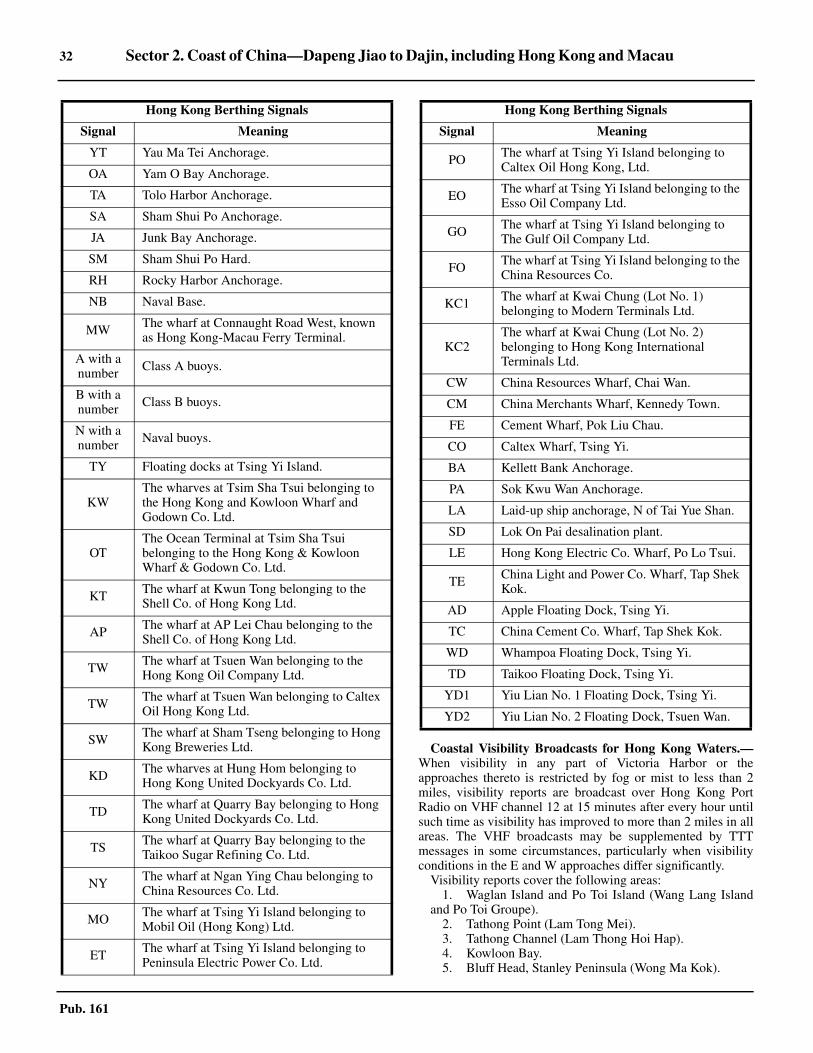
32 Sector 2. Coast of China—Dapeng Jiao to Dajin, including Hong Kong and Macau
Pub. 161
Coastal Visibility Broadcasts for Hong Kong Waters.—When visibility in any part of Victoria Harbor or theapproaches thereto is restricted by fog or mist to less than 2miles, visibility reports are broadcast over Hong Kong PortRadio on VHF channel 12 at 15 minutes after every hour untilsuch time as visibility has improved to more than 2 miles in allareas. The VHF broadcasts may be supplemented by TTTmessages in some circumstances, particularly when visibilityconditions in the E and W approaches differ significantly.2.23 Visibility reports cover the following areas:
1. Waglan Island and Po Toi Island (Wang Lang Islandand Po Toi Groupe).
2. Tathong Point (Lam Tong Mei).3. Tathong Channel (Lam Thong Hoi Hap).4. Kowloon Bay.5. Bluff Head, Stanley Peninsula (Wong Ma Kok).
YT Yau Ma Tei Anchorage.
OA Yam O Bay Anchorage.
TA Tolo Harbor Anchorage.
SA Sham Shui Po Anchorage.
JA Junk Bay Anchorage.
SM Sham Shui Po Hard.
RH Rocky Harbor Anchorage.
NB Naval Base.
MW The wharf at Connaught Road West, known as Hong Kong-Macau Ferry Terminal.
A with a number Class A buoys.
B with a number Class B buoys.
N with a number Naval buoys.
TY Floating docks at Tsing Yi Island.
KW The wharves at Tsim Sha Tsui belonging to the Hong Kong and Kowloon Wharf and Godown Co. Ltd.
OT The Ocean Terminal at Tsim Sha Tsui belonging to the Hong Kong & Kowloon Wharf & Godown Co. Ltd.
KT The wharf at Kwun Tong belonging to the Shell Co. of Hong Kong Ltd.
AP The wharf at AP Lei Chau belonging to the Shell Co. of Hong Kong Ltd.
TW The wharf at Tsuen Wan belonging to the Hong Kong Oil Company Ltd.
TW The wharf at Tsuen Wan belonging to Caltex Oil Hong Kong Ltd.
SW The wharf at Sham Tseng belonging to Hong Kong Breweries Ltd.
KD The wharves at Hung Hom belonging to Hong Kong United Dockyards Co. Ltd.
TD The wharf at Quarry Bay belonging to Hong Kong United Dockyards Co. Ltd.
TS The wharf at Quarry Bay belonging to the Taikoo Sugar Refining Co. Ltd.
NY The wharf at Ngan Ying Chau belonging to China Resources Co. Ltd.
MO The wharf at Tsing Yi Island belonging to Mobil Oil (Hong Kong) Ltd.
ET The wharf at Tsing Yi Island belonging to Peninsula Electric Power Co. Ltd.
Hong Kong Berthing Signals
Signal Meaning
PO The wharf at Tsing Yi Island belonging to Caltex Oil Hong Kong, Ltd.
EO The wharf at Tsing Yi Island belonging to the Esso Oil Company Ltd.
GO The wharf at Tsing Yi Island belonging to The Gulf Oil Company Ltd.
FO The wharf at Tsing Yi Island belonging to the China Resources Co.
KC1 The wharf at Kwai Chung (Lot No. 1) belonging to Modern Terminals Ltd.
KC2The wharf at Kwai Chung (Lot No. 2) belonging to Hong Kong International Terminals Ltd.
CW China Resources Wharf, Chai Wan.
CM China Merchants Wharf, Kennedy Town.
FE Cement Wharf, Pok Liu Chau.
CO Caltex Wharf, Tsing Yi.
BA Kellett Bank Anchorage.
PA Sok Kwu Wan Anchorage.
LA Laid-up ship anchorage, N of Tai Yue Shan.
SD Lok On Pai desalination plant.
LE Hong Kong Electric Co. Wharf, Po Lo Tsui.
TE China Light and Power Co. Wharf, Tap Shek Kok.
AD Apple Floating Dock, Tsing Yi.
TC China Cement Co. Wharf, Tap Shek Kok.
WD Whampoa Floating Dock, Tsing Yi.
TD Taikoo Floating Dock, Tsing Yi.
YD1 Yiu Lian No. 1 Floating Dock, Tsing Yi.
YD2 Yiu Lian No. 2 Floating Dock, Tsuen Wan.
Hong Kong Berthing Signals
Signal Meaning

Sector 2. Coast of China—Dapeng Jiao to Dajin, including Hong Kong and Macau 33
Pub. 161
6. Victora Harbor.7. East Lamma Channel.8. Tsing Chau (Green Island).9. West Lamma Channel.10. Cheong Chau Island.
2.23 The reports are broadcast in plain language in the followingmanner:
Anchorage
Quarantine Anchorage.—Vessels may request advanceclearance and quarantine services by radio. These services areavailable 24 hours at the Western Quarantine and ImmigrationAnchorage. Services are provided at the Eastern Quarantinceand Immigration Anchorage from 0600 to 1800 daily. Thereare several additional quarantine anchorages which are bestseen on the chart.
The two quarantine anchorages are situated within the watersof the port. Eastern Quarantine Anchorage is situated S of theairport, and has charted depths of 9.1 to 12.4m, mud, sand, andgravel. Western Quarantine Anchorage is centered about 1 mileS of Tsing Yi Chou, and offers depths of 7 to 18.7m, mud andshells.2.23 A disused explosives dumping ground close W of the SW tipof the Tsing Yi extends into Ma Wan Fairway. The W side ofthe fairway is bordered by Ma Wan Anchorage, with depths of10.4 to 32.5m. Vessels with an air draft of greater that 41m arenot permitted within the designated anchorage areas located Sand W of Ma Wan Channel. A 6.8m shoal lies close N of MaWan Anchorage.2.23 Dangerous Goods Anchorage.—Six dangerous goodsanchorages are situated throughout the port area for vesselscarrying commodities listed as dangerous by the Director ofMarine. Western Dangerous Goods Anchorage adjoins theWestern Quarantine Anchorage, and has depths of 6.3 to 9.2m,soft mud and shells. The anchorage is studded with mooringbuoys.2.23 Kau Yi Chau Dangerous Goods Anchorage extends Sthrough W from the S shore of Kau Yi Chau. ReservedDangerous Goods Anchorage lies 1 mile E of Kau Yi Chau.Both are best seen on the chart.2.23 Tsuen Wan Dangerous Goods Anchorage is situated at the Eend of that channel, N of Tsing Yi Chau. Depths at the centerof the anchorage are 10 to 14.8m, but shoal patches lie at theSE corner of the area, and shoal banks extend from the shoreon all sides. A Prohibited Anchorage Area lies at the S end ofthe anchorage.2.23 Tseung Kwan O Dangerous Goods Anchorage is situated 0.9mile NW of Fat Tau Chau. The least charted depth here is 12m,soft mud.
2.23 Rocky Harbor Dangerous Goods Anchorage (22°20'N.,114°20'E.) is situated in Leung Shuen Wan Hoi, which hasalready been described. The anchorage has charted depths of7m, mud and requires local knowledge for its use.2.23 Naval Anchorage.—A naval anchorage is charted just S ofCentral Fairway and is best seen on the chart. Large naval unitsoften anchor N of Tsing Chau (Green Island), between theProhibited Anchorage and Kellett Bank. 2.23 Typhoon Anchorage.—Anchorage on the N side of theharbor is preferable during typhoon season as the KowloonPeninsula offers protection from NE winds. Along with severalmooring buoys, shelter for small craft during severe weather isafforded by specially constructed Typhoon Shelter Harborssituated throughout the Hong Kong area. The Director ofMarine should be contacted for details on these havens.2.23 General Anchorage.—General anchorage is available inSham Shui Po Anchorage which is situated between the Nshore of Ngong Shuen Chau and Lai Chi Kok to the N and NE.Yau Ma Ti Anchorage, SE of Ngong Shuen Chau, has depthsof 4.6 to 5.5m, but is available only to vessels up to 91.5mlong.2.23 There are three Kellett Anchorages which lie SSE of TsingYi. Kellett Anchorage No. 1 can handle one vessel up to 300min length, with a maximum draft of 11m. Kellett AnchorageNo. 2 can handle eight vessels up to 150m in length, withmaximum drafts of 6.5m. Kellett Anchorage No. 3 can handlethree vessels up to 180m in length, with maximum drafts of9.5m.2.23 The Sham Shui KOK Anchorages lie directly S of Siu Mo Toand E of the Hong Kong International Airport. Sham ShuiKOK Anchorage No. 1 can handle two vessels up to 180m inlength, with maximum drafts of 8m. Sham Shui KOKAnchorage No. 2 can handle one vessel up to 180m in length,with a maximum draft of 9m. 2.23 Anchorages for vessels waiting to enter Hong Kong harborare designated at:
1. Southeast Lamma Anchorage—1.25 miles SE ofYuen Kok Light (22°11'N., 114°09'E.).
2. South Lamma Anchorage—1.25 miles SSW of YuenKok, for vessels carrying dangerous goods.
3. Southwest Lamma Anchorage—SW of Yuen Kok.2.23 All the above anchorages offer a least charted depth of 20m,soft gray mud with rocky bottom.2.23 Prohibited Anchorage.—A prohibited anchorage fairwayhas been designated on the W side of the harbor. It leads fromthe N end of Tung Pok Liu Hoi Hap (East Lamma Channel)along the W side of Kellett Bank to Tsing Yi. Its limits arecharted.2.23 A prohibited anchorage area for vessels with an air draft ofmore than 41m has been established in the vicinity of Ma Wan,as follows:
1. West limit—a line joining Ha Pang Light and Tai YueShan at 114°01.7'E.
2. South limit—a line joining SW corner of Tsing Yi andTai Yue Shan at 22°19.6'N.
3. East limit—a line joining Ting Kau and Tsing Yi at114°04.6'E.
2.23 A prohibited anchorage area has been established adjacent tothe Hong Kong Disneyland Theme Park. Anchorage is onlyallowed if permitted by the Director of Marine.
Visibility Report
Less than 0.1 mile Thick fog
Between 0.1 and 1 mile Restricted visibility
Between 1 and 2 miles Visibility in miles and tenths of a mile (e.g. 1.6 miles)
Between 2 and 5 miles Moderate visibility
Over 5 miles Good visibility

34 Sector 2. Coast of China—Dapeng Jiao to Dajin, including Hong Kong and Macau
Pub. 161
2.23 Many other prohibited anchorage areas are situatedthroughout the harbor; the charts are the best guide to theirlimits and locations.
Directions
2.23 The entrance channels normally used by vessels calling atHong Kong are approached from the E or SE. Waglan IslandLight, steered for on a bearing between 243° and 330° leadsfrom seaward to a position where the Traffic SeparationSchemes through Lam Tong Hoi Hap or Tung Pok Liu Hoi Hap(East Lamma Channel) may be reached. 2.23 If approaching Hong Kong from S of the usual shippinglanes, vessels should keep at least 5 miles seaward of JiapengLiedao and Dangan Liedao.2.23 If bound for Lam Tong Hoi Hap from E, steer for theappropriate lane of the Traffic Separation Scheme, keeping agood lookout for traffic near the lane entrance.2.23 If bound for Tung Pok Liu Hoi Hap (East Lamma Channel)from the SE, round the N end of Dangan Liedao at least 5 milesoff, taking care to avoid the dangerous wrecks charted about6.7 miles E and 4.4 miles ESE of the light on Poh Toi Island.Keeping a sharp lookout for traffic, pass no more than 1.5miles S of Poh Toi Island, and proceed to the appropriate trafficlane.2.23 If bound for Tung Pok Liu Hoi Hap (East Lamma Channel)from the E, proceed as directed above, passing S of WaglanIsland and Poh Toi Island.2.23 If bound for the bulk berth in Sai Pok Liu Hoi Hap (WestLamma Channel), steer as directed for Tung Pok Liu Hoi Hap(East Lamma Channel) until S of Poh Toi Island. Keeping aneye out for traffic, steer to pass within 1 mile of Lamma Island.Round the island’s S end, and proceed to the dredged channeloff the island’s W side. Except for a 10m patch located 0.2 mileoff the island’s SW extremity, the S end of Lamma Island isgenerally clear of fringing dangers, with deep water close off.The dredged cut to the dock is well marked.2.23 The channels traversing Kellett Bank in the W approaches toVictoria Harbor, though congested with moorings, are wellmarked. The E approach through Lei Yue Mun has a greaterconcentration of local craft, coupled with a narrow channel andspecial regulations for passing the airport. A conspicuouschimney bearing 299° serves as an excellent steering markwhen passing through Lei Yue Mun. Local authoritiesrecommend anchoring outside the fairway in the event ofreduced visibility, as passage through Lei Yue Mun is difficultin adverse weather.
Channels Leading from Hong Kong to ZhujiangKou
2.24 Kap Shui Mun Fairway, and Ma Wan Fairway, to theE of it, are two of the channels leading to the Zhujiang Koufrom the NW of Victoria Harbor. Kap Shui Mu Fairway isentered between Pun Shan Shek and Tsing Yi and leadsbetween the NE end of Tai Yue Shan on the W and Tang LungChau and Ma Wan on the E. This channel has depths exceeding18.3m and even though narrow, may be used by local traffic ifthe vessels do not exceed 10m in length, as it is the shorterroute leading to the passage between the N of Tai Yue Shan and
the mainland. Vessels greater than 10m in length can onlyproceed in a SE direction, since Kap Shui Mun is designated aspecial area.
2.24 The Kap Shui Mun Bridge, linking Ma Wan and Tai YueShan, crosses Kap Shui Mun, with a maximum safe verticalclearance of 41m. Vessels with an air draft of more than 41mwill not be allowed to transit the channel. Ma Wan Fairwayalso has depths of over 18.3m and leads between the E sides ofTang Lung Chau and Ma Wan and the W side of Tsing Yi.2.24 A lighted buoy marks a 6.4m depth 0.5 mile ENE of TangLung Chau Light. Attention is drawn to the existence of lessthan charted depths extending up to 0.2 mile NW of the lightedbuoy.2.24 The Tsing Ma Bridge, which links Ma Wan and Tsing Yi,crosses Ma Wan Fairway. The maximum safe verticalclearance is 53m. Vessels with an air draft of more than 53mwill not be allowed to transit the area between Ma Wan andTsing Yi.
Kap Shui Mun Fairway
Ma Wan Fairway

Sector 2. Coast of China—Dapeng Jiao to Dajin, including Hong Kong and Macau 35
Pub. 161
2.25 The passage along the N shore of Tsing Yi fromTsuen Wan continues W and is intersected by Ma Wan FairwayNE of Ma Wan and by Kap Shui Mun Fairway NE of the Nextremity Tai Yue Shan. The passage then leads W about 10miles, bordered on the N by the mainland and on the S by theislands off the N shore of Tai Yue Shan where it becomes partof the Zhujiang Kou.2.25 Caution.—Traffic may converge from all directions in thevicinity of the junction of the N end of Western Fairway, theSE end of Kap Shui Mun Fairway, the SE end of Ma WanFairway, and the W end of Northern Fairway. Particularcaution should be exercised when navigating in this area.2.25 Ma Wan and Tang Lung Chau are fringed with drying rocks,some of which lie as far as 0.3 mile E of the E side of Ma Wan.Foul ground connects Tang Lung Shun with Ma Wan, andextends up to 0.2 mile off the S point of the former.2.25 From the mainland opposite Ma Wan, a pier extends into thestrait. Caution is necessary in this portion of the channel, asdocking or undocking may occur at the wharf at all hours.2.25 A light is shown from a framework tower standing on NgauLan Tsui, the NE extremity of Ma Wan. Another light is shownfrom a tower standing on Gemini Point (22°21'48"N.,114°04'12"E.); the white sector of this light leads through MaWan Fairway. Both lights are shown day and night when avessel constrained by its draft transits Ma Wan Fairway.2.25 A bridge, with a vertical clearance of 53m, connects a pointlying 0.5 mile ENE of Gemini Point and the NW extremity ofTsing Yi.2.25 Ma Wan Traffic Control Center is located on Gemini Point.The positions of the restricted areas in Ma Wan Fairway arebest seen on the chart.2.25 Traffic signals, consisting of three red lights, disposedvertically, are shown day and night from towers situated at HaPang; Kau Po, the NW extremity of Ma Wan; and Hoi MeiWan, 0.1 mile NE of Gemini Point. Traffic restrictions will alsobe passed by VHF and through patrol craft.2.25 Waiting Areas have been established, as follows:
2.25 When Ha Pang and NW Ma Wan signals are shown, a vesselis about to transit or is transiting Ma Wan Fairway westboundor northbound. On seeing the signals, all traffic approachingMa Wan eastbound, except vessels of less than 20m in lengthand passenger ferries issued with a Speed Restriction Permit(SRP), should either proceed to Waiting Area 1 or 2 or, whenconsidered safe to do so, to continue their passages by makinguse of Kap Shue Mun.2.25 Vessels should avoid waiting in the zone between WaitingAreas 1 and 2 above, as this will obstruct the passage of largevessels following the deep water route.
2.25 When Hoi Mei Wan signals are shown, a vessel is about totransit or is transiting Ma Wan Fairway eastbound orsouthbound. On seeing the signal, all vessels approaching therestricted area from N of Tsing Yi, except vessels of less than20m in length and passenger ferries issued with a SpeedRestriction Permit (SRP), should wait at Waiting Area 3,taking care not to encroach upon the deep water channel closeto the N shore of Tsing Yi. Vessels approaching the area fromthe S should wait at Waiting Area 4 or continue their passageby following Kap Shui Mun. If they prefer to wait, they shouldkeep clear of Ma Wan Fairway and Kap Shui Mun.2.25 Vessels that have entered the restricted area before the signallights are shown should proceed with extreme caution andobserve directions given by the patrol launch.2.25 The tidal currents in the vicinity of Kap Shui Mun are strong,and at the sides of the channels cause eddies that are ofsufficient strength to make navigation of small craft difficult.
Tai Yue Shan
2.26 Tai Yue Shan (Lantau Island) (22°16'N., 113°57'E.)is the largest of the islands in Hong Kong and extends NE toSW between the W side of Sai Pok Liu Hoi Hap (West LammaChannel), and the E side of the outer Zhujiang Kou. The islandis rather barren and rugged, with numerous peaks in excess of250m high. The summit of Tai Yue Shan, in the S central part,is Lantau Peak, which rises to a height of 935m. Fishermenfrequent the many bays and inlets along the jagged coastline ofTai Yue Shan as well as the islands off its shores.2.26 The NE face of Tai Yue Shan forms the W side of Kap ShuiMun, previously described in paragraph 2.24. The covesindenting the E coast, which is about 8 miles long, have depthsof generally less than 5.5m. Depths of less than 5.5m alsoextend S from the NE end of the island to the N side of HeiLing Chau and Chau Kung Island.2.26 An islet and several rocks, one of which dries and anothersunken, encumber the very shoal channel between the NW endof Peng Chau and Tai Yue Shan.2.26 A submarine power cable is laid from the NW point of HeiLiug Chau leading NW to Lantau.2.26 A lighted buoy is moored close offshore on the S side ofNgan Kwon Wan, about 0.8 mile NW from Castle Rock(22°15'N., 114°01'E.).2.26 A fresh water pipeline stretches from the NE entrance pointof Ngan Kwang Wan to Hei Ling Chau, to Chau Kung, to PengChau, and then W to Lantau.2.26 The SE extremity of the island lies 0.5 mile off the N end ofCheung Chau Island. The channel between Cheung ChauIsland and Tai Yue Shan has depths of 3m in the fairway.
2.27 Adamasta Rock (22°13.5'N., 114°01.2'E.) is markedby a lighted beacon. The rock dries 1.2m and lies in theseparation zone at the NE end of the channel. Adamasta NWLighted Buoy and Adamasta SE Lighted Buoy mark the extentof the shoal water surrounding the rock. There is a depth of3.9m lying 0.2 mile WNW and a 5.5m depth lying 0.5 mile NEof the rock.2.27 Submarine cables, including a power cable and a waterpipeline, are laid across Adamasta Channel. Southeast LantauLighted Buoy is moored at the SW end of the channel.
Area Location
Waiting Area 1 0.8 mile WSW of Ha Pang Light and N of the deep water channel
Waiting Area 2 1.25 miles SW of Ha Pang Light and S of the deep water channel.
Waiting Area 3 0.4 mile E of Hoi Mei Wan Light.
Waiting Area 40.5 mile E of Tang Lung Chau and between Kap Shui Mun and Ma Wan Fairway.
36 Sector 2. Coast of China—Dapeng Jiao to Dajin, including Hong Kong and Macau
Pub. 161
2.27 The S side of the island is indented by two shoal bightsseparated by a hilly promontory. The E side of the E bight isformed by a rugged peninsula which extends to the SEextremity of the island.2.27 Rocky Islet, 29m high, lies 0.8 mile E of the W entrancepoint of the E bight. Mid Rocks, which dry 1.2m, lie about 1mile NE of Rocky Islet.2.27 The cliff at the SW extremity of Tai Yue Shan, from which alight is shown, is whitewashed for ease of identification.
Between the SW extremity of Tai Yue Shan and Peaked Hill,a small islet connected to Tai Yue Shan by a sandspit, about 1.2miles N, with depths of less than 5.5m extends over 0.3 mileoffshore. A 1m rock lies about 1 mile NNW of Peaked Hill.2.27 Two shallow coves indent the island between Peaked Hilland Bluff Point about 2.5 miles to the NNE. Near the S end ofBluff Point there is a conspicuous police station and flagstaff.A pier about 52m long with a depth of 2.7 m to 3m along itsinboard side extends SW from the shore near the flagstaff.2.27 Supplementary storm signals are shown from the policestation when local signals are displayed in Victoria Harbor.2.27 Caution.—Dangerous wrecks lie 1.8 miles ESE, 2 milesNNW, and 4 miles N, respectively, of Bluff Point.
2.28 The Soko Islands (22°10'N., 113°55'E.) are a groupof islands and rocks located toward the S end of a shoal withdepths of less than 9.2m that extends 3.5 miles S from the Scentral part of Tai Yue Shan.2.28 Tai A Chau, the southwesternmost of the group, rises steeplyto 153m. A rock, that dries 1.5m, lies about 0.2 mile N of the Nend of the island and an islet, 40m high, with a rock off its Send, lies about 1 mile ESE of Tai A Chau Light.2.28 Siu A Chau, 122m high and the northernmost of the group,lies about 0.5 mile N of Tai A Chau. A shoal with depths ofless than 5.5m, extends about 2 miles W from the W side of SiuA Chau. Four rocky islets, the highest 36m high, lie betweenthe W ends of Siu A Chau and Tai A Chau. 2.28 Between Bluff Point and a small projecting point that formsthe NW extremity of Tai Yue Shan 3.2 miles NE, the coast isindented by a shoal irregular bight.
Zhujiang Kou—North of Tai Yue Shan
2.29 Chi Shuimen is the fairway between Urmston Roadand Kap Shui Mun which is bordered on the N by the Chinamainland and on the S by Tai Yue Shan and the islands off its Ncoast. The channel is part of the Zhujiang Kou and more than 1mile wide with depths in excess of 12.5m in mid-channel.2.29 Kwai Shek (22°21'N., 114°03'E.), at the W side of the N endof Kap Shui Mun, is the northernmost point of Tai Yue Shan.The coast, for about 1 mile SW of this point, is indented by twosmall bays separated by a narrow peninsula to the E of which isa conspicuous red cliff, 88m high. Immediately SW of thesebays is a bight, at the W entrance of which lies Lu Keng Island.This island separates the bight from another small bay to theW.2.29 Sui Mo To (East Brother) is an islet, 59m high, located 2.2miles W of Lu Keng Island. There are depths of less than 5.5mwithin about 0.4 mile of the W and E sides of this islet. Tai MoTo (West Brother), an islet 65m high, lies 1 mile SW of Sui MoTo and has depths of less than 5.5m extending 0.6 mile W, 0.1
mile N, and 0.4 mile E of its shores. Both islands provide goodradar returns at 13 miles.2.29 Reef Islet, 9m high, lies 0.3 mile S of Sui Mo To and has abank with a depth of 2.7m extending over 91m E.
2.30 Chek Lap Kok Island (Chu Lu Kok Island)(22°19'N., 113°56'E.) lies with Red Point, its N extremity, 1.2miles WSW of Tai Mo To. The island is barren, 124m high,about 1 mile wide at its greatest breadth and extends 2.1 milesS from Red Point to within 0.3 mile of the entrance to TungChau Bay on Tai Yue Shan. Red Point has a remarkable rockyappearance.2.30 Anchorage can be taken in the fairway E of Red Point and Sof Reef Island, in depths of 10 to 15m.2.30 The 5m curve extends ESE from Red Point nearly to Tai YueShan, leaving shoal depths in the bay enclosed by Chek LapKok Island and the NW coast of the larger island.2.30 Sha Chau (22°21'N., 113°53'E.), 53m high, lies to the SE ofa group of small islands and drying and submerged rockswhich form the SW limit of Urmston Road. Lung Kwu Chau,marked by a light on its NW extremity, is two rocky isletsconnected by a drying spit that lies about 1.5 miles N of ShaChau at the NW of this group of islets, on rocks. White Rock,Tree Islet, and Dulley Rock, about 1.5 miles SW of the light onTung Kwo, mark the W limits of these dangers.2.30 The NW coast of Tai Yue Shan from Lu Keng for about 6miles WSW to Tung Chung Bay is steep. Between this bay andthe NW point of the island is an islet 46m high, about 1 mileoffshore.2.30 Caution.—The actual depths across the bank between ShaChau and Chu Lu Kok Island have not been verified. Lesswater than charted has been reported (1995) NW of Lung KwuChau.2.30 A height restricted area has been established in the vicinityof the Tung Chung bridges, with a maximum permitted verticalclearance of 8m.2.30 Restricted areas, designated 1 through 8, have beenestablished around Chek Lap Kok Airport (22°18.5'N.,113°55.0'E.), Lung Kwu Chau (22°18.5'N., 113°53.0'E.), andSiu Mo To (22°20.2'N., 113°58.9'E.). Vessels are prohibitedfrom entering or passing through areas 1 through 4 without thepermission of the Director of Marine. Vessels with air draftsgreater than 15m and 30m are prohibited from entering orremaining in areas 5 or 6 and 7 or 8, respectively, without thepermission of the Director of Marine. The areas are marked bybuoys and lights and are best seen on the chart.
2.31 Between Brothers Point (22°21'N., 114°01'E.) andBlack Point, the mainland coast trends W about 4.5 miles toMong Hau Shek (Pillar Point), then 3.2 miles NW to BlackPoint. Tai Lam Chung and another small bay indent the shoreto the W of Brothers Point and about 2 miles further W isTsing Shan Wan.2.31 A tank and a white building from which storm signals aredisplayed stand on the W shore of Tai Lam Chung, from whicha jetty projects. The jetty has a length of 40m and alongsidedepths of 4.9m. A submarine cable extends from the shores ofthe bay to Tai Yue Shan; the cable landing is marked bybeacons. About 1 mile N of the bay, two conspicuous chimneysstand near a wharf with alongside depths of 6.1m.

Sector 2. Coast of China—Dapeng Jiao to Dajin, including Hong Kong and Macau 37
Pub. 161
2.31 Anchorage.—Tuen Mun Immigration Anchorage, withdepths of 4.8 to 7m and a mooring buoy at the NW corner, lies1.5 miles ESE of Mong Hau Shek. The anchorage is for theclearance of river trade vessels operating between Pearl RiverDelta ports and Hong Kong.2.31 Tsing Shan Wan (Castle Peak Bay) is 2.5 miles across itsmouth from Mong Hau Shek to the opposite shore. Pak KokPoint, on which stands an obelisk, lies 1 mile ENE of MongHau Shek. This shallow bay is fronted by a bank with a depthof 5.8m; two rocks are charted off the bay’s E shore. A lightmarking a sewer outfall lies 0.1 mile SSE of Pak Kok Point.2.31 An offshore jetty is under construction (2006) about 1 mileSW of Pillar Point. 2.31 The coast trends SE from Tsing Shan Wan to Pillar Point,then NW to Black Point. The coast is reef-fringed in places,with depths of less than 5.5m extending up to 0.7 mile off theshore N of Tap Shek Kok (22°23'N., 113°55'E.).2.31 A power plant and cement plant stand about 1.5 miles NE ofPillar Point, and are approachable through a marked channeldredged to a depth of 18.5m.2.31 There are two conspicuous chimneys in the area; the NWchimney has an elevation of 220m and the SE chimney anelevation of 255m.2.31 Urmston Road is the area between the latter coast and TungKwu. It affords anchorage for vessels proceeding upriver, butthe tidal currents are strong. 2.31 Anchorage is available in the charted area W of Black Point,in charted depths of 11.2 to 17.4m, sand. Depths shoal rapidlyW of the anchorage; a wreck is charted about 0.2 mile W of theanchorage’s W boundary.
Zhujiang and Zhujiang Kou
2.32 The Zhujiang Kou (Zhujiang Estuary) generallyencompasses the area between Tuwu Chio (22°05'N.,113°33'E.) on the W, the SW extremity of Tai Yue Shan on theE, and the numerous islands fronting the coast to the S,including Wanshan Quindao (Wanshan Ch’un-tao). The twomain channels leading to the Zhujiang through the estuary areLantau Channel from the E, and Tan-hsi Shui-tao from the SW.The Portuguese province of Macau lies on the NW side of theestuary on the China mainland. The major Chinese ports withinthe Zhujiang are Huangpu and Guangzhou, which lie 60 and 77miles, respectively, upriver from Macau.2.32 Dachan Donghangdao fairway (22°31'N., 113°51'E.) has aleast depth of 15m and a navigable width of 195m. 2.32 Shenzhen Western Channel (22°28'N., 113°51'E.) has a leastdepth of 15m and a minimum navigable width of 210m. 2.32 Pilotage.—Pilotage for the Zhujiang (Pearl River) iscompulsory and vessels are required to send their ETA 24hours and 12 hours prior to arrival. Pilots for both Zhujiang andMacau board 1.7 miles W of Guishan Dao (paragraph 2.34),where the quarantine anchorage area is centered. Chinesecustoms, immigration, health, and other port officials usuallyboard the vessel with the pilot.2.32 Cargo activities are carried out at the quarantine anchorage.The depths are 9m and 15m with good holding ground, mud.Sichi Yan, a rock, awash, lies 2.3 miles W of Guishan Light.2.32 Regulations.—Vessels are required to obtain permission ofthe proper authorities well in advance to enter the People’s
Republic of China. Chinese authorities prohibit foreign vesselsnavigating, anchoring, or fishing within territorial claimedwaters.2.32 Directions.—Vessels entering Zhujiang and Macau shouldfollow the directions given below:
1. Vessels sailing from Hong Kong to Zhujiang mayfollow a route through West Lamma Channel to a position22°08'44''N, 113°55'30''E, then proceed through LantauChannel, as safe navigation permits, on a course of 295° toarrive at 22°12'04''N, 113°47'41''E. Steer 204° to22°10'36''N, 113°47'00''E and then S to the QuarantineAnchorage. In 1989, it was reported that vessels could pass Sof Guishan Dao, thus avoiding the shoal water extendingNW from Niutou Dao.
2. When departing Macau or Zhujiang Kou, the courseslisted above should be followed in their reverse order.However, the directions given above are subject to changeand any variation or changes are directed by the localauthorities and broadcast by radio.
2.32 Caution.—Vessels should have little difficulty entering theestuary by day, however, in thick weather caution is necessarybecause the off-lying islands in the approaches are steep-to andsoundings give insufficient warning.2.32 Fish stakes have been established throughout the ZhujiangKou and the Zhujiang (Pearl River) and must be avoided.Additionally, the channels, aids, and depths in the river areconstantly changing. Therefore, excessive reliance should notbe placed upon the charted depths or features in this area.2.32 No vessel should enter any of the channels, creeks, ortributaries of the Tan Jiang, Xijiang, and Zhujiang without apilot. Permission to enter these waters must be obtained fromthe government of the People’s Republic of China.2.32 In the narrow channels, creeks, and tributaries of the TanJiang, Xijiang, and Zhujiang vessels should proceed at such aspeed that the waves caused by their motion through the waterdo not damage the river banks and shore installations. This isespecially true in passing the numerous villages on both sidesof the channels. Speed should be reduced when passing towsand heavily loaded junks. A careful lookout must be kept fortows and junks hauling out from the river banks or coming outfrom the various tributaries or reaches.2.32 Care must be taken in approaching the river banks becauseof a number of small groins extending out. Barriers have beenbuilt in some places, leaving only a narrow navigable channel.2.32 Overhead telegraph cables, at varying heights above the levelof the river, span the narrow channels, creeks, and tributaries.They are erected or removed without notice.2.32 Reports indicate that vessels anchoring or transiting areasclaimed by the People’s Republic of China without priorpermission, and/or outside of the recommended routes riskseizure and detention.2.32 A restricted area has been established and is bounded bylines joining the following positions:
a. 22°25'N, 113°49'E.b. 22°23'N, 113°50'E.c. 22°23'N, 113°51'E.d. 22°25'N, 113°51'E.
2.32 Foreign vessels are prohibited inside the line connecting theislands of Xiaowanshan Dao, Dawanshan Dao, Jiapeng Liedao,and Dangan Liedao.

38 Sector 2. Coast of China—Dapeng Jiao to Dajin, including Hong Kong and Macau
Pub. 161
2.33 Wanshan Quindao is the southernmost group of thenumerous islands contained within Zhujiang Kou.2.33 Dawanshan Dao (21°56'N., 113°43'E.), the outermost ofWanshan Quindao, is steep, bold, and rocky and features aconspicuous dome-shaped mountain in its NW part that rises to447m. At the SW end of the island is a small inlet known asWanshan Wan. 2.33 Aspect.—Xiowanshan Dao, with several rocks lying off itsshores, rises to 254m WNW of Dawanshan Dao. A rock with adepth of 1.8m lies about 0.7 mile NW of the island’s SW end.Yamu Pai, a steep-to rock which dries 1.8m, lies 0.5 mile N ofthe island’s NE end. Xiaoputai, a small islet, together with twoother islets form the W extension of Wanshan Quindao.Xiaoputai, 58m high, lies 5 miles NW of Dawanshan Dao. Aracon transmits from Xiaoputai.2.33 Huangmao Dao lies to the E of Xiaoputai and features apeaked hill rising to 99m. Bai Pai, an islet, lies 0.4 mile off theisland’s W side, with a drying rock close SE of it. Across anarrow channel to the E of Huangmao Dao lie two islandsknown as Dalie Dao and Xiaolie Dao, which are themselvesseparated by a narrow foul channel. 2.33 A drying rock lies 0.2 mile N of the N island, and a 4m patchlies 0.8 mile N of the same island.2.33 Dongao Dao, 172m high, lies 1.2 miles ESE of HuangmaoDao. Nan-Sha Wan indents the SW side of the island, andaffords shelter in Northeast Monsoon, but rocks with depths ofless than 2m lie in the approaches to the bay. A dangerouswreck lies close W of Dongao Dao. Tung-ao Wan, a rock-fringed inlet, indents the NE side of the island. A rock with adepth less than 1.8m and another with a depth of 5.5m lies inthe entrance to the bay. A rock, with a depth of 2.7m, lies 0.8mile E of the NE extremity of the island.2.33 Bei Yan, awash and steep-to, lies 0.3 mile NE of the samepoint.2.33 Pilotage.—The pilot boarding area lies N of DawanshanDao in position 21°59'N, 113°43'E. 2.33 Anchorage.—Anchorage, in 22m, mud, can be taken bysmall vessels off the entrance to the inlet.
2.34 Baili Dao (21°59'N., 113°45'E.) lies 1.5 miles SE ofDongao Dao, and rises to a height of 302m, with a conspicuousconical hill, 225m high, on its NE portion. The hills on the Spart of the island are studded with black rocks. Baili Dao isrock-fringed in places and indented with several small inlets.About 2 miles N of the island lies Shagou Pai, which breaks,and about 0.5 mile N of the island’s NW extremity lies ClioRock, with a depth of less than 1.8m. House Islet, 33m high,and close E of which lies a sunken rock, lies 0.2 mile N of BailiDao’s N end.2.34 Gui Zhou, 86m high, lies 0.75 mile E of Baili Dao, and has arock, which dries 1m, close off its NW extremity.2.34 Heng Zhou, 117m high, and Zhu Zhou, 175m high, lie 2 and3 miles, respectively, E of Baili Dao. Zhu Zhou, which ismarked by a light, is indented on its N side by a small inlet, andhas a steep, rocky islet, 54m high, known as Chou-Tzu, off itsSE side. 2.34 Anchorage, in a depth of 19m, may be taken in the S part ofthe channel between Heng Zhou and Zhu Zhou, with the lighton Zhu Zhou bearing 095°, and about 0.1 mile distant.2.34 Dongtou Shi, a rock which dries 1.8m, lies about 3.2 miles N
of Heng Zhou. Sanya Pai, a group of rocks marked by a light,lies 5 miles N of the same island. Xiaozhizhu Pao andDazhizhu Dao (22°07'N., 113°53'E.) are two islands at the SEend of Dahao Shuidao, which stretches 6.5 miles NW of thelatter named island. Xiaozhizhu Dao is 109m high whileDazhizhu Dao is 265m high, with rocks, awash, off its E andSW extremities.2.34 Guishan Dao (22°08'N., 113°49'E.), 234m high andinhabited, lies 2 miles WNW of Xiaozhizhu Dao. A light isshown from the islet, and a signal station is situated on theisland’s summit. A pilot station for Zhujiang Kou pilots issituated on the W side of Guishan Dao.2.34 Caution.—A prohibited anchorage area lies S of the islandand is best seen on the chart.
2.35 Zhenxiangwei, 64m high, lies 0.75 mile off GuishanDao’s SE side, several dangers encumber the channel betweenthem. The channel between Zhenxiangwei and XiaozhizhuDao is clear of dangers, and is sometimes used by vesselsentering Lantau Channel from the S.2.35 Zhongxin Zhou, 133m high, lies close N of Guishan Dao,with depths of less than 5.5m between them.2.35 Niutou Dao (22°10'N., 113°48'E.), 141m high at its N end,lies NW of Zhongxin Zhou and is separated from it by NiutouMen, a passage about 0.2 mile wide. A rock with a depth of 5mlies about 0.2 mile off Niutou Dao’s SW side, encumbering theW entrance of the passage. A 64m high islet lies close off theisland’s NW extremity.2.35 A light is shown from the NW extremity of Niutou Dao.2.35 Caution.—A dangerous wreck lies in the passage betweenZhongxin Zhou and Niutou Dao.
2.36 Lantau Channel (Tai Yue Hoi Hop) leads into thecentral part of the Zhujiang Kou between the Soko Islands andTai Yue Shan on the NE and Dazhizhu Dao to the SW. Thechannel is nearly 2 miles wide at its narrowest portion, deep,and clear of dangers.2.36 Daxi Shuidao is a channel which leads into Zhujiang Kou,and leads off the W side of the estuary. The E side of thechannel is the deepest, with shoaling reported on the W side.The fairway has charted depths of 7m, and is entered betweenDawo Shan (22°05'N., 113°33'E.) on the NW, and Xiaoputaion the SE.2.36 The islands on the W side of the channel are described withthe W side of the estuary.2.36 Datou Zhou (22°06'N., 113°42'E.) lies 5.5 miles NE ofXiaoputai. Dalu Dao, 97m high with a prominent rock on itssummit, is a rocky islet lying 0.5 mile N of Datou Zhou. DaluPai, with a depth of less than 0.9m close NE, is an exposedrock 15m high, lying 0.8 mile NNE of Dalu Dao. Jishiling Pai,a 14m high islet, lies 0.2 mile E of Dalu Pai.2.36 Anchorages have been established 2 miles NW and 3 milesSE from Datou Zhou.2.36 Sanjiaoshan Dao, 150m high and rugged, with a 1.5m rockclose off its S side, lies 0.8 mile N of the islet of Xilu. Depthsof less than 5.5m extend up to 0.8 mile N of the island. QingZhou, 104m high and the northernmost island of the group, lies0.8 mile NNE of Sanjiaoshun Dao.2.36 Chitan (22°07'N., 113°46'E.), 72m high, with a rock closeoff its NW side, lies 3.2 miles E of Dalu Dao.

Sector 2. Coast of China—Dapeng Jiao to Dajin, including Hong Kong and Macau 39
Pub. 161
2.37 Sichi Yan (Four Feet Rock) (22°09'N., 113°46'E.), arock awash, lies 1.5 miles NNE of Chitan. This obstruction liesquite near the pilot, quarantine, and cargo handling anchorages.Another foul area exists 0.7 mile E of Sichi Yan.2.37 The tidal currents are not very strong around the outerislands, but are variable and stronger in the channels leadinginto the Zhujiang Kou.2.37 In Daxi Shuidao, the ebb current sets strongly S along theislands on the E side of the channel. The flood current setsmostly N to NW.2.37 In Lantau Channel, the ebb current sets SE through thefairway. Strong eddies form, particularly in July and August,when the current attains a spring rate of 4.5 knots. The floodcurrent sets NW, following the axis of the channel.2.37 Freshets flowing out of the Zhujiang through Daxi Shuidaohave an almost constant set from Dahengqin Dao (22°06'N.,113°33'E.), cross-channel, then along the islands to the W. Thecurrents at this time attain a rate of 1 or 2 knots, particularlywith E winds. At times there may seem to be a surface currentsetting to the E, but during freshets the undercurrent continuesto set to the W.2.37 The W side of the outer estuary is very shoal between Tu-WuChiao and Tung-Ku Chiao, about 18 miles N. Depths of lessthan 5.5m extend over 4.5 miles offshore, and probably farther.Reports indicate that this area has shoaled so much that charteddepths of the area may be inaccurate. 2.37 The islands of Ilha de Tapia and Ilha da Coloane lie in the Sapproach to that harbor, on the W side of Zhujiang Kou. 2.37 Ilha de Coloane (22°08'N., 113°34'E.), 171m high on its
SW part, is the southernmost island of the province. Acauseway connects the island with Ilha de Taipa, and showsnavigational lights from its shores. 2.37 Ilha de Taipa (22°10'N., 113°33'E.), with an 11m high rockof its E extremity, lies 1 mile N of Ilha de Coloane. The islandrises to a height of 158m and is joined to Macau by a bridgeand causeway. 2.37 The channel W of these islands consists of drying mud flatswhich are navigable by small craft only. Ilha de Taipa andXiaohengqin Dao to the W form the S side of a boat passagewhich connects the port of Macau and the Xijiang.2.37 There is a deepwater port in the vicinity of Ponta de Ka-Hocomprising a 40m long container wharf and an oil terminal fortankers up to 1,200 dwt.
Macau Harbor (22°11'N., 113°34'E.)
World Port Index No. 57810
2.38 Macau Harbor and the city of Macau occupy thepeninsula at the SE end of Aomen Dao (Macau Island). Theport consists of two parts; the outer port is protected bybreakwaters on the E side of the peninsula and the inner port onthe W side of the peninsula is sheltered on the W by La-paShan. The port is frequented by small vessels, ferry boats, andlocal craft, while larger cargo vessels work freight from theanchorages rather than enter the harbor.2.38 Tides—Currents.—The mean tidal range is about 1.8m.The tidal currents set strongly across the harbor entrance.
Macau Tower and the Sai Van Bridge (rear)

40 Sector 2. Coast of China—Dapeng Jiao to Dajin, including Hong Kong and Macau
Pub. 161
2.38 Depths—Limitations.—The 5m curve lies about 3 miles Eof, and the 2m curve lies in close proximity to, the outer endsof the breakwaters. The channel to the outer harbor whichleads between the breakwaters has a dredged depth of 4.4m onthe range line. The channel leading S of the W breakwater andaround the peninsula to the inner harbor is dredged to a depthof 3.5m up to the piers. The latter channel leads under a bridgein the causeway between Macau and Ilha de Taipa which has avertical clearance of 30m.2.38 Aspect.—Fortaleza da Guia, a prominent fort, stands on thesummit of a hill overlooking the city of Macau from the E. Alight, a signal station, and several yellow buildings are situatedat or near the fort. Four radio masts, three of which are paintedred and white, stand on a hill about 0.5 mile NE of the fort.2.38 At the observatory, situated about 0.1 mile SW of the fort, isa luminous time signal. The signal, consisting of 37 lights on apost, indicates the exact local times of 2400, 0300, 0600, and2100 by extinguishing the lights. The signal commences 4.5minutes before the time.2.38 The channels to both the inner and outer ports are marked bylighted and unlighted beacons and buoys. Range lights, aligned305°, mark the dredged channel to the outer harbor.2.38 Pilotage.—Pilotage is compulsory, and the pilot boards atthe Pilotage, Quarantine, Loading, or Unloading Anchorage inZhujiang Kou. Vessels should not attempt to proceed past thepilot station without a pilot on board due to the regulations inforce in this area by Chinese authorities.2.38 Signals.—Vessels using the Macau channels by day shallcarry at the mast, two black spheres vertically arranged, and bynight two green lights on the yard arm, similarly arranged.2.38 The local storm signal code used in Macau is the same asused in Hong Kong.2.38 Anchorage.—Anchorage in the fairways of the port isprohibited. Large vessels may anchor, in a depth of 7.3m, mud,in a position 7 to 8 miles SE of Fortaleza da Guia or on themain entrance range 1.5 to 2 miles from the breakwater heads,in depths of 4.1m and 4.2m, respectively. Cargo is worked atthese anchorages by lighters.2.38 Directions.—If proceeding from Hong Kong to Macau, orvice-versa, vessels should use the appropriate TrafficSeparation Scheme, as seen on the chart.2.38 Caution.—Mariners are advised to obtain the latest andlargest scale charts of the area before proceeding to Macau.However, even though these charts may be held, they may notreflect the correct depths throughout the area due to thecontinuous river estuary silting and lack of reports containingcorrective information.
2.39 Shekou (Chiwan) Harbor (22°28'N., 113°52'E.)(World Port Index No. 57777) is situated on the E side ofZhujiang Kou and SW of the Nantou Peninsula. Shekou, oncea fishing village has now developed into a modern deep waterport. The port can be regarded as an important gateway of seatransportation in S China.2.39 Depths—Limitations.—The approach channel has a depthof 12.5m. The maximum allowable draft for the port is 11m.Vessels up to 70,000 dwt can be accommodated. There are sixberths with depths of 7 to 11m. The longest berth is SupplyBoat Jetty, 520m in length, with a depth of 7m alongside. 2.39 Kaifeng Container Terminal has two berths, with a combined
length of 610m and an alongside depth of 14m.2.39 The Chiwan Petroleum Service Base has seven berths, with atotal of 515m of berthing space and alongside depths of 6.6 to7.1m.2.39 Mawan, a port for general cargo is situated close NW ofChiwan Gang. Vessels up to 50,000 dwt can be accommodated.There is a 230m long berth, with a depth of 11.4m alongside,for vessels up to 30,000 dwt. 2.39 Shekou Gang, a general cargo port and offshore oil supportbase, is situated 1.2 miles ENE of Mawan. Vessels up to 70,000dwt can be accommodated. Shekou has six berths, with depthsalongside of 6 to 11m. Berth No. 3, the longest and deepestberth, is 180m long and has an alongside depth of 11m. 2.39 Aspect.—A lighted range, in line bearing 305°, leads intothe harbor. 2.39 An automatic identification system (AIS) transponder issituated on Buoy K1 (22°26'N., 113°53'E.).
Pilotage.—Pilotage, available during daylight only, iscompulsory for foreign vessels entering and leaving port. Thepilot boards in position 22°23.7'N, 113°53.7'E. Pilotage isprovided by Hong Kong and Shekou Pilots. Vessels shouldsend their ETA 72 hours, 48 hours, and 24 hours in advance oftheir arrival at the port. Chiwan Harbor is equipped with VHFfacilities and a coastal radio station. In addition, a dispatchnetwork has been set up to provide wireless telephone andtelex services to offshore drilling rigs.2.39 Anchorage.—Anchorage can be obtained in designatedareas, with depths of 7 to 13m, mud and sand, good holdingground. The designated anchorage areas lie S of Chiwan andare best seen on the chart.2.39 Caution.—Lesser depths than charted have been reported(1996) in the S end of the designated anchorage area.2.39 A wreck, marked by a lighted buoy, lies in position22°26'19"N, 113°52'35"E.
2.40 Between Macau and Tonggu Jiao point about 7.5miles N, the coast is indented by two small shoal bays.Xiangzhou Wan, the southernmost of the two has a group ofislands off its S entrance point. Taipei (White Rock), theoutermost danger fronting the bay, lies 2 miles NE of the bay’sS entrance point, and is surrounded by drying rocks. Yeli Shan,a small islet, 71m high, lies 0.8 mile WSW of Bai Pai. A dryingrock lies 0.7 mile W of B2.40 Several small islets lie within 0.8 mile of Changkeng Ding(22°19'N., 113°36'E.), the point separating the two bays. The Nbay is shoal.
2.40 Tonggu Jiao (22°23'N., 113°37'E.) is a rock-fringed point atthe N extremity of the N bay. A 1.5m patch lies 0.5 mile SSEof the point. An islet and a drying rock located on a bank withdepths of 1.5m lie about 0.5 mile NNW of the point.2.40 The inner part of the estuary extends about 22 miles N of aline connecting Lan Kok Tsui (Black Point) on the E, andTonggu Jiao on the W. The estuary above this point is up to 15miles wide, constricting to the N. This body of water isencumbered with numerous shoals and banks which dry, andleave only narrow, shoal, and shifting channels toward thecenter of the estuary. Although small shallow-draft vesselsnavigate the maze of rivers and channels connecting the

Sector 2. Coast of China—Dapeng Jiao to Dajin, including Hong Kong and Macau 41
Pub. 161
Zhujiang and Xijiang to the W, ocean-going vessels areconfined to the reaches of the river.2.40 Tides—Currents.—During the Northeast Monsoon, thenight tide will be about 0.2m higher than the day tide; duringthe Southwest Monsoon the reverse is found.2.40 Winds from the NW have been known to reduce depths by asmuch as 0.6m, while fresh SE winds have increased depths bythe same amount.2.40 The level of water in the estuary is likely to be highest insummer, especially after a heavy rainfall.2.40 Directions.—Pilotage is compulsory for vessels proceedingN of the Pilot, Quarantine, Loading, or Unloading Anchorage.Vessels following the buoyed channel should navigate thelower reaches with particular caution as fishing stakes,dangerous wrecks, and other obstructions are charted in thereach between a point W of Peaked Hill, and Neilingding Dao.North of Neilingding Dao, the channel has a charted width ofabout 0.4 mile to a point 5.2 miles SSE of Sanban Zhou(22°43'N., 113°39'E.); then the channel widens.2.40 Caution.—The lower reaches of the Zhujiang and Huangpuport areas contain military and naval installations.
2.41 Neilingding Dao (22°25'N., 113°48'E.) rises to aheight of 339m in a conical peak. The E side of the islandshows wooded slopes while the W side has a customs stationsituated on it. Several buildings are situated on the island. Alight is shown from the NW point of Neilingding Dao. NanShazui, with depths of less than 1m, extends S of the island,while Fanshi Qiantan, with depths of 2.5m, extends up to 19miles N of the island.
Inner Zhujiang Kou—West Side
2.42 Between Tonggu Jiao and Dajiaotou Dao, 22 miles N,the estuary is encumbered by drying banks extending from theshore and the islands that front them. Several channelsavailable to shallow-draft vessels only, lead through the banks,W to the Xijiang and N to Guangzhou. Junk Fleet Entrance andLunghsueh Hai-Kou (Lankit Entrance) are the most transited.2.42 Qi’ao Dao (22°25'N., 113°38'E.), an island rising to 184m atits SW end, lies 1 mile N of Tonggu Jiao. A light is shown fromthe island, and the fishing stakes off its NE side are usuallymarked by lights. Several rocks fringe the S side of the island.2.42 Jinxingdan is the channel between the island and TongguJiao. Small vessels may find anchorage, in a depth of 9.2m,mud, about 1.5 miles NW of Tonggu Jiao, but depths at theanchorage may be less than charted. Half-Tide Rock, awashand fringed with sunken rocks, lies 2.2 miles NW of TongguJiao, and an islet surrounded by foul ground, lies 0.8 mile NWof the point. A shoal with a dangerous sunken rock at its NWend, extends about 1 mile WNW of the islet.
2.43 Junk Fleet Entrance (22°24'N., 113°41'E.), lying offthe NE extremity of Qi’ao Dao, is a narrow, shoal, andunmarked channel leading through the mud banks fronting theW side of the estuary. From Qi’ao Dao the channel leads about12 miles NNW to the entrance of Tan-Chou Shui-Tao, about 2miles NE of Hengmen Dao, and is joined from the W byHengmen, another tributary, at the same point.2.43 Dajian Feng, 301m high, stands on the mainland about 1.2
miles WSW of Hengmen Dao. Hengmen Dao (22°34'N.,113°35'E.), 97m high, lies close NE of Dajian Feng. 2.43 Longxue Dao (Lankit Island.) (22°42'N., 113°38'E.) is 61mhigh near its SW extremity, where a small temple and sometrees stand. The island lies at the SE terminus of a drying bankextending from several islands about 2.3 miles WNW of it. Anew harbor (2010), protected by breakwaters, is in progress. 2.43 Shanban Zhou (22°43'N., 113°39'E.) two small isletsseparated by a drying bank, lie 1.5 miles NE of Longxue Dao.The SE islet, which resembles an overturned boat, shows alight. Detached reefs lie up to 0.3 mile SE, E, and N of the Nislet. A drying bank extends up to 0.3 mile NW, and SSW ofthe same island, off the island’s W shore.2.43 Nansha (22°48'N., 113°35'E.), a new section of theGuangzhou Port Complex, is located along the NE coast ofDajiaotou Dao. The purpose of this expansion to the S is toprovide deeper water for ferry, container, coal, shipyard andpetro-chemical facilities. Considerable land reclamation andconstruction (2005) are underway to convert several adjoiningislands in the Zhujiang into this major port and industrial zone.2.43 Depths—Limitations.—The port can handle vessels up to50,000 dwt, with a maximum length of 200m and maximumdraft of 10.5m. Phase 2 of this expansion, expected to becompletd in 2007, will allow for vessels up to 100,000 dwt.2.43 Aspect.—To the N of the Humen Bridge are Shaluo WanzuiWharf (ferry), Nanwei Deepwater Wharf, Dongfa Wharf, andShichang Wharf. Yourong Chuangchang Wharf is used as ashipyard; the Zhujiang Power Station has an L-shaped jetty.2.43 To the S of Humen Bridge lies Lianhe Container Wharf.When Phase 2 is completed, four more wharves will beavailable.2.43 Pilotage.—Pilotage is compulsory; pilots board at theGuangzhou and Huangpu Pilot Station.2.43 Regulations.—See information about Guangzhou VTS(paragraph 2.52) and Hong Kong VTS (paragraph 2.23).2.43 Anchorage.—There are several anchorages, best seen onchart, inside Humen Shuidao. 2.43 Caution.—Due to the lack of current information, the shoalnature of the channel, and the need for local knowledge as wellas the restrictions placed upon foreign vessels in Chinesewaters, vessels should not attempt any of the channelsmentioned above without prior permission and a pilot aboard.
Inner Zhujiang Kou—East Side
2.44 Lan Kok Tsui (Black Point) (22°25'N., 113°54'E.) onthe E side of the estuary, is the W extremity of a large, highpeninsula, rising to a height of about 138m. A dangerouswreck, marked by a lighted buoy, lies in position 22°31'05"N,113°48'56"E.2.44 Hau Hoi Wan (22°28'N., 113°57'E.) is entered between LanKok Tsui and Mawan Xiajiao, about 4 miles NNW. The bay ismostly shoal and studded with fishing stakes. A bridge, with avertical clearance of 23m at its central span (22°28.5'N.,113°57.4'E.), crosses the bay and is marked by lights. 2.44 Dachan Wan (22°33'N., 113°53'E.), a shoal bay, indents themainland on the N side of the peninsula forming the N shore ofHau Hoi Wan. Several islands lie off the mouth of the bay, thelargest being Dachan Dao, 121m high, and the farthest Wbeing Xiya, located about 6 miles NW of Mawan Xiojiao.

42 Sector 2. Coast of China—Dapeng Jiao to Dajin, including Hong Kong and Macau
Pub. 161
2.44 Huipeng Jiao (22°30'N., 113°50'E.), two islets closetogether on a drying sandbank, lie 0.8 mile S of Dachan Dao.The NW island is the higher of the two.2.44 Dachan Dao, located 3.2 miles NW of Mawan Xiajiao, has asignal station situated at the NW end of the island. XiaochanDao lies 1.5 miles N of Dachan Dao, and is nearly connected toit by a spit with depths of less than 1m.2.44 Bai Shi (White Rock) and Fanshi Yu, 8m and 17m high,respectively, are two exposed rocks lying close together, 4.5miles WNW of Mawan Xiajiao. Both rocks lie on the Eextremity of Fanshi Qiantan (Fanshek Bank). This bank is over21 miles in extent, about 4.5 miles wide at its widest part, andhas a least charted depth of 1m S of Neilingding Dao. FanshiShuidao, the channel E of the bank, should only be attemptedby shallow-draft vessels possessing local knowledge.2.44 Between the N entrance point of Ta-ch’en Wan and Ch’uanPi Chiao about 14 miles NW, the E side of the estuary isfringed by a drying bank. Depths of less than 5.5m lie up to 5miles offshore.
Zhujiang Entrance to Huangpu
2.45 The Zhujiang is navigable by ocean-going vessels toGuangzhou (Canton), about 17 miles above Huangpu (Wam-poa). The main channel was reportedly dredged to a depth of8.5m as far as Huangpu and has a depth of 9m at HW. SouthChannel and East Channel lead from Huangpu to Guangzhou.South Channel is the main channel and has a depth of 6m atHW. The channel is marked by beacons, buoys, and ranges, butdepths within it are subject to change, and several dangers lieadjacent to it.2.45 An extensive network of side channels permeate theZhujiang delta, used mainly by fishing craft, junks, and otherlocal traffic. Because of the restrictions placed on foreignvessels in Chinese waters, the shallow nature of the fairways,and the need for local knowledge, only the main fairways willbe considered.2.45 The passage from pilot quarantine anchorage to Huangpucovers 63 miles through seven major channels. LingdingShuidao (22°25'N., 113°45'E.) is the channel between FanshiQiantan shoal and the banks on the W side of the estuary. Thechannel has dredged depths of 10m and is marked by lightedbuoys. 2.45 Lingding Shuidao has dredged depths of 15 to 16.5m in thecenter of the channel between Mayou Shi Light Vessel(22°16.6'N., 113°48.3'E.) and Nansha Gang. 2.45 Tonggu Shuidao (22°20'N., 113°49'E.), a deeper and moredirect route to the Shenzhen ports, leads 8.5 miles NNE fromLingding Shuidao from a point about 2.25 miles N of MayouShi Light Vessel. The channel, marked by buoys, has a depth of15.8m and a navigable width of 210m. 2.45 Regulations.—Vessels entering and departing ShenzhenGang by Tonggu Shuidao must obtain prior approval of theShenzhen or Guanzhou VTS Centers at least 24 hours inadvance of arrival. See information about Guangzhou VTS(paragraph 2.52). Vessels of 50,000 dwt and larger arerestricted to daylight transit. Vessels of 80,000 dwt or moremust arrange for tugs and a safety and security plan at least 72hours in advance.2.45 Shenzhen VTS is divided into two sections as follows:
1. Eastern Sector: The area between the coast and aline connecting Tai Long Tsui (22°24.8'N., 114°24.3'E.) andHeiyan Jiao (22°27.0'N., 114°30.1'E.).
Eastern Sector VTS may be contacted on VHF channels16, 68, and 74.
2. Western Sector: The area between the coast and thefollowing reporting lines:
a. the parallel of latitude of Lung Kwu Chau Light(22°22.8'N).
b. the line connecting Lung Kwu Chau Light(22°22.8'N., 113°52.6'E.) and Neilingding Daolightbeacon (22°25.0'N., 113°46.9'E.).
c. the meridian of longitude of Neilingding Daolightbeacon (22°25.0'N., 113°46.9'E.).
d. the parallel of latitude 22°31.2'N.Western Sector VTS may be contacted on VHF channels
16 and 65; passenger vessels should report on VHF channel69; cargo vessels should report via VHF channel 72.
2.45 Vessels entering port must report to the Shenzhen orGuangzhou VTS Centers, respectively, prior to leaving theJiashan or Zhuzhou anchorages, and subsequently, whentransiting the cape area of Jiyi Jiao. Vessels departing port mustreport when passing the “T17” (22°24.6'N., 113°51.1'E.)lighted buoy in the Tonggu fairway.2.45 Vessels of less than 5m draft, and vessels carrying bulkliquid cargoes, should avoid entering Tonggu Shuidao, exceptin an emergency. Fishing is prohibited in Tonggu Shuidao. 2.45 Caution.—An obstruction is reported to lie in the N exit ofthe channel at Urmston Road.2.45 Chuanbi Shuidao (22°42'N., 113°41'E.) lies at the Zhujiangentrance.2.45 Humen Shuidao (22°46'N., 113°38'E.) is marked by lightedbuoys.2.45 The port of Hunan (22°46'N., 113°40'E.) is a developingport on the E side of the mouth of the Zhujiang River (PearlRiver). 2.45 There are two multipurpose quays, with a combined lengthof 678m, that can accommodate vessels of up to 20,000 dwt,Work is in progress (2008) on the construction of berthing forgeneral cargo and container vessels of up to 50,000 dwt. 2.45 Caution.—The Humen Bridge, with a vertical clearance of60m, spans the channel in the vicinity of Jinsuo Pai (22°47'N.,113°37'E.).
2.46 Nizhau Shuidao (22°54'N., 113°34'E.) andLianhuashan Shuidao (22°58'N., 113°32'E.) channels aremarked by range lights and lighted buoys.2.46 Caution.—A stranded wreck lies close W of the chartedtrack, about 0.8 mile W of the S extremity of La Sha.2.46 Chisha Shuidao (23°02'N., 113°30'E.) extends 3 milesupriver from Dong Jiang, a tributary that flows into Zhujiangfrom NE, where Huangpuxingang is located. There are severalmooring buoys and anchorages. The channel has reportedlybeen dredged to a depth of 8.5m.
2.46 Dahaozhou Shuidao (23°05'N., 113°28'E.) is marked byleading lights and lighted buoys from 2 miles ESE of Huangpu.This channel is the narrowest of all major ship channels, 70mwide, and has a least depth of 7.8m. Loaded ships of 20,000 toncan pass through this channel on a flood tide. However, a

Sector 2. Coast of China—Dapeng Jiao to Dajin, including Hong Kong and Macau 43
Pub. 161
vessel requires a vertical clearance of 60m to pass under ahanging power cable. The Huangpu Bridge, with a maximumvertical clearance of 60m, crosses the channel at Dahao Zhou.
2.47 Huangpuxingang (23°03'N., 113°30'E.) (World PortIndex No. 57825) is situated close NW of Dong Jiang creekand the E bank of Zhujiang. Huangpuxingang is a new portcomplex of Huangpu, situated 4.5 miles NW. This portcomplex has a total quayage of 1,500m. 2.47 Tides—Currents.—During the winter months of theNortheast Monsoon, a high tide at night rises an additional0.3m higher than a daytime high tide. During the SouthwestMonsoon, this occurrence reverses. During the SouthwestMonsoon, the rise of the river is visibly higher than during theNortheast Monsoon by 0.3m.2.47 Wind effect on the water level in the region is significant. Afresh SE wind can increase the depth by 0.6m and decrease itby an equal amount during NW wind. 2.47 Tide gauges, showing the water level measured above theLLWS, are established, as follows:
1. Off Nizhou Shuidao (22°54'N., 113°34'E.).2. Huangpu main wharf and dockyard.3. At a jetty situated in position 23°04.5'N, 113°15.3'E.
(2 miles S of Guangzhou).4. At a jetty situated 0.2 mile N of Guangzhou Harbor.
2.47 The flood current usually reaches a velocity of 2.5 to 3.5knots, and the ebb current a velocity of 2.5 to 4.5 knots, butmay vary during freshets or drought conditions.2.47 Depths—Limitations.—Wharf No. 1 through Wharf No. 8can accommodate vessels between 20,000 and 35,000 tons, andhave depths of 11.9m alongside. Additional berths are underconstruction close N of the wharves. Conspicuous silos standW of the berths. Facilities are available for the handling of bulksolid, bulk liquid, break-bulk, and containerized cargoes.2.47 A container and ro-ro terminal has two berths, with a totallength of 471m and depths of 12m alongside. The terminal canaccommodate vessels of up to 25,000 tons. 2.47 Nansha Gang Container Wharf (22°39'N., 113°41'E.) has sixnew berths (2009) with depths alongside of 11.9 to 15m. 2.47 Tanker piers are situated 0.8 mile NW of the port area.Facing the port at midstream, there are anchor berths andseveral mooring buoys. 2.47 Aspect.—Chuanbi Shuidao, at the N end of Zhujiang Kou isthe river entrance. From the river mouth, the fairway passesbetween the anchorage berths situated off the E bank at theriver entrance, E of the islands in the lower reaches of thefairway, and over several shoal areas via a channelapproximately 137m wide to the new port complex. Thechannel widens considerably at this point, but narrows againfor vessels proceeding to Guangzhou. Huangpu port area isentered by a short reach off the main channel, marked by rangelights.2.47 Signals—IThe port signal station stands in position23°03'48"N, 113°30'00"E.2.47 Caution.—There have been extensive changes in the shoalsencumbering the river, the channels traversing it, and the aidsto navigation marking the channels. In addition, several sets ofpower cables span the channel to Guangzhou from a point overthe Huangpu port area to Guangzhou itself. Local authoritiesshould be consulted for the latest information on channel
depths and vertical clearances before attempting passage toHuangpu or Guangzhou.
2.48 Ch’uan-Pi Chiao (22°45'N., 113°40'E.), the Sextremity of Chueen-Pi Island, marks the S extremity ofChuan-bi Shuidao. About 1 mile N of the point stands TowerHill, on which a signal station stands. Nearly 2.4 miles W ofTower Hill lies Tai-Chiao Shan (Bower Point), on which standsa fort. The point is backed by a hill, 49m high, about 0.5 milefurther W.2.48 Anchorage.—In the Zhujiang, anchorages are used forpilots embarking or disembarking, quarantine, awaiting tide orfor swinging a vessel around, or in the cases of draft restraintor terminal congestion. Anchorages are used also for workingcargo. In addition to the anchorage W of Guishan Dao(paragraph 2.34) in the Zhujiang estuary, there are anchorageareas established in the river off Xiaohu Jiao (22°50'N.,113°34'E.), Lianhuashan Shuidao (22°58'N., 113°32'E.), andoff Dahao Zhau.2.48 The area off Shanban Zhou has 15 anchorage berths,numbered Berth S1 through Berth S15, in depths of 9.5 and15m, mud and sand. A rock, with a depth of 10.5m, lies nearthe center of Berth S14. A dangerous wreck lies close SW ofanchor Berth S14 and Berth S15.2.48 The area off Dahao Zhou has anchorage berths D1 throughD8 for handling dangerous cargo.2.48 There are anchorages and mooring berths established aroundand in the port area, in depths of 7 to 12m, sand and mud, withswinging areas of 330m and 740m in diameter.2.48 Permission to anchor must be obtained from the properauthorities at least 24 hours in advance, but vessels seekingtyphoon shelter are permitted temporary anchorage with noprior notice.2.48 Caution.—An area extending 0.5 mile E, and 1 mile N andS of Tai-Chiao Shan is reported to be prohibited to all merchantand fishing vessels. 2.48 Two islands named Shanghengdang and Xiahengdang lie 4.5miles and 4.2 miles, respectively, N of Ch’uan-Pi Chiao. Theislands and various dangers extending from or lying off themdivide the river into two channels. Hu Men, the E channel, isused by ocean-going vessels, while the W channel is used onlyby local traffic. Foul ground, on which a small islet lies,extends between the islands, up to 0.2 mile E, 0.3 mile N, and 3miles SE of those islands. Jinsuo Pai, which shows a light, lies0.2 mile SE of Shanghengdang, and is surrounded by foulground. A 6.5m patch and a rocky islet lie 0.2 mile SE and 0.3mile S, respectively, of Jinsuo Pai.
2.49 Dahu Dao (22°50'N., 113°35'E.), 179m high, lies onthe SW side of the channel, about 2 miles N of Shangheng-dang. The N end of the island rises to a remarkable roundedmass of granite with sheer sides. A 3.7m patch lies 1 mile SEof the island.2.49 About 4.5 miles N of Dahu Dao the channel traverses aheavily shoaled area where the fairways reduced to a width ofabout 137m. The fairway meanders across the river channel forabout 15 miles to its terminus, 1 mile S of the Huangpu NewTerminal complex, and is marked by lighted beacons, rangelights, and buoys. 2.49 Second Bar Pagoda (23°00'N., 113°30'E.), with Linfo Fort

44 Sector 2. Coast of China—Dapeng Jiao to Dajin, including Hong Kong and Macau
Pub. 161
close N of it, stands on a hill 108m high, on the W bank of theriver. Conspicuous silos stand 3.5 miles NNW of the pagoda.
Huangpu (Wampoa) (23°05'N., 113°25'E.)World Port Index No. 57822
2.50 Huangpu is the major port in S China devoted toforeign trade and is the largest transhipment terminal S ofShanghai. It is situated about 10 miles E of Guangzhou. 2.50 From 0.5 mile SSE of the N point on Dahaozhou, ChishaShuidao leads NW into Tiezhuang Shuidao and branchesNNW through Dahaozhou Shuidao into Huangpu Shuidao,where the two channels are separated by four sand banks or flatislands known as Hongsheng, Longchuan, Daji, and Diancao.Huangpu Channel runs N of these and Tiezhuang channel runsS. These channels meet again at Honan-chou Tsui (23°06'N.,113°14'E.) off the city of Guangzhou (Canton). The distance toHonan-chou Tsui from the dividing point at Chisha Channelthrough Tiezhuang Channel is 16 miles. Huangpu Channel is13 miles. However, vessels do not proceed beyond the port ofHuangpu when using the N channel, because low bridges crossthis channel on the approach to Guangzhou.2.50 A spit with depths of less than 5m extends about 0.4 mileESE and 0.2 mile NE from Diancao Zhou, the easternmost flatisland of the four mentioned before. From Huangpu, anoverhead power cable spans across to Diancao Zhou and S overTiezhuang Channel with a vertical clearance of 60m.2.50 Yuzhu Qiantan, part of which dries, extends 0.3 mile close Nof Daji Sha, a flat island W of Diancao. The navigable channel,Huangpu Shuidao, lies between this bank and the port ofHuangpu.2.50 Winds—Weather.—This area is dominated by longsummers and short winters. The highest temperatures recordedare in July (39°C), and the lowest in January (0°C). Rainfall isheaviest between April and August. Fogs develop occasionallyduring the early morning hours in winter, but are generallyshort lived, dissipating soon after sunrise.2.50 Winds, under the monsoon influence, are generally S and SEfrom April to July, and NE the rest of the year. 2.50 Typhoons occur in the summer and autumn, with windsgenerally of force 6 to 9, gusting to force 11.2.50 Tides—Currents.—Tides are affected by a large diurnalinequality. The average rise of spring tides ranges from 2m inJanuary to 3m in June and July. Tidal currents attainingvelocities of 2 to 3 knots on the flood, or 2.5 to 4 knots on theebb, may be experienced. 2.50 Depths—Limitations.—The harbor is divided into twosections, Dongji and Xiji. There are 45 berths totalling 5,000mof berthing length with alongside depths of 8.5 to 9m. Inaddition, cargo is handled at several anchorages, in the mid-current of Huangpu Shuidao (Whampoa Channel), in depths of8 to 10m, mud and sand.2.50 Aspect.—The main port area is fronted by several flatislands separating it from the main river channel. A signalstation stands about 1 mile NW of the new port complex; asecond station stands on a 65m hill about 0.8 mile NW ofYuchu (23°06'N., 113°26'E.)2.50 Pilotage.—See Pilotage for Guangzhou in paragraph 2.52.2.50 Regulations.—See Regulations for Guangzhou in paragraph2.52.
2.50 Signals.—Signal stations are located 1 mile NW of the newport complex and 0.7 mile N of the main portion of the harbor.Storm signals, similar to those flown at Hong Kong, aredisplayed.
Huangpu to Guangzhou
2.51 The main channel to Guangzhou continues with theriver channel on the S side of the islands fronting Huangpu,trending SW, then NW, and finally N to the terminals atGuangzhou. Vessels having a maximum draft of 5m can berthin the harbor. Larger vessels are handled at Huangpu.2.51 Several overhead power cables, some with unspecifiedvertical clearances, span the fairway. A power cable crossingthe channel at the S end of the port restricts entering vessels tomasthead heights of less than 26m.2.51 Due to the nature of the channel, the need for extensive localknowledge, and the restrictions placed on foreign vessels inChinese waters only general directions will be given.2.51 From Huangpuxingang to Junk Rock (23°02'N., 113°24'E.),the fairway has general depths of 5.6 to 13.4m, but severalshoal patches with depths of 5.2m and less obstruct thechannel. Concrete piles and fishing stakes obstruct the N halfof the channel at the confluence of two streams charted about 5miles WNW of the Huangpu new port complex. A concretepile obstructs the S side of the channel about 0.8 mile NE ofthe fishing stakes mentioned above.2.51 Junk Rock, with a depth of 1.2m, lies 0.2 mile NE of a pointwith conspicuous cliffs on it, 44m high. About 1.2 miles N andclose S of the point, overhead power cables span the channel.2.51 From Junk Rock to Yuangangsha Zui (23°02'N., 113°21'E.)the channel runs SW, then W, and NW between Shen-chingChou and Nan-T’ang Chou, passing N of Hai-hsin-kang, anislet which shows a light. Comus Rock, awash, lies about 0.1mile E of the island. 2.51 Lijiao Shuido lies between the islands, is marked, and has aleast depth of 5.9m. 2.51 Vessels bound for Guangzhou pass S of Hsi-yu Chou, 6miles W of Xiajiao, then N past Macau Fort to the port. Anoverhead power cable, with a vertical clearance of 26m, spansthe channel close by Macau Fort.
Guangzhou (Canton) (23°06'N., 113°14'E.)
World Port Index No. 57830
2.52 Guangzhou port area encompasses an area on the Nbank of the Zhujiang with the main seaward approach comingfrom the S. The limits of the port are best seen on the chart.2.52 Tides—Currents.—Spring tides rise 2.3m and neap tidesrise 1.9m. The ebb current attains a rate of 3 to 4 knots abreastMacau Fort. A tide gauge is situated on a T-headed pier on theE bank.2.52 Depths—Limitations.—Vessels having a maximum draft of5m can be accommodated in the harbor, which has a totalberthing length of 2,600m. Vessels of up to 6m draft can workcargo mid-stream. Vessels unable to enter must anchor out anddischarge to lighters. A passenger service operates to HongKong. An overhead power cable, with a vertical clearance of26m spans the channel close by Macau Fort. Bridges to the NE,

Sector 2. Coast of China—Dapeng Jiao to Dajin, including Hong Kong and Macau 45
Pub. 161
N, and NW of the main berthing areas restrict vessels sailingbeyond the port. Larger vessels are handled at Huangpu.2.52 Aspect.—Macau Fort (23°04'N., 113°15'E.) is situated on asmall island at the S end of the harbor area. Numerous wharvesand T-headed piers line the river banks.2.52 A large tract of alluvial land lies in the common delta of theXijiang and the Zhujiang to the E of Sanshui (23°11'N.,112°50'E.) and S of Guangzhou. This tract of land isintersected by a web of creeks and waterways used for tradeand communication.2.52 The principal waterways connecting the two rivers intersectthe Zhujiang between Chin-Haing Men (22°23'N., 113°37'E.)and the shoal area below Huangpuxingang. Since most of thepassages are either extremely shallow or obstructed byunderwater barriers and overhead cables, only shallow drafttraffic, such as junks, travel them regularly. For the abovereasons, further description of these waterways will not begiven.2.52 Pilotage.—Pilotage is compulsory for all foreign vesselsentering or departing the port. The pilots board in the followingpositions:
1. Dazhizhou South (for foreign vessels and Chinesevessels entering or leaving by way of Tonggu Fairway)—position 22°05'N, 113°51'E.
2. Dadanwei Pilot Large Vessel Anchorage—position21°57.6'N, 113°59.1'E.
3. Wai Lingding Works Pilot Anchorage—position22°05.5'N, 114°00.5'E.
4. Zhujiang Zhoutou Pilot Anchorage—position22°07.3'N, 113°40.5'E.
5. Guishan Pilot Anchorage—position 22°07.9'N,113°46.3'E.
6. Guishan Large Vessel Anchorage—position22°08.4'N, 113°48.4'E.
7. Wanshan Qundao—21°59.0'N, 113°43.0'E. 8. Guishan Dao—22°09.0'N, 113°50.0'E.
2.52 Regulations.—The Guangzhou VTS is in operation andmonitors traffic within the area bounded by lines joining thefollowing positions:
a. 22°20'N, 113°32'E.b. 22°20'N, 114°24'E.c. 21°55'N, 114°24'E.d. 21°55'N, 113°32'E.
2.52 Reports to the VTS are mandatory for the following vessels:1. Vessels over 500 grt.2. Vessels entering the anchorage area and transporting
hazardous goods, liquified gas or chemicals, as well as all oiltankers.
3. Passenger vessels entering the anchorage area.4. Fishing vessels greater than 24m long.
2.52 Vessels navigating Tonggu Fairway (22°20'N., 113°49'E.)must also report to Shenzhen VTS as outlined in theregulations section in sector-paragraph 2.45 of this publication. 2.52 Signals.—Storm signals, similar to those shown in HongKong, are shown at the yardarm of the customs house, 0.2 mileE of Honanchou Tsui and also from a mast atop theexamination shed, 0.3 mile NNE.2.52 Anchorage.—Anchorage is available in the port area, indepths of 5 to 6.5m, mud and sand. Local authorities and thepilot should be consulted before attempting to anchor in any of
the areas mentioned above. 2.52 Directions.—Due to the nature of the channel, the need forlocal knowledge, and the restrictions placed on foreign vesselswithin Chinese waters, vessels are urged to contact localauthorities before attempting any of the channels mentionedabove.
Dahengqin Dao to Dajin
2.53 Dahengqin Dao (22°06'N., 113°30'E.) lies at the SWportion of the entrance to the Zhujiang Kou and at the SE endof Modao Men, which is the main entrance of the Xijiang.Several islands lie off the river deltas between Dahengqin Daoand Dajin about 30 miles WSW. To the N of the latter island isa bay which leads to Ya Men Wan and the T’an Chiang.2.53 Aspect.—Dahengqin Dao is a large irregularly shapedisland. Naobei Shan (Adams Peak), 460m high and locatednear the middle of the E part of the island, is its summit.Shihlan Chou, two islets lying close together, is located about0.3 mile S of the S extremity of Dahengqin Dao. Hsing Chou, asmall islet, lies about 1 mile NW of Shihlan Chou. Closeapproach to the above islands is prevented by dangerous rocksand mud flats.2.53 Sanzao Dao (22°02'N., 113°21'E.) lies 4 miles W ofDahengquin Dao across the entrance to the Hsi Chiang.Though larger than the latter island, it is not as high, its highestmountain peak rising to only 270m. Sanzao Dao is populatedand has a few small piers in the bays which indent itsperimeter. Titao Tsui (Red Cliff Head) (22°05'N., 113°24'E.)is the NE extremity of this island.2.53 A group of small islands and islets extends in an arc fromHeng Zhou (Ross Island), off Titao Tsui, S and SW to Shih-wan (The Stragglers) (22°00'N., 113°24'E.), off the SE side ofSanzao Dao. A narrow channel, bound on the E by mud flats,leads between Titao Tsui and Heng Zhou, but it is blocked atits N end by a causeway.2.53 Anchorage can be taken NW of Heng Zhou. The anchorageis well-sheltered, but the holding ground is only fair and thetidal currents are strong.2.53 Caution.—Shoals, with depths of less than 5.5m, have beenreported to extend farther SE from Sanzao Dao than charted.
2.54 Gaolan Dao (21°55'N., 113°15'E.) lies about 4 milesSW of the SW extremity of Dahengqin Dao. It is 420m highand has a prominent sand slide on its NE side. The island isindented by many small, shallow bays. Sunken rocks fringe theSE side of the island. 2.54 Depths—Limitations.—The channel to ZhuhaiInternational Container Terminal (21°57'N., 113°14'E.) has aleast depth of 10m. 2.54 Pilotage.—Pilotage is compulsory. Vessels having a draft ofmore than 6m board a pilot at Anchorage No. 1 (21°50.5'N.,113°13.4'E.), Vessels having a draft of less than 6m board apilot at Anchorage No. 2 (21°53.5'N., 113°12.5'E.). 2.54 Small vessels with local knowledge can anchor, in about 5m,mud, in the NW of the two small bays on the SW side ofGaolan Dao. The islets of Wen Zhou and Yuan Chou lie about0.8 mile E of the island.2.54 Hebao Dao is an irregularly-shaped island lying 3 miles SWof Gaolan Dao. Nan Wan, an exposed bay with depths of 5.5 to

46 Sector 2. Coast of China—Dapeng Jiao to Dajin, including Hong Kong and Macau
Pub. 161
10m in its middle part, indents the S coast of the island. A rock,5m high, lies off the SW entrance to this bay. Hebao Dao ishighest on its W side; anchorage may be taken, in a depth of9m, about 1.5 miles W of the coast.2.54 A channel, which leads to the approach to the T’an Chiang,passes between Hebao Dao and Gaolan Dao. Depths of 5.5 to9.2m are found in the channel up to about 6 miles NW of the Eextremity of Niu-chiao Shan. Small vessels can find protectedanchorage in this channel.2.54 Dajin (21°52'N., 113°02'E.) a rocky island with four peaksmore than 305m high, is located about 5.5 miles W of HebaoDao. Its 393m high peak, which is dark in color with some redstreaks, stands on the island’s E side. A rock, 4m high, liesclose off the S extremity of the Dajin. This rock is thenorthernmost of a chain of rocks and islets that extends S forabout 4 miles. The southernmost rocks are called San-pei-chiu. 2.54 Caution.—Vessels should pass well S of San-pei-chiu as thevicinity has not been closely examined.2.54 Dajin is separated from the mainland to the NW by a channelwith depths of less than 3.7m.
2.54 Tong Kwa (21°51'N., 112°54'E.), on the mainland, islocated 5 miles W of Dajin. The description of the mainland Wof Tong Kwa begins in paragraph 3.2.
Entrance to the Xijiang
2.55 The delta of the Xijiang is formed by many islandswhich are separated from the mainland by numerous shallowchannels and waterways. The principal entrance, Modao Men,passes to the W of Dahengqin Dao and leads NNW into theriver. Other entrances to the Xijiang are suitable only for small,local craft. Between the mouth of the Hsi Ching and San-shuiJunction, about 75 miles NNW of Dahengqin Dao, the E sideof the Xijiang is connected with the Zhujiang system by a largenumber of creeks. Although, these waterways will bementioned as they join or leave the Xijiang, they will not bedescribed, due to their restricted depths and lack of currentinformation.2.55 Modao Men is the E and principal chanel and is entered fromseaward between the islets off the SW of Dahengqin Dao onthe E, and a bank which partly dries and extends about 12miles SE from Teng-lung Sha on the W. 2.55 Tides—Currents.—In the vicinity of the delta of the HsiChiang, the W current of the Northeast Monsoon occurs fromOctober to May. In March, April, and May about one third ofthe currents set in an opposite direction. The E current of theSouthwest Monsoon occurs from June to September. In June,July, and August this current attains its greatest rate andconsistency.2.55 Offshore of the delta of the Xijiang, the tidal current on therising tide is governed principally by the prevailing wind. Withstrong E winds it sets WNW; with SW winds it sets N. Thetidal current on the falling tide sets mostly in a SW direction.2.55 The mean range of the tide at Gaolan Dao is about 1.2m andthe diurnal range is about 1.7m.2.55 Within the river the tidal currents, which are strong, usuallyfollow the direction of the channels. These channels aregenerally shallow and intricate. However, the depths aregreatly affected by seasonal change. In June and July, the river
is at its highest, and in December and January it is at its lowest.A high river brings with it strong currents, making navigationdifficult at times.2.55 Caution.—Permission to navigate the river must be obtainedfrom the proper authorities well in advance of the vessel’sarrival. The river and the ports it services have been reportedlyclosed to foreign shipping.
2.56 From San-shui Junction, where the Pei Chiang joinsthe Xijiang, the Xijiang trends W past Wu-chou. Description ofthe river will terminate at Wu-chou, as only small craft proceedbeyond to the upper reaches of the river .2.56 The ports described with the Xijiang are Pei-chieh, Hsin-hui,San-shui, and Wu-chou. 2.56 Ta-ching Chiao (Morgan Point) (22°06'N., 113°28'E.) is theW extremity of Dahengqin Dao and lies 3.5 miles within thechannel entrance on its E side. Vessels must avoid the rocksand islets between this point and Shih-lan Chou at the SE endof the entrance.2.56 About 1.3 miles NW of Ta-ching Chiao on the E side of thechannel is a drying rock marked by a beacon. A rock, awash,also marked by a beacon, lies on the mud flats about 1 mile Wof the above mentioned drying rock.2.56 Massie Point is the W extremity of Hsiao-heng-ch’in, anarrow island lying parallel to the N shore of Ta-heng-ch’inTao. Mud flats fill the gap between these two islands. A bankthat dries 0.2m at its N end, extends about 2.5 miles NW fromMassie Point. Ta-kang (Mong Chau) lies on this bank in aposition about 0.7 mile NW of Massie Point. A prominentwhite square tower stands on this islet. About 0.2 mile N of Ta-kang lies another small islet.2.56 The island of Hao Chou (Pak Tank) (22°09'N., 113°24'E.)lies on the drying flat across the channel about 3 miles W ofTa-kang. The islands immediately NNW, W, and WSW of HaoChou are joined by a causeway from the NE end of Ta-lin-Taoto Teng-lung Shan.2.56 La-pa Shan lies about 1 mile N of Hsiao-heng-ch’in. Anarow boat channel separates the two islands and connectsModao Men with the Zhujiang Kou.
2.57 Yu-chi Shan (22°12'N., 113°27'E.) is the summit ofan unnamed island, 210m high, lying close W of La-pa Shanand is separated from it by a creek. The N side of this islandand La-pa Shan are separated from Ao-men Tao by anothernarrow channel. Ma On Shan, a steep hill, is the W extremityof this nameless island. A rock with a depth of less than 2m liesclose W of this point.2.57 A narrow bank, with its S end about 0.3 mile SW of theabove rock, extends NW for 4.8 miles to Chu P’ai Sha. Thisbank forms the W limit of the channel and is backed by Teng-lung Sha. On the E side of the channel extending NW from MaOn Shan, several creeks lead into Ao-men Tao; a long narrowcultivated island parallels the aforementioned bank.2.57 Sheong Ma Kok (22°16'N., 113°21'E.), located E of ChuP’ai Sha, is the SW extremity of a range of hills on Ao-menTao. The main fairway leads between these two islands, thenNW to Mo-Tao, a hilly island about 0.5 mile N of Chu P’aiSha. Mo-Tao is separated from Ao-men Tao by a narrowchannel. A fort stands on the island.2.57 Lo-chou Men is a continuation of the main channel above

Sector 2. Coast of China—Dapeng Jiao to Dajin, including Hong Kong and Macau 47
Pub. 161
Modao Men. Three islands which extend about 11 miles NNWfrom the N side of Teng-lung Sha form the W side of thechannel. San Sha is the southernmost of these three islands. LoChao (22°19'N., 113°17'E.), the middle island, features StripeCliff on its SE side about 0.7 mile from the W bank of the river.Tree Point lies on the E side of the same island about 1.2 milesN of Stripe Cliff. Sunken rocks lie close off this point. Somewhite and red cliffs, fronted by rocks close offshore, stand ashort distance inland on the NE side of Lo Chao2.57 Red cliffs are found on the SE side and on the N end of ChukChau, the third of the three islands. A rock with a depth of lessthan 1.8m lies close offshore about 1.3 miles SE of the N endof Chuk Chau. A shoal extends off the N and NE of the N redcliff for up to 0.5 mile.
Chuk Chau to Chau Lin Channel
2.58 Lo-chau Ch’i is entered from N close W of the N endof Chuk Chou. Moorhen Creek is entered from SE between thesame point and the S end of an island about 0.5 mile N. Theentrances to these creeks, which are used by small craft, arevery narrow.2.58 The E side of the river from Mo-tao to abeam the N end ofChuk Chau is also formed by islands, the northernmost beingKwongfuksha. The creeks that separate these islands from eachother and from Ao-men Tao to the E, lead to the entrance ofNemesis Creek. This latter creek connects Lo-chou Men withthe Zhujiang system, but is suitable for use by small craft only.2.58 The main channel leads close W of an island which liesnearly in mid-channel about 0.5 mile NE of the N end of ChukChau. The W side of the channel, for a distance of about 9miles NNW of this island, is formed by a number of low andcultivated islands. The E side of the channel is low and isintersected by a number of creeks. Some sunken rocks lie closeoff the NW end of Kwongfuksha, nearly 2 miles N of the mid-channel island.2.58 An islet lies in mid-river about 0.8 mile N of the NW end ofKwongfuksha. The main channel leads between this islet andthe E bank of the river. A shoal spit and two groins projectfrom the N part of the islet. A rock with a depth of less than1.8m, existence doubtful, lies close off the E bank of the riverabreast the islet.
2.58 Kep Siang (22°29'N., 113°14'E.), a narrow islet, lies on theE side of the channel about 1.5 miles NNW of the above islet.A spit, with a depth of less than 1.8m, extends a short distanceN from the N end of the islet. A rock with a depth of less than2m lies abreast the N end of Kep Siang, close off the W bank ofthe main channel.2.58 Shih-ch’i Ch’i (Shekkei Creek) enters the main channelabreast the SE end of Kep Siang. This creek connects theXijiang with the Zhujiang system. Lung-Kang Ch’i (LungKong Creek) a tributary of the main river, enters the mainchannel off the NE side of Kep Siang. Holmes Creek leads Sfrom a position about 4 miles NNW of Kep Siang.2.58 The NE end of the island separating Holmes Creek from themain channel of the Xijiang is fronted by shoals to a distanceof 0.3 mile. Groins extend from both banks of the river, justbelow the junction.2.58 The main channel trends 4 miles N from its junction with
Holmes Creek. Gruning Shoal, an extensive sand bank, is theonly known danger in this part of the channel. It extends about0.7 mile SE and 0.3 mile E from the SE end of Chau Lin(22°37'N., 113°09'E.).2.58 The Xijiang is divided into three branches in the vicinity ofGruning Shoal. The W branch, which leads off the SW side ofthe shoal, leads to Pei-chieh and Hsin-hui. The NW branch,which leads off the NE side of this shoal, is the main branch ofthe Hsi Chiang and is known as Chau Lin Channel. The Nbranch, which is entered N of the SE side of this shoal, isknown as Sandpiper Creek. It is used by small craft. 2.58 Wai-hai (Ngaihai), a village, stands on the S side of the Wbranch, abreast the SE extremity of Chau Lin. A tower standson the river bank, close N of Wai-hai.2.58 Wu-chun Hill, 56m high, is located on the E side of the mainriver about 1 mile E of the SE end of Chau Lin.
Chau Lin Channel leads NW about 4.5 miles along the NEside of Gruning Shoal, then, between Chau Lin on the SW andFutong Island on the NE. Near the N end of Chau Lin, BambooIsland lies in mid-river with the main channel between its SWshore and Chau Lin. Hall Point, 0.6 mile WNW of BambooIsland, is the N extremity of Chau Lin. An overhead cablecrosses the river at Bamboo Island. A spit, with a depth of1.2m, extends 0.3 mile N from Hall Point.2.58 A narrow island, separated from the SE side of Chau Lin bya narrow creek, extends about 1.6 miles NW from a positionabout 0.5 mile NW of the SE extremity of Chau Lin. The mainchannel leads off the NE side of this island. A sunken stonebarrier, nearly awash at LW and usually marked by eddies,extends 0.2 mile E from the NW end of the narrow island. Ashoal, with a depth of 0.9m, extends a short distance from theSW side of the channel, close NW of the barrier. To the SW ofChau Lin on the W banks of a creek known as Chiang-menCh’i, are situated Pei-Chieh and Hsin-hui. These towns can beapproached through the channel leading W along the S side ofChau Lin or from the N by sailing S along the W side of ChauLin to the Chiang-men Ch’i.2.58 Vessels using the channel on the W side of Chau Lin fromChau Lin Channel should give Hall Point a wide berth. Thedepth in this channel is estimated to be about 3m and reportedto be buoyed.2.58 The E entrance, off the SW of Gruning Shoal is very narrow.Edgell Island, 46m high, lies in mid-channel about 1.7 mileswithin the E entrance. It can be passed on either side. A rockwith a depth of 0.9m, lies on the S side of the fairway about 0.8mile E of the island.2.58 There is a shoal area and a spit extending from the S bankwhere the N entrance, E entrance, and Chiang-men Ch’iconverge.2.58 The tidal current on the falling tide attains a rate of 4 to 5knots during the high river season, and from 1 to 2 knots duringthe low river season.
Pei-chieh (Pakkai) (22°35'N., 113°06'E.) stands on the Wbank, close N of the E entrance of the Chiang-men Ch’i. Itconsists of a custom house, a business section, and a fewhomes. All vessels bound for or leaving Hsin-hui must stop atthe customs house. There are four wharves at Pei-chieh wherecargo is transshipped to junks and sampans for carriage toHsin-hui, 1.8 miles SW, on the NW side of the Chiang-menCh’i.

48 Sector 2. Coast of China—Dapeng Jiao to Dajin, including Hong Kong and Macau
Pub. 161
Chau Lin Channel to San-shui Reach
2.59 The main channel leads N about 3.5 miles from HallPoint to Chai Tau Shan. A couple of villages stand on the riverbanks in this portion of the channel and some rocky spits andshoals project up to 0.3 mile from shore. The NW end ofSandpiper Creek joins the Xijiang about 0.5 mile SE of ChiTau Shan at the N end of Futong Island.2.59 Chi Tau Shan (Plover Island) is a low, flat, narrow islandlying in mid-river. A prominent house stands on a rockymound, 12m high, on the N end of the island. Therecommended channel is to the E of the island as rocks arereported to be in the W channel. A cable, with a reportedclearance of 23m at LW, crosses the E channel. Vessels passingunder it should keep well to the E bank.2.59 The Xijiang widens somewhat as it trends NNW for 3 milesfrom Chi Tau Shan to Staunch Island. Heng-chiang, a village,stands near the W bank about 0.5 mile W of Chi Tau Shan. Atemple stands on the same side of the river about 0.5 mile N ofthe village. A rocky point is located close N of the temple.2.59 A rock, that dries 1.8m, lies close off the W bank about 0.5mile S of the temple. A rock, that dries 2.4m, lies close off thesame side of the river, about 0.2 mile N of the temple.2.59 Short groins extend from the W side of the river in this area.The main channel leads along the W side of the river, off thegroins.2.59 Staunch Island is formed by a rocky patch that covers duringperiods of high river. A light is shown from a white hut erectedon piles on the island. A rocky ledge extends 0.3 mile N fromStaunch Island.
2.60 Lo Sa Tau Point (22°46'N., 113°05'E.), located about0.5 mile E of Staunch Island, is a low projection. A dryingshoal extends a short distance N and W from the point. Abranch channel, entered between this point and First Cliffs,about 0.7 mile NE, trends in a SE direction for 2.5 miles to itsintersection with three creeks. One of these leads S and rejoinsthe Xijiang and the others ultimately lead to the Zhujiang.2.60 Fa Chiau, an island 36m high, lies on the E side of the mainriver in a position about 2.5 miles N of Staunch Island.Navigable channels lead on either side of the island. A rock,with a depth of less than 1.8m, lies close W of the S extremityof Fa Chiau. A spit extends nearly 0.5 mile NW from the NWextremity of the island. The main channel leads SE of theisland and the spit. A high overhead cable crosses the mainriver at a position about 0.3 mile S of the island.2.60 Kan-chu-Ch’i, a waterway which connects the Xijiangsystem with the Zhujiang system, is entered just to the E of FaChiau.
2.60 Tam Kong Chau (22°49'N., 113°02'E.), a small islet, lies onthe S side of the Xijiang about 1.5 miles WNW of Fa Chiau.Kaukong Sa Hau, the port area of Kaukong Hu, is situated onthe N side of the river abreast the islet.2.60 Sha-tzu (Hok Shan Islands) lie from 0.7 mile W to 3.2 milesWNW of Tam Kong Chau. They consist of two low, flat islandswhich are separated by a narrow, partly drying channel. Themain channel leads along the N shore of these islands betweenthem and an extensive shoal that extends out from the N bankof the river. Perkins Rock, with a depth of 1.8m, lies near the
SE end of this shoal, about 0.2 mile off the NE side of the Eisland.2.60 Ku Lao and Ho-ch’ing, two small villages, are situated onthe SW and NE banks, respectively, of the river about 1.5 milesNW of the NW end of the W island. A rocky ledge, parts ofwhich are above water, extends halfway across the river at KuLao. Its outer edge is usually marked by eddies. 2.60 Anchorage can be taken, in 13 to 16.5m, about 1 mileupstream from Ku Lao.2.60 About 3.7 miles NNW of Ku Lao a prominent seven-storypagoda, 57m high, stands on a point on the W bank of the river.Lo An Chau (Rattler Island), low, narrow, and flat, lies near theE bank, abreast of this pagoda.2.60 The island of T’ai-p’ing Shan, which is rather large, flat, andwooded, lies NW of Lo An Chau and divides the river into twochannels. An extensive sand bank lies N and W from the N endof the island. The E channel is the main channel and hasgreater depths on its E side. The W channel is notrecommended as it is shallow at each end.2.60 Anchorage can be taken, in a depth of 4.9m, off theprominent pagoda at the entrance to the W channel of T’ai-p’ing Shan.2.60 Ho Kok Island lies parallel and close to the E river bank from1.2 to 3 miles N of the N end of T’ai-p’ing Shan. Red Hills,178m high, is located a short distance inland from the W bank,abreast Ho Kok Island.
2.61 Rocky Point (23°00'N., 112°51'E.), located on the Ebank about 1.8 miles NNW of the end of the above island, israther steep-to. Fu Wan, a village, stands on a small point onthe opposite side of the river, abreast Rocky Point. Some rockslie close off the coast near the village.2.61 Sik Lung Tsi, 18m high and very small, lies in the middle ofthe river in a position about 2 miles N of Rocky Point. Thechannel E of the island is clear. This reach of the river is linedwith brick kilns.2.61 Pai-ni Bank, which dries at low river lies close off the E bankin a position about 1.8 miles N of Sik Lung Tsi. The mainchannel leads W of this bank. A shoal bank, which extends upto 0.5 mile off the E side of the river, extends nearly 1.5 milesNNW and then a little over 1 mile N from Pai-ni Bank. Theriver is very narrow in this vicinity.2.61 A low point, on which stands a temple, is located on the Wside of the river about 2.5 miles NNW of Sik Lung Tsi. Thispoint is fringed with rocks, some of which dry, and which areusually marked by eddies.2.61 Mau Hau, a village, stands on the E bank, about 2.5 miles Nof the low point. The river narrows in the vicinity of the villageand flows through rocky headlands. To the N of the village itwidens out somewhat. At San-shui Junction, located about 1.7miles N of the village, the Xijiang trends NW and then W. San-shui Reach, which connects the Xijiang with the Pei Chiang,leads NE from the junction. The E end of the reach is con-nected with the system by Fo-shan Chih-liu and Hsi-nan Ch’i.2.61 Mandarin Shoal lies in mid-channel off the SW entrance toSan-shui Junction. It varies as to size and position and whenconsidered dangerous is usually marked by a sampandisplaying a red flag.2.61 The main channel of the Hsi Chiang leads NW off the SWsides of Mandarin Shoal and Chin-sha (Kwong Sai or Fort
Sector 2. Coast of China—Dapeng Jiao to Dajin, including Hong Kong and Macau 49
Pub. 161
Island), then W. This latter island is narrow, low, flat, partlywooded, and extends about 1.8 miles NW from a positionabout 0.3 mile NNW of the shoal. A spit extends 0.3 mile fromthe NW end of the island and a rock, with a depth of 1.2m, isreported to lie off the SW side of Chin-sha.
San-shui Reach (23°10'N., 112°50'E.) is entered from theXijiang through San-shui Junction. The W entrance is betweenEntrance Point and Mandarin Point about 0.1 mile N. Theformer point is the middle of three points on the SE shore ofthe entrance; the latter point is marked by a light.2.61 A shoal bank, with depths of less than 1.8m, extends halfwayacross the junction from its NW side. The depths in San-shuiReach change from year to year and during low-river season,only small craft can navigate the channel.2.61 Kang Ken (Tweed Point) is located on the SE side of the NEend of San-shui Junction, 0.7 mile NE of Mandarin Point. Alight is shown from the shoal ground fringing Kang Ken. A tidegauge, marked from 1m below zero to 3.9m above zero, issituated near Kang Ken.2.61 Frasers Hill, 61m high, rises 0.5 mile NE of Kang Ken. Arock, with a depth of less than 1.8m, lies close N of the hill. Adrying bank extends up to 0.1 mile offshore for nearly 1 mile tothe E, beginning about 0.1 mile E of Frasers Hill.
2.62 Lo Ah Chau (Rattler Island) (23°10'N., 112°50'E.)lies in the middle of the entrance of the Pei Chiang and formsthe N side of the W entrance of San-shui Reach. Fish Point, theSW extremity of the island, is located about 0.3 mile NNE ofKang Ken. A light vessel, which displays a red flag by day, ismoored off Fish Point. Chow Wei (Low Point), the SEextremity of the island, is located about 0.6 mile NE of KangKen. A beacon stands on Chow Wei.2.62 A drying sand bank lies close off the SW side of Lo AhChau. A shoal bank, with depths of 0.6 to 1.8m, lies betweenthe SE side of the island and the SE side of the reach in thevicinity of Frasers Hill.
2.62 A rock, 3.3m high and marked by a beacon, is located inmid-channel about 1 mile E of Chou Wei. A spit with a depthof 0.3m extends SSE to shore from close SE of this rock.2.62 Sun Sha, a large island, lies in mid-channel. Its W end,which is fringed by a drying bank to a distance of 0.3 mile, liesabout 0.5 mile E of the aforementioned rock. A wooded isletlies a short distance off the NE side of the island in a positionabout 0.2 mile NW of its E end. Lo Sha, a narrow islandcovered mostly by buildings, lies close E of Sun Sha. A narrow,drying bank separates the two islands. A chimney stands nearthe NW end of Lo Sha, and a tower stands near its SE end.2.62 The channel, which passes S of the two islands, is reported tobe the one used. Sand banks have been reported as extendingfrom both sides of the W part of this channel.2.62 A narrow spit, with a depth of 0.3m, extends 0.2 mile N froma position on the N side of Sun Sha, 0.5 mile W of the NW endof Lo Sha. A drying bank, the outer end of which lies close Wof this spit, extends nearly halfway across the channel from theN side of the reach. A small drying patch lies in mid-channel,close E of the spit.
2.63 San-shui (23°11'N., 112°50'E.) is located on the Eside of the mouth of the Pei Chiang, about 0.5 mile N of
Hokau. San-shui is a small port, with Hokau, its port area,situated outside the embankment. Hokau is flooded about 6months of the year. The greater part of the waterborne traffic ofSan-shui is carried through to Hsi-nan, about 2.5 miles E ofHokau.2.63 A small jetty, with a pipeline, lies at the oil depot on the Nbank, about 0.8 mile E of Hokau.2.63 Floods can be expected once or twice a year when there arefreshets concurrently in the Xijiang and Pei Chiang. At thesetimes, usually June and July, the rivers become turbulent,sweeping past like a mill race. Violent squalls usuallyaccompany the freshets. River levels under these conditionshave exceeded 8m at the bar. 2.63 Signals.—A black ball is displayed at the custom house atHokau when the depth on the bar is less than 2.4m.2.63 Storm signals are displayed at the custom house at Hokau.
2.63 Anchorage.—The anchorage outside the bar off Kang Kenis used by vessels unable to cross the bar between Lo Ah Chauand Frasers Hill. This anchorage is small and canaccommodate about three vessels.2.63 The anchorage off the custom house at Hokau has goodholding ground, but is exposed to sudden, heavy squalls fromthe SE in summer. During the winter months it is obstructed byshifting sand banks, which limit its use to vessels drawing lessthan 1.5m.2.63 Caution.—Vessels without recent local knowledge shouldnot attempt to enter San-shui Reach from the Xijiang as thecharts are inadequate and the river is continually changing.Great attention must be paid to the steering due to the strongswirls and eddies.2.63 Numerous native craft and large rafts are often met withinthe entrance and in San-shui Reach. The rafts are kedged andtheir progress is slow, thus impeding navigation.2.63 The large rafts, up to 122m long and 46m wide, whichsometimes transit the Pei Chiang three or four at a time, are adanger to navigation. Large stacks of pine tree branches, whichare floated down two abreast on boats which are lashedtogether, also are a hazard. Sometimes 20 or more of these raftsand stacks are in close proximity and occupy almost the entirewidth of the river.2.63 The Pei Chiang leads N from the W of San-shui Junction andSan-shui Reach. It is suitable only for shallow draft vessels.
Chin-sha to Ts’ang-Wu
2.64 From a position SW of the NW end of Chin-sha, theriver leads W about 7 miles to the island of Moyen Chou. Thechannel favors the N bank of the river for most of this stretch.
2.64 Ch’ing-ch’i-hsu (Ching Ki Creek) joins the Hsi Chiang fromthe N about 0.5 mile NW of Chin-sha. A group of drying rocks
Day signal Night signal Meaning
One black ball One red light Bad weather is expected
Two black balls, disposed vertically
Two red lights A typhoon or strong gale is expected

50 Sector 2. Coast of China—Dapeng Jiao to Dajin, including Hong Kong and Macau
Pub. 161
lies close off the S bank of the Xijiang opposite the mouth ofthe Ch’ing-ch’i-hsu. Red Banks and Kestrel Bank, whichextend over halfway into the river, stretch about 2.5 miles Wfrom the drying rocks.2.64 Anchorage can be taken close off the steep-to banks of theriver near the village of Sha Po which lies 3 miles W of KestrelBank.2.64 Moyen Chou (Kwangli Island), a rather large island, lies inmid-river, 2 to 4.5 miles W of Sha Po. The main channel leadsover the N shore of the island. Sandbanks lie close off the NEside and NW end of the island and a shoal spit extends about0.8mile WSW from its W end. Some rocky patches lie closeoff the N bank, N of the E end of Moyen Chou.2.64 The Xijiang trends about 4 miles SW from the W end ofMoyen Chou to the N entrance of Ling Yang Gorge. First Bar,which has a depth of 1.8m at low river, lies about 2 miles N ofthe entrance to the gorge. The river continues SW about 4.2miles through this gorge, passing between mountain rangesrising to 858m at Mount Parkes, 3.5 miles due S of the Nentrance. Ling Yang Gorge is 0.1 to 0.15 mile wide in itsnarrowest part, and is deep in the fairway. Overhead cablesspan the river at both ends of the gorge. Vessels should stay tothe middle of the channel.2.64 At the S entrance of the gorge, the Xijiang continues 4 milesSW, then turns W a distance of 6 miles. Sandbanks and rockslie close off the banks for most of this latter SW portion of thechannel. As the river turns W, it passes the walled city of Kao-yao (Shiuhing) (23°01'N., 112°28'E.), a military station. Asandbank, awash at LW, encumbers the S side of the river fromabreast the city to 3 miles E. The Seven Stars, a marble rangeof hills, is located 2 miles inland, N of Kao-yao.2.64 Anchorage can be taken off the S gates of Kao-yao about 1.5miles E of a large pagoda.
Between Kao-yao and Narrow Island, the Xijiang windsthrough hilly country for a distance of 24 miles. The hills varyin height from 30 to 457m. They are mostly densely wooded,but many of them are cultivated. There are several villagesalong both shores of this portion of the river. Sandbanks andsunken rocks project from the banks, primarily near the bendsin the channels.2.64 Spike Hill rises on the N bank about 2.5 miles W of Kao-yao. A temple can be seen on the S bank opposite Spike Hill.Overhead cables span the river at this location which should bepassed near the N bank during high river season.2.64 A deep, narrow, and steep-to gorge is entered 4 miles upriverfrom Spike Hill. A prominent tower stands on the N bank ofthe gorge near its N end where the channel turns from W toNW.
2.65 Lu-pu-hsu (Lukpo) (23°08'N., 112°28'E.) stands onthe N river banks where the channel takes a sharp turn from Wto S. A bank extends from the SE side of the river abreast thevillage. From here, the channel winds generally SW about 8miles to Tree Head on the S shore 0.7 mile S of Narrow Island.2.65 Narrow Island lies in mid-river and is covered with bamboo.Extensive sand banks connect the island with the N bank of theriver. Sandbanks, which are steep-to on their S side, extend 1.3miles WSW from Narrow Island. These banks are usuallymarked by stakes. A small, steep projection juts out from the Ebank about 0.4 mile NE of the NE end of this island.
2.65 Three prominent red cliffs are located a short distance W ofTree Head. Some dangerous rocks, marked by eddies, arefound nearly in mid-channel abreast the middle cliff.2.65 Yueh-ch’eng (Yutshing) (23°04'N., 112°'E.) a village, issituated on the NW side of a bend in the Xijiang, 3.5 miles Wof Narrow Island. The Cock’s Comb, a marble hill, stands nearthe N bank of the river, 4.7 miles W of the village.
From the Cock’s Comb, the river trends W about 2.5 miles,then N 2 miles farther, before turning generally W again forabout 14 miles to Steep Point on the S bank. The channel holdsto mid-river for the most part. Some banks extend offshore inplaces along the passage, particularly where the channel turnsfrom N to W above Cock’s Comb and off Te-ch’ing (Takhing),about 3 miles E of Steep Point. A few drying rocks lie off the Eshore opposite the former bank. These rocks are sometimesmarked by buoys.2.65 There are numerous villages and settlements on both banksof the river throughout this stretch. Several joss houses andpagodas can be seen on either shore along the way. Te-ch’ing, awalled city, is apparently the largest of the villages on this Wheading. A nine-story pagoda stands on the N shore, slightlyinland and 3 miles E of Te-ch’ing.2.65 The Hsi Chiang turns SW for a short distance at Steep Point.Flat Rocks, which dry 0.3m, extend nearly halfway across theriver from the NW bank, opposite the point. Strong eddies arefound in their vicinity.2.65 Yung Tong, a village on the N bank of the river, is situated 1mile NW of Steep Point. Some rocks, that dry, lie close off theS bank, about 0.6 mile SW of the village. A buoy marks theserocks during winter. Shoals, composed of stones and shingle,fringe the N bank 0.7 mile to 1.8 miles W of Yung Tong.2.65 Ta-li-Kou (Tai Lik Hau), a village, is situated on the S bank 2miles WSW of Yung Tong. A shoal bank extends from the SWside of the river between the village and a point 2.5 miles NW.The SE side of this shoal extends into the middle of the river.2.65 Rocky Spit is located on the NE side of the river, 1.5 milesNW of the village. A rock, marked by a buoy in winter, lies inmid-river off the spit. The channel lies between the rock andthe spit. Two rocks, the existence of which are doubtful, lie ashort distance upriver from this rock. Strong eddies exist in thevicinity of these rocks.
Ha Lok, a village, is situated on the N bank about 1.5 milesNNW of Rocky Spit. An extensive shoal bank fringes the Nbank of the river up to 4 miles WNW of the village.2.65 A prominent temple stands on the S bank, 1 mile WSW ofthe village. A reef, that dries 0.6m, extends about 150m fromthe S bank, 1 mile W of the temple. Some rocks lie off the Sbank between the temple and the reef.
2.66 Lo-p’ang (Lu Pong) (23°10'N., 111°37'E.), a villagestanding on the S bank, is situated about 2 miles W of thetemple. Rocks, that dry 4.3m, lie in the middle of the river, Nof Lo-p’ang. The channel leads between these rocks and the Sbank of the river. Rocks, the existence of which are doubtful,lie on the edge of a shoal bank that extends from the NE shore,about 0.5 mile NW of the drying rocks.2.66 A single mass of granite, in the form of a thumb, risesperpendicularly about 91m high, on a range of hills 430m high.The formation is prominent and lies a short distance inlandfrom the N bank, NE of the drying rocks.

Sector 2. Coast of China—Dapeng Jiao to Dajin, including Hong Kong and Macau 51
Pub. 161
2.66 A rock lies close off the SW bank, 1.7 miles NW of Lo-p’ang. A shoal bank fringes the E side of the river 2.5 to 3.8miles NW of Lo-p’ang. A reef, with some rocks N of it,extends W from the N end of the shoal bank almost to theopposite side of the river. The W extremity of this reef ismarked by a buoy. Some rocks lie close off the W side of theriver, abreast the reef. The channel leads between these rocksand the W end of the reef.2.66 Tu-ch’eng (Dosing), a small town, stands on the W bank ofthe river, 4.2 miles NW of Lo-p’ang. An overhead cablecrosses the river at a position 0.8 mile upriver from Tu-ch’eng.Vessels should keep close to the E bank of the river in passingunder this cable.2.66 The W side of the river, between Tu-ch’eng and a point 2.8miles NE, is fringed by an extensive shoal. The E side of thisshoal is marked by buoys.2.66 Ku-hsun (Pa Chung), a village on the SE bank of the river, issituated 1 mile E of Tu-ch’eng. Some rocks lie off the SE bank,0.5 mile NE of the village and some rocks, which dry 1.8m, lieoff the E bank, 2 miles NE of Ku-hsun.2.66 Ch’ang-kang Hsu (Chong Kong), a village, stands on the Ebank 1 mile N of the latter mentioned drying rocks. A shoalbank extends from the NE side of the river both abreast, and forsome distance N, of the buildings. A joss house, possiblyblocked from view until nearly abeam, stands near a hill on theSW bank of the river 1 mile N of the drying rocks. A rock liesclose offshore and SW of the joss house.
Caution.—Second Bar lies abreast of the joss house. Areported depth of 1.8m was found over this bar; the channelover it is subject to shifting.2.66 Shoal banks extend 5 miles along the NE riverbank upriverfrom Second Bar. Robinson Rocks, marked by a buoy andlying nearly in mid-channel, lie on the W side of the channel ina position 1.2 miles NNW of the joss house. Janus Rock,marked by a buoy, lies in a similar position, 1 mile fartherupriver. Some rocks lie close off the W bank, 3.5 miles NNWof the joss house. A sunken rock lies 0.2 mile NNW of theserocks and over 0.1 mile from the W bank of the river. Anothersunken rock lies 0.2 mile farther NNW.2.66 Kok Heu, a village situated among the trees on the NE bankof the river, is located 3.2 miles N of the above joss house.Shoal banks, which dry 3.6m, extend halfway across the riverabreast the village. The main channel leads between theseshoal banks and the aforementioned rocks on the W side of theriver.
2.67 Feng-ch’uan (Fungston) (23°24'N., 111°31'E.), awalled city, is situated on the E bank about 3.5 miles NNW ofKok Heu. A shoal bank extends into the middle of the riverfrom the village. The Ho Chiang, a tributary of the Xijiangflows into the E side of the latter river in a position 2 miles N ofFeng-ch’uan.2.67 A shoal bank extends off the W side of the river for adistance of about 1 mile N and S, opposite the mouth of the HoChiang. A rocky ledge lies off the E bank a short distance N ofthe same river mouth. Rocks that dry 2.1m and that are markedby rips when submerged, lie in mid-river on the N side of thechannel 2.5 miles N of the mouth of the Ho Chiang.2.67 An islet, 6m high, lies on the S side of the fairway, 1.5 milesE of Wu-chou. There is a joss house on the islet. Rocks, some
of which dry 2.7m, extend 0.3 mile W from the islet. A dryingrock lies on the end of a drying shoal which extends 0.2 mile Efrom the islet. A small islet lies close E of this rock.2.67 A reef that dries 3.3m extends a short distance from the Sbank of the river, about 1.2 miles W of the 6m high islet.2.67 Caution.—Some of the dangers in the Hsi Chiang betweenTu-ch’eng and Wu-chou are marked by spar buoys, either onthe danger itself or very near it, and by more conspicuouswooden triangular framework buoys moored near the sparbuoys. The triangular buoys are sometimes swept away bytows, but the spar buoys usually remain in position. Thetriangular buoys are placed in position by the port authority atWu-chou when the water level is about 2.1m at the city. Thesebuoys are numbered from No. 1, off Sun Sin Kiu, to No. 14, inthe Wu-chou Reach. Red buoys should be left to the starboardhand, and black buoys on the port hand, when proceedingupriver.
2.68 Wu-chou (Ts’ang-Wu) (23°29'N., 111°19'E.) standsprimarily on the N bank of the Hsi Chiang at its junction withthe Kuei Chiang to the W about 180 miles from the sea. It hasseveral concrete and brick wharves equipped with light cranes,and several covered warehouses in the port. 2.68 Tides—Currents.—The rate of the current during highflood in the gorge is 5 to 8 knots, accompanied by heavyeddies. The average rate in winter is about 1.5 knots.2.68 The Hsi Chiang has an irregular rise. In 1897, the lowestwater was taken as a datum for the zero mark at Wu-chou.Since that time the river has fallen 0.8m below the datum andrisen 21m above it. At the time of low river, a craft drawingover 2.1m runs the risk of grounding in several places in theriver.2.68 The period of low river appears to last from the start ofDecember to the middle of March. Then the river rises rapidly,attaining its highest level in June, and falls again graduallyfrom the end of September.2.68 Depths—Limitations.—Vessels drawing up to 3.9m canproceed to Wu-chou at high river, and from 1.8 to 2.1m at lowriver.2.68 Aspect.—The city stands on the SW side of a hill which is336m high. The business center is in the SW part of the city.Some conspicuous barracks stand inland to the NE of the cityand are backed by radio masts a short distance N. A tide gaugelies off the N shore 0.3 mile S of the barracks. The N bank ofthe Hsi Chiang at Wu-chou slopes and in summer when theriver overflows its banks, the river is considerably wideropposite the city than it is in winter.2.68 The hills on the S side of the river rise to a height of 259m. Aprominent pagoda, which stands on a 150m hill on the S bankof the river, is situated 0.7 mile SSE of the barracks. There aresome oil installations and a tide gauge on this side of the river.2.68 The old British Consulate stands on the W bank of the KueiChiang, abreast of Wu-chou. A prominent building is situated 1mile W of the consulate.2.68 Anchorage.—The anchorage is close E of the city 0.3 mileSE of the barracks. It has been reported that in summer, whenthe Kuei Chiang is in flood, safe anchorage can be taken on theS side of the river, opposite the city.2.68 Caution.—Overhead cables span the river to the E of thecity near the anchorage. These cables are low and necessitate

52 Sector 2. Coast of China—Dapeng Jiao to Dajin, including Hong Kong and Macau
Pub. 161
housing the topmasts. Vessels should keep to the N bank inpassing under them during the high river season.2.68 The Xijiang beyond Wu-chou is navigable only by smallcraft with shallow draft and will not be described.
T’an Chiang
2.69 T’an Chiang (22°26'N., 113°04'E.) is approachedfrom the S between Hebao Dao (21°52'N., 113°10'E.) andDajin, then, into a large bay indenting the mainland throughwhich vessels pass to reach Ya Men Wan. Ya Men Wan(22°20'N., 113°04'E.), in turn, joins the T’an Chiang at itsmouth.2.69 Depths—Limitations.—The channels to and through theT’an Chiang are shallow and intricate. The rise of the river isvery irregular and fluctuates with the seasons. The river ishighest in summer and lowest in winter.2.69 Aspect.—The W shore of the inner approach to the T’anChiang is well-defined and has a number of small villagesalong it. It is fronted by mud flats on which lie some smallislets. The E shore is formed by reclaimed land and mud banksand is not well-defined.2.69 Ya Men Wan, entered 20 miles N of Dajin, is 13 miles long.The Hu-t’iao Men, a very narrow and shoal tributary leading tothe Xijiang from the W, is entered just to the E of the Sentrance to Yai Men. Its entrance is narrow and leads betweenshoals extending from both shores. The banks of the T’anChiang beyond the N end of Ya Men Wan are low and flat. Theland bordering the river is cultivated.2.69 Caution.—Vessels are required to obtain the permission ofthe appropriate authorities before navigating the river, whichhas been reported to be closed to foreign shipping.
2.70 Damang, rounded and 263m high in its N part, andwith a rocky peninsula extending 1.5 miles SW from its mainpart, lies with its S extremity 1.8 miles NNW of the NWextremity of Hebao Dao. A group of rocks, 1m high, lie 0.5mile W of the middle of the island. Mang-tzu, 60m high, lies at
the outer extremity of a group of rocks that extends 0.5 mileSSW from the SW extremity of Damang. T’a Chou, a rockyislet, 85m high, lies about 0.8 mile NW of the N part ofDamang. A rock, 6.4m high, lies 0.2 mile SE of T’achou.2.70 Sanjiaosan Dao, a rocky islet, 138m high, lies 1.2 miles NEof Damang. A rock, 3m high, lies 0.3 mile W of SanjiaosanDao.
2.71 Nancy Dao (22°00'N., 113°13'E.), a narrow island,253m high, lies with its SW extremity 1.5 miles NE of Mang-tzu. It is joined to the mainland to the N by reclaimed land.2.71 In addition to the above mentioned islands, several smallislets lie close off both the E and W shores of the bay. One ofthese islets, Chi’s-pi, lies about halfway up and in the middle ofthe bay. The channel passes close E of this islet.2.71 Depths—Limitations.—A narrow, intricate, and unmarkedchannel with a least depth of 2.1m at LW leads up the baybetween the drying banks to the entrances of Ya Men Wan andHu-t’iao Men. Pilots with local knowledge are a necessity.2.71 Yai Men Channel is 13 miles long. Greater depths are foundin this channel than in the approach channels.2.71 Aspect.—A prominent white tower stands on the W side ofthe entrance of Ya Men Wan. A similar tower stands on the Send of the point separating the entrances of Yai Men and Hu-t’iao Men. A prominent, white building with a flagstaff standsclose to the latter tower, but at a lower level. A ruined fort, withan overhead telegraph spanning the river in its vicinity, standson the E side of the channel in a position about 1 mile NW ofthe tower.2.71 Caution.—Vessels entering Ya Men Wan must depend onlocal knowledge. It may be necessary to lower the topmast athigh river to clear the overhead cables.2.71 The T’an Chiang is divided into two branches 3 miles NW ofits entrance. The valley of the river is well-cultivated and thereare several towns along its banks. The N branch of the river iswider and deeper than the preferred channel. Due to the needfor local knowledge and for a pilot on board, no furtherdescription is given.

53
Pub. 161
3. Coast of China—Dajin to Jiaowei Jiao, Including HainanTao
3.0Additional chart coverage may be found in NGA/DLIS Catalog of Maps, Charts, and Related Products (Unlimited Distribution).SECTOR 3 — CHART INFORMATION

55
Pub. 161
SECTOR 3
COAST OF CHINA—DAJIN TO JIAOWEI JIAO, INCLUDING HAINAN DAO
3.0 Plan.—This sector describes the S coast of China fromDajin to Jiaowei Jiao, the sequence being from E to W, includ-ing the N shore of Hainan Dao bordering Qiongzhou Haixia.Following the description of the strait, Hainan Dao is describedclockwise from Ching-hsin Chiao, its NE extremity, to Ping-ma-chiao, the island’s NW extremity.
General Remarks
3.1 Winds—Weather.—The climate in this sector is gov-erned by the monsoons. The Northeast Monsoon is muchstronger and more persistent than its counterpart. It beginsaround September and brings rain with cool temperate weather. 3.1 This monsoon is rarely interrupted over the open sea andfrom between the N and E more than half the time. The direc-tion of the wind is steadiest from December to February. InMarch and April winds from between S and E become increas-ingly frequent as opposed to the middle of the season wheninterruptions in the wind pattern last only for 1 or 2 days. Mayis the month of transition to the Southwest Monsoon.3.1 The Southwest Monsoon is very irregular and often weak.Winds are from SE to SW, but not as strong or consistent asduring the Northeast Monsoon. Hot weather begins in earlysummer and calms make the heat oppressive. Showers occur inthe afternoon almost daily during this season. At the end ofAugust, W winds are as common as E winds near Hainan Dao.These W winds bring rain and thick weather.3.1 Near Hainan Dao and through Qiongzhou Haixia heavysqualls of short duration are common from June throughAugust, although they may occur during any season of theyear. These squalls are usually preceded by a blue haze overthe land. The most dangerous type of squall is the arch squall,which is preceded by clouds rising from the horizon in theform of an arch. Heavy rain occurs when the arch is passingoverhead. They can be expected inland off the river estuariesand in places where the hinterland is mountainous when strongoffshore winds are occurring.3.1 Typhoons may occur in any month, but they are more fre-quent from June through November. The typhoons occurring inAugust and September are considered more violent.3.1 Fog occurs about two to three days per month from Januaryto April between Hainan Dao and 112°E, however, to the E ofthis meridian the frequency increases. 3.1 Coastal fogs are fairly common from January through April,although not more so than at sea. During the Northeast Mon-soon, particularly from January through March, visibility inQiongzhou Haixia is poor. Misty or drizzly weather mayreduce visibility to less than 2 miles with little or no warning.3.1 Tides—Currents.—Tides in the South China Sea are most-ly of a diurnal character. The principal changes follow the dec-lination of the moon rather than its phases. Shortly after themoon crosses the equator, the diurnal tide vanishes and thesemi-diurnal tides occur. As declination increases, the diurnaltide increases, and when the declination is near its maximum,
N or S, single day tides may occur. The springs of the semi-diurnal tide occur shortly after a full or new moon. The neapsof the semi-diurnal tide occur shortly after quadrature. Thesprings of the diurnal tide occur shortly after the moon reachesits maximum declination.3.1 Currents of the South China Sea flow in accordance with thegeneral pattern of the wind. The main currents are those causedby the monsoons. The SW current of the Northeast Monsoon isstronger and more constant than the NE current of the South-west Monsoon. A considerable portion of the currents of bothmonsoons exceeds a rate of 1 knot.3.1 Between 14° and 21°N, the SW or W current of the North-east Monsoon occurs from October through February, withMarch and April being the months of transition.3.1 The NE or E current occurs from May through August, Sep-tember being the month of transition. In December and Janu-ary, the current attains a maximum rate of 0.5 knot to 1.5 knots.3.1 During the Northeast Monsoon, and also in August andSeptember when E winds prevail, the current frequently sets Wat a rate of 3 knots off Tungtafan Shih (21°28'N., 112°23'E.).It abates only to 1.5 knots when the tidal current, underordinary circumstances, would be setting E.3.1 Frequently during the Southwest Monsoon, if the wind shiftsto the E, a W set is experienced. Off the SE and SW coasts ofHainan Dao, currents resulting from monsoons may be en-countered. From October through March, the currents set NWat a rate of 0.7 to 1 knot. From June through August, the cur-rents set SE at a rate of 0.5 to 0.8 knot.
Aspect.—For a distance of 115 miles WSW of T’ung-ku, thepeninsula extending from the mainland 6 miles W of Ta-chin,to the mouth of the Shui-lung Chiang, the S coast of China isirregular and fronted by off-lying islands. Most of these islandsand other dangers in this portion of the sector lie within the20m curve. Along the coast, mud flats and banks are prevalent.The shore is backed by hills and mountains reaching heights ofover 1,219m. There are no ports of commercial importance toforeign shipping in this part of the sector.3.1 To the W of the above-mentioned river mouth, the coasttrends SW for about 35 miles to the entrance of Kuang-chouWan, within which is situated the port of Chan-chiang. Thislarge bay, filled with islands and shoals, indents Leizhou Ban-dao. The S side of this peninsula, about 45 miles S of Kuang-chou Wan’s main entrance, forms the N side of QiongzhouHaixia.
3.1 Qiongzhou Haixia, the passage between the peninsula andthe island of Hainan Dao is encumbered with numerous sandyshoals and banks in its E approaches, but a deep navigablechannel leads between them. 3.1 The strait proper is about 50 miles long and 10 miles wide atit narrowest part. Specific regulations govern vessels transitingthe strait.3.1 Hainan Dao is 156 miles long NE-SW, and 100 miles wide atits widest part. Its coast is about 560 miles in length. Ch’i-chou

56 Sector 3. Coast of China—Dajin to Jiaowei Jiao, including Hainan Dao
Pub. 161
Ch’un Tao is the largest group of off-lying islets, lying as far as18 miles from the NE end of the island.3.1 The E and NW sides of Hainan Dao are reef-fringed inplaces. The SE and S coasts are bold, but banks and shoalshave been reported along them in places as well as along theSW coast. Sand or sand and gravel beaches front most of thecoast. These are interrupted by bold, rocky points and low,marshy land bordering lagoon and river entrances.3.1 The S half of the island is mountainous and vegetation-covered, attaining elevations of over 1,829m in the Wu-chihShan which at times are visible from Qiongzhou Haixia. Spursfrom these ranges extend to the coast at the S two-thirds of theisland where they form bold capes and headlands. Low-lyingriver valleys and constricted coastal plains lie between theseranges.3.1 A flat to rolling plain, interrupted by steep isolated hills,extends over the N third of Hainan Dao. Much of this plain isunder cultivation.3.1 Only three harbors on the island are of commercial import-ance; the others provide only limited facilities to native junks.Of the main ports, Haikou is on the N coast, Tung-hai-t’an ison the W coast, and Sanya is on the S coast.3.1 Caution.—Several wrecks lie off the coast described in thissector. Their type and location can best be seen on the charts ofthe area concerned.3.1 Much of the area described in this sector has been imper-fectly surveyed, especially between the offshore islands andthe mainland and along the mainland shores in the many bightsand bays. With the exception of the S side of QiongzhouHaixia, much of the coast of Hainan Dao has not beenthoroughly examined. Many shoals and reefs fringe the island,some of them extending seaward as far as 10 miles or more.The position of vessels may not be accurately determined byvisual bearings in some instances.3.1 Permission to enter Chinese waters should be obtained wellin advance of any voyage here.3.1 Certain portions of the coastline covered in this sector arereported to be dangerous due to mines.
Tong Kwa To Shui-Lung Chiang
3.2 Tong Kwa (21°51'N., 112°54'E.), at its S extremity, isa peninsula extending from the mainland to within about 1.5miles of the NW side of Dajin. The passage between the two,Tong Kwa Hai, is shoal and used only by small craft. An islet,93m high, lies in the passage off the S side of the peninsula andthe S extremity of Tong Kwa is fringed by dangerous sunkenrocks. The SE side of the above peninsula between its SWextremity and Chiao-tsui Shan, 10 miles NE, is high andrugged.3.2 Several islands and islets lie offshore to the SW of Tong Kwapeninsula. The N shores of the islands of Hsia-ch’uan Shan andShangchuang Dao form the S side of San-hsia Kou, a passageleading to a large bay to the W of Tong Kwa.3.2 Shangchuang Dao (21°41'N., 112°48'E.) is a large mount-ainous, and irregularly shaped island which rises to a height of485m in its N part. Its NE extremity lies 5.3 miles S of the SWextremity of Tong Kwa peninsula. Its W extremity lies 11miles SW of Tong Kwa and its SW extremity, Shangchuan Jiao14 miles SSW of its NE extremity.
3.2 Three large, open, unexamined bays indent the E coast ofShangchuang Dao. Some drying rocks lie off the NE extremityof the island and three islets, the highest of which is 52m high,are found about midway down the coast.3.2 Off the SE coast lies the island of Weijia Dao which is rocky,marked by a light, and over 206m high. A deep channel, about0.2 mile wide, separates the cliffs of the two islands.3.2 Wuzhu Zhou (21°36'N., 112°53'E.), a barren island over230m high, is separated from the SE end of Shangchuang Daoby a channel about 2.7 miles wide with a depth of 21.9m. Anislet, 70m high, lies close off the NW side of Wuzhu Zhou.3.2 The N coast of Shangchuang Dao is rugged and irregularwith shallow bays and coves indenting its entire length. Huang-mao T’ou, a narrow peninsula, extends from shore about 5miles W of the NE extremity of the island and forms the E sideof a rather large bay which is divided by four offshore islets.On the E shore of this bay, in its N portion, stands a largemonastery.
3.3 Pai Yen (21°41'N., 112°42'E.) is the point markingthe W extremity of Shangchuang Dao. The W coast of theisland, between the above point and Shangchuang Dao, isindented by three distinct bays. The northernmost, Ta Wan,indents the middle of the island to a distance of about 4 miles,nearly cutting Shangchuang Dao into two parts.3.3 The middle bay on the W coast, Shati Wan, is enteredbetween Shati Jiao and a point about 1.5 miles SE and indentsthe coast 1.5 miles. A naval activity property consisting of abarracks and a jetty used by patrol craft is situated within thebay. Depths of 9.2m are found in the entrance, graduallydecreasing to 5.5m about 0.3 mile from the head of Shati Wan.3.3 Meitou Zhou, a rocky islet, 23m high, lies on the N side ofthe entrance to Shati Wan. The channel between this islet andShangchuang Dao is foul.3.3 A reef, marked by a lighted buoy, was reported (1957) to liein the bay. The position of the reef is not known.3.3 Anchorage.—Vessels can anchor, in a depth of 9.2m about0.3 mile SE of Meitou Zhou or in a depth of 8.2m with thedrying rocks at the head of the bay bearing 050° about 0.8 mileoff. Large junks may be found anchored off Shati Hsu, thevillage at the head of the bay.3.3 Tatien Wan is the southernmost bay on the W side of theisland. A signal station is situated near Shangchuang Dao, SEof the S entrance to this bay. Rocks extend about 0.2 mileseaward to the S entrance to Tatien Wan.3.3 The S coast of the island is rather rugged and steep-to.
3.4 Xiachuan Dao (Hsia-ch’uan Shan) (21°40'N.,112°36'E.), a large and irregularly shaped island, lies withinthe 10m curve to the W of Shangchuang Dao across a strait en-cumbered with islets. The island is about 11 miles long on itsNE-SW axis and 7 miles wide on its E-W axis.3.4 The W side of the island between the islet off its NEextremity and Pai-shih Chiao, its SW extremity, is indented bya number of bays and coves. Anchorage can be taken, in 9 to11m, soft mud, about 1 mile W of the southernmost cove onthis W shore, just N of Pai-Shih Chiao. The E side of Hsia-ch’uan Shan, between the NE end of the island and its E ex-tremity, is indented by a shallow bight about 2.5 miles acrossits mouth.

Sector 3. Coast of China—Dajin to Jiaowei Jiao, including Hainan Dao 57
Pub. 161
3.4 Nan-ao Wan is a small but well-protected bay on the S coastof the island. The bay is protected by a peninsula extending Efrom the SW extremity of Hsia-ch’uan Shan and by the islandof Wang-fu Chou, which lies about 1.2 miles E of the E end ofthe peninsula across the mouth of Nan-ao Wan.3.4 Wang-fu Chou (Wang-fu Zhou), 186m high, is separatedfrom the S shore of the larger island by a channel about 0.5mile wide which is encumbered by fishing stakes. Passage Isletlies close off the SW end of Wang-fu Chou with a reef joiningthe two. Rocks extend 100m W from Passage Islet and alongthe W shore of Wang-fu Chou.3.4 Depths of 9.2m are found in the S entrance to the bay whichleads to the W of the above mentioned off-lying rocks and tothe E of the peninsula on the SW end of Hsia-ch’uan Shan.Depths of 7.3 to 8.2m are found in the middle of the bay NWof Wang-fu Chou.3.4 Anchorage.—Vessels can anchor in Nan-ao Wan, in 8.2m,soft mud, about 0.5 mile off the W side of Wang-fu Chou. Thisanchorage offers protection from E winds, but is exposed to Swinds and swells. Anchorage can be taken, in about 7.3m,mud, in the middle of the W part of the bay. This anchorageaffords protection from S and SE winds.3.4 Some sunken rocks lie off the E entrance point of Nan-aoWan. Between this point and the E extremity of the island, 3.2miles NE, there is a shallow bight.
3.5 San-hsia Kou (21°47'N., 112°52'E.), the passagebetween Shangchuang Dao and Hsia-ch’uan Shan and themainland to the N, leads SW from SW of Tong Kwa peninsulato the island of Mang Chou, a distance of over 25 miles.Depths of 4.8 to 5.5m are found in this unmarked fairway. 3.5 The channel is entered from the E between the rocks off theTong Kwa peninsula and those NE of the NE end of Shang-chuang Dao. The S entrance leads to the W of the islands offthe E coast of Hsia-ch’uan Shan on the W and the W coast ofShangchuang Dao on the E. Depths of 9.2m shoaling to 5.5mare found in this latter approach channel.3.5 Tides—Currents.—The flood current sets N and the ebb Sthrough the S approach channel. They are strongest at springs.3.5 Anchorage.—Anchoring is possible in this passage, whichhas a soft bottom.3.5 Vessels can anchor, in 9 to 11m, soft bottom, in the S part ofthe S approach to San-hsia Kou. Anchorage can also be taken,in 4.3m, soft mud, between the SE coast of Hsia-ch’uan Shanand P’ing Chou (21°36'N., 112°39'E.).3.5 The W and SW approaches to San-hsia Kou which lead N ofMang Zhou across the mouth of Pei-hai Wan and SW of MangZhou along the NW coast of Hsia-ch’uan Shan, respectively,have not been adequately surveyed.3.5 Mang Zhou (21°40'N., 112°27'E.), an irregularly-shaped,grass-covered island, 304m high, lies close within the 5mcurve about 4 miles SSE of the W entrance point of Pei-haiWan. A village, visible from SE, stands near the summit of theisland and a rock, 9m high, lies about 0.8 mile S of MangZhou. Shoal ground, on which there are some rocks, extendsabout 1.5 miles NE and E from the NE side of the island.3.5 The coast between the SW extremity and the Tong Kwapeninsula and T’an Wan, 29 miles WSW, is mountainous,rugged, and irregular. The many bays formed by the indenta-tions of the coast have not been closely examined. Kuang-hai
Wan, at the head of a bay 11 miles N of Shangchuang Dao, is asupply center for fishing craft. A fishing harbor with a shipyardfor repair and construction of fishing craft is established.3.5 The mouth of T’an Wan (21°44'N., 112°08'E.) is 13 milesacross. Mo-yang Chiang, a river with a rather large delta, flowsinto the bay in its NW part. The main entrance to the river liesbetween two forts about 0.5 mile apart. Local knowledge isrequired to enter this bay as it is shallow, rock-strewn, andrelatively unexamined.3.5 Mud flats extend a considerable distance off this entireportion of the coast.
Off-lying Islands
3.6 Dongdafan Shi (Tung-fan Shih) (21°27'N.,112°22'E.), a barren white rock, 61m high, and appearing as ajunk with one sail, lies farthest offshore of the islands in thisportion of the sector. It has a steep summit and is prominent.Tung-hsiao-fan Shih, a high rock, lies 0.5 mile N of DongdafanShi and a rock awash lies between the two islets. 3.6 Explosives grounds, with reported depths of 24m and 25m,lie approximately 1.5 miles W and 1.2 miles SSE of Dong-dafan Shi.3.6 Nanpeng Dao (Nan-P’eng) over 244m high near its W end,is located 12 miles WNW of Dongdafan Shi. Huangchengshan,a rounded islet, lies 3.8 miles W of Nanpeng Shi. Breakershave been reported on the shoal S of the island and in the areaof two above-water rocks lying 1.8 miles SW of Huangcheng-shan.3.6 Enhuo (Erh-huo), a rocky islet, 148m high, lies 4 milesNNW of Nanpeng Dao. Sunken rocks lie close off its W andSE ends and a rocky islet lies between it and Li-t’ou-t’ieh,about 1 mile E.3.6 Dahuo (Ta-huo) (21°39'N., 112°07'E.), 129m high, lies inabout the middle of the mouth of T’an Wan. It appears as asaddle when viewed from the SW. A rock awash lies about 1mile SW of this island.
3.7 Hailingshan Dao (Hai-ling-shan Tao) (21°38'N.,111°54'E.) is a rather large mountainous island whose N sideforms the SW side of T’an Wan as well as the SE side of Yang-pien Hai. The waters N of the island have not been closelyexamined. Near the center, is the island’s summit, Sugar Loaf,which is over 400m high.3.7 The SW extremity of the island is a low, sandy point with adrying sand bank extending SW from it for about 0.5 mile.Two islets with numerous sunken rocks around them lie on thisbank. The S coast of the island extends about 13 miles ENEand is slightly indented. Reefs, shoals, and drying flats extendoff this coast from about 2.5 miles E of the SW end up to the Eextremity, Hailingshan Dao, which is marked by a 223m highhill and a red patch of sand visible from SE.3.7 Hailingshan Gang (Hai-ling-shan Chiang) (21°45'N.,111°39'E.) is a bay of moderate depth, encumbered by shoals,lying between the W side of Hailingshan Dao, and the main-land to the W. 3.7 Winds—Weather.—Southwest winds predominate in sum-mer, when rainstorms are frequent. Northeast winds predom-inate in winter, when fog is prevalent. Northeast winds are usu-ally experienced during the approach of a typhoon.

58 Sector 3. Coast of China—Dajin to Jiaowei Jiao, including Hainan Dao
Pub. 161
3.7 Tides—Currents.—The tide sets NE on the rising tide at arate of 1.3 knots and SW on the falling tide at a rate of 2.5knots.3.7 Pilotage.—Pilots board 1 mile SW of Mawei Zhou.3.7 Anchorage.—The anchorage is sheltered from NE, E, andSE winds, but during NW and N winds, considerable swell isexperienced. Vessels wishing to use this anchorage shouldobtain permission from the proper authorities well in advance.Local knowledge is essential for this anchorage.3.7 A quarantine anchorage and a designated anchorage havebeen established 1 mile SW and 2.5 miles WSW respectively,from Mawei Zhou.
3.8 Shuangshan Dao (Shuang Shan) (21°33'N.,111°41'E.) is comprised of two islets, 64m high, that lie in theSW of a bay indenting the coast to the W of Hailingshan Dao.A rocky spit, extending E from the mainland, encloses andextends beyond these islets. The Rugged Mountains, whichattain a height of nearly 914m, lie inland in this vicinity.3.8 The coast, from Shungyu Zui (Shuang-yu Tsui), a low sandypoint about 3.2 miles SW of Shuangshan Dao, to the mouth ofShui-lung Chiang, 31 miles W, is very irregular and fringed byoffshore reefs and islets. Most of this coastline has not beenclosely examined and mariners should remain well offshore.Continuing W and WSW to the Huang-p’o Chiang, a distanceof about 30 miles, the coast is low and relatively regular, butincompletely surveyed. Vessels should give this coast a wideberth.3.8 A pinnacle-shaped feature on Shuangyu Zui, 38m high, isreported to be prominent. A reef, with some rocky islets on it,extends 1.3 miles SW from this point. The entrance to thenarrow inlet N of this reef is foul.3.8 Qing Zhou (Ch’ing Chou) (21°29'N., 111°28'E.), 126m highand covered with bushes and grass, is located 2 miles S of arocky peninsula which marks the E entrance of a bay. Depthsof 7.3 to 11m are found in the unobstructed sections of theouter part of this bay, but the inner part is mostly shallow.
3.9 Xiaozhu Zhou (Ta-chu Chou) (21°26'N., 111°22'E.),87m high, lies 0.5 mile NNE of Dazhu Zhou and foul groundextends 1.8 miles farther NNE. Reefs and rocks are found N,NW, S, and SW of Qing Zhou and N and NE of Xiaozhu Zhou. 3.9 Anchorage, in 7.3 to 11m, fine sand, can be taken about 0.5mile or more W of the latter island. The anchorage is exposedto the Southwest Monsoon, but offers some protection from theNortheast Monsoon.3.9 The coast immediately N of the above anchorage trends N toSW and terminates at its SW end in a triangular-shapedpeninsula called Lien-t’ou. The NE end of the peninsula isjoined to the mainland by a sandy isthmus. The S side of Lien-t’ou is hilly and has a rounded appearance from the E. Sie HoPoint, the S extremity of the peninsula, is located about 2.5miles SSE of its N extremity.3.9 Caution.—An SBM lies about 5.5 miles SE of XiaozhuZhou. A submarine oil pipeline extends 8 miles NW from theSBM to the coast. Navigation is prohibited within 1 mile of theSBM and the pipeline.3.9 Sie Ho Reef lies about 0.5 mile off the SE side of Lien-t’ouand extends 1 to 2 miles ESE from Sie Ho Point. An above-water rock lies near its center. Po-p’i Shih, a large white rock,
lies about 0.5 mile SW of the above point. A drying rock liesclose W of Po-p’i Shih and a sunken rock lies about 0.5 mileoff the W side of Lien-t’ou, 1 mile NW of Sie Ho Point.3.9 Hsiao-fang-chi Tao, a very small islet, 32m high, lies 1.5miles W of Po-p’i Shih with a sunken rock in the area betweenthe two as well as other sunken rocks lying nearly 0.5 mile offthe NW extremity of the former islet.
3.10 Dafangji Dao (Ta-fang-chi Tao) (21°23'N.,111°11'E.) rises to a height of 122m about 2 miles SW ofHsiao-fang-chi Tao. A shoal spit with a depth of 4.5m extends1.5 miles N from the islet.3.10 Anchorage.—Anchorage can be taken with some protectionfrom monsoons, in a depth of 11m, just N of an imaginary linejoining Dafangji Dao and Hsiao-fang-chi Tao. Heavy swellsroll into the anchorage during the strength of the monsoons.3.10 Caution.—Dangerous wrecks lie about 2 miles S and 6miles SSW of Dafangji Dao.3.10 A shallow bank extends up to 4 miles off the mainland coastto the N of the above anchorage. The E end of the bank dries.Niu-mu Shih (Black Rocks) and Hua-wen Shih (Marble Rock)lie to the W of the S end of the drying bank with the formerlying 4.8 miles NW and the latter 2.3 miles N, respectively, ofHsiao-fang-chi Tao. These rocks are above-water and prom-inent.
3.11 Tien-pai Chiang is a small harbor located N of Lien-t’ou. It is entered through a channel leading between the above-mentioned dangers and the W side of the peninsula. The harboris used only by junks and other small craft.3.11 Shui-lung Chiang, another small coastal harbor used byjunks and small craft, lies with its narrow entrance about 8miles W of the entrance to Tien-pai Chiang. The coast betweenthe two entrances is rather hilly, but has not been completelyexamined. Chim Shan, a white hummock, 21m high, is locatedmidway along this coast. 3.11 Shuidong (21°29'N., 111°05'E.), the port serving the city ofMaoming (21°50'N., 110°56'E.), is located inside the entranceto a drying lagoon. The port is known locally as “Oil City.”Shuidong SBM, lighted and equipped with a racon, is locatedin position 21°21'N, 111°24'E. 3.11 Currents run parallel to the coast, in either a SW or NEdirection.3.11 Vessels approach from the S using an entry and departurelane that is 5.5 miles wide and 12 miles long. A channel, 91mwide with a depth of 9.4m and marked by buoys and ranges,leads to the piers. The government general cargo berth is 189mlong. There is also a private general cargo berth, 244m long.Both berths have a depth of 11m alongside. A private oil wharfhas depths of 7.5 to 11.9m alongside.3.11 Vessels with a maximum draft of 7.5m can be accommo-dated. Vessel transits are allowed during daylight hours only.3.11 Pilots board in the pilot and typhoon anchorage areas, whichare best seen on the chart. 3.11 Caution.—A dangerous wreck is reported (2005) to lieapproximately 24 miles S of Shuidong SBM. 3.11 Two 4.5m shoals lie close off the pier area.3.11 Shoal ground, as defined by the 3m curve, extends up to 4miles off this coast. The E end of this shoal ground dries. The20m curve is charted 6.5 miles offshore.

Sector 3. Coast of China—Dajin to Jiaowei Jiao, including Hainan Dao 59
Pub. 161
3.12 A narrow peninsula with its E end forming part of theW side of the entrance channel to Shui-lung Chiang, extendsabout 5 miles WSW to An Kang Shan. This bold cliff, 168mhigh, is fronted by dangerous rocks extending 4 miles fartherWSW and about 1 mile offshore. Two prominent hills, 9 and18m high, stand on the peninsula between its NE end and AnKang Shan.3.12 Between this hill and the mouth of the Huang-p’o Chiang,about 24 miles WSW, the coast is low and has some red cliffs.A 1.8m rocky patch lies 2.5 miles offshore in a position about11.5 miles WSW of An Kang Shan. The 20m curve is chartedup to 16 miles offshore of this coast.3.12 Huang-p’o Chiang has not been thoroughly examined.Breakers have been reported as extending 3 miles seaward ofthe river mouth. Ngchunyun, a small river port, lies about 5miles within the river entrance. Light-draft vessels with localknowledge can ascend the river as far as the port. A white fort(21°14'N., 110°38'E.) stands on an island on the SW side ofHuang-p’o Chiang, and a peak, 183m high, lies 12.5 milesNNW of the fort.3.12 The coast from the mouth of this river for about 10 milesSSW to the entrance of Zhanjiang Gang is low and sandy.3.12 Leizhou Bandao is a large peninsula extending S from the Scoast of China between the parallels of 20°13'N and 21°25'N.Its surface is undulating and deeply indented. Barren sanddunes and scattered fishing villages are found along its coasts.3.12 The E coast of the peninsula between Huang-p’o Chiang andCaia-pei Chiao, 46 miles S, is indented by a wide bight to adistance of about 25 miles. The coasts of the bight are flat andmuddy and are intersected by a number of small rivers. Theislands of Lin-hai Tao and Tung-hai Tao fill the N half of thisbight. The main entrance to Kuang-chou Wan, which is alsothe entrance to the port of Chan-chiang, leads between thesetwo islands. The country backing Zhanjiang Gang is undu-lating and volcanic in origin.3.12 The S portion of the bight is filled with shallow banks withnarrow channels between them. Much of this portion of thebight is imperfectly surveyed. Rocks and reefs probably existwithin 10 miles of the SE coast of the peninsula.3.12 The S coast of Leizhou Bandao is described with QiongzhouHaixia in paragraph 3.27.
3.13 Naozhou Dao (Nao Chao) (20°54'N., 110°35'E.) is arocky island with a barren summit, 85m high, marked by astone lighthouse which is prominent from all directions exceptS. Sometimes this light is obscured by clouds. The islandappears as a flattened cone from seaward and is reportedly agood radar target. Tung-pei Chiao, the NE point of the island,and Chung Chiao, about 2.8 miles SSW, provide good radarfixes. Sandhills, 12 to 15m high, stand on the N side of Nao-zhou Dao.3.13 A conical tower, painted in black and white bands, stands onthe N coast of the island about 0.3 mile E of Pei-ch’ing T’ou,the N extremity of the island.3.13 The coasts of Naozhou Dao are irregular and are fringedwith drying banks which extend 0.2 to 0.8 mile offshore. Foulground consisting of sunken and drying reefs connected bysand and mud shoals, extends 1 to 6 miles seaward from the SEcoast of the island. P’ang Chiao (Grand Plateau), 2.2 milesSSE of Tung-nan Chiao, which is the SE extremity of Naozhou
Dao, dries 3.6m and is the highest reef within the foul area.3.13 Naozhou Roadstead, lying to the SE of Kuang-chou Wan, isformed by the N side of Naozhou Dao, the E side of Tung-haiTao, and the SE side of Lin-hai Tao. The main channel throughthe roadstead allows vessels with a draft of about 11m to ridethe tide into Kuang-chou Wan. Vessels with a draft of less than8m can enter and leave regardless of the tide. 3.13 Kuang-chou Wan is reportedly accessible via a channel pass-ing S and W of Naozhou Dao, but this approach is not author-ized by Chinese authorities.3.13 Longshui Ling (Wei-t’sui Ling) (21°02'N., 110°31'E.),located 9 miles NW of the summit of Naozhou Dao and 1 mileinland of the E coast of Tung-hai Tao, is 109m high and veryprominent. Its dark summit is fronted by light sand. Sand hillslie between it and the coast.
3.14 Hung Shan (21°04'N., 110°32'E.), 32m high, stands2.5 miles N of Longshui Ling and 1 mile within the S entrancepoint of Kuang-chou Wan. The latter is low, sandy, androunded. The N side of the entrance is marked by severalwooded hills which are prolonged toward the N by high sanddunes. 3.14 Ch’ing Ling (21°06'N., 110°33'E.), which is wooded onlyon its S and W sides, is the most conspicuous of these hills. Itis 0.7 mile inland and shows a light, close to the W of which isa prominent white house.3.14 Caution.—During the Northeast Monsoon, the seas breakover the shoal ground that extends SE from the SE end of Lin-hai Tao and E from the NE end of Tung-hai Tao.3.14 The coastal area S of Naozhou Dao, for a distance of about22 miles to the N limit of the mined area in the E entrance toQiongzhou Haixia, is unsurveyed, and is probably dangerousdue to reefs and shoals.3.14 Dangerous wrecks lie 11 miles S and SSE and 2 miles SSWof Naozhou Dao.
Zhanjiang Gang
3.15 Zhanjiang Gang (Kuang-Chou Wan), a rather largebay, is 6.5 miles long in an ESE-WNW direction. It is 5.5 mileswide within its entrance. The navigable portion is reduced to acomparatively narrow channel which in some places is only 0.2mile wide between the shoals with which it is encumbered. Theentrance channel of the bay is about 1 mile wide between thenarrow drying banks which fringe the coast on either side.3.15 The channel bottom for its entire length is of mud and sand.The shores of the bay are low, sandy, and fronted nearlyeverywhere by banks of soft drying mud. There are, however,some red cliffs and some clumps of trees which shelter villagesalong the shores of the bay.3.15 Zhanjiang Vessel Traffic System (VTS).—Zhanjiang VTSis in operation in the waters between “A2” lightedbuoy(20°59'27"N., 110°37'05"E.) and No. 46 lighted buoy(21°10'55"N., 110°25'06"E.). The VTS provides the followinginformation on request:
1. Traffic information and schema.2. Meteorological conditions.3. Navigational assistance and advice.
3.15 Zhanjiang VTS may be contacted on VHF channels 8, 16,and 65.

60 Sector 3. Coast of China—Dajin to Jiaowei Jiao, including Hainan Dao
Pub. 161
3.15 Maxie He Chiang enters Kuang-chou Wan in its N partabreast the island of Ta-ch’ing Tao.3.15 Pilotage.—See the port description for Zhanjiang.3.15 Regulations.—Vessels wishing to navigate within Chinesewaters should obtain the permission of the proper authoritieswell in advance.
3.16 Islands.—Dongtoushan Dao (Tung-T’ou Shan)(21°06'N., 110°24'E.), a rather large island, lies in the SW partof the bay. There is a prominent white cone-shaped beacon onthe SE end of the island. A narrow and foul channel separatesthe S side of Dongtoushan Dao from Yuan Chiao, a point onthe N end of Donghai Dao. The N and E sides of the island arefronted by banks of rock and mud.
3.16 Teching Dao (Ta-ch’ing Tao) (21°09'N., 110°25'E.) is aboutthe same size as Tung-t’ou Shan, but is more regular in shapeand lies 3.2 miles N. It lies on the E side of the main channelclose E of the tanker piers. The island is cultivated and sup-ports some villages. Hsi Chiao is the W extremity of TechingDao. A drying bank extends 1.2 miles SE of the island.3.16 The tidal currents in the entrance of Zhanjiang Gang some-times attain a rate of over 4 knots. They flow in the generaldirection of the channel. However, seaward of the entrance,particular care should be given to the set of lateral currentsduring the Northeast Monsoon. These crosscurrents have beenreported to reach velocities of 8 knots.3.16 Within the bay the tidal currents follow the general directionof the main channel, except near the N end of DongtoushanDao where the flood continues to set W into the channel off theNW side of this island and the ebb sets in an opposite direction.3.16 To the N of Dongtoushan Dao the tidal currents return to themain channel directions. Velocities range from 1.2 to 2.5 knotson the flood and reach 0.5 knot on the ebb.
3.17 Entrance channel.—From seaward, the entrancechannel has a least reported depth of 9.2m, but the range linepasses close aboard shoal patches, an obstruction, and across a7.5m shoal patch charted 5.8 miles N of the range lights onNaozhou Dao. A dangerous wreck (2009) lies close E of theapproach channel in position 21°02.7'N, 110°36.3'E. Thefairway passes N of Naozhou Dao, between Nansan Dao andDonghai Dao, and through the estuary to the port of Zhanjiang. 3.17 Several secondary channels exist in Zhanjiang Gang, butshould only be attempted by vessels with local knowledge.
Kuang-chou Wan
3.18 North side.—This shore, lying NW of Lin Shan, islow and swampy. Chintzu Chiao, located 4 miles NW of LinShan, is formed by red cliffs. Banks formed of sand, mud, androcks, some of which dry as much as 3.7m, extend from theshore S to the fairway. These banks are charted.
3.19 South side.—This side of the bay begins with a low,sandy point at the NE part of Donghai Dao. The shore to theSW, for a distance of 2.5 miles, consists of broken cliffs up to20m high. There are patches of rock along the shore. The coastis then low and sandy as far as Yuan Chiao, where it again risesto a low cliff.
3.19 The shoal ground and drying banks that front the N coast ofDonghai Dao force the main channel to a nearly NW-SEdirection. Fishing stakes may be found on these banks.3.19 A rocky shoal forms the SW side of the fairway of the mainchannel about 1 mile to the N of Dongtoushan Dao. In thisvicinity, the channel is about 0.3 mile wide.
3.20 West side.—The W side of the bay from Shitou Jiaoextends SW. A sand bank, which dries and has several scat-tered drying rocks on it, extends offshore forming the NW sideof a side channel and the W side of the main channel. Fisher’sRock, which dries 4m, lies 2 miles SSW of Shitou Jiao.3.20 Shitou Jiao (21°09'N., 110°23'E.) can be identified by theoil tanks at the foot of the main tanker jetty extending from it.3.20 Caution.—Vessels should have little trouble as long as theystay in the main channel and adhere to the guidance of the pilotwhen moving off the range lines or out of the buoyed passages.Most turns and dangers near the fairway are marked by buoysand can be cleared by staying on the ranges.3.20 Fishing stakes are found bordering the main channel invarious locations along its routes.
Zhanjiang (21°12'N., 110°24'E.)
World Port Index No. 57770
3.21 The port of Zhanjiang (Chan-Chiang) is situated at theNE part of the Leizhou Peninsula of Guangdong Province, onthe W bank of Maxie He Chiang (Wu-li-shan Chiang). 3.21 The port is protected against typhoons, but during the North-east Monsoon, conditions caused by strong onshore winds canbe difficult. The inability of a pilot to berth a vessel during thisperiod can cause considerable delays. However, this deep waterport handles much of the trade of southern China and it alsoserves as a base for offshore oil drilling and deep sea fishingindustry.
3.21 Winds—Weather.—The port has a subtropical climate withlong hot summers and short winters. 3.21 Winds follow the patterns of the Northeast Monsoon andSouthwest Monsoon. In summer, winds from E and SE prevail
Zhanjiang

Sector 3. Coast of China—Dajin to Jiaowei Jiao, including Hainan Dao 61
Pub. 161
while in winter they are NW through N to NE. Rainfall isheavy from May to September.3.21 Typhoons strike the port most frequently between July andNovember and bring winds reaching force 8 to 12 on theBeaufort Scale. Although the harbor provides shelter duringthese storms, cargo operations are often interrupted.3.21 Fog occurs frequently between dawn and mid-morning dur-ing winter and spring. The fog is infrequently dense, however,and does not affect aviation or cargo operations to any greatextent. There is little fog in summer and autumn.3.21 Tides—Currents.—The tides within the port are semi-diurnal, but irregular. They rise 3.8m at springs and 2.9m atneaps.3.21 Off Zhanjiang, the tidal current on the rise flows roughlyNW following the channel at a rate of 1.2 to 2.5 knots. It begins2.5 hours after LW at Naozhou Dao. When falling, thedirection is SE beginning 1 hour 12 minutes after HW atNaozhou Dao. The velocity on the fall is between 0.5 and 1.5knots.3.21 Depths—Limitations.—Vessels of up to 70,000 dwt can beaccommodated at the port. The port is divided into threeworking areas totalling 2,767m of wharfage. The majority ofthe berths, 23 of the 29, are deepwater berths for vesselsexceeding 10,000 tons. There are an additional 18 anchorgeberths, in depths of 13 to 34m.3.21 Nine berths in Area No. 1 have alongside depths of 10.9mand can accommodate vessels of up to 10,000 tons. Two berthsin Area No. 2 can accommodate vessels of up to 35,000 tons.3.21 There is a petroleum jetty with a 100,000 ton capacity and analongside depth of 11.9m; four vessels of 25,000 to 50,000tons can be berthed at the pier. There are two container berthsable to accommodate vessels of up to 15,000 dwt.3.21 The controlling depth of the approach channel is 11m at HWand 9.5m at LW. The maximum permitted drafts are:
1. Bulk carriers—10.4m.2. General cargo vessels—9.2m.3. Tankers—11.7m.
3.21 The general cargo area is situated 1 mile N of the oil jetty.There are 14 berths here and a ro-ro camber for local ferries.3.21 A bulk terminal capable of handling coal, ore, grain, orphosphate vessels of up to 35,000 dwt, is situated 1 mile N ofthe oil pier. It is approached by a narrow channel. A newfacility, able to accommodate ore carriers of up to 400,00 dwtis expected to become operational in 2011. 3.21 A bridge having a vertical clearance of 48m is centered inposition 21°15.1'N, 110°25.1E. 3.21 Aspect.—When entering the port proper, the oil tanks andthe piers of the petroleum complex are conspicuous on the Wbank of the Maxie He Chiang. Two breakwaters, parallel toeach other and to the tanker jetty, extend E from shore close Nof the N tanker berth which extends N from the main jetty.3.21 Zhanjiang Gang Light Vessel (21°04'N., 110°35'E.) marks
the S limit to Zhangjiang Harbor; the light vessel is equippedwith a racon. 3.21 Shoal ground and drying banks extend into the river fromboth shores. Some drying and above-water rocks stand on thesebanks. Vessels are, therefore, advised to stay to mid-channelunless directed otherwise by the pilot.3.21 Alouette Bank (21°11'N., 110°24'E.) a rocky shoal thatdries less than 0.3m at its S end, lies on the NW side of thefairway, 1 mile SSW of Tung-ying Chiao. A 1.5m patch lyingat the end of a foul bank, lies 1.5 mile SW of Alouette Bank.3.21 Pilotage.—Pilotage is compulsory for all foreign vesselsentering or leaving the harbor. Vessels should indicate whichpilot anchorage they intend to use when requesting the pilot.3.21 The pilot will board inbound vessels at the First or SecondPilot Anchorage Area, depending on draft and familiarity withthe port. The First Pilot Anchorage Area is used by vesselslacking local knowledge and/or entering with drafts in excessof 9.5m. Vessels with a draft of less than 9.5m and inpossession of local knowledge may board the pilot at theSecond Pilot Anchorage Area, which is also the quarantineanchorage. Both anchorages are best seen on the appropriatechart. 3.21 Port officials will board with the pilot.3.21 Signals.—A signal and lookout station with a signal mast issituated close inshore about halfway between the root of theShih-t’ou petroleum jetty and the S end of the main cargowharf. Strong wind and strom signals are shown in the accom-panying table titled Zhanjiang—Strong Wind and StormSignals.
3.21 Anchorage.—The outermost anchorage, First Pilot Anchor-age Area, is situated at the intersection of Longshuiling Hang-dao and Doulongoun Beighangdao leading tracks. The holdingground is good in soft mud, but the anchorage is exposed to theNortheast Monsoon. Alternatively, most vessels embark pilotsat Second Pilot Anchorage Area, which also has good holdingground; this anchorage lies off the N side of the fairway, at theintersection of Entrance Channel and Nansan-dao Xihangdao.A yellow lighted buoy marks the shoal limit NE of theanchorage. Vessels with a maximum draft of 10.3m can useSecond Pilot Anchorage Area.3.21 There are 19 anchor berths, in depths of 13 to 34m, desig-nated by the harbormaster, most of them with good holdingground, sand and mud. However, mariners should note the1.6m shoal within the Oil Tanker Anchorage lying 1 mile E ofthe bulk terminal.3.21 Anchor berths No. 17, No. 18, and No. 19 lie on the N sideof Entrance Channel off the SW extremity of Nansan Dao.There are several anchorages for tankers, situated 1 mile S ofShai Wei (21°09.5'N., 110°25.0'E.), and 1.5 miles NNE of thesame point.3.21 Anchorage is prohibited in the cable area NE of the city.
Zhanjiang—Strong Wind and Storm Signals
Day signal Night signal Meaning
Winds not associated with a typhoon
Cylinder, disposed vertically Two green lights, disposed vertically Winds over force 6-7 within 6 hours
Diamond, disposed vertically One red light over one green light Winds over force 8 within 24 hours

62 Sector 3. Coast of China—Dajin to Jiaowei Jiao, including Hainan Dao
Pub. 161
3.21 There are a number of mooring buoys for use by vessels of10,000 tons during typhoons.3.21 Directions.—Approach Naozhou Dao from the E, keepingDoulong Cun (20°56'N., 110°38'E.) Range Lights, in linebearing 276°45', and passing N of Lighted Buoy No. 1, altercourse to head for Longshui Ling Range Lights, in line303°45'. If the range lights are unrecognizable, then steer forLongshui Ling summit bearing 299°; however, a W set towardsNaozhou Dao is usually encountered on this leg. The darksummit fronted by light sand is unmistakable, and sometimesappears to rise from the clouds. A vessel choosing First PilotAnchorage Area should use the N section of the anchorage areaduring the Northeast Monsoon, and the W section whenanchoring with a flood tide. 3.21 A vessel proceeding to cross the bar continues on the abovecourse and from First Pilot Anchorage Area brings DoulongCun Range Lights in line bearing 167° astern when steering on347°. This course should lead a vessel through the bar, betweenlighted buoys until about 4 miles from Nasan Dao Front RangeLight, when course should be altered to 325° in alignment withNansan Dao Range Lights. 3.21 A regular mid-channel dredging operation is conducted tomaintain a least depth of 9m in Doulongcun Beihangdao chan-nel bar (in the vicinity between Lighted Buoy No. 2 andLighted Buoy No. 3). An obstruction lies about 0.2 mile NNWof Lighted Buoy No. 2 with a 6.5m depth above it; anothershoal, with a depth of 7.3m, lies on the W limit of the channeland 4.7 miles SSE of Nasan Dao Front Range Light.3.21 When Hou Ling bears 259°, or at night when Longshui LingFront Range Light changes from red to white, alter course to284°30' and proceed through the entrance channel.3.21 There are three anchorage berths, lying midway between the10m contour S of Nansan Dao and mid-channel. The SecondPilot Anchorage Area lies 0.5 mile W of the westernmost an-choring berth. Fishing stakes are usually encountered on bothsides of this channel; a dangerous wreck lies about 0.2 mileESE of Lighted Buoy No. 103.21 Caution.—A dangerous wreck is reported (2006) to lie lessthan 1 mile E of the First Pilot Anchorage Area.3.21 Lesser depths than charted have been reported in theentrance channel and adjacent waters. Mariners should note theadditional dangerous wrecks, best seen on the chart, within thispart of the approach. 3.21 Some of the range lights within the port may be obscured by
trees. Vessels may experience considerable scend in the shal-lowest part of the channel. Fishing piles encumber both sidesof the fairway.3.21 Mariners should exercise caution due to numerous chartedobstructions and dangers between Zhangjiang Gang and Hail-ingshan Gang, some lying up to 70 miles offshore.
3.22 Maxie He Chiang, above Zhanjiang, maintains itswidth and deep-draft navigability as far N as the island ofDiaoshun Dao, a distance of about 6 miles. To the N of this is-land, the river is traversed by smaller vessels with local know-ledge and junks as far as the village of Shih-men (21°24'N.,110°22'E.).3.22 West bank.—Between Zhanjiang and Ping-lo T’ou(21°14'N., 110°24'E.), 2 miles NNE, the shore is indentedabout 0.5 mile by a mangrove-fringed bight. The bight, whichis encumbered with fishing stakes, is filled with drying mudflats.3.22 Bonheur Tower, which is prominent, stands near the shore 1mile NNW of the N piers at Zhanjiang Between the tower andPing-lo T’ou, there are two prominent hills, 12m high, standingclose together. Ping-lo T’ou is the E extremity of a range ofhills. Nearly the entire W shore is fronted by mud flats that dry.3.22 A chimney stands on the coast near the NW end of PeseCliffs which begin about 2.5 miles NW of Ping-lo T’ou andextend NW. A black and white banded square tower, 7m high,stands 0.5 mile NW of the chimney. Another chimney standsclose SE of the tower.3.22 Due N of Pese Cliffs lies the island of Diaoshun Dao. Anextensive flat lies between the W side of the island and themainland to the W. A causeway extends to the SW end of theisland from the vicinity of the above mentioned black andwhite tower. Another causeway joins the N end of the islandwith the mainland to the N.3.22 A rocky shoal, with depths of 1.2m to 1.8m at its outer end,extends about 1 mile SSE from the S end of Diaoshun Dao.3.22 A steelworks has been built on Diaoshun Dao. There is a2,000m long quay on the SE end of the island, at which thereare five berths with alongside depths of 9.1m. A bulk-loadingberth lies at the NE end of the quay.3.22 Anchorage can be taken in the river in a position about 1.3miles SE of the SE end of the island.
3.23 Between Tung-ying Chiao (21°12'N., 110°25'E.),
Winds associated with a typhoon
T-shape Three white lights, disposed vertically Tropical storm within 48 hours
Ball One white light over one green light over one white light Winds force 6-7 within 24 hours
Cone, point up One white lights over two green lights Winds over force 8 within 12 hours
Two cones, points together Three green lights, disposed vertically Storm force winds not exceeding force 12 within 12 hours
Cross One red light over one green light over one red light Typhoon
Zhanjiang—Strong Wind and Storm Signals
Day signal Night signal Meaning

Sector 3. Coast of China—Dajin to Jiaowei Jiao, including Hainan Dao 63
Pub. 161
which is rather steep-to, and a point 2 miles NE, the E side ofthe Maxie He Chiang consists of low and level cliffs. Inlandthere is cultivation, and several villages lie hidden by trees. Anaval installation extends N from the point. A drying bankfringes the shore N of Tung-ying Chiao and fishing stakes aresometimes found on the banks.3.23 Between the point located 2 miles NNE of Tung-ying Chiaoand Point Tumulus, about 1.5 miles NNW, there is a bight,most of which dries. A hill, 9m high, stands on Point Tumulus.3.23 A sand bank lies about 1.5 miles NNW of this point, about0.3 mile offshore. A drying rock lies about 0.3 mile SW of theS end of the sand bank.3.23 Between Point Tumulus and Chenal de Potao about 2.2 milesN, the E side of the river is bordered by mangroves. Mud flats,which dry, extend up to 0.3 mile offshore and generally fringethe coast N to Shih-men.
Leizhou Bandao
3.24 Hsi-nan Hang-men is a partially unsurveyed and un-marked channel which leads S of Nao Chao and Tung-hai Taoand NE of Leizhou Bandao. The channel is entered from theSE between the foul ground off the SE of Nao Chao, which isnearly always visible during daylight hours, and the banks offto the E of the peninsula. The entrance is 3 miles wide.3.24 Caution.—Hsi-nan Hang-men and the branch channelsleading from it are used only under favorable conditions byvessels with local knowledge, most of which are also lightdraft. Although the channels are described here in general, dueto their unsurveyed nature and Chinese regulations governingterritorial waters, their use is not recommended.
3.25 Chi-moa Sha (20°51'N., 110°31'E.) is an extensivebank which nearly dries and forms the S side of Hsi-nan Hang-men. Near the SE end of this bank, a branch channel, Tung-peiHang-men, leads to the NE between Naozhou Dao and thereefs and foul ground to the SE. The entrance, between two1.8m patches and the channel, lies SE of Naozhou DaoRoadstead in the approaches to Kuang-chou Wan. This channelshould be attempted only at LW when the dangers are mostvisible.
Nao-chou-hsi-pei Hang-men, a channel connecting the innerpart of Hsi-nan Hang-men with the approach to Kuang-chouWan, leads along the W and NW sides of Naozhou Dao. It isentered from S between Hsi-nan T’an and Ma-ti T’an wherethere is a least depth of 5.3m over a width of 0.5 mile in thefairway. The channel narrows to about 0.25 mile within theentrance for a good part of its length as it leads between thebanks of Kan-hsin T’an and Hsi-pei T’an.3.25 Swatchway Channel, with a least depth of 2.8m in the fair-way, lies between Kan-hsin T’an and the shoal ground fringingthe SE side of Tung-hai Tao.3.25 Mandarin Bay is entered at the NW head of Hsi-nan Hang-men. This bay fills the bight on the S of Tung-hai Tao and onthe E of Leizhou Bandao. The shores of the bay dry nearly allaround. However, a narrow channel does lead from its W part,N along the W coast of Tung-hai Tao and into Kuang-chouWan. A river enters the SW corner of the bay, but access to it isshoal.3.25 Tides—Currents.—The tidal currents are divided by
Naozhou Dao. One current passes N of the island and the otherS. In Nao-chou-hsi-pei Hang-men the tidal currents attain arate of 2.5 knots at springs, changing about 1 hour after highand low water. The set is to the S on the rising tide and to the Non the falling tide. The flood current setting NW through Hsin-nan Hang-men meets the flood current setting S through Nao-chou-hsi-pei Hang-men in the channel abreast of Tan-shui;they separate at the same spot.3.25 To the SW of Chi-mao Sha, the coast of Leizhou Bandao(Lei-chou Pan-tao) between Pei-kou-keng Chiao (20°51'N.,110°20'E.) and Malu about 18 miles SSE, is low, irregular, andindented by shallow creeks. The coast has not been thoroughlyexamined and shoal banks extend as far as 18 miles offshore.
3.26 Malu (20°35'N., 110°28'E.), a small port, stands onthe S side of Wai-lo-pou Chiang. Between this port and Chia-pei Chiao, 8 miles SSE, the coast consists of sand hills.3.26 Off the entrance of Malu, the tidal currents set stronglyacross the channel on both sides. The maximum rate of thecurrent is reported as 2.5 knots.3.26 Chia-pei Chiao (Nui-pi Chiao) (Gopai Point) (20°29'N.,110°32'E.), the NE entrance point of Qiongzhou Haixia, formsthe E extremity of Leizhou Bandao. The point is low and isbacked by sand hills rising to heights of 21 to 24m. A mound,48m high, lies 3 miles SSW of Chia-pei Chiao.3.26 Hei Chiao (Black Rocks) (20°30'N., 110°32'E.) which dry1.2m, are located about 1.5 miles NNE of Chia-pei Chiao. Ashoal that dries in places lies 3 miles E of the same point.3.26 Caution.—The N limit of a mined area lies at the E end ofQiongzhou Haixia and extends E about 32 miles from Hei-chiao; the area then extends along the inner route close offLeizhou Bandao to the S of Hei-chiao and could be dangerous.
Qiongzhou Haixia
3.27 The S side of Leizhou Bandao forms the N side ofQiongzhou Haixia (Hainan Strait) (20°10'N., 110°10'E.) andthe N coast of Hainan Dao (Hai-nan Tao) forms the S side ofthe strait. The waterway has a least width of about 10 milesbetween the peninsula and the island and is about 47 mileslong. The E limit of the strait is defined as a line drawn fromMulan Tou Light (20°09'N., 110°41'E.) in a 320° direction toShanguohou Light (20°25'N., 110°31'E.) on Leizhou Bandao.The W limit is a line drawn between Lingao Jiao (Lin-kaoChiao) Light (20°01'N., 109°43'E.) and Jiaowei Jiao (Chiao-Wei Chiao) Light (20°13'N., 109°55'E.). This passage is de-clared to be Chinese inland waters and regulated by the Qiong-zhou Haixia Authority. 3.27 Depths—Limitations.—Rocks and shoals lie in the ap-proaches to the E and W entrances of the strait, with the E en-trance being far more encumbered with dangers than the W.The offshore approaches to the S coast of the peninsula and tothe N coast of the island within the strait are mostly clear. Theinshore approaches, however, are obstructed in many places.Fringing reefs are prevalent in some of the bays indenting thepeninsula and along many parts of the N coast of Hainan Dao.3.27 Both coasts bordering Qiongzhou Haixia share a similaraspect. They are indented by many bays separated by capes andpoints of varying configuration. The heads of these bays aremostly shoal and some are bordered by mud and sand flats.

64 Sector 3. Coast of China—Dajin to Jiaowei Jiao, including Hainan Dao
Pub. 161
Some have detached dangers and others have lagoons extend-ing inland from them.3.27 The coast is fronted predominantly by sandy beachesalthough, there are short stretches of cliffs with scattered rockypoints. In most places the coast is backed by low sand dunesand sand hills covered with scrub growth. Scattered palms andother trees grow near the coast while a wide coastal plain ex-tends inland. This low rolling plain is broken in places by iso-lated hills rising between 91m and 244m.3.27 The streams which discharge into the sea are navigable onlyby small, native craft.3.27 Haikou is the only commercial port of importance within thestrait. It lies on the N coast of Hainan Dao about midwaythrough the strait.3.27 Regulations.—Application for authorization to transit thestrait should be made in accordance with established regula-tions. If it is necessary for nonmilitary vessels to transit thestrait, they should execute the following procedures.3.27 Application for permission to enter the limits of QiongzhouHaixia should be submitted to the Qiongzhou Haixia Authority48 hours prior to entry. Vessels requesting permission to transitmust include:
1. Vessel name.2. Nationality.3. Date and time of passage.
4. Gross tonnage.5. Ports of departure and destination.6. Speed.7. Hull color and funnel markings.
3.27 Upon receipt of authorization to pass through the strait, and24 hours prior to entering the strait or within 2 hours of sailingthe port of departure, the vessel shall report to the QiongzhouHaixia authority the exact time of anticipated entry.3.27 Vessels must not exceed a maximum speed of 10 knotswithin the strait. Upon entry into the strait, if signals origin-ating from the bank or from a naval vessel are sighted, the tran-siting vessel shall reply immediately and comply with the re-quest conveyed by the signals. When passing through Qiong-zhou Haixia, the vessel should adhere strictly to the reportedtime schedule and remain within the stipulated navigationalarea.3.27 When passing through Qiongzhou Haixia, the vessel maynot normally operate its radar, take photographs, conduct sur-veys or engage in acts contrary to the laws of the People’s Re-public of China. If in the course of navigation, conditions suchas dense fog or a storm are encountered which severely restrictvisibility and necessitate the use of radar, the vessel involvedshall submit a report to the Qiongzhou Haixia Authority statingthe reasons for wishing to operate its radar and the vessel’spresent position and speed. Not until approval is given may the
Qiongzhou Haixia

Sector 3. Coast of China—Dajin to Jiaowei Jiao, including Hainan Dao 65
Pub. 161
vessel operate its radar. If at that time conditions are criticaland the ship’s navigational safety is endangered, it may submita report of the circumstances and operate its radar immediatelyand afterward send a detailed report to the Qiongzhou HaixiaAuthority for its records showing the time that the radar wasused and describing the circumstances and events concerningits operation.3.27 A non-military vessel which violates these regulations shallbe treated as follows:
1. Prior to its entry into the strait, the vessel may beordered to desist from entering the regulated area, reverse itscourse, and sail around Hainan Dao, or wait until it hassatisfactorily completed formalities to pass through the straitand receive approval before resuming its passage.
2. If the vessel has already entered the regulated area, itmay be ordered to heave-to, be escorted to the port of Haikoufor an inspection to be conducted, and be penalized inaccordance with the findings of the inspection. After theinspection or delay, depending on circumstances, the vesselmay be allowed to transit the strait, or may be ordered toleave, in which case it will be escorted out of the strait underguard.
3.27 It should be clearly understood that the publication of theabove regulations is solely for information relative to the navi-gational safety of shipping, and in no way constitutes a legalrecognition by the United States of the international validity ofany rule, regulation, or proclamation so published.3.27 Additional cautionary notes and regulations concerning nav-igation in the vicinity of China’s coastline are found in para-graph 1.1, paragraph 1.2, and paragraph 2.1, as well as in Pub.120, Sailing Directions (Planning Guide) Pacific Ocean andSoutheast Asia.3.27 The Qiongzhou Haixia Vessel Traffic System (VTS) is inoperation within Qiongzhou Haixia. Participation in the VTS ismandatory for passenger vessels and all vessels of 200 grt orgreater. Anchoring in the VTS area is prohibited. 3.27 The Qiongzhou Straits Vessel Traffic Service (VTS) hasjurisdiction over the waters between the following lines:
1. East limit—the area within a circle having a radius of22 miles centered on Mulan Tou Light (20°10'N, 110°41'E.).
2. West limit—a line drawn between Lingao Jiao Light(20°01'N., 109°43'E.) and Denglou Jiao Light (20°13'N.,109°55'E.).
3.27 Vessels must maintain a continuous watch on VHF channels8 and 16, and use VHF channel 25 for business communica-tions. Vessels with any emergency situation must report imme-diately to the VTC. Reports must be made to Qiongzhou Haix-ia VTC on VHF channel 8 when crossing the following report-ing lines:
1. East Reporting Line—delimited by an arc, having aradius of 22 miles, centered on Mulan Tou Light (20°10'N,110°41'E.).
2. West Reporting Line—a line connecting the followingpoints:
a. Lingao Jiao Light (20°01N., 109°43'E.).b. Denglou Jiao Light (20°13'N., 109°55'E.).
3. South Reporting Line—a line connecting Mulan TaoLight and position 20°03'N, 110°00'E.
4. North Reporting Line—a line connecting SandunLighted Buoy (20°12'N., 110°05'E.) and Paiwei Jiao Lighted
Beacon (20°15'N., 110°17'E.).3.27 The N channel of Qiongzhou Haixia has a non-IMO adoptedtraffic separation scheme (TSS) in force. The TSS, with a leastdepth of 8m, is marked by lighted buoys and runs to the NWfrom Lighted Buoy No. 11 and Lighted Buoy 13. There are twodangerous wrecks which lie approximately 1 mile S of LightedBuoy No. 1.3.27 Caution.—Although, the hydrography in the E entrance andapproach to Qiongzhou Haixia seems to offer many usablechannels between the various shoals and banks, the entire areais reported to be mined. However, a channel has been swept foruse on a risk-acceptable basis and presents the best routethrough the shoals. The channel is buoyed and begins at BuoyNo. 1 (21°15'N., 111°05'E.) and leads through Chung Shui-Taopassage.3.27 A smaller minefield is reported to obstruct the W approachesto the strait. For details of the limits of both mined areas andthe buoyed channel through the E area, see Pub. 120, SailingDirections (Planning Guide) Pacific Ocean and SoutheastAsia..3.27 Tide rips exist throughout the strait, particularly abreastMulan Tou. Some of these rips have the appearance of shoalsand are discolored by vegetable matter. When the currents setW in the vicinity of Mulan Tou there is a strong set toward thereef extending from this point. Currents in this vicinity attainrates of 3 to 5 knots.
Qiongzhou Haixia—East Entrance
3.28 The sea usually breaks on the shoal parts of thedangerous banks at the E approach to the strait during theNortheast Monsoon and when there is a swell from E. Thesebanks extend as far as 20 miles NE from a line joining the Eentrance points of the strait. Although there are deep channelsbetween the banks, vessels should proceed with extremecaution as tidal currents are uncertain and most of the shoalheads are unmarked.3.28 Zhong Shuidao leads between Pei-fang Tui (20°19'N.,110°54'E.), an extensive shoal oriented ENE-WSW with a leastdepth of 0.2m on its W end, and Nau-Fang Tui (20°12'N.,110°52'E.), another extensive shoal bank with a dangerouswreck on its NE extremity. The channel then leads S of Hsi-fang Tui (20°17'N., 110°40'E.), which has several dangeroussunken rocks on its SE edge, to the designated navigable areaof the strait as previously described in the regulations inparagraph 3.27. This middle channel is the only channel opento foreign shipping. The channel is swept through the minedarea and is marked by a safe water buoy at its entrance. Therest of the channel is marked by lighted buoys. This channel isthe widest and deepest channel in the E approach to QiongzhouHaixia. Although the dangers are not all marked, the channel isconsidered the best channel in the approach to the strait fromthe E and its use is mandatory.3.28 Pei Shui-tao, with a least depth of 10.4m at the E part of itsfairway, leads between Pei-hsi Tui on its NW side and Hsi-fangTui and Pei-fang Tui on its S and SE sides. Several isolatedshoals and detached patches with depths of 8.2 to 9.4m, liethroughout the channel, and are best seen on the appropriatechart.3.28 The use of this channel is not recommended because the

66 Sector 3. Coast of China—Dajin to Jiaowei Jiao, including Hainan Dao
Pub. 161
dangers are not marked, the currents are strong, the channel isnot straight and the use of a channel other than Zhong Shuidaois a contravention of local regulations for foreign shipping.Additionally, Pei Shui-tao traverses a reported mine dangerarea.3.28 Pei-hsi Tui, with a least depth of 2m, lies with its centerapproximately 13 miles NNE of Mulan Tou. An extensiveshoal area, which has not been thoroughly examined, lies N ofthis bank and extends about 12.5 miles ENE from the NE endof Lo-t’o Sha (20°22'N., 110°35'E.).3.28 In general, the 20m curve lies less than 2 miles from thesalient points of the N and S shores of the strait, except wherebays indent the coast.3.28 Caution.—Visibility may be quickly and dangerously re-stricted by fog in Xiongzhou Haixia, particularly in the Januaryto March monsoon season.
Qiongzhou Haixia—West Entrance
3.29 Several sandy banks lie in the W approach to thestrait, some with shoal heads. Pei Sha is a large shoal, about 1.3miles wide with a least depth of 5.4m, that extends about 11miles E from a position 20 miles NE of Bingma Jiao (Ping-maChiao) (19°55'N., 109°18'E.).3.29 In approaching the strait from the W or departing to the W,the best channel leads S of Pei Sha. Vessels should give theNW coast of the island a berth of about 5 miles to ensureavoiding the coastal bank W of Lingao Jiao (Lin-kao Chiao)(20°01'N., 109°43'E.) Two dangerous wreck lies 9 miles and15 miles WNW of Lingao Jiao. Care should also be taken toavoid the wrecks lying NW of Bingma Jiao. Additionally,anchoring in the vicinity of the reported minefield in this areawould not be prudent. 3.29 A shoal, with a least depth of 5.4m lies 5 miles N of the Eend of Pei Sha in a position lying between 16 and 20 miles Wof Jiaowei Jiao. A bank with several shoal heads extends NWfrom a position about 7.5 miles W of the same point. The NWshoal head lies 25 miles NW of the point and has a depth of7m. The SE shoal head with a least depth of 8.5m, reported(1962), lies about 7 miles W of Jiaowei Jiao.3.29 For information concerning the Gulf of Tonkin N and W ofthe entrance to Qiongzhou Haxia, see Sector 4. For informationon the South China Sea E of the strait, see Sector 1.
Qiongzhou Haixia—North Shore
3.30 The S coast of Leizhou Bandao forms the N shore ofQiongzhou Haixia. It extends from Chia-pei Chiao (20°29'N.,110°31'E.) SW about 20 miles to Paiwei Jiao, then W about 21miles to Jiaowei Jiao.3.30 Between Chia-pei Chiao and Paiwei Jiao (P’ai-wei Chiao)(20°14'N., 110°17'E.), the coast is backed mostly by sand hillsbetween 21m and 24m high. San-kao-lung rises to 49m about 3miles SSW of Chia-pei Chiao and along the SW part of thisportion of the coast, red cliffs mark the shore.3.30 Between Chia-pei Chiao and Shangouhou (Peterson Point)(20°26'N., 110°31'E.), which is reportedly marked by a light, afringing offshore reef extends as far as 1.8 miles offshore.About 3 miles off this shore are reefs which continue E and SEfor at least 15 miles. It is on this reef, to the SE of the point, on
which lies Luodou Sha.3.30 This cay is 2.3 miles long and 2m high. Small cays lie closeoff the N and S ends of the main islet. Depths shoal abruptly inthe approach to these cays.3.30 The channel between Luodou Sha and the mainland is about1 mile wide but it is fringed on both sides by reefs. It is used bysmall, local craft as an inner route to and from Chan-chiang,but it is not recommended for vessels without local knowledgeas the area is imperfectly surveyed and governed by localregulations. The passage becomes narrow and dangerous in itsN portions.3.30 The coast SW from Shangouhou to Hongkan Point(20°19'N., 110°24'E.) is mostly unexamined. Hongkan Wan isa slight indentation just SW of the latter point. Foul groundextends about 1.3 miles offshore from the NE entrance point.Small vessels with local knowledge and permission can anchorin 13m, mud, with the light on the NE entrance point bearing068° distant 1.5 miles.3.30 Paiwei Jiao (P’ai-wei Chiao) is a fringed, sandy reef with aconical point about 24m high. To the SW of the point the coastis reef fringed and indented by Hai-an Chiang which recedesabout 2 miles. Depths in the bay shoal sharply within the 20mcurve which fronts the bay less than 1 mile offshore abreast theentrance points.3.30 The head of the bay is backed by red cliffs between 15 and18m high. Anchorage for small vessels can be taken, in 9.2,mud, with the light bearing 338°, distant 1.8 miles.
3.31 Hsiao-tao Chiao (Islet Point) (20°14'N., 110°07'E.) isthe E entrance point of Jiaowei Wan (Chiao-wei Wan) (KamiBay). The mouth of the bay stretches from this point for about12 miles W to Jiaowei Jiao.3.31 The bay indents the coast about 4 miles, and is shoal andreef-fringed from about 0.5 to 1.8 miles offshore. The landbacking the E side of the bay rises gradually to the N of Hsiao-Tao Chiao. A pagoda stands on the E slope of a hill 5.5 milesNNE of the point.3.31 Several small islets lie on the reef fringing the E entrancepoint.3.31 The W side of the bay is backed by sand hills. These hills arebrush-covered, but become bare towards the SW part. Thereare red cliffs at the central part of the head of the bay.3.31 Jiaowei Jiao (Chiao-Wei Chiao) (20°13'N., 109°55'E.)marks both the W entrance to Jiaowei Wan and the NWentrance to Qiongzhou Haixia. It is the SW end of a 12m reef-fringed islet on which stands a light. It was reported (1965) thatthe high trees on the island make the lighthouse extremelydifficult to distinguish. A rock, with a depth less than 1.8m, liesabout 1 mile SSW of the point. Depths of less than 11m extend2 miles SW from the point and there are rips in this area.3.31 Small vessels can take anchorage, with some shelter fromthe NW, in a depth of 9.1m, mud, with Jiaowei Jiao Lightbearing 277°, distant 1.5 miles; and from NE winds, in 16.5m,mud, with the point bearing 128°, distant 1.5 miles.3.31 The coast N of Jiaowei Jiao is described in paragraph 4.3.
Hainan Dao—North Coast
3.32 The N coast of Hainan Dao forms the S side ofQiongzhou Haixia. The coast is very irregular, being indented

Sector 3. Coast of China—Dajin to Jiaowei Jiao, including Hainan Dao 67
Pub. 161
by several bays. The Nan-tu Chiang delta bisects the coast. 3.32 The port of Haikou is situated at the mouth of this river. TheE portions of this coast are generally sandy and low, but towardthe W part cliffs intersperse the dunes. The rivers that intersectthe coast are navigable only by very small craft.3.32 Baohu Jiao (Ching-hsin Chiao) (20°01'N., 110°56'E.),marked by a light equipped with an automatic identificationsystem (AIS), is a low sandy point rising to a height of 63mabout 1.5 miles inland to the S of its extremity; a radiobeaconis situated 0.5 mile NW of the light. Baohu Shan, a blackdouble-peaked hill, 194m high, rises 4.5 miles SW of the point.The hills W of the point are red and those S of the point arecovered with black patches. A prominent conical tomb standson the point. A reef extends about 1 mile offshore from BaohuJiao. 3.32 Between Baohu Jiao and Mulan Tou, 16.5 miles NW, thecoast recedes about 3 miles SW and is backed by sandy hills.Shan-tou Chiao, with a reef, parts of which dry, extendingabout 1.3 miles NE from it, divides this large bight aboutmidway along its length. A reef fringes the coast as far as 2miles offshore, W from Baohu Jiao to a position about 2.5miles SE of Shan-tou Chiao. Depths of less than 5.5m extend 2miles N of the same point.3.32 From a position about 3.8 miles N of Shan-tou Chou, a shoalextends NW for about 3 miles to Magpie Rock (20°08'N.,110°42'E.). Close NE of this rock is Riversdale Patch, with adepth of 4.5m. The patch lies on the NE end of a spit about 1.7miles SE of Mulan Tou. There are numerous rocks and shoalheads fringing the coast in this vicinity to as far as 1 mileoffshore.
3.33 Mulan Tou (20°10'N., 110°41'E.) is the N headlandof the coast. A light marks the point; an automatic identifi-cation system (AIS) is siutated at the light. The shoreline isreef-fringed to a distance of 0.8 mile offshore in places. A 59mhill rises 1 mile S of this point and a 49m hill, with a con-spicuous white sand cliff on its E side, rises 0.8 mile fartherSE.3.33 The tidal currents on the flood set strongly toward the reefextending N from Mulan Tou. To the W of the point they setSW into Puqian Chiang and must be allowed for. It is advisableat times to pass E and N of Nan-hsi-hsiao-tui, then W into thestrait due to the set of these currents.3.33 Regulations.—As Nan Shuidao leads into QiongzhouHaixia from other than the required approach, its use isrestricted to local vessels unless prior permission is obtainedfrom the Chinese authorities. Extreme caution should be takenwhen rounding Mulan Tou, because of the numerous dangersand strong tidal currents off the point.3.33 Caution.—In addition to the previously-mentioned reefs,rocks, and shoals, several wrecks and obstructions lie off thecoast of Hainan Dao between Baohu Jiao and Mulan Tou.Their locations can best be seen on the charts.3.33 Hainan Tou Tui, with shoals and patches which dry at lowwater, extends about 10 miles ESE and then irregularly about 6miles NE from a position about 1.5 miles NE of Mulan Tou. Adetached 5m shoal head is reported close off the NW end ofHainan Tou Tui, with depths of 13.2m around. The shoal headsat the NE part of this bank encumber the channel between thisbank and Nanfang Qiantan.
3.33 Nan Shuidao leads between Hainan Tou and the dangerswhich fringe the coast SE of Mulan Tou. Although this channelis marked by buoys, it is very narrow at its NW end and thecharted positions of the buoys should not be relied upon. Thereis a least charted depth of 12.6m in the fairway. This channelhas the advantage of leading close to the coast withnavigational aids. It is considered dangerous at night or inrestricted visibility and with strong tidal currents.3.33 The channel is closed to foreign merchant ships.
3.34 Puqian Jiao (20°06'N., 110°34'E.) lies 7.8 miles SWof Mulan Tou, across the mouth of Hainan Wan, a slightindentation in the coast. The shores of this bay are backed byscrub-covered sand hills between 15m and 21m high. 3.34 Anchorage can be taken, in 13m, mud, about 1 mile SW ofHai-nan Yuan-yai which is a prominent, flat bluff 56m highthat stands about 1 mile SW of Mulan Tao. Rocks, wrecks, andreefs make close approach to the shores of Hainan Wan dan-gerous without local knowledge.3.34 Puqian Shan (Chi-hsing-ling), a hill with several summits,the highest 140m and on which stands a conspicuous pagoda,rises 1.5 miles E of Puqian Jiao.3.34 Puqian Wan, a bight indenting the coast about 4 miles,stretches between Puqian Jiao and Pai-sha Chiao, 13 miles E,at the center of the delta of the Nan-tu Chiang. Depths withinthe bay are mostly less than 9m and they shoal toward its head.Fishing stakes are charted off the entrance to the bight.3.34 A 10.1m patch, and several wrecks, along with numerousfishing stakes lie off the E entrance to the bight. 3.34 The shores are low except on the E side. The entrance to alarge shallow lagoon used by small craft with local knowledgelies at the SE end of the bay.3.34 Pai-sha Tui, a dangerous shoal ridge with shoal heads havingdepths of as little as 0.4m, extends about 11.5 miles ENE fromPai-sha Chiao (20°05'N., 110°18'E.), close within the 20mcurve.3.34 Anchorage.—Exposed anchorage can be taken, in a depth of11m, mud and sand, good holding ground, about 1.5 miles Wof Puqian Jiao. Small vessels can anchor, in a depth of 8.2m,mud, in the W part of the bay in the lee of Pai-sha Tui with thepagoda SE of Pai-sha Chiao bearing 226° and the pagoda onthe hill E of Puqian Jiao bearing 088°. The latter anchorageshould be approached from the E.3.34 Fishing stakes may be encountered as far as 2 miles N of Pai-sha Chiao and a detached 8.2m patch lies about 0.8 mile N ofthe same point at the W entrance to Haikou Wan.
3.35 The mouth of Haikou Wan is formed on the E by theNan-tu Chiang delta and on the W by Chengmai Jiao, about 10miles W. The 10m curve generally fronts the bay between thesepoints. From here the depths shoal rapidly toward the head ofthe bay. The port of Haikou lies in the S part of Haikou Wan.3.35 Several small, shallow river mouths discharge through thedelta of Nan-tu Chiang, on the E side of the bay.3.35 A cliffy ridge, 12 to 15m high, on which several conspicuousbuildings are situated, rises close inland at the S side of the bay.Sand dunes, 21 to 24m high, back the SW side of Haikou Wanup to its W entrance. Xiaomao Shan, a conspicuous hill, 25mhigh, is located 1.5 miles E of Chengmai Jiao and Ma-an Ling(The Hummocks), with two crater like peaks, the higher of

68 Sector 3. Coast of China—Dajin to Jiaowei Jiao, including Hainan Dao
Pub. 161
which is 230m, rises about 8 miles S of the above hill.3.35 Ta-lu T’an, with depths of less than 0.8m, extends NW fromwithin the bay to a position about 1.5 miles NE of the W en-trance point. Several partially exposed wrecks lie in the centralpart of the bay.
Haikou (20°02'N., 110°17'E.)
World Port Index No. 57760
3.36 Haikou is an artificial harbor situated in the S, centralpart of Haikou Wan. It is protected by two strengthened break-waters and is used as a typhoon refuge. The outer harbor an-chorage handles most of the foreign commerce.3.36 Winds—Weather.—The winds affecting the port are a re-sult of the monsoons. During the summer, they have little affecton port operations unless they result from a typhoon. In winter,the Northeast Monsoon can develop heavy seas in the anchor-age area rendering cargo operations untenable. Fog occurs inwinter and spring, but is usually of short duration. Violentsqualls occur occasionally.3.36 Tides—Currents.—The tropic range is 1.8m and thediurnal range is 1.3m. Tidal currents set SW into the bay forabout 16 hours on the flood and NE for about 8 hours on theebb at rates of 1.2 to 3 knots. These rates and directions aresubject to change during the strength of the monsoon due to theconsistency of the wind.3.36 Depths—Limitations.—The outer channel to the lighterageworking area is dredged to a depth of 9.5m. Haikou is enteredthrough a buoyed channel dredged to a depth of 7.4m in it. Itwas reported that the channel has a tendency to silt. Rangelights lead through the channel to the harbor area. 3.36 A wharf on the E side of the harbor, having three berths canaccommodate vessels of up to 5,000 dwt and up to 6m in draft.On the S side of the harbor, two piers exist with lesser depths.The majority of the cargo operations involving larger vessels,especially those of foreign registry, takes place at anchor withthe use of lighters. Vessels of 25,000 dwt are handled at theanchorage. 3.36 Passenger services to Hong Kong and Guangzhou are inoperation as well as a passenger and ro-ro service to Zhanjiang.3.36 The W entrance to the harbor is much deeper than theentrance, which is used only by small craft.3.36 Aspect.—The port of Haikou is situated on the S shore ofHaikou Wan near the city of Xiuying. The city of Haikou lies3.5 miles ENE of the port area within the delta of the Nan-tuChiang. This city can be reached only by small, local craft.3.36 A conspicuous white fort stands on each of the entrancepoints to Haikou Wan, with the shores to the E, W, and NWbeing mainly wooded. Several towers stand on the SE side ofthe bay, and a conspicuous, 47m high pagoda stands 2 miles SEof the town.3.36 Pilotage.—Pilotage is compulsory. Pilots are met in the pilotquarantine anchorage. Pilotage is available day and night. ETAshould be sent 24 hours in advance to PENAVICO (Haikou).3.36 There is a coast radio station and a port radio station.3.36 Regulations.—Since vessels proceeding to or from Haikoumust use Qiongzhou Haixia they should comply with theregulations governing the use of the strait. 3.36 Signals.—A signal station, from which storm signals are
shown is situated in the port area SW of the main wharf. Thefollowing flags of the International Code of Signals are used:
3.36 Anchorage.—The Pilot and Quarantine Anchorage lies 4miles N of the harbor area, and has depths of 15.2 to 16.4m,mud and sand. Several anchorage berths, having depths of 3.7to 9.2m, are available, and are best seen on the chart. Northeastwinds send a heavy sea into the anchorages.3.36 Directions.—Due to the restrictions placed on foreign ves-sels in Chinese waters, and the compulsory nature of pilotagefor this port, no directions are given. Vessels are urged tocontact local authorities for the latest information on depths inthe channels and anchorages of the port.3.36 Caution.—Depths in the approach channel, the harborbasin, and the anchorages are liable to shoal. Several prohibit-ed anchorages lie in the vicinity of the port, and are best seenon the appropriate chart.
Hainan Dao—North Coast (continued)
3.37 Chengmai Jiao (20°04'N., 110°09'E.) is a low, sandypoint which forms the E point of Chengmai Wan, a shoal bayindenting the coast about 4 miles. The NE part of the bay isencumbered with fish stakes to a distance of 1.5 miles offshore.Depths in the SW part of the bay shoal rapidly.3.37 The SE shore of the bay is low and sandy from ChengmaiJiao to the pagoda 7 miles SW. The pagoda stands on the NEend of some low cliffs which extend W about 3 miles to themouth of a shallow lagoon. Tong Sui Mun, a hill, 172m high,rises to its summit 3.5 miles ESE of the lagoon entrance. Sanddunes, 6 to 9m high, back the SW side of the bay as far asYubao Jiao.3.37 Caution.—An area containing unexploded ordnance ischarted 2 miles NE of Yubao Jiao.
3.38 Between Yubao Jiao (19°59'N., 109°53'E.) andLeigong Dao, an eroded, 15m high islet lying 3.2 miles W, thecoast is quite steep-to. It is faced with red cliffs, 15 to 18mhigh. A layer of black lava lies close under the top of the cliffsand appears as a HW mark.3.38 Anchorage for small vessels can be taken in Maniao Chiang,in 7.3m, blue clay, about 0.8 mile SSW of the small islet whichlies close NW of the E entrance point. The shores of this bayare low and reef-fringed with drying flats at its head.3.38 The bay indenting the coast between Hung-t’ao Tsui andLingao Jiao is suitable only for small craft. 3.38 A fort stands on a spit at the SE side of the bay near ashallow inlet.3.38 Lingao Jiao (Lin-kao Chiao) (20°01'N., 109°43'E.), whichis marked by a light and a signal station, is the SW limit of theQiongzhou Haixia Administrative Area. The point is low andsandy and the coast, for about 11 miles WSW to T’iao-lou, is
Haikou Port Signals
Flag Meaning
C Customs Officer requested
O Stevedores requested
Q Quarantine

Sector 3. Coast of China—Dajin to Jiaowei Jiao, including Hainan Dao 69
Pub. 161
low, reef-fringed, and sandy. This portion of the island shouldbe given a wide berth. Kao-shan Ling, 210m high, is aprominent hill rising 6 miles E of T’iao-Lou.
3.39 Bingma Jiao (Ping-ma Chiao) (19°55'N., 109°18'E.)is located 12 miles WSW of T’iao-Lou across the mouth ofHoushui Wan. The point is low on its N side and cliffy on its Eside. Reefs fringe the coast on either side of the point, but the20m curve lies less than 1 mile off the point. A light is shownfrom a white tower on Bingma Jiao; a signal station and raconare situated at the light.3.39 The shore of Houshui Wan is irregular and low, but severalhills behind it make good landmarks. Sun-lin Ling(19°48'06"N., 108°25'00"E.) is a wooded conical hill rising to198m about 9.5 miles SE of Bingma Jiao; another hill, 212mhigh, rises 8.5 miles farther ESE.3.39 The bay is reef-fringed with drying flats at its head.Linchang Dao, a large drying reef which is steep-to on its Nside, lies in the center of the mouth of the bay. A low, sandycay, 4m high, lies on the S side of the reef toward its E end.3.39 Anchorage, sheltered in all seasons, for small vessels, withpermission, can be taken,in a depth of 7.3m, sand, about 1.5miles SW of the cay. 3.39 Caution.—Care should be taken to avoid the detacheddrying reef lying S of the cay when approaching this anchoragefrom the E.
Hainan Dao—East Coast
3.40 Qizhou Leidao (Ch’i-chou Ch’un Tao) (T’a-yaCh’un-tao) (19°56'N., 111°13'E.) is comprised of two smallgroups of offshore islands that lie 17 miles ESE of Baohu Jiao.The islands are high, almost inaccessible, and barren andextend in a NE-SW direction for about 8 miles.3.40 Bei Shi (Pei-t’a-ya Tao) (Pei Shih) (19°59'N., 111°16'E.),the outermost and largest of the NE group of four islets, is191m high. Two small islets, of which the southwesternmost isconical, lie close together about 0.7 mile SW of the largeisland. P’ing-shih, 114m high, lies 0.3 mile farther SW. It is thesouthwesternmost island of the group and the space betweenthese latter three islets is encumbered with sunken rocks. Alight is shown from Bei Shi; a racon is situated at the light.3.40 The N islet of the SW group, Ch’ih-shih-tzu, is very small,but 52m high. It lies about 5 miles SW of Bei Shi. Nan-shih,the largest of this group and with a sunken rock and a smallislet close off its N end, has three peaks, the highest 151mhigh. 3.40 Nan-t’a-ya Tao (Shuang-fan) (19°53'N., 111°12'E.), 99mhigh, with a sunken rock close off its N end, lies 1.2 miles SSEof Nan-shih and has two summits.
The coast trends regularly about 24 miles S from Baohu Jiaoto Tonggu Zui, a hilly headland. It is fairly low between thesetwo points with several streams discharging into the sea. Thecoast is backed by sandy ridges, 30 to 60m high, and fronted bya sand and pebble beach.3.40 A rocky shoal area, with depths of less than 5.8m, wasreported (1941) within a radius of 2 miles from a positionabout 7 miles SE of Baohu Jiao.
3.41 Tonggu Zui (Tung-ku Chiao) (Tung-ku Tsui)(19°38'N., 111°02'E.) is a reef-fringed point. It forms the SEextremity of a hilly promontory which rises to a height of347m about 2 miles NNW. Between Tonggu Zui and theentrance of Ch’ing-lan Chiang, 14 miles SW, the coast is lowand reef-fringed. The bight to the W of Tonggu Zui isencumbered by above-water and drying rocks.3.41 Lorne Rock, which covers, is a dangerous pinnacle lyingabout 11 miles S of Tonggu Zui.3.41 Ch’ing-lan Chiang, lying 11 miles W of Lorne Rock, is asheltered inlet receding 3 miles NW which leads to a largeshallow lagoon. Rocks and sand bars that fringe the entranceuncover at LW and limit the use of the bight for shelter to smallvessels. These craft anchor off the entrance of the inlet, in adepth of 12.8m, sand and coral, about 2 miles S of the Eentrance point. A narrow buoyed channel, about 0.1 mile wide,leads over the bar and into the harbor. The village of Ch’ing-lan is situated on the W bank, 1.5 miles from the W entrancepoint. In 1989, it was reported that there are two berths built atCh’ing-lan for vessels up to 5,000 dwt.3.41 Between Ch’ing-lan Chiang and Ta-hua Chiao, 46 milesSSW, the coast is low and flat with scattered hills rising inland.A small cove, the entrance points of which are reef-fringed, islocated about 11 miles SW of Ch’ing-lan Chiang. It affordsanchorage for small vessels with local knowledge, in 11 to14.6m, sand and mud.3.41 The Wan-ch’uan Ho discharges into Po-au Chiang, a largevery shoal lagoon, the entrance of which lies 15 miles SSW ofthe above cove. A prominent white pagoda stands close S ofthe entrance. A conspicuous hill, 332m high, rises 11 miles Wof the entrance. Several above-water and drying rocks lie closeoff the lagoon entrance and make it nearly inaccessible. Thetallest rock is 7.9m high.3.41 Rocks, some of which uncover, fringe the coast up to 1.5miles offshore for a distance of about 15 miles S of the lagoonentrance. Scattered hills rise closer to the coast in this vicinity.3.41 Caution.—When piloting between Tung-ku Chiao and Po-au Chiao, vessels should be maintained in depths greater than27m.3.41 The entrance to another large, but very shallow lagoon, lies17 miles farther S from the entrance to Po-au Chiang. Twoblack rocks, the outer rock being 6.1m high, mark the lagoonentrance.
3.42 Wenchang Oil Terminal (19°37'N., 112°03'E) liesapproximately 60 miles E of the NE extremity of Hainan Dao.The terminal consists of fixed platforms and the WenchangFloating Production and Storage Off-loading (FPSO) vessel,The facility can be contacted by e-mail, as follows:
3.42 Depths—Limitations.—Vessels with a maximum draft of16.5m can be accommodated.
China National Offshore Oil Corporation
http://www.cnooc.com.cn

70 Sector 3. Coast of China—Dajin to Jiaowei Jiao, including Hainan Dao
Pub. 161
3.42 Pilotage.—Pilotage is compulsory. The pilot boarding arealies within a circle with a radius of 2 miles centered in position19°45'N, 111°55'E. Pilots will board in daylight hours only.The port authority for Wenchang Oil Terminal is ChinaNational Offshore Oil Corporation.
3.43 Baian Dao (Kuan-Ts’ai Ling) (18°49'N., 110°34'E.)is 87m high, with a conspicuous pillar rock on its E end, andlies 2 miles NE of Dahua Jiao. A rock, 12m high, lies at theouter edge of a ledge which extends about 0.8 mile NNW fromthe islet of Baian Dao. A light is shown from the S extremity ofthe islet.3.43 Dahua Jiao (Ta-hua Chiao) (18°47'N., 110°33'E.), close offwhich there is a sunken rock, rises to a height of 124m at its Nand highest summit. A signal station stands on the point.
Between Dahua Jiao and Jinmu Jiao, 68 miles SW, the coastis rugged and mostly steep-to. Several fairly deep bays andcoves indent the coast between bold headlands and steeppoints. These are backed by high land with mountains rising inthe interior.3.43 The coast between Dahua Jiao and Ma-liu T’ou, a cliffypoint located 11 miles SW, is filled by an irregular bight thatrecedes 2.5 miles NW. Several hilly points which rise to over91m project slightly seaward. They form coves affording shel-ter for small craft. Between these points the coast is low andsandy.3.43 Round Islet (18°46'N., 110°30'E.), 71m high, with a rockawash at LW close off its SE side, lies 3 miles SW of DahuaJiao.3.43 Dazhou Dao (Ta-chou Tao) (18°40'N., 110°29'E.), 4 miles Eof Ma-liu T’ou, consists of two high ridges connected by asandy isthmus which partly covers. The S end rises to 290m. Ashoal with depths of less than 7.3m extends 1.3 miles W fromthe N part of the island. A light, equipped with an automaticidentification system (AIS), is situated at Dazhou Dao. 3.43 Anchorage can be taken by vessels with permission, in adepth of 13m, mud and sand, off the W side of the island, S ofthe shoal area or, in 20 to 22m, E of the isthmus on the E sideof the island.3.43 Ma-liu T’ou (Malow T’ou) (18°40'N., 110°25'E.) rises to aheight of 141m near its outer end. It forms the S end of a hillyridge that extends 2 miles N from the point. Several prominentpeaks rise to the W and inland from the point. The highestpeaks have been reported to be visible at a distance of 90 miles.3.43 A large, fairly regular bight indents the coast to the NW for adistance of 5 miles and extends between Ma-liu T’ou andLingshi Jiao which lies 27 miles to the SW. Several islets lieoffshore within this bight.3.43 Chou-tzu Tao, 155m high, lies 3 miles SW of Ma-liu Taowith Chia-ching Tao, 79m high, about 4.2 miles farther W.Anchorage, sheltered from NE, can be taken, in depths of 11 to16.5m, sand, about midway between the former island and thepoint. A shallow lagoon entrance breaks the shoreline betweenthe two islets.
3.44 Fen-chieh Chou (18°35'N., 110°12'E.), 107m high,lies 6.5 miles SW of Chia-ching Tao and 1 mile offshore. Thisislet has two hummocks. Shunang-fan Shih, 9.5 miles SSW ofFen-chieh Chou is 46m high and about 4 miles offshore. It isthe largest of a group of rocks and resembles a junk from the
distance.3.44 Lingshi Jiao (Ling-shui Chiao) (18°23'N., 110°03'E.) is theSE extremity of a headland that is cliffy on its S side. It rises toa height exceeding 259m in a range of hummocks that extend 5miles W from the point. A white tower stands near LingshiJiao. The S end of the headland has a 148m high sugar loafpoint. A rocky shoal extends nearly 2 miles SW from a reef-fringed point about 2 miles WNW of this latter point.3.44 Anchorage, sheltered from the NE, can be taken, in depths of18 to 22m, mud with the fort at the lagoon entrance NNW ofLingshi Jiao bearing 034°, distant about 3 miles.3.44 Between Lingshi Jiao and Ya-lung Chiao (Lang-yeh Chiao)(18°12'N., 109°42'E.), which is the S point of an irregularpeninsula projecting SE from Hainan Dao, the coast recedesirregularly about 8 miles to the NW and forms Ling-shui Wan.The N and W shores of this bay are low and sandy, with theexception of the section lying 13 miles W of Lingshi Jiao,where a reef-fringed point with some sunken and above-waterrocks interrupts the shore. The narrow coastal plain is backedby hills and mountains to the N and W.3.44 Wu-ch’i Chou (Niu-ch’i Chou) (18°19'N., 109°45'E.), 82mhigh, lies in the SW part of the bay about 3.5 miles NE of theentrance to a shallow lagoon. The island is cliffy on its S sideand reef-fringed on its N side. A rocky shoal, with a least depthof less than 1.8m, lies 1 mile E of Wu-ch’i Chou.3.44 Anchorage, sheltered from the SW, can be taken, in 29m,sand, about 2 miles S of Wu-ch’i Chou.3.44 The peninsula forming the SW side of Ling-shui Wan isindented by several coves around its entire perimeter. It iscliffy, mostly steep-to, and rises to a height of 359m toward itscenter. The W spit of the peninsula, which has Ya-lung Chiaoas its S extremity, forms the E side of Lang-yeh Wan. Pai-huChiao, a black, rocky point located 5.5 miles SSW, forms theW entrance point of the bay. The head of the bay is fronted by asandy beach and backed by hills.
3.45 Lang-yeh Wan contains several islands and islets.Dongmao Zhou (18°11'N., 109°41'E.), 111m high, is the out-ermost island of the bay. A 14m high rock and an 11m highrock lie close E and N, respectively of the island. Hsi Chou,105m high, lies 1 mile W of Dongmao Zhou and is marked onits SE end by a light.3.45 Yeh-Chu Tao, an island, 95m high, stands within the bayabout 2.5 miles NW of Dongmao Zhou. Two small islets,Tung-p’a and Hsi-p’ai lie to the W of Yeh-chu Tao. Anchoragecan be taken, in 12.8 to 14.6m, mud and sand, about 0.8 mileNE of the E end of Yeh-chu Tao. However, the NE wind blowsstrongly between the hills of the peninsula to the E and duringS and SE winds, considerable swell may build up in the bay.3.45 Between Pai-hu Chiao and Jinmu Jiao (Chin-mu Chiao)(18°10'N., 109°33'E.), 2.8 miles WSW, the coast is bold andsteep-to. This headland marks, at Jinmu Jiao, both the S pointof Hainan Dao and for descriptive purposes, the dividing linebetween the E and W coasts of the island. The peninsula risesto 380m to the NE of the signal station above Jinmu Jiao. Alight is shown from the S extremity of this point and the coastto the W is steep-to and bold; a racon is situated at the light.3.45 Caution.—Unexploded ordnance lies in the vicinity of Yu-lin Chiang in approximate position (18°10'50"N.,109°32'21"N.).

Sector 3. Coast of China—Dajin to Jiaowei Jiao, including Hainan Dao 71
Pub. 161
Hainan Dao—West Coast
3.46 From Jinmu Jiao, the W coast of Hainan Dao trendsWNW a distance of 55 miles, then N about 52 miles, and thenNE a distance of 49 miles to Bingma Jiao.3.46 Mountains stand fairly close to the S part of this coast form-ing several fairly bold and prominent points. Along the NWpart of the coast, the coastal plain widens. Here, the hills aremore isolated and many of the points are low.3.46 Chien-feng Ling, 1,290m high, a conspicuous peak, standsabout 16 miles NE of Ying-ko Tsui and 3.8 miles SE of TuLing (18°45'N., 108°50'E.), which is 1,293m high. The formerpeak appears as a precipitous crater from SE and NE, but fromW appears as a single pinnacle.3.46 Farther inland the mountains of the interior rise to elevationsexceeding 1,829m.3.46 Tides—Currents.—The flood current sets WNW at a rateof 2 knots abreast Yai-chou Wan and the ebb sets E at a rate of1.8 knots.3.46 Abreast Ying-ko Tsui, the flood current sets NW at a rate of2.3 knots and the ebb current sets SE at a rate of 1.8 knots.3.46 Caution.—When navigating along the W coast of the island,it is recommended that vessels stay in depths greater than 46min order to stay seaward of the dangers lying off this coast.
3.47 Yu-lin Chiang (18°11'N., 109°31'E.) is a large bayindenting the coast between Jinmu Jiao and Luhuitou Jiao. Yu-lin Chiao, supporting a signal station, is the S end of a smallpeninsula that divides the N part of the bay. The bay is free ofdangers beyond 0.3 mile offshore with the exception of a 3.6mpatch which lies 2 miles E and a 7m shoal lying 1.8 miles ENEof Luhuitou-Ling (18°10'N., 109°34'E.). To the E and N ofthis peninsula is the naval port of Yu-lin. The port area is nearlylandlocked, but is reported to be able to accommodate vesselswith a draft of up to 9.7m; however, it has also been reportedthat the port is closed to foreign commercial vessels. 3.47 Caution.—The approaches to the port of Yu-lin are report-edly dangerous due to mines near Jinmu Jiao, Yu-lin Chiao, Ta-lang Chiao and in Yu-lin Chiang.
3.48 Luhuitou Jiao (Lu-hui-t’ou Chiao) (18°11'N.,109°28'E.) is the S extremity of a narrow peninsula that rises toa height of 277m. Between this point and Nan-shan Chiao, 18miles WNW, the coast recedes 5 miles N forming San-yaChiang and then tends quite regularly W. The coast is backedby hills and intersected by narrow valleys. Several islands lieacross the mouth of San-ya Chiang.3.48 Dongmao Zhou, 79m high, reef-fringed and cliffy on its SEside, lies 4 miles NW of Luhuitou Jiao. Shoals with depths ofless than 7.8m exist within 0.5 mile of the island. A reef, withtwo rocky heads 8.7 and 11m high, lies 1.2 miles SW of theisland.3.48 Ximao Zhou (Hsi-mei Chou), 124m high, wooded, reef-fringed and cliffy on its S end, lies about 2.2 miles WNW ofDongmao Zhou. A 38m high islet lies close off the SW end ofthe island; Pan-hu Shih, a rock which dries 1.1m, lies about 1mile SW of the islet. A light, equipped with an automaticidentification system (AIS), is shown from the S end of XimaoZhou. 3.48 Caution.—It is recommended that vessels not pass between
Dongmao Zhou and Ximao Zhou, nor between Ximao Zhouand Chiao Ling due to a dangerous wreck in the fairway, 2miles NW of Ximao Zhou.
3.49 Sanya (18°14'N., 109°30'E.) lies on the E side ofSanya Chiang, and is entered between Hsiao Chou, 24m high,located at the W end of a drying reef extending from the shore,1.5 miles NE of Sanya Chiao, and the SW end of Bai Pai, 0.6mile NNW. The port is primarily a salt export terminal.3.49 Tides—Currents.—The mean range of the tide is 1.8m.3.49 Depths—Limitations.—An L-shaped pier, divided intothree sections, provides 728m of berthing space for generalcargo vessels. Berth No. 3 is 92m long and has an alongsidedepth of 4.5m. Berth No. 4 and Berth No. 5 have a combinedlength of 250m and an alongside depth of 4.2m. Berth No. 6and Berth No. 7, 260m long, have an alongside depth of 7.5m.Vessels of 10,000 dwt are loaded and unloaded at the anchor-age.3.49 Sanya Lifesaving Station, an L-shaped pier, extends 100minto the channel from an area of reclaimed land on the side ofthe entrance channel.3.49 The entrance channel, marked by lighted buoys, leads ENEtowards the harbor area from a position 0.3 mile N of XiaZhou. The depth of the channel is 7m at LW and 9.2m at HW.The maximum allowable draft in the channel is 7m.3.49 Aspect.—Range lights are established for the entrancechannel. The lights in line bearing 071°30' lead in a leastcharted depth of 7.1m (on the Chinese chart), to the pier.3.49 Nan-shan Chiao, located about 8 miles W of the lastmentioned group of rocks, rises to a height of 490m about 1mile N of the point. Its summit is flat and bold with a slightsaddle in it. A prominent pagoda stands on a hill about 3.5miles E of the summit.3.49 A rock that dries about 1.8m lies 4.2 miles SW of the point.3.49 Pilotage.—Pilotage is compulsory and is available 24 hoursdaily. The pilot will board at the Pilot Anchorage (18°11'N.,109°26'E.). The anchorage, established in depths of 20 to 28m,mud, good holding ground, is intended for vessels of up to10,000 dwt. Vessels awaiting pilotage or quarantine clearanceshould anchor within 0.5 mile of the pilot boarding place.
3.49 Anchorage.—There are three anchorages available, in-cluding the Pilotage and Quarantine Anchorage. The HavenAnchorage (18°14'N., 109°26'E.) has depths of 5 to 16m, mud,good holding ground, and accepts vessels of up to 50,000 dwt.The Lightening Anchorage (18°14'N., 109°27'E.) has depths of8 to 16m, mud, good holding ground, and accepts vessels of upto 50,000 dwt.3.49 Anchorage during the Northeast Monsoon may be obtainedoutside the port, in a depth of 9m, or inside the entrance, in adepth of 4m, good holding ground. 3.49 Vessels should anchor as directed by the pilot in one of thedesignated anchorages situated in the area NE of DongmaoZhou and Ximao Zhou. Vessels over 50,000 dwt may choosean anchorage in greater depths. 3.49 Vessels should not proceed closer to shore from the anchor-age without local knowledge due to the existence of reefs,shoals, and islets to the E and SE.3.49 Directions.—It is recommended that vessels entering SanyaChiang use the route passing through the following positions

72 Sector 3. Coast of China—Dajin to Jiaowei Jiao, including Hainan Dao
Pub. 161
(bearings and distances from Ximao Zhou peak (18°14'N,109°22'E.)):
a. 225°, 9.0 miles.b. 284°, 5.1 miles.c. 352°, 1.8 miles.d. 044°, 1.3 miles.e. 083°, 5.5 miles.
3.49 Caution.—Several rocks lie N of the recommended trackabout 3.2 miles NW of Ximao Zhou.3.49 A lighted production platform stands 48 miles SSW of Nan-shan Chiao; a submerged gas pipeline extends from the plat-form to the point.
3.50 Yai-chou Wan indents the coast for about 12 miles Wof Nan-shan Chiao as far as Fu-jung Ch’i (Fu-jung-ch’i). In theNE part of the bay, a stream discharges into the sea where thecoast is low. Fu-jung Ch’i is marked by two, 35m high hum-mocks.3.50 The islands of Tung-lo Tao (18°19'N., 108°59'E.) and Hsi-ku Tao, 2 miles WSW of it, lie to the S Fu-jung Ch’i. A 5.5mshoal lies about 2 miles S of Hsi-ku Tao and a drying rock lies2 miles S of Hsi-ku Tao.3.50 Between Fu-jung Ch’i and Ying-ko Tsui (18°30'N.,108°41'E.), the SW extremity of Hainan Dao, the coast isbacked by a low cultivated plain. Ying-ko Tsui is marked by alight; an automatic identification system (AIS) is situated at thelight structure. Sandy hillocks, 6.1 to 12.2m high, border the Wpart of the coast in places. An isolated hill, 119m high, rises 5miles NE of Ying-ko Tsui. A stream discharges into the seathrough the marshes about midway along the shore at the headof the bay. Seaward to the S and SW of the river mouth areseveral shoal heads having depths of as little as 2.7m. 3.50 Eddies are frequently encountered in the vicinity of thebanks off the SW coast of Hainan Dao.
3.51 Yu-lin Chiao (Yu-lin Chou) (19°06'N., 108°36'E.), a45m high point, stands 36 miles N of Ying-ko Tsui. Theintervening coast is indented by two large bights and the shoreis mostly low, flat, and sandy. About 12 miles N of Ying-koTsui, a spur from the mountains in the interior extends to thecoast terminating in a 195m hill. 3.51 Several dangerous shoal areas and banks lie a considerabledistance off this portion of the coast. Most of these are elon-gated and lie parallel to the coast. They are relatively steep-toon their seaward sides.3.51 Outer Bank (18°37'N., 108°23'E.), the outermost danger,has a 3.6m shoal head which breaks near its center. Shoaldepths extend ESE from this bank to a position lying 3 milesSW of Ying-ko Tsui and N, then NE to about 11 miles SW ofYu-lin Chiao.3.51 Caution.—Due to the shoals and other dangers off the Wand SW coast of Hainan Dao, vessels should keep to depths of46m or greater, and at least 25 miles offshore. With the strongtidal currents and soft nature of the bottom off this coast, theshoal heads may constantly shift position.
3.52 Beili Wan (Pei-li Chiang) (19°10'N., 108°35'E.) is ashoal bay indenting the coast between Yulin Chiao and a lowsandy spit about 7 miles N. The N part of the bay has dryingflats. Shoals with depths of less than 5.5m extend over 5 miles
WSW from the N entrance point. Except in the SW part of thebay, the depths are less than 5.5m. Reefs fringe the SE shore ofthe bay. The port of Basuo Gang is located in Beili Wan and thePei-li Ho discharges into the bay about 4 miles NE of theharbor. The city of Beili stands 0.5 mile up this river.
Basuo Gang (19°06'N., 108°37'E.)
World Port Index No. 57768
3.53 Basuo Gang is located 0.8 mile E of Yu-lin Chiao, thewesternmost point on Hainan Dao. The harbor is protected bytwo long breakwaters of large concrete blocks; the N break-water submerges partially at HW. However, the harbor isexposed to typhoons. The major activities at the port are exportof iron ore and fishing. A red light is shown from the N break-water head, and a green light from the S breakwater head.3.53 Winds—Weather.—The Northeast Monsoon is at strengthat Basuo Gang from November through February. Winds blowout of the NE at force 4 to 7 and sometimes force 8 for severaldays at a time. During these periods of strong wind, a heavysea can build up in the open roadstead and cause ships to pitchand roll at the berths within the breakwaters. The SouthwestMonsoon season is from April to September.3.53 Fog is not a major problem at Basuo Gang, but heavy raincan be expected at times between June and September.3.53 Storm warnings are given by the signal station on Yu-linChiao and should be particularly heeded by vessels at the oreberths during the typhoon season.3.53 Tides—Currents.—Tides at Basuo Gang are usuallydiurnal. Tidal heights reach a maximum of 3.6m at MHHW,and 0.4m at MLLW. At flood tide, the current flow is NEattaining a rate of 0.8 knots and at ebb tide, it is SW at about1.3 knots. Offshore currents are governed by the prevailingmonsoon and generally parallel the coast.3.53 Depths—Limitations.—The maximum draft for vesselsentering the harbor is 9m, although depths of 7.8m are chartedon the range line. The approach channel is 120m wide and hasa depth of 9m at HW.3.53 North Wharf, comprising Berth No. 1 and Berth No. 2, has alength of 450m and an alongside depth of 9m. The wharf isdesigned to accommodate ore vessels of up to 20,000 dwt. 3.53 South Wharf, comprising Berth No. 3 and Berth No. 4, has alength of 670m and an alongside depth of 9m for general cargovessels. The wharf is designed to accommodate one vessel of20,000 dwt and one of 5,000 dwt.3.53 Berth Nos 5 and Berth No. 6 have a combined length of400m and an alongside depth of 10m. General cargo and LPGvessels of up to 20,000 dwt can be accommodated.3.53 Vessels up to 180m long and 43,000 dwt can be accommo-dated.
3.53 Aspect.—The pyramidal hill on Yu-lin Chiao is very dis-tinctive. A 145m high hill, located 6.5 miles NE of the point,has been reported to be a useful landmark. A light, equippedwith an automatic identification system (AIS), is shown fromYu-lin Chiao. 3.53 The entrance channel and breakwaters are marked by rangelights and beacons. The axis of the main channel is 089°-269°and is nearly 1 mile long. The breakwaters are visible com-

Sector 3. Coast of China—Dajin to Jiaowei Jiao, including Hainan Dao 73
Pub. 161
pletely at LW and the ore-loading machinery which extends thelength of the ore wharf is distinctive.3.53 Pilotage.—Pilotage, available during daylight only, is com-pulsory for all foreign vessels entering and leaving the harbor.3.53 Regulations.—Masters are requested to radio the followinginformation to Basuo Gang 72 hours, 48 hours, and 24 hoursbefore arrival or immediately on departure from their last portof call:
1. Ship’s ETA and route taken.2. Cargo to load.3. Ship’s overall length, breadth, draft, and tons per inch
immersion.4. Type and quantity of dangerous cargo on board.
3.53 A subsequent message 16 hours before arrival should give anamended ETA.3.53 Anchorage.—The Pilot and Quarantine Anchorage issituated 1.8 miles NW of the N breakwater, in depths of 8 to11m, mud and sand. The anchorage may prove to be untenablein a strong wind, as it is exposed, and the holding ground isreported to be marginal.3.53 Directions.—Vessels should make Yulin Jiao, and from aposition with the lighthouse bearing between 100° and 110°,distant 10 miles, should steer for the quarantine anchorage. Thechannel entrance is marked on the S side by a lighted buoymoored 0.6 mile NW of Yu-lin Chiao. 3.53 Caution.—Numerous fishing stakes and fixed nets exist inthe approaches to Basuo Gang.3.53 A dangerous wreck lies 3 miles W of Yu-lin Chiao Light.
3.54 Between Ssu-keng-sha Chiao (19°13'N., 108°37'E.),the N entrance of Beili Wan and Ta-chiao T’ou, a bold, rockypoint 10 miles NNE, the coast is low. The Ch’ang Chiangdischarges through a wide delta with several mouths aboutmidway between these two points. Depths are very shoal nearthe delta. Farther N, a sunken rock lies 2.8 miles SW of Ta-chiao T’ou.3.54 Anchorage.—A lightering anchorage with depths of about18m lies approximately 3.5 miles WSW of Ta-chiao T’ou lightand is centered in position 19°20'N, 108°38'E. 3.54 Lying 16 miles NE of Ta-chiao T’ou is a shallow lagoonentrance used by fishermen. The entrance can be identified bya conspicuous fort which stands near it. Exposed anchorage, in13m, can be taken off this entrance with the fort bearing 114°,distant about 3 miles.3.54 Caution.—Vessels should give this portion of the coast awide berth due to the obstruction area lying offshore betweenthe river mouth and Ta-chiao T’ou.
3.55 Yang-p’u Wan (19°42'N., 109°06'E.) recedes 5 milesE between Guanyin Jiao (19°35'N., 109°00'E.) and ShenjianChiao, 15 miles NE. The head of the bay is shoal and it is reef-
fringed on the SE and NE sides.
3.55 Lin-ch’ang Shih (Ta-ch’an) (19°41'N., 109°06'E.), is a reefwhich has a low, sand cay and an islet on it, and together with areef extending W from the low, sandy peninsula projectingWSW into the bay from its NE part, obstructs the entrance toYang-p’u Chiang.3.55 Depths—Limitations.—The port has 26 deep water berthsfor the handling of steel products, general and bulk cargo, andcontainers. 3.55 Yang-p’u Chiang has a coal terminal for vessels of 20,000dwt, a container berth for a 20,000 dwt vessel, and a berth forvessels of 3,000 dwt. Vessels should contact local authoritiesfor more information.3.55 The maximum permissible draft in the harbor is 11m at LW,or 13m at HW. The maximum allowable vessel length is 200m.3.55 Pilotage.—Pilotage is compulsory for all foreign vessels.Pilots board vessels exceeding 300,000 dwt at Anchorage No.1, which has a 1 mile radius centered in position 19°49'00N,108°56'25E.3.55 Pilots board all other vessels in Anchorage No. 2, delimitedby the following coordinates:
(a) (19°46'00"N., 109°01'00"E.)(b) (19°46'30"N., 109°01'00"E.)(c) (19°46'30"N., 109°01'48"E.)(d) (19°46'00"N., 109°01'48"E.)
3.55 Anchorage.—Anchorage No. 1 has depths of approximately30m. 3.55 Anchorage No. 2 lies centered about 10 miles W of theAutomatic Identification System (AIS) tower (19°46'N.,109°12'E.), best seen on the chart. 3.55 Small vessels with local knowledge can proceed to a shel-tered anchorage, in 7.3 to 9.1m, close within the entrance of alarge lagoon, which has its entrance at the head of the bay. Anarrow buoyed channel, with a least known depth of 4.2macross the bar, leads clear of the reefs and sandbanks to thelagoon entrance.
3.56 Shen-chien Chiao (19°47'N., 109°09'E.) is a cliffy,reef-fringed point with a conspicuous pillar rock, 18m high,lying close WSW. A conspicuous pagoda stands on the N sideof the point. The remainder of the coast, NE to Bingma Jiao(19°55'N., 109°18'E.), a distance of about 11 miles, is reef-fringed to a distance of 0.8 mile offshore in places. BingmaJiao is marked by a light; a signal station and racon are situatedat the light structure. Ping-ma Shan, an important landmark inthe approach to the W entrance of Ch’iung-chou Hai-Hsia fromSW, rises to a height of 211m about 3.5 miles SSW of BingmaJiao.3.56 Caution.—Two wrecks lie approximately 10.5 miles WNWof Bingma Jiao, and are best seen on the chart.

75
Pub. 161
4. Coast of Vietnam—The Gulf of Tonkin
4.0Additional chart coverage may be found in NGA/DLIS Catalog of Maps, Charts, and Related Products (Unlimited Distribution).SECTOR 4 — CHART INFORMATION

77
Pub. 161
SECTOR 4
COAST OF VIETNAM—THE GULF OF TONKIN
4.0 Plan.—This sector describes the Gulf of Tonkin and in-cludes the port of Hai Phong, the shipping port for Hanoi, thecapital of Vietnam. The arrangement of the sector is N fromJiaowei Jiao (20°13'N., 109°55'E.) and along the coast of Lei-zhou Bandao, then W to the Chinese border. The SW and NWshores of the Gulf of Tonkin, from Mui Lay (17°05'N.,107°07'E.) to the Chinese border, including the Archipel desFai Tsi Long, are then described.
General Remarks
4.1 The Gulf of Tonkin is bordered S and W by the coastof Vietnam, and E by Hainan Dao and Leizhou Bandao, whichare Chinese territory. The entrance to the gulf is more than 120miles wide between the SW extremity of Hainan Dao and themainland SW. Numerous islets and shoals lie at the head of thegulf, and several small islands lie near the W shore. In the NWpart of the gulf is the extensive delta plain of the Red River,with its many waterways. This region is densely populated.4.1 General depths in the gulf are comparatively shallow, withdepths of 101m being found in the middle of the entrance; thedepths decrease toward the shores, and average less than 55min the N part of the gulf. The bottom is generally soft andsuitable for anchorage. Large patches of muddy water, resemb-ling banks, are seen at times, but invariably are found to havedeep water when examined.4.1 The NE part of the gulf is quite shallow, with depths of 18mand less being found 25 miles from the land.4.1 For the most part, sunken dangers are within or near the 20mcurve, with the exceptions of the banks and shoals fringing theW and N shores of Hai-Nan Tao.4.1 Pilotage.—Pilotage is compulsory for all foreign vesselswhen entering, leaving, shifting, mooring or unmooring withinthe limits of a Vietnamese port. Request for pilotage services isrequired 24 hours prior to departure from a port or for anymovement within a port.4.1 Vessels must send their ETA message at least 48 hoursbefore arrival at any Vietnamese port, followed by intervals of12 hours, 7 hours, and 2 hours. Vessel messages are tenderedthrough their local agents to the office of the port authorities.The port authorities should be immediately informed of anyunforeseen delay occurring during the above stipulated period.4.1 Anchorage.—A vessel awaiting a pilot on arrival shallanchor in the designated waiting area until further notice.Vessels carrying explosives or flammable cargo shall anchor inthe area as designated. 4.1 Regulations.—In the approaches to Vietnamese ports, ves-sels must follow the tracts recommended by the port author-ities. From the time of such an approach, the Vietnamese flagmust be kept hoisted at all times until departure from a port or apilot station.4.1 Port entry is controlled by the port authorities, pending berthavailability, weather, etc. 4.1 Requests for port entry are made by vessels to the port
authorities on VHF channel 16 or by radiotelephone, or bymeans of visual International Code of Signals.4.1 A vessel shall not enter a harbor until the signal grantingentry is shown from the signal station, or from the pilot boat.4.1 When refused entry, the vessel should immediately reducespeed, alter course to stay clear of the fairway, stemming thetide if possible, or anchor in the area recommended to avoidobstructing traffic flow.4.1 Inbound vessels should give way to outbound vessels, asvessels leaving port maintain priority over inbound vessels.4.1 Caution.—Vessels wishing to enter the ports or approachthe coasts described in this chapter should do so only with theprior permission of the respective authorities, well before thevessel’s arrival. Vessels not having the approval of the properauthorities should give the coast a wide berth. 4.1 Fishing stakes are frequently encountered at distances of 25to 30 miles offshore. They consist of several long bamboopoles, anchored by large stones, and marked by a flag; a sam-pan is usually attached to them, and vessels should not passbetween the sampan and the bamboo. 4.1 Very large fleets of fishing junks may be met off the coast ofChina. The large trading junks have five masts, with two smallsails aft. Chinese junks do not carry the regulation lights.4.1 Steel pipes and well heads are reported in the following ap-proximate positions:
a. 20°35'N, 108°33'E.b. 20°46'N, 108°38'E.c. 20°45'N, 109°02'E.d. 20°17'N, 109°17'E.e. 20°46'N, 108°59'E.f. 20°46'N, 109°00'E.
Dao Bach Long Vi
4.2 Dao Bach Long Vi (20°08'N., 107°44'E.) lies 42miles SE of Xuy Nong Chao (Iles Norway) and serves as agood mark for vessels approaching Hai Phong. The summit ofthe island is a plateau, 58m high, the slopes of which are pre-cipitous in places, and in others, covered with trees. It isfringed by reefs, and a rocky bank with depths of less than 10mup to 1.3 miles NE, 0.8 mile W, 1.3 miles SW, and 2 miles S ofthe island. The island should be given a berth of at least 2miles. Dao Bach Long Vi can be seen on radar at a distance of18 miles.4.2 Shoals of fish are plentiful in the vicinity and have beenmistaken for breakers.4.2 Pilotage.—Pilotage is compulsory. Vessels calling at anyport in the Gulf of Tonkin, or at Hai Phong, must continue toHon Dau (20°40'N., 106°49'E.), where pilots are available.4.2 Anchorage.—Small vessels may find anchorage during theNortheast Monsoon, in a depth of 6.4m, off the S side of theisland.4.2 Caution.—A depth of 10.9m lies 26 miles WNW of DaoBach Long Vi.
78 Sector 4. Coast of Vietnam—The Gulf of Tonkin
Pub. 161
4.2 A pinnacle depth of 29m has been reported in approximateposition 18°49'N, 106°35'E.4.2 A dangerous wreck lies about 27 miles NW of the island.
The Gulf of Tonkin—Northeast Side
4.3 Jiaowei Jiao (Chiao-Wei Chiao) (Denglou Jiao)(20°13'N., 109°55'E.), the SW extremity of a sandy islet, 12mhigh, lies on the N side of the W approach to Chiung-chou Hai-hsia (Hainan Strait). Jiaowei Jiao was described in paragraph3.31.4.3 Dongchang Wan lies between Jiaowei Jiao and Shuiwei Jiao,a low point, 11 miles NNW. The shores of the bay are level andcultivated, with sandy beaches in places, and groups of trees.There are numerous fishing stakes about 5 miles NW ofJiaowei Jiao. A rock, with a depth of less than 1.8m, lies about1 mile S of Jiaowei Jiao.4.3 Liusha Wan, entered N of Shuiwei Jiao, is unsurveyed, but isreported navigable by large vessels for a distance of 2 or 3miles, and by small craft for several miles further. The riverenters the Gulf of Tonkin through a wide lagoon, and isreported to provide good shelter during typhoons.4.3 The coast in this vicinity is low and wooded, rising graduallyto a summit, 186m high, about 11 miles NNE of Shuiwei Jiao.Approaching from W this summit is the first land to be seen.4.3 The coast between Shuiwei Jiao and Guantou Jiao, 77 milesNW, has not been surveyed. Numerous banks exist offshoreand there are many fishing stakes. Several bays indent the Wside of Leizhou Bandao.4.3 An extensive bay lies in the NE part of this section of coast.The large estuaries of Tieh-shan Chiang (21°35'N.,109°35'E.)and Ying-lo Chiang discharge into the N and Esides, respectively, of the bay. The bay and estuaries are en-cumbered with numerous shallow banks and fishing stakes.4.3 Guantou Jiao (Kuan-tou Chiao) (21°27'N., 109°02'E.) is theW extremity of a low peninsula. A ridge of hills rises closebehind the point and attains an elevation of 114m at its summit,about 0.5 mile NE of the point. The ridge of hills appears as anisland from a distance. Nautilus Hill, 111m high, is the summitof Guantou Jiao. 4.3 A light is shown from a conspicuous white tower situated onGuantou Ling. A conspicuous white fort stands on a hill about0.9 mile NE of the light.4.3 There is an L-shaped oil pier close NE of Guantou Jiao; anL-shaped jetty lies 0.2 mile farther NE.
4.4 Weizhou Dao (Wei-chou Tao) (21°03'N., 109°07'E.)lies 23 miles S of Guantou Jiao. From the sea, the island is seenrising abruptly on its W and S sides and sloping gradually onits SE side. A light is shown from a stone tower situated on itsSW side. 4.4 Wan-t’ou Ling (21°02'N., 109°07'E.), the summit of theisland, 70m high, rises near the SE extremity of the island.4.4 A reef extends 1 mile from the N side of the island and 0.3mile from the SW and E sides of the island. At night the islandshould not be approached within depths of less than 20m.4.4 Discolored patches of small area, with the appearance ofshoal water, are very common between Weizhou Dao andGuantou Jiao; they are only detached mud whirls or weedpatches.
4.4 Nam Wan (Nan Wan), the small bay on the S side of theisland, affords anchorage, in 7.3 to 9.2m, in its outer part. It issheltered from all winds except those between SSE and ESE;apart from the chance of a typhoon, S winds are seldom verystrong. A bank, with a depth of 4.5m at its outer end, extends0.8 mile SE from the W entrance point of the bay; a sunkenrock, with a depth less than 1.8m, lies 0.4 mile SE of the samepoint. Depths of less than 5.5m extend 0.5 mile offshorebetween the E entrance point of the bay and a point located 0.8mile WNW. A rocky islet, 29m high, lies 0.8 mile W of the Eentrance point.
4.5 Xieyang Dao (Hsieh-yang Tao) (20°54'N., 109°13'E.)lies 9 miles SE of Weizhou Dao Light. The steep cliffs on its Wside rise up to a height of 140m where a 15m high triangularlight structure stands.4.5 Weizhou Marine Terminal is a floating process, storage, andoff-loading vessel, Nan Hai Xi Wang, permanently moored toan SPM in position 20°49'54"N, 108°36'48"E. A productionplatform situated 1 mile SSE of the SPM is connected to it bypipeline. Vessels of up to 100,000 dwt with a maximum lengthof 270m may be accommodated at the terminal. The terminalrequires a minimum dwt of 30,000 and length of 100m. Draftrequirements are given in the accompanying table.
4.5 Vessels must be in accordance with MARPOL (The Interna-tional Convention for the Prevention of Pollution from Ships)regulations.4.5 Restricted areas encircle both the platform, with a radius of 1mile, and the SPM, with a radius of 2 miles.
Beihai Gang (Pei-hai Anchorage) (21°29'N., 109°04'E.)
World Port Index No. 57750
4.6 Beihai Gang, situated NE of Guantou Jiao, affords an-chorage for vessels of moderate draft. The anchorage is pro-tected by sand banks on its N side and is open SW. Workingcargo is often difficult during the Northeast Monsoon. Themajor cargoes are fertilizers, grain, steel products, coal, ore,and timber.4.6 Tides—Currents.—The tidal rise at Beihai is 4.7m atMHHW.
4.6 The tidal currents set through the anchorage area at velo-cities of 0.5 to 2.5 knots, proportional to the range of tide. TheNE flood begins 1 hour after LW; the SW ebb begins 1 hourafter HW.4.6 Depths—Limitations.—Beihei channel extends from thepilot and quarantine anchorage to the lightening anchorage.
Vessel sizeDraft
Forward Aft
Up to 32,000 dwt 4.9m 7.3m
32,000 to 45,000 dwt 5.5m 7.9m
45,000 to 60,000 dwt 5.8m 8.2m
60,000 dwt and over 6.7m 8.5m

Sector 4. Coast of Vietnam—The Gulf of Tonkin 79
Pub. 161
The channel has been dredged to depths of 9.5 to 11.8m over awidth of 0.2 to 1 mile (2008). This channel can be transited byvessels up to 230m in length, with a maximum draft of 10.8m. 4.6 The channel to Shibuling harbor is marked by lighted buoysand extends from the central part of Beihei Channel. Thechannel is 100m in width and has depths of up to 12m. Thereare two deepwater berths capable of accommodating generalcargo vessels of up to 35,000 dwt at Shibuling, with acombined berthing length of 340m and an alongside depth of12m. 4.6 The Waisha harbor channel extends from the end of Beihaichannel to Waisha harbor. The channel is 60 to 80m wide andhas depths of 2.5 to 3.8m. Waisha inner harbor has a 463mlong quay wall with alongside depths of 2 to 4m.4.6 Aspect.—The coast for a distance of 1.2 miles NE ofGuantou Jiao consists of cliffs about 21m high.4.6 Ti-chiao, a fishing village, lies 2.7 miles NE of GuantouJiao. The town of Pei-hai lies 2 miles farther E; a conspicuouscustom house is situated in the E end of the town.4.6 Pilotage.—Pilotage, available during daylight only, is com-pulsory for foreign vessels entering, leaving, and movingwithin the port. Requests for pilotage are sent 24 hours inadvance. Vessels are boarded at the pilotage and quarantineanchorage centered 4 miles S of the light on Guantou Jiao.Vessels should send their ETA with draft and cargo description72 hours, 48 hours, and 24 hours in advance of the arrival at theanchorage, and amended as necessary. 4.6 Regulations.—Local harbor regulations are in force, as fol-lows:
1. Before adjusting ballast, lowering lifeboats, inspect-ing the main engine, testing/using radio, or painting the outerhull, vessels should apply to the harbormaster in writing.
2. When taking bunkers or welding, in addition to firstobtaining permission from the harbormaster, the work mustalso be done under the harbormaster’s supervision.
3. There must be crew available at the top of the gang-way to adjust the gangway as required. A safety net must besecurely rigged under the gangway.
4. The master must arrange for a duty officer to beavailable to solve any potential problems during the vessel’sloading and discharging and said officer should liaise closelywith shore personnel.
5. While at anchor, a duty officer must maintain a VHFwatch on the nominated channel.
4.6 All vessels must use a Chinese State agent. A separatelocally-appointed agent is responsible for all dealings with thestate agent.4.6 Signals.—Storm signals are displayed from a flagstaff situ-ated 1 mile SE of Ti-chiao. Radio services are available onVHF channels 16 and 14.4.6 Anchorage.—The pilot and quarantine anchorage, centered4 miles S of the light on Guantou Jiao, has a radius of 800m,and depths of 8 to 10m, sand and mud. 4.6 Three lightening anchorages are situated off the port, indepths of 5 to 9m, mud and sand. The Northeast Monsoonmakes cargo operations at these anchorages difficult.4.6 Directions.—From a position located 5 miles W of WeizhouDao, proceed as safe navigation permits to the pilot and quar-antine anchorage, then be guided by the buoys to the cargoanchorage.
4.6 Caution.—An area prohibited to fishing and anchorageextends NW from Guantou Jiao. Fishing stakes are reported tolie in the SE portion of the pilot and quarantine anchorage, aswell as several other positions in the approaches to the port thatare best seen on the appropriate chart.4.6 Danshuisha Qiantan, the bank between Guantou Jiao andDijiao (21°29'24"N., 109°04'24"E.), extends 0.2 to 0.8 mileoffshore and has depths of 2 to 3m. The NW and N stretch ofthe bank is marked by lighted buoys to a distance of 1 mile NEof Wai Sha (21°29'N., 109°05'E.).
4.7 Between Guantou Jiao and Wu-lei Chiao (20°36'N.,108°44'E.), 20 miles WNW, a large shallow bay, with depths ofless than 1.8m, indents the coast. Several rivers discharge intothe bay. Tai-mei Tun (Tai-mao Chou), an islet, lies 0.7 mile Sof Wu-lei Chiao. A hill, 111m high, rises 1.5 miles N of Wu-leiChiao.4.7 A 1.8m patch and a 5.5m patch were reported to lie 7.2 and8.5 miles S, respectively, of Tai-mei Tun, but their existence isdoubtful.4.7 Qinzhou (Ch’in Chou Wan) lies between Tai-me Tun andHu-tieh Ling (21°33'N., 108°26'E.), 17 miles WSW. Hu-tiehLing, an islet, 36m high, lies close to the coast, connected by asand bank. The bay is encumbered with shoals, many of whichdry. Depths in the bay are mostly less than 5.5m. A narrowchannel, obstructed by a bar lying 6.5 miles E of Hu-tieh Ling,leads N into the bay. Only vessels with local knowledge shouldattempt to enter the bay.4.7 An-pu-k’ou Kang (An-fou-k’ou Chiang), a shallow bayencumbered with drying banks, is entered between a point, 3miles W of Hu-tieh Ling, and Pai-lung Wei, 10 miles fartherWSW. A bank, with depths of less than 1.8m, extends 3.5 milesSW of the E entrance point of the bay. An islet, 7.9m high, anda rock that dries 0.9m, lie 1.5 miles WSW and SSW, respect-ively, of the E entrance point.
Fangcheng Gang (21°45'N., 108°21'E.)
World Port Index No. 57745
4.8 Fangcheng Gang, a deep water port at the mouth ofthe Fangcheng River, is open to foreign shipping, and primarilyhandles cement, ore, timber, grain, fertilizer, and general cargo.The port borders the provinces of Yunnan, Guizho, andSichuan to the NW, and Beibu Gulf to the N. 4.8 Winds—Weather.—The prevailing winds are NE and SW.Fog is most frequent in the morning or at night in the earlyspring and late winter.4.8 Tides—Currents.—The average tidal range is 3 to 4m.4.8 The current attains a velocity of 1.7 knots at flood tide and3.1 knots at ebb tide.4.8Depths—Limitations.—The approach channel leading to theport is 7.5 miles long, with a minimum width of 80m, anddepths of 15.7 to 16.9m. It is marked by lighted buoys andlighted range beacons. 4.8 Vessels of up to 69,550 dwt, with a maximum length of225m and beam of 32m, can be accommodated.4.8 The port has eight berths. Berth Nos. 1 and 2 are general cargoberths which can accommodate vessels of up 10,000 dwt, eachhaving a length of 180m and an alongside depth of 8.5m.

80 Sector 4. Coast of Vietnam—The Gulf of Tonkin
Pub. 161
4.8 Berth No. 3 through Berth No. 5 are heavy cargo, grain, andcement berths, which can accommodate vessels of up to 15,000dwt, each having a length of 180m and an alongside depth of9m. 4.8 Berth No. 6, with a length of 180m and an alongside depth of10m, is a bulk cargo berth, which can accommodate vessels ofup to 25,000 dwt. 4.8 Berth No. 7, with a length of 210m and an alongside depth of10.5m, is a coal and ore berth, which can accommodate vesselsof up to 25,000 dwt.4.8 Berth No. 8, with a length of 220m and an alongside depth of13.6m, is a bulk cargo berth which can accommodate vessels ofup to 30,000 dwt.4.8 Berth No. 12, with a length of 265m and an alongside depthof 10.5m, is a bulk cargo berth which can accommodate vesselsof up to 180,000 dwt. 4.8 The cement factory has a berth with a length of 165m and analongside depth of 7.5m, which can accommodate vessels ofup to 10,000 dwt. 4.8 The swinging basin near the berths has a 360m diameter. 4.8 Aspect.—A light is shown from the E side of the entrance tothe bay of An-pu-k’ou. The approach from seaward to thequarantine anchorage is clear of dangers. The hilly coastlineprovides a good radar return.4.8 Pilotage.—Pilotage is compulsory and available day andnight, though subject to tidal variations. Pilots must berequested 24 hours in advance, and confirmed 12 hours prior toarrival. Vessels must request pilots 12 hours prior to departure.The pilot boards in the following positions:
a. 21°25.4'N, 108°25.5'E. b. 21°23.8'N, 108°22.7'E. (capesize vessels)
4.8 Regulations.—Fangcheng Radio may be contacted on VHFchannels 9 and 16.4.8 Anchorage.—There are ten anchorages, designated B1through B10, each with a 450m radius, in depths exceeding10m, sandy mud and clay. Anchorage for vessels carryingdangerous cargo may be taken in designated areas B9 and B10.Non-power driven vessels should anchor N of the B1anchorage. 4.8 Vessels engaged in lightening, awaiting berth, or takingshelter from inclement weather, anchor in the four anchorages,designated C1 through C4. Each anchorage has a radius of300m in depths of 6 to 13m, sandy mud and clay.4.8 Additional berths for large vessels waiting to enter theharbor are situated 2 miles W of Paotai Jiao on a continuationof the initial leg of the approach channel.4.8 Directions.—The channel entrance to Fangcheng is markedby a pair of lighted can buoys in position 21°30'N, 108°21'E,which is 3 miles N of the pilot boarding place. The channelthen extends N for a distance of 2.5 miles to the first pair ofleading lighted beacons. After crossing over the unmarked barand passing E of two red can lighted buoys, vessels shouldalign the lighted beacons and steer into the range bearing303°15'. 4.8 The next pair of lighted beacons align on a bearing of326°45' and lead a short distance through the turn into NiutouHangdao. Leading lights bearing 350° ahead, and an additionalset to be kept bearing 170° astern, lead a distance of 2 milesthrough this reach. When the next pair of lighted beacons isaligned bearing 339°15', steer on this range for a distance of
0.8 mile until a lighted can buoy is on the starboard beam, thenhead NNE for the berths.
4.9 Bailong Wei (Cap Pak Loung) (21°30'N., 108°13'E.),88m high, is the SW extremity of a hilly peninsula projectingfrom the mainland.4.9 Bailong Wan is entered close W of Bailong Wei. Nearly allthe N and NW portions of the bay are occupied by drying sandbanks, on which lay the islands of Man-wei tao and Wu-t’ou.Outside the entrance to the bay there is a bar with depths of7m. From a position lying 0.8 mile W of Bailong Wei, for adistance of 2 miles NNE, there are depths of 7 to 11m in thefairway, and anchorage with good holding ground. The bayshould not be entered without local knowledge.
The Gulf of Tonkin—West Side—Mui Lay toArchipel des Fai Tsi Long
4.10 Mui Lay (Cap Lay) (17°05'N., 107°07'E.) is rockyand covered with vegetation. The cape is 21 to 30m high, and asmall group of rocks extends a short distance from it. On the Sside of the cape are some yellowish-brown cliffs, at the N endof which is a small bay. On the N side of the cape there are redand yellow cliffs.4.10 Hon Co (Hon Gio) (Ile du Tigre), 70m high, lies 13 milesENE of Mui Lay, from which it is separated by a deep andclear channel. A conspicuous tower is situated on the summitof the island. The N and S ends of the island slope steeplytowards the sea. 4.10 Rocks fringe the N and W sides of the island, and detachedrocks lie close to its E and S extremities. The bottom aroundthe island is rocky and uneven. A depth of 14m lies 2 miles Nof the island.4.10 Aspect.—Abreast Hon Co, in fine weather, the inland rangeof mountains from Dong Ngai (16°21'N., 107°14'E.), 1,774mhigh, to the peaks in the vicinity of Rau Nhat Le can be seen.The most prominent mountains are: Dong Voi Mep (Dent duTigre), 1,739m high, rising 30 miles SW of Mui Lay; DongChan, 1,254m, about 10 miles farther N; Nui Da Mao, 734mhigh, standing 9 miles SW of Rau Nhat Le; and Co Roong(Grand Sommet), 1,623m high, located 15 miles WSW of NuiDa Mao.
Mui Lay to Mui Ron
4.11 The coast between Mui Lay and Rau Nhat Le, 37miles NW, is low and sandy, with villages and a few palm treesin places. 4.11 Rau Nhat Le (Ron Nhat Le) (17°29'N., 106°38'E.) isfronted by a bank with depths of less than 1.8m extending morethan 0.5 mile offshore. The charted depths of about 3m in theentrance to the river are subject to change. Entry should not beattempted without local knowledge.4.11 The town of Dong Hoi stands on the W bank of the river. Achurch, with a tower, surmounted by a dome, rising above thesand hills, stands on the W bank about 0.8 mile within theentrance and is prominent from seaward.4.11 A rock, which dries 1.8m, lies nearly 1 mile offshore, 2 milesN of Rau Nhat Le.4.11 Anchorage.—There is good anchorage off Rau Nhat Le,

Sector 4. Coast of Vietnam—The Gulf of Tonkin 81
Pub. 161
outside the bar, during the Southwest Monsoon. Within theentrance, small vessels may anchor off the church and tower, ina depth of 4m.
4.12 The coast between Rau Nhat Le and Pointe Da Nhai,12 miles NW, is sandy, backed by sand hills, and has low cliffsin places. The first of these cliffs lies 2.3 miles NW of RauNhat Le. Another cliff, 2 miles farther NW, is red in color,stands at the entrance to a small river, and rises to a woodedsummit on which stands a pagoda. 4.12 Cua Lyhoa lies 11 miles NW of Rau Nhat Le. A rocky pointlies 1 mile SE of the river entrance. A fishing village is situatedon the N side of the entrance. A dredged channel to Cua Lyhoa,suitable for small craft, has a depth of 1.5m at HW.
4.12 Pointe Da Nhai (17°40'N., 106°30'E.) consists of two rockyspurs, close together and bordered by sand. A small whitepagoda stands at the foot of the N spur. The mountainsapproach the coast here and form a promontory, 74m high,rendering the point prominent. Ru Hon Bong, 233m high, rises2 miles WSW of the point.4.12 Cua Giang, 3 miles NNW of Pointe Da Nhai, is fronted by asteep-to bar. It was reported that vessels with a draft of lessthan 1.8m could cross the bar at half-tide. The bar is subject tofrequent change and should not be attempted without localknowledge. Song Giang is reported to be deep as far as themountains inland, where timber is floated down to the mouth.4.12 Between Cua Giang and Cua Ron, 10 miles N, the coast islow and sandy. A rocky bank extends about 2.3 miles E of CuaRon. Hon No, a coral reef, which dries 0.9m, lies near the outerend of the bank. The bank extends N and connects with thereefs extending W of Hon Nam, which is 61m high.
4.13 Mui Ong (17°56'N., 106°31'E.) rises to an elevationof 154m about 1 mile inland, and can be recognized by apagoda and large red patches on it. Ba Coc, 1,006m high andHoanh Son, 1,022m high, are two prominent wooded summits,about 4 and 11 miles, respectively, WNW of the cape. A shoalwith a depth of 0.6 mile lies 0.4 mile S of Mui Ong.4.13 Hon Co and Hon La lie close to, and about 0.7 mile ESE,respectively, of Mui Ong. Hon La is the higher of the two.4.13 Hon Gio, 109m high, is a rugged and steep-to islet, lying 9miles E of Mui Ong.4.13 A bank, with a depth of 18m, was reported to lie 29 milesESE of Mui Ong. The bank was unsuccessfully searched for,and its position and existence are doubtful.4.13 Vung Chua, a bay lying SW of Hon La and Hon Co, is theonly place on this section of coast offering protection duringthe Northeast Monsoon. The bay affords good holding ground,but is exposed to the swell. Small vessels can anchor, in 5.5 to9.2m, in the shelter of the above islets. Larger vessels anchorfarther offshore, keeping Hon Gio open S of the S extremity ofHon La.4.13 Mui Doc rises to an elevation of 264m about 0.7 mile W ofMui Ong. Good anchorage, during the Southwest Monsoon,can be found N of Mui Ong, or off Mui Doc.4.13 The coast is rocky between Mui Doc and Mui Dao, a lowpoint lying 2.5 miles NNW, and another low point, located 0.5mile farther NNW. The coast is then low and sandy for adistance of 7 miles NNW.
4.14 Mui Ron (18°07'N., 106°26'E.) is a rocky steep-toheadland rising to an elevation of 230m. Nui Can Son, 368mhigh, is conspicuous about 3.5 miles SW of Mui Ron. Mui RonMa is the NE point of the cape.4.14 Hon Son Duong, 145m high and wooded, lies 1.5 miles SEof Mui Ron. From the E it has the appearance of three pointedsummits, with a perpendicular cliff towards its N end, andsloping highlands towards the SW end. A reef, with a depth of1.8m, and steep-to on its N and S side, extends about 0.3 mileWSW from the W extremity of Hon Son Duong. A reef, with arock which dries about 3m at its outer end, extends 0.4 mile SEfrom the SE extremity of the islet.4.14 Hon Con Chim, 25m high and rocky, with two pointedpeaks, lies 1.5 miles ENE of Hon Son Duong.4.14 Anchorage.—Good anchorage can be taken, in a depth of11m, mud, about 0.5 mile S of Hon Son Duong, which is steep-to, with its W extremity bearing 325°, and with Hon Con Chimbearing 055°. The anchorage is sheltered by the islet and thereefs extending from its extremities, but during the NortheastMonsoon the swell is considerable.
Mui Ron to Ben Thuy
4.15 The coast between Mui Ron and Mui Ga, 60 milesNW, consists of sandy beaches, backed by sandy plains. Inland,the mountains, which approach the coast at Mui Ong, curve W,then NW, following to some extent the curve of the coast. 4.15 Rao Co (18°10'N., 105°25'E.), 2,286m high and the mostprominent peak, lies 58 miles W of Mui Ron and 35 milesinland. From N, this peak presents a remarkable double sum-mit, but is often hidden by clouds. There are prominent isolatedpeaks on the plains near the coast.4.15 Vung Han, the bay W of Mui Ron, affords shelter from E andS winds, but is open to winds from NE to W, and is thereforeavailable only during the Southwest Monsoon. The head of thebay is low and sandy, and can be approached according todraft.4.15 Cua Khau, the narrow outlet of a large lagoon, lies close Wof Vung Han and is obstructed by a bar that dries. Nui Ban Do,two prominent peaks, 441m high, lie 5 miles NW of Cua Khau.4.15 Cua Nhuong (18°16'N., 106°08'E.) has a narrow entrance,obstructed by a shallow bar. Hon Buc, a group of gray rocks, 4to 5m high, and many rocks, some of which dry, lies 1 mile Nof the entrance. Hon En, a precipitous rectangular-shaped islet,41m high, lies 3.5 miles NE of the E entrance point of CuaNhuong. Hon Man, a ridge of rocks, 7m high, lies 0.3 mile E ofHon En; the sea has been observed to break a short distance SEof these rocks.4.15 Cliffs extending 1.8 miles E of Cua Nhuong are high andprecipitous. Ru Cua, 458m high, lies 1.7 miles ESE of the Eentrance point of Cua Nhuong.
4.16 Ru Cum, 108m high, with a pagoda on its E slope, liesclose to the coast, 2 miles WNW of Cua Nhuong.4.16 The coast between Ru Cum and Nui Nam Giai, 13 milesNW, is low, sandy, and bare of vegetation. Nui Nam Giai,375m high, is the summit of a ridge terminating 1.8 miles N inMui Sot, a high, cliffy headland, 57m high, which is connectedto the coast by a narrow low sandy isthmus. A rock, 2.4m high,lies about 137m N of Mui Lo, the N extremity of Mui Sot. Cua

82 Sector 4. Coast of Vietnam—The Gulf of Tonkin
Pub. 161
Sot, entered W of Mui Lo, has an entrance with a least depth of1.8m over the bar; within the bar the depths increase, but thechannel narrows.4.16 Between Cua Sot and Cua Hai, 20 miles NW, the coast issandy. Bong Son, 213m high, lies 3 miles W of Mui Lo, nearly1 mile inland. Nui Ong, consisting of four peaks, the highest ofwhich is 700m high, lies 6.5 miles NW of Bong Son, and 2.5miles inland; it is the highest range in the vicinity.4.16 Between Cua Hoi and the mouth of Song Cua Lo, about 5miles NW, the coast is low and sandy. Mui Rong, the Nentrance point of Song Cua Lo, is cliffy and a hill, 102m high,rises 0.3 mile W of it; drying rocks extend up to 0.8 mile E ofthe point. Roche Cua Lo, high, black and prominent, lies 1 mileS of Mui Rong, about 0.1 mile off a small projection on thecoast.4.16 Mui Ga (18°51'N., 105°43'E.), comprised of cliffs, lies 0.8mile N of Mui Rong. Ru Than Vu, 441m high, standing 7 milesW of Mui Ga, is the summit of a range of mountains.
4.17 Off-lying islets and dangers.—Hon Mat (18°48'N.,105°58'E.), 218m high, lies 13.5 miles ESE of Mui Ga. Rochedes Pecheurs, with a depth of 1.5m, lies about 1.5 miles NW ofthe NW end of the islet. A rock awash lies close off its SEextremity.4.17 Hon Truan, 43m high, lying 1.2 miles E of the S extremity ofHon Mat, is the easternmost of the islets off this part of thecoast. A rock, above water, with a rock drying 0.9m close E,lies about 300m NW of Hon Truan.4.17 Rocher Nom, 13m high, and fringed by rocks on its SW andSE side, lies in the E approach to Cua Hoi, 7 miles WSW ofHon Mat. Rocher Lap, 4m high, lies 1 mile NW of RocherNom. Rocky patches, with depths of 3.7m, lie about 0.5 mileSSE and 0.2 mile W of Rocher Lap.4.17 Hon Nieu (18°48'N., 105°46'E.), 4 miles SE of Mui Ga, liesin the N approach to Cua Hoi. It is comprised of two hills,separated by a low neck; the E and higher hill is 123m high. Arock, with a depth of less than 2m, existence doubtful, ischarted 1.2 miles NNE of Hon Nieu.4.17 Plateau du Large, a group of rocks, one of which is about0.6m high, lies 3 miles E of Mui Ga. It is generally visible orcan be distinguished by the sea breaking over it. Rocher St.Ann, which dries 0.3m, lies 1.2 miles WSW of Plateau duLarge.4.17 Anchorage.—Small vessels can obtain shelter, during theNortheast Monsoon, on the SW side of Hon Mat, in a depth of20m. There is good anchorage, sheltered from NE winds, forvessels with local knowledge, on the SW side of Hon Nieu, in adepth of 8m. This anchorage is useful to vessels unable to enterCua Hoi.
Ben Thuy (Nghe Tinh) (18°39'N., 105°42'E.)
World Port Index No. 57660
4.18 Cua Hoi is the mouth of Song Ca. Vessels able tocross the bar can ascend to Ben Thuy, about 10 miles from theentrance. Ben Thuy is the port for Vinh, the capital of theprovince of Nge An.4.18 Tides—Currents.—The tidal rise at MHHW at Hon Nieu is2.7m.
4.18 With large tides the flood current lasts about 6 hours, and theebb for 18 hours. With small tides there is no flood. Duringperiods of high river, the currents can be very strong. Slackwater at Ben Thuy occurs about 1 hour 45 minutes after that atCua Hoi, or about 1 hour after high and low water.4.18 Depths—Limitations.—A bank, with depths of less than2m, extends from both entrance points of Cua Hoi, which arelow and sandy. The bar is composed of hard sand and subject tofrequent change. No vessel should attempt to cross the barwithout a pilot.4.18 Vessels drawing up to 4.5m can reach Ben Thuy. Vessels ofdeeper draft anchor NW of Hon Nieu and discharge their cargointo lighters.4.18 Ben Thuy Pier (18°39'00"N., 105°42'00"E.) can accommo-date vessels with a maximum draft of 4m. 4.18 Cua Lo Pier (18°49'30"N., 105°42'00"E.) can accommodatevessels up to 100m long with a draft of 5m. 4.18 Xuam Hai Pier (18°40'48"N., 105°42'00"E.) can accommo-date vessels with a maximum draft of 4.5m.4.18 Aspect.—A lighted beacon is shown from the N entrancepoint of Cua Hoi.4.18 The channel over the bar is buoyed.4.18 Pilotage.—Vessels requiring a pilot should give 24 hoursnotice. The pilot will then meet the vessel outside the bar or offHon Nieu. Messages should be sent through Da Nang or HaiPhong coast radio stations.4.18 Anchorage.—Anchorage can be obtained off Ben Thuy, in adepth of 8m. A vessel drawing 3m can anchor 100m from theouter ends of the piers.4.18 There are several mooring buoys established off the portarea.4.18 Vung Thu Dien (Vung Phu Dien) (Baie du Brandon) isentered between Mui Ga and Mui Falaise, located 15 miles N.The bay affords inadequate shelter as it is open NE; during theSouthwest Monsoon, the winds are SE. Le Pate, an isolatedpeak, 149m high, lies 12.5 miles NW of Mui Ga, and 5 milesinland.
Ben Thuy to the Delta of the Red River
4.19 Mui Falaise (19°06'N., 106°44'E.) rises to anelevation of 189m about 0.5 mile inland. The cape has a broad,light-colored stripe on its N face. Lach Quen, about 1.5 milesW of Mui Falaise, has an entrance restricted by banks. Nui Ky,117m high, lies 0.2 mile W of the W entrance of Lach Quen.4.19 The coast between Mui Falaise and Cap Bouton, 7 miles N,is low and sandy. A group of rocks, some of which are sunken,lie 2.5 to 3.5 miles N of Mui Falaise, and close offshore; two ofthese rocks are prominent and the highest is about 79m high.4.19 Cap Bouton (19°13'N., 105°45'E.), 139m high and wooded,is the E entrance point of Cua Can, a shallow estuary. Tworocks, the S of which dries 1.5m, lie close together, 1 mile ENEof the cape, and about 0.3 mile offshore.4.19 Shoals, the existence of which is doubtful, with depths of5.8m and 7m, are charted 7 miles ESE and 4 miles SE, respect-ively, of Cap Bouton.4.19 Mui Ta Lus (Cap Ta Lus), 4 miles NNE of Cap Bouton, isjoined to the mainland by a narrow neck of sand. About 0.7mile N of Mui Ta Lus is the S extremity of Hu Truong, a steepcliff the summit of which, nearly 1 mile N, is 171m high.

Sector 4. Coast of Vietnam—The Gulf of Tonkin 83
Pub. 161
4.19 Dao Bien Son, 2 miles NNE of Mui Ta Lus, is an island,162m high at its N end, and joined to the mainland by a dryingbank. There is a conspicuous vertical rock, almost detached atthe SE extremity of the island. Foul ground, drying 1.5m at itsouter end, extends about 0.3 mile S from the island. A rock,with a depth of 4m, lies 2 miles N of Dao Bien Son.4.19 Abreast Dao Bien Son, the coast is bordered by a range ofhills, which attain an altitude of 431m in Nui Xuoc, about 4miles inland.
Off-lying Islets and Dangers
4.20 Hon Me (19°22'N., 105°56'E.), the largest and north-easternmost of a group of precipitous islets, which shows alight, lies 5.2 miles ENE of the N end of Dao Bien Son. Theislets are uninhabited and only frequented by fishermen insummer. Hon Me has several wooded peaks, the highest risingto a height of 251m. Hon Vat, 127m high, lies close SSE ofHon Me, with an islet and rocks between. Hon Vong, 58mhigh, lies 0.3 mile W of the W extremity of Hon Me.4.20 Anchorage can be taken off the SW side of Hon Me, betweenHon Vat and Hon Vong, in depths of 7.3 to 8.2m, with localknowledge. 4.20 Hon Dot, 115m high and conical, lies 1.5 miles SW of HonMe. Hon Tio, 28m high, lies close off the SE end of Hon Dot.4.20 Hon Men, 36m high, is the highest of a group of rocks, 0.7mile SW of Hon Dot. Hon Sap and Hon Neu are groups ofrocks, the highest reaching heights of 16m and 50m high,respectively, 0.8 mile and 1.5 miles SE, respectively, of HonMen. A 9.5m patch lies 2 miles S of Hon Sap. 4.20 Hon Bong, 65m high, is the NW of a group of islets lying 2.3miles WSW of Hon Me. A ledge of rocks, some of which dry,extends 0.4 mile WSW from Hon Bong. A bank, with depthsof less than 9m, extends 1.3 miles S of Hon Bong.4.20 Mui Bang (Cap Bang) (19°26'N., 105°49'E.), 92m high, lies7.5 miles WSW of Hon Me, and has a summit, in the shape of afinger, dominating the sand hills.4.20 A range of mountains lies within this section of coast. NuiTu Vi, 560m high and cone-shaped, lies at the S end of therange, 6 miles W of Mui Bang. Nui Cac, 507m high, rises 4miles N of Nui Tu Vi, and stands at the N end of the range. NuiBom, 307m high, lies 4 miles NE of Nui Cac and 2 miles fromthe coast.4.20 North of Nui Cac is the plain of Thanh Hoa, through whichflow Song Yen and Song Ma. The plain is also watered bynumerous canals and is wooded. It is cultivated near the coastand studded with villages. Nui Dau Lon, 304m high, lies onthis plain, 13 miles NW of Nui Tu Vi.4.20 Lach Yapp, the mouth of Song Yen, lies 9 miles N of MuiBang. Within the mouth of Lach Yapp a bank of mud nearlyobstructs the river.
4.21 Mui Chao (Cap Chao) (19°43'N., 105°54'E.) is 78mhigh, and can be recognized by a pagoda on its N slope that isvisible from sea.4.21 Lach Chao (Song Lach Chao), 4 miles NNE of Mui Chao, isthe mouth of Song Ma. There is a depth of 3.7m between theentrance points in the fairway, although drying banks extendfrom both points. The bar close off the banks has a depth ofabout 1.2m, but is subject to change.
4.21 Lach Truong Giang is entered about 6.5 miles N of LachChao. Nui Truong, 201m high, steep and isolated, lies 1 mileSW of the S entrance point. Hon Bo, 26m high, lies near theextremity of a drying bank that extends 0.3 mile ENE from theS entrance point; two drying rocks lie close E of the islet.4.21 Lach Truong Giang is accessible at HW to vessels drawing3.4m, but the depths are subject to change. No vessel shouldenter without local knowledge. 4.21 Hon Ne (19°55'N., 106°01'E.), 79m high, lies 3 miles NE ofHon Bo.
Delta of the Red River
4.22 Located 7 miles N of Hon Ne is the SE extremity of arange of serrated mountains that extend NW for a considerabledistance. Northeast of this range is an extensive plain wateredby the Red River, the Song Thai Binh, and their tributaries. Themouths of the different branches of these rivers form a vastdelta extending from the above-mentioned range of mountainsto Lach Huyen (20°46'N., 106°55'E.), the NE mouth of SongThai Binh, 70 miles NE.4.22 Shallow banks of mud front this section of coast, which isflat with trees here and there which appear to rise out of thesea. Vessels approaching the coast should continuously employsound signals, and should not attempt the river mouths withouta pilot. During restricted visibility, the proximity of the coastalbank is noticed by the reddish color of the water and thebreakers.4.22 The branches of the Red River and Song Thai Binh are con-nected by creeks and canals, and a considerable trade is carriedon within the interior.
4.23 Hanoi (21°02'N., 105°50'E.) can be reached byshallow draft vessels. Vessels drawing 2.7m can reach Hanoiby Song Day and the Red River, except when the river is low. 4.23 Tides—Currents.—Tidal currents in the approaches to theRed River normally set N on the flood and S on the ebb. Strongcurrents have been noted near Cua Lach Giang and Cua Ba Lat.4.23 The Red River is at its lowest from December to May.Around May, the melting of the snows causes the river to riserapidly, frequently washing away the banks. The annual rise atHanoi is 4.9 to 6.1m. The current in the lower reaches of theriver is often 2 or 3 knots. In the upper reaches, above Hanoi, 4to 5 knots is common in the high-river season. In the narrowsduring freshets, 7 or 8 knots may be reached.4.23 Depths—Limitations.—The wharves provide 850m ofberthing space with alongside depths of up to 6m.4.23 Smaller vessels can proceed about 200 miles above Hanoiwhen the river stages permit. 4.23 Hai Phong, 13 miles inland, is situated on the S bank of theCua Cam, a mouth of Song Thai Binh.
Cua Day to Presqu’ile de Do Son
4.24 Cua Day (Cua Dai) (19°58'N., 106°06'E.), the mouthof Song Day, lies 8 miles NE of Hon Ne, and is fronted bydrying banks extending 4 miles S of the entrance. The narrowchannel between the banks is subject to frequent change.4.24 Cua Lach Giang, 6 miles ENE of Cua Day, and Cua Ba Lat,26 miles farther NE, are impracticable for ocean-going vessels.

84 Sector 4. Coast of Vietnam—The Gulf of Tonkin
Pub. 161
They are fronted by drying mud banks for a considerable dis-tance, and muddy waters, having the appearance of banks ofmud, extend a considerable distance offshore. Vessels passingshould give these mouths a wide berth due to the strong cross-currents in the vicinity, and the scarcity of landmarks.4.24 A light is shown 5.5 miles NE of the entrance to Cua Ba Lat.4.24 Cua Tra Ly, 11.5 miles N of Cua Ba Lat, appears easy ofaccess, but the depths within decrease rapidly.4.24 Cua Thai Binh (20°36'N., 106°38'E.) and Cua Van Uc, 5miles NE, are among the shallower mouths of Song Thai Binh.The bars that obstruct their entrances have depths of less than1.5m. Three buoys are moored 6 miles SE of the river entrance.A stranded wreck lies 1.2 miles to seaward of the middle buoy.4.24 Presqu’ile de Do Son is a hilly peninsula with Petit Mirador,70m high, at its SE extremity. The peninsula attains anelevation of 129m at Grand Mirador, located 2.5 miles NW ofPetit Mirador.
Approaches to Hai Phong
4.25 Hai Phong is approached between Presqu’ile de DonSon and Xuy Nong Chao (Iles Norway), 18 miles E. Dao CatBa (Ile Cac Ba), 7 miles NNW of Xuy Nong Chao, lies on theN side of the approach.4.25 Two channels lead to Hai Phong. Cua Cam, a mouth of SongThai Binh, NE of Presqu’ile de Do Son, and Cua Nam Trieu, 3miles NE, and separated from Cua Cam by Ile de Dinh Vu.Deep draft vessels use Cua Nam Trieu, which is entered by adredged channel across the bar. Cua Nam Trieu is connected toSong Cua Cam by Dinh Vu (Canal Maritime), which has beencut through Ile de Dinh Vu. Hai Phong lies on the S bank ofSong Cua Cam, 4 miles above Dinh Vu.4.25 Caution.—Significant shoaling has been reported (2007) inthe entrance to Cua Cam Trieu and within Cua Cam. The chan-nel has been extensively revised due to a narrower recom-mended NW passage.
4.25 Hon Dau (20°40'N., 106°49'E.), which shows a light fromwhich a radio beacon transmits, lies 0.5 mile SE of Presqu’ilede Do Son.4.25 Xuy Nong Chao (Iles Norway) consists of two groups ofhigh and inaccessible islands and rocks, separated by a channelabout 1.5 miles wide. Rocher Est, 75m high and the largestisland of the E group, is a natural landmark for vessels callingat ports in the NW part of the Gulf of Tonkin. Several islets androcks extend 0.3 mile ENE of Rocher Est and La Tour, apointed rock surrounded by depths of 4.7m, lying 0.3 mile N ofthe island.
4.26 Grande Norway (20°37'N., 107°10'E.), 83m high, isthe largest of the W group. A light, from which a radio beacontransmits, is shown from the SE part of the island. A smallgroup of islets lies 0.5 mile SE of Grande Norway; Le Menhir,a rock, lies 0.1 mile SE of the group.4.26 Ile Ouest, 64m high and lying 1.5 miles WSW of GrandeNorway, is the W island of Xuy Nong Chao.4.26 Caution.—A depth of 11m lies 21.8 miles distant bearing162° from the S extremity of Grande Norway.4.26 Numerous junks may be encountered in the approach to HaiPhong and in the vicinity of Xuy Nong Chao. Most of these
vessels display no navigational lights at night.4.26 Ta Lao Pai (Rocher de Large), 17m high, lies 3.5 miles NWof Ile Ouest, and shows a light. Basse du Passage, with a depthof 8.5m, lies 1.7 miles WNW of Ta Lao Pai.4.26 Dao Cat Ba (Ile Cac Ba), a large irregularly-shaped island,has a range of mountains rising to a summit over 340m highnear the W part of the island. A peninsula at the S end of theisland has a summit 144m high, with a prominent fort on it, 0.8mile NE of the S extremity of Dao Cat Ba.
4.27 La Quille (20°41'N., 107°03'E.), a 41m high rock,lies 1.3 miles S of Dao Cat Ba. Les Oreilles, an islet, and Ile H,98m high, lie 0.1 mile N and 0.8 mile NNW, respectively, of LaQuille. 4.27 Rocher Trident, with a depth of 1.8m, lies 1 mile W of LaQuille; a stranded wreck lies on the N side of the shoal. Awreck, with a depth of 1.5m, lies 0.8 mile W of Rocher Tri-dent.4.27 In the approaches to Hai Phong the tides are subject to alarge diurnal inequality. Only one high and one low tide occursin 24 hours. The lowest tides occur about 3 days after the moonhas crossed the Equator. At this period the ordinarily diurnaltides are observed. High water occurs at Hai Phong about 1hour after HW at Presqu’ile de Do Son. Highest tide occursabout 5 hours after the moon’s upper transit when the moon hasa N declination, and about 5 hours after lower transit when themoon has a S declination. The tides are higher during theNortheast Monsoon than during the Southwest Monsoon.4.27 The tidal rise at Cua Nam Trieu is 3.1m and 2.7m at XuyNong Chao at MHHW.4.27 Tidal currents off the entrance to Cua Nam Trieu generallyset NE and follow the channels on the flood. As the tide rises,the flow becomes less restricted to the channels and sets acrossthem in a northerly direction, at the same time attaining itsmaximum rate. At HW locally, the flow turns counterclock-wise and decreases. The flow sets SSW on the ebb tide,attaining a velocity of nearly 0.8 knot with small tides and 1knot with large tides. The flow becomes very weak 2 hoursbefore LW, and reverses at LW. The flow is stronger on theflood tide than on the ebb tide, and in the dredged parts of thechannel over the shallows.
Hai Phong (20°52'N., 106°41'E.)
World Port Index No. 57680
4.28 Hai Phong, the shipping port for Hanoi, has theappearance of a European town. The city and wharves lie onthe S bank of the Cua Cam. Moorings are laid in the river toprovide berths for deeper draft vessels, and cargo is worked bylighters.4.28 Hai Phong port limits cover the Vinh Ha Long (paragraph4.35) and Hon Gai (Hon Gay) (paragraph 4.36) areas.4.28 Winds—Weather.—The climate of Hai Phong is primarilytropical. However, during the months of January, February, andMarch the weather is cold and damp.4.28 Squalls are a probability at any time of the year, those ofparticular violence being the “arch squall” that occurs in thisarea. This type is preceded by clouds rising in the form of anarch, attended by heavy rains and high winds.

Sector 4. Coast of Vietnam—The Gulf of Tonkin 85
Pub. 161
4.28 Tides—Currents.—In Song Cua Cam the current mayattain a velocity of 2.5 knots. In Cua Nam Trieu, the flowreverses 2 hours 30 minutes after HW and 1 hour 30 minutesafter LW at Cua Cam. With large tides, the velocity of the ebbcurrent exceeds 3 knots.4.28 At Hai Phong during the low-river season (October toFebruary), the ebb current begins 2 hours after HW at Hon Dauand the flood current begins 2 hours 30 minutes after LW atHon Dau; the maximum velocities are 1.5 knots and 1 knot,respectively. With large tides, the ebb current begins 3 hours 30minutes after HW at Hon Dau and the flood current begins 6hours 30 minutes after LW at Hon Dau; the maximumvelocities are 2 to 4 knots and 2 to 3 knots, respectively. 4.28 At Hai Phong during the high-river season, which occurs insummer, the flood current is reduced and the ebb current isincreased in both speed and duration; there is no flood currentat all if the tidal range is less than 0.3m. The ebb current hasbeen observed to reach 4 to 5 knots after heavy rain and vesselsfrequently drag anchor.4.28 The flood current becomes established slowly; for the first0.5 hour the velocity does not exceed 0.5 knot and this isfollowed by a slack water period of 1 hour to 1 hour 30 minutesbefore the current is properly established. The ebb currentstarts rapidly, beginning in the middle of the river; it attains avelocity of 1 knot within 1 hour of commencement.4.28 Depths—Limitations.—Dinh Vu (Canal Maritime) has aleast depth of 7.9m. The depths decrease to 4.6m in Cua Camon the range line, about 0.5 mile farther WNW.4.28 The maximum size vessel permitted to cross the bar andenter the dredged channel in Cua Nam Trieu is 200m in length,26m breadth, and 7m draft. Vessels of lesser size may have anallowable draft of 7.6m to berth alongside. Vessels of lesserdraft may also lighter in Nihtiep (20°51.3'N., 106°46.0'E.) andBachdang (20°52.4'N., 106°45.4'E.) anchorages. Vessels ex-ceeding this draft are lightered in Ha Long Bay (Vinh HaLong) anchorage.4.28 There are 11 berths with depths of 8m alongside for general,bulk, and container cargo, and passenger vessels. Additionally,the longest berth is located in the Doanxa berthing area, whichhas two berths for ro-ro and container vessels, and has a totallength of 300m. 4.28 The tanker berth in the Thuongly area can accommodatevessels of up to 5.8m draft.4.28 The Cua Cam berthing area harbors three berths for generalcargo vessels. The Thuysan area has an additional two berthsfor fishing vessels and general cargo vessels. Chauve providesa berthing area for two general cargo vessels.4.28 If maximum draft exceeds port limitations, vessels anchor inBaie d’Halong and discharge into lighters.4.28 The harbor has a total of 15 marine moorings which arecapable of accommodating vessels of the 15,000 dwt class,with maximum drafts of 7.6m. Mooring berths in the river havedepths of 5.7 to 7.8m.4.28 Large vessels usually swing upstream, beyond the wharfarea, and then dock with their bows downstream.4.28 A channel, marked by lighted buoys, leads NW to LachHuyen. The channel has been dredged (2009) to a mid-channeldepth of 6.7m and minimum width of approximately 100m. 4.28 A channel, marked by lighted buoys, leads WSW andconnects Lach Huyen with Cua Nam Trieu. The channel has a
mid-channel depth of 4.6m and minimum width ofapproximately 80m. 4.28 The channel to the port of Hai Phong follows CanalMaritime and ends in Cua Cam. The channel has a controllingmid-channel depth of 5.2m and minimum width ofapproximately 80m. 4.28 Vessels bound for Hai Phong should seek up to date adviceregarding draft limitations prior to arrival.4.28 Pilotage.—Pilotage for merchant vessels is compulsory.Pilots are stationed at Hon Dau and board 2.5 miles E of HonDau Light (20°39.8'N., 106°52.0'E.).4.28 Vessels should radio their expected time of arrival at the pilotstation at least 48 hours in advance. The notice should alsoinclude the last port of call and their estimated draft at arrival.Vessels are generally taken upriver by day only. Pilots may becontacted on VHF channels 9 and 16.4.28 The pilot boat has a red hull. Pilots embark in the vicinity ofLighted Buoy No. 0.4.28 Regulations.—A customs officer and police officer usuallyboard vessels at Lighted Buoy No. 0 and accompany the vesselto Hai Phong.4.28 During poor visibility vessels should maintain constant radiowatch, and should notify the port authorities of the time ofdeparture from Lighted Buoy No. 0 and their speed. Vesselswith a draft of less than 3m must navigate outside the channel,NE of the line of starboard hand lighted buoys.4.28 Passage at night is possible, but daylight hours are preferred.4.28 When two vessels are approaching Dinh Vu from oppositedirections, the one from Cua Nam Trieu must wait, and anchorif necessary, until the vessel from Cua Cam has passedthrough.4.28 Signals.—When dredges are at work, vessels must soundtheir whistles repeatedly. A dredge must not be passed until itdisplays the signal “Not under command” at half mast, indi-cating that the channel is clear, and one of the two followingsignals:
4.28 Vessels passing a dredge must do so as slowly as possible,and must stop if necessary.4.28 A signal station is available in Hai Phong, from which stormsignals are displayed.4.28 Anchorage.—There are four anchorage areas, as follows:
4.28 Vessels awaiting the tide should anchor as near Hon Dau
Day Night Meaning
A cone, point up
Two green lights, vertically disposed
The dredge must be passed on the star-board side
A cone, point down
Two red lights, ver-tically disposed
The dredge must be passed on the port side
Anchorage Maximum draft
Ninhtiep 7.0m
Bachdang 6.0m
Halong 10.0m
Hongay 9.4m

86 Sector 4. Coast of Vietnam—The Gulf of Tonkin
Pub. 161
(20°40'N., 106°49'E.) as their draft will permit. If there is aheavy swell, vessels with a draft of 5.8m can anchor in theentrance of Baie d’Apowan (20°43'N., 107°02'E.) in a depthof 7m. See also Vinh Ha Long for deep-draft anchorage, whichwill be described later in paragraph 4.35.4.28 Vessels anchoring in the vicinity and outer anchoragesshould beware of intruders. See also the cautionary remarks onpiracy in paragraph 2.1.4.28 Directions.—Vessels bound for Hai Phong should steer forXuy Nong Chao (Iles Norway). Approaching these islands inthick weather or at night, caution should be exercised in depthsof less than 29m. The bottom E of the islands consists of graymud. The radio should be manned continuously in thickweather.4.28 A vessel approaching from S in thick weather should steerfor Hon Dau. Approaching Hon Dau on a bearing of 343° thebottom consists of muddy sand, while to the W of this line thebottom is almost all mud, often mixed with shells. East of thisline the bottom is white or gray sand, with black speckles.4.28 In poor visibility, if a vessel considers itself too far W, itshould anchor as soon as it is in depths of 15m. On ascertainingsuch is the case, it should steer E into a depth of 20m, and thenN, into a depth of 11m, when it will have a better chance ofsighting Hon Dau.4.28 If the pilot boat is not sighted or it is too late to proceed toHai Phong, excellent anchorage can be obtained, in 12m, mud,good holding ground, with Hon Dau bearing W, and withLighted Buoy No. 0 bearing N. 4.28 Due to the changing nature of the entrance channel and thecompulsory pilotage for the port, no further directions aregiven.4.28 Caution.—Depths in the seaward approach channel aresubject to change, and the buoyage is altered accordingly. Thebuoyage in the approach channel is reported to be unreliable ormissing. In 1990, heavy silting in the Cua Nam Trieu wasreported.4.28 A dangerous wreck lies in the approaches to Hai Phong,approximately 7.75 miles ESE of Hon Dau.
Song Bach Dang
4.29 Above the E entrance of Dinh Vu, the Cua Nam Trieubecomes the Song Bach Dang (20°51'N., 106°46'E.), and thenthe Song Da Bach. Port Redon (20°59'N., 106°46'E.) lies onthe NE bank of Song Da Bach, about 8.5 miles above Dinh Vu;it is the terminus of a railway to mines and has a small jetty atwhich vessels can not berth. 4.29 Bancs de Ha Nam extend about 0.8 mile from the W bank ofSong Da Bach, about midway between Dinh Vu and PortRedon. A narrow channel on its E side is marked by buoys. In1990, it was reported that the dangerous rock on Bancs de HaNam was removed by explosives.4.29 Pilotage.—Pilotage in the river is compulsory.4.29 Anchorage.—There is anchorage above Bancs de Ha Nam,abreast the W entrance of Song Chanh, in a depth of about10m. This anchorage serves Quang Yen (20°56'N., 106°48'E.)and its zinc factory.4.29 Anchorage can be taken by vessels with a draft of 4.9m inSong Chanh, 4 miles SE of Quang Yen.4.29 Port Redon Anchorage, about 3 miles farther N, has depths
of 7 to 11m. Vessels load coal and other ores by lighters.4.29 Lach Huyen (20°48'N., 106°55'E.), the NE mouth of SongThai Binh, has a tower on its W entrance point. A buoyedchannel leads NW from Buoy P-0 (20°41'N., 107°00'E.) andover the bar lying 3 to 4.5 miles SE of the entrance. Thechannel is approximately 7 miles long, with depths of 7.1 to10.7m and a minimum width of 100m. 4.29 Vessels with local knowledge can cross the bar at HWS andproceed upriver in deep water to the E entrance of Song Chanh.There are depths of not less than 4.9m in Song Chanh to within2.5 miles of Quang Yen. 4.29 A buoyed channel in the S part of Dao Ha Nam (20°49'N.,106°52'E.) connects Lach Huyen and Ha Nam with Cua NamTrieu and Hai Phong. This channel has depths of 5.9 to 7.4mand a minimum width of 78m.
Archipel des Fai Tsi Long
4.30 The NW shore of the Gulf of Tonkin, for a distance of40 miles NE of Dao Cat Ba (20°48'N., 107°02'E.), is borderedby numerous, high, rocky islands and islets of limestoneformation, known as the Archipel des Fai Tsi Long (20°50'N.,107°25'E.). These islands present varied forms with very dis-tinct summits, some of which attain elevations of over 305m.4.30 Xuy Nong Chao (Iles Norway) makes a good landfall in theapproach from S. The fort on the S end of Dao Cat Ba, andDao Lai Tao (20°43'N., 107°28'E.) 23 miles E, an island witha conical summit, are easily identified.4.30 The archipelago consists mainly of steep rocks and islets ofmarble, 46 to 91m high, some of which have been worn awayat the waterline and overhang the sea. From a distance, theseislands appear as a compact mass, but on nearer approach thechannels between them can be distinguished. Steep mountainsrun parallel to and back the coast NW of the archipelago.4.30 Caution.—Vessels should not pass close to the limestonerocks as large pieces occasionally break off. Small islets shouldbe given a wide berth to avoid the shoals in their vicinity.
4.31 Channels.—Archipel des Fai Tsi Long providesanchorages for large vessels. The principal channels leading tothese anchorages are:
1. Entree Profonde, leading from Baie de Lan Ha,through Rade du Crapaud, then through Chenal du Volta, orPasse de l’Arche, to Vinh Ha Long.
2. Entree Profonde, then through Passe Crochet intoPasse Henriette and Vinh Ha Long to Port Courbet .
3. Passe Henriette, the best approach to Vinh Ha Long.Chenal du Ducouedic and Chenal del’Hamelin lead fromPasse Henriette to Baie de Fai Tsi Long.
4. Passe de l’Aspic, leading into Baie de Fai Tsi Long,and through Chenal de la Saone and Chenal de Cam Pha toCam Pha Port.
5. Passe de la Perouse, then through Passe du Casqueinto Chenal de la Saone. This is the most direct route to CamPha Port.
4.31 The above channels lead to sheltered anchorages where theworking of cargo is generally uninterrupted and where vesselscan go alongside one another. The holding ground is good andtidal currents attain a velocity of only 1 knot at spring tides.These anchorages offer fair shelter during typhoons as they are

Sector 4. Coast of Vietnam—The Gulf of Tonkin 87
Pub. 161
practically landlocked, and the islets are high enough to dimin-ish much of the wind.4.31 Pak Ha Mun (20°58'N., 107°34'E.) on the E side of thearchipelago, has depths of 11 to 13m, and affords secure an-chorage in a depth of 15m.4.31 Winds—Weather.—From December to March fogs arefrequent and persistent. Among the islands the heat in summeris greater than in the delta area SW or offshore. Temperaturesreach 38°C in summer, and drop to 7° to 10°C in winter. 4.31 Pilotage.—Pilotage is compulsory to ports in the archi-pelago. Pilots for Hon Gai and Cam Pha Port are embarked inthe vicinity of Lighted Buoy No. 0. Vessels must arrive at thepilot boarding area before 1500 on weekdays and before 1200on Sundays or festivals in order to enter these ports on the dayof arrival. Once embarked the pilot will signal the time ofarrival at the port concerned, after which the use of radio isforbidden.4.31 A pilot boarding place is also in the vicinity of L’Orange.
Approaches to Vinh Ha Long and Hon Gai
4.32 Baie de Lan Ha (20°45'N., 107°07'E.) is enteredbetween the islets fronting the SE side of Dao Cat Ba and theSW extremity of Ile de la Paix (20°45'N., 107°07'E.). The Eside of the bay, which is high and steep, is formed by Ile de laPaix, with several islets off its NW side, and Ile de l’Union,close N.4.32 Ilots M (20°42'N., 107°05'E.), a group of three islets, lies 2.8miles N of Hon Ta Lao Pai. Roche du Pecheur, with a leastdepth of 8.2m, lies 0.5 mile SE of Ilots M. Ilot Cornu, 37mhigh, lies 1.5 miles NE of Ilots M. Rocher Soulipai, whichdries 3m, lies 0.8 mile S of Ilot Cornu; a rock, with a depth of0.9m, lies 0.2 mile farther S.4.32 Anchorage according to draft can be taken in several shel-tered inlets formed by the islets on the W side of the bay.4.32 Entree Profonde (20°47'N., 107°07'E.) is entered betweenthe S extremity of Ile de l’Union and Pointe O, 1.3 milesWNW. Ile du Milieu, 62m high, lies on the W side of thechannel, about 0.3 mile SE of Pointe O. From S, the entrance toEntree Profonde is not visible until past Ile du Milieu.4.32 On the E side of the channel, Ilot de la Recherche, 36m high,with a rock close off its SW side, lies 0.3 mile NW of the S endof Ile de l’Union.4.32 La Selle, 220m high, the summit of Ile de l’Union, isconspicuous and stands 0.8 mile N of the S end of the island.Above-water rocks extend about 0.2 mile offshore abreast LaSelle; a rock with a depth of 1.8m, lies close W of the rocks.Ilot Rouille, 58m high, lies 0.1 mile farther N.4.32 A chain of islets and rocks extends up to 0.3 mile off the Npart of the W side of Ile de l’Union. Vessels should pass W ofthese dangers.4.32 Anchorage.—Port Bayard, on the W side of Entree Pro-fonde, affords excellent shelter to small vessels with localknowledge in typhoon conditions. It has depths of 5.5 to 7.3m,but the entrance between the rocks on either side is about 73mwide.4.32 Entree Profonde leads into Rade du Crapaud at its N endbetween the NW end of Ile de l’Union and Le Cobra, about 0.5mile NW.4.32 Rade du Crapaud (20°49'N., 107°07'E.) affords the most
accessible shelter from typhoons for large vessels when in thevicinity of Xuy Nong Chao. Le Crapaud, 13m high, lies on theSW side of the roadstead, 0.1 mile ENE of the N end of LeCobra.4.32 Anchorage can be taken, in 13m, mud, with Le Crapaudbearing 150°, distant about 0.7 mile.4.32 Chenal du Volta, on the NW side of the roadstead, leads toVinh Ha Long. A vessel can proceed into Passe Henriette viaPasse Crochet on the E side of the roadstead.
4.33 Passe Henriette (20°48'N., 107°09'E.), the bestapproach channel to Vinh Ha Long and Hon Gai, is the onlyone that should be used by deep-draft vessels. The channel,according to surveys (2006), has a least depth of 12.8m in thefairway, which is approximately 200m wide, and leads NNWto Hon Bui Xam (20°51'N., 107°08'E.). Passe Henriette isentered between L’Orange (20°44'N., 107°11'E.), a 42m highislet, and Ile Henriette, a 60m high islet, lying 1 mile W.L’Orange has a white mark on its SE point, which was reportedto be visible, although indistinctly, for a distance of about 5miles. Le Bloc (Bloc), a 94m high islet, lies about 0.2 mile Nof Ile Henriette. From a position in the vicinity of Hon CoNgua (20°52'N., 107°07'E.), the channel continues NW to meetthe buoyed inner channel. The inner channel, with dredgeddepths of 8.3 to 8.5m and a width of 80m, leads NNW to CuaLuc. The Hon Gai Bridge crosses Cua Luc and has a verticalclearance of 50m.4.33 La Mauvaise, a shoal with a depth of 3m, lies 0.7 mile SSEof Ile Henriette; a rock, with a depth of 0.9m, lies 0.2 mile S ofthe same islet.4.33 Le Canot, a 23m high islet lying 1.5 miles N of Ile Henriette,is the outermost of several islets lying E of Ile de la Paix. A4.6m shoal, with a wreck on its S side, extends 0.1 mile SE ofLe Canot.4.33 Le Youyou, a rock, 0.9m high, lies about 0.3 mile N of LeCanot, and close W of the recommended track. A rock, with adepth of 2.1m, lies 0.2 mile NW of Le Youyou.4.33 Le Nez, 69m high, lies 0.5 mile NE of La Scie, the north-easternmost of the islands fringing Ile de l’Union. A reef, witha depth of 3.7m, extends 100m E of Le Nez, and close W of therecommended track.4.33 An 11m patch lies 0.1 mile SSE of L’Orange. L’Epieu, a46m high islet, lies 0.8 mile ENE of L’Orange.4.33 Le Fantome, a 47m high islet, lies 0.8 mile N of L’Orange.La Jonque, a 63m high islet, lies 0.3 mile N of Le Fantome. Arock, with a depth of 0.6m, lies 0.4 mile W of La Jonque.4.33 Le Bouquet, 34m high, lies 1 mile NNW of La Jonque. LeMusoir, 123m high, lies 0.5 mile N of Le Bouquet. Ile duCirque, 131m high, lies 0.7 mile E of Le Musoir. A 4.6m shoallies 0.5 mile NNW of Le Musoir.4.33 Hongai L’Echelle (20°49'N., 107°09'E.), 127m high, and LeDragon, on which there is a prominent casemate, are thesouthernmost and northernmost of a group of islets lying 0.5mile NE of Le Nez. A bank, with depths of less than 9m,extends 0.3 mile SSE from L’Echelle.
4.34 Head of Pass.—Ile Salacco (20°50'N., 107°08'E.)lies on the W side of the channel, 0.7 mile WNW of Le Dra-gon. Le Moine, 0.5 mile N of Ile Salacco, has a rock, 2m high,close off its E extremity. The island of Le Goeland lies close

88 Sector 4. Coast of Vietnam—The Gulf of Tonkin
Pub. 161
NW of Le Moine; a wreck lies off the NE side of the island. 4.34 Le Puceron, a 12m high islet, lies on the E side of PasseHenriette, about 0.5 mile ENE of Le Moine. La Roche Percee,a 126m high island, lies 0.3 mile farther N.4.34 Hon May Den (L’Index) (20°52'N., 107°07'E.), a 156mhigh islet, has a prominent notch about halfway up its steep Wside, and a white mark on its E side. A light is shown from theislet. A bank with depths of less than 9m extends 0.4 mile S ofthe islet.4.34 Anchorage.—The quarantine anchorage lies 0.5 mile WSWof Hon May Den.4.34 La Tribune, 59m high, lies 0.3 mile SE of Hon May Den andis the southernmost of a group of small islets on the E side ofthe entrance to Chenal de l’Hamelin.4.34 La Banane, 102m high, lies 1 mile NNW of Hon May Den.
Vinh Ha Long
4.35 Vinh Ha Long (20°55'N., 107°05'E.) is an extensivebay lying between the islands bordering the N and NE coasts ofDao Cat Ba and the mainland N. The major part of the bay isoccupied by a bank with depths of less than 4.5m. Large ves-sels can anchor in a narrow band in the SE part of the bay offthe inner entrances of the channels leading into the bay.4.35 Ile de l’Hospital lies about 1.8 miles WSW of Hon May Den;two islets, the N of which is 45m high, lie close N of the W ex-tremity of Ile de l’Hospital. La Noix, a small islet, marked by alight, lies 0.5 mile E of Ile de l’Hospital.4.35 Anchorage.—The most frequented anchorage is in depths of11 to 15m, mud, between Ile de la Surprise (20°51'N.,107°06'E.) and Hon May Den. 4.35 Anchorage can be taken, in depths of 9 to 15m, abreast Ile del’Hospital. The anchorage has excellent holding ground, andvessels intending a long stay should weigh their anchors occa-sionally to prevent them from being buried.
Hon Gai (Cai Lan) (Port Courbet) (20°57'N., 107°04'E.)
World Port Index No. 57700
4.36 Hon Gai (Hon Gay), lies in the N part of Vinh HaLong, and is accessible by a dredged channel through the bay.Chenal de l’Hamelin is an alternate route to Hon Gai. The portlies at the SE extremity of Cua Luc, the entrance to HongaiBay. The latter is a large bay, encumbered with drying banks.4.36 Tides—Currents.—The tidal rise at Hon Gai is 3.6m atMHHW.4.36 The N flood current in Cua Luc begins 4 hours after LWduring small tides, and 2 hours after LW during large tides. TheS ebb current begins 1 hour after HW. The ebb current is thestronger, attaining a velocity of 3 knots after heavy rains. Theflood current has a maximum velocity of about 0.8 knot at half-tide.4.36 Outside the entrance the tidal current is stronger on the Eside than on the W side; during the ebb there is an eddy whichsets N along the wharf at Hon Gai.4.36 In the anchorage the ebb begins about 1 hour after HW, withboth small and large tides.4.36 Depths—Limitations.—A buoyed channel, dredged to a
depth of 8.6m, leads NNW across Vinh Ha Long from aposition about 0.6 mile NNW of La Noix. Vessels with a draftup to 10m can reach Hon Gai at HW. 4.36 Cai Lan terminal has four berths and can accommodatevessels of up to 25,000 dwt. There is a general cargo berth,166m long, with an alongside depth of 9m. Two containerberths, 220m and 230m long, respectively, have alongsidedepths of 12m. The bulk and general cargo berth is 230m longand has an alongside depth of 12m. 4.36 There is a coal berth, 120m long with an alongside depth of8.5m. 4.36 Tankers of up to 20,000 dwt can be accommodated at a buoyberth, in a depth of 15m, about 0.5 mile N of Cua Luc narrows.4.36 A submarine cable and an overhead electrical cable, with asafe clearance of 33m, cross the entrance of Cua Luc. Hon Gaibridge also crosses the channel and has a height of 50m. 4.36 Aspect.—The axis of the channel, 159°-349°, is marked bytwo directional lights; one is shown on La Noix, while theother is shown on the W side of Cua Luc.4.36 Pilotage.—Pilotage is compulsory. The pilot station is situ-ated in position 20°43'24"N, 107°10'18"E. See pilotage in-structions for Hai Phong (paragraph 4.28) and Archipel des FaiTsi Long (paragraph 4.30) for further information. 4.36 Anchorage.—There are designated anchorages for LASHvessels, tankers, dangerous cargo, and lightering.4.36 Anchorage can be taken in the deep water S of the entranceto Cua Luc, provided they do not obstruct the approach to thewharves at Hon Gai.4.36 Anchorage can also be taken, in depths of 15 to 17m, in the Spart of Port Courbet, N of Cua Luc, where there are two moor-ing buoys.
4.37 Chenal de l’Hamelin, an alternative channel leadingto Port Courbet, has a least depth of 3.7m in the fairway, andpasses between a number of islands in the NW part of Vinh HaLong. In the NW part of the channel there is a bar, throughwhich there is a dredged channel with a depth of 4.9m, softmud. Lighted and unlighted buoys mark the S side of thedredged channel.4.37 The channel leads close E of Hon May Den, then leads Nand NE, passing NE of La Clochette, an islet, marked by alight, lying 1.3 miles NE of Hon May Den. Then it passes closeW of La Toque, a 24m high islet, about 0.3 miles farther N.From close W of La Toque the channel leads about 0.7 mileNW, passing close NE of La Porte-Fanal, an islet marked by alight. The channel then extends WNW, passing S of Ile duRepos, which shows a light, then passes through the dredgedchannel leading to the deep water S of Cua Luc. Vessels in thedredged channel should keep about 50m N of the buoys.4.37 The shallowest part of the channel is midway between LaPorte-Fanal and La Lionne, a 65m high islet lying 0.5 mile N,where there is a depth of 3.7m.
Baie de Fai Tsi Long
4.38 Baie de Fai Tsi Long (20°55'N., 107°53'E.), thelargest bay in the archipelago, is exposed to NE winds. Depthswithin the bay are mostly shoal except in its SE part. The bay isnot as commercially important as Vinh Ha Long, and is moreof a thoroughfare to the channels within the islands.

Sector 4. Coast of Vietnam—The Gulf of Tonkin 89
Pub. 161
4.38 The bay is entered from SW by Chenal du Ducouedic, whichbranches off from Passe Henriette. Chenal du Chateau Renaud,which branches off Chenal de l’Hamelin, close N of LaClochette (20°53'N., 107°08'E.), enters the W end of the bay,runs along its NW side and joins Chenal de la Saione E ofL’Aigle. 4.38 Baie de Fai Tsi Long is entered from the S by Passe del’Aspic, or by Passe de la Perouse, which connects with Passedu Casque (20°52'N., 107°18'E.). Passe de la Mouche,available for ships with local knowledge, is entered E of Ile deDeux Passes, which lies 1 mile NE of Ile de l’Entree(20°50'N., 107°19'E.). Tidal currents in Passe de la Mouche arevery strong.4.38 Chenal de la Saone parallels the S and SE sides of the bay. Itconnects with Chenal de Bourayne, from which Chenal deCam Pha leads to Cam Pha Port.
Chenal du Ducouedic
4.39 Chenal du Ducouedic is the deepest channel fromPasse Henriette to Baie de Fai Tsi Long. It branches off PasseHenriette, E of Ile de l’Union, and passes E of L’Echelle(20°49'N., 107°09'E.) in a N direction. It then passes W of LeSac, which lies close NW of Le Grand Sommet, 113m high. LeSampan, a rock which dries 3.4m, lies about 0.3 mile N of LeSac.4.39 From abreast Le Sac, the channel leads NNE, passing W ofIle Commune, 1.3 miles NNE of Le Sac. It then passes W ofIlot A and Ile de l’Entree, which lie nearly 1 mile and 1.8miles, respectively, NNE of the W extremity of Ile Commune.The channel then turns ENE and enters Chenal de la Saone.
Chenal du Chateau Renaud
4.40 Chenal du Chateau Renaud branches off Chenal del’Hamelin NW of La Clochette (20°53'N., 107°08'E.), andtrends NE between Le Nid and Le Pierrot, a 113m high islet,lying 0.3 mile N, where the channel enters Baie de Fai TsiLong. Le Nid, an islet with a needle-shaped rock at its Nextremity, lies 0.2 mile W of Ile des Singes (20°53'N.,107°10'E.). A rock, with a depth of 3.7m, lies nearly 0.3 mileNNE of the N extremity of Ile des Singes.4.40 Le Castel, a 169m high islet, lies on the SE side of thechannel, about 0.3 mile NE of Ile des Singes. Le Lapin(20°54'N., 107°10'E.), 30m high, and Le Kepi, 40m high, aretwo islets lying 0.5 mile and 1.7 miles ENE, respectively, of LeCastel.4.40 On the NW side of the channel, Le Marron, a 16m high rock,lies 0.6 mile N of Le Lapin. La Voile, a steep, 24m high rock,lies nearly 1.8 miles farther ENE.4.40 Chenal du Chateau Renaud leads across the NW side of Baiede Fai Tsi Long, and passes between Le Dome (20°57'00"N.,107°14'30"E.), a 102m high islet, lying 4 miles NE of Le Kepi,and Le Carosse, a 34m high islet, about 0.3 mile E.4.40 Le Spectre (20°57'N., 107°15'E.), an island, lies 0.2 mile Eof Le Carosse. A bank, with a depth of 4m, extends 0.1 mile Nof the E end of Le Spectre. Roche du Chenal, which dries 0.9mand is marked to its N by a buoy, lies 0.2 mile N of Le Spectre.The channel passes between the bank and Roche du Chenal .4.40 After clearing Roche du Chenal, the channel extends ENE to
a position about 0.2 mile S of the E end of La Momie, an islandlying 0.8 mile NW of L’Aigle (20°58'N., 106°59'E.). Le Chien,an islet, lies on the NW side of the channel, about 0.3 mile SWof La Momie. The channel then extends in an ESE direction,passing close NE of L’Aigle, and joins Chenal du Bourayne.L’Aigle, seen from the W, dominates all other islands androcks.
Islands and Dangers in the Approach to Baie deFai Tsi Long
4.41 Dao Lai Tao (20°43'N., 107°28'E.), 170m high, is thesouthernmost of the islands which lie on the NE side of the Sapproach to Baie de Fai Tsi Long. The island lies 15 milesENE of Rocher Est, and is steep-to on its S side, outside itsfringing reef. Roche du Chinois, with a depth of 4.2m, lies 1mile SW of the island, and a dangerous rock (PA) lies 1.3 milesfurther SW.4.41 Nui Thuong Mai (Siong Lai Tac), 132m high, lies 1 mileNNE of Dao Lao Tao. Cap Quan Lan, the S extremity of DaoCai Ban (Ile de Quan Lan) lies 2.5 miles N of Dao Lai Tao.4.41 Off-lying dangers.—Tche Li Pai, an 8m high rock, sur-rounded by a reef, lies 6 miles WSW of Dao Lai Tao. At LWseveral pointed rocks are visible, which occasionally resemblethe masts of junks. Depths of less than 3.7m extend up to 0.6mile N and S of the island.4.41 Recif des Salpes, which dries 3.4m, lies 1.2 miles N of TcheLi Pai. A reef, which dries 0.3m, and a rocky shoal, with adepth of 2.1m, lie 0.5 mile NNE and 1 mile NNW, respectively,of Recif des Salpes.4.41 Nui Nut (Ti Mao Tao), 116m high, lies 3.5 miles WNW ofDao Lai Tao. A bank, with depths of less than 5.5m, extends1.7 miles W of Nui Nut. Baou Tao, 94m high, lies on this bank,0.5 mile W of the island.4.41 Ile du Sud (20°47'N., 107°20'E.), with Le Fourmilier, a 55mhigh islet, close N, lies 3.2 miles NW of Baou Tao, and is the Sof a group of islets and rocks off the SW extremity of Ile DanhDo La.4.41 A bank, with depths of less than 9m, extends 5 miles SWfrom Ile Danh Do La, and NW as far as the E side of Passe deL’Aspic and across the entrances of Passe de la Mouche andPasse de la Perouse.
Passe de l’Aspic
4.42 Passe de l’Aspic lies E of Passe Henriette, and has aleast depth of 8.2m on the recommended track in the pass. 4.42 Approaching from SW, a vessel should pass E of Hu Lang(20°44'N., 107°12'E.), a 52m high islet, and L’Epieu, lying 0.2mile SW, at a distance of at least 1 mile. L’Epieu, a 46m highislet, is the southeasternmost islet of the group lying on the Eside of Passe Henriette.4.42 The entrance to Passe de l’Aspic lies NNE of Hu Lang withthat islet bearing 210°, astern, showing about midway betweenSam Pui Tsao and the NW island of the group lying 1 mile Wof Grande Norway.4.42 La Mere (20°48'N., 107°15'E.), a 45m high islet, withL’Enfant, a 19m high rock lying close SE, lies on the SE sideof the entrance to Passe de l’Aspic. A rock, which dries 1.8m,lies almost 100m NW of La Mere. L’Arche, an islet, lies 0.7mile NW of La Mere.
90 Sector 4. Coast of Vietnam—The Gulf of Tonkin
Pub. 161
4.42 From abreast L’Arche, L’Escargot (20°53'N., 107°15'E.), a66m high islet lying 4.5 miles NNE, will be seen between theislets bordering Passe de l’Aspic on either side, bearing about011°.4.42 Le Roquet, an islet, lies on the E side of the pass, 0.7 mileNNE of L’Arche. Ile de l’Aspic, on the W side of the pass, lies0.5 mile NW of Le Roquet.4.42 L’Escalier, an islet, about 0.7 mile NNE of Ile de l’Aspic,lies on the W side of the channel. A rocky ledge, with a depthof 1.8m at its extremity, extends 0.1 mile S from L’Escalier.4.42 Ile du Souffleur lies nearly 0.5 mile E of L’Escalier, on the Eside of the pass. A rocky ledge connects Ile du Souffleur to theW extremity of Ile de l’Arlene, 0.7 mile N. A rock, with adepth of less than 1.8m, lies close off the W extremity of Ile del’Arlene. La Tranche, a rock, lies about 0.4 mile WNW, on theW side of the pass.4.42 Ile du Pont lies 0.8 mile N of Ile de l’Arlene, with severalislets between, on the E side of the pass. A bank, with a depthof 0.9m, and a spit, with a depth of 3.7m, extend a shortdistance from the SW side, and N end, respectively, of Ile duPont.4.42 On the W side of the pass, La Potiche, a rock, close off the Eend of an islet, lies 0.1 mile W of Ile du Pont. An islet lies closeNE of La Potiche.4.42 After passing Ile du Pont, Passe de l’Aspic leads about 0.5mile NE, then NNE, passing between some islets. It then entersBaie de Fai Tsi Long between L’Escargot and Le Nigre, a rock,0.7 mile E, and joins Chenal de la Saone, 1 mile farther NNE.Shoals over which there are depths of 5.8 to 7m, lie E ofL’Escargot and 0.4 mile SW of Le Nigre, but there is a narrowchannel between them in which the depths are greater.4.42 Tidal currents are strong abreast Ile du Pont.
Passe de la Perouse (Lach Dong Trang)
4.43 Passe de la Perouse, E of Passe de l’Aspic, is orientedon a 029°-209° axis and approached from SW between TcheLi Pai (20°41'N., 107°21'E.) and L’Epieu, about 9 milesWNW. The best course of approach is with Sam Pui Tsao(20°39'N., 107°09'E.) bearing 221° astern.4.43 Le Turco (20°48'N., 107°16'E.), a rock, lies on the NW sideof the approach to Passe de la Perouse.4.43 Le Cancrelat (20°50'N., 107°18'E.), an islet marked by alight, lies 1.5 miles NE of Le Turco, on the SE side of Passe dela Perouse. There is a least depth of 8.5m on the recommendedtrack at the S end, but the depths increase as Passe du Casque isapproached.4.43 Approaching the pass from S, La Mere, L’Enfant, and LeCancrelat are easy to identify. The channel leads about 0.3 mileNW of Le Cancrelat and passes between it and several islets onthe NW side of the pass.4.43 A 6m patch lies close off the E extremity of La Meduse(20°51'N., 107°17'E.), the largest of the islands lying NW ofthe recommended track, and an above-water rock lies close Wof the patch. Two islets lie about 0.2 mile further N.4.43 L’Encrier, a rock, marked by a beacon, lies 1.5 miles NNE ofLe Cancrelat, and between them is a group of islets and shoalswhich lie within 0.1 mile of the SE side of the recommendedtrack.4.43 Tidal currents at the junction of Passe de la Perouse and
Passe du Casque attain a velocity of 1.5 knots, with a tidalrange of about 3m.
Passe du Casque
4.44 Passe du Casque leads NW from a position located0.3 mile NW of L’Encrier (20°51'N., 107°19'E.). It thenpasses between Le Marsouin, 0.7 mile NW of L’Encrier, and agroup of islets which lie on an extensive shoal on the NE sideof the channel.4.44 The channel continues NW, passing close E of Le Casque, a261m high island lying 1.2 miles NW of Le Marsouin. The NEextremity of Le Casque is marked by a beacon backed by awhitewashed mark facing N.4.44 From a position 0.2 mile NW of L’Encrier, the SW extremityof Hon Hang Toi (Ile Double) (20°49'N., 107°20'E.) bearingabout 146° astern, and just open SW of Ile Verte, leads throughthe NW portion of the pass. Ile Verte lies 0.3 mile SE ofL’Encrier.4.44 Passe du Casque, which should only be used by vessels withlocal knowledge, can be used at any state of the tide.
Passe de la Mouche
4.45 Passe de la Mouche, E of Passe de la Perouse, shouldonly be used by vessels with local knowledge. Le Chien(20°50'N., 107°20'E.), with another smaller islet close NW, lies1 mile N of Hon Hang Toi, on the E side of Passe de laMouche. Ile Haute lies 0.4 mile farther NNW. A rock, with adepth of 0.3m, lies 0.4 mile W of Le Chien.4.45 Ile de l’Entree lies nearly 0.8 mile W of the above rock. TheE extremity of Ile de Deux Passes, located nearly 1 mile NE ofIle de l’Entree, bearing 015°, in range with La Mouche, a lowrock lying 0.2 mile farther NNE, leads W of this rock, andthrough the entrance of the pass.4.45 Passe de la Mouche is entered from S between Ile des DeuxPasses and the islet lying 0.3 mile ESE.4.45 From a position about 0.3 mile S of Ile des Deux Passes, avessel may leave Passe de la Mouche steering in a NWdirection to join Passe du Casque, with Le Casque bearing313°. The channel then leads N and NNW, passing E of the SEextremity of Nui Thua Cong, and E of Ile Kieu, farther N. TheSE extremities of both islands are fringed by reefs.4.45 Ile Dao Trao (20°52'N., 107°22'E.), on the W side of thepass, has a peninsula projecting from its NW end. Nui Say Tau,110m high, lies on the N end of the peninsula. A patch having adepth of 5.8m lies nearly in mid-channel, 0.5 mile NW of theNW extremity of Ile Dao Trao.4.45 Northward of the N end of Ile Kieu, Passe de la Moucheturns NW and enters Chenal de la Saone.
Chenal de la Saone
4.46 Chenal de la Saone, a continuation E of Chenal duDucouedic, crosses the banks in the S part of Baie de Fai TsiLong, in a least depth of about 4.5m. From 1 mile SE of Ile duMilieu (20°55'N., 107°16'E.), Chenal de la Saone turns NEthrough the E part of Baie de Fai Tsi Long.4.46 Ile du Chenal (20°56'N., 107°17'E.), 1.5 miles NE of Ile duMilieu, lies on the NW side of Chenal de la Saone. La Poire

Sector 4. Coast of Vietnam—The Gulf of Tonkin 91
Pub. 161
and La Pomme lie close together about 0.5 mile farther NE.4.46 Les Aiglons is a group of islands lying off the S side ofL’Aigle. A beacon lies on the SE extremity of the E island ofLes Aiglons.4.46 On the SE side of the channel, Ilot Plat lies 0.3 mile WSW ofthe NW end of Nui Thua Cong.4.46 Ile Rousse lies 0.8 mile E of La Pomme. A bank, with adepth of 1.5m at its outer end, extends 0.5 mile SW of the Wend of Ile Rousse. Chenal de la Saone passes between LaPomme and the bank.4.46 Chenal du Bourayne, the continuation NE of Chenal de laSaone, is entered between Le Vautour (20°58'N., 107°19'E.)an islet lying 0.7 mile NE of L’Aigle, and La Regate, 1 mileSE. The channel has a least fairway depth of 9.1m to theentrance of Chenal de Cam Pha, 2 miles NE.4.46 L’Abeille, an islet with a 4.3m shoal patch close NE, lies onthe SE side of this channel, nearly 1 mile NE of La Regate. LaRuche, a rock, with a depth of 1.5m, and with an islet closeSW, lies 0.7 mile farther NE. A light is shown from the NWside of L’Abeille.
Cam Pha (21°02'N., 107°22'E.)
World Port Index No. 57710
4.47 Cam Pha consists mainly of a coaling wharf, built forthe export of coal from the mines in the vicinity.4.47 Tides—Currents.—The tidal rise at Cam Pha Port is 4.3mat MHHW.4.47 The tidal currents are strong. The ebb tidal current sets in aSW direction in the S part of Chenal de Cam Pha. Abreast thewharf, the tidal current sets N and S; the ebb current attains avelocity of 3 knots.4.47 Depths—Limitations.—The approach channel is dredgedto a depth of 6.7m.4.47 The wharf at Cam Pha Port, 320m long, can berth two ves-sels alongside, in a depth of 10.5m. Vessels of up to 55,000dwt, with a length of 265m and a draft of 14m, can beaccommodated. 4.47 Aspect.—Chenal de Cam Pha, which is buoyed and markedby ranges, is entered close SE of Les Ours (20°59'N.,107°21'E.), the SE of a group of islets which lies on the coastalbank extending over 1 mile offshore. The E side of the channelis bordered by a shoal bank, which extends about 1 mile SWfrom Le Bouton, an above-water rock, 1 mile ENE of LesOurs.4.47 Ile de l’Angle, 0.7 mile NNE of Les Ours, lies on the outeredge of a bank, which partly dries, on the W side of the chan-nel. A beacon marks the edge of the bank E of Ile de l’Angle.4.47 Ile Jaune lies 0.5 mile N of the wharf at Cam Pha. Ile Vertelies 0.3 mile NE of the S extremity of Ile Jaune. A spit, whichdries, extends 0.5 mile S of Ile Verte; a rock, 0.9m high, lies onthis spit, 0.2 mile S of Ile Verte.4.47 A rock, with a depth of 3.7m, lies 0.3 mile N of the S ex-tremity of the wharf at Cam Pha Port and about 100m offshore.4.47 Aspect.—Chenal de Cam Pha is marked by buoys, and rangelights which are shown only occasionally.4.47 Pilotage.—Pilotage is compulsory. The vessel’s ETA shouldbe sent on departure from last port of call and 72 hours, 36hours, 24 hours, 12 hours, 6 hours, and 4 hours prior to arrival.
4.47 The pilot will board at Buoy No. 0, at the entrance to CuaNam Trieu. In 1984, it was reported that pilots may board 0.5mile WSW of L’Orange. On leaving, pilots disembark at LeCancrelat (20°50'N., 107°18'E.). See Hai Phong (paragraph4.28) and Archipel des Fai Tsi Long (paragraph 4.30).4.47 Regulations.—Pratique can not be granted by radio, butmust be applied for through the boarding party delegated bythe port authority to review all related shipboard documenta-tion and manifests.4.47 Anchorage.—There is good anchorage, in 5.8 to 10.1m, inthe N part of Chenal de Cam Pha, but there is very little swing-ing room.4.47 Directions.—The most frequent route to Cam Pha Port is viaPasse de la Perouse and Passe du Casque, then through Passede la Saone to Chenal du Bourayne and Chenal de Cam Pha tothe wharf.
Inner Channels in the North Part of Archipel desFai Tse Long
4.48 Between the islands in the N part of Archipel des FaiTsi Long there are several channels, some of which are linkedby subsidiary channels. During the Northeast Monsoon thesechannels offer considerable advantages for shallow-draft andlow-powered vessels with local knowledge. There are few aidsto navigation and most of the dangers are unmarked. Most ofthe channels have depths of not less than 4.3m in the fairway,except at the N end of Chenal du Duchaffaut, where there is abar with a depth of 3m. This bar can be avoided by proceedingto the open sea through Passe des Bruyeres, close N of Ile auxBruyeres, and then Tsieng Mun.
Chenal du Roc aux Aigles
4.49 Chenal du Roc aux Aigles is entered from W betweenVan Duoi (20°55'N., 107°20'E.) and Ile Rousse, close N.Shoals, with depths of less than 5m, extend nearly 0.5 mile Wfrom the W end of these islands.4.49 Ilot Boise, 38m high, lies 0.8 mile E of Van Duoi. A rock,which dries 0.6m, lies close to the SE side of the channel, onthe N end of the foul ground extending almost 1 mile NE ofIlot Boise.4.49 La Brioche, a 91m high islet, lies 1.5 miles ENE of IlotBoise. Le Coin, 0.3 mile N of La Brioche, is the southeastern-most of a group of islets on the NW side of the channel. Depthsof less than 5m extend 1 mile WSW of Le Coin.4.49 The channel then leads NE between Le Roc aux Aigles(20°57'N., 107°26'E.), a steep hill, 195m high, on the NW sideof Ile Longue, and Le Lapin, a 38m high rock lying 0.3 mile W.The channel continues NE passing between La Hache, 173mhigh, and La Plate, another islet, 109m high, which lies closeNW of the N end of Ile Longue.4.49 L’Enclume (20°59'N., 107°26'E.), a 136m high islet, lies 0.8mile NE of La Hache, with several other islets between it.4.49 Farther N the channel joins Chenal du Lynx.
Chenal du Lynx
4.50 Chenal du Lynx extends NNE from the NE entranceof Chenal du Roc aux Aigles, and between L’Isole (21°00'N.,

92 Sector 4. Coast of Vietnam—The Gulf of Tonkin
Pub. 161
107°27'E.), a 48m high islet lying 0.8 mile NNE of L’Enclume,and Le Gamin, a 19m high rock, lying 0.6 mile ENE of L’Isole.La Souris (21°00'N., 107°28'E.), a prominent rock, 30m high,lies nearly 0.5 mile E of Le Gamin. Le Gland, a 4m high rockwhich is difficult to distinguish, lies on the W side of thechannel, 0.4 mile N of L’Isole.4.50 The least depth in the fairway of Chenal du Lynx is 5.8m andlies 0.3 mile SE of L’Isole.4.50 From a position 0.3 mile E of L’Isole, the channel continuesNNE a distance of 3.5 miles to pass close E of Ile du Coude(21°03'N., 107°28'E.). On this stretch the channel passes closeE of a group of islands that lie together on the W side of thechannel, 1 mile N of Le Gamin. The channel continues 5.5miles NE past Ile du Coude along the E side of the shallowbank separating it from Chenal du Duchaffaut.
4.51 Le Grande Ile (21°04'N., 107°30'E.), 212m high onits W end, and Le Diademe, an 89m high islet, lie 0.3 mile, and1.7 miles, respectively, NE of Ile de la Saone.4.51 Le Chat, a 58m high islet, lies 0.4 mile NNE of the Wextremity of Le Grande Ile. A bank with depths of less than5.5m, extends about 0.3 mile SW of Le Chat.4.51 From a point lying 0.3 mile SW of Le Chat, round the islet ata distance of about 100m from its E side, and from a positionabout 0.3 mile NE of the islet, continue in a NE direction withthe SE extremity of Le Chat bearing 226° astern, in range withthe SE extremity of Ile du Coude.4.51 On the NW side of this part of the channel, Basse du Dia-deme, with a depth of 5.2m, lies 0.3 mile NW of Le Diademe.Basse du Lynx, lying 0.2 mile farther W, is marked by a bea-con. Le Lion, a 96m high islet, lies about 0.2 mile farther W.4.51 Le Pate, an 84m high islet, and Le Donjon, 88m high, lie 1.3miles and 2 miles, respectively, NE of Le Lion, and lie on thebank separating Chenal du Lynx from Chenal du Duchaffaut.4.51 After passing between Basse du Diademe and Le Diademe,the channel takes a more N course and passes between LeDonjon and Le Castel, a 109m high islet lying 0.8 mile E. Thechannel then joins Chenal du Duchaffaut.
Chenal du Kersaint
4.52 Chenal du Kersaint, with a least depth of 7.3m in thefairway, branches off Chenal de la Saone, 0.3 mile NW of theNW end of Ile Rousse, and leads E between that island andL’Amande (20°57'N., 107°20'E.), which lies 0.2 mile N of theW part of Ile Rousse. A rock, with a depth of 3.7m and markedby a buoy, lies 0.1 mile S of L’Amande.4.52 La Limace, an island, lies on the N side of the channel,nearly 1 mile ENE of L’Amande. Le Doigt, an above-waterrock, lies 0.4 mile E of the N end of La Limace. Le Capitole,an islet, lies 0.8 mile farther ENE, on the N side of the channel.Shoals, which partly dry, lie on the S side of the channel, about0.5 mile S and SSW of La Limace.4.52 Abreast the shoals S of La Limace the channel leads NE,with the summit of Le Colosse (Colosse) (21°01'N.,107°27'E.), bearing about 051°, until reaching a point 1.2 milesSW of that island, when it takes a more N course and joinsChenal du Duchaffaut.4.52 Le Dome (21°00'N., 107°26'E.), a 123m high island, lies onthe SE side of the channel. A rocky shoal, which dries 3.4m,
lies 0.4 mile N of Le Dome, and is marked by a beacon. Chenaldu Kersaint connects with Chenal du Duchaffaut about 0.2mile W of the shoal.
Chenal du Duchaffaut
4.53 Chenal du Duchaffaut, the continuation of Chenal duKersaint, leads in a NNE direction for a distance of 6 milesbetween the islands and rocks off the SE side of Dao Cai Bau(Ile de Ke-Bao), and then for 10 miles along the SE side of thatisland, about 0.5 mile offshore, as far as the S entrance of CuaMo (21°13'N., 107°37'E.), where it accesses the sea. Off CuaMo there is a bar, over which there is a depth of 4.6m, which isthe shallowest part of the channel.4.53 The channel leads between Le Colosse (21°01'N.,107°27'E.) and Le Maillet, another island, 63m high, 0.5 mileW of the S extremity of Le Colosse. The channel thencontinues NNE, passing E of Ile aux Trois Sommets, lying 2.2miles NNE of Le Maillet. From abreast Ile aux Trois Sommetsthe channel trends more N to a position 0.2 mile E of LeMarron, a 20m high islet, lying 1 mile farther NNE.4.53 Le Doigt, an islet, 63m high, lying 0.7 mile NNE of LeMarron, is the SE of a group of islets NW of the channel.4.53 From abreast Le Marron, the channel leads NE and passesbetween L’Isole, a 45m high islet, and a 2.4m high rock lying0.1 mile ESE. The fairway in this stretch leads across patcheswith depths of 5.5m. L’Isole lies 0.5 mile NW of Ile duMarquis (21°05'N., 107°30'E.). Basse de l’Isole, with a depthof 2.7m, lies 0.3 mile E of L’Isole. Lying 0.2 mile N of Bassede l’Isole, are depths of less than 5.2m in the fairway of thechannel.4.53 From a position lying 0.3 mile NE of L’Isole, the channelcontinues NE for about 3 miles to abreast Le Donjon(21°07'N., 107°32'E.). Chenal du Duchaffaut joins Chenal duLynx about 1 mile NNE of Le Donjon.4.53 From abreast Le Donjon, the channel continues 8 miles NEto abreast the NE extremity of Dao Cai Bau, the S entrancepoint of Cua Mo. A shoal, with a depth of 4.2m, lies 0.3 mileoffshore, about 1.5 miles SW of the NE extremity of Dao CaiBau. The SE extremity of Ile de la Plage (21°14'N., 107°38'E.)bearing 035°, and in range with the partly wooded summit ofIle du Grand Singe (21°17'N., 107°41'E.), leads close SE ofthe above shoal.4.53 A marked shoal with a least depth of 4.6m extends from theNE extremity of Dao Cai Bau, SE to Hon Chin, obstructing thefairway. Vessels may bypass this shoal and proceed to the opensea via Passe des Bruyeres and Tsieng Mun. Passe desBruyeres leads close around the N end of Ile aux Bruyeres(21°09'N., 107°35'E.), with a fairway depth of 4.5m.
Off-lying Islands and Dangers in the East Ap-proach to Archipel des Fai Tsi Long
4.54 Iles Kao Tao, a group of islands located 7 to 14 milesoffshore, lies 20 miles NE of Dao Lai Tao (20°43'N.,107°28'E.). The islands are nearly bare of trees, the larger onesbeing cultivated, and form a contrast with the islands near CapQuan Lan, which are densely wooded. The islands are fairlysteep-to on the SE side, and lie close within the 20m curve. Thechannels between the islands are encumbered with numerous

Sector 4. Coast of Vietnam—The Gulf of Tonkin 93
Pub. 161
dangers, and vessels without local knowledge should notnavigate between the islands.4.54 Dao Ching Lan Xan (Ile Tching Lan Xan) (21°01'N.,107°50'E.), the SE island of the group, has a range of hills ex-tending the length of the island, and attains an elevation of210m near its middle.4.54 Dao Cu Xa (Ile Cu Xu), an island with a conical summit,166m high, near its N end, lies 1 mile W of Chao Chay Toc, theSW extremity of Dao Ching Lan Xan.4.54 Anchorage for vessels with local knowledge, having a draftof 4.5m, can be taken between Dao Ching Lanx Xan and DaoCu Xa.4.54 A rock, which dries 0.9m, lies 2 miles NNW of the Sextremity of Dao Cu Xa; a detached 5.5m patch lies 1.5 milesW of the rock.4.54 Rocher Ulipai, 0.9m high, lies 2.8 miles NW of the Nextremity of Dao Cu Xa. A rock, which dries 2.4m, andanother rock, which dries 1.8m, lie 0.3 mile N and 0.2 mile S,respectively, off Rocher Ulipai.4.54 Roche du Pou, with a depth of 4.6m, lies 1.2 miles NW ofRocher Ulipai.4.54 Vang Chao lies 4 miles NW of Xan Chao, an island lying offthe NW end of Dao Ching Lan Xan. Txat Xing Chao(21°08'N., 107°48'E.), 1.5 miles NW of Vang Chao, is the larg-est of a group of islets off the NW side of Iles Kao Tao. A reefon which lies several islets, extends nearly 0.5 mile NNE ofTxat Xing Chao.4.54 Ma Chao (21°09'N., 107°51'E.), 106m high, lies 3 miles NEof Txat Xing Chao, and is the N island of Iles Kao Tao. A reef,on which there are some islets, extends about 0.5 mile from theNE end of Ma Chao.4.54 Dangers between Iles Kao Tao and Tsieng Mun.—BancIntermediaire, which has a least depth of 3m, lies aboutmidway between Rocher Ulipai and Ile Ba Mun. Roche Nam,with a depth of 3.7m, lies at the NE end of this bank, nearly 4miles ESE of Pointe de Tsieng Mun, the SE entrance point ofTsieng Mun. Roche du Nhatrang, with a depth of 2.7m, lies 2miles SE of the same point.
Islands and Channels on the East Side of Archi-pel des Fai Tsi Long
4.55 Dao Cai Ban (Ile De Quan Lan) is hilly, rising to anelevation of 195m about 2 miles NNE of Cap Quan Lan(20°59'N., 107°29'E.). Sommet de l’Entree, 96m high, lies atthe N extremity of the island.4.55 Pak Ha Mun (20°58'N., 107°34'E.), a body of water fromwhich Chenal de la Suprise is accessible, is identified bySommet de l’Entree and La Bosse, a 220m high hill, about 1mile NE at the S end of Ile Ba Mun. Sommet Pak Ha Mun,401m high, in the N part of Ile de la Table, and the flat summitof the same island, 436m high, can also be identified rising 2.5miles NNW and WSW, respectively, of Sommet de l’Entree.4.55 Le Fer a Cheval, a group of black jagged rocks, lie about 1mile NW of the entrance. Pointe Cormoran lies 0.5 mile fartherN.4.55 Within the entrance of Pak Ha Mun the land is high on bothsides; the E side is densely wooded and on the W side theslopes of the hills are clearer. The middle of Pak Ha Mun isencumbered by a narrow sand bank, with depths of less than
3.7m, which extends 1.8 miles S from La Tortue, a 27m highisland, lying 0.8 mile NNE of Pointe Cormoran.4.55 The NE end of Chenal du Jaguar lies between Sommet del’Entree and Le Fer a Cheval. In this vicinity, Ile de la Tableand Dao Cai Ban are connected by a sandbank which hasdepths of less than 1.8m. Chenal de Jaguar is available only forshallow-draft vessels with local knowledge.4.55 Anchorage.—Vessels can anchor, in depths of 10 to 12m,between Le Fer a Cheval and the sand bank lying 0.4 mile E. Amore sheltered anchorage lies E of the sand bank, abreast Ansedu Pirate, in depths of 6 to 7m. The bottom is mud, good hold-ing ground, but the tidal currents are strong and the sea isrough during the Northeast Monsoon.4.55 Vessels entering from seaward should steer for Sommet PakHa Mun bearing 313°.
Chenal de la Surprise
4.56 Chenal de la Surprise is entered between PointeCormorant and Pointe Ducouedic, 0.7 mile ENE. From theentrance of Pak Ha Mun, the channel leads N, passing E of thesandbank extending 1.7 miles S of La Tortue, and E of thebank, with depths of less than 5.5m, which extends off the Eside of Ile de la Table from La Tortue to La Gourde (21°02'N.,107°34'E.). An islet, 20m high, lies on the bank about 0.3 mileNNE of La Tortue. A rocky shoal, which dries 2.7m, lies on thebank, about 0.7 mile SSW of La Gourde.4.56 The channel passes 0.3 mile E of La Gourde, then passesclose E of La Tour, a 135m high island, lying 1.5 miles fartherNNE.4.56 There is a least depth of 5.8m in the fairway of the N part ofChenal de la Surprise, and the depths are not less than 4.9m forabout 100m on either side.4.56 After passing E of La Tour, the channel is navigated bykeeping the SE extremity of that island bearing 204° astern,and in range with La Gourde. Then, from abreast Ile Noire(21°05'N., 107°35'E.), the channel leads in a more E direction,with the S extremity of Ile Noire bearing 217° astern.4.56 Ile du Doigt, 99m high, lies on the NW side of the channel,with several islets close NE, one of which is 122m high. TheNE of these islets lies 1 mile W of the N extremity of Ile BaMun. Rocher Tsieng Mun, 48m high, lies 0.3 mile NNE of thelatter islet.4.56 Les Freres, two islets close together, lie on the SE side of thechannel. The N islet is 51m high, and lies 0.7 mile WSW of theN extremity of Ile Ba Mun. 4.56 Chenal de la Surprise enters Tsieng Mun between RocherTsieng Mun and Pointe de Tsieng, the N extremity of Ile BaMun, from a position 0.2 mile E of Ile du Doigt, with the Sextremity of Ile du Doigt bearing 236° astern.
Chenal de la Carabine
4.57 Chenal de la Carabine is entered from Chenal de laSurprise between La Gourde (21°02'N., 107°34'E.), theoutermost islet off the NE end of Ile de la Table, and Le Cone,an islet, 56m high, lying 0.5 mile N. The channel trends W andSW, and connects with Chenal du Lynx and Chenal du Roc auxAigles. The least depth in the fairway is about 6.7m.4.57 La Quille, a 22m high rock, lies close off the NE end of Ile

94 Sector 4. Coast of Vietnam—The Gulf of Tonkin
Pub. 161
de la Table, about 0.3 mile NW of La Gourde. Ile Plate lies onthe N side of the channel, 0.2 mile NW of La Quille. The isletof Le Chateau Fort lies 0.1 mile farther NW.4.57 A shoal, with a least depth of 2.7m, lies 0.3 mile W of the Sextremity of Le Chateau Fort. La Touffe, a 13m high island,with a white rock on its S end, lies in mid-channel, about 0.5mile farther W. A bank, with a depth of 4.6m, and a bank witha depth of 3m, extend 0.1 mile W and E, respectively, of LaTouffe. A shoal, with a least depth of 0.9m, lies about 0.2 mileS of La Touffe. The main channel lies S of La Touffe, butvessels with local knowledge may pass about 150m N of it.The white rock on the S end of La Touffe bearing 274° leadsfrom Chenal de la Surprise to La Touffe.4.57 The channel trends SW and divides into two branches afterpassing La Touffe. The branches pass on either side of a bank,on which there are three islets. Chenal du Sud, leading SWbetween the islands and the NW side of Ile de la Table, is onlyavailable at LW for vessels with local knowledge, drawing lessthan 4.6m. Le Schako, 43m high and the northeasternmostislet, lies 1.2 miles SW of La Touffe. La Chimere, a 95m highislet, lies 0.3 mile SW of Le Schako, and Le Meutriere, a smallislet, 74m high, lies 1 mile farther SW. A rock, awash, lies 0.2mile SW of Le Meutriere.4.57 Chenal de la Carabine leads SW between the above dangersand a chain of islands, lying on a shallow bank extending SWfrom Ile Madeline (21°06'N., 107°34'E.), and forming the NWside of the channel. Ile de Amers, Le Lieve, and La Fourmi lieon the above bank closest to the fairway. Ile de Amers lies 0.5mile W of La Touffe. Le Lieve, a 24m high islet, lies 0.3 mileNW of La Meutriere. La Fourmi, a 5.5m high rock, lies closeoff the edge of the bank, 1 mile SW of La Meutriere.4.57 The channel passes between La Meutriere and La Lieve andthen SE of La Fourmi. It then passes N of La Souris and thenon either side of Le Gamin, about 0.5 mile farther W. The lattertwo rocks are described with Chenal du Lynx (paragraph 4.50).Chenal de la Carabine joins Chenal du Lynx W of Le Gamin.
Tsieng Mun
4.58 Tsieng Mun (21°08'N., 107°38'E.) is entered betweenPointe de Tsieng Mun, the N extremity of Ile Ba Mun, and IleBoise, about 0.8 mile NE. This pass leads to Passe desBruyeres and the N end of the channels running through the Epart of Archipel des Fai Tsi Long. A spit, with a depth of 2.7m,extends 0.1 mile NE of Pointe de Tsieng Mun.
4.58 Anchorage.—Anchorage can be taken, in 14 to 18m, goodholding ground, close within the entrance of Tsieng Mun.Shallow draft vessels can find better shelter in Chenal de laSurprise, close SE of Ile du Doigt, which lies 1 mile SW ofPointe de Tsieng Mun.4.58 Iles Kao Tao and the dangers W of them have been pre-viously described in paragraph 4.54.
Passe de Bruyeres
4.59 Passe de Bruyeres is a narrow shoal channel, with aleast depth of 4.6m. It leads WNW from a position 0.5 mileNNW of Pointe de Tsieng Mun, passing N of Rocher TsiengMun, lying 1 mile WNW of the point. The channel then passes
0.1 mile NE of the reef extending from the NE end of Ile auxBruyeres, and SW of an extensive bank which lies S of HonChin. The channel is less than 0.2 mile wide here, and there aredepths of less than 0.9m on the S and SW sides of the latterbank. The channel then leads into Chenal du Duchaffaut.4.59 Directions.—From Tsieng Mun, pass N of Rocher TsiengMun, then bring the N end of the latter rock to bear 132°astern, and in range with a white pyramidal structure on theNW end of Ile Ba Mun. Steer on this range for about 1 mile.Then bring a white mark on the N extremity of thenortheasternmost islet of the Ile du Doigt group in range 148°,astern, with a pyramidal structure on the S islet of Les Freres.This course leads N of Ile aux Bruyeres into Chenal duDuchaffaut.
Dao Cai Bau to the Chinese Border
4.60 The coast between the NE extremity of Dao Cai Bau(Ile de Ke-Bao) (21°31'N., 107°37'E.) and the Chinese border,about 16 miles NE is backed by hills, covered with trees anddense jungle, extending to the coast, which is bordered bymangroves. A range of mountains lies between 8 and 18 milesinland, rising to an elevation of 1,507m, about 21 miles N ofthe NE end of Dao Cai Bau, but they are only visible fromseaward in clear weather.
4.60 A chain of long and narrow islands, with hills about 100 to150m high, and usually very wooded, lies a short distance offand parallel with the coast. Vinh Thuc (Ile du Kersaint), the Eisland of the chain, has a conspicuous peak, 159m high, at itsSW extremity. Xinh Moui Tiai (Gai Tien Xa) (Ile du ChateauRenaud) is separated from the SW end of Vinh Thuc, by PasseFu Tai Mun (Fu Tai Mun), a narrow pass.
Off-lying Islands and Dangers
4.61 Dao Lo Chuc San (Ile Lo Chuc San) (21°14'N.,107°58'E.), 186m high, is the highest of a group of islands androcks, fringed by foul ground, and lies 6 miles NE of Iles KaoTao. Several 10m patches lie between Iles Kao Tao and thegroup.4.61 Tai Shan Tao, 141m high, the SE island of the group, islocated 3 miles SE of Dao Lo Chuc San. Rocher Occidental,5m high, lies 0.5 mile W of the W extremity of Tai Shan Tao. A10.1m patch lies 2.5 miles S of the island.4.61 Im Shan, a 59m high island, lies 0.4 mile NNW of Tai ShanTao. A reef, which dries 3.4m, lies 0.3 mile E of the S extrem-ity of the island, and a group of rocks, 4.9m high, lies 0.2 milefarther E, with a 4.9m patch close NE.4.61 Anchorage.—Anchorage, affording good shelter during theNortheast Monsoon, can be taken, in a depth of 10m, mud andsand, 0.5 mile SE of the W extremity of Dao Lo Chuc San,about 0.2 mile offshore.4.61 Sam Hai Pai, a reef with two heads, which dries 0.3m, lies5.5 miles ENE of the N extremity of Dao Lo Chuc San.4.61 Pak Son Kong Pai, a dangerous rock, 0.3m high, with a reef,which dries 1.2m close W, lies 10 miles NE of Sam Hai Pai,and 7 miles S of Pei Lung Wei. A rocky shoal, with a depth of1.8m, lies 1 mile E of Pak Son Kong Pai, and a rocky shoal,with a depth of 6.1m, lies 1 mile W of the same rock.

Sector 4. Coast of Vietnam—The Gulf of Tonkin 95
Pub. 161
Approaches to Van Hoa and Rade de Tien Yen
4.62 Van Hoa is approached via Kuai Chin Mun(21°15'N., 107°42'E.), N of Ile des Singes (Ile aux Singes),then through Cua Mo. It can also be approached via TsiengMun, Passe de Bruyeres and the channels through Archipel desFai Tsi Long.4.62 The seaward approaches to Kuai Chin Mun are encumberedwith numerous shoals with depths of less than 5.5m. Le GrandBanc, with a least depth of 3.4m, lies with its W edge about 0.5mile W of Ile aux Sangliers. Le Petit Banc (21°12'N.,107°45'E.), with two heads, with depths of 2.1m and about 0.7mile apart, lies 4 miles ESE of Ile aux Singes. Le Banc duMilieu, a sandbank, with a least depth of 1.2m, lies 4.5 miles Eof Ile aux Singes. Banc de la Clocheterie, with a least depth of3m, lies 2.5 miles SSE of the E end of Iles Tsin San (21°17'N.,107°47'E.).4.62 The fairway depths in Kuai Chin Mun are over 5.5m, withthe exception of a 4.5m patch lying 1.7 miles W of the N ex-tremity of Ile aux Singes. Kuai Chin Mun should only be usedby shallow draft vessels having local knowledge.4.62 Cua Mo is entered between the NE extremity of Dao Cau
Bau and Ile Verte, 0.5 mile NNE. The channel passes NW ofIle des Pirates (21°13'N., 107°35'E.), which lies close W ofthe NE extremity of Dao Cai Bau. Iles des Pirates should bepassed 0.1 mile off to avoid the extensive sandbank, withdepths of less than 5.5m, lying 0.3 mile NW of that island.
Van Hoa and Rade de Tien Yen
4.63 Van Hoa (Port Wallut) (21°12'N., 107°34'E.) (WorldPort Index No. 57720), a coaling station, reported in disrepair,is situated on Dai Cai Bau, S of the SW extremity of Iles desPirates. There is a stone coaling wharf, 60m long, with a depthof 4.9m alongside.4.63 Pilotage.—Pilotage is not compulsory, but can be obtainedat Hon Dan with advance arrangement. (See Hai Phong, para-graph 4.28).4.63 Anchorage.—Anchorage can be taken, in 7.3 to 12m, goodholding ground, 0.5 to 1 mile W of the SW extremity of Ile desPirates.4.63 Rade de Tien Yen provides anchorage about 3 miles NW ofIle des Pirates, but vessels without local knowledge should notproceed above Van Hoa.

97
Pub. 161
5. Vietnam—Central and South Coasts
5.0Additional chart coverage may be found in NGA/DLIS Catalog of Maps, Charts, and Related Products (Unlimited Distribution).SECTOR 5 — CHART INFORMATION

99
Pub. 161
SECTOR 5
VIETNAM—CENTRAL AND SOUTH COASTS
5.0 Plan.—This sector describes the central and S coasts ofVietnam, and includes the port of Sai Gon (Sai Gon). The off-lying islands and banks off the SE coast of Vietnam are firstdescribed; these include Dao Phu Qui, Iles Chadwick, RoyalBishop Banks and Con Son. The central and S coasts of Vietn-am are then described. The arrangement of the latter part is SE,S, then SW from Mui Lay (17°05'N., 107°07'E.), the W en-trance point of the Gulf of Tonkin to Mui Bai Bung, the SW ex-tremity of Vietnam.
General Remarks
5.1 The coast from Mui Lay to Mui Da Nang is generallylow with sand dunes, 20 to 30m high, with the exception of themountains near Mui Chon May Dong.5.1 The coast of central Vietnam to Mui Vung Tau (10°19'N.,107°05'E.) is for the most part mountainous, and consists of asuccession of jagged cliffs and wind-swept sand hills. Thereare many bays and secure anchorages S along the coast to MuiDinh (11°22'N., 109°01'E.).5.1 The coast from Mui Vung Tau to Mui Bai Bung is low and attimes inundated by the sea, and in most parts the tops of thetrees are only just visible at a distance of up to 12 miles. Thiscoast is fringed by banks of sand, with depths of 1.8 to 5.5m,which extend offshore up to 15 miles off the delta of theMekong.5.1 Caution.—Mariners are cautioned that unknown dangersmay exist in the approaches to the mouths of the Mekong be-tween the meridians of Mui Bai Bung (8°36'N., 104°43'E.)and Cu Lao Thu (Dao Phu Qui) (10°33'N., 108°56'E.) andalso that less depths than charted may exist.5.1 Vessels navigating within 25 miles of the coastline shouldexercise extreme caution when N of the Con Son Islands, asnumerous dangerous wrecks and obstructions lie in thesewaters.5.1 Gas fields, best seen on the chart, are established in severaloffshore areas of this coast. Vessels are advised not to enter therestricted areas associated with the terminal operations.Maritime Exclusion Zones (MEZ) may only be entered withpermission of the terminal operators.
Off-lying Islands and Banks
5.2 Cu Lao Thu (Dao Phu Qui) (10°32'N., 108°57'E.), anisland with two hills near its N end, lies 40 miles off the coastof Vietnam. The NE hill, 91m high, is conical and severalmasses of rock near its summit give it a jagged appearance.The SW hill, 108m high, has a round top. The island has beenreported to be a good radar target at 18 miles.5.2 Ilot du Sud, 47m high, lies near the center of a reef extending1.5 miles SSE of the island. Some rocks, one of which is 22mhigh, lie on the outer edge of the coastal reef which extends 0.5mile NE of the island.5.2 Anchorage.—During the Northeast Monsoon, there is fair
anchorage, in depths of 24 to 29m, sand and shells, off thesandy shore forming the W and SW sides of the island. Thebest position is in depths of 18 to 26m, just S of the SW ex-tremity of the island, about 0.5 mile off the coastal reef.5.2 Anchorage can be taken during the Southwest Monsoon offthe NE end of the island, in depths of 26 to 28m, but the bottomis rocky, the holding ground is poor, and it cannot be re-commended as an anchorage. There is a better anchorage, how-ever, with the 22m rock bearing 170°, distant about 1 mile.5.2 Caution.—A mined danger area lies close S of Ilot du Sud.The area is about 6 miles N to S and 5 miles E to W.
5.3 Rocher Eleve, 20m high, lies 5 miles NW of Cu LaoThu. Soundings of 11 to 13m lie within 1 mile E and W of therock. A depth of 12.8m lies on a bank midway between Cu LaoThu and Rocher Eleve.5.3 Banc Hollandais consists of coral and has a least depth of 2mabout 15 miles WNW of Cu Lao Thu. There are depths of 4.6to 9m on its SE side, which is very steep-to.5.3 Depths in the channel between Banc Hollandais and RocherEleve are very irregular, varying from 12 to 50m. A bank, witha depth of 11m, coral, and a bank with 15.8m, lie 4 miles N and6 miles NNW, respectively, of the shallowest part of BancHollandais.5.3 Vessels should give Banc Hollandais a wide berth as sound-ings are so irregular in its vicinity that it cannot be approachedwith safety.5.3 Banc Rivier, 10 miles WNW of Banc Hollandais, togetherwith the banks NE and SW, will be described with themainland beginning in paragraph 5.40.5.3 Banc de la Marne, 21 miles WSW of Cu Lao Thu, has a leastdepth of 15.8m. It has not been thoroughly examined. A depthof 13.7m, existence doubtful, and a depth of 16.5m (reported1964), lie 8 miles ESE of Banc de la Marne.
Iles Catwick
5.4 Iles Catwick (10°00'N., 108°59'E.), S of Cu Lao Thu,lie in a region of irregular depths in which volcanic activity hasbeen noted. Great caution is necessary when navigating in thevicinity. Iles Catwick consists of three islands.
5.4 Poulo Sepate (Poulo Sapate) (9°58'N., 109°05'E.), 111mhigh and barren, is the E and highest of Iles Catwick. Viewedfrom some directions, the island resembles a shoe and fromothers it appears as a square column, while from E it appears asa pyramid.5.4 The island is steep-to, except for a rock awash, close E of itsS extremity. Anchorage can be taken, in 29m, E of the island,but the holding ground is not good. Poulo Sepate has beenreported to be a good radar target at a distance of 19 miles.5.4 Rocher Julia (Julia Shoal), with a depth of 5.8m, coral, lies3.5 miles SE of Poulo Sepate. A depth of 28m lies 5 miles SSEof Poulo Sepate, in an area in which submarine volcanoes have

100 Sector 5. Vietnam—Central and South Coasts
Pub. 161
been reported. A 20m depth was reported (1978) 33 miles SSEof Poulo Sepate.5.4 Petite Catwick, a pyramidal rock, 17m high and steep-to, lies2 miles NW of Poulo Sepate. Unsheltered anchorage can betaken, in a depth of 20m, about 0.2 mile NE of the rock.
5.4 Grande Catwick (10°03'N., 108°54'E.), a round, barrenrock, 60m high, lies 9.5 miles WNW of Petite Catwick. Theisland is steep-to, except for a reef extending about 0.2 mileSE. Anchorage can be taken, in a depth of 40m, about 0.2 mileN of the island. Grande Catwick has been reported to be a goodradar target at 20 miles.5.4 La Paix, a rock which dries 1.8m, lies midway betweenGrande Catwick and Petite Catwick. The rock is small andsteep-to; the sea always breaks on it except in calm weather.5.4 Rocher Yusun, 17 miles N of Petite Chadwick, is a coralpatch with a depth of 6m. In fine weather it is not easily seen,but in the strength of the monsoon the sea has been observed tobreak on it.5.4 Currents in the vicinity of Iles Catwick are at times verystrong. They are quite irregular close in around the islands.5.4 An unlit mooring-type buoy was reported (1989) in a posi-tion about 39 miles WSW of Grande Catwick.
Royal Bishop Banks
5.5 Royal Bishop Banks, composed of coral, has a leastdepth of 7.9m. The following depths lie at distances and bear-ings from the least depth:
1. Depths of 12.8m and 16.1m lie 13.5 and 20.5 miles,respectively, ENE.
2. A depth of 13.7m lies 7.5 miles ESE.3. Depths of 16.8m lie 14 and 22 miles S.4. A depth of 9.2m lies 7 miles SW.5. A depth of 10.4m lies 11.5 miles WSW.
5.5 Numerous platforms have been established in the RoyalBishop Banks.5.5 Banc Wallace (9°29'N., 107°38'E.), with a least depth of8.5m, lies 31 miles WSW of the least depth of Royal BishopBanks.5.5 Banc Callou (Callou Bank), with a least depth of 9.2m, lies11 miles SSW of Banc Wallace.5.5 A shoal, with a depth of 12.8m (reported 1959), lies 19 milesSE of Bank Callou and a dangerous wreck lies 22 miles ENEof the bank. Another dangerous wreck lies 25 miles ESE ofBanc Callou (2006).5.5 Banc de l’Astrolabe consists of three detached coral reefs.The E reef (10°06'N., 107°58'E.), with a least depth of 6.7m,lies 25 miles NNW of the least depth of Bishop Banks. The Wreef has a least depth of 4.6m and lies 11 miles W of the E reef.The middle reef, with a least depth of 6.7m, lies about midwaybetween the E and W reefs. Banks, with least depths of 8.5mand 8.2m, lie 8 and 10 miles, respectively, N of the middle reef.A depth of 7.3m was reported (1972) to lie 24 miles NE of themiddle reef. A 12.8m patch lies 8 miles ESE of the E reef.
5.6 Bach Ho Oil Field (9°48'N., 108°00'E.), consists ofseveral Floating Storage and Off-loading sytems (FSO). Amarine exclusion zone (MEZ), which requires prior approvalfrom the terminal to enter, surrounds the terminal
5.6 Pilotage.—Pilotage is compulsory. Berthing is restricted todaylight hours only. Vessels should forward their ETA 72, 48,24, and 12 hours prior to arrival. Confirmation that thenavigation and propulsion equipment is operational should beincluded in the report forwarded 24 hours prior to arrival.Vessels should advise the terminal of any revision of ETA bymore than 3 hours, subsequent to the vessel forwarding its 12hour report. 5.6 The initial ETA report to the oil and gas productionenterprise (OGPE) should include:
1. Vessel’s name, call sign, type of vessel, and flag.2. ETA, date and time.3. Master’s name and nationality.4. Most recent port of call and next port of call.5. Number of crew and passengers on board.6. Arrival draft, LOA, and trim.7. Most recent port of call.8. Type and quantity of cargo on board and/or ballast.9. Quantity of cargo to be loaded at the terminal and
maximaum loading rate at one manifold.10. Confirmation that the vessel is able to load and
deballast simultaneously.11. Confirmation that the inert gas system is working and
the tanks are inert on arrival.12. Confirmation that the cargo heating system is
operational and can maintain cargo temperatures of at least40°C.
5.6 Vessels calling at the terminal for the first time shouldinclude:
1. GRT, nrt, and dwt.2. Inmarsat numbers. 3. LOA and length from bow to manifold.4. Confirmation that a 16-inch flange is available at the
port manifold.5. Confirmation that the vessel is equipped with a
fairlead and bracket, or chain stopper for a 76mm chain.5.6 Upon reaching a distance of 20 miles from the terminal,vessels should contact the terminal on VHF channel 16 forinstructions, 5.6 The pilots will board in positions approximately 4 milesfrom the specific floating units, or in positions advised byVung Tau port authority.
5.7 Dai Hung Oil Field (8°29'N., 108°41'E.), consistingof a floating production unit (FPU) and a floating storage andoffloading unit (FSU), lies approximately 75 miles SSE ofRoyal Bishop Banks. A marine exclusion zone, which requiresprior approval from the terminal to enter, surrounds theterminal. Sea traffic must maintain a minimum distance of 5miles from the marine exclusion zone. 5.7 Pilotage.—Pilotage is compulsory. Berthing is restricted todaylight hours only. Vessels should forward their ETA 72, 48,24, and 12 hours prior to arrival. Confirmation that thenavigation and propulsion equipment is operational should beincluded in the report forwarded 24 hours prior to arrival.Vessels should advise the terminal of any revision of ETA bymore than 3 hours, subsequent to the vessel forwarding its 12hour report. Notice of ETA should include:
1. Vessel’s name, call sign, type of vessel, and place ofregistraton.

Sector 5. Vietnam—Central and South Coasts 101
Pub. 161
2. Radio frequencies available for communication.3. Inmarsat numbers and satellite in use.4. Arrival draft, LOA, and trim.5. Number of crew and passengers on board.6. Most recent port of call.7. Type and quantity of cargo on board.8. Name of insurers and place of issued certification.
5.7 Vessels should contact the terminal control room on VHFchannel 6 upon approaching within 10 miles of the terminal,stating course, speed, distance and bearing from the FPU. 5.7 Pilots will board 3 miles from the terminal, or at the port ofVung Tau, as advised by the port authority.
Con Son Islands (8°42'N., 106°37'E.)
5.8 This group consists of about 12 islands and islets,lying 45 miles from the coast of Vietnam. They are locatednear the track of vessels proceeding between Singapore and SaiGon (Sai Gon). The islands are of sufficient height as to beconspicuous in clear weather from a considerable distance.They serve as a useful mark in making a landfall on themainland coast from S. Con Son has been reported to be a poorradar target at a distance of 29 miles, and a good radar target at20 miles.5.8 Con Son, the principal and largest island of the group, ismountainous. The summit of the island, 549m high and flat,lies in the S part of the island. A rocky peninsula, terminatingin Mui Con Chim (Mui Ta Be), divides the E coast into twobays, Vinh Con Son and Vinh Dong Bac. The village of ConSon, at the head of Vinh Con Son, contains a penitentiary.5.8 Most of the islets off Con Son are high and wooded.5.8 Rocher Blanc (Hon Trung) (8°46'N., 106°43'E.), 57m high,lies 3 miles ENE of the NE end of Con Son.5.8 Hon Cau, 221m high, lies 4.5 miles E of Mui Con Chim.Hon Bai Canh, 2 miles WSW of Hon Cau, lies in the approachto Vinh Con Son, and consists of two hills joined by a narrowisthmus. A light is shown from the islet.5.8 A 13.7m depth was reported (1968) about 32 miles E of theNE end of Con Son.5.8 Hon Chac Lon and Hon Tai Lon lie 0.3 mile SE, and 1 mileESE, respectively, of the SE extremity of Con Son. Hon Tho(Hon Nghe) lies near the extremity of a reef extending about0.2 mile E of Hon Tre Nho.5.8 Hon Ba lies close off the SW side of Con Son, to which it isjoined by a drying bank. La Dent, 330m high, the summit ofHon Ba, lies near the E end of the islet.5.8 Hon Tre Lon, 141m high, with an islet close off its Eextremity, lies 2.5 miles N of Hon Ba, off the W side of ConSon; Hon Tre Nho lies 2.5 miles farther NE. Hon Nghe liesnear the extremity of a reef extending 0.2 mile E of Hon TreNho.
Vinh Con Son
5.9 Vinh Con Son (Vung Con Son), the S of the two bayson the SE side of Con Son, is entered between Mui Con Chimand Mui Ca Map (Bai Nhut), the SE extremity of Con Son. Thebay is open SE, and is recommended only during the South-west Monsoon.5.9 The N part of Vinh Con Son, inside the line joining the
entrance points is encumbered with an extensive shore flat andmany detached shoal patches, some of which dry. Banc duConvict, which dries 0.6m, lies near the outer edge of this area,1.8 miles SW of Mui Con Chim.5.9 Banc des Tortues fronts the bay and extends from the W sideof Hon Bai Canh to the N end of Hon Tai. It has general depthsof 5.5 to 11m, with shoal patches of less than 5.5m.5.9 Rocher du Courrier, with a depth of 5.8m, lies 1 mile WSWof the W extremity of Hon Bai Cahn, with a 9.2m patch about 1mile farther SW; they lie in the deep passage between Banc desTortues and the shallow patches of Vinh Con Son.5.9 Entrances.—There are three entrances into Vinh Con Son.The NE entrance, wide and deep, lies between Mui Con Chimand Hon Bai Canh. Care must be taken to avoid Rocher duCourrier.5.9 The SE entrance is entered by passing 0.1 mile NE of HonTho, midway between the islet and the shoal with depths of 4.9to 5.2m, which lies near the SW end of Banc des Tortues.There are least depths of 9.2m in the fairway of this channel.5.9 The SW entrance lies between Mui Ca Map and Hon Chat.The channel is narrow and deep, but the depths decreasesomewhat rapidly N of the entrance.5.9 Aspect.—Lights, in range bearing 339°, situated at the headof the bay near the town of Con Son, lead to Pierre BlancheAnchorage. The light structures are conspicuous by day.5.9 A radio tower exhibiting aircraft warning lights stands at thehead of the bay.5.9 A light shown from a large white rock is situated 1.2 miles Sof the range lights.5.9 Anchorage.—Deep-draft vessels, which must enter by theNE entrance, can find a good berth, in 11 to 12.8m, with thesummit of Hon Tai bearing 182°, and Hon Bong Lan bearing095°. The latter is a small islet lying 0.3 mile S of the SW endof Hon Bai Canh.5.9 Vessels of moderate or light draft should anchor W of theabove position, in depths of 8.5 to 9.4m, to avoid the sea duringthe strength of the Southwest Monsoon. The squalls are strongthere, but the holding ground is good, consisting of gray mud.5.9 Anchorage can be taken in Pierre Blanche Anchorage, indepths of 6.4 to 7.3m, with the pier at Con Son bearing 010°,distant 0.8 mile. The entrance range leads clear of Rocher duMilicien, which dries.5.9 Vinh Dong Bac (Ving Dong Bac), immediately NE of VinhCon Son, offers convenient anchorage during the SouthwestMonsoon. The bay is free from dangers, but the depths de-crease rapidly within the 10m curve. Vessels should thereforeanchor, in a minimum depth of 13m, mud. A dredged andbuoyed channel leads to the river entrance.
5.10 Ben Dam (Baie du Sud Ouest) (8°40'N., 106°32'E.) isformed between the SW side of Con Son and Hon Ba, closeSW. The bay is well-sheltered by the surrounding hills, exceptfrom NW, but the wind is seldom strong from that quarter.Anchorage can be taken, in 11 to 13m, good holding ground,gravel and mud. The head of the bay narrows and dries.5.10 Off-lying islets.—Hon Trung Lon (8°36'N., 106°09'E.), theNE of two islets, is 47m high and round, with the upper halfcovered with vegetation. It lies 24 miles W of the Con SonIslands.5.10 Hon Trung Nho, lying 3.5 miles SW of Hon Trung Lon, is

102 Sector 5. Vietnam—Central and South Coasts
Pub. 161
12.8m high, with patches of vegetation. It appears white fromE, and the sea breaks heavily on its E side during high winds.5.10 The above islets have been reported to be good radar targetsat 17 miles.
Mui Lay to Vung Da Nang
5.11 Mui Lay (17°05'N., 107°07'E.), with Hon Co and themountains inland, has been described in paragraph 4.10.5.11 The coast between Mui Lay and Mui Chon May Tay, 65miles SE, is low and sandy, with intermittent sand hills. Itoffers no anchorage during the Northeast Monsoon, but an-chorage is possible anywhere off the coast during the South-west Monsoon, in suitable depths. There are no known sunkendangers. The high mountains inland are often hidden by mist,particularly during the Northeast Monsoon.5.11 Cua Tung, 4.5 miles S of Mui Lay, is the outlet of Song BenHai, and is often marked by breakers. The river is only access-ible to boats with drafts up to 1.8m.5.11 Cua Viet, 12 miles SSE of Mui Lay, is often marked bybreakers and has a bar, with a depth of 1.5m, lying 0.8 mile Eof the entrance and subject to change.5.11 The coast between Cua Viet and Cua Thuan An, 32 miles SEis a sandy plain with fishing villages near the shore.5.11 A depth of 14m lies 21 miles ESE of the entrance to CuaThuan An.5.11 Cua Thuan An (16°34'N., 107°38'E.) is the entrance toSong Huong, which provides access to the city of Hue(16°29'N., 107°35'E.). During the Northeast Monsoon, the seabreaks on the bar and it may become impassable. A barrier,with a number of openings through it, stretches across the innerend of Cua Thuan An. During the Southwest Monsoon, theriver can probably be entered by vessels with a draft of 3m, butcan only be navigated by vessels of 1m draft to Hue, which lies7 miles upstream. The last of the flood is the best time to enter. 5.11 The river is encumbered with sand banks and fishing stakes,and vessels should not enter without local knowledge. Theriver is at its lowest level in February, and at its highest inNovember. The tidal currents are strong on the bar and in theriver. A light is shown from the W side of the entrance.5.11 There is no regular pilotage service, but the services of apilot may possibly be obtained.5.11 Anchorage can be taken, in 11 to 18m off the bar during per-iods of favorable winds.5.11 Banc de Thuan An, with depths of 12.8 to 16.5m, lies E ofCua Thuan An, almost parallel to the coast and 4 to 7 miles off-shore.5.11 Cua Tu Hien, located 22 miles SE of Cua Thuan An, leadsinto Dam Cua Hai, which is connected by inland waterwayswith Song Huong. The coast between the above entrancesconsists of sandy beach backed by sandhills, on the summits ofwhich are villages surrounded by trees and cultivated fields.This part of the coast is distinctive and unlikely to be mistakenfor that section N of Cua Than An, where the villages are onthe sides of the hills, not on the summits.5.11 Mui Chon May Tay, 2 miles ESE of Cua Tu Hien, projectsonly a short distance from the coast. Nui Vinh Phong, 482mhigh, and Dong Nhut, 592m high, lie 1 mile and 2.5 milesSSW, respectively, of Mui Chon May Tay.5.11 Baie Chon May (Vung Chon May), entered between Mui
Chon May Tay and Mui Chon May Dong, provides anchorage,in 13m, good holding ground, leeward of Mui Chon MayDong. However, the bay is barely tenable when the NortheastMonsoon is fairly established.
5.11 Mui Chon May Dong (16°21'N., 108°02'E.) is the N ex-tremity of a steep and wooded peninsula, joined to the coast bya sandy isthmus. The peninsula rises to Nui Tron, 282m high,1.7 miles from the cape.5.11 The coast is low from the peninsula of Mui Chon May Dongto the outlet of Dam Lap An, 6 miles SE, which is marked by apagoda. The coast is rocky for a distance of 6 miles to thepeninsula at the NW entrance point of Vung Da Nang. 5.11 Hon Son Cha (16°13'N., 108°12'E.), a 230m high island, iscliffy and separated from the NW entrance point of Vung DaNang by a passage about 0.3 mile wide, with a depth of 24m inthe fairway.
Vung Da Nang (16°06'N., 108°13'E.)
World Port Index No. 57650
5.12 Vung Da Nang (Da Nang) (16°06'N., 108°13'E.) isentered between the N extremity of Ban Dao Tien Sa andanother high peninsula, lying 4 miles NW. The entrance to thebay is easily recognized by Hon Son Cha, previously describedabove in paragraph 5.9, and Ban Dao Tien Sa , which lie off theNW entrance point of the bay. There are a number of dan-gerous wrecks in Vung Da Nang.5.12 Ban Dao Tien Sa, a mountainous peninsula of irregularoutline, rises to an elevation of 696m near its center, and isjoined to the mainland by a low isthmus. Mui Da Nang(16°07'N., 108°21'E.) forms the E extremity of Ban Dao TienSa, and a small peninsula, 62m high, with Hai Quan (Ilot del’Observatoire) at its S end, forms the W extremity. RocherCanton, which dries 0.6m, lies 0.4 mile N of the N extremity ofBan Dao Tien Sa, is generally visible and is marked close N bya buoy. An obstruction with a least depth of 9.6m lies 1.3 milesWSW of Rocher Canton.5.12 The port of Da Nang (16°04'N., 108°14'E.) lies in the SWpart of Vung Da Nang, on the W bank of Song Han, closewithin the river mouth. The channel to the river is protected onits W side by a detached breakwater nearly 1 mile long. Abreakwater extends NW from the E side of the entrance to theriver.5.12 Da Nang is a principal port of central Vietnam. The terminalhandles bulk cargo, being the port for the coal mines of NangSon, 35 miles upriver, as well as general cargo, containerizedcargo, cars, and petroleum products.5.12 Winds—Weather.—During the Northeast Monsoon season,from November to March when fresh breezes prevail, theclimate is temperate. Squalls from the N appear in February,warning of which is given by the clouds amassing on themountains N. Exposure to the sun should be avoided during theremaining 7 months of the year. The heat is very trying in Apriland May due to the frequent calms. At this time vessels shouldanchor well out in the bay away from the high land of thepeninsula in order to have the benefit of any light airs, avoidingthe stifling inshore anchorages. In June the heat is temperedsomewhat by land and sea breezes.

Sector 5. Vietnam—Central and South Coasts 103
Pub. 161
5.12 Tides—Currents.—The tidal rise at Da Nang is 1.2m atMHHW and 1.1m at MLHW.5.12 During large tides the currents in the bay are negligible, andonly just reach a velocity of 0.5 knot in the river. There is noflood current at Da Nang during nominal tides.5.12 Depths—Limitations.—There are depths of 18 to 22m inthe entrance of Vung Da Nang, decreasing gradually towardthe SW shore. The entrance channel is dredged to a controllingdepth of 13m.5.12 The two piers NW of Hai Quan (Ilot de l’Observatoire)comprise the sea port of Tien Sa. There are four berths able toaccommodate vessels of up to 182m in length with alongsidedepths of 9.5m.5.12 A jetty, 91m long, projects SE from the S end of Hai Quan.Vessels up to 190m in length, 26m beam, and a maximum draftof 11m can berth at this jetty.5.12 The channel from Ile de l’Observatoire to the entrance ofSong Han has charted depths of 4.5m.5.12 The main quay at the river port of Song Han is 530m longand has alongside depths of 4 to 6m. Song Han 7 is 134m longwith an alongside depth of 6m. Song Han 8 is 90m long andhas an alongside depth of 6m. Song Han 9 is 70m long and hasan alongside depth of 6m. Quay No. 234 is 220m long and hasan alongside depth of 6m. 5.12 My Khe (16°04'15"N., 108°15'20"E.), an offshore tankerberth, lies 2 miles off the S shore of Vung Da Nang and canaccommodate vessels of up to 40,000 dwt with a maximumdraft of 13m. 5.12 Lien Chien (16°08'15"N., 108°08'10"E.), a tanker mooringberth designated for vessels of up to 5,000 dwt, lies in depthsof 7.6m in the N part of Vung Kim Lien, on the W side of VungDa Nang.5.12 Submarine pipelines connect the oil berths mentioned aboveto the shore and are best seen on the chart.5.12 Aspect.—A light is shown from the E side of Ban Dao TienSa, 1.8 miles NW of Mui Da Nang.5.12 A conspicuous radar tower stands on the 621m peak on theW side of Ban Dao Tien Sa.5.12 A light is shown on the W extremity of Ban Dao Tien Sa,about 0.5 mile NW of Hai Quan.5.12 Pointe Isabelle (16°10'N., 108°09'E.), the SE end of a smallpeninsula, 130m high, on the W side of the bay, is reported tobe a good radar target.5.12 A green tank is conspicuous 1.8 miles ESE of Hai Quan.5.12 Lighted buoys mark the channel over the bar leading to theanchorage E of Hai Quan, and to the entrance of Song Han.5.12 The detached breakwater on the W side of the channelleading to the river entrance is marked by lights at its N and Sends.5.12 Pilotage.—Pilotage is compulsory. Pilots will board in thedesignated quarantine anchorage (16°10'N., 108°11'E.). Re-quests for pilotage should be sent 48 hours and 24 hours inadvance. Berthing is usually restricted to daylight hours.5.12 Signals.—The Harbor Entrance Control Post (HECP) issituated near the W extremity of Bun Dao Tien Sa, which maybe contacted on 2716 kHz. A signal station is situated near thelight structure NW of Mui Da Nang.5.12 Anchorage.—Large vessels anchor in the 45 designatedanchorages established in Vung Da Nang, in depths of 10 to16m.
5.12 Small vessels can anchor E of Hai Quan, sheltered from theforce of the Northeast Monsoon.5.12 Vung Da Nang offers no sheltered anchorage during theNortheast Monsoon or during a typhoon; in the latter case thebest anchorage is in the shelter of Cu Lao Cham (15°57'N.,108°31'E.).5.12 Emergency and Explosive Anchorages are situated in the Wpart of the bay.5.12 Directions.—Vung Da Nang is easy of access between the Nside of Ban Dao Tien Sa and Hon Son Cha, 4 miles NW.Vessels should pass N and W of Rocher Canton.5.12 To enter Song Han, after passing Hai Quan, a vessel shouldkeep the range lights, situated NE of Hai Quan, in line astern,and proceed through the dredged channel.5.12 Caution is necessary to avoid the numerous fishing vesselswhich generally show no lights.
Vung Da Nang to Vung Qui Nhon
5.13 Baie du Lutin (Bai Num) (16°06'N., 108°18'E.), onthe S side of Ban Dao Tien Sa, provides sheltered anchorage, in11 to 12m, mud, to vessels with local knowledge.5.13 Baie du Rocher Noir lies farther W. Rocher Noir, abovewater, lies on a shoal outside the entrance of the bay.5.13 Southwest of Rocher Noir there is a stretch of coast knownlocally as China Beach. An offshore pipeline berth, 1 mile S ofRocher Noir, can accommodate tankers up to 183m long, withdrafts of 13m.5.13 The coast between Ban Dao Tien Sa and Song Cua Dai, 15miles SW, is low and backed by lagoons. A hill, 106m high,rising 10 miles NW of Song Cua Dai, is the only landmark onthis stretch.5.13 Song Cua Dai (15°53'N., 108°24'E.) is entered betweenPointe Cua Dai (Mui Cua Dai) and Mui An Luong, 1 mile E. Anarrow sandbank extends in a curve 1 mile E of Pointe CuaDai. Southward of the bank, Song Cua Dai is fronted by a bar,about 1 mile wide. The channel through the bar has a depth ofabout 1.5m, but is subject to frequent change.5.13 Anchorage can be taken, in depths of 14 to 18m, outside thebar, but the holding ground is poor. The masts of junks an-chored inside the bar are visible from seaward.
Off-lying Islands
5.14 Cu Lao Cham (15°57'N., 108°31'E.) is the largest ofa group of islands extending up to 10 miles ENE of the mouthof Song Cua Dai. It is 517m high, and can be seen for a greatdistance in clear weather.5.14 Anchorage.—The bay on the SW side of Cu Lao Champrovides good shelter during the Northeast Monsoon, in depthsof 7.3 to 8.2m, sand and mud, good holding ground. Goodshelter can also be found in deeper water SW of the island.5.14 Hon Tai, 212m high, lies 0.7 mile S of Cu Lao Cham. Rocherd’Entrecasteaux, with a least depth of 4.3m, lies 0.8 mile WSWof Hon Tai.5.14 Hon Giai and Hon Mo lie 1 mile and 2 miles, respectively,SSW of the W end of Cu Lao Cham.5.14 Hon La, 166m high, lies 2 miles W of Cu Lao Cham. HonCo and Hon Cu lie 1 mile and 1.5 miles, respectively, fartherW.

104 Sector 5. Vietnam—Central and South Coasts
Pub. 161
5.14 Caution.—Cu Lao Cham, Hon Tai, and Hon Giai lie in anarea restricted to traffic.5.14 The depths between the Cu Lao Cham group are irregular,with shoal patches. Several areas of potential danger, many ofwhich are charted, lie up to 60 miles offshore from andbetween ESE and NNE of Cu Lao Cham.
5.15 The coast between Song Cua Dai and Mui An Hoa(15°31'N., 108°41'E.), 44m high, located 28 miles SE,continues at a low elevation. Hon Ong, a steep-to islet, 140mhigh, lies 18 miles N of Mui An Hoa. In the interior are severalmountain ranges. Hon Nui Tau, 953m high, lies 31 miles NWof Mui An Hoa.5.15 A ledge of rocks, with a depth of 1.8m and another ledgewith depths of less than 0.3m, lie 1 mile NW and 0.5 mile W,respectively, of Mui An Hoa. The sea sometimes breaks onthese ledges.
5.16 Vung An Hoa lies between Mui An Hoa and apeninsula lying 1.2 miles SSE. The bay is encumbered byrocks and islets in its N part. Truong (Trung) Giang dischargesinto the S end of the bay.5.16 A radio tower, marked by red obstruction lights, and a watertank stand near the S entrance point of the bay. A conspicuousdome and water tank stand about 1 mile S of the S entrancepoint.5.16 A channel, dredged to 6.1m in 1970 and marked by lightedbuoys, leads through the S part of Vung An Hoa, and to a rampnear the E entrance of Truong Giang.5.16 An offshore pipeline berth, 3.5 miles SE of Vung An Hoa,can accommodate vessels up to 183m in length and up to10.3m in draft.5.16 Vung Dung Quat (15°25'N., 108°44'E.), a terminal in VietTranh Bay, consists of an oil jetty and a SPM (15°22'33"N.,108°51'40"E.). Dung Quat is approached between Mui An Hoaand Mui Dat Vian Ka (Mui Vian Ka) (15°25'N., 108°48'E.).Foul ground extends about 0.3 mile NNW of the latter point.Song Tra Bong enters the bay 2.5 miles SW of Mui Dat VianKa. Several islets and rocks lie off the mouth of the river.Inland of the coastline the country is mountainous. Nui Chua,1,362m high, lies 14 miles SW of Mui An Hoa.5.16 Pilotage.—Pilotage is compulsory for the following vessels:
1. Passenger vessels, oil tankers, and LPG vessels of1,000 grt and greater.
2. All foreign vessels of 100 grt and greater.3. All Vietnamese vessels of 2,000 grt or greater.
5.16 Pilots may be contacted on VHF channel 12. 5.16 Use of tugs is compulsory for vessels berthing or unberthing.Vessels may berth between the hours of 0600 and 1600 localtime.5.16 Anchorage.—During the Southwest Monsoon, goodanchorage can be taken in the SE part of Vung Dung Quat.Large vessels should anchor, in a depth of 15m, SW of Mui DatVian Ka. Small vessels can anchor, in depths of 5.5 to 7.3m,nearer the shore.
5.17 Mui Nam Tram (15°21'N., 108°52'E.), rising to anelevation of 141m, lies 1.5 miles E of Mui Dat Vian Ka, fromwhich it is separated by a bay. Between Mui Nam Tram andPointe de Go Nhan, 6 miles SSE, lie two open bays separated
by Mui Phuoc Thien (Pointe de Phuoc Thien), a 31m highheadland. A rock, awash, lies 0.5 mile SE of Pointe de GoNhan.5.17 A sandy bay lies between Pointe de Go Nhan and Mui BaLang An, 6 miles SE. Anchorage can be taken, in depths of 10to 12m, in the S part of the bay, NW of Mui Ba Lang An.5.17 Mui Ba Lang An (Mui Batangan) (15°14'N., 108°57'E.),36m high, is fringed on its N side by a reef and rocks, some ofwhich are above water, extending more than 0.5 mile offshore.Hon Bong Lan (Rocher Plat), 6m high, lies 3.5 miles SSE ofthe cape, and 1.8 miles offshore. Two detached rocks, withdepths of 7.6 and 2.7m, lie 1 mile and 1.3 miles, respectively,NNW of Hon Bong Lan. Mui Ba Lang An should be given awide berth.
Off-lying Islands and Dangers
5.18 Cu Lao Re (15°23'N., 109°07'E.), an island lying 12miles NE of Mui Ba Lang An, is formed of several craters andpeaks. These appear isolated when viewed from a distance of25 miles, except on a N bearing, when the island has a levelaspect. The E and highest peak is 169m high. A light is shownfrom the NE extremity of the island.5.18 Cu Lao Re is fringed by coral reef which extends 0.7 mileWNW from its W extremity and 1 mile SE from its E end.
5.18 Anchorage.—The holding ground off the island is rocky andpoor, but temporary anchorage can be taken S of the summit.The best anchorage during the Southwest Monsoon is N of theW peak, where the sea is generally calmed.5.18 Cu Lao Bo Bai, a rocky islet, lies 2.5 miles NNW of Cu LaoRe. It is fringed by coral reef, and lies on a bank, with depths ofless than 9m, extending 0.5 mile offshore.5.18 Banc du Volta, with a least depth of 4.3m, lies 6 miles NW ofCu Lao Re. The sea breaks frequently on the bank; during theSouthwest Monsoon, it is frequented by fishermen.5.18 In 1965, a depth of 11m was reported to lie 31 miles NE ofCu Lao Re, with another shoal, with a depth of 18.3m, lying 5miles farther N. In the same year a shoal with a depth of 18.3mwas reported to lie 23 miles ESE of the same island.
5.19 The coast between Mui Ba Lang An and Cap Sa Hoi,35 miles SSE, is backed by sandhills. A prominent sand hill,163m high, lies close inland from Cap Mia, which lies 10.5miles NNW of Cap Sa Hoi. Inland of the coastline the countryis mountainous. Nui Da Vach, the highest in the area, rises toan elevation of 1,136m, about 21 miles SW of Mui Ba LangAn.5.19 Song Tra Khuc discharges 6 miles SSW of Mui Ba Lang An.The village of Quang Ngai is situated 5 miles within the rivermouth.
Cu Lao Re from SE

Sector 5. Vietnam—Central and South Coasts 105
Pub. 161
5.19 Rocher Noir, a 4.5m high black rock, lies 3 miles S of SongTra Khuk, near the edge of a bank that extends 0.8 mile off-shore.
5.19 Cap Sa Hoi (14°40'N., 109°05'E.), 92m high, is the S end ofa peninsula enclosing a lagoon. There is a customhouse on thecape and a village lies on the mainland W.5.19 The coast between Cap Sa Hoi and Pointe de Kim Bong, 5miles S, consists of beaches, separated by rocky points. Thecoast is then sandy to Pointe An Yo, 8.5 miles farther S. NuiKho, with a red summit, 223m high, lies 4 miles NW of PointeAn Yo and 2 miles inland.5.19 Pointe An Yo is the N of two rocky spurs that extend from achain of mountains. The summit of the mountains rises 5 milesSSW of the point. A rock, with a depth of 2.1m, lies 0.5 mile Eof Pointe An Yo.5.19 Ile Tortue (14°22'N., 109°12'E.), a 10m high black islet, lies6.5 miles SE of Pointe An Yo and 3.5 miles offshore. A reefextends a short distance from its E side.5.19 Ile Nuoc, 45m high with two peaks, lies 6.5 miles S of IleTortue. It is the largest and NE of a group of black, rocky islets,and lies on a bank extending 1 mile from the mainland. RocherPlat, which dries 2.1m, lies on this bank about 1 mile S of IleNuoc. A white house, formerly a lighthouse, lies on the main-land W of the islet.
5.20 Nuoc Ngot (14°08'N., 109°13'E.) is a steep promon-tory, 168m high, with several red granite peaks made conspic-uous by the patches of sand on their slopes. This promontory isthe S end of a peninsula that forms the E side of Dam NuocNgot.5.20 Nui Ba, 874m high, with an isolated rock on it, lies 7 milesSW of Nuoc Ngot. Hon Heo, 664m high with a flat summit andan isolated rock on it, lies 5 miles ESE of Nui Ba.5.20 Hon Trau, a barren, granite islet, 37m high, lies 4 miles E ofNuoc Ngot. Two rocks, above water, lie 0.2 mile E of the islet.A rock, on which the sea breaks, lies between the rocks and theislet.5.20 Thanh Hi (14°01'N., 109°15'E.), 188m high, lies 2.5 miles Eof Hon Heo. Tan Ly, a 218m high prominent hill, lies on thecoast 1.5 miles farther S, separating two small bays. A rockypoint lies 2 miles S of Tan Ly. An open sandy bay, backed bysand hills, extends 5 miles SSE to Ban Dao Phuoc Mai, a 94mhigh promontory, near its N end. 5.20 Nghiem Kinh Chieu (13°53'N., 109°19'E.), a rock-fringedislet with another islet close N, lies 0.3 mile E of the abovepromontory. The E side of Ban Dao Phuoc Mai is steep andhigh to Mui Yen at its SE extremity. A prominent gap betweentwo hills lies 3.5 miles N of Mui Yen. Nui Den (13°51'N.,109°17'E.), 361m high, the summit of the peninsula, lies 2.3miles N of the gap.5.20 Cu Lao Hon Kho, a 52m high islet connected to the coast bya reef, lies 0.8 mile NE of Mui Yen.
Off-lying Islands—Approach to Vung Qui Nhon
5.21 Cu Lao Coni (Nui Ong Can), a small group of islets,the highest of which is 34m high, lies 3.5 miles E of the Nextremity of Ban Dao Phuoc Mai. A 7.3m rocky patch lies 0.4mile W of Cu Lao Coni.
5.21 Nui Ong Co, a steep pyramidal rock, 54m high, lies 1.7 milesW of Cu Lao Coni..5.21 Cu Lao Xanh (Cu Lao Poulo Gambir) (13°37'N.,109°21'E.), with two summits, the tops of which are bare, liesnearly 8 miles SSE of Mui Yen. The NW hill is 123m high, anda light is shown from the E hill. Banc de Paques, composed ofcoral and with a least depth of 7.6m, lies 2 miles W of the Sextremity of Cu Lao Xanh.5.21 Les Mamelles are two sharp-peaked rocks, one of which is38m high, lying 0.7 mile SSE of Cu Lao Xanh. Another rocklies close S of Les Mamelles, and there is a depth of 5.2mabout 0.1 mile S of this rock.
Vung Qui Nhon (13°46'N., 109°14'E.)
World Port Index No. 57640
5.22 Vung Qui Nhon, on the W side of Ban Dao PhoucMai, is a mostly shallow bay, with the exception of the dredgedchannels in its S part. The bay is entered between Pointe Sud,the SW extremity of Ban Dao Phouc Mai, and Pointe de Gia,about 0.3 mile N. The town of Qui Nhon occupies the spitforming the SW shore of Vung Qui Nhon which terminates inPointe de Gia. Numerous streams discharge into the W side ofthe bay. Les Sept Ilots lie nearly in the middle of the bay, 1.8miles NNW of Pointe de Gia.5.22 The port handles cement, fertilizer, timber and wood pro-ducts, and agricultural cargo. 5.22 Tides—Currents.—The tidal rise at Qui Nhon is 1.9m atMHHW.5.22 Tidal currents near Culao Hon Kho set W on a rising tide,attaining a velocity of 1.5 knots. During the rainy season thecurrent setting out of Vung Qui Nhon is strong. The current atthe entrance attains a velocity of 2 knots with large tides, and1.5 knots with small tides; this velocity is attained 6 hours afterhigh and low water locally. The current changes direction 2hours after high and low water.5.22 Depths—Limitations.—The 20m curve in the approach toQui Nhon runs roughly between Mui Yen and close E of HonDat (13°41'N., 109°16'E.).5.22 Hon Kho, with a depth of 7m, is an isolated danger in theapproach, lying 2.5 miles SSE of Mui Yen.5.22 A buoyed channel, established between the 10m curves,leads between Pointe Sud and Pointe de Gia.5.22 There are two berths with a total length of 350m and a depthof 7.5m alongside. There is also a floating petroleum dock fortankers having a draft of up to 8m.5.22 Vessels of up to 16,000 dwt, having a maximum length of180m and a maximum draft of 7.5m, can be accommodated.5.22 A rock, with a depth of 3.9m and marked by a buoy, lies 0.1mile W of Pointe Sud.5.22 Aspect.—Ban Dao Phuoc Mai and Cu Lao Xanh have beenpreviously described in paragraph 5.17 and paragraph 5.18,respectively.5.22 Nui Mui Yen, 151m high, lies 0.6 mile NNW of Mui Yen,the SE extremity of Ban Dao Phuoc Mai. Nui Dau Goc Let(Phuong Mai), 318m high, the highest peak on this part of thepeninsula, lies 1.5 miles farther NW. Hon Dat, 68m high andcovered with brushwood, lies 4.5 miles SSW of Nui Mui Yen,and 1 mile off the mainland.

106 Sector 5. Vietnam—Central and South Coasts
Pub. 161
5.22 A tower, showing red obstruction lights and white lights atits base, stands 3.5 miles WSW of Pointe Sud.5.22 Beacons, in range bearing 352°, lead from the Zero Buoy tothe bay.5.22 Pilotage.—Pilotage, which is compulsory, should be ar-ranged for well in advance. The pilot boards during daylighthours at Zero Buoy (13°44'19"N., 109°15'16"E.). During in-clement weather, the harbormaster designates an anchorageposition via VHF where the pilot may board with safety.5.22 Signals.—The Harbor Entrance Control Post (HECP) onPointe Sud can be contacted on 2716 kHz or by flashing light.5.22 Anchorage.—Anchorages in the Qui Nhon area areassigned by the Harbor Entrance Control Post. Large vesselsanchor S of Ban Dao Phuoc Mai in suitable depths. Shelteredanchorage can be found in Vung Qui Nhon, in depths of 5.5 to9m, N of Pointe de Gia.
Vung Qui Nhon to Vung Xuan Dai
5.23 Mui Ke Ga (13°34'N., 109°18'E.), 4 miles SW of CuLao Xanh, is the E extremity of a rocky peninsula. A fewabove-water rocks lie close off the NW side of the peninsula.Nui Yen Beo, 336m high with a conical summit, lies 3.5 milesW of Mui Ke Ga.5.23 Baie De Cu Mong, entered 2.5 miles SSW of Mui Ke Ga, isquite shallow. There are depths of 11m in the entrance whichshoal rapidly. The shores of the bay are densely populated andbordered by coconut trees. Anchorage, well-sheltered, can betaken by small vessels in the SW part of the bay in a depth of5m, mud.5.23 Mui Vung Trich, 3.8 miles S of Mui Ke Ga, is the S extrem-ity of a peninsula, 114m high, joined to the mainland by a nar-row isthmus of sand. Anchorage during the Southwest Mon-soon can be taken, in depths of 5 to 9m, in the bay SW of MuiVung Trich.5.23 Mui Ong Dien, 6 miles SSE of Mui Ke Ga, rises to an ele-vation of 158m and is the NE end of a hilly peninsula formingthe E side of Vung Chao. 5.23 Mui Luoi Cay (13°24'N., 109°18'E.), a perpendicular cliff, 4miles SSW of Mui Ong Dien, is the S extremity of the penin-sula. Three peaks rise on the S side of the peninsula; the E andhighest peak is 358m high, and nearly 2 miles N of Mui LuoiCay.
Vung Xuan Dai and Vung Chao
5.24 Vung Xuan Dai (13°23'N., 109°17'E.), entered be-tween Mui Luoi Cay and Mui Ganh Den, 2.5 miles S, providesaccess to Vung Chao (Baie de Vung Chao), one of the mostsheltered bays on the coast of Vietnam. The entrance of VungXuan Dai can be recognized by the peaks on the peninsula N ofMui Luoi Cay, the high cliffs of Mui Ong Den and those closeN of Mui Vung Trich. Vung Chao is entered between Mui MuU (13°26'N., 109°15'E.) and Dong Tranh, lying 1.2 mile E.5.24 Rocher de l’Illissus, with a depth of 1.8m, lies in theapproach to Vung Xuan Dai, 1.2 miles SE of Mui Ganh Den,which is 77m high and cultivated.5.24 Tides—Currents.—The tidal rise at Vung Xuan Dai is 1.7mat MHHW.5.24 The tidal currents in the entrance to Vung Xuan Dai attain a
velocity of 1.5 knots, setting W on the flood.5.24 Depths—Limitations.—Vung Xuan Dai has general depthsof 11 to 17m. Vung Chao has general depths of 5.5m to 8.2m.Depths of less than 5.5m extend 1 mile from the W shore of thebay and the NE part of the bay is fringed by a drying reefextending up to 0.5 mile offshore.5.24 Hon Yen (13°23'N., 109°17'E.), 48m high, and formed ofjagged red rocks, lies in the entrance of Vung Xuan Dai. Abank, with above-water rocks, extends about 0.2 mile ENE andWSW of the islet. Rocher de l’Octant, with a depth of 1.5m,lies 0.5 mile WSW of Hon Yen.5.24 Cu Lao Ong Xa, gray in color and rock-fringed, lies 2.3miles WNW of Hon Yen. Rocher du Volga, with a depth of 4m,lies 0.5 mile NNE of Cu Lao Ong Xa.5.24 Rocher Bouee, 1m high, lies 0.4 mile W of Mui GanhTuong (13°24'N., 109°16'E.), in the approach to Vung Chao.5.24 Hon Lo Dam Ca, a coral patch which dries 1.2m, lies nearlyin the middle of Vung Chao, 1.5 miles NNW of Dong Tranh.5.24 Anchorage.—Anchorage during the Southwest Monsooncan be taken, in a depth of 11m, with the mouth of Song BinhBa in the S part of Vung Xuan Dai, bearing 165°, and with HonYen bearing 070°. Rocher de l’Octant is to be avoided whenapproaching this anchorage.5.24 Anchorage can also be taken in Rade de Vung Lam (Ao XomLuoi), about 0.5 mile N of Cu Lao Ong Xa, in 9m, mud. Whenapproaching this anchorage, Rocher du Volga should beavoided.5.24 During the Northeast Monsoon, anchorage can be taken, in adepth of 10m, NNW of Rocher Bouee, but the sea is usuallyrough during this monsoon and if the draft permits it is betterto enter Vung Chao.5.24 In Vung Chao anchorage can be taken, in a depth of 7m, be-tween Hon Lo Dam Ca and Mui Co, a point located 2 miles E.Anchorage can also be taken, in depths of 5.5 to 5.9m, in the Wpart of Vung Chao, off Song Cau, with the town bearing be-tween 280° and 300°. The bottom in the latter two anchoragesis hard mud, good holding ground.
Vung Xuan Dai to Cap Varella
5.25 Mui Lang (13°20'N., 109°18'E.), a black rocky bluff,lies 1.7 miles S of Mui Ganh Den.5.25 Cu Lao Ma Nha (Lao Ma Nha), a wooded island, 104m high,lies 3.5 miles SE of Mui Lang. It is uninhabited, but frequentedby fishermen. During the summer the narrow channel betweenthe island and the coast is blocked by fishing nets.
5.25 Le Trapeze (13°15'N., 109°19'E.), a black, prominent point,is located 1.5 miles SW of Cu Lao Ma Nha. A steep-to reef, onwhich lies an above-water rock, extends 0.3 mile E of thepoint. Le Bonnet, a black islet, lies 1.8 miles farther SSW.5.25 Iles Bai Ma Lieng lie on a rocky bank extending 2 miles SEfrom a rocky promontory. Lao Dua (13°10'N., 109°20'E.),14m high, lies near the outer end of the bank. Hon Chua (LaoChua), 37m high, lies about midway between Lao Dua and thepoint. A 7m patch lies 0.5 mile SE of Lao Dua. 5.25 Anchorage during the Southwest Monsoon can be taken SWof Hon Chua. Iles Bai Ma Lieng provide some shelter duringthe Northeast Monsoon, but anchorage is not recommendedduring the season.

Sector 5. Vietnam—Central and South Coasts 107
Pub. 161
5.25 A sandy beach extends from the vicinity of Iles Bai MaLieng to Cap Varella.5.25 The mouth of Song Da Rang (Song Ba), accessible only tojunks, lies 5 miles S of Iles Bai Ma Lieng. Nui Chap Chai,391m high, and Nui Hon Chuong, 572m high, are prominentstanding 4.5 and 11 miles, respectively, NW of the mouth.5.25 Hon Co, 18m high, lying 9.5 miles SE of the mouth of SongDa Rang and 1.5 miles offshore, is the SE of a group of rocks,some of which are awash.5.25 Cap Varella, the E extremity of Vietnam, consists of steepcliffs rising to four rocky peaks. Three of the peaks lie on thepeninsula forming the E side of Vung Ro. Mui Nay is the NEpoint of the cape. Mui Ke Ga (Mui Dieu) (12°54'N.,109°28'E.) lies NE of the NE rocky peak. Mui Ba, 2.3 miles Sof Mui Ke Ga, is the SW extremity of the cape.5.25 Nui Da Bia, 706m high, the summit of Cap Varella, islocated 3.5 miles W of Mui Ke Ga and has a rock resembling apagoda. The summit is visible for 50 miles in clear weather, butis often hidden by clouds. A light and a signal station stand onthe peak. 5.25 Anchorage.—During the Southwest Monsoon, anchoragecan be taken off the bight NW of Mui Nay, in a depth of 18m,with Nui Da Bia bearing 233°.5.25 Vung Ro (12°51'N., 109°25'E.), a small bay, is entered W ofMui La, the SW extremity of Cap Varella. It is backed by highland and its E side formed by Cap Varella. It is one of the safestanchorages on the coast of central Vietnam. The depths in theentrance are 18.3m, which gradually decrease towards the vill-age at the head of the bay. Hon Nua, a 143m high island, withperpendicular cliffs on its E side, lies in the approach to VungRo, 1.7 miles SW of Mui La.5.25 An offshore pipeline berth, with a least depth of 12.8m, liesin the NW part of the harbor. A pier, 180m long and linked tothe shore by a causeway, has depths of 7.9 to 11.5m alongside.5.25 Anchorage can be taken as convenient in Vung Ro. Duringthe Southwest Monsoon or in good weather anchorage can betaken W of Hon Nua.
Presqu’ile de Hon Gom
5.26 Presqu’ile de Hon Gom, with Mui Ganh (12°34'N.,109°26'E.) at its S extremity, is joined to the mainland, 15miles NNW of Mui Ganh, by a low and narrow isthmus about 5miles long. The islands in Ben Goi can be seen over theisthmus. Hon Nhon, 436m high, 8 miles NNW of Mui Ganh, isthe summit of a mountainous projection extending 4 miles SWfrom the W side of the peninsula.5.26 The S side of Ban Dao Hon Gom is mountainous. KhaiLuong, 291m high, and Le Doigt, 309m high, lie 0.8 mile N,and 3.5 miles NNW, respectively, of Mui Ganh.5.26 Chu Mu (La Mere and L’Enfant), 2,051m high, prominentand surmounted by two rocks that appear like fingers ofunequal size, is located 31 miles WNW of Mui Ganh. Nui HonChao, 1,625m high, lies 10.5 miles ENE of Chu Mu. Themountain peaks are frequently obscured by clouds, especiallyduring the Northeast Monsoon.5.26 Hon Lon, a large island, lies close off the SW side of BanDao Hon Gom. On the E side of the peninsula, Hon Trau Nam,a group of eight rocks, 6m high, lies 1.5 miles E of Mui Ganh.Hon Kho Tran, an islet, lies 2 miles farther NNE and 0.5 mile
offshore.5.26 Mui Doi, 5.5 miles NNE of Mui Ganh, is the SE extremity ofa hilly peninsula. Hon Doi, with sunken rocks lying close to itsW and S side, lies close NE of Mui Doi.
Baie de Van Fong and Ben Goi
5.27 The approach to Baie de Van Fong and Ben Goi liesbetween Mui Ganh, the S extremity of Presqu’ile de Hon Gom,and Mui Ban Thang (12°24'N., 109°21'E.), 11 miles SSW.The latter point is the E extremity of a mountainous andwooded peninsula. Hon Heo, 813m high, rising 4 miles W ofMui Ban Thang, is the summit of this peninsula.5.27 Lach Cua Be, entered between Mui Ghan and Mui Co, 1mile W, is the deep clear channel by which vessels reach CuaVan (Port Dayot). Vung Van Fong, which leads into Ben Goi, isentered between the SE extremity of Hon Lon and Mui Mong(12°30'N., 109°19'E.), the E extremity of Hon My Giang, 6miles WSW. Hon Do, 136m high, lies 2 miles ESE of MuiMong. Hon Hoa, 26m high, lies 1 mile E of Hon Do on a smallshoal patch, and is the outermost islet in the approach to VungVan Fong. Vung Cai Ban is formed between the latter islandsand Mui Ban Thang.5.27 Lach Cua Be is entered W of Mui Ganh. Rocher du Lion,with a depth of 2.7m, lies 0.3 mile S of Mui Ganh. The passagehas depths of 28m, and narrows to a width of 0.25 mile NE ofHon Lon, where it enters Cua Van. Vung Thu, a small bay, liesmidway along the NE shore of Lach Cua Be.5.27 Cua Van (Port Dayot) is a small landlocked bay on the Wside of Ban Dao Hon Gom. It has two prominent islands withinit.5.27 Lach Co, with depths of 20m, is the continuation W of LachCua Be from Cua Van into Ben Goi.5.27 Anchorage.—Cua Van provides anchorage in any of itsbights, in depths of about 18m. The NW bight, where the bot-tom is mud, is most frequented. In the Northeast Monsoon,there is better anchorage in Vung Thu, in depths of 12m, about0.2 mile offshore.
5.28 Vung Van Fong has depths of 12 to 28m, mud bottom.Hon Lon, wooded and mountainous, forms the NE side of thebay which is free of dangers. The island rises to a flat summit,567m high, near its NW end. A small bay indents the SW sideof Hon Lon. Hon Den lies 0.7 mile WSW of the NW entrancepoint of the bay; a patch, with a depth of 2.4m, lies 0.2 mile Wof the islet.5.28 Anchorage during the Northeast Monsoon can be takenleeward of Hon Lon, but it is open SE.5.28 Ben Goi is entered between the NW end of Hon Lon andPointe Hon Khoi (12°35'N., 109°15'E.). The latter point is theNE extremity of Presqu’ile de Hon Khoi, with a high summitrising 1.5 miles SSW of the point. 5.28 Hon Mai, 42m high, is the outermost of several islets off theNW end of Hon Lon, and lies 0.8 mile NW of the point. Adetached drying patch lies 0.2 mile S of the islet.5.28 Banc du Milieu, which dries, lies 0.5 mile W of Hon Mai. DaBia, described with Cap Varella in paragraph 5.22, in range022°45' with Hon Mao, the NE of the chain of islets on the NWside of Ben Goi, leads into the bay between Hon Mai and Bancdu Milieu.

108 Sector 5. Vietnam—Central and South Coasts
Pub. 161
5.28 Plateau du La Perouse, a group of detached shoals withseveral rocky heads and some with depths of less than 0.6m, lienearly in the middle of the S end of Ben Goi. Rocky patcheshaving depths of 3m and 0.3m, lie 1.6 and 2 miles, respect-ively, WNW of Hon Mai, on the NE side of the group.5.28 A chain of islets fringed by drying coral reef lies parallel tothe NW side of Ben Goi. Hon Vung, 20m high, the SW of thechain of islets, lies 3 miles NW of Hon Mai. A patch, whichdries 1.5m, and another patch, which dries 0.6m, lie about 0.3mile WSW and NE, respectively, of Hon Vung.5.28 Cua Gia (Kua Gia), a channel separating the islets from thecoast, has a least width of 0.7 mile between the reefs on eitherside, with depths of not less than 5.5m in the fairway.5.28 Hon Mao (12°44'N., 109°20'E.), 16m high, is the NE islet ofthe group. Hon Trau, a reef which dries 0.6m, lies 1 mile NE ofHon Mai.5.28 Pilotage.—Pilotage is compulsory. Vessels approaching thebay should contact Hon Khoi pilots on VHF channel 16 at least2 hours prior to arrival. The pilot boards just outside theentrance to the bay in position 12°30'N, 109°23'E.5.28 Regulations.—Vessels should forward their ETA 48 hours,24 hours, 12 hours, and 6 hours prior to arrival. The messagesent 48 hours prior should include the following information:
1. Vessel’s name, port of registry, and flag.2. Dwt/nrt/grt.3. Number of crew members.4. Anti-pollution Insurance Coverage (TOVALOP or
equivalent).5. Arrival/departure drafts.6. Parallel body length (arrival and departure).7. Freeboard (arrival and departure).8. Manifold compatability with 8 or 10 inch hose.9. Cargo description.10. Total cargo on board.11. Total cargo transfer.12. Nationality of senior officers.13. Validity of trading certificates.
5.28 Anchorage.—Vessels can anchor as convenient, in depths of12.8 to 16.5m, in Ben Goi, with Da Bia in range 023° with thesummit of Hon Mao, or closer to Ban Dao Hon Gom.5.28 Vung Hon Khoi is entered between the N extremity of BanDao Hon Khoi and a point lying 4 miles NW. There are depthsof 5.8m between the entrance points, but S of this line thedepths decrease rapidly. Anchorage can be taken in the bay, indepths of 4m, good holding ground, by small vessels with localknowledge or, in depths of 7m, farther out.5.28 Directions.—Ben Goi can be entered through Lach Cua Beand Lach Co, or through Vung Van Fong. If entering from thelatter, a vessel should pass between Hon Mai and Banc duMilieu, keeping on the charted range line.5.28 Vung Cay Ban, NW of Mui Ban Thang, is sheltered by theislets on its N side. Banc de Deo Ngan, with depths of 7m in itsouter part, extends 2.8 miles N of Mui Ban Thang.
Baie de Nha Trang—Approaches
5.29 Several islands, the largest of which is Hon Tre(12°12'N., 109°17'E.), and Grand Banc (12°17'N., 109°18'E.),an extensive shoal, lie in the approach to Baie de Nha Trang.5.29 Hon Tre is formed of three mountain ranges, connected by
low isthmuses. The summit of the E range is 414m high andlies nearly 1.5 miles WNW of Mui Rach Trang, the Eextremity of Hon Tre. The summit of the central range, 482mhigh, lies 2 miles farther W. The island is densely wooded andthere are steep cliffs in places. A light is shown from Mui RachTrang.
5.30 Eastern approach.—The E approach lies betweenMui Rach Trang and Mui Ban Thang, 12 miles N.5.30 Hon Dung (12°16'N., 109°22'E.), 218m high and prominent,with a framework tower on its summit, is located 4.5 milesNNE of Mui Rach Trang. The islet is steep-to and bordered atits base by a narrow ridge of shingle. Hon Cau, 116m high andbare with high rocks off its S end, lies 0.6 mile NE of HonDung and resembles a ruined castle from the offing.5.30 Hon Cha La, 192m high and rocky, lies 2.5 miles SE of MuiBan Thang, in the NE part of the approach. The island is bareexcept for some scrub on its summit, where there is a largeboulder. Hon Bac, 18m high, is located 4 miles SSW of MuiBan Thang, the E extremity of a mountainous and woodedpeninsula. Hon Heo (12°24'N., 109°17'E.), the summit of thispeninsula, is located near the center of its SE end, 4 miles W ofMui Ban Thang.5.30 Baie de Binhcang lies on the NE side of the approach to Baiede Nha Trang. It is entered between Mui Da Chong and MuiKhe Ga, located 4 miles SW. Hon Cu Lao and Hon Thi lie 3.5miles NNW and 4.5 miles N, respectively, of Mui Khe Ga. Thedepths in Baie de Binhcang gradually decrease as the islandsare approached. A shallow, marshy inlet lies NW of the islands.5.30 Anchorage.—Baie de Binhcang affords good anchorageduring both monsoons, in depths of less than 18m.
5.31 Grand Banc lies near the middle of the E approach toBaie de Nha Trang; the depths on the bank are very irregular.Rocher du Nord-Ouest, with a depth of 0.3m, is the shallowestcoral head, lying 2.5 miles E of Mui Khe Ga. Rocher Bour-ayne, with a depth of 1.8m, coral, lies 0.8 mile SE of Rocher duNord-Ouest.5.31 Mui Khe Ga (12°18'N., 109°15'E.), the N entrance point ofBaie de Nha Trang, rises steeply from the sea to several highpeaks. Due Ba, 578m high, consists of three summits, rising5.5 miles WNW of the point. Hon Mat (Ile Tortue), 49m highand resembling a tortoise, lies nearly 1 mile S of Mui Khe Ga.
5.32 South approach.—The S approach to Baie de NhaTrang lies between Mui Dong Ba (12°08'N., 109°14'E.) andMui Rach Trang, 7.5 miles ENE. Mui Dong Ba is the Eextremity of a mountain range, and rises steeply from the sea.Nui Chu Hin, a 643m high peak, lies 1.5 miles W of the point,and Nui Cau Hin, 978m high, lies 3.5 miles farther WNW.5.32 Hon Tam, 2 miles NW of Mui Dong Ba, lies in the middle ofthe S approach, and is fringed by a narrow steep-to reef.
5.32 Mui Chut (12°13'N., 109°13'E.) is the S entrance point ofBaie de Nha Trang. Hon Mieu, 100m high, lies about midwaybetween Mui Chut and Hon Tam.5.32 Hon Mung, 184m high, is located on the E side of the Sapproach, 2 miles SW of Mui Rach Trang. North of Hon Mungthere is an indentation in the S side of Hon Tre.5.32 Hon Mot, 92m high, is located 1.2 miles WNW of Hon

Sector 5. Vietnam—Central and South Coasts 109
Pub. 161
Mung. Rocher du Lion, with a depth of 4m, lies 0.3 mile W ofHon Mot.
5.33 Off-lying islets and dangers in the SouthApproach.—Iles des Pecheurs is a group of islets with HonNgoai (12°00'N., 109°20'E.), 112m high, the S and highest,located 11.5 miles S of Mui Rach Trang. A white cairn standson the summit of Hon Ngoai, and Rocher Vulcan, with a depthof 1.5m, lies about 0.5 mile N of the islet.
5.33 Hon Noi, 2 miles N of Hon Ngoai, is the largest of the group,and its summit, 99m high, has a white cairn on it. Smaller isletslie close N and S of Hon Noi.5.33 Banc de Castlereagh, Banc de Thuy Trieu, and Banc duTondu extend NW from Iles des Pecheurs.
5.33 Banc de Thuy Trieu has a depth of 5.5m lying 4.5 milesWNW of Hon Noi. Vessels without local knowledge should notpass between Iles des Pecheurs and the coast.
Baie de Nha Trang (Nha Trang) (12°15'N., 109°14'E.)
World Port Index No. 57620
5.34 Baie de Nha Trang lies between Mui Chut and MuiKhe Ga, 6 miles NNE. In the bay, the shore from Mui Chut tothe entrance of Song Cai, 3 miles N, is fronted by a sandybeach, backed by sand hills. The NW shore of the bay, betweenSong Cai and Mui Khe Ga, is fringed by coral reef. Hon CutChim, 7m high, is located 1 mile E of the N entrance point ofSong Cai. Depths of 0.3m and less extend 0.1 mile S and W ofHon Cut Chim.5.34 Tides—Currents.—The tidal rise at Nha Trang is 1.8m atMHHW.5.34 In Baie de Nha Trang the flow is weak and is governed bynontidal current.5.34 Depths—Limitations.—An offshore pipeline berth, close Nof Mui Chut, can accommodate tankers of up to 20,000 dwtwith a maximum draft of 10.7m.5.34 The approach channel is dredged to a depth of 11.5m. 5.34 There is a quay, 215m in length, with a depth of 11.8malongside; vessels of up to 20,000 dwt can be accommodated. 5.34 A pier, 58m long, for barges and small vessels, has depths of3 to 6.1m alongside and is situated 0.5 mile NW of Mui Chut.5.34 A cable car system, with a vertical clearance of 54m, crossesthe channel between Thon Truo’ng Dong and the westernpeninsula of Hon Tre island. 5.34 Cargo vessels are lightened at the anchorages.5.34 Aspect.—The islands in the approach to Baie de Nha Trangare good radar targets. A red and white checkered water tank
stands 1.5 miles NW of Mui Chut.5.34 A statue of Buddha is prominent above a temple on the sum-mit of a hill, 2 miles farther NNW; the statue is floodlit andmarked by a red obstruction light.5.34 Rocher Noir, 1.5m high, lies 0.3 mile offshore, near the NWend of Hon Tre.5.34 Pilotage.—Pilotage is compulsory. Vessels approaching NhaTrang from the S must board a pilot 1 mile SSW of Hon Mot.Vessels arriving from the E must board a pilot 2 miles NNE ofMui Chut. Pilots board during daylight hours only. 5.34 Signals.—The Harbor Entrance Control Post (HECP), closeS of Mui Chut, will assign anchorage berths and may be con-tacted by radio or flashing light.5.34 Anchorage.—Anchorage during the Southwest Monsooncan be taken almost anywhere in Baie de Nha Trang, S of thetown, over a bottom of sand and mud.5.34 Vessels carrying dangerous cargo anchor NW of Hon Mot, ina depth of 20m. Other vessels anchor within 0.5 mile of thequay, in a depth of 15m.5.34 There is anchorage, frequented by junks, W of Hon Mieu.During the Southwest Monsoon, this anchorage is shelteredfrom the swell that frequently comes from SE. During theNortheast Monsoon, the anchorage is sheltered from the heavyswell by the NW end of Hon Tre.5.34 During the Southwest Monsoon, vessels with local knowledgecan find secure anchorage in Bai Tru or Bai Tre on the N side ofHon Tre.5.34 During the Northeast Monsoon (October to March) anchor-age in Baie de Nha Trang may become untenable due to theheavy swell that enters the bay. At such times, shelter can befound SE of Hon Tre or in the bay on its S side.5.34 Directions.—Vessels approaching from the E can pass N orS of Hon Dung. The entrance channel S of Hon Dung is 1 milewide and passes S of Grand Banc and Hon Mat.5.34 Approaching from the S, a vessel should pass E of Iles desPecheurs and proceed between Hon Mot and Hon Tam orbetween the latter islet and Hon Mieu. Care must be taken toavoid Rocher du Lion off the W side of Hon Mot.5.34 Caution.—Submarine cables are laid across Baie de Nha
Iles des Pecheurs bearing 255°, distant 15 milesPhotograph courtesy of M/V Queen Victoria
Nha Trang Cable Car Pylon

110 Sector 5. Vietnam—Central and South Coasts
Pub. 161
Trang, generally in an E direction from the shore 2 miles NWof Mui Chut.5.34 Caution is necessary at night due to the presence of fishingboats which often show no lights.
Baie de Nha Trang to Vinh Cam Ranh
5.35 Plage de Thuy-Trieu, a low, sandy beach, backed bysandhills, extends 9 miles SSE from a point located 2 milesSSW of Mui Dong Ba (12°09'N., 109°14'E.). A bare and rockyhill, 142m high, lies at the SE end of the beach.5.35 Mui Lo Gio, 2 miles farther SW, is rocky and bare; a rockyledge, with a depth of 4.6m at its extremity, extends 0.2 mileENE from the point. A rock, 4m high, lies nearly 1 mile NNWof the point; a 4.2m shoal lies 0.1 mile NE of the rock.5.35 The N entrance point of Baie de Ba Dai is located 1.5 milesSSW of Mui Lo Gio. Two islets lie on a bank extending 0.8mile E of the N entrance point. Hon Nhan is the inner islet. Theouter islet is 16m high, and Mui Cam Linh (Pointe de CamRanh) is located 3.5 miles farther S.
Approach to Vinh Cam Ranh
5.36 The approach to Vinh Cam Ranh lies between MuiCam Linh (Pointe de Cam Ranh) (11°53'N., 109°17'E.) andMui Da Vaich, 9.5 miles SSW. Vinh Cam Ranh is one of thefinest harbors on the coast of central Vietnam. A secureanchorage is available for all types of vessels at the approachesand within the bay.5.36 Mui Cam Linh (Pointe de Cam Ranh) is the E extremity ofthe mountainous end of a peninsula. The summit of this penin-sula is Nui Ao Ho (Ao Ho), 465m high, located 2.3 milesWNW of Mui Cam Linh. Hon Deo, 14m high, is the outermostislet lying off a point located 1.2 miles SSW of Mui Cam Linh.5.36 Dao Tagne (11°50'N., 109°15'E.) lies with Mui Bai Nom, itsS extremity, lying 4 miles SW of Mui Cam Linh. The island isdivided into two parts by low land with palms on it. The sum-mit, 206m high, with a conspicuous white square building onit, is located on the SW side of the island. Hon Co Ngoai (HonKho Ngoai), 15m high, lies 0.3 mile off the SE extremity of theisland.
5.37 Mui Da Vaich (Mui Da Vach) rises steeply to anelevation of 330m about 0.7 mile W of the point and forms theE extremity of a range of mountains, which attains an elevationof 950m in Nui Ong, 4.8 miles WNW of Mui Da Vaich. OnNui Ong there is an isolated rock, or knob, resembling that onCap Varella. Nui Chua, cone-shaped, is located 1 mile E of NuiOng. Mui Da Vaich slopes evenly from its summit and iswooded to the steep cliffs fronting the sea. Rocher Varella, 5mhigh, is conspicuous close S of the point. There is deep waterclose off the point.5.37 Hon Chut, 117m high, bare and rocky, lies 2.7 miles NNWof Mui Da Vaich and is connected to the mainland by asubmerged ridge with depths of 3.7m in the fairway. An isletand above-water rocks lie close SSE of Hon Chut. A light isshown from the NE end of Hon Chut.5.37 Hon Salacco (Hon Trung), 25m high, lies 0.3 mile NW ofHon Chut. Basse Salacco, with a depth of 5.2m, lies 0.3 mileNE of Hon Salacco.
5.37 Mui Ca Tien (Pointe de Ba Tien), lying 1.7 miles NW of HonChut, is the E extremity of a peninsula joined to the mainlandby a narrow neck of land.5.37 Hon Trung (Hon Mui) (11°49'N., 109°12'E.), 22m high, iscomposed of dark, rock with its summit covered with brush-wood, and lies 0.5 mile NE of Mui Ca Tien.5.37 Grande Passe, the access channel to Vinh Cam Ranh, isentered between Hon Trung and Dao Tagne, 1.5 miles NE. Thepassage has depths of 20 to 25m in the fairway.5.37 Mui Sopt (Mui Sop), 3.5 miles N of Hon Trung, is the Nextremity of a range of hills that separates the outer roadsteadfrom Vinh Cam Ranh. Rocher Doigt, a hill, 140m high, isconspicuous nearly 0.5 mile S of Mui Sopt.5.37 Hon Lo Ong Gia, a group of rocks, one of which is 8m high,lies 1 mile S of Mui Sopt. There are other dangers near.5.37 Le Goulet, the passage leading into Vinh Cam Ranh, liesbetween Mui Sopt and Mui Hon Lan (Mui Hon Luong), 0.8mile ENE. Mui Hon Lan is fairly steep-to, while Mui Sopt isfoul to a distance of 0.1 mile, and Le Goulet has depths in thefairway of 22m. A radio tower, marked by red obstructionlights, stands 1.2 miles NNE of Mui Hon Lan.5.37 Baie de Binh Ba, on the E side of the outer roadstead, isentered between Mui Nam, the NW extremity of Dao Tagne,and Mui Hon Lan. Baie de Binh Ba has general depths of about14 to 22m.
Vinh Cam Ranh (11°53'N., 109°10'E.)World Port Index No. 57610
5.38 Vinh Cam Ranh, on the coast of central Vietnam, iseasy to access and surrounded by mountains. The harbor opensN and SW within Le Goulet. The village of Cam Lam (CamRanh) lies on the W side of the bay, 3.5 miles WNW of MuiHon Lan.5.38 Pointe Bai Sau lies on the E side of the bay, 1.8 miles N ofMui Hon Lan. A sandbank, with depths of less than 1m andsteep-to on its W side, extends 0.8 mile W of the point.5.38 Mui Con Ke projects from the NW shore of the bay, 2 milesNNW of Pointe Bai Sau. Lagune de Thuy-Trieu, a shallowlagoon, extends N of Mui Con Ke and is separated from the seaby Plage de Thuy-Trieu, a narrow neck of land.5.38 Tides—Currents.—The tidal rise at Vinh Cam Ranh is1.7m at MHHW. In Vinh Cam Ranh, at springs, the currentinside the bay and at the entrance is less than 1 knot.5.38 Depths—Limitations.—There are depths of 9.2 to 18.3mfor a distance of 2 miles within the entrance. In the SW part ofthe bay, depths of less than 5.5m extend 1.5 miles from theshore. The NW shore, opposite Le Goulet, is bordered bydrying reef extending up to 0.5 mile offshore in places.5.38 Rocher Da Nau, with a depth of 1.5m, lies 1 mile E of CamLam. Banc de Da Bac, nearly awash and marked by a tower,lies 1 mile S of Cam Lam.5.38 A concrete tanker pier, 160m in length, with a depth of12.8m alongside, lies 0.5 mile S of Pointe Bai Sau. The pier isconnected to the shore by a causeway, and a mooring dolphin issituated close seaward of the pier. A pier close S can accom-modate deep-draft vessels.5.38 A channel dredged to 9.2m and marked by lights leads tocharted LST ramps and a basin situated 1 mile N of Pointe BaiSau.

Sector 5. Vietnam—Central and South Coasts 111
Pub. 161
5.38 The T-head pier, at the outer end of the causeway S of CamLam, has a 90m long face capable of berthing vessels up to107m in length with a draft of 4.9m. 5.38 Pilotage.—Pilotage is compulsory and should be arrangedwell in advance. The pilot will board in position 11°48'30"N,109°12'30"E during daylight hours.5.38 Signals.—The Harbor Entrance Control Post (HECP), situ-ated on top of a conspicuous white building on Mui Hon Lan,may be contacted by radio or flashing light. Anchorage berthsare assigned by the post.5.38 Storm signals are shown from Cam Lam, 0.9 mile NNE ofthe head of the pier.5.38 Anchorage.—Vessels can anchor according to draft in VinhCam Ranh or the approaches as directed by HECP.
Vin Cam Ranh to Baie de Phan Rang
5.39 Ilot Da Tai (Hon Long Doi) (11°43'N., 109°14'E.),46m high, lies close offshore, 1 mile SW of Mui Da Vaich.5.39 Baie de Vung Gang, entered 1 mile farther W, is difficult todistinguish due to the high mountains near it. La Sentinelle, asmall island, lies close off the W shore of the bay, 0.5 mile N ofthe S entrance point of the bay. A rock, above water, lies closeE of the latter entrance point. Three rocks above water lie closeN of La Sentinelle. The bay is divided into two basins N of thelatter rocks. A fishing village stands at the head of the bay, anda number of fishing craft are found here in season.5.39 Anchorage can be taken, in a depth of 14.6m, in the outerbasin, which provides good protection and is easy to access.Heavy squalls occur at times, but the holding ground is good.5.39 The coast between the S entrance point of Baie de VungGang and Hon Chong, 8.5 miles SSW, slopes steeply inlandfrom the mountains and is fringed by reef. Bai Lua, 27m high,lies midway along this stretch and close offshore.5.39 Hon Chong, 27m high, is the outer of a group of islets ex-tending 0.5 mile off the coast. Hon Do, a low peninsula, lies1.3 miles SW.
5.40 Vung Phan Rang (Thon Ninh Chu) (Baie de PhanRang) (11°35'N., 109°02'E.) is entered between Hon Do andthe mouth of Song Kinh Dinh, 6 miles WSW. The river is notnavigable. Two mountains are located at the head of the bay;Nui Quit, 356m high, rises 5 miles WNW of Hon Do, and NuiCa Du, 319m high, rises 3.2 miles farther WNW. 5.40 Depths—Limitations.—Plateau de Corail, with a leastdepth of 0.3m, extends 0.7 mile to 1.5 miles SW of Hon Do.Banc du Chateaurenault, with a least depth of 2.4m, lies 3.2miles WSW of Hon Do; a 5.5m patch lies 1 mile NE of thebank. Banc du Haiphong, with a depth of 0.3m, lies 3.2 milesWNW of Hon Do and 0.5 mile offshore.5.40 There are depths of 7.5 to 14.6m in the entrance to the bay,W of Banc du Chateaurenault. The general depths in the bayare 7.5 to 9.2m.
5.40 Aspect.—A prominent church of Phan Rang stands 2 milesWNW of the mouth of Song Kinh Dinh. A drying coral reefextends 0.8 mile E from a point lying 0.7 mile N of the aboveriver mouth. The town of Ninh Chu lies 2.5 miles farther N.5.40 Anchorage.—During the Northeast Monsoon, the bestanchorage is in a depth of 7m in the NE part of the bay.
Vung Phan Rang to Mui Vung Tau
5.41 The coast from Song Kinh Dinh to Mui Dinh(11°22'N., 109°01'E.), 10.5 miles S, is backed by high land.Nui Cha Bang, 437m high, is located 8 miles NW of Mui Dinhat the N end of a range of mountains extending S. Nui Maviek,354m high, is located 3.5 miles E of Nui Cha Bang and 1.2miles from the coast.5.41 Mui Dinh (Cap Padaran) is high, steep, and convex toseaward. Nui De Ca, 614m high, is located 4 miles W of thecape. The land near Mui Dinh appears isolated when viewedfrom the N or SW.5.41 Aspect.—A light is shown from the high part of the cape.Vessels can communicate with the signal station on Mui Dinhby means of the International Code of Signals.5.41 Banc Nouvelle, with a depth of 6.1m, lies 2 miles N of MuiDinh and 1 mile offshore.5.41 Anchorage.—During the Southwest Monsoon, large vesselscan anchor, in a depth of 14.6m, off a small bay close N of MuiDinh, with the NE extremity of the cape bearing 157°. Bancsdu Lutin, with depths of 1.4 to 3.3m, lie close NNW of the an-chorage.
5.42 High land extends along the coast from Mui Dinh toMui Sung Trau, 7 miles WSW.5.42 Baie de Padaran is entered between Mui Sung Trau andPointe Lagan, 15 miles SW. The SW part of the bay isencumbered by a bank with depths of less than 9m. Hon Lao,40m high, lies 8 miles ENE of Pointe Lagan, on the E edge ofthe above bank. A bank, with a depth of 4.3m at its outer end,extends 1 mile W of the island.5.42 Banc Ernest Simons, with a depth of 8.8m, lies 2 miles E ofHon Lao.5.42 Banc de Breda, with a least depth of 1.5m, coral, lies nearlymidway between Hon Lao and Mui Sung Trau.5.42 Ca Na, a village situated 2.5 miles NW of Mui Sung Trau,lies on the E side of the entrance to a lake. The village lies atthe S end of a gap between the mountains which is only prom-inent from SW. A power station, 1.5 miles ESE of the village,can be recognized by a white building and a water tower.5.42 Anchorage can be taken during the Northeast Monsoon, indepths of 9 to 13m, sand, SW of the power station and 0.8 mileoffshore. A SE swell is developed in the bay during the North-east Monsoon.5.42 Pointe Lagan (11°10'N., 108°43'E.) is the extremity of anarrow spit of land. A ledge, with depths of less than 5.5m,extends 2.5 miles SW of the point.
5.43 Off-lying dangers.—The coastal bank, with depthsof less than 20m, sand and coral, extends 13 miles SSE fromPointe Lagan. Banc de l’Althea, with a depth of 12.8m, lies 12miles SSE of Pointe Lagan and is the outermost of severaldangerous shoal heads.5.43 Banc Bourayne, with a depth of 8.8m, lies 2.5 miles NNW ofBanc de l’Althea. Banc Duchaffaut, with a depth of 8.8m, lies3 miles farther NW.5.43 The banks off Pointe Lagan are rocky, and there are bamboofish traps on or near them, sometimes in considerable depths.There are also numerous wrecks in the area. Vessels shouldgive Pointe Lagan a berth of about 15 miles.

112 Sector 5. Vietnam—Central and South Coasts
Pub. 161
5.43 Banc de Torcy, with a least depth of 14m, lies 17 miles S ofPointe Lagan.5.43 Vung Phan Ri is entered between Pointe Lagan and PointeGuio, located 15.5 miles WSW. Hai Tan, a large village, lies 9miles NNE of Pointe Guio at the mouth of Song Luy. The coastbetween Pointe Guio and Hai Tan consists of cliffs of reddishcolor, E of which the slopes of the hills are wooded.5.43 Anchorage can be taken, in depths of 7 to 9m, SW of themouth of Song Luy, with Pointe Lagan bearing 075°. Duringthe Northeast Monsoon, small vessels can find shelter, in adepth of 6.4m, NW of Pointe Lagan.5.43 Nui Binh Nhon, a 236m high sand hill standing 4 miles W ofPointe Guio, can easily be recognized.
5.43 Mui Ne (Pointe Vinay) (10°55'N., 108°18'E.) is theextremity of a low, wooded hill, steep on its S side at the S endof a peninsula. Hon Lao, 25m high and covered with grass, lies0.5 mile SE of the point. A tower is conspicuous on the W sideof the peninsula, 1 mile N of the point.5.43 Caution.—Banc Rivier, with a depth of 12.8m, coral, andBanc Madge, with a least depth of 12.8m, coral, lie about 18miles SE and 15 miles S, respectively, of Mui Ne. BancHollandais and other off-lying dangers have been previouslydescribed in paragraph 5.3.
5.44 Vinh Phan Thiet (Vung Phan Thiet) occupies the bightbetween Mui Ne and Mui Ke Ga, 22 miles SW. Depths in thebay are irregular, and a bank with depths of less than 5.5m,extends 1.5 miles W of Mui Ne. Fishing nets may be found at adistance of 10 miles offshore abreast Ving Phan Thiet and MuiNe.5.44 Mui Ke Ga (10°42'N., 108°00'E.) is the extremity of a lowtongue of land and the prolongation of a spur of Nui Ta Kou.The latter mountain, 694m high, rising 9 miles NW of Mui KeGa, is the most conspicuous of the mountains W of Vung PhanThiet, and stands detached from any other high land. Ilot KeGa lies close S of the point. A light is shown from the islet.5.44 Caution.—A mined area lies 1.5 miles S of Ilot Ke Ga; thearea is charted and extends approximately 10 miles N to S and7 miles E to W. Another mined area lies 10 miles SW.
5.45 The town of Phan Thiet, an important fishing center,lies 15 miles NNE of Mui Ke Ga, at the mouth of Song Cai.The light structure, on the E side of the river entrance, is notvery visible among the trees. The best landmarks are a watertower, with a red roof, and a tower marked by red obstructionlights, 1 mile NNW and 2.2 miles W, respectively, of the lightstructure.5.45 Anchorage can be taken, in a depth of 7.9m, mud, with thelight structure at Phan Thiet bearing 314°, distant 2 miles.5.45 During the Northeast Monsoon, anchorage can be taken, in adepth of 6.4m, in the NE part of the bay, off Hai Long (KhanThien), keeping clear of the bank extending W of Mui Ne.
5.46 The coast between Mui Ke Ga and Mui Ba Kiem, 31miles WSW, is low, and the coastal bank, with depths of less11m, extends up to 6 miles offshore in places. A bank, withdepths of 4 to 5.5m, extends 2.5 miles WSW from a positionlying 2 miles WSW of Mui Ke Ga.5.46 Hon Ba, a 38m high islet, is wooded and lies 11.5 miles
WSW of Mui Ke Ga and 1.3 miles offshore.5.46 A spit, with a depth of 4m at its S extremity, extends 4.2miles offshore from a position lying 3 miles WSW of Hon Ba.5.46 Caution.—Banc de Britto, with a least depth of 0.9m, liesnear the outer edge of the 20m curve, 16 miles SW of Mui KeGa. Vessels are advised not to pass between Banc de Britto andthe coast without local knowledge and, in adverse weather,should not approach the bank in depths less than 29m. Bancsde l’Astrolabe, farther S, and the shoals in the vicinity werepreviously described in paragraph 5.5.
5.47 Mui Ba Kiem (10°30'N., 107°31'E.) is 119m high.Nui Ho Linh, 162m high, lies 0.8 mile NW of the cape. Achain of yellowish-white sand hills, 36 to 46m high, extendsalong the coast between Mui Ba Kiem and Mui Ho Tram,located 4.5 miles WSW; the hills lie a short distance inland, 1to 3 miles NE of Mui Ho Tram.5.47 Caution.—Rocher Rosslyn, with a depth of 0.6m, lies 6.2miles SSE of Mui Ba Kiem.5.47 Haut Fonds de Ba Ke, a number of isolated patches, withdepths of 4 to 9.2m, extend 7 miles SSE of Mui Ho Tram.These shoals are separated from each other by depths of 11 to12m, causing overfalls. Detached shoals, with depths of 10.1mand 7.3m, lie 8 and 11 miles S, respectively, of Mui Ho Tram.5.47 During restricted visibility vessels should pass the abovedangers in depths of 22m or more.
5.48 Su Tu Den Terminal (10°25.4'N., 108°23.7'E.)consists of the FPSO Cuu Long MV9 and is operated byCuulong Joint Operating Company. Pilotage is compulsory; theMooring Master boards in position 10°21.2'N, 108°23.4'E. Ifthe weather is bad, the pilot will board 4 miles S of Mui VungTau. Berthing is done in daylight only, while unberthing isdone 24 hours.
Vessels should request pilotage and give their ETA 72 hours,48 hours, 24 hours, and 12 hours prior to arrival.
Mui Ky Van (10°23'N., 107°16'E.), 12 miles WSW of MuiHo Tram, rises to several peaks, the highest of which is NuiChau Vien, 327m high, located 2 miles N of the cape. Aconspicuous red building stands near the shore, 2 miles NE ofMui Ky Van.5.48 Rocher Pernambuco, with a depth of 5.2m, lies 2 miles SE ofMui Ky Van. The depths in the vicinity are irregular, withseveral shoal patches nearby; the shallowest and outermost,with a depth of 5.2m, lies 3.2 miles SSE of Mui Ky Van.5.48 Between Mui Ky Van and Mui Vung Tau, 11 miles WSW,there is a shallow bay, the shores of which are low and backedby sand hills.
Song Sai Gon
5.49 The delta of Song Sai Gon lies in a bay enteredbetween Mui Vung Tau (10°19'N., 107°05'E.) and Pointe duMirador, the NE entrance point of Cua Tieu, 20 miles WSW.The delta is composed of numerous islands, separated by riversor canals which are connected with each other. The deltaprovides access to the important port of Sai Gon (Than Pho HoChi Minh), situated 35 miles NW of Mui Vung Tau.5.49 Song Sai Gon has its source 80 miles NW of Mui Vung Tauand pursues a winding course as far as Sai Gon. About 4 miles

Sector 5. Vietnam—Central and South Coasts 113
Pub. 161
SE of Sai Gon, the river is joined by Song Dong Nai. At PointePhami, 5 miles below this junction, the river divides into twobranches. The E branch, consisting of Song Long Tao andSong Nha Be, flows through the middle of the delta and entersVung Ganh Rai, 9 miles NW of Mui Vung Tau. This branch isthe principal access to Sai Gon, being the deepest and bestmarked, and ascends for a distance of 46 miles from Mui VungTau to Sai Gon. The W branch, consisting of Song Nha Be andCua Soirap, is entered 12 miles WNW of Mui Vung Tau. Bancdu Soirap, with a least depth of 1.2m, extends 12 miles SEfrom the E entrance point of Cua Soirap.
Mui Vung Tau and Approaches
5.50 Mui Vung Tau is the S extremity of an island whichhas three steep hills on its W side. These hills are the first highland seen when approaching from SW and appear as islands ata distance. Nui Nho, 182m high, the S of the three hills, liesnearly 1 mile NNW of Mui Vung Tau. The highest hill, 245mhigh, lies 1.5 miles farther NNW. Nui Dinh, 491m high, the Speak of a group of mountains, lies 13.5 miles NNE of MuiVung Tau. Mui Ky Van, 11 miles ESE of Mui Vung Tau, waspreviously described in paragraph 5.44.5.50 A light is shown from the summit of Mui Vung Tau and aracon transmits from the tower; a signal station is situated nearthe light.5.50 The climate at Mui Vung Tau is tropical and there is heavyrainfall from May to October.
Dangers in the Approach
5.51 In adverse weather the banks in the S approach to MuiVung Tau should be cleared with close regard to the soundings.Approaching from NE, Britto Bank (10°29'N., 107°50'E.) andother dangers off the coast should be given a wide berth. Adangerous wreck lies on the E side of the bank. Additionally,there are dangerous wrecks lying 4 miles NE and 10 miles E ofBritto Bank.5.51 Banc du Cap has a least depth of 7.6m and lies 2.2 miles SEof Mui Vung Tau. A detached shoal, with a depth of 7m, lies 3miles SE of Mui Vung Tau.5.51 Banc du Requin, farther E, has least depths of 6.4 and 5.8mlying 5.5 and 6 miles ESE, respectively, of Mui Vung Tau.5.51 Banc Formosa, 1 mile ESE of Mui Vung Tau, has a leastdepth of 4.4m in its W part, and a rock, with a depth of 1.5m,lies 2 miles ESE of the cape.5.51 Banc Ranza, with a least depth of 5.8m and extending in aWNW-ESE direction, is centered 0.7 mile W of Mui Vung Tau.A considerable number of wrecks and obstructions, some ofwhich are marked by buoys, lie near the bank and in the accessto the E branch of the river.5.51 Ilot Archinard, 15m high, lies 0.4 mile NE of Mui Vung Tau,on the outer edge of a reef extending 0.2 mile offshore andanother islet lies 0.2 mile SW of Ilot Archinard. There is arock, with a depth of 6.4m, lying 0.3 mile SE of Mui Vung Tau.5.51 On the W side of the approach, Bancs de Can Gio, which dry0.3 to 2.4m, extend nearly 2 miles offshore between Mui DongTranh (10°20'N., 106°53'E.), located 10 miles NE of Pointe duMirador, and Mui Ganh Rai (Pointe Can Gio), lying 6.5 milesfarther ENE.
5.51 Banc du Sud-Ouest, with depths of less than 9.1m, extendsfarther SE, between Banc du Soirap and a position lying 1.5miles SW of Mui Vung Tau.5.51 Banc du Phare, with depths of 0.8 to 1.9m on its E edge, lieson the W side of the access to Vung Ganh Rai. The bank isseparated from Mui Do Cao Trang, located 2.5 miles NNW ofMui Vung Tau, by a deep channel 1.2 miles wide.5.51 Tides—Currents.—The tidal rise at Mui Vung Tau is 3.5mat MHHW and 3.3m at MLHW.5.51 At Mui Vung Tau the flood current begins shortly after LWand the ebb shortly after HW.5.51 At Sai Gon the flood current begins about 4 hours 45minutes after LW at Mui Vung Tau; the ebb current begins 4hours 15 minutes after HW at Mui Vung Tau. The duration ofslack water is about 20 minutes. The flood current attains itsmaximum velocity quickly, the ebb current slowly.5.51 The current attains velocities of 1 knot to 3.5 knots. Thelocal pilots anticipate a velocity of 1 knot for every meter oftidal range. According to the pilots, if the range of tide is lessthan 0.9m, there is no flood current for that flood tide.5.51 The duration and velocities of the tidal currents are greatlyinfluenced by the rainy season (August through September)and the flood current is often completely negated, so that theebb flows continuously.
5.52 Off Pointe du Lombard (10°36'N., 106°52'E.) vio-lent crosscurrents and undertows are experienced.5.52 During the Northeast Monsoon, a vessel may be set leewardof Mui Vung Tau toward Bancs de Can Gio by the prevailingcurrent, accelerated by the flood tidal current. During the ebb,however, the current is at times overcome and there may be aNE set. During the flood tide the current sets W over BancFormosa. Westward of the bank it sets more N into Vung GanhRai. On the ebb tide it sets in a S direction out of the bay and Eover Banc Formosa. Slack water occurs about 1 hour after highand low waters at Mui Vung Tau, and the currents attainvelocities of about 2 knots; this velocity is maintained for themiddle 2 hours of the rising and falling tides.5.52 Pilotage.—Pilotage is compulsory. The pilot station issituated at Baie des Cocotiers (Vung Dua). Request for a pilotshould be made by radio or VHF at least 24 hours in advance,stating the draft and any possibly dangerous material. The pilotboards 2.5 miles NW of Mui Vung Tau. The customs officialusually boards with the pilot.5.52 Anchorage.—Anchorage can be taken, in depths of 10 to20m, off the high land NNW of Mui Vung Tau, on either sideof the entrance channel. The anchorage is excellent during theNortheast Monsoon, but there is often considerable swellduring the Southwest Monsoon.5.52 Vessels in quarantine anchor at Nha Be.5.52 Anchorage is prohibited, except in case of emergency, within1 mile of either side of the sharp bends of the river, or in thevicinity of the channel through Banc du Corail.5.52 It has been reported (1989) that vessels anchoring S of10°19'N will be asked to proceed closer to Xa Vung Tau inorder to be boarded and cleared by the authorities.
Main Channel
5.53 The entrance to the E and main branch to Sai Gon lies

114 Sector 5. Vietnam—Central and South Coasts
Pub. 161
between Mui Ganh Rai (10°25'N., 106°59'E.) and the Sextremity of Cu Lao Phu Loi, 2 miles NNW. The bar leadinginto Song Nga Bay lies NE of Mui Ganh Rai and has depths of7.2m on the recommended track to abreast Mui Ganh Rai. Theentrance channel is buoyed. It has been reported that buoysmay not be in their charted positions and they may no longerexhibit lights.5.53 There are least depths of 6.4m on either side of the recom-mended track, with the exception of a 5.5m shoal, about 1 mileNNE of Mui Ganh Rai, close S of the recommended track.5.53 The channel narrows toward the NW part at the riverentrance. Within the bar the depths increase and then there aregenerally ample depths upriver. The shallowest depths arefound on the point side of the bends in most cases. There isadequate room in most reaches of the river for vessels to passeach other.5.53 A bank, with depths of 4.2 and 5.5m at its E edge, extendshalfway across the river, abreast Rach Don (10°34'N.,106°50'E.), on the W side of the river.5.53 Banc du Propontis (10°35'N., 106°52'E.), with a depth of5.2m at its W edge, extends halfway across the river from the Ebank. About 0.5 mile farther N, a bank with depths of 4.5m atits E edge, extends halfway across the river opposite Rach TacRoi.5.53 Banc de Corail, which extends across the river, lies with its Send lying 0.5 mile NNW of Pointe du Lombard (10°36'N.,106°52'E.), and its N end in the concave side of the bend, 1mile farther NNW. The least charted depth in the channelthrough the bank is 5.4m near its S end, although it wasreported (1995) that lesser depths may exist, particularly in thisvicinity. Shoal depths are reportedly encroaching toward thecenter of the channel from both sides of the river (1995). 5.53 Song Long Tao enters Song Nha Be N of Pointe Phami(10°40'N., 106°47'E.). A spit, with a depth of 4.9m at its ex-tremity, extends 0.2 mile NW of the point. Anchorage is pro-hibited in the area NW of Pointe Phami.
5.54 Nha Be (10°41'N., 106°47'E.) is a subport of Sai Gonand the commercial oil depot for Than Pho Ho Chi Minh, lyingon the W bank of Song Nha Be, 4 miles NW of the city. 5.54 Tides—Currents.—Vessels proceeding to Nha Be normallycross Banc du Corail at HW, turn opposite the jetty on the floodtide and berth starboard side-to. Vessels crossing Banc duCorail later than 1 hour after HW have to berth on the ebb tide.Vessels berthing on a flood tide must also unberth on a floodtide. Vessels which berth on an ebb tide may only un-berth oneither the first or last hour of the ebb tide.5.54 Depths—Limitations.—There are jetties equipped withmooring buoys with depths alongside of 8.2, 9.2, and 9.4m,respectively. There are two wharves with a combined berthinglength of 380m and alongside depths of 10 to 13m. Vessels ofup to 30,000 dwt can be accommodated.5.54 There are several mooring buoys inside the 10m curvebetween Pointe du Lazaret and Nha Be.5.54 Banc de la Ville de Paris and a bank close SE, each withdepths of less than 5.5m, extend 0.4 and 0.3 mile, respectively,off the E bank of Song Nha Be, opposite the port of Nha Be.5.54 From N of Banc de la Ville de Paris to Mui Den Do (Pointedu Feu Rouge) (10°44'N., 106°46'E.), a bank with depths ofless than 5.5m, extends off the E bank of Song Nha Be, as far
as the middle of the river. A dangerous wreck, marked bybuoys close NE and SW of it, lies 0.9 mile SW of Mui Den Do.5.54 Mui Ky Ha (Pointe de Binh Loi), 0.4 mile NNE of Mui DenDo, is the N entrance point of Song Dong Nai. Banc deCaobang, with depths of less than 5.5m, extends 0.7 mile SSEof Mui Ky Ha. Xom Cat Lai lies 2.5 miles ENE of the point.5.54 Song Sai Gon, entered N of Mui Den Do, extends W andwinds irregularly for about 5 miles to the mouth of Kinh Te, theS limit of the port of Sai Gon .5.54 Pointe du Rach Bao lies on the N side of the river, 0.8 mileW of Mui Den Do. Banc du Chargeur, with a depth of 4.9m atits outer edge, extends 150m W of Pointe du Rach Bao. Bancdu Gange, with a depth of 4.9m at its E edge, extends nearby tomid-river from the W bank, just N of Banc du Chargeur.5.54 Above these dangers the channel is clear except for the fring-ing banks and several stranded wrecks on the N bank of theriver.5.54 Caution—An overhead cable, with an estimated verticalclearance of 40m, spans the river about 0.3 mile E of the mouthof Kinh Te.
5.55 West Channel.—Cua Soirap is an alternate channeland can be used at any stage of the tide by vessels with amaximum draft of 6.7m. The channel entrance, common toCua Soirap and Cua Tieu, is buoyed. 5.55 The bar obstructing the channel to Cua Soirap is coveredwith fishing stakes. The fairway over the bar is marked bybuoys which are moved as necessary and requires local know-ledge. 5.55 Abreast the entrance of Song Vam Co (10°29'N., 106°44'E.)there is a shelf, with depths of 4.6m, encumbered by rocks andfishing stakes.
Sai Gon (Than Pho Ho Chi Min) (Saigon) (10°46'N., 106°43'E.)
World Port Index No. 57580
5.56 The port of Sai Gon (Saigon) lies on the W bank ofSong Sai Gon and is the port for Thanh Pho Ho Chi Minh. Theport extends from the mouth of Kinh Te, the S limit of the port,to the mouth of Rach Ben Nghe, 1 mile NW, then to the mouthof Rach Cau Bong, 1 mile farther NNE. 5.56 The Port de Commerce, the commercial part, lies in the Spart of the harbor, and the navy yard occupies the N part. TheN limit of the Port de Commerce is abreast the Statue ofGeneral Tra Hung Dau, standing 0.4 mile N of the mouth ofRach Ben Nghe. 5.56 The harbor offices and custom house are situated on the Nside of the entrance to Rach Ben Nghe.5.56 The Port of Nha Be, the oil port of Sai Gon, is situated about10 miles below the port, and was previously described inparagraph 5.50.5.56 The military port of Newport lies close E of the navy yard
Tides—Currents
5.56 The tidal rise at Sai Gon is 3.7m at MHHW and 3.2m atMLHW.5.56 The tidal currents at Sai Gon can attain velocities of 4 knots.

Sector 5. Vietnam—Central and South Coasts 115
Pub. 161
Off the E bank, the current turns 20 minutes before it occurs inmid-river. See also tides and tidal currents at Mui Vung Tau.
Depths—Limitations
5.56 Vessels of up to 220m in length and 11m draft can transit themain channel between 0400 and 1600. Vessels must arrive inSai Gon at least 1 hour before the end of the flood in order toswing at anchor before mooring.5.56 The maximum draft of a vessel transiting the main channelto Sai Gon is limited to the depth in the channel through Bancdu Corail. Vessels with less than 6m draft can cross the bank atany hour of the tide. In order to arrive at Than Pho Ho ChiMinh at the beginning of the flood, a vessel must be at MuiVung Tau at the beginning of the flood there. 5.56 The least depth in Port de Commerce is 8.2m, on Banc duCanton, nearly in mid-river, off the mouth of Rach Ben Nghe.With this exception, the depths in the fairway are 9.8m ormore. 5.56 Off the navy yard there are obstructions, with depths of 1.8to 4.9m, about 0.4 mile SW of the mouth of Rach Cau Bong.5.56 Quay Kanh-Hoi, 249m long, has 11 berths and is situated onthe SW side of the river, close upriver of the mouth of Kinh Te,and has depths of 5.5 to 10.3m alongside. The quay at NhaRong is 488m long and has depths of 6 tp 9m alongside. Tan
Thuan is 343m long with alongside depths of 9.6 to 12.1m. TanThuan II Terminal has two berths: Phu My is 230m long withan alongside depth 0-of 14m; TT2 is 222m long with analongside depth of 10.5m.5.56 There are container and ro-ro facilities at the K-12 berths indepths of 12m. Ore and bulk cargo can be handled at quay K9which is 100m long and has an alongside depth of 9.5m.5.56 The Vitaico Terminal, which handles wood products, is126m long, has an alongside depth of 8.7m, and can accommo-date vessels of up to 16,000 dwt.5.56 Ben Nghe is 519m long and has depths of 9.5 to 13m. Thereare five mooring buoys providing berths with lengths of 160 to200m in depths of 7 to 10m.5.56 The quay at New Port is 618m long and has alongside depthsof 7.5 to 9.5m.5.56 There is a passenger terminal with two quays. Quay MM1 is138m long and has an alongside depth of 9m. Quay MM2 is147m long and has a depth alongside of 6m.5.56 There are 20 mooring berths in the harbor. Vessels are, as arule, moored head and stern between buoys, with bows down-stream. The buoys provide berths 50 to 200m long in depths of7 to 13.3m.5.56 Rach Ben Nghe, which connects Thanh Pho Ho Chi Minhwith the river port of Cho Lon close SW, has a least depth of0.9m and is crossed by three bridges. 5.56 Vessels can swing at anchor in only two areas; one is near themouth of Rach Ben Nghe, and the other is N of Port de Guerre,above the navy yard. At the latter point, on the S bank, nearly0.5 mile E of Rach Cau Bong, vessels place their bows on thebank between two beacons and let the tidal current swing them.
Pilotage
5.56 Pilotage is compulsory. Pilots board in position 10°20'N,107°03'E.
Regulations
5.56 Vessels, as a general rule, are permitted to shift berth duringdaylight hours only, as prescribed by the port authorities. A 6hour notice is necessary.
Signals
5.56 There is a coast radio station and a port radio station atThanh Pho Ho Chi Minh.5.56 Storm signals are shown from a station situated in position10°46'N, 106°42'E.5.56 At Nha Be, a vessel should display its national flag andnumber. Vessels can display flag N of the International Code toobtain a motorboat which will take a message to be transmittedby telephone to Sai Gon. Vessels can also use the InternationalCode.
Anchorage
5.56 Anchorage is prohibited within the harbor limits. Vesselsmust anchor below the mooring berths and out of the fairway. 5.56 Vessels in quarantine or carrying explosives are instructed toanchor at Nha Be.
Sai Gon

116 Sector 5. Vietnam—Central and South Coasts
Pub. 161
The Mekong River
5.57 The Mekong River, one of the world’s great rivers, is2,800 miles long and has its source in the mountains of Tibet. Itflows through China, Burma, Laos, and Cambodia beforereaching its delta in Vietnam. For the greater part of its lengthit runs through steep gorges and over dangerous rapids. AtKracheh, in central Cambodia, 105 miles above Phnom Penh, itbecomes a wide slow-flowing river suitable for navigation byocean-going vessels.5.57 At Phnom Penh (11°36'N., 104°54'E.), the Mekong Riverdivides into two principal arms, flowing nearly parallel to eachother through Vietnam to the South China Sea. The E arm, andprincipal waterway used by ocean-going vessels, is known asSong Tien Giang, and the W arm is known as Song Hau Giangor Bassac.5.57 At Phnom Penh, the Mekong River is joined by a riverextending NW, which connects with Tonle Sap, a lake about 80miles long.5.57 Depths over the bars at its entrances are the controllingfactor in the navigation of the Mekong River. There are depthsof 2.1 to 3m over the bars of the principal mouths of the river.The river depths generally increase within the bars, but localknowledge is necessary.5.57 The land in the vicinity of the mouths is low and subject tofrequent change due to the accumulation of alluvial depositsbrought down by the different branches of the river.5.57 Tides—Currents.—The water level in the river is low fromFebruary to June, the lowest levels occurring in April and May,and high from July to December, the highest levels occurringfrom August to October. When the river is low, the current isinfluenced by the tidal current as far as Phnom Penh; when theriver is high, the effect of the tidal current is felt to about Sadec(10°18'N., 105°45'E.). At and above Vinh Long (10°15'N.,105°58'E.) the direction is continuously seaward.5.57 Tidal currents in the river mouths attain velocities of 3 to 4knots during the high river season on the ebb current. In thelow river season it may attain velocities of 1.5 to 2 knots withlarge tides.5.57 Pilotage.—Pilotage is compulsory in the Mekong River; it iscompulsory from Mui Vung Tau to the Cambodian border.Pilots board and disembark in Baie des Cocotiers, NW of MuiVung Tau.5.57 Vessels bound for Phnom Penh should send, 48 hours inadvance, their ETA at Mui Vung Tau to Mekong Pilotage SaiGon, and their ETA at Phnom Penh to the Port Captain PhnomPenh through Sai Gon coast radio station.5.57 Cambodia and Vietnam each maintain a pilot station in theirrespective territories near the border on the Mekong River. TheCambodian station is at Kaam Samna Kraom (10°56'N.,105°11'E.), and the Vietnamese station is at Tan Chau(10°48'N., 105°15'E.). 5.57 Vessels subject to pilotage are piloted by Cambodian pilotsbetween the Vietnam border and Phnom Penh.5.57 Regulations.—Vessels in the Vietnamese part of the Me-kong River are only permitted to be underway from sunrise tosunset, except in unfavorable circumstances of the tide.5.57 Vessels waiting overnight for the tide are only permitted toanchor at My Tho (10°21'N., 106°22'E.) or at certain pointsindicated by the pilot.
5.57 Vessels proceeding to Phnom Penh and requiring the ser-vices of a pilot must first obtain permission from the Cambo-dian authorities.
Song Tien Giang
5.58 Song Tien Giang, the E and principal waterway of theMekong River, enters the sea through six main mouths. CuaTieu, the N mouth and principal entrance, is entered betweenthe NE extremity of Cu Lao Loi Quan and Pointe du Mirador(10°16'N., 106°45'E.).5.58 Banks, with depths of less than 5.5m, extend up to 13 milesoff the entrance of Cua Tieu; breakers generally mark the edgesof the banks. Fish nets and large, isolated fish stakes, invisibleat night, constitute a danger to navigation, especially nearPointe de Mirador.5.58 Banc Norodom dries to a distance of 5 miles ESE of Pointede Mirador. A light is shown from the S side of the bank, about2.7 miles ESE of the point.5.58 Depths—Limitations.—There are depths of 2.1m over thebar of Cua Tieu, which extends 11 miles from the entrance, andvessels without local knowledge should not cross it.5.58 The allowable draft of a vessel proceeding to Phnom Penhdepends on the depth of water on the bar at Cua Tieu plus thetide at Mui Vung Tau. There are also bars at distances of 70,78, and 120 miles above the entrance, but these, althoughpossibly affecting the times of anchoring, do not necessarilydiminish the practicability of the passage.5.58 Vessels should arrive at the entrance of the bar at such timeas to be able to cross with an underkeel clearance of 1.2m, andproceed up the river on the flood.5.58 The allowable drafts vary from 4.4m in April to 5.5m inAugust through November.5.58 Speed is limited to 10 knots in the entrance.5.58 The seaward entrance to the channel, and the channel itself,are buoyed.5.58 Caution.—There are many fishing stakes in Song TienGiang, but these are generally well lit at night with the endstake normally being marked by a red light.5.58 The passage is not as difficult as it may appear; the river iswide and there are few sharp turns. The bottom consists of softmud and if a vessel goes aground serious damage is unlikely.5.58 Vessels should be cautious of the high density of river craft,which in general, do not observe the regulations.
5.59 Phnom Penh (11°36'N., 104°54'E.), 178 miles aboveCua Tieu, is the capital of Cambodia. The limiting draft for avessel proceeding to Phnom Penh is dependent upon the draftof a vessel able to cross the bar at Cua Tieu.5.59 The height of the river at Phnom Penh has a tidal range of of9.2m from LW to HW. The current at Phnom Penh flowsseaward, attaining a maximum velocity of 3.8 knots.5.59 The port consists of a commercial harbor and a naval harbor.Pontoon Wharves Nos. 1 and 3, each 58m long, and PontoonWharf No. 2, in the commercial harbor, can accommodate ves-sels up to 2,000 tons. A wharf, 200m in length, two T-headedquays, and a wharf, 60m in length, have least depths of 5malongside. Additional pontoons allow the berthing of vesselsup to 100m in length.5.59 Shell POL Pier, a T-head pier, with a berthing length of 76m,

Sector 5. Vietnam—Central and South Coasts 117
Pub. 161
can accommodate vessels of 5,200 dwt, with drafts of 3.3 to5m.
Song Hau Giang
5.60 Song Hau Giang (Bassac), the W arm of the MekongRiver, is used mainly by vessels bound for Can Tho, LongXuyen, and Chau Doc (Chau Phu). It has two mouths, CuaDinh An and Cua Tran De, which are fronted by shallow banksextending 10 miles offshore.5.60 Cua Dinh An, the entrance most used, is fronted by a bankwhich dries in parts. North of the bank there is another bank,which also dries in parts, and on which there is a strandedwreck.5.60 The entrance channel to Cua Dinh An, which is buoyed,leads past Pointe de Long Kanh, the NE point of the rivermouth. Caution should be exercised when approaching theentrance channel, due to the drying bank mentioned above, thelack of prominent landmarks, and the reported unreliability ofthe buoyage in the channel.
5.61 Can Tho (10°02'N., 105°47'E.) is situated 50 milesabove the entrance to Cua Dinh An. The port handles gasoline,fertilizers, chemicals, cement, and rice.5.61 Depths—Limitations.—There are two quays, with a totalberthing length of 142m and depths of 9m. Vessels of up to18,800 dwt, 140m in length, and a draft of 7m can be accom-modated.5.61 Pilotage.—Pilotage is compulsory. The pilot boards in posi-tion 9°29'N, 106°31'E.. Pilotage must be requested by VHF 24hours in advance of arrival through Can Tho Port Authority.The harbormaster will advise the vessel of an alternate board-ing station in the event of poor weather conditions. Pilotage isavailable during daylight hours only.5.61 Anchorage.—Vessels awaiting a pilot may anchor in thevicinity of the pilot boarding position, in a depth of 12m. Adangerous wreck lies approximately 1.7 miles SE of thisboarding area.
The Mekong River to Mui Bai Bung
5.62 The coast of Vietnam, off the mouths of the MekongRiver and then to Mui Bai Bung (8°37'N., 104°43'E.), is low,and at times inundated by the sea. In most parts the tops of the
trees are only just visible at a distance of 11 or 12 miles. Thecoastal bank, with depths of 1.8 to 5.5m, borders this entirecoast, extending up to 13 miles off the Mekong Delta. Off thedelta, the depths seaward of the coastal bank increase abruptlyto 11m, then to 18m.
5.62 Vessels bound for Mui Vung Tau from the W or SW are re-commended to give Hon Khoai a wide berth, then pass E or Wof the Con Son Islands, previously described in paragraph 5.6,and continue to navigate toward Mui Vung Tau, keeping wellseaward of the coast. Many vessels have grounded on the banksoff the Mekong delta due to the absence of landmarks and therapid decrease in depths. If it becomes necessary to approachthis coast, a vessel should not proceed in depths of less than20m, especially during the Northeast Monsoon, when there is astrong current which sets onto the banks.5.62 The mouth of Song Ganh Hao (9°00'N., 105°25'E.) is ob-structed by a bar which dries at very low tides. Mooring buoyshave been established 6 miles SE of the river mouth. Junksascend Song Ganh Hao as far as Quan Long (Ca Mau), 20miles NW of the mouth, and can reach the Gulf of Thailandthrough inland waterways during the Southwest Monsoon.5.62 Cua Bo De, 20 miles SE of the mouth of Song Ganh Hao, isthe mouth of a small river that runs across the peninsula andconnects with the Gulf of Thailand. Bouys, lighted buoys, anda directional light lead into Cua Bo De.
5.63 Hon Khoai (8°26'N., 104°50'E.), 12 miles SE of MuiBai Bung, the SW extremity of Vietnam, is 318m high at its Send and densely wooded. A light is shown from the E side ofthe summit.5.63 Hon Sao, 175m high and wooded, lies 1 mile E of the S endof Hon Khoai. Rocher Hull, 10 m high, lies 2.5 miles SE ofHon Sao; a rock, with a depth of less than 1.8m, lies close SWof Rocher Hull. In 1971, Rocher Hull was reported to lie 0.4mile SSE of its charted position.5.63 A bank, with depths of less than 5.5m and about 1 mile wide,extends E, then ENE, to a position lying 32 miles ENE of HonKhoai.5.63 Caution.—Banc du Royalist, with a depth of 11m, lies 26miles SE of Hon Khoai. Another bank, with a depth of 11m,lies 20 miles ENE of Royalist Bank.5.63 St. Marcouf, a bank with a depth of 6.7m, lies 32 miles E ofHon Khoai.

119
Pub. 161
6. The Gulf of Thailand (Coasts of Cambodia and Thailand) and
Malaysia—East Coast
6.0Additional chart coverage may be found in NGA/DLIS Catalog of Maps, Charts, and Related Products (Unlimited Distribution).SECTOR 6 — CHART INFORMATION

121
Pub. 161
SECTOR 6
THE GULF OF THAILAND (COASTS OF CAMBODIA AND THAILAND) AND MALAYSIA—EAST COAST
6.0 Plan.—This sector describes the Gulf of Thailand and the Ecoast of Malaysia, and includes the port of Bangkok (KrungThep). The E and N shores of the Gulf of Thailand to Bangkokare first described. The W coast of the Gulf of Thailand and theE coast of Malaysia to Tanjung Penawar (1°31'N., 104°17'E.)are then described. The arrangement of the sector is N, NW, S,and then SE.
General Remarks
6.1 The Gulf of Thailand is one of the major coastal in-dentations of Southeast Asia. The gulf extends NW about 400miles from its entrance to its head. The entrance is 205 mileswide between Mui Bai Bung, the SW extremity of Vietnam,and Sungai Kelantan (6°13'N., 102°14'E.), on the E coast ofMalaysia.6.1 The NE shore of the gulf is more indented and irregular thanthe W shore and the islets and dangers lie farther offshore.6.1 The NW and W shores of the gulf are backed by coastalranges that extend to the coast in places. This coast iscomposed of sandy beaches interspersed by ridges and rockypoints. The hinterland consists of dense forests with numerousstreams.6.1 Most of the ports are small coastal trading centers. Bangkok,at the head of the gulf, and Chuk Samet Harbor, on the SE sideof Ao Sattahip, are the only major ports.6.1 The E coast of Malaysia between Sungai Kelantan andTanjung Penawar, 310 miles SSE, is characterized by lowswampy areas with numerous rivers discharging into the sea.Coastal ridges and hills extend to the coast at isolated points. Ingeneral, the off-lying islands are quite high and wooded. Theyprovide good landmarks for coastal navigation.
6.1 Caution.—Several areas of the Gulf of Thailand, which arebest seen on the appropriate chart, contain oil and gas fieldswith a network of pipelines. Lighted and unlighted structures,both above and below water are associated with these fields,and pose a danger to navigation. Specialized offshore tankerberths, complete with production platforms and storage bargesare present, and will be described. Several pipelines, carryingpetroleum and natural gas are laid on the sea bed of the gulf,and are best seen on the appropriate charts. However, not allthe features are charted and vessels navigating in the vicinityare required to exercise special caution. Flares at structuresmay be seen from distances exceeding 20 miles.6.1 Mariners risk prosecution by anchoring or trawling near apipeline and damaging it. Gas from a damaged pipeline cancause a fire, or loss of a vessel’s buoyancy.6.1 Several areas containing production fields have beendesignated as restricted areas, and vessels not associated withthem are advised to avoid the areas by as wide a margin aspracticable.
The Gulf of Thailand—East and North Shores
6.2 Mui Bai Bung (8°37'N., 104°43'E.), the NE entrancepoint of the Gulf of Thailand, is low and wooded. Hon Khoaiand the dangers SE have been described in paragraph 5.59. Thepoint is fronted by a coastal bank, with depths of less than 11m,extending 7 miles SW and 8.5 miles W, respectively, from thepoint. The coastal bank shoals sharply, and has depths of lessthan 1.8m close within its W edge. Depths of less than 14.6mextend up to 13 miles SW of the point.6.2 A rock, uncovering 1.2m, lies 14 miles SW of Mui BaiBung.6.2 Hon Khoai is the primary landfall for vessels entering theGulf of Thailand.
6.2 Caution.—An extensive unexamined bank, with depths of14.6 to 18.3m, lies with its center lying 70 miles WSW of MuiBai Bung.6.2 Hon Chuoi, 150m high and wooded, is located 22 milesNNW of Mui Bai Bung; it is cliffy, steep-to, and appears astwo islands from S. Hon Buong, 50m high, with a small isletoff its E side, lies 4 miles SSE of Hon Chuoi. A rocky ledgeextends 0.3 mile E of the islet.
Mui Bai Bung to Chrouy Samit—Off-lying Is-lands and Dangers
6.3 The islands and dangers described below lie up to 81miles off the coast and outside the 20m curve between Mui BaiBung and Chrouy Samit (Pointe Samit) (10°52'N., 103°07'E.),166 miles NW.6.3 Hon Panjang (Hon Tho Chau) (9°18'N., 103°29'E.), flat-topped and 167m high, lies 84 miles NW of Mui Bai Bung.The island has the appearance of a tableland. Two islets, theouter islet being 45m high, lie on a coral bank extending 2miles ENE of the island. Rocher Blanc (Hon Da Bac), 23mhigh, lies 2 miles S of the SW end of the island. A reef, con-sisting of two rocky heads, with a depth of 1.2m, lies 1.2 milesENE of Hon Da Bac.6.3 Anchorage.—A bay on the W side of the island offers goodanchorage and shelter, in a depth of 29m, sand and coral. Arock, 0.6m high, with sunken rocks close E and W, lies 0.5 mileSW of the N entrance point of the bay.6.3 Caution.—It has been reported (1998) that Hon Panjang andits associated islets may lie 1.3 miles E of their charted posi-tions.
6.4 Hon Da Ban, 34m high, and Rocher Table, 12m highand 0.3 mile SE, lie 8.5 miles ENE of Hon Panjang.6.4 Dewagougee Shoal, with a depth of 5.5m, was reported to lie17 miles NNW of Hon Panjang. A shoal, with a depth of 7.3m,was reported (1961) to lie 3 miles NW of Dewagougee Shoal.

122 Sector 6. The Gulf of Thailand and Malaysia—East Coast
Pub. 161
6.4 Poulo Wai consists of two wooded islets, separated by achannel 0.7 mile wide, with depths of 18.3m in the fairway.The W island is 91m high at its SE end. A light is shown fromthe E end of the W island. The E island is 61m high, andRocher Saracen, awash, lies 0.8 mile NNW of the island. Arock, 0.9m high, with sunken rocks close E and W, lies 0.7 mileE of the E island. A patch, with a depth of 8.2m, lies 2 miles Sof the latter rock, and an 8.5m shoal was reported to lie 7.5miles E of Poulo Wai.6.4 Recif Depond, which dries 0.6m, lies 12 miles ENE of PouloWai.6.4 Anchorage.—Good anchorage can be found off the N sideof the E island of Poulo Wai, but the best berth is in a depth of14.6m, off the sandy bay on the NE side of the W island, 0.3mile offshore.
6.5 Ilot Veer (10°14'N., 102°53'E.), 36m high and steep-to, lies 18.5 miles N of Poulo Wai.6.5 Kas Prins (Kaoh Pring), 61m high, lies 9 miles farther NNW.An islet, 46m high, and an islet, 7m high, lie 0.5 mile, and 1.5miles, respectively, W of Kas Prins.6.5 Kas Tang (Kaoh Tang), 10 miles ESE of Kas Prins, iswooded, inhabited, and 134m high at its N end. Ile Abri, asmall islet, lies 0.5 mile N of the S entrance point of the sandybay on the E side of the island. Another small islet lies 1 mileSE of Kas Tang.6.5 Ilots Sud Est consists of two islets lying 4.5 ESE of KasTang. The NW islet is 43m high, and a shoal, with a least depthof 6.7m, extends 1.5 miles SSE of the SE islet.6.5 Recif Condor, which dries 0.3m, lies 22 miles NNW of KasPrins, and 17.5 miles WSW of Chrouy Samit.
Mui Bai Bung to Baie de Ream
6.6 Mui Ba Quan (8°46'N., 104°48'E.), 12 miles NNE ofMui Bai Bung, is the N entrance point of a shallow estuary.6.6 The coast between Mui Ba Quan and the S entrance point ofVinh Rach Gia, 64 miles N, is low, wooded, and intersected bysmall streams. The coastal bank, with depths of less than 5.5m,extends 2 miles offshore along this stretch of coast. The onlylandmark along this coast is Hon Da Bac, 30m high, wooded,and standing close to the coast, 24 miles N of Mui Ba Quan.6.6 A 5.8m shoal, existence doubtful, was reported (1965) 37miles WNW of Hon Da Bac; a 9.2m patch was reported to lie2.5 miles farther NNW.6.6 Vinh Rach Gia has general depths of 0.6 to 1.5m. Hon Tre(9°57'N., 104°50'E.), cone-shaped and 323m high, lies near themiddle of the bay entrance. The N entrance point of the bayrises to several peaks.6.6 Rach Gia (10°01'N., 105°05'E.), a small port, lies at theentrance of a channel which provides access to a canal networkextending to the Mekong River. The canal is navigable by boatswith drafts of up to 1.8m.6.6 Vung Cay Duong, close NW of Vinh Rach Gia, has depths ofless than 5.5m and is backed by low land.6.6 Mui Hon Chong (10°08'N., 104°39'E.), the W entrancepoint of Vung Cay Duong, is a rocky headland, 161m high.Rocher Sans Nom, 1.5m high, lies 4.5 miles SE of Mui HonChong, on a bank with depths of 3.4m which extends 3 milesW of Rocher Sans Nom.
6.6 Mui Ong Thoa (Mui Hon Troc), 2 miles W of Mui HonChong, is a rocky headland. A range of hills, rising to analtitude of 201m, extends 4 miles NE of the headland.6.6 Quan Dao Balua (Iles Balua) is an extensive group of islandsextending 12 miles W and SSW of Mui Ong Thoa. Numerousrocks, reefs, and shoals, with depths of less than 5.5m, liebetween and near the islands. A vessel should not attempt tonavigate within the islands without local knowledge.6.6 Hon Nghe (10°01'N., 104°33'E.), conical and 323m high, iswooded, inhabited, and lies 7 miles SSW of Mui Ong Thoa. Itis the largest of the islands. Outer Island, 4 miles SW of HonNghe, is the S island of the group. A shoal lies 9.2 miles W ofOuter Island with a least depth of 7.9m. Ile Escarpe lies 3.5miles W of Hon Nghe.6.6 Hon Heo (10°11'N., 104°32'E.), 102m high, lies 4.5 milesWNW of Mui Ong Thoa. Ile Ouest, 8 miles WSW of Hon Heo,is the W of Quan Dao Balua.
6.7 Quan Dao Nam Du (Iles de Poulo Dama) (9°41'N.,104°22'E.) in the approach to Vinh Rach Gia, consists of twoparallel chains of islands in a N-S direction. Hon Nam Du(9°41'N., 104°21'E.), the principal island of the group, exhibitsa light and has a sharp peak, 309m high, near its center; amonument stands on the E side of the island, 1.5 miles from itsS extremity. Hon Mong Tay, 103m high, lies 1 mile S of HonNam Du and a 4.6m steep-to shoal lies 0.3 mile S of HonMong Tay. A reef, with a depth of 0.9m, lies 1.3 miles W of thesummit of Hon Nam Du; a rock, with a depth of 1.5m, lies 2miles farther N. Hon Gian, 105m high, lies 1.5 miles N of HonNam Du. An islet, 48m high, with a rock above-water 0.2 mileW, lies 1.2 miles WSW of Hon Gian. 6.7 Hon Mau, over 61m high, and the S of the E chain of islets,lies 2.5 miles SE of the S extremity of Hon Nam Du. HonTruoc, 90m high, and the N islet of the E chain, lies 1.5 miles Eof the NE side of Hon Nam Du. Roche de l’Aspic, with a depthof 0.6m, lies 0.4 mile N of Hon Truoc; a rock awash lies 0.3mile WNW.6.7 Anchorage, during the Northeast Monsoon, can be taken in adepth of 12.8m, 0.5 mile SW of the W extremity of Hon Mau.During the Southwest Monsoon, the best anchorage for vesselswith local knowledge is in a depth of 7.3m, good holdingground, E of the summit of Hon Nam Du, in the passagebetween the islands.
6.8 Hon Rai (Ile Tamassou) (9°48'N., 104°38'E.), 405mhigh, table-topped, wooded, and with a steep summit, lies 14miles NE of Quan Dao Nam Du. A rock, with a depth of 0.6m,lies 0.3 mile off the W end of the island. A 3.2m patch,existence doubtful, lies 1.2 miles SE of the W end of the island.
6.8 Iles d’An Thoi (9°57'N., 104°02'E.) is a group of small is-lands and islets extending 6.5 miles S of Mui Hanh (10°01'N.,104°01'E.), the SW extremity of Dao Phu Quoc. Hon Dua,101m high, the N island, is separated from Mui Hanh by achannel, about 0.5 mile wide, with a deep fairway. The chan-nels between Iles d’An Thoi are apparently deep, but shouldnot be used. A light is shown from Mui Hanh. 6.8 Hon May Rut, 87m high, lies in the SW end of the group.Hon Kim Qui, 53m high, and Hon Trang, 33m high, lie 0.5mile NW and 0.3 mile SSE, respectively, of Hon May Rut. Hon

Sector 6. The Gulf of Thailand and Malaysia—East Coast 123
Pub. 161
Xuong, 75m high, and Hon Mong Tay, 0.5 mile S of it, are theSE islands of the group.6.8 A 10.3m depth was reported (1966) to lie 5.5 miles W ofHon May Rut.6.8 Hon Tay (9°49'N., 104°03'E.), 69m high, with a rock, 1mhigh, lying 0.3 mile W, is separated from Iles d’An Thoi by achannel 5 miles wide.6.8 Hon Da Ban, 6m high, lies 1.2 miles SE of Hon Tay. A rock,1.5m high, lies 0.8 mile E of Hon Da Ban. Hon Dong, 118mhigh, lies 3 miles ENE of Hon Tay.
Dao Phu Quoc
6.9 Dao Phu Quoc (10°15'N., 104°00'E.) is a mount-ainous island. Nui Chua (10°22'N., 104°03'E.), 565m high, thesummit of the island, rises at the N extremity of a mountainrange that dominates the E coast of the island.6.9 Cay Dua (An Thoi) (10°01'N., 104°01'E.) is an importantfishing harbor in the small bay E of Mui Hanh. There are twopiers at Cay Dua. The W pier, 101m in length, serves as a fuelpier, and is supported by concrete pilings. The pier canaccommodate vessels up to 152m in length and 4.2m draft.6.9 The SW side of Dao Phu Quoc is mostly low with isolatedhills rising inland. Sommet Carre, 161m high, rises close to thecoast, 2.8 miles NNW of Mui Hanh. This coast is fringed by abank with depths of less than 9.2m extending up to 0.5 mileoffshore.6.9 Duong Dong (10°13'N., 103°58'E.) (World Port Index No.57520), the center of an important fishing industry, is markedby a light and lies on the S side of a river entrance, 13 milesNNW of Mui Hanh. A large rock, surmounted by a white mast,with a pagoda nearby, lies on the S side of the river entrance.6.9 Anchorage.—Anchorage can be taken, in a depth of 11m,about 1 mile W of the light structure on the S entrance point ofthe river. 6.9 During the Northeast Monsoon, anchorage can be obtainedanywhere off the SW side of Dao Phu Quoc.
6.9 Mui Dai Trai (10°22'N., 103°50'E.), the W extremity of DaoPhu Quoc, is backed by Day Nui Bai Dai, a range of hillsextending 6 miles E. Hon Thay Boi, 18m high and wooded,lies 1.3 miles W of Mui Dai Trai; a 1.8m patch lies 0.4 mileENE of the islet. Hon Ban, 14m high, lies 1 mile N of HonThay Boi. Hon Don Moi (Hon Do Moi), with rocks close off it,lies 2.3 miles S of Mui Dai Trai, and 0.5 mile offshore.
6.10 Mui Ganh Dau, the NW extremity of Dao Phu Quoc,lies 1 mile NNE of Mui Dai Trai. Rocher Plat, a rock abovewater, lies 0.8 mile N of Mui Ganh Dau; a rock, with less than1.8m, lies 0.3 mile SE of Rocher Plat.6.10 The island of Kaoh Ses, 89m high, lies 2.3 miles NW of MuiGanh Dau. Ile Cone lies 0.5 mile W of the S extremity of KaohSes, and a shoal with a depth of 3m lies 0.5 mile SSE of thesame extremity. Kaoh Thmei, close NW of Kao Ses, has twosummits; the highest, 172m high, rises in its N part.6.10 Mui Kwala, the N extremity of Dao Phu Quoc, rises to NuiChao, 382m high, 1 mile S. Nui Ham Rong, 366m high, lies 3miles farther SSW. Dangerous ground extends nearly 2 milesW and N of the cape. Banc du Loire Inferieure, with a depth of3m, lies 1.5 miles N of Mui Kwala, and is the N danger. A
shoal, with a least depth of 4.2m, extends 3 miles ENE of thecape.6.10 The E side of Dao Phu Quoc is bordered by shoal water, withdepths of less than 1.8m extending up to 4 miles offshore inplaces.6.10 Nui Da Bac, 448m high, lies at the S end of the tablelandmountain range on the E side of Dao Phu Qui. Nui Ham Ninh,376m high, lies 3 miles farther SW. The village of Ham Ninh,where a light is shown, lies 1 mile SE of Nui Ham Ninh.6.10 Mui Ong Doi, at the SE end of Dao Phu Quoc, is the SEextremity of a peninsula with a rounded summit, 120m high.Depths of less than 5.5m extend 3 miles SE of Mui Ong Doi.6.10 Anchorage.—The irregularity of the bottom makes anchor-age difficult off the E side of Dao Phu Quoc. Anchorage can beobtained, in a depth 8.5m, about 3 miles E of Ham Ninh.6.10 During the Southwest Monsoon, the most sheltered anchor-age is in the bay NW of Mui Ong Doi, in a depth of 10m.
Caution.—Exercise care when utilizing the coast of DaoPhu Quoc and the adjacent islands from Duong Dong to HonDo Mai for position-fixing purposes. Some features on and offthis coast have been reported to be incorrectly charted.
Approach to Ha Tien—Islands and Dangers
6.11 Poulo Cici (10°12'N., 104°15'E.) consists of twoislets, the N of which is 65m high and covered with trees. Theislets lie near the S end of a bank, with depths of less than5.5m, extending S of the coast between Cap Bumbi (10°32'N.,104°11'E.) and Pointe Kep, 8 miles ESE.6.11 Rocher Rosita, which dries 0.6m, lies 4.5 miles NNW ofPoulo Cici.6.11 Iles Des Pirates (Quan Dao Hai Tac), a group of islands andislets, lie on a bank, with depths of less than 5.5m, extending13 miles S of Pointe Kep. Vessels should not attempt to passbetween the islands without local knowledge.6.11 Hon Duoc (10°15'N., 104°19'E.), the S island of the group,lies 5 miles NE of Poulo Cici. Hon Doc lies 3.5 miles NNE ofHon Duoc.6.11 Kaoh Tunsay, 155m high and wooded, rises 3 miles SE ofPointe Kep, and is the N island of the group.
6.12 Ha Tien (10°23'N., 104°29'E.) (World Port Index No.57530) lies at the mouth of Rach Giang Thanh, whichdischarges 2.5 miles ENE of Mui Nai. Hills on either side ofthe river entrance form a gap that is conspicuous from SW. Alight is shown on Mui Nai. Lights, in range 044°, on the NWside of the river entrance, are moved as necessary to conformto the channel over the bar; the range passes between a rock,with a depth of 1.2m, and a wreck farther E.6.12 The bar at the river mouth has depths of 0.6m for a distanceof about 100m. The mud, however, is very soft and vessels withdrafts of 3.4m, and with sufficient power, can enter the river.6.12 A quay on the N side of the river has depths of 2.4malongside.6.12 Anchorage.—Vessels drawing 4.6m can anchor 1.5 milesseaward of Mui Nai.6.12 During the Southwest Monsoon, small vessels with localknowledge can anchor, in a depth of 6.4m, about 0.5 mile E ofHon Doc.6.12 Directions.—Vessels should approach between Ile Ouest
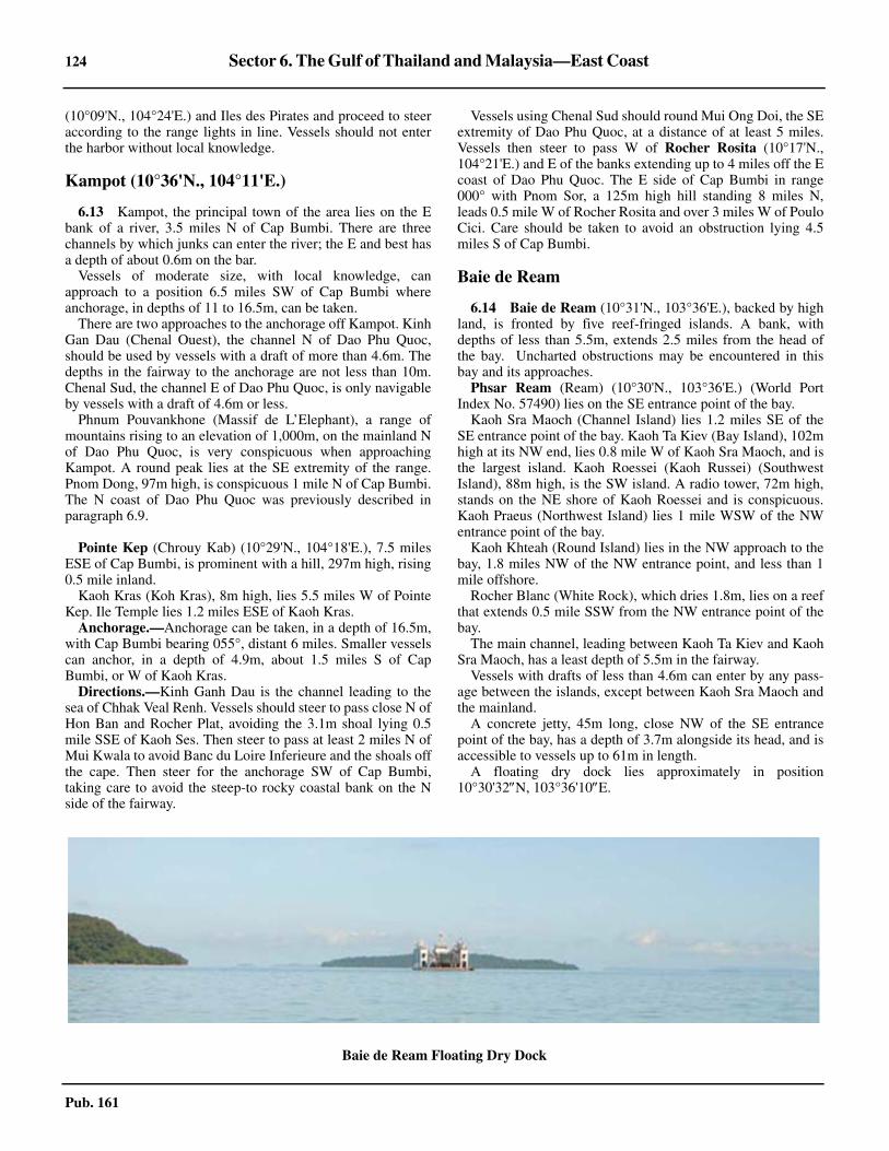
124 Sector 6. The Gulf of Thailand and Malaysia—East Coast
Pub. 161
(10°09'N., 104°24'E.) and Iles des Pirates and proceed to steeraccording to the range lights in line. Vessels should not enterthe harbor without local knowledge.
Kampot (10°36'N., 104°11'E.)
6.13 Kampot, the principal town of the area lies on the Ebank of a river, 3.5 miles N of Cap Bumbi. There are threechannels by which junks can enter the river; the E and best hasa depth of about 0.6m on the bar.6.13 Vessels of moderate size, with local knowledge, canapproach to a position 6.5 miles SW of Cap Bumbi whereanchorage, in depths of 11 to 16.5m, can be taken.6.13 There are two approaches to the anchorage off Kampot. KinhGan Dau (Chenal Ouest), the channel N of Dao Phu Quoc,should be used by vessels with a draft of more than 4.6m. Thedepths in the fairway to the anchorage are not less than 10m.Chenal Sud, the channel E of Dao Phu Quoc, is only navigableby vessels with a draft of 4.6m or less.6.13 Phnum Pouvankhone (Massif de L’Elephant), a range ofmountains rising to an elevation of 1,000m, on the mainland Nof Dao Phu Quoc, is very conspicuous when approachingKampot. A round peak lies at the SE extremity of the range.Pnom Dong, 97m high, is conspicuous 1 mile N of Cap Bumbi.The N coast of Dao Phu Quoc was previously described inparagraph 6.9.
6.13 Pointe Kep (Chrouy Kab) (10°29'N., 104°18'E.), 7.5 milesESE of Cap Bumbi, is prominent with a hill, 297m high, rising0.5 mile inland.6.13 Kaoh Kras (Koh Kras), 8m high, lies 5.5 miles W of PointeKep. Ile Temple lies 1.2 miles ESE of Kaoh Kras.6.13 Anchorage.—Anchorage can be taken, in a depth of 16.5m,with Cap Bumbi bearing 055°, distant 6 miles. Smaller vesselscan anchor, in a depth of 4.9m, about 1.5 miles S of CapBumbi, or W of Kaoh Kras.6.13 Directions.—Kinh Ganh Dau is the channel leading to thesea of Chhak Veal Renh. Vessels should steer to pass close N ofHon Ban and Rocher Plat, avoiding the 3.1m shoal lying 0.5mile SSE of Kaoh Ses. Then steer to pass at least 2 miles N ofMui Kwala to avoid Banc du Loire Inferieure and the shoals offthe cape. Then steer for the anchorage SW of Cap Bumbi,taking care to avoid the steep-to rocky coastal bank on the Nside of the fairway.
6.13 Vessels using Chenal Sud should round Mui Ong Doi, the SEextremity of Dao Phu Quoc, at a distance of at least 5 miles.Vessels then steer to pass W of Rocher Rosita (10°17'N.,104°21'E.) and E of the banks extending up to 4 miles off the Ecoast of Dao Phu Quoc. The E side of Cap Bumbi in range000° with Pnom Sor, a 125m high hill standing 8 miles N,leads 0.5 mile W of Rocher Rosita and over 3 miles W of PouloCici. Care should be taken to avoid an obstruction lying 4.5miles S of Cap Bumbi.
Baie de Ream
6.14 Baie de Ream (10°31'N., 103°36'E.), backed by highland, is fronted by five reef-fringed islands. A bank, withdepths of less than 5.5m, extends 2.5 miles from the head ofthe bay. Uncharted obstructions may be encountered in thisbay and its approaches. 6.14 Phsar Ream (Ream) (10°30'N., 103°36'E.) (World PortIndex No. 57490) lies on the SE entrance point of the bay.6.14 Kaoh Sra Maoch (Channel Island) lies 1.2 miles SE of theSE entrance point of the bay. Kaoh Ta Kiev (Bay Island), 102mhigh at its NW end, lies 0.8 mile W of Kaoh Sra Maoch, and isthe largest island. Kaoh Roessei (Kaoh Russei) (SouthwestIsland), 88m high, is the SW island. A radio tower, 72m high,stands on the NE shore of Kaoh Roessei and is conspicuous.Kaoh Praeus (Northwest Island) lies 1 mile WSW of the NWentrance point of the bay. 6.14 Kaoh Khteah (Round Island) lies in the NW approach to thebay, 1.8 miles NW of the NW entrance point, and less than 1mile offshore.6.14 Rocher Blanc (White Rock), which dries 1.8m, lies on a reefthat extends 0.5 mile SSW from the NW entrance point of thebay.6.14 The main channel, leading between Kaoh Ta Kiev and KaohSra Maoch, has a least depth of 5.5m in the fairway. 6.14 Vessels with drafts of less than 4.6m can enter by any pass-age between the islands, except between Kaoh Sra Maoch andthe mainland.6.14 A concrete jetty, 45m long, close NW of the SE entrancepoint of the bay, has a depth of 3.7m alongside its head, and isaccessible to vessels up to 61m in length.6.14 A floating dry dock lies approximately in position10°30'32N, 103°36'10E. 6.14
Baie de Ream Floating Dry Dock

Sector 6. The Gulf of Thailand and Malaysia—East Coast 125
Pub. 161
6.14 Anchorage.—Baie de Ream offers fairly secure anchorageduring the Southwest Monsoon, off the NE end of Kaoh TaKiev. The best anchorage, in a depth of 11m, is with the N sideof the pier bearing 105°, distant 0.2 mile. Vessels should notproceed farther N of this anchorage as depths shoal sharply.6.14 During the Northeast Monsoon, strong currents set in thechannel. During the Southwest Monsoon a heavy swell entersthe bay. At this anchorage, tidal currents have been observedsetting N on the flood tide and SSE on the ebb tide, attainingvelocities of up to 1 knot.
Chhak Kampong Saom
6.15 Chhak Kampong Saom (Baie de Kampong Som) isentered between a point close ESE of Kaoh Poah (Koh Pos)(10°37'N., 103°29'E.) and Chrouy Samit (Pointe Samit), 27miles NW. The bay is sheltered from SW by a chain of islandsextending SSE from Chrouy Samit. The N shore of the bay islow and bordered by mangroves. The N part of the bay is shoaland encumbered with fishing stakes. Vessels should notproceed to the head of the bay without local knowledge.6.15 The port of Kampong Saom lies in the SE part of the bay.
The Approach to Chhak Kampong Saom—Is-lands and Dangers
6.16 Kaoh Rung Samloem (10°35'N., 103°18'E.), the S
island in the approach, rises to an elevation of 210m in its NWpart, and is thickly wooded; its SW and SE sides are steep-to.Kaoh Kon (Ile Cone), 157m high, lies close N of the island.Chhak Saracen (Baie du Saracen) indents the E side of theisland, and have depths of 7.6 to 11m shoaling graduallytowards its shores. No dangers lie more than 0.3 mile offshore.6.16 Anchorage.—During the southwest monsoon, anchoragecan be taken, in a depth of 7.3m, about 0.3 mile off a cascade,at the SE end of a sandy beach in the S part of the bay. The NEpart of the bay offers better shelter during the northeastmonsoon.6.16 Kaoh Rung, 2.2 miles NW of Kaoh Rung Samloem, is steep-to on its SW and NW sides. The island is wooded, and itssummit is 317m high on its SW side. A bank, with a depth of5.2m near its outer end, extends 3.5 miles NE from the NE endof Kaoh Rung. Banc de Kas Rung, with a least depth of 2.1m,lies on the SE part of the bank.6.16 Anchorage, during the Southwest Monsoon, can be taken, indepths of 7.3 to 14.6m, sand and mud, off the NE side of KaohRung. Anchorage can also be taken in the bay on the SW sideof the island.6.16 Kaoh Ta Team (Ile du Chenal) and Kaoh Mano (Ile duMilieu), with an islet close N, lie 0.7 mile apart, about midwaybetween Kaoh Rung and Chrouy Samit. The coastal bank, withdepths of less than 5.5m, extends up to 4 miles offshore in thebay NE of Kaoh Mano.6.16 Kaoh Damlong (Ile Plate) lies 2.5 miles SE of Chrouy Samit.6.16 Kaoh Kaong Kang (Koh Kong Kang) (10°36'N., 103°25'E.)lies in the approach to Kampong Saom, midway between KaohRung Samloem and the mainland. A reef extends 0.3 mileWSW from the island. A shoal, with a depth of 8.5m, lies 0.9mile N and 1.2 miles S, respectively, of the E end of the island.A light is shown from the E end of Kaoh Kaong Kang.6.16 Kaoh Poah (Koh Pos), close off the SE entrance, lies 1 mileWNW of Kaoh Poah. A light is shown from Kaoh Dek Koul.
Chhak Kampong Saom—Channels
6.17 The best channel into Chhak Kampong Saom isbetween Kaoh Rung Samloem and Kaoh Kaong Kang. Thischannel is 3.5 miles wide and clear, with depths of over 18m.
The passage between Kaoh Rung Samloem and Kaoh Runghas a least depth of 11m. However, a bank, with depths of lessthan 10m extends 3.5 miles SE from the SE side of Kaoh Rung,and a depth of 6.4m lies on this bank, 2.5 miles SE of theisland. On the S side of the passage, a depth of 7.7m lies 1 mileE of the N extremity of Kaoh Kon.6.17 Kaoh Ta Team (Ile du Chenal) lies in the middle of thepassage between Kaoh Rung and Kaoh Mano (Ile du Milieu).There are least depths of 10.1m in the passage, but depths ofless than 9.2m and 5.5m extend about 3 miles NNE and NE,respectively of the NE extremity of Kaoh Rung.
Kampong Saom (Sihanoukville) (10°38'N., 103°30'E.)
World Port Index No. 57485
6.18 Kampong Saom is the principal port of Cambodia andthe only port which can berth ocean-going vessels. The port
Kaoh Roessei Tower

126 Sector 6. The Gulf of Thailand and Malaysia—East Coast
Pub. 161
extends from the quay S of Pointe Loune to Kaoh Preap(Rocher Preap) (Rocher Touffu), 1.5 miles NNE. The main pierextends W then SSW from Pointe Loune. A new pier extends0.5 mile ENE of Pointe Loune, and is sheltered by abreakwater extending NNE of Pointe Loune. Extensive portdevelopment plans are scheduled to begin in 2011 and becompleted by 2015. 6.18 A breakwater extending from Kaoh Preap to Pointe Dom-inique, 0.7 mile E, forms the N part of the new harbor. A break-water also extends SSW of Kaoh Preap. Two visible wrecks lieinside this breakwater and another wreck lies close inside thebreakwater at Pointe Loune.6.18 An offshore pipeline berth is situated off Pointe du Depart,3.5 miles NNE of Pointe Dominique.6.18 Tides—Currents.—Tides at Kampong Saom are usually di-urnal. The tidal rise is 1.3m at MHHW.6.18 There are strong and irregular currents in the passagebetween Kaoh Poah and the mainland. The tidal currents at themain wharf run parallel with it. The maximum velocity is 1.5knots, and the average rate does not exceed 0.5 knot.6.18 A flag shown at the N end of the wharf indicates a N currentat the wharf, and a flag shown at the S end of the wharfindicates a S current; during slack water no flag is shown.6.18 Depths—Limitations.—The main pier extends W and SWfrom Pointe Loune and has a total length of 550m. The prin-
cipal part of this pier is its SW arm which is 275m in length. Itis reported that two vessels with drafts to 9.5m can berthalongside its W side and two vessels with drafts of up to 7.5malongside its E side. Near the inner end of the main wharf abreakwater extends SSW providing shelter to a lighter basin onthe E side of which there is a lighter quay. Lloyd’s Port Guide20
6.18 The entrance and turning basin in the S part of the newharbor were reported dredged to 7.3m.6.18 The wharf in the S part of the new harbor has depths of 7.3malongside. Two mooring buoys are established between thebreakwater and the wharf.6.18 The offshore pipeline berth at Pointe du Depart, which lies13 miles SW of Rocher Blanc, has two moorings in depths of15m, capable of accommodating tankers up to 220m in lengthand 11.5m draft. The facility at Pointe du Depart can accom-modate tankers of up to 60m in length with drafts to 4.6m.6.18 Rocher Thmor (Rocher Eiffel), 3m high, lies nearly 0.9 mileN of the NE extremity of Kaoh Poah. A 4m patch lies 0.3 mileNW of Rocher Thmor, and is marked by a buoy. A patch, witha least depth of 3.3m, lies nearly 0.5 mile E of Rocher Thmor,and is marked by a buoy.6.18 A rock, with a depth of 1.6m, lies on a detached shoal, 0.3mile NW of Kaoh Preap.
Kampong Saom Fuel Pier
Kaoh Poah Bridge (under construction 2010)

Sector 6. The Gulf of Thailand and Malaysia—East Coast 127
Pub. 161
6.18 The deep passage between Kaoh Poah and the mainland hasa least depth of 8.2m on the axis of the buoyed channel, withthe white beacon on Pointe Loune bearing 031°36'.6.18 Aspect.—Two warehouses, easily identifiable from a dis-tance, lie close S of Pointe Loune, and nearly parallel to themain pier. Several radio towers are reported to be conspicuous. 6.18 A light is shown from the N tip of the breakwater at PointeLoune. Kaoh Preap, 5.8m high and prominent, lies at the NWcorner of the harbor.6.18 A flare is conspicuous on Pointe du Depart, where there is arefinery.6.18 Pilotage.—Pilotage is compulsory, and should be requestedat least 24 hours prior to arrival. The pilot boards close NE ofBuoy KS. Berthing is usually carried out in daylight only,while unberthing takes place day or night, weather permitting.6.18 Regulations.—Navigation is prohibited within 0.5 mile ofthe tanker berth.6.18 Anchorage.—Three anchorage areas are available to vesselsawaiting a berth, a pilot, or working cargo. The N anchorage,situated N of Lighted Buoy A, has depths of 9.2 to 11m, goodholding ground. The S anchorage, situated S of Kaoh Poah, isused as a lightering anchorage when the N anchorage is toorough. The anchorage has depths of 8 to 10m, mud. The tankeranchorage, in depths of 15.8 to 18m, lies 2 miles NW of KaohDek Koul (Rocher Carre).
6.18 Directions.—The port is easy to approach by day or night.Vessels arriving during hours of darkness are advised toapproach the port by entering between Kaoh Kaong Kang andKaoh Dek Koul, passing about 0.4 mile W of the latter.6.18 The most direct route to the harbor at Kampong Saom is viathe deep passage between Kaoh Poah and the mainland. Thisroute is marked by buoys and the beacon on Pointe Lounebearing 031°36'.6.18 Vessels can also reach the harbor by the passage W of KaohPoah, which has a least depth of 7m. Vessels then pass N ofLighted Buoy A and Lighted Buoy B, moored NW and ENE ofRocher Thmor.
Chrouy Samit to Laem Ling
6.19 The coast between Chrouy Samit (Pointe Samit)(10°52'N., 103°07'E.) and Chrouy Yai Sen (Pointe Yeay Sen),22 miles N, is hilly near the coast, forming rocky bluffs withsandy bays between. The bays afford good anchorage withoffshore winds.6.19 A group of islands lies within 3 miles of the coast N ofChrouy Samit. Kas Samit, the S island, is 120m high.6.19 Rocher Table, 60m high, is located 6 miles N of Kas Samit,and 3.5 miles offshore. A 7.3m rocky shoal extends 0.5 mileSW of the islet. Roche du Branlebas, which dries 0.3m, lies 2.3miles NE of Rocher Table.6.19 Ilots Kussat (Kaoh Putsa) consists of three islets. The outerislet is 90m high, and lies 1.5 miles SW of Pointe Koh Kussat(11°05'N., 103°06'E.).6.19 Caution.—Rocher Kusrovie (Kaoh Kusrovie), 11m high,lies 17.5 miles W of Pointe Koh Kussat. Banc Ubon Boratit,composed of sand and coral, with a least depth of 1.2m, lies 1mile N of Rocher Kusrovie.6.19 Banc de Yai Sen, with a least depth of 12m, and Banc de Kas
Kong, with a least depth of 12.8m, lie 9.5 miles NE and 13.5miles N, respectively of Rocher Kusrovie.
6.20 Koh Kong (Koah Kong) (11°20'N., 103°00'E.) frontsBaie de Kas Kong (Chaak Kaoh Kong), a shoal bay betweenChrouy Yai Sen and Lem Dam (Phum Lamdam), 12 miles N.The island is wooded and attains an elevation of 406m near itscentral part.6.20 Ilot Cone (Kaoh Mul) (11°26'N., 103°00'E.), 1 mile NW ofLem Dam, is 37m high and joined to the mainland by acauseway. A light is occasionally shown from the islet. Apagoda is conspicuous at Kas Kapig, 1.5 miles NNE of IlotCone.6.20 Koh Yor (11°35'N., 102°56'E.), 118m high and prominent,lies 10 miles NNW of Ilot Cone and appears as an island.6.20 The coast is low and bordered by sandy beaches betweenKoh Yor and Khao Hua Maew (11°55'N., 102°47'E.), a rockybluff, 71m high, 22 miles NNW. A mountain range, rising toelevations of 300 to 600m and with its S end lying 4 miles N ofKoh Yor, backs this coast 1 to 3 miles inland.6.20 Ao Trat is entered between Khao Hua Maew and Laem Nam(Laem Sok) (12°03'N., 102°35'E.), 14 miles NW. The bay hasdepths of less than 5.5m except in its outer part, and there aredrying flats at its head. A light is shown on Laem Nam, and onLaem Ko Pu, 7.5 miles N.6.20 Anchorage can be taken, in a depth of 7.3m, about 4 miles Eof Laem Nam.
Off-lying Islands and Dangers
6.21 Ko Kut is the SE of a group of islands lying SSE ofLaem Ling (12°10'N., 102°17'E.). It is a high, level island,rising to an elevation of 344m in its S part. A light is shownnear the S end of the island (11°34'N., 102°36'E.).6.21 Ko Mak, 4 miles NW of Ko Kut, has a rocky headland, 107mhigh at its W extremity. The channel between the two islandshas depths of over 11m. Ko Rayang Nok, an 81m high islet,lies 0.5 mile S of the W extremity of Ko Mak. Ko Kradat, 57mhigh, lies near the middle of a coral flat extending 4.5 miles NEof Ko Mak. A depth of 5.5m lies 2 miles SE of the SEextremity of Ko Kradat. A rock, with a depth of 7m, whoseposition is approximate, lies 0.5 mile SSE of the 5.5m depth.6.21 Ko Rang Yai (Ko Rang), 193m high, lies 3 miles WSW ofKo Mak. Ko Mapring, 70m high, lies 0.8 mile N of the latterisland. Rocks, above and below water, extend up to 1 mile offthe N end of Ko Rang Yai.6.21 Hin Phrai Nam, awash, lies 2.5 miles NE of Ko Mapring.
6.22 Ko Chang (12°03'N., 102°21'E.), the largest island ofthe group, has several peaked hills intersected by rocky andprecipitous ravines. The summit is a table peak, 744m high, inthe SW part of the island. Ko Chang Trat Light (12°06'N.,102°17'E.) is shown from the NW summit of the island. 6.22 Ko Khlum, 242m high, lies 3 miles SE of Laem Bang Bao,the SW extremity of Ko Chang. Hin Rap, 1.5m high, lies 1.5miles W of the S end of Ko Khlum. A rock, 1m high, lies 1.5miles NE of Hin Rap. A rock, with a depth of 5.6m, lies 0.5mile E of Hin Rap.6.22 Hin Luk Bat, 1.5m high, lies 2 miles WSW of Laem BangBao.

128 Sector 6. The Gulf of Thailand and Malaysia—East Coast
Pub. 161
6.22 Ko Yuak (Ko Yauk), 40m high, and the NW of three islets,lies 5 miles NW of Laem Bang Bao, and 1.8 miles off the Wcoast of Ko Chang.6.22 Hin Sam Sao (Hin Samsau), 2.4m high, and Hin Rai (HinRarb), 1.2m high, lie 1.5 and 2 miles, respectively, NW of KoYuak. Hin Rai, 2.5 miles offshore, is the outermost danger offthe W side of Ko Chang.6.22 Caution.—An area dangerous for anchoring or fishing dueto mines lies up to 8 miles W of the W coast of Ko Chang andis best seen on the chart.
Chong Ko Chang
6.23 Chong Ko Chang (Ko Chang Chong), the channelbetween Ko Chang and the mainland, has depths of 6.4 to 9.2min the fairway. Vessels drawing more than 4.5m should not usethis channel without local knowledge.6.23 Ko Ngam, 120m high, bordered close SE by rocks above andbelow water, lies close SE of the SE end of Ko Chang.6.23 Ko Mai Si Yai (Ko Maisi Yai), 1.5 miles E of Ko Ngam, lieson the E side of the entrance to Chong Ko Chang. Several isletsextend up to 2 miles E and ENE of Ko Mai Si Yai.6.23 Ko Baidang, 125m high, and Ko Wai, 128m high, lie 2 milesSSW, and 3.5 miles SW, respectively, of Ko Mai Si Yai, in theS approach to Chong Ko Chang, and the W approach to AoTrat.
6.23 The coastal bank, with depths of less than 5.5m, on the SWside of Chong Ko Chang, extends up to 1 mile from the NEside of Ko Chang. Ko Salak (Ko Lim), 60m high, lies on theSW side of the fairway, 6 miles NNW of Ko Mai Si Yai; a 4.6mpatch lies 2.5 miles NW of the islet.6.23 The coast on the N side of Chong Ko Chang is low andmangrove-covered. A light is shown at Ban Laem Ngop, 7miles NNW of Ko Salak. The coastal bank, with depths of lessthan 5.5m, extends 1 mile off Ban Laem Ngap, and 6.5 milesoffshore in the SE part, extending SW from Laem Sok to theislets off the SE end of Ko Chang.6.23 Chong Ko Chang is entered from NW between Ko ChangNoi, 87m high, close off the NW extremity of Ko Chang, andLaem Ling, located 3 miles NNE.6.23 Hin Khi Chang (Hin Kee Chang), 1.2m high, lies on the Nside of the fairway, 3.3 miles E of Ko Chang Noi. A light isshown from Hin Khi Chang.6.23 Anchorage.—There is anchorage, in depths of 8.2 to 9.2m,about 0.7 mile SE of Hin Khi Chang. Small vessels can obtainanchorage, in a depth of 4.6m, about 1.5 miles SW of BanLaem Ngop. Vessels approaching from NW should steer forthe light structure on Hin Khi Chang bearing 110°, and thenpass 0.1 to 0.2 mile S of the rock, and anchor when the struc-ture comes in range, or opens SW of Laem Ling.
Laem Ling to Ko Saba
6.24 Laem Ling (12°12'N., 102°17'E.) is bordered 0.3mile W by a rocky patch, awash. A hill, 163m high, rises 1mile ESE of Laem Ling.6.24 The coast between Laem Ling and the E entrance point ofMae Nam Chanthaburi, 20 miles NW, is low and fringed withmangroves.
6.24 Ko Chik Nok, 82m high, standing 5.5 miles NW of LaemLing, fronts the mouth of Mae Nam Welu. The bar of the river,with depths of 1.8 to 2.1m in the fairway, extends 2 miles SWof Ko Chik Nok. A light is shown from the NW extremity ofKo Chik Nok.6.24 Ko Proet, 65m high and connected to the coast by a spit, lies10 miles NW of Ko Chik Nok. Ko Kwang and Ko Nang Ram,lie 0.5 mile SE, and 1 mile NW, respectively, of Ko Proet. HinPhin, with a depth of 4.4m, lies 1 mile SSE of Ko Kwang.6.24 Hin Bojesen, consisting of two rocks nearly 0.5 mile apart,each with a depth of 2.1m, lies 4 miles SW of Ko Proet. HinPhut, two steep-to rocks above water, lies 6.2 miles SW of KoProet and is marked by a buoy.6.24 Laem Sing (12°28'N., 102°04'E.), the W entrance point ofMae Nam Chanthaburi, rises to Khao Laem Sing, 172m high,about 0.8 mile NNW. A light is shown from the point.6.24 Ko Nom Sao, 108m high, lies 2 miles W of Laem Sing. Arock, with a depth of 9.4m, lies 1.8 miles SSE of the islet. KhaoSa Bap rises to an elevation of 932m about 10 miles ENE ofLaem Sing.6.24 Mae Nam Chanthaburi is entered W of Laem Sing. The townof Ban Paknam stands on the low E entrance point, 0.8 milefarther N. Ko Chula, a 16m high islet, lies 0.4 mile SE of LaemSing. Rocks, below water and awash, extend up to 0.2 mile Nand SSW of the islet. Hin Sukhrip, with a depth of 2.3m, lies0.5 mile SW of Ko Chula.6.24 A rocky bank extends 0.1 mile E from Laem Sing, leaving achannel about 0.2 mile wide, with a depth of 3.6m in thefairway.6.24 Vessels drawing 3.6m can proceed up the river 2.3 miles Nof Ban Paknam, to Ban Laem Pradu, where there is acustomhouse, church, and wooden pier, on the W side of theriver. Vessels moor in the river as the tidal currents are strong.6.24 Tha Chalaep, on the N bank of the river 1.7 miles farther N,is the port for Chanthaburi and is accessible to vessels of 2.7mdraft. There is a jetty, with a T-head about 25m long, which canaccommodate vessels of 500 tons and a draft of 3m at HW.Pilotage is not available.6.24 Ao Mu Yai, a shoal bay, backed by a low and wooded coast,lies between Laem Sing and Ko Saba, 7 miles WNW. There arenumerous fishing stakes off this bay during the NortheastMonsoon.6.24 Ko Saba, 65m high, lies close off a prominent hilly point. KoLuk Saba, a reef awash, extends 0.2 mile S of Ko Saba. MaeNam Khem Nu, entered E of Ko Saba, is obstructed by a barwith a depth of 1.8m.
Ko Saba to Laem Samae San
6.25 Khao Khung Kraben (12°34'N., 101°53'E.), apromontory, 126m high, and joined to the mainland by anarrow isthmus, lies 5.5 miles NW of Ko Saba.6.25 Ao Khung Kraben, entered N of Khao Khung Kraben, hasdepths of less than 1.8m, with mud and sand flats extendingover most of the bay.6.25 The coast between Khao Khung Kraben and LaemThoraphim, 15 miles WNW, recedes to form a bight. The coastis hilly between Kao Khung Kraben and Khao Taphao Khwam,which rises to an elevation of 128m about 4.5 miles NNW; thenthe coast is low to Laem Thoraphim. A low hill, 44m high, lies

Sector 6. The Gulf of Thailand and Malaysia—East Coast 129
Pub. 161
close W of Laem Thoraphim, and Ko Khi Pla, 9m high, lies 1mile WSW of the point, and 0.3 mile offshore.
6.25 The coastal bank, with depths of less than 5.1m, extends 2.5miles off the NE shore of the bight. Islets and foul groundextend 8 miles S of the NW shore. Ko Man Nok (12°34'N.,101°42'E.), 5.5 miles SE of Laem Thoraphim, is the southern-most islet of the above group. The islet is 22m high and rock-fringed; a light is shown from the summit. Hin Loftus, theoutermost danger of the group, is awash at LW, and lies 0.8mile SE of Ko Man Nok. Vessels should not pass inside thisgroup of dangers.6.25 Caution.—Hin Ai Lop, which dries, lies 5.5 miles W ofKhao Khung Kraben. Hin Ritthidet, with a depth of 3.7m, lies0.7 mile SSW of Hin Ai Lop.6.25 Hin Alhambra (12°26'N., 101°40'E.), a coral bank whichuncovers, lies 13 miles S of Laem Thoraphim. Parts of the reefare reported to break in heavy weather. Depths of 0.3m lie 0.8mile E and 0.3 mile W of its drying part.
6.26 The coast between Laem Thoraphim and Laem Ya, 14miles WSW, is mostly low and wooded, except for a fewisolated hills. Laem Ya (12°35'N., 101°25'E.) rises to anelevation of 121m close N. Khao Taphao Khwam, 551m high,rising 5.5 miles N of Laem Ya, is the S peak of a range ofmountains extending 10 miles N.6.26 Caution.—Ko Thalu, 65m high, and with rocks extending0.3 mile S, lies 7 miles SW of Laem Thoraphim. Hin KlangRong, which is awash, lies 1 mile N of Ko Thalu.
6.27 Ko Kudi (Ko Kut), 49m high, with the rocky islet ofKo Thai Khangkhao close S, lies 3.5 miles NW of Ko Thalu. Itis the southernmost of a chain of islets and rocks extending 3miles from the coast. Vessels should pass S of Ko Thai Khang-khao.6.27 Ko Samet, with its N extremity lying 2 miles E of Laem Ya,is the largest island off this coast. The island is hilly, attainingan elevation of 112m at its N end. A light is shown from theNW end of Ko Samet.6.27 Hin Khao, 7m high, and Ko Chan, 21m high, lie 1 mile NEand 0.3 mile S, respectively, of the S extremity of Ko Samet.Hin San Chalam, 1.5m high, lies 0.5 mile S of Ko Chan; rocksabove water extend 0.2 mile E, and depths of less than 5.5mextend 0.3 mile SE of Hin San Chalam.6.27 Chong Samet, the passage between Ko Samet and themainland, has several sunken rocks and shoals with depths ofless than 3.7m and should only be used by vessels with localknowledge. Marine farms have been established in theapproaches to Chong Samet and in the strait itself.6.27 The coast between Laem Ya and Laem Samae San, 27 milesW, is low and wooded, except for Khao Sap, 62m high, anisolated hill, located 2.5 miles NW of Laem Ya.6.27 Hin But, with a depth of less than 1.8m, and marked S by abuoy, lies 2.5 miles W of Laem Ya. Hin Redang lies 1.3 milesNW of Hin But.
6.28 Mae Nam Rayong (12°39'N., 101°17'E.) discharges9.2 miles WNW of Laem Ya; the bar of the river is constantlyshifting and the bar nearly dries. A light is shown close withinthe river mouth. A pagoda stands on the S side of the prom-
ontory. A pier lies 2.5 miles E of the light. The recommendedroute to the pier is marked by range lights and lighted buoys. 6.28 Rayong (Map Ta Phut) (12°38'N., 101°19'E.), a terminalenclosed by breakwaters, lies W of the mouth of Mae NamRayong.6.28 Depths—Limitations.—The pier is capable of accommo-dating a general cargo vessel up to 20,000 dwt and there aretwo berths for liquid cargo vessels. 6.28 Aspect.—Range lights, in line bearing 345°30', lead into theharbor. The channel to the terminal is marked by lighted buoys.Range lights, in line bearing 330°, lead to the wharf.6.28 Ko Saket, 7m high, lies 6.5 miles W of the entrance to MaeNam Rayong, and 1.2 miles offshore. The islet lies on a bank,with depths of less than 1.8m extending 2 miles offshore.6.28 Pilotage.—Pilotage is compulsory; the pilot boards near thefairway lighted buoy. Berthing and unberthing of vessels takesplace during daylight hours only. 6.28 Anchorage.—Anchorage can be taken, in depths of 7.3 to12.8m, S of Mae Nam Rayong Light, but there is no shelter ineither monsoon season. Vessels with a draft over 15m needs tocontact port control for an anchoring position.6.28 Caution.—Marine farms exist in the approaches to, and inMae Nam Rayong.
Head of the Gulf of Thailand—East Side
6.29 Laem Samae San (12°36'N., 100°58'E.), 58m high, isthe E entrance point of the bight which forms the head of theGulf of Thailand. Hin Chula, a rock marked by a light, lies onfoul ground extending 0.2 mile E of Laem Samae San.6.29 Islands and islets extend 8 miles S of Laem Samae San. KoChuang (12°31'N., 100°58'E.), 148m high, lies with itssummit 4.5 miles S of Laem Samae San. Hin Lak Bet, 8mhigh, and Ko Chan, 38m high, lie 1 mile NW, and 0.5 mile E,respectively, of Ko Chuang. Two islets lie 0.3 mile off the NEend of the island. A light is shown from the summit of KoChuang.6.29 Hin Chalam (12°28'N., 100°58'E.), 9m high, white andsteep-to, lies 2.5 miles S of Ko Chuang. Hin Yai, a coral patchwith a depth of 11m, lies 1.8 miles SSW of Hin Chalam.6.29 Caution.—An ammunition dumping ground surrounds HinChalam.
6.30 Ko Samae San, 167m high and located 1.2 miles N ofKo Chuang, is the largest of the off-lying group of islands andislets. Ko Chang Klua, 28m high, lies 1 mile E of the Sextremity of Ko Samae San. Hin Lak Kun Chae, 4m high, andKho Kham, 64m high, lie 1 mile, and 1.8 miles, respectively,NW of the same extremity.6.30 Ko Raet, 106m high, lies 0.3 mile S of Laem Samae San, andabout the same distance off the NE end of Ko Samae San.6.30 The coast between Laem Samae San and Laem Chao, 2.3miles WNW, is indented by two bights with low and woodedshores, separated by a rocky point. Laem Chao (12°36'N.,100°57'E.), a rocky headland, 62m high, is bordered 0.5 mileWSW by Ko Chorakhe, a 57m high islet.6.30 A submarine pipeline carrying natural gas has been laid fromseaward to a position 9 miles W of Rayong, and is best seen onthe appropriate chart. Vessels should exercise caution whenanchoring in the vicinity.

130 Sector 6. The Gulf of Thailand and Malaysia—East Coast
Pub. 161
Sattahip (Chuk Samet Harbor) (12°37'N., 100°55'E.)
World Port Index No. 57446
6.31 Sattahip is approached between Ko Chorakhe and KoI Lao, 2.3 miles WNW. Ko Yo lies close NE of Ko I Lao, on thesame reef. Ko Maeo, 16m high, lies 0.4 mile SE of Ko Yo, atthe SE end of a bank, with depths of less than 5.5m. Ko Mu,68m high, lies 1.3 miles NW of Ko Chorakhe with abreakwater, which shelters the harbor, extending 0.5 mile fromthe SE extremity of the island. Ko Nang Ram, 29m high, lieson the E side of the harbor entrance, nearly 0.5 mile E of thebreakwater head. The harbor consists of a tanker pier,connected to the shore by a pipeline trestle, on the E side of theharbor entrance, and deep-draft cargo berths farther N. Theport is reserved primarily for naval vessels. 6.31 Winds—Weather.—The winds and swells in the area arestrong only during the Southwest Monsoon (April throughSeptember). The prevailing winds are WSW at 5 knots inJanuary; S at 6 knots from February through May; SW at 8 to10 knots from June through September; and N at 5 to 6 knotsfrom October through December.6.31 The mean relative humidity varies from 68 per cent inJanuary to 82 per cent in October. The mean temperaturethroughout the year is 13°C to 15.8°C.6.31 Tides—Currents.—The tide at Ao Sattahip is usuallydiurnal. The tidal rise at MHHW is 2.1m.6.31 In the channel between Ko Chorakhe and the mainland thetidal current sets NW on the rising tide and SE on the ebb,attaining a velocity of 1 knot to 1.5 knots. A 2 to 3 knot currenthas been reported in the entrance channel, running generally Wwith the flood and E with the ebb.6.31 Depths—Limitations.—The buoyed channel to the harborhas depths of 8.9m across its seaward end, and depths of 9.4min the fairway of the remainder of the channel.6.31 The tanker berth has depths of 10.1 to 11m alongside andcan accommodate a vessel of up to 250m in length with a draftof 9.1m.6.31 Five general cargo berths are available to ocean-going ves-sels. The West Quay has a length of 540m and can accommo-date three vessels of up to 180m in length with drafts to 9m.The North Quay is 350m long and able to accommodate twovessels of up to 150m in length, with drafts to 7.8m. 6.31 Aspect.—In the approach, the lights on Ko Chuang andLaem Phu Chao are easily visible up to 20 miles on a clear day.The breakwater light may be seen up to 10 miles.6.31 Range lights on the W side of the cargo pier lead through thebuoyed channel to the harbor.6.31 Pilotage.—Pilotage is compulsory and is available only indaylight hours. Pilots board off the entrance to the buoyedchannel. Contact Sattahip Port Control on VHF channel 16from 35 miles distant from the point of arrival. The workingfrequency is VHF channel 12. Vessels are requested to ensurearrival time is prior to 1600 as pilots will not berth during dark-ness due to the absence of navigation lights.6.31 The vessel’s ETA should be sent at least 36 hours in advance,along with the ship’s length and draft. Vessels are required tokeep continuous listening watch while approaching, at anchor,and moving within the harbor.
6.31 Anchorage.—Anchorage is available, in depths of 22 to31m, shells and mud, in the two charted anchorage areas situ-ated approximately 4 miles SW and 3.5 miles WSW of theChuk Samet breakwater. These areas are exposed and may notbe tenable during the Southwest Monsoon.6.31 A quarantine anchorage is situated 6 miles SSE of the ChukSamet breakwater and can best be seen on the chart.
6.32 Ao Sattahip (12°38'N., 100°54'E.) is shoal andencumbered with several reef-fringed islands which lie in theapproach and entrance. Laem Pu Chao (12°39'N., 100°51'E.)is the W entrance point of Ao Sattahip; a light is shown fromthe summit. Unauthorized entry into Ao Sattahip is prohibited. 6.32 Ko Tao Mo, 146m high, and the largest island, lies 0.8 mileSE of Laem Pu Chao. 6.32 Tides—Currents.—West of Kao Tao Mo the currents setNW on the flood and SE on the ebb attaining velocities of 1knot to 1.5 knots. The tidal currents in the channel between KoTao Mo and Ko Phra flow in the same directions, attainingvelocities of 1 knot.6.32 Depths—Limitations.—An oil pier with a T-head, 67mlong, and a depth of 5.8m alongside, is situated on the N side ofthe W end of Ko Phra. A prominent radio mast, with oil tanksclose E, stands close SE of the pier. A drying bank, marked Nby a lighted buoy, extends 0.3 mile N of the E end of Ko Phra.The approach to the pier from W is difficult and a vessel shouldturn and secure alongside, heading W.6.32 An L-head pier extending S and W of Laem Thian, is 152mlong and 18m wide, with a depth of 7m alongside. Two con-crete LST ramps and mooring platforms are situated close E ofthe L-head pier.6.32 In the narrow channel between Ko Tao Mo and the mainlandthere are least depths of 5.5m between the coastal banks.6.32 Aspect.—The N coast of Ao Sattahip between Laem PuChao and Laem Thian, 2 miles E, is mostly hilly and fringed bystony beaches. Ko Phra, 103m high, lies 0.3 mile ENE of KaoTao Mo. 6.32 The buildings and radio masts of the naval base at AoSattahip extend N of Laem Thian. 6.32 Anchorage.—Anchorage, with local knowledge, can betaken, in depths of 6.4 to 8.2m, N of the NE end of Ko Tao Mo,but anchorage NE of the island has been reported to be unsafe,especially in the Southwest Monsoon.6.32 Caution.—There are areas dangerous due to mines in theapproach to Sattahip and Chong Khram.6.32 A seaplane landing area is situated in the central part of AoSattahip. Vessels are prohibited from anchoring, fishing, ortransiting the area.
Ko Khram Yai
6.33 Ko Khram Yai (12°42'N., 100°47'E.) is separatedfrom the mainland by Chong Khram, which is about 1.7 mileswide. The S extremity of Ko Khram Yai lies 4 miles WNW ofLaem Pu Chao, and the island rises to an elevation of 233mnear its S end.6.33 Hin Yai, 4m high, and Hin Ta, 5m high, lie 0.3 mile SE and0.5 mile E, respectively, of the S extremity of Ko Khram Yai. Arock, with a depth of 1.6m, lies 0.3 mile E of Hin Yai.6.33 The W side of Ko Khram Yai is fairly steep-to, and fringed

Sector 6. The Gulf of Thailand and Malaysia—East Coast 131
Pub. 161
by a rocky bank with depths of less than 1.8m extending 0.2mile offshore.6.33 A shoal, with a least depth of 4m, lies 1.5 miles N of KoKhram Yai. A bank, with depths of less than 10m, extends 2miles farther N.6.33 Ko Khram Noi, a 37m high islet, with a small islet close N,lies 0.5 mile NNW of the NE extremity of Ko Khram Yai.
6.33 Hin Rang Kwian (12°48'N., 100°48'E.), a 9m high rock,marked by a light, lies 4.5 miles N of the NE end of Ko KhramYai.
Chong Khram
6.34 Chong Khram is the strait between Ko Khram Yai andthe mainland. Ko I Ra, 47m high and rock-fringed, lies in themiddle of the S entrance to the strait. Hin Khi Sua, with rocksextending 0.2 mile SE, lies 0.3 mile NE of Ko I Ra. A light isshown from Hin Khi Sua. 6.34 Ao Thung Prong lies on the E side of the strait where thereare depths of 13 to 22m in the fairway. A 9.4m patch lies 0.3mile E of Hin Khi Sua.6.34 On the W side of the strait, a bank with depths of 5.5 to 11mextends 1.5 miles SE from the SE side of Ko Khram Yai. HinKi Pla, 11m high, lies 0.7 mile SE of the E extremity of KoKhram Yai. An islet, 4m high, and a rock, with a depth of lessthan 1.8m, lie 0.3 mile W, and 0.4 mile ESE, respectively, ofHin Ki Pla.6.34 Hin Wua Lai Khwai Wing, which partly dries, lies 0.8 mileNE of the E extremity of Ko Khram Yai.6.34 Winds—Weather.—Winds and swells are strong in ChongKhram during the Southwest Monsoon. During the NortheastMonsoon season, commencing about mid-September, reason-able shelter from winds and swells are afforded in this area.6.34 Tides—Currents.—The flood current sets N through ChongKhram and the ebb current S, with velocities of 1 knot to 2knots. The current attains velocities of 2 to 3 knots W of Ko IRa. However, tidal currents are difficult to predict in this areaand vary according to local winds, swells, and river currents.
6.35 Chong Khram—East side.—The coast from LaemPu Chao (12°39'N., 100°51'E.) to Ko Klet Kaeo, 6.5 miles N,is composed of high rocky bluffs, with sandy bays between.Khao Hat Yao rises to an elevation of 290m, nearly 4 miles Nof Laem Pu Chao. Ao Thung Kai Tia and Ao Thung Prong, inthe S part of this coast, are separated from each other by apromontory which rises to an elevation of 186m. The bays havedepths of less than 5.5m, and the 10m curve fronts the entrancepoints of these bays close offshore.
6.35 Caution.—Firing exercises may be conducted by the RoyalThai Navy in the vicinity of Hat Yao Thung Prong. See Pub.120, Sailing Directions (Planning Guide) Pacific Ocean andSoutheast Asia for more information.
6.36 Thung Prong (12°42'N., 100°50'E.) lies close N ofAo Thung Prong. It consists of a T-shaped pier and De LongPier, situated 0.3 mile N. 6.36 Tides—Currents.—The strong currents in Chong Khramcreate a significant hazard as they run under De Long Pier. Ap-
proaching De Long Pier at other than slack water can be dan-gerous. Tidal currents have been reported to attain velocities ofas much as 6 to 8 knots in the vicinity of the piers at ThungProng.6.36 Depths—Limitations.—Map Pier, the T-shaped pier, atanker berth, is 135m long, prolonged by dolphins, and can ac-commodate vessels up to 183m in length. The pier has depthsalongside of 10.1m at MLW and 9.1m at LWOS. Vessels up to8.5m draft can remain alongside at LWOS.6.36 The De Long Pier has a length of 183m, with a depth of12.8m alongside.6.36 Pilotage.—Pilotage is not compulsory, but is strongly re-commended due to the strong tidal currents.
6.36 Anchorage.—Anchorage while waiting for a berth or pilotcan be taken, in a depth of 13.7m, good holding ground, NE ofKo Khram Yai between 12°43'N and 12°44'N.
6.36 Between the port of Thung Prong and Ko Klet Kaeo, 74mhigh, located 3.5 miles N, depths of less than 10m extend 0.8mile offshore. A bay, with low and wooded shores, indents thecoast between Ko Klet Kaeo and Laem Phatthaya (Patthaya)(12°55'N., 100°51'E.), about 9 miles N. A bank, with depths ofless than 6m, extends 2 miles S from a position lying 2 milesSSW of Laem Phatthaya; a least depth of 4.4m lies near the Nend of the bank.
Photos courtesy of Len Fernandez
De Long Pier

132 Sector 6. The Gulf of Thailand and Malaysia—East Coast
Pub. 161
Off-lying Islets and Dangers
6.37 A chain of islets and dangers extends 2.5 miles off-shore between Ko Khram Yai and Laem Krabang (13°05'N.,100°53'E.).6.37 Ko Lin (Ko Rin), 108m high, lies 5.5 miles W of Hin RangKwian. Hin Ton Mai, and Hin Khao, each 14m high, lie 0.5mile S and 0.8 mile NE, respectively, of Ko Lin.6.37 Ko Phai, 138m high at its S end, lies 7 miles N of Ko Lin,and 11 miles W of Laem Phatthaya. A light is shown from themiddle of the W side of Ko Phai.6.37 Ko Man Wichai, 53m high and steep-to, lies 2.5 miles S ofKo Phai. Ko Klung Badan, 44m high, lies 1.2 miles N of KoMan Wichai. Ko Hu Chang, a 2m high islet, lies 0.5 milefarther N.6.37 Ko Luam, 108m high, lies 1 mile NW of Ko Phai, and is thewesternmost of the off-lying islets. A bank, with depths of lessthan 6m extends 2.5 miles N of Ko Luam.6.37 Ko Lan, 205m high, lies 5 miles E of Ko Phai. Ko Sak, 33mhigh, and Ko Khrok, 41m high, lie 0.5 mile N and 1 mile ESE,respectively, of the N end of Ko Lan. A rock, with a depth of2.7m, lies 0.8 mile S of Ko Khrok. A rock awash lies 1.3 milesESE of Ko Khrok, and is marked E by a buoy.
Laem Phatthaya to Ko Si Chang
6.38 Laem Phatthaya (Laem Patthaya) (12°55'N.,100°51'E.), a rocky bluff, rises to a hill, 98m high, about 0.5mile SSE, on which stands a radio tower, marked by red lights.Ko Chun, low, rocky, and marked by a light, lies 1 mile N ofLaem Phatthaya.6.38 A shallow bay, with low and wooded shores, indents thecoast between Laem Phatthaya and Laem Krabang, 9 miles N.6.38 Ko Nok, 3m high and marked by a light, lies 4.5 miles SW ofLaem Krabang.6.38 Ao Phatthaya, close NE of Laem Phatthaya, is a popularbeach resort. Excellent anchorage has been reported off LaemPhatthaya. Ships generally anchor in the vicinity of position12°56'N, 100°51'E, in depths of 16.5 to 24m, sand, good hold-ing ground.6.38 Approach to the anchorage can be made from SW or NW,but vessels generally favor the approach from SW due tocurrents which run in a SW-NE direction. Currents have beenreported to attain velocities of up to 6 knots. 6.38 Laem Krabang is a hilly point, rising to Khao Laem Kra-bang, 100m high, about 0.5 mile N. Khao Pho Bai rises to201m high, about 2.5 miles NNE of Laem Krabang.
6.39 Laem Krabang (Laem Chabang) (13°05'N.,100°53'E.) (World Port Index No. 57462), is a multi-purposebulk, cruise, and container term-inal situated on the Gulf ofSiam, and has no depth limitations. This deep water port acts asa sub-port for Bangkok.6.39 Tides—Currents.—Currents having a velocity of 3 knots,in a SW-NE direction, were reported (2009) to be observed inthe harbor.
Depths—Limitations.—The controlling depth in the en-trance channel is 13.6m. The port can accommodate vessels upto 70,000 dwt, with a maximum draft of 13m. 6.39 Basin No. 1 is is the northernmost of three basins protected
by a detached breakwater,and is dredged to a depth of 11.6m.The North Quay consists of six terminals, all with maximumdepths alongside of 14m, except at Terminal A. Terminal A,which is used for coastal traffic, has a length of 250m and amaximum depth of 10m. Terminal A1, a cruise terminal, has a365m long berth, and can handle vessels up to 70,000 dwt.Terminal A2 and Terminal A3 are multi-purpose, and havelengths of 400m and 350m respectively, with berths to accom-modate vessels carrying sugar and molasses. Terminal A4 isfor agri-bulk, with a length of 350m. Terminal A5 is for coaland general cargo and has a length of 225m.6.39 The South Quay consists of five terminals, all with an along-side depth of 14m. Terminal B1 through Terminal B4 are con-tainer terminals, each with a berth length of 300m. The LaemChabang International Terminal, located at Terminal B5, is400m long.6.39 Basin No. 2 is dredged to a depth of 13.6m. The North Quayconsists of terminals C0, C1, C2, and C3. The South Quay con-sists of terminals D1, D2, and D3.6.39 Basin No. 3 is under construction S of Basin No. 2. Break-waters to the W and SSE of the basin are also under con-struction. 6.39 An offshore berth is established in position 13°06'N,100°52'E; an associated submarine pipeline connects the berthto the shore. 6.39 Aspect.—Range lights, in line bearing 059°18', lead intoBasin No. 1. 6.39 Pilotage.—Pilotage is compulsory. Pilots, contacted on VHFchannels 13, 14, and 16, board in the following positions:
1. North Entrance—13°13.3'N, 100°51.9'E.2. South Entrance—13°03.0'N, 100°47.3'E.
6.39 Regulations.—There is a VTS to monitor traffic and assistwith navigation within the Laem Chabang harbor limits.6.39 Anchorage.—Anchorage can be taken, in a depth of 14m,off Laem Krabang in position 13°04'N, 100°50'E.
Ko Si Chang
6.40 Ko Si Chang is the largest of a group of islands lying4 miles NW of Laem Krabang. Khao Sao Thong, 192m high,lies 0.5 mile S of the N end of the island, and is the island’ssummit. The middle of the S part of the island is a woodedtableland, 59m high, surrounded by hills rising steeply fromthe coast.6.40 Ko Khangkhao, 77m high, lies 0.3 miles S of Ko Yai Tao, anislet close off the S end of Ko Si Chang.6.40 Ko Thai Ta Mun, a 25m high islet, lies close SW of KoKhangkhao, to which it is connected by a reef. A light is shownfrom the summit of the islet.6.40 Hin Sampayu, 3.6m high and marked at its S end by a light,lies 0.6 mile NNW of the NW end of Ko Si Chang.6.40 Hin Kong Nok, a group of rocks nearly awash at LWS, lies0.6 mile ENE of Hin Sampayu.6.40 Ko Kham Yai, 62m high, lies 0.8 mile off the NE side of KoSi Chang. An obelisk, prominent from N, stands on the NWextremity of Ko Kham Yai. Hin Kong Nai, a group of rockswhich partly dries, lies 0.3 mile NNW of the NW end of KoKham Yai, on a bank with depths of less than 5.5m extending0.3 mile farther NNW.6.40 Ko Kham Noi, 20m high, and Ko Prong, 9m high, lie 0.2

Sector 6. The Gulf of Thailand and Malaysia—East Coast 133
Pub. 161
mile NE and 0.3 mile E, respectively, of Ko Kham Yai. Depthsof less than 5.5m extend 0.2 mile S of Ko Kham Noi.6.40 Ko Ran Dok Mai, 15m high and reef-fringed, lies little morethan 0.7 mile SE of Ko Kham Yai.6.40 Laem Wang (Laem Wat), a narrow promontory with aprominent obelisk on its extremity, lies on the E side of Ko SiChang, nearly 1 mile W of Ko Ran Dok Mai. A light is shownfrom Laem Wang.6.40 Regulations.—A Traffic Separation Scheme has been estab-lished between Ko Si Chang and the mainland coast. The limitsof this scheme are best seen on the appropriate chart. This TSSis not IMO-adopted, however Rule 10 of the International Reg-ulations for Preventing Collisions at Sea (1972) applies. 6.40 Caution.—Lesser depths than charted exist in the navigablewaters between Ko Nok (13°01'N., 100°49'E.) and the Ko SiChang Transhipment Area (13°09'N., 100°50'E.). 6.40 The waters around Ko Si Chang having depths of less than5.5m are dangerous for anchoring or fishing due to mines, butare open to surface navigation. Ko Si Chang Anchorage isusually approached from N. Laem Sommuk Anchorage isavailable for small vessels in case of adverse conditions at KoSi Chang.
6.41 Ko Si Chang (13°10'N., 100°49'E.) (World PortIndex No. 57470), in the NE part of Ko Si Chang, is utilized byvessels hampered by the bar of Mae Nam Chao Phraya. Vesselsproceeding to or from Bangkok (Krung Threp) may either loadfrom or discharge to lighters here.6.41 Depths—Limitations.—Ko Si Chang Terminal consists ofa pier with four liquid cargo berths and a ro-ro berth at the rootof the pier. Berth No. 1 has a depth alongside of 16m and canaccommodate tankers of up to 100,000 dwt. Berth No. 2 has adepth alongside of 16m and handles tankers of up to 10,000dwt. Berth Nos. 3 and 4 have depths of 12m and canaccommodate vessels of up to 5,000 dwt. 6.41 Pilotage.—Pilots board in the following positions:
1. North Entrance—position 13°07.1'N, 100°50.8'E.2. South Entrance—position 13°04.9'N, 100°51.4'E.
6.41 Regulations.—Berthing is allowed during daylight hoursonly, but unberthing may be permitted at night.6.41 Anchorage.—During the Northeast Monsoon, large vesselsgenerally anchor between Ko Kham Yai and Ko Ran Dok Mai,in depths exceeding 9m, with the S extremity of Ko Kham Yaibearing 315°.6.41 During the Southwest Monsoon, large vessels anchor N ofKo Kham Noi. Anchorage can be taken, in a depth of 9m, withthe N extremity of Ko Si Chang bearing 253°, distant 1.2 miles.6.41 Anchorage, sheltered from both monsoons, can also betaken, in depths of 9.2 to 16.5m, between Laem Wang and KoRan Dok Mai.6.41 Caution.—A stranded wreck lies 1 mile ENE of LaemWang.
Si Racha (Ao Udom) Terminal (13°07'N., 100°53'E.)
World Port Index No. 57460
6.42 Situated on the mainland, 4 miles ESE of Ko SiChang, the port is contained within a restricted area, the limits
of which are best seen on the chart. There is one dry cargo pierand three tanker terminals.6.42 Winds—Weather.—Occasional squalls may be experi-enced.6.42 Tides—Currents.—The tidal rise at Ko Si Chang is 2.3m atMHHW, and 1.9m at MLHW.6.42 A N set may be experienced with a rising tide.6.42 Depths—Limitations.—The port is able to accommodatetank vessels up to 118,000 dwt, 274m in length, with drafts to15.3m. Dry cargo vessels of up 150,000 dwt, having a maxi-mum length of 265m, and draft of 12.8m can be accommo-dated.6.42 There are four berths at a 450m long jetty for the handling ofscrap metals. Vessels of up to 60,000 dwt can be accommo-dated.6.42 The Siam Seaport Terminal has four berths, with a totalquayage of 745m. The terminal can handle bulk, break bulk,steel, wood, chemical, and agricultural cargos. 6.42 From N to S; the berths at Sriracha Oil Terminal are, as fol-lows:
1. TORC (Thai Oil Refining Company) Sea Berth con-sists of six mooring buoys at the seaward end of a pipeline. Atanker, 274m long having a maximum draft of 14m, can beaccommodated. Torc Jetty lies on the pipeline 0.5 mile fromthe shore.
2. PTT Jetty, a gas separation terminal, extends 0.7 mileofffshore. A pipeline with mooring buoys at its extremity ex-tends NW from the jetty head. No. 1 Berth, which accom-modates vessels up to 100,000 dwt, is situated at the head ofthe jetty, and No. 2 Berth and No. 3 Berth, which accommo-date vessels up to 5,000 and 2,000 dwt, respectively, aresituated on the N side of the jetty. A tanker 280m long andhaving a draft of 15m can be accommodated.
3. Esso Sea Berth consists of six mooring buoys at theend of a pipeline. A tanker 274m long and having a draft of15.3m can be accommodated. A platform flanked by dol-phins is situated on the pipeline 0.5 mile from the shore andEsso Jetty, also on the pipeline, is 0.1 mile from the shore.
6.42 Vessels may berth both N or S at all berths depending on thetide and weather. Tankers berth in daytime only.6.42 A hulk is moored offshore close N of the restricted area.6.42 Aspect.—A conspicuous flare stands about 0.3 mile E ofKaho Pho Bai (13°07'N., 100°54'E.). A conspicuous radiotower painted in red and white bands stands 1 mile SW of thepeak.6.42 Pilotage.—Pilotage is compulsory. Pilots can be contactedon VHF channels 10, 12, 13, 14, and 16 and board in the fol-lowing positions:
1. North Entrance—position 13°13.3'N, 100°51.9'E.2. South Entrance—position 13°03.0'N, 100°47.3'E.
6.42 The following information should be passed to SupplyOperations Division (PPT):
1. Name and call sign of vessel.2. Flag.3. LOA, draft, and width of vessel.4. ETA at terminal.5. Nature of cargo, technical name, UN number (if ap-
plicable), and quantity.6. Distribution of cargo (and that to be left on board).7. Is vessel fitted with an inert gas system?

134 Sector 6. The Gulf of Thailand and Malaysia—East Coast
Pub. 161
8. Any defects of vessel or its machinery which mayaffect navigation, safety, or the marine environment.
6.42 The port authority should be notified immediately if there isa change of more than 1 hour in vessel’s ETA. Radio contactshould be established 12 hours in advance through Bangkok. 6.42 Pilots should be contacted by VHF 24 hours and 6 hours inadvance. Contact the terminal 3 hours in advance.6.42 Anchorage.—Anchorage may be taken in an area 1 mile inradius, centered in position 13°04'N., 100°51'E, in a depth of22m, mud and sand, good holding ground. Anchorage is pro-hibited within the restricted area.6.42 Directions.—The following positions and courses mark arecommended track that reportedly give a least depth of 17m.From position 12°43'00"N, 100°44'36''E, steer 000° to position12°56'14''N, 100°44'36''E; then steer 022° to position13°00'00''N, 100°46'12''E. Proceed to steer 037° to position13°06'20"N, 100°51'00"E and then steer for the port.6.42 Caution.—Vessels are advised to contact local authoritiesfor the latest information on depths and approach routes.6.42 Sea suction intakes are likely to get blocked by vegetationand floating debri.
Ko Si Chang to Mae Nam Chao Phraya
6.43 Laem Samuk (13°19'N., 100°54'E.) rises to an eleva-tion of 74m about 10 miles NE of Ko Si Chang, and appears asan island. Khao Phu, a 314m high hill, rises 5.5 miles SE ofLaem Samuk. Khao Khieo, 798m high and located 4.5 milesNE of Khao Phu, is the highest of a range of hills along thisstretch of coast.6.43 Khao Phra Bat, 146m high, lies 7 miles NE of Laem Samuk,and is at the N end of the high land on the E side of the Gulf ofThailand. Mae Nam Bang Pakong, entered 10 miles NNE ofLaem Samuk, is accessible only to small craft. 6.43 The coast between the mouth of Mae Nam Bang Pakong andthe mouth of Mae Nam Chao Phraya, 22 miles W, is low andbordered with mangroves. This coast is fronted by a bank withdepths of less than 11m, extending from 6 to 9 miles offshore.The bank is encumbered by fishing traps.
Mae Nam Chao Phraya Entrance (13°32'N., 100°36'E.) and Bangkok (Krung Thep) (13°45'N., 100°30'E.)
World Port Index No. 57450
6.44 Mae Nam Chao Phraya is entered at the head of theGulf of Thailand between the fort at Pom Phra Chulachom-klao (13°32'N., 100°35'E.) and a point 1 mile NE. The riverprovides access to the city of Bangkok, 25 miles upstream.Krung Thep (Bangkok) New Harbor lies 15 miles above theriver entrance.6.44 The entrance to Mae Nam Chao Phraya is fronted by a barextending about 8 miles seaward. Extensive banks of mud andsand dry on the bar, which is encumbered with numerousfishing stakes. Lights may be shown from the stakes at night. Achannel dredged to a depth of 8.5m leads across the bar for adistance of 10 miles to the river entrance.6.44 Samut Prakan (Changwat Samut Prakan), a town situated 3.5miles above the river entrance, is the quarantine station, where
customs officials will board.6.44 Winds—Weather.—At Bangkok during the day, windsfrom between S and SW predominate from February to June,and are from the SW and W from July to September, with anaverage of Force 2 on the Beaufort scale. Northerliespredominate from October to December, and the winds arevariable in January, with the average being Force 1 to 2 in thesemonths. At night, the wind is calm most of the time throughoutthe year, with the average wind being less than Force 1.6.44 Tides—Currents.—The tidal rise at Bangkok Bar is 3.5m atMHHW and 3m at MLHW.6.44 There are great irregularities in the time and heights of thetide on the bar. The morning tides are greater than the eveningtides from October to March, or when the declination of thesun is S; the evening tides are greater than the morning tidesfrom April to September. There are usually two tides per day,but at times the weak tide disappears and there is only one tideper day.6.44 Depths are also affected by the wind, S winds increasingthem. Depths will be increased when a strong NE or E wind isblowing in the gulf. Depths are reduced with strong W windsand heavy NW or W squalls when the flood current is retarded.6.44 A typhoon in the South China Sea, in the vicinity of MuiVung Tau, has been known to decrease the depth of the bar byas much as 0.9m.6.44 High tide at Bangkok is 3 hours after high tide on the bar.The river is at its lowest level in July and August, and at itshighest level in February.6.44 Outside the bar, the flood tidal current sets NW and the ebbsets SE; both attain rates of 0.2 to 1 knot. During the NortheastMonsoon the current occasionally sets W along the edge of thebar with considerable strength.6.44 In the channel across the bar the currents follow the directionof the channel and are influenced by the tidal currents and cur-rents from the river. They attain velocities of 0.5 knot to 3.5knots.6.44 At Bangkok, the tidal currents are usually weaker than theriver currents from September to December; during this periodthe flow is almost continuously seaward. During the rainy sea-son the currents may occasionally attain velocities of 4 to 5knots.6.44 Depths—Limitations.—Entering vessels are restricted inthe maximum length and draft they may carry over the bar toBangkok. The maximum draft a vessel may possess whentransiting the bar is calculated by adding a factor called the“Bar Adder” to the predicted height of tide at the bar as pub-lished in the Thai tide tables. The “Bar Adder” is dependent onthe vessel’s length, and is given below. In any event, vessels arerestricted to a length of 183m and a maximum draft of 8.2m.
6.44 Vessels of deep draft and lengths exceeding 150m shouldtake into consideration their handling characteristics, and the
Length of Vessel Bar Adder
128.4 to 135.6m 4.8m
135.6 to 143.3m 4.6m
143.3 to 152.4m 4.4m
152.4 to 161.5m 4.2m

Sector 6. The Gulf of Thailand and Malaysia—East Coast 135
Pub. 161
winding nature of the fairway before attempting the channel.Vessels unable to cross the bar fully loaded can anchor off KoSi Chang, or leeward of Laem Samuk during the NortheastMonsoon, and work cargo.6.44 Three overhead cables span the navigable channel of theriver. The first two, with vertical clearances of 71m and 53m,lie respectively 5 miles N, and 7.2 miles NNE of the fort at theriver mouth. The third cable, with a vertical clearance of 40m,is situated 341 mile SE of the Grand Palace (13°45'N.,100°30'E.).6.44 Four bridges cross the fairway from seaward to a point abovethe Royal Thai Navy anchorage. The lower two, situated 3miles S, and 0.7 mile SSE of the Grand Palace, have moveablecenter spans. The two bridges above the Grand Palace havefixed spans.6.44 Several submarine cables and pipelines cross the channel atvarious places, and are best seen on the chart.6.44 By Thai regulation, all inbound cargo and passengers mustbe discharged at the Klongtoi Wharves, unless a special permitis obtained from the port authorities in advance. The wharfcomplex is situated in the approximate position 13°42'N,100°35'E, and offers facilities for handling container, bulk,liquid, and general cargo. A row of 36 mooring dolphins off thecomplex offers seven mid-stream berths for vessels not exceed-ing 172m in length. Vessels loading cargo use these berths, aswell as private wharves and other mooring berths throughoutthe harbor area.6.44 Aspect.—The coast on either side of the river entrance islow and mangrove-covered, presenting no natural landmarks.The first conspicuous features seen will be the Bangkok BarPilot Light Station (13°23'N., 100°36'E.).6.44 The channels and depths in the vicinity of Bangkok Bar aresubject to frequent change. Buoys and other aids to navigationare modified accordingly. Remains of former leading lights andranges may exist. 6.44 The harbor is divided into three zones, the limits of whichare marked by pairs of obelisks, one on each riverbank. ZoneII, situated roughly between the meridians of 100°31'E and100°35.5'E is termed the New Port, and is of the greatestcommercial significance. Zone I, which takes in the waterfrontof Bangkok proper, is considered the old port. Royal ThaiNaval installations and anchorages are situated throughout thearea.6.44 Pilotage.—Pilotage is compulsory and available 24 hours.Vessels 50m and over must board a pilot when transitting theriver between the Bankok Bar Channel entrance and the upperlimits of the port. The pilot may be boarded within about 0.3mile of the Bangkok Bar Pilot Light Station, situated 13°23'N,100°36'E. The ETA should be sent 48 hours, 24 hours, and 12hours in advance.6.44 The following information is required by the port authorities:
1. Vessel’s name and nationality.2. Last port of call.3. ETA at pilot station.4. Fresh water draft.5. General cargo tonnage.6. Any dangerous cargo.7. If a heavy lift is required.8. If fresh water is required.9. Number of passengers.
10. Time of anchoring at pilot station if applicable.6.44 Vessels should establish contact by VHF within 10 miles ofport and maintain listening watch on VHF channel 16.6.44 Regulations.—In addition to a request for radio pratique, theharbormaster must be contacted at least 24 hours prior toarrival, and a request made to berth at Klongtoi Wharves.Departing vessels must notify the harbormaster at least 6 hoursprior to leaving berth. Vessels requesting a berth, or a shift ofberth should fly Flag T of the International Code of Signals.6.44 Customs and health officials will board in the river off SamutPrankan Changwat Samut Prakan (13°36'N., 100°36'E.).6.44 Where the channel is divided by mooring berths or vesselsare moored in midstream, the channel to the E of these ob-structions shall be used by all vessels exceeding 50 tons.6.44 A vessel drifting in the harbor shall fly Flag G of the Inter-national Code of Signals forward, and shall keep to midstreamor as near to vessels moored in midstream as safe navigationpermits when being passed by a vessel with a following cur-rent.6.44 Vessels anchoring off the seaward end of the bar channelshould provide watchmen and adequate lighting, and shouldensure that all ladders are kept up.6.44 Signals.—Radio and VHF facilities are available in the port,and may be used to contact the port officials or pilots.6.44 Tide and berthing signals are displayed from a flagstaff at theE end of a quay at the mouth of Khlong Phra Khanong(13°42'N., 100°35'E.). 6.44 A vessel in distress should use the following code groups viaflashing light or signal hoist to summon assistance:
1. DQ—I am on fire.2. ST—I require a police boat.
6.44 The above signals should be supplemented by the codegroup X, sounded on the ship’s whistle. Vessels requestingassistance by VHF should use the above code groups, givingvessel’s name and location in English.6.44 Anchorage.—Vessels intending to cross the bar usuallyanchor about 2 miles SE of the Pilot Light Station, in charteddepths of 12.5 to 14m. The dangerous goods, quarantine, andnaval anchorages are situated 4.5 miles ESE, 6.25 miles E, and2.5 miles E of the Pilot Light Station, respectively. Thequarantine and dangerous goods anchorages have generaldepths of 14m, while the naval anchorage has lesser depths. Adangerous wreck lies near the center of the naval anchorage. Ifthese anchorages become untenable, vessels can anchor off KoSi Chang, or in the Northeast Monsoon leeward of Laem Som-muk.6.44 Vessels waiting for a berth or loading cargo usually anchor inmidstream. The pilot should be consulted before anchoring.6.44 Several areas prohibited to anchorage and the laying of sub-marine cables, pipelines, and other obstructions exist in thewaters of the port, and are best seen on the appropriate chart.6.44 Directions.—Taking into consideration the vessel’s draft,there may be a need to proceed to an appropriate anchorageand discharge cargo before attempting the bar.6.44 Keeping a good lookout for fishing vessels and other traffic,proceed to the Pilot Light Station described above. Take care toavoid the charted anchorage areas, and the shoal area charted 3miles E of the Pilot Light Station. The shoal has a least depthof 4.9m. Several dangerous wrecks are charted in theapproaches to Bangkok. Dangerous wrecks are charted within

136 Sector 6. The Gulf of Thailand and Malaysia—East Coast
Pub. 161
the Naval Anchorage, and about 2 miles SSE of the Pilot LightStation, just W of the general anchorage. An extensive expanseof drying flats studded with fishing stakes fronts the coast inthe vicinity of Mae Nam Chao Phraya, crossed only by theriver entrance channel. 6.44 The channel is about 12 miles long, has a width of 100m inthe reaches and 250m in the bends. The least depth in themiddle of the channel is about 5m (1996). The fairway is wellmarked by beacons, buoys, lighted ranges, and unlightedranges, some of which are moved as necessary as the channelshifts. 6.44 Caution.—See Pub. 120, Sailing Directions (PlanningGuide) Pacific Ocean and Southeast Asia for details on areasdangerous due to mines in the vicinity of Bangkok.6.44 A dangerous wreck, marked by a lighted buoy, lies in the ap-proaches to Bangkok approximately 2.5 miles SE of PhraChunlachomklao Fort.
The Gulf of Thailand—West Shore—Mae NamChao Phraya to Prachuap Khiri Khan
6.45 The coast at the head of the Gulf of Thailand, betweenthe mouth of Mae Nam Chao Praya to the mouth of Mae NamMae Khlong, 37 miles WSW, is low and wooded. There arenumerous fishing stakes off this section of coast and depths ofless than 9m extend up to 11 miles off the coast.6.45 Midway along the coast, the mouth of Mae Nam NakhonChai Si, obstructed by a shallow bar, is difficult to distinguish.A radio tower, 64m high and marked by an obstruction light,stands 2.5 miles farther N, at Samut Sakhon. 6.45 Mae Nam Mae Khlong is fronted by a shallow bar anddrying mud banks extending about 3.5 miles offshore. A radiotower, 76m high and marked by an obstruction light, stands 2.5miles N of the river mouth.
6.46 Laem Phak Bia (13°02'N., 100°06'E.), a low pointmarked by a light, lies 20 miles SSE of the mouth of Mae NamMae Khlong. 6.46 A marine farm is situated 2.5 miles SSW of Laem Phak Bia. 6.46 A bank, with depths of less than 10m, stretches 24 miles Sfrom Laem Phak Bia, and extends up to 9 miles offshore.6.46 Khao Chao Lai, 372m high, rises 15 miles SSW of LaemPhak Bia, 3 miles inland from the coast.6.46 A large cement factory and four storage silos are situatedclose S of Khao Chao Lai. A canal, 18m wide, extends 1.5miles inland from the coast E of the factory. The canal entranceis protected by parallel rock jetties extending 0.7 mile seaward.The depth of the jetty channel and canal is about 4m.6.46 Khao Chong Muong rises to an elevation of 642m about 6miles SW of Khao Chao Lai. Khao Pak Pla, 469m high, lies 7.5miles farther SSE.6.46 Hua Hin Light, 5.5 miles SE of Khao Pak Pla, is shown froma rock close offshore.6.46 Khao Takiap, a 124m high hill, lies on a small headland ex-tending prominently from the coast, 3.5 miles SSE of Hua HinLight. Hin Sao, 3m high, lies 1 mile E of Khao Takiap.
6.46 Caution.—See Pub. 120, Sailing Directions (PlanningGuide) Pacific Ocean and Southeast Asia, for areas dangerousto anchoring or fishing.
6.47 Ko Sai, a 35m high islet, lies 2 miles S of Hin Sao. KoSadao, 29m high, with Ko Khi Nok, 15m high, close E, lies 0.8mile farther S.6.47 A hill, 190m high, and Khao Kalok (12°20'N., 100°00'E.),131m high, lie close to the coast, 1.7 miles SW, and 8 miles S,respectively of Ko Khi Nok.6.47 Ko Kolam (Ko Koram), 197m high, lies 5.5 miles S of KhaoKalok.6.47 Ko Sattakut, 150m high, and marked at its NE end by a light,lies 2 miles SE of Ko Kolam, and 0.5 mile NE of a hillyheadland.6.47 Khao Sam Roi Yot, a remarkable range of mountains, lies Wof Ko Sattakut, and 5 miles inland. The two highest peaks, thehighest 605m high, are located at the N end of the range. Therange has the appearance of a serrated tableland at a distance,and is unlike any other land in the Gulf of Thailand.6.47 Khao Mong Lai (Khao Ta Mong Rai) (11°50'N., 99°50'E.),a 269m high summit, is located at the N end of a promontory,24 miles SW of Ko Sattakut. The sides of the hills forming thepromontory fall steeply to the shore. 6.47 The stretch of coast between Khao Mong Lai and LaemPhak Bia is known as Chai Fung Somdet Phra NaresuamMaharat (the coast of King Naresuan the Great).
Prachuap Khiri Khan
6.48 The coast between the promontory called PrachuapKhiri Khan (11°48'N., 99°48'E.) and another promontory, 6miles SSW, is indented by two shallow bays, separated by athird promontory. The heads of the bays are low, wooded, andmarshy.6.48 Ao Prachuap Khiri Khan, the N bay, is fringed by a dryingcoastal bank, and has depths of less than 5.5m. The town ofPrachuap Khiri Khan lies in the SW part of the bay.6.48 The promontory separating the bays rises to a conspicuoushorn-shaped hill, 207m high. Ko Raet, 130m high and markedby a light on its summit, lies 0.5 mile NE of the promontory; arock awash lies 0.5 mile SE of the drying coastal bank.6.48 Ao Manao, the S bay, dries at its head, and has depths of lessthan 5.5m. Ko Luam, 122m high, is located in the approach toAo Manao, 1.8 miles NE of the S entrance point of the bay. KoI Aen, 82m high, is located inside the entrance of the bay, 1mile WNW of Ko Luam.6.48 Khao Khlong Wan (11°45'N., 99°48'E.), a conspicuousrocky horn, 250m high, is located 1 mile NE of the S entrancepoint of Ao Manao.6.48 Caution.—See Pub. 120, Sailing Directions (PlanningGuide) Pacific Ocean and Southeast Asia, for areas dangerousto anchoring or fishing due to mines.6.48 An airplane target practice area extends 35 miles NE and 20miles SE from Ao Manao. Navigation is prohibited in the areaduring aerial bombing exercises.
Prachuap Khiri Khan to Ao Chumphon
6.49 The coast between Khao Khlong Wan and Laem MaeRamphuong, 37 miles SSW, is low, wooded, and regular exceptfor a group of conical hills. The highest of these hills rises to218m about 14 miles N of Laem Mae Ramphuong. Khao Noi,165m high, lies 3.5 miles farther N and 2.5 miles inland.

Sector 6. The Gulf of Thailand and Malaysia—East Coast 137
Pub. 161
6.49 This coast is relatively steep-to, all dangers lying within 2miles of the coast except for Ko Chan.6.49 Ko Phing, 63m high, with a rock awash close W, lies 1.8miles S of Khao Khlong Wan. Ko Phang, 64m high, lies 0.8mile farther SSW.6.49 Ko Chan, 63m high, with another small islet close S, lies 7.5miles SSW of Khao Khlong Wan.
Jasmine Terminal (11°18'N., 101°13'E.) consists of a plat-form and the FPSO Jasmine Venture MV7, which is equippedwith a radio direction finding beacon. Vessels should give anETA 72 hours, 48 hours, and 24 hours prior to arrival. Themaximum size vessel handled was 150,000 dwt.6.49 Pilotage.—Pilotage is compulsory when berthing and isdone by the Mooring Master. Mooring services are availableduring daylight hours only, unless unmooring, which can bedone 24 hours. 6.49 If waves reach 2.5m in height or wind speeds reach 25 knots,the vessel must unmoor. 6.49 Laem Mae Ramphung (11°11'N., 99°34'E.) is the Sextremity of a peninsula which appears as an island from adistance due to the low elevation of the coast W of it; the pointrises to an elevation of 248m.6.49 Bang Saphan (11°11'N., 99°33.8'E.), a small port located Wof Laem Mae Ramphung, is designed to handle steel, rubber,pineapples, and containerized cargo. The approach to the portis marked by a lighted buoy.6.49 Pilotage.—Pilotage is compulsory is available 24 hours;pilots board in position 11°11'N, 99°36.3'E. 6.49 An islet lies close N of Laem Mae Ramphung; a dangerouswreck lies 0.5 mile N of the islet.6.49 The coast between Laem Mae Ramphung and Laem Yai, 18miles SSW, continues mostly low except for a few isolated hillsinland. About midway between the points, the coastal bank,with Ko Thalu, 89m high and flat-topped at its outer end, ex-tends 4 miles seaward. Ko Sing lies on the coastal bankbetween Ko Thalu and the coast; Ko Sang lies 1.5 miles fartherSSW. A shoal, with a depth of 4.3m, sand, lies 0.5 mile NE ofKo Sang.6.49 Laem Yai, a prominent craggy headland, rises to an elevationof 301m, at the NE end of a peninsula. Laem Chong Phra, the Sextremity of the peninsula, lies 2.5 miles SSW of Laem Yai. KoWiang, 247m high in its N part, lies close SW of Laem ChongPhra.
6.50 Ko Rang, 100m high and exhibiting a light at its sum-mit, lies 1.5 miles SE of the SW end of Ko Wiang. Ko Chi-kong, 51m high and with a rock awash close NE, lies 1 mileNNE of Ko Rang.6.50 Ko Ran Kai, 30m high, and Ko Ran Pet, 26m high, the outer-most islets, lie 3.2 miles ESE and 3.5 miles SE, respectively, ofKo Rang.6.50 The coast between Laem Yai and Laem Kho Kwang, 27miles SW, is hilly, rocky, and reef-fringed, except for severalsmall coves. These coves dry at their heads and are suitableonly for small craft.6.50 Khao Yai Bang Chak, steep and marked by a beacon, rises toa height of 192m close to the coast, 9 miles SW of Laem Yai.Table Rock, 26m high, lies 2.5 miles S of the summit, and 0.5mile offshore. Ko Khai, a 108m high islet, is located 2.5 milesfarther S.
6.50 Laem Thaen, a small peninsula, with an elevation of 33m,projects from the coast, 3 miles SW of Ko Khai; there is a redcliff at its S extremity.6.50 Khao Din So rises to an elevation of 350m and stands 5.5miles SW of Laem Thaen. Laem Pho Bae, 5 miles farther S,rises to an elevation of 107m close inshore. A rock with a depthof 6.8m lies 2.7 miles E of Laem Pho Bae.6.50 Laem Kho Kwang (10°31'N., 99°16'E.), 2 miles fartherSSW, has a hill 56m high at its extremity which is connected tothe coast SW by a low isthmus covered with trees. Another hill,118m high, lies 1 mile SW of the point.6.50 Benchamas Explorer (10°31'N., 101°15'E.) is an offshoreterminal consisting of a floating storage unit (FSU) for crudeoil produced in the Gulf of Thailand. Vessels of up to 110,000dwt can be accommodated. Pilots board in position 10°30'N,101°09'E or in a position advised by the terminal. Vesselsshould send their ETA 72 hours, 48 hours, and 24 hours priorto arrival. The terminal can be contacted on VHF channels 16and 73. 6.50 Tantawan Explorer (10°05'N., 101°25'E.) is a floatingproduction storage and off-loading (FPSO) platform. Pilotsboard in position 10°02'N, 101°20'E or in a position advised bythe terminal. Vessels should send their ETA 72 hours, 24 hours,and 4 hours prior to arrival.
Off-lying Islands and Dangers in the Approach toAo Chumphon
6.51 Ko Chorakhe, 42m high in its N end, lies 7 miles ENEof Laem Kho Kwang, in the NE approach to Ao Chumphon. Areef extends 0.5 mile W of the SW end of the island, and ashoal, with a depth of 6.8m, extends 0.8 mile farther W.6.51 Ko Ngam Yai (10°30'N., 99°26'E.), 103m high, theoutermost island in the approach, lies 9 miles E of Laem KhoKwang. Hin Lak Ngam, an above-water rock, and Ko NgamNoi (Ko Ngam Lek), lie close NNE and 0.3 mile S, respect-ively, of Ko Ngam Yai.6.51 Ko Lak Ngam, 19m high, lies 2.2 miles SSW of Ko NgamYai. Hin Lak Mattra, 3m high, lies 2.5 miles farther WSW. A5.4m depth and an 8.2m depth lie 0.5 mile W and 0.7 mileNNE, respectively, of Hin Lak Mattra.6.51 Ko Kalok, 40m high and rock-fringed, lies 3 miles WSW ofKo Ngam Yai. Ko Thalu, 29m high, lies 1 mile farther SW.6.51 Ao Chumphon (10°28'N., 99°16'E.) is entered betweenLaem Kho Kwang and a point lying 5.5 miles S. Hin Chum-phon, a dangerous rock, lies 1.8 miles SE of Laem KhoKwang. A shoal, with a depth of 3m, lies between Hin Chum-phon and the shore WNW.6.51 Ko Kho Thian lies on a reef close NE of the S entrance pointof the bay. Ko Samet, 82m high, lies 1 mile NE of Ko KhoThian. An 8.9m patch lies 0.7 mile E of the N end of Ko Samet,and a rock awash lies 0.3 mile W of the SW end of the islet.6.51 Ko Mattaphon, an islet marked by a light, lies 2.5 miles W ofthe N end of Ko Samet, and 0.5 mile NE of the mouth of MaeNam Chumphon.6.51 Anchorage.—During the Southwest Monsoon, anchoragecan be taken, in depths of 7.3 to 9.2m, mud and sand, about 1.5miles NE of Ko Mattaphon.6.51 Caution.—During the Southwest Monsoon, there are num-erous fishing stakes in Ao Chumphon.

138 Sector 6. The Gulf of Thailand and Malaysia—East Coast
Pub. 161
Ao Chumphon to Lang Suan Roads
6.52 The coast between Ko Kho Thian (10°25'N.,99°19'E.) and Laem Tian, 4.2 miles S, has hills rising toelevations of about 100m close to the coast. Ko Maphrao, 55mhigh, lies 0.5 mile offshore midway along this coast.6.52 A group of islands and islets, oriented NE, lies off the abovecoast, in the SE approach to Ao Chumphon. Ko Mattra, 132mhigh, with rocks extending a short distance NE and SW, is theoutermost and highest of the group, and lies 4.5 miles ESE ofKo Kho Thian. Ko I Raet, 94m high, lies 1.3 miles SW; Ko LakRaet and other rocks above water lie close NE of Ko I Raet. Abank, with a least depth of 6.4m, is centered 1.8 miles S of theSW end of Ko Mattra. Ko Sak, 37m high, lies 2.5 miles NW ofKo Mattra.6.52 Ao Sawi, entered between Laem Tian and Laem PrachamHiang, 8 miles SSW, is a shoal bay with drying flats at its head.Several islets lie across the entrance of the bay. Ko RangKachiu, 69m high and the outermost islet, lies 2.5 miles SSE ofLaem Tian.6.52 Laem Pracham Hiang rises to Khao Pracham Hiang, 255mhigh. Ko Kula rises to a sharp peak, 175m high, about 1 mileNE of Laem Pracham Hiang.6.52 The coast between Laem Pracham Hiang and the mouth ofKhlong Lang Suan, 18 miles SSW is bordered by hills, 100 to300m high.6.52 Ko Mat Wai Noi, 47m high, with Ko Mat Wai Yai, 55m high,close S, lies 1.5 mile S of Laem Pracham Hiang. Ko KhangSua, 60m high, lies 3 miles farther SSW, and 2.5 miles off-shore.6.52 Ko Rang Banthat (Ko Rang Prathat), 25m high and markedby a light, lies 2 miles S of Ko Khang Sua.
6.53 Nang Nuang Oil Field (10°07'30"N., 99°26'12"E.)consisting of a production platform to which a storage tanker ismoored, is situated 14 miles ENE of Ko Rang Banthat. A lightis exhibited from the production platform.6.53 Depths—Limitations.—The depth alongside the terminal is29m.6.53 Four lighted buoys mark the extent of an area in which navi-gation is restricted within 500m of the production platform andstorage tanker.6.53 Pilotage.—Pilotage is compulsory for tankers berthing at theterminal, and can only be carried out in daylight hours. 6.53 Ko Phithak, 100m high, lies 0.4 mile NE of Laem Thong Sai.Hin Phithak, above water, lies on a ledge of rocks extending0.5 mile E of Ko Phithak.6.53 Laem Riu, 2.5 miles S of Ko Phithak, rises to an elevation of119m.
6.54 Lang Suan Roads lies off the mouth of Khlong LangSuan (Mae Nam) (9°57'N., 99°10'E.). The approach to theriver is encumbered by rocks and shoals, and during the South-west Monsoon, numerous fishing stakes may be encountered Nand S of the river entrance. A light is shown from the entrance.Entrance Lighted Buoy No. 1 is moored 0.6 mile ENE of LangSuan Light.6.54 Hin Thong Wo, a rocky shoal with a least depth of 7.7m, liesin the NE approach, 7 miles NE of Lang Suan Light. HinHaeng, with a depth of 4.4m, lies 3.5 miles SW of Hin Thong
Wo.6.54 Hin Klang Ao, a stony patch with a depth of 3.1m, lies 5.5miles SE of Lang Suan Light, and is the N danger in the Sapproach to Lang Suan Roads. Hin Hemawanit, a 5.5m rockypatch, lies 2 miles SE of Hin Klang Ao.6.54 A group of dangerous rocks lies up to 2.5 miles offshoreabreast the mouth of Khlong Lang Suan. Hin Folk Hon (HinFalkhon), is the northwesternmost rock; Hin Charas is thesouthwesternmost rock of the group.6.54 Anchorage.—It is reported that small vessels with localknowledge can obtain secure anchorage in the inner part ofLang Suan Roads, W of the inner line of dangers, in a depth of5.5m, sand.
Lang Suan Roads to Chong Samui
6.55 The coast between the mouth of Khlong Lang Suanand Laem Duat (9°42'N., 99°10'E.), 15 miles S, is wooded andbordered by numerous dangers. The outermost dangers are HinChen Thale, with a depth of 8.6m, lying 12.2 miles SE of themouth of Khlong Lang Suan, and Hin Phum, with a depth of7.9m, lying 3.8 miles farther S.6.55 Khao Khan Thuli, a prominent sharp peak, 247m high, islocated 2.5 miles SSW of Laem Duat.6.55 Khao Prasong, 372m high, located 7.5 miles farther SSE, isthe most prominent feature on this part of the coast.6.55 Ao Ban Don, a shallow bay, is entered 12.5 miles farther SE.The bay is entered between Laem Sui, a low point, and LaemKhung Mo, 14.5 miles ESE. Ko Prap, a 60m high islet, markedby a light on its summit, lies 6 miles WSW of Laem KhungMo.6.55 Anchorage.—Small vessels with drafts of 4m and over cananchor 6 miles N of Laem Sui.
6.56 Thathong (9°11'N., 99°22'E.), situated at the mouthof the Mae Nam Ta Pi river, is a general cargo terminal.6.56 Tides—Currents.—The average fall and rise of tide is about0.6m. Extreme tides are 2.5m.6.56 Depths—Limitations.—The channel leading to the port ismaintained at a depth of 4.8m.6.56 There is one berth with an overall length of 194m andanother with a length of 94m. The depth at the docks is 5m atMLLW.6.56 Pilotage.—All vessels 1,000 gross tons and over are re-quired to have a pilot.
6.57 A chain of islands and islets extends 28 miles N ofLaem Thuat (9°20'N., 99°41'E.), which lies 10 miles ENE ofAo Ban Don. Ko Palikan, 22m high and marked by a light, lies1 mile N of Laem Thuat.6.57 Ko Tung Ku (9°48'N., 99°43'E.), the N islet of the chain, is59m high, with a smaller islet close S. Ko Mae Ko (Ko WaoYai), 100m high, lies 2.5 miles WSW of Ko Tung Ku. Isletsand dangers extend 0.8 mile S of Ko Mae Ko.6.57 Ko Nai Phut, 193m high, lies 4.5 miles S of Ko Mae Ko.Above-water rocks extend 0.3 mile N of Ko Nai Phut, andislets extend up to 0.8 mile W of the island.6.57 Chong Nua, with depths of 13 to 22m, between the dangersS of Ko Mae Ko and the rocks N of Ko Nai Phut, is the N pass-age through the chain.

Sector 6. The Gulf of Thailand and Malaysia—East Coast 139
Pub. 161
6.57 Ko Ang Thong, rising to 396m at its S end, lies 3 miles S ofKo Nai Phut, with numerous islets and rocks between. Ko PhaiRuak, 162m high, lies 2 miles E of the S end of Ko Ang Thong.Ko Wua Te, a 92m high islet, lies 0.8 mile SE of Ko Phai Ruak.6.57 Ko Phaluai, 342m high, lies 3.2 miles S of Ko Ang Thong.Hin Hlak, above water, with a small islet lying 0.3 mile W, lies0.2 mile N of the N end of Ko Phaluai. Ko Tao Pun, surroundedby rocks, lies 0.5 mile off the NW side of Ko Phaluai.6.57 Chong Ang Thong, between Ko Ang Thong and Ko Phaluai,has a least depth of 6.8m in the fairway. The channel is enteredfrom E between Ko Wua Te and Hin Hlak.6.57 Islands, islets, rocks, and dangers lie S of Ko Phaluai, b-tween the latter island and the mainland. The channels betweenare dangerous and shoal.
6.58 Chong Ko Tao (9°55'N., 99°55'E.) is a deep passage,separating Ko Tao (10°06'N., 99°51'E.) from Ko Phangan, 18miles SSE. The passage has general depths of 22 to 35m.6.58 Hin Bai, 14m high and steep-to, lies near the middle ofChong Ko Tao, 8.5 miles N of Ko Phangan. A submerged rock,with a depth of 11.3m, lies 4 miles WNW of Hin Bai.6.58 Caution.—A circular area with a 5 mile radius, centered onHin Bai, is declared a dangerous exercise area.
6.59 Ko Tao, 40 miles ENE of the mouth of Khlong LangSuan, is 358m high near its NW end. An islet 170m high, withan islet close S, lies 0.8 mile off the NW extremity of theisland. The N and E sides of the island are steep-to, and an isletlies 0.2 mile off its SE extremity. The bight on the W side ofthe island is foul up to 0.5 mile offshore.6.59 A submerged rock, with a 5m depth, lies 4.5 miles SSW ofthe S end of Ko Tao; another rock, with a depth of 7.1m, lies 4miles NW of Ko Tao.
6.59 Ko Phangan (9°45'N., 100°02'E.) attains an elevation of627m near the middle of its N part. Ko Ma, an islet, lies closeoff the NW end of the island, and Ko Kong Nui, another islet,lies 0.5 mile off the W end of the island. Ko Kong Kliang lies1.5 miles SW of Ko Kong Nui. Ko Phangan is the northern-most of islands and islets extending 37 miles NNE of LaemKho Khao (9°13'N., 99°53'E.).6.59 Chong Phangan, the passage between Ko Phangan and KoSamui, 5 miles S, has depths of 13 to 20m in the fairway.6.59 On the N side of Chong Phangan, Ko Kong Rin, 3m high,lies close S of the SE extremity of Ko Phangan. Ko Tae Nai lies0.8 mile off the SW end of Ko Phangan with Ko Tae Nok lyingnearly 1.5 miles farther W.6.59 On the S side of Chong Phangan, Ko Kong Ok lies 1.2 milesNE of the NE extremity of Ko Samui, with numerous above-water rocks between. Ko Som, 2 miles WSW of Ko Kong Ok,has two above-water rocks and dangers extending about 1 mileW. Laem Na Lan lies 4.5 miles W of Ko Som and a depth of1.4m lies 1 mile NE of the point.6.59 A light is shown from Laem Yai, the NW extremity of KoSamui.6.59 Ko Samui, with its SE extremity Laem Ret (9°25'N.,100°01'E.) located 3.5 miles ENE of Ko Katen, is part of theprovince of Nakhon Si Thammarat. Khao Yai summit, 635mhigh, is located 4.5 miles N of Laem Ret. The island is coveredwith dense forest, and there are several villages.
6.60 Chong Samui is entered between Laem Kho Khao(9°13'N., 99°53'E.) and Laem So, the S extremity of Ko Samui.Laem Kho Khao is conspicuous, consisting of five peaks, oneof which is 237m high. Khao Chai Son, 535m high, lies 2.5miles NW of Laem Kho Khao. Hills back the coast NNW ofthe latter point, and depths of less than 10m extend up to 1.5miles off the intervening points.6.60 The W, and best, channel, lies between the mainland and KoWang Nai, 6 miles N of Laem Kho Khao. Ko Wang Nai, 72mhigh and rock-fringed, is marked by a light. The channel hasdepths of 10 to 14m in the fairway. The channel is partlyencumbered by fishing stakes. A 10.1m patch lies 6 miles SEof Ko Wang Nai. 6.60 Ko Wang Nok lies 1 mile E of Ko Wang Nai; a rock, 52mhigh, lies 0.3 mile ESE of Ko Wang Nok.6.60 Ko Rap, 2 miles farther E, lies nearly in the middle of theentrance to the strait. A rock, with a depth of 6.8m, lies 0.5mile NE of Ko Rap.6.60 Hin Nam Lai, above water and surrounded by foul ground,lies nearly 2 miles NW of Ko Rap. Ko Mat Khaeng lies 0.7mile farther NNW.6.60 Ko Katen, 225m high, lies nearly midway between Ko MatKhaeng and the S extremity of Ko Samui. An islet 17m highand reef-fringed, lies close off the SW end of Ko Katen. KoMat Sum lies 1 mile E of the SE end of Ko Katen. Hin La Lek,3m high in its E part, lies 1 mile N of Ko Mat Sum.6.60 In the NE approach to Chong Samui, Hin Ang Wong, 0.7mhigh, lies on the E end of a detached reef, 2 miles SSE of LaemRet, on the SE side of Ko Samui.
6.61 Khanom (9°14'N., 99°52'E.) is a small port whichprovides a bulk berth E of the delta of the Khlong Khanom.Vessels anchor, in depths of 12.8m, mud and sand, E of theriver mouth. A conspicuous red and white chimney stands onthe NW bank of the river.6.61 There is also a jetty where vessels are moored to six buoys,three forward and three aft, to berth 3m off the jetty in a depthof 9.2m. Vessels should be able to provide six lines.6.61 Caution.—A submarine power cable is laid from a positionclose E of the power station in a NE direction.6.61 A wreck lies 0.6 mile NE of the river mouth.
6.62 Middle Passage—Middle Passage is the wide pass-age between Ko Phangan and Ko Samui on the E side, and thechain of islands and islets extending N of Laem Thuat(9°20'N., 99°41'E.) on the W side. It leads from Chong Ko Taoto Chong Samui at its S end.6.62 On the E side of the passage, Ko Kong Kliang and Ko TaeNok and the dangers W of Ko Phangan were previously de-scribed in paragraph 6.59.6.62 Mooring buoys, 2 miles SSE of Laem Yai, the NW end of KoSamui, lie at the seaward end of a water supply pipeline; a canbuoy marks the end of the pipeline.6.62 Ko Mao Thap (Ko Ha), 2 miles WNW of Laem Hin Khom,the SW extremity of Ko Samui, is the outermost of five isletsoff the SW end of Ko Samui. Ko Thalu, with Ko Din close S,and Ko Malaeng Pong lie 0.5 mile NE and 0.5 mile SSE,respectively, of Ko Mao Thap.6.62 On the W side of the passage, Ko Tung Ku (9°48'N.,99°43'E.) is the N islet. A bank with depths of less than 10m

140 Sector 6. The Gulf of Thailand and Malaysia—East Coast
Pub. 161
extends 12 miles E of Ko Ang Thong and 8 miles E of KoChuak (9°28'N., 99°41'E.). There are depths of 11 to 18mbetween the above bank and the dangers off Ko Phangan andKo Samui.
Chong Samui to Songkhla Harbor
6.63 A restricted area, enclosing several oil and gas fieldsis situated 90 miles NE of Laem Talumphok.6.63 Rectangular in shape, approximately 60 miles long in a N-Sdirection, and 25 miles wide in an E-W direction, the areaencloses a region of producing oil and gas fields, with the asso-ciated structures both above and below water, which present ahazard to navigation. Vessels are advised to avoid the area byas wide a margin as is practicable.6.63 Erawan Gas Field Terminal (9°05'N., 101°19'E.) (WorldPort Index No. 57440) is connected by pipelines to four otherlighted platforms; Plat-form B through Platform E, within itsgroup, are situated 54 miles NE of Ko Kra. A single pointmooring buoy (SPM) is situated 2.5 miles NE of Terminal A.The Erawan group is also linked with pipelines to three otheroil fields in the area. Baanpot Oil Field is situated 15 milesSSE of Erawan; Satun Oil Field is 16 miles NNE; and PlatongOil Field is 21 miles further N from Satun Oil Field. Funan OilField, Jakrawan Oil Field, Kaphong Oil Field and Surat OilField have been more recently established within the restrictedarea as well.6.63 The pipeline leads N passing close W of an explosive dump-ing ground centered on position 9°50'N, 101°15'E and contin-uing N, landing 8 miles W of Rayong.6.63 A storage tanker is moored 2.5 miles NE of Platform A at thecenter of Erawan Gas Field. Tankers up to 250m in length andup 100,000 dwt berth alongside to load. 6.63 Pilotage.—Pilotage is compulsory within the terminal areaand boarding locations are specified by Terminal Control,except when proceeding to anchor. When approaching ErawanTerminal from the E, the pilot boards in position 9°04'N,101°25'E; from the W, the pilot boards at the anchorage inposition 9°05'N, 101°09'E. When approaching PlatongTerminal from the N, the pilot boards at the anchorage inposition 9°40'N, 101°29'E. Tankers can only berth in day-lighthours, but can unberth at any time. 6.63 Regulations.—The vessel’s ETA should be sent 72 hours inadvance, followed by 48-hour and 24-hour confirmations;subsequent changes of more than 2 hours to the ETA should bereported. 6.63 Vessels should keep a continuous listening watch on VHFchannels 16 and 17 for advice or berthing instructions fromTerminal Control. The operating frequency for Marine Controlis VHF channel 9. Inital entry reports should include thefollowing information:The working channel for Erawan FSOand Platong FSO is VHF channel 17.
1. Vessel name, type and details of vessels ownerhsip.2. Purpose of visit to the oilfield.3. If the vessel is on contract, state the principal
contractor and organization managing this contract.4. The destination and associated ETA within the
oilfield.5. Status regarding currency of field charts and
prescribed anchoring procedures.
6.63 Vessels are required to report as follows: 1. Pattani Spirit Approach Lane.—Vessels must
approach from the E when heading to the Northern ExportAnchorage (9°39.8'N., 101°29.0'E.) by using the NorthernApproach Lane and passing between Northern ApproachLane Point NA-1 (9°37'N., 101°35'E.) and Point NA-2(9°42'N., 101°35'E.).
Reports must be made to Terminal Control before comingwithin 10 miles of the Restricted Area.
2. Erawan Approach Lane.—Vessels must approachfrom the W and keep clear of the Restricted Area whenheading to the Western Export Anchorage. Reports must bemade to Terminal Control before coming within 10 miles ofthe Western Export Anchorage.
3. Eastern Approach Lane.—Vessels must report toErawan Terminal when passing:
a. Position 9°14'N, 101°35'E. from the N.b. Position 9°09'N, 101°35'E from the S.
4. Southern Approach Lane.—Vessels must report tothe Erawan Terminal when passing:
a. Position 8°30'N, 101°31'E from the W.b. Position 8°30'N, 101°37'E from the E.
6.63 Anchorage.—Anchorage can be taken within 1 mile of thefollowing positions:
1. Satun W—position 9°19.3'N, 101°21.3'E.2. Satun Central—position 9°16.1'N, 101°27.5'E.3. Erawan Central—position 9°08.2'N, 101°22.0'E.4. W Export Tanker—position 9°04.5'N, 101°09.0'E.5. E Export Tanker—position 9°04.0'N, 101°25.0'E.6. Erawan W—position 8°59.0'N, 101°13.5'E.7. Funan N—position 8°58.6'N, 101°36.5'E.8. Funan W—position 8°52.9'N, 101°32.3'E.9. Pailin N—position 8°51.3'N, 101°18.9'E.10. Pailin W—position 8°36.9'N, 101°17.0'E. Vessels instructed to anchor should subsequently report
their time and anchored position as soon as practicable. 6.63 Caution.—A number of wells lie outside the restricted area.
6.64 Laem Phlai Dam (9°05'N., 99°55'E.), located 8 milesSSE of Laem Kho Khao, rises to an elevation of 474m. KhaoPhra, 814m high, lies 3 miles W of the point.6.64 Laem Kho Kwang, 5 miles S of Laem Phlai Dam, rises to anelevation of 148m about 1 mile W of the point. A light isshown 0.7 mile NW of the point, and a rock awash, lies 0.7mile NNE of the same point.6.64 The coast between Laem Kho Kwang and the W entrancepoint of Ao Nakhon, 30 miles S, is low, and backed by a rangeof mountains with several prominent peaks 13 miles inland.6.64 Ao Nakhon, a shallow bight, is entered between LaemTalumphuk (8°31'N., 100°08'E.) and the mouth of KhlongPak Phaya, 4.5 miles W. Laem Talumphuk is a narrow curvedspit, of coarse sand, with a group of trees on its extremity. Alight is shown from the spit. The entrance of Khlong Tha Phaelies 3.7 miles NW of the mouth of Khlong Pak Phaya; a light isshown 0.8 mile above the entrance. Depths of less than 10mextend 7 miles N of Laem Talumphuk, and the point and theland behind are low.6.64 Anchorage, during the Southwest Monsoon, can be taken, ina depth of 7.3m about 4.5 miles NE of the mouth of KhlongTha Phae.

Sector 6. The Gulf of Thailand and Malaysia—East Coast 141
Pub. 161
6.65 Ko Kra (8°24'N., 100°45'E.), 162m high and markedby a light, lies 35 miles E of Laem Talumphuk. High Rock,81m high, with another rock close W, lies 1.3 miles SSE of KoKra. Boat Rock, 1.2m high, lies 1 mile SW of High Rock.6.65 The coast between Laem Talumphuk and Songkhla, 82 milesSSE, is low, sandy, and wooded in places. A range of mount-ains parallels this coast 30 to 35 miles inland. Depths of lessthan 10m extend 5 miles offshore in the S approach to LaemTalumphuk. Farther S, depths of less than 10m extend up to 3miles offshore.6.65 A large lagoon, entered from Songkhla Harbor, extends 45miles NNW, and is separated from the Gulf of Thailand by alow sandy neck of land ranging in width from 2 to 10 miles.6.65 Bongkot Terminal (8°04'N., 102°20'E.) consists of the stor-age tanker FSO2 Patumabaha. Vessels may contact the term-inal when they are within 50 miles of it and should maintaincontact on VHF channel 6 or 16 until boarded by the MooringMaster.6.65 Pilotage.—Pilotage is compulsory and is done by a MooringMaster. Mooring services are available during daylight hoursonly. Vessels at anchor awaiting berthing instructions must ad-vise the anchoring time and position and monitor VHF. Thepilot boards in the following positions:
a. 2.6 miles W of Wellhead Platform WP5 (8°00.4'N.,102°17.1'E).
b. 1.6 miles N of the FSO.
Songkhla Harbor (7°13'N., 100°35'E.)
World Port Index No. 57439
6.66 Songkhla Harbor is entered between Laem Sai(7°14'N., 100°35'E.) and Hua Khao Daeng, 0.5 mile SW. Ashort breakwater extends NE from Laem Sai. A spit, parts ofwhich dry, extends 2 miles NW of Laem Sai, and is crossed bya narrow dredged channel close NW of the breakwater. 6.66 Islets front the harbor entrance, and Khao Tang Kuan, 101mhigh, lies 1.5 miles SSE of Laem Sai. The W side of the harboris hilly, with a range of hills, some over 150m high, extending2 miles S of Hua Khao Daeng. 6.66 Tides—Currents.—The tidal rise at Songkhla Roads is0.7m.6.66 The tidal current sets NW along the coast outside the harborwhile the tide is rising inside the harbor, and in the oppositedirection when it is falling.6.66 The current inside the harbor area attains a velocity of 2knots.6.66 Depths—Limitations.—The channel has a dredged depth of9m and a width of 120m. There is a turning basin at the W endof the quay with a diameter of 300m.6.66 There are three berths with a total length of 510m and analongside depth of 10m. Vessels up to 173m long, with a draftof 8.2m can be accommodated. There are three oil berths inthe outer harbor; vessels up to 200m long with a deep draft of8m can be accommodated. 6.66 Aspect.—The channel is marked by lighted buoys and rangelights.6.66 Ko Nu (7°14'N., 100°36'E.), the highest islet, 74m high, lies1.5 miles ENE of Laem Sai. Hin Luk Maeo Nok, a 1.5m highrock, lies 0.7 mile farther NE.
6.66 Ko Maeo, 30m high, lies nearly 1.5 miles NNW of Ko Nu.Hin Luk Maeo Nai, a reef with several rocks, the highest 4mhigh, lies 0.5 mile S of Ko Maeo. A rock with a depth of 3.3mlies 0.7 mile N of the SW end of Ko Maeo; a 3.7m shoal lies0.2 mile SW of the rock.6.66 A radio tower marked by obstruction lights stands 100m SWof Songkhla Light; two pagodas stand on a hill located 1.5miles WNW of the same light. An airfield lies SE of the town.6.66 Pilotage.—Pilotage is compulsory. The pilot boards in thevicinity of the entrance buoy.6.66 Regulations.—See Pub. 120, Sailing Directions (PlanningGuide) Pacific Ocean and Southeast Asia for details on regula-tions pertaining to vessels in Thai waters.6.66 Signals.—The port may be reached on VHF channel 16. Thepilots may be contacted on VHF channel 14.6.66 Anchorage.—It has been reported that three anchorageberths are available, in the following locations:
a. 7°17'10''N., 100°36'15''E.b. 7°15'30''N., 100°37'45''E.c. About 0.8 mile E of Ko Maeo.
6.66 The anchorages have charted depths of 9.2 to 10.4m, mudand shells. Small vessels can anchor 0.4 mile W of Ko Nu.6.66 Directions.—The turn into the harbor is reported to bedifficult, and should be attempted only at slack water.6.66 An overhead cable, having a vertical clearance of 40m, spansthe channel 0.3 mile SE of the range lights.6.66 Caution.—Two dangerous wrecks lie 20 miles N and 30miles NNE of Songkhla, respectively. Another dangerouswreck lies 50 miles ENE of the entrance to Songkhla Khao. 6.66 Fishing stakes are reported to extend up to 30m from thechannel’s sides.
Songkhla Harbor to Sungei Kelantan
6.67 A range of mountains extends S of Songkhla. KhaoThiamda, 277m high, and Khao Wang, 305m high, rising 4 and10 miles, respectively, S of Songkhla, are part of this range.6.67 The coast between Songkhla and Ao Pattani, 43 miles ESE,is mostly low. A projection lies about midway along this coast,with Ko Kham, a 40m high islet, 1 mile NE. Khao Khwang221m high, lies 2 miles SSW of the projection.6.67 Enemy Chaser Patch, 15.5 miles E of the projection, has aleast depth of 3.3m, and lies at the N end of a shoal extending 3miles offshore.6.67 Ao Pattani, a shallow bay, is entered between Laem Ta Chi(6°56'N., 101°15'E.) and the mouth of Mae Nam Pattani, 2miles S. The town of Pattani, 1 mile S of the mouth of MaeNam Pattani, is a major rubber exporting center. Lighterswhich have to be taken over the bar of the river at HW are usedin cargo operations.6.67 A dangerous wreck, marked by a buoy, lies 2 miles NNW ofLaem Ta Chi.6.67 Laem Ta Chi is the extremity of a low, sandy spit, thicklycovered with pine trees. A light is shown from the N side of thespit, 2 miles ENE of the extremity of Laem Ta Chi. Rangelights are shown from the W entrance point of Mae NamPattani. A radio tower, 93m high and marked by obstructionlights, stands nearly 2 miles farther SSW.6.67 A bank, with depths of less than 10m, extends 12.5 milesNNW of Laem Ta Chi.

142 Sector 6. The Gulf of Thailand and Malaysia—East Coast
Pub. 161
6.67 Loftus Bank, consisting of hard sand, and rocks with depthsof 1.5 to 3.7m, extends 5.5 miles ESE from a position about 2miles NE of the N end of the above-mentioned spit; it is almostjoined to the coastal bank near its W end.6.67 Beating China Shoal, with a depth of 2.9m, lies 0.7 mile offthe N side of Loftus Bank; rocks, with depths of 6.5 to 7.5m,extend 2.5 miles farther E.6.67 Anchorage.—Small vessels can obtain anchorage, in depthsof 5.5 to 9.2m, about 5 miles W of Laem Ta Chi. Large vesselscan anchor in depths of 10 to 11m about 4 miles NW of LaemTa Chi, particularly during the Southwest Monsoon (April toSeptember), when the sea is calm. Ships are boarded by immi-gration and customs officers. There is no quarantine service,but ships are required to have a clean bill of health.
6.68 The coast between Ao Pattani and Laem Khao Phra(6°51'N., 101°33'E.) is low. Khao Maruat rises to an elevationof 322m about 2 miles WSW of the cape. Khao Yai, 475mhigh, lies 6.5 miles SSW of the cape.6.68 Off-lying islet.—Ko Losin (Pulau Lozin) (7°19'N.,101°56'E.), 2m high, lies 3l miles NE of Laem Khao Phra. Alight is shown from the islet. Ko Losin is reported to lie 3.75miles ENE of its charted position.6.68 The coast between Laem Khao Phra and the entrance toSungai Kelantan, 55 miles SE, is mostly low.6.68 The entrance to Khlong Sai Buri, obstructed by a shallowshifting bar, lies 9 miles S of Laem Ko Phra. A light is shownon the S side of the river entrance.6.68 Khao Nam Khang, 780m high, rising 9.5 miles SSW of theentrance to Khlong Sai Buri, is the N summit of a range ofmountains extending SSE.6.68 Hin Rakit, a white rock, 9m high and steep-to, lies 3.2 milesoffshore, 6 miles ESE of the entrance to Khlong Sai Buri. KhaoTanyong, 294m high, conical and wooded, rises close to thecoast about 17.5 miles farther SSE. A conspicuous dark hill,over 150m high and wooded, is located 3 miles S of Khao Tan-yong.
6.68 Narathiwat (6°26'N., 101°50'E.), a small rubber and copraport, lies 3 miles NW of Khao Tanyong, 0.5 mile within theshoal entrance of Khlong Bang Nara. Cargo is lightered to theroadstead 1.5 miles off the river entrance. Vessels of light draftare able to cross the bar only at HW. 6.68 Song Duc Marine Terminal (7°10'N., 104°03'E.) lies about150 miles offshore, ENE of Laem Khao Phra. The terminalconsists of a platform and Floating Production, Storage, andOffloading (FPSO) unit. There is a doctor available on theFPSO. 6.68 Pilotage.—Pilotage is compulsory. There is an anchorageand pilot boarding area about 4 miles E of the terminal. 6.68 The port authority may be contacted by e-mail, as follows:
Sungai Kelantan
6.69 The delta of Sungai Kelantan, low and featureless, isbacked by numerous lagoons and waterways. Sungai Kelantanhas two main entrances.
6.69 Kuala Besar (6°13'N., 102°13'E.), the E entrance is navi-gable only by boats. The depths are constantly changing, andlocal knowledge is necessary. A light is shown close inside theE entrance point of Kuala Besar. Discolored water may beencountered several miles seaward of the entrance. The Nextremity of the E entrance point of Kuala Besar is the SWentrance point of the Gulf of Thailand.6.69 Kuala Tongkong, the W entrance to Sungai Kelantan, lies 4miles W of Kuala Besar.
6.70 Tumpat (6°12'N., 102°10'E.) lies on the S side of theentrance of Kuala Besar. Kota Baharu lies 6 miles SE ofTumpat, on the W side of Sungai Kelantan. Tumpat exportslogs loaded into riverine lighter vessels. An air field is situated3.5 miles NE of Kota Baharu. 6.70 The port area of Tumpat is sheltered from seaward by acurved sand spit, but anchorage inside the sand spit is suitableonly for small craft. 6.70 Depths—Limitations.—A jetty, 185m in length, projectsfrom the coast about 1 mile WNW of Tumpat. At night, whenwork is in progress, the jetty and immediate vicinity areilluminated by bright lights.6.70 Aspect.—Pantai Sri Tujoh Light is exhibited from a whitewooden framework tower, 11m high, standing close within theW extremity of Tanjung Kuda.6.70 Kuala Baru Tumpat Lighted Beacon, a white structure 5m inheight, stands on a drying mud flat at the E end of the harbor,1.7 miles E of Pantai Sri Tujoh Light; its position is approx-imate.6.70 A light is also occasionally exhibited from a beacon situated1 mile SW of Pantai Sri Tujoh Light.6.70 Anchorage.—Small vessels can obtain anchorage, in adepth of 6.4m, soft mud, 2 miles NNW of Tumpat Light. Largevessels anchor farther offshore, remaining in depths of 11m ormore, but the holding ground is poor.6.70 Anchorage, in a depth of 9.2m, mud, good holding ground,was reported to lie 1 mile N of the entrance to Kuala Besar.6.70 Directions.—Vessels proceeding to Tumpat from SE shouldkeep 2.5 miles from the coast until Tumpat Light bears 180°when course may be steered for the anchorage.6.70 Caution.—A shoal, with a least depth of 3.1m, lies 2.5 milesNNW of Tumpat. A wreck with masts showing lies on the Wside of the shoal.6.70 Fishing stakes may be encountered up to 6 miles from thecoast.
East Coast of Malaysia—Sungai Kelantan toTanjung Penawar
6.71 The E coast of Malaysia between Sungai Kelantanand Tanjung Penawar, 310 miles SSE, is characterized by lowswampy areas with numerous rivers discharging into the sea.Coastal ridges and hills extend to the coast at isolated points. Ingeneral, the off-lying islands are quite high, wooded, and goodlandmarks for coastal navigation.6.71 Caution.—Fishing stakes may be encountered in depths ofless than 15m off the E side of Malaysia.6.71 Oil well structures, transfer platforms, and related equipmentare situated off this section of coast.

Sector 6. The Gulf of Thailand and Malaysia—East Coast 143
Pub. 161
Sungai Kelantan to Kuala Terengganu
6.72 A light is shown from a framework tower at Sabak(6°11'N., 102°19'E.), located 6.5 miles ESE of the E entranceto Sungai Kelantan.6.72 The coast between Sabak and Sungai Besut, 25 miles SE, islow, sandy, and bordered by coconut trees. Depths of less than11m extend up to 4.5 miles offshore, shoaling gradually shore-ward.6.72 The village of Bachok, where a light is shown, is situated 8miles SSE of Sabak. Bukit Marak, a hill, 112m high, isconspicuous 5 miles WSW of Bachok. Bukit Gunong, with anelevation of 192m, is located 6 miles SW of Bachok.6.72 Kuala Semarak, located 14 miles SSE of Bachok, lies at theentrance of Sungai Semarak, and is obstructed by a bar. A lightis shown at the S side of the entrance. Batu Meninjau (BatuManinjau), 514m high, is conspicuous 14 miles W of theentrance.6.72 Sungai Besut, navigable only by boats, is entered 4 miles SEof Kuala Semarak. A fishing light is shown on the E entrancepoint of Sungai Besut.6.72 Pulau Rhu, with an elevation of 110m, is located 3 miles E ofthe entrance to Sungai Besut, and 2 miles offshore.6.72 The coast between Sungai Besut and Tanjung Merang, 30miles SE, is low and bordered by sandy beach. Kuala SetiuBharu, an inlet along the coast, lies 17 miles SE of SungaiBesut.6.72 Pulau Chipu, a 23m high islet, scrub-covered and surroundedby shoal water, is prominent about 3.8 miles NE of Kuala SetiuBharu. Baker Shoal, an 11.3m coral patch, and Dickson Shoal,a 12.8m coral patch, lie 3.5 miles N and 3.8 miles WSW,respectively, of Pulau Chipu.6.72 A range of mountains, with many peaks, backs this coast,attaining its greatest elevation at Gunong Lawit, 1,519m high,about 17 miles SW of Kuala Setiu Bharu.
6.73 Tanjung Merang (5°32'N., 102°57'E.) has anelevation of 47m, and a conical hill, 204m high rises 2.5 milesS of it. A light is shown on Tanjung Merang.6.73 Batu Rusa, two above-water rocks, the S of which is 2.7mhigh, lies 2.5 miles ENE of Tanjung Merang. Batu Tengah,0.6m high, with a rock, awash, close SW, lies 0.8 mile N ofBatu Rusa.6.73 Batu Bara, 40m high, lies nearly 6.5 miles N of TanjungMerang; three rocks, the highest of which stands 2.1m high, lie0.8 mile NW of Batu Bara. Hafther Rock, with a depth of lessthan 1.8m, lies 0.7 mile SW of Batu Bara.6.73 Batu Rakit, a small group of rocks, 0.6m high, lies 8 milesSE of Tanjung Merang, and 0.5 mile offshore. A light is shownon Batu Rakit.6.73 The coast between Tanjung Merang and Kuala Terengganu,16.5 miles SE, is low, but at Batu Rakit the high land ap-proaches the coast.6.73 An 11m patch lies 4.5 miles N of Batu Rakit. Depths of lessthan 11m extend up to 5 miles offshore in the vicinity of BakuRakit.
Off-lying Islands and Dangers
6.74 Pulau Perhentian Kechil (5°55'N., 102°43'E.), 345m
high in its S part, lies 7 miles NE of Pulau Rhu. PulauPerhentian Besar, 321m high, is located close E of PulauPerhentian Kechil, from which it is separated by a narrow foulchannel. A coral patch, awash, lies 0.3 mile off the W side ofthe W island. A light is shown from the SW side of PulauPerhentian Besar. Anchorage for small vessels with localknowledge can be taken in the S entrance to the channelbetween the islands.6.74 Pulau Susu Dara, 199m high, lies 3.5 miles WNW of the Nend of Pulau Perhentian Kechil. Pulau Serenggeh, 59m high,and Pulau Rawa, 55m high, lie nearly 1 mile S, and 1 mile E,respectively, of Pulau Susu Dara. A rock, 1.2m high, lies 0.5mile WNW of the W end of Pulau Susu Dara. Several isletsand rocks lie between Pulau Susu Dara and Pulau Rawa.6.74 Churchill Patches, with a least depth of 13.7m, sand andshell, lies 7.8 miles N of Pulau Susu Dara.6.74 Pulau Lang Tengah, 128m high, wooded, and cultivated inplaces, lies 8.5 miles SE of Pulau Perhentian Besar.
6.75 Pulau Redang (5°47'N., 103°01'E.), lying 14 milesESE of Pulau Perhentian Besar, is the largest, highest, and out-ermost of the group of islands which lie off the coast betweenKuala Semerak and Kuala Terengganu. Pulau Redang, thicklywooded, rises to an elevation of 359m in its N part. PulauLima, 76m high, lies 1 mile off the E side of Pulau Redang.6.75 Pulau Redang Harbor, formed by islands off the S side ofPulau Redang, provides sheltered anchorage for small vessels.Pulau Pinang, 126m high, and reef-fringed on its NE side,forms the SW side of the harbor. A light is shown from theisland.6.75 The channel N of Pulau Pinang is for boats and is dangerouswhen the tide is in progress. A 5.2m shoal lies in mid-channel0.3 mile ENE of the N end of Pulau Pinang. Connell Rock, acoral patch with a depth of 4.9m, lies 0.2 mile E of PulauPinang.6.75 Pulau Ekor Tibu, 52m high, is located nearly 1.5 miles E ofthe E extremity of Pulau Pinang, on the S side of the Eapproach to the harbor. Pulau Chipor, 11m high, lies 0.5 mileWSW of Pulau Ekor Tibu. Batu Chipor, a round-topped rock,which dries 1.8m, lies 0.2 mile N of Pulau Chipor.6.75 Pulau Koringo Besar, 15m high, lies on the S end of a reefextending 0.5 mile off the SE side of Pulau Redang, and on theN side of the E entrance to the harbor.6.75 Anchorage.—Small vessels can find good anchorage, indepths of 7.3 to 9.1m, with swinging room of about 300m, inthe NW part of Pulau Redang Harbor. Larger vessels cananchor, in depths of 16 to 18m, sand and coral, about 0.5 mileN of Pulau Chipor.6.75 Anchorage can also be taken by medium-sized vessels in thebay on the N side of Pulau Redang. The bottom is fine coralsand and the holding ground is reported to be good, especiallyat the seaward end of the bay where the bottom is hard sand orclay. Approach to the bay can be made with a conspicuousrocky outcrop, located at the head of the bay, bearing about200°; a thickly-wooded hill lies in the vicinity of the rockyoutcrop.
6.76 Pulau Yu Kechil (5°38'N., 103°10'E.), 71m high, islocated 11.5 miles SE of Pulau Redang, and is the south-easternmost of the islets off this part of the coast. Pulau Yu

144 Sector 6. The Gulf of Thailand and Malaysia—East Coast
Pub. 161
Besar, 91m high, is located 1 mile NNW of Pulau Yu Kechil.An 11m depth is charted about 1.2 miles SE of Pulau YuKechil.6.76 Pulau Bidong Laut, 293m high, lies 5.2 miles W of Pulau YuKechil. The island is thickly wooded and has several bays withsandy beaches on its W and SW sides. A submerged rock wasreported (1945) to lie 0.3 mile N of Pulau Bidong Laut. PulauGelok, 107m high, lies 1.5 miles N of Pulau Bidong Laut.Pulau Tengkorak, 34m high, with a 9m high islet close N, lies0.5 mile farther NNE. Pulau Kapak, 65m high and thicklywooded, lies 0.5 mile S of Pulau Bidong Laut.
6.77 Kuala Trengganu (5°21'N., 103°08'E.), a smallcoastal port, is fronted by a shifting bar, which had a leastdepth of 1.4m in 1972. The town of Trengganu lies on the Sbank close within the harbor entrance. 6.77 Depths—Limitations.—Depths in the inner channel de-crease from 9m at the river entrance to 2m above the innernavigational buoys. Four jetties, with depths of 3.7m alongside,are situated between the town and 1.5 miles upstream.6.77 Aspect.—A fort lies on a 31m hill about 0.3 mile SW of theS entrance point of the harbor. A light is shown from a whitebrick pillar in front of the fort. Bukit Besar, a hill rising 2 milesS of the entrance, is surmounted by a radio mast with anelevation of 202m and marked by red obstruction lights.6.77 Pilotage.—The pilot boarding place lies within a 1-mile ra-dius of the fairway lighted buoy.6.77 Anchorage.—Exposed anchorage can be taken, in 9m, sand,with the light near the fort bearing 243°, distant 1.5 miles.Small craft with local knowledge can obtain good anchorage,in a depth of 4.3m, just within the entrance.
Kuala Trengganu to Tanjung Dungun
6.78 Tanjung Chenering (5°16'N., 103°11'E.), 74m high,is located 5 miles SSE of Kuala Trengganu, and is conspicuousbeing the only rocky headland in the vicinity. Bukit Panji,203m high, is located 1.5 miles SW of Tanjung Chenering.6.78 Pulau Kapas, 124m high and densely wooded, lies 5 milesESE of Tanjung Chenering. An islet lies close off its NW end.A light obscured from seaward between bearings of 154° to300° is shown from the S end of Pulau Kapas. Depths of lessthan 11m extend 1 mile NNW and SSE of the island. A 4.9mshoal lies 0.5 mile WSW of Pulau Kapas, on the coastal bank,with depths of less than 9m, extending between the island andthe mainland.6.78 Kuala Merchang, an inlet along the coast, is located 10.5miles S of Pulau Kapas. Batu Siatin, 3 miles NNE of KualaMerchang and 1.5 miles offshore, consists of two steep-torocks, 0.2 mile apart, the outer rock with a least depth of 0.6m.6.78 The coast from abreast Pulau Kapas to Tanjung Dungun, 28miles SSE, is flat, covered with jungle and scrub, and backedby many low hills. A range of wooded hills is located 3.5 milesinland, in the S part of this coast; the range terminates at its Send in Bukit Laba, 232m high, 5 miles W of Tanjung Dungun.The 10m curve lies 1 mile offshore abreast Batu Siatin andapproaches to about 0.5 mile offshore abreast Tanjung Dun-gun.
6.79 Off-lying islands.—Pulau Tenggol (4°48'N.,
103°41'E.), 283m high and densely wooded, lies 14.5 miles Eof Tanjung Dungun. The island has three peaks, the N andcenter of which have twin summits. The island is steep-to androcky, except for a small bay on its W side; there are severalsunken rocks in the bay. 6.79 Anchorage off the bay can be taken, in a depth of 48m, about0.3 mile N of the S entrance point of the bay. An old lighttower stands on the NE extremity of the island.6.79 A bare rock, 10m high, lies 0.8 mile SSE of Pulau Tenggol.The channel between the rock and Pulau Tenggol has depths of20m in the fairway and appears to be free of dangers.
6.79 Pulau Nyirih, lying 2 miles NNW of Pulau Tenggol, has twosummits, the N and higher of which has an elevation of 108m.A rock, which dries 1.8m, and a rock with a least depth of6.1m, lie 0.1 mile NNW, and 0.3 mile E, respectively, of the Npoint of the island.6.79 A bare rock, 26m high and steep-to, lies 1 mile N of PulauNyirih. A small rock, 3m high, and another 4.6m high, eachsteep-to, lie 0.2 mile NW, and 0.8 mile ESE, respectively, ofthe above-mentioned bare rock.
6.80 Tanjung Dungun (4°47'N., 103°26'E.) rises to anelevation of 60m, and is marked at its summit by a light. Thetown of Kuala Dungun, 1 mile SW of Tanjung Dungun, servesthe port and the iron mines at Bukit Besi, 19 miles inland, towhich it is connected by a light railway. The port limits extendN to 4°47'00"N, E to 103°28'15"E, and S to 4°42'00"N.6.80 Winds—Weather.—Vessels load and discharge into locallighters, but this is practicable only during the SouthwestMonsoon season from about March 1 to October 31.6.80 Depths—Limitations.—Sungai (Sungei) Dungun, dis-charging close SW of Tanjung Dungun, is accessible to vesselsof 2m draft. A rest house is conspicuous 1 mile S of the Wentrance point of Sungai Dungun; Sura Jetty is situated 0.5mile farther S. Sura Jetty can only be used in calm weather.Mooring buoys are situated E of the rest house and Sura Jetty.6.80 Pilotage.—Pilotage is compulsory for all ore vessels. Pilotsboard 10 miles off the coast. The pilot boat flies Flag H of theInternational Code. Custom and immigration authorities boardat the anchorage.6.80 Anchorage.—Anchorage can be taken, in a depth of 10m,mud and sand, about 1.5 miles E of Sura Jetty.
Tanjung Dungun to Kuantan
6.81 Bukit Bauk (4°42'N., 103°25'E.), 474m high anddensely wooded, is located 5 miles SSW of Tanjung Dungun,and is the summit of a range extending SE to the coast. BukitBelakang Parang lies 1 mile E of Bukit Bauk, in the samerange.6.81 Tanjung Labohan, 16 miles S of Tanjung Dungun, is markedby a light, and rises to Bukit Labohan, 378m high, about 0.8mile NNW. Paton Bank, with a depth of 15.5m, is located 3miles ENE of Tanjung Labohan.
6.81 Kertih Oil Terminal (4°34'N., 103°28'E.) (World Port IndexNo. 57415) is situated close N of Tanjung Batu Lata. KertihControl Tower light is shown from a gray metal frameworktower, 35m high. A lighted yellow beacon is shown from Paka

Sector 6. The Gulf of Thailand and Malaysia—East Coast 145
Pub. 161
Power station cooling water intake nearly 2 miles N of theterminal.6.81 Gas pipelines lead ENE from Kertih Oil Terminal to TapisMarine Terminal and Sotong Platform, 108 miles NE and 86miles E, respectively.6.81 A T-head pier projecting to the 5m curve consists of threeberths lying in position 4°35'N., 103°28'E. The pier is pro-tected by a detached breakwater, lighted at its N and S ends,established close E. A buoyed channel leads to the berths.6.81 Winds—Weather.—It is reported (2009) that all marineoperations may be suspended in wind and sea conditions ofBeaufort Force 5 or greater. 6.81 Depths—Limitations.—Single Anchor Leg Moorings(SALM) No. 1 and SALM No. 2, lighted, with sound fogsignals, are situated 2.2 miles E and 2.7 miles ESE respectivelyof the terminal. Tankers between 40,000 dwt and 250,000 dwtcan berth at them. The maximum loaded draft is 17.4m atSALM No. 1 and 20.4m at SALM No. 2.6.81 A Single Point Mooring (SPM) is moored 1.3 miles ENE ofthe terminal, in a depth of 16.5m. A tanker between 15,000 and85,000 dwt can berth there to load from a refinery ashore to amaximum draft of 11.1m. 6.81 Lighted Buoy No. 1 and Lighted Buoy No. 2 are at the 15mcurve to mark shallow waters for deep draft tankers. A tug anda mooring launch attend during the mooring operations.6.81 Pilotage.—Pilotage through the mooring master is compul-sory for all vessels. Pilots board, as follows:
1. Pilot Station 1—position 4°38'N, 103°33'E.2. Pilot Station 2—position 4°35'N, 103°33'E.
6.81 Regulations.—Vessels should send their ETA to KertihMarine Control via telex upon departure from the previousport. The ETA should be confirmed 72 hours, 48 hours, 24hours, and 12 hours in advance.6.81 Vessels should contact Kertih Marine Control on VHF chan-nel 16 when within range and maintain a continuous listeningwatch on that channel.6.81 A Vessel Traffic Management System is maintained withradar surveillance encompassing the area within 24 miles ofthe port. The service provides vessels with advice on naviga-tional conditions, traffic, weather, and tidal information uponVHF contact.6.81 A restricted area extends about 5 miles seaward of theterminal. The N limit of the restricted area is marked by alighted buoy moored 4.5 miles NE of Tanjung Bata Lata.6.81 Caution.—A sudden outbreak of severe weather may be ex-perienced in the area, resulting in the offshore current ex-ceeding 3 knots. The currents are the result of the monsoonseasons. During the Northeast Monsoon (November-March)the current sets S and in the Southwest Monsoon (May-Sep-tember) it sets N.
6.82 The village of Kemasik, from which a light is shown,lies 5.5 miles S of Tanjung Labohan. Batu Bau, with a leastdepth of 7.6m, lies 1.5 miles E of Kemasik. Caslon Bank, witha least depth of 13.7m, extends 4 miles NW of Batu Bau.6.82 Tanjung Penunjuk (4°20'N., 103°30'E.) lies 11.5 miles S ofTanjung Labohan; a light is shown 0.8 mile NW of the point.Radio masts, marked by red obstruction lights at an elevationof about 335m stand on Bukit Kijal, 1.5 miles SW of TanjungPenunjuk; the lights are visible for a considerable distance
from NE and SE, but are obstructed from E. A shoal, with aleast depth of 11.3m, and Beting Karang Baru, with a depth of10.7m, lie 3.5 miles NE, and 4.2 miles SE, respectively, ofTanjung Penunjuk.
6.82 Sungai Kemaman (4°14'N., 103°27'E.) discharges 6 milesSSW of Tanjung Penunjuk. Bukit Gemok, 174m high, islocated close to the coast, 4 miles NNE of the river entrance. Alight is shown from a hill close N of the E entrance point.6.82 Vessels with a draft of 2.4m, with local knowledge, can enterthe river. The entrance to the river is marked by lighted ranges. 6.82 Chukai lies 2 miles within the river entrance. Iron ore isexported through Chukai by lighters to vessels at anchor off theriver entrance.6.82 Two shoals, one with a depth of 4.2m and the other with adepth of 3.9m, lie 2 miles ESE and 2.5 miles SE, respectively,of the E entrance point of Sungai Kemaman.6.82 Anchorage can be taken in a depth of 12.8m, mud and sand,about 0.7 mile SE of the E entrance point, with the lightstructure bearing 305°.
Kemaman Harbor (4°15'N., 103°27'E.)
World Port Index No. 57411
6.83 Kemaman Harbor is protected by East Wharf, whichextends 850m SSW from Tanjung Berhala, and the S break-water, which extends 730m E then N from Tanjung Sulung.6.83 Depths—Limitations.—In the N part of the harbor, the off-shore oil and gas supply Base Wharf is 360m long with a depthof 7.8m alongside. The W side of East Wharf is 630m long,with a depth of 14.5m alongside for vessels up to 220,000 dwtand 13m draft. In the S part of the harbor, there is a berth at thehead of the LPG terminal jetty for tankers up to 40,000 dwt and12.5m draft. 6.83 A bank with depths of less than 11m extends 0.4 miles SSEfrom the head of East Breakwater. A rock, Batu Belacan, witha depth of 4.6m, lies 0.1 mile N of the S extremity of the bank.6.83 Aspect.—The main channel leading to the turning basin inthe harbor is 15m deep, and is approached from a position 2miles SSE of Tanjung Berhala. Lighted Beacon No. 1 marksthe channel, which is guided by two pairs of leading lights intothe harbor. The first pair lead from Lighted Beacons No. 8 andLighted Beacons No. 10 aligning on bearing 310°; the secondpair lead from Lighted Beacon No. 7 and Lighted Beacon No.9 on bearing 327°30'. Fairway Lighted Buoy is moored on thealignment of the first pair of leading lights, 5.2 miles SE of theharbor entrance.6.83 Lighted Beacon No. 5 stands close S of East Wharf head. Alight is shown from the head of the S breakwater.6.83 Pilotage.—Pilotage is compulsory, except for offshoresupply vessels, and is available between 0700 and 1900. Thepilot boards at the channel entrance, about 2.5 miles SE of thehead of East Wharf. Deep draft vessels are boarded about 5.5miles SE of the head of East Wharf.6.83 Anchorage.—The quarantine anchorage and the deep draftanchorage are situated NE of the approach channel and are bestseen on the chart.6.83 The petroleum anchorage is situated SW of the approachchannel and is best seen on the chart.

146 Sector 6. The Gulf of Thailand and Malaysia—East Coast
Pub. 161
6.83 The supply vessel anchorage is situated NE of the approachchannel, 1.5 miles SE of Tanjung Berhala.
6.84 Coastal Features.—Tanjung Geliga (Tanjung Guli-ga), 4 miles S of Sungai Kemaman, rises to an elevation of92m.6.84 The coast between Tanjung Geliga and Tanjung Gelang, 12.5miles S, is low and featureless except for a 97m hill rising closeto the coast, 1 mile N of Tanjung Cherating.6.84 Offshore oil platforms are situated 100 miles W of TanjungGeliga.6.84 Oil fields on the W side of Main Route.—Kapak NatunaOil Field and Terminal lie 30 miles NW of the main routebetween Singapore and Hong Kong. Platforms may also beencountered within 7 miles of either side of the main route,between S and SE of Kapak Natuna Oil Field. 6.84 Oil fields on the E side of Main Route.—Udang Oil Fieldis situated 40 miles NNE of Kepulauan Anambas and 20 milesSE of the main route between Singapore and Hong Kong.There may exist extended chains of platforms, particularlyleading NW in Udang Oil Field, a distance of 2 to 5 miles E ofthe main route.
6.85 Tanjung Gelang (3°58'N., 103°27'E.) rises to an ele-vation of 112m. Bukit Pengorok, 196m high and conical, islocated 2 miles farther NW. Beting Gebing, a shoal having aleast depth of 3.7m, lies 2.2 miles NE of Tanjung Gelang.Depths of 6.7 to 11m extend 3.8 miles N, and 5.5 miles SSW ofBeting Gebing. A 12.5m depth, and Skua Shoal, with a leastdepth of 10.3m, lie 3.5 miles E, and 4.5 miles SSE, respect-ively of Tanjung Gelang.6.85 Tanjung Tembeling (3°48'N., 103°23'E.), located 10.5miles SSW of Tanjung Gelang, rises to an elevation of 100m. Alight is shown 0.3 mile N of the point. Bukit Pelindong, 267mhigh, is located 2 miles NNW of Tanjung Tembeling. A groupof radio masts, 37m high, marked by red lights at the mastheads and green lights at the base of the masts, stands on thesummit of Bukit Pelindong. The lights are visible a consid-erable distance to seaward. Red obstruction lights are shown atan elevation of 335m, from a conspicuous radio mast, 76mhigh, 0.3 mile farther E. Bukit Beserah rises to an elevation of366m about 2 miles farther NW.6.85 There are several obstructions, with depths of less than 9m,within 3 miles of Tanjung Tembeling.
Off-lying Shoals in the Approach to Kuantan
6.86 Asquith Shoal (3°44'N., 103°43'E.), with a depth of12.3m, lies 21.5 miles ESE of Tanjung Tembeling. Boys Shoal,with a least depth of 13.7m, and Campbell Shoal, with a leastdepth of 11.2m, coarse sand and rock, lie 6 miles SE, and 10miles SSE, respectively, of Asquith Shoal.6.86 Elliot Shoal, with a least depth of 14m and Allen Shoal, witha least depth of 13.1m, extend 3.5 miles SSE and 4.5 miles S,respectively, of Asquith Shoal.6.86 Haslam Shoals consists of fine sand and shells; the mainshoal, 4 miles long in a N-S direction, has a least depth of 6.7mat its S end, which lies 6 miles WSW of Asquith Shoal.Robinson Rock, with a depth of 10.9m lies 3 miles SE of themain shoal, with depths of 11m between.
6.86 Herring Shoal, with a depth of 9.1m, lies 10 miles E ofTanjung Tembeling. An 11m shoal lies 3.5 miles farther E.Clark Shoal, with a depth of 8.2m, lies 2 miles SSE of HerringShoal. A 10.4m shoal, and a rock with a depth of 10.7m, lie 2miles E and 2 miles ESE, respectively, of Clark Shoal.6.86 Martin Ridge, composed of sand and rock, extends S for adistance of 9 miles from a position 8.5 miles ESE of TanjungTembeling. There is a patch, with a least depth of 7.3m at the Nend, and there is a least depth of 6.7m about 2 miles from its Send.6.86 Karang Tanjong, with a least depth of 4.9m, sand, shell, andshingle, lies with its shallowest part lying 3 miles SE ofTanjung Tembeling. Depths of 5 to 7m lie 1 mile SSW of theshallowest part, and depths of 6.7 to 9.4m extend 6 miles NNEof the shallowest part. Stork Rock, with a depth of 10.6m, lies9 miles ENE of Tanjung Tembeling. An obstruction, with adepth of less than 6.4m, lies 0.8 mile W of the N end of KarangTanjong.6.86 Appleby Rock, Harris Shoal and Taylor Shoal, with depthsof 4.2m, 5.5m, and 4.2m respectively, lie 5, 6.5, and 9.5 miles,respectively, SSE of Tanjung Tembeling.
Kuantan Port (3°58'N., 103°26'E.)
World Port Index No. 57410
6.87 Kuantan Port is situated on the N side of TanjungGelang. Kuantan Old Port (3°48'N., 103°20'E.) is located atthe mouth of the Kuantan River, 11 miles SSW. Kuantan Port isthe only deep-water port on the E side of the Malay Peninsulaand can accommodate vessels of 45,000 dwt, except at thepalm oil berth, where vessels of 54,500 dwt, with a draft of11.2m, can be accommodated. The main exports are timberand palm oil.6.87 There is a basin in the harbor and the harbor is protected byN and S breakwaters, each marked by a light at the head. Fromthe basin entrance, the N breakwater extends SE and then SSE1 mile, to a point 0.5 mile NNE of Tanjung Gelang Light. TheS breakwater extends 0.1 mile from a point N of the same light. 6.87 Winds—Weather.—The wind is predominantly NE. Themonsoon season is from November to February.6.87 Tides—Currents.—The tidal range at spring rise is 3.5m.The predominant current sets N across the harbor entranceattaining a velocity of 2 knots, which decreases as it flowsseaward. The current may reverse its direction to the S after astorm during the monsoon.6.87 Depths—Limitations.—The channel to Kuantan is dredgedto a least depth of 12.6m. Within the breakwaters is a turningbasin, 500m in diameter, with a least depth of 12.2m. 6.87 There are 11 berths in the port. A jetty, on the S side of theentrance to the basin, has inner and outer palm oil berths. Theouter berth is 315m long for vessels with 11.5m draft and canaccommodate vessels of up to 54,000 dwt. The inner berth is150m long for a vessel with a maximum draft of 8m and canaccommodate vessels of up to 8,000 dwt. At the N entrance tothe basin, there is a jetty with mineral oil berth 150m long forvessels with an 8m draft.6.87 On the S side at the W section of the harbor basin there aregeneral and container cargo berths, numbered from seaward,with a total quayage of 750m for vessels having a maximum

Sector 6. The Gulf of Thailand and Malaysia—East Coast 147
Pub. 161
draft of 11.2m. The container berth is 225m long with analongside depth of 11.5m. The three multipurpose berths havea total length of 525m. Passenger vessels may dock at themultipurpose berths. The container, ro-ro, and multipurposefacilities can accommodate vessels up to 45,000 dwt. Stern-ramp vessels can also be accommodated.6.87 The Chemical Berth and the MTBE Terminal each have alength of 240m, at which vessels of up to 53,000 dwt, with amaximum draft of 11.4m, can berth.6.87 The Service Jetty, close N of the Naval Basin, is 140m longand has an alongside depth of 4m. Berth No. 1A is a coastalberth, 70m long in a depth of 8m. 6.87 Pilotage.—Pilotage is compulsory. Vessels are to forwardtheir ETA at least 24 hours in advance and to confirm the ETAon VHF channel 12, 13, or 16 at least 2 hours before arrival.Pilots board vessels at a point 0.3 mile E of Fairway LightedBuoy.6.87 Anchorage.—Vessels with drafts up to 13m draft anchor NEand SW of the approach channel, good holding ground, mudand sand, although this anchorage is exposed to the NortheastMonsoon.6.87 Directions.—From the pilot boarding place the channelleads in a straight line for a distance of 3 miles to the break-water entrance. The range lights, bearing 311°04', will guide avessel in maintaining the centerline of the channel; it is 220mwide and dredged through a ridge 1.5 miles SE from the break-water entrance. The channel has a least depth of 12.2m. Anunderkeel clearance of 3.5m is required to enter harbor duringthe Northeast Monsoon.6.87 Caution.—Discolored water lies in position 3°53'N,105°11'E, approximately 15 miles SSE of the lighted platformsituated in Belida Oil Field. 6.87 A dangerous wreck, marked by a lighted buoy, lies 0.6 mileESE of Tanjung Gelang. Another dangerous wreck lies 1.1miles ENE of the point.
6.88 Tapis Marine Terminal A (5°31'N., 105°01'E.)(World Port Index No. 57425) is situated within a restrictedarea that should not be entered by unauthorized vessels. Sev-eral groups of platforms from the surrounding oilfields are con-nected by pipelines. Dulang Platform is situated 5 miles NW ofSemankok Platform. A tanker mooring buoy is established 1mile S of Dulang Platform. 6.88 Pipelines are laid from Tapis Terminal and Sotong PlatformsWSW to Kertih Terminal. Semangkok Field, with twoplatforms, is situated 47 miles WNW of Tapis Marine TerminalA; Sotong Collector Platform is situated 42 miles SSW ofTapis Marine Terminal A; and Kakap Oil Field is situated 55miles SE of Tapis Marine Terminal A. Two Duyong Platformsare situated 24 and 29 miles ENE of Satong Platform.6.88 A platform, with a SPM close E, is situated 40 miles E of theE Duyong platform.6.88 Pilotage.—Pilots board in the waiting area 17 miles SSW ofthe storage tanker, where ships usually remain underway. Portradio station and administrative offices are aboard the storagetanker.
6.89 Sungai Kuantan (3°48'N., 103°21'E.), entered 1.7miles W of Tanjung Tembeling, provides access to Kuantan,which is the outlet for a considerable tin mining industry.
Kuala Kuantan, the mouth of the river, is fronted by a dryingbank. A dredged channel, marked by a lighted range andlighted buoys, leads across the bank. The channel is subject toconstant change, especially during the Northeast Monsoon; therange lights and buoys are moved as necessary. No vesselshould enter the river without local knowledge.6.89 Tides—Currents.—The tidal rise at Kuantan is 2.7m atMHHW and 1.8m at MLHW.6.89 Depths—Limitations.—The river is accessible to vessels ofup to 3m draft. The main wharf in the harbor is 43m long, witha depth of 2.1m alongside, and a depth of 4.9m a short distanceoff. A private wharf, close SW of the main wharf, has depths of3m alongside. Two T-head oil jetties, on the N side of the river,have depths of 5.5 and 5.8m alongside.6.89 A bank, with depths of less than 5.5m, extends up to 2 milesoffshore for a distance of 5 miles SSW of Tanjung Tembeling.6.89 Two 5.5m patches lie 1.8 miles S, and 2.2 miles SSW,respectively, of Tanjung Tembeling. 6.89 Aspect.—A cluster of three oil tanks stands on the N bank ofthe river, close within the entrance, and provides a goodlandmark. A water tank is conspicuous 0.3 mile S of the Wentrance point of the river. A conspicuous radio mast, 105mhigh and marked by obstruction lights, stands 2 miles SW ofthe same entrance point.6.89 Anchorage.—Anchorage can be taken, in depths of 8.2 to9.2m, mud and sand, good holding ground, 0.8 mile SSE ofTanjung Tembeling.6.89 Anchorage is also available 2.3 miles SE of Tanjung Tem-beling, in a depth of 12m.
Kuantan to Tanjung Penyabong
6.90 The coast between the entrance to Sungai Kuantanand the N entrance to Sungai Pahang, 18 miles SSE, is low anddensely wooded.6.90 Sungai Pahang has two mouths formed by Pulau SyedHasan (Pulau Syed Hassan) (3°31'N., 103°29'E.). The river isshallow and the banks constantly change.6.90 Kuala Pahang Light is shown close N of the N entrance pointof Sungai Pahang.6.90 Batu Serandu, a reef supporting a fishing reserve, has a depthof 5.5m, and lies 3 miles NNW of the N entrance point ofSungai Pahang.6.90 Bass Shoals, consisting of several heads with depths of 9.8 to10.7m, extends up to 7 miles E of the entrance to SungaiPahang. Cardno Shoals, with a least depth of 8m, lies 4 milesSE of Pulau Syed Hasan.6.90 Anchorage can be taken, in a depth of 8.2m, mud and sand, 1mile NE of Kuala Pahang Light.6.90 Wardlaw Shoals, consisting of patches of coral rising steeplyfrom the bottom, and with a least depth of 1.2m, lies 3.5 milesS of Pulau Syed Hasan; depths of less than 5.5m extend about1 mile farther S.6.90 The coast from the S entrance of Sungai Pahang to abreastWardlaw Shoals is densely wooded, then the coast to TanjungBatu, 16 miles S, consists mainly of sandy beaches. A woodedhill, 41m high, rises 1 mile N of Tanjung Batu.6.90 A narrow shoal, 1.5 miles long in a N-S direction, and with aleast depth of 3m, lies with it S end lying 2.5 miles NE ofTanjung Batu. A shoal, with a least depth of 3.4m, lies 6.5

148 Sector 6. The Gulf of Thailand and Malaysia—East Coast
Pub. 161
miles farther N. A 7m patch lies 5 miles ENE of the above-mentioned narrow bank.6.90 A light is shown at Nenasi, a fairly large fishing settlement,situated 3.5 miles S of Tanjung Batu.
6.91 Off-lying islets and dangers.—Pulau Berhala(3°15'N., 103°39'E.), a wooded steep-sided islet, 28m high andmarked by a light, lies 13 miles ENE of Tanjung Batu. A ledgeof rocks, 0.3m high, over which the sea breaks in bad weather,extends 0.3 mile NNE of the islet. A shoal, with a least depthof 10m, and a 10m patch, lie 4.5 miles NW, and 7.5 miles N,respectively, of Pulau Berhala.6.91 Jubilee Shoal, a steep-to coral patch, with a least depth of8.8m, lies 9 miles E of Pulau Berhala. A depth of 15.5m lies10.5 miles NE of Jubilee Shoal.6.91 Bell Shoal, with a depth of 15.8m, lies 18 miles NNE ofPulau Berhala. Tucker Shoals, a number of detached shoals,with a least depth of 12.8m, extends 10 miles SSE from BellShoal.6.91 The coast from Nenasi (3°08'N., 103°27'E.) to the entranceof Sungai Rompin, 19 miles S, consists of a series of long,sandy beaches, fringed by a line of casuarinas and backed byflat jungle country. Settlements are distinguished by thecoconut palms which surround them.6.91 Sungai Bebar, navigable at HW, enters the sea from within asandy spit, parallel with the coast and extending S of Nenasi.Sungai Mercung, suitable for boats, lies 6 miles farther S.6.91 Margaret Shoal, a detached bank 13.5 miles in length withinits 5.5m contour, lies with its N end lying 5.5 miles E of Nenasilight structure. A patch, with a least depth of 1.5m, lies near itsS end, 3 miles offshore. An extensive shoal, with a least depthof 10m, lies 6.5 miles E of the S part of Margaret Shoal.6.91 A radio tower, marked by a red obstruction light, stands onthe N entrance point of Sungai (Sungei) Rompin.6.91 The mouth of Sungai Rompin is fronted by a bar with a leastdepth of 1.1m. No attempt should be made to enter the riverwithout local knowledge as changes occur every monsoon. Theport is little used except by fishing craft. The limits of the portof Kuala Rompin are comprised between the parallels of2°53'24"N and 2°45'00"N, and W of 103°36'48"E.6.91 A light is shown from the head of the Kuala Rompin Jetty,situated on the S side of the river.6.91 Vessels working cargo via Sungai Rompin should anchorwithin the port limits N of 2°49'18"N. Vessels working cargovia Sungai Pontian, a river with a drying bar 3 miles SE ofSungai Rompin, should anchor within the limits S of2°49'18"N.
6.92 Pulau Duchong Laut, 43m high, lies 2.5 miles ESE ofthe entrance to Sungai Pontian. Drying rocks lie NE of theislet, and another islet, 35m high, lies 0.8 mile S.6.92 Boya Rock, 0.3m high, lies 3 miles E of Pulau DuchongLaut. A light is shown from Boya Rock.6.92 The coast between Sungai Rompin and Tanjung Penyabong(2°39'N., 103°45'E.), 19 miles ESE, is fairly low except for anisolated hill, 129m high, standing 3.5 miles from the coast,abreast of Pulau Duchong Laut.6.92 Kuala Endau, entered 6.5 miles WNW is obstructed by a bar,with depths of 0.9 to 1.5m, extending 1.5 miles offshore. Alight is shown from the E entrance point of Sungai Endau; the
light structure is difficult to identify from seaward. RobbShoals, an extensive rocky patch, lies with its least depth of2.4m about 3.2 miles N of the river entrance. Iron ore and tinare exported from the town of Endau, 1 mile within the riverentrance. 6.92 Anchorage can be taken, in depths of 12.8 to 16.5m, mud,good holding ground, about 5.3 miles NE of the river entrance.
6.93 Pulau Acheh (Pulau Kaban) (2°40'N., 103°46'E.),located 1 mile NE of Tanjung Penyabong, has several summits,the highest rising to 154m at its SE end. A small islet, 43mhigh, lies close off the NW end of the island.6.93 Pulau Tengah, 76m high, is the N of a group of islets androcks extending 1 mile N of the NW extremity of TanjungPenyabong.6.93 Pulau Tunus and Pulau Layak lie on the N side of BlairHarbor, about 1 mile, and 2 miles, respectively, NW of PulauAcheh. Pulau Tunus consists of three islets, the highest with anelevation of 43m. Pulau Layak is 78m high at its SE end. BatuDoyak, which dries 1.8m, lies 0.7 mile S of Pulau Layak.6.93 A rock awash, and a rock with a depth of 5.5m, lie 0.5 mileSW, and 0.7 mile SE of the S end of Pulau Acheh.6.93 Anchorage for small vessels with local knowledge can betaken, in a depth of 7.3m, stiff mud, W of Pulau Acheh be-tween the islets NW and Pulau Tengah.
Tanjung Penyabong to Tanjung Sekakap
6.94 Two shallow bays, separated by Pulau Mawar, indentthe coast between Tanjung Penyabong and Tanjung Resang, 5miles SE. Pulau Mawar consists of two islets; the SE and largerislet is 72m high, and the NW islet has two conspicuous pillarrocks, 24m high. Malang Gading, 1.3 miles N of Pulau Mawar,consists of two groups of rocks, 0.2 mile apart, the N of whichis 3.4m high.6.94 Tanjung Resang rises to an elevation of 75m. Bukit Arong,238m high, is easily identified 1.5 miles SW of TanjungResang. Pulau Puchong, 15m high, is located 1 mile SE of thesame point.6.94 Tanjung Selantai, 143m high, is located 5 miles SSE ofTanjung Resang. Pulau Batu Gajah (Batu Gaja), 45m high, islocated 1 mile SSE of Tanjung Selantai. Pulau Stindan, 85mhigh and marked by a light at its SE end, is located 1.5 miles Sof the same point.6.94 Caution.—Between Pulau Acheh and Tanjung Selentai, arenumerous fishing stakes which extend offshore to depths of15m in places. During the Northeast Monsoon, these stakes arefrequently destroyed, and wooden stakes, often submerged, aredangerous to small craft, and may be encountered anywherealong the coast.
6.95 Mersing (2°26'N., 103°51'E.) lies at the mouth ofSungai Mersing, 2.5 miles S of Pulau Setindan. A light,difficult to distinguish against the lights of the town, is shownon the S side of the river entrance. A green-tiled dome is con-spicuous in the town, 0.3 mile S of the light. Batu Chawang, a10m high red rock, lying 1 mile E of the river entrance, is agood landmark. A meteorological hut with a flagstaff isconspicuous on a hill about 1 mile NW of the river entrance.The bar off the entrance of the river is passable by boats, and

Sector 6. The Gulf of Thailand and Malaysia—East Coast 149
Pub. 161
has varying depths. The bar was reported to dry at LW. 6.95 Anchorage, according to draft, can be taken NE of the riverentrance; the very flat bottom consists of mud, sand, and shell.6.95 Two radio masts, marked by obstruction lights, stand at anelevation of 114m, about 3 miles S of Sungai Mersing, at the Send of a range of hills.6.95 Tanjung Sekakap, 107m high, is located 8 miles SE ofSungai Mersing. Pulau Blanah, a small islet, 27m high, liesclose to the coast 1.3 miles NW of the point. A shoal with aleast depth of 8.2m lies 3 miles NNE of Tanjung Sekakap.
Off-lying Islands and Dangers
6.96 Pulau Sembilang (2°42'N., 103°53'E.), 234m high onits NW side, lies 7.5 miles ENE of Tanjung Penyabong. PulauSribuat (Pulau Siribuat), 139m high at its SE end, is separatedfrom Pulau Sembilang, close W, by a foul channel. PulauSantu, 72m high and grass-covered, lies nearly 0.5 mile E ofthe NE end of Pulau Sribuat. 6.96 Mitchell Patches, an extensive bank, has a least known depthof 10.4m lying 1.7 miles N of the NW end of Pulau Sribuat. Adepth of 8.5m lies 1.8 miles SE of the S end of PulauSembilang, then a reef, with depths of 7.3 to 11m, extends NWalmost to the island.6.96 Anchorage, well-sheltered from S, can be taken, in a depthof 14m, mud, sand, and shell, 1 mile NW of the NW end ofPulau Sribuat, on the S end of Mitchell Patches. Good an-chorage can also be taken, in a depth of 16.5m, mud and sand,1.2 miles SE of Pulau Sribuat, on the bank extending SE fromthe island.6.96 Pulau Mertang Barat (Pulau Achi), 2 miles SW of PulauSribuat, is 59m high, and the NW and highest of three rockyislets lying close together. Depths of less than 11m extend 0.4mile W of Pulau Mertang Barat, and 0.4 mile SE of the SEislet. A light is shown from Pulau Mertang Barat.6.96 Remora Patches lie with a least depth of 13.7m lying 6 milesNW of Pulau Mertang Barat. Burden Patches has a depth of10.1m lying 2 miles SW of the same islet and a 10.4m depthlying 2 miles farther S.6.96 Pulau Harimau, located 6.5 miles SE of Pulau MertangBarat, is 91m high and steep-to except on its SW side wherethere are sunken rocks. It is the NW and largest of a chain ofislets and rocks extending 3 miles SE, and which lie on thesame submerged ridge as Pulau Mertang Barat. A bank, with aleast depth of 11.6m, lies 2.5 miles NW of Pulau Harimau.
6.97 Pulau Mensirip, 49m high and tree-covered, lies 0.7mile SE of Pulau Harimau; the fairway between the two islandsis free of dangers. Pulau Rawa, 113m high, is located 2 milesfarther SE and is the SE islet of the group.6.97 Pulau Babi Kechil North, 122m high, lies 2 miles SW ofPulau Rawa. Pulau Babi Kechil South lies 0.5 mile SSE ofPulau Babi Kechil North, from which it is separated by foulground. A rock, 4.9m high, lies 0.2 mile off the E side of PulauBabi Tengah. Both islands are planted with coconut palms, andthere are sandy beaches on the SW sides, but the NE sides aresteep and rocky.6.97 Anchorage can be taken, in a depth of 20m, mud and sand,midway between Pulau Rawa and Pulau Babi Kechil North.6.97 Pulau Babi Besar, lying 1.2 miles SSE of Pulau Babi Kechil
South, is thickly wooded, with four separate summits, thehighest of which is 252m high, in its SE part. It is fringed byrocks and reefs extending up to 0.2 mile offshore. A bank, withdepths of 5.5 to 11m, extends 1.3 miles S of the island. Adetached 5.5m shoal lies 1.3 miles SW of the island. In thechannel between Pulau Babi Besar and the mainland, a bankwith a least depth of 10.6m and another bank, with a leastdepth of 8.2m, lie 2 miles WNW and SW, respectively, of the5.5m shoal.6.97 Batu Sakit Mata, 1.5m high, is located 2.5 miles E of the Nend of Pulau Babi Besar, and Batu Tikus, 8.5m high, is located2.5 miles farther SE. They are rocky outcrops on a bank withgeneral depths of 12.8 to 18.3m.
Pulau Tioman
6.98 Pulau Tioman (2°47'N., 104°10'E.), the largest islandoff the E coast of Malaysia, consists of lofty mountains.Gunong Kajang, the largest and highest peak, 1,053m high,rises 5 miles NW of Tanjung Lanting, the SE extremity of theisland. A light is shown from Tanjung Lanting. 6.98 A conspicuous twin-peaked hill, 456m high, is located nearTanjung Lanting; a flat-topped mountain, 957m high, is con-spicuous 2 miles farther NW. Bukit Perayon, 419m high, the Nsummit of the island, is easily identified. The island is coveredwith jungle, with some cultivation limited to the coastal strip.The presence of coconut palms indicates the location of theinhabitants of the island. The island has been reported visiblefrom distances of more than 50 miles at times.6.98 The E side of Pulau Tioman, apart from Telok Juara, issteep-to, rugged, and rocky, with no off-lying dangers. The Nentrance point of Telok Juara, 5 miles N of Tanjung Lanting,rises abruptly to a height of 183m. Above-water rocks extend0.2 mile SE of the point, and a 4.6m rocky shoal, and an 11mpatch, lie 0.3 mile SE and 0.4 mile SSW of the same point. Thecove is about 1.2 miles wide between its entrance points, andrecedes 0.8 mile W to a sandy beach bisected by a smallheadland. The 10m curve fronts the W shore of the cove nearly0.5 mile offshore. 6.98 Anchorage, in depths of 11 to 18.3m, mud under sand, goodholding ground, can be taken in the SW part of the cove.6.98 Telok Mokut, a sandy bay, indents the coast betweenTanjung Lanting and Tanjung Duata, located 4 miles W. Twoconspicuous outcrops of rock with twin summits, 760m high,rise close N and NW of Tanjung Duata. Anchorage with localknowledge and in fine weather, can be taken in Telok Mokut, indepths of 26 to 28m, sand.6.98 The SW coast of Pulau Tioman from Tanjung Duata toTanjung Bongkil, 4.2 miles NNW is steep-to, with the 10mcurve at no point lying more than 0.3 mile offshore.6.98 Pulau Tumuk, a small wooded islet, 34m high, lies 0.5 mileNNE of Tanjung Bongkil. Tanjung Batu Panjang lies 0.7 milefarther NE. A radio mast stands on Tanjung Batu Panjang.6.98 Telok Tekek (Telok Telek) is entered between Tanjung BatuPanjong and Tanjung Penuba, 3.5 miles NNE. Pulau Rengis, asmall rocky islet, 24m high, lies 0.8 mile NE of Tanjung BatuPanjong. A shallow bank of sand and coral, with a depth of10.4m at its outer end, extends 0.4 mile W of Pulau Rengis.Within the bay the 20m curve fronts the coast 0.3 mile offshorewith the exception of the bank off Pulau Rengis. Within the

150 Sector 6. The Gulf of Thailand and Malaysia—East Coast
Pub. 161
20m curve the depths decrease very rapidly and there arenumerous coral heads.6.98 Anchorage can be taken anywhere in Telok Tekek, NE ofPulau Rengis, in depths of 26 to 37m, mud and shells, goodholding ground.6.98 An offshore current flowing NE attaining velocities of 1 to 2knots has been reported in the vicinity of the bay.6.98 Pulau Soyah, 37m high, lies close offshore, 1.3 miles N ofTanjung Penuba. Between Tanjung Penuba and Tanjung GuaLayang, the N extremity of Pulau Tioman, the 30m curve liesat distances of no more than about 0.4 mile offshore.
6.99 Off-lying islets and dangers.—Magicienne Rock,with a depth of 8.2m, lies 2 miles NW of the N extremity ofPulau Tioman.6.99 Pulau Tulai lies 3 miles WNW of the NW extremity of PulauTioman. The island is densely wooded, and has severalsummits, the highest rising 123m on the E side of the island.Two above-water rocks lie off the S side of the island.6.99 Pulau Chebeh, 72m high and nearly 1 mile NNW of PulauTulai, is a steep-to rocky islet with few trees on it. 6.99 Pulau Sepoi, a rocky islet, 73m high, lies 3 miles WSW ofPulau Tulai. Pulau Labas, a bare rocky islet, 20m high, lies 1mile SE of Pulau Sepoi. A comparatively shallow bank extendsbetween the two islets, with a 10.1m depth lying 0.2 mile SE ofPulau Sepoi. Karang Tohor, with a least depth of 14m, lies 1.5miles SSW of Pulau Labas.6.99 Pulau Burong 9.5 miles W of the W extremity of PulauTioman, is a group of three rocky islets; the N and largest isletis 53m high.6.99 Pulau Gut, 4.5 miles SW of Tanjung Lanting, is 49m high tothe tops of the trees. It is steep-to except off its S side wheredepths of less than 5.5m extend 0.2 mile offshore. Batu Sepoy,with a least depth of 2.4m, lies nearly 1 mile N of Pulau Gut.6.99 Pulau Tokong Bahara (2°40'N., 104°04'E.) is a bare rock,57m high, marked by a light close NNW, and lies 6.5 miles Wof Pulau Gut. Two detached rocks lie about 0.3 mile NNW ofthe islet.
Pulau Pemanggil
6.100 Pulau Pemanggil (2°35'N., 104°20'E.), 9.5 miles SEof Pulau Tioman, has two main peaks and a number ofsubsidiary peaks. The SE and highest peak, 433m high, risesabruptly from the end of the island; the NW peak, 386m high,is less distinctive. A dome-shaped rocky summit, with smoothvertical sides, rises to a height of 319m about 0.5 mile SSW.6.100 The island is steep-to on all sides, but is partially fringed bynarrow coral reefs and rocks close inshore, particularly in thebays. A rock, which dries 2.1m, lies 0.1 mile offshore in the Npart of Telok Kador, a bay on the NE side of the island.Coconut-palm plantations distinguish the inhabited part of theisland, close to the shore of the two bays on the SW side of theisland.6.100 Good anchorage can be found, in depths of 33 to 39m, sandand shell, as convenient, off the SW coast of Pulau Pemanggil.6.100 Pulau Aur (2°27'N., 104°31'E.), 11.5 miles SE of PulauPemanggil, is densely wooded, with two conspicuous peaks.The SE peak is 538m high, and the NW peak is 445m high.From NE or SW, the saddle-shaped island often appears as two
islands from a great distance.6.100 Pulau Pinang, 0.5 mile off the SE shore of Pulau Aur, issteep-sided, rocky, and 95m high. The channel between thesetwo islands is deep and clear of dangers.6.100 Three rocks and coral shoals, with depths of 9.2 to 10.1m, lieSW of Pulau Pinang, 0.8 mile off the SE coast of Pulau Aur.Strong tidal currents and current eddies may be encountered inthis area which should be given a wide berth.6.100 A target, consisting of a group of nine mooring buoys, lies2.3 miles S of the SW end of Pulau Aur.6.100 Pulau Dayang, 171m high, lies close NW of Pulau Aur, fromwhich it is separated by a deep channel. A group of rocks, thelargest 1.5m high, extends 0.7 mile E from the N end of theisland. Pulau Lang, 55m high, lies 0.8 mile SW of PulauDayang, and 0.5 mile off the W end of Pulau Aur.
6.100 Anchorage.—Large vessels can obtain good shelter duringthe Northeast Monsoon off Telok To Kaya (Telok Kyahs) onthe SW side of Pulau Aur, in a depth of 40m, sand, a distanceof 0.5 mile offshore, with the left tangent of Pulau Aur bearing335° and the right tangent bearing 117°. Within the bay thebottom is irregular and discolored water caused by tidal eddiesgive the impression of shoal water.6.100 Excellent sheltered anchorage can be found, in a depth of42m, sand and shell, at the NW end of Pulau Aur, equidistantbetween that island, Pulau Dayang and Pulau Lang; swingingroom is limited to about 0.3 mile. The W approaches on eitherside of Pulau Lang are deep and clear. The main village ofPulau Aur lies in a sheltered valley on the SE side of this an-chorage.
Tanjung Sekakap to Tanjung Penawar
6.101 The coast between Tanjung Sekakap (2°21'N.,103°56'E.) and Tanjung Tenggaroh, located 6.5 miles SSE, ismainly steep, rocky, and interspersed with sandy beaches.Tanjung Murang, 2.5 miles SE of Tanjung Sekakap, rises to aheight of 111m.6.101 A light is shown from the easternmost part of TanjungTenggaroh; an abandoned lighthouse stands close SW.6.101 The coast between Tanjung Tenggaroh and Tanjung SediliBesar, 22 miles SSE, is mostly low and densely wooded. Thecoast between Tanjung Tenggaroh and Tanjung Leman, 6 milesSSE, is fringed by a bank with depths of less than 5.5m extend-ing up to 2.3 miles offshore.
Off-lying Islands and Dangers
6.102 Batu Murau, 1.5m high, lies 4 miles E of TanjungMurau, at the S end of a reef of about 0.5 mile in extent.
6.102 Pulau Tinggi (2°18'N., 104°07'E.), 4 miles farther E, rises toa conical peak, 609m high. Gebang Rocks, two rocks whichdry 0.6m and on which the sea breaks during the NortheastMonsoon, lie 1.3 miles N of the island. Pulau Iboi, 105m high,with two drying rocks close E, is the outermost of two islets,0.5 mile off the NE side of the island. Pulau Simbang, 44mhigh, lies near the SE edge of a bank with depths of less than11m extending 1.8 miles SE of Pulau Tinggi. One Tree Rock,

Sector 6. The Gulf of Thailand and Malaysia—East Coast 151
Pub. 161
22m high, lies close N of Pulau Simbang, with a detachedrocky ledge, uncovered at most stages of the tide, close E.
6.103 Pulau Yu (Tokong Yu) (2°07'N., 104°15'E.), a bluff,wooded islet, 47m high, is the SE of a chain of islets anddangers extending 12 miles SE of Pulau Tinggi. A small shoal,with a least depth of 11.3m on its S side, lies 1.3 miles NW ofPulau Yu.6.103 Tokong Chopak, 5m high, Tokong Blalang, 31m high, andTokong Chondong, 43m high, are located 3.5, 5, and 5.8 miles,respectively, NW of Pulau Yu. A rocky ledge, with a leastdepth of 1.8m, joins Tokong Chondong to Tokong Gantang, 0.3mile N, and then extends 0.1 mile N to a rock which dries1.2m.6.103 Pulau Lima Besar, with five distinctive pinnacles, 52m high,lies on a rocky bank lying 2 miles NW of Tokong Gantang.Tokong Sangoe, 21m high, is located nearly 1 mile W of PulauLima Besar, and Tokong Raket, two rocks, the highest 30mhigh, lies 0.5 mile ESE of Pulau Lima Besar. Karang Ambong,a rock with a depth of 0.9m, lies 0.5 mile SW of Pulau LimaBesar.6.103 Pulau Sibu, 4 miles SW of Pulau Tinggi, is 154m high nearits SE end, and 114m high near its NW end. A bank, withdepths of less than 5.5m, extends 2 miles SE of Pulau Sibu.Pulau Sibu Tengah, 3.7m high, lies 1 mile SE of Pulau Sibu,and other islets and rocks extending 1 mile farther SE, lie onthe SE edge of the above bank. Three patches, with a leastdepth of 4.3m, lie 0.5 mile NE of the N end of Pulau Sibu.6.103 Sibu Channel, between Pulau Sibu and the mainland, is 2.5miles wide between the 5m curves on either side, with depthsof 9.8 to 15.2m in the fairway. The channel is encumbered by anumber of patches on its NE side, the shallowest with depths of5.2m and 7.6m, about 1.2 miles NW, and 0.8 mile WNW,respectively, of the NW end of Pulau Sibu.6.103 Tanjung Sedili Besar (1°55'N., 104°08'E.) rises to an ele-vation of 47m. A light is shown from a 3.7m high rock, near
the outer end of foul ground extending 1 mile SE of the point.
6.104 Telok Mahkota (Jason Bay), a shoal bay, is enteredbetween Tanjung Sedili Besar and Tanjung Sedili Kechil, 4miles SSE. A wreck, marked by a buoy, lies 5 miles E of Tan-jung Sedili Kechil.6.104 Sungai Sedili Besar enters the N end of the bay, betweenTanjung Sedili Besar and Pulau Tagal, a densely woodedisland, 0.5 mile W. Kampong Sedili Besar, a fishing village,lies on the E side of the river entrance. A pylon, 15m high,stands on a 0.6m high rock, about 0.1 mile N of Pulau Tagal;an overhead telephone cable extends from the pylon to the jettyat Kampong Sedili Besar. Tanjung Sedili Kechil is 85m high,and a reef extends 0.8 mile E of the point.6.104 The coast between Tanjung Sedili Kechil and TanjungKelesa (Tanjung Klesa), 10 miles SSE, is backed by hills closeinshore. Depths of less than 11m extend 2 to 3 miles offshore.Then the coast between Tanjung Kelesa and Tanjung Siang 4miles farther SSE is bordered by trees about 43m high.6.104 Tanjung Balau lies 2.5 miles SSE of Tanjung Siang. A groupof rocks, the highest with an elevation of 3m, lies closeoffshore, 0.5 mile NW of Tanjung Balau.6.104 Bukit Siti rises to a height of 137m about 3.5 miles WSW ofTanjung Siang.
6.105 Tanjung Penawar (1°31'N., 104°17'E.), located 6.5miles SSE of Tanjung Balau, is a low point, 9 miles N of theNE entrance point of Singapore Strait. The coast for a distanceof 1 mile N of Tanjung Penawar is bold, but with rocky patchesextending 0.2 mile to 0.8 mile offshore. The 10m curve frontsthe point about 2 miles offshore.6.105 Bukit Twatow, 139m high, rises 2 miles WSW of TanjungPenawar. The coast in this vicinity is rather low and wooded.Bukit Twatow, being discernible during hazy weather muchsooner than Bukit Pelali, 191m high, 6 miles farther SSW, is agood landmark when approaching Singapore Strait from N.

Pub. 161
Glossaries 153Glossaries
Chinese
Chinese English
A
an................................embankment, bank, shore, coast cliffan-chiao............................................. submerged rocks, reefanjiao................................................................. sunken rockansha ........................................................... shoal, sandbankao.........................................................bay, cove, inlet, dock
B
bandao................................................................... peninsulabei................................................................................. northbi ................................................................................... nosebodi ...................................................................... anchoragebu ...............................................................................village
C
cao............................................................................ channelcha....................................................lock, dam, floodbarrierchau.........................................................................see chouchao.....................................................................bog, marshchen.........................................................town, market townch'eng ........................................................ city, walled townchi...............................................obstruction, ledges in riverch'i............stream, river, head, cape, point, mountain, sevenchia.......................................................................cape, bluffch'ia ..............................................................customs barrierchiang........ river, shoal, harbour, port, inlet, channel, soundchiang-tao............................................channel, strait, soundchiao..................... creek, rock, reef, shoal, islet, cape, pointch'iao .......................................................................... bridgechien.............................................................mountain, peakch'ien .............................................................. shallow, shoalch'ien-lai............................................................. bank, shoalch'ien-t'an ........................................................... bank, shoalch'ien-tui .......................................................................bankch'ih...............................................................................pongchih-chiang-tao ............................................................ reachching................................... capital, city isthmus, ford, ferrychiu.................................................................................ninecho...........................................................................see chouchou................................................................... island, bankchow........................................................................see chouch'uan ................................................................stream, riverchuang........................................................................villagechueh................................................................... cape, pointchung...............................................................middle,centrech'un-tao................................. archipelago, group of islandschu-tao ................................... archipelago, group of islandscun..............................................................................village
D
da............................................................................big, greatdao............................................................................... islanddaozi............................................................................ islanddiantan.......................................................................patches
ding ..................................................................................topdizui ......................................................................... landspitdong ................................................................................east
E
erh ................................................................................... two
F
fangbodi .............................................................. breakwaterfeng .............................................................. mountain, peakfou.................................................................................. portfu................................................................. province capital
G
gang .............................................port, harbour, mound, hillgangchi ........................................................................ basingangkou ........................................................... port, harbourgaojiao ............................................................... promontoryguanchang.................................................................. square
H
hai ........................................................................... sea, gulfhaibin ...........................................................................beachhai-ching ........................................................ strait, channelhaidi ......................................................................... sea wallhai-hsia .......................................................... strait, channelhaikou ...................................................................sea mouthhai-k'ou ......................................................channel entrancehai-pin........................................................seashoure, beachhaiqu .................................................................... water areahai-wan ...................................................................bay, gulfhaixia ............................................................................straithangdao.....................................................................fairwayhang-lu ......................................................................fairwayhangmen .......................................... pass navigable to shipshe .................................................................................. riverhei ................................................................................ blackho ................................................................. river, waterwayhou ..................................................................................rearhsi ....................................................west, mountain, streamhsia..........................................................strait, gorge, lowerhsiang........................................................rural area, villagehsiao............................................................................. smallhsien.................................................. district, district capitalhisin ............................................................................... newhsu............................................................................... islandhsuan...........................................................................eddieshu ................................................................................... lakehuang ......................................................................... yellowhung .................................................................................red
J
ji ....................................................................... village, townjia ................................................................. headland, pointjian ......................................................................... top, peak
Chinese English

Pub. 161
154 Glossaries
jiang .............................................................................. riverjiao ................................................................................. reefjiao ...................................................................... point, capejie ................................................................................. streetjiu .....................................................................................old
K
kan.............................................................dry, harbour, portkan........................................................................see chiangkang.................................................................... mound, hillkao..................................................................................highkao-chiao............................................................promontorykao-juan .................................................................... plateaukau............................................................................see k'oukiang.....................................................................see chiangkiao.........................................................................see chiaokou or k'ou ..mouth, river entrance, port, inlet, ravine, gullykow............................................................................see kouku ................................................................................ valleyku-k'ou ........................................................................ravinekuan............................................................. barrier, customskuo ........................................................... country, kingdom
L
lan...........................................................................reef, bluelanjiangsha .......................................................................barlao.....................................................................................oldli .......................................................... gravel, shingle, innerliedao...........................................................group of islandslieh-tao ..................................................................see liedaolieh-yeh ......................................................... group of rockslin .................................................................................forestling ................................... ridge, mountain, mountain rangeliu ........................................................... stream, current, sixlu ....................................................................................road
M
man............................................................................seemenmaodi ................................................................... anchoragemao-ti ....................................................................see maodimen................................................gate, pass, channel, straitmiao ...........................................................................templemu ........................................................... trees, wood, gravemun ..........................................................................see men
N
nan................................................................................ southnei................................................................................. innernei-ao ........................................................................... basinn'i....................................................................................mud
O
o ..................................................................................see aoou ................................................................................see ao
P
pa.................................................. embankment, quay, eightpai.........................................................................reef, white
Chinese English
pang ........................................................................ see pengpan-tao ................................................................ see bandaopao ......................................................town village, rampartp'ao-t'ai........................................................................... portpei ..............................................................................see beipeng ............................................................................. creekpi .......................................................................... cape, nosepiao ....................................................................... rock, isletp'ing-chou .......................................................... level shoalsp'o .................................................................. arm of the seapo-ti..................................................... roadstead, anchoragepu ............................................................................... villagep'u .................................. inlet, creek, village, town, rampart
Q
qian ............................................................................... frontqiantan ................................................................shoal, bankqu ................................................................................... areaqundao ............................................................... archipelagoqunjiao .......................................................................... reefs
S
san................................................................................. threesan........................................................................... see shansan-chiao-chou.............................................................. deltaseu............................................................................. see hsusha............................ sandbank, islet, sand, low sandy pointsha-chiao..................................................................sandspitsha-ch'iu................................................................sand duneshan.....................................................mountain, hill, islandshang............................................................................uppershan-hu .........................................................................coralshan-hu-chiao ........................................................coral reefshan-mo .......................................................mountain rangeshan-sha ............................................................ bar, sandbarshan-tien ...................................................mountain summitshao...................................................................... small, fewshatan ................................................sandy shoal, sand flatssha-tsui.....................................................................sandspitshatui......................................................................sandbankshazhou ..................................................................sandbankshazui .......................................................................sandspitshen............................................................................... deepsheng.......................................................................provinceshi ..................................................................................rockshih ..........................................city, market, store, rock, hillthih-t'ai ............................................................ridge of rocksshih-ti .........................................................................swampshu................................................................................... treeshu-lin ..........................................................................forestshui .....................................................................water, rivershuidao..................................................................... channelshui-lu ........................................................ channel, passageshui-tao ............................................................... seeshuidaosi ................................................................................ templessu ...................................................monastery, temple, foursu................................................................................ seehsu
Chinese English

Pub. 161
Glossaries 155
T
ta............................................................... tower, great, larget'a............................................................................... pagodatai ............................................................................... see tuitan.................................................................................... flatt'an.................................................. banks, flats, rapids, laketang.............................................................................villaget'ang........................................................ embankment, pondtao................................................... island, road, paddy fieldt'ao...................................................................................baytao-tzu ............................................................................ islettau...............................................................................see taotautze.................................................................... see t'o-tzuti ...... embankment, dyke, earth, ground, place, low, bottomt'ien.............................................................arable land, fieldting .......................................................... summit, mountaint'o.......................................................stone, rocky eminencet'o-tzu .............................................. stone, rocky knob, islettou or t'ou ............................................cape, headland, pointt'ou-tzu ................................................cape, headland, pointtow ............................................................................ see toutsui............................................................... cape, point, spittsui-tsu......................................................... cape, point, spittsui-wei......................................................... cape,point, spitts'unvillagetu ........................................................................... ferry,fordtuan.............................................................................villagetui .....................................................................mound, banktui-tsui .................................................................... bank,spittun ..............................................................................villagetung ................................................................................ east
W
wa.............................................................................. swamp
Chinese English
wai ................................................................................outerwan.....................................................bay, gulf bend in riverwei .............................................headland, tail. walled town
X
xi .........................................................................west, creekxia .................................................................................straitxian ............................................................................ countyxiao .....................................................................small, littlexin .................................................................................. newxu ............................................................................... village
Y
yai .................................................................................. cliffyan .................................................................................rockyang ................. ocean, enclosed portion of the sea, channelyeh .........................................................................moorlandyen ................................embankment, dyke, rock, reef, cliffyen't'an ......................................................................salt panyen-tien ......................................................................saltpanyen-ch'ang..............................................................saltworksyu ........................................................................island, isletyunhe ........................................................................... canalyun-ho.......................................................................... canal
Z
zhai ............................................................................ villagezhang...........................................................................mountzhen............................................................................... townzhong ............................................................middle, centralzhou .....................................................................shoal, isletzhuang........................................................................ villagezui .........................................................................point, spitzeizi...............................................................................pointzulangdi .............................................................. breakwater
Chinese English

Pub. 161
156 Glossaries
Vietnamese
Vietnamese English
A
ap................................................................................hamlet
B
ban..............................................................................villageban dao.................................................................. peninsulaben tau....................................................................... seaportbien...................................................................................seabot ..................................................................................inlet
C
cang........................................................................mountainchu.................................................................. hill, mountaincua..................................................................mouth of rivercudao, culao ................................................................ island
D
dar, dia........................................................................... riverdoi ..................................................................high hill, capeduong .......................................................................... ocean
G
giang..................................................................... large rivergiong ............................................................................... hill
H
hon .................................................................... small islandhoang................................................................. lake, lagoon
K
kas ............................................................................... islandkhum ..........................................................................villagekinh .................................................................... strait, canalkompong ....................................................................village
L
lang.............................................................................villageluon .............................................................. irrigation canal
M
mui ...................................................................... cape, pointmuon .......................................................... girrigation canal
N
nhai thi ...................................................................river portnui .................................................................. hill, mountain
nuoc ....................................................................river, water
O
oan ................................................................................. gulfong ............................................................................. stream
P
phnom ..............................................................................hillpho ................................................................ branch of riverphum .......................................................................... villagepoulu ........................................................................... islandprek ............................................................................ stream
Q
quan dao............................................................. archipelago
R
rach ............................................................................ streamran .....................................................................breaker, reefranh .............................................................................. canalroc ................................................................................ canal
S
sa............................................................................ sandbackse, son, song.................................................................. riversoung, sung ................................................................. islandstoeung.......................................................................... river
T
than ..................................................... shallows, bar of riverthom...................................................................under watertieu ................................................................ reef, coral reeftong, tot..................................................................mountaintram............................................................................ woodstranh........................................................................... village
V
vam .................................................................... river mouthvinh .........................................................................bay, gulf
W
wat ............................................................................. temple
X
xa, xom ...................................................................... villagexeo ............................................................................. streamxuyen ............................................................................ river
Vietnamese English
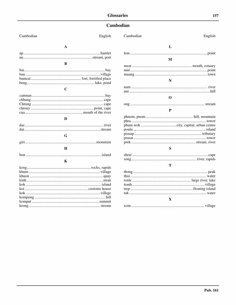
Pub. 161
Glossaries 157
Cambodian
Cambodian English
A
ap................................................................................hamletau........................................................................stream, port
B
bai....................................................................................bayban..............................................................................villagebanteai.................................................... fort, fortified placebeng...................................................................... lake, pond
C
camnan ............................................................................baychhung........................................................................... capeChrung .......................................................................... capechrouy ................................................................. point, capecua............................................................mouth of the river
D
dac................................................................................. riverdai............................................................................... stream
G
giri ..........................................................................mountain
H
hon .............................................................................. island
K
keng.................................................................. rocks, rapidskhum ..........................................................................villagekhuon ............................................................................quaykinh ...............................................................................straitkoh .............................................................................. islandkoi ................................................................. customs housekok .............................................................................villagekompong ......................................................................... hillkomput ......................................................................summitkrong .......................................................................... stream
L
lem ................................................................................point
M
meat .............................................................. mouth, estuarymui ................................................................................pointmuang ........................................................................... town
N
nam ............................................................................... rivernui ....................................................................................hill
O
ong ............................................................................. stream
P
phnom, pnom................................................. hill, mountainphra .............................................................................. towerphum srok .....................................city, capital, urban centrepoulu ........................................................................... islandprasap...................................................................... tributaryprasat............................................................................ towerprek ...................................................................stream, river
S
shrui ...............................................................................capesong.................................................................... river, rapids
T
tbong ............................................................................. peakthui ............................................................................... watertonle ............................................................. large river, laketranh........................................................................... villagetrep................................................................. floating islandtuk ................................................................................ water
X
xom ............................................................................ village
Cambodian English

Pub. 161
158 Glossaries
Malay
Malay English
A
ayer.................................................................. water, streamalangan .............................................................................bararus............................................................................ currentayer masin ............................................................. salt water
B
bagan............................................................... landing placebaharu, bahru ................................................................. newbandar.......................................................port, trading townbarat ................................................................west, westernbatang............................................................................ riverbatu.................................................................................rockbesar ....................................................................large, greatbeting ................................................................. shoal, bankbiru .................................................................................bluebukit ................................................................................ hill
C
changkat .......................................................... hillock, shoalchetek ....................................................................... shallow
D
dalam............................................................................. deepdarat ........................................................... land, the interior
G
gosong, gusong ........................................... shoal, reef, islet
H
hijau .............................................................................greenhitam, itam ..........................................................black, darkhutan or utan ....................................................jungle, forest
K
kampong.....................................................................villagekarang................................................................... coral, reefkechil...................................................................small, littlekering, kring.................................................................... drykuala................mouth or a river or confluence of two riverskuning ........................................................................yellow
L
labuan................................................................... anchoragelaut ....................................................................sea, seaward
M
malang.....................................................rock, reef, or shoal
mas............................................................................. goldenmerah ...............................................................................redmuara .......................................................... mouth of a river
N
negri .....................................................................town, state
P
paya................................................................marsh, swamppangkalan........................................................ landing placepanjang ..........................................................................longpantai ................................................ coast, seaboard, beachparit.................................................................. ditch, streampasir ................................................................... sand, beachpekan................................................................ town, marketpohon or pokok............................................................... treeprau ................................................................................ boatpulau ........................................................................... islandputeh, putih ..................................................................white
R
rendah ............................................................................. lowrumah...........................................................................house
S
selat................................................................ channel, straitselatan .......................................................... south, southernsungai............................................................................ river
T
tanah ................................................................land, countrytanjong ........................... cape, headland, point, promontorytelok ....................................................... bay, bend in a riverterumbu, trumbu ............................. dangerous hidden shoalterusan....................................................connecting channeltimor ...............................................................................easttinggi..............................................................................hightohor..........................................................................shallowtua ....................................................................................oldtukun ................................................................. sunken rock
U
umpur.............................................................................mudutara ............................................................................. north
Malay English
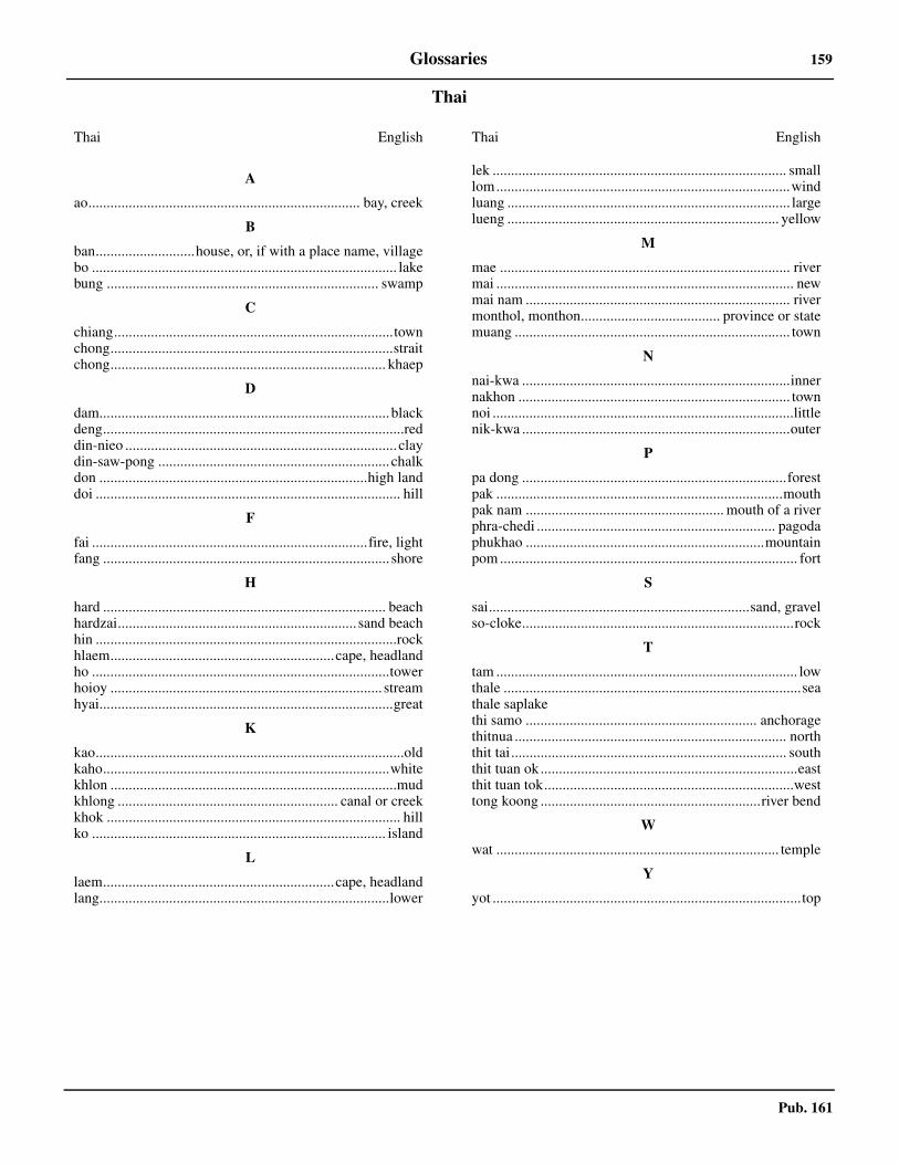
Pub. 161
Glossaries 159
Thai
Thai English
A
ao.......................................................................... bay, creek
B
ban...........................house, or, if with a place name, villagebo ................................................................................... lakebung .......................................................................... swamp
C
chiang............................................................................townchong.............................................................................straitchong........................................................................... khaep
D
dam...............................................................................blackdeng..................................................................................reddin-nieo .......................................................................... claydin-saw-pong ............................................................... chalkdon .........................................................................high landdoi ................................................................................... hill
F
fai ...........................................................................fire, lightfang .............................................................................. shore
H
hard ............................................................................. beachhardzai................................................................. sand beachhin ..................................................................................rockhlaem.............................................................cape, headlandho .................................................................................towerhoioy .......................................................................... streamhyai................................................................................great
K
kao....................................................................................oldkaho..............................................................................whitekhlon ..............................................................................mudkhlong ............................................................ canal or creekkhok ................................................................................ hillko ................................................................................ island
L
laem...............................................................cape, headlandlang...............................................................................lower
lek ................................................................................ smalllom................................................................................windluang ............................................................................. largelueng .......................................................................... yellow
M
mae ............................................................................... rivermai ................................................................................. newmai nam ........................................................................ rivermonthol, monthon...................................... province or statemuang ........................................................................... town
N
nai-kwa .........................................................................innernakhon .......................................................................... townnoi ..................................................................................littlenik-kwa .........................................................................outer
P
pa dong ........................................................................forestpak ..............................................................................mouthpak nam ...................................................... mouth of a riverphra-chedi ................................................................. pagodaphukhao .................................................................mountainpom ................................................................................. fort
S
sai.......................................................................sand, gravelso-cloke..........................................................................rock
T
tam .................................................................................. lowthale .................................................................................seathale saplakethi samo ............................................................... anchoragethitnua .......................................................................... norththit tai........................................................................... souththit tuan ok ......................................................................eastthit tuan tok....................................................................westtong koong ............................................................river bend
W
wat ............................................................................. temple
Y
yot ....................................................................................top
Thai English

161
Pub. 161
How to use the Index—Gazetteer
Geographic names of navigational features are generally those used by the nation having sovereignty and are listedalphabetically. Diacritical marks, such as accents, cedillas, and circumflexes, which are related to specific letters in certain foreignlanguages, are not used in the interest of typographical simplicity.
Geographic names or their spellings do not necessarily reflect recognition of the political status of an area by the United StatesGovernment. Positions are approximate and are intended merely as locators to facilitate reference to the charts.
To use as a Gazetteer note the position and Sector number of the feature and refer to the Chart Information diagram for theSector. Plot the approximate position of the feature on this diagram and note the approximate chart number.
To use as an Index of features described in the text note the paragraph number at the right. To locate this feature on the bestscale chart use the Gazetteer procedure above.
Index—Gazetteer
Position° ' ° '
Position° ' ° '
Sec.Para
Sec.Para
AABERDEEN HARBOR 22 15 N 114 11 E 2.16ADAMASTA ROCK 22 14 N 114 01 E 2.27AI ZHOU 22 03 N 113 55 E 2.13ALICIA ANNIE REEF 9 24 N 115 26 E 1.34ALISON REEF 8 50 N 114 00 E 1.36ALLISON REEF 8 50 N 114 00 E 1.36ALOUETTE BANK 21 11 N 110 24 E 3.21AMBOYNA CAY 7 52 N 112 55 E 1.44AMPHITRITE GROUP 16 53 N 112 17 E 1.8AN THOI 10 01 N 104 01 E 6.9ANBO SHOZHOA 7 52 N 112 55 E 1.44ANOA NATUNA MARINE TERM. 5 13 N 105 36 E 1.46ANTELOPE REEF 16 27 N 111 35 E 1.14AO SATTAHIP 12 38 N 100 54 E 6.32AO UDOM 13 07 N 100 53 E 6.42AP LEI PAI 22 14 N 114 09 E 2.16ARCHIPEL DES FAI TSI LONG 20 50 N 107 25 E 4.30ARDASIER REEF 7 38 N 113 56 E 1.38ASQUITH SHOAL 3 44 N 103 43 E 6.86
BBACHDANG 20 52 N 106 45 E 4.28BAI NUM 16 06 N 108 18 E 5.13BAIAN DAO 18 49 N 110 34 E 3.43BAIE D'APOWAN 20 43 N 107 02 E 4.28BAIE DE FAI TSI LONG 20 55 N 107 13 E 4.38BAIE DE LAN HA 20 45 N 107 07 E 4.32BAIE DE NHA TRANG 12 15 N 109 14 E 5.34BAIE DE PHAN RANG 11 35 N 109 02 E 5.40BAIE DE REAM 10 31 N 103 36 E 6.14BAIE DU LUTIN 16 06 N 108 18 E 5.13BAIE DU SUD OUEST 8 40 N 106 32 E 5.10BAILI DAO 21 59 N 113 45 E 2.34BAILONG WEI 21 30 N 108 13 E 4.9BANC DU PROPONTIS 10 35 N 106 52 E 5.53BANC WALLACE 9 29 N 107 38 E 5.5BANG SAPHAN 11 11 N 99 34 E 6.49BANGKOK 13 45 N 100 30 E 6.44BAOHU JIAO 20 01 N 110 56 E 3.32BEI SHI 19 59 N 111 16 E 3.40BEIHAI GANG 21 29 N 109 04 E 4.6BEIJIAN DAO 21 53 N 114 02 E 2.11BEILI WAN 19 10 N 108 35 E 3.52BEN DAM 8 40 N 106 32 E 5.10BEN THUY 18 39 N 105 42 E 4.18BEN THUY PIER 18 39 N 105 42 E 4.18BINGMA JIAO 19 55 N 109 18 E 3.39BLACK POINT 22 25 N 113 54 E 2.44BLACK ROCKS 20 30 N 110 32 E 3.26BOKHARA ROCKS 22 13 N 114 16 E 2.19BOMBAY REEF 16 02 N 112 31 E 1.16BOMBAY SHOAL 9 26 N 116 55 E 1.30BONGKOT TERMINAL 8 04 N 102 20 E 6.65BOXALL REEF 9 36 N 116 10 E 1.32BRITTO BANK 10 29 N 107 50 E 5.51
BROTHERS POINT 22 21 N 114 01 E 2.31BUKIT BAUK 4 42 N 103 25 E 6.81
CCAI LAN 20 57 N 107 04 E 4.35CAM PHA 21 02 N 107 22 E 4.47CAN THO 10 02 N 105 47 E 5.61CANTON 23 06 N 113 14 E 2.52CAP BANG 19 26 N 105 49 E 4.20CAP BOUTON 19 13 N 105 45 E 4.19CAP BUMBI 10 32 N 104 11 E 6.11CAP CHAO 19 43 N 105 54 E 4.21CAP LAY 17 05 N 107 07 E 4.10CAP PAK LOUNG 21 30 N 108 13 E 4.9CAP QUAN LAN 20 59 N 107 29 E 4.55CAP SA HOI 14 40 N 109 05 E 5.19CASTLE ROCK 22 15 N 114 01 E 2.26CAY DUA 10 01 N 104 01 E 6.9CENTRAL REEF 8 55 N 112 21 E 1.42CH'I-CHOU CH'UN TAO 19 56 N 111 13 E 3.40CH'ING CHOU 21 29 N 111 28 E 3.8CH'ING LING 21 06 N 110 33 E 3.14CH'UAN-PI CHIAO 22 45 N 113 40 E 2.48CHAI WAN 22 16 N 114 15 E 2.14CHANGKENG DING 22 19 N 113 36 E 2.40CHARLOTTE BANK 7 08 N 107 36 E 1.49CHAU KUNG TO 22 16 N 114 03 E 2.21CHAU LIN 22 37 N 113 09 E 2.58CHEK CHUE WAN 22 12 N 114 12 E 2.15CHEK LAP KOK ISLAND 22 19 N 113 56 E 2.30CHENGMAI JIAO 20 04 N 110 09 E 3.37CHESTERMAN ROCK 22 11 N 114 12 E 2.19CHIAO-WEI CHIAO 20 13 N 109 55 E 4.3CHIAO-WEI CHIAO LIGHT 20 13 N 109 55 E 3.27CHIA-P'ENG LIEH-TAO 21 52 N 114 00 E 2.11CHIA-PEI CHIAO 20 29 N 110 31 E 3.30CHIA-PEI CHIAO 20 29 N 110 32 E 3.26CHI-MOA SHA 20 51 N 110 31 E 3.25CHING-HSIN CHIAO 20 01 N 110 56 E 3.32CHIN-HAING MEN 22 23 N 113 37 E 2.52CHIN-MU CHIAO 18 10 N 109 33 E 3.45CHISHA SHUIDAO 23 02 N 113 30 E 2.46CHITAN 22 07 N 113 46 E 2.36CHIWAN HARBOR 22 28 N 113 52 E 2.39CHONG KO TAO 9 55 N 99 55 E 6.58CHROUY KAB 10 29 N 104 18 E 6.13CHROUY SAMIT 10 52 N 103 07 E 6.19CHU LU KOK ISLAND 22 19 N 113 56 E 2.30CHUANBI SHUIDAO 22 42 N 113 41 E 2.45CHUK SAMET HARBOR 12 37 N 100 55 E 6.31COLOSSE 21 01 N 107 27 E 4.52COMMODORE REEF 8 22 N 115 14 E 1.37CON SON ISLANDS 8 42 N 106 37 E 5.8CORNWALLIS SOUTH REEF 8 45 N 114 13 E 1.36CU LAO CHAM 15 57 N 108 31 E 5.14CU LAO POULO GAMBIR 13 37 N 109 21 E 5.21CU LAO RE 15 23 N 109 07 E 5.18

162 Index—Gazetteer
Pub. 161
Position° ' ° '
Position° ' ° '
Sec.Para
Sec.Para
CU LAO THU 10 32 N 108 57 E 5.2CU LAO THU 10 33 N 108 56 E 5.1CU LAO XANH 13 37 N 109 21 E 5.21CUA DAI 19 58 N 106 06 E 4.24CUA DAY 19 58 N 106 06 E 4.24CUA LO PIER 18 49 N 105 42 E 4.18CUA MO 21 13 N 107 37 E 4.53CUA NHUONG 18 16 N 106 08 E 4.15CUA THAI BINH 20 36 N 106 38 E 4.24CUA THUAN AN 16 34 N 107 38 E 5.11CUARTERON REEF 8 54 N 112 52 E 1.41
DDA NANG 16 04 N 108 14 E 5.12DA NANG 16 09 N 108 12 E 5.12DACHAN WAN 22 33 N 113 53 E 2.44DAFANGJI DAO 21 23 N 111 11 E 3.10DAHAOZHOU SHUIDAO 23 05 N 113 28 E 2.46DAHENGQIN DAO 22 06 N 113 30 E 2.53DAHENGQIN DAO 22 06 N 113 33 E 2.37DAHU DAO 22 50 N 113 35 E 2.49DAHUA JIAO 18 47 N 110 33 E 3.43DAHUO 21 39 N 112 07 E 3.6DAI HUNG OIL FIELD 8 29 N 108 41 E 5.6, 5.7DAJIN 21 52 N 113 02 E 2.54DALLAS REEF 7 38 N 113 48 E 1.39DANGAN DAO 22 02 N 114 12 E 2.11DANGAN LIEDAO 22 01 N 114 12 E 2.11DAO CAI BAU 21 31 N 107 37 E 4.60DAO CAT BA 20 48 N 107 02 E 4.30DAO CHING LAN XAN 21 01 N 107 50 E 4.54DAO LAI TAO 20 43 N 107 28 E 4.41DAO LO CHUC SAN 21 14 N 107 58 E 4.61DAO PHU QUI 10 32 N 108 57 E 5.2DAO PHU QUI 10 33 N 108 56 E 5.1DAO PHU QUOC 10 15 N 104 00 E 6.10DAO TAGNE 11 50 N 109 15 E 5.36DAPENG JIAO 22 27 N 114 30 E 2.2DAPENG WAN 22 32 N 114 23 E 2.2DATOU ZHOU 22 06 N 113 42 E 2.36DAWANSHAN DAO 21 56 N 113 43 E 2.33DAWO SHAN 22 05 N 113 33 E 2.36DAZHIZHU DAO 22 07 N 113 53 E 2.34DAZHOU DOA 18 40 N 110 29 E 3.43DENGLOU JIAO 20 13 N 109 55 E 4.3DIDO BANK 16 49 N 112 53 E 1.15DIJIAO 21 29 N 109 04 E 4.6DISCOVERY GREAT REEF 10 01 N 113 52 E 1.26DISCOVERY REEF 16 14 N 111 40 E 1.17DISCOVERY SMALL REEF 10 01 N 114 01 E 1.26DONG NGAI 16 21 N 107 14 E 4.10DONGDAFAN SHI 21 27 N 112 22 E 3.6DONGMAO ZHOU 18 11 N 109 41 E 3.45DONGTOUSHAN DAO 21 06 N 110 24 E 3.16DOUBLE HAVEN 22 32 N 114 18 E 2.4DOULONG CUN 20 56 N 110 38 E 3.21DUNCAN ISLANDS 16 27 N 111 43 E 1.12DUNG QUAT 15 25 N 108 44 E 5.16DUONG DONG 10 13 N 103 58 E 6.9
EEAST LAMMA CHANNEL 22 14 N 114 08 E 2.20EAST REEF 8 50 N 112 35 E 1.41ENLOA REEF 8 07 N 114 08 E 1.39ENTREE PROFONDE 20 47 N 107 07 E 4.32ERAWAN TERMINAL 9 05 N 101 19 E 6.63ERICA REEF 8 07 N 114 08 E 1.39
FFANGCHENG GANG 21 45 N 108 21 E 4.8FEN-CHIEH CHOU 18 35 N 110 12 E 3.44FENG-CH'UAN 23 24 N 111 31 E 2.67FIERY CROSS REEF 9 35 N 112 54 E 1.41FIRST THOMAS SHOAL 9 20 N 115 57 E 1.34FOUR FEET ROCK 22 09 N 113 46 E 2.37FUNGSTON 23 24 N 111 31 E 2.67
GGAOLAN DAO 21 55 N 113 15 E 2.54GAU TAU 22 28 N 114 26 E 2.3GAVEN REEFS 10 12 N 114 13 E 1.25GEMINI POINT 22 21 N 114 04 E 2.25GOPAI POINT 20 29 N 110 32 E 3.26GRAND BANC 12 17 N 109 18 E 5.29GRAND PALACE 13 45 N 100 30 E 6.44GRANDE CATWICK 10 03 N 108 54 E 5.4GRANDE NORWAY 20 37 N 107 10 E 4.26GREEN ISLAND 22 17 N 114 07 E 2.18GUANGZHOU 23 06 N 113 14 E 2.52GUANTOU JIAO 21 27 N 109 02 E 4.3GUANYIN JIAO 19 35 N 109 00 E 3.55GUISHAN DAO 22 08 N 113 49 E 2.34
HHA MEI WAN 22 13 N 114 06 E 2.17HA TIEN 10 23 N 104 29 E 6.12HAI PHONG 20 52 N 106 41 E 4.28HAIKOU 20 02 N 110 17 E 3.36HAI-LING-SHAN CHIANG 21 45 N 111 39 E 3.7HAILINGSHAN DAO 21 38 N 111 54 E 3.7HAILINGSHAN GANG 21 45 N 111 39 E 3.7HAI-LING-SHAN TAO 21 38 N 111 54 E 3.7HAINAN STRAIT 20 10 N 110 10 E 3.27HALF MOON SHOAL 8 52 N 116 16 E 1.30HANOI 21 02 N 105 50 E 4.23HAO CHOU 22 09 N 113 24 E 2.56HAU HOI WAN 22 28 N 113 57 E 2.44HAVEN ANCHORAGE 18 14 N 109 26 E 3.49HEBAO DAO 21 52 N 113 10 E 2.69HEI CHIAO 20 30 N 110 32 E 3.26HELEN SHOAL 19 12 N 113 52 E 1.6HENGGANG DAO 22 02 N 114 01 E 2.13HENG-KANG CHOU 22 02 N 114 01 E 2.13HENGMEN DAO 22 34 N 113 35 E 2.43HEUNG KONG TSAI 22 15 N 114 11 E 2.16HIN ALHAMBRA 12 26 N 101 40 E 6.25HIN CHALAM 12 28 N 100 58 E 6.29HIN RANG KWIAN 12 48 N 100 48 E 6.33HOK TSUI 22 13 N 114 16 E 2.14HON DAT 13 41 N 109 16 E 5.22HON DAU 20 40 N 106 49 E 4.28HON DAU LIGHT 20 40 N 106 49 E 4.28HON DUNG 12 16 N 109 22 E 5.30HON DUOC 10 15 N 104 19 E 6.11HON GAI 20 57 N 107 04 E 4.35HON HANG TOI 20 49 N 107 20 E 4.44HON HEO 10 11 N 104 32 E 6.6HON HEO 12 24 N 109 17 E 5.30HON KHOAI 8 26 N 104 50 E 5.63HON LONG DOI 11 43 N 109 14 E 5.39HON MAO 12 44 N 109 20 E 5.28HON MAT 18 48 N 105 58 E 4.17HON MAY DEN 20 52 N 107 07 E 4.34HON ME 19 22 N 105 56 E 4.20HON MUI 11 49 N 109 12 E 5.37HON NAM DU 9 41 N 104 21 E 6.7HON NE 19 55 N 106 01 E 4.21HON NGHE 10 01 N 104 33 E 6.6HON NGOAI 12 00 N 109 20 E 5.33HON NIEU 18 48 N 105 46 E 4.17HON PANJANG 9 18 N 103 29 E 6.3HON RAI 9 48 N 104 38 E 6.8HON SON CHA 16 13 N 108 12 E 5.11HON TAY 9 49 N 104 03 E 6.8HON THO CHAU 9 18 N 103 29 E 6.3HON TRE 12 12 N 109 17 E 5.29HON TRE 9 57 N 104 50 E 6.6HON TRUNG 11 49 N 109 12 E 5.37HON TRUNG 8 46 N 106 43 E 5.8HON TRUNG LON 8 36 N 106 09 E 5.10HON YEN 13 23 N 109 17 E 5.24HONAN-CHOU TSUI 23 06 N 113 14 E 2.50HONG KONG ISLAND 22 16 N 114 12 E 2.14HONGKAN POINT 20 19 N 110 24 E 3.30HOPKINS REEF 10 49 N 116 05 E 1.28HSIA-CH'UAN SHAN 21 40 N 112 36 E 3.4

Index—Gazetteer 163
Pub. 161
Position° ' ° '
Position° ' ° '
Sec.Para
Sec.Para
HSIAO-TAO CHIAO 20 14 N 110 07 E 3.31HSIEH-YANG TAO 20 54 N 109 13 E 4.5HSI-FANG TUI 20 17 N 110 40 E 3.28HSI-TAN TAO 21 58 N 114 08 E 2.11HU LANG 20 44 N 107 12 E 4.42HUANGPU 23 05 N 113 25 E 2.50HUANGPUXINGANG 23 03 N 113 30 E 2.47HUE 16 29 N 107 35 E 5.11HUIPENG JIAO 22 30 N 113 50 E 2.44HUIZHOU OIL TERMINAL 21 21 N 115 25 E 1.4HUMEN SHUIDAO 22 46 N 113 38 E 2.45HUNAN 22 46 N 113 40 E 2.45HUNG SHAN 21 04 N 110 32 E 3.14HU-TIEH LING 21 33 N 108 26 E 4.7
IILE AUX BRUYERES 21 09 N 107 35 E 4.53ILE DAO TRAO 20 52 N 107 22 E 4.45ILE DE KE-BAO 21 31 N 107 37 E 4.60ILE DE L'ENTREE 20 50 N 107 19 E 4.38ILE DE LA PAIX 20 45 N 107 07 E 4.32ILE DE LA PLAGE 21 14 N 107 38 E 4.53ILE DE LA SURPRISE 20 51 N 107 06 E 4.35ILE DES PIRATES 21 13 N 107 35 E 4.62ILE DES SINGES 20 53 N 107 10 E 4.40ILE DOUBLE 20 49 N 107 20 E 4.44ILE DU CHENAL 20 56 N 107 17 E 4.46ILE DU COUDE 21 03 N 107 28 E 4.50ILE DU GRAND SINGE 21 17 N 107 41 E 4.53ILE DU MARQUIS 21 05 N 107 30 E 4.53ILE DU MILIEU 20 55 N 107 16 E 4.46ILE DU SUD 20 47 N 107 20 E 4.41ILE LO CHUC SAN 21 14 N 107 58 E 4.61ILE MADELINE 21 06 N 107 34 E 4.57ILE NOIRE 21 05 N 107 35 E 4.56ILE OUEST 10 09 N 104 24 E 6.12ILE SALACCO 20 50 N 107 08 E 4.34ILE TAMASSOU 9 48 N 104 38 E 6.8ILE TCHING LAN XAN 21 01 N 107 50 E 4.54ILE TORTUE 14 22 N 109 12 E 5.19ILES CATWICK 10 00 N 108 59 E 5.4ILES D'AN THOI 9 57 N 104 02 E 6.8ILES DE POULO DAMA 9 41 N 104 22 E 6.7ILES TSIN SAN 21 17 N 107 47 E 4.62ILHA DE COLOANE 22 08 N 113 34 E 2.37ILHA DE TAIPA 22 10 N 113 33 E 2.37ILOT CONE 11 26 N 103 00 E 6.20ILOT DA TAI 11 43 N 109 14 E 5.39ILOT VEER 10 14 N 102 53 E 6.5ILOTS M 20 42 N 107 05 E 4.32ILTIS BANK 16 46 N 112 13 E 1.10INVESTIGATOR NORTHEAST SHOAL 9 10 N 116 25 E 1.31INVESTIGATOR SHOAL 8 10 N 114 40 E 1.38IRVING REEF 10 52 N 114 55 E 1.27ISLET POINT 20 14 N 110 07 E 3.31ITU ABA ISLAND 10 23 N 114 22 E 1.26
JJACKSON ATOLL 10 30 N 115 45 E 1.27JASMINE TERMINAL 11 18 N 101 13 E 6.49JIAOWEI JIAO 20 13 N 109 55 E 4.3JIAOWEI JIAO LIGHT 20 13 N 109 55 E 3.27JIAPENG LIEDAO 21 52 N 114 00 E 2.11JINMU JIAO 18 10 N 109 33 E 3.45JINSUO PAI 22 48 N 113 36 E 2.45JOHNSON REEF 9 42 N 114 17 E 1.34JOSS HOUSE BAY 22 16 N 114 17 E 2.18JUNK BAY 22 17 N 114 16 E 2.18JUNK FLEET ENTRANCE 22 24 N 113 41 E 2.43JUNK ROCK 23 02 N 113 24 E 2.51
KKAAM SAMNA KRAOM 10 56 N 105 11 E 5.57KAHO PHO BAI 13 07 N 100 54 E 6.42KAMPONG SAOM 10 38 N 103 30 E 6.18KAMPOT 10 36 N 104 11 E 6.13
KAOH KAONG KANG 10 36 N 103 25 E 6.16KAOH KONG 11 20 N 103 00 E 6.20KAOH MUL 11 26 N 103 00 E 6.20KAOH POAH 10 37 N 103 29 E 6.15KAOH RUNG SAMLOEM 10 35 N 103 18 E 6.16KAO-YAO 23 01 N 112 28 E 2.64KAU YI CHAU 22 17 N 114 04 E 2.22KEMAMAN HARBOR 4 15 N 03 27 E 6.85KEP SIANG 22 29 N 113 14 E 2.58KERTIH OIL TERMINAL 4 34 N 103 28 E 6.81KHANOM 9 14 N 99 52 E 6.61KHAO HUA MAEW 11 55 N 102 47 E 6.20KHAO KALOK 12 20 N 100 00 E 6.47KHAO KHLONG WAN 11 45 N 99 48 E 6.48KHAO KHUNG KRABEN 12 34 N 101 53 E 6.25KHAO MONG LAI 11 50 N 99 50 E 6.47KHAO TA MONG RAI 11 50 N 99 50 E 6.47KHLONG LANG SUAN 9 57 N 99 10 E 6.54KHLONG PHRA KHANONG 13 42 N 100 35 E 6.44KO CHANG 12 03 N 102 21 E 6.22KO CHANG TRAT LIGHT 12 06 N 102 17 E 6.22KO CHUAK 9 28 N 99 41 E 6.62KO CHUANG 12 31 N 100 58 E 6.29KO KHO THIAN 10 25 N 99 19 E 6.52KO KHRAM YAI 12 42 N 100 47 E 6.33KO KRA 8 24 N 100 45 E 6.65KO KUT 11 34 N 102 36 E 6.21KO LOSIN 7 19 N 101 56 E 6.68KO MAN NOK 12 34 N 101 42 E 6.25KO NGAM YAI 10 30 N 99 26 E 6.51KO NU 7 14 N 100 36 E 6.66KO PHANGAN 9 45 N 100 02 E 6.59KO SI CHANG HARBOR 13 10 N 100 49 E 6.41KO TAO 10 06 N 99 51 E 6.58KO TUNG KU 9 48 N 99 43 E 6.57KOH KONG 11 20 N 103 00 E 6.20KOH KONG KANG 10 36 N 103 25 E 6.16KOH POS 10 37 N 103 29 E 6.15KOH YOR 11 35 N 102 56 E 6.20KRUNG THEP 13 45 N 100 30 E 6.44KUAI CHIN MUN 21 15 N 107 42 E 4.62KUALA BESAR 6 13 N 102 13 E 6.69KUALA TRENGGANU 5 21 N 103 08 E 6.77KUANTAN OLD PORT 3 48 N 103 20 E 6.87KUANTAN PORT 3 58 N 103 26 E 6.87KUAN-TOU CHIAO 21 27 N 109 02 E 4.3KUAN-TS'AI LING 18 49 N 110 34 E 3.43KWAI SHEK 22 21 N 114 03 E 2.29KWO CHAU KWAN TO 22 16 N 114 21 E 2.7
LL'AIGLE 20 58 N 106 59 E 4.40L'AMANDE 20 57 N 107 20 E 4.52L'ECHELLE 20 49 N 107 09 E 4.33L'ENCLUME 20 59 N 107 26 E 4.49L'ENCRIER 20 51 N 107 19 E 4.44L'ESCARGOT 20 53 N 107 15 E 4.42L'INDEX 20 52 N 107 07 E 4.34L'ISOLE 21 00 N 107 27 E 4.50L'ORANGE 20 44 N 107 11 E 4.33LA CLOCHETTE 20 53 N 107 08 E 4.38LA GOURDE 21 02 N 107 34 E 4.56LA MEDUSE 20 51 N 107 17 E 4.43LA MERE 20 48 N 107 15 E 4.42LA QUILLE 20 41 N 107 03 E 4.27LA SOURIS 21 00 N 107 28 E 4.50LACH HUYEN 20 46 N 106 55 E 4.22LACH HUYEN 20 48 N 106 55 E 4.29LAEM CHABANG 13 05 N 100 53 E 6.39LAEM CHAO 12 36 N 100 57 E 6.30LAEM KHAO PHRA 6 51 N 101 33 E 6.68LAEM KHO KHAO 9 13 N 99 53 E 6.59LAEM KHO KWANG 10 31 N 99 16 E 6.50LAEM KRABANG 13 05 N 100 53 E 6.39LAEM LING 12 10 N 102 17 E 6.21LAEM LING 12 12 N 102 17 E 6.24LAEM MAE RAMPHUNG 11 11 N 99 34 E 6.49LAEM NAM 12 03 N 102 35 E 6.20LAEM PATTHAYA 12 55 N 100 51 E 6.38LAEM PHAK BIA 13 02 N 100 06 E 6.46

164 Index—Gazetteer
Pub. 161
Position° ' ° '
Position° ' ° '
Sec.Para
Sec.Para
LAEM PHATTHAYA 12 55 N 100 51 E 6.38LAEM PHLAI DAM 9 05 N 99 55 E 6.64LAEM PU CHAO 12 39 N 100 51 E 6.32LAEM RET 9 25 N 100 01 E 6.59LAEM SAI 7 14 N 100 35 E 6.66LAEM SAMAE SAN 12 36 N 100 58 E 6.29LAEM SAMUK 13 19 N 100 54 E 6.43LAEM SING 12 28 N 102 04 E 6.24LAEM SOK 12 03 N 102 35 E 6.20LAEM TA CHI 6 56 N 101 15 E 6.67LAEM TALUMPHUK 8 31 N 100 08 E 6.64LAEM THONG LANG 12 37 N 100 55 E 6.31LAEM THUAT 9 20 N 99 41 E 6.57LAEM YA 12 35 N 101 25 E 6.26LAMMA ISLAND 22 12 N 114 08 E 2.17LAMMA PATCH 22 15 N 114 07 E 2.20LAN KOK TSUI 22 25 N 113 54 E 2.44LANG-YEH CHIAO 18 12 N 109 42 E 3.44LANKIT ISLAND. 22 42 N 113 38 E 2.43LANTAU CHANNEL 22 08 N 113 54 E 2.8LANTAU ISLAND 22 16 N 113 57 E 2.26LAO DUA 13 10 N 109 20 E 5.25LE CANCRELAT 20 50 N 107 18 E 4.43LE CHIEN 20 50 N 107 20 E 4.45LE COLOSSE 21 01 N 107 27 E 4.52LE DOME 20 57 N 107 14 E 4.40LE DOME 21 00 N 107 26 E 4.52LE DONJON 21 07 N 107 32 E 4.53LE GRANDE ILE 21 04 N 107 30 E 4.51LE LAPIN 20 54 N 107 10 E 4.40LE PETIT BANC 21 12 N 107 45 E 4.62LE ROC AUX AIGLES 20 57 N 107 26 E 4.49LE SPECTRE 20 57 N 107 15 E 4.40LE TRAPEZE 13 15 N 109 19 E 5.25LE TURCO 20 48 N 107 16 E 4.43LE VAUTOUR 20 58 N 107 19 E 4.46LEI YU MUN 22 17 N 114 14 E 2.19LEI YUE MUN 22 17 N 114 14 E 2.8LEMA CHANNEL 22 06 N 114 14 E 2.8LES OURS 20 59 N 107 21 E 4.47LEUNG SHUEN WAN HOI 22 20 N 114 19 E 2.5LIANHUASHAN SHUIDAO 22 58 N 113 32 E 2.46LIEN CHIEN 16 08 N 108 08 E 5.12LIGHTENING ANCHORAGE 18 14 N 109 27 E 3.49LIN-CH'ANG SHIH 19 41 N 109 06 E 3.55LINCOLN ISLAND 16 40 N 112 44 E 1.15LINGAO JIAO 20 01 N 109 43 E 3.38LINGAO JIAO LIGHT 20 00 N 109 42 E 3.27LINGDING SHUIDAO 22 25 N 113 45 E 2.45LINGSHI JIAO 18 23 N 110 03 E 3.44LING-SHUI CHIAO 18 23 N 110 03 E 3.44LIN-KAO CHIAO 20 01 N 109 43 E 3.38LIN-KAO CHIAO LIGHT 20 00 N 109 42 E 3.27LIVOCK REEF 10 11 N 115 17 E 1.27LO AH CHAU 23 10 N 112 50 E 2.62LO CHAO 22 19 N 113 17 E 2.57LO SA TAU POINT 22 46 N 113 05 E 2.60LOAITA ISLAND 10 41 N 114 25 E 1.24LONG HARBOR 22 27 N 114 21 E 2.3LONGSHUI LING 21 02 N 110 31 E 3.13LONGXUE DAO 22 42 N 113 38 E 2.43LO-P'ANG 23 10 N 111 37 E 2.66LORD AUCKLAND SHOAL 10 20 N 117 19 E 1.29LO-T'O SHA 20 22 N 110 35 E 3.28LU PONG 23 10 N 111 37 E 2.66LU-HUI-T'OU CHIAO 18 11 N 109 28 E 3.48LUHUITOU JIAO 18 11 N 109 28 E 3.48LUHUITOU-LING 18 10 N 109 34 E 3.47LUKPO 23 08 N 112 28 E 2.65LU-PU-HSU 23 08 N 112 28 E 2.65
MMA CHAO 21 09 N 107 51 E 4.54MACAU FORT 23 04 N 113 15 E 2.52MACAU HARBOR 22 11 N 113 34 E 2.38MACCLESFIELD BANK 15 45 N 114 20 E 1.18MAE NAM 9 57 N 99 10 E 6.54MAE NAM CHAO PHRAYA 13 32 N 100 36 E 6.44MAE NAM RAYONG 12 39 N 101 17 E 6.28MAGPIE ROCK 20 08 N 110 42 E 3.32
MA-LIU T'OU 18 40 N 110 25 E 3.43MALOW T'OU 18 40 N 110 25 E 3.43MALU 20 35 N 110 28 E 3.26MANG ZHOU 21 40 N 112 27 E 3.5MAP TA PHUT 12 39 N 101 17 E 6.28MARIVELES REEF 8 00 N 113 56 E 1.39MENZIES REEF 11 09 N 114 48 E 1.27MERSING 2 26 N 103 51 E 6.95MIAO-WAN 21 56 N 114 01 E 2.12MIAOWAN DAO 21 56 N 114 01 E 2.12MIRS BAY 22 32 N 114 23 E 2.2MISCHIEF REEF 9 55 N 115 32 E 1.33MONEY ISLAND 16 27 N 111 30 E 1.14MORGAN POINT 22 06 N 113 28 E 2.56MUI AN HOA 15 31 N 108 41 E 5.15MUI BA KIEM 10 30 N 107 31 E 5.47MUI BA LANG AN 15 14 N 108 57 E 5.17MUI BAI BUNG 8 36 N 104 43 E 5.1MUI BAI BUNG 8 37 N 104 43 E 5.62MUI BAN THANG 12 24 N 109 21 E 5.27MUI BANG 19 26 N 105 49 E 4.20MUI BATANGAN 15 14 N 108 57 E 5.17MUI CAM LINH 11 53 N 109 17 E 5.36MUI CHAO 19 43 N 105 54 E 4.21MUI CHON MAY DONG 16 21 N 108 02 E 5.11MUI CHUT 12 13 N 109 13 E 5.32MUI DA NANG 16 07 N 108 21 E 5.12MUI DAI TRAI 10 22 N 103 50 E 6.9MUI DAT VIAN KA 15 25 N 108 48 E 5.16MUI DEN DO 10 44 N 106 46 E 5.54MUI DIEU 12 54 N 109 28 E 5.25MUI DINH 11 22 N 109 01 E 5.41MUI DONG BA 12 08 N 109 14 E 5.32MUI DONG BA 12 09 N 109 14 E 5.35MUI DONG TRANH 10 20 N 106 53 E 5.51MUI FALAISE 19 06 N 106 44 E 4.19MUI GA 18 51 N 105 43 E 4.16MUI GANH 12 34 N 109 26 E 5.26MUI GANH RAI 10 25 N 106 59 E 5.53MUI GANH TUONG 13 24 N 109 16 E 5.24MUI HANH 10 01 N 104 01 E 6.8MUI HON CHONG 10 08 N 104 39 E 6.6MUI KE GA 10 42 N 108 00 E 5.44MUI KE GA 12 54 N 109 28 E 5.25MUI KE GA 13 34 N 109 18 E 5.23MUI KHE GA 12 18 N 109 15 E 5.31MUI KY VAN 10 23 N 107 16 E 5.48MUI LANG 13 20 N 109 18 E 5.25MUI LAY 17 05 N 107 07 E 4.10MUI LUOI CAY 13 24 N 109 18 E 5.23MUI MONG 12 30 N 109 19 E 5.27MUI MU U 13 26 N 109 15 E 5.24MUI NAM TRAM 15 21 N 108 52 E 5.17MUI NE 10 55 N 108 18 E 5.43MUI ONG 17 56 N 106 31 E 4.13MUI RON 18 07 N 106 26 E 4.14MUI VIAN KA 15 25 N 108 48 E 5.16MUI VUNG TAU 10 19 N 107 05 E 5.1MULAN TOU 20 10 N 110 41 E 3.33MULAN TOU LIGHT 20 09 N 110 41 E 3.27MY KHE 16 04 N 108 15 E 5.12MY THO 10 21 N 106 22 E 5.57
NNAMYIT ISLAND 10 11 N 114 22 E 1.25NANCY DAO 22 00 N 113 13 E 2.71NANG NUANG OILFIELD 10 07 N 99 26 E 6.53NANSHA 22 48 N 113 35 E 2.43NANSHAN ISLAND 10 44 N 115 49 E 1.28NAN-T'A-YA TAO 19 53 N 111 12 E 3.40NAO CHAO 20 54 N 110 35 E 3.13NAOZHOU DAO 20 54 N 110 35 E 3.13NARATHIWAT 6 26 N 101 50 E 6.68NAU-FANG TUI 20 12 N 110 52 E 3.28NEILINGDING DAO 22 25 N 113 48 E 2.41NENASI 3 08 N 103 27 E 6.91NGAN CHAU 22 13 N 114 11 E 2.15NGAU MEI HOI 22 20 N 114 17 E 2.6NGHE TINH 18 39 N 105 42 E 4.18NGHIEM KINH CHIEU 13 53 N 109 19 E 5.20

Index—Gazetteer 165
Pub. 161
Position° ' ° '
Position° ' ° '
Sec.Para
Sec.Para
NGONG SHUEN CHAU 22 19 N 114 08 E 2.18NHA BE 10 41 N 106 47 E 5.54NHA TRANG 12 15 N 109 14 E 5.34NIHTIEP 20 51 N 106 46 E 4.28NINEPIN ISLANDS 22 16 N 114 21 E 2.7NIU-CH'I CHOU 18 19 N 109 45 E 3.44NIUTOU DAO 22 10 N 113 48 E 2.35NIZHAU SHUIDAO 22 54 N 113 34 E 2.46NIZHOU SHUIDAO 22 54 N 113 34 E 1.NORTH DANGER REEF 11 25 N 114 21 E 1.21NORTH EAST CAY 11 27 N 114 21 E 1.21NORTH ISLAND 16 58 N 112 18 E 1.9NORTH POINT 22 17 N 114 11 E 2.23, 7.NORTH REEF 17 06 N 111 30 E 1.8NORTH WEST INVESTIGATOR REEF 9 35 N 112 54 E 1.41NUI CHUA 10 22 N 104 03 E 6.9NUI DEN 13 51 N 109 17 E 5.20NUI-PI CHIAO 20 29 N 110 32 E 3.26NUOC NGOT 14 08 N 109 13 E 5.20
OONE FOOT ROCK 22 15 N 114 22 E 2.7OUTER BANK 18 37 N 108 23 E 3.51O-YEN SHIH 21 56 N 114 03 E 2.11
PP'AI-WEI CHIAO 20 14 N 110 17 E 3.30P'ING CHOU 21 36 N 112 39 E 3.5PAI YEN 21 41 N 112 42 E 3.3PAI-SHA CHIAO 20 05 N 110 18 E 3.34PAIWEI JIAO 20 14 N 110 17 E 3.30PAK HA MUN 20 58 N 107 34 E 4.31PAK KOK 22 17 N 114 11 E 2.23, 7.PAK TANK 22 09 N 113 24 E 2.56PARACEL ISLANDS 16 40 N 112 20 E 1.7PASSE DU CASQUE 20 52 N 107 18 E 4.38PASSE HENRIETTE 20 48 N 107 09 E 4.33PASSU KEAH 16 03 N 111 46 E 1.17PATTLE ISLAND 16 32 N 111 36 E 1.13PEARSON REEF 8 59 N 113 42 E 1.37PEI SHIH 19 59 N 111 16 E 3.40PEI-CHIEN TAO 21 53 N 114 02 E 2.11PEI-FANG TUI 20 19 N 110 54 E 3.28PEI-HAI ANCHORAGE 21 29 N 109 04 E 4.6PEI-KOU-KENG CHIAO 20 51 N 110 20 E 3.25PEI-LI CHIANG 19 10 N 108 35 E 3.52PEI-T'A-YA TAO 19 59 N 111 16 E 3.40PENG CHAU 22 17 N 114 02 E 2.22PETERSON POINT 20 26 N 110 31 E 3.30PHNOM PENH 11 36 N 104 54 E 5.59PHSAR REAM 10 30 N 103 36 E 6.14PIGEON REEF 8 52 N 114 38 E 1.37PILOT ANCHORAGE 18 11 N 109 26 E 3.49PING-LO T'OU 21 14 N 110 24 E 3.22PING-MA CHIAO 19 55 N 109 18 E 3.39PO LO TSUI 22 13 N 114 06 E 2.17PO TOI GROUP 22 11 N 114 16 E 2.9PO TOI ISLAND 22 10 N 114 16 E 2.10POINTE DA NHAI 17 40 N 106 30 E 4.12POINTE DE CAM RANH 11 53 N 109 17 E 5.36POINTE DU FEU ROUGE 10 44 N 106 46 E 5.54POINTE DU LOMBARD 10 36 N 106 52 E 5.52POINTE DU MIRADOR 10 16 N 106 45 E 5.58POINTE HON KHOI 12 35 N 109 15 E 5.28POINTE ISABELLE 16 10 N 108 09 E 5.12POINTE KEP 10 29 N 104 18 E 6.13POINTE KOH KUSSAT 11 05 N 103 06 E 6.19POINTE LAGAN 11 10 N 108 43 E 5.42POINTE PHAMI 10 40 N 106 47 E 5.53POINTE SAMIT 10 52 N 103 07 E 6.19POINTE VINAY 10 55 N 108 18 E 5.43POK LIU CHAU 22 12 N 114 08 E 2.17POM PHRA CHULACHOMKLAO 13 32 N 100 35 E 6.44PORT COURBET 20 59 N 107 04 E 4.35PORT REDON 20 59 N 106 46 E 4.29PORT WALLUT 21 12 N 107 34 E 4.63POULO CICI 10 12 N 104 15 E 6.11POULO SAPATE 9 58 N 109 05 E 5.4
POULO SEPATE 9 58 N 109 05 E 5.4PRACHUAP KHIRI KHAN 11 48 N 99 48 E 6.48PRATAS ISLAND 20 42 N 116 43 E 1.3PRINCE CONSORT BANK 7 55 N 109 58 E 1.48PRINCE OF WALES BANK 8 09 N 110 30 E 1.48PULAU ACHEH 2 40 N 103 46 E 6.93PULAU AUR 2 27 N 104 31 E 6.100PULAU BERHALA 3 15 N 103 39 E 6.91PULAU KABAN 2 40 N 103 46 E 6.93PULAU LOZIN 7 19 N 101 56 E 6.68PULAU PEMANGGIL 2 35 N 104 20 E 6.100PULAU PERHENTIAN KECHIL 5 55 N 102 43 E 6.74PULAU REDANG 5 47 N 103 01 E 6.75PULAU SEMBILANG 2 42 N 103 53 E 6.96PULAU SYED HASAN 3 31 N 103 29 E 6.90PULAU SYED HASSAN 3 31 N 103 29 E 6.90PULAU TENGGOL 4 48 N 103 41 E 6.79PULAU TINGGI 2 18 N 104 07 E 6.102PULAU TIOMAN 2 47 N 104 10 E 6.98PULAU TOKONG BAHARA 2 40 N 104 04 E 6.99PULAU YU 2 07 N 104 15 E 6.103PULAU YU KECHIL 5 38 N 103 10 E 6.76PUQIAN JIAO 20 06 N 110 34 E 3.34PYRAMID ROCK 16 35 N 112 39 E 1.16
QQI'AO DAO 22 25 N 113 38 E 2.42QING ZHOU 21 29 N 111 28 E 3.8QIZHOU LEIDAO 19 56 N 111 13 E 3.40QUAN DAO NAM DU 9 41 N 104 22 E 6.7QUANG YEN 20 56 N 106 48 E 4.29
RRACH DON 10 34 N 106 50 E 5.53RACH GIA 10 01 N 105 05 E 6.6RADE DU CRAPAUD 20 49 N 107 07 E 4.32RAO CO 18 10 N 105 25 E 4.15RATTLER ISLAND 23 10 N 112 50 E 2.62RAU NHAT LE 17 29 N 106 38 E 4.11REAM 10 30 N 103 36 E 6.14RED CLIFF HEAD 22 05 N 113 24 E 2.53REPULSE BAY 22 14 N 114 11 E 2.15ROCHER BLANC 8 46 N 106 43 E 5.8ROCHER ROSITA 10 17 N 104 21 E 6.13ROCKY HARBOR 22 20 N 114 20 E 2.23ROCKY POINT 23 00 N 112 51 E 2.61RON NHAT LE 17 29 N 106 38 E 4.11ROUND ISLAND 22 13 N 114 11 E 2.15ROUND ISLET 18 46 N 110 30 E 3.43ROYAL CAPTAIN SHOAL 9 01 N 116 40 E 1.31ROYAL CHARLOTTE REEF 6 57 N 113 35 E 1.45
SSABAK 6 11 N 102 19 E 6.72SABINA SHOAL 9 43 N 116 36 E 1.31SADEC 10 18 N 105 45 E 5.57SAI GON 10 46 N 106 43 E 5.56SAI POK LIU HOI HAP 22 11 N 114 03 E 2.21SAIGON 10 46 N 106 43 E 5.56SAINT ESPRIT SHOAL 19 33 N 113 03 E 1.6SAM PUI TSAO 20 39 N 107 09 E 4.43SANBAN ZHOU 22 43 N 113 39 E 2.40SANDY SHOAL 11 02 N 117 38 E 1.29SAN-HSIA KOU 21 47 N 112 52 E 3.5SAN-MEN 22 03 N 113 59 E 2.13SANMEN DAO 22 03 N 113 59 E 2.13SAN-SHUI 23 11 N 112 50 E 2.63SANSHUI 23 11 N 112 50 E 2.52SAN-SHUI REACH 23 10 N 112 50 E 2.61SANYA 18 14 N 109 30 E 3.49SANZAO DAO 22 02 N 113 21 E 2.53SATTAHIP 12 37 N 100 55 E 6.30SCARBOROUGH REEF 15 08 N 117 45 E 1.19SCARBOROUGH SHOAL 15 08 N 117 45 E 1.19SCAWFELL SHOAL 7 18 N 106 52 E 1.49SEAHORSE SHOAL 10 50 N 117 47 E 1.29
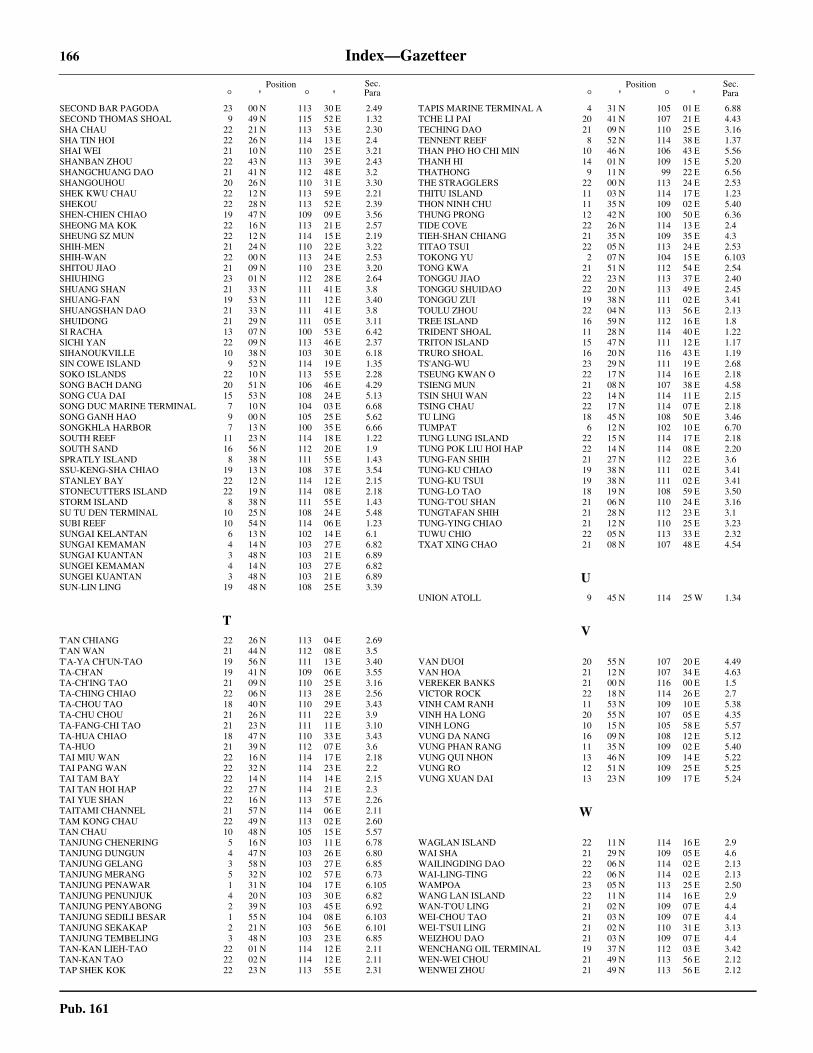
166 Index—Gazetteer
Pub. 161
Position° ' ° '
Position° ' ° '
Sec.Para
Sec.Para
SECOND BAR PAGODA 23 00 N 113 30 E 2.49SECOND THOMAS SHOAL 9 49 N 115 52 E 1.32SHA CHAU 22 21 N 113 53 E 2.30SHA TIN HOI 22 26 N 114 13 E 2.4SHAI WEI 21 10 N 110 25 E 3.21SHANBAN ZHOU 22 43 N 113 39 E 2.43SHANGCHUANG DAO 21 41 N 112 48 E 3.2SHANGOUHOU 20 26 N 110 31 E 3.30SHEK KWU CHAU 22 12 N 113 59 E 2.21SHEKOU 22 28 N 113 52 E 2.39SHEN-CHIEN CHIAO 19 47 N 109 09 E 3.56SHEONG MA KOK 22 16 N 113 21 E 2.57SHEUNG SZ MUN 22 12 N 114 15 E 2.19SHIH-MEN 21 24 N 110 22 E 3.22SHIH-WAN 22 00 N 113 24 E 2.53SHITOU JIAO 21 09 N 110 23 E 3.20SHIUHING 23 01 N 112 28 E 2.64SHUANG SHAN 21 33 N 111 41 E 3.8SHUANG-FAN 19 53 N 111 12 E 3.40SHUANGSHAN DAO 21 33 N 111 41 E 3.8SHUIDONG 21 29 N 111 05 E 3.11SI RACHA 13 07 N 100 53 E 6.42SICHI YAN 22 09 N 113 46 E 2.37SIHANOUKVILLE 10 38 N 103 30 E 6.18SIN COWE ISLAND 9 52 N 114 19 E 1.35SOKO ISLANDS 22 10 N 113 55 E 2.28SONG BACH DANG 20 51 N 106 46 E 4.29SONG CUA DAI 15 53 N 108 24 E 5.13SONG DUC MARINE TERMINAL 7 10 N 104 03 E 6.68SONG GANH HAO 9 00 N 105 25 E 5.62SONGKHLA HARBOR 7 13 N 100 35 E 6.66SOUTH REEF 11 23 N 114 18 E 1.22SOUTH SAND 16 56 N 112 20 E 1.9SPRATLY ISLAND 8 38 N 111 55 E 1.43SSU-KENG-SHA CHIAO 19 13 N 108 37 E 3.54STANLEY BAY 22 12 N 114 12 E 2.15STONECUTTERS ISLAND 22 19 N 114 08 E 2.18STORM ISLAND 8 38 N 111 55 E 1.43SU TU DEN TERMINAL 10 25 N 108 24 E 5.48SUBI REEF 10 54 N 114 06 E 1.23SUNGAI KELANTAN 6 13 N 102 14 E 6.1SUNGAI KEMAMAN 4 14 N 103 27 E 6.82SUNGAI KUANTAN 3 48 N 103 21 E 6.89SUNGEI KEMAMAN 4 14 N 103 27 E 6.82SUNGEI KUANTAN 3 48 N 103 21 E 6.89SUN-LIN LING 19 48 N 108 25 E 3.39
TT'AN CHIANG 22 26 N 113 04 E 2.69T'AN WAN 21 44 N 112 08 E 3.5T'A-YA CH'UN-TAO 19 56 N 111 13 E 3.40TA-CH'AN 19 41 N 109 06 E 3.55TA-CH'ING TAO 21 09 N 110 25 E 3.16TA-CHING CHIAO 22 06 N 113 28 E 2.56TA-CHOU TAO 18 40 N 110 29 E 3.43TA-CHU CHOU 21 26 N 111 22 E 3.9TA-FANG-CHI TAO 21 23 N 111 11 E 3.10TA-HUA CHIAO 18 47 N 110 33 E 3.43TA-HUO 21 39 N 112 07 E 3.6TAI MIU WAN 22 16 N 114 17 E 2.18TAI PANG WAN 22 32 N 114 23 E 2.2TAI TAM BAY 22 14 N 114 14 E 2.15TAI TAN HOI HAP 22 27 N 114 21 E 2.3TAI YUE SHAN 22 16 N 113 57 E 2.26TAITAMI CHANNEL 21 57 N 114 06 E 2.11TAM KONG CHAU 22 49 N 113 02 E 2.60TAN CHAU 10 48 N 105 15 E 5.57TANJUNG CHENERING 5 16 N 103 11 E 6.78TANJUNG DUNGUN 4 47 N 103 26 E 6.80TANJUNG GELANG 3 58 N 103 27 E 6.85TANJUNG MERANG 5 32 N 102 57 E 6.73TANJUNG PENAWAR 1 31 N 104 17 E 6.105TANJUNG PENUNJUK 4 20 N 103 30 E 6.82TANJUNG PENYABONG 2 39 N 103 45 E 6.92TANJUNG SEDILI BESAR 1 55 N 104 08 E 6.103TANJUNG SEKAKAP 2 21 N 103 56 E 6.101TANJUNG TEMBELING 3 48 N 103 23 E 6.85TAN-KAN LIEH-TAO 22 01 N 114 12 E 2.11TAN-KAN TAO 22 02 N 114 12 E 2.11TAP SHEK KOK 22 23 N 113 55 E 2.31
TAPIS MARINE TERMINAL A 4 31 N 105 01 E 6.88TCHE LI PAI 20 41 N 107 21 E 4.43TECHING DAO 21 09 N 110 25 E 3.16TENNENT REEF 8 52 N 114 38 E 1.37THAN PHO HO CHI MIN 10 46 N 106 43 E 5.56THANH HI 14 01 N 109 15 E 5.20THATHONG 9 11 N 99 22 E 6.56THE STRAGGLERS 22 00 N 113 24 E 2.53THITU ISLAND 11 03 N 114 17 E 1.23THON NINH CHU 11 35 N 109 02 E 5.40THUNG PRONG 12 42 N 100 50 E 6.36TIDE COVE 22 26 N 114 13 E 2.4TIEH-SHAN CHIANG 21 35 N 109 35 E 4.3TITAO TSUI 22 05 N 113 24 E 2.53TOKONG YU 2 07 N 104 15 E 6.103TONG KWA 21 51 N 112 54 E 2.54TONGGU JIAO 22 23 N 113 37 E 2.40TONGGU SHUIDAO 22 20 N 113 49 E 2.45TONGGU ZUI 19 38 N 111 02 E 3.41TOULU ZHOU 22 04 N 113 56 E 2.13TREE ISLAND 16 59 N 112 16 E 1.8TRIDENT SHOAL 11 28 N 114 40 E 1.22TRITON ISLAND 15 47 N 111 12 E 1.17TRURO SHOAL 16 20 N 116 43 E 1.19TS'ANG-WU 23 29 N 111 19 E 2.68TSEUNG KWAN O 22 17 N 114 16 E 2.18TSIENG MUN 21 08 N 107 38 E 4.58TSIN SHUI WAN 22 14 N 114 11 E 2.15TSING CHAU 22 17 N 114 07 E 2.18TU LING 18 45 N 108 50 E 3.46TUMPAT 6 12 N 102 10 E 6.70TUNG LUNG ISLAND 22 15 N 114 17 E 2.18TUNG POK LIU HOI HAP 22 14 N 114 08 E 2.20TUNG-FAN SHIH 21 27 N 112 22 E 3.6TUNG-KU CHIAO 19 38 N 111 02 E 3.41TUNG-KU TSUI 19 38 N 111 02 E 3.41TUNG-LO TAO 18 19 N 108 59 E 3.50TUNG-T'OU SHAN 21 06 N 110 24 E 3.16TUNGTAFAN SHIH 21 28 N 112 23 E 3.1TUNG-YING CHIAO 21 12 N 110 25 E 3.23TUWU CHIO 22 05 N 113 33 E 2.32TXAT XING CHAO 21 08 N 107 48 E 4.54
UUNION ATOLL 9 45 N 114 25 W 1.34
V
VAN DUOI 20 55 N 107 20 E 4.49VAN HOA 21 12 N 107 34 E 4.63VEREKER BANKS 21 00 N 116 00 E 1.5VICTOR ROCK 22 18 N 114 26 E 2.7VINH CAM RANH 11 53 N 109 10 E 5.38VINH HA LONG 20 55 N 107 05 E 4.35VINH LONG 10 15 N 105 58 E 5.57VUNG DA NANG 16 09 N 108 12 E 5.12VUNG PHAN RANG 11 35 N 109 02 E 5.40VUNG QUI NHON 13 46 N 109 14 E 5.22VUNG RO 12 51 N 109 25 E 5.25VUNG XUAN DAI 13 23 N 109 17 E 5.24
W
WAGLAN ISLAND 22 11 N 114 16 E 2.9WAI SHA 21 29 N 109 05 E 4.6WAILINGDING DAO 22 06 N 114 02 E 2.13WAI-LING-TING 22 06 N 114 02 E 2.13WAMPOA 23 05 N 113 25 E 2.50WANG LAN ISLAND 22 11 N 114 16 E 2.9WAN-T'OU LING 21 02 N 109 07 E 4.4WEI-CHOU TAO 21 03 N 109 07 E 4.4WEI-T'SUI LING 21 02 N 110 31 E 3.13WEIZHOU DAO 21 03 N 109 07 E 4.4WENCHANG OIL TERMINAL 19 37 N 112 03 E 3.42WEN-WEI CHOU 21 49 N 113 56 E 2.12WENWEI ZHOU 21 49 N 113 56 E 2.12

Index—Gazetteer 167
Pub. 161
Position° ' ° '
Position° ' ° '
Sec.Para
Sec.Para
WENWEI ZHOU LIGHTHOUSE 21 49 N 113 56 E 2.32WEST LAMMA CHANNEL 22 11 N 114 03 E 2.21WEST REEF 8 51 N 112 11 E 1.41WEST YORK ISLAND 11 05 N 115 00 E 1.27WESTERN REEF 10 16 N 113 37 E 1.26WHITE POINT 22 19 N 114 08 E 2.23WHITSUN REEF 9 58 N 114 39 E 1.35WOODY ISLAND 16 50 N 112 20 E 1.10WU CHOU 23 29 N 111 19 E 2.68WU-CH'I CHOU 18 19 N 109 45 E 3.44WU-LEI CHIAO 20 36 N 108 44 E 4.7WUZHU ZHOU 21 36 N 112 53 E 3.2
X
XIACHUAN DAO 21 40 N 112 36 E 3.4XIAOHU JIAO 22 50 N 113 34 E 2.48XIAOZHU ZHOU 21 26 N 111 22 E 3.9XIDAN DAO 21 58 N 114 08 E 2.11XIEYANG DAO 20 54 N 109 13 E 4.5XIJIANG TERMINAL 21 18 N 114 59 E 1.4XUAM HAI PIER 18 40 N 105 42 E 4.18
YYA MEN WAN 22 20 N 113 04 E 2.69YA-LUNG CHIAO 18 12 N 109 42 E 3.44YANG-P'U WAN 19 42 N 109 06 E 3.55YANTIAN 22 35 N 114 16 E 2.4YI BLUFF 22 16 N 114 18 E 2.7YING-KO TSUI 18 30 N 108 41 E 3.50YUANGANGSHA ZUI 23 02 N 113 21 E 2.51YUBAO JIAO 19 59 N 109 53 E 3.38YU-CHI SHAN 22 12 N 113 27 E 2.57YUCHU 23 06 N 113 26 E 2.50YUEH-CH’ENG 23 04 N 112 00 E 2.65YU-LIN CHIANG 18 11 N 109 31 E 3.47YU-LIN CHIAO 19 06 N 108 36 E 3.51YU-LIN CHOU 19 06 N 108 36 E 3.51YUTSHING 23 04 N 112 E 2.65
ZZERO BUOY 13 44 N 109 15 E 5.22ZHANJIANG 21 12 N 110 24 E 3.21ZHANJIANG GANG 21 10 N 110 25 E 3.15ZHUJIANG KOU 22 30 N 113 35 E 2.32