sop for drainage maintenance responsibility...
TRANSCRIPT
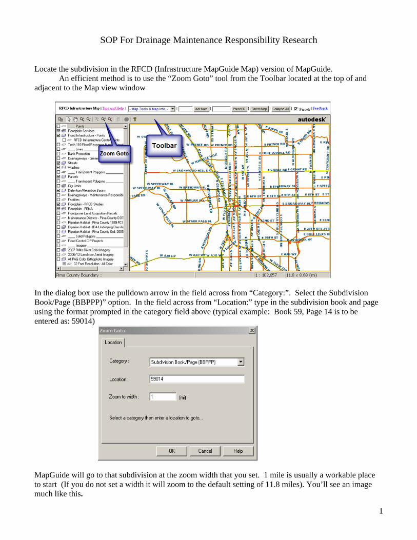
SOP For Drainage Maintenance Responsibility Research Locate the subdivision in the RFCD (Infrastructure MapGuide Map) version of MapGuide. An efficient method is to use the “Zoom Goto” tool from the Toolbar located at the top of and adjacent to the Map view window
In the dialog box use the pulldown arrow in the field across from “Category:”. Select the Subdivision Book/Page (BBPPP)” option. In the field across from “Location:” type in the subdivision book and page using the format prompted in the category field above (typical example: Book 59, Page 14 is to be entered as: 59014)
MapGuide will go to that subdivision at the zoom width that you set. 1 mile is usually a workable place to start (If you do not set a width it will zoom to the default setting of 11.8 miles). You’ll see an image much like this.
1
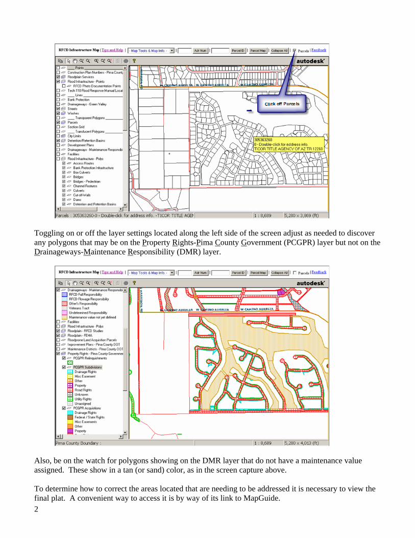
Toggling on or off the layer settings located along the left side of the screen adjust as needed to discover any polygons that may be on the Property Rights-Pima County Government (PCGPR) layer but not on the Drainageways-Maintenance Responsibility (DMR) layer.
Also, be on the watch for polygons showing on the DMR layer that do not have a maintenance value assigned. These show in a tan (or sand) color, as in the screen capture above. To determine how to correct the areas located that are needing to be addressed it is necessary to view the final plat. A convenient way to access it is by way of its link to MapGuide.
2
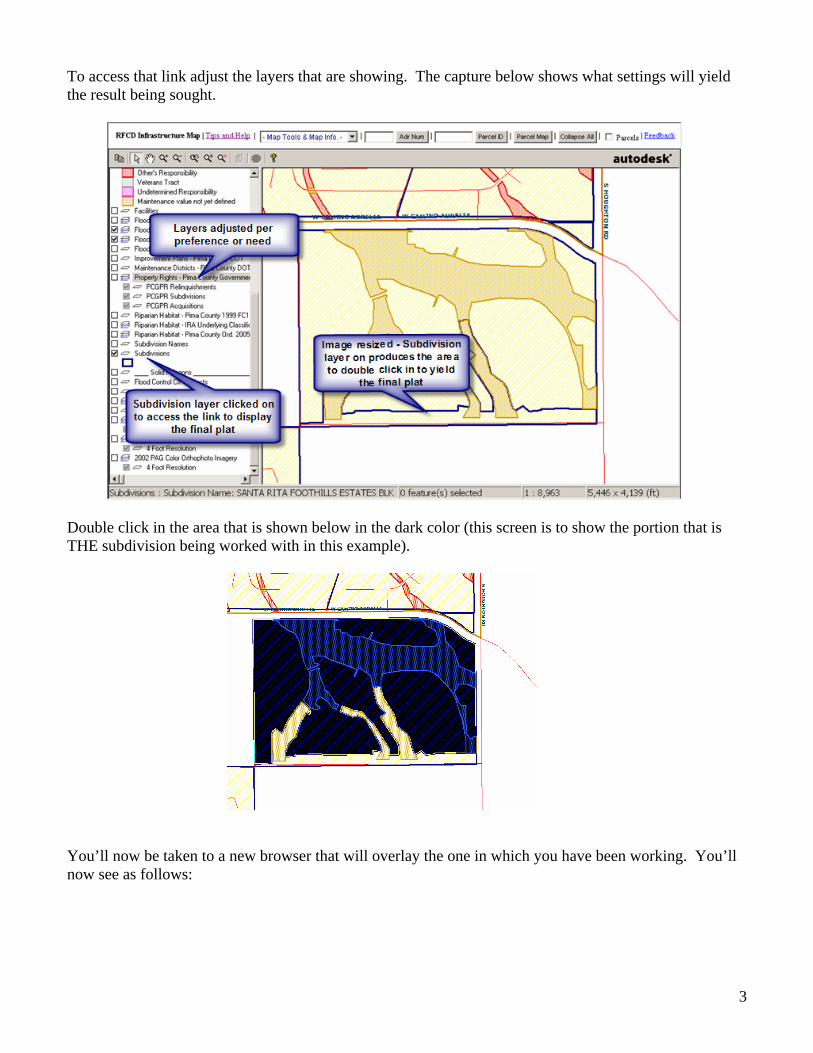
To access that link adjust the layers that are showing. The capture below shows what settings will yield the result being sought.
Double click in the area that is shown below in the dark color (this screen is to show the portion that is THE subdivision being worked with in this example).
You’ll now be taken to a new browser that will overlay the one in which you have been working. You’ll now see as follows:
3
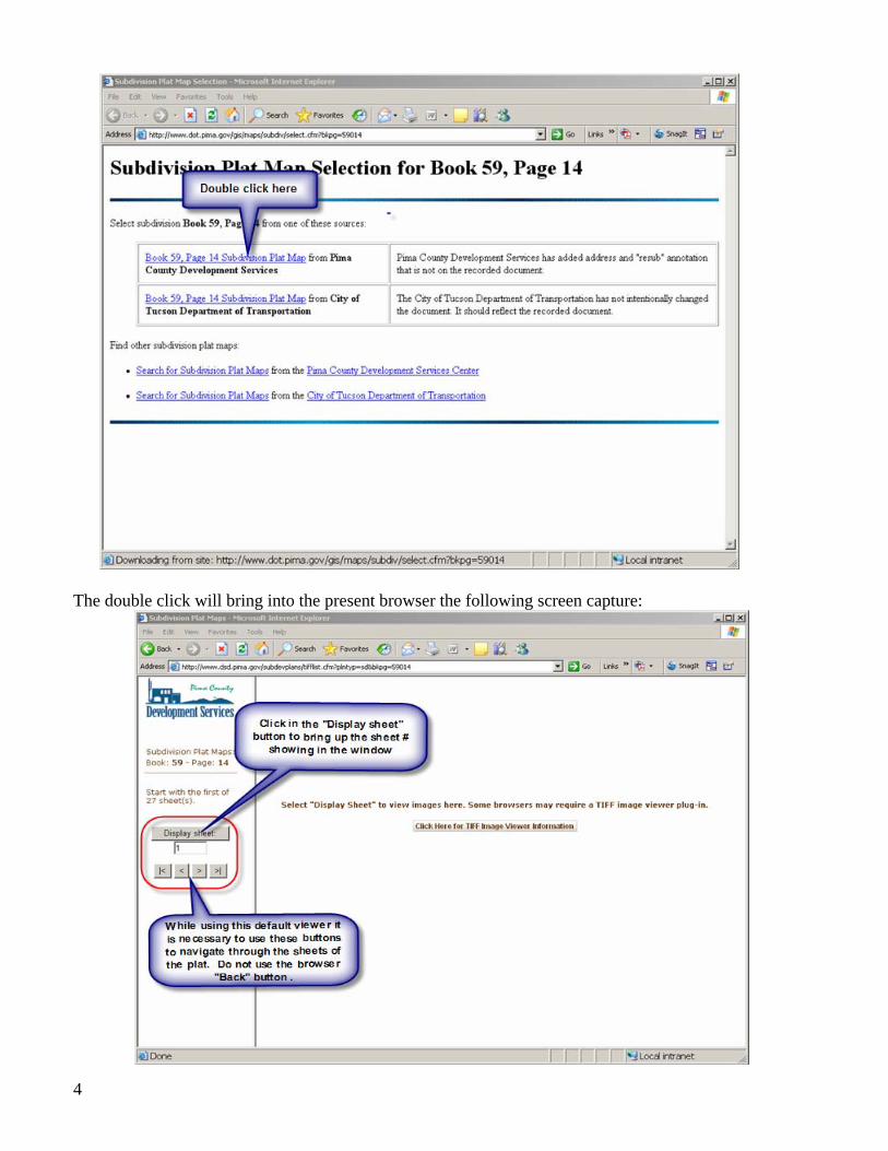
The double click will bring into the present browser the following screen capture:
4
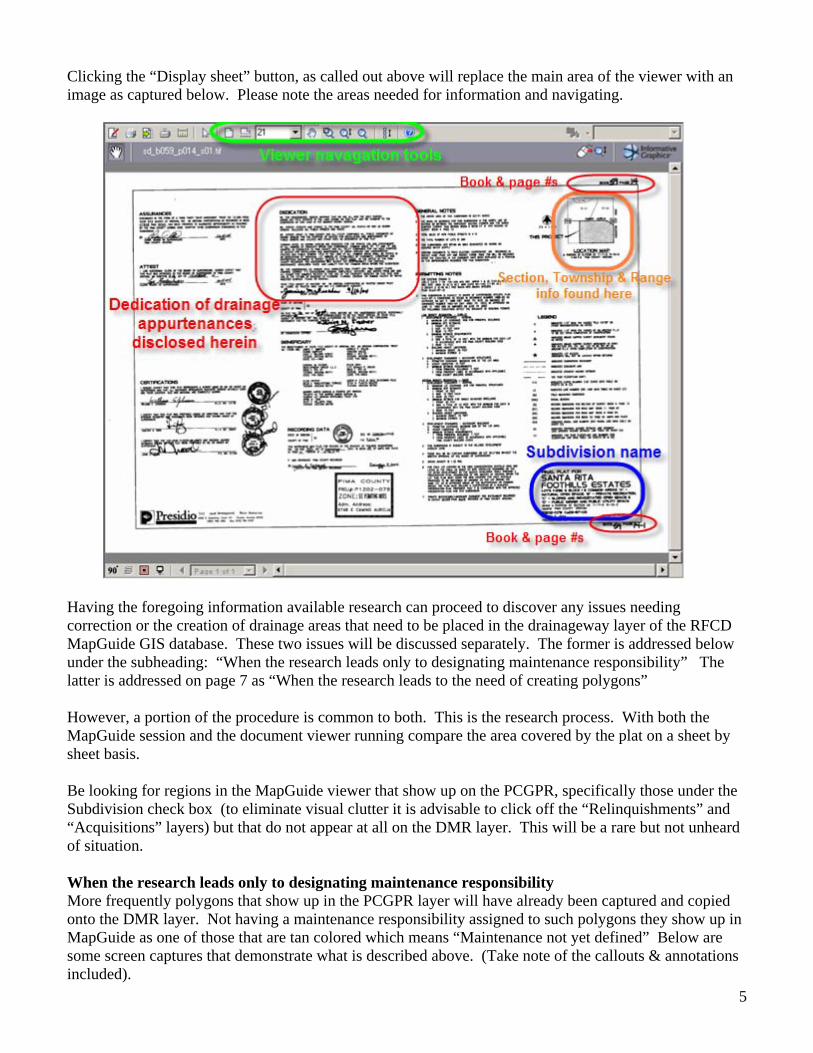
Clicking the “Display sheet” button, as called out above will replace the main area of the viewer with an image as captured below. Please note the areas needed for information and navigating.
Having the foregoing information available research can proceed to discover any issues needing correction or the creation of drainage areas that need to be placed in the drainageway layer of the RFCD MapGuide GIS database. These two issues will be discussed separately. The former is addressed below under the subheading: “When the research leads only to designating maintenance responsibility” The latter is addressed on page 7 as “When the research leads to the need of creating polygons” However, a portion of the procedure is common to both. This is the research process. With both the MapGuide session and the document viewer running compare the area covered by the plat on a sheet by sheet basis. Be looking for regions in the MapGuide viewer that show up on the PCGPR, specifically those under the Subdivision check box (to eliminate visual clutter it is advisable to click off the “Relinquishments” and “Acquisitions” layers) but that do not appear at all on the DMR layer. This will be a rare but not unheard of situation. When the research leads only to designating maintenance responsibility More frequently polygons that show up in the PCGPR layer will have already been captured and copied onto the DMR layer. Not having a maintenance responsibility assigned to such polygons they show up in MapGuide as one of those that are tan colored which means “Maintenance not yet defined” Below are some screen captures that demonstrate what is described above. (Take note of the callouts & annotations included).
5
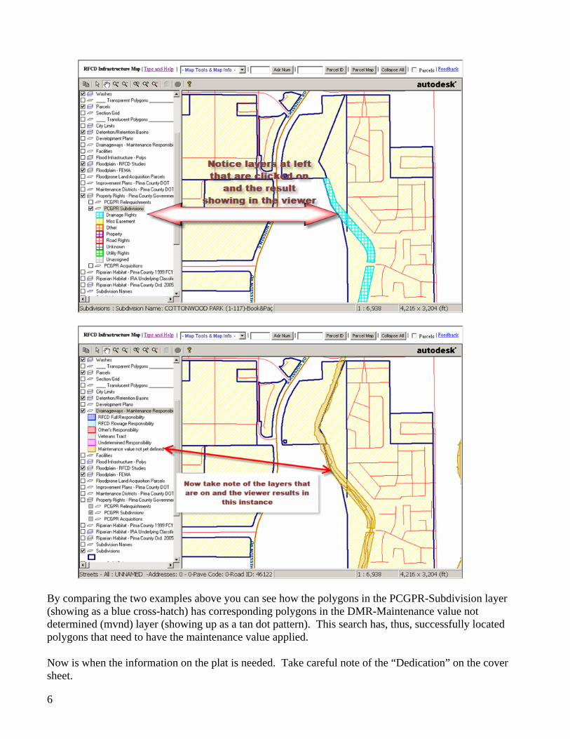
By comparing the two examples above you can see how the polygons in the PCGPR-Subdivision layer (showing as a blue cross-hatch) has corresponding polygons in the DMR-Maintenance value not determined (mvnd) layer (showing up as a tan dot pattern). This search has, thus, successfully located polygons that need to have the maintenance value applied. Now is when the information on the plat is needed. Take careful note of the “Dedication” on the cover sheet.
6
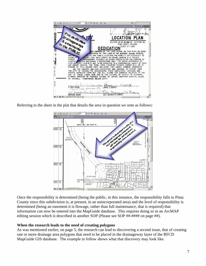
Referring to the sheet in the plat that details the area in question we note as follows:
Once the responsibility is determined (being the public, in this instance, the responsibility falls to Pima County since this subdivision is, at present, in an unincorporated area) and the level of responsibility is determined (being an easement it is flowage, rather than full maintenance, that is required) that information can now be entered into the MapGuide database. This requires doing so in an ArcMAP editing session which is described in another SOP (Please see SOP ##-#### on page ##). When the research leads to the need of creating polygons As was mentioned earlier, on page 5, the research can lead to discovering a second issue, that of creating one or more drainage area polygons that need to be placed in the drainageway layer of the RFCD MapGuide GIS database. The example to follow shows what that discovery may look like.
7
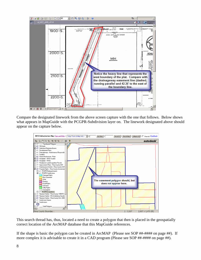
Compare the designated linework from the above screen capture with the one that follows. Below shows what appears in MapGuide with the PCGPR-Subdivision layer on. The linework designated above should appear on the capture below.
This search thread has, thus, located a need to create a polygon that then is placed in the geospatially correct location of the ArcMAP database that this MapGuide references. If the shape is basic the polygon can be created in ArcMAP (Please see SOP ##-#### on page ##). If more complex it is advisable to create it in a CAD program (Please see SOP ##-#### on page ##).
8