solwaybank wind farm - iema€¦ · technical summary forms part of the resubmission of the...
TRANSCRIPT

SOLWAYBANK Wind FarmVolume 1 - Non Technical Summary


CONTENTS
1. NON-TECHNICAL SUMMARY ................................................................................... 1
Introduction 1
2. RES ................................................................................................................. 2
3. DESCRIPTION OF THE PROJECT ............................................................................. 2
Site Location 2
Environmental Sensitivities 2
Project Description 3
Site Access 3
4. SITE SELECTION, DESIGN EVOLUTION AND ALTERNATIVES ........................................... 4
5. ENVIRONMENTAL IMPACT ASSESSMENT.................................................................... 5
EIA Process 5
Forestry 6
Landscape and Visual 6
Ecology 7
Ornithology 9
Cultural Heritage and Archaeology 9
Geology, Hydrology and Hydrogeology 10
Noise 10
Electromagnetic Interference and Aviation 11 Television and Microwave Communications 11 Aviation and Eskdalemuir Seismic Monitoring Station 11
Access, Traffic and Transport 12
Socio-economics 13
Other Issues – Health & Safety, Air & Climate, Shadow Flicker 14 Health and Safety 14 Air & Climate 14 Shadow Flicker 14
Potential Grid Connection 15
6. SUMMARY ....................................................................................................... 16
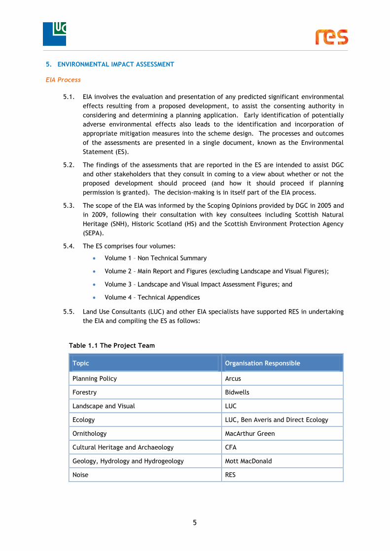
Table 1.1 The Project Team
Figure 1: Site Location Figure 2: Infrastructure Layout Figure 3: Felling Area


1
1. NON-TECHNICAL SUMMARY
Introduction
1.1. RES is applying for planning permission to construct a wind farm comprising 15 turbines,
near Kirtleton, Dumfries and Galloway, as shown in Figure 1: Site Location, to be known
as Solwaybank Wind Farm (hereafter referred to as ‘the proposed wind farm’). An
application for a wind farm at Solwaybank was originally made in 2009 for a 21 turbine
scheme. In July 2010, following comments received from consultees, the decision was
taken to withdraw the application. The layout has since been redesigned and this Non-
Technical Summary forms part of the resubmission of the Solwaybank Wind Farm planning
application.
1.2. As the proposal has a generating capacity of under 50 megawatts (MW), an application
for planning permission will be made to Dumfries and Galloway Council (DGC) under the
Town and Country Planning (Scotland) Act 1997, as amended by The Planning etc. Act
(Scotland) 2006. The Development will be considered a ‘major’ development by DGC,
as the proposed wind farm is likely to have a total installed capacity exceeding 20 MW.
1.3. As required by the Environmental Impact Assessment (Scotland) Regulations 2011, the
planning application is accompanied by an Environmental Statement (ES). The purpose
of the ES is to detail the results of the Environmental Impact Assessment (EIA) and
report on predicted environmental effects of the proposed wind farm.
1.4. This Non-Technical Summary (NTS) summarises the findings and conclusions of the ES.
A Pre-Application Consultation Report and Design and Access Statement have also been
submitted to accompany the planning application, and a Planning Statement has been
prepared.
1.5. The full ES, together with the planning application to DGC and associated documents
will be available for viewing during normal opening hours at the addresses below:
Lockerbie Council Offices
Dryfe Road Lockerbie DG11 2AS
Lockerbie Library 31-33 High Street
Lockerbie DG11 2JL
Langholm Customer Service Centre Market Place
Langholm DG13 0JQ
Gretna Customer Service Centre
56F Annan Road Gretna
DG16 5AT
1.6. An electronic version of the documents, including the ES will be available to download
from www.solwaybank-windfarm.co.uk. Paper copies of the NTS or other documents
forming part of the planning application can be requested from:
RES UK & Ireland Limited
3rd Floor, STV
Pacific Quay
Glasgow
G51 1PQ
2
1.7. Copies of the NTS are available free of charge; ES Volumes 2-4 can be purchased on CD
for £25 or paper copies at a cost of £250 (including postage and packaging).
2. RES
2.1. RES is one of the world’s leading independent renewable energy developers with
operations across Europe, North America and Asia-Pacific. RES, a British company, has
been at the forefront of wind energy development since the 1970s and has developed
and/or built 100 wind farms (or 5 Gigawatts (GW) of wind capacity) around the world,
including 10% of the UK’s wind energy. This includes seven wind farms in Scotland with
a total generation capacity of more than 120 MW. In 2010, RES commenced
construction of Hill of Towie Wind Farm in Moray and Kelburn Wind Farm in North
Ayrshire.
3. DESCRIPTION OF THE PROJECT
Site Location
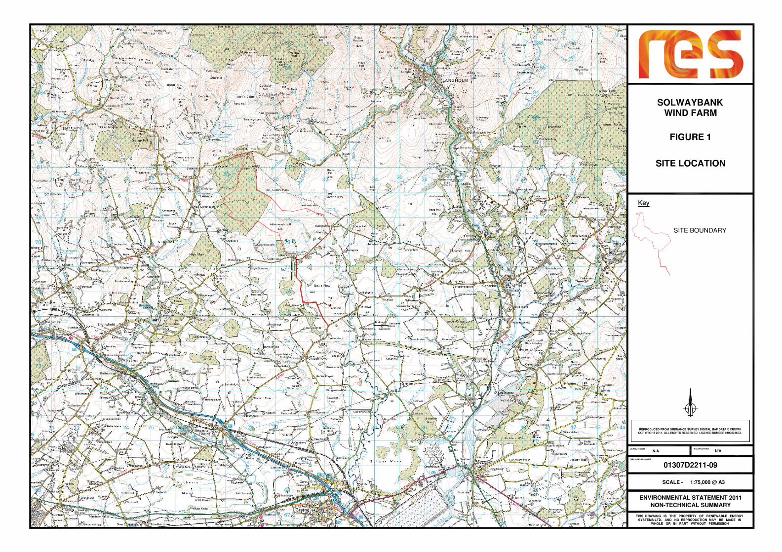
3.1. The proposed wind farm is located within the Annandale and Eskdale administrative
area of Dumfries and Galloway. It is located approximately 1.5 km east of the village of
Kirtleton and 8 km south-west of Langholm. The B7068 Lockerbie to Langholm road
borders the northern most edge of the site.
3.2. The proposed wind farm site boundary covers approximately 663 hectares (ha), but the
loss of land due to the proposed infrastructure (turbines, tracks, crane hard standings,
substation compound etc) will be limited to 8.3 ha (approximately 1.25% of the site) for
the lifetime of the project.
3.3. The site location and infrastructure layout of the proposed Solwaybank Wind Farm are
shown on Figures 1 and 2 at the end of this NTS
3.4. The site is currently used for a mix of rough livestock grazing and commercial forestry.
Approximately 198 ha of forestry will be felled to allow the wind farm to be built and
operate efficiently. 159 ha of forestry will be replanted after the construction phase is
complete.
3.5. The site is mainly located in the landscape character type ‘foothills’ although the site
boundary and infrastructure also incorporates ‘Upland Fringe’ and ‘Flow Plateau’
landscapes.
Environmental Sensitivities
3.6. The proposed wind farm is not within any national or international designations for
landscape or environmental features.
3.7. International and national designations within 10 km include:
Langholm and Newcastleton Hills Special Protection Area (SPA). This site is also
designated as a Site of Special Scientific Interest (SSSI);
Raeburn Flow Special Area of Conservation (SAC). The site is also designated as a
SSSI;
3
Bigholms Burn SSSI (geological);
River Esk, Glencartholm SSSI (geological);
Bells Flow SSSI.
3.8. No ‘right of way’ crosses the site although a non core path (#2685 leading into #2686)
crosses the top corner of the site and follows the proposed access track onto the B7068.
Project Description
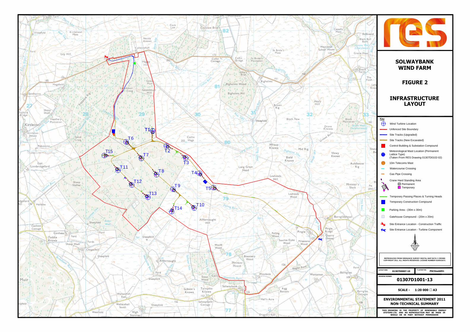
3.9. The proposed wind farm layout is shown in Figure 2: Site Layout. The main components
of the proposed wind farm comprise:
15 three-bladed horizontal axis wind turbines of up to 126.5 m tip-height, each
nominally rated at between 2 - 2.5 MW,
at each turbine, associated low to medium voltage transformers and related
switchgear,
turbine foundations,
hard-standing areas for erection cranes at each turbine location,
a single, permanent, free-standing meteorological mast,
up to six guyed temporary calibration meteorological masts to be used during the
wind farm commissioning and acceptance testing,
on-site access tracks,
forestry felling;
two site entrances from the main road network;
a wind farm sub-station compound containing a control building,
an on-site electrical and control network of buried cables,
two temporary construction compounds, and
road widening and improvement works along the access route.
3.10. A spur connection from the sub-station to the local grid network will also be required
however this is not part of the wind farm planning application. Nevertheless
environmental considerations are discussed in ES Volume 2, Chapter 18: Potential Grid
Connection).
3.11. Subject to the granting of planning permission, it is anticipated that the construction of
the proposed wind farm will take place over an 18 month programme including a felling
programme of 12 months. The operational life of the wind farm is approximately 25
years. At the end of this period, a decision would be made as to whether to refurbish,
remove, or replace the turbines.
Site Access
3.12. The proposed wind farm will be accessed by two routes. Construction traffic will travel
to the site along the B7068 to the North Entrance while abnormal load deliveries (e.g.

4
turbine and substation components) will exit the A(74)M at Jn21 Kirkpatrick and travel
to the site via the B6357 to Chapelknowe then turning left after Tympanheck onto the
unclassified road to Solwaybank and then onto the site entrance at Pingle Farm.
Widening and improvement works are planned at several points along the abnormal load
delivery route mainly along the unclassified road between Tympanheck and Pingle
Farm.
3.13. On-site tracks are required to enable the turbine components and construction
materials to be transported to their locations, and to enable ongoing access for
subsequent maintenance visits. A network of approximately 10.4 km of site tracks will
be required to access the turbines for construction, operation and decommissioning.
The tracks will have a running width of approximately 5-5.5 m, wider at bends and
passing places.
4. SITE SELECTION, DESIGN EVOLUTION AND ALTERNATIVES
4.1. The site at Solwaybank was identified by RES as a potential site for wind farm
development through the use of a computer based Geographical Information System
(GIS). The system identifies areas for development by highlighting any environmental
constraints. The proposed wind farm site satisfies the following criteria:
an absence of international and national landscapes and nature conservation
designations within the boundary;
an exposed location with good wind speeds;
feasible site access routes;
access to grid connection;
the site is outwith the line-of-sight of Munro tops to an extent of 20 km; and
distance to settlements and individual properties.
4.2. The overall aim of the design strategy was to create a wind farm with a cohesive design
that relates to the surrounding landscape and takes account of the environmental
characteristics of the site and the surrounding area. Site features primarily include
ecologically important habitats and species such as blanket bog and bat commuting
routes, cultural heritage features and hydrological resources. In the wider area
consideration was given to how the wind farm would sit alongside other existing or
proposed wind farms.
4.3. The inherent nature of wind turbines as tall, modern structures means that the form of
the proposed wind farm as a whole is important, and a clear design strategy is
necessary. The strategy therefore considered the appearance of the proposed wind
farm as an object or composition in the landscape as the primary factor in generating
the layout. Further details of the design strategy can be found in Chapter 3: Site
Selection, Design Evolution and Alternatives in the ES Volume 2: Main Report.
5
5. ENVIRONMENTAL IMPACT ASSESSMENT
EIA Process
5.1. EIA involves the evaluation and presentation of any predicted significant environmental
effects resulting from a proposed development, to assist the consenting authority in
considering and determining a planning application. Early identification of potentially
adverse environmental effects also leads to the identification and incorporation of
appropriate mitigation measures into the scheme design. The processes and outcomes
of the assessments are presented in a single document, known as the Environmental
Statement (ES).
5.2. The findings of the assessments that are reported in the ES are intended to assist DGC
and other stakeholders that they consult in coming to a view about whether or not the
proposed development should proceed (and how it should proceed if planning
permission is granted). The decision-making is in itself part of the EIA process.
5.3. The scope of the EIA was informed by the Scoping Opinions provided by DGC in 2005 and
in 2009, following their consultation with key consultees including Scottish Natural
Heritage (SNH), Historic Scotland (HS) and the Scottish Environment Protection Agency
(SEPA).
5.4. The ES comprises four volumes:
Volume 1 – Non Technical Summary
Volume 2 – Main Report and Figures (excluding Landscape and Visual Figures);
Volume 3 – Landscape and Visual Impact Assessment Figures; and
Volume 4 – Technical Appendices
5.5. Land Use Consultants (LUC) and other EIA specialists have supported RES in undertaking
the EIA and compiling the ES as follows:
Table 1.1 The Project Team
Topic Organisation Responsible
Planning Policy Arcus
Forestry Bidwells
Landscape and Visual LUC
Ecology LUC, Ben Averis and Direct Ecology
Ornithology MacArthur Green
Cultural Heritage and Archaeology CFA
Geology, Hydrology and Hydrogeology Mott MacDonald
Noise RES
6
Topic Organisation Responsible
Electromagnetic Interference and Aviation RES
Access, Traffic and Transport Mott MacDonald
Socio-economics RES
Other Issues – Health and Safety, Air and
Climate, Shadow Flicker
RES
5.6. The key findings of the EIA are summarised in the following sections. Further in depth
information is contained in ES Volume 2: Main Report.
Forestry
5.7. The forestry chapter provides information relating to the forestry that currently
occupies the proposed site and provides detailed proposals for felling, replanting,
subsequent land management and other forestry related operations.
5.8. The proposed wind farm requires the felling of 198 ha of forestry (Figure 3: Felling
Area) and forms part of a wider c.540 ha area of forestry that is split into four different
ownerships. The proposed wind farm would be constructed mainly on the south-eastern
flank of the planted coniferous areas. Additional felling is also likely to be required in
this area to maximise efficiency of the turbine operations.
5.9. It is the intention to replant the majority of the site, leaving ‘keyhole’ installation of
turbines and access tracks as well as creating open areas particularly around the head
of the Palling Burn to improve existing habitats. The proposed felling is expected to be
undertaken over 12 months. Draft Forest Design Plans have been produced to provide
details of felling requirements for the proposed wind farm and indicative restocking
proposals.
Landscape and Visual
5.10. The Landscape and Visual Impact Assessment (LVIA) considered the effect that the
proposed wind farm will have on the landscape character and on the people who view
that landscape. The assessment involved a desk study, field survey and computer
modelling.
5.11. The study area for the assessment was defined as 35 km from the outermost turbines of
the proposed wind farm in all directions, as is recommended by current good practice
guidance for turbines of 100 m to blade tip or higher. The cumulative assessment
comprised an initial search for other wind farm schemes within a 60 km radius in
accordance with relevant guidance. A detailed assessment was undertaken of the
effect of the addition of the proposed wind farm to all existing, consented or
application stage schemes within 35 km at a cut-off date of 1 August 2011.
5.12. The study area encompasses a wide variety of different landform types, from the
Southern Uplands to low coastal plains. The site is not situated within a designated

7
landscape and no significant effects on designated landscapes are predicted. The
Langholm Hills Regional Scenic Area (RSA) is approximately 5 km from the site to the
north-east. Other designated areas within the study area include the Nith Estuary
National Scenic Area (NSA), Torthorwald Ridge RSA, Solway Coast RSA, the Solwaybank
Area of Outstanding Natural Beauty (AONB), Liddel Water Landscape of County
Importance and Hadrian’s Wall World Heritage Site (WHS) buffer zone.
5.13. During the construction phase, it is anticipated that there would be inevitable
significant effects on the landscape of the site itself. Effects would, however, be
temporary and a post-construction restoration plan would be implemented to ensure
the appropriate restoration of disturbed areas.
5.14. Once operational, there would be significant effects on the landscape of the site and a
locally significant effect on the ‘Foothills’ Landscape Character Type (LCT) within
which the turbines would be located. The site boundary also includes land classified
under ‘Upland Fringe’ and ‘Flow Plateau’ LCTs, but no significant effects have been
predicted for these LCTs, or more distant LCTs.
5.15. To assess likely effects on visual amenity during operation of the proposed wind farm,
18 viewpoints were selected for detailed review; these were agreed in consultation
with SNH, DGC, Scottish Borders Council, Carlisle City Council and Cumbria County
Council. Of these 18 viewpoints, significant visual effects are predicted for seven of
them. These seven viewpoints are amongst those within closest proximity to the site.
For the remaining eleven viewpoints, landscape and visual effects are not predicted to
be significant and no significant visual effects are predicted from settlements across
the study area. Sequential views from local sections of the B7068 road, which runs
from Lockerbie to Langholm, and from minor roads around the site are likely to be
effected visually. However, no other significant effects are predicted for sequential
views from routes around the study area.
5.16. Aside from the cumulative effects predicted for the ‘Foothills’ LCT which forms part of
the site boundary,) and for sections of the B7068 road, no other significant cumulative
effects are predicted.
5.17. With regards to landscape and visual effects, due to the nature of wind farm
developments there is limited scope for mitigation. However, over the longer term,
effects at the site will be reduced via the reinstatement and restoration of vegetation,
in addition to the forest replanting plans.
Ecology
5.18. The assessment of the potential effects of the proposed wind farm on flora and fauna
considered both direct effects, such as habitat loss, and indirect effects such as
disturbance to protected species.
5.19. There are no statutory or non-statutory designated sites within the site boundary.
Raeburn Flow SAC (also a designated SSSI) is located 5.3 km to the south of the site and
is designated for the internationally important areas of active and degraded raised bog
that it supports. The Langholm and Newcastleton Hills SPA (also a designated SSSI) is
located 8.1 km to the north-east of the site. This is an international level designation,

8
due to a breeding population of hen harrier. There are three other SSSIs (listed in
paragraph 3.7), four Local Wildlife Sites (LWSs) and three areas of ancient woodland, of
semi-natural origin, within 10 km of the site.
5.20. The main habitat types identified within the site include woodlands, grasslands,
heathlands, mires, open water habitats and man-made habitats. With respect to
protected species, evidence of otter was found within the site boundary, primarily
corresponding with the lower reaches of Palling Burn. Evidence of badger activity was
found across the site, with the highest levels of activity recorded in areas of coniferous
plantation woodland outwith the proposed wind farm infrastructure area. Six species of
bat and relatively high levels of activity were recorded throughout the site. However,
the majority of bat passes were from common and soprano pipistrelle bats which are
common throughout the UK. Recent records suggest red squirrel are present on the
site, however population size is likely to be relatively low. Reptiles recorded on-site
were limited to the common lizard. The watercourses within the site provide
connecting routes for fish towards larger watercourses downstream. To inform the
layout design, appropriate buffers were applied around recorded otter shelters, badger
setts and watercourses to ensure appropriate set back distances from the wind farm
infrastructure.
5.21. Potential short term effects are predicted for badger and for red squirrel during the
construction phase. In order to reduce these effects, pre-construction surveys will be
carried out to identify any badger setts or squirrel dreys. Felling activity will be
managed in order to maintain a suitable distance from setts and nest boxes for squirrels
will be installed in appropriate locations within the retained forestry areas. When
required an Ecological Clerk of Works (ECoW) will be present on-site during the
construction and felling phases to monitor activity and ensure mitigation measures are
adhered to.
5.22. Potential collision risk for bats is predicted during the operation of the wind farm. The
magnitude of collision is likely to be low. Measures will be implemented to reduce this
risk including maintaining a distance of open habitat between the new woodland edges
and rotor diameter of the turbines. In addition, careful improved woodland design and
replanting methods will aim to provide links in areas to key features of value to bats in
the wider landscape.
5.23. The layout was designed to minimise the loss of habitats of higher conservation value
such as blanket bog, wet heath and modified bog. However, some areas of these
habitats will be lost and, given their international and national importance, potential
significant effects are predicted for blanket bog habitats. Potential effects, of a lesser
degree, are also predicted for wet heath and modified bog habitats.
5.24. A Habitat Management Plan (HMP) is proposed to compensate for the loss of these
habitats. The objectives of the HMP will include restoring a mosaic of heath, bog and
grassland habitats in some previously afforested areas and improving the condition and
maintaining the extent of existing blanket bog and grassland habitat at Allfornought
Hill. The HMP will be developed post consent in further detail in conjunction with
relevant stakeholders, to include the landowners, RES, DGC and SNH. Implementation
of the HMP will result in all predicted effects being reduced.

9
Ornithology
5.25. The ornithology assessment evaluates the effects of the proposed wind farm on birds.
It has been informed by desk-based studies and field surveys. Consultations were also
undertaken with SNH, DGC and the Royal Society for the Protection of Birds (RSPB).
5.26. The field work took place between September 2010 and August 2011 and included
surveys of flight activity, upland breeding birds, birds of prey, black grouse lek and
winter non-breeding birds.
5.27. There are no statutory designations within the site. There are three Special Protected
Areas (SPAs) within 20 km. Assessment of the effects of the proposed wind farm in
combination with other projects in the area has predicted that the addition of
Solwaybank Wind Farm is unlikely to have significant effects on the qualifying interest
of these sites.
5.28. Wind farm construction can lead to the disturbance and displacement of birds,
particularly during the breeding season. A number of measures are proposed to reduce
the potential for significant effects during construction. These include the production
of a Breeding Bird Protection Plan (BBPP), which is essential to ensure that all
reasonable precautions are taken to protect birds’ nests, eggs, and dependent young
during construction. Recommended buffer distances around Barn Owl (250 m) and
Goshawk (500 m) nesting sites will be maintained until young have fledged. The
restoration and re-planting proposals within the Habitat Management Plan (HMP) will
result in positive effects for birds, Common Crossbill and Lesser Redpoll in particular.
5.29. Once the proposed wind farm is operational, there is a potential risk of collision for bird
species who continue to utilise the proposed wind farm site. To indicate the level of
risk, collision Risk Modelling (CRM) was carried out for goshawk, hen harrier, golden
plover (non-breeding season), pink-footed goose and greylag geese (non-breeding
season). The findings confirmed that the predicted collision risk for all three species
was is low.
5.30. The findings of the assessment indicate that the potential effects of the proposed wind
farm upon birds will not be significant.
Cultural Heritage and Archaeology
5.31. An assessment was undertaken of the potential effects of the proposed wind farm on
cultural heritage and archaeological features within and around, the site. The
assessment considered direct effects, such as removal or damage to features within the
site, indirect effects to the setting of designated features in the surrounding landscape
and cumulative effects. It also considered potential effects on unrecorded
archaeological features.
5.32. There are eleven cultural heritage features located within the site. The majority of
these features are associated with medieval or later agricultural activity and whilst
they contribute to the present character of the landscape, they are considered to be of
no more than local importance. There are no features of national or regional
importance within the site; a Category C(S) Listed Building, Pingle farmhouse, lies at
the eastern extent of the site.

10
5.33. Construction of a wind farm can have a direct effect on archaeological remains
wherever ground disturbance takes place, e.g. for turbine bases and access tracks. The
proposed wind farm design has taken account of known cultural heritage features to
minimise these effects. The layout of the proposed wind farm avoids all known cultural
heritage features identified within the site and, as a result, there will be no direct
effect on any previously recorded sites or features of historic environment interest.
There is potential for significant effects on unrecorded/buried features. To minimise
effects, appropriate mitigation measures will be implemented, including the watching
of ground-breaking works in sensitive areas by an archaeologist who can record any
previously unknown finds as appropriate.
5.34. Views of the operational wind farm from the surrounding landscape have been assessed
and no significant effects on the setting of designated cultural heritage features are
predicted. Similarly, no effects as a result of the cumulative assessment are predicted
to be significant.
Geology, Hydrology and Hydrogeology
5.35. The study area, extending 5 km from the centre of the site, was assessed for potential
effects on hydrological and hydrogeological features.
5.36. The site drains into three separate catchments; the Kirtle Water, River Sark and River
Esk. The site contains the headwaters of a number of burns and sikes (e.g. Collin Burn,
Palling Burn, Pokeskine Sike, Hallsike Burn, Woodside Burn and Gowdmuir Sike) which
drain down towards the Kirtle water, River Sark and River Esk (through Collin Burn).
The ‘Palling Burn’, a tributary of the River Sark runs through the centre of the site.
5.37. There are eleven private water supplies (PWS) within 5 km of the site none of which are
within the site boundary.
5.38. Peat probing was also undertaken along the proposed track route and at the turbine
locations. Peat depth was found to vary between 0 and 3 m across the site. Where
possible the site infrastructure was relocated to avoid deeper areas of peat.
5.39. The layout of the proposed wind farm has been designed to minimise the effect on
hydrological features by keeping the number of new watercourse crossings required to a
minimum and respecting a 70 m buffer zone around all watercourses for siting wind
turbines and other infrastructure. Four new water crossings will be created and
upgrades to four existing crossing will be required.
5.40. During construction and operation of the proposed wind farm, a number of established
good practice measures will be put in place in relation to the control of surface water
run-off, drainage, pollution prevention and areas of peat, many of which are required
by regulation. These are designed to ensure the protection of watercourses and private
water supplies. Following adoption of these measures, the effects on hydrology and
hydrogeology will be reduced to a minor level.
Noise
5.41. There are two types of noise associated with the operation of wind turbines:
aerodynamic noise results from turbines rotating through the air; and mechanical noise
11
can be generated from gearboxes or generators, although mechanical noise from
modern turbines is minimal. Noise levels are generally low and, under most operating
conditions, it is likely that turbine noise would be masked by wind generated
background noise such as the sound of wind blowing through trees and around buildings.
Noise is also created during the construction phase by construction activities and
traffic.
5.42. An assessment has been undertaken of the potential construction and operational noise
effects from the proposed wind farm on nearby properties. The methodology was
agreed with the Environmental Health Officer at DGC.
5.43. Noise generated as a result of construction of the proposed wind farm will be
temporary in nature during the 18 month construction phase. There is predicted to be
a temporary increase in noise levels at two properties during the upgrade and
construction of access tracks. The temporary nature of the works means that the
increased effect is not considered to be significant.
5.44. Operational noise levels were assessed in line with government guidance. In
accordance with the guidance, background noise measurements were carried out at a
number of representative residential properties near the proposed wind farm, and
predicted operational noise levels compared with the existing background noise levels.
The predictions demonstrate that the proposed wind farm can operate below the
relevant limits set out in the guidance. No significant cumulative noise effects are
predicted during the construction or operational phases.
Electromagnetic Interference and Aviation
Television and Microwave Communications
5.45. The shadow, reflection and movement created by wind turbines can potentially
interfere with communication systems that use electromagnetic waves as the
transmission medium (e.g. television, radio or microwave links). Turbine design and
location influence the level of effect.
5.46. In addition to RES’s own technical assessments, consultation was undertaken with all
relevant organisations and system operators, which could be affected by the proposed
wind farm. The consultation identified telecoms links in the area which were
considered during the design stage to ensure the required separation between turbines
and telecoms links was achieved.
5.47. Analysis has demonstrated that there will be no widespread interference to TV
reception. A range of viable mitigation measures are available to the few properties
that may be affected and the most appropriate solution must be decided on a case by
case basis. Solutions include improved aerial system or utilising a different transmitter.
The recent switch to digital TV is expected to help mitigate any effects as digital
signals are less susceptible to interference.
Aviation and Eskdalemuir Seismic Monitoring Station
5.48. Wind turbines can potentially interfere with aviation operations by either physically
affecting the safeguarding of an aerodrome by the close proximity of the turbines or

12
through interference with the Air Traffic Control (ATC) radars that direct aeroplanes
and helicopters in flight.
5.49. Consultation was carried out with all relevant organisations which could be affected by
the proposed wind farm. This included NATS En-Route Ltd. (NERL), the Defence
Infrastructure Organisation (DIO) (which safeguards all Ministry of Defence (MoD) and
Met Office infrastructure and activities), the Civil Aviation Authority (CAA) and Carlisle
Airport.
5.50. As a result of consultation with NERL, potential effects on the Lowther Hill radar were
identified. Following investigation, it was concluded that, with the implementation of
appropriate mitigation measures, the objection from NERL would be removed. Carlisle
Airport had no objection to the proposed wind farm.
5.51. The DIO objected to the original 2009 application due to the risk to low-flying aircrafts
and the. This led to the withdrawal and subsequent re-design of the turbine layout.
DIO have been consulted again on the new 15 turbine layout and the expectation is that
the low flying objection will be removed.
5.52. If consented, prior to construction of the wind farm, the MoD and the relevant Air
Traffic Services bodies would be notified of the construction timetable, wind turbine
locations and dimensions prior to construction.
5.53. The DIO also raised an objection in relation to effects on the Eskdalemuir Seismological
Recording Station. Trials are currently underway in relation to appropriate mitigation
solutions for potential effects on the seismological recording stations, including the use
of dampening technology.
Access, Traffic and Transport
5.54. During construction, heavy goods vehicles (HGVs) and light goods vehicles (LGVs) will be
used to transport turbine components and material required for construction of the
proposed wind farm to the site. Turbine components need to be transported on
vehicles capable of carrying ‘abnormal loads’ (vehicles longer than 17 m and/or wider
than 4 m).
5.55. Consultation was undertaken with DGC Roads Department to help identify the preferred
access route to the site. Construction traffic will be brought along the B7068 to the
site’s northern entrance, while abnormal loads will enter the site via the south
entrance near Pingle Farm.
5.56. The preferred route for abnormal loads travels from the south of the site via the
A74(M), the B6357 and the Solwaybank - Barnglieshead unclassified road. Felled timber
will also leave the site via the B7068 and then onto the B722 towards the A74(M) (the
agreed timber transport route).
5.57. The maximum traffic impact is likely to occur between months 7 to 12 of the
construction programme. During that time it is predicted there will be up to 60 HGV
movements (30 in and 30 out) per day. This level of activity is predicted to be a short
term significant increase on the B7068 due to the increase in HGV traffic and potential
for delays.

13
5.58. A Traffic Management Plan (TMP) would be developed and implemented to maximise
efficiency and minimise any adverse effects.
5.59. In the event other nearby projects are in the construction phase at the same time, such
as Ewe Hill (6 turbine) Wind Farm or the Ewe Hill and Newfield Overhead Line Grid
Connection the adverse effects on the B7068 may increase, assuming the construction
traffic for those projects also uses the B7068. In that unlikely event, a joint TMP would
be prepared.
5.60. During the operational phase of the proposed wind farm, significant effects as a result
of any related traffic movements are considered unlikely. Therefore mitigation
measures are not proposed during the operational phase of the development.
5.61. The cumulative assessment indicated an average of 180 HGV movements (90 in and 90
out) per month during the peak period, taking into account the traffic movements of
Ewe Hill Wind Farm (6 consented turbines) and the associated Ewe Hill and Newfield
Wind Farm Overhead Line. It is estimated that 25% of traffic generated during the peak
period, is attributable to the construction of Solwaybank Wind Farm. The likelihood of
these developments being constructed at the same time however, is considered to be
low.
Socio-economics
5.62. The social and economic assessment for the proposed wind farm takes account of
potential effects on recreation and tourism, amenity value, land use, employment, the
economy, public safety and public access within the site and the surrounding area.
5.63. Key land use on site includes a large area of commercial forest and agricultural grazing
land. The site is not used for any formal recreational activities and there are no known
rights of way within the site boundary.
5.64. During the construction phase, it is anticipated that a temporary workforce averaging
30 people will be employed and indirect employment as a result of supply chain
benefits will also occur. To ensure positive benefits for the local area during
construction of the proposed wind farm RES will seek to use local labour, manufacturers
and suppliers where possible, as is standard company practice
5.65. The potential for effects on commercial activities on site, risks to public safety and
restrictions to public access are considered negligible following mitigation. Access to
the site will be allowed once the proposed wind farm is operational and information
boards will be established to provide information for visitors. Emergency contact
numbers will be provided on site in the unlikely event they are required.
5.66. Whilst it is difficult to provide a definitive judgement, effects on tourism, recreation
and amenity value due to the operation of the proposed wind farm are considered not
to be significant and can be either positive or negative depending on the personal
opinion of the viewer with respect to wind farm developments. As there is a direct link
with the landscape and visual amenity assessment, in particular the viewpoint
assessment, these effects are discussed in the landscape and visual section.

14
Other Issues – Health & Safety, Air & Climate, Shadow Flicker
Health and Safety
5.67. Safety of the public and its staff are of paramount importance to RES. During
construction and subsequent operation of the proposed wind farm, site safety
procedures and legislation will be strictly enforced and followed.
5.68. A number of services have been identified both on the site or along the access routes.
These include telephone lines, water mains, power lines etc. In particular a high
pressure gas pipeline crosses the centre of the site in a south easterly direction. RES
has taken the gas pipeline into account in the wind farm design and ensured the
turbines are located at a safe distance. A 33 kV overhead power line currently crosses
the forested section of the site travelling north easterly. RES intends on
undergrounding this section of line before the turbines are constructed.
5.69. Prior to any work commencing on site, all utility providers will be re-consulted to
establish the most up to date service locations of nearby utilities. Where existing
services are found to obstruct or interfere with the proposed wind farm, these may be
relocated to a position mutually agreed between RES and the utility provider in
question. Remaining services will be marked out on site and included in the
Construction Method Statement to ensure they are fully protected.
Air & Climate
5.70. Emissions to air are predominantly associated with the construction and
decommissioning phases, related to traffic and machinery exhaust emissions and the
creation of dust. Due to the temporary nature of the works and the distance from local
residences, a full assessment on air quality was not deemed necessary. Dust and
exhaust emissions can be effectively controlled and mitigation measures will be
implemented to minimise any air quality effects.
Shadow Flicker
5.71. Provided the right conditions are in place (particular time of year, time of day, sunny
conditions), a shadow may be created by the blade passing in front of the sun. This
effect, known as shadow flicker, will remain within the wind farm area when the sun is
high, but will be cast further afield when the sun is at lower levels. Shadow flicker can
cause disturbance if shadow is cast over an open door or window, or when an observer
is in close proximity to the turbines. Given the rotation speed of the turbines and the
distance to the nearest properties, shadow flicker effects from the proposed wind farm
are unlikely to cause any disturbance.
5.72. A related visual effect to shadow flicker is that of reflected light. Theoretically, should
light be reflected off a rotating turbine blade onto an observer then a stroboscopic
effect would be experienced. In practice, a number of factors, including the matt
turbine blade surface and weather and light conditions limit the severity of the
phenomenon and there are no known reports of reflected light being a significant
problem at other wind farms. Therefore, it is concluded that reflected light will not be
of concern for the proposed wind farm.

15
Potential Grid Connection
5.73. Although a grid connection is an integral, requisite part of any wind farm project, it
follows a separate consenting route under Section 37 of the Electricity Act, with the
application made by the operator of the distribution or transmission network. Although
it is not possible to confirm the grid connection route with certainty until the the time
at which the connection is secured for construction, it is prudent to determine the most
probable connection route corridor and assess the viability of an environmentally
acceptable connection route within that corridor.
5.74. RES has carried out an assessment of the local grid network to identify the most likely
technically viable connection. The review concluded the most likely connection would
be primarily via overhead line into the 33 kV network at Chapelcross Substation,
approximately 12.5 km south west from the site. Undergrounding of the line is likely to
be required in some sections (eg crossing railway line or main roads or to minimise
impacts on designated features).
5.75. It is predicted that the proposed grid connection will lead to the direct loss of a small
amount of the landscape resource and will create a new feature in the landscape.
However, overhead transmission lines of equal and greater scale are a common
occurrence in this area. The grid connection will affect views where the line is viewed
at close quarters, but from a distance, the line will appear as one of several similar
developments found throughout the area. Overall, its effects on the perception of the
landscape and existing visual amenity should be limited.
5.76. The proposed route corridor includes some ecologically sensitive habitats that could
potentially support protected species. These may include badger, otter, water vole,
bats and birds. Pre-construction surveys would be undertaken to check for any
protected mammal species, breeding bird species and potential bat roosts. If any
sensitive protected species sites are identified, effects on any of these would be
minimised through micro-siting the route and timing the works to avoid sensitive
seasons. There are a number of small areas of ancient woodland within the proposed
route corridor. These could be avoided through careful routeing. Overhead cables may
be required in sections where watercourses are to be crossed.
5.77. There are several recorded designated and undesignated sites of cultural heritage
interest within the preferred route corridor. It is anticipated that direct effects upon
known sites would be prevented through physical avoidance as far as reasonably
practicable. There is an area around the former Limestone Quarry and Tile Works that
may prove more difficult to avoid. A more detailed desk-based assessment and field
work would be required in order to determine the sensitivity of the sites in this area.
The potential for effects upon previously unrecorded archaeology is deemed to be low.
5.78. Most of the recorded sites within the corridor are not considered likely to be
susceptible to indirect effects upon their settings given most are of low sensitivity and
also the low visual effect from the proposed type of infrastructure. Overall, the
assessment indicated that a grid connection development could be accommodated
within the proposed route corridor with only limited potential effects on archaeology
and cultural heritage.

16
6. SUMMARY
6.1. The EIA of the proposed wind farm was carried out in accordance with regulatory
requirements and guidance on good practice. The overall aim of the design strategy
was to create a wind farm with a cohesive design that fits into, and relates well to, the
surrounding and ‘host’ landscape whilst minimising effects on onsite environmental
conditions, for example sensitive habitats, watercourses and cultural heritage features.
6.2. The ES shows that, with the proposed mitigation measures in place, the majority of
potential environmental effects associated with the construction and operation of the
proposed wind farm can be avoided or minimised.
SCALE -
THIS DRAWING IS THE PROPERTY OF RENEWABLE ENERGYSYSTEMS LTD. AND NO REPRODUCTION MAY BE MADE IN
WHOLE OR IN PART WITHOUT PERMISSION
DRAWING NUMBER
LAYOUT DWG T-LAYOUT NO.
SOLWAYBANKWIND FARM
FIGURE 1
SITE LOCATION
N/A N/A
01307D2211-09
1:75,000 @ A3
ENVIRONMENTAL STATEMENT 2011NON-TECHNICAL SUMMARY
REPRODUCED FROM ORDNANCE SURVEY DIGITAL MAP DATA © CROWNCOPYRIGHT 2011. ALL RIGHTS RESERVED. LICENSE NUMBER 0100031673.
SITE BOUNDARY

Solwaybank Wind Farm RES
T1
T7
T10T14
T9
T8
T13
T12
T11
T15
T6
T1
T2
T3
T4
T5
SCALE -
THIS DRAWING IS THE PROPERTY OF RENEWABLE ENERGYSYSTEMS LTD. AND NO REPRODUCTION MAY BE MADE IN
WHOLE OR IN PART WITHOUT PERMISSION
DRAWING NUMBER
LAYOUT DWG T-LAYOUT NO.
SOLWAYBANKWIND FARM
FIGURE 2
INFRASTRUCTURELAYOUT
01307D0007-10 PSCOswb051
01307D1001-13
1:20 000 @ A3
ENVIRONMENTAL STATEMENT 2011NON-TECHNICAL SUMMARY
Wind Turbine Location
Site Tracks (Upgraded)
Unfenced Site Boundary
Site Tracks (New Excavated)
Site Entrance Location - Construction Traffic
Site Entrance Location - Turbine Component
Control Building & Substation Compound
Crane Hard Standing Area
Temporary Construction Compound
Meteorological Mast Location (PermanentLattice Type)(Taken From RES Drawing 01307D0102-02)
Watercourse Crossing
10m Telecoms Mast
PermanentTemporary
Temporary Passing Places & Turning Heads
Parking Area - (30m x 30m)
Gatehouse Compound - (20m x 20m)
Gas Pipe Crossing
REPRODUCED FROM ORDNANCE SURVEY DIGITAL MAP DATA © CROWNCOPYRIGHT 2011. ALL RIGHTS RESERVED. LICENSE NUMBER 0100031673.

Solwaybank Wind Farm RES

SCALE -
THIS DRAWING IS THE PROPERTY OF RENEWABLE ENERGYSYSTEMS LTD. AND NO REPRODUCTION MAY BE MADE IN
WHOLE OR IN PART WITHOUT PERMISSION
DRAWING NUMBER
LAYOUT DWG T-LAYOUT NO.
SOLWAYBANKWIND FARM
FIGURE 3
FOREST FELLING
01307D0007-01 PSCOswb051
01307D2241-01
1:10,000
ENVIRONMENTAL STATEMENT 2011NON-TECHNICAL SUMMARY
© Getmapping Plc 2011

Solwaybank Wind Farm RES