solicitation for competitive bid - arkansas
TRANSCRIPT

September 11, 2020
SOLICITATION FOR COMPETITIVE BID
1ARKANSAS GIS OFFICE // NG9-1-1 Gap Analysis
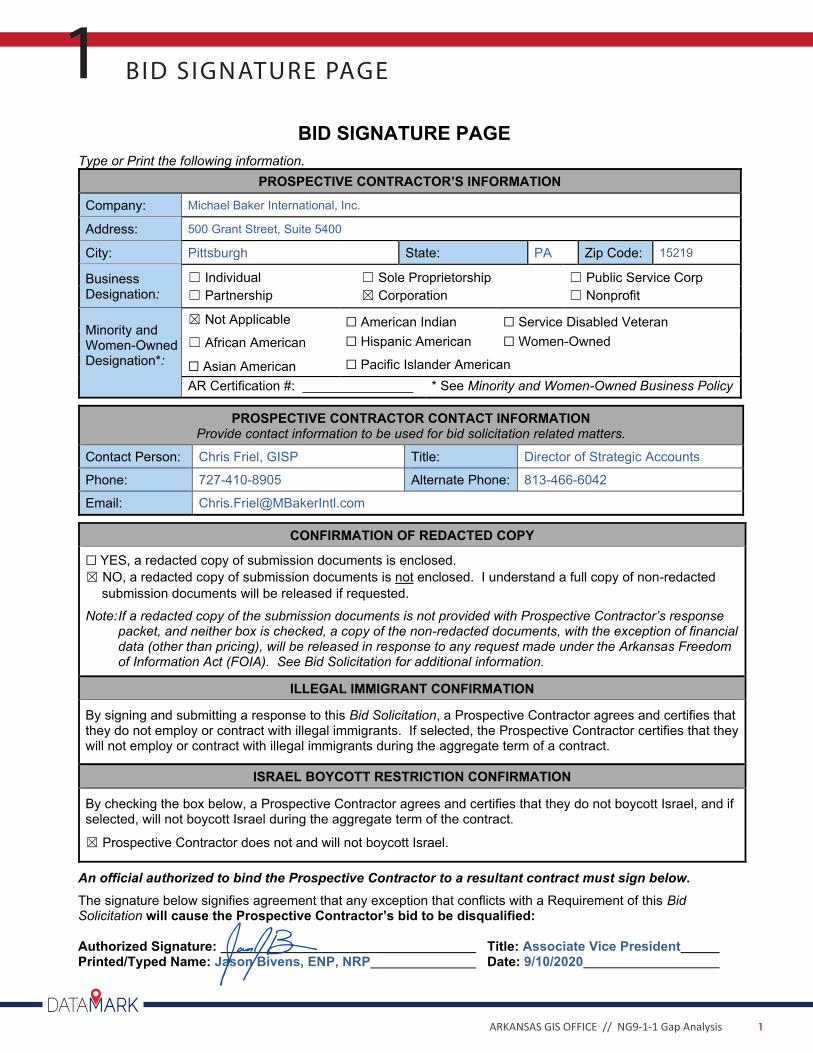
BID SIGNATURE PAGE1
BID SIGNATURE PAGE
Type or Print the following information. PROSPECTIVE CONTRACTOR’S INFORMATION
Company: Michael Baker International, Inc.
Address: 500 Grant Street, Suite 5400
City: Pittsburgh State: PA Zip Code: 15219
Business Designation:
☐ Individual ☐ Sole Proprietorship ☐ Public Service Corp ☐ Partnership ☒ Corporation ☐ Nonprofit
Minority and Women-Owned Designation*:
☒ Not Applicable ☐ American Indian ☐ Service Disabled Veteran ☐ African American ☐ Hispanic American ☐ Women-Owned
☐ Asian American ☐ Pacific Islander American AR Certification #: _______________ * See Minority and Women-Owned Business Policy
PROSPECTIVE CONTRACTOR CONTACT INFORMATION Provide contact information to be used for bid solicitation related matters.
Contact Person: Chris Friel, GISP Title: Director of Strategic Accounts
Phone: 727-410-8905 Alternate Phone: 813-466-6042
Email: [email protected]
CONFIRMATION OF REDACTED COPY
☐ YES, a redacted copy of submission documents is enclosed. ☒ NO, a redacted copy of submission documents is not enclosed. I understand a full copy of non-redacted
submission documents will be released if requested. Note: If a redacted copy of the submission documents is not provided with Prospective Contractor’s response
packet, and neither box is checked, a copy of the non-redacted documents, with the exception of financial data (other than pricing), will be released in response to any request made under the Arkansas Freedom of Information Act (FOIA). See Bid Solicitation for additional information.
ILLEGAL IMMIGRANT CONFIRMATION
By signing and submitting a response to this Bid Solicitation, a Prospective Contractor agrees and certifies that they do not employ or contract with illegal immigrants. If selected, the Prospective Contractor certifies that they will not employ or contract with illegal immigrants during the aggregate term of a contract.
ISRAEL BOYCOTT RESTRICTION CONFIRMATION
By checking the box below, a Prospective Contractor agrees and certifies that they do not boycott Israel, and if selected, will not boycott Israel during the aggregate term of the contract.
☒ Prospective Contractor does not and will not boycott Israel.
An official authorized to bind the Prospective Contractor to a resultant contract must sign below. The signature below signifies agreement that any exception that conflicts with a Requirement of this Bid Solicitation will cause the Prospective Contractor’s bid to be disqualified: Authorized Signature: Title: Associate Vice President Printed/Typed Name: Jason Bivens, ENP, NRP Date: 9/10/2020
2ARKANSAS GIS OFFICE // NG9-1-1 Gap Analysis
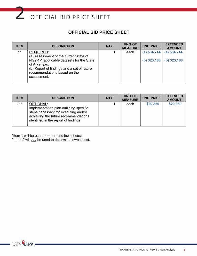
OFFICIAL BID PRICE SHEE T2OFFICIAL BID PRICE SHEET
ITEM DESCRIPTION QTY UNIT OF MEASURE UNIT PRICE EXTENDED
AMOUNT 1* REQUIRED:
(a) Assessment of the current state of NG9-1-1 applicable datasets for the State of Arkansas. (b) Report of findings and a set of future recommendations based on the assessment.
1 each (a) $34,744
(b) $23,180
(a) $34,744
(b) $23,180
ITEM DESCRIPTION QTY UNIT OF MEASURE UNIT PRICE EXTENDED
AMOUNT 2** OPTIONAL:
Implementation plan outlining specific steps necessary for executing and/or achieving the future recommendations identified in the report of findings.
1 each $20,850 $20,850
*Item 1 will be used to determine lowest cost. **Item 2 will not be used to determine lowest cost.
3ARKANSAS GIS OFFICE // NG9-1-1 Gap Analysis
DATAMARK, the public safety GIS team of Michael Baker, brings comprehensive, real-world expertise in police, fire, EMS and 9-1-1 leadership roles to Next Generation 9-1-1 transitions. The DATAMARK team leads the industry by shaping rules and legislation, and by building a suite of products and services that ensure accurate emergency response location data in life-critical situations. DATAMARK empowers its team and stakeholder partners to foster trusted relationships and cultivate data integrity for informed decision making. The team works with clients to solve their complex needs, from data quality checks and addressing to workflow analysis and more.
Benefits of partnering with DATAMARK include:
9 A well-known, go-to NG9-1-1 authority
9 An Esri Silver Partner focused on Public Safety, NG9-1-1, and overall GIS needs
9 A consultant with a large team of knowledgeable and seasoned staff including former 9-1-1 directors, emergency services personnel, and GIS practitioners; all dedicated to public safety and NG9-1-1
9 Experts in the fields of Public Safety and GIS with an extensive roster of certified Emergency Number Professionals (ENP), GIS Professional (GISP) and Project Management Professionals (PMP) including the President of the Geospatial Information Technology Association (GITA), as well as standards and best practices authoring working group chairs and participants at the National Emergency Number Association (NENA)
9 A dedicated and proven project management team who has extensive experience in highly accurate reliable GIS necessary for public safety and NG9-1-1 and the quality management practices needed to support them
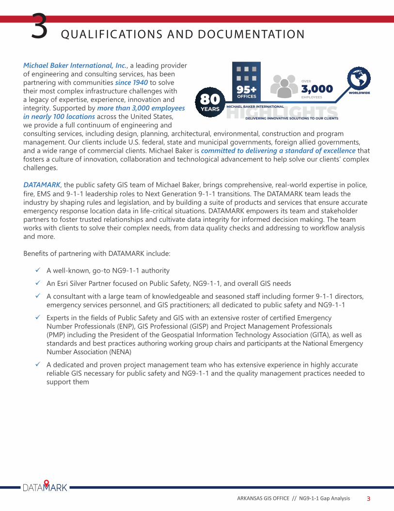
Michael Baker International, Inc., a leading provider of engineering and consulting services, has been partnering with communities since 1940 to solve their most complex infrastructure challenges with a legacy of expertise, experience, innovation and integrity. Supported by more than 3,000 employees in nearly 100 locations across the United States, we provide a full continuum of engineering and consulting services, including design, planning, architectural, environmental, construction and program management. Our clients include U.S. federal, state and municipal governments, foreign allied governments, and a wide range of commercial clients. Michael Baker is committed to delivering a standard of excellence that fosters a culture of innovation, collaboration and technological advancement to help solve our clients’ complex challenges.
QUALIFICATIONS AND DOCUMENTATION33,000EMPLOYEES
95+OFFICES
HIGHLIGHTSMICHAEL BAKER INTERNATIONAL80YEARS
OVER
DELIVERING INNOVATIVE SOLUTIONS TO OUR CLIENTS
WORLDWIDE
4ARKANSAS GIS OFFICE // NG9-1-1 Gap Analysis
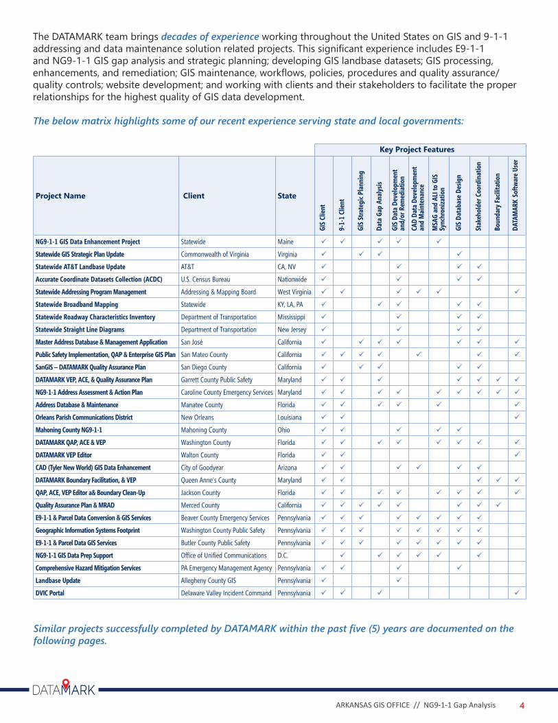
The DATAMARK team brings decades of experience working throughout the United States on GIS and 9-1-1addressing and data maintenance solution related projects. This significant experience includes E9-1-1 and NG9-1-1 GIS gap analysis and strategic planning; developing GIS landbase datasets; GIS processing, enhancements, and remediation; GIS maintenance, workflows, policies, procedures and quality assurance/quality controls; website development; and working with clients and their stakeholders to facilitate the proper relationships for the highest quality of GIS data development.
The below matrix highlights some of our recent experience serving state and local governments:
Project Name Client State
NG9-1-1 GIS Data Enhancement Project Statewide Maine 9 9 9 9 9
Statewide GIS Strategic Plan Update Commonwealth of Virginia Virginia 9 9 9 9
Statewide AT&T Landbase Update AT&T CA, NV 9 9 9 9
Accurate Coordinate Datasets Collection (ACDC) U.S. Census Bureau Nationwide 9 9 9 9
Statewide Addressing Program Management Addressing & Mapping Board West Virginia 9 9 9 9 9 9
Statewide Broadband Mapping Statewide KY, LA, PA 9 9 9 9 9
Statewide Roadway Characteristics Inventory Department of Transportation Mississippi 9 9 9 9
Statewide Straight Line Diagrams Department of Transportation New Jersey 9 9 9 9
Master Address Database & Management Application San José California 9 9 9 9 9 9 9
Public Safety Implementation, QAP & Enterprise GIS Plan San Mateo County California 9 9 9 9 9 9 9
SanGIS – DATAMARK Quality Assurance Plan San Diego County California 9 9 9 9 9
DATAMARK VEP, ACE, & Quality Assurance Plan Garrett County Public Safety Maryland 9 9 9 9 9 9 9
NG9-1-1 Address Assessment & Action Plan Caroline County Emergency Services Maryland 9 9 9 9 9 9 9 9 9
Address Database & Maintenance Manatee County Florida 9 9 9 9 9 9
Orleans Parish Communications District New Orleans Louisiana 9 9 9
Mahoning County NG9-1-1 Mahoning County Ohio 9 9 9 9 9
DATAMARK QAP, ACE & VEP Washington County Florida 9 9 9 9 9 9 9 9
DATAMARK VEP Editor Walton County Florida 9 9 9
CAD (Tyler New World) GIS Data Enhancement City of Goodyear Arizona 9 9 9 9 9 9
DATAMARK Boundary Facilitation, & VEP Queen Anne’s County Maryland 9 9 9 9 9
QAP, ACE, VEP Editor a& Boundary Clean-Up Jackson County Florida 9 9 9 9 9 9 9 9
Quality Assurance Plan & MRAD Merced County California 9 9 9 9 9 9 9 9
E9-1-1 & Parcel Data Conversion & GIS Services Beaver County Emergency Services Pennsylvania 9 9 9 9 9 9 9 9
Geographic Information Systems Footprint Washington County Public Safety Pennsylvania 9 9 9 9 9 9 9 9
E9-1-1 & Parcel Data GIS Services Butler County Public Safety Pennsylvania 9 9 9 9 9 9 9 9
NG9-1-1 GIS Data Prep Support Office of Unified Communications D.C. 9 9 9 9 9 9
Comprehensive Hazard Mitigation Services PA Emergency Management Agency Pennsylvania 9 9 9 9
Landbase Update Allegheny County GIS Pennsylvania 9 9
DVIC Portal Delaware Valley Incident Command Pennsylvania 9 9 9 9
GIS
Clie
nt
9-1-
1 Cl
ient
GIS
Stra
tegi
c Pla
nnin
g
Data
Gap
Ana
lysis
GIS
Data
Dev
elop
men
t an
d/or
Rem
edia
tion
CAD
Data
Dev
elop
men
tan
d M
aint
enan
ce
MSA
G an
d AL
I to
GIS
Sync
hron
izatio
n
GIS
Data
base
Des
ign
Stak
ehol
der C
oord
inat
ion
Boun
dary
Facil
itatio
n
DATA
MAR
K So
ftwar
e Us
er
Key Project Features
Similar projects successfully completed by DATAMARK within the past five (5) years are documented on the following pages.
5ARKANSAS GIS OFFICE // NG9-1-1 Gap Analysis
DATAMARK developed a Strategic Implementation Plan (SIP) for the Merced County GIS Master Road and Address Database (MRAD). The SIP set the stage for Merced County to implement a NG9-1-1 compliant, GIS data solution. The specific tasks for this effort included:
» Assessment of Current Public Safety System GIS Usage, Available GIS Data and Current Public Safety Data Governance
» Assessment of Public Safety GIS Data Quality, Data Gaps and Level of Effort to Fill the Gaps• Review of Public Safety GIS Data Maintenance and Data Sharing Workflows• Creation of Draft and Final Document
DATAMARK also performed data consolidation and remediation services that utilized the DATAMARK VEP and Address Comparison and Evaluation (ACE) tools. Specific tasks included:
» Schema Design - proposed and built consensus around a database schema design that met the business needs of the County and found compliance with the Esri Local Government Information Model (LGIM) and the NENA NG9-1-1 GIS Data Model.
» Data Completeness Assessment• Address Completeness Assessment - Address Comparison Evaluation (ACE) - Develop Master Address Database (MAD)• Road Centerline Completeness• Data Accuracy Assessment
In partnership with Esri, DATAMARK also performed ArcGIS enterprise migration services to address the installation upgrade and configuration of the ArcGIS Enterprise platform.
Merced County, CAGIS Master Road and Address Database Implementation Services
The DATAMARK team’s cross-disciplinary expertise in public safety and GIS, as well as the work they have been conducting in support of California’s NG9-1-1
initiative, makes them a true partner and leader in GIS innovation.- Gene Barrera, GIS Manager“ “
Contact/Reference: Project Duration/Completion:Gene Barrera, GIS [email protected]
January 2018 - December 2019
6ARKANSAS GIS OFFICE // NG9-1-1 Gap Analysis
Merced County, CAGIS Master Road and Address Database Implementation Services
Project Duration/Completion:
San Mateo County, CAPublic Safety GIS Data Implementation & Quality Assurance Plan
Contact/Reference: Project Duration/Completion:Dan BelvillePublic Safety Communications [email protected] / 650.363.4915
January 2018 - April 2018
DATAMARK developed a Public Safety GIS Data Implementation & Quality Assurance Plan (QAP) to set the stage for the San Mateo County Office of Public Safety Communications to implement a NG9-1-1 compliant, GIS data solution. The specific tasks for this effort included:
» Assessment of Current Public Safety System GIS Usage, Available GIS Data and Current Public Safety Data Governance
» Assessment of Public Safety GIS Data Quality, Data Gaps and Level of Effort to Fill the Gaps• Review of Public Safety GIS Data Maintenance and Data Sharing Workflows• Creation of Draft and Final Document
The QAP served as a roadmap for the successful development of NG9-1-1 data for PSC’s new Versaterm CAD system. The QAP also provided NENA standards summaries and background.
Furthermore, DATAMARK provided an enterprise GIS system architecture design that included a comprehensive needs assessment based on two rounds of departmental interviews and an implementation/migration plan for a proposed solution.
The project assessed the County of San Mateo’s business architecture (departmental workflows that currently use GIS or could benefit from the use of GIS); data architecture (existing and needed geospatial data to support the GIS-based workflows); and technical architecture (server infrastructure, cloud versus on-premise environment, hardware, software/licensing, mobile data collection, map-based web applications, etc.). The needs assessment documented the existing “as-is” environment for each of the business, data, and technical architectures and provided recommendations for the proposed “to be” environment for each of the business, data, and technical architectures.
7ARKANSAS GIS OFFICE // NG9-1-1 Gap Analysis
San Mateo County, CAPublic Safety GIS Data Implementation & Quality Assurance Plan
Mahoning County, OHGIS Services for Transition to NG9-1-1
Contact/Reference: Project Duration/Completion:Maggi McGee, E9-1-1 [email protected]
January 2019 - December 2019
DATAMARK provided a wide range of GIS services for implementation of Mahoning County’s Phase I & II compliant E9-1-1 system transition to NG9-1-1. Mahoning County includes approximately 170,000 properties, 110,200 addressable structures, seven different wireless carriers, 256 cell towers, and 2,162 miles of streets.
The team performed:
» Development of a testing plan to evaluate wireless carrier infrastructure and information for Phase II compliance, a database design compliant with NENA and Ohio Location Based Response System (LBRS) standards » Gap analysis of the county’s existing GIS road centerline and addressable structure data against current
digital oblique imagery » Field verification of data gaps to accurately map the county’s road centerlines, address points, cell
towers, and Emergency Service Zones (ESZs) » Implementation of an Addressing Webportal for the addressing authority’s assignment of new
addresses » Training of addressing authorities on Addressing Webportal » GIS data maintenance services provided for addresses, road centerlines, ESZs, and cell towers for LBRS
and NENA compliance » MSAG/ALI synchronization services » Fire hydrant collection coordination » PSAP GIS data distribution and loading support
DATAMARK utilized Esri’s ArcGIS platform with the Pictometry toolbar to perform the in-office gap analyses. Field verification included the utilization of Panasonic Toughbooks loaded with Esri ArcPad to collect digital photographs of each verified structure and hyperlinking them to each address point.
Utilizing Esri’s JavaScript API, DATAMARK developed a customized Addressing Web Portal application to assign new addresses in the GIS database in the County’s Esri ArcGIS Server for SQL server environment. Procedure manuals and on-site training services were provided to addressing authorities. The resultant database provides the county dispatch centers with the ability to display the 9-1-1 caller’s name, address, and specific emergency responder information, as well as the wireless caller’s coordinate location. Emergency responders will be able to quickly navigate to and locate individuals in need.
Original project initiation started November 2007. Due to repeated agreement renewals and requests for additional services, DATAMARK has an active agreement for services and staff augmentation with the County.
8ARKANSAS GIS OFFICE // NG9-1-1 Gap Analysis
Mahoning County, OHGIS Services for Transition to NG9-1-1
Commonwealth of Virginia, VAGIS Strategic Plan Update
Contact/Reference: Project Duration/Completion:Joe Sewash, VGIN [email protected]
2015
DATAMARK provided professional services to update the 2015 to 2020 statewide geographic information system (GIS) strategic plan for the Commonwealth of Virginia. The purpose of the project was to develop a five-year update of the Virginia GIS Strategic Plan to incorporate the emergence of NG9-1-1. The project stakeholders recognized that NG9-1-1 requires new roles, responsibilities, and coordination for GIS professionals at all levels of public safety communications group management. In addition, the project was tasked with ensuring that the strategic plan continued to align with local, regional, state agency, education, and private sector requirements.
The NG9-1-1 initiative will update the 9-1-1 service infrastructure to improve emergency response in an increasingly wireless and mobile society. Spatial data is one of the cornerstone components of a fully implemented NG9-1- 1 system. For the GIS community, this means an increased accuracy standard, a more frequent update cycle, entirely new public safety datasets and a regional footprint of data.
The services provided to the Commonwealth of Virginia included:
» Comprehensive stakeholder outreach program which included• Town hall meetings• Online survey• One-to-one interviews
» Analysis of the data collected from the stakeholder outreach » Update to the GIS strategic plan to incorporate Next Generation 9-1-1 (NG9-1-1) requirements
The updated GIS strategic plan directly supports NG9-1-1 by defining the new role that GIS must serve at both the state and local levels. At the local level, address authorities must begin evaluating workflow methodologies and business practices that support timely entry of new addresses into the GIS database. At the state level, new technologies need to be evaluated that support the timely collection, aggregation, and quality control of location data for use at the regional and local level.
9ARKANSAS GIS OFFICE // NG9-1-1 Gap Analysis
EQUAL OPPORTUNIT Y POLICY4
10ARKANSAS GIS OFFICE // NG9-1-1 Gap Analysis

DATAMARKGIS.COMMBAKERINTL.COM
Local Office: 1400 W. Markham Street, Suite 204, Little Rock, AR 72201