soil survey of waseca county, minnesota - natural resources
TRANSCRIPT

United StatesDepartment ofAgriculture
NaturalResourcesConservationService
Soil Survey ofWaseca County,Minnesota
In cooperation withMinnesota AgriculturalExperiment Station andBoard of Water and SoilResources

The Natural Resources Conservation Service (NRCS) is committed to making itsinformation accessible to all of its customers and employees. If you are experiencingaccessibility issues and need assistance, please contact our Helpdesk by phone at1-800-457-3642 or by e-mail at [email protected]. For assistancewith publications that include maps, graphs, or similar forms of information, you mayalso wish to contact our State or local office. You can locate the correct office andphone number at http://offices.sc.egov.usda.gov/locator/app.
NRCS Accessibility Statement

This publication consists of a manuscript and a set of soil maps. The information provided can be useful in planningthe use and management of small areas.
To find information about your area of interest, locate that area on the Index to Map Sheets. Note the number ofthe map sheet, and turn to that sheet.
Locate your area of interest on the map sheet. Note the map unit symbols that are in that area. Turn to theContents, which lists the map units by symbol and name and shows the page where each map unit is described.The map unit symbols and names also appear as bookmarks, which link directly to the appropriate page in thepublication.
The Contents shows which table has data on a specific land use for each soil map unit. Also see the Contents forother sections of this publication that may address your specific needs.
3
How To Use This Soil Survey

4
Additional information about the Nation’s natural resources is available on theNatural Resources Conservation Service homepage on the World Wide Web. Theaddress is http://www.nrcs.usda.gov.
This soil survey is a publication of the National Cooperative Soil Survey, a joint effortof the United States Department of Agriculture and other Federal agencies, Stateagencies including the Agricultural Experiment Stations, and local agencies. TheNatural Resources Conservation Service (formerly the Soil Conservation Service) hasleadership for the Federal part of the National Cooperative Soil Survey.
Major fieldwork for this soil survey was completed in 2000. Soil names anddescriptions were approved in 2001. Unless otherwise indicated, statements in thispublication refer to conditions in the survey area in 2000. This survey was madecooperatively by the Natural Resources Conservation Service, the MinnesotaAgricultural Experiment Station, and the Board of Soil and Water Resources. Thesurvey is part of the technical assistance furnished to the Waseca County Soil andWater Conservation District. The survey was partially funded by Waseca County. Otherassistance was provided by the Agricultural Extension Service, the MinnesotaGeological Survey, and the Minnesota Department of Natural Resources.
Soil maps in this survey may be copied without permission. Enlargement of thesemaps, however, could cause misunderstanding of the detail of mapping. If enlarged,maps do not show the small areas of contrasting soils that could have been shown at alarger scale.
The United States Department of Agriculture (USDA) prohibits discrimination in all ofits programs on the basis of race, color, national origin, gender, religion, age, disability,political beliefs, sexual orientation, and marital or family status. (Not all prohibited basesapply to all programs.) Persons with disabilities who require alternative means forcommunication of program information (Braille, large print, audiotape, etc.) shouldcontact the USDA’s TARGET Center at 202-720-2600 (voice or TDD).
To file a complaint of discrimination, write USDA, Director, Office of Civil Rights,Room 326W, Whitten Building, 14th and Independence Avenue SW, Washington, DC20250-9410, or call 202-720-5964 (voice or TDD). USDA is an equal opportunityprovider and employer.
Cover: Cropland and marshes in a nearly level to steep area of Reedslake, Lester, and Le Sueursoils in Waseca County.

5
Contents
How To Use This Soil Survey ................................. 3Foreword ................................................................. 9How This Survey Was Made ................................... 11General Nature of the Survey Area ......................... 12
History ................................................................ 12Industry and Transportation Facilities ................. 13Quaternary History and Glacial Landforms
of Waseca County ........................................ 13Climate ............................................................... 14
Formation and Classification of the Soils .......... 15Formation of the Soils ........................................ 15
Climate ........................................................... 15Living Organisms ........................................... 15Topography .................................................... 15Parent Material ............................................... 16Time ............................................................... 16
Classification of the Soils .................................... 17Table 1.—Classification of the Soils ............... 18
Soil Map Unit Descriptions .................................. 21GP—Pits, gravel-Udipsamments complex .......... 22L5A—Delft, overwash-Delft complex, 1 to 4
percent slopes ............................................. 22L13A—Klossner muck, depressional, 0 to 1
percent slopes ............................................. 23L14A—Houghton muck, depressional, 0 to 1
percent slopes ............................................. 24L15A—Klossner, Okoboji, and Glencoe soils,
ponded, 0 to 1 percent slopes ...................... 25L16A—Muskego, Blue Earth, and Houghton
soils, ponded, 0 to 1 percent slopes ............. 26L26B—Shorewood silty clay loam, 3 to 6
percent slopes ............................................. 27L36A—Hamel, overwash-Hamel complex, 1
to 4 percent slopes ...................................... 28L40B—Angus-Kilkenny complex, 2 to 6
percent slopes ............................................. 29L41C2—Lester-Kilkenny complex, 6 to 12
percent slopes, eroded ................................ 30L41D2—Lester-Kilkenny complex, 12 to 18
percent slopes, eroded ................................ 31L41E—Lester-Kilkenny complex, 18 to 25
percent slopes ............................................. 32L48A—Derrynane, overwash-Derrynane
complex, 1 to 4 percent slopes .................... 33
L49A—Klossner soils, depressional, 0 to 1percent slopes ............................................. 34
L50A—Houghton and Muskego soils,depressional, 0 to 1 percent slopes ............. 35
L51C2—Gladek silt loam, 6 to 12 percentslopes, eroded ............................................. 36
L56A—Muskego and Klossner soils, 0 to 1percent slopes, frequently flooded ............... 37
L57A—Medo muck, depressional, 0 to 1percent slopes ............................................. 38
L63A—Klossner muck, lake plain,depressional, 0 to 1 percent slopes ............. 39
L64A—Tadkee-Tadkee, depressional,complex, 0 to 2 percent slopes .................... 40
L73A—Blue Earth mucky silty clay loam,depressional, 0 to 1 percent slopes ............. 41
L74A—Estherville sandy loam, terrace,0 to 2 percent slopes.................................... 42
L75B—Barrington silt loam, 2 to 6 percentslopes .......................................................... 43
L76B—Dickinson fine sandy loam, 1 to 6percent slopes ............................................. 43
L77A—Brownton silty clay loam, 0 to 2percent slopes ............................................. 44
L78A—Canisteo clay loam, 0 to 2 percentslopes .......................................................... 45
L79B—Clarion loam, 2 to 5 percentslopes .......................................................... 47
L80C2—Lester loam, 6 to 12 percent slopes,eroded ......................................................... 48
L80D2—Lester loam, 12 to 18 percentslopes, eroded ............................................. 49
L81A—Cordova clay loam, 0 to 2 percentslopes .......................................................... 50
L82A—Marna silty clay loam, 0 to 2 percentslopes .......................................................... 51
L83A—Webster clay loam, 0 to 2 percentslopes .......................................................... 52
L84A—Glencoe clay loam, depressional, 0 to1 percent slopes .......................................... 53
L85A—Nicollet clay loam, 1 to 3 percentslopes .......................................................... 54
L86A—Madelia silty clay loam, 0 to 2 percentslopes .......................................................... 55

6
L87A—Kingston silty clay loam, 1 to 3percent slopes ............................................. 56
L88A—Lura silty clay, depressional, 0 to 1percent slopes ............................................. 56
L89A—Guckeen silty clay loam, 0 to 3percent slopes ............................................. 57
L90A—Le Sueur clay loam, 0 to 3 percentslopes .......................................................... 58
L91A—Mazaska silty clay loam, 0 to 2percent slopes ............................................. 59
L92A—Darfur loam, 0 to 2 percent slopes .......... 60L93A—Muskego muck, depressional, 0 to 1
percent slopes ............................................. 61L94A—Lowlein fine sandy loam, terrace, 0 to
3 percent slopes .......................................... 62L95E—Hawick gravelly coarse sandy loam,
12 to 25 percent slopes ................................ 63L96B—Estherville-Hawick complex, 2 to 6
percent slopes ............................................. 64L97C—Hawick-Estherville complex, 6 to 12
percent slopes ............................................. 65L98A—Crippin-Nicollet complex, 1 to 3
percent slopes ............................................. 66L99B—Clarion-Swanlake complex, 2 to 6
percent slopes ............................................. 67L100B—Clarion-Estherville complex, 2 to 6
percent slopes ............................................. 68L101C2—Omsrud-Hawick-Storden complex,
6 to 12 percent slopes, eroded ..................... 69L101D2—Omsrud-Hawick-Storden complex,
12 to 18 percent slopes, eroded ................... 70L102C2—Omsrud-Storden complex, 6 to 12
percent slopes, eroded ................................ 72L102D2—Omsrud-Storden complex, 12 to 18
percent slopes, eroded ................................ 73L103A—Fieldon-Canisteo complex, 0 to 2
percent slopes ............................................. 74L105C2—Lester-Hawick complex, 6 to 12
percent slopes, eroded ................................ 75L105D2—Lester-Hawick complex, 12 to 18
percent slopes, eroded ................................ 77L106C2—Lester-Storden complex, 6 to 12
percent slopes, eroded ................................ 78L106D2—Lester-Storden complex, 12 to 18
percent slopes, eroded ................................ 79
L107A—Canisteo-Glencoe, depressional,complex, 0 to 2 percent slopes .................... 80
L108A—Cordova-Rolfe, depressional,complex, 0 to 2 percent slopes .................... 82
L109A—Marna-Barbert, depressional,complex, 0 to 2 percent slopes .................... 82
L110E—Lester-Ridgeton complex, 18 to 25percent slopes ............................................. 83
L110F—Lester-Ridgeton complex, 25 to 45percent slopes ............................................. 85
L111A—Nicollet silty clay loam, 1 to 3percent slopes ............................................. 86
L112A—Webster silty clay loam, 0 to 2percent slopes ............................................. 87
L113B—Reedslake loam, 2 to 5 percentslopes .......................................................... 88
L114A—Hanlon fine sandy loam, 0 to 3percent slopes, rarely flooded ...................... 89
L115A—Brownton-Lura, depressional,complex, 0 to 2 percent slopes .................... 90
L116A—Le Sueur-Lerdal complex, 1 to 3percent slopes ............................................. 90
L117C2—Omsrud loam, 6 to 12 percentslopes, eroded ............................................. 91
L118A—Rushriver fine sandy loam, 0 to 1percent slopes, frequently flooded ............... 93
L119B—Angus loam, 2 to 5 percent slopes........ 94L120A—Good Thunder silty clay loam,
0 to 3 percent slopes.................................... 95L121B—Clarion clay loam, 2 to 5 percent
slopes .......................................................... 95L122B—Reedslake-Estherville complex,
2 to 6 percent slopes.................................... 96L123A—Belleville sandy loam, 0 to 2 percent
slopes .......................................................... 97L124A—Glencoe mucky clay loam,
depressional, 0 to 1 percent slopes ............. 98L125A—Hanlon, rarely flooded-Coland,
occasionally flooded, complex, 0 to 3percent slopes ............................................. 99
L126A—Coland silty clay loam, 0 to 2percent slopes, occasionally flooded.......... 100
L127A—Coland silty clay loam, channeled,0 to 2 percent slopes, frequentlyflooded ....................................................... 101

7
L128A—Mazaska-Rolfe, depressional,complex, 0 to 2 percent slopes .................. 102
L129B—Terril loam, 2 to 6 percentslopes ........................................................ 103
L130A—Okoboji mucky silty clay loam,depressional, 0 to 1 percent slopes ........... 103
M-W—Water, miscellaneous ............................ 104U3B—Udorthents, loamy (cut and fill land),
0 to 6 percent slopes.................................. 105W—Water ......................................................... 105Table 2.—Acreage and Proportionate Extent
of the Soils ................................................. 105Use and Management of the Soils .................... 107
Interpretive Ratings .......................................... 107Rating Class Terms ...................................... 107Numerical Ratings ........................................ 107
Agronomy ......................................................... 107Cropland Management Considerations ........ 107Crop Yield Estimates .................................... 109Land Capability Classification ...................... 109Prime Farmland ........................................... 110Windbreaks and Environmental Plantings .... 111
Windbreak Suitability Groups ................... 111Recreation ........................................................ 112Wildlife Habitat ................................................. 113Engineering ...................................................... 114
Building Site Development ........................... 115Agricultural Waste Management .................. 116Construction Materials ................................. 119Water Management ...................................... 119
Table 3.—Cropland ManagementConsiderations ........................................... 121
Table 4.—Land Capability and Yields perAcre of Crops and Pasture ......................... 150
Table 5.—Prime Farmland ................................ 158Table 6.—Windbreaks and Environmental
Plantings .................................................... 159Table 7.—Windbreak Suitability Groups ........... 221Table 8a.—Recreation ...................................... 234Table 8b.—Recreation ...................................... 263Table 9.—Wildlife Habitat .................................. 288Table 10a.—Building Site Development ............ 303Table 10b.—Building Site Development ............ 332Table 11a.—Agricultural Waste
Management .............................................. 366Table 11b.—Agricultural Waste
Management .............................................. 410Table 12a.—Construction Materials .................. 451Table 12b.—Construction Materials .................. 476Table 13.—Water Management ........................ 508
Soil Properties .................................................... 539Engineering Index Properties ........................... 539Physical and Chemical Properties .................... 540Water Features ................................................. 541Soil Features .................................................... 543Table 14.—Engineering Index Properties ......... 544Table 15.—Physical Properties of the
Soils ........................................................... 600Table 16.—Chemical Properties of the
Soils ........................................................... 635Table 17.—Soil Moisture Status by Depth ........ 661Table 18.—Flooding Frequency and
Duration ..................................................... 698Table 19.—Ponding Frequency, Duration,
and Depth .................................................. 717Table 20.—Soil Features .................................. 740
References .......................................................... 753Glossary .............................................................. 755

8
Where To Get Updated Information
The soil properties and interpretations included in this survey were current as ofMarch 2003. The most current information is available through the NRCS Soil DataMart Website at http://soildatamart.nrcs.usda.gov/
Additional information is available from the Natural Resources Conservation Service(NRCS) Field Office Technical Guide at Waseca, Minnesota, or online atwww.nrcs.usda.gov/technical/efotg. The data in the Field Office Technical Guide areupdated periodically.
Additional information about soils and about NRCS is available through theMinnesota NRCS Web page at www.mn.nrcs.usda.gov.
For further information, please contact:
USDA, Natural Resources Conservation ServiceWaseca Field Office212 15th Avenue NE, Suite 5Waseca, MN 56093Phone: 507-835-4831

9
This soil survey contains information that affects land use planning in this surveyarea. It contains predictions of soil behavior for selected land uses. The survey alsohighlights soil limitations, improvements needed to overcome the limitations, and theimpact of selected land uses on the environment.
This soil survey is designed for many different users. Farmers, foresters, andagronomists can use it to evaluate the potential of the soil and the management neededfor maximum food and fiber production. Planners, community officials, engineers,developers, builders, and home buyers can use the survey to plan land use, select sitesfor construction, and identify special practices needed to ensure proper performance.Conservationists, teachers, students, and specialists in recreation, wildlifemanagement, waste disposal, and pollution control can use the survey to help themunderstand, protect, and enhance the environment.
Various land use regulations of Federal, State, and local governments may imposespecial restrictions on land use or land treatment. The information in this report isintended to identify soil properties that are used in making various land use or landtreatment decisions. Statements made in this report are intended to help the land usersidentify and reduce the effects of soil limitations on various land uses. The landowner oruser is responsible for identifying and complying with existing laws and regulations.
Great differences in soil properties can occur within short distances. Some soils areseasonally wet or subject to flooding. Some are shallow to bedrock. Some are toounstable to be used as a foundation for buildings or roads. Clayey or wet soils arepoorly suited to use as septic tank absorption fields. A high water table makes a soilpoorly suited to basements or underground installations.
These and many other soil properties that affect land use are described in this soilsurvey. The location of each soil is shown on the soil maps. Each soil in the survey areais described, and information on specific uses is given. Help in using this publicationand additional information are available at the local office of the Natural ResourcesConservation Service or the Cooperative Extension Service.
William HuntState ConservationistNatural Resources Conservation Service
Foreword

Location of Waseca County and MLRA 103 in Region 10

11
How This Survey Was MadeThis survey was made to provide updated
information about the soils and miscellaneous areas inthe survey area, which is in Region 10 and in MajorLand Resource Area 103. Region 10 is anadministrative division of the Natural ResourcesConservation Service. Major land resource areas(MLRAs) are geographically associated land resourceunits that share a common land use, elevation andtopography, climate, water, soils, and vegetation(USDA, 1981). Waseca County is a subset of MajorLand Resource Area 103 (Central Iowa and MinnesotaTill Prairies). Map unit design and the detailed soildescriptions are based on the occurrence of each soilthroughout the MLRA. In some cases a soilcomponent may be referred to that does not occur inthe Waseca County subset but that is representative ofthe MLRA.
The information includes a description of the soilsand miscellaneous areas and their location and adiscussion of their properties and the subsequenteffects on suitability, limitations, and management forspecified uses. Soil scientists used information fromthe previously published survey of Waseca County(Cummins, 1961). In the field, the soil scientistsobserved the steepness, length, and shape of theslopes; the general pattern of drainage; the kinds ofcrops and native plants; and the kinds of bedrock.They dug many holes to study the soil profile, which is
the sequence of natural layers, or horizons, in a soil.The profile extends from the surface down into theunconsolidated material in which the soil formed. Theunconsolidated material is devoid of roots and otherliving organisms and has not been changed by otherbiological activity.
The soils and miscellaneous areas in the surveyarea are in an orderly pattern that is related to thegeology, landforms, relief, climate, and naturalvegetation of the area. Each kind of soil andmiscellaneous area is associated with a particular kindof landscape or segment of the landscape. Byobserving the soils and miscellaneous areas in thesurvey area and relating their position to specificsegments of the landscape, soil scientists develop aconcept, or model, of how the soils were formed. Thus,during mapping, this model enables the soil scientiststo predict with a considerable degree of accuracy thekind of soil or miscellaneous area at a specific locationon the landscape.
Individual soils on the landscape commonly mergeinto one another as their characteristics graduallychange. To construct an accurate map, however, soilscientists must determine the boundaries between thesoils. They can observe only a limited number of soilprofiles. Nevertheless, these observations,supplemented by an understanding of the soil-vegetation-landscape relationship, are sufficient toverify predictions of the kinds of soil in an area and todetermine the boundaries.
Soil Survey of
Waseca County, MinnesotaBy Douglas E. Miller, Natural Resources Conservation Service
Fieldwork by John F. Beck, April L. Gansen, Peter R. Hartman, Thomas C. Jackson,Kenneth D. Matzdorf, and Douglas E. Miller, Natural Resources Conservation Service
Correlation by Allan G. Giencke, Natural Resources Conservation Service
United States Department of Agriculture, Natural Resources Conservation Service,in cooperation with the Waseca Soil and Water Conservation District and the MinnesotaAgricultural Experiment Station
12 Soil Survey of
Soil scientists recorded the characteristics of thesoil profiles that they studied. They noted soil color,texture, size and shape of soil aggregates, kind andamount of rock fragments, distribution of plant roots,soil reaction, and other features that enable them toidentify soils. After describing the soils in the surveyarea and determining their properties, the soilscientists assigned the soils to taxonomic classes(units). Taxonomic classes are concepts. Eachtaxonomic class has a set of soil characteristics withprecisely defined limits. The classes are used as abasis for comparison to classify soils systematically.Soil taxonomy, the system of taxonomic classificationused in the United States, is based mainly on the kindand character of soil properties and the arrangementof horizons within the profile. After the soil scientistsclassified and named the soils in the survey area, theycompared the individual soils with similar soils in thesame taxonomic class in other areas so that theycould confirm data and assemble additional databased on experience and research.
While a soil survey is in progress, samples of someof the soils in the area generally are collected forlaboratory analyses and for engineering tests. Soilscientists interpret the data from these analyses andtests as well as the field-observed characteristics andthe soil properties to determine the expected behaviorof the soils under different uses. Interpretations for allof the soils are field tested through observation of thesoils in different uses and under different levels ofmanagement. Interpretations are modified asnecessary to fit local conditions, and some newinterpretations are developed to meet local needs.Data are assembled from other sources, such asresearch information, production records, and fieldexperience of specialists. For example, data on cropyields under defined levels of management areassembled from farm records and from field or plotexperiments on the same kinds of soil.
Predictions about soil behavior are based not onlyon soil properties but also on such variables asclimate and biological activity. Soil conditions arepredictable over long periods of time, but they are notpredictable from year to year. For example, soilscientists can predict with a fairly high degree ofaccuracy that a given soil will have a zone in which thesoil moisture status is wet within certain depths inmost years, but they cannot predict that this zone willalways be at a specific level in the soil on a specificdate.
After soil scientists located and identified thesignificant natural bodies of soil in the survey area,they drew the boundaries of these bodies on aerialphotographs and identified each as a specific map
unit. Aerial photographs show trees, buildings, fields,roads, and rivers, all of which help in locatingboundaries accurately.
The descriptions, names, and delineations of thesoils in this survey area may not fully agree with thosein adjacent survey areas. Differences are the result ofa better knowledge of soils, modifications in seriesconcepts, or variations in the intensity of mapping or inthe extent of the soils in the survey areas.
General Nature of the Survey AreaWaseca County is in the northwestern part of the
Central Iowa and Minnesota Till Prairies (MLRA 103).The county has a total area of 277,000 acres, of which5,067 acres consists of natural bodies of water.Waseca, the county seat, is the largest community. In1990, Waseca had a population of 8,385 and WasecaCounty had a population of 18,500.
History
Waseca County was inhabited by the Winnebagoband of Lakota Indians, generally known as Sioux,when the first settlers arrived. The Lakota word“Waseca” means “rich ground.” The county wasopened to legal settlement in 1851. In that year theSioux relinquished title to a large area of land west ofthe Mississippi River.
From 1855 to 1857, the area was part of SteeleCounty; on February 27, 1857, Waseca County wasorganized. Most of the early settlers who came to thecounty were from the eastern part of the United Statesand Canada. They were mainly of Irish, German, andScandinavian descent. The town of Wilton was theoriginal county seat, but in 1870 the county seat wasmoved to its present location in Waseca. Of the 13original townsites established, 7 remain. They areWaseca, Janesville, New Richland, Waldorf, Matawan,Alma City, and Otisco (Childs, 1905).
The border between two major ecologicalcommunities runs through Waseca County. The prairiegrasslands and hardwood forests were native tovarious parts of the county; transitional areas of oakwoods openings occurred between these two landtypes. Generally, the prairie grasslands dominated thesouthwestern and central parts the county. The prairieand forests included numerous lakes, streams, rivers,and marshes. The soils formed in glacial deposits thatwere high in natural fertility. Because of the naturalfertility of the soils, farming developed and prosperedin the area. In 1859, the first wheat crop washarvested. By 1886, 1,523 farms were raising wheat,oats, corn, barley, rye, potatoes, beans, hay, flax seed,

Waseca County, Minnesota 13
grapes, timothy seed, clover seed, and apples(Rutledge, 1988). Currently, most of the land area inthe county is farmland. In 2000, approximately 84percent of the farmland was used for crops. Corn andsoybeans are the principal grain crops, and hogs,dairy cattle, and poultry are the principal livestockenterprises in the county.
Industry and Transportation Facilities
Agriculture and supporting businesses are the mainindustry in Waseca County. Other industries includeprinting, electronics, and small businesses.
Waseca is approximately 65 miles from Minneapolisand St. Paul and about 50 miles from Rochester. Thecounty has a well developed network of roadways.U.S. Highway 14 and Minnesota Highway 30 bothcross the county from east to west. MinnesotaHighway 13 and Waseca County Road 3 are the mainnorth-south routes. Other county and township roadsmake all areas of the county accessible. A railroad lineruns east and west, intersecting the towns of Wasecaand Janesville. A branch line goes south from Wasecathrough New Richland.
Quaternary History and GlacialLandforms of Waseca County
By Barbara A. Lusardi, geologist, Minnesota Geological Survey
During the Pleistocene Epoch, 2 million to 10,000years ago, glaciers advanced and retreated acrossMinnesota. In Waseca County, all of the glacialdeposits near the land surface were deposited duringthe last major glacial episode in Minnesota—the lateWisconsin glaciation—about 14,000 years ago. At thattime, the Des Moines lobe extended through theMinnesota lowland to its maximum extent: south toDes Moines, Iowa, and east to the border of Steeleand Dodge Counties in Minnesota. The Bemis morainemarks its terminal margin. By about 12,000 years ago,ice was no longer active in this region, althoughstagnant, melting ice still covered much of the county.After the remaining glacial ice in the region completelymelted, modern soils developed and alluviumaccumulated in modern streams.
The preglacial bedrock surface across the countyconsists of Ordovician sedimentary rocks (500-450million years old). This surface is buried by 70 to 350feet (21 to 106 meters) of glacial sediment(Bloomgren, 1993).
Soils in Waseca County formed mainly in glacial till,which is an unsorted mix of rock debris depositeddirectly by ice. The till is light olive brown to yellowish
brown, calcareous, pebbly loam. With each advance,the glaciers deposited sediments, the lithology ofwhich indicates the direction of the glacial advance. Tillin Waseca County contains (as represented in thevery coarse sand fraction) an average of 39 percentcrystalline rocks (granitic, mafic igneous, andmetamorphic), 24 percent carbonate rocks, and 37percent shale (Lusardi, 1997). The presence of grayshale indicates that the ice carried debris derived fromrocks in the northwest, particularly the Pierre Shale inNorth Dakota. Because all of the till at the surface issimilar in color, texture, and lithology, it is the glaciallandforms that provide the depositional history of theice in this region.
Circular (in places coalescing), flat-topped hills andirregular, rounded hummocks form the dominantlandscape across the county. Hilltops range fromabout 10 to 30 feet (3 to 9 meters) above the base,and abundant depressions and channels, occupied byswamps, separate the hills. The hills formed whenunsorted supraglacial debris slumped into holes in thestagnant ice. When the ice melted, the debrisremained as hills. This process is known astopographic inversion because what had been a holein the ice is now a hill on the ground. Where composedof fine grained lacustrine sediment, the circular, flat-topped landforms may be called ice-walled lake plains.In Waseca County, however, little lacustrine sedimentwas discovered (Lusardi, 1997). Instead of becominglakes in the ice, these holes served as glacial “stormdrains,” collecting anything that washed into them. Thethicker the stagnant ice, the deeper the possible hole;the more debris on the ice, the higher the hill. There iswithin the county a gradation from south to north (anda less distinct gradation from west to east) fromcircular, flat-topped hills that have low relief (about 10feet, or 3 meters) to moderate relief (about 20 feet, or6 meters) to high relief (about 30 feet, or 9 meters).Apparently, the ice, the debris on top of the ice, or bothwere thinnest in the central part of the county andthicker to the north and east.
To the north and east (north of Everson Lake andthe eastern parts of Otisco and New RichlandTownships), the circular, flat-topped hills grade intoirregular, rounded hummocks. The formation ofrounded hummocks instead of circular, flat-topped hillsis related to the stability of the stagnant-iceenvironment. In the central part of the county, the icewasted in place. Closer to the ice margin, however,water flowing from and along the margin underminedthe ice and caused collapse and redistribution of thesediment.
Through the central and southern parts of thecounty, till forms a relatively level to gently undulating

14
plain. Circular landforms on the plain, althoughobvious on aerial photographs, do not have enoughrelief (less than 10 feet, or less than 3 meters) toappear on a topographic base. These sediments areinterpreted as till deposited by ice that had little or nosupraglacial till on top (Lusardi, 1997).
In the western part of the county, the till plain iscovered by a veneer of silt and clay that was depositedin Glacial Lake Minnesota, which covered parts ofWatonwan, Blue Earth, Faribault, and WasecaCounties. In Waseca County, evidence of the lake isobscure. The lake sediment is thin, almost entirelywithin the zone of soil development, and, therefore, itis difficult to identify. In addition, the distribution of thelake sediment is patchy; exposures in shallowdrainage basins and adjacent to stream valleys arepredominantly till.
There apparently were two outlets of the lakethrough Waseca County—one to the north and one tothe east. The northern outlet was a network ofchannels that drained through what is now LakeElysian into the extensive channel system to the north.Eventually, this drainage flowed eastward into theprecursor of the Cannon River in Rice County(Patterson and Hobbs, 1995). The existence of aneastern outlet in the county is more speculative. Waterfrom the lake may have drained through what is nowthe Le Sueur River valley (Lusardi, 1997).
The Le Sueur River, which now flows west into theMinnesota River, once flowed east in channelsdeveloped above and below the glacier and along theice margin. Several sharp bends in the river representdrainage paths occupied at different times during thelate Wisconsin. The Le Sueur River valley west of theconfluence with the Little Le Sueur River (sec. 7, T.106 N., R. 22 W.) is probably a remnant of a previoussubglacial drainage active when the ice margin was inthe eastern part of the county. Sand and graveloutwash deposits from this earlier drainage faneastward from an abrupt beginning to the west againstthe northeast-southwest-trending ice margin (northfrom sec. 3, T. 105 N., R. 23 W., following the Le SueurRiver valley, and continuing north to sec. 1, T. 107 N.,R. 21 W.). An indistinct pattern of low-relief linearridges on the surface of the fan suggests that it mayhave been deposited on stagnant ice. The ridgesrepresent sediment-filled channels cut into the ice that,because of topographic inversion, appear as ridges onthe land surface (Patterson, 1994). Much of thisoutwash fan was buried under as much as 50 feet (15
meters) of till deposited when the ice continued toadvance eastward.
A narrow band of sand and gravel within the buriedfan is exposed in a network of channels, one of whichis now occupied by the Little Le Sueur River (secs. 1to 5 and 8 to 12, T. 106 N., R. 22 W.). The sand andgravel can be traced eastward to where the Little LeSueur River joins the Straight River in Steele County,Minnesota. The meltwater that carved these channelsis probably related to the draining of Glacial LakeMinnesota. Water from the lake presumably flowedthrough channels in the stagnant ice and was funneledinto previously excavated lows and channels. Eskers—elongate ridges of stratified sand and gravel—are insome of the channels. These ridges are deposits fromstreams that flowed in ice-walled channels or tunnelson or under the glacier.
Farther west, the river bends to the southwest. Thissegment occupies a broad, indistinct trough thatextends southwest through Silver Lake and northeastthrough Clear Lake. There is little topographicexpression of this feature, because supraglacialsediment collapsed and filled the channel. Itspresence is inferred from the alignment of low areas,lakes, and the river valley (Lusardi, 1997). This trough,as well as other indistinct troughs along the Le SueurRiver valley, may correspond to short-lived positions ofthe ice margin.
Climate
Waseca County is in the interior of the greatlandmass of North America. This landmass, heated insummer by a sun that is at a high altitude and thatshines for long hours, makes the summers warm andpleasant. In contrast, winters are cold, and the landcools rapidly as a result of less effective solar heating.Reduced solar heating in winter is caused by a lowsun angle, increased reflection of solar radiation bysnow, and shortened day length. Northerly winds fromCanada bring in additional frigid air.
Precipitation in Waseca County frequently occursas snowstorms during the winter and as showers(which are often heavy) during the warmer monthswhen warm moist air moves up from the south. Thetotal annual rainfall is normally adequate for corn andsoybeans.
Specific data on temperature and precipitation forthe survey area are available on the Web at www.wcc.nrcs.usda.gov/climate/climate-map.html.

15
This section relates the soils in the survey area tothe major factors of soil formation and describes thesystem of soil classification.
Formation of the SoilsThe natural environment consisting of the thin
mantle of material we refer to as soil is dynamic andever changing. Soils are affected by soil-formingprocesses involving the interaction of five majorfactors. These factors are parent material, climate,living organisms, topography, and time (Jenny, 1941).The interaction of these factors generates complexchemical, physical, and biological processes. As aresult of these soil-forming processes acting over time,definitive layers, or horizons, develop in the soil.
Climate
Climate is probably the most influential soil-formingfactor (Brady, 1974). Moisture and temperatureinfluence the rate of chemical and physicalreactions and the growth of microbes in the soil.Native vegetation (for example, hardwood forest orprairie grass) also is influenced by climate.Rainwater eventually enters the soil, dissolvingsoluble soil materials and transporting them to otherparts of the soil profile. This process is known asleaching.
Waseca County has a cool, subhumid, continentalclimate characterized by wide variations intemperature from summer to winter. During the winter,the soil-forming processes are essentially dormant.The soil is frozen to a depth of 2 to 3 feet. The depth towhich frost penetrates the soil is dependent on theamount of snowfall in late fall and early winter.
The climate is fairly uniform across the survey area.Local variations are caused by relief, aspect, andparent material. For example, south- and west-facingslopes tend to be warmer and drier than north- andeast-facing slopes. Coarse textured soils tend to bewarmer and droughtier than loamy or clayey soils.
Living Organisms
Plants and animals provide the organic material forthe formation of humus. Roots, leaves, and stemsprovide most of this material. Climate, parent material,and topography affect plant species. Micro-organisms,which are affected by the same factors, perform manyvital functions in the soil. Micro-organisms transformorganic material into humus, convert forms of nitrogen,and protect plant roots from disease-causingorganisms. Micro-organisms generally includebacteria, fungi, and protozoa. Micro-organisms occurin the A horizon, or topsoil, which is the part of the soilprofile that has the largest content of organic matter(USDA, 1999). Plants impact soil chemistry. Nativeprairie grasses have extensive root systems that resultin a relatively large amount of accumulated humus,which is less acid than the material formed underhardwood forests. Soils that formed under hardwoodforests accumulate less humus that is more acid.
Waseca County is situated where the big woods(hardwood forests) gave way to the native prairiegrasslands. Transitional areas of scattered oak standswithin areas of grassland were also part of the nativevegetation. The original prairies no longer exist in thecounty. A number of remnant woodlots from theoriginal “big woods” still exist.
Human activity has also influenced thedevelopment of soils. Humans have removed naturalvegetation; accelerated soil erosion by leaving the soilsurface bare; changed the drainage of some soils; andchanged the natural topography by removing soilmaterial in some places and filling in other areas.
Topography
Topography, or relief, refers to position on thelandscape. Differences in landscape setting affect soilformation by impacting the amount of rainfall that runsoff or onto a particular site. Storden, Lester,Reedslake, Le Sueur, Cordova, and Glencoe soilsformed in the same parent material—New Ulm Till—
Formation and Classification of the Soils

16 Soil Survey of
but have different characteristics as a result of the soil-forming processes relative to their position on thelandscape. Storden soils occur on the most convexparts of the hillslope (the shoulder). Because theyhave a high rate of runoff, a relatively small amount ofrainfall or snowmelt enters the soil. They exhibit onlyminimal development of distinct horizons becausecalcium carbonate has not been allowed to leachdownward through the profile. Storden soils, therefore,have calcium carbonate at the surface and have arelatively low content of organic matter. Lester andReedslake soils are on the less convex parts of thehillslope (the backslope). Less runoff occurs in theseareas, and more water infiltrates the soil. As a result,calcium carbonate is leached downward in the soilprofile. This “weathering” of the soil profile results inthe development of soil horizons. Lester soils are onslopes of 6 percent or more, and Reedslake soils haveslopes ranging from 2 to 5 percent. Le Sueur soils, onnearly level, slightly convex summits of hills or slightrises in broad flat areas, have an even lower runoffrate and higher rate of water infiltration than theReedslake soils. Cordova soils are in nearly level orslightly concave positions. In most years Cordova soilsbecome saturated with water for parts of the growingseason. Glencoe soils are in closed depressions.There is essentially no runoff, and a great amount ofwater runs into the depressions. Glencoe soils arenaturally saturated with water for nearly all of thegrowing season and have standing water on thesurface for part of the season.
Extreme differences in the amount of water in thesoil affect the kind and intensity of biological andchemical processes in the soil. Different species ofplants and micro-organisms live in areas where thesoil is saturated with water (such as areas of Glencoesoils) than in areas where water runs off or percolatesthrough the soil (such as areas of Storden or Lestersoils). Many tree species do not grow well on soilswhere water is at or near the surface for much of thegrowing season. On the other hand, reeds and sedgesrequire sites that are saturated with water at or nearthe surface during the same period.
Parent Material
Parent material is the physical material in which thesoil forms. Parent material determines importantphysical properties of the soil, such as the ability tostore water for plants and the ability to transmit water.Parent material also largely determines the ability tosupply important nutrients to plants, such as calcium,phosphorus, and potassium. The inherent physical andchemical properties are related, to a large extent, to
the percentage of sand, silt, and clay in the parentmaterial. Soils that formed in parent materials with ahigh content of silt have a high capacity to store waterfor plants. Soils that formed in parent materials with ahigh content of silt and clay have a high capacity tostore nutrients for plants. Soils that formed in parentmaterials with a high content of sand have a lowcapacity to store water and nutrients.
The soils of Waseca County formed primarily inparent materials transported and modified by ice andwater. Glacial till is the most common parent materialin the county. Glacial till is an unsorted mixture ofsand, silt, clay, gravel, cobbles, and boulders. Glacierswith origins in Canada transported loamy, calcareoustill into Waseca County. Soils that formed in loamy,calcareous glacial till include Glencoe, Canisteo,Webster, Nicollet, Clarion, Omsrud, Storden, Cordova,Le Sueur, Angus, Reedslake, and Lester soils. Insome areas of the county, parent material wasdeposited in a stagnant ice environment asmoderately fine textured and fine textured glacial till.Soils that formed in this kind of parent material includeMazaska, Rolfe, Derrynane, Lerdal, and Kilkennysoils.
Soils that formed in coarse textured parentmaterials occur as sand and gravel as a result ofglacial outwash deposits from glacial meltwater.Examples are Estherville, Hawick, and Dickinson soils.
The nearly level margins of Glacial Lake Minnesotaare in the southwestern part of the county. Lacustrinesediments were laid down in this area. The soils thatformed in fine textured lacustrine sediments includeLura, Brownton, Marna, Barbert, and Guckeen soils.
Some soils in Waseca County formed in organicdeposits resulting from the accumulation of decayedplant material over a period of many years. Houghton,Muskego, and Klossner soils are examples.
Time
Time is required for all soil formation. Soils in someparts of the world have been exposed to the soil-forming factors for much longer than the soils inWaseca County. Such soils have been leached ofmost of their nutrients. Also, the clay particles mayhave been altered to types of clay or other compoundsthat have little capacity to store nutrients for plants.These soils are considered to be strongly weatheredor “old.” The soils in Waseca County have been subjectto the soil-forming processes for only 12,000 to 14,000years. These soils are considered to be “young”because they still retain large amounts of nutrients forplants to utilize. They also have the capacity to storelarge amounts of nutrients for plants.

Waseca County, Minnesota 17
Classification of the SoilsThe system of soil classification used by the
National Cooperative Soil Survey has six categories(Soil Survey Staff, 1998 and 1999). Beginning with thebroadest, these categories are the order, suborder,great group, subgroup, family, and series.Classification is based on soil properties observed inthe field or inferred from those observations or fromlaboratory measurements. Table 1 shows theclassification of the soils in the survey area. Thecategories are defined in the following paragraphs.
ORDER. Twelve soil orders are recognized. Thedifferences among orders reflect the dominant soil-forming processes and the degree of soil formation.Each order is identified by a word ending in sol. Anexample is Mollisol.
SUBORDER. Each order is divided into subordersprimarily on the basis of properties that influence soilgenesis and are important to plant growth orproperties that reflect the most important variableswithin the orders. The last syllable in the name of asuborder indicates the order. An example is Aquoll(Aqu, meaning water, plus oll, from Mollisol).
GREAT GROUP. Each suborder is divided intogreat groups on the basis of close similarities in kind,arrangement, and degree of development ofpedogenic horizons; soil moisture and temperatureregimes; and base status. Each great group isidentified by the name of a suborder and by a prefixthat indicates a property of the soil. An example isEndoaquolls (Endo, meaning within, plus aquoll, thesuborder of the Mollisols that has an aquic moistureregime).
SUBGROUP. Each great group has a typic
subgroup. Other subgroups are intergrades orextragrades. The typic is the central concept of thegreat group; it is not necessarily the most extensive.Intergrades are transitions to other orders, suborders,or great groups. Extragrades have some propertiesthat are not representative of the great group but doesnot indicate transitions to any other known kind of soil.Each subgroup is identified by one or more adjectivespreceding the name of the great group. The adjectiveTypic identifies the subgroup that typifies the greatgroup. An example is Typic Endoaquolls.
FAMILY. Families are established within asubgroup on the basis of physical and chemicalproperties and other characteristics that affectmanagement. Generally, the properties are those ofhorizons below plow depth where there is muchbiological activity. Among the properties andcharacteristics considered are particle-size class,mineral content, mineralogy class, cation-exchangeactivity class, temperature regime, thickness of theroot zone, consistence, moisture equivalent, slope,and permanent cracks. A family name consists of thename of a subgroup preceded by terms that indicatesoil properties. An example is fine-loamy, mixed,superactive, mesic Typic Endoaquolls.
SERIES. The series consists of soils that havesimilar horizons in their profile. The horizons aresimilar in color, texture, structure, reaction,consistence, mineral and chemical composition, andarrangement in the profile. The texture of the surfacelayer or of the substratum can differ within a series. Anexample is the Webster series.
The Official Soil Series Descriptions (OSDs) giveinformation about the series mapped in Waseca County.These descriptions are available at http://soils.usda.gov.

18 Soil Survey of
Table 1.--Classification of the Soils__________________________________________________________________________________________________________________________ | Soil name | Family or higher taxonomic class |__________________________________________________________________________________________________________________________ | Angus--------------------|Fine-loamy, mixed, superactive, mesic Mollic Hapludalfs Barbert------------------|Fine, smectitic, mesic Vertic Argialbolls Barrington---------------|Fine-silty, mixed, superactive, mesic Oxyaquic Argiudolls Belleville---------------|Sandy over loamy, mixed, superactive, mesic Typic Endoaquolls Belview------------------|Fine-loamy, mixed, superactive, mesic Typic Calciudolls Biscay-------------------|Fine-loamy over sandy or sandy-skeletal, mixed, superactive, mesic Typic Endoaquolls Blue Earth---------------|Fine-silty, mixed, superactive, calcareous, mesic Mollic Fluvaquents Brownton-----------------|Fine, smectitic, calcareous, mesic Vertic Epiaquolls Canisteo-----------------|Fine-loamy, mixed, superactive, calcareous, mesic Typic Endoaquolls Clarion------------------|Fine-loamy, mixed, superactive, mesic Typic Hapludolls Cokato-------------------|Fine-loamy, mixed, superactive, mesic Typic Argiudolls Coland-------------------|Fine-loamy, mixed, superactive, mesic Cumulic Endoaquolls Cordova------------------|Fine-loamy, mixed, superactive, mesic Typic Argiaquolls Crippin------------------|Fine-loamy, mixed, superactive, mesic Aquic Hapludolls Darfur-------------------|Coarse-loamy, mixed, superactive, mesic Typic Endoaquolls Dassel-------------------|Coarse-loamy, mixed, superactive, mesic Typic Endoaquolls Delft--------------------|Fine-loamy, mixed, superactive, mesic Cumulic Endoaquolls Derrynane----------------|Fine, smectitic, mesic Cumulic Vertic Endoaquolls Dickinson----------------|Coarse-loamy, mixed, superactive, mesic Typic Hapludolls Estherville--------------|Sandy, mixed, mesic Typic Hapludolls Fieldon------------------|Coarse-loamy, mixed, superactive, calcareous, mesic Typic Endoaquolls Gladek-------------------|Fine-silty, mixed, superactive, mesic Mollic Hapludalfs Glencoe------------------|Fine-loamy, mixed, superactive, mesic Cumulic Endoaquolls Good Thunder-------------|Fine, smectitic, mesic Aquertic Argiudolls Granby-------------------|Sandy, mixed, mesic Typic Endoaquolls Guckeen------------------|Fine, smectitic, mesic Aquertic Hapludolls Hamel--------------------|Fine-loamy, mixed, superactive, mesic Typic Argiaquolls Hanlon-------------------|Coarse-loamy, mixed, superactive, mesic Cumulic Hapludolls Harps--------------------|Fine-loamy, mixed, superactive, mesic Typic Calciaquolls Havelock-----------------|Fine-loamy, mixed, superactive, calcareous, mesic Cumulic Endoaquolls Hawick-------------------|Sandy, mixed, mesic Entic Hapludolls Houghton-----------------|Euic, mesic Typic Haplosaprists Kilkenny-----------------|Fine, smectitic, mesic Oxyaquic Vertic Hapludalfs Kingston-----------------|Fine-silty, mixed, superactive, mesic Aquic Hapludolls Klossner-----------------|Loamy, mixed, euic, mesic Terric Haplosaprists Le Sueur-----------------|Fine-loamy, mixed, superactive, mesic Aquic Argiudolls Lerdal-------------------|Fine, smectitic, mesic Aeric Vertic Epiaqualfs Lester-------------------|Fine-loamy, mixed, superactive, mesic Mollic Hapludalfs Linder-------------------|Coarse-loamy, mixed, superactive, mesic Aquic Hapludolls Litchfield---------------|Sandy, mixed, mesic Aquic Hapludolls Lowlein------------------|Coarse-loamy, mixed, superactive, mesic Typic Hapludolls Lura---------------------|Fine, smectitic, mesic Cumulic Vertic Epiaquolls Madelia------------------|Fine-silty, mixed, superactive, mesic Typic Endoaquolls Marna--------------------|Fine, smectitic, mesic Vertic Epiaquolls Mazaska------------------|Fine, smectitic, mesic Vertic Argiaquolls Medo---------------------|Loamy, mixed, euic, mesic Terric Haplosaprists Minneopa-----------------|Sandy, mixed, mesic Aquic Hapludolls Minnetonka---------------|Fine, smectitic, mesic Vertic Argiaquolls Muskego------------------|Coprogenous, euic, mesic Limnic Haplosaprists Nicollet-----------------|Fine-loamy, mixed, superactive, mesic Aquic Hapludolls Ocheyedan----------------|Fine-loamy, mixed, superactive, mesic Typic Hapludolls Okoboji------------------|Fine, smectitic, mesic Cumulic Vertic Endoaquolls Omsrud-------------------|Fine-loamy, mixed, superactive, mesic Typic Hapludolls Reedslake----------------|Fine-loamy, mixed, superactive, mesic Typic Argiudolls Ridgeton-----------------|Fine-loamy, mixed, superactive, mesic Pachic Hapludolls Rolfe--------------------|Fine, smectitic, mesic Typic Argialbolls Rushriver----------------|Coarse-loamy, mixed, superactive, calcareous, mesic Mollic Fluvaquents Shorewood----------------|Fine, smectitic, mesic Aquertic Argiudolls Spicer-------------------|Fine-silty, mixed, superactive, calcareous, mesic Typic Endoaquolls Spillville---------------|Fine-loamy, mixed, superactive, mesic Cumulic Hapludolls Storden------------------|Fine-loamy, mixed, superactive, mesic Typic Eutrudepts Suckercreek--------------|Coarse-loamy, mixed, superactive, calcareous, mesic Fluvaquentic Endoaquolls Swanlake-----------------|Fine-loamy, mixed, superactive, mesic Typic Calciudolls Tadkee-------------------|Sandy over loamy, mixed, superactive, nonacid, mesic Mollic Endoaquents Terril-------------------|Fine-loamy, mixed, superactive, mesic Cumulic Hapludolls |

Waseca County, Minnesota 19
Table 1.--Classification of the Soils--Continued__________________________________________________________________________________________________________________________ | Soil name | Family or higher taxonomic class |__________________________________________________________________________________________________________________________ | Tomall-------------------|Coarse-loamy, mixed, superactive, mesic Cumulic Hapludolls Truman-------------------|Fine-silty, mixed, superactive, mesic Typic Hapludolls Udipsamments-------------|Udipsamments Udorthents---------------|Udorthents Webster------------------|Fine-loamy, mixed, superactive, mesic Typic Endoaquolls |__________________________________________________________________________________________________________________________


21
This section includes the soil map unit descriptionsfor the soil series mapped in Waseca County.
Characteristics of the soil and the material in whichit formed are identified for each soil series. A briefdescription of the soil profile is provided in the mapunit descriptions. For more information about a soilseries, the official series description can be viewed ordownloaded from the Web. The detailed descriptionsfollow standards in the “Soil Survey Manual” (SoilSurvey Division Staff, 1993). Many of the technicalterms used in the descriptions are defined in “Keys toSoil Taxonomy” (Soil Survey Staff, 1998).
The map units on the soil maps in this surveyrepresent the soils or miscellaneous areas in thesurvey area. These soils or miscellaneous areas arelisted as individual components in the map unitdescriptions. The map unit descriptions in this section,along with the maps, can be used to determine thesuitability and potential of a unit for specific uses. Theyalso can be used to plan the management needed forthose uses. More information about each map unit isprovided in the tables (see Contents).
A map unit delineation on the soil maps representsan area on the landscape. It is identified by differencesin the properties and taxonomic classification ofcomponents and by the percentage of eachcomponent in the map unit.
Components that are dissimilar, or contrasting, areidentified in the map unit description. Dissimilarcomponents are those that have properties andbehavioral characteristics divergent enough fromthose of the major components to affect use or torequire different management. They generally are insmall areas and could not be mapped separatelybecause of the scale used. Some small areas ofstrongly contrasting soils or miscellaneous areas areidentified by a special symbol on the maps.
Components that are similar to the majorcomponents (noncontrasting) are not identified in themap unit description. Similar components are thosethat have properties and behavioral characteristicssimilar enough to those of the major components thatthey do not affect use or require differentmanagement.
The presence of multiple components in a map unitin no way diminishes the usefulness or accuracy of thedata. The objective of mapping is not to delineate puretaxonomic classes but rather to separate thelandscape into segments that have similar use andmanagement requirements. The delineation of suchlandscape segments on the map provides sufficientinformation for the development of resource plans, butif intensive use of small areas is planned, onsiteinvestigation is needed to define and locate the soilsand miscellaneous areas.
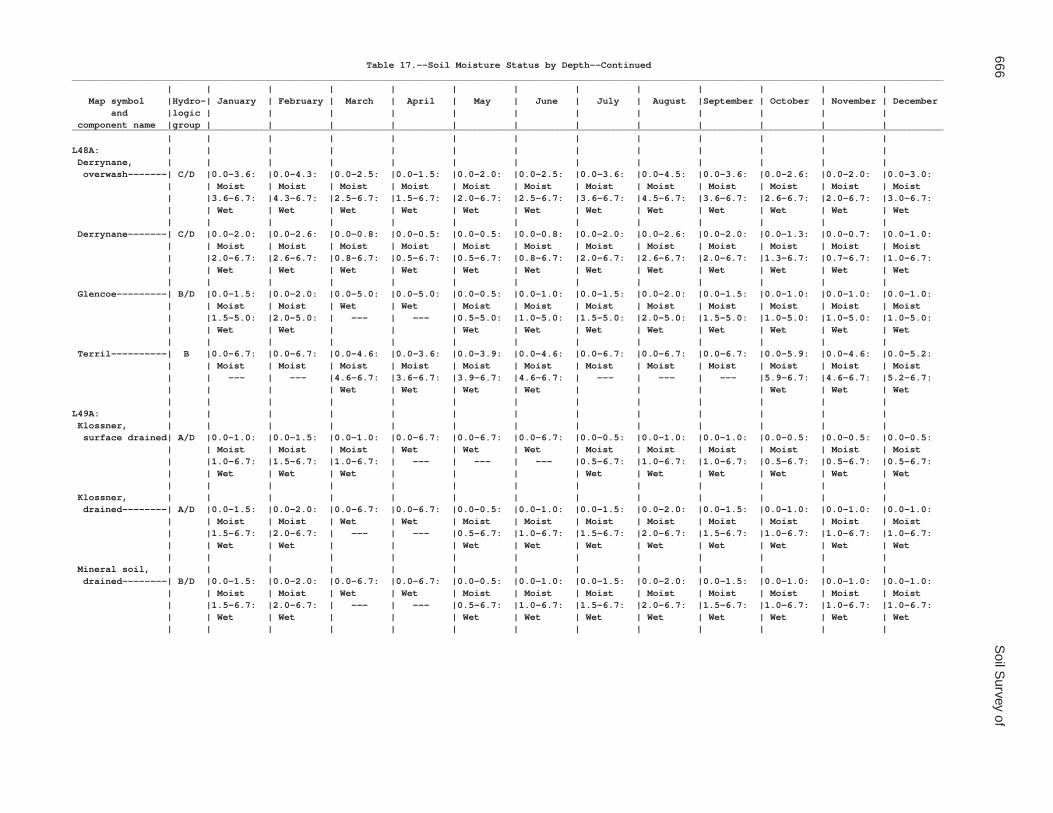
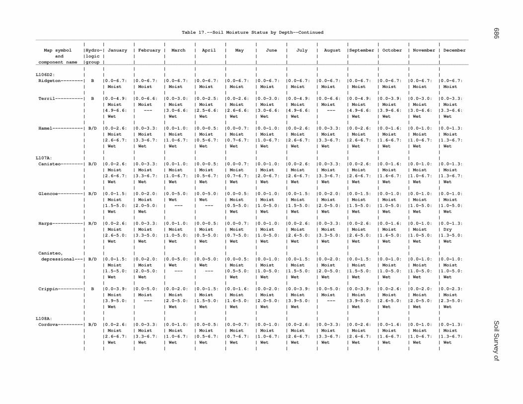
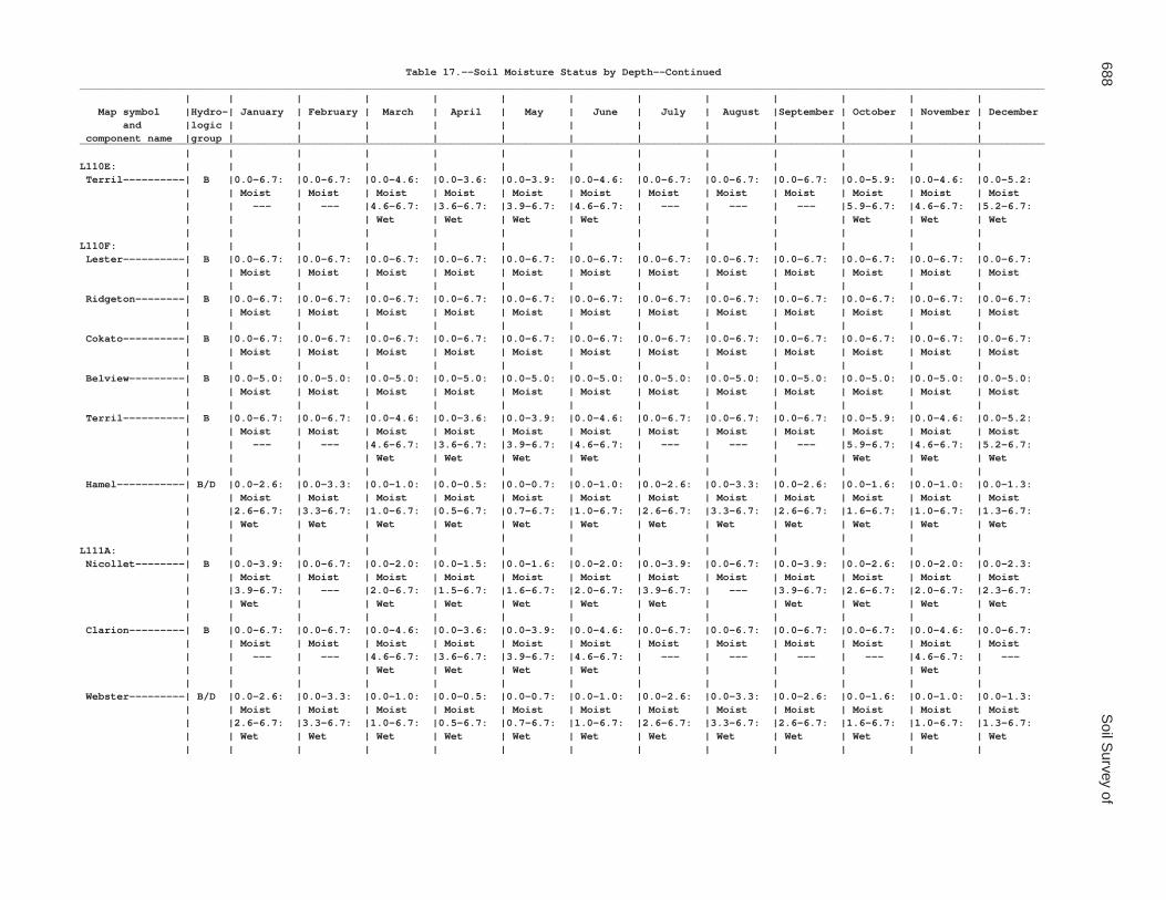
An identifying symbol is used for each map unit onthe soil maps. This symbol precedes the map unitname in the map unit descriptions. Each descriptionincludes general information about the unit. The mapunit descriptions include representative values in feetand the months in which wet soil moisture status ishighest and lowest in the soil profile and ponding isshallowest and deepest on the soil surface. Thedescriptions also include the classes of flooding andthe months in which flooding is least and most likely tooccur. Tables 17, 18, and 19 provide a completedisplay of this data for every month of the year. Theavailable water capacity given in each map unitdescription is calculated for all horizons in the soilprofile. The organic matter content displayed in eachmap unit description is calculated for all horizons inthe soil profile, except those that represent the surfaceduff layer on forested soils. Table 15 provides acomplete display of available water capacity andorganic matter content by horizon.
The principal hazards and limitations to beconsidered in planning for specific uses are describedin other sections of this survey.
Soils that have profiles that are almost alike makeup a soil series. Except for differences in texture of thesurface layer or of the underlying layers, all the soils ofa series have major horizons that are similar incomposition, thickness, and arrangement.
Soils of one series can differ in texture of thesurface layer or of the underlying layers. They also candiffer in slope, stoniness, salinity, wetness, degree oferosion, and other characteristics that affect their use.On the basis of such differences, a soil series is
Soil Map Unit Descriptions

22 Soil Survey of
divided into soil phases. The name of a soil phasecommonly indicates a feature that affects use ormanagement. For example, Lester loam, 6 to 12percent slopes, eroded, is a phase of the Lester series.
A map unit is named for the component orcomponents that make up a dominant percentage ofthe map unit. Many map units consist of one dominantcomponent. These map units are consociations.Canisteo clay loam, 0 to 2 percent slopes, is anexample.
Some map units are made up of two or moredominant components. These map units arecomplexes or undifferentiated groups.
A complex consists of two or more components insuch an intricate pattern or in such small areas thatthey cannot be shown separately on the maps.Attempting to delineate the individual components of acomplex would result in excessive clutter that couldmake the map illegible. The pattern and proportion ofthe components in a complex are somewhat similar inall areas. Canisteo-Glencoe, depressional, complex, 0to 2 percent slopes, is an example.
An undifferentiated group is made up of two ormore components that could be mapped individuallybut are mapped as one unit because similarinterpretations can be made for use and management.The pattern and proportion of the components in amapped area are not uniform. An area can be madeup of only one of the dominant components, or it canbe made up of all of them. Muskego, Blue Earth, andHoughton soils, ponded, 0 to 1 percent slopes, is anundifferentiated group in this survey area.
This survey includes miscellaneous areas. Suchareas have little or no soil material and support little orno vegetation. The Pits component of the Pits, gravel-Udipsamments complex is an example.
Table 2 gives the acreage and proportionate extentof each map unit. Other tables (see Contents) giveproperties of the soils and the limitations, capabilities,and potentials for many uses. The Glossary definesmany of the terms used in describing the soils ormiscellaneous areas.
GP—Pits, gravel-Udipsamments complex
Component Description
Pits, gravel
Extent: 50 to 100 percent of the unitGeomorphic setting: Stream terraces, outwash plains,
and morainesParent material: Sandy and gravelly outwashGeneral description: Gravel pits are areas that have
been mined for gravel or sand. Specific areas are
actively being mined or are abandoned pits.Because of the variability of this component,interpretations for specific uses are not available.Onsite investigation is needed.
Udipsamments
Extent: 15 to 30 percent of the unitGeomorphic setting: Moraines, stream terraces, and
outwash plainsParent material: OutwashGeneral description: Udipsamments are areas of soil
that support plant growth. They consist of areas ofthe pits that have been reclaimed or abandoned.Because of the variability of this component,interpretations for specific uses are not available.Onsite investigation is needed.
L5A—Delft, overwash-Delft complex, 1 to4 percent slopes
Component Description
Delft, overwash, and similar soils
Extent: 40 to 60 percent of the unitGeomorphic setting: MorainesPosition on the landform: Drainageways and swalesSlope range: 1 to 4 percentTexture of the surface layer: LoamDepth to restrictive feature: Very deep (more than 60
inches)Drainage class: Somewhat poorly drainedParent material: Colluvium over tillFlooding: NoneWet soil moisture status is highest (depth, months):
1.5 feet (April)Wet soil moisture status is lowest (depth, months): 4.5
feet (August)Ponding: NoneAvailable water capacity to a depth of 60 inches: 11.3
inchesContent of organic matter in the upper 10 inches: 3.5
percentTypical profile:
Ap—0 to 12 inches; loamA—12 to 37 inches; loamBg—37 to 47 inches; clay loamCg—47 to 80 inches; loam
Delft and similar soils
Extent: 30 to 55 percent of the unitGeomorphic setting: MorainesPosition on the landform: Drainageways and swalesSlope range: 1 to 3 percentTexture of the surface layer: Loam

Waseca County, Minnesota 23
Depth to restrictive feature: Very deep (more than 60inches)
Drainage class: Poorly drainedParent material: Colluvium over tillFlooding: NoneWet soil moisture status is highest (depth, months):
0.5 foot (April)Wet soil moisture status is lowest (depth, months): 3.3
feet (February, August)Ponding: NoneAvailable water capacity to a depth of 60 inches: 11.4
inchesContent of organic matter in the upper 10 inches: 6
percentTypical profile:
Ap,A—0 to 37 inches; loamBg—37 to 50 inches; clay loamCg—50 to 60 inches; loam
Glencoe
Extent: 0 to 10 percent of the unitGeomorphic setting: MorainesPosition on the landform: DepressionsSlope range: 0 to 1 percentTexture of the surface layer: Clay loamDepth to restrictive feature: Very deep (more than 60
inches)Drainage class: Very poorly drainedParent material: TillFlooding: NoneWet soil moisture status is highest (depth, months): At
the surface (March, April)Wet soil moisture status is lowest (depth, months): 2
feet (February, August)Ponding is shallowest (depth, months): 0.5 foot
(March)Ponding is deepest (depth, months): 1 foot (April)Available water capacity to a depth of 60 inches: 11.2
inchesContent of organic matter in the upper 10 inches: 7.5
percentTypical profile:
Ap—0 to 10 inches; clay loamA,ABg—10 to 35 inches; clay loamBg—35 to 48 inches; loamCg—48 to 60 inches; loam
Terril
Extent: 0 to 10 percent of the unitGeomorphic setting: Hills on morainesPosition on the landform: FootslopesSlope range: 2 to 6 percentTexture of the surface layer: Loam
Depth to restrictive feature: Very deep (more than 60inches)
Drainage class: Moderately well drainedParent material: Colluvium over tillFlooding: NoneWet soil moisture status is highest (depth, months):
2.5 feet (April)Wet soil moisture status is lowest (depth, months):
More than 6.7 feet (February, August)Ponding: NoneAvailable water capacity to a depth of 60 inches: 11.4
inchesContent of organic matter in the upper 10 inches: 4
percentTypical profile:
Ap,A1—0 to 27 inches; loamA2,BA—27 to 40 inches; loamBw—40 to 63 inches; loamC—63 to 80 inches; loam
L13A—Klossner muck, depressional, 0 to1 percent slopes
Component Description
Klossner, drained, and similar soils
Extent: 65 to 85 percent of the unitGeomorphic setting: MorainesPosition on the landform: DepressionsSlope range: 0 to 1 percentTexture of the surface layer: MuckDepth to restrictive feature: Very deep (more than 60
inches)Drainage class: Very poorly drainedParent material: Organic material over tillFlooding: NoneWet soil moisture status is highest (depth, months): At
the surface (March, April)Wet soil moisture status is lowest (depth, months): 2
feet (February, August)Ponding does not occur (months): January, February,
May, June, July, August, September, October,November, December
Ponding is deepest (depth, months): 1 foot (April)Available water capacity to a depth of 60 inches: 17.7
inchesContent of organic matter in the upper 10 inches: 50
percentTypical profile:
Op,Oa—0 to 26 inches; muck2A1—26 to 36 inches; mucky silty clay loam2A2—36 to 48 inches; silty clay loam2Cg—48 to 80 inches; loam
24 Soil Survey of
Mineral soil, drained
Classification: Loamy, mixed, superactive, mesicCumulic Endoaquolls
Extent: 5 to 20 percent of the unitGeomorphic setting: MorainesPosition on the landform: DepressionsSlope range: 0 to 1 percentTexture of the surface layer: LoamDepth to restrictive feature: Very deep (more than 60
inches)Drainage class: Very poorly drainedParent material: TillFlooding: NoneWet soil moisture status is highest (depth, months): At
the surface (March, April)Wet soil moisture status is lowest (depth, months): 2
feet (February, August)Ponding does not occur (months): January, February,
May, June, July, August, September, October,November, December
Ponding is deepest (depth, months): 1 foot (April)Available water capacity to a depth of 60 inches: 11.1
inchesContent of organic matter in the upper 10 inches: 7.5
percentTypical profile:
Ap—0 to 13 inches; loamA,Bg1—13 to 31 inches; clay loamBg2—31 to 45 inches; clay loamCg—45 to 80 inches; loam
Houghton, drained
Extent: 0 to 10 percent of the unitGeomorphic setting: MorainesPosition on the landform: DepressionsSlope range: 0 to 1 percentTexture of the surface layer: MuckDepth to restrictive feature: Very deep (more than 60
inches)Drainage class: Very poorly drainedParent material: Organic materialFlooding: NoneWet soil moisture status is highest (depth, months): At
the surface (March, April)Wet soil moisture status is lowest (depth, months): 2
feet (February, August)Ponding does not occur (months): January, February,
May, June, July, August, September, October,November, December
Ponding is deepest (depth, months): 1 foot (April)Available water capacity to a depth of 60 inches: 23.9
inchesContent of organic matter in the upper 10 inches: 75
percent
Typical profile:Op—0 to 10 inches; muckOa—10 to 80 inches; muck
L14A—Houghton muck, depressional, 0 to1 percent slopes
Component Description
Houghton, drained, and similar soils
Extent: 65 to 85 percent of the unitGeomorphic setting: MorainesPosition on the landform: DepressionsSlope range: 0 to 1 percentTexture of the surface layer: MuckDepth to restrictive feature: Very deep (more than 60
inches)Drainage class: Very poorly drainedParent material: Organic materialFlooding: NoneWet soil moisture status is highest (depth, months): At
the surface (March, April)Wet soil moisture status is lowest (depth, months): 2
feet (February, August)Ponding does not occur (months): January, February,
May, June, July, August, September, October,November, December
Ponding is deepest (depth, months): 1 foot (April)Available water capacity to a depth of 60 inches: 23.9
inchesContent of organic matter in the upper 10 inches: 75
percentTypical profile:
Op—0 to 10 inches; muckOa—10 to 80 inches; muck
Klossner, drained
Extent: 5 to 20 percent of the unitGeomorphic setting: MorainesPosition on the landform: DepressionsSlope range: 0 to 1 percentTexture of the surface layer: MuckDepth to restrictive feature: Very deep (more than 60
inches)Drainage class: Very poorly drainedParent material: Organic material over tillFlooding: NoneWet soil moisture status is highest (depth, months): At
the surface (March, April)Wet soil moisture status is lowest (depth, months): 2
feet (February, August)Ponding does not occur (months): January, February,
May, June, July, August, September, October,November, December

Waseca County, Minnesota 25
Ponding is deepest (depth, months): 1 foot (April)Available water capacity to a depth of 60 inches: 17.7
inchesContent of organic matter in the upper 10 inches: 50
percentTypical profile:
Op,Oa—0 to 26 inches; muck2A1—26 to 36 inches; mucky silty clay loam2A2—36 to 48 inches; silty clay loam2Cg—48 to 80 inches; loam
Mineral soil, drained
Classification: Loamy, mixed, superactive, mesicCumulic Endoaquolls
Extent: 5 to 20 percent of the unitGeomorphic setting: MorainesPosition on the landform: DepressionsSlope range: 0 to 1 percentTexture of the surface layer: LoamDepth to restrictive feature: Very deep (more than 60
inches)Drainage class: Very poorly drainedParent material: TillFlooding: NoneWet soil moisture status is highest (depth, months): At
the surface (March, April)Wet soil moisture status is lowest (depth, months): 2
feet (February, August)Ponding does not occur (months): January, February,
May, June, July, August, September, October,November, December
Ponding is deepest (depth, months): 1 foot (April)Available water capacity to a depth of 60 inches: 11.1
inchesContent of organic matter in the upper 10 inches: 7.5
percentTypical profile:
Ap—0 to 13 inches; loamA,Bg1—13 to 31 inches; clay loamBg2—31 to 45 inches; clay loamCg—45 to 80 inches; loam
L15A—Klossner, Okoboji, and Glencoesoils, ponded, 0 to 1 percent slopes
Component Description
Klossner, ponded, and similar soils
Extent: 0 to 100 percent of the unitGeomorphic setting: MorainesPosition on the landform: DepressionsSlope range: 0 to 1 percentTexture of the surface layer: Muck
Depth to restrictive feature: Very deep (more than 60inches)
Drainage class: Very poorly drainedParent material: Organic material over tillFlooding: NoneWet soil moisture status: At the surface all yearPonding is shallowest (depth, months): 0.5 foot (August)Ponding is deepest (depth, months): 3 feet (March,
April, May)Available water capacity to a depth of 60 inches: 17.4
inchesContent of organic matter in the upper 10 inches: 42.5
percentTypical profile:
Oa—0 to 26 inches; muck2A1—26 to 33 inches; silt loam2A2—33 to 40 inches; loam2Cg—40 to 80 inches; loam
Okoboji, ponded, and similar soils
Extent: 0 to 100 percent of the unitGeomorphic setting: MorainesPosition on the landform: DepressionsSlope range: 0 to 1 percentTexture of the surface layer: Mucky silty clay loamDepth to restrictive feature: Very deep (more than 60
inches)Drainage class: Very poorly drainedParent material: Alluvium or lacustrine sediments over
tillFlooding: NoneWet soil moisture status: At the surface all yearPonding is shallowest (depth, months): 0.5 foot (August)Ponding is deepest (depth, months): 3 feet (March,
April, May)Available water capacity to a depth of 60 inches: 11.9
inchesContent of organic matter in the upper 10 inches: 14
percentTypical profile:
A1—0 to 10 inches; mucky silty clay loamA2—10 to 52 inches; silty clay loamBg—52 to 60 inches; silty clay loam
Glencoe, ponded, and similar soils
Extent: 0 to 100 percent of the unitGeomorphic setting: MorainesPosition on the landform: DepressionsSlope range: 0 to 1 percentTexture of the surface layer: Silty clay loamDepth to restrictive feature: Very deep (more than 60
inches)Drainage class: Very poorly drainedParent material: Till

26 Soil Survey of
Flooding: NoneWet soil moisture status: At the surface all yearPonding is shallowest (depth, months): 0.5 foot
(August)Ponding is deepest (depth, months): 3 feet (March,
April, May)Available water capacity to a depth of 60 inches: 11.4
inchesContent of organic matter in the upper 10 inches: 7
percentTypical profile:
A—0 to 42 inches; silty clay loamBg—42 to 50 inches; clay loamCg—50 to 60 inches; loam
Houghton, ponded
Extent: 0 to 20 percent of the unitGeomorphic setting: MorainesPosition on the landform: DepressionsSlope range: 0 to 1 percentTexture of the surface layer: MuckDepth to restrictive feature: Very deep (more than 60
inches)Drainage class: Very poorly drainedParent material: Organic materialFlooding: NoneWet soil moisture status: At the surface all yearPonding is shallowest (depth, months): 0.5 foot
(August)Ponding is deepest (depth, months): 3 feet (March,
April, May)Available water capacity to a depth of 60 inches: 23.9
inchesContent of organic matter in the upper 10 inches: 84.5
percentTypical profile:
Oa—0 to 80 inches; muck
L16A—Muskego, Blue Earth, andHoughton soils, ponded, 0 to 1 percentslopes
Component Description
Muskego, ponded, and similar soils
Extent: 0 to 100 percent of the unitGeomorphic setting: MorainesPosition on the landform: DepressionsSlope range: 0 to 1 percentTexture of the surface layer: MuckDepth to restrictive feature: Very deep (more than 60
inches)
Drainage class: Very poorly drainedParent material: Organic material over coprogenous
earthFlooding: NoneWet soil moisture status: At the surface all yearPonding is shallowest (depth, months): 0.5 foot
(August)Ponding is deepest (depth, months): 3 feet (March,
April, May)Available water capacity to a depth of 60 inches: 19.4
inchesContent of organic matter in the upper 10 inches: 75
percentTypical profile:
Oa1—0 to 9 inches; muckOa2—9 to 36 inches; muckLco—36 to 60 inches; coprogenous earth
Blue Earth, ponded, and similar soils
Extent: 0 to 100 percent of the unitGeomorphic setting: MorainesPosition on the landform: DepressionsSlope range: 0 to 1 percentTexture of the surface layer: Silt loamDepth to restrictive feature: Very deep (more than 60
inches)Drainage class: Very poorly drainedParent material: Coprogenous earthFlooding: NoneWet soil moisture status: At the surface all yearPonding is shallowest (depth, months): 0.5 foot
(August)Ponding is deepest (depth, months): 3 feet (March,
April, May)Available water capacity to a depth of 60 inches: 12.6
inchesContent of organic matter in the upper 10 inches: 17.5
percentTypical profile:
A—0 to 50 inches; silt loamCg—50 to 60 inches; silt loam
Houghton, ponded, and similar soils
Extent: 0 to 100 percent of the unitGeomorphic setting: MorainesPosition on the landform: DepressionsSlope range: 0 to 1 percentTexture of the surface layer: MuckDepth to restrictive feature: Very deep (more than 60
inches)Drainage class: Very poorly drainedParent material: Organic materialFlooding: None

Waseca County, Minnesota 27
Wet soil moisture status: At the surface all yearPonding is shallowest (depth, months): 0.5 foot
(August)Ponding is deepest (depth, months): 3 feet (March,
April, May)Available water capacity to a depth of 60 inches: 23.9
inchesContent of organic matter in the upper 10 inches: 84.5
percentTypical profile:
Oa—0 to 80 inches; muck
Klossner, ponded
Extent: 0 to 20 percent of the unitGeomorphic setting: MorainesPosition on the landform: DepressionsSlope range: 0 to 1 percentTexture of the surface layer: MuckDepth to restrictive feature: Very deep (more than 60
inches)Drainage class: Very poorly drainedParent material: Organic material over tillFlooding: NoneWet soil moisture status: At the surface all yearPonding is shallowest (depth, months): 0.5 foot
(August)Ponding is deepest (depth, months): 3 feet (March,
April, May)Available water capacity to a depth of 60 inches: 17.4
inchesContent of organic matter in the upper 10 inches: 42.5
percentTypical profile:
Oa—0 to 26 inches; muck2A1—26 to 33 inches; silt loam2A2—33 to 40 inches; loam2Cg—40 to 80 inches; loam
L26B—Shorewood silty clay loam, 3 to 6percent slopes
Component Description
Shorewood and similar soils
Extent: 85 to 95 percent of the unitGeomorphic setting: Hills on lake plains; hills on
morainesPosition on the landform: Backslopes and summitsSlope range: 3 to 6 percentTexture of the surface layer: Silty clay loamDepth to restrictive feature: Very deep (more than 60
inches)
Drainage class: Moderately well drainedParent material: Lacustrine sediments over tillFlooding: NoneWet soil moisture status is highest (depth, months):
1.5 feet (April)Wet soil moisture status is lowest (depth, months):
More than 5 feet (January, February, July, August,September, October)
Ponding: NoneAvailable water capacity to a depth of 60 inches: 10.2
inchesContent of organic matter in the upper 10 inches: 6
percentTypical profile:
Ap,A,AB—0 to 17 inches; silty clay loamBt—17 to 39 inches; silty clay2BCg,2Cg—39 to 60 inches; loam
Good Thunder
Extent: 0 to 10 percent of the unitGeomorphic setting: Lake plains and morainesPosition on the landform: Flats and slight risesSlope range: 0 to 3 percentTexture of the surface layer: Silty clay loamDepth to restrictive feature: Very deep (more than 60
inches)Drainage class: Moderately well drainedParent material: Lacustrine sedimentsFlooding: NoneWet soil moisture status is highest (depth, months):
2.5 feet (April, May)Wet soil moisture status is lowest (depth, months): 5.6
feet (February, August)Ponding: NoneAvailable water capacity to a depth of 60 inches: 10.6
inchesContent of organic matter in the upper 10 inches: 5.5
percentTypical profile:
Ap,A—0 to 15 inches; silty clay loamBt—15 to 32 inches; silty clayC—32 to 80 inches; silt loam
Minnetonka
Extent: 0 to 10 percent of the unitGeomorphic setting: Lake plains and morainesPosition on the landform: Flats and swalesSlope range: 0 to 2 percentTexture of the surface layer: Silty clay loamDepth to restrictive feature: Very deep (more than 60
inches)Drainage class: Poorly drainedParent material: Lacustrine sediments

28 Soil Survey of
Flooding: NoneWet soil moisture status is highest (depth, months):
0.5 foot (April, May)Wet soil moisture status is lowest (depth, months): 2.5
feet (February, August)Ponding: NoneAvailable water capacity to a depth of 60 inches: 10.8
inchesContent of organic matter in the upper 10 inches: 5
percentTypical profile:
Ap,A—0 to 13 inches; silty clay loamBtg—13 to 35 inches; silty clayCg—35 to 60 inches; silty clay loam
L36A—Hamel, overwash-Hamel complex,1 to 4 percent slopes
Component Description
Hamel, overwash, and similar soils
Extent: 40 to 60 percent of the unitGeomorphic setting: MorainesPosition on the landform: Drainageways and swalesSlope range: 1 to 4 percentTexture of the surface layer: LoamDepth to restrictive feature: Very deep (more than 60
inches)Drainage class: Somewhat poorly drainedParent material: Colluvium over tillFlooding: NoneWet soil moisture status is highest (depth, months):
1.5 feet (April)Wet soil moisture status is lowest (depth, months): 4.5
feet (August)Ponding: NoneAvailable water capacity to a depth of 60 inches: 11.8
inchesContent of organic matter in the upper 10 inches: 3.5
percentTypical profile:
Ap—0 to 13 inches; loamA—13 to 29 inches; clay loamBtg—29 to 50 inches; clay loamCg—50 to 80 inches; loam
Hamel and similar soils
Extent: 30 to 55 percent of the unitGeomorphic setting: MorainesPosition on the landform: Drainageways and swalesSlope range: 1 to 3 percentTexture of the surface layer: LoamDepth to restrictive feature: Very deep (more than 60
inches)
Drainage class: Poorly drainedParent material: Colluvium over tillFlooding: NoneWet soil moisture status is highest (depth, months):
0.5 foot (April)Wet soil moisture status is lowest (depth, months): 3.3
feet (February, August)Ponding: NoneAvailable water capacity to a depth of 60 inches: 11.6
inchesContent of organic matter in the upper 10 inches: 6
percentTypical profile:
Ap,A,AB—0 to 24 inches; loamBtg—24 to 46 inches; clay loamCg—46 to 80 inches; loam
Terril
Extent: 0 to 10 percent of the unitGeomorphic setting: Hills on morainesPosition on the landform: FootslopesSlope range: 2 to 5 percentTexture of the surface layer: LoamDepth to restrictive feature: Very deep (more than 60
inches)Drainage class: Moderately well drainedParent material: Colluvium over tillFlooding: NoneWet soil moisture status is highest (depth, months):
3.6 feet (April)Wet soil moisture status is lowest (depth, months):
More than 6.7 feet (January, February, July,August, September)
Ponding: NoneAvailable water capacity to a depth of 60 inches: 11.4
inchesContent of organic matter in the upper 10 inches: 4
percentTypical profile:
Ap,A1—0 to 27 inches; loamA2,BA—27 to 40 inches; loamBw—40 to 63 inches; loamC—63 to 80 inches; loam
Glencoe
Extent: 0 to 5 percent of the unitGeomorphic setting: MorainesPosition on the landform: DepressionsSlope range: 0 to 1 percentTexture of the surface layer: LoamDepth to restrictive feature: Very deep (more than 60
inches)Drainage class: Very poorly drainedParent material: Till

Waseca County, Minnesota 29
Flooding: NoneWet soil moisture status is highest (depth, months): At
the surface (March, April)Wet soil moisture status is lowest (depth, months): 2
feet (February, August)Ponding does not occur (months): January, February,
May, June, July, August, September, October,November, December
Ponding is deepest (depth, months): 1 foot (April)Available water capacity to a depth of 60 inches: 11.1
inchesContent of organic matter in the upper 10 inches: 7.5
percentTypical profile:
Ap—0 to 13 inches; loamA,Bg1—13 to 31 inches; clay loamBg2—31 to 45 inches; loamCg—45 to 80 inches; loam
L40B—Angus-Kilkenny complex, 2 to 6percent slopes
Component Description
Angus and similar soils
Extent: 35 to 55 percent of the unitGeomorphic setting: Hills on morainesPosition on the landform: Backslopes and summitsSlope range: 2 to 5 percentTexture of the surface layer: LoamDepth to restrictive feature: Very deep (more than 60
inches)Drainage class: Well drainedParent material: TillFlooding: NoneWet soil moisture status is highest (depth, months):
3.6 feet (April)Wet soil moisture status is lowest (depth, months):
More than 6.7 feet (January, February, July,August, September)
Ponding: NoneAvailable water capacity to a depth of 60 inches: 10.5
inchesContent of organic matter in the upper 10 inches: 2.5
percentTypical profile:
Ap—0 to 8 inches; loamBt—8 to 35 inches; clay loamBC—35 to 40 inches; clay loamC—40 to 80 inches; loam
Kilkenny and similar soils
Extent: 30 to 50 percent of the unitGeomorphic setting: Hills on moraines
Position on the landform: Summits and shouldersSlope range: 2 to 6 percentTexture of the surface layer: Clay loamDepth to restrictive feature: Very deep (more than 60
inches)Drainage class: Moderately well drainedParent material: Glaciofluvial sediments and reworked
till over tillFlooding: NoneWet soil moisture status is highest (depth, months):
1.7 feet (April)Wet soil moisture status is lowest (depth, months):
More than 6.7 feet (February, July, August,September)
Ponding: NoneAvailable water capacity to a depth of 60 inches: 10.3
inchesContent of organic matter in the upper 10 inches: 3
percentTypical profile:
Ap—0 to 11 inches; clay loamBt—11 to 35 inches; clay loam2Bk,2C—35 to 80 inches; loam
Lerdal
Extent: 5 to 15 percent of the unitGeomorphic setting: MorainesPosition on the landform: Flats and slight risesSlope range: 1 to 3 percentTexture of the surface layer: Clay loamDepth to restrictive feature: More than 60 inchesDrainage class: Somewhat poorly drainedParent material: Glaciofluvial sediments and reworked
till over tillFlooding: NoneWet soil moisture status is highest (depth, months):
1.6 feet (November)Wet soil moisture status is lowest (depth, months): 4.9
feet (February, August)Ponding: NoneAvailable water capacity to a depth of 60 inches: 10.2
inchesContent of organic matter in the upper 10 inches: 2.6
percentTypical profile:
Ap—0 to 8 inches; clay loamE—8 to 12 inches; clay loamBt,Btg—12 to 41 inches; silty clay loamBk—41 to 80 inches; loam
Mazaska
Extent: 0 to 10 percent of the unitGeomorphic setting: MorainesPosition on the landform: Swales

30 Soil Survey of
Slope range: 0 to 2 percentTexture of the surface layer: Silty clay loamDepth to restrictive feature: More than 60 inchesDrainage class: Poorly drainedParent material: Glaciofluvial sediments and reworked
till over tillFlooding: NoneWet soil moisture status is highest (depth, months):
0.5 foot (April, May)Wet soil moisture status is lowest (depth, months): 2.6
feet (February, August)Ponding: NoneAvailable water capacity to a depth of 60 inches: 9.5
inchesContent of organic matter in the upper 10 inches: 5.5
percentTypical profile:
Ap,A—0 to 15 inches; silty clay loamBtg—15 to 42 inches; clayBkg—42 to 80 inches; loam
L41C2—Lester-Kilkenny complex, 6 to 12percent slopes, eroded
Component Description
Lester, eroded, and similar soils
Extent: 40 to 50 percent of the unitGeomorphic setting: Hills on morainesPosition on the landform: Backslopes and shouldersSlope range: 6 to 12 percentTexture of the surface layer: LoamDepth to restrictive feature: Very deep (more than 60
inches)Drainage class: Well drainedParent material: TillFlooding: NoneDepth to wet soil moisture status: More than 6.7 feet
all yearPonding: NoneAvailable water capacity to a depth of 60 inches: 10.5
inchesContent of organic matter in the upper 10 inches: 1.6
percentTypical profile:
Ap—0 to 7 inches; loamBt—7 to 38 inches; clay loamBk—38 to 60 inches; loamC—60 to 80 inches; loam
Kilkenny, eroded, and similar soils
Extent: 35 to 45 percent of the unitGeomorphic setting: Hills on morainesPosition on the landform: Summits and shoulders
Slope range: 6 to 12 percentTexture of the surface layer: Clay loamDepth to restrictive feature: Very deep (more than 60
inches)Drainage class: Moderately well drainedParent material: Glaciofluvial sediments and reworked
till over tillFlooding: NoneWet soil moisture status is highest (depth, months):
2.5 feet (April)Wet soil moisture status is lowest (depth, months):
More than 6.7 feet (January, February, March,June, July, August, September, October,November, December)
Ponding: NoneAvailable water capacity to a depth of 60 inches: 10.3
inchesContent of organic matter in the upper 10 inches: 1.9
percentTypical profile:
Ap—0 to 9 inches; clay loamBt—9 to 53 inches; clay loam2BC,2C—53 to 80 inches; loam
Terril
Extent: 5 to 15 percent of the unitGeomorphic setting: Hills on morainesPosition on the landform: FootslopesSlope range: 0 to 4 percentTexture of the surface layer: LoamDepth to restrictive feature: Very deep (more than 60
inches)Drainage class: Moderately well drainedParent material: Colluvium over tillFlooding: NoneWet soil moisture status is highest (depth, months):
3.6 feet (April)Wet soil moisture status is lowest (depth, months):
More than 6.7 feet (January, February, July,August, September)
Ponding: NoneAvailable water capacity to a depth of 60 inches: 11.4
inchesContent of organic matter in the upper 10 inches: 4
percentTypical profile:
Ap,A1—0 to 27 inches; loamA2,BA—27 to 40 inches; loamBw—40 to 63 inches; loamC—63 to 80 inches; loam
Derrynane
Extent: 2 to 10 percent of the unitGeomorphic setting: Moraines

Waseca County, Minnesota 31
Position on the landform: Drainageways and swalesSlope range: 1 to 3 percentTexture of the surface layer: Clay loamDepth to restrictive feature: Very deep (more than 60
inches)Drainage class: Poorly drainedParent material: Colluvium or glaciofluvial sediments
over tillFlooding: NoneWet soil moisture status is highest (depth, months):
0.5 foot (April, May)Wet soil moisture status is lowest (depth, months): 2.6
feet (February, August)Ponding: NoneAvailable water capacity to a depth of 60 inches: 10
inchesContent of organic matter in the upper 10 inches: 6
percentTypical profile:
Ap,A1—0 to 19 inches; clay loamA2—19 to 39 inches; silty clayBg,2Bg—39 to 65 inches; clay loam2Cg—65 to 80 inches; loam
L41D2—Lester-Kilkenny complex, 12 to18 percent slopes, eroded
Component Description
Lester, eroded, and similar soils
Extent: 40 to 50 percent of the unitGeomorphic setting: Hills on morainesPosition on the landform: Backslopes and shouldersSlope range: 12 to 18 percentTexture of the surface layer: LoamDepth to restrictive feature: Very deep (more than 60
inches)Drainage class: Well drainedParent material: TillFlooding: NoneDepth to wet soil moisture status: More than 6.7 feet
all yearPonding: NoneAvailable water capacity to a depth of 60 inches: 10.5
inchesContent of organic matter in the upper 10 inches: 1.6
percentTypical profile:
Ap—0 to 7 inches; loamBt—7 to 38 inches; clay loamBk—38 to 60 inches; loamC—60 to 80 inches; loam
Kilkenny, eroded, and similar soils
Extent: 25 to 45 percent of the unitGeomorphic setting: Hills on morainesPosition on the landform: Summits and shouldersSlope range: 12 to 18 percentTexture of the surface layer: Clay loamDepth to restrictive feature: Very deep (more than 60
inches)Drainage class: Moderately well drainedParent material: Glaciofluvial sediments and reworked
till over tillFlooding: NoneWet soil moisture status is highest (depth, months):
2.5 feet (April)Wet soil moisture status is lowest (depth, months):
More than 6.7 feet (January, February, March,June, July, August, September, October,November, December)
Ponding: NoneAvailable water capacity to a depth of 60 inches: 10.3
inchesContent of organic matter in the upper 10 inches: 1.9
percentTypical profile:
Ap—0 to 9 inches; clay loamBt—9 to 53 inches; clay loam2BC,2C—53 to 80 inches; loam
Terril
Extent: 5 to 15 percent of the unitGeomorphic setting: Hills on morainesPosition on the landform: FootslopesSlope range: 0 to 4 percentTexture of the surface layer: LoamDepth to restrictive feature: Very deep (more than 60
inches)Drainage class: Moderately well drainedParent material: Colluvium over tillFlooding: NoneWet soil moisture status is highest (depth, months):
3.6 feet (April)Wet soil moisture status is lowest (depth, months):
More than 6.7 feet (January, February, July,August, September)
Ponding: NoneAvailable water capacity to a depth of 60 inches: 11.4
inchesContent of organic matter in the upper 10 inches: 4
percentTypical profile:
Ap,A1—0 to 27 inches; loamA2,BA—27 to 40 inches; loam

32 Soil Survey of
Bw—40 to 63 inches; loamC—63 to 80 inches; loam
Derrynane
Extent: 2 to 10 percent of the unitGeomorphic setting: MorainesPosition on the landform: Drainageways and swalesSlope range: 1 to 3 percentTexture of the surface layer: Clay loamDepth to restrictive feature: Very deep (more than 60
inches)Drainage class: Poorly drainedParent material: Colluvium or glaciofluvial sediments
over tillFlooding: NoneWet soil moisture status is highest (depth, months):
0.5 foot (April, May)Wet soil moisture status is lowest (depth, months): 2.6
feet (February, August)Ponding: NoneAvailable water capacity to a depth of 60 inches: 10
inchesContent of organic matter in the upper 10 inches: 6
percentTypical profile:
Ap,A1—0 to 19 inches; clay loamA2—19 to 39 inches; silty clayBg,2Bg—39 to 65 inches; clay loam2Cg—65 to 80 inches; loam
Ridgeton
Extent: 0 to 10 percent of the unitGeomorphic setting: Hills on morainesPosition on the landform: Footslopes and
backslopesSlope range: 8 to 14 percentTexture of the surface layer: LoamDepth to restrictive feature: Very deep (more than 60
inches)Drainage class: Well drainedParent material: Colluvium over tillFlooding: NoneDepth to wet soil moisture status: More than 6.7 feet
all yearPonding: NoneAvailable water capacity to a depth of 60 inches: 11.2
inchesContent of organic matter in the upper 10 inches: 4
percentTypical profile:
Ap,A1—0 to 23 inches; loamA2,AB—23 to 38 inches; loamBw—38 to 50 inches; loamC—50 to 80 inches; loam
L41E—Lester-Kilkenny complex, 18 to 25percent slopes
Component Description
Lester and similar soils
Extent: 40 to 50 percent of the unitGeomorphic setting: Hills on morainesPosition on the landform: Shoulders and backslopesSlope range: 18 to 25 percentTexture of the surface layer: LoamDepth to restrictive feature: Very deep (more than 60
inches)Drainage class: Well drainedParent material: TillFlooding: NoneDepth to wet soil moisture status: More than 6.7 feet
all yearPonding: NoneAvailable water capacity to a depth of 60 inches: 10.4
inchesContent of organic matter in the upper 10 inches: 3
percentTypical profile:
A—0 to 5 inches; loamBE,Bt—5 to 34 inches; clay loamBk—34 to 60 inches; loamC—60 to 80 inches; loam
Kilkenny and similar soils
Extent: 35 to 45 percent of the unitGeomorphic setting: Hills on morainesPosition on the landform: Shoulders and summitsSlope range: 18 to 25 percentTexture of the surface layer: Clay loamDepth to restrictive feature: Very deep (more than 60
inches)Drainage class: Moderately well drainedParent material: Glaciofluvial sediments and reworked
till over tillFlooding: NoneWet soil moisture status is highest (depth, months):
2.5 feet (April)Wet soil moisture status is lowest (depth, months):
More than 6.7 feet (January, February, March,June, July, August, September, October,November, December)
Ponding: NoneAvailable water capacity to a depth of 60 inches: 10.2
inchesContent of organic matter in the upper 10 inches: 2.7
percentTypical profile:
A—0 to 7 inches; clay loam

Waseca County, Minnesota 33
Bt—7 to 31 inches; clay loam2Bk,2C—31 to 80 inches; loam
Terril
Extent: 5 to 15 percent of the unitGeomorphic setting: Hills on morainesPosition on the landform: FootslopesSlope range: 0 to 4 percentTexture of the surface layer: LoamDepth to restrictive feature: Very deep (more than 60
inches)Drainage class: Moderately well drainedParent material: Colluvium over tillFlooding: NoneWet soil moisture status is highest (depth, months):
3.6 feet (April)Wet soil moisture status is lowest (depth, months):
More than 6.7 feet (January, February, July,August, September)
Ponding: NoneAvailable water capacity to a depth of 60 inches: 11.3
inchesContent of organic matter in the upper 10 inches: 4
percentTypical profile:
A1,A2—0 to 24 inches; loamAB—24 to 37 inches; loamBw—37 to 57 inches; loamC—57 to 80 inches; loam
Derrynane
Extent: 2 to 10 percent of the unitGeomorphic setting: MorainesPosition on the landform: Drainageways and swalesSlope range: 1 to 3 percentTexture of the surface layer: Clay loamDepth to restrictive feature: Very deep (more than 60
inches)Drainage class: Poorly drainedParent material: Colluvium or glaciofluvial sediments
over tillFlooding: NoneWet soil moisture status is highest (depth, months):
0.5 foot (April, May)Wet soil moisture status is lowest (depth, months): 2.6
feet (February, August)Ponding: NoneAvailable water capacity to a depth of 60 inches: 10
inchesContent of organic matter in the upper 10 inches: 6
percentTypical profile:
A1—0 to 20 inches; clay loamA2—20 to 40 inches; clay loam, silty clay
Btg—40 to 54 inches; clay loam2Cg—54 to 80 inches; loam
Ridgeton
Extent: 0 to 10 percent of the unitGeomorphic setting: Hills on morainesPosition on the landform: Footslopes and backslopesSlope range: 10 to 20 percentTexture of the surface layer: LoamDepth to restrictive feature: Very deep (more than 60
inches)Drainage class: Well drainedParent material: Colluvium over tillFlooding: NoneDepth to wet soil moisture status: More than 6.7 feet
all yearPonding: NoneAvailable water capacity to a depth of 60 inches: 11.4
inchesContent of organic matter in the upper 10 inches: 5
percentTypical profile:
A1,A2,A3—0 to 32 inches; loamBw—32 to 40 inches; loamC1,C2—40 to 80 inches; loam
L48A—Derrynane, overwash-Derrynanecomplex, 1 to 4 percent slopes
Component Description
Derrynane, overwash, and similar soils
Extent: 40 to 60 percent of the unitGeomorphic setting: MorainesPosition on the landform: Drainageways and swalesSlope range: 1 to 4 percentTexture of the surface layer: Clay loamDepth to restrictive feature: Very deep (more than 60
inches)Drainage class: Somewhat poorly drainedParent material: Colluvium or glaciofluvial sediments
over tillFlooding: NoneWet soil moisture status is highest (depth, months):
1.5 feet (April)Wet soil moisture status is lowest (depth, months): 4.5
feet (August)Ponding: NoneAvailable water capacity to a depth of 60 inches: 9.7
inchesContent of organic matter in the upper 10 inches: 3
percentTypical profile:
Ap,A1—0 to 16 inches; clay loam

34 Soil Survey of
A2,AE,Bt—16 to 48 inches; clay loamBtg—48 to 67 inches; clay loamCg—67 to 80 inches; loam
Derrynane and similar soils
Extent: 30 to 55 percent of the unitGeomorphic setting: MorainesPosition on the landform: Drainageways and swalesSlope range: 1 to 3 percentTexture of the surface layer: Clay loamDepth to restrictive feature: Very deep (more than 60
inches)Drainage class: Poorly drainedParent material: Colluvium or glaciofluvial sediments
over tillFlooding: NoneWet soil moisture status is highest (depth, months):
0.5 foot (April, May)Wet soil moisture status is lowest (depth, months): 2.6
feet (February, August)Ponding: NoneAvailable water capacity to a depth of 60 inches: 10
inchesContent of organic matter in the upper 10 inches: 6
percentTypical profile:
Ap,A1—0 to 19 inches; clay loamA2—19 to 39 inches; silty clayBg,2Bg—39 to 65 inches; clay loam2Cg—65 to 80 inches; loam
Glencoe
Extent: 5 to 10 percent of the unitGeomorphic setting: MorainesPosition on the landform: DepressionsSlope range: 0 to 1 percentTexture of the surface layer: Clay loamDepth to restrictive feature: Very deep (more than 60
inches)Drainage class: Very poorly drainedParent material: TillFlooding: NoneWet soil moisture status is highest (depth, months): At
the surface (March, April)Wet soil moisture status is lowest (depth, months): 2
feet (February, August)Ponding is shallowest (depth, months): 0.5 foot
(March)Ponding is deepest (depth, months): 1 foot (April)Available water capacity to a depth of 60 inches: 11.2
inchesContent of organic matter in the upper 10 inches: 7.5
percent
Typical profile:Ap—0 to 10 inches; clay loamA,ABg—10 to 35 inches; clay loamBg—35 to 48 inches; loamCg—48 to 60 inches; loam
Terril
Extent: 5 to 10 percent of the unitGeomorphic setting: Hills on morainesPosition on the landform: FootslopesSlope range: 2 to 6 percentTexture of the surface layer: LoamDepth to restrictive feature: Very deep (more than 60
inches)Drainage class: Moderately well drainedParent material: Colluvium over tillFlooding: NoneWet soil moisture status is highest (depth, months):
3.6 feet (April)Wet soil moisture status is lowest (depth, months):
More than 6.7 feet (January, February, July,August, September)
Ponding: NoneAvailable water capacity to a depth of 60 inches: 11.4
inchesContent of organic matter in the upper 10 inches: 4
percentTypical profile:
Ap,A1—0 to 27 inches; loamA2,BA—27 to 40 inches; loamBw—40 to 63 inches; loamC—63 to 80 inches; loam
L49A—Klossner soils, depressional, 0 to1 percent slopes
Component Description
Klossner, surface drained, and similar soils
Extent: 50 to 100 percent of the unitGeomorphic setting: MorainesPosition on the landform: DepressionsSlope range: 0 to 1 percentTexture of the surface layer: MuckDepth to restrictive feature: Very deep (more than 60
inches)Drainage class: Very poorly drainedParent material: Organic material over tillFlooding: NoneWet soil moisture status is highest (depth, months): At
the surface (April, May, June)Wet soil moisture status is lowest (depth, months): 1.5
feet (February)

Waseca County, Minnesota 35
Ponding does not occur (months): January, February,July, August, September, October, November,December
Ponding is deepest (depth, months): 1 foot (March,April, May)
Available water capacity to a depth of 60 inches: 17.4inches
Content of organic matter in the upper 10 inches: 42.5percent
Typical profile:Oa—0 to 26 inches; muck2A1—26 to 33 inches; silt loam2A2—33 to 40 inches; loam2Cg—40 to 80 inches; loam
Klossner, drained, and similar soils
Extent: 0 to 40 percent of the unitGeomorphic setting: MorainesPosition on the landform: DepressionsSlope range: 0 to 1 percentTexture of the surface layer: MuckDepth to restrictive feature: Very deep (more than 60
inches)Drainage class: Very poorly drainedParent material: Organic material over tillFlooding: NoneWet soil moisture status is highest (depth, months): At
the surface (March, April)Wet soil moisture status is lowest (depth, months): 2
feet (February, August)Ponding does not occur (months): January, February,
May, June, July, August, September, October,November, December
Ponding is deepest (depth, months): 1 foot (April)Available water capacity to a depth of 60 inches: 17.7
inchesContent of organic matter in the upper 10 inches: 50
percentTypical profile:
Op,Oa—0 to 26 inches; muck2A1—26 to 36 inches; mucky silty clay loam2A2—36 to 48 inches; silty clay loam2Cg—48 to 80 inches; loam
Mineral soil, drained
Classification: Loamy, mixed, superactive, mesicCumulic Endoaquolls
Extent: 5 to 25 percent of the unitGeomorphic setting: MorainesPosition on the landform: DepressionsSlope range: 0 to 1 percentTexture of the surface layer: Loam
Depth to restrictive feature: Very deep (more than 60inches)
Drainage class: Very poorly drainedParent material: TillFlooding: NoneWet soil moisture status is highest (depth, months): At
the surface (March, April)Wet soil moisture status is lowest (depth, months): 2
feet (February, August)Ponding does not occur (months): January, February,
May, June, July, August, September, October,November, December
Ponding is deepest (depth, months): 1 foot (April)Available water capacity to a depth of 60 inches: 11.1
inchesContent of organic matter in the upper 10 inches: 7.5
percentTypical profile:
Ap—0 to 13 inches; loamA,Bg1—13 to 31 inches; clay loamBg2—31 to 45 inches; clay loamCg—45 to 80 inches; loam
L50A—Houghton and Muskego soils,depressional, 0 to 1 percent slopes
Component Description
Houghton, surface drained, and similar soils
Extent: 20 to 60 percent of the unitGeomorphic setting: MorainesPosition on the landform: DepressionsSlope range: 0 to 1 percentTexture of the surface layer: MuckDepth to restrictive feature: Very deep (more than 60
inches)Drainage class: Very poorly drainedParent material: Organic materialFlooding: NoneWet soil moisture status is highest (depth, months): At
the surface (April, May, June)Wet soil moisture status is lowest (depth, months): 1.5
feet (February)Ponding does not occur (months): January, February,
July, August, September, October, November,December
Ponding is deepest (depth, months): 1 foot (March,April, May)
Available water capacity to a depth of 60 inches: 23.9inches
Content of organic matter in the upper 10 inches: 84.5percent

36 Soil Survey of
Typical profile:Oa—0 to 80 inches; muck
Muskego, surface drained, and similar soils
Extent: 20 to 60 percent of the unitGeomorphic setting: MorainesPosition on the landform: DepressionsSlope range: 0 to 1 percentTexture of the surface layer: MuckDepth to restrictive feature: Very deep (more than 60
inches)Drainage class: Very poorly drainedParent material: Organic material over coprogenous
earthFlooding: NoneWet soil moisture status is highest (depth, months): At
the surface (April, May, June)Wet soil moisture status is lowest (depth, months): 1.5
feet (February)Ponding does not occur (months): January, February,
July, August, September, October, November,December
Ponding is deepest (depth, months): 1 foot (March,April, May)
Available water capacity to a depth of 60 inches: 19.4inches
Content of organic matter in the upper 10 inches: 75percent
Typical profile:Oa1—0 to 9 inches; muckOa2—9 to 36 inches; muckLco—36 to 60 inches; coprogenous earth
Klossner, drained
Extent: 0 to 20 percent of the unitGeomorphic setting: MorainesPosition on the landform: DepressionsSlope range: 0 to 1 percentTexture of the surface layer: MuckDepth to restrictive feature: Very deep (more than 60
inches)Drainage class: Very poorly drainedParent material: Organic material over tillFlooding: NoneWet soil moisture status is highest (depth, months): At
the surface (March, April)Wet soil moisture status is lowest (depth, months): 2
feet (February, August)Ponding does not occur (months): January, February,
May, June, July, August, September, October,November, December
Ponding is deepest (depth, months): 1 foot (April)Available water capacity to a depth of 60 inches: 17.7
inches
Content of organic matter in the upper 10 inches: 50percent
Typical profile:Op,Oa—0 to 26 inches; muck2A1—26 to 36 inches; mucky silty clay loam2A2—36 to 48 inches; silty clay loam2Cg—48 to 80 inches; loam
Mineral soil, drained
Classification: Loamy, mixed, superactive, mesicCumulic Endoaquolls
Extent: 0 to 20 percent of the unitGeomorphic setting: MorainesPosition on the landform: DepressionsSlope range: 0 to 1 percentTexture of the surface layer: LoamDepth to restrictive feature: Very deep (more than 60
inches)Drainage class: Very poorly drainedParent material: TillFlooding: NoneWet soil moisture status is highest (depth, months): At
the surface (March, April)Wet soil moisture status is lowest (depth, months): 2
feet (February, August)Ponding does not occur (months): January, February,
May, June, July, August, September, October,November, December
Ponding is deepest (depth, months): 1 foot (April)Available water capacity to a depth of 60 inches: 11.1
inchesContent of organic matter in the upper 10 inches: 7.5
percentTypical profile:
Ap—0 to 13 inches; loamA,Bg1—13 to 31 inches; clay loamBg2—31 to 45 inches; clay loamCg—45 to 80 inches; loam
L51C2—Gladek silt loam, 6 to 12 percentslopes, eroded
Component Description
Gladek, eroded, and similar soils
Extent: 70 to 90 percent of the unitGeomorphic setting: Hills on lake plainsPosition on the landform: Backslopes and shouldersSlope range: 6 to 12 percentTexture of the surface layer: Silt loamDepth to restrictive feature: Very deep (more than 60
inches)Drainage class: Well drained

Waseca County, Minnesota 37
Parent material: Lacustrine sedimentsFlooding: NoneDepth to wet soil moisture status: More than 6.7 feet
all yearPonding: NoneAvailable water capacity to a depth of 60 inches: 11.6
inchesContent of organic matter in the upper 10 inches: 3
percentTypical profile:
Ap—0 to 10 inches; silt loamBt—10 to 39 inches; silt loamC—39 to 80 inches; silt loam
Barrington
Extent: 5 to 25 percent of the unitGeomorphic setting: Hills on lake plainsPosition on the landform: Summits and backslopesSlope range: 2 to 6 percentTexture of the surface layer: Silt loamDepth to restrictive feature: Very deep (more than 60
inches)Drainage class: Moderately well drainedParent material: Lacustrine sedimentsFlooding: NoneWet soil moisture status is highest (depth, months):
2.5 feet (April)Wet soil moisture status is lowest (depth, months):
More than 5 feet (February, August)Ponding: NoneAvailable water capacity to a depth of 60 inches: 9.4
inchesContent of organic matter in the upper 10 inches: 4
percentTypical profile:
Ap,A—0 to 15 inches; silt loamBt—15 to 33 inches; silt loamC—33 to 60 inches; stratified loamy very fine sand
to silt loam
Lester, eroded
Extent: 0 to 10 percent of the unitGeomorphic setting: Hills on morainesPosition on the landform: Shoulders and backslopesSlope range: 6 to 12 percentTexture of the surface layer: LoamDepth to restrictive feature: Very deep (more than 60
inches)Drainage class: Well drainedParent material: TillFlooding: NoneDepth to wet soil moisture status: More than 6.7 feet
all yearPonding: None
Available water capacity to a depth of 60 inches: 10.5inches
Content of organic matter in the upper 10 inches: 1.6percent
Typical profile:Ap—0 to 7 inches; loamBt—7 to 38 inches; clay loamBk—38 to 60 inches; loamC—60 to 80 inches; loam
Madelia
Extent: 0 to 10 percent of the unitGeomorphic setting: Lake plainsPosition on the landform: Flats and swalesSlope range: 0 to 2 percentTexture of the surface layer: Silty clay loamDepth to restrictive feature: Very deep (more than 60
inches)Drainage class: Poorly drainedParent material: Lacustrine sedimentsFlooding: NoneWet soil moisture status is highest (depth, months):
0.5 foot (April)Wet soil moisture status is lowest (depth, months): 3.3
feet (February, August)Ponding: NoneAvailable water capacity to a depth of 60 inches: 11.7
inchesContent of organic matter in the upper 10 inches: 6
percentTypical profile:
Ap,A,AB—0 to 19 inches; silty clay loamBg—19 to 37 inches; silty clay loamCg—37 to 60 inches; silt loam
L56A—Muskego and Klossner soils, 0 to1 percent slopes, frequently flooded
Component Description
Muskego, frequently flooded, and similar soils
Extent: 30 to 100 percent of the unitGeomorphic setting: Flood plainsPosition on the landform: FlatsSlope range: 0 to 1 percentTexture of the surface layer: MuckDepth to restrictive feature: Very deep (more than 60
inches)Drainage class: Very poorly drainedParent material: Organic material over coprogenous
earthFlooding does not occur (months): January, February,
August, September, October, November,December

38 Soil Survey of
Flooding is most likely (frequency, months): Frequent(March, April, May, June)
Wet soil moisture status is highest (depth, months): Atthe surface (April, May, June)
Wet soil moisture status is lowest (depth, months): 1.5feet (February)
Ponding is shallowest (depth, months): 0.5 foot (June)Ponding is deepest (depth, months): 1 foot (March,
April, May)Available water capacity to a depth of 60 inches: 19.4
inchesContent of organic matter in the upper 10 inches: 75
percentTypical profile:
Oa1—0 to 9 inches; muckOa2—9 to 36 inches; muckLco—36 to 60 inches; coprogenous earth
Klossner, frequently flooded, and similar soils
Extent: 30 to 100 percent of the unitGeomorphic setting: Flood plainsPosition on the landform: FlatsSlope range: 0 to 1 percentTexture of the surface layer: MuckDepth to restrictive feature: Very deep (more than 60
inches)Drainage class: Very poorly drainedParent material: Organic material over tillFlooding does not occur (months): January, February,
August, September, October, November,December
Flooding is most likely (frequency, months): Frequent(March, April, May, June)
Wet soil moisture status is highest (depth, months): Atthe surface (April, May, June)
Wet soil moisture status is lowest (depth, months): 1.5feet (February)
Ponding is shallowest (depth, months): 0.5 foot (June)Ponding is deepest (depth, months): 1 foot (March,
April, May)Available water capacity to a depth of 60 inches: 17.4
inchesContent of organic matter in the upper 10 inches: 42.5
percentTypical profile:
Oa—0 to 26 inches; muck2A1—26 to 33 inches; silt loam2A2—33 to 40 inches; loam2Cg—40 to 80 inches; loam
Suckercreek, frequently flooded
Extent: 0 to 40 percent of the unitGeomorphic setting: Flood plainsPosition on the landform: Flats
Slope range: 0 to 2 percentTexture of the surface layer: LoamDepth to restrictive feature: Very deep (more than 60
inches)Drainage class: Very poorly drainedParent material: AlluviumFlooding does not occur (months): January, February,
August, September, October, November,December
Flooding is most likely (frequency, months): Frequent(March, April, May, June)
Wet soil moisture status is highest (depth, months): Atthe surface (April, May, June)
Wet soil moisture status is lowest (depth, months): 1.8feet (February)
Ponding: NoneAvailable water capacity to a depth of 60 inches: 9.9
inchesContent of organic matter in the upper 10 inches: 5
percentTypical profile:
A—0 to 22 inches; loamCg—22 to 80 inches; loamy fine sand
L57A—Medo muck, depressional, 0 to 1percent slopes
Component Description
Medo, drained, and similar soils
Extent: 65 to 85 percent of the unitGeomorphic setting: Depressions on stream terraces
and outwash plainsSlope range: 0 to 1 percentTexture of the surface layer: MuckDepth to restrictive feature: Very deep (more than 60
inches)Drainage class: Very poorly drainedParent material: Organic material over outwashFlooding: NoneWet soil moisture status is highest (depth, months): At
the surface (March, April)Wet soil moisture status is lowest (depth, months): 2
feet (February, August)Ponding is shallowest (depth, months): 0.5 foot
(March)Ponding is deepest (depth, months): 1 foot (April)Available water capacity to a depth of 60 inches: 14.3
inchesContent of organic matter in the upper 10 inches: 70
percentTypical profile:
Op,Oa—0 to 27 inches; muck

Waseca County, Minnesota 39
2A—27 to 35 inches; mucky loam2Bg—35 to 39 inches; sandy clay loam2Cg—39 to 80 inches; gravelly loamy coarse sand
Mineral soil, drained
Classification: Coarse-loamy, mixed, superactive,mesic Typic Endoaquolls
Extent: 5 to 20 percent of the unitGeomorphic setting: Depressions on stream terraces
and outwash plainsSlope range: 0 to 1 percentTexture of the surface layer: Fine sandy loamDepth to restrictive feature: Very deep (more than 60
inches)Drainage class: Very poorly drainedParent material: OutwashFlooding: NoneWet soil moisture status is highest (depth, months): At
the surface (March, April)Wet soil moisture status is lowest (depth, months): 2
feet (February, August)Ponding is shallowest (depth, months): 0.5 foot
(March)Ponding is deepest (depth, months): 1 foot (April)Available water capacity to a depth of 60 inches: 6.8
inchesContent of organic matter in the upper 10 inches: 8
percentTypical profile:
Ap,A3—0 to 23 inches; fine sandy loamBg—23 to 31 inches; stratified loamy fine sand to
fine sandy loam2Cg—31 to 60 inches; stratified loamy sand to
coarse sand
Houghton, drained
Extent: 0 to 10 percent of the unitGeomorphic setting: Depressions on stream terraces
and outwash plainsSlope range: 0 to 1 percentTexture of the surface layer: MuckDepth to restrictive feature: Very deep (more than 60
inches)Drainage class: Very poorly drainedParent material: Organic materialFlooding: NoneWet soil moisture status is highest (depth, months): At
the surface (March, April)Wet soil moisture status is lowest (depth, months): 2
feet (February, August)Ponding is shallowest (depth, months): 0.5 foot
(March)Ponding is deepest (depth, months): 1 foot (April)
Available water capacity to a depth of 60 inches: 23.9inches
Content of organic matter in the upper 10 inches: 75percent
Typical profile:Op—0 to 10 inches; muckOa—10 to 80 inches; muck
L63A—Klossner muck, lake plain,depressional, 0 to 1 percent slopes
Component Description
Klossner and similar soils
Extent: 75 to 95 percent of the unitGeomorphic setting: Lake plainsPosition on the landform: DepressionsSlope range: 0 to 1 percentTexture of the surface layer: MuckDepth to restrictive feature: Very deep (more than 60
inches)Drainage class: Very poorly drainedParent material: Organic material over lacustrine
sedimentsFlooding: NoneWet soil moisture status is highest (depth, months): At
the surface (March, April)Wet soil moisture status is lowest (depth, months): 2
feet (February, August)Ponding is shallowest (depth, months): 0.5 foot
(March)Ponding is deepest (depth, months): 1 foot (April)Available water capacity to a depth of 60 inches: 17.4
inchesContent of organic matter in the upper 10 inches: 42.5
percentTypical profile:
Op,Oa—0 to 25 inches; muck2A—25 to 40 inches; silty clay loam2Cg—40 to 80 inches; silty clay loam
Lura
Extent: 5 to 15 percent of the unitGeomorphic setting: Lake plainsPosition on the landform: DepressionsSlope range: 0 to 1 percentTexture of the surface layer: Silty clayDepth to restrictive feature: Very deep (more than 60
inches)Drainage class: Very poorly drainedParent material: Lacustrine sedimentsFlooding: None

40 Soil Survey of
Wet soil moisture status is highest (depth, months): Atthe surface (March, April)
Wet soil moisture status is lowest (depth, months): 2feet (February, August)
Ponding is shallowest (depth, months): 0.5 foot(March)
Ponding is deepest (depth, months): 1 foot (April)Available water capacity to a depth of 60 inches: 9.6
inchesContent of organic matter in the upper 10 inches: 8
percentTypical profile:
Ap—0 to 10 inches; silty clayA—10 to 58 inches; clayBg—58 to 72 inches; silty clay
Brownton
Extent: 0 to 10 percent of the unitGeomorphic setting: Lake plainsPosition on the landform: Rims of depressionsSlope range: 0 to 2 percentTexture of the surface layer: Silty clay loamDepth to restrictive feature: Very deep (more than 60
inches)Drainage class: Poorly drainedParent material: Lacustrine sediments over tillFlooding: NoneWet soil moisture status is highest (depth, months):
0.5 foot (April, May)Wet soil moisture status is lowest (depth, months): 2.6
feet (February, August)Ponding: NoneAvailable water capacity to a depth of 60 inches: 10.5
inchesContent of organic matter in the upper 10 inches: 6
percentTypical profile:
Ap,A,AB—0 to 22 inches; silty clay loamBg—22 to 38 inches; silty clay2Cg—38 to 60 inches; loam
L64A—Tadkee-Tadkee, depressional,complex, 0 to 2 percent slopes
Component Description
Tadkee and similar soils
Extent: 20 to 70 percent of the unitGeomorphic setting: Beaches on morainesPosition on the landform: FlatsSlope range: 0 to 2 percentTexture of the surface layer: Loamy fine sandDepth to restrictive feature: Very deep (more than 60
inches)
Drainage class: Poorly drainedParent material: Beach sand over tillFlooding: NoneWet soil moisture status is highest (depth, months):
0.5 foot (April)Wet soil moisture status is lowest (depth, months): 3.3
feet (February, August)Ponding: NoneAvailable water capacity to a depth of 60 inches: 7.6
inchesContent of organic matter in the upper 10 inches: 4.3
percentTypical profile:
A—0 to 6 inches; loamy fine sandBg—6 to 34 inches; sand2Cg—34 to 80 inches; loam
Tadkee, depressional, and similar soils
Extent: 20 to 70 percent of the unitGeomorphic setting: Beaches on morainesPosition on the landform: DepressionsSlope range: 0 to 1 percentTexture of the surface layer: Mucky loamy fine sandDepth to restrictive feature: Very deep (more than 60
inches)Drainage class: Very poorly drainedParent material: Beach sand over tillFlooding: NoneWet soil moisture status is highest (depth, months): At
the surface (March, April, May, June)Wet soil moisture status is lowest (depth, months): 2
feet (February, August)Ponding is shallowest (depth, months): 0.5 foot (June)Ponding is deepest (depth, months): 1 foot (March,
April, May)Available water capacity to a depth of 60 inches: 9.8
inchesContent of organic matter in the upper 10 inches: 12.1
percentTypical profile:
A—0 to 6 inches; mucky loamy fine sandBg—6 to 27 inches; sand2Cg—27 to 80 inches; loam
Better drained soil
Classification: Sandy over loamy, mixed, superactive,mesic Aquic Udorthents
Extent: 0 to 20 percent of the unitGeomorphic setting: Beaches on morainesPosition on the landform: Slight risesSlope range: 0 to 3 percentTexture of the surface layer: Loamy sandDepth to restrictive feature: Very deep (more than 60
inches)
Waseca County, Minnesota 41
Drainage class: Moderately well drainedParent material: Outwash over tillFlooding: NoneWet soil moisture status is highest (depth, months):
2.5 feet (April)Wet soil moisture status is lowest (depth, months):
More than 6.7 feet (February, August)Ponding: NoneAvailable water capacity to a depth of 60 inches: 8.2
inchesContent of organic matter in the upper 10 inches: 2.1
percentTypical profile:
A—0 to 6 inches; loamy sandBw—6 to 25 inches; loamy sand2Cg—25 to 80 inches; loam
Granby
Extent: 0 to 6 percent of the unitGeomorphic setting: Beaches on morainesPosition on the landform: DepressionsSlope range: 0 to 1 percentTexture of the surface layer: Loamy fine sandDepth to restrictive feature: Very deep (more than 60
inches)Drainage class: Very poorly drainedParent material: OutwashFlooding: NoneWet soil moisture status is highest (depth, months): At
the surface (March, April, May, June)Wet soil moisture status is lowest (depth, months): 1.8
feet (August)Ponding is shallowest (depth, months): 0.5 foot (June)Ponding is deepest (depth, months): 1 foot (March,
April, May)Available water capacity to a depth of 60 inches: 4.9
inchesContent of organic matter in the upper 10 inches: 7
percentTypical profile:
A—0 to 12 inches; loamy fine sandAC—12 to 24 inches; loamy fine sandC—24 to 60 inches; loamy fine sand
Less sandy soil
Classification: Fine-loamy, mixed, superactive,calcareous, mesic Mollic Endoaquepts
Extent: 0 to 5 percent of the unitGeomorphic setting: Beaches on morainesPosition on the landform: FlatsSlope range: 0 to 2 percentTexture of the surface layer: Loamy fine sandDepth to restrictive feature: Very deep (more than 60
inches)
Drainage class: Poorly drainedParent material: TillFlooding: NoneWet soil moisture status is highest (depth, months):
0.5 foot (April)Wet soil moisture status is lowest (depth, months): 3.3
feet (February, August)Ponding: NoneAvailable water capacity to a depth of 60 inches: 9.9
inchesContent of organic matter in the upper 10 inches: 2.9
percentTypical profile:
A—0 to 4 inches; loamy fine sandBg—4 to 20 inches; loamCg—20 to 80 inches; loam
L73A—Blue Earth mucky silty clay loam,depressional, 0 to 1 percent slopes
Component Description
Blue Earth and similar soils
Extent: 70 to 90 percent of the unitGeomorphic setting: Lake plains and morainesPosition on the landform: DepressionsSlope range: 0 to 1 percentTexture of the surface layer: Mucky silty clay loamDepth to restrictive feature: Very deep (more than 60
inches)Drainage class: Very poorly drainedParent material: Coprogenous earth over tillFlooding: NoneWet soil moisture status is highest (depth, months): At
the surface (March, April)Wet soil moisture status is lowest (depth, months): 2
feet (February, August)Ponding is shallowest (depth, months): 0.5 foot
(March)Ponding is deepest (depth, months): 1 foot (April)Available water capacity to a depth of 60 inches: 12.6
inchesContent of organic matter in the upper 10 inches: 17.5
percentTypical profile:
Ap—0 to 10 inches; mucky silty clay loamCg—10 to 68 inches; mucky silty clay loam2Cg—68 to 80 inches; loam
Belleville
Extent: 5 to 15 percent of the unitGeomorphic setting: Beaches on morainesPosition on the landform: Flats

42 Soil Survey of
Slope range: 0 to 2 percentTexture of the surface layer: Sandy loamDepth to restrictive feature: Very deep (more than 60
inches)Drainage class: Poorly drainedParent material: Glaciolacustrine sediments over tillFlooding: NoneWet soil moisture status is highest (depth, months):
0.5 foot (April)Wet soil moisture status is lowest (depth, months): 2
feet (August)Ponding: NoneAvailable water capacity to a depth of 60 inches: 8.4
inchesContent of organic matter in the upper 10 inches: 4.5
percentTypical profile:
Ap—0 to 11 inches; sandy loamBg—11 to 27 inches; loamy sand2Bg—27 to 48 inches; loam2Cg—48 to 80 inches; loam
Canisteo
Extent: 5 to 15 percent of the unitGeomorphic setting: MorainesPosition on the landform: Flats and rims of depressionsSlope range: 0 to 2 percentTexture of the surface layer: Clay loamDepth to restrictive feature: Very deep (more than 60
inches)Drainage class: Poorly drainedParent material: TillFlooding: NoneWet soil moisture status is highest (depth, months):
0.5 foot (April)Wet soil moisture status is lowest (depth, months): 3.3
feet (February, August)Ponding: NoneAvailable water capacity to a depth of 60 inches: 10.3
inchesContent of organic matter in the upper 10 inches: 5.5
percentTypical profile:
Ap,A—0 to 18 inches; clay loamBkg—18 to 39 inches; loamCg—39 to 80 inches; loam
L74A—Estherville sandy loam, terrace, 0to 2 percent slopes
Component Description
Estherville and similar soils
Extent: 80 to 90 percent of the unit
Geomorphic setting: Stream terracesPosition on the landform: Flats and slight risesSlope range: 0 to 2 percentTexture of the surface layer: Sandy loamDepth to restrictive feature: Very deep (more than 60
inches)Drainage class: Somewhat excessively drainedParent material: OutwashFlooding: NoneDepth to wet soil moisture status: More than 5 feet all
yearPonding: NoneAvailable water capacity to a depth of 60 inches: 4.1
inchesContent of organic matter in the upper 10 inches: 3
percentTypical profile:
Ap,A—0 to 13 inches; sandy loamBw1—13 to 18 inches; sandy loam2Bw2—18 to 23 inches; loamy coarse sand2C—23 to 60 inches; gravelly coarse sand
Hawick
Extent: 5 to 15 percent of the unitGeomorphic setting: Hills on outwash plainsPosition on the landform: Summits and backslopesSlope range: 2 to 4 percentTexture of the surface layer: Sandy loamDepth to restrictive feature: Very deep (more than 60
inches)Drainage class: Excessively drainedParent material: OutwashFlooding: NoneDepth to wet soil moisture status: More than 6.7 feet
all yearPonding: NoneAvailable water capacity to a depth of 60 inches: 2.7
inchesContent of organic matter in the upper 10 inches: 1.5
percentTypical profile:
Ap—0 to 7 inches; sandy loamBw,C—7 to 80 inches; gravelly coarse sand
Biscay
Extent: 0 to 5 percent of the unitGeomorphic setting: Outwash plainsPosition on the landform: Flats and swalesSlope range: 0 to 2 percentTexture of the surface layer: LoamDepth to restrictive feature: Very deep (more than 60
inches)Drainage class: Poorly drainedParent material: Outwash

Waseca County, Minnesota 43
Flooding: NoneWet soil moisture status is highest (depth, months):
0.5 foot (April)Wet soil moisture status is lowest (depth, months): 2
feet (August)Ponding: NoneAvailable water capacity to a depth of 60 inches: 7.5
inchesContent of organic matter in the upper 10 inches: 6
percentTypical profile:
Ap,A—0 to 20 inches; loamBg—20 to 28 inches; loam2BCg—28 to 36 inches; gravelly loam2Cg—36 to 60 inches; gravelly coarse sand
L75B—Barrington silt loam, 2 to 6 percentslopes
Component Description
Barrington and similar soils
Extent: 70 to 90 percent of the unitGeomorphic setting: Hills on lake plainsPosition on the landform: Backslopes and summitsSlope range: 2 to 6 percentTexture of the surface layer: Silt loamDepth to restrictive feature: Very deep (more than 60
inches)Drainage class: Moderately well drainedParent material: Lacustrine sedimentsFlooding: NoneWet soil moisture status is highest (depth, months):
2.5 feet (April)Wet soil moisture status is lowest (depth, months):
More than 5 feet (February, August)Ponding: NoneAvailable water capacity to a depth of 60 inches: 9.4
inchesContent of organic matter in the upper 10 inches: 4
percentTypical profile:
Ap,A—0 to 15 inches; silt loamBt—15 to 33 inches; silt loamC—33 to 60 inches; stratified loamy very fine sand
to silt loam
Gladek
Extent: 5 to 15 percent of the unitGeomorphic setting: Hills on lake plainsPosition on the landform: Shoulders and backslopesSlope range: 6 to 12 percentTexture of the surface layer: Silt loam
Depth to restrictive feature: Very deep (more than 60inches)
Drainage class: Well drainedParent material: Lacustrine sedimentsFlooding: NoneDepth to wet soil moisture status: More than 6.7 feet
all yearPonding: NoneAvailable water capacity to a depth of 60 inches: 11.6
inchesContent of organic matter in the upper 10 inches: 3
percentTypical profile:
Ap—0 to 10 inches; silt loamBt—10 to 39 inches; silty clay loam, silt loamC—39 to 80 inches; silt loam, very fine sandy
loam
Madelia
Extent: 0 to 5 percent of the unitGeomorphic setting: Lake plainsPosition on the landform: Flats and swalesSlope range: 0 to 2 percentTexture of the surface layer: Silty clay loamDepth to restrictive feature: Very deep (more than 60
inches)Drainage class: Poorly drainedParent material: Lacustrine sedimentsFlooding: NoneWet soil moisture status is highest (depth, months):
0.5 foot (April)Wet soil moisture status is lowest (depth, months): 3.3
feet (February, August)Ponding: NoneAvailable water capacity to a depth of 60 inches: 11.7
inchesContent of organic matter in the upper 10 inches: 6
percentTypical profile:
Ap,A,AB—0 to 19 inches; silty clay loamBg—19 to 37 inches; silty clay loamCg—37 to 60 inches; silt loam
L76B—Dickinson fine sandy loam, 1 to 6percent slopes
Component Description
Dickinson and similar soils
Extent: 70 to 90 percent of the unitGeomorphic setting: Hills on deltas; hills on outwash
plainsPosition on the landform: Summits and backslopes

44 Soil Survey of
Slope range: 1 to 6 percentTexture of the surface layer: Fine sandy loamDepth to restrictive feature: Very deep (more than 60
inches)Drainage class: Well drainedParent material: OutwashFlooding: NoneDepth to wet soil moisture status: More than 5 feet all
yearPonding: NoneAvailable water capacity to a depth of 60 inches: 6.1
inchesContent of organic matter in the upper 10 inches: 1.5
percentTypical profile:
Ap,A—0 to 14 inches; fine sandy loamBw—14 to 39 inches; fine sandy loamC—39 to 60 inches; loamy fine sand
Litchfield
Extent: 5 to 15 percent of the unitGeomorphic setting: Outwash plains, terraces, and
deltasPosition on the landform: Flats and slight risesSlope range: 0 to 3 percentTexture of the surface layer: Loamy fine sandDepth to restrictive feature: Very deep (more than 60
inches)Drainage class: Somewhat poorly drainedParent material: OutwashFlooding: NoneWet soil moisture status is highest (depth, months):
1.3 feet (April)Wet soil moisture status is lowest (depth, months): 3
feet (August)Ponding: NoneAvailable water capacity to a depth of 60 inches: 7.2
inchesContent of organic matter in the upper 10 inches: 2
percentTypical profile:
Ap,A,AB—0 to 20 inches; loamy fine sandBw—20 to 33 inches; fine sandBC—33 to 40 inches; very fine sandy loamC—40 to 80 inches; loamy fine sand
Darfur
Extent: 0 to 10 percent of the unitGeomorphic setting: Outwash plainsPosition on the landform: FlatsSlope range: 0 to 2 percentTexture of the surface layer: LoamDepth to restrictive feature: Very deep (more than 60
inches)
Drainage class: Poorly drainedParent material: OutwashFlooding: NoneWet soil moisture status is highest (depth, months): At
the surface (April)Wet soil moisture status is lowest (depth, months): 2
feet (August)Ponding: NoneAvailable water capacity to a depth of 60 inches: 8.5
inchesContent of organic matter in the upper 10 inches: 6.3
percentTypical profile:
Ap—0 to 9 inches; loamA,AB—9 to 19 inches; loamBg—19 to 31 inches; fine sandy loamCg—31 to 60 inches; stratified fine sand to loamy
fine sand to fine sandy loam
Clarion
Extent: 0 to 5 percent of the unitGeomorphic setting: Hills on morainesPosition on the landform: Backslopes and summitsSlope range: 2 to 5 percentTexture of the surface layer: LoamDepth to restrictive feature: Very deep (more than 60
inches)Drainage class: Well drainedParent material: TillFlooding: NoneWet soil moisture status is highest (depth, months):
3.6 feet (April)Wet soil moisture status is lowest (depth, months):
More than 5 feet (January, February, July, August,September, October, December)
Ponding: NoneAvailable water capacity to a depth of 60 inches: 10.9
inchesContent of organic matter in the upper 10 inches: 4.5
percentTypical profile:
Ap,A—0 to 14 inches; loamBw—14 to 33 inches; loamC—33 to 60 inches; loam
L77A—Brownton silty clay loam, 0 to 2percent slopes
Component Description
Brownton and similar soils
Extent: 65 to 90 percent of the unitGeomorphic setting: Lake plainsPosition on the landform: Rims of depressions

Waseca County, Minnesota 45
Slope range: 0 to 2 percentTexture of the surface layer: Silty clay loamDepth to restrictive feature: Very deep (more than 60
inches)Drainage class: Poorly drainedParent material: Lacustrine sediments over tillFlooding: NoneWet soil moisture status is highest (depth, months):
0.5 foot (April, May)Wet soil moisture status is lowest (depth, months): 2.6
feet (February, August)Ponding: NoneAvailable water capacity to a depth of 60 inches: 10.5
inchesContent of organic matter in the upper 10 inches: 6
percentTypical profile:
Ap,A,AB—0 to 22 inches; silty clay loamBg—22 to 38 inches; silty clay2Cg—38 to 60 inches; loam
Marna
Extent: 5 to 20 percent of the unitGeomorphic setting: Moraines and lake plainsPosition on the landform: Flats and swalesSlope range: 0 to 2 percentTexture of the surface layer: Silty clay loamDepth to restrictive feature: Very deep (more than 60
inches)Drainage class: Poorly drainedParent material: Lacustrine sediments over tillFlooding: NoneWet soil moisture status is highest (depth, months):
0.5 foot (April, May)Wet soil moisture status is lowest (depth, months): 2.6
feet (February, August)Ponding: NoneAvailable water capacity to a depth of 60 inches: 10.5
inchesContent of organic matter in the upper 10 inches: 6
percentTypical profile:
Ap,A,AB—0 to 20 inches; silty clay loamBg—20 to 32 inches; clay2Bg—32 to 41 inches; clay loam2Bkg—41 to 60 inches; loam
Lura
Extent: 5 to 15 percent of the unitGeomorphic setting: Lake plainsPosition on the landform: DepressionsSlope range: 0 to 1 percentTexture of the surface layer: Silty clay
Depth to restrictive feature: Very deep (more than 60inches)
Drainage class: Very poorly drainedParent material: Lacustrine sedimentsFlooding: NoneWet soil moisture status is highest (depth, months): At
the surface (March, April)Wet soil moisture status is lowest (depth, months): 2
feet (February, August)Ponding is shallowest (depth, months): 0.5 foot
(March)Ponding is deepest (depth, months): 1 foot (April)Available water capacity to a depth of 60 inches: 9.6
inchesContent of organic matter in the upper 10 inches: 8
percentTypical profile:
Ap—0 to 10 inches; silty clayA—10 to 58 inches; clayBg—58 to 72 inches; silty clay
L78A—Canisteo clay loam, 0 to 2 percentslopes
Component Description
Canisteo and similar soils
Extent: 55 to 85 percent of the unitGeomorphic setting: MorainesPosition on the landform: Flats and rims of
depressionsSlope range: 0 to 2 percentTexture of the surface layer: Clay loamDepth to restrictive feature: Very deep (more than 60
inches)Drainage class: Poorly drainedParent material: TillFlooding: NoneWet soil moisture status is highest (depth, months):
0.5 foot (April)Wet soil moisture status is lowest (depth, months): 3.3
feet (February, August)Ponding: NoneAvailable water capacity to a depth of 60 inches: 10.7
inchesContent of organic matter in the upper 10 inches: 5.5
percentTypical profile:
Ap,A—0 to 18 inches; clay loamBkg—18 to 39 inches; loamCg—39 to 80 inches; loam

46 Soil Survey of
Crippin
Extent: 0 to 10 percent of the unitGeomorphic setting: MorainesPosition on the landform: Flats and slight risesSlope range: 1 to 3 percentTexture of the surface layer: LoamDepth to restrictive feature: Very deep (more than 60
inches)Drainage class: Somewhat poorly drainedParent material: TillFlooding: NoneWet soil moisture status is highest (depth, months):
1.5 feet (April)Wet soil moisture status is lowest (depth, months):
More than 5 feet (February, August)Ponding: NoneAvailable water capacity to a depth of 60 inches: 10.9
inchesContent of organic matter in the upper 10 inches: 5.5
percentTypical profile:
Ap,AB—0 to 15 inches; loamBw—15 to 27 inches; loamC—27 to 60 inches; loam
Glencoe
Extent: 5 to 15 percent of the unitGeomorphic setting: MorainesPosition on the landform: DepressionsSlope range: 0 to 1 percentTexture of the surface layer: Clay loamDepth to restrictive feature: Very deep (more than 60
inches)Drainage class: Very poorly drainedParent material: TillFlooding: NoneWet soil moisture status is highest (depth, months): At
the surface (March, April)Wet soil moisture status is lowest (depth, months): 2
feet (February, August)Ponding is shallowest (depth, months): 0.5 foot
(March)Ponding is deepest (depth, months): 1 foot (April)Available water capacity to a depth of 60 inches: 11.2
inchesContent of organic matter in the upper 10 inches: 7.5
percentTypical profile:
Ap—0 to 10 inches; clay loamA,ABg—10 to 35 inches; clay loamBg—35 to 48 inches; loamCg—48 to 60 inches; loam
Canisteo, depressional
Extent: 0 to 10 percent of the unitGeomorphic setting: MorainesPosition on the landform: DepressionsSlope range: 0 to 1 percentTexture of the surface layer: Silty clay loamDepth to restrictive feature: Very deep (more than 60
inches)Drainage class: Very poorly drainedParent material: Lacustrine sediments over tillFlooding: NoneWet soil moisture status is highest (depth, months): At
the surface (March, April)Wet soil moisture status is lowest (depth, months): 2
feet (February, August)Ponding is shallowest (depth, months): 0.5 foot
(March)Ponding is deepest (depth, months): 1 foot (April)Available water capacity to a depth of 60 inches: 10.7
inchesContent of organic matter in the upper 10 inches: 6
percentTypical profile:
Ap,A—0 to 17 inches; silty clay loamBg—17 to 30 inches; silty clay loam2Cg—30 to 60 inches; loam
Harps
Extent: 0 to 15 percent of the unitGeomorphic setting: MorainesPosition on the landform: Rims of depressionsSlope range: 0 to 2 percentTexture of the surface layer: Clay loamDepth to restrictive feature: Very deep (more than 60
inches)Drainage class: Poorly drainedParent material: TillFlooding: NoneWet soil moisture status is highest (depth, months):
0.5 foot (April)Wet soil moisture status is lowest (depth, months): 3.3
feet (February, August)Ponding: NoneAvailable water capacity to a depth of 60 inches: 10.6
inchesContent of organic matter in the upper 10 inches: 4
percentTypical profile:
Apk,Ak—0 to 13 inches; clay loamBk—13 to 30 inches; loamCg—30 to 60 inches; loam

Waseca County, Minnesota 47
Webster
Extent: 0 to 10 percent of the unitGeomorphic setting: MorainesPosition on the landform: Flats and swalesSlope range: 0 to 2 percentTexture of the surface layer: Clay loamDepth to restrictive feature: More than 60 inchesDrainage class: Poorly drainedParent material: TillFlooding: NoneWet soil moisture status is highest (depth, months):
0.5 foot (April)Wet soil moisture status is lowest (depth, months): 3.3
feet (February, August)Ponding: NoneAvailable water capacity to a depth of 60 inches: 10.7
inchesContent of organic matter in the upper 10 inches: 5.5
percentTypical profile:
Ap,A—0 to 19 inches; clay loamBg—19 to 26 inches; clay loamBCg,Cg—26 to 60 inches; loam
L79B—Clarion loam, 2 to 5 percent slopes
Component Description
Clarion and similar soils
Extent: 50 to 80 percent of the unitGeomorphic setting: Hills on morainesPosition on the landform: Backslopes and summitsSlope range: 2 to 5 percentTexture of the surface layer: LoamDepth to restrictive feature: More than 60 inchesDrainage class: Well drainedParent material: TillFlooding: NoneWet soil moisture status is highest (depth, months):
3.6 feet (April)Wet soil moisture status is lowest (depth, months):
More than 5 feet (January, February, July, August,September, October, December)
Ponding: NoneAvailable water capacity to a depth of 60 inches: 10.9
inchesContent of organic matter in the upper 10 inches: 4.5
percentTypical profile:
Ap,A—0 to 14 inches; loamBw—14 to 33 inches; loamBk—33 to 60 inches; loam
Clarion, eroded
Extent: 10 to 40 percent of the unitGeomorphic setting: Hills on morainesPosition on the landform: ShouldersSlope range: 2 to 5 percentTexture of the surface layer: LoamDepth to restrictive feature: Very deep (more than 60
inches)Drainage class: Well drainedParent material: TillFlooding: NoneWet soil moisture status is highest (depth, months):
3.6 feet (April)Wet soil moisture status is lowest (depth, months):
More than 5 feet (January, February, July, August,September, October, December)
Ponding: NoneAvailable water capacity to a depth of 60 inches: 10.9
inchesContent of organic matter in the upper 10 inches: 2.5
percentTypical profile:
Ap—0 to 10 inches; loamBw—10 to 38 inches; loamBk—38 to 60 inches; loam
Nicollet
Extent: 0 to 15 percent of the unitGeomorphic setting: MorainesPosition on the landform: Flats and slight risesSlope range: 1 to 3 percentTexture of the surface layer: Clay loamDepth to restrictive feature: Very deep (more than 60
inches)Drainage class: Somewhat poorly drainedParent material: TillFlooding: NoneWet soil moisture status is highest (depth, months):
1.5 feet (April)Wet soil moisture status is lowest (depth, months):
More than 5 feet (February, August)Ponding: NoneAvailable water capacity to a depth of 60 inches: 10.7
inchesContent of organic matter in the upper 10 inches: 6
percentTypical profile:
Ap,A—0 to 17 inches; clay loamBw,Bg1,Bg2—17 to 33 inches; clay loamBg3—33 to 36 inches; clay loamCg—36 to 60 inches; loam

48 Soil Survey of
Webster
Extent: 0 to 5 percent of the unitGeomorphic setting: MorainesPosition on the landform: Flats and swalesSlope range: 0 to 2 percentTexture of the surface layer: Clay loamDepth to restrictive feature: Very deep (more than 60
inches)Drainage class: Poorly drainedParent material: TillFlooding: NoneWet soil moisture status is highest (depth, months):
0.5 foot (April)Wet soil moisture status is lowest (depth, months): 3.3
feet (February, August)Ponding: NoneAvailable water capacity to a depth of 60 inches: 10.7
inchesContent of organic matter in the upper 10 inches: 5.5
percentTypical profile:
Ap,A—0 to 19 inches; clay loamBg—19 to 26 inches; clay loamBCg,Cg—26 to 60 inches; loam
L80C2—Lester loam, 6 to 12 percentslopes, eroded
Component Description
Lester, eroded, and similar soils
Extent: 65 to 90 percent of the unitGeomorphic setting: Hills on morainesPosition on the landform: Backslopes and shouldersSlope range: 6 to 12 percentTexture of the surface layer: LoamDepth to restrictive feature: Very deep (more than 60
inches)Drainage class: Well drainedParent material: TillFlooding: NoneDepth to wet soil moisture status: More than 6.7 feet
all yearPonding: NoneAvailable water capacity to a depth of 60 inches: 10.5
inchesContent of organic matter in the upper 10 inches: 1.6
percentTypical profile:
Ap—0 to 7 inches; loamBt—7 to 38 inches; clay loam
Bk—38 to 60 inches; loamC—60 to 80 inches; loam
Terril
Extent: 5 to 15 percent of the unitGeomorphic setting: Hills on morainesPosition on the landform: FootslopesSlope range: 4 to 6 percentTexture of the surface layer: LoamDepth to restrictive feature: Very deep (more than 60
inches)Drainage class: Moderately well drainedParent material: Colluvium over tillFlooding: NoneWet soil moisture status is highest (depth, months):
3.6 feet (April)Wet soil moisture status is lowest (depth, months):
More than 6.7 feet (January, February, July,August, September)
Ponding: NoneAvailable water capacity to a depth of 60 inches: 11.4
inchesContent of organic matter in the upper 10 inches: 4
percentTypical profile:
Ap,A1—0 to 27 inches; loamA2,BA—27 to 40 inches; loamBw—40 to 63 inches; loamC—63 to 80 inches; loam
Hamel
Extent: 0 to 10 percent of the unitGeomorphic setting: MorainesPosition on the landform: Drainageways and swalesSlope range: 1 to 4 percentTexture of the surface layer: LoamDepth to restrictive feature: Very deep (more than 60
inches)Drainage class: Poorly drainedParent material: Colluvium over tillFlooding: NoneWet soil moisture status is highest (depth, months):
0.5 foot (April)Wet soil moisture status is lowest (depth, months): 3.3
feet (February, August)Ponding: NoneAvailable water capacity to a depth of 60 inches: 11.6
inchesContent of organic matter in the upper 10 inches: 6
percentTypical profile:
Ap,A,AB—0 to 24 inches; loam

Waseca County, Minnesota 49
Btg—24 to 46 inches; clay loamCg—46 to 80 inches; loam
Reedslake
Extent: 0 to 10 percent of the unitGeomorphic setting: Hills on morainesPosition on the landform: Summits and backslopesSlope range: 2 to 5 percentTexture of the surface layer: LoamDepth to restrictive feature: Very deep (more than 60
inches)Drainage class: Well drainedParent material: TillFlooding: NoneWet soil moisture status is highest (depth, months):
3.6 feet (April)Wet soil moisture status is lowest (depth, months):
More than 6.7 feet (January, February, July,August, September)
Ponding: NoneAvailable water capacity to a depth of 60 inches: 10.6
inchesContent of organic matter in the upper 10 inches: 4
percentTypical profile:
Ap—0 to 12 inches; loamBt—12 to 26 inches; clay loamBk—26 to 48 inches; loamC—48 to 80 inches; loam
Storden, eroded
Extent: 0 to 15 percent of the unitGeomorphic setting: Hills on morainesPosition on the landform: Shoulders and backslopesSlope range: 6 to 12 percentTexture of the surface layer: LoamDepth to restrictive feature: Very deep (more than 60
inches)Drainage class: Well drainedParent material: TillFlooding: NoneDepth to wet soil moisture status: More than 6.7 feet
all yearPonding: NoneAvailable water capacity to a depth of 60 inches: 10.5
inchesContent of organic matter in the upper 10 inches: 1.2
percentTypical profile:
Ap—0 to 7 inches; loamBk—7 to 55 inches; loamC—55 to 80 inches; loam
L80D2—Lester loam, 12 to 18 percentslopes, eroded
Component Description
Lester, eroded, and similar soils
Extent: 60 to 80 percent of the unitGeomorphic setting: Hills on morainesPosition on the landform: Backslopes and shouldersSlope range: 12 to 18 percentTexture of the surface layer: LoamDepth to restrictive feature: Very deep (more than 60
inches)Drainage class: Well drainedParent material: TillFlooding: NoneDepth to wet soil moisture status: More than 6.7 feet
all yearPonding: NoneAvailable water capacity to a depth of 60 inches: 10.5
inchesContent of organic matter in the upper 10 inches: 1.6
percentTypical profile:
Ap—0 to 7 inches; loamBt—7 to 38 inches; clay loamBk—38 to 60 inches; loamC—60 to 80 inches; loam
Ridgeton
Extent: 5 to 15 percent of the unitGeomorphic setting: Hills on morainesPosition on the landform: FootslopesSlope range: 9 to 14 percentTexture of the surface layer: LoamDepth to restrictive feature: Very deep (more than 60
inches)Drainage class: Well drainedParent material: Colluvium over tillFlooding: NoneDepth to wet soil moisture status: More than 6.7 feet
all yearPonding: NoneAvailable water capacity to a depth of 60 inches: 11.2
inchesContent of organic matter in the upper 10 inches: 4
percentTypical profile:
Ap,A1—0 to 23 inches; loamA2,AB—23 to 38 inches; loamBw—38 to 50 inches; loamC—50 to 80 inches; loam

50 Soil Survey of
Storden, eroded
Extent: 0 to 15 percent of the unitGeomorphic setting: Hills on morainesPosition on the landform: Shoulders and backslopesSlope range: 12 to 18 percentTexture of the surface layer: LoamDepth to restrictive feature: Very deep (more than 60
inches)Drainage class: Well drainedParent material: TillFlooding: NoneDepth to wet soil moisture status: More than 6.7 feet
all yearPonding: NoneAvailable water capacity to a depth of 60 inches: 10.5
inchesContent of organic matter in the upper 10 inches: 1.2
percentTypical profile:
Ap—0 to 7 inches; loamBk—7 to 55 inches; loamC—55 to 80 inches; loam
Terril
Extent: 2 to 10 percent of the unitGeomorphic setting: Hills on morainesPosition on the landform: FootslopesSlope range: 4 to 6 percentTexture of the surface layer: LoamDepth to restrictive feature: Very deep (more than 60
inches)Drainage class: Moderately well drainedParent material: Colluvium over tillFlooding: NoneWet soil moisture status is highest (depth, months):
2.5 feet (April)Wet soil moisture status is lowest (depth, months):
More than 6.6 feet (February, August)Ponding: NoneAvailable water capacity to a depth of 60 inches: 11.4
inchesContent of organic matter in the upper 10 inches: 4
percentTypical profile:
Ap,A1—0 to 27 inches; loamA2,BA—27 to 40 inches; loamBw—40 to 63 inches; loamC—63 to 80 inches; loam
Hamel
Extent: 1 to 4 percent of the unitGeomorphic setting: MorainesPosition on the landform: Drainageways and swalesSlope range: 1 to 4 percent
Texture of the surface layer: LoamDepth to restrictive feature: Very deep (more than 60
inches)Drainage class: Poorly drainedParent material: Colluvium over tillFlooding: NoneWet soil moisture status is highest (depth, months):
0.5 foot (April)Wet soil moisture status is lowest (depth, months): 3.3
feet (February, August)Ponding: NoneAvailable water capacity to a depth of 60 inches: 11.6
inchesContent of organic matter in the upper 10 inches: 6
percentTypical profile:
Ap,A,AB—0 to 24 inches; loamBtg—24 to 46 inches; clay loamCg—46 to 80 inches; loam
L81A—Cordova clay loam, 0 to 2 percentslopes
Component Description
Cordova and similar soils
Extent: 75 to 90 percent of the unitGeomorphic setting: MorainesPosition on the landform: Flats and swalesSlope range: 0 to 2 percentTexture of the surface layer: Clay loamDepth to restrictive feature: Very deep (more than 60
inches)Drainage class: Poorly drainedParent material: TillFlooding: NoneWet soil moisture status is highest (depth, months):
0.5 foot (April)Wet soil moisture status is lowest (depth, months): 3.3
feet (February, August)Ponding: NoneAvailable water capacity to a depth of 60 inches: 10.7
inchesContent of organic matter in the upper 10 inches: 5.5
percentTypical profile:
Ap,A—0 to 18 inches; clay loamBtg—18 to 38 inches; clay loamCg—38 to 80 inches; loam
Le Sueur
Extent: 5 to 15 percent of the unitGeomorphic setting: Moraines

Waseca County, Minnesota 51
Position on the landform: Flats and slight risesSlope range: 1 to 3 percentTexture of the surface layer: Clay loamDepth to restrictive feature: Very deep (more than 60
inches)Drainage class: Somewhat poorly drainedParent material: TillFlooding: NoneWet soil moisture status is highest (depth, months):
1.5 feet (April)Wet soil moisture status is lowest (depth, months): 5.9
feet (February, August)Ponding: NoneAvailable water capacity to a depth of 60 inches: 10.5
inchesContent of organic matter in the upper 10 inches: 5
percentTypical profile:
Ap,AB—0 to 17 inches; clay loamBt—17 to 37 inches; clay loamBk—37 to 46 inches; loamC—46 to 80 inches; loam
Rolfe
Extent: 0 to 15 percent of the unitGeomorphic setting: MorainesPosition on the landform: DepressionsSlope range: 0 to 1 percentTexture of the surface layer: Silt loamDepth to restrictive feature: Very deep (more than 60
inches)Drainage class: Very poorly drainedParent material: Glaciolacustrine sediments over tillFlooding: NoneWet soil moisture status is highest (depth, months): At
the surface (March, April)Wet soil moisture status is lowest (depth, months): 2
feet (February, August)Ponding is shallowest (depth, months): 0.5 foot
(March)Ponding is deepest (depth, months): 1 foot (April)Available water capacity to a depth of 60 inches: 10.3
inchesContent of organic matter in the upper 10 inches: 4
percentTypical profile:
Ap,A—0 to 12 inches; silt loamE—12 to 20 inches; silt loamBtg—20 to 35 inches; silty clay2Bt—35 to 51 inches; clay loam2Cg—51 to 60 inches; loam
L82A—Marna silty clay loam, 0 to 2percent slopes
Component Description
Marna and similar soils
Extent: 70 to 90 percent of the unitGeomorphic setting: Moraines and lake plainsPosition on the landform: Flats and swalesSlope range: 0 to 2 percentTexture of the surface layer: Silty clay loamDepth to restrictive feature: Very deep (more than 60
inches)Drainage class: Poorly drainedParent material: Lacustrine sediments over tillFlooding: NoneWet soil moisture status is highest (depth, months):
0.5 foot (April, May)Wet soil moisture status is lowest (depth, months): 2.6
feet (February, August)Ponding: NoneAvailable water capacity to a depth of 60 inches: 10.5
inchesContent of organic matter in the upper 10 inches: 6
percentTypical profile:
Ap,A,AB—0 to 20 inches; silty clay loamBg—20 to 32 inches; clay2Bg—32 to 41 inches; clay loam2Bkg—41 to 60 inches; loam
Barbert
Extent: 0 to 15 percent of the unitGeomorphic setting: Lake plainsPosition on the landform: DepressionsSlope range: 0 to 1 percentTexture of the surface layer: Silt loamDepth to restrictive feature: Very deep (more than 60
inches)Drainage class: Very poorly drainedParent material: Lacustrine sedimentsFlooding: NoneWet soil moisture status is highest (depth, months): At
the surface (March, April)Wet soil moisture status is lowest (depth, months): 2
feet (February, August)Ponding is shallowest (depth, months): 0.5 foot
(March)Ponding is deepest (depth, months): 1 foot (April)Available water capacity to a depth of 60 inches: 10.9
inches

52 Soil Survey of
Content of organic matter in the upper 10 inches: 3.7percent
Typical profile:Ap—0 to 7 inches; silt loamE—7 to 17 inches; silt loamBtg—17 to 43 inches; clayC—43 to 60 inches; silty clay loam
Guckeen
Extent: 0 to 10 percent of the unitGeomorphic setting: Moraines and lake plainsPosition on the landform: Flats and slight risesSlope range: 0 to 3 percentTexture of the surface layer: Silty clay loamDepth to restrictive feature: Very deep (more than 60
inches)Drainage class: Somewhat poorly drainedParent material: Lacustrine sediments over tillFlooding: NoneWet soil moisture status is highest (depth, months):
2.5 feet (April, May)Wet soil moisture status is lowest (depth, months): 5.6
feet (February, August)Ponding: NoneAvailable water capacity to a depth of 60 inches: 10.1
inchesContent of organic matter in the upper 10 inches: 5
percentTypical profile:
Ap,A—0 to 15 inches; silty clay loamBw—15 to 24 inches; silty clay loam2Bw—24 to 30 inches; clay loam2Cg—30 to 60 inches; loam
L83A—Webster clay loam, 0 to 2 percentslopes
Component Description
Webster and similar soils
Extent: 50 to 85 percent of the unitGeomorphic setting: MorainesPosition on the landform: Flats and swalesSlope range: 0 to 2 percentTexture of the surface layer: Clay loamDepth to restrictive feature: Very deep (more than 60
inches)Drainage class: Poorly drainedParent material: TillFlooding: NoneWet soil moisture status is highest (depth, months):
0.5 foot (April)Wet soil moisture status is lowest (depth, months): 3.3
feet (February, August)
Ponding: NoneAvailable water capacity to a depth of 60 inches: 10.7
inchesContent of organic matter in the upper 10 inches: 5.5
percentTypical profile:
Ap,A—0 to 19 inches; clay loamBg—19 to 26 inches; clay loamBCg,Cg—26 to 60 inches; loam
Glencoe
Extent: 0 to 20 percent of the unitGeomorphic setting: MorainesPosition on the landform: DepressionsSlope range: 0 to 1 percentTexture of the surface layer: Clay loamDepth to restrictive feature: Very deep (more than 60
inches)Drainage class: Very poorly drainedParent material: TillFlooding: NoneWet soil moisture status is highest (depth, months): At
the surface (March, April)Wet soil moisture status is lowest (depth, months): 2
feet (February, August)Ponding is shallowest (depth, months): 0.5 foot
(March)Ponding is deepest (depth, months): 1 foot (April)Available water capacity to a depth of 60 inches: 11.2
inchesContent of organic matter in the upper 10 inches: 7.5
percentTypical profile:
Ap—0 to 10 inches; clay loamA,ABg—10 to 35 inches; clay loamBg—35 to 48 inches; loamCg—48 to 60 inches; loam
Canisteo
Extent: 0 to 15 percent of the unitGeomorphic setting: MorainesPosition on the landform: Flats and rims of
depressionsSlope range: 0 to 2 percentTexture of the surface layer: Clay loamDepth to restrictive feature: Very deep (more than 60
inches)Drainage class: Poorly drainedParent material: TillFlooding: NoneWet soil moisture status is highest (depth, months):
0.5 foot (April)Wet soil moisture status is lowest (depth, months): 3.3
feet (February, August)

Waseca County, Minnesota 53
Ponding: NoneAvailable water capacity to a depth of 60 inches: 10.3
inchesContent of organic matter in the upper 10 inches: 5.5
percentTypical profile:
Ap,A—0 to 18 inches; clay loamBkg—18 to 39 inches; loamCg—39 to 80 inches; loam
Nicollet
Extent: 0 to 20 percent of the unitGeomorphic setting: MorainesPosition on the landform: Flats and slight risesSlope range: 1 to 3 percentTexture of the surface layer: Clay loamDepth to restrictive feature: Very deep (more than 60
inches)Drainage class: Somewhat poorly drainedParent material: TillFlooding: NoneWet soil moisture status is highest (depth, months):
1.5 feet (April)Wet soil moisture status is lowest (depth, months):
More than 5 feet (February, August)Ponding: NoneAvailable water capacity to a depth of 60 inches: 10.7
inchesContent of organic matter in the upper 10 inches: 6
percentTypical profile:
Ap,A—0 to 17 inches; clay loamBw,Bg1,Bg2—17 to 33 inches; clay loamBg3—33 to 36 inches; clay loamCg—36 to 60 inches; loam
L84A—Glencoe clay loam, depressional, 0to 1 percent slopes
Component Description
Glencoe and similar soils
Extent: 75 to 100 percent of the unitGeomorphic setting: MorainesPosition on the landform: DepressionsSlope range: 0 to 1 percentTexture of the surface layer: Clay loamDepth to restrictive feature: Very deep (more than 60
inches)Drainage class: Very poorly drainedParent material: TillFlooding: NoneWet soil moisture status is highest (depth, months): At
the surface (March, April)
Wet soil moisture status is lowest (depth, months): 2feet (February, August)
Ponding is shallowest (depth, months): 0.5 foot(March)
Ponding is deepest (depth, months): 1 foot (April)Available water capacity to a depth of 60 inches: 11.2
inchesContent of organic matter in the upper 10 inches: 7.5
percentTypical profile:
Ap—0 to 10 inches; clay loamA,ABg—10 to 35 inches; clay loamBg—35 to 48 inches; loamCg—48 to 60 inches; loam
Very poorly drained muck
Classification: Fine-loamy, mixed, superactive, mesicHistic Endoaquolls
Extent: 5 to 15 percent of the unitGeomorphic setting: MorainesPosition on the landform: DepressionsSlope range: 0 to 1 percentTexture of the surface layer: MuckDepth to restrictive feature: Very deep (more than 60
inches)Drainage class: Very poorly drainedParent material: Organic material over tillFlooding: NoneWet soil moisture status is highest (depth, months): At
the surface (March, April)Wet soil moisture status is lowest (depth, months): 2
feet (February, August)Ponding is shallowest (depth, months): 0.5 foot
(March)Ponding is deepest (depth, months): 1 foot (April)Available water capacity to a depth of 60 inches: 13.6
inchesContent of organic matter in the upper 10 inches: 42.5
percentTypical profile:
Op,Oa—0 to 12 inches; muckA—12 to 29 inches; clay loamCg—29 to 60 inches; loam
Canisteo
Extent: 0 to 10 percent of the unitGeomorphic setting: MorainesPosition on the landform: Flats and rims of
depressionsSlope range: 0 to 2 percentTexture of the surface layer: Clay loamDepth to restrictive feature: Very deep (more than 60
inches)Drainage class: Poorly drained

54 Soil Survey of
Parent material: TillFlooding: NoneWet soil moisture status is highest (depth, months):
0.5 foot (April)Wet soil moisture status is lowest (depth, months): 3.3
feet (February, August)Ponding: NoneAvailable water capacity to a depth of 60 inches: 10.7
inchesContent of organic matter in the upper 10 inches: 5.5
percentTypical profile:
Ap,A—0 to 18 inches; clay loamBkg—18 to 39 inches; loamCg—39 to 80 inches; loam
Harps
Extent: 0 to 15 percent of the unitGeomorphic setting: MorainesPosition on the landform: Rims of depressionsSlope range: 0 to 2 percentTexture of the surface layer: Clay loamDepth to restrictive feature: Very deep (more than 60
inches)Drainage class: Poorly drainedParent material: TillFlooding: NoneWet soil moisture status is highest (depth, months):
0.5 foot (April)Wet soil moisture status is lowest (depth, months): 3.3
feet (February, August)Ponding: NoneAvailable water capacity to a depth of 60 inches: 10.6
inchesContent of organic matter in the upper 10 inches: 4
percentTypical profile:
Apk,Ak—0 to 13 inches; clay loamBk—13 to 30 inches; loamCg—30 to 60 inches; loam
L85A—Nicollet clay loam, 1 to 3 percentslopes
Component Description
Nicollet and similar soils
Extent: 70 to 95 percent of the unitGeomorphic setting: MorainesPosition on the landform: Flats and slight risesSlope range: 1 to 3 percentTexture of the surface layer: Clay loamDepth to restrictive feature: Very deep (more than 60
inches)
Drainage class: Somewhat poorly drainedParent material: TillFlooding: NoneWet soil moisture status is highest (depth, months):
1.5 feet (April)Wet soil moisture status is lowest (depth, months):
More than 5 feet (February, August)Ponding: NoneAvailable water capacity to a depth of 60 inches: 10.7
inchesContent of organic matter in the upper 10 inches: 6
percentTypical profile:
Ap,A—0 to 17 inches; clay loamBw,Bg1,Bg2—17 to 33 inches; clay loamBg3—33 to 36 inches; clay loamCg—36 to 60 inches; loam
Clarion
Extent: 5 to 15 percent of the unitGeomorphic setting: Hills on morainesPosition on the landform: Backslopes and summitsSlope range: 2 to 5 percentTexture of the surface layer: LoamDepth to restrictive feature: Very deep (more than 60
inches)Drainage class: Well drainedParent material: TillFlooding: NoneWet soil moisture status is highest (depth, months):
3.6 feet (April)Wet soil moisture status is lowest (depth, months):
More than 5 feet (January, February, July, August,September, October, December)
Ponding: NoneAvailable water capacity to a depth of 60 inches: 10.9
inchesContent of organic matter in the upper 10 inches: 4.5
percentTypical profile:
Ap,A—0 to 14 inches; loamBw—14 to 33 inches; loamBk—33 to 60 inches; loam
Webster
Extent: 2 to 10 percent of the unitGeomorphic setting: MorainesPosition on the landform: Flats and swalesSlope range: 0 to 2 percentTexture of the surface layer: Clay loamDepth to restrictive feature: Very deep (more than 60
inches)Drainage class: Poorly drainedParent material: Till
Waseca County, Minnesota 55
Flooding: NoneWet soil moisture status is highest (depth, months):
0.5 foot (April)Wet soil moisture status is lowest (depth, months): 3.3
feet (February, August)Ponding: NoneAvailable water capacity to a depth of 60 inches: 10.7
inchesContent of organic matter in the upper 10 inches: 5.5
percentTypical profile:
Ap,A—0 to 19 inches; clay loamBg—19 to 26 inches; clay loamBCg,Cg—26 to 60 inches; loam
L86A—Madelia silty clay loam, 0 to 2percent slopes
Component Description
Madelia and similar soils
Extent: 80 to 95 percent of the unitGeomorphic setting: Lake plainsPosition on the landform: Flats and swalesSlope range: 0 to 2 percentTexture of the surface layer: Silty clay loamDepth to restrictive feature: Very deep (more than 60
inches)Drainage class: Poorly drainedParent material: Lacustrine sedimentsFlooding: NoneWet soil moisture status is highest (depth, months):
0.5 foot (April)Wet soil moisture status is lowest (depth, months): 3.3
feet (February, August)Ponding: NoneAvailable water capacity to a depth of 60 inches: 11.7
inchesContent of organic matter in the upper 10 inches: 6
percentTypical profile:
Ap,A,AB—0 to 19 inches; silty clay loamBg—19 to 37 inches; silty clay loamCg—37 to 60 inches; silt loam
Okoboji
Extent: 0 to 10 percent of the unitGeomorphic setting: Moraines and lake plainsSlope range: 0 to 1 percentTexture of the surface layer: Silty clay loamDepth to restrictive feature: Very deep (more than 60
inches)Drainage class: Very poorly drained
Parent material: Lacustrine sediments over tillFlooding: NoneWet soil moisture status is highest (depth, months): At
the surface (March, April)Wet soil moisture status is lowest (depth, months): 2
feet (August)Ponding is shallowest (depth, months): 0.5 foot
(March)Ponding is deepest (depth, months): 1 foot (April)Available water capacity to a depth of 60 inches: 12.1
inchesContent of organic matter in the upper 10 inches: 7.7
percentTypical profile:
Ap,A—0 to 26 inches; silty clay loamBg—26 to 42 inches; silty clayCg—42 to 60 inches; silty clay loam
Spicer
Extent: 0 to 10 percent of the unitGeomorphic setting: Lake plainsPosition on the landform: Rims of depressionsSlope range: 0 to 2 percentTexture of the surface layer: Silty clay loamDepth to restrictive feature: Very deep (more than 60
inches)Drainage class: Poorly drainedParent material: Lacustrine sedimentsFlooding: NoneWet soil moisture status is highest (depth, months):
0.5 foot (April)Wet soil moisture status is lowest (depth, months): 3.3
feet (February, August)Ponding: NoneAvailable water capacity to a depth of 60 inches: 11.7
inchesContent of organic matter in the upper 10 inches: 6
percentTypical profile:
Ap,A—0 to 16 inches; silty clay loamBg,BCg—16 to 40 inches; silt loamCg—40 to 60 inches; silt loam
Kingston
Extent: 0 to 5 percent of the unitGeomorphic setting: Lake plainsPosition on the landform: Flats and slight risesSlope range: 1 to 3 percentTexture of the surface layer: Silty clay loamDepth to restrictive feature: Very deep (more than 60
inches)Drainage class: Somewhat poorly drainedParent material: Lacustrine sedimentsFlooding: None

56 Soil Survey of
Wet soil moisture status is highest (depth, months):1.5 feet (April)
Wet soil moisture status is lowest (depth, months):More than 5 feet (February, August)
Ponding: NoneAvailable water capacity to a depth of 60 inches: 11.3
inchesContent of organic matter in the upper 10 inches: 6
percentTypical profile:
Ap,A—0 to 16 inches; silty clay loamBw—16 to 25 inches; silty clay loamC—25 to 60 inches; silt loam
L87A—Kingston silty clay loam, 1 to 3percent slopes
Component Description
Kingston and similar soils
Extent: 70 to 90 percent of the unitGeomorphic setting: Lake plainsPosition on the landform: Flats and slight risesSlope range: 1 to 3 percentTexture of the surface layer: Silty clay loamDepth to restrictive feature: Very deep (more than 60
inches)Drainage class: Somewhat poorly drainedParent material: Lacustrine sedimentsFlooding: NoneWet soil moisture status is highest (depth, months):
1.5 feet (April)Wet soil moisture status is lowest (depth, months):
More than 5 feet (February, August)Ponding: NoneAvailable water capacity to a depth of 60 inches: 11.3
inchesContent of organic matter in the upper 10 inches: 6
percentTypical profile:
Ap,A—0 to 16 inches; silty clay loamBw—16 to 25 inches; silty clay loamC—25 to 60 inches; silt loam
Truman
Extent: 5 to 15 percent of the unitGeomorphic setting: Hills on lake plainsPosition on the landform: Backslopes and summitsSlope range: 2 to 6 percentTexture of the surface layer: Silt loamDepth to restrictive feature: Very deep (more than 60
inches)Drainage class: Well drainedParent material: Lacustrine sediments
Flooding: NoneWet soil moisture status is highest (depth, months):
3.6 feet (April)Wet soil moisture status is lowest (depth, months):
More than 5 feet (January, February, July, August,September, October, December)
Ponding: NoneAvailable water capacity to a depth of 60 inches: 12
inchesContent of organic matter in the upper 10 inches: 6
percentTypical profile:
Ap,AB—0 to 14 inches; silt loamBw,BC—14 to 36 inches; silt loamC—36 to 60 inches; silt loam
Madelia
Extent: 0 to 10 percent of the unitGeomorphic setting: Lake plainsPosition on the landform: Flats and swalesSlope range: 0 to 2 percentTexture of the surface layer: Silty clay loamDepth to restrictive feature: Very deep (more than 60
inches)Drainage class: Poorly drainedParent material: Lacustrine sedimentsFlooding: NoneWet soil moisture status is highest (depth, months):
0.5 foot (April)Wet soil moisture status is lowest (depth, months): 3.3
feet (February, August)Ponding: NoneAvailable water capacity to a depth of 60 inches: 11.7
inchesContent of organic matter in the upper 10 inches: 6
percentTypical profile:
Ap,A,AB—0 to 19 inches; silty clay loamBg—19 to 37 inches; silty clay loamCg—37 to 60 inches; silt loam
L88A—Lura silty clay, depressional, 0 to 1percent slopes
Component Description
Lura and similar soils
Extent: 75 to 95 percent of the unitGeomorphic setting: Lake plainsPosition on the landform: DepressionsSlope range: 0 to 1 percentTexture of the surface layer: Silty clayDepth to restrictive feature: Very deep (more than 60
inches)

Waseca County, Minnesota 57
Drainage class: Very poorly drainedParent material: Lacustrine sedimentsFlooding: NoneWet soil moisture status is highest (depth, months): At
the surface (March, April)Wet soil moisture status is lowest (depth, months): 2
feet (February, August)Ponding is shallowest (depth, months): 0.5 foot
(March)Ponding is deepest (depth, months): 1 foot (April)Available water capacity to a depth of 60 inches: 9.6
inchesContent of organic matter in the upper 10 inches: 8
percentTypical profile:
Ap—0 to 10 inches; silty clayA—10 to 58 inches; clayBg—58 to 72 inches; silty clay
Brownton
Extent: 0 to 15 percent of the unitGeomorphic setting: Lake plainsPosition on the landform: Rims of depressionsSlope range: 0 to 2 percentTexture of the surface layer: Silty clay loamDepth to restrictive feature: Very deep (more than 60
inches)Drainage class: Poorly drainedParent material: Lacustrine sediments over tillFlooding: NoneWet soil moisture status is highest (depth, months):
0.5 foot (April, May)Wet soil moisture status is lowest (depth, months): 2.6
feet (February, August)Ponding: NoneAvailable water capacity to a depth of 60 inches: 10.5
inchesContent of organic matter in the upper 10 inches: 6
percentTypical profile:
Ap,A,AB—0 to 22 inches; silty clay loamBg—22 to 38 inches; silty clay2Cg—38 to 60 inches; loam
Organic soil
Classification: Fine, smectitic, mesic Histic EpiaquollsExtent: 0 to 10 percent of the unitGeomorphic setting: Lake plainsPosition on the landform: DepressionsSlope range: 0 to 1 percentTexture of the surface layer: Muck
Depth to restrictive feature: Very deep (more than 60inches)
Drainage class: Very poorly drainedParent material: Organic material over lacustrine
sedimentsFlooding: NoneWet soil moisture status is highest (depth, months): At
the surface (March, April)Wet soil moisture status is lowest (depth, months): 2
feet (February, August)Ponding is shallowest (depth, months): 0.5 foot
(March)Ponding is deepest (depth, months): 1 foot (April)Available water capacity to a depth of 60 inches: 14.2
inchesContent of organic matter in the upper 10 inches: 42.5
percentTypical profile:
Op—0 to 10 inches; muck2A1—10 to 26 inches; mucky silty clay loam2A2—26 to 48 inches; silty clay loam2Cg—48 to 80 inches; silty clay
L89A—Guckeen silty clay loam, 0 to 3percent slopes
Component Description
Guckeen and similar soils
Extent: 70 to 90 percent of the unitGeomorphic setting: Moraines and lake plainsPosition on the landform: Flats and slight risesSlope range: 0 to 3 percentTexture of the surface layer: Silty clay loamDepth to restrictive feature: Very deep (more than 60
inches)Drainage class: Somewhat poorly drainedParent material: Lacustrine sediments over tillFlooding: NoneWet soil moisture status is highest (depth, months):
1.5 feet (April, May)Wet soil moisture status is lowest (depth, months): 4.9
feet (February, August)Ponding: NoneAvailable water capacity to a depth of 60 inches: 10.1
inchesContent of organic matter in the upper 10 inches: 5
percentTypical profile:
Ap,A—0 to 15 inches; silty clay loamBw—15 to 24 inches; silty clay loam

58 Soil Survey of
2Bw—24 to 30 inches; clay loam2Cg—30 to 60 inches; loam
Marna
Extent: 0 to 15 percent of the unitGeomorphic setting: Lake plains and morainesPosition on the landform: Flats and swalesSlope range: 0 to 2 percentTexture of the surface layer: Silty clay loamDepth to restrictive feature: Very deep (more than 60
inches)Drainage class: Poorly drainedParent material: Lacustrine sediments over tillFlooding: NoneWet soil moisture status is highest (depth, months):
0.5 foot (April, May)Wet soil moisture status is lowest (depth, months): 2.6
feet (February, August)Ponding: NoneAvailable water capacity to a depth of 60 inches: 10.5
inchesContent of organic matter in the upper 10 inches: 6
percentTypical profile:
Ap,A,AB—0 to 20 inches; silty clay loamBg—20 to 32 inches; clay2Bg—32 to 41 inches; clay loam2Bkg—41 to 60 inches; loam
Clarion clay loam
Extent: 0 to 15 percent of the unitGeomorphic setting: Hills on morainesPosition on the landform: Backslopes and summitsSlope range: 2 to 5 percentTexture of the surface layer: Clay loamDepth to restrictive feature: Very deep (more than 60
inches)Drainage class: Well drainedParent material: Lacustrine sediment over tillFlooding: NoneWet soil moisture status is highest (depth, months):
3.6 feet (April)Wet soil moisture status is lowest (depth, months):
More than 5 feet (January, February, July, August,September, October, December)
Ponding: NoneAvailable water capacity to a depth of 60 inches: 10.9
inchesContent of organic matter in the upper 10 inches: 4.5
percentTypical profile:
Ap,A—0 to 13 inches; clay loam
Bw—13 to 37 inches; clay loamC—37 to 80 inches; loam
L90A—Le Sueur clay loam, 0 to 3 percentslopes
Component Description
Le Sueur and similar soils
Extent: 70 to 85 percent of the unitGeomorphic setting: MorainesPosition on the landform: Flats and slight risesSlope range: 0 to 3 percentTexture of the surface layer: Clay loamDepth to restrictive feature: Very deep (more than 60
inches)Drainage class: Somewhat poorly drainedParent material: TillFlooding: NoneWet soil moisture status is highest (depth, months):
1.5 feet (April)Wet soil moisture status is lowest (depth, months): 5.9
feet (February, August)Ponding: NoneAvailable water capacity to a depth of 60 inches: 10.5
inchesContent of organic matter in the upper 10 inches: 5
percentTypical profile:
Ap,AB—0 to 17 inches; clay loamBt—17 to 37 inches; clay loamBk—37 to 46 inches; loamC—46 to 80 inches; loam
Cordova
Extent: 5 to 15 percent of the unitGeomorphic setting: MorainesPosition on the landform: Flats and swalesSlope range: 0 to 2 percentTexture of the surface layer: Clay loamDepth to restrictive feature: Very deep (more than 60
inches)Drainage class: Poorly drainedParent material: TillFlooding: NoneWet soil moisture status is highest (depth, months):
0.5 foot (April)Wet soil moisture status is lowest (depth, months): 3.3
feet (February, August)Ponding: NoneAvailable water capacity to a depth of 60 inches: 10.7
inches

Waseca County, Minnesota 59
Content of organic matter in the upper 10 inches: 5.5percent
Typical profile:Ap,A—0 to 18 inches; clay loamBtg—18 to 38 inches; clay loamCg—38 to 80 inches; loam
Reedslake
Extent: 5 to 15 percent of the unitGeomorphic setting: Hills on morainesPosition on the landform: Summits and backslopesSlope range: 2 to 5 percentTexture of the surface layer: LoamDepth to restrictive feature: Very deep (more than 60
inches)Drainage class: Well drainedParent material: TillFlooding: NoneWet soil moisture status is highest (depth, months):
3.6 feet (April)Wet soil moisture status is lowest (depth, months):
More than 6.7 feet (January, February, July,August, September)
Ponding: NoneAvailable water capacity to a depth of 60 inches: 10.6
inchesContent of organic matter in the upper 10 inches: 4
percentTypical profile:
Ap—0 to 12 inches; loamBt—12 to 26 inches; clay loamBk—26 to 48 inches; loamC—48 to 80 inches; loam
L91A—Mazaska silty clay loam, 0 to 2percent slopes
Component Description
Mazaska and similar soils
Extent: 75 to 95 percent of the unitGeomorphic setting: MorainesPosition on the landform: Flats and swalesSlope range: 0 to 2 percentTexture of the surface layer: Silty clay loamDepth to restrictive feature: Very deep (more than 60
inches)Drainage class: Poorly drainedParent material: Glaciofluvial sediments and reworked
till over tillFlooding: NoneWet soil moisture status is highest (depth, months):
0.5 foot (April, May)
Wet soil moisture status is lowest (depth, months): 2.6feet (February, August)
Ponding: NoneAvailable water capacity to a depth of 60 inches: 9.5
inchesContent of organic matter in the upper 10 inches: 5.5
percentTypical profile:
Ap,A—0 to 15 inches; silty clay loamBtg—15 to 42 inches; clayBkg—42 to 80 inches; loam
Lerdal
Extent: 5 to 15 percent of the unitGeomorphic setting: MorainesPosition on the landform: Flats and slight risesSlope range: 1 to 3 percentTexture of the surface layer: Clay loamDepth to restrictive feature: Very deep (more than 60
inches)Drainage class: Somewhat poorly drainedParent material: Glaciofluvial sediments and reworked
till over tillFlooding: NoneWet soil moisture status is highest (depth, months):
1.6 feet (November)Wet soil moisture status is lowest (depth, months): 4.9
feet (February, August)Ponding: NoneAvailable water capacity to a depth of 60 inches: 10.2
inchesContent of organic matter in the upper 10 inches: 2.6
percentTypical profile:
Ap—0 to 8 inches; clay loamE—8 to 12 inches; clay loamBt,Btg—12 to 41 inches; silty clay loamBk—41 to 80 inches; loam
Rolfe
Extent: 0 to 10 percent of the unitGeomorphic setting: MorainesPosition on the landform: DepressionsSlope range: 0 to 1 percentTexture of the surface layer: Silt loamDepth to restrictive feature: Very deep (more than 60
inches)Drainage class: Very poorly drainedParent material: Glaciolacustrine sediments over tillFlooding: NoneWet soil moisture status is highest (depth, months): At
the surface (March, April)Wet soil moisture status is lowest (depth, months): 2
feet (February, August)

60 Soil Survey of
Ponding is shallowest (depth, months): 0.5 foot(March)
Ponding is deepest (depth, months): 1 foot (April)Available water capacity to a depth of 60 inches: 10.3
inchesContent of organic matter in the upper 10 inches: 4
percentTypical profile:
Ap,A—0 to 12 inches; silt loamE—12 to 20 inches; silt loamBtg—20 to 35 inches; silty clay2Bt—35 to 51 inches; clay loam2Cg—51 to 60 inches; loam
L92A—Darfur loam, 0 to 2 percent slopes
Component Description
Darfur and similar soils
Extent: 70 to 90 percent of the unitGeomorphic setting: Outwash plainsPosition on the landform: FlatsSlope range: 0 to 2 percentTexture of the surface layer: LoamDepth to restrictive feature: Very deep (more than 60
inches)Drainage class: Poorly drainedParent material: OutwashFlooding: NoneWet soil moisture status is highest (depth, months):
0.5 foot (April)Wet soil moisture status is lowest (depth, months): 2
feet (August)Ponding: NoneAvailable water capacity to a depth of 60 inches: 8.5
inchesContent of organic matter in the upper 10 inches: 6.3
percentTypical profile:
Ap—0 to 9 inches; loamA,AB—9 to 19 inches; loamBg—19 to 31 inches; fine sandy loamCg—31 to 60 inches; stratified fine sand to loamy
fine sand to fine sandy loam
Fieldon
Extent: 5 to 15 percent of the unitGeomorphic setting: Outwash plainsPosition on the landform: FlatsSlope range: 0 to 2 percentTexture of the surface layer: LoamDepth to restrictive feature: Very deep (more than 60
inches)
Drainage class: Poorly drainedParent material: OutwashFlooding: NoneWet soil moisture status is highest (depth, months): At
the surface (April)Wet soil moisture status is lowest (depth, months): 2
feet (August)Ponding: NoneAvailable water capacity to a depth of 60 inches: 7.9
inchesContent of organic matter in the upper 10 inches: 6.5
percentTypical profile:
Ap,A,AB—0 to 19 inches; loamBg,Bw—19 to 37 inches; fine sandy loamC,Cg—37 to 60 inches; stratified fine sand to
loamy fine sand
Litchfield
Extent: 0 to 10 percent of the unitGeomorphic setting: Outwash plainsPosition on the landform: Flats and slight risesSlope range: 0 to 3 percentTexture of the surface layer: Loamy fine sandDepth to restrictive feature: Very deep (more than 60
inches)Drainage class: Somewhat poorly drainedParent material: OutwashFlooding: NoneWet soil moisture status is highest (depth, months):
1.3 feet (April)Wet soil moisture status is lowest (depth, months): 3
feet (August)Ponding: NoneAvailable water capacity to a depth of 60 inches: 7.2
inchesContent of organic matter in the upper 10 inches: 2
percentTypical profile:
Ap,A,AB—0 to 20 inches; loamy fine sandBw—20 to 33 inches; fine sandBC—33 to 40 inches; very fine sandy loamC—40 to 80 inches; loamy fine sand
Webster
Extent: 0 to 10 percent of the unitGeomorphic setting: MorainesPosition on the landform: Flats and swalesSlope range: 0 to 2 percentTexture of the surface layer: Clay loamDepth to restrictive feature: Very deep (more than 60
inches)Drainage class: Poorly drainedParent material: Till

Waseca County, Minnesota 61
Flooding: NoneWet soil moisture status is highest (depth, months):
0.5 foot (April)Wet soil moisture status is lowest (depth, months): 3.3
feet (February, August)Ponding: NoneAvailable water capacity to a depth of 60 inches: 10.7
inchesContent of organic matter in the upper 10 inches: 5.5
percentTypical profile:
Ap,A—0 to 19 inches; clay loamBg—19 to 26 inches; clay loamBCg,Cg—26 to 60 inches; loam
Dassel
Extent: 0 to 5 percent of the unitGeomorphic setting: Outwash plainsPosition on the landform: DepressionsSlope range: 0 to 1 percentTexture of the surface layer: Mucky fine sandy loamDepth to restrictive feature: Very deep (more than 60
inches)Drainage class: Very poorly drainedParent material: OutwashFlooding: NoneWet soil moisture status is highest (depth, months): At
the surface (March, April)Wet soil moisture status is lowest (depth, months): 1.8
feet (August)Ponding does not occur (months): January, February,
May, June, July, August, September, October,November, December
Ponding is deepest (depth, months): 1 foot (April)Available water capacity to a depth of 60 inches: 8.6
inchesContent of organic matter in the upper 10 inches: 8.9
percentTypical profile:
Ap—0 to 6 inches; mucky fine sandy loamA—6 to 23 inches; fine sandy loamBg—23 to 31 inches; loamy very fine sandCg—31 to 60 inches; fine sand
L93A—Muskego muck, depressional, 0 to1 percent slopes
Component Description
Muskego and similar soils
Extent: 70 to 90 percent of the unitGeomorphic setting: MorainesPosition on the landform: Depressions
Slope range: 0 to 1 percentTexture of the surface layer: MuckDepth to restrictive feature: Very deep (more than 60
inches)Drainage class: Very poorly drainedParent material: Organic material/coprogenous earth
over tillFlooding: NoneWet soil moisture status is highest (depth, months): At
the surface (March, April)Wet soil moisture status is lowest (depth, months): 2
feet (February, August)Ponding is shallowest (depth, months): 0.5 foot
(March)Ponding is deepest (depth, months): 1 foot (April)Available water capacity to a depth of 60 inches: 15.6
inchesContent of organic matter in the upper 10 inches: 75
percentTypical profile:
Op,Oa—0 to 16 inches; muckLco—16 to 76 inches; coprogenous earthCg—76 to 80 inches; loam
Blue Earth
Extent: 0 to 15 percent of the unitGeomorphic setting: MorainesPosition on the landform: DepressionsSlope range: 0 to 1 percentTexture of the surface layer: Mucky silty clay loamDepth to restrictive feature: Very deep (more than 60
inches)Drainage class: Very poorly drainedParent material: Coprogenous earth over tillFlooding: NoneWet soil moisture status is highest (depth, months): At
the surface (March, April)Wet soil moisture status is lowest (depth, months): 2
feet (February, August)Ponding is shallowest (depth, months): 0.5 foot
(March)Ponding is deepest (depth, months): 1 foot (April)Available water capacity to a depth of 60 inches: 12.6
inchesContent of organic matter in the upper 10 inches: 17.5
percentTypical profile:
Ap—0 to 10 inches; mucky silty clay loamCg—10 to 68 inches; mucky silty clay loam2Cg—68 to 80 inches; loam
Mineral soil, drained
Classification: Loamy, mixed, superactive, mesicCumulic Endoaquolls

62 Soil Survey of
Extent: 0 to 10 percent of the unitGeomorphic setting: MorainesPosition on the landform: DepressionsSlope range: 0 to 1 percentTexture of the surface layer: LoamDepth to restrictive feature: Very deep (more than 60
inches)Drainage class: Very poorly drainedParent material: TillFlooding: NoneWet soil moisture status is highest (depth, months): At
the surface (March, April)Wet soil moisture status is lowest (depth, months): 2
feet (February, August)Ponding is shallowest (depth, months): 0.5 foot
(March)Ponding is deepest (depth, months): 1 foot (April)Available water capacity to a depth of 60 inches: 11.1
inchesContent of organic matter in the upper 10 inches: 7.5
percentTypical profile:
Ap—0 to 13 inches; loamA,Bg1—13 to 31 inches; clay loamBg2—31 to 45 inches; clay loamCg—45 to 80 inches; loam
Belleville
Extent: 0 to 5 percent of the unitGeomorphic setting: Beaches on morainesPosition on the landform: FlatsSlope range: 0 to 2 percentTexture of the surface layer: Sandy loamDepth to restrictive feature: Very deep (more than 60
inches)Drainage class: Poorly drainedParent material: Glaciolacustrine sediments over tillFlooding: NoneWet soil moisture status is highest (depth, months): At
the surface (April)Wet soil moisture status is lowest (depth, months): 2
feet (August)Ponding: NoneAvailable water capacity to a depth of 60 inches: 8.4
inchesContent of organic matter in the upper 10 inches: 4.5
percentTypical profile:
Ap—0 to 11 inches; sandy loamBg—11 to 27 inches; loamy sand2Bg—27 to 48 inches; loam2Cg—48 to 80 inches; loam
L94A—Lowlein fine sandy loam, terrace, 0to 3 percent slopes
Component Description
Lowlein and similar soils
Extent: 60 to 85 percent of the unitGeomorphic setting: Stream terracesPosition on the landform: Flats and slight risesSlope range: 0 to 3 percentTexture of the surface layer: Fine sandy loamDepth to restrictive feature: Very deep (more than 60
inches)Drainage class: Moderately well drainedParent material: Outwash over lacustrine silty
sedimentsFlooding: NoneWet soil moisture status is highest (depth, months):
2.5 feet (April)Wet soil moisture status is lowest (depth, months): 3.9
feet (February, August)Ponding: NoneAvailable water capacity to a depth of 60 inches: 8.5
inchesContent of organic matter in the upper 10 inches: 3
percentTypical profile:
Ap,A—0 to 18 inches; fine sandy loamBw1—18 to 27 inches; fine sandy loamBw2—27 to 46 inches; stratified loamy sand to fine
sandy loam2Bw—46 to 72 inches; silt loam2C—72 to 80 inches; silt loam
Linder
Extent: 10 to 25 percent of the unitGeomorphic setting: Stream terracesPosition on the landform: Flats and slight risesSlope range: 0 to 2 percentTexture of the surface layer: LoamDepth to restrictive feature: Very deep (more than 60
inches)Drainage class: Somewhat poorly drainedParent material: OutwashFlooding: NoneWet soil moisture status is highest (depth, months):
1.3 feet (April)Wet soil moisture status is lowest (depth, months): 3
feet (August)Ponding: NoneAvailable water capacity to a depth of 60 inches: 6.3
inches

Waseca County, Minnesota 63
Content of organic matter in the upper 10 inches: 3.5percent
Typical profile:Ap,AB—0 to 15 inches; loamBw,BC—15 to 29 inches; sandy loam2C—29 to 60 inches; stratified gravelly coarse
sand to coarse sand to loamy coarse sand
Dickinson
Extent: 5 to 10 percent of the unitGeomorphic setting: Hills on stream terracesPosition on the landform: Backslopes and summitsSlope range: 1 to 6 percentTexture of the surface layer: Fine sandy loamDepth to restrictive feature: Very deep (more than 60
inches)Drainage class: Well drainedParent material: OutwashFlooding: NoneDepth to wet soil moisture status: More than 5 feet all
yearPonding: NoneAvailable water capacity to a depth of 60 inches: 6.1
inchesContent of organic matter in the upper 10 inches: 1.5
percentTypical profile:
Ap,A—0 to 14 inches; fine sandy loamBw—14 to 39 inches; fine sandy loamC—39 to 60 inches; loamy fine sand
Darfur
Extent: 0 to 5 percent of the unitGeomorphic setting: Stream terracesPosition on the landform: FlatsSlope range: 0 to 2 percentTexture of the surface layer: LoamDepth to restrictive feature: Very deep (more than 60
inches)Drainage class: Poorly drainedParent material: OutwashFlooding: NoneWet soil moisture status is highest (depth, months): At
the surface (April)Wet soil moisture status is lowest (depth, months): 2
feet (August)Ponding: NoneAvailable water capacity to a depth of 60 inches: 8.5
inchesContent of organic matter in the upper 10 inches: 6.3
percentTypical profile:
Ap—0 to 9 inches; loamA,AB—9 to 19 inches; loam
Bg—19 to 31 inches; fine sandy loamCg—31 to 60 inches; stratified fine sand to loamy
fine sand to fine sandy loam
L95E—Hawick gravelly coarse sandyloam, 12 to 25 percent slopes
Component Description
Hawick and similar soils
Extent: 70 to 90 percent of the unitGeomorphic setting: Hills on stream terraces; hills on
outwash plainsPosition on the landform: Summits, shoulders, and
backslopesSlope range: 12 to 25 percentTexture of the surface layer: Gravelly coarse sandy
loamDepth to restrictive feature: Very deep (more than 60
inches)Drainage class: Excessively drainedParent material: OutwashFlooding: NoneDepth to wet soil moisture status: More than 5 feet all
yearPonding: NoneAvailable water capacity to a depth of 60 inches: 2.8
inchesContent of organic matter in the upper 10 inches: 1.5
percentTypical profile:
Ap—0 to 7 inches; gravelly coarse sandy loamAC—7 to 10 inches; gravelly loamy coarse sandC—10 to 60 inches; gravelly coarse sand
Estherville
Extent: 5 to 15 percent of the unitGeomorphic setting: Hills on stream terraces; hills on
outwash plainsPosition on the landform: Backslopes and summitsSlope range: 12 to 18 percentTexture of the surface layer: Sandy loamDepth to restrictive feature: Very deep (more than 60
inches)Drainage class: Somewhat excessively drainedParent material: OutwashFlooding: NoneDepth to wet soil moisture status: More than 5 feet all
yearPonding: NoneAvailable water capacity to a depth of 60 inches: 3.5
inchesContent of organic matter in the upper 10 inches: 1.7
percent

64 Soil Survey of
Typical profile:Ap—0 to 8 inches; sandy loamBw—8 to 13 inches; sandy loam2C—13 to 60 inches; gravelly coarse sand
Tomall
Extent: 5 to 15 percent of the unitGeomorphic setting: Stream terraces and outwash
plainsPosition on the landform: SwalesSlope range: 0 to 2 percentTexture of the surface layer: LoamDepth to restrictive feature: Very deep (more than 60
inches)Drainage class: Well drainedParent material: Colluvium over outwashFlooding: NoneWet soil moisture status is highest (depth, months): 4
feet (April, May)Wet soil moisture status is lowest (depth, months):
More than 6.7 feet (January, February, March,July, August, September, October, November,December)
Ponding: NoneAvailable water capacity to a depth of 60 inches: 9.5
inchesContent of organic matter in the upper 10 inches: 6
percentTypical profile:
Ap,A,AB—0 to 33 inches; loamBw—33 to 42 inches; sandy loam2Bw—42 to 47 inches; loamy coarse sand2C—47 to 80 inches; gravelly loamy coarse sand
L96B—Estherville-Hawick complex, 2 to 6percent slopes
Component Description
Estherville and similar soils
Extent: 40 to 65 percent of the unitGeomorphic setting: Hills on outwash plains; hills on
terracesPosition on the landform: Backslopes and summitsSlope range: 2 to 6 percentTexture of the surface layer: Sandy loamDepth to restrictive feature: Very deep (more than 60
inches)Drainage class: Somewhat excessively drainedParent material: OutwashFlooding: NoneDepth to wet soil moisture status: More than 5 feet all
year
Ponding: NoneAvailable water capacity to a depth of 60 inches: 4.1
inchesContent of organic matter in the upper 10 inches: 3
percentTypical profile:
Ap,A—0 to 13 inches; sandy loamBw1—13 to 18 inches; sandy loam2Bw2—18 to 23 inches; loamy coarse sand2C—23 to 60 inches; gravelly coarse sand
Hawick and similar soils
Extent: 25 to 40 percent of the unitGeomorphic setting: Hills on outwash plains; hills on
stream terracesPosition on the landform: Summits, backslopes, and
shouldersSlope range: 2 to 6 percentTexture of the surface layer: Sandy loamDepth to restrictive feature: Very deep (more than 60
inches)Drainage class: Excessively drainedParent material: OutwashFlooding: NoneDepth to wet soil moisture status: More than 6.7 feet
all yearPonding: NoneAvailable water capacity to a depth of 60 inches: 2.7
inchesContent of organic matter in the upper 10 inches: 1.5
percentTypical profile:
Ap—0 to 7 inches; sandy loamBw,C—7 to 80 inches; gravelly coarse sand
Tomall
Extent: 5 to 15 percent of the unitGeomorphic setting: Outwash plains and stream
terracesPosition on the landform: SwalesSlope range: 0 to 2 percentTexture of the surface layer: LoamDepth to restrictive feature: Very deep (more than 60
inches)Drainage class: Well drainedParent material: Colluvium over outwashFlooding: NoneWet soil moisture status is highest (depth, months): 4
feet (April, May)Wet soil moisture status is lowest (depth, months):
More than 6.7 feet (January, February, March,July, August, September, October, November,December)
Ponding: None

Waseca County, Minnesota 65
Available water capacity to a depth of 60 inches: 9.5inches
Content of organic matter in the upper 10 inches: 6percent
Typical profile:Ap,A,AB—0 to 33 inches; loamBw—33 to 42 inches; sandy loam2Bw—42 to 47 inches; loamy coarse sand2C—47 to 80 inches; gravelly loamy coarse sand
Biscay
Extent: 0 to 5 percent of the unitGeomorphic setting: Outwash plainsPosition on the landform: Flats and swalesSlope range: 0 to 2 percentTexture of the surface layer: LoamDepth to restrictive feature: Very deep (more than 60
inches)Drainage class: Poorly drainedParent material: OutwashFlooding: NoneWet soil moisture status is highest (depth, months): At
the surface (April)Wet soil moisture status is lowest (depth, months): 2
feet (August)Ponding: NoneAvailable water capacity to a depth of 60 inches: 7.5
inchesContent of organic matter in the upper 10 inches: 6
percentTypical profile:
Ap,A—0 to 20 inches; loamBg—20 to 28 inches; loam2BCg—28 to 36 inches; gravelly loam2Cg—36 to 60 inches; gravelly coarse sand
L97C—Hawick-Estherville complex, 6 to12 percent slopes
Component Description
Hawick and similar soils
Extent: 45 to 70 percent of the unitGeomorphic setting: Hills on stream terraces; hills on
outwash plainsPosition on the landform: Shoulders, backslopes, and
summitsSlope range: 6 to 12 percentTexture of the surface layer: Gravelly sandy loamDepth to restrictive feature: Very deep (more than 60
inches)Drainage class: Excessively drainedParent material: OutwashFlooding: None
Depth to wet soil moisture status: More than 6.7 feetall year
Ponding: NoneAvailable water capacity to a depth of 60 inches: 2.7
inchesContent of organic matter in the upper 10 inches: 1.5
percentTypical profile:
Ap—0 to 7 inches; gravelly sandy loamBw,C—7 to 80 inches; gravelly coarse sand
Estherville and similar soils
Extent: 25 to 40 percent of the unitGeomorphic setting: Hills on stream terraces; hills on
outwash plainsPosition on the landform: Summits and backslopesSlope range: 6 to 12 percentTexture of the surface layer: Sandy loamDepth to restrictive feature: Very deep (more than 60
inches)Drainage class: Somewhat excessively drainedParent material: OutwashFlooding: NoneDepth to wet soil moisture status: More than 5 feet all
yearPonding: NoneAvailable water capacity to a depth of 60 inches: 4.1
inchesContent of organic matter in the upper 10 inches: 3
percentTypical profile:
Ap,A—0 to 13 inches; sandy loamBw1—13 to 18 inches; sandy loam2Bw2—18 to 23 inches; loamy coarse sand2C—23 to 60 inches; gravelly coarse sand
Tomall
Extent: 5 to 15 percent of the unitGeomorphic setting: Outwash plains and stream
terracesPosition on the landform: SwalesSlope range: 0 to 3 percentTexture of the surface layer: LoamDepth to restrictive feature: Very deep (more than 60
inches)Drainage class: Well drainedParent material: Colluvium over outwashFlooding: NoneWet soil moisture status is highest (depth, months): 4
feet (April, May)Wet soil moisture status is lowest (depth, months):
More than 6.7 feet (January, February, March,July, August, September, October, November,December)

66 Soil Survey of
Ponding: NoneAvailable water capacity to a depth of 60 inches: 9.5
inchesContent of organic matter in the upper 10 inches: 6
percentTypical profile:
Ap,A,AB—0 to 33 inches; loamBw—33 to 42 inches; sandy loam2Bw—42 to 47 inches; loamy coarse sand2C—47 to 80 inches; gravelly loamy coarse sand
L98A—Crippin-Nicollet complex, 1 to 3percent slopes
Component Description
Crippin and similar soils
Extent: 40 to 60 percent of the unitGeomorphic setting: MorainesPosition on the landform: Flats and slight risesSlope range: 1 to 3 percentTexture of the surface layer: LoamDepth to restrictive feature: Very deep (more than 60
inches)Drainage class: Somewhat poorly drainedParent material: TillFlooding: NoneWet soil moisture status is highest (depth, months):
1.5 feet (April)Wet soil moisture status is lowest (depth, months):
More than 5 feet (February, August)Ponding: NoneAvailable water capacity to a depth of 60 inches: 10.9
inchesContent of organic matter in the upper 10 inches: 5.5
percentTypical profile:
Ap,AB—0 to 15 inches; loamBw—15 to 27 inches; loamC—27 to 60 inches; loam
Nicollet and similar soils
Extent: 30 to 45 percent of the unitGeomorphic setting: MorainesPosition on the landform: Flats and slight risesSlope range: 1 to 3 percentTexture of the surface layer: Clay loamDepth to restrictive feature: Very deep (more than 60
inches)Drainage class: Somewhat poorly drainedParent material: TillFlooding: NoneWet soil moisture status is highest (depth, months):
1.5 feet (April)
Wet soil moisture status is lowest (depth, months):More than 5 feet (February, August)
Ponding: NoneAvailable water capacity to a depth of 60 inches: 10.7
inchesContent of organic matter in the upper 10 inches: 6
percentTypical profile:
Ap,A—0 to 17 inches; clay loamBw,Bg1,Bg2—17 to 33 inches; clay loamBg3—33 to 36 inches; clay loamCg—36 to 60 inches; loam
Canisteo
Extent: 0 to 10 percent of the unitGeomorphic setting: MorainesPosition on the landform: FlatsSlope range: 0 to 2 percentTexture of the surface layer: Clay loamDepth to restrictive feature: Very deep (more than 60
inches)Drainage class: Poorly drainedParent material: TillFlooding: NoneWet soil moisture status is highest (depth, months):
0.5 foot (April)Wet soil moisture status is lowest (depth, months): 3.3
feet (February, August)Ponding: NoneAvailable water capacity to a depth of 60 inches: 10.7
inchesContent of organic matter in the upper 10 inches: 5.5
percentTypical profile:
Ap,A—0 to 18 inches; clay loamBkg—18 to 39 inches; loamCg—39 to 80 inches; loam
Clarion
Extent: 0 to 10 percent of the unitGeomorphic setting: Hills on morainesPosition on the landform: Backslopes and summitsSlope range: 2 to 5 percentTexture of the surface layer: LoamDepth to restrictive feature: Very deep (more than 60
inches)Drainage class: Well drainedParent material: TillFlooding: NoneWet soil moisture status is highest (depth, months):
3.6 feet (April)Wet soil moisture status is lowest (depth, months):
More than 5 feet (January, February, July, August,September, October, December)

Waseca County, Minnesota 67
Ponding: NoneAvailable water capacity to a depth of 60 inches: 10.9
inchesContent of organic matter in the upper 10 inches: 4.5
percentTypical profile:
Ap,A—0 to 14 inches; loamBw—14 to 33 inches; loamBk—33 to 60 inches; loam
L99B—Clarion-Swanlake complex, 2 to 6percent slopes
Component Description
Clarion and similar soils
Extent: 50 to 70 percent of the unitGeomorphic setting: Hills on morainesPosition on the landform: Backslopes and summitsSlope range: 2 to 5 percentTexture of the surface layer: LoamDepth to restrictive feature: Very deep (more than 60
inches)Drainage class: Well drainedParent material: TillFlooding: NoneWet soil moisture status is highest (depth, months):
3.6 feet (April)Wet soil moisture status is lowest (depth, months):
More than 5 feet (January, February, July, August,September, October, December)
Ponding: NoneAvailable water capacity to a depth of 60 inches: 10.9
inchesContent of organic matter in the upper 10 inches: 4.5
percentTypical profile:
Ap,A—0 to 14 inches; loamBw—14 to 33 inches; loamBk—33 to 60 inches; loam
Swanlake and similar soils
Extent: 15 to 30 percent of the unitGeomorphic setting: Hills on morainesPosition on the landform: ShouldersSlope range: 3 to 6 percentTexture of the surface layer: LoamDepth to restrictive feature: Very deep (more than 60
inches)Drainage class: Well drainedParent material: TillFlooding: NoneWet soil moisture status is highest (depth, months):
3.6 feet (April)
Wet soil moisture status is lowest (depth, months):More than 5 feet (January, February, July, August,September, October, December)
Ponding: NoneAvailable water capacity to a depth of 60 inches: 10.6
inchesContent of organic matter in the upper 10 inches: 2.8
percentTypical profile:
Ap—0 to 9 inches; loamBk—9 to 43 inches; loamC—43 to 60 inches; loam
Nicollet
Extent: 5 to 15 percent of the unitGeomorphic setting: MorainesPosition on the landform: Flats and slight risesSlope range: 1 to 3 percentTexture of the surface layer: Clay loamDepth to restrictive feature: Very deep (more than 60
inches)Drainage class: Somewhat poorly drainedParent material: TillFlooding: NoneWet soil moisture status is highest (depth, months):
1.5 feet (April)Wet soil moisture status is lowest (depth, months):
More than 5 feet (February, August)Ponding: NoneAvailable water capacity to a depth of 60 inches: 10.7
inchesContent of organic matter in the upper 10 inches: 6
percentTypical profile:
Ap,A—0 to 17 inches; clay loamBw,Bg1,Bg2—17 to 33 inches; clay loamBg3—33 to 36 inches; clay loamCg—36 to 60 inches; loam
Webster
Extent: 0 to 5 percent of the unitGeomorphic setting: MorainesPosition on the landform: Flats and swalesSlope range: 0 to 2 percentTexture of the surface layer: Clay loamDepth to restrictive feature: Very deep (more than 60
inches)Drainage class: Poorly drainedParent material: TillFlooding: NoneWet soil moisture status is highest (depth, months):
0.5 foot (April)Wet soil moisture status is lowest (depth, months): 3.3
feet (February, August)

68 Soil Survey of
Ponding: NoneAvailable water capacity to a depth of 60 inches: 10.7
inchesContent of organic matter in the upper 10 inches: 5.5
percentTypical profile:
Ap,A—0 to 19 inches; clay loamBg—19 to 26 inches; clay loamBCg,Cg—26 to 60 inches; loam
L100B—Clarion-Estherville complex, 2 to6 percent slopes
Component Description
Clarion and similar soils
Extent: 40 to 50 percent of the unitGeomorphic setting: Hills on morainesPosition on the landform: Backslopes and summitsSlope range: 2 to 5 percentTexture of the surface layer: LoamDepth to restrictive feature: Very deep (more than 60
inches)Drainage class: Well drainedParent material: TillFlooding: NoneWet soil moisture status is highest (depth, months):
3.6 feet (April)Wet soil moisture status is lowest (depth, months):
More than 5 feet (January, February, July, August,September, October, December)
Ponding: NoneAvailable water capacity to a depth of 60 inches: 10.9
inchesContent of organic matter in the upper 10 inches: 4.5
percentTypical profile:
Ap,A—0 to 14 inches; loamBw—14 to 33 inches; loamBk—33 to 60 inches; loam
Estherville and similar soils
Extent: 30 to 50 percent of the unitGeomorphic setting: Hills on morainesSlope range: 2 to 6 percentTexture of the surface layer: Sandy loamDepth to restrictive feature: Very deep (more than 60
inches)Drainage class: Somewhat excessively drainedParent material: OutwashFlooding: NoneDepth to wet soil moisture status: More than 5 feet all
yearPonding: None
Available water capacity to a depth of 60 inches: 4.1inches
Content of organic matter in the upper 10 inches: 3percent
Typical profile:Ap,A—0 to 13 inches; sandy loamBw1—13 to 18 inches; sandy loam2Bw2—18 to 23 inches; loamy coarse sand2C—23 to 60 inches; gravelly coarse sand
Lowlein
Extent: 0 to 10 percent of the unitGeomorphic setting: MorainesPosition on the landform: Flats and risesSlope range: 0 to 2 percentTexture of the surface layer: Sandy loamDepth to restrictive feature: Very deep (more than 60
inches)Drainage class: Moderately well drainedParent material: Outwash over tillFlooding: NoneWet soil moisture status is highest (depth, months):
2.5 feet (April)Wet soil moisture status is lowest (depth, months): 3.9
feet (February, August)Ponding: NoneAvailable water capacity to a depth of 60 inches: 8.8
inchesContent of organic matter in the upper 10 inches: 3.5
percentTypical profile:
Ap,A—0 to 14 inches; sandy loamBw1—14 to 24 inches; sandy loamBw2—24 to 31 inches; loamy sand2C—31 to 60 inches; loam
Nicollet
Extent: 5 to 10 percent of the unitGeomorphic setting: MorainesPosition on the landform: Flats and slight risesSlope range: 1 to 3 percentTexture of the surface layer: Clay loamDepth to restrictive feature: Very deep (more than 60
inches)Drainage class: Somewhat poorly drainedParent material: TillFlooding: NoneWet soil moisture status is highest (depth, months):
1.5 feet (April)Wet soil moisture status is lowest (depth, months):
More than 5 feet (February, August)Ponding: NoneAvailable water capacity to a depth of 60 inches: 10.7
inches

Waseca County, Minnesota 69
Content of organic matter in the upper 10 inches: 6percent
Typical profile:Ap,A—0 to 17 inches; clay loamBw,Bg1,Bg2—17 to 33 inches; clay loamBg3—33 to 36 inches; clay loamCg—36 to 60 inches; loam
Swanlake
Extent: 5 to 10 percent of the unitGeomorphic setting: Hills on morainesPosition on the landform: ShouldersSlope range: 3 to 6 percentTexture of the surface layer: LoamDepth to restrictive feature: Very deep (more than 60
inches)Drainage class: Well drainedParent material: TillFlooding: NoneWet soil moisture status is highest (depth, months):
3.6 feet (April)Wet soil moisture status is lowest (depth, months):
More than 5 feet (January, February, July, August,September, October, December)
Ponding: NoneAvailable water capacity to a depth of 60 inches: 10.6
inchesContent of organic matter in the upper 10 inches: 2.8
percentTypical profile:
Ap—0 to 9 inches; loamBk—9 to 43 inches; loamC—43 to 60 inches; loam
Webster
Extent: 0 to 10 percent of the unitGeomorphic setting: MorainesPosition on the landform: Flats and swalesSlope range: 0 to 2 percentTexture of the surface layer: Clay loamDepth to restrictive feature: Very deep (more than 60
inches)Drainage class: Poorly drainedParent material: TillFlooding: NoneWet soil moisture status is highest (depth, months):
0.5 foot (April)Wet soil moisture status is lowest (depth, months): 3.3
feet (February, August)Ponding: NoneAvailable water capacity to a depth of 60 inches: 10.7
inchesContent of organic matter in the upper 10 inches: 5.5
percent
Typical profile:Ap,A—0 to 19 inches; clay loamBg—19 to 26 inches; clay loamBCg,Cg—26 to 60 inches; clay loam, loam
L101C2—Omsrud-Hawick-Stordencomplex, 6 to 12 percent slopes,eroded
Component Description
Omsrud, eroded, and similar soils
Extent: 30 to 50 percent of the unitGeomorphic setting: Hills on morainesPosition on the landform: Backslopes and
shouldersSlope range: 6 to 12 percentTexture of the surface layer: LoamDepth to restrictive feature: Very deep (more than 60
inches)Drainage class: Well drainedParent material: TillFlooding: NoneDepth to wet soil moisture status: More than 6.7 feet
all yearPonding: NoneAvailable water capacity to a depth of 60 inches: 10.6
inchesContent of organic matter in the upper 10 inches: 2.9
percentTypical profile:
Ap—0 to 9 inches; loamBw—9 to 19 inches; clay loamBk—19 to 36 inches; loamC—36 to 80 inches; loam
Hawick and similar soils
Extent: 25 to 35 percent of the unitGeomorphic setting: Hills on morainesSlope range: 6 to 12 percentTexture of the surface layer: Gravelly sandy loamDepth to restrictive feature: Very deep (more than 60
inches)Drainage class: Excessively drainedParent material: OutwashFlooding: NoneDepth to wet soil moisture status: More than 6.7 feet
all yearPonding: NoneAvailable water capacity to a depth of 60 inches: 2.7
inchesContent of organic matter in the upper 10 inches: 1.5
percent

70 Soil Survey of
Typical profile:Ap—0 to 7 inches; gravelly sandy loamBw,C—7 to 80 inches; gravelly coarse sand
Storden, eroded, and similar soils
Extent: 15 to 25 percent of the unitGeomorphic setting: Hills on morainesPosition on the landform: Backslopes and shouldersSlope range: 6 to 12 percentTexture of the surface layer: LoamDepth to restrictive feature: Very deep (more than 60
inches)Drainage class: Well drainedParent material: TillFlooding: NoneDepth to wet soil moisture status: More than 6.7 feet
all yearPonding: NoneAvailable water capacity to a depth of 60 inches: 10.5
inchesContent of organic matter in the upper 10 inches: 1.2
percentTypical profile:
Ap—0 to 7 inches; loamBk—7 to 55 inches; loamC—55 to 80 inches; loam
Delft
Extent: 0 to 10 percent of the unitGeomorphic setting: MorainesPosition on the landform: Drainageways and swalesSlope range: 1 to 3 percentTexture of the surface layer: LoamDepth to restrictive feature: Very deep (more than 60
inches)Drainage class: Poorly drainedParent material: Colluvium over tillFlooding: NoneWet soil moisture status is highest (depth, months):
0.5 foot (April)Wet soil moisture status is lowest (depth, months): 3.3
feet (February, August)Ponding: NoneAvailable water capacity to a depth of 60 inches: 11.4
inchesContent of organic matter in the upper 10 inches: 6
percentTypical profile:
Ap,A—0 to 37 inches; loamBg—37 to 50 inches; clay loamCg—50 to 60 inches; loam
Terril
Extent: 5 to 10 percent of the unit
Geomorphic setting: Hills on morainesPosition on the landform: FootslopesSlope range: 2 to 6 percentTexture of the surface layer: LoamDepth to restrictive feature: Very deep (more than 60
inches)Drainage class: Moderately well drainedParent material: Colluvium over tillFlooding: NoneWet soil moisture status is highest (depth, months):
3.6 feet (April)Wet soil moisture status is lowest (depth, months):
More than 6.7 feet (January, February, July,August, September)
Ponding: NoneAvailable water capacity to a depth of 60 inches: 11.4
inchesContent of organic matter in the upper 10 inches: 4
percentTypical profile:
Ap,A1—0 to 27 inches; loamA2,BA—27 to 40 inches; loamBw—40 to 63 inches; loamC—63 to 80 inches; loam
L101D2—Omsrud-Hawick-Stordencomplex, 12 to 18 percent slopes,eroded
Component Description
Omsrud, eroded, and similar soils
Extent: 30 to 50 percent of the unitGeomorphic setting: Hills on morainesPosition on the landform: Backslopes and shouldersSlope range: 12 to 18 percentTexture of the surface layer: LoamDepth to restrictive feature: Very deep (more than 60
inches)Drainage class: Well drainedParent material: TillFlooding: NoneDepth to wet soil moisture status: More than 6.7 feet
all yearPonding: NoneAvailable water capacity to a depth of 60 inches: 10.6
inchesContent of organic matter in the upper 10 inches: 2.9
percentTypical profile:
Ap—0 to 9 inches; loamBw—9 to 19 inches; clay loamBk—19 to 36 inches; loamC—36 to 80 inches; loam

Waseca County, Minnesota 71
Hawick and similar soils
Extent: 25 to 35 percent of the unitGeomorphic setting: Hills on morainesSlope range: 12 to 18 percentTexture of the surface layer: Gravelly coarse sandy
loamDepth to restrictive feature: Very deep (more than 60
inches)Drainage class: Excessively drainedParent material: OutwashFlooding: NoneDepth to wet soil moisture status: More than 6.7 feet
all yearPonding: NoneAvailable water capacity to a depth of 60 inches: 2.7
inchesContent of organic matter in the upper 10 inches: 1.5
percentTypical profile:
Ap—0 to 7 inches; gravelly coarse sandy loamBw,C—7 to 80 inches; gravelly coarse sand
Storden, eroded, and similar soils
Extent: 15 to 25 percent of the unitGeomorphic setting: Hills on morainesPosition on the landform: Shoulders and backslopesSlope range: 12 to 18 percentTexture of the surface layer: LoamDepth to restrictive feature: Very deep (more than 60
inches)Drainage class: Well drainedParent material: TillFlooding: NoneDepth to wet soil moisture status: More than 6.7 feet
all yearPonding: NoneAvailable water capacity to a depth of 60 inches: 10.5
inchesContent of organic matter in the upper 10 inches: 1.2
percentTypical profile:
Ap—0 to 7 inches; loamBk—7 to 55 inches; loamC—55 to 80 inches; loam
Ridgeton
Extent: 2 to 10 percent of the unitGeomorphic setting: Hills on morainesPosition on the landform: FootslopesSlope range: 9 to 14 percentTexture of the surface layer: LoamDepth to restrictive feature: Very deep (more than 60
inches)
Drainage class: Well drainedParent material: Colluvium over tillFlooding: NoneDepth to wet soil moisture status: More than 6.7 feet
all yearPonding: NoneAvailable water capacity to a depth of 60 inches: 11.2
inchesContent of organic matter in the upper 10 inches: 4
percentTypical profile:
Ap,A1—0 to 23 inches; loamA2,AB—23 to 38 inches; loamBw—38 to 50 inches; loamC—50 to 80 inches; loam
Delft
Extent: 2 to 10 percent of the unitGeomorphic setting: MorainesPosition on the landform: Drainageways and swalesSlope range: 1 to 3 percentTexture of the surface layer: LoamDepth to restrictive feature: Very deep (more than 60
inches)Drainage class: Poorly drainedParent material: Colluvium over tillFlooding: NoneWet soil moisture status is highest (depth, months):
0.5 foot (April)Wet soil moisture status is lowest (depth, months): 3.3
feet (February, August)Ponding: NoneAvailable water capacity to a depth of 60 inches: 11.4
inchesContent of organic matter in the upper 10 inches: 6
percentTypical profile:
Ap,A—0 to 37 inches; loamBg—37 to 50 inches; clay loamCg—50 to 60 inches; loam
Terril
Extent: 2 to 5 percent of the unitGeomorphic setting: Hills on morainesPosition on the landform: FootslopesSlope range: 4 to 6 percentTexture of the surface layer: LoamDepth to restrictive feature: Very deep (more than 60
inches)Drainage class: Moderately well drainedParent material: Colluvium over tillFlooding: NoneWet soil moisture status is highest (depth, months):
2.5 feet (April)

72 Soil Survey of
Wet soil moisture status is lowest (depth, months):More than 6.6 feet (February, August)
Ponding: NoneAvailable water capacity to a depth of 60 inches: 11.4
inchesContent of organic matter in the upper 10 inches: 4
percentTypical profile:
Ap,A1—0 to 27 inches; loamA2,BA—27 to 40 inches; loamBw—40 to 63 inches; loamC—63 to 80 inches; loam
L102C2—Omsrud-Storden complex, 6 to12 percent slopes, eroded
Component Description
Omsrud, eroded, and similar soils
Extent: 40 to 70 percent of the unitGeomorphic setting: Hills on morainesPosition on the landform: Backslopes and shouldersSlope range: 6 to 12 percentTexture of the surface layer: LoamDepth to restrictive feature: Very deep (more than 60
inches)Drainage class: Well drainedParent material: TillFlooding: NoneDepth to wet soil moisture status: More than 6.7 feet
all yearPonding: NoneAvailable water capacity to a depth of 60 inches: 10.6
inchesContent of organic matter in the upper 10 inches: 2.9
percentTypical profile:
Ap—0 to 9 inches; loamBw—9 to 19 inches; clay loamBk—19 to 36 inches; loamC—36 to 80 inches; loam
Storden, eroded, and similar soils
Extent: 20 to 30 percent of the unitGeomorphic setting: Hills on morainesPosition on the landform: Shoulders and backslopesSlope range: 6 to 12 percentTexture of the surface layer: LoamDepth to restrictive feature: Very deep (more than 60
inches)Drainage class: Well drainedParent material: TillFlooding: None
Depth to wet soil moisture status: More than 6.7 feetall year
Ponding: NoneAvailable water capacity to a depth of 60 inches: 10.5
inchesContent of organic matter in the upper 10 inches: 1.2
percentTypical profile:
Ap—0 to 7 inches; loamBk—7 to 55 inches; loamC—55 to 80 inches; loam
Omsrud
Extent: 10 to 20 percent of the unitGeomorphic setting: Hills on morainesPosition on the landform: Backslopes and shouldersSlope range: 6 to 12 percentTexture of the surface layer: LoamDepth to restrictive feature: Very deep (more than 60
inches)Drainage class: Well drainedParent material: TillFlooding: NoneDepth to wet soil moisture status: More than 6.7 feet
all yearPonding: NoneAvailable water capacity to a depth of 60 inches: 10.7
inchesContent of organic matter in the upper 10 inches: 4
percentTypical profile:
Ap,A—0 to 12 inches; loamBw—12 to 16 inches; clay loamBk—16 to 32 inches; loamC—32 to 60 inches; loam
Terril
Extent: 5 to 15 percent of the unitGeomorphic setting: Hills on morainesPosition on the landform: FootslopesSlope range: 2 to 6 percentTexture of the surface layer: LoamDepth to restrictive feature: Very deep (more than 60
inches)Drainage class: Moderately well drainedParent material: Colluvium over tillFlooding: NoneWet soil moisture status is highest (depth, months):
3.6 feet (April)Wet soil moisture status is lowest (depth, months):
More than 6.7 feet (January, February, July,August, September)
Ponding: None

Waseca County, Minnesota 73
Available water capacity to a depth of 60 inches: 11.4inches
Content of organic matter in the upper 10 inches: 4percent
Typical profile:Ap,A1—0 to 27 inches; loamA2,BA—27 to 40 inches; loamBw—40 to 63 inches; loamC—63 to 80 inches; loam
Delft
Extent: 2 to 10 percent of the unitGeomorphic setting: MorainesPosition on the landform: Drainageways and swalesSlope range: 1 to 3 percentTexture of the surface layer: LoamDepth to restrictive feature: Very deep (more than 60
inches)Drainage class: Poorly drainedParent material: Colluvium over tillFlooding: NoneWet soil moisture status is highest (depth, months):
0.5 foot (April)Wet soil moisture status is lowest (depth, months): 3.3
feet (February, August)Ponding: NoneAvailable water capacity to a depth of 60 inches: 11.4
inchesContent of organic matter in the upper 10 inches: 6
percentTypical profile:
Ap,A—0 to 37 inches; loamBg—37 to 50 inches; clay loamCg—50 to 60 inches; loam
L102D2—Omsrud-Storden complex, 12 to18 percent slopes, eroded
Component Description
Omsrud, eroded, and similar soils
Extent: 40 to 75 percent of the unitGeomorphic setting: Hills on morainesPosition on the landform: Shoulders and backslopesSlope range: 12 to 18 percentTexture of the surface layer: LoamDepth to restrictive feature: Very deep (more than 60
inches)Drainage class: Well drainedParent material: TillFlooding: NoneDepth to wet soil moisture status: More than 6.7 feet
all year
Ponding: NoneAvailable water capacity to a depth of 60 inches: 10.6
inchesContent of organic matter in the upper 10 inches: 2.9
percentTypical profile:
Ap—0 to 9 inches; loamBw—9 to 19 inches; clay loamBk—19 to 36 inches; loamC—36 to 80 inches; loam
Storden, eroded, and similar soils
Extent: 15 to 25 percent of the unitGeomorphic setting: Hills on morainesPosition on the landform: Shoulders and backslopesSlope range: 12 to 18 percentTexture of the surface layer: LoamDepth to restrictive feature: Very deep (more than 60
inches)Drainage class: Well drainedParent material: TillFlooding: NoneDepth to wet soil moisture status: More than 6.7 feet
all yearPonding: NoneAvailable water capacity to a depth of 60 inches: 10.5
inchesContent of organic matter in the upper 10 inches: 1.2
percentTypical profile:
Ap—0 to 7 inches; loamBk—7 to 55 inches; loamC—55 to 80 inches; loam
Omsrud
Extent: 10 to 25 percent of the unitGeomorphic setting: Hills on morainesPosition on the landform: Backslopes and shouldersSlope range: 12 to 18 percentTexture of the surface layer: LoamDepth to restrictive feature: Very deep (more than 60
inches)Drainage class: Well drainedParent material: TillFlooding: NoneDepth to wet soil moisture status: More than 6.7 feet
all yearPonding: NoneAvailable water capacity to a depth of 60 inches: 10.7
inchesContent of organic matter in the upper 10 inches: 4
percentTypical profile:
Ap,A—0 to 12 inches; loam

74 Soil Survey of
Bw—12 to 16 inches; clay loamBk—16 to 32 inches; loamC—32 to 60 inches; loam
Ridgeton
Extent: 5 to 10 percent of the unitGeomorphic setting: Hills on morainesPosition on the landform: FootslopesSlope range: 9 to 14 percentTexture of the surface layer: LoamDepth to restrictive feature: Very deep (more than 60
inches)Drainage class: Well drainedParent material: Colluvium over tillFlooding: NoneDepth to wet soil moisture status: More than 6.7 feet
all yearPonding: NoneAvailable water capacity to a depth of 60 inches: 11.2
inchesContent of organic matter in the upper 10 inches: 4
percentTypical profile:
Ap,A1—0 to 23 inches; loamA2,AB—23 to 38 inches; loamBw—38 to 50 inches; loamC—50 to 80 inches; loam
Delft
Extent: 0 to 10 percent of the unitGeomorphic setting: MorainesPosition on the landform: Drainageways and swalesSlope range: 1 to 3 percentTexture of the surface layer: LoamDepth to restrictive feature: Very deep (more than 60
inches)Drainage class: Poorly drainedParent material: Colluvium over tillFlooding: NoneWet soil moisture status is highest (depth, months):
0.5 foot (April)Wet soil moisture status is lowest (depth, months): 3.3
feet (February, August)Ponding: NoneAvailable water capacity to a depth of 60 inches: 11.4
inchesContent of organic matter in the upper 10 inches: 6
percentTypical profile:
Ap,A—0 to 37 inches; loamBg—37 to 50 inches; clay loamCg—50 to 60 inches; loam
Terril
Extent: 2 to 8 percent of the unitGeomorphic setting: Hills on morainesPosition on the landform: FootslopesSlope range: 4 to 6 percentTexture of the surface layer: LoamDepth to restrictive feature: Very deep (more than 60
inches)Drainage class: Moderately well drainedParent material: Colluvium over tillFlooding: NoneWet soil moisture status is highest (depth, months):
2.5 feet (April)Wet soil moisture status is lowest (depth, months):
More than 6.6 feet (February, August)Ponding: NoneAvailable water capacity to a depth of 60 inches: 11.4
inchesContent of organic matter in the upper 10 inches: 4
percentTypical profile:
Ap,A1—0 to 27 inches; loamA2,BA—27 to 40 inches; loamBw—40 to 63 inches; loamC—63 to 80 inches; loam
L103A—Fieldon-Canisteo complex, 0 to 2percent slopes
Component Description
Fieldon and similar soils
Extent: 45 to 55 percent of the unitGeomorphic setting: MorainesPosition on the landform: Flats with deltaic sedimentsSlope range: 0 to 2 percentTexture of the surface layer: LoamDepth to restrictive feature: Very deep (more than 60
inches)Drainage class: Poorly drainedParent material: Deltaic sedimentsFlooding: NoneWet soil moisture status is highest (depth, months): At
the surface (April)Wet soil moisture status is lowest (depth, months): 2
feet (August)Ponding: NoneAvailable water capacity to a depth of 60 inches: 7.9
inchesContent of organic matter in the upper 10 inches: 6.5
percent

Waseca County, Minnesota 75
Typical profile:Ap,A,AB—0 to 19 inches; loamBg,Bw—19 to 37 inches; fine sandy loamC,Cg—37 to 60 inches; stratified fine sand to
loamy fine sand
Canisteo and similar soils
Extent: 30 to 40 percent of the unitGeomorphic setting: MorainesPosition on the landform: Flats and rims of
depressionsSlope range: 0 to 2 percentTexture of the surface layer: Clay loamDepth to restrictive feature: Very deep (more than 60
inches)Drainage class: Poorly drainedParent material: TillFlooding: NoneWet soil moisture status is highest (depth, months):
0.5 foot (April)Wet soil moisture status is lowest (depth, months): 3.3
feet (February, August)Ponding: NoneAvailable water capacity to a depth of 60 inches: 10.7
inchesContent of organic matter in the upper 10 inches: 5.5
percentTypical profile:
Ap,A—0 to 18 inches; clay loamBkg—18 to 39 inches; loamCg—39 to 80 inches; loam
Darfur
Extent: 5 to 15 percent of the unitGeomorphic setting: MorainesPosition on the landform: Flats with deltaic sedimentsSlope range: 0 to 2 percentTexture of the surface layer: LoamDepth to restrictive feature: Very deep (more than 60
inches)Drainage class: Poorly drainedParent material: Deltiac sedimentsFlooding: NoneWet soil moisture status is highest (depth, months): At
the surface (April)Wet soil moisture status is lowest (depth, months): 2
feet (August)Ponding: NoneAvailable water capacity to a depth of 60 inches: 8.5
inchesContent of organic matter in the upper 10 inches: 6.3
percentTypical profile:
Ap—0 to 9 inches; loam
A,AB—9 to 19 inches; loamBg—19 to 31 inches; fine sandy loamCg—31 to 60 inches; stratified fine sand to loamy
fine sand to fine sandy loam
Glencoe
Extent: 0 to 10 percent of the unitGeomorphic setting: MorainesPosition on the landform: DepressionsSlope range: 0 to 1 percentTexture of the surface layer: Clay loamDepth to restrictive feature: Very deep (more than 60
inches)Drainage class: Very poorly drainedParent material: TillFlooding: NoneWet soil moisture status is highest (depth, months): At
the surface (March, April)Wet soil moisture status is lowest (depth, months): 2
feet (February, August)Ponding is shallowest (depth, months): 0.5 foot
(March)Ponding is deepest (depth, months): 1 foot (April)Available water capacity to a depth of 60 inches: 11.2
inchesContent of organic matter in the upper 10 inches: 7.5
percentTypical profile:
Ap—0 to 10 inches; clay loamA,ABg—10 to 35 inches; clay loamBg—35 to 48 inches; loamCg—48 to 60 inches; loam
L105C2—Lester-Hawick complex, 6 to 12percent slopes, eroded
Component Description
Lester, eroded, and similar soils
Extent: 30 to 55 percent of the unitGeomorphic setting: Hills on morainesPosition on the landform: Shoulders and backslopesSlope range: 6 to 12 percentTexture of the surface layer: LoamDepth to restrictive feature: Very deep (more than 60
inches)Drainage class: Well drainedParent material: TillFlooding: NoneDepth to wet soil moisture status: More than 6.6 feet
all yearPonding: NoneAvailable water capacity to a depth of 60 inches: 10.5
inches
76 Soil Survey of
Content of organic matter in the upper 10 inches: 1.6percent
Typical profile:Ap—0 to 7 inches; loamBt—7 to 38 inches; clay loamBk—38 to 60 inches; loamC—60 to 80 inches; loam
Hawick and similar soils
Extent: 25 to 45 percent of the unitGeomorphic setting: Hills on morainesPosition on the landform: Backslopes and summitsSlope range: 6 to 12 percentTexture of the surface layer: Gravelly sandy loamDepth to restrictive feature: Very deep (more than 60
inches)Drainage class: Excessively drainedParent material: OutwashFlooding: NoneDepth to wet soil moisture status: More than 6.6 feet
all yearPonding: NoneAvailable water capacity to a depth of 60 inches: 2.7
inchesContent of organic matter in the upper 10 inches: 1.5
percentTypical profile:
Ap—0 to 7 inches; gravelly sandy loamBw,C—7 to 80 inches; gravelly coarse sand
Terril
Extent: 5 to 15 percent of the unitGeomorphic setting: Hills on morainesPosition on the landform: FootslopesSlope range: 2 to 6 percentTexture of the surface layer: LoamDepth to restrictive feature: Very deep (more than 60
inches)Drainage class: Moderately well drainedParent material: Colluvium over tillFlooding: NoneWet soil moisture status is highest (depth, months):
3.6 feet (April)Wet soil moisture status is lowest (depth, months):
More than 6.7 feet (January, February, July,August, September)
Ponding: NoneAvailable water capacity to a depth of 60 inches: 11.4
inchesContent of organic matter in the upper 10 inches: 4
percentTypical profile:
Ap,A1—0 to 27 inches; loam
A2,BA—27 to 40 inches; loamBw—40 to 63 inches; loamC—63 to 80 inches; loam
Hamel
Extent: 0 to 10 percent of the unitGeomorphic setting: MorainesPosition on the landform: Drainageways and
swalesSlope range: 1 to 3 percentTexture of the surface layer: LoamDepth to restrictive feature: Very deep (more than 60
inches)Drainage class: Poorly drainedParent material: Colluvium over tillFlooding: NoneWet soil moisture status is highest (depth, months):
0.5 foot (April)Wet soil moisture status is lowest (depth, months): 3.3
feet (February, August)Ponding: NoneAvailable water capacity to a depth of 60 inches: 11.6
inchesContent of organic matter in the upper 10 inches: 6
percentTypical profile:
Ap,A,AB—0 to 24 inches; loamBtg—24 to 46 inches; clay loamCg—46 to 80 inches; loam
Storden, eroded
Extent: 0 to 10 percent of the unitGeomorphic setting: Hills on morainesPosition on the landform: Shoulders and
backslopesSlope range: 6 to 12 percentTexture of the surface layer: LoamDepth to restrictive feature: Very deep (more than 60
inches)Drainage class: Well drainedParent material: TillFlooding: NoneDepth to wet soil moisture status: More than 6.6 feet
all yearPonding: NoneAvailable water capacity to a depth of 60 inches: 10.5
inchesContent of organic matter in the upper 10 inches: 1.2
percentTypical profile:
Ap—0 to 7 inches; loamBk—7 to 55 inches; loamC—55 to 80 inches; loam
Waseca County, Minnesota 77
L105D2—Lester-Hawick complex, 12 to 18percent slopes, eroded
Component Description
Lester, eroded, and similar soils
Extent: 30 to 55 percent of the unitGeomorphic setting: Hills on morainesPosition on the landform: Shoulders and backslopesSlope range: 12 to 18 percentTexture of the surface layer: LoamDepth to restrictive feature: Very deep (more than 60
inches)Drainage class: Well drainedParent material: TillFlooding: NoneDepth to wet soil moisture status: More than 6.7 feet
all yearPonding: NoneAvailable water capacity to a depth of 60 inches: 10.5
inchesContent of organic matter in the upper 10 inches: 1.6
percentTypical profile:
Ap—0 to 7 inches; loamBt—7 to 38 inches; clay loamBk—38 to 60 inches; loamC—60 to 80 inches; loam
Hawick and similar soils
Extent: 30 to 40 percent of the unitGeomorphic setting: Hills on morainesPosition on the landform: Summits and backslopesSlope range: 12 to 18 percentTexture of the surface layer: Gravelly coarse sandy
loamDepth to restrictive feature: Very deep (more than 60
inches)Drainage class: Excessively drainedParent material: OutwashFlooding: NoneDepth to wet soil moisture status: More than 6.7 feet
all yearPonding: NoneAvailable water capacity to a depth of 60 inches: 2.7
inchesContent of organic matter in the upper 10 inches: 1.5
percentTypical profile:
Ap—0 to 7 inches; gravelly coarse sandy loamBw,C—7 to 80 inches; gravelly coarse sand
Ridgeton
Extent: 5 to 15 percent of the unit
Geomorphic setting: Hills on morainesPosition on the landform: FootslopesSlope range: 9 to 14 percentTexture of the surface layer: LoamDepth to restrictive feature: Very deep (more than 60
inches)Drainage class: Well drainedParent material: Colluvium over tillFlooding: NoneDepth to wet soil moisture status: More than 6.7 feet
all yearPonding: NoneAvailable water capacity to a depth of 60 inches: 11.2
inchesContent of organic matter in the upper 10 inches: 4
percentTypical profile:
Ap,A1—0 to 23 inches; loamA2,AB—23 to 38 inches; loamBw—38 to 50 inches; loamC—50 to 80 inches; loam
Hamel
Extent: 0 to 10 percent of the unitGeomorphic setting: MorainesPosition on the landform: Drainageways and swalesSlope range: 1 to 3 percentTexture of the surface layer: LoamDepth to restrictive feature: Very deep (more than 60
inches)Drainage class: Poorly drainedParent material: Colluvium over tillFlooding: NoneWet soil moisture status is highest (depth, months):
0.5 foot (April)Wet soil moisture status is lowest (depth, months): 3.3
feet (February, August)Ponding: NoneAvailable water capacity to a depth of 60 inches: 11.6
inchesContent of organic matter in the upper 10 inches: 6
percentTypical profile:
Ap,A,AB—0 to 24 inches; loamBtg—24 to 46 inches; clay loamCg—46 to 80 inches; loam
Storden, eroded
Extent: 0 to 10 percent of the unitGeomorphic setting: Hills on morainesPosition on the landform: Shoulders and backslopesSlope range: 12 to 18 percentTexture of the surface layer: Loam

78 Soil Survey of
Depth to restrictive feature: Very deep (more than 60inches)
Drainage class: Well drainedParent material: TillFlooding: NoneDepth to wet soil moisture status: More than 6.7 feet
all yearPonding: NoneAvailable water capacity to a depth of 60 inches: 10.5
inchesContent of organic matter in the upper 10 inches: 1.2
percentTypical profile:
Ap—0 to 7 inches; loamBk—7 to 55 inches; loamC—55 to 80 inches; loam
Terril
Extent: 2 to 5 percent of the unitGeomorphic setting: Hills on morainesPosition on the landform: FootslopesSlope range: 4 to 6 percentTexture of the surface layer: LoamDepth to restrictive feature: Very deep (more than 60
inches)Drainage class: Moderately well drainedParent material: Colluvium over tillFlooding: NoneWet soil moisture status is highest (depth, months):
2.5 feet (April)Wet soil moisture status is lowest (depth, months):
More than 6.6 feet (February, August)Ponding: NoneAvailable water capacity to a depth of 60 inches: 11.4
inchesContent of organic matter in the upper 10 inches: 4
percentTypical profile:
Ap,A1—0 to 27 inches; loamA2,BA—27 to 40 inches; loamBw—40 to 63 inches; loamC—63 to 80 inches; loam
L106C2—Lester-Storden complex, 6 to 12percent slopes, eroded
Component Description
Lester, eroded, and similar soils
Extent: 50 to 70 percent of the unitGeomorphic setting: Hills on morainesPosition on the landform: Backslopes and shouldersSlope range: 6 to 12 percentTexture of the surface layer: Loam
Depth to restrictive feature: Very deep (more than 60inches)
Drainage class: Well drainedParent material: TillFlooding: NoneDepth to wet soil moisture status: More than 6.7 feet
all yearPonding: NoneAvailable water capacity to a depth of 60 inches: 10.5
inchesContent of organic matter in the upper 10 inches: 1.6
percentTypical profile:
Ap—0 to 7 inches; loamBt—7 to 38 inches; clay loamBk—38 to 60 inches; loamC—60 to 80 inches; loam
Storden, eroded, and similar soils
Extent: 15 to 25 percent of the unitGeomorphic setting: Hills on morainesPosition on the landform: Shoulders and backslopesSlope range: 6 to 12 percentTexture of the surface layer: LoamDepth to restrictive feature: Very deep (more than 60
inches)Drainage class: Well drainedParent material: TillFlooding: NoneDepth to wet soil moisture status: More than 6.7 feet
all yearPonding: NoneAvailable water capacity to a depth of 60 inches: 10.5
inchesContent of organic matter in the upper 10 inches: 1.2
percentTypical profile:
Ap—0 to 7 inches; loamBk—7 to 55 inches; loamC—55 to 80 inches; loam
Terril
Extent: 5 to 15 percent of the unitGeomorphic setting: Hills on morainesPosition on the landform: FootslopesSlope range: 2 to 6 percentTexture of the surface layer: LoamDepth to restrictive feature: Very deep (more than 60
inches)Drainage class: Moderately well drainedParent material: Colluvium over tillFlooding: NoneWet soil moisture status is highest (depth, months):
3.6 feet (April)

Waseca County, Minnesota 79
Wet soil moisture status is lowest (depth, months):More than 6.7 feet (January, February, July,August, September)
Ponding: NoneAvailable water capacity to a depth of 60 inches: 11.4
inchesContent of organic matter in the upper 10 inches: 4
percentTypical profile:
Ap,A1—0 to 27 inches; loamA2,BA—27 to 40 inches; loamBw—40 to 63 inches; loamC—63 to 80 inches; loam
Hamel
Extent: 0 to 10 percent of the unitGeomorphic setting: MorainesPosition on the landform: Drainageways and swalesSlope range: 1 to 3 percentTexture of the surface layer: LoamDepth to restrictive feature: Very deep (more than 60
inches)Drainage class: Poorly drainedParent material: Colluvium over tillFlooding: NoneWet soil moisture status is highest (depth, months):
0.5 foot (April)Wet soil moisture status is lowest (depth, months): 3.3
feet (February, August)Ponding: NoneAvailable water capacity to a depth of 60 inches: 11.6
inchesContent of organic matter in the upper 10 inches: 6
percentTypical profile:
Ap,A,AB—0 to 24 inches; loamBtg—24 to 46 inches; clay loamCg—46 to 80 inches; loam
Reedslake
Extent: 2 to 5 percent of the unitGeomorphic setting: Hills on morainesPosition on the landform: Backslopes and summitsSlope range: 2 to 5 percentTexture of the surface layer: LoamDepth to restrictive feature: Very deep (more than 60
inches)Drainage class: Well drainedParent material: TillFlooding: NoneWet soil moisture status is highest (depth, months):
3.6 feet (April)
Wet soil moisture status is lowest (depth, months):More than 6.7 feet (January, February, July,August, September)
Ponding: NoneAvailable water capacity to a depth of 60 inches: 10.6
inchesContent of organic matter in the upper 10 inches: 4
percentTypical profile:
Ap—0 to 12 inches; loamBt—12 to 26 inches; clay loamBk—26 to 48 inches; loamC—48 to 80 inches; loam
L106D2—Lester-Storden complex, 12 to18 percent slopes, eroded
Component Description
Lester, eroded, and similar soils
Extent: 50 to 70 percent of the unitGeomorphic setting: Hills on morainesPosition on the landform: Backslopes and shouldersSlope range: 12 to 18 percentTexture of the surface layer: LoamDepth to restrictive feature: Very deep (more than 60
inches)Drainage class: Well drainedParent material: TillFlooding: NoneDepth to wet soil moisture status: More than 6.7 feet
all yearPonding: NoneAvailable water capacity to a depth of 60 inches: 10.5
inchesContent of organic matter in the upper 10 inches: 1.6
percentTypical profile:
Ap—0 to 7 inches; loamBt—7 to 38 inches; clay loamBk—38 to 60 inches; loamC—60 to 80 inches; loam
Storden, eroded, and similar soils
Extent: 15 to 25 percent of the unitGeomorphic setting: Hills on morainesPosition on the landform: Shoulders and backslopesSlope range: 12 to 18 percentTexture of the surface layer: LoamDepth to restrictive feature: Very deep (more than 60
inches)Drainage class: Well drained
80 Soil Survey of
Parent material: TillFlooding: NoneDepth to wet soil moisture status: More than 6.7 feet
all yearPonding: NoneAvailable water capacity to a depth of 60 inches: 10.5
inchesContent of organic matter in the upper 10 inches: 1.2
percentTypical profile:
Ap—0 to 7 inches; loamBk—7 to 55 inches; loamC—55 to 80 inches; loam
Ridgeton
Extent: 5 to 15 percent of the unitGeomorphic setting: Hills on morainesPosition on the landform: FootslopesSlope range: 9 to 14 percentTexture of the surface layer: LoamDepth to restrictive feature: Very deep (more than 60
inches)Drainage class: Well drainedParent material: Colluvium over tillFlooding: NoneDepth to wet soil moisture status: More than 6.7 feet
all yearPonding: NoneAvailable water capacity to a depth of 60 inches: 11.2
inchesContent of organic matter in the upper 10 inches: 4
percentTypical profile:
Ap,A1—0 to 23 inches; loamA2,AB—23 to 38 inches; loamBw—38 to 50 inches; loamC—50 to 80 inches; loam
Terril
Extent: 2 to 10 percent of the unitGeomorphic setting: Hills on morainesPosition on the landform: FootslopesSlope range: 4 to 6 percentTexture of the surface layer: LoamDepth to restrictive feature: Very deep (more than 60
inches)Drainage class: Moderately well drainedParent material: Colluvium over tillFlooding: NoneWet soil moisture status is highest (depth, months):
2.5 feet (April)Wet soil moisture status is lowest (depth, months):
More than 6.6 feet (February, August)Ponding: None
Available water capacity to a depth of 60 inches: 11.4inches
Content of organic matter in the upper 10 inches: 4percent
Typical profile:Ap,A1—0 to 27 inches; loamA2,BA—27 to 40 inches; loamBw—40 to 63 inches; loamC—63 to 80 inches; loam
Hamel
Extent: 0 to 6 percent of the unitGeomorphic setting: MorainesPosition on the landform: Drainageways and swalesSlope range: 1 to 3 percentTexture of the surface layer: LoamDepth to restrictive feature: Very deep (more than 60
inches)Drainage class: Poorly drainedParent material: Colluvium over tillFlooding: NoneWet soil moisture status is highest (depth, months):
0.5 foot (April)Wet soil moisture status is lowest (depth, months): 3.3
feet (February, August)Ponding: NoneAvailable water capacity to a depth of 60 inches: 11.6
inchesContent of organic matter in the upper 10 inches: 6
percentTypical profile:
Ap,A,AB—0 to 24 inches; loamBtg—24 to 46 inches; clay loamCg—46 to 80 inches; loam
L107A—Canisteo-Glencoe, depressional,complex, 0 to 2 percent slopes
Component Description
Canisteo and similar soils
Extent: 30 to 70 percent of the unitGeomorphic setting: MorainesPosition on the landform: Flats and rims of
depressionsSlope range: 0 to 2 percentTexture of the surface layer: Clay loamDepth to restrictive feature: Very deep (more than 60
inches)Drainage class: Poorly drainedParent material: TillFlooding: NoneWet soil moisture status is highest (depth, months):
0.5 foot (April)

Waseca County, Minnesota 81
Wet soil moisture status is lowest (depth, months): 3.3feet (February, August)
Ponding: NoneAvailable water capacity to a depth of 60 inches: 10.7
inchesContent of organic matter in the upper 10 inches: 5.5
percentTypical profile:
Ap,A—0 to 18 inches; clay loamBkg—18 to 39 inches; loamCg—39 to 80 inches; loam
Glencoe and similar soils
Extent: 15 to 55 percent of the unitGeomorphic setting: MorainesPosition on the landform: DepressionsSlope range: 0 to 1 percentTexture of the surface layer: Clay loamDepth to restrictive feature: Very deep (more than 60
inches)Drainage class: Very poorly drainedParent material: TillFlooding: NoneWet soil moisture status is highest (depth, months): At
the surface (March, April)Wet soil moisture status is lowest (depth, months): 2
feet (February, August)Ponding is shallowest (depth, months): 0.5 foot
(March)Ponding is deepest (depth, months): 1 foot (April)Available water capacity to a depth of 60 inches: 11.2
inchesContent of organic matter in the upper 10 inches: 7.5
percentTypical profile:
Ap—0 to 10 inches; clay loamA,ABg—10 to 35 inches; clay loamBg—35 to 48 inches; loamCg—48 to 60 inches; loam
Harps
Extent: 5 to 15 percent of the unitGeomorphic setting: MorainesPosition on the landform: Rims of depressionsSlope range: 0 to 2 percentTexture of the surface layer: Clay loamDepth to restrictive feature: Very deep (more than 60
inches)Drainage class: Poorly drainedParent material: TillFlooding: NoneWet soil moisture status is highest (depth, months):
0.5 foot (April)
Wet soil moisture status is lowest (depth, months): 3.3feet (February, August)
Ponding: NoneAvailable water capacity to a depth of 60 inches: 10.6
inchesContent of organic matter in the upper 10 inches: 4
percentTypical profile:
Apk,Ak—0 to 13 inches; clay loamBk—13 to 30 inches; loamCg—30 to 60 inches; loam
Canisteo, depressional
Extent: 0 to 5 percent of the unitGeomorphic setting: Depression on morainesPosition on the landform: DepressionsSlope range: 0 to 1 percentTexture of the surface layer: Silty clay loamDepth to restrictive feature: Very deep (more than 60
inches)Drainage class: Very poorly drainedParent material: Lacustrine sediments over tillFlooding: NoneWet soil moisture status is highest (depth, months): At
the surface (March, April)Wet soil moisture status is lowest (depth, months): 2
feet (February, August)Ponding is shallowest (depth, months): 0.5 foot
(March)Ponding is deepest (depth, months): 1 foot (April)Available water capacity to a depth of 60 inches: 10.7
inchesContent of organic matter in the upper 10 inches: 6
percentTypical profile:
Ap,A—0 to 17 inches; silty clay loamBg—17 to 30 inches; silty clay loam2Cg—30 to 60 inches; loam
Crippin
Extent: 0 to 5 percent of the unitGeomorphic setting: MorainesPosition on the landform: Flats and slight risesSlope range: 1 to 3 percentTexture of the surface layer: LoamDepth to restrictive feature: Very deep (more than 60
inches)Drainage class: Somewhat poorly drainedParent material: TillFlooding: NoneWet soil moisture status is highest (depth, months):
1.5 feet (April)

82 Soil Survey of
Wet soil moisture status is lowest (depth, months):More than 5 feet (February, August)
Ponding: NoneAvailable water capacity to a depth of 60 inches: 10.9
inchesContent of organic matter in the upper 10 inches: 5.5
percentTypical profile:
Ap,AB—0 to 15 inches; loamBw—15 to 27 inches; loamC—27 to 60 inches; loam
L108A—Cordova-Rolfe, depressional,complex, 0 to 2 percent slopes
Component Description
Cordova and similar soils
Extent: 50 to 75 percent of the unitGeomorphic setting: MorainesPosition on the landform: Flats and swalesSlope range: 0 to 2 percentTexture of the surface layer: Clay loamDepth to restrictive feature: Very deep (more than 60
inches)Drainage class: Poorly drainedParent material: TillFlooding: NoneWet soil moisture status is highest (depth, months):
0.5 foot (April)Wet soil moisture status is lowest (depth, months): 3.3
feet (February, August)Ponding: NoneAvailable water capacity to a depth of 60 inches: 10.7
inchesContent of organic matter in the upper 10 inches: 5.5
percentTypical profile:
Ap,A—0 to 18 inches; clay loamBtg—18 to 38 inches; clay loamCg—38 to 80 inches; loam
Rolfe and similar soils
Extent: 15 to 35 percent of the unitGeomorphic setting: MorainesPosition on the landform: DepressionsSlope range: 0 to 1 percentTexture of the surface layer: Silt loamDepth to restrictive feature: Very deep (more than 60
inches)Drainage class: Very poorly drainedParent material: Glaciolacustrine sediments over tillFlooding: None
Wet soil moisture status is highest (depth, months): Atthe surface (March, April)
Wet soil moisture status is lowest (depth, months): 2feet (February, August)
Ponding is shallowest (depth, months): 0.5 foot(March)
Ponding is deepest (depth, months): 1 foot (April)Available water capacity to a depth of 60 inches: 10.3
inchesContent of organic matter in the upper 10 inches: 4
percentTypical profile:
Ap,A—0 to 12 inches; silt loamE—12 to 20 inches; silt loamBtg—20 to 35 inches; silty clay2Bt—35 to 51 inches; clay loam2Cg—51 to 60 inches; loam
Le Sueur
Extent: 0 to 10 percent of the unitGeomorphic setting: MorainesPosition on the landform: Flats and slight risesSlope range: 1 to 3 percentTexture of the surface layer: Clay loamDepth to restrictive feature: Very deep (more than 60
inches)Drainage class: Somewhat poorly drainedParent material: TillFlooding: NoneWet soil moisture status is highest (depth, months):
1.5 feet (April)Wet soil moisture status is lowest (depth, months): 5.9
feet (February, August)Ponding: NoneAvailable water capacity to a depth of 60 inches: 10.5
inchesContent of organic matter in the upper 10 inches: 5
percentTypical profile:
Ap,AB—0 to 17 inches; clay loamBt—17 to 37 inches; clay loamBk—37 to 46 inches; loamC—46 to 80 inches; loam
L109A—Marna-Barbert, depressional,complex, 0 to 2 percent slopes
Component Description
Marna and similar soils
Extent: 55 to 75 percent of the unitGeomorphic setting: Lake plainsPosition on the landform: Flats and swales

Waseca County, Minnesota 83
Slope range: 0 to 2 percentTexture of the surface layer: Silty clay loamDepth to restrictive feature: Very deep (more than 60
inches)Drainage class: Poorly drainedParent material: Lacustrine sediments over tillFlooding: NoneWet soil moisture status is highest (depth, months):
0.5 foot (April, May)Wet soil moisture status is lowest (depth, months): 2.6
feet (February, August)Ponding: NoneAvailable water capacity to a depth of 60 inches: 10.5
inchesContent of organic matter in the upper 10 inches: 6
percentTypical profile:
Ap,A,AB—0 to 20 inches; silty clay loamBg—20 to 32 inches; clay2Bg—32 to 41 inches; clay loam2Bkg—41 to 60 inches; loam
Barbert and similar soils
Extent: 20 to 35 percent of the unitGeomorphic setting: Lake plainsPosition on the landform: DepressionsSlope range: 0 to 1 percentTexture of the surface layer: Silt loamDepth to restrictive feature: Very deep (more than 60
inches)Drainage class: Very poorly drainedParent material: Lacustrine sedimentsFlooding: NoneWet soil moisture status is highest (depth, months): At
the surface (March, April)Wet soil moisture status is lowest (depth, months): 2
feet (February, August)Ponding is shallowest (depth, months): 0.5 foot
(March)Ponding is deepest (depth, months): 1 foot (April)Available water capacity to a depth of 60 inches: 10.9
inchesContent of organic matter in the upper 10 inches: 3.7
percentTypical profile:
Ap—0 to 7 inches; silt loamE—7 to 17 inches; silt loamBtg—17 to 43 inches; clayC—43 to 60 inches; silty clay loam
Guckeen
Extent: 0 to 10 percent of the unitGeomorphic setting: Lake plainsPosition on the landform: Flats and slight rises
Slope range: 0 to 3 percentTexture of the surface layer: Silty clay loamDepth to restrictive feature: Very deep (more than 60
inches)Drainage class: Somewhat poorly drainedParent material: Lacustrine sediments over tillFlooding: NoneWet soil moisture status is highest (depth, months):
1.5 feet (April, May)Wet soil moisture status is lowest (depth, months): 4.9
feet (February, August)Ponding: NoneAvailable water capacity to a depth of 60 inches: 10.1
inchesContent of organic matter in the upper 10 inches: 5
percentTypical profile:
Ap,A—0 to 15 inches; silty clay loamBw—15 to 24 inches; silty clay loam2Bw—24 to 30 inches; clay loam2Cg—30 to 60 inches; loam
L110E—Lester-Ridgeton complex, 18 to25 percent slopes
Component Description
Lester and similar soils
Extent: 45 to 65 percent of the unitGeomorphic setting: Escarpments on morainesPosition on the landform: Shoulders and backslopesSlope range: 18 to 25 percentTexture of the surface layer: LoamDepth to restrictive feature: Very deep (more than 60
inches)Drainage class: Well drainedParent material: TillFlooding: NoneDepth to wet soil moisture status: More than 6.7 feet
all yearPonding: NoneAvailable water capacity to a depth of 60 inches: 10.4
inchesContent of organic matter in the upper 10 inches: 3
percentTypical profile:
A—0 to 5 inches; loamBE,Bt—5 to 34 inches; clay loamBk—34 to 60 inches; loamC—60 to 80 inches; loam
Ridgeton and similar soils
Extent: 20 to 40 percent of the unit

84 Soil Survey of
Geomorphic setting: Escarpments on morainesPosition on the landform: Footslopes and backslopesSlope range: 12 to 25 percentTexture of the surface layer: LoamDepth to restrictive feature: Very deep (more than 60
inches)Drainage class: Well drainedParent material: Colluvium over tillFlooding: NoneDepth to wet soil moisture status: More than 6.7 feet
all yearPonding: NoneAvailable water capacity to a depth of 60 inches: 11.4
inchesContent of organic matter in the upper 10 inches: 5
percentTypical profile:
A1,A2,A3—0 to 32 inches; loamBw—32 to 40 inches; loamC1,C2—40 to 80 inches; loam
Cokato
Extent: 10 to 20 percent of the unitGeomorphic setting: Escarpments on morainesPosition on the landform: Summits and backslopesSlope range: 18 to 25 percentTexture of the surface layer: LoamDepth to restrictive feature: Very deep (more than 60
inches)Drainage class: Well drainedParent material: TillFlooding: NoneDepth to wet soil moisture status: More than 6.7 feet
all yearPonding: NoneAvailable water capacity to a depth of 60 inches: 10.8
inchesContent of organic matter in the upper 10 inches: 4
percentTypical profile:
A—0 to 16 inches; loamBt—16 to 30 inches; clay loamBk—30 to 60 inches; loam
Belview
Extent: 0 to 15 percent of the unitGeomorphic setting: Escarpments on morainesPosition on the landform: Backslopes and shouldersSlope range: 18 to 25 percentTexture of the surface layer: LoamDepth to restrictive feature: Very deep (more than 60
inches)Drainage class: Well drainedParent material: Till
Flooding: NoneDepth to wet soil moisture status: More than 5 feet all
yearPonding: NoneAvailable water capacity to a depth of 60 inches: 10.5
inchesContent of organic matter in the upper 10 inches: 3.7
percentTypical profile:
A—0 to 9 inches; loamBk—9 to 50 inches; loamC—50 to 60 inches; loam
Hamel
Extent: 0 to 5 percent of the unitGeomorphic setting: Escarpments on morainesPosition on the landform: ToeslopesSlope range: 1 to 4 percentTexture of the surface layer: LoamDepth to restrictive feature: Very deep (more than 60
inches)Drainage class: Poorly drainedParent material: Colluvium over tillFlooding: NoneWet soil moisture status is highest (depth, months):
0.5 foot (April)Wet soil moisture status is lowest (depth, months): 3.3
feet (February, August)Ponding: NoneAvailable water capacity to a depth of 60 inches: 11.5
inchesContent of organic matter in the upper 10 inches: 6
percentTypical profile:
A1,A2—0 to 22 inches; loamBtg—22 to 41 inches; clay loamCg—41 to 80 inches; loam
Terril
Extent: 1 to 5 percent of the unitGeomorphic setting: Escarpments on morainesPosition on the landform: FootslopesSlope range: 4 to 6 percentTexture of the surface layer: LoamDepth to restrictive feature: Very deep (more than 60
inches)Drainage class: Moderately well drainedParent material: Colluvium over tillFlooding: NoneWet soil moisture status is highest (depth, months):
3.6 feet (April)Wet soil moisture status is lowest (depth, months):
More than 6.7 feet (January, February, July,August, September)

Waseca County, Minnesota 85
Ponding: NoneAvailable water capacity to a depth of 60 inches: 11.3
inchesContent of organic matter in the upper 10 inches: 4
percentTypical profile:
A1,A2—0 to 24 inches; loamAB—24 to 37 inches; loamBw—37 to 57 inches; loamC—57 to 80 inches; loam
L110F—Lester-Ridgeton complex, 25 to45 percent slopes
Component Description
Lester and similar soils
Extent: 45 to 65 percent of the unitGeomorphic setting: Escarpments on morainesPosition on the landform: Backslopes and shouldersSlope range: 25 to 45 percentTexture of the surface layer: LoamDepth to restrictive feature: Very deep (more than 60
inches)Drainage class: Well drainedParent material: TillFlooding: NoneDepth to wet soil moisture status: More than 6.7 feet
all yearPonding: NoneAvailable water capacity to a depth of 60 inches: 10.4
inchesContent of organic matter in the upper 10 inches: 3.3
percentTypical profile:
A—0 to 6 inches; loamBt—6 to 25 inches; clay loamC—25 to 60 inches; loam
Ridgeton and similar soils
Extent: 20 to 40 percent of the unitGeomorphic setting: Escarpments on morainesPosition on the landform: Footslopes and backslopesSlope range: 18 to 35 percentTexture of the surface layer: LoamDepth to restrictive feature: Very deep (more than 60
inches)Drainage class: Well drainedParent material: Colluvium over tillFlooding: NoneDepth to wet soil moisture status: More than 6.7 feet
all yearPonding: None
Available water capacity to a depth of 60 inches: 11.4inches
Content of organic matter in the upper 10 inches: 5percent
Typical profile:A1,A2,A3—0 to 32 inches; loamBw—32 to 40 inches; loamC1,C2—40 to 80 inches; loam
Cokato
Extent: 0 to 20 percent of the unitGeomorphic setting: Escarpments on morainesPosition on the landform: Backslopes and summitsSlope range: 25 to 40 percentTexture of the surface layer: LoamDepth to restrictive feature: Very deep (more than 60
inches)Drainage class: Well drainedParent material: TillFlooding: NoneDepth to wet soil moisture status: More than 6.7 feet
all yearPonding: NoneAvailable water capacity to a depth of 60 inches: 10.8
inchesContent of organic matter in the upper 10 inches: 4
percentTypical profile:
A—0 to 16 inches; loamBt—16 to 30 inches; clay loamBk—30 to 60 inches; loam
Belview
Extent: 2 to 15 percent of the unitGeomorphic setting: Escarpments on morainesPosition on the landform: Backslopes and shouldersSlope range: 25 to 45 percentTexture of the surface layer: LoamDepth to restrictive feature: Very deep (more than 60
inches)Drainage class: Well drainedParent material: TillFlooding: NoneDepth to wet soil moisture status: More than 5 feet all
yearPonding: NoneAvailable water capacity to a depth of 60 inches: 10.5
inchesContent of organic matter in the upper 10 inches: 3.7
percentTypical profile:
A—0 to 9 inches; loamBk—9 to 50 inches; loamC—50 to 60 inches; loam

86 Soil Survey of
Terril
Extent: 1 to 5 percent of the unitGeomorphic setting: Escarpments on morainesPosition on the landform: FootslopesSlope range: 4 to 6 percentTexture of the surface layer: LoamDepth to restrictive feature: Very deep (more than 60
inches)Drainage class: Moderately well drainedParent material: Colluvium over tillFlooding: NoneWet soil moisture status is highest (depth, months):
3.6 feet (April)Wet soil moisture status is lowest (depth, months):
More than 6.7 feet (January, February, July,August, September)
Ponding: NoneAvailable water capacity to a depth of 60 inches: 11.3
inchesContent of organic matter in the upper 10 inches: 4
percentTypical profile:
A1,A2—0 to 24 inches; loamAB—24 to 37 inches; loamBw—37 to 57 inches; loamC—57 to 80 inches; loam
Hamel
Extent: 0 to 3 percent of the unitGeomorphic setting: Escarpments on morainesPosition on the landform: ToeslopesSlope range: 1 to 4 percentTexture of the surface layer: LoamDepth to restrictive feature: Very deep (more than 60
inches)Drainage class: Poorly drainedParent material: Colluvium over tillFlooding: NoneWet soil moisture status is highest (depth, months):
0.5 foot (April)Wet soil moisture status is lowest (depth, months): 3.3
feet (February, August)Ponding: NoneAvailable water capacity to a depth of 60 inches: 11.5
inchesContent of organic matter in the upper 10 inches: 6
percentTypical profile:
A1,A2—0 to 22 inches; loamBtg—22 to 41 inches; clay loamCg—41 to 80 inches; loam
L111A—Nicollet silty clay loam, 1 to 3percent slopes
Component Description
Nicollet and similar soils
Extent: 70 to 90 percent of the unitGeomorphic setting: MorainesPosition on the landform: Flats and slight risesSlope range: 1 to 3 percentTexture of the surface layer: Silty clay loamDepth to restrictive feature: Very deep (more than 60
inches)Drainage class: Somewhat poorly drainedParent material: Lacustrine sediments over tillFlooding: NoneWet soil moisture status is highest (depth, months):
1.5 feet (April)Wet soil moisture status is lowest (depth, months):
More than 6.7 feet (February, August)Ponding: NoneAvailable water capacity to a depth of 60 inches: 10.5
inchesContent of organic matter in the upper 10 inches: 6
percentTypical profile:
Ap—0 to 10 inches; silty clay loamBw—10 to 31 inches; clay loamBk—31 to 42 inches; loamC—42 to 80 inches; loam
Clarion
Extent: 0 to 15 percent of the unitGeomorphic setting: Hills on morainesPosition on the landform: Backslopes and summitsSlope range: 2 to 5 percentTexture of the surface layer: LoamDepth to restrictive feature: Very deep (more than 60
inches)Drainage class: Well drainedParent material: TillFlooding: NoneWet soil moisture status is highest (depth, months):
3.6 feet (April)Wet soil moisture status is lowest (depth, months):
More than 6.7 feet (January, February, July,August, September, October, December)
Ponding: NoneAvailable water capacity to a depth of 60 inches: 10.9
inchesContent of organic matter in the upper 10 inches: 4.5
percent

Waseca County, Minnesota 87
Typical profile:Ap,A—0 to 14 inches; loamBw—14 to 33 inches; loamBk—33 to 60 inches; loam
Webster
Extent: 0 to 10 percent of the unitGeomorphic setting: MorainesPosition on the landform: Flats and swalesSlope range: 0 to 2 percentTexture of the surface layer: Silty clay loamDepth to restrictive feature: Very deep (more than 60
inches)Drainage class: Poorly drainedParent material: Lacustrine sediments over tillFlooding: NoneWet soil moisture status is highest (depth, months):
0.5 foot (April)Wet soil moisture status is lowest (depth, months): 3.3
feet (February, August)Ponding: NoneAvailable water capacity to a depth of 60 inches: 10.9
inchesContent of organic matter in the upper 10 inches: 5.5
percentTypical profile:
Ap,A,AB—0 to 24 inches; silty clay loamBg—24 to 45 inches; clay loamCg—45 to 80 inches; loam
L112A—Webster silty clay loam, 0 to 2percent slopes
Component Description
Webster and similar soils
Extent: 75 to 90 percent of the unitGeomorphic setting: MorainesPosition on the landform: Flats and swalesSlope range: 0 to 2 percentTexture of the surface layer: Silty clay loamDepth to restrictive feature: Very deep (more than 60
inches)Drainage class: Poorly drainedParent material: Lacustrine sediments over tillFlooding: NoneWet soil moisture status is highest (depth, months):
0.5 foot (April)Wet soil moisture status is lowest (depth, months): 3.3
feet (February, August)Ponding: NoneAvailable water capacity to a depth of 60 inches: 10.9
inches
Content of organic matter in the upper 10 inches: 5.5percent
Typical profile:Ap,A,AB—0 to 24 inches; silty clay loamBg—24 to 45 inches; clay loamCg—45 to 80 inches; loam
Glencoe
Extent: 5 to 15 percent of the unitGeomorphic setting: MorainesPosition on the landform: DepressionsSlope range: 0 to 1 percentTexture of the surface layer: Clay loamDepth to restrictive feature: Very deep (more than 60
inches)Drainage class: Very poorly drainedParent material: TillFlooding: NoneWet soil moisture status is highest (depth, months): At
the surface (March, April)Wet soil moisture status is lowest (depth, months): 2
feet (February, August)Ponding is shallowest (depth, months): 0.5 foot
(March)Ponding is deepest (depth, months): 1 foot (April)Available water capacity to a depth of 60 inches: 11.2
inchesContent of organic matter in the upper 10 inches: 7.5
percentTypical profile:
Ap—0 to 10 inches; clay loamA,ABg—10 to 35 inches; clay loamBg—35 to 48 inches; loamCg—48 to 60 inches; loam
Nicollet
Extent: 0 to 10 percent of the unitGeomorphic setting: Lake plains and morainesPosition on the landform: Flats and slight risesSlope range: 1 to 3 percentTexture of the surface layer: Silty clay loamDepth to restrictive feature: Very deep (more than 60
inches)Drainage class: Somewhat poorly drainedParent material: Lacustrine sediments over tillFlooding: NoneWet soil moisture status is highest (depth, months):
1.5 feet (April)Wet soil moisture status is lowest (depth, months):
More than 6.7 feet (February, August)Ponding: NoneAvailable water capacity to a depth of 60 inches: 10.5
inches

88 Soil Survey of
Content of organic matter in the upper 10 inches: 6percent
Typical profile:Ap—0 to 10 inches; silty clay loamBw—10 to 31 inches; clay loamBk—31 to 42 inches; loamC—42 to 80 inches; loam
L113B—Reedslake loam, 2 to 5 percentslopes
Component Description
Reedslake and similar soils
Extent: 65 to 80 percent of the unitGeomorphic setting: Hills on morainesPosition on the landform: Summits and backslopesSlope range: 2 to 5 percentTexture of the surface layer: LoamDepth to restrictive feature: Very deep (more than 60
inches)Drainage class: Well drainedParent material: TillFlooding: NoneWet soil moisture status is highest (depth, months):
3.6 feet (April)Wet soil moisture status is lowest (depth, months):
More than 6.7 feet (January, February, July,August, September)
Ponding: NoneAvailable water capacity to a depth of 60 inches: 10.6
inchesContent of organic matter in the upper 10 inches: 4
percentTypical profile:
Ap—0 to 12 inches; loamBt—12 to 26 inches; clay loamBk—26 to 48 inches; loamC—48 to 80 inches; loam
Le Sueur
Extent: 5 to 15 percent of the unitGeomorphic setting: MorainesPosition on the landform: Flats and slight risesSlope range: 1 to 3 percentTexture of the surface layer: Clay loamDepth to restrictive feature: Very deep (more than 60
inches)Drainage class: Somewhat poorly drainedParent material: TillFlooding: None
Wet soil moisture status is highest (depth, months):1.5 feet (April)
Wet soil moisture status is lowest (depth, months): 5.9feet (February, August)
Ponding: NoneAvailable water capacity to a depth of 60 inches: 10.5
inchesContent of organic matter in the upper 10 inches: 5
percentTypical profile:
Ap,AB—0 to 17 inches; clay loamBt—17 to 37 inches; clay loamBk—37 to 46 inches; loamC—46 to 80 inches; loam
Reedslake, eroded
Extent: 5 to 15 percent of the unitGeomorphic setting: Hills on morainesPosition on the landform: Backslopes and summitsSlope range: 2 to 5 percentTexture of the surface layer: LoamDepth to restrictive feature: Very deep (more than 60
inches)Drainage class: Well drainedParent material: TillFlooding: NoneWet soil moisture status is highest (depth, months):
3.6 feet (April)Wet soil moisture status is lowest (depth, months):
More than 6.7 feet (January, February, July,August, September)
Ponding: NoneAvailable water capacity to a depth of 60 inches: 10.6
inchesContent of organic matter in the upper 10 inches: 2
percentTypical profile:
Ap—0 to 12 inches; loamBt—12 to 26 inches; clay loamBk—26 to 48 inches; loamC—48 to 80 inches; loam
Cordova
Extent: 0 to 10 percent of the unitGeomorphic setting: MorainesPosition on the landform: Flats and swalesSlope range: 0 to 2 percentTexture of the surface layer: Clay loamDepth to restrictive feature: Very deep (more than 60
inches)Drainage class: Poorly drainedParent material: Till

Waseca County, Minnesota 89
Flooding: NoneWet soil moisture status is highest (depth, months):
0.5 foot (April)Wet soil moisture status is lowest (depth, months): 3.3
feet (February, August)Ponding: NoneAvailable water capacity to a depth of 60 inches: 10.7
inchesContent of organic matter in the upper 10 inches: 5.5
percentTypical profile:
Ap,A—0 to 18 inches; clay loamBtg—18 to 38 inches; clay loamCg—38 to 80 inches; loam
L114A—Hanlon fine sandy loam, 0 to 3percent slopes, rarely flooded
Component Description
Hanlon, rarely flooded, and similar soils
Extent: 70 to 95 percent of the unitGeomorphic setting: Flood plainsPosition on the landform: Flats and slight risesSlope range: 0 to 3 percentTexture of the surface layer: Fine sandy loamDepth to restrictive feature: Very deep (more than 60
inches)Drainage class: Moderately well drainedParent material: AlluviumFlooding does not occur (months): January, February,
July, August, September, October, November,December
Flooding is most likely (frequency, months): Rare(March, April, May, June)
Wet soil moisture status is highest (depth, months):2.5 feet (April)
Wet soil moisture status is lowest (depth, months): 3.9feet (February, August)
Ponding: NoneAvailable water capacity to a depth of 60 inches: 9.9
inchesContent of organic matter in the upper 10 inches: 2.5
percentTypical profile:
A—0 to 24 inches; fine sandy loamAB—24 to 52 inches; fine sandy loamBw1—52 to 57 inches; fine sandy loamBw2,C—57 to 80 inches; stratified fine sand to
loamy fine sand to fine sandy loam
Coland, occasionally flooded
Extent: 5 to 15 percent of the unit
Geomorphic setting: Flood plainsPosition on the landform: FlatsSlope range: 0 to 2 percentTexture of the surface layer: Silty clay loamDepth to restrictive feature: Very deep (more than 60
inches)Drainage class: Poorly drainedParent material: AlluviumFlooding does not occur (months): January, February,
September, October, November, DecemberFlooding is most likely (frequency, months):
Occasional (March, April, May, June, July, August)Wet soil moisture status is highest (depth, months):
0.5 foot (April)Wet soil moisture status is lowest (depth, months): 3.3
feet (February, August)Ponding: NoneAvailable water capacity to a depth of 60 inches: 12.2
inchesContent of organic matter in the upper 10 inches: 6
percentTypical profile:
Ap,A—0 to 25 inches; silty clay loamAC,Cg1—25 to 54 inches; loamCg2—54 to 60 inches; sandy loam
Minneopa, rarely flooded
Extent: 5 to 10 percent of the unitGeomorphic setting: Flood plainsPosition on the landform: Flats and slight risesSlope range: 0 to 3 percentTexture of the surface layer: Sandy loamDepth to restrictive feature: Very deep (more than 60
inches)Drainage class: Moderately well drainedParent material: AlluviumFlooding does not occur (months): January, February,
July, August, September, October, November,December
Flooding is most likely (frequency, months): Rare(March, April, May, June)
Wet soil moisture status is highest (depth, months):2.5 feet (April)
Wet soil moisture status is lowest (depth, months): 3.9feet (February, August)
Ponding: NoneAvailable water capacity to a depth of 60 inches: 5.3
inchesContent of organic matter in the upper 10 inches: 4
percentTypical profile:
Ap,A—0 to 15 inches; sandy loamBw—15 to 20 inches; sandy loamBC,C—20 to 60 inches; loamy sand

90 Soil Survey of
L115A—Brownton-Lura, depressional,complex, 0 to 2 percent slopes
Component Description
Brownton and similar soils
Extent: 50 to 60 percent of the unitGeomorphic setting: Lake plainsPosition on the landform: Flats and rims of
depressionsSlope range: 0 to 2 percentTexture of the surface layer: Silty clay loamDepth to restrictive feature: Very deep (more than 60
inches)Drainage class: Poorly drainedParent material: Lacustrine sediments over tillFlooding: NoneWet soil moisture status is highest (depth, months):
0.5 foot (April, May)Wet soil moisture status is lowest (depth, months): 2.6
feet (February, August)Ponding: NoneAvailable water capacity to a depth of 60 inches: 10.5
inchesContent of organic matter in the upper 10 inches: 6
percentTypical profile:
Ap,A,AB—0 to 22 inches; silty clay loamBg—22 to 38 inches; silty clay2Cg—38 to 60 inches; loam
Lura and similar soils
Extent: 30 to 40 percent of the unitGeomorphic setting: Lake plainsPosition on the landform: DepressionsSlope range: 0 to 1 percentTexture of the surface layer: Silty clayDepth to restrictive feature: Very deep (more than 60
inches)Drainage class: Very poorly drainedParent material: Lacustrine sedimentsFlooding: NoneWet soil moisture status is highest (depth, months): At
the surface (March, April)Wet soil moisture status is lowest (depth, months): 2
feet (February, August)Ponding is shallowest (depth, months): 0.5 foot
(March)Ponding is deepest (depth, months): 1 foot (April)Available water capacity to a depth of 60 inches: 9.6
inchesContent of organic matter in the upper 10 inches: 8
percent
Typical profile:Ap—0 to 10 inches; silty clayA—10 to 58 inches; clayBg—58 to 72 inches; silty clay
Marna
Extent: 5 to 15 percent of the unitGeomorphic setting: Lake plains and morainesPosition on the landform: Flats and swalesSlope range: 0 to 2 percentTexture of the surface layer: Silty clay loamDepth to restrictive feature: Very deep (more than 60
inches)Drainage class: Poorly drainedParent material: Lacustrine sediments over tillFlooding: NoneWet soil moisture status is highest (depth, months):
0.5 foot (April, May)Wet soil moisture status is lowest (depth, months): 2.6
feet (February, August)Ponding: NoneAvailable water capacity to a depth of 60 inches: 10.5
inchesContent of organic matter in the upper 10 inches: 6
percentTypical profile:
Ap,A,AB—0 to 20 inches; silty clay loamBg—20 to 32 inches; clay2Bg—32 to 41 inches; clay loam2Bkg—41 to 60 inches; loam
L116A—Le Sueur-Lerdal complex, 1 to 3percent slopes
Component Description
Le Sueur and similar soils
Extent: 35 to 55 percent of the unitGeomorphic setting: MorainesPosition on the landform: Flats and slight risesSlope range: 1 to 3 percentTexture of the surface layer: Clay loamDepth to restrictive feature: Very deep (more than 60
inches)Drainage class: Somewhat poorly drainedParent material: TillFlooding: NoneWet soil moisture status is highest (depth, months):
1.5 feet (April)Wet soil moisture status is lowest (depth, months): 5.9
feet (February, August)Ponding: None

Waseca County, Minnesota 91
Available water capacity to a depth of 60 inches: 10.5inches
Content of organic matter in the upper 10 inches: 5percent
Typical profile:Ap,AB—0 to 17 inches; clay loamBt—17 to 37 inches; clay loamBk—37 to 46 inches; loamC—46 to 80 inches; loam
Lerdal and similar soils
Extent: 30 to 50 percent of the unitGeomorphic setting: MorainesPosition on the landform: Flats and slight risesSlope range: 1 to 3 percentTexture of the surface layer: Clay loamDepth to restrictive feature: Very deep (more than 60
inches)Drainage class: Somewhat poorly drainedParent material: Glaciofluvial sediments and reworked
till over tillFlooding: NoneWet soil moisture status is highest (depth, months):
1.6 feet (November)Wet soil moisture status is lowest (depth, months): 4.9
feet (February, August)Ponding: NoneAvailable water capacity to a depth of 60 inches: 10.2
inchesContent of organic matter in the upper 10 inches: 2.6
percentTypical profile:
Ap—0 to 8 inches; clay loamE—8 to 12 inches; clay loamBt,Btg—12 to 41 inches; silty clay loamBk—41 to 80 inches; loam
Mazaska
Extent: 5 to 15 percent of the unitGeomorphic setting: MorainesPosition on the landform: Flats and swalesSlope range: 0 to 2 percentTexture of the surface layer: Silty clay loamDepth to restrictive feature: More than 60 inchesDrainage class: Poorly drainedParent material: Glaciofluvial sediments and reworked
till over tillFlooding: NoneWet soil moisture status is highest (depth, months):
0.5 foot (April, May)Wet soil moisture status is lowest (depth, months): 2.6
feet (February, August)Ponding: None
Available water capacity to a depth of 60 inches: 9.5inches
Content of organic matter in the upper 10 inches: 5.5percent
Typical profile:Ap,A—0 to 15 inches; silty clay loamBtg—15 to 42 inches; clayBkg—42 to 80 inches; loam
Kilkenny
Extent: 0 to 10 percent of the unitGeomorphic setting: Hills on morainesPosition on the landform: Shoulders and summitsSlope range: 2 to 6 percentTexture of the surface layer: Clay loamDepth to restrictive feature: Very deep (more than 60
inches)Drainage class: Moderately well drainedParent material: Glaciofluvial sediments and reworked
till over tillFlooding: NoneWet soil moisture status is highest (depth, months):
1.7 feet (April)Wet soil moisture status is lowest (depth, months):
More than 6.7 feet (February, July, August,September)
Ponding: NoneAvailable water capacity to a depth of 60 inches: 10.3
inchesContent of organic matter in the upper 10 inches: 3
percentTypical profile:
Ap—0 to 11 inches; clay loamBt—11 to 35 inches; clay loam2Bk,2C—35 to 80 inches; loam
L117C2—Omsrud loam, 6 to 12 percentslopes, eroded
Component Description
Omsrud, eroded, and similar soils
Extent: 55 to 75 percent of the unitGeomorphic setting: Hills on morainesPosition on the landform: Shoulders and backslopesSlope range: 6 to 12 percentTexture of the surface layer: LoamDepth to restrictive feature: Very deep (more than 60
inches)Drainage class: Well drainedParent material: TillFlooding: None

92 Soil Survey of
Depth to wet soil moisture status: More than 6.7 feetall year
Ponding: NoneAvailable water capacity to a depth of 60 inches: 10.6
inchesContent of organic matter in the upper 10 inches: 2.9
percentTypical profile:
Ap—0 to 9 inches; loamBw—9 to 19 inches; clay loamBk—19 to 36 inches; loamC—36 to 80 inches; loam
Omsrud
Extent: 5 to 20 percent of the unitGeomorphic setting: Hills on morainesPosition on the landform: Backslopes and shouldersSlope range: 6 to 12 percentTexture of the surface layer: LoamDepth to restrictive feature: Very deep (more than 60
inches)Drainage class: Well drainedParent material: TillFlooding: NoneDepth to wet soil moisture status: More than 6.7 feet
all yearPonding: NoneAvailable water capacity to a depth of 60 inches: 10.7
inchesContent of organic matter in the upper 10 inches: 4
percentTypical profile:
Ap,A—0 to 12 inches; loamBw—12 to 16 inches; clay loamBk—16 to 32 inches; loamC—32 to 60 inches; loam
Terril
Extent: 5 to 10 percent of the unitGeomorphic setting: Hills on morainesPosition on the landform: FootslopesSlope range: 4 to 8 percentTexture of the surface layer: LoamDepth to restrictive feature: Very deep (more than 60
inches)Drainage class: Moderately well drainedParent material: Colluvium over tillFlooding: NoneWet soil moisture status is highest (depth, months):
3.6 feet (April)Wet soil moisture status is lowest (depth, months):
More than 6.7 feet (January, February, July,August, September)
Ponding: None
Available water capacity to a depth of 60 inches: 11.4inches
Content of organic matter in the upper 10 inches: 4percent
Typical profile:Ap,A1—0 to 27 inches; loamA2,BA—27 to 40 inches; loamBw—40 to 63 inches; loamC—63 to 80 inches; loam
Delft
Extent: 0 to 10 percent of the unitGeomorphic setting: MorainesPosition on the landform: Drainageways and swalesSlope range: 1 to 3 percentTexture of the surface layer: LoamDepth to restrictive feature: Very deep (more than 60
inches)Drainage class: Poorly drainedParent material: Colluvium over tillFlooding: NoneWet soil moisture status is highest (depth, months):
0.5 foot (April)Wet soil moisture status is lowest (depth, months): 3.3
feet (February, August)Ponding: NoneAvailable water capacity to a depth of 60 inches: 11.4
inchesContent of organic matter in the upper 10 inches: 6
percentTypical profile:
Ap,A—0 to 37 inches; loamBg—37 to 50 inches; clay loamCg—50 to 60 inches; loam
Storden, eroded
Extent: 0 to 10 percent of the unitGeomorphic setting: Hills on morainesPosition on the landform: Backslopes and shouldersSlope range: 6 to 12 percentTexture of the surface layer: LoamDepth to restrictive feature: Very deep (more than 60
inches)Drainage class: Well drainedParent material: TillFlooding: NoneDepth to wet soil moisture status: More than 6.7 feet
all yearPonding: NoneAvailable water capacity to a depth of 60 inches: 10.5
inchesContent of organic matter in the upper 10 inches: 1.2
percent

Waseca County, Minnesota 93
Typical profile:Ap—0 to 7 inches; loamBk—7 to 55 inches; loamC—55 to 80 inches; loam
L118A—Rushriver fine sandy loam, 0 to 1percent slopes, frequently flooded
Component Description
Rushriver, frequently flooded, and similar soils
Extent: 70 to 90 percent of the unitGeomorphic setting: Flood plainsSlope range: 0 to 1 percentTexture of the surface layer: Stratified sandy loam to
fine sandy loamDepth to restrictive feature: Very deep (more than 60
inches)Drainage class: Poorly drainedParent material: AlluviumFlooding does not occur (months): January, February,
September, October, November, DecemberFlooding is most likely (frequency, months): Frequent
(March, April, May, June)Wet soil moisture status is highest (depth, months): At
the surface (April)Wet soil moisture status is lowest (depth, months): 2
feet (August)Ponding: NoneAvailable water capacity to a depth of 60 inches: 7.8
inchesContent of organic matter in the upper 10 inches: 2.5
percentTypical profile:
A—0 to 41 inches; stratified sandy loam to finesandy loam
C—41 to 80 inches; stratified fine sand to loamyvery fine sand to silt loam
Houghton, frequently flooded
Extent: 0 to 10 percent of the unitGeomorphic setting: Flood plainsSlope range: 0 to 1 percentTexture of the surface layer: MuckDepth to restrictive feature: Very deep (more than 60
inches)Drainage class: Very poorly drainedParent material: Organic materialFlooding does not occur (months): January, February,
September, October, November, DecemberFlooding is most likely (frequency, months): Frequent
(March, April, May, June)Wet soil moisture status: At the surface all year
Ponding: NoneAvailable water capacity to a depth of 60 inches: 23.9
inchesContent of organic matter in the upper 10 inches: 84.5
percentTypical profile:
Oa—0 to 60 inches; muck
Klossner, frequently flooded
Extent: 0 to 10 percent of the unitGeomorphic setting: Flood plainsSlope range: 0 to 1 percentTexture of the surface layer: MuckDepth to restrictive feature: Very deep (more than 60
inches)Drainage class: Very poorly drainedParent material: Organic material over loamy tillFlooding does not occur (months): January, February,
September, October, November, DecemberFlooding is most likely (frequency, months): Frequent
(March, April, May, June)Wet soil moisture status: At the surface all yearPonding: NoneAvailable water capacity to a depth of 60 inches: 17.7
inchesContent of organic matter in the upper 10 inches: 42.5
percentTypical profile:
Oa—0 to 22 inches; muck2A1—22 to 45 inches; mucky silt loam2A2—45 to 60 inches; silt loam
Medo, frequently flooded
Extent: 0 to 10 percent of the unitGeomorphic setting: Flood plainsSlope range: 0 to 1 percentTexture of the surface layer: MuckDepth to restrictive feature: Very deep (more than 60
inches)Drainage class: Very poorly drainedParent material: Organic material over sandy depositsFlooding does not occur (months): January, February,
September, October, November, DecemberFlooding is most likely (frequency, months): Frequent
(March, April, May, June)Wet soil moisture status: At the surface all yearPonding: NoneAvailable water capacity to a depth of 60 inches: 14.5
inchesContent of organic matter in the upper 10 inches: 35
percentTypical profile:
Oa—0 to 25 inches; muck

94 Soil Survey of
2A—25 to 31 inches; mucky silt loam2Bg—31 to 45 inches; silt loam2Cg—45 to 80 inches; gravelly coarse sand
L119B—Angus loam, 2 to 5 percentslopes
Component Description
Angus and similar soils
Extent: 50 to 90 percent of the unitGeomorphic setting: Hills on morainesPosition on the landform: Summits and backslopesSlope range: 2 to 5 percentTexture of the surface layer: LoamDepth to restrictive feature: Very deep (more than 60
inches)Drainage class: Well drainedParent material: TillFlooding: NoneWet soil moisture status is highest (depth, months):
3.6 feet (April)Wet soil moisture status is lowest (depth, months):
More than 6.7 feet (January, February, July,August, September)
Ponding: NoneAvailable water capacity to a depth of 60 inches: 10.5
inchesContent of organic matter in the upper 10 inches: 2.5
percentTypical profile:
Ap—0 to 8 inches; loamBt—8 to 35 inches; clay loamBC—35 to 40 inches; clay loamC—40 to 80 inches; loam
Angus, eroded
Extent: 5 to 40 percent of the unitGeomorphic setting: Hills on morainesPosition on the landform: ShouldersSlope range: 2 to 5 percentTexture of the surface layer: Clay loamDepth to restrictive feature: Very deep (more than 60
inches)Drainage class: Well drainedParent material: TillFlooding: NoneWet soil moisture status is highest (depth, months):
3.6 feet (April)Wet soil moisture status is lowest (depth, months):
More than 6.7 feet (January, February, July,August, September)
Ponding: None
Available water capacity to a depth of 60 inches: 10.5inches
Content of organic matter in the upper 10 inches: 1.8percent
Typical profile:Ap—0 to 8 inches; clay loamBt—8 to 40 inches; clay loamBk—40 to 60 inches; loam
Cordova
Extent: 0 to 10 percent of the unitGeomorphic setting: MorainesPosition on the landform: Flats and swalesSlope range: 0 to 2 percentTexture of the surface layer: Clay loamDepth to restrictive feature: Very deep (more than 60
inches)Drainage class: Poorly drainedParent material: TillFlooding: NoneWet soil moisture status is highest (depth, months):
0.5 foot (April)Wet soil moisture status is lowest (depth, months): 3.3
feet (February, August)Ponding: NoneAvailable water capacity to a depth of 60 inches: 10.7
inchesContent of organic matter in the upper 10 inches: 5.5
percentTypical profile:
Ap,A—0 to 18 inches; clay loamBtg—18 to 38 inches; clay loamCg—38 to 80 inches; loam
Le Sueur
Extent: 5 to 15 percent of the unitGeomorphic setting: MorainesPosition on the landform: Flats and slight risesSlope range: 1 to 3 percentTexture of the surface layer: Clay loamDepth to restrictive feature: Very deep (more than 60
inches)Drainage class: Somewhat poorly drainedParent material: TillFlooding: NoneWet soil moisture status is highest (depth, months):
1.5 feet (April)Wet soil moisture status is lowest (depth, months): 5.9
feet (February, August)Ponding: NoneAvailable water capacity to a depth of 60 inches: 10.5
inchesContent of organic matter in the upper 10 inches: 5
percent

Waseca County, Minnesota 95
Typical profile:Ap,AB—0 to 17 inches; clay loamBt—17 to 37 inches; clay loamBk—37 to 46 inches; loamC—46 to 80 inches; loam
L120A—Good Thunder silty clay loam, 0to 3 percent slopes
Component Description
Good Thunder and similar soils
Extent: 70 to 90 percent of the unitGeomorphic setting: Lake plainsPosition on the landform: Flats and slight risesSlope range: 0 to 3 percentTexture of the surface layer: Silty clay loamDepth to restrictive feature: Very deep (more than 60
inches)Drainage class: Moderately well drainedParent material: Lacustrine sedimentsFlooding: NoneWet soil moisture status is highest (depth, months):
2.5 feet (April, May)Wet soil moisture status is lowest (depth, months): 5.6
feet (February, August)Ponding: NoneAvailable water capacity to a depth of 60 inches: 10.6
inchesContent of organic matter in the upper 10 inches: 5.5
percentTypical profile:
Ap,A—0 to 15 inches; silty clay loamBt—15 to 32 inches; silty clayC—32 to 80 inches; silt loam
Ocheyedan
Extent: 5 to 15 percent of the unitGeomorphic setting: Hills on morainesPosition on the landform: Backslopes and summitsSlope range: 2 to 4 percentTexture of the surface layer: LoamDepth to restrictive feature: Very deep (more than 60
inches)Drainage class: Well drainedParent material: Loamy and silty sedimentsFlooding: NoneWet soil moisture status is highest (depth, months):
3.6 feet (April)Wet soil moisture status is lowest (depth, months):
More than 5 feet (January, February, July, August,September, October, December)
Ponding: None
Available water capacity to a depth of 60 inches: 11.5inches
Content of organic matter in the upper 10 inches: 4.5percent
Typical profile:Ap—0 to 10 inches; loamBw1,Bw2—10 to 30 inches; loam2C1,2C2—30 to 60 inches; stratified loam to silt
loam
Minnetonka
Extent: 5 to 15 percent of the unitGeomorphic setting: Lake plainsPosition on the landform: Flats and swalesSlope range: 0 to 2 percentTexture of the surface layer: Silty clay loamDepth to restrictive feature: Very deep (more than 60
inches)Drainage class: Poorly drainedParent material: Lacustrine sedimentsFlooding: NoneWet soil moisture status is highest (depth, months):
0.5 foot (April, May)Wet soil moisture status is lowest (depth, months): 2.5
feet (February, August)Ponding: NoneAvailable water capacity to a depth of 60 inches: 10.8
inchesContent of organic matter in the upper 10 inches: 5
percentTypical profile:
Ap,A—0 to 13 inches; silty clay loamBtg—13 to 35 inches; silty clayCg—35 to 60 inches; silty clay loam
L121B—Clarion clay loam, 2 to 5 percentslopes
Component Description
Clarion and similar soils
Extent: 70 to 90 percent of the unitGeomorphic setting: Hills on morainesPosition on the landform: Summits and backslopesSlope range: 2 to 5 percentTexture of the surface layer: Clay loamDepth to restrictive feature: Very deep (more than 60
inches)Drainage class: Well drainedParent material: Lacustrine sediments over tillFlooding: NoneWet soil moisture status is highest (depth, months):
3.6 feet (April)

96 Soil Survey of
Wet soil moisture status is lowest (depth, months):More than 6.7 feet (January, February, July,August, September)
Ponding: NoneAvailable water capacity to a depth of 60 inches: 10.9
inchesContent of organic matter in the upper 10 inches: 4.5
percentTypical profile:
Ap,A—0 to 13 inches; clay loamBw—13 to 37 inches; clay loamC—37 to 80 inches; loam
Guckeen
Extent: 10 to 20 percent of the unitGeomorphic setting: MorainesPosition on the landform: Flats and slight risesSlope range: 0 to 5 percentTexture of the surface layer: Silty clay loamDepth to restrictive feature: Very deep (more than 60
inches)Drainage class: Somewhat poorly drainedParent material: Lacustrine sediments over tillFlooding: NoneWet soil moisture status is highest (depth, months):
1.5 feet (April, May)Wet soil moisture status is lowest (depth, months): 4.9
feet (February, August)Ponding: NoneAvailable water capacity to a depth of 60 inches: 10.1
inchesContent of organic matter in the upper 10 inches: 5
percentTypical profile:
Ap,A—0 to 15 inches; silty clay loamBw—15 to 24 inches; silty clay loam2Bw—24 to 30 inches; clay loam2Cg—30 to 60 inches; loam
Marna
Extent: 0 to 10 percent of the unitGeomorphic setting: Moraines and lake plainsPosition on the landform: Flats and swalesSlope range: 0 to 2 percentTexture of the surface layer: Silty clay loamDepth to restrictive feature: Very deep (more than 60
inches)Drainage class: Poorly drainedParent material: Lacustrine sediments over tillFlooding: NoneWet soil moisture status is highest (depth, months):
0.5 foot (April, May)Wet soil moisture status is lowest (depth, months): 2.6
feet (February, August)
Ponding: NoneAvailable water capacity to a depth of 60 inches: 10.5
inchesContent of organic matter in the upper 10 inches: 6
percentTypical profile:
Ap,A,AB—0 to 20 inches; silty clay loamBg—20 to 32 inches; clay2Bg—32 to 41 inches; clay loam2Bkg—41 to 60 inches; loam
L122B—Reedslake-Estherville complex, 2to 6 percent slopes
Component Description
Reedslake and similar soils
Extent: 45 to 65 percent of the unitGeomorphic setting: Hills on morainesPosition on the landform: Backslopes and summitsSlope range: 2 to 5 percentTexture of the surface layer: LoamDepth to restrictive feature: Very deep (more than 60
inches)Drainage class: Well drainedParent material: TillFlooding: NoneWet soil moisture status is highest (depth, months):
3.6 feet (April)Wet soil moisture status is lowest (depth, months):
More than 6.7 feet (January, February, July,August, September)
Ponding: NoneAvailable water capacity to a depth of 60 inches: 10.6
inchesContent of organic matter in the upper 10 inches: 4
percentTypical profile:
Ap—0 to 12 inches; loamBt—12 to 26 inches; clay loamBk—26 to 48 inches; loamC—48 to 80 inches; loam
Estherville and similar soils
Extent: 15 to 40 percent of the unitGeomorphic setting: Hills on morainesPosition on the landform: Shoulders and backslopesSlope range: 2 to 6 percentTexture of the surface layer: Sandy loamDepth to restrictive feature: Very deep (more than 60
inches)Drainage class: Somewhat excessively drainedParent material: Outwash

Waseca County, Minnesota 97
Flooding: NoneDepth to wet soil moisture status: More than 5 feet all
yearPonding: NoneAvailable water capacity to a depth of 60 inches: 4.1
inchesContent of organic matter in the upper 10 inches: 3
percentTypical profile:
Ap,A—0 to 13 inches; sandy loamBw1—13 to 18 inches; sandy loam2Bw2—18 to 23 inches; loamy coarse sand2C—23 to 60 inches; gravelly coarse sand
Le Sueur
Extent: 5 to 15 percent of the unitGeomorphic setting: MorainesPosition on the landform: Flats and slight risesSlope range: 1 to 3 percentTexture of the surface layer: Clay loamDepth to restrictive feature: Very deep (more than 60
inches)Drainage class: Somewhat poorly drainedParent material: TillFlooding: NoneWet soil moisture status is highest (depth, months):
1.5 feet (April)Wet soil moisture status is lowest (depth, months):
More than 5 feet (February, August)Ponding: NoneAvailable water capacity to a depth of 60 inches: 10.5
inchesContent of organic matter in the upper 10 inches: 5
percentTypical profile:
Ap,AB—0 to 17 inches; clay loamBt—17 to 37 inches; clay loamBk—37 to 46 inches; loamC—46 to 80 inches; loam
Cordova
Extent: 0 to 10 percent of the unitGeomorphic setting: MorainesPosition on the landform: Flats and swalesSlope range: 0 to 2 percentTexture of the surface layer: Clay loamDepth to restrictive feature: Very deep (more than 60
inches)Drainage class: Poorly drainedParent material: TillFlooding: NoneWet soil moisture status is highest (depth, months):
0.5 foot (April)
Wet soil moisture status is lowest (depth, months): 3.3feet (February, August)
Ponding: NoneAvailable water capacity to a depth of 60 inches: 10.7
inchesContent of organic matter in the upper 10 inches: 5.5
percentTypical profile:
Ap,A—0 to 18 inches; clay loamBtg—18 to 38 inches; clay loamCg—38 to 80 inches; loam
Lowlein
Extent: 0 to 10 percent of the unitGeomorphic setting: MorainesPosition on the landform: Flats and risesSlope range: 0 to 2 percentTexture of the surface layer: Sandy loamDepth to restrictive feature: Very deep (more than 60
inches)Drainage class: Moderately well drainedParent material: Outwash over tillFlooding: NoneWet soil moisture status is highest (depth, months):
2.5 feet (April)Wet soil moisture status is lowest (depth, months): 3.9
feet (February, August)Ponding: NoneAvailable water capacity to a depth of 60 inches: 8.8
inchesContent of organic matter in the upper 10 inches: 3.5
percentTypical profile:
Ap,A—0 to 14 inches; sandy loamBw1—14 to 24 inches; sandy loamBw2—24 to 31 inches; loamy sand2C—31 to 60 inches; loam
L123A—Belleville sandy loam, 0 to 2percent slopes
Component Description
Belleville and similar soils
Extent: 80 to 95 percent of the unitGeomorphic setting: Beaches on morainesPosition on the landform: FlatsSlope range: 0 to 2 percentTexture of the surface layer: Sandy loamDepth to restrictive feature: Very deep (more than 60
inches)Drainage class: Poorly drained

98 Soil Survey of
Parent material: Glaciolacustrine sediments over tillFlooding: NoneWet soil moisture status is highest (depth, months):
0.5 foot (April)Wet soil moisture status is lowest (depth, months): 2
feet (August)Ponding: NoneAvailable water capacity to a depth of 60 inches: 8.4
inchesContent of organic matter in the upper 10 inches: 4.5
percentTypical profile:
Ap—0 to 11 inches; sandy loamBg—11 to 27 inches; loamy sand2Bg—27 to 48 inches; loam2Cg—48 to 80 inches; loam
Granby
Extent: 10 to 20 percent of the unitGeomorphic setting: Beaches on morainesPosition on the landform: DepressionsSlope range: 0 to 1 percentTexture of the surface layer: Loamy fine sandDepth to restrictive feature: Very deep (more than 60
inches)Drainage class: Very poorly drainedParent material: OutwashFlooding: NoneWet soil moisture status is highest (depth, months): At
the surface (March, April, May, June)Wet soil moisture status is lowest (depth, months): 1.8
feet (August)Ponding is shallowest (depth, months): 0.5 foot (June)Ponding is deepest (depth, months): 1 foot (March,
April, May)Available water capacity to a depth of 60 inches: 4.9
inchesContent of organic matter in the upper 10 inches: 7
percentTypical profile:
Ap—0 to 12 inches; loamy fine sandAC—12 to 24 inches; fine sandC—24 to 60 inches; loamy fine sand
L124A—Glencoe mucky clay loam,depressional, 0 to 1 percent slopes
Component Description
Glencoe mucky clay loam and similar soils
Extent: 80 to 90 percent of the unitGeomorphic setting: MorainesPosition on the landform: Depressions
Slope range: 0 to 1 percentTexture of the surface layer: Mucky clay loamDepth to restrictive feature: Very deep (more than 60
inches)Drainage class: Very poorly drainedParent material: TillFlooding: NoneWet soil moisture status is highest (depth, months): At
the surface (March, April)Wet soil moisture status is lowest (depth, months): 2
feet (February, August)Ponding is shallowest (depth, months): 0.5 foot
(March)Ponding is deepest (depth, months): 1 foot (April)Available water capacity to a depth of 60 inches: 11.4
inchesContent of organic matter in the upper 10 inches: 14
percentTypical profile:
Ap—0 to 10 inches; mucky clay loamA—10 to 29 inches; clay loamBg—29 to 42 inches; loamCg—42 to 60 inches; loam
Canisteo
Extent: 5 to 15 percent of the unitGeomorphic setting: MorainesPosition on the landform: Flats and rimsSlope range: 0 to 2 percentTexture of the surface layer: Clay loamDepth to restrictive feature: Very deep (more than 60
inches)Drainage class: Poorly drainedParent material: TillFlooding: NoneWet soil moisture status is highest (depth, months):
0.5 foot (April)Wet soil moisture status is lowest (depth, months): 3.3
feet (February, August)Ponding: NoneAvailable water capacity to a depth of 60 inches: 10.7
inchesContent of organic matter in the upper 10 inches: 5.5
percentTypical profile:
Ap,A—0 to 18 inches; clay loamBkg—18 to 39 inches; loamCg—39 to 80 inches; loam
Glencoe clay loam
Extent: 0 to 10 percent of the unitGeomorphic setting: MorainesPosition on the landform: DepressionsSlope range: 0 to 1 percent

Waseca County, Minnesota 99
Texture of the surface layer: Clay loamDepth to restrictive feature: Very deep (more than 60
inches)Drainage class: Very poorly drainedParent material: TillFlooding: NoneWet soil moisture status is highest (depth, months): At
the surface (March, April)Wet soil moisture status is lowest (depth, months): 2
feet (February, August)Ponding is shallowest (depth, months): 0.5 foot
(March)Ponding is deepest (depth, months): 1 foot (April)Available water capacity to a depth of 60 inches: 11.2
inchesContent of organic matter in the upper 10 inches: 7.5
percentTypical profile:
Ap—0 to 10 inches; clay loamA,ABg—10 to 35 inches; clay loamBg—35 to 48 inches; loamCg—48 to 60 inches; loam
L125A—Hanlon, rarely flooded-Coland,occasionally flooded, complex, 0 to 3percent slopes
Component Description
Hanlon, rarely flooded, and similar soils
Extent: 35 to 65 percent of the unitGeomorphic setting: Flood plainsPosition on the landform: Flats and slight risesSlope range: 0 to 3 percentTexture of the surface layer: Fine sandy loamDepth to restrictive feature: Very deep (more than 60
inches)Drainage class: Moderately well drainedParent material: AlluviumFlooding does not occur (months): January, February,
July, August, September, October, November,December
Flooding is most likely (frequency, months): Rare(March, April, May, June)
Wet soil moisture status is highest (depth, months):2.5 feet (April)
Wet soil moisture status is lowest (depth, months): 3.9feet (February, August)
Ponding: NoneAvailable water capacity to a depth of 60 inches: 9.9
inchesContent of organic matter in the upper 10 inches: 2.5
percent
Typical profile:A—0 to 24 inches; fine sandy loamAB—24 to 52 inches; fine sandy loamBw1—52 to 57 inches; fine sandy loamBw2,C—57 to 80 inches; stratified fine sand to
loamy fine sand to fine sandy loam
Coland, occasionally flooded, and similar soils
Extent: 25 to 40 percent of the unitGeomorphic setting: Flood plainsPosition on the landform: FlatsSlope range: 0 to 2 percentTexture of the surface layer: Silty clay loamDepth to restrictive feature: Very deep (more than 60
inches)Drainage class: Poorly drainedParent material: AlluviumFlooding does not occur (months): January, February,
September, October, November, DecemberFlooding is most likely (frequency, months):
Occasional (March, April, May, June, July, August)Wet soil moisture status is highest (depth, months):
0.5 foot (April)Wet soil moisture status is lowest (depth, months): 3.3
feet (February, August)Ponding: NoneAvailable water capacity to a depth of 60 inches: 12.2
inchesContent of organic matter in the upper 10 inches: 6
percentTypical profile:
Ap,A—0 to 25 inches; silty clay loamAC,Cg1—25 to 54 inches; loamCg2—54 to 60 inches; sandy loam
Minneopa, rarely flooded
Extent: 10 to 25 percent of the unitGeomorphic setting: Flood plainsPosition on the landform: Flats and slight risesSlope range: 0 to 3 percentTexture of the surface layer: Sandy loamDepth to restrictive feature: Very deep (more than 60
inches)Drainage class: Moderately well drainedParent material: AlluviumFlooding does not occur (months): January, February,
July, August, September, October, November,December
Flooding is most likely (frequency, months): Rare(March, April, May, June)
Wet soil moisture status is highest (depth, months):2.5 feet (April)
Wet soil moisture status is lowest (depth, months): 3.9feet (February, August)

100 Soil Survey of
Ponding: NoneAvailable water capacity to a depth of 60 inches: 5.3
inchesContent of organic matter in the upper 10 inches: 4
percentTypical profile:
Ap,A—0 to 15 inches; sandy loamBw—15 to 20 inches; sandy loamBC,C—20 to 60 inches; loamy sand
L126A—Coland silty clay loam, 0 to 2percent slopes, occasionally flooded
Component Description
Coland, occasionally flooded, and similar soils
Extent: 65 to 90 percent of the unitGeomorphic setting: Flood plainsPosition on the landform: FlatsSlope range: 0 to 2 percentTexture of the surface layer: Silty clay loamDepth to restrictive feature: Very deep (more than 60
inches)Drainage class: Poorly drainedParent material: AlluviumFlooding does not occur (months): January, February,
September, October, November, DecemberFlooding is most likely (frequency, months):
Occasional (March, April, May, June, July, August)Wet soil moisture status is highest (depth, months):
0.5 foot (April)Wet soil moisture status is lowest (depth, months): 3.3
feet (February, August)Ponding: NoneAvailable water capacity to a depth of 60 inches: 12.2
inchesContent of organic matter in the upper 10 inches: 6
percentTypical profile:
Ap,A—0 to 25 inches; silty clay loamAC,Cg1—25 to 54 inches; loamCg2—54 to 60 inches; sandy loam
Minneopa, occasionally flooded
Extent: 0 to 15 percent of the unitGeomorphic setting: Flood plainsPosition on the landform: Flats and slight risesSlope range: 0 to 3 percentTexture of the surface layer: Sandy loamDepth to restrictive feature: Very deep (more than 60
inches)Drainage class: Moderately well drainedParent material: Alluvium
Flooding does not occur (months): January, February,July, August, September, October, November,December
Flooding is most likely (frequency, months):Occasional (March, April, May, June, July, August)
Wet soil moisture status is highest (depth, months):2.5 feet (April)
Wet soil moisture status is lowest (depth, months): 3.9feet (February, August)
Ponding: NoneAvailable water capacity to a depth of 60 inches: 5.3
inchesContent of organic matter in the upper 10 inches: 4
percentTypical profile:
Ap,A—0 to 15 inches; sandy loamBw—15 to 20 inches; sandy loamBC,C—20 to 60 inches; loamy sand
Havelock, occasionally flooded
Extent: 0 to 10 percent of the unitGeomorphic setting: Flood plainsPosition on the landform: FlatsSlope range: 0 to 2 percentTexture of the surface layer: Clay loamDepth to restrictive feature: Very deep (more than 60
inches)Drainage class: Poorly drainedParent material: AlluviumFlooding does not occur (months): January, February,
September, October, November, DecemberFlooding is most likely (frequency, months):
Occasional (March, April, May, June, July, August)Wet soil moisture status is highest (depth, months):
0.5 foot (April)Wet soil moisture status is lowest (depth, months): 3.3
feet (February, August)Ponding: NoneAvailable water capacity to a depth of 60 inches: 11.1
inchesContent of organic matter in the upper 10 inches: 6
percentTypical profile:
Ap,A—0 to 23 inches; clay loamBg—23 to 35 inches; clay loamCg—35 to 60 inches; stratified loam to silt loam to
clay loam
Spillville, occasionally flooded
Extent: 0 to 10 percent of the unitGeomorphic setting: Flood plainsPosition on the landform: Flats and slight risesSlope range: 0 to 2 percentTexture of the surface layer: Loam
Waseca County, Minnesota 101
Depth to restrictive feature: Very deep (more than 60inches)
Drainage class: Somewhat poorly drainedParent material: AlluviumFlooding does not occur (months): January, February,
September, October, November, DecemberFlooding is most likely (frequency, months):
Occasional (March, April, May, June, July, August)Wet soil moisture status is highest (depth, months):
1.5 feet (April)Wet soil moisture status is lowest (depth, months):
More than 5 feet (February, August)Ponding: NoneAvailable water capacity to a depth of 60 inches: 11.7
inchesContent of organic matter in the upper 10 inches: 5
percentTypical profile:
Ap,A—0 to 51 inches; loamC—51 to 60 inches; loam
L127A—Coland silty clay loam,channeled, 0 to 2 percent slopes,frequently flooded
Component Description
Coland, frequently flooded, and similar soils
Extent: 65 to 90 percent of the unitGeomorphic setting: Flood plainsPosition on the landform: FlatsSlope range: 0 to 2 percentTexture of the surface layer: Silty clay loamDepth to restrictive feature: Very deep (more than 60
inches)Drainage class: Poorly drainedParent material: AlluviumFlooding does not occur (months): January, February,
September, October, November, DecemberFlooding is most likely (frequency, months): Frequent
(March, April, May, June)Wet soil moisture status is highest (depth, months):
0.5 foot (April)Wet soil moisture status is lowest (depth, months): 3.3
feet (February, August)Ponding: NoneAvailable water capacity to a depth of 60 inches: 12.3
inchesContent of organic matter in the upper 10 inches: 6
percentTypical profile:
A1—0 to 12 inches; silty clay loamA2—12 to 30 inches; loam
A3—30 to 55 inches; stratified fine sandy loam toloam
AB,Bg—55 to 80 inches; fine sandy loam
Minneopa, occasionally flooded
Extent: 0 to 15 percent of the unitGeomorphic setting: Flood plainsPosition on the landform: RisesSlope range: 0 to 3 percentTexture of the surface layer: Sandy loamDepth to restrictive feature: Very deep (more than 60
inches)Drainage class: Moderately well drainedParent material: AlluviumFlooding does not occur (months): January, February,
July, August, September, October, November,December
Flooding is most likely (frequency, months):Occasional (March, April, May, June, July, August)
Wet soil moisture status is highest (depth, months):2.5 feet (April)
Wet soil moisture status is lowest (depth, months): 3.9feet (February, August)
Ponding: NoneAvailable water capacity to a depth of 60 inches: 5.6
inchesContent of organic matter in the upper 10 inches: 3
percentTypical profile:
A—0 to 16 inches; sandy loamBw—16 to 29 inches; loamy sandC—29 to 60 inches; sand
Havelock, frequently flooded
Extent: 0 to 10 percent of the unitGeomorphic setting: Flood plainsPosition on the landform: FlatsSlope range: 0 to 2 percentTexture of the surface layer: Silt loamDepth to restrictive feature: Very deep (more than 60
inches)Drainage class: Poorly drainedParent material: AlluviumFlooding does not occur (months): January, February,
September, October, November, DecemberFlooding is most likely (frequency, months): Frequent
(March, April, May, June)Wet soil moisture status is highest (depth, months):
0.5 foot (April)Wet soil moisture status is lowest (depth, months): 3.3
feet (February, August)Ponding: NoneAvailable water capacity to a depth of 60 inches: 11.4
inches

102 Soil Survey of
Content of organic matter in the upper 10 inches: 4percent
Typical profile:A,Bg1—0 to 30 inches; silt loamBg2—30 to 40 inches; loamCg—40 to 60 inches; stratified loam to silt loam to
clay loam
Spillville, occasionally flooded
Extent: 0 to 10 percent of the unitGeomorphic setting: Flood plainsPosition on the landform: Flats and slight risesSlope range: 0 to 2 percentTexture of the surface layer: LoamDepth to restrictive feature: Very deep (more than 60
inches)Drainage class: Somewhat poorly drainedParent material: AlluviumFlooding does not occur (months): January, February,
September, October, November, DecemberFlooding is most likely (frequency, months):
Occasional (March, April, May, June, July, August)Wet soil moisture status is highest (depth, months):
1.5 feet (April)Wet soil moisture status is lowest (depth, months):
More than 5 feet (February, August)Ponding: NoneAvailable water capacity to a depth of 60 inches: 11.7
inchesContent of organic matter in the upper 10 inches: 5
percentTypical profile:
A—0 to 51 inches; loamC—51 to 60 inches; loam
L128A—Mazaska-Rolfe, depressional,complex, 0 to 2 percent slopes
Component Description
Mazaska and similar soils
Extent: 50 to 70 percent of the unitGeomorphic setting: MorainesPosition on the landform: Flats and swalesSlope range: 0 to 2 percentTexture of the surface layer: Silty clay loamDepth to restrictive feature: Very deep (more than 60
inches)Drainage class: Poorly drainedParent material: Glaciofluvial sediments and reworked
till over tillFlooding: None
Wet soil moisture status is highest (depth, months):0.5 foot (April, May)
Wet soil moisture status is lowest (depth, months): 2.6feet (February, August)
Ponding: NoneAvailable water capacity to a depth of 60 inches: 9.5
inchesContent of organic matter in the upper 10 inches: 5.5
percentTypical profile:
Ap,A—0 to 15 inches; silty clay loamBtg—15 to 42 inches; clayBkg—42 to 80 inches; loam
Rolfe and similar soils
Extent: 20 to 35 percent of the unitGeomorphic setting: MorainesPosition on the landform: DepressionsSlope range: 0 to 1 percentTexture of the surface layer: Silt loamDepth to restrictive feature: Very deep (more than 60
inches)Drainage class: Very poorly drainedParent material: Glaciolacustrine sediments over tillFlooding: NoneWet soil moisture status is highest (depth, months): At
the surface (March, April)Wet soil moisture status is lowest (depth, months): 2
feet (February, August)Ponding is shallowest (depth, months): 0.5 foot
(March)Ponding is deepest (depth, months): 1 foot (April)Available water capacity to a depth of 60 inches: 10.3
inchesContent of organic matter in the upper 10 inches: 4
percentTypical profile:
Ap,A—0 to 12 inches; silt loamE—12 to 20 inches; silt loamBtg—20 to 35 inches; silty clay2Bt—35 to 51 inches; clay loam2Cg—51 to 60 inches; loam
Lerdal
Extent: 5 to 15 percent of the unitGeomorphic setting: MorainesPosition on the landform: Flats and slight risesSlope range: 1 to 3 percentTexture of the surface layer: Clay loamDepth to restrictive feature: Very deep (more than 60
inches)Drainage class: Somewhat poorly drained

Waseca County, Minnesota 103
Parent material: Glaciofluvial sediments and reworkedtill over till
Flooding: NoneWet soil moisture status is highest (depth, months):
1.6 feet (November)Wet soil moisture status is lowest (depth, months): 4.9
feet (February, August)Ponding: NoneAvailable water capacity to a depth of 60 inches: 10.2
inchesContent of organic matter in the upper 10 inches: 2.6
percentTypical profile:
Ap—0 to 8 inches; clay loamE—8 to 12 inches; clay loamBt,Btg—12 to 41 inches; silty clay loamBk—41 to 80 inches; loam
L129B—Terril loam, 2 to 6 percent slopes
Component Description
Terril and similar soils
Extent: 80 to 95 percent of the unitGeomorphic setting: Hills on morainesPosition on the landform: FootslopesSlope range: 2 to 6 percentTexture of the surface layer: LoamDepth to restrictive feature: Very deep (more than 60
inches)Drainage class: Moderately well drainedParent material: Colluvium over tillFlooding: NoneWet soil moisture status is highest (depth, months):
3.6 feet (April)Wet soil moisture status is lowest (depth, months):
More than 6.7 feet (January, February, July,August, September)
Ponding: NoneAvailable water capacity to a depth of 60 inches: 11.4
inchesContent of organic matter in the upper 10 inches: 4
percentTypical profile:
Ap,A1—0 to 27 inches; loamA2,BA—27 to 40 inches; loamBw—40 to 63 inches; loamC—63 to 80 inches; loam
Delft
Extent: 0 to 10 percent of the unitGeomorphic setting: MorainesPosition on the landform: Drainageways and swalesSlope range: 1 to 3 percent
Texture of the surface layer: LoamDepth to restrictive feature: Very deep (more than 60
inches)Drainage class: Poorly drainedParent material: Colluvium over tillFlooding: NoneWet soil moisture status is highest (depth, months):
0.5 foot (April)Wet soil moisture status is lowest (depth, months): 3.3
feet (February, August)Ponding: NoneAvailable water capacity to a depth of 60 inches: 11.4
inchesContent of organic matter in the upper 10 inches: 6
percentTypical profile:
Ap,A—0 to 37 inches; loamBg—37 to 50 inches; clay loamCg—50 to 60 inches; loam
Hamel
Extent: 0 to 10 percent of the unitGeomorphic setting: MorainesPosition on the landform: Drainageways and swalesSlope range: 1 to 3 percentTexture of the surface layer: LoamDepth to restrictive feature: Very deep (more than 60
inches)Drainage class: Poorly drainedParent material: Colluvium over tillFlooding: NoneWet soil moisture status is highest (depth, months):
0.5 foot (April)Wet soil moisture status is lowest (depth, months): 3.3
feet (February, August)Ponding: NoneAvailable water capacity to a depth of 60 inches: 11.6
inchesContent of organic matter in the upper 10 inches: 6
percentTypical profile:
Ap,A,AB—0 to 24 inches; loamBtg—24 to 46 inches; clay loamCg—46 to 80 inches; loam
L130A—Okoboji mucky silty clay loam,depressional, 0 to 1 percent slopes
Component Description
Okoboji mucky silty clay loam and similar soils
Extent: 60 to 85 percent of the unitGeomorphic setting: Moraines and lake plainsPosition on the landform: Depressions

104 Soil Survey of
Slope range: 0 to 1 percentTexture of the surface layer: Mucky silty clay loamDepth to restrictive feature: Very deep (more than 60
inches)Drainage class: Very poorly drainedParent material: Lacustrine sediments over tillFlooding: NoneWet soil moisture status is highest (depth, months): At
the surface (March, April)Wet soil moisture status is lowest (depth, months): 2
feet (February, August)Ponding is shallowest (depth, months): 0.5 foot
(March)Ponding is deepest (depth, months): 1 foot (April)Available water capacity to a depth of 60 inches: 12
inchesContent of organic matter in the upper 10 inches: 14
percentTypical profile:
Ap,A—0 to 13 inches; mucky silty clay loamA—13 to 35 inches; silty clay loamBg—35 to 60 inches; silty clay loam
Okoboji silty clay loam
Extent: 10 to 20 percent of the unitGeomorphic setting: Moraines and lake plainsPosition on the landform: DepressionsSlope range: 0 to 1 percentTexture of the surface layer: Silty clay loamDepth to restrictive feature: Very deep (more than 60
inches)Drainage class: Very poorly drainedParent material: Lacustrine sediments over tillFlooding: NoneWet soil moisture status is highest (depth, months): At
the surface (March, April)Wet soil moisture status is lowest (depth, months): 2
feet (August)Ponding is shallowest (depth, months): 0.5 foot
(March)Ponding is deepest (depth, months): 1 foot (April)Available water capacity to a depth of 60 inches: 12.1
inchesContent of organic matter in the upper 10 inches: 7.7
percentTypical profile:
Ap,A—0 to 26 inches; silty clay loamBg—26 to 42 inches; silty clayCg—42 to 60 inches; silty clay loam
Brownton
Extent: 5 to 10 percent of the unitGeomorphic setting: Lake plainsPosition on the landform: Rims of depressions
Slope range: 0 to 2 percentTexture of the surface layer: Silty clay loamDepth to restrictive feature: Very deep (more than 60
inches)Drainage class: Poorly drainedParent material: Lacustrine sediments over tillFlooding: NoneWet soil moisture status is highest (depth, months):
0.5 foot (April, May)Wet soil moisture status is lowest (depth, months): 2.6
feet (February, August)Ponding: NoneAvailable water capacity to a depth of 60 inches: 10.5
inchesContent of organic matter in the upper 10 inches: 6
percentTypical profile:
Ap,A,AB—0 to 22 inches; silty clay loamBg—22 to 38 inches; silty clay2Cg—38 to 60 inches; loam
Spicer
Extent: 0 to 10 percent of the unitGeomorphic setting: Lake plainsPosition on the landform: Rims of depressionsSlope range: 0 to 2 percentTexture of the surface layer: Silty clay loamDepth to restrictive feature: Very deep (more than 60
inches)Drainage class: Poorly drainedParent material: Lacustrine sedimentsFlooding: NoneWet soil moisture status is highest (depth, months):
0.5 foot (April)Wet soil moisture status is lowest (depth, months): 3.3
feet (February, August)Ponding: NoneAvailable water capacity to a depth of 60 inches: 11.7
inchesContent of organic matter in the upper 10 inches: 6
percentTypical profile:
Ap,A—0 to 16 inches; silty clay loamBg,BCg—16 to 40 inches; silt loamCg—40 to 60 inches; silt loam
M-W—Water, miscellaneous
Component Description
• This map unit consists of bodies of water that havebeen constructed, including sewage lagoons, storm-water sediment basins with a permanent pool of water,and aquaculture ponds.

Waseca County, Minnesota 105
U3B—Udorthents, loamy (cut and fillland), 0 to 6 percent slopes
Component Description
Udorthents (cut and fill land)
Extent: 100 percent of the unitGeomorphic setting: MorainesSlope range: 0 to 6 percentParent material: Variable loamy materialFlooding: NoneGeneral description: Udorthents consist primarily of
areas that have been cut for leveling or filled fordevelopment. The cut and/or fill material is
dominantly loamy soil material. As much as 30percent of this map unit is covered byimpervious surfaces. Most of the areas havebeen disturbed by construction activity. Becauseof the variability of this map unit, interpretationsfor specific uses are not available. Onsiteinvestigation is needed.
W—Water
Component Description
• This map unit consists of naturally occurring bodiesof water.
Table 2.--Acreage and Proportionate Extent of the Soils_______________________________________________________________________________________________________ | | | Map | Soil name | Acres |Percentsymbol | | |_______________________________________________________________________________________________________ | | |GP |Pits, gravel-Udipsamments complex----------------------------------------| 126 | *L5A |Delft, overwash-Delft complex, 1 to 4 percent slopes---------------------| 3,817 | 1.4L13A |Klossner muck, depressional, 0 to 1 percent slopes-----------------------| 3,447 | 1.2L14A |Houghton muck, depressional, 0 to 1 percent slopes-----------------------| 2,987 | 1.1L15A |Klossner, Okoboji, and Glencoe soils, ponded, 0 to 1 percent slopes------| 1,524 | 0.6L16A |Muskego, Blue Earth, and Houghton soils, ponded, 0 to 1 percent slopes---| 7,184 | 2.6L26B |Shorewood silty clay loam, 3 to 6 percent slopes-------------------------| 143 | *L36A |Hamel, overwash-Hamel complex, 1 to 4 percent slopes---------------------| 8,099 | 2.9L40B |Angus-Kilkenny complex, 2 to 6 percent slopes----------------------------| 6,354 | 2.3L41C2 |Lester-Kilkenny complex, 6 to 12 percent slopes, eroded-----------------| 4,163 | 1.5L41D2 |Lester-Kilkenny complex, 12 to 18 percent slopes, eroded-----------------| 1,287 | 0.5L41E |Lester-Kilkenny complex, 18 to 25 percent slopes-------------------------| 486 | 0.2L48A |Derrynane, overwash-Derrynane complex, 1 to 4 percent slopes-------------| 2,972 | 1.1L49A |Klossner soils, depressional, 0 to 1 percent slopes----------------------| 373 | 0.1L50A |Houghton and Muskego soils, depressional, 0 to 1 percent slopes----------| 1,827 | 0.7L51C2 |Gladek silt loam, 6 to 12 percent slopes, eroded-------------------------| 104 | *L56A |Muskego and Klossner soils, 0 to 1 percent slopes, frequently flooded----| 141 | *L57A |Medo muck, depressional, 0 to 1 percent slopes---------------------------| 68 | *L63A |Klossner muck, lake plain, depressional, 0 to 1 percent slopes-----------| 313 | 0.1L64A |Tadkee-Tadkee, depressional, complex, 0 to 2 percent slopes--------------| 520 | 0.2L73A |Blue Earth mucky silty clay loam, depressional, 0 to 1 percent slopes----| 272 | *L74A |Estherville sandy loam, terrace, 0 to 2 percent slopes-------------------| 3 | *L75B |Barrington silt loam, 2 to 6 percent slopes------------------------------| 342 | 0.1L76B |Dickinson fine sandy loam, 1 to 6 percent slopes-------------------------| 496 | 0.2L77A |Brownton silty clay loam, 0 to 2 percent slopes--------------------------| 319 | 0.1L78A |Canisteo clay loam, 0 to 2 percent slopes--------------------------------| 2,341 | 0.8L79B |Clarion loam, 2 to 5 percent slopes--------------------------------------| 12,373 | 4.5L80C2 |Lester loam, 6 to 12 percent slopes, eroded-----------------------------| 10,209 | 3.7L80D2 |Lester loam, 12 to 18 percent slopes, eroded-----------------------------| 2,772 | 1.0L81A |Cordova clay loam, 0 to 2 percent slopes---------------------------------| 12,707 | 4.6L82A |Marna silty clay loam, 0 to 2 percent slopes-----------------------------| 14,784 | 5.3L83A |Webster clay loam, 0 to 2 percent slopes---------------------------------| 20,603 | 7.4L84A |Glencoe clay loam, depressional, 0 to 1 percent slopes-------------------| 7,624 | 2.8L85A |Nicollet clay loam, 1 to 3 percent slopes--------------------------------| 13,962 | 5.0L86A |Madelia silty clay loam, 0 to 2 percent slopes---------------------------| 399 | 0.1L87A |Kingston silty clay loam, 1 to 3 percent slopes--------------------------| 275 | *L88A |Lura silty clay, depressional, 0 to 1 percent slopes---------------------| 494 | 0.2L89A |Guckeen silty clay loam, 0 to 3 percent slopes---------------------------| 3,191 | 1.2L90A |Le Sueur clay loam, 0 to 3 percent slopes--------------------------------| 16,246 | 5.9 | | |
See footnote at end of table.

106
Table 2.--Acreage and Proportionate Extent of the Soils--Continued_______________________________________________________________________________________________________ | | | Map | Soil name | Acres |Percentsymbol | | |_______________________________________________________________________________________________________ | | |L91A |Mazaska silty clay loam, 0 to 2 percent slopes---------------------------| 3,259 | 1.2L92A |Darfur loam, 0 to 2 percent slopes---------------------------------------| 271 | *L93A |Muskego muck, depressional, 0 to 1 percent slopes------------------------| 3,791 | 1.4L94A |Lowlein fine sandy loam, terrace, 0 to 3 percent slopes------------------| 277 | 0.1L95E |Hawick gravelly coarse sandy loam, 12 to 25 percent slopes---------------| 33 | *L96B |Estherville-Hawick complex, 2 to 6 percent slopes------------------------| 204 | *L97C |Hawick-Estherville complex, 6 to 12 percent slopes-----------------------| 197 | *L98A |Crippin-Nicollet complex, 1 to 3 percent slopes--------------------------| 609 | 0.2L99B |Clarion-Swanlake complex, 2 to 6 percent slopes--------------------------| 367 | 0.1L100B |Clarion-Estherville complex, 2 to 6 percent slopes-----------------------| 1,703 | 0.6L101C2 |Omsrud-Hawick-Storden complex, 6 to 12 percent slopes, eroded------------| 1,150 | 0.4L101D2 |Omsrud-Hawick-Storden complex, 12 to 18 percent slopes, eroded-----------| 164 | *L102C2 |Omsrud-Storden complex, 6 to 12 percent slopes, eroded-------------------| 1,353 | 0.5L102D2 |Omsrud-Storden complex, 12 to 18 percent slopes, eroded------------------| 546 | 0.2L103A |Fieldon-Canisteo complex, 0 to 2 percent slopes--------------------------| 404 | 0.1L105C2 |Lester-Hawick complex, 6 to 12 percent slopes, eroded--------------------| 1,441 | 0.5L105D2 |Lester-Hawick complex, 12 to 18 percent slopes, eroded-------------------| 561 | 0.2L106C2 |Lester-Storden complex, 6 to 12 percent slopes, eroded-------------------| 46 | *L106D2 |Lester-Storden complex, 12 to 18 percent slopes, eroded------------------| 6 | *L107A |Canisteo-Glencoe, depressional, complex, 0 to 2 percent slopes-----------| 28,707 | 10.4L108A |Cordova-Rolfe, depressional, complex, 0 to 2 percent slopes--------------| 3,060 | 1.1L109A |Marna-Barbert, depressional, complex, 0 to 2 percent slopes--------------| 1,731 | 0.6L110E |Lester-Ridgeton complex, 18 to 25 percent slopes-------------------------| 934 | 0.3L110F |Lester-Ridgeton complex, 25 to 45 percent slopes-------------------------| 696 | 0.3L111A |Nicollet silty clay loam, 1 to 3 percent slopes--------------------------| 2,906 | 1.0L112A |Webster silty clay loam, 0 to 2 percent slopes---------------------------| 6,435 | 2.3L113B |Reedslake loam, 2 to 5 percent slopes------------------------------------| 19,730 | 7.1L114A |Hanlon fine sandy loam, 0 to 3 percent slopes, rarely flooded------------| 195 | *L115A |Brownton-Lura, depressional, complex, 0 to 2 percent slopes--------------| 2,497 | 0.9L116A |Le Sueur-Lerdal complex, 1 to 3 percent slopes---------------------------| 3,946 | 1.4L117C2 |Omsrud loam, 6 to 12 percent slopes, eroded-----------------------------| 3,174 | 1.1L118A |Rushriver fine sandy loam, 0 to 1 percent slopes, frequently flooded-----| 2 | *L119B |Angus loam, 2 to 5 percent slopes----------------------------------------| 51 | *L120A |Good Thunder silty clay loam, 0 to 3 percent slopes----------------------| 156 | *L121B |Clarion clay loam, 2 to 5 percent slopes---------------------------------| 1,811 | 0.7L122B |Reedslake-Estherville complex, 2 to 6 percent slopes---------------------| 1,600 | 0.6L123A |Belleville sandy loam, 0 to 2 percent slopes-----------------------------| 249 | *L124A |Glencoe mucky clay loam, depressional, 0 to 1 percent slopes-------------| 343 | 0.1L125A |Hanlon, rarely flooded-Coland, occasionally flooded, complex, 0 to 3 | | | percent slopes----------------------------------------------------------| 996 | 0.4L126A |Coland silty clay loam, 0 to 2 percent slopes, occasionally flooded------| 3,266 | 1.2L127A |Coland silty clay loam, channeled, 0 to 2 percent slopes, frequently | | | flooded-----------------------------------------------------------------| 3,190 | 1.2L128A |Mazaska-Rolfe, depressional, complex, 0 to 2 percent slopes--------------| 1,211 | 0.4L129B |Terril loam, 2 to 6 percent slopes---------------------------------------| 2,591 | 0.9L130A |Okoboji mucky silty clay loam, depressional, 0 to 1 percent slopes-------| 67 | *M-W |Water, miscellaneous-----------------------------------------------------| 97 | *U3B |Udorthents, loamy (cut and fill land), 0 to 6 percent slopes-------------| 563 | 0.2W |Water--------------------------------------------------------------------| 5,067 | 1.8 | |____________|________ | Total---------------------------------------------------------------| 277,000 | 100.0 | | |_______________________________________________________________________________________________________
* Less than 0.1 percent.

107
This soil survey is an inventory and evaluation ofthe soils in the survey area. It can be used to adjustland uses to the limitations and potentials of naturalresources and the environment. Also, it can help toprevent soil-related failures in land uses.
In preparing a soil survey, soil scientists,conservationists, engineers, and others collectextensive field data about the nature and behavioralcharacteristics of the soils. They collect data onerosion, droughtiness, flooding, and other factors thataffect various soil uses and management. Fieldexperience and collected data on soil properties andperformance are used as a basis in predicting soilbehavior.
Information in this section can be used to plan theuse and management of soils for crops and pasture;as sites for buildings, highways and othertransportation systems, and parks and otherrecreational facilities; as sites for agricultural wastemanagement; and as wildlife habitat. It can be used toidentify the potentials and limitations of each soil forspecific land uses and to help prevent constructionfailures caused by unfavorable soil properties.
Planners and others using soil survey informationcan evaluate the effect of specific land uses onproductivity and on the environment. The survey canhelp planners to maintain or create a land use patternin harmony with the natural soil.
Contractors can use this survey to locate sourcesof sand and gravel, roadfill, and topsoil. They can useit to identify areas where bedrock, wetness, or veryfirm soil layers can cause difficulty in excavation.
Health officials, highway officials, engineers, andothers may also find this survey useful. The surveycan help them plan the safe disposal of wastes andlocate sites for pavements, sidewalks, campgrounds,playgrounds, lawns, and trees and shrubs.
Interpretive RatingsThe interpretive tables in this survey rate the soils in
the survey area for various uses. Many of the tablesidentify the limitations that affect specified uses andindicate the severity of those limitations. The ratings inthese tables are both verbal and numerical.
Rating Class Terms
Rating classes are expressed in the tables in termsthat indicate the extent to which the soils are limited byall of the soil features that affect a specified use or interms that indicate the suitability of the soils for theuse. Thus, the tables may show limitation classes orsuitability classes. Terms for the limitation classes arenot limited, somewhat limited, and very limited. Thesuitability ratings are expressed as well suited,moderately suited, poorly suited, and unsuited or asgood, fair, poor, and very poor.
Numerical Ratings
Numerical ratings in the tables indicate the relativeseverity of individual limitations. The ratings are shownas decimal fractions ranging from 0.00 to 1.00. Theyindicate gradations between the point at which a soilfeature has the greatest negative impact on the useand the point at which the soil feature is not alimitation. The limitations appear in order from themost limiting to the least limiting. Thus, if more thanone limitation is identified, the most severe limitation islisted first and the least severe one is listed last.
AgronomyGeneral management needed for crops and for hay
and pasture is suggested in this section. The systemof land capability classification used by the NaturalResources Conservation Service is explained, theestimated yields of the main crops and hay andpasture plants are listed, prime farmland is defined,and considerations affecting windbreaks andenvironmental plantings are described. Planners ofmanagement systems for individual fields or farmsshould consider obtaining specific information from thelocal office of the Natural Resources ConservationService or the Cooperative Extension Service.
Cropland Management Considerations
The management concerns affecting the use of thesoil map units in the survey area for crops are shown
Use and Management of the Soils

108 Soil Survey of
in table 3. The main concerns in managingnonirrigated cropland are conserving moisture,controlling wind erosion and water erosion, andmaintaining soil fertility.
Conserving moisture consists primarily of reducingthe evaporation and runoff rates and increasing thewater infiltration rate. Applying conservation tillage andconservation cropping systems, farming on the contour,stripcropping, establishing field windbreaks, and leavingcrop residue on the surface conserve moisture.
Generally, a combination of several practices isneeded to control wind erosion and water erosion.Conservation tillage, stripcropping, field windbreaks,contour farming, conservation cropping systems, cropresidue management, terraces, diversions, andgrassed waterways help to prevent excessive soil loss.
Measures that are effective in maintaining soilfertility include applying fertilizer, both organic andinorganic, including manure; incorporating cropresidue or green manure crops into the soil; and usingproper crop rotations. Controlling erosion helps toprevent the loss of organic matter and plant nutrientsand thus helps to maintain productivity, although thelevel of fertility can be reduced even in areas whereerosion is controlled. All soils used for nonirrigatedcrops respond well to applications of fertilizer.
Some of the considerations shown in the tablecannot be easily overcome. These are channels,flooding, gullies, and ponding.
Additional considerations are as follows:Lime content, limited available water capacity,
limited content of organic matter, potential poor tilthand compaction, and restricted permeability.—Theselimitations can be minimized by incorporating greenmanure crops, manure, or crop residue into the soil;applying a system of conservation tillage; and usingconservation cropping systems. Also, crops mayrespond well to additions of phosphate fertilizer to soilsthat have a high content of lime.
Potential for ground-water contamination.—Theproper use of nutrients and pesticides can reduce therisk of ground-water contamination.
Potential for surface-water contamination.—The riskof surface-water contamination can be reduced by theproper use of nutrients and pesticides and byconservation farming practices that reduce the runoffrate.
Surface crusting.—This limitation retards seedlingdevelopment after periods of heavy rainfall.
Surface rock fragments.—This limitation causes rapidwear of tillage equipment. It cannot be easily overcome.
Surface stones.—Stones or boulders on or near thesurface can hinder normal tillage unless they areremoved.
Salt content.—In areas where this is a limitation,only salt-tolerant crops should be grown.
On irrigated soils the main management concernsare efficient water use, nutrient management, controlof erosion, pest and weed control, and timely plantingand harvesting for a successful crop. An irrigationsystem that provides optimum control and distributionof water at minimum cost is needed. Overirrigationwastes water, leaches plant nutrients, and causeserosion. Also, it can increase wetness and soil salinity.
Explanation of Criteria
Acid soil.—The pH is less than 6.1.Channeled.—The word “channeled” is included in
the map unit name.Dense layer.—The bulk density is 1.80 g/cc or
greater within the soil profile.Depth to rock.—The depth to bedrock is less than
40 inches.Eroded.—The word “eroded” is included in the map
unit name.Excessive permeability.—Saturated hydraulic
conductivity is 42 micrometers per second or morewithin the soil profile.
Flooding.—Flooding is occasional, frequent, or veryfrequent.
Gullied.—The word “gullied” is included in the mapunit name.
High content of organic matter.—The surface layerhas more than 20 percent organic matter.
Lime content.—The pH is 7.4 or more in the surfacelayer, or the wind erodibility group is 4L.
Limited available water capacity.—The availablewater capacity calculated to a depth of 60 inches or toa root-limiting layer is 6 inches or less.
Limited content of organic matter.—The content oforganic matter is 2 percent or less in the surface layer.
Ponding.—Ponding duration is assigned to the mapunit component. Water is above the surface.
Potential poor tilth and compaction.—The content ofclay is 27 percent or more in the surface layer.
Potential for ground-water contamination (bynutrients or pesticides).—The depth to a zone in whichthe soil moisture status is wet is 4 feet or less, thesaturated hydraulic conductivity of any layer is morethan 42 micrometers per second, or the depth tobedrock is less than 60 inches.
Potential for surface-water contamination (bynutrients or pesticides).—The map unit component isoccasionally, frequently, or very frequently flooded, issubject to ponding, is assigned to hydrologic group Cor D and has a slope of more than 2 percent, isassigned to hydrologic group A and has a slope ofmore than 6 percent, or is assigned to hydrologic

Waseca County, Minnesota 109
group B, has a slope of 3 percent or more, and has aK factor of more than 0.17.
Previously eroded.—The word “eroded” is includedin the map unit name.
Restricted permeability.—Saturated hydraulicconductivity is less than 0.42 micrometer per secondwithin the soil profile.
Salt content.—The electrical conductivity is 4 ormore in the surface layer or 8 or more within a depthof 30 inches.
Slope (equipment limitation).—The slope is morethan 15 percent.
Surface crusting.—The content of clay is 27 percentor more and the content of organic matter is 2 percentor less in the surface layer.
Surface rock fragments (equipment limitation).—The terms describing the texture of the surface layerinclude any rock fragment modifier, except for gravelly,channery, stony, very stony, extremely stony, bouldery,very bouldery, and extremely bouldery.
Surface stones (equipment limitation).—The word“stony” or “bouldery” is included in the description ofthe surface layer, or 0.01 percent or more of thesurface is covered with boulders.
Water erosion.—Either the slope is 6 percent ormore, or the slope is more than 3 percent and lessthan 6 percent and the surface layer is not sandy.
Wet soil moisture status.—A zone in which the soilmoisture status is wet is within 2.5 feet of the surface.
Wind erosion.—The wind erodibility group is 1, 2, 3,or 4L.
Hydrologic groups are described under the heading“Water Features.” Erosion factors (e.g., K factor) andwind erodibility groups are described under theheading “Physical and Chemical Properties.”
Crop Yield Estimates
The average yields per acre that can be expectedof the principal crops under a high level ofmanagement are shown in table 4. In any given year,yields may be higher or lower than those indicated inthe table because of variations in rainfall and otherclimatic factors. The land capability classification ofmap units in the survey area also is shown in the table.
The yields are based mainly on the experience andrecords of farmers, conservationists, and extensionagents. Available yield data from nearby counties andresults of field trials and demonstrations also areconsidered.
The management needed to obtain the indicatedyields of the various crops depends on the kind of soiland the crop. Management can include drainage,erosion control, and protection from flooding; the
proper planting and seeding rates; suitable high-yielding crop varieties; appropriate and timely tillage;control of weeds, plant diseases, and harmful insects;favorable soil reaction and optimum levels of nitrogen,phosphorus, potassium, and trace elements for eachcrop; effective use of crop residue, barnyard manure,and green manure crops; and harvesting that ensuresthe smallest possible loss.
The estimated yields reflect the productive capacityof each soil for each of the principal crops. Yields arelikely to increase as new production technology isdeveloped. The productivity of a given soil comparedwith that of other soils, however, is not likely to change.
Crops other than those shown in the table aregrown in the survey area, but estimated yields are notlisted because the acreage of such crops is small. Thelocal office of the Natural Resources ConservationService or of the Cooperative Extension Service canprovide information about the management andproductivity of the soils for those crops.
Pasture and Hayland Interpretations
Under good management, proper grazing isessential for the production of high-quality forage,stand survival, and erosion control. Proper grazinghelps plants to maintain sufficient and generallyvigorous top growth during the growing season. Brushcontrol is essential in many areas, and weed controlgenerally is needed. Rotation grazing and renovationalso are important management practices.
Yield estimates are often provided in animal unitmonths (AUM), or the amount of forage or feedrequired to feed one animal unit (one cow, one horse,one mule, five sheep, or five goats) for 30 days.
The local office of the Natural ResourcesConservation Service or of the Cooperative ExtensionService can provide information about forage yieldsother than those shown in table 4.
Land Capability Classification
Land capability classification shows, in a generalway, the suitability of soils for most kinds of field crops.Crops that require special management are excluded.The soils are grouped according to their limitations forfield crops, the risk of damage if they are used forcrops, and the way they respond to management. Thecriteria used in grouping the soils do not take intoaccount major and generally expensive landformingthat would change slope, depth, or othercharacteristics of the soils, nor do they includepossible but unlikely major reclamation projects.Capability classification is not a substitute forinterpretations designed to show suitability and

110 Soil Survey of
limitations of groups of soils for woodland or forengineering purposes.
In the capability system, soils generally are groupedat three levels—capability class, subclass, and unit(USDA, 1961). These categories indicate the degreeand kinds of limitations affecting mechanized farmingsystems that produce the more commonly grown fieldcrops, such as corn, small grain, cotton, hay, and field-grown vegetables. Only class and subclass are usedin this survey.
Capability classes, the broadest groups, aredesignated by the numbers 1 through 8. The numbersindicate progressively greater limitations and narrowerchoices for practical use.
If properly managed, soils in classes 1, 2, 3, and 4are suitable for the mechanized production ofcommonly grown field crops and for pasture andwoodland. The degree of the soil limitations affectingthe production of cultivated crops increasesprogressively from class 1 to class 4. The limitationscan affect levels of production and the risk ofpermanent soil deterioration caused by erosion andother factors.
Soils in classes 5, 6, and 7 are generally not suitedto the mechanized production of commonly grown fieldcrops without special management, but they aresuitable for plants that provide a permanent cover,such as grasses and trees. The severity of the soillimitations affecting crops increases progressivelyfrom class 5 to class 7.
Areas in class 8 are generally not suitable for crops,pasture, or woodland without a level of managementthat is impractical. These areas may have potential forother uses, such as recreational facilities and wildlifehabitat.
Capability subclasses identify the dominant kind oflimitation in the class. They are designated by adding asmall letter, e, w, s, or c, to the class numeral, forexample, 2e. The letter e shows that the main hazardis the risk of erosion unless a close-growing plantcover is maintained; w shows that water in or on thesoil interferes with plant growth or cultivation (in somesoils the wetness can be partly corrected by artificialdrainage); s shows that the soil is limited mainlybecause it is shallow, droughty, or stony; and c, usedin only some parts of the United States, shows that thechief limitation is climate that is very cold or very dry.
There are no subclasses in class 1 because thesoils of this class have few limitations. Class 5contains only the subclasses indicated by w, s, or cbecause the soils in class 5 are subject to little or noerosion. They have other limitations that restrict theiruse mainly to pasture, woodland, wildlife habitat, orrecreation.
The capability classification of map units in thesurvey area is given in table 4.
Prime Farmland
Prime farmland is of major importance in meetingthe Nation’s short- and long-range needs for food andfiber. The acreage of high-quality farmland is limited,and the U.S. Department of Agriculture recognizesthat government at local, State, and Federal levels, aswell as individuals, must encourage and facilitate thewise use of our Nation’s prime farmland.
Prime farmland soils, as defined by the U.S.Department of Agriculture, are soils that are bestsuited to food, feed, forage, fiber, and oilseed crops.Such soils have properties that favor the economicproduction of sustained high yields of crops. The soilsneed only to be treated and managed by acceptablefarming methods. An adequate moisture supply and asufficiently long growing season are required. Primefarmland soils produce the highest yields with minimalexpenditure of energy and economic resources, andfarming these soils results in the least damage to theenvironment.
Prime farmland soils may presently be used ascropland, pasture, or woodland or for other purposes.They either are used for food and fiber or are availablefor these uses. Urban or built-up land, public land, andwater areas cannot be considered prime farmland.Urban or built-up land is any contiguous unit of land 10acres or more in size that is used for such purposesas housing, industrial, and commercial sites, sites forinstitutions or public buildings, small parks, golfcourses, cemeteries, railroad yards, airports, sanitarylandfills, sewage treatment plants, and water-controlstructures. Public land is land not available for farmingin National forests, National parks, militaryreservations, and State parks.
Prime farmland soils commonly receive anadequate and dependable supply of moisture fromprecipitation or irrigation. The temperature and growingseason are favorable, and the level of acidity oralkalinity and the content of salts and sodium areacceptable. The soils have few, if any, rocks and arepermeable to water and air. They are not excessivelyerodible or saturated with water for long periods, andthey are not frequently flooded during the growingseason or are protected from flooding. Slopes rangemainly from 0 to 6 percent.
Soils that have a zone high in the profile in whichthe soil moisture status is wet or soils that are subjectto flooding may qualify as prime farmland where theselimitations are overcome by drainage measures orflood control. Onsite evaluation is necessary to

Waseca County, Minnesota 111
determine the effectiveness of corrective measures.More information about the criteria for prime farmlandcan be obtained at the local office of the NaturalResources Conservation Service.
A recent trend in land use has been the conversionof prime farmland to urban and industrial uses. Theloss of prime farmland to other uses puts pressure onlands that are less productive than prime farmland.
About 212,427 acres, or nearly 77 percent of thesurvey area, meets the requirements for primefarmland.
The map units in the survey area that meet therequirements for prime farmland are listed in table 5.This list does not constitute a recommendation for aparticular land use. On some soils included in thetable, measures that overcome limitations are needed.The need for these measures is indicated inparentheses after the map unit name. The location ofeach map unit is shown on the soil maps. The soilqualities that affect use and management aredescribed in the section “Soil Map Unit Descriptions.”
Windbreaks and Environmental Plantings
Windbreaks protect livestock, buildings, and yardsfrom wind and snow. They also protect fruit trees andgardens, and they furnish habitat for wildlife. Severalrows of low- and high-growing broadleaf andconiferous trees and shrubs provide the mostprotection.
Field windbreaks are narrow plantings made at rightangles to the prevailing wind and at specific intervalsacross the field. The interval depends on the erodibilityof the soil. Field windbreaks protect cropland andcrops from wind, help to keep snow on the fields, andprovide food and cover for wildlife.
Environmental plantings help to beautify and screenhouses and other buildings and to abate noise. Theplants, mostly evergreen shrubs and trees, are closelyspaced. To ensure plant survival, a healthy plantingstock of suitable species should be planted properlyon a well prepared site and maintained in goodcondition.
Windbreaks are often planted on land that did notoriginally support trees. Knowledge of how treesperform on such land can be gained only by observingand recording the performance of trees that have beenplanted and have survived. Many popular windbreakspecies are not indigenous to the areas in which theyare planted.
Each tree or shrub species has certain climatic andphysiographic limits. Within these parameters, a treeor shrub may grow well or grow poorly, depending on
the characteristics of the soil. Each tree or shrub hasdefinable potential heights in a given physiographicarea and under a given climate. Accurate definitions ofpotential heights are necessary when a windbreak isplanned and designed.
Table 6 shows the height that locally grown treesand shrubs are expected to reach in 20 years onvarious soils. The estimates in this table are based onmeasurements and observation of establishedplantings that have been given adequate care. Theycan be used as a guide in planning windbreaks andscreens. Additional information on planningwindbreaks and screens and planting and caring fortrees and shrubs can be obtained from local offices ofthe Natural Resources Conservation Service or theCooperative Extension Service or from a nursery.
Windbreak Suitability Groups
Windbreak suitability groups consist of soils inwhich the kinds and degrees of the hazards andlimitations that affect the survival and growth of treesand shrubs in windbreaks are about the same. Thewindbreak suitability groups assigned to the soils inthe survey area are listed in table 7.
Group 1 consists of soils that are somewhat poorlydrained or moderately well drained, are rapidlypermeable to moderately slowly permeable, and donot have free carbonates in the upper 20 inches.
Group 1K consists of soils that are somewhatpoorly drained or moderately well drained, are rapidlypermeable to moderately slowly permeable, and havefree carbonates within 20 inches of the surface. Thesesoils may be very slightly saline or slightly saline (theelectrical conductivity is 2 to 8).
Group 2 consists of poorly drained soils that havebeen artificially drained and do not have freecarbonates in the upper 20 inches. Permeabilityvaries.
Group 2H consists of very poorly drained soils thathave been artificially drained and have more than 16inches of organic material. Permeability varies.
Group 2K consists of poorly drained or very poorlydrained soils that have been artificially drained andhave free carbonates within 20 inches of the surface.Permeability varies. These soils may be very slightlysaline or slightly saline (the electrical conductivity is 2to 8).
Group 2W consists of very poorly drained soils thatare subject to ponding and have been artificiallydrained. It includes soils that have an organic surfacelayer up to 16 inches thick. Permeability varies.
Group 3 consists of soils that are well drained ormoderately well drained and are loamy or silty

112 Soil Survey of
throughout. Permeability is moderate or moderatelyslow. These soils do not have free carbonates in theupper 20 inches.
Group 4 consists of soils that are well drained,moderately well drained, or somewhat poorly drainedand have a silty or loamy surface layer and a clayeysubsoil. Permeability is slow or very slow.
Group 4C consists of soils that are well drained,moderately well drained, or somewhat poorly drainedand have a clayey surface layer and subsoil.Permeability is slow or very slow.
Group 4F consists of soils that are well drained,moderately well drained, or somewhat poorly drainedand have a substratum of dense till. Permeability isslow or very slow.
Group 5 consists of soils that are excessivelydrained to moderately well drained and have amoderate available water capacity. These soils aredominantly fine sandy loam or sandy loam, but someare sandy in the upper part and loamy in the lowerpart.
Group 6D consists of excessively drained tomoderately well drained, loamy soils that have bedrockat a depth of 20 to 40 inches. These soils have a lowor moderate available water capacity.
Group 6G consists of excessively drained tomoderately well drained soils that are loamy in theupper part and have sand or sand and gravel at adepth of 20 to 40 inches. These soils have a low ormoderate available water capacity.
Group 7 consists of excessively drained to welldrained soils that are dominantly loamy fine sand orcoarser textured and are shallow to sand or to sandand gravel. These soils have a low available watercapacity.
Group 8 consists of excessively drained to welldrained, loamy soils that have free carbonates within20 inches of the surface.
Group 9W consists of soils that are somewhatpoorly drained, poorly drained, or very poorly drainedand are moderately saline (the electrical conductivityis 8 to 16).
Group 10 consists of soils or miscellaneous areasthat generally are not suitable for windbreaks. One ormore characteristics, such as soil depth, texture,wetness, available water capacity, or slope, limit theplanting, survival, or growth of trees and shrubs.
RecreationThe soils of the survey area are rated in tables 8a
and 8b according to limitations that affect theirsuitability for recreation. The ratings are both verbaland numerical. Rating class terms indicate the extent
to which the soils are limited by all of the soil featuresthat affect the recreational uses.
Not limited indicates that the soil has features thatare very favorable for the specified use. Goodperformance and very low maintenance can beexpected.
Somewhat limited indicates that the soil hasfeatures that are moderately favorable for the specifieduse. The limitations can be overcome or minimized byspecial planning, design, or installation. Fairperformance and moderate maintenance can beexpected.
Very limited indicates that the soil has one or morefeatures that are unfavorable for the specified use. Thelimitations generally cannot be overcome withoutmajor soil reclamation, special design, or expensiveinstallation procedures. Poor performance and highmaintenance can be expected.
Numerical ratings in the tables indicate the severityof individual limitations. The ratings are shown asdecimal fractions ranging from 0.01 to 1.00. Theyindicate gradations between the point at which a soilfeature has the greatest negative impact on the use(1.00) and the point at which the soil feature is not alimitation (0.00).
The ratings in the tables are based on restrictivesoil features, such as wetness, slope, and texture ofthe surface layer. Susceptibility to flooding isconsidered. Not considered in the ratings, butimportant in evaluating a site, are the location andaccessibility of the area, the size and shape of thearea and its scenic quality, vegetation, access towater, potential water impoundment sites, and accessto public sewer lines. The capacity of the soil to absorbseptic tank effluent and the ability of the soil to supportvegetation also are important. Soils that are subject toflooding are limited for recreational uses by theduration and intensity of flooding and the season whenflooding occurs. In planning recreational facilities,onsite assessment of the height, duration, intensity,and frequency of flooding is essential.
The information in the tables can be supplementedby other information in this survey, for example,interpretations for building site development,construction materials, and water management.
Camp areas require site preparation, such asshaping and leveling the tent and parking areas,stabilizing roads and intensively used areas, andinstalling sanitary facilities and utility lines. Campareas are subject to heavy foot traffic and somevehicular traffic. The ratings are based on the soilproperties that affect the ease of developing campareas and the performance of the areas afterdevelopment. Slope, stoniness, and depth to bedrock

Waseca County, Minnesota 113
or a cemented pan are the main concerns affectingthe development of camp areas.
The soil properties that affect the performance ofthe areas after development are those that influencetrafficability and promote the growth of vegetation,especially in heavily used areas. For good trafficability,the surface of camp areas should absorb rainfallreadily, remain firm under heavy foot traffic, and not bedusty when dry. The soil properties that influencetrafficability are texture of the surface layer, depth to azone in which the soil moisture status is wet, ponding,flooding, permeability, and large stones. The soilproperties that affect the growth of plants are depth tobedrock or a cemented pan, permeability, and toxicsubstances in the soil.
Picnic areas are subject to heavy foot traffic. Mostvehicular traffic is confined to access roads andparking areas. The ratings are based on the soilproperties that affect the ease of developing picnicareas and that influence trafficability and the growth ofvegetation after development. Slope and stoniness arethe main concerns affecting the development of picnicareas. For good trafficability, the surface of picnicareas should absorb rainfall readily, remain firm underheavy foot traffic, and not be dusty when dry. The soilproperties that influence trafficability are texture of thesurface layer, depth to a zone in which the soilmoisture status is wet, ponding, flooding, permeability,and large stones. The soil properties that affect thegrowth of plants are depth to bedrock or a cementedpan, permeability, and toxic substances in the soil.
Playgrounds require soils that are nearly level, arefree of stones, and can withstand intensive foot traffic.The ratings are based on the soil properties that affectthe ease of developing playgrounds and that influencetrafficability and the growth of vegetation afterdevelopment. Slope and stoniness are the mainconcerns affecting the development of playgrounds.For good trafficability, the surface of the playgroundsshould absorb rainfall readily, remain firm under heavyfoot traffic, and not be dusty when dry. The soilproperties that influence trafficability are texture of thesurface layer, depth to a zone in which the soilmoisture status is wet, ponding, flooding, permeability,and large stones. The soil properties that affect thegrowth of plants are depth to bedrock or a cementedpan, permeability, and toxic substances in the soil.
Paths and trails for hiking and horseback ridingshould require little or no slope modification throughcutting and filling. The ratings are based on the soilproperties that affect trafficability and erodibility. Theseproperties are stoniness, depth to a zone in which thesoil moisture status is wet, ponding, flooding, slope,and texture of the surface layer.
Off-road motorcycle trails require little or no sitepreparation. They are not covered with surfacingmaterial or vegetation. Considerable compaction of thesoil material is likely. The ratings are based on the soilproperties that influence erodibility, trafficability,dustiness, and the ease of revegetation. Theseproperties are stoniness, slope, depth to a zone inwhich the soil moisture status is wet, ponding,flooding, and texture of the surface layer.
Golf fairways are subject to heavy foot traffic andsome light vehicular traffic. Cutting or filling may berequired. Irrigation is not considered in the ratings. Theratings are based on the soil properties that affectplant growth and trafficability after vegetation isestablished. The properties that affect plant growth arereaction; depth to a zone in which the soil moisturestatus is wet; ponding; depth to bedrock or a cementedpan; the available water capacity in the upper 40inches; the content of salts, sodium, or calciumcarbonate; and sulfidic materials. The properties thataffect trafficability are flooding, depth to a zone inwhich the soil moisture status is wet, ponding, slope,stoniness, and the amount of sand, clay, or organicmatter in the surface layer. The suitability of the soil fortraps, tees, roughs, and greens is not considered inthe ratings.
Wildlife HabitatSoils affect the kind and amount of vegetation that
is available to wildlife as food and cover. They alsoaffect the construction of water impoundments. If food,cover, or water is missing, inadequate, or inaccessible,wildlife will be scarce or will not inhabit the area.
If the soils have potential for habitat development,wildlife habitat can be created or improved by plantingappropriate vegetation, properly managing the existingplant cover, and fostering the natural establishment ofdesirable plants.
In table 9, the soils in the survey area are ratedaccording to their potential for providing habitat forvarious kinds of wildlife. This information can be usedin planning parks, wildlife refuges, nature study areas,and other developments for wildlife; in selecting soilsthat are suitable for establishing, improving, ormaintaining specific elements of wildlife habitat; and indetermining the intensity of management needed foreach element of the habitat.
The potential of the soil is rated good, fair, poor, orvery poor. A rating of good indicates that the elementor kind of habitat is easily established, improved, ormaintained. Few or no limitations affect management,and satisfactory results can be expected. A rating offair indicates that the element or kind of habitat can be

114 Soil Survey of
established, improved, or maintained in most places.Moderately intensive management is required forsatisfactory results. A rating of poor indicates thatlimitations are severe for the designated element orkind of habitat. Habitat can be created, improved, ormaintained in most places, but management is difficultand must be intensive. A rating of very poor indicatesthat restrictions for the element or kind of habitat arevery severe and that unsatisfactory results can beexpected. Creating, improving, or maintaining habitatis impractical or impossible.
The elements of wildlife habitat are described in thefollowing paragraphs.
Grain and seed crops are domestic grains andseed-producing herbaceous plants used by wildlife.Examples are corn, soybeans, wheat, oats, andbarley.
Grasses and legumes are domestic perennialgrasses and herbaceous legumes planted for wildlifefood and cover. Examples are bromegrass, timothy,orchardgrass, clover, alfalfa, wheatgrass, and birdsfoottrefoil.
Wild herbaceous plants are native or naturallyestablished grasses and forbs, including weeds, thatprovide food and cover for wildlife. Examples arebluestems, indiangrass, blueberry, goldenrod,lambsquarters, dandelions, blackberry, ragweed,wheatgrass, and nightshade.
The major soil properties affecting the growth ofgrain and forage crops and wild herbaceous plants aredepth of the root zone, texture of the surface layer, theamount of water available to plants, wetness, salinity,and flooding. The length of the growing season also isimportant.
Hardwood trees and woody understory producenuts or other fruit, buds, catkins, twigs, bark, andfoliage that wildlife eat. Examples are oak, poplar, boxelder, birch, maple, green ash, willow, and Americanelm.
Coniferous plants are cone-bearing trees, shrubs,or ground cover that provide habitat or supply food inthe form of browse, seed, or fruit-like cones. Examplesare pine, spruce, cedar, and tamarack.
The major soil properties affecting the growth ofhardwood and coniferous trees and shrubs are depthof the root zone, the amount of water available toplants, and wetness.
Wetland plants are annual and perennial wildherbaceous plants that grow on moist or wet sites.Submerged or floating aquatic plants are excluded.Wetland plants produce food or cover for wetlandwildlife. Examples of these plants are smartweeds,wild millet, rushes, sedges, bulrushes, wild rice,
arrowhead, waterplantain, cattail, prairie cordgrass,bluejoint grass, asters, and beggarticks.
The major soil properties affecting wetland plantsare texture of the surface layer, wetness, acidity oralkalinity, and slope.
Shallow water areas have an average depth of lessthan 5 feet. They are useful as habitat for some wildlifespecies. They are naturally wet areas or are createdby dams, levees, or water-control measures inmarshes or streams. Examples are waterfowl feedingareas, wildlife watering developments, beaver ponds,and other wildlife ponds.
The major soil properties affecting shallow waterareas are depth to bedrock, wetness, surfacestoniness, slope, and permeability.
The habitat for various kinds of wildlife is describedin the following paragraphs.
Habitat for openland wildlife consists of cropland,pasture, meadows, and areas that are overgrown withgrasses, herbs, and shrubs. These areas producegrain and seed crops, grasses and legumes, and wildherbaceous plants. The wildlife attracted to theseareas include ring-necked pheasant, meadowlark, fieldsparrow, killdeer, cottontail rabbit, and red fox.
Habitat for woodland wildlife consists of areas ofhardwoods or conifers or a mixture of these andassociated grasses, legumes, and wild herbaceousplants. The wildlife attracted to this habitat include wildturkey, ruffed grouse, thrushes, woodpeckers, owls,tree squirrels, raccoon, and white-tailed deer.
Habitat for wetland wildlife consists of open,marshy or swampy shallow water areas, bogs, or floodplains that support water-tolerant plants. The wildlifeattracted to this habitat include ducks, geese, herons,bitterns, rails, kingfishers, muskrat, otter, mink, andbeaver.
EngineeringThis section provides information for planning land
uses related to urban development and to watermanagement. Soils are rated for various uses, and themost limiting features are identified. Ratings are givenfor building site development, agricultural wastemanagement, construction materials, and watermanagement. The ratings are based on observedperformance of the soils and on the data in the tablesdescribed under the heading “Soil Properties.”
Information in this section is intended for land useplanning, for evaluating land use alternatives, and forplanning site investigations prior to design andconstruction. The information, however, has limitations.For example, estimates and other data generally apply

Waseca County, Minnesota 115
only to that part of the soil between the surface and adepth of 5 to 7 feet. Because of the map scale, smallareas of different soils may be included within themapped areas of a specific soil.
The information is not site specific and does noteliminate the need for onsite investigation of the soilsor for testing and analysis by personnel experienced inthe design and construction of engineering works.
Government ordinances and regulations thatrestrict certain land uses or impose specific designcriteria were not considered in preparing theinformation in this section. Local ordinances andregulations should be considered in planning, in siteselection, and in design.
Soil properties, site features, and observedperformance were considered in determining theratings in this section. During the fieldwork for this soilsurvey, determinations were made about particle-sizedistribution, liquid limit, plasticity index, soil reaction,depth to bedrock, hardness of bedrock within 5 to 7feet of the surface, soil wetness, depth to a zone inwhich the soil moisture status is wet, ponding, slope,likelihood of flooding, natural soil structureaggregation, and soil density. Data were collectedabout kinds of clay minerals, mineralogy of the sandand silt fractions, and the kinds of adsorbed cations.Estimates were made for erodibility, permeability,corrosivity, linear extensibility, available water capacity,and other behavioral characteristics affectingengineering uses.
This information can be used to evaluate thepotential of areas for residential, commercial,industrial, and recreational uses; make preliminaryestimates of construction conditions; evaluatealternative routes for roads, streets, highways,pipelines, and underground cables; plan detailedonsite investigations of soils and geology; evaluatealternative sites for waste management facilities;locate potential sources of gravel, sand, earthfill, andtopsoil; plan drainage systems, irrigation systems,ponds, terraces, and other structures for soil andwater conservation; and predict performance ofproposed small structures and pavements bycomparing the performance of existing similarstructures on the same or similar soils.
The information in the tables, along with the soilmaps, the soil descriptions, and other data provided inthis survey, can be used to make additionalinterpretations.
Some of the terms used in this soil survey have aspecial meaning in soil science and are defined in theGlossary.
Building Site Development
Soil properties influence the development ofbuilding sites, including the selection of the site, thedesign of the structure, construction, performanceafter construction, and maintenance. Tables 10a and10b show the degree and kind of soil limitations thataffect dwellings with and without basements, smallcommercial buildings, local roads and streets, shallowexcavations, and lawns and landscaping.
The ratings in the tables are both verbal andnumerical. Rating class terms indicate the extent towhich the soils are limited by all of the soil featuresthat affect building site development.
Not limited indicates that the soil has features thatare very favorable for the specified use. Goodperformance and very low maintenance can beexpected.
Somewhat limited indicates that the soil hasfeatures that are moderately favorable for the specifieduse. The limitations can be overcome or minimized byspecial planning, design, or installation. Fairperformance and moderate maintenance can beexpected.
Very limited indicates that the soil has one or morefeatures that are unfavorable for the specified use. Thelimitations generally cannot be overcome withoutmajor soil reclamation, special design, or expensiveinstallation procedures. Poor performance and highmaintenance can be expected.
Numerical ratings in the tables indicate the severityof individual limitations. The ratings are shown asdecimal fractions ranging from 0.01 to 1.00. Theyindicate gradations between the point at which a soilfeature has the greatest negative impact on the use(1.00) and the point at which the soil feature is not alimitation (0.00).
Dwellings are single-family houses of three storiesor less. For dwellings without basements, thefoundation is assumed to consist of spread footings ofreinforced concrete built on undisturbed soil at a depthof 2 feet or at the depth of maximum frost penetration,whichever is deeper. For dwellings with basements,the foundation is assumed to consist of spreadfootings of reinforced concrete built on undisturbed soilat a depth of about 7 feet. The ratings for dwellings arebased on the soil properties that affect the capacity ofthe soil to support a load without movement and onthe properties that affect excavation and constructioncosts. The properties that affect the load-supportingcapacity include depth to a zone in which the soilmoisture status is wet, ponding, flooding, subsidence,

116 Soil Survey of
linear extensibility (shrink-swell potential), andcompressibility. Compressibility is inferred from theUnified classification. The properties that affect theease and amount of excavation include depth to azone in which the soil moisture status is wet, ponding,flooding, slope, depth to bedrock or a cemented pan,hardness of bedrock or a cemented pan, and theamount and size of rock fragments.
Small commercial buildings are structures that areless than three stories high and do not havebasements. The foundation is assumed to consist ofspread footings of reinforced concrete built onundisturbed soil at a depth of 2 feet or at the depth ofmaximum frost penetration, whichever is deeper. Theratings are based on the soil properties that affect thecapacity of the soil to support a load withoutmovement and on the properties that affect excavationand construction costs. The properties that affect theload-supporting capacity include depth to a zone inwhich the soil moisture status is wet, ponding,flooding, subsidence, linear extensibility (shrink-swellpotential), and compressibility (which is inferred fromthe Unified classification). The properties that affectthe ease and amount of excavation include flooding,depth to a zone in which the soil moisture status iswet, ponding, slope, depth to bedrock or a cementedpan, hardness of bedrock or a cemented pan, and theamount and size of rock fragments.
Local roads and streets have an all-weather surfaceand carry automobile and light truck traffic all year.They have a subgrade of cut or fill soil material; a baseof gravel, crushed rock, or soil material stabilized bylime or cement; and a surface of flexible material(asphalt), rigid material (concrete), or gravel with abinder. The ratings are based on the soil propertiesthat affect the ease of excavation and grading and thetraffic-supporting capacity. The properties that affectthe ease of excavation and grading are depth tobedrock or a cemented pan, hardness of bedrock or acemented pan, depth to a zone in which the soilmoisture status is wet, ponding, flooding, the amountof large stones, and slope. The properties that affectthe traffic-supporting capacity are soil strength (asinferred from the AASHTO group index number),subsidence, linear extensibility (shrink-swell potential),the potential for frost action, depth to a zone in whichthe soil moisture status is wet, and ponding.
Shallow excavations are trenches or holes dug to amaximum depth of 5 or 6 feet for graves, utility lines,open ditches, or other purposes. The ratings arebased on the soil properties that influence the ease ofdigging and the resistance to sloughing. Depth tobedrock or a cemented pan, hardness of bedrock or acemented pan, the amount of large stones, and dense
layers influence the ease of digging, filling, andcompacting. Depth to a zone in which the soil moisturestatus is wet, flooding, and ponding may restrict theperiod when excavations can be made. Slopeinfluences the ease of using machinery. Soil texture,depth to a zone in which the soil moisture status iswet, and linear extensibility (shrink-swell potential)influence the resistance to sloughing.
Lawns and landscaping require soils on which turfand ornamental trees and shrubs can be establishedand maintained. Irrigation is not considered in theratings. The ratings are based on the soil propertiesthat affect plant growth and trafficability aftervegetation is established. The properties that affectplant growth are reaction; depth to a zone in which thesoil moisture status is wet; ponding; depth to bedrockor a cemented pan; the available water capacity in theupper 40 inches; the content of salts, sodium, orcalcium carbonate; and sulfidic materials. Theproperties that affect trafficability are flooding, depth toa zone in which the soil moisture status is wet,ponding, slope, stoniness, and the amount of sand,clay, or organic matter in the surface layer.
Agricultural Waste Management
Soil properties are important considerations inareas where soils are used as sites for the treatmentand disposal of organic waste and wastewater.Selection of soils with properties that favor wastemanagement can help to prevent environmentaldamage.
Tables 11a and 11b show the degree and kind ofsoil limitations affecting the treatment of agriculturalwaste, including municipal and food-processingwastewater and effluent from lagoons or storageponds. Municipal wastewater is the waste stream froma municipality. It contains domestic waste and maycontain industrial waste. It may have received primaryor secondary treatment. It is rarely untreated sewage.Food-processing wastewater results from thepreparation of fruits, vegetables, milk, cheese, andmeats for public consumption. In places it is high incontent of sodium and chloride. In the context of thesetables, the effluent in lagoons and storage ponds isfrom facilities used to treat or store food-processingwastewater or domestic or animal waste. Domesticand food-processing wastewater is very dilute, and theeffluent from the facilities that treat or store itcommonly is very low in content of carbonaceous andnitrogenous material; the content of nitrogencommonly ranges from 10 to 30 milligrams per liter.The wastewater from animal waste treatment lagoonsor storage ponds, however, has much higher

Waseca County, Minnesota 117
concentrations of these materials, mainly because themanure has not been diluted as much as the domesticwaste. The content of nitrogen in this wastewatergenerally ranges from 50 to 2,000 milligrams per liter.When wastewater is applied, checks should be madeto ensure that nitrogen, heavy metals, and salts arenot added in excessive amounts.
The ratings in the tables are for waste managementsystems that not only dispose of and treat organicwaste or wastewater but also are beneficial to crops(application of manure and food-processing waste,application of sewage sludge, and disposal ofwastewater by irrigation) and for waste managementsystems that are designed only for the purpose ofwastewater disposal and treatment (overland flow ofwastewater, rapid infiltration of wastewater, and slowrate treatment of wastewater).
The ratings are both verbal and numerical. Ratingclass terms indicate the extent to which the soils arelimited by all of the soil features that affect agriculturalwaste management. Not limited indicates that the soilhas features that are very favorable for the specifieduse. Good performance and very low maintenancecan be expected. Somewhat limited indicates that thesoil has features that are moderately favorable for thespecified use. The limitations can be overcome orminimized by special planning, design, or installation.Fair performance and moderate maintenance can beexpected. Very limited indicates that the soil has oneor more features that are unfavorable for the specifieduse. The limitations generally cannot be overcomewithout major soil reclamation, special design, orexpensive installation procedures. Poor performanceand high maintenance can be expected.
Numerical ratings in the tables indicate the severityof individual limitations. The ratings are shown asdecimal fractions ranging from 0.01 to 1.00. Theyindicate gradations between the point at which a soilfeature has the greatest negative impact on the use(1.00) and the point at which the soil feature is not alimitation (0.00).
Application of manure and food-processing wastenot only disposes of waste material but also canimprove crop production by increasing the supply ofnutrients in the soils where the material is applied.Manure is the excrement of livestock and poultry, andfood-processing waste is damaged fruit andvegetables and the peelings, stems, leaves, pits, andsoil particles removed in food preparation. The manureand food-processing waste are either solid, slurry, orliquid. Their nitrogen content varies. A high content ofnitrogen limits the application rate. Toxic or otherwisedangerous wastes, such as those mixed with the lye
used in food processing, are not considered in theratings.
The ratings are based on the soil properties thataffect absorption, plant growth, microbial activity,erodibility, the rate at which the waste is applied, andthe method by which the waste is applied. Theproperties that affect absorption include permeability,depth to a zone in which the soil moisture status iswet, ponding, the sodium adsorption ratio, depth tobedrock or a cemented pan, and available watercapacity. The properties that affect plant growth andmicrobial activity include reaction, the sodiumadsorption ratio, salinity, and bulk density. The winderodibility group, the soil erosion factor K, and slopeare considered in estimating the likelihood that winderosion or water erosion will transport the wastematerial from the application site. Stones, cobbles, azone in which the soil moisture status is wet, ponding,and flooding can hinder the application of waste.Permanently frozen soils are unsuitable for wastetreatment.
Application of sewage sludge not only disposes ofwaste material but also can improve crop productionby increasing the supply of nutrients in the soils wherethe material is applied. In the context of this table,sewage sludge is the residual product of the treatmentof municipal sewage. The solid component consistsmainly of cell mass, primarily bacteria cells thatdeveloped during secondary treatment and haveincorporated soluble organics into their own bodies.The sludge has small amounts of sand, silt, and othersolid debris. The content of nitrogen varies. Somesludge has constituents that are toxic to plants orhazardous to the food chain, such as heavy metalsand exotic organic compounds, and should beanalyzed chemically prior to use.
The content of water in the sludge ranges fromabout 98 percent to less than 40 percent. The sludgeis considered liquid if it is more than about 90 percentwater, slurry if it is about 50 to 90 percent water, andsolid if it is less than about 50 percent water.
The ratings in the table are based on the soilproperties that affect absorption, plant growth,microbial activity, erodibility, the rate at which thesludge is applied, and the method by which the sludgeis applied. The properties that affect absorption, plantgrowth, and microbial activity include permeability,depth to a zone in which the soil moisture status iswet, ponding, the sodium adsorption ratio, depth tobedrock or a cemented pan, available water capacity,reaction, salinity, and bulk density. The wind erodibilitygroup, the soil erosion factor K, and slope areconsidered in estimating the likelihood that wind

118 Soil Survey of
erosion or water erosion will transport the wastematerial from the application site. Stones, cobbles, azone in which the soil moisture status is wet, ponding,and flooding can hinder the application of sludge.Permanently frozen soils are unsuitable for wastetreatment.
Disposal of wastewater by irrigation not onlydisposes of municipal wastewater and wastewaterfrom food-processing plants, lagoons, and storageponds but also can improve crop production byincreasing the amount of water available to crops. Theratings in the table are based on the soil propertiesthat affect the design, construction, management, andperformance of the irrigation system. The propertiesthat affect design and management include thesodium adsorption ratio, depth to a zone in which thesoil moisture status is wet, ponding, available watercapacity, permeability, slope, and flooding. Theproperties that affect construction include stones,cobbles, depth to bedrock or a cemented pan, depth toa zone in which the soil moisture status is wet, andponding. The properties that affect performanceinclude depth to bedrock or a cemented pan, bulkdensity, the sodium adsorption ratio, salinity, reaction,and the cation-exchange capacity, which is used toestimate the capacity of a soil to adsorb heavy metals.Permanently frozen soils are not suitable for disposalof wastewater by irrigation.
Overland flow of wastewater is a process in whichwastewater is applied to the upper reaches of slopedland and allowed to flow across vegetated surfaces,sometimes called terraces, to runoff-collection ditches.The length of the run generally is 150 to 300 feet. Theapplication rate ranges from 2.5 to 16.0 inches perweek. It commonly exceeds the rate needed forirrigation of cropland. The wastewater leaves solidsand nutrients on the vegetated surfaces as it flowsdownslope in a thin film. Most of the water reaches thecollection ditch, some is lost throughevapotranspiration, and a small amount may percolateto the ground water.
The ratings in the table are based on the soilproperties that affect absorption, plant growth,microbial activity, and the design and construction ofthe system. Reaction and the cation-exchangecapacity affect absorption. Reaction, salinity, and thesodium adsorption ratio affect plant growth andmicrobial activity. Slope, permeability, depth to a zonein which the soil moisture status is wet, ponding,flooding, depth to bedrock or a cemented pan, stones,and cobbles affect design and construction.Permanently frozen soils are unsuitable for wastetreatment.
Rapid infiltration of wastewater is a process inwhich wastewater applied in a level basin at a rate of 4to 120 inches per week percolates through the soil.The wastewater may eventually reach the groundwater. The application rate commonly exceeds the rateneeded for irrigation of cropland. Vegetation is not anecessary part of the treatment; hence, the basinsmay or may not be vegetated. The thickness of the soilmaterial needed for proper treatment of thewastewater is more than 72 inches. As a result,geologic and hydrologic investigation is needed toensure proper design and performance and todetermine the risk of ground-water pollution.
The ratings in the table are based on the soilproperties that affect the risk of pollution and thedesign, construction, and performance of the system.Depth to a zone in which the soil moisture status iswet, ponding, flooding, and depth to bedrock or acemented pan affect the risk of pollution and thedesign and construction of the system. Slope, stones,and cobbles also affect design and construction.Permeability and reaction affect performance.Permanently frozen soils are unsuitable for wastetreatment.
Slow rate treatment of wastewater is a process inwhich wastewater is applied to land at a rate normallybetween 0.5 inch and 4.0 inches per week. Theapplication rate commonly exceeds the rate neededfor irrigation of cropland. The applied wastewater istreated as it moves through the soil. Much of thetreated water may percolate to the ground water, andsome enters the atmosphere throughevapotranspiration. The applied water generally is notallowed to run off the surface. Waterlogging isprevented either through control of the application rateor through the use of tile drains, or both.
The ratings in the table are based on the soilproperties that affect absorption, plant growth,microbial activity, erodibility, and the application ofwaste. The properties that affect absorption includethe sodium adsorption ratio, depth to a zone in whichthe soil moisture status is wet, ponding, availablewater capacity, permeability, depth to bedrock or acemented pan, reaction, the cation-exchange capacity,and slope. Reaction, the sodium adsorption ratio,salinity, and bulk density affect plant growth andmicrobial activity. The wind erodibility group, the soilerosion factor K, and slope are considered inestimating the likelihood of wind erosion or watererosion. Stones, cobbles, a zone in which the soilmoisture status is wet, ponding, and flooding canhinder the application of waste. Permanently frozensoils are unsuitable for waste treatment.

Waseca County, Minnesota 119
Construction Materials
Tables 12a and 12b give information about the soilsas potential sources of gravel, sand, reclamationmaterial, roadfill, and topsoil. Normal compaction,minor processing, and other standard constructionpractices are assumed.
Sand and gravel are natural aggregates suitable forcommercial use with a minimum of processing. Theyare used in many kinds of construction. Specificationsfor each use vary widely. In table 12a, only thelikelihood of finding material in suitable quantity isevaluated. The suitability of the material for specificpurposes is not evaluated, nor are factors that affectexcavation of the material. The properties used toevaluate the soil as a source of sand or gravel aregradation of grain sizes (as indicated by the Unifiedclassification of the soil), the thickness of suitablematerial, and the content of rock fragments. If thebottom layer of the soil contains sand or gravel, thesoil is considered a likely source regardless ofthickness. The assumption is that the sand or gravellayer below the depth of observation exceeds theminimum thickness.
The soils are rated good, fair, or poor as potentialsources of sand and gravel. A rating of good or fairmeans that the source material is likely to be in orbelow the soil. The bottom layer and the thickest layerof the soils are assigned numerical ratings. Theseratings indicate the likelihood that the layer is a sourceof sand or gravel. The number 0.00 indicates that thelayer is a poor source. The number 1.00 indicates thatthe layer is a good source. A number between 0.00and 1.00 indicates the degree to which the layer is alikely source.
The soils are rated good, fair, or poor as potentialsources of reclamation material, roadfill, and topsoil.The features that limit the soils as sources of thesematerials are specified in the tables. The numericalratings given after the specified features indicate thedegree to which the features limit the soils as sourcesof reclamation material, roadfill, or topsoil. The lowerthe number, the greater the limitation.
Reclamation material is used in areas that havebeen drastically disturbed by surface mining or similaractivities. When these areas are reclaimed, layers ofsoil material or unconsolidated geological material, orboth, are replaced in a vertical sequence. Thereconstructed soil favors plant growth. The ratings inthe table do not apply to quarries and other minedareas that require an offsite source of reconstructionmaterial. The ratings are based on the soil propertiesthat affect erosion and stability of the surface and theproductive potential of the reconstructed soil. These
properties include the content of sodium, salts, andcalcium carbonate; reaction; available water capacity;erodibility; texture; content of rock fragments; andcontent of organic matter and other features that affectfertility.
Roadfill is soil material that is excavated in oneplace and used in road embankments in anotherplace. In table 12b, the soils are rated as a source ofroadfill for low embankments, generally less than 6feet high and less exacting in design than higherembankments.
The ratings are for the whole soil, from the surfaceto a depth of about 5 feet. It is assumed that soil layerswill be mixed when the soil material is excavated andspread.
The ratings are based on the amount of suitablematerial and on soil properties that affect the ease ofexcavation and the performance of the material after itis in place. The thickness of the suitable material is amajor consideration. The ease of excavation isaffected by large stones, depth to a zone in which thesoil moisture status is wet, and slope. How well the soilperforms in place after it has been compacted anddrained is determined by its strength (as inferred fromthe AASHTO classification of the soil) and linearextensibility (shrink-swell potential).
Topsoil is used to cover an area so that vegetationcan be established and maintained. The upper 40inches of a soil is evaluated for use as topsoil. Alsoevaluated is the reclamation potential of the borrowarea. The ratings are based on the soil properties thataffect plant growth; the ease of excavating, loading,and spreading the material; and reclamation of theborrow area. Toxic substances, soil reaction, and theproperties that are inferred from soil texture, such asavailable water capacity and fertility, affect plantgrowth. The ease of excavating, loading, andspreading is affected by rock fragments, slope, depthto a zone in which the soil moisture status is wet, soiltexture, and thickness of suitable material.Reclamation of the borrow area is affected by slope,depth to a zone in which the soil moisture status iswet, rock fragments, depth to bedrock or a cementedpan, and toxic material.
The surface layer of most soils is generallypreferred for topsoil because of its organic mattercontent. Organic matter greatly increases theabsorption and retention of moisture and nutrients forplant growth.
Water Management
Table 13 gives information on the soil propertiesand site features that affect water management. The
120 Soil Survey of
degree and kind of soil limitations are given for pondreservoir areas; embankments, dikes, and levees; andaquifer-fed excavated ponds. The ratings are bothverbal and numerical. Rating class terms indicate theextent to which the soils are limited by all of the soilfeatures that affect these uses.
Not limited indicates that the soil has features thatare very favorable for the specified use. Goodperformance and very low maintenance can beexpected.
Somewhat limited indicates that the soil hasfeatures that are moderately favorable for the specifieduse. The limitations can be overcome or minimized byspecial planning, design, or installation. Fairperformance and moderate maintenance can beexpected.
Very limited indicates that the soil has one or morefeatures that are unfavorable for the specified use. Thelimitations generally cannot be overcome withoutmajor soil reclamation, special design, or expensiveinstallation procedures. Poor performance and highmaintenance can be expected.
Numerical ratings in the table indicate the severityof individual limitations. The ratings are shown asdecimal fractions ranging from 0.01 to 1.00. Theyindicate gradations between the point at which a soilfeature has the greatest negative impact on the use(1.00) and the point at which the soil feature is not alimitation (0.00).
Pond reservoir areas hold water behind a dam orembankment. Soils best suited to this use have lowseepage potential in the upper 60 inches. Theseepage potential is determined by the permeability ofthe soil and the depth to fractured bedrock or otherpermeable material. Excessive slope can affect thestorage capacity of the reservoir area.
Embankments, dikes, and levees are raisedstructures of soil material, generally less than 20 feethigh, constructed to impound water or to protect landagainst overflow. Embankments that have zonedconstruction (core and shell) are not considered. Inthis table, the soils are rated as a source of materialfor embankment fill. The ratings apply to the soilmaterial below the surface layer to a depth of about 5feet. It is assumed that soil layers will be uniformlymixed and compacted during construction.
The ratings do not indicate the ability of the naturalsoil to support an embankment. Soil properties to adepth even greater than the height of the embankmentcan affect performance and safety of the embankment.Generally, deeper onsite investigation is needed todetermine these properties.
Soil material in embankments must be resistant toseepage, piping, and erosion and have favorablecompaction characteristics. Unfavorable featuresinclude less than 5 feet of suitable material and a highcontent of stones or boulders, organic matter, or saltsor sodium. A seasonal zone in which the soil moisturestatus is wet affects the amount of usable material. Italso affects trafficability.
Aquifer-fed excavated ponds are pits or dugoutsthat extend to a ground-water aquifer or to a depthbelow a permanent zone in which the soil moisturestatus is wet. Excluded are ponds that are fed only bysurface runoff and embankment ponds that impoundwater 3 feet or more above the original surface.Excavated ponds are affected by depth to apermanent zone in which the soil moisture status iswet, permeability of the aquifer, and quality of thewater as inferred from the salinity of the soil. Depth tobedrock and the content of large stones affect theease of excavation.

Waseca County, Minnesota 121
Table 3.--Cropland Management Considerations
(See text for a description of the considerations listed in this table)
______________________________________________________________________________________ Map symbol | Pct. | Cropland management and | of map | considerations component name | unit |______________________________________________________________________________________ | |GP: | | Pits, gravel. | | | | Udipsamments. | | | |L5A: | | Delft, overwash--------------| 50 | Potential for ground-water contamination | | Water erosion | | Wet soil moisture status | | Delft------------------------| 40 | Potential for ground-water contamination | | Wet soil moisture status Glencoe----------------------| 5 | Ponding | | Potential poor tilth and compaction | | Potential for ground-water contamination | | Potential for surface-water contamination | | Wet soil moisture status | | Terril-----------------------| 5 | Potential for ground-water contamination | | Potential for surface-water contamination | | Water erosion | | Wet soil moisture status | |L13A: | | Klossner, drained------------| 80 | High content of organic matter | | Ponding | | Potential for ground-water contamination | | Potential for surface-water contamination | | Wet soil moisture status | | Wind erosion | | Mineral soil, drained--------| 15 | Ponding | | Potential for ground-water contamination | | Potential for surface-water contamination | | Wet soil moisture status | | Houghton, drained------------| 5 | High content of organic matter | | Ponding | | Potential for ground-water contamination | | Potential for surface-water contamination | | Wet soil moisture status | | Wind erosion | |L14A: | | Houghton, drained------------| 80 | High content of organic matter | | Ponding | | Potential for ground-water contamination | | Potential for surface-water contamination | | Wet soil moisture status | | Wind erosion | | Klossner, drained------------| 10 | High content of organic matter | | Ponding | | Potential for ground-water contamination | | Potential for surface-water contamination | | Wet soil moisture status | | Wind erosion | |

122 Soil Survey of
Table 3.--Cropland Management Considerations--Continued______________________________________________________________________________________ Map symbol | Pct. | Cropland management and | of map | considerations component name | unit |______________________________________________________________________________________ | |L14A: | | Mineral soil, drained--------| 10 | Ponding | | Potential for ground-water contamination | | Potential for surface-water contamination | | Wet soil moisture status | |L15A: | | Klossner, ponded-------------| 30 | High content of organic matter | | Ponding | | Potential for ground-water contamination | | Potential for surface-water contamination | | Wet soil moisture status | | Okoboji, ponded--------------| 30 | Ponding | | Potential poor tilth and compaction | | Potential for ground-water contamination | | Potential for surface-water contamination | | Wet soil moisture status | | Glencoe, ponded--------------| 30 | Ponding | | Potential poor tilth and compaction | | Potential for ground-water contamination | | Potential for surface-water contamination | | Wet soil moisture status | | Houghton, ponded-------------| 10 | High content of organic matter | | Ponding | | Potential for ground-water contamination | | Potential for surface-water contamination | | Wet soil moisture status | |L16A: | | Muskego, ponded--------------| 30 | High content of organic matter | | Ponding | | Potential for ground-water contamination | | Potential for surface-water contamination | | Wet soil moisture status | | Blue Earth, ponded-----------| 30 | High content of organic matter | | Lime content | | Ponding | | Potential for ground-water contamination | | Potential for surface-water contamination | | Wet soil moisture status | | Houghton, ponded-------------| 30 | High content of organic matter | | Ponding | | Potential for ground-water contamination | | Potential for surface-water contamination | | Wet soil moisture status | | Klossner, ponded-------------| 10 | High content of organic matter | | Ponding | | Potential for ground-water contamination | | Potential for surface-water contamination | | Wet soil moisture status | |L26B: | | Shorewood--------------------| 90 | Potential poor tilth and compaction | | Potential for ground-water contamination | | Potential for surface-water contamination | | Restricted permeability | | Water erosion | | Wet soil moisture status | |

Waseca County, Minnesota 123
Table 3.--Cropland Management Considerations--Continued______________________________________________________________________________________ Map symbol | Pct. | Cropland management and | of map | considerations component name | unit |______________________________________________________________________________________ | |L26B: | | Good Thunder-----------------| 5 | Potential poor tilth and compaction | | Potential for ground-water contamination | | Potential for surface-water contamination | | Wet soil moisture status | | Minnetonka-------------------| 5 | Potential poor tilth and compaction | | Potential for ground-water contamination | | Wet soil moisture status | |L36A: | | Hamel, overwash--------------| 50 | Potential for ground-water contamination | | Water erosion | | Wet soil moisture status | | Hamel------------------------| 43 | Potential for ground-water contamination | | Wet soil moisture status | | Terril-----------------------| 5 | Potential for ground-water contamination | | Potential for surface-water contamination | | Water erosion | | Glencoe----------------------| 2 | Ponding | | Potential for ground-water contamination | | Potential for surface-water contamination | | Wet soil moisture status | |L40B: | | Angus------------------------| 45 | Potential for ground-water contamination | | Potential for surface-water contamination | | Water erosion | | Kilkenny---------------------| 40 | Potential poor tilth and compaction | | Potential for ground-water contamination | | Potential for surface-water contamination | | Water erosion | | Wet soil moisture status | | Lerdal-----------------------| 10 | Acid soil | | Potential poor tilth and compaction | | Potential for ground-water contamination | | Potential for surface-water contamination | | Restricted permeability | | Wet soil moisture status | | Mazaska----------------------| 5 | Potential poor tilth and compaction | | Potential for ground-water contamination | | Wet soil moisture status | |L41C2: | | Lester, eroded---------------| 45 | Potential for surface-water contamination | | Previously eroded | | Water erosion | | Kilkenny, eroded-------------| 40 | Potential poor tilth and compaction | | Potential for ground-water contamination | | Potential for surface-water contamination | | Previously eroded | | Water erosion | | Terril-----------------------| 10 | Potential for ground-water contamination | | Potential for surface-water contamination | | Previously eroded | | Water erosion | |

124 Soil Survey of
Table 3.--Cropland Management Considerations--Continued______________________________________________________________________________________ Map symbol | Pct. | Cropland management and | of map | considerations component name | unit |______________________________________________________________________________________ | |L41C2: | | Derrynane--------------------| 5 | Potential poor tilth and compaction | | Potential for ground-water contamination | | Previously eroded | | Wet soil moisture status | |L41D2: | | Lester, eroded---------------| 45 | Slope | | Potential for surface-water contamination | | Previously eroded | | Water erosion | | Kilkenny, eroded-------------| 35 | Slope | | Potential poor tilth and compaction | | Potential for ground-water contamination | | Potential for surface-water contamination | | Previously eroded | | Water erosion | | Terril-----------------------| 10 | Potential for ground-water contamination | | Potential for surface-water contamination | | Previously eroded | | Water erosion | | Derrynane--------------------| 5 | Potential poor tilth and compaction | | Potential for ground-water contamination | | Previously eroded | | Wet soil moisture status | | Ridgeton---------------------| 5 | Potential for surface-water contamination | | Previously eroded | | Water erosion | |L41E: | | Lester-----------------------| 45 | Slope | | Potential for surface-water contamination | | Water erosion | | Kilkenny---------------------| 40 | Slope | | Potential poor tilth and compaction | | Potential for ground-water contamination | | Potential for surface-water contamination | | Water erosion | | Terril-----------------------| 5 | Potential for ground-water contamination | | Potential for surface-water contamination | | Water erosion | | Derrynane--------------------| 5 | Potential poor tilth and compaction | | Potential for ground-water contamination | | Wet soil moisture status | | Ridgeton---------------------| 5 | Slope | | Potential for surface-water contamination | | Water erosion | |L48A: | | Derrynane, overwash----------| 50 | Potential poor tilth and compaction | | Potential for ground-water contamination | | Water erosion | | Wet soil moisture status | | Derrynane--------------------| 40 | Potential poor tilth and compaction | | Potential for ground-water contamination | | Wet soil moisture status | |

Waseca County, Minnesota 125
Table 3.--Cropland Management Considerations--Continued______________________________________________________________________________________ Map symbol | Pct. | Cropland management and | of map | considerations component name | unit |______________________________________________________________________________________ | |L48A: | | Glencoe----------------------| 5 | Ponding | | Potential poor tilth and compaction | | Potential for ground-water contamination | | Potential for surface-water contamination | | Wet soil moisture status | | Terril-----------------------| 5 | Potential for ground-water contamination | | Potential for surface-water contamination | | Water erosion | |L49A: | | Klossner, surface drained----| 65 | High content of organic matter | | Ponding | | Potential for ground-water contamination | | Potential for surface-water contamination | | Wet soil moisture status | | Wind erosion | | Klossner, drained------------| 20 | High content of organic matter | | Ponding | | Potential for ground-water contamination | | Potential for surface-water contamination | | Wet soil moisture status | | Wind erosion | | Mineral soil, drained--------| 15 | Ponding | | Potential for ground-water contamination | | Potential for surface-water contamination | | Wet soil moisture status | |L50A: | | Houghton, surface drained----| 40 | High content of organic matter | | Ponding | | Potential for ground-water contamination | | Potential for surface-water contamination | | Wet soil moisture status | | Wind erosion | | Muskego, surface drained-----| 40 | High content of organic matter | | Ponding | | Potential for ground-water contamination | | Potential for surface-water contamination | | Wet soil moisture status | | Wind erosion | | Klossner, drained------------| 10 | High content of organic matter | | Ponding | | Potential for ground-water contamination | | Potential for surface-water contamination | | Wet soil moisture status | | Wind erosion | | Mineral soil, drained--------| 10 | Ponding | | Potential for ground-water contamination | | Potential for surface-water contamination | | Wet soil moisture status | |L51C2: | | Gladek, eroded---------------| 80 | Potential for surface-water contamination | | Previously eroded | | Water erosion | |

126 Soil Survey of
Table 3.--Cropland Management Considerations--Continued______________________________________________________________________________________ Map symbol | Pct. | Cropland management and | of map | considerations component name | unit |______________________________________________________________________________________ | |L51C2: | | Barrington-------------------| 10 | Potential for ground-water contamination | | Potential for surface-water contamination | | Previously eroded | | Water erosion | | Wet soil moisture status | | Lester, eroded---------------| 5 | Potential for surface-water contamination | | Previously eroded | | Water erosion | | Madelia----------------------| 5 | Potential poor tilth and compaction | | Potential for ground-water contamination | | Previously eroded | | Wet soil moisture status | |L56A: | | Muskego, frequently flooded--| 45 | Flooding | | High content of organic matter | | Ponding | | Potential for ground-water contamination | | Potential for surface-water contamination | | Wet soil moisture status | | Klossner, frequently flooded | 45 | Flooding | | High content of organic matter | | Ponding | | Potential for ground-water contamination | | Potential for surface-water contamination | | Wet soil moisture status | | Suckercreek, frequently | | flooded---------------------| 10 | Flooding | | Lime content | | Potential for ground-water contamination | | Potential for surface-water contamination | | Wet soil moisture status | |L57A: | | Medo, drained----------------| 80 | Excessive permeability | | High content of organic matter | | Ponding | | Potential for ground-water contamination | | Potential for surface-water contamination | | Wet soil moisture status | | Wind erosion | | Mineral soil, drained--------| 15 | Excessive permeability | | Ponding | | Potential for ground-water contamination | | Potential for surface-water contamination | | Wet soil moisture status | | Wind erosion | | Houghton, drained------------| 5 | High content of organic matter | | Ponding | | Potential for ground-water contamination | | Potential for surface-water contamination | | Wet soil moisture status | | Wind erosion | |

Waseca County, Minnesota 127
Table 3.--Cropland Management Considerations--Continued______________________________________________________________________________________ Map symbol | Pct. | Cropland management and | of map | considerations component name | unit |______________________________________________________________________________________ | |L63A: | | Klossner---------------------| 85 | High content of organic matter | | Ponding | | Potential for ground-water contamination | | Potential for surface-water contamination | | Wet soil moisture status | | Wind erosion | | Lura-------------------------| 10 | Ponding | | Potential poor tilth and compaction | | Potential for ground-water contamination | | Potential for surface-water contamination | | Restricted permeability | | Wet soil moisture status | | Brownton---------------------| 5 | Lime content | | Potential poor tilth and compaction | | Potential for ground-water contamination | | Restricted permeability | | Wet soil moisture status | |L64A: | | Tadkee-----------------------| 50 | Excessive permeability | | Potential for ground-water contamination | | Wet soil moisture status | | Wind erosion | | Tadkee, depressional---------| 36 | Excessive permeability | | High content of organic matter | | Ponding | | Potential for ground-water contamination | | Potential for surface-water contamination | | Wet soil moisture status | | Wind erosion | | Better drained soil----------| 8 | Excessive permeability | | Potential for ground-water contamination | | Wet soil moisture status | | Wind erosion | | Granby-----------------------| 4 | Excessive permeability | | Limited available water capacity | | Ponding | | Potential for ground-water contamination | | Potential for surface-water contamination | | Wet soil moisture status | | Wind erosion | | Less sandy soil--------------| 2 | Excessive permeability | | Lime content | | Potential for ground-water contamination | | Wet soil moisture status | | Wind erosion | |L73A: | | Blue Earth-------------------| 80 | High content of organic matter | | Lime content | | Ponding | | Potential for ground-water contamination | | Potential for surface-water contamination | | Wet soil moisture status | |

128 Soil Survey of
Table 3.--Cropland Management Considerations--Continued______________________________________________________________________________________ Map symbol | Pct. | Cropland management and | of map | considerations component name | unit |______________________________________________________________________________________ | |L73A: | | Belleville-------------------| 10 | Excessive permeability | | Potential for ground-water contamination | | Wet soil moisture status | | Wind erosion | | Canisteo---------------------| 10 | Lime content | | Potential poor tilth and compaction | | Potential for ground-water contamination | | Wet soil moisture status | | Wind erosion | |L74A: | | Estherville------------------| 87 | Excessive permeability | | Limited available water capacity | | Potential for ground-water contamination | | Wind erosion | | Hawick-----------------------| 10 | Excessive permeability | | Limited available water capacity | | Potential for ground-water contamination | | Water erosion | | Biscay-----------------------| 3 | Excessive permeability | | Potential for ground-water contamination | | Wet soil moisture status | |L75B: | | Barrington-------------------| 85 | Potential for ground-water contamination | | Potential for surface-water contamination | | Water erosion | | Wet soil moisture status | | Gladek-----------------------| 10 | Potential for surface-water contamination | | Water erosion | | Madelia----------------------| 5 | Potential poor tilth and compaction | | Potential for ground-water contamination | | Wet soil moisture status | |L76B: | | Dickinson--------------------| 80 | Excessive permeability | | Limited content of organic matter | | Potential for ground-water contamination | | Potential for surface-water contamination | | Water erosion | | Wind erosion | | Litchfield-------------------| 13 | Excessive permeability | | Potential for ground-water contamination | | Wet soil moisture status | | Wind erosion | | Darfur-----------------------| 5 | Potential for ground-water contamination | | Wet soil moisture status | | Clarion----------------------| 2 | Potential for ground-water contamination | | Potential for surface-water contamination | | Water erosion | |

Waseca County, Minnesota 129
Table 3.--Cropland Management Considerations--Continued______________________________________________________________________________________ Map symbol | Pct. | Cropland management and | of map | considerations component name | unit |______________________________________________________________________________________ | |L77A: | | Brownton---------------------| 75 | Lime content | | Potential poor tilth and compaction | | Potential for ground-water contamination | | Restricted permeability | | Wet soil moisture status | | Marna------------------------| 15 | Potential poor tilth and compaction | | Potential for ground-water contamination | | Wet soil moisture status | | Lura-------------------------| 10 | Ponding | | Potential poor tilth and compaction | | Potential for ground-water contamination | | Potential for surface-water contamination | | Restricted permeability | | Wet soil moisture status | |L78A: | | Canisteo---------------------| 65 | Lime content | | Potential poor tilth and compaction | | Potential for ground-water contamination | | Wet soil moisture status | | Wind erosion | | Crippin----------------------| 10 | Lime content | | Potential for ground-water contamination | | Wet soil moisture status | | Wind erosion | | Glencoe----------------------| 10 | Ponding | | Potential poor tilth and compaction | | Potential for ground-water contamination | | Potential for surface-water contamination | | Wet soil moisture status | | Canisteo, depressional-------| 5 | Lime content | | Ponding | | Potential poor tilth and compaction | | Potential for ground-water contamination | | Potential for surface-water contamination | | Wet soil moisture status | | Wind erosion | | Harps------------------------| 5 | Lime content | | Potential poor tilth and compaction | | Potential for ground-water contamination | | Wet soil moisture status | | Wind erosion | | Webster----------------------| 5 | Potential for ground-water contamination | | Wet soil moisture status | |L79B: | | Clarion----------------------| 65 | Potential for ground-water contamination | | Potential for surface-water contamination | | Water erosion | | Clarion, eroded--------------| 25 | Potential for ground-water contamination | | Potential for surface-water contamination | | Water erosion | |

130 Soil Survey of
Table 3.--Cropland Management Considerations--Continued______________________________________________________________________________________ Map symbol | Pct. | Cropland management and | of map | considerations component name | unit |______________________________________________________________________________________ | |L79B: | | Nicollet---------------------| 8 | Potential poor tilth and compaction | | Potential for ground-water contamination | | Wet soil moisture status | | Webster----------------------| 2 | Potential for ground-water contamination | | Wet soil moisture status | |L80C2: | | Lester, eroded---------------| 75 | Potential for surface-water contamination | | Previously eroded | | Water erosion | | Terril-----------------------| 10 | Potential for ground-water contamination | | Potential for surface-water contamination | | Previously eroded | | Water erosion | | Hamel------------------------| 5 | Potential for ground-water contamination | | Previously eroded | | Water erosion | | Wet soil moisture status | | Reedslake--------------------| 5 | Potential for ground-water contamination | | Potential for surface-water contamination | | Previously eroded | | Water erosion | | Storden, eroded--------------| 5 | Lime content | | Limited content of organic matter | | Potential for surface-water contamination | | Previously eroded | | Water erosion | | Wind erosion | |L80D2: | | Lester, eroded---------------| 75 | Slope | | Potential for surface-water contamination | | Previously eroded | | Water erosion | | Ridgeton---------------------| 10 | Potential for surface-water contamination | | Previously eroded | | Water erosion | | Storden, eroded--------------| 8 | Slope | | Lime content | | Limited content of organic matter | | Potential for surface-water contamination | | Previously eroded | | Water erosion | | Wind erosion | | Terril-----------------------| 5 | Potential for ground-water contamination | | Potential for surface-water contamination | | Previously eroded | | Water erosion | | Wet soil moisture status | | Hamel------------------------| 2 | Potential for ground-water contamination | | Previously eroded | | Water erosion | | Wet soil moisture status | |

Waseca County, Minnesota 131
Table 3.--Cropland Management Considerations--Continued______________________________________________________________________________________ Map symbol | Pct. | Cropland management and | of map | considerations component name | unit |______________________________________________________________________________________ | |L81A: | | Cordova----------------------| 85 | Potential poor tilth and compaction | | Potential for ground-water contamination | | Wet soil moisture status | | Le Sueur---------------------| 10 | Potential poor tilth and compaction | | Potential for ground-water contamination | | Wet soil moisture status | | Rolfe------------------------| 5 | Ponding | | Potential for ground-water contamination | | Potential for surface-water contamination | | Wet soil moisture status | |L82A: | | Marna------------------------| 85 | Potential poor tilth and compaction | | Potential for ground-water contamination | | Wet soil moisture status | | Barbert----------------------| 10 | Ponding | | Potential for ground-water contamination | | Potential for surface-water contamination | | Restricted permeability | | Wet soil moisture status | | Guckeen----------------------| 5 | Potential poor tilth and compaction | | Potential for ground-water contamination | | Potential for surface-water contamination | | Wet soil moisture status | |L83A: | | Webster----------------------| 65 | Potential for ground-water contamination | | Wet soil moisture status | | Glencoe----------------------| 15 | Ponding | | Potential poor tilth and compaction | | Potential for ground-water contamination | | Potential for surface-water contamination | | Wet soil moisture status | | Canisteo---------------------| 10 | Lime content | | Potential poor tilth and compaction | | Potential for ground-water contamination | | Wet soil moisture status | | Wind erosion | | Nicollet---------------------| 10 | Potential poor tilth and compaction | | Potential for ground-water contamination | | Wet soil moisture status | |L84A: | | Glencoe----------------------| 80 | Ponding | | Potential poor tilth and compaction | | Potential for ground-water contamination | | Potential for surface-water contamination | | Wet soil moisture status | | Very poorly drained muck-----| 10 | High content of organic matter | | Ponding | | Potential for ground-water contamination | | Potential for surface-water contamination | | Wet soil moisture status | | Wind erosion | |

132 Soil Survey of
Table 3.--Cropland Management Considerations--Continued______________________________________________________________________________________ Map symbol | Pct. | Cropland management and | of map | considerations component name | unit |______________________________________________________________________________________ | |L84A: | | Canisteo---------------------| 5 | Lime content | | Potential poor tilth and compaction | | Potential for ground-water contamination | | Wet soil moisture status | | Wind erosion | | Harps------------------------| 5 | Lime content | | Potential poor tilth and compaction | | Potential for ground-water contamination | | Wet soil moisture status | | Wind erosion | |L85A: | | Nicollet---------------------| 85 | Potential poor tilth and compaction | | Potential for ground-water contamination | | Wet soil moisture status | | Clarion----------------------| 10 | Potential for ground-water contamination | | Potential for surface-water contamination | | Water erosion | | Webster----------------------| 5 | Potential for ground-water contamination | | Wet soil moisture status | |L86A: | | Madelia----------------------| 90 | Potential poor tilth and compaction | | Potential for ground-water contamination | | Wet soil moisture status | | Okoboji----------------------| 5 | Ponding | | Potential poor tilth and compaction | | Potential for ground-water contamination | | Potential for surface-water contamination | | Wet soil moisture status | | Spicer-----------------------| 3 | Lime content | | Potential poor tilth and compaction | | Potential for ground-water contamination | | Wet soil moisture status | | Wind erosion | | Kingston---------------------| 2 | Potential poor tilth and compaction | | Potential for ground-water contamination | | Wet soil moisture status | |L87A: | | Kingston---------------------| 85 | Potential poor tilth and compaction | | Potential for ground-water contamination | | Wet soil moisture status | | Truman-----------------------| 10 | Potential for ground-water contamination | | Potential for surface-water contamination | | Water erosion | | Madelia----------------------| 5 | Potential poor tilth and compaction | | Potential for ground-water contamination | | Wet soil moisture status | |

Waseca County, Minnesota 133
Table 3.--Cropland Management Considerations--Continued______________________________________________________________________________________ Map symbol | Pct. | Cropland management and | of map | considerations component name | unit |______________________________________________________________________________________ | |L88A: | | Lura-------------------------| 85 | Ponding | | Potential poor tilth and compaction | | Potential for ground-water contamination | | Potential for surface-water contamination | | Restricted permeability | | Wet soil moisture status | | Brownton---------------------| 10 | Lime content | | Potential poor tilth and compaction | | Potential for ground-water contamination | | Restricted permeability | | Wet soil moisture status | | Organic soil-----------------| 5 | High content of organic matter | | Ponding | | Potential for ground-water contamination | | Potential for surface-water contamination | | Restricted permeability | | Wet soil moisture status | | Wind erosion | |L89A: | | Guckeen----------------------| 82 | Potential poor tilth and compaction | | Potential for ground-water contamination | | Potential for surface-water contamination | | Wet soil moisture status | | Marna------------------------| 10 | Potential poor tilth and compaction | | Potential for ground-water contamination | | Wet soil moisture status | | Clarion clay loam------------| 8 | Potential for ground-water contamination | | Potential for surface-water contamination | | Water erosion | |L90A: | | Le Sueur---------------------| 75 | Potential poor tilth and compaction | | Potential for ground-water contamination | | Wet soil moisture status | | Cordova----------------------| 13 | Potential poor tilth and compaction | | Potential for ground-water contamination | | Wet soil moisture status | | Reedslake--------------------| 12 | Potential for ground-water contamination | | Potential for surface-water contamination | | Water erosion | |L91A: | | Mazaska----------------------| 85 | Potential poor tilth and compaction | | Potential for ground-water contamination | | Wet soil moisture status | | Lerdal-----------------------| 10 | Acid soil | | Potential poor tilth and compaction | | Potential for ground-water contamination | | Potential for surface-water contamination | | Restricted permeability | | Wet soil moisture status | |

134 Soil Survey of
Table 3.--Cropland Management Considerations--Continued______________________________________________________________________________________ Map symbol | Pct. | Cropland management and | of map | considerations component name | unit |______________________________________________________________________________________ | |L91A: | | Rolfe------------------------| 5 | Ponding | | Potential for ground-water contamination | | Potential for surface-water contamination | | Wet soil moisture status | |L92A: | | Darfur-----------------------| 78 | Potential for ground-water contamination | | Wet soil moisture status | | Fieldon----------------------| 10 | Excessive permeability | | Lime content | | Potential for ground-water contamination | | Wet soil moisture status | | Wind erosion | | Litchfield-------------------| 5 | Excessive permeability | | Potential for ground-water contamination | | Wet soil moisture status | | Wind erosion | | Webster----------------------| 5 | Potential for ground-water contamination | | Wet soil moisture status | | Dassel-----------------------| 2 | Excessive permeability | | Ponding | | Potential for ground-water contamination | | Potential for surface-water contamination | | Wet soil moisture status | |L93A: | | Muskego----------------------| 82 | High content of organic matter | | Ponding | | Potential for ground-water contamination | | Potential for surface-water contamination | | Restricted permeability | | Wet soil moisture status | | Wind erosion | | Blue Earth-------------------| 10 | High content of organic matter | | Lime content | | Ponding | | Potential for ground-water contamination | | Potential for surface-water contamination | | Wet soil moisture status | | Mineral soil, drained--------| 5 | Ponding | | Potential for ground-water contamination | | Potential for surface-water contamination | | Wet soil moisture status | | Belleville-------------------| 3 | Excessive permeability | | Potential for ground-water contamination | | Wet soil moisture status | | Wind erosion | |L94A: | | Lowlein----------------------| 75 | Potential for ground-water contamination | | Wet soil moisture status | | Wind erosion | | Linder-----------------------| 15 | Excessive permeability | | Potential for ground-water contamination | | Wet soil moisture status | |

Waseca County, Minnesota 135
Table 3.--Cropland Management Considerations--Continued______________________________________________________________________________________ Map symbol | Pct. | Cropland management and | of map | considerations component name | unit |______________________________________________________________________________________ | |L94A: | | Dickinson--------------------| 8 | Excessive permeability | | Limited content of organic matter | | Potential for ground-water contamination | | Potential for surface-water contamination | | Water erosion | | Wind erosion | | Darfur-----------------------| 2 | Potential for ground-water contamination | | Wet soil moisture status | |L95E: | | Hawick-----------------------| 80 | Slope | | Excessive permeability | | Limited available water capacity | | Potential for ground-water contamination | | Potential for surface-water contamination | | Water erosion | | Estherville------------------| 10 | Slope | | Excessive permeability | | Limited available water capacity | | Potential for ground-water contamination | | Potential for surface-water contamination | | Water erosion | | Wind erosion | | Tomall-----------------------| 10 | Excessive permeability | | Potential for ground-water contamination | |L96B: | | Estherville------------------| 55 | Excessive permeability | | Limited available water capacity | | Potential for ground-water contamination | | Potential for surface-water contamination | | Water erosion | | Wind erosion | | Hawick-----------------------| 35 | Excessive permeability | | Limited available water capacity | | Potential for ground-water contamination | | Water erosion | | Tomall-----------------------| 8 | Excessive permeability | | Potential for ground-water contamination | | Biscay-----------------------| 2 | Excessive permeability | | Potential for ground-water contamination | | Wet soil moisture status | |L97C: | | Hawick-----------------------| 60 | Excessive permeability | | Limited available water capacity | | Potential for ground-water contamination | | Potential for surface-water contamination | | Water erosion | | Estherville------------------| 30 | Excessive permeability | | Limited available water capacity | | Potential for ground-water contamination | | Potential for surface-water contamination | | Water erosion | | Wind erosion | |

136 Soil Survey of
Table 3.--Cropland Management Considerations--Continued______________________________________________________________________________________ Map symbol | Pct. | Cropland management and | of map | considerations component name | unit |______________________________________________________________________________________ | |L97C: | | Tomall-----------------------| 10 | Excessive permeability | | Potential for ground-water contamination | |L98A: | | Crippin----------------------| 50 | Lime content | | Potential for ground-water contamination | | Wet soil moisture status | | Wind erosion | | Nicollet---------------------| 40 | Potential poor tilth and compaction | | Potential for ground-water contamination | | Wet soil moisture status | | Canisteo---------------------| 5 | Lime content | | Potential poor tilth and compaction | | Potential for ground-water contamination | | Wet soil moisture status | | Wind erosion | | Clarion----------------------| 5 | Potential for ground-water contamination | | Potential for surface-water contamination | | Water erosion | |L99B: | | Clarion----------------------| 62 | Potential for ground-water contamination | | Potential for surface-water contamination | | Water erosion | | Swanlake---------------------| 25 | Lime content | | Potential for ground-water contamination | | Potential for surface-water contamination | | Water erosion | | Wind erosion | | Nicollet---------------------| 10 | Potential poor tilth and compaction | | Potential for ground-water contamination | | Wet soil moisture status | | Webster----------------------| 3 | Potential for ground-water contamination | | Wet soil moisture status | |L100B: | | Clarion----------------------| 45 | Potential for ground-water contamination | | Potential for surface-water contamination | | Water erosion | | Estherville------------------| 35 | Excessive permeability | | Limited available water capacity | | Potential for ground-water contamination | | Potential for surface-water contamination | | Water erosion | | Wind erosion | | Lowlein----------------------| 5 | Excessive permeability | | Potential for ground-water contamination | | Wet soil moisture status | | Wind erosion | | Nicollet---------------------| 5 | Potential poor tilth and compaction | | Potential for ground-water contamination | | Wet soil moisture status | |

Waseca County, Minnesota 137
Table 3.--Cropland Management Considerations--Continued______________________________________________________________________________________ Map symbol | Pct. | Cropland management and | of map | considerations component name | unit |______________________________________________________________________________________ | |L100B: | | Swanlake---------------------| 5 | Lime content | | Potential for ground-water contamination | | Potential for surface-water contamination | | Water erosion | | Wind erosion | | Webster----------------------| 5 | Potential for ground-water contamination | | Wet soil moisture status | |L101C2: | | Omsrud, eroded---------------| 40 | Potential for surface-water contamination | | Previously eroded | | Water erosion | | Hawick-----------------------| 30 | Excessive permeability | | Limited available water capacity | | Potential for ground-water contamination | | Potential for surface-water contamination | | Previously eroded | | Water erosion | | Storden, eroded--------------| 20 | Lime content | | Limited content of organic matter | | Potential for surface-water contamination | | Previously eroded | | Water erosion | | Wind erosion | | Delft------------------------| 5 | Potential for ground-water contamination | | Previously eroded | | Wet soil moisture status | | Terril-----------------------| 5 | Potential for ground-water contamination | | Potential for surface-water contamination | | Previously eroded | | Water erosion | |L101D2: | | Omsrud, eroded---------------| 40 | Slope | | Potential for surface-water contamination | | Previously eroded | | Water erosion | | Hawick-----------------------| 25 | Slope | | Excessive permeability | | Limited available water capacity | | Potential for ground-water contamination | | Potential for surface-water contamination | | Previously eroded | | Water erosion | | Storden, eroded--------------| 20 | Slope | | Lime content | | Limited content of organic matter | | Potential for surface-water contamination | | Previously eroded | | Water erosion | | Wind erosion | | Ridgeton---------------------| 6 | Potential for surface-water contamination | | Previously eroded | | Water erosion | |

138 Soil Survey of
Table 3.--Cropland Management Considerations--Continued______________________________________________________________________________________ Map symbol | Pct. | Cropland management and | of map | considerations component name | unit |______________________________________________________________________________________ | |L101D2: | | Delft------------------------| 5 | Potential for ground-water contamination | | Previously eroded | | Wet soil moisture status | | Terril-----------------------| 4 | Potential for ground-water contamination | | Potential for surface-water contamination | | Previously eroded | | Water erosion | | Wet soil moisture status | |L102C2: | | Omsrud, eroded---------------| 45 | Potential for surface-water contamination | | Previously eroded | | Water erosion | | Storden, eroded--------------| 25 | Lime content | | Limited content of organic matter | | Potential for surface-water contamination | | Previously eroded | | Water erosion | | Wind erosion | | Omsrud-----------------------| 15 | Potential for surface-water contamination | | Previously eroded | | Water erosion | | Terril-----------------------| 10 | Potential for ground-water contamination | | Potential for surface-water contamination | | Previously eroded | | Water erosion | | Delft------------------------| 5 | Potential for ground-water contamination | | Previously eroded | | Wet soil moisture status | |L102D2: | | Omsrud, eroded---------------| 45 | Slope | | Potential for surface-water contamination | | Previously eroded | | Water erosion | | Storden, eroded--------------| 20 | Slope | | Lime content | | Limited content of organic matter | | Potential for surface-water contamination | | Previously eroded | | Water erosion | | Wind erosion | | Omsrud-----------------------| 15 | Slope | | Potential for surface-water contamination | | Previously eroded | | Water erosion | | Ridgeton---------------------| 8 | Potential for surface-water contamination | | Previously eroded | | Water erosion | | Delft------------------------| 6 | Potential for ground-water contamination | | Previously eroded | | Wet soil moisture status | |

Waseca County, Minnesota 139
Table 3.--Cropland Management Considerations--Continued______________________________________________________________________________________ Map symbol | Pct. | Cropland management and | of map | considerations component name | unit |______________________________________________________________________________________ | |L102D2: | | Terril-----------------------| 6 | Potential for ground-water contamination | | Potential for surface-water contamination | | Previously eroded | | Water erosion | | Wet soil moisture status | |L103A: | | Fieldon----------------------| 50 | Excessive permeability | | Lime content | | Potential for ground-water contamination | | Wet soil moisture status | | Wind erosion | | Canisteo---------------------| 35 | Lime content | | Potential poor tilth and compaction | | Potential for ground-water contamination | | Wet soil moisture status | | Wind erosion | | Darfur-----------------------| 10 | Potential for ground-water contamination | | Wet soil moisture status | | Glencoe----------------------| 5 | Ponding | | Potential poor tilth and compaction | | Potential for ground-water contamination | | Potential for surface-water contamination | | Wet soil moisture status | |L105C2: | | Lester, eroded---------------| 45 | Potential for surface-water contamination | | Previously eroded | | Water erosion | | Hawick-----------------------| 35 | Excessive permeability | | Limited available water capacity | | Potential for ground-water contamination | | Potential for surface-water contamination | | Previously eroded | | Water erosion | | Terril-----------------------| 10 | Potential for ground-water contamination | | Potential for surface-water contamination | | Previously eroded | | Water erosion | | Hamel------------------------| 5 | Potential for ground-water contamination | | Previously eroded | | Wet soil moisture status | | Storden, eroded--------------| 5 | Lime content | | Limited content of organic matter | | Potential for surface-water contamination | | Previously eroded | | Water erosion | | Wind erosion | |L105D2: | | Lester, eroded---------------| 45 | Slope | | Potential for surface-water contamination | | Previously eroded | | Water erosion | |

140 Soil Survey of
Table 3.--Cropland Management Considerations--Continued______________________________________________________________________________________ Map symbol | Pct. | Cropland management and | of map | considerations component name | unit |______________________________________________________________________________________ | |L105D2: | | Hawick-----------------------| 35 | Slope | | Excessive permeability | | Limited available water capacity | | Potential for ground-water contamination | | Potential for surface-water contamination | | Previously eroded | | Water erosion | | Ridgeton---------------------| 8 | Potential for surface-water contamination | | Previously eroded | | Water erosion | | Hamel------------------------| 5 | Potential for ground-water contamination | | Previously eroded | | Wet soil moisture status | | Storden, eroded--------------| 5 | Slope | | Lime content | | Limited content of organic matter | | Potential for surface-water contamination | | Previously eroded | | Water erosion | | Wind erosion | | Terril-----------------------| 2 | Potential for ground-water contamination | | Potential for surface-water contamination | | Previously eroded | | Water erosion | | Wet soil moisture status | |L106C2: | | Lester, eroded---------------| 62 | Potential for surface-water contamination | | Previously eroded | | Water erosion | | Storden, eroded--------------| 20 | Lime content | | Limited content of organic matter | | Potential for surface-water contamination | | Previously eroded | | Water erosion | | Wind erosion | | Terril-----------------------| 10 | Potential for ground-water contamination | | Potential for surface-water contamination | | Previously eroded | | Water erosion | | Hamel------------------------| 5 | Potential for ground-water contamination | | Previously eroded | | Wet soil moisture status | | Reedslake--------------------| 3 | Potential for ground-water contamination | | Potential for surface-water contamination | | Previously eroded | | Water erosion | |L106D2: | | Lester, eroded---------------| 62 | Slope | | Potential for surface-water contamination | | Previously eroded | | Water erosion | |
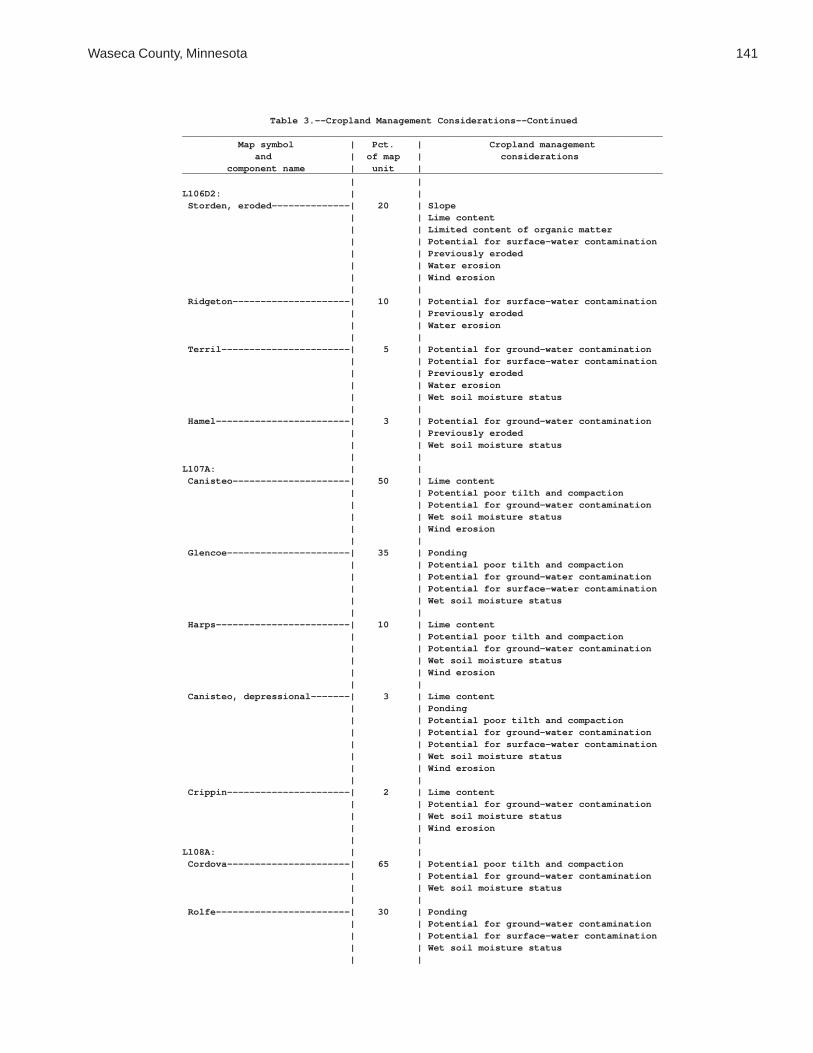
Waseca County, Minnesota 141
Table 3.--Cropland Management Considerations--Continued______________________________________________________________________________________ Map symbol | Pct. | Cropland management and | of map | considerations component name | unit |______________________________________________________________________________________ | |L106D2: | | Storden, eroded--------------| 20 | Slope | | Lime content | | Limited content of organic matter | | Potential for surface-water contamination | | Previously eroded | | Water erosion | | Wind erosion | | Ridgeton---------------------| 10 | Potential for surface-water contamination | | Previously eroded | | Water erosion | | Terril-----------------------| 5 | Potential for ground-water contamination | | Potential for surface-water contamination | | Previously eroded | | Water erosion | | Wet soil moisture status | | Hamel------------------------| 3 | Potential for ground-water contamination | | Previously eroded | | Wet soil moisture status | |L107A: | | Canisteo---------------------| 50 | Lime content | | Potential poor tilth and compaction | | Potential for ground-water contamination | | Wet soil moisture status | | Wind erosion | | Glencoe----------------------| 35 | Ponding | | Potential poor tilth and compaction | | Potential for ground-water contamination | | Potential for surface-water contamination | | Wet soil moisture status | | Harps------------------------| 10 | Lime content | | Potential poor tilth and compaction | | Potential for ground-water contamination | | Wet soil moisture status | | Wind erosion | | Canisteo, depressional-------| 3 | Lime content | | Ponding | | Potential poor tilth and compaction | | Potential for ground-water contamination | | Potential for surface-water contamination | | Wet soil moisture status | | Wind erosion | | Crippin----------------------| 2 | Lime content | | Potential for ground-water contamination | | Wet soil moisture status | | Wind erosion | |L108A: | | Cordova----------------------| 65 | Potential poor tilth and compaction | | Potential for ground-water contamination | | Wet soil moisture status | | Rolfe------------------------| 30 | Ponding | | Potential for ground-water contamination | | Potential for surface-water contamination | | Wet soil moisture status | |

142 Soil Survey of
Table 3.--Cropland Management Considerations--Continued______________________________________________________________________________________ Map symbol | Pct. | Cropland management and | of map | considerations component name | unit |______________________________________________________________________________________ | |L108A: | | Le Sueur---------------------| 5 | Potential poor tilth and compaction | | Potential for ground-water contamination | | Wet soil moisture status | |L109A: | | Marna------------------------| 65 | Potential poor tilth and compaction | | Potential for ground-water contamination | | Wet soil moisture status | | Barbert----------------------| 30 | Ponding | | Potential for ground-water contamination | | Potential for surface-water contamination | | Restricted permeability | | Wet soil moisture status | | Guckeen----------------------| 5 | Potential poor tilth and compaction | | Potential for ground-water contamination | | Potential for surface-water contamination | | Wet soil moisture status | |L110E: | | Lester-----------------------| 50 | Slope | | Potential for surface-water contamination | | Water erosion | | Ridgeton---------------------| 30 | Slope | | Potential for surface-water contamination | | Water erosion | | Cokato-----------------------| 10 | Slope | | Potential for surface-water contamination | | Water erosion | | Belview----------------------| 6 | Slope | | Lime content | | Potential for surface-water contamination | | Water erosion | | Wind erosion | | Hamel------------------------| 2 | Potential for ground-water contamination | | Water erosion | | Wet soil moisture status | | Terril-----------------------| 2 | Potential for ground-water contamination | | Potential for surface-water contamination | | Water erosion | |L110F: | | Lester-----------------------| 55 | Slope | | Potential for surface-water contamination | | Water erosion | | Ridgeton---------------------| 30 | Slope | | Potential for surface-water contamination | | Water erosion | | Cokato-----------------------| 8 | Slope | | Potential for surface-water contamination | | Water erosion | |

Waseca County, Minnesota 143
Table 3.--Cropland Management Considerations--Continued______________________________________________________________________________________ Map symbol | Pct. | Cropland management and | of map | considerations component name | unit |______________________________________________________________________________________ | |L110F: | | Belview----------------------| 4 | Slope | | Lime content | | Potential for surface-water contamination | | Water erosion | | Wind erosion | | Terril-----------------------| 2 | Potential for ground-water contamination | | Potential for surface-water contamination | | Water erosion | | Hamel------------------------| 1 | Potential for ground-water contamination | | Water erosion | | Wet soil moisture status | |L111A: | | Nicollet---------------------| 85 | Potential poor tilth and compaction | | Potential for ground-water contamination | | Wet soil moisture status | | Clarion----------------------| 10 | Potential for ground-water contamination | | Potential for surface-water contamination | | Water erosion | | Webster----------------------| 5 | Potential for ground-water contamination | | Wet soil moisture status | |L112A: | | Webster----------------------| 85 | Potential for ground-water contamination | | Wet soil moisture status | | Glencoe----------------------| 10 | Ponding | | Potential poor tilth and compaction | | Potential for ground-water contamination | | Potential for surface-water contamination | | Wet soil moisture status | | Nicollet---------------------| 5 | Potential poor tilth and compaction | | Potential for ground-water contamination | | Wet soil moisture status | |L113B: | | Reedslake--------------------| 75 | Potential for ground-water contamination | | Potential for surface-water contamination | | Water erosion | | Le Sueur---------------------| 10 | Potential poor tilth and compaction | | Potential for ground-water contamination | | Wet soil moisture status | | Reedslake, eroded------------| 10 | Potential for ground-water contamination | | Potential for surface-water contamination | | Water erosion | | Cordova----------------------| 5 | Potential poor tilth and compaction | | Potential for ground-water contamination | | Wet soil moisture status | |L114A: | | Hanlon, rarely flooded-------| 85 | Potential for ground-water contamination | | Wet soil moisture status | | Wind erosion | |

144 Soil Survey of
Table 3.--Cropland Management Considerations--Continued______________________________________________________________________________________ Map symbol | Pct. | Cropland management and | of map | considerations component name | unit |______________________________________________________________________________________ | |L114A: | | Coland, occasionally flooded | 10 | Flooding | | Potential poor tilth and compaction | | Potential for ground-water contamination | | Potential for surface-water contamination | | Wet soil moisture status | | Minneopa, rarely flooded-----| 5 | Excessive permeability | | Limited available water capacity | | Potential for ground-water contamination | | Wet soil moisture status | | Wind erosion | |L115A: | | Brownton---------------------| 55 | Lime content | | Potential poor tilth and compaction | | Potential for ground-water contamination | | Restricted permeability | | Wet soil moisture status | | Lura-------------------------| 35 | Ponding | | Potential poor tilth and compaction | | Potential for ground-water contamination | | Potential for surface-water contamination | | Restricted permeability | | Wet soil moisture status | | Marna------------------------| 10 | Potential poor tilth and compaction | | Potential for ground-water contamination | | Wet soil moisture status | |L116A: | | Le Sueur---------------------| 45 | Potential poor tilth and compaction | | Potential for ground-water contamination | | Wet soil moisture status | | Lerdal-----------------------| 40 | Acid soil | | Potential poor tilth and compaction | | Potential for ground-water contamination | | Potential for surface-water contamination | | Restricted permeability | | Wet soil moisture status | | Mazaska----------------------| 10 | Potential poor tilth and compaction | | Potential for ground-water contamination | | Wet soil moisture status | | Kilkenny---------------------| 5 | Potential poor tilth and compaction | | Potential for ground-water contamination | | Potential for surface-water contamination | | Water erosion | | Wet soil moisture status | |L117C2: | | Omsrud, eroded---------------| 65 | Potential for surface-water contamination | | Previously eroded | | Water erosion | | Omsrud-----------------------| 15 | Potential for surface-water contamination | | Previously eroded | | Water erosion | |

Waseca County, Minnesota 145
Table 3.--Cropland Management Considerations--Continued______________________________________________________________________________________ Map symbol | Pct. | Cropland management and | of map | considerations component name | unit |______________________________________________________________________________________ | |L117C2: | | Terril-----------------------| 10 | Potential for ground-water contamination | | Potential for surface-water contamination | | Previously eroded | | Water erosion | | Delft------------------------| 5 | Potential for ground-water contamination | | Previously eroded | | Wet soil moisture status | | Storden, eroded--------------| 5 | Lime content | | Limited content of organic matter | | Potential for surface-water contamination | | Previously eroded | | Water erosion | | Wind erosion | |L118A: | | Rushriver, frequently flooded| 85 | Flooding | | Lime content | | Potential for ground-water contamination | | Potential for surface-water contamination | | Wet soil moisture status | | Wind erosion | | Houghton, frequently flooded | 5 | Flooding | | High content of organic matter | | Potential for ground-water contamination | | Potential for surface-water contamination | | Wet soil moisture status | | Wind erosion | | Klossner, frequently flooded | 5 | Flooding | | High content of organic matter | | Potential for ground-water contamination | | Potential for surface-water contamination | | Wet soil moisture status | | Wind erosion | | Medo, frequently flooded-----| 5 | Flooding | | High content of organic matter | | Potential for ground-water contamination | | Potential for surface-water contamination | | Wet soil moisture status | | Wind erosion | |L119B: | | Angus------------------------| 80 | Potential for ground-water contamination | | Potential for surface-water contamination | | Water erosion | | Angus, eroded----------------| 10 | Potential for ground-water contamination | | Potential for surface-water contamination | | Water erosion | | Cordova----------------------| 5 | Potential poor tilth and compaction | | Potential for ground-water contamination | | Wet soil moisture status | | Le Sueur---------------------| 5 | Potential poor tilth and compaction | | Potential for ground-water contamination | | Wet soil moisture status | |

146 Soil Survey of
Table 3.--Cropland Management Considerations--Continued______________________________________________________________________________________ Map symbol | Pct. | Cropland management and | of map | considerations component name | unit |______________________________________________________________________________________ | |L120A: | | Good Thunder-----------------| 80 | Potential poor tilth and compaction | | Potential for ground-water contamination | | Potential for surface-water contamination | | Wet soil moisture status | | Ocheyedan--------------------| 10 | Potential for ground-water contamination | | Potential for surface-water contamination | | Water erosion | | Minnetonka-------------------| 10 | Potential poor tilth and compaction | | Potential for ground-water contamination | | Wet soil moisture status | |L121B: | | Clarion----------------------| 80 | Potential poor tilth and compaction | | Potential for ground-water contamination | | Potential for surface-water contamination | | Water erosion | | Guckeen----------------------| 15 | Potential poor tilth and compaction | | Potential for ground-water contamination | | Potential for surface-water contamination | | Water erosion | | Wet soil moisture status | | Marna------------------------| 5 | Potential poor tilth and compaction | | Potential for ground-water contamination | | Wet soil moisture status | |L122B: | | Reedslake--------------------| 55 | Potential for ground-water contamination | | Potential for surface-water contamination | | Water erosion | | Estherville------------------| 25 | Excessive permeability | | Limited available water capacity | | Potential for ground-water contamination | | Potential for surface-water contamination | | Water erosion | | Wind erosion | | Le Sueur---------------------| 10 | Potential poor tilth and compaction | | Potential for ground-water contamination | | Wet soil moisture status | | Cordova----------------------| 5 | Potential poor tilth and compaction | | Potential for ground-water contamination | | Wet soil moisture status | | Lowlein----------------------| 5 | Excessive permeability | | Potential for ground-water contamination | | Wet soil moisture status | | Wind erosion | |L123A: | | Belleville-------------------| 85 | Excessive permeability | | Potential for ground-water contamination | | Wet soil moisture status | | Wind erosion | |

Waseca County, Minnesota 147
Table 3.--Cropland Management Considerations--Continued______________________________________________________________________________________ Map symbol | Pct. | Cropland management and | of map | considerations component name | unit |______________________________________________________________________________________ | |L123A: | | Granby-----------------------| 15 | Excessive permeability | | Limited available water capacity | | Ponding | | Potential for ground-water contamination | | Potential for surface-water contamination | | Wet soil moisture status | | Wind erosion | |L124A: | | Glencoe mucky clay loam------| 85 | Ponding | | Potential for ground-water contamination | | Potential for surface-water contamination | | Wet soil moisture status | | Canisteo---------------------| 10 | Lime content | | Potential poor tilth and compaction | | Potential for ground-water contamination | | Wet soil moisture status | | Wind erosion | | Glencoe clay loam------------| 5 | Ponding | | Potential poor tilth and compaction | | Potential for ground-water contamination | | Potential for surface-water contamination | | Wet soil moisture status | |L125A: | | Hanlon, rarely flooded-------| 60 | Potential for ground-water contamination | | Wet soil moisture status | | Wind erosion | | Coland, occasionally flooded | 25 | Flooding | | Potential poor tilth and compaction | | Potential for ground-water contamination | | Potential for surface-water contamination | | Wet soil moisture status | | Minneopa, rarely flooded-----| 15 | Excessive permeability | | Limited available water capacity | | Potential for ground-water contamination | | Wet soil moisture status | | Wind erosion | |L126A: | | Coland, occasionally flooded | 80 | Flooding | | Potential poor tilth and compaction | | Potential for ground-water contamination | | Potential for surface-water contamination | | Wet soil moisture status | | Minneopa, occasionally | | flooded---------------------| 10 | Excessive permeability | | Limited available water capacity | | Potential for ground-water contamination | | Wet soil moisture status | | Wind erosion | |

148 Soil Survey of
Table 3.--Cropland Management Considerations--Continued______________________________________________________________________________________ Map symbol | Pct. | Cropland management and | of map | considerations component name | unit |______________________________________________________________________________________ | |L126A: | | Havelock, occasionally | | flooded---------------------| 5 | Flooding | | Lime content | | Potential poor tilth and compaction | | Potential for ground-water contamination | | Potential for surface-water contamination | | Wet soil moisture status | | Wind erosion | | Spillville, occasionally | | flooded---------------------| 5 | Flooding | | Potential for ground-water contamination | | Potential for surface-water contamination | | Wet soil moisture status | |L127A: | | Coland, frequently flooded---| 80 | Flooding | | Channeled | | Potential poor tilth and compaction | | Potential for ground-water contamination | | Potential for surface-water contamination | | Wet soil moisture status | | Minneopa, occasionally | | flooded---------------------| 10 | Channeled | | Excessive permeability | | Limited available water capacity | | Potential for ground-water contamination | | Wet soil moisture status | | Wind erosion | | Havelock, frequently flooded | 5 | Flooding | | Channeled | | Lime content | | Potential for ground-water contamination | | Potential for surface-water contamination | | Wet soil moisture status | | Wind erosion | | Spillville, occasionally | | flooded---------------------| 5 | Flooding | | Channeled | | Potential for ground-water contamination | | Potential for surface-water contamination | | Wet soil moisture status | |L128A: | | Mazaska----------------------| 60 | Potential poor tilth and compaction | | Potential for ground-water contamination | | Wet soil moisture status | | Rolfe------------------------| 30 | Ponding | | Potential for ground-water contamination | | Potential for surface-water contamination | | Wet soil moisture status | | Lerdal-----------------------| 10 | Acid soil | | Potential poor tilth and compaction | | Potential for ground-water contamination | | Potential for surface-water contamination | | Restricted permeability | | Wet soil moisture status | |

Waseca County, Minnesota 149
Table 3.--Cropland Management Considerations--Continued______________________________________________________________________________________ Map symbol | Pct. | Cropland management and | of map | considerations component name | unit |______________________________________________________________________________________ | |L129B: | | Terril-----------------------| 90 | Potential for ground-water contamination | | Potential for surface-water contamination | | Water erosion | | Delft------------------------| 5 | Potential for ground-water contamination | | Wet soil moisture status | | Hamel------------------------| 5 | Potential for ground-water contamination | | Wet soil moisture status | |L130A: | | Okoboji mucky silty clay loam| 75 | Ponding | | Potential poor tilth and compaction | | Potential for ground-water contamination | | Potential for surface-water contamination | | Wet soil moisture status | | Okoboji silty clay loam------| 15 | Ponding | | Potential poor tilth and compaction | | Potential for ground-water contamination | | Potential for surface-water contamination | | Wet soil moisture status | | Brownton---------------------| 5 | Lime content | | Potential poor tilth and compaction | | Potential for ground-water contamination | | Restricted permeability | | Wet soil moisture status | | Spicer-----------------------| 5 | Lime content | | Potential poor tilth and compaction | | Potential for ground-water contamination | | Wet soil moisture status | | Wind erosion | |M-W. | | Water, miscellaneous | | | |U3B. | | Udorthents (cut and fill | | land) | | | |W. | | Water | | | |______________________________________________________________________________________

150S
oil Survey of
Table 4.--Land Capability and Yields per Acre of Crops and Pasture
(Yields are those that can be expected under a high level of management. They are for nonirrigated areas. Absence of a yield indicates that the soil is not suited to the crop or the crop generally is not grown on the soil)
_____________________________________________________________________________________________________________________________ | | | | | | | | Map symbol and | Pct. of | Land |Bromegrass- |Bromegrass- | Reed | Corn | Oats | Soybeans component name | map unit| capability | alfalfa |alfalfa hay |canarygrass | | |_____________________________________________________________________________________________________________________________ | | | AUM* | Tons | Tons | Bu | Bu | Bu | | | | | | | |GP: | | | | | | | | Pits, gravel. | | | | | | | | | | | | | | | | Udipsamments. | | | | | | | | | | | | | | | |L5A----------------------| | | 5.6 | 4.4 | --- | 154 | 92 | 47 Delft, overwash---------| 50 | 2w | | | | | | | | | | | | | | Delft-------------------| 40 | 2w | | | | | | | | | | | | | |L13A---------------------| 80 | 3w | 4.1 | 3.1 | --- | 127 | 81 | 39 Klossner, drained | | | | | | | | | | | | | | | |L14A---------------------| 80 | 3w | --- | --- | --- | 126 | 81 | 39 Houghton, drained | | | | | | | | | | | | | | | |L15A---------------------| | | --- | --- | --- | --- | --- | --- Klossner, ponded--------| 30 | 8w | | | | | | | | | | | | | | Okoboji, ponded---------| 30 | 8w | | | | | | | | | | | | | | Glencoe, ponded---------| 30 | 8w | | | | | | | | | | | | | |L16A---------------------| | | --- | --- | --- | --- | --- | --- Muskego, ponded---------| 30 | 8w | | | | | | | | | | | | | | Blue Earth, ponded------| 30 | 8w | | | | | | | | | | | | | | Houghton, ponded--------| 30 | 8w | | | | | | | | | | | | | |L26B---------------------| 90 | 2e | 5.6 | 4.4 | --- | 145 | 85 | 42 Shorewood | | | | | | | | | | | | | | | |L36A---------------------| | | 5.8 | 4.5 | --- | 155 | 90 | 47 Hamel, overwash---------| 50 | 2w | | | | | | | | | | | | | | Hamel-------------------| 43 | 2w | | | | | | | | | | | | | |L40B---------------------| | | 5.5 | 4.3 | --- | 149 | 86 | 46 Angus-------------------| 45 | 2e | | | | | | | | | | | | | | Kilkenny----------------| 40 | 2e | | | | | | | | | | | | | |
See footnote at end of table.

Waseca C
ounty, Minnesota
151
Table 4.--Land Capability and Yields per Acre of Crops and Pasture--Continued_____________________________________________________________________________________________________________________________ | | | | | | | | Map symbol and | Pct. of | Land |Bromegrass- |Bromegrass- | Reed | Corn | Oats | Soybeans component name | map unit| capability | alfalfa |alfalfa hay |canarygrass | | |_____________________________________________________________________________________________________________________________ | | | AUM* | Tons | Tons | Bu | Bu | Bu | | | | | | | |L41C2--------------------| | | 6.1 | 4.4 | --- | 142 | 81 | 43 Lester, eroded----------| 45 | 3e | | | | | | | | | | | | | | Kilkenny, eroded--------| 40 | 3e | | | | | | | | | | | | | |L41D2--------------------| | | 5.5 | 4.2 | --- | 127 | 71 | 41 Lester, eroded----------| 45 | 4e | | | | | | | | | | | | | | Kilkenny, eroded--------| 35 | 4e | | | | | | | | | | | | | |L41E---------------------| | | 4.0 | 3.1 | --- | --- | --- | --- Lester------------------| 45 | 6e | | | | | | | | | | | | | | Kilkenny----------------| 40 | 6e | | | | | | | | | | | | | |L48A---------------------| | | 5.8 | 4.4 | --- | 145 | 90 | 50 Derrynane, overwash-----| 50 | 2w | | | | | | | | | | | | | | Derrynane---------------| 40 | 2w | | | | | | | | | | | | | |L49A---------------------| | | --- | --- | 5.0 | --- | --- | --- Klossner, surface | | | | | | | | drained----------------| 65 | 6w | | | | | | | | | | | | | | Klossner, drained-------| 20 | 3w | | | | | | | | | | | | | |L50A---------------------| | | --- | --- | 5.0 | --- | --- | --- Houghton, surface | | | | | | | | drained----------------| 40 | 6w | | | | | | | | | | | | | | Muskego, surface drained| 40 | 6w | | | | | | | | | | | | | |L51C2--------------------| 80 | 3e | 5.8 | 4.4 | --- | 139 | 81 | 43 Gladek, eroded | | | | | | | | | | | | | | | |L56A---------------------| | | --- | --- | --- | --- | --- | --- Muskego, frequently | | | | | | | | flooded----------------| 45 | 6w | | | | | | | | | | | | | | Klossner, frequently | | | | | | | | flooded----------------| 45 | 6w | | | | | | | | | | | | | |L57A---------------------| 80 | 3w | 4.4 | 3.3 | --- | 125 | 75 | 38 Medo, drained | | | | | | | | | | | | | | | |
See footnote at end of table.

152S
oil Survey of
Table 4.--Land Capability and Yields per Acre of Crops and Pasture--Continued_____________________________________________________________________________________________________________________________ | | | | | | | | Map symbol and | Pct. of | Land |Bromegrass- |Bromegrass- | Reed | Corn | Oats | Soybeans component name | map unit| capability | alfalfa |alfalfa hay |canarygrass | | |_____________________________________________________________________________________________________________________________ | | | AUM* | Tons | Tons | Bu | Bu | Bu | | | | | | | |L63A---------------------| 85 | 3w | 4.3 | 3.3 | --- | 127 | 81 | 39 Klossner | | | | | | | | | | | | | | | |L64A---------------------| | | --- | --- | --- | --- | --- | --- Tadkee------------------| 50 | 3w | | | | | | | | | | | | | | Tadkee, depressional----| 36 | 6w | | | | | | | | | | | | | |L73A---------------------| 80 | 3w | 4.5 | 3.5 | --- | 118 | 78 | 36 Blue Earth | | | | | | | | | | | | | | | |L74A---------------------| 87 | 3s | 2.7 | 2.1 | --- | 75 | 57 | 21 Estherville | | | | | | | | | | | | | | | |L75B---------------------| 85 | 2e | 5.7 | 4.4 | --- | 155 | 86 | 49 Barrington | | | | | | | | | | | | | | | |L76B---------------------| 80 | 3e | 4.1 | 3.1 | --- | 105 | 76 | 32 Dickinson | | | | | | | | | | | | | | | |L77A---------------------| 75 | 2w | 5.4 | 4.1 | --- | 148 | 84 | 44 Brownton | | | | | | | | | | | | | | | |L78A---------------------| 65 | 2w | 5.6 | 4.3 | --- | 153 | 86 | 44 Canisteo | | | | | | | | | | | | | | | |L79B---------------------| 65 | 2e | 6.4 | 5.0 | --- | 160 | 92 | 51 Clarion | | | | | | | | | | | | | | | |L80C2--------------------| 75 | 3e | 5.9 | 4.5 | --- | 145 | 82 | 44 Lester, eroded | | | | | | | | | | | | | | | |L80D2--------------------| 75 | 4e | 5.2 | 4.0 | --- | 123 | 67 | 40 Lester, eroded | | | | | | | | | | | | | | | |L81A---------------------| 85 | 2w | 5.8 | 4.4 | --- | 153 | 89 | 49 Cordova | | | | | | | | | | | | | | | |L82A---------------------| 85 | 2w | 5.7 | 4.3 | --- | 151 | 90 | 49 Marna | | | | | | | | | | | | | | | |L83A---------------------| 65 | 2w | 5.7 | 4.4 | --- | 157 | 89 | 48 Webster | | | | | | | | | | | | | | | |L84A---------------------| 80 | 3w | 4.6 | 3.6 | --- | 137 | 81 | 39 Glencoe | | | | | | | | | | | | | | | |
See footnote at end of table.

Waseca C
ounty, Minnesota
153
Table 4.--Land Capability and Yields per Acre of Crops and Pasture--Continued_____________________________________________________________________________________________________________________________ | | | | | | | | Map symbol and | Pct. of | Land |Bromegrass- |Bromegrass- | Reed | Corn | Oats | Soybeans component name | map unit| capability | alfalfa |alfalfa hay |canarygrass | | |_____________________________________________________________________________________________________________________________ | | | AUM* | Tons | Tons | Bu | Bu | Bu | | | | | | | |L85A---------------------| 85 | 1 | 6.4 | 5.0 | --- | 166 | 94 | 51 Nicollet | | | | | | | | | | | | | | | |L86A---------------------| 90 | 2w | 5.8 | 4.4 | --- | 159 | 90 | 48 Madelia | | | | | | | | | | | | | | | |L87A---------------------| 85 | 1 | 6.4 | 4.9 | --- | 167 | 93 | 52 Kingston | | | | | | | | | | | | | | | |L88A---------------------| 85 | 3w | 4.5 | 3.5 | --- | 131 | 80 | 38 Lura | | | | | | | | | | | | | | | |L89A---------------------| 82 | 2w | 6.3 | 4.8 | --- | 162 | 93 | 51 Guckeen | | | | | | | | | | | | | | | |L90A---------------------| 75 | 1 | 6.4 | 5.0 | --- | 162 | 93 | 51 Le Sueur | | | | | | | | | | | | | | | |L91A---------------------| 85 | 2w | 5.1 | 4.1 | --- | 132 | 84 | 43 Mazaska | | | | | | | | | | | | | | | |L92A---------------------| 78 | 2w | 5.4 | 4.1 | --- | 147 | 86 | 45 Darfur | | | | | | | | | | | | | | | |L93A---------------------| 82 | 4w | 4.5 | 3.5 | --- | 120 | 80 | 35 Muskego | | | | | | | | | | | | | | | |L94A---------------------| 75 | 1 | 5.0 | 3.8 | --- | 136 | 88 | 42 Lowlein | | | | | | | | | | | | | | | |L95E---------------------| 80 | 7s | 2.3 | 1.7 | --- | --- | --- | --- Hawick | | | | | | | | | | | | | | | |L96B---------------------| | | 2.7 | 2.0 | --- | 69 | 54 | 21 Estherville-------------| 55 | 3s | | | | | | | | | | | | | | Hawick------------------| 35 | 4s | | | | | | | | | | | | | |L97C---------------------| | | 2.3 | 1.7 | --- | 61 | 50 | 18 Hawick------------------| 60 | 4s | | | | | | | | | | | | | | Estherville-------------| 30 | 4s | | | | | | | | | | | | | |
See footnote at end of table.
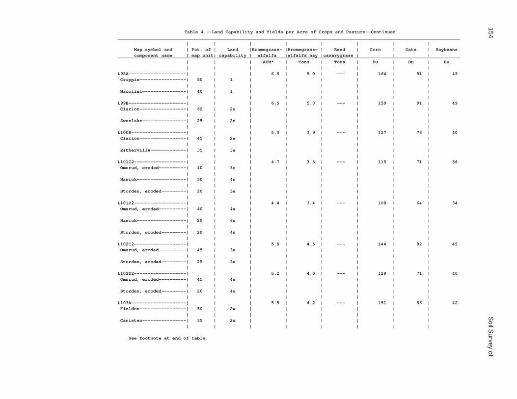
154S
oil Survey of
Table 4.--Land Capability and Yields per Acre of Crops and Pasture--Continued_____________________________________________________________________________________________________________________________ | | | | | | | | Map symbol and | Pct. of | Land |Bromegrass- |Bromegrass- | Reed | Corn | Oats | Soybeans component name | map unit| capability | alfalfa |alfalfa hay |canarygrass | | |_____________________________________________________________________________________________________________________________ | | | AUM* | Tons | Tons | Bu | Bu | Bu | | | | | | | |L98A---------------------| | | 6.5 | 5.0 | --- | 164 | 91 | 49 Crippin-----------------| 50 | 1 | | | | | | | | | | | | | | Nicollet----------------| 40 | 1 | | | | | | | | | | | | | |L99B---------------------| | | 6.5 | 5.0 | --- | 159 | 91 | 49 Clarion-----------------| 62 | 2e | | | | | | | | | | | | | | Swanlake----------------| 25 | 2e | | | | | | | | | | | | | |L100B--------------------| | | 5.0 | 3.9 | --- | 127 | 78 | 40 Clarion-----------------| 45 | 2e | | | | | | | | | | | | | | Estherville-------------| 35 | 3s | | | | | | | | | | | | | |L101C2-------------------| | | 4.7 | 3.5 | --- | 115 | 71 | 36 Omsrud, eroded----------| 40 | 3e | | | | | | | | | | | | | | Hawick------------------| 30 | 4s | | | | | | | | | | | | | | Storden, eroded---------| 20 | 3e | | | | | | | | | | | | | |L101D2-------------------| | | 4.4 | 3.4 | --- | 108 | 64 | 34 Omsrud, eroded----------| 40 | 4e | | | | | | | | | | | | | | Hawick------------------| 25 | 6s | | | | | | | | | | | | | | Storden, eroded---------| 20 | 4e | | | | | | | | | | | | | |L102C2-------------------| | | 5.8 | 4.5 | --- | 144 | 82 | 45 Omsrud, eroded----------| 45 | 3e | | | | | | | | | | | | | | Storden, eroded---------| 25 | 3e | | | | | | | | | | | | | |L102D2-------------------| | | 5.2 | 4.0 | --- | 129 | 71 | 40 Omsrud, eroded----------| 45 | 4e | | | | | | | | | | | | | | Storden, eroded---------| 20 | 4e | | | | | | | | | | | | | |L103A--------------------| | | 5.5 | 4.2 | --- | 151 | 86 | 42 Fieldon-----------------| 50 | 2w | | | | | | | | | | | | | | Canisteo----------------| 35 | 2w | | | | | | | | | | | | | |
See footnote at end of table.

Waseca C
ounty, Minnesota
155
Table 4.--Land Capability and Yields per Acre of Crops and Pasture--Continued_____________________________________________________________________________________________________________________________ | | | | | | | | Map symbol and | Pct. of | Land |Bromegrass- |Bromegrass- | Reed | Corn | Oats | Soybeans component name | map unit| capability | alfalfa |alfalfa hay |canarygrass | | |_____________________________________________________________________________________________________________________________ | | | AUM* | Tons | Tons | Bu | Bu | Bu | | | | | | | |L105C2-------------------| | | 4.5 | 3.5 | --- | 112 | 69 | 34 Lester, eroded----------| 45 | 3e | | | | | | | | | | | | | | Hawick------------------| 35 | 4s | | | | | | | | | | | | | |L105D2-------------------| | | 4.1 | 3.1 | --- | 99 | 60 | 32 Lester, eroded----------| 45 | 4e | | | | | | | | | | | | | | Hawick------------------| 35 | 6s | | | | | | | | | | | | | |L106C2-------------------| | | 5.9 | 4.5 | --- | 142 | 80 | 44 Lester, eroded----------| 62 | 3e | | | | | | | | | | | | | | Storden, eroded---------| 20 | 3e | | | | | | | | | | | | | |L106D2-------------------| | | 5.3 | 4.0 | --- | 122 | 67 | 40 Lester, eroded----------| 62 | 4e | | | | | | | | | | | | | | Storden, eroded---------| 20 | 4e | | | | | | | | | | | | | |L107A--------------------| | | 5.3 | 4.1 | --- | 148 | 84 | 42 Canisteo----------------| 50 | 2w | | | | | | | | | | | | | | Glencoe-----------------| 35 | 3w | | | | | | | | | | | | | |L108A--------------------| | | 5.3 | 4.0 | --- | 134 | 78 | 43 Cordova-----------------| 65 | 2w | | | | | | | | | | | | | | Rolfe-------------------| 30 | 3w | | | | | | | | | | | | | |L109A--------------------| | | 5.2 | 4.0 | --- | 145 | 87 | 46 Marna-------------------| 65 | 2w | | | | | | | | | | | | | | Barbert-----------------| 30 | 3w | | | | | | | | | | | | | |L110E--------------------| | | 4.1 | 3.2 | --- | --- | --- | --- Lester------------------| 50 | 6e | | | | | | | | | | | | | | Ridgeton----------------| 30 | 4e | | | | | | | | | | | | | |L110F--------------------| | | --- | --- | --- | --- | --- | --- Lester------------------| 55 | 7e | | | | | | | | | | | | | | Ridgeton----------------| 30 | 6e | | | | | | | | | | | | | |
See footnote at end of table.

156S
oil Survey of
Table 4.--Land Capability and Yields per Acre of Crops and Pasture--Continued_____________________________________________________________________________________________________________________________ | | | | | | | | Map symbol and | Pct. of | Land |Bromegrass- |Bromegrass- | Reed | Corn | Oats | Soybeans component name | map unit| capability | alfalfa |alfalfa hay |canarygrass | | |_____________________________________________________________________________________________________________________________ | | | AUM* | Tons | Tons | Bu | Bu | Bu | | | | | | | |L111A--------------------| 85 | 1 | 6.5 | 5.0 | --- | 166 | 94 | 51 Nicollet | | | | | | | | | | | | | | | |L112A--------------------| 85 | 2w | 5.8 | 4.4 | --- | 159 | 90 | 49 Webster | | | | | | | | | | | | | | | |L113B--------------------| 75 | 2e | 6.4 | 4.9 | --- | 160 | 91 | 51 Reedslake | | | | | | | | | | | | | | | |L114A--------------------| 85 | 2s | 5.1 | 3.9 | --- | 132 | 76 | 39 Hanlon, rarely flooded | | | | | | | | | | | | | | | |L115A--------------------| | | 5.1 | 3.9 | --- | 142 | 83 | 42 Brownton----------------| 55 | 2w | | | | | | | | | | | | | | Lura--------------------| 35 | 3w | | | | | | | | | | | | | |L116A--------------------| | | 5.7 | 4.4 | --- | 141 | 82 | 44 Le Sueur----------------| 45 | 1 | | | | | | | | | | | | | | Lerdal------------------| 40 | 2e | | | | | | | | | | | | | |L117C2-------------------| 65 | 3e | 5.9 | 4.5 | --- | 149 | 84 | 46 Omsrud, eroded | | | | | | | | | | | | | | | |L118A--------------------| 85 | 5w | --- | --- | --- | --- | --- | --- Rushriver, frequently | | | | | | | | flooded | | | | | | | | | | | | | | | |L119B--------------------| 80 | 2e | 5.7 | 4.4 | --- | 158 | 90 | 49 Angus | | | | | | | | | | | | | | | |L120A--------------------| 80 | 2w | 5.6 | 4.3 | --- | 147 | 85 | 43 Good Thunder | | | | | | | | | | | | | | | |L121B--------------------| 80 | 2e | 5.9 | 4.5 | --- | 159 | 93 | 51 Clarion | | | | | | | | | | | | | | | |L122B--------------------| | | 5.4 | 4.1 | --- | 136 | 82 | 43 Reedslake---------------| 55 | 2e | | | | | | | | | | | | | | Estherville-------------| 25 | 3s | | | | | | | | | | | | | |L123A--------------------| 85 | 2w | 3.4 | 2.6 | --- | 101 | 72 | 31 Belleville | | | | | | | | | | | | | | | |
See footnote at end of table.

Waseca C
ounty, Minnesota
157
Table 4.--Land Capability and Yields per Acre of Crops and Pasture--Continued_____________________________________________________________________________________________________________________________ | | | | | | | | Map symbol and | Pct. of | Land |Bromegrass- |Bromegrass- | Reed | Corn | Oats | Soybeans component name | map unit| capability | alfalfa |alfalfa hay |canarygrass | | |_____________________________________________________________________________________________________________________________ | | | AUM* | Tons | Tons | Bu | Bu | Bu | | | | | | | |L124A--------------------| 85 | 3w | 4.6 | 3.5 | --- | 133 | 81 | 38 Glencoe | | | | | | | | | | | | | | | |L125A--------------------| | | 5.0 | 3.8 | --- | 127 | 73 | 38 Hanlon, rarely flooded--| 60 | 2s | | | | | | | | | | | | | | Coland, occasionally | | | | | | | | flooded----------------| 25 | 2w | | | | | | | | | | | | | |L126A--------------------| 80 | 2w | 5.1 | 3.9 | --- | 141 | 77 | 43 Coland, occasionally | | | | | | | | flooded | | | | | | | | | | | | | | | |L127A--------------------| 80 | 5w | --- | --- | --- | --- | --- | --- Coland, frequently | | | | | | | | flooded | | | | | | | | | | | | | | | |L128A--------------------| | | 4.8 | 3.7 | --- | 118 | 74 | 39 Mazaska-----------------| 60 | 2w | | | | | | | | | | | | | | Rolfe-------------------| 30 | 3w | | | | | | | | | | | | | |L129B--------------------| 90 | 2e | 6.5 | 5.1 | --- | 160 | 95 | 51 Terril | | | | | | | | | | | | | | | |L130A--------------------| 75 | 3w | 4.4 | 3.4 | --- | 131 | 81 | 38 Okoboji | | | | | | | | | | | | | | | |M-W. | | | | | | | | Water, miscellaneous | | | | | | | | | | | | | | | |U3B. | | | | | | | | Udorthents (cut and fill| | | | | | | | land) | | | | | | | | | | | | | | | |W. | | | | | | | | Water | | | | | | | | | | | | | | | |_____________________________________________________________________________________________________________________________
* Animal unit month: The amount of forage or feed required to feed one animal unit (one cow, one horse, one mule, fivesheep, or five goats) for 30 days.

158 Soil Survey of
Table 5.--Prime Farmland
(Only the soils considered prime farmland are listed. Urban or built-up areas of the soils listed are not considered prime farmland. If a soil is prime farmland only under certain conditions, the conditions are specified in parentheses after the soil name)
_______________________________________________________________________________________________________ | Map | Soil namesymbol | |_______________________________________________________________________________________________________ |L5A |Delft, overwash-Delft complex, 1 to 4 percent slopes (where drained)L26B |Shorewood silty clay loam, 3 to 6 percent slopesL36A |Hamel, overwash-Hamel complex, 1 to 4 percent slopes (where drained)L40B |Angus-Kilkenny complex, 2 to 6 percent slopesL48A |Derrynane, overwash-Derrynane complex, 1 to 4 percent slopes (where drained)L75B |Barrington silt loam, 2 to 6 percent slopesL76B |Dickinson fine sandy loam, 1 to 6 percent slopesL77A |Brownton silty clay loam, 0 to 2 percent slopes (where drained)L78A |Canisteo clay loam, 0 to 2 percent slopes (where drained)L79B |Clarion loam, 2 to 5 percent slopesL81A |Cordova clay loam, 0 to 2 percent slopes (where drained)L82A |Marna silty clay loam, 0 to 2 percent slopes (where drained)L83A |Webster clay loam, 0 to 2 percent slopes (where drained)L84A |Glencoe clay loam, depressional, 0 to 1 percent slopes (where drained)L85A |Nicollet clay loam, 1 to 3 percent slopesL86A |Madelia silty clay loam, 0 to 2 percent slopes (where drained)L87A |Kingston silty clay loam, 1 to 3 percent slopesL88A |Lura silty clay, depressional, 0 to 1 percent slopes (where drained)L89A |Guckeen silty clay loam, 0 to 3 percent slopesL90A |Le Sueur clay loam, 0 to 3 percent slopesL91A |Mazaska silty clay loam, 0 to 2 percent slopes (where drained)L92A |Darfur loam, 0 to 2 percent slopes (where drained)L94A |Lowlein fine sandy loam, terrace, 0 to 3 percent slopesL98A |Crippin-Nicollet complex, 1 to 3 percent slopesL99B |Clarion-Swanlake complex, 2 to 6 percent slopesL103A |Fieldon-Canisteo complex, 0 to 2 percent slopes (where drained)L107A |Canisteo-Glencoe, depressional, complex, 0 to 2 percent slopes (where drained)L108A |Cordova-Rolfe, depressional, complex, 0 to 2 percent slopes (where drained)L109A |Marna-Barbert, depressional, complex, 0 to 2 percent slopes (where drained)L111A |Nicollet silty clay loam, 1 to 3 percent slopesL112A |Webster silty clay loam, 0 to 2 percent slopes (where drained)L113B |Reedslake loam, 2 to 5 percent slopesL114A |Hanlon fine sandy loam, 0 to 3 percent slopes, rarely floodedL115A |Brownton-Lura, depressional, complex, 0 to 2 percent slopes (where drained)L116A |Le Sueur-Lerdal complex, 1 to 3 percent slopesL119B |Angus loam, 2 to 5 percent slopesL120A |Good Thunder silty clay loam, 0 to 3 percent slopesL121B |Clarion clay loam, 2 to 5 percent slopesL124A |Glencoe mucky clay loam, depressional, 0 to 1 percent slopes (where drained)L125A |Hanlon, rarely flooded-Coland, occasionally flooded, complex, 0 to 3 percent slopes (where | protected from flooding or not frequently flooded during the growing season)L126A |Coland silty clay loam, 0 to 2 percent slopes, occasionally flooded (where | protected from flooding or not frequently flooded during the growing season)L128A |Mazaska-Rolfe, depressional, complex, 0 to 2 percent slopes (where drained)L129B |Terril loam, 2 to 6 percent slopesL130A |Okoboji mucky silty clay loam, depressional, 0 to 1 percent slopes (where drained) |_______________________________________________________________________________________________________

Waseca C
ounty, Minnesota
159
Table 6.--Windbreaks and Environmental Plantings
(Only the soils suitable for windbreaks and environmental plantings are listed. Absence of an entry indicates that trees generally do not grow to the given height)
____________________________________________________________________________________________________________________________________________ | | Trees having predicted 20-year average height, in feet, of-- Map symbol and | Pct. of |________________________________________________________________________________________________________ component name | map unit| <8 | 8-15 | 16-25 | 26-35 | >35____________________________________________________________________________________________________________________________________________ | | | | | |L5A: | | | | | | Delft, overwash---------| 50 | --- |American plum, |Amur maple, eastern |Golden willow-------|Green ash, silver | | | redosier dogwood | arborvitae, white | | maple, eastern | | | | spruce, common | | cottonwood | | | | hackberry, tall | | | | | | purple willow | | | | | | | | Delft-------------------| 40 | --- |American plum, |Amur maple, eastern |Golden willow-------|Green ash, silver | | | redosier dogwood | arborvitae, white | | maple, eastern | | | | spruce, common | | cottonwood | | | | hackberry, tall | | | | | | purple willow | | | | | | | | Glencoe-----------------| 5 |Redosier dogwood----| --- |Black ash, tall |Black willow, golden| --- | | | | purple willow | willow, white | | | | | | willow | | | | | | | Terril------------------| 5 |Redosier dogwood----|Siberian peashrub, |Eastern redcedar, |Honeylocust, jack |Silver maple, | | | American plum, | Amur maple, Black | pine, black walnut,| Siouxland | | | common lilac, | Hills spruce, | common hackberry, | cottonwood | | | prunus, silver | Norway spruce | eastern white pine,| | | | buffaloberry | | green ash | | | | | | |L13A: | | | | | | Klossner, drained-------| 80 | --- |Redosier dogwood, |Black ash-----------|Golden willow-------| --- | | | silky dogwood | | | | | | | | | Mineral soil, drained---| 15 |Redosier dogwood----|Silky dogwood |Green ash, northern |Golden willow-------|Eastern cottonwood | | | | whitecedar | | | | | | | | Houghton, drained-------| 5 | --- |Redosier dogwood, |Black ash-----------|Golden willow-------| --- | | | silky dogwood | | | | | | | | |L14A: | | | | | | Houghton, drained-------| 80 | --- |Redosier dogwood, |Black ash-----------|Golden willow-------| --- | | | silky dogwood | | | | | | | | | Klossner, drained-------| 10 | --- |Redosier dogwood, |Black ash-----------|Golden willow-------| --- | | | silky dogwood | | | | | | | | | Mineral soil, drained---| 10 |Redosier dogwood----|Silky dogwood-------|Green ash, northern |Golden willow-------|Eastern cottonwood | | | | whitecedar | | | | | | | |

160S
oil Survey of
Table 6.--Windbreaks and Environmental Plantings--Continued____________________________________________________________________________________________________________________________________________ | | Trees having predicted 20-year average height, in feet, of-- Map symbol and | Pct. of |________________________________________________________________________________________________________ component name | map unit| <8 | 8-15 | 16-25 | 26-35 | >35____________________________________________________________________________________________________________________________________________ | | | | | |L26B: | | | | | | Shorewood---------------| 90 |Hedge cotoneaster---|American |Black Hills spruce, |Green ash, jack pine|Silver maple, | | | cranberrybush, | Siberian crabapple,| | eastern cottonwood | | | Siberian peashrub, | eastern redcedar, | | | | | common chokecherry,| white spruce, Amur | | | | | common lilac, | maple, Austrian | | | | | cotoneaster, | pine, ponderosa | | | | | American plum, | pine, common | | | | | silver buffaloberry| hackberry, eastern | | | | | | white pine, red | | | | | | pine | | | | | | | | Good Thunder------------| 5 |Hedge cotoneaster---|American |Black Hills spruce, |Green ash, jack pine|Silver maple, | | | cranberrybush, | Siberian crabapple,| | eastern cottonwood | | | Siberian peashrub, | eastern redcedar, | | | | | common chokecherry,| white spruce, Amur | | | | | common lilac, | maple, Austrian | | | | | cotoneaster, | pine, Russian- | | | | | American plum, | olive, ponderosa | | | | | silver buffaloberry| pine, common | | | | | | hackberry, eastern | | | | | | white pine, red | | | | | | pine | | | | | | | | Minnetonka--------------| 5 |Nanking cherry------|American |American plum, blue |Eastern white pine, |Green ash, silver | | | cranberrybush, | spruce, Black Hills| golden willow | maple, Siouxland | | | cotoneaster, | spruce, ponderosa | | cottonwood, eastern | | | sargent crabapple, | pine, common | | cottonwood | | | common lilac, | hackberry | | | | | eastern redcedar, | | | | | | redosier dogwood, | | | | | | silver buffaloberry| | | | | | | | |L36A: | | | | | | Hamel, overwash---------| 50 | --- |American |Black Hills spruce, |Eastern white pine, |Silver maple, | | | cranberrybush, | blue spruce, white | northern red oak, | eastern cottonwood, | | | Nanking cherry, | spruce, eastern | green ash | Siouxland | | | common chokecherry,| redcedar, ponderosa| | cottonwood | | | redosier dogwood, | pine, Amur maple, | | | | | sargent crabapple, | common hackberry | | | | | American plum, | | | | | | common lilac | | | | | | | | |

Waseca C
ounty, Minnesota
161
Table 6.--Windbreaks and Environmental Plantings--Continued____________________________________________________________________________________________________________________________________________ | | Trees having predicted 20-year average height, in feet, of-- Map symbol and | Pct. of |________________________________________________________________________________________________________ component name | map unit| <8 | 8-15 | 16-25 | 26-35 | >35____________________________________________________________________________________________________________________________________________ | | | | | |L36A: | | | | | | Hamel-------------------| 43 |Nanking cherry------|American |American plum, blue |Eastern white pine, |Green ash, silver | | | cranberrybush, | spruce, Black Hills| golden willow | maple, Siouxland | | | cotoneaster, | spruce, ponderosa | | cottonwood, eastern | | | sargent crabapple, | pine, common | | cottonwood | | | common lilac, | hackberry | | | | | eastern redcedar, | | | | | | redosier dogwood, | | | | | | silver buffaloberry| | | | | | | | | Terril------------------| 5 |Nanking cherry------|American |Black Hills spruce, |Green ash-----------|Silver maple, | | | cranberrybush, | blue spruce, | | eastern cottonwood, | | | common chokecherry,| eastern redcedar, | | Siouxland | | | cotoneaster, | white spruce, | | cottonwood | | | sargent crabapple, | Norway spruce, | | | | | silver | ponderosa pine, | | | | | buffaloberry, | eastern white pine | | | | | American plum, Amur| | | | | | maple, common lilac| | | | | | | | | Glencoe-----------------| 2 |Redosier dogwood----|Silky dogwood-------|Green ash, northern |Golden willow-------|Eastern cottonwood | | | | whitecedar | | | | | | | |L40B: | | | | | | Angus-------------------| 45 |Nanking cherry------|American |Black Hills spruce, |Green ash-----------|Silver maple, | | | cranberrybush, | blue spruce, | | eastern cottonwood, | | | common chokecherry,| eastern redcedar, | | Siouxland | | | cotoneaster, | white spruce, | | cottonwood | | | sargent crabapple, | Norway spruce, | | | | | silver | ponderosa pine, | | | | | buffaloberry, | eastern white pine | | | | | American plum, Amur| | | | | | maple, common lilac| | | | | | | | | Kilkenny----------------| 40 |Nanking cherry------|American |Black Hills spruce, |Green ash-----------|Silver maple, | | | cranberrybush, | blue spruce, | | eastern cottonwood, | | | common chokecherry,| eastern redcedar, | | Siouxland | | | cotoneaster, | white spruce, | | cottonwood | | | sargent crabapple, | Norway spruce, | | | | | silver | ponderosa pine, | | | | | buffaloberry, | eastern white pine | | | | | American plum, Amur| | | | | | maple, common lilac| | | | | | | | |

162S
oil Survey of
Table 6.--Windbreaks and Environmental Plantings--Continued____________________________________________________________________________________________________________________________________________ | | Trees having predicted 20-year average height, in feet, of-- Map symbol and | Pct. of |________________________________________________________________________________________________________ component name | map unit| <8 | 8-15 | 16-25 | 26-35 | >35____________________________________________________________________________________________________________________________________________ | | | | | |L40B: | | | | | | Lerdal------------------| 10 |Hedge cotoneaster---|American |Black Hills spruce, |Green ash-----------|Silver maple, | | | cranberrybush, | Siberian crabapple,| | eastern cottonwood | | | common chokecherry,| eastern redcedar, | | | | | common lilac, | white spruce, Amur | | | | | cotoneaster, | maple, Austrian | | | | | American plum, | pine, ponderosa | | | | | silver buffaloberry| pine, common | | | | | | hackberry, eastern | | | | | | white pine | | | | | | | | Mazaska-----------------| 5 |Nanking cherry------|American |American plum, blue |Eastern white pine, |Green ash, silver | | | cranberrybush, | spruce, Black Hills| golden willow | maple, Siouxland | | | cotoneaster, | spruce, ponderosa | | cottonwood, eastern | | | sargent crabapple, | pine, common | | cottonwood | | | common lilac, | hackberry | | | | | eastern redcedar, | | | | | | redosier dogwood, | | | | | | silver buffaloberry| | | | | | | | |L41C2: | | | | | | Lester, eroded----------| 45 |Nanking cherry------|American |Black Hills spruce, |Green ash-----------|Silver maple, | | | cranberrybush, | blue spruce, | | eastern cottonwood, | | | common chokecherry,| eastern redcedar, | | Siouxland | | | cotoneaster, | white spruce, | | cottonwood | | | sargent crabapple, | Norway spruce, | | | | | silver | ponderosa pine, | | | | | buffaloberry, | eastern white pine | | | | | American plum, Amur| | | | | | maple, common lilac| | | | | | | | | Kilkenny, eroded--------| 40 |Nanking cherry------|American |Black Hills spruce, |Green ash-----------|Silver maple, | | | cranberrybush, | blue spruce, | | eastern cottonwood, | | | common chokecherry,| eastern redcedar, | | Siouxland | | | cotoneaster, | white spruce, | | cottonwood | | | sargent crabapple, | Norway spruce, | | | | | silver | ponderosa pine, | | | | | buffaloberry, | eastern white pine | | | | | American plum, Amur| | | | | | maple, common lilac| | | | | | | | |

Waseca C
ounty, Minnesota
163
Table 6.--Windbreaks and Environmental Plantings--Continued____________________________________________________________________________________________________________________________________________ | | Trees having predicted 20-year average height, in feet, of-- Map symbol and | Pct. of |________________________________________________________________________________________________________ component name | map unit| <8 | 8-15 | 16-25 | 26-35 | >35____________________________________________________________________________________________________________________________________________ | | | | | |L41C2: | | | | | | Terril------------------| 10 |Nanking cherry------|American |Black Hills spruce, |Green ash-----------|Silver maple, | | | cranberrybush, | blue spruce, | | eastern cottonwood, | | | common chokecherry,| eastern redcedar, | | Siouxland | | | cotoneaster, | white spruce, | | cottonwood | | | sargent crabapple, | Norway spruce, | | | | | silver | ponderosa pine, | | | | | buffaloberry, | eastern white pine | | | | | American plum, Amur| | | | | | maple, common lilac| | | | | | | | | Derrynane---------------| 5 |Nanking cherry------|American |American plum, blue |Eastern white pine, |Green ash, silver | | | cranberrybush, | spruce, Black Hills| golden willow | maple, Siouxland | | | cotoneaster, | spruce, ponderosa | | cottonwood, eastern | | | sargent crabapple, | pine, common | | cottonwood | | | common lilac, | hackberry | | | | | eastern redcedar, | | | | | | redosier dogwood, | | | | | | silver buffaloberry| | | | | | | | |L41D2: | | | | | | Lester, eroded----------| 45 |Nanking cherry------|American |Black Hills spruce, |Green ash-----------|Silver maple, | | | cranberrybush, | blue spruce, | | eastern cottonwood, | | | common chokecherry,| eastern redcedar, | | Siouxland | | | cotoneaster, | white spruce, | | cottonwood | | | sargent crabapple, | Norway spruce, | | | | | silver | ponderosa pine, | | | | | buffaloberry, | eastern white pine | | | | | American plum, Amur| | | | | | maple, common lilac| | | | | | | | | Kilkenny, eroded--------| 35 |Nanking cherry------|American |Black Hills spruce, |Green ash-----------|Silver maple, | | | cranberrybush, | blue spruce, | | eastern cottonwood, | | | common chokecherry,| eastern redcedar, | | Siouxland | | | cotoneaster, | white spruce, | | cottonwood | | | sargent crabapple, | Norway spruce, | | | | | silver | ponderosa pine, | | | | | buffaloberry, | eastern white pine | | | | | American plum, Amur| | | | | | maple, common lilac| | | | | | | | |
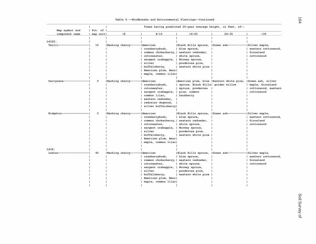
164S
oil Survey of
Table 6.--Windbreaks and Environmental Plantings--Continued____________________________________________________________________________________________________________________________________________ | | Trees having predicted 20-year average height, in feet, of-- Map symbol and | Pct. of |________________________________________________________________________________________________________ component name | map unit| <8 | 8-15 | 16-25 | 26-35 | >35____________________________________________________________________________________________________________________________________________ | | | | | |L41D2: | | | | | | Terril------------------| 10 |Nanking cherry------|American |Black Hills spruce, |Green ash-----------|Silver maple, | | | cranberrybush, | blue spruce, | | eastern cottonwood, | | | common chokecherry,| eastern redcedar, | | Siouxland | | | cotoneaster, | white spruce, | | cottonwood | | | sargent crabapple, | Norway spruce, | | | | | silver | ponderosa pine, | | | | | buffaloberry, | eastern white pine | | | | | American plum, Amur| | | | | | maple, common lilac| | | | | | | | | Derrynane---------------| 5 |Nanking cherry------|American |American plum, blue |Eastern white pine, |Green ash, silver | | | cranberrybush, | spruce, Black Hills| golden willow | maple, Siouxland | | | cotoneaster, | spruce, ponderosa | | cottonwood, eastern | | | sargent crabapple, | pine, common | | cottonwood | | | common lilac, | hackberry | | | | | eastern redcedar, | | | | | | redosier dogwood, | | | | | | silver buffaloberry| | | | | | | | | Ridgeton----------------| 5 |Nanking cherry------|American |Black Hills spruce, |Green ash-----------|Silver maple, | | | cranberrybush, | blue spruce, | | eastern cottonwood, | | | common chokecherry,| eastern redcedar, | | Siouxland | | | cotoneaster, | white spruce, | | cottonwood | | | sargent crabapple, | Norway spruce, | | | | | silver | ponderosa pine, | | | | | buffaloberry, | eastern white pine | | | | | American plum, Amur| | | | | | maple, common lilac| | | | | | | | |L41E: | | | | | | Lester------------------| 45 |Nanking cherry------|American |Black Hills spruce, |Green ash-----------|Silver maple, | | | cranberrybush, | blue spruce, | | eastern cottonwood, | | | common chokecherry,| eastern redcedar, | | Siouxland | | | cotoneaster, | white spruce, | | cottonwood | | | sargent crabapple, | Norway spruce, | | | | | silver | ponderosa pine, | | | | | buffaloberry, | eastern white pine | | | | | American plum, Amur| | | | | | maple, common lilac| | | | | | | | |

Waseca C
ounty, Minnesota
165
Table 6.--Windbreaks and Environmental Plantings--Continued____________________________________________________________________________________________________________________________________________ | | Trees having predicted 20-year average height, in feet, of-- Map symbol and | Pct. of |________________________________________________________________________________________________________ component name | map unit| <8 | 8-15 | 16-25 | 26-35 | >35____________________________________________________________________________________________________________________________________________ | | | | | |L41E: | | | | | | Kilkenny----------------| 40 |Nanking cherry------|American |Black Hills spruce, |Green ash-----------|Silver maple, | | | cranberrybush, | blue spruce, | | eastern cottonwood, | | | common chokecherry,| eastern redcedar, | | Siouxland | | | cotoneaster, | white spruce, | | cottonwood | | | sargent crabapple, | Norway spruce, | | | | | silver | ponderosa pine, | | | | | buffaloberry, | eastern white pine | | | | | American plum, Amur| | | | | | maple, common lilac| | | | | | | | | Terril------------------| 5 |Nanking cherry------|American |Black Hills spruce, |Green ash-----------|Silver maple, | | | cranberrybush, | blue spruce, | | eastern cottonwood, | | | common chokecherry,| eastern redcedar, | | Siouxland | | | cotoneaster, | white spruce, | | cottonwood | | | sargent crabapple, | Norway spruce, | | | | | silver | ponderosa pine, | | | | | buffaloberry, | eastern white pine | | | | | American plum, Amur| | | | | | maple, common lilac| | | | | | | | | Derrynane---------------| 5 |Nanking cherry------|American |American plum, blue |Eastern white pine, |Green ash, silver | | | cranberrybush, | spruce, Black Hills| golden willow | maple, Siouxland | | | cotoneaster, | spruce, ponderosa | | cottonwood, eastern | | | sargent crabapple, | pine, common | | cottonwood | | | common lilac, | hackberry | | | | | eastern redcedar, | | | | | | redosier dogwood, | | | | | | silver buffaloberry| | | | | | | | | Ridgeton----------------| 5 |Nanking cherry------|American |Black Hills spruce, |Green ash-----------|Silver maple, | | | cranberrybush, | blue spruce, | | eastern cottonwood, | | | common chokecherry,| eastern redcedar, | | Siouxland | | | cotoneaster, | white spruce, | | cottonwood | | | sargent crabapple, | Norway spruce, | | | | | silver | ponderosa pine, | | | | | buffaloberry, | eastern white pine | | | | | American plum, Amur| | | | | | maple, common lilac| | | | | | | | |L48A: | | | | | | Derrynane, overwash-----| 50 | --- |Redosier dogwood----|American plum, Amur | --- |Golden willow, green | | | | maple, white | | ash | | | | spruce, tall purple| | | | | | willow | | | | | | | |

166S
oil Survey of
Table 6.--Windbreaks and Environmental Plantings--Continued____________________________________________________________________________________________________________________________________________ | | Trees having predicted 20-year average height, in feet, of-- Map symbol and | Pct. of |________________________________________________________________________________________________________ component name | map unit| <8 | 8-15 | 16-25 | 26-35 | >35____________________________________________________________________________________________________________________________________________ | | | | | |L48A: | | | | | | Derrynane---------------| 40 | --- |Redosier dogwood----|American plum, Amur | --- |Golden willow, green | | | | maple, white | | ash | | | | spruce, tall purple| | | | | | willow | | | | | | | | Glencoe-----------------| 5 |Redosier dogwood----| --- |Black ash, tall |Black willow, golden| --- | | | | purple willow | willow, white | | | | | | willow | | | | | | | Terril------------------| 5 |Redosier dogwood----|Siberian peashrub, |Eastern redcedar, |Honeylocust, jack |Silver maple, | | | American plum, | Amur maple, Black | pine, black walnut,| Siouxland | | | common lilac, | Hills spruce, | common hackberry, | cottonwood | | | prunus, silver | Norway spruce | eastern white pine,| | | | buffaloberry | | green ash | | | | | | |L49A: | | | | | | Klossner, surface | | | | | | drained----------------| 65 | --- | --- | --- | --- | --- | | | | | | Klossner, drained-------| 20 | --- |Redosier dogwood, |Black ash-----------|Golden willow-------| --- | | | silky dogwood | | | | | | | | | Mineral soil, drained---| 15 |Redosier dogwood----|Silky dogwood-------|Green ash, northern |Golden willow-------|Eastern cottonwood | | | | whitecedar | | | | | | | |L50A: | | | | | | Houghton, surface | | | | | | drained----------------| 40 | --- | --- | --- | --- | --- | | | | | | Muskego, surface drained| 40 | --- | --- | --- | --- | --- | | | | | | Klossner, drained-------| 10 | --- |Redosier dogwood, |Black ash-----------|Golden willow-------| --- | | | silky dogwood | | | | | | | | | Mineral soil, drained---| 10 |Redosier dogwood----|Silky dogwood-------|Green ash, northern |Golden willow-------|Eastern cottonwood | | | | whitecedar | | | | | | | |L51C2: | | | | | | Gladek, eroded----------| 80 | --- |Siberian peashrub, |Eastern arborvitae, |Russian-olive, | --- | | | common lilac, gray | eastern redcedar, | common hackberry, | | | | dogwood, redosier | Amur maple, blue | green ash, eastern | | | | dogwood | spruce | white pine | | | | | | |

Waseca C
ounty, Minnesota
167
Table 6.--Windbreaks and Environmental Plantings--Continued____________________________________________________________________________________________________________________________________________ | | Trees having predicted 20-year average height, in feet, of-- Map symbol and | Pct. of |________________________________________________________________________________________________________ component name | map unit| <8 | 8-15 | 16-25 | 26-35 | >35____________________________________________________________________________________________________________________________________________ | | | | | |L51C2: | | | | | | Barrington--------------| 10 |Silky dogwood-------|American |Washington hawthorn,|Austrian pine, |Pin oak, eastern | | | cranberrybush, Amur| blue spruce, | Norway spruce | white pine | | | honeysuckle, Amur | eastern arborvitae,| | | | | privet | white fir | | | | | | | | Lester, eroded----------| 5 | --- |Siberian peashrub, |Eastern arborvitae, |Russian-olive, | --- | | | common lilac, gray | eastern redcedar, | common hackberry, | | | | dogwood, redosier | Amur maple, blue | eastern white pine,| | | | dogwood | spruce | green ash | | | | | | | Madelia-----------------| 5 | --- |American plum, |Amur maple, eastern |Golden willow-------|Green ash, silver | | | redosier dogwood | arborvitae, white | | maple, eastern | | | | spruce, common | | cottonwood | | | | hackberry, tall | | | | | | purple willow | | | | | | | |L57A: | | | | | | Medo, drained-----------| 80 | --- |Redosier dogwood, |Black ash-----------|Golden willow-------| --- | | | silky dogwood | | | | | | | | | Mineral soil, drained---| 15 |Redosier dogwood----|Silky dogwood-------|Green ash, northern |Golden willow-------|Eastern cottonwood | | | | whitecedar | | | | | | | | Houghton, drained-------| 5 | --- |Redosier dogwood, |Black ash-----------|Golden willow-------| --- | | | silky dogwood | | | | | | | | |L63A: | | | | | | Klossner----------------| 85 | --- |Nannyberry, silky |White spruce--------|Norway spruce, green|Imperial Carolina | | | dogwood | | ash | poplar | | | | | | Lura--------------------| 10 |Redosier dogwood----| --- |Black ash, tall |Black willow, golden| --- | | | | purple willow | willow, white | | | | | | willow | | | | | | | Brownton----------------| 5 |Honeysuckle---------|Siberian peashrub, |Eastern redcedar, |Green ash, golden |Eastern cottonwood | | | common lilac, | bur oak, white | willow, honeylocust| | | | eastern arborvitae | spruce, common | | | | | | hackberry | | | | | | | |L64A: | | | | | | Tadkee------------------| 50 | --- | --- | --- | --- | --- | | | | | | Tadkee, depressional----| 36 | --- | --- | --- | --- | --- | | | | | |

168S
oil Survey of
Table 6.--Windbreaks and Environmental Plantings--Continued____________________________________________________________________________________________________________________________________________ | | Trees having predicted 20-year average height, in feet, of-- Map symbol and | Pct. of |________________________________________________________________________________________________________ component name | map unit| <8 | 8-15 | 16-25 | 26-35 | >35____________________________________________________________________________________________________________________________________________ | | | | | |L64A: | | | | | | Better drained soil-----| 8 | --- |Tatarian |Eastern arborvitae, |Austrian pine, |Silver maple | | | honeysuckle, common| white spruce, Amur | eastern white pine,| | | | lilac, redosier | maple, blue spruce | common hackberry, | | | | dogwood | | green ash | | | | | | | Granby------------------| 4 | --- | --- | --- | --- | --- | | | | | | Less sandy soil---------| 2 | --- | --- | --- | --- | --- | | | | | |L73A: | | | | | | Blue Earth--------------| 80 |Redosier dogwood----|Gray dogwood, silky |Northern whitecedar,|Black willow, golden|Eastern cottonwood | | | dogwood | black ash, tall | willow, white | | | | | purple willow | willow | | | | | | | Belleville--------------| 10 |Redosier dogwood----|Gray dogwood, silky |Northern whitecedar,|Black willow, golden|Eastern cottonwood | | | dogwood | black ash, tall | willow, white | | | | | purple willow | willow | | | | | | | Canisteo----------------| 10 |Redosier dogwood----|Gray dogwood, silky |Northern whitecedar,|Black willow, golden|Eastern cottonwood | | | dogwood | black ash, tall | willow, white | | | | | purple willow | willow | | | | | | |L74A: | | | | | | Estherville-------------| 87 |Siberian peashrub---|American plum, |Black Hills spruce, |Eastern white pine, | --- | | | common chokecherry,| eastern redcedar, | red pine, Scotch | | | | common lilac, | jack pine, | pine, eastern | | | | sargent crabapple, | ponderosa pine, | cottonwood | | | | silver buffaloberry| white spruce, | | | | | | Austrian pine, | | | | | | green ash, silver | | | | | | maple | | | | | | | | Hawick------------------| 10 |Siberian peashrub---|American plum, |Black Hills spruce, |Eastern white pine, | --- | | | common chokecherry,| eastern redcedar, | red pine, Scotch | | | | common lilac, | jack pine, | pine, eastern | | | | sargent crabapple, | ponderosa pine, | cottonwood | | | | silver buffaloberry| white spruce, | | | | | | Austrian pine, | | | | | | green ash, silver | | | | | | maple | | | | | | | |

Waseca C
ounty, Minnesota
169
Table 6.--Windbreaks and Environmental Plantings--Continued____________________________________________________________________________________________________________________________________________ | | Trees having predicted 20-year average height, in feet, of-- Map symbol and | Pct. of |________________________________________________________________________________________________________ component name | map unit| <8 | 8-15 | 16-25 | 26-35 | >35____________________________________________________________________________________________________________________________________________ | | | | | |L74A: | | | | | | Biscay------------------| 3 | --- |American |American plum, Black|Eastern white pine, |Green ash, quaking | | | cranberrybush, | Hills spruce, | golden willow | aspen, silver | | | cotoneaster, | ponderosa pine, | | maple, Siouxland | | | sargent crabapple, | common hackberry, | | cottonwood, eastern | | | white spruce, | tall purple willow | | cottonwood | | | Siberian peashrub, | | | | | | common lilac, | | | | | | eastern redcedar, | | | | | | redosier dogwood, | | | | | | silver buffaloberry| | | | | | | | |L75B: | | | | | | Barrington--------------| 85 |Nanking cherry------|American |Black Hills spruce, |Green ash, |Silver maple, | | | cranberrybush, | eastern redcedar, | honeylocust, jack | eastern cottonwood, | | | common chokecherry,| white spruce, | pine | quaking aspen, | | | cotoneaster, | Norway spruce, | | Siouxland | | | sargent crabapple, | ponderosa pine, | | cottonwood, | | | silver | eastern white pine,| | Carolina poplar | | | buffaloberry, | red pine | | | | | American plum, Amur| | | | | | maple, Siberian | | | | | | peashrub, common | | | | | | lilac | | | | | | | | | Gladek------------------| 10 | --- |Siberian peashrub, |Eastern arborvitae, |Russian-olive, | --- | | | common lilac, gray | eastern redcedar, | common hackberry, | | | | dogwood, redosier | Amur maple, blue | green ash, eastern | | | | dogwood | spruce | white pine | | | | | | | Madelia-----------------| 5 | --- |American |American plum, Black|Eastern white pine, |Green ash, quaking | | | cranberrybush, | Hills spruce, | golden willow | aspen, silver | | | cotoneaster, | ponderosa pine, | | maple, Siouxland | | | sargent crabapple, | common hackberry, | | cottonwood, eastern | | | white spruce, | tall purple willow | | cottonwood | | | Siberian peashrub, | | | | | | common lilac, | | | | | | eastern redcedar, | | | | | | redosier dogwood, | | | | | | silver buffaloberry| | | | | | | | |

170S
oil Survey of
Table 6.--Windbreaks and Environmental Plantings--Continued____________________________________________________________________________________________________________________________________________ | | Trees having predicted 20-year average height, in feet, of-- Map symbol and | Pct. of |________________________________________________________________________________________________________ component name | map unit| <8 | 8-15 | 16-25 | 26-35 | >35____________________________________________________________________________________________________________________________________________ | | | | | |L76B: | | | | | | Dickinson---------------| 80 |Hedge cotoneaster---|American |Black Hills spruce, |Eastern white pine, |Silver maple, | | | cranberrybush, | ponderosa pine, | green ash, | eastern cottonwood | | | American plum, | Amur maple, common | honeylocust, red | | | | Siberian peashrub, | hackberry, white | pine | | | | common chokecherry,| spruce, Norway | | | | | common lilac, | spruce | | | | | silver | | | | | | buffaloberry, | | | | | | eastern redcedar | | | | | | | | | Litchfield--------------| 13 | --- |Nanking cherry, |Black Hills spruce, |American basswood, |Silver maple, | | | Siberian peashrub, | Norway spruce, | Austrian pine, | eastern cottonwood, | | | common chokecherry,| white spruce, | eastern white pine,| Siouxland | | | redosier dogwood, | eastern redcedar, | northern red oak, | cottonwood | | | sargent crabapple, | ponderosa pine, | green ash | | | | silver | Amur maple, common | | | | | buffaloberry, | hackberry, red pine| | | | | American plum, | | | | | | common lilac | | | | | | | | | Darfur------------------| 5 | --- |American |American plum, Black|Eastern white pine, |Green ash, quaking | | | cranberrybush, | Hills spruce, | golden willow | aspen, silver | | | cotoneaster, | ponderosa pine, | | maple, Siouxland | | | sargent crabapple, | common hackberry, | | cottonwood, eastern | | | white spruce, | tall purple willow | | cottonwood | | | Siberian peashrub, | | | | | | common lilac, | | | | | | eastern redcedar, | | | | | | redosier dogwood, | | | | | | silver buffaloberry| | | | | | | | | Clarion-----------------| 2 |Nanking cherry------|American |Black Hills spruce, |Green ash, |Silver maple, | | | cranberrybush, | eastern redcedar, | honeylocust, jack | eastern cottonwood, | | | common chokecherry,| white spruce, | pine | quaking aspen, | | | cotoneaster, | Norway spruce, | | Siouxland | | | sargent crabapple, | ponderosa pine, | | cottonwood, | | | silver | eastern white pine,| | Carolina poplar | | | buffaloberry, | red pine | | | | | American plum, Amur| | | | | | maple, Siberian | | | | | | peashrub, common | | | | | | lilac | | | | | | | | |
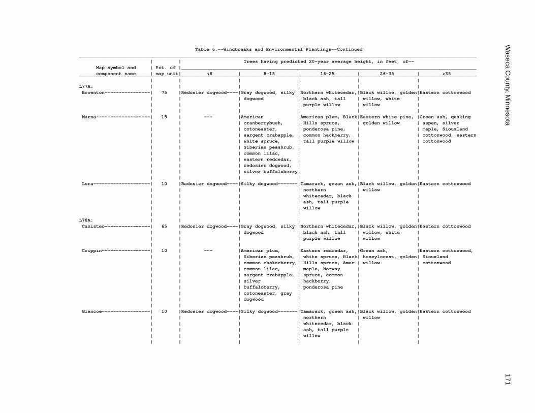
Waseca C
ounty, Minnesota
171
Table 6.--Windbreaks and Environmental Plantings--Continued____________________________________________________________________________________________________________________________________________ | | Trees having predicted 20-year average height, in feet, of-- Map symbol and | Pct. of |________________________________________________________________________________________________________ component name | map unit| <8 | 8-15 | 16-25 | 26-35 | >35____________________________________________________________________________________________________________________________________________ | | | | | |L77A: | | | | | | Brownton----------------| 75 |Redosier dogwood----|Gray dogwood, silky |Northern whitecedar,|Black willow, golden|Eastern cottonwood | | | dogwood | black ash, tall | willow, white | | | | | purple willow | willow | | | | | | | Marna-------------------| 15 | --- |American |American plum, Black|Eastern white pine, |Green ash, quaking | | | cranberrybush, | Hills spruce, | golden willow | aspen, silver | | | cotoneaster, | ponderosa pine, | | maple, Siouxland | | | sargent crabapple, | common hackberry, | | cottonwood, eastern | | | white spruce, | tall purple willow | | cottonwood | | | Siberian peashrub, | | | | | | common lilac, | | | | | | eastern redcedar, | | | | | | redosier dogwood, | | | | | | silver buffaloberry| | | | | | | | | Lura--------------------| 10 |Redosier dogwood----|Silky dogwood-------|Tamarack, green ash,|Black willow, golden|Eastern cottonwood | | | | northern | willow | | | | | whitecedar, black | | | | | | ash, tall purple | | | | | | willow | | | | | | | |L78A: | | | | | | Canisteo----------------| 65 |Redosier dogwood----|Gray dogwood, silky |Northern whitecedar,|Black willow, golden|Eastern cottonwood | | | dogwood | black ash, tall | willow, white | | | | | purple willow | willow | | | | | | | Crippin-----------------| 10 | --- |American plum, |Eastern redcedar, |Green ash, |Eastern cottonwood, | | | Siberian peashrub, | white spruce, Black| honeylocust, golden| Siouxland | | | common chokecherry,| Hills spruce, Amur | willow | cottonwood | | | common lilac, | maple, Norway | | | | | sargent crabapple, | spruce, common | | | | | silver | hackberry, | | | | | buffaloberry, | ponderosa pine | | | | | cotoneaster, gray | | | | | | dogwood | | | | | | | | | Glencoe-----------------| 10 |Redosier dogwood----|Silky dogwood-------|Tamarack, green ash,|Black willow, golden|Eastern cottonwood | | | | northern | willow | | | | | whitecedar, black | | | | | | ash, tall purple | | | | | | willow | | | | | | | |

172S
oil Survey of
Table 6.--Windbreaks and Environmental Plantings--Continued____________________________________________________________________________________________________________________________________________ | | Trees having predicted 20-year average height, in feet, of-- Map symbol and | Pct. of |________________________________________________________________________________________________________ component name | map unit| <8 | 8-15 | 16-25 | 26-35 | >35____________________________________________________________________________________________________________________________________________ | | | | | |L78A: | | | | | | Canisteo, depressional--| 5 |Redosier dogwood----|Silky dogwood-------|Tamarack, green ash,|Black willow, golden|Eastern cottonwood | | | | northern | willow | | | | | whitecedar, black | | | | | | ash, tall purple | | | | | | willow | | | | | | | | Harps-------------------| 5 |Redosier dogwood----|Common lilac, |Blue spruce, eastern|Green ash, golden |Eastern cottonwood | | | eastern arborvitae | redcedar, white | willow, honeylocust| | | | | spruce, common | | | | | | hackberry | | | | | | | | Webster-----------------| 5 | --- |American |American plum, Black|Eastern white pine, |Green ash, quaking | | | cranberrybush, | Hills spruce, | golden willow | aspen, silver | | | cotoneaster, | ponderosa pine, | | maple, Siouxland | | | sargent crabapple, | common hackberry, | | cottonwood, eastern | | | white spruce, | tall purple willow | | cottonwood | | | Siberian peashrub, | | | | | | common lilac, | | | | | | eastern redcedar, | | | | | | redosier dogwood, | | | | | | silver buffaloberry| | | | | | | | |L79B: | | | | | | Clarion-----------------| 65 |Nanking cherry------|American |Black Hills spruce, |Green ash, |Silver maple, | | | cranberrybush, | eastern redcedar, | honeylocust, jack | eastern cottonwood, | | | common chokecherry,| white spruce, | pine | quaking aspen, | | | cotoneaster, | Norway spruce, | | Siouxland | | | sargent crabapple, | ponderosa pine, | | cottonwood, | | | silver | eastern white pine,| | Carolina poplar | | | buffaloberry, | red pine | | | | | American plum, Amur| | | | | | maple, Siberian | | | | | | peashrub, common | | | | | | lilac | | | | | | | | | Clarion, eroded---------| 25 | --- |Siberian peashrub, |Eastern arborvitae, |Russian-olive, | --- | | | common lilac, gray | eastern redcedar, | common hackberry, | | | | dogwood, redosier | Amur maple, blue | green ash, eastern | | | | dogwood | spruce | white pine | | | | | | |

Waseca C
ounty, Minnesota
173
Table 6.--Windbreaks and Environmental Plantings--Continued____________________________________________________________________________________________________________________________________________ | | Trees having predicted 20-year average height, in feet, of-- Map symbol and | Pct. of |________________________________________________________________________________________________________ component name | map unit| <8 | 8-15 | 16-25 | 26-35 | >35____________________________________________________________________________________________________________________________________________ | | | | | |L79B: | | | | | | Nicollet----------------| 8 | --- |Nanking cherry, |Black Hills spruce, |American basswood, |Silver maple, | | | Siberian peashrub, | Norway spruce, | Austrian pine, | eastern cottonwood, | | | common chokecherry,| white spruce, | eastern white pine,| Siouxland | | | redosier dogwood, | eastern redcedar, | northern red oak, | cottonwood | | | sargent crabapple, | ponderosa pine, | green ash | | | | silver | Amur maple, common | | | | | buffaloberry, | hackberry, red pine| | | | | American plum, | | | | | | common lilac | | | | | | | | | Webster-----------------| 2 | --- |American |American plum, Black|Eastern white pine, |Green ash, quaking | | | cranberrybush, | Hills spruce, | golden willow | aspen, silver | | | cotoneaster, | ponderosa pine, | | maple, Siouxland | | | sargent crabapple, | common hackberry, | | cottonwood, eastern | | | white spruce, | tall purple willow | | cottonwood | | | Siberian peashrub, | | | | | | common lilac, | | | | | | eastern redcedar, | | | | | | redosier dogwood, | | | | | | silver buffaloberry| | | | | | | | |L80C2: | | | | | | Lester, eroded----------| 75 |Nanking cherry------|American |Black Hills spruce, |Green ash, |Silver maple, | | | cranberrybush, | eastern redcedar, | honeylocust, jack | eastern cottonwood, | | | common chokecherry,| white spruce, | pine | quaking aspen, | | | cotoneaster, | Norway spruce, | | Siouxland | | | sargent crabapple, | ponderosa pine, | | cottonwood, | | | silver | eastern white pine,| | Carolina poplar | | | buffaloberry, | red pine | | | | | American plum, Amur| | | | | | maple, Siberian | | | | | | peashrub, common | | | | | | lilac | | | | | | | | | Terril------------------| 10 |Nanking cherry------|American |Black Hills spruce, |Green ash, |Silver maple, | | | cranberrybush, | eastern redcedar, | honeylocust, jack | eastern cottonwood, | | | common chokecherry,| white spruce, | pine | quaking aspen, | | | cotoneaster, | Norway spruce, | | Siouxland | | | sargent crabapple, | ponderosa pine, | | cottonwood, | | | silver | eastern white pine,| | Carolina poplar | | | buffaloberry, | red pine | | | | | American plum, Amur| | | | | | maple, Siberian | | | | | | peashrub, common | | | | | | lilac | | | | | | | | |

174S
oil Survey of
Table 6.--Windbreaks and Environmental Plantings--Continued____________________________________________________________________________________________________________________________________________ | | Trees having predicted 20-year average height, in feet, of-- Map symbol and | Pct. of |________________________________________________________________________________________________________ component name | map unit| <8 | 8-15 | 16-25 | 26-35 | >35____________________________________________________________________________________________________________________________________________ | | | | | |L80C2: | | | | | | Hamel-------------------| 5 | --- |American |American plum, Black|Eastern white pine, |Green ash, quaking | | | cranberrybush, | Hills spruce, | golden willow | aspen, silver | | | cotoneaster, | ponderosa pine, | | maple, Siouxland | | | sargent crabapple, | common hackberry, | | cottonwood, eastern | | | white spruce, | tall purple willow | | cottonwood | | | Siberian peashrub, | | | | | | common lilac, | | | | | | eastern redcedar, | | | | | | redosier dogwood, | | | | | | silver buffaloberry| | | | | | | | | Reedslake---------------| 5 |Nanking cherry------|American |Black Hills spruce, |Green ash, |Silver maple, | | | cranberrybush, | eastern redcedar, | honeylocust, jack | eastern cottonwood, | | | common chokecherry,| white spruce, | pine | quaking aspen, | | | cotoneaster, | Norway spruce, | | Siouxland | | | sargent crabapple, | ponderosa pine, | | cottonwood, | | | silver | eastern white pine,| | Carolina poplar | | | buffaloberry, | red pine | | | | | American plum, Amur| | | | | | maple, Siberian | | | | | | peashrub, common | | | | | | lilac | | | | | | | | | Storden, eroded---------| 5 |American plum, |Siberian peashrub, |Green ash, ponderosa|Eastern cottonwood | --- | | common lilac | Black Hills spruce,| pine, honeylocust | | | | | common hackberry, | | | | | | eastern redcedar | | | | | | | | |L80D2: | | | | | | Lester, eroded----------| 75 |Nanking cherry------|American |Black Hills spruce, |Green ash, |Silver maple, | | | cranberrybush, | eastern redcedar, | honeylocust, jack | eastern cottonwood, | | | common chokecherry,| white spruce, | pine | quaking aspen, | | | cotoneaster, | Norway spruce, | | Siouxland | | | sargent crabapple, | ponderosa pine, | | cottonwood, | | | silver | eastern white pine,| | Carolina poplar | | | buffaloberry, | red pine | | | | | American plum, Amur| | | | | | maple, Siberian | | | | | | peashrub, common | | | | | | lilac | | | | | | | | |

Waseca C
ounty, Minnesota
175
Table 6.--Windbreaks and Environmental Plantings--Continued____________________________________________________________________________________________________________________________________________ | | Trees having predicted 20-year average height, in feet, of-- Map symbol and | Pct. of |________________________________________________________________________________________________________ component name | map unit| <8 | 8-15 | 16-25 | 26-35 | >35____________________________________________________________________________________________________________________________________________ | | | | | |L80D2: | | | | | | Ridgeton----------------| 10 | --- |American |Black Hills spruce, |Green ash, |Silver maple, | | | cranberrybush, | eastern redcedar, | honeylocust, jack | eastern cottonwood, | | | common chokecherry,| white spruce, | pine | quaking aspen, | | | cotoneaster, | Norway spruce, | | Siouxland | | | sargent crabapple, | ponderosa pine, | | cottonwood, | | | silver | eastern white pine,| | Carolina poplar | | | buffaloberry, | red pine | | | | | American plum, Amur| | | | | | maple, Siberian | | | | | | peashrub, common | | | | | | lilac | | | | | | | | | Storden, eroded---------| 8 |American plum, |Siberian peashrub, |Green ash, ponderosa|Eastern cottonwood | --- | | common lilac | Black Hills spruce,| pine, honeylocust | | | | | common hackberry, | | | | | | eastern redcedar | | | | | | | | | Terril------------------| 5 | --- |American |Black Hills spruce, |Green ash, |Silver maple, | | | cranberrybush, | eastern redcedar, | honeylocust, jack | eastern cottonwood, | | | common chokecherry,| white spruce, | pine | quaking aspen, | | | cotoneaster, | Norway spruce, | | Siouxland | | | sargent crabapple, | ponderosa pine, | | cottonwood, | | | silver | eastern white pine,| | Carolina poplar | | | buffaloberry, | red pine | | | | | American plum, Amur| | | | | | maple, Siberian | | | | | | peashrub, common | | | | | | lilac | | | | | | | | | Hamel-------------------| 2 | --- |American |American plum, Black|Eastern white pine, |Green ash, quaking | | | cranberrybush, | Hills spruce, | golden willow | aspen, silver | | | cotoneaster, | ponderosa pine, | | maple, Siouxland | | | sargent crabapple, | common hackberry, | | cottonwood, eastern | | | white spruce, | tall purple willow | | cottonwood | | | Siberian peashrub, | | | | | | common lilac, | | | | | | eastern redcedar, | | | | | | redosier dogwood, | | | | | | silver buffaloberry| | | | | | | | |

176S
oil Survey of
Table 6.--Windbreaks and Environmental Plantings--Continued____________________________________________________________________________________________________________________________________________ | | Trees having predicted 20-year average height, in feet, of-- Map symbol and | Pct. of |________________________________________________________________________________________________________ component name | map unit| <8 | 8-15 | 16-25 | 26-35 | >35____________________________________________________________________________________________________________________________________________ | | | | | |L81A: | | | | | | Cordova-----------------| 85 | --- |American |American plum, Black|Eastern white pine, |Green ash, quaking | | | cranberrybush, | Hills spruce, | golden willow | aspen, silver | | | cotoneaster, | ponderosa pine, | | maple, Siouxland | | | sargent crabapple, | common hackberry, | | cottonwood, eastern | | | white spruce, | tall purple willow | | cottonwood | | | Siberian peashrub, | | | | | | common lilac, | | | | | | eastern redcedar, | | | | | | redosier dogwood, | | | | | | silver buffaloberry| | | | | | | | | Le Sueur----------------| 10 | --- |Nanking cherry, |Black Hills spruce, |American basswood, |Silver maple, | | | Siberian peashrub, | Norway spruce, | Austrian pine, | eastern cottonwood, | | | common chokecherry,| white spruce, | eastern white pine,| Siouxland | | | redosier dogwood, | eastern redcedar, | northern red oak, | cottonwood | | | sargent crabapple, | ponderosa pine, | green ash | | | | silver | Amur maple, common | | | | | buffaloberry, | hackberry, red pine| | | | | American plum, | | | | | | common lilac | | | | | | | | | Rolfe-------------------| 5 |Redosier dogwood----|Silky dogwood-------|Tamarack, green ash,|Black willow, golden|Eastern cottonwood | | | | northern | willow | | | | | whitecedar, black | | | | | | ash, tall purple | | | | | | willow | | | | | | | |L82A: | | | | | | Marna-------------------| 85 | --- |American |American plum, Black|Eastern white pine, |Green ash, quaking | | | cranberrybush, | Hills spruce, | golden willow | aspen, silver | | | cotoneaster, | ponderosa pine, | | maple, Siouxland | | | sargent crabapple, | common hackberry, | | cottonwood, eastern | | | white spruce, | tall purple willow | | cottonwood | | | Siberian peashrub, | | | | | | common lilac, | | | | | | eastern redcedar, | | | | | | redosier dogwood, | | | | | | silver buffaloberry| | | | | | | | | Barbert-----------------| 10 |Redosier dogwood----|Silky dogwood-------|Tamarack, green ash,|Black willow, golden|Eastern cottonwood | | | | northern | willow | | | | | whitecedar, black | | | | | | ash, tall purple | | | | | | willow | | | | | | | |

Waseca C
ounty, Minnesota
177
Table 6.--Windbreaks and Environmental Plantings--Continued____________________________________________________________________________________________________________________________________________ | | Trees having predicted 20-year average height, in feet, of-- Map symbol and | Pct. of |________________________________________________________________________________________________________ component name | map unit| <8 | 8-15 | 16-25 | 26-35 | >35____________________________________________________________________________________________________________________________________________ | | | | | |L82A: | | | | | | Guckeen-----------------| 5 | --- |Siberian peashrub, |Bur oak, eastern |Eastern white pine, | --- | | | common lilac | arborvitae, eastern| green ash | | | | | redcedar, white | | | | | | spruce, Austrian | | | | | | pine, common | | | | | | hackberry | | | | | | | |L83A: | | | | | | Webster-----------------| 65 | --- |American |American plum, Black|Eastern white pine, |Green ash, quaking | | | cranberrybush, | Hills spruce, | golden willow | aspen, silver | | | cotoneaster, | ponderosa pine, | | maple, Siouxland | | | sargent crabapple, | common hackberry, | | cottonwood, eastern | | | white spruce, | tall purple willow | | cottonwood | | | Siberian peashrub, | | | | | | common lilac, | | | | | | eastern redcedar, | | | | | | redosier dogwood, | | | | | | silver buffaloberry| | | | | | | | | Glencoe-----------------| 15 |Redosier dogwood----|Silky dogwood-------|Tamarack, green ash,|Black willow, golden|Eastern cottonwood | | | | northern | willow | | | | | whitecedar, black | | | | | | ash, tall purple | | | | | | willow | | | | | | | | Canisteo----------------| 10 |Redosier dogwood----|Gray dogwood, silky |Northern whitecedar,|Black willow, golden|Eastern cottonwood | | | dogwood | black ash, tall | willow, white | | | | | purple willow | willow | | | | | | | Nicollet----------------| 10 | --- |Nanking cherry, |Black Hills spruce, |American basswood, |Silver maple, | | | Siberian peashrub, | Norway spruce, | Austrian pine, | eastern cottonwood, | | | common chokecherry,| white spruce, | eastern white pine,| Siouxland | | | redosier dogwood, | eastern redcedar, | northern red oak, | cottonwood | | | sargent crabapple, | ponderosa pine, | green ash | | | | silver | Amur maple, common | | | | | buffaloberry, | hackberry, red pine| | | | | American plum, | | | | | | common lilac | | | | | | | | |L84A: | | | | | | Glencoe-----------------| 80 |Redosier dogwood----|Silky dogwood-------|Tamarack, green ash,|Black willow, golden|Eastern cottonwood | | | | northern | willow | | | | | whitecedar, black | | | | | | ash, tall purple | | | | | | willow | | | | | | | |

178S
oil Survey of
Table 6.--Windbreaks and Environmental Plantings--Continued____________________________________________________________________________________________________________________________________________ | | Trees having predicted 20-year average height, in feet, of-- Map symbol and | Pct. of |________________________________________________________________________________________________________ component name | map unit| <8 | 8-15 | 16-25 | 26-35 | >35____________________________________________________________________________________________________________________________________________ | | | | | |L84A: | | | | | | Very poorly drained muck| 10 |Redosier dogwood----|Silky dogwood-------|Tamarack, green ash,|Black willow, golden|Eastern cottonwood | | | | northern | willow | | | | | whitecedar, black | | | | | | ash, tall purple | | | | | | willow | | | | | | | | Canisteo----------------| 5 |Redosier dogwood----|Gray dogwood, silky |Northern whitecedar,|Black willow, golden|Eastern cottonwood | | | dogwood | black ash, tall | willow, white | | | | | purple willow | willow | | | | | | | Harps-------------------| 5 |Redosier dogwood----|Common lilac, |Blue spruce, eastern|Green ash, golden |Eastern cottonwood | | | eastern arborvitae | redcedar, white | willow, honeylocust| | | | | spruce, common | | | | | | hackberry | | | | | | | |L85A: | | | | | | Nicollet----------------| 85 | --- |Nanking cherry, |Black Hills spruce, |American basswood, |Silver maple, | | | Siberian peashrub, | Norway spruce, | Austrian pine, | eastern cottonwood, | | | common chokecherry,| white spruce, | eastern white pine,| Siouxland | | | redosier dogwood, | eastern redcedar, | northern red oak, | cottonwood | | | sargent crabapple, | ponderosa pine, | green ash | | | | silver | Amur maple, common | | | | | buffaloberry, | hackberry, red pine| | | | | American plum, | | | | | | common lilac | | | | | | | | | Clarion-----------------| 10 |Nanking cherry------|American |Black Hills spruce, |Green ash, |Silver maple, | | | cranberrybush, | eastern redcedar, | honeylocust, jack | eastern cottonwood, | | | common chokecherry,| white spruce, | pine | quaking aspen, | | | cotoneaster, | Norway spruce, | | Siouxland | | | sargent crabapple, | ponderosa pine, | | cottonwood, | | | silver | eastern white pine,| | Carolina poplar | | | buffaloberry, | red pine | | | | | American plum, Amur| | | | | | maple, Siberian | | | | | | peashrub, common | | | | | | lilac | | | | | | | | |

Waseca C
ounty, Minnesota
179
Table 6.--Windbreaks and Environmental Plantings--Continued____________________________________________________________________________________________________________________________________________ | | Trees having predicted 20-year average height, in feet, of-- Map symbol and | Pct. of |________________________________________________________________________________________________________ component name | map unit| <8 | 8-15 | 16-25 | 26-35 | >35____________________________________________________________________________________________________________________________________________ | | | | | |L85A: | | | | | | Webster-----------------| 5 | --- |American |American plum, Black|Eastern white pine, |Green ash, quaking | | | cranberrybush, | Hills spruce, | golden willow | aspen, silver | | | cotoneaster, | ponderosa pine, | | maple, Siouxland | | | sargent crabapple, | common hackberry, | | cottonwood, eastern | | | white spruce, | tall purple willow | | cottonwood | | | Siberian peashrub, | | | | | | common lilac, | | | | | | eastern redcedar, | | | | | | redosier dogwood, | | | | | | silver buffaloberry| | | | | | | | |L86A: | | | | | | Madelia-----------------| 90 | --- |American |American plum, Black|Eastern white pine, |Green ash, quaking | | | cranberrybush, | Hills spruce, | golden willow | aspen, silver | | | cotoneaster, | ponderosa pine, | | maple, Siouxland | | | sargent crabapple, | common hackberry, | | cottonwood, eastern | | | white spruce, | tall purple willow | | cottonwood | | | Siberian peashrub, | | | | | | common lilac, | | | | | | eastern redcedar, | | | | | | redosier dogwood, | | | | | | silver buffaloberry| | | | | | | | | Okoboji-----------------| 5 |Redosier dogwood----|Silky dogwood-------|Tamarack, green ash,|Black willow, golden|Eastern cottonwood | | | | northern | willow | | | | | whitecedar, black | | | | | | ash, tall purple | | | | | | willow | | | | | | | | Spicer------------------| 3 | --- | --- | --- | --- | --- | | | | | | Kingston----------------| 2 | --- |Nanking cherry, |Black Hills spruce, |American basswood, |Silver maple, | | | Siberian peashrub, | Norway spruce, | Austrian pine, | eastern cottonwood, | | | common chokecherry,| white spruce, | eastern white pine,| Siouxland | | | redosier dogwood, | eastern redcedar, | northern red oak, | cottonwood | | | sargent crabapple, | ponderosa pine, | green ash | | | | silver | Amur maple, common | | | | | buffaloberry, | hackberry, red pine| | | | | American plum, | | | | | | common lilac | | | | | | | | |

180S
oil Survey of
Table 6.--Windbreaks and Environmental Plantings--Continued____________________________________________________________________________________________________________________________________________ | | Trees having predicted 20-year average height, in feet, of-- Map symbol and | Pct. of |________________________________________________________________________________________________________ component name | map unit| <8 | 8-15 | 16-25 | 26-35 | >35____________________________________________________________________________________________________________________________________________ | | | | | |L87A: | | | | | | Kingston----------------| 85 | --- |Nanking cherry, |Black Hills spruce, |American basswood, |Silver maple, | | | Siberian peashrub, | Norway spruce, | Austrian pine, | eastern cottonwood, | | | common chokecherry,| white spruce, | eastern white pine,| Siouxland | | | redosier dogwood, | eastern redcedar, | northern red oak, | cottonwood | | | sargent crabapple, | ponderosa pine, | green ash | | | | silver | Amur maple, common | | | | | buffaloberry, | hackberry, red pine| | | | | American plum, | | | | | | common lilac | | | | | | | | | Truman------------------| 10 | --- |Siberian peashrub, |Eastern arborvitae, |Russian-olive, | --- | | | common lilac, gray | eastern redcedar, | common hackberry, | | | | dogwood, redosier | Amur maple, blue | green ash, eastern | | | | dogwood | spruce | white pine | | | | | | | Madelia-----------------| 5 | --- |American |American plum, Black|Eastern white pine, |Green ash, quaking | | | cranberrybush, | Hills spruce, | golden willow | aspen, silver | | | cotoneaster, | ponderosa pine, | | maple, Siouxland | | | sargent crabapple, | common hackberry, | | cottonwood, eastern | | | white spruce, | tall purple willow | | cottonwood | | | Siberian peashrub, | | | | | | common lilac, | | | | | | eastern redcedar, | | | | | | redosier dogwood, | | | | | | silver buffaloberry| | | | | | | | |L88A: | | | | | | Lura--------------------| 85 |Redosier dogwood----|Silky dogwood-------|Tamarack, green ash,|Black willow, golden|Eastern cottonwood | | | | northern | willow | | | | | whitecedar, black | | | | | | ash, tall purple | | | | | | willow | | | | | | | | Brownton----------------| 10 |Redosier dogwood----|Gray dogwood, silky |Northern whitecedar,|Black willow, golden|Eastern cottonwood | | | dogwood | black ash, tall | willow, white | | | | | purple willow | willow | | | | | | |

Waseca C
ounty, Minnesota
181
Table 6.--Windbreaks and Environmental Plantings--Continued____________________________________________________________________________________________________________________________________________ | | Trees having predicted 20-year average height, in feet, of-- Map symbol and | Pct. of |________________________________________________________________________________________________________ component name | map unit| <8 | 8-15 | 16-25 | 26-35 | >35____________________________________________________________________________________________________________________________________________ | | | | | |L88A: | | | | | | Organic soil------------| 5 |Nanking cherry, |American |Austrian pine, Black|Red pine------------|Golden willow, green | | sargent crabapple | cranberrybush, | Hills spruce, | | ash, silver maple, | | | common lilac, | Manchurian | | eastern cottonwood, | | | cotoneaster, | crabapple, Norway | | Siouxland | | | redosier dogwood, | spruce, Siberian | | cottonwood, | | | American plum, Amur| crabapple, white | | Carolina poplar | | | maple, Siberian | spruce, Russian- | | | | | peashrub, blue | olive, common | | | | | spruce, common | hackberry, common | | | | | chokecherry, | hackberry, tall | | | | | eastern redcedar, | purple willow | | | | | silver buffaloberry| | | | | | | | |L89A: | | | | | | Guckeen-----------------| 82 | --- |Siberian peashrub, |Bur oak, eastern |Eastern white pine, | --- | | | common lilac | arborvitae, eastern| green ash | | | | | redcedar, white | | | | | | spruce, Austrian | | | | | | pine, common | | | | | | hackberry | | | | | | | | Marna-------------------| 10 | --- |American |American plum, Black|Eastern white pine, |Green ash, quaking | | | cranberrybush, | Hills spruce, | golden willow | aspen, silver | | | cotoneaster, | ponderosa pine, | | maple, Siouxland | | | sargent crabapple, | common hackberry, | | cottonwood, eastern | | | white spruce, | tall purple willow | | cottonwood | | | Siberian peashrub, | | | | | | common lilac, | | | | | | eastern redcedar, | | | | | | redosier dogwood, | | | | | | silver buffaloberry| | | | | | | | | Clarion clay loam-------| 8 | --- |American |Black Hills spruce, |Green ash, |Silver maple, | | | cranberrybush, | eastern redcedar, | honeylocust, jack | eastern cottonwood, | | | common chokecherry,| white spruce, | pine | quaking aspen, | | | cotoneaster, | Norway spruce, | | Siouxland | | | sargent crabapple, | ponderosa pine, | | cottonwood, | | | silver | eastern white pine,| | Carolina poplar | | | buffaloberry, | red pine | | | | | American plum, Amur| | | | | | maple, Siberian | | | | | | peashrub, common | | | | | | lilac | | | | | | | | |

182S
oil Survey of
Table 6.--Windbreaks and Environmental Plantings--Continued____________________________________________________________________________________________________________________________________________ | | Trees having predicted 20-year average height, in feet, of-- Map symbol and | Pct. of |________________________________________________________________________________________________________ component name | map unit| <8 | 8-15 | 16-25 | 26-35 | >35____________________________________________________________________________________________________________________________________________ | | | | | |L90A: | | | | | | Le Sueur----------------| 75 | --- |Nanking cherry, |Black Hills spruce, |American basswood, |Silver maple, | | | Siberian peashrub, | Norway spruce, | Austrian pine, | eastern cottonwood, | | | common chokecherry,| white spruce, | eastern white pine,| Siouxland | | | redosier dogwood, | eastern redcedar, | northern red oak, | cottonwood | | | sargent crabapple, | ponderosa pine, | green ash | | | | silver | Amur maple, common | | | | | buffaloberry, | hackberry, red pine| | | | | American plum, | | | | | | common lilac | | | | | | | | | Cordova-----------------| 13 | --- |American |American plum, Black|Eastern white pine, |Green ash, quaking | | | cranberrybush, | Hills spruce, | golden willow | aspen, silver | | | cotoneaster, | ponderosa pine, | | maple, Siouxland | | | sargent crabapple, | common hackberry, | | cottonwood, eastern | | | white spruce, | tall purple willow | | cottonwood | | | Siberian peashrub, | | | | | | common lilac, | | | | | | eastern redcedar, | | | | | | redosier dogwood, | | | | | | silver buffaloberry| | | | | | | | | Reedslake---------------| 12 | --- |American |Black Hills spruce, |Green ash, |Silver maple, | | | cranberrybush, | eastern redcedar, | honeylocust, jack | eastern cottonwood, | | | common chokecherry,| white spruce, | pine | quaking aspen, | | | cotoneaster, | Norway spruce, | | Siouxland | | | sargent crabapple, | ponderosa pine, | | cottonwood, | | | silver | eastern white pine,| | Carolina poplar | | | buffaloberry, | red pine | | | | | American plum, Amur| | | | | | maple, Siberian | | | | | | peashrub, common | | | | | | lilac | | | | | | | | |L91A: | | | | | | Mazaska-----------------| 85 | --- |American |American plum, Black|Eastern white pine, |Green ash, quaking | | | cranberrybush, | Hills spruce, | golden willow | aspen, silver | | | cotoneaster, | ponderosa pine, | | maple, Siouxland | | | sargent crabapple, | common hackberry, | | cottonwood, eastern | | | white spruce, | tall purple willow | | cottonwood | | | Siberian peashrub, | | | | | | common lilac, | | | | | | eastern redcedar, | | | | | | redosier dogwood, | | | | | | silver buffaloberry| | | | | | | | |

Waseca C
ounty, Minnesota
183
Table 6.--Windbreaks and Environmental Plantings--Continued____________________________________________________________________________________________________________________________________________ | | Trees having predicted 20-year average height, in feet, of-- Map symbol and | Pct. of |________________________________________________________________________________________________________ component name | map unit| <8 | 8-15 | 16-25 | 26-35 | >35____________________________________________________________________________________________________________________________________________ | | | | | |L91A: | | | | | | Lerdal------------------| 10 |Hedge cotoneaster---|American |Black Hills spruce, |Green ash, jack pine|Silver maple, | | | cranberrybush, | Siberian crabapple,| | eastern cottonwood | | | Siberian peashrub, | eastern redcedar, | | | | | common chokecherry,| white spruce, Amur | | | | | common lilac, | maple, Austrian | | | | | cotoneaster, | pine, ponderosa | | | | | American plum, | pine, common | | | | | silver buffaloberry| hackberry, eastern | | | | | | white pine, red | | | | | | pine | | | | | | | | Rolfe-------------------| 5 |Redosier dogwood----|Silky dogwood-------|Tamarack, green ash,|Black willow, golden|Eastern cottonwood | | | | northern | willow | | | | | whitecedar, black | | | | | | ash, tall purple | | | | | | willow | | | | | | | |L92A: | | | | | | Darfur------------------| 78 | --- |American |American plum, Black|Eastern white pine, |Green ash, quaking | | | cranberrybush, | Hills spruce, | golden willow | aspen, silver | | | cotoneaster, | ponderosa pine, | | maple, Siouxland | | | sargent crabapple, | common hackberry, | | cottonwood, eastern | | | white spruce, | tall purple willow | | cottonwood | | | Siberian peashrub, | | | | | | common lilac, | | | | | | eastern redcedar, | | | | | | redosier dogwood, | | | | | | silver buffaloberry| | | | | | | | | Fieldon-----------------| 10 |Redosier dogwood----|Gray dogwood, silky |Northern whitecedar,|Black willow, golden|Eastern cottonwood | | | dogwood | black ash, tall | willow, white | | | | | purple willow | willow | | | | | | | Litchfield--------------| 5 | --- |Nanking cherry, |Black Hills spruce, |American basswood, |Silver maple, | | | Siberian peashrub, | Norway spruce, | Austrian pine, | eastern cottonwood, | | | common chokecherry,| white spruce, | eastern white pine,| Siouxland | | | redosier dogwood, | eastern redcedar, | northern red oak, | cottonwood | | | sargent crabapple, | ponderosa pine, | green ash | | | | silver | Amur maple, common | | | | | buffaloberry, | hackberry, red pine| | | | | American plum, | | | | | | common lilac | | | | | | | | |

184S
oil Survey of
Table 6.--Windbreaks and Environmental Plantings--Continued____________________________________________________________________________________________________________________________________________ | | Trees having predicted 20-year average height, in feet, of-- Map symbol and | Pct. of |________________________________________________________________________________________________________ component name | map unit| <8 | 8-15 | 16-25 | 26-35 | >35____________________________________________________________________________________________________________________________________________ | | | | | |L92A: | | | | | | Webster-----------------| 5 | --- |American |American plum, Black|Eastern white pine, |Green ash, quaking | | | cranberrybush, | Hills spruce, | golden willow | aspen, silver | | | cotoneaster, | ponderosa pine, | | maple, Siouxland | | | sargent crabapple, | common hackberry, | | cottonwood, eastern | | | white spruce, | tall purple willow | | cottonwood | | | Siberian peashrub, | | | | | | common lilac, | | | | | | eastern redcedar, | | | | | | redosier dogwood, | | | | | | silver buffaloberry| | | | | | | | | Dassel------------------| 2 |Redosier dogwood----|Silky dogwood-------|Tamarack, green ash,|Black willow, golden|Eastern cottonwood | | | | northern | willow | | | | | whitecedar, black | | | | | | ash, tall purple | | | | | | willow | | | | | | | |L93A: | | | | | | Muskego-----------------| 82 |Common ninebark, |American |White spruce, |Eastern redcedar----|Imperial Carolina | | nannyberry, | cranberrybush, late| Japanese tree | | poplar | | redosier dogwood, | lilac, eastern | lilac, Manchurian | | | | silky dogwood | arborvitae | crabapple | | | | | | | | Blue Earth--------------| 10 |Redosier dogwood----| --- |Black ash, tall |Golden willow, white| --- | | | | purple willow | willow | | | | | | | Mineral soil, drained---| 5 |Redosier dogwood----|Silky dogwood-------|Green ash, northern |Golden willow-------|Eastern cottonwood | | | | whitecedar | | | | | | | | Belleville--------------| 3 |Redosier dogwood----|Gray dogwood, silky |Northern whitecedar,|Black willow, golden|Eastern cottonwood | | | dogwood | black ash, tall | willow, white | | | | | purple willow | willow | | | | | | |L94A: | | | | | | Lowlein-----------------| 75 | --- |Nanking cherry, |Black Hills spruce, |American basswood, |Silver maple, | | | Siberian peashrub, | Norway spruce, | Austrian pine, | eastern cottonwood, | | | common chokecherry,| white spruce, | eastern white pine,| Siouxland | | | redosier dogwood, | eastern redcedar, | northern red oak, | cottonwood | | | sargent crabapple, | ponderosa pine, | green ash | | | | silver | Amur maple, common | | | | | buffaloberry, | hackberry, red pine| | | | | American plum, | | | | | | common lilac | | | | | | | | |

Waseca C
ounty, Minnesota
185
Table 6.--Windbreaks and Environmental Plantings--Continued____________________________________________________________________________________________________________________________________________ | | Trees having predicted 20-year average height, in feet, of-- Map symbol and | Pct. of |________________________________________________________________________________________________________ component name | map unit| <8 | 8-15 | 16-25 | 26-35 | >35____________________________________________________________________________________________________________________________________________ | | | | | |L94A: | | | | | | Linder------------------| 15 | --- |Nanking cherry, |Black Hills spruce, |American basswood, |Silver maple, | | | Siberian peashrub, | Norway spruce, | Austrian pine, | eastern cottonwood, | | | common chokecherry,| white spruce, | eastern white pine,| Siouxland | | | redosier dogwood, | eastern redcedar, | northern red oak, | cottonwood | | | sargent crabapple, | ponderosa pine, | green ash | | | | silver | Amur maple, common | | | | | buffaloberry, | hackberry, red pine| | | | | American plum, | | | | | | common lilac | | | | | | | | | Dickinson---------------| 8 |Hedge cotoneaster---|American |Black Hills spruce, |Eastern white pine, |Silver maple, | | | cranberrybush, | ponderosa pine, | green ash, | eastern cottonwood | | | American plum, | Amur maple, common | honeylocust, red | | | | Siberian peashrub, | hackberry, white | pine | | | | common chokecherry,| spruce, Norway | | | | | common lilac, | spruce | | | | | silver | | | | | | buffaloberry, | | | | | | eastern redcedar | | | | | | | | | Darfur------------------| 2 | --- |American |American plum, Black|Eastern white pine, |Green ash, quaking | | | cranberrybush, | Hills spruce, | golden willow | aspen, silver | | | cotoneaster, | ponderosa pine, | | maple, Siouxland | | | sargent crabapple, | common hackberry, | | cottonwood, eastern | | | white spruce, | tall purple willow | | cottonwood | | | Siberian peashrub, | | | | | | common lilac, | | | | | | eastern redcedar, | | | | | | redosier dogwood, | | | | | | silver buffaloberry| | | | | | | | |L95E: | | | | | | Hawick------------------| 80 |Siberian peashrub---|American plum, |Black Hills spruce, |Eastern white pine, | --- | | | common chokecherry,| eastern redcedar, | red pine, Scotch | | | | common lilac, | jack pine, | pine, eastern | | | | sargent crabapple, | ponderosa pine, | cottonwood | | | | silver buffaloberry| white spruce, | | | | | | Austrian pine, | | | | | | green ash, silver | | | | | | maple | | | | | | | |

186S
oil Survey of
Table 6.--Windbreaks and Environmental Plantings--Continued____________________________________________________________________________________________________________________________________________ | | Trees having predicted 20-year average height, in feet, of-- Map symbol and | Pct. of |________________________________________________________________________________________________________ component name | map unit| <8 | 8-15 | 16-25 | 26-35 | >35____________________________________________________________________________________________________________________________________________ | | | | | |L95E: | | | | | | Estherville-------------| 10 |Siberian peashrub---|American plum, |Black Hills spruce, |Eastern white pine, | --- | | | common chokecherry,| eastern redcedar, | red pine, Scotch | | | | common lilac, | jack pine, | pine, eastern | | | | sargent crabapple, | ponderosa pine, | cottonwood | | | | silver buffaloberry| white spruce, | | | | | | Austrian pine, | | | | | | green ash, silver | | | | | | maple | | | | | | | | Tomall------------------| 10 |Nanking cherry------|American |Black Hills spruce, |Green ash-----------|Silver maple, | | | cranberrybush, | blue spruce, | | eastern cottonwood, | | | common chokecherry,| eastern redcedar, | | Siouxland | | | cotoneaster, | white spruce, | | cottonwood | | | sargent crabapple, | Norway spruce, | | | | | silver | ponderosa pine, | | | | | buffaloberry, | eastern white pine | | | | | American plum, Amur| | | | | | maple, common lilac| | | | | | | | |L96B: | | | | | | Estherville-------------| 55 |Siberian peashrub---|American plum, |Black Hills spruce, |Eastern white pine, | --- | | | common chokecherry,| eastern redcedar, | red pine, Scotch | | | | common lilac, | jack pine, | pine, eastern | | | | sargent crabapple, | ponderosa pine, | cottonwood | | | | silver buffaloberry| white spruce, | | | | | | Austrian pine, | | | | | | green ash, silver | | | | | | maple | | | | | | | | Hawick------------------| 35 |Siberian peashrub---|American plum, |Black Hills spruce, |Eastern white pine, | --- | | | common chokecherry,| eastern redcedar, | red pine, Scotch | | | | common lilac, | jack pine, | pine, eastern | | | | sargent crabapple, | ponderosa pine, | cottonwood | | | | silver buffaloberry| white spruce, | | | | | | Austrian pine, | | | | | | green ash, silver | | | | | | maple | | | | | | | |

Waseca C
ounty, Minnesota
187
Table 6.--Windbreaks and Environmental Plantings--Continued____________________________________________________________________________________________________________________________________________ | | Trees having predicted 20-year average height, in feet, of-- Map symbol and | Pct. of |________________________________________________________________________________________________________ component name | map unit| <8 | 8-15 | 16-25 | 26-35 | >35____________________________________________________________________________________________________________________________________________ | | | | | |L96B: | | | | | | Tomall------------------| 8 | --- |American |Black Hills spruce, |Green ash, |Silver maple, | | | cranberrybush, | eastern redcedar, | honeylocust, jack | eastern cottonwood, | | | common chokecherry,| white spruce, | pine | quaking aspen, | | | cotoneaster, | Norway spruce, | | Siouxland | | | sargent crabapple, | ponderosa pine, | | cottonwood, | | | silver | eastern white pine,| | Carolina poplar | | | buffaloberry, | red pine | | | | | American plum, Amur| | | | | | maple, Siberian | | | | | | peashrub, common | | | | | | lilac | | | | | | | | | Biscay------------------| 2 | --- |American |American plum, Black|Eastern white pine, |Green ash, quaking | | | cranberrybush, | Hills spruce, | golden willow | aspen, silver | | | cotoneaster, | ponderosa pine, | | maple, Siouxland | | | sargent crabapple, | common hackberry, | | cottonwood, eastern | | | white spruce, | tall purple willow | | cottonwood | | | Siberian peashrub, | | | | | | common lilac, | | | | | | eastern redcedar, | | | | | | redosier dogwood, | | | | | | silver buffaloberry| | | | | | | | |L97C: | | | | | | Hawick------------------| 60 |Siberian peashrub---|American plum, |Black Hills spruce, |Eastern white pine, | --- | | | common chokecherry,| eastern redcedar, | red pine, Scotch | | | | common lilac, | jack pine, | pine, eastern | | | | sargent crabapple, | ponderosa pine, | cottonwood | | | | silver buffaloberry| white spruce, | | | | | | Austrian pine, | | | | | | green ash, silver | | | | | | maple | | | | | | | | Estherville-------------| 30 |Siberian peashrub---|American plum, |Black Hills spruce, |Eastern white pine, | --- | | | common chokecherry,| eastern redcedar, | red pine, Scotch | | | | common lilac, | jack pine, | pine, eastern | | | | sargent crabapple, | ponderosa pine, | cottonwood | | | | silver buffaloberry| white spruce, | | | | | | Austrian pine, | | | | | | green ash, silver | | | | | | maple | | | | | | | |

188S
oil Survey of
Table 6.--Windbreaks and Environmental Plantings--Continued____________________________________________________________________________________________________________________________________________ | | Trees having predicted 20-year average height, in feet, of-- Map symbol and | Pct. of |________________________________________________________________________________________________________ component name | map unit| <8 | 8-15 | 16-25 | 26-35 | >35____________________________________________________________________________________________________________________________________________ | | | | | |L97C: | | | | | | Tomall------------------| 10 | --- |American |Black Hills spruce, |Green ash, |Silver maple, | | | cranberrybush, | eastern redcedar, | honeylocust, jack | eastern cottonwood, | | | common chokecherry,| white spruce, | pine | quaking aspen, | | | cotoneaster, | Norway spruce, | | Siouxland | | | sargent crabapple, | ponderosa pine, | | cottonwood, | | | silver | eastern white pine,| | Carolina poplar | | | buffaloberry, | red pine | | | | | American plum, Amur| | | | | | maple, Siberian | | | | | | peashrub, common | | | | | | lilac | | | | | | | | |L98A: | | | | | | Crippin-----------------| 50 | --- |American plum, |Eastern redcedar, |Green ash, |Eastern cottonwood, | | | Siberian peashrub, | white spruce, Black| honeylocust, golden| Siouxland | | | common chokecherry,| Hills spruce, Amur | willow | cottonwood | | | common lilac, | maple, Norway | | | | | sargent crabapple, | spruce, common | | | | | silver | hackberry, | | | | | buffaloberry, | ponderosa pine | | | | | cotoneaster, gray | | | | | | dogwood | | | | | | | | | Nicollet----------------| 40 | --- |Nanking cherry, |Black Hills spruce, |American basswood, |Silver maple, | | | Siberian peashrub, | Norway spruce, | Austrian pine, | eastern cottonwood, | | | common chokecherry,| white spruce, | eastern white pine,| Siouxland | | | redosier dogwood, | eastern redcedar, | northern red oak, | cottonwood | | | sargent crabapple, | ponderosa pine, | green ash | | | | silver | Amur maple, common | | | | | buffaloberry, | hackberry, red pine| | | | | American plum, | | | | | | common lilac | | | | | | | | | Canisteo----------------| 5 |Redosier dogwood----|Gray dogwood, silky |Northern whitecedar,|Black willow, golden|Eastern cottonwood | | | dogwood | black ash, tall | willow, white | | | | | purple willow | willow | | | | | | |
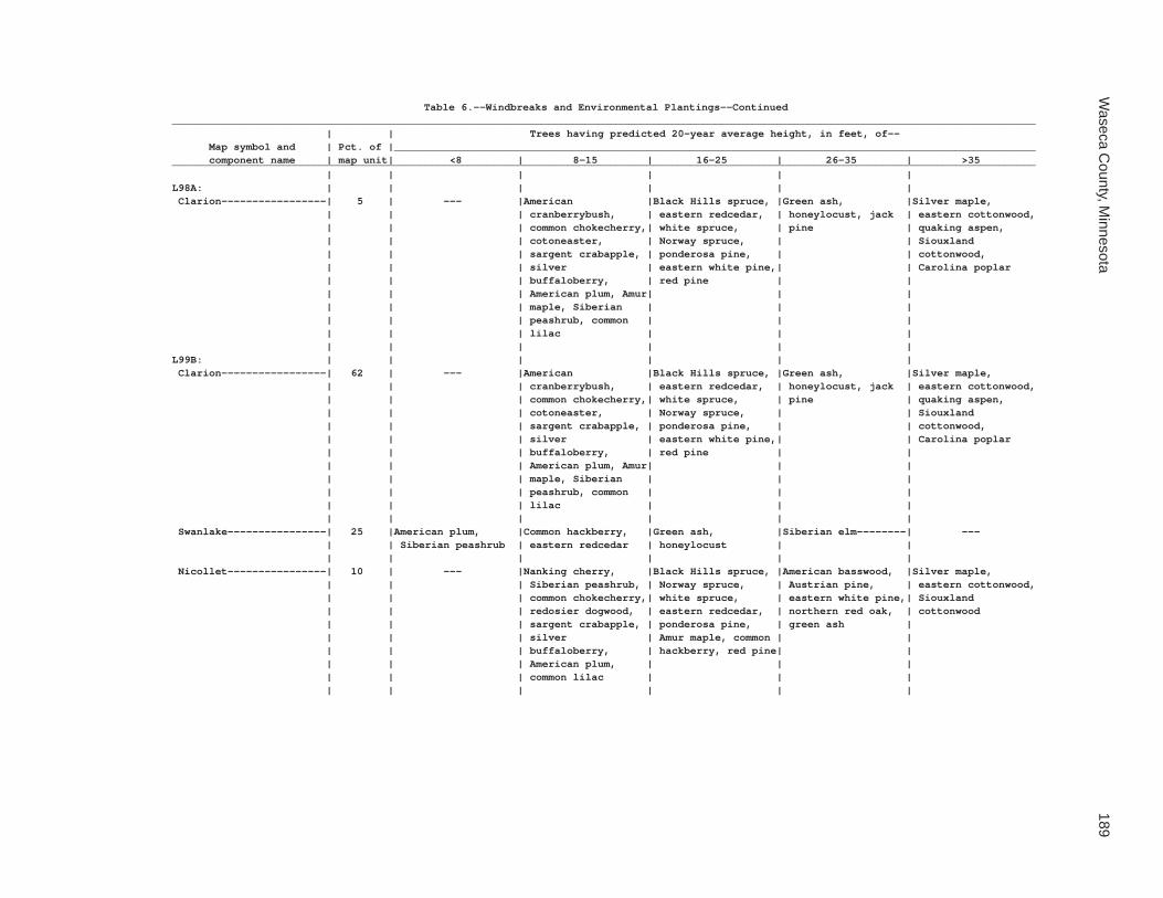
Waseca C
ounty, Minnesota
189
Table 6.--Windbreaks and Environmental Plantings--Continued____________________________________________________________________________________________________________________________________________ | | Trees having predicted 20-year average height, in feet, of-- Map symbol and | Pct. of |________________________________________________________________________________________________________ component name | map unit| <8 | 8-15 | 16-25 | 26-35 | >35____________________________________________________________________________________________________________________________________________ | | | | | |L98A: | | | | | | Clarion-----------------| 5 | --- |American |Black Hills spruce, |Green ash, |Silver maple, | | | cranberrybush, | eastern redcedar, | honeylocust, jack | eastern cottonwood, | | | common chokecherry,| white spruce, | pine | quaking aspen, | | | cotoneaster, | Norway spruce, | | Siouxland | | | sargent crabapple, | ponderosa pine, | | cottonwood, | | | silver | eastern white pine,| | Carolina poplar | | | buffaloberry, | red pine | | | | | American plum, Amur| | | | | | maple, Siberian | | | | | | peashrub, common | | | | | | lilac | | | | | | | | |L99B: | | | | | | Clarion-----------------| 62 | --- |American |Black Hills spruce, |Green ash, |Silver maple, | | | cranberrybush, | eastern redcedar, | honeylocust, jack | eastern cottonwood, | | | common chokecherry,| white spruce, | pine | quaking aspen, | | | cotoneaster, | Norway spruce, | | Siouxland | | | sargent crabapple, | ponderosa pine, | | cottonwood, | | | silver | eastern white pine,| | Carolina poplar | | | buffaloberry, | red pine | | | | | American plum, Amur| | | | | | maple, Siberian | | | | | | peashrub, common | | | | | | lilac | | | | | | | | | Swanlake----------------| 25 |American plum, |Common hackberry, |Green ash, |Siberian elm--------| --- | | Siberian peashrub | eastern redcedar | honeylocust | | | | | | | | Nicollet----------------| 10 | --- |Nanking cherry, |Black Hills spruce, |American basswood, |Silver maple, | | | Siberian peashrub, | Norway spruce, | Austrian pine, | eastern cottonwood, | | | common chokecherry,| white spruce, | eastern white pine,| Siouxland | | | redosier dogwood, | eastern redcedar, | northern red oak, | cottonwood | | | sargent crabapple, | ponderosa pine, | green ash | | | | silver | Amur maple, common | | | | | buffaloberry, | hackberry, red pine| | | | | American plum, | | | | | | common lilac | | | | | | | | |

190S
oil Survey of
Table 6.--Windbreaks and Environmental Plantings--Continued____________________________________________________________________________________________________________________________________________ | | Trees having predicted 20-year average height, in feet, of-- Map symbol and | Pct. of |________________________________________________________________________________________________________ component name | map unit| <8 | 8-15 | 16-25 | 26-35 | >35____________________________________________________________________________________________________________________________________________ | | | | | |L99B: | | | | | | Webster-----------------| 3 | --- |American |American plum, Black|Eastern white pine, |Green ash, quaking | | | cranberrybush, | Hills spruce, | golden willow | aspen, silver | | | cotoneaster, | ponderosa pine, | | maple, Siouxland | | | sargent crabapple, | common hackberry, | | cottonwood, eastern | | | white spruce, | tall purple willow | | cottonwood | | | Siberian peashrub, | | | | | | common lilac, | | | | | | eastern redcedar, | | | | | | redosier dogwood, | | | | | | silver buffaloberry| | | | | | | | |L100B: | | | | | | Clarion-----------------| 45 | --- |American |Black Hills spruce, |Green ash, |Silver maple, | | | cranberrybush, | eastern redcedar, | honeylocust, jack | eastern cottonwood, | | | common chokecherry,| white spruce, | pine | quaking aspen, | | | cotoneaster, | Norway spruce, | | Siouxland | | | sargent crabapple, | ponderosa pine, | | cottonwood, | | | silver | eastern white pine,| | Carolina poplar | | | buffaloberry, | red pine | | | | | American plum, Amur| | | | | | maple, Siberian | | | | | | peashrub, common | | | | | | lilac | | | | | | | | | Estherville-------------| 35 |Siberian peashrub---|American plum, |Black Hills spruce, |Eastern white pine, | --- | | | common chokecherry,| eastern redcedar, | red pine, Scotch | | | | common lilac, | jack pine, | pine, eastern | | | | sargent crabapple, | ponderosa pine, | cottonwood | | | | silver buffaloberry| white spruce, | | | | | | Austrian pine, | | | | | | green ash, silver | | | | | | maple | | | | | | | | Lowlein-----------------| 5 | --- |Common lilac, |Eastern arborvitae, |Austrian pine, |Silver maple | | | redosier dogwood | white spruce, Amur | eastern white pine,| | | | | maple, blue spruce | common hackberry, | | | | | | green ash | | | | | | | Nicollet----------------| 5 | --- |Nanking cherry, |Black Hills spruce, |American basswood, |Silver maple, | | | Siberian peashrub, | Norway spruce, | Austrian pine, | eastern cottonwood, | | | common chokecherry,| white spruce, | eastern white pine,| Siouxland | | | redosier dogwood, | eastern redcedar, | northern red oak, | cottonwood | | | sargent crabapple, | ponderosa pine, | green ash | | | | silver | Amur maple, common | | | | | buffaloberry, | hackberry, red pine| | | | | American plum, | | | | | | common lilac | | | | | | | | |

Waseca C
ounty, Minnesota
191
Table 6.--Windbreaks and Environmental Plantings--Continued____________________________________________________________________________________________________________________________________________ | | Trees having predicted 20-year average height, in feet, of-- Map symbol and | Pct. of |________________________________________________________________________________________________________ component name | map unit| <8 | 8-15 | 16-25 | 26-35 | >35____________________________________________________________________________________________________________________________________________ | | | | | |L100B: | | | | | | Swanlake----------------| 5 |American plum, |Common hackberry, |Green ash, |Siberian elm--------| --- | | Siberian peashrub | eastern redcedar | honeylocust | | | | | | | | Webster-----------------| 5 | --- |American |American plum, Black|Eastern white pine, |Green ash, quaking | | | cranberrybush, | Hills spruce, | golden willow | aspen, silver | | | cotoneaster, | ponderosa pine, | | maple, Siouxland | | | sargent crabapple, | common hackberry, | | cottonwood, eastern | | | white spruce, | tall purple willow | | cottonwood | | | Siberian peashrub, | | | | | | common lilac, | | | | | | eastern redcedar, | | | | | | redosier dogwood, | | | | | | silver buffaloberry| | | | | | | | |L101C2: | | | | | | Omsrud, eroded----------| 40 | --- |American |Black Hills spruce, |Green ash, |Silver maple, | | | cranberrybush, | eastern redcedar, | honeylocust, jack | eastern cottonwood, | | | common chokecherry,| white spruce, | pine | quaking aspen, | | | cotoneaster, | Norway spruce, | | Siouxland | | | sargent crabapple, | ponderosa pine, | | cottonwood, | | | silver | eastern white pine,| | Carolina poplar | | | buffaloberry, | red pine | | | | | American plum, Amur| | | | | | maple, Siberian | | | | | | peashrub, common | | | | | | lilac | | | | | | | | | Hawick------------------| 30 |Siberian peashrub---|American plum, |Black Hills spruce, |Eastern white pine, | --- | | | common chokecherry,| eastern redcedar, | red pine, Scotch | | | | common lilac, | jack pine, | pine, eastern | | | | sargent crabapple, | ponderosa pine, | cottonwood | | | | silver buffaloberry| white spruce, | | | | | | Austrian pine, | | | | | | green ash, silver | | | | | | maple | | | | | | | | Storden, eroded---------| 20 |American plum, |Siberian peashrub, |Green ash, ponderosa|Eastern cottonwood | --- | | common lilac | Black Hills spruce,| pine, honeylocust | | | | | common hackberry, | | | | | | eastern redcedar | | | | | | | | |

192S
oil Survey of
Table 6.--Windbreaks and Environmental Plantings--Continued____________________________________________________________________________________________________________________________________________ | | Trees having predicted 20-year average height, in feet, of-- Map symbol and | Pct. of |________________________________________________________________________________________________________ component name | map unit| <8 | 8-15 | 16-25 | 26-35 | >35____________________________________________________________________________________________________________________________________________ | | | | | |L101C2: | | | | | | Delft-------------------| 5 | --- |American |American plum, Black|Eastern white pine, |Green ash, quaking | | | cranberrybush, | Hills spruce, | golden willow | aspen, silver | | | cotoneaster, | ponderosa pine, | | maple, Siouxland | | | sargent crabapple, | common hackberry, | | cottonwood, eastern | | | white spruce, | tall purple willow | | cottonwood | | | Siberian peashrub, | | | | | | common lilac, | | | | | | eastern redcedar, | | | | | | redosier dogwood, | | | | | | silver buffaloberry| | | | | | | | | Terril------------------| 5 |Redosier dogwood----|Siberian peashrub, |Eastern redcedar, |Honeylocust, jack |Silver maple, | | | American plum, | Amur maple, Black | pine, black walnut,| Siouxland | | | common lilac, | Hills spruce, | common hackberry, | cottonwood | | | prunus, silver | Norway spruce | eastern white pine,| | | | buffaloberry | | green ash | | | | | | |L101D2: | | | | | | Omsrud, eroded----------| 40 | --- |American |Black Hills spruce, |Green ash, |Silver maple, | | | cranberrybush, | eastern redcedar, | honeylocust, jack | eastern cottonwood, | | | common chokecherry,| white spruce, | pine | quaking aspen, | | | cotoneaster, | Norway spruce, | | Siouxland | | | sargent crabapple, | ponderosa pine, | | cottonwood, | | | silver | eastern white pine,| | Carolina poplar | | | buffaloberry, | red pine | | | | | American plum, Amur| | | | | | maple, Siberian | | | | | | peashrub, common | | | | | | lilac | | | | | | | | | Hawick------------------| 25 |Siberian peashrub---|American plum, |Black Hills spruce, |Eastern white pine, | --- | | | common chokecherry,| Russian-olive, | red pine, Scotch | | | | common lilac, | eastern redcedar, | pine, eastern | | | | sargent crabapple, | jack pine, | cottonwood | | | | silver buffaloberry| ponderosa pine, | | | | | | white spruce, | | | | | | Austrian pine, | | | | | | green ash, silver | | | | | | maple | | | | | | | | Storden, eroded---------| 20 |American plum, |Cotoneaster---------|Common hackberry, | --- | --- | | Siberian peashrub | | eastern redcedar, | | | | | | green ash, | | | | | | honeylocust, sugar | | | | | | maple | | | | | | | |

Waseca C
ounty, Minnesota
193
Table 6.--Windbreaks and Environmental Plantings--Continued____________________________________________________________________________________________________________________________________________ | | Trees having predicted 20-year average height, in feet, of-- Map symbol and | Pct. of |________________________________________________________________________________________________________ component name | map unit| <8 | 8-15 | 16-25 | 26-35 | >35____________________________________________________________________________________________________________________________________________ | | | | | |L101D2: | | | | | | Ridgeton----------------| 6 | --- |American |Black Hills spruce, |Green ash, |Silver maple, | | | cranberrybush, | eastern redcedar, | honeylocust, jack | eastern cottonwood, | | | common chokecherry,| white spruce, | pine | quaking aspen, | | | cotoneaster, | Norway spruce, | | Siouxland | | | sargent crabapple, | ponderosa pine, | | cottonwood, | | | silver | eastern white pine,| | Carolina poplar | | | buffaloberry, | red pine | | | | | American plum, Amur| | | | | | maple, Siberian | | | | | | peashrub, common | | | | | | lilac | | | | | | | | | Delft-------------------| 5 | --- |American |American plum, Black|Eastern white pine, |Green ash, quaking | | | cranberrybush, | Hills spruce, | golden willow | aspen, silver | | | cotoneaster, | ponderosa pine, | | maple, Siouxland | | | sargent crabapple, | common hackberry, | | cottonwood, eastern | | | white spruce, | tall purple willow | | cottonwood | | | Siberian peashrub, | | | | | | common lilac, | | | | | | eastern redcedar, | | | | | | redosier dogwood, | | | | | | silver buffaloberry| | | | | | | | | Terril------------------| 4 | --- |American |Black Hills spruce, |Green ash, |Silver maple, | | | cranberrybush, | eastern redcedar, | honeylocust, jack | eastern cottonwood, | | | common chokecherry,| white spruce, | pine | quaking aspen, | | | cotoneaster, | Norway spruce, | | Siouxland | | | sargent crabapple, | ponderosa pine, | | cottonwood, | | | silver | eastern white pine,| | Carolina poplar | | | buffaloberry, | red pine | | | | | American plum, Amur| | | | | | maple, Siberian | | | | | | peashrub, common | | | | | | lilac | | | | | | | | |L102C2: | | | | | | Omsrud, eroded----------| 45 | --- |American |Black Hills spruce, |Green ash, |Silver maple, | | | cranberrybush, | eastern redcedar, | honeylocust, jack | eastern cottonwood, | | | common chokecherry,| white spruce, | pine | quaking aspen, | | | cotoneaster, | Norway spruce, | | Siouxland | | | sargent crabapple, | ponderosa pine, | | cottonwood, | | | silver | eastern white pine,| | Carolina poplar | | | buffaloberry, | red pine | | | | | American plum, Amur| | | | | | maple, Siberian | | | | | | peashrub, common | | | | | | lilac | | | | | | | | |

194S
oil Survey of
Table 6.--Windbreaks and Environmental Plantings--Continued____________________________________________________________________________________________________________________________________________ | | Trees having predicted 20-year average height, in feet, of-- Map symbol and | Pct. of |________________________________________________________________________________________________________ component name | map unit| <8 | 8-15 | 16-25 | 26-35 | >35____________________________________________________________________________________________________________________________________________ | | | | | |L102C2: | | | | | | Storden, eroded---------| 25 |American plum, |Siberian peashrub, |Green ash, ponderosa|Eastern cottonwood | --- | | common lilac | Black Hills spruce,| pine, honeylocust | | | | | common hackberry, | | | | | | eastern redcedar | | | | | | | | | Omsrud------------------| 15 | --- |American |Black Hills spruce, |Green ash, |Silver maple, | | | cranberrybush, | eastern redcedar, | honeylocust, jack | eastern cottonwood, | | | common chokecherry,| white spruce, | pine | quaking aspen, | | | cotoneaster, | Norway spruce, | | Siouxland | | | sargent crabapple, | ponderosa pine, | | cottonwood, | | | silver | eastern white pine,| | Carolina poplar | | | buffaloberry, | red pine | | | | | American plum, Amur| | | | | | maple, Siberian | | | | | | peashrub, common | | | | | | lilac | | | | | | | | | Terril------------------| 10 |Redosier dogwood----|Siberian peashrub, |Eastern redcedar, |Honeylocust, jack |Silver maple, | | | American plum, | Amur maple, Black | pine, black walnut,| Siouxland | | | common lilac, | Hills spruce, | common hackberry, | cottonwood | | | prunus, silver | Norway spruce | eastern white pine,| | | | buffaloberry | | green ash | | | | | | | Delft-------------------| 5 | --- |American |American plum, Black|Eastern white pine, |Green ash, quaking | | | cranberrybush, | Hills spruce, | golden willow | aspen, silver | | | cotoneaster, | ponderosa pine, | | maple, Siouxland | | | sargent crabapple, | common hackberry, | | cottonwood, eastern | | | white spruce, | tall purple willow | | cottonwood | | | Siberian peashrub, | | | | | | common lilac, | | | | | | eastern redcedar, | | | | | | redosier dogwood, | | | | | | silver buffaloberry| | | | | | | | |L102D2: | | | | | | Omsrud, eroded----------| 45 | --- |American |Black Hills spruce, |Green ash, |Silver maple, | | | cranberrybush, | eastern redcedar, | honeylocust, jack | eastern cottonwood, | | | common chokecherry,| white spruce, | pine | quaking aspen, | | | cotoneaster, | Norway spruce, | | Siouxland | | | sargent crabapple, | ponderosa pine, | | cottonwood, | | | silver | eastern white pine,| | Carolina poplar | | | buffaloberry, | red pine | | | | | American plum, Amur| | | | | | maple, Siberian | | | | | | peashrub, common | | | | | | lilac | | | | | | | | |
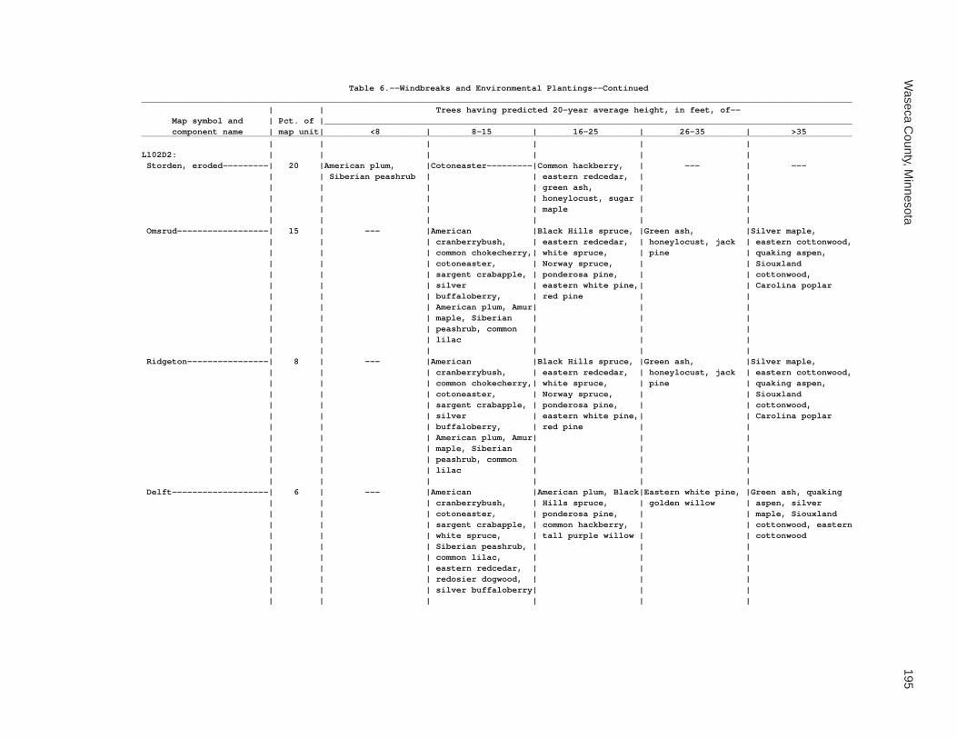
Waseca C
ounty, Minnesota
195
Table 6.--Windbreaks and Environmental Plantings--Continued____________________________________________________________________________________________________________________________________________ | | Trees having predicted 20-year average height, in feet, of-- Map symbol and | Pct. of |________________________________________________________________________________________________________ component name | map unit| <8 | 8-15 | 16-25 | 26-35 | >35____________________________________________________________________________________________________________________________________________ | | | | | |L102D2: | | | | | | Storden, eroded---------| 20 |American plum, |Cotoneaster---------|Common hackberry, | --- | --- | | Siberian peashrub | | eastern redcedar, | | | | | | green ash, | | | | | | honeylocust, sugar | | | | | | maple | | | | | | | | Omsrud------------------| 15 | --- |American |Black Hills spruce, |Green ash, |Silver maple, | | | cranberrybush, | eastern redcedar, | honeylocust, jack | eastern cottonwood, | | | common chokecherry,| white spruce, | pine | quaking aspen, | | | cotoneaster, | Norway spruce, | | Siouxland | | | sargent crabapple, | ponderosa pine, | | cottonwood, | | | silver | eastern white pine,| | Carolina poplar | | | buffaloberry, | red pine | | | | | American plum, Amur| | | | | | maple, Siberian | | | | | | peashrub, common | | | | | | lilac | | | | | | | | | Ridgeton----------------| 8 | --- |American |Black Hills spruce, |Green ash, |Silver maple, | | | cranberrybush, | eastern redcedar, | honeylocust, jack | eastern cottonwood, | | | common chokecherry,| white spruce, | pine | quaking aspen, | | | cotoneaster, | Norway spruce, | | Siouxland | | | sargent crabapple, | ponderosa pine, | | cottonwood, | | | silver | eastern white pine,| | Carolina poplar | | | buffaloberry, | red pine | | | | | American plum, Amur| | | | | | maple, Siberian | | | | | | peashrub, common | | | | | | lilac | | | | | | | | | Delft-------------------| 6 | --- |American |American plum, Black|Eastern white pine, |Green ash, quaking | | | cranberrybush, | Hills spruce, | golden willow | aspen, silver | | | cotoneaster, | ponderosa pine, | | maple, Siouxland | | | sargent crabapple, | common hackberry, | | cottonwood, eastern | | | white spruce, | tall purple willow | | cottonwood | | | Siberian peashrub, | | | | | | common lilac, | | | | | | eastern redcedar, | | | | | | redosier dogwood, | | | | | | silver buffaloberry| | | | | | | | |

196S
oil Survey of
Table 6.--Windbreaks and Environmental Plantings--Continued____________________________________________________________________________________________________________________________________________ | | Trees having predicted 20-year average height, in feet, of-- Map symbol and | Pct. of |________________________________________________________________________________________________________ component name | map unit| <8 | 8-15 | 16-25 | 26-35 | >35____________________________________________________________________________________________________________________________________________ | | | | | |L102D2: | | | | | | Terril------------------| 6 | --- |American |Black Hills spruce, |Green ash, |Silver maple, | | | cranberrybush, | eastern redcedar, | honeylocust, jack | eastern cottonwood, | | | common chokecherry,| white spruce, | pine | quaking aspen, | | | cotoneaster, | Norway spruce, | | Siouxland | | | sargent crabapple, | ponderosa pine, | | cottonwood, | | | silver | eastern white pine,| | Carolina poplar | | | buffaloberry, | red pine | | | | | American plum, Amur| | | | | | maple, Siberian | | | | | | peashrub, common | | | | | | lilac | | | | | | | | |L103A: | | | | | | Fieldon-----------------| 50 |Redosier dogwood----|Gray dogwood, silky |Northern whitecedar,|Black willow, golden|Eastern cottonwood | | | dogwood | black ash, tall | willow, white | | | | | purple willow | willow | | | | | | | Canisteo----------------| 35 |Redosier dogwood----|Gray dogwood, silky |Northern whitecedar,|Black willow, golden|Eastern cottonwood | | | dogwood | black ash, tall | willow, white | | | | | purple willow | willow | | | | | | | Darfur------------------| 10 | --- |American |American plum, Black|Eastern white pine, |Green ash, quaking | | | cranberrybush, | Hills spruce, | golden willow | aspen, silver | | | cotoneaster, | ponderosa pine, | | maple, Siouxland | | | sargent crabapple, | common hackberry, | | cottonwood, eastern | | | white spruce, | tall purple willow | | cottonwood | | | Siberian peashrub, | | | | | | common lilac, | | | | | | eastern redcedar, | | | | | | redosier dogwood, | | | | | | silver buffaloberry| | | | | | | | | Glencoe-----------------| 5 |Redosier dogwood----|Silky dogwood-------|Tamarack, green ash,|Black willow, golden|Eastern cottonwood | | | | northern | willow | | | | | whitecedar, black | | | | | | ash, tall purple | | | | | | willow | | | | | | | |

Waseca C
ounty, Minnesota
197
Table 6.--Windbreaks and Environmental Plantings--Continued____________________________________________________________________________________________________________________________________________ | | Trees having predicted 20-year average height, in feet, of-- Map symbol and | Pct. of |________________________________________________________________________________________________________ component name | map unit| <8 | 8-15 | 16-25 | 26-35 | >35____________________________________________________________________________________________________________________________________________ | | | | | |L105C2: | | | | | | Lester, eroded----------| 45 | --- |American |Black Hills spruce, |Green ash, |Silver maple, | | | cranberrybush, | eastern redcedar, | honeylocust, jack | eastern cottonwood, | | | common chokecherry,| white spruce, | pine | quaking aspen, | | | cotoneaster, | Norway spruce, | | Siouxland | | | sargent crabapple, | ponderosa pine, | | cottonwood, | | | silver | eastern white pine,| | Carolina poplar | | | buffaloberry, | red pine | | | | | American plum, Amur| | | | | | maple, Siberian | | | | | | peashrub, common | | | | | | lilac | | | | | | | | | Hawick------------------| 35 |Siberian peashrub---|American plum, |Black Hills spruce, |Eastern white pine, | --- | | | common chokecherry,| eastern redcedar, | red pine, Scotch | | | | common lilac, | jack pine, | pine, eastern | | | | sargent crabapple, | ponderosa pine, | cottonwood | | | | silver buffaloberry| white spruce, | | | | | | Austrian pine, | | | | | | green ash, silver | | | | | | maple | | | | | | | | Terril------------------| 10 |Redosier dogwood----|Siberian peashrub, |Eastern redcedar, |Honeylocust, jack |Silver maple, | | | American plum, | Amur maple, Black | pine, black walnut,| Siouxland | | | common lilac, | Hills spruce, | common hackberry, | cottonwood | | | prunus, silver | Norway spruce | eastern white pine,| | | | buffaloberry | | green ash | | | | | | | Hamel-------------------| 5 | --- |American |American plum, Black|Eastern white pine, |Green ash, quaking | | | cranberrybush, | Hills spruce, | golden willow | aspen, silver | | | cotoneaster, | ponderosa pine, | | maple, Siouxland | | | sargent crabapple, | common hackberry, | | cottonwood, eastern | | | white spruce, | tall purple willow | | cottonwood | | | Siberian peashrub, | | | | | | common lilac, | | | | | | eastern redcedar, | | | | | | redosier dogwood, | | | | | | silver buffaloberry| | | | | | | | | Storden, eroded---------| 5 |American plum, |Siberian peashrub, |Green ash, ponderosa|Eastern cottonwood | --- | | common lilac | Black Hills spruce,| pine, honeylocust | | | | | common hackberry, | | | | | | eastern redcedar | | | | | | | | |

198S
oil Survey of
Table 6.--Windbreaks and Environmental Plantings--Continued____________________________________________________________________________________________________________________________________________ | | Trees having predicted 20-year average height, in feet, of-- Map symbol and | Pct. of |________________________________________________________________________________________________________ component name | map unit| <8 | 8-15 | 16-25 | 26-35 | >35____________________________________________________________________________________________________________________________________________ | | | | | |L105D2: | | | | | | Lester, eroded----------| 45 | --- |American |Black Hills spruce, |Green ash, |Silver maple, | | | cranberrybush, | eastern redcedar, | honeylocust, jack | eastern cottonwood, | | | common chokecherry,| white spruce, | pine | quaking aspen, | | | cotoneaster, | Norway spruce, | | Siouxland | | | sargent crabapple, | ponderosa pine, | | cottonwood, | | | silver | eastern white pine,| | Carolina poplar | | | buffaloberry, | red pine | | | | | American plum, Amur| | | | | | maple, Siberian | | | | | | peashrub, common | | | | | | lilac | | | | | | | | | Hawick------------------| 35 |Siberian peashrub---|American plum, |Black Hills spruce, |Eastern white pine, | --- | | | common chokecherry,| eastern redcedar, | red pine, Scotch | | | | common lilac, | jack pine, | pine, eastern | | | | sargent crabapple, | ponderosa pine, | cottonwood | | | | silver buffaloberry| white spruce, | | | | | | Austrian pine, | | | | | | green ash, silver | | | | | | maple | | | | | | | | Ridgeton----------------| 8 | --- |American |Black Hills spruce, |Green ash, |Silver maple, | | | cranberrybush, | eastern redcedar, | honeylocust, jack | eastern cottonwood, | | | common chokecherry,| white spruce, | pine | quaking aspen, | | | cotoneaster, | Norway spruce, | | Siouxland | | | sargent crabapple, | ponderosa pine, | | cottonwood, | | | silver | eastern white pine,| | Carolina poplar | | | buffaloberry, | red pine | | | | | American plum, Amur| | | | | | maple, Siberian | | | | | | peashrub, common | | | | | | lilac | | | | | | | | | Hamel-------------------| 5 | --- |American |American plum, Black|Eastern white pine, |Green ash, quaking | | | cranberrybush, | Hills spruce, | golden willow | aspen, silver | | | cotoneaster, | ponderosa pine, | | maple, Siouxland | | | sargent crabapple, | common hackberry, | | cottonwood, eastern | | | white spruce, | tall purple willow | | cottonwood | | | Siberian peashrub, | | | | | | common lilac, | | | | | | eastern redcedar, | | | | | | redosier dogwood, | | | | | | silver buffaloberry| | | | | | | | |
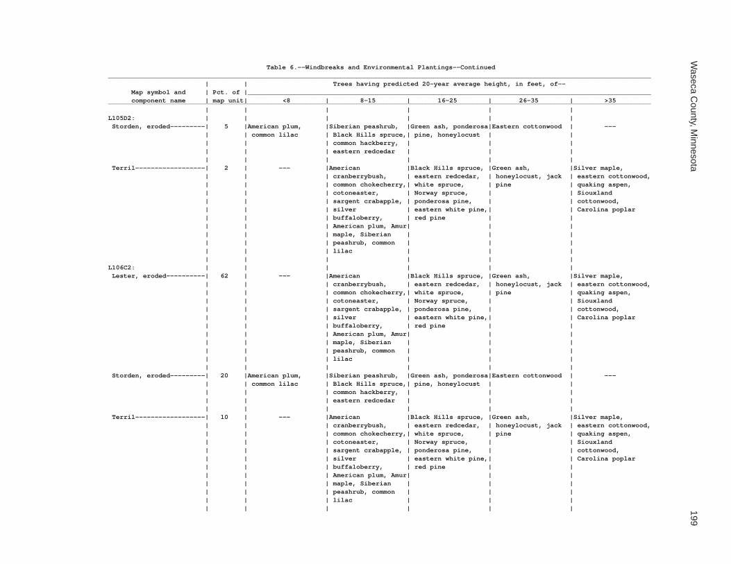
Waseca C
ounty, Minnesota
199
Table 6.--Windbreaks and Environmental Plantings--Continued____________________________________________________________________________________________________________________________________________ | | Trees having predicted 20-year average height, in feet, of-- Map symbol and | Pct. of |________________________________________________________________________________________________________ component name | map unit| <8 | 8-15 | 16-25 | 26-35 | >35____________________________________________________________________________________________________________________________________________ | | | | | |L105D2: | | | | | | Storden, eroded---------| 5 |American plum, |Siberian peashrub, |Green ash, ponderosa|Eastern cottonwood | --- | | common lilac | Black Hills spruce,| pine, honeylocust | | | | | common hackberry, | | | | | | eastern redcedar | | | | | | | | | Terril------------------| 2 | --- |American |Black Hills spruce, |Green ash, |Silver maple, | | | cranberrybush, | eastern redcedar, | honeylocust, jack | eastern cottonwood, | | | common chokecherry,| white spruce, | pine | quaking aspen, | | | cotoneaster, | Norway spruce, | | Siouxland | | | sargent crabapple, | ponderosa pine, | | cottonwood, | | | silver | eastern white pine,| | Carolina poplar | | | buffaloberry, | red pine | | | | | American plum, Amur| | | | | | maple, Siberian | | | | | | peashrub, common | | | | | | lilac | | | | | | | | |L106C2: | | | | | | Lester, eroded----------| 62 | --- |American |Black Hills spruce, |Green ash, |Silver maple, | | | cranberrybush, | eastern redcedar, | honeylocust, jack | eastern cottonwood, | | | common chokecherry,| white spruce, | pine | quaking aspen, | | | cotoneaster, | Norway spruce, | | Siouxland | | | sargent crabapple, | ponderosa pine, | | cottonwood, | | | silver | eastern white pine,| | Carolina poplar | | | buffaloberry, | red pine | | | | | American plum, Amur| | | | | | maple, Siberian | | | | | | peashrub, common | | | | | | lilac | | | | | | | | | Storden, eroded---------| 20 |American plum, |Siberian peashrub, |Green ash, ponderosa|Eastern cottonwood | --- | | common lilac | Black Hills spruce,| pine, honeylocust | | | | | common hackberry, | | | | | | eastern redcedar | | | | | | | | | Terril------------------| 10 | --- |American |Black Hills spruce, |Green ash, |Silver maple, | | | cranberrybush, | eastern redcedar, | honeylocust, jack | eastern cottonwood, | | | common chokecherry,| white spruce, | pine | quaking aspen, | | | cotoneaster, | Norway spruce, | | Siouxland | | | sargent crabapple, | ponderosa pine, | | cottonwood, | | | silver | eastern white pine,| | Carolina poplar | | | buffaloberry, | red pine | | | | | American plum, Amur| | | | | | maple, Siberian | | | | | | peashrub, common | | | | | | lilac | | | | | | | | |

200S
oil Survey of
Table 6.--Windbreaks and Environmental Plantings--Continued____________________________________________________________________________________________________________________________________________ | | Trees having predicted 20-year average height, in feet, of-- Map symbol and | Pct. of |________________________________________________________________________________________________________ component name | map unit| <8 | 8-15 | 16-25 | 26-35 | >35____________________________________________________________________________________________________________________________________________ | | | | | |L106C2: | | | | | | Hamel-------------------| 5 | --- |American |American plum, Black|Eastern white pine, |Green ash, quaking | | | cranberrybush, | Hills spruce, | golden willow | aspen, silver | | | cotoneaster, | ponderosa pine, | | maple, Siouxland | | | sargent crabapple, | common hackberry, | | cottonwood, eastern | | | white spruce, | tall purple willow | | cottonwood | | | Siberian peashrub, | | | | | | common lilac, | | | | | | eastern redcedar, | | | | | | redosier dogwood, | | | | | | silver buffaloberry| | | | | | | | | Reedslake---------------| 3 | --- |American |Black Hills spruce, |Green ash, |Silver maple, | | | cranberrybush, | eastern redcedar, | honeylocust, jack | eastern cottonwood, | | | common chokecherry,| white spruce, | pine | quaking aspen, | | | cotoneaster, | Norway spruce, | | Siouxland | | | sargent crabapple, | ponderosa pine, | | cottonwood, | | | silver | eastern white pine,| | Carolina poplar | | | buffaloberry, | red pine | | | | | American plum, Amur| | | | | | maple, Siberian | | | | | | peashrub, common | | | | | | lilac | | | | | | | | |L106D2: | | | | | | Lester, eroded----------| 62 | --- |American |Black Hills spruce, |Green ash, |Silver maple, | | | cranberrybush, | eastern redcedar, | honeylocust, jack | eastern cottonwood, | | | common chokecherry,| white spruce, | pine | quaking aspen, | | | cotoneaster, | Norway spruce, | | Siouxland | | | sargent crabapple, | ponderosa pine, | | cottonwood, | | | silver | eastern white pine,| | Carolina poplar | | | buffaloberry, | red pine | | | | | American plum, Amur| | | | | | maple, Siberian | | | | | | peashrub, common | | | | | | lilac | | | | | | | | | Storden, eroded---------| 20 |American plum, |Siberian peashrub, |Green ash, ponderosa|Eastern cottonwood | --- | | common lilac | Black Hills spruce,| pine, honeylocust | | | | | common hackberry, | | | | | | eastern redcedar | | | | | | | | |

Waseca C
ounty, Minnesota
201
Table 6.--Windbreaks and Environmental Plantings--Continued____________________________________________________________________________________________________________________________________________ | | Trees having predicted 20-year average height, in feet, of-- Map symbol and | Pct. of |________________________________________________________________________________________________________ component name | map unit| <8 | 8-15 | 16-25 | 26-35 | >35____________________________________________________________________________________________________________________________________________ | | | | | |L106D2: | | | | | | Ridgeton----------------| 10 | --- |American |Black Hills spruce, |Green ash, |Silver maple, | | | cranberrybush, | eastern redcedar, | honeylocust, jack | eastern cottonwood, | | | common chokecherry,| white spruce, | pine | quaking aspen, | | | cotoneaster, | Norway spruce, | | Siouxland | | | sargent crabapple, | ponderosa pine, | | cottonwood, | | | silver | eastern white pine,| | Carolina poplar | | | buffaloberry, | red pine | | | | | American plum, Amur| | | | | | maple, Siberian | | | | | | peashrub, common | | | | | | lilac | | | | | | | | | Terril------------------| 5 | --- |American |Black Hills spruce, |Green ash, |Silver maple, | | | cranberrybush, | eastern redcedar, | honeylocust, jack | eastern cottonwood, | | | common chokecherry,| white spruce, | pine | quaking aspen, | | | cotoneaster, | Norway spruce, | | Siouxland | | | sargent crabapple, | ponderosa pine, | | cottonwood, | | | silver | eastern white pine,| | Carolina poplar | | | buffaloberry, | red pine | | | | | American plum, Amur| | | | | | maple, Siberian | | | | | | peashrub, common | | | | | | lilac | | | | | | | | | Hamel-------------------| 3 | --- |American |American plum, Black|Eastern white pine, |Green ash, quaking | | | cranberrybush, | Hills spruce, | golden willow | aspen, silver | | | cotoneaster, | ponderosa pine, | | maple, Siouxland | | | sargent crabapple, | common hackberry, | | cottonwood, eastern | | | white spruce, | tall purple willow | | cottonwood | | | Siberian peashrub, | | | | | | common lilac, | | | | | | eastern redcedar, | | | | | | redosier dogwood, | | | | | | silver buffaloberry| | | | | | | | |L107A: | | | | | | Canisteo----------------| 50 |Redosier dogwood----|Gray dogwood, silky |Northern whitecedar,|Black willow, golden|Eastern cottonwood | | | dogwood | black ash, tall | willow, white | | | | | purple willow | willow | | | | | | | Glencoe-----------------| 35 |Redosier dogwood----|Silky dogwood-------|Tamarack, green ash,|Black willow, golden|Eastern cottonwood | | | | northern | willow | | | | | whitecedar, black | | | | | | ash, tall purple | | | | | | willow | | | | | | | |

202S
oil Survey of
Table 6.--Windbreaks and Environmental Plantings--Continued____________________________________________________________________________________________________________________________________________ | | Trees having predicted 20-year average height, in feet, of-- Map symbol and | Pct. of |________________________________________________________________________________________________________ component name | map unit| <8 | 8-15 | 16-25 | 26-35 | >35____________________________________________________________________________________________________________________________________________ | | | | | |L107A: | | | | | | Harps-------------------| 10 |Redosier dogwood----|Common lilac, |Blue spruce, eastern|Green ash, golden |Eastern cottonwood | | | eastern arborvitae | redcedar, white | willow, honeylocust| | | | | spruce, common | | | | | | hackberry | | | | | | | | Canisteo, depressional--| 3 |Redosier dogwood----|Gray dogwood, silky |Northern whitecedar,|Black willow, golden|Eastern cottonwood | | | dogwood | black ash, tall | willow, white | | | | | purple willow | willow | | | | | | | Crippin-----------------| 2 | --- |American plum, |Eastern redcedar, |Green ash, |Eastern cottonwood, | | | Siberian peashrub, | white spruce, Black| honeylocust, golden| Siouxland | | | common chokecherry,| Hills spruce, Amur | willow | cottonwood | | | common lilac, | maple, Norway | | | | | sargent crabapple, | spruce, common | | | | | silver | hackberry, | | | | | buffaloberry, | ponderosa pine | | | | | cotoneaster, gray | | | | | | dogwood | | | | | | | | |L108A: | | | | | | Cordova-----------------| 65 | --- |American |American plum, Black|Eastern white pine, |Green ash, quaking | | | cranberrybush, | Hills spruce, | golden willow | aspen, silver | | | cotoneaster, | ponderosa pine, | | maple, Siouxland | | | sargent crabapple, | common hackberry, | | cottonwood, eastern | | | white spruce, | tall purple willow | | cottonwood | | | Siberian peashrub, | | | | | | common lilac, | | | | | | eastern redcedar, | | | | | | redosier dogwood, | | | | | | silver buffaloberry| | | | | | | | | Rolfe-------------------| 30 |Redosier dogwood----|Silky dogwood-------|Tamarack, green ash,|Black willow, golden|Eastern cottonwood | | | | northern | willow | | | | | whitecedar, black | | | | | | ash, tall purple | | | | | | willow | | | | | | | | Le Sueur----------------| 5 | --- |Common lilac, |Eastern arborvitae, |Austrian pine, |Silver maple | | | redosier dogwood | white spruce, Amur | eastern white pine,| | | | | maple, blue spruce | common hackberry, | | | | | | green ash | | | | | | |

Waseca C
ounty, Minnesota
203
Table 6.--Windbreaks and Environmental Plantings--Continued____________________________________________________________________________________________________________________________________________ | | Trees having predicted 20-year average height, in feet, of-- Map symbol and | Pct. of |________________________________________________________________________________________________________ component name | map unit| <8 | 8-15 | 16-25 | 26-35 | >35____________________________________________________________________________________________________________________________________________ | | | | | |L109A: | | | | | | Marna-------------------| 65 | --- |American |American plum, Black|Eastern white pine, |Green ash, quaking | | | cranberrybush, | Hills spruce, | golden willow | aspen, silver | | | cotoneaster, | ponderosa pine, | | maple, Siouxland | | | sargent crabapple, | common hackberry, | | cottonwood, eastern | | | white spruce, | tall purple willow | | cottonwood | | | Siberian peashrub, | | | | | | common lilac, | | | | | | eastern redcedar, | | | | | | redosier dogwood, | | | | | | silver buffaloberry| | | | | | | | | Barbert-----------------| 30 |Redosier dogwood----|Silky dogwood-------|Tamarack, green ash,|Black willow, golden|Eastern cottonwood | | | | northern | willow | | | | | whitecedar, black | | | | | | ash, tall purple | | | | | | willow | | | | | | | | Guckeen-----------------| 5 | --- |Siberian peashrub, |Bur oak, eastern |Eastern white pine, | --- | | | common lilac | arborvitae, eastern| green ash | | | | | redcedar, white | | | | | | spruce, Austrian | | | | | | pine, common | | | | | | hackberry | | | | | | | |L110E: | | | | | | Lester------------------| 50 |Nanking cherry------|American |Black Hills spruce, |Green ash, |Silver maple, | | | cranberrybush, | eastern redcedar, | honeylocust, jack | eastern cottonwood, | | | common chokecherry,| white spruce, | pine | quaking aspen, | | | cotoneaster, | Norway spruce, | | Siouxland | | | sargent crabapple, | ponderosa pine, | | cottonwood, | | | silver | eastern white pine,| | Carolina poplar | | | buffaloberry, | red pine | | | | | American plum, Amur| | | | | | maple, Siberian | | | | | | peashrub, common | | | | | | lilac | | | | | | | | |

204S
oil Survey of
Table 6.--Windbreaks and Environmental Plantings--Continued____________________________________________________________________________________________________________________________________________ | | Trees having predicted 20-year average height, in feet, of-- Map symbol and | Pct. of |________________________________________________________________________________________________________ component name | map unit| <8 | 8-15 | 16-25 | 26-35 | >35____________________________________________________________________________________________________________________________________________ | | | | | |L110E: | | | | | | Ridgeton----------------| 30 |Nanking cherry------|American |Black Hills spruce, |Green ash, |Silver maple, | | | cranberrybush, | eastern redcedar, | honeylocust, jack | eastern cottonwood, | | | common chokecherry,| white spruce, | pine | quaking aspen, | | | cotoneaster, | Norway spruce, | | Siouxland | | | sargent crabapple, | ponderosa pine, | | cottonwood, | | | silver | eastern white pine,| | Carolina poplar | | | buffaloberry, | red pine | | | | | American plum, Amur| | | | | | maple, Siberian | | | | | | peashrub, common | | | | | | lilac | | | | | | | | | Cokato------------------| 10 |Nanking cherry------|American |Black Hills spruce, |Green ash, |Silver maple, | | | cranberrybush, | eastern redcedar, | honeylocust, jack | eastern cottonwood, | | | common chokecherry,| white spruce, | pine | quaking aspen, | | | cotoneaster, | Norway spruce, | | Siouxland | | | sargent crabapple, | ponderosa pine, | | cottonwood, | | | silver | eastern white pine,| | Carolina poplar | | | buffaloberry, | red pine | | | | | American plum, Amur| | | | | | maple, Siberian | | | | | | peashrub, common | | | | | | lilac | | | | | | | | | Belview-----------------| 6 |American plum, |Siberian peashrub, |Green ash, ponderosa|Eastern cottonwood | --- | | common lilac | Black Hills spruce,| pine, honeylocust | | | | | common hackberry, | | | | | | eastern redcedar | | | | | | | | | Hamel-------------------| 2 | --- |American plum-------|Amur maple, redosier|Golden willow-------|Green ash, silver | | | | dogwood, eastern | | maple, eastern | | | | arborvitae, white | | cottonwood | | | | spruce, common | | | | | | hackberry, tall | | | | | | purple willow | | | | | | | | Terril------------------| 2 |Nanking cherry------|American |Black Hills spruce, |Green ash, |Silver maple, | | | cranberrybush, | eastern redcedar, | honeylocust, jack | eastern cottonwood, | | | common chokecherry,| white spruce, | pine | quaking aspen, | | | cotoneaster, | Norway spruce, | | Siouxland | | | sargent crabapple, | ponderosa pine, | | cottonwood, | | | silver | eastern white pine,| | Carolina poplar | | | buffaloberry, | red pine | | | | | American plum, Amur| | | | | | maple, Siberian | | | | | | peashrub, common | | | | | | lilac | | | | | | | | |

Waseca C
ounty, Minnesota
205
Table 6.--Windbreaks and Environmental Plantings--Continued____________________________________________________________________________________________________________________________________________ | | Trees having predicted 20-year average height, in feet, of-- Map symbol and | Pct. of |________________________________________________________________________________________________________ component name | map unit| <8 | 8-15 | 16-25 | 26-35 | >35____________________________________________________________________________________________________________________________________________ | | | | | |L110F: | | | | | | Lester------------------| 55 |Nanking cherry------|American |Black Hills spruce, |Green ash, |Silver maple, | | | cranberrybush, | eastern redcedar, | honeylocust, jack | eastern cottonwood, | | | common chokecherry,| white spruce, | pine | quaking aspen, | | | cotoneaster, | Norway spruce, | | Siouxland | | | sargent crabapple, | ponderosa pine, | | cottonwood, | | | silver | eastern white pine,| | Carolina poplar | | | buffaloberry, | red pine | | | | | American plum, Amur| | | | | | maple, Siberian | | | | | | peashrub, common | | | | | | lilac | | | | | | | | | Ridgeton----------------| 30 |Nanking cherry------|American |Black Hills spruce, |Green ash, |Silver maple, | | | cranberrybush, | eastern redcedar, | honeylocust, jack | eastern cottonwood, | | | common chokecherry,| white spruce, | pine | quaking aspen, | | | cotoneaster, | Norway spruce, | | Siouxland | | | sargent crabapple, | ponderosa pine, | | cottonwood, | | | silver | eastern white pine,| | Carolina poplar | | | buffaloberry, | red pine | | | | | American plum, Amur| | | | | | maple, Siberian | | | | | | peashrub, common | | | | | | lilac | | | | | | | | | Cokato------------------| 8 |Nanking cherry------|American |Black Hills spruce, |Green ash, |Silver maple, | | | cranberrybush, | eastern redcedar, | honeylocust, jack | eastern cottonwood, | | | common chokecherry,| white spruce, | pine | quaking aspen, | | | cotoneaster, | Norway spruce, | | Siouxland | | | sargent crabapple, | ponderosa pine, | | cottonwood, | | | silver | eastern white pine,| | Carolina poplar | | | buffaloberry, | red pine | | | | | American plum, Amur| | | | | | maple, Siberian | | | | | | peashrub, common | | | | | | lilac | | | | | | | | | Belview-----------------| 4 |American plum, |Siberian peashrub, |Green ash, ponderosa|Eastern cottonwood | --- | | common lilac | Black Hills spruce,| pine, honeylocust | | | | | common hackberry, | | | | | | eastern redcedar | | | | | | | | |

206S
oil Survey of
Table 6.--Windbreaks and Environmental Plantings--Continued____________________________________________________________________________________________________________________________________________ | | Trees having predicted 20-year average height, in feet, of-- Map symbol and | Pct. of |________________________________________________________________________________________________________ component name | map unit| <8 | 8-15 | 16-25 | 26-35 | >35____________________________________________________________________________________________________________________________________________ | | | | | |L110F: | | | | | | Terril------------------| 2 |Nanking cherry------|American |Black Hills spruce, |Green ash, |Silver maple, | | | cranberrybush, | eastern redcedar, | honeylocust, jack | eastern cottonwood, | | | common chokecherry,| white spruce, | pine | quaking aspen, | | | cotoneaster, | Norway spruce, | | Siouxland | | | sargent crabapple, | ponderosa pine, | | cottonwood, | | | silver | eastern white pine,| | Carolina poplar | | | buffaloberry, | red pine | | | | | American plum, Amur| | | | | | maple, Siberian | | | | | | peashrub, common | | | | | | lilac | | | | | | | | | Hamel-------------------| 1 | --- |American plum-------|Amur maple, redosier|Golden willow-------|Green ash, silver | | | | dogwood, eastern | | maple, eastern | | | | arborvitae, white | | cottonwood | | | | spruce, common | | | | | | hackberry, tall | | | | | | purple willow | | | | | | | |L111A: | | | | | | Nicollet----------------| 85 | --- |Nanking cherry, |Black Hills spruce, |American basswood, |Silver maple, | | | Siberian peashrub, | Norway spruce, | Austrian pine, | eastern cottonwood, | | | common chokecherry,| white spruce, | eastern white pine,| Siouxland | | | redosier dogwood, | eastern redcedar, | northern red oak, | cottonwood | | | sargent crabapple, | ponderosa pine, | green ash | | | | silver | Amur maple, common | | | | | buffaloberry, | hackberry, red pine| | | | | American plum, | | | | | | common lilac | | | | | | | | | Clarion-----------------| 10 | --- |American |Black Hills spruce, |Green ash, |Silver maple, | | | cranberrybush, | eastern redcedar, | honeylocust, jack | eastern cottonwood, | | | common chokecherry,| white spruce, | pine | quaking aspen, | | | cotoneaster, | Norway spruce, | | Siouxland | | | sargent crabapple, | ponderosa pine, | | cottonwood, | | | silver | eastern white pine,| | Carolina poplar | | | buffaloberry, | red pine | | | | | American plum, Amur| | | | | | maple, Siberian | | | | | | peashrub, common | | | | | | lilac | | | | | | | | |

Waseca C
ounty, Minnesota
207
Table 6.--Windbreaks and Environmental Plantings--Continued____________________________________________________________________________________________________________________________________________ | | Trees having predicted 20-year average height, in feet, of-- Map symbol and | Pct. of |________________________________________________________________________________________________________ component name | map unit| <8 | 8-15 | 16-25 | 26-35 | >35____________________________________________________________________________________________________________________________________________ | | | | | |L111A: | | | | | | Webster-----------------| 5 | --- |American |American plum, Black|Eastern white pine, |Green ash, quaking | | | cranberrybush, | Hills spruce, | golden willow | aspen, silver | | | cotoneaster, | ponderosa pine, | | maple, Siouxland | | | sargent crabapple, | common hackberry, | | cottonwood, eastern | | | white spruce, | tall purple willow | | cottonwood | | | Siberian peashrub, | | | | | | common lilac, | | | | | | eastern redcedar, | | | | | | redosier dogwood, | | | | | | silver buffaloberry| | | | | | | | |L112A: | | | | | | Webster-----------------| 85 | --- |American |American plum, Black|Eastern white pine, |Green ash, quaking | | | cranberrybush, | Hills spruce, | golden willow | aspen, silver | | | cotoneaster, | ponderosa pine, | | maple, Siouxland | | | sargent crabapple, | common hackberry, | | cottonwood, eastern | | | white spruce, | tall purple willow | | cottonwood | | | Siberian peashrub, | | | | | | common lilac, | | | | | | eastern redcedar, | | | | | | redosier dogwood, | | | | | | silver buffaloberry| | | | | | | | | Glencoe-----------------| 10 |Redosier dogwood----|Silky dogwood-------|Tamarack, green ash,|Black willow, golden|Eastern cottonwood | | | | northern | willow | | | | | whitecedar, black | | | | | | ash, tall purple | | | | | | willow | | | | | | | | Nicollet----------------| 5 | --- |Nanking cherry, |Black Hills spruce, |American basswood, |Silver maple, | | | Siberian peashrub, | Norway spruce, | Austrian pine, | eastern cottonwood, | | | common chokecherry,| white spruce, | eastern white pine,| Siouxland | | | redosier dogwood, | eastern redcedar, | northern red oak, | cottonwood | | | sargent crabapple, | ponderosa pine, | green ash | | | | silver | Amur maple, common | | | | | buffaloberry, | hackberry, red pine| | | | | American plum, | | | | | | common lilac | | | | | | | | |

208S
oil Survey of
Table 6.--Windbreaks and Environmental Plantings--Continued____________________________________________________________________________________________________________________________________________ | | Trees having predicted 20-year average height, in feet, of-- Map symbol and | Pct. of |________________________________________________________________________________________________________ component name | map unit| <8 | 8-15 | 16-25 | 26-35 | >35____________________________________________________________________________________________________________________________________________ | | | | | |L113B: | | | | | | Reedslake---------------| 75 | --- |American |Black Hills spruce, |Green ash, |Silver maple, | | | cranberrybush, | eastern redcedar, | honeylocust, jack | eastern cottonwood, | | | common chokecherry,| white spruce, | pine | quaking aspen, | | | cotoneaster, | Norway spruce, | | Siouxland | | | sargent crabapple, | ponderosa pine, | | cottonwood, | | | silver | eastern white pine,| | Carolina poplar | | | buffaloberry, | red pine | | | | | American plum, Amur| | | | | | maple, Siberian | | | | | | peashrub, common | | | | | | lilac | | | | | | | | | Le Sueur----------------| 10 | --- |Nanking cherry, |Black Hills spruce, |American basswood, |Silver maple, | | | Siberian peashrub, | Norway spruce, | Austrian pine, | eastern cottonwood, | | | common chokecherry,| white spruce, | eastern white pine,| Siouxland | | | redosier dogwood, | eastern redcedar, | northern red oak, | cottonwood | | | sargent crabapple, | ponderosa pine, | green ash | | | | silver | Amur maple, common | | | | | buffaloberry, | hackberry, red pine| | | | | American plum, | | | | | | common lilac | | | | | | | | | Reedslake, eroded-------| 10 | --- |American |Black Hills spruce, |Green ash, |Silver maple, | | | cranberrybush, | eastern redcedar, | honeylocust, jack | eastern cottonwood, | | | common chokecherry,| white spruce, | pine | quaking aspen, | | | cotoneaster, | Norway spruce, | | Siouxland | | | sargent crabapple, | ponderosa pine, | | cottonwood, | | | silver | eastern white pine,| | Carolina poplar | | | buffaloberry, | red pine | | | | | American plum, Amur| | | | | | maple, Siberian | | | | | | peashrub, common | | | | | | lilac | | | | | | | | | Cordova-----------------| 5 | --- |American |American plum, Black|Eastern white pine, |Green ash, quaking | | | cranberrybush, | Hills spruce, | golden willow | aspen, silver | | | cotoneaster, | ponderosa pine, | | maple, Siouxland | | | sargent crabapple, | common hackberry, | | cottonwood, eastern | | | white spruce, | tall purple willow | | cottonwood | | | Siberian peashrub, | | | | | | common lilac, | | | | | | eastern redcedar, | | | | | | redosier dogwood, | | | | | | silver buffaloberry| | | | | | | | |

Waseca C
ounty, Minnesota
209
Table 6.--Windbreaks and Environmental Plantings--Continued____________________________________________________________________________________________________________________________________________ | | Trees having predicted 20-year average height, in feet, of-- Map symbol and | Pct. of |________________________________________________________________________________________________________ component name | map unit| <8 | 8-15 | 16-25 | 26-35 | >35____________________________________________________________________________________________________________________________________________ | | | | | |L114A: | | | | | | Hanlon, rarely flooded--| 85 | --- |Nanking cherry, |Black Hills spruce, |American basswood, |Silver maple, | | | Siberian peashrub, | Norway spruce, | Austrian pine, | eastern cottonwood, | | | common chokecherry,| white spruce, | eastern white pine,| Siouxland | | | redosier dogwood, | eastern redcedar, | northern red oak, | cottonwood | | | sargent crabapple, | ponderosa pine, | green ash | | | | silver | Amur maple, common | | | | | buffaloberry, | hackberry, red pine| | | | | American plum, | | | | | | common lilac | | | | | | | | | Coland, occasionally | | | | | | flooded----------------| 10 | --- |American |American plum, Black|Eastern white pine, |Green ash, quaking | | | cranberrybush, | Hills spruce, | golden willow | aspen, silver | | | cotoneaster, | ponderosa pine, | | maple, Siouxland | | | sargent crabapple, | common hackberry, | | cottonwood, eastern | | | white spruce, | tall purple willow | | cottonwood | | | Siberian peashrub, | | | | | | common lilac, | | | | | | eastern redcedar, | | | | | | redosier dogwood, | | | | | | silver buffaloberry| | | | | | | | | Minneopa, rarely flooded| 5 | --- |Nanking cherry, |Black Hills spruce, |American basswood, |Silver maple, | | | Siberian peashrub, | Norway spruce, | Austrian pine, | eastern cottonwood, | | | common chokecherry,| white spruce, | eastern white pine,| Siouxland | | | redosier dogwood, | eastern redcedar, | northern red oak, | cottonwood | | | sargent crabapple, | ponderosa pine, | green ash | | | | silver | Amur maple, common | | | | | buffaloberry, | hackberry, red pine| | | | | American plum, | | | | | | common lilac | | | | | | | | |L115A: | | | | | | Brownton----------------| 55 |Redosier dogwood----|Gray dogwood, silky |Northern whitecedar,|Black willow, golden|Eastern cottonwood | | | dogwood | black ash, tall | willow, white | | | | | purple willow | willow | | | | | | | Lura--------------------| 35 |Redosier dogwood----|Silky dogwood-------|Tamarack, green ash,|Black willow, golden|Eastern cottonwood | | | | northern | willow | | | | | whitecedar, black | | | | | | ash, tall purple | | | | | | willow | | | | | | | |

210S
oil Survey of
Table 6.--Windbreaks and Environmental Plantings--Continued____________________________________________________________________________________________________________________________________________ | | Trees having predicted 20-year average height, in feet, of-- Map symbol and | Pct. of |________________________________________________________________________________________________________ component name | map unit| <8 | 8-15 | 16-25 | 26-35 | >35____________________________________________________________________________________________________________________________________________ | | | | | |L115A: | | | | | | Marna-------------------| 10 | --- |American |American plum, Black|Eastern white pine, |Green ash, quaking | | | cranberrybush, | Hills spruce, | golden willow | aspen, silver | | | cotoneaster, | ponderosa pine, | | maple, Siouxland | | | sargent crabapple, | common hackberry, | | cottonwood, eastern | | | white spruce, | tall purple willow | | cottonwood | | | Siberian peashrub, | | | | | | common lilac, | | | | | | eastern redcedar, | | | | | | redosier dogwood, | | | | | | silver buffaloberry| | | | | | | | |L116A: | | | | | | Le Sueur----------------| 45 | --- |Nanking cherry, |Black Hills spruce, |American basswood, |Silver maple, | | | Siberian peashrub, | Norway spruce, | Austrian pine, | eastern cottonwood, | | | common chokecherry,| white spruce, | eastern white pine,| Siouxland | | | redosier dogwood, | eastern redcedar, | northern red oak, | cottonwood | | | sargent crabapple, | ponderosa pine, | green ash | | | | silver | Amur maple, common | | | | | buffaloberry, | hackberry, red pine| | | | | American plum, | | | | | | common lilac | | | | | | | | | Lerdal------------------| 40 |Hedge cotoneaster---|American |Black Hills spruce, |Green ash, jack pine|Silver maple, | | | cranberrybush, | Siberian crabapple,| | eastern cottonwood | | | Siberian peashrub, | eastern redcedar, | | | | | common chokecherry,| white spruce, Amur | | | | | common lilac, | maple, Austrian | | | | | cotoneaster, | pine, ponderosa | | | | | American plum, | pine, common | | | | | silver buffaloberry| hackberry, eastern | | | | | | white pine, red | | | | | | pine | | | | | | | | Mazaska-----------------| 10 | --- |American |American plum, Black|Eastern white pine, |Green ash, quaking | | | cranberrybush, | Hills spruce, | golden willow | aspen, silver | | | cotoneaster, | ponderosa pine, | | maple, Siouxland | | | sargent crabapple, | common hackberry, | | cottonwood, eastern | | | white spruce, | tall purple willow | | cottonwood | | | Siberian peashrub, | | | | | | common lilac, | | | | | | eastern redcedar, | | | | | | redosier dogwood, | | | | | | silver buffaloberry| | | | | | | | |

Waseca C
ounty, Minnesota
211
Table 6.--Windbreaks and Environmental Plantings--Continued____________________________________________________________________________________________________________________________________________ | | Trees having predicted 20-year average height, in feet, of-- Map symbol and | Pct. of |________________________________________________________________________________________________________ component name | map unit| <8 | 8-15 | 16-25 | 26-35 | >35____________________________________________________________________________________________________________________________________________ | | | | | |L116A: | | | | | | Kilkenny----------------| 5 |Nanking cherry------|American |Black Hills spruce, |Green ash-----------|Silver maple, | | | cranberrybush, | blue spruce, | | eastern cottonwood, | | | common chokecherry,| eastern redcedar, | | Siouxland | | | cotoneaster, | white spruce, | | cottonwood | | | sargent crabapple, | Norway spruce, | | | | | silver | ponderosa pine, | | | | | buffaloberry, | eastern white pine | | | | | American plum, Amur| | | | | | maple, common lilac| | | | | | | | |L117C2: | | | | | | Omsrud, eroded----------| 65 | --- |American |Black Hills spruce, |Green ash, |Silver maple, | | | cranberrybush, | eastern redcedar, | honeylocust, jack | eastern cottonwood, | | | common chokecherry,| white spruce, | pine | quaking aspen, | | | cotoneaster, | Norway spruce, | | Siouxland | | | sargent crabapple, | ponderosa pine, | | cottonwood, | | | silver | eastern white pine,| | Carolina poplar | | | buffaloberry, | red pine | | | | | American plum, Amur| | | | | | maple, Siberian | | | | | | peashrub, common | | | | | | lilac | | | | | | | | | Omsrud------------------| 15 | --- |American |Black Hills spruce, |Green ash, |Silver maple, | | | cranberrybush, | eastern redcedar, | honeylocust, jack | eastern cottonwood, | | | common chokecherry,| white spruce, | pine | quaking aspen, | | | cotoneaster, | Norway spruce, | | Siouxland | | | sargent crabapple, | ponderosa pine, | | cottonwood, | | | silver | eastern white pine,| | Carolina poplar | | | buffaloberry, | red pine | | | | | American plum, Amur| | | | | | maple, Siberian | | | | | | peashrub, common | | | | | | lilac | | | | | | | | | Terril------------------| 10 | --- |American |Black Hills spruce, |Green ash, |Silver maple, | | | cranberrybush, | eastern redcedar, | honeylocust, jack | eastern cottonwood, | | | common chokecherry,| white spruce, | pine | quaking aspen, | | | cotoneaster, | Norway spruce, | | Siouxland | | | sargent crabapple, | ponderosa pine, | | cottonwood, | | | silver | eastern white pine,| | Carolina poplar | | | buffaloberry, | red pine | | | | | American plum, Amur| | | | | | maple, Siberian | | | | | | peashrub, common | | | | | | lilac | | | | | | | | |

212S
oil Survey of
Table 6.--Windbreaks and Environmental Plantings--Continued____________________________________________________________________________________________________________________________________________ | | Trees having predicted 20-year average height, in feet, of-- Map symbol and | Pct. of |________________________________________________________________________________________________________ component name | map unit| <8 | 8-15 | 16-25 | 26-35 | >35____________________________________________________________________________________________________________________________________________ | | | | | |L117C2: | | | | | | Delft-------------------| 5 | --- |American |American plum, Black|Eastern white pine, |Green ash, quaking | | | cranberrybush, | Hills spruce, | golden willow | aspen, silver | | | cotoneaster, | ponderosa pine, | | maple, Siouxland | | | sargent crabapple, | common hackberry, | | cottonwood, eastern | | | white spruce, | tall purple willow | | cottonwood | | | Siberian peashrub, | | | | | | common lilac, | | | | | | eastern redcedar, | | | | | | redosier dogwood, | | | | | | silver buffaloberry| | | | | | | | | Storden, eroded---------| 5 |American plum, |Cotoneaster---------|Common hackberry, | --- | --- | | Siberian peashrub | | eastern redcedar, | | | | | | green ash, | | | | | | honeylocust, sugar | | | | | | maple | | | | | | | |L118A: | | | | | | Rushriver, frequently | | | | | | flooded----------------| 85 |Redosier dogwood----|Gray dogwood, silky |Northern whitecedar,|Black willow, golden|Eastern cottonwood | | | dogwood | black ash, tall | willow, white | | | | | purple willow | willow | | | | | | | Houghton, frequently | | | | | | flooded----------------| 5 | --- | --- | --- | --- | --- | | | | | | Klossner, frequently | | | | | | flooded----------------| 5 | --- | --- | --- | --- | --- | | | | | | Medo, frequently flooded| 5 |Common ninebark-----|Amur privet, | --- |Golden willow-------| --- | | | nannyberry | | | | | | | | |L119B: | | | | | | Angus-------------------| 80 | --- |American |Black Hills spruce, |Green ash, |Silver maple, | | | cranberrybush, | eastern redcedar, | honeylocust, jack | eastern cottonwood, | | | common chokecherry,| white spruce, | pine | quaking aspen, | | | cotoneaster, | Norway spruce, | | Siouxland | | | sargent crabapple, | ponderosa pine, | | cottonwood, | | | silver | eastern white pine,| | Carolina poplar | | | buffaloberry, | red pine | | | | | American plum, Amur| | | | | | maple, Siberian | | | | | | peashrub, common | | | | | | lilac | | | | | | | | |

Waseca C
ounty, Minnesota
213
Table 6.--Windbreaks and Environmental Plantings--Continued____________________________________________________________________________________________________________________________________________ | | Trees having predicted 20-year average height, in feet, of-- Map symbol and | Pct. of |________________________________________________________________________________________________________ component name | map unit| <8 | 8-15 | 16-25 | 26-35 | >35____________________________________________________________________________________________________________________________________________ | | | | | |L119B: | | | | | | Angus, eroded-----------| 10 | --- |American |Black Hills spruce, |Green ash, |Silver maple, | | | cranberrybush, | eastern redcedar, | honeylocust, jack | eastern cottonwood, | | | common chokecherry,| white spruce, | pine | quaking aspen, | | | cotoneaster, | Norway spruce, | | Siouxland | | | sargent crabapple, | ponderosa pine, | | cottonwood, | | | silver | eastern white pine,| | Carolina poplar | | | buffaloberry, | red pine | | | | | American plum, Amur| | | | | | maple, Siberian | | | | | | peashrub, common | | | | | | lilac | | | | | | | | | Cordova-----------------| 5 | --- |American |American plum, Black|Eastern white pine, |Green ash, quaking | | | cranberrybush, | Hills spruce, | golden willow | aspen, silver | | | cotoneaster, | ponderosa pine, | | maple, Siouxland | | | sargent crabapple, | common hackberry, | | cottonwood, eastern | | | white spruce, | tall purple willow | | cottonwood | | | Siberian peashrub, | | | | | | common lilac, | | | | | | eastern redcedar, | | | | | | redosier dogwood, | | | | | | silver buffaloberry| | | | | | | | | Le Sueur----------------| 5 | --- |Nanking cherry, |Black Hills spruce, |American basswood, |Silver maple, | | | Siberian peashrub, | Norway spruce, | Austrian pine, | eastern cottonwood, | | | common chokecherry,| white spruce, | eastern white pine,| Siouxland | | | redosier dogwood, | eastern redcedar, | northern red oak, | cottonwood | | | sargent crabapple, | ponderosa pine, | green ash | | | | silver | Amur maple, common | | | | | buffaloberry, | hackberry, red pine| | | | | American plum, | | | | | | common lilac | | | | | | | | |L120A: | | | | | | Good Thunder------------| 80 |Hedge cotoneaster---|American |Black Hills spruce, |Green ash, jack pine|Silver maple, | | | cranberrybush, | Siberian crabapple,| | eastern cottonwood | | | Siberian peashrub, | eastern redcedar, | | | | | common chokecherry,| white spruce, Amur | | | | | common lilac, | maple, Austrian | | | | | cotoneaster, | pine, ponderosa | | | | | American plum, | pine, common | | | | | silver buffaloberry| hackberry, eastern | | | | | | white pine, red | | | | | | pine | | | | | | | |

214S
oil Survey of
Table 6.--Windbreaks and Environmental Plantings--Continued____________________________________________________________________________________________________________________________________________ | | Trees having predicted 20-year average height, in feet, of-- Map symbol and | Pct. of |________________________________________________________________________________________________________ component name | map unit| <8 | 8-15 | 16-25 | 26-35 | >35____________________________________________________________________________________________________________________________________________ | | | | | |L120A: | | | | | | Ocheyedan---------------| 10 | --- |American |Black Hills spruce, |Green ash, |Silver maple, | | | cranberrybush, | eastern redcedar, | honeylocust, jack | eastern cottonwood, | | | common chokecherry,| white spruce, | pine | quaking aspen, | | | cotoneaster, | Norway spruce, | | Siouxland | | | sargent crabapple, | ponderosa pine, | | cottonwood, | | | silver | eastern white pine,| | Carolina poplar | | | buffaloberry, | red pine | | | | | American plum, Amur| | | | | | maple, Siberian | | | | | | peashrub, common | | | | | | lilac | | | | | | | | | Minnetonka--------------| 10 | --- |American |American plum, Black|Eastern white pine, |Green ash, quaking | | | cranberrybush, | Hills spruce, | golden willow | aspen, silver | | | cotoneaster, | ponderosa pine, | | maple, Siouxland | | | sargent crabapple, | common hackberry, | | cottonwood, eastern | | | white spruce, | tall purple willow | | cottonwood | | | Siberian peashrub, | | | | | | common lilac, | | | | | | eastern redcedar, | | | | | | redosier dogwood, | | | | | | silver buffaloberry| | | | | | | | |L121B: | | | | | | Clarion-----------------| 80 | --- |American |Black Hills spruce, |Green ash, |Silver maple, | | | cranberrybush, | eastern redcedar, | honeylocust, jack | eastern cottonwood, | | | common chokecherry,| white spruce, | pine | quaking aspen, | | | cotoneaster, | Norway spruce, | | Siouxland | | | sargent crabapple, | ponderosa pine, | | cottonwood, | | | silver | eastern white pine,| | Carolina poplar | | | buffaloberry, | red pine | | | | | American plum, Amur| | | | | | maple, Siberian | | | | | | peashrub, common | | | | | | lilac | | | | | | | | | Guckeen-----------------| 15 | --- |Siberian peashrub, |Bur oak, eastern |Eastern white pine, | --- | | | common lilac | arborvitae, eastern| green ash | | | | | redcedar, white | | | | | | spruce, Austrian | | | | | | pine, common | | | | | | hackberry | | | | | | | |

Waseca C
ounty, Minnesota
215
Table 6.--Windbreaks and Environmental Plantings--Continued____________________________________________________________________________________________________________________________________________ | | Trees having predicted 20-year average height, in feet, of-- Map symbol and | Pct. of |________________________________________________________________________________________________________ component name | map unit| <8 | 8-15 | 16-25 | 26-35 | >35____________________________________________________________________________________________________________________________________________ | | | | | |L121B: | | | | | | Marna-------------------| 5 | --- |American |American plum, Black|Eastern white pine, |Green ash, quaking | | | cranberrybush, | Hills spruce, | golden willow | aspen, silver | | | cotoneaster, | ponderosa pine, | | maple, Siouxland | | | sargent crabapple, | common hackberry, | | cottonwood, eastern | | | white spruce, | tall purple willow | | cottonwood | | | Siberian peashrub, | | | | | | common lilac, | | | | | | eastern redcedar, | | | | | | redosier dogwood, | | | | | | silver buffaloberry| | | | | | | | |L122B: | | | | | | Reedslake---------------| 55 | --- |American |Black Hills spruce, |Green ash, |Silver maple, | | | cranberrybush, | eastern redcedar, | honeylocust, jack | eastern cottonwood, | | | common chokecherry,| white spruce, | pine | quaking aspen, | | | cotoneaster, | Norway spruce, | | Siouxland | | | sargent crabapple, | ponderosa pine, | | cottonwood, | | | silver | eastern white pine,| | Carolina poplar | | | buffaloberry, | red pine | | | | | American plum, Amur| | | | | | maple, Siberian | | | | | | peashrub, common | | | | | | lilac | | | | | | | | | Estherville-------------| 25 |Siberian peashrub---|American plum, |Black Hills spruce, |Eastern white pine, | --- | | | common chokecherry,| eastern redcedar, | red pine, Scotch | | | | common lilac, | jack pine, | pine, eastern | | | | sargent crabapple, | ponderosa pine, | cottonwood | | | | silver buffaloberry| white spruce, | | | | | | Austrian pine, | | | | | | green ash, silver | | | | | | maple | | | | | | | | Le Sueur----------------| 10 | --- |Nanking cherry, |Black Hills spruce, |American basswood, |Silver maple, | | | Siberian peashrub, | Norway spruce, | Austrian pine, | eastern cottonwood, | | | common chokecherry,| white spruce, | eastern white pine,| Siouxland | | | redosier dogwood, | eastern redcedar, | northern red oak, | cottonwood | | | sargent crabapple, | ponderosa pine, | green ash | | | | silver | Amur maple, common | | | | | buffaloberry, | hackberry, red pine| | | | | American plum, | | | | | | common lilac | | | | | | | | |

216S
oil Survey of
Table 6.--Windbreaks and Environmental Plantings--Continued____________________________________________________________________________________________________________________________________________ | | Trees having predicted 20-year average height, in feet, of-- Map symbol and | Pct. of |________________________________________________________________________________________________________ component name | map unit| <8 | 8-15 | 16-25 | 26-35 | >35____________________________________________________________________________________________________________________________________________ | | | | | |L122B: | | | | | | Cordova-----------------| 5 | --- |American |American plum, Black|Eastern white pine, |Green ash, quaking | | | cranberrybush, | Hills spruce, | golden willow | aspen, silver | | | cotoneaster, | ponderosa pine, | | maple, Siouxland | | | sargent crabapple, | common hackberry, | | cottonwood, eastern | | | white spruce, | tall purple willow | | cottonwood | | | Siberian peashrub, | | | | | | common lilac, | | | | | | eastern redcedar, | | | | | | redosier dogwood, | | | | | | silver buffaloberry| | | | | | | | | Lowlein-----------------| 5 | --- |Common lilac, |Eastern arborvitae, |Austrian pine, |Silver maple | | | redosier dogwood | white spruce, Amur | eastern white pine,| | | | | maple, blue spruce | common hackberry, | | | | | | green ash | | | | | | |L123A: | | | | | | Belleville--------------| 85 |Redosier dogwood----|Gray dogwood, silky |Northern whitecedar,|Black willow, golden|Eastern cottonwood | | | dogwood | black ash, tall | willow, white | | | | | purple willow | willow | | | | | | | Granby------------------| 15 |Redosier dogwood----|Silky dogwood-------|Tamarack, green ash,|Black willow, golden|Eastern cottonwood | | | | northern | willow | | | | | whitecedar, black | | | | | | ash, tall purple | | | | | | willow | | | | | | | |L124A: | | | | | | Glencoe mucky clay loam | 85 |Redosier dogwood----|Silky dogwood-------|Tamarack, green ash,|Black willow, golden|Eastern cottonwood | | | | northern | willow | | | | | whitecedar, black | | | | | | ash, tall purple | | | | | | willow | | | | | | | | Canisteo----------------| 10 |Redosier dogwood----|Gray dogwood, silky |Northern whitecedar,|Black willow, golden|Eastern cottonwood | | | dogwood | black ash, tall | willow, white | | | | | purple willow | willow | | | | | | | Glencoe clay loam-------| 5 |Redosier dogwood----|Silky dogwood-------|Tamarack, green ash,|Black willow, golden|Eastern cottonwood | | | | northern | willow | | | | | whitecedar, black | | | | | | ash, tall purple | | | | | | willow | | | | | | | |

Waseca C
ounty, Minnesota
217
Table 6.--Windbreaks and Environmental Plantings--Continued____________________________________________________________________________________________________________________________________________ | | Trees having predicted 20-year average height, in feet, of-- Map symbol and | Pct. of |________________________________________________________________________________________________________ component name | map unit| <8 | 8-15 | 16-25 | 26-35 | >35____________________________________________________________________________________________________________________________________________ | | | | | |L125A: | | | | | | Hanlon, rarely flooded--| 60 | --- |Nanking cherry, |Black Hills spruce, |American basswood, |Silver maple, | | | Siberian peashrub, | Norway spruce, | Austrian pine, | eastern cottonwood, | | | common chokecherry,| white spruce, | eastern white pine,| Siouxland | | | redosier dogwood, | eastern redcedar, | northern red oak, | cottonwood | | | sargent crabapple, | ponderosa pine, | green ash | | | | silver | Amur maple, common | | | | | buffaloberry, | hackberry, red pine| | | | | American plum, | | | | | | common lilac | | | | | | | | | Coland, occasionally | | | | | | flooded----------------| 25 | --- |American |American plum, Black|Eastern white pine, |Green ash, quaking | | | cranberrybush, | Hills spruce, | golden willow | aspen, silver | | | cotoneaster, | ponderosa pine, | | maple, Siouxland | | | sargent crabapple, | common hackberry, | | cottonwood, eastern | | | white spruce, | tall purple willow | | cottonwood | | | Siberian peashrub, | | | | | | common lilac, | | | | | | eastern redcedar, | | | | | | redosier dogwood, | | | | | | silver buffaloberry| | | | | | | | | Minneopa, rarely flooded| 15 | --- |Nanking cherry, |Black Hills spruce, |American basswood, |Silver maple, | | | Siberian peashrub, | Norway spruce, | Austrian pine, | eastern cottonwood, | | | common chokecherry,| white spruce, | eastern white pine,| Siouxland | | | redosier dogwood, | eastern redcedar, | northern red oak, | cottonwood | | | sargent crabapple, | ponderosa pine, | green ash | | | | silver | Amur maple, common | | | | | buffaloberry, | hackberry, red pine| | | | | American plum, | | | | | | common lilac | | | | | | | | |L126A: | | | | | | Coland, occasionally | | | | | | flooded----------------| 80 | --- |American |American plum, Black|Eastern white pine, |Green ash, quaking | | | cranberrybush, | Hills spruce, | golden willow | aspen, silver | | | cotoneaster, | ponderosa pine, | | maple, Siouxland | | | sargent crabapple, | common hackberry, | | cottonwood, eastern | | | white spruce, | tall purple willow | | cottonwood | | | Siberian peashrub, | | | | | | common lilac, | | | | | | eastern redcedar, | | | | | | redosier dogwood, | | | | | | silver buffaloberry| | | | | | | | |

218S
oil Survey of
Table 6.--Windbreaks and Environmental Plantings--Continued____________________________________________________________________________________________________________________________________________ | | Trees having predicted 20-year average height, in feet, of-- Map symbol and | Pct. of |________________________________________________________________________________________________________ component name | map unit| <8 | 8-15 | 16-25 | 26-35 | >35____________________________________________________________________________________________________________________________________________ | | | | | |L126A: | | | | | | Minneopa, occasionally | | | | | | flooded----------------| 10 | --- |Nanking cherry, |Black Hills spruce, |American basswood, |Silver maple, | | | Siberian peashrub, | Norway spruce, | Austrian pine, | eastern cottonwood, | | | common chokecherry,| white spruce, | eastern white pine,| Siouxland | | | redosier dogwood, | eastern redcedar, | northern red oak, | cottonwood | | | sargent crabapple, | ponderosa pine, | green ash | | | | silver | Amur maple, common | | | | | buffaloberry, | hackberry, red pine| | | | | American plum, | | | | | | common lilac | | | | | | | | | Havelock, occasionally | | | | | | flooded----------------| 5 |Redosier dogwood----|Gray dogwood, silky |Northern whitecedar,|Black willow, golden|Eastern cottonwood | | | dogwood | black ash, tall | willow, white | | | | | purple willow | willow | | | | | | | Spillville, occasionally| | | | | | flooded----------------| 5 | --- |Nanking cherry, |Black Hills spruce, |American basswood, |Silver maple, | | | Siberian peashrub, | Norway spruce, | Austrian pine, | eastern cottonwood, | | | common chokecherry,| white spruce, | eastern white pine,| Siouxland | | | redosier dogwood, | eastern redcedar, | northern red oak, | cottonwood | | | sargent crabapple, | ponderosa pine, | green ash | | | | silver | Amur maple, common | | | | | buffaloberry, | hackberry, red pine| | | | | American plum, | | | | | | common lilac | | | | | | | | |L127A: | | | | | | Coland, frequently | | | | | | flooded----------------| 80 |Redosier dogwood----|Silky dogwood-------|Tamarack, green ash,|Black willow, golden|Eastern cottonwood | | | | northern | willow | | | | | whitecedar, black | | | | | | ash, tall purple | | | | | | willow | | | | | | | | Minneopa, occasionally | | | | | | flooded----------------| 10 | --- |Nanking cherry, |Black Hills spruce, |American basswood, |Silver maple, | | | Siberian peashrub, | Norway spruce, | Austrian pine, | eastern cottonwood, | | | common chokecherry,| white spruce, | eastern white pine,| Siouxland | | | redosier dogwood, | eastern redcedar, | northern red oak, | cottonwood | | | sargent crabapple, | ponderosa pine, | green ash | | | | silver | Amur maple, common | | | | | buffaloberry, | hackberry, red pine| | | | | American plum, | | | | | | common lilac | | | | | | | | |

Waseca C
ounty, Minnesota
219
Table 6.--Windbreaks and Environmental Plantings--Continued____________________________________________________________________________________________________________________________________________ | | Trees having predicted 20-year average height, in feet, of-- Map symbol and | Pct. of |________________________________________________________________________________________________________ component name | map unit| <8 | 8-15 | 16-25 | 26-35 | >35____________________________________________________________________________________________________________________________________________ | | | | | |L127A: | | | | | | Havelock, frequently | | | | | | flooded----------------| 5 |Redosier dogwood----|Gray dogwood, silky |Northern whitecedar,|Black willow, golden|Eastern cottonwood | | | dogwood | black ash, tall | willow, white | | | | | purple willow | willow | | | | | | | Spillville, occasionally| | | | | | flooded----------------| 5 | --- |Nanking cherry, |Black Hills spruce, |American basswood, |Silver maple, | | | Siberian peashrub, | Norway spruce, | Austrian pine, | eastern cottonwood, | | | common chokecherry,| white spruce, | eastern white pine,| Siouxland | | | redosier dogwood, | eastern redcedar, | northern red oak, | cottonwood | | | sargent crabapple, | ponderosa pine, | green ash | | | | silver | Amur maple, common | | | | | buffaloberry, | hackberry, red pine| | | | | American plum, | | | | | | common lilac | | | | | | | | |L128A: | | | | | | Mazaska-----------------| 60 | --- |American |American plum, Black|Eastern white pine, |Green ash, quaking | | | cranberrybush, | Hills spruce, | golden willow | aspen, silver | | | cotoneaster, | ponderosa pine, | | maple, Siouxland | | | sargent crabapple, | common hackberry, | | cottonwood, eastern | | | white spruce, | tall purple willow | | cottonwood | | | Siberian peashrub, | | | | | | common lilac, | | | | | | eastern redcedar, | | | | | | redosier dogwood, | | | | | | silver buffaloberry| | | | | | | | | Rolfe-------------------| 30 |Redosier dogwood----|Silky dogwood-------|Tamarack, green ash,|Black willow, golden|Eastern cottonwood | | | | northern | willow | | | | | whitecedar, black | | | | | | ash, tall purple | | | | | | willow | | | | | | | | Lerdal------------------| 10 |Hedge cotoneaster---|American |Black Hills spruce, |Green ash, jack pine|Silver maple, | | | cranberrybush, | Siberian crabapple,| | eastern cottonwood | | | Siberian peashrub, | eastern redcedar, | | | | | common chokecherry,| white spruce, Amur | | | | | common lilac, | maple, Austrian | | | | | cotoneaster, | pine, ponderosa | | | | | American plum, | pine, common | | | | | silver buffaloberry| hackberry, eastern | | | | | | white pine, red | | | | | | pine | | | | | | | |

220S
oil Survey of
Table 6.--Windbreaks and Environmental Plantings--Continued____________________________________________________________________________________________________________________________________________ | | Trees having predicted 20-year average height, in feet, of-- Map symbol and | Pct. of |________________________________________________________________________________________________________ component name | map unit| <8 | 8-15 | 16-25 | 26-35 | >35____________________________________________________________________________________________________________________________________________ | | | | | |L129B: | | | | | | Terril------------------| 90 |Redosier dogwood----|Siberian peashrub, |Eastern redcedar, |Honeylocust, jack |Silver maple, | | | American plum, | Amur maple, Black | pine, black walnut,| Siouxland | | | common lilac, | Hills spruce, | common hackberry, | cottonwood | | | prunus, silver | Norway spruce | eastern white pine,| | | | buffaloberry | | green ash | | | | | | | Delft-------------------| 5 | --- |American |American plum, Black|Eastern white pine, |Green ash, quaking | | | cranberrybush, | Hills spruce, | golden willow | aspen, silver | | | cotoneaster, | ponderosa pine, | | maple, Siouxland | | | sargent crabapple, | common hackberry, | | cottonwood, eastern | | | white spruce, | tall purple willow | | cottonwood | | | Siberian peashrub, | | | | | | common lilac, | | | | | | eastern redcedar, | | | | | | redosier dogwood, | | | | | | silver buffaloberry| | | | | | | | | Hamel-------------------| 5 | --- |American plum-------|Amur maple, redosier|Golden willow-------|Green ash, silver | | | | dogwood, eastern | | maple, eastern | | | | arborvitae, white | | cottonwood | | | | spruce, common | | | | | | hackberry, tall | | | | | | purple willow | | | | | | | |L130A: | | | | | | Okoboji mucky silty | | | | | | clay loam--------------| 75 |Redosier dogwood----|Silky dogwood-------|Tamarack, green ash,|Black willow, golden|Eastern cottonwood | | | | northern | willow | | | | | whitecedar, black | | | | | | ash, tall purple | | | | | | willow | | | | | | | | Okoboji silty clay loam | 15 |Redosier dogwood----|Silky dogwood-------|Tamarack, green ash,|Black willow, golden|Eastern cottonwood | | | | northern | willow | | | | | whitecedar, black | | | | | | ash, tall purple | | | | | | willow | | | | | | | | Brownton----------------| 5 |Redosier dogwood----|Gray dogwood, silky |Northern whitecedar,|Black willow, golden|Eastern cottonwood | | | dogwood | black ash, tall | willow, white | | | | | purple willow | willow | | | | | | | Spicer------------------| 5 | --- | --- | --- | --- | --- | | | | | |____________________________________________________________________________________________________________________________________________

Waseca County, Minnesota 221
Table 7.--Windbreak Suitability Groups
(Suitable shrubs and trees with their mature heights are listed in table 6. Absence of an entry indicates that a windbreak suitability group is not assigned)
___________________________________________________________________________ | | Map symbol | Pct. of | Windbreak and | map unit| suitability component name | | group___________________________________________________________________________ | |L5A: | | Delft, overwash-------| 50 | 2 | | Delft-----------------| 40 | 2 | | Glencoe---------------| 5 | 2 | | Terril----------------| 5 | 3 | |L13A: | | Klossner, drained-----| 80 | 2H | | Mineral soil, drained | 15 | 2 | | Houghton, drained-----| 5 | 2H | |L14A: | | Houghton, drained-----| 80 | 2H | | Klossner, drained-----| 10 | 2H | | Mineral soil, drained | 10 | 2 | |L15A: | | Klossner, ponded------| 30 | 10 | | Okoboji, ponded-------| 30 | 10 | | Glencoe, ponded-------| 30 | 10 | | Houghton, ponded------| 10 | 10 | |L16A: | | Muskego, ponded-------| 30 | 10 | | Blue Earth, ponded----| 30 | 10 | | Houghton, ponded------| 30 | 10 | | Klossner, ponded------| 10 | 10 | |L26B: | | Shorewood-------------| 90 | 4 | | Good Thunder----------| 5 | 4 | | Minnetonka------------| 5 | 2 | |L36A: | | Hamel, overwash-------| 50 | 1 | | Hamel-----------------| 43 | 2 | | Terril----------------| 5 | 3 | | Glencoe---------------| 2 | 2 | |

222 Soil Survey of
Table 7.--Windbreak Suitability Groups--Continued___________________________________________________________________________ | | Map symbol | Pct. of | Windbreak and | map unit| suitability component name | | group___________________________________________________________________________ | |L40B: | | Angus-----------------| 45 | 3 | | Kilkenny--------------| 40 | 3 | | Lerdal----------------| 10 | 4 | | Mazaska---------------| 5 | 2 | |L41C2: | | Lester, eroded--------| 45 | 3 | | Kilkenny, eroded------| 40 | 3 | | Terril----------------| 10 | 3 | | Derrynane-------------| 5 | 2 | |L41D2: | | Lester, eroded--------| 45 | 3 | | Kilkenny, eroded------| 35 | 3 | | Terril----------------| 10 | 3 | | Derrynane-------------| 5 | 2 | | Ridgeton--------------| 5 | 3 | |L41E: | | Lester----------------| 45 | 3 | | Kilkenny--------------| 40 | 3 | | Terril----------------| 5 | 3 | | Derrynane-------------| 5 | 2 | | Ridgeton--------------| 5 | 3 | |L48A: | | Derrynane, overwash---| 50 | 2 | | Derrynane-------------| 40 | 2 | | Glencoe---------------| 5 | 2 | | Terril----------------| 5 | 3 | |L49A: | | Klossner, surface | | drained--------------| 65 | 10 | | Klossner, drained-----| 20 | 2H | | Mineral soil, drained | 15 | 2 | |

Waseca County, Minnesota 223
Table 7.--Windbreak Suitability Groups--Continued___________________________________________________________________________ | | Map symbol | Pct. of | Windbreak and | map unit| suitability component name | | group___________________________________________________________________________ | |L50A: | | Houghton, surface | | drained--------------| 40 | 10 | | Muskego, surface | | drained--------------| 40 | 10 | | Klossner, drained-----| 10 | 2H | | Mineral soil, drained | 10 | 2 | |L51C2: | | Gladek, eroded--------| 80 | 3 | | Barrington------------| 10 | 3 | | Lester, eroded--------| 5 | 3 | | Madelia---------------| 5 | 2 | |L56A: | | Muskego, frequently | | flooded--------------| 45 | 10 | | Klossner, frequently | | flooded--------------| 45 | 10 | | Suckercreek, | | frequently flooded---| 10 | 10 | |L57A: | | Medo, drained---------| 80 | 2H | | Mineral soil, drained | 15 | 2 | | Houghton, drained-----| 5 | 2H | |L63A: | | Klossner--------------| 85 | 2 | | Lura------------------| 10 | 2 | | Brownton--------------| 5 | 2K | |L64A: | | Tadkee----------------| 50 | 10 | | Tadkee, depressional--| 36 | 10 | | Better drained soil---| 8 | 1 | | Granby----------------| 4 | 10 | | Less sandy soil-------| 2 | 10 | |L73A: | | Blue Earth------------| 80 | 2K | | Belleville------------| 10 | 2K | | Canisteo--------------| 10 | 2K | |

224 Soil Survey of
Table 7.--Windbreak Suitability Groups--Continued___________________________________________________________________________ | | Map symbol | Pct. of | Windbreak and | map unit| suitability component name | | group___________________________________________________________________________ | |L74A: | | Estherville-----------| 87 | 7 | | Hawick----------------| 10 | 7 | | Biscay----------------| 3 | 2 | |L75B: | | Barrington------------| 85 | 3 | | Gladek----------------| 10 | 3 | | Madelia---------------| 5 | 2 | |L76B: | | Dickinson-------------| 80 | 5 | | Litchfield------------| 13 | 1 | | Darfur----------------| 5 | 2 | | Clarion---------------| 2 | 3 | |L77A: | | Brownton--------------| 75 | 2K | | Marna-----------------| 15 | 2 | | Lura------------------| 10 | 2 | |L78A: | | Canisteo--------------| 65 | 2K | | Crippin---------------| 10 | 1K | | Glencoe---------------| 10 | 2 | | Canisteo, depressional| 5 | 2 | | Harps-----------------| 5 | 2K | | Webster---------------| 5 | 2 | |L79B: | | Clarion---------------| 65 | 3 | | Clarion, eroded-------| 25 | 3 | | Nicollet--------------| 8 | 1 | | Webster---------------| 2 | 2 | |L80C2: | | Lester, eroded--------| 75 | 3 | | Terril----------------| 10 | 3 | | Hamel-----------------| 5 | 2 | | Reedslake-------------| 5 | 3 | | Storden, eroded-------| 5 | 8 | |

Waseca County, Minnesota 225
Table 7.--Windbreak Suitability Groups--Continued___________________________________________________________________________ | | Map symbol | Pct. of | Windbreak and | map unit| suitability component name | | group___________________________________________________________________________ | |L80D2: | | Lester, eroded--------| 75 | 3 | | Ridgeton--------------| 10 | 3 | | Storden, eroded-------| 8 | 8 | | Terril----------------| 5 | 3 | | Hamel-----------------| 2 | 2 | |L81A: | | Cordova---------------| 85 | 2 | | Le Sueur--------------| 10 | 1 | | Rolfe-----------------| 5 | 2 | |L82A: | | Marna-----------------| 85 | 2 | | Barbert---------------| 10 | 2 | | Guckeen---------------| 5 | 4 | |L83A: | | Webster---------------| 65 | 2 | | Glencoe---------------| 15 | 2 | | Canisteo--------------| 10 | 2K | | Nicollet--------------| 10 | 1 | |L84A: | | Glencoe---------------| 80 | 2 | | Very poorly drained | | muck-----------------| 10 | 2 | | Canisteo--------------| 5 | 2K | | Harps-----------------| 5 | 2K | |L85A: | | Nicollet--------------| 85 | 1 | | Clarion---------------| 10 | 3 | | Webster---------------| 5 | 2 | |L86A: | | Madelia---------------| 90 | 2 | | Okoboji---------------| 5 | 2 | | Spicer----------------| 3 | 2K | | Kingston--------------| 2 | 1 | |

226 Soil Survey of
Table 7.--Windbreak Suitability Groups--Continued___________________________________________________________________________ | | Map symbol | Pct. of | Windbreak and | map unit| suitability component name | | group___________________________________________________________________________ | |L87A: | | Kingston--------------| 85 | 1 | | Truman----------------| 10 | 3 | | Madelia---------------| 5 | 2 | |L88A: | | Lura------------------| 85 | 2 | | Brownton--------------| 10 | 2K | | Organic soil----------| 5 | 2 | |L89A: | | Guckeen---------------| 82 | 4 | | Marna-----------------| 10 | 2 | | Clarion clay loam-----| 8 | 3 | |L90A: | | Le Sueur--------------| 75 | 1 | | Cordova---------------| 13 | 2 | | Reedslake-------------| 12 | 3 | |L91A: | | Mazaska---------------| 85 | 2 | | Lerdal----------------| 10 | 4 | | Rolfe-----------------| 5 | 2 | |L92A: | | Darfur----------------| 78 | 2 | | Fieldon---------------| 10 | 2K | | Litchfield------------| 5 | 1 | | Webster---------------| 5 | 2 | | Dassel----------------| 2 | 2 | |L93A: | | Muskego---------------| 82 | 2H | | Blue Earth------------| 10 | 2K | | Mineral soil, drained | 5 | 2 | | Belleville------------| 3 | 2K | |L94A: | | Lowlein---------------| 75 | 1 | | Linder----------------| 15 | 1 | | Dickinson-------------| 8 | 5 | | Darfur----------------| 2 | 2 | |

Waseca County, Minnesota 227
Table 7.--Windbreak Suitability Groups--Continued___________________________________________________________________________ | | Map symbol | Pct. of | Windbreak and | map unit| suitability component name | | group___________________________________________________________________________ | |L95E: | | Hawick----------------| 80 | 7 | | Estherville-----------| 10 | 7 | | Tomall----------------| 10 | 3 | |L96B: | | Estherville-----------| 55 | 7 | | Hawick----------------| 35 | 7 | | Tomall----------------| 8 | 3 | | Biscay----------------| 2 | 2 | |L97C: | | Hawick----------------| 60 | 7 | | Estherville-----------| 30 | 7 | | Tomall----------------| 10 | 3 | |L98A: | | Crippin---------------| 50 | 1K | | Nicollet--------------| 40 | 1 | | Canisteo--------------| 5 | 2K | | Clarion---------------| 5 | 3 | |L99B: | | Clarion---------------| 62 | 3 | | Swanlake--------------| 25 | 8 | | Nicollet--------------| 10 | 1 | | Webster---------------| 3 | 2 | |L100B: | | Clarion---------------| 45 | 3 | | Estherville-----------| 35 | 7 | | Lowlein---------------| 5 | 1 | | Nicollet--------------| 5 | 1 | | Swanlake--------------| 5 | 8 | | Webster---------------| 5 | 2 | |L101C2: | | Omsrud, eroded--------| 40 | 3 | | Hawick----------------| 30 | 7 | | Storden, eroded-------| 20 | 8 | | Delft-----------------| 5 | 2 | | Terril----------------| 5 | 3 | |

228 Soil Survey of
Table 7.--Windbreak Suitability Groups--Continued___________________________________________________________________________ | | Map symbol | Pct. of | Windbreak and | map unit| suitability component name | | group___________________________________________________________________________ | |L101D2: | | Omsrud, eroded--------| 40 | 3 | | Hawick----------------| 25 | 7 | | Storden, eroded-------| 20 | 8 | | Ridgeton--------------| 6 | 3 | | Delft-----------------| 5 | 2 | | Terril----------------| 4 | 3 | |L102C2: | | Omsrud, eroded--------| 45 | 3 | | Storden, eroded-------| 25 | 8 | | Omsrud----------------| 15 | 3 | | Terril----------------| 10 | 3 | | Delft-----------------| 5 | 2 | |L102D2: | | Omsrud, eroded--------| 45 | 3 | | Storden, eroded-------| 20 | 8 | | Omsrud----------------| 15 | 3 | | Ridgeton--------------| 8 | 3 | | Delft-----------------| 6 | 2 | | Terril----------------| 6 | 3 | |L103A: | | Fieldon---------------| 50 | 2K | | Canisteo--------------| 35 | 2K | | Darfur----------------| 10 | 2 | | Glencoe---------------| 5 | 2 | |L105C2: | | Lester, eroded--------| 45 | 3 | | Hawick----------------| 35 | 7 | | Terril----------------| 10 | 3 | | Hamel-----------------| 5 | 2 | | Storden, eroded-------| 5 | 8 | |L105D2: | | Lester, eroded--------| 45 | 3 | | Hawick----------------| 35 | 7 | | Ridgeton--------------| 8 | 3 | |

Waseca County, Minnesota 229
Table 7.--Windbreak Suitability Groups--Continued___________________________________________________________________________ | | Map symbol | Pct. of | Windbreak and | map unit| suitability component name | | group___________________________________________________________________________ | |L105D2: | | Hamel-----------------| 5 | 2 | | Storden, eroded-------| 5 | 8 | | Terril----------------| 2 | 3 | |L106C2: | | Lester, eroded--------| 62 | 3 | | Storden, eroded-------| 20 | 8 | | Terril----------------| 10 | 3 | | Hamel-----------------| 5 | 2 | | Reedslake-------------| 3 | 3 | |L106D2: | | Lester, eroded--------| 62 | 3 | | Storden, eroded-------| 20 | 8 | | Ridgeton--------------| 10 | 3 | | Terril----------------| 5 | 3 | | Hamel-----------------| 3 | 2 | |L107A: | | Canisteo--------------| 50 | 2K | | Glencoe---------------| 35 | 2 | | Harps-----------------| 10 | 2K | | Canisteo, depressional| 3 | 2 | | Crippin---------------| 2 | 1K | |L108A: | | Cordova---------------| 65 | 2 | | Rolfe-----------------| 30 | 2 | | Le Sueur--------------| 5 | 1 | |L109A: | | Marna-----------------| 65 | 2 | | Barbert---------------| 30 | 2 | | Guckeen---------------| 5 | 4 | |L110E: | | Lester----------------| 50 | 3 | | Ridgeton--------------| 30 | 3 | | Cokato----------------| 10 | 3 | | Belview---------------| 6 | 8 | |

230 Soil Survey of
Table 7.--Windbreak Suitability Groups--Continued___________________________________________________________________________ | | Map symbol | Pct. of | Windbreak and | map unit| suitability component name | | group___________________________________________________________________________ | |L110E: | | Hamel-----------------| 2 | 2 | | Terril----------------| 2 | 3 | |L110F: | | Lester----------------| 55 | 3 | | Ridgeton--------------| 30 | 3 | | Cokato----------------| 8 | 3 | | Belview---------------| 4 | 8 | | Terril----------------| 2 | 3 | | Hamel-----------------| 1 | 2 | |L111A: | | Nicollet--------------| 85 | 1 | | Clarion---------------| 10 | 3 | | Webster---------------| 5 | 2 | |L112A: | | Webster---------------| 85 | 2 | | Glencoe---------------| 10 | 2 | | Nicollet--------------| 5 | 1 | |L113B: | | Reedslake-------------| 75 | 3 | | Le Sueur--------------| 10 | 1 | | Reedslake, eroded-----| 10 | 3 | | Cordova---------------| 5 | 2 | |L114A: | | Hanlon, rarely flooded| 85 | 1 | | Coland, occasionally | | flooded--------------| 10 | 2 | | Minneopa, rarely | | flooded--------------| 5 | 1 | |L115A: | | Brownton--------------| 55 | 2K | | Lura------------------| 35 | 2 | | Marna-----------------| 10 | 2 | |L116A: | | Le Sueur--------------| 45 | 1 | | Lerdal----------------| 40 | 4 | |

Waseca County, Minnesota 231
Table 7.--Windbreak Suitability Groups--Continued___________________________________________________________________________ | | Map symbol | Pct. of | Windbreak and | map unit| suitability component name | | group___________________________________________________________________________ | |L116A: | | Mazaska---------------| 10 | 2 | | Kilkenny--------------| 5 | 3 | |L117C2: | | Omsrud, eroded--------| 65 | 3 | | Omsrud----------------| 15 | 3 | | Terril----------------| 10 | 3 | | Delft-----------------| 5 | 2 | | Storden, eroded-------| 5 | 8 | |L118A: | | Rushriver, frequently | | flooded--------------| 85 | 2K | | Houghton, frequently | | flooded--------------| 5 | 2H | | Klossner, frequently | | flooded--------------| 5 | 2H | | Medo, frequently | | flooded--------------| 5 | 2 | |L119B: | | Angus-----------------| 80 | 3 | | Angus, eroded---------| 10 | 3 | | Cordova---------------| 5 | 2 | | Le Sueur--------------| 5 | 1 | |L120A: | | Good Thunder----------| 80 | 4 | | Ocheyedan-------------| 10 | 3 | | Minnetonka------------| 10 | 2 | |L121B: | | Clarion---------------| 80 | 3 | | Guckeen---------------| 15 | 4 | | Marna-----------------| 5 | 2 | |L122B: | | Reedslake-------------| 55 | 3 | | Estherville-----------| 25 | 7 | | Le Sueur--------------| 10 | 1 | | Cordova---------------| 5 | 2 | | Lowlein---------------| 5 | 1 | |

232 Soil Survey of
Table 7.--Windbreak Suitability Groups--Continued___________________________________________________________________________ | | Map symbol | Pct. of | Windbreak and | map unit| suitability component name | | group___________________________________________________________________________ | |L123A: | | Belleville------------| 85 | 2K | | Granby----------------| 15 | 2 | |L124A: | | Glencoe mucky clay | | loam-----------------| 85 | 2 | | Canisteo--------------| 10 | 2K | | Glencoe clay loam-----| 5 | 2 | |L125A: | | Hanlon, rarely flooded| 60 | 1 | | Coland, occasionally | | flooded--------------| 25 | 2 | | Minneopa, rarely | | flooded--------------| 15 | 1 | |L126A: | | Coland, occasionally | | flooded--------------| 80 | 2 | | Minneopa, occasionally| | flooded--------------| 10 | 1 | | Havelock, occasionally| | flooded--------------| 5 | 2K | | Spillville, | | occasionally flooded | 5 | 1 | |L127A: | | Coland, frequently | | flooded--------------| 80 | 2 | | Minneopa, occasionally| | flooded--------------| 10 | 1 | | Havelock, frequently | | flooded--------------| 5 | 2K | | Spillville, | | occasionally flooded | 5 | 1 | |L128A: | | Mazaska---------------| 60 | 2 | | Rolfe-----------------| 30 | 2 | | Lerdal----------------| 10 | 4 | |L129B: | | Terril----------------| 90 | 3 | | Delft-----------------| 5 | 2 | | Hamel-----------------| 5 | 2 | |

Waseca County, Minnesota 233
Table 7.--Windbreak Suitability Groups--Continued___________________________________________________________________________ | | Map symbol | Pct. of | Windbreak and | map unit| suitability component name | | group___________________________________________________________________________ | |L130A: | | Okoboji mucky silty | | clay loam------------| 75 | 2 | | Okoboji silty clay | | loam-----------------| 15 | 2 | | Brownton--------------| 5 | 2K | | Spicer----------------| 5 | 2K | |___________________________________________________________________________

234 Soil Survey of
Table 8a.--Recreation
(The information in this table indicates the dominant soil condition but does not eliminate the need for onsite investigation. The numbers in the value columns range from 0.01 to 1.00. The larger the value, the greater the limitation. “Not rated” indicates that data are not available or that no rating is applicable. See text for further explanation of ratings in this table)
________________________________________________________________________________________________________ | | | | Map symbol and |Pct.| Camp areas | Picnic areas | Playgrounds component name | of | | | |map | | | |unit| | | _____________________________________________________________________________ | | Rating class and |Value| Rating class and |Value| Rating class and |Value | | limiting features | | limiting features | | limiting features |________________________________________________________________________________________________________ | | | | | | |GP: | | | | | | | Pits, gravel--------| 80 |Not rated | |Not rated | |Not rated | | | | | | | | Udipsamments--------| 20 |Not rated | |Not rated | |Not rated | | | | | | | |L5A: | | | | | | | Delft, overwash-----| 50 |Somewhat limited | |Somewhat limited | |Somewhat limited | | | Depth to |0.98 | Depth to |0.75 | Depth to |0.98 | | saturated zone | | saturated zone | | saturated zone | | | Restricted |0.15 | Restricted |0.15 | Restricted |0.15 | | permeability | | permeability | | permeability | | | | | | | | Delft---------------| 40 |Very limited | |Very limited | |Very limited | | | Depth to |1.00 | Depth to |1.00 | Depth to |1.00 | | saturated zone | | saturated zone | | saturated zone | | | Restricted |0.15 | Restricted |0.15 | Restricted |0.15 | | permeability | | permeability | | permeability | | | | | | | | Glencoe-------------| 5 |Very limited | |Very limited | |Very limited | | | Depth to |1.00 | Ponding |1.00 | Depth to |1.00 | | saturated zone | | Depth to |1.00 | saturated zone | | | Ponding |1.00 | saturated zone | | Ponding |1.00 | | | | | | | Terril--------------| 5 |Somewhat limited | |Not limited | |Somewhat limited | | | Depth to |0.01 | | | Slope |0.50 | | saturated zone | | | | Depth to |0.01 | | | | | | saturated zone | | | | | | | |L13A: | | | | | | | Klossner, drained---| 80 |Very limited | |Very limited | |Very limited | | | Content of |1.00 | Content of |1.00 | Content of |1.00 | | organic matter | | organic matter | | organic matter | | | Depth to |1.00 | Depth to |1.00 | Depth to |1.00 | | saturated zone | | saturated zone | | saturated zone | | | Ponding |1.00 | Ponding |1.00 | Ponding |1.00 | | | | | | | Mineral soil, | | | | | | | drained------------| 15 |Very limited | |Very limited | |Very limited | | | Depth to |1.00 | Depth to |1.00 | Depth to |1.00 | | saturated zone | | saturated zone | | saturated zone | | | Ponding |1.00 | Ponding |1.00 | Ponding |1.00 | | | | | | | Houghton, drained---| 5 |Very limited | |Very limited | |Very limited | | | Content of |1.00 | Content of |1.00 | Content of |1.00 | | organic matter | | organic matter | | organic matter | | | Depth to |1.00 | Depth to |1.00 | Depth to |1.00 | | saturated zone | | saturated zone | | saturated zone | | | Ponding |1.00 | Ponding |1.00 | Ponding |1.00 | | | | | | |L14A: | | | | | | | Houghton, drained---| 80 |Very limited | |Very limited | |Very limited | | | Content of |1.00 | Content of |1.00 | Content of |1.00 | | organic matter | | organic matter | | organic matter | | | Depth to |1.00 | Depth to |1.00 | Depth to |1.00 | | saturated zone | | saturated zone | | saturated zone | | | Ponding |1.00 | Ponding |1.00 | Ponding |1.00 | | | | | | |

Waseca County, Minnesota 235
Table 8a.--Recreation--Continued________________________________________________________________________________________________________ | | | | Map symbol and |Pct.| Camp areas | Picnic areas | Playgrounds component name | of | | | |map | | | |unit| | | _____________________________________________________________________________ | | Rating class and |Value| Rating class and |Value| Rating class and |Value | | limiting features | | limiting features | | limiting features |________________________________________________________________________________________________________ | | | | | | |L14A: | | | | | | | Klossner, drained---| 10 |Very limited | |Very limited | |Very limited | | | Content of |1.00 | Content of |1.00 | Content of |1.00 | | organic matter | | organic matter | | organic matter | | | Depth to |1.00 | Depth to |1.00 | Depth to |1.00 | | saturated zone | | saturated zone | | saturated zone | | | Ponding |1.00 | Ponding |1.00 | Ponding |1.00 | | | | | | | Mineral soil, | | | | | | | drained------------| 10 |Very limited | |Very limited | |Very limited | | | Depth to |1.00 | Depth to |1.00 | Depth to |1.00 | | saturated zone | | saturated zone | | saturated zone | | | Ponding |1.00 | Ponding |1.00 | Ponding |1.00 | | | | | | |L15A: | | | | | | | Klossner, ponded----| 30 |Very limited | |Very limited | |Very limited | | | Ponding |1.00 | Ponding |1.00 | Content of |1.00 | | Content of |1.00 | Content of |1.00 | organic matter | | | organic matter | | organic matter | | Ponding |1.00 | | Depth to |1.00 | Depth to |1.00 | Depth to |1.00 | | saturated zone | | saturated zone | | saturated zone | | | | | | | | Okoboji, ponded-----| 30 |Very limited | |Very limited | |Very limited | | | Ponding |1.00 | Ponding |1.00 | Ponding |1.00 | | Depth to |1.00 | Depth to |1.00 | Depth to |1.00 | | saturated zone | | saturated zone | | saturated zone | | | Restricted |0.15 | Restricted |0.15 | Restricted |0.15 | | permeability | | permeability | | permeability | | | | | | | | Glencoe, ponded-----| 30 |Very limited | |Very limited | |Very limited | | | Ponding |1.00 | Ponding |1.00 | Ponding |1.00 | | Depth to |1.00 | Depth to |1.00 | Depth to |1.00 | | saturated zone | | saturated zone | | saturated zone | | | | | | | | Houghton, ponded----| 10 |Very limited | |Very limited | |Very limited | | | Ponding |1.00 | Ponding |1.00 | Content of |1.00 | | Content of |1.00 | Content of |1.00 | organic matter | | | organic matter | | organic matter | | Ponding |1.00 | | Depth to |1.00 | Depth to |1.00 | Depth to |1.00 | | saturated zone | | saturated zone | | saturated zone | | | | | | | |L16A: | | | | | | | Muskego, ponded-----| 30 |Very limited | |Very limited | |Very limited | | | Ponding |1.00 | Ponding |1.00 | Content of |1.00 | | Content of |1.00 | Content of |1.00 | organic matter | | | organic matter | | organic matter | | Ponding |1.00 | | Depth to |1.00 | Depth to |1.00 | Depth to |1.00 | | saturated zone | | saturated zone | | saturated zone | | | Restricted |0.96 | Restricted |0.96 | Restricted |0.96 | | permeability | | permeability | | permeability | | | | | | | | Blue Earth, ponded--| 30 |Very limited | |Very limited | |Very limited | | | Ponding |1.00 | Ponding |1.00 | Ponding |1.00 | | Depth to |1.00 | Depth to |1.00 | Depth to |1.00 | | saturated zone | | saturated zone | | saturated zone | | | | | | | |

236 Soil Survey of
Table 8a.--Recreation--Continued________________________________________________________________________________________________________ | | | | Map symbol and |Pct.| Camp areas | Picnic areas | Playgrounds component name | of | | | |map | | | |unit| | | _____________________________________________________________________________ | | Rating class and |Value| Rating class and |Value| Rating class and |Value | | limiting features | | limiting features | | limiting features |________________________________________________________________________________________________________ | | | | | | |L16A: | | | | | | | Houghton, ponded----| 30 |Very limited | |Very limited | |Very limited | | | Ponding |1.00 | Ponding |1.00 | Content of |1.00 | | Content of |1.00 | Content of |1.00 | organic matter | | | organic matter | | organic matter | | Ponding |1.00 | | Depth to |1.00 | Depth to |1.00 | Depth to |1.00 | | saturated zone | | saturated zone | | saturated zone | | | | | | | | Klossner, ponded----| 10 |Very limited | |Very limited | |Very limited | | | Ponding |1.00 | Ponding |1.00 | Content of |1.00 | | Content of |1.00 | Content of |1.00 | organic matter | | | organic matter | | organic matter | | Ponding |1.00 | | Depth to |1.00 | Depth to |1.00 | Depth to |1.00 | | saturated zone | | saturated zone | | saturated zone | | | | | | | |L26B: | | | | | | | Shorewood-----------| 90 |Somewhat limited | |Somewhat limited | |Somewhat limited | | | Depth to |0.98 | Depth to |0.75 | Depth to |0.98 | | saturated zone | | saturated zone | | saturated zone | | | Restricted |0.60 | Restricted |0.60 | Restricted |0.60 | | permeability | | permeability | | permeability | | | | | | | Slope |0.50 | | | | | | | Good Thunder--------| 5 |Somewhat limited | |Somewhat limited | |Somewhat limited | | | Restricted |0.43 | Restricted |0.43 | Restricted |0.43 | | permeability | | permeability | | permeability | | | Depth to |0.01 | | | Slope |0.03 | | saturated zone | | | | Depth to |0.01 | | | | | | saturated zone | | | | | | | | Minnetonka----------| 5 |Very limited | |Very limited | |Very limited | | | Depth to |1.00 | Depth to |1.00 | Depth to |1.00 | | saturated zone | | saturated zone | | saturated zone | | | Restricted |0.96 | Restricted |0.96 | Restricted |0.96 | | permeability | | permeability | | permeability | | | | | | | |L36A: | | | | | | | Hamel, overwash-----| 50 |Somewhat limited | |Somewhat limited | |Somewhat limited | | | Depth to |0.98 | Depth to |0.75 | Depth to |0.98 | | saturated zone | | saturated zone | | saturated zone | | | Restricted |0.21 | Restricted |0.21 | Restricted |0.21 | | permeability | | permeability | | permeability | | | | | | | | Hamel---------------| 43 |Very limited | |Very limited | |Very limited | | | Depth to |1.00 | Depth to |1.00 | Depth to |1.00 | | saturated zone | | saturated zone | | saturated zone | | | Restricted |0.21 | Restricted |0.21 | Restricted |0.21 | | permeability | | permeability | | permeability | | | | | | | | Terril--------------| 5 |Not limited | |Not limited | |Somewhat limited | | | | | | | Slope |0.12 | | | | | | | Glencoe-------------| 2 |Very limited | |Very limited | |Very limited | | | Depth to |1.00 | Depth to |1.00 | Depth to |1.00 | | saturated zone | | saturated zone | | saturated zone | | | Ponding |1.00 | Ponding |1.00 | Ponding |1.00 | | | | | | |L40B: | | | | | | | Angus---------------| 45 |Not limited | |Not limited | |Somewhat limited | | | | | | | Slope |0.50 | | | | | | |

Waseca County, Minnesota 237
Table 8a.--Recreation--Continued________________________________________________________________________________________________________ | | | | Map symbol and |Pct.| Camp areas | Picnic areas | Playgrounds component name | of | | | |map | | | |unit| | | _____________________________________________________________________________ | | Rating class and |Value| Rating class and |Value| Rating class and |Value | | limiting features | | limiting features | | limiting features |________________________________________________________________________________________________________ | | | | | | |L40B: | | | | | | | Kilkenny------------| 40 |Somewhat limited | |Somewhat limited | |Somewhat limited | | | Depth to |0.88 | Depth to |0.56 | Depth to |0.88 | | saturated zone | | saturated zone | | saturated zone | | | Restricted |0.21 | Restricted |0.21 | Restricted |0.21 | | permeability | | permeability | | permeability | | | | | | | Slope |0.12 | | | | | | | Lerdal--------------| 10 |Somewhat limited | |Somewhat limited | |Somewhat limited | | | Restricted |0.94 | Restricted |0.94 | Restricted |0.94 | | permeability | | permeability | | permeability | | | Depth to |0.90 | Depth to |0.60 | Depth to |0.90 | | saturated zone | | saturated zone | | saturated zone | | | | | | | Slope |0.03 | | | | | | | Mazaska-------------| 5 |Very limited | |Very limited | |Very limited | | | Depth to |1.00 | Depth to |1.00 | Depth to |1.00 | | saturated zone | | saturated zone | | saturated zone | | | Restricted |0.96 | Restricted |0.96 | Restricted |0.96 | | permeability | | permeability | | permeability | | | | | | | |L41C2: | | | | | | | Lester, eroded------| 45 |Somewhat limited | |Somewhat limited | |Very limited | | | Slope |0.04 | Slope |0.04 | Slope |1.00 | | | | | | | Kilkenny, eroded----| 40 |Somewhat limited | |Somewhat limited | |Very limited | | | Restricted |0.21 | Restricted |0.21 | Slope |1.00 | | permeability | | permeability | | Restricted |0.21 | | Slope |0.04 | Slope |0.04 | permeability | | | | | | | | Terril--------------| 10 |Not limited | |Not limited | |Somewhat limited | | | | | | | Slope |0.12 | | | | | | | Derrynane-----------| 5 |Very limited | |Very limited | |Very limited | | | Depth to |1.00 | Depth to |1.00 | Depth to |1.00 | | saturated zone | | saturated zone | | saturated zone | | | Restricted |0.43 | Restricted |0.43 | Restricted |0.43 | | permeability | | permeability | | permeability | | | | | | | |L41D2: | | | | | | | Lester, eroded------| 45 |Very limited | |Very limited | |Very limited | | | Slope |1.00 | Slope |1.00 | Slope |1.00 | | | | | | | Kilkenny, eroded----| 35 |Very limited | |Very limited | |Very limited | | | Slope |1.00 | Slope |1.00 | Slope |1.00 | | Restricted |0.21 | Restricted |0.21 | Restricted |0.21 | | permeability | | permeability | | permeability | | | | | | | | Terril--------------| 10 |Not limited | |Not limited | |Somewhat limited | | | | | | | Slope |0.12 | | | | | | | Derrynane-----------| 5 |Very limited | |Very limited | |Very limited | | | Depth to |1.00 | Depth to |1.00 | Depth to |1.00 | | saturated zone | | saturated zone | | saturated zone | | | Restricted |0.43 | Restricted |0.43 | Restricted |0.43 | | permeability | | permeability | | permeability | | | | | | | | Ridgeton------------| 5 |Somewhat limited | |Somewhat limited | |Very limited | | | Slope |0.16 | Slope |0.16 | Slope |1.00 | | | | | | |

238 Soil Survey of
Table 8a.--Recreation--Continued________________________________________________________________________________________________________ | | | | Map symbol and |Pct.| Camp areas | Picnic areas | Playgrounds component name | of | | | |map | | | |unit| | | _____________________________________________________________________________ | | Rating class and |Value| Rating class and |Value| Rating class and |Value | | limiting features | | limiting features | | limiting features |________________________________________________________________________________________________________ | | | | | | |L41E: | | | | | | | Lester--------------| 45 |Very limited | |Very limited | |Very limited | | | Slope |1.00 | Slope |1.00 | Slope |1.00 | | | | | | | Kilkenny------------| 40 |Very limited | |Very limited | |Very limited | | | Slope |1.00 | Slope |1.00 | Slope |1.00 | | Restricted |0.21 | Restricted |0.21 | Restricted |0.21 | | permeability | | permeability | | permeability | | | | | | | | Terril--------------| 5 |Not limited | |Not limited | |Somewhat limited | | | | | | | Slope |0.12 | | | | | | | Derrynane-----------| 5 |Very limited | |Very limited | |Very limited | | | Depth to |1.00 | Depth to |1.00 | Depth to |1.00 | | saturated zone | | saturated zone | | saturated zone | | | Restricted |0.43 | Restricted |0.43 | Restricted |0.43 | | permeability | | permeability | | permeability | | | | | | | | Ridgeton------------| 5 |Somewhat limited | |Somewhat limited | |Very limited | | | Slope |0.96 | Slope |0.96 | Slope |1.00 | | | | | | |L48A: | | | | | | | Derrynane, overwash | 50 |Somewhat limited | |Somewhat limited | |Somewhat limited | | | Depth to |0.98 | Depth to |0.75 | Depth to |0.98 | | saturated zone | | saturated zone | | saturated zone | | | Restricted |0.43 | Restricted |0.43 | Restricted |0.43 | | permeability | | permeability | | permeability | | | | | | | | Derrynane-----------| 40 |Very limited | |Very limited | |Very limited | | | Depth to |1.00 | Depth to |1.00 | Depth to |1.00 | | saturated zone | | saturated zone | | saturated zone | | | Restricted |0.43 | Restricted |0.43 | Restricted |0.43 | | permeability | | permeability | | permeability | | | | | | | | Glencoe-------------| 5 |Very limited | |Very limited | |Very limited | | | Depth to |1.00 | Ponding |1.00 | Depth to |1.00 | | saturated zone | | Depth to |1.00 | saturated zone | | | Ponding |1.00 | saturated zone | | Ponding |1.00 | | | | | | | Terril--------------| 5 |Not limited | |Not limited | |Somewhat limited | | | | | | | Slope |0.50 | | | | | | |L49A: | | | | | | | Klossner, surface | | | | | | | drained------------| 65 |Very limited | |Very limited | |Very limited | | | Content of |1.00 | Content of |1.00 | Content of |1.00 | | organic matter | | organic matter | | organic matter | | | Depth to |1.00 | Depth to |1.00 | Depth to |1.00 | | saturated zone | | saturated zone | | saturated zone | | | Ponding |1.00 | Ponding |1.00 | Ponding |1.00 | | | | | | | Klossner, drained---| 20 |Very limited | |Very limited | |Very limited | | | Content of |1.00 | Content of |1.00 | Content of |1.00 | | organic matter | | organic matter | | organic matter | | | Depth to |1.00 | Depth to |1.00 | Depth to |1.00 | | saturated zone | | saturated zone | | saturated zone | | | Ponding |1.00 | Ponding |1.00 | Ponding |1.00 | | | | | | |

Waseca County, Minnesota 239
Table 8a.--Recreation--Continued________________________________________________________________________________________________________ | | | | Map symbol and |Pct.| Camp areas | Picnic areas | Playgrounds component name | of | | | |map | | | |unit| | | _____________________________________________________________________________ | | Rating class and |Value| Rating class and |Value| Rating class and |Value | | limiting features | | limiting features | | limiting features |________________________________________________________________________________________________________ | | | | | | |L49A: | | | | | | | Mineral soil, | | | | | | | drained------------| 15 |Very limited | |Very limited | |Very limited | | | Depth to |1.00 | Depth to |1.00 | Depth to |1.00 | | saturated zone | | saturated zone | | saturated zone | | | Ponding |1.00 | Ponding |1.00 | Ponding |1.00 | | | | | | |L50A: | | | | | | | Houghton, surface | | | | | | | drained------------| 40 |Very limited | |Very limited | |Very limited | | | Content of |1.00 | Content of |1.00 | Content of |1.00 | | organic matter | | organic matter | | organic matter | | | Depth to |1.00 | Depth to |1.00 | Depth to |1.00 | | saturated zone | | saturated zone | | saturated zone | | | Ponding |1.00 | Ponding |1.00 | Ponding |1.00 | | | | | | | Muskego, surface | | | | | | | drained------------| 40 |Very limited | |Very limited | |Very limited | | | Content of |1.00 | Content of |1.00 | Content of |1.00 | | organic matter | | organic matter | | organic matter | | | Depth to |1.00 | Depth to |1.00 | Depth to |1.00 | | saturated zone | | saturated zone | | saturated zone | | | Ponding |1.00 | Ponding |1.00 | Ponding |1.00 | | Restricted |0.96 | Restricted |0.96 | Restricted |0.96 | | permeability | | permeability | | permeability | | | | | | | | Klossner, drained---| 10 |Very limited | |Very limited | |Very limited | | | Content of |1.00 | Content of |1.00 | Content of |1.00 | | organic matter | | organic matter | | organic matter | | | Depth to |1.00 | Depth to |1.00 | Depth to |1.00 | | saturated zone | | saturated zone | | saturated zone | | | Ponding |1.00 | Ponding |1.00 | Ponding |1.00 | | | | | | | Mineral soil, | | | | | | | drained------------| 10 |Very limited | |Very limited | |Very limited | | | Depth to |1.00 | Depth to |1.00 | Depth to |1.00 | | saturated zone | | saturated zone | | saturated zone | | | Ponding |1.00 | Ponding |1.00 | Ponding |1.00 | | | | | | |L51C2: | | | | | | | Gladek, eroded------| 80 |Somewhat limited | |Somewhat limited | |Very limited | | | Slope |0.04 | Slope |0.04 | Slope |1.00 | | | | | | | Barrington----------| 10 |Somewhat limited | |Not limited | |Somewhat limited | | | Depth to |0.01 | | | Slope |0.50 | | saturated zone | | | | Depth to |0.01 | | | | | | saturated zone | | | | | | | | Lester, eroded------| 5 |Somewhat limited | |Somewhat limited | |Very limited | | | Slope |0.04 | Slope |0.04 | Slope |1.00 | | | | | | | Madelia-------------| 5 |Very limited | |Very limited | |Very limited | | | Depth to |1.00 | Depth to |1.00 | Depth to |1.00 | | saturated zone | | saturated zone | | saturated zone | | | | | | | |

240 Soil Survey of
Table 8a.--Recreation--Continued________________________________________________________________________________________________________ | | | | Map symbol and |Pct.| Camp areas | Picnic areas | Playgrounds component name | of | | | |map | | | |unit| | | _____________________________________________________________________________ | | Rating class and |Value| Rating class and |Value| Rating class and |Value | | limiting features | | limiting features | | limiting features |________________________________________________________________________________________________________ | | | | | | |L56A: | | | | | | | Muskego, frequently | | | | | | | flooded------------| 45 |Very limited | |Very limited | |Very limited | | | Flooding |1.00 | Ponding |1.00 | Content of |1.00 | | Ponding |1.00 | Content of |1.00 | organic matter | | | Content of |1.00 | organic matter | | Flooding |1.00 | | organic matter | | Depth to |1.00 | Ponding |1.00 | | Depth to |1.00 | saturated zone | | Depth to |1.00 | | saturated zone | | Restricted |0.96 | saturated zone | | | Restricted |0.96 | permeability | | Restricted |0.96 | | permeability | | Flooding |0.40 | permeability | | | | | | | | Klossner, frequently| | | | | | | flooded------------| 45 |Very limited | |Very limited | |Very limited | | | Flooding |1.00 | Ponding |1.00 | Content of |1.00 | | Ponding |1.00 | Content of |1.00 | organic matter | | | Content of |1.00 | organic matter | | Flooding |1.00 | | organic matter | | Depth to |1.00 | Ponding |1.00 | | Depth to |1.00 | saturated zone | | Depth to |1.00 | | saturated zone | | Flooding |0.40 | saturated zone | | | | | | | | Suckercreek, | | | | | | | frequently flooded | 10 |Very limited | |Very limited | |Very limited | | | Flooding |1.00 | Depth to |1.00 | Flooding |1.00 | | Depth to |1.00 | saturated zone | | Depth to |1.00 | | saturated zone | | Flooding |0.40 | saturated zone | | | | | | | |L57A: | | | | | | | Medo, drained-------| 80 |Very limited | |Very limited | |Very limited | | | Ponding |1.00 | Ponding |1.00 | Content of |1.00 | | Content of |1.00 | Content of |1.00 | organic matter | | | organic matter | | organic matter | | Ponding |1.00 | | Depth to |1.00 | Depth to |1.00 | Depth to |1.00 | | saturated zone | | saturated zone | | saturated zone | | | | | | | | Mineral soil, | | | | | | | drained------------| 15 |Very limited | |Very limited | |Very limited | | | Ponding |1.00 | Ponding |1.00 | Ponding |1.00 | | Depth to |1.00 | Depth to |1.00 | Depth to |1.00 | | saturated zone | | saturated zone | | saturated zone | | | | | | | | Houghton, drained---| 5 |Very limited | |Very limited | |Very limited | | | Ponding |1.00 | Ponding |1.00 | Content of |1.00 | | Content of |1.00 | Content of |1.00 | organic matter | | | organic matter | | organic matter | | Ponding |1.00 | | Depth to |1.00 | Depth to |1.00 | Depth to |1.00 | | saturated zone | | saturated zone | | saturated zone | | | | | | | |L63A: | | | | | | | Klossner------------| 85 |Very limited | |Very limited | |Very limited | | | Depth to |1.00 | Ponding |1.00 | Depth to |1.00 | | saturated zone | | Depth to |1.00 | saturated zone | | | Ponding |1.00 | saturated zone | | Content of |1.00 | | Content of |1.00 | Content of |1.00 | organic matter | | | organic matter | | organic matter | | Ponding |1.00 | | | | | | |

Waseca County, Minnesota 241
Table 8a.--Recreation--Continued________________________________________________________________________________________________________ | | | | Map symbol and |Pct.| Camp areas | Picnic areas | Playgrounds component name | of | | | |map | | | |unit| | | _____________________________________________________________________________ | | Rating class and |Value| Rating class and |Value| Rating class and |Value | | limiting features | | limiting features | | limiting features |________________________________________________________________________________________________________ | | | | | | |L63A: | | | | | | | Lura----------------| 10 |Very limited | |Very limited | |Very limited | | | Depth to |1.00 | Too clayey |1.00 | Depth to |1.00 | | saturated zone | | Ponding |1.00 | saturated zone | | | Ponding |1.00 | Depth to |1.00 | Too clayey |1.00 | | Too clayey |1.00 | saturated zone | | Ponding |1.00 | | Restricted |0.94 | Restricted |0.94 | Restricted |0.94 | | permeability | | permeability | | permeability | | | | | | | | Brownton------------| 5 |Very limited | |Very limited | |Very limited | | | Depth to |1.00 | Depth to |1.00 | Depth to |1.00 | | saturated zone | | saturated zone | | saturated zone | | | Restricted |0.94 | Restricted |0.94 | Restricted |0.94 | | permeability | | permeability | | permeability | | | | | | | |L64A: | | | | | | | Tadkee--------------| 50 |Very limited | |Very limited | |Very limited | | | Depth to |1.00 | Depth to |1.00 | Depth to |1.00 | | saturated zone | | saturated zone | | saturated zone | | | Too sandy |0.89 | Too sandy |0.89 | Too sandy |0.89 | | | | | | | Tadkee, depressional| 36 |Very limited | |Very limited | |Very limited | | | Depth to |1.00 | Ponding |1.00 | Depth to |1.00 | | saturated zone | | Depth to |1.00 | saturated zone | | | Ponding |1.00 | saturated zone | | Ponding |1.00 | | Too sandy |0.89 | Too sandy |0.89 | Too sandy |0.89 | | | | | | | Better drained soil | 8 |Somewhat limited | |Somewhat limited | |Somewhat limited | | | Too sandy |0.46 | Too sandy |0.46 | Too sandy |0.46 | | Depth to |0.01 | | | Slope |0.03 | | saturated zone | | | | Depth to |0.01 | | | | | | saturated zone | | | | | | | | Granby--------------| 4 |Very limited | |Very limited | |Very limited | | | Depth to |1.00 | Ponding |1.00 | Depth to |1.00 | | saturated zone | | Depth to |1.00 | saturated zone | | | Ponding |1.00 | saturated zone | | Ponding |1.00 | | Too sandy |0.89 | Too sandy |0.89 | Too sandy |0.89 | | | | | | | Less sandy soil-----| 2 |Very limited | |Very limited | |Very limited | | | Depth to |1.00 | Depth to |1.00 | Depth to |1.00 | | saturated zone | | saturated zone | | saturated zone | | | Too sandy |0.89 | Too sandy |0.89 | Too sandy |0.89 | | | | | | |L73A: | | | | | | | Blue Earth----------| 80 |Very limited | |Very limited | |Very limited | | | Depth to |1.00 | Ponding |1.00 | Depth to |1.00 | | saturated zone | | Depth to |1.00 | saturated zone | | | Ponding |1.00 | saturated zone | | Ponding |1.00 | | | | | | | Belleville----------| 10 |Very limited | |Very limited | |Very limited | | | Depth to |1.00 | Depth to |1.00 | Depth to |1.00 | | saturated zone | | saturated zone | | saturated zone | | | Restricted |0.21 | Restricted |0.21 | Restricted |0.21 | | permeability | | permeability | | permeability | | | | | | | | Canisteo------------| 10 |Very limited | |Very limited | |Very limited | | | Depth to |1.00 | Depth to |1.00 | Depth to |1.00 | | saturated zone | | saturated zone | | saturated zone | | | | | | | |

242 Soil Survey of
Table 8a.--Recreation--Continued________________________________________________________________________________________________________ | | | | Map symbol and |Pct.| Camp areas | Picnic areas | Playgrounds component name | of | | | |map | | | |unit| | | _____________________________________________________________________________ | | Rating class and |Value| Rating class and |Value| Rating class and |Value | | limiting features | | limiting features | | limiting features |________________________________________________________________________________________________________ | | | | | | |L74A: | | | | | | | Estherville---------| 87 |Not limited | |Not limited | |Not limited | | | | | | | | Hawick--------------| 10 |Not limited | |Not limited | |Somewhat limited | | | | | | | Gravel content |0.90 | | | | | | Slope |0.12 | | | | | | | Biscay--------------| 3 |Very limited | |Very limited | |Very limited | | | Depth to |1.00 | Depth to |1.00 | Depth to |1.00 | | saturated zone | | saturated zone | | saturated zone | | | | | | | |L75B: | | | | | | | Barrington----------| 85 |Somewhat limited | |Not limited | |Somewhat limited | | | Depth to |0.01 | | | Slope |0.50 | | saturated zone | | | | Depth to |0.01 | | | | | | saturated zone | | | | | | | | Gladek--------------| 10 |Somewhat limited | |Somewhat limited | |Very limited | | | Slope |0.04 | Slope |0.04 | Slope |1.00 | | | | | | | Madelia-------------| 5 |Very limited | |Very limited | |Very limited | | | Depth to |1.00 | Depth to |1.00 | Depth to |1.00 | | saturated zone | | saturated zone | | saturated zone | | | | | | | |L76B: | | | | | | | Dickinson-----------| 80 |Not limited | |Not limited | |Somewhat limited | | | | | | | Slope |0.50 | | | | | | | Litchfield----------| 13 |Very limited | |Somewhat limited | |Very limited | | | Depth to |1.00 | Too sandy |0.92 | Depth to |1.00 | | saturated zone | | Depth to |0.90 | saturated zone | | | Too sandy |0.92 | saturated zone | | Too sandy |0.92 | | | | | | | Darfur--------------| 5 |Very limited | |Very limited | |Very limited | | | Depth to |1.00 | Depth to |1.00 | Depth to |1.00 | | saturated zone | | saturated zone | | saturated zone | | | | | | | | Clarion-------------| 2 |Not limited | |Not limited | |Somewhat limited | | | | | | | Slope |0.50 | | | | | | |L77A: | | | | | | | Brownton------------| 75 |Very limited | |Very limited | |Very limited | | | Depth to |1.00 | Depth to |1.00 | Depth to |1.00 | | saturated zone | | saturated zone | | saturated zone | | | Restricted |0.94 | Restricted |0.94 | Restricted |0.94 | | permeability | | permeability | | permeability | | | | | | | | Marna---------------| 15 |Very limited | |Very limited | |Very limited | | | Depth to |1.00 | Depth to |1.00 | Depth to |1.00 | | saturated zone | | saturated zone | | saturated zone | | | Restricted |0.96 | Restricted |0.96 | Restricted |0.96 | | permeability | | permeability | | permeability | | | | | | | | Lura----------------| 10 |Very limited | |Very limited | |Very limited | | | Depth to |1.00 | Too clayey |1.00 | Depth to |1.00 | | saturated zone | | Ponding |1.00 | saturated zone | | | Ponding |1.00 | Depth to |1.00 | Too clayey |1.00 | | Too clayey |1.00 | saturated zone | | Ponding |1.00 | | Restricted |0.94 | Restricted |0.94 | Restricted |0.94 | | permeability | | permeability | | permeability | | | | | | | |

Waseca County, Minnesota 243
Table 8a.--Recreation--Continued________________________________________________________________________________________________________ | | | | Map symbol and |Pct.| Camp areas | Picnic areas | Playgrounds component name | of | | | |map | | | |unit| | | _____________________________________________________________________________ | | Rating class and |Value| Rating class and |Value| Rating class and |Value | | limiting features | | limiting features | | limiting features |________________________________________________________________________________________________________ | | | | | | |L78A: | | | | | | | Canisteo------------| 65 |Very limited | |Very limited | |Very limited | | | Depth to |1.00 | Depth to |1.00 | Depth to |1.00 | | saturated zone | | saturated zone | | saturated zone | | | | | | | | Crippin-------------| 10 |Very limited | |Somewhat limited | |Somewhat limited | | | Depth to |0.99 | Depth to |0.78 | Depth to |0.99 | | saturated zone | | saturated zone | | saturated zone | | | | | | | | Glencoe-------------| 10 |Very limited | |Very limited | |Very limited | | | Depth to |1.00 | Ponding |1.00 | Depth to |1.00 | | saturated zone | | Depth to |1.00 | saturated zone | | | Ponding |1.00 | saturated zone | | Ponding |1.00 | | | | | | | Canisteo, | | | | | | | depressional-------| 5 |Very limited | |Very limited | |Very limited | | | Depth to |1.00 | Ponding |1.00 | Depth to |1.00 | | saturated zone | | Depth to |1.00 | saturated zone | | | Ponding |1.00 | saturated zone | | Ponding |1.00 | | | | | | | Harps---------------| 5 |Very limited | |Very limited | |Very limited | | | Depth to |1.00 | Depth to |1.00 | Depth to |1.00 | | saturated zone | | saturated zone | | saturated zone | | | | | | | | Webster-------------| 5 |Very limited | |Very limited | |Very limited | | | Depth to |1.00 | Depth to |1.00 | Depth to |1.00 | | saturated zone | | saturated zone | | saturated zone | | | | | | | |L79B: | | | | | | | Clarion-------------| 65 |Not limited | |Not limited | |Somewhat limited | | | | | | | Slope |0.50 | | | | | | | Clarion, eroded-----| 25 |Not limited | |Not limited | |Somewhat limited | | | | | | | Slope |0.50 | | | | | | | Nicollet------------| 8 |Very limited | |Somewhat limited | |Somewhat limited | | | Depth to |0.99 | Depth to |0.78 | Depth to |0.99 | | saturated zone | | saturated zone | | saturated zone | | | | | | | | Webster-------------| 2 |Very limited | |Very limited | |Very limited | | | Depth to |1.00 | Depth to |1.00 | Depth to |1.00 | | saturated zone | | saturated zone | | saturated zone | | | | | | | |L80C2: | | | | | | | Lester, eroded------| 75 |Somewhat limited | |Somewhat limited | |Very limited | | | Slope |0.04 | Slope |0.04 | Slope |1.00 | | | | | | | Terril--------------| 10 |Not limited | |Not limited | |Somewhat limited | | | | | | | Slope |0.88 | | | | | | | Hamel---------------| 5 |Very limited | |Very limited | |Very limited | | | Depth to |1.00 | Depth to |1.00 | Depth to |1.00 | | saturated zone | | saturated zone | | saturated zone | | | Restricted |0.21 | Restricted |0.21 | Restricted |0.21 | | permeability | | permeability | | permeability | | | | | | | Slope |0.12 | | | | | | | Reedslake-----------| 5 |Not limited | |Not limited | |Somewhat limited | | | | | | | Slope |0.50 | | | | | | |

244 Soil Survey of
Table 8a.--Recreation--Continued________________________________________________________________________________________________________ | | | | Map symbol and |Pct.| Camp areas | Picnic areas | Playgrounds component name | of | | | |map | | | |unit| | | _____________________________________________________________________________ | | Rating class and |Value| Rating class and |Value| Rating class and |Value | | limiting features | | limiting features | | limiting features |________________________________________________________________________________________________________ | | | | | | |L80C2: | | | | | | | Storden, eroded-----| 5 |Somewhat limited | |Somewhat limited | |Very limited | | | Slope |0.04 | Slope |0.04 | Slope |1.00 | | | | | | |L80D2: | | | | | | | Lester, eroded------| 75 |Very limited | |Very limited | |Very limited | | | Slope |1.00 | Slope |1.00 | Slope |1.00 | | | | | | | Ridgeton------------| 10 |Somewhat limited | |Somewhat limited | |Very limited | | | Slope |0.63 | Slope |0.63 | Slope |1.00 | | | | | | | Storden, eroded-----| 8 |Very limited | |Very limited | |Very limited | | | Slope |1.00 | Slope |1.00 | Slope |1.00 | | | | | | | Terril--------------| 5 |Somewhat limited | |Not limited | |Somewhat limited | | | Depth to |0.01 | | | Slope |0.88 | | saturated zone | | | | Depth to |0.01 | | | | | | saturated zone | | | | | | | | Hamel---------------| 2 |Very limited | |Very limited | |Very limited | | | Depth to |1.00 | Depth to |1.00 | Depth to |1.00 | | saturated zone | | saturated zone | | saturated zone | | | Restricted |0.21 | Restricted |0.21 | Restricted |0.21 | | permeability | | permeability | | permeability | | | | | | | Slope |0.12 | | | | | | |L81A: | | | | | | | Cordova-------------| 85 |Very limited | |Very limited | |Very limited | | | Depth to |1.00 | Depth to |1.00 | Depth to |1.00 | | saturated zone | | saturated zone | | saturated zone | | | Restricted |0.21 | Restricted |0.21 | Restricted |0.21 | | permeability | | permeability | | permeability | | | | | | | | Le Sueur------------| 10 |Very limited | |Somewhat limited | |Somewhat limited | | | Depth to |0.99 | Depth to |0.78 | Depth to |0.99 | | saturated zone | | saturated zone | | saturated zone | | | | | | | | Rolfe---------------| 5 |Very limited | |Very limited | |Very limited | | | Depth to |1.00 | Ponding |1.00 | Depth to |1.00 | | saturated zone | | Depth to |1.00 | saturated zone | | | Ponding |1.00 | saturated zone | | Ponding |1.00 | | Restricted |0.96 | Restricted |0.96 | Restricted |0.96 | | permeability | | permeability | | permeability | | | | | | | |L82A: | | | | | | | Marna---------------| 85 |Very limited | |Very limited | |Very limited | | | Depth to |1.00 | Depth to |1.00 | Depth to |1.00 | | saturated zone | | saturated zone | | saturated zone | | | Restricted |0.96 | Restricted |0.96 | Restricted |0.96 | | permeability | | permeability | | permeability | | | | | | | | Barbert-------------| 10 |Very limited | |Very limited | |Very limited | | | Depth to |1.00 | Ponding |1.00 | Depth to |1.00 | | saturated zone | | Depth to |1.00 | saturated zone | | | Ponding |1.00 | saturated zone | | Ponding |1.00 | | Restricted |0.94 | Restricted |0.94 | Restricted |0.94 | | permeability | | permeability | | permeability | | | | | | | |

Waseca County, Minnesota 245
Table 8a.--Recreation--Continued________________________________________________________________________________________________________ | | | | Map symbol and |Pct.| Camp areas | Picnic areas | Playgrounds component name | of | | | |map | | | |unit| | | _____________________________________________________________________________ | | Rating class and |Value| Rating class and |Value| Rating class and |Value | | limiting features | | limiting features | | limiting features |________________________________________________________________________________________________________ | | | | | | |L82A: | | | | | | | Guckeen-------------| 5 |Somewhat limited | |Somewhat limited | |Somewhat limited | | | Restricted |0.43 | Restricted |0.43 | Restricted |0.43 | | permeability | | permeability | | permeability | | | Depth to |0.01 | | | Depth to |0.01 | | saturated zone | | | | saturated zone | | | | | | | |L83A: | | | | | | | Webster-------------| 65 |Very limited | |Very limited | |Very limited | | | Depth to |1.00 | Depth to |1.00 | Depth to |1.00 | | saturated zone | | saturated zone | | saturated zone | | | | | | | | Glencoe-------------| 15 |Very limited | |Very limited | |Very limited | | | Depth to |1.00 | Ponding |1.00 | Depth to |1.00 | | saturated zone | | Depth to |1.00 | saturated zone | | | Ponding |1.00 | saturated zone | | Ponding |1.00 | | | | | | | Canisteo------------| 10 |Very limited | |Very limited | |Very limited | | | Depth to |1.00 | Depth to |1.00 | Depth to |1.00 | | saturated zone | | saturated zone | | saturated zone | | | | | | | | Nicollet------------| 10 |Very limited | |Somewhat limited | |Somewhat limited | | | Depth to |0.99 | Depth to |0.78 | Depth to |0.99 | | saturated zone | | saturated zone | | saturated zone | | | | | | | |L84A: | | | | | | | Glencoe-------------| 80 |Very limited | |Very limited | |Very limited | | | Depth to |1.00 | Ponding |1.00 | Depth to |1.00 | | saturated zone | | Depth to |1.00 | saturated zone | | | Ponding |1.00 | saturated zone | | Ponding |1.00 | | | | | | | Very poorly drained | | | | | | | muck---------------| 10 |Very limited | |Very limited | |Very limited | | | Depth to |1.00 | Ponding |1.00 | Depth to |1.00 | | saturated zone | | Depth to |1.00 | saturated zone | | | Ponding |1.00 | saturated zone | | Content of |1.00 | | Content of |1.00 | Content of |1.00 | organic matter | | | organic matter | | organic matter | | Ponding |1.00 | | | | | | | Canisteo------------| 5 |Very limited | |Very limited | |Very limited | | | Depth to |1.00 | Depth to |1.00 | Depth to |1.00 | | saturated zone | | saturated zone | | saturated zone | | | | | | | | Harps---------------| 5 |Very limited | |Very limited | |Very limited | | | Depth to |1.00 | Depth to |1.00 | Depth to |1.00 | | saturated zone | | saturated zone | | saturated zone | | | | | | | |L85A: | | | | | | | Nicollet------------| 85 |Very limited | |Somewhat limited | |Somewhat limited | | | Depth to |0.99 | Depth to |0.78 | Depth to |0.99 | | saturated zone | | saturated zone | | saturated zone | | | | | | | | Clarion-------------| 10 |Not limited | |Not limited | |Somewhat limited | | | | | | | Slope |0.50 | | | | | | | Webster-------------| 5 |Very limited | |Very limited | |Very limited | | | Depth to |1.00 | Depth to |1.00 | Depth to |1.00 | | saturated zone | | saturated zone | | saturated zone | | | | | | | |

246 Soil Survey of
Table 8a.--Recreation--Continued________________________________________________________________________________________________________ | | | | Map symbol and |Pct.| Camp areas | Picnic areas | Playgrounds component name | of | | | |map | | | |unit| | | _____________________________________________________________________________ | | Rating class and |Value| Rating class and |Value| Rating class and |Value | | limiting features | | limiting features | | limiting features |________________________________________________________________________________________________________ | | | | | | |L86A: | | | | | | | Madelia-------------| 90 |Very limited | |Very limited | |Very limited | | | Depth to |1.00 | Depth to |1.00 | Depth to |1.00 | | saturated zone | | saturated zone | | saturated zone | | | | | | | | Okoboji-------------| 5 |Very limited | |Very limited | |Very limited | | | Depth to |1.00 | Ponding |1.00 | Depth to |1.00 | | saturated zone | | Depth to |1.00 | saturated zone | | | Ponding |1.00 | saturated zone | | Ponding |1.00 | | Restricted |0.15 | Restricted |0.15 | Restricted |0.15 | | permeability | | permeability | | permeability | | | | | | | | Spicer--------------| 3 |Very limited | |Very limited | |Very limited | | | Depth to |1.00 | Depth to |1.00 | Depth to |1.00 | | saturated zone | | saturated zone | | saturated zone | | | | | | | | Kingston------------| 2 |Very limited | |Somewhat limited | |Somewhat limited | | | Depth to |0.99 | Depth to |0.78 | Depth to |0.99 | | saturated zone | | saturated zone | | saturated zone | | | | | | | |L87A: | | | | | | | Kingston------------| 85 |Very limited | |Somewhat limited | |Somewhat limited | | | Depth to |0.99 | Depth to |0.78 | Depth to |0.99 | | saturated zone | | saturated zone | | saturated zone | | | | | | | | Truman--------------| 10 |Not limited | |Not limited | |Somewhat limited | | | | | | | Slope |0.50 | | | | | | | Madelia-------------| 5 |Very limited | |Very limited | |Very limited | | | Depth to |1.00 | Depth to |1.00 | Depth to |1.00 | | saturated zone | | saturated zone | | saturated zone | | | | | | | |L88A: | | | | | | | Lura----------------| 85 |Very limited | |Very limited | |Very limited | | | Depth to |1.00 | Too clayey |1.00 | Depth to |1.00 | | saturated zone | | Ponding |1.00 | saturated zone | | | Ponding |1.00 | Depth to |1.00 | Too clayey |1.00 | | Too clayey |1.00 | saturated zone | | Ponding |1.00 | | Restricted |0.94 | Restricted |0.94 | Restricted |0.94 | | permeability | | permeability | | permeability | | | | | | | | Brownton------------| 10 |Very limited | |Very limited | |Very limited | | | Depth to |1.00 | Depth to |1.00 | Depth to |1.00 | | saturated zone | | saturated zone | | saturated zone | | | Restricted |0.94 | Restricted |0.94 | Restricted |0.94 | | permeability | | permeability | | permeability | | | | | | | | Organic soil--------| 5 |Very limited | |Very limited | |Very limited | | | Depth to |1.00 | Ponding |1.00 | Depth to |1.00 | | saturated zone | | Depth to |1.00 | saturated zone | | | Ponding |1.00 | saturated zone | | Content of |1.00 | | Content of |1.00 | Content of |1.00 | organic matter | | | organic matter | | organic matter | | Ponding |1.00 | | | | | | |L89A: | | | | | | | Guckeen-------------| 82 |Very limited | |Somewhat limited | |Somewhat limited | | | Depth to |0.99 | Depth to |0.78 | Depth to |0.99 | | saturated zone | | saturated zone | | saturated zone | | | Restricted |0.43 | Restricted |0.43 | Restricted |0.43 | | permeability | | permeability | | permeability | | | | | | | |

Waseca County, Minnesota 247
Table 8a.--Recreation--Continued________________________________________________________________________________________________________ | | | | Map symbol and |Pct.| Camp areas | Picnic areas | Playgrounds component name | of | | | |map | | | |unit| | | _____________________________________________________________________________ | | Rating class and |Value| Rating class and |Value| Rating class and |Value | | limiting features | | limiting features | | limiting features |________________________________________________________________________________________________________ | | | | | | |L89A: | | | | | | | Marna---------------| 10 |Very limited | |Very limited | |Very limited | | | Depth to |1.00 | Depth to |1.00 | Depth to |1.00 | | saturated zone | | saturated zone | | saturated zone | | | Restricted |0.96 | Restricted |0.96 | Restricted |0.96 | | permeability | | permeability | | permeability | | | | | | | | Clarion clay loam---| 8 |Not limited | |Not limited | |Somewhat limited | | | | | | | Slope |0.50 | | | | | | |L90A: | | | | | | | Le Sueur------------| 75 |Very limited | |Somewhat limited | |Somewhat limited | | | Depth to |0.99 | Depth to |0.78 | Depth to |0.99 | | saturated zone | | saturated zone | | saturated zone | | | | | | | | Cordova-------------| 13 |Very limited | |Very limited | |Very limited | | | Depth to |1.00 | Depth to |1.00 | Depth to |1.00 | | saturated zone | | saturated zone | | saturated zone | | | Restricted |0.21 | Restricted |0.21 | Restricted |0.21 | | permeability | | permeability | | permeability | | | | | | | | Reedslake-----------| 12 |Not limited | |Not limited | |Somewhat limited | | | | | | | Slope |0.50 | | | | | | |L91A: | | | | | | | Mazaska-------------| 85 |Very limited | |Very limited | |Very limited | | | Depth to |1.00 | Depth to |1.00 | Depth to |1.00 | | saturated zone | | saturated zone | | saturated zone | | | Restricted |0.96 | Restricted |0.96 | Restricted |0.96 | | permeability | | permeability | | permeability | | | | | | | | Lerdal--------------| 10 |Somewhat limited | |Somewhat limited | |Somewhat limited | | | Restricted |0.94 | Restricted |0.94 | Restricted |0.94 | | permeability | | permeability | | permeability | | | Depth to |0.90 | Depth to |0.60 | Depth to |0.90 | | saturated zone | | saturated zone | | saturated zone | | | | | | | | Rolfe---------------| 5 |Very limited | |Very limited | |Very limited | | | Depth to |1.00 | Ponding |1.00 | Depth to |1.00 | | saturated zone | | Depth to |1.00 | saturated zone | | | Ponding |1.00 | saturated zone | | Ponding |1.00 | | Restricted |0.96 | Restricted |0.96 | Restricted |0.96 | | permeability | | permeability | | permeability | | | | | | | |L92A: | | | | | | | Darfur--------------| 78 |Very limited | |Very limited | |Very limited | | | Depth to |1.00 | Depth to |1.00 | Depth to |1.00 | | saturated zone | | saturated zone | | saturated zone | | | | | | | | Fieldon-------------| 10 |Very limited | |Very limited | |Very limited | | | Depth to |1.00 | Depth to |1.00 | Depth to |1.00 | | saturated zone | | saturated zone | | saturated zone | | | | | | | | Litchfield----------| 5 |Very limited | |Somewhat limited | |Very limited | | | Depth to |1.00 | Too sandy |0.92 | Depth to |1.00 | | saturated zone | | Depth to |0.90 | saturated zone | | | Too sandy |0.92 | saturated zone | | Too sandy |0.92 | | | | | | | Webster-------------| 5 |Very limited | |Very limited | |Very limited | | | Depth to |1.00 | Depth to |1.00 | Depth to |1.00 | | saturated zone | | saturated zone | | saturated zone | | | | | | | |

248 Soil Survey of
Table 8a.--Recreation--Continued________________________________________________________________________________________________________ | | | | Map symbol and |Pct.| Camp areas | Picnic areas | Playgrounds component name | of | | | |map | | | |unit| | | _____________________________________________________________________________ | | Rating class and |Value| Rating class and |Value| Rating class and |Value | | limiting features | | limiting features | | limiting features |________________________________________________________________________________________________________ | | | | | | |L92A: | | | | | | | Dassel--------------| 2 |Very limited | |Very limited | |Very limited | | | Depth to |1.00 | Depth to |1.00 | Depth to |1.00 | | saturated zone | | saturated zone | | saturated zone | | | Ponding |1.00 | Ponding |1.00 | Ponding |1.00 | | | | | | |L93A: | | | | | | | Muskego-------------| 82 |Very limited | |Very limited | |Very limited | | | Depth to |1.00 | Ponding |1.00 | Depth to |1.00 | | saturated zone | | Depth to |1.00 | saturated zone | | | Ponding |1.00 | saturated zone | | Content of |1.00 | | Content of |1.00 | Content of |1.00 | organic matter | | | organic matter | | organic matter | | Ponding |1.00 | | Restricted |0.94 | Restricted |0.94 | Restricted |0.94 | | permeability | | permeability | | permeability | | | | | | | | Blue Earth----------| 10 |Very limited | |Very limited | |Very limited | | | Depth to |1.00 | Ponding |1.00 | Depth to |1.00 | | saturated zone | | Depth to |1.00 | saturated zone | | | Ponding |1.00 | saturated zone | | Ponding |1.00 | | | | | | | Mineral soil, | | | | | | | drained------------| 5 |Very limited | |Very limited | |Very limited | | | Ponding |1.00 | Ponding |1.00 | Ponding |1.00 | | Depth to |1.00 | Depth to |1.00 | Depth to |1.00 | | saturated zone | | saturated zone | | saturated zone | | | | | | | | Belleville----------| 3 |Very limited | |Very limited | |Very limited | | | Depth to |1.00 | Depth to |1.00 | Depth to |1.00 | | saturated zone | | saturated zone | | saturated zone | | | Restricted |0.21 | Restricted |0.21 | Restricted |0.21 | | permeability | | permeability | | permeability | | | | | | | |L94A: | | | | | | | Lowlein-------------| 75 |Somewhat limited | |Not limited | |Somewhat limited | | | Depth to |0.01 | | | Depth to |0.01 | | saturated zone | | | | saturated zone | | | | | | | | Linder--------------| 15 |Very limited | |Somewhat limited | |Very limited | | | Depth to |1.00 | Depth to |0.90 | Depth to |1.00 | | saturated zone | | saturated zone | | saturated zone | | | | | | | | Dickinson-----------| 8 |Not limited | |Not limited | |Somewhat limited | | | | | | | Slope |0.50 | | | | | | | Darfur--------------| 2 |Very limited | |Very limited | |Very limited | | | Depth to |1.00 | Depth to |1.00 | Depth to |1.00 | | saturated zone | | saturated zone | | saturated zone | | | | | | | |L95E: | | | | | | | Hawick--------------| 80 |Very limited | |Very limited | |Very limited | | | Slope |1.00 | Slope |1.00 | Slope |1.00 | | Gravel content |0.01 | Gravel content |0.01 | Gravel content |1.00 | | | | | | | Estherville---------| 10 |Very limited | |Very limited | |Very limited | | | Slope |1.00 | Slope |1.00 | Slope |1.00 | | | | | | | Tomall--------------| 10 |Not limited | |Not limited | |Not limited | | | | | | | |

Waseca County, Minnesota 249
Table 8a.--Recreation--Continued________________________________________________________________________________________________________ | | | | Map symbol and |Pct.| Camp areas | Picnic areas | Playgrounds component name | of | | | |map | | | |unit| | | _____________________________________________________________________________ | | Rating class and |Value| Rating class and |Value| Rating class and |Value | | limiting features | | limiting features | | limiting features |________________________________________________________________________________________________________ | | | | | | |L96B: | | | | | | | Estherville---------| 55 |Not limited | |Not limited | |Somewhat limited | | | | | | | Slope |0.50 | | | | | | | Hawick--------------| 35 |Not limited | |Not limited | |Somewhat limited | | | | | | | Gravel content |0.90 | | | | | | Slope |0.50 | | | | | | | Tomall--------------| 8 |Not limited | |Not limited | |Not limited | | | | | | | | Biscay--------------| 2 |Very limited | |Very limited | |Very limited | | | Depth to |1.00 | Depth to |1.00 | Depth to |1.00 | | saturated zone | | saturated zone | | saturated zone | | | | | | | |L97C: | | | | | | | Hawick--------------| 60 |Somewhat limited | |Somewhat limited | |Very limited | | | Slope |0.04 | Slope |0.04 | Slope |1.00 | | | | | | Gravel content |0.90 | | | | | | | Estherville---------| 30 |Somewhat limited | |Somewhat limited | |Very limited | | | Slope |0.04 | Slope |0.04 | Slope |1.00 | | | | | | | Tomall--------------| 10 |Not limited | |Not limited | |Not limited | | | | | | | |L98A: | | | | | | | Crippin-------------| 50 |Very limited | |Somewhat limited | |Somewhat limited | | | Depth to |0.99 | Depth to |0.78 | Depth to |0.99 | | saturated zone | | saturated zone | | saturated zone | | | | | | | | Nicollet------------| 40 |Very limited | |Somewhat limited | |Somewhat limited | | | Depth to |0.99 | Depth to |0.78 | Depth to |0.99 | | saturated zone | | saturated zone | | saturated zone | | | | | | | | Canisteo------------| 5 |Very limited | |Very limited | |Very limited | | | Depth to |1.00 | Depth to |1.00 | Depth to |1.00 | | saturated zone | | saturated zone | | saturated zone | | | | | | | | Clarion-------------| 5 |Not limited | |Not limited | |Somewhat limited | | | | | | | Slope |0.50 | | | | | | |L99B: | | | | | | | Clarion-------------| 62 |Not limited | |Not limited | |Somewhat limited | | | | | | | Slope |0.50 | | | | | | | Swanlake------------| 25 |Not limited | |Not limited | |Somewhat limited | | | | | | | Slope |0.88 | | | | | | | Nicollet------------| 10 |Very limited | |Somewhat limited | |Somewhat limited | | | Depth to |0.99 | Depth to |0.78 | Depth to |0.99 | | saturated zone | | saturated zone | | saturated zone | | | | | | | | Webster-------------| 3 |Very limited | |Very limited | |Very limited | | | Depth to |1.00 | Depth to |1.00 | Depth to |1.00 | | saturated zone | | saturated zone | | saturated zone | | | | | | | |L100B: | | | | | | | Clarion-------------| 45 |Not limited | |Not limited | |Somewhat limited | | | | | | | Slope |0.50 | | | | | | | Estherville---------| 35 |Not limited | |Not limited | |Somewhat limited | | | | | | | Slope |0.50 | | | | | | |

250 Soil Survey of
Table 8a.--Recreation--Continued________________________________________________________________________________________________________ | | | | Map symbol and |Pct.| Camp areas | Picnic areas | Playgrounds component name | of | | | |map | | | |unit| | | _____________________________________________________________________________ | | Rating class and |Value| Rating class and |Value| Rating class and |Value | | limiting features | | limiting features | | limiting features |________________________________________________________________________________________________________ | | | | | | |L100B: | | | | | | | Lowlein-------------| 5 |Somewhat limited | |Not limited | |Somewhat limited | | | Depth to |0.01 | | | Depth to |0.01 | | saturated zone | | | | saturated zone | | | | | | | | Nicollet------------| 5 |Very limited | |Somewhat limited | |Somewhat limited | | | Depth to |0.99 | Depth to |0.78 | Depth to |0.99 | | saturated zone | | saturated zone | | saturated zone | | | | | | | | Swanlake------------| 5 |Not limited | |Not limited | |Somewhat limited | | | | | | | Slope |0.50 | | | | | | | Webster-------------| 5 |Very limited | |Very limited | |Very limited | | | Depth to |1.00 | Depth to |1.00 | Depth to |1.00 | | saturated zone | | saturated zone | | saturated zone | | | | | | | |L101C2: | | | | | | | Omsrud, eroded------| 40 |Somewhat limited | |Somewhat limited | |Very limited | | | Slope |0.04 | Slope |0.04 | Slope |1.00 | | | | | | | Hawick--------------| 30 |Somewhat limited | |Somewhat limited | |Very limited | | | Slope |0.04 | Slope |0.04 | Slope |1.00 | | | | | | Gravel content |0.90 | | | | | | | Storden, eroded-----| 20 |Somewhat limited | |Somewhat limited | |Very limited | | | Slope |0.04 | Slope |0.04 | Slope |1.00 | | | | | | | Delft---------------| 5 |Very limited | |Very limited | |Very limited | | | Depth to |1.00 | Depth to |1.00 | Depth to |1.00 | | saturated zone | | saturated zone | | saturated zone | | | Restricted |0.15 | Restricted |0.15 | Restricted |0.15 | | permeability | | permeability | | permeability | | | | | | | | Terril--------------| 5 |Not limited | |Not limited | |Somewhat limited | | | | | | | Slope |0.50 | | | | | | |L101D2: | | | | | | | Omsrud, eroded------| 40 |Very limited | |Very limited | |Very limited | | | Slope |1.00 | Slope |1.00 | Slope |1.00 | | | | | | | Hawick--------------| 25 |Very limited | |Very limited | |Very limited | | | Slope |1.00 | Slope |1.00 | Slope |1.00 | | | | | | Gravel content |0.90 | | | | | | | Storden, eroded-----| 20 |Very limited | |Very limited | |Very limited | | | Slope |1.00 | Slope |1.00 | Slope |1.00 | | | | | | | Ridgeton------------| 6 |Somewhat limited | |Somewhat limited | |Very limited | | | Slope |0.63 | Slope |0.63 | Slope |1.00 | | | | | | | Delft---------------| 5 |Very limited | |Very limited | |Very limited | | | Depth to |1.00 | Depth to |1.00 | Depth to |1.00 | | saturated zone | | saturated zone | | saturated zone | | | Restricted |0.15 | Restricted |0.15 | Restricted |0.15 | | permeability | | permeability | | permeability | | | | | | | | Terril--------------| 4 |Somewhat limited | |Not limited | |Somewhat limited | | | Depth to |0.01 | | | Slope |0.88 | | saturated zone | | | | Depth to |0.01 | | | | | | saturated zone | | | | | | | |

Waseca County, Minnesota 251
Table 8a.--Recreation--Continued________________________________________________________________________________________________________ | | | | Map symbol and |Pct.| Camp areas | Picnic areas | Playgrounds component name | of | | | |map | | | |unit| | | _____________________________________________________________________________ | | Rating class and |Value| Rating class and |Value| Rating class and |Value | | limiting features | | limiting features | | limiting features |________________________________________________________________________________________________________ | | | | | | |L102C2: | | | | | | | Omsrud, eroded------| 45 |Somewhat limited | |Somewhat limited | |Very limited | | | Slope |0.04 | Slope |0.04 | Slope |1.00 | | | | | | | Storden, eroded-----| 25 |Somewhat limited | |Somewhat limited | |Very limited | | | Slope |0.04 | Slope |0.04 | Slope |1.00 | | | | | | | Omsrud--------------| 15 |Somewhat limited | |Somewhat limited | |Very limited | | | Slope |0.04 | Slope |0.04 | Slope |1.00 | | | | | | | Terril--------------| 10 |Not limited | |Not limited | |Somewhat limited | | | | | | | Slope |0.50 | | | | | | | Delft---------------| 5 |Very limited | |Very limited | |Very limited | | | Depth to |1.00 | Depth to |1.00 | Depth to |1.00 | | saturated zone | | saturated zone | | saturated zone | | | Restricted |0.15 | Restricted |0.15 | Restricted |0.15 | | permeability | | permeability | | permeability | | | | | | | |L102D2: | | | | | | | Omsrud, eroded------| 45 |Very limited | |Very limited | |Very limited | | | Slope |1.00 | Slope |1.00 | Slope |1.00 | | | | | | | Storden, eroded-----| 20 |Very limited | |Very limited | |Very limited | | | Slope |1.00 | Slope |1.00 | Slope |1.00 | | | | | | | Omsrud--------------| 15 |Very limited | |Very limited | |Very limited | | | Slope |1.00 | Slope |1.00 | Slope |1.00 | | | | | | | Ridgeton------------| 8 |Somewhat limited | |Somewhat limited | |Very limited | | | Slope |0.63 | Slope |0.63 | Slope |1.00 | | | | | | | Delft---------------| 6 |Very limited | |Very limited | |Very limited | | | Depth to |1.00 | Depth to |1.00 | Depth to |1.00 | | saturated zone | | saturated zone | | saturated zone | | | Restricted |0.15 | Restricted |0.15 | Restricted |0.15 | | permeability | | permeability | | permeability | | | | | | | | Terril--------------| 6 |Somewhat limited | |Not limited | |Somewhat limited | | | Depth to |0.01 | | | Slope |0.88 | | saturated zone | | | | Depth to |0.01 | | | | | | saturated zone | | | | | | | |L103A: | | | | | | | Fieldon-------------| 50 |Very limited | |Very limited | |Very limited | | | Depth to |1.00 | Depth to |1.00 | Depth to |1.00 | | saturated zone | | saturated zone | | saturated zone | | | | | | | | Canisteo------------| 35 |Very limited | |Very limited | |Very limited | | | Depth to |1.00 | Depth to |1.00 | Depth to |1.00 | | saturated zone | | saturated zone | | saturated zone | | | | | | | | Darfur--------------| 10 |Very limited | |Very limited | |Very limited | | | Depth to |1.00 | Depth to |1.00 | Depth to |1.00 | | saturated zone | | saturated zone | | saturated zone | | | | | | | | Glencoe-------------| 5 |Very limited | |Very limited | |Very limited | | | Depth to |1.00 | Ponding |1.00 | Depth to |1.00 | | saturated zone | | Depth to |1.00 | saturated zone | | | Ponding |1.00 | saturated zone | | Ponding |1.00 | | | | | | |

252 Soil Survey of
Table 8a.--Recreation--Continued________________________________________________________________________________________________________ | | | | Map symbol and |Pct.| Camp areas | Picnic areas | Playgrounds component name | of | | | |map | | | |unit| | | _____________________________________________________________________________ | | Rating class and |Value| Rating class and |Value| Rating class and |Value | | limiting features | | limiting features | | limiting features |________________________________________________________________________________________________________ | | | | | | |L105C2: | | | | | | | Lester, eroded------| 45 |Somewhat limited | |Somewhat limited | |Very limited | | | Slope |0.04 | Slope |0.04 | Slope |1.00 | | | | | | | Hawick--------------| 35 |Somewhat limited | |Somewhat limited | |Very limited | | | Slope |0.04 | Slope |0.04 | Slope |1.00 | | | | | | Gravel content |0.90 | | | | | | | Terril--------------| 10 |Not limited | |Not limited | |Somewhat limited | | | | | | | Slope |0.50 | | | | | | | Hamel---------------| 5 |Very limited | |Very limited | |Very limited | | | Depth to |1.00 | Depth to |1.00 | Depth to |1.00 | | saturated zone | | saturated zone | | saturated zone | | | Restricted |0.21 | Restricted |0.21 | Restricted |0.21 | | permeability | | permeability | | permeability | | | | | | | | Storden, eroded-----| 5 |Somewhat limited | |Somewhat limited | |Very limited | | | Slope |0.04 | Slope |0.04 | Slope |1.00 | | | | | | |L105D2: | | | | | | | Lester, eroded------| 45 |Very limited | |Very limited | |Very limited | | | Slope |1.00 | Slope |1.00 | Slope |1.00 | | | | | | | Hawick--------------| 35 |Very limited | |Very limited | |Very limited | | | Slope |1.00 | Slope |1.00 | Slope |1.00 | | | | | | Gravel content |0.90 | | | | | | | Ridgeton------------| 8 |Somewhat limited | |Somewhat limited | |Very limited | | | Slope |0.63 | Slope |0.63 | Slope |1.00 | | | | | | | Hamel---------------| 5 |Very limited | |Very limited | |Very limited | | | Depth to |1.00 | Depth to |1.00 | Depth to |1.00 | | saturated zone | | saturated zone | | saturated zone | | | Restricted |0.21 | Restricted |0.21 | Restricted |0.21 | | permeability | | permeability | | permeability | | | | | | | | Storden, eroded-----| 5 |Very limited | |Very limited | |Very limited | | | Slope |1.00 | Slope |1.00 | Slope |1.00 | | | | | | | Terril--------------| 2 |Somewhat limited | |Not limited | |Somewhat limited | | | Depth to |0.01 | | | Slope |0.88 | | saturated zone | | | | Depth to |0.01 | | | | | | saturated zone | | | | | | | |L106C2: | | | | | | | Lester, eroded------| 62 |Somewhat limited | |Somewhat limited | |Very limited | | | Slope |0.04 | Slope |0.04 | Slope |1.00 | | | | | | | Storden, eroded-----| 20 |Somewhat limited | |Somewhat limited | |Very limited | | | Slope |0.04 | Slope |0.04 | Slope |1.00 | | | | | | | Terril--------------| 10 |Not limited | |Not limited | |Somewhat limited | | | | | | | Slope |0.50 | | | | | | | Hamel---------------| 5 |Very limited | |Very limited | |Very limited | | | Depth to |1.00 | Depth to |1.00 | Depth to |1.00 | | saturated zone | | saturated zone | | saturated zone | | | Restricted |0.21 | Restricted |0.21 | Restricted |0.21 | | permeability | | permeability | | permeability | | | | | | | |

Waseca County, Minnesota 253
Table 8a.--Recreation--Continued________________________________________________________________________________________________________ | | | | Map symbol and |Pct.| Camp areas | Picnic areas | Playgrounds component name | of | | | |map | | | |unit| | | _____________________________________________________________________________ | | Rating class and |Value| Rating class and |Value| Rating class and |Value | | limiting features | | limiting features | | limiting features |________________________________________________________________________________________________________ | | | | | | |L106C2: | | | | | | | Reedslake-----------| 3 |Not limited | |Not limited | |Somewhat limited | | | | | | | Slope |0.50 | | | | | | |L106D2: | | | | | | | Lester, eroded------| 62 |Very limited | |Very limited | |Very limited | | | Slope |1.00 | Slope |1.00 | Slope |1.00 | | | | | | | Storden, eroded-----| 20 |Very limited | |Very limited | |Very limited | | | Slope |1.00 | Slope |1.00 | Slope |1.00 | | | | | | | Ridgeton------------| 10 |Somewhat limited | |Somewhat limited | |Very limited | | | Slope |0.63 | Slope |0.63 | Slope |1.00 | | | | | | | Terril--------------| 5 |Somewhat limited | |Not limited | |Somewhat limited | | | Depth to |0.01 | | | Slope |0.88 | | saturated zone | | | | Depth to |0.01 | | | | | | saturated zone | | | | | | | | Hamel---------------| 3 |Very limited | |Very limited | |Very limited | | | Depth to |1.00 | Depth to |1.00 | Depth to |1.00 | | saturated zone | | saturated zone | | saturated zone | | | Restricted |0.21 | Restricted |0.21 | Restricted |0.21 | | permeability | | permeability | | permeability | | | | | | | |L107A: | | | | | | | Canisteo------------| 50 |Very limited | |Very limited | |Very limited | | | Depth to |1.00 | Depth to |1.00 | Depth to |1.00 | | saturated zone | | saturated zone | | saturated zone | | | | | | | | Glencoe-------------| 35 |Very limited | |Very limited | |Very limited | | | Depth to |1.00 | Ponding |1.00 | Depth to |1.00 | | saturated zone | | Depth to |1.00 | saturated zone | | | Ponding |1.00 | saturated zone | | Ponding |1.00 | | | | | | | Harps---------------| 10 |Very limited | |Very limited | |Very limited | | | Depth to |1.00 | Depth to |1.00 | Depth to |1.00 | | saturated zone | | saturated zone | | saturated zone | | | | | | | | Canisteo, | | | | | | | depressional-------| 3 |Very limited | |Very limited | |Very limited | | | Depth to |1.00 | Ponding |1.00 | Depth to |1.00 | | saturated zone | | Depth to |1.00 | saturated zone | | | Ponding |1.00 | saturated zone | | Ponding |1.00 | | | | | | | Crippin-------------| 2 |Very limited | |Somewhat limited | |Somewhat limited | | | Depth to |0.99 | Depth to |0.78 | Depth to |0.99 | | saturated zone | | saturated zone | | saturated zone | | | | | | | |L108A: | | | | | | | Cordova-------------| 65 |Very limited | |Very limited | |Very limited | | | Depth to |1.00 | Depth to |1.00 | Depth to |1.00 | | saturated zone | | saturated zone | | saturated zone | | | Restricted |0.21 | Restricted |0.21 | Restricted |0.21 | | permeability | | permeability | | permeability | | | | | | | |

254 Soil Survey of
Table 8a.--Recreation--Continued________________________________________________________________________________________________________ | | | | Map symbol and |Pct.| Camp areas | Picnic areas | Playgrounds component name | of | | | |map | | | |unit| | | _____________________________________________________________________________ | | Rating class and |Value| Rating class and |Value| Rating class and |Value | | limiting features | | limiting features | | limiting features |________________________________________________________________________________________________________ | | | | | | |L108A: | | | | | | | Rolfe---------------| 30 |Very limited | |Very limited | |Very limited | | | Depth to |1.00 | Ponding |1.00 | Depth to |1.00 | | saturated zone | | Depth to |1.00 | saturated zone | | | Ponding |1.00 | saturated zone | | Ponding |1.00 | | Restricted |0.96 | Restricted |0.96 | Restricted |0.96 | | permeability | | permeability | | permeability | | | | | | | | Le Sueur------------| 5 |Very limited | |Somewhat limited | |Somewhat limited | | | Depth to |0.99 | Depth to |0.78 | Depth to |0.99 | | saturated zone | | saturated zone | | saturated zone | | | | | | | |L109A: | | | | | | | Marna---------------| 65 |Very limited | |Very limited | |Very limited | | | Depth to |1.00 | Depth to |1.00 | Depth to |1.00 | | saturated zone | | saturated zone | | saturated zone | | | Restricted |0.96 | Restricted |0.96 | Restricted |0.96 | | permeability | | permeability | | permeability | | | | | | | | Barbert-------------| 30 |Very limited | |Very limited | |Very limited | | | Depth to |1.00 | Ponding |1.00 | Depth to |1.00 | | saturated zone | | Depth to |1.00 | saturated zone | | | Ponding |1.00 | saturated zone | | Ponding |1.00 | | Restricted |0.94 | Restricted |0.94 | Restricted |0.94 | | permeability | | permeability | | permeability | | | | | | | | Guckeen-------------| 5 |Very limited | |Somewhat limited | |Somewhat limited | | | Depth to |0.99 | Depth to |0.78 | Depth to |0.99 | | saturated zone | | saturated zone | | saturated zone | | | Restricted |0.43 | Restricted |0.43 | Restricted |0.43 | | permeability | | permeability | | permeability | | | | | | | |L110E: | | | | | | | Lester--------------| 50 |Very limited | |Very limited | |Very limited | | | Slope |1.00 | Slope |1.00 | Slope |1.00 | | | | | | | Ridgeton------------| 30 |Very limited | |Very limited | |Very limited | | | Slope |1.00 | Slope |1.00 | Slope |1.00 | | | | | | | Cokato--------------| 10 |Very limited | |Very limited | |Very limited | | | Slope |1.00 | Slope |1.00 | Slope |1.00 | | | | | | | Belview-------------| 6 |Very limited | |Very limited | |Very limited | | | Slope |1.00 | Slope |1.00 | Slope |1.00 | | | | | | | Hamel---------------| 2 |Very limited | |Very limited | |Very limited | | | Depth to |1.00 | Depth to |1.00 | Depth to |1.00 | | saturated zone | | saturated zone | | saturated zone | | | Restricted |0.21 | Restricted |0.21 | Restricted |0.21 | | permeability | | permeability | | permeability | | | | | | | Slope |0.12 | | | | | | | Terril--------------| 2 |Not limited | |Not limited | |Somewhat limited | | | | | | | Slope |0.88 | | | | | | |L110F: | | | | | | | Lester--------------| 55 |Very limited | |Very limited | |Very limited | | | Slope |1.00 | Slope |1.00 | Slope |1.00 | | | | | | |

Waseca County, Minnesota 255
Table 8a.--Recreation--Continued________________________________________________________________________________________________________ | | | | Map symbol and |Pct.| Camp areas | Picnic areas | Playgrounds component name | of | | | |map | | | |unit| | | _____________________________________________________________________________ | | Rating class and |Value| Rating class and |Value| Rating class and |Value | | limiting features | | limiting features | | limiting features |________________________________________________________________________________________________________ | | | | | | |L110F: | | | | | | | Ridgeton------------| 30 |Very limited | |Very limited | |Very limited | | | Slope |1.00 | Slope |1.00 | Slope |1.00 | | | | | | | Cokato--------------| 8 |Very limited | |Very limited | |Very limited | | | Slope |1.00 | Slope |1.00 | Slope |1.00 | | | | | | | Belview-------------| 4 |Very limited | |Very limited | |Very limited | | | Slope |1.00 | Slope |1.00 | Slope |1.00 | | | | | | | Terril--------------| 2 |Not limited | |Not limited | |Somewhat limited | | | | | | | Slope |0.88 | | | | | | | Hamel---------------| 1 |Very limited | |Very limited | |Very limited | | | Depth to |1.00 | Depth to |1.00 | Depth to |1.00 | | saturated zone | | saturated zone | | saturated zone | | | Restricted |0.21 | Restricted |0.21 | Restricted |0.21 | | permeability | | permeability | | permeability | | | | | | | Slope |0.12 | | | | | | |L111A: | | | | | | | Nicollet------------| 85 |Very limited | |Somewhat limited | |Somewhat limited | | | Depth to |0.99 | Depth to |0.78 | Depth to |0.99 | | saturated zone | | saturated zone | | saturated zone | | | | | | | | Clarion-------------| 10 |Not limited | |Not limited | |Somewhat limited | | | | | | | Slope |0.50 | | | | | | | Webster-------------| 5 |Very limited | |Very limited | |Very limited | | | Depth to |1.00 | Depth to |1.00 | Depth to |1.00 | | saturated zone | | saturated zone | | saturated zone | | | | | | | |L112A: | | | | | | | Webster-------------| 85 |Very limited | |Very limited | |Very limited | | | Depth to |1.00 | Depth to |1.00 | Depth to |1.00 | | saturated zone | | saturated zone | | saturated zone | | | | | | | | Glencoe-------------| 10 |Very limited | |Very limited | |Very limited | | | Depth to |1.00 | Ponding |1.00 | Depth to |1.00 | | saturated zone | | Depth to |1.00 | saturated zone | | | Ponding |1.00 | saturated zone | | Ponding |1.00 | | | | | | | Nicollet------------| 5 |Very limited | |Somewhat limited | |Somewhat limited | | | Depth to |0.99 | Depth to |0.78 | Depth to |0.99 | | saturated zone | | saturated zone | | saturated zone | | | | | | | |L113B: | | | | | | | Reedslake-----------| 75 |Not limited | |Not limited | |Somewhat limited | | | | | | | Slope |0.50 | | | | | | | Le Sueur------------| 10 |Very limited | |Somewhat limited | |Somewhat limited | | | Depth to |0.99 | Depth to |0.78 | Depth to |0.99 | | saturated zone | | saturated zone | | saturated zone | | | | | | | | Reedslake, eroded---| 10 |Not limited | |Not limited | |Somewhat limited | | | | | | | Slope |0.88 | | | | | | |

256 Soil Survey of
Table 8a.--Recreation--Continued________________________________________________________________________________________________________ | | | | Map symbol and |Pct.| Camp areas | Picnic areas | Playgrounds component name | of | | | |map | | | |unit| | | _____________________________________________________________________________ | | Rating class and |Value| Rating class and |Value| Rating class and |Value | | limiting features | | limiting features | | limiting features |________________________________________________________________________________________________________ | | | | | | |L113B: | | | | | | | Cordova-------------| 5 |Very limited | |Very limited | |Very limited | | | Depth to |1.00 | Depth to |1.00 | Depth to |1.00 | | saturated zone | | saturated zone | | saturated zone | | | Restricted |0.21 | Restricted |0.21 | Restricted |0.21 | | permeability | | permeability | | permeability | | | | | | | |L114A: | | | | | | | Hanlon, rarely | | | | | | | flooded------------| 85 |Very limited | |Not limited | |Somewhat limited | | | Flooding |1.00 | | | Depth to |0.01 | | Depth to |0.01 | | | saturated zone | | | saturated zone | | | | | | | | | | | | Coland, occasionally| | | | | | | flooded------------| 10 |Very limited | |Very limited | |Very limited | | | Flooding |1.00 | Depth to |1.00 | Depth to |1.00 | | Depth to |1.00 | saturated zone | | saturated zone | | | saturated zone | | | | Flooding |0.60 | | | | | | | Minneopa, rarely | | | | | | | flooded------------| 5 |Very limited | |Not limited | |Somewhat limited | | | Flooding |1.00 | | | Depth to |0.01 | | Depth to |0.01 | | | saturated zone | | | saturated zone | | | | | | | | | | | |L115A: | | | | | | | Brownton------------| 55 |Very limited | |Very limited | |Very limited | | | Depth to |1.00 | Depth to |1.00 | Depth to |1.00 | | saturated zone | | saturated zone | | saturated zone | | | Restricted |0.94 | Restricted |0.94 | Restricted |0.94 | | permeability | | permeability | | permeability | | | | | | | | Lura----------------| 35 |Very limited | |Very limited | |Very limited | | | Depth to |1.00 | Too clayey |1.00 | Depth to |1.00 | | saturated zone | | Ponding |1.00 | saturated zone | | | Ponding |1.00 | Depth to |1.00 | Too clayey |1.00 | | Too clayey |1.00 | saturated zone | | Ponding |1.00 | | Restricted |0.94 | Restricted |0.94 | Restricted |0.94 | | permeability | | permeability | | permeability | | | | | | | | Marna---------------| 10 |Very limited | |Very limited | |Very limited | | | Depth to |1.00 | Depth to |1.00 | Depth to |1.00 | | saturated zone | | saturated zone | | saturated zone | | | Restricted |0.96 | Restricted |0.96 | Restricted |0.96 | | permeability | | permeability | | permeability | | | | | | | |L116A: | | | | | | | Le Sueur------------| 45 |Very limited | |Somewhat limited | |Somewhat limited | | | Depth to |0.99 | Depth to |0.78 | Depth to |0.99 | | saturated zone | | saturated zone | | saturated zone | | | | | | | | Lerdal--------------| 40 |Somewhat limited | |Somewhat limited | |Somewhat limited | | | Restricted |0.94 | Restricted |0.94 | Restricted |0.94 | | permeability | | permeability | | permeability | | | Depth to |0.90 | Depth to |0.60 | Depth to |0.90 | | saturated zone | | saturated zone | | saturated zone | | | | | | | |

Waseca County, Minnesota 257
Table 8a.--Recreation--Continued________________________________________________________________________________________________________ | | | | Map symbol and |Pct.| Camp areas | Picnic areas | Playgrounds component name | of | | | |map | | | |unit| | | _____________________________________________________________________________ | | Rating class and |Value| Rating class and |Value| Rating class and |Value | | limiting features | | limiting features | | limiting features |________________________________________________________________________________________________________ | | | | | | |L116A: | | | | | | | Mazaska-------------| 10 |Very limited | |Very limited | |Very limited | | | Depth to |1.00 | Depth to |1.00 | Depth to |1.00 | | saturated zone | | saturated zone | | saturated zone | | | Restricted |0.96 | Restricted |0.96 | Restricted |0.96 | | permeability | | permeability | | permeability | | | | | | | | Kilkenny------------| 5 |Somewhat limited | |Somewhat limited | |Somewhat limited | | | Depth to |0.88 | Depth to |0.56 | Depth to |0.88 | | saturated zone | | saturated zone | | saturated zone | | | Restricted |0.21 | Restricted |0.21 | Restricted |0.21 | | permeability | | permeability | | permeability | | | | | | | Slope |0.12 | | | | | | |L117C2: | | | | | | | Omsrud, eroded------| 65 |Somewhat limited | |Somewhat limited | |Very limited | | | Slope |0.04 | Slope |0.04 | Slope |1.00 | | | | | | | Omsrud--------------| 15 |Somewhat limited | |Somewhat limited | |Very limited | | | Slope |0.04 | Slope |0.04 | Slope |1.00 | | | | | | | Terril--------------| 10 |Not limited | |Not limited | |Very limited | | | | | | | Slope |1.00 | | | | | | | Delft---------------| 5 |Very limited | |Very limited | |Very limited | | | Depth to |1.00 | Depth to |1.00 | Depth to |1.00 | | saturated zone | | saturated zone | | saturated zone | | | Restricted |0.15 | Restricted |0.15 | Restricted |0.15 | | permeability | | permeability | | permeability | | | | | | | | Storden, eroded-----| 5 |Somewhat limited | |Somewhat limited | |Very limited | | | Slope |0.04 | Slope |0.04 | Slope |1.00 | | | | | | |L118A: | | | | | | | Rushriver, | | | | | | | frequently flooded | 85 |Very limited | |Very limited | |Very limited | | | Depth to |1.00 | Depth to |1.00 | Depth to |1.00 | | saturated zone | | saturated zone | | saturated zone | | | Flooding |1.00 | Flooding |0.40 | Flooding |1.00 | | | | | | Gravel content |0.50 | | | | | | | Houghton, frequently| | | | | | | flooded------------| 5 |Very limited | |Very limited | |Very limited | | | Depth to |1.00 | Depth to |1.00 | Depth to |1.00 | | saturated zone | | saturated zone | | saturated zone | | | Flooding |1.00 | Content of |1.00 | Content of |1.00 | | Content of |1.00 | organic matter | | organic matter | | | organic matter | | Flooding |0.40 | Flooding |1.00 | | | | | | | Klossner, frequently| | | | | | | flooded------------| 5 |Very limited | |Very limited | |Very limited | | | Depth to |1.00 | Depth to |1.00 | Depth to |1.00 | | saturated zone | | saturated zone | | saturated zone | | | Flooding |1.00 | Content of |1.00 | Content of |1.00 | | Content of |1.00 | organic matter | | organic matter | | | organic matter | | Flooding |0.40 | Flooding |1.00 | | | | | | |
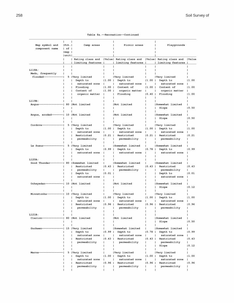
258 Soil Survey of
Table 8a.--Recreation--Continued________________________________________________________________________________________________________ | | | | Map symbol and |Pct.| Camp areas | Picnic areas | Playgrounds component name | of | | | |map | | | |unit| | | _____________________________________________________________________________ | | Rating class and |Value| Rating class and |Value| Rating class and |Value | | limiting features | | limiting features | | limiting features |________________________________________________________________________________________________________ | | | | | | |L118A: | | | | | | | Medo, frequently | | | | | | | flooded------------| 5 |Very limited | |Very limited | |Very limited | | | Depth to |1.00 | Depth to |1.00 | Depth to |1.00 | | saturated zone | | saturated zone | | saturated zone | | | Flooding |1.00 | Content of |1.00 | Content of |1.00 | | Content of |1.00 | organic matter | | organic matter | | | organic matter | | Flooding |0.40 | Flooding |1.00 | | | | | | |L119B: | | | | | | | Angus---------------| 80 |Not limited | |Not limited | |Somewhat limited | | | | | | | Slope |0.50 | | | | | | | Angus, eroded-------| 10 |Not limited | |Not limited | |Somewhat limited | | | | | | | Slope |0.50 | | | | | | | Cordova-------------| 5 |Very limited | |Very limited | |Very limited | | | Depth to |1.00 | Depth to |1.00 | Depth to |1.00 | | saturated zone | | saturated zone | | saturated zone | | | Restricted |0.21 | Restricted |0.21 | Restricted |0.21 | | permeability | | permeability | | permeability | | | | | | | | Le Sueur------------| 5 |Very limited | |Somewhat limited | |Somewhat limited | | | Depth to |0.99 | Depth to |0.78 | Depth to |0.99 | | saturated zone | | saturated zone | | saturated zone | | | | | | | |L120A: | | | | | | | Good Thunder--------| 80 |Somewhat limited | |Somewhat limited | |Somewhat limited | | | Restricted |0.43 | Restricted |0.43 | Restricted |0.43 | | permeability | | permeability | | permeability | | | Depth to |0.01 | | | Depth to |0.01 | | saturated zone | | | | saturated zone | | | | | | | | Ocheyedan-----------| 10 |Not limited | |Not limited | |Somewhat limited | | | | | | | Slope |0.12 | | | | | | | Minnetonka----------| 10 |Very limited | |Very limited | |Very limited | | | Depth to |1.00 | Depth to |1.00 | Depth to |1.00 | | saturated zone | | saturated zone | | saturated zone | | | Restricted |0.96 | Restricted |0.96 | Restricted |0.96 | | permeability | | permeability | | permeability | | | | | | | |L121B: | | | | | | | Clarion-------------| 80 |Not limited | |Not limited | |Somewhat limited | | | | | | | Slope |0.50 | | | | | | | Guckeen-------------| 15 |Very limited | |Somewhat limited | |Somewhat limited | | | Depth to |0.99 | Depth to |0.78 | Depth to |0.99 | | saturated zone | | saturated zone | | saturated zone | | | Restricted |0.43 | Restricted |0.43 | Restricted |0.43 | | permeability | | permeability | | permeability | | | | | | | Slope |0.12 | | | | | | | Marna---------------| 5 |Very limited | |Very limited | |Very limited | | | Depth to |1.00 | Depth to |1.00 | Depth to |1.00 | | saturated zone | | saturated zone | | saturated zone | | | Restricted |0.96 | Restricted |0.96 | Restricted |0.96 | | permeability | | permeability | | permeability | | | | | | | |

Waseca County, Minnesota 259
Table 8a.--Recreation--Continued________________________________________________________________________________________________________ | | | | Map symbol and |Pct.| Camp areas | Picnic areas | Playgrounds component name | of | | | |map | | | |unit| | | _____________________________________________________________________________ | | Rating class and |Value| Rating class and |Value| Rating class and |Value | | limiting features | | limiting features | | limiting features |________________________________________________________________________________________________________ | | | | | | |L122B: | | | | | | | Reedslake-----------| 55 |Not limited | |Not limited | |Somewhat limited | | | | | | | Slope |0.50 | | | | | | | Estherville---------| 25 |Not limited | |Not limited | |Somewhat limited | | | | | | | Slope |0.50 | | | | | | | Le Sueur------------| 10 |Very limited | |Somewhat limited | |Somewhat limited | | | Depth to |0.99 | Depth to |0.78 | Depth to |0.99 | | saturated zone | | saturated zone | | saturated zone | | | | | | | | Cordova-------------| 5 |Very limited | |Very limited | |Very limited | | | Depth to |1.00 | Depth to |1.00 | Depth to |1.00 | | saturated zone | | saturated zone | | saturated zone | | | Restricted |0.21 | Restricted |0.21 | Restricted |0.21 | | permeability | | permeability | | permeability | | | | | | | | Lowlein-------------| 5 |Somewhat limited | |Not limited | |Somewhat limited | | | Depth to |0.01 | | | Depth to |0.01 | | saturated zone | | | | saturated zone | | | | | | | |L123A: | | | | | | | Belleville----------| 85 |Very limited | |Very limited | |Very limited | | | Depth to |1.00 | Depth to |1.00 | Depth to |1.00 | | saturated zone | | saturated zone | | saturated zone | | | Restricted |0.21 | Restricted |0.21 | Restricted |0.21 | | permeability | | permeability | | permeability | | | | | | | | Granby--------------| 15 |Very limited | |Very limited | |Very limited | | | Depth to |1.00 | Ponding |1.00 | Depth to |1.00 | | saturated zone | | Depth to |1.00 | saturated zone | | | Ponding |1.00 | saturated zone | | Ponding |1.00 | | Too sandy |0.89 | Too sandy |0.89 | Too sandy |0.89 | | | | | | |L124A: | | | | | | | Glencoe mucky clay | | | | | | | loam---------------| 85 |Very limited | |Very limited | |Very limited | | | Depth to |1.00 | Ponding |1.00 | Depth to |1.00 | | saturated zone | | Depth to |1.00 | saturated zone | | | Ponding |1.00 | saturated zone | | Ponding |1.00 | | | | | | | Canisteo------------| 10 |Very limited | |Very limited | |Very limited | | | Depth to |1.00 | Depth to |1.00 | Depth to |1.00 | | saturated zone | | saturated zone | | saturated zone | | | | | | | | Glencoe clay loam---| 5 |Very limited | |Very limited | |Very limited | | | Depth to |1.00 | Ponding |1.00 | Depth to |1.00 | | saturated zone | | Depth to |1.00 | saturated zone | | | Ponding |1.00 | saturated zone | | Ponding |1.00 | | | | | | |L125A: | | | | | | | Hanlon, rarely | | | | | | | flooded------------| 60 |Very limited | |Not limited | |Somewhat limited | | | Flooding |1.00 | | | Depth to |0.01 | | Depth to |0.01 | | | saturated zone | | | saturated zone | | | | | | | | | | | |

260 Soil Survey of
Table 8a.--Recreation--Continued________________________________________________________________________________________________________ | | | | Map symbol and |Pct.| Camp areas | Picnic areas | Playgrounds component name | of | | | |map | | | |unit| | | _____________________________________________________________________________ | | Rating class and |Value| Rating class and |Value| Rating class and |Value | | limiting features | | limiting features | | limiting features |________________________________________________________________________________________________________ | | | | | | |L125A: | | | | | | | Coland, occasionally| | | | | | | flooded------------| 25 |Very limited | |Very limited | |Very limited | | | Flooding |1.00 | Depth to |1.00 | Depth to |1.00 | | Depth to |1.00 | saturated zone | | saturated zone | | | saturated zone | | | | Flooding |0.60 | | | | | | | Minneopa, rarely | | | | | | | flooded------------| 15 |Very limited | |Not limited | |Somewhat limited | | | Flooding |1.00 | | | Depth to |0.01 | | Depth to |0.01 | | | saturated zone | | | saturated zone | | | | | | | | | | | |L126A: | | | | | | | Coland, occasionally| | | | | | | flooded------------| 80 |Very limited | |Very limited | |Very limited | | | Flooding |1.00 | Depth to |1.00 | Depth to |1.00 | | Depth to |1.00 | saturated zone | | saturated zone | | | saturated zone | | | | Flooding |0.60 | | | | | | | Minneopa, | | | | | | | occasionally | | | | | | | flooded------------| 10 |Very limited | |Not limited | |Somewhat limited | | | Flooding |1.00 | | | Depth to |0.01 | | Depth to |0.01 | | | saturated zone | | | saturated zone | | | | | | | | | | | | Havelock, | | | | | | | occasionally | | | | | | | flooded------------| 5 |Very limited | |Very limited | |Very limited | | | Flooding |1.00 | Depth to |1.00 | Depth to |1.00 | | Depth to |1.00 | saturated zone | | saturated zone | | | saturated zone | | | | Flooding |0.60 | | | | | | | Spillville, | | | | | | | occasionally | | | | | | | flooded------------| 5 |Very limited | |Somewhat limited | |Somewhat limited | | | Flooding |1.00 | Depth to |0.78 | Depth to |0.99 | | Depth to |0.99 | saturated zone | | saturated zone | | | saturated zone | | | | Flooding |0.60 | | | | | | |L127A: | | | | | | | Coland, frequently | | | | | | | flooded------------| 80 |Very limited | |Very limited | |Very limited | | | Flooding |1.00 | Depth to |1.00 | Flooding |1.00 | | Depth to |1.00 | saturated zone | | Depth to |1.00 | | saturated zone | | Flooding |0.40 | saturated zone | | | | | | | | Minneopa, | | | | | | | occasionally | | | | | | | flooded------------| 10 |Very limited | |Not limited | |Somewhat limited | | | Flooding |1.00 | | | Depth to |0.01 | | Depth to |0.01 | | | saturated zone | | | saturated zone | | | | | | | | | | | | Havelock, frequently| | | | | | | flooded------------| 5 |Very limited | |Very limited | |Very limited | | | Flooding |1.00 | Depth to |1.00 | Flooding |1.00 | | Depth to |1.00 | saturated zone | | Depth to |1.00 | | saturated zone | | Flooding |0.40 | saturated zone | | | | | | | |

Waseca County, Minnesota 261
Table 8a.--Recreation--Continued________________________________________________________________________________________________________ | | | | Map symbol and |Pct.| Camp areas | Picnic areas | Playgrounds component name | of | | | |map | | | |unit| | | _____________________________________________________________________________ | | Rating class and |Value| Rating class and |Value| Rating class and |Value | | limiting features | | limiting features | | limiting features |________________________________________________________________________________________________________ | | | | | | |L127A: | | | | | | | Spillville, | | | | | | | occasionally | | | | | | | flooded------------| 5 |Very limited | |Somewhat limited | |Somewhat limited | | | Flooding |1.00 | Depth to |0.78 | Depth to |0.99 | | Depth to |0.99 | saturated zone | | saturated zone | | | saturated zone | | | | Flooding |0.60 | | | | | | |L128A: | | | | | | | Mazaska-------------| 60 |Very limited | |Very limited | |Very limited | | | Depth to |1.00 | Depth to |1.00 | Depth to |1.00 | | saturated zone | | saturated zone | | saturated zone | | | Restricted |0.96 | Restricted |0.96 | Restricted |0.96 | | permeability | | permeability | | permeability | | | | | | | | Rolfe---------------| 30 |Very limited | |Very limited | |Very limited | | | Depth to |1.00 | Ponding |1.00 | Depth to |1.00 | | saturated zone | | Depth to |1.00 | saturated zone | | | Ponding |1.00 | saturated zone | | Ponding |1.00 | | Restricted |0.96 | Restricted |0.96 | Restricted |0.96 | | permeability | | permeability | | permeability | | | | | | | | Lerdal--------------| 10 |Somewhat limited | |Somewhat limited | |Somewhat limited | | | Restricted |0.94 | Restricted |0.94 | Restricted |0.94 | | permeability | | permeability | | permeability | | | Depth to |0.90 | Depth to |0.60 | Depth to |0.90 | | saturated zone | | saturated zone | | saturated zone | | | | | | | |L129B: | | | | | | | Terril--------------| 90 |Not limited | |Not limited | |Somewhat limited | | | | | | | Slope |0.50 | | | | | | | Delft---------------| 5 |Very limited | |Very limited | |Very limited | | | Depth to |1.00 | Depth to |1.00 | Depth to |1.00 | | saturated zone | | saturated zone | | saturated zone | | | Restricted |0.15 | Restricted |0.15 | Restricted |0.15 | | permeability | | permeability | | permeability | | | | | | | | Hamel---------------| 5 |Very limited | |Very limited | |Very limited | | | Depth to |1.00 | Depth to |1.00 | Depth to |1.00 | | saturated zone | | saturated zone | | saturated zone | | | Restricted |0.21 | Restricted |0.21 | Restricted |0.21 | | permeability | | permeability | | permeability | | | | | | | |L130A: | | | | | | | Okoboji mucky silty | | | | | | | clay loam----------| 75 |Very limited | |Very limited | |Very limited | | | Depth to |1.00 | Ponding |1.00 | Depth to |1.00 | | saturated zone | | Depth to |1.00 | saturated zone | | | Ponding |1.00 | saturated zone | | Ponding |1.00 | | Restricted |0.21 | Restricted |0.21 | Restricted |0.21 | | permeability | | permeability | | permeability | | | | | | | | Okoboji silty clay | | | | | | | loam---------------| 15 |Very limited | |Very limited | |Very limited | | | Depth to |1.00 | Ponding |1.00 | Depth to |1.00 | | saturated zone | | Depth to |1.00 | saturated zone | | | Ponding |1.00 | saturated zone | | Ponding |1.00 | | Restricted |0.15 | Restricted |0.15 | Restricted |0.15 | | permeability | | permeability | | permeability | | | | | | | |

262 Soil Survey of
Table 8a.--Recreation--Continued________________________________________________________________________________________________________ | | | | Map symbol and |Pct.| Camp areas | Picnic areas | Playgrounds component name | of | | | |map | | | |unit| | | _____________________________________________________________________________ | | Rating class and |Value| Rating class and |Value| Rating class and |Value | | limiting features | | limiting features | | limiting features |________________________________________________________________________________________________________ | | | | | | |L130A: | | | | | | | Brownton------------| 5 |Very limited | |Very limited | |Very limited | | | Depth to |1.00 | Depth to |1.00 | Depth to |1.00 | | saturated zone | | saturated zone | | saturated zone | | | Restricted |0.94 | Restricted |0.94 | Restricted |0.94 | | permeability | | permeability | | permeability | | | | | | | | Spicer--------------| 5 |Very limited | |Very limited | |Very limited | | | Depth to |1.00 | Depth to |1.00 | Depth to |1.00 | | saturated zone | | saturated zone | | saturated zone | | | | | | | |M-W: | | | | | | | Water, miscellaneous|100 |Not rated | |Not rated | |Not rated | | | | | | | |U3B: | | | | | | | Udorthents (cut and | | | | | | | fill land)---------|100 |Not rated | |Not rated | |Not rated | | | | | | | |W: | | | | | | | Water---------------|100 |Not rated | |Not rated | |Not rated | | | | | | | |________________________________________________________________________________________________________

Waseca County, Minnesota 263
Table 8b.--Recreation
(The information in this table indicates the dominant soil condition but does not eliminate the need for onsite investigation. The numbers in the value columns range from 0.01 to 1.00. The larger the value, the greater the limitation. “Not rated” indicates that data are not available or that no rating is applicable. See text for further explanation of ratings in this table)
________________________________________________________________________________________________________ | | | | Map symbol and |Pct.| Paths and trails | Off-road | Golf fairways component name | of | | motorcycle trails | |map | | | |unit| | | _____________________________________________________________________________ | | Rating class and |Value| Rating class and |Value| Rating class and |Value | | limiting features | | limiting features | | limiting features |________________________________________________________________________________________________________ | | | | | | |GP: | | | | | | | Pits, gravel--------| 80 |Not rated | |Not rated | |Not rated | | | | | | | | Udipsamments--------| 20 |Not rated | |Not rated | |Not rated | | | | | | | |L5A: | | | | | | | Delft, overwash-----| 50 |Somewhat limited | |Somewhat limited | |Somewhat limited | | | Depth to |0.44 | Depth to |0.44 | Depth to |0.75 | | saturated zone | | saturated zone | | saturated zone | | | | | | | | Delft---------------| 40 |Very limited | |Very limited | |Very limited | | | Depth to |1.00 | Depth to |1.00 | Depth to |1.00 | | saturated zone | | saturated zone | | saturated zone | | | | | | | | Glencoe-------------| 5 |Very limited | |Very limited | |Very limited | | | Depth to |1.00 | Depth to |1.00 | Ponding |1.00 | | saturated zone | | saturated zone | | Depth to |1.00 | | Ponding |1.00 | Ponding |1.00 | saturated zone | | | | | | | | Terril--------------| 5 |Not limited | |Not limited | |Not limited | | | | | | | |L13A: | | | | | | | Klossner, drained---| 80 |Very limited | |Very limited | |Very limited | | | Content of |1.00 | Content of |1.00 | Content of |1.00 | | organic matter | | organic matter | | organic matter | | | Depth to |1.00 | Depth to |1.00 | Depth to |1.00 | | saturated zone | | saturated zone | | saturated zone | | | Ponding |1.00 | Ponding |1.00 | Ponding |1.00 | | | | | | | Mineral soil, | | | | | | | drained------------| 15 |Very limited | |Very limited | |Very limited | | | Depth to |1.00 | Depth to |1.00 | Depth to |1.00 | | saturated zone | | saturated zone | | saturated zone | | | Ponding |1.00 | Ponding |1.00 | Ponding |1.00 | | | | | | | Houghton, drained---| 5 |Very limited | |Very limited | |Very limited | | | Content of |1.00 | Content of |1.00 | Content of |1.00 | | organic matter | | organic matter | | organic matter | | | Depth to |1.00 | Depth to |1.00 | Depth to |1.00 | | saturated zone | | saturated zone | | saturated zone | | | Ponding |1.00 | Ponding |1.00 | Ponding |1.00 | | | | | | |L14A: | | | | | | | Houghton, drained---| 80 |Very limited | |Very limited | |Very limited | | | Content of |1.00 | Content of |1.00 | Content of |1.00 | | organic matter | | organic matter | | organic matter | | | Depth to |1.00 | Depth to |1.00 | Depth to |1.00 | | saturated zone | | saturated zone | | saturated zone | | | Ponding |1.00 | Ponding |1.00 | Ponding |1.00 | | | | | | |

264 Soil Survey of
Table 8b.--Recreation--Continued________________________________________________________________________________________________________ | | | | Map symbol and |Pct.| Paths and trails | Off-road | Golf fairways component name | of | | motorcycle trails | |map | | | |unit| | | _____________________________________________________________________________ | | Rating class and |Value| Rating class and |Value| Rating class and |Value | | limiting features | | limiting features | | limiting features |________________________________________________________________________________________________________ | | | | | | |L14A: | | | | | | | Klossner, drained---| 10 |Very limited | |Very limited | |Very limited | | | Content of |1.00 | Content of |1.00 | Content of |1.00 | | organic matter | | organic matter | | organic matter | | | Depth to |1.00 | Depth to |1.00 | Depth to |1.00 | | saturated zone | | saturated zone | | saturated zone | | | Ponding |1.00 | Ponding |1.00 | Ponding |1.00 | | | | | | | Mineral soil, | | | | | | | drained------------| 10 |Very limited | |Very limited | |Very limited | | | Depth to |1.00 | Depth to |1.00 | Depth to |1.00 | | saturated zone | | saturated zone | | saturated zone | | | Ponding |1.00 | Ponding |1.00 | Ponding |1.00 | | | | | | |L15A: | | | | | | | Klossner, ponded----| 30 |Very limited | |Very limited | |Very limited | | | Content of |1.00 | Content of |1.00 | Ponding |1.00 | | organic matter | | organic matter | | Content of |1.00 | | Ponding |1.00 | Ponding |1.00 | organic matter | | | Depth to |1.00 | Depth to |1.00 | Depth to |1.00 | | saturated zone | | saturated zone | | saturated zone | | | | | | | | Okoboji, ponded-----| 30 |Very limited | |Very limited | |Very limited | | | Ponding |1.00 | Ponding |1.00 | Ponding |1.00 | | Depth to |1.00 | Depth to |1.00 | Depth to |1.00 | | saturated zone | | saturated zone | | saturated zone | | | | | | | | Glencoe, ponded-----| 30 |Very limited | |Very limited | |Very limited | | | Ponding |1.00 | Ponding |1.00 | Ponding |1.00 | | Depth to |1.00 | Depth to |1.00 | Depth to |1.00 | | saturated zone | | saturated zone | | saturated zone | | | | | | | | Houghton, ponded----| 10 |Very limited | |Very limited | |Very limited | | | Content of |1.00 | Content of |1.00 | Ponding |1.00 | | organic matter | | organic matter | | Content of |1.00 | | Ponding |1.00 | Ponding |1.00 | organic matter | | | Depth to |1.00 | Depth to |1.00 | Depth to |1.00 | | saturated zone | | saturated zone | | saturated zone | | | | | | | |L16A: | | | | | | | Muskego, ponded-----| 30 |Very limited | |Very limited | |Very limited | | | Content of |1.00 | Content of |1.00 | Ponding |1.00 | | organic matter | | organic matter | | Content of |1.00 | | Ponding |1.00 | Ponding |1.00 | organic matter | | | Depth to |1.00 | Depth to |1.00 | Carbonate content|1.00 | | saturated zone | | saturated zone | | Depth to |1.00 | | | | | | saturated zone | | | | | | | | Blue Earth, ponded--| 30 |Very limited | |Very limited | |Very limited | | | Ponding |1.00 | Ponding |1.00 | Ponding |1.00 | | Depth to |1.00 | Depth to |1.00 | Depth to |1.00 | | saturated zone | | saturated zone | | saturated zone | | | | | | | | Houghton, ponded----| 30 |Very limited | |Very limited | |Very limited | | | Content of |1.00 | Content of |1.00 | Ponding |1.00 | | organic matter | | organic matter | | Content of |1.00 | | Ponding |1.00 | Ponding |1.00 | organic matter | | | Depth to |1.00 | Depth to |1.00 | Depth to |1.00 | | saturated zone | | saturated zone | | saturated zone | | | | | | | |

Waseca County, Minnesota 265
Table 8b.--Recreation--Continued________________________________________________________________________________________________________ | | | | Map symbol and |Pct.| Paths and trails | Off-road | Golf fairways component name | of | | motorcycle trails | |map | | | |unit| | | _____________________________________________________________________________ | | Rating class and |Value| Rating class and |Value| Rating class and |Value | | limiting features | | limiting features | | limiting features |________________________________________________________________________________________________________ | | | | | | |L16A: | | | | | | | Klossner, ponded----| 10 |Very limited | |Very limited | |Very limited | | | Content of |1.00 | Content of |1.00 | Ponding |1.00 | | organic matter | | organic matter | | Content of |1.00 | | Ponding |1.00 | Ponding |1.00 | organic matter | | | Depth to |1.00 | Depth to |1.00 | Depth to |1.00 | | saturated zone | | saturated zone | | saturated zone | | | | | | | |L26B: | | | | | | | Shorewood-----------| 90 |Somewhat limited | |Somewhat limited | |Somewhat limited | | | Depth to |0.44 | Depth to |0.44 | Depth to |0.75 | | saturated zone | | saturated zone | | saturated zone | | | | | | | | Good Thunder--------| 5 |Not limited | |Not limited | |Not limited | | | | | | | | Minnetonka----------| 5 |Very limited | |Very limited | |Very limited | | | Depth to |1.00 | Depth to |1.00 | Depth to |1.00 | | saturated zone | | saturated zone | | saturated zone | | | | | | | |L36A: | | | | | | | Hamel, overwash-----| 50 |Somewhat limited | |Somewhat limited | |Somewhat limited | | | Depth to |0.44 | Depth to |0.44 | Depth to |0.75 | | saturated zone | | saturated zone | | saturated zone | | | | | | | | Hamel---------------| 43 |Very limited | |Very limited | |Very limited | | | Depth to |1.00 | Depth to |1.00 | Depth to |1.00 | | saturated zone | | saturated zone | | saturated zone | | | | | | | | Terril--------------| 5 |Not limited | |Not limited | |Not limited | | | | | | | | Glencoe-------------| 2 |Very limited | |Very limited | |Very limited | | | Depth to |1.00 | Depth to |1.00 | Depth to |1.00 | | saturated zone | | saturated zone | | saturated zone | | | Ponding |1.00 | Ponding |1.00 | Ponding |1.00 | | | | | | |L40B: | | | | | | | Angus---------------| 45 |Not limited | |Not limited | |Not limited | | | | | | | | Kilkenny------------| 40 |Somewhat limited | |Somewhat limited | |Somewhat limited | | | Depth to |0.18 | Depth to |0.18 | Depth to |0.56 | | saturated zone | | saturated zone | | saturated zone | | | | | | | | Lerdal--------------| 10 |Somewhat limited | |Somewhat limited | |Somewhat limited | | | Depth to |0.22 | Depth to |0.22 | Depth to |0.60 | | saturated zone | | saturated zone | | saturated zone | | | | | | | | Mazaska-------------| 5 |Very limited | |Very limited | |Very limited | | | Depth to |1.00 | Depth to |1.00 | Depth to |1.00 | | saturated zone | | saturated zone | | saturated zone | | | | | | | |L41C2: | | | | | | | Lester, eroded------| 45 |Not limited | |Not limited | |Somewhat limited | | | | | | | Slope |0.04 | | | | | | | Kilkenny, eroded----| 40 |Not limited | |Not limited | |Somewhat limited | | | | | | | Slope |0.04 | | | | | | | Terril--------------| 10 |Not limited | |Not limited | |Not limited | | | | | | | |

266 Soil Survey of
Table 8b.--Recreation--Continued________________________________________________________________________________________________________ | | | | Map symbol and |Pct.| Paths and trails | Off-road | Golf fairways component name | of | | motorcycle trails | |map | | | |unit| | | _____________________________________________________________________________ | | Rating class and |Value| Rating class and |Value| Rating class and |Value | | limiting features | | limiting features | | limiting features |________________________________________________________________________________________________________ | | | | | | |L41C2: | | | | | | | Derrynane-----------| 5 |Very limited | |Very limited | |Very limited | | | Depth to |1.00 | Depth to |1.00 | Depth to |1.00 | | saturated zone | | saturated zone | | saturated zone | | | | | | | |L41D2: | | | | | | | Lester, eroded------| 45 |Not limited | |Not limited | |Very limited | | | | | | | Slope |1.00 | | | | | | | Kilkenny, eroded----| 35 |Not limited | |Not limited | |Very limited | | | | | | | Slope |1.00 | | | | | | | Terril--------------| 10 |Not limited | |Not limited | |Not limited | | | | | | | | Derrynane-----------| 5 |Very limited | |Very limited | |Very limited | | | Depth to |1.00 | Depth to |1.00 | Depth to |1.00 | | saturated zone | | saturated zone | | saturated zone | | | | | | | | Ridgeton------------| 5 |Not limited | |Not limited | |Somewhat limited | | | | | | | Slope |0.16 | | | | | | |L41E: | | | | | | | Lester--------------| 45 |Somewhat limited | |Not limited | |Very limited | | | Slope |0.82 | | | Slope |1.00 | | | | | | | Kilkenny------------| 40 |Somewhat limited | |Not limited | |Very limited | | | Slope |0.82 | | | Slope |1.00 | | | | | | | Terril--------------| 5 |Not limited | |Not limited | |Not limited | | | | | | | | Derrynane-----------| 5 |Very limited | |Very limited | |Very limited | | | Depth to |1.00 | Depth to |1.00 | Depth to |1.00 | | saturated zone | | saturated zone | | saturated zone | | | | | | | | Ridgeton------------| 5 |Not limited | |Not limited | |Somewhat limited | | | | | | | Slope |0.96 | | | | | | |L48A: | | | | | | | Derrynane, overwash | 50 |Somewhat limited | |Somewhat limited | |Somewhat limited | | | Depth to |0.44 | Depth to |0.44 | Depth to |0.75 | | saturated zone | | saturated zone | | saturated zone | | | | | | | | Derrynane-----------| 40 |Very limited | |Very limited | |Very limited | | | Depth to |1.00 | Depth to |1.00 | Depth to |1.00 | | saturated zone | | saturated zone | | saturated zone | | | | | | | | Glencoe-------------| 5 |Very limited | |Very limited | |Very limited | | | Depth to |1.00 | Depth to |1.00 | Ponding |1.00 | | saturated zone | | saturated zone | | Depth to |1.00 | | Ponding |1.00 | Ponding |1.00 | saturated zone | | | | | | | | Terril--------------| 5 |Not limited | |Not limited | |Not limited | | | | | | | |

Waseca County, Minnesota 267
Table 8b.--Recreation--Continued________________________________________________________________________________________________________ | | | | Map symbol and |Pct.| Paths and trails | Off-road | Golf fairways component name | of | | motorcycle trails | |map | | | |unit| | | _____________________________________________________________________________ | | Rating class and |Value| Rating class and |Value| Rating class and |Value | | limiting features | | limiting features | | limiting features |________________________________________________________________________________________________________ | | | | | | |L49A: | | | | | | | Klossner, surface | | | | | | | drained------------| 65 |Very limited | |Very limited | |Very limited | | | Content of |1.00 | Content of |1.00 | Content of |1.00 | | organic matter | | organic matter | | organic matter | | | Depth to |1.00 | Depth to |1.00 | Depth to |1.00 | | saturated zone | | saturated zone | | saturated zone | | | Ponding |1.00 | Ponding |1.00 | Ponding |1.00 | | | | | | | Klossner, drained---| 20 |Very limited | |Very limited | |Very limited | | | Content of |1.00 | Content of |1.00 | Content of |1.00 | | organic matter | | organic matter | | organic matter | | | Depth to |1.00 | Depth to |1.00 | Depth to |1.00 | | saturated zone | | saturated zone | | saturated zone | | | Ponding |1.00 | Ponding |1.00 | Ponding |1.00 | | | | | | | Mineral soil, | | | | | | | drained------------| 15 |Very limited | |Very limited | |Very limited | | | Depth to |1.00 | Depth to |1.00 | Depth to |1.00 | | saturated zone | | saturated zone | | saturated zone | | | Ponding |1.00 | Ponding |1.00 | Ponding |1.00 | | | | | | |L50A: | | | | | | | Houghton, surface | | | | | | | drained------------| 40 |Very limited | |Very limited | |Very limited | | | Content of |1.00 | Content of |1.00 | Content of |1.00 | | organic matter | | organic matter | | organic matter | | | Depth to |1.00 | Depth to |1.00 | Depth to |1.00 | | saturated zone | | saturated zone | | saturated zone | | | Ponding |1.00 | Ponding |1.00 | Ponding |1.00 | | | | | | | Muskego, surface | | | | | | | drained------------| 40 |Very limited | |Very limited | |Very limited | | | Content of |1.00 | Content of |1.00 | Content of |1.00 | | organic matter | | organic matter | | organic matter | | | Depth to |1.00 | Depth to |1.00 | Carbonate content|1.00 | | saturated zone | | saturated zone | | Depth to |1.00 | | Ponding |1.00 | Ponding |1.00 | saturated zone | | | | | | | Ponding |1.00 | | | | | | | Klossner, drained---| 10 |Very limited | |Very limited | |Very limited | | | Content of |1.00 | Content of |1.00 | Content of |1.00 | | organic matter | | organic matter | | organic matter | | | Depth to |1.00 | Depth to |1.00 | Depth to |1.00 | | saturated zone | | saturated zone | | saturated zone | | | Ponding |1.00 | Ponding |1.00 | Ponding |1.00 | | | | | | | Mineral soil, | | | | | | | drained------------| 10 |Very limited | |Very limited | |Very limited | | | Depth to |1.00 | Depth to |1.00 | Depth to |1.00 | | saturated zone | | saturated zone | | saturated zone | | | Ponding |1.00 | Ponding |1.00 | Ponding |1.00 | | | | | | |L51C2: | | | | | | | Gladek, eroded------| 80 |Not limited | |Not limited | |Somewhat limited | | | | | | | Slope |0.04 | | | | | | | Barrington----------| 10 |Not limited | |Not limited | |Not limited | | | | | | | |

268 Soil Survey of
Table 8b.--Recreation--Continued________________________________________________________________________________________________________ | | | | Map symbol and |Pct.| Paths and trails | Off-road | Golf fairways component name | of | | motorcycle trails | |map | | | |unit| | | _____________________________________________________________________________ | | Rating class and |Value| Rating class and |Value| Rating class and |Value | | limiting features | | limiting features | | limiting features |________________________________________________________________________________________________________ | | | | | | |L51C2: | | | | | | | Lester, eroded------| 5 |Not limited | |Not limited | |Somewhat limited | | | | | | | Slope |0.04 | | | | | | | Madelia-------------| 5 |Very limited | |Very limited | |Very limited | | | Depth to |1.00 | Depth to |1.00 | Depth to |1.00 | | saturated zone | | saturated zone | | saturated zone | | | | | | | |L56A: | | | | | | | Muskego, frequently | | | | | | | flooded------------| 45 |Very limited | |Very limited | |Very limited | | | Content of |1.00 | Content of |1.00 | Ponding |1.00 | | organic matter | | organic matter | | Flooding |1.00 | | Ponding |1.00 | Ponding |1.00 | Content of |1.00 | | Depth to |1.00 | Depth to |1.00 | organic matter | | | saturated zone | | saturated zone | | Carbonate content|1.00 | | Flooding |0.40 | Flooding |0.40 | Depth to |1.00 | | | | | | saturated zone | | | | | | | | Klossner, frequently| | | | | | | flooded------------| 45 |Very limited | |Very limited | |Very limited | | | Content of |1.00 | Content of |1.00 | Ponding |1.00 | | organic matter | | organic matter | | Flooding |1.00 | | Ponding |1.00 | Ponding |1.00 | Content of |1.00 | | Depth to |1.00 | Depth to |1.00 | organic matter | | | saturated zone | | saturated zone | | Depth to |1.00 | | Flooding |0.40 | Flooding |0.40 | saturated zone | | | | | | | | Suckercreek, | | | | | | | frequently flooded | 10 |Very limited | |Very limited | |Very limited | | | Depth to |1.00 | Depth to |1.00 | Flooding |1.00 | | saturated zone | | saturated zone | | Depth to |1.00 | | Flooding |0.40 | Flooding |0.40 | saturated zone | | | | | | | |L57A: | | | | | | | Medo, drained-------| 80 |Very limited | |Very limited | |Very limited | | | Content of |1.00 | Content of |1.00 | Ponding |1.00 | | organic matter | | organic matter | | Content of |1.00 | | Ponding |1.00 | Ponding |1.00 | organic matter | | | Depth to |1.00 | Depth to |1.00 | Depth to |1.00 | | saturated zone | | saturated zone | | saturated zone | | | | | | | | Mineral soil, | | | | | | | drained------------| 15 |Very limited | |Very limited | |Very limited | | | Ponding |1.00 | Ponding |1.00 | Ponding |1.00 | | Depth to |1.00 | Depth to |1.00 | Depth to |1.00 | | saturated zone | | saturated zone | | saturated zone | | | | | | | | Houghton, drained---| 5 |Very limited | |Very limited | |Very limited | | | Content of |1.00 | Content of |1.00 | Ponding |1.00 | | organic matter | | organic matter | | Content of |1.00 | | Ponding |1.00 | Ponding |1.00 | organic matter | | | Depth to |1.00 | Depth to |1.00 | Depth to |1.00 | | saturated zone | | saturated zone | | saturated zone | | | | | | | |

Waseca County, Minnesota 269
Table 8b.--Recreation--Continued________________________________________________________________________________________________________ | | | | Map symbol and |Pct.| Paths and trails | Off-road | Golf fairways component name | of | | motorcycle trails | |map | | | |unit| | | _____________________________________________________________________________ | | Rating class and |Value| Rating class and |Value| Rating class and |Value | | limiting features | | limiting features | | limiting features |________________________________________________________________________________________________________ | | | | | | |L63A: | | | | | | | Klossner------------| 85 |Very limited | |Very limited | |Very limited | | | Depth to |1.00 | Depth to |1.00 | Ponding |1.00 | | saturated zone | | saturated zone | | Content of |1.00 | | Content of |1.00 | Content of |1.00 | organic matter | | | organic matter | | organic matter | | Depth to |1.00 | | Ponding |1.00 | Ponding |1.00 | saturated zone | | | | | | | | Lura----------------| 10 |Very limited | |Very limited | |Very limited | | | Depth to |1.00 | Depth to |1.00 | Too clayey |1.00 | | saturated zone | | saturated zone | | Ponding |1.00 | | Too clayey |1.00 | Too clayey |1.00 | Depth to |1.00 | | Ponding |1.00 | Ponding |1.00 | saturated zone | | | | | | | | Brownton------------| 5 |Very limited | |Very limited | |Very limited | | | Depth to |1.00 | Depth to |1.00 | Depth to |1.00 | | saturated zone | | saturated zone | | saturated zone | | | | | | | |L64A: | | | | | | | Tadkee--------------| 50 |Very limited | |Very limited | |Very limited | | | Depth to |1.00 | Depth to |1.00 | Depth to |1.00 | | saturated zone | | saturated zone | | saturated zone | | | Too sandy |0.89 | Too sandy |0.89 | | | | | | | | | Tadkee, depressional| 36 |Very limited | |Very limited | |Very limited | | | Depth to |1.00 | Depth to |1.00 | Ponding |1.00 | | saturated zone | | saturated zone | | Depth to |1.00 | | Ponding |1.00 | Ponding |1.00 | saturated zone | | | Too sandy |0.89 | Too sandy |0.89 | | | | | | | | | Better drained soil | 8 |Somewhat limited | |Somewhat limited | |Not limited | | | Too sandy |0.46 | Too sandy |0.46 | | | | | | | | | Granby--------------| 4 |Very limited | |Very limited | |Very limited | | | Depth to |1.00 | Depth to |1.00 | Ponding |1.00 | | saturated zone | | saturated zone | | Depth to |1.00 | | Ponding |1.00 | Ponding |1.00 | saturated zone | | | Too sandy |0.89 | Too sandy |0.89 | Droughty |0.13 | | | | | | | Less sandy soil-----| 2 |Very limited | |Very limited | |Very limited | | | Depth to |1.00 | Depth to |1.00 | Depth to |1.00 | | saturated zone | | saturated zone | | saturated zone | | | Too sandy |0.89 | Too sandy |0.89 | | | | | | | | |L73A: | | | | | | | Blue Earth----------| 80 |Very limited | |Very limited | |Very limited | | | Depth to |1.00 | Depth to |1.00 | Ponding |1.00 | | saturated zone | | saturated zone | | Depth to |1.00 | | Ponding |1.00 | Ponding |1.00 | saturated zone | | | | | | | | Belleville----------| 10 |Very limited | |Very limited | |Very limited | | | Depth to |1.00 | Depth to |1.00 | Depth to |1.00 | | saturated zone | | saturated zone | | saturated zone | | | | | | | | Canisteo------------| 10 |Very limited | |Very limited | |Very limited | | | Depth to |1.00 | Depth to |1.00 | Depth to |1.00 | | saturated zone | | saturated zone | | saturated zone | | | | | | | |

270 Soil Survey of
Table 8b.--Recreation--Continued________________________________________________________________________________________________________ | | | | Map symbol and |Pct.| Paths and trails | Off-road | Golf fairways component name | of | | motorcycle trails | |map | | | |unit| | | _____________________________________________________________________________ | | Rating class and |Value| Rating class and |Value| Rating class and |Value | | limiting features | | limiting features | | limiting features |________________________________________________________________________________________________________ | | | | | | |L74A: | | | | | | | Estherville---------| 87 |Not limited | |Not limited | |Somewhat limited | | | | | | | Droughty |0.12 | | | | | | | Hawick--------------| 10 |Not limited | |Not limited | |Very limited | | | | | | | Droughty |1.00 | | | | | | | Biscay--------------| 3 |Very limited | |Very limited | |Very limited | | | Depth to |1.00 | Depth to |1.00 | Depth to |1.00 | | saturated zone | | saturated zone | | saturated zone | | | | | | | |L75B: | | | | | | | Barrington----------| 85 |Not limited | |Not limited | |Not limited | | | | | | | | Gladek--------------| 10 |Not limited | |Not limited | |Somewhat limited | | | | | | | Slope |0.04 | | | | | | | Madelia-------------| 5 |Very limited | |Very limited | |Very limited | | | Depth to |1.00 | Depth to |1.00 | Depth to |1.00 | | saturated zone | | saturated zone | | saturated zone | | | | | | | |L76B: | | | | | | | Dickinson-----------| 80 |Not limited | |Not limited | |Not limited | | | | | | | | Litchfield----------| 13 |Somewhat limited | |Somewhat limited | |Somewhat limited | | | Too sandy |0.92 | Too sandy |0.92 | Depth to |0.90 | | Depth to |0.78 | Depth to |0.78 | saturated zone | | | saturated zone | | saturated zone | | | | | | | | | | Darfur--------------| 5 |Very limited | |Very limited | |Very limited | | | Depth to |1.00 | Depth to |1.00 | Depth to |1.00 | | saturated zone | | saturated zone | | saturated zone | | | | | | | | Clarion-------------| 2 |Not limited | |Not limited | |Not limited | | | | | | | |L77A: | | | | | | | Brownton------------| 75 |Very limited | |Very limited | |Very limited | | | Depth to |1.00 | Depth to |1.00 | Depth to |1.00 | | saturated zone | | saturated zone | | saturated zone | | | | | | | | Marna---------------| 15 |Very limited | |Very limited | |Very limited | | | Depth to |1.00 | Depth to |1.00 | Depth to |1.00 | | saturated zone | | saturated zone | | saturated zone | | | | | | | | Lura----------------| 10 |Very limited | |Very limited | |Very limited | | | Depth to |1.00 | Depth to |1.00 | Too clayey |1.00 | | saturated zone | | saturated zone | | Ponding |1.00 | | Too clayey |1.00 | Too clayey |1.00 | Depth to |1.00 | | Ponding |1.00 | Ponding |1.00 | saturated zone | | | | | | | |L78A: | | | | | | | Canisteo------------| 65 |Very limited | |Very limited | |Very limited | | | Depth to |1.00 | Depth to |1.00 | Depth to |1.00 | | saturated zone | | saturated zone | | saturated zone | | | | | | | | Crippin-------------| 10 |Somewhat limited | |Somewhat limited | |Somewhat limited | | | Depth to |0.50 | Depth to |0.50 | Depth to |0.78 | | saturated zone | | saturated zone | | saturated zone | | | | | | | |

Waseca County, Minnesota 271
Table 8b.--Recreation--Continued________________________________________________________________________________________________________ | | | | Map symbol and |Pct.| Paths and trails | Off-road | Golf fairways component name | of | | motorcycle trails | |map | | | |unit| | | _____________________________________________________________________________ | | Rating class and |Value| Rating class and |Value| Rating class and |Value | | limiting features | | limiting features | | limiting features |________________________________________________________________________________________________________ | | | | | | |L78A: | | | | | | | Glencoe-------------| 10 |Very limited | |Very limited | |Very limited | | | Depth to |1.00 | Depth to |1.00 | Ponding |1.00 | | saturated zone | | saturated zone | | Depth to |1.00 | | Ponding |1.00 | Ponding |1.00 | saturated zone | | | | | | | | Canisteo, | | | | | | | depressional-------| 5 |Very limited | |Very limited | |Very limited | | | Depth to |1.00 | Depth to |1.00 | Ponding |1.00 | | saturated zone | | saturated zone | | Depth to |1.00 | | Ponding |1.00 | Ponding |1.00 | saturated zone | | | | | | | | Harps---------------| 5 |Very limited | |Very limited | |Very limited | | | Depth to |1.00 | Depth to |1.00 | Depth to |1.00 | | saturated zone | | saturated zone | | saturated zone | | | | | | | | Webster-------------| 5 |Very limited | |Very limited | |Very limited | | | Depth to |1.00 | Depth to |1.00 | Depth to |1.00 | | saturated zone | | saturated zone | | saturated zone | | | | | | | |L79B: | | | | | | | Clarion-------------| 65 |Not limited | |Not limited | |Not limited | | | | | | | | Clarion, eroded-----| 25 |Not limited | |Not limited | |Not limited | | | | | | | | Nicollet------------| 8 |Somewhat limited | |Somewhat limited | |Somewhat limited | | | Depth to |0.50 | Depth to |0.50 | Depth to |0.78 | | saturated zone | | saturated zone | | saturated zone | | | | | | | | Webster-------------| 2 |Very limited | |Very limited | |Very limited | | | Depth to |1.00 | Depth to |1.00 | Depth to |1.00 | | saturated zone | | saturated zone | | saturated zone | | | | | | | |L80C2: | | | | | | | Lester, eroded------| 75 |Not limited | |Not limited | |Somewhat limited | | | | | | | Slope |0.04 | | | | | | | Terril--------------| 10 |Not limited | |Not limited | |Not limited | | | | | | | | Hamel---------------| 5 |Very limited | |Very limited | |Very limited | | | Depth to |1.00 | Depth to |1.00 | Depth to |1.00 | | saturated zone | | saturated zone | | saturated zone | | | | | | | | Reedslake-----------| 5 |Not limited | |Not limited | |Not limited | | | | | | | | Storden, eroded-----| 5 |Not limited | |Not limited | |Somewhat limited | | | | | | | Slope |0.04 | | | | | | |L80D2: | | | | | | | Lester, eroded------| 75 |Not limited | |Not limited | |Very limited | | | | | | | Slope |1.00 | | | | | | | Ridgeton------------| 10 |Not limited | |Not limited | |Somewhat limited | | | | | | | Slope |0.63 | | | | | | | Storden, eroded-----| 8 |Not limited | |Not limited | |Very limited | | | | | | | Slope |1.00 | | | | | | | Terril--------------| 5 |Not limited | |Not limited | |Not limited | | | | | | | |

272 Soil Survey of
Table 8b.--Recreation--Continued________________________________________________________________________________________________________ | | | | Map symbol and |Pct.| Paths and trails | Off-road | Golf fairways component name | of | | motorcycle trails | |map | | | |unit| | | _____________________________________________________________________________ | | Rating class and |Value| Rating class and |Value| Rating class and |Value | | limiting features | | limiting features | | limiting features |________________________________________________________________________________________________________ | | | | | | |L80D2: | | | | | | | Hamel---------------| 2 |Very limited | |Very limited | |Very limited | | | Depth to |1.00 | Depth to |1.00 | Depth to |1.00 | | saturated zone | | saturated zone | | saturated zone | | | | | | | |L81A: | | | | | | | Cordova-------------| 85 |Very limited | |Very limited | |Very limited | | | Depth to |1.00 | Depth to |1.00 | Depth to |1.00 | | saturated zone | | saturated zone | | saturated zone | | | | | | | | Le Sueur------------| 10 |Somewhat limited | |Somewhat limited | |Somewhat limited | | | Depth to |0.50 | Depth to |0.50 | Depth to |0.78 | | saturated zone | | saturated zone | | saturated zone | | | | | | | | Rolfe---------------| 5 |Very limited | |Very limited | |Very limited | | | Depth to |1.00 | Depth to |1.00 | Ponding |1.00 | | saturated zone | | saturated zone | | Depth to |1.00 | | Ponding |1.00 | Ponding |1.00 | saturated zone | | | | | | | |L82A: | | | | | | | Marna---------------| 85 |Very limited | |Very limited | |Very limited | | | Depth to |1.00 | Depth to |1.00 | Depth to |1.00 | | saturated zone | | saturated zone | | saturated zone | | | | | | | | Barbert-------------| 10 |Very limited | |Very limited | |Very limited | | | Depth to |1.00 | Depth to |1.00 | Ponding |1.00 | | saturated zone | | saturated zone | | Depth to |1.00 | | Ponding |1.00 | Ponding |1.00 | saturated zone | | | | | | | | Guckeen-------------| 5 |Not limited | |Not limited | |Not limited | | | | | | | |L83A: | | | | | | | Webster-------------| 65 |Very limited | |Very limited | |Very limited | | | Depth to |1.00 | Depth to |1.00 | Depth to |1.00 | | saturated zone | | saturated zone | | saturated zone | | | | | | | | Glencoe-------------| 15 |Very limited | |Very limited | |Very limited | | | Depth to |1.00 | Depth to |1.00 | Ponding |1.00 | | saturated zone | | saturated zone | | Depth to |1.00 | | Ponding |1.00 | Ponding |1.00 | saturated zone | | | | | | | | Canisteo------------| 10 |Very limited | |Very limited | |Very limited | | | Depth to |1.00 | Depth to |1.00 | Depth to |1.00 | | saturated zone | | saturated zone | | saturated zone | | | | | | | | Nicollet------------| 10 |Somewhat limited | |Somewhat limited | |Somewhat limited | | | Depth to |0.50 | Depth to |0.50 | Depth to |0.78 | | saturated zone | | saturated zone | | saturated zone | | | | | | | |L84A: | | | | | | | Glencoe-------------| 80 |Very limited | |Very limited | |Very limited | | | Depth to |1.00 | Depth to |1.00 | Ponding |1.00 | | saturated zone | | saturated zone | | Depth to |1.00 | | Ponding |1.00 | Ponding |1.00 | saturated zone | | | | | | | |

Waseca County, Minnesota 273
Table 8b.--Recreation--Continued________________________________________________________________________________________________________ | | | | Map symbol and |Pct.| Paths and trails | Off-road | Golf fairways component name | of | | motorcycle trails | |map | | | |unit| | | _____________________________________________________________________________ | | Rating class and |Value| Rating class and |Value| Rating class and |Value | | limiting features | | limiting features | | limiting features |________________________________________________________________________________________________________ | | | | | | |L84A: | | | | | | | Very poorly drained | | | | | | | muck---------------| 10 |Very limited | |Very limited | |Very limited | | | Depth to |1.00 | Depth to |1.00 | Ponding |1.00 | | saturated zone | | saturated zone | | Content of |1.00 | | Content of |1.00 | Content of |1.00 | organic matter | | | organic matter | | organic matter | | Depth to |1.00 | | Ponding |1.00 | Ponding |1.00 | saturated zone | | | | | | | | Canisteo------------| 5 |Very limited | |Very limited | |Very limited | | | Depth to |1.00 | Depth to |1.00 | Depth to |1.00 | | saturated zone | | saturated zone | | saturated zone | | | | | | | | Harps---------------| 5 |Very limited | |Very limited | |Very limited | | | Depth to |1.00 | Depth to |1.00 | Depth to |1.00 | | saturated zone | | saturated zone | | saturated zone | | | | | | | |L85A: | | | | | | | Nicollet------------| 85 |Somewhat limited | |Somewhat limited | |Somewhat limited | | | Depth to |0.50 | Depth to |0.50 | Depth to |0.78 | | saturated zone | | saturated zone | | saturated zone | | | | | | | | Clarion-------------| 10 |Not limited | |Not limited | |Not limited | | | | | | | | Webster-------------| 5 |Very limited | |Very limited | |Very limited | | | Depth to |1.00 | Depth to |1.00 | Depth to |1.00 | | saturated zone | | saturated zone | | saturated zone | | | | | | | |L86A: | | | | | | | Madelia-------------| 90 |Very limited | |Very limited | |Very limited | | | Depth to |1.00 | Depth to |1.00 | Depth to |1.00 | | saturated zone | | saturated zone | | saturated zone | | | | | | | | Okoboji-------------| 5 |Very limited | |Very limited | |Very limited | | | Depth to |1.00 | Depth to |1.00 | Ponding |1.00 | | saturated zone | | saturated zone | | Depth to |1.00 | | Ponding |1.00 | Ponding |1.00 | saturated zone | | | | | | | | Spicer--------------| 3 |Very limited | |Very limited | |Very limited | | | Depth to |1.00 | Depth to |1.00 | Depth to |1.00 | | saturated zone | | saturated zone | | saturated zone | | | | | | | | Kingston------------| 2 |Somewhat limited | |Somewhat limited | |Somewhat limited | | | Depth to |0.50 | Depth to |0.50 | Depth to |0.78 | | saturated zone | | saturated zone | | saturated zone | | | | | | | |L87A: | | | | | | | Kingston------------| 85 |Somewhat limited | |Somewhat limited | |Somewhat limited | | | Depth to |0.50 | Depth to |0.50 | Depth to |0.78 | | saturated zone | | saturated zone | | saturated zone | | | | | | | | Truman--------------| 10 |Not limited | |Not limited | |Not limited | | | | | | | | Madelia-------------| 5 |Very limited | |Very limited | |Very limited | | | Depth to |1.00 | Depth to |1.00 | Depth to |1.00 | | saturated zone | | saturated zone | | saturated zone | | | | | | | |

274 Soil Survey of
Table 8b.--Recreation--Continued________________________________________________________________________________________________________ | | | | Map symbol and |Pct.| Paths and trails | Off-road | Golf fairways component name | of | | motorcycle trails | |map | | | |unit| | | _____________________________________________________________________________ | | Rating class and |Value| Rating class and |Value| Rating class and |Value | | limiting features | | limiting features | | limiting features |________________________________________________________________________________________________________ | | | | | | |L88A: | | | | | | | Lura----------------| 85 |Very limited | |Very limited | |Very limited | | | Depth to |1.00 | Depth to |1.00 | Too clayey |1.00 | | saturated zone | | saturated zone | | Ponding |1.00 | | Too clayey |1.00 | Too clayey |1.00 | Depth to |1.00 | | Ponding |1.00 | Ponding |1.00 | saturated zone | | | | | | | | Brownton------------| 10 |Very limited | |Very limited | |Very limited | | | Depth to |1.00 | Depth to |1.00 | Depth to |1.00 | | saturated zone | | saturated zone | | saturated zone | | | | | | | | Organic soil--------| 5 |Very limited | |Very limited | |Very limited | | | Depth to |1.00 | Depth to |1.00 | Ponding |1.00 | | saturated zone | | saturated zone | | Content of |1.00 | | Content of |1.00 | Content of |1.00 | organic matter | | | organic matter | | organic matter | | Depth to |1.00 | | Ponding |1.00 | Ponding |1.00 | saturated zone | | | | | | | |L89A: | | | | | | | Guckeen-------------| 82 |Somewhat limited | |Somewhat limited | |Somewhat limited | | | Depth to |0.50 | Depth to |0.50 | Depth to |0.78 | | saturated zone | | saturated zone | | saturated zone | | | | | | | | Marna---------------| 10 |Very limited | |Very limited | |Very limited | | | Depth to |1.00 | Depth to |1.00 | Depth to |1.00 | | saturated zone | | saturated zone | | saturated zone | | | | | | | | Clarion clay loam---| 8 |Not limited | |Not limited | |Not limited | | | | | | | |L90A: | | | | | | | Le Sueur------------| 75 |Somewhat limited | |Somewhat limited | |Somewhat limited | | | Depth to |0.50 | Depth to |0.50 | Depth to |0.78 | | saturated zone | | saturated zone | | saturated zone | | | | | | | | Cordova-------------| 13 |Very limited | |Very limited | |Very limited | | | Depth to |1.00 | Depth to |1.00 | Depth to |1.00 | | saturated zone | | saturated zone | | saturated zone | | | | | | | | Reedslake-----------| 12 |Not limited | |Not limited | |Not limited | | | | | | | |L91A: | | | | | | | Mazaska-------------| 85 |Very limited | |Very limited | |Very limited | | | Depth to |1.00 | Depth to |1.00 | Depth to |1.00 | | saturated zone | | saturated zone | | saturated zone | | | | | | | | Lerdal--------------| 10 |Somewhat limited | |Somewhat limited | |Somewhat limited | | | Depth to |0.22 | Depth to |0.22 | Depth to |0.60 | | saturated zone | | saturated zone | | saturated zone | | | | | | | | Rolfe---------------| 5 |Very limited | |Very limited | |Very limited | | | Depth to |1.00 | Depth to |1.00 | Ponding |1.00 | | saturated zone | | saturated zone | | Depth to |1.00 | | Ponding |1.00 | Ponding |1.00 | saturated zone | | | | | | | |L92A: | | | | | | | Darfur--------------| 78 |Very limited | |Very limited | |Very limited | | | Depth to |1.00 | Depth to |1.00 | Depth to |1.00 | | saturated zone | | saturated zone | | saturated zone | | | | | | | |

Waseca County, Minnesota 275
Table 8b.--Recreation--Continued________________________________________________________________________________________________________ | | | | Map symbol and |Pct.| Paths and trails | Off-road | Golf fairways component name | of | | motorcycle trails | |map | | | |unit| | | _____________________________________________________________________________ | | Rating class and |Value| Rating class and |Value| Rating class and |Value | | limiting features | | limiting features | | limiting features |________________________________________________________________________________________________________ | | | | | | |L92A: | | | | | | | Fieldon-------------| 10 |Very limited | |Very limited | |Very limited | | | Depth to |1.00 | Depth to |1.00 | Depth to |1.00 | | saturated zone | | saturated zone | | saturated zone | | | | | | | | Litchfield----------| 5 |Somewhat limited | |Somewhat limited | |Somewhat limited | | | Too sandy |0.92 | Too sandy |0.92 | Depth to |0.90 | | Depth to |0.78 | Depth to |0.78 | saturated zone | | | saturated zone | | saturated zone | | | | | | | | | | Webster-------------| 5 |Very limited | |Very limited | |Very limited | | | Depth to |1.00 | Depth to |1.00 | Depth to |1.00 | | saturated zone | | saturated zone | | saturated zone | | | | | | | | Dassel--------------| 2 |Very limited | |Very limited | |Very limited | | | Depth to |1.00 | Depth to |1.00 | Depth to |1.00 | | saturated zone | | saturated zone | | saturated zone | | | Ponding |1.00 | Ponding |1.00 | Ponding |1.00 | | | | | | |L93A: | | | | | | | Muskego-------------| 82 |Very limited | |Very limited | |Very limited | | | Depth to |1.00 | Depth to |1.00 | Ponding |1.00 | | saturated zone | | saturated zone | | Content of |1.00 | | Content of |1.00 | Content of |1.00 | organic matter | | | organic matter | | organic matter | | Depth to |1.00 | | Ponding |1.00 | Ponding |1.00 | saturated zone | | | | | | | Carbonate content|1.00 | | | | | | | Blue Earth----------| 10 |Very limited | |Very limited | |Very limited | | | Depth to |1.00 | Depth to |1.00 | Ponding |1.00 | | saturated zone | | saturated zone | | Depth to |1.00 | | Ponding |1.00 | Ponding |1.00 | saturated zone | | | | | | | | Mineral soil, | | | | | | | drained------------| 5 |Very limited | |Very limited | |Very limited | | | Ponding |1.00 | Ponding |1.00 | Ponding |1.00 | | Depth to |1.00 | Depth to |1.00 | Depth to |1.00 | | saturated zone | | saturated zone | | saturated zone | | | | | | | | Belleville----------| 3 |Very limited | |Very limited | |Very limited | | | Depth to |1.00 | Depth to |1.00 | Depth to |1.00 | | saturated zone | | saturated zone | | saturated zone | | | | | | | |L94A: | | | | | | | Lowlein-------------| 75 |Not limited | |Not limited | |Not limited | | | | | | | | Linder--------------| 15 |Somewhat limited | |Somewhat limited | |Somewhat limited | | | Depth to |0.78 | Depth to |0.78 | Depth to |0.90 | | saturated zone | | saturated zone | | saturated zone | | | | | | | | Dickinson-----------| 8 |Not limited | |Not limited | |Not limited | | | | | | | | Darfur--------------| 2 |Very limited | |Very limited | |Very limited | | | Depth to |1.00 | Depth to |1.00 | Depth to |1.00 | | saturated zone | | saturated zone | | saturated zone | | | | | | | |L95E: | | | | | | | Hawick--------------| 80 |Somewhat limited | |Not limited | |Very limited | | | Slope |0.32 | | | Slope |1.00 | | | | | | Droughty |1.00 | | | | | | Gravel content |0.01 | | | | | | |

276 Soil Survey of
Table 8b.--Recreation--Continued________________________________________________________________________________________________________ | | | | Map symbol and |Pct.| Paths and trails | Off-road | Golf fairways component name | of | | motorcycle trails | |map | | | |unit| | | _____________________________________________________________________________ | | Rating class and |Value| Rating class and |Value| Rating class and |Value | | limiting features | | limiting features | | limiting features |________________________________________________________________________________________________________ | | | | | | |L95E: | | | | | | | Estherville---------| 10 |Not limited | |Not limited | |Very limited | | | | | | | Slope |1.00 | | | | | | Droughty |0.59 | | | | | | | Tomall--------------| 10 |Not limited | |Not limited | |Not limited | | | | | | | |L96B: | | | | | | | Estherville---------| 55 |Not limited | |Not limited | |Somewhat limited | | | | | | | Droughty |0.12 | | | | | | | Hawick--------------| 35 |Not limited | |Not limited | |Very limited | | | | | | | Droughty |1.00 | | | | | | | Tomall--------------| 8 |Not limited | |Not limited | |Not limited | | | | | | | | Biscay--------------| 2 |Very limited | |Very limited | |Very limited | | | Depth to |1.00 | Depth to |1.00 | Depth to |1.00 | | saturated zone | | saturated zone | | saturated zone | | | | | | | |L97C: | | | | | | | Hawick--------------| 60 |Not limited | |Not limited | |Very limited | | | | | | | Droughty |1.00 | | | | | | Slope |0.04 | | | | | | | Estherville---------| 30 |Not limited | |Not limited | |Somewhat limited | | | | | | | Droughty |0.12 | | | | | | Slope |0.04 | | | | | | | Tomall--------------| 10 |Not limited | |Not limited | |Not limited | | | | | | | |L98A: | | | | | | | Crippin-------------| 50 |Somewhat limited | |Somewhat limited | |Somewhat limited | | | Depth to |0.50 | Depth to |0.50 | Depth to |0.78 | | saturated zone | | saturated zone | | saturated zone | | | | | | | | Nicollet------------| 40 |Somewhat limited | |Somewhat limited | |Somewhat limited | | | Depth to |0.50 | Depth to |0.50 | Depth to |0.78 | | saturated zone | | saturated zone | | saturated zone | | | | | | | | Canisteo------------| 5 |Very limited | |Very limited | |Very limited | | | Depth to |1.00 | Depth to |1.00 | Depth to |1.00 | | saturated zone | | saturated zone | | saturated zone | | | | | | | | Clarion-------------| 5 |Not limited | |Not limited | |Not limited | | | | | | | |L99B: | | | | | | | Clarion-------------| 62 |Not limited | |Not limited | |Not limited | | | | | | | | Swanlake------------| 25 |Not limited | |Not limited | |Not limited | | | | | | | | Nicollet------------| 10 |Somewhat limited | |Somewhat limited | |Somewhat limited | | | Depth to |0.50 | Depth to |0.50 | Depth to |0.78 | | saturated zone | | saturated zone | | saturated zone | | | | | | | | Webster-------------| 3 |Very limited | |Very limited | |Very limited | | | Depth to |1.00 | Depth to |1.00 | Depth to |1.00 | | saturated zone | | saturated zone | | saturated zone | | | | | | | |

Waseca County, Minnesota 277
Table 8b.--Recreation--Continued________________________________________________________________________________________________________ | | | | Map symbol and |Pct.| Paths and trails | Off-road | Golf fairways component name | of | | motorcycle trails | |map | | | |unit| | | _____________________________________________________________________________ | | Rating class and |Value| Rating class and |Value| Rating class and |Value | | limiting features | | limiting features | | limiting features |________________________________________________________________________________________________________ | | | | | | |L100B: | | | | | | | Clarion-------------| 45 |Not limited | |Not limited | |Not limited | | | | | | | | Estherville---------| 35 |Not limited | |Not limited | |Somewhat limited | | | | | | | Droughty |0.12 | | | | | | | Lowlein-------------| 5 |Not limited | |Not limited | |Not limited | | | | | | | | Nicollet------------| 5 |Somewhat limited | |Somewhat limited | |Somewhat limited | | | Depth to |0.50 | Depth to |0.50 | Depth to |0.78 | | saturated zone | | saturated zone | | saturated zone | | | | | | | | Swanlake------------| 5 |Not limited | |Not limited | |Not limited | | | | | | | | Webster-------------| 5 |Very limited | |Very limited | |Very limited | | | Depth to |1.00 | Depth to |1.00 | Depth to |1.00 | | saturated zone | | saturated zone | | saturated zone | | | | | | | |L101C2: | | | | | | | Omsrud, eroded------| 40 |Not limited | |Not limited | |Somewhat limited | | | | | | | Slope |0.04 | | | | | | | Hawick--------------| 30 |Not limited | |Not limited | |Very limited | | | | | | | Droughty |1.00 | | | | | | Slope |0.04 | | | | | | | Storden, eroded-----| 20 |Not limited | |Not limited | |Somewhat limited | | | | | | | Slope |0.04 | | | | | | | Delft---------------| 5 |Very limited | |Very limited | |Very limited | | | Depth to |1.00 | Depth to |1.00 | Depth to |1.00 | | saturated zone | | saturated zone | | saturated zone | | | | | | | | Terril--------------| 5 |Not limited | |Not limited | |Not limited | | | | | | | |L101D2: | | | | | | | Omsrud, eroded------| 40 |Not limited | |Not limited | |Very limited | | | | | | | Slope |1.00 | | | | | | | Hawick--------------| 25 |Not limited | |Not limited | |Very limited | | | | | | | Slope |1.00 | | | | | | Droughty |1.00 | | | | | | | Storden, eroded-----| 20 |Not limited | |Not limited | |Very limited | | | | | | | Slope |1.00 | | | | | | | Ridgeton------------| 6 |Not limited | |Not limited | |Somewhat limited | | | | | | | Slope |0.63 | | | | | | | Delft---------------| 5 |Very limited | |Very limited | |Very limited | | | Depth to |1.00 | Depth to |1.00 | Depth to |1.00 | | saturated zone | | saturated zone | | saturated zone | | | | | | | | Terril--------------| 4 |Not limited | |Not limited | |Not limited | | | | | | | |L102C2: | | | | | | | Omsrud, eroded------| 45 |Not limited | |Not limited | |Somewhat limited | | | | | | | Slope |0.04 | | | | | | |

278 Soil Survey of
Table 8b.--Recreation--Continued________________________________________________________________________________________________________ | | | | Map symbol and |Pct.| Paths and trails | Off-road | Golf fairways component name | of | | motorcycle trails | |map | | | |unit| | | _____________________________________________________________________________ | | Rating class and |Value| Rating class and |Value| Rating class and |Value | | limiting features | | limiting features | | limiting features |________________________________________________________________________________________________________ | | | | | | |L102C2: | | | | | | | Storden, eroded-----| 25 |Not limited | |Not limited | |Somewhat limited | | | | | | | Slope |0.04 | | | | | | | Omsrud--------------| 15 |Not limited | |Not limited | |Somewhat limited | | | | | | | Slope |0.04 | | | | | | | Terril--------------| 10 |Not limited | |Not limited | |Not limited | | | | | | | | Delft---------------| 5 |Very limited | |Very limited | |Very limited | | | Depth to |1.00 | Depth to |1.00 | Depth to |1.00 | | saturated zone | | saturated zone | | saturated zone | | | | | | | |L102D2: | | | | | | | Omsrud, eroded------| 45 |Not limited | |Not limited | |Very limited | | | | | | | Slope |1.00 | | | | | | | Storden, eroded-----| 20 |Not limited | |Not limited | |Very limited | | | | | | | Slope |1.00 | | | | | | | Omsrud--------------| 15 |Not limited | |Not limited | |Very limited | | | | | | | Slope |1.00 | | | | | | | Ridgeton------------| 8 |Not limited | |Not limited | |Somewhat limited | | | | | | | Slope |0.63 | | | | | | | Delft---------------| 6 |Very limited | |Very limited | |Very limited | | | Depth to |1.00 | Depth to |1.00 | Depth to |1.00 | | saturated zone | | saturated zone | | saturated zone | | | | | | | | Terril--------------| 6 |Not limited | |Not limited | |Not limited | | | | | | | |L103A: | | | | | | | Fieldon-------------| 50 |Very limited | |Very limited | |Very limited | | | Depth to |1.00 | Depth to |1.00 | Depth to |1.00 | | saturated zone | | saturated zone | | saturated zone | | | | | | | | Canisteo------------| 35 |Very limited | |Very limited | |Very limited | | | Depth to |1.00 | Depth to |1.00 | Depth to |1.00 | | saturated zone | | saturated zone | | saturated zone | | | | | | | | Darfur--------------| 10 |Very limited | |Very limited | |Very limited | | | Depth to |1.00 | Depth to |1.00 | Depth to |1.00 | | saturated zone | | saturated zone | | saturated zone | | | | | | | | Glencoe-------------| 5 |Very limited | |Very limited | |Very limited | | | Depth to |1.00 | Depth to |1.00 | Ponding |1.00 | | saturated zone | | saturated zone | | Depth to |1.00 | | Ponding |1.00 | Ponding |1.00 | saturated zone | | | | | | | |L105C2: | | | | | | | Lester, eroded------| 45 |Not limited | |Not limited | |Somewhat limited | | | | | | | Slope |0.04 | | | | | | | Hawick--------------| 35 |Not limited | |Not limited | |Very limited | | | | | | | Droughty |1.00 | | | | | | Slope |0.04 | | | | | | | Terril--------------| 10 |Not limited | |Not limited | |Not limited | | | | | | | |

Waseca County, Minnesota 279
Table 8b.--Recreation--Continued________________________________________________________________________________________________________ | | | | Map symbol and |Pct.| Paths and trails | Off-road | Golf fairways component name | of | | motorcycle trails | |map | | | |unit| | | _____________________________________________________________________________ | | Rating class and |Value| Rating class and |Value| Rating class and |Value | | limiting features | | limiting features | | limiting features |________________________________________________________________________________________________________ | | | | | | |L105C2: | | | | | | | Hamel---------------| 5 |Very limited | |Very limited | |Very limited | | | Depth to |1.00 | Depth to |1.00 | Depth to |1.00 | | saturated zone | | saturated zone | | saturated zone | | | | | | | | Storden, eroded-----| 5 |Not limited | |Not limited | |Somewhat limited | | | | | | | Slope |0.04 | | | | | | |L105D2: | | | | | | | Lester, eroded------| 45 |Not limited | |Not limited | |Very limited | | | | | | | Slope |1.00 | | | | | | | Hawick--------------| 35 |Not limited | |Not limited | |Very limited | | | | | | | Slope |1.00 | | | | | | Droughty |1.00 | | | | | | | Ridgeton------------| 8 |Not limited | |Not limited | |Somewhat limited | | | | | | | Slope |0.63 | | | | | | | Hamel---------------| 5 |Very limited | |Very limited | |Very limited | | | Depth to |1.00 | Depth to |1.00 | Depth to |1.00 | | saturated zone | | saturated zone | | saturated zone | | | | | | | | Storden, eroded-----| 5 |Not limited | |Not limited | |Very limited | | | | | | | Slope |1.00 | | | | | | | Terril--------------| 2 |Not limited | |Not limited | |Not limited | | | | | | | |L106C2: | | | | | | | Lester, eroded------| 62 |Not limited | |Not limited | |Somewhat limited | | | | | | | Slope |0.04 | | | | | | | Storden, eroded-----| 20 |Not limited | |Not limited | |Somewhat limited | | | | | | | Slope |0.04 | | | | | | | Terril--------------| 10 |Not limited | |Not limited | |Not limited | | | | | | | | Hamel---------------| 5 |Very limited | |Very limited | |Very limited | | | Depth to |1.00 | Depth to |1.00 | Depth to |1.00 | | saturated zone | | saturated zone | | saturated zone | | | | | | | | Reedslake-----------| 3 |Not limited | |Not limited | |Not limited | | | | | | | |L106D2: | | | | | | | Lester, eroded------| 62 |Not limited | |Not limited | |Very limited | | | | | | | Slope |1.00 | | | | | | | Storden, eroded-----| 20 |Not limited | |Not limited | |Very limited | | | | | | | Slope |1.00 | | | | | | | Ridgeton------------| 10 |Not limited | |Not limited | |Somewhat limited | | | | | | | Slope |0.63 | | | | | | | Terril--------------| 5 |Not limited | |Not limited | |Not limited | | | | | | | | Hamel---------------| 3 |Very limited | |Very limited | |Very limited | | | Depth to |1.00 | Depth to |1.00 | Depth to |1.00 | | saturated zone | | saturated zone | | saturated zone | | | | | | | |

280 Soil Survey of
Table 8b.--Recreation--Continued________________________________________________________________________________________________________ | | | | Map symbol and |Pct.| Paths and trails | Off-road | Golf fairways component name | of | | motorcycle trails | |map | | | |unit| | | _____________________________________________________________________________ | | Rating class and |Value| Rating class and |Value| Rating class and |Value | | limiting features | | limiting features | | limiting features |________________________________________________________________________________________________________ | | | | | | |L107A: | | | | | | | Canisteo------------| 50 |Very limited | |Very limited | |Very limited | | | Depth to |1.00 | Depth to |1.00 | Depth to |1.00 | | saturated zone | | saturated zone | | saturated zone | | | | | | | | Glencoe-------------| 35 |Very limited | |Very limited | |Very limited | | | Depth to |1.00 | Depth to |1.00 | Ponding |1.00 | | saturated zone | | saturated zone | | Depth to |1.00 | | Ponding |1.00 | Ponding |1.00 | saturated zone | | | | | | | | Harps---------------| 10 |Very limited | |Very limited | |Very limited | | | Depth to |1.00 | Depth to |1.00 | Depth to |1.00 | | saturated zone | | saturated zone | | saturated zone | | | | | | | | Canisteo, | | | | | | | depressional-------| 3 |Very limited | |Very limited | |Very limited | | | Depth to |1.00 | Depth to |1.00 | Ponding |1.00 | | saturated zone | | saturated zone | | Depth to |1.00 | | Ponding |1.00 | Ponding |1.00 | saturated zone | | | | | | | | Crippin-------------| 2 |Somewhat limited | |Somewhat limited | |Somewhat limited | | | Depth to |0.50 | Depth to |0.50 | Depth to |0.78 | | saturated zone | | saturated zone | | saturated zone | | | | | | | |L108A: | | | | | | | Cordova-------------| 65 |Very limited | |Very limited | |Very limited | | | Depth to |1.00 | Depth to |1.00 | Depth to |1.00 | | saturated zone | | saturated zone | | saturated zone | | | | | | | | Rolfe---------------| 30 |Very limited | |Very limited | |Very limited | | | Depth to |1.00 | Depth to |1.00 | Ponding |1.00 | | saturated zone | | saturated zone | | Depth to |1.00 | | Ponding |1.00 | Ponding |1.00 | saturated zone | | | | | | | | Le Sueur------------| 5 |Somewhat limited | |Somewhat limited | |Somewhat limited | | | Depth to |0.50 | Depth to |0.50 | Depth to |0.78 | | saturated zone | | saturated zone | | saturated zone | | | | | | | |L109A: | | | | | | | Marna---------------| 65 |Very limited | |Very limited | |Very limited | | | Depth to |1.00 | Depth to |1.00 | Depth to |1.00 | | saturated zone | | saturated zone | | saturated zone | | | | | | | | Barbert-------------| 30 |Very limited | |Very limited | |Very limited | | | Depth to |1.00 | Depth to |1.00 | Ponding |1.00 | | saturated zone | | saturated zone | | Depth to |1.00 | | Ponding |1.00 | Ponding |1.00 | saturated zone | | | | | | | | Guckeen-------------| 5 |Somewhat limited | |Somewhat limited | |Somewhat limited | | | Depth to |0.50 | Depth to |0.50 | Depth to |0.78 | | saturated zone | | saturated zone | | saturated zone | | | | | | | |L110E: | | | | | | | Lester--------------| 50 |Somewhat limited | |Not limited | |Very limited | | | Slope |0.68 | | | Slope |1.00 | | | | | | | Ridgeton------------| 30 |Somewhat limited | |Not limited | |Very limited | | | Slope |0.08 | | | Slope |1.00 | | | | | | |

Waseca County, Minnesota 281
Table 8b.--Recreation--Continued________________________________________________________________________________________________________ | | | | Map symbol and |Pct.| Paths and trails | Off-road | Golf fairways component name | of | | motorcycle trails | |map | | | |unit| | | _____________________________________________________________________________ | | Rating class and |Value| Rating class and |Value| Rating class and |Value | | limiting features | | limiting features | | limiting features |________________________________________________________________________________________________________ | | | | | | |L110E: | | | | | | | Cokato--------------| 10 |Somewhat limited | |Not limited | |Very limited | | | Slope |0.68 | | | Slope |1.00 | | | | | | | Belview-------------| 6 |Somewhat limited | |Not limited | |Very limited | | | Slope |0.68 | | | Slope |1.00 | | | | | | | Hamel---------------| 2 |Very limited | |Very limited | |Very limited | | | Depth to |1.00 | Depth to |1.00 | Depth to |1.00 | | saturated zone | | saturated zone | | saturated zone | | | | | | | | Terril--------------| 2 |Not limited | |Not limited | |Not limited | | | | | | | |L110F: | | | | | | | Lester--------------| 55 |Very limited | |Somewhat limited | |Very limited | | | Slope |1.00 | Slope |0.78 | Slope |1.00 | | | | | | | Ridgeton------------| 30 |Somewhat limited | |Not limited | |Very limited | | | Slope |0.68 | | | Slope |1.00 | | | | | | | Cokato--------------| 8 |Very limited | |Somewhat limited | |Very limited | | | Slope |1.00 | Slope |0.22 | Slope |1.00 | | | | | | | Belview-------------| 4 |Very limited | |Somewhat limited | |Very limited | | | Slope |1.00 | Slope |0.78 | Slope |1.00 | | | | | | | Terril--------------| 2 |Not limited | |Not limited | |Not limited | | | | | | | | Hamel---------------| 1 |Very limited | |Very limited | |Very limited | | | Depth to |1.00 | Depth to |1.00 | Depth to |1.00 | | saturated zone | | saturated zone | | saturated zone | | | | | | | |L111A: | | | | | | | Nicollet------------| 85 |Somewhat limited | |Somewhat limited | |Somewhat limited | | | Depth to |0.50 | Depth to |0.50 | Depth to |0.78 | | saturated zone | | saturated zone | | saturated zone | | | | | | | | Clarion-------------| 10 |Not limited | |Not limited | |Not limited | | | | | | | | Webster-------------| 5 |Very limited | |Very limited | |Very limited | | | Depth to |1.00 | Depth to |1.00 | Depth to |1.00 | | saturated zone | | saturated zone | | saturated zone | | | | | | | |L112A: | | | | | | | Webster-------------| 85 |Very limited | |Very limited | |Very limited | | | Depth to |1.00 | Depth to |1.00 | Depth to |1.00 | | saturated zone | | saturated zone | | saturated zone | | | | | | | | Glencoe-------------| 10 |Very limited | |Very limited | |Very limited | | | Depth to |1.00 | Depth to |1.00 | Ponding |1.00 | | saturated zone | | saturated zone | | Depth to |1.00 | | Ponding |1.00 | Ponding |1.00 | saturated zone | | | | | | | | Nicollet------------| 5 |Somewhat limited | |Somewhat limited | |Somewhat limited | | | Depth to |0.50 | Depth to |0.50 | Depth to |0.78 | | saturated zone | | saturated zone | | saturated zone | | | | | | | |

282 Soil Survey of
Table 8b.--Recreation--Continued________________________________________________________________________________________________________ | | | | Map symbol and |Pct.| Paths and trails | Off-road | Golf fairways component name | of | | motorcycle trails | |map | | | |unit| | | _____________________________________________________________________________ | | Rating class and |Value| Rating class and |Value| Rating class and |Value | | limiting features | | limiting features | | limiting features |________________________________________________________________________________________________________ | | | | | | |L113B: | | | | | | | Reedslake-----------| 75 |Not limited | |Not limited | |Not limited | | | | | | | | Le Sueur------------| 10 |Somewhat limited | |Somewhat limited | |Somewhat limited | | | Depth to |0.50 | Depth to |0.50 | Depth to |0.78 | | saturated zone | | saturated zone | | saturated zone | | | | | | | | Reedslake, eroded---| 10 |Not limited | |Not limited | |Not limited | | | | | | | | Cordova-------------| 5 |Very limited | |Very limited | |Very limited | | | Depth to |1.00 | Depth to |1.00 | Depth to |1.00 | | saturated zone | | saturated zone | | saturated zone | | | | | | | |L114A: | | | | | | | Hanlon, rarely | | | | | | | flooded------------| 85 |Not limited | |Not limited | |Not limited | | | | | | | | Coland, occasionally| | | | | | | flooded------------| 10 |Very limited | |Very limited | |Very limited | | | Depth to |1.00 | Depth to |1.00 | Depth to |1.00 | | saturated zone | | saturated zone | | saturated zone | | | | | | | Flooding |0.60 | | | | | | | Minneopa, rarely | | | | | | | flooded------------| 5 |Not limited | |Not limited | |Somewhat limited | | | | | | | Droughty |0.01 | | | | | | |L115A: | | | | | | | Brownton------------| 55 |Very limited | |Very limited | |Very limited | | | Depth to |1.00 | Depth to |1.00 | Depth to |1.00 | | saturated zone | | saturated zone | | saturated zone | | | | | | | | Lura----------------| 35 |Very limited | |Very limited | |Very limited | | | Depth to |1.00 | Depth to |1.00 | Too clayey |1.00 | | saturated zone | | saturated zone | | Ponding |1.00 | | Too clayey |1.00 | Too clayey |1.00 | Depth to |1.00 | | Ponding |1.00 | Ponding |1.00 | saturated zone | | | | | | | | Marna---------------| 10 |Very limited | |Very limited | |Very limited | | | Depth to |1.00 | Depth to |1.00 | Depth to |1.00 | | saturated zone | | saturated zone | | saturated zone | | | | | | | |L116A: | | | | | | | Le Sueur------------| 45 |Somewhat limited | |Somewhat limited | |Somewhat limited | | | Depth to |0.50 | Depth to |0.50 | Depth to |0.78 | | saturated zone | | saturated zone | | saturated zone | | | | | | | | Lerdal--------------| 40 |Somewhat limited | |Somewhat limited | |Somewhat limited | | | Depth to |0.22 | Depth to |0.22 | Depth to |0.60 | | saturated zone | | saturated zone | | saturated zone | | | | | | | | Mazaska-------------| 10 |Very limited | |Very limited | |Very limited | | | Depth to |1.00 | Depth to |1.00 | Depth to |1.00 | | saturated zone | | saturated zone | | saturated zone | | | | | | | | Kilkenny------------| 5 |Somewhat limited | |Somewhat limited | |Somewhat limited | | | Depth to |0.18 | Depth to |0.18 | Depth to |0.56 | | saturated zone | | saturated zone | | saturated zone | | | | | | | |

Waseca County, Minnesota 283
Table 8b.--Recreation--Continued________________________________________________________________________________________________________ | | | | Map symbol and |Pct.| Paths and trails | Off-road | Golf fairways component name | of | | motorcycle trails | |map | | | |unit| | | _____________________________________________________________________________ | | Rating class and |Value| Rating class and |Value| Rating class and |Value | | limiting features | | limiting features | | limiting features |________________________________________________________________________________________________________ | | | | | | |L117C2: | | | | | | | Omsrud, eroded------| 65 |Not limited | |Not limited | |Somewhat limited | | | | | | | Slope |0.04 | | | | | | | Omsrud--------------| 15 |Not limited | |Not limited | |Somewhat limited | | | | | | | Slope |0.04 | | | | | | | Terril--------------| 10 |Not limited | |Not limited | |Not limited | | | | | | | | Delft---------------| 5 |Very limited | |Very limited | |Very limited | | | Depth to |1.00 | Depth to |1.00 | Depth to |1.00 | | saturated zone | | saturated zone | | saturated zone | | | | | | | | Storden, eroded-----| 5 |Not limited | |Not limited | |Somewhat limited | | | | | | | Slope |0.04 | | | | | | |L118A: | | | | | | | Rushriver, | | | | | | | frequently flooded | 85 |Very limited | |Very limited | |Very limited | | | Depth to |1.00 | Depth to |1.00 | Flooding |1.00 | | saturated zone | | saturated zone | | Depth to |1.00 | | Flooding |0.40 | Flooding |0.40 | saturated zone | | | | | | | | Houghton, frequently| | | | | | | flooded------------| 5 |Very limited | |Very limited | |Very limited | | | Depth to |1.00 | Depth to |1.00 | Flooding |1.00 | | saturated zone | | saturated zone | | Content of |1.00 | | Content of |1.00 | Content of |1.00 | organic matter | | | organic matter | | organic matter | | Depth to |1.00 | | Flooding |0.40 | Flooding |0.40 | saturated zone | | | | | | | | Klossner, frequently| | | | | | | flooded------------| 5 |Very limited | |Very limited | |Very limited | | | Depth to |1.00 | Depth to |1.00 | Flooding |1.00 | | saturated zone | | saturated zone | | Content of |1.00 | | Content of |1.00 | Content of |1.00 | organic matter | | | organic matter | | organic matter | | Depth to |1.00 | | Flooding |0.40 | Flooding |0.40 | saturated zone | | | | | | | | Medo, frequently | | | | | | | flooded------------| 5 |Very limited | |Very limited | |Very limited | | | Depth to |1.00 | Depth to |1.00 | Flooding |1.00 | | saturated zone | | saturated zone | | Content of |1.00 | | Content of |1.00 | Content of |1.00 | organic matter | | | organic matter | | organic matter | | Depth to |1.00 | | Flooding |0.40 | Flooding |0.40 | saturated zone | | | | | | | |L119B: | | | | | | | Angus---------------| 80 |Not limited | |Not limited | |Not limited | | | | | | | | Angus, eroded-------| 10 |Not limited | |Not limited | |Not limited | | | | | | | | Cordova-------------| 5 |Very limited | |Very limited | |Very limited | | | Depth to |1.00 | Depth to |1.00 | Depth to |1.00 | | saturated zone | | saturated zone | | saturated zone | | | | | | | | Le Sueur------------| 5 |Somewhat limited | |Somewhat limited | |Somewhat limited | | | Depth to |0.50 | Depth to |0.50 | Depth to |0.78 | | saturated zone | | saturated zone | | saturated zone | | | | | | | |

284 Soil Survey of
Table 8b.--Recreation--Continued________________________________________________________________________________________________________ | | | | Map symbol and |Pct.| Paths and trails | Off-road | Golf fairways component name | of | | motorcycle trails | |map | | | |unit| | | _____________________________________________________________________________ | | Rating class and |Value| Rating class and |Value| Rating class and |Value | | limiting features | | limiting features | | limiting features |________________________________________________________________________________________________________ | | | | | | |L120A: | | | | | | | Good Thunder--------| 80 |Not limited | |Not limited | |Not limited | | | | | | | | Ocheyedan-----------| 10 |Not limited | |Not limited | |Not limited | | | | | | | | Minnetonka----------| 10 |Very limited | |Very limited | |Very limited | | | Depth to |1.00 | Depth to |1.00 | Depth to |1.00 | | saturated zone | | saturated zone | | saturated zone | | | | | | | |L121B: | | | | | | | Clarion-------------| 80 |Not limited | |Not limited | |Not limited | | | | | | | | Guckeen-------------| 15 |Somewhat limited | |Somewhat limited | |Somewhat limited | | | Depth to |0.50 | Depth to |0.50 | Depth to |0.78 | | saturated zone | | saturated zone | | saturated zone | | | | | | | | Marna---------------| 5 |Very limited | |Very limited | |Very limited | | | Depth to |1.00 | Depth to |1.00 | Depth to |1.00 | | saturated zone | | saturated zone | | saturated zone | | | | | | | |L122B: | | | | | | | Reedslake-----------| 55 |Not limited | |Not limited | |Not limited | | | | | | | | Estherville---------| 25 |Not limited | |Not limited | |Somewhat limited | | | | | | | Droughty |0.12 | | | | | | | Le Sueur------------| 10 |Somewhat limited | |Somewhat limited | |Somewhat limited | | | Depth to |0.50 | Depth to |0.50 | Depth to |0.78 | | saturated zone | | saturated zone | | saturated zone | | | | | | | | Cordova-------------| 5 |Very limited | |Very limited | |Very limited | | | Depth to |1.00 | Depth to |1.00 | Depth to |1.00 | | saturated zone | | saturated zone | | saturated zone | | | | | | | | Lowlein-------------| 5 |Not limited | |Not limited | |Not limited | | | | | | | |L123A: | | | | | | | Belleville----------| 85 |Very limited | |Very limited | |Very limited | | | Depth to |1.00 | Depth to |1.00 | Depth to |1.00 | | saturated zone | | saturated zone | | saturated zone | | | | | | | | Granby--------------| 15 |Very limited | |Very limited | |Very limited | | | Depth to |1.00 | Depth to |1.00 | Ponding |1.00 | | saturated zone | | saturated zone | | Depth to |1.00 | | Ponding |1.00 | Ponding |1.00 | saturated zone | | | Too sandy |0.89 | Too sandy |0.89 | Droughty |0.13 | | | | | | |L124A: | | | | | | | Glencoe mucky clay | | | | | | | loam---------------| 85 |Very limited | |Very limited | |Very limited | | | Depth to |1.00 | Depth to |1.00 | Ponding |1.00 | | saturated zone | | saturated zone | | Depth to |1.00 | | Ponding |1.00 | Ponding |1.00 | saturated zone | | | | | | | | Canisteo------------| 10 |Very limited | |Very limited | |Very limited | | | Depth to |1.00 | Depth to |1.00 | Depth to |1.00 | | saturated zone | | saturated zone | | saturated zone | | | | | | | |

Waseca County, Minnesota 285
Table 8b.--Recreation--Continued________________________________________________________________________________________________________ | | | | Map symbol and |Pct.| Paths and trails | Off-road | Golf fairways component name | of | | motorcycle trails | |map | | | |unit| | | _____________________________________________________________________________ | | Rating class and |Value| Rating class and |Value| Rating class and |Value | | limiting features | | limiting features | | limiting features |________________________________________________________________________________________________________ | | | | | | |L124A: | | | | | | | Glencoe clay loam---| 5 |Very limited | |Very limited | |Very limited | | | Depth to |1.00 | Depth to |1.00 | Ponding |1.00 | | saturated zone | | saturated zone | | Depth to |1.00 | | Ponding |1.00 | Ponding |1.00 | saturated zone | | | | | | | |L125A: | | | | | | | Hanlon, rarely | | | | | | | flooded------------| 60 |Not limited | |Not limited | |Not limited | | | | | | | | Coland, occasionally| | | | | | | flooded------------| 25 |Very limited | |Very limited | |Very limited | | | Depth to |1.00 | Depth to |1.00 | Depth to |1.00 | | saturated zone | | saturated zone | | saturated zone | | | | | | | Flooding |0.60 | | | | | | | Minneopa, rarely | | | | | | | flooded------------| 15 |Not limited | |Not limited | |Somewhat limited | | | | | | | Droughty |0.01 | | | | | | |L126A: | | | | | | | Coland, occasionally| | | | | | | flooded------------| 80 |Very limited | |Very limited | |Very limited | | | Depth to |1.00 | Depth to |1.00 | Depth to |1.00 | | saturated zone | | saturated zone | | saturated zone | | | | | | | Flooding |0.60 | | | | | | | Minneopa, | | | | | | | occasionally | | | | | | | flooded------------| 10 |Not limited | |Not limited | |Somewhat limited | | | | | | | Droughty |0.01 | | | | | | | Havelock, | | | | | | | occasionally | | | | | | | flooded------------| 5 |Very limited | |Very limited | |Very limited | | | Depth to |1.00 | Depth to |1.00 | Depth to |1.00 | | saturated zone | | saturated zone | | saturated zone | | | | | | | Flooding |0.60 | | | | | | | Spillville, | | | | | | | occasionally | | | | | | | flooded------------| 5 |Somewhat limited | |Somewhat limited | |Somewhat limited | | | Depth to |0.50 | Depth to |0.50 | Depth to |0.78 | | saturated zone | | saturated zone | | saturated zone | | | | | | | Flooding |0.60 | | | | | | |L127A: | | | | | | | Coland, frequently | | | | | | | flooded------------| 80 |Very limited | |Very limited | |Very limited | | | Depth to |1.00 | Depth to |1.00 | Flooding |1.00 | | saturated zone | | saturated zone | | Depth to |1.00 | | Flooding |0.40 | Flooding |0.40 | saturated zone | | | | | | | | Minneopa, | | | | | | | occasionally | | | | | | | flooded------------| 10 |Not limited | |Not limited | |Not limited | | | | | | | |

286 Soil Survey of
Table 8b.--Recreation--Continued________________________________________________________________________________________________________ | | | | Map symbol and |Pct.| Paths and trails | Off-road | Golf fairways component name | of | | motorcycle trails | |map | | | |unit| | | _____________________________________________________________________________ | | Rating class and |Value| Rating class and |Value| Rating class and |Value | | limiting features | | limiting features | | limiting features |________________________________________________________________________________________________________ | | | | | | |L127A: | | | | | | | Havelock, frequently| | | | | | | flooded------------| 5 |Very limited | |Very limited | |Very limited | | | Depth to |1.00 | Depth to |1.00 | Flooding |1.00 | | saturated zone | | saturated zone | | Depth to |1.00 | | Flooding |0.40 | Flooding |0.40 | saturated zone | | | | | | | | Spillville, | | | | | | | occasionally | | | | | | | flooded------------| 5 |Somewhat limited | |Somewhat limited | |Somewhat limited | | | Depth to |0.50 | Depth to |0.50 | Depth to |0.78 | | saturated zone | | saturated zone | | saturated zone | | | | | | | Flooding |0.60 | | | | | | |L128A: | | | | | | | Mazaska-------------| 60 |Very limited | |Very limited | |Very limited | | | Depth to |1.00 | Depth to |1.00 | Depth to |1.00 | | saturated zone | | saturated zone | | saturated zone | | | | | | | | Rolfe---------------| 30 |Very limited | |Very limited | |Very limited | | | Depth to |1.00 | Depth to |1.00 | Ponding |1.00 | | saturated zone | | saturated zone | | Depth to |1.00 | | Ponding |1.00 | Ponding |1.00 | saturated zone | | | | | | | | Lerdal--------------| 10 |Somewhat limited | |Somewhat limited | |Somewhat limited | | | Depth to |0.22 | Depth to |0.22 | Depth to |0.60 | | saturated zone | | saturated zone | | saturated zone | | | | | | | |L129B: | | | | | | | Terril--------------| 90 |Not limited | |Not limited | |Not limited | | | | | | | | Delft---------------| 5 |Very limited | |Very limited | |Very limited | | | Depth to |1.00 | Depth to |1.00 | Depth to |1.00 | | saturated zone | | saturated zone | | saturated zone | | | | | | | | Hamel---------------| 5 |Very limited | |Very limited | |Very limited | | | Depth to |1.00 | Depth to |1.00 | Depth to |1.00 | | saturated zone | | saturated zone | | saturated zone | | | | | | | |L130A: | | | | | | | Okoboji mucky silty | | | | | | | clay loam----------| 75 |Very limited | |Very limited | |Very limited | | | Depth to |1.00 | Depth to |1.00 | Ponding |1.00 | | saturated zone | | saturated zone | | Depth to |1.00 | | Ponding |1.00 | Ponding |1.00 | saturated zone | | | | | | | | Okoboji silty clay | | | | | | | loam---------------| 15 |Very limited | |Very limited | |Very limited | | | Depth to |1.00 | Depth to |1.00 | Ponding |1.00 | | saturated zone | | saturated zone | | Depth to |1.00 | | Ponding |1.00 | Ponding |1.00 | saturated zone | | | | | | | | Brownton------------| 5 |Very limited | |Very limited | |Very limited | | | Depth to |1.00 | Depth to |1.00 | Depth to |1.00 | | saturated zone | | saturated zone | | saturated zone | | | | | | | | Spicer--------------| 5 |Very limited | |Very limited | |Very limited | | | Depth to |1.00 | Depth to |1.00 | Depth to |1.00 | | saturated zone | | saturated zone | | saturated zone | | | | | | | |

Waseca County, Minnesota 287
Table 8b.--Recreation--Continued________________________________________________________________________________________________________ | | | | Map symbol and |Pct.| Paths and trails | Off-road | Golf fairways component name | of | | motorcycle trails | |map | | | |unit| | | _____________________________________________________________________________ | | Rating class and |Value| Rating class and |Value| Rating class and |Value | | limiting features | | limiting features | | limiting features |________________________________________________________________________________________________________ | | | | | | |M-W: | | | | | | | Water, miscellaneous|100 |Not rated | |Not rated | |Not rated | | | | | | | |U3B: | | | | | | | Udorthents (cut and | | | | | | | fill land)---------|100 |Not rated | |Not rated | |Not rated | | | | | | | |W: | | | | | | | Water---------------|100 |Not rated | |Not rated | |Not rated | | | | | | | |________________________________________________________________________________________________________

288 Soil Survey of
Table 9.--Wildlife Habitat
(See text for definitions of terms used in this table. Absence of an entry indicates that no rating is applicable)
______________________________________________________________________________________________________________________ | | Potential for habitat elements |Potential as habitat for-- __________________________________________________________________________________ Map symbol | Pct. of | Grain | | Wild | | | | | Open- | Wood- | Wetland and | map unit| and |Grasses|herba- | Hard- |Conif- |Wetland|Shallow| land | land | wild- component name | | seed | and | ceous | wood | erous |plants | water | wild- | wild- | life | | crops |legumes|plants | trees |plants | | areas | life | life |______________________________________________________________________________________________________________________ | | | | | | | | | | |GP: | | | | | | | | | | | Pits, gravel. | | | | | | | | | | | | | | | | | | | | | | Udipsamments. | | | | | | | | | | | | | | | | | | | | | |L5A: | | | | | | | | | | | Delft, overwash---------| 50 |Good |Good |Good |Fair |Fair |Good |Good |Good |Fair |Good | | | | | | | | | | | Delft-------------------| 40 |Good |Good |Good |Fair |Fair |Good |Good |Good |Fair |Good | | | | | | | | | | | Glencoe-----------------| 5 |Good |Good |Fair |Fair |Fair |Good |Good |Good |Fair |Good | | | | | | | | | | | Terril------------------| 5 |Good |Good |Good |Good |Good |Poor |Poor |Good |Good |Poor | | | | | | | | | | |L13A: | | | | | | | | | | | Klossner, drained-------| 80 |Good |Good |Good |Good |Good |Poor |Fair |Good |Good |Poor | | | | | | | | | | | Mineral soil, drained---| 15 |Good |Good |Good |Good |Good |Poor |Fair |Good |Good |Poor | | | | | | | | | | | Houghton, drained-------| 5 |Good |Good |Good |Good |Good |Poor |Fair |Good |Good |Poor | | | | | | | | | | |L14A: | | | | | | | | | | | Houghton, drained-------| 80 |Good |Good |Good |Good |Good |Poor |Fair |Good |Good |Poor | | | | | | | | | | | Klossner, drained-------| 10 |Good |Good |Good |Good |Good |Poor |Fair |Good |Good |Poor | | | | | | | | | | | Mineral soil, drained---| 10 |Good |Good |Good |Good |Good |Poor |Fair |Good |Good |Poor | | | | | | | | | | |L15A: | | | | | | | | | | | Klossner, ponded--------| 30 |Very |Very |Good |Very |Very |Good |Good |Very |Very |Good | | poor | poor | | poor | poor | | | poor | poor | | | | | | | | | | | | Okoboji, ponded---------| 30 |Very |Very |Good |Very |Very |Good |Good |Very |Very |Good | | poor | poor | | poor | poor | | | poor | poor | | | | | | | | | | | | Glencoe, ponded---------| 30 |Very |Very |Good |Very |Very |Good |Good |Very |Very |Good | | poor | poor | | poor | poor | | | poor | poor | | | | | | | | | | | | Houghton, ponded--------| 10 |Very |Very |Good |Very |Very |Good |Good |Very |Very |Good | | poor | poor | | poor | poor | | | poor | poor | | | | | | | | | | | |L16A: | | | | | | | | | | | Muskego, ponded---------| 30 |Very |Very |Good |Very |Very |Good |Good |Very |Very |Good | | poor | poor | | poor | poor | | | poor | poor | | | | | | | | | | | | Blue Earth, ponded------| 30 |Very |Very |Good |Very |Very |Good |Good |Very |Very |Good | | poor | poor | | poor | poor | | | poor | poor | | | | | | | | | | | | Houghton, ponded--------| 30 |Very |Very |Good |Very |Very |Good |Good |Very |Very |Good | | poor | poor | | poor | poor | | | poor | poor | | | | | | | | | | | | Klossner, ponded--------| 10 |Very |Very |Good |Very |Very |Good |Good |Very |Very |Good | | poor | poor | | poor | poor | | | poor | poor | | | | | | | | | | | |L26B: | | | | | | | | | | | Shorewood---------------| 90 |Good |Good |Good |Good |Good |Poor |Poor |Fair |Good |Poor | | | | | | | | | | | Good Thunder------------| 5 |Good |Good |Good |Good |Good |Poor |Poor |Fair |Good |Poor | | | | | | | | | | | Minnetonka--------------| 5 |Good |Good |Good |Good |Good |Good |Good |Good |Fair |Good | | | | | | | | | | |

Waseca County, Minnesota 289
Table 9.--Wildlife Habitat--Continued______________________________________________________________________________________________________________________ | | Potential for habitat elements |Potential as habitat for-- __________________________________________________________________________________ Map symbol | Pct. of | Grain | | Wild | | | | | Open- | Wood- | Wetland and | map unit| and |Grasses|herba- | Hard- |Conif- |Wetland|Shallow| land | land | wild- component name | | seed | and | ceous | wood | erous |plants | water | wild- | wild- | life | | crops |legumes|plants | trees |plants | | areas | life | life |______________________________________________________________________________________________________________________ | | | | | | | | | | |L36A: | | | | | | | | | | | Hamel, overwash---------| 50 |Good |Good |Good |Good |Good |Poor |Fair |Good |Good |Poor | | | | | | | | | | | Hamel-------------------| 43 |Good |Good |Good |Good |Good |Good |Good |Good |Good |Good | | | | | | | | | | | Terril------------------| 5 |Good |Good |Good |Good |Good |Poor |Poor |Good |Good |Poor | | | | | | | | | | | Glencoe-----------------| 2 |Good |Good |Good |Good |Fair |Good |Good |Good |Good |Good | | | | | | | | | | |L40B: | | | | | | | | | | | Angus-------------------| 45 |Good |Good |Good |Good |Good |Very |Very |Good |Good |Very | | | | | | | poor | poor | | | poor | | | | | | | | | | | Kilkenny----------------| 40 |Good |Good |Good |Good |Good |Poor |Very |Good |Good |Very | | | | | | | | poor | | | poor | | | | | | | | | | | Lerdal------------------| 10 |Good |Good |Good |Good |Good |Poor |Poor |Good |Good |Poor | | | | | | | | | | | Mazaska-----------------| 5 |Good |Good |Good |Fair |Fair |Good |Good |Good |Fair |Good | | | | | | | | | | |L41C2: | | | | | | | | | | | Lester, eroded----------| 45 |Good |Good |Good |Good |Good |Very |Very |Good |Good |Very | | | | | | | poor | poor | | | poor | | | | | | | | | | | Kilkenny, eroded--------| 40 |Good |Good |Good |Good |Good |Very |Very |Good |Good |Very | | | | | | | poor | poor | | | poor | | | | | | | | | | | Terril------------------| 10 |Good |Good |Good |Good |Good |Poor |Poor |Good |Good |Poor | | | | | | | | | | | Derrynane---------------| 5 |Good |Good |Good |Fair |Fair |Good |Good |Good |Fair |Good | | | | | | | | | | |L41D2: | | | | | | | | | | | Lester, eroded----------| 45 |Fair |Good |Good |Good |Good |Very |Very |Good |Good |Very | | | | | | | poor | poor | | | poor | | | | | | | | | | | Kilkenny, eroded--------| 35 |Fair |Good |Good |Good |Good |Very |Very |Good |Good |Very | | | | | | | poor | poor | | | poor | | | | | | | | | | | Terril------------------| 10 |Good |Good |Good |Good |Good |Poor |Poor |Good |Good |Poor | | | | | | | | | | | Derrynane---------------| 5 |Good |Good |Good |Fair |Fair |Good |Good |Good |Fair |Good | | | | | | | | | | | Ridgeton----------------| 5 |Fair |Good |Good |Good |Good |Very |Very |Good |Good |Very | | | | | | | poor | poor | | | poor | | | | | | | | | | |L41E: | | | | | | | | | | | Lester------------------| 45 |Poor |Good |Good |Good |Good |Very |Very |Good |Good |Very | | | | | | | poor | poor | | | poor | | | | | | | | | | | Kilkenny----------------| 40 |Poor |Good |Good |Good |Good |Very |Very |Good |Good |Very | | | | | | | poor | poor | | | poor | | | | | | | | | | | Terril------------------| 5 |Good |Good |Good |Good |Good |Poor |Poor |Good |Good |Poor | | | | | | | | | | | Derrynane---------------| 5 |Good |Good |Good |Fair |Fair |Good |Good |Good |Fair |Good | | | | | | | | | | | Ridgeton----------------| 5 |Fair |Good |Good |Good |Good |Very |Very |Good |Good |Very | | | | | | | poor | poor | | | poor | | | | | | | | | | |

290 Soil Survey of
Table 9.--Wildlife Habitat--Continued______________________________________________________________________________________________________________________ | | Potential for habitat elements |Potential as habitat for-- __________________________________________________________________________________ Map symbol | Pct. of | Grain | | Wild | | | | | Open- | Wood- | Wetland and | map unit| and |Grasses|herba- | Hard- |Conif- |Wetland|Shallow| land | land | wild- component name | | seed | and | ceous | wood | erous |plants | water | wild- | wild- | life | | crops |legumes|plants | trees |plants | | areas | life | life |______________________________________________________________________________________________________________________ | | | | | | | | | | |L48A: | | | | | | | | | | | Derrynane, overwash-----| 50 |Good |Good |Good |Fair |Fair |Good |Good |Good |Fair |Good | | | | | | | | | | | Derrynane---------------| 40 |Good |Good |Good |Fair |Fair |Good |Good |Good |Fair |Good | | | | | | | | | | | Glencoe-----------------| 5 |Good |Good |Fair |Fair |Fair |Good |Good |Good |Fair |Good | | | | | | | | | | | Terril------------------| 5 |Good |Good |Good |Good |Good |Poor |Poor |Good |Good |Poor | | | | | | | | | | |L49A: | | | | | | | | | | | Klossner, surface | | | | | | | | | | | drained----------------| 65 |Poor |Poor |Good |Poor |Poor |Good |Good |Poor |Poor |Good | | | | | | | | | | | Klossner, drained-------| 20 |Good |Good |Good |Good |Good |Poor |Fair |Good |Good |Poor | | | | | | | | | | | Mineral soil, drained---| 15 |Good |Good |Good |Good |Good |Poor |Fair |Good |Good |Poor | | | | | | | | | | |L50A: | | | | | | | | | | | Houghton, surface | | | | | | | | | | | drained----------------| 40 |Poor |Poor |Good |Poor |Poor |Good |Good |Poor |Poor |Good | | | | | | | | | | | Muskego, surface drained| 40 |Poor |Poor |Good |Poor |Poor |Good |Good |Poor |Poor |Good | | | | | | | | | | | Klossner, drained-------| 10 |Good |Good |Good |Good |Good |Poor |Fair |Good |Good |Poor | | | | | | | | | | | Mineral soil, drained---| 10 |Good |Good |Good |Good |Good |Poor |Fair |Good |Good |Poor | | | | | | | | | | |L51C2: | | | | | | | | | | | Gladek, eroded----------| 80 |Good |Good |Good |Good |Good |Poor |Very |Good |Good |Very | | | | | | | | poor | | | poor | | | | | | | | | | | Barrington--------------| 10 |Good |Good |Good |Good |Good |Poor |Poor |Good |Good |Poor | | | | | | | | | | | Lester, eroded----------| 5 |Fair |Good |Good |Good |Good |Very |Very |Good |Good |Very | | | | | | | poor | poor | | | poor | | | | | | | | | | | Madelia-----------------| 5 |Good |Good |Good |Good |Fair |Good |Good |Good |Fair |Good | | | | | | | | | | |L56A: | | | | | | | | | | | Muskego, frequently | | | | | | | | | | | flooded----------------| 45 |Poor |Poor |Good |Poor |Poor |Good |Good |Poor |Poor |Good | | | | | | | | | | | Klossner, frequently | | | | | | | | | | | flooded----------------| 45 |Poor |Poor |Good |Poor |Poor |Good |Good |Poor |Poor |Good | | | | | | | | | | | Suckercreek, frequently | | | | | | | | | | | flooded----------------| 10 |Poor |Poor |Good |Poor |Poor |Good |Good |Poor |Poor |Good | | | | | | | | | | |L57A: | | | | | | | | | | | Medo, drained-----------| 80 |Good |Good |Good |Good |Good |Poor |Fair |Good |Good |Poor | | | | | | | | | | | Mineral soil, drained---| 15 |Good |Good |Good |Good |Good |Poor |Fair |Good |Good |Poor | | | | | | | | | | | Houghton, drained-------| 5 |Good |Good |Good |Good |Good |Poor |Fair |Good |Good |Poor | | | | | | | | | | |L63A: | | | | | | | | | | | Klossner----------------| 85 |Good |Poor |Poor |Poor |Poor |Good |Good |Fair |Poor |Good | | | | | | | | | | | Lura--------------------| 10 |Poor |Poor |Poor |Poor |Poor |Good |Good |Poor |Poor |Good | | | | | | | | | | | Brownton----------------| 5 |Good |Good |Fair |Fair |Fair |Good |Good |Good |Fair |Good | | | | | | | | | | |

Waseca County, Minnesota 291
Table 9.--Wildlife Habitat--Continued______________________________________________________________________________________________________________________ | | Potential for habitat elements |Potential as habitat for-- __________________________________________________________________________________ Map symbol | Pct. of | Grain | | Wild | | | | | Open- | Wood- | Wetland and | map unit| and |Grasses|herba- | Hard- |Conif- |Wetland|Shallow| land | land | wild- component name | | seed | and | ceous | wood | erous |plants | water | wild- | wild- | life | | crops |legumes|plants | trees |plants | | areas | life | life |______________________________________________________________________________________________________________________ | | | | | | | | | | |L64A: | | | | | | | | | | | Tadkee------------------| 50 |Poor |Good |Good |Fair |Poor |Good |Good |Good |Poor |Good | | | | | | | | | | | Tadkee, depressional----| 36 |Poor |Good |Good |Poor |Poor |Good |Good |Poor |Poor |Good | | | | | | | | | | | Better drained soil-----| 8 |Fair |Good |Good |Fair |Good |Very |Very |Fair |Good |Very | | | | | | | poor | poor | | | poor | | | | | | | | | | | Granby------------------| 4 |Poor |Good |Good |Poor |Poor |Good |Good |Good |Poor |Good | | | | | | | | | | | Less sandy soil---------| 2 |Poor |Good |Good |Fair |Poor |Good |Good |Good |Poor |Good | | | | | | | | | | |L73A: | | | | | | | | | | | Blue Earth--------------| 80 |Fair |Fair |Fair |Fair |Poor |Good |Good |Fair |Poor |Good | | | | | | | | | | | Belleville--------------| 10 |Fair |Fair |Good |Poor |Poor |Fair |Fair |Fair |Poor |Fair | | | | | | | | | | | Canisteo----------------| 10 |Good |Good |Fair |Fair |Fair |Good |Good |Good |Fair |Good | | | | | | | | | | |L74A: | | | | | | | | | | | Estherville-------------| 87 |Fair |Fair |Fair |Fair |Fair |Very |Very |Fair |Fair |Very | | | | | | | poor | poor | | | poor | | | | | | | | | | | Hawick------------------| 10 |Poor |Poor |Fair |Poor |Poor |Very |Very |Poor |Poor |Very | | | | | | | poor | poor | | | poor | | | | | | | | | | | Biscay------------------| 3 |Good |Good |Good |Good |Fair |Good |Good |Good |Fair |Good | | | | | | | | | | |L75B: | | | | | | | | | | | Barrington--------------| 85 |Good |Good |Good |Good |Good |Poor |Poor |Good |Good |Poor | | | | | | | | | | | Gladek------------------| 10 |Good |Good |Good |Good |Good |Poor |Very |Good |Good |Very | | | | | | | | poor | | | poor | | | | | | | | | | | Madelia-----------------| 5 |Good |Good |Good |Good |Fair |Good |Good |Good |Fair |Good | | | | | | | | | | |L76B: | | | | | | | | | | | Dickinson---------------| 80 |Good |Good |Good |Good |Good |Poor |Very |Good |Good |Very | | | | | | | | poor | | | poor | | | | | | | | | | | Litchfield--------------| 13 |Fair |Good |Good |Good |Good |Fair |Poor |Good |Good |Poor | | | | | | | | | | | Darfur------------------| 5 |Fair |Fair |Fair |Fair |Fair |Good |Good |Fair |Fair |Good | | | | | | | | | | | Clarion-----------------| 2 |Good |Good |Good |Good |Good |Poor |Very |Good |Good |Very | | | | | | | | poor | | | poor | | | | | | | | | | |L77A: | | | | | | | | | | | Brownton----------------| 75 |Good |Good |Fair |Fair |Fair |Good |Good |Good |Fair |Good | | | | | | | | | | | Marna-------------------| 15 |Good |Good |Fair |Fair |Fair |Good |Good |Good |Fair |Good | | | | | | | | | | | Lura--------------------| 10 |Poor |Poor |Poor |Poor |Poor |Good |Good |Poor |Poor |Good | | | | | | | | | | |L78A: | | | | | | | | | | | Canisteo----------------| 65 |Good |Good |Fair |Fair |Fair |Good |Good |Good |Fair |Good | | | | | | | | | | | Crippin-----------------| 10 |Good |Good |Good |Good |Fair |Fair |Poor |Good |Good |Poor | | | | | | | | | | | Glencoe-----------------| 10 |Good |Good |Fair |Fair |Fair |Good |Good |Good |Fair |Good | | | | | | | | | | |

292 Soil Survey of
Table 9.--Wildlife Habitat--Continued______________________________________________________________________________________________________________________ | | Potential for habitat elements |Potential as habitat for-- __________________________________________________________________________________ Map symbol | Pct. of | Grain | | Wild | | | | | Open- | Wood- | Wetland and | map unit| and |Grasses|herba- | Hard- |Conif- |Wetland|Shallow| land | land | wild- component name | | seed | and | ceous | wood | erous |plants | water | wild- | wild- | life | | crops |legumes|plants | trees |plants | | areas | life | life |______________________________________________________________________________________________________________________ | | | | | | | | | | |L78A: | | | | | | | | | | | Canisteo, depressional--| 5 |Fair |Fair |Fair |Fair |Poor |Good |Good |Fair |Poor |Good | | | | | | | | | | | Harps-------------------| 5 |Fair |Fair |Fair |Fair |Poor |Good |Good |Fair |Fair |Good | | | | | | | | | | | Webster-----------------| 5 |Good |Good |Good |Fair |Poor |Good |Good |Good |Fair |Good | | | | | | | | | | |L79B: | | | | | | | | | | | Clarion-----------------| 65 |Good |Good |Good |Good |Good |Poor |Very |Good |Good |Very | | | | | | | | poor | | | poor | | | | | | | | | | | Clarion, eroded---------| 25 |Good |Good |Good |Good |Good |Poor |Very |Good |Good |Very | | | | | | | | poor | | | poor | | | | | | | | | | | Nicollet----------------| 8 |Good |Good |Good |Good |Good |Poor |Poor |Good |Good |Poor | | | | | | | | | | | Webster-----------------| 2 |Good |Good |Good |Fair |Poor |Good |Good |Good |Fair |Good | | | | | | | | | | |L80C2: | | | | | | | | | | | Lester, eroded----------| 75 |Fair |Good |Good |Good |Good |Very |Very |Good |Good |Very | | | | | | | poor | poor | | | poor | | | | | | | | | | | Terril------------------| 10 |Good |Good |Good |Good |Good |Poor |Poor |Good |Good |Poor | | | | | | | | | | | Hamel-------------------| 5 |Good |Good |Fair |Good |Fair |Good |Good |Good |Fair |Good | | | | | | | | | | | Reedslake---------------| 5 |Good |Good |Good |Good |Good |Very |Very |Good |Good |Very | | | | | | | poor | poor | | | poor | | | | | | | | | | | Storden, eroded---------| 5 |Fair |Good |Good |Fair |Poor |Very |Very |Fair |Fair |Very | | | | | | | poor | poor | | | poor | | | | | | | | | | |L80D2: | | | | | | | | | | | Lester, eroded----------| 75 |Fair |Good |Good |Good |Good |Very |Very |Good |Good |Very | | | | | | | poor | poor | | | poor | | | | | | | | | | | Ridgeton----------------| 10 |Fair |Good |Good |Good |Good |Very |Very |Good |Good |Very | | | | | | | poor | poor | | | poor | | | | | | | | | | | Storden, eroded---------| 8 |Fair |Good |Good |Fair |Poor |Very |Very |Fair |Fair |Very | | | | | | | poor | poor | | | poor | | | | | | | | | | | Terril------------------| 5 |Good |Good |Good |Good |Good |Poor |Poor |Good |Good |Poor | | | | | | | | | | | Hamel-------------------| 2 |Good |Good |Fair |Good |Fair |Good |Good |Good |Fair |Good | | | | | | | | | | |L81A: | | | | | | | | | | | Cordova-----------------| 85 |Good |Good |Good |Fair |Fair |Good |Good |Good |Fair |Good | | | | | | | | | | | Le Sueur----------------| 10 |Good |Good |Good |Good |Good |Poor |Poor |Good |Good |Poor | | | | | | | | | | | Rolfe-------------------| 5 |Fair |Fair |Fair |Fair |Poor |Good |Good |Fair |Fair |Good | | | | | | | | | | |L82A: | | | | | | | | | | | Marna-------------------| 85 |Good |Good |Fair |Fair |Fair |Good |Good |Good |Fair |Good | | | | | | | | | | | Barbert-----------------| 10 |Good |Good |Good |Fair |Fair |Good |Good |Good |Fair |Fair | | | | | | | | | | | Guckeen-----------------| 5 |Good |Good |Good |Good |Good |Fair |Fair |Good |Good |Fair | | | | | | | | | | |

Waseca County, Minnesota 293
Table 9.--Wildlife Habitat--Continued______________________________________________________________________________________________________________________ | | Potential for habitat elements |Potential as habitat for-- __________________________________________________________________________________ Map symbol | Pct. of | Grain | | Wild | | | | | Open- | Wood- | Wetland and | map unit| and |Grasses|herba- | Hard- |Conif- |Wetland|Shallow| land | land | wild- component name | | seed | and | ceous | wood | erous |plants | water | wild- | wild- | life | | crops |legumes|plants | trees |plants | | areas | life | life |______________________________________________________________________________________________________________________ | | | | | | | | | | |L83A: | | | | | | | | | | | Webster-----------------| 65 |Good |Good |Good |Fair |Poor |Good |Good |Good |Fair |Good | | | | | | | | | | | Glencoe-----------------| 15 |Good |Good |Fair |Fair |Fair |Good |Good |Good |Fair |Good | | | | | | | | | | | Canisteo----------------| 10 |Good |Good |Fair |Fair |Fair |Good |Good |Good |Fair |Good | | | | | | | | | | | Nicollet----------------| 10 |Good |Good |Good |Good |Good |Poor |Poor |Good |Good |Poor | | | | | | | | | | |L84A: | | | | | | | | | | | Glencoe-----------------| 80 |Good |Good |Fair |Fair |Fair |Good |Good |Good |Fair |Good | | | | | | | | | | | Very poorly drained muck| 10 |Good |Poor |Poor |Poor |Poor |Good |Good |Fair |Poor |Good | | | | | | | | | | | Canisteo----------------| 5 |Good |Good |Fair |Fair |Fair |Good |Good |Good |Fair |Good | | | | | | | | | | | Harps-------------------| 5 |Fair |Fair |Fair |Fair |Poor |Good |Good |Fair |Fair |Good | | | | | | | | | | |L85A: | | | | | | | | | | | Nicollet----------------| 85 |Good |Good |Good |Good |Good |Poor |Poor |Good |Good |Poor | | | | | | | | | | | Clarion-----------------| 10 |Good |Good |Good |Good |Good |Poor |Very |Good |Good |Very | | | | | | | | poor | | | poor | | | | | | | | | | | Webster-----------------| 5 |Good |Good |Good |Fair |Poor |Good |Good |Good |Fair |Good | | | | | | | | | | |L86A: | | | | | | | | | | | Madelia-----------------| 90 |Good |Good |Good |Good |Fair |Good |Good |Good |Fair |Good | | | | | | | | | | | Okoboji-----------------| 5 |Fair |Fair |Fair |Fair |Very |Good |Good |Fair |Fair |Good | | | | | | poor | | | | | | | | | | | | | | | | Spicer------------------| 3 |Good |Good |Fair |Fair |Poor |Good |Good |Good |Fair |Good | | | | | | | | | | | Kingston----------------| 2 |Good |Good |Good |Good |Good |Poor |Poor |Good |Good |Poor | | | | | | | | | | |L87A: | | | | | | | | | | | Kingston----------------| 85 |Good |Good |Good |Good |Good |Poor |Poor |Good |Good |Poor | | | | | | | | | | | Truman------------------| 10 |Good |Good |Good |Good |Fair |Poor |Very |Good |Good |Very | | | | | | | | poor | | | poor | | | | | | | | | | | Madelia-----------------| 5 |Good |Good |Good |Good |Fair |Good |Good |Good |Fair |Good | | | | | | | | | | |L88A: | | | | | | | | | | | Lura--------------------| 85 |Poor |Poor |Poor |Poor |Poor |Good |Good |Poor |Poor |Good | | | | | | | | | | | Brownton----------------| 10 |Good |Good |Fair |Fair |Fair |Good |Good |Good |Fair |Good | | | | | | | | | | | Organic soil------------| 5 |Good |Poor |Poor |Poor |Poor |Good |Good |Fair |Poor |Good | | | | | | | | | | |L89A: | | | | | | | | | | | Guckeen-----------------| 82 |Good |Good |Good |Good |Good |Fair |Fair |Good |Good |Fair | | | | | | | | | | | Marna-------------------| 10 |Good |Good |Fair |Fair |Fair |Good |Good |Good |Fair |Good | | | | | | | | | | | Clarion clay loam-------| 8 |Good |Good |Good |Good |Good |Poor |Very |Good |Good |Very | | | | | | | | poor | | | poor | | | | | | | | | | |

294 Soil Survey of
Table 9.--Wildlife Habitat--Continued______________________________________________________________________________________________________________________ | | Potential for habitat elements |Potential as habitat for-- __________________________________________________________________________________ Map symbol | Pct. of | Grain | | Wild | | | | | Open- | Wood- | Wetland and | map unit| and |Grasses|herba- | Hard- |Conif- |Wetland|Shallow| land | land | wild- component name | | seed | and | ceous | wood | erous |plants | water | wild- | wild- | life | | crops |legumes|plants | trees |plants | | areas | life | life |______________________________________________________________________________________________________________________ | | | | | | | | | | |L90A: | | | | | | | | | | | Le Sueur----------------| 75 |Good |Good |Good |Good |Good |Poor |Poor |Good |Good |Poor | | | | | | | | | | | Cordova-----------------| 13 |Good |Good |Good |Fair |Fair |Good |Good |Good |Fair |Good | | | | | | | | | | | Reedslake---------------| 12 |Good |Good |Good |Good |Good |Very |Very |Good |Good |Very | | | | | | | poor | poor | | | poor | | | | | | | | | | |L91A: | | | | | | | | | | | Mazaska-----------------| 85 |Good |Good |Good |Fair |Fair |Good |Good |Good |Fair |Good | | | | | | | | | | | Lerdal------------------| 10 |Good |Good |Good |Good |Good |Poor |Poor |Good |Good |Poor | | | | | | | | | | | Rolfe-------------------| 5 |Fair |Fair |Fair |Fair |Poor |Good |Good |Fair |Fair |Good | | | | | | | | | | |L92A: | | | | | | | | | | | Darfur------------------| 78 |Fair |Fair |Fair |Fair |Fair |Good |Good |Fair |Fair |Good | | | | | | | | | | | Fieldon-----------------| 10 |Good |Good |Good |Good |Fair |Good |Good |Good |Good |Good | | | | | | | | | | | Litchfield--------------| 5 |Fair |Good |Good |Good |Good |Fair |Poor |Good |Good |Poor | | | | | | | | | | | Webster-----------------| 5 |Good |Good |Good |Fair |Poor |Good |Good |Good |Fair |Good | | | | | | | | | | | Dassel------------------| 2 |Poor |Poor |Poor |Poor |Poor |Good |Good |Poor |Poor |Good | | | | | | | | | | |L93A: | | | | | | | | | | | Muskego-----------------| 82 |Good |Fair |Poor |Poor |Poor |Good |Good |Fair |Poor |Good | | | | | | | | | | | Blue Earth--------------| 10 |Fair |Fair |Fair |Fair |Poor |Good |Good |Fair |Poor |Good | | | | | | | | | | | Mineral soil, drained---| 5 |Good |Good |Good |Good |Good |Poor |Fair |Good |Good |Poor | | | | | | | | | | | Belleville--------------| 3 |Fair |Fair |Good |Poor |Poor |Fair |Fair |Fair |Poor |Fair | | | | | | | | | | |L94A: | | | | | | | | | | | Lowlein-----------------| 75 |Good |Good |Good |Good |Good |Poor |Poor |Good |Good |Poor | | | | | | | | | | | Linder------------------| 15 |Fair |Good |Good |Good |Good |Very |Very |Good |Good |Very | | | | | | | poor | poor | | | poor | | | | | | | | | | | Dickinson---------------| 8 |Good |Good |Good |Good |Good |Poor |Very |Good |Good |Very | | | | | | | | poor | | | poor | | | | | | | | | | | Darfur------------------| 2 |Fair |Fair |Fair |Fair |Fair |Good |Good |Fair |Fair |Good | | | | | | | | | | |L95E: | | | | | | | | | | | Hawick------------------| 80 |Very |Very |Fair |Poor |Poor |Very |Very |Very |Poor |Very | | poor | poor | | | | poor | poor | poor | | poor | | | | | | | | | | | Estherville-------------| 10 |Fair |Fair |Fair |Fair |Fair |Very |Very |Fair |Fair |Very | | | | | | | poor | poor | | | poor | | | | | | | | | | | Tomall------------------| 10 |Good |Good |Good |Good |Good |Very |Very |Good |Good |Very | | | | | | | poor | poor | | | poor | | | | | | | | | | |L96B: | | | | | | | | | | | Estherville-------------| 55 |Fair |Fair |Fair |Fair |Fair |Very |Very |Fair |Fair |Very | | | | | | | poor | poor | | | poor | | | | | | | | | | | Hawick------------------| 35 |Poor |Poor |Fair |Poor |Poor |Very |Very |Poor |Poor |Very | | | | | | | poor | poor | | | poor | | | | | | | | | | |

Waseca County, Minnesota 295
Table 9.--Wildlife Habitat--Continued______________________________________________________________________________________________________________________ | | Potential for habitat elements |Potential as habitat for-- __________________________________________________________________________________ Map symbol | Pct. of | Grain | | Wild | | | | | Open- | Wood- | Wetland and | map unit| and |Grasses|herba- | Hard- |Conif- |Wetland|Shallow| land | land | wild- component name | | seed | and | ceous | wood | erous |plants | water | wild- | wild- | life | | crops |legumes|plants | trees |plants | | areas | life | life |______________________________________________________________________________________________________________________ | | | | | | | | | | |L96B: | | | | | | | | | | | Tomall------------------| 8 |Good |Good |Good |Good |Good |Very |Very |Good |Good |Very | | | | | | | poor | poor | | | poor | | | | | | | | | | | Biscay------------------| 2 |Good |Good |Good |Good |Fair |Good |Good |Good |Fair |Good | | | | | | | | | | |L97C: | | | | | | | | | | | Hawick------------------| 60 |Poor |Poor |Fair |Poor |Poor |Very |Very |Poor |Poor |Very | | | | | | | poor | poor | | | poor | | | | | | | | | | | Estherville-------------| 30 |Fair |Fair |Fair |Fair |Fair |Very |Very |Fair |Fair |Very | | | | | | | poor | poor | | | poor | | | | | | | | | | | Tomall------------------| 10 |Good |Good |Good |Good |Good |Very |Very |Good |Good |Very | | | | | | | poor | poor | | | poor | | | | | | | | | | |L98A: | | | | | | | | | | | Crippin-----------------| 50 |Good |Good |Good |Good |Fair |Fair |Poor |Good |Good |Poor | | | | | | | | | | | Nicollet----------------| 40 |Good |Good |Good |Good |Good |Poor |Poor |Good |Good |Poor | | | | | | | | | | | Canisteo----------------| 5 |Good |Good |Fair |Fair |Fair |Good |Good |Good |Fair |Good | | | | | | | | | | | Clarion-----------------| 5 |Good |Good |Good |Good |Good |Poor |Very |Good |Good |Very | | | | | | | | poor | | | poor | | | | | | | | | | |L99B: | | | | | | | | | | | Clarion-----------------| 62 |Good |Good |Good |Good |Good |Poor |Very |Good |Good |Very | | | | | | | | poor | | | poor | | | | | | | | | | | Swanlake----------------| 25 |Good |Good |Good |Fair |Fair |Poor |Very |Good |Fair |Very | | | | | | | | poor | | | poor | | | | | | | | | | | Nicollet----------------| 10 |Good |Good |Good |Good |Good |Poor |Poor |Good |Good |Poor | | | | | | | | | | | Webster-----------------| 3 |Good |Good |Good |Fair |Poor |Good |Good |Good |Fair |Good | | | | | | | | | | |L100B: | | | | | | | | | | | Clarion-----------------| 45 |Good |Good |Good |Good |Good |Poor |Very |Good |Good |Very | | | | | | | | poor | | | poor | | | | | | | | | | | Estherville-------------| 35 |Fair |Fair |Fair |Fair |Fair |Very |Very |Fair |Fair |Very | | | | | | | poor | poor | | | poor | | | | | | | | | | | Lowlein-----------------| 5 |Good |Good |Good |Good |Good |Poor |Poor |Good |Good |Poor | | | | | | | | | | | Nicollet----------------| 5 |Good |Good |Good |Good |Good |Poor |Poor |Good |Good |Poor | | | | | | | | | | | Swanlake----------------| 5 |Good |Good |Good |Fair |Fair |Poor |Very |Good |Fair |Very | | | | | | | | poor | | | poor | | | | | | | | | | | Webster-----------------| 5 |Good |Good |Good |Fair |Poor |Good |Good |Good |Fair |Good | | | | | | | | | | |L101C2: | | | | | | | | | | | Omsrud, eroded----------| 40 |Poor |Fair |Good |Good |Good |Very |Very |Fair |Good |Very | | | | | | | poor | poor | | | poor | | | | | | | | | | | Hawick------------------| 30 |Poor |Poor |Fair |Poor |Poor |Very |Very |Poor |Poor |Very | | | | | | | poor | poor | | | poor | | | | | | | | | | | Storden, eroded---------| 20 |Fair |Good |Good |Fair |Poor |Very |Very |Fair |Fair |Very | | | | | | | poor | poor | | | poor | | | | | | | | | | |

296 Soil Survey of
Table 9.--Wildlife Habitat--Continued______________________________________________________________________________________________________________________ | | Potential for habitat elements |Potential as habitat for-- __________________________________________________________________________________ Map symbol | Pct. of | Grain | | Wild | | | | | Open- | Wood- | Wetland and | map unit| and |Grasses|herba- | Hard- |Conif- |Wetland|Shallow| land | land | wild- component name | | seed | and | ceous | wood | erous |plants | water | wild- | wild- | life | | crops |legumes|plants | trees |plants | | areas | life | life |______________________________________________________________________________________________________________________ | | | | | | | | | | |L101C2: | | | | | | | | | | | Delft-------------------| 5 |Good |Good |Good |Fair |Fair |Good |Good |Good |Fair |Good | | | | | | | | | | | Terril------------------| 5 |Good |Good |Good |Good |Good |Poor |Poor |Good |Good |Poor | | | | | | | | | | |L101D2: | | | | | | | | | | | Omsrud, eroded----------| 40 |Poor |Fair |Good |Good |Good |Very |Very |Fair |Good |Very | | | | | | | poor | poor | | | poor | | | | | | | | | | | Hawick------------------| 25 |Poor |Poor |Fair |Poor |Poor |Very |Very |Poor |Poor |Very | | | | | | | poor | poor | | | poor | | | | | | | | | | | Storden, eroded---------| 20 |Fair |Good |Good |Fair |Poor |Very |Very |Fair |Fair |Very | | | | | | | poor | poor | | | poor | | | | | | | | | | | Ridgeton----------------| 6 |Fair |Good |Good |Good |Good |Very |Very |Good |Good |Very | | | | | | | poor | poor | | | poor | | | | | | | | | | | Delft-------------------| 5 |Good |Good |Good |Fair |Fair |Good |Good |Good |Fair |Good | | | | | | | | | | | Terril------------------| 4 |Good |Good |Good |Good |Good |Poor |Poor |Good |Good |Poor | | | | | | | | | | |L102C2: | | | | | | | | | | | Omsrud, eroded----------| 45 |Poor |Fair |Good |Good |Good |Very |Very |Fair |Good |Very | | | | | | | poor | poor | | | poor | | | | | | | | | | | Storden, eroded---------| 25 |Fair |Good |Good |Fair |Poor |Very |Very |Fair |Fair |Very | | | | | | | poor | poor | | | poor | | | | | | | | | | | Omsrud------------------| 15 |Poor |Fair |Good |Good |Good |Very |Very |Fair |Good |Very | | | | | | | poor | poor | | | poor | | | | | | | | | | | Terril------------------| 10 |Good |Good |Good |Good |Good |Poor |Poor |Good |Good |Poor | | | | | | | | | | | Delft-------------------| 5 |Good |Good |Good |Fair |Fair |Good |Good |Good |Fair |Good | | | | | | | | | | |L102D2: | | | | | | | | | | | Omsrud, eroded----------| 45 |Poor |Fair |Good |Good |Good |Very |Very |Fair |Good |Very | | | | | | | poor | poor | | | poor | | | | | | | | | | | Storden, eroded---------| 20 |Fair |Good |Good |Fair |Poor |Very |Very |Fair |Fair |Very | | | | | | | poor | poor | | | poor | | | | | | | | | | | Omsrud------------------| 15 |Poor |Fair |Good |Good |Good |Very |Very |Fair |Good |Very | | | | | | | poor | poor | | | poor | | | | | | | | | | | Ridgeton----------------| 8 |Fair |Good |Good |Good |Good |Very |Very |Good |Good |Very | | | | | | | poor | poor | | | poor | | | | | | | | | | | Delft-------------------| 6 |Good |Good |Good |Fair |Fair |Good |Good |Good |Fair |Good | | | | | | | | | | | Terril------------------| 6 |Good |Good |Good |Good |Good |Poor |Poor |Good |Good |Poor | | | | | | | | | | |L103A: | | | | | | | | | | | Fieldon-----------------| 50 |Good |Good |Good |Good |Fair |Good |Good |Good |Good |Good | | | | | | | | | | | Canisteo----------------| 35 |Good |Good |Fair |Fair |Fair |Good |Good |Good |Fair |Good | | | | | | | | | | | Darfur------------------| 10 |Fair |Fair |Fair |Fair |Fair |Good |Good |Fair |Fair |Good | | | | | | | | | | | Glencoe-----------------| 5 |Good |Good |Fair |Fair |Fair |Good |Good |Good |Fair |Good | | | | | | | | | | |

Waseca County, Minnesota 297
Table 9.--Wildlife Habitat--Continued______________________________________________________________________________________________________________________ | | Potential for habitat elements |Potential as habitat for-- __________________________________________________________________________________ Map symbol | Pct. of | Grain | | Wild | | | | | Open- | Wood- | Wetland and | map unit| and |Grasses|herba- | Hard- |Conif- |Wetland|Shallow| land | land | wild- component name | | seed | and | ceous | wood | erous |plants | water | wild- | wild- | life | | crops |legumes|plants | trees |plants | | areas | life | life |______________________________________________________________________________________________________________________ | | | | | | | | | | |L105C2: | | | | | | | | | | | Lester, eroded----------| 45 |Fair |Good |Good |Good |Good |Very |Very |Good |Good |Very | | | | | | | poor | poor | | | poor | | | | | | | | | | | Hawick------------------| 35 |Poor |Poor |Fair |Poor |Poor |Very |Very |Poor |Poor |Very | | | | | | | poor | poor | | | poor | | | | | | | | | | | Terril------------------| 10 |Good |Good |Good |Good |Good |Poor |Poor |Good |Good |Poor | | | | | | | | | | | Hamel-------------------| 5 |Good |Good |Fair |Good |Fair |Good |Good |Good |Fair |Good | | | | | | | | | | | Storden, eroded---------| 5 |Fair |Good |Good |Fair |Poor |Very |Very |Fair |Fair |Very | | | | | | | poor | poor | | | poor | | | | | | | | | | |L105D2: | | | | | | | | | | | Lester, eroded----------| 45 |Fair |Good |Good |Good |Good |Very |Very |Good |Good |Very | | | | | | | poor | poor | | | poor | | | | | | | | | | | Hawick------------------| 35 |Poor |Poor |Fair |Poor |Poor |Very |Very |Poor |Poor |Very | | | | | | | poor | poor | | | poor | | | | | | | | | | | Ridgeton----------------| 8 |Fair |Good |Good |Good |Good |Very |Very |Good |Good |Very | | | | | | | poor | poor | | | poor | | | | | | | | | | | Hamel-------------------| 5 |Good |Good |Fair |Good |Fair |Good |Good |Good |Fair |Good | | | | | | | | | | | Storden, eroded---------| 5 |Fair |Good |Good |Fair |Poor |Very |Very |Fair |Fair |Very | | | | | | | poor | poor | | | poor | | | | | | | | | | | Terril------------------| 2 |Good |Good |Good |Good |Good |Poor |Poor |Good |Good |Poor | | | | | | | | | | |L106C2: | | | | | | | | | | | Lester, eroded----------| 62 |Fair |Good |Good |Good |Good |Very |Very |Good |Good |Very | | | | | | | poor | poor | | | poor | | | | | | | | | | | Storden, eroded---------| 20 |Fair |Good |Good |Fair |Poor |Very |Very |Fair |Fair |Very | | | | | | | poor | poor | | | poor | | | | | | | | | | | Terril------------------| 10 |Good |Good |Good |Good |Good |Poor |Poor |Good |Good |Poor | | | | | | | | | | | Hamel-------------------| 5 |Good |Good |Fair |Good |Fair |Good |Good |Good |Fair |Good | | | | | | | | | | | Reedslake---------------| 3 |Good |Good |Good |Good |Good |Very |Very |Good |Good |Very | | | | | | | poor | poor | | | poor | | | | | | | | | | |L106D2: | | | | | | | | | | | Lester, eroded----------| 62 |Fair |Good |Good |Good |Good |Very |Very |Good |Good |Very | | | | | | | poor | poor | | | poor | | | | | | | | | | | Storden, eroded---------| 20 |Fair |Good |Good |Fair |Poor |Very |Very |Fair |Fair |Very | | | | | | | poor | poor | | | poor | | | | | | | | | | | Ridgeton----------------| 10 |Fair |Good |Good |Good |Good |Very |Very |Good |Good |Very | | | | | | | poor | poor | | | poor | | | | | | | | | | | Terril------------------| 5 |Good |Good |Good |Good |Good |Poor |Poor |Good |Good |Poor | | | | | | | | | | | Hamel-------------------| 3 |Good |Good |Fair |Good |Fair |Good |Good |Good |Fair |Good | | | | | | | | | | |

298 Soil Survey of
Table 9.--Wildlife Habitat--Continued______________________________________________________________________________________________________________________ | | Potential for habitat elements |Potential as habitat for-- __________________________________________________________________________________ Map symbol | Pct. of | Grain | | Wild | | | | | Open- | Wood- | Wetland and | map unit| and |Grasses|herba- | Hard- |Conif- |Wetland|Shallow| land | land | wild- component name | | seed | and | ceous | wood | erous |plants | water | wild- | wild- | life | | crops |legumes|plants | trees |plants | | areas | life | life |______________________________________________________________________________________________________________________ | | | | | | | | | | |L107A: | | | | | | | | | | | Canisteo----------------| 50 |Good |Good |Fair |Fair |Fair |Good |Good |Good |Fair |Good | | | | | | | | | | | Glencoe-----------------| 35 |Good |Good |Fair |Fair |Fair |Good |Good |Good |Fair |Good | | | | | | | | | | | Harps-------------------| 10 |Fair |Fair |Fair |Fair |Poor |Good |Good |Fair |Fair |Good | | | | | | | | | | | Canisteo, depressional--| 3 |Fair |Fair |Fair |Fair |Poor |Good |Good |Fair |Poor |Good | | | | | | | | | | | Crippin-----------------| 2 |Good |Good |Good |Good |Fair |Fair |Poor |Good |Good |Poor | | | | | | | | | | |L108A: | | | | | | | | | | | Cordova-----------------| 65 |Good |Good |Good |Fair |Fair |Good |Good |Good |Fair |Good | | | | | | | | | | | Rolfe-------------------| 30 |Fair |Fair |Fair |Fair |Poor |Good |Good |Fair |Fair |Good | | | | | | | | | | | Le Sueur----------------| 5 |Good |Good |Good |Good |Good |Poor |Poor |Good |Good |Poor | | | | | | | | | | |L109A: | | | | | | | | | | | Marna-------------------| 65 |Good |Good |Fair |Fair |Fair |Good |Good |Good |Fair |Good | | | | | | | | | | | Barbert-----------------| 30 |Good |Good |Good |Fair |Fair |Good |Good |Good |Fair |Fair | | | | | | | | | | | Guckeen-----------------| 5 |Good |Good |Good |Good |Good |Fair |Fair |Good |Good |Fair | | | | | | | | | | |L110E: | | | | | | | | | | | Lester------------------| 50 |Poor |Fair |Good |Good |Good |Very |Very |Fair |Good |Very | | | | | | | poor | poor | | | poor | | | | | | | | | | | Ridgeton----------------| 30 |Fair |Good |Good |Good |Good |Very |Very |Good |Good |Very | | | | | | | poor | poor | | | poor | | | | | | | | | | | Cokato------------------| 10 |Poor |Fair |Good |Good |Good |Very |Very |Fair |Good |Very | | | | | | | poor | poor | | | poor | | | | | | | | | | | Belview-----------------| 6 |Fair |Good |Good |Fair |Poor |Very |Very |Fair |Fair |Very | | | | | | | poor | poor | | | poor | | | | | | | | | | | Hamel-------------------| 2 |Good |Good |Fair |Good |Fair |Good |Good |Good |Fair |Good | | | | | | | | | | | Terril------------------| 2 |Good |Good |Good |Good |Good |Poor |Poor |Good |Good |Poor | | | | | | | | | | |L110F: | | | | | | | | | | | Lester------------------| 55 |Poor |Fair |Good |Good |Good |Very |Very |Fair |Good |Very | | | | | | | poor | poor | | | poor | | | | | | | | | | | Ridgeton----------------| 30 |Fair |Good |Good |Good |Good |Very |Very |Good |Good |Very | | | | | | | poor | poor | | | poor | | | | | | | | | | | Cokato------------------| 8 |Poor |Fair |Good |Good |Good |Very |Very |Fair |Good |Very | | | | | | | poor | poor | | | poor | | | | | | | | | | | Belview-----------------| 4 |Poor |Fair |Good |Fair |Poor |Very |Very |Fair |Fair |Very | | | | | | | poor | poor | | | poor | | | | | | | | | | | Terril------------------| 2 |Good |Good |Good |Good |Good |Poor |Poor |Good |Good |Poor | | | | | | | | | | | Hamel-------------------| 1 |Good |Good |Fair |Good |Fair |Good |Good |Good |Fair |Good | | | | | | | | | | |

Waseca County, Minnesota 299
Table 9.--Wildlife Habitat--Continued______________________________________________________________________________________________________________________ | | Potential for habitat elements |Potential as habitat for-- __________________________________________________________________________________ Map symbol | Pct. of | Grain | | Wild | | | | | Open- | Wood- | Wetland and | map unit| and |Grasses|herba- | Hard- |Conif- |Wetland|Shallow| land | land | wild- component name | | seed | and | ceous | wood | erous |plants | water | wild- | wild- | life | | crops |legumes|plants | trees |plants | | areas | life | life |______________________________________________________________________________________________________________________ | | | | | | | | | | |L111A: | | | | | | | | | | | Nicollet----------------| 85 |Good |Good |Good |Good |Good |Poor |Poor |Good |Good |Poor | | | | | | | | | | | Clarion-----------------| 10 |Good |Good |Good |Good |Good |Poor |Very |Good |Good |Very | | | | | | | | poor | | | poor | | | | | | | | | | | Webster-----------------| 5 |Good |Good |Good |Fair |Poor |Good |Good |Good |Fair |Good | | | | | | | | | | |L112A: | | | | | | | | | | | Webster-----------------| 85 |Good |Good |Good |Fair |Poor |Good |Good |Good |Fair |Good | | | | | | | | | | | Glencoe-----------------| 10 |Good |Good |Fair |Fair |Fair |Good |Good |Good |Fair |Good | | | | | | | | | | | Nicollet----------------| 5 |Good |Good |Good |Good |Good |Poor |Poor |Good |Good |Poor | | | | | | | | | | |L113B: | | | | | | | | | | | Reedslake---------------| 75 |Good |Good |Good |Good |Good |Very |Very |Good |Good |Very | | | | | | | poor | poor | | | poor | | | | | | | | | | | Le Sueur----------------| 10 |Good |Good |Good |Good |Good |Poor |Poor |Good |Good |Poor | | | | | | | | | | | Reedslake, eroded-------| 10 |Good |Good |Good |Good |Good |Very |Very |Good |Good |Very | | | | | | | poor | poor | | | poor | | | | | | | | | | | Cordova-----------------| 5 |Good |Good |Good |Fair |Fair |Good |Good |Good |Fair |Good | | | | | | | | | | |L114A: | | | | | | | | | | | Hanlon, rarely flooded--| 85 |Good |Good |Good |Good |Good |Poor |Fair |Good |Good |Poor | | | | | | | | | | | Coland, occasionally | | | | | | | | | | | flooded----------------| 10 |Good |Good |Good |Fair |Fair |Good |Good |Good |Fair |Good | | | | | | | | | | | Minneopa, rarely flooded| 5 |Fair |Fair |Fair |Fair |Fair |Poor |Poor |Fair |Fair |Poor | | | | | | | | | | |L115A: | | | | | | | | | | | Brownton----------------| 55 |Good |Good |Fair |Fair |Fair |Good |Good |Good |Fair |Good | | | | | | | | | | | Lura--------------------| 35 |Poor |Poor |Poor |Poor |Poor |Good |Good |Poor |Poor |Good | | | | | | | | | | | Marna-------------------| 10 |Good |Good |Fair |Fair |Fair |Good |Good |Good |Fair |Good | | | | | | | | | | |L116A: | | | | | | | | | | | Le Sueur----------------| 45 |Good |Good |Good |Good |Good |Poor |Poor |Good |Good |Poor | | | | | | | | | | | Lerdal------------------| 40 |Good |Good |Good |Good |Good |Poor |Poor |Good |Good |Poor | | | | | | | | | | | Mazaska-----------------| 10 |Good |Good |Good |Fair |Fair |Good |Good |Good |Fair |Good | | | | | | | | | | | Kilkenny----------------| 5 |Good |Good |Good |Good |Good |Poor |Very |Good |Good |Very | | | | | | | | poor | | | poor | | | | | | | | | | |L117C2: | | | | | | | | | | | Omsrud, eroded----------| 65 |Poor |Fair |Good |Good |Good |Very |Very |Fair |Good |Very | | | | | | | poor | poor | | | poor | | | | | | | | | | | Omsrud------------------| 15 |Poor |Fair |Good |Good |Good |Very |Very |Fair |Good |Very | | | | | | | poor | poor | | | poor | | | | | | | | | | | Terril------------------| 10 |Good |Good |Good |Good |Good |Poor |Poor |Good |Good |Poor | | | | | | | | | | | Delft-------------------| 5 |Good |Good |Good |Fair |Fair |Good |Good |Good |Fair |Good | | | | | | | | | | |

300 Soil Survey of
Table 9.--Wildlife Habitat--Continued______________________________________________________________________________________________________________________ | | Potential for habitat elements |Potential as habitat for-- __________________________________________________________________________________ Map symbol | Pct. of | Grain | | Wild | | | | | Open- | Wood- | Wetland and | map unit| and |Grasses|herba- | Hard- |Conif- |Wetland|Shallow| land | land | wild- component name | | seed | and | ceous | wood | erous |plants | water | wild- | wild- | life | | crops |legumes|plants | trees |plants | | areas | life | life |______________________________________________________________________________________________________________________ | | | | | | | | | | |L117C2: | | | | | | | | | | | Storden, eroded---------| 5 |Fair |Good |Good |Fair |Poor |Very |Very |Fair |Fair |Very | | | | | | | poor | poor | | | poor | | | | | | | | | | |L118A: | | | | | | | | | | | Rushriver, frequently | | | | | | | | | | | flooded----------------| 85 |Poor |Fair |Fair |Fair |Fair |Good |Good |Fair |Fair |Good | | | | | | | | | | | Houghton, frequently | | | | | | | | | | | flooded----------------| 5 |Very |Very |Very |Very |Very |Good |Good |Very |Very |Good | | poor | poor | poor | poor | poor | | | poor | poor | | | | | | | | | | | | Klossner, frequently | | | | | | | | | | | flooded----------------| 5 |Very |Very |Very |Very |Very |Good |Good |Very |Very |Good | | poor | poor | poor | poor | poor | | | poor | poor | | | | | | | | | | | | Medo, frequently flooded| 5 |Fair |Fair |Poor |Poor |Poor |Good |Good |Fair |Poor |Good | | | | | | | | | | |L119B: | | | | | | | | | | | Angus-------------------| 80 |Good |Good |Good |Good |Good |Very |Very |Good |Good |Very | | | | | | | poor | poor | | | poor | | | | | | | | | | | Angus, eroded-----------| 10 |Good |Good |Good |Good |Good |Very |Very |Good |Good |Very | | | | | | | poor | poor | | | poor | | | | | | | | | | | Cordova-----------------| 5 |Good |Good |Good |Fair |Fair |Good |Good |Good |Fair |Good | | | | | | | | | | | Le Sueur----------------| 5 |Good |Good |Good |Good |Good |Poor |Poor |Good |Good |Poor | | | | | | | | | | |L120A: | | | | | | | | | | | Good Thunder------------| 80 |Good |Good |Good |Good |Good |Poor |Poor |Fair |Good |Poor | | | | | | | | | | | Ocheyedan---------------| 10 |Good |Good |Good |Good |Good |Poor |Poor |Good |Good |Poor | | | | | | | | | | | Minnetonka--------------| 10 |Good |Good |Good |Good |Good |Good |Good |Good |Fair |Good | | | | | | | | | | |L121B: | | | | | | | | | | | Clarion-----------------| 80 |Good |Good |Good |Good |Good |Poor |Very |Good |Good |Very | | | | | | | | poor | | | poor | | | | | | | | | | | Guckeen-----------------| 15 |Good |Good |Good |Good |Good |Fair |Fair |Good |Good |Fair | | | | | | | | | | | Marna-------------------| 5 |Good |Good |Fair |Fair |Fair |Good |Good |Good |Fair |Good | | | | | | | | | | |L122B: | | | | | | | | | | | Reedslake---------------| 55 |Good |Good |Good |Good |Good |Very |Very |Good |Good |Very | | | | | | | poor | poor | | | poor | | | | | | | | | | | Estherville-------------| 25 |Fair |Fair |Fair |Fair |Fair |Very |Very |Fair |Fair |Very | | | | | | | poor | poor | | | poor | | | | | | | | | | | Le Sueur----------------| 10 |Good |Good |Good |Good |Good |Poor |Poor |Good |Good |Poor | | | | | | | | | | | Cordova-----------------| 5 |Good |Good |Good |Fair |Fair |Good |Good |Good |Fair |Good | | | | | | | | | | | Lowlein-----------------| 5 |Good |Good |Good |Good |Good |Poor |Poor |Good |Good |Poor | | | | | | | | | | |L123A: | | | | | | | | | | | Belleville--------------| 85 |Fair |Fair |Good |Poor |Poor |Fair |Fair |Fair |Poor |Fair | | | | | | | | | | | Granby------------------| 15 |Poor |Poor |Fair |Fair |Fair |Good |Good |Poor |Fair |Good | | | | | | | | | | |

Waseca County, Minnesota 301
Table 9.--Wildlife Habitat--Continued______________________________________________________________________________________________________________________ | | Potential for habitat elements |Potential as habitat for-- __________________________________________________________________________________ Map symbol | Pct. of | Grain | | Wild | | | | | Open- | Wood- | Wetland and | map unit| and |Grasses|herba- | Hard- |Conif- |Wetland|Shallow| land | land | wild- component name | | seed | and | ceous | wood | erous |plants | water | wild- | wild- | life | | crops |legumes|plants | trees |plants | | areas | life | life |______________________________________________________________________________________________________________________ | | | | | | | | | | |L124A: | | | | | | | | | | | Glencoe mucky clay loam | 85 |Good |Good |Fair |Fair |Fair |Good |Good |Good |Fair |Good | | | | | | | | | | | Canisteo----------------| 10 |Good |Good |Fair |Fair |Fair |Good |Good |Good |Fair |Good | | | | | | | | | | | Glencoe clay loam-------| 5 |Good |Good |Fair |Fair |Fair |Good |Good |Good |Fair |Good | | | | | | | | | | |L125A: | | | | | | | | | | | Hanlon, rarely flooded--| 60 |Good |Good |Good |Good |Good |Poor |Fair |Good |Good |Poor | | | | | | | | | | | Coland, occasionally | | | | | | | | | | | flooded----------------| 25 |Good |Good |Good |Fair |Fair |Good |Good |Good |Fair |Good | | | | | | | | | | | Minneopa, rarely flooded| 15 |Fair |Fair |Fair |Fair |Fair |Poor |Poor |Fair |Fair |Poor | | | | | | | | | | |L126A: | | | | | | | | | | | Coland, occasionally | | | | | | | | | | | flooded----------------| 80 |Good |Good |Good |Fair |Fair |Good |Good |Good |Fair |Good | | | | | | | | | | | Minneopa, occasionally | | | | | | | | | | | flooded----------------| 10 |Fair |Fair |Fair |Fair |Fair |Poor |Poor |Fair |Fair |Poor | | | | | | | | | | | Havelock, occasionally | | | | | | | | | | | flooded----------------| 5 |Good |Good |Good |Fair |Fair |Good |Good |Good |Fair |Good | | | | | | | | | | | Spillville, occasionally| | | | | | | | | | | flooded----------------| 5 |Good |Good |Good |Good |Good |Fair |Fair |Good |Good |Fair | | | | | | | | | | |L127A: | | | | | | | | | | | Coland, frequently | | | | | | | | | | | flooded----------------| 80 |Poor |Fair |Fair |Poor |Poor |Good |Good |Poor |Poor |Good | | | | | | | | | | | Minneopa, occasionally | | | | | | | | | | | flooded----------------| 10 |Fair |Fair |Fair |Fair |Fair |Poor |Poor |Fair |Fair |Poor | | | | | | | | | | | Havelock, frequently | | | | | | | | | | | flooded----------------| 5 |Poor |Fair |Fair |Poor |Poor |Good |Good |Poor |Fair |Good | | | | | | | | | | | Spillville, occasionally| | | | | | | | | | | flooded----------------| 5 |Good |Good |Good |Good |Good |Fair |Fair |Good |Good |Fair | | | | | | | | | | |L128A: | | | | | | | | | | | Mazaska-----------------| 60 |Good |Good |Good |Fair |Fair |Good |Good |Good |Fair |Good | | | | | | | | | | | Rolfe-------------------| 30 |Fair |Fair |Fair |Fair |Poor |Good |Good |Fair |Fair |Good | | | | | | | | | | | Lerdal------------------| 10 |Good |Good |Good |Good |Good |Poor |Poor |Good |Good |Poor | | | | | | | | | | |L129B: | | | | | | | | | | | Terril------------------| 90 |Good |Good |Good |Good |Good |Poor |Poor |Good |Good |Poor | | | | | | | | | | | Delft-------------------| 5 |Good |Good |Good |Fair |Fair |Good |Good |Good |Fair |Good | | | | | | | | | | | Hamel-------------------| 5 |Good |Good |Fair |Good |Fair |Good |Good |Good |Fair |Good | | | | | | | | | | |L130A: | | | | | | | | | | | Okoboji mucky silty clay| | | | | | | | | | | loam-------------------| 75 |Fair |Fair |Fair |Fair |Very |Good |Good |Fair |Fair |Good | | | | | | poor | | | | | | | | | | | | | | | | Okoboji silty clay loam | 15 |Fair |Fair |Fair |Fair |Very |Good |Good |Fair |Fair |Good | | | | | | poor | | | | | | | | | | | | | | | |

302 Soil Survey of
Table 9.--Wildlife Habitat--Continued______________________________________________________________________________________________________________________ | | Potential for habitat elements |Potential as habitat for-- __________________________________________________________________________________ Map symbol | Pct. of | Grain | | Wild | | | | | Open- | Wood- | Wetland and | map unit| and |Grasses|herba- | Hard- |Conif- |Wetland|Shallow| land | land | wild- component name | | seed | and | ceous | wood | erous |plants | water | wild- | wild- | life | | crops |legumes|plants | trees |plants | | areas | life | life |______________________________________________________________________________________________________________________ | | | | | | | | | | |L130A: | | | | | | | | | | | Brownton----------------| 5 |Good |Good |Fair |Fair |Fair |Good |Good |Good |Fair |Good | | | | | | | | | | | Spicer------------------| 5 |Good |Good |Fair |Fair |Poor |Good |Good |Good |Fair |Good | | | | | | | | | | |M-W. | | | | | | | | | | | Water, miscellaneous | | | | | | | | | | | | | | | | | | | | | |U3B. | | | | | | | | | | | Udorthents (cut and fill| | | | | | | | | | | land) | | | | | | | | | | | | | | | | | | | | | |W. | | | | | | | | | | | Water | | | | | | | | | | | | | | | | | | | | | |______________________________________________________________________________________________________________________

Waseca County, Minnesota 303
Table 10a.--Building Site Development
(The information in this table indicates the dominant soil condition but does not eliminate the need for onsite investigation. The numbers in the value columns range from 0.01 to 1.00. The larger the value, the greater the limitation. “Not rated” indicates that data are not available or that no rating is applicable. See text for further explanation of ratings in this table)
________________________________________________________________________________________________________ | | | | Map symbol and |Pct.| Dwellings without | Dwellings with | Small commercial component name | of | basements | basements | buildings |map | | | |unit| | | _____________________________________________________________________________ | | Rating class and |Value| Rating class and |Value| Rating class and |Value | | limiting features | | limiting features | | limiting features |________________________________________________________________________________________________________ | | | | | | |GP: | | | | | | | Pits, gravel--------| 80 |Not rated | |Not rated | |Not rated | | | | | | | | Udipsamments--------| 20 |Not rated | |Not rated | |Not rated | | | | | | | |L5A: | | | | | | | Delft, overwash-----| 50 |Somewhat limited | |Very limited | |Somewhat limited | | | Depth to |0.98 | Depth to |1.00 | Depth to |0.98 | | saturated zone | | saturated zone | | saturated zone | | | Shrink-swell |0.50 | Shrink-swell |0.50 | Shrink-swell |0.50 | | | | | | | Delft---------------| 40 |Very limited | |Very limited | |Very limited | | | Depth to |1.00 | Depth to |1.00 | Depth to |1.00 | | saturated zone | | saturated zone | | saturated zone | | | Shrink-swell |0.50 | Shrink-swell |0.50 | Shrink-swell |0.50 | | | | | | | Glencoe-------------| 5 |Very limited | |Very limited | |Very limited | | | Ponding |1.00 | Ponding |1.00 | Ponding |1.00 | | Depth to |1.00 | Depth to |1.00 | Depth to |1.00 | | saturated zone | | saturated zone | | saturated zone | | | Shrink-swell |0.50 | Shrink-swell |0.50 | Shrink-swell |0.50 | | | | | | | Terril--------------| 5 |Somewhat limited | |Very limited | |Somewhat limited | | | Depth to |0.01 | Depth to |1.00 | Depth to |0.01 | | saturated zone | | saturated zone | | saturated zone | | | | | | | |L13A: | | | | | | | Klossner, drained---| 80 |Very limited | |Very limited | |Very limited | | | Subsidence |1.00 | Subsidence |1.00 | Subsidence |1.00 | | Content of |1.00 | Depth to |1.00 | Content of |1.00 | | organic matter | | saturated zone | | organic matter | | | Depth to |1.00 | Ponding |1.00 | Depth to |1.00 | | saturated zone | | Shrink-swell |0.50 | saturated zone | | | Ponding |1.00 | | | Ponding |1.00 | | | | | | | Mineral soil, | | | | | | | drained------------| 15 |Very limited | |Very limited | |Very limited | | | Depth to |1.00 | Depth to |1.00 | Depth to |1.00 | | saturated zone | | saturated zone | | saturated zone | | | Ponding |1.00 | Ponding |1.00 | Ponding |1.00 | | Shrink-swell |0.50 | | | Shrink-swell |0.50 | | | | | | | Houghton, drained---| 5 |Very limited | |Very limited | |Very limited | | | Subsidence |1.00 | Subsidence |1.00 | Subsidence |1.00 | | Content of |1.00 | Content of |1.00 | Content of |1.00 | | organic matter | | organic matter | | organic matter | | | Depth to |1.00 | Depth to |1.00 | Depth to |1.00 | | saturated zone | | saturated zone | | saturated zone | | | Ponding |1.00 | Ponding |1.00 | Ponding |1.00 | | | | | | |

304 Soil Survey of
Table 10a.--Building Site Development--Continued________________________________________________________________________________________________________ | | | | Map symbol and |Pct.| Dwellings without | Dwellings with | Small commercial component name | of | basements | basements | buildings |map | | | |unit| | | _____________________________________________________________________________ | | Rating class and |Value| Rating class and |Value| Rating class and |Value | | limiting features | | limiting features | | limiting features |________________________________________________________________________________________________________ | | | | | | |L14A: | | | | | | | Houghton, drained---| 80 |Very limited | |Very limited | |Very limited | | | Subsidence |1.00 | Subsidence |1.00 | Subsidence |1.00 | | Content of |1.00 | Content of |1.00 | Content of |1.00 | | organic matter | | organic matter | | organic matter | | | Depth to |1.00 | Depth to |1.00 | Depth to |1.00 | | saturated zone | | saturated zone | | saturated zone | | | Ponding |1.00 | Ponding |1.00 | Ponding |1.00 | | | | | | | Klossner, drained---| 10 |Very limited | |Very limited | |Very limited | | | Subsidence |1.00 | Subsidence |1.00 | Subsidence |1.00 | | Content of |1.00 | Depth to |1.00 | Content of |1.00 | | organic matter | | saturated zone | | organic matter | | | Depth to |1.00 | Ponding |1.00 | Depth to |1.00 | | saturated zone | | Shrink-swell |0.50 | saturated zone | | | Ponding |1.00 | | | Ponding |1.00 | | | | | | | Mineral soil, | | | | | | | drained------------| 10 |Very limited | |Very limited | |Very limited | | | Depth to |1.00 | Depth to |1.00 | Depth to |1.00 | | saturated zone | | saturated zone | | saturated zone | | | Ponding |1.00 | Ponding |1.00 | Ponding |1.00 | | Shrink-swell |0.50 | | | Shrink-swell |0.50 | | | | | | |L15A: | | | | | | | Klossner, ponded----| 30 |Very limited | |Very limited | |Very limited | | | Ponding |1.00 | Ponding |1.00 | Ponding |1.00 | | Subsidence |1.00 | Subsidence |1.00 | Subsidence |1.00 | | Content of |1.00 | Depth to |1.00 | Content of |1.00 | | organic matter | | saturated zone | | organic matter | | | Depth to |1.00 | Shrink-swell |0.50 | Depth to |1.00 | | saturated zone | | | | saturated zone | | | | | | | | Okoboji, ponded-----| 30 |Very limited | |Very limited | |Very limited | | | Ponding |1.00 | Ponding |1.00 | Ponding |1.00 | | Shrink-swell |1.00 | Shrink-swell |1.00 | Shrink-swell |1.00 | | Depth to |1.00 | Depth to |1.00 | Depth to |1.00 | | saturated zone | | saturated zone | | saturated zone | | | | | | | | Glencoe, ponded-----| 30 |Very limited | |Very limited | |Very limited | | | Ponding |1.00 | Ponding |1.00 | Ponding |1.00 | | Depth to |1.00 | Depth to |1.00 | Depth to |1.00 | | saturated zone | | saturated zone | | saturated zone | | | Shrink-swell |0.50 | Shrink-swell |0.50 | Shrink-swell |0.50 | | | | | | | Houghton, ponded----| 10 |Very limited | |Very limited | |Very limited | | | Ponding |1.00 | Ponding |1.00 | Ponding |1.00 | | Subsidence |1.00 | Subsidence |1.00 | Subsidence |1.00 | | Content of |1.00 | Content of |1.00 | Content of |1.00 | | organic matter | | organic matter | | organic matter | | | Depth to |1.00 | Depth to |1.00 | Depth to |1.00 | | saturated zone | | saturated zone | | saturated zone | | | | | | | |L16A: | | | | | | | Muskego, ponded-----| 30 |Very limited | |Very limited | |Very limited | | | Ponding |1.00 | Ponding |1.00 | Ponding |1.00 | | Subsidence |1.00 | Subsidence |1.00 | Subsidence |1.00 | | Content of |1.00 | Content of |1.00 | Content of |1.00 | | organic matter | | organic matter | | organic matter | | | Depth to |1.00 | Depth to |1.00 | Depth to |1.00 | | saturated zone | | saturated zone | | saturated zone | | | | | | | |

Waseca County, Minnesota 305
Table 10a.--Building Site Development--Continued________________________________________________________________________________________________________ | | | | Map symbol and |Pct.| Dwellings without | Dwellings with | Small commercial component name | of | basements | basements | buildings |map | | | |unit| | | _____________________________________________________________________________ | | Rating class and |Value| Rating class and |Value| Rating class and |Value | | limiting features | | limiting features | | limiting features |________________________________________________________________________________________________________ | | | | | | |L16A: | | | | | | | Blue Earth, ponded--| 30 |Very limited | |Very limited | |Very limited | | | Ponding |1.00 | Ponding |1.00 | Ponding |1.00 | | Content of |1.00 | Content of |1.00 | Content of |1.00 | | organic matter | | organic matter | | organic matter | | | Depth to |1.00 | Depth to |1.00 | Depth to |1.00 | | saturated zone | | saturated zone | | saturated zone | | | Shrink-swell |0.50 | Shrink-swell |0.50 | Shrink-swell |0.50 | | | | | | | Houghton, ponded----| 30 |Very limited | |Very limited | |Very limited | | | Ponding |1.00 | Ponding |1.00 | Ponding |1.00 | | Subsidence |1.00 | Subsidence |1.00 | Subsidence |1.00 | | Content of |1.00 | Content of |1.00 | Content of |1.00 | | organic matter | | organic matter | | organic matter | | | Depth to |1.00 | Depth to |1.00 | Depth to |1.00 | | saturated zone | | saturated zone | | saturated zone | | | | | | | | Klossner, ponded----| 10 |Very limited | |Very limited | |Very limited | | | Ponding |1.00 | Ponding |1.00 | Ponding |1.00 | | Subsidence |1.00 | Subsidence |1.00 | Subsidence |1.00 | | Content of |1.00 | Depth to |1.00 | Content of |1.00 | | organic matter | | saturated zone | | organic matter | | | Depth to |1.00 | Shrink-swell |0.50 | Depth to |1.00 | | saturated zone | | | | saturated zone | | | | | | | |L26B: | | | | | | | Shorewood-----------| 90 |Very limited | |Very limited | |Very limited | | | Shrink-swell |1.00 | Shrink-swell |1.00 | Shrink-swell |1.00 | | Depth to |0.98 | Depth to |1.00 | Depth to |0.98 | | saturated zone | | saturated zone | | saturated zone | | | | | | | | Good Thunder--------| 5 |Very limited | |Very limited | |Very limited | | | Shrink-swell |1.00 | Depth to |1.00 | Shrink-swell |1.00 | | Depth to |0.01 | saturated zone | | Depth to |0.01 | | saturated zone | | | | saturated zone | | | | | | | | Minnetonka----------| 5 |Very limited | |Very limited | |Very limited | | | Shrink-swell |1.00 | Depth to |1.00 | Shrink-swell |1.00 | | Depth to |1.00 | saturated zone | | Depth to |1.00 | | saturated zone | | Shrink-swell |0.50 | saturated zone | | | | | | | |L36A: | | | | | | | Hamel, overwash-----| 50 |Somewhat limited | |Very limited | |Somewhat limited | | | Depth to |0.98 | Depth to |1.00 | Depth to |0.98 | | saturated zone | | saturated zone | | saturated zone | | | | | Shrink-swell |0.50 | | | | | | | | | Hamel---------------| 43 |Very limited | |Very limited | |Very limited | | | Depth to |1.00 | Depth to |1.00 | Depth to |1.00 | | saturated zone | | saturated zone | | saturated zone | | | Shrink-swell |0.50 | | | Shrink-swell |0.50 | | | | | | | Terril--------------| 5 |Not limited | |Somewhat limited | |Not limited | | | | | Depth to |0.78 | | | | | | saturated zone | | | | | | | | | | Glencoe-------------| 2 |Very limited | |Very limited | |Very limited | | | Depth to |1.00 | Depth to |1.00 | Depth to |1.00 | | saturated zone | | saturated zone | | saturated zone | | | Ponding |1.00 | Ponding |1.00 | Ponding |1.00 | | Shrink-swell |0.50 | | | Shrink-swell |0.50 | | | | | | |

306 Soil Survey of
Table 10a.--Building Site Development--Continued________________________________________________________________________________________________________ | | | | Map symbol and |Pct.| Dwellings without | Dwellings with | Small commercial component name | of | basements | basements | buildings |map | | | |unit| | | _____________________________________________________________________________ | | Rating class and |Value| Rating class and |Value| Rating class and |Value | | limiting features | | limiting features | | limiting features |________________________________________________________________________________________________________ | | | | | | |L40B: | | | | | | | Angus---------------| 45 |Somewhat limited | |Somewhat limited | |Somewhat limited | | | Shrink-swell |0.50 | Depth to |0.78 | Shrink-swell |0.50 | | | | saturated zone | | | | | | | | | | Kilkenny------------| 40 |Somewhat limited | |Very limited | |Somewhat limited | | | Depth to |0.88 | Depth to |1.00 | Depth to |0.88 | | saturated zone | | saturated zone | | saturated zone | | | Shrink-swell |0.50 | | | Shrink-swell |0.50 | | | | | | | Lerdal--------------| 10 |Very limited | |Very limited | |Very limited | | | Shrink-swell |1.00 | Depth to |1.00 | Shrink-swell |1.00 | | Depth to |0.90 | saturated zone | | Depth to |0.90 | | saturated zone | | | | saturated zone | | | | | | | | Mazaska-------------| 5 |Very limited | |Very limited | |Very limited | | | Shrink-swell |1.00 | Depth to |1.00 | Shrink-swell |1.00 | | Depth to |1.00 | saturated zone | | Depth to |1.00 | | saturated zone | | | | saturated zone | | | | | | | |L41C2: | | | | | | | Lester, eroded------| 45 |Somewhat limited | |Somewhat limited | |Very limited | | | Shrink-swell |0.50 | Shrink-swell |0.50 | Slope |1.00 | | Slope |0.04 | Slope |0.04 | Shrink-swell |0.50 | | | | | | | Kilkenny, eroded----| 40 |Somewhat limited | |Very limited | |Very limited | | | Shrink-swell |0.50 | Depth to |1.00 | Slope |1.00 | | Slope |0.04 | saturated zone | | Shrink-swell |0.50 | | | | Shrink-swell |0.50 | | | | | | Slope |0.04 | | | | | | | | | Terril--------------| 10 |Not limited | |Somewhat limited | |Not limited | | | | | Depth to |0.78 | | | | | | saturated zone | | | | | | | | | | Derrynane-----------| 5 |Very limited | |Very limited | |Very limited | | | Shrink-swell |1.00 | Depth to |1.00 | Shrink-swell |1.00 | | Depth to |1.00 | saturated zone | | Depth to |1.00 | | saturated zone | | Shrink-swell |0.50 | saturated zone | | | | | | | |L41D2: | | | | | | | Lester, eroded------| 45 |Very limited | |Very limited | |Very limited | | | Slope |1.00 | Slope |1.00 | Slope |1.00 | | Shrink-swell |0.50 | Shrink-swell |0.50 | Shrink-swell |0.50 | | | | | | | Kilkenny, eroded----| 35 |Very limited | |Very limited | |Very limited | | | Slope |1.00 | Slope |1.00 | Slope |1.00 | | Shrink-swell |0.50 | Depth to |1.00 | Shrink-swell |0.50 | | | | saturated zone | | | | | | | Shrink-swell |0.50 | | | | | | | | | Terril--------------| 10 |Not limited | |Somewhat limited | |Not limited | | | | | Depth to |0.78 | | | | | | saturated zone | | | | | | | | | | Derrynane-----------| 5 |Very limited | |Very limited | |Very limited | | | Shrink-swell |1.00 | Depth to |1.00 | Shrink-swell |1.00 | | Depth to |1.00 | saturated zone | | Depth to |1.00 | | saturated zone | | Shrink-swell |0.50 | saturated zone | | | | | | | |

Waseca County, Minnesota 307
Table 10a.--Building Site Development--Continued________________________________________________________________________________________________________ | | | | Map symbol and |Pct.| Dwellings without | Dwellings with | Small commercial component name | of | basements | basements | buildings |map | | | |unit| | | _____________________________________________________________________________ | | Rating class and |Value| Rating class and |Value| Rating class and |Value | | limiting features | | limiting features | | limiting features |________________________________________________________________________________________________________ | | | | | | |L41D2: | | | | | | | Ridgeton------------| 5 |Somewhat limited | |Somewhat limited | |Very limited | | | Slope |0.16 | Slope |0.16 | Slope |1.00 | | | | | | |L41E: | | | | | | | Lester--------------| 45 |Very limited | |Very limited | |Very limited | | | Slope |1.00 | Slope |1.00 | Slope |1.00 | | Shrink-swell |0.50 | | | Shrink-swell |0.50 | | | | | | | Kilkenny------------| 40 |Very limited | |Very limited | |Very limited | | | Slope |1.00 | Slope |1.00 | Slope |1.00 | | Shrink-swell |0.50 | Depth to |1.00 | Shrink-swell |0.50 | | | | saturated zone | | | | | | | | | | Terril--------------| 5 |Not limited | |Somewhat limited | |Not limited | | | | | Depth to |0.78 | | | | | | saturated zone | | | | | | | | | | Derrynane-----------| 5 |Very limited | |Very limited | |Very limited | | | Shrink-swell |1.00 | Depth to |1.00 | Shrink-swell |1.00 | | Depth to |1.00 | saturated zone | | Depth to |1.00 | | saturated zone | | Shrink-swell |1.00 | saturated zone | | | | | | | | Ridgeton------------| 5 |Somewhat limited | |Somewhat limited | |Very limited | | | Slope |0.96 | Slope |0.96 | Slope |1.00 | | | | | | |L48A: | | | | | | | Derrynane, overwash | 50 |Very limited | |Very limited | |Very limited | | | Shrink-swell |1.00 | Shrink-swell |1.00 | Shrink-swell |1.00 | | Depth to |0.98 | Depth to |1.00 | Depth to |0.98 | | saturated zone | | saturated zone | | saturated zone | | | | | | | | Derrynane-----------| 40 |Very limited | |Very limited | |Very limited | | | Shrink-swell |1.00 | Depth to |1.00 | Shrink-swell |1.00 | | Depth to |1.00 | saturated zone | | Depth to |1.00 | | saturated zone | | Shrink-swell |0.50 | saturated zone | | | | | | | | Glencoe-------------| 5 |Very limited | |Very limited | |Very limited | | | Ponding |1.00 | Ponding |1.00 | Ponding |1.00 | | Depth to |1.00 | Depth to |1.00 | Depth to |1.00 | | saturated zone | | saturated zone | | saturated zone | | | Shrink-swell |0.50 | Shrink-swell |0.50 | Shrink-swell |0.50 | | | | | | | Terril--------------| 5 |Not limited | |Somewhat limited | |Not limited | | | | | Depth to |0.78 | | | | | | saturated zone | | | | | | | | | |L49A: | | | | | | | Klossner, surface | | | | | | | drained------------| 65 |Very limited | |Very limited | |Very limited | | | Subsidence |1.00 | Subsidence |1.00 | Subsidence |1.00 | | Content of |1.00 | Depth to |1.00 | Content of |1.00 | | organic matter | | saturated zone | | organic matter | | | Depth to |1.00 | Ponding |1.00 | Depth to |1.00 | | saturated zone | | Shrink-swell |0.50 | saturated zone | | | Ponding |1.00 | | | Ponding |1.00 | | | | | | |

308 Soil Survey of
Table 10a.--Building Site Development--Continued________________________________________________________________________________________________________ | | | | Map symbol and |Pct.| Dwellings without | Dwellings with | Small commercial component name | of | basements | basements | buildings |map | | | |unit| | | _____________________________________________________________________________ | | Rating class and |Value| Rating class and |Value| Rating class and |Value | | limiting features | | limiting features | | limiting features |________________________________________________________________________________________________________ | | | | | | |L49A: | | | | | | | Klossner, drained---| 20 |Very limited | |Very limited | |Very limited | | | Subsidence |1.00 | Subsidence |1.00 | Subsidence |1.00 | | Content of |1.00 | Depth to |1.00 | Content of |1.00 | | organic matter | | saturated zone | | organic matter | | | Depth to |1.00 | Ponding |1.00 | Depth to |1.00 | | saturated zone | | Shrink-swell |0.50 | saturated zone | | | Ponding |1.00 | | | Ponding |1.00 | | | | | | | Mineral soil, | | | | | | | drained------------| 15 |Very limited | |Very limited | |Very limited | | | Depth to |1.00 | Depth to |1.00 | Depth to |1.00 | | saturated zone | | saturated zone | | saturated zone | | | Ponding |1.00 | Ponding |1.00 | Ponding |1.00 | | Shrink-swell |0.50 | | | Shrink-swell |0.50 | | | | | | |L50A: | | | | | | | Houghton, surface | | | | | | | drained------------| 40 |Very limited | |Very limited | |Very limited | | | Subsidence |1.00 | Subsidence |1.00 | Subsidence |1.00 | | Content of |1.00 | Content of |1.00 | Content of |1.00 | | organic matter | | organic matter | | organic matter | | | Depth to |1.00 | Depth to |1.00 | Depth to |1.00 | | saturated zone | | saturated zone | | saturated zone | | | Ponding |1.00 | Ponding |1.00 | Ponding |1.00 | | | | | | | Muskego, surface | | | | | | | drained------------| 40 |Very limited | |Very limited | |Very limited | | | Subsidence |1.00 | Subsidence |1.00 | Subsidence |1.00 | | Content of |1.00 | Content of |1.00 | Content of |1.00 | | organic matter | | organic matter | | organic matter | | | Depth to |1.00 | Depth to |1.00 | Depth to |1.00 | | saturated zone | | saturated zone | | saturated zone | | | Ponding |1.00 | Ponding |1.00 | Ponding |1.00 | | | | | | | Klossner, drained---| 10 |Very limited | |Very limited | |Very limited | | | Subsidence |1.00 | Subsidence |1.00 | Subsidence |1.00 | | Content of |1.00 | Depth to |1.00 | Content of |1.00 | | organic matter | | saturated zone | | organic matter | | | Depth to |1.00 | Ponding |1.00 | Depth to |1.00 | | saturated zone | | Shrink-swell |0.50 | saturated zone | | | Ponding |1.00 | | | Ponding |1.00 | | | | | | | Mineral soil, | | | | | | | drained------------| 10 |Very limited | |Very limited | |Very limited | | | Depth to |1.00 | Depth to |1.00 | Depth to |1.00 | | saturated zone | | saturated zone | | saturated zone | | | Ponding |1.00 | Ponding |1.00 | Ponding |1.00 | | Shrink-swell |0.50 | | | Shrink-swell |0.50 | | | | | | |L51C2: | | | | | | | Gladek, eroded------| 80 |Somewhat limited | |Somewhat limited | |Very limited | | | Shrink-swell |0.50 | Slope |0.04 | Slope |1.00 | | Slope |0.04 | | | Shrink-swell |0.50 | | | | | | | Barrington----------| 10 |Somewhat limited | |Very limited | |Somewhat limited | | | Shrink-swell |0.50 | Depth to |1.00 | Shrink-swell |0.50 | | Depth to |0.01 | saturated zone | | Depth to |0.01 | | saturated zone | | | | saturated zone | | | | | | | |

Waseca County, Minnesota 309
Table 10a.--Building Site Development--Continued________________________________________________________________________________________________________ | | | | Map symbol and |Pct.| Dwellings without | Dwellings with | Small commercial component name | of | basements | basements | buildings |map | | | |unit| | | _____________________________________________________________________________ | | Rating class and |Value| Rating class and |Value| Rating class and |Value | | limiting features | | limiting features | | limiting features |________________________________________________________________________________________________________ | | | | | | |L51C2: | | | | | | | Lester, eroded------| 5 |Somewhat limited | |Somewhat limited | |Very limited | | | Shrink-swell |0.50 | Shrink-swell |0.50 | Slope |1.00 | | Slope |0.04 | Slope |0.04 | Shrink-swell |0.50 | | | | | | | Madelia-------------| 5 |Very limited | |Very limited | |Very limited | | | Depth to |1.00 | Depth to |1.00 | Depth to |1.00 | | saturated zone | | saturated zone | | saturated zone | | | Shrink-swell |0.50 | | | Shrink-swell |0.50 | | | | | | |L56A: | | | | | | | Muskego, frequently | | | | | | | flooded------------| 45 |Very limited | |Very limited | |Very limited | | | Ponding |1.00 | Ponding |1.00 | Ponding |1.00 | | Subsidence |1.00 | Subsidence |1.00 | Subsidence |1.00 | | Flooding |1.00 | Flooding |1.00 | Flooding |1.00 | | Content of |1.00 | Content of |1.00 | Content of |1.00 | | organic matter | | organic matter | | organic matter | | | Depth to |1.00 | Depth to |1.00 | Depth to |1.00 | | saturated zone | | saturated zone | | saturated zone | | | | | | | | Klossner, frequently| | | | | | | flooded------------| 45 |Very limited | |Very limited | |Very limited | | | Ponding |1.00 | Ponding |1.00 | Ponding |1.00 | | Subsidence |1.00 | Subsidence |1.00 | Subsidence |1.00 | | Flooding |1.00 | Flooding |1.00 | Flooding |1.00 | | Content of |1.00 | Depth to |1.00 | Content of |1.00 | | organic matter | | saturated zone | | organic matter | | | Depth to |1.00 | Shrink-swell |0.50 | Depth to |1.00 | | saturated zone | | | | saturated zone | | | | | | | | Suckercreek, | | | | | | | frequently flooded | 10 |Very limited | |Very limited | |Very limited | | | Flooding |1.00 | Flooding |1.00 | Flooding |1.00 | | Depth to |1.00 | Depth to |1.00 | Depth to |1.00 | | saturated zone | | saturated zone | | saturated zone | | | | | | | |L57A: | | | | | | | Medo, drained-------| 80 |Very limited | |Very limited | |Very limited | | | Ponding |1.00 | Ponding |1.00 | Ponding |1.00 | | Subsidence |1.00 | Subsidence |1.00 | Subsidence |1.00 | | Content of |1.00 | Depth to |1.00 | Content of |1.00 | | organic matter | | saturated zone | | organic matter | | | Depth to |1.00 | | | Depth to |1.00 | | saturated zone | | | | saturated zone | | | | | | | | Mineral soil, | | | | | | | drained------------| 15 |Very limited | |Very limited | |Very limited | | | Ponding |1.00 | Ponding |1.00 | Ponding |1.00 | | Depth to |1.00 | Depth to |1.00 | Depth to |1.00 | | saturated zone | | saturated zone | | saturated zone | | | | | | | | Houghton, drained---| 5 |Very limited | |Very limited | |Very limited | | | Ponding |1.00 | Ponding |1.00 | Ponding |1.00 | | Subsidence |1.00 | Subsidence |1.00 | Subsidence |1.00 | | Content of |1.00 | Content of |1.00 | Content of |1.00 | | organic matter | | organic matter | | organic matter | | | Depth to |1.00 | Depth to |1.00 | Depth to |1.00 | | saturated zone | | saturated zone | | saturated zone | | | | | | | |

310 Soil Survey of
Table 10a.--Building Site Development--Continued________________________________________________________________________________________________________ | | | | Map symbol and |Pct.| Dwellings without | Dwellings with | Small commercial component name | of | basements | basements | buildings |map | | | |unit| | | _____________________________________________________________________________ | | Rating class and |Value| Rating class and |Value| Rating class and |Value | | limiting features | | limiting features | | limiting features |________________________________________________________________________________________________________ | | | | | | |L63A: | | | | | | | Klossner------------| 85 |Very limited | |Very limited | |Very limited | | | Ponding |1.00 | Ponding |1.00 | Ponding |1.00 | | Subsidence |1.00 | Subsidence |1.00 | Subsidence |1.00 | | Depth to |1.00 | Depth to |1.00 | Depth to |1.00 | | saturated zone | | saturated zone | | saturated zone | | | Content of |1.00 | Shrink-swell |0.50 | Content of |1.00 | | organic matter | | | | organic matter | | | | | | | | Lura----------------| 10 |Very limited | |Very limited | |Very limited | | | Ponding |1.00 | Ponding |1.00 | Ponding |1.00 | | Depth to |1.00 | Depth to |1.00 | Depth to |1.00 | | saturated zone | | saturated zone | | saturated zone | | | Shrink-swell |1.00 | Shrink-swell |1.00 | Shrink-swell |1.00 | | | | | | | Brownton------------| 5 |Very limited | |Very limited | |Very limited | | | Shrink-swell |1.00 | Depth to |1.00 | Shrink-swell |1.00 | | Depth to |1.00 | saturated zone | | Depth to |1.00 | | saturated zone | | | | saturated zone | | | | | | | |L64A: | | | | | | | Tadkee--------------| 50 |Very limited | |Very limited | |Very limited | | | Depth to |1.00 | Depth to |1.00 | Depth to |1.00 | | saturated zone | | saturated zone | | saturated zone | | | | | | | | Tadkee, depressional| 36 |Very limited | |Very limited | |Very limited | | | Ponding |1.00 | Ponding |1.00 | Ponding |1.00 | | Depth to |1.00 | Depth to |1.00 | Depth to |1.00 | | saturated zone | | saturated zone | | saturated zone | | | | | | | | Better drained soil | 8 |Somewhat limited | |Very limited | |Somewhat limited | | | Depth to |0.01 | Depth to |1.00 | Depth to |0.01 | | saturated zone | | saturated zone | | saturated zone | | | | | | | | Granby--------------| 4 |Very limited | |Very limited | |Very limited | | | Ponding |1.00 | Ponding |1.00 | Ponding |1.00 | | Depth to |1.00 | Depth to |1.00 | Depth to |1.00 | | saturated zone | | saturated zone | | saturated zone | | | | | | | | Less sandy soil-----| 2 |Very limited | |Very limited | |Very limited | | | Depth to |1.00 | Depth to |1.00 | Depth to |1.00 | | saturated zone | | saturated zone | | saturated zone | | | | | | | |L73A: | | | | | | | Blue Earth----------| 80 |Very limited | |Very limited | |Very limited | | | Ponding |1.00 | Ponding |1.00 | Ponding |1.00 | | Depth to |1.00 | Depth to |1.00 | Depth to |1.00 | | saturated zone | | saturated zone | | saturated zone | | | Content of |1.00 | | | Content of |1.00 | | organic matter | | | | organic matter | | | | | | | | Belleville----------| 10 |Very limited | |Very limited | |Very limited | | | Depth to |1.00 | Depth to |1.00 | Depth to |1.00 | | saturated zone | | saturated zone | | saturated zone | | | | | | | | Canisteo------------| 10 |Very limited | |Very limited | |Very limited | | | Depth to |1.00 | Depth to |1.00 | Depth to |1.00 | | saturated zone | | saturated zone | | saturated zone | | | | | | | |

Waseca County, Minnesota 311
Table 10a.--Building Site Development--Continued________________________________________________________________________________________________________ | | | | Map symbol and |Pct.| Dwellings without | Dwellings with | Small commercial component name | of | basements | basements | buildings |map | | | |unit| | | _____________________________________________________________________________ | | Rating class and |Value| Rating class and |Value| Rating class and |Value | | limiting features | | limiting features | | limiting features |________________________________________________________________________________________________________ | | | | | | |L74A: | | | | | | | Estherville---------| 87 |Not limited | |Not limited | |Not limited | | | | | | | | Hawick--------------| 10 |Not limited | |Not limited | |Not limited | | | | | | | | Biscay--------------| 3 |Very limited | |Very limited | |Very limited | | | Depth to |1.00 | Depth to |1.00 | Depth to |1.00 | | saturated zone | | saturated zone | | saturated zone | | | Shrink-swell |0.50 | | | Shrink-swell |0.50 | | | | | | |L75B: | | | | | | | Barrington----------| 85 |Somewhat limited | |Very limited | |Somewhat limited | | | Shrink-swell |0.50 | Depth to |1.00 | Shrink-swell |0.50 | | Depth to |0.01 | saturated zone | | Depth to |0.01 | | saturated zone | | | | saturated zone | | | | | | | | Gladek--------------| 10 |Somewhat limited | |Somewhat limited | |Very limited | | | Shrink-swell |0.50 | Slope |0.04 | Slope |1.00 | | Slope |0.04 | | | Shrink-swell |0.50 | | | | | | | Madelia-------------| 5 |Very limited | |Very limited | |Very limited | | | Depth to |1.00 | Depth to |1.00 | Depth to |1.00 | | saturated zone | | saturated zone | | saturated zone | | | Shrink-swell |0.50 | | | Shrink-swell |0.50 | | | | | | |L76B: | | | | | | | Dickinson-----------| 80 |Not limited | |Not limited | |Not limited | | | | | | | | Litchfield----------| 13 |Very limited | |Very limited | |Very limited | | | Depth to |1.00 | Depth to |1.00 | Depth to |1.00 | | saturated zone | | saturated zone | | saturated zone | | | | | | | | Darfur--------------| 5 |Very limited | |Very limited | |Very limited | | | Depth to |1.00 | Depth to |1.00 | Depth to |1.00 | | saturated zone | | saturated zone | | saturated zone | | | | | | | | Clarion-------------| 2 |Not limited | |Somewhat limited | |Not limited | | | | | Depth to |0.78 | | | | | | saturated zone | | | | | | | | | |L77A: | | | | | | | Brownton------------| 75 |Very limited | |Very limited | |Very limited | | | Shrink-swell |1.00 | Depth to |1.00 | Shrink-swell |1.00 | | Depth to |1.00 | saturated zone | | Depth to |1.00 | | saturated zone | | | | saturated zone | | | | | | | | Marna---------------| 15 |Very limited | |Very limited | |Very limited | | | Shrink-swell |1.00 | Depth to |1.00 | Shrink-swell |1.00 | | Depth to |1.00 | saturated zone | | Depth to |1.00 | | saturated zone | | | | saturated zone | | | | | | | | Lura----------------| 10 |Very limited | |Very limited | |Very limited | | | Ponding |1.00 | Ponding |1.00 | Ponding |1.00 | | Depth to |1.00 | Depth to |1.00 | Depth to |1.00 | | saturated zone | | saturated zone | | saturated zone | | | Shrink-swell |1.00 | Shrink-swell |1.00 | Shrink-swell |1.00 | | | | | | |L78A: | | | | | | | Canisteo------------| 65 |Very limited | |Very limited | |Very limited | | | Depth to |1.00 | Depth to |1.00 | Depth to |1.00 | | saturated zone | | saturated zone | | saturated zone | | | | | | | |

312 Soil Survey of
Table 10a.--Building Site Development--Continued________________________________________________________________________________________________________ | | | | Map symbol and |Pct.| Dwellings without | Dwellings with | Small commercial component name | of | basements | basements | buildings |map | | | |unit| | | _____________________________________________________________________________ | | Rating class and |Value| Rating class and |Value| Rating class and |Value | | limiting features | | limiting features | | limiting features |________________________________________________________________________________________________________ | | | | | | |L78A: | | | | | | | Crippin-------------| 10 |Somewhat limited | |Very limited | |Very limited | | | Depth to |0.99 | Depth to |1.00 | Depth to |0.99 | | saturated zone | | saturated zone | | saturated zone | | | | | | | | Glencoe-------------| 10 |Very limited | |Very limited | |Very limited | | | Ponding |1.00 | Ponding |1.00 | Ponding |1.00 | | Depth to |1.00 | Depth to |1.00 | Depth to |1.00 | | saturated zone | | saturated zone | | saturated zone | | | Shrink-swell |0.50 | Shrink-swell |0.50 | Shrink-swell |0.50 | | | | | | | Canisteo, | | | | | | | depressional-------| 5 |Very limited | |Very limited | |Very limited | | | Ponding |1.00 | Ponding |1.00 | Ponding |1.00 | | Depth to |1.00 | Depth to |1.00 | Depth to |1.00 | | saturated zone | | saturated zone | | saturated zone | | | Shrink-swell |0.50 | | | Shrink-swell |0.50 | | | | | | | Harps---------------| 5 |Very limited | |Very limited | |Very limited | | | Depth to |1.00 | Depth to |1.00 | Depth to |1.00 | | saturated zone | | saturated zone | | saturated zone | | | | | | | | Webster-------------| 5 |Very limited | |Very limited | |Very limited | | | Depth to |1.00 | Depth to |1.00 | Depth to |1.00 | | saturated zone | | saturated zone | | saturated zone | | | | | | | |L79B: | | | | | | | Clarion-------------| 65 |Not limited | |Somewhat limited | |Not limited | | | | | Depth to |0.78 | | | | | | saturated zone | | | | | | | | | | Clarion, eroded-----| 25 |Not limited | |Somewhat limited | |Not limited | | | | | Depth to |0.78 | | | | | | saturated zone | | | | | | | | | | Nicollet------------| 8 |Somewhat limited | |Very limited | |Very limited | | | Depth to |0.99 | Depth to |1.00 | Depth to |0.99 | | saturated zone | | saturated zone | | saturated zone | | | Shrink-swell |0.50 | | | Shrink-swell |0.50 | | | | | | | Webster-------------| 2 |Very limited | |Very limited | |Very limited | | | Depth to |1.00 | Depth to |1.00 | Depth to |1.00 | | saturated zone | | saturated zone | | saturated zone | | | | | | | |L80C2: | | | | | | | Lester, eroded------| 75 |Somewhat limited | |Somewhat limited | |Very limited | | | Shrink-swell |0.50 | Shrink-swell |0.50 | Slope |1.00 | | Slope |0.04 | Slope |0.04 | Shrink-swell |0.50 | | | | | | | Terril--------------| 10 |Not limited | |Somewhat limited | |Somewhat limited | | | | | Depth to |0.78 | Slope |0.12 | | | | saturated zone | | | | | | | | | | Hamel---------------| 5 |Very limited | |Very limited | |Very limited | | | Depth to |1.00 | Depth to |1.00 | Depth to |1.00 | | saturated zone | | saturated zone | | saturated zone | | | Shrink-swell |0.50 | | | Shrink-swell |0.50 | | | | | | |

Waseca County, Minnesota 313
Table 10a.--Building Site Development--Continued________________________________________________________________________________________________________ | | | | Map symbol and |Pct.| Dwellings without | Dwellings with | Small commercial component name | of | basements | basements | buildings |map | | | |unit| | | _____________________________________________________________________________ | | Rating class and |Value| Rating class and |Value| Rating class and |Value | | limiting features | | limiting features | | limiting features |________________________________________________________________________________________________________ | | | | | | |L80C2: | | | | | | | Reedslake-----------| 5 |Somewhat limited | |Somewhat limited | |Somewhat limited | | | Shrink-swell |0.50 | Depth to |0.78 | Shrink-swell |0.50 | | | | saturated zone | | | | | | | | | | Storden, eroded-----| 5 |Somewhat limited | |Somewhat limited | |Very limited | | | Shrink-swell |0.50 | Shrink-swell |0.50 | Slope |1.00 | | Slope |0.04 | Slope |0.04 | Shrink-swell |0.50 | | | | | | |L80D2: | | | | | | | Lester, eroded------| 75 |Very limited | |Very limited | |Very limited | | | Slope |1.00 | Slope |1.00 | Slope |1.00 | | Shrink-swell |0.50 | Shrink-swell |0.50 | Shrink-swell |0.50 | | | | | | | Ridgeton------------| 10 |Somewhat limited | |Somewhat limited | |Very limited | | | Slope |0.63 | Slope |0.63 | Slope |1.00 | | | | | | | Storden, eroded-----| 8 |Very limited | |Very limited | |Very limited | | | Slope |1.00 | Slope |1.00 | Slope |1.00 | | Shrink-swell |0.50 | Shrink-swell |0.50 | Shrink-swell |0.50 | | | | | | | Terril--------------| 5 |Somewhat limited | |Very limited | |Somewhat limited | | | Depth to |0.01 | Depth to |1.00 | Slope |0.12 | | saturated zone | | saturated zone | | Depth to |0.01 | | | | | | saturated zone | | | | | | | | Hamel---------------| 2 |Very limited | |Very limited | |Very limited | | | Depth to |1.00 | Depth to |1.00 | Depth to |1.00 | | saturated zone | | saturated zone | | saturated zone | | | Shrink-swell |0.50 | | | Shrink-swell |0.50 | | | | | | |L81A: | | | | | | | Cordova-------------| 85 |Very limited | |Very limited | |Very limited | | | Depth to |1.00 | Depth to |1.00 | Depth to |1.00 | | saturated zone | | saturated zone | | saturated zone | | | Shrink-swell |0.50 | | | Shrink-swell |0.50 | | | | | | | Le Sueur------------| 10 |Somewhat limited | |Very limited | |Very limited | | | Depth to |0.99 | Depth to |1.00 | Depth to |0.99 | | saturated zone | | saturated zone | | saturated zone | | | Shrink-swell |0.50 | | | Shrink-swell |0.50 | | | | | | | Rolfe---------------| 5 |Very limited | |Very limited | |Very limited | | | Ponding |1.00 | Ponding |1.00 | Ponding |1.00 | | Depth to |1.00 | Depth to |1.00 | Depth to |1.00 | | saturated zone | | saturated zone | | saturated zone | | | Shrink-swell |1.00 | Shrink-swell |0.50 | Shrink-swell |1.00 | | | | | | |L82A: | | | | | | | Marna---------------| 85 |Very limited | |Very limited | |Very limited | | | Shrink-swell |1.00 | Depth to |1.00 | Shrink-swell |1.00 | | Depth to |1.00 | saturated zone | | Depth to |1.00 | | saturated zone | | | | saturated zone | | | | | | | | Barbert-------------| 10 |Very limited | |Very limited | |Very limited | | | Ponding |1.00 | Ponding |1.00 | Ponding |1.00 | | Depth to |1.00 | Depth to |1.00 | Depth to |1.00 | | saturated zone | | saturated zone | | saturated zone | | | Shrink-swell |1.00 | Shrink-swell |1.00 | Shrink-swell |1.00 | | | | | | |

314 Soil Survey of
Table 10a.--Building Site Development--Continued________________________________________________________________________________________________________ | | | | Map symbol and |Pct.| Dwellings without | Dwellings with | Small commercial component name | of | basements | basements | buildings |map | | | |unit| | | _____________________________________________________________________________ | | Rating class and |Value| Rating class and |Value| Rating class and |Value | | limiting features | | limiting features | | limiting features |________________________________________________________________________________________________________ | | | | | | |L82A: | | | | | | | Guckeen-------------| 5 |Somewhat limited | |Very limited | |Somewhat limited | | | Depth to |0.01 | Depth to |1.00 | Depth to |0.01 | | saturated zone | | saturated zone | | saturated zone | | | | | | | |L83A: | | | | | | | Webster-------------| 65 |Very limited | |Very limited | |Very limited | | | Depth to |1.00 | Depth to |1.00 | Depth to |1.00 | | saturated zone | | saturated zone | | saturated zone | | | | | | | | Glencoe-------------| 15 |Very limited | |Very limited | |Very limited | | | Ponding |1.00 | Ponding |1.00 | Ponding |1.00 | | Depth to |1.00 | Depth to |1.00 | Depth to |1.00 | | saturated zone | | saturated zone | | saturated zone | | | Shrink-swell |0.50 | Shrink-swell |0.50 | Shrink-swell |0.50 | | | | | | | Canisteo------------| 10 |Very limited | |Very limited | |Very limited | | | Depth to |1.00 | Depth to |1.00 | Depth to |1.00 | | saturated zone | | saturated zone | | saturated zone | | | | | | | | Nicollet------------| 10 |Somewhat limited | |Very limited | |Very limited | | | Depth to |0.99 | Depth to |1.00 | Depth to |0.99 | | saturated zone | | saturated zone | | saturated zone | | | Shrink-swell |0.50 | | | Shrink-swell |0.50 | | | | | | |L84A: | | | | | | | Glencoe-------------| 80 |Very limited | |Very limited | |Very limited | | | Ponding |1.00 | Ponding |1.00 | Ponding |1.00 | | Depth to |1.00 | Depth to |1.00 | Depth to |1.00 | | saturated zone | | saturated zone | | saturated zone | | | Shrink-swell |0.50 | Shrink-swell |0.50 | Shrink-swell |0.50 | | | | | | | Very poorly drained | | | | | | | muck---------------| 10 |Very limited | |Very limited | |Very limited | | | Ponding |1.00 | Ponding |1.00 | Ponding |1.00 | | Subsidence |1.00 | Subsidence |1.00 | Subsidence |1.00 | | Depth to |1.00 | Depth to |1.00 | Depth to |1.00 | | saturated zone | | saturated zone | | saturated zone | | | Shrink-swell |0.50 | | | Shrink-swell |0.50 | | | | | | | Canisteo------------| 5 |Very limited | |Very limited | |Very limited | | | Depth to |1.00 | Depth to |1.00 | Depth to |1.00 | | saturated zone | | saturated zone | | saturated zone | | | | | | | | Harps---------------| 5 |Very limited | |Very limited | |Very limited | | | Depth to |1.00 | Depth to |1.00 | Depth to |1.00 | | saturated zone | | saturated zone | | saturated zone | | | | | | | |L85A: | | | | | | | Nicollet------------| 85 |Somewhat limited | |Very limited | |Very limited | | | Depth to |0.99 | Depth to |1.00 | Depth to |0.99 | | saturated zone | | saturated zone | | saturated zone | | | Shrink-swell |0.50 | | | Shrink-swell |0.50 | | | | | | | Clarion-------------| 10 |Not limited | |Somewhat limited | |Not limited | | | | | Depth to |0.78 | | | | | | saturated zone | | | | | | | | | | Webster-------------| 5 |Very limited | |Very limited | |Very limited | | | Depth to |1.00 | Depth to |1.00 | Depth to |1.00 | | saturated zone | | saturated zone | | saturated zone | | | | | | | |

Waseca County, Minnesota 315
Table 10a.--Building Site Development--Continued________________________________________________________________________________________________________ | | | | Map symbol and |Pct.| Dwellings without | Dwellings with | Small commercial component name | of | basements | basements | buildings |map | | | |unit| | | _____________________________________________________________________________ | | Rating class and |Value| Rating class and |Value| Rating class and |Value | | limiting features | | limiting features | | limiting features |________________________________________________________________________________________________________ | | | | | | |L86A: | | | | | | | Madelia-------------| 90 |Very limited | |Very limited | |Very limited | | | Depth to |1.00 | Depth to |1.00 | Depth to |1.00 | | saturated zone | | saturated zone | | saturated zone | | | Shrink-swell |0.50 | | | Shrink-swell |0.50 | | | | | | | Okoboji-------------| 5 |Very limited | |Very limited | |Very limited | | | Ponding |1.00 | Ponding |1.00 | Ponding |1.00 | | Depth to |1.00 | Depth to |1.00 | Depth to |1.00 | | saturated zone | | saturated zone | | saturated zone | | | Shrink-swell |1.00 | Shrink-swell |1.00 | Shrink-swell |1.00 | | | | | | | Spicer--------------| 3 |Very limited | |Very limited | |Very limited | | | Depth to |1.00 | Depth to |1.00 | Depth to |1.00 | | saturated zone | | saturated zone | | saturated zone | | | Shrink-swell |0.50 | Shrink-swell |0.50 | Shrink-swell |0.50 | | | | | | | Kingston------------| 2 |Somewhat limited | |Very limited | |Very limited | | | Depth to |0.99 | Depth to |1.00 | Depth to |0.99 | | saturated zone | | saturated zone | | saturated zone | | | | | | | |L87A: | | | | | | | Kingston------------| 85 |Somewhat limited | |Very limited | |Very limited | | | Depth to |0.99 | Depth to |1.00 | Depth to |0.99 | | saturated zone | | saturated zone | | saturated zone | | | | | | | | Truman--------------| 10 |Not limited | |Somewhat limited | |Not limited | | | | | Depth to |0.78 | | | | | | saturated zone | | | | | | | | | | Madelia-------------| 5 |Very limited | |Very limited | |Very limited | | | Depth to |1.00 | Depth to |1.00 | Depth to |1.00 | | saturated zone | | saturated zone | | saturated zone | | | Shrink-swell |0.50 | | | Shrink-swell |0.50 | | | | | | |L88A: | | | | | | | Lura----------------| 85 |Very limited | |Very limited | |Very limited | | | Ponding |1.00 | Ponding |1.00 | Ponding |1.00 | | Depth to |1.00 | Depth to |1.00 | Depth to |1.00 | | saturated zone | | saturated zone | | saturated zone | | | Shrink-swell |1.00 | Shrink-swell |1.00 | Shrink-swell |1.00 | | | | | | | Brownton------------| 10 |Very limited | |Very limited | |Very limited | | | Shrink-swell |1.00 | Depth to |1.00 | Shrink-swell |1.00 | | Depth to |1.00 | saturated zone | | Depth to |1.00 | | saturated zone | | | | saturated zone | | | | | | | | Organic soil--------| 5 |Very limited | |Very limited | |Very limited | | | Ponding |1.00 | Ponding |1.00 | Ponding |1.00 | | Subsidence |1.00 | Subsidence |1.00 | Subsidence |1.00 | | Depth to |1.00 | Depth to |1.00 | Depth to |1.00 | | saturated zone | | saturated zone | | saturated zone | | | Shrink-swell |0.50 | Shrink-swell |1.00 | Shrink-swell |0.50 | | | | | | |L89A: | | | | | | | Guckeen-------------| 82 |Somewhat limited | |Very limited | |Very limited | | | Depth to |0.99 | Depth to |1.00 | Depth to |0.99 | | saturated zone | | saturated zone | | saturated zone | | | | | | | |

316 Soil Survey of
Table 10a.--Building Site Development--Continued________________________________________________________________________________________________________ | | | | Map symbol and |Pct.| Dwellings without | Dwellings with | Small commercial component name | of | basements | basements | buildings |map | | | |unit| | | _____________________________________________________________________________ | | Rating class and |Value| Rating class and |Value| Rating class and |Value | | limiting features | | limiting features | | limiting features |________________________________________________________________________________________________________ | | | | | | |L89A: | | | | | | | Marna---------------| 10 |Very limited | |Very limited | |Very limited | | | Shrink-swell |1.00 | Depth to |1.00 | Shrink-swell |1.00 | | Depth to |1.00 | saturated zone | | Depth to |1.00 | | saturated zone | | | | saturated zone | | | | | | | | Clarion clay loam---| 8 |Not limited | |Somewhat limited | |Not limited | | | | | Depth to |0.78 | | | | | | saturated zone | | | | | | | | | |L90A: | | | | | | | Le Sueur------------| 75 |Somewhat limited | |Very limited | |Very limited | | | Depth to |0.99 | Depth to |1.00 | Depth to |0.99 | | saturated zone | | saturated zone | | saturated zone | | | Shrink-swell |0.50 | | | Shrink-swell |0.50 | | | | | | | Cordova-------------| 13 |Very limited | |Very limited | |Very limited | | | Depth to |1.00 | Depth to |1.00 | Depth to |1.00 | | saturated zone | | saturated zone | | saturated zone | | | Shrink-swell |0.50 | | | Shrink-swell |0.50 | | | | | | | Reedslake-----------| 12 |Somewhat limited | |Somewhat limited | |Somewhat limited | | | Shrink-swell |0.50 | Depth to |0.78 | Shrink-swell |0.50 | | | | saturated zone | | | | | | | | | |L91A: | | | | | | | Mazaska-------------| 85 |Very limited | |Very limited | |Very limited | | | Shrink-swell |1.00 | Depth to |1.00 | Shrink-swell |1.00 | | Depth to |1.00 | saturated zone | | Depth to |1.00 | | saturated zone | | | | saturated zone | | | | | | | | Lerdal--------------| 10 |Very limited | |Very limited | |Very limited | | | Shrink-swell |1.00 | Depth to |1.00 | Shrink-swell |1.00 | | Depth to |0.90 | saturated zone | | Depth to |0.90 | | saturated zone | | | | saturated zone | | | | | | | | Rolfe---------------| 5 |Very limited | |Very limited | |Very limited | | | Ponding |1.00 | Ponding |1.00 | Ponding |1.00 | | Depth to |1.00 | Depth to |1.00 | Depth to |1.00 | | saturated zone | | saturated zone | | saturated zone | | | Shrink-swell |1.00 | Shrink-swell |0.50 | Shrink-swell |1.00 | | | | | | |L92A: | | | | | | | Darfur--------------| 78 |Very limited | |Very limited | |Very limited | | | Depth to |1.00 | Depth to |1.00 | Depth to |1.00 | | saturated zone | | saturated zone | | saturated zone | | | | | | | | Fieldon-------------| 10 |Very limited | |Very limited | |Very limited | | | Depth to |1.00 | Depth to |1.00 | Depth to |1.00 | | saturated zone | | saturated zone | | saturated zone | | | | | | | | Litchfield----------| 5 |Very limited | |Very limited | |Very limited | | | Depth to |1.00 | Depth to |1.00 | Depth to |1.00 | | saturated zone | | saturated zone | | saturated zone | | | | | | | | Webster-------------| 5 |Very limited | |Very limited | |Very limited | | | Depth to |1.00 | Depth to |1.00 | Depth to |1.00 | | saturated zone | | saturated zone | | saturated zone | | | | | | | |

Waseca County, Minnesota 317
Table 10a.--Building Site Development--Continued________________________________________________________________________________________________________ | | | | Map symbol and |Pct.| Dwellings without | Dwellings with | Small commercial component name | of | basements | basements | buildings |map | | | |unit| | | _____________________________________________________________________________ | | Rating class and |Value| Rating class and |Value| Rating class and |Value | | limiting features | | limiting features | | limiting features |________________________________________________________________________________________________________ | | | | | | |L92A: | | | | | | | Dassel--------------| 2 |Very limited | |Very limited | |Very limited | | | Depth to |1.00 | Depth to |1.00 | Depth to |1.00 | | saturated zone | | saturated zone | | saturated zone | | | Ponding |1.00 | Ponding |1.00 | Ponding |1.00 | | | | | | |L93A: | | | | | | | Muskego-------------| 82 |Very limited | |Very limited | |Very limited | | | Ponding |1.00 | Ponding |1.00 | Ponding |1.00 | | Subsidence |1.00 | Subsidence |1.00 | Subsidence |1.00 | | Depth to |1.00 | Depth to |1.00 | Depth to |1.00 | | saturated zone | | saturated zone | | saturated zone | | | Content of |1.00 | Shrink-swell |0.50 | Content of |1.00 | | organic matter | | | | organic matter | | | Shrink-swell |0.50 | | | Shrink-swell |0.50 | | | | | | | Blue Earth----------| 10 |Very limited | |Very limited | |Very limited | | | Ponding |1.00 | Ponding |1.00 | Ponding |1.00 | | Depth to |1.00 | Depth to |1.00 | Depth to |1.00 | | saturated zone | | saturated zone | | saturated zone | | | Content of |1.00 | | | Content of |1.00 | | organic matter | | | | organic matter | | | | | | | | Mineral soil, | | | | | | | drained------------| 5 |Very limited | |Very limited | |Very limited | | | Ponding |1.00 | Ponding |1.00 | Ponding |1.00 | | Depth to |1.00 | Depth to |1.00 | Depth to |1.00 | | saturated zone | | saturated zone | | saturated zone | | | Shrink-swell |0.50 | | | Shrink-swell |0.50 | | | | | | | Belleville----------| 3 |Very limited | |Very limited | |Very limited | | | Depth to |1.00 | Depth to |1.00 | Depth to |1.00 | | saturated zone | | saturated zone | | saturated zone | | | | | | | |L94A: | | | | | | | Lowlein-------------| 75 |Somewhat limited | |Very limited | |Somewhat limited | | | Depth to |0.01 | Depth to |1.00 | Depth to |0.01 | | saturated zone | | saturated zone | | saturated zone | | | | | | | | Linder--------------| 15 |Very limited | |Very limited | |Very limited | | | Depth to |1.00 | Depth to |1.00 | Depth to |1.00 | | saturated zone | | saturated zone | | saturated zone | | | | | | | | Dickinson-----------| 8 |Not limited | |Not limited | |Not limited | | | | | | | | Darfur--------------| 2 |Very limited | |Very limited | |Very limited | | | Depth to |1.00 | Depth to |1.00 | Depth to |1.00 | | saturated zone | | saturated zone | | saturated zone | | | | | | | |L95E: | | | | | | | Hawick--------------| 80 |Very limited | |Very limited | |Very limited | | | Slope |1.00 | Slope |1.00 | Slope |1.00 | | | | | | | Estherville---------| 10 |Very limited | |Very limited | |Very limited | | | Slope |1.00 | Slope |1.00 | Slope |1.00 | | | | | | | Tomall--------------| 10 |Not limited | |Somewhat limited | |Not limited | | | | | Depth to |0.61 | | | | | | saturated zone | | | | | | | | | |

318 Soil Survey of
Table 10a.--Building Site Development--Continued________________________________________________________________________________________________________ | | | | Map symbol and |Pct.| Dwellings without | Dwellings with | Small commercial component name | of | basements | basements | buildings |map | | | |unit| | | _____________________________________________________________________________ | | Rating class and |Value| Rating class and |Value| Rating class and |Value | | limiting features | | limiting features | | limiting features |________________________________________________________________________________________________________ | | | | | | |L96B: | | | | | | | Estherville---------| 55 |Not limited | |Not limited | |Not limited | | | | | | | | Hawick--------------| 35 |Not limited | |Not limited | |Not limited | | | | | | | | Tomall--------------| 8 |Not limited | |Somewhat limited | |Not limited | | | | | Depth to |0.61 | | | | | | saturated zone | | | | | | | | | | Biscay--------------| 2 |Very limited | |Very limited | |Very limited | | | Depth to |1.00 | Depth to |1.00 | Depth to |1.00 | | saturated zone | | saturated zone | | saturated zone | | | Shrink-swell |0.50 | | | Shrink-swell |0.50 | | | | | | |L97C: | | | | | | | Hawick--------------| 60 |Somewhat limited | |Somewhat limited | |Very limited | | | Slope |0.04 | Slope |0.04 | Slope |1.00 | | | | | | | Estherville---------| 30 |Somewhat limited | |Somewhat limited | |Very limited | | | Slope |0.04 | Slope |0.04 | Slope |1.00 | | | | | | | Tomall--------------| 10 |Not limited | |Somewhat limited | |Not limited | | | | | Depth to |0.61 | | | | | | saturated zone | | | | | | | | | |L98A: | | | | | | | Crippin-------------| 50 |Somewhat limited | |Very limited | |Very limited | | | Depth to |0.99 | Depth to |1.00 | Depth to |0.99 | | saturated zone | | saturated zone | | saturated zone | | | | | | | | Nicollet------------| 40 |Somewhat limited | |Very limited | |Very limited | | | Depth to |0.99 | Depth to |1.00 | Depth to |0.99 | | saturated zone | | saturated zone | | saturated zone | | | Shrink-swell |0.50 | | | Shrink-swell |0.50 | | | | | | | Canisteo------------| 5 |Very limited | |Very limited | |Very limited | | | Depth to |1.00 | Depth to |1.00 | Depth to |1.00 | | saturated zone | | saturated zone | | saturated zone | | | | | | | | Clarion-------------| 5 |Not limited | |Somewhat limited | |Not limited | | | | | Depth to |0.78 | | | | | | saturated zone | | | | | | | | | |L99B: | | | | | | | Clarion-------------| 62 |Not limited | |Somewhat limited | |Not limited | | | | | Depth to |0.78 | | | | | | saturated zone | | | | | | | | | | Swanlake------------| 25 |Not limited | |Somewhat limited | |Somewhat limited | | | | | Depth to |0.78 | Slope |0.12 | | | | saturated zone | | | | | | | | | | Nicollet------------| 10 |Somewhat limited | |Very limited | |Very limited | | | Depth to |0.99 | Depth to |1.00 | Depth to |0.99 | | saturated zone | | saturated zone | | saturated zone | | | Shrink-swell |0.50 | | | Shrink-swell |0.50 | | | | | | | Webster-------------| 3 |Very limited | |Very limited | |Very limited | | | Depth to |1.00 | Depth to |1.00 | Depth to |1.00 | | saturated zone | | saturated zone | | saturated zone | | | | | | | |

Waseca County, Minnesota 319
Table 10a.--Building Site Development--Continued________________________________________________________________________________________________________ | | | | Map symbol and |Pct.| Dwellings without | Dwellings with | Small commercial component name | of | basements | basements | buildings |map | | | |unit| | | _____________________________________________________________________________ | | Rating class and |Value| Rating class and |Value| Rating class and |Value | | limiting features | | limiting features | | limiting features |________________________________________________________________________________________________________ | | | | | | |L100B: | | | | | | | Clarion-------------| 45 |Not limited | |Somewhat limited | |Not limited | | | | | Depth to |0.78 | | | | | | saturated zone | | | | | | | | | | Estherville---------| 35 |Not limited | |Not limited | |Not limited | | | | | | | | Lowlein-------------| 5 |Somewhat limited | |Very limited | |Somewhat limited | | | Depth to |0.01 | Depth to |1.00 | Depth to |0.01 | | saturated zone | | saturated zone | | saturated zone | | | | | | | | Nicollet------------| 5 |Somewhat limited | |Very limited | |Very limited | | | Depth to |0.99 | Depth to |1.00 | Depth to |0.99 | | saturated zone | | saturated zone | | saturated zone | | | Shrink-swell |0.50 | | | Shrink-swell |0.50 | | | | | | | Swanlake------------| 5 |Not limited | |Somewhat limited | |Not limited | | | | | Depth to |0.78 | | | | | | saturated zone | | | | | | | | | | Webster-------------| 5 |Very limited | |Very limited | |Very limited | | | Depth to |1.00 | Depth to |1.00 | Depth to |1.00 | | saturated zone | | saturated zone | | saturated zone | | | | | | | |L101C2: | | | | | | | Omsrud, eroded------| 40 |Somewhat limited | |Somewhat limited | |Very limited | | | Slope |0.04 | Slope |0.04 | Slope |1.00 | | | | | | | Hawick--------------| 30 |Somewhat limited | |Somewhat limited | |Very limited | | | Slope |0.04 | Slope |0.04 | Slope |1.00 | | | | | | | Storden, eroded-----| 20 |Somewhat limited | |Somewhat limited | |Very limited | | | Slope |0.04 | Slope |0.04 | Slope |1.00 | | | | | | | Delft---------------| 5 |Very limited | |Very limited | |Very limited | | | Depth to |1.00 | Depth to |1.00 | Depth to |1.00 | | saturated zone | | saturated zone | | saturated zone | | | Shrink-swell |0.50 | Shrink-swell |0.50 | Shrink-swell |0.50 | | | | | | | Terril--------------| 5 |Not limited | |Somewhat limited | |Not limited | | | | | Depth to |0.78 | | | | | | saturated zone | | | | | | | | | |L101D2: | | | | | | | Omsrud, eroded------| 40 |Very limited | |Very limited | |Very limited | | | Slope |1.00 | Slope |1.00 | Slope |1.00 | | | | | | | Hawick--------------| 25 |Very limited | |Very limited | |Very limited | | | Slope |1.00 | Slope |1.00 | Slope |1.00 | | | | | | | Storden, eroded-----| 20 |Very limited | |Very limited | |Very limited | | | Slope |1.00 | Slope |1.00 | Slope |1.00 | | | | | | | Ridgeton------------| 6 |Somewhat limited | |Somewhat limited | |Very limited | | | Slope |0.63 | Slope |0.63 | Slope |1.00 | | | | | | | Delft---------------| 5 |Very limited | |Very limited | |Very limited | | | Depth to |1.00 | Depth to |1.00 | Depth to |1.00 | | saturated zone | | saturated zone | | saturated zone | | | Shrink-swell |0.50 | Shrink-swell |0.50 | Shrink-swell |0.50 | | | | | | |

320 Soil Survey of
Table 10a.--Building Site Development--Continued________________________________________________________________________________________________________ | | | | Map symbol and |Pct.| Dwellings without | Dwellings with | Small commercial component name | of | basements | basements | buildings |map | | | |unit| | | _____________________________________________________________________________ | | Rating class and |Value| Rating class and |Value| Rating class and |Value | | limiting features | | limiting features | | limiting features |________________________________________________________________________________________________________ | | | | | | |L101D2: | | | | | | | Terril--------------| 4 |Somewhat limited | |Very limited | |Somewhat limited | | | Depth to |0.01 | Depth to |1.00 | Slope |0.12 | | saturated zone | | saturated zone | | Depth to |0.01 | | | | | | saturated zone | | | | | | | |L102C2: | | | | | | | Omsrud, eroded------| 45 |Somewhat limited | |Somewhat limited | |Very limited | | | Slope |0.04 | Slope |0.04 | Slope |1.00 | | | | | | | Storden, eroded-----| 25 |Somewhat limited | |Somewhat limited | |Very limited | | | Slope |0.04 | Slope |0.04 | Slope |1.00 | | | | | | | Omsrud--------------| 15 |Somewhat limited | |Somewhat limited | |Very limited | | | Slope |0.04 | Slope |0.04 | Slope |1.00 | | | | | | | Terril--------------| 10 |Not limited | |Somewhat limited | |Not limited | | | | | Depth to |0.78 | | | | | | saturated zone | | | | | | | | | | Delft---------------| 5 |Very limited | |Very limited | |Very limited | | | Depth to |1.00 | Depth to |1.00 | Depth to |1.00 | | saturated zone | | saturated zone | | saturated zone | | | Shrink-swell |0.50 | Shrink-swell |0.50 | Shrink-swell |0.50 | | | | | | |L102D2: | | | | | | | Omsrud, eroded------| 45 |Very limited | |Very limited | |Very limited | | | Slope |1.00 | Slope |1.00 | Slope |1.00 | | | | | | | Storden, eroded-----| 20 |Very limited | |Very limited | |Very limited | | | Slope |1.00 | Slope |1.00 | Slope |1.00 | | | | | | | Omsrud--------------| 15 |Very limited | |Very limited | |Very limited | | | Slope |1.00 | Slope |1.00 | Slope |1.00 | | | | | | | Ridgeton------------| 8 |Somewhat limited | |Somewhat limited | |Very limited | | | Slope |0.63 | Slope |0.63 | Slope |1.00 | | | | | | | Delft---------------| 6 |Very limited | |Very limited | |Very limited | | | Depth to |1.00 | Depth to |1.00 | Depth to |1.00 | | saturated zone | | saturated zone | | saturated zone | | | Shrink-swell |0.50 | Shrink-swell |0.50 | Shrink-swell |0.50 | | | | | | | Terril--------------| 6 |Somewhat limited | |Very limited | |Somewhat limited | | | Depth to |0.01 | Depth to |1.00 | Slope |0.12 | | saturated zone | | saturated zone | | Depth to |0.01 | | | | | | saturated zone | | | | | | | |L103A: | | | | | | | Fieldon-------------| 50 |Very limited | |Very limited | |Very limited | | | Depth to |1.00 | Depth to |1.00 | Depth to |1.00 | | saturated zone | | saturated zone | | saturated zone | | | | | | | | Canisteo------------| 35 |Very limited | |Very limited | |Very limited | | | Depth to |1.00 | Depth to |1.00 | Depth to |1.00 | | saturated zone | | saturated zone | | saturated zone | | | | | | | | Darfur--------------| 10 |Very limited | |Very limited | |Very limited | | | Depth to |1.00 | Depth to |1.00 | Depth to |1.00 | | saturated zone | | saturated zone | | saturated zone | | | | | | | |

Waseca County, Minnesota 321
Table 10a.--Building Site Development--Continued________________________________________________________________________________________________________ | | | | Map symbol and |Pct.| Dwellings without | Dwellings with | Small commercial component name | of | basements | basements | buildings |map | | | |unit| | | _____________________________________________________________________________ | | Rating class and |Value| Rating class and |Value| Rating class and |Value | | limiting features | | limiting features | | limiting features |________________________________________________________________________________________________________ | | | | | | |L103A: | | | | | | | Glencoe-------------| 5 |Very limited | |Very limited | |Very limited | | | Ponding |1.00 | Ponding |1.00 | Ponding |1.00 | | Depth to |1.00 | Depth to |1.00 | Depth to |1.00 | | saturated zone | | saturated zone | | saturated zone | | | Shrink-swell |0.50 | Shrink-swell |0.50 | Shrink-swell |0.50 | | | | | | |L105C2: | | | | | | | Lester, eroded------| 45 |Somewhat limited | |Somewhat limited | |Very limited | | | Shrink-swell |0.50 | Shrink-swell |0.50 | Slope |1.00 | | Slope |0.04 | Slope |0.04 | Shrink-swell |0.50 | | | | | | | Hawick--------------| 35 |Somewhat limited | |Somewhat limited | |Very limited | | | Slope |0.04 | Slope |0.04 | Slope |1.00 | | | | | | | Terril--------------| 10 |Not limited | |Somewhat limited | |Not limited | | | | | Depth to |0.78 | | | | | | saturated zone | | | | | | | | | | Hamel---------------| 5 |Very limited | |Very limited | |Very limited | | | Depth to |1.00 | Depth to |1.00 | Depth to |1.00 | | saturated zone | | saturated zone | | saturated zone | | | Shrink-swell |0.50 | | | Shrink-swell |0.50 | | | | | | | Storden, eroded-----| 5 |Somewhat limited | |Somewhat limited | |Very limited | | | Slope |0.04 | Slope |0.04 | Slope |1.00 | | | | | | |L105D2: | | | | | | | Lester, eroded------| 45 |Very limited | |Very limited | |Very limited | | | Slope |1.00 | Slope |1.00 | Slope |1.00 | | Shrink-swell |0.50 | Shrink-swell |0.50 | Shrink-swell |0.50 | | | | | | | Hawick--------------| 35 |Very limited | |Very limited | |Very limited | | | Slope |1.00 | Slope |1.00 | Slope |1.00 | | | | | | | Ridgeton------------| 8 |Somewhat limited | |Somewhat limited | |Very limited | | | Slope |0.63 | Slope |0.63 | Slope |1.00 | | | | | | | Hamel---------------| 5 |Very limited | |Very limited | |Very limited | | | Depth to |1.00 | Depth to |1.00 | Depth to |1.00 | | saturated zone | | saturated zone | | saturated zone | | | Shrink-swell |0.50 | | | Shrink-swell |0.50 | | | | | | | Storden, eroded-----| 5 |Very limited | |Very limited | |Very limited | | | Slope |1.00 | Slope |1.00 | Slope |1.00 | | | | | | | Terril--------------| 2 |Somewhat limited | |Very limited | |Somewhat limited | | | Depth to |0.01 | Depth to |1.00 | Slope |0.12 | | saturated zone | | saturated zone | | Depth to |0.01 | | | | | | saturated zone | | | | | | | |L106C2: | | | | | | | Lester, eroded------| 62 |Somewhat limited | |Somewhat limited | |Very limited | | | Shrink-swell |0.50 | Shrink-swell |0.50 | Slope |1.00 | | Slope |0.04 | Slope |0.04 | Shrink-swell |0.50 | | | | | | | Storden, eroded-----| 20 |Somewhat limited | |Somewhat limited | |Very limited | | | Slope |0.04 | Slope |0.04 | Slope |1.00 | | | | | | |

322 Soil Survey of
Table 10a.--Building Site Development--Continued________________________________________________________________________________________________________ | | | | Map symbol and |Pct.| Dwellings without | Dwellings with | Small commercial component name | of | basements | basements | buildings |map | | | |unit| | | _____________________________________________________________________________ | | Rating class and |Value| Rating class and |Value| Rating class and |Value | | limiting features | | limiting features | | limiting features |________________________________________________________________________________________________________ | | | | | | |L106C2: | | | | | | | Terril--------------| 10 |Not limited | |Somewhat limited | |Not limited | | | | | Depth to |0.78 | | | | | | saturated zone | | | | | | | | | | Hamel---------------| 5 |Very limited | |Very limited | |Very limited | | | Depth to |1.00 | Depth to |1.00 | Depth to |1.00 | | saturated zone | | saturated zone | | saturated zone | | | Shrink-swell |0.50 | | | Shrink-swell |0.50 | | | | | | | Reedslake-----------| 3 |Somewhat limited | |Somewhat limited | |Somewhat limited | | | Shrink-swell |0.50 | Depth to |0.78 | Shrink-swell |0.50 | | | | saturated zone | | | | | | | | | |L106D2: | | | | | | | Lester, eroded------| 62 |Very limited | |Very limited | |Very limited | | | Slope |1.00 | Slope |1.00 | Slope |1.00 | | Shrink-swell |0.50 | Shrink-swell |0.50 | Shrink-swell |0.50 | | | | | | | Storden, eroded-----| 20 |Very limited | |Very limited | |Very limited | | | Slope |1.00 | Slope |1.00 | Slope |1.00 | | | | | | | Ridgeton------------| 10 |Somewhat limited | |Somewhat limited | |Very limited | | | Slope |0.63 | Slope |0.63 | Slope |1.00 | | | | | | | Terril--------------| 5 |Somewhat limited | |Very limited | |Somewhat limited | | | Depth to |0.01 | Depth to |1.00 | Slope |0.12 | | saturated zone | | saturated zone | | Depth to |0.01 | | | | | | saturated zone | | | | | | | | Hamel---------------| 3 |Very limited | |Very limited | |Very limited | | | Depth to |1.00 | Depth to |1.00 | Depth to |1.00 | | saturated zone | | saturated zone | | saturated zone | | | Shrink-swell |0.50 | | | Shrink-swell |0.50 | | | | | | |L107A: | | | | | | | Canisteo------------| 50 |Very limited | |Very limited | |Very limited | | | Depth to |1.00 | Depth to |1.00 | Depth to |1.00 | | saturated zone | | saturated zone | | saturated zone | | | | | | | | Glencoe-------------| 35 |Very limited | |Very limited | |Very limited | | | Ponding |1.00 | Ponding |1.00 | Ponding |1.00 | | Depth to |1.00 | Depth to |1.00 | Depth to |1.00 | | saturated zone | | saturated zone | | saturated zone | | | Shrink-swell |0.50 | Shrink-swell |0.50 | Shrink-swell |0.50 | | | | | | | Harps---------------| 10 |Very limited | |Very limited | |Very limited | | | Depth to |1.00 | Depth to |1.00 | Depth to |1.00 | | saturated zone | | saturated zone | | saturated zone | | | | | | | | Canisteo, | | | | | | | depressional-------| 3 |Very limited | |Very limited | |Very limited | | | Ponding |1.00 | Ponding |1.00 | Ponding |1.00 | | Depth to |1.00 | Depth to |1.00 | Depth to |1.00 | | saturated zone | | saturated zone | | saturated zone | | | Shrink-swell |0.50 | | | Shrink-swell |0.50 | | | | | | | Crippin-------------| 2 |Somewhat limited | |Very limited | |Very limited | | | Depth to |0.99 | Depth to |1.00 | Depth to |0.99 | | saturated zone | | saturated zone | | saturated zone | | | | | | | |

Waseca County, Minnesota 323
Table 10a.--Building Site Development--Continued________________________________________________________________________________________________________ | | | | Map symbol and |Pct.| Dwellings without | Dwellings with | Small commercial component name | of | basements | basements | buildings |map | | | |unit| | | _____________________________________________________________________________ | | Rating class and |Value| Rating class and |Value| Rating class and |Value | | limiting features | | limiting features | | limiting features |________________________________________________________________________________________________________ | | | | | | |L108A: | | | | | | | Cordova-------------| 65 |Very limited | |Very limited | |Very limited | | | Depth to |1.00 | Depth to |1.00 | Depth to |1.00 | | saturated zone | | saturated zone | | saturated zone | | | Shrink-swell |0.50 | | | Shrink-swell |0.50 | | | | | | | Rolfe---------------| 30 |Very limited | |Very limited | |Very limited | | | Ponding |1.00 | Ponding |1.00 | Ponding |1.00 | | Depth to |1.00 | Depth to |1.00 | Depth to |1.00 | | saturated zone | | saturated zone | | saturated zone | | | Shrink-swell |1.00 | Shrink-swell |0.50 | Shrink-swell |1.00 | | | | | | | Le Sueur------------| 5 |Somewhat limited | |Very limited | |Very limited | | | Depth to |0.99 | Depth to |1.00 | Depth to |0.99 | | saturated zone | | saturated zone | | saturated zone | | | Shrink-swell |0.50 | | | Shrink-swell |0.50 | | | | | | |L109A: | | | | | | | Marna---------------| 65 |Very limited | |Very limited | |Very limited | | | Shrink-swell |1.00 | Depth to |1.00 | Shrink-swell |1.00 | | Depth to |1.00 | saturated zone | | Depth to |1.00 | | saturated zone | | | | saturated zone | | | | | | | | Barbert-------------| 30 |Very limited | |Very limited | |Very limited | | | Ponding |1.00 | Ponding |1.00 | Ponding |1.00 | | Depth to |1.00 | Depth to |1.00 | Depth to |1.00 | | saturated zone | | saturated zone | | saturated zone | | | Shrink-swell |1.00 | Shrink-swell |1.00 | Shrink-swell |1.00 | | | | | | | Guckeen-------------| 5 |Somewhat limited | |Very limited | |Very limited | | | Depth to |0.99 | Depth to |1.00 | Depth to |0.99 | | saturated zone | | saturated zone | | saturated zone | | | | | | | |L110E: | | | | | | | Lester--------------| 50 |Very limited | |Very limited | |Very limited | | | Slope |1.00 | Slope |1.00 | Slope |1.00 | | Shrink-swell |0.50 | | | Shrink-swell |0.50 | | | | | | | Ridgeton------------| 30 |Very limited | |Very limited | |Very limited | | | Slope |1.00 | Slope |1.00 | Slope |1.00 | | | | | | | Cokato--------------| 10 |Very limited | |Very limited | |Very limited | | | Slope |1.00 | Slope |1.00 | Slope |1.00 | | Shrink-swell |0.50 | | | Shrink-swell |0.50 | | | | | | | Belview-------------| 6 |Very limited | |Very limited | |Very limited | | | Slope |1.00 | Slope |1.00 | Slope |1.00 | | | | | | | Hamel---------------| 2 |Very limited | |Very limited | |Very limited | | | Depth to |1.00 | Depth to |1.00 | Depth to |1.00 | | saturated zone | | saturated zone | | saturated zone | | | Shrink-swell |0.50 | | | Shrink-swell |0.50 | | | | | | | Terril--------------| 2 |Not limited | |Somewhat limited | |Somewhat limited | | | | | Depth to |0.78 | Slope |0.12 | | | | saturated zone | | | | | | | | | |L110F: | | | | | | | Lester--------------| 55 |Very limited | |Very limited | |Very limited | | | Slope |1.00 | Slope |1.00 | Slope |1.00 | | Shrink-swell |0.50 | | | Shrink-swell |0.50 | | | | | | |

324 Soil Survey of
Table 10a.--Building Site Development--Continued________________________________________________________________________________________________________ | | | | Map symbol and |Pct.| Dwellings without | Dwellings with | Small commercial component name | of | basements | basements | buildings |map | | | |unit| | | _____________________________________________________________________________ | | Rating class and |Value| Rating class and |Value| Rating class and |Value | | limiting features | | limiting features | | limiting features |________________________________________________________________________________________________________ | | | | | | |L110F: | | | | | | | Ridgeton------------| 30 |Very limited | |Very limited | |Very limited | | | Slope |1.00 | Slope |1.00 | Slope |1.00 | | | | | | | Cokato--------------| 8 |Very limited | |Very limited | |Very limited | | | Slope |1.00 | Slope |1.00 | Slope |1.00 | | Shrink-swell |0.50 | | | Shrink-swell |0.50 | | | | | | | Belview-------------| 4 |Very limited | |Very limited | |Very limited | | | Slope |1.00 | Slope |1.00 | Slope |1.00 | | | | | | | Terril--------------| 2 |Not limited | |Somewhat limited | |Somewhat limited | | | | | Depth to |0.78 | Slope |0.12 | | | | saturated zone | | | | | | | | | | Hamel---------------| 1 |Very limited | |Very limited | |Very limited | | | Depth to |1.00 | Depth to |1.00 | Depth to |1.00 | | saturated zone | | saturated zone | | saturated zone | | | Shrink-swell |0.50 | | | Shrink-swell |0.50 | | | | | | |L111A: | | | | | | | Nicollet------------| 85 |Somewhat limited | |Very limited | |Very limited | | | Depth to |0.99 | Depth to |1.00 | Depth to |0.99 | | saturated zone | | saturated zone | | saturated zone | | | Shrink-swell |0.50 | | | Shrink-swell |0.50 | | | | | | | Clarion-------------| 10 |Not limited | |Somewhat limited | |Not limited | | | | | Depth to |0.78 | | | | | | saturated zone | | | | | | | | | | Webster-------------| 5 |Very limited | |Very limited | |Very limited | | | Depth to |1.00 | Depth to |1.00 | Depth to |1.00 | | saturated zone | | saturated zone | | saturated zone | | | Shrink-swell |0.50 | | | Shrink-swell |0.50 | | | | | | |L112A: | | | | | | | Webster-------------| 85 |Very limited | |Very limited | |Very limited | | | Depth to |1.00 | Depth to |1.00 | Depth to |1.00 | | saturated zone | | saturated zone | | saturated zone | | | Shrink-swell |0.50 | | | Shrink-swell |0.50 | | | | | | | Glencoe-------------| 10 |Very limited | |Very limited | |Very limited | | | Ponding |1.00 | Ponding |1.00 | Ponding |1.00 | | Depth to |1.00 | Depth to |1.00 | Depth to |1.00 | | saturated zone | | saturated zone | | saturated zone | | | Shrink-swell |0.50 | Shrink-swell |0.50 | Shrink-swell |0.50 | | | | | | | Nicollet------------| 5 |Somewhat limited | |Very limited | |Very limited | | | Depth to |0.99 | Depth to |1.00 | Depth to |0.99 | | saturated zone | | saturated zone | | saturated zone | | | Shrink-swell |0.50 | | | Shrink-swell |0.50 | | | | | | |L113B: | | | | | | | Reedslake-----------| 75 |Somewhat limited | |Somewhat limited | |Somewhat limited | | | Shrink-swell |0.50 | Depth to |0.78 | Shrink-swell |0.50 | | | | saturated zone | | | | | | | | | | Le Sueur------------| 10 |Somewhat limited | |Very limited | |Very limited | | | Depth to |0.99 | Depth to |1.00 | Depth to |0.99 | | saturated zone | | saturated zone | | saturated zone | | | Shrink-swell |0.50 | | | Shrink-swell |0.50 | | | | | | |

Waseca County, Minnesota 325
Table 10a.--Building Site Development--Continued________________________________________________________________________________________________________ | | | | Map symbol and |Pct.| Dwellings without | Dwellings with | Small commercial component name | of | basements | basements | buildings |map | | | |unit| | | _____________________________________________________________________________ | | Rating class and |Value| Rating class and |Value| Rating class and |Value | | limiting features | | limiting features | | limiting features |________________________________________________________________________________________________________ | | | | | | |L113B: | | | | | | | Reedslake, eroded---| 10 |Somewhat limited | |Somewhat limited | |Somewhat limited | | | Shrink-swell |0.50 | Depth to |0.78 | Shrink-swell |0.50 | | | | saturated zone | | Slope |0.12 | | | | | | | Cordova-------------| 5 |Very limited | |Very limited | |Very limited | | | Depth to |1.00 | Depth to |1.00 | Depth to |1.00 | | saturated zone | | saturated zone | | saturated zone | | | Shrink-swell |0.50 | | | Shrink-swell |0.50 | | | | | | |L114A: | | | | | | | Hanlon, rarely | | | | | | | flooded------------| 85 |Very limited | |Very limited | |Very limited | | | Flooding |1.00 | Flooding |1.00 | Flooding |1.00 | | Depth to |0.01 | Depth to |1.00 | Depth to |0.01 | | saturated zone | | saturated zone | | saturated zone | | | | | | | | Coland, occasionally| | | | | | | flooded------------| 10 |Very limited | |Very limited | |Very limited | | | Flooding |1.00 | Flooding |1.00 | Flooding |1.00 | | Depth to |1.00 | Depth to |1.00 | Depth to |1.00 | | saturated zone | | saturated zone | | saturated zone | | | Shrink-swell |0.50 | Shrink-swell |0.50 | Shrink-swell |0.50 | | | | | | | Minneopa, rarely | | | | | | | flooded------------| 5 |Very limited | |Very limited | |Very limited | | | Flooding |1.00 | Flooding |1.00 | Flooding |1.00 | | Depth to |0.01 | Depth to |1.00 | Depth to |0.01 | | saturated zone | | saturated zone | | saturated zone | | | | | | | |L115A: | | | | | | | Brownton------------| 55 |Very limited | |Very limited | |Very limited | | | Shrink-swell |1.00 | Depth to |1.00 | Shrink-swell |1.00 | | Depth to |1.00 | saturated zone | | Depth to |1.00 | | saturated zone | | | | saturated zone | | | | | | | | Lura----------------| 35 |Very limited | |Very limited | |Very limited | | | Ponding |1.00 | Ponding |1.00 | Ponding |1.00 | | Depth to |1.00 | Depth to |1.00 | Depth to |1.00 | | saturated zone | | saturated zone | | saturated zone | | | Shrink-swell |1.00 | Shrink-swell |1.00 | Shrink-swell |1.00 | | | | | | | Marna---------------| 10 |Very limited | |Very limited | |Very limited | | | Shrink-swell |1.00 | Depth to |1.00 | Shrink-swell |1.00 | | Depth to |1.00 | saturated zone | | Depth to |1.00 | | saturated zone | | | | saturated zone | | | | | | | |L116A: | | | | | | | Le Sueur------------| 45 |Somewhat limited | |Very limited | |Very limited | | | Depth to |0.99 | Depth to |1.00 | Depth to |0.99 | | saturated zone | | saturated zone | | saturated zone | | | Shrink-swell |0.50 | | | Shrink-swell |0.50 | | | | | | | Lerdal--------------| 40 |Very limited | |Very limited | |Very limited | | | Shrink-swell |1.00 | Depth to |1.00 | Shrink-swell |1.00 | | Depth to |0.90 | saturated zone | | Depth to |0.90 | | saturated zone | | | | saturated zone | | | | | | | |

326 Soil Survey of
Table 10a.--Building Site Development--Continued________________________________________________________________________________________________________ | | | | Map symbol and |Pct.| Dwellings without | Dwellings with | Small commercial component name | of | basements | basements | buildings |map | | | |unit| | | _____________________________________________________________________________ | | Rating class and |Value| Rating class and |Value| Rating class and |Value | | limiting features | | limiting features | | limiting features |________________________________________________________________________________________________________ | | | | | | |L116A: | | | | | | | Mazaska-------------| 10 |Very limited | |Very limited | |Very limited | | | Shrink-swell |1.00 | Depth to |1.00 | Shrink-swell |1.00 | | Depth to |1.00 | saturated zone | | Depth to |1.00 | | saturated zone | | | | saturated zone | | | | | | | | Kilkenny------------| 5 |Somewhat limited | |Very limited | |Somewhat limited | | | Depth to |0.88 | Depth to |1.00 | Depth to |0.88 | | saturated zone | | saturated zone | | saturated zone | | | Shrink-swell |0.50 | | | Shrink-swell |0.50 | | | | | | |L117C2: | | | | | | | Omsrud, eroded------| 65 |Somewhat limited | |Somewhat limited | |Very limited | | | Slope |0.04 | Slope |0.04 | Slope |1.00 | | | | | | | Omsrud--------------| 15 |Somewhat limited | |Somewhat limited | |Very limited | | | Slope |0.04 | Slope |0.04 | Slope |1.00 | | | | | | | Terril--------------| 10 |Not limited | |Somewhat limited | |Somewhat limited | | | | | Depth to |0.78 | Slope |0.50 | | | | saturated zone | | | | | | | | | | Delft---------------| 5 |Very limited | |Very limited | |Very limited | | | Depth to |1.00 | Depth to |1.00 | Depth to |1.00 | | saturated zone | | saturated zone | | saturated zone | | | Shrink-swell |0.50 | Shrink-swell |0.50 | Shrink-swell |0.50 | | | | | | | Storden, eroded-----| 5 |Somewhat limited | |Somewhat limited | |Very limited | | | Slope |0.04 | Slope |0.04 | Slope |1.00 | | | | | | |L118A: | | | | | | | Rushriver, | | | | | | | frequently flooded | 85 |Very limited | |Very limited | |Very limited | | | Flooding |1.00 | Flooding |1.00 | Flooding |1.00 | | Depth to |1.00 | Depth to |1.00 | Depth to |1.00 | | saturated zone | | saturated zone | | saturated zone | | | | | | | | Houghton, frequently| | | | | | | flooded------------| 5 |Very limited | |Very limited | |Very limited | | | Subsidence |1.00 | Subsidence |1.00 | Subsidence |1.00 | | Flooding |1.00 | Flooding |1.00 | Flooding |1.00 | | Depth to |1.00 | Depth to |1.00 | Depth to |1.00 | | saturated zone | | saturated zone | | saturated zone | | | Content of |1.00 | Content of |1.00 | Content of |1.00 | | organic matter | | organic matter | | organic matter | | | | | | | | Klossner, frequently| | | | | | | flooded------------| 5 |Very limited | |Very limited | |Very limited | | | Subsidence |1.00 | Subsidence |1.00 | Subsidence |1.00 | | Flooding |1.00 | Flooding |1.00 | Flooding |1.00 | | Depth to |1.00 | Depth to |1.00 | Depth to |1.00 | | saturated zone | | saturated zone | | saturated zone | | | Content of |1.00 | Shrink-swell |0.50 | Content of |1.00 | | organic matter | | | | organic matter | | | Shrink-swell |0.50 | | | Shrink-swell |0.50 | | | | | | |

Waseca County, Minnesota 327
Table 10a.--Building Site Development--Continued________________________________________________________________________________________________________ | | | | Map symbol and |Pct.| Dwellings without | Dwellings with | Small commercial component name | of | basements | basements | buildings |map | | | |unit| | | _____________________________________________________________________________ | | Rating class and |Value| Rating class and |Value| Rating class and |Value | | limiting features | | limiting features | | limiting features |________________________________________________________________________________________________________ | | | | | | |L118A: | | | | | | | Medo, frequently | | | | | | | flooded------------| 5 |Very limited | |Very limited | |Very limited | | | Subsidence |1.00 | Subsidence |1.00 | Subsidence |1.00 | | Flooding |1.00 | Flooding |1.00 | Flooding |1.00 | | Depth to |1.00 | Depth to |1.00 | Depth to |1.00 | | saturated zone | | saturated zone | | saturated zone | | | Content of |1.00 | | | Content of |1.00 | | organic matter | | | | organic matter | | | | | | | |L119B: | | | | | | | Angus---------------| 80 |Somewhat limited | |Somewhat limited | |Somewhat limited | | | Shrink-swell |0.50 | Depth to |0.78 | Shrink-swell |0.50 | | | | saturated zone | | | | | | | | | | Angus, eroded-------| 10 |Somewhat limited | |Somewhat limited | |Somewhat limited | | | Shrink-swell |0.50 | Depth to |0.78 | Shrink-swell |0.50 | | | | saturated zone | | | | | | | Shrink-swell |0.50 | | | | | | | | | Cordova-------------| 5 |Very limited | |Very limited | |Very limited | | | Depth to |1.00 | Depth to |1.00 | Depth to |1.00 | | saturated zone | | saturated zone | | saturated zone | | | Shrink-swell |0.50 | | | Shrink-swell |0.50 | | | | | | | Le Sueur------------| 5 |Somewhat limited | |Very limited | |Very limited | | | Depth to |0.99 | Depth to |1.00 | Depth to |0.99 | | saturated zone | | saturated zone | | saturated zone | | | Shrink-swell |0.50 | | | Shrink-swell |0.50 | | | | | | |L120A: | | | | | | | Good Thunder--------| 80 |Very limited | |Very limited | |Very limited | | | Shrink-swell |1.00 | Depth to |1.00 | Shrink-swell |1.00 | | Depth to |0.01 | saturated zone | | Depth to |0.01 | | saturated zone | | | | saturated zone | | | | | | | | Ocheyedan-----------| 10 |Not limited | |Somewhat limited | |Not limited | | | | | Depth to |0.78 | | | | | | saturated zone | | | | | | | | | | Minnetonka----------| 10 |Very limited | |Very limited | |Very limited | | | Shrink-swell |1.00 | Depth to |1.00 | Shrink-swell |1.00 | | Depth to |1.00 | saturated zone | | Depth to |1.00 | | saturated zone | | Shrink-swell |0.50 | saturated zone | | | | | | | |L121B: | | | | | | | Clarion-------------| 80 |Somewhat limited | |Somewhat limited | |Somewhat limited | | | Shrink-swell |0.50 | Depth to |0.78 | Shrink-swell |0.50 | | | | saturated zone | | | | | | | | | | Guckeen-------------| 15 |Somewhat limited | |Very limited | |Very limited | | | Depth to |0.99 | Depth to |1.00 | Depth to |0.99 | | saturated zone | | saturated zone | | saturated zone | | | | | | | | Marna---------------| 5 |Very limited | |Very limited | |Very limited | | | Shrink-swell |1.00 | Depth to |1.00 | Shrink-swell |1.00 | | Depth to |1.00 | saturated zone | | Depth to |1.00 | | saturated zone | | | | saturated zone | | | | | | | |

328 Soil Survey of
Table 10a.--Building Site Development--Continued________________________________________________________________________________________________________ | | | | Map symbol and |Pct.| Dwellings without | Dwellings with | Small commercial component name | of | basements | basements | buildings |map | | | |unit| | | _____________________________________________________________________________ | | Rating class and |Value| Rating class and |Value| Rating class and |Value | | limiting features | | limiting features | | limiting features |________________________________________________________________________________________________________ | | | | | | |L122B: | | | | | | | Reedslake-----------| 55 |Somewhat limited | |Somewhat limited | |Somewhat limited | | | Shrink-swell |0.50 | Depth to |0.78 | Shrink-swell |0.50 | | | | saturated zone | | | | | | | | | | Estherville---------| 25 |Not limited | |Not limited | |Not limited | | | | | | | | Le Sueur------------| 10 |Somewhat limited | |Very limited | |Very limited | | | Depth to |0.99 | Depth to |1.00 | Depth to |0.99 | | saturated zone | | saturated zone | | saturated zone | | | Shrink-swell |0.50 | | | Shrink-swell |0.50 | | | | | | | Cordova-------------| 5 |Very limited | |Very limited | |Very limited | | | Depth to |1.00 | Depth to |1.00 | Depth to |1.00 | | saturated zone | | saturated zone | | saturated zone | | | Shrink-swell |0.50 | | | Shrink-swell |0.50 | | | | | | | Lowlein-------------| 5 |Somewhat limited | |Very limited | |Somewhat limited | | | Depth to |0.01 | Depth to |1.00 | Depth to |0.01 | | saturated zone | | saturated zone | | saturated zone | | | | | | | |L123A: | | | | | | | Belleville----------| 85 |Very limited | |Very limited | |Very limited | | | Depth to |1.00 | Depth to |1.00 | Depth to |1.00 | | saturated zone | | saturated zone | | saturated zone | | | | | | | | Granby--------------| 15 |Very limited | |Very limited | |Very limited | | | Ponding |1.00 | Ponding |1.00 | Ponding |1.00 | | Depth to |1.00 | Depth to |1.00 | Depth to |1.00 | | saturated zone | | saturated zone | | saturated zone | | | | | | | |L124A: | | | | | | | Glencoe mucky clay | | | | | | | loam---------------| 85 |Very limited | |Very limited | |Very limited | | | Ponding |1.00 | Ponding |1.00 | Ponding |1.00 | | Depth to |1.00 | Depth to |1.00 | Depth to |1.00 | | saturated zone | | saturated zone | | saturated zone | | | Shrink-swell |0.50 | Shrink-swell |0.50 | Shrink-swell |0.50 | | | | | | | Canisteo------------| 10 |Very limited | |Very limited | |Very limited | | | Depth to |1.00 | Depth to |1.00 | Depth to |1.00 | | saturated zone | | saturated zone | | saturated zone | | | | | | | | Glencoe clay loam---| 5 |Very limited | |Very limited | |Very limited | | | Ponding |1.00 | Ponding |1.00 | Ponding |1.00 | | Depth to |1.00 | Depth to |1.00 | Depth to |1.00 | | saturated zone | | saturated zone | | saturated zone | | | Shrink-swell |0.50 | Shrink-swell |0.50 | Shrink-swell |0.50 | | | | | | |L125A: | | | | | | | Hanlon, rarely | | | | | | | flooded------------| 60 |Very limited | |Very limited | |Very limited | | | Flooding |1.00 | Flooding |1.00 | Flooding |1.00 | | Depth to |0.01 | Depth to |1.00 | Depth to |0.01 | | saturated zone | | saturated zone | | saturated zone | | | | | | | |

Waseca County, Minnesota 329
Table 10a.--Building Site Development--Continued________________________________________________________________________________________________________ | | | | Map symbol and |Pct.| Dwellings without | Dwellings with | Small commercial component name | of | basements | basements | buildings |map | | | |unit| | | _____________________________________________________________________________ | | Rating class and |Value| Rating class and |Value| Rating class and |Value | | limiting features | | limiting features | | limiting features |________________________________________________________________________________________________________ | | | | | | |L125A: | | | | | | | Coland, occasionally| | | | | | | flooded------------| 25 |Very limited | |Very limited | |Very limited | | | Flooding |1.00 | Flooding |1.00 | Flooding |1.00 | | Depth to |1.00 | Depth to |1.00 | Depth to |1.00 | | saturated zone | | saturated zone | | saturated zone | | | Shrink-swell |0.50 | Shrink-swell |0.50 | Shrink-swell |0.50 | | | | | | | Minneopa, rarely | | | | | | | flooded------------| 15 |Very limited | |Very limited | |Very limited | | | Flooding |1.00 | Flooding |1.00 | Flooding |1.00 | | Depth to |0.01 | Depth to |1.00 | Depth to |0.01 | | saturated zone | | saturated zone | | saturated zone | | | | | | | |L126A: | | | | | | | Coland, occasionally| | | | | | | flooded------------| 80 |Very limited | |Very limited | |Very limited | | | Flooding |1.00 | Flooding |1.00 | Flooding |1.00 | | Depth to |1.00 | Depth to |1.00 | Depth to |1.00 | | saturated zone | | saturated zone | | saturated zone | | | Shrink-swell |0.50 | Shrink-swell |0.50 | Shrink-swell |0.50 | | | | | | | Minneopa, | | | | | | | occasionally | | | | | | | flooded------------| 10 |Very limited | |Very limited | |Very limited | | | Flooding |1.00 | Flooding |1.00 | Flooding |1.00 | | Depth to |0.01 | Depth to |1.00 | Depth to |0.01 | | saturated zone | | saturated zone | | saturated zone | | | | | | | | Havelock, | | | | | | | occasionally | | | | | | | flooded------------| 5 |Very limited | |Very limited | |Very limited | | | Flooding |1.00 | Flooding |1.00 | Flooding |1.00 | | Shrink-swell |1.00 | Depth to |1.00 | Shrink-swell |1.00 | | Depth to |1.00 | saturated zone | | Depth to |1.00 | | saturated zone | | | | saturated zone | | | | | | | | Spillville, | | | | | | | occasionally | | | | | | | flooded------------| 5 |Very limited | |Very limited | |Very limited | | | Flooding |1.00 | Flooding |1.00 | Flooding |1.00 | | Depth to |0.99 | Depth to |1.00 | Depth to |0.99 | | saturated zone | | saturated zone | | saturated zone | | | Shrink-swell |0.50 | Shrink-swell |0.50 | Shrink-swell |0.50 | | | | | | |L127A: | | | | | | | Coland, frequently | | | | | | | flooded------------| 80 |Very limited | |Very limited | |Very limited | | | Flooding |1.00 | Flooding |1.00 | Flooding |1.00 | | Depth to |1.00 | Depth to |1.00 | Depth to |1.00 | | saturated zone | | saturated zone | | saturated zone | | | Shrink-swell |0.50 | Shrink-swell |0.50 | Shrink-swell |0.50 | | | | | | | Minneopa, | | | | | | | occasionally | | | | | | | flooded------------| 10 |Very limited | |Very limited | |Very limited | | | Flooding |1.00 | Flooding |1.00 | Flooding |1.00 | | Depth to |0.01 | Depth to |1.00 | Depth to |0.01 | | saturated zone | | saturated zone | | saturated zone | | | | | | | |

330 Soil Survey of
Table 10a.--Building Site Development--Continued________________________________________________________________________________________________________ | | | | Map symbol and |Pct.| Dwellings without | Dwellings with | Small commercial component name | of | basements | basements | buildings |map | | | |unit| | | _____________________________________________________________________________ | | Rating class and |Value| Rating class and |Value| Rating class and |Value | | limiting features | | limiting features | | limiting features |________________________________________________________________________________________________________ | | | | | | |L127A: | | | | | | | Havelock, frequently| | | | | | | flooded------------| 5 |Very limited | |Very limited | |Very limited | | | Flooding |1.00 | Flooding |1.00 | Flooding |1.00 | | Shrink-swell |1.00 | Depth to |1.00 | Shrink-swell |1.00 | | Depth to |1.00 | saturated zone | | Depth to |1.00 | | saturated zone | | Shrink-swell |1.00 | saturated zone | | | | | | | | Spillville, | | | | | | | occasionally | | | | | | | flooded------------| 5 |Very limited | |Very limited | |Very limited | | | Flooding |1.00 | Flooding |1.00 | Flooding |1.00 | | Depth to |0.99 | Depth to |1.00 | Depth to |0.99 | | saturated zone | | saturated zone | | saturated zone | | | Shrink-swell |0.50 | Shrink-swell |0.50 | Shrink-swell |0.50 | | | | | | |L128A: | | | | | | | Mazaska-------------| 60 |Very limited | |Very limited | |Very limited | | | Shrink-swell |1.00 | Depth to |1.00 | Shrink-swell |1.00 | | Depth to |1.00 | saturated zone | | Depth to |1.00 | | saturated zone | | | | saturated zone | | | | | | | | Rolfe---------------| 30 |Very limited | |Very limited | |Very limited | | | Ponding |1.00 | Ponding |1.00 | Ponding |1.00 | | Depth to |1.00 | Depth to |1.00 | Depth to |1.00 | | saturated zone | | saturated zone | | saturated zone | | | Shrink-swell |1.00 | Shrink-swell |0.50 | Shrink-swell |1.00 | | | | | | | Lerdal--------------| 10 |Very limited | |Very limited | |Very limited | | | Shrink-swell |1.00 | Depth to |1.00 | Shrink-swell |1.00 | | Depth to |0.90 | saturated zone | | Depth to |0.90 | | saturated zone | | | | saturated zone | | | | | | | |L129B: | | | | | | | Terril--------------| 90 |Not limited | |Somewhat limited | |Not limited | | | | | Depth to |0.78 | | | | | | saturated zone | | | | | | | | | | Delft---------------| 5 |Very limited | |Very limited | |Very limited | | | Depth to |1.00 | Depth to |1.00 | Depth to |1.00 | | saturated zone | | saturated zone | | saturated zone | | | Shrink-swell |0.50 | Shrink-swell |0.50 | Shrink-swell |0.50 | | | | | | | Hamel---------------| 5 |Very limited | |Very limited | |Very limited | | | Depth to |1.00 | Depth to |1.00 | Depth to |1.00 | | saturated zone | | saturated zone | | saturated zone | | | Shrink-swell |0.50 | | | Shrink-swell |0.50 | | | | | | |L130A: | | | | | | | Okoboji mucky silty | | | | | | | clay loam----------| 75 |Very limited | |Very limited | |Very limited | | | Ponding |1.00 | Ponding |1.00 | Ponding |1.00 | | Depth to |1.00 | Depth to |1.00 | Depth to |1.00 | | saturated zone | | saturated zone | | saturated zone | | | Shrink-swell |1.00 | Shrink-swell |1.00 | Shrink-swell |1.00 | | | | | | | Okoboji silty clay | | | | | | | loam---------------| 15 |Very limited | |Very limited | |Very limited | | | Ponding |1.00 | Ponding |1.00 | Ponding |1.00 | | Depth to |1.00 | Depth to |1.00 | Depth to |1.00 | | saturated zone | | saturated zone | | saturated zone | | | Shrink-swell |1.00 | Shrink-swell |1.00 | Shrink-swell |1.00 | | | | | | |

Waseca County, Minnesota 331
Table 10a.--Building Site Development--Continued________________________________________________________________________________________________________ | | | | Map symbol and |Pct.| Dwellings without | Dwellings with | Small commercial component name | of | basements | basements | buildings |map | | | |unit| | | _____________________________________________________________________________ | | Rating class and |Value| Rating class and |Value| Rating class and |Value | | limiting features | | limiting features | | limiting features |________________________________________________________________________________________________________ | | | | | | |L130A: | | | | | | | Brownton------------| 5 |Very limited | |Very limited | |Very limited | | | Shrink-swell |1.00 | Depth to |1.00 | Shrink-swell |1.00 | | Depth to |1.00 | saturated zone | | Depth to |1.00 | | saturated zone | | | | saturated zone | | | | | | | | Spicer--------------| 5 |Very limited | |Very limited | |Very limited | | | Depth to |1.00 | Depth to |1.00 | Depth to |1.00 | | saturated zone | | saturated zone | | saturated zone | | | Shrink-swell |0.50 | Shrink-swell |0.50 | Shrink-swell |0.50 | | | | | | |M-W: | | | | | | | Water, miscellaneous|100 |Not rated | |Not rated | |Not rated | | | | | | | |U3B: | | | | | | | Udorthents (cut and | | | | | | | fill land)---------|100 |Not rated | |Not rated | |Not rated | | | | | | | |W: | | | | | | | Water---------------|100 |Not rated | |Not rated | |Not rated | | | | | | | |________________________________________________________________________________________________________

332 Soil Survey of
Table 10b.--Building Site Development
(The information in this table indicates the dominant soil condition but does not eliminate the need for onsite investigation. The numbers in the value columns range from 0.01 to 1.00. The larger the value, the greater the limitation. “Not rated” indicates that data are not available or that no rating is applicable. See text for further explanation of ratings in this table)
________________________________________________________________________________________________________ | | | | Map symbol and |Pct.| Local roads and | Shallow excavations | Lawns and landscaping component name | of | streets | | |map | | | |unit| | | _____________________________________________________________________________ | | Rating class and |Value| Rating class and |Value| Rating class and |Value | | limiting features | | limiting features | | limiting features |________________________________________________________________________________________________________ | | | | | | |GP: | | | | | | | Pits, gravel--------| 80 |Not rated | |Not rated | |Not rated | | | | | | | | Udipsamments--------| 20 |Not rated | |Not rated | |Not rated | | | | | | | |L5A: | | | | | | | Delft, overwash-----| 50 |Very limited | |Very limited | |Somewhat limited | | | Frost action |1.00 | Depth to |1.00 | Depth to |0.75 | | Depth to |0.75 | saturated zone | | saturated zone | | | saturated zone | | Cutbanks cave |0.10 | | | | Shrink-swell |0.50 | | | | | | | | | | | Delft---------------| 40 |Very limited | |Very limited | |Very limited | | | Frost action |1.00 | Depth to |1.00 | Depth to |1.00 | | Depth to |1.00 | saturated zone | | saturated zone | | | saturated zone | | Cutbanks cave |0.10 | | | | Shrink-swell |0.50 | | | | | | | | | | | Glencoe-------------| 5 |Very limited | |Very limited | |Very limited | | | Ponding |1.00 | Ponding |1.00 | Ponding |1.00 | | Depth to |1.00 | Depth to |1.00 | Depth to |1.00 | | saturated zone | | saturated zone | | saturated zone | | | Frost action |1.00 | Cutbanks cave |0.10 | | | | Low strength |1.00 | | | | | | Shrink-swell |0.50 | | | | | | | | | | | Terril--------------| 5 |Somewhat limited | |Very limited | |Not limited | | | Frost action |0.50 | Depth to |1.00 | | | | | | saturated zone | | | | | | | Cutbanks cave |0.10 | | | | | | | | |L13A: | | | | | | | Klossner, drained---| 80 |Very limited | |Very limited | |Very limited | | | Subsidence |1.00 | Depth to |1.00 | Content of |1.00 | | Frost action |1.00 | saturated zone | | organic matter | | | Depth to |1.00 | Ponding |1.00 | Depth to |1.00 | | saturated zone | | Content of |1.00 | saturated zone | | | Ponding |1.00 | organic matter |1.00 | Ponding |1.00 | | | | Cutbanks cave |0.10 | | | | | | | | | Mineral soil, | | | | | | | drained------------| 15 |Very limited | |Very limited | |Very limited | | | Frost action |1.00 | Depth to |1.00 | Depth to |1.00 | | Depth to |1.00 | saturated zone | | saturated zone | | | saturated zone | | Ponding |1.00 | Ponding |1.00 | | Low strength |1.00 | Cutbanks cave |0.10 | | | | Ponding |1.00 | | | | | | Shrink-swell |0.50 | | | | | | | | | | | Houghton, drained---| 5 |Very limited | |Very limited | |Very limited | | | Subsidence |1.00 | Content of |1.00 | Content of |1.00 | | Frost action |1.00 | organic matter | | organic matter | | | Depth to |1.00 | Depth to |1.00 | Depth to |1.00 | | saturated zone | | saturated zone | | saturated zone | | | Ponding |1.00 | Ponding |1.00 | Ponding |1.00 | | | | Cutbanks cave |0.10 | | | | | | | | |

Waseca County, Minnesota 333
Table 10b.--Building Site Development--Continued________________________________________________________________________________________________________ | | | | Map symbol and |Pct.| Local roads and | Shallow excavations | Lawns and landscaping component name | of | streets | | |map | | | |unit| | | _____________________________________________________________________________ | | Rating class and |Value| Rating class and |Value| Rating class and |Value | | limiting features | | limiting features | | limiting features |________________________________________________________________________________________________________ | | | | | | |L14A: | | | | | | | Houghton, drained---| 80 |Very limited | |Very limited | |Very limited | | | Subsidence |1.00 | Content of |1.00 | Content of |1.00 | | Frost action |1.00 | organic matter | | organic matter | | | Depth to |1.00 | Depth to |1.00 | Depth to |1.00 | | saturated zone | | saturated zone | | saturated zone | | | Ponding |1.00 | Ponding |1.00 | Ponding |1.00 | | | | Cutbanks cave |0.10 | | | | | | | | | Klossner, drained---| 10 |Very limited | |Very limited | |Very limited | | | Subsidence |1.00 | Depth to |1.00 | Content of |1.00 | | Frost action |1.00 | saturated zone | | organic matter | | | Depth to |1.00 | Ponding |1.00 | Depth to |1.00 | | saturated zone | | Content of |1.00 | saturated zone | | | Ponding |1.00 | organic matter | | Ponding |1.00 | | Ponding |1.00 | Cutbanks cave |0.10 | | | | | | | | | Mineral soil, | | | | | | | drained------------| 10 |Very limited | |Very limited | |Very limited | | | Frost action |1.00 | Depth to |1.00 | Depth to |1.00 | | Depth to |1.00 | saturated zone | | saturated zone | | | saturated zone | | Ponding |1.00 | Ponding |1.00 | | Low strength |1.00 | Cutbanks cave |0.10 | | | | Ponding |1.00 | | | | | | Shrink-swell |0.50 | | | | | | | | | | |L15A: | | | | | | | Klossner, ponded----| 30 |Very limited | |Very limited | |Very limited | | | Ponding |1.00 | Ponding |1.00 | Ponding |1.00 | | Subsidence |1.00 | Depth to |1.00 | Content of |1.00 | | Frost action |1.00 | saturated zone | | organic matter | | | Depth to |1.00 | Content of |1.00 | Depth to |1.00 | | saturated zone | | organic matter | | saturated zone | | | | | Cutbanks cave |0.10 | | | | | | | | | Okoboji, ponded-----| 30 |Very limited | |Very limited | |Very limited | | | Ponding |1.00 | Ponding |1.00 | Ponding |1.00 | | Frost action |1.00 | Depth to |1.00 | Depth to |1.00 | | Shrink-swell |1.00 | saturated zone | | saturated zone | | | Depth to |1.00 | Cutbanks cave |0.10 | | | | saturated zone | | | | | | | | | | | | Glencoe, ponded-----| 30 |Very limited | |Very limited | |Very limited | | | Ponding |1.00 | Ponding |1.00 | Ponding |1.00 | | Frost action |1.00 | Depth to |1.00 | Depth to |1.00 | | Depth to |1.00 | saturated zone | | saturated zone | | | saturated zone | | Cutbanks cave |0.10 | | | | Shrink-swell |0.50 | | | | | | | | | | | Houghton, ponded----| 10 |Very limited | |Very limited | |Very limited | | | Ponding |1.00 | Ponding |1.00 | Ponding |1.00 | | Subsidence |1.00 | Content of |1.00 | Content of |1.00 | | Frost action |1.00 | organic matter | | organic matter | | | Depth to |1.00 | Depth to |1.00 | Depth to |1.00 | | saturated zone | | saturated zone | | saturated zone | | | | | Cutbanks cave |0.10 | | | | | | | | |
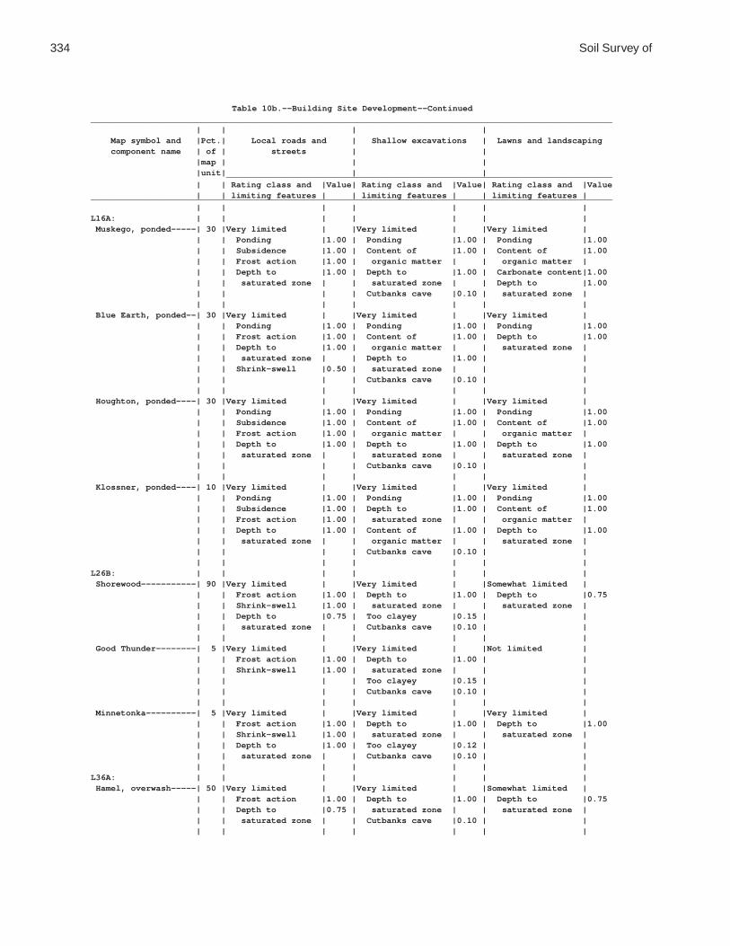
334 Soil Survey of
Table 10b.--Building Site Development--Continued________________________________________________________________________________________________________ | | | | Map symbol and |Pct.| Local roads and | Shallow excavations | Lawns and landscaping component name | of | streets | | |map | | | |unit| | | _____________________________________________________________________________ | | Rating class and |Value| Rating class and |Value| Rating class and |Value | | limiting features | | limiting features | | limiting features |________________________________________________________________________________________________________ | | | | | | |L16A: | | | | | | | Muskego, ponded-----| 30 |Very limited | |Very limited | |Very limited | | | Ponding |1.00 | Ponding |1.00 | Ponding |1.00 | | Subsidence |1.00 | Content of |1.00 | Content of |1.00 | | Frost action |1.00 | organic matter | | organic matter | | | Depth to |1.00 | Depth to |1.00 | Carbonate content|1.00 | | saturated zone | | saturated zone | | Depth to |1.00 | | | | Cutbanks cave |0.10 | saturated zone | | | | | | | | Blue Earth, ponded--| 30 |Very limited | |Very limited | |Very limited | | | Ponding |1.00 | Ponding |1.00 | Ponding |1.00 | | Frost action |1.00 | Content of |1.00 | Depth to |1.00 | | Depth to |1.00 | organic matter | | saturated zone | | | saturated zone | | Depth to |1.00 | | | | Shrink-swell |0.50 | saturated zone | | | | | | | Cutbanks cave |0.10 | | | | | | | | | Houghton, ponded----| 30 |Very limited | |Very limited | |Very limited | | | Ponding |1.00 | Ponding |1.00 | Ponding |1.00 | | Subsidence |1.00 | Content of |1.00 | Content of |1.00 | | Frost action |1.00 | organic matter | | organic matter | | | Depth to |1.00 | Depth to |1.00 | Depth to |1.00 | | saturated zone | | saturated zone | | saturated zone | | | | | Cutbanks cave |0.10 | | | | | | | | | Klossner, ponded----| 10 |Very limited | |Very limited | |Very limited | | | Ponding |1.00 | Ponding |1.00 | Ponding |1.00 | | Subsidence |1.00 | Depth to |1.00 | Content of |1.00 | | Frost action |1.00 | saturated zone | | organic matter | | | Depth to |1.00 | Content of |1.00 | Depth to |1.00 | | saturated zone | | organic matter | | saturated zone | | | | | Cutbanks cave |0.10 | | | | | | | | |L26B: | | | | | | | Shorewood-----------| 90 |Very limited | |Very limited | |Somewhat limited | | | Frost action |1.00 | Depth to |1.00 | Depth to |0.75 | | Shrink-swell |1.00 | saturated zone | | saturated zone | | | Depth to |0.75 | Too clayey |0.15 | | | | saturated zone | | Cutbanks cave |0.10 | | | | | | | | | Good Thunder--------| 5 |Very limited | |Very limited | |Not limited | | | Frost action |1.00 | Depth to |1.00 | | | | Shrink-swell |1.00 | saturated zone | | | | | | | Too clayey |0.15 | | | | | | Cutbanks cave |0.10 | | | | | | | | | Minnetonka----------| 5 |Very limited | |Very limited | |Very limited | | | Frost action |1.00 | Depth to |1.00 | Depth to |1.00 | | Shrink-swell |1.00 | saturated zone | | saturated zone | | | Depth to |1.00 | Too clayey |0.12 | | | | saturated zone | | Cutbanks cave |0.10 | | | | | | | | |L36A: | | | | | | | Hamel, overwash-----| 50 |Very limited | |Very limited | |Somewhat limited | | | Frost action |1.00 | Depth to |1.00 | Depth to |0.75 | | Depth to |0.75 | saturated zone | | saturated zone | | | saturated zone | | Cutbanks cave |0.10 | | | | | | | | |

Waseca County, Minnesota 335
Table 10b.--Building Site Development--Continued________________________________________________________________________________________________________ | | | | Map symbol and |Pct.| Local roads and | Shallow excavations | Lawns and landscaping component name | of | streets | | |map | | | |unit| | | _____________________________________________________________________________ | | Rating class and |Value| Rating class and |Value| Rating class and |Value | | limiting features | | limiting features | | limiting features |________________________________________________________________________________________________________ | | | | | | |L36A: | | | | | | | Hamel---------------| 43 |Very limited | |Very limited | |Very limited | | | Frost action |1.00 | Depth to |1.00 | Depth to |1.00 | | Depth to |1.00 | saturated zone | | saturated zone | | | saturated zone | | Cutbanks cave |0.10 | | | | Shrink-swell |0.50 | | | | | | | | | | | Terril--------------| 5 |Somewhat limited | |Somewhat limited | |Not limited | | | Frost action |0.50 | Depth to |0.78 | | | | | | saturated zone | | | | | | | Cutbanks cave |0.10 | | | | | | | | | Glencoe-------------| 2 |Very limited | |Very limited | |Very limited | | | Frost action |1.00 | Depth to |1.00 | Depth to |1.00 | | Depth to |1.00 | saturated zone | | saturated zone | | | saturated zone | | Ponding |1.00 | Ponding |1.00 | | Low strength |1.00 | Cutbanks cave |0.10 | | | | Ponding |1.00 | | | | | | Shrink-swell |0.50 | | | | | | | | | | |L40B: | | | | | | | Angus---------------| 45 |Somewhat limited | |Somewhat limited | |Not limited | | | Shrink-swell |0.50 | Depth to |0.78 | | | | Frost action |0.50 | saturated zone | | | | | | | Cutbanks cave |0.10 | | | | | | | | | Kilkenny------------| 40 |Very limited | |Very limited | |Somewhat limited | | | Frost action |1.00 | Depth to |1.00 | Depth to |0.56 | | Depth to |0.56 | saturated zone | | saturated zone | | | saturated zone | | Cutbanks cave |0.10 | | | | Shrink-swell |0.50 | | | | | | | | | | | Lerdal--------------| 10 |Very limited | |Very limited | |Somewhat limited | | | Frost action |1.00 | Depth to |1.00 | Depth to |0.60 | | Shrink-swell |1.00 | saturated zone | | saturated zone | | | Depth to |0.60 | Too clayey |0.12 | | | | saturated zone | | Cutbanks cave |0.10 | | | | | | | | | Mazaska-------------| 5 |Very limited | |Very limited | |Very limited | | | Frost action |1.00 | Depth to |1.00 | Depth to |1.00 | | Shrink-swell |1.00 | saturated zone | | saturated zone | | | Depth to |1.00 | Cutbanks cave |0.10 | | | | saturated zone | | Too clayey |0.03 | | | | | | | | |L41C2: | | | | | | | Lester, eroded------| 45 |Somewhat limited | |Somewhat limited | |Somewhat limited | | | Shrink-swell |0.50 | Cutbanks cave |0.10 | Slope |0.04 | | Frost action |0.50 | Slope |0.04 | | | | Slope |0.04 | | | | | | | | | | | Kilkenny, eroded----| 40 |Very limited | |Very limited | |Somewhat limited | | | Frost action |1.00 | Depth to |1.00 | Slope |0.04 | | Shrink-swell |0.50 | saturated zone | | | | | Slope |0.04 | Cutbanks cave |0.10 | | | | | | Slope |0.04 | | | | | | | | | Terril--------------| 10 |Somewhat limited | |Somewhat limited | |Not limited | | | Frost action |0.50 | Depth to |0.78 | | | | | | saturated zone | | | | | | | Cutbanks cave |0.10 | | | | | | | | |

336 Soil Survey of
Table 10b.--Building Site Development--Continued________________________________________________________________________________________________________ | | | | Map symbol and |Pct.| Local roads and | Shallow excavations | Lawns and landscaping component name | of | streets | | |map | | | |unit| | | _____________________________________________________________________________ | | Rating class and |Value| Rating class and |Value| Rating class and |Value | | limiting features | | limiting features | | limiting features |________________________________________________________________________________________________________ | | | | | | |L41C2: | | | | | | | Derrynane-----------| 5 |Very limited | |Very limited | |Very limited | | | Frost action |1.00 | Depth to |1.00 | Depth to |1.00 | | Shrink-swell |1.00 | saturated zone | | saturated zone | | | Depth to |1.00 | Cutbanks cave |0.10 | | | | saturated zone | | | | | | | | | | | |L41D2: | | | | | | | Lester, eroded------| 45 |Very limited | |Very limited | |Very limited | | | Slope |1.00 | Slope |1.00 | Slope |1.00 | | Shrink-swell |0.50 | Cutbanks cave |0.10 | | | | Frost action |0.50 | | | | | | | | | | | Kilkenny, eroded----| 35 |Very limited | |Very limited | |Very limited | | | Frost action |1.00 | Slope |1.00 | Slope |1.00 | | Slope |1.00 | Depth to |1.00 | | | | Shrink-swell |0.50 | saturated zone | | | | | | | Cutbanks cave |0.10 | | | | | | | | | Terril--------------| 10 |Somewhat limited | |Somewhat limited | |Not limited | | | Frost action |0.50 | Depth to |0.78 | | | | | | saturated zone | | | | | | | Cutbanks cave |0.10 | | | | | | | | | Derrynane-----------| 5 |Very limited | |Very limited | |Very limited | | | Frost action |1.00 | Depth to |1.00 | Depth to |1.00 | | Shrink-swell |1.00 | saturated zone | | saturated zone | | | Depth to |1.00 | Cutbanks cave |0.10 | | | | saturated zone | | | | | | | | | | | | Ridgeton------------| 5 |Somewhat limited | |Somewhat limited | |Somewhat limited | | | Frost action |0.50 | Slope |0.16 | Slope |0.16 | | Slope |0.16 | Cutbanks cave |0.10 | | | | | | | | |L41E: | | | | | | | Lester--------------| 45 |Very limited | |Very limited | |Very limited | | | Slope |1.00 | Slope |1.00 | Slope |1.00 | | Shrink-swell |0.50 | Cutbanks cave |0.10 | | | | Frost action |0.50 | | | | | | | | | | | Kilkenny------------| 40 |Very limited | |Very limited | |Very limited | | | Slope |1.00 | Slope |1.00 | Slope |1.00 | | Frost action |1.00 | Depth to |1.00 | | | | Shrink-swell |0.50 | saturated zone | | | | | | | Cutbanks cave |0.10 | | | | | | | | | Terril--------------| 5 |Somewhat limited | |Somewhat limited | |Not limited | | | Frost action |0.50 | Depth to |0.78 | | | | | | saturated zone | | | | | | | Cutbanks cave |0.10 | | | | | | | | | Derrynane-----------| 5 |Very limited | |Very limited | |Very limited | | | Frost action |1.00 | Depth to |1.00 | Depth to |1.00 | | Shrink-swell |1.00 | saturated zone | | saturated zone | | | Depth to |1.00 | Cutbanks cave |0.10 | | | | saturated zone | | | | | | | | | | | | Ridgeton------------| 5 |Somewhat limited | |Somewhat limited | |Somewhat limited | | | Slope |0.96 | Slope |0.96 | Slope |0.96 | | Frost action |0.50 | Cutbanks cave |0.10 | | | | | | | | |

Waseca County, Minnesota 337
Table 10b.--Building Site Development--Continued________________________________________________________________________________________________________ | | | | Map symbol and |Pct.| Local roads and | Shallow excavations | Lawns and landscaping component name | of | streets | | |map | | | |unit| | | _____________________________________________________________________________ | | Rating class and |Value| Rating class and |Value| Rating class and |Value | | limiting features | | limiting features | | limiting features |________________________________________________________________________________________________________ | | | | | | |L48A: | | | | | | | Derrynane, overwash | 50 |Very limited | |Very limited | |Somewhat limited | | | Frost action |1.00 | Depth to |1.00 | Depth to |0.75 | | Shrink-swell |1.00 | saturated zone | | saturated zone | | | Depth to |0.75 | Cutbanks cave |0.10 | | | | saturated zone | | | | | | | | | | | | Derrynane-----------| 40 |Very limited | |Very limited | |Very limited | | | Frost action |1.00 | Depth to |1.00 | Depth to |1.00 | | Shrink-swell |1.00 | saturated zone | | saturated zone | | | Depth to |1.00 | Cutbanks cave |0.10 | | | | saturated zone | | | | | | | | | | | | Glencoe-------------| 5 |Very limited | |Very limited | |Very limited | | | Ponding |1.00 | Ponding |1.00 | Ponding |1.00 | | Depth to |1.00 | Depth to |1.00 | Depth to |1.00 | | saturated zone | | saturated zone | | saturated zone | | | Frost action |1.00 | Cutbanks cave |0.10 | | | | Low strength |1.00 | | | | | | Shrink-swell |0.50 | | | | | | | | | | | Terril--------------| 5 |Somewhat limited | |Somewhat limited | |Not limited | | | Frost action |0.50 | Depth to |0.78 | | | | | | saturated zone | | | | | | | Cutbanks cave |0.10 | | | | | | | | |L49A: | | | | | | | Klossner, surface | | | | | | | drained------------| 65 |Very limited | |Very limited | |Very limited | | | Subsidence |1.00 | Depth to |1.00 | Content of |1.00 | | Frost action |1.00 | saturated zone | | organic matter | | | Depth to |1.00 | Ponding |1.00 | Depth to |1.00 | | saturated zone | | Content of |1.00 | saturated zone | | | Ponding |1.00 | organic matter | | Ponding |1.00 | | | | Cutbanks cave |0.10 | | | | | | | | | Klossner, drained---| 20 |Very limited | |Very limited | |Very limited | | | Subsidence |1.00 | Depth to |1.00 | Content of |1.00 | | Frost action |1.00 | saturated zone | | organic matter | | | Depth to |1.00 | Ponding |1.00 | Depth to |1.00 | | saturated zone | | Content of |1.00 | saturated zone | | | Ponding |1.00 | organic matter | | Ponding |1.00 | | | | Cutbanks cave |0.10 | | | | | | | | | Mineral soil, | | | | | | | drained------------| 15 |Very limited | |Very limited | |Very limited | | | Frost action |1.00 | Depth to |1.00 | Depth to |1.00 | | Depth to |1.00 | saturated zone | | saturated zone | | | saturated zone | | Ponding |1.00 | Ponding |1.00 | | Low strength |1.00 | Cutbanks cave |0.10 | | | | Ponding |1.00 | | | | | | Shrink-swell |0.50 | | | | | | | | | | |

338 Soil Survey of
Table 10b.--Building Site Development--Continued________________________________________________________________________________________________________ | | | | Map symbol and |Pct.| Local roads and | Shallow excavations | Lawns and landscaping component name | of | streets | | |map | | | |unit| | | _____________________________________________________________________________ | | Rating class and |Value| Rating class and |Value| Rating class and |Value | | limiting features | | limiting features | | limiting features |________________________________________________________________________________________________________ | | | | | | |L50A: | | | | | | | Houghton, surface | | | | | | | drained------------| 40 |Very limited | |Very limited | |Very limited | | | Subsidence |1.00 | Content of |1.00 | Content of |1.00 | | Frost action |1.00 | organic matter | | organic matter | | | Depth to |1.00 | Depth to |1.00 | Depth to |1.00 | | saturated zone | | saturated zone | | saturated zone | | | Ponding |1.00 | Ponding |1.00 | Ponding |1.00 | | | | Cutbanks cave |0.10 | | | | | | | | | Muskego, surface | | | | | | | drained------------| 40 |Very limited | |Very limited | |Very limited | | | Subsidence |1.00 | Content of |1.00 | Content of |1.00 | | Frost action |1.00 | organic matter | | organic matter | | | Depth to |1.00 | Depth to |1.00 | Carbonate content|1.00 | | saturated zone | | saturated zone | | Depth to |1.00 | | Ponding |1.00 | Ponding |1.00 | saturated zone | | | | | Cutbanks cave |0.10 | Ponding |1.00 | | | | | | | Klossner, drained---| 10 |Very limited | |Very limited | |Very limited | | | Subsidence |1.00 | Depth to |1.00 | Content of |1.00 | | Frost action |1.00 | saturated zone | | organic matter | | | Depth to |1.00 | Ponding |1.00 | Depth to |1.00 | | saturated zone | | Content of |1.00 | saturated zone | | | Ponding |1.00 | organic matter | | Ponding |1.00 | | | | Cutbanks cave |0.10 | | | | | | | | | Mineral soil, | | | | | | | drained------------| 10 |Very limited | |Very limited | |Very limited | | | Frost action |1.00 | Depth to |1.00 | Depth to |1.00 | | Depth to |1.00 | saturated zone | | saturated zone | | | saturated zone | | Ponding |1.00 | Ponding |1.00 | | Low strength |1.00 | Cutbanks cave |0.10 | | | | Ponding |1.00 | | | | | | Shrink-swell |0.50 | | | | | | | | | | |L51C2: | | | | | | | Gladek, eroded------| 80 |Very limited | |Somewhat limited | |Somewhat limited | | | Frost action |1.00 | Cutbanks cave |0.10 | Slope |0.04 | | Shrink-swell |0.50 | Slope |0.04 | | | | Slope |0.04 | | | | | | | | | | | Barrington----------| 10 |Very limited | |Very limited | |Not limited | | | Frost action |1.00 | Cutbanks cave |1.00 | | | | Shrink-swell |0.50 | Depth to |1.00 | | | | | | saturated zone | | | | | | | | | | Lester, eroded------| 5 |Somewhat limited | |Somewhat limited | |Somewhat limited | | | Shrink-swell |0.50 | Cutbanks cave |0.10 | Slope |0.04 | | Frost action |0.50 | Slope |0.04 | | | | Slope |0.04 | | | | | | | | | | | Madelia-------------| 5 |Very limited | |Very limited | |Very limited | | | Frost action |1.00 | Depth to |1.00 | Depth to |1.00 | | Depth to |1.00 | saturated zone | | saturated zone | | | saturated zone | | Cutbanks cave |0.10 | | | | Shrink-swell |0.50 | | | | | | | | | | |

Waseca County, Minnesota 339
Table 10b.--Building Site Development--Continued________________________________________________________________________________________________________ | | | | Map symbol and |Pct.| Local roads and | Shallow excavations | Lawns and landscaping component name | of | streets | | |map | | | |unit| | | _____________________________________________________________________________ | | Rating class and |Value| Rating class and |Value| Rating class and |Value | | limiting features | | limiting features | | limiting features |________________________________________________________________________________________________________ | | | | | | |L56A: | | | | | | | Muskego, frequently | | | | | | | flooded------------| 45 |Very limited | |Very limited | |Very limited | | | Ponding |1.00 | Ponding |1.00 | Ponding |1.00 | | Subsidence |1.00 | Content of |1.00 | Flooding |1.00 | | Frost action |1.00 | organic matter | | Content of |1.00 | | Flooding |1.00 | Depth to |1.00 | organic matter | | | Depth to |1.00 | saturated zone | | Carbonate content|1.00 | | saturated zone | | Flooding |0.80 | Depth to |1.00 | | | | Cutbanks cave |0.10 | saturated zone | | | | | | | | Klossner, frequently| | | | | | | flooded------------| 45 |Very limited | |Very limited | |Very limited | | | Ponding |1.00 | Ponding |1.00 | Ponding |1.00 | | Subsidence |1.00 | Depth to |1.00 | Flooding |1.00 | | Frost action |1.00 | saturated zone | | Content of |1.00 | | Flooding |1.00 | Content of |1.00 | organic matter | | | Depth to |1.00 | organic matter | | Depth to |1.00 | | saturated zone | | Flooding |0.80 | saturated zone | | | | | Cutbanks cave |0.10 | | | | | | | | | Suckercreek, | | | | | | | frequently flooded | 10 |Very limited | |Very limited | |Very limited | | | Frost action |1.00 | Cutbanks cave |1.00 | Flooding |1.00 | | Flooding |1.00 | Depth to |1.00 | Depth to |1.00 | | Depth to |1.00 | saturated zone | | saturated zone | | | saturated zone | | Flooding |0.80 | | | | | | | | |L57A: | | | | | | | Medo, drained-------| 80 |Very limited | |Very limited | |Very limited | | | Ponding |1.00 | Ponding |1.00 | Ponding |1.00 | | Subsidence |1.00 | Cutbanks cave |1.00 | Content of |1.00 | | Frost action |1.00 | Depth to |1.00 | organic matter | | | Depth to |1.00 | saturated zone | | Depth to |1.00 | | saturated zone | | Content of |1.00 | saturated zone | | | | | organic matter | | | | | | | | | | Mineral soil, | | | | | | | drained------------| 15 |Very limited | |Very limited | |Very limited | | | Ponding |1.00 | Ponding |1.00 | Ponding |1.00 | | Frost action |1.00 | Cutbanks cave |1.00 | Depth to |1.00 | | Depth to |1.00 | Depth to |1.00 | saturated zone | | | saturated zone | | saturated zone | | | | | | | | | | Houghton, drained---| 5 |Very limited | |Very limited | |Very limited | | | Ponding |1.00 | Ponding |1.00 | Ponding |1.00 | | Subsidence |1.00 | Content of |1.00 | Content of |1.00 | | Frost action |1.00 | organic matter | | organic matter | | | Depth to |1.00 | Depth to |1.00 | Depth to |1.00 | | saturated zone | | saturated zone | | saturated zone | | | | | Cutbanks cave |0.10 | | | | | | | | |L63A: | | | | | | | Klossner------------| 85 |Very limited | |Very limited | |Very limited | | | Ponding |1.00 | Ponding |1.00 | Ponding |1.00 | | Depth to |1.00 | Depth to |1.00 | Content of |1.00 | | saturated zone | | saturated zone | | organic matter | | | Subsidence |1.00 | Content of |1.00 | Depth to |1.00 | | Frost action |1.00 | organic matter | | saturated zone | | | | | Cutbanks cave |0.10 | | | | | | | | |

340 Soil Survey of
Table 10b.--Building Site Development--Continued________________________________________________________________________________________________________ | | | | Map symbol and |Pct.| Local roads and | Shallow excavations | Lawns and landscaping component name | of | streets | | |map | | | |unit| | | _____________________________________________________________________________ | | Rating class and |Value| Rating class and |Value| Rating class and |Value | | limiting features | | limiting features | | limiting features |________________________________________________________________________________________________________ | | | | | | |L63A: | | | | | | | Lura----------------| 10 |Very limited | |Very limited | |Very limited | | | Ponding |1.00 | Ponding |1.00 | Too clayey |1.00 | | Depth to |1.00 | Depth to |1.00 | Ponding |1.00 | | saturated zone | | saturated zone | | Depth to |1.00 | | Frost action |1.00 | Too clayey |0.72 | saturated zone | | | Shrink-swell |1.00 | Cutbanks cave |0.10 | | | | | | | | | Brownton------------| 5 |Very limited | |Very limited | |Very limited | | | Frost action |1.00 | Depth to |1.00 | Depth to |1.00 | | Shrink-swell |1.00 | saturated zone | | saturated zone | | | Depth to |1.00 | Too clayey |0.28 | | | | saturated zone | | Cutbanks cave |0.10 | | | | | | | | |L64A: | | | | | | | Tadkee--------------| 50 |Very limited | |Very limited | |Very limited | | | Frost action |1.00 | Depth to |1.00 | Depth to |1.00 | | Depth to |1.00 | saturated zone | | saturated zone | | | saturated zone | | Cutbanks cave |1.00 | | | | | | | | | Tadkee, depressional| 36 |Very limited | |Very limited | |Very limited | | | Ponding |1.00 | Ponding |1.00 | Ponding |1.00 | | Depth to |1.00 | Depth to |1.00 | Depth to |1.00 | | saturated zone | | saturated zone | | saturated zone | | | Frost action |1.00 | Cutbanks cave |1.00 | | | | | | | | | Better drained soil | 8 |Somewhat limited | |Very limited | |Not limited | | | Frost action |0.50 | Cutbanks cave |1.00 | | | | | | Depth to |1.00 | | | | | | saturated zone | | | | | | | | | | Granby--------------| 4 |Very limited | |Very limited | |Very limited | | | Ponding |1.00 | Ponding |1.00 | Ponding |1.00 | | Depth to |1.00 | Depth to |1.00 | Depth to |1.00 | | saturated zone | | saturated zone | | saturated zone | | | Frost action |1.00 | Cutbanks cave |1.00 | Droughty |0.13 | | | | | | | Less sandy soil-----| 2 |Very limited | |Very limited | |Very limited | | | Frost action |1.00 | Depth to |1.00 | Depth to |1.00 | | Depth to |1.00 | saturated zone | | saturated zone | | | saturated zone | | Cutbanks cave |0.10 | | | | | | | | |L73A: | | | | | | | Blue Earth----------| 80 |Very limited | |Very limited | |Very limited | | | Ponding |1.00 | Ponding |1.00 | Ponding |1.00 | | Depth to |1.00 | Depth to |1.00 | Depth to |1.00 | | saturated zone | | saturated zone | | saturated zone | | | Frost action |1.00 | Content of |1.00 | | | | | | organic matter | | | | | | | Cutbanks cave |0.10 | | | | | | | | | Belleville----------| 10 |Very limited | |Very limited | |Very limited | | | Frost action |1.00 | Depth to |1.00 | Depth to |1.00 | | Depth to |1.00 | saturated zone | | saturated zone | | | saturated zone | | Cutbanks cave |1.00 | | | | | | | | | Canisteo------------| 10 |Very limited | |Very limited | |Very limited | | | Frost action |1.00 | Depth to |1.00 | Depth to |1.00 | | Depth to |1.00 | saturated zone | | saturated zone | | | saturated zone | | Cutbanks cave |0.10 | | | | | | | | |

Waseca County, Minnesota 341
Table 10b.--Building Site Development--Continued________________________________________________________________________________________________________ | | | | Map symbol and |Pct.| Local roads and | Shallow excavations | Lawns and landscaping component name | of | streets | | |map | | | |unit| | | _____________________________________________________________________________ | | Rating class and |Value| Rating class and |Value| Rating class and |Value | | limiting features | | limiting features | | limiting features |________________________________________________________________________________________________________ | | | | | | |L74A: | | | | | | | Estherville---------| 87 |Not limited | |Very limited | |Somewhat limited | | | | | Cutbanks cave |1.00 | Droughty |0.12 | | | | | | | Hawick--------------| 10 |Not limited | |Very limited | |Very limited | | | | | Cutbanks cave |1.00 | Droughty |1.00 | | | | | | | Biscay--------------| 3 |Very limited | |Very limited | |Very limited | | | Frost action |1.00 | Depth to |1.00 | Depth to |1.00 | | Depth to |1.00 | saturated zone | | saturated zone | | | saturated zone | | Cutbanks cave |1.00 | | | | Shrink-swell |0.50 | | | | | | | | | | |L75B: | | | | | | | Barrington----------| 85 |Very limited | |Very limited | |Not limited | | | Frost action |1.00 | Cutbanks cave |1.00 | | | | Shrink-swell |0.50 | Depth to |1.00 | | | | | | saturated zone | | | | | | | | | | Gladek--------------| 10 |Very limited | |Somewhat limited | |Somewhat limited | | | Frost action |1.00 | Cutbanks cave |0.10 | Slope |0.04 | | Shrink-swell |0.50 | Slope |0.04 | | | | Slope |0.04 | | | | | | | | | | | Madelia-------------| 5 |Very limited | |Very limited | |Very limited | | | Frost action |1.00 | Depth to |1.00 | Depth to |1.00 | | Depth to |1.00 | saturated zone | | saturated zone | | | saturated zone | | Cutbanks cave |0.10 | | | | Shrink-swell |0.50 | | | | | | | | | | |L76B: | | | | | | | Dickinson-----------| 80 |Somewhat limited | |Very limited | |Not limited | | | Frost action |0.50 | Cutbanks cave |1.00 | | | | | | | | | Litchfield----------| 13 |Somewhat limited | |Very limited | |Somewhat limited | | | Depth to |0.90 | Cutbanks cave |1.00 | Depth to |0.90 | | saturated zone | | Depth to |1.00 | saturated zone | | | Frost action |0.50 | saturated zone | | | | | | | | | | Darfur--------------| 5 |Very limited | |Very limited | |Very limited | | | Depth to |1.00 | Depth to |1.00 | Depth to |1.00 | | saturated zone | | saturated zone | | saturated zone | | | Frost action |1.00 | Cutbanks cave |1.00 | | | | | | | | | Clarion-------------| 2 |Somewhat limited | |Somewhat limited | |Not limited | | | Frost action |0.50 | Depth to |0.78 | | | | | | saturated zone | | | | | | | Cutbanks cave |0.10 | | | | | | | | |L77A: | | | | | | | Brownton------------| 75 |Very limited | |Very limited | |Very limited | | | Frost action |1.00 | Depth to |1.00 | Depth to |1.00 | | Shrink-swell |1.00 | saturated zone | | saturated zone | | | Depth to |1.00 | Too clayey |0.28 | | | | saturated zone | | Cutbanks cave |0.10 | | | | | | | | | Marna---------------| 15 |Very limited | |Very limited | |Very limited | | | Frost action |1.00 | Depth to |1.00 | Depth to |1.00 | | Shrink-swell |1.00 | saturated zone | | saturated zone | | | Depth to |1.00 | Too clayey |0.28 | | | | saturated zone | | Cutbanks cave |0.10 | | | | | | | | |

342 Soil Survey of
Table 10b.--Building Site Development--Continued________________________________________________________________________________________________________ | | | | Map symbol and |Pct.| Local roads and | Shallow excavations | Lawns and landscaping component name | of | streets | | |map | | | |unit| | | _____________________________________________________________________________ | | Rating class and |Value| Rating class and |Value| Rating class and |Value | | limiting features | | limiting features | | limiting features |________________________________________________________________________________________________________ | | | | | | |L77A: | | | | | | | Lura----------------| 10 |Very limited | |Very limited | |Very limited | | | Ponding |1.00 | Ponding |1.00 | Too clayey |1.00 | | Depth to |1.00 | Depth to |1.00 | Ponding |1.00 | | saturated zone | | saturated zone | | Depth to |1.00 | | Frost action |1.00 | Too clayey |0.72 | saturated zone | | | Shrink-swell |1.00 | Cutbanks cave |0.10 | | | | | | | | |L78A: | | | | | | | Canisteo------------| 65 |Very limited | |Very limited | |Very limited | | | Frost action |1.00 | Depth to |1.00 | Depth to |1.00 | | Depth to |1.00 | saturated zone | | saturated zone | | | saturated zone | | Cutbanks cave |0.10 | | | | | | | | | Crippin-------------| 10 |Very limited | |Very limited | |Somewhat limited | | | Frost action |1.00 | Depth to |1.00 | Depth to |0.78 | | Depth to |0.78 | saturated zone | | saturated zone | | | saturated zone | | Cutbanks cave |0.10 | | | | | | | | | Glencoe-------------| 10 |Very limited | |Very limited | |Very limited | | | Ponding |1.00 | Ponding |1.00 | Ponding |1.00 | | Depth to |1.00 | Depth to |1.00 | Depth to |1.00 | | saturated zone | | saturated zone | | saturated zone | | | Frost action |1.00 | Cutbanks cave |0.10 | | | | Low strength |1.00 | | | | | | Shrink-swell |0.50 | | | | | | | | | | | Canisteo, | | | | | | | depressional-------| 5 |Very limited | |Very limited | |Very limited | | | Ponding |1.00 | Ponding |1.00 | Ponding |1.00 | | Depth to |1.00 | Depth to |1.00 | Depth to |1.00 | | saturated zone | | saturated zone | | saturated zone | | | Frost action |1.00 | Cutbanks cave |0.10 | | | | Shrink-swell |0.50 | | | | | | | | | | | Harps---------------| 5 |Very limited | |Very limited | |Very limited | | | Frost action |1.00 | Depth to |1.00 | Depth to |1.00 | | Depth to |1.00 | saturated zone | | saturated zone | | | saturated zone | | Cutbanks cave |0.10 | | | | | | | | | Webster-------------| 5 |Very limited | |Very limited | |Very limited | | | Frost action |1.00 | Depth to |1.00 | Depth to |1.00 | | Depth to |1.00 | saturated zone | | saturated zone | | | saturated zone | | Cutbanks cave |0.10 | | | | | | | | |L79B: | | | | | | | Clarion-------------| 65 |Somewhat limited | |Somewhat limited | |Not limited | | | Frost action |0.50 | Depth to |0.78 | | | | | | saturated zone | | | | | | | Cutbanks cave |0.10 | | | | | | | | | Clarion, eroded-----| 25 |Somewhat limited | |Somewhat limited | |Not limited | | | Frost action |0.50 | Depth to |0.78 | | | | | | saturated zone | | | | | | | Cutbanks cave |0.10 | | | | | | | | | Nicollet------------| 8 |Very limited | |Very limited | |Somewhat limited | | | Frost action |1.00 | Depth to |1.00 | Depth to |0.78 | | Depth to |0.78 | saturated zone | | saturated zone | | | saturated zone | | Cutbanks cave |0.10 | | | | Shrink-swell |0.50 | | | | | | | | | | |

Waseca County, Minnesota 343
Table 10b.--Building Site Development--Continued________________________________________________________________________________________________________ | | | | Map symbol and |Pct.| Local roads and | Shallow excavations | Lawns and landscaping component name | of | streets | | |map | | | |unit| | | _____________________________________________________________________________ | | Rating class and |Value| Rating class and |Value| Rating class and |Value | | limiting features | | limiting features | | limiting features |________________________________________________________________________________________________________ | | | | | | |L79B: | | | | | | | Webster-------------| 2 |Very limited | |Very limited | |Very limited | | | Frost action |1.00 | Depth to |1.00 | Depth to |1.00 | | Depth to |1.00 | saturated zone | | saturated zone | | | saturated zone | | Cutbanks cave |0.10 | | | | | | | | |L80C2: | | | | | | | Lester, eroded------| 75 |Somewhat limited | |Somewhat limited | |Somewhat limited | | | Shrink-swell |0.50 | Cutbanks cave |0.10 | Slope |0.04 | | Frost action |0.50 | Slope |0.04 | | | | Slope |0.04 | | | | | | | | | | | Terril--------------| 10 |Somewhat limited | |Somewhat limited | |Not limited | | | Frost action |0.50 | Depth to |0.78 | | | | | | saturated zone | | | | | | | Cutbanks cave |0.10 | | | | | | | | | Hamel---------------| 5 |Very limited | |Very limited | |Very limited | | | Frost action |1.00 | Depth to |1.00 | Depth to |1.00 | | Depth to |1.00 | saturated zone | | saturated zone | | | saturated zone | | Cutbanks cave |0.10 | | | | Shrink-swell |0.50 | | | | | | | | | | | Reedslake-----------| 5 |Somewhat limited | |Somewhat limited | |Not limited | | | Shrink-swell |0.50 | Depth to |0.78 | | | | Frost action |0.50 | saturated zone | | | | | | | Cutbanks cave |0.10 | | | | | | | | | Storden, eroded-----| 5 |Somewhat limited | |Somewhat limited | |Somewhat limited | | | Shrink-swell |0.50 | Cutbanks cave |0.10 | Slope |0.04 | | Frost action |0.50 | Slope |0.04 | | | | Slope |0.04 | | | | | | | | | | |L80D2: | | | | | | | Lester, eroded------| 75 |Very limited | |Very limited | |Very limited | | | Slope |1.00 | Slope |1.00 | Slope |1.00 | | Shrink-swell |0.50 | Cutbanks cave |0.10 | | | | Frost action |0.50 | | | | | | | | | | | Ridgeton------------| 10 |Somewhat limited | |Somewhat limited | |Somewhat limited | | | Slope |0.63 | Slope |0.63 | Slope |0.63 | | Frost action |0.50 | Cutbanks cave |0.10 | | | | | | | | | Storden, eroded-----| 8 |Very limited | |Very limited | |Very limited | | | Slope |1.00 | Slope |1.00 | Slope |1.00 | | Shrink-swell |0.50 | Cutbanks cave |0.10 | | | | Frost action |0.50 | | | | | | | | | | | Terril--------------| 5 |Somewhat limited | |Very limited | |Not limited | | | Frost action |0.50 | Depth to |1.00 | | | | | | saturated zone | | | | | | | Cutbanks cave |0.10 | | | | | | | | | Hamel---------------| 2 |Very limited | |Very limited | |Very limited | | | Frost action |1.00 | Depth to |1.00 | Depth to |1.00 | | Depth to |1.00 | saturated zone | | saturated zone | | | saturated zone | | Cutbanks cave |0.10 | | | | Shrink-swell |0.50 | | | | | | | | | | |

344 Soil Survey of
Table 10b.--Building Site Development--Continued________________________________________________________________________________________________________ | | | | Map symbol and |Pct.| Local roads and | Shallow excavations | Lawns and landscaping component name | of | streets | | |map | | | |unit| | | _____________________________________________________________________________ | | Rating class and |Value| Rating class and |Value| Rating class and |Value | | limiting features | | limiting features | | limiting features |________________________________________________________________________________________________________ | | | | | | |L81A: | | | | | | | Cordova-------------| 85 |Very limited | |Very limited | |Very limited | | | Frost action |1.00 | Depth to |1.00 | Depth to |1.00 | | Depth to |1.00 | saturated zone | | saturated zone | | | saturated zone | | Cutbanks cave |0.10 | | | | Shrink-swell |0.50 | | | | | | | | | | | Le Sueur------------| 10 |Very limited | |Very limited | |Somewhat limited | | | Frost action |1.00 | Depth to |1.00 | Depth to |0.78 | | Depth to |0.78 | saturated zone | | saturated zone | | | saturated zone | | Cutbanks cave |0.10 | | | | Shrink-swell |0.50 | | | | | | | | | | | Rolfe---------------| 5 |Very limited | |Very limited | |Very limited | | | Ponding |1.00 | Ponding |1.00 | Ponding |1.00 | | Depth to |1.00 | Depth to |1.00 | Depth to |1.00 | | saturated zone | | saturated zone | | saturated zone | | | Frost action |1.00 | Cutbanks cave |0.10 | | | | Shrink-swell |1.00 | Too clayey |0.02 | | | | | | | | |L82A: | | | | | | | Marna---------------| 85 |Very limited | |Very limited | |Very limited | | | Frost action |1.00 | Depth to |1.00 | Depth to |1.00 | | Shrink-swell |1.00 | saturated zone | | saturated zone | | | Depth to |1.00 | Too clayey |0.28 | | | | saturated zone | | Cutbanks cave |0.10 | | | | | | | | | Barbert-------------| 10 |Very limited | |Very limited | |Very limited | | | Ponding |1.00 | Ponding |1.00 | Ponding |1.00 | | Depth to |1.00 | Depth to |1.00 | Depth to |1.00 | | saturated zone | | saturated zone | | saturated zone | | | Frost action |1.00 | Too clayey |0.72 | | | | Shrink-swell |1.00 | Cutbanks cave |0.10 | | | | | | | | | Guckeen-------------| 5 |Very limited | |Very limited | |Not limited | | | Frost action |1.00 | Depth to |1.00 | | | | | | saturated zone | | | | | | | Cutbanks cave |0.10 | | | | | | Too clayey |0.03 | | | | | | | | |L83A: | | | | | | | Webster-------------| 65 |Very limited | |Very limited | |Very limited | | | Frost action |1.00 | Depth to |1.00 | Depth to |1.00 | | Depth to |1.00 | saturated zone | | saturated zone | | | saturated zone | | Cutbanks cave |0.10 | | | | | | | | | Glencoe-------------| 15 |Very limited | |Very limited | |Very limited | | | Ponding |1.00 | Ponding |1.00 | Ponding |1.00 | | Depth to |1.00 | Depth to |1.00 | Depth to |1.00 | | saturated zone | | saturated zone | | saturated zone | | | Frost action |1.00 | Cutbanks cave |0.10 | | | | Low strength |1.00 | | | | | | Shrink-swell |0.50 | | | | | | | | | | | Canisteo------------| 10 |Very limited | |Very limited | |Very limited | | | Frost action |1.00 | Depth to |1.00 | Depth to |1.00 | | Depth to |1.00 | saturated zone | | saturated zone | | | saturated zone | | Cutbanks cave |0.10 | | | | | | | | |

Waseca County, Minnesota 345
Table 10b.--Building Site Development--Continued________________________________________________________________________________________________________ | | | | Map symbol and |Pct.| Local roads and | Shallow excavations | Lawns and landscaping component name | of | streets | | |map | | | |unit| | | _____________________________________________________________________________ | | Rating class and |Value| Rating class and |Value| Rating class and |Value | | limiting features | | limiting features | | limiting features |________________________________________________________________________________________________________ | | | | | | |L83A: | | | | | | | Nicollet------------| 10 |Very limited | |Very limited | |Somewhat limited | | | Frost action |1.00 | Depth to |1.00 | Depth to |0.78 | | Depth to |0.78 | saturated zone | | saturated zone | | | saturated zone | | Cutbanks cave |0.10 | | | | Shrink-swell |0.50 | | | | | | | | | | |L84A: | | | | | | | Glencoe-------------| 80 |Very limited | |Very limited | |Very limited | | | Ponding |1.00 | Ponding |1.00 | Ponding |1.00 | | Depth to |1.00 | Depth to |1.00 | Depth to |1.00 | | saturated zone | | saturated zone | | saturated zone | | | Frost action |1.00 | Cutbanks cave |0.10 | | | | Low strength |1.00 | | | | | | Shrink-swell |0.50 | | | | | | | | | | | Very poorly drained | | | | | | | muck---------------| 10 |Very limited | |Very limited | |Very limited | | | Ponding |1.00 | Ponding |1.00 | Ponding |1.00 | | Depth to |1.00 | Depth to |1.00 | Content of |1.00 | | saturated zone | | saturated zone | | organic matter | | | Subsidence |1.00 | Cutbanks cave |0.10 | Depth to |1.00 | | Frost action |1.00 | | | saturated zone | | | Low strength |1.00 | | | | | | | | | | | Canisteo------------| 5 |Very limited | |Very limited | |Very limited | | | Frost action |1.00 | Depth to |1.00 | Depth to |1.00 | | Depth to |1.00 | saturated zone | | saturated zone | | | saturated zone | | Cutbanks cave |0.10 | | | | | | | | | Harps---------------| 5 |Very limited | |Very limited | |Very limited | | | Frost action |1.00 | Depth to |1.00 | Depth to |1.00 | | Depth to |1.00 | saturated zone | | saturated zone | | | saturated zone | | Cutbanks cave |0.10 | | | | | | | | |L85A: | | | | | | | Nicollet------------| 85 |Very limited | |Very limited | |Somewhat limited | | | Frost action |1.00 | Depth to |1.00 | Depth to |0.78 | | Depth to |0.78 | saturated zone | | saturated zone | | | saturated zone | | Cutbanks cave |0.10 | | | | Shrink-swell |0.50 | | | | | | | | | | | Clarion-------------| 10 |Somewhat limited | |Somewhat limited | |Not limited | | | Frost action |0.50 | Depth to |0.78 | | | | | | saturated zone | | | | | | | Cutbanks cave |0.10 | | | | | | | | | Webster-------------| 5 |Very limited | |Very limited | |Very limited | | | Frost action |1.00 | Depth to |1.00 | Depth to |1.00 | | Depth to |1.00 | saturated zone | | saturated zone | | | saturated zone | | Cutbanks cave |0.10 | | | | | | | | |L86A: | | | | | | | Madelia-------------| 90 |Very limited | |Very limited | |Very limited | | | Frost action |1.00 | Depth to |1.00 | Depth to |1.00 | | Depth to |1.00 | saturated zone | | saturated zone | | | saturated zone | | Cutbanks cave |0.10 | | | | Shrink-swell |0.50 | | | | | | | | | | |

346 Soil Survey of
Table 10b.--Building Site Development--Continued________________________________________________________________________________________________________ | | | | Map symbol and |Pct.| Local roads and | Shallow excavations | Lawns and landscaping component name | of | streets | | |map | | | |unit| | | _____________________________________________________________________________ | | Rating class and |Value| Rating class and |Value| Rating class and |Value | | limiting features | | limiting features | | limiting features |________________________________________________________________________________________________________ | | | | | | |L86A: | | | | | | | Okoboji-------------| 5 |Very limited | |Very limited | |Very limited | | | Ponding |1.00 | Ponding |1.00 | Ponding |1.00 | | Depth to |1.00 | Depth to |1.00 | Depth to |1.00 | | saturated zone | | saturated zone | | saturated zone | | | Frost action |1.00 | Cutbanks cave |0.10 | | | | Low strength |1.00 | Too clayey |0.02 | | | | Shrink-swell |1.00 | | | | | | | | | | | Spicer--------------| 3 |Very limited | |Very limited | |Very limited | | | Frost action |1.00 | Depth to |1.00 | Depth to |1.00 | | Depth to |1.00 | saturated zone | | saturated zone | | | saturated zone | | Cutbanks cave |0.10 | | | | Shrink-swell |0.50 | | | | | | | | | | | Kingston------------| 2 |Very limited | |Very limited | |Somewhat limited | | | Frost action |1.00 | Depth to |1.00 | Depth to |0.78 | | Depth to |0.78 | saturated zone | | saturated zone | | | saturated zone | | Cutbanks cave |0.10 | | | | | | | | |L87A: | | | | | | | Kingston------------| 85 |Very limited | |Very limited | |Somewhat limited | | | Frost action |1.00 | Depth to |1.00 | Depth to |0.78 | | Depth to |0.78 | saturated zone | | saturated zone | | | saturated zone | | Cutbanks cave |0.10 | | | | | | | | | Truman--------------| 10 |Very limited | |Somewhat limited | |Not limited | | | Frost action |1.00 | Depth to |0.78 | | | | | | saturated zone | | | | | | | Cutbanks cave |0.10 | | | | | | | | | Madelia-------------| 5 |Very limited | |Very limited | |Very limited | | | Frost action |1.00 | Depth to |1.00 | Depth to |1.00 | | Depth to |1.00 | saturated zone | | saturated zone | | | saturated zone | | Cutbanks cave |0.10 | | | | Shrink-swell |0.50 | | | | | | | | | | |L88A: | | | | | | | Lura----------------| 85 |Very limited | |Very limited | |Very limited | | | Ponding |1.00 | Ponding |1.00 | Too clayey |1.00 | | Depth to |1.00 | Depth to |1.00 | Ponding |1.00 | | saturated zone | | saturated zone | | Depth to |1.00 | | Frost action |1.00 | Too clayey |0.72 | saturated zone | | | Shrink-swell |1.00 | Cutbanks cave |0.10 | | | | | | | | | Brownton------------| 10 |Very limited | |Very limited | |Very limited | | | Frost action |1.00 | Depth to |1.00 | Depth to |1.00 | | Shrink-swell |1.00 | saturated zone | | saturated zone | | | Depth to |1.00 | Too clayey |0.28 | | | | saturated zone | | Cutbanks cave |0.10 | | | | | | | | | Organic soil--------| 5 |Very limited | |Very limited | |Very limited | | | Ponding |1.00 | Ponding |1.00 | Ponding |1.00 | | Depth to |1.00 | Depth to |1.00 | Content of |1.00 | | saturated zone | | saturated zone | | organic matter | | | Subsidence |1.00 | Cutbanks cave |0.10 | Depth to |1.00 | | Frost action |1.00 | | | saturated zone | | | Shrink-swell |0.50 | | | | | | | | | | |

Waseca County, Minnesota 347
Table 10b.--Building Site Development--Continued________________________________________________________________________________________________________ | | | | Map symbol and |Pct.| Local roads and | Shallow excavations | Lawns and landscaping component name | of | streets | | |map | | | |unit| | | _____________________________________________________________________________ | | Rating class and |Value| Rating class and |Value| Rating class and |Value | | limiting features | | limiting features | | limiting features |________________________________________________________________________________________________________ | | | | | | |L89A: | | | | | | | Guckeen-------------| 82 |Very limited | |Very limited | |Somewhat limited | | | Frost action |1.00 | Depth to |1.00 | Depth to |0.78 | | Depth to |0.78 | saturated zone | | saturated zone | | | saturated zone | | Cutbanks cave |0.10 | | | | | | Too clayey |0.03 | | | | | | | | | Marna---------------| 10 |Very limited | |Very limited | |Very limited | | | Frost action |1.00 | Depth to |1.00 | Depth to |1.00 | | Shrink-swell |1.00 | saturated zone | | saturated zone | | | Depth to |1.00 | Too clayey |0.28 | | | | saturated zone | | Cutbanks cave |0.10 | | | | | | | | | Clarion clay loam---| 8 |Somewhat limited | |Somewhat limited | |Not limited | | | Frost action |0.50 | Depth to |0.78 | | | | | | saturated zone | | | | | | | Cutbanks cave |0.10 | | | | | | | | |L90A: | | | | | | | Le Sueur------------| 75 |Very limited | |Very limited | |Somewhat limited | | | Frost action |1.00 | Depth to |1.00 | Depth to |0.78 | | Depth to |0.78 | saturated zone | | saturated zone | | | saturated zone | | Cutbanks cave |0.10 | | | | Shrink-swell |0.50 | | | | | | | | | | | Cordova-------------| 13 |Very limited | |Very limited | |Very limited | | | Frost action |1.00 | Depth to |1.00 | Depth to |1.00 | | Depth to |1.00 | saturated zone | | saturated zone | | | saturated zone | | Cutbanks cave |0.10 | | | | Shrink-swell |0.50 | | | | | | | | | | | Reedslake-----------| 12 |Somewhat limited | |Somewhat limited | |Not limited | | | Shrink-swell |0.50 | Depth to |0.78 | | | | Frost action |0.50 | saturated zone | | | | | | | Cutbanks cave |0.10 | | | | | | | | |L91A: | | | | | | | Mazaska-------------| 85 |Very limited | |Very limited | |Very limited | | | Frost action |1.00 | Depth to |1.00 | Depth to |1.00 | | Shrink-swell |1.00 | saturated zone | | saturated zone | | | Depth to |1.00 | Cutbanks cave |0.10 | | | | saturated zone | | Too clayey |0.03 | | | | | | | | | Lerdal--------------| 10 |Very limited | |Very limited | |Somewhat limited | | | Frost action |1.00 | Depth to |1.00 | Depth to |0.60 | | Shrink-swell |1.00 | saturated zone | | saturated zone | | | Depth to |0.60 | Too clayey |0.12 | | | | saturated zone | | Cutbanks cave |0.10 | | | | | | | | | Rolfe---------------| 5 |Very limited | |Very limited | |Very limited | | | Ponding |1.00 | Ponding |1.00 | Ponding |1.00 | | Depth to |1.00 | Depth to |1.00 | Depth to |1.00 | | saturated zone | | saturated zone | | saturated zone | | | Frost action |1.00 | Cutbanks cave |0.10 | | | | Shrink-swell |1.00 | Too clayey |0.02 | | | | | | | | |L92A: | | | | | | | Darfur--------------| 78 |Very limited | |Very limited | |Very limited | | | Depth to |1.00 | Depth to |1.00 | Depth to |1.00 | | saturated zone | | saturated zone | | saturated zone | | | Frost action |1.00 | Cutbanks cave |1.00 | | | | | | | | |

348 Soil Survey of
Table 10b.--Building Site Development--Continued________________________________________________________________________________________________________ | | | | Map symbol and |Pct.| Local roads and | Shallow excavations | Lawns and landscaping component name | of | streets | | |map | | | |unit| | | _____________________________________________________________________________ | | Rating class and |Value| Rating class and |Value| Rating class and |Value | | limiting features | | limiting features | | limiting features |________________________________________________________________________________________________________ | | | | | | |L92A: | | | | | | | Fieldon-------------| 10 |Very limited | |Very limited | |Very limited | | | Depth to |1.00 | Depth to |1.00 | Depth to |1.00 | | saturated zone | | saturated zone | | saturated zone | | | Frost action |1.00 | Cutbanks cave |1.00 | | | | | | | | | Litchfield----------| 5 |Somewhat limited | |Very limited | |Somewhat limited | | | Depth to |0.90 | Cutbanks cave |1.00 | Depth to |0.90 | | saturated zone | | Depth to |1.00 | saturated zone | | | Frost action |0.50 | saturated zone | | | | | | | | | | Webster-------------| 5 |Very limited | |Very limited | |Very limited | | | Frost action |1.00 | Depth to |1.00 | Depth to |1.00 | | Depth to |1.00 | saturated zone | | saturated zone | | | saturated zone | | Cutbanks cave |0.10 | | | | | | | | | Dassel--------------| 2 |Very limited | |Very limited | |Very limited | | | Depth to |1.00 | Depth to |1.00 | Depth to |1.00 | | saturated zone | | saturated zone | | saturated zone | | | Frost action |1.00 | Cutbanks cave |1.00 | Ponding |1.00 | | Ponding |1.00 | Ponding |1.00 | | | | | | | | |L93A: | | | | | | | Muskego-------------| 82 |Very limited | |Very limited | |Very limited | | | Ponding |1.00 | Ponding |1.00 | Ponding |1.00 | | Depth to |1.00 | Depth to |1.00 | Content of |1.00 | | saturated zone | | saturated zone | | organic matter | | | Subsidence |1.00 | Content of |1.00 | Depth to |1.00 | | Frost action |1.00 | organic matter | | saturated zone | | | Shrink-swell |0.50 | Cutbanks cave |0.10 | Carbonate content|1.00 | | | | | | | Blue Earth----------| 10 |Very limited | |Very limited | |Very limited | | | Ponding |1.00 | Ponding |1.00 | Ponding |1.00 | | Depth to |1.00 | Depth to |1.00 | Depth to |1.00 | | saturated zone | | saturated zone | | saturated zone | | | Frost action |1.00 | Content of |1.00 | | | | | | organic matter | | | | | | | Cutbanks cave |0.10 | | | | | | | | | Mineral soil, | | | | | | | drained------------| 5 |Very limited | |Very limited | |Very limited | | | Ponding |1.00 | Ponding |1.00 | Ponding |1.00 | | Frost action |1.00 | Depth to |1.00 | Depth to |1.00 | | Depth to |1.00 | saturated zone | | saturated zone | | | saturated zone | | Cutbanks cave |0.10 | | | | Low strength |1.00 | | | | | | Shrink-swell |0.50 | | | | | | | | | | | Belleville----------| 3 |Very limited | |Very limited | |Very limited | | | Depth to |1.00 | Depth to |1.00 | Depth to |1.00 | | saturated zone | | saturated zone | | saturated zone | | | Frost action |1.00 | Cutbanks cave |1.00 | | | | | | | | |L94A: | | | | | | | Lowlein-------------| 75 |Somewhat limited | |Very limited | |Not limited | | | Frost action |0.50 | Cutbanks cave |1.00 | | | | | | Depth to |1.00 | | | | | | saturated zone | | | | | | | | | |

Waseca County, Minnesota 349
Table 10b.--Building Site Development--Continued________________________________________________________________________________________________________ | | | | Map symbol and |Pct.| Local roads and | Shallow excavations | Lawns and landscaping component name | of | streets | | |map | | | |unit| | | _____________________________________________________________________________ | | Rating class and |Value| Rating class and |Value| Rating class and |Value | | limiting features | | limiting features | | limiting features |________________________________________________________________________________________________________ | | | | | | |L94A: | | | | | | | Linder--------------| 15 |Very limited | |Very limited | |Somewhat limited | | | Frost action |1.00 | Cutbanks cave |1.00 | Depth to |0.90 | | Depth to |0.90 | Depth to |1.00 | saturated zone | | | saturated zone | | saturated zone | | | | | | | | | | Dickinson-----------| 8 |Somewhat limited | |Very limited | |Not limited | | | Frost action |0.50 | Cutbanks cave |1.00 | | | | | | | | | Darfur--------------| 2 |Very limited | |Very limited | |Very limited | | | Depth to |1.00 | Depth to |1.00 | Depth to |1.00 | | saturated zone | | saturated zone | | saturated zone | | | Frost action |1.00 | Cutbanks cave |1.00 | | | | | | | | |L95E: | | | | | | | Hawick--------------| 80 |Very limited | |Very limited | |Very limited | | | Slope |1.00 | Cutbanks cave |1.00 | Slope |1.00 | | | | Slope |1.00 | Droughty |1.00 | | | | | | Gravel content |0.01 | | | | | | | Estherville---------| 10 |Very limited | |Very limited | |Very limited | | | Slope |1.00 | Cutbanks cave |1.00 | Slope |1.00 | | | | Slope |1.00 | Droughty |0.59 | | | | | | | Tomall--------------| 10 |Somewhat limited | |Very limited | |Not limited | | | Frost action |0.50 | Cutbanks cave |1.00 | | | | | | Depth to |0.61 | | | | | | saturated zone | | | | | | | | | |L96B: | | | | | | | Estherville---------| 55 |Not limited | |Very limited | |Somewhat limited | | | | | Cutbanks cave |1.00 | Droughty |0.12 | | | | | | | Hawick--------------| 35 |Not limited | |Very limited | |Very limited | | | | | Cutbanks cave |1.00 | Droughty |1.00 | | | | | | | Tomall--------------| 8 |Somewhat limited | |Very limited | |Not limited | | | Frost action |0.50 | Cutbanks cave |1.00 | | | | | | Depth to |0.61 | | | | | | saturated zone | | | | | | | | | | Biscay--------------| 2 |Very limited | |Very limited | |Very limited | | | Depth to |1.00 | Depth to |1.00 | Depth to |1.00 | | saturated zone | | saturated zone | | saturated zone | | | Frost action |1.00 | Cutbanks cave |1.00 | | | | Shrink-swell |0.50 | | | | | | | | | | |L97C: | | | | | | | Hawick--------------| 60 |Somewhat limited | |Very limited | |Very limited | | | Slope |0.04 | Cutbanks cave |1.00 | Droughty |1.00 | | | | Slope |0.04 | Slope |0.04 | | | | | | | Estherville---------| 30 |Somewhat limited | |Very limited | |Somewhat limited | | | Slope |0.04 | Cutbanks cave |1.00 | Droughty |0.12 | | | | Slope |0.04 | Slope |0.04 | | | | | | | Tomall--------------| 10 |Somewhat limited | |Very limited | |Not limited | | | Frost action |0.50 | Cutbanks cave |1.00 | | | | | | Depth to |0.61 | | | | | | saturated zone | | | | | | | | | |

350 Soil Survey of
Table 10b.--Building Site Development--Continued________________________________________________________________________________________________________ | | | | Map symbol and |Pct.| Local roads and | Shallow excavations | Lawns and landscaping component name | of | streets | | |map | | | |unit| | | _____________________________________________________________________________ | | Rating class and |Value| Rating class and |Value| Rating class and |Value | | limiting features | | limiting features | | limiting features |________________________________________________________________________________________________________ | | | | | | |L98A: | | | | | | | Crippin-------------| 50 |Very limited | |Very limited | |Somewhat limited | | | Frost action |1.00 | Depth to |1.00 | Depth to |0.78 | | Depth to |0.78 | saturated zone | | saturated zone | | | saturated zone | | Cutbanks cave |0.10 | | | | | | | | | Nicollet------------| 40 |Very limited | |Very limited | |Somewhat limited | | | Frost action |1.00 | Depth to |1.00 | Depth to |0.78 | | Depth to |0.78 | saturated zone | | saturated zone | | | saturated zone | | Cutbanks cave |0.10 | | | | Shrink-swell |0.50 | | | | | | | | | | | Canisteo------------| 5 |Very limited | |Very limited | |Very limited | | | Frost action |1.00 | Depth to |1.00 | Depth to |1.00 | | Depth to |1.00 | saturated zone | | saturated zone | | | saturated zone | | Cutbanks cave |0.10 | | | | | | | | | Clarion-------------| 5 |Somewhat limited | |Somewhat limited | |Not limited | | | Frost action |0.50 | Depth to |0.78 | | | | | | saturated zone | | | | | | | Cutbanks cave |0.10 | | | | | | | | |L99B: | | | | | | | Clarion-------------| 62 |Somewhat limited | |Somewhat limited | |Not limited | | | Frost action |0.50 | Depth to |0.78 | | | | | | saturated zone | | | | | | | Cutbanks cave |0.10 | | | | | | | | | Swanlake------------| 25 |Somewhat limited | |Somewhat limited | |Not limited | | | Frost action |0.50 | Depth to |0.78 | | | | | | saturated zone | | | | | | | Cutbanks cave |0.10 | | | | | | | | | Nicollet------------| 10 |Very limited | |Very limited | |Somewhat limited | | | Frost action |1.00 | Depth to |1.00 | Depth to |0.78 | | Depth to |0.78 | saturated zone | | saturated zone | | | saturated zone | | Cutbanks cave |0.10 | | | | Shrink-swell |0.50 | | | | | | | | | | | Webster-------------| 3 |Very limited | |Very limited | |Very limited | | | Frost action |1.00 | Depth to |1.00 | Depth to |1.00 | | Depth to |1.00 | saturated zone | | saturated zone | | | saturated zone | | Cutbanks cave |0.10 | | | | | | | | |L100B: | | | | | | | Clarion-------------| 45 |Somewhat limited | |Somewhat limited | |Not limited | | | Frost action |0.50 | Depth to |0.78 | | | | | | saturated zone | | | | | | | Cutbanks cave |0.10 | | | | | | | | | Estherville---------| 35 |Not limited | |Very limited | |Somewhat limited | | | | | Cutbanks cave |1.00 | Droughty |0.12 | | | | | | | Lowlein-------------| 5 |Somewhat limited | |Very limited | |Not limited | | | Frost action |0.50 | Cutbanks cave |1.00 | | | | | | Depth to |1.00 | | | | | | saturated zone | | | | | | | | | |

Waseca County, Minnesota 351
Table 10b.--Building Site Development--Continued________________________________________________________________________________________________________ | | | | Map symbol and |Pct.| Local roads and | Shallow excavations | Lawns and landscaping component name | of | streets | | |map | | | |unit| | | _____________________________________________________________________________ | | Rating class and |Value| Rating class and |Value| Rating class and |Value | | limiting features | | limiting features | | limiting features |________________________________________________________________________________________________________ | | | | | | |L100B: | | | | | | | Nicollet------------| 5 |Very limited | |Very limited | |Somewhat limited | | | Frost action |1.00 | Depth to |1.00 | Depth to |0.78 | | Depth to |0.78 | saturated zone | | saturated zone | | | saturated zone | | Cutbanks cave |0.10 | | | | Shrink-swell |0.50 | | | | | | | | | | | Swanlake------------| 5 |Somewhat limited | |Somewhat limited | |Not limited | | | Frost action |0.50 | Depth to |0.78 | | | | | | saturated zone | | | | | | | Cutbanks cave |0.10 | | | | | | | | | Webster-------------| 5 |Very limited | |Very limited | |Very limited | | | Frost action |1.00 | Depth to |1.00 | Depth to |1.00 | | Depth to |1.00 | saturated zone | | saturated zone | | | saturated zone | | Cutbanks cave |0.10 | | | | | | | | |L101C2: | | | | | | | Omsrud, eroded------| 40 |Somewhat limited | |Somewhat limited | |Somewhat limited | | | Frost action |0.50 | Cutbanks cave |0.10 | Slope |0.04 | | Slope |0.04 | Slope |0.04 | | | | | | | | | Hawick--------------| 30 |Somewhat limited | |Very limited | |Very limited | | | Slope |0.04 | Cutbanks cave |1.00 | Droughty |1.00 | | | | Slope |0.04 | Slope |0.04 | | | | | | | Storden, eroded-----| 20 |Somewhat limited | |Somewhat limited | |Somewhat limited | | | Frost action |0.50 | Cutbanks cave |0.10 | Slope |0.04 | | Slope |0.04 | Slope |0.04 | | | | | | | | | Delft---------------| 5 |Very limited | |Very limited | |Very limited | | | Frost action |1.00 | Depth to |1.00 | Depth to |1.00 | | Depth to |1.00 | saturated zone | | saturated zone | | | saturated zone | | Cutbanks cave |0.10 | | | | Shrink-swell |0.50 | | | | | | | | | | | Terril--------------| 5 |Somewhat limited | |Somewhat limited | |Not limited | | | Frost action |0.50 | Depth to |0.78 | | | | | | saturated zone | | | | | | | Cutbanks cave |0.10 | | | | | | | | |L101D2: | | | | | | | Omsrud, eroded------| 40 |Very limited | |Very limited | |Very limited | | | Slope |1.00 | Slope |1.00 | Slope |1.00 | | Frost action |0.50 | Cutbanks cave |0.10 | | | | | | | | | Hawick--------------| 25 |Very limited | |Very limited | |Very limited | | | Slope |1.00 | Cutbanks cave |1.00 | Slope |1.00 | | | | Slope |1.00 | Droughty |1.00 | | | | | | | Storden, eroded-----| 20 |Very limited | |Very limited | |Very limited | | | Slope |1.00 | Slope |1.00 | Slope |1.00 | | Frost action |0.50 | Cutbanks cave |0.10 | | | | | | | | | Ridgeton------------| 6 |Somewhat limited | |Somewhat limited | |Somewhat limited | | | Slope |0.63 | Slope |0.63 | Slope |0.63 | | Frost action |0.50 | Cutbanks cave |0.10 | | | | | | | | |

352 Soil Survey of
Table 10b.--Building Site Development--Continued________________________________________________________________________________________________________ | | | | Map symbol and |Pct.| Local roads and | Shallow excavations | Lawns and landscaping component name | of | streets | | |map | | | |unit| | | _____________________________________________________________________________ | | Rating class and |Value| Rating class and |Value| Rating class and |Value | | limiting features | | limiting features | | limiting features |________________________________________________________________________________________________________ | | | | | | |L101D2: | | | | | | | Delft---------------| 5 |Very limited | |Very limited | |Very limited | | | Frost action |1.00 | Depth to |1.00 | Depth to |1.00 | | Depth to |1.00 | saturated zone | | saturated zone | | | saturated zone | | Cutbanks cave |0.10 | | | | Shrink-swell |0.50 | | | | | | | | | | | Terril--------------| 4 |Somewhat limited | |Very limited | |Not limited | | | Frost action |0.50 | Depth to |1.00 | | | | | | saturated zone | | | | | | | Cutbanks cave |0.10 | | | | | | | | |L102C2: | | | | | | | Omsrud, eroded------| 45 |Somewhat limited | |Somewhat limited | |Somewhat limited | | | Frost action |0.50 | Cutbanks cave |0.10 | Slope |0.04 | | Slope |0.04 | Slope |0.04 | | | | | | | | | Storden, eroded-----| 25 |Somewhat limited | |Somewhat limited | |Somewhat limited | | | Frost action |0.50 | Cutbanks cave |0.10 | Slope |0.04 | | Slope |0.04 | Slope |0.04 | | | | | | | | | Omsrud--------------| 15 |Somewhat limited | |Somewhat limited | |Somewhat limited | | | Frost action |0.50 | Cutbanks cave |0.10 | Slope |0.04 | | Slope |0.04 | Slope |0.04 | | | | | | | | | Terril--------------| 10 |Somewhat limited | |Somewhat limited | |Not limited | | | Frost action |0.50 | Depth to |0.78 | | | | | | saturated zone | | | | | | | Cutbanks cave |0.10 | | | | | | | | | Delft---------------| 5 |Very limited | |Very limited | |Very limited | | | Frost action |1.00 | Depth to |1.00 | Depth to |1.00 | | Depth to |1.00 | saturated zone | | saturated zone | | | saturated zone | | Cutbanks cave |0.10 | | | | Shrink-swell |0.50 | | | | | | | | | | |L102D2: | | | | | | | Omsrud, eroded------| 45 |Very limited | |Very limited | |Very limited | | | Slope |1.00 | Slope |1.00 | Slope |1.00 | | Frost action |0.50 | Cutbanks cave |0.10 | | | | | | | | | Storden, eroded-----| 20 |Very limited | |Very limited | |Very limited | | | Slope |1.00 | Slope |1.00 | Slope |1.00 | | Frost action |0.50 | Cutbanks cave |0.10 | | | | | | | | | Omsrud--------------| 15 |Very limited | |Very limited | |Very limited | | | Slope |1.00 | Slope |1.00 | Slope |1.00 | | Frost action |0.50 | Cutbanks cave |0.10 | | | | | | | | | Ridgeton------------| 8 |Somewhat limited | |Somewhat limited | |Somewhat limited | | | Slope |0.63 | Slope |0.63 | Slope |0.63 | | Frost action |0.50 | Cutbanks cave |0.10 | | | | | | | | | Delft---------------| 6 |Very limited | |Very limited | |Very limited | | | Frost action |1.00 | Depth to |1.00 | Depth to |1.00 | | Depth to |1.00 | saturated zone | | saturated zone | | | saturated zone | | Cutbanks cave |0.10 | | | | Shrink-swell |0.50 | | | | | | | | | | |

Waseca County, Minnesota 353
Table 10b.--Building Site Development--Continued________________________________________________________________________________________________________ | | | | Map symbol and |Pct.| Local roads and | Shallow excavations | Lawns and landscaping component name | of | streets | | |map | | | |unit| | | _____________________________________________________________________________ | | Rating class and |Value| Rating class and |Value| Rating class and |Value | | limiting features | | limiting features | | limiting features |________________________________________________________________________________________________________ | | | | | | |L102D2: | | | | | | | Terril--------------| 6 |Somewhat limited | |Very limited | |Not limited | | | Frost action |0.50 | Depth to |1.00 | | | | | | saturated zone | | | | | | | Cutbanks cave |0.10 | | | | | | | | |L103A: | | | | | | | Fieldon-------------| 50 |Very limited | |Very limited | |Very limited | | | Depth to |1.00 | Depth to |1.00 | Depth to |1.00 | | saturated zone | | saturated zone | | saturated zone | | | Frost action |1.00 | Cutbanks cave |1.00 | | | | | | | | | Canisteo------------| 35 |Very limited | |Very limited | |Very limited | | | Frost action |1.00 | Depth to |1.00 | Depth to |1.00 | | Depth to |1.00 | saturated zone | | saturated zone | | | saturated zone | | Cutbanks cave |0.10 | | | | | | | | | Darfur--------------| 10 |Very limited | |Very limited | |Very limited | | | Depth to |1.00 | Depth to |1.00 | Depth to |1.00 | | saturated zone | | saturated zone | | saturated zone | | | Frost action |1.00 | Cutbanks cave |1.00 | | | | | | | | | Glencoe-------------| 5 |Very limited | |Very limited | |Very limited | | | Ponding |1.00 | Ponding |1.00 | Ponding |1.00 | | Depth to |1.00 | Depth to |1.00 | Depth to |1.00 | | saturated zone | | saturated zone | | saturated zone | | | Frost action |1.00 | Cutbanks cave |0.10 | | | | Low strength |1.00 | | | | | | Shrink-swell |0.50 | | | | | | | | | | |L105C2: | | | | | | | Lester, eroded------| 45 |Somewhat limited | |Somewhat limited | |Somewhat limited | | | Shrink-swell |0.50 | Cutbanks cave |0.10 | Slope |0.04 | | Frost action |0.50 | Slope |0.04 | | | | Slope |0.04 | | | | | | | | | | | Hawick--------------| 35 |Somewhat limited | |Very limited | |Very limited | | | Slope |0.04 | Cutbanks cave |1.00 | Droughty |1.00 | | | | Slope |0.04 | Slope |0.04 | | | | | | | Terril--------------| 10 |Somewhat limited | |Somewhat limited | |Not limited | | | Frost action |0.50 | Depth to |0.78 | | | | | | saturated zone | | | | | | | Cutbanks cave |0.10 | | | | | | | | | Hamel---------------| 5 |Very limited | |Very limited | |Very limited | | | Frost action |1.00 | Depth to |1.00 | Depth to |1.00 | | Depth to |1.00 | saturated zone | | saturated zone | | | saturated zone | | Cutbanks cave |0.10 | | | | Shrink-swell |0.50 | | | | | | | | | | | Storden, eroded-----| 5 |Somewhat limited | |Somewhat limited | |Somewhat limited | | | Frost action |0.50 | Cutbanks cave |0.10 | Slope |0.04 | | Slope |0.04 | Slope |0.04 | | | | | | | | |L105D2: | | | | | | | Lester, eroded------| 45 |Very limited | |Very limited | |Very limited | | | Slope |1.00 | Slope |1.00 | Slope |1.00 | | Shrink-swell |0.50 | Cutbanks cave |0.10 | | | | Frost action |0.50 | | | | | | | | | | |

354 Soil Survey of
Table 10b.--Building Site Development--Continued________________________________________________________________________________________________________ | | | | Map symbol and |Pct.| Local roads and | Shallow excavations | Lawns and landscaping component name | of | streets | | |map | | | |unit| | | _____________________________________________________________________________ | | Rating class and |Value| Rating class and |Value| Rating class and |Value | | limiting features | | limiting features | | limiting features |________________________________________________________________________________________________________ | | | | | | |L105D2: | | | | | | | Hawick--------------| 35 |Very limited | |Very limited | |Very limited | | | Slope |1.00 | Cutbanks cave |1.00 | Slope |1.00 | | | | Slope |1.00 | Droughty |1.00 | | | | | | | Ridgeton------------| 8 |Somewhat limited | |Somewhat limited | |Somewhat limited | | | Slope |0.63 | Slope |0.63 | Slope |0.63 | | Frost action |0.50 | Cutbanks cave |0.10 | | | | | | | | | Hamel---------------| 5 |Very limited | |Very limited | |Very limited | | | Frost action |1.00 | Depth to |1.00 | Depth to |1.00 | | Depth to |1.00 | saturated zone | | saturated zone | | | saturated zone | | Cutbanks cave |0.10 | | | | Shrink-swell |0.50 | | | | | | | | | | | Storden, eroded-----| 5 |Very limited | |Very limited | |Very limited | | | Slope |1.00 | Slope |1.00 | Slope |1.00 | | Frost action |0.50 | Cutbanks cave |0.10 | | | | | | | | | Terril--------------| 2 |Somewhat limited | |Very limited | |Not limited | | | Frost action |0.50 | Depth to |1.00 | | | | | | saturated zone | | | | | | | Cutbanks cave |0.10 | | | | | | | | |L106C2: | | | | | | | Lester, eroded------| 62 |Somewhat limited | |Somewhat limited | |Somewhat limited | | | Shrink-swell |0.50 | Cutbanks cave |0.10 | Slope |0.04 | | Frost action |0.50 | Slope |0.04 | | | | Slope |0.04 | | | | | | | | | | | Storden, eroded-----| 20 |Somewhat limited | |Somewhat limited | |Somewhat limited | | | Frost action |0.50 | Cutbanks cave |0.10 | Slope |0.04 | | Slope |0.04 | Slope |0.04 | | | | | | | | | Terril--------------| 10 |Somewhat limited | |Somewhat limited | |Not limited | | | Frost action |0.50 | Depth to |0.78 | | | | | | saturated zone | | | | | | | Cutbanks cave |0.10 | | | | | | | | | Hamel---------------| 5 |Very limited | |Very limited | |Very limited | | | Frost action |1.00 | Depth to |1.00 | Depth to |1.00 | | Depth to |1.00 | saturated zone | | saturated zone | | | saturated zone | | Cutbanks cave |0.10 | | | | Shrink-swell |0.50 | | | | | | | | | | | Reedslake-----------| 3 |Somewhat limited | |Somewhat limited | |Not limited | | | Shrink-swell |0.50 | Depth to |0.78 | | | | Frost action |0.50 | saturated zone | | | | | | | Cutbanks cave |0.10 | | | | | | | | |L106D2: | | | | | | | Lester, eroded------| 62 |Very limited | |Very limited | |Very limited | | | Slope |1.00 | Slope |1.00 | Slope |1.00 | | Shrink-swell |0.50 | Cutbanks cave |0.10 | | | | Frost action |0.50 | | | | | | | | | | | Storden, eroded-----| 20 |Very limited | |Very limited | |Very limited | | | Slope |1.00 | Slope |1.00 | Slope |1.00 | | Frost action |0.50 | Cutbanks cave |0.10 | | | | | | | | |

Waseca County, Minnesota 355
Table 10b.--Building Site Development--Continued________________________________________________________________________________________________________ | | | | Map symbol and |Pct.| Local roads and | Shallow excavations | Lawns and landscaping component name | of | streets | | |map | | | |unit| | | _____________________________________________________________________________ | | Rating class and |Value| Rating class and |Value| Rating class and |Value | | limiting features | | limiting features | | limiting features |________________________________________________________________________________________________________ | | | | | | |L106D2: | | | | | | | Ridgeton------------| 10 |Somewhat limited | |Somewhat limited | |Somewhat limited | | | Slope |0.63 | Slope |0.63 | Slope |0.63 | | Frost action |0.50 | Cutbanks cave |0.10 | | | | | | | | | Terril--------------| 5 |Somewhat limited | |Very limited | |Not limited | | | Frost action |0.50 | Depth to |1.00 | | | | | | saturated zone | | | | | | | Cutbanks cave |0.10 | | | | | | | | | Hamel---------------| 3 |Very limited | |Very limited | |Very limited | | | Frost action |1.00 | Depth to |1.00 | Depth to |1.00 | | Depth to |1.00 | saturated zone | | saturated zone | | | saturated zone | | Cutbanks cave |0.10 | | | | Shrink-swell |0.50 | | | | | | | | | | |L107A: | | | | | | | Canisteo------------| 50 |Very limited | |Very limited | |Very limited | | | Frost action |1.00 | Depth to |1.00 | Depth to |1.00 | | Depth to |1.00 | saturated zone | | saturated zone | | | saturated zone | | Cutbanks cave |0.10 | | | | | | | | | Glencoe-------------| 35 |Very limited | |Very limited | |Very limited | | | Ponding |1.00 | Ponding |1.00 | Ponding |1.00 | | Depth to |1.00 | Depth to |1.00 | Depth to |1.00 | | saturated zone | | saturated zone | | saturated zone | | | Frost action |1.00 | Cutbanks cave |0.10 | | | | Low strength |1.00 | | | | | | Shrink-swell |0.50 | | | | | | | | | | | Harps---------------| 10 |Very limited | |Very limited | |Very limited | | | Frost action |1.00 | Depth to |1.00 | Depth to |1.00 | | Depth to |1.00 | saturated zone | | saturated zone | | | saturated zone | | Cutbanks cave |0.10 | | | | | | | | | Canisteo, | | | | | | | depressional-------| 3 |Very limited | |Very limited | |Very limited | | | Ponding |1.00 | Ponding |1.00 | Ponding |1.00 | | Depth to |1.00 | Depth to |1.00 | Depth to |1.00 | | saturated zone | | saturated zone | | saturated zone | | | Frost action |1.00 | Cutbanks cave |0.10 | | | | Shrink-swell |0.50 | | | | | | | | | | | Crippin-------------| 2 |Very limited | |Very limited | |Somewhat limited | | | Frost action |1.00 | Depth to |1.00 | Depth to |0.78 | | Depth to |0.78 | saturated zone | | saturated zone | | | saturated zone | | Cutbanks cave |0.10 | | | | | | | | |L108A: | | | | | | | Cordova-------------| 65 |Very limited | |Very limited | |Very limited | | | Frost action |1.00 | Depth to |1.00 | Depth to |1.00 | | Depth to |1.00 | saturated zone | | saturated zone | | | saturated zone | | Cutbanks cave |0.10 | | | | Shrink-swell |0.50 | | | | | | | | | | | Rolfe---------------| 30 |Very limited | |Very limited | |Very limited | | | Ponding |1.00 | Ponding |1.00 | Ponding |1.00 | | Depth to |1.00 | Depth to |1.00 | Depth to |1.00 | | saturated zone | | saturated zone | | saturated zone | | | Frost action |1.00 | Cutbanks cave |0.10 | | | | Shrink-swell |1.00 | Too clayey |0.02 | | | | | | | | |

356 Soil Survey of
Table 10b.--Building Site Development--Continued________________________________________________________________________________________________________ | | | | Map symbol and |Pct.| Local roads and | Shallow excavations | Lawns and landscaping component name | of | streets | | |map | | | |unit| | | _____________________________________________________________________________ | | Rating class and |Value| Rating class and |Value| Rating class and |Value | | limiting features | | limiting features | | limiting features |________________________________________________________________________________________________________ | | | | | | |L108A: | | | | | | | Le Sueur------------| 5 |Very limited | |Very limited | |Somewhat limited | | | Frost action |1.00 | Depth to |1.00 | Depth to |0.78 | | Depth to |0.78 | saturated zone | | saturated zone | | | saturated zone | | Cutbanks cave |0.10 | | | | Shrink-swell |0.50 | | | | | | | | | | |L109A: | | | | | | | Marna---------------| 65 |Very limited | |Very limited | |Very limited | | | Frost action |1.00 | Depth to |1.00 | Depth to |1.00 | | Shrink-swell |1.00 | saturated zone | | saturated zone | | | Depth to |1.00 | Too clayey |0.28 | | | | saturated zone | | Cutbanks cave |0.10 | | | | | | | | | Barbert-------------| 30 |Very limited | |Very limited | |Very limited | | | Ponding |1.00 | Ponding |1.00 | Ponding |1.00 | | Depth to |1.00 | Depth to |1.00 | Depth to |1.00 | | saturated zone | | saturated zone | | saturated zone | | | Frost action |1.00 | Too clayey |0.72 | | | | Shrink-swell |1.00 | Cutbanks cave |0.10 | | | | | | | | | Guckeen-------------| 5 |Very limited | |Very limited | |Somewhat limited | | | Frost action |1.00 | Depth to |1.00 | Depth to |0.78 | | Depth to |0.78 | saturated zone | | saturated zone | | | saturated zone | | Cutbanks cave |0.10 | | | | | | Too clayey |0.03 | | | | | | | | |L110E: | | | | | | | Lester--------------| 50 |Very limited | |Very limited | |Very limited | | | Slope |1.00 | Slope |1.00 | Slope |1.00 | | Shrink-swell |0.50 | Cutbanks cave |0.10 | | | | Frost action |0.50 | | | | | | | | | | | Ridgeton------------| 30 |Very limited | |Very limited | |Very limited | | | Slope |1.00 | Slope |1.00 | Slope |1.00 | | Frost action |0.50 | Cutbanks cave |0.10 | | | | | | | | | Cokato--------------| 10 |Very limited | |Very limited | |Very limited | | | Slope |1.00 | Slope |1.00 | Slope |1.00 | | Shrink-swell |0.50 | Cutbanks cave |0.10 | | | | Frost action |0.50 | | | | | | | | | | | Belview-------------| 6 |Very limited | |Very limited | |Very limited | | | Slope |1.00 | Slope |1.00 | Slope |1.00 | | Frost action |0.50 | Cutbanks cave |0.10 | | | | | | | | | Hamel---------------| 2 |Very limited | |Very limited | |Very limited | | | Frost action |1.00 | Depth to |1.00 | Depth to |1.00 | | Depth to |1.00 | saturated zone | | saturated zone | | | saturated zone | | Cutbanks cave |0.10 | | | | Shrink-swell |0.50 | | | | | | | | | | | Terril--------------| 2 |Somewhat limited | |Somewhat limited | |Not limited | | | Frost action |0.50 | Depth to |0.78 | | | | | | saturated zone | | | | | | | Cutbanks cave |0.10 | | | | | | | | |

Waseca County, Minnesota 357
Table 10b.--Building Site Development--Continued________________________________________________________________________________________________________ | | | | Map symbol and |Pct.| Local roads and | Shallow excavations | Lawns and landscaping component name | of | streets | | |map | | | |unit| | | _____________________________________________________________________________ | | Rating class and |Value| Rating class and |Value| Rating class and |Value | | limiting features | | limiting features | | limiting features |________________________________________________________________________________________________________ | | | | | | |L110F: | | | | | | | Lester--------------| 55 |Very limited | |Very limited | |Very limited | | | Slope |1.00 | Slope |1.00 | Slope |1.00 | | Shrink-swell |0.50 | Cutbanks cave |0.10 | | | | Frost action |0.50 | | | | | | | | | | | Ridgeton------------| 30 |Very limited | |Very limited | |Very limited | | | Slope |1.00 | Slope |1.00 | Slope |1.00 | | Frost action |0.50 | Cutbanks cave |0.10 | | | | | | | | | Cokato--------------| 8 |Very limited | |Very limited | |Very limited | | | Slope |1.00 | Slope |1.00 | Slope |1.00 | | Shrink-swell |0.50 | Cutbanks cave |0.10 | | | | Frost action |0.50 | | | | | | | | | | | Belview-------------| 4 |Very limited | |Very limited | |Very limited | | | Slope |1.00 | Slope |1.00 | Slope |1.00 | | Frost action |0.50 | Cutbanks cave |0.10 | | | | | | | | | Terril--------------| 2 |Somewhat limited | |Somewhat limited | |Not limited | | | Frost action |0.50 | Depth to |0.78 | | | | | | saturated zone | | | | | | | Cutbanks cave |0.10 | | | | | | | | | Hamel---------------| 1 |Very limited | |Very limited | |Very limited | | | Frost action |1.00 | Depth to |1.00 | Depth to |1.00 | | Depth to |1.00 | saturated zone | | saturated zone | | | saturated zone | | Cutbanks cave |0.10 | | | | Shrink-swell |0.50 | | | | | | | | | | |L111A: | | | | | | | Nicollet------------| 85 |Very limited | |Very limited | |Somewhat limited | | | Frost action |1.00 | Depth to |1.00 | Depth to |0.78 | | Depth to |0.78 | saturated zone | | saturated zone | | | saturated zone | | Cutbanks cave |0.10 | | | | Shrink-swell |0.50 | | | | | | | | | | | Clarion-------------| 10 |Somewhat limited | |Somewhat limited | |Not limited | | | Frost action |0.50 | Depth to |0.78 | | | | | | saturated zone | | | | | | | Cutbanks cave |0.10 | | | | | | | | | Webster-------------| 5 |Very limited | |Very limited | |Very limited | | | Frost action |1.00 | Depth to |1.00 | Depth to |1.00 | | Depth to |1.00 | saturated zone | | saturated zone | | | saturated zone | | Cutbanks cave |0.10 | | | | Shrink-swell |0.50 | | | | | | | | | | |L112A: | | | | | | | Webster-------------| 85 |Very limited | |Very limited | |Very limited | | | Frost action |1.00 | Depth to |1.00 | Depth to |1.00 | | Depth to |1.00 | saturated zone | | saturated zone | | | saturated zone | | Cutbanks cave |0.10 | | | | Shrink-swell |0.50 | | | | | | | | | | |

358 Soil Survey of
Table 10b.--Building Site Development--Continued________________________________________________________________________________________________________ | | | | Map symbol and |Pct.| Local roads and | Shallow excavations | Lawns and landscaping component name | of | streets | | |map | | | |unit| | | _____________________________________________________________________________ | | Rating class and |Value| Rating class and |Value| Rating class and |Value | | limiting features | | limiting features | | limiting features |________________________________________________________________________________________________________ | | | | | | |L112A: | | | | | | | Glencoe-------------| 10 |Very limited | |Very limited | |Very limited | | | Ponding |1.00 | Ponding |1.00 | Ponding |1.00 | | Depth to |1.00 | Depth to |1.00 | Depth to |1.00 | | saturated zone | | saturated zone | | saturated zone | | | Frost action |1.00 | Cutbanks cave |0.10 | | | | Low strength |1.00 | | | | | | Shrink-swell |0.50 | | | | | | | | | | | Nicollet------------| 5 |Very limited | |Very limited | |Somewhat limited | | | Frost action |1.00 | Depth to |1.00 | Depth to |0.78 | | Depth to |0.78 | saturated zone | | saturated zone | | | saturated zone | | Cutbanks cave |0.10 | | | | Shrink-swell |0.50 | | | | | | | | | | |L113B: | | | | | | | Reedslake-----------| 75 |Somewhat limited | |Somewhat limited | |Not limited | | | Shrink-swell |0.50 | Depth to |0.78 | | | | Frost action |0.50 | saturated zone | | | | | | | Cutbanks cave |0.10 | | | | | | | | | Le Sueur------------| 10 |Very limited | |Very limited | |Somewhat limited | | | Frost action |1.00 | Depth to |1.00 | Depth to |0.78 | | Depth to |0.78 | saturated zone | | saturated zone | | | saturated zone | | Cutbanks cave |0.10 | | | | Shrink-swell |0.50 | | | | | | | | | | | Reedslake, eroded---| 10 |Somewhat limited | |Somewhat limited | |Not limited | | | Shrink-swell |0.50 | Depth to |0.78 | | | | Frost action |0.50 | saturated zone | | | | | | | Cutbanks cave |0.10 | | | | | | | | | Cordova-------------| 5 |Very limited | |Very limited | |Very limited | | | Frost action |1.00 | Depth to |1.00 | Depth to |1.00 | | Depth to |1.00 | saturated zone | | saturated zone | | | saturated zone | | Cutbanks cave |0.10 | | | | Shrink-swell |0.50 | | | | | | | | | | |L114A: | | | | | | | Hanlon, rarely | | | | | | | flooded------------| 85 |Somewhat limited | |Very limited | |Not limited | | | Frost action |0.50 | Cutbanks cave |1.00 | | | | Flooding |0.40 | Depth to |1.00 | | | | | | saturated zone | | | | | | | | | | Coland, occasionally| | | | | | | flooded------------| 10 |Very limited | |Very limited | |Very limited | | | Frost action |1.00 | Depth to |1.00 | Depth to |1.00 | | Flooding |1.00 | saturated zone | | saturated zone | | | Depth to |1.00 | Flooding |0.60 | Flooding |0.60 | | saturated zone | | Cutbanks cave |0.10 | | | | Shrink-swell |0.50 | | | | | | | | | | | Minneopa, rarely | | | | | | | flooded------------| 5 |Somewhat limited | |Very limited | |Somewhat limited | | | Frost action |0.50 | Cutbanks cave |1.00 | Droughty |0.01 | | Flooding |0.40 | Depth to |1.00 | | | | | | saturated zone | | | | | | | | | |

Waseca County, Minnesota 359
Table 10b.--Building Site Development--Continued________________________________________________________________________________________________________ | | | | Map symbol and |Pct.| Local roads and | Shallow excavations | Lawns and landscaping component name | of | streets | | |map | | | |unit| | | _____________________________________________________________________________ | | Rating class and |Value| Rating class and |Value| Rating class and |Value | | limiting features | | limiting features | | limiting features |________________________________________________________________________________________________________ | | | | | | |L115A: | | | | | | | Brownton------------| 55 |Very limited | |Very limited | |Very limited | | | Frost action |1.00 | Depth to |1.00 | Depth to |1.00 | | Shrink-swell |1.00 | saturated zone | | saturated zone | | | Depth to |1.00 | Too clayey |0.28 | | | | saturated zone | | Cutbanks cave |0.10 | | | | | | | | | Lura----------------| 35 |Very limited | |Very limited | |Very limited | | | Ponding |1.00 | Ponding |1.00 | Too clayey |1.00 | | Depth to |1.00 | Depth to |1.00 | Ponding |1.00 | | saturated zone | | saturated zone | | Depth to |1.00 | | Frost action |1.00 | Too clayey |0.72 | saturated zone | | | Shrink-swell |1.00 | Cutbanks cave |0.10 | | | | | | | | | Marna---------------| 10 |Very limited | |Very limited | |Very limited | | | Frost action |1.00 | Depth to |1.00 | Depth to |1.00 | | Shrink-swell |1.00 | saturated zone | | saturated zone | | | Depth to |1.00 | Too clayey |0.28 | | | | saturated zone | | Cutbanks cave |0.10 | | | | | | | | |L116A: | | | | | | | Le Sueur------------| 45 |Very limited | |Very limited | |Somewhat limited | | | Frost action |1.00 | Depth to |1.00 | Depth to |0.78 | | Depth to |0.78 | saturated zone | | saturated zone | | | saturated zone | | Cutbanks cave |0.10 | | | | Shrink-swell |0.50 | | | | | | | | | | | Lerdal--------------| 40 |Very limited | |Very limited | |Somewhat limited | | | Frost action |1.00 | Depth to |1.00 | Depth to |0.60 | | Shrink-swell |1.00 | saturated zone | | saturated zone | | | Depth to |0.60 | Too clayey |0.12 | | | | saturated zone | | Cutbanks cave |0.10 | | | | | | | | | Mazaska-------------| 10 |Very limited | |Very limited | |Very limited | | | Frost action |1.00 | Depth to |1.00 | Depth to |1.00 | | Shrink-swell |1.00 | saturated zone | | saturated zone | | | Depth to |1.00 | Cutbanks cave |0.10 | | | | saturated zone | | Too clayey |0.03 | | | | | | | | | Kilkenny------------| 5 |Very limited | |Very limited | |Somewhat limited | | | Frost action |1.00 | Depth to |1.00 | Depth to |0.56 | | Depth to |0.56 | saturated zone | | saturated zone | | | saturated zone | | Cutbanks cave |0.10 | | | | Shrink-swell |0.50 | | | | | | | | | | |L117C2: | | | | | | | Omsrud, eroded------| 65 |Somewhat limited | |Somewhat limited | |Somewhat limited | | | Frost action |0.50 | Cutbanks cave |0.10 | Slope |0.04 | | Slope |0.04 | Slope |0.04 | | | | | | | | | Omsrud--------------| 15 |Somewhat limited | |Somewhat limited | |Somewhat limited | | | Frost action |0.50 | Cutbanks cave |0.10 | Slope |0.04 | | Slope |0.04 | Slope |0.04 | | | | | | | | | Terril--------------| 10 |Somewhat limited | |Somewhat limited | |Not limited | | | Frost action |0.50 | Depth to |0.78 | | | | | | saturated zone | | | | | | | Cutbanks cave |0.10 | | | | | | | | |

360 Soil Survey of
Table 10b.--Building Site Development--Continued________________________________________________________________________________________________________ | | | | Map symbol and |Pct.| Local roads and | Shallow excavations | Lawns and landscaping component name | of | streets | | |map | | | |unit| | | _____________________________________________________________________________ | | Rating class and |Value| Rating class and |Value| Rating class and |Value | | limiting features | | limiting features | | limiting features |________________________________________________________________________________________________________ | | | | | | |L117C2: | | | | | | | Delft---------------| 5 |Very limited | |Very limited | |Very limited | | | Frost action |1.00 | Depth to |1.00 | Depth to |1.00 | | Depth to |1.00 | saturated zone | | saturated zone | | | saturated zone | | Cutbanks cave |0.10 | | | | Shrink-swell |0.50 | | | | | | | | | | | Storden, eroded-----| 5 |Somewhat limited | |Somewhat limited | |Somewhat limited | | | Frost action |0.50 | Cutbanks cave |0.10 | Slope |0.04 | | Slope |0.04 | Slope |0.04 | | | | | | | | |L118A: | | | | | | | Rushriver, | | | | | | | frequently flooded | 85 |Very limited | |Very limited | |Very limited | | | Depth to |1.00 | Depth to |1.00 | Flooding |1.00 | | saturated zone | | saturated zone | | Depth to |1.00 | | Frost action |1.00 | Cutbanks cave |1.00 | saturated zone | | | Flooding |1.00 | Flooding |0.80 | | | | | | | | | Houghton, frequently| | | | | | | flooded------------| 5 |Very limited | |Very limited | |Very limited | | | Depth to |1.00 | Depth to |1.00 | Flooding |1.00 | | saturated zone | | saturated zone | | Content of |1.00 | | Subsidence |1.00 | Content of |1.00 | organic matter | | | Frost action |1.00 | organic matter | | Depth to |1.00 | | Flooding |1.00 | Flooding |0.80 | saturated zone | | | | | Cutbanks cave |0.10 | | | | | | | | | Klossner, frequently| | | | | | | flooded------------| 5 |Very limited | |Very limited | |Very limited | | | Depth to |1.00 | Depth to |1.00 | Flooding |1.00 | | saturated zone | | saturated zone | | Content of |1.00 | | Subsidence |1.00 | Content of |1.00 | organic matter | | | Frost action |1.00 | organic matter | | Depth to |1.00 | | Flooding |1.00 | Flooding |0.80 | saturated zone | | | Shrink-swell |0.50 | Cutbanks cave |0.10 | | | | | | | | | Medo, frequently | | | | | | | flooded------------| 5 |Very limited | |Very limited | |Very limited | | | Depth to |1.00 | Depth to |1.00 | Flooding |1.00 | | saturated zone | | saturated zone | | Content of |1.00 | | Subsidence |1.00 | Cutbanks cave |1.00 | organic matter | | | Frost action |1.00 | Content of |1.00 | Depth to |1.00 | | Flooding |1.00 | organic matter | | saturated zone | | | | | Flooding |0.80 | | | | | | | | |L119B: | | | | | | | Angus---------------| 80 |Somewhat limited | |Somewhat limited | |Not limited | | | Shrink-swell |0.50 | Depth to |0.78 | | | | Frost action |0.50 | saturated zone | | | | | | | Cutbanks cave |0.10 | | | | | | | | | Angus, eroded-------| 10 |Somewhat limited | |Somewhat limited | |Not limited | | | Shrink-swell |0.50 | Depth to |0.78 | | | | Frost action |0.50 | saturated zone | | | | | | | Cutbanks cave |0.10 | | | | | | | | |

Waseca County, Minnesota 361
Table 10b.--Building Site Development--Continued________________________________________________________________________________________________________ | | | | Map symbol and |Pct.| Local roads and | Shallow excavations | Lawns and landscaping component name | of | streets | | |map | | | |unit| | | _____________________________________________________________________________ | | Rating class and |Value| Rating class and |Value| Rating class and |Value | | limiting features | | limiting features | | limiting features |________________________________________________________________________________________________________ | | | | | | |L119B: | | | | | | | Cordova-------------| 5 |Very limited | |Very limited | |Very limited | | | Frost action |1.00 | Depth to |1.00 | Depth to |1.00 | | Depth to |1.00 | saturated zone | | saturated zone | | | saturated zone | | Cutbanks cave |0.10 | | | | Shrink-swell |0.50 | | | | | | | | | | | Le Sueur------------| 5 |Very limited | |Very limited | |Somewhat limited | | | Frost action |1.00 | Depth to |1.00 | Depth to |0.78 | | Depth to |0.78 | saturated zone | | saturated zone | | | saturated zone | | Cutbanks cave |0.10 | | | | Shrink-swell |0.50 | | | | | | | | | | |L120A: | | | | | | | Good Thunder--------| 80 |Very limited | |Very limited | |Not limited | | | Frost action |1.00 | Depth to |1.00 | | | | Shrink-swell |1.00 | saturated zone | | | | | | | Too clayey |0.15 | | | | | | Cutbanks cave |0.10 | | | | | | | | | Ocheyedan-----------| 10 |Somewhat limited | |Somewhat limited | |Not limited | | | Frost action |0.50 | Depth to |0.78 | | | | | | saturated zone | | | | | | | Cutbanks cave |0.10 | | | | | | | | | Minnetonka----------| 10 |Very limited | |Very limited | |Very limited | | | Frost action |1.00 | Depth to |1.00 | Depth to |1.00 | | Shrink-swell |1.00 | saturated zone | | saturated zone | | | Depth to |1.00 | Too clayey |0.12 | | | | saturated zone | | Cutbanks cave |0.10 | | | | | | | | |L121B: | | | | | | | Clarion-------------| 80 |Somewhat limited | |Somewhat limited | |Not limited | | | Shrink-swell |0.50 | Depth to |0.78 | | | | Frost action |0.50 | saturated zone | | | | | | | Cutbanks cave |0.10 | | | | | | | | | Guckeen-------------| 15 |Very limited | |Very limited | |Somewhat limited | | | Frost action |1.00 | Depth to |1.00 | Depth to |0.78 | | Depth to |0.78 | saturated zone | | saturated zone | | | saturated zone | | Cutbanks cave |0.10 | | | | | | Too clayey |0.03 | | | | | | | | | Marna---------------| 5 |Very limited | |Very limited | |Very limited | | | Frost action |1.00 | Depth to |1.00 | Depth to |1.00 | | Shrink-swell |1.00 | saturated zone | | saturated zone | | | Depth to |1.00 | Too clayey |0.28 | | | | saturated zone | | Cutbanks cave |0.10 | | | | | | | | |L122B: | | | | | | | Reedslake-----------| 55 |Somewhat limited | |Somewhat limited | |Not limited | | | Shrink-swell |0.50 | Depth to |0.78 | | | | Frost action |0.50 | saturated zone | | | | | | | Cutbanks cave |0.10 | | | | | | | | | Estherville---------| 25 |Not limited | |Very limited | |Somewhat limited | | | | | Cutbanks cave |1.00 | Droughty |0.12 | | | | | | |

362 Soil Survey of
Table 10b.--Building Site Development--Continued________________________________________________________________________________________________________ | | | | Map symbol and |Pct.| Local roads and | Shallow excavations | Lawns and landscaping component name | of | streets | | |map | | | |unit| | | _____________________________________________________________________________ | | Rating class and |Value| Rating class and |Value| Rating class and |Value | | limiting features | | limiting features | | limiting features |________________________________________________________________________________________________________ | | | | | | |L122B: | | | | | | | Le Sueur------------| 10 |Very limited | |Very limited | |Somewhat limited | | | Frost action |1.00 | Depth to |1.00 | Depth to |0.78 | | Depth to |0.78 | saturated zone | | saturated zone | | | saturated zone | | Cutbanks cave |0.10 | | | | Shrink-swell |0.50 | | | | | | | | | | | Cordova-------------| 5 |Very limited | |Very limited | |Very limited | | | Frost action |1.00 | Depth to |1.00 | Depth to |1.00 | | Depth to |1.00 | saturated zone | | saturated zone | | | saturated zone | | Cutbanks cave |0.10 | | | | Shrink-swell |0.50 | | | | | | | | | | | Lowlein-------------| 5 |Somewhat limited | |Very limited | |Not limited | | | Frost action |0.50 | Cutbanks cave |1.00 | | | | | | Depth to |1.00 | | | | | | saturated zone | | | | | | | | | |L123A: | | | | | | | Belleville----------| 85 |Very limited | |Very limited | |Very limited | | | Frost action |1.00 | Depth to |1.00 | Depth to |1.00 | | Depth to |1.00 | saturated zone | | saturated zone | | | saturated zone | | Cutbanks cave |1.00 | | | | | | | | | Granby--------------| 15 |Very limited | |Very limited | |Very limited | | | Ponding |1.00 | Ponding |1.00 | Ponding |1.00 | | Depth to |1.00 | Depth to |1.00 | Depth to |1.00 | | saturated zone | | saturated zone | | saturated zone | | | Frost action |0.50 | Cutbanks cave |1.00 | Droughty |0.13 | | | | | | |L124A: | | | | | | | Glencoe mucky clay | | | | | | | loam---------------| 85 |Very limited | |Very limited | |Very limited | | | Ponding |1.00 | Ponding |1.00 | Ponding |1.00 | | Depth to |1.00 | Depth to |1.00 | Depth to |1.00 | | saturated zone | | saturated zone | | saturated zone | | | Frost action |1.00 | Cutbanks cave |0.10 | | | | Low strength |1.00 | | | | | | Shrink-swell |0.50 | | | | | | | | | | | Canisteo------------| 10 |Very limited | |Very limited | |Very limited | | | Frost action |1.00 | Depth to |1.00 | Depth to |1.00 | | Depth to |1.00 | saturated zone | | saturated zone | | | saturated zone | | Cutbanks cave |0.10 | | | | | | | | | Glencoe clay loam---| 5 |Very limited | |Very limited | |Very limited | | | Ponding |1.00 | Ponding |1.00 | Ponding |1.00 | | Depth to |1.00 | Depth to |1.00 | Depth to |1.00 | | saturated zone | | saturated zone | | saturated zone | | | Frost action |1.00 | Cutbanks cave |0.10 | | | | Low strength |1.00 | | | | | | Shrink-swell |0.50 | | | | | | | | | | |L125A: | | | | | | | Hanlon, rarely | | | | | | | flooded------------| 60 |Somewhat limited | |Very limited | |Not limited | | | Frost action |0.50 | Cutbanks cave |1.00 | | | | Flooding |0.40 | Depth to |1.00 | | | | | | saturated zone | | | | | | | | | |

Waseca County, Minnesota 363
Table 10b.--Building Site Development--Continued________________________________________________________________________________________________________ | | | | Map symbol and |Pct.| Local roads and | Shallow excavations | Lawns and landscaping component name | of | streets | | |map | | | |unit| | | _____________________________________________________________________________ | | Rating class and |Value| Rating class and |Value| Rating class and |Value | | limiting features | | limiting features | | limiting features |________________________________________________________________________________________________________ | | | | | | |L125A: | | | | | | | Coland, occasionally| | | | | | | flooded------------| 25 |Very limited | |Very limited | |Very limited | | | Frost action |1.00 | Depth to |1.00 | Depth to |1.00 | | Flooding |1.00 | saturated zone | | saturated zone | | | Depth to |1.00 | Flooding |0.60 | Flooding |0.60 | | saturated zone | | Cutbanks cave |0.10 | | | | Shrink-swell |0.50 | | | | | | | | | | | Minneopa, rarely | | | | | | | flooded------------| 15 |Somewhat limited | |Very limited | |Somewhat limited | | | Frost action |0.50 | Cutbanks cave |1.00 | Droughty |0.01 | | Flooding |0.40 | Depth to |1.00 | | | | | | saturated zone | | | | | | | | | |L126A: | | | | | | | Coland, occasionally| | | | | | | flooded------------| 80 |Very limited | |Very limited | |Very limited | | | Frost action |1.00 | Depth to |1.00 | Depth to |1.00 | | Flooding |1.00 | saturated zone | | saturated zone | | | Depth to |1.00 | Flooding |0.60 | Flooding |0.60 | | saturated zone | | Cutbanks cave |0.10 | | | | Shrink-swell |0.50 | | | | | | | | | | | Minneopa, | | | | | | | occasionally | | | | | | | flooded------------| 10 |Somewhat limited | |Very limited | |Somewhat limited | | | Frost action |0.50 | Cutbanks cave |1.00 | Droughty |0.01 | | Flooding |0.40 | Depth to |1.00 | | | | | | saturated zone | | | | | | | | | | Havelock, | | | | | | | occasionally | | | | | | | flooded------------| 5 |Very limited | |Very limited | |Very limited | | | Frost action |1.00 | Depth to |1.00 | Depth to |1.00 | | Flooding |1.00 | saturated zone | | saturated zone | | | Shrink-swell |1.00 | Flooding |0.60 | Flooding |0.60 | | Depth to |1.00 | Cutbanks cave |0.10 | | | | saturated zone | | | | | | | | | | | | Spillville, | | | | | | | occasionally | | | | | | | flooded------------| 5 |Very limited | |Very limited | |Somewhat limited | | | Flooding |1.00 | Depth to |1.00 | Depth to |0.78 | | Depth to |0.78 | saturated zone | | saturated zone | | | saturated zone | | Flooding |0.60 | Flooding |0.60 | | Shrink-swell |0.50 | Cutbanks cave |0.10 | | | | Frost action |0.50 | | | | | | | | | | |L127A: | | | | | | | Coland, frequently | | | | | | | flooded------------| 80 |Very limited | |Very limited | |Very limited | | | Frost action |1.00 | Depth to |1.00 | Flooding |1.00 | | Flooding |1.00 | saturated zone | | Depth to |1.00 | | Depth to |1.00 | Flooding |0.80 | saturated zone | | | saturated zone | | Cutbanks cave |0.10 | | | | Shrink-swell |0.50 | | | | | | | | | | |

364 Soil Survey of
Table 10b.--Building Site Development--Continued________________________________________________________________________________________________________ | | | | Map symbol and |Pct.| Local roads and | Shallow excavations | Lawns and landscaping component name | of | streets | | |map | | | |unit| | | _____________________________________________________________________________ | | Rating class and |Value| Rating class and |Value| Rating class and |Value | | limiting features | | limiting features | | limiting features |________________________________________________________________________________________________________ | | | | | | |L127A: | | | | | | | Minneopa, | | | | | | | occasionally | | | | | | | flooded------------| 10 |Somewhat limited | |Very limited | |Not limited | | | Frost action |0.50 | Cutbanks cave |1.00 | | | | Flooding |0.40 | Depth to |1.00 | | | | | | saturated zone | | | | | | | | | | Havelock, frequently| | | | | | | flooded------------| 5 |Very limited | |Very limited | |Very limited | | | Frost action |1.00 | Depth to |1.00 | Flooding |1.00 | | Flooding |1.00 | saturated zone | | Depth to |1.00 | | Shrink-swell |1.00 | Flooding |0.80 | saturated zone | | | Depth to |1.00 | Cutbanks cave |0.10 | | | | saturated zone | | | | | | | | | | | | Spillville, | | | | | | | occasionally | | | | | | | flooded------------| 5 |Very limited | |Very limited | |Somewhat limited | | | Flooding |1.00 | Depth to |1.00 | Depth to |0.78 | | Depth to |0.78 | saturated zone | | saturated zone | | | saturated zone | | Flooding |0.60 | Flooding |0.60 | | Shrink-swell |0.50 | Cutbanks cave |0.10 | | | | Frost action |0.50 | | | | | | | | | | |L128A: | | | | | | | Mazaska-------------| 60 |Very limited | |Very limited | |Very limited | | | Frost action |1.00 | Depth to |1.00 | Depth to |1.00 | | Shrink-swell |1.00 | saturated zone | | saturated zone | | | Depth to |1.00 | Cutbanks cave |0.10 | | | | saturated zone | | Too clayey |0.03 | | | | | | | | | Rolfe---------------| 30 |Very limited | |Very limited | |Very limited | | | Ponding |1.00 | Ponding |1.00 | Ponding |1.00 | | Depth to |1.00 | Depth to |1.00 | Depth to |1.00 | | saturated zone | | saturated zone | | saturated zone | | | Frost action |1.00 | Cutbanks cave |0.10 | | | | Shrink-swell |1.00 | Too clayey |0.02 | | | | | | | | | Lerdal--------------| 10 |Very limited | |Very limited | |Somewhat limited | | | Frost action |1.00 | Depth to |1.00 | Depth to |0.60 | | Shrink-swell |1.00 | saturated zone | | saturated zone | | | Depth to |0.60 | Too clayey |0.12 | | | | saturated zone | | Cutbanks cave |0.10 | | | | | | | | |L129B: | | | | | | | Terril--------------| 90 |Somewhat limited | |Somewhat limited | |Not limited | | | Frost action |0.50 | Depth to |0.78 | | | | | | saturated zone | | | | | | | Cutbanks cave |0.10 | | | | | | | | | Delft---------------| 5 |Very limited | |Very limited | |Very limited | | | Frost action |1.00 | Depth to |1.00 | Depth to |1.00 | | Depth to |1.00 | saturated zone | | saturated zone | | | saturated zone | | Cutbanks cave |0.10 | | | | Shrink-swell |0.50 | | | | | | | | | | |

Waseca County, Minnesota 365
Table 10b.--Building Site Development--Continued________________________________________________________________________________________________________ | | | | Map symbol and |Pct.| Local roads and | Shallow excavations | Lawns and landscaping component name | of | streets | | |map | | | |unit| | | _____________________________________________________________________________ | | Rating class and |Value| Rating class and |Value| Rating class and |Value | | limiting features | | limiting features | | limiting features |________________________________________________________________________________________________________ | | | | | | |L129B: | | | | | | | Hamel---------------| 5 |Very limited | |Very limited | |Very limited | | | Frost action |1.00 | Depth to |1.00 | Depth to |1.00 | | Depth to |1.00 | saturated zone | | saturated zone | | | saturated zone | | Cutbanks cave |0.10 | | | | Shrink-swell |0.50 | | | | | | | | | | |L130A: | | | | | | | Okoboji mucky silty | | | | | | | clay loam----------| 75 |Very limited | |Very limited | |Very limited | | | Ponding |1.00 | Ponding |1.00 | Ponding |1.00 | | Depth to |1.00 | Depth to |1.00 | Depth to |1.00 | | saturated zone | | saturated zone | | saturated zone | | | Frost action |1.00 | Cutbanks cave |0.10 | | | | Shrink-swell |1.00 | | | | | | | | | | | Okoboji silty clay | | | | | | | loam---------------| 15 |Very limited | |Very limited | |Very limited | | | Ponding |1.00 | Ponding |1.00 | Ponding |1.00 | | Depth to |1.00 | Depth to |1.00 | Depth to |1.00 | | saturated zone | | saturated zone | | saturated zone | | | Frost action |1.00 | Too clayey |0.12 | | | | Low strength |1.00 | Cutbanks cave |0.10 | | | | Shrink-swell |1.00 | | | | | | | | | | | Brownton------------| 5 |Very limited | |Very limited | |Very limited | | | Frost action |1.00 | Depth to |1.00 | Depth to |1.00 | | Shrink-swell |1.00 | saturated zone | | saturated zone | | | Depth to |1.00 | Too clayey |0.28 | | | | saturated zone | | Cutbanks cave |0.10 | | | | | | | | | Spicer--------------| 5 |Very limited | |Very limited | |Very limited | | | Frost action |1.00 | Depth to |1.00 | Depth to |1.00 | | Depth to |1.00 | saturated zone | | saturated zone | | | saturated zone | | Cutbanks cave |0.10 | | | | Shrink-swell |0.50 | | | | | | | | | | |M-W: | | | | | | | Water, miscellaneous|100 |Not rated | |Not rated | |Not rated | | | | | | | |U3B: | | | | | | | Udorthents (cut and | | | | | | | fill land)---------|100 |Not rated | |Not rated | |Not rated | | | | | | | |W: | | | | | | | Water---------------|100 |Not rated | |Not rated | |Not rated | | | | | | | |________________________________________________________________________________________________________

366 Soil Survey of
Table 11a.--Agricultural Waste Management
(The information in this table indicates the dominant soil condition but does not eliminate the need for onsite investigation. The numbers in the value columns range from 0.01 to 1.00. The larger the value, the greater the limitation. "Not rated" indicates that data are not available or that no rating is applicable. See text for further explanation of ratings in this table)
________________________________________________________________________________________________________ | | | | Map symbol and |Pct.| Application of | Application | Disposal of component name | of | manure and food- | of sewage sludge | wastewater |map | processing waste | | by irrigation |unit| | | _____________________________________________________________________________ | | Rating class and |Value| Rating class and |Value| Rating class and |Value | | limiting features | | limiting features | | limiting features |________________________________________________________________________________________________________ | | | | | | |GP: | | | | | | | Pits, gravel--------| 80 |Not rated | |Not rated | |Not rated | | | | | | | | Udipsamments--------| 20 |Not rated | |Not rated | |Not rated | | | | | | | |L5A: | | | | | | | Delft, overwash-----| 50 |Very limited | |Very limited | |Very limited | | | Depth to |1.00 | Depth to |1.00 | Depth to |1.00 | | saturated zone | | saturated zone | | saturated zone | | | Leaching |0.70 | Restricted |0.22 | Restricted |0.22 | | limitation | | permeability | | permeability | | | Restricted |0.30 | | | | | | permeability | | | | | | | | | | | | Delft---------------| 40 |Very limited | |Very limited | |Very limited | | | Depth to |1.00 | Depth to |1.00 | Depth to |1.00 | | saturated zone | | saturated zone | | saturated zone | | | Leaching |0.70 | Restricted |0.22 | Restricted |0.22 | | limitation | | permeability | | permeability | | | Restricted |0.30 | | | | | | permeability | | | | | | | | | | | | Glencoe-------------| 5 |Very limited | |Very limited | |Very limited | | | Depth to |1.00 | Depth to |1.00 | Depth to |1.00 | | saturated zone | | saturated zone | | saturated zone | | | Ponding |1.00 | Ponding |1.00 | Ponding |1.00 | | Leaching |0.70 | | | | | | limitation | | | | | | | | | | | | Terril--------------| 5 |Somewhat limited | |Somewhat limited | |Somewhat limited | | | Depth to |0.05 | Depth to |0.05 | Too steep for |0.08 | | saturated zone | | saturated zone | | surface | | | | | | | application | | | | | | | Depth to |0.05 | | | | | | saturated zone | | | | | | | |L13A: | | | | | | | Klossner, drained---| 80 |Very limited | |Very limited | |Very limited | | | Depth to |1.00 | Depth to |1.00 | Depth to |1.00 | | saturated zone | | saturated zone | | saturated zone | | | Low adsorption |1.00 | Low adsorption |1.00 | Low adsorption |1.00 | | Ponding |1.00 | Ponding |1.00 | Ponding |1.00 | | Leaching |0.90 | Too acid |0.21 | Too acid |0.21 | | limitation | | | | | | | Too acid |0.05 | | | | | | | | | | | Mineral soil, | | | | | | | drained------------| 15 |Very limited | |Very limited | |Very limited | | | Depth to |1.00 | Depth to |1.00 | Depth to |1.00 | | saturated zone | | saturated zone | | saturated zone | | | Ponding |1.00 | Ponding |1.00 | Ponding |1.00 | | Leaching |0.70 | | | | | | limitation | | | | | | | | | | | |
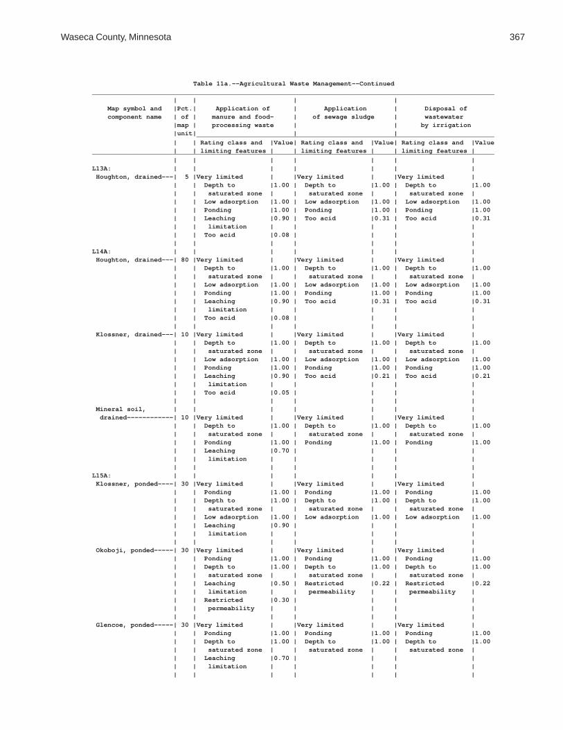
Waseca County, Minnesota 367
Table 11a.--Agricultural Waste Management--Continued________________________________________________________________________________________________________ | | | | Map symbol and |Pct.| Application of | Application | Disposal of component name | of | manure and food- | of sewage sludge | wastewater |map | processing waste | | by irrigation |unit| | | _____________________________________________________________________________ | | Rating class and |Value| Rating class and |Value| Rating class and |Value | | limiting features | | limiting features | | limiting features |________________________________________________________________________________________________________ | | | | | | |L13A: | | | | | | | Houghton, drained---| 5 |Very limited | |Very limited | |Very limited | | | Depth to |1.00 | Depth to |1.00 | Depth to |1.00 | | saturated zone | | saturated zone | | saturated zone | | | Low adsorption |1.00 | Low adsorption |1.00 | Low adsorption |1.00 | | Ponding |1.00 | Ponding |1.00 | Ponding |1.00 | | Leaching |0.90 | Too acid |0.31 | Too acid |0.31 | | limitation | | | | | | | Too acid |0.08 | | | | | | | | | | |L14A: | | | | | | | Houghton, drained---| 80 |Very limited | |Very limited | |Very limited | | | Depth to |1.00 | Depth to |1.00 | Depth to |1.00 | | saturated zone | | saturated zone | | saturated zone | | | Low adsorption |1.00 | Low adsorption |1.00 | Low adsorption |1.00 | | Ponding |1.00 | Ponding |1.00 | Ponding |1.00 | | Leaching |0.90 | Too acid |0.31 | Too acid |0.31 | | limitation | | | | | | | Too acid |0.08 | | | | | | | | | | | Klossner, drained---| 10 |Very limited | |Very limited | |Very limited | | | Depth to |1.00 | Depth to |1.00 | Depth to |1.00 | | saturated zone | | saturated zone | | saturated zone | | | Low adsorption |1.00 | Low adsorption |1.00 | Low adsorption |1.00 | | Ponding |1.00 | Ponding |1.00 | Ponding |1.00 | | Leaching |0.90 | Too acid |0.21 | Too acid |0.21 | | limitation | | | | | | | Too acid |0.05 | | | | | | | | | | | Mineral soil, | | | | | | | drained------------| 10 |Very limited | |Very limited | |Very limited | | | Depth to |1.00 | Depth to |1.00 | Depth to |1.00 | | saturated zone | | saturated zone | | saturated zone | | | Ponding |1.00 | Ponding |1.00 | Ponding |1.00 | | Leaching |0.70 | | | | | | limitation | | | | | | | | | | | |L15A: | | | | | | | Klossner, ponded----| 30 |Very limited | |Very limited | |Very limited | | | Ponding |1.00 | Ponding |1.00 | Ponding |1.00 | | Depth to |1.00 | Depth to |1.00 | Depth to |1.00 | | saturated zone | | saturated zone | | saturated zone | | | Low adsorption |1.00 | Low adsorption |1.00 | Low adsorption |1.00 | | Leaching |0.90 | | | | | | limitation | | | | | | | | | | | | Okoboji, ponded-----| 30 |Very limited | |Very limited | |Very limited | | | Ponding |1.00 | Ponding |1.00 | Ponding |1.00 | | Depth to |1.00 | Depth to |1.00 | Depth to |1.00 | | saturated zone | | saturated zone | | saturated zone | | | Leaching |0.50 | Restricted |0.22 | Restricted |0.22 | | limitation | | permeability | | permeability | | | Restricted |0.30 | | | | | | permeability | | | | | | | | | | | | Glencoe, ponded-----| 30 |Very limited | |Very limited | |Very limited | | | Ponding |1.00 | Ponding |1.00 | Ponding |1.00 | | Depth to |1.00 | Depth to |1.00 | Depth to |1.00 | | saturated zone | | saturated zone | | saturated zone | | | Leaching |0.70 | | | | | | limitation | | | | | | | | | | | |

368 Soil Survey of
Table 11a.--Agricultural Waste Management--Continued________________________________________________________________________________________________________ | | | | Map symbol and |Pct.| Application of | Application | Disposal of component name | of | manure and food- | of sewage sludge | wastewater |map | processing waste | | by irrigation |unit| | | _____________________________________________________________________________ | | Rating class and |Value| Rating class and |Value| Rating class and |Value | | limiting features | | limiting features | | limiting features |________________________________________________________________________________________________________ | | | | | | |L15A: | | | | | | | Houghton, ponded----| 10 |Very limited | |Very limited | |Very limited | | | Ponding |1.00 | Ponding |1.00 | Ponding |1.00 | | Depth to |1.00 | Depth to |1.00 | Depth to |1.00 | | saturated zone | | saturated zone | | saturated zone | | | Low adsorption |1.00 | Low adsorption |1.00 | Low adsorption |1.00 | | Leaching |0.90 | | | | | | limitation | | | | | | | | | | | |L16A: | | | | | | | Muskego, ponded-----| 30 |Very limited | |Very limited | |Very limited | | | Ponding |1.00 | Ponding |1.00 | Ponding |1.00 | | Depth to |1.00 | Depth to |1.00 | Depth to |1.00 | | saturated zone | | saturated zone | | saturated zone | | | Low adsorption |1.00 | Low adsorption |1.00 | Low adsorption |1.00 | | Restricted |1.00 | Restricted |1.00 | Restricted |1.00 | | permeability | | permeability | | permeability | | | Leaching |0.90 | | | | | | limitation | | | | | | | | | | | | Blue Earth, ponded--| 30 |Very limited | |Very limited | |Very limited | | | Ponding |1.00 | Ponding |1.00 | Ponding |1.00 | | Depth to |1.00 | Depth to |1.00 | Depth to |1.00 | | saturated zone | | saturated zone | | saturated zone | | | Leaching |0.70 | | | | | | limitation | | | | | | | | | | | | Houghton, ponded----| 30 |Very limited | |Very limited | |Very limited | | | Ponding |1.00 | Ponding |1.00 | Ponding |1.00 | | Depth to |1.00 | Depth to |1.00 | Depth to |1.00 | | saturated zone | | saturated zone | | saturated zone | | | Low adsorption |1.00 | Low adsorption |1.00 | Low adsorption |1.00 | | Leaching |0.90 | | | | | | limitation | | | | | | | | | | | | Klossner, ponded----| 10 |Very limited | |Very limited | |Very limited | | | Ponding |1.00 | Ponding |1.00 | Ponding |1.00 | | Depth to |1.00 | Depth to |1.00 | Depth to |1.00 | | saturated zone | | saturated zone | | saturated zone | | | Low adsorption |1.00 | Low adsorption |1.00 | Low adsorption |1.00 | | Leaching |0.90 | | | | | | limitation | | | | | | | | | | | |L26B: | | | | | | | Shorewood-----------| 90 |Very limited | |Very limited | |Very limited | | | Depth to |1.00 | Depth to |1.00 | Depth to |1.00 | | saturated zone | | saturated zone | | saturated zone | | | Restricted |0.89 | Restricted |0.78 | Restricted |0.78 | | permeability | | permeability | | permeability | | | | | | | Too steep for |0.08 | | | | | | surface | | | | | | | application | | | | | | | | Good Thunder--------| 5 |Somewhat limited | |Somewhat limited | |Somewhat limited | | | Depth to |0.87 | Depth to |0.87 | Depth to |0.87 | | saturated zone | | saturated zone | | saturated zone | | | Restricted |0.74 | Restricted |0.60 | Restricted |0.60 | | permeability | | permeability | | permeability | | | | | | | |

Waseca County, Minnesota 369
Table 11a.--Agricultural Waste Management--Continued________________________________________________________________________________________________________ | | | | Map symbol and |Pct.| Application of | Application | Disposal of component name | of | manure and food- | of sewage sludge | wastewater |map | processing waste | | by irrigation |unit| | | _____________________________________________________________________________ | | Rating class and |Value| Rating class and |Value| Rating class and |Value | | limiting features | | limiting features | | limiting features |________________________________________________________________________________________________________ | | | | | | |L26B: | | | | | | | Minnetonka----------| 5 |Very limited | |Very limited | |Very limited | | | Depth to |1.00 | Depth to |1.00 | Depth to |1.00 | | saturated zone | | saturated zone | | saturated zone | | | Restricted |1.00 | Restricted |1.00 | Restricted |1.00 | | permeability | | permeability | | permeability | | | Leaching |0.50 | Too acid |0.07 | Too acid |0.07 | | limitation | | | | | | | Too acid |0.02 | | | | | | | | | | |L36A: | | | | | | | Hamel, overwash-----| 50 |Very limited | |Very limited | |Very limited | | | Depth to |1.00 | Depth to |1.00 | Depth to |1.00 | | saturated zone | | saturated zone | | saturated zone | | | Restricted |0.41 | Restricted |0.31 | Restricted |0.31 | | permeability | | permeability | | permeability | | | | | | | | Hamel---------------| 43 |Very limited | |Very limited | |Very limited | | | Depth to |1.00 | Depth to |1.00 | Depth to |1.00 | | saturated zone | | saturated zone | | saturated zone | | | Leaching |0.70 | Restricted |0.31 | Restricted |0.31 | | limitation | | permeability | | permeability | | | Restricted |0.41 | | | | | | permeability | | | | | | | | | | | | Terril--------------| 5 |Somewhat limited | |Somewhat limited | |Somewhat limited | | | Depth to |0.05 | Depth to |0.05 | Depth to |0.05 | | saturated zone | | saturated zone | | saturated zone | | | | | | | | Glencoe-------------| 2 |Very limited | |Very limited | |Very limited | | | Depth to |1.00 | Depth to |1.00 | Depth to |1.00 | | saturated zone | | saturated zone | | saturated zone | | | Ponding |1.00 | Ponding |1.00 | Ponding |1.00 | | Leaching |0.70 | | | | | | limitation | | | | | | | | | | | |L40B: | | | | | | | Angus---------------| 45 |Somewhat limited | |Somewhat limited | |Somewhat limited | | | Depth to |0.05 | Depth to |0.05 | Too steep for |0.08 | | saturated zone | | saturated zone | | surface | | | | | | | application | | | | | | | Depth to |0.05 | | | | | | saturated zone | | | | | | | | Kilkenny------------| 40 |Very limited | |Very limited | |Very limited | | | Depth to |1.00 | Depth to |1.00 | Depth to |1.00 | | saturated zone | | saturated zone | | saturated zone | | | Restricted |0.41 | Restricted |0.31 | Restricted |0.31 | | permeability | | permeability | | permeability | | | Too acid |0.05 | Too acid |0.21 | Too acid |0.21 | | | | | | | Lerdal--------------| 10 |Very limited | |Very limited | |Very limited | | | Depth to |1.00 | Depth to |1.00 | Depth to |1.00 | | saturated zone | | saturated zone | | saturated zone | | | Restricted |1.00 | Restricted |1.00 | Restricted |1.00 | | permeability | | permeability | | permeability | | | Too acid |0.03 | Too acid |0.14 | Too acid |0.14 | | | | | | |

370 Soil Survey of
Table 11a.--Agricultural Waste Management--Continued________________________________________________________________________________________________________ | | | | Map symbol and |Pct.| Application of | Application | Disposal of component name | of | manure and food- | of sewage sludge | wastewater |map | processing waste | | by irrigation |unit| | | _____________________________________________________________________________ | | Rating class and |Value| Rating class and |Value| Rating class and |Value | | limiting features | | limiting features | | limiting features |________________________________________________________________________________________________________ | | | | | | |L40B: | | | | | | | Mazaska-------------| 5 |Very limited | |Very limited | |Very limited | | | Depth to |1.00 | Depth to |1.00 | Depth to |1.00 | | saturated zone | | saturated zone | | saturated zone | | | Restricted |1.00 | Restricted |1.00 | Restricted |1.00 | | permeability | | permeability | | permeability | | | Leaching |0.50 | | | | | | limitation | | | | | | | | | | | |L41C2: | | | | | | | Lester, eroded------| 45 |Somewhat limited | |Somewhat limited | |Very limited | | | Slope |0.04 | Slope |0.04 | Too steep for |1.00 | | | | | | surface | | | | | | | application | | | | | | | Too steep for |0.22 | | | | | | sprinkler | | | | | | | application | | | | | | | | Kilkenny, eroded----| 40 |Somewhat limited | |Somewhat limited | |Very limited | | | Depth to |0.86 | Depth to |0.86 | Too steep for |1.00 | | saturated zone | | saturated zone | | surface | | | Restricted |0.41 | Restricted |0.31 | application | | | permeability | | permeability | | Depth to |0.86 | | Too acid |0.05 | Too acid |0.21 | saturated zone | | | Slope |0.04 | Slope |0.04 | Restricted |0.31 | | | | | | permeability | | | | | | | Too steep for |0.22 | | | | | | sprinkler | | | | | | | application | | | | | | | Too acid |0.21 | | | | | | | Terril--------------| 10 |Somewhat limited | |Somewhat limited | |Somewhat limited | | | Depth to |0.05 | Depth to |0.05 | Depth to |0.05 | | saturated zone | | saturated zone | | saturated zone | | | | | | | | Derrynane-----------| 5 |Very limited | |Very limited | |Very limited | | | Depth to |1.00 | Depth to |1.00 | Depth to |1.00 | | saturated zone | | saturated zone | | saturated zone | | | Restricted |0.74 | Restricted |0.60 | Restricted |0.60 | | permeability | | permeability | | permeability | | | Leaching |0.50 | | | | | | limitation | | | | | | | | | | | |L41D2: | | | | | | | Lester, eroded------| 45 |Very limited | |Very limited | |Very limited | | | Slope |1.00 | Slope |1.00 | Too steep for |1.00 | | | | | | surface | | | | | | | application | | | | | | | Too steep for |1.00 | | | | | | sprinkler | | | | | | | application | | | | | | | |

Waseca County, Minnesota 371
Table 11a.--Agricultural Waste Management--Continued________________________________________________________________________________________________________ | | | | Map symbol and |Pct.| Application of | Application | Disposal of component name | of | manure and food- | of sewage sludge | wastewater |map | processing waste | | by irrigation |unit| | | _____________________________________________________________________________ | | Rating class and |Value| Rating class and |Value| Rating class and |Value | | limiting features | | limiting features | | limiting features |________________________________________________________________________________________________________ | | | | | | |L41D2: | | | | | | | Kilkenny, eroded----| 35 |Very limited | |Very limited | |Very limited | | | Slope |1.00 | Slope |1.00 | Too steep for |1.00 | | Depth to |0.86 | Depth to |0.86 | surface | | | saturated zone | | saturated zone | | application | | | Restricted |0.41 | Restricted |0.31 | Too steep for |1.00 | | permeability | | permeability | | sprinkler | | | Too acid |0.05 | Too acid |0.21 | application | | | | | | | Depth to |0.86 | | | | | | saturated zone | | | | | | | Restricted |0.31 | | | | | | permeability | | | | | | | Too acid |0.21 | | | | | | | Terril--------------| 10 |Somewhat limited | |Somewhat limited | |Somewhat limited | | | Depth to |0.05 | Depth to |0.05 | Depth to |0.05 | | saturated zone | | saturated zone | | saturated zone | | | | | | | | Derrynane-----------| 5 |Very limited | |Very limited | |Very limited | | | Depth to |1.00 | Depth to |1.00 | Depth to |1.00 | | saturated zone | | saturated zone | | saturated zone | | | Restricted |0.74 | Restricted |0.60 | Restricted |0.60 | | permeability | | permeability | | permeability | | | Leaching |0.50 | | | | | | limitation | | | | | | | | | | | | Ridgeton------------| 5 |Somewhat limited | |Somewhat limited | |Very limited | | | Slope |0.16 | Slope |0.16 | Too steep for |1.00 | | | | | | surface | | | | | | | application | | | | | | | Too steep for |0.40 | | | | | | sprinkler | | | | | | | application | | | | | | | |L41E: | | | | | | | Lester--------------| 45 |Very limited | |Very limited | |Very limited | | | Slope |1.00 | Slope |1.00 | Too steep for |1.00 | | | | | | surface | | | | | | | application | | | | | | | Too steep for |1.00 | | | | | | sprinkler | | | | | | | application | | | | | | | | Kilkenny------------| 40 |Very limited | |Very limited | |Very limited | | | Slope |1.00 | Slope |1.00 | Too steep for |1.00 | | Depth to |0.86 | Depth to |0.86 | surface | | | saturated zone | | saturated zone | | application | | | Restricted |0.41 | Restricted |0.31 | Too steep for |1.00 | | permeability | | permeability | | sprinkler | | | Too acid |0.05 | Too acid |0.21 | application | | | | | | | Depth to |0.86 | | | | | | saturated zone | | | | | | | Restricted |0.31 | | | | | | permeability | | | | | | | Too acid |0.21 | | | | | | | Terril--------------| 5 |Somewhat limited | |Somewhat limited | |Somewhat limited | | | Depth to |0.05 | Depth to |0.05 | Depth to |0.05 | | saturated zone | | saturated zone | | saturated zone | | | | | | | |

372 Soil Survey of
Table 11a.--Agricultural Waste Management--Continued________________________________________________________________________________________________________ | | | | Map symbol and |Pct.| Application of | Application | Disposal of component name | of | manure and food- | of sewage sludge | wastewater |map | processing waste | | by irrigation |unit| | | _____________________________________________________________________________ | | Rating class and |Value| Rating class and |Value| Rating class and |Value | | limiting features | | limiting features | | limiting features |________________________________________________________________________________________________________ | | | | | | |L41E: | | | | | | | Derrynane-----------| 5 |Very limited | |Very limited | |Very limited | | | Depth to |1.00 | Depth to |1.00 | Depth to |1.00 | | saturated zone | | saturated zone | | saturated zone | | | Restricted |0.74 | Restricted |0.60 | Restricted |0.60 | | permeability | | permeability | | permeability | | | Leaching |0.50 | | | | | | limitation | | | | | | | | | | | | Ridgeton------------| 5 |Somewhat limited | |Somewhat limited | |Very limited | | | Slope |0.96 | Slope |0.96 | Too steep for |1.00 | | | | | | surface | | | | | | | application | | | | | | | Too steep for |0.98 | | | | | | sprinkler | | | | | | | application | | | | | | | |L48A: | | | | | | | Derrynane, overwash | 50 |Very limited | |Very limited | |Very limited | | | Depth to |1.00 | Depth to |1.00 | Depth to |1.00 | | saturated zone | | saturated zone | | saturated zone | | | Restricted |0.74 | Restricted |0.60 | Restricted |0.60 | | permeability | | permeability | | permeability | | | Leaching |0.50 | | | | | | limitation | | | | | | | | | | | | Derrynane-----------| 40 |Very limited | |Very limited | |Very limited | | | Depth to |1.00 | Depth to |1.00 | Depth to |1.00 | | saturated zone | | saturated zone | | saturated zone | | | Restricted |0.74 | Restricted |0.60 | Restricted |0.60 | | permeability | | permeability | | permeability | | | Leaching |0.50 | | | | | | limitation | | | | | | | | | | | | Glencoe-------------| 5 |Very limited | |Very limited | |Very limited | | | Depth to |1.00 | Depth to |1.00 | Depth to |1.00 | | saturated zone | | saturated zone | | saturated zone | | | Ponding |1.00 | Ponding |1.00 | Ponding |1.00 | | Leaching |0.70 | | | | | | limitation | | | | | | | | | | | | Terril--------------| 5 |Somewhat limited | |Somewhat limited | |Somewhat limited | | | Depth to |0.05 | Depth to |0.05 | Too steep for |0.08 | | saturated zone | | saturated zone | | surface | | | | | | | application | | | | | | | Depth to |0.05 | | | | | | saturated zone | | | | | | | |L49A: | | | | | | | Klossner, surface | | | | | | | drained------------| 65 |Very limited | |Very limited | |Very limited | | | Depth to |1.00 | Depth to |1.00 | Depth to |1.00 | | saturated zone | | saturated zone | | saturated zone | | | Low adsorption |1.00 | Low adsorption |1.00 | Low adsorption |1.00 | | Ponding |1.00 | Ponding |1.00 | Ponding |1.00 | | Leaching |0.90 | | | | | | limitation | | | | | | | | | | | |

Waseca County, Minnesota 373
Table 11a.--Agricultural Waste Management--Continued________________________________________________________________________________________________________ | | | | Map symbol and |Pct.| Application of | Application | Disposal of component name | of | manure and food- | of sewage sludge | wastewater |map | processing waste | | by irrigation |unit| | | _____________________________________________________________________________ | | Rating class and |Value| Rating class and |Value| Rating class and |Value | | limiting features | | limiting features | | limiting features |________________________________________________________________________________________________________ | | | | | | |L49A: | | | | | | | Klossner, drained---| 20 |Very limited | |Very limited | |Very limited | | | Depth to |1.00 | Depth to |1.00 | Depth to |1.00 | | saturated zone | | saturated zone | | saturated zone | | | Low adsorption |1.00 | Low adsorption |1.00 | Low adsorption |1.00 | | Ponding |1.00 | Ponding |1.00 | Ponding |1.00 | | Leaching |0.90 | Too acid |0.21 | Too acid |0.21 | | limitation | | | | | | | Too acid |0.05 | | | | | | | | | | | Mineral soil, | | | | | | | drained------------| 15 |Very limited | |Very limited | |Very limited | | | Depth to |1.00 | Depth to |1.00 | Depth to |1.00 | | saturated zone | | saturated zone | | saturated zone | | | Ponding |1.00 | Ponding |1.00 | Ponding |1.00 | | Leaching |0.70 | | | | | | limitation | | | | | | | | | | | |L50A: | | | | | | | Houghton, surface | | | | | | | drained------------| 40 |Very limited | |Very limited | |Very limited | | | Depth to |1.00 | Depth to |1.00 | Depth to |1.00 | | saturated zone | | saturated zone | | saturated zone | | | Low adsorption |1.00 | Low adsorption |1.00 | Low adsorption |1.00 | | Ponding |1.00 | Ponding |1.00 | Ponding |1.00 | | Leaching |0.90 | | | | | | limitation | | | | | | | | | | | | Muskego, surface | | | | | | | drained------------| 40 |Very limited | |Very limited | |Very limited | | | Depth to |1.00 | Depth to |1.00 | Depth to |1.00 | | saturated zone | | saturated zone | | saturated zone | | | Low adsorption |1.00 | Low adsorption |1.00 | Low adsorption |1.00 | | Restricted |1.00 | Restricted |1.00 | Restricted |1.00 | | permeability | | permeability | | permeability | | | Ponding |1.00 | Ponding |1.00 | Ponding |1.00 | | Leaching |0.90 | | | | | | limitation | | | | | | | | | | | | Klossner, drained---| 10 |Very limited | |Very limited | |Very limited | | | Depth to |1.00 | Depth to |1.00 | Depth to |1.00 | | saturated zone | | saturated zone | | saturated zone | | | Low adsorption |1.00 | Low adsorption |1.00 | Low adsorption |1.00 | | Ponding |1.00 | Ponding |1.00 | Ponding |1.00 | | Leaching |0.90 | Too acid |0.21 | Too acid |0.21 | | limitation | | | | | | | Too acid |0.05 | | | | | | | | | | | Mineral soil, | | | | | | | drained------------| 10 |Very limited | |Very limited | |Very limited | | | Depth to |1.00 | Depth to |1.00 | Depth to |1.00 | | saturated zone | | saturated zone | | saturated zone | | | Ponding |1.00 | Ponding |1.00 | Ponding |1.00 | | Leaching |0.70 | | | | | | limitation | | | | | | | | | | | |

374 Soil Survey of
Table 11a.--Agricultural Waste Management--Continued________________________________________________________________________________________________________ | | | | Map symbol and |Pct.| Application of | Application | Disposal of component name | of | manure and food- | of sewage sludge | wastewater |map | processing waste | | by irrigation |unit| | | _____________________________________________________________________________ | | Rating class and |Value| Rating class and |Value| Rating class and |Value | | limiting features | | limiting features | | limiting features |________________________________________________________________________________________________________ | | | | | | |L51C2: | | | | | | | Gladek, eroded------| 80 |Somewhat limited | |Somewhat limited | |Very limited | | | Slope |0.04 | Slope |0.04 | Too steep for |1.00 | | | | | | surface | | | | | | | application | | | | | | | Too steep for |0.22 | | | | | | sprinkler | | | | | | | application | | | | | | | | Barrington----------| 10 |Somewhat limited | |Somewhat limited | |Somewhat limited | | | Depth to |0.87 | Depth to |0.87 | Depth to |0.87 | | saturated zone | | saturated zone | | saturated zone | | | | | | | Too steep for |0.08 | | | | | | surface | | | | | | | application | | | | | | | | Lester, eroded------| 5 |Somewhat limited | |Somewhat limited | |Very limited | | | Slope |0.04 | Slope |0.04 | Too steep for |1.00 | | Too acid |0.01 | Too acid |0.01 | surface | | | | | | | application | | | | | | | Too steep for |0.22 | | | | | | sprinkler | | | | | | | application | | | | | | | Too acid |0.01 | | | | | | | Madelia-------------| 5 |Very limited | |Very limited | |Very limited | | | Depth to |1.00 | Depth to |1.00 | Depth to |1.00 | | saturated zone | | saturated zone | | saturated zone | | | Leaching |0.70 | | | | | | limitation | | | | | | | | | | | |L56A: | | | | | | | Muskego, frequently | | | | | | | flooded------------| 45 |Very limited | |Very limited | |Very limited | | | Depth to |1.00 | Depth to |1.00 | Depth to |1.00 | | saturated zone | | saturated zone | | saturated zone | | | Flooding |1.00 | Flooding |1.00 | Low adsorption |1.00 | | Low adsorption |1.00 | Low adsorption |1.00 | Flooding |1.00 | | Restricted |1.00 | Restricted |1.00 | Restricted |1.00 | | permeability | | permeability | | permeability | | | Ponding |1.00 | Ponding |1.00 | Ponding |1.00 | | | | | | | Klossner, frequently| | | | | | | flooded------------| 45 |Very limited | |Very limited | |Very limited | | | Depth to |1.00 | Depth to |1.00 | Depth to |1.00 | | saturated zone | | saturated zone | | saturated zone | | | Flooding |1.00 | Flooding |1.00 | Low adsorption |1.00 | | Low adsorption |1.00 | Low adsorption |1.00 | Flooding |1.00 | | Ponding |1.00 | Ponding |1.00 | Ponding |1.00 | | Runoff |0.40 | | | | | | | | | | | Suckercreek, | | | | | | | frequently flooded | 10 |Very limited | |Very limited | |Very limited | | | Depth to |1.00 | Depth to |1.00 | Depth to |1.00 | | saturated zone | | saturated zone | | saturated zone | | | Flooding |1.00 | Flooding |1.00 | Flooding |1.00 | | Runoff |0.40 | Filtering |0.01 | Filtering |0.01 | | Filtering |0.01 | capacity | | capacity | | | capacity | | | | | | | | | | | |

Waseca County, Minnesota 375
Table 11a.--Agricultural Waste Management--Continued________________________________________________________________________________________________________ | | | | Map symbol and |Pct.| Application of | Application | Disposal of component name | of | manure and food- | of sewage sludge | wastewater |map | processing waste | | by irrigation |unit| | | _____________________________________________________________________________ | | Rating class and |Value| Rating class and |Value| Rating class and |Value | | limiting features | | limiting features | | limiting features |________________________________________________________________________________________________________ | | | | | | |L57A: | | | | | | | Medo, drained-------| 80 |Not rated | |Not rated | |Not rated | | | | | | | | Mineral soil, | | | | | | | drained------------| 15 |Very limited | |Very limited | |Very limited | | | Filtering |1.00 | Filtering |1.00 | Filtering |1.00 | | capacity | | capacity | | capacity | | | Depth to |1.00 | Depth to |1.00 | Depth to |1.00 | | saturated zone | | saturated zone | | saturated zone | | | Ponding |1.00 | Ponding |1.00 | Ponding |1.00 | | Leaching |0.70 | | | | | | limitation | | | | | | | | | | | | Houghton, drained---| 5 |Very limited | |Very limited | |Very limited | | | Depth to |1.00 | Depth to |1.00 | Depth to |1.00 | | saturated zone | | saturated zone | | saturated zone | | | Low adsorption |1.00 | Low adsorption |1.00 | Low adsorption |1.00 | | Ponding |1.00 | Ponding |1.00 | Ponding |1.00 | | Leaching |0.90 | Too acid |0.31 | Too acid |0.31 | | limitation | | | | | | | Too acid |0.08 | | | | | | | | | | |L63A: | | | | | | | Klossner------------| 85 |Very limited | |Very limited | |Very limited | | | Depth to |1.00 | Depth to |1.00 | Depth to |1.00 | | saturated zone | | saturated zone | | saturated zone | | | Low adsorption |1.00 | Low adsorption |1.00 | Low adsorption |1.00 | | Ponding |1.00 | Ponding |1.00 | Ponding |1.00 | | Leaching |0.90 | | | | | | limitation | | | | | | | | | | | | Lura----------------| 10 |Very limited | |Very limited | |Very limited | | | Restricted |1.00 | Restricted |1.00 | Restricted |1.00 | | permeability | | permeability | | permeability | | | Depth to |1.00 | Depth to |1.00 | Depth to |1.00 | | saturated zone | | saturated zone | | saturated zone | | | Ponding |1.00 | Ponding |1.00 | Ponding |1.00 | | Leaching |0.50 | | | | | | limitation | | | | | | | | | | | | Brownton------------| 5 |Very limited | |Very limited | |Very limited | | | Restricted |1.00 | Restricted |1.00 | Restricted |1.00 | | permeability | | permeability | | permeability | | | Depth to |1.00 | Depth to |1.00 | Depth to |1.00 | | saturated zone | | saturated zone | | saturated zone | | | Leaching |0.50 | | | | | | limitation | | | | | | | | | | | |L64A: | | | | | | | Tadkee--------------| 50 |Very limited | |Very limited | |Very limited | | | Filtering |1.00 | Filtering |1.00 | Filtering |1.00 | | capacity | | capacity | | capacity | | | Depth to |1.00 | Depth to |1.00 | Depth to |1.00 | | saturated zone | | saturated zone | | saturated zone | | | Leaching |0.70 | | | | | | limitation | | | | | | | | | | | |

376 Soil Survey of
Table 11a.--Agricultural Waste Management--Continued________________________________________________________________________________________________________ | | | | Map symbol and |Pct.| Application of | Application | Disposal of component name | of | manure and food- | of sewage sludge | wastewater |map | processing waste | | by irrigation |unit| | | _____________________________________________________________________________ | | Rating class and |Value| Rating class and |Value| Rating class and |Value | | limiting features | | limiting features | | limiting features |________________________________________________________________________________________________________ | | | | | | |L64A: | | | | | | | Tadkee, depressional| 36 |Very limited | |Very limited | |Very limited | | | Filtering |1.00 | Filtering |1.00 | Filtering |1.00 | | capacity | | capacity | | capacity | | | Depth to |1.00 | Depth to |1.00 | Depth to |1.00 | | saturated zone | | saturated zone | | saturated zone | | | Ponding |1.00 | Ponding |1.00 | Ponding |1.00 | | Leaching |0.70 | | | | | | limitation | | | | | | | | | | | | Better drained soil | 8 |Very limited | |Very limited | |Very limited | | | Filtering |1.00 | Filtering |1.00 | Filtering |1.00 | | capacity | | capacity | | capacity | | | Depth to |0.87 | Depth to |0.87 | Depth to |0.87 | | saturated zone | | saturated zone | | saturated zone | | | | | | | | Granby--------------| 4 |Very limited | |Very limited | |Very limited | | | Filtering |1.00 | Filtering |1.00 | Filtering |1.00 | | capacity | | capacity | | capacity | | | Depth to |1.00 | Depth to |1.00 | Depth to |1.00 | | saturated zone | | saturated zone | | saturated zone | | | Ponding |1.00 | Ponding |1.00 | Ponding |1.00 | | Leaching |0.90 | Droughty |0.23 | Droughty |0.23 | | limitation | | | | | | | Droughty |0.23 | | | | | | | | | | | Less sandy soil-----| 2 |Very limited | |Very limited | |Very limited | | | Filtering |1.00 | Filtering |1.00 | Filtering |1.00 | | capacity | | capacity | | capacity | | | Depth to |1.00 | Depth to |1.00 | Depth to |1.00 | | saturated zone | | saturated zone | | saturated zone | | | Leaching |0.70 | | | | | | limitation | | | | | | | | | | | |L73A: | | | | | | | Blue Earth----------| 80 |Very limited | |Very limited | |Very limited | | | Depth to |1.00 | Depth to |1.00 | Depth to |1.00 | | saturated zone | | saturated zone | | saturated zone | | | Ponding |1.00 | Ponding |1.00 | Ponding |1.00 | | Leaching |0.70 | | | | | | limitation | | | | | | | | | | | | Belleville----------| 10 |Very limited | |Very limited | |Very limited | | | Filtering |1.00 | Filtering |1.00 | Filtering |1.00 | | capacity | | capacity | | capacity | | | Depth to |1.00 | Depth to |1.00 | Depth to |1.00 | | saturated zone | | saturated zone | | saturated zone | | | Leaching |0.70 | Restricted |0.31 | Restricted |0.31 | | limitation | | permeability | | permeability | | | Restricted |0.41 | | | | | | permeability | | | | | | | | | | | | Canisteo------------| 10 |Very limited | |Very limited | |Very limited | | | Depth to |1.00 | Depth to |1.00 | Depth to |1.00 | | saturated zone | | saturated zone | | saturated zone | | | Leaching |0.70 | | | | | | limitation | | | | | | | | | | | |

Waseca County, Minnesota 377
Table 11a.--Agricultural Waste Management--Continued________________________________________________________________________________________________________ | | | | Map symbol and |Pct.| Application of | Application | Disposal of component name | of | manure and food- | of sewage sludge | wastewater |map | processing waste | | by irrigation |unit| | | _____________________________________________________________________________ | | Rating class and |Value| Rating class and |Value| Rating class and |Value | | limiting features | | limiting features | | limiting features |________________________________________________________________________________________________________ | | | | | | |L74A: | | | | | | | Estherville---------| 87 |Very limited | |Very limited | |Very limited | | | Filtering |1.00 | Filtering |1.00 | Filtering |1.00 | | capacity | | capacity | | capacity | | | Droughty |0.70 | Droughty |0.70 | Droughty |0.70 | | | | | | | Hawick--------------| 10 |Very limited | |Very limited | |Very limited | | | Filtering |1.00 | Filtering |1.00 | Filtering |1.00 | | capacity | | capacity | | capacity | | | Droughty |0.94 | Droughty |0.94 | Droughty |0.94 | | Leaching |0.45 | | | | | | limitation | | | | | | | | | | | | Biscay--------------| 3 |Very limited | |Very limited | |Very limited | | | Depth to |1.00 | Depth to |1.00 | Depth to |1.00 | | saturated zone | | saturated zone | | saturated zone | | | Filtering |1.00 | Filtering |1.00 | Filtering |1.00 | | capacity | | capacity | | capacity | | | Leaching |0.70 | | | | | | limitation | | | | | | | | | | | |L75B: | | | | | | | Barrington----------| 85 |Somewhat limited | |Somewhat limited | |Somewhat limited | | | Depth to |0.87 | Depth to |0.87 | Depth to |0.87 | | saturated zone | | saturated zone | | saturated zone | | | | | | | Too steep for |0.08 | | | | | | surface | | | | | | | application | | | | | | | | Gladek--------------| 10 |Somewhat limited | |Somewhat limited | |Very limited | | | Slope |0.04 | Slope |0.04 | Too steep for |1.00 | | | | | | surface | | | | | | | application | | | | | | | Too steep for |0.22 | | | | | | sprinkler | | | | | | | application | | | | | | | | Madelia-------------| 5 |Very limited | |Very limited | |Very limited | | | Depth to |1.00 | Depth to |1.00 | Depth to |1.00 | | saturated zone | | saturated zone | | saturated zone | | | Leaching |0.70 | | | | | | limitation | | | | | | | | | | | |L76B: | | | | | | | Dickinson-----------| 80 |Very limited | |Very limited | |Very limited | | | Filtering |1.00 | Filtering |1.00 | Filtering |1.00 | | capacity | | capacity | | capacity | | | Too acid |0.01 | Too acid |0.01 | Too steep for |0.08 | | | | | | surface | | | | | | | application | | | | | | | Too acid |0.01 | | | | | | | Litchfield----------| 13 |Very limited | |Very limited | |Very limited | | | Filtering |1.00 | Filtering |1.00 | Filtering |1.00 | | capacity | | capacity | | capacity | | | Depth to |1.00 | Depth to |1.00 | Depth to |1.00 | | saturated zone | | saturated zone | | saturated zone | | | Too acid |0.02 | Too acid |0.07 | Too acid |0.07 | | | | | | |

378 Soil Survey of
Table 11a.--Agricultural Waste Management--Continued________________________________________________________________________________________________________ | | | | Map symbol and |Pct.| Application of | Application | Disposal of component name | of | manure and food- | of sewage sludge | wastewater |map | processing waste | | by irrigation |unit| | | _____________________________________________________________________________ | | Rating class and |Value| Rating class and |Value| Rating class and |Value | | limiting features | | limiting features | | limiting features |________________________________________________________________________________________________________ | | | | | | |L76B: | | | | | | | Darfur--------------| 5 |Very limited | |Very limited | |Very limited | | | Depth to |1.00 | Depth to |1.00 | Depth to |1.00 | | saturated zone | | saturated zone | | saturated zone | | | Leaching |0.70 | | | | | | limitation | | | | | | | | | | | | Clarion-------------| 2 |Somewhat limited | |Somewhat limited | |Somewhat limited | | | Depth to |0.05 | Depth to |0.05 | Too steep for |0.08 | | saturated zone | | saturated zone | | surface | | | | | | | application | | | | | | | Depth to |0.05 | | | | | | saturated zone | | | | | | | |L77A: | | | | | | | Brownton------------| 75 |Very limited | |Very limited | |Very limited | | | Restricted |1.00 | Restricted |1.00 | Restricted |1.00 | | permeability | | permeability | | permeability | | | Depth to |1.00 | Depth to |1.00 | Depth to |1.00 | | saturated zone | | saturated zone | | saturated zone | | | Leaching |0.50 | | | | | | limitation | | | | | | | | | | | | Marna---------------| 15 |Very limited | |Very limited | |Very limited | | | Depth to |1.00 | Depth to |1.00 | Depth to |1.00 | | saturated zone | | saturated zone | | saturated zone | | | Restricted |1.00 | Restricted |1.00 | Restricted |1.00 | | permeability | | permeability | | permeability | | | Leaching |0.50 | | | | | | limitation | | | | | | | | | | | | Lura----------------| 10 |Very limited | |Very limited | |Very limited | | | Restricted |1.00 | Restricted |1.00 | Restricted |1.00 | | permeability | | permeability | | permeability | | | Depth to |1.00 | Depth to |1.00 | Depth to |1.00 | | saturated zone | | saturated zone | | saturated zone | | | Ponding |1.00 | Ponding |1.00 | Ponding |1.00 | | Leaching |0.50 | | | | | | limitation | | | | | | | | | | | |L78A: | | | | | | | Canisteo------------| 65 |Very limited | |Very limited | |Very limited | | | Depth to |1.00 | Depth to |1.00 | Depth to |1.00 | | saturated zone | | saturated zone | | saturated zone | | | Leaching |0.70 | | | | | | limitation | | | | | | | | | | | | Crippin-------------| 10 |Very limited | |Very limited | |Very limited | | | Depth to |1.00 | Depth to |1.00 | Depth to |1.00 | | saturated zone | | saturated zone | | saturated zone | | | | | | | | Glencoe-------------| 10 |Very limited | |Very limited | |Very limited | | | Depth to |1.00 | Depth to |1.00 | Depth to |1.00 | | saturated zone | | saturated zone | | saturated zone | | | Ponding |1.00 | Ponding |1.00 | Ponding |1.00 | | Leaching |0.70 | | | | | | limitation | | | | | | | | | | | |

Waseca County, Minnesota 379
Table 11a.--Agricultural Waste Management--Continued________________________________________________________________________________________________________ | | | | Map symbol and |Pct.| Application of | Application | Disposal of component name | of | manure and food- | of sewage sludge | wastewater |map | processing waste | | by irrigation |unit| | | _____________________________________________________________________________ | | Rating class and |Value| Rating class and |Value| Rating class and |Value | | limiting features | | limiting features | | limiting features |________________________________________________________________________________________________________ | | | | | | |L78A: | | | | | | | Canisteo, | | | | | | | depressional-------| 5 |Very limited | |Very limited | |Very limited | | | Depth to |1.00 | Depth to |1.00 | Depth to |1.00 | | saturated zone | | saturated zone | | saturated zone | | | Leaching |0.70 | | | | | | limitation | | | | | | | | | | | | Harps---------------| 5 |Very limited | |Very limited | |Very limited | | | Depth to |1.00 | Depth to |1.00 | Depth to |1.00 | | saturated zone | | saturated zone | | saturated zone | | | Leaching |0.70 | | | | | | limitation | | | | | | | | | | | | Webster-------------| 5 |Very limited | |Very limited | |Very limited | | | Depth to |1.00 | Depth to |1.00 | Depth to |1.00 | | saturated zone | | saturated zone | | saturated zone | | | Leaching |0.70 | | | | | | limitation | | | | | | | | | | | |L79B: | | | | | | | Clarion-------------| 65 |Somewhat limited | |Somewhat limited | |Somewhat limited | | | Depth to |0.05 | Depth to |0.05 | Too steep for |0.08 | | saturated zone | | saturated zone | | surface | | | | | | | application | | | | | | | Depth to |0.05 | | | | | | saturated zone | | | | | | | | Clarion, eroded-----| 25 |Somewhat limited | |Somewhat limited | |Somewhat limited | | | Depth to |0.05 | Depth to |0.05 | Too steep for |0.08 | | saturated zone | | saturated zone | | surface | | | | | | | application | | | | | | | Depth to |0.05 | | | | | | saturated zone | | | | | | | | Nicollet------------| 8 |Very limited | |Very limited | |Very limited | | | Depth to |1.00 | Depth to |1.00 | Depth to |1.00 | | saturated zone | | saturated zone | | saturated zone | | | | | | | | Webster-------------| 2 |Very limited | |Very limited | |Very limited | | | Depth to |1.00 | Depth to |1.00 | Depth to |1.00 | | saturated zone | | saturated zone | | saturated zone | | | Leaching |0.70 | | | | | | limitation | | | | | | | | | | | |L80C2: | | | | | | | Lester, eroded------| 75 |Somewhat limited | |Somewhat limited | |Very limited | | | Slope |0.04 | Slope |0.04 | Too steep for |1.00 | | Too acid |0.01 | Too acid |0.01 | surface | | | | | | | application | | | | | | | Too steep for |0.22 | | | | | | sprinkler | | | | | | | application | | | | | | | Too acid |0.01 | | | | | | | Terril--------------| 10 |Somewhat limited | |Somewhat limited | |Somewhat limited | | | Depth to |0.05 | Depth to |0.05 | Too steep for |0.32 | | saturated zone | | saturated zone | | surface | | | | | | | application | | | | | | | Depth to |0.05 | | | | | | saturated zone | | | | | | | |

380 Soil Survey of
Table 11a.--Agricultural Waste Management--Continued________________________________________________________________________________________________________ | | | | Map symbol and |Pct.| Application of | Application | Disposal of component name | of | manure and food- | of sewage sludge | wastewater |map | processing waste | | by irrigation |unit| | | _____________________________________________________________________________ | | Rating class and |Value| Rating class and |Value| Rating class and |Value | | limiting features | | limiting features | | limiting features |________________________________________________________________________________________________________ | | | | | | |L80C2: | | | | | | | Hamel---------------| 5 |Very limited | |Very limited | |Very limited | | | Depth to |1.00 | Depth to |1.00 | Depth to |1.00 | | saturated zone | | saturated zone | | saturated zone | | | Leaching |0.70 | Restricted |0.31 | Restricted |0.31 | | limitation | | permeability | | permeability | | | Restricted |0.41 | | | | | | permeability | | | | | | | | | | | | Reedslake-----------| 5 |Somewhat limited | |Somewhat limited | |Somewhat limited | | | Depth to |0.05 | Depth to |0.05 | Too steep for |0.08 | | saturated zone | | saturated zone | | surface | | | | | | | application | | | | | | | Depth to |0.05 | | | | | | saturated zone | | | | | | | | Storden, eroded-----| 5 |Somewhat limited | |Somewhat limited | |Very limited | | | Slope |0.04 | Slope |0.04 | Too steep for |1.00 | | | | | | surface | | | | | | | application | | | | | | | Too steep for |0.22 | | | | | | sprinkler | | | | | | | application | | | | | | | |L80D2: | | | | | | | Lester, eroded------| 75 |Very limited | |Very limited | |Very limited | | | Slope |1.00 | Slope |1.00 | Too steep for |1.00 | | Too acid |0.01 | Too acid |0.01 | surface | | | | | | | application | | | | | | | Too steep for |1.00 | | | | | | sprinkler | | | | | | | application | | | | | | | Too acid |0.01 | | | | | | | Ridgeton------------| 10 |Somewhat limited | |Somewhat limited | |Very limited | | | Slope |0.63 | Slope |0.63 | Too steep for |1.00 | | | | | | surface | | | | | | | application | | | | | | | Too steep for |0.78 | | | | | | sprinkler | | | | | | | application | | | | | | | | Storden, eroded-----| 8 |Very limited | |Very limited | |Very limited | | | Slope |1.00 | Slope |1.00 | Too steep for |1.00 | | | | | | surface | | | | | | | application | | | | | | | Too steep for |1.00 | | | | | | sprinkler | | | | | | | application | | | | | | | | Terril--------------| 5 |Somewhat limited | |Somewhat limited | |Somewhat limited | | | Depth to |0.05 | Depth to |0.05 | Too steep for |0.32 | | saturated zone | | saturated zone | | surface | | | | | | | application | | | | | | | Depth to |0.05 | | | | | | saturated zone | | | | | | | |

Waseca County, Minnesota 381
Table 11a.--Agricultural Waste Management--Continued________________________________________________________________________________________________________ | | | | Map symbol and |Pct.| Application of | Application | Disposal of component name | of | manure and food- | of sewage sludge | wastewater |map | processing waste | | by irrigation |unit| | | _____________________________________________________________________________ | | Rating class and |Value| Rating class and |Value| Rating class and |Value | | limiting features | | limiting features | | limiting features |________________________________________________________________________________________________________ | | | | | | |L80D2: | | | | | | | Hamel---------------| 2 |Very limited | |Very limited | |Very limited | | | Depth to |1.00 | Depth to |1.00 | Depth to |1.00 | | saturated zone | | saturated zone | | saturated zone | | | Leaching |0.70 | Restricted |0.31 | Restricted |0.31 | | limitation | | permeability | | permeability | | | Restricted |0.41 | | | | | | permeability | | | | | | | | | | | |L81A: | | | | | | | Cordova-------------| 85 |Very limited | |Very limited | |Very limited | | | Depth to |1.00 | Depth to |1.00 | Depth to |1.00 | | saturated zone | | saturated zone | | saturated zone | | | Leaching |0.70 | Restricted |0.31 | Restricted |0.31 | | limitation | | permeability | | permeability | | | Restricted |0.41 | | | | | | permeability | | | | | | | | | | | | Le Sueur------------| 10 |Very limited | |Very limited | |Very limited | | | Depth to |1.00 | Depth to |1.00 | Depth to |1.00 | | saturated zone | | saturated zone | | saturated zone | | | Too acid |0.01 | Too acid |0.01 | Too acid |0.01 | | | | | | | Rolfe---------------| 5 |Very limited | |Very limited | |Very limited | | | Depth to |1.00 | Depth to |1.00 | Depth to |1.00 | | saturated zone | | saturated zone | | saturated zone | | | Restricted |1.00 | Restricted |1.00 | Restricted |1.00 | | permeability | | permeability | | permeability | | | Ponding |1.00 | Ponding |1.00 | Ponding |1.00 | | Leaching |0.50 | Too acid |0.07 | Too acid |0.07 | | limitation | | | | | | | Too acid |0.02 | | | | | | | | | | |L82A: | | | | | | | Marna---------------| 85 |Very limited | |Very limited | |Very limited | | | Depth to |1.00 | Depth to |1.00 | Depth to |1.00 | | saturated zone | | saturated zone | | saturated zone | | | Restricted |1.00 | Restricted |1.00 | Restricted |1.00 | | permeability | | permeability | | permeability | | | Leaching |0.50 | | | | | | limitation | | | | | | | | | | | | Barbert-------------| 10 |Very limited | |Very limited | |Very limited | | | Restricted |1.00 | Restricted |1.00 | Restricted |1.00 | | permeability | | permeability | | permeability | | | Depth to |1.00 | Depth to |1.00 | Depth to |1.00 | | saturated zone | | saturated zone | | saturated zone | | | Ponding |1.00 | Ponding |1.00 | Ponding |1.00 | | Leaching |0.50 | Too acid |0.42 | Too acid |0.42 | | limitation | | | | | | | Too acid |0.11 | | | | | | | | | | | Guckeen-------------| 5 |Very limited | |Very limited | |Very limited | | | Depth to |1.00 | Depth to |1.00 | Depth to |1.00 | | saturated zone | | saturated zone | | saturated zone | | | Restricted |0.74 | Restricted |0.60 | Restricted |0.60 | | permeability | | permeability | | permeability | | | | | | | |

382 Soil Survey of
Table 11a.--Agricultural Waste Management--Continued________________________________________________________________________________________________________ | | | | Map symbol and |Pct.| Application of | Application | Disposal of component name | of | manure and food- | of sewage sludge | wastewater |map | processing waste | | by irrigation |unit| | | _____________________________________________________________________________ | | Rating class and |Value| Rating class and |Value| Rating class and |Value | | limiting features | | limiting features | | limiting features |________________________________________________________________________________________________________ | | | | | | |L83A: | | | | | | | Webster-------------| 65 |Very limited | |Very limited | |Very limited | | | Depth to |1.00 | Depth to |1.00 | Depth to |1.00 | | saturated zone | | saturated zone | | saturated zone | | | Leaching |0.70 | | | | | | limitation | | | | | | | | | | | | Glencoe-------------| 15 |Very limited | |Very limited | |Very limited | | | Depth to |1.00 | Depth to |1.00 | Depth to |1.00 | | saturated zone | | saturated zone | | saturated zone | | | Ponding |1.00 | Ponding |1.00 | Ponding |1.00 | | Leaching |0.70 | | | | | | limitation | | | | | | | | | | | | Canisteo------------| 10 |Very limited | |Very limited | |Very limited | | | Depth to |1.00 | Depth to |1.00 | Depth to |1.00 | | saturated zone | | saturated zone | | saturated zone | | | Leaching |0.70 | | | | | | limitation | | | | | | | | | | | | Nicollet------------| 10 |Very limited | |Very limited | |Very limited | | | Depth to |1.00 | Depth to |1.00 | Depth to |1.00 | | saturated zone | | saturated zone | | saturated zone | | | | | | | |L84A: | | | | | | | Glencoe-------------| 80 |Very limited | |Very limited | |Very limited | | | Depth to |1.00 | Depth to |1.00 | Depth to |1.00 | | saturated zone | | saturated zone | | saturated zone | | | Ponding |1.00 | Ponding |1.00 | Ponding |1.00 | | Leaching |0.70 | | | | | | limitation | | | | | | | | | | | | Very poorly drained | | | | | | | muck---------------| 10 |Very limited | |Very limited | |Very limited | | | Depth to |1.00 | Depth to |1.00 | Depth to |1.00 | | saturated zone | | saturated zone | | saturated zone | | | Low adsorption |1.00 | Low adsorption |1.00 | Low adsorption |1.00 | | Ponding |1.00 | Ponding |1.00 | Ponding |1.00 | | Leaching |0.90 | | | | | | limitation | | | | | | | | | | | | Canisteo------------| 5 |Very limited | |Very limited | |Very limited | | | Depth to |1.00 | Depth to |1.00 | Depth to |1.00 | | saturated zone | | saturated zone | | saturated zone | | | Leaching |0.70 | | | | | | limitation | | | | | | | | | | | | Harps---------------| 5 |Very limited | |Very limited | |Very limited | | | Depth to |1.00 | Depth to |1.00 | Depth to |1.00 | | saturated zone | | saturated zone | | saturated zone | | | Leaching |0.70 | | | | | | limitation | | | | | | | | | | | |L85A: | | | | | | | Nicollet------------| 85 |Very limited | |Very limited | |Very limited | | | Depth to |1.00 | Depth to |1.00 | Depth to |1.00 | | saturated zone | | saturated zone | | saturated zone | | | | | | | |

Waseca County, Minnesota 383
Table 11a.--Agricultural Waste Management--Continued________________________________________________________________________________________________________ | | | | Map symbol and |Pct.| Application of | Application | Disposal of component name | of | manure and food- | of sewage sludge | wastewater |map | processing waste | | by irrigation |unit| | | _____________________________________________________________________________ | | Rating class and |Value| Rating class and |Value| Rating class and |Value | | limiting features | | limiting features | | limiting features |________________________________________________________________________________________________________ | | | | | | |L85A: | | | | | | | Clarion-------------| 10 |Somewhat limited | |Somewhat limited | |Somewhat limited | | | Depth to |0.05 | Depth to |0.05 | Too steep for |0.08 | | saturated zone | | saturated zone | | surface | | | | | | | application | | | | | | | Depth to |0.05 | | | | | | saturated zone | | | | | | | | Webster-------------| 5 |Very limited | |Very limited | |Very limited | | | Depth to |1.00 | Depth to |1.00 | Depth to |1.00 | | saturated zone | | saturated zone | | saturated zone | | | Leaching |0.70 | | | | | | limitation | | | | | | | | | | | |L86A: | | | | | | | Madelia-------------| 90 |Very limited | |Very limited | |Very limited | | | Depth to |1.00 | Depth to |1.00 | Depth to |1.00 | | saturated zone | | saturated zone | | saturated zone | | | Leaching |0.70 | | | | | | limitation | | | | | | | | | | | | Okoboji-------------| 5 |Very limited | |Very limited | |Very limited | | | Depth to |1.00 | Depth to |1.00 | Depth to |1.00 | | saturated zone | | saturated zone | | saturated zone | | | Ponding |1.00 | Ponding |1.00 | Ponding |1.00 | | Leaching |0.50 | Restricted |0.22 | Restricted |0.22 | | limitation | | permeability | | permeability | | | Restricted |0.30 | | | | | | permeability | | | | | | | | | | | | Spicer--------------| 3 |Very limited | |Very limited | |Very limited | | | Depth to |1.00 | Depth to |1.00 | Depth to |1.00 | | saturated zone | | saturated zone | | saturated zone | | | Leaching |0.70 | | | | | | limitation | | | | | | | | | | | | Kingston------------| 2 |Very limited | |Very limited | |Very limited | | | Depth to |1.00 | Depth to |1.00 | Depth to |1.00 | | saturated zone | | saturated zone | | saturated zone | | | | | | | |L87A: | | | | | | | Kingston------------| 85 |Very limited | |Very limited | |Very limited | | | Depth to |1.00 | Depth to |1.00 | Depth to |1.00 | | saturated zone | | saturated zone | | saturated zone | | | | | | | | Truman--------------| 10 |Somewhat limited | |Somewhat limited | |Somewhat limited | | | Depth to |0.05 | Depth to |0.05 | Too steep for |0.08 | | saturated zone | | saturated zone | | surface | | | | | | | application | | | | | | | Depth to |0.05 | | | | | | saturated zone | | | | | | | | Madelia-------------| 5 |Very limited | |Very limited | |Very limited | | | Depth to |1.00 | Depth to |1.00 | Depth to |1.00 | | saturated zone | | saturated zone | | saturated zone | | | Leaching |0.70 | | | | | | limitation | | | | | | | | | | | |

384 Soil Survey of
Table 11a.--Agricultural Waste Management--Continued________________________________________________________________________________________________________ | | | | Map symbol and |Pct.| Application of | Application | Disposal of component name | of | manure and food- | of sewage sludge | wastewater |map | processing waste | | by irrigation |unit| | | _____________________________________________________________________________ | | Rating class and |Value| Rating class and |Value| Rating class and |Value | | limiting features | | limiting features | | limiting features |________________________________________________________________________________________________________ | | | | | | |L88A: | | | | | | | Lura----------------| 85 |Very limited | |Very limited | |Very limited | | | Restricted |1.00 | Restricted |1.00 | Restricted |1.00 | | permeability | | permeability | | permeability | | | Depth to |1.00 | Depth to |1.00 | Depth to |1.00 | | saturated zone | | saturated zone | | saturated zone | | | Ponding |1.00 | Ponding |1.00 | Ponding |1.00 | | Leaching |0.50 | | | | | | limitation | | | | | | | | | | | | Brownton------------| 10 |Very limited | |Very limited | |Very limited | | | Restricted |1.00 | Restricted |1.00 | Restricted |1.00 | | permeability | | permeability | | permeability | | | Depth to |1.00 | Depth to |1.00 | Depth to |1.00 | | saturated zone | | saturated zone | | saturated zone | | | Leaching |0.50 | | | | | | limitation | | | | | | | | | | | | Organic soil--------| 5 |Very limited | |Very limited | |Very limited | | | Depth to |1.00 | Depth to |1.00 | Depth to |1.00 | | saturated zone | | saturated zone | | saturated zone | | | Low adsorption |1.00 | Low adsorption |1.00 | Low adsorption |1.00 | | Ponding |1.00 | Ponding |1.00 | Ponding |1.00 | | Leaching |0.90 | Restricted |0.78 | Restricted |0.78 | | limitation | | permeability | | permeability | | | Restricted |0.89 | | | | | | permeability | | | | | | | | | | | |L89A: | | | | | | | Guckeen-------------| 82 |Very limited | |Very limited | |Very limited | | | Depth to |1.00 | Depth to |1.00 | Depth to |1.00 | | saturated zone | | saturated zone | | saturated zone | | | Restricted |0.74 | Restricted |0.60 | Restricted |0.60 | | permeability | | permeability | | permeability | | | | | | | | Marna---------------| 10 |Very limited | |Very limited | |Very limited | | | Depth to |1.00 | Depth to |1.00 | Depth to |1.00 | | saturated zone | | saturated zone | | saturated zone | | | Restricted |1.00 | Restricted |1.00 | Restricted |1.00 | | permeability | | permeability | | permeability | | | Leaching |0.50 | | | | | | limitation | | | | | | | | | | | | Clarion clay loam---| 8 |Somewhat limited | |Somewhat limited | |Somewhat limited | | | Depth to |0.05 | Depth to |0.05 | Too steep for |0.08 | | saturated zone | | saturated zone | | surface | | | | | | | application | | | | | | | Depth to |0.05 | | | | | | saturated zone | | | | | | | |L90A: | | | | | | | Le Sueur------------| 75 |Very limited | |Very limited | |Very limited | | | Depth to |1.00 | Depth to |1.00 | Depth to |1.00 | | saturated zone | | saturated zone | | saturated zone | | | Too acid |0.01 | Too acid |0.01 | Too acid |0.01 | | | | | | |

Waseca County, Minnesota 385
Table 11a.--Agricultural Waste Management--Continued________________________________________________________________________________________________________ | | | | Map symbol and |Pct.| Application of | Application | Disposal of component name | of | manure and food- | of sewage sludge | wastewater |map | processing waste | | by irrigation |unit| | | _____________________________________________________________________________ | | Rating class and |Value| Rating class and |Value| Rating class and |Value | | limiting features | | limiting features | | limiting features |________________________________________________________________________________________________________ | | | | | | |L90A: | | | | | | | Cordova-------------| 13 |Very limited | |Very limited | |Very limited | | | Depth to |1.00 | Depth to |1.00 | Depth to |1.00 | | saturated zone | | saturated zone | | saturated zone | | | Leaching |0.70 | Restricted |0.31 | Restricted |0.31 | | limitation | | permeability | | permeability | | | Restricted |0.41 | | | | | | permeability | | | | | | | | | | | | Reedslake-----------| 12 |Somewhat limited | |Somewhat limited | |Somewhat limited | | | Depth to |0.05 | Depth to |0.05 | Too steep for |0.08 | | saturated zone | | saturated zone | | surface | | | | | | | application | | | | | | | Depth to |0.05 | | | | | | saturated zone | | | | | | | |L91A: | | | | | | | Mazaska-------------| 85 |Very limited | |Very limited | |Very limited | | | Depth to |1.00 | Depth to |1.00 | Depth to |1.00 | | saturated zone | | saturated zone | | saturated zone | | | Restricted |1.00 | Restricted |1.00 | Restricted |1.00 | | permeability | | permeability | | permeability | | | Leaching |0.50 | | | | | | limitation | | | | | | | | | | | | Lerdal--------------| 10 |Very limited | |Very limited | |Very limited | | | Restricted |1.00 | Restricted |1.00 | Restricted |1.00 | | permeability | | permeability | | permeability | | | Depth to |1.00 | Depth to |1.00 | Depth to |1.00 | | saturated zone | | saturated zone | | saturated zone | | | Too acid |0.03 | Too acid |0.14 | Too acid |0.14 | | | | | | | Rolfe---------------| 5 |Very limited | |Very limited | |Very limited | | | Depth to |1.00 | Depth to |1.00 | Depth to |1.00 | | saturated zone | | saturated zone | | saturated zone | | | Restricted |1.00 | Restricted |1.00 | Restricted |1.00 | | permeability | | permeability | | permeability | | | Ponding |1.00 | Ponding |1.00 | Ponding |1.00 | | Leaching |0.50 | Too acid |0.07 | Too acid |0.07 | | limitation | | | | | | | Too acid |0.02 | | | | | | | | | | |L92A: | | | | | | | Darfur--------------| 78 |Very limited | |Very limited | |Very limited | | | Depth to |1.00 | Depth to |1.00 | Depth to |1.00 | | saturated zone | | saturated zone | | saturated zone | | | Leaching |0.70 | | | | | | limitation | | | | | | | | | | | | Fieldon-------------| 10 |Very limited | |Very limited | |Very limited | | | Depth to |1.00 | Depth to |1.00 | Depth to |1.00 | | saturated zone | | saturated zone | | saturated zone | | | Filtering |1.00 | Filtering |1.00 | Filtering |1.00 | | capacity | | capacity | | capacity | | | Leaching |0.70 | | | | | | limitation | | | | | | | | | | | |

386 Soil Survey of
Table 11a.--Agricultural Waste Management--Continued________________________________________________________________________________________________________ | | | | Map symbol and |Pct.| Application of | Application | Disposal of component name | of | manure and food- | of sewage sludge | wastewater |map | processing waste | | by irrigation |unit| | | _____________________________________________________________________________ | | Rating class and |Value| Rating class and |Value| Rating class and |Value | | limiting features | | limiting features | | limiting features |________________________________________________________________________________________________________ | | | | | | |L92A: | | | | | | | Litchfield----------| 5 |Very limited | |Very limited | |Very limited | | | Filtering |1.00 | Filtering |1.00 | Filtering |1.00 | | capacity | | capacity | | capacity | | | Depth to |1.00 | Depth to |1.00 | Depth to |1.00 | | saturated zone | | saturated zone | | saturated zone | | | Too acid |0.02 | Too acid |0.07 | Too acid |0.07 | | | | | | | Webster-------------| 5 |Very limited | |Very limited | |Very limited | | | Depth to |1.00 | Depth to |1.00 | Depth to |1.00 | | saturated zone | | saturated zone | | saturated zone | | | Leaching |0.70 | | | | | | limitation | | | | | | | | | | | | Dassel--------------| 2 |Very limited | |Very limited | |Very limited | | | Depth to |1.00 | Depth to |1.00 | Depth to |1.00 | | saturated zone | | saturated zone | | saturated zone | | | Ponding |1.00 | Ponding |1.00 | Ponding |1.00 | | Filtering |1.00 | Filtering |1.00 | Filtering |1.00 | | capacity | | capacity | | capacity | | | Leaching |0.70 | | | | | | limitation | | | | | | | | | | | |L93A: | | | | | | | Muskego-------------| 82 |Very limited | |Very limited | |Very limited | | | Restricted |1.00 | Restricted |1.00 | Restricted |1.00 | | permeability | | permeability | | permeability | | | Depth to |1.00 | Depth to |1.00 | Depth to |1.00 | | saturated zone | | saturated zone | | saturated zone | | | Low adsorption |1.00 | Low adsorption |1.00 | Low adsorption |1.00 | | Ponding |1.00 | Ponding |1.00 | Ponding |1.00 | | Leaching |0.90 | | | | | | limitation | | | | | | | | | | | | Blue Earth----------| 10 |Very limited | |Very limited | |Very limited | | | Depth to |1.00 | Depth to |1.00 | Depth to |1.00 | | saturated zone | | saturated zone | | saturated zone | | | Ponding |1.00 | Ponding |1.00 | Ponding |1.00 | | Leaching |0.70 | | | | | | limitation | | | | | | | | | | | | Mineral soil, | | | | | | | drained------------| 5 |Very limited | |Very limited | |Very limited | | | Depth to |1.00 | Depth to |1.00 | Depth to |1.00 | | saturated zone | | saturated zone | | saturated zone | | | Ponding |1.00 | Ponding |1.00 | Ponding |1.00 | | Leaching |0.70 | | | | | | limitation | | | | | | | | | | | | Belleville----------| 3 |Very limited | |Very limited | |Very limited | | | Filtering |1.00 | Filtering |1.00 | Filtering |1.00 | | capacity | | capacity | | capacity | | | Depth to |1.00 | Depth to |1.00 | Depth to |1.00 | | saturated zone | | saturated zone | | saturated zone | | | Leaching |0.90 | Restricted |0.31 | Restricted |0.31 | | limitation | | permeability | | permeability | | | Restricted |0.41 | | | | | | permeability | | | | | | | | | | | |

Waseca County, Minnesota 387
Table 11a.--Agricultural Waste Management--Continued________________________________________________________________________________________________________ | | | | Map symbol and |Pct.| Application of | Application | Disposal of component name | of | manure and food- | of sewage sludge | wastewater |map | processing waste | | by irrigation |unit| | | _____________________________________________________________________________ | | Rating class and |Value| Rating class and |Value| Rating class and |Value | | limiting features | | limiting features | | limiting features |________________________________________________________________________________________________________ | | | | | | |L94A: | | | | | | | Lowlein-------------| 75 |Somewhat limited | |Somewhat limited | |Somewhat limited | | | Depth to |0.87 | Depth to |0.87 | Depth to |0.87 | | saturated zone | | saturated zone | | saturated zone | | | | | | | | Linder--------------| 15 |Very limited | |Very limited | |Very limited | | | Filtering |1.00 | Filtering |1.00 | Filtering |1.00 | | capacity | | capacity | | capacity | | | Depth to |1.00 | Depth to |1.00 | Depth to |1.00 | | saturated zone | | saturated zone | | saturated zone | | | | | | | | Dickinson-----------| 8 |Very limited | |Very limited | |Very limited | | | Filtering |1.00 | Filtering |1.00 | Filtering |1.00 | | capacity | | capacity | | capacity | | | Too acid |0.01 | Too acid |0.01 | Too steep for |0.08 | | | | | | surface | | | | | | | application | | | | | | | Too acid |0.01 | | | | | | | Darfur--------------| 2 |Very limited | |Very limited | |Very limited | | | Depth to |1.00 | Depth to |1.00 | Depth to |1.00 | | saturated zone | | saturated zone | | saturated zone | | | Leaching |0.70 | | | | | | limitation | | | | | | | | | | | |L95E: | | | | | | | Hawick--------------| 80 |Very limited | |Very limited | |Very limited | | | Filtering |1.00 | Filtering |1.00 | Filtering |1.00 | | capacity | | capacity | | capacity | | | Droughty |1.00 | Droughty |1.00 | Too steep for |1.00 | | Slope |1.00 | Slope |1.00 | surface | | | Leaching |0.45 | | | application | | | limitation | | | | Too steep for |1.00 | | | | | | sprinkler | | | | | | | application | | | | | | | Droughty |1.00 | | | | | | | Estherville---------| 10 |Very limited | |Very limited | |Very limited | | | Filtering |1.00 | Filtering |1.00 | Filtering |1.00 | | capacity | | capacity | | capacity | | | Slope |1.00 | Slope |1.00 | Too steep for |1.00 | | Droughty |0.94 | Droughty |0.94 | surface | | | | | | | application | | | | | | | Too steep for |1.00 | | | | | | sprinkler | | | | | | | application | | | | | | | Droughty |0.94 | | | | | | | Tomall--------------| 10 |Very limited | |Very limited | |Very limited | | | Filtering |1.00 | Filtering |1.00 | Filtering |1.00 | | capacity | | capacity | | capacity | | | | | | | |L96B: | | | | | | | Estherville---------| 55 |Very limited | |Very limited | |Very limited | | | Filtering |1.00 | Filtering |1.00 | Filtering |1.00 | | capacity | | capacity | | capacity | | | Droughty |0.70 | Droughty |0.70 | Droughty |0.70 | | | | | | Too steep for |0.08 | | | | | | surface | | | | | | | application | | | | | | | |

388 Soil Survey of
Table 11a.--Agricultural Waste Management--Continued________________________________________________________________________________________________________ | | | | Map symbol and |Pct.| Application of | Application | Disposal of component name | of | manure and food- | of sewage sludge | wastewater |map | processing waste | | by irrigation |unit| | | _____________________________________________________________________________ | | Rating class and |Value| Rating class and |Value| Rating class and |Value | | limiting features | | limiting features | | limiting features |________________________________________________________________________________________________________ | | | | | | |L96B: | | | | | | | Hawick--------------| 35 |Very limited | |Very limited | |Very limited | | | Filtering |1.00 | Filtering |1.00 | Filtering |1.00 | | capacity | | capacity | | capacity | | | Droughty |0.94 | Droughty |0.94 | Droughty |0.94 | | Leaching |0.45 | | | Too steep for |0.08 | | limitation | | | | surface | | | | | | | application | | | | | | | | Tomall--------------| 8 |Very limited | |Very limited | |Very limited | | | Filtering |1.00 | Filtering |1.00 | Filtering |1.00 | | capacity | | capacity | | capacity | | | | | | | | Biscay--------------| 2 |Very limited | |Very limited | |Very limited | | | Depth to |1.00 | Depth to |1.00 | Depth to |1.00 | | saturated zone | | saturated zone | | saturated zone | | | Filtering |1.00 | Filtering |1.00 | Filtering |1.00 | | capacity | | capacity | | capacity | | | Leaching |0.70 | | | | | | limitation | | | | | | | | | | | |L97C: | | | | | | | Hawick--------------| 60 |Very limited | |Very limited | |Very limited | | | Filtering |1.00 | Filtering |1.00 | Filtering |1.00 | | capacity | | capacity | | capacity | | | Droughty |0.94 | Droughty |0.94 | Too steep for |1.00 | | Leaching |0.45 | Slope |0.04 | surface | | | limitation | | | | application | | | Slope |0.04 | | | Droughty |0.94 | | | | | | Too steep for |0.22 | | | | | | sprinkler | | | | | | | application | | | | | | | | Estherville---------| 30 |Very limited | |Very limited | |Very limited | | | Filtering |1.00 | Filtering |1.00 | Too steep for |1.00 | | capacity | | capacity | | surface | | | Droughty |0.70 | Droughty |0.70 | application | | | Slope |0.04 | Slope |0.04 | Filtering |1.00 | | | | | | capacity | | | | | | | Droughty |0.70 | | | | | | Too steep for |0.22 | | | | | | sprinkler | | | | | | | application | | | | | | | | Tomall--------------| 10 |Very limited | |Very limited | |Very limited | | | Filtering |1.00 | Filtering |1.00 | Filtering |1.00 | | capacity | | capacity | | capacity | | | | | | | |L98A: | | | | | | | Crippin-------------| 50 |Very limited | |Very limited | |Very limited | | | Depth to |1.00 | Depth to |1.00 | Depth to |1.00 | | saturated zone | | saturated zone | | saturated zone | | | | | | | | Nicollet------------| 40 |Very limited | |Very limited | |Very limited | | | Depth to |1.00 | Depth to |1.00 | Depth to |1.00 | | saturated zone | | saturated zone | | saturated zone | | | | | | | |

Waseca County, Minnesota 389
Table 11a.--Agricultural Waste Management--Continued________________________________________________________________________________________________________ | | | | Map symbol and |Pct.| Application of | Application | Disposal of component name | of | manure and food- | of sewage sludge | wastewater |map | processing waste | | by irrigation |unit| | | _____________________________________________________________________________ | | Rating class and |Value| Rating class and |Value| Rating class and |Value | | limiting features | | limiting features | | limiting features |________________________________________________________________________________________________________ | | | | | | |L98A: | | | | | | | Canisteo------------| 5 |Very limited | |Very limited | |Very limited | | | Depth to |1.00 | Depth to |1.00 | Depth to |1.00 | | saturated zone | | saturated zone | | saturated zone | | | Leaching |0.70 | | | | | | limitation | | | | | | | | | | | | Clarion-------------| 5 |Somewhat limited | |Somewhat limited | |Somewhat limited | | | Depth to |0.05 | Depth to |0.05 | Too steep for |0.08 | | saturated zone | | saturated zone | | surface | | | | | | | application | | | | | | | Depth to |0.05 | | | | | | saturated zone | | | | | | | |L99B: | | | | | | | Clarion-------------| 62 |Somewhat limited | |Somewhat limited | |Somewhat limited | | | Depth to |0.05 | Depth to |0.05 | Too steep for |0.08 | | saturated zone | | saturated zone | | surface | | | | | | | application | | | | | | | Depth to |0.05 | | | | | | saturated zone | | | | | | | | Swanlake------------| 25 |Somewhat limited | |Somewhat limited | |Somewhat limited | | | Depth to |0.05 | Depth to |0.05 | Too steep for |0.32 | | saturated zone | | saturated zone | | surface | | | | | | | application | | | | | | | Depth to |0.05 | | | | | | saturated zone | | | | | | | | Nicollet------------| 10 |Very limited | |Very limited | |Very limited | | | Depth to |1.00 | Depth to |1.00 | Depth to |1.00 | | saturated zone | | saturated zone | | saturated zone | | | | | | | | Webster-------------| 3 |Very limited | |Very limited | |Very limited | | | Depth to |1.00 | Depth to |1.00 | Depth to |1.00 | | saturated zone | | saturated zone | | saturated zone | | | Leaching |0.70 | | | | | | limitation | | | | | | | | | | | |L100B: | | | | | | | Clarion-------------| 45 |Somewhat limited | |Somewhat limited | |Somewhat limited | | | Depth to |0.05 | Depth to |0.05 | Too steep for |0.08 | | saturated zone | | saturated zone | | surface | | | | | | | application | | | | | | | Depth to |0.05 | | | | | | saturated zone | | | | | | | | Estherville---------| 35 |Very limited | |Very limited | |Very limited | | | Filtering |1.00 | Filtering |1.00 | Filtering |1.00 | | capacity | | capacity | | capacity | | | Droughty |0.70 | Droughty |0.70 | Droughty |0.70 | | | | | | Too steep for |0.08 | | | | | | surface | | | | | | | application | | | | | | | | Lowlein-------------| 5 |Very limited | |Very limited | |Very limited | | | Filtering |1.00 | Filtering |1.00 | Filtering |1.00 | | capacity | | capacity | | capacity | | | Depth to |0.87 | Depth to |0.87 | Depth to |0.87 | | saturated zone | | saturated zone | | saturated zone | | | | | | | |

390 Soil Survey of
Table 11a.--Agricultural Waste Management--Continued________________________________________________________________________________________________________ | | | | Map symbol and |Pct.| Application of | Application | Disposal of component name | of | manure and food- | of sewage sludge | wastewater |map | processing waste | | by irrigation |unit| | | _____________________________________________________________________________ | | Rating class and |Value| Rating class and |Value| Rating class and |Value | | limiting features | | limiting features | | limiting features |________________________________________________________________________________________________________ | | | | | | |L100B: | | | | | | | Nicollet------------| 5 |Very limited | |Very limited | |Very limited | | | Depth to |1.00 | Depth to |1.00 | Depth to |1.00 | | saturated zone | | saturated zone | | saturated zone | | | | | | | | Swanlake------------| 5 |Somewhat limited | |Somewhat limited | |Somewhat limited | | | Depth to |0.05 | Depth to |0.05 | Too steep for |0.08 | | saturated zone | | saturated zone | | surface | | | | | | | application | | | | | | | Depth to |0.05 | | | | | | saturated zone | | | | | | | | Webster-------------| 5 |Very limited | |Very limited | |Very limited | | | Depth to |1.00 | Depth to |1.00 | Depth to |1.00 | | saturated zone | | saturated zone | | saturated zone | | | Leaching |0.70 | | | | | | limitation | | | | | | | | | | | |L101C2: | | | | | | | Omsrud, eroded------| 40 |Somewhat limited | |Somewhat limited | |Very limited | | | Slope |0.04 | Slope |0.04 | Too steep for |1.00 | | | | | | surface | | | | | | | application | | | | | | | Too steep for |0.22 | | | | | | sprinkler | | | | | | | application | | | | | | | | Hawick--------------| 30 |Very limited | |Very limited | |Very limited | | | Filtering |1.00 | Filtering |1.00 | Filtering |1.00 | | capacity | | capacity | | capacity | | | Droughty |0.94 | Droughty |0.94 | Too steep for |1.00 | | Leaching |0.45 | Slope |0.04 | surface | | | limitation | | | | application | | | Slope |0.04 | | | Droughty |0.94 | | | | | | Too steep for |0.22 | | | | | | sprinkler | | | | | | | application | | | | | | | | Storden, eroded-----| 20 |Somewhat limited | |Somewhat limited | |Very limited | | | Slope |0.04 | Slope |0.04 | Too steep for |1.00 | | | | | | surface | | | | | | | application | | | | | | | Too steep for |0.22 | | | | | | sprinkler | | | | | | | application | | | | | | | | Delft---------------| 5 |Very limited | |Very limited | |Very limited | | | Depth to |1.00 | Depth to |1.00 | Depth to |1.00 | | saturated zone | | saturated zone | | saturated zone | | | Leaching |0.70 | Restricted |0.22 | Restricted |0.22 | | limitation | | permeability | | permeability | | | Restricted |0.30 | | | | | | permeability | | | | | | | | | | | | Terril--------------| 5 |Somewhat limited | |Somewhat limited | |Somewhat limited | | | Depth to |0.05 | Depth to |0.05 | Too steep for |0.08 | | saturated zone | | saturated zone | | surface | | | | | | | application | | | | | | | Depth to |0.05 | | | | | | saturated zone | | | | | | | |

Waseca County, Minnesota 391
Table 11a.--Agricultural Waste Management--Continued________________________________________________________________________________________________________ | | | | Map symbol and |Pct.| Application of | Application | Disposal of component name | of | manure and food- | of sewage sludge | wastewater |map | processing waste | | by irrigation |unit| | | _____________________________________________________________________________ | | Rating class and |Value| Rating class and |Value| Rating class and |Value | | limiting features | | limiting features | | limiting features |________________________________________________________________________________________________________ | | | | | | |L101D2: | | | | | | | Omsrud, eroded------| 40 |Very limited | |Very limited | |Very limited | | | Slope |1.00 | Slope |1.00 | Too steep for |1.00 | | | | | | surface | | | | | | | application | | | | | | | Too steep for |1.00 | | | | | | sprinkler | | | | | | | application | | | | | | | | Hawick--------------| 25 |Very limited | |Very limited | |Very limited | | | Filtering |1.00 | Filtering |1.00 | Filtering |1.00 | | capacity | | capacity | | capacity | | | Slope |1.00 | Slope |1.00 | Too steep for |1.00 | | Droughty |0.94 | Droughty |0.94 | surface | | | Leaching |0.45 | | | application | | | limitation | | | | Too steep for |1.00 | | | | | | sprinkler | | | | | | | application | | | | | | | Droughty |0.94 | | | | | | | Storden, eroded-----| 20 |Very limited | |Very limited | |Very limited | | | Slope |1.00 | Slope |1.00 | Too steep for |1.00 | | | | | | surface | | | | | | | application | | | | | | | Too steep for |1.00 | | | | | | sprinkler | | | | | | | application | | | | | | | | Ridgeton------------| 6 |Somewhat limited | |Somewhat limited | |Very limited | | | Slope |0.63 | Slope |0.63 | Too steep for |1.00 | | | | | | surface | | | | | | | application | | | | | | | Too steep for |0.78 | | | | | | sprinkler | | | | | | | application | | | | | | | | Delft---------------| 5 |Very limited | |Very limited | |Very limited | | | Depth to |1.00 | Depth to |1.00 | Depth to |1.00 | | saturated zone | | saturated zone | | saturated zone | | | Leaching |0.70 | Restricted |0.22 | Restricted |0.22 | | limitation | | permeability | | permeability | | | Restricted |0.30 | | | | | | permeability | | | | | | | | | | | | Terril--------------| 4 |Somewhat limited | |Somewhat limited | |Somewhat limited | | | Depth to |0.05 | Depth to |0.05 | Too steep for |0.32 | | saturated zone | | saturated zone | | surface | | | | | | | application | | | | | | | Depth to |0.05 | | | | | | saturated zone | | | | | | | |L102C2: | | | | | | | Omsrud, eroded------| 45 |Somewhat limited | |Somewhat limited | |Very limited | | | Slope |0.04 | Slope |0.04 | Too steep for |1.00 | | | | | | surface | | | | | | | application | | | | | | | Too steep for |0.22 | | | | | | sprinkler | | | | | | | application | | | | | | | |

392 Soil Survey of
Table 11a.--Agricultural Waste Management--Continued________________________________________________________________________________________________________ | | | | Map symbol and |Pct.| Application of | Application | Disposal of component name | of | manure and food- | of sewage sludge | wastewater |map | processing waste | | by irrigation |unit| | | _____________________________________________________________________________ | | Rating class and |Value| Rating class and |Value| Rating class and |Value | | limiting features | | limiting features | | limiting features |________________________________________________________________________________________________________ | | | | | | |L102C2: | | | | | | | Storden, eroded-----| 25 |Somewhat limited | |Somewhat limited | |Very limited | | | Slope |0.04 | Slope |0.04 | Too steep for |1.00 | | | | | | surface | | | | | | | application | | | | | | | Too steep for |0.22 | | | | | | sprinkler | | | | | | | application | | | | | | | | Omsrud--------------| 15 |Somewhat limited | |Somewhat limited | |Very limited | | | Slope |0.04 | Slope |0.04 | Too steep for |1.00 | | | | | | surface | | | | | | | application | | | | | | | Too steep for |0.22 | | | | | | sprinkler | | | | | | | application | | | | | | | | Terril--------------| 10 |Somewhat limited | |Somewhat limited | |Somewhat limited | | | Depth to |0.05 | Depth to |0.05 | Too steep for |0.08 | | saturated zone | | saturated zone | | surface | | | | | | | application | | | | | | | Depth to |0.05 | | | | | | saturated zone | | | | | | | | Delft---------------| 5 |Very limited | |Very limited | |Very limited | | | Depth to |1.00 | Depth to |1.00 | Depth to |1.00 | | saturated zone | | saturated zone | | saturated zone | | | Leaching |0.70 | Restricted |0.22 | Restricted |0.22 | | limitation | | permeability | | permeability | | | Restricted |0.30 | | | | | | permeability | | | | | | | | | | | |L102D2: | | | | | | | Omsrud, eroded------| 45 |Very limited | |Very limited | |Very limited | | | Slope |1.00 | Slope |1.00 | Too steep for |1.00 | | | | | | surface | | | | | | | application | | | | | | | Too steep for |1.00 | | | | | | sprinkler | | | | | | | application | | | | | | | | Storden, eroded-----| 20 |Very limited | |Very limited | |Very limited | | | Slope |1.00 | Slope |1.00 | Too steep for |1.00 | | | | | | surface | | | | | | | application | | | | | | | Too steep for |1.00 | | | | | | sprinkler | | | | | | | application | | | | | | | | Omsrud--------------| 15 |Very limited | |Very limited | |Very limited | | | Slope |1.00 | Slope |1.00 | Too steep for |1.00 | | | | | | surface | | | | | | | application | | | | | | | Too steep for |1.00 | | | | | | sprinkler | | | | | | | application | | | | | | | |

Waseca County, Minnesota 393
Table 11a.--Agricultural Waste Management--Continued________________________________________________________________________________________________________ | | | | Map symbol and |Pct.| Application of | Application | Disposal of component name | of | manure and food- | of sewage sludge | wastewater |map | processing waste | | by irrigation |unit| | | _____________________________________________________________________________ | | Rating class and |Value| Rating class and |Value| Rating class and |Value | | limiting features | | limiting features | | limiting features |________________________________________________________________________________________________________ | | | | | | |L102D2: | | | | | | | Ridgeton------------| 8 |Somewhat limited | |Somewhat limited | |Very limited | | | Slope |0.63 | Slope |0.63 | Too steep for |1.00 | | | | | | surface | | | | | | | application | | | | | | | Too steep for |0.78 | | | | | | sprinkler | | | | | | | application | | | | | | | | Delft---------------| 6 |Very limited | |Very limited | |Very limited | | | Depth to |1.00 | Depth to |1.00 | Depth to |1.00 | | saturated zone | | saturated zone | | saturated zone | | | Leaching |0.70 | Restricted |0.22 | Restricted |0.22 | | limitation | | permeability | | permeability | | | Restricted |0.30 | | | | | | permeability | | | | | | | | | | | | Terril--------------| 6 |Somewhat limited | |Somewhat limited | |Somewhat limited | | | Depth to |0.05 | Depth to |0.05 | Too steep for |0.32 | | saturated zone | | saturated zone | | surface | | | | | | | application | | | | | | | Depth to |0.05 | | | | | | saturated zone | | | | | | | |L103A: | | | | | | | Fieldon-------------| 50 |Very limited | |Very limited | |Very limited | | | Depth to |1.00 | Depth to |1.00 | Depth to |1.00 | | saturated zone | | saturated zone | | saturated zone | | | Filtering |1.00 | Filtering |1.00 | Filtering |1.00 | | capacity | | capacity | | capacity | | | Leaching |0.70 | | | | | | limitation | | | | | | | | | | | | Canisteo------------| 35 |Very limited | |Very limited | |Very limited | | | Depth to |1.00 | Depth to |1.00 | Depth to |1.00 | | saturated zone | | saturated zone | | saturated zone | | | Leaching |0.70 | | | | | | limitation | | | | | | | | | | | | Darfur--------------| 10 |Very limited | |Very limited | |Very limited | | | Depth to |1.00 | Depth to |1.00 | Depth to |1.00 | | saturated zone | | saturated zone | | saturated zone | | | Leaching |0.70 | | | | | | limitation | | | | | | | | | | | | Glencoe-------------| 5 |Very limited | |Very limited | |Very limited | | | Depth to |1.00 | Depth to |1.00 | Depth to |1.00 | | saturated zone | | saturated zone | | saturated zone | | | Ponding |1.00 | Ponding |1.00 | Ponding |1.00 | | Leaching |0.70 | | | | | | limitation | | | | | | | | | | | |L105C2: | | | | | | | Lester, eroded------| 45 |Somewhat limited | |Somewhat limited | |Very limited | | | Slope |0.04 | Slope |0.04 | Too steep for |1.00 | | Too acid |0.01 | Too acid |0.01 | surface | | | | | | | application | | | | | | | Too steep for |0.22 | | | | | | sprinkler | | | | | | | application | | | | | | | Too acid |0.01 | | | | | | |

394 Soil Survey of
Table 11a.--Agricultural Waste Management--Continued________________________________________________________________________________________________________ | | | | Map symbol and |Pct.| Application of | Application | Disposal of component name | of | manure and food- | of sewage sludge | wastewater |map | processing waste | | by irrigation |unit| | | _____________________________________________________________________________ | | Rating class and |Value| Rating class and |Value| Rating class and |Value | | limiting features | | limiting features | | limiting features |________________________________________________________________________________________________________ | | | | | | |L105C2: | | | | | | | Hawick--------------| 35 |Very limited | |Very limited | |Very limited | | | Filtering |1.00 | Filtering |1.00 | Filtering |1.00 | | capacity | | capacity | | capacity | | | Droughty |0.94 | Droughty |0.94 | Too steep for |1.00 | | Leaching |0.45 | Slope |0.04 | surface | | | limitation | | | | application | | | Slope |0.04 | | | Droughty |0.94 | | | | | | Too steep for |0.22 | | | | | | sprinkler | | | | | | | application | | | | | | | | Terril--------------| 10 |Somewhat limited | |Somewhat limited | |Somewhat limited | | | Depth to |0.05 | Depth to |0.05 | Too steep for |0.08 | | saturated zone | | saturated zone | | surface | | | | | | | application | | | | | | | Depth to |0.05 | | | | | | saturated zone | | | | | | | | Hamel---------------| 5 |Very limited | |Very limited | |Very limited | | | Depth to |1.00 | Depth to |1.00 | Depth to |1.00 | | saturated zone | | saturated zone | | saturated zone | | | Leaching |0.70 | Restricted |0.31 | Restricted |0.31 | | limitation | | permeability | | permeability | | | Restricted |0.41 | | | | | | permeability | | | | | | | | | | | | Storden, eroded-----| 5 |Somewhat limited | |Somewhat limited | |Very limited | | | Slope |0.04 | Slope |0.04 | Too steep for |1.00 | | | | | | surface | | | | | | | application | | | | | | | Too steep for |0.22 | | | | | | sprinkler | | | | | | | application | | | | | | | |L105D2: | | | | | | | Lester, eroded------| 45 |Very limited | |Very limited | |Very limited | | | Slope |1.00 | Slope |1.00 | Too steep for |1.00 | | Too acid |0.01 | Too acid |0.01 | surface | | | | | | | application | | | | | | | Too steep for |1.00 | | | | | | sprinkler | | | | | | | application | | | | | | | Too acid |0.01 | | | | | | | Hawick--------------| 35 |Very limited | |Very limited | |Very limited | | | Filtering |1.00 | Filtering |1.00 | Filtering |1.00 | | capacity | | capacity | | capacity | | | Slope |1.00 | Slope |1.00 | Too steep for |1.00 | | Droughty |0.94 | Droughty |0.94 | surface | | | Leaching |0.45 | | | application | | | limitation | | | | Too steep for |1.00 | | | | | | sprinkler | | | | | | | application | | | | | | | Droughty |0.94 | | | | | | |

Waseca County, Minnesota 395
Table 11a.--Agricultural Waste Management--Continued________________________________________________________________________________________________________ | | | | Map symbol and |Pct.| Application of | Application | Disposal of component name | of | manure and food- | of sewage sludge | wastewater |map | processing waste | | by irrigation |unit| | | _____________________________________________________________________________ | | Rating class and |Value| Rating class and |Value| Rating class and |Value | | limiting features | | limiting features | | limiting features |________________________________________________________________________________________________________ | | | | | | |L105D2: | | | | | | | Ridgeton------------| 8 |Somewhat limited | |Somewhat limited | |Very limited | | | Slope |0.63 | Slope |0.63 | Too steep for |1.00 | | | | | | surface | | | | | | | application | | | | | | | Too steep for |0.78 | | | | | | sprinkler | | | | | | | application | | | | | | | | Hamel---------------| 5 |Very limited | |Very limited | |Very limited | | | Depth to |1.00 | Depth to |1.00 | Depth to |1.00 | | saturated zone | | saturated zone | | saturated zone | | | Leaching |0.70 | Restricted |0.31 | Restricted |0.31 | | limitation | | permeability | | permeability | | | Restricted |0.41 | | | | | | permeability | | | | | | | | | | | | Storden, eroded-----| 5 |Very limited | |Very limited | |Very limited | | | Slope |1.00 | Slope |1.00 | Too steep for |1.00 | | | | | | surface | | | | | | | application | | | | | | | Too steep for |1.00 | | | | | | sprinkler | | | | | | | application | | | | | | | | Terril--------------| 2 |Somewhat limited | |Somewhat limited | |Somewhat limited | | | Depth to |0.05 | Depth to |0.05 | Too steep for |0.32 | | saturated zone | | saturated zone | | surface | | | | | | | application | | | | | | | Depth to |0.05 | | | | | | saturated zone | | | | | | | |L106C2: | | | | | | | Lester, eroded------| 62 |Somewhat limited | |Somewhat limited | |Very limited | | | Slope |0.04 | Slope |0.04 | Too steep for |1.00 | | Too acid |0.01 | Too acid |0.01 | surface | | | | | | | application | | | | | | | Too steep for |0.22 | | | | | | sprinkler | | | | | | | application | | | | | | | Too acid |0.01 | | | | | | | Storden, eroded-----| 20 |Somewhat limited | |Somewhat limited | |Very limited | | | Slope |0.04 | Slope |0.04 | Too steep for |1.00 | | | | | | surface | | | | | | | application | | | | | | | Too steep for |0.22 | | | | | | sprinkler | | | | | | | application | | | | | | | | Terril--------------| 10 |Somewhat limited | |Somewhat limited | |Somewhat limited | | | Depth to |0.05 | Depth to |0.05 | Too steep for |0.08 | | saturated zone | | saturated zone | | surface | | | | | | | application | | | | | | | Depth to |0.05 | | | | | | saturated zone | | | | | | | |

396 Soil Survey of
Table 11a.--Agricultural Waste Management--Continued________________________________________________________________________________________________________ | | | | Map symbol and |Pct.| Application of | Application | Disposal of component name | of | manure and food- | of sewage sludge | wastewater |map | processing waste | | by irrigation |unit| | | _____________________________________________________________________________ | | Rating class and |Value| Rating class and |Value| Rating class and |Value | | limiting features | | limiting features | | limiting features |________________________________________________________________________________________________________ | | | | | | |L106C2: | | | | | | | Hamel---------------| 5 |Very limited | |Very limited | |Very limited | | | Depth to |1.00 | Depth to |1.00 | Depth to |1.00 | | saturated zone | | saturated zone | | saturated zone | | | Leaching |0.70 | Restricted |0.31 | Restricted |0.31 | | limitation | | permeability | | permeability | | | Restricted |0.41 | | | | | | permeability | | | | | | | | | | | | Reedslake-----------| 3 |Somewhat limited | |Somewhat limited | |Somewhat limited | | | Depth to |0.05 | Depth to |0.05 | Too steep for |0.08 | | saturated zone | | saturated zone | | surface | | | | | | | application | | | | | | | Depth to |0.05 | | | | | | saturated zone | | | | | | | |L106D2: | | | | | | | Lester, eroded------| 62 |Very limited | |Very limited | |Very limited | | | Slope |1.00 | Slope |1.00 | Too steep for |1.00 | | Too acid |0.01 | Too acid |0.01 | surface | | | | | | | application | | | | | | | Too steep for |1.00 | | | | | | sprinkler | | | | | | | application | | | | | | | Too acid |0.01 | | | | | | | Storden, eroded-----| 20 |Very limited | |Very limited | |Very limited | | | Slope |1.00 | Slope |1.00 | Too steep for |1.00 | | | | | | surface | | | | | | | application | | | | | | | Too steep for |1.00 | | | | | | sprinkler | | | | | | | application | | | | | | | | Ridgeton------------| 10 |Somewhat limited | |Somewhat limited | |Very limited | | | Slope |0.63 | Slope |0.63 | Too steep for |1.00 | | | | | | surface | | | | | | | application | | | | | | | Too steep for |0.78 | | | | | | sprinkler | | | | | | | application | | | | | | | | Terril--------------| 5 |Somewhat limited | |Somewhat limited | |Somewhat limited | | | Depth to |0.05 | Depth to |0.05 | Too steep for |0.32 | | saturated zone | | saturated zone | | surface | | | | | | | application | | | | | | | Depth to |0.05 | | | | | | saturated zone | | | | | | | | Hamel---------------| 3 |Very limited | |Very limited | |Very limited | | | Depth to |1.00 | Depth to |1.00 | Depth to |1.00 | | saturated zone | | saturated zone | | saturated zone | | | Leaching |0.70 | Restricted |0.31 | Restricted |0.31 | | limitation | | permeability | | permeability | | | Restricted |0.41 | | | | | | permeability | | | | | | | | | | | |

Waseca County, Minnesota 397
Table 11a.--Agricultural Waste Management--Continued________________________________________________________________________________________________________ | | | | Map symbol and |Pct.| Application of | Application | Disposal of component name | of | manure and food- | of sewage sludge | wastewater |map | processing waste | | by irrigation |unit| | | _____________________________________________________________________________ | | Rating class and |Value| Rating class and |Value| Rating class and |Value | | limiting features | | limiting features | | limiting features |________________________________________________________________________________________________________ | | | | | | |L107A: | | | | | | | Canisteo------------| 50 |Very limited | |Very limited | |Very limited | | | Depth to |1.00 | Depth to |1.00 | Depth to |1.00 | | saturated zone | | saturated zone | | saturated zone | | | Leaching |0.70 | | | | | | limitation | | | | | | | | | | | | Glencoe-------------| 35 |Very limited | |Very limited | |Very limited | | | Depth to |1.00 | Depth to |1.00 | Depth to |1.00 | | saturated zone | | saturated zone | | saturated zone | | | Ponding |1.00 | Ponding |1.00 | Ponding |1.00 | | Leaching |0.70 | | | | | | limitation | | | | | | | | | | | | Harps---------------| 10 |Very limited | |Very limited | |Very limited | | | Depth to |1.00 | Depth to |1.00 | Depth to |1.00 | | saturated zone | | saturated zone | | saturated zone | | | Leaching |0.70 | | | | | | limitation | | | | | | | | | | | | Canisteo, | | | | | | | depressional-------| 3 |Very limited | |Very limited | |Very limited | | | Depth to |1.00 | Depth to |1.00 | Depth to |1.00 | | saturated zone | | saturated zone | | saturated zone | | | Leaching |0.70 | | | | | | limitation | | | | | | | | | | | | Crippin-------------| 2 |Very limited | |Very limited | |Very limited | | | Depth to |1.00 | Depth to |1.00 | Depth to |1.00 | | saturated zone | | saturated zone | | saturated zone | | | | | | | |L108A: | | | | | | | Cordova-------------| 65 |Very limited | |Very limited | |Very limited | | | Depth to |1.00 | Depth to |1.00 | Depth to |1.00 | | saturated zone | | saturated zone | | saturated zone | | | Leaching |0.70 | Restricted |0.31 | Restricted |0.31 | | limitation | | permeability | | permeability | | | Restricted |0.41 | | | | | | permeability | | | | | | | | | | | | Rolfe---------------| 30 |Very limited | |Very limited | |Very limited | | | Depth to |1.00 | Depth to |1.00 | Depth to |1.00 | | saturated zone | | saturated zone | | saturated zone | | | Restricted |1.00 | Restricted |1.00 | Restricted |1.00 | | permeability | | permeability | | permeability | | | Ponding |1.00 | Ponding |1.00 | Ponding |1.00 | | Leaching |0.50 | Too acid |0.07 | Too acid |0.07 | | limitation | | | | | | | Too acid |0.02 | | | | | | | | | | | Le Sueur------------| 5 |Very limited | |Very limited | |Very limited | | | Depth to |1.00 | Depth to |1.00 | Depth to |1.00 | | saturated zone | | saturated zone | | saturated zone | | | Too acid |0.01 | Too acid |0.01 | Too acid |0.01 | | | | | | |

398 Soil Survey of
Table 11a.--Agricultural Waste Management--Continued________________________________________________________________________________________________________ | | | | Map symbol and |Pct.| Application of | Application | Disposal of component name | of | manure and food- | of sewage sludge | wastewater |map | processing waste | | by irrigation |unit| | | _____________________________________________________________________________ | | Rating class and |Value| Rating class and |Value| Rating class and |Value | | limiting features | | limiting features | | limiting features |________________________________________________________________________________________________________ | | | | | | |L109A: | | | | | | | Marna---------------| 65 |Very limited | |Very limited | |Very limited | | | Depth to |1.00 | Depth to |1.00 | Depth to |1.00 | | saturated zone | | saturated zone | | saturated zone | | | Restricted |1.00 | Restricted |1.00 | Restricted |1.00 | | permeability | | permeability | | permeability | | | Leaching |0.50 | | | | | | limitation | | | | | | | | | | | | Barbert-------------| 30 |Very limited | |Very limited | |Very limited | | | Restricted |1.00 | Restricted |1.00 | Restricted |1.00 | | permeability | | permeability | | permeability | | | Depth to |1.00 | Depth to |1.00 | Depth to |1.00 | | saturated zone | | saturated zone | | saturated zone | | | Ponding |1.00 | Ponding |1.00 | Ponding |1.00 | | Leaching |0.50 | Too acid |0.42 | Too acid |0.42 | | limitation | | | | | | | Too acid |0.11 | | | | | | | | | | | Guckeen-------------| 5 |Very limited | |Very limited | |Very limited | | | Depth to |1.00 | Depth to |1.00 | Depth to |1.00 | | saturated zone | | saturated zone | | saturated zone | | | Restricted |0.74 | Restricted |0.60 | Restricted |0.60 | | permeability | | permeability | | permeability | | | | | | | |L110E: | | | | | | | Lester--------------| 50 |Very limited | |Very limited | |Very limited | | | Slope |1.00 | Slope |1.00 | Too steep for |1.00 | | | | | | surface | | | | | | | application | | | | | | | Too steep for |1.00 | | | | | | sprinkler | | | | | | | application | | | | | | | | Ridgeton------------| 30 |Very limited | |Very limited | |Very limited | | | Slope |1.00 | Slope |1.00 | Too steep for |1.00 | | | | | | surface | | | | | | | application | | | | | | | Too steep for |1.00 | | | | | | sprinkler | | | | | | | application | | | | | | | | Cokato--------------| 10 |Very limited | |Very limited | |Very limited | | | Slope |1.00 | Slope |1.00 | Too steep for |1.00 | | | | | | surface | | | | | | | application | | | | | | | Too steep for |1.00 | | | | | | sprinkler | | | | | | | application | | | | | | | | Belview-------------| 6 |Very limited | |Very limited | |Very limited | | | Slope |1.00 | Slope |1.00 | Too steep for |1.00 | | | | | | surface | | | | | | | application | | | | | | | Too steep for |1.00 | | | | | | sprinkler | | | | | | | application | | | | | | | |

Waseca County, Minnesota 399
Table 11a.--Agricultural Waste Management--Continued________________________________________________________________________________________________________ | | | | Map symbol and |Pct.| Application of | Application | Disposal of component name | of | manure and food- | of sewage sludge | wastewater |map | processing waste | | by irrigation |unit| | | _____________________________________________________________________________ | | Rating class and |Value| Rating class and |Value| Rating class and |Value | | limiting features | | limiting features | | limiting features |________________________________________________________________________________________________________ | | | | | | |L110E: | | | | | | | Hamel---------------| 2 |Very limited | |Very limited | |Very limited | | | Depth to |1.00 | Depth to |1.00 | Depth to |1.00 | | saturated zone | | saturated zone | | saturated zone | | | Leaching |0.70 | Restricted |0.31 | Restricted |0.31 | | limitation | | permeability | | permeability | | | Restricted |0.41 | | | | | | permeability | | | | | | | | | | | | Terril--------------| 2 |Somewhat limited | |Somewhat limited | |Somewhat limited | | | Depth to |0.05 | Depth to |0.05 | Too steep for |0.32 | | saturated zone | | saturated zone | | surface | | | | | | | application | | | | | | | Depth to |0.05 | | | | | | saturated zone | | | | | | | |L110F: | | | | | | | Lester--------------| 55 |Very limited | |Very limited | |Very limited | | | Slope |1.00 | Slope |1.00 | Too steep for |1.00 | | | | | | surface | | | | | | | application | | | | | | | Too steep for |1.00 | | | | | | sprinkler | | | | | | | application | | | | | | | | Ridgeton------------| 30 |Very limited | |Very limited | |Very limited | | | Slope |1.00 | Slope |1.00 | Too steep for |1.00 | | | | | | surface | | | | | | | application | | | | | | | Too steep for |1.00 | | | | | | sprinkler | | | | | | | application | | | | | | | | Cokato--------------| 8 |Very limited | |Very limited | |Very limited | | | Slope |1.00 | Slope |1.00 | Too steep for |1.00 | | | | | | surface | | | | | | | application | | | | | | | Too steep for |1.00 | | | | | | sprinkler | | | | | | | application | | | | | | | | Belview-------------| 4 |Very limited | |Very limited | |Very limited | | | Slope |1.00 | Slope |1.00 | Too steep for |1.00 | | | | | | surface | | | | | | | application | | | | | | | Too steep for |1.00 | | | | | | sprinkler | | | | | | | application | | | | | | | | Terril--------------| 2 |Somewhat limited | |Somewhat limited | |Somewhat limited | | | Depth to |0.05 | Depth to |0.05 | Too steep for |0.32 | | saturated zone | | saturated zone | | surface | | | | | | | application | | | | | | | Depth to |0.05 | | | | | | saturated zone | | | | | | | |

400 Soil Survey of
Table 11a.--Agricultural Waste Management--Continued________________________________________________________________________________________________________ | | | | Map symbol and |Pct.| Application of | Application | Disposal of component name | of | manure and food- | of sewage sludge | wastewater |map | processing waste | | by irrigation |unit| | | _____________________________________________________________________________ | | Rating class and |Value| Rating class and |Value| Rating class and |Value | | limiting features | | limiting features | | limiting features |________________________________________________________________________________________________________ | | | | | | |L110F: | | | | | | | Hamel---------------| 1 |Very limited | |Very limited | |Very limited | | | Depth to |1.00 | Depth to |1.00 | Depth to |1.00 | | saturated zone | | saturated zone | | saturated zone | | | Leaching |0.70 | Restricted |0.31 | Restricted |0.31 | | limitation | | permeability | | permeability | | | Restricted |0.41 | | | | | | permeability | | | | | | | | | | | |L111A: | | | | | | | Nicollet------------| 85 |Very limited | |Very limited | |Very limited | | | Depth to |1.00 | Depth to |1.00 | Depth to |1.00 | | saturated zone | | saturated zone | | saturated zone | | | | | | | | Clarion-------------| 10 |Somewhat limited | |Somewhat limited | |Somewhat limited | | | Depth to |0.05 | Depth to |0.05 | Too steep for |0.08 | | saturated zone | | saturated zone | | surface | | | | | | | application | | | | | | | Depth to |0.05 | | | | | | saturated zone | | | | | | | | Webster-------------| 5 |Very limited | |Very limited | |Very limited | | | Depth to |1.00 | Depth to |1.00 | Depth to |1.00 | | saturated zone | | saturated zone | | saturated zone | | | Leaching |0.70 | | | | | | limitation | | | | | | | | | | | |L112A: | | | | | | | Webster-------------| 85 |Very limited | |Very limited | |Very limited | | | Depth to |1.00 | Depth to |1.00 | Depth to |1.00 | | saturated zone | | saturated zone | | saturated zone | | | Leaching |0.70 | | | | | | limitation | | | | | | | | | | | | Glencoe-------------| 10 |Very limited | |Very limited | |Very limited | | | Depth to |1.00 | Depth to |1.00 | Depth to |1.00 | | saturated zone | | saturated zone | | saturated zone | | | Ponding |1.00 | Ponding |1.00 | Ponding |1.00 | | Leaching |0.70 | | | | | | limitation | | | | | | | | | | | | Nicollet------------| 5 |Very limited | |Very limited | |Very limited | | | Depth to |1.00 | Depth to |1.00 | Depth to |1.00 | | saturated zone | | saturated zone | | saturated zone | | | | | | | |L113B: | | | | | | | Reedslake-----------| 75 |Somewhat limited | |Somewhat limited | |Somewhat limited | | | Depth to |0.05 | Depth to |0.05 | Too steep for |0.08 | | saturated zone | | saturated zone | | surface | | | | | | | application | | | | | | | Depth to |0.05 | | | | | | saturated zone | | | | | | | | Le Sueur------------| 10 |Very limited | |Very limited | |Very limited | | | Depth to |1.00 | Depth to |1.00 | Depth to |1.00 | | saturated zone | | saturated zone | | saturated zone | | | | | | | |

Waseca County, Minnesota 401
Table 11a.--Agricultural Waste Management--Continued________________________________________________________________________________________________________ | | | | Map symbol and |Pct.| Application of | Application | Disposal of component name | of | manure and food- | of sewage sludge | wastewater |map | processing waste | | by irrigation |unit| | | _____________________________________________________________________________ | | Rating class and |Value| Rating class and |Value| Rating class and |Value | | limiting features | | limiting features | | limiting features |________________________________________________________________________________________________________ | | | | | | |L113B: | | | | | | | Reedslake, eroded---| 10 |Somewhat limited | |Somewhat limited | |Somewhat limited | | | Depth to |0.05 | Depth to |0.05 | Too steep for |0.32 | | saturated zone | | saturated zone | | surface | | | | | | | application | | | | | | | Depth to |0.05 | | | | | | saturated zone | | | | | | | | Cordova-------------| 5 |Very limited | |Very limited | |Very limited | | | Depth to |1.00 | Depth to |1.00 | Depth to |1.00 | | saturated zone | | saturated zone | | saturated zone | | | Leaching |0.70 | Restricted |0.31 | Restricted |0.31 | | limitation | | permeability | | permeability | | | Restricted |0.41 | | | | | | permeability | | | | | | | | | | | |L114A: | | | | | | | Hanlon, rarely | | | | | | | flooded------------| 85 |Somewhat limited | |Somewhat limited | |Somewhat limited | | | Depth to |0.87 | Depth to |0.87 | Depth to |0.87 | | saturated zone | | saturated zone | | saturated zone | | | Filtering |0.01 | Flooding |0.40 | Filtering |0.01 | | capacity | | Filtering |0.01 | capacity | | | | | capacity | | | | | | | | | | Coland, occasionally| | | | | | | flooded------------| 10 |Very limited | |Very limited | |Very limited | | | Depth to |1.00 | Depth to |1.00 | Depth to |1.00 | | saturated zone | | saturated zone | | saturated zone | | | Leaching |0.70 | Flooding |1.00 | Flooding |0.60 | | limitation | | | | | | | Flooding |0.60 | | | | | | | | | | | Minneopa, rarely | | | | | | | flooded------------| 5 |Very limited | |Very limited | |Very limited | | | Filtering |1.00 | Filtering |1.00 | Filtering |1.00 | | capacity | | capacity | | capacity | | | Depth to |0.87 | Depth to |0.87 | Depth to |0.87 | | saturated zone | | saturated zone | | saturated zone | | | Droughty |0.07 | Flooding |0.40 | Droughty |0.07 | | | | Droughty |0.07 | | | | | | | | |L115A: | | | | | | | Brownton------------| 55 |Very limited | |Very limited | |Very limited | | | Restricted |1.00 | Restricted |1.00 | Restricted |1.00 | | permeability | | permeability | | permeability | | | Depth to |1.00 | Depth to |1.00 | Depth to |1.00 | | saturated zone | | saturated zone | | saturated zone | | | Leaching |0.50 | | | | | | limitation | | | | | | | | | | | | Lura----------------| 35 |Very limited | |Very limited | |Very limited | | | Restricted |1.00 | Restricted |1.00 | Restricted |1.00 | | permeability | | permeability | | permeability | | | Depth to |1.00 | Depth to |1.00 | Depth to |1.00 | | saturated zone | | saturated zone | | saturated zone | | | Ponding |1.00 | Ponding |1.00 | Ponding |1.00 | | Leaching |0.50 | | | | | | limitation | | | | | | | | | | | |

402 Soil Survey of
Table 11a.--Agricultural Waste Management--Continued________________________________________________________________________________________________________ | | | | Map symbol and |Pct.| Application of | Application | Disposal of component name | of | manure and food- | of sewage sludge | wastewater |map | processing waste | | by irrigation |unit| | | _____________________________________________________________________________ | | Rating class and |Value| Rating class and |Value| Rating class and |Value | | limiting features | | limiting features | | limiting features |________________________________________________________________________________________________________ | | | | | | |L115A: | | | | | | | Marna---------------| 10 |Very limited | |Very limited | |Very limited | | | Depth to |1.00 | Depth to |1.00 | Depth to |1.00 | | saturated zone | | saturated zone | | saturated zone | | | Restricted |1.00 | Restricted |1.00 | Restricted |1.00 | | permeability | | permeability | | permeability | | | Leaching |0.50 | | | | | | limitation | | | | | | | | | | | |L116A: | | | | | | | Le Sueur------------| 45 |Very limited | |Very limited | |Very limited | | | Depth to |1.00 | Depth to |1.00 | Depth to |1.00 | | saturated zone | | saturated zone | | saturated zone | | | Too acid |0.01 | Too acid |0.01 | Too acid |0.01 | | | | | | | Lerdal--------------| 40 |Very limited | |Very limited | |Very limited | | | Restricted |1.00 | Restricted |1.00 | Restricted |1.00 | | permeability | | permeability | | permeability | | | Depth to |1.00 | Depth to |1.00 | Depth to |1.00 | | saturated zone | | saturated zone | | saturated zone | | | Too acid |0.03 | Too acid |0.14 | Too acid |0.14 | | | | | | | Mazaska-------------| 10 |Very limited | |Very limited | |Very limited | | | Depth to |1.00 | Depth to |1.00 | Depth to |1.00 | | saturated zone | | saturated zone | | saturated zone | | | Restricted |1.00 | Restricted |1.00 | Restricted |1.00 | | permeability | | permeability | | permeability | | | Leaching |0.50 | | | | | | limitation | | | | | | | | | | | | Kilkenny------------| 5 |Very limited | |Very limited | |Very limited | | | Depth to |1.00 | Depth to |1.00 | Depth to |1.00 | | saturated zone | | saturated zone | | saturated zone | | | Restricted |0.41 | Restricted |0.31 | Restricted |0.31 | | permeability | | permeability | | permeability | | | Too acid |0.05 | Too acid |0.21 | Too acid |0.21 | | | | | | |L117C2: | | | | | | | Omsrud, eroded------| 65 |Somewhat limited | |Somewhat limited | |Very limited | | | Slope |0.04 | Slope |0.04 | Too steep for |1.00 | | | | | | surface | | | | | | | application | | | | | | | Too steep for |0.22 | | | | | | sprinkler | | | | | | | application | | | | | | | | Omsrud--------------| 15 |Somewhat limited | |Somewhat limited | |Very limited | | | Slope |0.04 | Slope |0.04 | Too steep for |1.00 | | | | | | surface | | | | | | | application | | | | | | | Too steep for |0.22 | | | | | | sprinkler | | | | | | | application | | | | | | | | Terril--------------| 10 |Somewhat limited | |Somewhat limited | |Somewhat limited | | | Depth to |0.05 | Depth to |0.05 | Too steep for |0.08 | | saturated zone | | saturated zone | | surface | | | | | | | application | | | | | | | Depth to |0.05 | | | | | | saturated zone | | | | | | | |

Waseca County, Minnesota 403
Table 11a.--Agricultural Waste Management--Continued________________________________________________________________________________________________________ | | | | Map symbol and |Pct.| Application of | Application | Disposal of component name | of | manure and food- | of sewage sludge | wastewater |map | processing waste | | by irrigation |unit| | | _____________________________________________________________________________ | | Rating class and |Value| Rating class and |Value| Rating class and |Value | | limiting features | | limiting features | | limiting features |________________________________________________________________________________________________________ | | | | | | |L117C2: | | | | | | | Delft---------------| 5 |Very limited | |Very limited | |Very limited | | | Depth to |1.00 | Depth to |1.00 | Depth to |1.00 | | saturated zone | | saturated zone | | saturated zone | | | Leaching |0.70 | Restricted |0.22 | Restricted |0.22 | | limitation | | permeability | | permeability | | | Restricted |0.30 | | | | | | permeability | | | | | | | | | | | | Storden, eroded-----| 5 |Somewhat limited | |Somewhat limited | |Very limited | | | Slope |0.04 | Slope |0.04 | Too steep for |1.00 | | | | | | surface | | | | | | | application | | | | | | | Too steep for |0.22 | | | | | | sprinkler | | | | | | | application | | | | | | | |L118A: | | | | | | | Rushriver, | | | | | | | frequently flooded | 85 |Very limited | |Very limited | |Very limited | | | Depth to |1.00 | Depth to |1.00 | Depth to |1.00 | | saturated zone | | saturated zone | | saturated zone | | | Flooding |1.00 | Flooding |1.00 | Flooding |1.00 | | Leaching |0.70 | Filtering |0.01 | Filtering |0.01 | | limitation | | capacity | | capacity | | | Filtering |0.01 | | | | | | capacity | | | | | | | | | | | | Houghton, frequently| | | | | | | flooded------------| 5 |Very limited | |Very limited | |Very limited | | | Depth to |1.00 | Depth to |1.00 | Depth to |1.00 | | saturated zone | | saturated zone | | saturated zone | | | Flooding |1.00 | Flooding |1.00 | Low adsorption |1.00 | | Low adsorption |1.00 | Low adsorption |1.00 | Flooding |1.00 | | Ponding |1.00 | Ponding |1.00 | Ponding |1.00 | | Leaching |0.90 | Too acid |0.07 | Too acid |0.07 | | limitation | | | | | | | | | | | | Klossner, frequently| | | | | | | flooded------------| 5 |Very limited | |Very limited | |Very limited | | | Depth to |1.00 | Depth to |1.00 | Depth to |1.00 | | saturated zone | | saturated zone | | saturated zone | | | Flooding |1.00 | Flooding |1.00 | Low adsorption |1.00 | | Low adsorption |1.00 | Low adsorption |1.00 | Flooding |1.00 | | Ponding |1.00 | Ponding |1.00 | Ponding |1.00 | | Leaching |0.90 | | | | | | limitation | | | | | | | | | | | | Medo, frequently | | | | | | | flooded------------| 5 |Not rated | |Not rated | |Not rated | | | | | | | |L119B: | | | | | | | Angus---------------| 80 |Somewhat limited | |Somewhat limited | |Somewhat limited | | | Depth to |0.05 | Depth to |0.05 | Too steep for |0.08 | | saturated zone | | saturated zone | | surface | | | | | | | application | | | | | | | Depth to |0.05 | | | | | | saturated zone | | | | | | | |
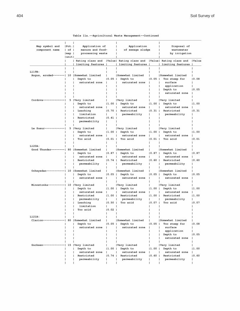
404 Soil Survey of
Table 11a.--Agricultural Waste Management--Continued________________________________________________________________________________________________________ | | | | Map symbol and |Pct.| Application of | Application | Disposal of component name | of | manure and food- | of sewage sludge | wastewater |map | processing waste | | by irrigation |unit| | | _____________________________________________________________________________ | | Rating class and |Value| Rating class and |Value| Rating class and |Value | | limiting features | | limiting features | | limiting features |________________________________________________________________________________________________________ | | | | | | |L119B: | | | | | | | Angus, eroded-------| 10 |Somewhat limited | |Somewhat limited | |Somewhat limited | | | Depth to |0.05 | Depth to |0.05 | Too steep for |0.08 | | saturated zone | | saturated zone | | surface | | | | | | | application | | | | | | | Depth to |0.05 | | | | | | saturated zone | | | | | | | | Cordova-------------| 5 |Very limited | |Very limited | |Very limited | | | Depth to |1.00 | Depth to |1.00 | Depth to |1.00 | | saturated zone | | saturated zone | | saturated zone | | | Leaching |0.70 | Restricted |0.31 | Restricted |0.31 | | limitation | | permeability | | permeability | | | Restricted |0.41 | | | | | | permeability | | | | | | | | | | | | Le Sueur------------| 5 |Very limited | |Very limited | |Very limited | | | Depth to |1.00 | Depth to |1.00 | Depth to |1.00 | | saturated zone | | saturated zone | | saturated zone | | | Too acid |0.01 | Too acid |0.01 | Too acid |0.01 | | | | | | |L120A: | | | | | | | Good Thunder--------| 80 |Somewhat limited | |Somewhat limited | |Somewhat limited | | | Depth to |0.87 | Depth to |0.87 | Depth to |0.87 | | saturated zone | | saturated zone | | saturated zone | | | Restricted |0.74 | Restricted |0.60 | Restricted |0.60 | | permeability | | permeability | | permeability | | | | | | | | Ocheyedan-----------| 10 |Somewhat limited | |Somewhat limited | |Somewhat limited | | | Depth to |0.05 | Depth to |0.05 | Depth to |0.05 | | saturated zone | | saturated zone | | saturated zone | | | | | | | | Minnetonka----------| 10 |Very limited | |Very limited | |Very limited | | | Depth to |1.00 | Depth to |1.00 | Depth to |1.00 | | saturated zone | | saturated zone | | saturated zone | | | Restricted |1.00 | Restricted |1.00 | Restricted |1.00 | | permeability | | permeability | | permeability | | | Leaching |0.50 | Too acid |0.07 | Too acid |0.07 | | limitation | | | | | | | Too acid |0.02 | | | | | | | | | | |L121B: | | | | | | | Clarion-------------| 80 |Somewhat limited | |Somewhat limited | |Somewhat limited | | | Depth to |0.05 | Depth to |0.05 | Too steep for |0.08 | | saturated zone | | saturated zone | | surface | | | | | | | application | | | | | | | Depth to |0.05 | | | | | | saturated zone | | | | | | | | Guckeen-------------| 15 |Very limited | |Very limited | |Very limited | | | Depth to |1.00 | Depth to |1.00 | Depth to |1.00 | | saturated zone | | saturated zone | | saturated zone | | | Restricted |0.74 | Restricted |0.60 | Restricted |0.60 | | permeability | | permeability | | permeability | | | | | | | |

Waseca County, Minnesota 405
Table 11a.--Agricultural Waste Management--Continued________________________________________________________________________________________________________ | | | | Map symbol and |Pct.| Application of | Application | Disposal of component name | of | manure and food- | of sewage sludge | wastewater |map | processing waste | | by irrigation |unit| | | _____________________________________________________________________________ | | Rating class and |Value| Rating class and |Value| Rating class and |Value | | limiting features | | limiting features | | limiting features |________________________________________________________________________________________________________ | | | | | | |L121B: | | | | | | | Marna---------------| 5 |Very limited | |Very limited | |Very limited | | | Depth to |1.00 | Depth to |1.00 | Depth to |1.00 | | saturated zone | | saturated zone | | saturated zone | | | Restricted |1.00 | Restricted |1.00 | Restricted |1.00 | | permeability | | permeability | | permeability | | | Leaching |0.50 | | | | | | limitation | | | | | | | | | | | |L122B: | | | | | | | Reedslake-----------| 55 |Somewhat limited | |Somewhat limited | |Somewhat limited | | | Depth to |0.05 | Depth to |0.05 | Too steep for |0.08 | | saturated zone | | saturated zone | | surface | | | | | | | application | | | | | | | Depth to |0.05 | | | | | | saturated zone | | | | | | | | Estherville---------| 25 |Very limited | |Very limited | |Very limited | | | Filtering |1.00 | Filtering |1.00 | Filtering |1.00 | | capacity | | capacity | | capacity | | | Droughty |0.70 | Droughty |0.70 | Droughty |0.70 | | | | | | Too steep for |0.08 | | | | | | surface | | | | | | | application | | | | | | | | Le Sueur------------| 10 |Very limited | |Very limited | |Very limited | | | Depth to |1.00 | Depth to |1.00 | Depth to |1.00 | | saturated zone | | saturated zone | | saturated zone | | | Too acid |0.01 | Too acid |0.01 | Too acid |0.01 | | | | | | | Cordova-------------| 5 |Very limited | |Very limited | |Very limited | | | Depth to |1.00 | Depth to |1.00 | Depth to |1.00 | | saturated zone | | saturated zone | | saturated zone | | | Leaching |0.70 | Restricted |0.31 | Restricted |0.31 | | limitation | | permeability | | permeability | | | Restricted |0.41 | | | | | | permeability | | | | | | | | | | | | Lowlein-------------| 5 |Very limited | |Very limited | |Very limited | | | Filtering |1.00 | Filtering |1.00 | Filtering |1.00 | | capacity | | capacity | | capacity | | | Depth to |0.87 | Depth to |0.87 | Depth to |0.87 | | saturated zone | | saturated zone | | saturated zone | | | | | | | |L123A: | | | | | | | Belleville----------| 85 |Very limited | |Very limited | |Very limited | | | Filtering |1.00 | Filtering |1.00 | Filtering |1.00 | | capacity | | capacity | | capacity | | | Depth to |1.00 | Depth to |1.00 | Depth to |1.00 | | saturated zone | | saturated zone | | saturated zone | | | Leaching |0.70 | Restricted |0.31 | Restricted |0.31 | | limitation | | permeability | | permeability | | | Restricted |0.41 | | | | | | permeability | | | | | | | | | | | |

406 Soil Survey of
Table 11a.--Agricultural Waste Management--Continued________________________________________________________________________________________________________ | | | | Map symbol and |Pct.| Application of | Application | Disposal of component name | of | manure and food- | of sewage sludge | wastewater |map | processing waste | | by irrigation |unit| | | _____________________________________________________________________________ | | Rating class and |Value| Rating class and |Value| Rating class and |Value | | limiting features | | limiting features | | limiting features |________________________________________________________________________________________________________ | | | | | | |L123A: | | | | | | | Granby--------------| 15 |Very limited | |Very limited | |Very limited | | | Filtering |1.00 | Filtering |1.00 | Filtering |1.00 | | capacity | | capacity | | capacity | | | Depth to |1.00 | Depth to |1.00 | Depth to |1.00 | | saturated zone | | saturated zone | | saturated zone | | | Ponding |1.00 | Ponding |1.00 | Ponding |1.00 | | Leaching |0.90 | Droughty |0.23 | Droughty |0.23 | | limitation | | | | | | | Droughty |0.23 | | | | | | | | | | |L124A: | | | | | | | Glencoe mucky clay | | | | | | | loam---------------| 85 |Very limited | |Very limited | |Very limited | | | Depth to |1.00 | Depth to |1.00 | Depth to |1.00 | | saturated zone | | saturated zone | | saturated zone | | | Ponding |1.00 | Ponding |1.00 | Ponding |1.00 | | Leaching |0.70 | | | | | | limitation | | | | | | | | | | | | Canisteo------------| 10 |Very limited | |Very limited | |Very limited | | | Depth to |1.00 | Depth to |1.00 | Depth to |1.00 | | saturated zone | | saturated zone | | saturated zone | | | Leaching |0.70 | | | | | | limitation | | | | | | | | | | | | Glencoe clay loam---| 5 |Very limited | |Very limited | |Very limited | | | Depth to |1.00 | Depth to |1.00 | Depth to |1.00 | | saturated zone | | saturated zone | | saturated zone | | | Ponding |1.00 | Ponding |1.00 | Ponding |1.00 | | Leaching |0.70 | | | | | | limitation | | | | | | | | | | | |L125A: | | | | | | | Hanlon, rarely | | | | | | | flooded------------| 60 |Somewhat limited | |Somewhat limited | |Somewhat limited | | | Depth to |0.87 | Depth to |0.87 | Depth to |0.87 | | saturated zone | | saturated zone | | saturated zone | | | Filtering |0.01 | Flooding |0.40 | Filtering |0.01 | | capacity | | Filtering |0.01 | capacity | | | | | capacity | | | | | | | | | | Coland, occasionally| | | | | | | flooded------------| 25 |Very limited | |Very limited | |Very limited | | | Depth to |1.00 | Depth to |1.00 | Depth to |1.00 | | saturated zone | | saturated zone | | saturated zone | | | Leaching |0.70 | Flooding |1.00 | Flooding |0.60 | | limitation | | | | | | | Flooding |0.60 | | | | | | | | | | | Minneopa, rarely | | | | | | | flooded------------| 15 |Very limited | |Very limited | |Very limited | | | Filtering |1.00 | Filtering |1.00 | Filtering |1.00 | | capacity | | capacity | | capacity | | | Depth to |0.87 | Depth to |0.87 | Depth to |0.87 | | saturated zone | | saturated zone | | saturated zone | | | Droughty |0.07 | Flooding |0.40 | Droughty |0.07 | | | | Droughty |0.07 | | | | | | | | |

Waseca County, Minnesota 407
Table 11a.--Agricultural Waste Management--Continued________________________________________________________________________________________________________ | | | | Map symbol and |Pct.| Application of | Application | Disposal of component name | of | manure and food- | of sewage sludge | wastewater |map | processing waste | | by irrigation |unit| | | _____________________________________________________________________________ | | Rating class and |Value| Rating class and |Value| Rating class and |Value | | limiting features | | limiting features | | limiting features |________________________________________________________________________________________________________ | | | | | | |L126A: | | | | | | | Coland, occasionally| | | | | | | flooded------------| 80 |Very limited | |Very limited | |Very limited | | | Depth to |1.00 | Depth to |1.00 | Depth to |1.00 | | saturated zone | | saturated zone | | saturated zone | | | Leaching |0.70 | Flooding |1.00 | Flooding |0.60 | | limitation | | | | | | | Flooding |0.60 | | | | | | | | | | | Minneopa, | | | | | | | occasionally | | | | | | | flooded------------| 10 |Very limited | |Very limited | |Very limited | | | Filtering |1.00 | Flooding |1.00 | Filtering |1.00 | | capacity | | Filtering |1.00 | capacity | | | Depth to |0.87 | capacity | | Depth to |0.87 | | saturated zone | | Depth to |0.87 | saturated zone | | | Flooding |0.60 | saturated zone | | Flooding |0.60 | | Droughty |0.07 | Droughty |0.07 | Droughty |0.07 | | | | | | | Havelock, | | | | | | | occasionally | | | | | | | flooded------------| 5 |Very limited | |Very limited | |Very limited | | | Depth to |1.00 | Depth to |1.00 | Depth to |1.00 | | saturated zone | | saturated zone | | saturated zone | | | Leaching |0.70 | Flooding |1.00 | Flooding |0.60 | | limitation | | Filtering |0.01 | Filtering |0.01 | | Flooding |0.60 | capacity | | capacity | | | Filtering |0.01 | | | | | | capacity | | | | | | | | | | | | Spillville, | | | | | | | occasionally | | | | | | | flooded------------| 5 |Very limited | |Very limited | |Very limited | | | Depth to |1.00 | Depth to |1.00 | Depth to |1.00 | | saturated zone | | saturated zone | | saturated zone | | | Flooding |0.60 | Flooding |1.00 | Flooding |0.60 | | | | | | |L127A: | | | | | | | Coland, frequently | | | | | | | flooded------------| 80 |Very limited | |Very limited | |Very limited | | | Depth to |1.00 | Depth to |1.00 | Depth to |1.00 | | saturated zone | | saturated zone | | saturated zone | | | Flooding |1.00 | Flooding |1.00 | Flooding |1.00 | | Leaching |0.70 | | | | | | limitation | | | | | | | | | | | | Minneopa, | | | | | | | occasionally | | | | | | | flooded------------| 10 |Very limited | |Very limited | |Very limited | | | Filtering |1.00 | Flooding |1.00 | Filtering |1.00 | | capacity | | Filtering |1.00 | capacity | | | Depth to |0.87 | capacity | | Depth to |0.87 | | saturated zone | | Depth to |0.87 | saturated zone | | | Flooding |0.60 | saturated zone | | Flooding |0.60 | | Droughty |0.02 | Droughty |0.02 | Droughty |0.02 | | | | | | |

408 Soil Survey of
Table 11a.--Agricultural Waste Management--Continued________________________________________________________________________________________________________ | | | | Map symbol and |Pct.| Application of | Application | Disposal of component name | of | manure and food- | of sewage sludge | wastewater |map | processing waste | | by irrigation |unit| | | _____________________________________________________________________________ | | Rating class and |Value| Rating class and |Value| Rating class and |Value | | limiting features | | limiting features | | limiting features |________________________________________________________________________________________________________ | | | | | | |L127A: | | | | | | | Havelock, frequently| | | | | | | flooded------------| 5 |Very limited | |Very limited | |Very limited | | | Depth to |1.00 | Depth to |1.00 | Depth to |1.00 | | saturated zone | | saturated zone | | saturated zone | | | Flooding |1.00 | Flooding |1.00 | Flooding |1.00 | | Leaching |0.70 | Filtering |0.01 | Filtering |0.01 | | limitation | | capacity | | capacity | | | Filtering |0.01 | | | | | | capacity | | | | | | | | | | | | Spillville, | | | | | | | occasionally | | | | | | | flooded------------| 5 |Very limited | |Very limited | |Very limited | | | Depth to |1.00 | Depth to |1.00 | Depth to |1.00 | | saturated zone | | saturated zone | | saturated zone | | | Flooding |0.60 | Flooding |1.00 | Flooding |0.60 | | | | | | |L128A: | | | | | | | Mazaska-------------| 60 |Very limited | |Very limited | |Very limited | | | Depth to |1.00 | Depth to |1.00 | Depth to |1.00 | | saturated zone | | saturated zone | | saturated zone | | | Restricted |1.00 | Restricted |1.00 | Restricted |1.00 | | permeability | | permeability | | permeability | | | Leaching |0.50 | | | | | | limitation | | | | | | | | | | | | Rolfe---------------| 30 |Very limited | |Very limited | |Very limited | | | Depth to |1.00 | Depth to |1.00 | Depth to |1.00 | | saturated zone | | saturated zone | | saturated zone | | | Restricted |1.00 | Restricted |1.00 | Restricted |1.00 | | permeability | | permeability | | permeability | | | Ponding |1.00 | Ponding |1.00 | Ponding |1.00 | | Leaching |0.50 | Too acid |0.07 | Too acid |0.07 | | limitation | | | | | | | Too acid |0.02 | | | | | | | | | | | Lerdal--------------| 10 |Very limited | |Very limited | |Very limited | | | Restricted |1.00 | Restricted |1.00 | Restricted |1.00 | | permeability | | permeability | | permeability | | | Depth to |1.00 | Depth to |1.00 | Depth to |1.00 | | saturated zone | | saturated zone | | saturated zone | | | Too acid |0.03 | Too acid |0.14 | Too acid |0.14 | | | | | | |L129B: | | | | | | | Terril--------------| 90 |Somewhat limited | |Somewhat limited | |Somewhat limited | | | Depth to |0.05 | Depth to |0.05 | Too steep for |0.08 | | saturated zone | | saturated zone | | surface | | | | | | | application | | | | | | | Depth to |0.05 | | | | | | saturated zone | | | | | | | | Delft---------------| 5 |Very limited | |Very limited | |Very limited | | | Depth to |1.00 | Depth to |1.00 | Depth to |1.00 | | saturated zone | | saturated zone | | saturated zone | | | Leaching |0.70 | Restricted |0.22 | Restricted |0.22 | | limitation | | permeability | | permeability | | | Restricted |0.30 | | | | | | permeability | | | | | | | | | | | |

Waseca County, Minnesota 409
Table 11a.--Agricultural Waste Management--Continued________________________________________________________________________________________________________ | | | | Map symbol and |Pct.| Application of | Application | Disposal of component name | of | manure and food- | of sewage sludge | wastewater |map | processing waste | | by irrigation |unit| | | _____________________________________________________________________________ | | Rating class and |Value| Rating class and |Value| Rating class and |Value | | limiting features | | limiting features | | limiting features |________________________________________________________________________________________________________ | | | | | | |L129B: | | | | | | | Hamel---------------| 5 |Very limited | |Very limited | |Very limited | | | Depth to |1.00 | Depth to |1.00 | Depth to |1.00 | | saturated zone | | saturated zone | | saturated zone | | | Leaching |0.70 | Restricted |0.31 | Restricted |0.31 | | limitation | | permeability | | permeability | | | Restricted |0.41 | | | | | | permeability | | | | | | | | | | | |L130A: | | | | | | | Okoboji mucky silty | | | | | | | clay loam----------| 75 |Very limited | |Very limited | |Very limited | | | Depth to |1.00 | Depth to |1.00 | Depth to |1.00 | | saturated zone | | saturated zone | | saturated zone | | | Ponding |1.00 | Ponding |1.00 | Ponding |1.00 | | Leaching |0.50 | Restricted |0.31 | Restricted |0.31 | | limitation | | permeability | | permeability | | | Restricted |0.41 | | | | | | permeability | | | | | | | | | | | | Okoboji silty clay | | | | | | | loam---------------| 15 |Very limited | |Very limited | |Very limited | | | Depth to |1.00 | Depth to |1.00 | Depth to |1.00 | | saturated zone | | saturated zone | | saturated zone | | | Ponding |1.00 | Ponding |1.00 | Ponding |1.00 | | Leaching |0.50 | Restricted |0.22 | Restricted |0.22 | | limitation | | permeability | | permeability | | | Restricted |0.30 | | | | | | permeability | | | | | | | | | | | | Brownton------------| 5 |Very limited | |Very limited | |Very limited | | | Restricted |1.00 | Restricted |1.00 | Restricted |1.00 | | permeability | | permeability | | permeability | | | Depth to |1.00 | Depth to |1.00 | Depth to |1.00 | | saturated zone | | saturated zone | | saturated zone | | | Leaching |0.50 | | | | | | limitation | | | | | | | | | | | | Spicer--------------| 5 |Very limited | |Very limited | |Very limited | | | Depth to |1.00 | Depth to |1.00 | Depth to |1.00 | | saturated zone | | saturated zone | | saturated zone | | | Leaching |0.70 | | | | | | limitation | | | | | | | | | | | |M-W: | | | | | | | Water, miscellaneous|100 |Not rated | |Not rated | |Not rated | | | | | | | |U3B: | | | | | | | Udorthents (cut and | | | | | | | fill land)---------|100 |Not rated | |Not rated | |Not rated | | | | | | | |W: | | | | | | | Water---------------|100 |Not rated | |Not rated | |Not rated | | | | | | | |________________________________________________________________________________________________________

410 Soil Survey of
Table 11b.--Agricultural Waste Management
(The information in this table indicates the dominant soil condition but does not eliminate the need for onsite investigation. The numbers in the value columns range from 0.01 to 1.00. The larger the value, the greater the limitation. "Not rated" indicates that data are not available or that no rating is applicable. See text for further explanation of ratings in this table)
________________________________________________________________________________________________________ | | | | Map symbol and |Pct.| Overland flow | Rapid infiltration | Slow rate treatment component name | of | of wastewater | of wastewater | of wastewater |map | | | |unit| | | _____________________________________________________________________________ | | Rating class and |Value| Rating class and |Value| Rating class and |Value | | limiting features | | limiting features | | limiting features |________________________________________________________________________________________________________ | | | | | | |GP: | | | | | | | Pits, gravel--------| 80 |Not rated | |Not rated | |Not rated | | | | | | | | Udipsamments--------| 20 |Not rated | |Not rated | |Not rated | | | | | | | |L5A: | | | | | | | Delft, overwash-----| 50 |Very limited | |Very limited | |Very limited | | | Depth to |1.00 | Restricted |1.00 | Depth to |1.00 | | saturated zone | | permeability | | saturated zone | | | Seepage |0.77 | Depth to |1.00 | Restricted |0.15 | | | | saturated zone | | permeability | | | | | | | | Delft---------------| 40 |Very limited | |Very limited | |Very limited | | | Depth to |1.00 | Restricted |1.00 | Depth to |1.00 | | saturated zone | | permeability | | saturated zone | | | Seepage |0.77 | Depth to |1.00 | Restricted |0.15 | | | | saturated zone | | permeability | | | | | | | | Glencoe-------------| 5 |Very limited | |Very limited | |Very limited | | | Depth to |1.00 | Depth to |1.00 | Depth to |1.00 | | saturated zone | | saturated zone | | saturated zone | | | Seepage |1.00 | Restricted |1.00 | Ponding |1.00 | | Ponding |1.00 | permeability | | | | | Too level |0.50 | Ponding |1.00 | | | | | | | | | Terril--------------| 5 |Very limited | |Very limited | |Somewhat limited | | | Seepage |1.00 | Depth to |1.00 | Too steep for |0.08 | | Depth to |0.05 | saturated zone | | surface | | | saturated zone | | Restricted |1.00 | application | | | | | permeability | | Depth to |0.05 | | | | | | saturated zone | | | | | | | |L13A: | | | | | | | Klossner, drained---| 80 |Very limited | |Very limited | |Very limited | | | Depth to |1.00 | Depth to |1.00 | Depth to |1.00 | | saturated zone | | saturated zone | | saturated zone | | | Low adsorption |1.00 | Restricted |1.00 | Low adsorption |1.00 | | Seepage |1.00 | permeability | | Ponding |1.00 | | Ponding |1.00 | Ponding |1.00 | Too acid |0.21 | | Too level |0.50 | | | | | | | | | | | Mineral soil, | | | | | | | drained------------| 15 |Very limited | |Very limited | |Very limited | | | Seepage |1.00 | Depth to |1.00 | Depth to |1.00 | | Depth to |1.00 | saturated zone | | saturated zone | | | saturated zone | | Restricted |1.00 | Ponding |1.00 | | Ponding |1.00 | permeability | | | | | Too level |0.50 | Ponding |1.00 | | | | | | | | |

Waseca County, Minnesota 411
Table 11b.--Agricultural Waste Management--Continued________________________________________________________________________________________________________ | | | | Map symbol and |Pct.| Overland flow | Rapid infiltration | Slow rate treatment component name | of | of wastewater | of wastewater | of wastewater |map | | | |unit| | | _____________________________________________________________________________ | | Rating class and |Value| Rating class and |Value| Rating class and |Value | | limiting features | | limiting features | | limiting features |________________________________________________________________________________________________________ | | | | | | |L13A: | | | | | | | Houghton, drained---| 5 |Very limited | |Very limited | |Very limited | | | Depth to |1.00 | Depth to |1.00 | Depth to |1.00 | | saturated zone | | saturated zone | | saturated zone | | | Low adsorption |1.00 | Ponding |1.00 | Low adsorption |1.00 | | Seepage |1.00 | Restricted |0.69 | Ponding |1.00 | | Ponding |1.00 | permeability | | Too acid |0.31 | | Too level |0.50 | | | | | | | | | | |L14A: | | | | | | | Houghton, drained---| 80 |Very limited | |Very limited | |Very limited | | | Depth to |1.00 | Depth to |1.00 | Depth to |1.00 | | saturated zone | | saturated zone | | saturated zone | | | Low adsorption |1.00 | Ponding |1.00 | Low adsorption |1.00 | | Seepage |1.00 | Restricted |0.69 | Ponding |1.00 | | Ponding |1.00 | permeability | | Too acid |0.31 | | Too level |0.50 | | | | | | | | | | | Klossner, drained---| 10 |Very limited | |Very limited | |Very limited | | | Depth to |1.00 | Depth to |1.00 | Depth to |1.00 | | saturated zone | | saturated zone | | saturated zone | | | Low adsorption |1.00 | Restricted |1.00 | Low adsorption |1.00 | | Seepage |1.00 | permeability | | Ponding |1.00 | | Ponding |1.00 | Ponding |1.00 | Too acid |0.21 | | Too level |0.50 | | | | | | | | | | | Mineral soil, | | | | | | | drained------------| 10 |Very limited | |Very limited | |Very limited | | | Seepage |1.00 | Depth to |1.00 | Depth to |1.00 | | Depth to |1.00 | saturated zone | | saturated zone | | | saturated zone | | Restricted |1.00 | Ponding |1.00 | | Ponding |1.00 | permeability | | | | | Too level |0.50 | Ponding |1.00 | | | | | | | | |L15A: | | | | | | | Klossner, ponded----| 30 |Very limited | |Very limited | |Very limited | | | Ponding |1.00 | Ponding |1.00 | Ponding |1.00 | | Depth to |1.00 | Depth to |1.00 | Depth to |1.00 | | saturated zone | | saturated zone | | saturated zone | | | Low adsorption |1.00 | Restricted |1.00 | Low adsorption |1.00 | | Seepage |1.00 | permeability | | | | | Too level |0.50 | | | | | | | | | | | Okoboji, ponded-----| 30 |Very limited | |Very limited | |Very limited | | | Seepage |1.00 | Ponding |1.00 | Ponding |1.00 | | Ponding |1.00 | Restricted |1.00 | Depth to |1.00 | | Depth to |1.00 | permeability | | saturated zone | | | saturated zone | | Depth to |1.00 | Restricted |0.15 | | Too level |0.50 | saturated zone | | permeability | | | | | | | | Glencoe, ponded-----| 30 |Very limited | |Very limited | |Very limited | | | Ponding |1.00 | Ponding |1.00 | Ponding |1.00 | | Depth to |1.00 | Depth to |1.00 | Depth to |1.00 | | saturated zone | | saturated zone | | saturated zone | | | Seepage |1.00 | Restricted |1.00 | | | | Too level |0.50 | permeability | | | | | | | | | |

412 Soil Survey of
Table 11b.--Agricultural Waste Management--Continued________________________________________________________________________________________________________ | | | | Map symbol and |Pct.| Overland flow | Rapid infiltration | Slow rate treatment component name | of | of wastewater | of wastewater | of wastewater |map | | | |unit| | | _____________________________________________________________________________ | | Rating class and |Value| Rating class and |Value| Rating class and |Value | | limiting features | | limiting features | | limiting features |________________________________________________________________________________________________________ | | | | | | |L15A: | | | | | | | Houghton, ponded----| 10 |Very limited | |Very limited | |Very limited | | | Ponding |1.00 | Ponding |1.00 | Ponding |1.00 | | Depth to |1.00 | Depth to |1.00 | Depth to |1.00 | | saturated zone | | saturated zone | | saturated zone | | | Low adsorption |1.00 | Restricted |0.69 | Low adsorption |1.00 | | Seepage |1.00 | permeability | | | | | Too level |0.50 | | | | | | | | | | |L16A: | | | | | | | Muskego, ponded-----| 30 |Very limited | |Very limited | |Very limited | | | Seepage |1.00 | Ponding |1.00 | Ponding |1.00 | | Ponding |1.00 | Restricted |1.00 | Depth to |1.00 | | Depth to |1.00 | permeability | | saturated zone | | | saturated zone | | Depth to |1.00 | Low adsorption |1.00 | | Low adsorption |1.00 | saturated zone | | Restricted |0.96 | | Too level |0.50 | | | permeability | | | | | | | | Blue Earth, ponded--| 30 |Very limited | |Very limited | |Very limited | | | Seepage |1.00 | Ponding |1.00 | Ponding |1.00 | | Ponding |1.00 | Depth to |1.00 | Depth to |1.00 | | Depth to |1.00 | saturated zone | | saturated zone | | | saturated zone | | Restricted |1.00 | | | | Too level |0.50 | permeability | | | | | | | | | | Houghton, ponded----| 30 |Very limited | |Very limited | |Very limited | | | Ponding |1.00 | Ponding |1.00 | Ponding |1.00 | | Depth to |1.00 | Depth to |1.00 | Depth to |1.00 | | saturated zone | | saturated zone | | saturated zone | | | Low adsorption |1.00 | Restricted |0.69 | Low adsorption |1.00 | | Seepage |1.00 | permeability | | | | | Too level |0.50 | | | | | | | | | | | Klossner, ponded----| 10 |Very limited | |Very limited | |Very limited | | | Ponding |1.00 | Ponding |1.00 | Ponding |1.00 | | Depth to |1.00 | Depth to |1.00 | Depth to |1.00 | | saturated zone | | saturated zone | | saturated zone | | | Low adsorption |1.00 | Restricted |1.00 | Low adsorption |1.00 | | Seepage |1.00 | permeability | | | | | Too level |0.50 | | | | | | | | | | |L26B: | | | | | | | Shorewood-----------| 90 |Very limited | |Very limited | |Very limited | | | Depth to |1.00 | Restricted |1.00 | Depth to |1.00 | | saturated zone | | permeability | | saturated zone | | | Seepage |0.77 | Depth to |1.00 | Restricted |0.60 | | | | saturated zone | | permeability | | | | | | | Too steep for |0.08 | | | | | | surface | | | | | | | application | | | | | | | | Good Thunder--------| 5 |Somewhat limited | |Very limited | |Somewhat limited | | | Depth to |0.87 | Restricted |1.00 | Depth to |0.87 | | saturated zone | | permeability | | saturated zone | | | Seepage |0.69 | Depth to |1.00 | Restricted |0.43 | | | | saturated zone | | permeability | | | | | | | |

Waseca County, Minnesota 413
Table 11b.--Agricultural Waste Management--Continued________________________________________________________________________________________________________ | | | | Map symbol and |Pct.| Overland flow | Rapid infiltration | Slow rate treatment component name | of | of wastewater | of wastewater | of wastewater |map | | | |unit| | | _____________________________________________________________________________ | | Rating class and |Value| Rating class and |Value| Rating class and |Value | | limiting features | | limiting features | | limiting features |________________________________________________________________________________________________________ | | | | | | |L26B: | | | | | | | Minnetonka----------| 5 |Very limited | |Very limited | |Very limited | | | Depth to |1.00 | Restricted |1.00 | Depth to |1.00 | | saturated zone | | permeability | | saturated zone | | | Seepage |0.77 | Depth to |1.00 | Restricted |0.96 | | Too acid |0.07 | saturated zone | | permeability | | | | | | | Too acid |0.07 | | | | | | |L36A: | | | | | | | Hamel, overwash-----| 50 |Very limited | |Very limited | |Very limited | | | Seepage |1.00 | Restricted |1.00 | Depth to |1.00 | | Depth to |1.00 | permeability | | saturated zone | | | saturated zone | | Depth to |1.00 | Restricted |0.21 | | | | saturated zone | | permeability | | | | | | | | Hamel---------------| 43 |Very limited | |Very limited | |Very limited | | | Seepage |1.00 | Restricted |1.00 | Depth to |1.00 | | Depth to |1.00 | permeability | | saturated zone | | | saturated zone | | Depth to |1.00 | Restricted |0.21 | | | | saturated zone | | permeability | | | | | | | | Terril--------------| 5 |Very limited | |Very limited | |Somewhat limited | | | Seepage |1.00 | Depth to |1.00 | Depth to |0.05 | | Depth to |0.05 | saturated zone | | saturated zone | | | saturated zone | | Restricted |1.00 | | | | | | permeability | | | | | | | | | | Glencoe-------------| 2 |Very limited | |Very limited | |Very limited | | | Seepage |1.00 | Depth to |1.00 | Depth to |1.00 | | Depth to |1.00 | saturated zone | | saturated zone | | | saturated zone | | Restricted |1.00 | Ponding |1.00 | | Ponding |1.00 | permeability | | | | | Too level |0.50 | Ponding |1.00 | | | | | | | | |L40B: | | | | | | | Angus---------------| 45 |Very limited | |Very limited | |Somewhat limited | | | Seepage |1.00 | Depth to |1.00 | Too steep for |0.08 | | Depth to |0.05 | saturated zone | | surface | | | saturated zone | | Restricted |1.00 | application | | | | | permeability | | Depth to |0.05 | | | | | | saturated zone | | | | | | | | Kilkenny------------| 40 |Very limited | |Very limited | |Very limited | | | Depth to |1.00 | Restricted |1.00 | Depth to |1.00 | | saturated zone | | permeability | | saturated zone | | | Seepage |0.69 | Depth to |1.00 | Too acid |0.21 | | Too acid |0.21 | saturated zone | | Restricted |0.21 | | | | | | permeability | | | | | | | | Lerdal--------------| 10 |Very limited | |Very limited | |Very limited | | | Seepage |1.00 | Restricted |1.00 | Depth to |1.00 | | Depth to |1.00 | permeability | | saturated zone | | | saturated zone | | Depth to |1.00 | Restricted |0.94 | | Too acid |0.14 | saturated zone | | permeability | | | | | | | Too acid |0.14 | | | | | | | Mazaska-------------| 5 |Very limited | |Very limited | |Very limited | | | Depth to |1.00 | Restricted |1.00 | Depth to |1.00 | | saturated zone | | permeability | | saturated zone | | | Seepage |0.69 | Depth to |1.00 | Restricted |0.96 | | | | saturated zone | | permeability | | | | | | | |

414 Soil Survey of
Table 11b.--Agricultural Waste Management--Continued________________________________________________________________________________________________________ | | | | Map symbol and |Pct.| Overland flow | Rapid infiltration | Slow rate treatment component name | of | of wastewater | of wastewater | of wastewater |map | | | |unit| | | _____________________________________________________________________________ | | Rating class and |Value| Rating class and |Value| Rating class and |Value | | limiting features | | limiting features | | limiting features |________________________________________________________________________________________________________ | | | | | | |L41C2: | | | | | | | Lester, eroded------| 45 |Very limited | |Very limited | |Very limited | | | Seepage |1.00 | Restricted |1.00 | Too steep for |1.00 | | Too steep for |0.50 | permeability | | surface | | | surface | | Slope |1.00 | application | | | application | | | | Too steep for |0.50 | | | | | | sprinkler | | | | | | | application | | | | | | | | Kilkenny, eroded----| 40 |Somewhat limited | |Very limited | |Very limited | | | Depth to |0.86 | Restricted |1.00 | Too steep for |1.00 | | saturated zone | | permeability | | surface | | | Seepage |0.69 | Slope |1.00 | application | | | Too steep for |0.50 | Depth to |0.14 | Depth to |0.86 | | surface | | saturated zone | | saturated zone | | | application | | | | Too steep for |0.50 | | Too acid |0.21 | | | sprinkler | | | | | | | application | | | | | | | Too acid |0.21 | | | | | | Restricted |0.21 | | | | | | permeability | | | | | | | | Terril--------------| 10 |Very limited | |Very limited | |Somewhat limited | | | Seepage |1.00 | Depth to |1.00 | Depth to |0.05 | | Depth to |0.05 | saturated zone | | saturated zone | | | saturated zone | | Restricted |1.00 | | | | | | permeability | | | | | | | | | | Derrynane-----------| 5 |Very limited | |Very limited | |Very limited | | | Depth to |1.00 | Restricted |1.00 | Depth to |1.00 | | saturated zone | | permeability | | saturated zone | | | Seepage |0.39 | Depth to |1.00 | Restricted |0.43 | | | | saturated zone | | permeability | | | | | | | |L41D2: | | | | | | | Lester, eroded------| 45 |Very limited | |Very limited | |Very limited | | | Seepage |1.00 | Slope |1.00 | Too steep for |1.00 | | Too steep for |1.00 | Restricted |1.00 | surface | | | surface | | permeability | | application | | | application | | | | Too steep for |1.00 | | | | | | sprinkler | | | | | | | application | | | | | | | | Kilkenny, eroded----| 35 |Very limited | |Very limited | |Very limited | | | Too steep for |1.00 | Slope |1.00 | Too steep for |1.00 | | surface | | Restricted |1.00 | surface | | | application | | permeability | | application | | | Depth to |0.86 | Depth to |0.14 | Too steep for |1.00 | | saturated zone | | saturated zone | | sprinkler | | | Seepage |0.69 | | | application | | | Too acid |0.21 | | | Depth to |0.86 | | | | | | saturated zone | | | | | | | Too acid |0.21 | | | | | | Restricted |0.21 | | | | | | permeability | | | | | | | | Terril--------------| 10 |Very limited | |Very limited | |Somewhat limited | | | Seepage |1.00 | Depth to |1.00 | Depth to |0.05 | | Depth to |0.05 | saturated zone | | saturated zone | | | saturated zone | | Restricted |1.00 | | | | | | permeability | | | | | | | | | |

Waseca County, Minnesota 415
Table 11b.--Agricultural Waste Management--Continued________________________________________________________________________________________________________ | | | | Map symbol and |Pct.| Overland flow | Rapid infiltration | Slow rate treatment component name | of | of wastewater | of wastewater | of wastewater |map | | | |unit| | | _____________________________________________________________________________ | | Rating class and |Value| Rating class and |Value| Rating class and |Value | | limiting features | | limiting features | | limiting features |________________________________________________________________________________________________________ | | | | | | |L41D2: | | | | | | | Derrynane-----------| 5 |Very limited | |Very limited | |Very limited | | | Depth to |1.00 | Restricted |1.00 | Depth to |1.00 | | saturated zone | | permeability | | saturated zone | | | Seepage |0.39 | Depth to |1.00 | Restricted |0.43 | | | | saturated zone | | permeability | | | | | | | | Ridgeton------------| 5 |Very limited | |Very limited | |Very limited | | | Seepage |1.00 | Slope |1.00 | Too steep for |1.00 | | Too steep for |0.78 | Restricted |1.00 | surface | | | surface | | permeability | | application | | | application | | | | Too steep for |0.78 | | | | | | sprinkler | | | | | | | application | | | | | | | |L41E: | | | | | | | Lester--------------| 45 |Very limited | |Very limited | |Very limited | | | Seepage |1.00 | Slope |1.00 | Too steep for |1.00 | | Too steep for |1.00 | Restricted |1.00 | surface | | | surface | | permeability | | application | | | application | | | | Too steep for |1.00 | | | | | | sprinkler | | | | | | | application | | | | | | | | Kilkenny------------| 40 |Very limited | |Very limited | |Very limited | | | Too steep for |1.00 | Slope |1.00 | Too steep for |1.00 | | surface | | Restricted |1.00 | surface | | | application | | permeability | | application | | | Depth to |0.86 | Depth to |0.14 | Too steep for |1.00 | | saturated zone | | saturated zone | | sprinkler | | | Seepage |0.69 | | | application | | | Too acid |0.21 | | | Depth to |0.86 | | | | | | saturated zone | | | | | | | Too acid |0.21 | | | | | | Restricted |0.21 | | | | | | permeability | | | | | | | | Terril--------------| 5 |Very limited | |Very limited | |Somewhat limited | | | Seepage |1.00 | Depth to |1.00 | Depth to |0.05 | | Depth to |0.05 | saturated zone | | saturated zone | | | saturated zone | | Restricted |1.00 | | | | | | permeability | | | | | | | | | | Derrynane-----------| 5 |Very limited | |Very limited | |Very limited | | | Depth to |1.00 | Restricted |1.00 | Depth to |1.00 | | saturated zone | | permeability | | saturated zone | | | Seepage |0.39 | Depth to |1.00 | Restricted |0.43 | | | | saturated zone | | permeability | | | | | | | | Ridgeton------------| 5 |Very limited | |Very limited | |Very limited | | | Seepage |1.00 | Slope |1.00 | Too steep for |1.00 | | Too steep for |1.00 | Restricted |1.00 | surface | | | surface | | permeability | | application | | | application | | | | Too steep for |1.00 | | | | | | sprinkler | | | | | | | application | | | | | | | |

416 Soil Survey of
Table 11b.--Agricultural Waste Management--Continued________________________________________________________________________________________________________ | | | | Map symbol and |Pct.| Overland flow | Rapid infiltration | Slow rate treatment component name | of | of wastewater | of wastewater | of wastewater |map | | | |unit| | | _____________________________________________________________________________ | | Rating class and |Value| Rating class and |Value| Rating class and |Value | | limiting features | | limiting features | | limiting features |________________________________________________________________________________________________________ | | | | | | |L48A: | | | | | | | Derrynane, overwash | 50 |Very limited | |Very limited | |Very limited | | | Depth to |1.00 | Restricted |1.00 | Depth to |1.00 | | saturated zone | | permeability | | saturated zone | | | Seepage |0.39 | Depth to |1.00 | Restricted |0.43 | | | | saturated zone | | permeability | | | | | | | | Derrynane-----------| 40 |Very limited | |Very limited | |Very limited | | | Depth to |1.00 | Restricted |1.00 | Depth to |1.00 | | saturated zone | | permeability | | saturated zone | | | Seepage |0.39 | Depth to |1.00 | Restricted |0.43 | | | | saturated zone | | permeability | | | | | | | | Glencoe-------------| 5 |Very limited | |Very limited | |Very limited | | | Depth to |1.00 | Depth to |1.00 | Depth to |1.00 | | saturated zone | | saturated zone | | saturated zone | | | Seepage |1.00 | Restricted |1.00 | Ponding |1.00 | | Ponding |1.00 | permeability | | | | | Too level |0.50 | Ponding |1.00 | | | | | | | | | Terril--------------| 5 |Very limited | |Very limited | |Somewhat limited | | | Seepage |1.00 | Depth to |1.00 | Too steep for |0.08 | | Depth to |0.05 | saturated zone | | surface | | | saturated zone | | Restricted |1.00 | application | | | | | permeability | | Depth to |0.05 | | | | | | saturated zone | | | | | | | |L49A: | | | | | | | Klossner, surface | | | | | | | drained------------| 65 |Very limited | |Very limited | |Very limited | | | Depth to |1.00 | Depth to |1.00 | Depth to |1.00 | | saturated zone | | saturated zone | | saturated zone | | | Low adsorption |1.00 | Restricted |1.00 | Low adsorption |1.00 | | Seepage |1.00 | permeability | | Ponding |1.00 | | Ponding |1.00 | Ponding |1.00 | | | | Too level |0.50 | | | | | | | | | | | Klossner, drained---| 20 |Very limited | |Very limited | |Very limited | | | Depth to |1.00 | Depth to |1.00 | Depth to |1.00 | | saturated zone | | saturated zone | | saturated zone | | | Low adsorption |1.00 | Restricted |1.00 | Low adsorption |1.00 | | Seepage |1.00 | permeability | | Ponding |1.00 | | Ponding |1.00 | Ponding |1.00 | Too acid |0.21 | | Too level |0.50 | | | | | | | | | | | Mineral soil, | | | | | | | drained------------| 15 |Very limited | |Very limited | |Very limited | | | Seepage |1.00 | Depth to |1.00 | Depth to |1.00 | | Depth to |1.00 | saturated zone | | saturated zone | | | saturated zone | | Restricted |1.00 | Ponding |1.00 | | Ponding |1.00 | permeability | | | | | Too level |0.50 | Ponding |1.00 | | | | | | | | |

Waseca County, Minnesota 417
Table 11b.--Agricultural Waste Management--Continued________________________________________________________________________________________________________ | | | | Map symbol and |Pct.| Overland flow | Rapid infiltration | Slow rate treatment component name | of | of wastewater | of wastewater | of wastewater |map | | | |unit| | | _____________________________________________________________________________ | | Rating class and |Value| Rating class and |Value| Rating class and |Value | | limiting features | | limiting features | | limiting features |________________________________________________________________________________________________________ | | | | | | |L50A: | | | | | | | Houghton, surface | | | | | | | drained------------| 40 |Very limited | |Very limited | |Very limited | | | Depth to |1.00 | Depth to |1.00 | Depth to |1.00 | | saturated zone | | saturated zone | | saturated zone | | | Low adsorption |1.00 | Ponding |1.00 | Low adsorption |1.00 | | Seepage |1.00 | Restricted |0.69 | Ponding |1.00 | | Ponding |1.00 | permeability | | | | | Too level |0.50 | | | | | | | | | | | Muskego, surface | | | | | | | drained------------| 40 |Very limited | |Very limited | |Very limited | | | Seepage |1.00 | Restricted |1.00 | Depth to |1.00 | | Depth to |1.00 | permeability | | saturated zone | | | saturated zone | | Depth to |1.00 | Low adsorption |1.00 | | Low adsorption |1.00 | saturated zone | | Ponding |1.00 | | Ponding |1.00 | Ponding |1.00 | Restricted |0.96 | | Too level |0.50 | | | permeability | | | | | | | | Klossner, drained---| 10 |Very limited | |Very limited | |Very limited | | | Depth to |1.00 | Depth to |1.00 | Depth to |1.00 | | saturated zone | | saturated zone | | saturated zone | | | Low adsorption |1.00 | Restricted |1.00 | Low adsorption |1.00 | | Seepage |1.00 | permeability | | Ponding |1.00 | | Ponding |1.00 | Ponding |1.00 | Too acid |0.21 | | Too level |0.50 | | | | | | | | | | | Mineral soil, | | | | | | | drained------------| 10 |Very limited | |Very limited | |Very limited | | | Seepage |1.00 | Depth to |1.00 | Depth to |1.00 | | Depth to |1.00 | saturated zone | | saturated zone | | | saturated zone | | Restricted |1.00 | Ponding |1.00 | | Ponding |1.00 | permeability | | | | | Too level |0.50 | Ponding |1.00 | | | | | | | | |L51C2: | | | | | | | Gladek, eroded------| 80 |Very limited | |Very limited | |Very limited | | | Seepage |1.00 | Restricted |1.00 | Too steep for |1.00 | | Too steep for |0.50 | permeability | | surface | | | surface | | Slope |1.00 | application | | | application | | | | Too steep for |0.50 | | | | | | sprinkler | | | | | | | application | | | | | | | | Barrington----------| 10 |Very limited | |Very limited | |Somewhat limited | | | Seepage |1.00 | Depth to |1.00 | Depth to |0.87 | | Depth to |0.87 | saturated zone | | saturated zone | | | saturated zone | | Restricted |1.00 | Too steep for |0.08 | | | | permeability | | surface | | | | | | | application | | | | | | | | Lester, eroded------| 5 |Very limited | |Very limited | |Very limited | | | Seepage |1.00 | Restricted |1.00 | Too steep for |1.00 | | Too steep for |0.50 | permeability | | surface | | | surface | | Slope |1.00 | application | | | application | | | | Too steep for |0.50 | | Too acid |0.01 | | | sprinkler | | | | | | | application | | | | | | | Too acid |0.01 | | | | | | |

418 Soil Survey of
Table 11b.--Agricultural Waste Management--Continued________________________________________________________________________________________________________ | | | | Map symbol and |Pct.| Overland flow | Rapid infiltration | Slow rate treatment component name | of | of wastewater | of wastewater | of wastewater |map | | | |unit| | | _____________________________________________________________________________ | | Rating class and |Value| Rating class and |Value| Rating class and |Value | | limiting features | | limiting features | | limiting features |________________________________________________________________________________________________________ | | | | | | |L51C2: | | | | | | | Madelia-------------| 5 |Very limited | |Very limited | |Very limited | | | Depth to |1.00 | Depth to |1.00 | Depth to |1.00 | | saturated zone | | saturated zone | | saturated zone | | | Seepage |1.00 | Restricted |1.00 | | | | | | permeability | | | | | | | | | |L56A: | | | | | | | Muskego, frequently | | | | | | | flooded------------| 45 |Very limited | |Very limited | |Very limited | | | Flooding |1.00 | Flooding |1.00 | Depth to |1.00 | | Seepage |1.00 | Restricted |1.00 | saturated zone | | | Depth to |1.00 | permeability | | Low adsorption |1.00 | | saturated zone | | Depth to |1.00 | Flooding |1.00 | | Low adsorption |1.00 | saturated zone | | Ponding |1.00 | | Ponding |1.00 | Ponding |1.00 | Restricted |0.96 | | | | | | permeability | | | | | | | | Klossner, frequently| | | | | | | flooded------------| 45 |Very limited | |Very limited | |Very limited | | | Flooding |1.00 | Flooding |1.00 | Depth to |1.00 | | Depth to |1.00 | Depth to |1.00 | saturated zone | | | saturated zone | | saturated zone | | Low adsorption |1.00 | | Low adsorption |1.00 | Restricted |1.00 | Flooding |1.00 | | Seepage |1.00 | permeability | | Ponding |1.00 | | Ponding |1.00 | Ponding |1.00 | | | | | | | | | Suckercreek, | | | | | | | frequently flooded | 10 |Very limited | |Very limited | |Very limited | | | Flooding |1.00 | Flooding |1.00 | Depth to |1.00 | | Seepage |1.00 | Depth to |1.00 | saturated zone | | | Depth to |1.00 | saturated zone | | Flooding |1.00 | | saturated zone | | Restricted |0.31 | Filtering |0.01 | | Too level |0.50 | permeability | | capacity | | | | | | | |L57A: | | | | | | | Medo, drained-------| 80 |Very limited | |Very limited | |Not rated | | | Depth to |1.00 | Depth to |1.00 | | | | saturated zone | | saturated zone | | | | | Low adsorption |1.00 | Ponding |1.00 | | | | Seepage |1.00 | Restricted |0.68 | | | | Ponding |1.00 | permeability | | | | | Too level |0.50 | | | | | | | | | | | Mineral soil, | | | | | | | drained------------| 15 |Very limited | |Very limited | |Very limited | | | Seepage |1.00 | Depth to |1.00 | Filtering |1.00 | | Depth to |1.00 | saturated zone | | capacity | | | saturated zone | | Ponding |1.00 | Depth to |1.00 | | Ponding |1.00 | Restricted |0.31 | saturated zone | | | Too level |0.50 | permeability | | Ponding |1.00 | | | | | | | Houghton, drained---| 5 |Very limited | |Very limited | |Very limited | | | Depth to |1.00 | Depth to |1.00 | Depth to |1.00 | | saturated zone | | saturated zone | | saturated zone | | | Low adsorption |1.00 | Ponding |1.00 | Low adsorption |1.00 | | Seepage |1.00 | Restricted |0.69 | Ponding |1.00 | | Ponding |1.00 | permeability | | Too acid |0.31 | | Too level |0.50 | | | | | | | | | | |

Waseca County, Minnesota 419
Table 11b.--Agricultural Waste Management--Continued________________________________________________________________________________________________________ | | | | Map symbol and |Pct.| Overland flow | Rapid infiltration | Slow rate treatment component name | of | of wastewater | of wastewater | of wastewater |map | | | |unit| | | _____________________________________________________________________________ | | Rating class and |Value| Rating class and |Value| Rating class and |Value | | limiting features | | limiting features | | limiting features |________________________________________________________________________________________________________ | | | | | | |L63A: | | | | | | | Klossner------------| 85 |Very limited | |Very limited | |Very limited | | | Depth to |1.00 | Depth to |1.00 | Depth to |1.00 | | saturated zone | | saturated zone | | saturated zone | | | Low adsorption |1.00 | Restricted |1.00 | Low adsorption |1.00 | | Seepage |1.00 | permeability | | Ponding |1.00 | | Ponding |1.00 | Ponding |1.00 | | | | | | | | | Lura----------------| 10 |Very limited | |Very limited | |Very limited | | | Depth to |1.00 | Restricted |1.00 | Depth to |1.00 | | saturated zone | | permeability | | saturated zone | | | Ponding |1.00 | Depth to |1.00 | Ponding |1.00 | | | | saturated zone | | Restricted |0.94 | | | | Ponding |1.00 | permeability | | | | | | | | Brownton------------| 5 |Very limited | |Very limited | |Very limited | | | Depth to |1.00 | Restricted |1.00 | Depth to |1.00 | | saturated zone | | permeability | | saturated zone | | | | | Depth to |1.00 | Restricted |0.94 | | | | saturated zone | | permeability | | | | | | | |L64A: | | | | | | | Tadkee--------------| 50 |Very limited | |Very limited | |Very limited | | | Seepage |1.00 | Depth to |1.00 | Filtering |1.00 | | Depth to |1.00 | saturated zone | | capacity | | | saturated zone | | Restricted |1.00 | Depth to |1.00 | | | | permeability | | saturated zone | | | | | | | | Tadkee, depressional| 36 |Very limited | |Very limited | |Very limited | | | Depth to |1.00 | Depth to |1.00 | Filtering |1.00 | | saturated zone | | saturated zone | | capacity | | | Seepage |1.00 | Restricted |1.00 | Depth to |1.00 | | Ponding |1.00 | permeability | | saturated zone | | | Too level |0.50 | Ponding |1.00 | Ponding |1.00 | | | | | | | Better drained soil | 8 |Very limited | |Very limited | |Very limited | | | Seepage |1.00 | Depth to |1.00 | Filtering |1.00 | | Depth to |0.87 | saturated zone | | capacity | | | saturated zone | | Restricted |1.00 | Depth to |0.87 | | | | permeability | | saturated zone | | | | | | | | Granby--------------| 4 |Very limited | |Very limited | |Very limited | | | Seepage |1.00 | Depth to |1.00 | Filtering |1.00 | | Depth to |1.00 | saturated zone | | capacity | | | saturated zone | | Ponding |1.00 | Depth to |1.00 | | Ponding |1.00 | | | saturated zone | | | Too level |0.50 | | | Ponding |1.00 | | | | | | | Less sandy soil-----| 2 |Very limited | |Very limited | |Very limited | | | Seepage |1.00 | Depth to |1.00 | Filtering |1.00 | | Depth to |1.00 | saturated zone | | capacity | | | saturated zone | | Restricted |1.00 | Depth to |1.00 | | | | permeability | | saturated zone | | | | | | | |

420 Soil Survey of
Table 11b.--Agricultural Waste Management--Continued________________________________________________________________________________________________________ | | | | Map symbol and |Pct.| Overland flow | Rapid infiltration | Slow rate treatment component name | of | of wastewater | of wastewater | of wastewater |map | | | |unit| | | _____________________________________________________________________________ | | Rating class and |Value| Rating class and |Value| Rating class and |Value | | limiting features | | limiting features | | limiting features |________________________________________________________________________________________________________ | | | | | | |L73A: | | | | | | | Blue Earth----------| 80 |Very limited | |Very limited | |Very limited | | | Depth to |1.00 | Depth to |1.00 | Depth to |1.00 | | saturated zone | | saturated zone | | saturated zone | | | Seepage |1.00 | Restricted |1.00 | Ponding |1.00 | | Ponding |1.00 | permeability | | | | | | | Ponding |1.00 | | | | | | | | | Belleville----------| 10 |Very limited | |Very limited | |Very limited | | | Seepage |1.00 | Restricted |1.00 | Filtering |1.00 | | Depth to |1.00 | permeability | | capacity | | | saturated zone | | Depth to |1.00 | Depth to |1.00 | | | | saturated zone | | saturated zone | | | | | | | Restricted |0.21 | | | | | | permeability | | | | | | | | Canisteo------------| 10 |Very limited | |Very limited | |Very limited | | | Depth to |1.00 | Depth to |1.00 | Depth to |1.00 | | saturated zone | | saturated zone | | saturated zone | | | Seepage |1.00 | Restricted |1.00 | | | | | | permeability | | | | | | | | | |L74A: | | | | | | | Estherville---------| 87 |Very limited | |Somewhat limited | |Very limited | | | Seepage |1.00 | Restricted |0.32 | Filtering |1.00 | | | | permeability | | capacity | | | | | | | | Hawick--------------| 10 |Very limited | |Not limited | |Very limited | | | Seepage |1.00 | | | Filtering |1.00 | | | | | | capacity | | | | | | | | Biscay--------------| 3 |Very limited | |Very limited | |Very limited | | | Depth to |1.00 | Depth to |1.00 | Depth to |1.00 | | saturated zone | | saturated zone | | saturated zone | | | Seepage |1.00 | Restricted |1.00 | Filtering |1.00 | | | | permeability | | capacity | | | | | | | |L75B: | | | | | | | Barrington----------| 85 |Very limited | |Very limited | |Somewhat limited | | | Seepage |1.00 | Depth to |1.00 | Depth to |0.87 | | Depth to |0.87 | saturated zone | | saturated zone | | | saturated zone | | Restricted |1.00 | Too steep for |0.08 | | | | permeability | | surface | | | | | | | application | | | | | | | | Gladek--------------| 10 |Very limited | |Very limited | |Very limited | | | Seepage |1.00 | Restricted |1.00 | Too steep for |1.00 | | Too steep for |0.50 | permeability | | surface | | | surface | | Slope |1.00 | application | | | application | | | | Too steep for |0.50 | | | | | | sprinkler | | | | | | | application | | | | | | | | Madelia-------------| 5 |Very limited | |Very limited | |Very limited | | | Depth to |1.00 | Depth to |1.00 | Depth to |1.00 | | saturated zone | | saturated zone | | saturated zone | | | Seepage |1.00 | Restricted |1.00 | | | | | | permeability | | | | | | | | | |

Waseca County, Minnesota 421
Table 11b.--Agricultural Waste Management--Continued________________________________________________________________________________________________________ | | | | Map symbol and |Pct.| Overland flow | Rapid infiltration | Slow rate treatment component name | of | of wastewater | of wastewater | of wastewater |map | | | |unit| | | _____________________________________________________________________________ | | Rating class and |Value| Rating class and |Value| Rating class and |Value | | limiting features | | limiting features | | limiting features |________________________________________________________________________________________________________ | | | | | | |L76B: | | | | | | | Dickinson-----------| 80 |Very limited | |Somewhat limited | |Very limited | | | Seepage |1.00 | Restricted |0.32 | Filtering |1.00 | | Too acid |0.01 | permeability | | capacity | | | | | | | Too steep for |0.08 | | | | | | surface | | | | | | | application | | | | | | | Too acid |0.01 | | | | | | | Litchfield----------| 13 |Very limited | |Very limited | |Very limited | | | Seepage |1.00 | Depth to |1.00 | Filtering |1.00 | | Depth to |1.00 | saturated zone | | capacity | | | saturated zone | | Restricted |1.00 | Depth to |1.00 | | Too acid |0.07 | permeability | | saturated zone | | | | | | | Too acid |0.07 | | | | | | | Darfur--------------| 5 |Very limited | |Very limited | |Very limited | | | Depth to |1.00 | Depth to |1.00 | Depth to |1.00 | | saturated zone | | saturated zone | | saturated zone | | | Seepage |1.00 | Restricted |1.00 | | | | | | permeability | | | | | | | | | | Clarion-------------| 2 |Very limited | |Very limited | |Somewhat limited | | | Seepage |1.00 | Depth to |1.00 | Too steep for |0.08 | | Depth to |0.05 | saturated zone | | surface | | | saturated zone | | Restricted |1.00 | application | | | | | permeability | | Depth to |0.05 | | | | | | saturated zone | | | | | | | |L77A: | | | | | | | Brownton------------| 75 |Very limited | |Very limited | |Very limited | | | Depth to |1.00 | Restricted |1.00 | Depth to |1.00 | | saturated zone | | permeability | | saturated zone | | | | | Depth to |1.00 | Restricted |0.94 | | | | saturated zone | | permeability | | | | | | | | Marna---------------| 15 |Very limited | |Very limited | |Very limited | | | Depth to |1.00 | Restricted |1.00 | Depth to |1.00 | | saturated zone | | permeability | | saturated zone | | | | | Depth to |1.00 | Restricted |0.96 | | | | saturated zone | | permeability | | | | | | | | Lura----------------| 10 |Very limited | |Very limited | |Very limited | | | Depth to |1.00 | Restricted |1.00 | Depth to |1.00 | | saturated zone | | permeability | | saturated zone | | | Ponding |1.00 | Depth to |1.00 | Ponding |1.00 | | | | saturated zone | | Restricted |0.94 | | | | Ponding |1.00 | permeability | | | | | | | |L78A: | | | | | | | Canisteo------------| 65 |Very limited | |Very limited | |Very limited | | | Depth to |1.00 | Depth to |1.00 | Depth to |1.00 | | saturated zone | | saturated zone | | saturated zone | | | Seepage |1.00 | Restricted |1.00 | | | | | | permeability | | | | | | | | | | Crippin-------------| 10 |Very limited | |Very limited | |Very limited | | | Depth to |1.00 | Depth to |1.00 | Depth to |1.00 | | saturated zone | | saturated zone | | saturated zone | | | Seepage |1.00 | Restricted |1.00 | | | | | | permeability | | | | | | | | | |

422 Soil Survey of
Table 11b.--Agricultural Waste Management--Continued________________________________________________________________________________________________________ | | | | Map symbol and |Pct.| Overland flow | Rapid infiltration | Slow rate treatment component name | of | of wastewater | of wastewater | of wastewater |map | | | |unit| | | _____________________________________________________________________________ | | Rating class and |Value| Rating class and |Value| Rating class and |Value | | limiting features | | limiting features | | limiting features |________________________________________________________________________________________________________ | | | | | | |L78A: | | | | | | | Glencoe-------------| 10 |Very limited | |Very limited | |Very limited | | | Depth to |1.00 | Depth to |1.00 | Depth to |1.00 | | saturated zone | | saturated zone | | saturated zone | | | Seepage |1.00 | Restricted |1.00 | Ponding |1.00 | | Ponding |1.00 | permeability | | | | | Too level |0.50 | Ponding |1.00 | | | | | | | | | Canisteo, | | | | | | | depressional-------| 5 |Very limited | |Very limited | |Very limited | | | Depth to |1.00 | Depth to |1.00 | Depth to |1.00 | | saturated zone | | saturated zone | | saturated zone | | | Seepage |1.00 | Restricted |1.00 | | | | | | permeability | | | | | | | | | | Harps---------------| 5 |Very limited | |Very limited | |Very limited | | | Seepage |1.00 | Depth to |1.00 | Depth to |1.00 | | Depth to |1.00 | saturated zone | | saturated zone | | | saturated zone | | Restricted |1.00 | | | | | | permeability | | | | | | | | | | Webster-------------| 5 |Very limited | |Very limited | |Very limited | | | Depth to |1.00 | Depth to |1.00 | Depth to |1.00 | | saturated zone | | saturated zone | | saturated zone | | | Seepage |1.00 | Restricted |1.00 | | | | | | permeability | | | | | | | | | |L79B: | | | | | | | Clarion-------------| 65 |Very limited | |Very limited | |Somewhat limited | | | Seepage |1.00 | Depth to |1.00 | Too steep for |0.08 | | Depth to |0.05 | saturated zone | | surface | | | saturated zone | | Restricted |1.00 | application | | | | | permeability | | Depth to |0.05 | | | | | | saturated zone | | | | | | | | Clarion, eroded-----| 25 |Very limited | |Very limited | |Somewhat limited | | | Seepage |1.00 | Depth to |1.00 | Too steep for |0.08 | | Depth to |0.05 | saturated zone | | surface | | | saturated zone | | Restricted |1.00 | application | | | | | permeability | | Depth to |0.05 | | | | | | saturated zone | | | | | | | | Nicollet------------| 8 |Very limited | |Very limited | |Very limited | | | Depth to |1.00 | Depth to |1.00 | Depth to |1.00 | | saturated zone | | saturated zone | | saturated zone | | | Seepage |1.00 | Restricted |1.00 | | | | | | permeability | | | | | | | | | | Webster-------------| 2 |Very limited | |Very limited | |Very limited | | | Depth to |1.00 | Depth to |1.00 | Depth to |1.00 | | saturated zone | | saturated zone | | saturated zone | | | Seepage |1.00 | Restricted |1.00 | | | | | | permeability | | | | | | | | | |

Waseca County, Minnesota 423
Table 11b.--Agricultural Waste Management--Continued________________________________________________________________________________________________________ | | | | Map symbol and |Pct.| Overland flow | Rapid infiltration | Slow rate treatment component name | of | of wastewater | of wastewater | of wastewater |map | | | |unit| | | _____________________________________________________________________________ | | Rating class and |Value| Rating class and |Value| Rating class and |Value | | limiting features | | limiting features | | limiting features |________________________________________________________________________________________________________ | | | | | | |L80C2: | | | | | | | Lester, eroded------| 75 |Very limited | |Very limited | |Very limited | | | Seepage |1.00 | Restricted |1.00 | Too steep for |1.00 | | Too steep for |0.50 | permeability | | surface | | | surface | | Slope |1.00 | application | | | application | | | | Too steep for |0.50 | | Too acid |0.01 | | | sprinkler | | | | | | | application | | | | | | | Too acid |0.01 | | | | | | | Terril--------------| 10 |Very limited | |Very limited | |Somewhat limited | | | Seepage |1.00 | Depth to |1.00 | Too steep for |0.32 | | Depth to |0.05 | saturated zone | | surface | | | saturated zone | | Restricted |1.00 | application | | | | | permeability | | Depth to |0.05 | | | | Slope |0.12 | saturated zone | | | | | | | | Hamel---------------| 5 |Very limited | |Very limited | |Very limited | | | Seepage |1.00 | Restricted |1.00 | Depth to |1.00 | | Depth to |1.00 | permeability | | saturated zone | | | saturated zone | | Depth to |1.00 | Restricted |0.21 | | | | saturated zone | | permeability | | | | | | | | Reedslake-----------| 5 |Very limited | |Very limited | |Somewhat limited | | | Seepage |1.00 | Depth to |1.00 | Too steep for |0.08 | | Depth to |0.05 | saturated zone | | surface | | | saturated zone | | Restricted |1.00 | application | | | | | permeability | | Depth to |0.05 | | | | | | saturated zone | | | | | | | | Storden, eroded-----| 5 |Very limited | |Very limited | |Very limited | | | Seepage |1.00 | Restricted |1.00 | Too steep for |1.00 | | Too steep for |0.50 | permeability | | surface | | | surface | | Slope |1.00 | application | | | application | | | | Too steep for |0.50 | | | | | | sprinkler | | | | | | | application | | | | | | | |L80D2: | | | | | | | Lester, eroded------| 75 |Very limited | |Very limited | |Very limited | | | Seepage |1.00 | Slope |1.00 | Too steep for |1.00 | | Too steep for |1.00 | Restricted |1.00 | surface | | | surface | | permeability | | application | | | application | | | | Too steep for |1.00 | | Too acid |0.01 | | | sprinkler | | | | | | | application | | | | | | | Too acid |0.01 | | | | | | | Ridgeton------------| 10 |Very limited | |Very limited | |Very limited | | | Seepage |1.00 | Slope |1.00 | Too steep for |1.00 | | Too steep for |1.00 | Restricted |1.00 | surface | | | surface | | permeability | | application | | | application | | | | Too steep for |1.00 | | | | | | sprinkler | | | | | | | application | | | | | | | |

424 Soil Survey of
Table 11b.--Agricultural Waste Management--Continued________________________________________________________________________________________________________ | | | | Map symbol and |Pct.| Overland flow | Rapid infiltration | Slow rate treatment component name | of | of wastewater | of wastewater | of wastewater |map | | | |unit| | | _____________________________________________________________________________ | | Rating class and |Value| Rating class and |Value| Rating class and |Value | | limiting features | | limiting features | | limiting features |________________________________________________________________________________________________________ | | | | | | |L80D2: | | | | | | | Storden, eroded-----| 8 |Very limited | |Very limited | |Very limited | | | Seepage |1.00 | Slope |1.00 | Too steep for |1.00 | | Too steep for |1.00 | Restricted |1.00 | surface | | | surface | | permeability | | application | | | application | | | | Too steep for |1.00 | | | | | | sprinkler | | | | | | | application | | | | | | | | Terril--------------| 5 |Very limited | |Very limited | |Somewhat limited | | | Seepage |1.00 | Depth to |1.00 | Too steep for |0.32 | | Depth to |0.05 | saturated zone | | surface | | | saturated zone | | Restricted |1.00 | application | | | | | permeability | | Depth to |0.05 | | | | Slope |0.12 | saturated zone | | | | | | | | Hamel---------------| 2 |Very limited | |Very limited | |Very limited | | | Seepage |1.00 | Restricted |1.00 | Depth to |1.00 | | Depth to |1.00 | permeability | | saturated zone | | | saturated zone | | Depth to |1.00 | Restricted |0.21 | | | | saturated zone | | permeability | | | | | | | |L81A: | | | | | | | Cordova-------------| 85 |Very limited | |Very limited | |Very limited | | | Depth to |1.00 | Restricted |1.00 | Depth to |1.00 | | saturated zone | | permeability | | saturated zone | | | Seepage |0.69 | Depth to |1.00 | Restricted |0.21 | | | | saturated zone | | permeability | | | | | | | | Le Sueur------------| 10 |Very limited | |Very limited | |Very limited | | | Seepage |1.00 | Depth to |1.00 | Depth to |1.00 | | Depth to |1.00 | saturated zone | | saturated zone | | | saturated zone | | Restricted |1.00 | Too acid |0.01 | | Too acid |0.01 | permeability | | | | | | | | | | Rolfe---------------| 5 |Very limited | |Very limited | |Very limited | | | Seepage |1.00 | Restricted |1.00 | Depth to |1.00 | | Depth to |1.00 | permeability | | saturated zone | | | saturated zone | | Depth to |1.00 | Ponding |1.00 | | Ponding |1.00 | saturated zone | | Restricted |0.96 | | Too acid |0.07 | Ponding |1.00 | permeability | | | | | | | Too acid |0.07 | | | | | | |L82A: | | | | | | | Marna---------------| 85 |Very limited | |Very limited | |Very limited | | | Depth to |1.00 | Restricted |1.00 | Depth to |1.00 | | saturated zone | | permeability | | saturated zone | | | | | Depth to |1.00 | Restricted |0.96 | | | | saturated zone | | permeability | | | | | | | | Barbert-------------| 10 |Very limited | |Very limited | |Very limited | | | Depth to |1.00 | Restricted |1.00 | Depth to |1.00 | | saturated zone | | permeability | | saturated zone | | | Seepage |1.00 | Depth to |1.00 | Ponding |1.00 | | Ponding |1.00 | saturated zone | | Restricted |0.94 | | Too acid |0.42 | Ponding |1.00 | permeability | | | | | | | Too acid |0.42 | | | | | | |

Waseca County, Minnesota 425
Table 11b.--Agricultural Waste Management--Continued________________________________________________________________________________________________________ | | | | Map symbol and |Pct.| Overland flow | Rapid infiltration | Slow rate treatment component name | of | of wastewater | of wastewater | of wastewater |map | | | |unit| | | _____________________________________________________________________________ | | Rating class and |Value| Rating class and |Value| Rating class and |Value | | limiting features | | limiting features | | limiting features |________________________________________________________________________________________________________ | | | | | | |L82A: | | | | | | | Guckeen-------------| 5 |Very limited | |Very limited | |Very limited | | | Depth to |1.00 | Restricted |1.00 | Depth to |1.00 | | saturated zone | | permeability | | saturated zone | | | Seepage |0.69 | Depth to |1.00 | Restricted |0.43 | | | | saturated zone | | permeability | | | | | | | |L83A: | | | | | | | Webster-------------| 65 |Very limited | |Very limited | |Very limited | | | Depth to |1.00 | Depth to |1.00 | Depth to |1.00 | | saturated zone | | saturated zone | | saturated zone | | | Seepage |1.00 | Restricted |1.00 | | | | | | permeability | | | | | | | | | | Glencoe-------------| 15 |Very limited | |Very limited | |Very limited | | | Depth to |1.00 | Depth to |1.00 | Depth to |1.00 | | saturated zone | | saturated zone | | saturated zone | | | Seepage |1.00 | Restricted |1.00 | Ponding |1.00 | | Ponding |1.00 | permeability | | | | | Too level |0.50 | Ponding |1.00 | | | | | | | | | Canisteo------------| 10 |Very limited | |Very limited | |Very limited | | | Depth to |1.00 | Depth to |1.00 | Depth to |1.00 | | saturated zone | | saturated zone | | saturated zone | | | Seepage |1.00 | Restricted |1.00 | | | | | | permeability | | | | | | | | | | Nicollet------------| 10 |Very limited | |Very limited | |Very limited | | | Depth to |1.00 | Depth to |1.00 | Depth to |1.00 | | saturated zone | | saturated zone | | saturated zone | | | Seepage |1.00 | Restricted |1.00 | | | | | | permeability | | | | | | | | | |L84A: | | | | | | | Glencoe-------------| 80 |Very limited | |Very limited | |Very limited | | | Depth to |1.00 | Depth to |1.00 | Depth to |1.00 | | saturated zone | | saturated zone | | saturated zone | | | Seepage |1.00 | Restricted |1.00 | Ponding |1.00 | | Ponding |1.00 | permeability | | | | | Too level |0.50 | Ponding |1.00 | | | | | | | | | Very poorly drained | | | | | | | muck---------------| 10 |Very limited | |Very limited | |Very limited | | | Depth to |1.00 | Depth to |1.00 | Depth to |1.00 | | saturated zone | | saturated zone | | saturated zone | | | Low adsorption |1.00 | Restricted |1.00 | Low adsorption |1.00 | | Seepage |1.00 | permeability | | Ponding |1.00 | | Ponding |1.00 | Ponding |1.00 | | | | | | | | | Canisteo------------| 5 |Very limited | |Very limited | |Very limited | | | Depth to |1.00 | Depth to |1.00 | Depth to |1.00 | | saturated zone | | saturated zone | | saturated zone | | | Seepage |1.00 | Restricted |1.00 | | | | | | permeability | | | | | | | | | | Harps---------------| 5 |Very limited | |Very limited | |Very limited | | | Seepage |1.00 | Depth to |1.00 | Depth to |1.00 | | Depth to |1.00 | saturated zone | | saturated zone | | | saturated zone | | Restricted |1.00 | | | | | | permeability | | | | | | | | | |

426 Soil Survey of
Table 11b.--Agricultural Waste Management--Continued________________________________________________________________________________________________________ | | | | Map symbol and |Pct.| Overland flow | Rapid infiltration | Slow rate treatment component name | of | of wastewater | of wastewater | of wastewater |map | | | |unit| | | _____________________________________________________________________________ | | Rating class and |Value| Rating class and |Value| Rating class and |Value | | limiting features | | limiting features | | limiting features |________________________________________________________________________________________________________ | | | | | | |L85A: | | | | | | | Nicollet------------| 85 |Very limited | |Very limited | |Very limited | | | Depth to |1.00 | Depth to |1.00 | Depth to |1.00 | | saturated zone | | saturated zone | | saturated zone | | | Seepage |1.00 | Restricted |1.00 | | | | | | permeability | | | | | | | | | | Clarion-------------| 10 |Very limited | |Very limited | |Somewhat limited | | | Seepage |1.00 | Depth to |1.00 | Too steep for |0.08 | | Depth to |0.05 | saturated zone | | surface | | | saturated zone | | Restricted |1.00 | application | | | | | permeability | | Depth to |0.05 | | | | | | saturated zone | | | | | | | | Webster-------------| 5 |Very limited | |Very limited | |Very limited | | | Depth to |1.00 | Depth to |1.00 | Depth to |1.00 | | saturated zone | | saturated zone | | saturated zone | | | Seepage |1.00 | Restricted |1.00 | | | | | | permeability | | | | | | | | | |L86A: | | | | | | | Madelia-------------| 90 |Very limited | |Very limited | |Very limited | | | Depth to |1.00 | Depth to |1.00 | Depth to |1.00 | | saturated zone | | saturated zone | | saturated zone | | | Seepage |1.00 | Restricted |1.00 | | | | | | permeability | | | | | | | | | | Okoboji-------------| 5 |Very limited | |Very limited | |Very limited | | | Depth to |1.00 | Restricted |1.00 | Depth to |1.00 | | saturated zone | | permeability | | saturated zone | | | Ponding |1.00 | Depth to |1.00 | Ponding |1.00 | | Seepage |0.77 | saturated zone | | Restricted |0.15 | | | | Ponding |1.00 | permeability | | | | | | | | Spicer--------------| 3 |Very limited | |Very limited | |Very limited | | | Depth to |1.00 | Depth to |1.00 | Depth to |1.00 | | saturated zone | | saturated zone | | saturated zone | | | Seepage |1.00 | Restricted |1.00 | | | | | | permeability | | | | | | | | | | Kingston------------| 2 |Very limited | |Very limited | |Very limited | | | Seepage |1.00 | Depth to |1.00 | Depth to |1.00 | | Depth to |1.00 | saturated zone | | saturated zone | | | saturated zone | | Restricted |1.00 | | | | | | permeability | | | | | | | | | |L87A: | | | | | | | Kingston------------| 85 |Very limited | |Very limited | |Very limited | | | Seepage |1.00 | Depth to |1.00 | Depth to |1.00 | | Depth to |1.00 | saturated zone | | saturated zone | | | saturated zone | | Restricted |1.00 | | | | | | permeability | | | | | | | | | | Truman--------------| 10 |Very limited | |Very limited | |Somewhat limited | | | Seepage |1.00 | Depth to |1.00 | Too steep for |0.08 | | Depth to |0.05 | saturated zone | | surface | | | saturated zone | | Restricted |1.00 | application | | | | | permeability | | Depth to |0.05 | | | | | | saturated zone | | | | | | | |

Waseca County, Minnesota 427
Table 11b.--Agricultural Waste Management--Continued________________________________________________________________________________________________________ | | | | Map symbol and |Pct.| Overland flow | Rapid infiltration | Slow rate treatment component name | of | of wastewater | of wastewater | of wastewater |map | | | |unit| | | _____________________________________________________________________________ | | Rating class and |Value| Rating class and |Value| Rating class and |Value | | limiting features | | limiting features | | limiting features |________________________________________________________________________________________________________ | | | | | | |L87A: | | | | | | | Madelia-------------| 5 |Very limited | |Very limited | |Very limited | | | Depth to |1.00 | Depth to |1.00 | Depth to |1.00 | | saturated zone | | saturated zone | | saturated zone | | | Seepage |1.00 | Restricted |1.00 | | | | | | permeability | | | | | | | | | |L88A: | | | | | | | Lura----------------| 85 |Very limited | |Very limited | |Very limited | | | Depth to |1.00 | Restricted |1.00 | Depth to |1.00 | | saturated zone | | permeability | | saturated zone | | | Ponding |1.00 | Depth to |1.00 | Ponding |1.00 | | | | saturated zone | | Restricted |0.94 | | | | Ponding |1.00 | permeability | | | | | | | | Brownton------------| 10 |Very limited | |Very limited | |Very limited | | | Depth to |1.00 | Restricted |1.00 | Depth to |1.00 | | saturated zone | | permeability | | saturated zone | | | | | Depth to |1.00 | Restricted |0.94 | | | | saturated zone | | permeability | | | | | | | | Organic soil--------| 5 |Very limited | |Very limited | |Very limited | | | Depth to |1.00 | Restricted |1.00 | Depth to |1.00 | | saturated zone | | permeability | | saturated zone | | | Low adsorption |1.00 | Depth to |1.00 | Low adsorption |1.00 | | Seepage |1.00 | saturated zone | | Ponding |1.00 | | Ponding |1.00 | Ponding |1.00 | Restricted |0.60 | | | | | | permeability | | | | | | | |L89A: | | | | | | | Guckeen-------------| 82 |Very limited | |Very limited | |Very limited | | | Depth to |1.00 | Restricted |1.00 | Depth to |1.00 | | saturated zone | | permeability | | saturated zone | | | Seepage |0.69 | Depth to |1.00 | Restricted |0.43 | | | | saturated zone | | permeability | | | | | | | | Marna---------------| 10 |Very limited | |Very limited | |Very limited | | | Depth to |1.00 | Restricted |1.00 | Depth to |1.00 | | saturated zone | | permeability | | saturated zone | | | | | Depth to |1.00 | Restricted |0.96 | | | | saturated zone | | permeability | | | | | | | | Clarion clay loam---| 8 |Very limited | |Very limited | |Somewhat limited | | | Seepage |1.00 | Depth to |1.00 | Too steep for |0.08 | | Depth to |0.05 | saturated zone | | surface | | | saturated zone | | Restricted |1.00 | application | | | | | permeability | | Depth to |0.05 | | | | | | saturated zone | | | | | | | |L90A: | | | | | | | Le Sueur------------| 75 |Very limited | |Very limited | |Very limited | | | Seepage |1.00 | Depth to |1.00 | Depth to |1.00 | | Depth to |1.00 | saturated zone | | saturated zone | | | saturated zone | | Restricted |1.00 | Too acid |0.01 | | Too acid |0.01 | permeability | | | | | | | | | | Cordova-------------| 13 |Very limited | |Very limited | |Very limited | | | Depth to |1.00 | Restricted |1.00 | Depth to |1.00 | | saturated zone | | permeability | | saturated zone | | | Seepage |0.69 | Depth to |1.00 | Restricted |0.21 | | | | saturated zone | | permeability | | | | | | | |

428 Soil Survey of
Table 11b.--Agricultural Waste Management--Continued________________________________________________________________________________________________________ | | | | Map symbol and |Pct.| Overland flow | Rapid infiltration | Slow rate treatment component name | of | of wastewater | of wastewater | of wastewater |map | | | |unit| | | _____________________________________________________________________________ | | Rating class and |Value| Rating class and |Value| Rating class and |Value | | limiting features | | limiting features | | limiting features |________________________________________________________________________________________________________ | | | | | | |L90A: | | | | | | | Reedslake-----------| 12 |Very limited | |Very limited | |Somewhat limited | | | Seepage |1.00 | Depth to |1.00 | Too steep for |0.08 | | Depth to |0.05 | saturated zone | | surface | | | saturated zone | | Restricted |1.00 | application | | | | | permeability | | Depth to |0.05 | | | | | | saturated zone | | | | | | | |L91A: | | | | | | | Mazaska-------------| 85 |Very limited | |Very limited | |Very limited | | | Depth to |1.00 | Restricted |1.00 | Depth to |1.00 | | saturated zone | | permeability | | saturated zone | | | Seepage |0.69 | Depth to |1.00 | Restricted |0.96 | | | | saturated zone | | permeability | | | | | | | | Lerdal--------------| 10 |Very limited | |Very limited | |Very limited | | | Depth to |1.00 | Restricted |1.00 | Depth to |1.00 | | saturated zone | | permeability | | saturated zone | | | Seepage |1.00 | Depth to |1.00 | Restricted |0.94 | | Too acid |0.14 | saturated zone | | permeability | | | | | | | Too acid |0.14 | | | | | | | Rolfe---------------| 5 |Very limited | |Very limited | |Very limited | | | Seepage |1.00 | Restricted |1.00 | Depth to |1.00 | | Depth to |1.00 | permeability | | saturated zone | | | saturated zone | | Depth to |1.00 | Ponding |1.00 | | Ponding |1.00 | saturated zone | | Restricted |0.96 | | Too acid |0.07 | Ponding |1.00 | permeability | | | | | | | Too acid |0.07 | | | | | | |L92A: | | | | | | | Darfur--------------| 78 |Very limited | |Very limited | |Very limited | | | Depth to |1.00 | Depth to |1.00 | Depth to |1.00 | | saturated zone | | saturated zone | | saturated zone | | | Seepage |1.00 | Restricted |1.00 | | | | | | permeability | | | | | | | | | | Fieldon-------------| 10 |Very limited | |Very limited | |Very limited | | | Depth to |1.00 | Depth to |1.00 | Depth to |1.00 | | saturated zone | | saturated zone | | saturated zone | | | Seepage |1.00 | Restricted |1.00 | Filtering |1.00 | | | | permeability | | capacity | | | | | | | | Litchfield----------| 5 |Very limited | |Very limited | |Very limited | | | Seepage |1.00 | Depth to |1.00 | Filtering |1.00 | | Depth to |1.00 | saturated zone | | capacity | | | saturated zone | | Restricted |1.00 | Depth to |1.00 | | Too acid |0.07 | permeability | | saturated zone | | | | | | | Too acid |0.07 | | | | | | | Webster-------------| 5 |Very limited | |Very limited | |Very limited | | | Depth to |1.00 | Depth to |1.00 | Depth to |1.00 | | saturated zone | | saturated zone | | saturated zone | | | Seepage |1.00 | Restricted |1.00 | | | | | | permeability | | | | | | | | | |

Waseca County, Minnesota 429
Table 11b.--Agricultural Waste Management--Continued________________________________________________________________________________________________________ | | | | Map symbol and |Pct.| Overland flow | Rapid infiltration | Slow rate treatment component name | of | of wastewater | of wastewater | of wastewater |map | | | |unit| | | _____________________________________________________________________________ | | Rating class and |Value| Rating class and |Value| Rating class and |Value | | limiting features | | limiting features | | limiting features |________________________________________________________________________________________________________ | | | | | | |L92A: | | | | | | | Dassel--------------| 2 |Very limited | |Very limited | |Very limited | | | Seepage |1.00 | Depth to |1.00 | Depth to |1.00 | | Depth to |1.00 | saturated zone | | saturated zone | | | saturated zone | | Ponding |1.00 | Ponding |1.00 | | Ponding |1.00 | Restricted |0.32 | Filtering |1.00 | | | | permeability | | capacity | | | | | | | |L93A: | | | | | | | Muskego-------------| 82 |Very limited | |Very limited | |Very limited | | | Seepage |1.00 | Restricted |1.00 | Depth to |1.00 | | Depth to |1.00 | permeability | | saturated zone | | | saturated zone | | Depth to |1.00 | Low adsorption |1.00 | | Low adsorption |1.00 | saturated zone | | Ponding |1.00 | | Ponding |1.00 | Ponding |1.00 | Restricted |0.94 | | | | | | permeability | | | | | | | | Blue Earth----------| 10 |Very limited | |Very limited | |Very limited | | | Depth to |1.00 | Depth to |1.00 | Depth to |1.00 | | saturated zone | | saturated zone | | saturated zone | | | Seepage |1.00 | Restricted |1.00 | Ponding |1.00 | | Ponding |1.00 | permeability | | | | | | | Ponding |1.00 | | | | | | | | | Mineral soil, | | | | | | | drained------------| 5 |Very limited | |Very limited | |Very limited | | | Seepage |1.00 | Depth to |1.00 | Depth to |1.00 | | Depth to |1.00 | saturated zone | | saturated zone | | | saturated zone | | Restricted |1.00 | Ponding |1.00 | | Ponding |1.00 | permeability | | | | | Too level |0.50 | Ponding |1.00 | | | | | | | | | Belleville----------| 3 |Very limited | |Very limited | |Very limited | | | Seepage |1.00 | Restricted |1.00 | Filtering |1.00 | | Depth to |1.00 | permeability | | capacity | | | saturated zone | | Depth to |1.00 | Depth to |1.00 | | | | saturated zone | | saturated zone | | | | | | | Restricted |0.21 | | | | | | permeability | | | | | | | |L94A: | | | | | | | Lowlein-------------| 75 |Very limited | |Very limited | |Somewhat limited | | | Seepage |1.00 | Depth to |1.00 | Depth to |0.87 | | Depth to |0.87 | saturated zone | | saturated zone | | | saturated zone | | Restricted |1.00 | | | | | | permeability | | | | | | | | | | Linder--------------| 15 |Very limited | |Very limited | |Very limited | | | Depth to |1.00 | Depth to |1.00 | Filtering |1.00 | | saturated zone | | saturated zone | | capacity | | | Seepage |1.00 | Restricted |1.00 | Depth to |1.00 | | | | permeability | | saturated zone | | | | | | | | Dickinson-----------| 8 |Very limited | |Somewhat limited | |Very limited | | | Seepage |1.00 | Restricted |0.32 | Filtering |1.00 | | Too acid |0.01 | permeability | | capacity | | | | | | | Too steep for |0.08 | | | | | | surface | | | | | | | application | | | | | | | Too acid |0.01 | | | | | | |

430 Soil Survey of
Table 11b.--Agricultural Waste Management--Continued________________________________________________________________________________________________________ | | | | Map symbol and |Pct.| Overland flow | Rapid infiltration | Slow rate treatment component name | of | of wastewater | of wastewater | of wastewater |map | | | |unit| | | _____________________________________________________________________________ | | Rating class and |Value| Rating class and |Value| Rating class and |Value | | limiting features | | limiting features | | limiting features |________________________________________________________________________________________________________ | | | | | | |L94A: | | | | | | | Darfur--------------| 2 |Very limited | |Very limited | |Very limited | | | Depth to |1.00 | Depth to |1.00 | Depth to |1.00 | | saturated zone | | saturated zone | | saturated zone | | | Seepage |1.00 | Restricted |1.00 | | | | | | permeability | | | | | | | | | |L95E: | | | | | | | Hawick--------------| 80 |Very limited | |Very limited | |Very limited | | | Seepage |1.00 | Slope |1.00 | Filtering |1.00 | | Too steep for |1.00 | | | capacity | | | surface | | | | Too steep for |1.00 | | application | | | | surface | | | | | | | application | | | | | | | Too steep for |1.00 | | | | | | sprinkler | | | | | | | application | | | | | | | | Estherville---------| 10 |Very limited | |Very limited | |Very limited | | | Seepage |1.00 | Slope |1.00 | Filtering |1.00 | | Too steep for |1.00 | Restricted |0.31 | capacity | | | surface | | permeability | | Too steep for |1.00 | | application | | | | surface | | | | | | | application | | | | | | | Too steep for |1.00 | | | | | | sprinkler | | | | | | | application | | | | | | | | Tomall--------------| 10 |Very limited | |Very limited | |Very limited | | | Seepage |1.00 | Depth to |1.00 | Filtering |1.00 | | | | saturated zone | | capacity | | | | | Restricted |1.00 | | | | | | permeability | | | | | | | | | |L96B: | | | | | | | Estherville---------| 55 |Very limited | |Somewhat limited | |Very limited | | | Seepage |1.00 | Restricted |0.32 | Filtering |1.00 | | | | permeability | | capacity | | | | | | | Too steep for |0.08 | | | | | | surface | | | | | | | application | | | | | | | | Hawick--------------| 35 |Very limited | |Not limited | |Very limited | | | Seepage |1.00 | | | Filtering |1.00 | | | | | | capacity | | | | | | | Too steep for |0.08 | | | | | | surface | | | | | | | application | | | | | | | | Tomall--------------| 8 |Very limited | |Very limited | |Very limited | | | Seepage |1.00 | Depth to |1.00 | Filtering |1.00 | | | | saturated zone | | capacity | | | | | Restricted |1.00 | | | | | | permeability | | | | | | | | | | Biscay--------------| 2 |Very limited | |Very limited | |Very limited | | | Depth to |1.00 | Depth to |1.00 | Depth to |1.00 | | saturated zone | | saturated zone | | saturated zone | | | Seepage |1.00 | Restricted |1.00 | Filtering |1.00 | | | | permeability | | capacity | | | | | | | |

Waseca County, Minnesota 431
Table 11b.--Agricultural Waste Management--Continued________________________________________________________________________________________________________ | | | | Map symbol and |Pct.| Overland flow | Rapid infiltration | Slow rate treatment component name | of | of wastewater | of wastewater | of wastewater |map | | | |unit| | | _____________________________________________________________________________ | | Rating class and |Value| Rating class and |Value| Rating class and |Value | | limiting features | | limiting features | | limiting features |________________________________________________________________________________________________________ | | | | | | |L97C: | | | | | | | Hawick--------------| 60 |Very limited | |Very limited | |Very limited | | | Seepage |1.00 | Slope |1.00 | Filtering |1.00 | | Too steep for |0.50 | | | capacity | | | surface | | | | Too steep for |1.00 | | application | | | | surface | | | | | | | application | | | | | | | Too steep for |0.50 | | | | | | sprinkler | | | | | | | application | | | | | | | | Estherville---------| 30 |Very limited | |Very limited | |Very limited | | | Seepage |1.00 | Slope |1.00 | Too steep for |1.00 | | Too steep for |0.50 | Restricted |0.32 | surface | | | surface | | permeability | | application | | | application | | | | Filtering |1.00 | | | | | | capacity | | | | | | | Too steep for |0.50 | | | | | | sprinkler | | | | | | | application | | | | | | | | Tomall--------------| 10 |Very limited | |Very limited | |Very limited | | | Seepage |1.00 | Depth to |1.00 | Filtering |1.00 | | | | saturated zone | | capacity | | | | | Restricted |1.00 | | | | | | permeability | | | | | | | | | |L98A: | | | | | | | Crippin-------------| 50 |Very limited | |Very limited | |Very limited | | | Depth to |1.00 | Depth to |1.00 | Depth to |1.00 | | saturated zone | | saturated zone | | saturated zone | | | Seepage |1.00 | Restricted |1.00 | | | | | | permeability | | | | | | | | | | Nicollet------------| 40 |Very limited | |Very limited | |Very limited | | | Depth to |1.00 | Depth to |1.00 | Depth to |1.00 | | saturated zone | | saturated zone | | saturated zone | | | Seepage |1.00 | Restricted |1.00 | | | | | | permeability | | | | | | | | | | Canisteo------------| 5 |Very limited | |Very limited | |Very limited | | | Depth to |1.00 | Depth to |1.00 | Depth to |1.00 | | saturated zone | | saturated zone | | saturated zone | | | Seepage |1.00 | Restricted |1.00 | | | | | | permeability | | | | | | | | | | Clarion-------------| 5 |Very limited | |Very limited | |Somewhat limited | | | Seepage |1.00 | Depth to |1.00 | Too steep for |0.08 | | Depth to |0.05 | saturated zone | | surface | | | saturated zone | | Restricted |1.00 | application | | | | | permeability | | Depth to |0.05 | | | | | | saturated zone | | | | | | | |L99B: | | | | | | | Clarion-------------| 62 |Very limited | |Very limited | |Somewhat limited | | | Seepage |1.00 | Depth to |1.00 | Too steep for |0.08 | | Depth to |0.05 | saturated zone | | surface | | | saturated zone | | Restricted |1.00 | application | | | | | permeability | | Depth to |0.05 | | | | | | saturated zone | | | | | | | |

432 Soil Survey of
Table 11b.--Agricultural Waste Management--Continued________________________________________________________________________________________________________ | | | | Map symbol and |Pct.| Overland flow | Rapid infiltration | Slow rate treatment component name | of | of wastewater | of wastewater | of wastewater |map | | | |unit| | | _____________________________________________________________________________ | | Rating class and |Value| Rating class and |Value| Rating class and |Value | | limiting features | | limiting features | | limiting features |________________________________________________________________________________________________________ | | | | | | |L99B: | | | | | | | Swanlake------------| 25 |Very limited | |Very limited | |Somewhat limited | | | Seepage |1.00 | Depth to |1.00 | Too steep for |0.32 | | Depth to |0.05 | saturated zone | | surface | | | saturated zone | | Restricted |1.00 | application | | | | | permeability | | Depth to |0.05 | | | | Slope |0.12 | saturated zone | | | | | | | | Nicollet------------| 10 |Very limited | |Very limited | |Very limited | | | Depth to |1.00 | Depth to |1.00 | Depth to |1.00 | | saturated zone | | saturated zone | | saturated zone | | | Seepage |1.00 | Restricted |1.00 | | | | | | permeability | | | | | | | | | | Webster-------------| 3 |Very limited | |Very limited | |Very limited | | | Depth to |1.00 | Depth to |1.00 | Depth to |1.00 | | saturated zone | | saturated zone | | saturated zone | | | Seepage |1.00 | Restricted |1.00 | | | | | | permeability | | | | | | | | | |L100B: | | | | | | | Clarion-------------| 45 |Very limited | |Very limited | |Somewhat limited | | | Seepage |1.00 | Depth to |1.00 | Too steep for |0.08 | | Depth to |0.05 | saturated zone | | surface | | | saturated zone | | Restricted |1.00 | application | | | | | permeability | | Depth to |0.05 | | | | | | saturated zone | | | | | | | | Estherville---------| 35 |Very limited | |Somewhat limited | |Very limited | | | Seepage |1.00 | Restricted |0.32 | Filtering |1.00 | | | | permeability | | capacity | | | | | | | Too steep for |0.08 | | | | | | surface | | | | | | | application | | | | | | | | Lowlein-------------| 5 |Very limited | |Very limited | |Very limited | | | Seepage |1.00 | Depth to |1.00 | Filtering |1.00 | | Depth to |0.87 | saturated zone | | capacity | | | saturated zone | | Restricted |1.00 | Depth to |0.87 | | | | permeability | | saturated zone | | | | | | | | Nicollet------------| 5 |Very limited | |Very limited | |Very limited | | | Depth to |1.00 | Depth to |1.00 | Depth to |1.00 | | saturated zone | | saturated zone | | saturated zone | | | Seepage |1.00 | Restricted |1.00 | | | | | | permeability | | | | | | | | | | Swanlake------------| 5 |Very limited | |Very limited | |Somewhat limited | | | Seepage |1.00 | Depth to |1.00 | Too steep for |0.08 | | Depth to |0.05 | saturated zone | | surface | | | saturated zone | | Restricted |1.00 | application | | | | | permeability | | Depth to |0.05 | | | | | | saturated zone | | | | | | | | Webster-------------| 5 |Very limited | |Very limited | |Very limited | | | Depth to |1.00 | Depth to |1.00 | Depth to |1.00 | | saturated zone | | saturated zone | | saturated zone | | | Seepage |1.00 | Restricted |1.00 | | | | | | permeability | | | | | | | | | |

Waseca County, Minnesota 433
Table 11b.--Agricultural Waste Management--Continued________________________________________________________________________________________________________ | | | | Map symbol and |Pct.| Overland flow | Rapid infiltration | Slow rate treatment component name | of | of wastewater | of wastewater | of wastewater |map | | | |unit| | | _____________________________________________________________________________ | | Rating class and |Value| Rating class and |Value| Rating class and |Value | | limiting features | | limiting features | | limiting features |________________________________________________________________________________________________________ | | | | | | |L101C2: | | | | | | | Omsrud, eroded------| 40 |Very limited | |Very limited | |Very limited | | | Seepage |1.00 | Restricted |1.00 | Too steep for |1.00 | | Too steep for |0.50 | permeability | | surface | | | surface | | Slope |1.00 | application | | | application | | | | Too steep for |0.50 | | | | | | sprinkler | | | | | | | application | | | | | | | | Hawick--------------| 30 |Very limited | |Very limited | |Very limited | | | Seepage |1.00 | Slope |1.00 | Filtering |1.00 | | Too steep for |0.50 | | | capacity | | | surface | | | | Too steep for |1.00 | | application | | | | surface | | | | | | | application | | | | | | | Too steep for |0.50 | | | | | | sprinkler | | | | | | | application | | | | | | | | Storden, eroded-----| 20 |Very limited | |Very limited | |Very limited | | | Seepage |1.00 | Restricted |1.00 | Too steep for |1.00 | | Too steep for |0.50 | permeability | | surface | | | surface | | Slope |1.00 | application | | | application | | | | Too steep for |0.50 | | | | | | sprinkler | | | | | | | application | | | | | | | | Delft---------------| 5 |Very limited | |Very limited | |Very limited | | | Depth to |1.00 | Restricted |1.00 | Depth to |1.00 | | saturated zone | | permeability | | saturated zone | | | Seepage |0.77 | Depth to |1.00 | Restricted |0.15 | | | | saturated zone | | permeability | | | | | | | | Terril--------------| 5 |Very limited | |Very limited | |Somewhat limited | | | Seepage |1.00 | Depth to |1.00 | Too steep for |0.08 | | Depth to |0.05 | saturated zone | | surface | | | saturated zone | | Restricted |1.00 | application | | | | | permeability | | Depth to |0.05 | | | | | | saturated zone | | | | | | | |L101D2: | | | | | | | Omsrud, eroded------| 40 |Very limited | |Very limited | |Very limited | | | Seepage |1.00 | Slope |1.00 | Too steep for |1.00 | | Too steep for |1.00 | Restricted |1.00 | surface | | | surface | | permeability | | application | | | application | | | | Too steep for |1.00 | | | | | | sprinkler | | | | | | | application | | | | | | | | Hawick--------------| 25 |Very limited | |Very limited | |Very limited | | | Seepage |1.00 | Slope |1.00 | Filtering |1.00 | | Too steep for |1.00 | | | capacity | | | surface | | | | Too steep for |1.00 | | application | | | | surface | | | | | | | application | | | | | | | Too steep for |1.00 | | | | | | sprinkler | | | | | | | application | | | | | | | |

434 Soil Survey of
Table 11b.--Agricultural Waste Management--Continued________________________________________________________________________________________________________ | | | | Map symbol and |Pct.| Overland flow | Rapid infiltration | Slow rate treatment component name | of | of wastewater | of wastewater | of wastewater |map | | | |unit| | | _____________________________________________________________________________ | | Rating class and |Value| Rating class and |Value| Rating class and |Value | | limiting features | | limiting features | | limiting features |________________________________________________________________________________________________________ | | | | | | |L101D2: | | | | | | | Storden, eroded-----| 20 |Very limited | |Very limited | |Very limited | | | Seepage |1.00 | Slope |1.00 | Too steep for |1.00 | | Too steep for |1.00 | Restricted |1.00 | surface | | | surface | | permeability | | application | | | application | | | | Too steep for |1.00 | | | | | | sprinkler | | | | | | | application | | | | | | | | Ridgeton------------| 6 |Very limited | |Very limited | |Very limited | | | Seepage |1.00 | Slope |1.00 | Too steep for |1.00 | | Too steep for |1.00 | Restricted |1.00 | surface | | | surface | | permeability | | application | | | application | | | | Too steep for |1.00 | | | | | | sprinkler | | | | | | | application | | | | | | | | Delft---------------| 5 |Very limited | |Very limited | |Very limited | | | Depth to |1.00 | Restricted |1.00 | Depth to |1.00 | | saturated zone | | permeability | | saturated zone | | | Seepage |0.77 | Depth to |1.00 | Restricted |0.15 | | | | saturated zone | | permeability | | | | | | | | Terril--------------| 4 |Very limited | |Very limited | |Somewhat limited | | | Seepage |1.00 | Depth to |1.00 | Too steep for |0.32 | | Depth to |0.05 | saturated zone | | surface | | | saturated zone | | Restricted |1.00 | application | | | | | permeability | | Depth to |0.05 | | | | Slope |0.12 | saturated zone | | | | | | | |L102C2: | | | | | | | Omsrud, eroded------| 45 |Very limited | |Very limited | |Very limited | | | Seepage |1.00 | Restricted |1.00 | Too steep for |1.00 | | Too steep for |0.50 | permeability | | surface | | | surface | | Slope |1.00 | application | | | application | | | | Too steep for |0.50 | | | | | | sprinkler | | | | | | | application | | | | | | | | Storden, eroded-----| 25 |Very limited | |Very limited | |Very limited | | | Seepage |1.00 | Restricted |1.00 | Too steep for |1.00 | | Too steep for |0.50 | permeability | | surface | | | surface | | Slope |1.00 | application | | | application | | | | Too steep for |0.50 | | | | | | sprinkler | | | | | | | application | | | | | | | | Omsrud--------------| 15 |Very limited | |Very limited | |Very limited | | | Seepage |1.00 | Restricted |1.00 | Too steep for |1.00 | | Too steep for |0.50 | permeability | | surface | | | surface | | Slope |1.00 | application | | | application | | | | Too steep for |0.50 | | | | | | sprinkler | | | | | | | application | | | | | | | | Terril--------------| 10 |Very limited | |Very limited | |Somewhat limited | | | Seepage |1.00 | Depth to |1.00 | Too steep for |0.08 | | Depth to |0.05 | saturated zone | | surface | | | saturated zone | | Restricted |1.00 | application | | | | | permeability | | Depth to |0.05 | | | | | | saturated zone | | | | | | | |

Waseca County, Minnesota 435
Table 11b.--Agricultural Waste Management--Continued________________________________________________________________________________________________________ | | | | Map symbol and |Pct.| Overland flow | Rapid infiltration | Slow rate treatment component name | of | of wastewater | of wastewater | of wastewater |map | | | |unit| | | _____________________________________________________________________________ | | Rating class and |Value| Rating class and |Value| Rating class and |Value | | limiting features | | limiting features | | limiting features |________________________________________________________________________________________________________ | | | | | | |L102C2: | | | | | | | Delft---------------| 5 |Very limited | |Very limited | |Very limited | | | Depth to |1.00 | Restricted |1.00 | Depth to |1.00 | | saturated zone | | permeability | | saturated zone | | | Seepage |0.77 | Depth to |1.00 | Restricted |0.15 | | | | saturated zone | | permeability | | | | | | | |L102D2: | | | | | | | Omsrud, eroded------| 45 |Very limited | |Very limited | |Very limited | | | Seepage |1.00 | Slope |1.00 | Too steep for |1.00 | | Too steep for |1.00 | Restricted |1.00 | surface | | | surface | | permeability | | application | | | application | | | | Too steep for |1.00 | | | | | | sprinkler | | | | | | | application | | | | | | | | Storden, eroded-----| 20 |Very limited | |Very limited | |Very limited | | | Seepage |1.00 | Slope |1.00 | Too steep for |1.00 | | Too steep for |1.00 | Restricted |1.00 | surface | | | surface | | permeability | | application | | | application | | | | Too steep for |1.00 | | | | | | sprinkler | | | | | | | application | | | | | | | | Omsrud--------------| 15 |Very limited | |Very limited | |Very limited | | | Seepage |1.00 | Slope |1.00 | Too steep for |1.00 | | Too steep for |1.00 | Restricted |1.00 | surface | | | surface | | permeability | | application | | | application | | | | Too steep for |1.00 | | | | | | sprinkler | | | | | | | application | | | | | | | | Ridgeton------------| 8 |Very limited | |Very limited | |Very limited | | | Seepage |1.00 | Slope |1.00 | Too steep for |1.00 | | Too steep for |1.00 | Restricted |1.00 | surface | | | surface | | permeability | | application | | | application | | | | Too steep for |1.00 | | | | | | sprinkler | | | | | | | application | | | | | | | | Delft---------------| 6 |Very limited | |Very limited | |Very limited | | | Depth to |1.00 | Restricted |1.00 | Depth to |1.00 | | saturated zone | | permeability | | saturated zone | | | Seepage |0.77 | Depth to |1.00 | Restricted |0.15 | | | | saturated zone | | permeability | | | | | | | | Terril--------------| 6 |Very limited | |Very limited | |Somewhat limited | | | Seepage |1.00 | Depth to |1.00 | Too steep for |0.32 | | Depth to |0.05 | saturated zone | | surface | | | saturated zone | | Restricted |1.00 | application | | | | | permeability | | Depth to |0.05 | | | | Slope |0.12 | saturated zone | | | | | | | |L103A: | | | | | | | Fieldon-------------| 50 |Very limited | |Very limited | |Very limited | | | Depth to |1.00 | Depth to |1.00 | Depth to |1.00 | | saturated zone | | saturated zone | | saturated zone | | | Seepage |1.00 | Restricted |1.00 | Filtering |1.00 | | | | permeability | | capacity | | | | | | | |

436 Soil Survey of
Table 11b.--Agricultural Waste Management--Continued________________________________________________________________________________________________________ | | | | Map symbol and |Pct.| Overland flow | Rapid infiltration | Slow rate treatment component name | of | of wastewater | of wastewater | of wastewater |map | | | |unit| | | _____________________________________________________________________________ | | Rating class and |Value| Rating class and |Value| Rating class and |Value | | limiting features | | limiting features | | limiting features |________________________________________________________________________________________________________ | | | | | | |L103A: | | | | | | | Canisteo------------| 35 |Very limited | |Very limited | |Very limited | | | Depth to |1.00 | Depth to |1.00 | Depth to |1.00 | | saturated zone | | saturated zone | | saturated zone | | | Seepage |1.00 | Restricted |1.00 | | | | | | permeability | | | | | | | | | | Darfur--------------| 10 |Very limited | |Very limited | |Very limited | | | Depth to |1.00 | Depth to |1.00 | Depth to |1.00 | | saturated zone | | saturated zone | | saturated zone | | | Seepage |1.00 | Restricted |1.00 | | | | | | permeability | | | | | | | | | | Glencoe-------------| 5 |Very limited | |Very limited | |Very limited | | | Depth to |1.00 | Depth to |1.00 | Depth to |1.00 | | saturated zone | | saturated zone | | saturated zone | | | Seepage |1.00 | Restricted |1.00 | Ponding |1.00 | | Ponding |1.00 | permeability | | | | | Too level |0.50 | Ponding |1.00 | | | | | | | | |L105C2: | | | | | | | Lester, eroded------| 45 |Very limited | |Very limited | |Very limited | | | Seepage |1.00 | Restricted |1.00 | Too steep for |1.00 | | Too steep for |0.50 | permeability | | surface | | | surface | | Slope |1.00 | application | | | application | | | | Too steep for |0.50 | | Too acid |0.01 | | | sprinkler | | | | | | | application | | | | | | | Too acid |0.01 | | | | | | | Hawick--------------| 35 |Very limited | |Very limited | |Very limited | | | Seepage |1.00 | Slope |1.00 | Filtering |1.00 | | Too steep for |0.50 | | | capacity | | | surface | | | | Too steep for |1.00 | | application | | | | surface | | | | | | | application | | | | | | | Too steep for |0.50 | | | | | | sprinkler | | | | | | | application | | | | | | | | Terril--------------| 10 |Very limited | |Very limited | |Somewhat limited | | | Seepage |1.00 | Depth to |1.00 | Too steep for |0.08 | | Depth to |0.05 | saturated zone | | surface | | | saturated zone | | Restricted |1.00 | application | | | | | permeability | | Depth to |0.05 | | | | | | saturated zone | | | | | | | | Hamel---------------| 5 |Very limited | |Very limited | |Very limited | | | Seepage |1.00 | Restricted |1.00 | Depth to |1.00 | | Depth to |1.00 | permeability | | saturated zone | | | saturated zone | | Depth to |1.00 | Restricted |0.21 | | | | saturated zone | | permeability | | | | | | | | Storden, eroded-----| 5 |Very limited | |Very limited | |Very limited | | | Seepage |1.00 | Restricted |1.00 | Too steep for |1.00 | | Too steep for |0.50 | permeability | | surface | | | surface | | Slope |1.00 | application | | | application | | | | Too steep for |0.50 | | | | | | sprinkler | | | | | | | application | | | | | | | |

Waseca County, Minnesota 437
Table 11b.--Agricultural Waste Management--Continued________________________________________________________________________________________________________ | | | | Map symbol and |Pct.| Overland flow | Rapid infiltration | Slow rate treatment component name | of | of wastewater | of wastewater | of wastewater |map | | | |unit| | | _____________________________________________________________________________ | | Rating class and |Value| Rating class and |Value| Rating class and |Value | | limiting features | | limiting features | | limiting features |________________________________________________________________________________________________________ | | | | | | |L105D2: | | | | | | | Lester, eroded------| 45 |Very limited | |Very limited | |Very limited | | | Seepage |1.00 | Slope |1.00 | Too steep for |1.00 | | Too steep for |1.00 | Restricted |1.00 | surface | | | surface | | permeability | | application | | | application | | | | Too steep for |1.00 | | Too acid |0.01 | | | sprinkler | | | | | | | application | | | | | | | Too acid |0.01 | | | | | | | Hawick--------------| 35 |Very limited | |Very limited | |Very limited | | | Seepage |1.00 | Slope |1.00 | Filtering |1.00 | | Too steep for |1.00 | | | capacity | | | surface | | | | Too steep for |1.00 | | application | | | | surface | | | | | | | application | | | | | | | Too steep for |1.00 | | | | | | sprinkler | | | | | | | application | | | | | | | | Ridgeton------------| 8 |Very limited | |Very limited | |Very limited | | | Seepage |1.00 | Slope |1.00 | Too steep for |1.00 | | Too steep for |1.00 | Restricted |1.00 | surface | | | surface | | permeability | | application | | | application | | | | Too steep for |1.00 | | | | | | sprinkler | | | | | | | application | | | | | | | | Hamel---------------| 5 |Very limited | |Very limited | |Very limited | | | Seepage |1.00 | Restricted |1.00 | Depth to |1.00 | | Depth to |1.00 | permeability | | saturated zone | | | saturated zone | | Depth to |1.00 | Restricted |0.21 | | | | saturated zone | | permeability | | | | | | | | Storden, eroded-----| 5 |Very limited | |Very limited | |Very limited | | | Seepage |1.00 | Slope |1.00 | Too steep for |1.00 | | Too steep for |1.00 | Restricted |1.00 | surface | | | surface | | permeability | | application | | | application | | | | Too steep for |1.00 | | | | | | sprinkler | | | | | | | application | | | | | | | | Terril--------------| 2 |Very limited | |Very limited | |Somewhat limited | | | Seepage |1.00 | Depth to |1.00 | Too steep for |0.32 | | Depth to |0.05 | saturated zone | | surface | | | saturated zone | | Restricted |1.00 | application | | | | | permeability | | Depth to |0.05 | | | | Slope |0.12 | saturated zone | | | | | | | |L106C2: | | | | | | | Lester, eroded------| 62 |Very limited | |Very limited | |Very limited | | | Seepage |1.00 | Restricted |1.00 | Too steep for |1.00 | | Too steep for |0.50 | permeability | | surface | | | surface | | Slope |1.00 | application | | | application | | | | Too steep for |0.50 | | Too acid |0.01 | | | sprinkler | | | | | | | application | | | | | | | Too acid |0.01 | | | | | | |

438 Soil Survey of
Table 11b.--Agricultural Waste Management--Continued________________________________________________________________________________________________________ | | | | Map symbol and |Pct.| Overland flow | Rapid infiltration | Slow rate treatment component name | of | of wastewater | of wastewater | of wastewater |map | | | |unit| | | _____________________________________________________________________________ | | Rating class and |Value| Rating class and |Value| Rating class and |Value | | limiting features | | limiting features | | limiting features |________________________________________________________________________________________________________ | | | | | | |L106C2: | | | | | | | Storden, eroded-----| 20 |Very limited | |Very limited | |Very limited | | | Seepage |1.00 | Restricted |1.00 | Too steep for |1.00 | | Too steep for |0.50 | permeability | | surface | | | surface | | Slope |1.00 | application | | | application | | | | Too steep for |0.50 | | | | | | sprinkler | | | | | | | application | | | | | | | | Terril--------------| 10 |Very limited | |Very limited | |Somewhat limited | | | Seepage |1.00 | Depth to |1.00 | Too steep for |0.08 | | Depth to |0.05 | saturated zone | | surface | | | saturated zone | | Restricted |1.00 | application | | | | | permeability | | Depth to |0.05 | | | | | | saturated zone | | | | | | | | Hamel---------------| 5 |Very limited | |Very limited | |Very limited | | | Seepage |1.00 | Restricted |1.00 | Depth to |1.00 | | Depth to |1.00 | permeability | | saturated zone | | | saturated zone | | Depth to |1.00 | Restricted |0.21 | | | | saturated zone | | permeability | | | | | | | | Reedslake-----------| 3 |Very limited | |Very limited | |Somewhat limited | | | Seepage |1.00 | Depth to |1.00 | Too steep for |0.08 | | Depth to |0.05 | saturated zone | | surface | | | saturated zone | | Restricted |1.00 | application | | | | | permeability | | Depth to |0.05 | | | | | | saturated zone | | | | | | | |L106D2: | | | | | | | Lester, eroded------| 62 |Very limited | |Very limited | |Very limited | | | Seepage |1.00 | Slope |1.00 | Too steep for |1.00 | | Too steep for |1.00 | Restricted |1.00 | surface | | | surface | | permeability | | application | | | application | | | | Too steep for |1.00 | | Too acid |0.01 | | | sprinkler | | | | | | | application | | | | | | | Too acid |0.01 | | | | | | | Storden, eroded-----| 20 |Very limited | |Very limited | |Very limited | | | Seepage |1.00 | Slope |1.00 | Too steep for |1.00 | | Too steep for |1.00 | Restricted |1.00 | surface | | | surface | | permeability | | application | | | application | | | | Too steep for |1.00 | | | | | | sprinkler | | | | | | | application | | | | | | | | Ridgeton------------| 10 |Very limited | |Very limited | |Very limited | | | Seepage |1.00 | Slope |1.00 | Too steep for |1.00 | | Too steep for |1.00 | Restricted |1.00 | surface | | | surface | | permeability | | application | | | application | | | | Too steep for |1.00 | | | | | | sprinkler | | | | | | | application | | | | | | | | Terril--------------| 5 |Very limited | |Very limited | |Somewhat limited | | | Seepage |1.00 | Depth to |1.00 | Too steep for |0.32 | | Depth to |0.05 | saturated zone | | surface | | | saturated zone | | Restricted |1.00 | application | | | | | permeability | | Depth to |0.05 | | | | Slope |0.12 | saturated zone | | | | | | | |

Waseca County, Minnesota 439
Table 11b.--Agricultural Waste Management--Continued________________________________________________________________________________________________________ | | | | Map symbol and |Pct.| Overland flow | Rapid infiltration | Slow rate treatment component name | of | of wastewater | of wastewater | of wastewater |map | | | |unit| | | _____________________________________________________________________________ | | Rating class and |Value| Rating class and |Value| Rating class and |Value | | limiting features | | limiting features | | limiting features |________________________________________________________________________________________________________ | | | | | | |L106D2: | | | | | | | Hamel---------------| 3 |Very limited | |Very limited | |Very limited | | | Seepage |1.00 | Restricted |1.00 | Depth to |1.00 | | Depth to |1.00 | permeability | | saturated zone | | | saturated zone | | Depth to |1.00 | Restricted |0.21 | | | | saturated zone | | permeability | | | | | | | |L107A: | | | | | | | Canisteo------------| 50 |Very limited | |Very limited | |Very limited | | | Depth to |1.00 | Depth to |1.00 | Depth to |1.00 | | saturated zone | | saturated zone | | saturated zone | | | Seepage |1.00 | Restricted |1.00 | | | | | | permeability | | | | | | | | | | Glencoe-------------| 35 |Very limited | |Very limited | |Very limited | | | Depth to |1.00 | Depth to |1.00 | Depth to |1.00 | | saturated zone | | saturated zone | | saturated zone | | | Seepage |1.00 | Restricted |1.00 | Ponding |1.00 | | Ponding |1.00 | permeability | | | | | Too level |0.50 | Ponding |1.00 | | | | | | | | | Harps---------------| 10 |Very limited | |Very limited | |Very limited | | | Seepage |1.00 | Depth to |1.00 | Depth to |1.00 | | Depth to |1.00 | saturated zone | | saturated zone | | | saturated zone | | Restricted |1.00 | | | | | | permeability | | | | | | | | | | Canisteo, | | | | | | | depressional-------| 3 |Very limited | |Very limited | |Very limited | | | Depth to |1.00 | Depth to |1.00 | Depth to |1.00 | | saturated zone | | saturated zone | | saturated zone | | | Seepage |1.00 | Restricted |1.00 | | | | | | permeability | | | | | | | | | | Crippin-------------| 2 |Very limited | |Very limited | |Very limited | | | Depth to |1.00 | Depth to |1.00 | Depth to |1.00 | | saturated zone | | saturated zone | | saturated zone | | | Seepage |1.00 | Restricted |1.00 | | | | | | permeability | | | | | | | | | |L108A: | | | | | | | Cordova-------------| 65 |Very limited | |Very limited | |Very limited | | | Depth to |1.00 | Restricted |1.00 | Depth to |1.00 | | saturated zone | | permeability | | saturated zone | | | Seepage |0.69 | Depth to |1.00 | Restricted |0.21 | | | | saturated zone | | permeability | | | | | | | | Rolfe---------------| 30 |Very limited | |Very limited | |Very limited | | | Seepage |1.00 | Restricted |1.00 | Depth to |1.00 | | Depth to |1.00 | permeability | | saturated zone | | | saturated zone | | Depth to |1.00 | Ponding |1.00 | | Ponding |1.00 | saturated zone | | Restricted |0.96 | | Too acid |0.07 | Ponding |1.00 | permeability | | | | | | | Too acid |0.07 | | | | | | | Le Sueur------------| 5 |Very limited | |Very limited | |Very limited | | | Seepage |1.00 | Depth to |1.00 | Depth to |1.00 | | Depth to |1.00 | saturated zone | | saturated zone | | | saturated zone | | Restricted |1.00 | Too acid |0.01 | | Too acid |0.01 | permeability | | | | | | | | | |

440 Soil Survey of
Table 11b.--Agricultural Waste Management--Continued________________________________________________________________________________________________________ | | | | Map symbol and |Pct.| Overland flow | Rapid infiltration | Slow rate treatment component name | of | of wastewater | of wastewater | of wastewater |map | | | |unit| | | _____________________________________________________________________________ | | Rating class and |Value| Rating class and |Value| Rating class and |Value | | limiting features | | limiting features | | limiting features |________________________________________________________________________________________________________ | | | | | | |L109A: | | | | | | | Marna---------------| 65 |Very limited | |Very limited | |Very limited | | | Depth to |1.00 | Restricted |1.00 | Depth to |1.00 | | saturated zone | | permeability | | saturated zone | | | | | Depth to |1.00 | Restricted |0.96 | | | | saturated zone | | permeability | | | | | | | | Barbert-------------| 30 |Very limited | |Very limited | |Very limited | | | Depth to |1.00 | Restricted |1.00 | Depth to |1.00 | | saturated zone | | permeability | | saturated zone | | | Seepage |1.00 | Depth to |1.00 | Ponding |1.00 | | Ponding |1.00 | saturated zone | | Restricted |0.94 | | Too acid |0.42 | Ponding |1.00 | permeability | | | | | | | Too acid |0.42 | | | | | | | Guckeen-------------| 5 |Very limited | |Very limited | |Very limited | | | Depth to |1.00 | Restricted |1.00 | Depth to |1.00 | | saturated zone | | permeability | | saturated zone | | | Seepage |0.69 | Depth to |1.00 | Restricted |0.43 | | | | saturated zone | | permeability | | | | | | | |L110E: | | | | | | | Lester--------------| 50 |Very limited | |Very limited | |Very limited | | | Seepage |1.00 | Slope |1.00 | Too steep for |1.00 | | Too steep for |1.00 | Restricted |1.00 | surface | | | surface | | permeability | | application | | | application | | | | Too steep for |1.00 | | | | | | sprinkler | | | | | | | application | | | | | | | | Ridgeton------------| 30 |Very limited | |Very limited | |Very limited | | | Seepage |1.00 | Slope |1.00 | Too steep for |1.00 | | Too steep for |1.00 | Restricted |1.00 | surface | | | surface | | permeability | | application | | | application | | | | Too steep for |1.00 | | | | | | sprinkler | | | | | | | application | | | | | | | | Cokato--------------| 10 |Very limited | |Very limited | |Very limited | | | Seepage |1.00 | Slope |1.00 | Too steep for |1.00 | | Too steep for |1.00 | Restricted |1.00 | surface | | | surface | | permeability | | application | | | application | | | | Too steep for |1.00 | | | | | | sprinkler | | | | | | | application | | | | | | | | Belview-------------| 6 |Very limited | |Very limited | |Very limited | | | Seepage |1.00 | Slope |1.00 | Too steep for |1.00 | | Too steep for |1.00 | Restricted |1.00 | surface | | | surface | | permeability | | application | | | application | | | | Too steep for |1.00 | | | | | | sprinkler | | | | | | | application | | | | | | | | Hamel---------------| 2 |Very limited | |Very limited | |Very limited | | | Seepage |1.00 | Restricted |1.00 | Depth to |1.00 | | Depth to |1.00 | permeability | | saturated zone | | | saturated zone | | Depth to |1.00 | Restricted |0.21 | | | | saturated zone | | permeability | | | | | | | |

Waseca County, Minnesota 441
Table 11b.--Agricultural Waste Management--Continued________________________________________________________________________________________________________ | | | | Map symbol and |Pct.| Overland flow | Rapid infiltration | Slow rate treatment component name | of | of wastewater | of wastewater | of wastewater |map | | | |unit| | | _____________________________________________________________________________ | | Rating class and |Value| Rating class and |Value| Rating class and |Value | | limiting features | | limiting features | | limiting features |________________________________________________________________________________________________________ | | | | | | |L110E: | | | | | | | Terril--------------| 2 |Very limited | |Very limited | |Somewhat limited | | | Seepage |1.00 | Depth to |1.00 | Too steep for |0.32 | | Depth to |0.05 | saturated zone | | surface | | | saturated zone | | Restricted |1.00 | application | | | | | permeability | | Depth to |0.05 | | | | Slope |0.12 | saturated zone | | | | | | | |L110F: | | | | | | | Lester--------------| 55 |Very limited | |Very limited | |Very limited | | | Seepage |1.00 | Slope |1.00 | Too steep for |1.00 | | Too steep for |1.00 | Restricted |1.00 | surface | | | surface | | permeability | | application | | | application | | | | Too steep for |1.00 | | | | | | sprinkler | | | | | | | application | | | | | | | | Ridgeton------------| 30 |Very limited | |Very limited | |Very limited | | | Seepage |1.00 | Slope |1.00 | Too steep for |1.00 | | Too steep for |1.00 | Restricted |1.00 | surface | | | surface | | permeability | | application | | | application | | | | Too steep for |1.00 | | | | | | sprinkler | | | | | | | application | | | | | | | | Cokato--------------| 8 |Very limited | |Very limited | |Very limited | | | Seepage |1.00 | Slope |1.00 | Too steep for |1.00 | | Too steep for |1.00 | Restricted |1.00 | surface | | | surface | | permeability | | application | | | application | | | | Too steep for |1.00 | | | | | | sprinkler | | | | | | | application | | | | | | | | Belview-------------| 4 |Very limited | |Very limited | |Very limited | | | Seepage |1.00 | Slope |1.00 | Too steep for |1.00 | | Too steep for |1.00 | Restricted |1.00 | surface | | | surface | | permeability | | application | | | application | | | | Too steep for |1.00 | | | | | | sprinkler | | | | | | | application | | | | | | | | Terril--------------| 2 |Very limited | |Very limited | |Somewhat limited | | | Seepage |1.00 | Depth to |1.00 | Too steep for |0.32 | | Depth to |0.05 | saturated zone | | surface | | | saturated zone | | Restricted |1.00 | application | | | | | permeability | | Depth to |0.05 | | | | Slope |0.12 | saturated zone | | | | | | | | Hamel---------------| 1 |Very limited | |Very limited | |Very limited | | | Seepage |1.00 | Restricted |1.00 | Depth to |1.00 | | Depth to |1.00 | permeability | | saturated zone | | | saturated zone | | Depth to |1.00 | Restricted |0.21 | | | | saturated zone | | permeability | | | | | | | |L111A: | | | | | | | Nicollet------------| 85 |Very limited | |Very limited | |Very limited | | | Seepage |1.00 | Depth to |1.00 | Depth to |1.00 | | Depth to |1.00 | saturated zone | | saturated zone | | | saturated zone | | Restricted |1.00 | | | | | | permeability | | | | | | | | | |

442 Soil Survey of
Table 11b.--Agricultural Waste Management--Continued________________________________________________________________________________________________________ | | | | Map symbol and |Pct.| Overland flow | Rapid infiltration | Slow rate treatment component name | of | of wastewater | of wastewater | of wastewater |map | | | |unit| | | _____________________________________________________________________________ | | Rating class and |Value| Rating class and |Value| Rating class and |Value | | limiting features | | limiting features | | limiting features |________________________________________________________________________________________________________ | | | | | | |L111A: | | | | | | | Clarion-------------| 10 |Very limited | |Very limited | |Somewhat limited | | | Seepage |1.00 | Depth to |1.00 | Too steep for |0.08 | | Depth to |0.05 | saturated zone | | surface | | | saturated zone | | Restricted |1.00 | application | | | | | permeability | | Depth to |0.05 | | | | | | saturated zone | | | | | | | | Webster-------------| 5 |Very limited | |Very limited | |Very limited | | | Depth to |1.00 | Depth to |1.00 | Depth to |1.00 | | saturated zone | | saturated zone | | saturated zone | | | Seepage |1.00 | Restricted |1.00 | | | | | | permeability | | | | | | | | | |L112A: | | | | | | | Webster-------------| 85 |Very limited | |Very limited | |Very limited | | | Depth to |1.00 | Depth to |1.00 | Depth to |1.00 | | saturated zone | | saturated zone | | saturated zone | | | Seepage |1.00 | Restricted |1.00 | | | | | | permeability | | | | | | | | | | Glencoe-------------| 10 |Very limited | |Very limited | |Very limited | | | Depth to |1.00 | Depth to |1.00 | Depth to |1.00 | | saturated zone | | saturated zone | | saturated zone | | | Seepage |1.00 | Restricted |1.00 | Ponding |1.00 | | Ponding |1.00 | permeability | | | | | Too level |0.50 | Ponding |1.00 | | | | | | | | | Nicollet------------| 5 |Very limited | |Very limited | |Very limited | | | Seepage |1.00 | Depth to |1.00 | Depth to |1.00 | | Depth to |1.00 | saturated zone | | saturated zone | | | saturated zone | | Restricted |1.00 | | | | | | permeability | | | | | | | | | |L113B: | | | | | | | Reedslake-----------| 75 |Very limited | |Very limited | |Somewhat limited | | | Seepage |1.00 | Depth to |1.00 | Too steep for |0.08 | | Depth to |0.05 | saturated zone | | surface | | | saturated zone | | Restricted |1.00 | application | | | | | permeability | | Depth to |0.05 | | | | | | saturated zone | | | | | | | | Le Sueur------------| 10 |Very limited | |Very limited | |Very limited | | | Seepage |1.00 | Depth to |1.00 | Depth to |1.00 | | Depth to |1.00 | saturated zone | | saturated zone | | | saturated zone | | Restricted |1.00 | | | | | | permeability | | | | | | | | | | Reedslake, eroded---| 10 |Very limited | |Very limited | |Somewhat limited | | | Seepage |1.00 | Depth to |1.00 | Too steep for |0.32 | | Depth to |0.05 | saturated zone | | surface | | | saturated zone | | Restricted |1.00 | application | | | | | permeability | | Depth to |0.05 | | | | Slope |0.12 | saturated zone | | | | | | | | Cordova-------------| 5 |Very limited | |Very limited | |Very limited | | | Depth to |1.00 | Restricted |1.00 | Depth to |1.00 | | saturated zone | | permeability | | saturated zone | | | Seepage |0.69 | Depth to |1.00 | Restricted |0.21 | | | | saturated zone | | permeability | | | | | | | |

Waseca County, Minnesota 443
Table 11b.--Agricultural Waste Management--Continued________________________________________________________________________________________________________ | | | | Map symbol and |Pct.| Overland flow | Rapid infiltration | Slow rate treatment component name | of | of wastewater | of wastewater | of wastewater |map | | | |unit| | | _____________________________________________________________________________ | | Rating class and |Value| Rating class and |Value| Rating class and |Value | | limiting features | | limiting features | | limiting features |________________________________________________________________________________________________________ | | | | | | |L114A: | | | | | | | Hanlon, rarely | | | | | | | flooded------------| 85 |Very limited | |Very limited | |Somewhat limited | | | Seepage |1.00 | Depth to |1.00 | Depth to |0.87 | | Depth to |0.87 | saturated zone | | saturated zone | | | saturated zone | | Restricted |0.31 | Filtering |0.01 | | Flooding |0.40 | permeability | | capacity | | | | | | | | Coland, occasionally| | | | | | | flooded------------| 10 |Very limited | |Very limited | |Very limited | | | Flooding |1.00 | Depth to |1.00 | Depth to |1.00 | | Depth to |1.00 | saturated zone | | saturated zone | | | saturated zone | | Restricted |1.00 | Flooding |0.60 | | Seepage |1.00 | permeability | | | | | | | Flooding |0.60 | | | | | | | | | Minneopa, rarely | | | | | | | flooded------------| 5 |Very limited | |Very limited | |Very limited | | | Seepage |1.00 | Depth to |1.00 | Filtering |1.00 | | Depth to |0.87 | saturated zone | | capacity | | | saturated zone | | Restricted |0.32 | Depth to |0.87 | | Flooding |0.40 | permeability | | saturated zone | | | | | | | |L115A: | | | | | | | Brownton------------| 55 |Very limited | |Very limited | |Very limited | | | Depth to |1.00 | Restricted |1.00 | Depth to |1.00 | | saturated zone | | permeability | | saturated zone | | | | | Depth to |1.00 | Restricted |0.94 | | | | saturated zone | | permeability | | | | | | | | Lura----------------| 35 |Very limited | |Very limited | |Very limited | | | Depth to |1.00 | Restricted |1.00 | Depth to |1.00 | | saturated zone | | permeability | | saturated zone | | | Ponding |1.00 | Depth to |1.00 | Ponding |1.00 | | | | saturated zone | | Restricted |0.94 | | | | Ponding |1.00 | permeability | | | | | | | | Marna---------------| 10 |Very limited | |Very limited | |Very limited | | | Depth to |1.00 | Restricted |1.00 | Depth to |1.00 | | saturated zone | | permeability | | saturated zone | | | | | Depth to |1.00 | Restricted |0.96 | | | | saturated zone | | permeability | | | | | | | |L116A: | | | | | | | Le Sueur------------| 45 |Very limited | |Very limited | |Very limited | | | Seepage |1.00 | Depth to |1.00 | Depth to |1.00 | | Depth to |1.00 | saturated zone | | saturated zone | | | saturated zone | | Restricted |1.00 | Too acid |0.01 | | Too acid |0.01 | permeability | | | | | | | | | | Lerdal--------------| 40 |Very limited | |Very limited | |Very limited | | | Depth to |1.00 | Restricted |1.00 | Depth to |1.00 | | saturated zone | | permeability | | saturated zone | | | Seepage |1.00 | Depth to |1.00 | Restricted |0.94 | | Too acid |0.14 | saturated zone | | permeability | | | | | | | Too acid |0.14 | | | | | | |

444 Soil Survey of
Table 11b.--Agricultural Waste Management--Continued________________________________________________________________________________________________________ | | | | Map symbol and |Pct.| Overland flow | Rapid infiltration | Slow rate treatment component name | of | of wastewater | of wastewater | of wastewater |map | | | |unit| | | _____________________________________________________________________________ | | Rating class and |Value| Rating class and |Value| Rating class and |Value | | limiting features | | limiting features | | limiting features |________________________________________________________________________________________________________ | | | | | | |L116A: | | | | | | | Mazaska-------------| 10 |Very limited | |Very limited | |Very limited | | | Depth to |1.00 | Restricted |1.00 | Depth to |1.00 | | saturated zone | | permeability | | saturated zone | | | Seepage |0.69 | Depth to |1.00 | Restricted |0.96 | | | | saturated zone | | permeability | | | | | | | | Kilkenny------------| 5 |Very limited | |Very limited | |Very limited | | | Depth to |1.00 | Restricted |1.00 | Depth to |1.00 | | saturated zone | | permeability | | saturated zone | | | Seepage |0.69 | Depth to |1.00 | Too acid |0.21 | | Too acid |0.21 | saturated zone | | Restricted |0.21 | | | | | | permeability | | | | | | | |L117C2: | | | | | | | Omsrud, eroded------| 65 |Very limited | |Very limited | |Very limited | | | Seepage |1.00 | Restricted |1.00 | Too steep for |1.00 | | Too steep for |0.50 | permeability | | surface | | | surface | | Slope |1.00 | application | | | application | | | | Too steep for |0.50 | | | | | | sprinkler | | | | | | | application | | | | | | | | Omsrud--------------| 15 |Very limited | |Very limited | |Very limited | | | Seepage |1.00 | Restricted |1.00 | Too steep for |1.00 | | Too steep for |0.50 | permeability | | surface | | | surface | | Slope |1.00 | application | | | application | | | | Too steep for |0.50 | | | | | | sprinkler | | | | | | | application | | | | | | | | Terril--------------| 10 |Very limited | |Very limited | |Somewhat limited | | | Seepage |1.00 | Depth to |1.00 | Too steep for |0.08 | | Depth to |0.05 | saturated zone | | surface | | | saturated zone | | Restricted |1.00 | application | | | | | permeability | | Depth to |0.05 | | | | | | saturated zone | | | | | | | | Delft---------------| 5 |Very limited | |Very limited | |Very limited | | | Depth to |1.00 | Restricted |1.00 | Depth to |1.00 | | saturated zone | | permeability | | saturated zone | | | Seepage |0.77 | Depth to |1.00 | Restricted |0.15 | | | | saturated zone | | permeability | | | | | | | | Storden, eroded-----| 5 |Very limited | |Very limited | |Very limited | | | Seepage |1.00 | Restricted |1.00 | Too steep for |1.00 | | Too steep for |0.50 | permeability | | surface | | | surface | | Slope |1.00 | application | | | application | | | | Too steep for |0.50 | | | | | | sprinkler | | | | | | | application | | | | | | | |L118A: | | | | | | | Rushriver, | | | | | | | frequently flooded | 85 |Very limited | |Very limited | |Very limited | | | Flooding |1.00 | Flooding |1.00 | Depth to |1.00 | | Seepage |1.00 | Depth to |1.00 | saturated zone | | | Depth to |1.00 | saturated zone | | Flooding |1.00 | | saturated zone | | Restricted |0.31 | Filtering |0.01 | | | | permeability | | capacity | | | | | | | |

Waseca County, Minnesota 445
Table 11b.--Agricultural Waste Management--Continued________________________________________________________________________________________________________ | | | | Map symbol and |Pct.| Overland flow | Rapid infiltration | Slow rate treatment component name | of | of wastewater | of wastewater | of wastewater |map | | | |unit| | | _____________________________________________________________________________ | | Rating class and |Value| Rating class and |Value| Rating class and |Value | | limiting features | | limiting features | | limiting features |________________________________________________________________________________________________________ | | | | | | |L118A: | | | | | | | Houghton, frequently| | | | | | | flooded------------| 5 |Very limited | |Very limited | |Very limited | | | Flooding |1.00 | Flooding |1.00 | Depth to |1.00 | | Depth to |1.00 | Depth to |1.00 | saturated zone | | | saturated zone | | saturated zone | | Low adsorption |1.00 | | Low adsorption |1.00 | Ponding |1.00 | Flooding |1.00 | | Seepage |1.00 | Restricted |0.69 | Ponding |1.00 | | Ponding |1.00 | permeability | | Too acid |0.07 | | | | | | | Klossner, frequently| | | | | | | flooded------------| 5 |Very limited | |Very limited | |Very limited | | | Flooding |1.00 | Flooding |1.00 | Depth to |1.00 | | Depth to |1.00 | Depth to |1.00 | saturated zone | | | saturated zone | | saturated zone | | Low adsorption |1.00 | | Low adsorption |1.00 | Restricted |1.00 | Flooding |1.00 | | Seepage |1.00 | permeability | | Ponding |1.00 | | Ponding |1.00 | Ponding |1.00 | | | | | | | | | Medo, frequently | | | | | | | flooded------------| 5 |Very limited | |Very limited | |Not rated | | | Flooding |1.00 | Flooding |1.00 | | | | Depth to |1.00 | Depth to |1.00 | | | | saturated zone | | saturated zone | | | | | Low adsorption |1.00 | Ponding |1.00 | | | | Seepage |1.00 | Restricted |0.68 | | | | Ponding |1.00 | permeability | | | | | | | | | |L119B: | | | | | | | Angus---------------| 80 |Very limited | |Very limited | |Somewhat limited | | | Seepage |1.00 | Depth to |1.00 | Too steep for |0.08 | | Depth to |0.05 | saturated zone | | surface | | | saturated zone | | Restricted |1.00 | application | | | | | permeability | | Depth to |0.05 | | | | | | saturated zone | | | | | | | | Angus, eroded-------| 10 |Very limited | |Very limited | |Somewhat limited | | | Seepage |1.00 | Depth to |1.00 | Too steep for |0.08 | | Depth to |0.05 | saturated zone | | surface | | | saturated zone | | Restricted |1.00 | application | | | | | permeability | | Depth to |0.05 | | | | | | saturated zone | | | | | | | | Cordova-------------| 5 |Very limited | |Very limited | |Very limited | | | Depth to |1.00 | Restricted |1.00 | Depth to |1.00 | | saturated zone | | permeability | | saturated zone | | | Seepage |0.69 | Depth to |1.00 | Restricted |0.21 | | | | saturated zone | | permeability | | | | | | | | Le Sueur------------| 5 |Very limited | |Very limited | |Very limited | | | Seepage |1.00 | Depth to |1.00 | Depth to |1.00 | | Depth to |1.00 | saturated zone | | saturated zone | | | saturated zone | | Restricted |1.00 | Too acid |0.01 | | Too acid |0.01 | permeability | | | | | | | | | |

446 Soil Survey of
Table 11b.--Agricultural Waste Management--Continued________________________________________________________________________________________________________ | | | | Map symbol and |Pct.| Overland flow | Rapid infiltration | Slow rate treatment component name | of | of wastewater | of wastewater | of wastewater |map | | | |unit| | | _____________________________________________________________________________ | | Rating class and |Value| Rating class and |Value| Rating class and |Value | | limiting features | | limiting features | | limiting features |________________________________________________________________________________________________________ | | | | | | |L120A: | | | | | | | Good Thunder--------| 80 |Somewhat limited | |Very limited | |Somewhat limited | | | Depth to |0.87 | Restricted |1.00 | Depth to |0.87 | | saturated zone | | permeability | | saturated zone | | | Seepage |0.69 | Depth to |1.00 | Restricted |0.43 | | | | saturated zone | | permeability | | | | | | | | Ocheyedan-----------| 10 |Very limited | |Very limited | |Somewhat limited | | | Seepage |1.00 | Depth to |1.00 | Depth to |0.05 | | Depth to |0.05 | saturated zone | | saturated zone | | | saturated zone | | Restricted |1.00 | | | | | | permeability | | | | | | | | | | Minnetonka----------| 10 |Very limited | |Very limited | |Very limited | | | Depth to |1.00 | Restricted |1.00 | Depth to |1.00 | | saturated zone | | permeability | | saturated zone | | | Seepage |0.77 | Depth to |1.00 | Restricted |0.96 | | Too acid |0.07 | saturated zone | | permeability | | | | | | | Too acid |0.07 | | | | | | |L121B: | | | | | | | Clarion-------------| 80 |Very limited | |Very limited | |Somewhat limited | | | Seepage |1.00 | Depth to |1.00 | Too steep for |0.08 | | Depth to |0.05 | saturated zone | | surface | | | saturated zone | | Restricted |1.00 | application | | | | | permeability | | Depth to |0.05 | | | | | | saturated zone | | | | | | | | Guckeen-------------| 15 |Very limited | |Very limited | |Very limited | | | Depth to |1.00 | Restricted |1.00 | Depth to |1.00 | | saturated zone | | permeability | | saturated zone | | | Seepage |0.69 | Depth to |1.00 | Restricted |0.43 | | | | saturated zone | | permeability | | | | | | | | Marna---------------| 5 |Very limited | |Very limited | |Very limited | | | Depth to |1.00 | Restricted |1.00 | Depth to |1.00 | | saturated zone | | permeability | | saturated zone | | | | | Depth to |1.00 | Restricted |0.96 | | | | saturated zone | | permeability | | | | | | | |L122B: | | | | | | | Reedslake-----------| 55 |Very limited | |Very limited | |Somewhat limited | | | Seepage |1.00 | Depth to |1.00 | Too steep for |0.08 | | Depth to |0.05 | saturated zone | | surface | | | saturated zone | | Restricted |1.00 | application | | | | | permeability | | Depth to |0.05 | | | | | | saturated zone | | | | | | | | Estherville---------| 25 |Very limited | |Somewhat limited | |Very limited | | | Seepage |1.00 | Restricted |0.32 | Filtering |1.00 | | | | permeability | | capacity | | | | | | | Too steep for |0.08 | | | | | | surface | | | | | | | application | | | | | | | | Le Sueur------------| 10 |Very limited | |Very limited | |Very limited | | | Seepage |1.00 | Depth to |1.00 | Depth to |1.00 | | Depth to |1.00 | saturated zone | | saturated zone | | | saturated zone | | Restricted |1.00 | Too acid |0.01 | | Too acid |0.01 | permeability | | | | | | | | | |

Waseca County, Minnesota 447
Table 11b.--Agricultural Waste Management--Continued________________________________________________________________________________________________________ | | | | Map symbol and |Pct.| Overland flow | Rapid infiltration | Slow rate treatment component name | of | of wastewater | of wastewater | of wastewater |map | | | |unit| | | _____________________________________________________________________________ | | Rating class and |Value| Rating class and |Value| Rating class and |Value | | limiting features | | limiting features | | limiting features |________________________________________________________________________________________________________ | | | | | | |L122B: | | | | | | | Cordova-------------| 5 |Very limited | |Very limited | |Very limited | | | Depth to |1.00 | Restricted |1.00 | Depth to |1.00 | | saturated zone | | permeability | | saturated zone | | | Seepage |0.69 | Depth to |1.00 | Restricted |0.21 | | | | saturated zone | | permeability | | | | | | | | Lowlein-------------| 5 |Very limited | |Very limited | |Very limited | | | Seepage |1.00 | Depth to |1.00 | Filtering |1.00 | | Depth to |0.87 | saturated zone | | capacity | | | saturated zone | | Restricted |1.00 | Depth to |0.87 | | | | permeability | | saturated zone | | | | | | | |L123A: | | | | | | | Belleville----------| 85 |Very limited | |Very limited | |Very limited | | | Seepage |1.00 | Restricted |1.00 | Filtering |1.00 | | Depth to |1.00 | permeability | | capacity | | | saturated zone | | Depth to |1.00 | Depth to |1.00 | | | | saturated zone | | saturated zone | | | | | | | Restricted |0.21 | | | | | | permeability | | | | | | | | Granby--------------| 15 |Very limited | |Very limited | |Very limited | | | Seepage |1.00 | Depth to |1.00 | Filtering |1.00 | | Depth to |1.00 | saturated zone | | capacity | | | saturated zone | | Ponding |1.00 | Depth to |1.00 | | Ponding |1.00 | | | saturated zone | | | | | | | Ponding |1.00 | | | | | | |L124A: | | | | | | | Glencoe mucky clay | | | | | | | loam---------------| 85 |Very limited | |Very limited | |Very limited | | | Depth to |1.00 | Depth to |1.00 | Depth to |1.00 | | saturated zone | | saturated zone | | saturated zone | | | Seepage |1.00 | Restricted |1.00 | Ponding |1.00 | | Ponding |1.00 | permeability | | | | | Too level |0.50 | Ponding |1.00 | | | | | | | | | Canisteo------------| 10 |Very limited | |Very limited | |Very limited | | | Depth to |1.00 | Depth to |1.00 | Depth to |1.00 | | saturated zone | | saturated zone | | saturated zone | | | Seepage |1.00 | Restricted |1.00 | | | | | | permeability | | | | | | | | | | Glencoe clay loam---| 5 |Very limited | |Very limited | |Very limited | | | Depth to |1.00 | Depth to |1.00 | Depth to |1.00 | | saturated zone | | saturated zone | | saturated zone | | | Seepage |1.00 | Restricted |1.00 | Ponding |1.00 | | Ponding |1.00 | permeability | | | | | Too level |0.50 | Ponding |1.00 | | | | | | | | |L125A: | | | | | | | Hanlon, rarely | | | | | | | flooded------------| 60 |Very limited | |Very limited | |Somewhat limited | | | Seepage |1.00 | Depth to |1.00 | Depth to |0.87 | | Depth to |0.87 | saturated zone | | saturated zone | | | saturated zone | | Restricted |0.31 | Filtering |0.01 | | Flooding |0.40 | permeability | | capacity | | | | | | | |

448 Soil Survey of
Table 11b.--Agricultural Waste Management--Continued________________________________________________________________________________________________________ | | | | Map symbol and |Pct.| Overland flow | Rapid infiltration | Slow rate treatment component name | of | of wastewater | of wastewater | of wastewater |map | | | |unit| | | _____________________________________________________________________________ | | Rating class and |Value| Rating class and |Value| Rating class and |Value | | limiting features | | limiting features | | limiting features |________________________________________________________________________________________________________ | | | | | | |L125A: | | | | | | | Coland, occasionally| | | | | | | flooded------------| 25 |Very limited | |Very limited | |Very limited | | | Flooding |1.00 | Depth to |1.00 | Depth to |1.00 | | Depth to |1.00 | saturated zone | | saturated zone | | | saturated zone | | Restricted |1.00 | Flooding |0.60 | | Seepage |1.00 | permeability | | | | | | | Flooding |0.60 | | | | | | | | | Minneopa, rarely | | | | | | | flooded------------| 15 |Very limited | |Very limited | |Very limited | | | Seepage |1.00 | Depth to |1.00 | Filtering |1.00 | | Depth to |0.87 | saturated zone | | capacity | | | saturated zone | | Restricted |0.32 | Depth to |0.87 | | Flooding |0.40 | permeability | | saturated zone | | | | | | | |L126A: | | | | | | | Coland, occasionally| | | | | | | flooded------------| 80 |Very limited | |Very limited | |Very limited | | | Flooding |1.00 | Depth to |1.00 | Depth to |1.00 | | Depth to |1.00 | saturated zone | | saturated zone | | | saturated zone | | Restricted |1.00 | Flooding |0.60 | | Seepage |1.00 | permeability | | | | | | | Flooding |0.60 | | | | | | | | | Minneopa, | | | | | | | occasionally | | | | | | | flooded------------| 10 |Very limited | |Very limited | |Very limited | | | Flooding |1.00 | Depth to |1.00 | Filtering |1.00 | | Seeapge |1.00 | saturated zone | | capacity | | | Depth to |0.87 | Flooding |0.60 | Depth to |0.87 | | saturated zone | | Restricted |0.32 | saturated zone | | | | | permeability | | Flooding |0.60 | | | | | | | Havelock, | | | | | | | occasionally | | | | | | | flooded------------| 5 |Very limited | |Very limited | |Very limited | | | Flooding |1.00 | Depth to |1.00 | Depth to |1.00 | | Seepage |1.00 | saturated zone | | saturated zone | | | Depth to |1.00 | Restricted |1.00 | Flooding |0.60 | | saturated zone | | permeability | | Filtering |0.01 | | | | Flooding |0.60 | capacity | | | | | | | | Spillville, | | | | | | | occasionally | | | | | | | flooded------------| 5 |Very limited | |Very limited | |Very limited | | | Flooding |1.00 | Depth to |1.00 | Depth to |1.00 | | Depth to |1.00 | saturated zone | | saturated zone | | | saturated zone | | Restricted |1.00 | Flooding |0.60 | | Seepage |1.00 | permeability | | | | | | | Flooding |0.60 | | | | | | | | |L127A: | | | | | | | Coland, frequently | | | | | | | flooded------------| 80 |Very limited | |Very limited | |Very limited | | | Flooding |1.00 | Flooding |1.00 | Depth to |1.00 | | Depth to |1.00 | Depth to |1.00 | saturated zone | | | saturated zone |1.00 | saturated zone | | Flooding |1.00 | | Seepage |1.00 | Restricted |1.00 | | | | | | permeability | | | | | | | | | |

Waseca County, Minnesota 449
Table 11b.--Agricultural Waste Management--Continued________________________________________________________________________________________________________ | | | | Map symbol and |Pct.| Overland flow | Rapid infiltration | Slow rate treatment component name | of | of wastewater | of wastewater | of wastewater |map | | | |unit| | | _____________________________________________________________________________ | | Rating class and |Value| Rating class and |Value| Rating class and |Value | | limiting features | | limiting features | | limiting features |________________________________________________________________________________________________________ | | | | | | |L127A: | | | | | | | Minneopa, | | | | | | | occasionally | | | | | | | flooded------------| 10 |Very limited | |Very limited | |Very limited | | | Flooding |1.00 | Depth to |1.00 | Filtering |1.00 | | Seepage |1.00 | saturated zone | | capacity | | | Depth to |0.87 | Flooding |0.60 | Depth to |0.87 | | saturated zone | | Restricted |0.32 | saturated zone | | | | | permeability | | Flooding |0.60 | | | | | | | Havelock, frequently| | | | | | | flooded------------| 5 |Very limited | |Very limited | |Very limited | | | Flooding |1.00 | Flooding |1.00 | Depth to |1.00 | | Seepage |1.00 | Depth to |1.00 | saturated zone | | | Depth to |1.00 | saturated zone | | Flooding |1.00 | | saturated zone | | Restricted |1.00 | Filtering |0.01 | | | | permeability | | capacity | | | | | | | | Spillville, | | | | | | | occasionally | | | | | | | flooded------------| 5 |Very limited | |Very limited | |Very limited | | | Flooding |1.00 | Depth to |1.00 | Depth to |1.00 | | Depth to |1.00 | saturated zone | | saturated zone | | | saturated zone | | Restricted |1.00 | Flooding |0.60 | | Seepage |1.00 | permeability | | | | | | | Flooding |0.60 | | | | | | | | |L128A: | | | | | | | Mazaska-------------| 60 |Very limited | |Very limited | |Very limited | | | Depth to |1.00 | Restricted |1.00 | Depth to |1.00 | | saturated zone | | permeability | | saturated zone | | | Seepage |0.69 | Depth to |1.00 | Restricted |0.96 | | | | saturated zone | | permeability | | | | | | | | Rolfe---------------| 30 |Very limited | |Very limited | |Very limited | | | Seepage |1.00 | Restricted |1.00 | Depth to |1.00 | | Depth to |1.00 | permeability | | saturated zone | | | saturated zone | | Depth to |1.00 | Ponding |1.00 | | Ponding |1.00 | saturated zone | | Restricted |0.96 | | Too acid |0.07 | Ponding |1.00 | permeability | | | | | | | Too acid |0.07 | | | | | | | Lerdal--------------| 10 |Very limited | |Very limited | |Very limited | | | Depth to |1.00 | Restricted |1.00 | Depth to |1.00 | | saturated zone | | permeability | | saturated zone | | | Seepage |1.00 | Depth to |1.00 | Restricted |0.94 | | Too acid |0.14 | saturated zone | | permeability | | | | | | | Too acid |0.14 | | | | | | |L129B: | | | | | | | Terril--------------| 90 |Very limited | |Very limited | |Somewhat limited | | | Seepage |1.00 | Depth to |1.00 | Too steep for |0.08 | | Depth to |0.05 | saturated zone | | surface | | | saturated zone | | Restricted |1.00 | application | | | | | permeability | | Depth to |0.05 | | | | | | saturated zone | | | | | | | |

450 Soil Survey of
Table 11b.--Agricultural Waste Management--Continued________________________________________________________________________________________________________ | | | | Map symbol and |Pct.| Overland flow | Rapid infiltration | Slow rate treatment component name | of | of wastewater | of wastewater | of wastewater |map | | | |unit| | | _____________________________________________________________________________ | | Rating class and |Value| Rating class and |Value| Rating class and |Value | | limiting features | | limiting features | | limiting features |________________________________________________________________________________________________________ | | | | | | |L129B: | | | | | | | Delft---------------| 5 |Very limited | |Very limited | |Very limited | | | Depth to |1.00 | Restricted |1.00 | Depth to |1.00 | | saturated zone | | permeability | | saturated zone | | | Seepage |0.77 | Depth to |1.00 | Restricted |0.15 | | | | saturated zone | | permeability | | | | | | | | Hamel---------------| 5 |Very limited | |Very limited | |Very limited | | | Seepage |1.00 | Restricted |1.00 | Depth to |1.00 | | Depth to |1.00 | permeability | | saturated zone | | | saturated zone | | Depth to |1.00 | Restricted |0.21 | | | | saturated zone | | permeability | | | | | | | |L130A: | | | | | | | Okoboji mucky silty | | | | | | | clay loam----------| 75 |Very limited | |Very limited | |Very limited | | | Seepage |1.00 | Restricted |1.00 | Depth to |1.00 | | Depth to |1.00 | permeability | | saturated zone | | | saturated zone | | Depth to |1.00 | Ponding |1.00 | | Ponding |1.00 | saturated zone | | Restricted |0.21 | | Too level |0.50 | Ponding |1.00 | permeability | | | | | | | | Okoboji silty clay | | | | | | | loam---------------| 15 |Very limited | |Very limited | |Very limited | | | Depth to |1.00 | Restricted |1.00 | Depth to |1.00 | | saturated zone | | permeability | | saturated zone | | | Ponding |1.00 | Depth to |1.00 | Ponding |1.00 | | Seepage |0.77 | saturated zone | | Restricted |0.15 | | | | Ponding |1.00 | permeability | | | | | | | | Brownton------------| 5 |Very limited | |Very limited | |Very limited | | | Depth to |1.00 | Restricted |1.00 | Depth to |1.00 | | saturated zone | | permeability | | saturated zone | | | | | Depth to |1.00 | Restricted |0.94 | | | | saturated zone | | permeability | | | | | | | | Spicer--------------| 5 |Very limited | |Very limited | |Very limited | | | Depth to |1.00 | Depth to |1.00 | Depth to |1.00 | | saturated zone | | saturated zone | | saturated zone | | | Seepage |1.00 | Restricted |1.00 | | | | | | permeability | | | | | | | | | |M-W: | | | | | | | Water, miscellaneous|100 |Not rated | |Not rated | |Not rated | | | | | | | |U3B: | | | | | | | Udorthents (cut and | | | | | | | fill land)---------|100 |Not rated | |Not rated | |Not rated | | | | | | | |W: | | | | | | | Water---------------|100 |Not rated | |Not rated | |Not rated | | | | | | | |________________________________________________________________________________________________________

Waseca County, Minnesota 451
Table 12a.--Construction Materials
(The information in this table indicates the dominant soil condition but does not eliminate the need for onsite investigation. The ratings given for the thickest layer are for the thickest layer above and excluding the bottom layer. The numbers in the value columns range from 0.00 to 0.99. The greater the value, the greater the likelihood that the bottom layer or thickest layer of the soil is a source of sand or gravel. “Not rated” indicates that data are not available or that no rating is applicable. See text for further explanation of ratings in this table)
______________________________________________________________________________ | | | Map symbol and |Pct.| Potential as source | Potential as source component name | of | of gravel | of sand |map | | |unit| | ___________________________________________________ | | Rating class |Value| Rating class |Value______________________________________________________________________________ | | | | |GP: | | | | | Pits, gravel--------| 80 |Not rated | |Not rated | | | | | | Udipsamments--------| 20 |Not rated | |Not rated | | | | | |L5A: | | | | | Delft, overwash-----| 50 |Poor | |Poor | | | Bottom layer |0.00 | Bottom layer |0.00 | | Thickest layer |0.00 | Thickest layer |0.00 | | | | | Delft---------------| 40 |Poor | |Poor | | | Bottom layer |0.00 | Bottom layer |0.00 | | Thickest layer |0.00 | Thickest layer |0.00 | | | | | Glencoe-------------| 5 |Poor | |Poor | | | Bottom layer |0.00 | Bottom layer |0.00 | | Thickest layer |0.00 | Thickest layer |0.00 | | | | | Terril--------------| 5 |Poor | |Poor | | | Bottom layer |0.00 | Bottom layer |0.00 | | Thickest layer |0.00 | Thickest layer |0.00 | | | | |L13A: | | | | | Klossner, drained---| 80 |Poor | |Poor | | | Bottom layer |0.00 | Bottom layer |0.00 | | Thickest layer |0.00 | Thickest layer |0.00 | | | | | Mineral soil, | | | | | drained------------| 15 |Poor | |Poor | | | Bottom layer |0.00 | Bottom layer |0.00 | | Thickest layer |0.00 | Thickest layer |0.00 | | | | | Houghton, drained---| 5 |Poor | |Poor | | | Bottom layer |0.00 | Bottom layer |0.00 | | Thickest layer |0.00 | Thickest layer |0.00 | | | | |L14A: | | | | | Houghton, drained---| 80 |Poor | |Poor | | | Bottom layer |0.00 | Bottom layer |0.00 | | Thickest layer |0.00 | Thickest layer |0.00 | | | | | Klossner, drained---| 10 |Poor | |Poor | | | Bottom layer |0.00 | Bottom layer |0.00 | | Thickest layer |0.00 | Thickest layer |0.00 | | | | | Mineral soil, | | | | | drained------------| 10 |Poor | |Poor | | | Bottom layer |0.00 | Bottom layer |0.00 | | Thickest layer |0.00 | Thickest layer |0.00 | | | | |

452 Soil Survey of
Table 12a.--Construction Materials--Continued______________________________________________________________________________ | | | Map symbol and |Pct.| Potential as source | Potential as source component name | of | of gravel | of sand |map | | |unit| | ___________________________________________________ | | Rating class |Value| Rating class |Value______________________________________________________________________________ | | | | |L15A: | | | | | Klossner, ponded----| 30 |Poor | |Poor | | | Bottom layer |0.00 | Bottom layer |0.00 | | Thickest layer |0.00 | Thickest layer |0.00 | | | | | Okoboji, ponded-----| 30 |Poor | |Poor | | | Bottom layer |0.00 | Bottom layer |0.00 | | Thickest layer |0.00 | Thickest layer |0.00 | | | | | Glencoe, ponded-----| 30 |Poor | |Poor | | | Bottom layer |0.00 | Bottom layer |0.00 | | Thickest layer |0.00 | Thickest layer |0.00 | | | | | Houghton, ponded----| 10 |Poor | |Poor | | | Bottom layer |0.00 | Bottom layer |0.00 | | Thickest layer |0.00 | Thickest layer |0.00 | | | | |L16A: | | | | | Muskego, ponded-----| 30 |Poor | |Poor | | | Bottom layer |0.00 | Bottom layer |0.00 | | Thickest layer |0.00 | Thickest layer |0.00 | | | | | Blue Earth, ponded--| 30 |Poor | |Poor | | | Bottom layer |0.00 | Bottom layer |0.00 | | Thickest layer |0.00 | Thickest layer |0.00 | | | | | Houghton, ponded----| 30 |Poor | |Poor | | | Bottom layer |0.00 | Bottom layer |0.00 | | Thickest layer |0.00 | Thickest layer |0.00 | | | | | Klossner, ponded----| 10 |Poor | |Poor | | | Bottom layer |0.00 | Bottom layer |0.00 | | Thickest layer |0.00 | Thickest layer |0.00 | | | | |L26B: | | | | | Shorewood-----------| 90 |Poor | |Poor | | | Bottom layer |0.00 | Bottom layer |0.00 | | Thickest layer |0.00 | Thickest layer |0.00 | | | | | Good Thunder--------| 5 |Poor | |Poor | | | Bottom layer |0.00 | Bottom layer |0.00 | | Thickest layer |0.00 | Thickest layer |0.00 | | | | | Minnetonka----------| 5 |Poor | |Poor | | | Bottom layer |0.00 | Bottom layer |0.00 | | Thickest layer |0.00 | Thickest layer |0.00 | | | | |L36A: | | | | | Hamel, overwash-----| 50 |Poor | |Poor | | | Bottom layer |0.00 | Bottom layer |0.00 | | Thickest layer |0.00 | Thickest layer |0.00 | | | | | Hamel---------------| 43 |Poor | |Poor | | | Bottom layer |0.00 | Bottom layer |0.00 | | Thickest layer |0.00 | Thickest layer |0.00 | | | | |

Waseca County, Minnesota 453
Table 12a.--Construction Materials--Continued______________________________________________________________________________ | | | Map symbol and |Pct.| Potential as source | Potential as source component name | of | of gravel | of sand |map | | |unit| | ___________________________________________________ | | Rating class |Value| Rating class |Value______________________________________________________________________________ | | | | |L36A: | | | | | Terril--------------| 5 |Poor | |Poor | | | Bottom layer |0.00 | Bottom layer |0.00 | | Thickest layer |0.00 | Thickest layer |0.00 | | | | | Glencoe-------------| 2 |Poor | |Poor | | | Bottom layer |0.00 | Bottom layer |0.00 | | Thickest layer |0.00 | Thickest layer |0.00 | | | | |L40B: | | | | | Angus---------------| 45 |Poor | |Poor | | | Bottom layer |0.00 | Bottom layer |0.00 | | Thickest layer |0.00 | Thickest layer |0.00 | | | | | Kilkenny------------| 40 |Poor | |Poor | | | Bottom layer |0.00 | Bottom layer |0.00 | | Thickest layer |0.00 | Thickest layer |0.00 | | | | | Lerdal--------------| 10 |Poor | |Poor | | | Bottom layer |0.00 | Bottom layer |0.00 | | Thickest layer |0.00 | Thickest layer |0.00 | | | | | Mazaska-------------| 5 |Poor | |Poor | | | Bottom layer |0.00 | Bottom layer |0.00 | | Thickest layer |0.00 | Thickest layer |0.00 | | | | |L41C2: | | | | | Lester, eroded------| 45 |Poor | |Poor | | | Bottom layer |0.00 | Bottom layer |0.00 | | Thickest layer |0.00 | Thickest layer |0.00 | | | | | Kilkenny, eroded----| 40 |Poor | |Poor | | | Bottom layer |0.00 | Bottom layer |0.00 | | Thickest layer |0.00 | Thickest layer |0.00 | | | | | Terril--------------| 10 |Poor | |Poor | | | Bottom layer |0.00 | Bottom layer |0.00 | | Thickest layer |0.00 | Thickest layer |0.00 | | | | | Derrynane-----------| 5 |Poor | |Poor | | | Bottom layer |0.00 | Bottom layer |0.00 | | Thickest layer |0.00 | Thickest layer |0.00 | | | | |L41D2: | | | | | Lester, eroded------| 45 |Poor | |Poor | | | Bottom layer |0.00 | Bottom layer |0.00 | | Thickest layer |0.00 | Thickest layer |0.00 | | | | | Kilkenny, eroded----| 35 |Poor | |Poor | | | Bottom layer |0.00 | Bottom layer |0.00 | | Thickest layer |0.00 | Thickest layer |0.00 | | | | | Terril--------------| 10 |Poor | |Poor | | | Bottom layer |0.00 | Bottom layer |0.00 | | Thickest layer |0.00 | Thickest layer |0.00 | | | | | Derrynane-----------| 5 |Poor | |Poor | | | Bottom layer |0.00 | Bottom layer |0.00 | | Thickest layer |0.00 | Thickest layer |0.00 | | | | |

454 Soil Survey of
Table 12a.--Construction Materials--Continued______________________________________________________________________________ | | | Map symbol and |Pct.| Potential as source | Potential as source component name | of | of gravel | of sand |map | | |unit| | ___________________________________________________ | | Rating class |Value| Rating class |Value______________________________________________________________________________ | | | | |L41D2: | | | | | Ridgeton------------| 5 |Poor | |Poor | | | Bottom layer |0.00 | Bottom layer |0.00 | | Thickest layer |0.00 | Thickest layer |0.00 | | | | |L41E: | | | | | Lester--------------| 45 |Poor | |Poor | | | Bottom layer |0.00 | Bottom layer |0.00 | | Thickest layer |0.00 | Thickest layer |0.00 | | | | | Kilkenny------------| 40 |Poor | |Poor | | | Bottom layer |0.00 | Bottom layer |0.00 | | Thickest layer |0.00 | Thickest layer |0.00 | | | | | Terril--------------| 5 |Poor | |Poor | | | Bottom layer |0.00 | Bottom layer |0.00 | | Thickest layer |0.00 | Thickest layer |0.00 | | | | | Derrynane-----------| 5 |Poor | |Poor | | | Bottom layer |0.00 | Bottom layer |0.00 | | Thickest layer |0.00 | Thickest layer |0.00 | | | | | Ridgeton------------| 5 |Poor | |Poor | | | Bottom layer |0.00 | Bottom layer |0.00 | | Thickest layer |0.00 | Thickest layer |0.00 | | | | |L48A: | | | | | Derrynane, overwash | 50 |Poor | |Poor | | | Bottom layer |0.00 | Bottom layer |0.00 | | Thickest layer |0.00 | Thickest layer |0.00 | | | | | Derrynane-----------| 40 |Poor | |Poor | | | Bottom layer |0.00 | Bottom layer |0.00 | | Thickest layer |0.00 | Thickest layer |0.00 | | | | | Glencoe-------------| 5 |Poor | |Poor | | | Bottom layer |0.00 | Bottom layer |0.00 | | Thickest layer |0.00 | Thickest layer |0.00 | | | | | Terril--------------| 5 |Poor | |Poor | | | Bottom layer |0.00 | Bottom layer |0.00 | | Thickest layer |0.00 | Thickest layer |0.00 | | | | |L49A: | | | | | Klossner, surface | | | | | drained------------| 65 |Poor | |Poor | | | Bottom layer |0.00 | Bottom layer |0.00 | | Thickest layer |0.00 | Thickest layer |0.00 | | | | | Klossner, drained---| 20 |Poor | |Poor | | | Bottom layer |0.00 | Bottom layer |0.00 | | Thickest layer |0.00 | Thickest layer |0.00 | | | | | Mineral soil, | | | | | drained------------| 15 |Poor | |Poor | | | Bottom layer |0.00 | Bottom layer |0.00 | | Thickest layer |0.00 | Thickest layer |0.00 | | | | |

Waseca County, Minnesota 455
Table 12a.--Construction Materials--Continued______________________________________________________________________________ | | | Map symbol and |Pct.| Potential as source | Potential as source component name | of | of gravel | of sand |map | | |unit| | ___________________________________________________ | | Rating class |Value| Rating class |Value______________________________________________________________________________ | | | | |L50A: | | | | | Houghton, surface | | | | | drained------------| 40 |Poor | |Poor | | | Bottom layer |0.00 | Bottom layer |0.00 | | Thickest layer |0.00 | Thickest layer |0.00 | | | | | Muskego, surface | | | | | drained------------| 40 |Poor | |Poor | | | Bottom layer |0.00 | Bottom layer |0.00 | | Thickest layer |0.00 | Thickest layer |0.00 | | | | | Klossner, drained---| 10 |Poor | |Poor | | | Bottom layer |0.00 | Bottom layer |0.00 | | Thickest layer |0.00 | Thickest layer |0.00 | | | | | Mineral soil, | | | | | drained------------| 10 |Poor | |Poor | | | Bottom layer |0.00 | Bottom layer |0.00 | | Thickest layer |0.00 | Thickest layer |0.00 | | | | |L51C2: | | | | | Gladek, eroded------| 80 |Poor | |Poor | | | Bottom layer |0.00 | Bottom layer |0.00 | | Thickest layer |0.00 | Thickest layer |0.00 | | | | | Barrington----------| 10 |Poor | |Poor | | | Bottom layer |0.00 | Bottom layer |0.00 | | Thickest layer |0.00 | Thickest layer |0.00 | | | | | Lester, eroded------| 5 |Poor | |Poor | | | Bottom layer |0.00 | Bottom layer |0.00 | | Thickest layer |0.00 | Thickest layer |0.00 | | | | | Madelia-------------| 5 |Poor | |Poor | | | Bottom layer |0.00 | Bottom layer |0.00 | | Thickest layer |0.00 | Thickest layer |0.00 | | | | |L56A: | | | | | Muskego, frequently | | | | | flooded------------| 45 |Poor | |Poor | | | Bottom layer |0.00 | Bottom layer |0.00 | | Thickest layer |0.00 | Thickest layer |0.00 | | | | | Klossner, frequently| | | | | flooded------------| 45 |Poor | |Poor | | | Bottom layer |0.00 | Bottom layer |0.00 | | Thickest layer |0.00 | Thickest layer |0.00 | | | | | Suckercreek, | | | | | frequently flooded | 10 |Poor | |Fair | | | Bottom layer |0.00 | Thickest layer |0.00 | | Thickest layer |0.00 | Bottom layer |0.62 | | | | |L57A: | | | | | Medo, drained-------| 80 |Poor | |Fair | | | Thickest layer |0.00 | Thickest layer |0.00 | | Bottom layer |0.00 | Bottom layer |0.43 | | | | |

456 Soil Survey of
Table 12a.--Construction Materials--Continued______________________________________________________________________________ | | | Map symbol and |Pct.| Potential as source | Potential as source component name | of | of gravel | of sand |map | | |unit| | ___________________________________________________ | | Rating class |Value| Rating class |Value______________________________________________________________________________ | | | | |L57A: | | | | | Mineral soil, | | | | | drained------------| 15 |Poor | |Fair | | | Bottom layer |0.00 | Bottom layer |0.09 | | Thickest layer |0.00 | Thickest layer |0.09 | | | | | Houghton, drained---| 5 |Poor | |Poor | | | Bottom layer |0.00 | Bottom layer |0.00 | | Thickest layer |0.00 | Thickest layer |0.00 | | | | |L63A: | | | | | Klossner------------| 85 |Poor | |Poor | | | Bottom layer |0.00 | Bottom layer |0.00 | | Thickest layer |0.00 | Thickest layer |0.00 | | | | | Lura----------------| 10 |Poor | |Poor | | | Bottom layer |0.00 | Bottom layer |0.00 | | Thickest layer |0.00 | Thickest layer |0.00 | | | | | Brownton------------| 5 |Poor | |Poor | | | Bottom layer |0.00 | Bottom layer |0.00 | | Thickest layer |0.00 | Thickest layer |0.00 | | | | |L64A: | | | | | Tadkee--------------| 50 |Poor | |Fair | | | Bottom layer |0.00 | Bottom layer |0.00 | | Thickest layer |0.00 | Thickest layer |0.97 | | | | | Tadkee, depressional| 36 |Poor | |Fair | | | Bottom layer |0.00 | Bottom layer |0.00 | | Thickest layer |0.00 | Thickest layer |0.97 | | | | | Better drained soil | 8 |Poor | |Fair | | | Bottom layer |0.00 | Bottom layer |0.00 | | Thickest layer |0.00 | Thickest layer |0.22 | | | | | Granby--------------| 4 |Poor | |Fair | | | Bottom layer |0.00 | Bottom layer |0.18 | | Thickest layer |0.00 | Thickest layer |0.62 | | | | | Less sandy soil-----| 2 |Poor | |Poor | | | Bottom layer |0.00 | Bottom layer |0.00 | | Thickest layer |0.00 | Thickest layer |0.00 | | | | |L73A: | | | | | Blue Earth----------| 80 |Poor | |Poor | | | Bottom layer |0.00 | Bottom layer |0.00 | | Thickest layer |0.00 | Thickest layer |0.00 | | | | | Belleville----------| 10 |Poor | |Poor | | | Bottom layer |0.00 | Bottom layer |0.00 | | Thickest layer |0.00 | Thickest layer |0.00 | | | | | Canisteo------------| 10 |Poor | |Poor | | | Bottom layer |0.00 | Bottom layer |0.00 | | Thickest layer |0.00 | Thickest layer |0.00 | | | | |

Waseca County, Minnesota 457
Table 12a.--Construction Materials--Continued______________________________________________________________________________ | | | Map symbol and |Pct.| Potential as source | Potential as source component name | of | of gravel | of sand |map | | |unit| | ___________________________________________________ | | Rating class |Value| Rating class |Value______________________________________________________________________________ | | | | |L74A: | | | | | Estherville---------| 87 |Fair | |Fair | | | Thickest layer |0.00 | Thickest layer |0.10 | | Bottom layer |0.05 | Bottom layer |0.86 | | | | | Hawick--------------| 10 |Fair | |Fair | | | Thickest layer |0.00 | Thickest layer |0.08 | | Bottom layer |0.05 | Bottom layer |0.91 | | | | | Biscay--------------| 3 |Fair | |Fair | | | Thickest layer |0.00 | Thickest layer |0.00 | | Bottom layer |0.08 | Bottom layer |0.91 | | | | |L75B: | | | | | Barrington----------| 85 |Poor | |Poor | | | Bottom layer |0.00 | Bottom layer |0.00 | | Thickest layer |0.00 | Thickest layer |0.00 | | | | | Gladek--------------| 10 |Poor | |Poor | | | Bottom layer |0.00 | Bottom layer |0.00 | | Thickest layer |0.00 | Thickest layer |0.00 | | | | | Madelia-------------| 5 |Poor | |Poor | | | Bottom layer |0.00 | Bottom layer |0.00 | | Thickest layer |0.00 | Thickest layer |0.00 | | | | |L76B: | | | | | Dickinson-----------| 80 |Poor | |Fair | | | Bottom layer |0.00 | Thickest layer |0.09 | | Thickest layer |0.00 | Bottom layer |0.62 | | | | | Litchfield----------| 13 |Poor | |Fair | | | Bottom layer |0.00 | Bottom layer |0.19 | | Thickest layer |0.00 | Thickest layer |0.57 | | | | | Darfur--------------| 5 |Poor | |Fair | | | Bottom layer |0.00 | Thickest layer |0.08 | | Thickest layer |0.00 | Bottom layer |0.11 | | | | | Clarion-------------| 2 |Poor | |Poor | | | Bottom layer |0.00 | Bottom layer |0.00 | | Thickest layer |0.00 | Thickest layer |0.00 | | | | |L77A: | | | | | Brownton------------| 75 |Poor | |Poor | | | Bottom layer |0.00 | Bottom layer |0.00 | | Thickest layer |0.00 | Thickest layer |0.00 | | | | | Marna---------------| 15 |Poor | |Poor | | | Bottom layer |0.00 | Bottom layer |0.00 | | Thickest layer |0.00 | Thickest layer |0.00 | | | | | Lura----------------| 10 |Poor | |Poor | | | Bottom layer |0.00 | Bottom layer |0.00 | | Thickest layer |0.00 | Thickest layer |0.00 | | | | |L78A: | | | | | Canisteo------------| 65 |Poor | |Poor | | | Bottom layer |0.00 | Bottom layer |0.00 | | Thickest layer |0.00 | Thickest layer |0.00 | | | | |

458 Soil Survey of
Table 12a.--Construction Materials--Continued______________________________________________________________________________ | | | Map symbol and |Pct.| Potential as source | Potential as source component name | of | of gravel | of sand |map | | |unit| | ___________________________________________________ | | Rating class |Value| Rating class |Value______________________________________________________________________________ | | | | |L78A: | | | | | Crippin-------------| 10 |Poor | |Poor | | | Bottom layer |0.00 | Bottom layer |0.00 | | Thickest layer |0.00 | Thickest layer |0.00 | | | | | Glencoe-------------| 10 |Poor | |Poor | | | Bottom layer |0.00 | Bottom layer |0.00 | | Thickest layer |0.00 | Thickest layer |0.00 | | | | | Canisteo, | | | | | depressional-------| 5 |Poor | |Poor | | | Bottom layer |0.00 | Bottom layer |0.00 | | Thickest layer |0.00 | Thickest layer |0.00 | | | | | Harps---------------| 5 |Poor | |Poor | | | Bottom layer |0.00 | Bottom layer |0.00 | | Thickest layer |0.00 | Thickest layer |0.00 | | | | | Webster-------------| 5 |Poor | |Poor | | | Bottom layer |0.00 | Bottom layer |0.00 | | Thickest layer |0.00 | Thickest layer |0.00 | | | | |L79B: | | | | | Clarion-------------| 65 |Poor | |Poor | | | Bottom layer |0.00 | Bottom layer |0.00 | | Thickest layer |0.00 | Thickest layer |0.00 | | | | | Clarion, eroded-----| 25 |Poor | |Poor | | | Bottom layer |0.00 | Bottom layer |0.00 | | Thickest layer |0.00 | Thickest layer |0.00 | | | | | Nicollet------------| 8 |Poor | |Poor | | | Bottom layer |0.00 | Bottom layer |0.00 | | Thickest layer |0.00 | Thickest layer |0.00 | | | | | Webster-------------| 2 |Poor | |Poor | | | Bottom layer |0.00 | Bottom layer |0.00 | | Thickest layer |0.00 | Thickest layer |0.00 | | | | |L80C2: | | | | | Lester, eroded------| 75 |Poor | |Poor | | | Bottom layer |0.00 | Bottom layer |0.00 | | Thickest layer |0.00 | Thickest layer |0.00 | | | | | Terril--------------| 10 |Poor | |Poor | | | Bottom layer |0.00 | Bottom layer |0.00 | | Thickest layer |0.00 | Thickest layer |0.00 | | | | | Hamel---------------| 5 |Poor | |Poor | | | Bottom layer |0.00 | Bottom layer |0.00 | | Thickest layer |0.00 | Thickest layer |0.00 | | | | | Reedslake-----------| 5 |Poor | |Poor | | | Bottom layer |0.00 | Bottom layer |0.00 | | Thickest layer |0.00 | Thickest layer |0.00 | | | | | Storden, eroded-----| 5 |Poor | |Poor | | | Bottom layer |0.00 | Bottom layer |0.00 | | Thickest layer |0.00 | Thickest layer |0.00 | | | | |

Waseca County, Minnesota 459
Table 12a.--Construction Materials--Continued______________________________________________________________________________ | | | Map symbol and |Pct.| Potential as source | Potential as source component name | of | of gravel | of sand |map | | |unit| | ___________________________________________________ | | Rating class |Value| Rating class |Value______________________________________________________________________________ | | | | |L80D2: | | | | | Lester, eroded------| 75 |Poor | |Poor | | | Bottom layer |0.00 | Bottom layer |0.00 | | Thickest layer |0.00 | Thickest layer |0.00 | | | | | Ridgeton------------| 10 |Poor | |Poor | | | Bottom layer |0.00 | Bottom layer |0.00 | | Thickest layer |0.00 | Thickest layer |0.00 | | | | | Storden, eroded-----| 8 |Poor | |Poor | | | Bottom layer |0.00 | Bottom layer |0.00 | | Thickest layer |0.00 | Thickest layer |0.00 | | | | | Terril--------------| 5 |Poor | |Poor | | | Bottom layer |0.00 | Bottom layer |0.00 | | Thickest layer |0.00 | Thickest layer |0.00 | | | | | Hamel---------------| 2 |Poor | |Poor | | | Bottom layer |0.00 | Bottom layer |0.00 | | Thickest layer |0.00 | Thickest layer |0.00 | | | | |L81A: | | | | | Cordova-------------| 85 |Poor | |Poor | | | Bottom layer |0.00 | Bottom layer |0.00 | | Thickest layer |0.00 | Thickest layer |0.00 | | | | | Le Sueur------------| 10 |Poor | |Poor | | | Bottom layer |0.00 | Bottom layer |0.00 | | Thickest layer |0.00 | Thickest layer |0.00 | | | | | Rolfe---------------| 5 |Poor | |Poor | | | Bottom layer |0.00 | Bottom layer |0.00 | | Thickest layer |0.00 | Thickest layer |0.00 | | | | |L82A: | | | | | Marna---------------| 85 |Poor | |Poor | | | Bottom layer |0.00 | Bottom layer |0.00 | | Thickest layer |0.00 | Thickest layer |0.00 | | | | | Barbert-------------| 10 |Poor | |Poor | | | Bottom layer |0.00 | Bottom layer |0.00 | | Thickest layer |0.00 | Thickest layer |0.00 | | | | | Guckeen-------------| 5 |Poor | |Poor | | | Bottom layer |0.00 | Bottom layer |0.00 | | Thickest layer |0.00 | Thickest layer |0.00 | | | | |L83A: | | | | | Webster-------------| 65 |Poor | |Poor | | | Bottom layer |0.00 | Bottom layer |0.00 | | Thickest layer |0.00 | Thickest layer |0.00 | | | | | Glencoe-------------| 15 |Poor | |Poor | | | Bottom layer |0.00 | Bottom layer |0.00 | | Thickest layer |0.00 | Thickest layer |0.00 | | | | | Canisteo------------| 10 |Poor | |Poor | | | Bottom layer |0.00 | Bottom layer |0.00 | | Thickest layer |0.00 | Thickest layer |0.00 | | | | |

460 Soil Survey of
Table 12a.--Construction Materials--Continued______________________________________________________________________________ | | | Map symbol and |Pct.| Potential as source | Potential as source component name | of | of gravel | of sand |map | | |unit| | ___________________________________________________ | | Rating class |Value| Rating class |Value______________________________________________________________________________ | | | | |L83A: | | | | | Nicollet------------| 10 |Poor | |Poor | | | Bottom layer |0.00 | Bottom layer |0.00 | | Thickest layer |0.00 | Thickest layer |0.00 | | | | |L84A: | | | | | Glencoe-------------| 80 |Poor | |Poor | | | Bottom layer |0.00 | Bottom layer |0.00 | | Thickest layer |0.00 | Thickest layer |0.00 | | | | | Very poorly drained | | | | | muck---------------| 10 |Poor | |Poor | | | Bottom layer |0.00 | Bottom layer |0.00 | | Thickest layer |0.00 | Thickest layer |0.00 | | | | | Canisteo------------| 5 |Poor | |Poor | | | Bottom layer |0.00 | Bottom layer |0.00 | | Thickest layer |0.00 | Thickest layer |0.00 | | | | | Harps---------------| 5 |Poor | |Poor | | | Bottom layer |0.00 | Bottom layer |0.00 | | Thickest layer |0.00 | Thickest layer |0.00 | | | | |L85A: | | | | | Nicollet------------| 85 |Poor | |Poor | | | Bottom layer |0.00 | Bottom layer |0.00 | | Thickest layer |0.00 | Thickest layer |0.00 | | | | | Clarion-------------| 10 |Poor | |Poor | | | Bottom layer |0.00 | Bottom layer |0.00 | | Thickest layer |0.00 | Thickest layer |0.00 | | | | | Webster-------------| 5 |Poor | |Poor | | | Bottom layer |0.00 | Bottom layer |0.00 | | Thickest layer |0.00 | Thickest layer |0.00 | | | | |L86A: | | | | | Madelia-------------| 90 |Poor | |Poor | | | Bottom layer |0.00 | Bottom layer |0.00 | | Thickest layer |0.00 | Thickest layer |0.00 | | | | | Okoboji-------------| 5 |Poor | |Poor | | | Bottom layer |0.00 | Bottom layer |0.00 | | Thickest layer |0.00 | Thickest layer |0.00 | | | | | Spicer--------------| 3 |Poor | |Poor | | | Bottom layer |0.00 | Bottom layer |0.00 | | Thickest layer |0.00 | Thickest layer |0.00 | | | | | Kingston------------| 2 |Poor | |Poor | | | Bottom layer |0.00 | Bottom layer |0.00 | | Thickest layer |0.00 | Thickest layer |0.00 | | | | |L87A: | | | | | Kingston------------| 85 |Poor | |Poor | | | Bottom layer |0.00 | Bottom layer |0.00 | | Thickest layer |0.00 | Thickest layer |0.00 | | | | | Truman--------------| 10 |Poor | |Poor | | | Bottom layer |0.00 | Bottom layer |0.00 | | Thickest layer |0.00 | Thickest layer |0.00 | | | | |

Waseca County, Minnesota 461
Table 12a.--Construction Materials--Continued______________________________________________________________________________ | | | Map symbol and |Pct.| Potential as source | Potential as source component name | of | of gravel | of sand |map | | |unit| | ___________________________________________________ | | Rating class |Value| Rating class |Value______________________________________________________________________________ | | | | |L87A: | | | | | Madelia-------------| 5 |Poor | |Poor | | | Bottom layer |0.00 | Bottom layer |0.00 | | Thickest layer |0.00 | Thickest layer |0.00 | | | | |L88A: | | | | | Lura----------------| 85 |Poor | |Poor | | | Bottom layer |0.00 | Bottom layer |0.00 | | Thickest layer |0.00 | Thickest layer |0.00 | | | | | Brownton------------| 10 |Poor | |Poor | | | Bottom layer |0.00 | Bottom layer |0.00 | | Thickest layer |0.00 | Thickest layer |0.00 | | | | | Organic soil--------| 5 |Poor | |Poor | | | Bottom layer |0.00 | Bottom layer |0.00 | | Thickest layer |0.00 | Thickest layer |0.00 | | | | |L89A: | | | | | Guckeen-------------| 82 |Poor | |Poor | | | Bottom layer |0.00 | Bottom layer |0.00 | | Thickest layer |0.00 | Thickest layer |0.00 | | | | | Marna---------------| 10 |Poor | |Poor | | | Bottom layer |0.00 | Bottom layer |0.00 | | Thickest layer |0.00 | Thickest layer |0.00 | | | | | Clarion clay loam---| 8 |Poor | |Poor | | | Bottom layer |0.00 | Bottom layer |0.00 | | Thickest layer |0.00 | Thickest layer |0.00 | | | | |L90A: | | | | | Le Sueur------------| 75 |Poor | |Poor | | | Bottom layer |0.00 | Bottom layer |0.00 | | Thickest layer |0.00 | Thickest layer |0.00 | | | | | Cordova-------------| 13 |Poor | |Poor | | | Bottom layer |0.00 | Bottom layer |0.00 | | Thickest layer |0.00 | Thickest layer |0.00 | | | | | Reedslake-----------| 12 |Poor | |Poor | | | Bottom layer |0.00 | Bottom layer |0.00 | | Thickest layer |0.00 | Thickest layer |0.00 | | | | |L91A: | | | | | Mazaska-------------| 85 |Poor | |Poor | | | Bottom layer |0.00 | Bottom layer |0.00 | | Thickest layer |0.00 | Thickest layer |0.00 | | | | | Lerdal--------------| 10 |Poor | |Poor | | | Bottom layer |0.00 | Bottom layer |0.00 | | Thickest layer |0.00 | Thickest layer |0.00 | | | | | Rolfe---------------| 5 |Poor | |Poor | | | Bottom layer |0.00 | Bottom layer |0.00 | | Thickest layer |0.00 | Thickest layer |0.00 | | | | |

462 Soil Survey of
Table 12a.--Construction Materials--Continued______________________________________________________________________________ | | | Map symbol and |Pct.| Potential as source | Potential as source component name | of | of gravel | of sand |map | | |unit| | ___________________________________________________ | | Rating class |Value| Rating class |Value______________________________________________________________________________ | | | | |L92A: | | | | | Darfur--------------| 78 |Poor | |Fair | | | Bottom layer |0.00 | Thickest layer |0.08 | | Thickest layer |0.00 | Bottom layer |0.11 | | | | | Fieldon-------------| 10 |Poor | |Fair | | | Bottom layer |0.00 | Thickest layer |0.00 | | Thickest layer |0.00 | Bottom layer |0.11 | | | | | Litchfield----------| 5 |Poor | |Fair | | | Bottom layer |0.00 | Bottom layer |0.19 | | Thickest layer |0.00 | Thickest layer |0.57 | | | | | Webster-------------| 5 |Poor | |Poor | | | Bottom layer |0.00 | Bottom layer |0.00 | | Thickest layer |0.00 | Thickest layer |0.00 | | | | | Dassel--------------| 2 |Poor | |Fair | | | Bottom layer |0.00 | Thickest layer |0.08 | | Thickest layer |0.00 | Bottom layer |0.99 | | | | |L93A: | | | | | Muskego-------------| 82 |Poor | |Poor | | | Bottom layer |0.00 | Bottom layer |0.00 | | Thickest layer |0.00 | Thickest layer |0.00 | | | | | Blue Earth----------| 10 |Poor | |Poor | | | Bottom layer |0.00 | Bottom layer |0.00 | | Thickest layer |0.00 | Thickest layer |0.00 | | | | | Mineral soil, | | | | | drained------------| 5 |Poor | |Poor | | | Bottom layer |0.00 | Bottom layer |0.00 | | Thickest layer |0.00 | Thickest layer |0.00 | | | | | Belleville----------| 3 |Poor | |Poor | | | Bottom layer |0.00 | Bottom layer |0.00 | | Thickest layer |0.00 | Thickest layer |0.00 | | | | |L94A: | | | | | Lowlein-------------| 75 |Poor | |Poor | | | Bottom layer |0.00 | Bottom layer |0.00 | | Thickest layer |0.00 | Thickest layer |0.00 | | | | | Linder--------------| 15 |Poor | |Fair | | | Thickest layer |0.00 | Thickest layer |0.00 | | Bottom layer |0.00 | Bottom layer |0.17 | | | | | Dickinson-----------| 8 |Poor | |Fair | | | Bottom layer |0.00 | Thickest layer |0.09 | | Thickest layer |0.00 | Bottom layer |0.62 | | | | | Darfur--------------| 2 |Poor | |Fair | | | Bottom layer |0.00 | Thickest layer |0.08 | | Thickest layer |0.00 | Bottom layer |0.11 | | | | |L95E: | | | | | Hawick--------------| 80 |Fair | |Fair | | | Thickest layer |0.00 | Thickest layer |0.09 | | Bottom layer |0.05 | Bottom layer |0.91 | | | | |
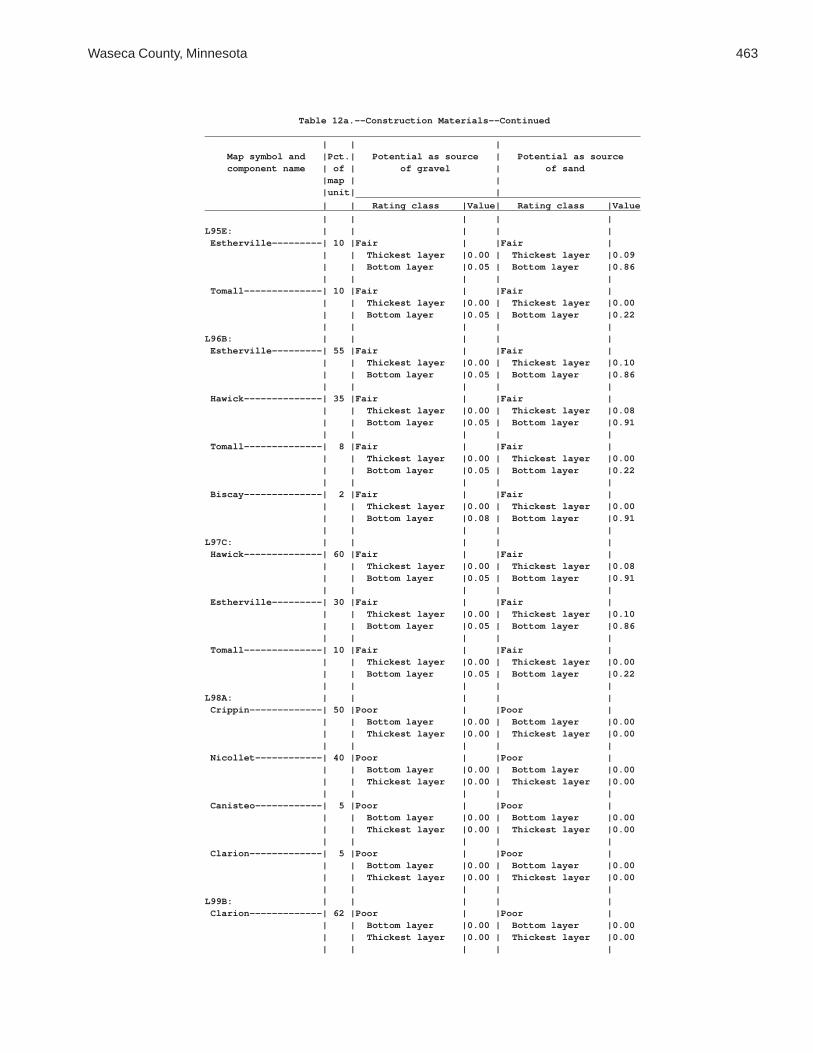
Waseca County, Minnesota 463
Table 12a.--Construction Materials--Continued______________________________________________________________________________ | | | Map symbol and |Pct.| Potential as source | Potential as source component name | of | of gravel | of sand |map | | |unit| | ___________________________________________________ | | Rating class |Value| Rating class |Value______________________________________________________________________________ | | | | |L95E: | | | | | Estherville---------| 10 |Fair | |Fair | | | Thickest layer |0.00 | Thickest layer |0.09 | | Bottom layer |0.05 | Bottom layer |0.86 | | | | | Tomall--------------| 10 |Fair | |Fair | | | Thickest layer |0.00 | Thickest layer |0.00 | | Bottom layer |0.05 | Bottom layer |0.22 | | | | |L96B: | | | | | Estherville---------| 55 |Fair | |Fair | | | Thickest layer |0.00 | Thickest layer |0.10 | | Bottom layer |0.05 | Bottom layer |0.86 | | | | | Hawick--------------| 35 |Fair | |Fair | | | Thickest layer |0.00 | Thickest layer |0.08 | | Bottom layer |0.05 | Bottom layer |0.91 | | | | | Tomall--------------| 8 |Fair | |Fair | | | Thickest layer |0.00 | Thickest layer |0.00 | | Bottom layer |0.05 | Bottom layer |0.22 | | | | | Biscay--------------| 2 |Fair | |Fair | | | Thickest layer |0.00 | Thickest layer |0.00 | | Bottom layer |0.08 | Bottom layer |0.91 | | | | |L97C: | | | | | Hawick--------------| 60 |Fair | |Fair | | | Thickest layer |0.00 | Thickest layer |0.08 | | Bottom layer |0.05 | Bottom layer |0.91 | | | | | Estherville---------| 30 |Fair | |Fair | | | Thickest layer |0.00 | Thickest layer |0.10 | | Bottom layer |0.05 | Bottom layer |0.86 | | | | | Tomall--------------| 10 |Fair | |Fair | | | Thickest layer |0.00 | Thickest layer |0.00 | | Bottom layer |0.05 | Bottom layer |0.22 | | | | |L98A: | | | | | Crippin-------------| 50 |Poor | |Poor | | | Bottom layer |0.00 | Bottom layer |0.00 | | Thickest layer |0.00 | Thickest layer |0.00 | | | | | Nicollet------------| 40 |Poor | |Poor | | | Bottom layer |0.00 | Bottom layer |0.00 | | Thickest layer |0.00 | Thickest layer |0.00 | | | | | Canisteo------------| 5 |Poor | |Poor | | | Bottom layer |0.00 | Bottom layer |0.00 | | Thickest layer |0.00 | Thickest layer |0.00 | | | | | Clarion-------------| 5 |Poor | |Poor | | | Bottom layer |0.00 | Bottom layer |0.00 | | Thickest layer |0.00 | Thickest layer |0.00 | | | | |L99B: | | | | | Clarion-------------| 62 |Poor | |Poor | | | Bottom layer |0.00 | Bottom layer |0.00 | | Thickest layer |0.00 | Thickest layer |0.00 | | | | |

464 Soil Survey of
Table 12a.--Construction Materials--Continued______________________________________________________________________________ | | | Map symbol and |Pct.| Potential as source | Potential as source component name | of | of gravel | of sand |map | | |unit| | ___________________________________________________ | | Rating class |Value| Rating class |Value______________________________________________________________________________ | | | | |L99B: | | | | | Swanlake------------| 25 |Poor | |Poor | | | Bottom layer |0.00 | Bottom layer |0.00 | | Thickest layer |0.00 | Thickest layer |0.00 | | | | | Nicollet------------| 10 |Poor | |Poor | | | Bottom layer |0.00 | Bottom layer |0.00 | | Thickest layer |0.00 | Thickest layer |0.00 | | | | | Webster-------------| 3 |Poor | |Poor | | | Bottom layer |0.00 | Bottom layer |0.00 | | Thickest layer |0.00 | Thickest layer |0.00 | | | | |L100B: | | | | | Clarion-------------| 45 |Poor | |Poor | | | Bottom layer |0.00 | Bottom layer |0.00 | | Thickest layer |0.00 | Thickest layer |0.00 | | | | | Estherville---------| 35 |Fair | |Fair | | | Thickest layer |0.00 | Thickest layer |0.10 | | Bottom layer |0.05 | Bottom layer |0.86 | | | | | Lowlein-------------| 5 |Poor | |Fair | | | Bottom layer |0.00 | Bottom layer |0.00 | | Thickest layer |0.00 | Thickest layer |0.09 | | | | | Nicollet------------| 5 |Poor | |Poor | | | Bottom layer |0.00 | Bottom layer |0.00 | | Thickest layer |0.00 | Thickest layer |0.00 | | | | | Swanlake------------| 5 |Poor | |Poor | | | Bottom layer |0.00 | Bottom layer |0.00 | | Thickest layer |0.00 | Thickest layer |0.00 | | | | | Webster-------------| 5 |Poor | |Poor | | | Bottom layer |0.00 | Bottom layer |0.00 | | Thickest layer |0.00 | Thickest layer |0.00 | | | | |L101C2: | | | | | Omsrud, eroded------| 40 |Poor | |Poor | | | Bottom layer |0.00 | Bottom layer |0.00 | | Thickest layer |0.00 | Thickest layer |0.00 | | | | | Hawick--------------| 30 |Fair | |Fair | | | Thickest layer |0.00 | Thickest layer |0.08 | | Bottom layer |0.05 | Bottom layer |0.91 | | | | | Storden, eroded-----| 20 |Poor | |Poor | | | Bottom layer |0.00 | Bottom layer |0.00 | | Thickest layer |0.00 | Thickest layer |0.00 | | | | | Delft---------------| 5 |Poor | |Poor | | | Bottom layer |0.00 | Bottom layer |0.00 | | Thickest layer |0.00 | Thickest layer |0.00 | | | | | Terril--------------| 5 |Poor | |Poor | | | Bottom layer |0.00 | Bottom layer |0.00 | | Thickest layer |0.00 | Thickest layer |0.00 | | | | |

Waseca County, Minnesota 465
Table 12a.--Construction Materials--Continued______________________________________________________________________________ | | | Map symbol and |Pct.| Potential as source | Potential as source component name | of | of gravel | of sand |map | | |unit| | ___________________________________________________ | | Rating class |Value| Rating class |Value______________________________________________________________________________ | | | | |L101D2: | | | | | Omsrud, eroded------| 40 |Poor | |Poor | | | Bottom layer |0.00 | Bottom layer |0.00 | | Thickest layer |0.00 | Thickest layer |0.00 | | | | | Hawick--------------| 25 |Fair | |Fair | | | Thickest layer |0.00 | Thickest layer |0.08 | | Bottom layer |0.05 | Bottom layer |0.91 | | | | | Storden, eroded-----| 20 |Poor | |Poor | | | Bottom layer |0.00 | Bottom layer |0.00 | | Thickest layer |0.00 | Thickest layer |0.00 | | | | | Ridgeton------------| 6 |Poor | |Poor | | | Bottom layer |0.00 | Bottom layer |0.00 | | Thickest layer |0.00 | Thickest layer |0.00 | | | | | Delft---------------| 5 |Poor | |Poor | | | Bottom layer |0.00 | Bottom layer |0.00 | | Thickest layer |0.00 | Thickest layer |0.00 | | | | | Terril--------------| 4 |Poor | |Poor | | | Bottom layer |0.00 | Bottom layer |0.00 | | Thickest layer |0.00 | Thickest layer |0.00 | | | | |L102C2: | | | | | Omsrud, eroded------| 45 |Poor | |Poor | | | Bottom layer |0.00 | Bottom layer |0.00 | | Thickest layer |0.00 | Thickest layer |0.00 | | | | | Storden, eroded-----| 25 |Poor | |Poor | | | Bottom layer |0.00 | Bottom layer |0.00 | | Thickest layer |0.00 | Thickest layer |0.00 | | | | | Omsrud--------------| 15 |Poor | |Poor | | | Bottom layer |0.00 | Bottom layer |0.00 | | Thickest layer |0.00 | Thickest layer |0.00 | | | | | Terril--------------| 10 |Poor | |Poor | | | Bottom layer |0.00 | Bottom layer |0.00 | | Thickest layer |0.00 | Thickest layer |0.00 | | | | | Delft---------------| 5 |Poor | |Poor | | | Bottom layer |0.00 | Bottom layer |0.00 | | Thickest layer |0.00 | Thickest layer |0.00 | | | | |L102D2: | | | | | Omsrud, eroded------| 45 |Poor | |Poor | | | Bottom layer |0.00 | Bottom layer |0.00 | | Thickest layer |0.00 | Thickest layer |0.00 | | | | | Storden, eroded-----| 20 |Poor | |Poor | | | Bottom layer |0.00 | Bottom layer |0.00 | | Thickest layer |0.00 | Thickest layer |0.00 | | | | | Omsrud--------------| 15 |Poor | |Poor | | | Bottom layer |0.00 | Bottom layer |0.00 | | Thickest layer |0.00 | Thickest layer |0.00 | | | | |

466 Soil Survey of
Table 12a.--Construction Materials--Continued______________________________________________________________________________ | | | Map symbol and |Pct.| Potential as source | Potential as source component name | of | of gravel | of sand |map | | |unit| | ___________________________________________________ | | Rating class |Value| Rating class |Value______________________________________________________________________________ | | | | |L102D2: | | | | | Ridgeton------------| 8 |Poor | |Poor | | | Bottom layer |0.00 | Bottom layer |0.00 | | Thickest layer |0.00 | Thickest layer |0.00 | | | | | Delft---------------| 6 |Poor | |Poor | | | Bottom layer |0.00 | Bottom layer |0.00 | | Thickest layer |0.00 | Thickest layer |0.00 | | | | | Terril--------------| 6 |Poor | |Poor | | | Bottom layer |0.00 | Bottom layer |0.00 | | Thickest layer |0.00 | Thickest layer |0.00 | | | | |L103A: | | | | | Fieldon-------------| 50 |Poor | |Fair | | | Bottom layer |0.00 | Thickest layer |0.00 | | Thickest layer |0.00 | Bottom layer |0.11 | | | | | Canisteo------------| 35 |Poor | |Poor | | | Bottom layer |0.00 | Bottom layer |0.00 | | Thickest layer |0.00 | Thickest layer |0.00 | | | | | Darfur--------------| 10 |Poor | |Fair | | | Bottom layer |0.00 | Thickest layer |0.08 | | Thickest layer |0.00 | Bottom layer |0.11 | | | | | Glencoe-------------| 5 |Poor | |Poor | | | Bottom layer |0.00 | Bottom layer |0.00 | | Thickest layer |0.00 | Thickest layer |0.00 | | | | |L105C2: | | | | | Lester, eroded------| 45 |Poor | |Poor | | | Bottom layer |0.00 | Bottom layer |0.00 | | Thickest layer |0.00 | Thickest layer |0.00 | | | | | Hawick--------------| 35 |Fair | |Fair | | | Thickest layer |0.00 | Thickest layer |0.08 | | Bottom layer |0.05 | Bottom layer |0.91 | | | | | Terril--------------| 10 |Poor | |Poor | | | Bottom layer |0.00 | Bottom layer |0.00 | | Thickest layer |0.00 | Thickest layer |0.00 | | | | | Hamel---------------| 5 |Poor | |Poor | | | Bottom layer |0.00 | Bottom layer |0.00 | | Thickest layer |0.00 | Thickest layer |0.00 | | | | | Storden, eroded-----| 5 |Poor | |Poor | | | Bottom layer |0.00 | Bottom layer |0.00 | | Thickest layer |0.00 | Thickest layer |0.00 | | | | |L105D2: | | | | | Lester, eroded------| 45 |Poor | |Poor | | | Bottom layer |0.00 | Bottom layer |0.00 | | Thickest layer |0.00 | Thickest layer |0.00 | | | | | Hawick--------------| 35 |Fair | |Fair | | | Thickest layer |0.00 | Thickest layer |0.08 | | Bottom layer |0.05 | Bottom layer |0.91 | | | | |
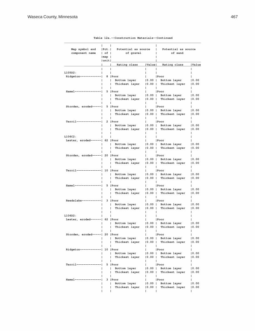
Waseca County, Minnesota 467
Table 12a.--Construction Materials--Continued______________________________________________________________________________ | | | Map symbol and |Pct.| Potential as source | Potential as source component name | of | of gravel | of sand |map | | |unit| | ___________________________________________________ | | Rating class |Value| Rating class |Value______________________________________________________________________________ | | | | |L105D2: | | | | | Ridgeton------------| 8 |Poor | |Poor | | | Bottom layer |0.00 | Bottom layer |0.00 | | Thickest layer |0.00 | Thickest layer |0.00 | | | | | Hamel---------------| 5 |Poor | |Poor | | | Bottom layer |0.00 | Bottom layer |0.00 | | Thickest layer |0.00 | Thickest layer |0.00 | | | | | Storden, eroded-----| 5 |Poor | |Poor | | | Bottom layer |0.00 | Bottom layer |0.00 | | Thickest layer |0.00 | Thickest layer |0.00 | | | | | Terril--------------| 2 |Poor | |Poor | | | Bottom layer |0.00 | Bottom layer |0.00 | | Thickest layer |0.00 | Thickest layer |0.00 | | | | |L106C2: | | | | | Lester, eroded------| 62 |Poor | |Poor | | | Bottom layer |0.00 | Bottom layer |0.00 | | Thickest layer |0.00 | Thickest layer |0.00 | | | | | Storden, eroded-----| 20 |Poor | |Poor | | | Bottom layer |0.00 | Bottom layer |0.00 | | Thickest layer |0.00 | Thickest layer |0.00 | | | | | Terril--------------| 10 |Poor | |Poor | | | Bottom layer |0.00 | Bottom layer |0.00 | | Thickest layer |0.00 | Thickest layer |0.00 | | | | | Hamel---------------| 5 |Poor | |Poor | | | Bottom layer |0.00 | Bottom layer |0.00 | | Thickest layer |0.00 | Thickest layer |0.00 | | | | | Reedslake-----------| 3 |Poor | |Poor | | | Bottom layer |0.00 | Bottom layer |0.00 | | Thickest layer |0.00 | Thickest layer |0.00 | | | | |L106D2: | | | | | Lester, eroded------| 62 |Poor | |Poor | | | Bottom layer |0.00 | Bottom layer |0.00 | | Thickest layer |0.00 | Thickest layer |0.00 | | | | | Storden, eroded-----| 20 |Poor | |Poor | | | Bottom layer |0.00 | Bottom layer |0.00 | | Thickest layer |0.00 | Thickest layer |0.00 | | | | | Ridgeton------------| 10 |Poor | |Poor | | | Bottom layer |0.00 | Bottom layer |0.00 | | Thickest layer |0.00 | Thickest layer |0.00 | | | | | Terril--------------| 5 |Poor | |Poor | | | Bottom layer |0.00 | Bottom layer |0.00 | | Thickest layer |0.00 | Thickest layer |0.00 | | | | | Hamel---------------| 3 |Poor | |Poor | | | Bottom layer |0.00 | Bottom layer |0.00 | | Thickest layer |0.00 | Thickest layer |0.00 | | | | |

468 Soil Survey of
Table 12a.--Construction Materials--Continued______________________________________________________________________________ | | | Map symbol and |Pct.| Potential as source | Potential as source component name | of | of gravel | of sand |map | | |unit| | ___________________________________________________ | | Rating class |Value| Rating class |Value______________________________________________________________________________ | | | | |L107A: | | | | | Canisteo------------| 50 |Poor | |Poor | | | Bottom layer |0.00 | Bottom layer |0.00 | | Thickest layer |0.00 | Thickest layer |0.00 | | | | | Glencoe-------------| 35 |Poor | |Poor | | | Bottom layer |0.00 | Bottom layer |0.00 | | Thickest layer |0.00 | Thickest layer |0.00 | | | | | Harps---------------| 10 |Poor | |Poor | | | Bottom layer |0.00 | Bottom layer |0.00 | | Thickest layer |0.00 | Thickest layer |0.00 | | | | | Canisteo, | | | | | depressional-------| 3 |Poor | |Poor | | | Bottom layer |0.00 | Bottom layer |0.00 | | Thickest layer |0.00 | Thickest layer |0.00 | | | | | Crippin-------------| 2 |Poor | |Poor | | | Bottom layer |0.00 | Bottom layer |0.00 | | Thickest layer |0.00 | Thickest layer |0.00 | | | | |L108A: | | | | | Cordova-------------| 65 |Poor | |Poor | | | Bottom layer |0.00 | Bottom layer |0.00 | | Thickest layer |0.00 | Thickest layer |0.00 | | | | | Rolfe---------------| 30 |Poor | |Poor | | | Bottom layer |0.00 | Bottom layer |0.00 | | Thickest layer |0.00 | Thickest layer |0.00 | | | | | Le Sueur------------| 5 |Poor | |Poor | | | Bottom layer |0.00 | Bottom layer |0.00 | | Thickest layer |0.00 | Thickest layer |0.00 | | | | |L109A: | | | | | Marna---------------| 65 |Poor | |Poor | | | Bottom layer |0.00 | Bottom layer |0.00 | | Thickest layer |0.00 | Thickest layer |0.00 | | | | | Barbert-------------| 30 |Poor | |Poor | | | Bottom layer |0.00 | Bottom layer |0.00 | | Thickest layer |0.00 | Thickest layer |0.00 | | | | | Guckeen-------------| 5 |Poor | |Poor | | | Bottom layer |0.00 | Bottom layer |0.00 | | Thickest layer |0.00 | Thickest layer |0.00 | | | | |L110E: | | | | | Lester--------------| 50 |Poor | |Poor | | | Bottom layer |0.00 | Bottom layer |0.00 | | Thickest layer |0.00 | Thickest layer |0.00 | | | | | Ridgeton------------| 30 |Poor | |Poor | | | Bottom layer |0.00 | Bottom layer |0.00 | | Thickest layer |0.00 | Thickest layer |0.00 | | | | | Cokato--------------| 10 |Poor | |Poor | | | Bottom layer |0.00 | Bottom layer |0.00 | | Thickest layer |0.00 | Thickest layer |0.00 | | | | |

Waseca County, Minnesota 469
Table 12a.--Construction Materials--Continued______________________________________________________________________________ | | | Map symbol and |Pct.| Potential as source | Potential as source component name | of | of gravel | of sand |map | | |unit| | ___________________________________________________ | | Rating class |Value| Rating class |Value______________________________________________________________________________ | | | | |L110E: | | | | | Belview-------------| 6 |Poor | |Poor | | | Bottom layer |0.00 | Bottom layer |0.00 | | Thickest layer |0.00 | Thickest layer |0.00 | | | | | Hamel---------------| 2 |Poor | |Poor | | | Bottom layer |0.00 | Bottom layer |0.00 | | Thickest layer |0.00 | Thickest layer |0.00 | | | | | Terril--------------| 2 |Poor | |Poor | | | Bottom layer |0.00 | Bottom layer |0.00 | | Thickest layer |0.00 | Thickest layer |0.00 | | | | |L110F: | | | | | Lester--------------| 55 |Poor | |Poor | | | Bottom layer |0.00 | Bottom layer |0.00 | | Thickest layer |0.00 | Thickest layer |0.00 | | | | | Ridgeton------------| 30 |Poor | |Poor | | | Bottom layer |0.00 | Bottom layer |0.00 | | Thickest layer |0.00 | Thickest layer |0.00 | | | | | Cokato--------------| 8 |Poor | |Poor | | | Bottom layer |0.00 | Bottom layer |0.00 | | Thickest layer |0.00 | Thickest layer |0.00 | | | | | Belview-------------| 4 |Poor | |Poor | | | Bottom layer |0.00 | Bottom layer |0.00 | | Thickest layer |0.00 | Thickest layer |0.00 | | | | | Terril--------------| 2 |Poor | |Poor | | | Bottom layer |0.00 | Bottom layer |0.00 | | Thickest layer |0.00 | Thickest layer |0.00 | | | | | Hamel---------------| 1 |Poor | |Poor | | | Bottom layer |0.00 | Bottom layer |0.00 | | Thickest layer |0.00 | Thickest layer |0.00 | | | | |L111A: | | | | | Nicollet------------| 85 |Poor | |Poor | | | Bottom layer |0.00 | Bottom layer |0.00 | | Thickest layer |0.00 | Thickest layer |0.00 | | | | | Clarion-------------| 10 |Poor | |Poor | | | Bottom layer |0.00 | Bottom layer |0.00 | | Thickest layer |0.00 | Thickest layer |0.00 | | | | | Webster-------------| 5 |Poor | |Poor | | | Bottom layer |0.00 | Bottom layer |0.00 | | Thickest layer |0.00 | Thickest layer |0.00 | | | | |L112A: | | | | | Webster-------------| 85 |Poor | |Poor | | | Bottom layer |0.00 | Bottom layer |0.00 | | Thickest layer |0.00 | Thickest layer |0.00 | | | | | Glencoe-------------| 10 |Poor | |Poor | | | Bottom layer |0.00 | Bottom layer |0.00 | | Thickest layer |0.00 | Thickest layer |0.00 | | | | |

470 Soil Survey of
Table 12a.--Construction Materials--Continued______________________________________________________________________________ | | | Map symbol and |Pct.| Potential as source | Potential as source component name | of | of gravel | of sand |map | | |unit| | ___________________________________________________ | | Rating class |Value| Rating class |Value______________________________________________________________________________ | | | | |L112A: | | | | | Nicollet------------| 5 |Poor | |Poor | | | Bottom layer |0.00 | Bottom layer |0.00 | | Thickest layer |0.00 | Thickest layer |0.00 | | | | |L113B: | | | | | Reedslake-----------| 75 |Poor | |Poor | | | Bottom layer |0.00 | Bottom layer |0.00 | | Thickest layer |0.00 | Thickest layer |0.00 | | | | | Le Sueur------------| 10 |Poor | |Poor | | | Bottom layer |0.00 | Bottom layer |0.00 | | Thickest layer |0.00 | Thickest layer |0.00 | | | | | Reedslake, eroded---| 10 |Poor | |Poor | | | Bottom layer |0.00 | Bottom layer |0.00 | | Thickest layer |0.00 | Thickest layer |0.00 | | | | | Cordova-------------| 5 |Poor | |Poor | | | Bottom layer |0.00 | Bottom layer |0.00 | | Thickest layer |0.00 | Thickest layer |0.00 | | | | |L114A: | | | | | Hanlon, rarely | | | | | flooded------------| 85 |Poor | |Fair | | | Bottom layer |0.00 | Bottom layer |0.06 | | Thickest layer |0.00 | Thickest layer |0.08 | | | | | Coland, occasionally| | | | | flooded------------| 10 |Poor | |Fair | | | Bottom layer |0.00 | Thickest layer |0.00 | | Thickest layer |0.00 | Bottom layer |0.09 | | | | | Minneopa, rarely | | | | | flooded------------| 5 |Poor | |Fair | | | Bottom layer |0.00 | Thickest layer |0.10 | | Thickest layer |0.00 | Bottom layer |0.52 | | | | |L115A: | | | | | Brownton------------| 55 |Poor | |Poor | | | Bottom layer |0.00 | Bottom layer |0.00 | | Thickest layer |0.00 | Thickest layer |0.00 | | | | | Lura----------------| 35 |Poor | |Poor | | | Bottom layer |0.00 | Bottom layer |0.00 | | Thickest layer |0.00 | Thickest layer |0.00 | | | | | Marna---------------| 10 |Poor | |Poor | | | Bottom layer |0.00 | Bottom layer |0.00 | | Thickest layer |0.00 | Thickest layer |0.00 | | | | |L116A: | | | | | Le Sueur------------| 45 |Poor | |Poor | | | Bottom layer |0.00 | Bottom layer |0.00 | | Thickest layer |0.00 | Thickest layer |0.00 | | | | | Lerdal--------------| 40 |Poor | |Poor | | | Bottom layer |0.00 | Bottom layer |0.00 | | Thickest layer |0.00 | Thickest layer |0.00 | | | | |

Waseca County, Minnesota 471
Table 12a.--Construction Materials--Continued______________________________________________________________________________ | | | Map symbol and |Pct.| Potential as source | Potential as source component name | of | of gravel | of sand |map | | |unit| | ___________________________________________________ | | Rating class |Value| Rating class |Value______________________________________________________________________________ | | | | |L116A: | | | | | Mazaska-------------| 10 |Poor | |Poor | | | Bottom layer |0.00 | Bottom layer |0.00 | | Thickest layer |0.00 | Thickest layer |0.00 | | | | | Kilkenny------------| 5 |Poor | |Poor | | | Bottom layer |0.00 | Bottom layer |0.00 | | Thickest layer |0.00 | Thickest layer |0.00 | | | | |L117C2: | | | | | Omsrud, eroded------| 65 |Poor | |Poor | | | Bottom layer |0.00 | Bottom layer |0.00 | | Thickest layer |0.00 | Thickest layer |0.00 | | | | | Omsrud--------------| 15 |Poor | |Poor | | | Bottom layer |0.00 | Bottom layer |0.00 | | Thickest layer |0.00 | Thickest layer |0.00 | | | | | Terril--------------| 10 |Poor | |Poor | | | Bottom layer |0.00 | Bottom layer |0.00 | | Thickest layer |0.00 | Thickest layer |0.00 | | | | | Delft---------------| 5 |Poor | |Poor | | | Bottom layer |0.00 | Bottom layer |0.00 | | Thickest layer |0.00 | Thickest layer |0.00 | | | | | Storden, eroded-----| 5 |Poor | |Poor | | | Bottom layer |0.00 | Bottom layer |0.00 | | Thickest layer |0.00 | Thickest layer |0.00 | | | | |L118A: | | | | | Rushriver, | | | | | frequently flooded | 85 |Poor | |Fair | | | Bottom layer |0.00 | Thickest layer |0.06 | | Thickest layer |0.00 | Bottom layer |0.08 | | | | | Houghton, frequently| | | | | flooded------------| 5 |Poor | |Poor | | | Bottom layer |0.00 | Bottom layer |0.00 | | Thickest layer |0.00 | Thickest layer |0.00 | | | | | Klossner, frequently| | | | | flooded------------| 5 |Poor | |Poor | | | Bottom layer |0.00 | Bottom layer |0.00 | | Thickest layer |0.00 | Thickest layer |0.00 | | | | | Medo, frequently | | | | | flooded------------| 5 |Poor | |Fair | | | Thickest layer |0.00 | Thickest layer |0.00 | | Bottom layer |0.00 | Bottom layer |0.91 | | | | |L119B: | | | | | Angus---------------| 80 |Poor | |Poor | | | Bottom layer |0.00 | Bottom layer |0.00 | | Thickest layer |0.00 | Thickest layer |0.00 | | | | | Angus, eroded-------| 10 |Poor | |Poor | | | Bottom layer |0.00 | Bottom layer |0.00 | | Thickest layer |0.00 | Thickest layer |0.00 | | | | |

472 Soil Survey of
Table 12a.--Construction Materials--Continued______________________________________________________________________________ | | | Map symbol and |Pct.| Potential as source | Potential as source component name | of | of gravel | of sand |map | | |unit| | ___________________________________________________ | | Rating class |Value| Rating class |Value______________________________________________________________________________ | | | | |L119B: | | | | | Cordova-------------| 5 |Poor | |Poor | | | Bottom layer |0.00 | Bottom layer |0.00 | | Thickest layer |0.00 | Thickest layer |0.00 | | | | | Le Sueur------------| 5 |Poor | |Poor | | | Bottom layer |0.00 | Bottom layer |0.00 | | Thickest layer |0.00 | Thickest layer |0.00 | | | | |L120A: | | | | | Good Thunder--------| 80 |Poor | |Poor | | | Bottom layer |0.00 | Bottom layer |0.00 | | Thickest layer |0.00 | Thickest layer |0.00 | | | | | Ocheyedan-----------| 10 |Poor | |Poor | | | Bottom layer |0.00 | Bottom layer |0.00 | | Thickest layer |0.00 | Thickest layer |0.00 | | | | | Minnetonka----------| 10 |Poor | |Poor | | | Bottom layer |0.00 | Bottom layer |0.00 | | Thickest layer |0.00 | Thickest layer |0.00 | | | | |L121B: | | | | | Clarion-------------| 80 |Poor | |Poor | | | Bottom layer |0.00 | Bottom layer |0.00 | | Thickest layer |0.00 | Thickest layer |0.00 | | | | | Guckeen-------------| 15 |Poor | |Poor | | | Bottom layer |0.00 | Bottom layer |0.00 | | Thickest layer |0.00 | Thickest layer |0.00 | | | | | Marna---------------| 5 |Poor | |Poor | | | Bottom layer |0.00 | Bottom layer |0.00 | | Thickest layer |0.00 | Thickest layer |0.00 | | | | |L122B: | | | | | Reedslake-----------| 55 |Poor | |Poor | | | Bottom layer |0.00 | Bottom layer |0.00 | | Thickest layer |0.00 | Thickest layer |0.00 | | | | | Estherville---------| 25 |Fair | |Fair | | | Thickest layer |0.00 | Thickest layer |0.10 | | Bottom layer |0.05 | Bottom layer |0.86 | | | | | Le Sueur------------| 10 |Poor | |Poor | | | Bottom layer |0.00 | Bottom layer |0.00 | | Thickest layer |0.00 | Thickest layer |0.00 | | | | | Cordova-------------| 5 |Poor | |Poor | | | Bottom layer |0.00 | Bottom layer |0.00 | | Thickest layer |0.00 | Thickest layer |0.00 | | | | | Lowlein-------------| 5 |Poor | |Fair | | | Bottom layer |0.00 | Bottom layer |0.00 | | Thickest layer |0.00 | Thickest layer |0.09 | | | | |L123A: | | | | | Belleville----------| 85 |Poor | |Poor | | | Bottom layer |0.00 | Bottom layer |0.00 | | Thickest layer |0.00 | Thickest layer |0.00 | | | | |

Waseca County, Minnesota 473
Table 12a.--Construction Materials--Continued______________________________________________________________________________ | | | Map symbol and |Pct.| Potential as source | Potential as source component name | of | of gravel | of sand |map | | |unit| | ___________________________________________________ | | Rating class |Value| Rating class |Value______________________________________________________________________________ | | | | |L123A: | | | | | Granby--------------| 15 |Poor | |Fair | | | Bottom layer |0.00 | Bottom layer |0.18 | | Thickest layer |0.00 | Thickest layer |0.87 | | | | |L124A: | | | | | Glencoe mucky clay | | | | | loam---------------| 85 |Poor | |Poor | | | Bottom layer |0.00 | Bottom layer |0.00 | | Thickest layer |0.00 | Thickest layer |0.00 | | | | | Canisteo------------| 10 |Poor | |Poor | | | Bottom layer |0.00 | Bottom layer |0.00 | | Thickest layer |0.00 | Thickest layer |0.00 | | | | | Glencoe clay loam---| 5 |Poor | |Poor | | | Bottom layer |0.00 | Bottom layer |0.00 | | Thickest layer |0.00 | Thickest layer |0.00 | | | | |L125A: | | | | | Hanlon, rarely | | | | | flooded------------| 60 |Poor | |Fair | | | Bottom layer |0.00 | Bottom layer |0.06 | | Thickest layer |0.00 | Thickest layer |0.08 | | | | | Coland, occasionally| | | | | flooded------------| 25 |Poor | |Fair | | | Bottom layer |0.00 | Thickest layer |0.00 | | Thickest layer |0.00 | Bottom layer |0.09 | | | | | Minneopa, rarely | | | | | flooded------------| 15 |Poor | |Fair | | | Bottom layer |0.00 | Thickest layer |0.10 | | Thickest layer |0.00 | Bottom layer |0.52 | | | | |L126A: | | | | | Coland, occasionally| | | | | flooded------------| 80 |Poor | |Fair | | | Bottom layer |0.00 | Thickest layer |0.00 | | Thickest layer |0.00 | Bottom layer |0.09 | | | | | Minneopa, | | | | | occasionally | | | | | flooded------------| 10 |Poor | |Fair | | | Bottom layer |0.00 | Thickest layer |0.10 | | Thickest layer |0.00 | Bottom layer |0.52 | | | | | Havelock, | | | | | occasionally | | | | | flooded------------| 5 |Poor | |Poor | | | Bottom layer |0.00 | Thickest layer |0.00 | | Thickest layer |0.00 | Bottom layer |0.00 | | | | | Spillville, | | | | | occasionally | | | | | flooded------------| 5 |Poor | |Poor | | | Bottom layer |0.00 | Bottom layer |0.00 | | Thickest layer |0.00 | Thickest layer |0.00 | | | | |

474 Soil Survey of
Table 12a.--Construction Materials--Continued______________________________________________________________________________ | | | Map symbol and |Pct.| Potential as source | Potential as source component name | of | of gravel | of sand |map | | |unit| | ___________________________________________________ | | Rating class |Value| Rating class |Value______________________________________________________________________________ | | | | |L127A: | | | | | Coland, frequently | | | | | flooded------------| 80 |Poor | |Fair | | | Bottom layer |0.00 | Thickest layer |0.00 | | Thickest layer |0.00 | Bottom layer |0.09 | | | | | Minneopa, | | | | | occasionally | | | | | flooded------------| 10 |Poor | |Fair | | | Bottom layer |0.00 | Thickest layer |0.09 | | Thickest layer |0.00 | Bottom layer |0.99 | | | | | Havelock, frequently| | | | | flooded------------| 5 |Poor | |Poor | | | Bottom layer |0.00 | Thickest layer |0.00 | | Thickest layer |0.00 | Bottom layer |0.00 | | | | | Spillville, | | | | | occasionally | | | | | flooded------------| 5 |Poor | |Poor | | | Bottom layer |0.00 | Bottom layer |0.00 | | Thickest layer |0.00 | Thickest layer |0.00 | | | | |L128A: | | | | | Mazaska-------------| 60 |Poor | |Poor | | | Bottom layer |0.00 | Bottom layer |0.00 | | Thickest layer |0.00 | Thickest layer |0.00 | | | | | Rolfe---------------| 30 |Poor | |Poor | | | Bottom layer |0.00 | Bottom layer |0.00 | | Thickest layer |0.00 | Thickest layer |0.00 | | | | | Lerdal--------------| 10 |Poor | |Poor | | | Bottom layer |0.00 | Bottom layer |0.00 | | Thickest layer |0.00 | Thickest layer |0.00 | | | | |L129B: | | | | | Terril--------------| 90 |Poor | |Poor | | | Bottom layer |0.00 | Bottom layer |0.00 | | Thickest layer |0.00 | Thickest layer |0.00 | | | | | Delft---------------| 5 |Poor | |Poor | | | Bottom layer |0.00 | Bottom layer |0.00 | | Thickest layer |0.00 | Thickest layer |0.00 | | | | | Hamel---------------| 5 |Poor | |Poor | | | Bottom layer |0.00 | Bottom layer |0.00 | | Thickest layer |0.00 | Thickest layer |0.00 | | | | |L130A: | | | | | Okoboji mucky silty | | | | | clay loam----------| 75 |Poor | |Poor | | | Bottom layer |0.00 | Bottom layer |0.00 | | Thickest layer |0.00 | Thickest layer |0.00 | | | | | Okoboji silty clay | | | | | loam---------------| 15 |Poor | |Poor | | | Bottom layer |0.00 | Bottom layer |0.00 | | Thickest layer |0.00 | Thickest layer |0.00 | | | | |

Waseca County, Minnesota 475
Table 12a.--Construction Materials--Continued______________________________________________________________________________ | | | Map symbol and |Pct.| Potential as source | Potential as source component name | of | of gravel | of sand |map | | |unit| | ___________________________________________________ | | Rating class |Value| Rating class |Value______________________________________________________________________________ | | | | |L130A: | | | | | Brownton------------| 5 |Poor | |Poor | | | Bottom layer |0.00 | Bottom layer |0.00 | | Thickest layer |0.00 | Thickest layer |0.00 | | | | | Spicer--------------| 5 |Poor | |Poor | | | Bottom layer |0.00 | Bottom layer |0.00 | | Thickest layer |0.00 | Thickest layer |0.00 | | | | |M-W: | | | | | Water, miscellaneous|100 |Not rated | |Not rated | | | | | |U3B: | | | | | Udorthents (cut and | | | | | fill land)---------|100 |Not rated | |Not rated | | | | | |W: | | | | | Water---------------|100 |Not rated | |Not rated | | | | | |______________________________________________________________________________

476 Soil Survey of
Table 12b.--Construction Materials
(The information in this table indicates the dominant soil condition but does not eliminate the need for onsite investigation. The numbers in the value columns range from 0.00 to 0.99. The smaller the value, the greater the limitation. “Not rated” indicates that data are not available or that no rating is applicable. See text for further explanation of ratings in this table)
________________________________________________________________________________________________________ | | | | Map symbol and |Pct.| Potential as source of | Potential as source | Potential as source component name | of | reclamation material | of roadfill | of topsoil |map | | | |unit| | | | _____________________________________________________________________________ | | Rating class and |Value| Rating class and |Value| Rating class and |Value | | limiting features | | limiting features | | limiting features |________________________________________________________________________________________________________ | | | | | | |GP: | | | | | | | Pits, gravel--------| 80 |Not rated | |Not rated | |Not rated | | | | | | | | Udipsamments--------| 20 |Not rated | |Not rated | |Not rated | | | | | | | |L5A: | | | | | | | Delft, overwash-----| 50 |Good | |Fair | |Fair | | | | | Depth to |0.14 | Depth to |0.14 | | | | saturated zone | | saturated zone | | | | | Shrink-swell |0.99 | | | | | | | | | Delft---------------| 40 |Good | |Poor | |Poor | | | | | Depth to |0.00 | Depth to |0.00 | | | | saturated zone | | saturated zone | | | | | Shrink-swell |0.99 | | | | | | | | | Glencoe-------------| 5 |Good | |Poor | |Poor | | | | | Depth to |0.00 | Depth to |0.00 | | | | saturated zone | | saturated zone | | | | | Low strength |0.00 | | | | | | Shrink-swell |0.93 | | | | | | | | | Terril--------------| 5 |Good | |Fair | |Fair | | | | | Depth to |0.88 | Depth to |0.88 | | | | saturated zone | | saturated zone | | | | | | | |L13A: | | | | | | | Klossner, drained---| 80 |Poor | |Poor | |Poor | | | Wind erosion |0.00 | Depth to |0.00 | Content of |0.00 | | Water erosion |0.99 | saturated zone | | organic matter | | | | | | | Depth to |0.00 | | | | | | saturated zone | | | | | | | | Mineral soil, | | | | | | | drained------------| 15 |Fair | |Poor | |Poor | | | Low content of |0.12 | Depth to |0.00 | Depth to |0.00 | | organic matter | | saturated zone | | saturated zone | | | | | Shrink-swell |0.95 | | | | | | | | | Houghton, drained---| 5 |Poor | |Poor | |Poor | | | Wind erosion |0.00 | Depth to |0.00 | Content of |0.00 | | | | saturated zone | | organic matter | | | | | | | Depth to |0.00 | | | | | | saturated zone | | | | | | | |L14A: | | | | | | | Houghton, drained---| 80 |Poor | |Poor | |Poor | | | Wind erosion |0.00 | Depth to |0.00 | Content of |0.00 | | | | saturated zone | | organic matter | | | | | | | Depth to |0.00 | | | | | | saturated zone | | | | | | | |

Waseca County, Minnesota 477
Table 12b.--Construction Materials--Continued________________________________________________________________________________________________________ | | | | Map symbol and |Pct.| Potential as source of | Potential as source | Potential as source component name | of | reclamation material | of roadfill | of topsoil |map | | | |unit| | | | _____________________________________________________________________________ | | Rating class and |Value| Rating class and |Value| Rating class and |Value | | limiting features | | limiting features | | limiting features |________________________________________________________________________________________________________ | | | | | | |L14A: | | | | | | | Klossner, drained---| 10 |Poor | |Poor | |Poor | | | Wind erosion |0.00 | Depth to |0.00 | Content of |0.00 | | Water erosion |0.99 | saturated zone | | organic matter | | | | | | | Depth to |0.00 | | | | | | saturated zone | | | | | | | | Mineral soil, | | | | | | | drained------------| 10 |Fair | |Poor | |Poor | | | Low content of |0.12 | Depth to |0.00 | Depth to |0.00 | | organic matter | | saturated zone | | saturated zone | | | | | Shrink-swell |0.95 | | | | | | | | |L15A: | | | | | | | Klossner, ponded----| 30 |Fair | |Poor | |Poor | | | Water erosion |0.99 | Depth to |0.00 | Content of |0.00 | | | | saturated zone | | organic matter | | | | | | | Depth to |0.00 | | | | | | saturated zone | | | | | | | | Okoboji, ponded-----| 30 |Fair | |Poor | |Poor | | | Too clayey |0.08 | Depth to |0.00 | Depth to |0.00 | | Water erosion |0.99 | saturated zone | | saturated zone | | | | | Shrink-swell |0.12 | Too clayey |0.08 | | | | | | | Glencoe, ponded-----| 30 |Good | |Poor | |Poor | | | | | Depth to |0.00 | Depth to |0.00 | | | | saturated zone | | saturated zone | | | | | Shrink-swell |0.93 | | | | | | | | | Houghton, ponded----| 10 |Good | |Poor | |Poor | | | | | Depth to |0.00 | Content of |0.00 | | | | saturated zone | | organic matter | | | | | | | Depth to |0.00 | | | | | | saturated zone | | | | | | | |L16A: | | | | | | | Muskego, ponded-----| 30 |Poor | |Poor | |Poor | | | Carbonate content|0.00 | Depth to |0.00 | Content of |0.00 | | | | saturated zone | | organic matter | | | | | | | Depth to |0.00 | | | | | | saturated zone | | | | | | | | Blue Earth, ponded--| 30 |Fair | |Poor | |Poor | | | Carbonate content|0.80 | Depth to |0.00 | Depth to |0.00 | | | | saturated zone | | saturated zone | | | | | Shrink-swell |0.95 | Content of |0.94 | | | | | | organic matter | | | | | | | | Houghton, ponded----| 30 |Good | |Poor | |Poor | | | | | Depth to |0.00 | Content of |0.00 | | | | saturated zone | | organic matter | | | | | | | Depth to |0.00 | | | | | | saturated zone | | | | | | | | Klossner, ponded----| 10 |Fair | |Poor | |Poor | | | Water erosion |0.99 | Depth to |0.00 | Content of |0.00 | | | | saturated zone | | organic matter | | | | | | | Depth to |0.00 | | | | | | saturated zone | | | | | | | |

478 Soil Survey of
Table 12b.--Construction Materials--Continued________________________________________________________________________________________________________ | | | | Map symbol and |Pct.| Potential as source of | Potential as source | Potential as source component name | of | reclamation material | of roadfill | of topsoil |map | | | |unit| | | | _____________________________________________________________________________ | | Rating class and |Value| Rating class and |Value| Rating class and |Value | | limiting features | | limiting features | | limiting features |________________________________________________________________________________________________________ | | | | | | |L26B: | | | | | | | Shorewood-----------| 90 |Poor | |Fair | |Poor | | | Too clayey |0.00 | Depth to |0.14 | Too clayey |0.00 | | Too acid |0.97 | saturated zone | | Depth to |0.14 | | | | Shrink-swell |0.76 | saturated zone | | | | | | | | Good Thunder--------| 5 |Poor | |Fair | |Poor | | | Too clayey |0.00 | Depth to |0.88 | Too clayey |0.00 | | Low content of |0.50 | saturated zone | | Depth to |0.88 | | organic matter | | Shrink-swell |0.96 | saturated zone | | | Too acid |0.97 | | | | | | Water erosion |0.99 | | | | | | | | | | | Minnetonka----------| 5 |Poor | |Poor | |Poor | | | Low content of |0.00 | Depth to |0.00 | Too clayey |0.00 | | organic matter | | saturated zone | | Depth to |0.00 | | Too clayey |0.00 | Shrink-swell |0.55 | saturated zone | | | Too acid |0.97 | | | | | | | | | | |L36A: | | | | | | | Hamel, overwash-----| 50 |Good | |Fair | |Fair | | | | | Depth to |0.14 | Depth to |0.14 | | | | saturated zone | | saturated zone | | | | | | | | Hamel---------------| 43 |Fair | |Poor | |Poor | | | Low content of |0.12 | Depth to |0.00 | Depth to |0.00 | | organic matter | | saturated zone | | saturated zone | | | | | Shrink-swell |0.99 | | | | | | | | | Terril--------------| 5 |Good | |Good | |Good | | | | | | | | Glencoe-------------| 2 |Fair | |Poor | |Poor | | | Low content of |0.12 | Depth to |0.00 | Depth to |0.00 | | organic matter | | saturated zone | | saturated zone | | | | | Shrink-swell |0.95 | | | | | | | | |L40B: | | | | | | | Angus---------------| 45 |Fair | |Fair | |Good | | | Low content of |0.12 | Shrink-swell |0.99 | | | | organic matter | | | | | | | Too acid |0.97 | | | | | | Water erosion |0.99 | | | | | | | | | | | Kilkenny------------| 40 |Poor | |Fair | |Poor | | | Too clayey |0.00 | Depth to |0.24 | Too clayey |0.00 | | Low content of |0.12 | saturated zone | | Depth to |0.24 | | organic matter | | Shrink-swell |0.98 | saturated zone | | | Too acid |0.68 | | | | | | | | | | | Lerdal--------------| 10 |Poor | |Fair | |Poor | | | Too clayey |0.00 | Depth to |0.22 | Too clayey |0.00 | | Low content of |0.12 | saturated zone | | Depth to |0.22 | | organic matter | | Shrink-swell |0.63 | saturated zone | | | Too acid |0.54 | | | Too acid |0.98 | | Carbonate content|0.97 | | | | | | Water erosion |0.99 | | | | | | | | | | |

Waseca County, Minnesota 479
Table 12b.--Construction Materials--Continued________________________________________________________________________________________________________ | | | | Map symbol and |Pct.| Potential as source of | Potential as source | Potential as source component name | of | reclamation material | of roadfill | of topsoil |map | | | |unit| | | | _____________________________________________________________________________ | | Rating class and |Value| Rating class and |Value| Rating class and |Value | | limiting features | | limiting features | | limiting features |________________________________________________________________________________________________________ | | | | | | |L40B: | | | | | | | Mazaska-------------| 5 |Poor | |Poor | |Poor | | | Too clayey |0.00 | Depth to |0.00 | Depth to |0.00 | | Low content of |0.12 | saturated zone | | saturated zone | | | organic matter | | Shrink-swell |0.56 | Too clayey |0.00 | | Too acid |0.68 | | | | | | Carbonate content|0.97 | | | | | | | | | | |L41C2: | | | | | | | Lester, eroded------| 45 |Fair | |Fair | |Fair | | | Low content of |0.88 | Shrink-swell |0.97 | Slope |0.96 | | organic matter | | | | | | | Too acid |0.97 | | | | | | Carbonate content|0.97 | | | | | | | | | | | Kilkenny, eroded----| 40 |Poor | |Fair | |Poor | | | Too clayey |0.00 | Depth to |0.89 | Too clayey |0.00 | | Low content of |0.50 | saturated zone | | Depth to |0.89 | | organic matter | | Shrink-swell |0.91 | saturated zone | | | Too acid |0.68 | | | Slope |0.96 | | | | | | | Terril--------------| 10 |Good | |Good | |Good | | | | | | | | Derrynane-----------| 5 |Poor | |Poor | |Poor | | | Too clayey |0.00 | Depth to |0.00 | Depth to |0.00 | | | | saturated zone | | saturated zone | | | | | Shrink-swell |0.41 | Too clayey |0.00 | | | | | | |L41D2: | | | | | | | Lester, eroded------| 45 |Fair | |Fair | |Poor | | | Low content of |0.88 | Shrink-swell |0.97 | Slope |0.00 | | organic matter | | | | | | | Too acid |0.97 | | | | | | Carbonate content|0.97 | | | | | | | | | | | Kilkenny, eroded----| 35 |Poor | |Fair | |Poor | | | Too clayey |0.00 | Depth to |0.89 | Slope |0.00 | | Low content of |0.50 | saturated zone | | Too clayey |0.00 | | organic matter | | Shrink-swell |0.91 | Depth to |0.89 | | Too acid |0.68 | | | saturated zone | | | | | | | | Terril--------------| 10 |Good | |Good | |Good | | | | | | | | Derrynane-----------| 5 |Poor | |Poor | |Poor | | | Too clayey |0.00 | Depth to |0.00 | Depth to |0.00 | | | | saturated zone | | saturated zone | | | | | Shrink-swell |0.41 | Too clayey |0.00 | | | | | | | Ridgeton------------| 5 |Good | |Good | |Fair | | | | | | | Slope |0.84 | | | | | | |L41E: | | | | | | | Lester--------------| 45 |Fair | |Fair | |Poor | | | Low content of |0.88 | Slope |0.18 | Slope |0.00 | | organic matter | | Shrink-swell |0.98 | | | | Too acid |0.97 | | | | | | Carbonate content|0.97 | | | | | | | | | | |

480 Soil Survey of
Table 12b.--Construction Materials--Continued________________________________________________________________________________________________________ | | | | Map symbol and |Pct.| Potential as source of | Potential as source | Potential as source component name | of | reclamation material | of roadfill | of topsoil |map | | | |unit| | | | _____________________________________________________________________________ | | Rating class and |Value| Rating class and |Value| Rating class and |Value | | limiting features | | limiting features | | limiting features |________________________________________________________________________________________________________ | | | | | | |L41E: | | | | | | | Kilkenny------------| 40 |Poor | |Fair | |Poor | | | Too clayey |0.00 | Slope |0.18 | Slope |0.00 | | Low content of |0.12 | Depth to |0.89 | Too clayey |0.00 | | organic matter | | saturated zone | | Depth to |0.89 | | Too acid |0.68 | Shrink-swell |0.99 | saturated zone | | | | | | | | Terril--------------| 5 |Good | |Good | |Good | | | | | | | | Derrynane-----------| 5 |Fair | |Poor | |Poor | | | Too clayey |0.82 | Depth to |0.00 | Depth to |0.00 | | | | saturated zone | | saturated zone | | | | | Shrink-swell |0.45 | Too clayey |0.82 | | | | | | | Ridgeton------------| 5 |Good | |Good | |Fair | | | | | | | Slope |0.04 | | | | | | |L48A: | | | | | | | Derrynane, overwash | 50 |Poor | |Fair | |Poor | | | Too clayey |0.00 | Depth to |0.14 | Too clayey |0.00 | | | | saturated zone | | Depth to |0.14 | | | | Shrink-swell |0.26 | saturated zone | | | | | | | | Derrynane-----------| 40 |Poor | |Poor | |Poor | | | Too clayey |0.00 | Depth to |0.00 | Depth to |0.00 | | | | saturated zone | | saturated zone | | | | | Shrink-swell |0.41 | Too clayey |0.00 | | | | | | | Glencoe-------------| 5 |Good | |Poor | |Poor | | | | | Depth to |0.00 | Depth to |0.00 | | | | saturated zone | | saturated zone | | | | | Low strength |0.00 | | | | | | Shrink-swell |0.93 | | | | | | | | | Terril--------------| 5 |Good | |Good | |Good | | | | | | | |L49A: | | | | | | | Klossner, surface | | | | | | | drained------------| 65 |Poor | |Poor | |Poor | | | Wind erosion |0.00 | Depth to |0.00 | Content of |0.00 | | Water erosion |0.99 | saturated zone | | organic matter | | | | | | | Depth to |0.00 | | | | | | saturated zone | | | | | | | | Klossner, drained---| 20 |Poor | |Poor | |Poor | | | Wind erosion |0.00 | Depth to |0.00 | Content of |0.00 | | Water erosion |0.99 | saturated zone | | organic matter | | | | | | | Depth to |0.00 | | | | | | saturated zone | | | | | | | | Mineral soil, | | | | | | | drained------------| 15 |Fair | |Poor | |Poor | | | Low content of |0.12 | Depth to |0.00 | Depth to |0.00 | | organic matter | | saturated zone | | saturated zone | | | | | Shrink-swell |0.95 | | | | | | | | |

Waseca County, Minnesota 481
Table 12b.--Construction Materials--Continued________________________________________________________________________________________________________ | | | | Map symbol and |Pct.| Potential as source of | Potential as source | Potential as source component name | of | reclamation material | of roadfill | of topsoil |map | | | |unit| | | | _____________________________________________________________________________ | | Rating class and |Value| Rating class and |Value| Rating class and |Value | | limiting features | | limiting features | | limiting features |________________________________________________________________________________________________________ | | | | | | |L50A: | | | | | | | Houghton, surface | | | | | | | drained------------| 40 |Poor | |Poor | |Poor | | | Wind erosion |0.00 | Depth to |0.00 | Content of |0.00 | | | | saturated zone | | organic matter | | | | | | | Depth to |0.00 | | | | | | saturated zone | | | | | | | | Muskego, surface | | | | | | | drained------------| 40 |Poor | |Poor | |Poor | | | Wind erosion |0.00 | Depth to |0.00 | Content of |0.00 | | Carbonate content|0.00 | saturated zone | | organic matter | | | | | | | Depth to |0.00 | | | | | | saturated zone | | | | | | | | Klossner, drained---| 10 |Poor | |Poor | |Poor | | | Wind erosion |0.00 | Depth to |0.00 | Content of |0.00 | | Water erosion |0.99 | saturated zone | | organic matter | | | | | | | Depth to |0.00 | | | | | | saturated zone | | | | | | | | Mineral soil, | | | | | | | drained------------| 10 |Fair | |Poor | |Poor | | | Low content of |0.12 | Depth to |0.00 | Depth to |0.00 | | organic matter | | saturated zone | | saturated zone | | | | | Shrink-swell |0.95 | | | | | | | | |L51C2: | | | | | | | Gladek, eroded------| 80 |Fair | |Fair | |Fair | | | Low content of |0.02 | Shrink-swell |0.99 | Slope |0.96 | | organic matter | | | | | | | Water erosion |0.90 | | | | | | Carbonate content|0.92 | | | | | | | | | | | Barrington----------| 10 |Fair | |Fair | |Fair | | | Low content of |0.12 | Depth to |0.88 | Depth to |0.88 | | organic matter | | saturated zone | | saturated zone | | | Water erosion |0.90 | | | | | | | | | | | Lester, eroded------| 5 |Fair | |Fair | |Fair | | | Low content of |0.88 | Shrink-swell |0.97 | Slope |0.96 | | organic matter | | | | | | | Too acid |0.97 | | | | | | Carbonate content|0.97 | | | | | | | | | | | Madelia-------------| 5 |Fair | |Poor | |Poor | | | Low content of |0.12 | Depth to |0.00 | Depth to |0.00 | | organic matter | | saturated zone | | saturated zone | | | Too clayey |0.98 | Shrink-swell |0.99 | Too clayey |0.98 | | Water erosion |0.99 | | | | | | | | | | |L56A: | | | | | | | Muskego, frequently | | | | | | | flooded------------| 45 |Poor | |Poor | |Poor | | | Carbonate content|0.00 | Depth to |0.00 | Content of |0.00 | | | | saturated zone | | organic matter | | | | | | | Depth to |0.00 | | | | | | saturated zone | | | | | | | |

482 Soil Survey of
Table 12b.--Construction Materials--Continued________________________________________________________________________________________________________ | | | | Map symbol and |Pct.| Potential as source of | Potential as source | Potential as source component name | of | reclamation material | of roadfill | of topsoil |map | | | |unit| | | | _____________________________________________________________________________ | | Rating class and |Value| Rating class and |Value| Rating class and |Value | | limiting features | | limiting features | | limiting features |________________________________________________________________________________________________________ | | | | | | |L56A: | | | | | | | Klossner, frequently| | | | | | | flooded------------| 45 |Fair | |Poor | |Poor | | | Water erosion |0.99 | Depth to |0.00 | Content of |0.00 | | | | saturated zone | | organic matter | | | | | | | Depth to |0.00 | | | | | | saturated zone | | | | | | | | Suckercreek, | | | | | | | frequently flooded | 10 |Good | |Poor | |Poor | | | | | Depth to |0.00 | Depth to |0.00 | | | | saturated zone | | saturated zone | | | | | | | |L57A: | | | | | | | Medo, drained-------| 80 |Poor | |Poor | |Poor | | | Wind erosion |0.00 | Depth to |0.00 | Content of |0.00 | | Low content of |0.12 | saturated zone | | organic matter | | | organic matter | | | | Depth to |0.00 | | | | | | saturated zone | | | | | | | | Mineral soil, | | | | | | | drained------------| 15 |Fair | |Poor | |Poor | | | Low content of |0.12 | Depth to |0.00 | Depth to |0.00 | | organic matter | | saturated zone | | saturated zone | | | | | | | | Houghton, drained---| 5 |Poor | |Poor | |Poor | | | Wind erosion |0.00 | Depth to |0.00 | Content of |0.00 | | | | saturated zone | | organic matter | | | | | | | Depth to |0.00 | | | | | | saturated zone | | | | | | | |L63A: | | | | | | | Klossner------------| 85 |Poor | |Poor | |Poor | | | Wind erosion |0.00 | Depth to |0.00 | Depth to |0.00 | | | | saturated zone | | saturated zone | | | | | Shrink-swell |0.99 | Content of |0.00 | | | | | | organic matter | | | | | | | | Lura----------------| 10 |Poor | |Poor | |Poor | | | Too clayey |0.00 | Depth to |0.00 | Too clayey |0.00 | | | | saturated zone | | Depth to |0.00 | | | | Shrink-swell |0.12 | saturated zone | | | | | | | | Brownton------------| 5 |Fair | |Poor | |Poor | | | Too clayey |0.12 | Depth to |0.00 | Depth to |0.00 | | | | saturated zone | | saturated zone | | | | | Shrink-swell |0.68 | Too clayey |0.12 | | | | | | |L64A: | | | | | | | Tadkee--------------| 50 |Poor | |Poor | |Poor | | | Too sandy |0.00 | Depth to |0.00 | Too sandy |0.00 | | Wind erosion |0.00 | saturated zone | | Depth to |0.00 | | Low content of |0.12 | | | saturated zone | | | organic matter | | | | | | | | | | | | Tadkee, depressional| 36 |Poor | |Poor | |Poor | | | Too sandy |0.00 | Depth to |0.00 | Too sandy |0.00 | | Wind erosion |0.00 | saturated zone | | Depth to |0.00 | | Low content of |0.12 | | | saturated zone | | | organic matter | | | | | | | | | | | |

Waseca County, Minnesota 483
Table 12b.--Construction Materials--Continued________________________________________________________________________________________________________ | | | | Map symbol and |Pct.| Potential as source of | Potential as source | Potential as source component name | of | reclamation material | of roadfill | of topsoil |map | | | |unit| | | | _____________________________________________________________________________ | | Rating class and |Value| Rating class and |Value| Rating class and |Value | | limiting features | | limiting features | | limiting features |________________________________________________________________________________________________________ | | | | | | |L64A: | | | | | | | Better drained soil | 8 |Poor | |Fair | |Fair | | | Wind erosion |0.00 | Depth to |0.88 | Too sandy |0.22 | | Low content of |0.12 | saturated zone | | Depth to |0.88 | | organic matter | | | | saturated zone | | | Too sandy |0.22 | | | | | | Too acid |0.95 | | | | | | | | | | | Granby--------------| 4 |Poor | |Poor | |Poor | | | Wind erosion |0.00 | Depth to |0.00 | Depth to |0.00 | | Low content of |0.00 | saturated zone | | saturated zone | | | organic matter | | | | Too sandy |0.36 | | Too sandy |0.36 | | | | | | Droughty |0.77 | | | | | | | | | | | Less sandy soil-----| 2 |Poor | |Poor | |Poor | | | Wind erosion |0.00 | Depth to |0.00 | Depth to |0.00 | | Low content of |0.12 | saturated zone | | saturated zone | | | organic matter | | | | | | | | | | | |L73A: | | | | | | | Blue Earth----------| 80 |Fair | |Poor | |Poor | | | Carbonate content|0.80 | Depth to |0.00 | Depth to |0.00 | | | | saturated zone | | saturated zone | | | | | | | Carbonate content|0.80 | | | | | | | Belleville----------| 10 |Fair | |Poor | |Poor | | | Too sandy |0.01 | Depth to |0.00 | Depth to |0.00 | | Low content of |0.12 | saturated zone | | saturated zone | | | organic matter | | | | Too sandy |0.01 | | | | | | | Canisteo------------| 10 |Fair | |Poor | |Poor | | | Low content of |0.12 | Depth to |0.00 | Depth to |0.00 | | organic matter | | saturated zone | | saturated zone | | | Carbonate content|0.97 | | | Rock fragments |0.97 | | | | | | |L74A: | | | | | | | Estherville---------| 87 |Poor | |Good | |Poor | | | Too sandy |0.00 | | | Too sandy |0.00 | | Low content of |0.12 | | | Rock fragments |0.00 | | organic matter | | | | Hard to reclaim |0.82 | | Droughty |0.30 | | | | | | | | | | | Hawick--------------| 10 |Poor | |Good | |Poor | | | Too sandy |0.00 | | | Too sandy |0.00 | | Droughty |0.06 | | | Rock fragments |0.03 | | Low content of |0.12 | | | Hard to reclaim |0.98 | | organic matter | | | | | | | | | | | | Biscay--------------| 3 |Fair | |Poor | |Poor | | | Low content of |0.12 | Depth to |0.00 | Depth to |0.00 | | organic matter | | saturated zone | | saturated zone | | | Carbonate content|0.97 | | | Hard to reclaim |0.68 | | | | | | |L75B: | | | | | | | Barrington----------| 85 |Fair | |Fair | |Fair | | | Low content of |0.12 | Depth to |0.88 | Depth to |0.88 | | organic matter | | saturated zone | | saturated zone | | | Water erosion |0.90 | | | | | | | | | | |

484 Soil Survey of
Table 12b.--Construction Materials--Continued________________________________________________________________________________________________________ | | | | Map symbol and |Pct.| Potential as source of | Potential as source | Potential as source component name | of | reclamation material | of roadfill | of topsoil |map | | | |unit| | | | _____________________________________________________________________________ | | Rating class and |Value| Rating class and |Value| Rating class and |Value | | limiting features | | limiting features | | limiting features |________________________________________________________________________________________________________ | | | | | | |L75B: | | | | | | | Gladek--------------| 10 |Fair | |Fair | |Fair | | | Low content of |0.02 | Shrink-swell |0.99 | Slope |0.96 | | organic matter | | | | | | | Water erosion |0.90 | | | | | | Carbonate content|0.92 | | | | | | | | | | | Madelia-------------| 5 |Fair | |Poor | |Poor | | | Low content of |0.12 | Depth to |0.00 | Depth to |0.00 | | organic matter | | saturated zone | | saturated zone | | | Too clayey |0.98 | Shrink-swell |0.99 | Too clayey |0.98 | | Water erosion |0.99 | | | | | | | | | | |L76B: | | | | | | | Dickinson-----------| 80 |Fair | |Good | |Good | | | Low content of |0.50 | | | | | | organic matter | | | | | | | Too acid |0.84 | | | | | | | | | | | Litchfield----------| 13 |Poor | |Fair | |Poor | | | Too sandy |0.00 | Depth to |0.06 | Too sandy |0.00 | | Wind erosion |0.00 | saturated zone | | Depth to |0.06 | | Low content of |0.12 | | | saturated zone | | | organic matter | | | | | | | Too acid |0.95 | | | | | | | | | | | Darfur--------------| 5 |Fair | |Poor | |Poor | | | Low content of |0.12 | Depth to |0.00 | Depth to |0.00 | | organic matter | | saturated zone | | saturated zone | | | | | | | | Clarion-------------| 2 |Fair | |Good | |Good | | | Low content of |0.12 | | | | | | organic matter | | | | | | | Water erosion |0.99 | | | | | | | | | | |L77A: | | | | | | | Brownton------------| 75 |Fair | |Poor | |Poor | | | Too clayey |0.12 | Depth to |0.00 | Depth to |0.00 | | | | saturated zone | | saturated zone | | | | | Shrink-swell |0.68 | Too clayey |0.12 | | | | | | | Marna---------------| 15 |Poor | |Poor | |Poor | | | Too clayey |0.00 | Depth to |0.00 | Depth to |0.00 | | Carbonate content|0.97 | saturated zone | | saturated zone | | | | | Shrink-swell |0.74 | Too clayey |0.00 | | | | | | | Lura----------------| 10 |Poor | |Poor | |Poor | | | Too clayey |0.00 | Depth to |0.00 | Too clayey |0.00 | | | | saturated zone | | Depth to |0.00 | | | | Shrink-swell |0.12 | saturated zone | | | | | | | |L78A: | | | | | | | Canisteo------------| 65 |Fair | |Poor | |Poor | | | Low content of |0.12 | Depth to |0.00 | Depth to |0.00 | | organic matter | | saturated zone | | saturated zone | | | Carbonate content|0.97 | | | Carbonate content|0.97 | | | | | | | Crippin-------------| 10 |Fair | |Fair | |Fair | | | Low content of |0.12 | Depth to |0.12 | Depth to |0.12 | | organic matter | | saturated zone | | saturated zone | | | Carbonate content|0.97 | | | | | | | | | | |

Waseca County, Minnesota 485
Table 12b.--Construction Materials--Continued________________________________________________________________________________________________________ | | | | Map symbol and |Pct.| Potential as source of | Potential as source | Potential as source component name | of | reclamation material | of roadfill | of topsoil |map | | | |unit| | | | _____________________________________________________________________________ | | Rating class and |Value| Rating class and |Value| Rating class and |Value | | limiting features | | limiting features | | limiting features |________________________________________________________________________________________________________ | | | | | | |L78A: | | | | | | | Glencoe-------------| 10 |Good | |Poor | |Poor | | | | | Depth to |0.00 | Depth to |0.00 | | | | saturated zone | | saturated zone | | | | | Low strength |0.00 | | | | | | Shrink-swell |0.93 | | | | | | | | | Canisteo, | | | | | | | depressional-------| 5 |Fair | |Poor | |Poor | | | Low content of |0.12 | Depth to |0.00 | Depth to |0.00 | | organic matter | | saturated zone | | saturated zone | | | | | Shrink-swell |0.99 | | | | | | | | | Harps---------------| 5 |Fair | |Poor | |Poor | | | Low content of |0.12 | Depth to |0.00 | Depth to |0.00 | | organic matter | | saturated zone | | saturated zone | | | Carbonate content|0.32 | | | Carbonate content|0.97 | | | | | | | Webster-------------| 5 |Fair | |Poor | |Poor | | | Low content of |0.12 | Depth to |0.00 | Depth to |0.00 | | organic matter | | saturated zone | | saturated zone | | | Too clayey |0.99 | Shrink-swell |0.99 | Too clayey |0.99 | | | | | | |L79B: | | | | | | | Clarion-------------| 65 |Fair | |Good | |Good | | | Low content of |0.12 | | | | | | organic matter | | | | | | | Carbonate content|0.97 | | | | | | Water erosion |0.99 | | | | | | | | | | | Clarion, eroded-----| 25 |Fair | |Good | |Good | | | Low content of |0.88 | | | | | | organic matter | | | | | | | Carbonate content|0.97 | | | | | | Water erosion |0.99 | | | | | | | | | | | Nicollet------------| 8 |Fair | |Fair | |Fair | | | Low content of |0.12 | Depth to |0.12 | Depth to |0.12 | | organic matter | | saturated zone | | saturated zone | | | Too clayey |0.98 | Shrink-swell |0.98 | Too clayey |0.98 | | | | | | | Webster-------------| 2 |Fair | |Poor | |Poor | | | Low content of |0.12 | Depth to |0.00 | Depth to |0.00 | | organic matter | | saturated zone | | saturated zone | | | Too clayey |0.99 | Shrink-swell |0.99 | Too clayey |0.99 | | | | | | |L80C2: | | | | | | | Lester, eroded------| 75 |Fair | |Fair | |Fair | | | Low content of |0.88 | Shrink-swell |0.97 | Slope |0.96 | | organic matter | | | | | | | Too acid |0.97 | | | | | | Carbonate content|0.97 | | | | | | | | | | | Terril--------------| 10 |Good | |Good | |Good | | | | | | | | Hamel---------------| 5 |Fair | |Poor | |Poor | | | Low content of |0.12 | Depth to |0.00 | Depth to |0.00 | | organic matter | | saturated zone | | saturated zone | | | | | Shrink-swell |0.99 | | | | | | | | |

486 Soil Survey of
Table 12b.--Construction Materials--Continued________________________________________________________________________________________________________ | | | | Map symbol and |Pct.| Potential as source of | Potential as source | Potential as source component name | of | reclamation material | of roadfill | of topsoil |map | | | |unit| | | | _____________________________________________________________________________ | | Rating class and |Value| Rating class and |Value| Rating class and |Value | | limiting features | | limiting features | | limiting features |________________________________________________________________________________________________________ | | | | | | |L80C2: | | | | | | | Reedslake-----------| 5 |Fair | |Fair | |Good | | | Low content of |0.12 | Shrink-swell |0.99 | | | | organic matter | | | | | | | Carbonate content|0.97 | | | | | | | | | | | Storden, eroded-----| 5 |Fair | |Fair | |Fair | | | Low content of |0.50 | Shrink-swell |0.90 | Carbonate content|0.80 | | organic matter | | | | Slope |0.96 | | Carbonate content|0.80 | | | | | | Water erosion |0.99 | | | | | | | | | | |L80D2: | | | | | | | Lester, eroded------| 75 |Fair | |Fair | |Poor | | | Low content of |0.88 | Shrink-swell |0.97 | Slope |0.00 | | organic matter | | | | | | | Too acid |0.97 | | | | | | Carbonate content|0.97 | | | | | | | | | | | Ridgeton------------| 10 |Good | |Good | |Fair | | | | | | | Slope |0.37 | | | | | | | Storden, eroded-----| 8 |Fair | |Fair | |Poor | | | Low content of |0.50 | Shrink-swell |0.90 | Slope |0.00 | | organic matter | | | | Carbonate content|0.80 | | Carbonate content|0.80 | | | | | | Water erosion |0.99 | | | | | | | | | | | Terril--------------| 5 |Good | |Fair | |Fair | | | | | Depth to |0.88 | Depth to |0.88 | | | | saturated zone | | saturated zone | | | | | | | | Hamel---------------| 2 |Fair | |Poor | |Poor | | | Low content of |0.12 | Depth to |0.00 | Depth to |0.00 | | organic matter | | saturated zone | | saturated zone | | | | | Shrink-swell |0.99 | | | | | | | | |L81A: | | | | | | | Cordova-------------| 85 |Fair | |Poor | |Poor | | | Low content of |0.12 | Depth to |0.00 | Depth to |0.00 | | organic matter | | saturated zone | | saturated zone | | | Too acid |0.84 | Shrink-swell |0.97 | Too clayey |0.94 | | Too clayey |0.95 | | | | | | | | | | | Le Sueur------------| 10 |Fair | |Fair | |Fair | | | Low content of |0.12 | Depth to |0.12 | Depth to |0.12 | | organic matter | | saturated zone | | saturated zone | | | Too acid |0.97 | Shrink-swell |0.98 | | | | Carbonate content|0.97 | | | | | | | | | | | Rolfe---------------| 5 |Poor | |Poor | |Poor | | | Too clayey |0.00 | Depth to |0.00 | Depth to |0.00 | | Low content of |0.50 | saturated zone | | saturated zone | | | organic matter | | Shrink-swell |0.87 | Too clayey |0.00 | | Too acid |0.95 | | | | | | Water erosion |0.99 | | | | | | | | | | |

Waseca County, Minnesota 487
Table 12b.--Construction Materials--Continued________________________________________________________________________________________________________ | | | | Map symbol and |Pct.| Potential as source of | Potential as source | Potential as source component name | of | reclamation material | of roadfill | of topsoil |map | | | |unit| | | | _____________________________________________________________________________ | | Rating class and |Value| Rating class and |Value| Rating class and |Value | | limiting features | | limiting features | | limiting features |________________________________________________________________________________________________________ | | | | | | |L82A: | | | | | | | Marna---------------| 85 |Fair | |Poor | |Poor | | | Too clayey |0.05 | Depth to |0.00 | Depth to |0.00 | | Carbonate content|0.97 | saturated zone | | saturated zone | | | | | Shrink-swell |0.74 | Too clayey |0.05 | | | | | | | Barbert-------------| 10 |Poor | |Poor | |Poor | | | Too clayey |0.00 | Depth to |0.00 | Too clayey |0.00 | | Too acid |0.84 | saturated zone | | Depth to |0.00 | | | | Shrink-swell |0.84 | saturated zone | | | | | | | | Guckeen-------------| 5 |Fair | |Fair | |Fair | | | Too clayey |0.12 | Depth to |0.88 | Too clayey |0.12 | | Low content of |0.12 | saturated zone | | Depth to |0.88 | | organic matter | | Shrink-swell |0.91 | saturated zone | | | Water erosion |0.99 | | | | | | | | | | |L83A: | | | | | | | Webster-------------| 65 |Fair | |Poor | |Poor | | | Low content of |0.12 | Depth to |0.00 | Depth to |0.00 | | organic matter | | saturated zone | | saturated zone | | | Too clayey |0.99 | Shrink-swell |0.99 | Too clayey |0.99 | | | | | | | Glencoe-------------| 15 |Good | |Poor | |Poor | | | | | Depth to |0.00 | Depth to |0.00 | | | | saturated zone | | saturated zone | | | | | Low strength |0.00 | | | | | | Shrink-swell |0.93 | | | | | | | | | Canisteo------------| 10 |Fair | |Poor | |Poor | | | Low content of |0.12 | Depth to |0.00 | Depth to |0.00 | | organic matter | | saturated zone | | saturated zone | | | Carbonate content|0.97 | | | Rock fragments |0.97 | | | | | | | Nicollet------------| 10 |Fair | |Fair | |Fair | | | Low content of |0.12 | Depth to |0.12 | Depth to |0.12 | | organic matter | | saturated zone | | saturated zone | | | Too clayey |0.98 | Shrink-swell |0.98 | Too clayey |0.98 | | | | | | |L84A: | | | | | | | Glencoe-------------| 80 |Good | |Poor | |Poor | | | | | Depth to |0.00 | Depth to |0.00 | | | | saturated zone | | saturated zone | | | | | Low strength |0.00 | | | | | | Shrink-swell |0.93 | | | | | | | | | Very poorly drained | | | | | | | muck---------------| 10 |Poor | |Poor | |Poor | | | Wind erosion |0.00 | Depth to |0.00 | Depth to |0.00 | | Low content of |0.12 | saturated zone | | saturated zone | | | organic matter | | Shrink-swell |0.99 | | | | | | | | | Canisteo------------| 5 |Fair | |Poor | |Poor | | | Low content of |0.12 | Depth to |0.00 | Depth to |0.00 | | organic matter | | saturated zone | | saturated zone | | | Carbonate content|0.97 | | | Carbonate content|0.97 | | | | | | | Harps---------------| 5 |Fair | |Poor | |Poor | | | Low content of |0.12 | Depth to |0.00 | Depth to |0.00 | | organic matter | | saturated zone | | saturated zone | | | Carbonate content|0.32 | | | Carbonate content|0.97 | | | | | | |

488 Soil Survey of
Table 12b.--Construction Materials--Continued________________________________________________________________________________________________________ | | | | Map symbol and |Pct.| Potential as source of | Potential as source | Potential as source component name | of | reclamation material | of roadfill | of topsoil |map | | | |unit| | | | _____________________________________________________________________________ | | Rating class and |Value| Rating class and |Value| Rating class and |Value | | limiting features | | limiting features | | limiting features |________________________________________________________________________________________________________ | | | | | | |L85A: | | | | | | | Nicollet------------| 85 |Fair | |Fair | |Fair | | | Low content of |0.12 | Depth to |0.12 | Depth to |0.12 | | organic matter | | saturated zone | | saturated zone | | | Too clayey |0.98 | Shrink-swell |0.98 | Too clayey |0.98 | | | | | | | Clarion-------------| 10 |Fair | |Good | |Good | | | Low content of |0.12 | | | | | | organic matter | | | | | | | Carbonate content|0.97 | | | | | | Water erosion |0.99 | | | | | | | | | | | Webster-------------| 5 |Fair | |Poor | |Poor | | | Low content of |0.12 | Depth to |0.00 | Depth to |0.00 | | organic matter | | saturated zone | | saturated zone | | | Too clayey |0.99 | Shrink-swell |0.99 | Too clayey |0.99 | | | | | | |L86A: | | | | | | | Madelia-------------| 90 |Fair | |Poor | |Poor | | | Low content of |0.12 | Depth to |0.00 | Depth to |0.00 | | organic matter | | saturated zone | | saturated zone | | | Too clayey |0.98 | Shrink-swell |0.99 | Too clayey |0.98 | | Water erosion |0.99 | | | | | | | | | | | Okoboji-------------| 5 |Fair | |Poor | |Poor | | | Too clayey |0.05 | Depth to |0.00 | Depth to |0.00 | | | | saturated zone | | saturated zone | | | | | Shrink-swell |0.12 | Too clayey |0.05 | | | | | | | Spicer--------------| 3 |Fair | |Poor | |Poor | | | Carbonate content|0.97 | Depth to |0.00 | Depth to |0.00 | | Water erosion |0.99 | saturated zone | | saturated zone | | | | | Shrink-swell |0.99 | Carbonate content|0.97 | | | | | | | Kingston------------| 2 |Fair | |Fair | |Fair | | | Low content of |0.12 | Depth to |0.12 | Depth to |0.12 | | organic matter | | saturated zone | | saturated zone | | | Water erosion |0.99 | | | | | | | | | | |L87A: | | | | | | | Kingston------------| 85 |Fair | |Fair | |Fair | | | Low content of |0.12 | Depth to |0.12 | Depth to |0.12 | | organic matter | | saturated zone | | saturated zone | | | Water erosion |0.99 | | | | | | | | | | | Truman--------------| 10 |Fair | |Good | |Good | | | Low content of |0.50 | | | | | | organic matter | | | | | | | Water erosion |0.90 | | | | | | | | | | | Madelia-------------| 5 |Fair | |Poor | |Poor | | | Low content of |0.12 | Depth to |0.00 | Depth to |0.00 | | organic matter | | saturated zone | | saturated zone | | | Too clayey |0.98 | Shrink-swell |0.99 | Too clayey |0.98 | | Water erosion |0.99 | | | | | | | | | | |L88A: | | | | | | | Lura----------------| 85 |Poor | |Poor | |Poor | | | Too clayey |0.00 | Depth to |0.00 | Too clayey |0.00 | | | | saturated zone | | Depth to |0.00 | | | | Shrink-swell |0.12 | saturated zone | | | | | | | |

Waseca County, Minnesota 489
Table 12b.--Construction Materials--Continued________________________________________________________________________________________________________ | | | | Map symbol and |Pct.| Potential as source of | Potential as source | Potential as source component name | of | reclamation material | of roadfill | of topsoil |map | | | |unit| | | | _____________________________________________________________________________ | | Rating class and |Value| Rating class and |Value| Rating class and |Value | | limiting features | | limiting features | | limiting features |________________________________________________________________________________________________________ | | | | | | |L88A: | | | | | | | Brownton------------| 10 |Fair | |Poor | |Poor | | | Too clayey |0.12 | Depth to |0.00 | Depth to |0.00 | | | | saturated zone | | saturated zone | | | | | Shrink-swell |0.68 | Too clayey |0.12 | | | | | | | Organic soil--------| 5 |Poor | |Poor | |Poor | | | Wind erosion |0.00 | Depth to |0.00 | Depth to |0.00 | | Too clayey |0.08 | saturated zone | | saturated zone | | | Low content of |0.50 | Shrink-swell |0.74 | Too clayey |0.08 | | organic matter | | | | | | | Water erosion |0.99 | | | | | | | | | | |L89A: | | | | | | | Guckeen-------------| 82 |Fair | |Fair | |Fair | | | Too clayey |0.12 | Depth to |0.12 | Too clayey |0.12 | | Low content of |0.12 | saturated zone | | Depth to |0.12 | | organic matter | | Shrink-swell |0.91 | saturated zone | | | Water erosion |0.99 | | | | | | | | | | | Marna---------------| 10 |Fair | |Poor | |Poor | | | Too clayey |0.05 | Depth to |0.00 | Depth to |0.00 | | Carbonate content|0.97 | saturated zone | | saturated zone | | | | | Shrink-swell |0.74 | Too clayey |0.05 | | | | | | | Clarion clay loam---| 8 |Fair | |Good | |Good | | | Low content of |0.12 | | | | | | organic matter | | | | | | | Water erosion |0.99 | | | | | | | | | | |L90A: | | | | | | | Le Sueur------------| 75 |Fair | |Fair | |Fair | | | Low content of |0.12 | Depth to |0.12 | Depth to |0.12 | | organic matter | | saturated zone | | saturated zone | | | Too acid |0.97 | Shrink-swell |0.98 | | | | Carbonate content|0.97 | | | | | | | | | | | Cordova-------------| 13 |Fair | |Poor | |Poor | | | Low content of |0.12 | Depth to |0.00 | Depth to |0.00 | | organic matter | | saturated zone | | saturated zone | | | Too acid |0.84 | Shrink-swell |0.97 | Too clayey |0.94 | | Too clayey |0.95 | | | | | | | | | | | Reedslake-----------| 12 |Fair | |Fair | |Good | | | Low content of |0.12 | Shrink-swell |0.99 | | | | organic matter | | | | | | | Carbonate content|0.97 | | | | | | | | | | |L91A: | | | | | | | Mazaska-------------| 85 |Poor | |Poor | |Poor | | | Too clayey |0.00 | Depth to |0.00 | Depth to |0.00 | | Low content of |0.12 | saturated zone | | saturated zone | | | organic matter | | Shrink-swell |0.56 | Too clayey |0.00 | | Too acid |0.68 | | | | | | Carbonate content|0.97 | | | | | | | | | | |
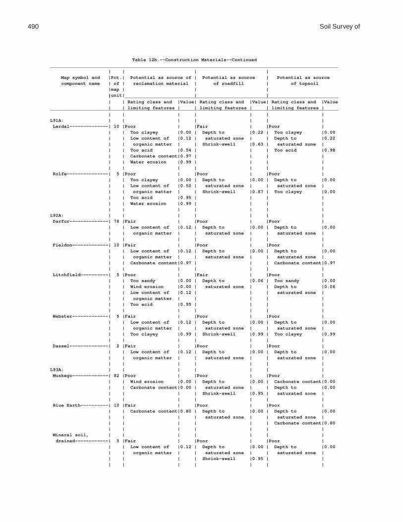
490 Soil Survey of
Table 12b.--Construction Materials--Continued________________________________________________________________________________________________________ | | | | Map symbol and |Pct.| Potential as source of | Potential as source | Potential as source component name | of | reclamation material | of roadfill | of topsoil |map | | | |unit| | | | _____________________________________________________________________________ | | Rating class and |Value| Rating class and |Value| Rating class and |Value | | limiting features | | limiting features | | limiting features |________________________________________________________________________________________________________ | | | | | | |L91A: | | | | | | | Lerdal--------------| 10 |Poor | |Fair | |Poor | | | Too clayey |0.00 | Depth to |0.22 | Too clayey |0.00 | | Low content of |0.12 | saturated zone | | Depth to |0.22 | | organic matter | | Shrink-swell |0.63 | saturated zone | | | Too acid |0.54 | | | Too acid |0.98 | | Carbonate content|0.97 | | | | | | Water erosion |0.99 | | | | | | | | | | | Rolfe---------------| 5 |Poor | |Poor | |Poor | | | Too clayey |0.00 | Depth to |0.00 | Depth to |0.00 | | Low content of |0.50 | saturated zone | | saturated zone | | | organic matter | | Shrink-swell |0.87 | Too clayey |0.00 | | Too acid |0.95 | | | | | | Water erosion |0.99 | | | | | | | | | | |L92A: | | | | | | | Darfur--------------| 78 |Fair | |Poor | |Poor | | | Low content of |0.12 | Depth to |0.00 | Depth to |0.00 | | organic matter | | saturated zone | | saturated zone | | | | | | | | Fieldon-------------| 10 |Fair | |Poor | |Poor | | | Low content of |0.12 | Depth to |0.00 | Depth to |0.00 | | organic matter | | saturated zone | | saturated zone | | | Carbonate content|0.97 | | | Carbonate content|0.97 | | | | | | | Litchfield----------| 5 |Poor | |Fair | |Poor | | | Too sandy |0.00 | Depth to |0.06 | Too sandy |0.00 | | Wind erosion |0.00 | saturated zone | | Depth to |0.06 | | Low content of |0.12 | | | saturated zone | | | organic matter | | | | | | | Too acid |0.95 | | | | | | | | | | | Webster-------------| 5 |Fair | |Poor | |Poor | | | Low content of |0.12 | Depth to |0.00 | Depth to |0.00 | | organic matter | | saturated zone | | saturated zone | | | Too clayey |0.99 | Shrink-swell |0.99 | Too clayey |0.99 | | | | | | | Dassel--------------| 2 |Fair | |Poor | |Poor | | | Low content of |0.12 | Depth to |0.00 | Depth to |0.00 | | organic matter | | saturated zone | | saturated zone | | | | | | | |L93A: | | | | | | | Muskego-------------| 82 |Poor | |Poor | |Poor | | | Wind erosion |0.00 | Depth to |0.00 | Carbonate content|0.00 | | Carbonate content|0.00 | saturated zone | | Depth to |0.00 | | | | Shrink-swell |0.95 | saturated zone | | | | | | | | Blue Earth----------| 10 |Fair | |Poor | |Poor | | | Carbonate content|0.80 | Depth to |0.00 | Depth to |0.00 | | | | saturated zone | | saturated zone | | | | | | | Carbonate content|0.80 | | | | | | | Mineral soil, | | | | | | | drained------------| 5 |Fair | |Poor | |Poor | | | Low content of |0.12 | Depth to |0.00 | Depth to |0.00 | | organic matter | | saturated zone | | saturated zone | | | | | Shrink-swell |0.95 | | | | | | | | |

Waseca County, Minnesota 491
Table 12b.--Construction Materials--Continued________________________________________________________________________________________________________ | | | | Map symbol and |Pct.| Potential as source of | Potential as source | Potential as source component name | of | reclamation material | of roadfill | of topsoil |map | | | |unit| | | | _____________________________________________________________________________ | | Rating class and |Value| Rating class and |Value| Rating class and |Value | | limiting features | | limiting features | | limiting features |________________________________________________________________________________________________________ | | | | | | |L93A: | | | | | | | Belleville----------| 3 |Fair | |Poor | |Poor | | | Too sandy |0.01 | Depth to |0.00 | Depth to |0.00 | | Low content of |0.12 | saturated zone | | saturated zone | | | organic matter | | | | Too sandy |0.01 | | | | | | |L94A: | | | | | | | Lowlein-------------| 75 |Fair | |Fair | |Fair | | | Low content of |0.12 | Depth to |0.88 | Depth to |0.88 | | organic matter | | saturated zone | | saturated zone | | | | | | | | Linder--------------| 15 |Fair | |Fair | |Fair | | | Low content of |0.12 | Depth to |0.06 | Depth to |0.06 | | organic matter | | saturated zone | | saturated zone | | | Carbonate content|0.97 | | | Hard to reclaim |0.50 | | | | | | | Dickinson-----------| 8 |Fair | |Good | |Good | | | Low content of |0.50 | | | | | | organic matter | | | | | | | Too acid |0.84 | | | | | | | | | | | Darfur--------------| 2 |Fair | |Poor | |Poor | | | Low content of |0.12 | Depth to |0.00 | Depth to |0.00 | | organic matter | | saturated zone | | saturated zone | | | | | | | |L95E: | | | | | | | Hawick--------------| 80 |Poor | |Fair | |Poor | | | Too sandy |0.00 | Slope |0.68 | Too sandy |0.00 | | Droughty |0.00 | | | Slope |0.00 | | Low content of |0.12 | | | Rock fragments |0.03 | | organic matter | | | | Hard to reclaim |0.98 | | | | | | | Estherville---------| 10 |Poor | |Good | |Poor | | | Too sandy |0.00 | | | Too sandy |0.00 | | Droughty |0.06 | | | Slope |0.00 | | Low content of |0.12 | | | Rock fragments |0.00 | | organic matter | | | | Hard to reclaim |0.82 | | | | | | | Tomall--------------| 10 |Good | |Good | |Fair | | | | | | | Hard to reclaim |0.92 | | | | | | |L96B: | | | | | | | Estherville---------| 55 |Poor | |Good | |Poor | | | Too sandy |0.00 | | | Too sandy |0.00 | | Low content of |0.12 | | | Rock fragments |0.00 | | organic matter | | | | Hard to reclaim |0.82 | | Droughty |0.30 | | | | | | | | | | | Hawick--------------| 35 |Poor | |Good | |Poor | | | Too sandy |0.00 | | | Too sandy |0.00 | | Droughty |0.06 | | | Rock fragments |0.03 | | Low content of |0.12 | | | Hard to reclaim |0.98 | | organic matter | | | | | | | | | | | | Tomall--------------| 8 |Good | |Good | |Fair | | | | | | | Hard to reclaim |0.92 | | | | | | |

492 Soil Survey of
Table 12b.--Construction Materials--Continued________________________________________________________________________________________________________ | | | | Map symbol and |Pct.| Potential as source of | Potential as source | Potential as source component name | of | reclamation material | of roadfill | of topsoil |map | | | |unit| | | | _____________________________________________________________________________ | | Rating class and |Value| Rating class and |Value| Rating class and |Value | | limiting features | | limiting features | | limiting features |________________________________________________________________________________________________________ | | | | | | |L96B: | | | | | | | Biscay--------------| 2 |Fair | |Poor | |Poor | | | Low content of |0.12 | Depth to |0.00 | Depth to |0.00 | | organic matter | | saturated zone | | saturated zone | | | Carbonate content|0.97 | | | Hard to reclaim |0.68 | | | | | | |L97C: | | | | | | | Hawick--------------| 60 |Poor | |Good | |Poor | | | Too sandy |0.00 | | | Too sandy |0.00 | | Droughty |0.06 | | | Rock fragments |0.03 | | Low content of |0.12 | | | Slope |0.96 | | organic matter | | | | Hard to reclaim |0.98 | | | | | | | Estherville---------| 30 |Poor | |Good | |Poor | | | Too sandy |0.00 | | | Too sandy |0.00 | | Low content of |0.12 | | | Rock fragments |0.00 | | organic matter | | | | Hard to reclaim |0.82 | | Droughty |0.30 | | | Slope |0.96 | | | | | | | Tomall--------------| 10 |Good | |Good | |Fair | | | | | | | Hard to reclaim |0.92 | | | | | | |L98A: | | | | | | | Crippin-------------| 50 |Fair | |Fair | |Fair | | | Low content of |0.12 | Depth to |0.12 | Depth to |0.12 | | organic matter | | saturated zone | | saturated zone | | | Carbonate content|0.97 | | | | | | | | | | | Nicollet------------| 40 |Fair | |Fair | |Fair | | | Low content of |0.12 | Depth to |0.12 | Depth to |0.12 | | organic matter | | saturated zone | | saturated zone | | | Too clayey |0.98 | Shrink-swell |0.98 | Too clayey |0.98 | | | | | | | Canisteo------------| 5 |Fair | |Poor | |Poor | | | Low content of |0.12 | Depth to |0.00 | Depth to |0.00 | | organic matter | | saturated zone | | saturated zone | | | Carbonate content|0.97 | | | Carbonate content|0.97 | | | | | | | Clarion-------------| 5 |Fair | |Good | |Good | | | Low content of |0.12 | | | | | | organic matter | | | | | | | Carbonate content|0.97 | | | | | | Water erosion |0.99 | | | | | | | | | | |L99B: | | | | | | | Clarion-------------| 62 |Fair | |Good | |Good | | | Low content of |0.12 | | | | | | organic matter | | | | | | | Carbonate content|0.97 | | | | | | Water erosion |0.99 | | | | | | | | | | | Swanlake------------| 25 |Fair | |Good | |Fair | | | Low content of |0.12 | | | Carbonate content|0.97 | | organic matter | | | | | | | Carbonate content|0.97 | | | | | | | | | | | Nicollet------------| 10 |Fair | |Fair | |Fair | | | Low content of |0.12 | Depth to |0.12 | Depth to |0.12 | | organic matter | | saturated zone | | saturated zone | | | Too clayey |0.98 | Shrink-swell |0.98 | Too clayey |0.98 | | | | | | |

Waseca County, Minnesota 493
Table 12b.--Construction Materials--Continued________________________________________________________________________________________________________ | | | | Map symbol and |Pct.| Potential as source of | Potential as source | Potential as source component name | of | reclamation material | of roadfill | of topsoil |map | | | |unit| | | | _____________________________________________________________________________ | | Rating class and |Value| Rating class and |Value| Rating class and |Value | | limiting features | | limiting features | | limiting features |________________________________________________________________________________________________________ | | | | | | |L99B: | | | | | | | Webster-------------| 3 |Fair | |Poor | |Poor | | | Low content of |0.12 | Depth to |0.00 | Depth to |0.00 | | organic matter | | saturated zone | | saturated zone | | | Too clayey |0.99 | Shrink-swell |0.99 | Too clayey |0.99 | | | | | | |L100B: | | | | | | | Clarion-------------| 45 |Fair | |Good | |Good | | | Low content of |0.12 | | | | | | organic matter | | | | | | | Carbonate content|0.97 | | | | | | Water erosion |0.99 | | | | | | | | | | | Estherville---------| 35 |Poor | |Good | |Poor | | | Too sandy |0.00 | | | Too sandy |0.00 | | Low content of |0.12 | | | Rock fragments |0.00 | | organic matter | | | | Hard to reclaim |0.82 | | Droughty |0.30 | | | | | | | | | | | Lowlein-------------| 5 |Fair | |Fair | |Fair | | | Low content of |0.12 | Depth to |0.88 | Depth to |0.88 | | organic matter | | saturated zone | | saturated zone | | | | | | | | Nicollet------------| 5 |Fair | |Fair | |Fair | | | Low content of |0.12 | Depth to |0.12 | Depth to |0.12 | | organic matter | | saturated zone | | saturated zone | | | Too clayey |0.98 | Shrink-swell |0.98 | Too clayey |0.98 | | | | | | | Swanlake------------| 5 |Fair | |Good | |Fair | | | Low content of |0.12 | | | Carbonate content|0.97 | | organic matter | | | | | | | Carbonate content|0.97 | | | | | | | | | | | Webster-------------| 5 |Fair | |Poor | |Poor | | | Low content of |0.12 | Depth to |0.00 | Depth to |0.00 | | organic matter | | saturated zone | | saturated zone | | | Too clayey |0.99 | Shrink-swell |0.99 | Too clayey |0.99 | | | | | | |L101C2: | | | | | | | Omsrud, eroded------| 40 |Fair | |Good | |Fair | | | Low content of |0.12 | | | Slope |0.96 | | organic matter | | | | Carbonate content|0.97 | | Carbonate content|0.97 | | | | | | | | | | | Hawick--------------| 30 |Poor | |Good | |Poor | | | Too sandy |0.00 | | | Too sandy |0.00 | | Droughty |0.06 | | | Rock fragments |0.03 | | Low content of |0.12 | | | Slope |0.96 | | organic matter | | | | Hard to reclaim |0.98 | | | | | | | Storden, eroded-----| 20 |Fair | |Good | |Fair | | | Low content of |0.12 | | | Slope |0.96 | | organic matter | | | | Carbonate content|0.97 | | Carbonate content|0.97 | | | | | | | | | | | Delft---------------| 5 |Good | |Poor | |Poor | | | | | Depth to |0.00 | Depth to |0.00 | | | | saturated zone | | saturated zone | | | | | Shrink-swell |0.99 | | | | | | | | | Terril--------------| 5 |Good | |Good | |Good | | | | | | | |

494 Soil Survey of
Table 12b.--Construction Materials--Continued________________________________________________________________________________________________________ | | | | Map symbol and |Pct.| Potential as source of | Potential as source | Potential as source component name | of | reclamation material | of roadfill | of topsoil |map | | | |unit| | | | _____________________________________________________________________________ | | Rating class and |Value| Rating class and |Value| Rating class and |Value | | limiting features | | limiting features | | limiting features |________________________________________________________________________________________________________ | | | | | | |L101D2: | | | | | | | Omsrud, eroded------| 40 |Fair | |Good | |Poor | | | Low content of |0.12 | | | Slope |0.00 | | organic matter | | | | Carbonate content|0.97 | | Carbonate content|0.97 | | | | | | | | | | | Hawick--------------| 25 |Poor | |Good | |Poor | | | Too sandy |0.00 | | | Too sandy |0.00 | | Droughty |0.06 | | | Slope |0.00 | | Low content of |0.12 | | | Rock fragments |0.03 | | organic matter | | | | Hard to reclaim |0.98 | | | | | | | Storden, eroded-----| 20 |Fair | |Good | |Poor | | | Low content of |0.12 | | | Slope |0.00 | | organic matter | | | | Carbonate content|0.97 | | Carbonate content|0.97 | | | | | | | | | | | Ridgeton------------| 6 |Good | |Good | |Fair | | | | | | | Slope |0.37 | | | | | | | Delft---------------| 5 |Good | |Poor | |Poor | | | | | Depth to |0.00 | Depth to |0.00 | | | | saturated zone | | saturated zone | | | | | Shrink-swell |0.99 | | | | | | | | | Terril--------------| 4 |Good | |Fair | |Fair | | | | | Depth to |0.88 | Depth to |0.88 | | | | saturated zone | | saturated zone | | | | | | | |L102C2: | | | | | | | Omsrud, eroded------| 45 |Fair | |Good | |Fair | | | Low content of |0.12 | | | Slope |0.96 | | organic matter | | | | Carbonate content|0.97 | | Carbonate content|0.97 | | | | | | | | | | | Storden, eroded-----| 25 |Fair | |Good | |Fair | | | Low content of |0.12 | | | Slope |0.96 | | organic matter | | | | Carbonate content|0.97 | | Carbonate content|0.97 | | | | | | | | | | | Omsrud--------------| 15 |Fair | |Good | |Fair | | | Low content of |0.12 | | | Slope |0.96 | | organic matter | | | | Carbonate content|0.97 | | Carbonate content|0.97 | | | | | | | | | | | Terril--------------| 10 |Good | |Good | |Good | | | | | | | | Delft---------------| 5 |Good | |Poor | |Poor | | | | | Depth to |0.00 | Depth to |0.00 | | | | saturated zone | | saturated zone | | | | | Shrink-swell |0.99 | | | | | | | | |L102D2: | | | | | | | Omsrud, eroded------| 45 |Fair | |Good | |Poor | | | Low content of |0.12 | | | Slope |0.00 | | organic matter | | | | Carbonate content|0.97 | | Carbonate content|0.97 | | | | | | | | | | |

Waseca County, Minnesota 495
Table 12b.--Construction Materials--Continued________________________________________________________________________________________________________ | | | | Map symbol and |Pct.| Potential as source of | Potential as source | Potential as source component name | of | reclamation material | of roadfill | of topsoil |map | | | |unit| | | | _____________________________________________________________________________ | | Rating class and |Value| Rating class and |Value| Rating class and |Value | | limiting features | | limiting features | | limiting features |________________________________________________________________________________________________________ | | | | | | |L102D2: | | | | | | | Storden, eroded-----| 20 |Fair | |Good | |Poor | | | Low content of |0.12 | | | Slope |0.00 | | organic matter | | | | Carbonate content|0.97 | | Carbonate content|0.97 | | | | | | | | | | | Omsrud--------------| 15 |Fair | |Good | |Poor | | | Low content of |0.12 | | | Slope |0.00 | | organic matter | | | | Carbonate content|0.97 | | Carbonate content|0.97 | | | | | | | | | | | Ridgeton------------| 8 |Good | |Good | |Fair | | | | | | | Slope |0.37 | | | | | | | Delft---------------| 6 |Good | |Poor | |Poor | | | | | Depth to |0.00 | Depth to |0.00 | | | | saturated zone | | saturated zone | | | | | Shrink-swell |0.99 | | | | | | | | | Terril--------------| 6 |Good | |Fair | |Fair | | | | | Depth to |0.88 | Depth to |0.88 | | | | saturated zone | | saturated zone | | | | | | | |L103A: | | | | | | | Fieldon-------------| 50 |Fair | |Poor | |Poor | | | Low content of |0.12 | Depth to |0.00 | Depth to |0.00 | | organic matter | | saturated zone | | saturated zone | | | Carbonate content|0.97 | | | Carbonate content|0.97 | | | | | | | Canisteo------------| 35 |Fair | |Poor | |Poor | | | Low content of |0.12 | Depth to |0.00 | Depth to |0.00 | | organic matter | | saturated zone | | saturated zone | | | Carbonate content|0.97 | | | Carbonate content|0.97 | | | | | | | Darfur--------------| 10 |Fair | |Poor | |Poor | | | Low content of |0.12 | Depth to |0.00 | Depth to |0.00 | | organic matter | | saturated zone | | saturated zone | | | | | | | | Glencoe-------------| 5 |Good | |Poor | |Poor | | | | | Depth to |0.00 | Depth to |0.00 | | | | saturated zone | | saturated zone | | | | | Low strength |0.00 | | | | | | Shrink-swell |0.93 | | | | | | | | |L105C2: | | | | | | | Lester, eroded------| 45 |Fair | |Fair | |Fair | | | Low content of |0.88 | Shrink-swell |0.97 | Slope |0.96 | | organic matter | | | | | | | Too acid |0.97 | | | | | | Carbonate content|0.97 | | | | | | | | | | | Hawick--------------| 35 |Poor | |Good | |Poor | | | Too sandy |0.00 | | | Too sandy |0.00 | | Droughty |0.06 | | | Rock fragments |0.03 | | Low content of |0.12 | | | Slope |0.96 | | organic matter | | | | Hard to reclaim |0.98 | | | | | | | Terril--------------| 10 |Good | |Good | |Good | | | | | | | |

496 Soil Survey of
Table 12b.--Construction Materials--Continued________________________________________________________________________________________________________ | | | | Map symbol and |Pct.| Potential as source of | Potential as source | Potential as source component name | of | reclamation material | of roadfill | of topsoil |map | | | |unit| | | | _____________________________________________________________________________ | | Rating class and |Value| Rating class and |Value| Rating class and |Value | | limiting features | | limiting features | | limiting features |________________________________________________________________________________________________________ | | | | | | |L105C2: | | | | | | | Hamel---------------| 5 |Fair | |Poor | |Poor | | | Low content of |0.12 | Depth to |0.00 | Depth to |0.00 | | organic matter | | saturated zone | | saturated zone | | | | | Shrink-swell |0.99 | | | | | | | | | Storden, eroded-----| 5 |Fair | |Good | |Fair | | | Low content of |0.12 | | | Slope |0.96 | | organic matter | | | | Carbonate content|0.97 | | Carbonate content|0.97 | | | | | | | | | | |L105D2: | | | | | | | Lester, eroded------| 45 |Fair | |Fair | |Poor | | | Low content of |0.88 | Shrink-swell |0.97 | Slope |0.00 | | organic matter | | | | | | | Too acid |0.97 | | | | | | Carbonate content|0.97 | | | | | | | | | | | Hawick--------------| 35 |Poor | |Good | |Poor | | | Too sandy |0.00 | | | Too sandy |0.00 | | Droughty |0.06 | | | Slope |0.00 | | Low content of |0.12 | | | Rock fragments |0.03 | | organic matter | | | | Hard to reclaim |0.98 | | | | | | | Ridgeton------------| 8 |Good | |Good | |Fair | | | | | | | Slope |0.37 | | | | | | | Hamel---------------| 5 |Fair | |Poor | |Poor | | | Low content of |0.12 | Depth to |0.00 | Depth to |0.00 | | organic matter | | saturated zone | | saturated zone | | | | | Shrink-swell |0.99 | | | | | | | | | Storden, eroded-----| 5 |Fair | |Good | |Poor | | | Low content of |0.12 | | | Slope |0.00 | | organic matter | | | | Carbonate content|0.97 | | Carbonate content|0.97 | | | | | | | | | | | Terril--------------| 2 |Good | |Fair | |Fair | | | | | Depth to |0.88 | Depth to |0.88 | | | | saturated zone | | saturated zone | | | | | | | |L106C2: | | | | | | | Lester, eroded------| 62 |Fair | |Fair | |Fair | | | Low content of |0.88 | Shrink-swell |0.97 | Slope |0.96 | | organic matter | | | | | | | Too acid |0.97 | | | | | | Carbonate content|0.97 | | | | | | | | | | | Storden, eroded-----| 20 |Fair | |Good | |Fair | | | Low content of |0.12 | | | Slope |0.96 | | organic matter | | | | Carbonate content|0.97 | | Carbonate content|0.97 | | | | | | | | | | | Terril--------------| 10 |Good | |Good | |Good | | | | | | | | Hamel---------------| 5 |Fair | |Poor | |Poor | | | Low content of |0.12 | Depth to |0.00 | Depth to |0.00 | | organic matter | | saturated zone | | saturated zone | | | | | Shrink-swell |0.99 | | | | | | | | |

Waseca County, Minnesota 497
Table 12b.--Construction Materials--Continued________________________________________________________________________________________________________ | | | | Map symbol and |Pct.| Potential as source of | Potential as source | Potential as source component name | of | reclamation material | of roadfill | of topsoil |map | | | |unit| | | | _____________________________________________________________________________ | | Rating class and |Value| Rating class and |Value| Rating class and |Value | | limiting features | | limiting features | | limiting features |________________________________________________________________________________________________________ | | | | | | |L106C2: | | | | | | | Reedslake-----------| 3 |Fair | |Fair | |Good | | | Low content of |0.12 | Shrink-swell |0.99 | | | | organic matter | | | | | | | Carbonate content|0.97 | | | | | | | | | | |L106D2: | | | | | | | Lester, eroded------| 62 |Fair | |Fair | |Poor | | | Low content of |0.88 | Shrink-swell |0.97 | Slope |0.00 | | organic matter | | | | | | | Too acid |0.97 | | | | | | Carbonate content|0.97 | | | | | | | | | | | Storden, eroded-----| 20 |Fair | |Good | |Poor | | | Low content of |0.12 | | | Slope |0.00 | | organic matter | | | | Carbonate content|0.97 | | Carbonate content|0.97 | | | | | | | | | | | Ridgeton------------| 10 |Good | |Good | |Fair | | | | | | | Slope |0.37 | | | | | | | Terril--------------| 5 |Good | |Fair | |Fair | | | | | Depth to |0.88 | Depth to |0.88 | | | | saturated zone | | saturated zone | | | | | | | | Hamel---------------| 3 |Fair | |Poor | |Poor | | | Low content of |0.12 | Depth to |0.00 | Depth to |0.00 | | organic matter | | saturated zone | | saturated zone | | | | | Shrink-swell |0.99 | | | | | | | | |L107A: | | | | | | | Canisteo------------| 50 |Fair | |Poor | |Poor | | | Low content of |0.12 | Depth to |0.00 | Depth to |0.00 | | organic matter | | saturated zone | | saturated zone | | | Carbonate content|0.97 | | | Carbonate content|0.97 | | | | | | | Glencoe-------------| 35 |Good | |Poor | |Poor | | | | | Depth to |0.00 | Depth to |0.00 | | | | saturated zone | | saturated zone | | | | | Low strength |0.00 | | | | | | Shrink-swell |0.93 | | | | | | | | | Harps---------------| 10 |Fair | |Poor | |Poor | | | Low content of |0.12 | Depth to |0.00 | Depth to |0.00 | | organic matter | | saturated zone | | saturated zone | | | Carbonate content|0.32 | | | Carbonate content|0.97 | | | | | | | Canisteo, | | | | | | | depressional-------| 3 |Fair | |Poor | |Poor | | | Low content of |0.12 | Depth to |0.00 | Depth to |0.00 | | organic matter | | saturated zone | | saturated zone | | | | | Shrink-swell |0.99 | | | | | | | | | Crippin-------------| 2 |Fair | |Fair | |Fair | | | Low content of |0.12 | Depth to |0.12 | Depth to |0.12 | | organic matter | | saturated zone | | saturated zone | | | Carbonate content|0.97 | | | | | | | | | | |

498 Soil Survey of
Table 12b.--Construction Materials--Continued________________________________________________________________________________________________________ | | | | Map symbol and |Pct.| Potential as source of | Potential as source | Potential as source component name | of | reclamation material | of roadfill | of topsoil |map | | | |unit| | | | _____________________________________________________________________________ | | Rating class and |Value| Rating class and |Value| Rating class and |Value | | limiting features | | limiting features | | limiting features |________________________________________________________________________________________________________ | | | | | | |L108A: | | | | | | | Cordova-------------| 65 |Fair | |Poor | |Poor | | | Low content of |0.12 | Depth to |0.00 | Depth to |0.00 | | organic matter | | saturated zone | | saturated zone | | | Too acid |0.84 | Shrink-swell |0.97 | Too clayey |0.94 | | Too clayey |0.95 | | | | | | | | | | | Rolfe---------------| 30 |Poor | |Poor | |Poor | | | Too clayey |0.00 | Depth to |0.00 | Depth to |0.00 | | Low content of |0.50 | saturated zone | | saturated zone | | | organic matter | | Shrink-swell |0.87 | Too clayey |0.00 | | Too acid |0.95 | | | | | | Water erosion |0.99 | | | | | | | | | | | Le Sueur------------| 5 |Fair | |Fair | |Fair | | | Low content of |0.12 | Depth to |0.12 | Depth to |0.12 | | organic matter | | saturated zone | | saturated zone | | | Too acid |0.97 | Shrink-swell |0.98 | | | | Carbonate content|0.97 | | | | | | | | | | |L109A: | | | | | | | Marna---------------| 65 |Fair | |Poor | |Poor | | | Too clayey |0.05 | Depth to |0.00 | Depth to |0.00 | | Carbonate content|0.97 | saturated zone | | saturated zone | | | | | Shrink-swell |0.74 | Too clayey |0.05 | | | | | | | Barbert-------------| 30 |Poor | |Poor | |Poor | | | Too clayey |0.00 | Depth to |0.00 | Too clayey |0.00 | | Too acid |0.84 | saturated zone | | Depth to |0.00 | | | | Shrink-swell |0.84 | saturated zone | | | | | | | | Guckeen-------------| 5 |Fair | |Fair | |Fair | | | Too clayey |0.12 | Depth to |0.12 | Too clayey |0.12 | | Low content of |0.12 | saturated zone | | Depth to |0.12 | | organic matter | | Shrink-swell |0.91 | saturated zone | | | Water erosion |0.99 | | | | | | | | | | |L110E: | | | | | | | Lester--------------| 50 |Fair | |Fair | |Poor | | | Low content of |0.88 | Slope |0.32 | Slope |0.00 | | organic matter | | Shrink-swell |0.98 | | | | Too acid |0.97 | | | | | | Carbonate content|0.97 | | | | | | | | | | | Ridgeton------------| 30 |Good | |Fair | |Poor | | | | | Slope |0.92 | Slope |0.00 | | | | | | | Cokato--------------| 10 |Fair | |Fair | |Poor | | | Low content of |0.12 | Slope |0.32 | Slope |0.00 | | organic matter | | | | | | | Carbonate content|0.97 | | | | | | Water erosion |0.99 | | | | | | | | | | | Belview-------------| 6 |Fair | |Fair | |Poor | | | Low content of |0.12 | Slope |0.32 | Slope |0.00 | | organic matter | | | | Carbonate content|0.97 | | Carbonate content|0.97 | | | | | | | | | | | Hamel---------------| 2 |Fair | |Poor | |Poor | | | Low content of |0.12 | Depth to |0.00 | Depth to |0.00 | | organic matter | | saturated zone | | saturated zone | | | | | | | |

Waseca County, Minnesota 499
Table 12b.--Construction Materials--Continued________________________________________________________________________________________________________ | | | | Map symbol and |Pct.| Potential as source of | Potential as source | Potential as source component name | of | reclamation material | of roadfill | of topsoil |map | | | |unit| | | | _____________________________________________________________________________ | | Rating class and |Value| Rating class and |Value| Rating class and |Value | | limiting features | | limiting features | | limiting features |________________________________________________________________________________________________________ | | | | | | |L110E: | | | | | | | Terril--------------| 2 |Good | |Good | |Good | | | | | | | |L110F: | | | | | | | Lester--------------| 55 |Fair | |Poor | |Poor | | | Low content of |0.12 | Slope |0.00 | Slope |0.00 | | organic matter | | Shrink-swell |0.99 | | | | Too acid |0.97 | | | | | | | | | | | Ridgeton------------| 30 |Good | |Fair | |Poor | | | | | Slope |0.32 | Slope |0.00 | | | | | | | Cokato--------------| 8 |Fair | |Poor | |Poor | | | Low content of |0.12 | Slope |0.00 | Slope |0.00 | | organic matter | | | | | | | Carbonate content|0.97 | | | | | | Water erosion |0.99 | | | | | | | | | | | Belview-------------| 4 |Fair | |Poor | |Poor | | | Low content of |0.12 | Slope |0.00 | Slope |0.00 | | organic matter | | | | Carbonate content|0.97 | | Carbonate content|0.97 | | | | | | | | | | | Terril--------------| 2 |Good | |Good | |Good | | | | | | | | Hamel---------------| 1 |Fair | |Poor | |Poor | | | Low content of |0.12 | Depth to |0.00 | Depth to |0.00 | | organic matter | | saturated zone | | saturated zone | | | | | | | |L111A: | | | | | | | Nicollet------------| 85 |Fair | |Fair | |Fair | | | Low content of |0.12 | Depth to |0.12 | Depth to |0.12 | | organic matter | | saturated zone | | saturated zone | | | Carbonate content|0.97 | Shrink-swell |0.99 | | | | | | | | | Clarion-------------| 10 |Fair | |Good | |Good | | | Low content of |0.12 | | | | | | organic matter | | | | | | | Carbonate content|0.97 | | | | | | Water erosion |0.99 | | | | | | | | | | | Webster-------------| 5 |Fair | |Poor | |Poor | | | Low content of |0.12 | Depth to |0.00 | Depth to |0.00 | | organic matter | | saturated zone | | saturated zone | | | Too clayey |0.99 | Shrink-swell |0.95 | Too clayey |0.99 | | | | | | |L112A: | | | | | | | Webster-------------| 85 |Fair | |Poor | |Poor | | | Low content of |0.12 | Depth to |0.00 | Depth to |0.00 | | organic matter | | saturated zone | | saturated zone | | | Too clayey |0.99 | Shrink-swell |0.95 | Too clayey |0.99 | | | | | | | Glencoe-------------| 10 |Good | |Poor | |Poor | | | | | Depth to |0.00 | Depth to |0.00 | | | | saturated zone | | saturated zone | | | | | Low strength |0.00 | | | | | | Shrink-swell |0.93 | | | | | | | | |

500 Soil Survey of
Table 12b.--Construction Materials--Continued________________________________________________________________________________________________________ | | | | Map symbol and |Pct.| Potential as source of | Potential as source | Potential as source component name | of | reclamation material | of roadfill | of topsoil |map | | | |unit| | | | _____________________________________________________________________________ | | Rating class and |Value| Rating class and |Value| Rating class and |Value | | limiting features | | limiting features | | limiting features |________________________________________________________________________________________________________ | | | | | | |L112A: | | | | | | | Nicollet------------| 5 |Fair | |Fair | |Fair | | | Low content of |0.12 | Depth to |0.12 | Depth to |0.12 | | organic matter | | saturated zone | | saturated zone | | | Carbonate content|0.97 | Shrink-swell |0.99 | | | | | | | | |L113B: | | | | | | | Reedslake-----------| 75 |Fair | |Fair | |Good | | | Low content of |0.12 | Shrink-swell |0.99 | | | | organic matter | | | | | | | Carbonate content|0.97 | | | | | | | | | | | Le Sueur------------| 10 |Fair | |Fair | |Fair | | | Low content of |0.12 | Depth to |0.12 | Depth to |0.12 | | organic matter | | saturated zone | | saturated zone | | | Too acid |0.97 | Shrink-swell |0.98 | | | | Carbonate content|0.97 | | | | | | | | | | | Reedslake, eroded---| 10 |Fair | |Fair | |Good | | | Low content of |0.12 | Shrink-swell |0.99 | | | | organic matter | | | | | | | Carbonate content|0.97 | | | | | | | | | | | Cordova-------------| 5 |Fair | |Poor | |Poor | | | Low content of |0.12 | Depth to |0.00 | Depth to |0.00 | | organic matter | | saturated zone | | saturated zone | | | Too acid |0.84 | Shrink-swell |0.97 | Too clayey |0.94 | | Too clayey |0.95 | | | | | | | | | | |L114A: | | | | | | | Hanlon, rarely | | | | | | | flooded------------| 85 |Good | |Fair | |Fair | | | | | Depth to |0.88 | Depth to |0.88 | | | | saturated zone | | saturated zone | | | | | | | | Coland, occasionally| | | | | | | flooded------------| 10 |Fair | |Poor | |Poor | | | Too clayey |0.98 | Depth to |0.00 | Depth to |0.00 | | | | saturated zone | | saturated zone | | | | | Shrink-swell |0.92 | Too clayey |0.98 | | | | | | | Minneopa, rarely | | | | | | | flooded------------| 5 |Poor | |Fair | |Poor | | | Too sandy |0.00 | Depth to |0.88 | Too sandy |0.00 | | Low content of |0.12 | saturated zone | | Rock fragments |0.68 | | organic matter | | | | Depth to |0.88 | | Droughty |0.93 | | | saturated zone | | | | | | | |L115A: | | | | | | | Brownton------------| 55 |Fair | |Poor | |Poor | | | Too clayey |0.12 | Depth to |0.00 | Depth to |0.00 | | | | saturated zone | | saturated zone | | | | | Shrink-swell |0.68 | Too clayey |0.12 | | | | | | | Lura----------------| 35 |Poor | |Poor | |Poor | | | Too clayey |0.00 | Depth to |0.00 | Too clayey |0.00 | | | | saturated zone | | Depth to |0.00 | | | | Shrink-swell |0.12 | saturated zone | | | | | | | |

Waseca County, Minnesota 501
Table 12b.--Construction Materials--Continued________________________________________________________________________________________________________ | | | | Map symbol and |Pct.| Potential as source of | Potential as source | Potential as source component name | of | reclamation material | of roadfill | of topsoil |map | | | |unit| | | | _____________________________________________________________________________ | | Rating class and |Value| Rating class and |Value| Rating class and |Value | | limiting features | | limiting features | | limiting features |________________________________________________________________________________________________________ | | | | | | |L115A: | | | | | | | Marna---------------| 10 |Fair | |Poor | |Poor | | | Too clayey |0.05 | Depth to |0.00 | Depth to |0.00 | | Carbonate content|0.97 | saturated zone | | saturated zone | | | | | Shrink-swell |0.74 | Too clayey |0.05 | | | | | | |L116A: | | | | | | | Le Sueur------------| 45 |Fair | |Fair | |Fair | | | Low content of |0.12 | Depth to |0.12 | Depth to |0.12 | | organic matter | | saturated zone | | saturated zone | | | Too acid |0.97 | Shrink-swell |0.98 | | | | Carbonate content|0.97 | | | | | | | | | | | Lerdal--------------| 40 |Poor | |Fair | |Poor | | | Too clayey |0.00 | Depth to |0.22 | Too clayey |0.00 | | Low content of |0.12 | saturated zone | | Depth to |0.22 | | organic matter | | Shrink-swell |0.63 | saturated zone | | | Too acid |0.54 | | | Too acid |0.98 | | Carbonate content|0.97 | | | | | | Water erosion |0.99 | | | | | | | | | | | Mazaska-------------| 10 |Poor | |Poor | |Poor | | | Too clayey |0.00 | Depth to |0.00 | Depth to |0.00 | | Low content of |0.12 | saturated zone | | saturated zone | | | organic matter | | Shrink-swell |0.56 | Too clayey |0.00 | | Too acid |0.68 | | | | | | Carbonate content|0.97 | | | | | | | | | | | Kilkenny------------| 5 |Poor | |Fair | |Poor | | | Too clayey |0.00 | Depth to |0.24 | Too clayey |0.00 | | Low content of |0.12 | saturated zone | | Depth to |0.24 | | organic matter | | Shrink-swell |0.98 | saturated zone | | | Too acid |0.68 | | | | | | | | | | |L117C2: | | | | | | | Omsrud, eroded------| 65 |Fair | |Good | |Fair | | | Low content of |0.12 | | | Slope |0.96 | | organic matter | | | | Carbonate content|0.97 | | Carbonate content|0.97 | | | | | | | | | | | Omsrud--------------| 15 |Fair | |Good | |Fair | | | Low content of |0.12 | | | Slope |0.96 | | organic matter | | | | Carbonate content|0.97 | | Carbonate content|0.97 | | | | | | | | | | | Terril--------------| 10 |Good | |Good | |Good | | | | | | | | Delft---------------| 5 |Good | |Poor | |Poor | | | | | Depth to |0.00 | Depth to |0.00 | | | | saturated zone | | saturated zone | | | | | Shrink-swell |0.99 | | | | | | | | | Storden, eroded-----| 5 |Fair | |Good | |Fair | | | Low content of |0.12 | | | Slope |0.96 | | organic matter | | | | Carbonate content|0.97 | | Carbonate content|0.97 | | | | | | | | | | |

502 Soil Survey of
Table 12b.--Construction Materials--Continued________________________________________________________________________________________________________ | | | | Map symbol and |Pct.| Potential as source of | Potential as source | Potential as source component name | of | reclamation material | of roadfill | of topsoil |map | | | |unit| | | | _____________________________________________________________________________ | | Rating class and |Value| Rating class and |Value| Rating class and |Value | | limiting features | | limiting features | | limiting features |________________________________________________________________________________________________________ | | | | | | |L118A: | | | | | | | Rushriver, | | | | | | | frequently flooded | 85 |Good | |Poor | |Poor | | | | | Depth to |0.00 | Depth to |0.00 | | | | saturated zone | | saturated zone | | | | | | | Rock fragments |0.72 | | | | | | | Houghton, frequently| | | | | | | flooded------------| 5 |Poor | |Poor | |Poor | | | Wind erosion |0.00 | Depth to |0.00 | Depth to |0.00 | | | | saturated zone | | saturated zone | | | | | | | Content of |0.00 | | | | | | organic matter | | | | | | | | Klossner, frequently| | | | | | | flooded------------| 5 |Poor | |Poor | |Poor | | | Wind erosion |0.00 | Depth to |0.00 | Depth to |0.00 | | Water erosion |0.99 | saturated zone | | saturated zone | | | | | Shrink-swell |0.99 | Content of |0.00 | | | | | | organic matter | | | | | | | | Medo, frequently | | | | | | | flooded------------| 5 |Poor | |Poor | |Poor | | | Wind erosion |0.00 | Depth to |0.00 | Depth to |0.00 | | | | saturated zone | | saturated zone | | | | | | | Content of |0.00 | | | | | | organic matter | | | | | | | Hard to reclaim |0.92 | | | | | | |L119B: | | | | | | | Angus---------------| 80 |Fair | |Fair | |Good | | | Low content of |0.12 | Shrink-swell |0.99 | | | | organic matter | | | | | | | Too acid |0.97 | | | | | | Water erosion |0.99 | | | | | | | | | | | Angus, eroded-------| 10 |Fair | |Fair | |Good | | | Low content of |0.88 | Shrink-swell |0.97 | | | | organic matter | | | | | | | Too acid |0.97 | | | | | | Carbonate content|0.97 | | | | | | | | | | | Cordova-------------| 5 |Fair | |Poor | |Poor | | | Low content of |0.12 | Depth to |0.00 | Depth to |0.00 | | organic matter | | saturated zone | | saturated zone | | | Too acid |0.84 | Shrink-swell |0.97 | Too clayey |0.94 | | Too clayey |0.95 | | | | | | | | | | | Le Sueur------------| 5 |Fair | |Fair | |Fair | | | Low content of |0.12 | Depth to |0.12 | Depth to |0.12 | | organic matter | | saturated zone | | saturated zone | | | Too acid |0.97 | Shrink-swell |0.98 | | | | Carbonate content|0.97 | | | | | | | | | | |L120A: | | | | | | | Good Thunder--------| 80 |Poor | |Fair | |Poor | | | Too clayey |0.00 | Depth to |0.88 | Too clayey |0.00 | | Low content of |0.50 | saturated zone | | Depth to |0.88 | | organic matter | | Shrink-swell |0.96 | saturated zone | | | Too acid |0.97 | | | | | | Water erosion |0.99 | | | | | | | | | | |

Waseca County, Minnesota 503
Table 12b.--Construction Materials--Continued________________________________________________________________________________________________________ | | | | Map symbol and |Pct.| Potential as source of | Potential as source | Potential as source component name | of | reclamation material | of roadfill | of topsoil |map | | | |unit| | | | _____________________________________________________________________________ | | Rating class and |Value| Rating class and |Value| Rating class and |Value | | limiting features | | limiting features | | limiting features |________________________________________________________________________________________________________ | | | | | | |L120A: | | | | | | | Ocheyedan-----------| 10 |Fair | |Good | |Good | | | Low content of |0.12 | | | | | | organic matter | | | | | | | Water erosion |0.90 | | | | | | | | | | | Minnetonka----------| 10 |Poor | |Poor | |Poor | | | Low content of |0.00 | Depth to |0.00 | Too clayey |0.00 | | organic matter | | saturated zone | | Depth to |0.00 | | Too clayey |0.00 | Shrink-swell |0.55 | saturated zone | | | Too acid |0.97 | | | | | | | | | | |L121B: | | | | | | | Clarion-------------| 80 |Fair | |Fair | |Good | | | Low content of |0.12 | Shrink-swell |0.98 | | | | organic matter | | | | | | | Water erosion |0.99 | | | | | | | | | | | Guckeen-------------| 15 |Fair | |Fair | |Fair | | | Too clayey |0.12 | Depth to |0.12 | Too clayey |0.12 | | Low content of |0.12 | saturated zone | | Depth to |0.12 | | organic matter | | Shrink-swell |0.91 | saturated zone | | | Water erosion |0.99 | | | | | | | | | | | Marna---------------| 5 |Fair | |Poor | |Poor | | | Too clayey |0.05 | Depth to |0.00 | Depth to |0.00 | | Carbonate content|0.97 | saturated zone | | saturated zone | | | | | Shrink-swell |0.74 | Too clayey |0.05 | | | | | | |L122B: | | | | | | | Reedslake-----------| 55 |Fair | |Fair | |Good | | | Low content of |0.12 | Shrink-swell |0.99 | | | | organic matter | | | | | | | Carbonate content|0.97 | | | | | | | | | | | Estherville---------| 25 |Poor | |Good | |Poor | | | Too sandy |0.00 | | | Too sandy |0.00 | | Low content of |0.12 | | | Rock fragments |0.00 | | organic matter | | | | Hard to reclaim |0.82 | | Droughty |0.30 | | | | | | | | | | | Le Sueur------------| 10 |Fair | |Fair | |Fair | | | Low content of |0.12 | Depth to |0.12 | Depth to |0.12 | | organic matter | | saturated zone | | saturated zone | | | Too acid |0.97 | Shrink-swell |0.98 | | | | Carbonate content|0.97 | | | | | | | | | | | Cordova-------------| 5 |Fair | |Poor | |Poor | | | Low content of |0.12 | Depth to |0.00 | Depth to |0.00 | | organic matter | | saturated zone | | saturated zone | | | Too acid |0.84 | Shrink-swell |0.97 | Too clayey |0.94 | | Too clayey |0.95 | | | | | | | | | | | Lowlein-------------| 5 |Fair | |Fair | |Fair | | | Low content of |0.12 | Depth to |0.88 | Depth to |0.88 | | organic matter | | saturated zone | | saturated zone | | | | | | | |

504 Soil Survey of
Table 12b.--Construction Materials--Continued________________________________________________________________________________________________________ | | | | Map symbol and |Pct.| Potential as source of | Potential as source | Potential as source component name | of | reclamation material | of roadfill | of topsoil |map | | | |unit| | | | _____________________________________________________________________________ | | Rating class and |Value| Rating class and |Value| Rating class and |Value | | limiting features | | limiting features | | limiting features |________________________________________________________________________________________________________ | | | | | | |L123A: | | | | | | | Belleville----------| 85 |Fair | |Poor | |Poor | | | Too sandy |0.01 | Depth to |0.00 | Depth to |0.00 | | Low content of |0.12 | saturated zone | | saturated zone | | | organic matter | | | | Too sandy |0.01 | | | | | | | Granby--------------| 15 |Poor | |Poor | |Poor | | | Wind erosion |0.00 | Depth to |0.00 | Depth to |0.00 | | Low content of |0.00 | saturated zone | | saturated zone | | | organic matter | | | | Too sandy |0.36 | | Too sandy |0.36 | | | | | | Droughty |0.77 | | | | | | | | | | |L124A: | | | | | | | Glencoe mucky clay | | | | | | | loam---------------| 85 |Good | |Poor | |Poor | | | | | Depth to |0.00 | Depth to |0.00 | | | | saturated zone | | saturated zone | | | | | Low strength |0.00 | | | | | | Shrink-swell |0.96 | | | | | | | | | Canisteo------------| 10 |Fair | |Poor | |Poor | | | Low content of |0.12 | Depth to |0.00 | Depth to |0.00 | | organic matter | | saturated zone | | saturated zone | | | Carbonate content|0.97 | | | Carbonate content|0.97 | | | | | | | Glencoe clay loam---| 5 |Good | |Poor | |Poor | | | | | Depth to |0.00 | Depth to |0.00 | | | | saturated zone | | saturated zone | | | | | Low strength |0.00 | | | | | | Shrink-swell |0.93 | | | | | | | | |L125A: | | | | | | | Hanlon, rarely | | | | | | | flooded------------| 60 |Good | |Fair | |Fair | | | | | Depth to |0.88 | Depth to |0.88 | | | | saturated zone | | saturated zone | | | | | | | | Coland, occasionally| | | | | | | flooded------------| 25 |Fair | |Poor | |Poor | | | Too clayey |0.98 | Depth to |0.00 | Depth to |0.00 | | | | saturated zone | | saturated zone | | | | | Shrink-swell |0.92 | Too clayey |0.98 | | | | | | | Minneopa, rarely | | | | | | | flooded------------| 15 |Poor | |Fair | |Poor | | | Too sandy |0.00 | Depth to |0.88 | Too sandy |0.00 | | Low content of |0.12 | saturated zone | | Rock fragments |0.68 | | organic matter | | | | Depth to |0.88 | | Droughty |0.93 | | | saturated zone | | | | | | | |L126A: | | | | | | | Coland, occasionally| | | | | | | flooded------------| 80 |Fair | |Poor | |Poor | | | Too clayey |0.98 | Depth to |0.00 | Depth to |0.00 | | | | saturated zone | | saturated zone | | | | | Shrink-swell |0.92 | Too clayey |0.98 | | | | | | |

Waseca County, Minnesota 505
Table 12b.--Construction Materials--Continued________________________________________________________________________________________________________ | | | | Map symbol and |Pct.| Potential as source of | Potential as source | Potential as source component name | of | reclamation material | of roadfill | of topsoil |map | | | |unit| | | | _____________________________________________________________________________ | | Rating class and |Value| Rating class and |Value| Rating class and |Value | | limiting features | | limiting features | | limiting features |________________________________________________________________________________________________________ | | | | | | |L126A: | | | | | | | Minneopa, | | | | | | | occasionally | | | | | | | flooded------------| 10 |Poor | |Fair | |Poor | | | Too sandy |0.00 | Depth to |0.88 | Too sandy |0.00 | | Low content of |0.12 | saturated zone | | Rock fragments |0.68 | | organic matter | | | | Depth to |0.88 | | Droughty |0.93 | | | saturated zone | | | | | | | | Havelock, | | | | | | | occasionally | | | | | | | flooded------------| 5 |Fair | |Poor | |Poor | | | Low content of |0.12 | Depth to |0.00 | Depth to |0.00 | | organic matter | | saturated zone | | saturated zone | | | Carbonate content|0.97 | Shrink-swell |0.86 | Carbonate content|0.97 | | Too clayey |0.98 | | | Too clayey |0.98 | | | | | | | Spillville, | | | | | | | occasionally | | | | | | | flooded------------| 5 |Good | |Fair | |Fair | | | | | Depth to |0.12 | Depth to |0.12 | | | | saturated zone | | saturated zone | | | | | Shrink-swell |0.94 | | | | | | | | |L127A: | | | | | | | Coland, frequently | | | | | | | flooded------------| 80 |Good | |Poor | |Poor | | | | | Depth to |0.00 | Depth to |0.00 | | | | saturated zone | | saturated zone | | | | | Shrink-swell |0.91 | | | | | | | | | Minneopa, | | | | | | | occasionally | | | | | | | flooded------------| 10 |Fair | |Fair | |Fair | | | Low content of |0.12 | Depth to |0.88 | Depth to |0.88 | | organic matter | | saturated zone | | saturated zone | | | Droughty |0.98 | | | | | | | | | | | Havelock, frequently| | | | | | | flooded------------| 5 |Fair | |Poor | |Poor | | | Carbonate content|0.97 | Depth to |0.00 | Depth to |0.00 | | | | saturated zone | | saturated zone | | | | | Shrink-swell |0.73 | Carbonate content|0.97 | | | | | | | Spillville, | | | | | | | occasionally | | | | | | | flooded------------| 5 |Good | |Fair | |Fair | | | | | Depth to |0.12 | Depth to |0.12 | | | | saturated zone | | saturated zone | | | | | Shrink-swell |0.94 | | | | | | | | |L128A: | | | | | | | Mazaska-------------| 60 |Poor | |Poor | |Poor | | | Too clayey |0.00 | Depth to |0.00 | Depth to |0.00 | | Low content of |0.12 | saturated zone | | saturated zone | | | organic matter | | Shrink-swell |0.56 | Too clayey |0.00 | | Too acid |0.68 | | | | | | Carbonate content|0.97 | | | | | | | | | | |

506 Soil Survey of
Table 12b.--Construction Materials--Continued________________________________________________________________________________________________________ | | | | Map symbol and |Pct.| Potential as source of | Potential as source | Potential as source component name | of | reclamation material | of roadfill | of topsoil |map | | | |unit| | | | _____________________________________________________________________________ | | Rating class and |Value| Rating class and |Value| Rating class and |Value | | limiting features | | limiting features | | limiting features |________________________________________________________________________________________________________ | | | | | | |L128A: | | | | | | | Rolfe---------------| 30 |Poor | |Poor | |Poor | | | Too clayey |0.00 | Depth to |0.00 | Depth to |0.00 | | Low content of |0.50 | saturated zone | | saturated zone | | | organic matter | | Shrink-swell |0.87 | Too clayey |0.00 | | Too acid |0.95 | | | | | | Water erosion |0.99 | | | | | | | | | | | Lerdal--------------| 10 |Poor | |Fair | |Poor | | | Too clayey |0.00 | Depth to |0.22 | Too clayey |0.00 | | Low content of |0.12 | saturated zone | | Depth to |0.22 | | organic matter | | Shrink-swell |0.63 | saturated zone | | | Too acid |0.54 | | | Too acid |0.98 | | Carbonate content|0.97 | | | | | | Water erosion |0.99 | | | | | | | | | | |L129B: | | | | | | | Terril--------------| 90 |Good | |Good | |Good | | | | | | | | Delft---------------| 5 |Good | |Poor | |Poor | | | | | Depth to |0.00 | Depth to |0.00 | | | | saturated zone | | saturated zone | | | | | Shrink-swell |0.99 | | | | | | | | | Hamel---------------| 5 |Fair | |Poor | |Poor | | | Low content of |0.12 | Depth to |0.00 | Depth to |0.00 | | organic matter | | saturated zone | | saturated zone | | | | | Shrink-swell |0.99 | | | | | | | | |L130A: | | | | | | | Okoboji mucky silty | | | | | | | clay loam----------| 75 |Poor | |Poor | |Poor | | | Too clayey |0.00 | Depth to |0.00 | Depth to |0.00 | | | | saturated zone | | saturated zone | | | | | Shrink-swell |0.16 | Too clayey |0.00 | | | | | | | Okoboji silty clay | | | | | | | loam---------------| 15 |Fair | |Poor | |Poor | | | Too clayey |0.05 | Depth to |0.00 | Depth to |0.00 | | | | saturated zone | | saturated zone | | | | | Shrink-swell |0.12 | Too clayey |0.05 | | | | | | | Brownton------------| 5 |Fair | |Poor | |Poor | | | Too clayey |0.12 | Depth to |0.00 | Depth to |0.00 | | | | saturated zone | | saturated zone | | | | | Shrink-swell |0.68 | Too clayey |0.12 | | | | | | | Spicer--------------| 5 |Fair | |Poor | |Poor | | | Carbonate content|0.97 | Depth to |0.00 | Depth to |0.00 | | Water erosion |0.99 | saturated zone | | saturated zone | | | | | Shrink-swell |0.99 | Carbonate content|0.97 | | | | | | |M-W: | | | | | | | Water, miscellaneous|100 |Not rated | |Not rated | |Not rated | | | | | | | |U3B: | | | | | | | Udorthents (cut and | | | | | | | fill land)---------|100 |Not rated | |Not rated | |Not rated | | | | | | | |

Waseca County, Minnesota 507
Table 12b.--Construction Materials--Continued________________________________________________________________________________________________________ | | | | Map symbol and |Pct.| Potential as source of | Potential as source | Potential as source component name | of | reclamation material | of roadfill | of topsoil |map | | | |unit| | | | _____________________________________________________________________________ | | Rating class and |Value| Rating class and |Value| Rating class and |Value | | limiting features | | limiting features | | limiting features |________________________________________________________________________________________________________ | | | | | | |W: | | | | | | | Water---------------|100 |Not rated | |Not rated | |Not rated | | | | | | | |________________________________________________________________________________________________________

508 Soil Survey of
Table 13.--Water Management
(The information in this table indicates the dominant soil condition but does not eliminate the need for onsite investigation. The numbers in the value columns range from 0.01 to 1.00. The larger the value, the greater the limitation. “Not rated” indicates that data are not available or that no rating is applicable. See text for further explanation of ratings in this table)
________________________________________________________________________________________________________ | | | | Map symbol and |Pct.| Pond reservoir areas | Embankments, dikes, and | Aquifer-fed component name | of | | levees | excavated ponds |map | | | |unit| | | _____________________________________________________________________________ | | Rating class and |Value| Rating class and |Value| Rating class and |Value | | limiting features | | limiting features | | limiting features |________________________________________________________________________________________________________ | | | | | | |GP: | | | | | | | Pits, gravel--------| 80 |Not rated | |Not rated | |Not rated | | | | | | | | Udipsamments--------| 20 |Not rated | |Not rated | |Not rated | | | | | | | |L5A: | | | | | | | Delft, overwash-----| 50 |Somewhat limited | |Very limited | |Somewhat limited | | | Seepage |0.70 | Depth to |1.00 | Slow refill |0.30 | | | | saturated zone | | Cutbanks cave |0.10 | | | | Piping |0.39 | | | | | | | | | Delft---------------| 40 |Somewhat limited | |Very limited | |Somewhat limited | | | Seepage |0.70 | Depth to |1.00 | Slow refill |0.30 | | | | saturated zone | | Cutbanks cave |0.10 | | | | Piping |0.41 | | | | | | | | | Glencoe-------------| 5 |Somewhat limited | |Very limited | |Somewhat limited | | | Seepage |0.70 | Ponding |1.00 | Slow refill |0.30 | | | | Depth to |1.00 | Cutbanks cave |0.10 | | | | saturated zone | | | | | | | Piping |0.45 | | | | | | | | | Terril--------------| 5 |Somewhat limited | |Somewhat limited | |Somewhat limited | | | Seepage |0.72 | Depth to |0.87 | Slow refill |0.28 | | | | saturated zone | | Cutbanks cave |0.10 | | | | Piping |0.45 | Deep to water |0.06 | | | | | | |L13A: | | | | | | | Klossner, drained---| 80 |Very limited | |Very limited | |Somewhat limited | | | Seepage |1.00 | Depth to |1.00 | Cutbanks cave |0.10 | | | | saturated zone | | | | | | | Ponding |1.00 | | | | | | Piping |0.48 | | | | | | | | | Mineral soil, | | | | | | | drained------------| 15 |Somewhat limited | |Very limited | |Somewhat limited | | | Seepage |0.70 | Depth to |1.00 | Slow refill |0.30 | | | | saturated zone | | Cutbanks cave |0.10 | | | | Ponding |1.00 | | | | | | Piping |0.43 | | | | | | | | | Houghton, drained---| 5 |Very limited | |Very limited | |Somewhat limited | | | Seepage |1.00 | Content of |1.00 | Cutbanks cave |0.10 | | | | organic matter | | | | | | | Depth to |1.00 | | | | | | saturated zone | | | | | | | Ponding |1.00 | | | | | | | | |L14A: | | | | | | | Houghton, drained---| 80 |Very limited | |Very limited | |Somewhat limited | | | Seepage |1.00 | Content of |1.00 | Cutbanks cave |0.10 | | | | organic matter | | | | | | | Depth to |1.00 | | | | | | saturated zone | | | | | | | Ponding |1.00 | | | | | | | | |

Waseca County, Minnesota 509
Table 13.--Water Management--Continued________________________________________________________________________________________________________ | | | | Map symbol and |Pct.| Pond reservoir areas | Embankments, dikes, and | Aquifer-fed component name | of | | levees | excavated ponds |map | | | |unit| | | _____________________________________________________________________________ | | Rating class and |Value| Rating class and |Value| Rating class and |Value | | limiting features | | limiting features | | limiting features |________________________________________________________________________________________________________ | | | | | | |L14A: | | | | | | | Klossner, drained---| 10 |Very limited | |Very limited | |Somewhat limited | | | Seepage |1.00 | Depth to |1.00 | Cutbanks cave |0.10 | | | | saturated zone | | | | | | | Ponding |1.00 | | | | | | Piping |0.48 | | | | | | | | | Mineral soil, | | | | | | | drained------------| 10 |Somewhat limited | |Very limited | |Somewhat limited | | | Seepage |0.70 | Depth to |1.00 | Slow refill |0.30 | | | | saturated zone | | Cutbanks cave |0.10 | | | | Ponding |1.00 | | | | | | Piping |0.43 | | | | | | | | |L15A: | | | | | | | Klossner, ponded----| 30 |Very limited | |Very limited | |Somewhat limited | | | Seepage |1.00 | Ponding |1.00 | Cutbanks cave |0.10 | | | | Depth to |1.00 | | | | | | saturated zone | | | | | | | Piping |0.60 | | | | | | | | | Okoboji, ponded-----| 30 |Somewhat limited | |Very limited | |Somewhat limited | | | Seepage |0.05 | Ponding |1.00 | Slow refill |0.30 | | | | Depth to |1.00 | Cutbanks cave |0.10 | | | | saturated zone | | | | | | | Hard to pack |0.88 | | | | | | | | | Glencoe, ponded-----| 30 |Somewhat limited | |Very limited | |Somewhat limited | | | Seepage |0.70 | Ponding |1.00 | Slow refill |0.30 | | | | Depth to |1.00 | Cutbanks cave |0.10 | | | | saturated zone | | | | | | | Piping |0.16 | | | | | | | | | Houghton, ponded----| 10 |Very limited | |Very limited | |Somewhat limited | | | Seepage |1.00 | Content of |1.00 | Cutbanks cave |0.10 | | | | organic matter | | | | | | | Ponding |1.00 | | | | | | Depth to |1.00 | | | | | | saturated zone | | | | | | | | | |L16A: | | | | | | | Muskego, ponded-----| 30 |Very limited | |Very limited | |Somewhat limited | | | Seepage |1.00 | Content of |1.00 | Cutbanks cave |0.10 | | | | organic matter | | | | | | | Ponding |1.00 | | | | | | Depth to |1.00 | | | | | | saturated zone | | | | | | | | | | Blue Earth, ponded--| 30 |Somewhat limited | |Very limited | |Somewhat limited | | | Seepage |0.72 | Content of |1.00 | Slow refill |0.28 | | | | organic matter | | Cutbanks cave |0.10 | | | | Ponding |1.00 | | | | | | Depth to |1.00 | | | | | | saturated zone | | | | | | | Piping |1.00 | | | | | | | | |

510 Soil Survey of
Table 13.--Water Management--Continued________________________________________________________________________________________________________ | | | | Map symbol and |Pct.| Pond reservoir areas | Embankments, dikes, and | Aquifer-fed component name | of | | levees | excavated ponds |map | | | |unit| | | _____________________________________________________________________________ | | Rating class and |Value| Rating class and |Value| Rating class and |Value | | limiting features | | limiting features | | limiting features |________________________________________________________________________________________________________ | | | | | | |L16A: | | | | | | | Houghton, ponded----| 30 |Very limited | |Very limited | |Somewhat limited | | | Seepage |1.00 | Content of |1.00 | Cutbanks cave |0.10 | | | | organic matter | | | | | | | Ponding |1.00 | | | | | | Depth to |1.00 | | | | | | saturated zone | | | | | | | | | | Klossner, ponded----| 10 |Very limited | |Very limited | |Somewhat limited | | | Seepage |1.00 | Ponding |1.00 | Cutbanks cave |0.10 | | | | Depth to |1.00 | | | | | | saturated zone | | | | | | | Piping |0.60 | | | | | | | | |L26B: | | | | | | | Shorewood-----------| 90 |Somewhat limited | |Very limited | |Somewhat limited | | | Seepage |0.70 | Depth to |1.00 | Slow refill |0.30 | | | | saturated zone | | Deep to water |0.24 | | | | | | Cutbanks cave |0.10 | | | | | | | Good Thunder--------| 5 |Somewhat limited | |Somewhat limited | |Somewhat limited | | | Seepage |0.72 | Depth to |0.87 | Slow refill |0.28 | | | | saturated zone | | Cutbanks cave |0.10 | | | | Piping |0.18 | Deep to water |0.06 | | | | | | | Minnetonka----------| 5 |Somewhat limited | |Very limited | |Somewhat limited | | | Seepage |0.57 | Depth to |1.00 | Slow refill |0.43 | | | | saturated zone | | Cutbanks cave |0.10 | | | | | | |L36A: | | | | | | | Hamel, overwash-----| 50 |Somewhat limited | |Very limited | |Somewhat limited | | | Seepage |0.72 | Depth to |1.00 | Slow refill |0.28 | | | | saturated zone | | Cutbanks cave |0.10 | | | | Piping |0.01 | | | | | | | | | Hamel---------------| 43 |Somewhat limited | |Very limited | |Somewhat limited | | | Seepage |0.72 | Depth to |1.00 | Slow refill |0.28 | | | | saturated zone | | Cutbanks cave |0.10 | | | | | | | Terril--------------| 5 |Somewhat limited | |Somewhat limited | |Somewhat limited | | | Seepage |0.72 | Piping |0.45 | Deep to water |0.60 | | | | Depth to |0.05 | Slow refill |0.28 | | | | saturated zone | | Cutbanks cave |0.10 | | | | | | | Glencoe-------------| 2 |Somewhat limited | |Very limited | |Somewhat limited | | | Seepage |0.70 | Depth to |1.00 | Slow refill |0.30 | | | | saturated zone | | Cutbanks cave |0.10 | | | | Ponding |1.00 | | | | | | Piping |0.43 | | | | | | | | |L40B: | | | | | | | Angus---------------| 45 |Somewhat limited | |Somewhat limited | |Somewhat limited | | | Seepage |0.72 | Piping |0.24 | Deep to water |0.60 | | | | Depth to |0.05 | Slow refill |0.30 | | | | saturated zone | | Cutbanks cave |0.10 | | | | | | | Kilkenny------------| 40 |Somewhat limited | |Very limited | |Somewhat limited | | | Seepage |0.70 | Depth to |1.00 | Slow refill |0.30 | | | | saturated zone | | Deep to water |0.24 | | | | | | Cutbanks cave |0.10 | | | | | | |

Waseca County, Minnesota 511
Table 13.--Water Management--Continued________________________________________________________________________________________________________ | | | | Map symbol and |Pct.| Pond reservoir areas | Embankments, dikes, and | Aquifer-fed component name | of | | levees | excavated ponds |map | | | |unit| | | _____________________________________________________________________________ | | Rating class and |Value| Rating class and |Value| Rating class and |Value | | limiting features | | limiting features | | limiting features |________________________________________________________________________________________________________ | | | | | | |L40B: | | | | | | | Lerdal--------------| 10 |Somewhat limited | |Very limited | |Somewhat limited | | | Seepage |0.70 | Depth to |1.00 | Slow refill |0.30 | | | | saturated zone | | Cutbanks cave |0.10 | | | | | | | Mazaska-------------| 5 |Somewhat limited | |Very limited | |Somewhat limited | | | Seepage |0.70 | Depth to |1.00 | Slow refill |0.30 | | | | saturated zone | | Cutbanks cave |0.10 | | | | Piping |0.01 | | | | | | | | |L41C2: | | | | | | | Lester, eroded------| 45 |Somewhat limited | |Somewhat limited | |Very limited | | | Seepage |0.72 | Piping |0.23 | Deep to water |1.00 | | | | | | | Kilkenny, eroded----| 40 |Somewhat limited | |Somewhat limited | |Very limited | | | Seepage |0.70 | Depth to |0.86 | Deep to water |1.00 | | | | saturated zone | | | | | | | Hard to pack |0.11 | | | | | | | | | Terril--------------| 10 |Somewhat limited | |Somewhat limited | |Somewhat limited | | | Seepage |0.72 | Piping |0.45 | Deep to water |0.60 | | | | Depth to |0.05 | Slow refill |0.28 | | | | saturated zone | | Cutbanks cave |0.10 | | | | | | | Derrynane-----------| 5 |Somewhat limited | |Very limited | |Somewhat limited | | | Seepage |0.70 | Depth to |1.00 | Slow refill |0.30 | | | | saturated zone | | Cutbanks cave |0.10 | | | | | | |L41D2: | | | | | | | Lester, eroded------| 45 |Somewhat limited | |Somewhat limited | |Very limited | | | Seepage |0.72 | Piping |0.23 | Deep to water |1.00 | | Slope |0.03 | | | | | | | | | | | Kilkenny, eroded----| 35 |Somewhat limited | |Somewhat limited | |Very limited | | | Seepage |0.70 | Depth to |0.86 | Deep to water |1.00 | | Slope |0.03 | saturated zone | | | | | | | Hard to pack |0.11 | | | | | | | | | Terril--------------| 10 |Somewhat limited | |Somewhat limited | |Somewhat limited | | | Seepage |0.72 | Piping |0.45 | Deep to water |0.60 | | | | Depth to |0.05 | Slow refill |0.28 | | | | saturated zone | | Cutbanks cave |0.10 | | | | | | | Derrynane-----------| 5 |Somewhat limited | |Very limited | |Somewhat limited | | | Seepage |0.70 | Depth to |1.00 | Slow refill |0.30 | | | | saturated zone | | Cutbanks cave |0.10 | | | | | | | Ridgeton------------| 5 |Somewhat limited | |Somewhat limited | |Very limited | | | Seepage |0.72 | Piping |0.42 | Deep to water |1.00 | | | | | | |L41E: | | | | | | | Lester--------------| 45 |Somewhat limited | |Somewhat limited | |Very limited | | | Seepage |0.72 | Piping |0.24 | Deep to water |1.00 | | Slope |0.18 | | | | | | | | | | | Kilkenny------------| 40 |Somewhat limited | |Somewhat limited | |Very limited | | | Seepage |0.70 | Depth to |0.86 | Deep to water |1.00 | | Slope |0.18 | saturated zone | | | | | | | | | |

512 Soil Survey of
Table 13.--Water Management--Continued________________________________________________________________________________________________________ | | | | Map symbol and |Pct.| Pond reservoir areas | Embankments, dikes, and | Aquifer-fed component name | of | | levees | excavated ponds |map | | | |unit| | | _____________________________________________________________________________ | | Rating class and |Value| Rating class and |Value| Rating class and |Value | | limiting features | | limiting features | | limiting features |________________________________________________________________________________________________________ | | | | | | |L41E: | | | | | | | Terril--------------| 5 |Somewhat limited | |Somewhat limited | |Somewhat limited | | | Seepage |0.72 | Piping |0.44 | Deep to water |0.60 | | | | Depth to |0.05 | Slow refill |0.28 | | | | saturated zone | | Cutbanks cave |0.10 | | | | | | | Derrynane-----------| 5 |Somewhat limited | |Very limited | |Somewhat limited | | | Seepage |0.70 | Depth to |1.00 | Slow refill |0.30 | | | | saturated zone | | Cutbanks cave |0.10 | | | | | | | Ridgeton------------| 5 |Somewhat limited | |Somewhat limited | |Very limited | | | Seepage |0.72 | Piping |0.39 | Deep to water |1.00 | | Slope |0.02 | | | | | | | | | | |L48A: | | | | | | | Derrynane, overwash | 50 |Somewhat limited | |Very limited | |Somewhat limited | | | Seepage |0.70 | Depth to |1.00 | Slow refill |0.30 | | | | saturated zone | | Cutbanks cave |0.10 | | | | | | | Derrynane-----------| 40 |Somewhat limited | |Very limited | |Somewhat limited | | | Seepage |0.70 | Depth to |1.00 | Slow refill |0.30 | | | | saturated zone | | Cutbanks cave |0.10 | | | | | | | Glencoe-------------| 5 |Somewhat limited | |Very limited | |Somewhat limited | | | Seepage |0.70 | Ponding |1.00 | Slow refill |0.30 | | | | Depth to |1.00 | Cutbanks cave |0.10 | | | | saturated zone | | | | | | | Piping |0.45 | | | | | | | | | Terril--------------| 5 |Somewhat limited | |Somewhat limited | |Somewhat limited | | | Seepage |0.72 | Piping |0.45 | Deep to water |0.60 | | | | Depth to |0.05 | Slow refill |0.28 | | | | saturated zone | | Cutbanks cave |0.10 | | | | | | |L49A: | | | | | | | Klossner, surface | | | | | | | drained------------| 65 |Very limited | |Very limited | |Somewhat limited | | | Seepage |1.00 | Depth to |1.00 | Cutbanks cave |0.10 | | | | saturated zone | | | | | | | Ponding |1.00 | | | | | | Piping |0.60 | | | | | | | | | Klossner, drained---| 20 |Very limited | |Very limited | |Somewhat limited | | | Seepage |1.00 | Depth to |1.00 | Cutbanks cave |0.10 | | | | saturated zone | | | | | | | Ponding |1.00 | | | | | | Piping |0.48 | | | | | | | | | Mineral soil, | | | | | | | drained------------| 15 |Somewhat limited | |Very limited | |Somewhat limited | | | Seepage |0.70 | Depth to |1.00 | Slow refill |0.30 | | | | saturated zone | | Cutbanks cave |0.10 | | | | Ponding |1.00 | | | | | | Piping |0.43 | | | | | | | | |

Waseca County, Minnesota 513
Table 13.--Water Management--Continued________________________________________________________________________________________________________ | | | | Map symbol and |Pct.| Pond reservoir areas | Embankments, dikes, and | Aquifer-fed component name | of | | levees | excavated ponds |map | | | |unit| | | _____________________________________________________________________________ | | Rating class and |Value| Rating class and |Value| Rating class and |Value | | limiting features | | limiting features | | limiting features |________________________________________________________________________________________________________ | | | | | | |L50A: | | | | | | | Houghton, surface | | | | | | | drained------------| 40 |Very limited | |Very limited | |Somewhat limited | | | Seepage |1.00 | Content of |1.00 | Cutbanks cave |0.10 | | | | organic matter | | | | | | | Depth to |1.00 | | | | | | saturated zone | | | | | | | Ponding |1.00 | | | | | | | | | Muskego, surface | | | | | | | drained------------| 40 |Very limited | |Very limited | |Somewhat limited | | | Seepage |1.00 | Content of |1.00 | Cutbanks cave |0.10 | | | | organic matter | | | | | | | Depth to |1.00 | | | | | | saturated zone | | | | | | | Ponding |1.00 | | | | | | | | | Klossner, drained---| 10 |Very limited | |Very limited | |Somewhat limited | | | Seepage |1.00 | Depth to |1.00 | Cutbanks cave |0.10 | | | | saturated zone | | | | | | | Ponding |1.00 | | | | | | Piping |0.48 | | | | | | | | | Mineral soil, | | | | | | | drained------------| 10 |Somewhat limited | |Very limited | |Somewhat limited | | | Seepage |0.70 | Depth to |1.00 | Slow refill |0.30 | | | | saturated zone | | Cutbanks cave |0.10 | | | | Ponding |1.00 | | | | | | Piping |0.43 | | | | | | | | |L51C2: | | | | | | | Gladek, eroded------| 80 |Somewhat limited | |Somewhat limited | |Very limited | | | Seepage |0.70 | Piping |0.65 | Deep to water |1.00 | | | | | | | Barrington----------| 10 |Somewhat limited | |Somewhat limited | |Very limited | | | Seepage |0.70 | Depth to |0.87 | Cutbanks cave |1.00 | | | | saturated zone | | Slow refill |0.30 | | | | Piping |0.79 | Deep to water |0.06 | | | | | | | Lester, eroded------| 5 |Somewhat limited | |Somewhat limited | |Very limited | | | Seepage |0.72 | Piping |0.23 | Deep to water |1.00 | | | | | | | Madelia-------------| 5 |Somewhat limited | |Very limited | |Somewhat limited | | | Seepage |0.70 | Depth to |1.00 | Slow refill |0.30 | | | | saturated zone | | Cutbanks cave |0.10 | | | | Piping |0.34 | | | | | | | | |L56A: | | | | | | | Muskego, frequently | | | | | | | flooded------------| 45 |Very limited | |Very limited | |Somewhat limited | | | Seepage |1.00 | Content of |1.00 | Cutbanks cave |0.10 | | | | organic matter | | | | | | | Ponding |1.00 | | | | | | Depth to |1.00 | | | | | | saturated zone | | | | | | | | | |

514 Soil Survey of
Table 13.--Water Management--Continued________________________________________________________________________________________________________ | | | | Map symbol and |Pct.| Pond reservoir areas | Embankments, dikes, and | Aquifer-fed component name | of | | levees | excavated ponds |map | | | |unit| | | _____________________________________________________________________________ | | Rating class and |Value| Rating class and |Value| Rating class and |Value | | limiting features | | limiting features | | limiting features |________________________________________________________________________________________________________ | | | | | | |L56A: | | | | | | | Klossner, frequently| | | | | | | flooded------------| 45 |Very limited | |Very limited | |Somewhat limited | | | Seepage |1.00 | Ponding |1.00 | Cutbanks cave |0.10 | | | | Depth to |1.00 | | | | | | saturated zone | | | | | | | Piping |0.60 | | | | | | | | | Suckercreek, | | | | | | | frequently flooded | 10 |Very limited | |Very limited | |Very limited | | | Seepage |1.00 | Depth to |1.00 | Cutbanks cave |1.00 | | | | saturated zone | | | | | | | Seepage |0.62 | | | | | | | | |L57A: | | | | | | | Medo, drained-------| 80 |Very limited | |Very limited | |Very limited | | | Seepage |1.00 | Ponding |1.00 | Cutbanks cave |1.00 | | | | Depth to |1.00 | | | | | | saturated zone | | | | | | | Seepage |0.43 | | | | | | | | | Mineral soil, | | | | | | | drained------------| 15 |Very limited | |Very limited | |Very limited | | | Seepage |1.00 | Ponding |1.00 | Cutbanks cave |1.00 | | | | Depth to |1.00 | | | | | | saturated zone | | | | | | | Seepage |0.09 | | | | | | | | | Houghton, drained---| 5 |Very limited | |Very limited | |Somewhat limited | | | Seepage |1.00 | Content of |1.00 | Cutbanks cave |0.10 | | | | organic matter | | | | | | | Ponding |1.00 | | | | | | Depth to |1.00 | | | | | | saturated zone | | | | | | | | | |L63A: | | | | | | | Klossner------------| 85 |Very limited | |Very limited | |Somewhat limited | | | Seepage |1.00 | Ponding |1.00 | Cutbanks cave |0.10 | | | | Depth to |1.00 | | | | | | saturated zone | | | | | | | Piping |0.01 | | | | | | | | | Lura----------------| 10 |Somewhat limited | |Very limited | |Somewhat limited | | | Seepage |0.01 | Ponding |1.00 | Slow refill |0.99 | | | | Depth to |1.00 | Cutbanks cave |0.10 | | | | saturated zone | | | | | | | Hard to pack |0.81 | | | | | | | | | Brownton------------| 5 |Somewhat limited | |Very limited | |Somewhat limited | | | Seepage |0.70 | Depth to |1.00 | Slow refill |0.30 | | | | saturated zone | | Cutbanks cave |0.10 | | | | | | |L64A: | | | | | | | Tadkee--------------| 50 |Very limited | |Very limited | |Very limited | | | Seepage |1.00 | Depth to |1.00 | Cutbanks cave |1.00 | | | | saturated zone | | | | | | | Seepage |1.00 | | | | | | | | |

Waseca County, Minnesota 515
Table 13.--Water Management--Continued________________________________________________________________________________________________________ | | | | Map symbol and |Pct.| Pond reservoir areas | Embankments, dikes, and | Aquifer-fed component name | of | | levees | excavated ponds |map | | | |unit| | | _____________________________________________________________________________ | | Rating class and |Value| Rating class and |Value| Rating class and |Value | | limiting features | | limiting features | | limiting features |________________________________________________________________________________________________________ | | | | | | |L64A: | | | | | | | Tadkee, depressional| 36 |Very limited | |Very limited | |Very limited | | | Seepage |1.00 | Ponding |1.00 | Cutbanks cave |1.00 | | | | Depth to |1.00 | | | | | | saturated zone | | | | | | | Seepage |1.00 | | | | | | Piping |0.92 | | | | | | | | | Better drained soil | 8 |Very limited | |Somewhat limited | |Very limited | | | Seepage |1.00 | Depth to |0.87 | Cutbanks cave |1.00 | | | | saturated zone | | Slow refill |0.30 | | | | Piping |0.85 | Deep to water |0.06 | | | | Seepage |0.22 | | | | | | | | | Granby--------------| 4 |Very limited | |Very limited | |Very limited | | | Seepage |1.00 | Ponding |1.00 | Cutbanks cave |1.00 | | | | Depth to |1.00 | | | | | | saturated zone | | | | | | | Seepage |0.62 | | | | | | | | | Less sandy soil-----| 2 |Somewhat limited | |Very limited | |Somewhat limited | | | Seepage |0.70 | Depth to |1.00 | Slow refill |0.30 | | | | saturated zone | | Cutbanks cave |0.10 | | | | Piping |0.32 | | | | | | | | |L73A: | | | | | | | Blue Earth----------| 80 |Somewhat limited | |Very limited | |Somewhat limited | | | Seepage |0.70 | Ponding |1.00 | Slow refill |0.30 | | | | Depth to |1.00 | Cutbanks cave |0.10 | | | | saturated zone | | | | | | | Piping |1.00 | | | | | | Content of |1.00 | | | | | | organic matter | | | | | | | | | | Belleville----------| 10 |Very limited | |Very limited | |Very limited | | | Seepage |1.00 | Depth to |1.00 | Cutbanks cave |1.00 | | | | saturated zone | | | | | | | Piping |0.85 | | | | | | | | | Canisteo------------| 10 |Somewhat limited | |Very limited | |Somewhat limited | | | Seepage |0.70 | Depth to |1.00 | Slow refill |0.30 | | | | saturated zone | | Cutbanks cave |0.10 | | | | Piping |0.62 | | | | | | | | |L74A: | | | | | | | Estherville---------| 87 |Very limited | |Somewhat limited | |Very limited | | | Seepage |1.00 | Seepage |0.98 | Deep to water |1.00 | | | | | | | Hawick--------------| 10 |Very limited | |Somewhat limited | |Very limited | | | Seepage |1.00 | Seepage |0.93 | Deep to water |1.00 | | | | | | | Biscay--------------| 3 |Very limited | |Very limited | |Very limited | | | Seepage |1.00 | Depth to |1.00 | Cutbanks cave |1.00 | | | | saturated zone | | | | | | | Seepage |0.91 | | | | | | | | |L75B: | | | | | | | Barrington----------| 85 |Somewhat limited | |Somewhat limited | |Very limited | | | Seepage |0.70 | Depth to |0.87 | Cutbanks cave |1.00 | | | | saturated zone | | Slow refill |0.30 | | | | Piping |0.79 | Deep to water |0.06 | | | | | | |

516 Soil Survey of
Table 13.--Water Management--Continued________________________________________________________________________________________________________ | | | | Map symbol and |Pct.| Pond reservoir areas | Embankments, dikes, and | Aquifer-fed component name | of | | levees | excavated ponds |map | | | |unit| | | _____________________________________________________________________________ | | Rating class and |Value| Rating class and |Value| Rating class and |Value | | limiting features | | limiting features | | limiting features |________________________________________________________________________________________________________ | | | | | | |L75B: | | | | | | | Gladek--------------| 10 |Somewhat limited | |Somewhat limited | |Very limited | | | Seepage |0.70 | Piping |0.65 | Deep to water |1.00 | | | | | | | Madelia-------------| 5 |Somewhat limited | |Very limited | |Somewhat limited | | | Seepage |0.70 | Depth to |1.00 | Slow refill |0.30 | | | | saturated zone | | Cutbanks cave |0.10 | | | | Piping |0.34 | | | | | | | | |L76B: | | | | | | | Dickinson-----------| 80 |Very limited | |Somewhat limited | |Very limited | | | Seepage |1.00 | Seepage |0.62 | Deep to water |1.00 | | | | | | | Litchfield----------| 13 |Very limited | |Very limited | |Very limited | | | Seepage |1.00 | Depth to |1.00 | Cutbanks cave |1.00 | | | | saturated zone | | | | | | | Seepage |0.57 | | | | | | | | | Darfur--------------| 5 |Very limited | |Very limited | |Very limited | | | Seepage |1.00 | Depth to |1.00 | Cutbanks cave |1.00 | | | | saturated zone | | | | | | | Seepage |0.11 | | | | | | | | | Clarion-------------| 2 |Somewhat limited | |Somewhat limited | |Somewhat limited | | | Seepage |0.70 | Piping |0.79 | Deep to water |0.60 | | | | Depth to |0.05 | Slow refill |0.30 | | | | saturated zone | | Cutbanks cave |0.10 | | | | | | |L77A: | | | | | | | Brownton------------| 75 |Somewhat limited | |Very limited | |Somewhat limited | | | Seepage |0.70 | Depth to |1.00 | Slow refill |0.30 | | | | saturated zone | | Cutbanks cave |0.10 | | | | | | | Marna---------------| 15 |Somewhat limited | |Very limited | |Somewhat limited | | | Seepage |0.70 | Depth to |1.00 | Slow refill |0.30 | | | | saturated zone | | Cutbanks cave |0.10 | | | | | | | Lura----------------| 10 |Somewhat limited | |Very limited | |Somewhat limited | | | Seepage |0.01 | Ponding |1.00 | Slow refill |0.99 | | | | Depth to |1.00 | Cutbanks cave |0.10 | | | | saturated zone | | | | | | | Hard to pack |0.81 | | | | | | | | |L78A: | | | | | | | Canisteo------------| 65 |Somewhat limited | |Very limited | |Somewhat limited | | | Seepage |0.70 | Depth to |1.00 | Slow refill |0.30 | | | | saturated zone | | Cutbanks cave |0.10 | | | | Piping |0.29 | | | | | | | | | Crippin-------------| 10 |Somewhat limited | |Very limited | |Somewhat limited | | | Seepage |0.70 | Depth to |1.00 | Slow refill |0.30 | | | | saturated zone | | Cutbanks cave |0.10 | | | | Piping |0.38 | | | | | | | | | Glencoe-------------| 10 |Somewhat limited | |Very limited | |Somewhat limited | | | Seepage |0.70 | Ponding |1.00 | Slow refill |0.30 | | | | Depth to |1.00 | Cutbanks cave |0.10 | | | | saturated zone | | | | | | | Piping |0.45 | | | | | | | | |

Waseca County, Minnesota 517
Table 13.--Water Management--Continued________________________________________________________________________________________________________ | | | | Map symbol and |Pct.| Pond reservoir areas | Embankments, dikes, and | Aquifer-fed component name | of | | levees | excavated ponds |map | | | |unit| | | _____________________________________________________________________________ | | Rating class and |Value| Rating class and |Value| Rating class and |Value | | limiting features | | limiting features | | limiting features |________________________________________________________________________________________________________ | | | | | | |L78A: | | | | | | | Canisteo, | | | | | | | depressional-------| 5 |Somewhat limited | |Very limited | |Somewhat limited | | | Seepage |0.70 | Ponding |1.00 | Slow refill |0.30 | | | | Depth to |1.00 | Cutbanks cave |0.10 | | | | saturated zone | | | | | | | Piping |0.23 | | | | | | | | | Harps---------------| 5 |Somewhat limited | |Very limited | |Somewhat limited | | | Seepage |0.70 | Depth to |1.00 | Slow refill |0.28 | | | | saturated zone | | Cutbanks cave |0.10 | | | | Piping |0.24 | | | | | | | | | Webster-------------| 5 |Somewhat limited | |Very limited | |Somewhat limited | | | Seepage |0.70 | Depth to |1.00 | Slow refill |0.30 | | | | saturated zone | | Cutbanks cave |0.10 | | | | Piping |0.19 | | | | | | | | |L79B: | | | | | | | Clarion-------------| 65 |Somewhat limited | |Somewhat limited | |Somewhat limited | | | Seepage |0.70 | Piping |0.79 | Deep to water |0.60 | | | | Depth to |0.05 | Slow refill |0.30 | | | | saturated zone | | Cutbanks cave |0.10 | | | | | | | Clarion, eroded-----| 25 |Somewhat limited | |Somewhat limited | |Somewhat limited | | | Seepage |0.70 | Piping |0.86 | Deep to water |0.60 | | | | Depth to |0.05 | Slow refill |0.30 | | | | saturated zone | | Cutbanks cave |0.10 | | | | | | | Nicollet------------| 8 |Somewhat limited | |Very limited | |Somewhat limited | | | Seepage |0.70 | Depth to |1.00 | Slow refill |0.30 | | | | saturated zone | | Cutbanks cave |0.10 | | | | Piping |0.10 | | | | | | | | | Webster-------------| 2 |Somewhat limited | |Very limited | |Somewhat limited | | | Seepage |0.70 | Depth to |1.00 | Slow refill |0.30 | | | | saturated zone | | Cutbanks cave |0.10 | | | | Piping |0.19 | | | | | | | | |L80C2: | | | | | | | Lester, eroded------| 75 |Somewhat limited | |Somewhat limited | |Very limited | | | Seepage |0.72 | Piping |0.23 | Deep to water |1.00 | | | | | | | Terril--------------| 10 |Somewhat limited | |Somewhat limited | |Somewhat limited | | | Seepage |0.72 | Piping |0.45 | Deep to water |0.60 | | | | Depth to |0.05 | Slow refill |0.28 | | | | saturated zone | | Cutbanks cave |0.10 | | | | | | | Hamel---------------| 5 |Somewhat limited | |Very limited | |Somewhat limited | | | Seepage |0.72 | Depth to |1.00 | Slow refill |0.28 | | | | saturated zone | | Cutbanks cave |0.10 | | | | | | | Reedslake-----------| 5 |Somewhat limited | |Somewhat limited | |Somewhat limited | | | Seepage |0.72 | Piping |0.27 | Deep to water |0.60 | | | | Depth to |0.05 | Slow refill |0.30 | | | | saturated zone | | Cutbanks cave |0.10 | | | | | | | Storden, eroded-----| 5 |Somewhat limited | |Somewhat limited | |Very limited | | | Seepage |0.72 | Piping |0.62 | Deep to water |1.00 | | | | | | |

518 Soil Survey of
Table 13.--Water Management--Continued________________________________________________________________________________________________________ | | | | Map symbol and |Pct.| Pond reservoir areas | Embankments, dikes, and | Aquifer-fed component name | of | | levees | excavated ponds |map | | | |unit| | | _____________________________________________________________________________ | | Rating class and |Value| Rating class and |Value| Rating class and |Value | | limiting features | | limiting features | | limiting features |________________________________________________________________________________________________________ | | | | | | |L80D2: | | | | | | | Lester, eroded------| 75 |Somewhat limited | |Somewhat limited | |Very limited | | | Seepage |0.72 | Piping |0.23 | Deep to water |1.00 | | Slope |0.03 | | | | | | | | | | | Ridgeton------------| 10 |Somewhat limited | |Somewhat limited | |Very limited | | | Seepage |0.72 | Piping |0.42 | Deep to water |1.00 | | Slope |0.01 | | | | | | | | | | | Storden, eroded-----| 8 |Somewhat limited | |Somewhat limited | |Very limited | | | Seepage |0.72 | Piping |0.62 | Deep to water |1.00 | | Slope |0.03 | | | | | | | | | | | Terril--------------| 5 |Somewhat limited | |Somewhat limited | |Somewhat limited | | | Seepage |0.72 | Depth to |0.87 | Slow refill |0.28 | | | | saturated zone | | Cutbanks cave |0.10 | | | | Piping |0.45 | Deep to water |0.06 | | | | | | | Hamel---------------| 2 |Somewhat limited | |Very limited | |Somewhat limited | | | Seepage |0.72 | Depth to |1.00 | Slow refill |0.28 | | | | saturated zone | | Cutbanks cave |0.10 | | | | | | |L81A: | | | | | | | Cordova-------------| 85 |Somewhat limited | |Very limited | |Somewhat limited | | | Seepage |0.70 | Depth to |1.00 | Slow refill |0.30 | | | | saturated zone | | Cutbanks cave |0.10 | | | | Piping |0.02 | | | | | | | | | Le Sueur------------| 10 |Somewhat limited | |Very limited | |Somewhat limited | | | Seepage |0.72 | Depth to |1.00 | Slow refill |0.28 | | | | saturated zone | | Cutbanks cave |0.10 | | | | Piping |0.15 | | | | | | | | | Rolfe---------------| 5 |Somewhat limited | |Very limited | |Somewhat limited | | | Seepage |0.70 | Ponding |1.00 | Slow refill |0.28 | | | | Depth to |1.00 | Cutbanks cave |0.10 | | | | saturated zone | | | | | | | Piping |0.03 | | | | | | | | |L82A: | | | | | | | Marna---------------| 85 |Somewhat limited | |Very limited | |Somewhat limited | | | Seepage |0.70 | Depth to |1.00 | Slow refill |0.30 | | | | saturated zone | | Cutbanks cave |0.10 | | | | | | | Barbert-------------| 10 |Somewhat limited | |Very limited | |Somewhat limited | | | Seepage |0.70 | Ponding |1.00 | Slow refill |0.30 | | | | Depth to |1.00 | Cutbanks cave |0.10 | | | | saturated zone | | | | | | | Hard to pack |0.07 | | | | | | | | | Guckeen-------------| 5 |Somewhat limited | |Somewhat limited | |Somewhat limited | | | Seepage |0.70 | Depth to |0.87 | Slow refill |0.30 | | | | saturated zone | | Cutbanks cave |0.10 | | | | Piping |0.10 | Deep to water |0.06 | | | | | | |L83A: | | | | | | | Webster-------------| 65 |Somewhat limited | |Very limited | |Somewhat limited | | | Seepage |0.70 | Depth to |1.00 | Slow refill |0.30 | | | | saturated zone | | Cutbanks cave |0.10 | | | | Piping |0.19 | | | | | | | | |

Waseca County, Minnesota 519
Table 13.--Water Management--Continued________________________________________________________________________________________________________ | | | | Map symbol and |Pct.| Pond reservoir areas | Embankments, dikes, and | Aquifer-fed component name | of | | levees | excavated ponds |map | | | |unit| | | _____________________________________________________________________________ | | Rating class and |Value| Rating class and |Value| Rating class and |Value | | limiting features | | limiting features | | limiting features |________________________________________________________________________________________________________ | | | | | | |L83A: | | | | | | | Glencoe-------------| 15 |Somewhat limited | |Very limited | |Somewhat limited | | | Seepage |0.70 | Ponding |1.00 | Slow refill |0.30 | | | | Depth to |1.00 | Cutbanks cave |0.10 | | | | saturated zone | | | | | | | Piping |0.45 | | | | | | | | | Canisteo------------| 10 |Somewhat limited | |Very limited | |Somewhat limited | | | Seepage |0.70 | Depth to |1.00 | Slow refill |0.30 | | | | saturated zone | | Cutbanks cave |0.10 | | | | Piping |0.61 | | | | | | | | | Nicollet------------| 10 |Somewhat limited | |Very limited | |Somewhat limited | | | Seepage |0.70 | Depth to |1.00 | Slow refill |0.30 | | | | saturated zone | | Cutbanks cave |0.10 | | | | Piping |0.10 | | | | | | | | |L84A: | | | | | | | Glencoe-------------| 80 |Somewhat limited | |Very limited | |Somewhat limited | | | Seepage |0.70 | Ponding |1.00 | Slow refill |0.30 | | | | Depth to |1.00 | Cutbanks cave |0.10 | | | | saturated zone | | | | | | | Piping |0.45 | | | | | | | | | Very poorly drained | | | | | | | muck---------------| 10 |Somewhat limited | |Very limited | |Somewhat limited | | | Seepage |0.70 | Ponding |1.00 | Cutbanks cave |0.10 | | | | Depth to |1.00 | | | | | | saturated zone | | | | | | | Piping |0.50 | | | | | | | | | Canisteo------------| 5 |Somewhat limited | |Very limited | |Somewhat limited | | | Seepage |0.70 | Depth to |1.00 | Slow refill |0.30 | | | | saturated zone | | Cutbanks cave |0.10 | | | | Piping |0.29 | | | | | | | | | Harps---------------| 5 |Somewhat limited | |Very limited | |Somewhat limited | | | Seepage |0.70 | Depth to |1.00 | Slow refill |0.28 | | | | saturated zone | | Cutbanks cave |0.10 | | | | Piping |0.24 | | | | | | | | |L85A: | | | | | | | Nicollet------------| 85 |Somewhat limited | |Very limited | |Somewhat limited | | | Seepage |0.70 | Depth to |1.00 | Slow refill |0.30 | | | | saturated zone | | Cutbanks cave |0.10 | | | | Piping |0.10 | | | | | | | | | Clarion-------------| 10 |Somewhat limited | |Somewhat limited | |Somewhat limited | | | Seepage |0.70 | Piping |0.79 | Deep to water |0.60 | | | | Depth to |0.05 | Slow refill |0.30 | | | | saturated zone | | Cutbanks cave |0.10 | | | | | | | Webster-------------| 5 |Somewhat limited | |Very limited | |Somewhat limited | | | Seepage |0.70 | Depth to |1.00 | Slow refill |0.30 | | | | saturated zone | | Cutbanks cave |0.10 | | | | Piping |0.19 | | | | | | | | |
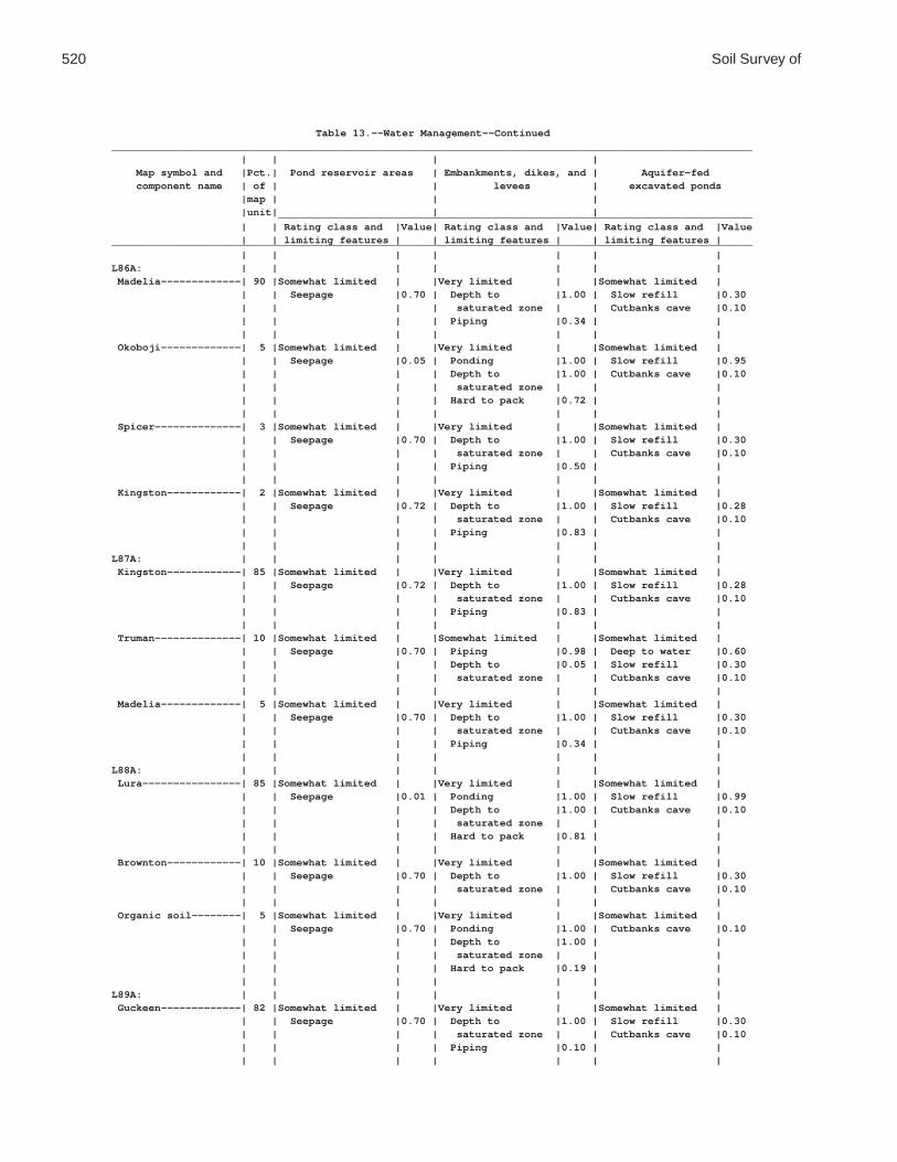
520 Soil Survey of
Table 13.--Water Management--Continued________________________________________________________________________________________________________ | | | | Map symbol and |Pct.| Pond reservoir areas | Embankments, dikes, and | Aquifer-fed component name | of | | levees | excavated ponds |map | | | |unit| | | _____________________________________________________________________________ | | Rating class and |Value| Rating class and |Value| Rating class and |Value | | limiting features | | limiting features | | limiting features |________________________________________________________________________________________________________ | | | | | | |L86A: | | | | | | | Madelia-------------| 90 |Somewhat limited | |Very limited | |Somewhat limited | | | Seepage |0.70 | Depth to |1.00 | Slow refill |0.30 | | | | saturated zone | | Cutbanks cave |0.10 | | | | Piping |0.34 | | | | | | | | | Okoboji-------------| 5 |Somewhat limited | |Very limited | |Somewhat limited | | | Seepage |0.05 | Ponding |1.00 | Slow refill |0.95 | | | | Depth to |1.00 | Cutbanks cave |0.10 | | | | saturated zone | | | | | | | Hard to pack |0.72 | | | | | | | | | Spicer--------------| 3 |Somewhat limited | |Very limited | |Somewhat limited | | | Seepage |0.70 | Depth to |1.00 | Slow refill |0.30 | | | | saturated zone | | Cutbanks cave |0.10 | | | | Piping |0.50 | | | | | | | | | Kingston------------| 2 |Somewhat limited | |Very limited | |Somewhat limited | | | Seepage |0.72 | Depth to |1.00 | Slow refill |0.28 | | | | saturated zone | | Cutbanks cave |0.10 | | | | Piping |0.83 | | | | | | | | |L87A: | | | | | | | Kingston------------| 85 |Somewhat limited | |Very limited | |Somewhat limited | | | Seepage |0.72 | Depth to |1.00 | Slow refill |0.28 | | | | saturated zone | | Cutbanks cave |0.10 | | | | Piping |0.83 | | | | | | | | | Truman--------------| 10 |Somewhat limited | |Somewhat limited | |Somewhat limited | | | Seepage |0.70 | Piping |0.98 | Deep to water |0.60 | | | | Depth to |0.05 | Slow refill |0.30 | | | | saturated zone | | Cutbanks cave |0.10 | | | | | | | Madelia-------------| 5 |Somewhat limited | |Very limited | |Somewhat limited | | | Seepage |0.70 | Depth to |1.00 | Slow refill |0.30 | | | | saturated zone | | Cutbanks cave |0.10 | | | | Piping |0.34 | | | | | | | | |L88A: | | | | | | | Lura----------------| 85 |Somewhat limited | |Very limited | |Somewhat limited | | | Seepage |0.01 | Ponding |1.00 | Slow refill |0.99 | | | | Depth to |1.00 | Cutbanks cave |0.10 | | | | saturated zone | | | | | | | Hard to pack |0.81 | | | | | | | | | Brownton------------| 10 |Somewhat limited | |Very limited | |Somewhat limited | | | Seepage |0.70 | Depth to |1.00 | Slow refill |0.30 | | | | saturated zone | | Cutbanks cave |0.10 | | | | | | | Organic soil--------| 5 |Somewhat limited | |Very limited | |Somewhat limited | | | Seepage |0.70 | Ponding |1.00 | Cutbanks cave |0.10 | | | | Depth to |1.00 | | | | | | saturated zone | | | | | | | Hard to pack |0.19 | | | | | | | | |L89A: | | | | | | | Guckeen-------------| 82 |Somewhat limited | |Very limited | |Somewhat limited | | | Seepage |0.70 | Depth to |1.00 | Slow refill |0.30 | | | | saturated zone | | Cutbanks cave |0.10 | | | | Piping |0.10 | | | | | | | | |

Waseca County, Minnesota 521
Table 13.--Water Management--Continued________________________________________________________________________________________________________ | | | | Map symbol and |Pct.| Pond reservoir areas | Embankments, dikes, and | Aquifer-fed component name | of | | levees | excavated ponds |map | | | |unit| | | _____________________________________________________________________________ | | Rating class and |Value| Rating class and |Value| Rating class and |Value | | limiting features | | limiting features | | limiting features |________________________________________________________________________________________________________ | | | | | | |L89A: | | | | | | | Marna---------------| 10 |Somewhat limited | |Very limited | |Somewhat limited | | | Seepage |0.70 | Depth to |1.00 | Slow refill |0.30 | | | | saturated zone | | Cutbanks cave |0.10 | | | | | | | Clarion clay loam---| 8 |Somewhat limited | |Somewhat limited | |Somewhat limited | | | Seepage |0.70 | Piping |0.73 | Deep to water |0.60 | | | | Depth to |0.05 | Slow refill |0.30 | | | | saturated zone | | Cutbanks cave |0.10 | | | | | | |L90A: | | | | | | | Le Sueur------------| 75 |Somewhat limited | |Very limited | |Somewhat limited | | | Seepage |0.72 | Depth to |1.00 | Slow refill |0.28 | | | | saturated zone | | Cutbanks cave |0.10 | | | | Piping |0.15 | | | | | | | | | Cordova-------------| 13 |Somewhat limited | |Very limited | |Somewhat limited | | | Seepage |0.70 | Depth to |1.00 | Slow refill |0.30 | | | | saturated zone | | Cutbanks cave |0.10 | | | | Piping |0.02 | | | | | | | | | Reedslake-----------| 12 |Somewhat limited | |Somewhat limited | |Somewhat limited | | | Seepage |0.72 | Piping |0.27 | Deep to water |0.60 | | | | Depth to |0.05 | Slow refill |0.30 | | | | saturated zone | | Cutbanks cave |0.10 | | | | | | |L91A: | | | | | | | Mazaska-------------| 85 |Somewhat limited | |Very limited | |Somewhat limited | | | Seepage |0.70 | Depth to |1.00 | Slow refill |0.30 | | | | saturated zone | | Cutbanks cave |0.10 | | | | Piping |0.01 | | | | | | | | | Lerdal--------------| 10 |Somewhat limited | |Very limited | |Somewhat limited | | | Seepage |0.70 | Depth to |1.00 | Slow refill |0.30 | | | | saturated zone | | Cutbanks cave |0.10 | | | | | | | Rolfe---------------| 5 |Somewhat limited | |Very limited | |Somewhat limited | | | Seepage |0.70 | Ponding |1.00 | Slow refill |0.28 | | | | Depth to |1.00 | Cutbanks cave |0.10 | | | | saturated zone | | | | | | | Piping |0.03 | | | | | | | | |L92A: | | | | | | | Darfur--------------| 78 |Very limited | |Very limited | |Very limited | | | Seepage |1.00 | Depth to |1.00 | Cutbanks cave |1.00 | | | | saturated zone | | | | | | | Seepage |0.11 | | | | | | | | | Fieldon-------------| 10 |Very limited | |Very limited | |Very limited | | | Seepage |1.00 | Depth to |1.00 | Cutbanks cave |1.00 | | | | saturated zone | | | | | | | Seepage |0.11 | | | | | | | | | Litchfield----------| 5 |Very limited | |Very limited | |Very limited | | | Seepage |1.00 | Depth to |1.00 | Cutbanks cave |1.00 | | | | saturated zone | | | | | | | Seepage |0.57 | | | | | | | | |

522 Soil Survey of
Table 13.--Water Management--Continued________________________________________________________________________________________________________ | | | | Map symbol and |Pct.| Pond reservoir areas | Embankments, dikes, and | Aquifer-fed component name | of | | levees | excavated ponds |map | | | |unit| | | _____________________________________________________________________________ | | Rating class and |Value| Rating class and |Value| Rating class and |Value | | limiting features | | limiting features | | limiting features |________________________________________________________________________________________________________ | | | | | | |L92A: | | | | | | | Webster-------------| 5 |Somewhat limited | |Very limited | |Somewhat limited | | | Seepage |0.70 | Depth to |1.00 | Slow refill |0.30 | | | | saturated zone | | Cutbanks cave |0.10 | | | | Piping |0.19 | | | | | | | | | Dassel--------------| 2 |Very limited | |Very limited | |Very limited | | | Seepage |1.00 | Depth to |1.00 | Cutbanks cave |1.00 | | | | saturated zone | | | | | | | Ponding |1.00 | | | | | | Seepage |1.00 | | | | | | | | |L93A: | | | | | | | Muskego-------------| 82 |Not limited | |Very limited | |Somewhat limited | | | | | Content of |1.00 | Cutbanks cave |0.10 | | | | organic matter | | | | | | | Ponding |1.00 | | | | | | Depth to |1.00 | | | | | | saturated zone | | | | | | | Piping |1.00 | | | | | | | | | Blue Earth----------| 10 |Somewhat limited | |Very limited | |Somewhat limited | | | Seepage |0.70 | Ponding |1.00 | Slow refill |0.30 | | | | Depth to |1.00 | Cutbanks cave |0.10 | | | | saturated zone | | | | | | | Piping |1.00 | | | | | | Content of |1.00 | | | | | | organic matter | | | | | | | | | | Mineral soil, | | | | | | | drained------------| 5 |Somewhat limited | |Very limited | |Somewhat limited | | | Seepage |0.70 | Ponding |1.00 | Slow refill |0.30 | | | | Depth to |1.00 | Cutbanks cave |0.10 | | | | saturated zone | | | | | | | Piping |0.43 | | | | | | | | | Belleville----------| 3 |Very limited | |Very limited | |Very limited | | | Seepage |1.00 | Depth to |1.00 | Cutbanks cave |1.00 | | | | saturated zone | | | | | | | Piping |0.80 | | | | | | | | |L94A: | | | | | | | Lowlein-------------| 75 |Very limited | |Very limited | |Very limited | | | Seepage |1.00 | Piping |1.00 | Cutbanks cave |1.00 | | | | Depth to |0.87 | Deep to water |0.06 | | | | saturated zone | | | | | | | | | | Linder--------------| 15 |Very limited | |Very limited | |Very limited | | | Seepage |1.00 | Depth to |1.00 | Cutbanks cave |1.00 | | | | saturated zone | | | | | | | Seepage |0.17 | | | | | | | | | Dickinson-----------| 8 |Very limited | |Somewhat limited | |Very limited | | | Seepage |1.00 | Seepage |0.62 | Deep to water |1.00 | | | | | | | Darfur--------------| 2 |Very limited | |Very limited | |Very limited | | | Seepage |1.00 | Depth to |1.00 | Cutbanks cave |1.00 | | | | saturated zone | | | | | | | Seepage |0.11 | | | | | | | | |

Waseca County, Minnesota 523
Table 13.--Water Management--Continued________________________________________________________________________________________________________ | | | | Map symbol and |Pct.| Pond reservoir areas | Embankments, dikes, and | Aquifer-fed component name | of | | levees | excavated ponds |map | | | |unit| | | _____________________________________________________________________________ | | Rating class and |Value| Rating class and |Value| Rating class and |Value | | limiting features | | limiting features | | limiting features |________________________________________________________________________________________________________ | | | | | | |L95E: | | | | | | | Hawick--------------| 80 |Very limited | |Somewhat limited | |Very limited | | | Seepage |1.00 | Seepage |0.93 | Deep to water |1.00 | | Slope |0.10 | | | | | | | | | | | Estherville---------| 10 |Very limited | |Somewhat limited | |Very limited | | | Seepage |1.00 | Seepage |0.98 | Deep to water |1.00 | | Slope |0.03 | | | | | | | | | | | Tomall--------------| 10 |Very limited | |Somewhat limited | |Very limited | | | Seepage |1.00 | Seepage |0.22 | Cutbanks cave |1.00 | | | | | | Deep to water |0.81 | | | | | | |L96B: | | | | | | | Estherville---------| 55 |Very limited | |Somewhat limited | |Very limited | | | Seepage |1.00 | Seepage |0.98 | Deep to water |1.00 | | | | | | | Hawick--------------| 35 |Very limited | |Somewhat limited | |Very limited | | | Seepage |1.00 | Seepage |0.93 | Deep to water |1.00 | | | | | | | Tomall--------------| 8 |Very limited | |Somewhat limited | |Very limited | | | Seepage |1.00 | Seepage |0.22 | Cutbanks cave |1.00 | | | | | | Deep to water |0.81 | | | | | | | Biscay--------------| 2 |Very limited | |Very limited | |Very limited | | | Seepage |1.00 | Depth to |1.00 | Cutbanks cave |1.00 | | | | saturated zone | | | | | | | Seepage |0.91 | | | | | | | | |L97C: | | | | | | | Hawick--------------| 60 |Very limited | |Somewhat limited | |Very limited | | | Seepage |1.00 | Seepage |0.93 | Deep to water |1.00 | | | | | | | Estherville---------| 30 |Very limited | |Somewhat limited | |Very limited | | | Seepage |1.00 | Seepage |0.98 | Deep to water |1.00 | | | | | | | Tomall--------------| 10 |Very limited | |Somewhat limited | |Very limited | | | Seepage |1.00 | Seepage |0.22 | Cutbanks cave |1.00 | | | | | | Deep to water |0.81 | | | | | | |L98A: | | | | | | | Crippin-------------| 50 |Somewhat limited | |Very limited | |Somewhat limited | | | Seepage |0.70 | Depth to |1.00 | Slow refill |0.30 | | | | saturated zone | | Cutbanks cave |0.10 | | | | Piping |0.38 | | | | | | | | | Nicollet------------| 40 |Somewhat limited | |Very limited | |Somewhat limited | | | Seepage |0.70 | Depth to |1.00 | Slow refill |0.30 | | | | saturated zone | | Cutbanks cave |0.10 | | | | Piping |0.10 | | | | | | | | | Canisteo------------| 5 |Somewhat limited | |Very limited | |Somewhat limited | | | Seepage |0.70 | Depth to |1.00 | Slow refill |0.30 | | | | saturated zone | | Cutbanks cave |0.10 | | | | Piping |0.29 | | | | | | | | | Clarion-------------| 5 |Somewhat limited | |Somewhat limited | |Somewhat limited | | | Seepage |0.70 | Piping |0.79 | Deep to water |0.60 | | | | Depth to |0.05 | Slow refill |0.30 | | | | saturated zone | | Cutbanks cave |0.10 | | | | | | |

524 Soil Survey of
Table 13.--Water Management--Continued________________________________________________________________________________________________________ | | | | Map symbol and |Pct.| Pond reservoir areas | Embankments, dikes, and | Aquifer-fed component name | of | | levees | excavated ponds |map | | | |unit| | | _____________________________________________________________________________ | | Rating class and |Value| Rating class and |Value| Rating class and |Value | | limiting features | | limiting features | | limiting features |________________________________________________________________________________________________________ | | | | | | |L99B: | | | | | | | Clarion-------------| 62 |Somewhat limited | |Somewhat limited | |Somewhat limited | | | Seepage |0.70 | Piping |0.79 | Deep to water |0.60 | | | | Depth to |0.05 | Slow refill |0.30 | | | | saturated zone | | Cutbanks cave |0.10 | | | | | | | Swanlake------------| 25 |Somewhat limited | |Somewhat limited | |Somewhat limited | | | Seepage |0.70 | Piping |0.32 | Deep to water |0.60 | | | | Depth to |0.05 | Slow refill |0.30 | | | | saturated zone | | Cutbanks cave |0.10 | | | | | | | Nicollet------------| 10 |Somewhat limited | |Very limited | |Somewhat limited | | | Seepage |0.70 | Depth to |1.00 | Slow refill |0.30 | | | | saturated zone | | Cutbanks cave |0.10 | | | | Piping |0.10 | | | | | | | | | Webster-------------| 3 |Somewhat limited | |Very limited | |Somewhat limited | | | Seepage |0.70 | Depth to |1.00 | Slow refill |0.30 | | | | saturated zone | | Cutbanks cave |0.10 | | | | Piping |0.19 | | | | | | | | |L100B: | | | | | | | Clarion-------------| 45 |Somewhat limited | |Somewhat limited | |Somewhat limited | | | Seepage |0.70 | Piping |0.79 | Deep to water |0.60 | | | | Depth to |0.05 | Slow refill |0.30 | | | | saturated zone | | Cutbanks cave |0.10 | | | | | | | Estherville---------| 35 |Very limited | |Somewhat limited | |Very limited | | | Seepage |1.00 | Seepage |0.98 | Deep to water |1.00 | | | | | | | Lowlein-------------| 5 |Very limited | |Very limited | |Very limited | | | Seepage |1.00 | Piping |1.00 | Cutbanks cave |1.00 | | | | Depth to |0.87 | Deep to water |0.06 | | | | saturated zone | | | | | | | Seepage |0.09 | | | | | | | | | Nicollet------------| 5 |Somewhat limited | |Very limited | |Somewhat limited | | | Seepage |0.70 | Depth to |1.00 | Slow refill |0.30 | | | | saturated zone | | Cutbanks cave |0.10 | | | | Piping |0.10 | | | | | | | | | Swanlake------------| 5 |Somewhat limited | |Somewhat limited | |Somewhat limited | | | Seepage |0.70 | Piping |0.32 | Deep to water |0.60 | | | | Depth to |0.05 | Slow refill |0.30 | | | | saturated zone | | Cutbanks cave |0.10 | | | | | | | Webster-------------| 5 |Somewhat limited | |Very limited | |Somewhat limited | | | Seepage |0.70 | Depth to |1.00 | Slow refill |0.30 | | | | saturated zone | | Cutbanks cave |0.10 | | | | Piping |0.19 | | | | | | | | |L101C2: | | | | | | | Omsrud, eroded------| 40 |Somewhat limited | |Somewhat limited | |Very limited | | | Seepage |0.70 | Piping |0.34 | Deep to water |1.00 | | | | | | | Hawick--------------| 30 |Very limited | |Somewhat limited | |Very limited | | | Seepage |1.00 | Seepage |0.93 | Deep to water |1.00 | | | | | | | Storden, eroded-----| 20 |Somewhat limited | |Somewhat limited | |Very limited | | | Seepage |0.70 | Piping |0.32 | Deep to water |1.00 | | | | | | |

Waseca County, Minnesota 525
Table 13.--Water Management--Continued________________________________________________________________________________________________________ | | | | Map symbol and |Pct.| Pond reservoir areas | Embankments, dikes, and | Aquifer-fed component name | of | | levees | excavated ponds |map | | | |unit| | | _____________________________________________________________________________ | | Rating class and |Value| Rating class and |Value| Rating class and |Value | | limiting features | | limiting features | | limiting features |________________________________________________________________________________________________________ | | | | | | |L101C2: | | | | | | | Delft---------------| 5 |Somewhat limited | |Very limited | |Somewhat limited | | | Seepage |0.70 | Depth to |1.00 | Slow refill |0.30 | | | | saturated zone | | Cutbanks cave |0.10 | | | | Piping |0.41 | | | | | | | | | Terril--------------| 5 |Somewhat limited | |Somewhat limited | |Somewhat limited | | | Seepage |0.72 | Piping |0.45 | Deep to water |0.60 | | | | Depth to |0.05 | Slow refill |0.28 | | | | saturated zone | | Cutbanks cave |0.10 | | | | | | |L101D2: | | | | | | | Omsrud, eroded------| 40 |Somewhat limited | |Somewhat limited | |Very limited | | | Seepage |0.70 | Piping |0.34 | Deep to water |1.00 | | Slope |0.03 | | | | | | | | | | | Hawick--------------| 25 |Very limited | |Somewhat limited | |Very limited | | | Seepage |1.00 | Seepage |0.93 | Deep to water |1.00 | | Slope |0.03 | | | | | | | | | | | Storden, eroded-----| 20 |Somewhat limited | |Somewhat limited | |Very limited | | | Seepage |0.70 | Piping |0.32 | Deep to water |1.00 | | Slope |0.03 | | | | | | | | | | | Ridgeton------------| 6 |Somewhat limited | |Somewhat limited | |Very limited | | | Seepage |0.72 | Piping |0.42 | Deep to water |1.00 | | Slope |0.01 | | | | | | | | | | | Delft---------------| 5 |Somewhat limited | |Very limited | |Somewhat limited | | | Seepage |0.70 | Depth to |1.00 | Slow refill |0.30 | | | | saturated zone | | Cutbanks cave |0.10 | | | | Piping |0.41 | | | | | | | | | Terril--------------| 4 |Somewhat limited | |Somewhat limited | |Somewhat limited | | | Seepage |0.72 | Depth to |0.87 | Slow refill |0.28 | | | | saturated zone | | Cutbanks cave |0.10 | | | | Piping |0.45 | Deep to water |0.06 | | | | | | |L102C2: | | | | | | | Omsrud, eroded------| 45 |Somewhat limited | |Somewhat limited | |Very limited | | | Seepage |0.70 | Piping |0.34 | Deep to water |1.00 | | | | | | | Storden, eroded-----| 25 |Somewhat limited | |Somewhat limited | |Very limited | | | Seepage |0.70 | Piping |0.32 | Deep to water |1.00 | | | | | | | Omsrud--------------| 15 |Somewhat limited | |Somewhat limited | |Very limited | | | Seepage |0.70 | Piping |0.35 | Deep to water |1.00 | | | | | | | Terril--------------| 10 |Somewhat limited | |Somewhat limited | |Somewhat limited | | | Seepage |0.72 | Piping |0.45 | Deep to water |0.60 | | | | Depth to |0.05 | Slow refill |0.28 | | | | saturated zone | | Cutbanks cave |0.10 | | | | | | | Delft---------------| 5 |Somewhat limited | |Very limited | |Somewhat limited | | | Seepage |0.70 | Depth to |1.00 | Slow refill |0.30 | | | | saturated zone | | Cutbanks cave |0.10 | | | | Piping |0.41 | | | | | | | | |

526 Soil Survey of
Table 13.--Water Management--Continued________________________________________________________________________________________________________ | | | | Map symbol and |Pct.| Pond reservoir areas | Embankments, dikes, and | Aquifer-fed component name | of | | levees | excavated ponds |map | | | |unit| | | _____________________________________________________________________________ | | Rating class and |Value| Rating class and |Value| Rating class and |Value | | limiting features | | limiting features | | limiting features |________________________________________________________________________________________________________ | | | | | | |L102D2: | | | | | | | Omsrud, eroded------| 45 |Somewhat limited | |Somewhat limited | |Very limited | | | Seepage |0.70 | Piping |0.34 | Deep to water |1.00 | | Slope |0.03 | | | | | | | | | | | Storden, eroded-----| 20 |Somewhat limited | |Somewhat limited | |Very limited | | | Seepage |0.70 | Piping |0.32 | Deep to water |1.00 | | Slope |0.03 | | | | | | | | | | | Omsrud--------------| 15 |Somewhat limited | |Somewhat limited | |Very limited | | | Seepage |0.70 | Piping |0.35 | Deep to water |1.00 | | Slope |0.03 | | | | | | | | | | | Ridgeton------------| 8 |Somewhat limited | |Somewhat limited | |Very limited | | | Seepage |0.72 | Piping |0.42 | Deep to water |1.00 | | Slope |0.01 | | | | | | | | | | | Delft---------------| 6 |Somewhat limited | |Very limited | |Somewhat limited | | | Seepage |0.70 | Depth to |1.00 | Slow refill |0.30 | | | | saturated zone | | Cutbanks cave |0.10 | | | | Piping |0.41 | | | | | | | | | Terril--------------| 6 |Somewhat limited | |Somewhat limited | |Somewhat limited | | | Seepage |0.72 | Depth to |0.87 | Slow refill |0.28 | | | | saturated zone | | Cutbanks cave |0.10 | | | | Piping |0.45 | Deep to water |0.06 | | | | | | |L103A: | | | | | | | Fieldon-------------| 50 |Very limited | |Very limited | |Very limited | | | Seepage |1.00 | Depth to |1.00 | Cutbanks cave |1.00 | | | | saturated zone | | | | | | | Seepage |0.11 | | | | | | | | | Canisteo------------| 35 |Somewhat limited | |Very limited | |Somewhat limited | | | Seepage |0.70 | Depth to |1.00 | Slow refill |0.30 | | | | saturated zone | | Cutbanks cave |0.10 | | | | Piping |0.29 | | | | | | | | | Darfur--------------| 10 |Very limited | |Very limited | |Very limited | | | Seepage |1.00 | Depth to |1.00 | Cutbanks cave |1.00 | | | | saturated zone | | | | | | | Seepage |0.11 | | | | | | | | | Glencoe-------------| 5 |Somewhat limited | |Very limited | |Somewhat limited | | | Seepage |0.70 | Ponding |1.00 | Slow refill |0.30 | | | | Depth to |1.00 | Cutbanks cave |0.10 | | | | saturated zone | | | | | | | Piping |0.45 | | | | | | | | |L105C2: | | | | | | | Lester, eroded------| 45 |Somewhat limited | |Somewhat limited | |Very limited | | | Seepage |0.72 | Piping |0.23 | Deep to water |1.00 | | | | | | | Hawick--------------| 35 |Very limited | |Somewhat limited | |Very limited | | | Seepage |1.00 | Seepage |0.93 | Deep to water |1.00 | | | | | | | Terril--------------| 10 |Somewhat limited | |Somewhat limited | |Somewhat limited | | | Seepage |0.72 | Piping |0.45 | Deep to water |0.60 | | | | Depth to |0.05 | Slow refill |0.28 | | | | saturated zone | | Cutbanks cave |0.10 | | | | | | |

Waseca County, Minnesota 527
Table 13.--Water Management--Continued________________________________________________________________________________________________________ | | | | Map symbol and |Pct.| Pond reservoir areas | Embankments, dikes, and | Aquifer-fed component name | of | | levees | excavated ponds |map | | | |unit| | | _____________________________________________________________________________ | | Rating class and |Value| Rating class and |Value| Rating class and |Value | | limiting features | | limiting features | | limiting features |________________________________________________________________________________________________________ | | | | | | |L105C2: | | | | | | | Hamel---------------| 5 |Somewhat limited | |Very limited | |Somewhat limited | | | Seepage |0.72 | Depth to |1.00 | Slow refill |0.28 | | | | saturated zone | | Cutbanks cave |0.10 | | | | | | | Storden, eroded-----| 5 |Somewhat limited | |Somewhat limited | |Very limited | | | Seepage |0.70 | Piping |0.32 | Deep to water |1.00 | | | | | | |L105D2: | | | | | | | Lester, eroded------| 45 |Somewhat limited | |Somewhat limited | |Very limited | | | Seepage |0.72 | Piping |0.23 | Deep to water |1.00 | | Slope |0.03 | | | | | | | | | | | Hawick--------------| 35 |Very limited | |Somewhat limited | |Very limited | | | Seepage |1.00 | Seepage |0.93 | Deep to water |1.00 | | Slope |0.03 | | | | | | | | | | | Ridgeton------------| 8 |Somewhat limited | |Somewhat limited | |Very limited | | | Seepage |0.72 | Piping |0.42 | Deep to water |1.00 | | Slope |0.01 | | | | | | | | | | | Hamel---------------| 5 |Somewhat limited | |Very limited | |Somewhat limited | | | Seepage |0.72 | Depth to |1.00 | Slow refill |0.28 | | | | saturated zone | | Cutbanks cave |0.10 | | | | | | | Storden, eroded-----| 5 |Somewhat limited | |Somewhat limited | |Very limited | | | Seepage |0.70 | Piping |0.32 | Deep to water |1.00 | | Slope |0.03 | | | | | | | | | | | Terril--------------| 2 |Somewhat limited | |Somewhat limited | |Somewhat limited | | | Seepage |0.72 | Depth to |0.87 | Slow refill |0.28 | | | | saturated zone | | Cutbanks cave |0.10 | | | | Piping |0.45 | Deep to water |0.06 | | | | | | |L106C2: | | | | | | | Lester, eroded------| 62 |Somewhat limited | |Somewhat limited | |Very limited | | | Seepage |0.72 | Piping |0.23 | Deep to water |1.00 | | | | | | | Storden, eroded-----| 20 |Somewhat limited | |Somewhat limited | |Very limited | | | Seepage |0.70 | Piping |0.32 | Deep to water |1.00 | | | | | | | Terril--------------| 10 |Somewhat limited | |Somewhat limited | |Somewhat limited | | | Seepage |0.72 | Piping |0.45 | Deep to water |0.60 | | | | Depth to |0.05 | Slow refill |0.28 | | | | saturated zone | | Cutbanks cave |0.10 | | | | | | | Hamel---------------| 5 |Somewhat limited | |Very limited | |Somewhat limited | | | Seepage |0.72 | Depth to |1.00 | Slow refill |0.28 | | | | saturated zone | | Cutbanks cave |0.10 | | | | | | | Reedslake-----------| 3 |Somewhat limited | |Somewhat limited | |Somewhat limited | | | Seepage |0.72 | Piping |0.27 | Deep to water |0.60 | | | | Depth to |0.05 | Slow refill |0.30 | | | | saturated zone | | Cutbanks cave |0.10 | | | | | | |L106D2: | | | | | | | Lester, eroded------| 62 |Somewhat limited | |Somewhat limited | |Very limited | | | Seepage |0.72 | Piping |0.23 | Deep to water |1.00 | | Slope |0.03 | | | | | | | | | | |

528 Soil Survey of
Table 13.--Water Management--Continued________________________________________________________________________________________________________ | | | | Map symbol and |Pct.| Pond reservoir areas | Embankments, dikes, and | Aquifer-fed component name | of | | levees | excavated ponds |map | | | |unit| | | _____________________________________________________________________________ | | Rating class and |Value| Rating class and |Value| Rating class and |Value | | limiting features | | limiting features | | limiting features |________________________________________________________________________________________________________ | | | | | | |L106D2: | | | | | | | Storden, eroded-----| 20 |Somewhat limited | |Somewhat limited | |Very limited | | | Seepage |0.70 | Piping |0.32 | Deep to water |1.00 | | Slope |0.03 | | | | | | | | | | | Ridgeton------------| 10 |Somewhat limited | |Somewhat limited | |Very limited | | | Seepage |0.72 | Piping |0.42 | Deep to water |1.00 | | Slope |0.01 | | | | | | | | | | | Terril--------------| 5 |Somewhat limited | |Somewhat limited | |Somewhat limited | | | Seepage |0.72 | Depth to |0.87 | Slow refill |0.28 | | | | saturated zone | | Cutbanks cave |0.10 | | | | Piping |0.45 | Deep to water |0.06 | | | | | | | Hamel---------------| 3 |Somewhat limited | |Very limited | |Somewhat limited | | | Seepage |0.72 | Depth to |1.00 | Slow refill |0.28 | | | | saturated zone | | Cutbanks cave |0.10 | | | | | | |L107A: | | | | | | | Canisteo------------| 50 |Somewhat limited | |Very limited | |Somewhat limited | | | Seepage |0.70 | Depth to |1.00 | Slow refill |0.30 | | | | saturated zone | | Cutbanks cave |0.10 | | | | Piping |0.29 | | | | | | | | | Glencoe-------------| 35 |Somewhat limited | |Very limited | |Somewhat limited | | | Seepage |0.70 | Ponding |1.00 | Slow refill |0.30 | | | | Depth to |1.00 | Cutbanks cave |0.10 | | | | saturated zone | | | | | | | Piping |0.45 | | | | | | | | | Harps---------------| 10 |Somewhat limited | |Very limited | |Somewhat limited | | | Seepage |0.70 | Depth to |1.00 | Slow refill |0.28 | | | | saturated zone | | Cutbanks cave |0.10 | | | | Piping |0.24 | | | | | | | | | Canisteo, | | | | | | | depressional-------| 3 |Somewhat limited | |Very limited | |Somewhat limited | | | Seepage |0.70 | Ponding |1.00 | Slow refill |0.30 | | | | Depth to |1.00 | Cutbanks cave |0.10 | | | | saturated zone | | | | | | | Piping |0.23 | | | | | | | | | Crippin-------------| 2 |Somewhat limited | |Very limited | |Somewhat limited | | | Seepage |0.70 | Depth to |1.00 | Slow refill |0.30 | | | | saturated zone | | Cutbanks cave |0.10 | | | | Piping |0.38 | | | | | | | | |L108A: | | | | | | | Cordova-------------| 65 |Somewhat limited | |Very limited | |Somewhat limited | | | Seepage |0.70 | Depth to |1.00 | Slow refill |0.30 | | | | saturated zone | | Cutbanks cave |0.10 | | | | Piping |0.02 | | | | | | | | | Rolfe---------------| 30 |Somewhat limited | |Very limited | |Somewhat limited | | | Seepage |0.70 | Ponding |1.00 | Slow refill |0.28 | | | | Depth to |1.00 | Cutbanks cave |0.10 | | | | saturated zone | | | | | | | Piping |0.03 | | | | | | | | |

Waseca County, Minnesota 529
Table 13.--Water Management--Continued________________________________________________________________________________________________________ | | | | Map symbol and |Pct.| Pond reservoir areas | Embankments, dikes, and | Aquifer-fed component name | of | | levees | excavated ponds |map | | | |unit| | | _____________________________________________________________________________ | | Rating class and |Value| Rating class and |Value| Rating class and |Value | | limiting features | | limiting features | | limiting features |________________________________________________________________________________________________________ | | | | | | |L108A: | | | | | | | Le Sueur------------| 5 |Somewhat limited | |Very limited | |Somewhat limited | | | Seepage |0.72 | Depth to |1.00 | Slow refill |0.28 | | | | saturated zone | | Cutbanks cave |0.10 | | | | Piping |0.15 | | | | | | | | |L109A: | | | | | | | Marna---------------| 65 |Somewhat limited | |Very limited | |Somewhat limited | | | Seepage |0.70 | Depth to |1.00 | Slow refill |0.30 | | | | saturated zone | | Cutbanks cave |0.10 | | | | | | | Barbert-------------| 30 |Somewhat limited | |Very limited | |Somewhat limited | | | Seepage |0.70 | Ponding |1.00 | Slow refill |0.30 | | | | Depth to |1.00 | Cutbanks cave |0.10 | | | | saturated zone | | | | | | | Hard to pack |0.07 | | | | | | | | | Guckeen-------------| 5 |Somewhat limited | |Very limited | |Somewhat limited | | | Seepage |0.70 | Depth to |1.00 | Slow refill |0.30 | | | | saturated zone | | Cutbanks cave |0.10 | | | | Piping |0.10 | | | | | | | | |L110E: | | | | | | | Lester--------------| 50 |Somewhat limited | |Somewhat limited | |Very limited | | | Seepage |0.72 | Piping |0.24 | Deep to water |1.00 | | Slope |0.15 | | | | | | | | | | | Ridgeton------------| 30 |Somewhat limited | |Somewhat limited | |Very limited | | | Seepage |0.72 | Piping |0.39 | Deep to water |1.00 | | Slope |0.06 | | | | | | | | | | | Cokato--------------| 10 |Somewhat limited | |Somewhat limited | |Very limited | | | Seepage |0.72 | Piping |0.29 | Deep to water |1.00 | | Slope |0.15 | | | | | | | | | | | Belview-------------| 6 |Somewhat limited | |Somewhat limited | |Very limited | | | Seepage |0.70 | Piping |0.32 | Deep to water |1.00 | | Slope |0.15 | | | | | | | | | | | Hamel---------------| 2 |Somewhat limited | |Very limited | |Somewhat limited | | | Seepage |0.72 | Depth to |1.00 | Slow refill |0.28 | | | | saturated zone | | Cutbanks cave |0.10 | | | | Piping |0.01 | | | | | | | | | Terril--------------| 2 |Somewhat limited | |Somewhat limited | |Somewhat limited | | | Seepage |0.72 | Piping |0.44 | Deep to water |0.60 | | | | Depth to |0.05 | Slow refill |0.28 | | | | saturated zone | | Cutbanks cave |0.10 | | | | | | |L110F: | | | | | | | Lester--------------| 55 |Somewhat limited | |Somewhat limited | |Very limited | | | Seepage |0.72 | Piping |0.25 | Deep to water |1.00 | | Slope |0.72 | | | | | | | | | | | Ridgeton------------| 30 |Somewhat limited | |Somewhat limited | |Very limited | | | Seepage |0.72 | Piping |0.39 | Deep to water |1.00 | | Slope |0.15 | | | | | | | | | | | Cokato--------------| 8 |Somewhat limited | |Somewhat limited | |Very limited | | | Seepage |0.72 | Piping |0.29 | Deep to water |1.00 | | Slope |0.50 | | | | | | | | | | |

530 Soil Survey of
Table 13.--Water Management--Continued________________________________________________________________________________________________________ | | | | Map symbol and |Pct.| Pond reservoir areas | Embankments, dikes, and | Aquifer-fed component name | of | | levees | excavated ponds |map | | | |unit| | | _____________________________________________________________________________ | | Rating class and |Value| Rating class and |Value| Rating class and |Value | | limiting features | | limiting features | | limiting features |________________________________________________________________________________________________________ | | | | | | |L110F: | | | | | | | Belview-------------| 4 |Somewhat limited | |Somewhat limited | |Very limited | | | Slope |0.72 | Piping |0.32 | Deep to water |1.00 | | Seepage |0.70 | | | | | | | | | | | Terril--------------| 2 |Somewhat limited | |Somewhat limited | |Somewhat limited | | | Seepage |0.72 | Piping |0.44 | Deep to water |0.60 | | | | Depth to |0.05 | Slow refill |0.28 | | | | saturated zone | | Cutbanks cave |0.10 | | | | | | | Hamel---------------| 1 |Somewhat limited | |Very limited | |Somewhat limited | | | Seepage |0.72 | Depth to |1.00 | Slow refill |0.28 | | | | saturated zone | | Cutbanks cave |0.10 | | | | Piping |0.01 | | | | | | | | |L111A: | | | | | | | Nicollet------------| 85 |Somewhat limited | |Very limited | |Somewhat limited | | | Seepage |0.72 | Depth to |1.00 | Slow refill |0.28 | | | | saturated zone | | Cutbanks cave |0.10 | | | | Piping |0.16 | | | | | | | | | Clarion-------------| 10 |Somewhat limited | |Somewhat limited | |Somewhat limited | | | Seepage |0.70 | Piping |0.79 | Deep to water |0.60 | | | | Depth to |0.05 | Slow refill |0.30 | | | | saturated zone | | Cutbanks cave |0.10 | | | | | | | Webster-------------| 5 |Somewhat limited | |Very limited | |Somewhat limited | | | Seepage |0.70 | Depth to |1.00 | Slow refill |0.30 | | | | saturated zone | | Cutbanks cave |0.10 | | | | Piping |0.11 | | | | | | | | |L112A: | | | | | | | Webster-------------| 85 |Somewhat limited | |Very limited | |Somewhat limited | | | Seepage |0.70 | Depth to |1.00 | Slow refill |0.30 | | | | saturated zone | | Cutbanks cave |0.10 | | | | Piping |0.11 | | | | | | | | | Glencoe-------------| 10 |Somewhat limited | |Very limited | |Somewhat limited | | | Seepage |0.70 | Ponding |1.00 | Slow refill |0.30 | | | | Depth to |1.00 | Cutbanks cave |0.10 | | | | saturated zone | | | | | | | Piping |0.45 | | | | | | | | | Nicollet------------| 5 |Somewhat limited | |Very limited | |Somewhat limited | | | Seepage |0.72 | Depth to |1.00 | Slow refill |0.28 | | | | saturated zone | | Cutbanks cave |0.10 | | | | Piping |0.16 | | | | | | | | |L113B: | | | | | | | Reedslake-----------| 75 |Somewhat limited | |Somewhat limited | |Somewhat limited | | | Seepage |0.72 | Piping |0.27 | Deep to water |0.60 | | | | Depth to |0.05 | Slow refill |0.30 | | | | saturated zone | | Cutbanks cave |0.10 | | | | | | | Le Sueur------------| 10 |Somewhat limited | |Very limited | |Somewhat limited | | | Seepage |0.72 | Depth to |1.00 | Slow refill |0.28 | | | | saturated zone | | Cutbanks cave |0.10 | | | | Piping |0.15 | | | | | | | | |

Waseca County, Minnesota 531
Table 13.--Water Management--Continued________________________________________________________________________________________________________ | | | | Map symbol and |Pct.| Pond reservoir areas | Embankments, dikes, and | Aquifer-fed component name | of | | levees | excavated ponds |map | | | |unit| | | _____________________________________________________________________________ | | Rating class and |Value| Rating class and |Value| Rating class and |Value | | limiting features | | limiting features | | limiting features |________________________________________________________________________________________________________ | | | | | | |L113B: | | | | | | | Reedslake, eroded---| 10 |Somewhat limited | |Somewhat limited | |Somewhat limited | | | Seepage |0.72 | Piping |0.27 | Deep to water |0.60 | | | | Depth to |0.05 | Slow refill |0.30 | | | | saturated zone | | Cutbanks cave |0.10 | | | | | | | Cordova-------------| 5 |Somewhat limited | |Very limited | |Somewhat limited | | | Seepage |0.70 | Depth to |1.00 | Slow refill |0.30 | | | | saturated zone | | Cutbanks cave |0.10 | | | | Piping |0.02 | | | | | | | | |L114A: | | | | | | | Hanlon, rarely | | | | | | | flooded------------| 85 |Very limited | |Somewhat limited | |Very limited | | | Seepage |1.00 | Depth to |0.87 | Cutbanks cave |1.00 | | | | saturated zone | | Deep to water |0.06 | | | | Seepage |0.08 | | | | | | | | | Coland, occasionally| | | | | | | flooded------------| 10 |Very limited | |Very limited | |Somewhat limited | | | Seepage |1.00 | Depth to |1.00 | Cutbanks cave |0.10 | | | | saturated zone | | | | | | | Seepage |0.09 | | | | | | Piping |0.03 | | | | | | | | | Minneopa, rarely | | | | | | | flooded------------| 5 |Very limited | |Somewhat limited | |Very limited | | | Seepage |1.00 | Depth to |0.87 | Cutbanks cave |1.00 | | | | saturated zone | | Deep to water |0.06 | | | | Seepage |0.52 | | | | | | | | |L115A: | | | | | | | Brownton------------| 55 |Somewhat limited | |Very limited | |Somewhat limited | | | Seepage |0.70 | Depth to |1.00 | Slow refill |0.30 | | | | saturated zone | | Cutbanks cave |0.10 | | | | | | | Lura----------------| 35 |Somewhat limited | |Very limited | |Somewhat limited | | | Seepage |0.01 | Ponding |1.00 | Slow refill |0.99 | | | | Depth to |1.00 | Cutbanks cave |0.10 | | | | saturated zone | | | | | | | Hard to pack |0.81 | | | | | | | | | Marna---------------| 10 |Somewhat limited | |Very limited | |Somewhat limited | | | Seepage |0.70 | Depth to |1.00 | Slow refill |0.30 | | | | saturated zone | | Cutbanks cave |0.10 | | | | | | |L116A: | | | | | | | Le Sueur------------| 45 |Somewhat limited | |Very limited | |Somewhat limited | | | Seepage |0.72 | Depth to |1.00 | Slow refill |0.28 | | | | saturated zone | | Cutbanks cave |0.10 | | | | Piping |0.15 | | | | | | | | | Lerdal--------------| 40 |Somewhat limited | |Very limited | |Somewhat limited | | | Seepage |0.70 | Depth to |1.00 | Slow refill |0.30 | | | | saturated zone | | Cutbanks cave |0.10 | | | | | | | Mazaska-------------| 10 |Somewhat limited | |Very limited | |Somewhat limited | | | Seepage |0.70 | Depth to |1.00 | Slow refill |0.30 | | | | saturated zone | | Cutbanks cave |0.10 | | | | Piping |0.01 | | | | | | | | |

532 Soil Survey of
Table 13.--Water Management--Continued________________________________________________________________________________________________________ | | | | Map symbol and |Pct.| Pond reservoir areas | Embankments, dikes, and | Aquifer-fed component name | of | | levees | excavated ponds |map | | | |unit| | | _____________________________________________________________________________ | | Rating class and |Value| Rating class and |Value| Rating class and |Value | | limiting features | | limiting features | | limiting features |________________________________________________________________________________________________________ | | | | | | |L116A: | | | | | | | Kilkenny------------| 5 |Somewhat limited | |Very limited | |Somewhat limited | | | Seepage |0.70 | Depth to |1.00 | Slow refill |0.30 | | | | saturated zone | | Deep to water |0.24 | | | | | | Cutbanks cave |0.10 | | | | | | |L117C2: | | | | | | | Omsrud, eroded------| 65 |Somewhat limited | |Somewhat limited | |Very limited | | | Seepage |0.70 | Piping |0.34 | Deep to water |1.00 | | | | | | | Omsrud--------------| 15 |Somewhat limited | |Somewhat limited | |Very limited | | | Seepage |0.70 | Piping |0.35 | Deep to water |1.00 | | | | | | | Terril--------------| 10 |Somewhat limited | |Somewhat limited | |Somewhat limited | | | Seepage |0.72 | Piping |0.45 | Deep to water |0.60 | | | | Depth to |0.05 | Slow refill |0.28 | | | | saturated zone | | Cutbanks cave |0.10 | | | | | | | Delft---------------| 5 |Somewhat limited | |Very limited | |Somewhat limited | | | Seepage |0.70 | Depth to |1.00 | Slow refill |0.30 | | | | saturated zone | | Cutbanks cave |0.10 | | | | Piping |0.41 | | | | | | | | | Storden, eroded-----| 5 |Somewhat limited | |Somewhat limited | |Very limited | | | Seepage |0.70 | Piping |0.32 | Deep to water |1.00 | | | | | | |L118A: | | | | | | | Rushriver, | | | | | | | frequently flooded | 85 |Very limited | |Very limited | |Very limited | | | Seepage |1.00 | Depth to |1.00 | Cutbanks cave |1.00 | | | | saturated zone | | | | | | | Seepage |0.08 | | | | | | | | | Houghton, frequently| | | | | | | flooded------------| 5 |Very limited | |Very limited | |Somewhat limited | | | Seepage |1.00 | Content of |1.00 | Cutbanks cave |0.10 | | | | organic matter | | | | | | | Depth to |1.00 | | | | | | saturated zone | | | | | | | | | | Klossner, frequently| | | | | | | flooded------------| 5 |Very limited | |Very limited | |Somewhat limited | | | Seepage |1.00 | Content of |1.00 | Cutbanks cave |0.10 | | | | organic matter | | | | | | | Depth to |1.00 | | | | | | saturated zone | | | | | | | Piping |0.62 | | | | | | | | | Medo, frequently | | | | | | | flooded------------| 5 |Very limited | |Very limited | |Very limited | | | Seepage |1.00 | Depth to |1.00 | Cutbanks cave |1.00 | | | | saturated zone | | | | | | | Seepage |0.95 | | | | | | | | |L119B: | | | | | | | Angus---------------| 80 |Somewhat limited | |Somewhat limited | |Somewhat limited | | | Seepage |0.72 | Piping |0.24 | Deep to water |0.60 | | | | Depth to |0.05 | Slow refill |0.30 | | | | saturated zone | | Cutbanks cave |0.10 | | | | | | |

Waseca County, Minnesota 533
Table 13.--Water Management--Continued________________________________________________________________________________________________________ | | | | Map symbol and |Pct.| Pond reservoir areas | Embankments, dikes, and | Aquifer-fed component name | of | | levees | excavated ponds |map | | | |unit| | | _____________________________________________________________________________ | | Rating class and |Value| Rating class and |Value| Rating class and |Value | | limiting features | | limiting features | | limiting features |________________________________________________________________________________________________________ | | | | | | |L119B: | | | | | | | Angus, eroded-------| 10 |Somewhat limited | |Somewhat limited | |Somewhat limited | | | Seepage |0.72 | Piping |0.19 | Deep to water |0.60 | | | | Depth to |0.05 | Slow refill |0.30 | | | | saturated zone | | Cutbanks cave |0.10 | | | | | | | Cordova-------------| 5 |Somewhat limited | |Very limited | |Somewhat limited | | | Seepage |0.70 | Depth to |1.00 | Slow refill |0.30 | | | | saturated zone | | Cutbanks cave |0.10 | | | | Piping |0.02 | | | | | | | | | Le Sueur------------| 5 |Somewhat limited | |Very limited | |Somewhat limited | | | Seepage |0.72 | Depth to |1.00 | Slow refill |0.28 | | | | saturated zone | | Cutbanks cave |0.10 | | | | Piping |0.15 | | | | | | | | |L120A: | | | | | | | Good Thunder--------| 80 |Somewhat limited | |Somewhat limited | |Somewhat limited | | | Seepage |0.72 | Depth to |0.87 | Slow refill |0.28 | | | | saturated zone | | Cutbanks cave |0.10 | | | | Piping |0.18 | Deep to water |0.06 | | | | | | | Ocheyedan-----------| 10 |Somewhat limited | |Very limited | |Somewhat limited | | | Seepage |0.70 | Piping |1.00 | Deep to water |0.60 | | | | Depth to |0.05 | Slow refill |0.30 | | | | saturated zone | | Cutbanks cave |0.10 | | | | | | | Minnetonka----------| 10 |Somewhat limited | |Very limited | |Somewhat limited | | | Seepage |0.57 | Depth to |1.00 | Slow refill |0.43 | | | | saturated zone | | Cutbanks cave |0.10 | | | | | | |L121B: | | | | | | | Clarion-------------| 80 |Somewhat limited | |Somewhat limited | |Somewhat limited | | | Seepage |0.70 | Piping |0.73 | Deep to water |0.60 | | | | Depth to |0.05 | Slow refill |0.30 | | | | saturated zone | | Cutbanks cave |0.10 | | | | | | | Guckeen-------------| 15 |Somewhat limited | |Very limited | |Somewhat limited | | | Seepage |0.70 | Depth to |1.00 | Slow refill |0.30 | | | | saturated zone | | Cutbanks cave |0.10 | | | | Piping |0.10 | | | | | | | | | Marna---------------| 5 |Somewhat limited | |Very limited | |Somewhat limited | | | Seepage |0.70 | Depth to |1.00 | Slow refill |0.30 | | | | saturated zone | | Cutbanks cave |0.10 | | | | | | |L122B: | | | | | | | Reedslake-----------| 55 |Somewhat limited | |Somewhat limited | |Somewhat limited | | | Seepage |0.72 | Piping |0.27 | Deep to water |0.60 | | | | Depth to |0.05 | Slow refill |0.30 | | | | saturated zone | | Cutbanks cave |0.10 | | | | | | | Estherville---------| 25 |Very limited | |Somewhat limited | |Very limited | | | Seepage |1.00 | Seepage |0.98 | Deep to water |1.00 | | | | | | | Le Sueur------------| 10 |Somewhat limited | |Very limited | |Somewhat limited | | | Seepage |0.72 | Depth to |1.00 | Slow refill |0.28 | | | | saturated zone | | Cutbanks cave |0.10 | | | | Piping |0.15 | | | | | | | | |

534 Soil Survey of
Table 13.--Water Management--Continued________________________________________________________________________________________________________ | | | | Map symbol and |Pct.| Pond reservoir areas | Embankments, dikes, and | Aquifer-fed component name | of | | levees | excavated ponds |map | | | |unit| | | _____________________________________________________________________________ | | Rating class and |Value| Rating class and |Value| Rating class and |Value | | limiting features | | limiting features | | limiting features |________________________________________________________________________________________________________ | | | | | | |L122B: | | | | | | | Cordova-------------| 5 |Somewhat limited | |Very limited | |Somewhat limited | | | Seepage |0.70 | Depth to |1.00 | Slow refill |0.30 | | | | saturated zone | | Cutbanks cave |0.10 | | | | Piping |0.02 | | | | | | | | | Lowlein-------------| 5 |Very limited | |Very limited | |Very limited | | | Seepage |1.00 | Piping |1.00 | Cutbanks cave |1.00 | | | | Depth to |0.87 | Deep to water |0.06 | | | | saturated zone | | | | | | | Seepage |0.09 | | | | | | | | |L123A: | | | | | | | Belleville----------| 85 |Very limited | |Very limited | |Very limited | | | Seepage |1.00 | Depth to |1.00 | Cutbanks cave |1.00 | | | | saturated zone | | | | | | | Piping |0.85 | | | | | | | | | Granby--------------| 15 |Very limited | |Very limited | |Very limited | | | Seepage |1.00 | Ponding |1.00 | Cutbanks cave |1.00 | | | | Depth to |1.00 | | | | | | saturated zone | | | | | | | Seepage |0.97 | | | | | | | | |L124A: | | | | | | | Glencoe mucky clay | | | | | | | loam---------------| 85 |Somewhat limited | |Very limited | |Somewhat limited | | | Seepage |0.70 | Ponding |1.00 | Slow refill |0.30 | | | | Depth to |1.00 | Cutbanks cave |0.10 | | | | saturated zone | | | | | | | Piping |0.43 | | | | | | | | | Canisteo------------| 10 |Somewhat limited | |Very limited | |Somewhat limited | | | Seepage |0.70 | Depth to |1.00 | Slow refill |0.30 | | | | saturated zone | | Cutbanks cave |0.10 | | | | Piping |0.29 | | | | | | | | | Glencoe clay loam---| 5 |Somewhat limited | |Very limited | |Somewhat limited | | | Seepage |0.70 | Ponding |1.00 | Slow refill |0.30 | | | | Depth to |1.00 | Cutbanks cave |0.10 | | | | saturated zone | | | | | | | Piping |0.45 | | | | | | | | |L125A: | | | | | | | Hanlon, rarely | | | | | | | flooded------------| 60 |Very limited | |Somewhat limited | |Very limited | | | Seepage |1.00 | Depth to |0.87 | Cutbanks cave |1.00 | | | | saturated zone | | Deep to water |0.06 | | | | Seepage |0.08 | | | | | | | | | Coland, occasionally| | | | | | | flooded------------| 25 |Very limited | |Very limited | |Somewhat limited | | | Seepage |1.00 | Depth to |1.00 | Cutbanks cave |0.10 | | | | saturated zone | | | | | | | Seepage |0.09 | | | | | | Piping |0.03 | | | | | | | | |

Waseca County, Minnesota 535
Table 13.--Water Management--Continued________________________________________________________________________________________________________ | | | | Map symbol and |Pct.| Pond reservoir areas | Embankments, dikes, and | Aquifer-fed component name | of | | levees | excavated ponds |map | | | |unit| | | _____________________________________________________________________________ | | Rating class and |Value| Rating class and |Value| Rating class and |Value | | limiting features | | limiting features | | limiting features |________________________________________________________________________________________________________ | | | | | | |L125A: | | | | | | | Minneopa, rarely | | | | | | | flooded------------| 15 |Very limited | |Somewhat limited | |Very limited | | | Seepage |1.00 | Depth to |0.87 | Cutbanks cave |1.00 | | | | saturated zone | | Deep to water |0.06 | | | | Seepage |0.52 | | | | | | | | |L126A: | | | | | | | Coland, occasionally| | | | | | | flooded------------| 80 |Very limited | |Very limited | |Somewhat limited | | | Seepage |1.00 | Depth to |1.00 | Cutbanks cave |0.10 | | | | saturated zone | | | | | | | Seepage |0.09 | | | | | | Piping |0.03 | | | | | | | | | Minneopa, | | | | | | | occasionally | | | | | | | flooded------------| 10 |Very limited | |Somewhat limited | |Very limited | | | Seepage |1.00 | Depth to |0.87 | Cutbanks cave |1.00 | | | | saturated zone | | Deep to water |0.06 | | | | Seepage |0.52 | | | | | | | | | Havelock, | | | | | | | occasionally | | | | | | | flooded------------| 5 |Very limited | |Very limited | |Somewhat limited | | | Seepage |1.00 | Depth to |1.00 | Cutbanks cave |0.10 | | | | saturated zone | | | | | | | Piping |0.12 | | | | | | Seepage |0.01 | | | | | | | | | Spillville, | | | | | | | occasionally | | | | | | | flooded------------| 5 |Very limited | |Very limited | |Somewhat limited | | | Seepage |1.00 | Depth to |1.00 | Cutbanks cave |0.10 | | | | saturated zone | | | | | | | Piping |0.66 | | | | | | | | |L127A: | | | | | | | Coland, frequently | | | | | | | flooded------------| 80 |Very limited | |Very limited | |Somewhat limited | | | Seepage |1.00 | Depth to |1.00 | Cutbanks cave |0.10 | | | | saturated zone | | | | | | | Piping |0.25 | | | | | | Seepage |0.09 | | | | | | | | | Minneopa, | | | | | | | occasionally | | | | | | | flooded------------| 10 |Very limited | |Somewhat limited | |Very limited | | | Seepage |1.00 | Seepage |0.99 | Cutbanks cave |1.00 | | | | Depth to |0.87 | Deep to water |0.06 | | | | saturated zone | | | | | | | | | | Havelock, frequently| | | | | | | flooded------------| 5 |Very limited | |Very limited | |Somewhat limited | | | Seepage |1.00 | Depth to |1.00 | Cutbanks cave |0.10 | | | | saturated zone | | | | | | | Piping |0.02 | | | | | | Seepage |0.01 | | | | | | | | |

536 Soil Survey of
Table 13.--Water Management--Continued________________________________________________________________________________________________________ | | | | Map symbol and |Pct.| Pond reservoir areas | Embankments, dikes, and | Aquifer-fed component name | of | | levees | excavated ponds |map | | | |unit| | | _____________________________________________________________________________ | | Rating class and |Value| Rating class and |Value| Rating class and |Value | | limiting features | | limiting features | | limiting features |________________________________________________________________________________________________________ | | | | | | |L127A: | | | | | | | Spillville, | | | | | | | occasionally | | | | | | | flooded------------| 5 |Very limited | |Very limited | |Somewhat limited | | | Seepage |1.00 | Depth to |1.00 | Cutbanks cave |0.10 | | | | saturated zone | | | | | | | Piping |0.66 | | | | | | | | |L128A: | | | | | | | Mazaska-------------| 60 |Somewhat limited | |Very limited | |Somewhat limited | | | Seepage |0.70 | Depth to |1.00 | Slow refill |0.30 | | | | saturated zone | | Cutbanks cave |0.10 | | | | Piping |0.01 | | | | | | | | | Rolfe---------------| 30 |Somewhat limited | |Very limited | |Somewhat limited | | | Seepage |0.70 | Ponding |1.00 | Slow refill |0.28 | | | | Depth to |1.00 | Cutbanks cave |0.10 | | | | saturated zone | | | | | | | Piping |0.03 | | | | | | | | | Lerdal--------------| 10 |Somewhat limited | |Very limited | |Somewhat limited | | | Seepage |0.70 | Depth to |1.00 | Slow refill |0.30 | | | | saturated zone | | Cutbanks cave |0.10 | | | | | | |L129B: | | | | | | | Terril--------------| 90 |Somewhat limited | |Somewhat limited | |Somewhat limited | | | Seepage |0.72 | Piping |0.45 | Deep to water |0.60 | | | | Depth to |0.05 | Slow refill |0.28 | | | | saturated zone | | Cutbanks cave |0.10 | | | | | | | Delft---------------| 5 |Somewhat limited | |Very limited | |Somewhat limited | | | Seepage |0.70 | Depth to |1.00 | Slow refill |0.30 | | | | saturated zone | | Cutbanks cave |0.10 | | | | Piping |0.41 | | | | | | | | | Hamel---------------| 5 |Somewhat limited | |Very limited | |Somewhat limited | | | Seepage |0.72 | Depth to |1.00 | Slow refill |0.28 | | | | saturated zone | | Cutbanks cave |0.10 | | | | | | |L130A: | | | | | | | Okoboji mucky silty | | | | | | | clay loam----------| 75 |Somewhat limited | |Very limited | |Somewhat limited | | | Seepage |0.04 | Ponding |1.00 | Slow refill |0.28 | | | | Depth to |1.00 | Cutbanks cave |0.10 | | | | saturated zone | | | | | | | Hard to pack |0.66 | | | | | | | | | Okoboji silty clay | | | | | | | loam---------------| 15 |Somewhat limited | |Very limited | |Somewhat limited | | | Seepage |0.05 | Ponding |1.00 | Slow refill |0.95 | | | | Depth to |1.00 | Cutbanks cave |0.10 | | | | saturated zone | | | | | | | Hard to pack |0.72 | | | | | | | | | Brownton------------| 5 |Somewhat limited | |Very limited | |Somewhat limited | | | Seepage |0.70 | Depth to |1.00 | Slow refill |0.30 | | | | saturated zone | | Cutbanks cave |0.10 | | | | | | | Spicer--------------| 5 |Somewhat limited | |Very limited | |Somewhat limited | | | Seepage |0.70 | Depth to |1.00 | Slow refill |0.30 | | | | saturated zone | | Cutbanks cave |0.10 | | | | Piping |0.50 | | | | | | | | |

Waseca County, Minnesota 537
Table 13.--Water Management--Continued________________________________________________________________________________________________________ | | | | Map symbol and |Pct.| Pond reservoir areas | Embankments, dikes, and | Aquifer-fed component name | of | | levees | excavated ponds |map | | | |unit| | | _____________________________________________________________________________ | | Rating class and |Value| Rating class and |Value| Rating class and |Value | | limiting features | | limiting features | | limiting features |________________________________________________________________________________________________________ | | | | | | |M-W: | | | | | | | Water, miscellaneous|100 |Not rated | |Not rated | |Not rated | | | | | | | |U3B: | | | | | | | Udorthents (cut and | | | | | | | fill land)---------|100 |Not rated | |Not rated | |Not rated | | | | | | | |W: | | | | | | | Water---------------|100 |Not rated | |Not rated | |Not rated | | | | | | | |________________________________________________________________________________________________________


539
Data relating to soil properties are collected duringthe course of the soil survey. The data and theestimates of soil and water features, listed in tables,are explained on the following pages.
Soil properties are determined by field examinationof the soils and by laboratory index testing of somebenchmark soils. Established standard procedures arefollowed. During the survey, many shallow borings aremade and examined to identify and classify the soilsand to delineate them on the soil maps. Samples aretaken from some typical profiles and tested in thelaboratory to determine grain-size distribution,plasticity, and compaction characteristics.
Estimates of soil properties are based on fieldexaminations, on laboratory tests of samples from thesurvey area, and on laboratory tests of samples ofsimilar soils in nearby areas. Tests verify fieldobservations, verify properties that cannot beestimated accurately by field observation, and help tocharacterize key soils.
The estimates of soil properties shown in the tablesinclude the range of grain-size distribution andAtterberg limits, the engineering classification, and thephysical and chemical properties of the major horizonsof each soil. Pertinent soil and water features also aregiven.
Engineering Index PropertiesTable 14 gives estimates of the engineering
classification and of the range of index properties forthe major horizons of each soil. Most soils havehorizons of contrasting properties within the upper 5 or6 feet.
Depth to the upper and lower boundaries of eachhorizon is indicated.
Texture is given in the standard terms used by theU.S. Department of Agriculture. These terms aredefined according to percentages of sand, silt, andclay in the fraction of the soil that is less than 2millimeters in diameter. “Loam,” for example, is soil thatis 7 to 27 percent clay, 28 to 50 percent silt, and lessthan 52 percent sand. If the content of particlescoarser than sand is as much as 15 percent, an
appropriate modifier is added, for example, “gravelly.”Textural terms are defined in the Glossary.
Classification of the soils is determined according tothe Unified soil classification system (ASTM, 2001)and the system adopted by the American Associationof State Highway and Transportation Officials(AASHTO, 2000).
The Unified system classifies soils according toproperties that affect their use as constructionmaterial. Soils are classified according to grain-sizedistribution of the fraction less than 3 inches indiameter and according to plasticity index, liquid limit,and organic matter content. Sandy and gravelly soilsare identified as GW, GP, GM, GC, SW, SP, SM, andSC; silty and clayey soils as ML, CL, OL, MH, CH, andOH; and highly organic soils as PT. Soils exhibitingengineering properties of two groups can have a dualclassification, for example, SP-SM.
The AASHTO system classifies soils according tothose properties that affect roadway construction andmaintenance. In this system, the fraction of a mineralsoil that is less than 3 inches in diameter is classifiedin one of seven groups from A-1 through A-7 on thebasis of grain-size distribution, liquid limit, andplasticity index. Soils in group A-1 are coarse grainedand low in content of fines (silt and clay). At the otherextreme, soils in group A-7 are fine grained. Highlyorganic soils are classified in group A-8 on the basis ofvisual inspection.
If laboratory data are available, the A-1, A-2, andA-7 groups are further classified as A-1-a, A-1-b,A-2-4, A-2-5, A-2-6, A-2-7, A-7-5, or A-7-6. As anadditional refinement, the suitability of a soil assubgrade material can be indicated by a group indexnumber. Group index numbers range from 0 for thebest subgrade material to 20 or higher for the poorest.
Rock fragments larger than 10 inches in diameterand 3 to 10 inches in diameter are indicated as apercentage of the total soil on a dry-weight basis. Thepercentages are estimates determined mainly byconverting volume percentage in the field to weightpercentage.
Percentage (of soil particles) passing designatedsieves is the percentage of the soil fraction less than 3
Soil Properties

540 Soil Survey of
inches in diameter based on an ovendry weight. Thesieves, numbers 4, 10, 40, and 200 (USA StandardSeries), have openings of 4.76, 2.00, 0.420, and 0.074millimeters, respectively. Estimates are based onlaboratory tests of soils sampled in the survey areaand in nearby areas and on estimates made in thefield.
Liquid limit and plasticity index (Atterberg limits)indicate the plasticity characteristics of a soil. Theestimates are based on test data from the survey areaor from nearby areas and on field examination.
The estimates of grain-size distribution, liquid limit,and plasticity index are generally rounded to thenearest 5 percent. Thus, if the ranges of gradation andAtterberg limits extend a marginal amount (1 or 2percentage points) across classification boundaries,the classification in the marginal zone is omitted in thetable.
Physical and Chemical PropertiesTables 15 and 16 show estimates of some
characteristics and features that affect soil behavior.These estimates are given for the major horizons ofeach soil in the survey area. The estimates are basedon field observations and on test data for these andsimilar soils.
Depth to the upper and lower boundaries of eachhorizon is indicated.
In table 15, clay as a soil separate, or component,consists of mineral soil particles that are less than0.002 millimeter in diameter. The estimated claycontent of each major soil horizon is given as apercentage, by weight, of the soil material that is lessthan 2 millimeters in diameter.
The amount and kind of clay greatly affect thefertility and physical condition of the soil. Theydetermine the ability of the soil to adsorb cations andto retain moisture. They influence linear extensibility,permeability, plasticity, the ease of soil dispersion, andother soil properties. The amount and kind of clay in asoil also affect tillage and earth-moving operations.
Moist bulk density is the weight of soil (ovendry) perunit volume. Volume is measured when the soil is atfield moisture capacity, that is, the moisture content at1/3-bar moisture tension. Weight is determined afterdrying the soil at 105 degrees C. In table 15, theestimated moist bulk density of each major soilhorizon is expressed in grams per cubic centimeter ofsoil material that is less than 2 millimeters in diameter.Bulk density data are used to compute linearextensibility, available water capacity, total pore space,and other soil properties. The moist bulk density of asoil indicates the pore space available for water and
roots. A bulk density of more than 1.6 can restrictwater storage and root penetration. Moist bulk densityis influenced by texture, kind of clay, content of organicmatter, and soil structure.
Saturated hydraulic conductivity refers to the abilityof a soil to transmit water or air. The term“permeability,” as used in soil surveys, indicatessaturated hydraulic conductivity (K
sat ). The estimates
in the table indicate the rate of water movement, inmicrometers per second (um/sec), when the soil issaturated. They are based on soil characteristicsobserved in the field, particularly structure, porosity,and texture. Permeability is considered in the design ofsoil drainage systems and septic tank absorptionfields.
Available water capacity refers to the quantity ofwater that the soil is capable of storing for use byplants. The capacity for water storage is given ininches of water per inch of soil for each major soilhorizon. The capacity varies, depending on soilproperties that affect the retention of water and thedepth of the root zone. The most important propertiesare the content of organic matter, soil texture, bulkdensity, and soil structure. Available water capacity isan important factor in the choice of plants or crops tobe grown and in the design and management ofirrigation systems. Available water capacity is not anestimate of the quantity of water actually available toplants at any given time.
Linear extensibility percent is the linear expressionof the volume difference of natural soil fabric at 1/3-baror 1/10-bar water content and oven dryness. Thevolume change is reported as percent change for thewhole soil. Volume change occurs mainly because ofthe interaction of clay minerals with water and varieswith the amount and type of clay minerals in the soil.The size of the load on the soil and the magnitude ofthe change in soil moisture content influence theamount of swelling of soils in place. Laboratorymeasurements of swelling of undisturbed clods weremade for many soils. For others, swelling wasestimated on the basis of the kind and amount of clayminerals in the soil and on measurements of similarsoils.
Linear extensibility of 3 percent or more can causedamage to buildings, roads, and other structures.Special design is often needed.
Organic matter is the plant and animal residue inthe soil at various stages of decomposition. In table15, the estimated content of organic matter isexpressed as a percentage, by weight, of the soilmaterial that is less than 2 millimeters in diameter.
The content of organic matter in a soil can bemaintained or increased by returning crop residue to

Waseca County, Minnesota 541
the soil. Organic matter affects the available watercapacity, infiltration rate, and tilth. It is a source ofnitrogen and other nutrients for crops.
Erosion factors are shown in table 15 as the Kfactor (Kw and Kf) and the T factor. Erosion factor Kindicates the susceptibility of a soil to sheet and rillerosion by water. Factor K is one of several factorsused in the Universal Soil Loss Equation (USLE) andthe Revised Universal Soil Loss Equation (RUSLE) topredict the average annual rate of soil loss by sheetand rill erosion in tons per acre per year. Theestimates are based primarily on percentage of silt,sand, and organic matter and on soil structure andpermeability. Values of K range from 0.02 to 0.69.Other factors being equal, the higher the value, themore susceptible the soil is to sheet and rill erosion bywater.
Erosion factor Kw indicates the erodibility of thewhole soil. The estimates are modified by thepresence of rock fragments.
Erosion factor Kf indicates the erodibility of the fine-earth fraction, or the material less than 2 millimeters insize.
Erosion factor T is an estimate of the maximumaverage annual rate of soil erosion by wind or waterthat can occur without affecting crop productivity overa sustained period. The rate is in tons per acre peryear.
Wind erodibility groups are made up of soils thathave similar properties affecting their susceptibility towind erosion in cultivated areas. The soils assigned togroup 1 are the most susceptible to wind erosion, andthose assigned to group 8 are the least susceptible.The groups are as follows:
1. Coarse sands, sands, fine sands, and very finesands.
2. Loamy coarse sands, loamy sands, loamy finesands, loamy very fine sands, ash material, and sapricsoil material.
3. Coarse sandy loams, sandy loams, fine sandyloams, and very fine sandy loams.
4L. Calcareous loams, silt loams, clay loams, andsilty clay loams.
4. Clays, silty clays, noncalcareous clay loams,and silty clay loams that are more than 35 percentclay.
5. Noncalcareous loams and silt loams that areless than 20 percent clay and sandy clay loams, sandyclays, and hemic soil material.
6. Noncalcareous loams and silt loams that aremore than 20 percent clay and noncalcareous clayloams that are less than 35 percent clay.
7. Silts, noncalcareous silty clay loams that areless than 35 percent clay, and fibric soil material.
8. Soils that are not subject to wind erosionbecause of rock fragments on the surface or becauseof surface wetness.
Wind erodibility index is a numerical value indicatingthe susceptibility of soil to wind erosion, or the tonsper acre per year that can be expected to be lost towind erosion. There is a close correlation betweenwind erosion and the texture of the surface layer, thesize and durability of surface clods, rock fragments,organic matter, and a calcareous reaction. Soilmoisture and frozen soil layers also influence winderosion.
In table 16, cation-exchange capacity is the totalamount of extractable bases that can be held by thesoil, expressed in terms of milliequivalents per 100grams of soil at neutrality (pH 7.0) or at some otherstated pH value. Soils having a low cation-exchangecapacity hold fewer cations and may require morefrequent applications of fertilizer than soils having ahigh cation-exchange capacity. The ability to retaincations reduces the hazard of ground-water pollution.
Soil reaction is a measure of acidity or alkalinity andis expressed as a range in pH values. The range in pHof each major horizon is based on many field tests. Formany soils, values have been verified by laboratoryanalyses. Soil reaction is important in selecting cropsand other plants, in evaluating soil amendments forfertility and stabilization, and in determining the risk ofcorrosion.
Calcium carbonate equivalent is the percent ofcarbonates, by weight, in the fraction of the soil lessthan 2 millimeters in size. The availability of plantnutrients is influenced by the amount of carbonates inthe soil. Incorporating nitrogen fertilizer into calcareoussoils helps to prevent nitrite accumulation andammonium-N volatilization.
Gypsum is expressed as a percent, by weight, ofhydrated calcium sulfates in the fraction of the soil lessthan 20 millimeters in size. Gypsum is partially solublein water. Soils that have a high content of gypsum maycollapse if the gypsum is removed by percolatingwater.
Water FeaturesSoil moisture status is an estimate of the fluctuating
water content in a soil. It greatly influences vegetationtype and plant growth; physical properties of soils,such as permeability, workability, strength, linearextensibility, and frost action; and chemicalinteractions and transport. Many other properties,qualities, and interpretations also are affected. Soilmoisture status is important in the classification ofsoils, wetland, and habitat.

542 Soil Survey of
Table 17 gives estimates of soil moisture for eachcomponent of a map unit at various depths for everymonth of the year. The depths displayed arerepresentative values that are indicative of conditionsthat occur most of the time. Dry indicates a moisturecondition under which most plants (especially crops)cannot extract water for growth. Moist indicates amoisture condition under which soil water is mostreadily available for plant growth. Wet indicates acondition under which water will stand in an unlinedhole or at least a condition under which the soil is toowet for the growth of most agricultural species. Amoisture status of 4.0-6.7 (wet) indicates that most ofthe time the component is saturated at some depthbetween 4.0 feet and 6.7 feet during the monthdesignated. In some years the soil may be saturated ata depth of less than 4.0 feet or more than 6.7 feet;however, field observations indicate that the soil will besaturated between these depths in most years. In thesummer, the soil may show the effects of drying plusintermittent rains that result in a moist or wet layerover a dry layer that gets moist or wet again.
In table 17, hydrologic soil groups are groups ofsoils that, when saturated, have the same runoffpotential under similar storm and ground coverconditions. The soil properties that affect the runoffpotential are those that influence the minimum rate ofinfiltration in a bare soil after prolonged wetting andwhen the soil is not frozen. These properties includethe depth to a zone in which the soil moisture status iswet, the infiltration rate, permeability after prolongedwetting, and the depth to a very slowly permeablehorizon or horizons. The influences of ground coverand slope are treated independently and are not takeninto account in hydrologic soil groups.
In the definitions of the hydrologic soil groups, theinfiltration rate is the rate at which water enters the soilat the surface and is controlled by surface conditions.The transmission rate is the rate at which water movesthrough the soil and is controlled by properties of thesoil horizons.
The four hydrologic soil groups are:Group A. Soils having a high infiltration rate (low
runoff potential) when thoroughly wet. These consistchiefly of very deep, well drained to excessivelydrained sands or gravelly sands. These soils have ahigh rate of water transmission.
Group B. Soils having a moderate infiltration ratewhen thoroughly wet. These consist chiefly ofmoderately deep or deep, moderately well drained orwell drained soils that have a moderately fine tomoderately coarse texture. These soils have amoderate rate of water transmission.
Group C. Soils having a slow infiltration rate when
thoroughly wet. These consist chiefly of soils having ahorizon or horizons that impede the downwardmovement of water or soils that have a moderately fineor fine texture. These soils have a slow rate of watertransmission.
Group D. Soils having a very slow infiltration rate(high runoff potential) when thoroughly wet. Theseconsist chiefly of clayey soils that have a high linearextensibility; soils that have a zone, high in the profile,in which the soil moisture status is wet on apermanent basis; soils that have a claypan or clayhorizon or horizons at or near the surface; and soilsthat are shallow over nearly impervious material.These soils have a very slow rate of watertransmission.
If a soil is assigned to a dual hydrologic group (A/D,B/D, or C/D), the first letter is for drained areas and thesecond is for undrained areas.
Flooding, the temporary covering of the soil surfaceby flowing water, is caused by overflow from streamsor by runoff from adjacent slopes. Shallow waterstanding or flowing for short periods after rainfall orsnowmelt is not considered flooding. Standing water inmarshes and swamps or in closed depressions isconsidered to be ponding.
Table 18 gives estimates of the frequency andduration of flooding for every month of the year.Flooding frequency is the annual probability of a floodevent expressed as a class. None indicates noreasonable possibility of flooding (the chance offlooding is nearly 0 percent in any year, or flooding islikely less than once in 500 years). Very rare indicatesthat flooding is very unlikely but possible underextremely unusual weather conditions (the chance offlooding is less than 1 percent in any year, or floodingis likely less than once in 100 years but more thanonce in 500 years). Rare indicates that flooding isunlikely but possible under unusual weather conditions(the chance of flooding is 1 to 5 percent in any year, orflooding is likely 1 to 5 times in 100 years). Occasionalindicates that flooding occurs infrequently under usualweather conditions (the chance of flooding is 5 to 50percent in any year, or flooding is likely 5 to 50 times in100 years). Frequent indicates that flooding is likely tooccur often under usual weather conditions (thechance of flooding is more than 50 percent in anyyear, or flooding is likely more than 50 times in 100years; but the chance of flooding is less than 50percent in all months in any year). Very frequentindicates that flooding is likely to occur very oftenunder usual weather conditions (the chance offlooding is more than 50 percent in all months of anyyear).
Flooding duration is the average duration of

Waseca County, Minnesota 543
inundation per flood occurrence expressed as a class.Extremely brief is 0.1 hour to 4.0 hours; very brief is 4to 48 hours; brief is 2 to 7 days; long is 7 to 30 days;and very long is more than 30 days. About two-thirdsto three-fourths of all flooding occurs during the statedperiod.
The information on flooding is based on evidence inthe soil profile, namely thin strata of gravel, sand, silt,or clay deposited by floodwater; irregular decrease inorganic matter content with increasing depth; and littleor no horizon development.
Also considered are local information about theextent and level of flooding and the relation of eachsoil on the landscape to historic floods. Information onthe extent of flooding based on soil data is lessspecific than that provided by detailed engineeringsurveys that delineate flood-prone areas at specificflood frequency levels.
Ponding is standing water in a closed depression.Unless a drainage system is installed, the water isremoved only by percolation, transpiration, orevaporation.
Table 19 gives estimates of the frequency, duration,and depth of ponding for every month of the year. Thedepths displayed are representative values that areindicative of conditions that occur most of the time.
Ponding frequency is the number of times pondingoccurs over a period of time. None indicates noreasonable possibility of ponding (the chance ofponding is nearly 0 percent in any year). Rareindicates that ponding is unlikely but possible underunusual weather conditions (the chance of pondingranges from nearly 0 percent to 5 percent in any year,or ponding is likely 0 to 5 times in 100 years).Occasional indicates that ponding is expectedinfrequently under usual weather conditions (thechance of ponding ranges from 5 to 50 percent in anyone year, or ponding is likely 5 to 50 times in 100years). Frequent indicates that ponding is likely tooccur under usual weather conditions (the chance ofponding is more than 50 percent in any year, orponding is likely more than 50 times in 100 years).
Ponding duration is the average length of time ofthe ponding occurrence. It is expressed as very brief(less than 2 days), brief (2 to 7 days), long (7 to 30days), and very long (more than 30 days).
Soil FeaturesTable 20 gives estimates of various soil features.
The estimates are used in land use planning thatinvolves engineering considerations.
Subsidence is the settlement of organic soils or ofsaturated mineral soils of very low density. Subsidencegenerally results from either desiccation andshrinkage or oxidation of organic material, or both,following drainage. Subsidence takes place gradually,usually over a period of several years. The table showsthe expected initial subsidence, which usually is aresult of drainage, and total subsidence, which resultsfrom a combination of factors.
Potential for frost action is the likelihood of upwardor lateral expansion of the soil caused by the formationof segregated ice lenses (frost heave) and thesubsequent collapse of the soil and loss of strength onthawing. Frost action occurs when moisture movesinto the freezing zone of the soil. Temperature, texture,density, permeability, content of organic matter, anddepth to a zone in which the soil moisture status is wetare the most important factors considered inevaluating the potential for frost action. It is assumedthat the soil is not insulated by vegetation or snow andis not artificially drained. Silty and highly structured,clayey soils that have a saturated zone high in theprofile during the winter are the most susceptible tofrost action. Well drained, very gravelly, or very sandysoils are the least susceptible. Frost heave and lowsoil strength during thawing cause damage topavements and other rigid structures.
Risk of corrosion pertains to potential soil-inducedelectrochemical or chemical action that corrodes orweakens uncoated steel or concrete. The rate ofcorrosion of uncoated steel is related to such factorsas soil moisture, particle-size distribution, acidity, andelectrical conductivity of the soil. The rate of corrosionof concrete is based mainly on the sulfate and sodiumcontent, texture, moisture content, and acidity of thesoil. Special site examination and design may beneeded if the combination of factors results in a severehazard of corrosion. The steel or concrete ininstallations that intersect soil boundaries or soil layersis more susceptible to corrosion than the steel orconcrete in installations that are entirely within onekind of soil or within one soil layer.
For uncoated steel, the risk of corrosion, expressedas low, moderate, or high, is based on soil drainageclass, total acidity, electrical resistivity near fieldcapacity, and electrical conductivity of the saturationextract.
For concrete, the risk of corrosion also is expressedas low, moderate, or high. It is based on soil texture,acidity, and amount of sulfates in the saturationextract.

544S
oil Survey of
Table 14.--Engineering Index Properties
(Absence of an entry indicates that the data were not estimated)
_______________________________________________________________________________________________________________________________________ | | | | Classification | Fragments | Percentage passing | | Map symbol | Pct. | Depth | USDA texture |___________________________|_____________| sieve number-- |Liquid| Plas- and | of map | | | | | >10 | 3-10 |___________________________|limit |ticity component name | unit | | | Unified | AASHTO |inches|inches| 4 | 10 | 40 | 200 | |index_______________________________________________________________________________________________________________________________________ | | In | | | | Pct | Pct | | | | | Pct | | | | | | | | | | | | | |GP: | | | | | | | | | | | | | Pits, gravel. | | | | | | | | | | | | | | | | | | | | | | | | | | Udipsamments. | | | | | | | | | | | | | | | | | | | | | | | | | |L5A: | | | | | | | | | | | | | Delft, overwash | 50 | 0-12 |Loam |CL |A-6, A-7 | 0 | 0 |95-100|90-100|75-90 |60-80 |30-45 |10-20 | | 12-37 |Loam |CL |A-6, A-7 | 0 | 0 |95-100|90-100|75-90 |60-80 |30-45 |10-20 | | 37-47 |Clay loam, silt|CL |A-6 | 0 | 0 |95-100|90-100|70-90 |50-75 |30-40 |12-20 | | | loam | | | | | | | | | | | | 47-80 |Clay loam, loam|CL |A-6 | 0-1 | 0-2 |95-100|90-98 |75-90 |50-75 |30-40 |12-20 | | | | | | | | | | | | | Delft-----------| 40 | 0-37 |Loam |CL |A-6, A-7 | 0 | 0 |95-100|90-100|75-90 |60-80 |30-45 |10-20 | | 37-50 |Clay loam, silt|CL |A-6 | 0 | 0 |95-100|90-100|70-90 |50-75 |30-40 |12-20 | | | loam | | | | | | | | | | | | 50-60 |Clay loam, loam|CL |A-6 | 0-1 | 0-2 |95-100|90-98 |75-90 |50-75 |30-40 |12-20 | | | | | | | | | | | | | Glencoe---------| 5 | 0-10 |Clay loam |ML, CL |A-6, A-7 | 0 | 0 |95-100|90-100|75-100|60-90 |40-50 |15-20 | | 10-35 |Silty clay |OL, ML, CL |A-6, A-7 | 0 | 0 |95-100|90-100|75-100|60-90 |30-50 |10-20 | | | loam, clay | | | | | | | | | | | | | loam, loam | | | | | | | | | | | | 35-48 |Loam, clay |ML, CL |A-6 | 0 | 0 |95-100|90-100|75-100|60-90 |30-40 | 5-20 | | | loam, silty | | | | | | | | | | | | | clay loam | | | | | | | | | | | | 48-60 |Clay loam, loam|CL |A-6 | 0-1 | 0-2 |95-100|90-98 |75-90 |50-75 |30-40 |12-20 | | | | | | | | | | | | | Terril----------| 5 | 0-27 |Loam |CL |A-6 | 0 | 0-2 |95-100|95-100|70-90 |60-80 |30-40 |10-20 | | 27-40 |Loam, clay loam|CL |A-6 | 0 | 0-3 |95-100|90-100|70-90 |60-80 |30-40 | 5-20 | | 40-63 |Clay loam, loam|CL-ML, CL |A-6 | 0 | 0-2 |95-100|90-100|65-95 |50-85 |20-40 | 5-20 | | 63-80 |Clay loam, loam|CL |A-6 | 0-1 | 0-2 |95-100|90-98 |75-90 |50-75 |30-40 |12-20 | | | | | | | | | | | | |L13A: | | | | | | | | | | | | | Klossner, | | | | | | | | | | | | | drained--------| 80 | 0-26 |Muck |PT |A-8 | 0 | 0 | --- | --- | --- | --- | --- | --- | | 26-36 |Mucky silt |MH |A-7 | 0 | 0 | 100 |95-100|90-100|85-95 |60-90 |10-30 | | | loam, mucky | | | | | | | | | | | | | silty clay | | | | | | | | | | | | | loam, silt | | | | | | | | | | | | | loam | | | | | | | | | | | | 36-48 |Clay loam, |CL |A-6, A-7 | 0 | 0 |95-100|90-100|80-100|60-90 |35-65 |20-30 | | | loam, silty | | | | | | | | | | | | | clay loam | | | | | | | | | | | | 48-80 |Clay loam, |CL |A-6, A-7 | 0 | 0-5 |90-100|85-100|60-95 |55-80 |30-55 |10-25 | | | loam, silty | | | | | | | | | | | | | clay loam | | | | | | | | | | | | | | | | | | | | | | |
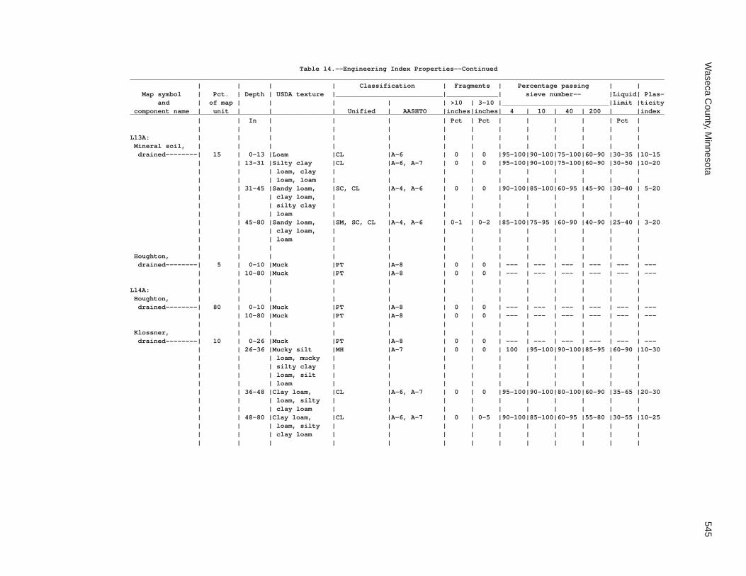
Waseca C
ounty, Minnesota
545
Table 14.--Engineering Index Properties--Continued_______________________________________________________________________________________________________________________________________ | | | | Classification | Fragments | Percentage passing | | Map symbol | Pct. | Depth | USDA texture |___________________________|_____________| sieve number-- |Liquid| Plas- and | of map | | | | | >10 | 3-10 |___________________________|limit |ticity component name | unit | | | Unified | AASHTO |inches|inches| 4 | 10 | 40 | 200 | |index_______________________________________________________________________________________________________________________________________ | | In | | | | Pct | Pct | | | | | Pct | | | | | | | | | | | | | |L13A: | | | | | | | | | | | | | Mineral soil, | | | | | | | | | | | | | drained--------| 15 | 0-13 |Loam |CL |A-6 | 0 | 0 |95-100|90-100|75-100|60-90 |30-35 |10-15 | | 13-31 |Silty clay |CL |A-6, A-7 | 0 | 0 |95-100|90-100|75-100|60-90 |30-50 |10-20 | | | loam, clay | | | | | | | | | | | | | loam, loam | | | | | | | | | | | | 31-45 |Sandy loam, |SC, CL |A-4, A-6 | 0 | 0 |90-100|85-100|60-95 |45-90 |30-40 | 5-20 | | | clay loam, | | | | | | | | | | | | | silty clay | | | | | | | | | | | | | loam | | | | | | | | | | | | 45-80 |Sandy loam, |SM, SC, CL |A-4, A-6 | 0-1 | 0-2 |85-100|75-95 |60-90 |40-90 |25-40 | 3-20 | | | clay loam, | | | | | | | | | | | | | loam | | | | | | | | | | | | | | | | | | | | | | | Houghton, | | | | | | | | | | | | | drained--------| 5 | 0-10 |Muck |PT |A-8 | 0 | 0 | --- | --- | --- | --- | --- | --- | | 10-80 |Muck |PT |A-8 | 0 | 0 | --- | --- | --- | --- | --- | --- | | | | | | | | | | | | |L14A: | | | | | | | | | | | | | Houghton, | | | | | | | | | | | | | drained--------| 80 | 0-10 |Muck |PT |A-8 | 0 | 0 | --- | --- | --- | --- | --- | --- | | 10-80 |Muck |PT |A-8 | 0 | 0 | --- | --- | --- | --- | --- | --- | | | | | | | | | | | | | Klossner, | | | | | | | | | | | | | drained--------| 10 | 0-26 |Muck |PT |A-8 | 0 | 0 | --- | --- | --- | --- | --- | --- | | 26-36 |Mucky silt |MH |A-7 | 0 | 0 | 100 |95-100|90-100|85-95 |60-90 |10-30 | | | loam, mucky | | | | | | | | | | | | | silty clay | | | | | | | | | | | | | loam, silt | | | | | | | | | | | | | loam | | | | | | | | | | | | 36-48 |Clay loam, |CL |A-6, A-7 | 0 | 0 |95-100|90-100|80-100|60-90 |35-65 |20-30 | | | loam, silty | | | | | | | | | | | | | clay loam | | | | | | | | | | | | 48-80 |Clay loam, |CL |A-6, A-7 | 0 | 0-5 |90-100|85-100|60-95 |55-80 |30-55 |10-25 | | | loam, silty | | | | | | | | | | | | | clay loam | | | | | | | | | | | | | | | | | | | | | | |

546S
oil Survey of
Table 14.--Engineering Index Properties--Continued_______________________________________________________________________________________________________________________________________ | | | | Classification | Fragments | Percentage passing | | Map symbol | Pct. | Depth | USDA texture |___________________________|_____________| sieve number-- |Liquid| Plas- and | of map | | | | | >10 | 3-10 |___________________________|limit |ticity component name | unit | | | Unified | AASHTO |inches|inches| 4 | 10 | 40 | 200 | |index_______________________________________________________________________________________________________________________________________ | | In | | | | Pct | Pct | | | | | Pct | | | | | | | | | | | | | |L14A: | | | | | | | | | | | | | Mineral soil, | | | | | | | | | | | | | drained--------| 10 | 0-13 |Loam |CL |A-6 | 0 | 0 |95-100|90-100|75-100|60-90 |30-35 |10-15 | | 13-31 |Silty clay |CL |A-6, A-7 | 0 | 0 |95-100|90-100|75-100|60-90 |30-50 |10-20 | | | loam, clay | | | | | | | | | | | | | loam, loam | | | | | | | | | | | | 31-45 |Sandy loam, |SC, CL |A-4, A-6 | 0 | 0 |90-100|85-100|60-95 |45-90 |30-40 | 5-20 | | | clay loam, | | | | | | | | | | | | | silty clay | | | | | | | | | | | | | loam | | | | | | | | | | | | 45-80 |Sandy loam, |SM, SC, CL |A-4, A-6 | 0-1 | 0-2 |85-100|75-95 |60-90 |40-90 |25-40 | 3-20 | | | clay loam, | | | | | | | | | | | | | loam | | | | | | | | | | | | | | | | | | | | | | |L15A: | | | | | | | | | | | | | Klossner, ponded| 30 | 0-26 |Muck |PT |A-8 | 0 | 0 | --- | --- | --- | --- | --- | --- | | 26-33 |Silt loam, |MH |A-7 | 0 | 0 | 100 |95-100|90-100|85-95 |60-90 |10-30 | | | silty clay | | | | | | | | | | | | | loam | | | | | | | | | | | | 33-40 |Clay loam, |CL |A-6, A-7 | 0 | 0 |95-100|90-100|80-100|60-90 |35-65 |20-30 | | | loam, silty | | | | | | | | | | | | | clay loam | | | | | | | | | | | | 40-80 |Clay loam, |CL |A-6, A-7 | 0 | 0-5 |90-100|85-100|60-95 |55-80 |30-55 |10-25 | | | loam, silty | | | | | | | | | | | | | clay loam | | | | | | | | | | | | | | | | | | | | | | | Okoboji, ponded | 30 | 0-10 |Mucky silty |MH |A-7 | 0 | 0 | 100 | 100 |95-100|90-95 |60-90 |10-30 | | | clay loam | | | | | | | | | | | | 10-52 |Silty clay |CH |A-7 | 0 | 0 | 100 | 100 |90-100|80-95 |55-65 |30-40 | | | loam, silty | | | | | | | | | | | | | clay | | | | | | | | | | | | 52-60 |Silty clay |CH |A-7 | 0 | 0 |95-100|95-100|90-100|80-95 |55-65 |30-40 | | | loam, silty | | | | | | | | | | | | | clay | | | | | | | | | | | | | | | | | | | | | | | Glencoe, ponded | 30 | 0-42 |Silty clay loam|CL |A-6, A-7 | 0 | 0 |95-100|90-100|75-100|60-90 |30-55 |10-25 | | 42-50 |Loam, clay |CL |A-6, A-7 | 0 | 0 |95-100|90-100|75-100|60-90 |30-50 |10-25 | | | loam, silty | | | | | | | | | | | | | clay loam | | | | | | | | | | | | 50-60 |Clay loam, loam|CL |A-6 | 0-1 | 0-2 |95-100|90-98 |75-90 |50-75 |30-40 |12-20 | | | | | | | | | | | | | Houghton, ponded| 10 | 0-80 |Muck |PT |A-8 | 0 | 0 | --- | --- | --- | --- | --- | --- | | | | | | | | | | | | |

Waseca C
ounty, Minnesota
547
Table 14.--Engineering Index Properties--Continued_______________________________________________________________________________________________________________________________________ | | | | Classification | Fragments | Percentage passing | | Map symbol | Pct. | Depth | USDA texture |___________________________|_____________| sieve number-- |Liquid| Plas- and | of map | | | | | >10 | 3-10 |___________________________|limit |ticity component name | unit | | | Unified | AASHTO |inches|inches| 4 | 10 | 40 | 200 | |index_______________________________________________________________________________________________________________________________________ | | In | | | | Pct | Pct | | | | | Pct | | | | | | | | | | | | | |L16A: | | | | | | | | | | | | | Muskego, ponded | 30 | 0-9 |Muck |PT |A-8 | 0 | 0 | --- | --- | --- | --- | --- | --- | | 9-36 |Muck |PT |A-8 | 0 | 0 | --- | --- | --- | --- | --- | --- | | 36-60 |Coprogenous |OL |A-5 | 0 | 0 |95-100|95-100|85-100|75-96 |40-50 | 2-8 | | | earth | | | | | | | | | | | | | | | | | | | | | | | Blue Earth, | | | | | | | | | | | | | ponded---------| 30 | 0-50 |Silt loam |OL |A-5 | 0 | 0 |95-100|95-100|85-95 |80-95 |41-50 | 2-8 | | 50-60 |Silty clay |OL |A-5 | 0 | 0 |95-100|80-100|80-95 |80-95 |41-50 | 2-8 | | | loam, clay | | | | | | | | | | | | | loam, silt | | | | | | | | | | | | | loam | | | | | | | | | | | | | | | | | | | | | | | Houghton, ponded| 30 | 0-80 |Muck |PT |A-8 | 0 | 0 | --- | --- | --- | --- | --- | --- | | | | | | | | | | | | | Klossner, ponded| 10 | 0-26 |Muck |PT |A-8 | 0 | 0 | --- | --- | --- | --- | --- | --- | | 26-33 |Silt loam, |MH |A-7 | 0 | 0 | 100 |95-100|90-100|85-95 |60-90 |10-30 | | | silty clay | | | | | | | | | | | | | loam | | | | | | | | | | | | 33-40 |Clay loam, |CL |A-6, A-7 | 0 | 0 |95-100|90-100|80-100|60-90 |35-65 |20-30 | | | loam, silty | | | | | | | | | | | | | clay loam | | | | | | | | | | | | 40-80 |Clay loam, |CL |A-6, A-7 | 0 | 0-5 |90-100|85-100|60-95 |55-80 |30-55 |10-25 | | | loam, silty | | | | | | | | | | | | | clay loam | | | | | | | | | | | | | | | | | | | | | | |L26B: | | | | | | | | | | | | | Shorewood-------| 90 | 0-17 |Silty clay loam|CL, ML |A-6, A-7 | 0 | 0 | 100 | 100 |90-100|85-100|35-50 |12-20 | | 17-39 |Silty clay, |CH, MH |A-7 | 0 | 0 | 100 | 100 |90-100|85-100|55-75 |20-45 | | | silty clay | | | | | | | | | | | | | loam | | | | | | | | | | | | 39-60 |Clay loam, loam|CL |A-6 | 0-1 | 0-2 |95-100|90-98 |75-90 |50-75 |30-40 |12-20 | | | | | | | | | | | | | Good Thunder----| 5 | 0-15 |Silty clay loam|CL, ML |A-6, A-7-6 | 0 | 0 | 100 | 100 |90-100|85-100|35-50 |12-20 | | 15-32 |Silty clay, |CH, MH |A-7 | 0 | 0 | 100 | 100 |90-100|85-100|45-75 |20-40 | | | silty clay | | | | | | | | | | | | | loam | | | | | | | | | | | | 32-80 |Silt loam, |CL, CL-ML, ML|A-4, A-6, A-7| 0 | 0 | 100 | 100 |95-100|85-100|25-50 | 5-20 | | | silty clay | | | | | | | | | | | | | loam | | | | | | | | | | | | | | | | | | | | | | |

548S
oil Survey of
Table 14.--Engineering Index Properties--Continued_______________________________________________________________________________________________________________________________________ | | | | Classification | Fragments | Percentage passing | | Map symbol | Pct. | Depth | USDA texture |___________________________|_____________| sieve number-- |Liquid| Plas- and | of map | | | | | >10 | 3-10 |___________________________|limit |ticity component name | unit | | | Unified | AASHTO |inches|inches| 4 | 10 | 40 | 200 | |index_______________________________________________________________________________________________________________________________________ | | In | | | | Pct | Pct | | | | | Pct | | | | | | | | | | | | | |L26B: | | | | | | | | | | | | | Minnetonka------| 5 | 0-13 |Silty clay loam|MH, CL |A-7 | 0 | 0 |95-100|95-100|90-98 |85-95 |40-55 |15-20 | | 13-35 |Silty clay, |CH, CL |A-7 | 0 | 0 |95-100|95-100|90-98 |85-95 |40-65 |15-35 | | | silty clay | | | | | | | | | | | | | loam | | | | | | | | | | | | 35-60 |Silty clay |CL, ML, MH |A-6, A-7 | 0 | 0 |95-100|85-100|75-100|60-95 |30-55 |10-25 | | | loam, silt | | | | | | | | | | | | | loam, clay | | | | | | | | | | | | | loam | | | | | | | | | | | | | | | | | | | | | | |L36A: | | | | | | | | | | | | | Hamel, overwash | 50 | 0-13 |Loam |CL, ML |A-4, A-6 | 0 | 0 | 100 |95-100|85-100|60-85 |30-40 | 5-20 | | 13-29 |Loam, clay loam|ML, CL |A-4, A-6 | 0 | 0 | 100 |95-100|85-100|60-85 |30-40 | 5-20 | | 29-50 |Clay loam, |CH, CL |A-7 | 0 | 0 |95-100|95-100|85-95 |65-80 |40-55 |25-35 | | | loam, silty | | | | | | | | | | | | | clay loam | | | | | | | | | | | | 50-80 |Clay loam, loam|CL |A-6 | 0-1 | 0-2 |95-100|90-98 |75-90 |50-75 |30-40 |12-20 | | | | | | | | | | | | | Hamel-----------| 43 | 0-24 |Loam |CL, ML |A-4, A-6 | 0 | 0 | 100 |95-100|85-100|60-85 |30-40 | 5-20 | | 24-46 |Clay loam, |CH, CL |A-6 | 0 | 0 |95-100|95-100|85-95 |65-80 |40-55 |25-35 | | | loam, silty | | | | | | | | | | | | | clay loam | | | | | | | | | | | | 46-80 |Clay loam, loam|CL |A-6 | 0-1 | 0-2 |95-100|90-98 |75-90 |50-75 |30-40 |12-20 | | | | | | | | | | | | | Terril----------| 5 | 0-27 |Loam |CL |A-6 | 0 | 0-2 |95-100|95-100|70-90 |60-80 |30-40 |10-20 | | 27-40 |Loam, clay loam|CL |A-6 | 0 | 0-3 |95-100|90-100|70-90 |60-80 |30-40 | 5-20 | | 40-63 |Clay loam, loam|CL, CL-ML |A-6 | 0 | 0-2 |95-100|90-100|65-95 |50-85 |20-40 | 5-20 | | 63-80 |Clay loam, loam|CL |A-6 | 0-1 | 0-2 |95-100|90-98 |75-90 |50-75 |30-40 |12-20 | | | | | | | | | | | | | Glencoe---------| 2 | 0-13 |Loam |CL |A-6 | 0 | 0 |95-100|90-100|75-100|60-90 |30-35 |10-15 | | 13-31 |Silty clay |CL |A-6, A-7 | 0 | 0 |95-100|90-100|75-100|60-90 |30-50 |10-20 | | | loam, clay | | | | | | | | | | | | | loam, loam | | | | | | | | | | | | 31-45 |Loam, clay |CL |A-6 | 0 | 0 |95-100|90-100|75-100|60-90 |30-40 | 5-20 | | | loam, silty | | | | | | | | | | | | | clay loam | | | | | | | | | | | | 45-80 |Clay loam, loam|CL |A-6 | 0-1 | 0-2 |95-100|90-98 |75-90 |50-75 |30-40 |12-20 | | | | | | | | | | | | |L40B: | | | | | | | | | | | | | Angus-----------| 45 | 0-8 |Loam |CL |A-6 | 0 | 0-5 |95-100|90-100|80-95 |50-85 |30-40 |11-15 | | 8-35 |Clay loam, loam|CL |A-6 | 0-1 | 0-5 |95-100|90-100|80-95 |55-75 |35-40 |15-20 | | 35-40 |Loam, clay loam|CL |A-6 | 0-1 | 0-5 |95-100|90-100|75-90 |50-75 |32-39 |13-18 | | 40-80 |Clay loam, loam|CL |A-6 | 0-1 | 0-2 |95-100|90-98 |75-90 |50-75 |30-40 |12-20 | | | | | | | | | | | | |

Waseca C
ounty, Minnesota
549
Table 14.--Engineering Index Properties--Continued_______________________________________________________________________________________________________________________________________ | | | | Classification | Fragments | Percentage passing | | Map symbol | Pct. | Depth | USDA texture |___________________________|_____________| sieve number-- |Liquid| Plas- and | of map | | | | | >10 | 3-10 |___________________________|limit |ticity component name | unit | | | Unified | AASHTO |inches|inches| 4 | 10 | 40 | 200 | |index_______________________________________________________________________________________________________________________________________ | | In | | | | Pct | Pct | | | | | Pct | | | | | | | | | | | | | |L40B: | | | | | | | | | | | | | Kilkenny--------| 40 | 0-11 |Clay loam |ML, CL |A-6, A-7 | 0 | 0 |95-100|95-100|80-95 |70-85 |35-50 |10-25 | | 11-35 |Clay loam, |CH, MH |A-7 | 0 | 0 |95-100|90-100|80-95 |65-80 |50-70 |25-35 | | | clay, silty | | | | | | | | | | | | | clay loam | | | | | | | | | | | | 35-80 |Clay loam, loam|CL |A-6 | 0-1 | 0-2 |95-100|90-98 |75-90 |50-75 |30-40 |12-20 | | | | | | | | | | | | | Lerdal----------| 10 | 0-8 |Clay loam |CL |A-6, A-7 | 0 | 0 |95-100|90-100|80-95 |60-90 |35-50 |10-22 | | 8-12 |Clay loam |CL |A-6, A-7 | 0 | 0 |95-100|90-100|80-95 |60-90 |35-50 |10-22 | | 12-41 |Silty clay |CL, ML, CH, |A-7 | 0 | 0 |95-100|90-100|80-95 |70-90 |45-70 |20-35 | | | loam, clay | MH | | | | | | | | | | | | loam | | | | | | | | | | | | 41-80 |Clay loam, loam|CL |A-6 | 0-1 | 0-2 |95-100|90-98 |75-90 |50-75 |30-40 |12-20 | | | | | | | | | | | | | Mazaska---------| 5 | 0-15 |Silty clay loam|CL, CH |A-6, A-7 | 0 | 0 |95-100|95-100|85-100|70-95 |35-55 |12-28 | | 15-42 |Clay, silty |CH, CL |A-7 | 0 | 0 |90-100|85-100|75-95 |60-90 |40-65 |15-35 | | | clay loam | | | | | | | | | | | | 42-80 |Loam, clay loam|CL |A-6 | 0-1 | 0-2 |95-100|90-98 |75-90 |50-75 |30-40 |12-20 | | | | | | | | | | | | |L41C2: | | | | | | | | | | | | | Lester, eroded--| 45 | 0-7 |Loam |CL-ML, CL |A-4, A-6 | 0 | 0-2 |95-100|90-100|80-95 |50-85 |25-40 | 5-15 | | 7-38 |Clay loam, loam|CL |A-6 | 0-1 | 0-3 |95-100|90-100|80-95 |55-75 |35-40 |15-20 | | 38-60 |Clay loam, loam|CL |A-6 | 0-1 | 0-2 |95-100|90-98 |75-90 |50-75 |30-40 |12-20 | | 60-80 |Clay loam, loam|CL |A-6 | 0-1 | 0-2 |95-100|90-98 |75-90 |50-75 |30-40 |12-20 | | | | | | | | | | | | | Kilkenny, eroded| 40 | 0-9 |Clay loam |ML, CL |A-6, A-7 | 0 | 0 |95-100|95-100|80-95 |70-85 |35-50 |10-25 | | 9-53 |Clay loam, |CH, MH |A-7 | 0 | 0 |95-100|90-100|80-95 |65-80 |50-70 |25-35 | | | clay, silty | | | | | | | | | | | | | clay loam | | | | | | | | | | | | 53-80 |Clay loam, loam|CL |A-6 | 0-1 | 0-2 |95-100|90-98 |75-90 |50-75 |30-40 |12-20 | | | | | | | | | | | | | Terril----------| 10 | 0-27 |Loam |CL |A-6 | 0 | 0-2 |95-100|95-100|70-90 |60-80 |30-40 |10-20 | | 27-40 |Loam, clay loam|CL |A-6 | 0 | 0-3 |95-100|90-100|70-90 |60-80 |30-40 | 5-20 | | 40-63 |Clay loam, loam|CL, CL-ML |A-6 | 0 | 0-2 |95-100|90-100|65-95 |50-85 |20-40 | 5-20 | | 63-80 |Clay loam, loam|CL |A-6 | 0-1 | 0-2 |95-100|90-98 |75-90 |50-75 |30-40 |12-20 | | | | | | | | | | | | | Derrynane-------| 5 | 0-19 |Clay loam |CH, CL |A-7 | 0 | 0 | 100 |95-100|80-90 |75-90 |46-56 |25-33 | | 19-39 |Silty clay, |CH, CL |A-6, A-7 | 0 | 0 | 100 |95-100|85-95 |70-90 |40-65 |20-35 | | | silty clay | | | | | | | | | | | | | loam, silty | | | | | | | | | | | | | clay loam, | | | | | | | | | | | | | clay loam, | | | | | | | | | | | | | silty clay | | | | | | | | | | | | 39-65 |Clay loam |CL |A-7 | 0 | 0 |95-100|95-100|85-95 |70-90 |43-50 |22-28 | | 65-80 |Clay loam, loam|CL |A-6 | 0-1 | 0-2 |95-100|90-98 |75-90 |50-75 |30-40 |12-20 | | | | | | | | | | | | |

550S
oil Survey of
Table 14.--Engineering Index Properties--Continued_______________________________________________________________________________________________________________________________________ | | | | Classification | Fragments | Percentage passing | | Map symbol | Pct. | Depth | USDA texture |___________________________|_____________| sieve number-- |Liquid| Plas- and | of map | | | | | >10 | 3-10 |___________________________|limit |ticity component name | unit | | | Unified | AASHTO |inches|inches| 4 | 10 | 40 | 200 | |index_______________________________________________________________________________________________________________________________________ | | In | | | | Pct | Pct | | | | | Pct | | | | | | | | | | | | | |L41D2: | | | | | | | | | | | | | Lester, eroded--| 45 | 0-7 |Loam |CL-ML, CL |A-4, A-6 | 0 | 0-2 |95-100|90-100|80-95 |50-85 |25-40 | 5-15 | | 7-38 |Clay loam, loam|CL |A-6 | 0-1 | 0-3 |95-100|90-100|80-95 |55-75 |35-40 |15-20 | | 38-60 |Clay loam, loam|CL |A-6 | 0-1 | 0-2 |95-100|90-98 |75-90 |50-75 |30-40 |12-20 | | 60-80 |Clay loam, loam|CL |A-6 | 0-1 | 0-2 |95-100|90-98 |75-90 |50-75 |30-40 |12-20 | | | | | | | | | | | | | Kilkenny, eroded| 35 | 0-9 |Clay loam |ML, CL |A-6, A-7 | 0 | 0 |95-100|95-100|80-95 |70-85 |35-50 |10-25 | | 9-53 |Clay loam, |CH, MH |A-7 | 0 | 0 |95-100|90-100|80-95 |65-80 |50-70 |25-35 | | | clay, silty | | | | | | | | | | | | | clay loam | | | | | | | | | | | | 53-80 |Clay loam, loam|CL |A-6 | 0-1 | 0-2 |95-100|90-98 |75-90 |50-75 |30-40 |12-20 | | | | | | | | | | | | | Terril----------| 10 | 0-27 |Loam |CL |A-6 | 0 | 0-2 |95-100|95-100|70-90 |60-80 |30-40 |10-20 | | 27-40 |Loam, clay loam|CL |A-6 | 0 | 0-3 |95-100|90-100|70-90 |60-80 |30-40 | 5-20 | | 40-63 |Clay loam, loam|CL, CL-ML |A-6 | 0 | 0-2 |95-100|90-100|65-95 |50-85 |20-40 | 5-20 | | 63-80 |Clay loam, loam|CL |A-6 | 0-1 | 0-2 |95-100|90-98 |75-90 |50-75 |30-40 |12-20 | | | | | | | | | | | | | Derrynane-------| 5 | 0-19 |Clay loam |CH, CL |A-7 | 0 | 0 | 100 |95-100|80-90 |75-90 |46-56 |25-33 | | 19-39 |Silty clay, |CH, CL |A-6, A-7 | 0 | 0 | 100 |95-100|85-95 |70-90 |40-65 |20-35 | | | silty clay | | | | | | | | | | | | | loam, silty | | | | | | | | | | | | | clay loam, | | | | | | | | | | | | | clay loam, | | | | | | | | | | | | | silty clay | | | | | | | | | | | | 39-65 |Clay loam |CL |A-7 | 0 | 0 |95-100|95-100|85-95 |70-90 |43-50 |22-28 | | 65-80 |Clay loam, loam|CL |A-6 | 0-1 | 0-2 |95-100|90-98 |75-90 |50-75 |30-40 |12-20 | | | | | | | | | | | | | Ridgeton--------| 5 | 0-23 |Loam |CL |A-6 | 0 | 0-2 |95-100|95-100|70-90 |60-80 |30-40 |10-20 | | 23-38 |Loam, clay loam|CL, CL-ML |A-6, A-7 | 0 | 0-3 |95-100|90-100|70-90 |60-80 |25-45 | 5-20 | | 38-50 |Clay loam, loam|CL-ML, CL |A-7, A-6 | 0 | 0-2 |95-100|90-100|65-95 |50-85 |20-45 | 5-20 | | 50-80 |Clay loam, loam|CL |A-6 | 0-1 | 0-2 |95-100|90-98 |75-90 |50-75 |30-40 |12-20 | | | | | | | | | | | | |L41E: | | | | | | | | | | | | | Lester----------| 45 | 0-5 |Loam |CL-ML, CL |A-4, A-6 | 0 | 0-2 |95-100|90-100|80-95 |50-85 |25-40 | 5-15 | | 5-34 |Clay loam, loam|CL |A-6 | 0-1 | 0-3 |95-100|90-100|80-95 |55-75 |35-40 |15-20 | | 34-60 |Clay loam, loam|CL |A-6 | 0-1 | 0-2 |95-100|90-98 |75-90 |50-75 |30-40 |12-20 | | 60-80 |Clay loam, loam|CL |A-6 | 0-1 | 0-2 |95-100|90-98 |75-90 |50-75 |30-40 |12-20 | | | | | | | | | | | | | Kilkenny--------| 40 | 0-7 |Clay loam |ML, CL |A-6, A-7 | 0 | 0 |95-100|95-100|80-95 |70-85 |35-50 |10-25 | | 7-31 |Clay loam, |CH, MH |A-7 | 0 | 0 |95-100|90-100|80-95 |65-80 |50-70 |25-35 | | | clay, silty | | | | | | | | | | | | | clay loam | | | | | | | | | | | | 31-80 |Clay loam, loam|CL |A-6 | 0-1 | 0-2 |95-100|90-98 |75-90 |50-75 |30-40 |12-20 | | | | | | | | | | | | |

Waseca C
ounty, Minnesota
551
Table 14.--Engineering Index Properties--Continued_______________________________________________________________________________________________________________________________________ | | | | Classification | Fragments | Percentage passing | | Map symbol | Pct. | Depth | USDA texture |___________________________|_____________| sieve number-- |Liquid| Plas- and | of map | | | | | >10 | 3-10 |___________________________|limit |ticity component name | unit | | | Unified | AASHTO |inches|inches| 4 | 10 | 40 | 200 | |index_______________________________________________________________________________________________________________________________________ | | In | | | | Pct | Pct | | | | | Pct | | | | | | | | | | | | | |L41E: | | | | | | | | | | | | | Terril----------| 5 | 0-24 |Loam |CL |A-6 | 0 | 0-2 |95-100|95-100|70-90 |60-80 |30-40 |10-20 | | 24-37 |Loam, clay loam|CL |A-6 | 0 | 0-3 |95-100|90-100|70-90 |60-80 |30-40 | 5-20 | | 37-57 |Clay loam, loam|CL, CL-ML |A-6 | 0 | 0-2 |95-100|90-100|65-95 |50-85 |20-40 | 5-20 | | 57-80 |Clay loam, loam|CL |A-6 | 0-1 | 0-2 |95-100|90-98 |75-90 |50-75 |30-40 |12-20 | | | | | | | | | | | | | Derrynane-------| 5 | 0-20 |Clay loam |CH, CL |A-7 | 0 | 0 | 100 |95-100|80-90 |75-90 |46-56 |25-33 | | 20-40 |Silty clay, |CH, CL |A-7, A-6 | 0 | 0 | 100 |95-100|85-95 |70-90 |40-65 |20-35 | | | silty clay | | | | | | | | | | | | | loam, silty | | | | | | | | | | | | | clay loam, | | | | | | | | | | | | | clay loam, | | | | | | | | | | | | | silty clay | | | | | | | | | | | | 40-54 |Clay loam |CL |A-7 | 0 | 0 |95-100|95-100|85-95 |70-90 |43-50 |22-28 | | 54-80 |Clay loam, loam|CL |A-6 | 0-1 | 0-2 |95-100|90-98 |75-90 |50-75 |30-40 |12-20 | | | | | | | | | | | | | Ridgeton--------| 5 | 0-32 |Loam |CL |A-6 | 0 | 0-2 |95-100|95-100|70-90 |60-80 |30-40 |10-20 | | 32-40 |Clay loam, loam|CL-ML, CL |A-7, A-6 | 0 | 0-2 |95-100|90-100|65-95 |50-85 |20-45 | 5-20 | | 40-80 |Clay loam, loam|CL |A-7, A-6 | 0-1 | 0-2 |95-100|90-98 |75-90 |50-75 |30-45 |12-20 | | | | | | | | | | | | |L48A: | | | | | | | | | | | | | Derrynane, | | | | | | | | | | | | | overwash-------| 50 | 0-16 |Clay loam |CH, CL |A-6 | 0 | 0 | 100 |95-100|80-90 |75-90 |40-55 |25-33 | | 16-48 |Silty clay, |CH, CL |A-6, A-7 | 0 | 0 | 100 |95-100|85-95 |70-90 |40-65 |20-35 | | | silty clay | | | | | | | | | | | | | loam, clay | | | | | | | | | | | | | loam | | | | | | | | | | | | 48-67 |Clay loam |CL |A-6 | 0 | 0 |95-100|95-100|85-95 |70-90 |30-50 |22-28 | | 67-80 |Clay loam, loam|CL |A-6 | 0-1 | 0-2 |95-100|90-98 |75-90 |50-75 |30-40 |12-20 | | | | | | | | | | | | | Derrynane-------| 40 | 0-19 |Clay loam |CH, CL |A-7 | 0 | 0 | 100 |95-100|80-90 |75-90 |46-56 |25-33 | | 19-39 |Silty clay, |CH, CL |A-7, A-6 | 0 | 0 | 100 |95-100|85-95 |70-90 |40-65 |20-35 | | | silty clay | | | | | | | | | | | | | loam, clay | | | | | | | | | | | | | loam | | | | | | | | | | | | 39-65 |Clay loam |CL |A-7 | 0 | 0 |95-100|95-100|85-95 |70-90 |43-50 |22-28 | | 65-80 |Clay loam, loam|CL |A-6 | 0-1 | 0-2 |95-100|90-98 |75-90 |50-75 |30-40 |12-20 | | | | | | | | | | | | | Glencoe---------| 5 | 0-10 |Clay loam |CL, ML |A-7, A-6 | 0 | 0 |95-100|90-100|75-100|60-90 |40-50 |15-20 | | 10-35 |Silty clay |CL, OL, ML |A-6, A-7 | 0 | 0 |95-100|90-100|75-100|60-90 |30-50 |10-20 | | | loam, clay | | | | | | | | | | | | | loam, loam | | | | | | | | | | | | 35-48 |Loam, clay |CL, ML |A-6 | 0 | 0 |95-100|90-100|75-100|60-90 |30-40 | 5-20 | | | loam, silty | | | | | | | | | | | | | clay loam | | | | | | | | | | | | 48-60 |Clay loam, loam|CL |A-6 | 0-1 | 0-2 |95-100|90-98 |75-90 |50-75 |30-40 |12-20 | | | | | | | | | | | | |

552S
oil Survey of
Table 14.--Engineering Index Properties--Continued_______________________________________________________________________________________________________________________________________ | | | | Classification | Fragments | Percentage passing | | Map symbol | Pct. | Depth | USDA texture |___________________________|_____________| sieve number-- |Liquid| Plas- and | of map | | | | | >10 | 3-10 |___________________________|limit |ticity component name | unit | | | Unified | AASHTO |inches|inches| 4 | 10 | 40 | 200 | |index_______________________________________________________________________________________________________________________________________ | | In | | | | Pct | Pct | | | | | Pct | | | | | | | | | | | | | |L48A: | | | | | | | | | | | | | Terril----------| 5 | 0-27 |Loam |CL |A-6 | 0 | 0-2 |95-100|95-100|70-90 |60-80 |30-40 |10-20 | | 27-40 |Loam, clay loam|CL |A-6 | 0 | 0-3 |95-100|90-100|70-90 |60-80 |30-40 | 5-20 | | 40-63 |Clay loam, loam|CL |A-6 | 0 | 0-2 |95-100|90-100|65-95 |50-85 |20-40 | 5-20 | | 63-80 |Clay loam, loam|CL |A-6 | 0-1 | 0-2 |95-100|90-98 |75-90 |50-75 |30-40 |12-20 | | | | | | | | | | | | |L49A: | | | | | | | | | | | | | Klossner, | | | | | | | | | | | | | surface drained| 65 | 0-26 |Muck |PT |A-8 | 0 | 0 | --- | --- | --- | --- | --- | --- | | 26-33 |Silt loam, |MH |A-7 | 0 | 0 | 100 |95-100|90-100|85-95 |60-90 |10-30 | | | silty clay | | | | | | | | | | | | | loam | | | | | | | | | | | | 33-40 |Clay loam, |CL |A-6, A-7 | 0 | 0 |95-100|90-100|80-100|60-90 |35-65 |20-30 | | | loam, silty | | | | | | | | | | | | | clay loam | | | | | | | | | | | | 40-80 |Clay loam, |CL |A-6, A-7 | 0 | 0-5 |90-100|85-100|60-95 |55-80 |30-55 |10-25 | | | loam, silty | | | | | | | | | | | | | clay loam | | | | | | | | | | | | | | | | | | | | | | | Klossner, | | | | | | | | | | | | | drained--------| 20 | 0-26 |Muck |PT |A-8 | 0 | 0 | --- | --- | --- | --- | --- | --- | | 26-36 |Mucky silt |MH |A-7 | 0 | 0 | 100 |95-100|90-100|85-95 |60-90 |10-30 | | | loam, mucky | | | | | | | | | | | | | silty clay | | | | | | | | | | | | | loam, silt | | | | | | | | | | | | | loam | | | | | | | | | | | | 36-48 |Clay loam, |CL |A-6, A-7 | 0 | 0 |95-100|90-100|80-100|60-90 |35-65 |20-30 | | | loam, silty | | | | | | | | | | | | | clay loam | | | | | | | | | | | | 48-80 |Clay loam, |CL |A-6, A-7 | 0 | 0-5 |90-100|85-100|60-95 |55-80 |30-55 |10-25 | | | loam, silty | | | | | | | | | | | | | clay loam | | | | | | | | | | | | | | | | | | | | | | | Mineral soil, | | | | | | | | | | | | | drained--------| 15 | 0-13 |Loam |CL |A-6 | 0 | 0 |95-100|90-100|75-100|60-90 |30-35 |10-15 | | 13-31 |Silty clay |CL |A-6, A-7 | 0 | 0 |95-100|90-100|75-100|60-90 |30-50 |10-20 | | | loam, clay | | | | | | | | | | | | | loam, loam | | | | | | | | | | | | 31-45 |Sandy loam, |SC, CL |A-4, A-6 | 0 | 0 |90-100|85-100|60-95 |45-90 |30-40 | 5-20 | | | clay loam, | | | | | | | | | | | | | silty clay | | | | | | | | | | | | | loam | | | | | | | | | | | | 45-80 |Sandy loam, |SM, SC, CL |A-4, A-6 | 0-1 | 0-2 |85-100|75-95 |60-90 |40-90 |25-40 | 3-20 | | | clay loam, | | | | | | | | | | | | | loam | | | | | | | | | | | | | | | | | | | | | | |
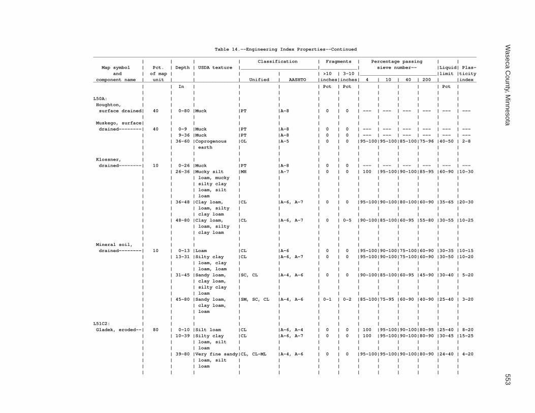
Waseca C
ounty, Minnesota
553
Table 14.--Engineering Index Properties--Continued_______________________________________________________________________________________________________________________________________ | | | | Classification | Fragments | Percentage passing | | Map symbol | Pct. | Depth | USDA texture |___________________________|_____________| sieve number-- |Liquid| Plas- and | of map | | | | | >10 | 3-10 |___________________________|limit |ticity component name | unit | | | Unified | AASHTO |inches|inches| 4 | 10 | 40 | 200 | |index_______________________________________________________________________________________________________________________________________ | | In | | | | Pct | Pct | | | | | Pct | | | | | | | | | | | | | |L50A: | | | | | | | | | | | | | Houghton, | | | | | | | | | | | | | surface drained| 40 | 0-80 |Muck |PT |A-8 | 0 | 0 | --- | --- | --- | --- | --- | --- | | | | | | | | | | | | | Muskego, surface| | | | | | | | | | | | | drained--------| 40 | 0-9 |Muck |PT |A-8 | 0 | 0 | --- | --- | --- | --- | --- | --- | | 9-36 |Muck |PT |A-8 | 0 | 0 | --- | --- | --- | --- | --- | --- | | 36-60 |Coprogenous |OL |A-5 | 0 | 0 |95-100|95-100|85-100|75-96 |40-50 | 2-8 | | | earth | | | | | | | | | | | | | | | | | | | | | | | Klossner, | | | | | | | | | | | | | drained--------| 10 | 0-26 |Muck |PT |A-8 | 0 | 0 | --- | --- | --- | --- | --- | --- | | 26-36 |Mucky silt |MH |A-7 | 0 | 0 | 100 |95-100|90-100|85-95 |60-90 |10-30 | | | loam, mucky | | | | | | | | | | | | | silty clay | | | | | | | | | | | | | loam, silt | | | | | | | | | | | | | loam | | | | | | | | | | | | 36-48 |Clay loam, |CL |A-6, A-7 | 0 | 0 |95-100|90-100|80-100|60-90 |35-65 |20-30 | | | loam, silty | | | | | | | | | | | | | clay loam | | | | | | | | | | | | 48-80 |Clay loam, |CL |A-6, A-7 | 0 | 0-5 |90-100|85-100|60-95 |55-80 |30-55 |10-25 | | | loam, silty | | | | | | | | | | | | | clay loam | | | | | | | | | | | | | | | | | | | | | | | Mineral soil, | | | | | | | | | | | | | drained--------| 10 | 0-13 |Loam |CL |A-6 | 0 | 0 |95-100|90-100|75-100|60-90 |30-35 |10-15 | | 13-31 |Silty clay |CL |A-6, A-7 | 0 | 0 |95-100|90-100|75-100|60-90 |30-50 |10-20 | | | loam, clay | | | | | | | | | | | | | loam, loam | | | | | | | | | | | | 31-45 |Sandy loam, |SC, CL |A-4, A-6 | 0 | 0 |90-100|85-100|60-95 |45-90 |30-40 | 5-20 | | | clay loam, | | | | | | | | | | | | | silty clay | | | | | | | | | | | | | loam | | | | | | | | | | | | 45-80 |Sandy loam, |SM, SC, CL |A-4, A-6 | 0-1 | 0-2 |85-100|75-95 |60-90 |40-90 |25-40 | 3-20 | | | clay loam, | | | | | | | | | | | | | loam | | | | | | | | | | | | | | | | | | | | | | |L51C2: | | | | | | | | | | | | | Gladek, eroded--| 80 | 0-10 |Silt loam |CL |A-6, A-4 | 0 | 0 | 100 |95-100|90-100|80-95 |25-40 | 8-20 | | 10-39 |Silty clay |CL |A-6, A-7 | 0 | 0 | 100 |95-100|90-100|80-90 |30-45 |15-25 | | | loam, silt | | | | | | | | | | | | | loam | | | | | | | | | | | | 39-80 |Very fine sandy|CL, CL-ML |A-4, A-6 | 0 | 0 |95-100|95-100|90-100|80-90 |24-40 | 4-20 | | | loam, silt | | | | | | | | | | | | | loam | | | | | | | | | | | | | | | | | | | | | | |

554S
oil Survey of
Table 14.--Engineering Index Properties--Continued_______________________________________________________________________________________________________________________________________ | | | | Classification | Fragments | Percentage passing | | Map symbol | Pct. | Depth | USDA texture |___________________________|_____________| sieve number-- |Liquid| Plas- and | of map | | | | | >10 | 3-10 |___________________________|limit |ticity component name | unit | | | Unified | AASHTO |inches|inches| 4 | 10 | 40 | 200 | |index_______________________________________________________________________________________________________________________________________ | | In | | | | Pct | Pct | | | | | Pct | | | | | | | | | | | | | |L51C2: | | | | | | | | | | | | | Barrington------| 10 | 0-15 |Silt loam |CL |A-4, A-6 | 0 | 0 | 100 |95-100|90-100|80-95 |30-40 | 8-18 | | 15-33 |Silt loam |CL |A-6, A-7 | 0 | 0 | 100 | 100 |95-100|80-95 |35-50 |11-25 | | 33-60 |Stratified |SC-SM, SC, |A-4, A-6 | 0 | 0 |95-100|80-100|75-100|36-90 |15-30 | 5-15 | | | loamy very | CL, CL-ML | | | | | | | | | | | | fine sand to | | | | | | | | | | | | | silt loam | | | | | | | | | | | | | | | | | | | | | | | Lester, eroded--| 5 | 0-7 |Loam |CL-ML, CL |A-4, A-6 | 0 | 0-2 |95-100|90-100|80-95 |50-85 |25-40 | 5-15 | | 7-38 |Clay loam, loam|CL |A-6 | 0-1 | 0-3 |95-100|90-100|80-95 |55-75 |35-40 |15-20 | | 38-60 |Clay loam, loam|CL |A-6 | 0-1 | 0-2 |95-100|90-98 |75-90 |50-75 |30-40 |12-20 | | 60-80 |Clay loam, loam|CL |A-6 | 0-1 | 0-2 |95-100|90-98 |75-90 |50-75 |30-40 |12-20 | | | | | | | | | | | | | Madelia---------| 5 | 0-19 |Silty clay loam|CL |A-6 | 0 | 0 | 100 | 100 | 100 |90-100|40-50 |10-25 | | 19-37 |Silty clay |CL |A-6, A-7 | 0 | 0 | 100 | 100 | 100 |90-100|30-50 |10-25 | | | loam, silt | | | | | | | | | | | | | loam | | | | | | | | | | | | 37-60 |Silt loam, |CL, ML |A-4, A-6, A-7| 0 | 0 | 100 | 100 | 100 |90-100|30-50 | 5-25 | | | silty clay | | | | | | | | | | | | | loam | | | | | | | | | | | | | | | | | | | | | | |L56A: | | | | | | | | | | | | | Muskego, | | | | | | | | | | | | | frequently | | | | | | | | | | | | | flooded--------| 45 | 0-9 |Muck |PT |A-8 | 0 | 0 | --- | --- | --- | --- | --- | --- | | 9-36 |Muck |PT |A-8 | 0 | 0 | --- | --- | --- | --- | --- | --- | | 36-60 |Coprogenous |OL |A-5 | 0 | 0 |95-100|95-100|85-100|75-96 |40-50 | 2-8 | | | earth | | | | | | | | | | | | | | | | | | | | | | | Klossner, | | | | | | | | | | | | | frequently | | | | | | | | | | | | | flooded--------| 45 | 0-26 |Muck |PT |A-8 | 0 | 0 | --- | --- | --- | --- | --- | --- | | 26-33 |Silt loam, |MH |A-7 | 0 | 0 | 100 |95-100|90-100|85-95 |60-90 |10-30 | | | silty clay | | | | | | | | | | | | | loam | | | | | | | | | | | | 33-40 |Clay loam, |CL |A-6, A-7 | 0 | 0 |95-100|90-100|80-100|60-90 |35-65 |20-30 | | | loam, silty | | | | | | | | | | | | | clay loam | | | | | | | | | | | | 40-80 |Clay loam, |CL |A-6, A-7 | 0 | 0-5 |90-100|85-100|60-95 |55-80 |30-55 |10-25 | | | loam, silty | | | | | | | | | | | | | clay loam | | | | | | | | | | | | | | | | | | | | | | |

Waseca C
ounty, Minnesota
555
Table 14.--Engineering Index Properties--Continued_______________________________________________________________________________________________________________________________________ | | | | Classification | Fragments | Percentage passing | | Map symbol | Pct. | Depth | USDA texture |___________________________|_____________| sieve number-- |Liquid| Plas- and | of map | | | | | >10 | 3-10 |___________________________|limit |ticity component name | unit | | | Unified | AASHTO |inches|inches| 4 | 10 | 40 | 200 | |index_______________________________________________________________________________________________________________________________________ | | In | | | | Pct | Pct | | | | | Pct | | | | | | | | | | | | | |L56A: | | | | | | | | | | | | | Suckercreek, | | | | | | | | | | | | | frequently | | | | | | | | | | | | | flooded--------| 10 | 0-22 |Loam |CL-ML, CL |A-4 | 0 | 0 | 100 | 100 |85-95 |50-85 |15-30 | 5-10 | | 22-80 |Loam, sandy |SC, SM |A-2, A-4 | 0 | 0 |95-100|85-100|65-90 |20-70 | 0-30 |NP-10 | | | loam, loamy | | | | | | | | | | | | | fine sand | | | | | | | | | | | | | | | | | | | | | | |L57A: | | | | | | | | | | | | | Medo, drained---| 80 | 0-27 |Muck |PT |A-8 | --- | --- | --- | --- | --- | --- | --- | --- | | 27-35 |Sandy clay |CL, ML |A-6, A-7 | 0 | 0 |85-100|75-100|55-95 |45-85 |35-50 | 7-22 | | | loam, mucky | | | | | | | | | | | | | loam, mucky | | | | | | | | | | | | | silt loam | | | | | | | | | | | | 35-39 |Sandy clay loam|SC, CL |A-6, A-7 | 0 | 0 |85-100|75-100|55-95 |45-85 |30-65 | 8-16 | | 39-80 |Sand, gravelly |SP, SP-SM, SM|A-1, A-2, | 0-2 | 0-5 |75-95 |60-95 |20-75 | 2-40 | 0-20 |NP-4 | | | coarse sand, | | A-3, A-4 | | | | | | | | | | | gravelly loamy| | | | | | | | | | | | | coarse sand, | | | | | | | | | | | | | fine sand | | | | | | | | | | | | | | | | | | | | | | | Mineral soil, | | | | | | | | | | | | | drained--------| 15 | 0-23 |Fine sandy loam|SM |A-4 | 0 | 0 | 100 |95-100|70-85 |40-50 | 0-30 |NP-4 | | 23-31 |Stratified |SM |A-2, A-4 | 0 | 0 | 100 |95-100|55-80 |25-50 | 0-30 |NP-4 | | | loamy fine | | | | | | | | | | | | | sand to fine | | | | | | | | | | | | | sandy loam | | | | | | | | | | | | 31-60 |Stratified |SM, SP-SM, SP|A-2 | 0 | 0 | 100 |80-100|45-90 | 4-55 | 0-15 | NP | | | loamy sand to | | | | | | | | | | | | | coarse sand | | | | | | | | | | | | | | | | | | | | | | | Houghton, | | | | | | | | | | | | | drained--------| 5 | 0-10 |Muck |PT |A-8 | 0 | 0 | --- | --- | --- | --- | --- | --- | | 10-80 |Muck |PT |A-8 | 0 | 0 | --- | --- | --- | --- | --- | --- | | | | | | | | | | | | |L63A: | | | | | | | | | | | | | Klossner--------| 85 | 0-25 |Muck |PT |A-8 | 0 | 0 | --- | --- | --- | --- | --- | --- | | 25-40 |Clay loam, |CL |A-6, A-7 | 0 | 0 |95-100|90-100|80-100|60-90 |35-65 |20-30 | | | loam, silty | | | | | | | | | | | | | clay loam | | | | | | | | | | | | 40-80 |Clay loam, |CL, CH |A-6, A-7 | 0 | 0 |95-100|90-100|80-100|60-90 |35-65 |20-30 | | | silty clay | | | | | | | | | | | | | loam | | | | | | | | | | | | | | | | | | | | | | |

556S
oil Survey of
Table 14.--Engineering Index Properties--Continued_______________________________________________________________________________________________________________________________________ | | | | Classification | Fragments | Percentage passing | | Map symbol | Pct. | Depth | USDA texture |___________________________|_____________| sieve number-- |Liquid| Plas- and | of map | | | | | >10 | 3-10 |___________________________|limit |ticity component name | unit | | | Unified | AASHTO |inches|inches| 4 | 10 | 40 | 200 | |index_______________________________________________________________________________________________________________________________________ | | In | | | | Pct | Pct | | | | | Pct | | | | | | | | | | | | | |L63A: | | | | | | | | | | | | | Lura------------| 10 | 0-10 |Silty clay |CH |A-7 | 0 | 0 | 100 | 100 |95-100|90-100|50-75 |25-45 | | 10-58 |Silty clay, |CH |A-7 | 0 | 0 | 100 | 100 |95-100|90-100|50-75 |25-45 | | | clay | | | | | | | | | | | | 58-72 |Silty clay, |CH, CL |A-7 | 0 | 0 | 100 | 100 |95-100|90-100|40-75 |15-45 | | | silty clay | | | | | | | | | | | | | loam, clay | | | | | | | | | | | | | | | | | | | | | | | Brownton--------| 5 | 0-22 |Silty clay loam|CH, MH |A-7 | 0 | 0 | 100 |95-100|90-100|85-95 |50-65 |20-35 | | 22-38 |Silty clay, |CH, MH |A-7 | 0 | 0 | 100 |95-100|90-100|85-95 |50-80 |25-40 | | | clay, silty | | | | | | | | | | | | | clay loam | | | | | | | | | | | | 38-60 |Clay loam, loam|CL |A-6 | 0-1 | 0-2 |95-100|90-98 |75-90 |50-75 |30-40 |12-20 | | | | | | | | | | | | |L64A: | | | | | | | | | | | | | Tadkee----------| 50 | 0-6 |Loamy fine sand|SM, SP-SM |A-2 | 0 | 0 | 100 |95-100|50-80 | 4-35 | 0-14 |NP-4 | | 6-34 |Sand, fine |SW, SP, SP-SM|A-1, A-2, A-3| 0 | 0 | 100 |75-100|45-80 | 4-35 | 0-14 | NP | | | sand, loamy | | | | | | | | | | | | | sand | | | | | | | | | | | | 34-80 |Clay loam, loam|CL |A-6 | 0-1 | 0-2 |95-100|90-98 |75-90 |50-75 |30-40 |12-20 | | | | | | | | | | | | | Tadkee, | | | | | | | | | | | | | depressional---| 36 | 0-6 |Mucky loamy |SP-SM, SM |A-2 | 0 | 0 | 100 |95-100|50-80 | 4-35 | 0-14 |NP-4 | | | fine sand | | | | | | | | | | | | 6-27 |Sand, fine |SW, SP, SP-SM|A-1, A-2, A-3| 0 | 0 | 100 |75-100|45-80 | 4-35 | 0-14 | NP | | | sand, loamy | | | | | | | | | | | | | sand | | | | | | | | | | | | 27-80 |Clay loam, loam|CL |A-6 | 0-1 | 0-2 |95-100|90-98 |75-90 |50-75 |30-40 |12-20 | | | | | | | | | | | | | Better drained | | | | | | | | | | | | | soil-----------| 8 | 0-6 |Loamy sand |SM |A-2 | 0 | 0-1 |98-100|95-100|70-90 |15-35 | 5-15 |NP-2 | | 6-25 |Sand, fine |SP-SM, SP |A-2 | 0 | 0-1 |98-100|95-100|65-90 | 4-25 | 5-15 |NP-2 | | | sand, loamy | | | | | | | | | | | | | sand | | | | | | | | | | | | 25-80 |Clay loam, loam|CL |A-6 | 0-1 | 0-2 |95-100|90-98 |75-90 |50-75 |30-40 |12-20 | | | | | | | | | | | | | Granby----------| 4 | 0-12 |Loamy fine sand|SM |A-2 | 0 | 0 | 100 | 100 |50-80 |15-35 | 0-14 | NP | | 12-24 |Sand, loamy |SM, SP-SM |A-3, A-1, A-2| 0 | 0 | 100 |95-100|45-80 | 5-35 | 0-14 | NP | | | fine sand, | | | | | | | | | | | | | loamy sand | | | | | | | | | | | | 24-60 |Coarse sand, |SP-SM, SM |A-1, A-2, A-3| 0 | 0 | 100 |95-100|45-80 | 5-35 | 0-14 | NP | | | fine sand, | | | | | | | | | | | | | loamy fine | | | | | | | | | | | | | sand | | | | | | | | | | | | | | | | | | | | | | |

Waseca C
ounty, Minnesota
557
Table 14.--Engineering Index Properties--Continued_______________________________________________________________________________________________________________________________________ | | | | Classification | Fragments | Percentage passing | | Map symbol | Pct. | Depth | USDA texture |___________________________|_____________| sieve number-- |Liquid| Plas- and | of map | | | | | >10 | 3-10 |___________________________|limit |ticity component name | unit | | | Unified | AASHTO |inches|inches| 4 | 10 | 40 | 200 | |index_______________________________________________________________________________________________________________________________________ | | In | | | | Pct | Pct | | | | | Pct | | | | | | | | | | | | | |L64A: | | | | | | | | | | | | | Less sandy soil | 2 | 0-4 |Loamy fine sand|SM, SP-SM |A-2 | 0 | 0 | 100 |95-100|50-80 | 4-35 | 0-14 |NP-4 | | 4-20 |Clay loam, loam|CL |A-6 | 0-1 | 0-2 |95-100|90-98 |75-90 |50-75 |30-40 |12-20 | | 20-80 |Clay loam, loam|CL |A-6 | 0-1 | 0-2 |95-100|90-98 |75-90 |50-75 |30-40 |12-20 | | | | | | | | | | | | |L73A: | | | | | | | | | | | | | Blue Earth------| 80 | 0-10 |Mucky silty |OL, ML |A-5 | 0 | 0 |95-100|95-100|85-95 |80-95 |41-50 | 2-8 | | | clay loam | | | | | | | | | | | | 10-68 |Mucky silty |ML, OL |A-5 | 0 | 0 |95-100|80-100|80-95 |80-95 |41-50 | 2-8 | | | clay loam, | | | | | | | | | | | | | clay loam, | | | | | | | | | | | | | mucky silt | | | | | | | | | | | | | loam | | | | | | | | | | | | 68-80 |Clay loam, loam|CL |A-6 | 0-1 | 0-2 |95-100|90-98 |75-90 |50-75 |30-40 |12-20 | | | | | | | | | | | | | Belleville------| 10 | 0-11 |Sandy loam |SC-SM, SM |A-4 | 0 | 0 | 100 |95-100|60-90 |35-50 | 0-25 |NP-5 | | 11-27 |Loamy sand, |SC-SM, SM, |A-1-b, A-2, | 0 | 0 |90-100|80-100|40-85 | 5-45 | 0-25 |NP-5 | | | fine sand, | SP-SM | A-3, A-4 | | | | | | | | | | | sand | | | | | | | | | | | | 27-48 |Loam, clay |CL |A-6 | 0-1 | 0-2 |95-100|90-98 |80-95 |55-90 |30-40 |10-20 | | | loam, silty | | | | | | | | | | | | | clay loam | | | | | | | | | | | | 48-80 |Clay loam, loam|CL |A-6 | 0-1 | 0-2 |95-100|90-98 |75-90 |50-75 |30-40 |12-20 | | | | | | | | | | | | | Canisteo--------| 10 | 0-18 |Clay loam |OL, CL |A-6 | 0 | 0 |95-100|95-100|85-100|60-100|40-50 |15-20 | | 18-39 |Clay loam, loam|CL, ML |A-6 | 0 | 0-5 |90-100|80-95 |60-95 |50-85 |30-40 | 5-15 | | 39-80 |Clay loam, loam|CL |A-6 | 0-1 | 0-2 |95-100|90-98 |75-90 |50-75 |30-40 |12-20 | | | | | | | | | | | | |L74A: | | | | | | | | | | | | | Estherville-----| 87 | 0-13 |Sandy loam |SM, SC-SM, SC|A-2, A-4 | 0 | 0-5 |90-100|80-100|50-75 |25-50 |20-30 | 2-10 | | 13-18 |Sandy loam, |SC-SM, SM, SC|A-1, A-2, A-4| 0 | 0-5 |85-100|80-95 |40-75 |15-45 |20-30 | 2-8 | | | loam, coarse | | | | | | | | | | | | | sandy loam | | | | | | | | | | | | 18-23 |Coarse sand, |SP-SM, SP, SM|A-2 | 0 | 0-10 |55-90 |50-85 |10-40 | 2-25 | 0-14 | NP | | | gravelly | | | | | | | | | | | | | coarse sand, | | | | | | | | | | | | | loamy coarse | | | | | | | | | | | | | sand | | | | | | | | | | | | 23-60 |Coarse sand, |GP, SP-SM, |A-1 | 0 | 0-10 |55-90 |50-85 |10-40 | 2-25 | 0-14 | NP | | | gravelly | SM, SP | | | | | | | | | | | | coarse sand, | | | | | | | | | | | | | loamy coarse | | | | | | | | | | | | | sand | | | | | | | | | | | | | | | | | | | | | | |

558S
oil Survey of
Table 14.--Engineering Index Properties--Continued_______________________________________________________________________________________________________________________________________ | | | | Classification | Fragments | Percentage passing | | Map symbol | Pct. | Depth | USDA texture |___________________________|_____________| sieve number-- |Liquid| Plas- and | of map | | | | | >10 | 3-10 |___________________________|limit |ticity component name | unit | | | Unified | AASHTO |inches|inches| 4 | 10 | 40 | 200 | |index_______________________________________________________________________________________________________________________________________ | | In | | | | Pct | Pct | | | | | Pct | | | | | | | | | | | | | |L74A: | | | | | | | | | | | | | Hawick----------| 10 | 0-7 |Gravelly coarse|SM, SP-SM |A-1, A-2, A-3| 0-2 | 0-5 |75-95 |60-95 |35-70 | 5-35 | 0-14 |NP-4 | | | sandy loam, | | | | | | | | | | | | | sandy loam | | | | | | | | | | | | 7-80 |Gravelly coarse|SP, SP-SM |A-1, A-2, A-3| 0-2 | 0-5 |60-95 |50-95 |30-65 | 2-10 | 0-14 | NP | | | sand, coarse | | | | | | | | | | | | | sand, sand | | | | | | | | | | | | | | | | | | | | | | | Biscay----------| 3 | 0-20 |Loam |ML, CL |A-6, A-7 | 0 | 0 |95-100|95-100|70-95 |50-80 |35-50 |10-25 | | 20-28 |Loam, clay |ML, CL |A-6, A-7 | 0 | 0 |95-100|90-100|70-90 |50-75 |30-50 |10-20 | | | loam, sandy | | | | | | | | | | | | | clay loam | | | | | | | | | | | | 28-36 |Gravelly loam, |SM, SC-SM, SC|A-4 | 0 | 0-5 |95-100|70-95 |50-80 |35-50 |15-30 | 2-10 | | | sandy loam, | | | | | | | | | | | | | gravelly sandy| | | | | | | | | | | | | loam | | | | | | | | | | | | 36-60 |Gravelly coarse|SP, GP, |A-1 | 0 | 0-5 |45-95 |35-95 |20-45 | 2-10 | --- | NP | | | sand | SP-SM, GP-GM| | | | | | | | | | | | | | | | | | | | | |L75B: | | | | | | | | | | | | | Barrington------| 85 | 0-15 |Silt loam |CL |A-4, A-6 | 0 | 0 | 100 |95-100|90-100|80-95 |30-40 | 8-18 | | 15-33 |Silt loam |CL |A-6, A-7 | 0 | 0 | 100 | 100 |95-100|80-95 |35-50 |11-25 | | 33-60 |Stratified |SC-SM, SC, |A-4, A-6 | 0 | 0 |95-100|80-100|75-100|36-90 |15-30 | 5-15 | | | loamy very | CL, CL-ML | | | | | | | | | | | | fine sand to | | | | | | | | | | | | | silt loam | | | | | | | | | | | | | | | | | | | | | | | Gladek----------| 10 | 0-10 |Silt loam |CL |A-6, A-4 | 0 | 0 | 100 |95-100|90-100|80-95 |25-40 | 8-20 | | 10-39 |Silty clay |CL |A-6, A-7 | 0 | 0 | 100 |95-100|90-100|80-90 |30-45 |15-25 | | | loam, silt | | | | | | | | | | | | | loam | | | | | | | | | | | | 39-80 |Very fine sandy|CL, CL-ML |A-4, A-6 | 0 | 0 |95-100|95-100|90-100|80-90 |24-40 | 4-15 | | | loam, silt | | | | | | | | | | | | | loam | | | | | | | | | | | | | | | | | | | | | | | Madelia---------| 5 | 0-19 |Silty clay loam|CL |A-6 | 0 | 0 | 100 | 100 | 100 |90-100|40-50 |10-25 | | 19-37 |Silty clay |CL |A-6, A-7 | 0 | 0 | 100 | 100 | 100 |90-100|30-50 |10-25 | | | loam, silt | | | | | | | | | | | | | loam | | | | | | | | | | | | 37-60 |Silt loam, |CL, ML |A-4, A-6, A-7| 0 | 0 | 100 | 100 | 100 |90-100|30-50 | 5-25 | | | silty clay | | | | | | | | | | | | | loam | | | | | | | | | | | | | | | | | | | | | | |

Waseca C
ounty, Minnesota
559
Table 14.--Engineering Index Properties--Continued_______________________________________________________________________________________________________________________________________ | | | | Classification | Fragments | Percentage passing | | Map symbol | Pct. | Depth | USDA texture |___________________________|_____________| sieve number-- |Liquid| Plas- and | of map | | | | | >10 | 3-10 |___________________________|limit |ticity component name | unit | | | Unified | AASHTO |inches|inches| 4 | 10 | 40 | 200 | |index_______________________________________________________________________________________________________________________________________ | | In | | | | Pct | Pct | | | | | Pct | | | | | | | | | | | | | |L76B: | | | | | | | | | | | | | Dickinson-------| 80 | 0-14 |Fine sandy loam|SM, SC-SM, SC|A-2, A-4 | 0 | 0 | 100 | 100 |85-95 |30-50 |15-30 |NP-10 | | 14-39 |Fine sandy |SM, SC, SC-SM|A-4 | 0 | 0 | 100 | 100 |85-95 |35-50 |15-30 |NP-10 | | | loam, sandy | | | | | | | | | | | | | loam | | | | | | | | | | | | 39-60 |Sand, loamy |SM |A-2, A-3 | 0 | 0 | 100 | 100 |70-90 | 5-20 | 0-14 | NP | | | fine sand, | | | | | | | | | | | | | loamy sand | | | | | | | | | | | | | | | | | | | | | | | Litchfield------| 13 | 0-20 |Loamy fine sand|SM |A-2 | 0 | 0 | 100 | 100 |80-95 |15-35 |15-20 |NP-4 | | 20-33 |Fine sand |SW-SM |A-2 | 0 | 0 | 100 | 100 |80-95 | 5-20 |15-20 |NP-4 | | 33-40 |Very fine sandy|SC-SM, CL-ML |A-4 | 0 | 0 | 100 |95-100|90-100|80-95 | 0-25 |NP-5 | | | loam | | | | | | | | | | | | 40-80 |Loamy fine |SM |A-2, A-3 | 0 | 0 | 100 | 100 |70-95 | 5-30 |15-20 |NP-4 | | | sand, loamy | | | | | | | | | | | | | sand, sand | | | | | | | | | | | | | | | | | | | | | | | Darfur----------| 5 | 0-9 |Loam |SC-SM, OL |A-4 | 0 | 0 | 100 | 100 | 100 |60-80 |25-40 |NP-10 | | 9-19 |Loam |SC-SM, OL |A-4 | 0 | 0 | 100 | 100 | 100 |60-80 |25-40 |NP-10 | | 19-31 |Fine sandy |SM |A-4 | 0 | 0 | 100 | 100 |70-100|35-50 |20-30 |NP-5 | | | loam, loam, | | | | | | | | | | | | | loamy fine | | | | | | | | | | | | | sand | | | | | | | | | | | | 31-60 |Stratified fine|SM |A-2, A-4 | 0 | 0 | 100 | 100 |50-100|15-40 | --- | NP | | | sand to loamy | | | | | | | | | | | | | fine sand to | | | | | | | | | | | | | fine sandy | | | | | | | | | | | | | loam | | | | | | | | | | | | | | | | | | | | | | | Clarion---------| 2 | 0-14 |Loam |CL, CL-ML |A-4, A-6 | 0 | 0-5 |95-100|95-100|75-90 |50-75 |25-40 | 5-15 | | 14-33 |Loam |CL-ML, CL |A-4, A-6 | 0 | 0-5 |90-100|85-100|75-90 |50-75 |25-40 | 5-15 | | 33-60 |Clay loam, loam|CL |A-6 | 0-1 | 0-2 |95-100|90-98 |75-90 |50-75 |30-40 |12-20 | | | | | | | | | | | | |L77A: | | | | | | | | | | | | | Brownton--------| 75 | 0-22 |Silty clay loam|CH, MH |A-7 | 0 | 0 | 100 |95-100|90-100|85-95 |50-65 |20-35 | | 22-38 |Silty clay, |CH, MH |A-7 | 0 | 0 | 100 |95-100|90-100|85-95 |50-80 |25-40 | | | clay, silty | | | | | | | | | | | | | clay loam | | | | | | | | | | | | 38-60 |Clay loam, loam|CL |A-6 | 0-1 | 0-2 |95-100|90-98 |75-90 |50-75 |30-40 |12-20 | | | | | | | | | | | | |

560S
oil Survey of
Table 14.--Engineering Index Properties--Continued_______________________________________________________________________________________________________________________________________ | | | | Classification | Fragments | Percentage passing | | Map symbol | Pct. | Depth | USDA texture |___________________________|_____________| sieve number-- |Liquid| Plas- and | of map | | | | | >10 | 3-10 |___________________________|limit |ticity component name | unit | | | Unified | AASHTO |inches|inches| 4 | 10 | 40 | 200 | |index_______________________________________________________________________________________________________________________________________ | | In | | | | Pct | Pct | | | | | Pct | | | | | | | | | | | | | |L77A: | | | | | | | | | | | | | Marna-----------| 15 | 0-20 |Silty clay loam|CH |A-7 | 0 | 0 |95-100|90-100|90-100|85-95 |45-75 |15-45 | | 20-32 |Clay, silty |CH |A-7 | 0 | 0 |95-100|90-100|90-100|85-95 |50-80 |20-45 | | | clay, silty | | | | | | | | | | | | | clay loam | | | | | | | | | | | | 32-41 |Silty clay |CL |A-7 | 0 | 0 |90-100|90-100|85-95 |65-90 |40-50 |20-30 | | | loam, clay | | | | | | | | | | | | | loam | | | | | | | | | | | | 41-60 |Clay loam, loam|CL |A-6 | 0-1 | 0-2 |95-100|90-98 |75-90 |50-75 |30-40 |12-20 | | | | | | | | | | | | | Lura------------| 10 | 0-10 |Silty clay |CH |A-7 | 0 | 0 | 100 | 100 |95-100|90-100|50-75 |25-45 | | 10-58 |Silty clay, |CH |A-7 | 0 | 0 | 100 | 100 |95-100|90-100|50-75 |25-45 | | | clay | | | | | | | | | | | | 58-72 |Silty clay, |CH, CL |A-7 | 0 | 0 | 100 | 100 |95-100|90-100|40-75 |15-45 | | | silty clay | | | | | | | | | | | | | loam, clay | | | | | | | | | | | | | | | | | | | | | | |L78A: | | | | | | | | | | | | | Canisteo--------| 65 | 0-18 |Clay loam |OL, CL |A-6 | 0 | 0 |95-100|95-100|85-100|60-100|40-50 |15-20 | | 18-39 |Clay loam, loam|CL |A-6 | 0-1 | 0-2 |95-100|80-98 |75-90 |50-75 |30-40 |12-20 | | 39-80 |Clay loam, loam|CL |A-6 | 0-1 | 0-2 |95-100|90-98 |75-90 |50-75 |30-40 |12-20 | | | | | | | | | | | | | Crippin---------| 10 | 0-15 |Loam |CL |A-6, A-7 | 0 | 0 |95-100|95-100|80-90 |60-80 |30-45 |10-20 | | 15-27 |Loam, clay loam|CL |A-6 | --- | 0-5 |95-100|90-100|80-90 |60-80 |30-40 |10-20 | | 27-60 |Clay loam, loam|CL |A-6 | 0-1 | 0-2 |95-100|90-98 |75-90 |50-75 |30-40 |12-20 | | | | | | | | | | | | | Glencoe---------| 10 | 0-10 |Clay loam |CL, ML, OL |A-6, A-7 | 0 | 0 |95-100|90-100|75-100|60-90 |40-50 |15-20 | | 10-35 |Silty clay |CL, OL, ML |A-6, A-7 | 0 | 0 |95-100|90-100|75-100|60-90 |30-50 |10-20 | | | loam, clay | | | | | | | | | | | | | loam, loam | | | | | | | | | | | | 35-48 |Loam, clay |CL, ML |A-6 | 0 | 0 |95-100|90-100|75-100|60-90 |30-40 | 5-20 | | | loam, silty | | | | | | | | | | | | | clay loam | | | | | | | | | | | | 48-60 |Clay loam, loam|CL |A-6 | 0-1 | 0-2 |95-100|90-98 |75-90 |50-75 |30-40 |12-20 | | | | | | | | | | | | | Canisteo, | | | | | | | | | | | | | depressional---| 5 | 0-17 |Silty clay loam|CL, ML |A-6 | 0 | 0 |95-100|95-100|85-100|60-100|40-50 |15-20 | | 17-30 |Clay loam, |ML, CL |A-6 | --- | 0-5 |95-100|90-100|85-95 |65-85 |35-50 |15-20 | | | loam, silty | | | | | | | | | | | | | clay loam | | | | | | | | | | | | 30-60 |Clay loam, loam|CL |A-6 | 0-1 | 0-2 |95-100|90-98 |75-90 |50-75 |30-40 |12-20 | | | | | | | | | | | | | Harps-----------| 5 | 0-13 |Clay loam |CH, CL |A-6, A-7 | 0 | 0-5 |95-100|95-100|80-90 |65-80 |35-55 |15-35 | | 13-30 |Clay loam, loam|CL |A-6 | 0-1 | 0-2 |95-100|90-98 |75-90 |50-75 |30-40 |12-20 | | 30-60 |Clay loam, loam|CL |A-6 | 0-1 | 0-2 |95-100|90-98 |75-90 |50-75 |30-40 |12-20 | | | | | | | | | | | | |

Waseca C
ounty, Minnesota
561
Table 14.--Engineering Index Properties--Continued_______________________________________________________________________________________________________________________________________ | | | | Classification | Fragments | Percentage passing | | Map symbol | Pct. | Depth | USDA texture |___________________________|_____________| sieve number-- |Liquid| Plas- and | of map | | | | | >10 | 3-10 |___________________________|limit |ticity component name | unit | | | Unified | AASHTO |inches|inches| 4 | 10 | 40 | 200 | |index_______________________________________________________________________________________________________________________________________ | | In | | | | Pct | Pct | | | | | Pct | | | | | | | | | | | | | |L78A: | | | | | | | | | | | | | Webster---------| 5 | 0-19 |Clay loam |OL, CL |A-7, A-6 | 0 | 0-5 |95-100|95-100|85-95 |75-90 |40-50 |15-20 | | 19-26 |Clay loam, |CL |A-6, A-7 | 0 | 0-5 |95-100|95-100|85-95 |65-85 |35-45 |15-25 | | | silty clay | | | | | | | | | | | | | loam, loam | | | | | | | | | | | | 26-60 |Clay loam, loam|CL |A-6 | 0-1 | 0-2 |95-100|90-98 |75-90 |50-75 |30-40 |12-20 | | | | | | | | | | | | |L79B: | | | | | | | | | | | | | Clarion---------| 65 | 0-14 |Loam |CL, CL-ML |A-4, A-6 | 0 | 0-5 |95-100|95-100|75-90 |50-75 |25-40 | 5-15 | | 14-33 |Loam |CL-ML, CL |A-4, A-6 | 0 | 0-5 |90-100|85-100|75-90 |50-75 |25-40 | 5-15 | | 33-60 |Clay loam, loam|CL |A-6 | 0-1 | 0-2 |95-100|90-98 |75-90 |50-75 |30-40 |12-20 | | | | | | | | | | | | | Clarion, eroded | 25 | 0-10 |Loam |CL, CL-ML |A-4, A-6 | 0 | 0-5 |95-100|95-100|75-90 |50-75 |25-40 | 5-15 | | 10-38 |Loam, sandy |CL-ML, CL |A-4, A-6 | 0 | 0-5 |90-100|85-100|75-90 |50-75 |25-40 | 5-15 | | | loam | | | | | | | | | | | | 38-60 |Clay loam, loam|CL |A-6 | 0-1 | 0-2 |95-100|90-98 |75-90 |50-75 |30-40 |12-20 | | | | | | | | | | | | | Nicollet--------| 8 | 0-17 |Clay loam |CL, ML |A-7, A-6 | 0-1 | 0-5 |95-100|90-100|85-100|55-85 |35-50 |10-25 | | 17-33 |Clay loam, |CL |A-6, A-7 | 0-1 | 0-5 |95-100|90-100|80-95 |55-80 |35-50 |15-25 | | | loam, silty | | | | | | | | | | | | | clay loam | | | | | | | | | | | | 33-36 |Clay loam, |CL |A-6, A-7 | 0-1 | 0-5 |95-100|90-100|80-95 |55-80 |35-50 |15-25 | | | loam, silty | | | | | | | | | | | | | clay loam | | | | | | | | | | | | 36-60 |Clay loam, loam|CL |A-6 | 0-1 | 0-2 |95-100|90-98 |75-90 |50-75 |30-40 |12-20 | | | | | | | | | | | | | Webster---------| 2 | 0-19 |Clay loam |OL, CL |A-7, A-6 | 0 | 0-5 |95-100|95-100|85-95 |75-90 |40-50 |15-20 | | 19-26 |Clay loam, |CL |A-6, A-7 | 0 | 0-5 |95-100|95-100|85-95 |65-85 |35-45 |15-25 | | | silty clay | | | | | | | | | | | | | loam, loam | | | | | | | | | | | | 26-60 |Clay loam, loam|CL |A-6 | 0-1 | 0-2 |95-100|90-98 |75-90 |50-75 |30-40 |12-20 | | | | | | | | | | | | |L80C2: | | | | | | | | | | | | | Lester, eroded--| 75 | 0-7 |Loam |CL-ML, CL |A-4, A-6 | 0 | 0-2 |95-100|90-100|80-95 |50-85 |25-40 | 5-15 | | 7-38 |Clay loam, loam|CL |A-6 | 0-1 | 0-3 |95-100|90-100|80-95 |55-75 |35-40 |15-20 | | 38-60 |Clay loam, loam|CL |A-6 | 0-1 | 0-2 |95-100|90-98 |75-90 |50-75 |30-40 |12-20 | | 60-80 |Clay loam, loam|CL |A-6 | 0-1 | 0-2 |95-100|90-98 |75-90 |50-75 |30-40 |12-20 | | | | | | | | | | | | | Terril----------| 10 | 0-27 |Loam |CL |A-6 | 0 | 0-2 |95-100|95-100|70-90 |60-80 |30-40 |10-20 | | 27-40 |Loam, clay loam|CL |A-6 | 0 | 0-3 |95-100|90-100|70-90 |60-80 |30-40 | 5-20 | | 40-63 |Clay loam, loam|CL, CL-ML |A-6 | 0 | 0-2 |95-100|90-100|65-95 |50-85 |20-40 | 5-20 | | 63-80 |Clay loam, loam|CL |A-6 | 0-1 | 0-2 |95-100|90-98 |75-90 |50-75 |30-40 |12-20 | | | | | | | | | | | | |

562S
oil Survey of
Table 14.--Engineering Index Properties--Continued_______________________________________________________________________________________________________________________________________ | | | | Classification | Fragments | Percentage passing | | Map symbol | Pct. | Depth | USDA texture |___________________________|_____________| sieve number-- |Liquid| Plas- and | of map | | | | | >10 | 3-10 |___________________________|limit |ticity component name | unit | | | Unified | AASHTO |inches|inches| 4 | 10 | 40 | 200 | |index_______________________________________________________________________________________________________________________________________ | | In | | | | Pct | Pct | | | | | Pct | | | | | | | | | | | | | |L80C2: | | | | | | | | | | | | | Hamel-----------| 5 | 0-24 |Loam |CL, ML |A-4, A-6 | 0 | 0 | 100 |95-100|85-100|60-85 |30-40 | 5-20 | | 24-46 |Clay loam, |CH, CL |A-6 | 0 | 0 |95-100|95-100|85-95 |65-80 |40-55 |25-35 | | | loam, silty | | | | | | | | | | | | | clay loam | | | | | | | | | | | | 46-80 |Clay loam, loam|CL |A-6 | 0-1 | 0-2 |95-100|90-98 |75-90 |50-75 |30-40 |12-20 | | | | | | | | | | | | | Reedslake-------| 5 | 0-12 |Loam |CL, CL-ML |A-6 | 0 | 0-2 |95-100|90-98 |80-95 |60-75 |25-40 | 5-15 | | 12-26 |Clay loam, loam|CL |A-6, A-7 | 0 | 0-2 |95-100|90-98 |80-95 |60-80 |32-45 |12-25 | | 26-48 |Clay loam, loam|CL |A-6 | 0-1 | 0-2 |95-100|90-98 |75-90 |50-75 |30-40 |12-20 | | 48-80 |Clay loam, loam|CL |A-6 | 0-1 | 0-2 |95-100|90-98 |75-90 |50-75 |30-40 |12-20 | | | | | | | | | | | | | Storden, eroded | 5 | 0-7 |Loam |CL |A-6 | 0 | 0-5 |95-100|95-98 |75-95 |60-75 |28-36 | 9-15 | | 7-55 |Loam, clay loam|CL |A-6 | 0 | 0-5 |95-100|90-98 |70-95 |55-70 |28-39 | 9-18 | | 55-80 |Clay loam, loam|CL |A-6 | 0-1 | 0-2 |95-100|90-98 |75-90 |50-75 |30-40 |12-20 | | | | | | | | | | | | |L80D2: | | | | | | | | | | | | | Lester, eroded--| 75 | 0-7 |Loam |CL-ML, CL |A-4, A-6 | 0 | 0-2 |95-100|90-100|80-95 |50-85 |25-40 | 5-15 | | 7-38 |Clay loam, loam|CL |A-6 | 0-1 | 0-3 |95-100|90-100|80-95 |55-75 |35-40 |15-20 | | 38-60 |Clay loam, loam|CL |A-6 | 0-1 | 0-2 |95-100|90-98 |75-90 |50-75 |30-40 |12-20 | | 60-80 |Clay loam, loam|CL |A-6 | 0-1 | 0-2 |95-100|90-98 |75-90 |50-75 |30-40 |12-20 | | | | | | | | | | | | | Ridgeton--------| 10 | 0-23 |Loam |CL |A-6 | 0 | 0-2 |95-100|95-100|70-90 |60-80 |30-40 |10-20 | | 23-38 |Loam, clay loam|CL, CL-ML |A-6, A-7 | 0 | 0-3 |95-100|90-100|70-90 |60-80 |25-45 | 5-20 | | 38-50 |Clay loam, loam|CL-ML, CL |A-7, A-6 | 0 | 0-2 |95-100|90-100|65-95 |50-85 |20-45 | 5-20 | | 50-80 |Clay loam, loam|CL |A-6 | 0-1 | 0-2 |95-100|90-98 |75-90 |50-75 |30-40 |12-20 | | | | | | | | | | | | | Storden, eroded | 8 | 0-7 |Loam |CL |A-6 | 0 | 0-5 |95-100|95-98 |75-95 |60-75 |28-36 | 9-15 | | 7-55 |Loam, clay loam|CL |A-6 | 0 | 0-5 |95-100|90-98 |70-95 |55-70 |28-39 | 9-18 | | 55-80 |Clay loam, loam|CL |A-6 | 0-1 | 0-2 |95-100|90-98 |75-90 |50-75 |30-40 |12-20 | | | | | | | | | | | | | Terril----------| 5 | 0-27 |Loam |CL |A-6 | 0 | 0-2 |95-100|95-100|70-90 |60-80 |30-40 |10-20 | | 27-40 |Loam, clay loam|CL |A-6 | 0 | 0-3 |95-100|90-100|70-90 |60-80 |30-40 | 5-20 | | 40-63 |Clay loam, loam|CL, CL-ML |A-6 | 0 | 0-2 |95-100|90-100|65-95 |50-85 |20-40 | 5-20 | | 63-80 |Clay loam, loam|CL |A-6 | 0-1 | 0-2 |95-100|90-98 |75-90 |50-75 |30-40 |12-20 | | | | | | | | | | | | | Hamel-----------| 2 | 0-24 |Loam |CL, ML |A-4, A-6 | 0 | 0 | 100 |95-100|85-100|60-85 |30-40 | 5-20 | | 24-46 |Clay loam, |CH, CL |A-6 | 0 | 0 |95-100|95-100|85-95 |65-80 |40-55 |25-35 | | | loam, silty | | | | | | | | | | | | | clay loam | | | | | | | | | | | | 46-80 |Clay loam, loam|CL |A-6 | 0-1 | 0-2 |95-100|90-98 |75-90 |50-75 |30-40 |12-20 | | | | | | | | | | | | |

Waseca C
ounty, Minnesota
563
Table 14.--Engineering Index Properties--Continued_______________________________________________________________________________________________________________________________________ | | | | Classification | Fragments | Percentage passing | | Map symbol | Pct. | Depth | USDA texture |___________________________|_____________| sieve number-- |Liquid| Plas- and | of map | | | | | >10 | 3-10 |___________________________|limit |ticity component name | unit | | | Unified | AASHTO |inches|inches| 4 | 10 | 40 | 200 | |index_______________________________________________________________________________________________________________________________________ | | In | | | | Pct | Pct | | | | | Pct | | | | | | | | | | | | | |L81A: | | | | | | | | | | | | | Cordova---------| 85 | 0-18 |Clay loam |MH, ML, CL, |A-6, A-7 | 0 | 0 |95-100|95-100|90-100|70-85 |40-60 |15-25 | | | | OH | | | | | | | | | | | 18-38 |Silty clay |CL |A-6 | 0 | 0 |90-100|90-100|85-95 |65-90 |40-50 |20-30 | | | loam, clay | | | | | | | | | | | | | loam | | | | | | | | | | | | 38-80 |Clay loam, loam|CL |A-6 | 0-1 | 0-2 |95-100|90-98 |75-90 |50-75 |30-40 |12-20 | | | | | | | | | | | | | Le Sueur--------| 10 | 0-17 |Clay loam |CL, ML |A-7, A-6 | 0 | 0 |95-100|95-100|90-100|75-90 |35-50 |10-25 | | 17-37 |Clay loam, |CL |A-6, A-7 | 0 | 0 |95-100|95-100|85-100|60-80 |35-50 |15-25 | | | loam, silty | | | | | | | | | | | | | clay loam | | | | | | | | | | | | 37-46 |Clay loam, loam|CL |A-6 | 0-1 | 0-2 |95-100|90-98 |75-90 |50-75 |30-40 |12-20 | | 46-80 |Clay loam, loam|CL |A-6 | 0-1 | 0-2 |95-100|90-98 |75-90 |50-75 |30-40 |12-20 | | | | | | | | | | | | | Rolfe-----------| 5 | 0-12 |Silt loam |OL, ML, CL |A-4, A-6 | 0 | 0 | 100 |95-100|90-100|80-95 |30-40 | 5-15 | | 12-20 |Silt loam, clay|ML, CL |A-6, A-4 | 0 | 0 | 100 |95-100|90-100|75-95 |30-40 | 5-35 | | | loam | | | | | | | | | | | | 20-35 |Silty clay |CH |A-7 | 0 | 0 | 100 |95-100|90-100|90-100|50-65 |25-35 | | 35-51 |Clay loam, loam|CL |A-6, A-7 | 0 | 0 |95-100|90-100|80-90 |55-75 |30-45 |10-20 | | 51-60 |Clay loam, loam|CL |A-6 | 0-1 | 0-2 |95-100|90-98 |75-90 |50-75 |30-40 |12-20 | | | | | | | | | | | | |L82A: | | | | | | | | | | | | | Marna-----------| 85 | 0-20 |Silty clay loam|CH |A-7 | 0 | 0 |95-100|90-100|90-100|85-95 |45-75 |15-45 | | 20-32 |Clay, silty |CH |A-7 | 0 | 0 |95-100|90-100|90-100|85-95 |50-80 |20-45 | | | clay, silty | | | | | | | | | | | | | clay loam | | | | | | | | | | | | 32-41 |Silty clay |CL |A-7 | 0 | 0 |90-100|90-100|85-95 |65-90 |40-50 |20-30 | | | loam, clay | | | | | | | | | | | | | loam | | | | | | | | | | | | 41-60 |Clay loam, loam|CL |A-6 | 0-1 | 0-2 |95-100|90-98 |75-90 |50-75 |30-40 |12-20 | | | | | | | | | | | | | Barbert---------| 10 | 0-7 |Silt loam |CL, CL-ML |A-4, A-6 | 0 | 0 | 100 | 100 |90-100|90-100|25-40 | 5-15 | | 7-17 |Silt loam |CL, CL-ML |A-4, A-6 | 0 | 0 | 100 | 100 |90-100|90-100|25-40 | 5-15 | | 17-43 |Clay, silty |CH, MH |A-7 | 0 | 0 | 100 | 100 |90-100|90-100|50-80 |20-50 | | | clay | | | | | | | | | | | | 43-60 |Silty clay |CL, ML, CL-ML|A-4, A-6, A-7| 0 | 0 | 100 | 100 |90-100|90-100|25-50 | 5-20 | | | loam, silt | | | | | | | | | | | | | loam | | | | | | | | | | | | | | | | | | | | | | | Guckeen---------| 5 | 0-15 |Silty clay loam|CH |A-7 | 0 | 0 | 100 |95-100|95-100|80-95 |40-55 |15-25 | | 15-24 |Silty clay, |CH |A-7 | 0 | 0 | 100 |95-100|95-100|80-95 |40-65 |15-30 | | | silty clay | | | | | | | | | | | | | loam, clay | | | | | | | | | | | | 24-30 |Clay loam, loam|CL |A-6, A-7 | --- | 0-2 |90-100|90-98 |85-95 |60-75 |30-50 |10-25 | | 30-60 |Clay loam, loam|CL |A-6 | 0-1 | 0-2 |95-100|90-98 |75-90 |50-75 |30-40 |12-20 | | | | | | | | | | | | |

564S
oil Survey of
Table 14.--Engineering Index Properties--Continued_______________________________________________________________________________________________________________________________________ | | | | Classification | Fragments | Percentage passing | | Map symbol | Pct. | Depth | USDA texture |___________________________|_____________| sieve number-- |Liquid| Plas- and | of map | | | | | >10 | 3-10 |___________________________|limit |ticity component name | unit | | | Unified | AASHTO |inches|inches| 4 | 10 | 40 | 200 | |index_______________________________________________________________________________________________________________________________________ | | In | | | | Pct | Pct | | | | | Pct | | | | | | | | | | | | | |L83A: | | | | | | | | | | | | | Webster---------| 65 | 0-19 |Clay loam |OL, CL |A-7, A-6 | 0 | 0-5 |95-100|95-100|85-95 |75-90 |40-50 |15-20 | | 19-26 |Clay loam, |CL |A-6, A-7 | 0 | 0-5 |95-100|95-100|85-95 |65-85 |35-45 |15-25 | | | silty clay | | | | | | | | | | | | | loam, loam | | | | | | | | | | | | 26-60 |Clay loam, loam|CL |A-6 | 0-1 | 0-2 |95-100|90-98 |75-90 |50-75 |30-40 |12-20 | | | | | | | | | | | | | Glencoe---------| 15 | 0-10 |Clay loam |CL, ML |A-6, A-7 | 0 | 0 |95-100|90-100|75-100|60-90 |40-50 |15-20 | | 10-35 |Silty clay |CL, OL, ML |A-6, A-7 | 0 | 0 |95-100|90-100|75-100|60-90 |30-50 |10-20 | | | loam, clay | | | | | | | | | | | | | loam, loam | | | | | | | | | | | | 35-48 |Loam, clay |CL, ML |A-6 | 0 | 0 |95-100|90-100|75-100|60-90 |30-40 | 5-20 | | | loam, silty | | | | | | | | | | | | | clay loam | | | | | | | | | | | | 48-60 |Clay loam, loam|CL |A-6 | 0-1 | 0-2 |95-100|90-98 |75-90 |50-75 |30-40 |12-20 | | | | | | | | | | | | | Canisteo--------| 10 | 0-18 |Clay loam |OL, CL |A-6 | 0 | 0 |95-100|95-100|85-100|60-100|40-50 |15-20 | | 18-39 |Clay loam, loam|CL, ML |A-6 | 0 | 0-5 |90-100|80-95 |60-95 |50-85 |30-40 | 5-15 | | 39-80 |Clay loam, loam|CL |A-6 | 0-1 | 0-2 |95-100|90-98 |75-90 |50-75 |30-40 |12-20 | | | | | | | | | | | | | Nicollet--------| 10 | 0-17 |Clay loam |CL, ML |A-6, A-7 | 0-1 | 0-5 |95-100|90-100|85-100|55-85 |35-50 |10-25 | | 17-33 |Clay loam, |CL |A-6, A-7 | 0-1 | 0-5 |95-100|90-100|80-95 |55-80 |35-50 |15-25 | | | loam, silty | | | | | | | | | | | | | clay loam | | | | | | | | | | | | 33-36 |Clay loam, |CL |A-6, A-7 | 0-1 | 0-5 |95-100|90-100|80-95 |55-80 |35-50 |15-25 | | | loam, silty | | | | | | | | | | | | | clay loam | | | | | | | | | | | | 36-60 |Clay loam, loam|CL |A-6 | 0-1 | 0-2 |95-100|90-98 |75-90 |50-75 |30-40 |12-20 | | | | | | | | | | | | |L84A: | | | | | | | | | | | | | Glencoe---------| 80 | 0-10 |Clay loam |CL, ML, OL |A-6, A-7 | 0 | 0 |95-100|90-100|75-100|60-90 |40-50 |15-20 | | 10-35 |Silty clay |CL, OL, ML |A-6, A-7 | 0 | 0 |95-100|90-100|75-100|60-90 |30-50 |10-20 | | | loam, clay | | | | | | | | | | | | | loam, loam | | | | | | | | | | | | 35-48 |Loam, clay |CL, ML |A-6 | 0 | 0 |95-100|90-100|75-100|60-90 |30-40 | 5-20 | | | loam, silty | | | | | | | | | | | | | clay loam | | | | | | | | | | | | 48-60 |Clay loam, loam|CL |A-6 | 0-1 | 0-2 |95-100|90-98 |75-90 |50-75 |30-40 |12-20 | | | | | | | | | | | | | Very poorly | | | | | | | | | | | | | drained muck---| 10 | 0-12 |Muck |PT |A-8 | 0 | 0 | --- | --- | --- | --- | --- | --- | | 12-29 |Silty clay |ML, OL, CL |A-6, A-7 | 0 | 0 |95-100|90-100|75-100|60-90 |30-50 |10-20 | | | loam, clay | | | | | | | | | | | | | loam, loam | | | | | | | | | | | | 29-60 |Clay loam, loam|CL |A-6 | 0-1 | 0-2 |95-100|90-98 |75-90 |50-75 |30-40 |12-20 | | | | | | | | | | | | |

Waseca C
ounty, Minnesota
565
Table 14.--Engineering Index Properties--Continued_______________________________________________________________________________________________________________________________________ | | | | Classification | Fragments | Percentage passing | | Map symbol | Pct. | Depth | USDA texture |___________________________|_____________| sieve number-- |Liquid| Plas- and | of map | | | | | >10 | 3-10 |___________________________|limit |ticity component name | unit | | | Unified | AASHTO |inches|inches| 4 | 10 | 40 | 200 | |index_______________________________________________________________________________________________________________________________________ | | In | | | | Pct | Pct | | | | | Pct | | | | | | | | | | | | | |L84A: | | | | | | | | | | | | | Canisteo--------| 5 | 0-18 |Clay loam |OL, CL |A-6 | 0 | 0 |95-100|95-100|85-100|60-100|40-50 |15-20 | | 18-39 |Clay loam, loam|CL |A-6 | 0-1 | 0-2 |95-100|80-98 |75-90 |50-75 |30-40 |12-20 | | 39-80 |Clay loam, loam|CL |A-6 | 0-1 | 0-2 |95-100|90-98 |75-90 |50-75 |30-40 |12-20 | | | | | | | | | | | | | Harps-----------| 5 | 0-13 |Clay loam |CH, CL |A-6, A-7 | 0 | 0-5 |95-100|95-100|80-90 |65-80 |35-55 |15-35 | | 13-30 |Clay loam, loam|CL |A-6 | 0-1 | 0-2 |95-100|90-98 |75-90 |50-75 |30-40 |12-20 | | 30-60 |Clay loam, loam|CL |A-6 | 0-1 | 0-2 |95-100|90-98 |75-90 |50-75 |30-40 |12-20 | | | | | | | | | | | | |L85A: | | | | | | | | | | | | | Nicollet--------| 85 | 0-17 |Clay loam |CL, ML |A-6, A-7 | 0-1 | 0-5 |95-100|90-100|85-100|55-85 |35-50 |10-25 | | 17-33 |Clay loam, |CL |A-6, A-7 | 0-1 | 0-5 |95-100|90-100|80-95 |55-80 |35-50 |15-25 | | | loam, silty | | | | | | | | | | | | | clay loam | | | | | | | | | | | | 33-36 |Clay loam, |CL |A-6, A-7 | 0-1 | 0-5 |95-100|90-100|80-95 |55-80 |35-50 |15-25 | | | loam, silty | | | | | | | | | | | | | clay loam | | | | | | | | | | | | 36-60 |Clay loam, loam|CL |A-6 | 0-1 | 0-2 |95-100|90-98 |75-90 |50-75 |30-40 |12-20 | | | | | | | | | | | | | Clarion---------| 10 | 0-14 |Loam |CL, CL-ML |A-4, A-6 | 0 | 0-5 |95-100|95-100|75-90 |50-75 |25-40 | 5-15 | | 14-33 |Loam |CL-ML, CL |A-4, A-6 | 0 | 0-5 |90-100|85-100|75-90 |50-75 |25-40 | 5-15 | | 33-60 |Clay loam, loam|CL |A-6 | 0-1 | 0-2 |95-100|90-98 |75-90 |50-75 |30-40 |12-20 | | | | | | | | | | | | | Webster---------| 5 | 0-19 |Clay loam |OL, CL |A-7, A-6 | 0 | 0-5 |95-100|95-100|85-95 |75-90 |40-50 |15-20 | | 19-26 |Clay loam, |CL |A-6, A-7 | 0 | 0-5 |95-100|95-100|85-95 |65-85 |35-45 |15-25 | | | silty clay | | | | | | | | | | | | | loam, loam | | | | | | | | | | | | 26-60 |Clay loam, loam|CL |A-6 | 0-1 | 0-2 |95-100|90-98 |75-90 |50-75 |30-40 |12-20 | | | | | | | | | | | | |L86A: | | | | | | | | | | | | | Madelia---------| 90 | 0-19 |Silty clay loam|CL |A-6 | 0 | 0 | 100 | 100 | 100 |90-100|40-50 |10-25 | | 19-37 |Silty clay |CL |A-6, A-7 | 0 | 0 | 100 | 100 | 100 |90-100|30-50 |10-25 | | | loam, silt | | | | | | | | | | | | | loam | | | | | | | | | | | | 37-60 |Silt loam, |CL, ML |A-4, A-6, A-7| 0 | 0 | 100 | 100 | 100 |90-100|30-50 | 5-25 | | | silty clay | | | | | | | | | | | | | loam | | | | | | | | | | | | | | | | | | | | | | | Okoboji---------| 5 | 0-26 |Silty clay loam|CH |A-7 | 0 | 0 | 100 | 100 |90-100|80-95 |50-60 |30-35 | | 26-42 |Silty clay |CH |A-7 | 0 | 0 | 100 | 100 |90-100|80-95 |50-60 |30-35 | | 42-60 |Silty clay loam|CL |A-6 | 0 | 0 |95-100|95-100|90-100|80-95 |40-48 |30-35 | | | | | | | | | | | | |

566S
oil Survey of
Table 14.--Engineering Index Properties--Continued_______________________________________________________________________________________________________________________________________ | | | | Classification | Fragments | Percentage passing | | Map symbol | Pct. | Depth | USDA texture |___________________________|_____________| sieve number-- |Liquid| Plas- and | of map | | | | | >10 | 3-10 |___________________________|limit |ticity component name | unit | | | Unified | AASHTO |inches|inches| 4 | 10 | 40 | 200 | |index_______________________________________________________________________________________________________________________________________ | | In | | | | Pct | Pct | | | | | Pct | | | | | | | | | | | | | |L86A: | | | | | | | | | | | | | Spicer----------| 3 | 0-16 |Silty clay loam|CL |A-6, A-7 | 0 | 0 | 100 | 100 |95-100|90-100|35-50 |10-25 | | 16-40 |Silt loam, |CL |A-6, A-7 | 0 | 0 | 100 | 100 |95-100|85-100|35-50 |10-25 | | | silty clay | | | | | | | | | | | | | loam | | | | | | | | | | | | 40-60 |Silt loam, |CL |A-4, A-6 | 0 | 0 | 100 | 100 |95-100|85-100|30-40 | 5-25 | | | silty clay | | | | | | | | | | | | | loam | | | | | | | | | | | | | | | | | | | | | | | Kingston--------| 2 | 0-16 |Silty clay loam|CL |A-6 | 0 | 0 | 100 | 100 |95-100|85-100|30-40 |10-20 | | 16-25 |Silty clay |CL, CL-ML, ML|A-4, A-6, A-7| 0 | 0 | 100 | 100 |95-100|85-100|25-50 | 6-20 | | | loam, silt | | | | | | | | | | | | | loam | | | | | | | | | | | | 25-60 |Silt loam, |CL, CL-ML, ML|A-4, A-6 | 0 | 0 | 100 | 100 |95-100|85-100|25-50 | 5-20 | | | silty clay | | | | | | | | | | | | | loam | | | | | | | | | | | | | | | | | | | | | | |L87A: | | | | | | | | | | | | | Kingston--------| 85 | 0-16 |Silty clay loam|CL |A-6 | 0 | 0 | 100 | 100 |95-100|85-100|30-40 |10-20 | | 16-25 |Silty clay |CL, CL-ML, ML|A-4, A-6, A-7| 0 | 0 | 100 | 100 |95-100|85-100|25-50 | 6-20 | | | loam, silt | | | | | | | | | | | | | loam | | | | | | | | | | | | 25-60 |Silt loam, |CL, CL-ML, ML|A-4, A-6 | 0 | 0 | 100 | 100 |95-100|85-100|25-50 | 5-20 | | | silty clay | | | | | | | | | | | | | loam | | | | | | | | | | | | | | | | | | | | | | | Truman----------| 10 | 0-14 |Silt loam |CL, CL-ML |A-4, A-6 | 0 | 0 | 100 | 100 |95-100|80-100|25-40 | 5-15 | | 14-36 |Silt loam, |CL, CL-ML |A-4, A-6, A-7| 0 | 0 | 100 | 100 |95-100|80-100|25-45 | 5-20 | | | silty clay | | | | | | | | | | | | | loam | | | | | | | | | | | | 36-60 |Silt loam |CL, CL-ML |A-4, A-6 | 0 | 0 | 100 | 100 |95-100|75-95 |25-40 | 5-15 | | | | | | | | | | | | | Madelia---------| 5 | 0-19 |Silty clay loam|CL |A-6 | 0 | 0 | 100 | 100 | 100 |90-100|40-50 |10-25 | | 19-37 |Silty clay |CL |A-6, A-7 | 0 | 0 | 100 | 100 | 100 |90-100|30-50 |10-25 | | | loam, silt | | | | | | | | | | | | | loam | | | | | | | | | | | | 37-60 |Silt loam, |CL, ML |A-4, A-6, A-7| 0 | 0 | 100 | 100 | 100 |90-100|30-50 | 5-25 | | | silty clay | | | | | | | | | | | | | loam | | | | | | | | | | | | | | | | | | | | | | |

Waseca C
ounty, Minnesota
567
Table 14.--Engineering Index Properties--Continued_______________________________________________________________________________________________________________________________________ | | | | Classification | Fragments | Percentage passing | | Map symbol | Pct. | Depth | USDA texture |___________________________|_____________| sieve number-- |Liquid| Plas- and | of map | | | | | >10 | 3-10 |___________________________|limit |ticity component name | unit | | | Unified | AASHTO |inches|inches| 4 | 10 | 40 | 200 | |index_______________________________________________________________________________________________________________________________________ | | In | | | | Pct | Pct | | | | | Pct | | | | | | | | | | | | | |L88A: | | | | | | | | | | | | | Lura------------| 85 | 0-10 |Silty clay |CH |A-7 | 0 | 0 | 100 | 100 |95-100|90-100|50-75 |25-45 | | 10-58 |Silty clay, |CH |A-7 | 0 | 0 | 100 | 100 |95-100|90-100|50-75 |25-45 | | | clay | | | | | | | | | | | | 58-72 |Silty clay, |CH, CL |A-7 | 0 | 0 | 100 | 100 |95-100|90-100|40-75 |15-45 | | | silty clay | | | | | | | | | | | | | loam, clay | | | | | | | | | | | | | | | | | | | | | | | Brownton--------| 10 | 0-22 |Silty clay loam|CH, MH |A-7 | 0 | 0 | 100 |95-100|90-100|85-95 |50-65 |20-35 | | 22-38 |Silty clay, |CH, MH |A-7 | 0 | 0 | 100 |95-100|90-100|85-95 |50-80 |25-40 | | | clay, silty | | | | | | | | | | | | | clay loam | | | | | | | | | | | | 38-60 |Clay loam, loam|CL |A-6 | 0-1 | 0-2 |95-100|90-98 |75-90 |50-75 |30-40 |12-20 | | | | | | | | | | | | | Organic soil----| 5 | 0-10 |Muck |PT |A-8 | 0 | 0 | --- | --- | --- | --- | --- | --- | | 10-26 |Mucky silty |MH |A-7 | 0 | 0 | 100 |95-100|90-100|85-95 |60-90 |10-30 | | | clay loam | | | | | | | | | | | | 26-48 |Clay loam, |CH |A-6, A-7 | 0 | 0 |95-100|90-100|80-100|60-90 |35-65 |20-30 | | | silty clay | | | | | | | | | | | | | loam | | | | | | | | | | | | 48-80 |Silty clay, |CH, CL |A-7 | 0 | 0 | 100 | 100 |95-100|90-100|40-75 |15-45 | | | silty clay | | | | | | | | | | | | | loam, clay | | | | | | | | | | | | | | | | | | | | | | |L89A: | | | | | | | | | | | | | Guckeen---------| 82 | 0-15 |Silty clay loam|CH |A-7 | 0 | 0 | 100 |95-100|95-100|80-95 |40-55 |15-25 | | 15-24 |Silty clay, |CH |A-7 | 0 | 0 | 100 |95-100|95-100|80-95 |40-65 |15-30 | | | silty clay | | | | | | | | | | | | | loam, clay | | | | | | | | | | | | 24-30 |Clay loam, loam|CL |A-6, A-7 | --- | 0-2 |90-100|90-98 |85-95 |60-75 |30-50 |10-25 | | 30-60 |Clay loam, loam|CL |A-6 | 0-1 | 0-2 |95-100|90-98 |75-90 |50-75 |30-40 |12-20 | | | | | | | | | | | | | Marna-----------| 10 | 0-20 |Silty clay loam|CH |A-7 | 0 | 0 |95-100|90-100|90-100|85-95 |45-75 |15-45 | | 20-32 |Clay, silty |CH |A-7 | 0 | 0 |95-100|90-100|90-100|85-95 |50-80 |20-45 | | | clay, silty | | | | | | | | | | | | | clay loam | | | | | | | | | | | | 32-41 |Silty clay |CL |A-6 | 0 | 0 |90-100|90-100|85-95 |65-90 |40-50 |20-30 | | | loam, clay | | | | | | | | | | | | | loam | | | | | | | | | | | | 41-60 |Clay loam, loam|CL |A-6 | 0-1 | 0-2 |95-100|90-98 |75-90 |50-75 |30-40 |12-20 | | | | | | | | | | | | | Clarion clay | | | | | | | | | | | | | loam-----------| 8 | 0-13 |Clay loam |CL-ML, CL |A-4, A-6 | 0 | 0-5 |95-100|95-100|75-90 |50-75 |25-40 | 5-15 | | 13-37 |Clay loam |CL-ML, CL |A-4, A-6 | 0 | 0-5 |90-100|85-100|75-90 |50-75 |25-40 | 5-15 | | 37-80 |Clay loam, loam|CL |A-6 | 0-1 | 0-2 |95-100|90-98 |75-90 |50-75 |30-40 |12-20 | | | | | | | | | | | | |

568S
oil Survey of
Table 14.--Engineering Index Properties--Continued_______________________________________________________________________________________________________________________________________ | | | | Classification | Fragments | Percentage passing | | Map symbol | Pct. | Depth | USDA texture |___________________________|_____________| sieve number-- |Liquid| Plas- and | of map | | | | | >10 | 3-10 |___________________________|limit |ticity component name | unit | | | Unified | AASHTO |inches|inches| 4 | 10 | 40 | 200 | |index_______________________________________________________________________________________________________________________________________ | | In | | | | Pct | Pct | | | | | Pct | | | | | | | | | | | | | |L90A: | | | | | | | | | | | | | Le Sueur--------| 75 | 0-17 |Clay loam |CL, ML |A-6, A-7 | 0 | 0 |95-100|95-100|90-100|75-90 |35-50 |10-25 | | 17-37 |Clay loam, |CL |A-6, A-7 | 0 | 0 |95-100|95-100|85-100|60-80 |35-50 |15-25 | | | loam, silty | | | | | | | | | | | | | clay loam | | | | | | | | | | | | 37-46 |Clay loam, loam|CL |A-6 | 0-1 | 0-2 |95-100|90-98 |75-90 |50-75 |30-40 |12-20 | | 46-80 |Clay loam, loam|CL |A-6 | 0-1 | 0-2 |95-100|90-98 |75-90 |50-75 |30-40 |12-20 | | | | | | | | | | | | | Cordova---------| 13 | 0-18 |Clay loam |MH, ML, CL, |A-6, A-7 | 0 | 0 |95-100|95-100|90-100|70-85 |40-60 |15-25 | | | | OH | | | | | | | | | | | 18-38 |Silty clay |CL |A-6 | 0 | 0 |90-100|90-100|85-95 |65-90 |40-50 |20-30 | | | loam, clay | | | | | | | | | | | | | loam | | | | | | | | | | | | 38-80 |Clay loam, loam|CL |A-6 | 0-1 | 0-2 |95-100|90-98 |75-90 |50-75 |30-40 |12-20 | | | | | | | | | | | | | Reedslake-------| 12 | 0-12 |Loam |CL, CL-ML |A-6 | 0 | 0-2 |95-100|90-98 |80-95 |60-75 |25-40 | 5-15 | | 12-26 |Clay loam, loam|CL |A-6, A-7 | 0 | 0-2 |95-100|90-98 |80-95 |60-80 |32-45 |12-25 | | 26-48 |Clay loam, loam|CL |A-6 | 0-1 | 0-2 |95-100|90-98 |75-90 |50-75 |30-40 |12-20 | | 48-80 |Clay loam, loam|CL |A-6 | 0-1 | 0-2 |95-100|90-98 |75-90 |50-75 |30-40 |12-20 | | | | | | | | | | | | |L91A: | | | | | | | | | | | | | Mazaska---------| 85 | 0-15 |Silty clay loam|CL, CH |A-6, A-7 | 0 | 0 |95-100|95-100|85-100|70-95 |35-55 |12-28 | | 15-42 |Clay, silty |CH, CL |A-7 | 0 | 0 |90-100|85-100|75-95 |60-90 |40-65 |15-35 | | | clay loam | | | | | | | | | | | | 42-80 |Clay loam, loam|CL |A-6 | 0-1 | 0-2 |95-100|90-98 |75-90 |50-75 |30-40 |12-20 | | | | | | | | | | | | | Lerdal----------| 10 | 0-8 |Clay loam |CL |A-6, A-7 | 0 | 0 |95-100|90-100|80-95 |60-90 |35-50 |10-22 | | 8-12 |Clay loam |CL |A-6, A-7 | 0 | 0 |95-100|90-100|80-95 |60-90 |35-50 |10-22 | | 12-41 |Silty clay |CL, ML, CH, |A-7 | 0 | 0 |95-100|90-100|80-95 |70-90 |45-70 |20-35 | | | loam, clay | MH | | | | | | | | | | | | loam | | | | | | | | | | | | 41-80 |Clay loam, loam|CL |A-6 | 0-1 | 0-2 |95-100|90-98 |75-90 |50-75 |30-40 |12-20 | | | | | | | | | | | | | Rolfe-----------| 5 | 0-12 |Silt loam |CL, ML, OL |A-4, A-6 | 0 | 0 | 100 |95-100|90-100|80-95 |30-40 | 5-15 | | 12-20 |Silt loam, clay|ML, CL |A-6, A-4 | 0 | 0 | 100 |95-100|90-100|75-95 |30-40 | 5-35 | | | loam | | | | | | | | | | | | 20-35 |Silty clay |CH |A-7 | 0 | 0 | 100 |95-100|90-100|90-100|50-65 |25-35 | | 35-51 |Clay loam, loam|CL |A-6, A-7 | 0 | 0 |95-100|90-100|80-90 |55-75 |30-45 |10-20 | | 51-60 |Clay loam, loam|CL |A-6 | 0-1 | 0-2 |95-100|90-98 |75-90 |50-75 |30-40 |12-20 | | | | | | | | | | | | |

Waseca C
ounty, Minnesota
569
Table 14.--Engineering Index Properties--Continued_______________________________________________________________________________________________________________________________________ | | | | Classification | Fragments | Percentage passing | | Map symbol | Pct. | Depth | USDA texture |___________________________|_____________| sieve number-- |Liquid| Plas- and | of map | | | | | >10 | 3-10 |___________________________|limit |ticity component name | unit | | | Unified | AASHTO |inches|inches| 4 | 10 | 40 | 200 | |index_______________________________________________________________________________________________________________________________________ | | In | | | | Pct | Pct | | | | | Pct | | | | | | | | | | | | | |L92A: | | | | | | | | | | | | | Darfur----------| 78 | 0-9 |Loam |SC-SM, OL |A-4 | 0 | 0 | 100 | 100 | 100 |60-80 |25-40 |NP-10 | | 9-19 |Loam |SC-SM, OL |A-4 | 0 | 0 | 100 | 100 | 100 |60-80 |25-40 |NP-10 | | 19-31 |Fine sandy |SM |A-4 | 0 | 0 | 100 | 100 |70-100|35-50 |20-30 |NP-5 | | | loam, loam, | | | | | | | | | | | | | loamy fine | | | | | | | | | | | | | sand | | | | | | | | | | | | 31-60 |Stratified fine|SM |A-2, A-4 | 0 | 0 | 100 | 100 |50-100|15-40 | --- | NP | | | sand to loamy | | | | | | | | | | | | | fine sand to | | | | | | | | | | | | | fine sandy | | | | | | | | | | | | | loam | | | | | | | | | | | | | | | | | | | | | | | Fieldon---------| 10 | 0-19 |Loam |CL-ML, ML, |A-4 | 0 | 0 | 100 | 100 |85-95 |50-75 |20-28 |NP-10 | | | | SC-SM | | | | | | | | | | | 19-37 |Fine sandy |SM, SC-SM |A-4 | 0 | 0 | 100 | 100 |70-90 |35-60 |15-30 |NP-5 | | | loam, very | | | | | | | | | | | | | fine sandy | | | | | | | | | | | | | loam, loam | | | | | | | | | | | | 37-60 |Stratified fine|SM |A-2, A-4 | 0 | 0 | 100 | 100 |60-100|15-40 | --- | NP | | | sand to loamy | | | | | | | | | | | | | fine sand | | | | | | | | | | | | | | | | | | | | | | | Litchfield------| 5 | 0-20 |Loamy fine sand|SM |A-2 | 0 | 0 | 100 | 100 |80-95 |15-35 |15-20 |NP-4 | | 20-33 |Fine sand |SM |A-2 | 0 | 0 | 100 | 100 |80-95 |20-35 |15-20 |NP-4 | | 33-40 |Very fine sandy|ML, SC-SM |A-4 | 0 | 0 | 100 |95-100|90-100|80-95 | 0-25 |NP-5 | | | loam | | | | | | | | | | | | 40-80 |Loamy fine |SM |A-2, A-3 | 0 | 0 | 100 | 100 |70-95 | 5-30 |15-20 |NP-4 | | | sand, loamy | | | | | | | | | | | | | sand, sand | | | | | | | | | | | | | | | | | | | | | | | Webster---------| 5 | 0-19 |Clay loam |OL, CL |A-7, A-6 | 0 | 0-5 |95-100|95-100|85-95 |75-90 |40-50 |15-20 | | 19-26 |Clay loam, |CL |A-6, A-7 | 0 | 0-5 |95-100|95-100|85-95 |65-85 |35-45 |15-25 | | | silty clay | | | | | | | | | | | | | loam, loam | | | | | | | | | | | | 26-60 |Clay loam, loam|CL |A-6 | 0-1 | 0-2 |95-100|90-98 |75-90 |50-75 |30-40 |12-20 | | | | | | | | | | | | | Dassel----------| 2 | 0-6 |Mucky fine |SC-SM |A-4 | 0 | 0 | 100 |95-100|70-85 |50-65 |15-30 |NP-4 | | | sandy loam | | | | | | | | | | | | 6-23 |Fine sandy loam|SC-SM |A-4 | 0 | 0 | 100 |95-100|70-85 |50-65 |15-30 |NP-4 | | 23-31 |Loamy very fine|SM |A-2, A-4 | 0 | 0 | 100 |95-100|55-80 |25-50 |15-30 |NP-4 | | | sand | | | | | | | | | | | | 31-60 |Fine sand |SP-SM |A-2 | 0 | 0 | 100 |80-100|45-90 |10-55 | --- | NP | | | | | | | | | | | | |

570S
oil Survey of
Table 14.--Engineering Index Properties--Continued_______________________________________________________________________________________________________________________________________ | | | | Classification | Fragments | Percentage passing | | Map symbol | Pct. | Depth | USDA texture |___________________________|_____________| sieve number-- |Liquid| Plas- and | of map | | | | | >10 | 3-10 |___________________________|limit |ticity component name | unit | | | Unified | AASHTO |inches|inches| 4 | 10 | 40 | 200 | |index_______________________________________________________________________________________________________________________________________ | | In | | | | Pct | Pct | | | | | Pct | | | | | | | | | | | | | |L93A: | | | | | | | | | | | | | Muskego---------| 82 | 0-16 |Muck |PT |A-8 | 0 | 0 | --- | --- | --- | --- | --- | --- | | 16-76 |Coprogenous |OL |A-5 | 0 | 0 |95-100|95-100|85-100|75-96 |40-50 | 2-8 | | | earth | | | | | | | | | | | | 76-80 |Clay loam, loam|CL |A-6 | 0-1 | 0-2 |95-100|90-98 |75-90 |50-75 |30-40 |12-20 | | | | | | | | | | | | | Blue Earth------| 10 | 0-10 |Mucky silty |OL, ML |A-5 | 0 | 0 |95-100|95-100|85-95 |80-95 |41-50 | 2-8 | | | clay loam | | | | | | | | | | | | 10-68 |Mucky silty |OL, ML |A-5 | 0 | 0 |95-100|80-100|80-95 |80-95 |41-50 | 2-8 | | | clay loam, | | | | | | | | | | | | | clay loam, | | | | | | | | | | | | | mucky silt | | | | | | | | | | | | | loam | | | | | | | | | | | | 68-80 |Clay loam, loam|CL |A-6 | 0-1 | 0-2 |95-100|90-98 |75-90 |50-75 |30-40 |12-20 | | | | | | | | | | | | | Mineral soil, | | | | | | | | | | | | | drained--------| 5 | 0-13 |Loam |CL |A-6 | 0 | 0 |95-100|90-100|75-100|60-90 |30-35 |10-15 | | 13-31 |Silty clay |CL |A-6, A-7 | 0 | 0 |95-100|90-100|75-100|60-90 |30-50 |10-20 | | | loam, clay | | | | | | | | | | | | | loam, loam | | | | | | | | | | | | 31-45 |Sandy loam, |SC, CL |A-4, A-6 | 0 | 0 |90-100|85-100|60-95 |45-90 |30-40 | 5-20 | | | clay loam, | | | | | | | | | | | | | silty clay | | | | | | | | | | | | | loam | | | | | | | | | | | | 45-80 |Sandy loam, |SM, SC, CL |A-4, A-6 | 0-1 | 0-2 |85-100|75-95 |60-90 |40-90 |25-40 | 3-20 | | | clay loam, | | | | | | | | | | | | | loam | | | | | | | | | | | | | | | | | | | | | | | Belleville------| 3 | 0-11 |Sandy loam |SC-SM, SM |A-4 | 0 | 0 | 100 |95-100|60-90 |35-50 | 0-25 |NP-5 | | 11-27 |Loamy sand, |SC-SM, SM, |A-1-b, A-2, | 0 | 0 |90-100|80-100|40-85 | 5-45 | 0-25 |NP-5 | | | fine sand, | SP-SM | A-3, A-4 | | | | | | | | | | | sand | | | | | | | | | | | | 27-48 |Loam, clay |CL |A-6 | 0-1 | 0-2 |95-100|90-98 |80-95 |55-90 |20-40 |10-25 | | | loam, silty | | | | | | | | | | | | | clay loam | | | | | | | | | | | | 48-80 |Clay loam, loam|CL |A-6 | 0-1 | 0-2 |95-100|90-98 |75-90 |50-75 |30-40 |12-20 | | | | | | | | | | | | |

Waseca C
ounty, Minnesota
571
Table 14.--Engineering Index Properties--Continued_______________________________________________________________________________________________________________________________________ | | | | Classification | Fragments | Percentage passing | | Map symbol | Pct. | Depth | USDA texture |___________________________|_____________| sieve number-- |Liquid| Plas- and | of map | | | | | >10 | 3-10 |___________________________|limit |ticity component name | unit | | | Unified | AASHTO |inches|inches| 4 | 10 | 40 | 200 | |index_______________________________________________________________________________________________________________________________________ | | In | | | | Pct | Pct | | | | | Pct | | | | | | | | | | | | | |L94A: | | | | | | | | | | | | | Lowlein---------| 75 | 0-18 |Fine sandy |SM, SC-SM |A-4 | 0 | 0 |90-100|85-100|60-75 |35-50 |15-20 |NP-5 | | | loam, sandy | | | | | | | | | | | | | loam | | | | | | | | | | | | 18-27 |Fine sandy |SC-SM, SM |A-4 | 0 | 0 |90-100|85-100|60-90 |35-80 |15-20 |NP-5 | | | loam, loamy | | | | | | | | | | | | | sand | | | | | | | | | | | | 27-46 |Stratified |SM, SC-SM |A-2 | 0 | 0 |90-100|85-100|60-90 |25-80 | 0-20 |NP-5 | | | loamy sand to | | | | | | | | | | | | | fine sandy | | | | | | | | | | | | | loam | | | | | | | | | | | | 46-72 |Silt loam, clay|CL |A-6 | 0 | 0 |95-100|90-98 |75-90 |50-75 |30-39 |12-20 | | | loam, loam | | | | | | | | | | | | 72-80 |Clay loam, silt|CL |A-6 | 0 | 0 |95-100|90-98 |75-90 |50-75 |30-39 |12-20 | | | loam, loam | | | | | | | | | | | | | | | | | | | | | | | Linder----------| 15 | 0-15 |Loam |SC |A-4, A-6 | 0 | 0 | 100 |95-100|80-95 |48-80 |25-40 | 8-15 | | 15-29 |Sandy loam |SC-SM, SC |A-2, A-4 | 0 | 0 |95-100|80-100|45-75 |30-45 |20-30 | 5-10 | | 29-60 |Stratified |SW, SP-SM |A-1 | 0 | 0-5 |75-95 |30-95 |25-50 | 2-12 | 0-14 | NP | | | gravelly | | | | | | | | | | | | | coarse sand to| | | | | | | | | | | | | coarse sand to| | | | | | | | | | | | | loamy coarse | | | | | | | | | | | | | sand, gravelly| | | | | | | | | | | | | loamy sand, | | | | | | | | | | | | | loamy coarse | | | | | | | | | | | | | sand | | | | | | | | | | | | | | | | | | | | | | | Dickinson-------| 8 | 0-14 |Fine sandy loam|SM, SC-SM, SC|A-2, A-4 | 0 | 0 | 100 | 100 |85-95 |30-50 |15-30 |NP-10 | | 14-39 |Fine sandy |SM, SC, SC-SM|A-4 | 0 | 0 | 100 | 100 |85-95 |35-50 |15-30 |NP-10 | | | loam, sandy | | | | | | | | | | | | | loam | | | | | | | | | | | | 39-60 |Sand, loamy |SM |A-2, A-3 | 0 | 0 | 100 | 100 |70-90 | 5-20 | 0-14 | NP | | | fine sand, | | | | | | | | | | | | | loamy sand | | | | | | | | | | | | | | | | | | | | | | | Darfur----------| 2 | 0-9 |Loam |SC-SM, OL |A-4 | 0 | 0 | 100 | 100 | 100 |60-80 |25-40 |NP-10 | | 9-19 |Loam |SC-SM, OL |A-4 | 0 | 0 | 100 | 100 | 100 |60-80 |25-40 |NP-10 | | 19-31 |Fine sandy |SM |A-4 | 0 | 0 | 100 | 100 |70-100|35-50 |20-30 |NP-5 | | | loam, loam, | | | | | | | | | | | | | loamy fine | | | | | | | | | | | | | sand | | | | | | | | | | | | 31-60 |Stratified fine|SM |A-2, A-4 | 0 | 0 | 100 | 100 |50-100|15-40 | --- | NP | | | sand to loamy | | | | | | | | | | | | | fine sand to | | | | | | | | | | | | | fine sandy | | | | | | | | | | | | | loam | | | | | | | | | | | | | | | | | | | | | | |

572S
oil Survey of
Table 14.--Engineering Index Properties--Continued_______________________________________________________________________________________________________________________________________ | | | | Classification | Fragments | Percentage passing | | Map symbol | Pct. | Depth | USDA texture |___________________________|_____________| sieve number-- |Liquid| Plas- and | of map | | | | | >10 | 3-10 |___________________________|limit |ticity component name | unit | | | Unified | AASHTO |inches|inches| 4 | 10 | 40 | 200 | |index_______________________________________________________________________________________________________________________________________ | | In | | | | Pct | Pct | | | | | Pct | | | | | | | | | | | | | |L95E: | | | | | | | | | | | | | Hawick----------| 80 | 0-7 |Gravelly coarse|SM, SP-SM |A-1, A-2, A-3| 0-2 | 0-5 |75-95 |60-95 |35-70 | 5-35 | 0-14 |NP-4 | | | sandy loam | | | | | | | | | | | | 7-10 |Gravelly loamy |SM, SP-SM |A-1, A-2, A-3| 0-2 | 0-5 |75-95 |60-95 |35-70 | 5-25 | 0-14 | NP | | | coarse sand, | | | | | | | | | | | | | gravelly | | | | | | | | | | | | | coarse sand, | | | | | | | | | | | | | loamy sand | | | | | | | | | | | | 10-60 |Gravelly coarse|SP, SP-SM |A-1, A-2, A-3| 0-2 | 0-5 |60-95 |50-95 |30-65 | 2-10 | 0-14 | NP | | | sand, coarse | | | | | | | | | | | | | sand, sand | | | | | | | | | | | | | | | | | | | | | | | Estherville-----| 10 | 0-8 |Sandy loam |SC, SC-SM, SM|A-2, A-4 | 0 | 0-5 |90-100|80-100|50-75 |25-50 |20-30 | 2-10 | | 8-13 |Sandy loam, |SC, SC-SM, SM|A-1, A-2, A-4| 0 | 0-5 |85-100|80-95 |40-75 |15-45 |20-30 | 2-8 | | | loam, coarse | | | | | | | | | | | | | sandy loam | | | | | | | | | | | | 13-60 |Coarse sand, |GP, SM, SP, |A-1 | 0 | 0-10 |55-90 |50-85 |10-40 | 2-25 | 0-14 | NP | | | gravelly | SP-SM | | | | | | | | | | | | coarse sand, | | | | | | | | | | | | | loamy coarse | | | | | | | | | | | | | sand | | | | | | | | | | | | | | | | | | | | | | | Tomall----------| 10 | 0-33 |Loam |SM, SC, CL-ML|A-4 | 0 | 0 | 100 | 100 |85-100|45-90 |20-35 | 2-10 | | 33-42 |Loam, sandy |SC, SM |A-4 | 0 | 0 | 100 |95-100|85-100|45-90 |20-45 | 7-10 | | | loam | | | | | | | | | | | | 42-47 |Gravelly coarse|SP, SP-SM |A-1, A-2, A-3| 0 | 0 |80-100|50-95 |25-65 | 4-20 | --- | NP | | | sand, loamy | | | | | | | | | | | | | coarse sand, | | | | | | | | | | | | | sand | | | | | | | | | | | | 47-80 |Gravelly loamy |SP, SP-SM |A-1, A-2, A-3| 0 | 0 |60-100|50-90 |20-60 | 2-10 | --- | NP | | | coarse sand, | | | | | | | | | | | | | coarse sand, | | | | | | | | | | | | | sand | | | | | | | | | | | | | | | | | | | | | | |

Waseca C
ounty, Minnesota
573
Table 14.--Engineering Index Properties--Continued_______________________________________________________________________________________________________________________________________ | | | | Classification | Fragments | Percentage passing | | Map symbol | Pct. | Depth | USDA texture |___________________________|_____________| sieve number-- |Liquid| Plas- and | of map | | | | | >10 | 3-10 |___________________________|limit |ticity component name | unit | | | Unified | AASHTO |inches|inches| 4 | 10 | 40 | 200 | |index_______________________________________________________________________________________________________________________________________ | | In | | | | Pct | Pct | | | | | Pct | | | | | | | | | | | | | |L96B: | | | | | | | | | | | | | Estherville-----| 55 | 0-13 |Sandy loam |SC-SM, SM, SC|A-2, A-4 | 0 | 0-5 |90-100|80-100|50-75 |25-50 |20-30 | 2-10 | | 13-18 |Sandy loam, |SC-SM, SM, SC|A-1, A-2, A-4| 0 | 0-5 |85-100|80-95 |40-75 |15-45 |20-30 | 2-8 | | | loam, coarse | | | | | | | | | | | | | sandy loam | | | | | | | | | | | | 18-23 |Coarse sand, |SP-SM, SP, SM|A-2 | 0 | 0-10 |55-90 |50-85 |10-40 | 2-25 | 0-14 | NP | | | gravelly | | | | | | | | | | | | | coarse sand, | | | | | | | | | | | | | loamy coarse | | | | | | | | | | | | | sand | | | | | | | | | | | | 23-60 |Coarse sand, |GP, SP-SM, |A-1 | 0 | 0-10 |55-90 |50-85 |10-40 | 2-25 | 0-14 | NP | | | gravelly | SM, SP | | | | | | | | | | | | coarse sand, | | | | | | | | | | | | | loamy coarse | | | | | | | | | | | | | sand | | | | | | | | | | | | | | | | | | | | | | | Hawick----------| 35 | 0-7 |Gravelly coarse|SM, SP-SM |A-1, A-2, A-3| 0-2 | 0-5 |75-95 |60-95 |35-70 | 5-35 | 0-14 |NP-4 | | | sandy loam, | | | | | | | | | | | | | sandy loam | | | | | | | | | | | | 7-80 |Gravelly coarse|SP, SP-SM |A-1, A-2, A-3| 0-2 | 0-5 |60-95 |50-95 |30-65 | 2-10 | 0-14 | NP | | | sand, coarse | | | | | | | | | | | | | sand, sand | | | | | | | | | | | | | | | | | | | | | | | Tomall----------| 8 | 0-33 |Loam |SM, SC, CL-ML|A-4 | 0 | 0 | 100 | 100 |85-100|45-90 |20-35 | 2-10 | | 33-42 |Loam, sandy |SM, SC |A-4 | 0 | 0 | 100 |95-100|85-100|45-90 |20-45 | 7-10 | | | loam | | | | | | | | | | | | 42-47 |Gravelly coarse|SP, SP-SM |A-1, A-2, A-3| 0 | 0 |80-100|50-95 |25-65 | 4-20 | --- | NP | | | sand, loamy | | | | | | | | | | | | | coarse sand, | | | | | | | | | | | | | sand | | | | | | | | | | | | 47-80 |Gravelly loamy |SP, SP-SM |A-1, A-2, A-3| 0 | 0 |60-100|50-90 |20-60 | 2-10 | --- | NP | | | coarse sand, | | | | | | | | | | | | | coarse sand, | | | | | | | | | | | | | sand | | | | | | | | | | | | | | | | | | | | | | | Biscay----------| 2 | 0-20 |Loam |ML, CL |A-6, A-7 | 0 | 0 |95-100|95-100|70-95 |50-80 |35-50 |10-25 | | 20-28 |Loam, clay |ML, CL |A-6, A-7 | 0 | 0 |95-100|90-100|70-90 |50-75 |30-50 |10-20 | | | loam, sandy | | | | | | | | | | | | | clay loam | | | | | | | | | | | | 28-36 |Gravelly loam, |SM, SC-SM, SC|A-4 | 0 | 0-5 |95-100|70-95 |50-80 |35-50 |15-30 | 2-10 | | | sandy loam, | | | | | | | | | | | | | gravelly sandy| | | | | | | | | | | | | loam | | | | | | | | | | | | 36-60 |Gravelly coarse|SP, GP, |A-1 | 0 | 0-5 |45-95 |35-95 |20-45 | 2-10 | --- | NP | | | sand | SP-SM, GP-GM| | | | | | | | | | | | | | | | | | | | | |
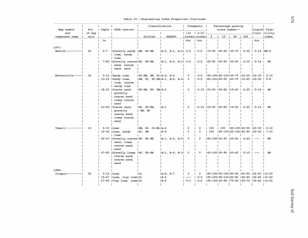
574S
oil Survey of
Table 14.--Engineering Index Properties--Continued_______________________________________________________________________________________________________________________________________ | | | | Classification | Fragments | Percentage passing | | Map symbol | Pct. | Depth | USDA texture |___________________________|_____________| sieve number-- |Liquid| Plas- and | of map | | | | | >10 | 3-10 |___________________________|limit |ticity component name | unit | | | Unified | AASHTO |inches|inches| 4 | 10 | 40 | 200 | |index_______________________________________________________________________________________________________________________________________ | | In | | | | Pct | Pct | | | | | Pct | | | | | | | | | | | | | |L97C: | | | | | | | | | | | | | Hawick----------| 60 | 0-7 |Gravelly sandy |SM, SP-SM |A-3, A-1, A-2| 0-2 | 0-5 |75-95 |60-95 |35-70 | 5-35 | 0-14 |NP-4 | | | loam, sandy | | | | | | | | | | | | | loam | | | | | | | | | | | | 7-80 |Gravelly coarse|SP, SP-SM |A-1, A-2, A-3| 0-2 | 0-5 |60-95 |50-95 |30-65 | 2-10 | 0-14 | NP | | | sand, coarse | | | | | | | | | | | | | sand, sand | | | | | | | | | | | | | | | | | | | | | | | Estherville-----| 30 | 0-13 |Sandy loam |SC-SM, SM, SC|A-2, A-4 | 0 | 0-5 |90-100|80-100|50-75 |25-50 |20-30 | 2-10 | | 13-18 |Sandy loam, |SM, SC, SC-SM|A-1, A-2, A-4| 0 | 0-5 |85-100|80-95 |40-75 |15-45 |20-30 | 2-8 | | | loam, coarse | | | | | | | | | | | | | sandy loam | | | | | | | | | | | | 18-23 |Coarse sand, |SP-SM, SP, SM|A-2 | 0 | 0-10 |55-90 |50-85 |10-40 | 2-25 | 0-14 | NP | | | gravelly | | | | | | | | | | | | | coarse sand, | | | | | | | | | | | | | loamy coarse | | | | | | | | | | | | | sand | | | | | | | | | | | | 23-60 |Coarse sand, |GP, SP-SM, |A-1 | 0 | 0-10 |55-90 |50-85 |10-40 | 2-25 | 0-14 | NP | | | gravelly | SM, SP | | | | | | | | | | | | coarse sand, | | | | | | | | | | | | | loamy coarse | | | | | | | | | | | | | sand | | | | | | | | | | | | | | | | | | | | | | | Tomall----------| 10 | 0-33 |Loam |SM, SC, CL-ML|A-4 | 0 | 0 | 100 | 100 |85-100|45-90 |20-35 | 2-10 | | 33-42 |Loam, sandy |SC, SM |A-4 | 0 | 0 | 100 |95-100|85-100|45-90 |20-45 | 7-10 | | | loam | | | | | | | | | | | | 42-47 |Gravelly coarse|SP, SP-SM |A-1, A-2, A-3| 0 | 0 |80-100|50-95 |25-65 | 4-20 | --- | NP | | | sand, loamy | | | | | | | | | | | | | coarse sand, | | | | | | | | | | | | | sand | | | | | | | | | | | | 47-80 |Gravelly loamy |SP, SP-SM |A-1, A-2, A-3| 0 | 0 |60-100|50-90 |20-60 | 2-10 | --- | NP | | | coarse sand, | | | | | | | | | | | | | coarse sand, | | | | | | | | | | | | | sand | | | | | | | | | | | | | | | | | | | | | | |L98A: | | | | | | | | | | | | | Crippin---------| 50 | 0-15 |Loam |CL |A-6, A-7 | 0 | 0 |95-100|95-100|80-90 |60-80 |30-45 |10-20 | | 15-27 |Loam, clay loam|CL |A-6 | --- | 0-5 |95-100|90-100|80-90 |60-80 |30-40 |10-20 | | 27-60 |Clay loam, loam|CL |A-6 | 0-1 | 0-2 |95-100|90-98 |75-90 |50-75 |30-40 |12-20 | | | | | | | | | | | | |

Waseca C
ounty, Minnesota
575
Table 14.--Engineering Index Properties--Continued_______________________________________________________________________________________________________________________________________ | | | | Classification | Fragments | Percentage passing | | Map symbol | Pct. | Depth | USDA texture |___________________________|_____________| sieve number-- |Liquid| Plas- and | of map | | | | | >10 | 3-10 |___________________________|limit |ticity component name | unit | | | Unified | AASHTO |inches|inches| 4 | 10 | 40 | 200 | |index_______________________________________________________________________________________________________________________________________ | | In | | | | Pct | Pct | | | | | Pct | | | | | | | | | | | | | |L98A: | | | | | | | | | | | | | Nicollet--------| 40 | 0-17 |Clay loam |CL, ML |A-6, A-7 | 0-1 | 0-5 |95-100|90-100|85-100|55-85 |35-50 |10-25 | | 17-33 |Clay loam, |CL |A-6, A-7 | 0-1 | 0-5 |95-100|90-100|80-95 |55-80 |35-50 |15-25 | | | loam, silty | | | | | | | | | | | | | clay loam | | | | | | | | | | | | 33-36 |Clay loam, |CL |A-6, A-7 | 0-1 | 0-5 |95-100|90-100|80-95 |55-80 |35-50 |15-25 | | | loam, silty | | | | | | | | | | | | | clay loam | | | | | | | | | | | | 36-60 |Clay loam, loam|CL |A-6 | 0-1 | 0-2 |95-100|90-98 |75-90 |50-75 |30-40 |12-20 | | | | | | | | | | | | | Canisteo--------| 5 | 0-18 |Clay loam |OL, CL |A-6 | 0 | 0 |95-100|95-100|85-100|60-100|40-50 |15-20 | | 18-39 |Clay loam, loam|CL |A-6 | 0-1 | 0-2 |95-100|80-98 |75-90 |50-75 |30-40 |12-20 | | 39-80 |Clay loam, loam|CL |A-6 | 0-1 | 0-2 |95-100|90-98 |75-90 |50-75 |30-40 |12-20 | | | | | | | | | | | | | Clarion---------| 5 | 0-14 |Loam |CL, CL-ML |A-4, A-6 | 0 | 0-5 |95-100|95-100|75-90 |50-75 |25-40 | 5-15 | | 14-33 |Loam |CL-ML, CL |A-4, A-6 | 0 | 0-5 |90-100|85-100|75-90 |50-75 |25-40 | 5-15 | | 33-60 |Clay loam, loam|CL |A-6 | 0-1 | 0-2 |95-100|90-98 |75-90 |50-75 |30-40 |12-20 | | | | | | | | | | | | |L99B: | | | | | | | | | | | | | Clarion---------| 62 | 0-14 |Loam |CL, CL-ML |A-4, A-6 | 0 | 0-5 |95-100|95-100|75-90 |50-75 |25-40 | 5-15 | | 14-33 |Loam |CL-ML, CL |A-4, A-6 | 0 | 0-5 |90-100|85-100|75-90 |50-75 |25-40 | 5-15 | | 33-60 |Clay loam, loam|CL |A-6 | 0-1 | 0-2 |95-100|90-98 |75-90 |50-75 |30-40 |12-20 | | | | | | | | | | | | | Swanlake--------| 25 | 0-9 |Loam |CL |A-6 | 0 | 0-5 |90-100|85-98 |75-90 |50-70 |28-36 | 9-15 | | 9-43 |Clay loam, loam|CL |A-6 | 0-1 | 0-2 |95-100|90-98 |75-90 |50-75 |30-40 |12-20 | | 43-60 |Clay loam, loam|CL |A-6 | 0-1 | 0-2 |95-100|90-98 |75-90 |50-75 |30-40 |12-20 | | | | | | | | | | | | | Nicollet--------| 10 | 0-17 |Clay loam |CL |A-6, A-7 | 0-1 | 0-5 |95-100|90-100|85-100|55-85 |35-50 |10-25 | | 17-33 |Clay loam, |CL |A-6, A-7 | 0-1 | 0-5 |95-100|90-100|80-95 |55-80 |35-50 |15-25 | | | loam, silty | | | | | | | | | | | | | clay loam | | | | | | | | | | | | 33-36 |Clay loam, |CL |A-6, A-7 | 0-1 | 0-5 |95-100|90-100|80-95 |55-80 |35-50 |15-25 | | | loam, silty | | | | | | | | | | | | | clay loam | | | | | | | | | | | | 36-60 |Clay loam, loam|CL |A-6 | 0-1 | 0-2 |95-100|90-98 |75-90 |50-75 |30-40 |12-20 | | | | | | | | | | | | | Webster---------| 3 | 0-19 |Clay loam |OL, CL |A-7, A-6 | 0 | 0-5 |95-100|95-100|85-95 |75-90 |40-50 |15-20 | | 19-26 |Clay loam, |CL |A-6, A-7 | 0 | 0-5 |95-100|95-100|85-95 |65-85 |35-45 |15-25 | | | silty clay | | | | | | | | | | | | | loam, loam | | | | | | | | | | | | 26-60 |Clay loam, loam|CL |A-6 | 0-1 | 0-2 |95-100|90-98 |75-90 |50-75 |30-40 |12-20 | | | | | | | | | | | | |
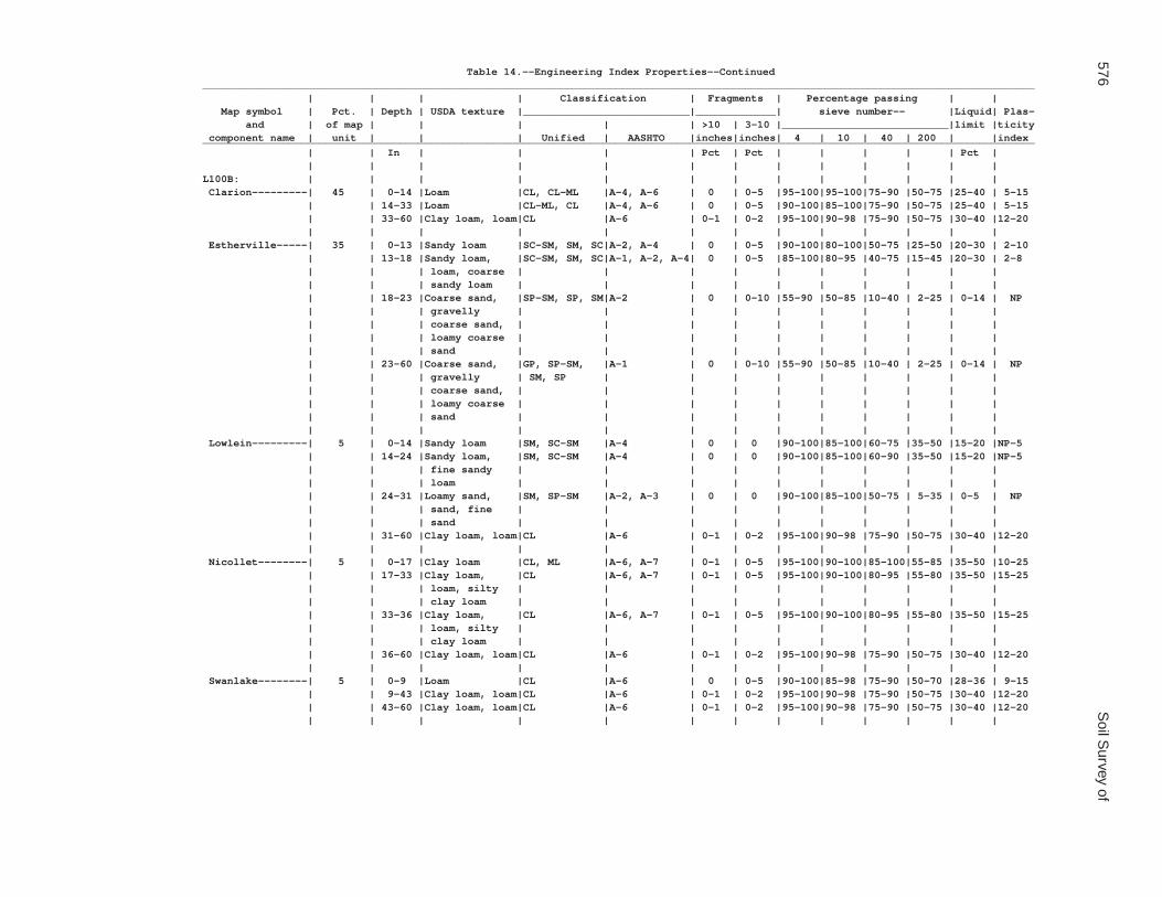
576S
oil Survey of
Table 14.--Engineering Index Properties--Continued_______________________________________________________________________________________________________________________________________ | | | | Classification | Fragments | Percentage passing | | Map symbol | Pct. | Depth | USDA texture |___________________________|_____________| sieve number-- |Liquid| Plas- and | of map | | | | | >10 | 3-10 |___________________________|limit |ticity component name | unit | | | Unified | AASHTO |inches|inches| 4 | 10 | 40 | 200 | |index_______________________________________________________________________________________________________________________________________ | | In | | | | Pct | Pct | | | | | Pct | | | | | | | | | | | | | |L100B: | | | | | | | | | | | | | Clarion---------| 45 | 0-14 |Loam |CL, CL-ML |A-4, A-6 | 0 | 0-5 |95-100|95-100|75-90 |50-75 |25-40 | 5-15 | | 14-33 |Loam |CL-ML, CL |A-4, A-6 | 0 | 0-5 |90-100|85-100|75-90 |50-75 |25-40 | 5-15 | | 33-60 |Clay loam, loam|CL |A-6 | 0-1 | 0-2 |95-100|90-98 |75-90 |50-75 |30-40 |12-20 | | | | | | | | | | | | | Estherville-----| 35 | 0-13 |Sandy loam |SC-SM, SM, SC|A-2, A-4 | 0 | 0-5 |90-100|80-100|50-75 |25-50 |20-30 | 2-10 | | 13-18 |Sandy loam, |SC-SM, SM, SC|A-1, A-2, A-4| 0 | 0-5 |85-100|80-95 |40-75 |15-45 |20-30 | 2-8 | | | loam, coarse | | | | | | | | | | | | | sandy loam | | | | | | | | | | | | 18-23 |Coarse sand, |SP-SM, SP, SM|A-2 | 0 | 0-10 |55-90 |50-85 |10-40 | 2-25 | 0-14 | NP | | | gravelly | | | | | | | | | | | | | coarse sand, | | | | | | | | | | | | | loamy coarse | | | | | | | | | | | | | sand | | | | | | | | | | | | 23-60 |Coarse sand, |GP, SP-SM, |A-1 | 0 | 0-10 |55-90 |50-85 |10-40 | 2-25 | 0-14 | NP | | | gravelly | SM, SP | | | | | | | | | | | | coarse sand, | | | | | | | | | | | | | loamy coarse | | | | | | | | | | | | | sand | | | | | | | | | | | | | | | | | | | | | | | Lowlein---------| 5 | 0-14 |Sandy loam |SM, SC-SM |A-4 | 0 | 0 |90-100|85-100|60-75 |35-50 |15-20 |NP-5 | | 14-24 |Sandy loam, |SM, SC-SM |A-4 | 0 | 0 |90-100|85-100|60-90 |35-50 |15-20 |NP-5 | | | fine sandy | | | | | | | | | | | | | loam | | | | | | | | | | | | 24-31 |Loamy sand, |SM, SP-SM |A-2, A-3 | 0 | 0 |90-100|85-100|50-75 | 5-35 | 0-5 | NP | | | sand, fine | | | | | | | | | | | | | sand | | | | | | | | | | | | 31-60 |Clay loam, loam|CL |A-6 | 0-1 | 0-2 |95-100|90-98 |75-90 |50-75 |30-40 |12-20 | | | | | | | | | | | | | Nicollet--------| 5 | 0-17 |Clay loam |CL, ML |A-6, A-7 | 0-1 | 0-5 |95-100|90-100|85-100|55-85 |35-50 |10-25 | | 17-33 |Clay loam, |CL |A-6, A-7 | 0-1 | 0-5 |95-100|90-100|80-95 |55-80 |35-50 |15-25 | | | loam, silty | | | | | | | | | | | | | clay loam | | | | | | | | | | | | 33-36 |Clay loam, |CL |A-6, A-7 | 0-1 | 0-5 |95-100|90-100|80-95 |55-80 |35-50 |15-25 | | | loam, silty | | | | | | | | | | | | | clay loam | | | | | | | | | | | | 36-60 |Clay loam, loam|CL |A-6 | 0-1 | 0-2 |95-100|90-98 |75-90 |50-75 |30-40 |12-20 | | | | | | | | | | | | | Swanlake--------| 5 | 0-9 |Loam |CL |A-6 | 0 | 0-5 |90-100|85-98 |75-90 |50-70 |28-36 | 9-15 | | 9-43 |Clay loam, loam|CL |A-6 | 0-1 | 0-2 |95-100|90-98 |75-90 |50-75 |30-40 |12-20 | | 43-60 |Clay loam, loam|CL |A-6 | 0-1 | 0-2 |95-100|90-98 |75-90 |50-75 |30-40 |12-20 | | | | | | | | | | | | |

Waseca C
ounty, Minnesota
577
Table 14.--Engineering Index Properties--Continued_______________________________________________________________________________________________________________________________________ | | | | Classification | Fragments | Percentage passing | | Map symbol | Pct. | Depth | USDA texture |___________________________|_____________| sieve number-- |Liquid| Plas- and | of map | | | | | >10 | 3-10 |___________________________|limit |ticity component name | unit | | | Unified | AASHTO |inches|inches| 4 | 10 | 40 | 200 | |index_______________________________________________________________________________________________________________________________________ | | In | | | | Pct | Pct | | | | | Pct | | | | | | | | | | | | | |L100B: | | | | | | | | | | | | | Webster---------| 5 | 0-19 |Clay loam |OL, CL |A-7, A-6 | 0 | 0-5 |95-100|95-100|85-95 |75-90 |40-50 |15-20 | | 19-26 |Clay loam, |CL |A-6, A-7 | 0 | 0-5 |95-100|95-100|85-95 |65-85 |35-45 |15-25 | | | silty clay | | | | | | | | | | | | | loam, loam | | | | | | | | | | | | 26-60 |Clay loam, loam|CL |A-6 | 0-1 | 0-2 |95-100|90-98 |75-90 |50-75 |30-40 |12-20 | | | | | | | | | | | | |L101C2: | | | | | | | | | | | | | Omsrud, eroded--| 40 | 0-9 |Loam |CL |A-6 | 0 | 0-2 |95-100|90-98 |85-95 |55-75 |30-35 |11-15 | | 9-19 |Loam, clay loam|CL |A-6 | 0 | 0-2 |95-100|90-98 |75-95 |55-80 |32-39 |12-18 | | 19-36 |Clay loam, loam|CL |A-6 | 0-1 | 0-2 |95-100|90-98 |75-90 |50-75 |30-40 |12-20 | | 36-80 |Clay loam, loam|CL |A-6 | 0-1 | 0-2 |95-100|90-98 |75-90 |50-75 |30-40 |12-20 | | | | | | | | | | | | | Hawick----------| 30 | 0-7 |Gravelly sandy |SM, SP-SM |A-3, A-1, A-2| 0-2 | 0-5 |75-95 |60-95 |35-70 | 5-35 | 0-14 |NP-4 | | | loam, sandy | | | | | | | | | | | | | loam | | | | | | | | | | | | 7-80 |Gravelly coarse|SP, SP-SM |A-1, A-2, A-3| 0-2 | 0-5 |60-95 |50-95 |30-65 | 2-10 | 0-14 | NP | | | sand, coarse | | | | | | | | | | | | | sand, sand | | | | | | | | | | | | | | | | | | | | | | | Storden, eroded | 5 | 0-7 |Loam |CL |A-6 | 0 | 0-5 |95-100|95-98 |75-95 |60-75 |28-36 | 9-15 | | 7-55 |Clay loam, loam|CL |A-6 | 0-1 | 0-2 |95-100|90-98 |75-90 |50-75 |30-40 |12-20 | | 55-80 |Clay loam, loam|CL |A-6 | 0-1 | 0-2 |95-100|90-98 |75-90 |50-75 |30-40 |12-20 | | | | | | | | | | | | | Delft-----------| 5 | 0-37 |Loam |CL |A-6, A-7 | 0 | 0 |95-100|90-100|75-90 |60-80 |30-45 |10-20 | | 37-50 |Clay loam, silt|CL |A-6 | 0 | 0 |95-100|90-100|70-90 |50-75 |30-40 |12-20 | | | loam | | | | | | | | | | | | 50-60 |Clay loam, loam|CL |A-6 | 0-1 | 0-2 |95-100|90-98 |75-90 |50-75 |30-40 |12-20 | | | | | | | | | | | | | Terril----------| 5 | 0-27 |Loam |CL |A-6 | 0 | 0-2 |95-100|95-100|70-90 |60-80 |30-40 |10-20 | | 27-40 |Loam, clay loam|CL |A-6 | 0 | 0-3 |95-100|90-100|70-90 |60-80 |30-40 | 5-20 | | 40-63 |Clay loam, loam|CL |A-6 | 0 | 0-2 |95-100|90-100|65-95 |50-85 |20-40 | 5-20 | | 63-80 |Clay loam, loam|CL |A-6 | 0-1 | 0-2 |95-100|90-98 |75-90 |50-75 |30-40 |12-20 | | | | | | | | | | | | |L101D2: | | | | | | | | | | | | | Omsrud, eroded--| 40 | 0-9 |Loam |CL |A-6 | 0 | 0-2 |95-100|90-98 |85-95 |55-75 |30-35 |11-15 | | 9-19 |Loam, clay loam|CL |A-6 | 0 | 0-2 |95-100|90-98 |75-95 |55-80 |32-39 |12-18 | | 19-36 |Clay loam, loam|CL |A-6 | 0-1 | 0-2 |95-100|90-98 |75-90 |50-75 |30-40 |12-20 | | 36-80 |Clay loam, loam|CL |A-6 | 0-1 | 0-2 |95-100|90-98 |75-90 |50-75 |30-40 |12-20 | | | | | | | | | | | | | Hawick----------| 25 | 0-7 |Gravelly coarse|SM, SP-SM |A-3, A-1, A-2| 0-2 | 0-5 |75-95 |60-95 |35-70 | 5-35 | 0-14 |NP-4 | | | sandy loam, | | | | | | | | | | | | | sandy loam | | | | | | | | | | | | 7-80 |Gravelly coarse|SP-SM, SP |A-1, A-2, A-3| 0-2 | 0-5 |60-95 |50-95 |30-65 | 2-10 | 0-14 | NP | | | sand, coarse | | | | | | | | | | | | | sand, sand | | | | | | | | | | | | | | | | | | | | | | |

578S
oil Survey of
Table 14.--Engineering Index Properties--Continued_______________________________________________________________________________________________________________________________________ | | | | Classification | Fragments | Percentage passing | | Map symbol | Pct. | Depth | USDA texture |___________________________|_____________| sieve number-- |Liquid| Plas- and | of map | | | | | >10 | 3-10 |___________________________|limit |ticity component name | unit | | | Unified | AASHTO |inches|inches| 4 | 10 | 40 | 200 | |index_______________________________________________________________________________________________________________________________________ | | In | | | | Pct | Pct | | | | | Pct | | | | | | | | | | | | | |L101D2: | | | | | | | | | | | | | Storden, eroded | 20 | 0-7 |Loam |CL |A-6 | 0 | 0-5 |95-100|95-98 |75-95 |60-75 |28-36 | 9-15 | | 7-55 |Clay loam, loam|CL |A-6 | 0-1 | 0-2 |95-100|90-98 |75-90 |50-75 |30-40 |12-20 | | 55-80 |Clay loam, loam|CL |A-6 | 0-1 | 0-2 |95-100|90-98 |75-90 |50-75 |30-40 |12-20 | | | | | | | | | | | | | Ridgeton--------| 6 | 0-23 |Loam |CL |A-6 | 0 | 0-2 |95-100|95-100|70-90 |60-80 |30-40 |10-20 | | 23-38 |Loam, clay loam|CL |A-6 | 0 | 0-3 |95-100|90-100|70-90 |60-80 |30-40 | 5-20 | | 38-50 |Clay loam, loam|CL |A-6 | 0 | 0-2 |95-100|90-100|65-95 |50-85 |20-40 | 5-20 | | 50-80 |Clay loam, loam|CL |A-6 | 0-1 | 0-2 |95-100|90-98 |75-90 |50-75 |30-40 |12-20 | | | | | | | | | | | | | Delft-----------| 5 | 0-37 |Loam |CL |A-6, A-7 | 0 | 0 |95-100|90-100|75-90 |60-80 |30-45 |10-20 | | 37-50 |Clay loam, silt|CL |A-6 | 0 | 0 |95-100|90-100|70-90 |50-75 |30-40 |12-20 | | | loam | | | | | | | | | | | | 50-60 |Clay loam, loam|CL |A-6 | 0-1 | 0-2 |95-100|90-98 |75-90 |50-75 |30-40 |12-20 | | | | | | | | | | | | | Terril----------| 4 | 0-27 |Loam |CL |A-6 | 0 | 0-2 |95-100|95-100|70-90 |60-80 |30-40 |10-20 | | 27-40 |Loam, clay loam|CL |A-6 | 0 | 0-3 |95-100|90-100|70-90 |60-80 |30-40 | 5-20 | | 40-63 |Clay loam, loam|CL |A-6 | 0 | 0-2 |95-100|90-100|65-95 |50-85 |20-40 | 5-20 | | 63-80 |Clay loam, loam|CL |A-6 | 0-1 | 0-2 |95-100|90-98 |75-90 |50-75 |30-40 |12-20 | | | | | | | | | | | | |L102C2: | | | | | | | | | | | | | Omsrud, eroded--| 45 | 0-9 |Loam |CL |A-6 | 0 | 0-2 |95-100|90-98 |85-95 |55-75 |30-35 |11-15 | | 9-19 |Loam, clay loam|CL |A-6 | 0 | 0-2 |95-100|90-98 |75-95 |55-80 |32-39 |12-18 | | 19-36 |Clay loam, loam|CL |A-6 | 0-1 | 0-2 |95-100|90-98 |75-90 |50-75 |30-40 |12-20 | | 36-80 |Clay loam, loam|CL |A-6 | 0-1 | 0-2 |95-100|90-98 |75-90 |50-75 |30-40 |12-20 | | | | | | | | | | | | | Storden, eroded | 25 | 0-7 |Loam |CL |A-6 | 0 | 0-5 |95-100|95-98 |75-95 |60-75 |28-36 | 9-15 | | 7-55 |Clay loam, loam|CL |A-6 | 0-1 | 0-2 |95-100|90-98 |75-90 |50-75 |30-40 |12-20 | | 55-80 |Clay loam, loam|CL |A-6 | 0-1 | 0-2 |95-100|90-98 |75-90 |50-75 |30-40 |12-20 | | | | | | | | | | | | | Omsrud----------| 15 | 0-12 |Loam |CL |A-6 | 0 | 0-2 |95-100|90-98 |85-95 |55-75 |30-35 |11-15 | | 12-16 |Loam, clay loam|CL |A-6 | 0 | 0-2 |95-100|90-98 |75-95 |55-80 |32-39 |12-18 | | 16-32 |Clay loam, loam|CL |A-6 | 0-1 | 0-2 |95-100|90-98 |75-90 |50-75 |30-40 |12-20 | | 32-60 |Clay loam, loam|CL |A-6 | 0-1 | 0-2 |95-100|90-98 |75-90 |50-75 |30-40 |12-20 | | | | | | | | | | | | | Terril----------| 10 | 0-27 |Loam |CL |A-6 | 0 | 0-2 |95-100|95-100|70-90 |60-80 |30-40 |10-20 | | 27-40 |Loam, clay loam|CL |A-6 | 0 | 0-3 |95-100|90-100|70-90 |60-80 |30-40 | 5-20 | | 40-63 |Clay loam, loam|CL |A-6 | 0 | 0-2 |95-100|90-100|65-95 |50-85 |20-40 | 5-20 | | 63-80 |Clay loam, loam|CL |A-6 | 0-1 | 0-2 |95-100|90-98 |75-90 |50-75 |30-40 |12-20 | | | | | | | | | | | | | Delft-----------| 5 | 0-37 |Loam |CL |A-6, A-7 | 0 | 0 |95-100|90-100|75-90 |60-80 |30-45 |10-20 | | 37-50 |Clay loam, silt|CL |A-6 | 0 | 0 |95-100|90-100|70-90 |50-75 |30-40 |12-20 | | | loam | | | | | | | | | | | | 50-60 |Clay loam, loam|CL |A-6 | 0-1 | 0-2 |95-100|90-98 |75-90 |50-75 |30-40 |12-20 | | | | | | | | | | | | |

Waseca C
ounty, Minnesota
579
Table 14.--Engineering Index Properties--Continued_______________________________________________________________________________________________________________________________________ | | | | Classification | Fragments | Percentage passing | | Map symbol | Pct. | Depth | USDA texture |___________________________|_____________| sieve number-- |Liquid| Plas- and | of map | | | | | >10 | 3-10 |___________________________|limit |ticity component name | unit | | | Unified | AASHTO |inches|inches| 4 | 10 | 40 | 200 | |index_______________________________________________________________________________________________________________________________________ | | In | | | | Pct | Pct | | | | | Pct | | | | | | | | | | | | | |L102D2: | | | | | | | | | | | | | Omsrud, eroded--| 45 | 0-9 |Loam |CL |A-6 | 0 | 0-2 |95-100|90-98 |85-95 |55-75 |30-35 |11-15 | | 9-19 |Loam, clay loam|CL |A-6 | 0 | 0-2 |95-100|90-98 |75-95 |55-80 |32-39 |12-18 | | 19-36 |Clay loam, loam|CL |A-6 | 0-1 | 0-2 |95-100|90-98 |75-90 |50-75 |30-40 |12-20 | | 36-80 |Clay loam, loam|CL |A-6 | 0-1 | 0-2 |95-100|90-98 |75-90 |50-75 |30-40 |12-20 | | | | | | | | | | | | | Storden, eroded | 20 | 0-7 |Loam |CL |A-6 | 0 | 0-5 |95-100|95-98 |75-95 |60-75 |28-36 | 9-15 | | 7-55 |Clay loam, loam|CL |A-6 | 0-1 | 0-2 |95-100|90-98 |75-90 |50-75 |30-40 |12-20 | | 55-80 |Clay loam, loam|CL |A-6 | 0-1 | 0-2 |95-100|90-98 |75-90 |50-75 |30-40 |12-20 | | | | | | | | | | | | | Omsrud----------| 15 | 0-12 |Loam |CL |A-6 | 0 | 0-2 |95-100|90-98 |85-95 |55-75 |30-35 |11-15 | | 12-16 |Loam, clay loam|CL |A-6 | 0 | 0-2 |95-100|90-98 |75-95 |55-80 |32-39 |12-18 | | 16-32 |Clay loam, loam|CL |A-6 | 0-1 | 0-2 |95-100|90-98 |75-90 |50-75 |30-40 |12-20 | | 32-60 |Clay loam, loam|CL |A-6 | 0-1 | 0-2 |95-100|90-98 |75-90 |50-75 |30-40 |12-20 | | | | | | | | | | | | | Ridgeton--------| 8 | 0-23 |Loam |CL |A-6 | 0 | 0-2 |95-100|95-100|70-90 |60-80 |30-40 |10-20 | | 23-38 |Loam, clay loam|CL |A-6 | 0 | 0-3 |95-100|90-100|70-90 |60-80 |30-40 | 5-20 | | 38-50 |Clay loam, loam|CL |A-6 | 0 | 0-2 |95-100|90-100|65-95 |50-85 |20-40 | 5-20 | | 50-80 |Clay loam, loam|CL |A-6 | 0-1 | 0-2 |95-100|90-98 |75-90 |50-75 |30-40 |12-20 | | | | | | | | | | | | | Delft-----------| 6 | 0-37 |Loam |CL |A-6, A-7 | 0 | 0 |95-100|90-100|75-90 |60-80 |30-45 |10-20 | | 37-50 |Clay loam, silt|CL |A-6 | 0 | 0 |95-100|90-100|70-90 |50-75 |30-40 |12-20 | | | loam | | | | | | | | | | | | 50-60 |Clay loam, loam|CL |A-6 | 0-1 | 0-2 |95-100|90-98 |75-90 |50-75 |30-40 |12-20 | | | | | | | | | | | | | Terril----------| 6 | 0-27 |Loam |CL |A-6 | 0 | 0-2 |95-100|95-100|70-90 |60-80 |30-40 |10-20 | | 27-40 |Loam, clay loam|CL |A-6 | 0 | 0-3 |95-100|90-100|70-90 |60-80 |30-40 | 5-20 | | 40-63 |Clay loam, loam|CL |A-6 | 0 | 0-2 |95-100|90-100|65-95 |50-85 |20-40 | 5-20 | | 63-80 |Clay loam, loam|CL |A-6 | 0-1 | 0-2 |95-100|90-98 |75-90 |50-75 |30-40 |12-20 | | | | | | | | | | | | |L103A: | | | | | | | | | | | | | Fieldon---------| 50 | 0-19 |Loam |CL-ML, ML, |A-4 | 0 | 0 | 100 | 100 |85-95 |50-75 |20-28 |NP-10 | | | | SC-SM | | | | | | | | | | | 19-37 |Fine sandy |SM, SC-SM |A-4 | 0 | 0 | 100 | 100 |70-90 |35-60 |15-30 |NP-5 | | | loam, very | | | | | | | | | | | | | fine sandy | | | | | | | | | | | | | loam, loam | | | | | | | | | | | | 37-60 |Stratified fine|SM |A-2, A-4 | 0 | 0 | 100 | 100 |60-100|15-40 | --- | NP | | | sand to loamy | | | | | | | | | | | | | fine sand | | | | | | | | | | | | | | | | | | | | | | | Canisteo--------| 35 | 0-18 |Clay loam |OL, CL |A-6 | 0 | 0 |95-100|95-100|85-100|60-100|40-50 |15-20 | | 18-39 |Clay loam, loam|CL |A-6 | 0-1 | 0-2 |95-100|80-98 |75-90 |50-75 |30-40 |12-20 | | 39-80 |Clay loam, loam|CL |A-6 | 0-1 | 0-2 |95-100|90-98 |75-90 |50-75 |30-40 |12-20 | | | | | | | | | | | | |

580S
oil Survey of
Table 14.--Engineering Index Properties--Continued_______________________________________________________________________________________________________________________________________ | | | | Classification | Fragments | Percentage passing | | Map symbol | Pct. | Depth | USDA texture |___________________________|_____________| sieve number-- |Liquid| Plas- and | of map | | | | | >10 | 3-10 |___________________________|limit |ticity component name | unit | | | Unified | AASHTO |inches|inches| 4 | 10 | 40 | 200 | |index_______________________________________________________________________________________________________________________________________ | | In | | | | Pct | Pct | | | | | Pct | | | | | | | | | | | | | |L103A: | | | | | | | | | | | | | Darfur----------| 10 | 0-9 |Loam |SC-SM, OL |A-4 | 0 | 0 | 100 | 100 | 100 |60-80 |25-40 |NP-10 | | 9-19 |Loam |SC-SM, OL |A-4 | 0 | 0 | 100 | 100 | 100 |60-80 |25-40 |NP-10 | | 19-31 |Fine sandy |SM |A-4 | 0 | 0 | 100 | 100 |70-100|35-50 |20-30 |NP-5 | | | loam, loam, | | | | | | | | | | | | | loamy fine | | | | | | | | | | | | | sand | | | | | | | | | | | | 31-60 |Stratified fine|SM |A-2, A-4 | 0 | 0 | 100 | 100 |50-100|15-40 | --- | NP | | | sand to loamy | | | | | | | | | | | | | fine sand to | | | | | | | | | | | | | fine sandy | | | | | | | | | | | | | loam | | | | | | | | | | | | | | | | | | | | | | | Glencoe---------| 5 | 0-10 |Clay loam |CL, ML, OL |A-6, A-7 | 0 | 0 |95-100|90-100|75-100|60-90 |40-50 |15-20 | | 10-35 |Silty clay |CL, OL, ML |A-6, A-7 | 0 | 0 |95-100|90-100|75-100|60-90 |30-50 |10-20 | | | loam, clay | | | | | | | | | | | | | loam, loam | | | | | | | | | | | | 35-48 |Loam, clay |CL, ML |A-6 | 0 | 0 |95-100|90-100|75-100|60-90 |30-40 | 5-20 | | | loam, silty | | | | | | | | | | | | | clay loam | | | | | | | | | | | | 48-60 |Clay loam, loam|CL |A-6 | 0-1 | 0-2 |95-100|90-98 |75-90 |50-75 |30-40 |12-20 | | | | | | | | | | | | |L105C2: | | | | | | | | | | | | | Lester, eroded--| 45 | 0-7 |Loam |CL-ML, CL |A-4, A-6 | 0 | 0-2 |95-100|90-100|80-95 |50-85 |25-40 | 5-15 | | 7-38 |Clay loam, loam|CL |A-6 | 0-1 | 0-3 |95-100|90-100|80-95 |55-75 |35-40 |15-20 | | 38-60 |Clay loam, loam|CL |A-6 | 0-1 | 0-2 |95-100|90-98 |75-90 |50-75 |30-40 |12-20 | | 60-80 |Clay loam, loam|CL |A-6 | 0-1 | 0-2 |95-100|90-98 |75-90 |50-75 |30-40 |12-20 | | | | | | | | | | | | | Hawick----------| 35 | 0-7 |Gravelly sandy |SM, SP-SM |A-3, A-1, A-2| 0-2 | 0-5 |75-95 |60-95 |35-70 | 5-35 | 0-14 |NP-4 | | | loam, sandy | | | | | | | | | | | | | loam | | | | | | | | | | | | 7-80 |Gravelly coarse|SP, SP-SM |A-1, A-2, A-3| 0-2 | 0-5 |60-95 |50-95 |30-65 | 2-10 | 0-14 | NP | | | sand, coarse | | | | | | | | | | | | | sand, sand | | | | | | | | | | | | | | | | | | | | | | | Terril----------| 10 | 0-27 |Loam |CL |A-6 | 0 | 0-2 |95-100|95-100|70-90 |60-80 |30-40 |10-20 | | 27-40 |Loam, clay loam|CL |A-6 | 0 | 0-3 |95-100|90-100|70-90 |60-80 |30-40 | 5-20 | | 40-63 |Clay loam, loam|CL |A-6 | 0 | 0-2 |95-100|90-100|65-95 |50-85 |20-40 | 5-20 | | 63-80 |Clay loam, loam|CL |A-6 | 0-1 | 0-2 |95-100|90-98 |75-90 |50-75 |30-40 |12-20 | | | | | | | | | | | | | Hamel-----------| 5 | 0-24 |Loam |CL, ML |A-4, A-6 | 0 | 0 | 100 |95-100|85-100|60-85 |30-40 | 5-20 | | 24-46 |Clay loam, |CH, CL |A-7 | 0 | 0 |95-100|95-100|85-95 |65-80 |40-55 |25-35 | | | loam, silty | | | | | | | | | | | | | clay loam | | | | | | | | | | | | 46-80 |Clay loam, loam|CL |A-6 | 0-1 | 0-2 |95-100|90-98 |75-90 |50-75 |30-40 |12-20 | | | | | | | | | | | | |

Waseca C
ounty, Minnesota
581
Table 14.--Engineering Index Properties--Continued_______________________________________________________________________________________________________________________________________ | | | | Classification | Fragments | Percentage passing | | Map symbol | Pct. | Depth | USDA texture |___________________________|_____________| sieve number-- |Liquid| Plas- and | of map | | | | | >10 | 3-10 |___________________________|limit |ticity component name | unit | | | Unified | AASHTO |inches|inches| 4 | 10 | 40 | 200 | |index_______________________________________________________________________________________________________________________________________ | | In | | | | Pct | Pct | | | | | Pct | | | | | | | | | | | | | |L105C2: | | | | | | | | | | | | | Storden, eroded | 5 | 0-7 |Loam |CL |A-6 | 0 | 0-5 |95-100|95-98 |75-95 |60-75 |28-36 | 9-15 | | 7-55 |Clay loam, loam|CL |A-6 | 0-1 | 0-2 |95-100|90-98 |75-90 |50-75 |30-40 |12-20 | | 55-80 |Clay loam, loam|CL |A-6 | 0-1 | 0-2 |95-100|90-98 |75-90 |50-75 |30-40 |12-20 | | | | | | | | | | | | |L105D2: | | | | | | | | | | | | | Lester, eroded--| 45 | 0-7 |Loam |CL, CL-ML |A-4, A-6 | 0 | 0-2 |95-100|90-100|80-95 |50-85 |25-40 | 5-15 | | 7-38 |Clay loam, loam|CL |A-6 | 0-1 | 0-3 |95-100|90-100|80-95 |55-75 |35-40 |15-20 | | 38-60 |Clay loam, loam|CL |A-6 | 0-1 | 0-2 |95-100|90-98 |75-90 |50-75 |30-40 |12-20 | | 60-80 |Clay loam, loam|CL |A-6 | 0-1 | 0-2 |95-100|90-98 |75-90 |50-75 |30-40 |12-20 | | | | | | | | | | | | | Hawick----------| 35 | 0-7 |Gravelly coarse|SM, SP-SM |A-3, A-1, A-2| 0-2 | 0-5 |75-95 |60-95 |35-70 | 5-35 | 0-14 |NP-4 | | | sandy loam, | | | | | | | | | | | | | sandy loam | | | | | | | | | | | | 7-80 |Gravelly coarse|SP, SP-SM |A-1, A-2, A-3| 0-2 | 0-5 |60-95 |50-95 |30-65 | 2-10 | 0-14 | NP | | | sand, coarse | | | | | | | | | | | | | sand, sand | | | | | | | | | | | | | | | | | | | | | | | Ridgeton--------| 8 | 0-23 |Loam |CL |A-6 | 0 | 0-2 |95-100|95-100|70-90 |60-80 |30-40 |10-20 | | 23-38 |Loam, clay loam|CL |A-6 | 0 | 0-3 |95-100|90-100|70-90 |60-80 |30-40 | 5-20 | | 38-50 |Clay loam, loam|CL |A-6 | 0 | 0-2 |95-100|90-100|65-95 |50-85 |20-40 | 5-20 | | 50-80 |Clay loam, loam|CL |A-6 | 0-1 | 0-2 |95-100|90-98 |75-90 |50-75 |30-40 |12-20 | | | | | | | | | | | | | Hamel-----------| 5 | 0-24 |Loam |CL, ML |A-4, A-6 | 0 | 0 | 100 |95-100|85-100|60-85 |30-40 | 5-20 | | 24-46 |Clay loam, |CH, CL |A-7 | 0 | 0 |95-100|95-100|85-95 |65-80 |40-55 |25-35 | | | loam, silty | | | | | | | | | | | | | clay loam | | | | | | | | | | | | 46-80 |Clay loam, loam|CL |A-6 | 0-1 | 0-2 |95-100|90-98 |75-90 |50-75 |30-40 |12-20 | | | | | | | | | | | | | Storden, eroded | 5 | 0-7 |Loam |CL |A-6 | 0 | 0-5 |95-100|95-98 |75-95 |60-75 |28-36 | 9-15 | | 7-55 |Clay loam, loam|CL |A-6 | 0-1 | 0-2 |95-100|90-98 |75-90 |50-75 |30-40 |12-20 | | 55-80 |Clay loam, loam|CL |A-6 | 0-1 | 0-2 |95-100|90-98 |75-90 |50-75 |30-40 |12-20 | | | | | | | | | | | | | Terril----------| 2 | 0-27 |Loam |CL |A-6 | 0 | 0-2 |95-100|95-100|70-90 |60-80 |30-40 |10-20 | | 27-40 |Loam, clay loam|CL |A-6 | 0 | 0-3 |95-100|90-100|70-90 |60-80 |30-40 | 5-20 | | 40-63 |Clay loam, loam|CL |A-6 | 0 | 0-2 |95-100|90-100|65-95 |50-85 |20-40 | 5-20 | | 63-80 |Clay loam, loam|CL |A-6 | 0-1 | 0-2 |95-100|90-98 |75-90 |50-75 |30-40 |12-20 | | | | | | | | | | | | |L106C2: | | | | | | | | | | | | | Lester, eroded--| 62 | 0-7 |Loam |CL, CL-ML |A-4, A-6 | 0 | 0-2 |95-100|90-100|80-95 |50-85 |25-40 | 5-15 | | 7-38 |Clay loam, loam|CL |A-6 | 0-1 | 0-3 |95-100|90-100|80-95 |55-75 |35-40 |15-20 | | 38-60 |Clay loam, loam|CL |A-6 | 0-1 | 0-2 |95-100|90-98 |75-90 |50-75 |30-40 |12-20 | | 60-80 |Clay loam, loam|CL |A-6 | 0-1 | 0-2 |95-100|90-98 |75-90 |50-75 |30-40 |12-20 | | | | | | | | | | | | |

582S
oil Survey of
Table 14.--Engineering Index Properties--Continued_______________________________________________________________________________________________________________________________________ | | | | Classification | Fragments | Percentage passing | | Map symbol | Pct. | Depth | USDA texture |___________________________|_____________| sieve number-- |Liquid| Plas- and | of map | | | | | >10 | 3-10 |___________________________|limit |ticity component name | unit | | | Unified | AASHTO |inches|inches| 4 | 10 | 40 | 200 | |index_______________________________________________________________________________________________________________________________________ | | In | | | | Pct | Pct | | | | | Pct | | | | | | | | | | | | | |L106C2: | | | | | | | | | | | | | Storden, eroded | 20 | 0-7 |Loam |CL |A-6 | 0 | 0-5 |95-100|95-98 |75-95 |60-75 |28-36 | 9-15 | | 7-55 |Clay loam, loam|CL |A-6 | 0-1 | 0-2 |95-100|90-98 |75-90 |50-75 |30-40 |12-20 | | 55-80 |Clay loam, loam|CL |A-6 | 0-1 | 0-2 |95-100|90-98 |75-90 |50-75 |30-40 |12-20 | | | | | | | | | | | | | Terril----------| 10 | 0-27 |Loam |CL |A-6 | 0 | 0-2 |95-100|95-100|70-90 |60-80 |30-40 |10-20 | | 27-40 |Loam, clay loam|CL |A-6 | 0 | 0-3 |95-100|90-100|70-90 |60-80 |30-40 | 5-20 | | 40-63 |Clay loam, loam|CL |A-6 | 0 | 0-2 |95-100|90-100|65-95 |50-85 |20-40 | 5-20 | | 63-80 |Clay loam, loam|CL |A-6 | 0-1 | 0-2 |95-100|90-98 |75-90 |50-75 |30-40 |12-20 | | | | | | | | | | | | | Hamel-----------| 5 | 0-24 |Loam |CL, ML |A-4, A-6 | 0 | 0 | 100 |95-100|85-100|60-85 |30-40 | 5-20 | | 24-46 |Clay loam, |CH, CL |A-6 | 0 | 0 |95-100|95-100|85-95 |65-80 |40-55 |25-35 | | | loam, silty | | | | | | | | | | | | | clay loam | | | | | | | | | | | | 46-80 |Clay loam, loam|CL |A-6 | 0-1 | 0-2 |95-100|90-98 |75-90 |50-75 |30-40 |12-20 | | | | | | | | | | | | | Reedslake-------| 3 | 0-12 |Loam |CL, CL-ML |A-6 | 0 | 0-2 |95-100|90-98 |80-95 |60-75 |25-40 | 5-15 | | 12-26 |Clay loam, loam|CL |A-6, A-7 | 0 | 0-2 |95-100|90-98 |80-95 |60-80 |32-45 |12-25 | | 26-48 |Clay loam, loam|CL |A-6 | 0-1 | 0-2 |95-100|90-98 |75-90 |50-75 |30-40 |12-20 | | 48-80 |Clay loam, loam|CL |A-6 | 0-1 | 0-2 |95-100|90-98 |75-90 |50-75 |30-40 |12-20 | | | | | | | | | | | | |L106D2: | | | | | | | | | | | | | Lester, eroded--| 62 | 0-7 |Loam |CL, CL-ML |A-4, A-6 | 0 | 0-2 |95-100|90-100|80-95 |50-85 |25-40 | 5-15 | | 7-38 |Clay loam, loam|CL |A-6 | 0-1 | 0-3 |95-100|90-100|80-95 |55-75 |35-40 |15-20 | | 38-60 |Clay loam, loam|CL |A-6 | 0-1 | 0-2 |95-100|90-98 |75-90 |50-75 |30-40 |12-20 | | 60-80 |Clay loam, loam|CL |A-6 | 0-1 | 0-2 |95-100|90-98 |75-90 |50-75 |30-40 |12-20 | | | | | | | | | | | | | Storden, eroded | 20 | 0-7 |Loam |CL |A-6 | 0 | 0-5 |95-100|95-98 |75-95 |60-75 |28-36 | 9-15 | | 7-55 |Clay loam, loam|CL |A-6 | 0-1 | 0-2 |95-100|90-98 |75-90 |50-75 |30-40 |12-20 | | 55-80 |Clay loam, loam|CL |A-6 | 0-1 | 0-2 |95-100|90-98 |75-90 |50-75 |30-40 |12-20 | | | | | | | | | | | | | Ridgeton--------| 10 | 0-23 |Loam |CL |A-6 | 0 | 0-2 |95-100|95-100|70-90 |60-80 |30-40 |10-20 | | 23-38 |Loam, clay loam|CL |A-6 | 0 | 0-3 |95-100|90-100|70-90 |60-80 |30-40 | 5-20 | | 38-50 |Clay loam, loam|CL |A-6 | 0 | 0-2 |95-100|90-100|65-95 |50-85 |20-40 | 5-20 | | 50-80 |Clay loam, loam|CL |A-6 | 0-1 | 0-2 |95-100|90-98 |75-90 |50-75 |30-40 |12-20 | | | | | | | | | | | | | Terril----------| 5 | 0-27 |Loam |CL |A-6 | 0 | 0-2 |95-100|95-100|70-90 |60-80 |30-40 |10-20 | | 27-40 |Loam, clay loam|CL |A-6 | 0 | 0-3 |95-100|90-100|70-90 |60-80 |30-40 | 5-20 | | 40-63 |Clay loam, loam|CL |A-6 | 0 | 0-2 |95-100|90-100|65-95 |50-85 |20-40 | 5-20 | | 63-80 |Clay loam, loam|CL |A-6 | 0-1 | 0-2 |95-100|90-98 |75-90 |50-75 |30-40 |12-20 | | | | | | | | | | | | | Hamel-----------| 3 | 0-24 |Loam |CL, ML |A-4, A-6 | 0 | 0 | 100 |95-100|85-100|60-85 |30-40 | 5-20 | | 24-46 |Clay loam, |CH, CL |A-7 | 0 | 0 |95-100|95-100|85-95 |65-80 |40-55 |25-35 | | | loam, silty | | | | | | | | | | | | | clay loam | | | | | | | | | | | | 46-80 |Clay loam, loam|CL |A-6 | 0-1 | 0-2 |95-100|90-98 |75-90 |50-75 |30-40 |12-20 | | | | | | | | | | | | |

Waseca C
ounty, Minnesota
583
Table 14.--Engineering Index Properties--Continued_______________________________________________________________________________________________________________________________________ | | | | Classification | Fragments | Percentage passing | | Map symbol | Pct. | Depth | USDA texture |___________________________|_____________| sieve number-- |Liquid| Plas- and | of map | | | | | >10 | 3-10 |___________________________|limit |ticity component name | unit | | | Unified | AASHTO |inches|inches| 4 | 10 | 40 | 200 | |index_______________________________________________________________________________________________________________________________________ | | In | | | | Pct | Pct | | | | | Pct | | | | | | | | | | | | | |L107A: | | | | | | | | | | | | | Canisteo--------| 50 | 0-18 |Clay loam |OL, CL |A-6 | 0 | 0 |95-100|95-100|85-100|60-100|40-50 |15-20 | | 18-39 |Clay loam, loam|CL |A-6 | 0-1 | 0-2 |95-100|80-98 |75-90 |50-75 |30-40 |12-20 | | 39-80 |Clay loam, loam|CL |A-6 | 0-1 | 0-2 |95-100|90-98 |75-90 |50-75 |30-40 |12-20 | | | | | | | | | | | | | Glencoe---------| 35 | 0-10 |Clay loam |OL, CL, ML |A-6, A-7 | 0 | 0 |95-100|90-100|75-100|60-90 |40-50 |15-20 | | 10-35 |Silty clay |CL, OL, ML |A-6, A-7 | 0 | 0 |95-100|90-100|75-100|60-90 |30-50 |10-20 | | | loam, clay | | | | | | | | | | | | | loam, loam | | | | | | | | | | | | 35-48 |Loam, clay |CL, ML |A-6 | 0 | 0 |95-100|90-100|75-100|60-90 |30-40 | 5-20 | | | loam, silty | | | | | | | | | | | | | clay loam | | | | | | | | | | | | 48-60 |Clay loam, loam|CL |A-6 | 0-1 | 0-2 |95-100|90-98 |75-90 |50-75 |30-40 |12-20 | | | | | | | | | | | | | Harps-----------| 10 | 0-13 |Clay loam |CH, CL |A-6, A-7 | 0 | 0-5 |95-100|95-100|80-90 |65-80 |35-55 |15-35 | | 13-30 |Clay loam, loam|CL |A-6 | 0-1 | 0-2 |95-100|90-98 |75-90 |50-75 |30-40 |12-20 | | 30-60 |Clay loam, loam|CL |A-6 | 0-1 | 0-2 |95-100|90-98 |75-90 |50-75 |30-40 |12-20 | | | | | | | | | | | | | Canisteo, | | | | | | | | | | | | | depressional---| 3 | 0-17 |Silty clay loam|CL, ML |A-6 | 0 | 0 |95-100|95-100|85-100|60-100|40-50 |15-20 | | 17-30 |Clay loam, |CL, ML |A-6 | --- | 0-5 |95-100|90-100|85-95 |65-85 |35-50 |15-20 | | | loam, silty | | | | | | | | | | | | | clay loam | | | | | | | | | | | | 30-60 |Clay loam, loam|CL |A-6 | 0-1 | 0-2 |95-100|90-98 |75-90 |50-75 |30-40 |12-20 | | | | | | | | | | | | | Crippin---------| 2 | 0-15 |Loam |CL |A-6, A-7 | 0 | 0 |95-100|95-100|80-90 |60-80 |30-45 |10-20 | | 15-27 |Loam, clay loam|CL |A-6 | --- | 0-5 |95-100|90-100|80-90 |60-80 |30-40 |10-20 | | 27-60 |Clay loam, loam|CL |A-6 | 0-1 | 0-2 |95-100|90-98 |75-90 |50-75 |30-40 |12-20 | | | | | | | | | | | | |L108A: | | | | | | | | | | | | | Cordova---------| 65 | 0-18 |Clay loam |MH, ML, CL, |A-6, A-7 | 0 | 0 |95-100|95-100|90-100|70-85 |40-60 |15-25 | | | | OH | | | | | | | | | | | 18-38 |Silty clay |CL |A-6 | 0 | 0 |90-100|90-100|85-95 |65-90 |40-50 |20-30 | | | loam, clay | | | | | | | | | | | | | loam | | | | | | | | | | | | 38-80 |Clay loam, loam|CL |A-6 | 0-1 | 0-2 |95-100|90-98 |75-90 |50-75 |30-40 |12-20 | | | | | | | | | | | | | Rolfe-----------| 30 | 0-12 |Silt loam |OL, ML, CL |A-4, A-6 | 0 | 0 | 100 |95-100|90-100|80-95 |30-40 | 5-15 | | 12-20 |Silt loam, clay|ML, CL |A-6, A-4 | 0 | 0 | 100 |95-100|90-100|75-95 |30-40 | 5-35 | | | loam | | | | | | | | | | | | 20-35 |Silty clay |CH |A-7 | 0 | 0 | 100 |95-100|90-100|90-100|50-65 |25-35 | | 35-51 |Clay loam, loam|CL |A-6, A-7 | 0 | 0 |95-100|90-100|80-90 |55-75 |30-45 |10-20 | | 51-60 |Clay loam, loam|CL |A-6 | 0-1 | 0-2 |95-100|90-98 |75-90 |50-75 |30-40 |12-20 | | | | | | | | | | | | |

584S
oil Survey of
Table 14.--Engineering Index Properties--Continued_______________________________________________________________________________________________________________________________________ | | | | Classification | Fragments | Percentage passing | | Map symbol | Pct. | Depth | USDA texture |___________________________|_____________| sieve number-- |Liquid| Plas- and | of map | | | | | >10 | 3-10 |___________________________|limit |ticity component name | unit | | | Unified | AASHTO |inches|inches| 4 | 10 | 40 | 200 | |index_______________________________________________________________________________________________________________________________________ | | In | | | | Pct | Pct | | | | | Pct | | | | | | | | | | | | | |L108A: | | | | | | | | | | | | | Le Sueur--------| 5 | 0-17 |Clay loam |CL, ML |A-7, A-6 | 0 | 0 |95-100|95-100|90-100|75-90 |35-50 |10-25 | | 17-37 |Clay loam, |CL |A-6, A-7 | 0 | 0 |95-100|95-100|85-100|60-80 |35-50 |15-25 | | | loam, silty | | | | | | | | | | | | | clay loam | | | | | | | | | | | | 37-46 |Clay loam, loam|CL |A-6 | 0-1 | 0-2 |95-100|90-98 |75-90 |50-75 |30-40 |12-20 | | 46-80 |Clay loam, loam|CL |A-6 | 0-1 | 0-2 |95-100|90-98 |75-90 |50-75 |30-40 |12-20 | | | | | | | | | | | | |L109A: | | | | | | | | | | | | | Marna-----------| 65 | 0-20 |Silty clay loam|CH |A-7 | 0 | 0 |95-100|90-100|90-100|85-95 |45-75 |15-45 | | 20-32 |Clay, silty |CH |A-7 | 0 | 0 |95-100|90-100|90-100|85-95 |50-80 |20-45 | | | clay, silty | | | | | | | | | | | | | clay loam | | | | | | | | | | | | 32-41 |Silty clay |CL |A-6 | 0 | 0 |90-100|90-100|85-95 |65-90 |40-50 |20-30 | | | loam, clay | | | | | | | | | | | | | loam | | | | | | | | | | | | 41-60 |Clay loam, loam|CL |A-6 | 0-1 | 0-2 |95-100|90-98 |75-90 |50-75 |30-40 |12-20 | | | | | | | | | | | | | Barbert---------| 30 | 0-7 |Silt loam |CL, CL-ML |A-4, A-6 | 0 | 0 | 100 | 100 |90-100|90-100|25-40 | 5-15 | | 7-17 |Silt loam |CL, CL-ML |A-4, A-6 | 0 | 0 | 100 | 100 |90-100|90-100|25-40 | 5-15 | | 17-43 |Clay, silty |CH, MH |A-7 | 0 | 0 | 100 | 100 |90-100|90-100|50-80 |20-50 | | | clay | | | | | | | | | | | | 43-60 |Silty clay |CL, ML, CL-ML|A-4, A-6, A-7| 0 | 0 | 100 | 100 |90-100|90-100|25-50 | 5-20 | | | loam, silt | | | | | | | | | | | | | loam | | | | | | | | | | | | | | | | | | | | | | | Guckeen---------| 5 | 0-15 |Silty clay loam|CH |A-7 | 0 | 0 | 100 |95-100|95-100|80-95 |40-55 |15-25 | | 15-24 |Silty clay, |CH |A-7 | 0 | 0 | 100 |95-100|95-100|80-95 |40-65 |15-30 | | | silty clay | | | | | | | | | | | | | loam, clay | | | | | | | | | | | | 24-30 |Clay loam, loam|CL |A-6, A-7 | --- | 0-2 |90-100|90-98 |85-95 |60-75 |30-50 |10-25 | | 30-60 |Clay loam, loam|CL |A-6 | 0-1 | 0-2 |95-100|90-98 |75-90 |50-75 |30-40 |12-20 | | | | | | | | | | | | |L110E: | | | | | | | | | | | | | Lester----------| 50 | 0-5 |Loam |CL-ML, CL |A-4, A-6 | 0 | 0-2 |95-100|90-100|80-95 |50-85 |25-40 | 5-15 | | 5-34 |Clay loam, loam|CL |A-6 | 0-1 | 0-3 |95-100|90-100|80-95 |55-75 |35-40 |15-20 | | 34-60 |Clay loam, loam|CL |A-6 | 0-1 | 0-2 |95-100|90-98 |75-90 |50-75 |30-40 |12-20 | | 60-80 |Clay loam, loam|CL |A-6 | 0-1 | 0-2 |95-100|90-98 |75-90 |50-75 |30-40 |12-20 | | | | | | | | | | | | | Ridgeton--------| 30 | 0-32 |Loam |CL |A-6 | 0 | 0-2 |95-100|95-100|70-90 |60-80 |30-40 |10-20 | | 32-40 |Clay loam, loam|CL-ML, CL |A-7, A-6 | 0 | 0-2 |95-100|90-100|65-95 |50-85 |20-45 | 5-20 | | 40-80 |Clay loam, loam|CL |A-7, A-6 | 0-1 | 0-2 |95-100|90-98 |75-90 |50-75 |30-45 |12-20 | | | | | | | | | | | | |

Waseca C
ounty, Minnesota
585
Table 14.--Engineering Index Properties--Continued_______________________________________________________________________________________________________________________________________ | | | | Classification | Fragments | Percentage passing | | Map symbol | Pct. | Depth | USDA texture |___________________________|_____________| sieve number-- |Liquid| Plas- and | of map | | | | | >10 | 3-10 |___________________________|limit |ticity component name | unit | | | Unified | AASHTO |inches|inches| 4 | 10 | 40 | 200 | |index_______________________________________________________________________________________________________________________________________ | | In | | | | Pct | Pct | | | | | Pct | | | | | | | | | | | | | |L110E: | | | | | | | | | | | | | Cokato----------| 10 | 0-16 |Loam |CL |A-6 | 0 | 0-2 |95-100|90-98 |80-95 |60-70 |32-36 |13-15 | | 16-30 |Clay loam, |CL |A-6, A-7 | 0 | 0-5 |95-100|90-98 |80-95 |65-80 |34-43 |14-21 | | | loam, sandy | | | | | | | | | | | | | clay loam | | | | | | | | | | | | 30-60 |Clay loam, loam|CL |A-6 | 0-1 | 0-2 |95-100|90-98 |75-90 |50-75 |30-40 |12-20 | | | | | | | | | | | | | Belview---------| 6 | 0-9 |Loam |CL |A-6 | 0 | 0-5 |95-100|95-98 |75-95 |60-75 |28-36 | 9-15 | | 9-50 |Clay loam, loam|CL |A-6 | 0-1 | 0-2 |95-100|90-98 |75-90 |50-75 |30-40 |12-20 | | 50-60 |Clay loam, loam|CL |A-6 | 0-1 | 0-2 |95-100|90-98 |75-90 |50-75 |30-40 |12-20 | | | | | | | | | | | | | Hamel-----------| 2 | 0-22 |Loam |CL, ML |A-4, A-6 | 0 | 0 | 100 |95-100|85-100|60-85 |30-40 | 5-20 | | 22-41 |Clay loam, |CH, CL |A-6 | 0 | 0 |95-100|95-100|85-95 |65-80 |40-55 |25-35 | | | loam, silty | | | | | | | | | | | | | clay loam | | | | | | | | | | | | 41-80 |Clay loam, loam|CL |A-6 | 0-1 | 0-2 |95-100|90-98 |75-90 |50-75 |30-40 |12-20 | | | | | | | | | | | | | Terril----------| 2 | 0-24 |Loam |CL |A-6 | 0 | 0-2 |95-100|95-100|70-90 |60-80 |30-40 |10-20 | | 24-37 |Loam, clay loam|CL |A-6 | 0 | 0-3 |95-100|90-100|70-90 |60-80 |30-40 | 5-20 | | 37-57 |Clay loam, loam|CL, CL-ML |A-6 | 0 | 0-2 |95-100|90-100|65-95 |50-85 |20-40 | 5-20 | | 57-80 |Clay loam, loam|CL |A-6 | 0-1 | 0-2 |95-100|90-98 |75-90 |50-75 |30-40 |12-20 | | | | | | | | | | | | |L110F: | | | | | | | | | | | | | Lester----------| 55 | 0-6 |Loam |CL-ML, CL |A-4, A-6 | 0 | 0-2 |95-100|90-100|80-95 |50-85 |25-40 | 5-15 | | 6-25 |Clay loam, loam|CL |A-6 | 0-1 | 0-3 |95-100|90-100|80-95 |55-75 |35-40 |15-20 | | 25-60 |Clay loam, loam|CL |A-6 | 0-1 | 0-2 |95-100|90-98 |75-90 |50-75 |30-40 |12-20 | | | | | | | | | | | | | Ridgeton--------| 30 | 0-32 |Loam |CL |A-6 | 0 | 0-2 |95-100|95-100|70-90 |60-80 |30-40 |10-20 | | 32-40 |Clay loam, loam|CL-ML, CL |A-7, A-6 | 0 | 0-2 |95-100|90-100|65-95 |50-85 |20-45 | 5-20 | | 40-80 |Clay loam, loam|CL |A-7, A-6 | 0-1 | 0-2 |95-100|90-98 |75-90 |50-75 |30-45 |12-20 | | | | | | | | | | | | | Cokato----------| 8 | 0-16 |Loam |CL |A-6 | 0 | 0-2 |95-100|90-98 |80-95 |60-70 |32-36 |13-15 | | 16-30 |Clay loam, |CL |A-6, A-7 | 0 | 0-5 |95-100|90-98 |80-95 |65-80 |34-43 |14-21 | | | loam, sandy | | | | | | | | | | | | | clay loam | | | | | | | | | | | | 30-60 |Clay loam, loam|CL |A-6 | 0-1 | 0-2 |95-100|90-98 |75-90 |50-75 |30-40 |12-20 | | | | | | | | | | | | | Belview---------| 4 | 0-9 |Loam |CL |A-6 | 0 | 0-5 |95-100|95-98 |75-95 |60-75 |28-36 | 9-15 | | 9-50 |Clay loam, loam|CL |A-6 | 0-1 | 0-2 |95-100|90-98 |75-90 |50-75 |30-40 |12-20 | | 50-60 |Clay loam, loam|CL |A-6 | 0-1 | 0-2 |95-100|90-98 |75-90 |50-75 |30-40 |12-20 | | | | | | | | | | | | | Terril----------| 2 | 0-24 |Loam |CL |A-6 | 0 | 0-2 |95-100|95-100|70-90 |60-80 |30-40 |10-20 | | 24-37 |Loam, clay loam|CL |A-6 | 0 | 0-3 |95-100|90-100|70-90 |60-80 |30-40 | 5-20 | | 37-57 |Clay loam, loam|CL, CL-ML |A-6 | 0 | 0-2 |95-100|90-100|65-95 |50-85 |20-40 | 5-20 | | 57-80 |Clay loam, loam|CL |A-6 | 0-1 | 0-2 |95-100|90-98 |75-90 |50-75 |30-40 |12-20 | | | | | | | | | | | | |

586S
oil Survey of
Table 14.--Engineering Index Properties--Continued_______________________________________________________________________________________________________________________________________ | | | | Classification | Fragments | Percentage passing | | Map symbol | Pct. | Depth | USDA texture |___________________________|_____________| sieve number-- |Liquid| Plas- and | of map | | | | | >10 | 3-10 |___________________________|limit |ticity component name | unit | | | Unified | AASHTO |inches|inches| 4 | 10 | 40 | 200 | |index_______________________________________________________________________________________________________________________________________ | | In | | | | Pct | Pct | | | | | Pct | | | | | | | | | | | | | |L110F: | | | | | | | | | | | | | Hamel-----------| 1 | 0-22 |Loam |CL, ML |A-4, A-6 | 0 | 0 | 100 |95-100|85-100|60-85 |30-40 | 5-20 | | 22-41 |Clay loam, |CH, CL |A-6 | 0 | 0 |95-100|95-100|85-95 |65-80 |40-55 |25-35 | | | loam, silty | | | | | | | | | | | | | clay loam | | | | | | | | | | | | 41-80 |Clay loam, loam|CL |A-6 | 0-1 | 0-2 |95-100|90-98 |75-90 |50-75 |30-40 |12-20 | | | | | | | | | | | | |L111A: | | | | | | | | | | | | | Nicollet--------| 85 | 0-10 |Silty clay loam|ML, CL |A-6, A-7-6 | 0-1 | 0-5 |95-100|90-100|85-100|55-85 |35-50 |10-25 | | 10-31 |Clay loam, |CL |A-6, A-7 | 0-1 | 0-5 |95-100|90-100|80-95 |55-80 |35-50 |15-25 | | | loam, silty | | | | | | | | | | | | | clay loam | | | | | | | | | | | | 31-42 |Clay loam, loam|CL |A-6 | 0-1 | 0-2 |95-100|80-98 |75-90 |50-75 |30-40 |12-20 | | 42-80 |Clay loam, loam|CL |A-6 | 0-1 | 0-2 |95-100|90-98 |75-90 |50-75 |30-40 |12-20 | | | | | | | | | | | | | Clarion---------| 10 | 0-14 |Loam |CL, CL-ML |A-4, A-6 | 0 | 0-5 |95-100|95-100|75-90 |50-75 |25-40 | 5-15 | | 14-33 |Loam |CL-ML, CL |A-4, A-6 | 0 | 0-5 |90-100|85-100|75-90 |50-75 |25-40 | 5-15 | | 33-60 |Clay loam, loam|CL |A-6 | 0-1 | 0-2 |95-100|90-98 |75-90 |50-75 |30-40 |12-20 | | | | | | | | | | | | | Webster---------| 5 | 0-24 |Silty clay loam|OL, CL |A-7-6, A-6 | 0 | 0-5 |95-100|95-100|85-95 |75-90 |40-50 |15-20 | | 24-45 |Clay loam, |CL |A-6, A-7 | 0 | 0-5 |95-100|95-100|85-95 |65-85 |35-45 |15-25 | | | silty clay | | | | | | | | | | | | | loam, loam | | | | | | | | | | | | 45-80 |Clay loam, loam|CL |A-6 | 0-1 | 0-2 |95-100|90-98 |75-90 |50-75 |30-40 |12-20 | | | | | | | | | | | | |L112A: | | | | | | | | | | | | | Webster---------| 85 | 0-24 |Silty clay loam|OL, CL |A-6, A-7-6 | 0 | 0-5 |95-100|95-100|85-95 |75-90 |40-50 |15-20 | | 24-45 |Clay loam, |CL |A-6, A-7 | 0 | 0-5 |95-100|95-100|85-95 |65-85 |35-45 |15-25 | | | silty clay | | | | | | | | | | | | | loam, loam | | | | | | | | | | | | 45-80 |Clay loam, loam|CL |A-6 | 0-1 | 0-2 |95-100|90-98 |75-90 |50-75 |30-40 |12-20 | | | | | | | | | | | | | Glencoe---------| 10 | 0-10 |Clay loam |CL, ML |A-6, A-7 | 0 | 0 |95-100|90-100|75-100|60-90 |40-50 |15-20 | | 10-35 |Silty clay |CL, OL, ML |A-6, A-7 | 0 | 0 |95-100|90-100|75-100|60-90 |30-50 |10-20 | | | loam, clay | | | | | | | | | | | | | loam, loam | | | | | | | | | | | | 35-48 |Loam, clay |CL, ML |A-6 | 0 | 0 |95-100|90-100|75-100|60-90 |30-40 | 5-20 | | | loam, silty | | | | | | | | | | | | | clay loam | | | | | | | | | | | | 48-60 |Clay loam, loam|CL |A-6 | 0-1 | 0-2 |95-100|90-98 |75-90 |50-75 |30-40 |12-20 | | | | | | | | | | | | |

Waseca C
ounty, Minnesota
587
Table 14.--Engineering Index Properties--Continued_______________________________________________________________________________________________________________________________________ | | | | Classification | Fragments | Percentage passing | | Map symbol | Pct. | Depth | USDA texture |___________________________|_____________| sieve number-- |Liquid| Plas- and | of map | | | | | >10 | 3-10 |___________________________|limit |ticity component name | unit | | | Unified | AASHTO |inches|inches| 4 | 10 | 40 | 200 | |index_______________________________________________________________________________________________________________________________________ | | In | | | | Pct | Pct | | | | | Pct | | | | | | | | | | | | | |L112A: | | | | | | | | | | | | | Nicollet--------| 5 | 0-10 |Silty clay loam|ML, CL |A-6, A-7-6 | 0-1 | 0-5 |95-100|90-100|85-100|55-85 |35-50 |10-25 | | 10-31 |Clay loam, |CL |A-6, A-7 | 0-1 | 0-5 |95-100|90-100|80-95 |55-80 |35-50 |15-25 | | | loam, silty | | | | | | | | | | | | | clay loam | | | | | | | | | | | | 31-42 |Clay loam, loam|CL |A-6 | 0-1 | 0-2 |95-100|80-98 |75-90 |50-75 |30-40 |12-20 | | 42-80 |Clay loam, loam|CL |A-6 | 0-1 | 0-2 |95-100|90-98 |75-90 |50-75 |30-40 |12-20 | | | | | | | | | | | | |L113B: | | | | | | | | | | | | | Reedslake-------| 75 | 0-12 |Loam |CL, CL-ML |A-6 | 0 | 0-2 |95-100|90-98 |80-95 |60-75 |25-40 | 5-15 | | 12-26 |Clay loam, loam|CL |A-6, A-7 | 0 | 0-2 |95-100|90-98 |80-95 |60-80 |32-45 |12-25 | | 26-48 |Clay loam, loam|CL |A-6 | 0-1 | 0-2 |95-100|90-98 |75-90 |50-75 |30-40 |12-20 | | 48-80 |Clay loam, loam|CL |A-6 | 0-1 | 0-2 |95-100|90-98 |75-90 |50-75 |30-40 |12-20 | | | | | | | | | | | | | Le Sueur--------| 10 | 0-17 |Clay loam |CL, ML |A-7, A-6 | 0 | 0 |95-100|95-100|90-100|75-90 |35-50 |10-25 | | 17-37 |Clay loam, |CL |A-6, A-7 | 0 | 0 |95-100|95-100|85-100|60-80 |35-50 |15-25 | | | loam, silty | | | | | | | | | | | | | clay loam | | | | | | | | | | | | 37-46 |Clay loam, loam|CL |A-6 | 0-1 | 0-2 |95-100|90-98 |75-90 |50-75 |30-40 |12-20 | | 46-80 |Clay loam, loam|CL |A-6 | 0-1 | 0-2 |95-100|90-98 |75-90 |50-75 |30-40 |12-20 | | | | | | | | | | | | | Reedslake, | | | | | | | | | | | | | eroded---------| 10 | 0-12 |Loam |CL, CL-ML |A-6 | 0 | 0-2 |95-100|90-98 |80-95 |60-75 |25-40 | 5-15 | | 12-26 |Clay loam, loam|CL |A-6, A-7 | 0 | 0-2 |95-100|90-98 |80-95 |60-80 |32-45 |12-25 | | 26-48 |Clay loam, loam|CL |A-6 | 0-1 | 0-2 |95-100|90-98 |75-90 |50-75 |30-40 |12-20 | | 48-80 |Clay loam, loam|CL |A-6 | 0-1 | 0-2 |95-100|90-98 |75-90 |50-75 |30-40 |12-20 | | | | | | | | | | | | | Cordova---------| 5 | 0-18 |Clay loam |MH, ML, CL, |A-6, A-7 | 0 | 0 |95-100|95-100|90-100|70-85 |40-60 |15-25 | | | | OH | | | | | | | | | | | 18-38 |Silty clay |CL |A-6 | 0 | 0 |90-100|90-100|85-95 |65-90 |40-50 |20-30 | | | loam, clay | | | | | | | | | | | | | loam | | | | | | | | | | | | 38-80 |Clay loam, loam|CL |A-6 | 0-1 | 0-2 |95-100|90-98 |75-90 |50-75 |30-40 |12-20 | | | | | | | | | | | | |

588S
oil Survey of
Table 14.--Engineering Index Properties--Continued_______________________________________________________________________________________________________________________________________ | | | | Classification | Fragments | Percentage passing | | Map symbol | Pct. | Depth | USDA texture |___________________________|_____________| sieve number-- |Liquid| Plas- and | of map | | | | | >10 | 3-10 |___________________________|limit |ticity component name | unit | | | Unified | AASHTO |inches|inches| 4 | 10 | 40 | 200 | |index_______________________________________________________________________________________________________________________________________ | | In | | | | Pct | Pct | | | | | Pct | | | | | | | | | | | | | |L114A: | | | | | | | | | | | | | Hanlon, rarely | | | | | | | | | | | | | flooded--------| 85 | 0-24 |Fine sandy loam|SM, SC, SC-SM|A-4 | 0 | 0 | 100 | 100 |75-80 |35-50 |25-35 | 5-10 | | 24-52 |Fine sandy |SM, SC, SC-SM|A-4 | 0 | 0 | 100 | 100 |75-80 |35-50 |25-35 | 5-10 | | | loam, sandy | | | | | | | | | | | | | loam | | | | | | | | | | | | 52-57 |Sandy loam, |SC, SC-SM, SM|A-2, A-4 | 0 | 0 | 100 | 100 |75-80 |25-40 |20-35 | 5-10 | | | fine sandy | | | | | | | | | | | | | loam, loamy | | | | | | | | | | | | | fine sand | | | | | | | | | | | | 57-80 |Stratified fine|CL-ML, CL, |A-2, A-4 | 0 | 0 | 100 | 100 |80-90 |20-60 |15-35 | 3-10 | | | sand to loamy | SC, SC-SM, | | | | | | | | | | | | fine sand to | SM | | | | | | | | | | | | fine sandy | | | | | | | | | | | | | loam, sandy | | | | | | | | | | | | | loam, loamy | | | | | | | | | | | | | sand | | | | | | | | | | | | | | | | | | | | | | | Coland, | | | | | | | | | | | | | occasionally | | | | | | | | | | | | | flooded--------| 10 | 0-25 |Silty clay loam|CL |A-6, A-7 | 0 | 0 | 100 | 100 |95-100|65-80 |35-50 |15-25 | | 25-54 |Loam, silty |CL |A-6, A-7 | 0 | 0 | 100 | 100 |95-100|65-80 |35-50 |15-25 | | | clay loam | | | | | | | | | | | | 54-60 |Loam, sandy |SC-SM, SC, |A-4, A-6 | 0 | 0 | 100 |90-100|60-70 |40-60 |20-40 | 5-15 | | | loam, sandy | CL-ML, CL | | | | | | | | | | | | clay loam | | | | | | | | | | | | | | | | | | | | | | | Minneopa, rarely| | | | | | | | | | | | | flooded--------| 5 | 0-15 |Sandy loam |SC-SM, SM |A-2, A-4 | 0 | 0 | 100 |85-100|60-70 |30-40 |15-30 | 2-10 | | 15-20 |Sandy loam, |SM, SC-SM |A-2, A-4 | 0 | 0 |80-100|80-100|30-70 |30-40 |15-30 | 2-10 | | | loamy sand, | | | | | | | | | | | | | coarse sandy | | | | | | | | | | | | | loam | | | | | | | | | | | | 20-60 |Loamy sand, |SM, SP-SM |A-1, A-2, A-3| 0 | 0 |80-100|80-100|25-75 | 5-15 |10-20 | NP | | | sand, gravelly| | | | | | | | | | | | | coarse sand | | | | | | | | | | | | | | | | | | | | | | |L115A: | | | | | | | | | | | | | Brownton--------| 55 | 0-22 |Silty clay loam|CH, MH |A-7 | 0 | 0 | 100 |95-100|90-100|85-95 |50-65 |20-35 | | 22-38 |Silty clay, |CH, MH |A-7 | 0 | 0 | 100 |95-100|90-100|85-95 |50-80 |25-40 | | | clay, silty | | | | | | | | | | | | | clay loam | | | | | | | | | | | | 38-60 |Clay loam, loam|CL |A-6 | 0-1 | 0-2 |95-100|90-98 |75-90 |50-75 |30-40 |12-20 | | | | | | | | | | | | |

Waseca C
ounty, Minnesota
589
Table 14.--Engineering Index Properties--Continued_______________________________________________________________________________________________________________________________________ | | | | Classification | Fragments | Percentage passing | | Map symbol | Pct. | Depth | USDA texture |___________________________|_____________| sieve number-- |Liquid| Plas- and | of map | | | | | >10 | 3-10 |___________________________|limit |ticity component name | unit | | | Unified | AASHTO |inches|inches| 4 | 10 | 40 | 200 | |index_______________________________________________________________________________________________________________________________________ | | In | | | | Pct | Pct | | | | | Pct | | | | | | | | | | | | | |L115A: | | | | | | | | | | | | | Lura------------| 35 | 0-10 |Silty clay |CH |A-7 | 0 | 0 | 100 | 100 |95-100|90-100|50-75 |25-45 | | 10-58 |Silty clay, |CH |A-7 | 0 | 0 | 100 | 100 |95-100|90-100|50-75 |25-45 | | | clay | | | | | | | | | | | | 58-72 |Silty clay, |CH, CL |A-7 | 0 | 0 | 100 | 100 |95-100|90-100|40-75 |15-45 | | | silty clay | | | | | | | | | | | | | loam, clay | | | | | | | | | | | | | | | | | | | | | | | Marna-----------| 10 | 0-20 |Silty clay loam|CH |A-7 | 0 | 0 |95-100|90-100|90-100|85-95 |45-75 |15-45 | | 20-32 |Clay, silty |CH |A-7 | 0 | 0 |95-100|90-100|90-100|85-95 |50-80 |20-45 | | | clay, silty | | | | | | | | | | | | | clay loam | | | | | | | | | | | | 32-41 |Silty clay |CL |A-6 | 0 | 0 |90-100|90-100|85-95 |65-90 |40-50 |20-30 | | | loam, clay | | | | | | | | | | | | | loam | | | | | | | | | | | | 41-60 |Clay loam, loam|CL |A-6 | 0-1 | 0-2 |95-100|90-98 |75-90 |50-75 |30-40 |12-20 | | | | | | | | | | | | |L116A: | | | | | | | | | | | | | Le Sueur--------| 45 | 0-17 |Clay loam |CL, ML |A-7, A-6 | 0 | 0 |95-100|95-100|90-100|75-90 |35-50 |10-25 | | 17-37 |Clay loam, |CL |A-6, A-7 | 0 | 0 |95-100|95-100|85-100|60-80 |35-50 |15-25 | | | loam, silty | | | | | | | | | | | | | clay loam | | | | | | | | | | | | 37-46 |Clay loam, loam|CL |A-6 | 0-1 | 0-2 |95-100|90-98 |75-90 |50-75 |30-40 |12-20 | | 46-80 |Clay loam, loam|CL |A-6 | 0-1 | 0-2 |95-100|90-98 |75-90 |50-75 |30-40 |12-20 | | | | | | | | | | | | | Lerdal----------| 40 | 0-8 |Clay loam |CL |A-6, A-7 | 0 | 0 |95-100|90-100|80-95 |60-90 |35-50 |10-22 | | 8-12 |Clay loam |CL |A-6, A-7 | 0 | 0 |95-100|90-100|80-95 |60-90 |35-50 |10-22 | | 12-41 |Silty clay |CL, ML, CH, |A-7 | 0 | 0 |95-100|90-100|80-95 |70-90 |45-70 |20-35 | | | loam, clay | MH | | | | | | | | | | | | loam | | | | | | | | | | | | 41-80 |Clay loam, loam|CL |A-6 | 0-1 | 0-2 |95-100|90-98 |75-90 |50-75 |30-40 |12-20 | | | | | | | | | | | | | Mazaska---------| 10 | 0-15 |Silty clay loam|CL, CH |A-7, A-6 | 0 | 0 |95-100|95-100|85-100|70-95 |35-55 |12-28 | | 15-42 |Clay, silty |CH, CL |A-7 | 0 | 0 |90-100|85-100|75-95 |60-90 |40-65 |15-35 | | | clay loam | | | | | | | | | | | | 42-80 |Clay loam, loam|CL |A-6 | 0-1 | 0-2 |95-100|90-98 |75-90 |50-75 |30-40 |12-20 | | | | | | | | | | | | | Kilkenny--------| 5 | 0-11 |Clay loam |ML, CL |A-6, A-7 | 0 | 0 |95-100|95-100|80-95 |70-85 |35-50 |10-25 | | 11-35 |Clay loam, |CH, MH |A-7 | 0 | 0 |95-100|90-100|80-95 |65-80 |50-70 |25-35 | | | clay, silty | | | | | | | | | | | | | clay loam | | | | | | | | | | | | 35-80 |Clay loam, loam|CL |A-6 | 0-1 | 0-2 |95-100|90-98 |75-90 |50-75 |30-40 |12-20 | | | | | | | | | | | | |

590S
oil Survey of
Table 14.--Engineering Index Properties--Continued_______________________________________________________________________________________________________________________________________ | | | | Classification | Fragments | Percentage passing | | Map symbol | Pct. | Depth | USDA texture |___________________________|_____________| sieve number-- |Liquid| Plas- and | of map | | | | | >10 | 3-10 |___________________________|limit |ticity component name | unit | | | Unified | AASHTO |inches|inches| 4 | 10 | 40 | 200 | |index_______________________________________________________________________________________________________________________________________ | | In | | | | Pct | Pct | | | | | Pct | | | | | | | | | | | | | |L117C2: | | | | | | | | | | | | | Omsrud, eroded--| 65 | 0-9 |Loam |CL |A-6 | 0 | 0-2 |95-100|90-98 |85-95 |55-75 |30-35 |11-15 | | 9-19 |Loam, clay loam|CL |A-6 | 0 | 0-2 |95-100|90-98 |75-95 |55-80 |32-39 |12-18 | | 19-36 |Clay loam, loam|CL |A-6 | 0-1 | 0-2 |95-100|90-98 |75-90 |50-75 |30-40 |12-20 | | 36-80 |Clay loam, loam|CL |A-6 | 0-1 | 0-2 |95-100|90-98 |75-90 |50-75 |30-40 |12-20 | | | | | | | | | | | | | Omsrud----------| 15 | 0-12 |Loam |CL |A-6 | 0 | 0-2 |95-100|90-98 |85-95 |55-75 |30-35 |11-15 | | 12-16 |Loam, clay loam|CL |A-6 | 0 | 0-2 |95-100|90-98 |75-95 |55-80 |32-39 |12-18 | | 16-32 |Clay loam, loam|CL |A-6 | 0-1 | 0-2 |95-100|90-98 |75-90 |50-75 |30-40 |12-20 | | 32-60 |Clay loam, loam|CL |A-6 | 0-1 | 0-2 |95-100|90-98 |75-90 |50-75 |30-40 |12-20 | | | | | | | | | | | | | Terril----------| 10 | 0-27 |Loam |CL |A-6 | 0 | 0-2 |95-100|95-100|70-90 |60-80 |30-40 |10-20 | | 27-40 |Loam, clay loam|CL |A-6 | 0 | 0-3 |95-100|90-100|70-90 |60-80 |30-40 | 5-20 | | 40-63 |Clay loam, loam|CL |A-6 | 0 | 0-2 |95-100|90-100|65-95 |50-85 |20-40 | 5-20 | | 63-80 |Clay loam, loam|CL |A-6 | 0-1 | 0-2 |95-100|90-98 |75-90 |50-75 |30-40 |12-20 | | | | | | | | | | | | | Delft-----------| 5 | 0-37 |Loam |CL |A-6, A-7 | 0 | 0 |95-100|90-100|75-90 |60-80 |30-45 |10-20 | | 37-50 |Clay loam, silt|CL |A-6 | 0 | 0 |95-100|90-100|70-90 |50-75 |30-40 |12-20 | | | loam | | | | | | | | | | | | 50-60 |Clay loam, loam|CL |A-6 | 0-1 | 0-2 |95-100|90-98 |75-90 |50-75 |30-40 |12-20 | | | | | | | | | | | | | Storden, eroded | 5 | 0-7 |Loam |CL |A-6 | 0 | 0-5 |95-100|95-98 |75-95 |60-75 |28-36 | 9-15 | | 7-55 |Clay loam, loam|CL |A-6 | 0-1 | 0-2 |95-100|90-98 |75-90 |50-75 |30-40 |12-20 | | 55-80 |Clay loam, loam|CL |A-6 | 0-1 | 0-2 |95-100|90-98 |75-90 |50-75 |30-40 |12-20 | | | | | | | | | | | | |L118A: | | | | | | | | | | | | | Rushriver, | | | | | | | | | | | | | frequently | | | | | | | | | | | | | flooded--------| 85 | 0-41 |Stratified |SC-SM, SM |A-4 | 0 | 0 |95-100|75-90 |45-75 |30-45 | 0-28 |NP-9 | | | sandy loam to | | | | | | | | | | | | | fine sandy | | | | | | | | | | | | | loam | | | | | | | | | | | | 41-80 |Stratified fine|SC-SM, SM, SP|A-1, A-2, | 0 | 0-2 |95-100|90-100|40-80 | 4-60 |10-20 |NP-5 | | | sand to loamy | | A-3, A-4 | | | | | | | | | | | very fine sand| | | | | | | | | | | | | to silt loam | | | | | | | | | | | | | | | | | | | | | | | Houghton, | | | | | | | | | | | | | frequently | | | | | | | | | | | | | flooded--------| 5 | 0-60 |Muck |PT |A-8 | 0 | 0 | --- | --- | --- | --- | --- | --- | | | | | | | | | | | | |

Waseca C
ounty, Minnesota
591
Table 14.--Engineering Index Properties--Continued_______________________________________________________________________________________________________________________________________ | | | | Classification | Fragments | Percentage passing | | Map symbol | Pct. | Depth | USDA texture |___________________________|_____________| sieve number-- |Liquid| Plas- and | of map | | | | | >10 | 3-10 |___________________________|limit |ticity component name | unit | | | Unified | AASHTO |inches|inches| 4 | 10 | 40 | 200 | |index_______________________________________________________________________________________________________________________________________ | | In | | | | Pct | Pct | | | | | Pct | | | | | | | | | | | | | |L118A: | | | | | | | | | | | | | Klossner, | | | | | | | | | | | | | frequently | | | | | | | | | | | | | flooded--------| 5 | 0-22 |Muck |PT |A-8 | 0 | 0 | --- | --- | --- | --- | --- | --- | | 22-45 |Mucky silt |OL |A-6 | 0 | 0 | 100 |95-100|90-100|85-95 |40-49 |10-30 | | | loam, mucky | | | | | | | | | | | | | silty clay | | | | | | | | | | | | | loam | | | | | | | | | | | | 45-60 |Silt loam, |CL |A-6, A-7 | 0 | 0-5 |90-100|85-100|60-100|55-90 |40-48 |10-25 | | | loam, silty | | | | | | | | | | | | | clay loam | | | | | | | | | | | | | | | | | | | | | | | Medo, frequently| | | | | | | | | | | | | flooded--------| 5 | 0-25 |Muck |PT |A-8 | --- | --- | --- | --- | --- | --- | --- | --- | | 25-31 |Sandy clay |MH, CL |A-6, A-7 | 0 | 0 |85-100|75-100|55-95 |45-85 |35-65 | 7-35 | | | loam, mucky | | | | | | | | | | | | | silt loam, | | | | | | | | | | | | | silt loam | | | | | | | | | | | | 31-45 |Silt loam, |CL, MH |A-6, A-7 | 0 | 0 |85-100|75-100|55-95 |45-85 |35-65 | 7-35 | | | mucky loam, | | | | | | | | | | | | | mucky silt | | | | | | | | | | | | | loam | | | | | | | | | | | | 45-80 |Gravelly coarse|SP, SP-SM, SM|A-1, A-2, | 0-2 | 0-5 |75-95 |60-95 |20-75 | 2-40 |15-25 |NP-7 | | | sand, gravelly| | A-3, A-4 | | | | | | | | | | | loamy coarse | | | | | | | | | | | | | sand, fine | | | | | | | | | | | | | sand | | | | | | | | | | | | | | | | | | | | | | |L119B: | | | | | | | | | | | | | Angus-----------| 80 | 0-8 |Loam |CL |A-6 | 0 | 0-5 |95-100|90-100|80-95 |50-85 |30-40 |11-15 | | 8-35 |Clay loam, loam|CL |A-6 | 0-1 | 0-5 |95-100|90-100|80-95 |55-75 |35-40 |15-20 | | 35-40 |Loam, clay loam|CL |A-6 | 0-1 | 0-5 |95-100|90-100|75-90 |50-75 |32-39 |13-18 | | 40-80 |Clay loam, loam|CL |A-6 | 0-1 | 0-2 |95-100|90-98 |75-90 |50-75 |30-40 |12-20 | | | | | | | | | | | | | Angus, eroded---| 10 | 0-8 |Clay loam |CL |A-6 | 0 | 0-5 |95-100|90-100|80-95 |50-85 |30-40 |11-15 | | 8-40 |Clay loam, loam|CL |A-6 | 0-1 | 0-5 |95-100|90-100|80-95 |55-75 |35-40 |15-20 | | 40-60 |Clay loam, loam|CL |A-6 | 0-1 | 0-2 |95-100|90-98 |75-90 |50-75 |30-40 |12-20 | | | | | | | | | | | | | Cordova---------| 5 | 0-18 |Clay loam |MH, ML, CL, |A-6, A-7 | 0 | 0 |95-100|95-100|90-100|70-85 |40-60 |15-25 | | | | OH | | | | | | | | | | | 18-38 |Silty clay |CL |A-6 | 0 | 0 |90-100|90-100|85-95 |65-90 |40-50 |20-30 | | | loam, clay | | | | | | | | | | | | | loam | | | | | | | | | | | | 38-80 |Clay loam, loam|CL |A-6 | 0-1 | 0-2 |95-100|90-98 |75-90 |50-75 |30-40 |12-20 | | | | | | | | | | | | |

592S
oil Survey of
Table 14.--Engineering Index Properties--Continued_______________________________________________________________________________________________________________________________________ | | | | Classification | Fragments | Percentage passing | | Map symbol | Pct. | Depth | USDA texture |___________________________|_____________| sieve number-- |Liquid| Plas- and | of map | | | | | >10 | 3-10 |___________________________|limit |ticity component name | unit | | | Unified | AASHTO |inches|inches| 4 | 10 | 40 | 200 | |index_______________________________________________________________________________________________________________________________________ | | In | | | | Pct | Pct | | | | | Pct | | | | | | | | | | | | | |L119B: | | | | | | | | | | | | | Le Sueur--------| 5 | 0-17 |Clay loam |CL, ML |A-7, A-6 | 0 | 0 |95-100|95-100|90-100|75-90 |35-50 |10-25 | | 17-37 |Clay loam, |CL |A-6, A-7 | 0 | 0 |95-100|95-100|85-100|60-80 |35-50 |15-25 | | | loam, silty | | | | | | | | | | | | | clay loam | | | | | | | | | | | | 37-46 |Clay loam, loam|CL |A-6 | 0-1 | 0-2 |95-100|90-98 |75-90 |50-75 |30-40 |12-20 | | 46-80 |Clay loam, loam|CL |A-6 | 0-1 | 0-2 |95-100|90-98 |75-90 |50-75 |30-40 |12-20 | | | | | | | | | | | | |L120A: | | | | | | | | | | | | | Good Thunder----| 80 | 0-15 |Silty clay loam|CL, ML |A-6, A-7-6 | 0 | 0 | 100 | 100 |90-100|85-100|35-50 |12-20 | | 15-32 |Silty clay, |CH, MH |A-7 | 0 | 0 | 100 | 100 |90-100|85-100|45-75 |20-40 | | | silty clay | | | | | | | | | | | | | loam | | | | | | | | | | | | 32-80 |Silt loam, |CL, CL-ML, ML|A-4, A-6, A-7| 0 | 0 | 100 | 100 |95-100|85-100|25-50 | 5-20 | | | silty clay | | | | | | | | | | | | | loam | | | | | | | | | | | | | | | | | | | | | | | Ocheyedan-------| 10 | 0-10 |Loam |CL |A-6 | 0 | 0 | 100 | 100 |75-90 |65-80 |30-40 |10-15 | | 10-30 |Sandy clay |SC-SM, SC, |A-4, A-6 | 0 | 0 | 100 | 100 |60-80 |35-55 |25-40 | 5-15 | | | loam, fine | CL, CL-ML | | | | | | | | | | | | sandy loam, | | | | | | | | | | | | | loam | | | | | | | | | | | | 30-60 |Stratified loam|CL, CL-ML |A-4, A-6 | 0 | 0 | 100 | 100 |85-95 |50-90 |25-40 | 5-15 | | | to silt loam, | | | | | | | | | | | | | sandy clay | | | | | | | | | | | | | loam, silt | | | | | | | | | | | | | loam | | | | | | | | | | | | | | | | | | | | | | | Minnetonka------| 10 | 0-13 |Silty clay loam|CL, MH |A-6 | 0 | 0 |95-100|95-100|90-98 |85-95 |40-55 |15-20 | | 13-35 |Silty clay, |CH, CL |A-7 | 0 | 0 |95-100|95-100|90-98 |85-95 |40-65 |15-35 | | | silty clay | | | | | | | | | | | | | loam | | | | | | | | | | | | 35-60 |Silty clay |CL, ML, MH |A-6, A-7 | 0 | 0 |95-100|85-100|75-100|60-95 |30-55 |10-25 | | | loam, silt | | | | | | | | | | | | | loam, clay | | | | | | | | | | | | | loam | | | | | | | | | | | | | | | | | | | | | | |L121B: | | | | | | | | | | | | | Clarion---------| 80 | 0-13 |Clay loam |CL-ML, CL |A-4, A-6 | 0 | 0-5 |95-100|95-100|75-90 |50-75 |25-40 | 5-15 | | 13-37 |Clay loam |CL-ML, CL |A-6, A-4 | 0 | 0-5 |90-100|85-100|75-90 |50-75 |25-40 | 5-15 | | 37-80 |Clay loam, loam|CL |A-6 | 0-1 | 0-2 |95-100|90-98 |75-90 |50-75 |30-40 |12-20 | | | | | | | | | | | | |

Waseca C
ounty, Minnesota
593
Table 14.--Engineering Index Properties--Continued_______________________________________________________________________________________________________________________________________ | | | | Classification | Fragments | Percentage passing | | Map symbol | Pct. | Depth | USDA texture |___________________________|_____________| sieve number-- |Liquid| Plas- and | of map | | | | | >10 | 3-10 |___________________________|limit |ticity component name | unit | | | Unified | AASHTO |inches|inches| 4 | 10 | 40 | 200 | |index_______________________________________________________________________________________________________________________________________ | | In | | | | Pct | Pct | | | | | Pct | | | | | | | | | | | | | |L121B: | | | | | | | | | | | | | Guckeen---------| 15 | 0-15 |Silty clay loam|CH |A-7 | 0 | 0 | 100 |95-100|95-100|80-95 |40-55 |15-25 | | 15-24 |Silty clay, |CH |A-7 | 0 | 0 | 100 |95-100|95-100|80-95 |40-65 |15-30 | | | silty clay | | | | | | | | | | | | | loam, clay | | | | | | | | | | | | 24-30 |Clay loam, loam|CL |A-6, A-7 | --- | 0-2 |90-100|90-98 |85-95 |60-75 |30-50 |10-25 | | 30-60 |Clay loam, loam|CL |A-6 | 0-1 | 0-2 |95-100|90-98 |75-90 |50-75 |30-40 |12-20 | | | | | | | | | | | | | Marna-----------| 5 | 0-20 |Silty clay loam|CH |A-7 | 0 | 0 |95-100|90-100|90-100|85-95 |45-75 |15-45 | | 20-32 |Clay, silty |CH |A-7 | 0 | 0 |95-100|90-100|90-100|85-95 |50-80 |20-45 | | | clay, silty | | | | | | | | | | | | | clay loam | | | | | | | | | | | | 32-41 |Silty clay |CL |A-6 | 0 | 0 |90-100|90-100|85-95 |65-90 |40-50 |20-30 | | | loam, clay | | | | | | | | | | | | | loam | | | | | | | | | | | | 41-60 |Clay loam, loam|CL |A-6 | 0-1 | 0-2 |95-100|90-98 |75-90 |50-75 |30-40 |12-20 | | | | | | | | | | | | |L122B: | | | | | | | | | | | | | Reedslake-------| 55 | 0-12 |Loam |CL, CL-ML |A-6 | 0 | 0-2 |95-100|90-98 |80-95 |60-75 |25-40 | 5-15 | | 12-26 |Clay loam, loam|CL |A-6, A-7 | 0 | 0-2 |95-100|90-98 |80-95 |60-80 |32-45 |12-25 | | 26-48 |Clay loam, loam|CL |A-6 | 0-1 | 0-2 |95-100|90-98 |75-90 |50-75 |30-40 |12-20 | | 48-80 |Clay loam, loam|CL |A-6 | 0-1 | 0-2 |95-100|90-98 |75-90 |50-75 |30-40 |12-20 | | | | | | | | | | | | | Estherville-----| 25 | 0-13 |Sandy loam |SM, SC-SM, SC|A-2, A-4 | 0 | 0-5 |90-100|80-100|50-75 |25-50 |20-30 | 2-10 | | 13-18 |Sandy loam, |SC-SM, SM, SC|A-1, A-2, A-4| 0 | 0-5 |85-100|80-95 |40-75 |15-45 |20-30 | 2-8 | | | loam, coarse | | | | | | | | | | | | | sandy loam | | | | | | | | | | | | 18-23 |Coarse sand, |SP-SM, SP, SM|A-2 | 0 | 0-10 |55-90 |50-85 |10-40 | 2-25 | 0-14 | NP | | | gravelly | | | | | | | | | | | | | coarse sand, | | | | | | | | | | | | | loamy coarse | | | | | | | | | | | | | sand | | | | | | | | | | | | 23-60 |Coarse sand, |SM, GP, |A-1 | 0 | 0-10 |55-90 |50-85 |10-40 | 2-25 | 0-14 | NP | | | gravelly | SP-SM, SP | | | | | | | | | | | | coarse sand, | | | | | | | | | | | | | loamy coarse | | | | | | | | | | | | | sand | | | | | | | | | | | | | | | | | | | | | | | Le Sueur--------| 10 | 0-17 |Clay loam |CL, ML |A-7, A-6 | 0 | 0 |95-100|95-100|90-100|75-90 |35-50 |10-25 | | 17-37 |Clay loam, |CL |A-6, A-7 | 0 | 0 |95-100|95-100|85-100|60-80 |35-50 |15-25 | | | loam, silty | | | | | | | | | | | | | clay loam | | | | | | | | | | | | 37-46 |Clay loam, loam|CL |A-6 | 0-1 | 0-2 |95-100|90-98 |75-90 |50-75 |30-40 |12-20 | | 46-80 |Clay loam, loam|CL |A-6 | 0-1 | 0-2 |95-100|90-98 |75-90 |50-75 |30-40 |12-20 | | | | | | | | | | | | |

594S
oil Survey of
Table 14.--Engineering Index Properties--Continued_______________________________________________________________________________________________________________________________________ | | | | Classification | Fragments | Percentage passing | | Map symbol | Pct. | Depth | USDA texture |___________________________|_____________| sieve number-- |Liquid| Plas- and | of map | | | | | >10 | 3-10 |___________________________|limit |ticity component name | unit | | | Unified | AASHTO |inches|inches| 4 | 10 | 40 | 200 | |index_______________________________________________________________________________________________________________________________________ | | In | | | | Pct | Pct | | | | | Pct | | | | | | | | | | | | | |L122B: | | | | | | | | | | | | | Cordova---------| 5 | 0-18 |Clay loam |MH, ML, CL, |A-6, A-7 | 0 | 0 |95-100|95-100|90-100|70-85 |40-60 |15-25 | | | | OH | | | | | | | | | | | 18-38 |Silty clay |CL |A-6 | 0 | 0 |90-100|90-100|85-95 |65-90 |40-50 |20-30 | | | loam, clay | | | | | | | | | | | | | loam | | | | | | | | | | | | 38-80 |Clay loam, loam|CL |A-6 | 0-1 | 0-2 |95-100|90-98 |75-90 |50-75 |30-40 |12-20 | | | | | | | | | | | | | Lowlein---------| 5 | 0-14 |Sandy loam |SM, SC-SM |A-4 | 0 | 0 |90-100|85-100|60-75 |35-50 |15-20 |NP-5 | | 14-24 |Sandy loam, |SM, SC-SM |A-4 | 0 | 0 |90-100|85-100|60-90 |35-50 |15-20 |NP-5 | | | fine sandy | | | | | | | | | | | | | loam | | | | | | | | | | | | 24-31 |Loamy sand, |SM, SP-SM |A-2, A-3 | 0 | 0 |90-100|85-100|50-75 | 5-35 | 0-5 | NP | | | sand, fine | | | | | | | | | | | | | sand | | | | | | | | | | | | 31-60 |Clay loam, loam|CL |A-6 | 0-1 | 0-2 |95-100|90-98 |75-90 |50-75 |30-40 |12-20 | | | | | | | | | | | | |L123A: | | | | | | | | | | | | | Belleville------| 85 | 0-11 |Sandy loam |SC-SM, SM |A-4 | 0 | 0 | 100 |95-100|60-90 |35-50 | 0-25 |NP-5 | | 11-27 |Loamy sand, |SC-SM, SM, |A-1-b, A-2-4,| 0 | 0 |90-100|80-100|40-85 | 5-45 | 0-25 |NP-5 | | | fine sand, | SP-SM | A-3, A-4 | | | | | | | | | | | sand | | | | | | | | | | | | 27-48 |Loam, clay |CL |A-6 | 0-1 | 0-2 |95-100|90-98 |80-95 |55-90 |30-40 |10-20 | | | loam, silty | | | | | | | | | | | | | clay loam | | | | | | | | | | | | 48-80 |Clay loam, loam|CL |A-6 | 0-1 | 0-2 |95-100|90-98 |75-90 |50-75 |30-40 |12-20 | | | | | | | | | | | | | Granby----------| 15 | 0-12 |Loamy fine sand|SM |A-2 | 0 | 0 | 100 | 100 |50-80 |15-35 | 0-14 | NP | | 12-24 |Sand, fine |SM, SP-SM |A-1, A-2, A-3| 0 | 0 | 100 |95-100|45-80 | 5-35 | 0-14 | NP | | | sand, loamy | | | | | | | | | | | | | sand | | | | | | | | | | | | 24-60 |Coarse sand, |SM, SP-SM |A-1, A-2, A-3| 0 | 0 | 100 |95-100|45-80 | 5-35 | 0-14 | NP | | | fine sand, | | | | | | | | | | | | | loamy fine | | | | | | | | | | | | | sand | | | | | | | | | | | | | | | | | | | | | | |L124A: | | | | | | | | | | | | | Glencoe mucky | | | | | | | | | | | | | clay loam------| 85 | 0-10 |Mucky clay loam|OL |A-6 | 0 | 0 | 100 | 100 |95-100|90-95 |35-50 |15-20 | | 10-29 |Clay loam, loam|OL, ML, CL |A-6, A-7 | 0 | 0 |95-100|90-100|75-100|60-90 |30-50 |10-20 | | 29-42 |Loam, clay |ML, CL |A-6 | 0 | 0 |95-100|90-100|75-100|60-90 |30-40 | 5-20 | | | loam, silty | | | | | | | | | | | | | clay loam | | | | | | | | | | | | 42-60 |Clay loam, loam|CL |A-6 | 0-1 | 0-2 |95-100|90-98 |75-90 |50-75 |30-40 |12-20 | | | | | | | | | | | | |

Waseca C
ounty, Minnesota
595
Table 14.--Engineering Index Properties--Continued_______________________________________________________________________________________________________________________________________ | | | | Classification | Fragments | Percentage passing | | Map symbol | Pct. | Depth | USDA texture |___________________________|_____________| sieve number-- |Liquid| Plas- and | of map | | | | | >10 | 3-10 |___________________________|limit |ticity component name | unit | | | Unified | AASHTO |inches|inches| 4 | 10 | 40 | 200 | |index_______________________________________________________________________________________________________________________________________ | | In | | | | Pct | Pct | | | | | Pct | | | | | | | | | | | | | |L124A: | | | | | | | | | | | | | Canisteo--------| 10 | 0-18 |Clay loam |OL, CL |A-6 | 0 | 0 |95-100|95-100|85-100|60-100|40-50 |15-20 | | 18-39 |Clay loam, loam|CL |A-6 | 0-1 | 0-2 |95-100|80-98 |75-90 |50-75 |30-40 |12-20 | | 39-80 |Clay loam, loam|CL |A-6 | 0-1 | 0-2 |95-100|90-98 |75-90 |50-75 |30-40 |12-20 | | | | | | | | | | | | |Glencoe clay | | | | | | | | | | | | | loam------------| 5 | 0-10 |Clay loam |OL, CL, ML |A-6, A-7 | 0 | 0 |95-100|90-100|75-100|60-90 |40-50 |15-20 | | 10-35 |Silty clay |CL, OL, ML |A-6, A-7 | 0 | 0 |95-100|90-100|75-100|60-90 |30-50 |10-20 | | | loam, clay | | | | | | | | | | | | | loam, loam | | | | | | | | | | | | 35-48 |Loam, clay |CL, ML |A-6 | 0 | 0 |95-100|90-100|75-100|60-90 |30-40 | 5-20 | | | loam, silty | | | | | | | | | | | | | clay loam | | | | | | | | | | | | 48-60 |Clay loam, loam|CL |A-6 | 0-1 | 0-2 |95-100|90-98 |75-90 |50-75 |30-40 |12-20 | | | | | | | | | | | | |L125A: | | | | | | | | | | | | | Hanlon, rarely | | | | | | | | | | | | | flooded--------| 60 | 0-24 |Fine sandy loam|SM, SC, SC-SM|A-4 | 0 | 0 | 100 | 100 |75-80 |35-50 |25-35 | 5-10 | | 24-52 |Fine sandy |SM, SC, SC-SM|A-4 | 0 | 0 | 100 | 100 |75-80 |35-50 |25-35 | 5-10 | | | loam, sandy | | | | | | | | | | | | | loam | | | | | | | | | | | | 52-57 |Sandy loam, |SC, SC-SM, SM|A-2, A-4 | 0 | 0 | 100 | 100 |75-80 |25-40 |20-35 | 5-10 | | | fine sandy | | | | | | | | | | | | | loam, loamy | | | | | | | | | | | | | fine sand | | | | | | | | | | | | 57-80 |Stratified fine|CL-ML, CL, |A-2, A-4 | 0 | 0 | 100 | 100 |80-90 |20-60 |15-35 | 3-10 | | | sand to loamy | SC, SC-SM, | | | | | | | | | | | | fine sand to | SM | | | | | | | | | | | | fine sandy | | | | | | | | | | | | | loam, sandy | | | | | | | | | | | | | loam, loamy | | | | | | | | | | | | | sand | | | | | | | | | | | | | | | | | | | | | | | Coland, | | | | | | | | | | | | | occasionally | | | | | | | | | | | | | flooded--------| 25 | 0-25 |Silty clay loam|CL |A-6, A-7 | 0 | 0 | 100 | 100 |95-100|65-80 |35-50 |15-25 | | 25-54 |Loam, silty |CL |A-6, A-7 | 0 | 0 | 100 | 100 |95-100|65-80 |35-50 |15-25 | | | clay loam | | | | | | | | | | | | 54-60 |Loam, sandy |CL-ML, SC-SM,|A-4, A-6 | 0 | 0 | 100 |90-100|60-70 |40-60 |20-40 | 5-15 | | | loam, sandy | SC, CL | | | | | | | | | | | | clay loam | | | | | | | | | | | | | | | | | | | | | | |

596S
oil Survey of
Table 14.--Engineering Index Properties--Continued_______________________________________________________________________________________________________________________________________ | | | | Classification | Fragments | Percentage passing | | Map symbol | Pct. | Depth | USDA texture |___________________________|_____________| sieve number-- |Liquid| Plas- and | of map | | | | | >10 | 3-10 |___________________________|limit |ticity component name | unit | | | Unified | AASHTO |inches|inches| 4 | 10 | 40 | 200 | |index_______________________________________________________________________________________________________________________________________ | | In | | | | Pct | Pct | | | | | Pct | | | | | | | | | | | | | |L125A: | | | | | | | | | | | | | Minneopa, rarely| | | | | | | | | | | | | flooded--------| 15 | 0-15 |Sandy loam |SC-SM, SM |A-2, A-4 | 0 | 0 | 100 |85-100|60-70 |30-40 |15-30 | 2-10 | | 15-20 |Sandy loam, |SM, SC-SM |A-2, A-4 | 0 | 0 |80-100|80-100|30-70 |30-40 |15-30 | 2-10 | | | loamy sand, | | | | | | | | | | | | | coarse sandy | | | | | | | | | | | | | loam | | | | | | | | | | | | 20-60 |Loamy sand, |SM, SP-SM |A-1, A-2, A-3| 0 | 0 |80-100|80-100|25-75 | 5-15 |10-20 | NP | | | sand, gravelly| | | | | | | | | | | | | coarse sand | | | | | | | | | | | | | | | | | | | | | | |L126A: | | | | | | | | | | | | | Coland, | | | | | | | | | | | | | occasionally | | | | | | | | | | | | | flooded--------| 80 | 0-25 |Silty clay loam|CL |A-6, A-7 | 0 | 0 | 100 | 100 |95-100|65-80 |35-50 |15-25 | | 25-54 |Loam, silty |CL |A-6, A-7 | 0 | 0 | 100 | 100 |95-100|65-80 |35-50 |15-25 | | | clay loam | | | | | | | | | | | | 54-60 |Loam, sandy |CL-ML, SC-SM,|A-4, A-6 | 0 | 0 | 100 |90-100|60-70 |40-60 |20-40 | 5-15 | | | loam, sandy | SC, CL | | | | | | | | | | | | clay loam | | | | | | | | | | | | | | | | | | | | | | | Minneopa, | | | | | | | | | | | | | occasionally | | | | | | | | | | | | | flooded--------| 10 | 0-15 |Sandy loam |SC-SM, SM |A-2, A-4 | 0 | 0 | 100 |85-100|60-70 |30-40 |15-30 | 2-10 | | 15-20 |Sandy loam, |SM, SC-SM |A-2, A-4 | 0 | 0 |80-100|80-100|30-70 |30-40 |15-30 | 2-10 | | | loamy sand, | | | | | | | | | | | | | coarse sandy | | | | | | | | | | | | | loam | | | | | | | | | | | | 20-60 |Loamy sand, |SM, SP-SM |A-1, A-2, A-3| 0 | 0 |80-100|80-100|25-75 | 5-15 |10-20 | NP | | | sand, gravelly| | | | | | | | | | | | | coarse sand | | | | | | | | | | | | | | | | | | | | | | | Havelock, | | | | | | | | | | | | | occasionally | | | | | | | | | | | | | flooded--------| 5 | 0-23 |Clay loam |CH, CL |A-6 | 0 | 0 | 100 | 100 |95-100|65-85 |38-55 |20-30 | | 23-35 |Clay loam, |CH, CL |A-6 | 0 | 0 | 100 | 100 |95-100|65-85 |38-55 |20-30 | | | silty clay | | | | | | | | | | | | | loam | | | | | | | | | | | | 35-60 |Stratified loam|CL, CL-ML, |A-4, A-6 | 0 | 0 | 100 |90-100|60-70 |40-60 |20-40 | 5-20 | | | to silt loam | SC, SC-SM | | | | | | | | | | | | to clay loam, | | | | | | | | | | | | | sandy loam, | | | | | | | | | | | | | sandy clay | | | | | | | | | | | | | loam | | | | | | | | | | | | | | | | | | | | | | |

Waseca C
ounty, Minnesota
597
Table 14.--Engineering Index Properties--Continued_______________________________________________________________________________________________________________________________________ | | | | Classification | Fragments | Percentage passing | | Map symbol | Pct. | Depth | USDA texture |___________________________|_____________| sieve number-- |Liquid| Plas- and | of map | | | | | >10 | 3-10 |___________________________|limit |ticity component name | unit | | | Unified | AASHTO |inches|inches| 4 | 10 | 40 | 200 | |index_______________________________________________________________________________________________________________________________________ | | In | | | | Pct | Pct | | | | | Pct | | | | | | | | | | | | | |L126A: | | | | | | | | | | | | | Spillville, | | | | | | | | | | | | | occasionally | | | | | | | | | | | | | flooded--------| 5 | 0-51 |Loam |CL |A-6 | 0 | 0 | 100 |95-100|85-95 |60-80 |25-40 |10-20 | | 51-60 |Sandy clay |SC, CL, |A-4, A-6 | 0 | 0 | 100 |95-100|80-90 |35-75 |20-40 | 5-15 | | | loam, loam, | CL-ML, SC-SM| | | | | | | | | | | | sandy loam | | | | | | | | | | | | | | | | | | | | | | |L127A: | | | | | | | | | | | | | Coland, | | | | | | | | | | | | | frequently | | | | | | | | | | | | | flooded--------| 80 | 0-12 |Silty clay loam|CL |A-6, A-7 | 0 | 0 | 100 | 100 |95-100|65-80 |35-50 |15-25 | | 12-30 |Loam |CL |A-6, A-7 | 0 | 0 | 100 | 100 |95-100|65-80 |35-50 |15-25 | | 30-55 |Stratified fine|SC-SM |A-6, A-4 | 0 | 0 | 100 | 100 |95-100|65-80 |30-40 | 8-25 | | | sandy loam to | | | | | | | | | | | | | loam, silty | | | | | | | | | | | | | clay loam | | | | | | | | | | | | 55-80 |Loam, sandy |SC-SM, SC, |A-4, A-6 | 0 | 0 | 100 |90-100|60-70 |40-60 |20-40 | 5-15 | | | loam, fine | CL-ML, CL | | | | | | | | | | | | sandy loam | | | | | | | | | | | | | | | | | | | | | | | Minneopa, | | | | | | | | | | | | | occasionally | | | | | | | | | | | | | flooded--------| 10 | 0-16 |Sandy loam |SC-SM, SM |A-2, A-4 | 0 | 0 | 100 |85-100|60-70 |30-40 |15-30 | 2-10 | | 16-29 |Sandy loam, |SM, SC-SM |A-2 | 0 | 0 |80-100|80-100|30-70 |15-35 |10-25 | 1-4 | | | loamy sand, | | | | | | | | | | | | | coarse sandy | | | | | | | | | | | | | loam | | | | | | | | | | | | 29-60 |Loamy sand, |SM, SP-SM |A-1, A-2, A-3| 0 | 0 |80-100|80-100|25-75 | 5-15 | 5-15 | NP | | | sand | | | | | | | | | | | | | | | | | | | | | | | Havelock, | | | | | | | | | | | | | frequently | | | | | | | | | | | | | flooded--------| 5 | 0-30 |Silt loam |CH, CL |A-6 | 0 | 0 | 100 | 100 |95-100|65-85 |39-55 |20-30 | | 30-40 |Clay loam, loam|CH, CL |A-7 | 0 | 0 | 100 | 100 |95-100|65-85 |45-55 |20-30 | | 40-60 |Stratified loam|CL, CL-ML, |A-4, A-6 | 0 | 0 | 100 |90-100|60-70 |40-60 |20-40 | 5-15 | | | to silt loam | SC, SC-SM | | | | | | | | | | | | to clay loam, | | | | | | | | | | | | | sandy clay | | | | | | | | | | | | | loam | | | | | | | | | | | | | | | | | | | | | | |

598S
oil Survey of
Table 14.--Engineering Index Properties--Continued_______________________________________________________________________________________________________________________________________ | | | | Classification | Fragments | Percentage passing | | Map symbol | Pct. | Depth | USDA texture |___________________________|_____________| sieve number-- |Liquid| Plas- and | of map | | | | | >10 | 3-10 |___________________________|limit |ticity component name | unit | | | Unified | AASHTO |inches|inches| 4 | 10 | 40 | 200 | |index_______________________________________________________________________________________________________________________________________ | | In | | | | Pct | Pct | | | | | Pct | | | | | | | | | | | | | |L127A: | | | | | | | | | | | | | Spillville, | | | | | | | | | | | | | occasionally | | | | | | | | | | | | | flooded--------| 5 | 0-51 |Loam |CL |A-6 | 0 | 0 | 100 |95-100|85-95 |60-80 |25-40 |10-20 | | 51-60 |Sandy clay |SC, CL, |A-4, A-6 | 0 | 0 | 100 |95-100|80-90 |35-75 |20-40 | 5-15 | | | loam, loam, | CL-ML, SC-SM| | | | | | | | | | | | sandy loam | | | | | | | | | | | | | | | | | | | | | | |L128A: | | | | | | | | | | | | | Mazaska---------| 60 | 0-15 |Silty clay loam|CL, CH |A-6, A-7 | 0 | 0 |95-100|95-100|85-100|70-95 |35-55 |12-28 | | 15-42 |Clay, silty |CH, CL |A-7 | 0 | 0 |90-100|85-100|75-95 |60-90 |40-65 |15-35 | | | clay loam | | | | | | | | | | | | 42-80 |Clay loam, loam|CL |A-6 | 0-1 | 0-2 |95-100|90-98 |75-90 |50-75 |30-40 |12-20 | | | | | | | | | | | | | Rolfe-----------| 30 | 0-12 |Silt loam |OL, ML, CL |A-4, A-6 | 0 | 0 | 100 |95-100|90-100|80-95 |30-40 | 5-15 | | 12-20 |Silt loam, clay|ML, CL |A-6, A-4 | 0 | 0 | 100 |95-100|90-100|75-95 |30-40 | 5-35 | | | loam | | | | | | | | | | | | 20-35 |Silty clay |CH |A-7 | 0 | 0 | 100 |95-100|90-100|90-100|50-65 |25-35 | | 35-51 |Clay loam, loam|CL |A-6, A-7 | 0 | 0 |95-100|90-100|80-90 |55-75 |30-45 |10-20 | | 51-60 |Clay loam, loam|CL |A-6 | 0-1 | 0-2 |95-100|90-98 |75-90 |50-75 |30-40 |12-20 | | | | | | | | | | | | | Lerdal----------| 10 | 0-8 |Clay loam |CL |A-6, A-7 | 0 | 0 |95-100|90-100|80-95 |60-90 |35-50 |10-22 | | 8-12 |Clay loam |CL |A-6, A-7 | 0 | 0 |95-100|90-100|80-95 |60-90 |35-50 |10-22 | | 12-41 |Silty clay |CL, ML, CH, |A-7 | 0 | 0 |95-100|90-100|80-95 |70-90 |45-70 |20-35 | | | loam, clay | MH | | | | | | | | | | | | loam | | | | | | | | | | | | 41-80 |Clay loam, loam|CL |A-6 | 0-1 | 0-2 |95-100|90-98 |75-90 |50-75 |30-40 |12-20 | | | | | | | | | | | | |L129B: | | | | | | | | | | | | | Terril----------| 90 | 0-27 |Loam |CL |A-6 | 0 | 0-2 |95-100|95-100|70-90 |60-80 |30-40 |10-20 | | 27-40 |Loam, clay loam|CL |A-6 | 0 | 0-3 |95-100|90-100|70-90 |60-80 |30-40 | 5-20 | | 40-63 |Clay loam, loam|CL |A-6 | 0 | 0-2 |95-100|90-100|65-95 |50-85 |20-40 | 5-20 | | 63-80 |Clay loam, loam|CL |A-6 | 0-1 | 0-2 |95-100|90-98 |75-90 |50-75 |30-40 |12-20 | | | | | | | | | | | | | Delft-----------| 5 | 0-37 |Loam |CL |A-6, A-7 | 0 | 0 |95-100|90-100|75-90 |60-80 |30-45 |10-20 | | 37-50 |Clay loam, silt|CL |A-6 | 0 | 0 |95-100|90-100|70-90 |50-75 |30-40 |12-20 | | | loam | | | | | | | | | | | | 50-60 |Clay loam, loam|CL |A-6 | 0-1 | 0-2 |95-100|90-98 |75-90 |50-75 |30-40 |12-20 | | | | | | | | | | | | | Hamel-----------| 5 | 0-24 |Loam |CL, ML |A-4, A-6 | 0 | 0 | 100 |95-100|85-100|60-85 |30-40 | 5-20 | | 24-46 |Clay loam, |CH, CL |A-6 | 0 | 0 |95-100|95-100|85-95 |65-80 |40-55 |25-35 | | | loam, silty | | | | | | | | | | | | | clay loam | | | | | | | | | | | | 46-80 |Clay loam, loam|CL |A-6 | 0-1 | 0-2 |95-100|90-98 |75-90 |50-75 |30-40 |12-20 | | | | | | | | | | | | |

Waseca C
ounty, Minnesota
599
Table 14.--Engineering Index Properties--Continued_______________________________________________________________________________________________________________________________________ | | | | Classification | Fragments | Percentage passing | | Map symbol | Pct. | Depth | USDA texture |___________________________|_____________| sieve number-- |Liquid| Plas- and | of map | | | | | >10 | 3-10 |___________________________|limit |ticity component name | unit | | | Unified | AASHTO |inches|inches| 4 | 10 | 40 | 200 | |index_______________________________________________________________________________________________________________________________________ | | In | | | | Pct | Pct | | | | | Pct | | | | | | | | | | | | | |L130A: | | | | | | | | | | | | | Okoboji mucky | | | | | | | | | | | | | silty clay loam| 75 | 0-13 |Mucky silty |OL |A-6 | 0 | 0 | 100 | 100 |95-100|90-95 |38-60 |15-25 | | | clay loam | | | | | | | | | | | | 13-35 |Silty clay |CH |A-7 | 0 | 0 | 100 | 100 |90-100|80-95 |50-60 |30-35 | | | loam, silty | | | | | | | | | | | | | clay | | | | | | | | | | | | 35-60 |Silty clay |CL |A-6 | 0 | 0 |95-100|95-100|90-100|80-95 |35-48 |30-35 | | | loam, silty | | | | | | | | | | | | | clay | | | | | | | | | | | | | | | | | | | | | | | Okoboji silty | | | | | | | | | | | | | clay loam------| 15 | 0-26 |Silty clay loam|CH |A-7 | 0 | 0 | 100 | 100 |90-100|80-95 |50-60 |30-35 | | 26-42 |Silty clay |CL, CH |A-7 | 0 | 0 | 100 | 100 |90-100|80-95 |48-60 |30-35 | | | loam, silty | | | | | | | | | | | | | clay | | | | | | | | | | | | 42-60 |Silty clay loam|CH, CL |A-6 | 0 | 0 |95-100|95-100|90-100|80-95 |38-60 |30-35 | | | | | | | | | | | | | Brownton--------| 5 | 0-22 |Silty clay loam|CH, MH |A-7 | 0 | 0 | 100 |95-100|90-100|85-95 |50-65 |20-35 | | 22-38 |Silty clay, |CH, MH |A-7 | 0 | 0 | 100 |95-100|90-100|85-95 |50-80 |25-40 | | | clay, silty | | | | | | | | | | | | | clay loam | | | | | | | | | | | | 38-60 |Clay loam, loam|CL |A-6 | 0-1 | 0-2 |95-100|90-98 |75-90 |50-75 |30-40 |12-20 | | | | | | | | | | | | | Spicer----------| 5 | 0-16 |Silty clay loam|CL |A-6, A-7 | 0 | 0 | 100 | 100 |95-100|90-100|35-50 |10-25 | | 16-40 |Silt loam, |CL |A-6, A-7 | 0 | 0 | 100 | 100 |95-100|85-100|35-50 |10-25 | | | silty clay | | | | | | | | | | | | | loam | | | | | | | | | | | | 40-60 |Silt loam, |CL |A-4, A-6 | 0 | 0 | 100 | 100 |95-100|85-100|30-40 | 5-20 | | | silty clay | | | | | | | | | | | | | loam | | | | | | | | | | | | | | | | | | | | | | |M-W. | | | | | | | | | | | | | Water, | | | | | | | | | | | | | miscellaneous | | | | | | | | | | | | | | | | | | | | | | | | | |U3B. | | | | | | | | | | | | | Udorthents (cut | | | | | | | | | | | | | and fill land) | | | | | | | | | | | | | | | | | | | | | | | | | |W. | | | | | | | | | | | | | Water | | | | | | | | | | | | | | | | | | | | | | | | | |_______________________________________________________________________________________________________________________________________

600S
oil Survey of
Table 15.--Physical Properties of the Soils
(Entries under "Erosion factors--T" apply to the entire profile. Entries under "Wind erodibility group" and "Wind erodibility index" apply only to the surface layer. Absence of an entry indicates that data were not estimated)
___________________________________________________________________________________________________________________________________ | | | | | | | | |Erosion factors|Wind |Wind Map symbol and | Pct. of | Depth | Clay | Moist | Saturated |Available| Linear | Organic |_______________|erodi-|erodi- component name | map unit| | | bulk | hydraulic | water |extensi- | matter | | | |bility|bility | | | | density |conductivity |capacity | bility | | Kw | Kf | T |group |index___________________________________________________________________________________________________________________________________ | | In | Pct | g/cc | um/sec | In/in | Pct | Pct | | | | | | | | | | | | | | | | | |GP: | | | | | | | | | | | | | Pits, gravel. | | | | | | | | | | | | | | | | | | | | | | | | | | Udipsamments. | | | | | | | | | | | | | | | | | | | | | | | | | |L5A: | | | | | | | | | | | | | Delft, overwash------| 50 | 0-12 | 20-27|1.40-1.65| 1.00-4.00 |0.18-0.20| 3.0-5.9 | 3.0-5.0 | .24 | .24 | 5 | 6 | 48 | | 12-37 | 20-30|1.40-1.65| 1.00-4.00 |0.18-0.20| 3.0-5.9 | 4.0-8.0 | .24 | .24 | | | | | 37-47 | 20-32|1.30-1.40| 4.00-14.00 |0.19-0.22| 0.0-2.9 | 0.5-2.0 | .32 | .32 | | | | | 47-80 | 20-30|1.35-1.55| 4.00-14.00 |0.15-0.19| 1.0-4.2 | 0.1-0.5 | .32 | .37 | | | | | | | | | | | | | | | | Delft----------------| 40 | 0-37 | 25-35|1.40-1.65| 1.00-4.00 |0.18-0.20| 3.0-5.9 | 4.0-8.0 | .24 | .24 | 5 | 6 | 48 | | 37-50 | 20-32|1.30-1.40| 4.00-14.00 |0.19-0.22| 0.0-2.9 | 0.5-2.0 | .32 | .32 | | | | | 50-60 | 20-30|1.35-1.55| 4.00-14.00 |0.15-0.19| 1.0-4.2 | 0.1-0.5 | .32 | .37 | | | | | | | | | | | | | | | | Glencoe--------------| 5 | 0-10 | 27-35|1.35-1.45| 1.00-14.00 |0.18-0.22| 3.0-5.9 | 5.0-10 | .28 | .28 | 5 | 6 | 48 | | 10-35 | 25-35|1.35-1.45| 1.00-14.00 |0.18-0.22| 3.0-5.9 | 2.0-5.0 | .28 | .28 | | | | | 35-48 | 25-35|1.35-1.50| 1.00-14.00 |0.15-0.19| 3.0-5.9 | 0.5-2.0 | .28 | .28 | | | | | 48-60 | 20-30|1.35-1.55| 4.00-14.00 |0.15-0.19| 1.0-4.2 | 0.1-0.5 | .32 | .37 | | | | | | | | | | | | | | | | Terril---------------| 5 | 0-27 | 18-26|1.35-1.40| 4.23-14.11 |0.20-0.22| 0.0-2.9 | 3.0-5.0 | .24 | .24 | 5 | 6 | 48 | | 27-40 | 24-30|1.40-1.45| 4.23-14.11 |0.17-0.19| 0.0-2.9 | 2.0-4.0 | .28 | .28 | | | | | 40-63 | 22-30|1.45-1.70| 4.23-14.11 |0.16-0.18| 0.0-2.9 | 0.0-1.0 | .32 | .32 | | | | | 63-80 | 20-30|1.35-1.55| 4.00-14.00 |0.15-0.19| 1.0-4.2 | 0.1-0.5 | .32 | .37 | | | | | | | | | | | | | | | |L13A: | | | | | | | | | | | | | Klossner, drained----| 80 | 0-26 | --- |0.25-0.55| 1.41-42.34 |0.35-0.48| --- | 25-60 | --- | --- | 2 | 2 | 134 | | 26-36 | 22-35|1.10-1.25| 4.23-14.11 |0.22-0.26| 3.0-5.9 | 10-20 | .37 | .37 | | | | | 36-48 | 22-35|1.30-1.40| 1.41-14.11 |0.18-0.22| 3.0-5.9 | 5.0-10 | .28 | .28 | | | | | 48-80 | 15-32|1.35-1.50| 4.23-14.11 |0.15-0.19| 3.0-5.9 | 0.0-5.0 | .28 | .28 | | | | | | | | | | | | | | | | Mineral soil, drained| 15 | 0-13 | 25-27|1.35-1.45| 4.23-14.11 |0.18-0.22| 3.0-5.9 | 5.0-10 | .28 | .28 | 5 | 6 | 48 | | 13-31 | 18-35|1.35-1.45| 1.41-14.11 |0.18-0.22| 3.0-5.9 | 2.0-5.0 | .28 | .28 | | | | | 31-45 | 15-35|1.35-1.50| 1.41-14.11 |0.15-0.19| 3.0-5.9 | 0.5-2.0 | .28 | .28 | | | | | 45-80 | 15-30|1.35-1.55| 4.23-14.11 |0.15-0.19| 1.0-4.2 | 0.1-0.5 | .32 | .37 | | | | | | | | | | | | | | | | Houghton, drained----| 5 | 0-10 | --- |0.15-0.25| 1.41-42.34 |0.35-0.45| --- | 70-99 | --- | --- | 3 | 2 | 134 | | 10-80 | --- |0.15-0.25| 1.41-42.34 |0.35-0.45| --- | 70-99 | --- | --- | | | | | | | | | | | | | | | |

Waseca C
ounty, Minnesota
601
Table 15.--Physical Properties of the Soils--Continued___________________________________________________________________________________________________________________________________ | | | | | | | | |Erosion factors|Wind |Wind Map symbol and | Pct. of | Depth | Clay | Moist | Saturated |Available| Linear | Organic |_______________|erodi-|erodi- component name | map unit| | | bulk | hydraulic | water |extensi- | matter | | | |bility|bility | | | | density |conductivity |capacity | bility | | Kw | Kf | T |group |index___________________________________________________________________________________________________________________________________ | | In | Pct | g/cc | um/sec | In/in | Pct | Pct | | | | | | | | | | | | | | | | | |L14A: | | | | | | | | | | | | | Houghton, drained----| 80 | 0-10 | --- |0.15-0.25| 1.41-42.34 |0.35-0.45| --- | 70-99 | --- | --- | 3 | 2 | 134 | | 10-80 | --- |0.15-0.25| 1.41-42.34 |0.35-0.45| --- | 70-99 | --- | --- | | | | | | | | | | | | | | | | Klossner, drained----| 10 | 0-26 | --- |0.25-0.55| 1.41-42.34 |0.35-0.48| --- | 25-60 | --- | --- | 2 | 2 | 134 | | 26-36 | 22-35|1.10-1.25| 4.23-14.11 |0.22-0.26| 3.0-5.9 | 10-20 | .37 | .37 | | | | | 36-48 | 22-35|1.30-1.40| 1.41-14.11 |0.18-0.22| 3.0-5.9 | 5.0-10 | .28 | .28 | | | | | 48-80 | 15-32|1.35-1.50| 4.23-14.11 |0.15-0.19| 3.0-5.9 | 0.0-5.0 | .28 | .28 | | | | | | | | | | | | | | | | Mineral soil, drained| 10 | 0-13 | 25-27|1.35-1.45| 4.23-14.11 |0.18-0.22| 3.0-5.9 | 5.0-10 | .28 | .28 | 5 | 6 | 48 | | 13-31 | 18-35|1.35-1.45| 1.41-14.11 |0.18-0.22| 3.0-5.9 | 2.0-5.0 | .28 | .28 | | | | | 31-45 | 15-35|1.35-1.50| 1.41-14.11 |0.15-0.19| 3.0-5.9 | 0.5-2.0 | .28 | .28 | | | | | 45-80 | 15-30|1.35-1.55| 4.23-14.11 |0.15-0.19| 1.0-4.2 | 0.1-0.5 | .32 | .37 | | | | | | | | | | | | | | | |L15A: | | | | | | | | | | | | | Klossner, ponded-----| 30 | 0-26 | --- |0.25-0.55| 1.41-42.34 |0.35-0.48| --- | 25-60 | --- | --- | 2 | 8 | 0 | | 26-33 | 22-35|1.10-1.25| 4.23-14.11 |0.22-0.26| 3.0-5.9 | 10-20 | .37 | .37 | | | | | 33-40 | 22-35|1.30-1.40| 1.41-14.11 |0.18-0.22| 3.0-5.9 | 5.0-10 | .28 | .28 | | | | | 40-80 | 15-32|1.35-1.50| 4.23-14.11 |0.15-0.19| 3.0-5.9 | 0.0-5.0 | .28 | .28 | | | | | | | | | | | | | | | | Okoboji, ponded------| 30 | 0-10 | 30-40|1.20-1.25| 4.23-14.11 |0.22-0.25| 3.0-5.9 | 10-18 | .32 | .32 | 5 | 8 | 0 | | 10-52 | 35-45|1.35-1.40| 1.41-4.23 |0.18-0.20| 6.0-8.9 | 4.0-8.0 | .37 | .37 | | | | | 52-60 | 35-45|1.35-1.40| 1.41-4.23 |0.18-0.20| 6.0-8.9 | 0.2-1.0 | .37 | .37 | | | | | | | | | | | | | | | | Glencoe, ponded------| 30 | 0-42 | 27-35|1.35-1.45| 1.41-14.11 |0.18-0.22| 3.0-5.9 | 5.0-10 | .28 | .28 | 5 | 8 | 0 | | 42-50 | 25-35|1.35-1.50| 1.41-14.11 |0.15-0.19| 3.0-5.9 | 2.0-6.0 | .28 | .28 | | | | | 50-60 | 20-30|1.35-1.55| 4.23-14.11 |0.15-0.19| 1.0-4.2 | 0.1-0.5 | .32 | .37 | | | | | | | | | | | | | | | | Houghton, ponded-----| 10 | 0-80 | --- |0.15-0.25| 1.41-42.34 |0.35-0.45| --- | 70-99 | --- | --- | 3 | 8 | 0 | | | | | | | | | | | | |L16A: | | | | | | | | | | | | | Muskego, ponded------| 30 | 0-9 | --- |0.10-0.21| 4.23-42.34 |0.35-0.45| --- | 60-90 | --- | --- | 1 | 8 | 0 | | 9-36 | --- |0.10-0.21| 4.23-42.34 |0.35-0.45| --- | 60-90 | --- | --- | | | | | 36-60 | 18-35|0.30-1.10| 0.42-1.41 |0.18-0.24| 3.0-5.9 | 6.0-20 | .28 | .28 | | | | | | | | | | | | | | | | Blue Earth, ponded---| 30 | 0-50 | 18-32|0.20-0.80| 4.23-14.11 |0.18-0.24| 3.0-5.9 | 10-25 | .28 | .28 | 5 | 8 | 0 | | 50-60 | 18-32|0.20-0.80| 4.23-14.11 |0.18-0.24| 0.0-2.9 | 10-25 | .28 | .28 | | | | | | | | | | | | | | | | Houghton, ponded-----| 30 | 0-80 | --- |0.15-0.25| 1.41-42.34 |0.35-0.45| --- | 70-99 | --- | --- | 3 | 8 | 0 | | | | | | | | | | | | | Klossner, ponded-----| 10 | 0-26 | --- |0.25-0.55| 1.41-42.34 |0.35-0.48| --- | 25-60 | --- | --- | 2 | 8 | 0 | | 26-33 | 22-35|1.10-1.25| 4.23-14.11 |0.22-0.26| 3.0-5.9 | 10-20 | .37 | .37 | | | | | 33-40 | 22-35|1.30-1.40| 1.41-14.11 |0.18-0.22| 3.0-5.9 | 5.0-10 | .28 | .28 | | | | | 40-80 | 15-32|1.35-1.50| 4.23-14.11 |0.15-0.19| 3.0-5.9 | 0.0-5.0 | .28 | .28 | | | | | | | | | | | | | | | |

602S
oil Survey of
Table 15.--Physical Properties of the Soils--Continued___________________________________________________________________________________________________________________________________ | | | | | | | | |Erosion factors|Wind |Wind Map symbol and | Pct. of | Depth | Clay | Moist | Saturated |Available| Linear | Organic |_______________|erodi-|erodi- component name | map unit| | | bulk | hydraulic | water |extensi- | matter | | | |bility|bility | | | | density |conductivity |capacity | bility | | Kw | Kf | T |group |index___________________________________________________________________________________________________________________________________ | | In | Pct | g/cc | um/sec | In/in | Pct | Pct | | | | | | | | | | | | | | | | | |L26B: | | | | | | | | | | | | | Shorewood------------| 90 | 0-17 | 30-40|1.20-1.40| 1.00-4.00 |0.18-0.22| 3.0-5.9 | 4.0-8.0 | .28 | .28 | 5 | 4 | 86 | | 17-39 | 36-55|1.20-1.35| 0.00-4.00 |0.13-0.16| 6.0-8.9 | 1.0-4.0 | .32 | .32 | | | | | 39-60 | 20-30|1.35-1.55| 4.00-14.00 |0.15-0.19| 1.0-4.2 | 0.1-0.5 | .32 | .37 | | | | | | | | | | | | | | | | Good Thunder---------| 5 | 0-15 | 30-40|1.20-1.40| 1.41-4.23 |0.18-0.22| 3.0-5.9 | 4.0-7.0 | .28 | .28 | 5 | 4 | 86 | | 15-32 | 36-55|1.20-1.35| 0.42-4.23 |0.13-0.16| 6.0-8.9 | 1.0-3.0 | .32 | .32 | | | | | 32-80 | 18-32|1.25-1.35| 4.23-14.11 |0.16-0.20| 0.0-2.9 | 0.0-1.0 | .37 | .37 | | | | | | | | | | | | | | | | Minnetonka-----------| 5 | 0-13 | 27-35|1.20-1.40| 1.41-4.23 |0.18-0.22| 3.0-5.9 | 4.0-8.0 | .28 | .28 | 5 | 7 | 38 | | 13-35 | 35-60|1.20-1.35| 0.42-1.41 |0.13-0.19| 6.0-8.9 | 0.2-1.0 | .28 | .28 | | | | | 35-60 | 25-40|1.25-1.55| 1.41-14.11 |0.16-0.21| 3.0-5.9 | 0.0-0.2 | .28 | .28 | | | | | | | | | | | | | | | |L36A: | | | | | | | | | | | | | Hamel, overwash------| 50 | 0-13 | 20-27|1.30-1.40| 4.23-14.11 |0.20-0.24| 0.0-2.9 | 3.0-5.0 | .28 | .28 | 5 | 6 | 48 | | 13-29 | 20-30|1.30-1.40| 4.23-14.11 |0.20-0.24| 0.0-2.9 | 5.0-7.0 | .28 | .28 | | | | | 29-50 | 24-35|1.45-1.60| 1.41-4.23 |0.16-0.19| 3.0-5.9 | 1.0-4.0 | .28 | .28 | | | | | 50-80 | 20-30|1.35-1.55| 4.23-14.11 |0.15-0.19| 1.0-4.2 | 0.1-0.5 | .32 | .37 | | | | | | | | | | | | | | | | Hamel----------------| 43 | 0-24 | 20-27|1.30-1.40| 4.23-14.11 |0.20-0.24| 0.0-2.9 | 5.0-7.0 | .28 | .28 | 5 | 6 | 48 | | 24-46 | 24-35|1.45-1.60| 1.41-4.23 |0.16-0.19| 3.0-5.9 | 1.0-4.0 | .28 | .28 | | | | | 46-80 | 20-30|1.35-1.55| 4.23-14.11 |0.15-0.19| 1.0-4.2 | 0.1-0.5 | .32 | .37 | | | | | | | | | | | | | | | | Terril---------------| 5 | 0-27 | 18-26|1.35-1.40| 4.23-14.11 |0.20-0.22| 0.0-2.9 | 3.0-5.0 | .24 | .24 | 5 | 6 | 48 | | 27-40 | 24-30|1.40-1.45| 4.23-14.11 |0.17-0.19| 0.0-2.9 | 2.0-4.0 | .28 | .28 | | | | | 40-63 | 22-30|1.45-1.70| 4.23-14.11 |0.16-0.18| 0.0-2.9 | 0.0-1.0 | .32 | .32 | | | | | 63-80 | 20-30|1.35-1.55| 4.23-14.11 |0.15-0.19| 1.0-4.2 | 0.1-0.5 | .32 | .37 | | | | | | | | | | | | | | | | Glencoe--------------| 2 | 0-13 | 25-27|1.35-1.45| 4.23-14.11 |0.18-0.22| 3.0-5.9 | 5.0-10 | .28 | .28 | 5 | 6 | 48 | | 13-31 | 25-35|1.35-1.45| 1.41-14.11 |0.18-0.22| 3.0-5.9 | 2.0-5.0 | .28 | .28 | | | | | 31-45 | 25-35|1.35-1.50| 1.41-14.11 |0.15-0.19| 3.0-5.9 | 0.5-2.0 | .28 | .28 | | | | | 45-80 | 20-30|1.35-1.55| 4.23-14.11 |0.15-0.19| 1.0-4.2 | 0.1-0.5 | .32 | .37 | | | | | | | | | | | | | | | |L40B: | | | | | | | | | | | | | Angus----------------| 45 | 0-8 | 20-27|1.30-1.40| 4.23-14.11 |0.20-0.22| 0.0-2.9 | 2.0-4.0 | .28 | .28 | 5 | 6 | 48 | | 8-35 | 24-35|1.45-1.55| 4.23-14.11 |0.15-0.19| 3.0-5.9 | 0.5-1.0 | .28 | .28 | | | | | 35-40 | 24-35|1.55-1.75| 4.23-14.11 |0.14-0.19| 0.0-2.9 | 0.0-0.5 | .37 | .37 | | | | | 40-80 | 20-30|1.35-1.55| 4.23-14.11 |0.15-0.19| 1.0-4.2 | 0.1-0.5 | .32 | .37 | | | | | | | | | | | | | | | | Kilkenny-------------| 40 | 0-11 | 27-30|1.15-1.25| 1.41-4.23 |0.17-0.19| 3.0-5.9 | 2.0-4.0 | .28 | .28 | 5 | 6 | 48 | | 11-35 | 35-45|1.25-1.35| 1.41-4.23 |0.15-0.19| 3.0-5.9 | 0.2-1.0 | .28 | .28 | | | | | 35-80 | 20-30|1.35-1.55| 4.23-14.11 |0.15-0.19| 1.0-4.2 | 0.1-0.5 | .32 | .37 | | | | | | | | | | | | | | | |

Waseca C
ounty, Minnesota
603
Table 15.--Physical Properties of the Soils--Continued___________________________________________________________________________________________________________________________________ | | | | | | | | |Erosion factors|Wind |Wind Map symbol and | Pct. of | Depth | Clay | Moist | Saturated |Available| Linear | Organic |_______________|erodi-|erodi- component name | map unit| | | bulk | hydraulic | water |extensi- | matter | | | |bility|bility | | | | density |conductivity |capacity | bility | | Kw | Kf | T |group |index___________________________________________________________________________________________________________________________________ | | In | Pct | g/cc | um/sec | In/in | Pct | Pct | | | | | | | | | | | | | | | | | |L40B: | | | | | | | | | | | | | Lerdal---------------| 10 | 0-8 | 27-32|1.15-1.25| 1.00-14.00 |0.18-0.22| 3.0-5.9 | 2.0-4.0 | .37 | .37 | 5 | 6 | 48 | | 8-12 | 27-32|1.15-1.25| 1.00-14.00 |0.18-0.22| 3.0-5.9 | 0.2-1.5 | .37 | .37 | | | | | 12-41 | 35-55|1.25-1.35| 0.00-1.00 |0.13-0.19| 6.0-8.9 | 0.2-0.8 | .32 | .32 | | | | | 41-80 | 20-30|1.35-1.55| 4.00-14.00 |0.15-0.19| 1.0-4.2 | 0.1-0.5 | .32 | .37 | | | | | | | | | | | | | | | | Mazaska--------------| 5 | 0-15 | 27-40|1.15-1.30| 1.41-4.23 |0.17-0.22| 6.0-8.9 | 4.0-7.0 | .28 | .28 | 5 | 7 | 38 | | 15-42 | 35-50|1.25-1.40| 0.42-1.41 |0.10-0.16| 6.0-8.9 | 0.5-2.0 | .28 | .28 | | | | | 42-80 | 20-30|1.35-1.55| 4.23-14.11 |0.15-0.19| 1.0-4.2 | 0.1-0.5 | .32 | .37 | | | | | | | | | | | | | | | |L41C2: | | | | | | | | | | | | | Lester, eroded-------| 45 | 0-7 | 20-27|1.30-1.40| 4.23-14.11 |0.20-0.22| 0.0-2.9 | 1.0-3.0 | .28 | .28 | 5 | 6 | 48 | | 7-38 | 24-32|1.45-1.55| 4.23-14.11 |0.15-0.19| 3.0-5.9 | 0.5-1.0 | .28 | .28 | | | | | 38-60 | 20-30|1.35-1.55| 4.23-14.11 |0.15-0.19| 1.0-4.2 | 0.1-0.5 | .32 | .37 | | | | | 60-80 | 20-30|1.35-1.55| 4.23-14.11 |0.15-0.19| 1.0-4.2 | 0.1-0.5 | .32 | .37 | | | | | | | | | | | | | | | | Kilkenny, eroded-----| 40 | 0-9 | 27-30|1.15-1.25| 1.41-4.23 |0.17-0.19| 3.0-5.9 | 1.0-3.0 | .28 | .28 | 5 | 6 | 48 | | 9-53 | 35-45|1.25-1.35| 1.41-4.23 |0.15-0.19| 3.0-5.9 | 0.2-1.0 | .28 | .28 | | | | | 53-80 | 20-30|1.35-1.55| 4.23-14.11 |0.15-0.19| 1.0-4.2 | 0.1-0.5 | .32 | .37 | | | | | | | | | | | | | | | | Terril---------------| 10 | 0-27 | 18-26|1.35-1.40| 4.23-14.11 |0.20-0.22| 0.0-2.9 | 3.0-5.0 | .24 | .24 | 5 | 6 | 48 | | 27-40 | 24-30|1.40-1.45| 4.23-14.11 |0.17-0.19| 0.0-2.9 | 2.0-4.0 | .28 | .28 | | | | | 40-63 | 22-30|1.45-1.70| 4.23-14.11 |0.16-0.18| 0.0-2.9 | 0.0-1.0 | .32 | .32 | | | | | 63-80 | 20-30|1.35-1.55| 4.23-14.11 |0.15-0.19| 1.0-4.2 | 0.1-0.5 | .32 | .37 | | | | | | | | | | | | | | | | Derrynane------------| 5 | 0-19 | 30-40|1.20-1.40| 0.42-4.23 |0.17-0.19| 6.0-8.9 | 5.0-10 | .28 | .28 | 5 | 4 | 86 | | 19-39 | 35-45|1.40-1.60| 0.42-4.23 |0.13-0.16| 6.0-8.9 | 5.0-10 | .28 | .28 | | | | | 39-65 | 27-35|1.40-1.75| 1.41-4.23 |0.15-0.19| 3.0-5.9 | 1.0-5.0 | .28 | .28 | | | | | 65-80 | 20-30|1.35-1.55| 4.23-14.11 |0.15-0.19| 1.0-4.2 | 0.1-0.5 | .32 | .37 | | | | | | | | | | | | | | | |L41D2: | | | | | | | | | | | | | Lester, eroded-------| 45 | 0-7 | 20-27|1.30-1.40| 4.23-14.11 |0.20-0.22| 0.0-2.9 | 1.0-3.0 | .28 | .28 | 5 | 6 | 48 | | 7-38 | 24-32|1.45-1.55| 4.23-14.11 |0.15-0.19| 3.0-5.9 | 0.5-1.0 | .28 | .28 | | | | | 38-60 | 20-30|1.35-1.55| 4.23-14.11 |0.15-0.19| 1.0-4.2 | 0.1-0.5 | .32 | .37 | | | | | 60-80 | 20-30|1.35-1.55| 4.23-14.11 |0.15-0.19| 1.0-4.2 | 0.1-0.5 | .32 | .37 | | | | | | | | | | | | | | | | Kilkenny, eroded-----| 35 | 0-9 | 27-30|1.15-1.25| 1.41-4.23 |0.17-0.19| 3.0-5.9 | 1.0-3.0 | .28 | .28 | 5 | 6 | 48 | | 9-53 | 35-45|1.25-1.35| 1.41-4.23 |0.15-0.19| 3.0-5.9 | 0.2-1.0 | .28 | .28 | | | | | 53-80 | 20-30|1.35-1.55| 4.23-14.11 |0.15-0.19| 1.0-4.2 | 0.1-0.5 | .32 | .37 | | | | | | | | | | | | | | | | Terril---------------| 10 | 0-27 | 18-26|1.35-1.40| 4.23-14.11 |0.20-0.22| 0.0-2.9 | 3.0-5.0 | .24 | .24 | 5 | 6 | 48 | | 27-40 | 24-30|1.40-1.45| 4.23-14.11 |0.17-0.19| 0.0-2.9 | 2.0-4.0 | .28 | .28 | | | | | 40-63 | 22-30|1.45-1.70| 4.23-14.11 |0.16-0.18| 0.0-2.9 | 0.0-1.0 | .32 | .32 | | | | | 63-80 | 20-30|1.35-1.55| 4.23-14.11 |0.15-0.19| 1.0-4.2 | 0.1-0.5 | .32 | .37 | | | | | | | | | | | | | | | |

604S
oil Survey of
Table 15.--Physical Properties of the Soils--Continued___________________________________________________________________________________________________________________________________ | | | | | | | | |Erosion factors|Wind |Wind Map symbol and | Pct. of | Depth | Clay | Moist | Saturated |Available| Linear | Organic |_______________|erodi-|erodi- component name | map unit| | | bulk | hydraulic | water |extensi- | matter | | | |bility|bility | | | | density |conductivity |capacity | bility | | Kw | Kf | T |group |index___________________________________________________________________________________________________________________________________ | | In | Pct | g/cc | um/sec | In/in | Pct | Pct | | | | | | | | | | | | | | | | | |L41D2: | | | | | | | | | | | | | Derrynane------------| 5 | 0-19 | 30-40|1.20-1.40| 0.42-4.23 |0.17-0.19| 6.0-8.9 | 5.0-10 | .28 | .28 | 5 | 4 | 86 | | 19-39 | 35-45|1.40-1.60| 0.42-4.23 |0.13-0.16| 6.0-8.9 | 5.0-10 | .28 | .28 | | | | | 39-65 | 27-35|1.40-1.75| 1.41-4.23 |0.15-0.19| 3.0-5.9 | 1.0-5.0 | .28 | .28 | | | | | 65-80 | 20-30|1.35-1.55| 4.23-14.11 |0.15-0.19| 1.0-4.2 | 0.1-0.5 | .32 | .37 | | | | | | | | | | | | | | | | Ridgeton-------------| 5 | 0-23 | 18-26|1.35-1.40| 4.23-14.11 |0.20-0.22| 0.0-2.9 | 3.0-5.0 | .24 | .24 | 5 | 6 | 48 | | 23-38 | 24-30|1.40-1.45| 4.23-14.11 |0.17-0.19| 0.0-2.9 | 2.0-4.0 | .28 | .28 | | | | | 38-50 | 22-30|1.45-1.70| 4.23-14.11 |0.16-0.18| 0.0-2.9 | 0.8-2.5 | .32 | .32 | | | | | 50-80 | 20-30|1.35-1.55| 4.00-14.00 |0.15-0.19| 1.0-4.2 | 0.1-0.5 | .32 | .37 | | | | | | | | | | | | | | | |L41E: | | | | | | | | | | | | | Lester---------------| 45 | 0-5 | 20-27|1.30-1.40| 4.23-14.11 |0.20-0.22| 0.0-2.9 | 4.0-8.0 | .28 | .28 | 5 | 6 | 48 | | 5-34 | 24-32|1.45-1.55| 4.23-14.11 |0.15-0.19| 3.0-5.9 | 0.5-1.0 | .28 | .28 | | | | | 34-60 | 20-30|1.35-1.55| 4.23-14.11 |0.15-0.19| 1.0-4.2 | 0.1-0.5 | .32 | .37 | | | | | 60-80 | 20-30|1.35-1.55| 4.23-14.11 |0.15-0.19| 1.0-4.2 | 0.1-0.5 | .32 | .37 | | | | | | | | | | | | | | | | Kilkenny-------------| 40 | 0-7 | 27-30|1.15-1.25| 1.41-4.23 |0.17-0.19| 3.0-5.9 | 2.0-4.0 | .28 | .28 | 5 | 6 | 48 | | 7-31 | 35-45|1.25-1.35| 1.41-4.23 |0.15-0.19| 3.0-5.9 | 0.2-1.0 | .28 | .28 | | | | | 31-80 | 20-30|1.35-1.55| 4.23-14.11 |0.15-0.19| 1.0-4.2 | 0.1-0.5 | .32 | .37 | | | | | | | | | | | | | | | | Terril---------------| 5 | 0-24 | 18-26|1.35-1.40| 4.23-14.11 |0.20-0.22| 0.0-2.9 | 3.0-5.0 | .24 | .24 | 5 | 6 | 48 | | 24-37 | 24-30|1.40-1.45| 4.23-14.11 |0.17-0.19| 0.0-2.9 | 2.0-4.0 | .28 | .28 | | | | | 37-57 | 22-30|1.45-1.70| 4.23-14.11 |0.16-0.18| 0.0-2.9 | 0.0-1.0 | .32 | .32 | | | | | 57-80 | 20-30|1.35-1.55| 4.23-14.11 |0.15-0.19| 1.0-4.2 | 0.1-0.5 | .32 | .37 | | | | | | | | | | | | | | | | Derrynane------------| 5 | 0-20 | 30-40|1.20-1.40| 0.42-4.23 |0.17-0.19| 6.0-8.9 | 5.0-10 | .28 | .28 | 5 | 4 | 86 | | 20-40 | 35-45|1.40-1.60| 0.42-4.23 |0.13-0.16| 6.0-8.9 | 5.0-10 | .28 | .28 | | | | | 40-54 | 27-40|1.40-1.75| 1.41-4.23 |0.15-0.19| 3.0-5.9 | 1.0-5.0 | .28 | .28 | | | | | 54-80 | 20-30|1.35-1.55| 4.23-14.11 |0.15-0.19| 1.0-4.2 | 0.1-0.5 | .32 | .37 | | | | | | | | | | | | | | | | Ridgeton-------------| 5 | 0-32 | 18-26|1.35-1.40| 4.23-14.11 |0.20-0.22| 0.0-2.9 | 3.0-8.0 | .24 | .24 | 5 | 6 | 48 | | 32-40 | 22-30|1.45-1.70| 4.23-14.11 |0.16-0.18| 0.0-2.9 | 0.0-1.0 | .32 | .32 | | | | | 40-80 | 20-30|1.35-1.55| 4.00-14.00 |0.15-0.19| 1.0-4.2 | 0.1-0.5 | .32 | .37 | | | | | | | | | | | | | | | |L48A: | | | | | | | | | | | | | Derrynane, overwash--| 50 | 0-16 | 30-40|1.20-1.40| 0.42-4.23 |0.17-0.19| 6.0-8.9 | 3.0-5.0 | .28 | .28 | 5 | 4 | 86 | | 16-48 | 35-45|1.40-1.60| 0.42-4.23 |0.13-0.16| 6.0-8.9 | 5.0-7.0 | .28 | .28 | | | | | 48-67 | 27-35|1.40-1.75| 1.41-4.23 |0.15-0.19| 3.0-5.9 | 3.0-5.0 | .28 | .28 | | | | | 67-80 | 20-30|1.35-1.55| 4.00-14.00 |0.15-0.19| 1.0-4.2 | 0.1-0.5 | .32 | .37 | | | | | | | | | | | | | | | | Derrynane------------| 40 | 0-19 | 30-40|1.20-1.40| 0.42-4.23 |0.17-0.19| 6.0-8.9 | 5.0-10 | .28 | .28 | 5 | 4 | 86 | | 19-39 | 35-45|1.40-1.60| 0.42-4.23 |0.13-0.16| 6.0-8.9 | 5.0-10 | .28 | .28 | | | | | 39-65 | 27-35|1.40-1.75| 1.41-4.23 |0.15-0.19| 3.0-5.9 | 1.0-5.0 | .28 | .28 | | | | | 65-80 | 20-30|1.35-1.55| 4.23-14.11 |0.15-0.19| 1.0-4.2 | 0.1-0.5 | .32 | .37 | | | | | | | | | | | | | | | |

Waseca C
ounty, Minnesota
605
Table 15.--Physical Properties of the Soils--Continued___________________________________________________________________________________________________________________________________ | | | | | | | | |Erosion factors|Wind |Wind Map symbol and | Pct. of | Depth | Clay | Moist | Saturated |Available| Linear | Organic |_______________|erodi-|erodi- component name | map unit| | | bulk | hydraulic | water |extensi- | matter | | | |bility|bility | | | | density |conductivity |capacity | bility | | Kw | Kf | T |group |index___________________________________________________________________________________________________________________________________ | | In | Pct | g/cc | um/sec | In/in | Pct | Pct | | | | | | | | | | | | | | | | | |L48A: | | | | | | | | | | | | | Glencoe--------------| 5 | 0-10 | 27-35|1.35-1.45| 1.00-14.00 |0.18-0.22| 3.0-5.9 | 5.0-10 | .28 | .28 | 5 | 6 | 48 | | 10-35 | 25-35|1.35-1.45| 1.00-14.00 |0.18-0.22| 3.0-5.9 | 2.0-5.0 | .28 | .28 | | | | | 35-48 | 25-35|1.35-1.50| 1.00-14.00 |0.15-0.19| 3.0-5.9 | 0.5-2.0 | .28 | .28 | | | | | 48-60 | 20-30|1.35-1.55| 4.00-14.00 |0.15-0.19| 1.0-4.2 | 0.1-0.5 | .32 | .37 | | | | | | | | | | | | | | | | Terril---------------| 5 | 0-27 | 18-26|1.35-1.40| 4.23-14.11 |0.20-0.22| 0.0-2.9 | 3.0-5.0 | .24 | .24 | 5 | 6 | 48 | | 27-40 | 24-30|1.40-1.45| 4.23-14.11 |0.17-0.19| 0.0-2.9 | 2.0-4.0 | .28 | .28 | | | | | 40-63 | 22-30|1.45-1.70| 4.23-14.11 |0.16-0.18| 0.0-2.9 | 0.0-1.0 | .32 | .32 | | | | | 63-80 | 20-30|1.35-1.55| 4.00-14.00 |0.15-0.19| 1.0-4.2 | 0.1-0.5 | .32 | .37 | | | | | | | | | | | | | | | |L49A: | | | | | | | | | | | | | Klossner, surface | | | | | | | | | | | | | drained-------------| 65 | 0-26 | --- |0.25-0.55| 1.41-42.34 |0.35-0.48| --- | 25-60 | --- | --- | 2 | 2 | 134 | | 26-33 | 22-35|1.10-1.25| 4.23-14.11 |0.22-0.26| 3.0-5.9 | 10-20 | .37 | .37 | | | | | 33-40 | 22-35|1.30-1.40| 1.41-14.11 |0.18-0.22| 3.0-5.9 | 5.0-10 | .28 | .28 | | | | | 40-80 | 15-32|1.35-1.50| 4.23-14.11 |0.15-0.19| 3.0-5.9 | 0.0-5.0 | .28 | .28 | | | | | | | | | | | | | | | | Klossner, drained----| 20 | 0-26 | --- |0.25-0.55| 1.41-42.34 |0.35-0.48| --- | 25-60 | --- | --- | 2 | 2 | 134 | | 26-36 | 22-35|1.10-1.25| 4.23-14.11 |0.22-0.26| 3.0-5.9 | 10-20 | .37 | .37 | | | | | 36-48 | 22-35|1.30-1.40| 1.41-14.11 |0.18-0.22| 3.0-5.9 | 5.0-10 | .28 | .28 | | | | | 48-80 | 15-32|1.35-1.50| 4.23-14.11 |0.15-0.19| 3.0-5.9 | 0.0-5.0 | .28 | .28 | | | | | | | | | | | | | | | | Mineral soil, drained| 15 | 0-13 | 25-27|1.35-1.45| 4.23-14.11 |0.18-0.22| 3.0-5.9 | 5.0-10 | .28 | .28 | 5 | 6 | 48 | | 13-31 | 18-35|1.35-1.45| 1.41-14.11 |0.18-0.22| 3.0-5.9 | 2.0-5.0 | .28 | .28 | | | | | 31-45 | 15-35|1.35-1.50| 1.41-14.11 |0.15-0.19| 3.0-5.9 | 0.5-2.0 | .28 | .28 | | | | | 45-80 | 15-30|1.35-1.55| 4.23-14.11 |0.15-0.19| 1.0-4.2 | 0.1-0.5 | .32 | .37 | | | | | | | | | | | | | | | |L50A: | | | | | | | | | | | | | Houghton, surface | | | | | | | | | | | | | drained-------------| 40 | 0-80 | --- |0.15-0.25| 1.41-42.34 |0.35-0.45| --- | 70-99 | --- | --- | 3 | 2 | 134 | | | | | | | | | | | | | Muskego, surface | | | | | | | | | | | | | drained-------------| 40 | 0-9 | --- |0.10-0.21| 4.23-42.34 |0.35-0.45| --- | 60-90 | --- | --- | 1 | 2 | 134 | | 9-36 | --- |0.10-0.21| 4.23-42.34 |0.35-0.45| --- | 60-90 | --- | --- | | | | | 36-60 | 18-35|0.30-1.10| 0.42-1.41 |0.18-0.24| 3.0-5.9 | 6.0-20 | .28 | .28 | | | | | | | | | | | | | | | | Klossner, drained----| 10 | 0-26 | --- |0.25-0.55| 1.41-42.34 |0.35-0.48| --- | 25-60 | --- | --- | 2 | 2 | 134 | | 26-36 | 22-35|1.10-1.25| 4.23-14.11 |0.22-0.26| 3.0-5.9 | 10-20 | .37 | .37 | | | | | 36-48 | 22-35|1.30-1.40| 1.41-14.11 |0.18-0.22| 3.0-5.9 | 5.0-10 | .28 | .28 | | | | | 48-80 | 15-32|1.35-1.50| 4.23-14.11 |0.15-0.19| 3.0-5.9 | 0.0-5.0 | .28 | .28 | | | | | | | | | | | | | | | | Mineral soil, drained| 10 | 0-13 | 25-27|1.35-1.45| 4.23-14.11 |0.18-0.22| 3.0-5.9 | 5.0-10 | .28 | .28 | 5 | 6 | 48 | | 13-31 | 18-35|1.35-1.45| 1.41-14.11 |0.18-0.22| 3.0-5.9 | 2.0-5.0 | .28 | .28 | | | | | 31-45 | 15-35|1.35-1.50| 1.41-14.11 |0.15-0.19| 3.0-5.9 | 0.5-2.0 | .28 | .28 | | | | | 45-80 | 15-30|1.35-1.55| 4.23-14.11 |0.15-0.19| 1.0-4.2 | 0.1-0.5 | .32 | .37 | | | | | | | | | | | | | | | |

606S
oil Survey of
Table 15.--Physical Properties of the Soils--Continued___________________________________________________________________________________________________________________________________ | | | | | | | | |Erosion factors|Wind |Wind Map symbol and | Pct. of | Depth | Clay | Moist | Saturated |Available| Linear | Organic |_______________|erodi-|erodi- component name | map unit| | | bulk | hydraulic | water |extensi- | matter | | | |bility|bility | | | | density |conductivity |capacity | bility | | Kw | Kf | T |group |index___________________________________________________________________________________________________________________________________ | | In | Pct | g/cc | um/sec | In/in | Pct | Pct | | | | | | | | | | | | | | | | | |L51C2: | | | | | | | | | | | | | Gladek, eroded-------| 80 | 0-10 | 18-27|1.15-1.30| 4.00-14.00 |0.22-0.24| 0.0-2.9 | 2.0-4.0 | .28 | .28 | 5 | 6 | 48 | | 10-39 | 25-35|1.20-1.45| 4.00-14.00 |0.18-0.20| 3.0-5.9 | 0.0-0.8 | .43 | .43 | | | | | 39-80 | 12-30|1.20-1.50| 4.00-14.00 |0.17-0.22| 0.0-2.9 | 0.0-0.2 | .43 | .43 | | | | | | | | | | | | | | | | Barrington-----------| 10 | 0-15 | 20-27|1.20-1.40| 4.00-14.00 |0.22-0.26| 0.0-2.9 | 3.0-5.0 | .32 | .32 | 5 | 6 | 48 | | 15-33 | 22-35|1.20-1.45| 4.00-14.00 |0.18-0.20| 3.0-5.9 | 0.0-2.0 | .43 | .43 | | | | | 33-60 | 7-28|1.50-1.70| 4.00-14.00 |0.07-0.11| 0.0-2.9 | 0.0-0.5 | .43 | .43 | | | | | | | | | | | | | | | | Lester, eroded-------| 5 | 0-7 | 20-27|1.30-1.40| 4.23-14.11 |0.20-0.22| 0.0-2.9 | 1.0-3.0 | .28 | .28 | 5 | 6 | 48 | | 7-38 | 24-32|1.45-1.55| 4.23-14.11 |0.15-0.19| 3.0-5.9 | 0.5-1.0 | .28 | .28 | | | | | 38-60 | 20-30|1.35-1.55| 4.00-14.00 |0.15-0.19| 1.0-4.2 | 0.1-0.5 | .32 | .37 | | | | | 60-80 | 20-30|1.35-1.55| 4.00-14.00 |0.15-0.19| 1.0-4.2 | 0.1-0.5 | .32 | .37 | | | | | | | | | | | | | | | | Madelia--------------| 5 | 0-19 | 27-35|1.20-1.30| 4.00-14.00 |0.18-0.24| 3.0-5.9 | 4.0-8.0 | .28 | .28 | 5 | 7 | 38 | | 19-37 | 18-35|1.25-1.35| 4.00-14.00 |0.16-0.22| 3.0-5.9 | 0.8-2.0 | .28 | .28 | | | | | 37-60 | 18-35|1.30-1.40| 4.00-14.00 |0.16-0.22| 0.0-2.9 | 0.1-0.8 | .37 | .37 | | | | | | | | | | | | | | | |L56A: | | | | | | | | | | | | | Muskego, frequently | | | | | | | | | | | | | flooded-------------| 45 | 0-9 | --- |0.10-0.21| 4.23-42.34 |0.35-0.45| --- | 60-90 | --- | --- | 1 | 8 | 0 | | 9-36 | --- |0.10-0.21| 4.23-42.34 |0.35-0.45| --- | 60-90 | --- | --- | | | | | 36-60 | 18-35|0.30-1.10| 0.42-1.41 |0.18-0.24| 3.0-5.9 | 6.0-20 | .28 | .28 | | | | | | | | | | | | | | | | Klossner, frequently | | | | | | | | | | | | | flooded-------------| 45 | 0-26 | --- |0.25-0.55| 1.41-42.34 |0.35-0.48| --- | 25-60 | --- | --- | 2 | 8 | 0 | | 26-33 | 22-35|1.10-1.25| 4.23-14.11 |0.22-0.26| 3.0-5.9 | 10-20 | .37 | .37 | | | | | 33-40 | 22-35|1.30-1.40| 1.41-14.11 |0.18-0.22| 3.0-5.9 | 5.0-10 | .28 | .28 | | | | | 40-80 | 15-32|1.35-1.50| 4.23-14.11 |0.15-0.19| 3.0-5.9 | 0.0-5.0 | .28 | .28 | | | | | | | | | | | | | | | | Suckercreek, | | | | | | | | | | | | | frequently flooded--| 10 | 0-22 | 7-20|1.20-1.60|14.11-42.34 |0.18-0.24| 0.0-2.9 | 3.0-6.0 | .28 | .28 | 5 | 8 | 0 | | 22-80 | 2-18|1.45-1.65|14.11-42.34 |0.08-0.20| 0.0-2.9 | 0.2-3.0 | .28 | .28 | | | | | | | | | | | | | | | |L57A: | | | | | | | | | | | | | Medo, drained--------| 80 | 0-27 | --- |0.25-0.45| 1.41-42.34 |0.35-0.45| --- | 55-85 | --- | --- | 2 | 2 | 134 | | 27-35 | 15-30|1.15-1.65| 4.23-42.34 |0.13-0.20| 3.0-5.9 | 5.0-20 | .24 | .24 | | | | | 35-39 | 15-30|1.15-1.65| 4.23-42.34 |0.13-0.20| 3.0-5.9 | 0.5-2.0 | .24 | .24 | | | | | 39-80 | 0-10|1.50-1.65|42.34-141.14 |0.03-0.10| 0.0-2.9 | 0.0-0.5 | .10 | .10 | | | | | | | | | | | | | | | | Mineral soil, drained| 15 | 0-23 | 6-18|1.30-1.45|14.11-42.34 |0.16-0.20| 0.0-2.9 | 3.0-15 | .20 | .20 | 4 | 3 | 86 | | 23-31 | 2-6 |1.40-1.60|14.11-42.34 |0.12-0.17| 0.0-2.9 | 0.5-1.0 | .20 | .20 | | | | | 31-60 | 2-6 |1.45-1.65|42.34-141.14 |0.02-0.08| 0.0-2.9 | 0.0-0.5 | .05 | .15 | | | | | | | | | | | | | | | | Houghton, drained----| 5 | 0-10 | --- |0.15-0.25| 1.41-42.34 |0.35-0.45| --- | 70-99 | --- | --- | 3 | 2 | 134 | | 10-80 | --- |0.15-0.25| 1.41-42.34 |0.35-0.45| --- | 70-99 | --- | --- | | | | | | | | | | | | | | | |

Waseca C
ounty, Minnesota
607
Table 15.--Physical Properties of the Soils--Continued___________________________________________________________________________________________________________________________________ | | | | | | | | |Erosion factors|Wind |Wind Map symbol and | Pct. of | Depth | Clay | Moist | Saturated |Available| Linear | Organic |_______________|erodi-|erodi- component name | map unit| | | bulk | hydraulic | water |extensi- | matter | | | |bility|bility | | | | density |conductivity |capacity | bility | | Kw | Kf | T |group |index___________________________________________________________________________________________________________________________________ | | In | Pct | g/cc | um/sec | In/in | Pct | Pct | | | | | | | | | | | | | | | | | |L63A: | | | | | | | | | | | | | Klossner-------------| 85 | 0-25 | 0-0 |0.25-0.55| 1.00-42.00 |0.35-0.48| --- | 25-60 | --- | --- | 2 | 2 | 134 | | 25-40 | 22-35|1.30-1.40| 1.00-14.00 |0.18-0.22| 3.0-5.9 | 4.0-10 | .28 | .28 | | | | | 40-80 | 28-45|1.30-1.40| 1.00-14.00 |0.18-0.22| 3.0-5.9 | 0.5-4.0 | .28 | .28 | | | | | | | | | | | | | | | | Lura-----------------| 10 | 0-10 | 45-60|1.25-1.35| 0.00-1.00 |0.14-0.17| 6.0-8.9 | 4.0-12 | .28 | .28 | 5 | 4 | 86 | | 10-58 | 45-60|1.25-1.35| 0.00-1.00 |0.14-0.17| 6.0-8.9 | 1.0-4.0 | .32 | .32 | | | | | 58-72 | 28-60|1.30-1.45| 0.00-4.00 |0.11-0.19| 6.0-8.9 | 0.0-1.0 | .32 | .32 | | | | | | | | | | | | | | | | Brownton-------------| 5 | 0-22 | 35-40|1.20-1.30| 0.00-1.00 |0.18-0.22| 6.0-8.9 | 4.0-8.0 | .28 | .28 | 5 | 4 | 86 | | 22-38 | 35-60|1.20-1.30| 0.00-1.00 |0.13-0.16| 6.0-8.9 | 0.2-1.0 | .28 | .28 | | | | | 38-60 | 20-30|1.35-1.55| 4.00-14.00 |0.15-0.19| 1.0-4.2 | 0.1-0.5 | .32 | .37 | | | | | | | | | | | | | | | |L64A: | | | | | | | | | | | | | Tadkee---------------| 50 | 0-6 | 2-12|1.20-1.60|42.34-141.14 |0.10-0.12| 0.0-2.9 | 4.0-10 | .17 | .17 | 5 | 2 | 134 | | 6-34 | 0-10|1.45-1.60|42.34-141.14 |0.05-0.12| 0.0-2.9 | 0.1-0.5 | .17 | .17 | | | | | 34-80 | 20-30|1.35-1.55| 4.23-14.11 |0.15-0.19| 1.0-4.2 | 0.1-0.5 | .32 | .37 | | | | | | | | | | | | | | | | Tadkee, depressional | 36 | 0-6 | 2-12|0.25-0.45| 1.41-42.34 |0.35-0.45| 0.0-2.9 | 15-30 | .10 | .10 | 5 | 2 | 134 | | 6-27 | 0-10|1.45-1.60|42.34-141.14 |0.05-0.12| 0.0-2.9 | 0.1-0.5 | .17 | .17 | | | | | 27-80 | 20-30|1.35-1.55| 4.23-14.11 |0.15-0.19| 1.0-4.2 | 0.1-0.5 | .32 | .37 | | | | | | | | | | | | | | | | Better drained soil--| 8 | 0-6 | 3-6 |1.50-1.55|42.00-141.00 |0.08-0.12| 0.0-2.9 | 1.0-4.0 | .17 | .17 | 5 | 2 | 134 | | 6-25 | 2-6 |1.50-1.55|42.00-141.00 |0.07-0.11| 0.0-2.9 | 0.5-1.0 | .17 | .17 | | | | | 25-80 | 20-30|1.35-1.55| 4.23-14.11 |0.15-0.19| 1.0-4.2 | 0.1-0.5 | .32 | .37 | | | | | | | | | | | | | | | | Granby---------------| 4 | 0-12 | 2-14|1.20-1.60|42.34-141.14 |0.10-0.12| 0.0-2.9 | 4.0-10 | .17 | .17 | 5 | 2 | 134 | | 12-24 | 0-14|1.45-1.60|42.34-141.14 |0.05-0.12| 0.0-2.9 | 0.0-0.5 | .17 | .17 | | | | | 24-60 | 0-10|1.45-1.60|42.34-141.14 |0.05-0.09| 0.0-2.9 | 0.0-0.5 | .17 | .17 | | | | | | | | | | | | | | | | Less sandy soil------| 2 | 0-4 | 2-12|1.20-1.60|42.34-141.14 |0.10-0.12| 0.0-2.9 | 4.0-10 | .17 | .17 | 5 | 2 | 134 | | 4-20 | 20-30|1.35-1.55| 4.23-14.11 |0.15-0.19| 1.0-4.2 | 0.1-0.5 | .32 | .37 | | | | | 20-80 | 20-30|1.35-1.55| 4.23-14.11 |0.15-0.19| 1.0-4.2 | 0.1-0.5 | .32 | .37 | | | | | | | | | | | | | | | |L73A: | | | | | | | | | | | | | Blue Earth-----------| 80 | 0-10 | 18-32|0.20-0.80| 4.00-14.00 |0.18-0.24| 3.0-5.9 | 10-25 | .28 | .28 | 5 | 6 | 48 | | 10-68 | 18-32|0.20-0.80| 4.00-14.00 |0.18-0.24| 0.0-2.9 | 10-20 | .28 | .28 | | | | | 68-80 | 20-30|1.35-1.55| 4.00-14.00 |0.15-0.19| 1.0-4.2 | 0.1-0.5 | .32 | .37 | | | | | | | | | | | | | | | | Belleville-----------| 10 | 0-11 | 12-18|1.30-1.50|14.11-42.34 |0.13-0.18| 0.0-2.9 | 3.0-6.0 | .20 | .20 | 3 | 3 | 86 | | 11-27 | 2-12|1.40-1.55|42.34-141.14 |0.04-0.12| 0.0-2.9 | 0.1-0.5 | .17 | .17 | | | | | 27-48 | 20-30|1.45-1.70| 1.41-4.23 |0.12-0.20| 3.0-5.9 | 0.1-0.5 | .32 | .32 | | | | | 48-80 | 20-30|1.35-1.55| 4.00-14.00 |0.15-0.19| 1.0-4.2 | 0.1-0.5 | .32 | .37 | | | | | | | | | | | | | | | |

608S
oil Survey of
Table 15.--Physical Properties of the Soils--Continued___________________________________________________________________________________________________________________________________ | | | | | | | | |Erosion factors|Wind |Wind Map symbol and | Pct. of | Depth | Clay | Moist | Saturated |Available| Linear | Organic |_______________|erodi-|erodi- component name | map unit| | | bulk | hydraulic | water |extensi- | matter | | | |bility|bility | | | | density |conductivity |capacity | bility | | Kw | Kf | T |group |index___________________________________________________________________________________________________________________________________ | | In | Pct | g/cc | um/sec | In/in | Pct | Pct | | | | | | | | | | | | | | | | | |L73A: | | | | | | | | | | | | | Canisteo-------------| 10 | 0-18 | 27-35|1.25-1.35| 4.00-14.00 |0.18-0.22| 3.0-5.9 | 4.0-7.0 | .24 | .24 | 5 | 4L | 86 | | 18-39 | 25-35|1.30-1.50| 4.00-14.00 |0.12-0.18| 0.0-2.9 | 0.5-1.0 | .32 | .32 | | | | | 39-80 | 20-30|1.35-1.55| 4.00-14.00 |0.15-0.19| 1.0-4.2 | 0.1-0.5 | .32 | .37 | | | | | | | | | | | | | | | |L74A: | | | | | | | | | | | | | Estherville----------| 87 | 0-13 | 5-15|1.25-1.35|14.00-42.00 |0.13-0.18| 0.0-2.9 | 2.0-4.0 | .20 | .20 | 3 | 3 | 86 | | 13-18 | 10-18|1.35-1.60|14.00-42.00 |0.13-0.18| 0.0-2.9 | 0.0-0.5 | .20 | .20 | | | | | 18-23 | 0-8 |1.50-1.65|42.00-141.00 |0.02-0.04| 0.0-2.9 | 0.0-0.5 | .10 | .10 | | | | | 23-60 | 0-8 |1.50-1.65|42.00-141.00 |0.02-0.04| 0.0-2.9 | 0.0-0.5 | .10 | .10 | | | | | | | | | | | | | | | | Hawick---------------| 10 | 0-7 | 2-10|1.50-1.65|14.11-141.14 |0.03-0.13| 0.0-2.9 | 1.0-3.0 | .10 | .15 | 5 | 8 | 86 | | 7-80 | 1-5 |1.55-1.65|141.14-282.29|0.02-0.06| 0.0-2.9 | 0.0-0.5 | .10 | .15 | | | | | | | | | | | | | | | | Biscay---------------| 3 | 0-20 | 18-30|1.20-1.30| 4.00-14.00 |0.20-0.22| 3.0-5.9 | 4.0-8.0 | .28 | .28 | 4 | 6 | 48 | | 20-28 | 18-30|1.25-1.35| 4.00-14.00 |0.17-0.19| 3.0-5.9 | 0.5-1.0 | .28 | .28 | | | | | 28-36 | 10-28|1.35-1.55|14.00-42.00 |0.11-0.17| 0.0-2.9 | 0.5-1.0 | .28 | .32 | | | | | 36-60 | 1-6 |1.55-1.65|42.00-141.00 |0.02-0.04| 0.0-2.9 | 0.0-0.5 | .05 | .10 | | | | | | | | | | | | | | | |L75B: | | | | | | | | | | | | | Barrington-----------| 85 | 0-15 | 20-27|1.20-1.40| 4.00-14.00 |0.22-0.26| 0.0-2.9 | 3.0-5.0 | .32 | .32 | 5 | 6 | 48 | | 15-33 | 22-35|1.20-1.45| 4.00-14.00 |0.18-0.20| 3.0-5.9 | 0.0-2.0 | .43 | .43 | | | | | 33-60 | 7-28|1.50-1.70| 4.00-14.00 |0.07-0.11| 0.0-2.9 | 0.0-0.5 | .43 | .43 | | | | | | | | | | | | | | | | Gladek---------------| 10 | 0-10 | 18-27|1.15-1.30| 4.00-14.00 |0.22-0.24| 0.0-2.9 | 2.0-4.0 | .28 | .28 | 5 | 6 | 48 | | 10-39 | 25-35|1.20-1.45| 4.00-14.00 |0.18-0.20| 3.0-5.9 | 0.0-0.8 | .43 | .43 | | | | | 39-80 | 12-30|1.20-1.50| 4.00-14.00 |0.17-0.22| 0.0-2.9 | 0.0-0.2 | .43 | .43 | | | | | | | | | | | | | | | | Madelia--------------| 5 | 0-19 | 27-35|1.20-1.30| 4.00-14.00 |0.18-0.24| 3.0-5.9 | 4.0-8.0 | .28 | .28 | 5 | 7 | 38 | | 19-37 | 18-35|1.25-1.35| 4.00-14.00 |0.16-0.22| 3.0-5.9 | 0.8-2.0 | .28 | .28 | | | | | 37-60 | 18-35|1.30-1.40| 4.00-14.00 |0.16-0.22| 0.0-2.9 | 0.1-0.8 | .37 | .37 | | | | | | | | | | | | | | | |L76B: | | | | | | | | | | | | | Dickinson------------| 80 | 0-14 | 10-18|1.50-1.55|14.00-42.00 |0.12-0.15| 0.0-2.9 | 1.0-2.0 | .20 | .20 | 4 | 3 | 86 | | 14-39 | 10-15|1.45-1.55|14.00-42.00 |0.12-0.15| 0.0-2.9 | 0.2-0.8 | .17 | .17 | | | | | 39-60 | 4-10|1.60-1.70|42.00-141.00 |0.02-0.04| 0.0-2.9 | 0.0-0.5 | .15 | .15 | | | | | | | | | | | | | | | | Litchfield-----------| 13 | 0-20 | 5-10|1.30-1.50|42.34-141.14 |0.10-0.12| 0.0-2.9 | 1.5-3.0 | .17 | .17 | 4 | 2 | 134 | | 20-33 | 5-10|1.40-1.65|14.11-42.34 |0.07-0.16| 0.0-2.9 | 0.5-1.0 | .17 | .17 | | | | | 33-40 | 10-20|1.15-1.30| 4.23-14.11 |0.22-0.24| 0.0-2.9 | 0.2-0.8 | .32 | .32 | | | | | 40-80 | 1-8 |1.45-1.65|42.34-141.14 |0.08-0.10| 0.0-2.9 | 0.1-0.5 | .17 | .17 | | | | | | | | | | | | | | | | Darfur---------------| 5 | 0-9 | 14-18|1.20-1.35| 4.00-14.00 |0.20-0.22| 0.0-2.9 | 5.0-8.0 | .20 | .20 | 5 | 5 | 56 | | 9-19 | 14-18|1.20-1.35| 4.00-14.00 |0.20-0.22| 0.0-2.9 | 2.0-6.0 | .20 | .20 | | | | | 19-31 | 13-18|1.35-1.50|14.00-42.00 |0.15-0.17| 0.0-2.9 | 0.2-0.8 | .20 | .20 | | | | | 31-60 | 5-15|1.45-1.60|14.00-42.00 |0.08-0.10| 0.0-2.9 | 0.0-0.5 | .20 | .20 | | | | | | | | | | | | | | | |

Waseca C
ounty, Minnesota
609
Table 15.--Physical Properties of the Soils--Continued___________________________________________________________________________________________________________________________________ | | | | | | | | |Erosion factors|Wind |Wind Map symbol and | Pct. of | Depth | Clay | Moist | Saturated |Available| Linear | Organic |_______________|erodi-|erodi- component name | map unit| | | bulk | hydraulic | water |extensi- | matter | | | |bility|bility | | | | density |conductivity |capacity | bility | | Kw | Kf | T |group |index___________________________________________________________________________________________________________________________________ | | In | Pct | g/cc | um/sec | In/in | Pct | Pct | | | | | | | | | | | | | | | | | |L76B: | | | | | | | | | | | | | Clarion--------------| 2 | 0-14 | 20-27|1.30-1.55| 4.00-14.00 |0.20-0.22| 0.0-2.9 | 3.0-6.0 | .24 | .24 | 5 | 6 | 48 | | 14-33 | 23-30|1.30-1.55| 4.00-14.00 |0.17-0.19| --- | 0.5-1.0 | .37 | .37 | | | | | 33-60 | 20-30|1.35-1.55| 4.00-14.00 |0.15-0.19| 1.0-4.2 | 0.1-0.5 | .32 | .37 | | | | | | | | | | | | | | | |L77A: | | | | | | | | | | | | | Brownton-------------| 75 | 0-22 | 35-40|1.20-1.30| 0.00-1.00 |0.18-0.22| 6.0-8.9 | 4.0-8.0 | .28 | .28 | 5 | 4 | 86 | | 22-38 | 35-60|1.20-1.30| 0.00-1.00 |0.13-0.16| 6.0-8.9 | 0.2-1.0 | .28 | .28 | | | | | 38-60 | 20-30|1.35-1.55| 4.00-14.00 |0.15-0.19| 1.0-4.2 | 0.1-0.5 | .32 | .37 | | | | | | | | | | | | | | | | Marna----------------| 15 | 0-20 | 35-50|1.20-1.30| 0.42-1.41 |0.18-0.22| 6.0-8.9 | 4.0-8.0 | .28 | .28 | 5 | 4 | 86 | | 20-32 | 35-60|1.25-1.40| 0.42-1.41 |0.13-0.16| 6.0-8.9 | 0.5-1.0 | .32 | .32 | | | | | 32-41 | 28-35|1.35-1.50| 1.41-4.23 |0.15-0.19| 3.0-5.9 | 0.2-0.8 | .28 | .28 | | | | | 41-60 | 20-30|1.35-1.55| 4.00-14.00 |0.15-0.19| 1.0-4.2 | 0.1-0.5 | .32 | .37 | | | | | | | | | | | | | | | | Lura-----------------| 10 | 0-10 | 45-60|1.25-1.35| 0.00-1.00 |0.14-0.17| 6.0-8.9 | 4.0-12 | .28 | .28 | 5 | 4 | 86 | | 10-58 | 45-60|1.25-1.35| 0.00-1.00 |0.14-0.17| 6.0-8.9 | 1.0-4.0 | .32 | .32 | | | | | 58-72 | 28-60|1.30-1.45| 0.00-4.00 |0.11-0.19| 6.0-8.9 | 0.0-1.0 | .32 | .32 | | | | | | | | | | | | | | | |L78A: | | | | | | | | | | | | | Canisteo-------------| 65 | 0-18 | 27-35|1.25-1.35| 4.00-14.00 |0.18-0.22| 3.0-5.9 | 4.0-7.0 | .24 | .24 | 5 | 4L | 86 | | 18-39 | 20-30|1.35-1.55| 4.00-14.00 |0.15-0.19| 1.0-4.2 | 0.5-1.0 | .32 | .32 | | | | | 39-80 | 20-30|1.35-1.55| 4.00-14.00 |0.15-0.19| 1.0-4.2 | 0.1-0.5 | .32 | .37 | | | | | | | | | | | | | | | | Crippin--------------| 10 | 0-15 | 22-27|1.35-1.40| 4.00-14.00 |0.20-0.22| 0.0-2.9 | 5.0-6.0 | .24 | .24 | 5 | 4L | 86 | | 15-27 | 24-30|1.40-1.55| 4.00-14.00 |0.17-0.19| --- | 0.8-2.5 | .28 | .28 | | | | | 27-60 | 20-30|1.35-1.55| 4.00-14.00 |0.15-0.19| 1.0-4.2 | 0.1-0.5 | .32 | .37 | | | | | | | | | | | | | | | | Glencoe--------------| 10 | 0-10 | 27-35|1.35-1.45| 1.00-14.00 |0.18-0.22| 3.0-5.9 | 5.0-10 | .28 | .28 | 5 | 6 | 48 | | 10-35 | 25-35|1.35-1.45| 1.00-14.00 |0.18-0.22| 3.0-5.9 | 2.0-5.0 | .28 | .28 | | | | | 35-48 | 25-35|1.35-1.50| 1.00-14.00 |0.15-0.19| 3.0-5.9 | 0.5-2.0 | .28 | .28 | | | | | 48-60 | 20-30|1.35-1.55| 4.00-14.00 |0.15-0.19| 1.0-4.2 | 0.1-0.5 | .32 | .37 | | | | | | | | | | | | | | | | Canisteo, | | | | | | | | | | | | | depressional--------| 5 | 0-17 | 27-32|1.25-1.35| 4.00-14.00 |0.18-0.22| 3.0-5.9 | 4.0-8.0 | .24 | .24 | 5 | 4L | 86 | | 17-30 | 20-35|1.35-1.50| 4.00-14.00 |0.15-0.19| 3.0-5.9 | 2.0-4.0 | .32 | .32 | | | | | 30-60 | 20-30|1.35-1.55| 4.00-14.00 |0.15-0.19| 1.0-4.2 | 0.1-0.5 | .32 | .37 | | | | | | | | | | | | | | | | Harps----------------| 5 | 0-13 | 27-35|1.35-1.40| 4.23-14.11 |0.19-0.21| 3.0-5.9 | 3.0-5.0 | .24 | .24 | 5 | 4L | 86 | | 13-30 | 20-30|1.35-1.55| 4.00-14.00 |0.15-0.19| 1.0-4.2 | 0.1-0.5 | .32 | .37 | | | | | 30-60 | 20-30|1.35-1.55| 4.00-14.00 |0.15-0.19| 1.0-4.2 | 0.1-0.5 | .32 | .37 | | | | | | | | | | | | | | | | Webster--------------| 5 | 0-19 | 26-35|1.35-1.40| 4.00-14.00 |0.19-0.21| 3.0-5.9 | 4.0-7.0 | .24 | .24 | 5 | 6 | 48 | | 19-26 | 25-35|1.40-1.50| 4.00-14.00 |0.16-0.18| 3.0-5.9 | 0.8-2.5 | .32 | .32 | | | | | 26-60 | 20-30|1.35-1.55| 4.00-14.00 |0.15-0.19| 1.0-4.2 | 0.1-0.5 | .32 | .37 | | | | | | | | | | | | | | | |

610S
oil Survey of
Table 15.--Physical Properties of the Soils--Continued___________________________________________________________________________________________________________________________________ | | | | | | | | |Erosion factors|Wind |Wind Map symbol and | Pct. of | Depth | Clay | Moist | Saturated |Available| Linear | Organic |_______________|erodi-|erodi- component name | map unit| | | bulk | hydraulic | water |extensi- | matter | | | |bility|bility | | | | density |conductivity |capacity | bility | | Kw | Kf | T |group |index___________________________________________________________________________________________________________________________________ | | In | Pct | g/cc | um/sec | In/in | Pct | Pct | | | | | | | | | | | | | | | | | |L79B: | | | | | | | | | | | | | Clarion--------------| 65 | 0-14 | 20-27|1.30-1.55| 4.00-14.00 |0.20-0.22| 0.0-2.9 | 3.0-6.0 | .24 | .24 | 5 | 6 | 48 | | 14-33 | 23-30|1.30-1.55| 4.00-14.00 |0.17-0.19| 0.0-2.9 | 0.5-1.0 | .37 | .37 | | | | | 33-60 | 20-30|1.35-1.55| 4.00-14.00 |0.15-0.19| 1.0-4.2 | 0.1-0.5 | .32 | .37 | | | | | | | | | | | | | | | | Clarion, eroded------| 25 | 0-10 | 20-27|1.30-1.55| 4.00-14.00 |0.20-0.22| 0.0-2.9 | 2.0-3.5 | .24 | .24 | 5 | 6 | 48 | | 10-38 | 23-30|1.30-1.55| 4.00-14.00 |0.17-0.19| 0.0-2.9 | 0.5-1.0 | .37 | .37 | | | | | 38-60 | 20-30|1.35-1.55| 4.00-14.00 |0.15-0.19| 1.0-4.2 | 0.1-0.5 | .32 | .37 | | | | | | | | | | | | | | | | Nicollet-------------| 8 | 0-17 | 27-35|1.15-1.25| 4.00-14.00 |0.17-0.22| 3.0-5.9 | 4.0-8.0 | .24 | .24 | 5 | 6 | 48 | | 17-33 | 25-35|1.25-1.35| 4.00-14.00 |0.15-0.19| 3.0-5.9 | 0.8-2.0 | .32 | .32 | | | | | 33-36 | 25-35|1.25-1.35| 4.00-14.00 |0.15-0.19| 3.0-5.9 | 0.2-0.8 | .32 | .32 | | | | | 36-60 | 20-30|1.35-1.55| 4.00-14.00 |0.15-0.19| 1.0-4.2 | 0.1-0.5 | .32 | .37 | | | | | | | | | | | | | | | | Webster--------------| 2 | 0-19 | 26-35|1.35-1.40| 4.00-14.00 |0.19-0.21| 3.0-5.9 | 4.0-7.0 | .24 | .24 | 5 | 6 | 48 | | 19-26 | 25-35|1.40-1.50| 4.00-14.00 |0.16-0.18| 3.0-5.9 | 0.8-2.5 | .32 | .32 | | | | | 26-60 | 20-30|1.35-1.55| 4.00-14.00 |0.15-0.19| 1.0-4.2 | 0.1-0.5 | .32 | .37 | | | | | | | | | | | | | | | |L80C2: | | | | | | | | | | | | | Lester, eroded-------| 75 | 0-7 | 20-27|1.30-1.40| 4.23-14.11 |0.20-0.22| 0.0-2.9 | 1.0-3.0 | .28 | .28 | 5 | 6 | 48 | | 7-38 | 24-32|1.45-1.55| 4.23-14.11 |0.15-0.19| 3.0-5.9 | 0.5-1.0 | .28 | .28 | | | | | 38-60 | 20-30|1.35-1.55| 4.00-14.00 |0.15-0.19| 1.0-4.2 | 0.1-0.5 | .32 | .37 | | | | | 60-80 | 20-30|1.35-1.55| 4.00-14.00 |0.15-0.19| 1.0-4.2 | 0.1-0.5 | .32 | .37 | | | | | | | | | | | | | | | | Terril---------------| 10 | 0-27 | 18-26|1.35-1.40| 4.23-14.11 |0.20-0.22| 0.0-2.9 | 3.0-5.0 | .24 | .24 | 5 | 6 | 48 | | 27-40 | 24-30|1.40-1.45| 4.23-14.11 |0.17-0.19| 0.0-2.9 | 2.0-4.0 | .28 | .28 | | | | | 40-63 | 22-30|1.45-1.70| 4.23-14.11 |0.16-0.18| 0.0-2.9 | 0.0-1.0 | .32 | .32 | | | | | 63-80 | 20-30|1.35-1.55| 4.00-14.00 |0.15-0.19| 1.0-4.2 | 0.1-0.5 | .32 | .37 | | | | | | | | | | | | | | | | Hamel----------------| 5 | 0-24 | 20-27|1.30-1.40| 4.23-14.11 |0.20-0.24| 0.0-2.9 | 5.0-7.0 | .28 | .28 | 5 | 6 | 48 | | 24-46 | 24-35|1.45-1.60| 1.41-4.23 |0.16-0.19| 3.0-5.9 | 1.0-4.0 | .28 | .28 | | | | | 46-80 | 20-30|1.35-1.55| 4.00-14.00 |0.15-0.19| 1.0-4.2 | 0.1-0.5 | .32 | .37 | | | | | | | | | | | | | | | | Reedslake------------| 5 | 0-12 | 20-26|1.30-1.40| 4.23-14.11 |0.20-0.22| 0.0-2.9 | 3.0-5.0 | .24 | .24 | 5 | 6 | 48 | | 12-26 | 22-32|1.40-1.50| 4.23-14.11 |0.15-0.19| 3.0-5.9 | 0.5-2.0 | .32 | .32 | | | | | 26-48 | 20-30|1.35-1.55| 4.00-14.00 |0.15-0.19| 1.0-4.2 | 0.1-0.5 | .32 | .37 | | | | | 48-80 | 20-30|1.35-1.55| 4.00-14.00 |0.15-0.19| 1.0-4.2 | 0.1-0.5 | .32 | .37 | | | | | | | | | | | | | | | | Storden, eroded------| 5 | 0-7 | 18-27|1.35-1.45| 4.23-14.11 |0.20-0.22| 0.0-2.9 | 1.0-2.0 | .28 | .28 | 5 | 4L | 86 | | 7-55 | 18-30|1.35-1.65| 4.23-14.11 |0.15-0.19| 3.0-5.9 | 0.0-1.0 | .37 | .37 | | | | | 55-80 | 20-30|1.35-1.55| 4.00-14.00 |0.15-0.19| 1.0-4.2 | 0.1-0.5 | .32 | .37 | | | | | | | | | | | | | | | |

Waseca C
ounty, Minnesota
611
Table 15.--Physical Properties of the Soils--Continued___________________________________________________________________________________________________________________________________ | | | | | | | | |Erosion factors|Wind |Wind Map symbol and | Pct. of | Depth | Clay | Moist | Saturated |Available| Linear | Organic |_______________|erodi-|erodi- component name | map unit| | | bulk | hydraulic | water |extensi- | matter | | | |bility|bility | | | | density |conductivity |capacity | bility | | Kw | Kf | T |group |index___________________________________________________________________________________________________________________________________ | | In | Pct | g/cc | um/sec | In/in | Pct | Pct | | | | | | | | | | | | | | | | | |L80D2: | | | | | | | | | | | | | Lester, eroded-------| 75 | 0-7 | 20-27|1.30-1.40| 4.23-14.11 |0.20-0.22| 0.0-2.9 | 1.0-3.0 | .28 | .28 | 5 | 6 | 48 | | 7-38 | 24-32|1.45-1.55| 4.23-14.11 |0.15-0.19| 3.0-5.9 | 0.5-1.0 | .28 | .28 | | | | | 38-60 | 20-30|1.35-1.55| 4.00-14.00 |0.15-0.19| 1.0-4.2 | 0.1-0.5 | .32 | .37 | | | | | 60-80 | 20-30|1.35-1.55| 4.00-14.00 |0.15-0.19| 1.0-4.2 | 0.1-0.5 | .32 | .37 | | | | | | | | | | | | | | | | Ridgeton-------------| 10 | 0-23 | 18-26|1.35-1.40| 4.23-14.11 |0.20-0.22| 0.0-2.9 | 3.0-5.0 | .24 | .24 | 5 | 6 | 48 | | 23-38 | 24-30|1.40-1.45| 4.23-14.11 |0.17-0.19| 0.0-2.9 | 2.0-4.0 | .28 | .28 | | | | | 38-50 | 22-30|1.45-1.70| 4.23-14.11 |0.16-0.18| 0.0-2.9 | 0.8-2.5 | .32 | .32 | | | | | 50-80 | 20-30|1.35-1.55| 4.00-14.00 |0.15-0.19| 1.0-4.2 | 0.1-0.5 | .32 | .37 | | | | | | | | | | | | | | | | Storden, eroded------| 8 | 0-7 | 18-27|1.35-1.45| 4.23-14.11 |0.20-0.22| 0.0-2.9 | 1.0-2.0 | .28 | .28 | 5 | 4L | 86 | | 7-55 | 18-30|1.35-1.65| 4.23-14.11 |0.15-0.19| 3.0-5.9 | 0.0-1.0 | .37 | .37 | | | | | 55-80 | 20-30|1.35-1.55| 4.00-14.00 |0.15-0.19| 1.0-4.2 | 0.1-0.5 | .32 | .37 | | | | | | | | | | | | | | | | Terril---------------| 5 | 0-27 | 18-26|1.35-1.40| 4.23-14.11 |0.20-0.22| 0.0-2.9 | 3.0-5.0 | .24 | .24 | 5 | 6 | 48 | | 27-40 | 24-30|1.40-1.45| 4.23-14.11 |0.17-0.19| 0.0-2.9 | 2.0-4.0 | .28 | .28 | | | | | 40-63 | 22-30|1.45-1.70| 4.23-14.11 |0.16-0.18| 0.0-2.9 | 0.0-1.0 | .32 | .32 | | | | | 63-80 | 20-30|1.35-1.55| 4.00-14.00 |0.15-0.19| 1.0-4.2 | 0.1-0.5 | .32 | .37 | | | | | | | | | | | | | | | | Hamel----------------| 2 | 0-24 | 20-27|1.30-1.40| 4.23-14.11 |0.20-0.24| 0.0-2.9 | 5.0-7.0 | .28 | .28 | 5 | 6 | 48 | | 24-46 | 24-35|1.45-1.60| 1.41-4.23 |0.16-0.19| 3.0-5.9 | 1.0-4.0 | .28 | .28 | | | | | 46-80 | 20-30|1.35-1.55| 4.00-14.00 |0.15-0.19| 1.0-4.2 | 0.1-0.5 | .32 | .37 | | | | | | | | | | | | | | | |L81A: | | | | | | | | | | | | | Cordova--------------| 85 | 0-18 | 27-30|1.25-1.45| 1.41-4.23 |0.18-0.22| 3.0-5.9 | 4.0-7.0 | .28 | .28 | 5 | 6 | 48 | | 18-38 | 28-35|1.35-1.50| 1.41-4.23 |0.15-0.19| 3.0-5.9 | 1.0-4.0 | .28 | .28 | | | | | 38-80 | 20-30|1.35-1.55| 4.00-14.00 |0.15-0.19| 1.0-4.2 | 0.1-0.5 | .32 | .37 | | | | | | | | | | | | | | | | Le Sueur-------------| 10 | 0-17 | 28-30|1.50-1.70| 4.23-14.11 |0.17-0.20| 3.0-5.9 | 3.0-7.0 | .24 | .24 | 5 | 6 | 48 | | 17-37 | 24-35|1.30-1.45| 4.23-14.11 |0.15-0.19| 3.0-5.9 | 0.5-2.0 | .32 | .32 | | | | | 37-46 | 20-30|1.35-1.55| 4.00-14.00 |0.15-0.19| 1.0-4.2 | 0.1-0.5 | .32 | .37 | | | | | 46-80 | 20-30|1.35-1.55| 4.00-14.00 |0.15-0.19| 1.0-4.2 | 0.1-0.5 | .32 | .37 | | | | | | | | | | | | | | | | Rolfe----------------| 5 | 0-12 | 22-27|1.35-1.40| 4.23-14.11 |0.22-0.24| 0.0-2.9 | 3.0-5.0 | .37 | .37 | 5 | 6 | 48 | | 12-20 | 22-27|1.40-1.50| 4.23-14.11 |0.22-0.24| 0.0-2.9 | 1.0-2.0 | .28 | .28 | | | | | 20-35 | 39-45|1.50-1.60| 0.42-1.41 |0.11-0.13| 6.0-8.9 | 1.0-2.0 | .28 | .28 | | | | | 35-51 | 25-35|1.50-1.60| 1.41-14.11 |0.14-0.16| 3.0-5.9 | 0.0-1.0 | .28 | .28 | | | | | 51-60 | 20-30|1.35-1.55| 4.00-14.00 |0.15-0.19| 1.0-4.2 | 0.1-0.5 | .32 | .37 | | | | | | | | | | | | | | | |L82A: | | | | | | | | | | | | | Marna----------------| 85 | 0-20 | 35-50|1.20-1.30| 0.42-1.41 |0.18-0.22| 6.0-8.9 | 4.0-8.0 | .28 | .28 | 5 | 4 | 86 | | 20-32 | 35-60|1.25-1.40| 0.42-1.41 |0.13-0.16| 6.0-8.9 | 0.5-1.0 | .32 | .32 | | | | | 32-41 | 28-35|1.35-1.50| 1.41-4.23 |0.15-0.19| 3.0-5.9 | 0.2-0.8 | .28 | .28 | | | | | 41-60 | 20-30|1.35-1.55| 4.00-14.00 |0.15-0.19| 1.0-4.2 | 0.1-0.5 | .32 | .37 | | | | | | | | | | | | | | | |

612S
oil Survey of
Table 15.--Physical Properties of the Soils--Continued___________________________________________________________________________________________________________________________________ | | | | | | | | |Erosion factors|Wind |Wind Map symbol and | Pct. of | Depth | Clay | Moist | Saturated |Available| Linear | Organic |_______________|erodi-|erodi- component name | map unit| | | bulk | hydraulic | water |extensi- | matter | | | |bility|bility | | | | density |conductivity |capacity | bility | | Kw | Kf | T |group |index___________________________________________________________________________________________________________________________________ | | In | Pct | g/cc | um/sec | In/in | Pct | Pct | | | | | | | | | | | | | | | | | |L82A: | | | | | | | | | | | | | Barbert--------------| 10 | 0-7 | 18-27|1.20-1.60| 4.00-14.00 |0.22-0.24| 0.0-2.9 | 4.0-7.0 | .28 | .28 | 5 | 6 | 48 | | 7-17 | 18-27|1.20-1.60| 4.00-14.00 |0.22-0.24| 0.0-2.9 | 0.2-0.8 | .28 | .28 | | | | | 17-43 | 45-60|1.20-1.35| 0.00-1.00 |0.10-0.14| 6.0-8.9 | 1.0-4.0 | .28 | .28 | | | | | 43-60 | 18-32|1.20-1.60| 4.00-14.00 |0.22-0.24| 0.0-2.9 | 0.1-0.8 | .28 | .28 | | | | | | | | | | | | | | | | Guckeen--------------| 5 | 0-15 | 35-40|1.20-1.30| 1.41-4.23 |0.16-0.19| 6.0-8.9 | 4.0-6.0 | .28 | .28 | 5 | 4 | 86 | | 15-24 | 35-50|1.25-1.35| 0.42-4.23 |0.13-0.16| 6.0-8.9 | 0.5-1.5 | .28 | .28 | | | | | 24-30 | 24-40|1.35-1.80| 0.42-4.23 |0.15-0.17| 3.0-5.9 | 0.2-0.8 | .37 | .37 | | | | | 30-60 | 20-30|1.35-1.55| 4.00-14.00 |0.15-0.19| 1.0-4.2 | 0.1-0.5 | .32 | .37 | | | | | | | | | | | | | | | |L83A: | | | | | | | | | | | | | Webster--------------| 65 | 0-19 | 26-35|1.35-1.40| 4.00-14.00 |0.19-0.21| 3.0-5.9 | 4.0-7.0 | .24 | .24 | 5 | 6 | 48 | | 19-26 | 25-35|1.40-1.50| 4.00-14.00 |0.16-0.18| 3.0-5.9 | 0.8-2.5 | .32 | .32 | | | | | 26-60 | 20-30|1.35-1.55| 4.00-14.00 |0.15-0.19| 1.0-4.2 | 0.1-0.5 | .32 | .37 | | | | | | | | | | | | | | | | Glencoe--------------| 15 | 0-10 | 27-35|1.35-1.45| 1.00-14.00 |0.18-0.22| 3.0-5.9 | 5.0-10 | .28 | .28 | 5 | 6 | 48 | | 10-35 | 25-35|1.35-1.45| 1.00-14.00 |0.18-0.22| 3.0-5.9 | 2.0-5.0 | .28 | .28 | | | | | 35-48 | 25-35|1.35-1.50| 1.00-14.00 |0.15-0.19| 3.0-5.9 | 0.5-2.0 | .28 | .28 | | | | | 48-60 | 20-30|1.35-1.55| 4.00-14.00 |0.15-0.19| 1.0-4.2 | 0.1-0.5 | .32 | .37 | | | | | | | | | | | | | | | | Canisteo-------------| 10 | 0-18 | 27-35|1.25-1.35| 4.00-14.00 |0.18-0.22| 3.0-5.9 | 4.0-7.0 | .24 | .24 | 5 | 4L | 86 | | 18-39 | 25-35|1.30-1.50| 4.00-14.00 |0.12-0.18| 0.0-2.9 | 0.5-1.0 | .32 | .32 | | | | | 39-80 | 20-30|1.35-1.55| 4.00-14.00 |0.15-0.19| 1.0-4.2 | 0.1-0.5 | .32 | .37 | | | | | | | | | | | | | | | | Nicollet-------------| 10 | 0-17 | 27-35|1.15-1.25| 4.00-14.00 |0.17-0.22| 3.0-5.9 | 4.0-8.0 | .24 | .24 | 5 | 6 | 48 | | 17-33 | 25-35|1.25-1.35| 4.00-14.00 |0.15-0.19| 3.0-5.9 | 0.8-2.0 | .32 | .32 | | | | | 33-36 | 25-35|1.25-1.35| 4.00-14.00 |0.15-0.19| 3.0-5.9 | 0.2-0.8 | .32 | .32 | | | | | 36-60 | 20-30|1.35-1.55| 4.00-14.00 |0.15-0.19| 1.0-4.2 | 0.1-0.5 | .32 | .37 | | | | | | | | | | | | | | | |L84A: | | | | | | | | | | | | | Glencoe--------------| 80 | 0-10 | 27-35|1.35-1.45| 1.00-14.00 |0.18-0.22| 3.0-5.9 | 5.0-10 | .28 | .28 | 5 | 6 | 48 | | 10-35 | 25-35|1.35-1.45| 1.00-14.00 |0.18-0.22| 3.0-5.9 | 2.0-5.0 | .28 | .28 | | | | | 35-48 | 25-35|1.35-1.50| 1.00-14.00 |0.15-0.19| 3.0-5.9 | 0.5-2.0 | .28 | .28 | | | | | 48-60 | 20-30|1.35-1.55| 4.00-14.00 |0.15-0.19| 1.0-4.2 | 0.1-0.5 | .32 | .37 | | | | | | | | | | | | | | | | Very poorly drained | | | | | | | | | | | | | muck----------------| 10 | 0-12 | 0-0 |0.25-0.55| 1.00-42.00 |0.35-0.48| --- | 25-60 | --- | --- | 2 | 2 | 134 | | 12-29 | 25-35|1.35-1.45| 1.00-14.00 |0.18-0.22| 3.0-5.9 | 2.0-5.0 | .28 | .28 | | | | | 29-60 | 20-30|1.35-1.55| 4.00-14.00 |0.15-0.19| 1.0-4.2 | 0.1-0.5 | .32 | .37 | | | | | | | | | | | | | | | | Canisteo-------------| 5 | 0-18 | 27-35|1.25-1.35| 4.00-14.00 |0.18-0.22| 3.0-5.9 | 4.0-7.0 | .24 | .24 | 5 | 4L | 86 | | 18-39 | 20-30|1.35-1.55| 4.00-14.00 |0.15-0.19| 1.0-4.2 | 0.5-1.0 | .32 | .32 | | | | | 39-80 | 20-30|1.35-1.55| 4.00-14.00 |0.15-0.19| 1.0-4.2 | 0.1-0.5 | .32 | .37 | | | | | | | | | | | | | | | |

Waseca C
ounty, Minnesota
613
Table 15.--Physical Properties of the Soils--Continued___________________________________________________________________________________________________________________________________ | | | | | | | | |Erosion factors|Wind |Wind Map symbol and | Pct. of | Depth | Clay | Moist | Saturated |Available| Linear | Organic |_______________|erodi-|erodi- component name | map unit| | | bulk | hydraulic | water |extensi- | matter | | | |bility|bility | | | | density |conductivity |capacity | bility | | Kw | Kf | T |group |index___________________________________________________________________________________________________________________________________ | | In | Pct | g/cc | um/sec | In/in | Pct | Pct | | | | | | | | | | | | | | | | | |L84A: | | | | | | | | | | | | | Harps----------------| 5 | 0-13 | 27-35|1.35-1.40| 4.23-14.11 |0.19-0.21| 3.0-5.9 | 3.0-5.0 | .24 | .24 | 5 | 4L | 86 | | 13-30 | 20-30|1.35-1.55| 4.00-14.00 |0.15-0.19| 1.0-4.2 | 0.1-0.5 | .32 | .37 | | | | | 30-60 | 20-30|1.35-1.55| 4.00-14.00 |0.15-0.19| 1.0-4.2 | 0.1-0.5 | .32 | .37 | | | | | | | | | | | | | | | |L85A: | | | | | | | | | | | | | Nicollet-------------| 85 | 0-17 | 27-35|1.15-1.25| 4.00-14.00 |0.17-0.22| 3.0-5.9 | 4.0-8.0 | .24 | .24 | 5 | 6 | 48 | | 17-33 | 25-35|1.25-1.35| 4.00-14.00 |0.15-0.19| 3.0-5.9 | 0.8-2.0 | .32 | .32 | | | | | 33-36 | 25-35|1.25-1.35| 4.00-14.00 |0.15-0.19| 3.0-5.9 | 0.2-0.8 | .32 | .32 | | | | | 36-60 | 20-30|1.35-1.55| 4.00-14.00 |0.15-0.19| 1.0-4.2 | 0.1-0.5 | .32 | .37 | | | | | | | | | | | | | | | | Clarion--------------| 10 | 0-14 | 20-27|1.30-1.55| 4.00-14.00 |0.20-0.22| 0.0-2.9 | 3.0-6.0 | .24 | .24 | 5 | 6 | 48 | | 14-33 | 23-30|1.30-1.55| 4.00-14.00 |0.17-0.19| 0.0-2.9 | 0.5-1.0 | .37 | .37 | | | | | 33-60 | 20-30|1.35-1.55| 4.00-14.00 |0.15-0.19| 1.0-4.2 | 0.1-0.5 | .32 | .37 | | | | | | | | | | | | | | | | Webster--------------| 5 | 0-19 | 26-35|1.35-1.40| 4.00-14.00 |0.19-0.21| 3.0-5.9 | 4.0-7.0 | .24 | .24 | 5 | 6 | 48 | | 19-26 | 25-35|1.40-1.50| 4.00-14.00 |0.16-0.18| 3.0-5.9 | 0.8-2.5 | .32 | .32 | | | | | 26-60 | 20-30|1.35-1.55| 4.00-14.00 |0.15-0.19| 1.0-4.2 | 0.1-0.5 | .32 | .37 | | | | | | | | | | | | | | | |L86A: | | | | | | | | | | | | | Madelia--------------| 90 | 0-19 | 27-35|1.20-1.30| 4.00-14.00 |0.18-0.24| 3.0-5.9 | 4.0-8.0 | .28 | .28 | 5 | 7 | 38 | | 19-37 | 18-35|1.25-1.35| 4.00-14.00 |0.16-0.22| 3.0-5.9 | 0.8-2.0 | .28 | .28 | | | | | 37-60 | 18-35|1.30-1.40| 4.00-14.00 |0.16-0.22| 0.0-2.9 | 0.1-0.8 | .37 | .37 | | | | | | | | | | | | | | | | Okoboji--------------| 5 | 0-26 | 35-42|1.30-1.40| 1.00-4.00 |0.21-0.23| 6.0-8.9 | 5.0-10 | .32 | .32 | 5 | 4 | 86 | | 26-42 | 38-45|1.30-1.40| 1.00-4.00 |0.18-0.20| 6.0-8.9 | 0.5-2.0 | .32 | .32 | | | | | 42-60 | 28-35|1.35-1.40| 1.00-4.00 |0.18-0.20| 6.0-8.9 | 0.2-0.8 | .32 | .32 | | | | | | | | | | | | | | | | Spicer---------------| 3 | 0-16 | 29-35|1.20-1.30| 4.00-14.00 |0.18-0.24| 3.0-5.9 | 4.0-8.0 | .28 | .28 | 5 | 4L | 86 | | 16-40 | 18-35|1.25-1.35| 4.00-14.00 |0.16-0.22| 3.0-5.9 | 0.8-2.0 | .37 | .37 | | | | | 40-60 | 18-35|1.25-1.35| 4.00-14.00 |0.16-0.22| 0.0-2.9 | 0.1-0.8 | .37 | .37 | | | | | | | | | | | | | | | | Kingston-------------| 2 | 0-16 | 27-32|1.20-1.30| 4.23-14.11 |0.18-0.24| 0.0-2.9 | 4.0-8.0 | .28 | .28 | 5 | 7 | 38 | | 16-25 | 18-32|1.25-1.35| 4.23-14.11 |0.16-0.20| 0.0-2.9 | 1.0-3.0 | .37 | .37 | | | | | 25-60 | 18-32|1.25-1.35| 4.23-14.11 |0.16-0.20| 0.0-2.9 | 0.1-0.5 | .37 | .37 | | | | | | | | | | | | | | | |L87A: | | | | | | | | | | | | | Kingston-------------| 85 | 0-16 | 27-32|1.20-1.30| 4.23-14.11 |0.18-0.24| 0.0-2.9 | 4.0-8.0 | .28 | .28 | 5 | 7 | 38 | | 16-25 | 18-32|1.25-1.35| 4.23-14.11 |0.16-0.20| 0.0-2.9 | 1.0-3.0 | .37 | .37 | | | | | 25-60 | 18-32|1.25-1.35| 4.23-14.11 |0.16-0.20| 0.0-2.9 | 0.1-0.5 | .37 | .37 | | | | | | | | | | | | | | | | Truman---------------| 10 | 0-14 | 18-27|1.25-1.35| 4.00-14.00 |0.20-0.23| 0.0-2.9 | 4.0-8.0 | .32 | .32 | 5 | 6 | 48 | | 14-36 | 18-32|1.30-1.45| 4.00-14.00 |0.18-0.21| 0.0-2.9 | 1.0-2.0 | .43 | .43 | | | | | 36-60 | 18-32|1.35-1.45| 4.00-14.00 |0.18-0.20| 0.0-2.9 | 0.0-1.0 | .43 | .43 | | | | | | | | | | | | | | | |

614S
oil Survey of
Table 15.--Physical Properties of the Soils--Continued___________________________________________________________________________________________________________________________________ | | | | | | | | |Erosion factors|Wind |Wind Map symbol and | Pct. of | Depth | Clay | Moist | Saturated |Available| Linear | Organic |_______________|erodi-|erodi- component name | map unit| | | bulk | hydraulic | water |extensi- | matter | | | |bility|bility | | | | density |conductivity |capacity | bility | | Kw | Kf | T |group |index___________________________________________________________________________________________________________________________________ | | In | Pct | g/cc | um/sec | In/in | Pct | Pct | | | | | | | | | | | | | | | | | |L87A: | | | | | | | | | | | | | Madelia--------------| 5 | 0-19 | 27-35|1.20-1.30| 4.00-14.00 |0.18-0.24| 3.0-5.9 | 4.0-8.0 | .28 | .28 | 5 | 7 | 38 | | 19-37 | 18-35|1.25-1.35| 4.00-14.00 |0.16-0.22| 3.0-5.9 | 0.8-2.0 | .28 | .28 | | | | | 37-60 | 18-35|1.30-1.40| 4.00-14.00 |0.16-0.22| 0.0-2.9 | 0.1-0.8 | .37 | .37 | | | | | | | | | | | | | | | |L88A: | | | | | | | | | | | | | Lura-----------------| 85 | 0-10 | 45-60|1.25-1.35| 0.00-1.00 |0.14-0.17| 6.0-8.9 | 4.0-12 | .28 | .28 | 5 | 4 | 86 | | 10-58 | 45-60|1.25-1.35| 0.00-1.00 |0.14-0.17| 6.0-8.9 | 1.0-4.0 | .32 | .32 | | | | | 58-72 | 28-60|1.30-1.45| 0.00-4.00 |0.11-0.19| 6.0-8.9 | 0.0-1.0 | .32 | .32 | | | | | | | | | | | | | | | | Brownton-------------| 10 | 0-22 | 35-40|1.20-1.30| 0.00-1.00 |0.18-0.22| 6.0-8.9 | 4.0-8.0 | .28 | .28 | 5 | 4 | 86 | | 22-38 | 35-60|1.20-1.30| 0.00-1.00 |0.13-0.16| 6.0-8.9 | 0.2-1.0 | .28 | .28 | | | | | 38-60 | 20-30|1.35-1.55| 4.00-14.00 |0.15-0.19| 1.0-4.2 | 0.1-0.5 | .32 | .37 | | | | | | | | | | | | | | | | Organic soil---------| 5 | 0-10 | 0-0 |0.25-0.55| 1.00-42.00 |0.35-0.48| --- | 25-60 | --- | --- | 2 | 2 | 134 | | 10-26 | 31-40|1.10-1.25| 4.00-14.00 |0.22-0.26| 3.0-5.9 | 10-20 | .37 | .37 | | | | | 26-48 | 31-40|1.30-1.40| 1.00-14.00 |0.18-0.22| 3.0-5.9 | 5.0-10 | .28 | .28 | | | | | 48-80 | 28-40|1.30-1.45| 0.00-4.00 |0.11-0.19| 6.0-8.9 | 0.0-1.0 | .32 | .32 | | | | | | | | | | | | | | | |L89A: | | | | | | | | | | | | | Guckeen--------------| 82 | 0-15 | 35-40|1.20-1.30| 1.41-4.23 |0.16-0.19| 6.0-8.9 | 4.0-6.0 | .28 | .28 | 5 | 4 | 86 | | 15-24 | 35-50|1.25-1.35| 0.42-4.23 |0.13-0.16| 6.0-8.9 | 0.5-1.5 | .28 | .28 | | | | | 24-30 | 24-40|1.35-1.80| 0.42-4.23 |0.15-0.17| 3.0-5.9 | 0.2-0.8 | .37 | .37 | | | | | 30-60 | 20-30|1.35-1.55| 4.00-14.00 |0.15-0.19| 1.0-4.2 | 0.1-0.5 | .32 | .37 | | | | | | | | | | | | | | | | Marna----------------| 10 | 0-20 | 35-50|1.20-1.30| 0.42-1.41 |0.18-0.22| 6.0-8.9 | 4.0-8.0 | .28 | .28 | 5 | 4 | 86 | | 20-32 | 35-60|1.25-1.40| 0.42-1.41 |0.13-0.16| 6.0-8.9 | 0.5-1.0 | .32 | .32 | | | | | 32-41 | 28-35|1.35-1.50| 1.41-4.23 |0.15-0.19| 3.0-5.9 | 0.2-0.8 | .28 | .28 | | | | | 41-60 | 20-30|1.35-1.55| 4.00-14.00 |0.15-0.19| 1.0-4.2 | 0.1-0.5 | .32 | .37 | | | | | | | | | | | | | | | | Clarion clay loam----| 8 | 0-13 | 20-27|1.30-1.55| 4.00-14.00 |0.20-0.22| 0.0-2.9 | 3.0-6.0 | .24 | .24 | 5 | 6 | 48 | | 13-37 | 27-30|1.30-1.55| 4.00-14.00 |0.17-0.19| --- | 0.5-1.0 | .37 | .37 | | | | | 37-80 | 20-30|1.35-1.55| 4.00-14.00 |0.15-0.19| 1.0-4.2 | 0.1-0.5 | .32 | .37 | | | | | | | | | | | | | | | |L90A: | | | | | | | | | | | | | Le Sueur-------------| 75 | 0-17 | 28-30|1.50-1.70| 4.23-14.11 |0.17-0.20| 3.0-5.9 | 3.0-7.0 | .24 | .24 | 5 | 6 | 48 | | 17-37 | 24-35|1.30-1.45| 4.23-14.11 |0.15-0.19| 3.0-5.9 | 0.5-2.0 | .32 | .32 | | | | | 37-46 | 20-30|1.35-1.55| 4.00-14.00 |0.15-0.19| 1.0-4.2 | 0.1-0.5 | .32 | .37 | | | | | 46-80 | 20-30|1.35-1.55| 4.00-14.00 |0.15-0.19| 1.0-4.2 | 0.1-0.5 | .32 | .37 | | | | | | | | | | | | | | | | Cordova--------------| 13 | 0-18 | 27-30|1.25-1.45| 1.41-4.23 |0.18-0.22| 3.0-5.9 | 4.0-7.0 | .28 | .28 | 5 | 6 | 48 | | 18-38 | 28-35|1.35-1.50| 1.41-4.23 |0.15-0.19| 3.0-5.9 | 1.0-4.0 | .28 | .28 | | | | | 38-80 | 20-30|1.35-1.55| 4.00-14.00 |0.15-0.19| 1.0-4.2 | 0.1-0.5 | .32 | .37 | | | | | | | | | | | | | | | |

Waseca C
ounty, Minnesota
615
Table 15.--Physical Properties of the Soils--Continued___________________________________________________________________________________________________________________________________ | | | | | | | | |Erosion factors|Wind |Wind Map symbol and | Pct. of | Depth | Clay | Moist | Saturated |Available| Linear | Organic |_______________|erodi-|erodi- component name | map unit| | | bulk | hydraulic | water |extensi- | matter | | | |bility|bility | | | | density |conductivity |capacity | bility | | Kw | Kf | T |group |index___________________________________________________________________________________________________________________________________ | | In | Pct | g/cc | um/sec | In/in | Pct | Pct | | | | | | | | | | | | | | | | | |L90A: | | | | | | | | | | | | | Reedslake------------| 12 | 0-12 | 20-26|1.30-1.40| 4.23-14.11 |0.20-0.22| 0.0-2.9 | 3.0-5.0 | .24 | .24 | 5 | 6 | 48 | | 12-26 | 22-32|1.40-1.50| 4.23-14.11 |0.15-0.19| 3.0-5.9 | 0.5-2.0 | .32 | .32 | | | | | 26-48 | 20-30|1.35-1.55| 4.00-14.00 |0.15-0.19| 1.0-4.2 | 0.1-0.5 | .32 | .37 | | | | | 48-80 | 20-30|1.35-1.55| 4.00-14.00 |0.15-0.19| 1.0-4.2 | 0.1-0.5 | .32 | .37 | | | | | | | | | | | | | | | |L91A: | | | | | | | | | | | | | Mazaska--------------| 85 | 0-15 | 27-40|1.15-1.30| 1.41-4.23 |0.17-0.22| 6.0-8.9 | 4.0-7.0 | .28 | .28 | 5 | 7 | 38 | | 15-42 | 35-50|1.25-1.40| 0.42-1.41 |0.10-0.16| 6.0-8.9 | 0.5-2.0 | .28 | .28 | | | | | 42-80 | 20-30|1.35-1.55| 4.00-14.00 |0.15-0.19| 1.0-4.2 | 0.1-0.5 | .32 | .37 | | | | | | | | | | | | | | | | Lerdal---------------| 10 | 0-8 | 27-32|1.15-1.25| 1.00-14.00 |0.18-0.22| 3.0-5.9 | 2.0-4.0 | .37 | .37 | 5 | 7 | 38 | | 8-12 | 27-32|1.15-1.25| 1.00-14.00 |0.18-0.22| 3.0-5.9 | 0.2-1.5 | .37 | .37 | | | | | 12-41 | 35-55|1.25-1.35| 0.00-1.00 |0.13-0.19| 6.0-8.9 | 0.2-0.8 | .32 | .32 | | | | | 41-80 | 20-30|1.35-1.55| 4.00-14.00 |0.15-0.19| 1.0-4.2 | 0.1-0.5 | .32 | .37 | | | | | | | | | | | | | | | | Rolfe----------------| 5 | 0-12 | 22-27|1.35-1.40| 4.23-14.11 |0.22-0.24| 0.0-2.9 | 3.0-5.0 | .37 | .37 | 5 | 6 | 48 | | 12-20 | 22-27|1.40-1.50| 4.23-14.11 |0.22-0.24| 0.0-2.9 | 1.0-2.0 | .28 | .28 | | | | | 20-35 | 39-45|1.50-1.60| 0.42-1.41 |0.11-0.13| 6.0-8.9 | 1.0-2.0 | .28 | .28 | | | | | 35-51 | 25-35|1.50-1.60| 1.41-14.11 |0.14-0.16| 3.0-5.9 | 0.0-1.0 | .28 | .28 | | | | | 51-60 | 20-30|1.35-1.55| 4.00-14.00 |0.15-0.19| 1.0-4.2 | 0.1-0.5 | .32 | .37 | | | | | | | | | | | | | | | |L92A: | | | | | | | | | | | | | Darfur---------------| 78 | 0-9 | 14-18|1.20-1.35| 4.00-14.00 |0.20-0.22| 0.0-2.9 | 5.0-8.0 | .20 | .20 | 5 | 5 | 56 | | 9-19 | 14-18|1.20-1.35| 4.00-14.00 |0.20-0.22| 0.0-2.9 | 2.0-6.0 | .20 | .20 | | | | | 19-31 | 13-18|1.35-1.50|14.00-42.00 |0.15-0.17| 0.0-2.9 | 0.2-0.8 | .20 | .20 | | | | | 31-60 | 5-15|1.45-1.60|14.00-42.00 |0.08-0.10| 0.0-2.9 | 0.0-0.5 | .20 | .20 | | | | | | | | | | | | | | | | Fieldon--------------| 10 | 0-19 | 15-22|1.25-1.40| 4.00-14.00 |0.18-0.20| 0.0-2.9 | 5.0-8.0 | .28 | .28 | 4 | 4L | 86 | | 19-37 | 10-18|1.35-1.55| 4.00-14.00 |0.15-0.17| 0.0-2.9 | 0.2-0.8 | .20 | .20 | | | | | 37-60 | 5-15|1.40-1.60|42.00-141.00 |0.05-0.07| 0.0-2.9 | 0.0-0.5 | .20 | .20 | | | | | | | | | | | | | | | | Litchfield-----------| 5 | 0-20 | 5-10|1.30-1.50|42.34-141.14 |0.10-0.12| 0.0-2.9 | 1.5-3.0 | .17 | .17 | 4 | 2 | 134 | | 20-33 | 5-10|1.40-1.65|14.11-42.34 |0.07-0.16| 0.0-2.9 | 0.5-1.0 | .17 | .17 | | | | | 33-40 | 10-20|1.15-1.30| 4.23-14.11 |0.22-0.24| 0.0-2.9 | 0.2-0.8 | .32 | .32 | | | | | 40-80 | 1-8 |1.45-1.65|42.34-141.14 |0.08-0.10| 0.0-2.9 | 0.1-0.5 | .17 | .17 | | | | | | | | | | | | | | | | Webster--------------| 5 | 0-19 | 26-35|1.35-1.40| 4.00-14.00 |0.19-0.21| 3.0-5.9 | 4.0-7.0 | .24 | .24 | 5 | 6 | 48 | | 19-26 | 25-35|1.40-1.50| 4.00-14.00 |0.16-0.18| 3.0-5.9 | 0.8-2.5 | .32 | .32 | | | | | 26-60 | 20-30|1.35-1.55| 4.00-14.00 |0.15-0.19| 1.0-4.2 | 0.1-0.5 | .32 | .37 | | | | | | | | | | | | | | | | Dassel---------------| 2 | 0-6 | 10-24|1.00-1.40|14.00-42.00 |0.18-0.24| 0.0-2.9 | 3.0-20 | .20 | .20 | 4 | 5 | 56 | | 6-23 | 10-24|1.00-1.40|14.00-42.00 |0.18-0.24| 0.0-2.9 | 3.0-8.0 | .20 | .20 | | | | | 23-31 | 2-6 |1.40-1.60|14.00-42.00 |0.12-0.17| 0.0-2.9 | 0.5-2.0 | .20 | .20 | | | | | 31-60 | 2-8 |1.45-1.65|42.00-141.00 |0.08-0.10| 0.0-2.9 | 0.0-0.5 | .20 | .20 | | | | | | | | | | | | | | | |

616S
oil Survey of
Table 15.--Physical Properties of the Soils--Continued___________________________________________________________________________________________________________________________________ | | | | | | | | |Erosion factors|Wind |Wind Map symbol and | Pct. of | Depth | Clay | Moist | Saturated |Available| Linear | Organic |_______________|erodi-|erodi- component name | map unit| | | bulk | hydraulic | water |extensi- | matter | | | |bility|bility | | | | density |conductivity |capacity | bility | | Kw | Kf | T |group |index___________________________________________________________________________________________________________________________________ | | In | Pct | g/cc | um/sec | In/in | Pct | Pct | | | | | | | | | | | | | | | | | |L93A: | | | | | | | | | | | | | Muskego--------------| 82 | 0-16 | 0-0 |0.10-0.21| 4.23-42.34 |0.35-0.45| --- | 60-90 | .10 | .10 | 1 | 2 | 134 | | 16-76 | 18-35|0.30-1.10| 0.00-1.00 |0.18-0.24| 3.0-5.9 | 6.0-20 | .28 | .28 | | | | | 76-80 | 20-30|1.35-1.55| 4.00-14.00 |0.15-0.19| 1.0-4.2 | 0.1-0.5 | .32 | .37 | | | | | | | | | | | | | | | | Blue Earth-----------| 10 | 0-10 | 18-32|0.20-0.80| 4.00-14.00 |0.18-0.24| 3.0-5.9 | 10-25 | .28 | .28 | 5 | 6 | 48 | | 10-68 | 18-32|0.20-0.80| 4.00-14.00 |0.18-0.24| 0.0-2.9 | 10-20 | .28 | .28 | | | | | 68-80 | 20-30|1.35-1.55| 4.00-14.00 |0.15-0.19| 1.0-4.2 | 0.1-0.5 | .32 | .37 | | | | | | | | | | | | | | | | Mineral soil, drained| 5 | 0-13 | 25-27|1.35-1.45| 4.23-14.11 |0.18-0.22| 3.0-5.9 | 5.0-10 | .28 | .28 | 5 | 6 | 48 | | 13-31 | 18-35|1.35-1.45| 1.41-14.11 |0.18-0.22| 3.0-5.9 | 2.0-5.0 | .28 | .28 | | | | | 31-45 | 15-35|1.35-1.50| 1.41-14.11 |0.15-0.19| 3.0-5.9 | 0.5-2.0 | .28 | .28 | | | | | 45-80 | 15-30|1.35-1.55| 4.23-14.11 |0.15-0.19| 1.0-4.2 | 0.1-0.5 | .32 | .37 | | | | | | | | | | | | | | | | Belleville-----------| 3 | 0-11 | 12-18|1.30-1.50|14.11-42.34 |0.13-0.18| 0.0-2.9 | 3.0-6.0 | .20 | .20 | 3 | 3 | 86 | | 11-27 | 2-12|1.40-1.55|42.34-141.14 |0.04-0.12| 0.0-2.9 | 0.1-0.5 | .17 | .17 | | | | | 27-48 | 20-30|1.45-1.70| 1.41-4.23 |0.12-0.20| 3.0-5.9 | 0.1-0.5 | .32 | .32 | | | | | 48-80 | 20-30|1.35-1.55| 4.00-14.00 |0.15-0.19| 1.0-4.2 | 0.1-0.5 | .32 | .37 | | | | | | | | | | | | | | | |L94A: | | | | | | | | | | | | | Lowlein--------------| 75 | 0-18 | 10-18|1.30-1.50|14.00-42.00 |0.13-0.15| 0.0-2.9 | 2.5-4.0 | .20 | .20 | 5 | 3 | 86 | | 18-27 | 10-18|1.35-1.45|14.00-42.00 |0.12-0.14| 0.0-2.9 | 0.5-1.0 | .24 | .24 | | | | | 27-46 | 8-12|1.35-1.45|14.00-42.00 |0.12-0.14| 0.0-2.9 | 0.5-1.0 | .24 | .24 | | | | | 46-72 | 20-30|1.35-1.55| 4.00-14.00 |0.15-0.19| 1.0-4.2 | 0.1-0.5 | .32 | .37 | | | | | 72-80 | 20-30|1.35-1.55| 4.00-14.00 |0.15-0.19| 1.0-4.2 | 0.1-0.5 | .32 | .37 | | | | | | | | | | | | | | | | Linder---------------| 15 | 0-15 | 14-20|1.40-1.45| 4.00-14.00 |0.20-0.22| 0.0-2.9 | 3.0-4.0 | .24 | .24 | 4 | 5 | 56 | | 15-29 | 10-18|1.45-1.55|14.00-42.00 |0.15-0.17| 0.0-2.9 | 0.0-0.5 | .24 | .24 | | | | | 29-60 | 2-8 |1.55-1.75|141.00-141.00|0.02-0.04| 0.0-2.9 | 0.0-0.5 | .10 | .20 | | | | | | | | | | | | | | | | Dickinson------------| 8 | 0-14 | 10-18|1.50-1.55|14.00-42.00 |0.12-0.15| 0.0-2.9 | 1.0-2.0 | .20 | .20 | 4 | 3 | 86 | | 14-39 | 10-15|1.45-1.55|14.00-42.00 |0.12-0.15| 0.0-2.9 | 0.2-0.8 | .17 | .17 | | | | | 39-60 | 4-10|1.60-1.70|42.00-141.00 |0.02-0.04| 0.0-2.9 | 0.0-0.5 | .15 | .15 | | | | | | | | | | | | | | | | Darfur---------------| 2 | 0-9 | 14-18|1.20-1.35| 4.00-14.00 |0.20-0.22| 0.0-2.9 | 5.0-8.0 | .20 | .20 | 5 | 5 | 56 | | 9-19 | 14-18|1.20-1.35| 4.00-14.00 |0.20-0.22| 0.0-2.9 | 2.0-6.0 | .20 | .20 | | | | | 19-31 | 13-18|1.35-1.50|14.00-42.00 |0.15-0.17| 0.0-2.9 | 0.2-0.8 | .20 | .20 | | | | | 31-60 | 5-15|1.45-1.60|14.00-42.00 |0.08-0.10| 0.0-2.9 | 0.0-0.5 | .20 | .20 | | | | | | | | | | | | | | | |L95E: | | | | | | | | | | | | | Hawick---------------| 80 | 0-7 | 7-12|1.50-1.65|14.11-141.14 |0.03-0.13| 0.0-2.9 | 1.0-3.0 | .10 | .15 | 5 | 8 | 134 | | 7-10 | 1-10|1.50-1.65|42.34-141.14 |0.03-0.10| 0.0-2.9 | 0.0-0.5 | .10 | .15 | | | | | 10-60 | 1-5 |1.55-1.65|141.14-282.29|0.02-0.06| 0.0-2.9 | 0.0-0.5 | .10 | .15 | | | | | | | | | | | | | | | |

Waseca C
ounty, Minnesota
617
Table 15.--Physical Properties of the Soils--Continued___________________________________________________________________________________________________________________________________ | | | | | | | | |Erosion factors|Wind |Wind Map symbol and | Pct. of | Depth | Clay | Moist | Saturated |Available| Linear | Organic |_______________|erodi-|erodi- component name | map unit| | | bulk | hydraulic | water |extensi- | matter | | | |bility|bility | | | | density |conductivity |capacity | bility | | Kw | Kf | T |group |index___________________________________________________________________________________________________________________________________ | | In | Pct | g/cc | um/sec | In/in | Pct | Pct | | | | | | | | | | | | | | | | | |L95E: | | | | | | | | | | | | | Estherville----------| 10 | 0-8 | 5-15|1.25-1.35|14.11-42.34 |0.13-0.18| 0.0-2.9 | 1.5-3.0 | .20 | .20 | 3 | 3 | 86 | | 8-13 | 10-18|1.35-1.60|14.11-42.34 |0.13-0.18| 0.0-2.9 | 0.1-0.8 | .20 | .20 | | | | | 13-60 | 0-8 |1.50-1.65|42.34-444.60 |0.02-0.04| 0.0-2.9 | 0.0-0.5 | .10 | .10 | | | | | | | | | | | | | | | | Tomall---------------| 10 | 0-33 | 12-20|1.25-1.40| 4.23-14.11 |0.20-0.24| 0.9-3.2 | 4.0-9.0 | .28 | .28 | 5 | 5 | 56 | | 33-42 | 10-18|1.40-1.60| 4.23-14.11 |0.15-0.19| 0.9-4.2 | 0.2-1.0 | .28 | .28 | | | | | 42-47 | 2-10|1.40-1.60|42.34-282.29 |0.02-0.05| 0.1-0.5 | 0.1-0.5 | .05 | .15 | | | | | 47-80 | 2-10|1.40-1.60|42.34-282.29 |0.02-0.05| 0.1-0.5 | 0.0-0.5 | .05 | .15 | | | | | | | | | | | | | | | |L96B: | | | | | | | | | | | | | Estherville----------| 55 | 0-13 | 5-15|1.25-1.35|14.00-42.00 |0.13-0.18| 0.0-2.9 | 2.0-4.0 | .20 | .20 | 3 | 3 | 86 | | 13-18 | 10-18|1.35-1.60|14.00-42.00 |0.13-0.18| 0.0-2.9 | 0.0-0.5 | .20 | .20 | | | | | 18-23 | 0-8 |1.50-1.65|42.00-141.00 |0.02-0.04| 0.0-2.9 | 0.0-0.5 | .10 | .10 | | | | | 23-60 | 0-8 |1.50-1.65|42.00-141.00 |0.02-0.04| 0.0-2.9 | 0.0-0.5 | .10 | .10 | | | | | | | | | | | | | | | | Hawick---------------| 35 | 0-7 | 2-10|1.50-1.65|14.11-141.14 |0.03-0.13| 0.0-2.9 | 1.0-3.0 | .10 | .15 | 5 | 8 | 86 | | 7-80 | 1-5 |1.55-1.65|141.14-282.29|0.02-0.06| 0.0-2.9 | 0.0-0.5 | .10 | .15 | | | | | | | | | | | | | | | | Tomall---------------| 8 | 0-33 | 12-20|1.25-1.40| 4.23-14.11 |0.20-0.24| 0.9-3.2 | 4.0-9.0 | .28 | .28 | 5 | 5 | 56 | | 33-42 | 10-18|1.40-1.60| 4.23-14.11 |0.15-0.19| 0.9-4.2 | 0.2-1.0 | .28 | .28 | | | | | 42-47 | 2-10|1.40-1.60|42.34-282.29 |0.02-0.05| 0.1-0.5 | 0.1-0.5 | .05 | .15 | | | | | 47-80 | 2-10|1.40-1.60|42.34-282.29 |0.02-0.05| 0.1-0.5 | 0.0-0.5 | .05 | .15 | | | | | | | | | | | | | | | | Biscay---------------| 2 | 0-20 | 18-30|1.20-1.30| 4.00-14.00 |0.20-0.22| 3.0-5.9 | 4.0-8.0 | .28 | .28 | 4 | 6 | 48 | | 20-28 | 18-30|1.25-1.35| 4.00-14.00 |0.17-0.19| 3.0-5.9 | 0.5-1.0 | .28 | .28 | | | | | 28-36 | 10-28|1.35-1.55|14.00-42.00 |0.11-0.17| 0.0-2.9 | 0.5-1.0 | .28 | .32 | | | | | 36-60 | 1-6 |1.55-1.65|42.00-141.00 |0.02-0.04| 0.0-2.9 | 0.0-0.5 | .05 | .10 | | | | | | | | | | | | | | | |L97C: | | | | | | | | | | | | | Hawick---------------| 60 | 0-7 | 2-10|1.50-1.65|14.11-141.14 |0.03-0.13| 0.0-2.9 | 1.0-3.0 | .10 | .15 | 5 | 8 | 134 | | 7-80 | 1-5 |1.55-1.65|141.14-282.29|0.02-0.06| 0.0-2.9 | 0.0-0.5 | .10 | .15 | | | | | | | | | | | | | | | | Estherville----------| 30 | 0-13 | 5-15|1.25-1.35|14.00-42.00 |0.13-0.18| 0.0-2.9 | 2.0-4.0 | .20 | .20 | 3 | 3 | 86 | | 13-18 | 10-18|1.35-1.60|14.00-42.00 |0.13-0.18| 0.0-2.9 | 0.0-0.5 | .20 | .20 | | | | | 18-23 | 0-8 |1.50-1.65|42.00-141.00 |0.02-0.04| 0.0-2.9 | 0.0-0.5 | .10 | .10 | | | | | 23-60 | 0-8 |1.50-1.65|42.00-141.00 |0.02-0.04| 0.0-2.9 | 0.0-0.5 | .10 | .10 | | | | | | | | | | | | | | | | Tomall---------------| 10 | 0-33 | 12-20|1.25-1.40| 4.23-14.11 |0.20-0.24| 0.9-3.2 | 4.0-9.0 | .28 | .28 | 5 | 5 | 56 | | 33-42 | 10-18|1.40-1.60| 4.23-14.11 |0.15-0.19| 0.9-4.2 | 0.2-1.0 | .28 | .28 | | | | | 42-47 | 2-10|1.40-1.60|42.34-282.29 |0.02-0.05| 0.1-0.5 | 0.1-0.5 | .05 | .15 | | | | | 47-80 | 2-10|1.40-1.60|42.34-282.29 |0.02-0.05| 0.1-0.5 | 0.0-0.5 | .05 | .15 | | | | | | | | | | | | | | | |

618S
oil Survey of
Table 15.--Physical Properties of the Soils--Continued___________________________________________________________________________________________________________________________________ | | | | | | | | |Erosion factors|Wind |Wind Map symbol and | Pct. of | Depth | Clay | Moist | Saturated |Available| Linear | Organic |_______________|erodi-|erodi- component name | map unit| | | bulk | hydraulic | water |extensi- | matter | | | |bility|bility | | | | density |conductivity |capacity | bility | | Kw | Kf | T |group |index___________________________________________________________________________________________________________________________________ | | In | Pct | g/cc | um/sec | In/in | Pct | Pct | | | | | | | | | | | | | | | | | |L98A: | | | | | | | | | | | | | Crippin--------------| 50 | 0-15 | 22-27|1.35-1.40| 4.00-14.00 |0.20-0.22| 0.0-2.9 | 5.0-6.0 | .24 | .24 | 5 | 4L | 86 | | 15-27 | 24-30|1.40-1.55| 4.00-14.00 |0.17-0.19| 1.0-4.2 | 0.8-2.5 | .28 | .28 | | | | | 27-60 | 20-30|1.35-1.55| 4.00-14.00 |0.15-0.19| 1.0-4.2 | 0.1-0.5 | .32 | .37 | | | | | | | | | | | | | | | | Nicollet-------------| 40 | 0-17 | 27-35|1.15-1.25| 4.00-14.00 |0.17-0.22| 3.0-5.9 | 4.0-8.0 | .24 | .24 | 5 | 6 | 48 | | 17-33 | 25-35|1.25-1.35| 4.00-14.00 |0.15-0.19| 3.0-5.9 | 0.8-2.0 | .32 | .32 | | | | | 33-36 | 25-35|1.25-1.35| 4.00-14.00 |0.15-0.19| 3.0-5.9 | 0.2-0.8 | .32 | .32 | | | | | 36-60 | 20-30|1.35-1.55| 4.00-14.00 |0.15-0.19| 1.0-4.2 | 0.1-0.5 | .32 | .37 | | | | | | | | | | | | | | | | Canisteo-------------| 5 | 0-18 | 27-35|1.25-1.35| 4.00-14.00 |0.18-0.22| 3.0-5.9 | 4.0-7.0 | .24 | .24 | 5 | 4L | 86 | | 18-39 | 20-30|1.35-1.55| 4.00-14.00 |0.15-0.19| 1.0-4.2 | 0.5-1.0 | .32 | .32 | | | | | 39-80 | 20-30|1.35-1.55| 4.00-14.00 |0.15-0.19| 1.0-4.2 | 0.1-0.5 | .32 | .37 | | | | | | | | | | | | | | | | Clarion--------------| 5 | 0-14 | 20-27|1.30-1.55| 4.00-14.00 |0.20-0.22| 0.0-2.9 | 3.0-6.0 | .24 | .24 | 5 | 6 | 48 | | 14-33 | 23-30|1.30-1.55| 4.00-14.00 |0.17-0.19| 0.0-2.9 | 0.5-1.0 | .37 | .37 | | | | | 33-60 | 20-30|1.35-1.55| 4.00-14.00 |0.15-0.19| 1.0-4.2 | 0.1-0.5 | .32 | .37 | | | | | | | | | | | | | | | |L99B: | | | | | | | | | | | | | Clarion--------------| 62 | 0-14 | 20-27|1.30-1.55| 4.00-14.00 |0.20-0.22| 0.0-2.9 | 3.0-6.0 | .24 | .24 | 5 | 6 | 48 | | 14-33 | 23-30|1.30-1.55| 4.00-14.00 |0.17-0.19| 0.0-2.9 | 0.5-1.0 | .37 | .37 | | | | | 33-60 | 20-30|1.35-1.55| 4.00-14.00 |0.15-0.19| 1.0-4.2 | 0.1-0.5 | .32 | .37 | | | | | | | | | | | | | | | | Swanlake-------------| 25 | 0-9 | 18-27|1.35-1.45| 4.00-14.00 |0.20-0.24| 0.0-2.9 | 2.0-4.0 | .28 | .28 | 5 | 4L | 86 | | 9-43 | 20-30|1.35-1.55| 4.00-14.00 |0.15-0.19| 1.0-4.2 | 0.1-0.5 | .32 | .37 | | | | | 43-60 | 20-30|1.35-1.55| 4.00-14.00 |0.15-0.19| 1.0-4.2 | 0.1-0.5 | .32 | .37 | | | | | | | | | | | | | | | | Nicollet-------------| 10 | 0-17 | 27-35|1.15-1.25| 4.00-14.00 |0.17-0.22| 3.0-5.9 | 4.0-8.0 | .24 | .24 | 5 | 6 | 48 | | 17-33 | 25-35|1.25-1.35| 4.00-14.00 |0.15-0.19| 3.0-5.9 | 0.8-2.0 | .32 | .32 | | | | | 33-36 | 25-35|1.25-1.35| 4.00-14.00 |0.15-0.19| 3.0-5.9 | 0.2-0.8 | .32 | .32 | | | | | 36-60 | 20-30|1.35-1.55| 4.00-14.00 |0.15-0.19| 1.0-4.2 | 0.1-0.5 | .32 | .37 | | | | | | | | | | | | | | | | Webster--------------| 3 | 0-19 | 26-35|1.35-1.40| 4.00-14.00 |0.19-0.21| 3.0-5.9 | 4.0-7.0 | .24 | .24 | 5 | 6 | 48 | | 19-26 | 25-35|1.40-1.50| 4.00-14.00 |0.16-0.18| 3.0-5.9 | 0.8-2.5 | .32 | .32 | | | | | 26-60 | 20-30|1.35-1.55| 4.00-14.00 |0.15-0.19| 1.0-4.2 | 0.1-0.5 | .32 | .37 | | | | | | | | | | | | | | | |L100B: | | | | | | | | | | | | | Clarion--------------| 45 | 0-14 | 20-27|1.30-1.55| 4.00-14.00 |0.20-0.22| 0.0-2.9 | 3.0-6.0 | .24 | .24 | 5 | 6 | 48 | | 14-33 | 23-30|1.30-1.55| 4.00-14.00 |0.17-0.19| 0.0-2.9 | 0.5-1.0 | .37 | .37 | | | | | 33-60 | 20-30|1.35-1.55| 4.00-14.00 |0.15-0.19| 1.0-4.2 | 0.1-0.5 | .32 | .37 | | | | | | | | | | | | | | | | Estherville----------| 35 | 0-13 | 5-15|1.25-1.35|14.00-42.00 |0.13-0.18| 0.0-2.9 | 2.0-4.0 | .20 | .20 | 3 | 3 | 86 | | 13-18 | 10-18|1.35-1.60|14.00-42.00 |0.13-0.18| 0.0-2.9 | 0.0-0.5 | .20 | .20 | | | | | 18-23 | 0-8 |1.50-1.65|42.00-141.00 |0.02-0.04| 0.0-2.9 | 0.0-0.5 | .10 | .10 | | | | | 23-60 | 0-8 |1.50-1.65|42.00-141.00 |0.02-0.04| 0.0-2.9 | 0.0-0.5 | .10 | .10 | | | | | | | | | | | | | | | |

Waseca C
ounty, Minnesota
619
Table 15.--Physical Properties of the Soils--Continued___________________________________________________________________________________________________________________________________ | | | | | | | | |Erosion factors|Wind |Wind Map symbol and | Pct. of | Depth | Clay | Moist | Saturated |Available| Linear | Organic |_______________|erodi-|erodi- component name | map unit| | | bulk | hydraulic | water |extensi- | matter | | | |bility|bility | | | | density |conductivity |capacity | bility | | Kw | Kf | T |group |index___________________________________________________________________________________________________________________________________ | | In | Pct | g/cc | um/sec | In/in | Pct | Pct | | | | | | | | | | | | | | | | | |L100B: | | | | | | | | | | | | | Lowlein--------------| 5 | 0-14 | 10-18|1.30-1.50|14.00-42.00 |0.13-0.15| 0.0-2.9 | 3.0-5.0 | .20 | .20 | 5 | 3 | 86 | | 14-24 | 10-18|1.35-1.45|14.00-42.00 |0.12-0.14| 0.0-2.9 | 1.0-2.0 | .24 | .24 | | | | | 24-31 | 1-10|1.55-1.65|42.00-141.00 |0.06-0.11| 0.0-2.9 | 0.0-1.0 | .15 | .15 | | | | | 31-60 | 20-30|1.35-1.55| 4.00-14.00 |0.15-0.19| 1.0-4.2 | 0.1-0.5 | .32 | .37 | | | | | | | | | | | | | | | | Nicollet-------------| 5 | 0-17 | 27-35|1.15-1.25| 4.00-14.00 |0.17-0.22| 3.0-5.9 | 4.0-8.0 | .24 | .24 | 5 | 6 | 48 | | 17-33 | 25-35|1.25-1.35| 4.00-14.00 |0.15-0.19| 3.0-5.9 | 0.8-2.0 | .32 | .32 | | | | | 33-36 | 25-35|1.25-1.35| 4.00-14.00 |0.15-0.19| 3.0-5.9 | 0.2-0.8 | .32 | .32 | | | | | 36-60 | 20-30|1.35-1.55| 4.00-14.00 |0.15-0.19| 1.0-4.2 | 0.1-0.5 | .32 | .37 | | | | | | | | | | | | | | | | Swanlake-------------| 5 | 0-9 | 18-27|1.35-1.45| 4.00-14.00 |0.20-0.24| 0.0-2.9 | 2.0-4.0 | .28 | .28 | 5 | 4L | 86 | | 9-43 | 20-30|1.35-1.55| 4.00-14.00 |0.15-0.19| 1.0-4.2 | 0.1-0.5 | .32 | .37 | | | | | 43-60 | 20-30|1.35-1.55| 4.00-14.00 |0.15-0.19| 1.0-4.2 | 0.1-0.5 | .32 | .37 | | | | | | | | | | | | | | | | Webster--------------| 5 | 0-19 | 26-35|1.35-1.40| 4.00-14.00 |0.19-0.21| 3.0-5.9 | 4.0-7.0 | .24 | .24 | 5 | 6 | 48 | | 19-26 | 25-35|1.40-1.50| 4.00-14.00 |0.16-0.18| 3.0-5.9 | 0.8-2.5 | .32 | .32 | | | | | 26-60 | 20-30|1.35-1.55| 4.00-14.00 |0.15-0.19| 1.0-4.2 | 0.1-0.5 | .32 | .37 | | | | | | | | | | | | | | | |L101C2: | | | | | | | | | | | | | Omsrud, eroded-------| 40 | 0-9 | 20-26|1.35-1.45| 4.23-14.11 |0.20-0.22| 0.0-2.9 | 2.0-4.0 | .24 | .24 | 5 | 6 | 48 | | 9-19 | 22-30|1.35-1.50| 4.23-14.11 |0.17-0.19| 0.0-2.9 | 0.5-2.0 | .32 | .32 | | | | | 19-36 | 20-30|1.35-1.55| 4.00-14.00 |0.15-0.19| 1.0-4.2 | 0.1-0.5 | .32 | .37 | | | | | 36-80 | 20-30|1.35-1.55| 4.00-14.00 |0.15-0.19| 1.0-4.2 | 0.1-0.5 | .32 | .37 | | | | | | | | | | | | | | | | Hawick---------------| 30 | 0-7 | 2-10|1.50-1.65|14.11-141.14 |0.03-0.13| 0.0-2.9 | 1.0-3.0 | .10 | .15 | 5 | 8 | 134 | | 7-80 | 1-5 |1.55-1.65|141.14-282.29|0.02-0.06| 0.0-2.9 | 0.0-0.5 | .10 | .15 | | | | | | | | | | | | | | | | Storden, eroded------| 20 | 0-7 | 18-27|1.35-1.45| 4.23-14.11 |0.20-0.22| 0.0-2.9 | 1.0-2.0 | .28 | .28 | 5 | 4L | 86 | | 7-55 | 20-30|1.35-1.55| 4.00-14.00 |0.15-0.19| 1.0-4.2 | 0.1-0.5 | .32 | .37 | | | | | 55-80 | 20-30|1.35-1.55| 4.00-14.00 |0.15-0.19| 1.0-4.2 | 0.1-0.5 | .32 | .37 | | | | | | | | | | | | | | | | Delft----------------| 5 | 0-37 | 25-35|1.40-1.65| 1.00-4.00 |0.18-0.20| 3.0-5.9 | 4.0-8.0 | .24 | .24 | 5 | 6 | 48 | | 37-50 | 20-32|1.30-1.40| 4.00-14.00 |0.19-0.22| 0.0-2.9 | 0.5-2.0 | .32 | .32 | | | | | 50-60 | 20-30|1.35-1.55| 4.00-14.00 |0.15-0.19| 1.0-4.2 | 0.1-0.5 | .32 | .37 | | | | | | | | | | | | | | | | Terril---------------| 5 | 0-27 | 18-26|1.35-1.40| 4.23-14.11 |0.20-0.22| 0.0-2.9 | 3.0-5.0 | .24 | .24 | 5 | 6 | 48 | | 27-40 | 24-30|1.40-1.45| 4.23-14.11 |0.17-0.19| 0.0-2.9 | 2.0-4.0 | .28 | .28 | | | | | 40-63 | 22-30|1.45-1.70| 4.23-14.11 |0.16-0.18| 0.0-2.9 | 0.0-1.0 | .32 | .32 | | | | | 63-80 | 20-30|1.35-1.55| 4.00-14.00 |0.15-0.19| 1.0-4.2 | 0.1-0.5 | .32 | .37 | | | | | | | | | | | | | | | |L101D2: | | | | | | | | | | | | | Omsrud, eroded-------| 40 | 0-9 | 20-26|1.35-1.45| 4.23-14.11 |0.20-0.22| 0.0-2.9 | 2.0-4.0 | .24 | .24 | 5 | 6 | 48 | | 9-19 | 22-30|1.35-1.50| 4.23-14.11 |0.17-0.19| 0.0-2.9 | 0.5-2.0 | .32 | .32 | | | | | 19-36 | 20-30|1.35-1.55| 4.00-14.00 |0.15-0.19| 1.0-4.2 | 0.1-0.5 | .32 | .37 | | | | | 36-80 | 20-30|1.35-1.55| 4.00-14.00 |0.15-0.19| 1.0-4.2 | 0.1-0.5 | .32 | .37 | | | | | | | | | | | | | | | |

620S
oil Survey of
Table 15.--Physical Properties of the Soils--Continued___________________________________________________________________________________________________________________________________ | | | | | | | | |Erosion factors|Wind |Wind Map symbol and | Pct. of | Depth | Clay | Moist | Saturated |Available| Linear | Organic |_______________|erodi-|erodi- component name | map unit| | | bulk | hydraulic | water |extensi- | matter | | | |bility|bility | | | | density |conductivity |capacity | bility | | Kw | Kf | T |group |index___________________________________________________________________________________________________________________________________ | | In | Pct | g/cc | um/sec | In/in | Pct | Pct | | | | | | | | | | | | | | | | | |L101D2: | | | | | | | | | | | | | Hawick---------------| 25 | 0-7 | 2-10|1.50-1.65|14.11-141.14 |0.03-0.13| 0.0-2.9 | 1.0-3.0 | .10 | .15 | 5 | 8 | 134 | | 7-80 | 1-5 |1.55-1.65|141.14-282.29|0.02-0.06| 0.0-2.9 | 0.0-0.5 | .10 | .15 | | | | | | | | | | | | | | | | Storden, eroded------| 20 | 0-7 | 18-27|1.35-1.45| 4.23-14.11 |0.20-0.22| 0.0-2.9 | 1.0-2.0 | .28 | .28 | 5 | 4L | 86 | | 7-55 | 20-30|1.35-1.55| 4.00-14.00 |0.15-0.19| 1.0-4.2 | 0.1-0.5 | .32 | .37 | | | | | 55-80 | 20-30|1.35-1.55| 4.00-14.00 |0.15-0.19| 1.0-4.2 | 0.1-0.5 | .32 | .37 | | | | | | | | | | | | | | | | Ridgeton-------------| 6 | 0-23 | 18-26|1.35-1.40| 4.23-14.11 |0.20-0.22| 0.0-2.9 | 3.0-5.0 | .24 | .24 | 5 | 6 | 48 | | 23-38 | 24-30|1.40-1.45| 4.23-14.11 |0.17-0.19| 0.0-2.9 | 2.0-4.0 | .28 | .28 | | | | | 38-50 | 22-30|1.45-1.70| 4.23-14.11 |0.16-0.18| 0.0-2.9 | 0.8-2.5 | .32 | .32 | | | | | 50-80 | 20-30|1.35-1.55| 4.00-14.00 |0.15-0.19| 1.0-4.2 | 0.1-0.5 | .32 | .37 | | | | | | | | | | | | | | | | Delft----------------| 5 | 0-37 | 25-35|1.40-1.65| 1.00-4.00 |0.18-0.20| 3.0-5.9 | 4.0-8.0 | .24 | .24 | 5 | 6 | 48 | | 37-50 | 20-32|1.30-1.40| 4.00-14.00 |0.19-0.22| 0.0-2.9 | 0.5-2.0 | .32 | .32 | | | | | 50-60 | 20-30|1.35-1.55| 4.00-14.00 |0.15-0.19| 1.0-4.2 | 0.1-0.5 | .32 | .37 | | | | | | | | | | | | | | | | Terril---------------| 4 | 0-27 | 18-26|1.35-1.40| 4.23-14.11 |0.20-0.22| 0.0-2.9 | 3.0-5.0 | .24 | .24 | 5 | 6 | 48 | | 27-40 | 24-30|1.40-1.45| 4.23-14.11 |0.17-0.19| 0.0-2.9 | 2.0-4.0 | .28 | .28 | | | | | 40-63 | 22-30|1.45-1.70| 4.23-14.11 |0.16-0.18| 0.0-2.9 | 0.0-1.0 | .32 | .32 | | | | | 63-80 | 20-30|1.35-1.55| 4.00-14.00 |0.15-0.19| 1.0-4.2 | 0.1-0.5 | .32 | .37 | | | | | | | | | | | | | | | |L102C2: | | | | | | | | | | | | | Omsrud, eroded-------| 45 | 0-9 | 20-26|1.35-1.45| 4.23-14.11 |0.20-0.22| 0.0-2.9 | 2.0-4.0 | .24 | .24 | 5 | 6 | 48 | | 9-19 | 22-30|1.35-1.50| 4.23-14.11 |0.17-0.19| 0.0-2.9 | 0.5-2.0 | .32 | .32 | | | | | 19-36 | 20-30|1.35-1.55| 4.00-14.00 |0.15-0.19| 1.0-4.2 | 0.1-0.5 | .32 | .37 | | | | | 36-80 | 20-30|1.35-1.55| 4.00-14.00 |0.15-0.19| 1.0-4.2 | 0.1-0.5 | .32 | .37 | | | | | | | | | | | | | | | | Storden, eroded------| 25 | 0-7 | 18-27|1.35-1.45| 4.23-14.11 |0.20-0.22| 0.0-2.9 | 1.0-2.0 | .28 | .28 | 5 | 4L | 86 | | 7-55 | 20-30|1.35-1.55| 4.00-14.00 |0.15-0.19| 1.0-4.2 | 0.1-0.5 | .32 | .37 | | | | | 55-80 | 20-30|1.35-1.55| 4.00-14.00 |0.15-0.19| 1.0-4.2 | 0.1-0.5 | .32 | .37 | | | | | | | | | | | | | | | | Omsrud---------------| 15 | 0-12 | 20-26|1.35-1.45| 4.23-14.11 |0.20-0.22| 0.0-2.9 | 3.0-5.0 | .24 | .24 | 5 | 6 | 48 | | 12-16 | 22-30|1.35-1.50| 4.23-14.11 |0.17-0.19| 0.0-2.9 | 0.5-2.0 | .32 | .32 | | | | | 16-32 | 20-30|1.35-1.55| 4.00-14.00 |0.15-0.19| 1.0-4.2 | 0.1-0.5 | .32 | .37 | | | | | 32-60 | 20-30|1.35-1.55| 4.00-14.00 |0.15-0.19| 1.0-4.2 | 0.1-0.5 | .32 | .37 | | | | | | | | | | | | | | | | Terril---------------| 10 | 0-27 | 18-26|1.35-1.40| 4.23-14.11 |0.20-0.22| 0.0-2.9 | 3.0-5.0 | .24 | .24 | 5 | 6 | 48 | | 27-40 | 24-30|1.40-1.45| 4.23-14.11 |0.17-0.19| 0.0-2.9 | 2.0-4.0 | .28 | .28 | | | | | 40-63 | 22-30|1.45-1.70| 4.23-14.11 |0.16-0.18| 0.0-2.9 | 0.0-1.0 | .32 | .32 | | | | | 63-80 | 20-30|1.35-1.55| 4.00-14.00 |0.15-0.19| 1.0-4.2 | 0.1-0.5 | .32 | .37 | | | | | | | | | | | | | | | | Delft----------------| 5 | 0-37 | 25-35|1.40-1.65| 1.00-4.00 |0.18-0.20| 3.0-5.9 | 4.0-8.0 | .24 | .24 | 5 | 6 | 48 | | 37-50 | 20-32|1.30-1.40| 4.00-14.00 |0.19-0.22| 0.0-2.9 | 0.5-2.0 | .32 | .32 | | | | | 50-60 | 20-30|1.35-1.55| 4.00-14.00 |0.15-0.19| 1.0-4.2 | 0.1-0.5 | .32 | .37 | | | | | | | | | | | | | | | |

Waseca C
ounty, Minnesota
621
Table 15.--Physical Properties of the Soils--Continued___________________________________________________________________________________________________________________________________ | | | | | | | | |Erosion factors|Wind |Wind Map symbol and | Pct. of | Depth | Clay | Moist | Saturated |Available| Linear | Organic |_______________|erodi-|erodi- component name | map unit| | | bulk | hydraulic | water |extensi- | matter | | | |bility|bility | | | | density |conductivity |capacity | bility | | Kw | Kf | T |group |index___________________________________________________________________________________________________________________________________ | | In | Pct | g/cc | um/sec | In/in | Pct | Pct | | | | | | | | | | | | | | | | | |L102D2: | | | | | | | | | | | | | Omsrud, eroded-------| 45 | 0-9 | 20-26|1.35-1.45| 4.23-14.11 |0.20-0.22| 0.0-2.9 | 2.0-4.0 | .24 | .24 | 5 | 6 | 48 | | 9-19 | 22-30|1.35-1.50| 4.23-14.11 |0.17-0.19| 0.0-2.9 | 0.5-2.0 | .32 | .32 | | | | | 19-36 | 20-30|1.35-1.55| 4.00-14.00 |0.15-0.19| 1.0-4.2 | 0.1-0.5 | .32 | .37 | | | | | 36-80 | 20-30|1.35-1.55| 4.00-14.00 |0.15-0.19| 1.0-4.2 | 0.1-0.5 | .32 | .37 | | | | | | | | | | | | | | | | Storden, eroded------| 20 | 0-7 | 18-27|1.35-1.45| 4.23-14.11 |0.20-0.22| 0.0-2.9 | 1.0-2.0 | .28 | .28 | 5 | 4L | 86 | | 7-55 | 20-30|1.35-1.55| 4.00-14.00 |0.15-0.19| 1.0-4.2 | 0.1-0.5 | .32 | .37 | | | | | 55-80 | 20-30|1.35-1.55| 4.00-14.00 |0.15-0.19| 1.0-4.2 | 0.1-0.5 | .32 | .37 | | | | | | | | | | | | | | | | Omsrud---------------| 15 | 0-12 | 20-26|1.35-1.45| 4.23-14.11 |0.20-0.22| 0.0-2.9 | 3.0-5.0 | .24 | .24 | 5 | 6 | 48 | | 12-16 | 22-30|1.35-1.50| 4.23-14.11 |0.17-0.19| 0.0-2.9 | 0.5-2.0 | .32 | .32 | | | | | 16-32 | 20-30|1.35-1.55| 4.00-14.00 |0.15-0.19| 1.0-4.2 | 0.1-0.5 | .32 | .37 | | | | | 32-60 | 20-30|1.35-1.55| 4.00-14.00 |0.15-0.19| 1.0-4.2 | 0.1-0.5 | .32 | .37 | | | | | | | | | | | | | | | | Ridgeton-------------| 8 | 0-23 | 18-26|1.35-1.40| 4.23-14.11 |0.20-0.22| 0.0-2.9 | 3.0-5.0 | .24 | .24 | 5 | 6 | 48 | | 23-38 | 24-30|1.40-1.45| 4.23-14.11 |0.17-0.19| 0.0-2.9 | 2.0-4.0 | .28 | .28 | | | | | 38-50 | 22-30|1.45-1.70| 4.23-14.11 |0.16-0.18| 0.0-2.9 | 0.8-2.5 | .32 | .32 | | | | | 50-80 | 20-30|1.35-1.55| 4.00-14.00 |0.15-0.19| 1.0-4.2 | 0.1-0.5 | .32 | .37 | | | | | | | | | | | | | | | | Delft----------------| 6 | 0-37 | 25-35|1.40-1.65| 1.00-4.00 |0.18-0.20| 3.0-5.9 | 4.0-8.0 | .24 | .24 | 5 | 6 | 48 | | 37-50 | 20-32|1.30-1.40| 4.00-14.00 |0.19-0.22| 0.0-2.9 | 0.5-2.0 | .32 | .32 | | | | | 50-60 | 20-30|1.35-1.55| 4.00-14.00 |0.15-0.19| 1.0-4.2 | 0.1-0.5 | .32 | .37 | | | | | | | | | | | | | | | | Terril---------------| 6 | 0-27 | 18-26|1.35-1.40| 4.23-14.11 |0.20-0.22| 0.0-2.9 | 3.0-5.0 | .24 | .24 | 5 | 6 | 48 | | 27-40 | 24-30|1.40-1.45| 4.23-14.11 |0.17-0.19| 0.0-2.9 | 2.0-4.0 | .28 | .28 | | | | | 40-63 | 22-30|1.45-1.70| 4.23-14.11 |0.16-0.18| 0.0-2.9 | 0.0-1.0 | .32 | .32 | | | | | 63-80 | 20-30|1.35-1.55| 4.00-14.00 |0.15-0.19| 1.0-4.2 | 0.1-0.5 | .32 | .37 | | | | | | | | | | | | | | | |L103A: | | | | | | | | | | | | | Fieldon--------------| 50 | 0-19 | 15-22|1.25-1.40| 4.00-14.00 |0.18-0.20| 0.0-2.9 | 5.0-8.0 | .28 | .28 | 4 | 4L | 86 | | 19-37 | 10-18|1.35-1.55| 4.00-14.00 |0.15-0.17| 0.0-2.9 | 0.2-0.8 | .20 | .20 | | | | | 37-60 | 5-15|1.40-1.60|42.00-141.00 |0.05-0.07| 0.0-2.9 | 0.0-0.5 | .20 | .20 | | | | | | | | | | | | | | | | Canisteo-------------| 35 | 0-18 | 27-35|1.25-1.35| 4.00-14.00 |0.18-0.22| 3.0-5.9 | 4.0-7.0 | .24 | .24 | 5 | 4L | 86 | | 18-39 | 20-30|1.35-1.55| 4.00-14.00 |0.15-0.19| 1.0-4.2 | 0.5-1.0 | .32 | .32 | | | | | 39-80 | 20-30|1.35-1.55| 4.00-14.00 |0.15-0.19| 1.0-4.2 | 0.1-0.5 | .32 | .37 | | | | | | | | | | | | | | | | Darfur---------------| 10 | 0-9 | 14-18|1.20-1.35| 4.00-14.00 |0.20-0.22| 0.0-2.9 | 5.0-8.0 | .20 | .20 | 5 | 5 | 56 | | 9-19 | 14-18|1.20-1.35| 4.00-14.00 |0.20-0.22| 0.0-2.9 | 2.0-6.0 | .20 | .20 | | | | | 19-31 | 13-18|1.35-1.50|14.00-42.00 |0.15-0.17| 0.0-2.9 | 0.2-0.8 | .20 | .20 | | | | | 31-60 | 5-15|1.45-1.60|14.00-42.00 |0.08-0.10| 0.0-2.9 | 0.0-0.5 | .20 | .20 | | | | | | | | | | | | | | | |

622S
oil Survey of
Table 15.--Physical Properties of the Soils--Continued___________________________________________________________________________________________________________________________________ | | | | | | | | |Erosion factors|Wind |Wind Map symbol and | Pct. of | Depth | Clay | Moist | Saturated |Available| Linear | Organic |_______________|erodi-|erodi- component name | map unit| | | bulk | hydraulic | water |extensi- | matter | | | |bility|bility | | | | density |conductivity |capacity | bility | | Kw | Kf | T |group |index___________________________________________________________________________________________________________________________________ | | In | Pct | g/cc | um/sec | In/in | Pct | Pct | | | | | | | | | | | | | | | | | |L103A: | | | | | | | | | | | | | Glencoe--------------| 5 | 0-10 | 27-35|1.35-1.45| 1.00-14.00 |0.18-0.22| 3.0-5.9 | 5.0-10 | .28 | .28 | 5 | 6 | 48 | | 10-35 | 25-35|1.35-1.45| 1.00-14.00 |0.18-0.22| 3.0-5.9 | 2.0-5.0 | .28 | .28 | | | | | 35-48 | 25-35|1.35-1.50| 1.00-14.00 |0.15-0.19| 3.0-5.9 | 0.5-2.0 | .28 | .28 | | | | | 48-60 | 20-30|1.35-1.55| 4.00-14.00 |0.15-0.19| 1.0-4.2 | 0.1-0.5 | .32 | .37 | | | | | | | | | | | | | | | |L105C2: | | | | | | | | | | | | | Lester, eroded-------| 45 | 0-7 | 20-27|1.30-1.40| 4.23-14.11 |0.20-0.22| 0.0-2.9 | 1.0-3.0 | .28 | .28 | 5 | 6 | 48 | | 7-38 | 24-32|1.45-1.55| 4.23-14.11 |0.15-0.19| 3.0-5.9 | 0.5-1.0 | .28 | .28 | | | | | 38-60 | 20-30|1.35-1.55| 4.00-14.00 |0.15-0.19| 1.0-4.2 | 0.1-0.5 | .32 | .37 | | | | | 60-80 | 20-30|1.35-1.55| 4.00-14.00 |0.15-0.19| 1.0-4.2 | 0.1-0.5 | .32 | .37 | | | | | | | | | | | | | | | | Hawick---------------| 35 | 0-7 | 2-10|1.50-1.65|14.11-141.14 |0.03-0.13| 0.0-2.9 | 1.0-3.0 | .10 | .15 | 5 | 8 | 134 | | 7-80 | 1-5 |1.55-1.65|141.14-282.29|0.02-0.06| 0.0-2.9 | 0.0-0.5 | .10 | .15 | | | | | | | | | | | | | | | | Terril---------------| 10 | 0-27 | 18-26|1.35-1.40| 4.23-14.11 |0.20-0.22| 0.0-2.9 | 3.0-5.0 | .24 | .24 | 5 | 6 | 48 | | 27-40 | 24-30|1.40-1.45| 4.23-14.11 |0.17-0.19| 0.0-2.9 | 2.0-4.0 | .28 | .28 | | | | | 40-63 | 22-30|1.45-1.70| 4.23-14.11 |0.16-0.18| 0.0-2.9 | 0.0-1.0 | .32 | .32 | | | | | 63-80 | 20-30|1.35-1.55| 4.00-14.00 |0.15-0.19| 1.0-4.2 | 0.1-0.5 | .32 | .37 | | | | | | | | | | | | | | | | Hamel----------------| 5 | 0-24 | 20-27|1.30-1.40| 4.23-14.11 |0.20-0.24| 0.0-2.9 | 5.0-7.0 | .28 | .28 | 5 | 6 | 48 | | 24-46 | 24-35|1.45-1.60| 1.41-4.23 |0.16-0.19| 3.0-5.9 | 1.0-4.0 | .28 | .28 | | | | | 46-80 | 20-30|1.35-1.55| 4.23-14.11 |0.15-0.19| 1.0-4.2 | 0.1-0.5 | .32 | .37 | | | | | | | | | | | | | | | | Storden, eroded------| 5 | 0-7 | 18-27|1.35-1.45| 4.23-14.11 |0.20-0.22| 0.0-2.9 | 1.0-2.0 | .28 | .28 | 5 | 4L | 86 | | 7-55 | 20-30|1.35-1.55| 4.00-14.00 |0.15-0.19| 1.0-4.2 | 0.1-0.5 | .32 | .37 | | | | | 55-80 | 20-30|1.35-1.55| 4.00-14.00 |0.15-0.19| 1.0-4.2 | 0.1-0.5 | .32 | .37 | | | | | | | | | | | | | | | |L105D2: | | | | | | | | | | | | | Lester, eroded-------| 45 | 0-7 | 20-27|1.30-1.40| 4.23-14.11 |0.20-0.22| 0.0-2.9 | 1.0-3.0 | .28 | .28 | 5 | 6 | 48 | | 7-38 | 24-32|1.45-1.55| 4.23-14.11 |0.15-0.19| 3.0-5.9 | 0.5-1.0 | .28 | .28 | | | | | 38-60 | 20-30|1.35-1.55| 4.00-14.00 |0.15-0.19| 1.0-4.2 | 0.1-0.5 | .32 | .37 | | | | | 60-80 | 20-30|1.35-1.55| 4.00-14.00 |0.15-0.19| 1.0-4.2 | 0.1-0.5 | .32 | .37 | | | | | | | | | | | | | | | | Hawick---------------| 35 | 0-7 | 2-10|1.50-1.65|14.11-141.14 |0.03-0.13| 0.0-2.9 | 1.0-3.0 | .10 | .15 | 5 | 8 | 134 | | 7-80 | 1-5 |1.55-1.65|141.14-282.29|0.02-0.06| 0.0-2.9 | 0.0-0.5 | .10 | .15 | | | | | | | | | | | | | | | | Ridgeton-------------| 8 | 0-23 | 18-26|1.35-1.40| 4.23-14.11 |0.20-0.22| 0.0-2.9 | 3.0-5.0 | .24 | .24 | 5 | 6 | 48 | | 23-38 | 24-30|1.40-1.45| 4.23-14.11 |0.17-0.19| 0.0-2.9 | 2.0-4.0 | .28 | .28 | | | | | 38-50 | 22-30|1.45-1.70| 4.23-14.11 |0.16-0.18| 0.0-2.9 | 0.8-2.5 | .32 | .32 | | | | | 50-80 | 20-30|1.35-1.55| 4.00-14.00 |0.15-0.19| 1.0-4.2 | 0.1-0.5 | .32 | .37 | | | | | | | | | | | | | | | | Hamel----------------| 5 | 0-24 | 20-27|1.30-1.40| 4.23-14.11 |0.20-0.24| 0.0-2.9 | 5.0-7.0 | .28 | .28 | 5 | 6 | 48 | | 24-46 | 24-35|1.45-1.60| 1.41-4.23 |0.16-0.19| 3.0-5.9 | 1.0-4.0 | .28 | .28 | | | | | 46-80 | 20-30|1.35-1.55| 4.23-14.11 |0.15-0.19| 1.0-4.2 | 0.1-0.5 | .32 | .37 | | | | | | | | | | | | | | | |

Waseca C
ounty, Minnesota
623
Table 15.--Physical Properties of the Soils--Continued___________________________________________________________________________________________________________________________________ | | | | | | | | |Erosion factors|Wind |Wind Map symbol and | Pct. of | Depth | Clay | Moist | Saturated |Available| Linear | Organic |_______________|erodi-|erodi- component name | map unit| | | bulk | hydraulic | water |extensi- | matter | | | |bility|bility | | | | density |conductivity |capacity | bility | | Kw | Kf | T |group |index___________________________________________________________________________________________________________________________________ | | In | Pct | g/cc | um/sec | In/in | Pct | Pct | | | | | | | | | | | | | | | | | |L105D2: | | | | | | | | | | | | | Storden, eroded------| 5 | 0-7 | 18-27|1.35-1.45| 4.23-14.11 |0.20-0.22| 0.0-2.9 | 1.0-2.0 | .28 | .28 | 5 | 4L | 86 | | 7-55 | 20-30|1.35-1.55| 4.00-14.00 |0.15-0.19| 1.0-4.2 | 0.1-0.5 | .32 | .37 | | | | | 55-80 | 20-30|1.35-1.55| 4.00-14.00 |0.15-0.19| 1.0-4.2 | 0.1-0.5 | .32 | .37 | | | | | | | | | | | | | | | | Terril---------------| 2 | 0-27 | 18-26|1.35-1.40| 4.23-14.11 |0.20-0.22| 0.0-2.9 | 3.0-5.0 | .24 | .24 | 5 | 6 | 48 | | 27-40 | 24-30|1.40-1.45| 4.23-14.11 |0.17-0.19| 0.0-2.9 | 2.0-4.0 | .28 | .28 | | | | | 40-63 | 22-30|1.45-1.70| 4.23-14.11 |0.16-0.18| 0.0-2.9 | 0.0-1.0 | .32 | .32 | | | | | 63-80 | 20-30|1.35-1.55| 4.00-14.00 |0.15-0.19| 1.0-4.2 | 0.1-0.5 | .32 | .37 | | | | | | | | | | | | | | | |L106C2: | | | | | | | | | | | | | Lester, eroded-------| 62 | 0-7 | 20-27|1.30-1.40| 4.23-14.11 |0.20-0.22| 0.0-2.9 | 1.0-3.0 | .28 | .28 | 5 | 6 | 48 | | 7-38 | 24-32|1.45-1.55| 4.23-14.11 |0.15-0.19| 3.0-5.9 | 0.5-1.0 | .28 | .28 | | | | | 38-60 | 20-30|1.35-1.55| 4.00-14.00 |0.15-0.19| 1.0-4.2 | 0.1-0.5 | .32 | .37 | | | | | 60-80 | 20-30|1.35-1.55| 4.00-14.00 |0.15-0.19| 1.0-4.2 | 0.1-0.5 | .32 | .37 | | | | | | | | | | | | | | | | Storden, eroded------| 20 | 0-7 | 18-27|1.35-1.45| 4.23-14.11 |0.20-0.22| 0.0-2.9 | 1.0-2.0 | .28 | .28 | 5 | 4L | 86 | | 7-55 | 20-30|1.35-1.55| 4.00-14.00 |0.15-0.19| 1.0-4.2 | 0.1-0.5 | .32 | .37 | | | | | 55-80 | 20-30|1.35-1.55| 4.00-14.00 |0.15-0.19| 1.0-4.2 | 0.1-0.5 | .32 | .37 | | | | | | | | | | | | | | | | Terril---------------| 10 | 0-27 | 18-26|1.35-1.40| 4.23-14.11 |0.20-0.22| 0.0-2.9 | 3.0-5.0 | .24 | .24 | 5 | 6 | 48 | | 27-40 | 24-30|1.40-1.45| 4.23-14.11 |0.17-0.19| 0.0-2.9 | 2.0-4.0 | .28 | .28 | | | | | 40-63 | 22-30|1.45-1.70| 4.23-14.11 |0.16-0.18| 0.0-2.9 | 0.0-1.0 | .32 | .32 | | | | | 63-80 | 20-30|1.35-1.55| 4.00-14.00 |0.15-0.19| 1.0-4.2 | 0.1-0.5 | .32 | .37 | | | | | | | | | | | | | | | | Hamel----------------| 5 | 0-24 | 20-27|1.30-1.40| 4.23-14.11 |0.20-0.24| 0.0-2.9 | 5.0-7.0 | .28 | .28 | 5 | 6 | 48 | | 24-46 | 24-35|1.45-1.60| 1.41-4.23 |0.16-0.19| 3.0-5.9 | 1.0-4.0 | .28 | .28 | | | | | 46-80 | 20-30|1.35-1.55| 4.23-14.11 |0.15-0.19| 1.0-4.2 | 0.1-0.5 | .32 | .37 | | | | | | | | | | | | | | | | Reedslake------------| 3 | 0-12 | 20-26|1.30-1.40| 4.23-14.11 |0.20-0.22| 0.0-2.9 | 3.0-5.0 | .24 | .24 | 5 | 6 | 48 | | 12-26 | 22-32|1.40-1.50| 4.23-14.11 |0.15-0.19| 3.0-5.9 | 0.5-2.0 | .32 | .32 | | | | | 26-48 | 20-30|1.35-1.55| 4.00-14.00 |0.15-0.19| 1.0-4.2 | 0.1-0.5 | .32 | .37 | | | | | 48-80 | 20-30|1.35-1.55| 4.00-14.00 |0.15-0.19| 1.0-4.2 | 0.1-0.5 | .32 | .37 | | | | | | | | | | | | | | | |L106D2: | | | | | | | | | | | | | Lester, eroded-------| 62 | 0-7 | 20-27|1.30-1.40| 4.23-14.11 |0.20-0.22| 0.0-2.9 | 1.0-3.0 | .28 | .28 | 5 | 6 | 48 | | 7-38 | 24-32|1.45-1.55| 4.23-14.11 |0.15-0.19| 3.0-5.9 | 0.5-1.0 | .28 | .28 | | | | | 38-60 | 20-30|1.35-1.55| 4.00-14.00 |0.15-0.19| 1.0-4.2 | 0.1-0.5 | .32 | .37 | | | | | 60-80 | 20-30|1.35-1.55| 4.00-14.00 |0.15-0.19| 1.0-4.2 | 0.1-0.5 | .32 | .37 | | | | | | | | | | | | | | | | Storden, eroded------| 20 | 0-7 | 18-27|1.35-1.45| 4.23-14.11 |0.20-0.22| 0.0-2.9 | 1.0-2.0 | .28 | .28 | 5 | 4L | 86 | | 7-55 | 20-30|1.35-1.55| 4.00-14.00 |0.15-0.19| 1.0-4.2 | 0.1-0.5 | .32 | .37 | | | | | 55-80 | 20-30|1.35-1.55| 4.00-14.00 |0.15-0.19| 1.0-4.2 | 0.1-0.5 | .32 | .37 | | | | | | | | | | | | | | | |

624S
oil Survey of
Table 15.--Physical Properties of the Soils--Continued___________________________________________________________________________________________________________________________________ | | | | | | | | |Erosion factors|Wind |Wind Map symbol and | Pct. of | Depth | Clay | Moist | Saturated |Available| Linear | Organic |_______________|erodi-|erodi- component name | map unit| | | bulk | hydraulic | water |extensi- | matter | | | |bility|bility | | | | density |conductivity |capacity | bility | | Kw | Kf | T |group |index___________________________________________________________________________________________________________________________________ | | In | Pct | g/cc | um/sec | In/in | Pct | Pct | | | | | | | | | | | | | | | | | |L106D2: | | | | | | | | | | | | | Ridgeton-------------| 10 | 0-23 | 18-26|1.35-1.40| 4.23-14.11 |0.20-0.22| 0.0-2.9 | 3.0-5.0 | .24 | .24 | 5 | 6 | 48 | | 23-38 | 24-30|1.40-1.45| 4.23-14.11 |0.17-0.19| 0.0-2.9 | 2.0-4.0 | .28 | .28 | | | | | 38-50 | 22-30|1.45-1.70| 4.23-14.11 |0.16-0.18| 0.0-2.9 | 0.8-2.5 | .32 | .32 | | | | | 50-80 | 20-30|1.35-1.55| 4.00-14.00 |0.15-0.19| 1.0-4.2 | 0.1-0.5 | .32 | .37 | | | | | | | | | | | | | | | | Terril---------------| 5 | 0-27 | 18-26|1.35-1.40| 4.23-14.11 |0.20-0.22| 0.0-2.9 | 3.0-5.0 | .24 | .24 | 5 | 6 | 48 | | 27-40 | 24-30|1.40-1.45| 4.23-14.11 |0.17-0.19| 0.0-2.9 | 2.0-4.0 | .28 | .28 | | | | | 40-63 | 22-30|1.45-1.70| 4.23-14.11 |0.16-0.18| 0.0-2.9 | 0.0-1.0 | .32 | .32 | | | | | 63-80 | 20-30|1.35-1.55| 4.00-14.00 |0.15-0.19| 1.0-4.2 | 0.1-0.5 | .32 | .37 | | | | | | | | | | | | | | | | Hamel----------------| 3 | 0-24 | 20-27|1.30-1.40| 4.23-14.11 |0.20-0.24| 0.0-2.9 | 5.0-7.0 | .28 | .28 | 5 | 6 | 48 | | 24-46 | 24-35|1.45-1.60| 1.41-4.23 |0.16-0.19| 3.0-5.9 | 1.0-4.0 | .28 | .28 | | | | | 46-80 | 20-30|1.35-1.55| 4.23-14.11 |0.15-0.19| 1.0-4.2 | 0.1-0.5 | .32 | .37 | | | | | | | | | | | | | | | |L107A: | | | | | | | | | | | | | Canisteo-------------| 50 | 0-18 | 27-35|1.25-1.35| 4.00-14.00 |0.18-0.22| 3.0-5.9 | 4.0-7.0 | .24 | .24 | 5 | 4L | 86 | | 18-39 | 20-30|1.35-1.55| 4.00-14.00 |0.15-0.19| 1.0-4.2 | 0.5-1.0 | .32 | .32 | | | | | 39-80 | 20-30|1.35-1.55| 4.00-14.00 |0.15-0.19| 1.0-4.2 | 0.1-0.5 | .32 | .37 | | | | | | | | | | | | | | | | Glencoe--------------| 35 | 0-10 | 27-35|1.35-1.45| 1.00-14.00 |0.18-0.22| 3.0-5.9 | 5.0-10 | .28 | .28 | 5 | 6 | 48 | | 10-35 | 25-35|1.35-1.45| 1.00-14.00 |0.18-0.22| 3.0-5.9 | 2.0-5.0 | .28 | .28 | | | | | 35-48 | 25-35|1.35-1.50| 1.00-14.00 |0.15-0.19| 3.0-5.9 | 0.5-2.0 | .28 | .28 | | | | | 48-60 | 20-30|1.35-1.55| 4.00-14.00 |0.15-0.19| 1.0-4.2 | 0.1-0.5 | .32 | .37 | | | | | | | | | | | | | | | | Harps----------------| 10 | 0-13 | 27-35|1.35-1.40| 4.23-14.11 |0.19-0.21| 3.0-5.9 | 3.0-5.0 | .24 | .24 | 5 | 4L | 86 | | 13-30 | 20-30|1.35-1.55| 4.00-14.00 |0.15-0.19| 1.0-4.2 | 0.1-0.5 | .32 | .37 | | | | | 30-60 | 20-30|1.35-1.55| 4.00-14.00 |0.15-0.19| 1.0-4.2 | 0.1-0.5 | .32 | .37 | | | | | | | | | | | | | | | | Canisteo, | | | | | | | | | | | | | depressional--------| 3 | 0-17 | 27-32|1.25-1.35| 4.00-14.00 |0.18-0.22| 3.0-5.9 | 4.0-8.0 | .24 | .24 | 5 | 4L | 86 | | 17-30 | 20-35|1.35-1.50| 4.00-14.00 |0.15-0.19| 3.0-5.9 | 2.0-4.0 | .32 | .32 | | | | | 30-60 | 20-30|1.35-1.55| 4.00-14.00 |0.15-0.19| 1.0-4.2 | 0.1-0.5 | .32 | .37 | | | | | | | | | | | | | | | | Crippin--------------| 2 | 0-15 | 22-27|1.35-1.40| 4.00-14.00 |0.20-0.22| 0.0-2.9 | 5.0-6.0 | .24 | .24 | 5 | 4L | 86 | | 15-27 | 24-30|1.40-1.55| 4.00-14.00 |0.17-0.19| --- | 0.8-2.5 | .28 | .28 | | | | | 27-60 | 20-30|1.35-1.55| 4.00-14.00 |0.15-0.19| 1.0-4.2 | 0.1-0.5 | .32 | .37 | | | | | | | | | | | | | | | |L108A: | | | | | | | | | | | | | Cordova--------------| 65 | 0-18 | 27-30|1.25-1.45| 1.41-4.23 |0.18-0.22| 3.0-5.9 | 4.0-7.0 | .28 | .28 | 5 | 6 | 48 | | 18-38 | 28-35|1.35-1.50| 1.41-4.23 |0.15-0.19| 3.0-5.9 | 1.0-4.0 | .28 | .28 | | | | | 38-80 | 20-30|1.35-1.55| 4.00-14.00 |0.15-0.19| 1.0-4.2 | 0.1-0.5 | .32 | .37 | | | | | | | | | | | | | | | |

Waseca C
ounty, Minnesota
625
Table 15.--Physical Properties of the Soils--Continued___________________________________________________________________________________________________________________________________ | | | | | | | | |Erosion factors|Wind |Wind Map symbol and | Pct. of | Depth | Clay | Moist | Saturated |Available| Linear | Organic |_______________|erodi-|erodi- component name | map unit| | | bulk | hydraulic | water |extensi- | matter | | | |bility|bility | | | | density |conductivity |capacity | bility | | Kw | Kf | T |group |index___________________________________________________________________________________________________________________________________ | | In | Pct | g/cc | um/sec | In/in | Pct | Pct | | | | | | | | | | | | | | | | | |L108A: | | | | | | | | | | | | | Rolfe----------------| 30 | 0-12 | 22-27|1.35-1.40| 4.23-14.11 |0.22-0.24| 0.0-2.9 | 3.0-5.0 | .37 | .37 | 5 | 6 | 48 | | 12-20 | 22-27|1.40-1.50| 4.23-14.11 |0.22-0.24| 0.0-2.9 | 1.0-2.0 | .28 | .28 | | | | | 20-35 | 39-45|1.50-1.60| 0.42-1.41 |0.11-0.13| 6.0-8.9 | 1.0-2.0 | .28 | .28 | | | | | 35-51 | 25-35|1.50-1.60| 1.41-14.11 |0.14-0.16| 3.0-5.9 | 0.0-1.0 | .28 | .28 | | | | | 51-60 | 20-30|1.35-1.55| 4.00-14.00 |0.15-0.19| 1.0-4.2 | 0.1-0.5 | .32 | .37 | | | | | | | | | | | | | | | | Le Sueur-------------| 5 | 0-17 | 28-30|1.50-1.70| 4.23-14.11 |0.17-0.20| 3.0-5.9 | 3.0-7.0 | .24 | .24 | 5 | 6 | 48 | | 17-37 | 24-35|1.30-1.45| 4.23-14.11 |0.15-0.19| 3.0-5.9 | 0.5-2.0 | .32 | .32 | | | | | 37-46 | 20-30|1.35-1.55| 4.00-14.00 |0.15-0.19| 1.0-4.2 | 0.1-0.5 | .32 | .37 | | | | | 46-80 | 20-30|1.35-1.55| 4.00-14.00 |0.15-0.19| 1.0-4.2 | 0.1-0.5 | .32 | .37 | | | | | | | | | | | | | | | |L109A: | | | | | | | | | | | | | Marna----------------| 65 | 0-20 | 35-50|1.20-1.30| 0.42-1.41 |0.18-0.22| 6.0-8.9 | 4.0-8.0 | .28 | .28 | 5 | 4 | 86 | | 20-32 | 35-60|1.25-1.40| 0.42-1.41 |0.13-0.16| 6.0-8.9 | 0.5-1.0 | .32 | .32 | | | | | 32-41 | 28-35|1.35-1.50| 1.41-4.23 |0.15-0.19| 3.0-5.9 | 0.2-0.8 | .28 | .28 | | | | | 41-60 | 20-30|1.35-1.55| 4.00-14.00 |0.15-0.19| 1.0-4.2 | 0.1-0.5 | .32 | .37 | | | | | | | | | | | | | | | | Barbert--------------| 30 | 0-7 | 18-27|1.20-1.60| 4.00-14.00 |0.22-0.24| 0.0-2.9 | 4.0-7.0 | .28 | .28 | 5 | 6 | 48 | | 7-17 | 18-27|1.20-1.60| 4.00-14.00 |0.22-0.24| 0.0-2.9 | 0.2-0.8 | .28 | .28 | | | | | 17-43 | 45-60|1.20-1.35| 0.00-1.00 |0.10-0.14| 6.0-8.9 | 1.0-4.0 | .28 | .28 | | | | | 43-60 | 18-32|1.20-1.60| 4.00-14.00 |0.22-0.24| 0.0-2.9 | 0.1-0.8 | .28 | .28 | | | | | | | | | | | | | | | | Guckeen--------------| 5 | 0-15 | 35-40|1.20-1.30| 1.41-4.23 |0.16-0.19| 6.0-8.9 | 4.0-6.0 | .28 | .28 | 5 | 4 | 86 | | 15-24 | 35-50|1.25-1.35| 0.42-4.23 |0.13-0.16| 6.0-8.9 | 0.5-1.5 | .28 | .28 | | | | | 24-30 | 24-40|1.35-1.80| 0.42-4.23 |0.15-0.17| 3.0-5.9 | 0.2-0.8 | .37 | .37 | | | | | 30-60 | 20-30|1.35-1.55| 4.00-14.00 |0.15-0.19| 1.0-4.2 | 0.1-0.5 | .32 | .37 | | | | | | | | | | | | | | | |L110E: | | | | | | | | | | | | | Lester---------------| 50 | 0-5 | 20-27|1.30-1.40| 4.23-14.11 |0.20-0.22| 0.0-2.9 | 4.0-8.0 | .28 | .28 | 5 | 6 | 48 | | 5-34 | 24-32|1.45-1.55| 4.23-14.11 |0.15-0.19| 3.0-5.9 | 0.5-1.0 | .28 | .28 | | | | | 34-60 | 20-30|1.35-1.55| 4.23-14.11 |0.15-0.19| 1.0-4.2 | 0.1-0.5 | .32 | .37 | | | | | 60-80 | 20-30|1.35-1.55| 4.23-14.11 |0.15-0.19| 1.0-4.2 | 0.1-0.5 | .32 | .37 | | | | | | | | | | | | | | | | Ridgeton-------------| 30 | 0-32 | 18-26|1.35-1.40| 4.23-14.11 |0.20-0.22| 0.0-2.9 | 3.0-8.0 | .24 | .24 | 5 | 6 | 48 | | 32-40 | 22-30|1.45-1.70| 4.23-14.11 |0.16-0.18| 0.0-2.9 | 0.0-1.0 | .32 | .32 | | | | | 40-80 | 20-30|1.35-1.55| 4.00-14.00 |0.15-0.19| 1.0-4.2 | 0.1-0.5 | .32 | .37 | | | | | | | | | | | | | | | | Cokato---------------| 10 | 0-16 | 22-27|1.30-1.40| 4.23-14.11 |0.20-0.22| 0.0-2.9 | 3.0-5.0 | .28 | .28 | 5 | 6 | 48 | | 16-30 | 25-35|1.40-1.50| 4.23-14.11 |0.15-0.19| 3.0-5.9 | 1.0-2.0 | .37 | .37 | | | | | 30-60 | 20-30|1.35-1.55| 4.00-14.00 |0.15-0.19| 1.0-4.2 | 0.1-0.5 | .32 | .37 | | | | | | | | | | | | | | | | Belview--------------| 6 | 0-9 | 18-27|1.35-1.45| 4.23-14.11 |0.20-0.22| 0.0-2.9 | 3.0-5.0 | .28 | .28 | 5 | 4L | 86 | | 9-50 | 20-30|1.35-1.55| 4.00-14.00 |0.15-0.19| 1.0-4.2 | 0.1-0.5 | .32 | .37 | | | | | 50-60 | 20-30|1.35-1.55| 4.00-14.00 |0.15-0.19| 1.0-4.2 | 0.1-0.5 | .32 | .37 | | | | | | | | | | | | | | | |

626S
oil Survey of
Table 15.--Physical Properties of the Soils--Continued___________________________________________________________________________________________________________________________________ | | | | | | | | |Erosion factors|Wind |Wind Map symbol and | Pct. of | Depth | Clay | Moist | Saturated |Available| Linear | Organic |_______________|erodi-|erodi- component name | map unit| | | bulk | hydraulic | water |extensi- | matter | | | |bility|bility | | | | density |conductivity |capacity | bility | | Kw | Kf | T |group |index___________________________________________________________________________________________________________________________________ | | In | Pct | g/cc | um/sec | In/in | Pct | Pct | | | | | | | | | | | | | | | | | |L110E: | | | | | | | | | | | | | Hamel----------------| 2 | 0-22 | 20-27|1.30-1.40| 4.23-14.11 |0.20-0.24| 0.0-2.9 | 5.0-7.0 | .28 | .28 | 5 | 6 | 48 | | 22-41 | 24-35|1.45-1.60| 1.41-4.23 |0.16-0.19| 3.0-5.9 | 1.0-4.0 | .28 | .28 | | | | | 41-80 | 20-30|1.35-1.55| 4.23-14.11 |0.15-0.19| 1.0-4.2 | 0.1-0.5 | .32 | .37 | | | | | | | | | | | | | | | | Terril---------------| 2 | 0-24 | 18-26|1.35-1.40| 4.23-14.11 |0.20-0.22| 0.0-2.9 | 3.0-5.0 | .24 | .24 | 5 | 6 | 48 | | 24-37 | 24-30|1.40-1.45| 4.23-14.11 |0.17-0.19| 0.0-2.9 | 2.0-4.0 | .28 | .28 | | | | | 37-57 | 22-30|1.45-1.70| 4.23-14.11 |0.16-0.18| 0.0-2.9 | 0.0-1.0 | .32 | .32 | | | | | 57-80 | 20-30|1.35-1.55| 4.23-14.11 |0.15-0.19| 1.0-4.2 | 0.1-0.5 | .32 | .37 | | | | | | | | | | | | | | | |L110F: | | | | | | | | | | | | | Lester---------------| 55 | 0-6 | 20-27|1.30-1.40| 4.23-14.11 |0.20-0.22| 0.0-2.9 | 4.0-8.0 | .28 | .28 | 5 | 6 | 48 | | 6-25 | 24-32|1.45-1.55| 4.23-14.11 |0.15-0.19| 3.0-5.9 | 0.5-1.0 | .28 | .28 | | | | | 25-60 | 20-30|1.35-1.55| 4.00-14.00 |0.15-0.19| 1.0-4.2 | 0.1-0.5 | .32 | .37 | | | | | | | | | | | | | | | | Ridgeton-------------| 30 | 0-32 | 18-26|1.35-1.40| 4.23-14.11 |0.20-0.22| 0.0-2.9 | 3.0-8.0 | .24 | .24 | 5 | 6 | 48 | | 32-40 | 22-30|1.45-1.70| 4.23-14.11 |0.16-0.18| 0.0-2.9 | 0.0-1.0 | .32 | .32 | | | | | 40-80 | 20-30|1.35-1.55| 4.00-14.00 |0.15-0.19| 1.0-4.2 | 0.1-0.5 | .32 | .37 | | | | | | | | | | | | | | | | Cokato---------------| 8 | 0-16 | 22-27|1.30-1.40| 4.23-14.11 |0.20-0.22| 0.0-2.9 | 3.0-8.0 | .28 | .28 | 5 | 6 | 48 | | 16-30 | 25-35|1.40-1.50| 4.23-14.11 |0.15-0.19| 3.0-5.9 | 1.0-2.0 | .37 | .37 | | | | | 30-60 | 20-30|1.35-1.55| 4.00-14.00 |0.15-0.19| 1.0-4.2 | 0.1-0.5 | .32 | .37 | | | | | | | | | | | | | | | | Belview--------------| 4 | 0-9 | 18-27|1.35-1.45| 4.23-14.11 |0.20-0.22| 0.0-2.9 | 3.0-8.0 | .28 | .28 | 5 | 4L | 86 | | 9-50 | 20-30|1.35-1.55| 4.00-14.00 |0.15-0.19| 1.0-4.2 | 0.1-0.5 | .32 | .37 | | | | | 50-60 | 20-30|1.35-1.55| 4.00-14.00 |0.15-0.19| 1.0-4.2 | 0.1-0.5 | .32 | .37 | | | | | | | | | | | | | | | | Terril---------------| 2 | 0-24 | 18-26|1.35-1.40| 4.23-14.11 |0.20-0.22| 0.0-2.9 | 3.0-5.0 | .24 | .24 | 5 | 6 | 48 | | 24-37 | 24-30|1.40-1.45| 4.23-14.11 |0.17-0.19| 0.0-2.9 | 2.0-4.0 | .28 | .28 | | | | | 37-57 | 22-30|1.45-1.70| 4.23-14.11 |0.16-0.18| 0.0-2.9 | 0.0-1.0 | .32 | .32 | | | | | 57-80 | 20-30|1.35-1.55| 4.23-14.11 |0.15-0.19| 1.0-4.2 | 0.1-0.5 | .32 | .37 | | | | | | | | | | | | | | | | Hamel----------------| 1 | 0-22 | 20-27|1.30-1.40| 4.23-14.11 |0.20-0.24| 0.0-2.9 | 5.0-7.0 | .28 | .28 | 5 | 6 | 48 | | 22-41 | 24-35|1.45-1.60| 1.41-4.23 |0.16-0.19| 3.0-5.9 | 1.0-4.0 | .28 | .28 | | | | | 41-80 | 20-30|1.35-1.55| 4.23-14.11 |0.15-0.19| 1.0-4.2 | 0.1-0.5 | .32 | .37 | | | | | | | | | | | | | | | |L111A: | | | | | | | | | | | | | Nicollet-------------| 85 | 0-10 | 27-35|1.15-1.25| 4.23-14.11 |0.17-0.22| 3.0-5.9 | 4.0-8.0 | .24 | .24 | 5 | 7 | 38 | | 10-31 | 25-35|1.25-1.35| 4.23-14.11 |0.15-0.19| 3.0-5.9 | 1.0-2.0 | .32 | .32 | | | | | 31-42 | 20-30|1.35-1.55| 4.00-14.00 |0.15-0.19| 1.0-4.2 | 0.5-1.0 | .32 | .32 | | | | | 42-80 | 20-30|1.35-1.55| 4.00-14.00 |0.15-0.19| 1.0-4.2 | 0.1-0.5 | .32 | .37 | | | | | | | | | | | | | | | | Clarion--------------| 10 | 0-14 | 20-27|1.30-1.55| 4.00-14.00 |0.20-0.22| 0.0-2.9 | 3.0-6.0 | .24 | .24 | 5 | 6 | 48 | | 14-33 | 23-30|1.30-1.55| 4.00-14.00 |0.17-0.19| --- | 0.5-1.0 | .37 | .37 | | | | | 33-60 | 20-30|1.35-1.55| 4.00-14.00 |0.15-0.19| 1.0-4.2 | 0.1-0.5 | .32 | .37 | | | | | | | | | | | | | | | |

Waseca C
ounty, Minnesota
627
Table 15.--Physical Properties of the Soils--Continued___________________________________________________________________________________________________________________________________ | | | | | | | | |Erosion factors|Wind |Wind Map symbol and | Pct. of | Depth | Clay | Moist | Saturated |Available| Linear | Organic |_______________|erodi-|erodi- component name | map unit| | | bulk | hydraulic | water |extensi- | matter | | | |bility|bility | | | | density |conductivity |capacity | bility | | Kw | Kf | T |group |index___________________________________________________________________________________________________________________________________ | | In | Pct | g/cc | um/sec | In/in | Pct | Pct | | | | | | | | | | | | | | | | | |L111A: | | | | | | | | | | | | | Webster--------------| 5 | 0-24 | 26-35|1.35-1.40| 4.00-14.00 |0.19-0.21| 3.0-5.9 | --- | .24 | .24 | 5 | 6 | 48 | | 24-45 | 25-35|1.40-1.50| 4.00-14.00 |0.16-0.18| 3.0-5.9 | 0.8-2.5 | .32 | .32 | | | | | 45-80 | 20-30|1.35-1.55| 4.00-14.00 |0.15-0.19| 1.0-4.2 | 0.1-0.5 | .32 | .37 | | | | | | | | | | | | | | | |L112A: | | | | | | | | | | | | | Webster--------------| 85 | 0-24 | 26-35|1.35-1.40| 4.00-14.00 |0.19-0.21| 3.0-5.9 | 4.0-7.0 | .24 | .24 | 5 | 6 | 48 | | 24-45 | 25-35|1.40-1.50| 4.00-14.00 |0.16-0.18| 3.0-5.9 | 0.8-2.5 | .32 | .32 | | | | | 45-80 | 20-30|1.35-1.55| 4.00-14.00 |0.15-0.19| 1.0-4.2 | 0.1-0.5 | .32 | .37 | | | | | | | | | | | | | | | | Glencoe--------------| 10 | 0-10 | 27-35|1.35-1.45| 1.00-14.00 |0.18-0.22| 3.0-5.9 | 5.0-10 | .28 | .28 | 5 | 6 | 48 | | 10-35 | 25-35|1.35-1.45| 1.00-14.00 |0.18-0.22| 3.0-5.9 | 2.0-5.0 | .28 | .28 | | | | | 35-48 | 25-35|1.35-1.50| 1.00-14.00 |0.15-0.19| 3.0-5.9 | 0.5-2.0 | .28 | .28 | | | | | 48-60 | 20-30|1.35-1.55| 4.00-14.00 |0.15-0.19| 1.0-4.2 | 0.1-0.5 | .32 | .37 | | | | | | | | | | | | | | | | Nicollet-------------| 5 | 0-10 | 27-35|1.15-1.25| 4.23-14.11 |0.17-0.22| 3.0-5.9 | 4.0-8.0 | .24 | .24 | 5 | 7 | 38 | | 10-31 | 25-35|1.25-1.35| 4.23-14.11 |0.15-0.19| 3.0-5.9 | 1.0-2.0 | .32 | .32 | | | | | 31-42 | 20-30|1.35-1.55| 4.00-14.00 |0.15-0.19| 1.0-4.2 | 0.5-1.0 | .32 | .32 | | | | | 42-80 | 20-30|1.35-1.55| 4.00-14.00 |0.15-0.19| 1.0-4.2 | 0.1-0.5 | .32 | .37 | | | | | | | | | | | | | | | |L113B: | | | | | | | | | | | | | Reedslake------------| 75 | 0-12 | 20-26|1.30-1.40| 4.23-14.11 |0.20-0.22| 0.0-2.9 | 3.0-5.0 | .24 | .24 | 5 | 6 | 48 | | 12-26 | 22-32|1.40-1.50| 4.23-14.11 |0.15-0.19| 3.0-5.9 | 0.5-2.0 | .32 | .32 | | | | | 26-48 | 20-30|1.35-1.55| 4.00-14.00 |0.15-0.19| 1.0-4.2 | 0.1-0.5 | .32 | .37 | | | | | 48-80 | 20-30|1.35-1.55| 4.00-14.00 |0.15-0.19| 1.0-4.2 | 0.1-0.5 | .32 | .37 | | | | | | | | | | | | | | | | Le Sueur-------------| 10 | 0-17 | 28-30|1.50-1.70| 4.23-14.11 |0.17-0.20| 3.0-5.9 | 3.0-7.0 | .24 | .24 | 5 | 6 | 48 | | 17-37 | 24-35|1.30-1.45| 4.23-14.11 |0.15-0.19| 3.0-5.9 | 0.5-2.0 | .32 | .32 | | | | | 37-46 | 20-30|1.35-1.55| 4.00-14.00 |0.15-0.19| 1.0-4.2 | 0.1-0.5 | .32 | .37 | | | | | 46-80 | 20-30|1.35-1.55| 4.00-14.00 |0.15-0.19| 1.0-4.2 | 0.1-0.5 | .32 | .37 | | | | | | | | | | | | | | | | Reedslake, eroded----| 10 | 0-12 | 20-26|1.30-1.40| 4.23-14.11 |0.20-0.22| 0.0-2.9 | 1.0-3.0 | .24 | .24 | 5 | 6 | 48 | | 12-26 | 22-32|1.40-1.50| 4.23-14.11 |0.15-0.19| 3.0-5.9 | 0.5-2.0 | .32 | .32 | | | | | 26-48 | 20-30|1.35-1.55| 4.00-14.00 |0.15-0.19| 1.0-4.2 | 0.1-0.5 | .32 | .37 | | | | | 48-80 | 20-30|1.35-1.55| 4.00-14.00 |0.15-0.19| 1.0-4.2 | 0.1-0.5 | .32 | .37 | | | | | | | | | | | | | | | | Cordova--------------| 5 | 0-18 | 27-30|1.25-1.45| 1.41-4.23 |0.18-0.22| 3.0-5.9 | 4.0-7.0 | .28 | .28 | 5 | 6 | 48 | | 18-38 | 28-35|1.35-1.50| 1.41-4.23 |0.15-0.19| 3.0-5.9 | 1.0-4.0 | .28 | .28 | | | | | 38-80 | 20-30|1.35-1.55| 4.00-14.00 |0.15-0.19| 1.0-4.2 | 0.1-0.5 | .32 | .37 | | | | | | | | | | | | | | | |L114A: | | | | | | | | | | | | | Hanlon, rarely | | | | | | | | | | | | | flooded-------------| 85 | 0-24 | 12-18|1.45-1.55|14.11-42.34 |0.16-0.18| 0.0-2.9 | 2.0-3.0 | .20 | .20 | 5 | 3 | 86 | | 24-52 | 12-18|1.45-1.55|14.11-42.34 |0.16-0.18| 0.0-2.9 | 1.0-2.0 | .20 | .20 | | | | | 52-57 | 5-10|1.55-1.70|14.11-42.34 |0.11-0.13| 0.0-2.9 | 1.0-2.0 | .20 | .20 | | | | | 57-80 | 2-18|1.55-1.70|14.11-42.34 |0.12-0.19| 0.0-2.9 | 0.0-1.0 | .24 | .24 | | | | | | | | | | | | | | | |

628S
oil Survey of
Table 15.--Physical Properties of the Soils--Continued___________________________________________________________________________________________________________________________________ | | | | | | | | |Erosion factors|Wind |Wind Map symbol and | Pct. of | Depth | Clay | Moist | Saturated |Available| Linear | Organic |_______________|erodi-|erodi- component name | map unit| | | bulk | hydraulic | water |extensi- | matter | | | |bility|bility | | | | density |conductivity |capacity | bility | | Kw | Kf | T |group |index___________________________________________________________________________________________________________________________________ | | In | Pct | g/cc | um/sec | In/in | Pct | Pct | | | | | | | | | | | | | | | | | |L114A: | | | | | | | | | | | | | Coland, occasionally | | | | | | | | | | | | | flooded-------------| 10 | 0-25 | 27-35|1.40-1.50| 4.00-14.00 |0.20-0.22| 3.0-5.9 | 5.0-7.0 | .24 | .24 | 5 | 7 | 38 | | 25-54 | 22-28|1.40-1.50| 4.00-14.00 |0.20-0.22| 3.0-5.9 | 2.0-5.0 | .24 | .24 | | | | | 54-60 | 12-26|1.50-1.65| 4.00-42.00 |0.13-0.17| 0.0-2.9 | 0.2-0.8 | .28 | .28 | | | | | | | | | | | | | | | | Minneopa, rarely | | | | | | | | | | | | | flooded-------------| 5 | 0-15 | 5-15|1.30-1.50|14.00-42.00 |0.13-0.15| 0.0-2.9 | 3.0-5.0 | .20 | .20 | 4 | 3 | 86 | | 15-20 | 5-15|1.40-1.60|14.00-42.00 |0.07-0.11| 0.0-2.9 | 0.5-1.0 | .20 | .20 | | | | | 20-60 | 1-10|1.50-1.70|42.00-141.00 |0.04-0.09| 0.0-2.9 | 0.1-0.5 | .15 | .15 | | | | | | | | | | | | | | | |L115A: | | | | | | | | | | | | | Brownton-------------| 55 | 0-22 | 35-40|1.20-1.30| 0.00-1.00 |0.18-0.22| 6.0-8.9 | 4.0-8.0 | .28 | .28 | 5 | 4 | 86 | | 22-38 | 35-60|1.20-1.30| 0.00-1.00 |0.13-0.16| 6.0-8.9 | 0.2-1.0 | .28 | .28 | | | | | 38-60 | 20-30|1.35-1.55| 4.00-14.00 |0.15-0.19| 1.0-4.2 | 0.1-0.5 | .32 | .37 | | | | | | | | | | | | | | | | Lura-----------------| 35 | 0-10 | 45-60|1.25-1.35| 0.00-1.00 |0.14-0.17| 6.0-8.9 | 4.0-12 | .28 | .28 | 5 | 4 | 86 | | 10-58 | 45-60|1.25-1.35| 0.00-1.00 |0.14-0.17| 6.0-8.9 | 1.0-4.0 | .32 | .32 | | | | | 58-72 | 28-60|1.30-1.45| 0.00-4.00 |0.11-0.19| 6.0-8.9 | 0.0-1.0 | .32 | .32 | | | | | | | | | | | | | | | | Marna----------------| 10 | 0-20 | 35-50|1.20-1.30| 0.42-1.41 |0.18-0.22| 6.0-8.9 | 4.0-8.0 | .28 | .28 | 5 | 4 | 86 | | 20-32 | 35-60|1.25-1.40| 0.42-1.41 |0.13-0.16| 6.0-8.9 | 0.5-1.0 | .32 | .32 | | | | | 32-41 | 28-35|1.35-1.50| 1.41-4.23 |0.15-0.19| 3.0-5.9 | 0.2-0.8 | .28 | .28 | | | | | 41-60 | 20-30|1.35-1.55| 4.00-14.00 |0.15-0.19| 1.0-4.2 | 0.1-0.5 | .32 | .37 | | | | | | | | | | | | | | | |L116A: | | | | | | | | | | | | | Le Sueur-------------| 45 | 0-17 | 28-30|1.50-1.70| 4.23-14.11 |0.17-0.20| 3.0-5.9 | 3.0-7.0 | .24 | .24 | 5 | 6 | 48 | | 17-37 | 24-35|1.30-1.45| 4.23-14.11 |0.15-0.19| 3.0-5.9 | 0.5-2.0 | .32 | .32 | | | | | 37-46 | 20-30|1.35-1.55| 4.00-14.00 |0.15-0.19| 1.0-4.2 | 0.1-0.5 | .32 | .37 | | | | | 46-80 | 20-30|1.35-1.55| 4.00-14.00 |0.15-0.19| 1.0-4.2 | 0.1-0.5 | .32 | .37 | | | | | | | | | | | | | | | | Lerdal---------------| 40 | 0-8 | 27-32|1.15-1.25| 1.00-14.00 |0.18-0.22| 3.0-5.9 | 2.0-4.0 | .37 | .37 | 5 | 7 | 38 | | 8-12 | 27-32|1.15-1.25| 1.00-14.00 |0.18-0.22| 3.0-5.9 | 0.2-1.5 | .37 | .37 | | | | | 12-41 | 35-55|1.25-1.35| 0.00-1.00 |0.13-0.19| 6.0-8.9 | 0.2-0.8 | .32 | .32 | | | | | 41-80 | 20-30|1.35-1.55| 4.00-14.00 |0.15-0.19| 1.0-4.2 | 0.1-0.5 | .32 | .37 | | | | | | | | | | | | | | | | Mazaska--------------| 10 | 0-15 | 27-40|1.15-1.30| 1.41-4.23 |0.17-0.22| 6.0-8.9 | 4.0-7.0 | .28 | .28 | 5 | 7 | 38 | | 15-42 | 35-50|1.25-1.40| 0.42-1.41 |0.10-0.16| 6.0-8.9 | 0.5-2.0 | .28 | .28 | | | | | 42-80 | 20-30|1.35-1.55| 4.00-14.00 |0.15-0.19| 1.0-4.2 | 0.1-0.5 | .32 | .37 | | | | | | | | | | | | | | | | Kilkenny-------------| 5 | 0-11 | 27-30|1.15-1.25| 1.41-4.23 |0.17-0.19| 3.0-5.9 | 2.0-4.0 | .28 | .28 | 5 | 6 | 48 | | 11-35 | 35-45|1.25-1.35| 1.41-4.23 |0.15-0.19| 3.0-5.9 | 0.2-1.0 | .28 | .28 | | | | | 35-80 | 20-30|1.35-1.55| 4.23-14.11 |0.15-0.19| 1.0-4.2 | 0.1-0.5 | .32 | .37 | | | | | | | | | | | | | | | |