soil survey of guadalupe mountains national park, texas · guadalupe mountains national park,...
TRANSCRIPT

United States Department of Agriculture Natural Resources Conservation Service National Park Service
In cooperation with the United States Department of Interior National Park Service, and Texas AgriLife Research
Soil Survey of Guadalupe Mountains National Park, Texas


How To Use This Soil Survey
General Soil Map
The general soil map, which is a color map, shows the survey area divided into groups of associated soils called general soil map units. This map is useful in planning the use and management of large areas.
To find information about your area of interest, locate that area on the map, identify the name of the map unit in the area on the color-coded map legend, then refer to the section General Soil Map Units for a general description of the soils in your area.
Detailed Soil Maps
The detailed soil maps can be useful in planning the use and management of small areas.
To find information about your area of interest, locate that area on the Index to Map Sheets.
Locate your area of interest on the map sheet. Note the map unit symbols that are in that area. Go to the Contents, which lists the map units by symbol and name and shows the page where each map unit is described.
The Contents shows which table has data on a specific land use for each detailed soil map unit. Also see the Contents for sections of this publication that may address your specific needs.
iii
This soil survey is a publication of the National Cooperative Soil Survey, a joint effort of the United States Department of Agriculture and other Federal agencies, State agencies including Texas AgriLife Research, and local agencies. The Natural Resources Conservation Service has leadership for the Federal part of the National Cooperative Soil Survey.
Major fieldwork for this soil survey was completed in 2010. Soil names and descriptions were approved in 2010. Unless otherwise indicated, statements in this publication refer to conditions in the survey area in 2010. This survey was made cooperatively by the Natural Resources Conservation Service and Texas AgriLife Research. The survey is part of the technical assistance furnished to the National Park Service, Guadalupe Mountains National Park Unit.
The proper citation for this soil survey report is as follows: United States Department of Agriculture, Natural Resources Conservation Service, and United States Department of the Interior, National Park Service. 2010. Soil Survey of Guadalupe Mountains National Park, Texas.
Soil maps in this survey may be copied without permission. Enlargement of these maps, however, could cause misunderstanding of the detail of mapping. If enlarged, maps do not show the small areas of contrasting soils that could have been shown at a larger scale.
The U.S. Department of Agriculture (USDA) prohibits discrimination in all its programs and activities on the basis of race, color, national origin, age, disability, and where applicable, sex, marital status, familial status, parental status, religion, sexual orientation, genetic information, political beliefs, reprisal, or because all or a part of an individual’s income is derived from any public assistance program. (Not all prohibited bases apply to all programs.) Persons with disabilities who require alternative means for communication of program information (Braille, large print, audiotape, etc.) should contact USDA’s TARGET Center at (202) 720-2600 (voice and TDD).
To file a complaint of discrimination write to USDA, Director, Office of Civil Rights, 1400 Independence Avenue, S.W., Washington, D.C. 20250-9410 or call (800) 795-3272 (voice) or (202) 720-6382 (TDD). USDA is an equal opportunity provider and employer.
Cover: The cover depicts a typical area of Pinery, Choza, and Altuda soils, 5 to 60 percent slopes, very rocky, on the alluvial fan remnants of the front range in Guadalupe Mountains National Park. Lostpeak-Rock outcrop complex, 40 to 95 percent slopes is on the very steep slopes above the fans. El Capitan Peak is in the background and Manzanita Spring is in the foreground.
Additional information about the Nation’s natural resources is available on the Natural Resources Conservation Service homepage on the World Wide Web. The address is http://www.nrcs.usda.gov
iv

Contents
How To Use This Soil Survey ............................................................................... i Foreword ............................................................................................................. vii
General Nature of the Survey Area .................................................................. 1 History ......................................................................................................... 2 Agriculture ................................................................................................... 3 Climate ........................................................................................................ 4
How This Survey Was Made ............................................................................ 8 General Soil Map Units ...................................................................................... 11
Soils of the Desert Grassland Vegetative Zone .............................................. 11 1. Chilicotal-Bissett-Chispa-Tenneco ........................................................ 11
Soils of the Desert Shrub Vegetative Zone .................................................... 12 2. Monahans-Corvus-Peligro .................................................................... 13
Soils of the Mixed Conifer Forest Vegetative Zone ........................................ 14 3. Victorio-Lozen-Rock outcrop ................................................................. 14
Soils of the Mixed Prairie Vegetative Zone ..................................................... 14 4. Bonespring-Pinery-Choza-Altuda ......................................................... 16
Soils of the Mountain Savannas Vegetative Zone .......................................... 16 5. Biduya-Desario-Lazarus ....................................................................... 16
Soils of the Mountain Shrub Vegetative Zone ................................................ 17 6. Lostpeak-Rock outcrop ......................................................................... 17
Soils of the Riparian Woodland Vegetative Zone ........................................... 17 7. McKittrick-Riverwash ............................................................................. 18
Detailed Soil Map Units ...................................................................................... 19 BDG—Biduya-Desario-Rock outcrop complex, 10 to 50 percent slopes ....... 20 BRG—Bissett-Rock outcrop complex, 15 to 60 percent slopes ..................... 23 BSG—Bonespring-Rock outcrop complex, 10 to 60 percent slopes .............. 25 CAD—Chispa-Tenneco complex, 2 to 9 percent slopes ................................ 27 CCD—Chilicotal-Chispa complex, 3 to 13 percent slopes ............................. 29 COC—Copia loamy fine sand, 2 to 7 percent slopes ..................................... 31 CPB—Corvus-Peligro complex, 1 to 5 percent slopes ................................... 33 LAD—Lazarus loam, 2 to 9 percent slopes .................................................... 35 LPC—Lark-Peligro complex, 1 to 8 percent slopes ........................................ 37 LRH—Lostpeak-Rock outcrop complex, 40 to 95 percent slopes .................. 39 MCB—McKittrick-Riverwash complex, flooded, 0 to 3 percent slopes ........... 41 MPB—Monahans-Pajarito complex, 0 to 5 percent slopes ............................ 44 PCG—Pinery, Choza, and Altuda soils, 5 to 60 percent slopes,
very rocky .................................................................................................. 47 VLG—Victorio-Lozen-Rock outcrop complex, 10 to 60 percent slopes ......... 50 VLH—Victorio-Lozen-Rock outcrop complex, 40 to 95 percent slopes .......... 53
Prime Farmland .................................................................................................. 57 Use and Management of the Soils .................................................................... 59
Interpretive Ratings ......................................................................................... 59 Rating Class Terms ................................................................................... 59 Numerical Ratings ..................................................................................... 59
Land Management .......................................................................................... 60 Land Capability Classification ......................................................................... 61 Ecological Site Descriptions for Guadalupe Mountains National Park ........... 62
v

General Description of Vegetation ............................................................ 63 Description of Rangeland and Annual Production Tables ........................ 65 Forest Productivity and Management ....................................................... 65 Rangeland and Forestland Ecological Sites ............................................. 66
LRR D, MLRA 42—Southern Desertic Basins, Plains, and Mountains .......................................................................................... 66
R042XB011NM—Deep Sand .......................................................... 66 R042XB007NM—Gyp Outcrop ....................................................... 67 R042XB006NM—Gyp Upland ......................................................... 68 R042XB012NM—Sandy ................................................................. 69 R042XB003NM—Vegetated Gypsum Dunes ................................. 70
LRR D, MLRA 42—Southern Desertic Basins, Plains, and Mountains .......................................................................................... 71
R042XC244TX—Gravelly ............................................................... 71 R042XC249TX—Limestone Hill and Mountain ............................. 72 R042XC007NM—Loamy ................................................................. 73
LRR G, MLRA 70C—Central New Mexico Highlands ......................... 74 F070CY020TX—Limestone Mountain (North Aspect)
Pseudotsuga menziesii var. glauca–Quercus gambelii/ Amelanchier utahensis-Fendlera ruipicola/Muhlenbergia pauciflora .................................................................................... 74
F070CY747TX—Limestone Mountain (South Aspect) Pinus Ponderosa car. Scopulorum-Pinus edulis/Quercus undulata-Cercocarpus montanus/Muhlenbergia dubia .............. 75
R070CY115NM—Breaks ................................................................ 76 R070CY745TX—Limestone Canyon .............................................. 77 R070CY746TX—Limestone Hill .................................................... 78 R070CY109NM—Loamy ................................................................. 79
LRR G, MLRA 70D—Southern Desert Foothills ................................. 80 R070DY156NM—Gravelly .............................................................. 80 R070DY151NM—Limestone Hills ................................................... 81 R070DY749TX—Sandstone Hill ..................................................... 82 R070DY152NM—Shallow ............................................................... 83
Recreation ....................................................................................................... 84 Wildlife ............................................................................................................ 85
Wildlife Habitat .......................................................................................... 86 Hydric Soils ..................................................................................................... 88 Engineering ..................................................................................................... 89
Building Site Development ........................................................................ 90 Sanitary Facilities ...................................................................................... 91 Construction Materials .............................................................................. 92 Water Management ................................................................................... 93
Soil Properties .................................................................................................... 95 Engineering Properties ................................................................................... 95 Physical Soil Properties .................................................................................. 96 Erosion Properties .......................................................................................... 97 Chemical Soil Properties ................................................................................ 98 Soil Organic Carbon ....................................................................................... 99 Water Features ............................................................................................. 100 Soil Features ................................................................................................. 101
Classification of the Soils ................................................................................ 103 Soil Series and Their Morphology ................................................................. 103
Altuda Series ........................................................................................... 104 Biduya Series .......................................................................................... 105
vi

Bissett Series .......................................................................................... 107 Bonespring Series ................................................................................... 109 Chilicotal Series ...................................................................................... 111 Chispa Series .......................................................................................... 113 Choza Series ........................................................................................... 114 Copia Series ............................................................................................ 116 Corvus Series .......................................................................................... 117 Desario Series ......................................................................................... 119 Lark Series .............................................................................................. 121 Lazarus Series ........................................................................................ 122 Lostpeak Series ...................................................................................... 125 Lozen Series ........................................................................................... 126 McKittrick Series ..................................................................................... 128 Monahans Series .................................................................................... 130 Pajarito Series ......................................................................................... 132 Peligro Series .......................................................................................... 133 Pinery Series ........................................................................................... 135 Tenneco Series ....................................................................................... 136 Victorio Series ......................................................................................... 137
Formation of the Soils ...................................................................................... 141 Factors of Soil Formation .............................................................................. 141
Parent Material ........................................................................................ 141 Living Organisms .................................................................................... 142 Topography ............................................................................................. 143 Climate .................................................................................................... 144 Time ........................................................................................................ 144
Processes of Horizon Differentiation ............................................................ 145 Surface Geology ........................................................................................... 145
Geologic History ...................................................................................... 145 Soil Relationship to Geology and Landforms .......................................... 148
References ........................................................................................................ 153 Glossary ............................................................................................................ 155 Tables ................................................................................................................ 173
Table 1.—Temperature and Precipitation ..................................................... 174 Table 2.—Freeze Dates in Spring and Fall .................................................. 175 Table 3.—Growing Season ........................................................................... 175 Table 4.—Acres/Hectares and Proportionate Extent of the Map Units ........ 176 Table 5.—Land Management—Planting ...................................................... 177 Table 6.—Land Management—Hazard of Erosion and Suitability
for Roads ................................................................................................. 180 Table 7.—Land Management—Mechanical Site Preparation and
Mechanical Site Restoration ................................................................... 183 Table 8.—Damage by Fire and Seedling Mortality on Forestland ................ 186 Table 9.—Land Capability Classification ...................................................... 189 Table 10.—Ecological Site—Soil Correlation ............................................... 191 Table 11.—Mean Annual Precipitation (MAP), Landscape, Parent
Material, and Ecological Site Identification ............................................. 193 Table 12.—Rangeland and Forest Understory Productivity with Existing
Plant Communities .................................................................................. 198 Table 13.—Forestland Productivity ............................................................... 209 Table 14.—Common Name and Scientific Nomenclature of Plants
within Guadalupe Mountains National Park ............................................ 210 Table 15.—Camp and Picnic Areas .............................................................. 212 Table 16.—Trail Management ...................................................................... 215
vii

Table 17.—Upland Native Herbaceous Plants, Upland Desertic Shrubs and Trees, and Upland Shrubs and Vines .............................................. 218
Table 18.—Upland Deciduous Trees and Upland Coniferous Trees ........... 221 Table 19.—Riparian Herbaceous Plants and Riparian Shrubs, Vines,
and Trees ................................................................................................ 224 Table 20.—Dwellings and Small Commercial Buildings ............................... 228 Table 21.—Roads and Streets, Shallow Excavations, and Landscaping ..... 231 Table 22.—Sewage Disposal ....................................................................... 235 Table 23.—Source of Gravel and Sand ........................................................ 239 Table 24.—Source of Reclamation Material, Roadfill, and Topsoil .............. 242 Table 25.—Ponds and Embankments .......................................................... 246 Table 26.—Engineering Properties ............................................................... 249 Table 27.—Physical Soil Properties ............................................................. 254 Table 28.—Erosion Properties of Soils ......................................................... 257 Table 29.—Chemical Soil Properties ............................................................ 260 Table 30.—Total Soil Carbon ....................................................................... 262 Table 31.—Water Features .......................................................................... 264 Table 32.—Soil Features .............................................................................. 266 Table 33.—Taxonomic Classification of the Soils ........................................ 269
Issued 2010
viii

Foreword
This soil survey was developed in conjunction with the National Park Service Inventory and Monitoring Program and is intended to serve as the official source document for soils occurring within Guadalupe Mountains National Park.
This soil survey contains information that affects current and future land use planning in the park. It contains predictions of soil behavior for selected land uses. The surveys highlight soil limitations, actions needed to overcome the limitations, and the impact of selected land uses on the environment. This soil survey is designed to meet the needs of the National Park Service and their partners to better understand the various soil properties present in the park and their affect on various natural ecological properties to help them understand, protect, and enhance the environment.
Various land use regulations of Federal, State, and local governments may impose special restrictions on land use or land treatment. The information in this report is intended to identify soil properties that are used in making various land use or land treatment decisions. Statements made in this report are intended to help the users identify and reduce the effects of soil limitations on various land uses. The user is responsible for identifying and complying with existing laws and regulations. Great differences in soil properties can occur within short distances. Some soils are seasonally wet or subject to flooding. Some are shallow to bedrock. Some are too unstable to be used as a foundation for buildings or roads. Clayey or wet soils are poorly suited to use as septic tank absorption fields. A high water table makes a soil poorly suited to basements or underground installations.
These and many other soil properties that affect land use are described in this soil survey. Broad areas of soils are shown on the general soil map. The location of each map unit is shown on the detailed soil maps. Each soil in the survey area is described, and information on specific uses is given. Help in using this publication and additional information are available at the local office of the Natural Resources Conservation Service or at Guadalupe Mountains National Park.
Donald W. Gohmert State Conservationist Natural Resources Conservation Service
ix

Soil Survey of Guadalupe Mountains National Park, Texas
By Alan L. Stahnke, Natural Resources Conservation Service
Fieldwork by Alan L Stahnke, William J. (BJ) Shoup, Jeremiah J. (Jo) Parsley, Seth Sowder, James A. Gordon, Jessica J. Lene, and Clark Harshbarger, Soils Scientists; and Michael Margo, Rangeland Specialist, Natural Resources Conservation Service
Quality Assurance by Wayne J. Gabriel and Charles D. Hibner, Natural Resources Conservation Service
In cooperation with the U.S. Department of the Interior, National Park Service
The survey area is in the Trans-Pecos region of west Texas in the northwestern corner of Culberson County and the northeastern corner of Hudspeth County. The survey covers an area of 88,276 acres. The survey area is bordered by Forest Service, Bureau of Land Management, and private land in New Mexico to the north and private land on the east, south, and west sides in Texas.
The survey area includes portions of Major Land Resource Areas (MLRA) Southern Desertic Basins, Plains, and Mountains—MLRA 42, Southern Desert Foothills—MLRA 70D, and Central New Mexico Highlands—MLRA 70C.
There are no perennial streams located in the park although there are numerous intermittent streams fed by springs and flash floods. The most consistent source of water in a stream can be found in McKittrick Canyon. This spring-fed stream disappears under a thick bed of alluvial gravels only to reappear further downstream in numerous places. The springs located in the park are the only source of water for wildlife in the area.
Elevations range from a low of 1,103 m in the Salt Basin on the west side of the park to 2,666 m at Guadalupe Peak, the highest point in Texas.
Soil scientists have determined that there are about twenty-three different kinds of soils in the park in fifteen map units. Of these twenty-four soils, eight are new series proposed within the park boundary. The soils vary widely in their texture, color, natural drainage, slope, and other characteristics. The climate in which these soils occur also varies widely. All of the new soils occur in MLRA 70C and MLRA 70D. These soils in the higher elevations are generally on slopes of 40 percent or more, and high in rock fragments. These soils occur in climates with enough soil moisture to foster the growth of woodland and montane forest plant communities, including montane grasslands.
General Nature of the Survey Area This section provides general information about Guadalupe Mountains National
Park. It describes the history, agriculture, and climate of the survey area.
1

History The following section is from the Texas Online Handbook
http://www.tshaonline.org/handbook/online/articles/GG/gkg2.html
Guadalupe Mountains National Park, in Hudspeth and Culberson Counties on the New Mexico border, preserves some of the exposed remnants of the Capitan Reef, one of the world's finest examples of ancient barrier reefs. The Guadalupe Range slopes upward from New Mexico to its highest peak within the national park. The park comprises 76,293 acres and includes the four highest peaks in Texas. Beginning some 250 million years ago, seawater and decaying marine organisms deposited lime along the shallow shelf of the Delaware Basin of the Permian Sea, forming a reef many hundreds of feet thick. Sediments buried the reef as the ocean drained away. Compression within the earth pushed up the area within the past ten to twelve million years. Erosion began to wear away the softer sedimentary rock, exposing parts of the hard limestone of the Capitan Reef. In a process that continues today, runoff from the old reef began to deposit salt on the flats now west of the park boundaries.
Plants and animals combine in the park in a mixture of species native to Mexico, the Rocky Mountains, and the eastern United States. The park includes a small segment of the Chihuahuan Desert and protects such desert species as prickly pear cacti, walking-stick chollas, kangaroo rats, and coyotes. The cliffs of McKittrick Canyon harbor an oasis of spring-fed streams, porcupines, mule deer, and lush stands of grey oak, velvet ash, bigtooth maple, and alligator juniper. Wild turkeys, elk, mountain lions, and black bears roam forests of conifers and aspens at higher elevations. Many species of birds, ranging from hummingbirds to golden eagles, may be found in the park. Aoudad sheep that were introduced into the Guadalupes from North Africa by hunting-lease operators have taken over the ecological niche once occupied by desert bighorn sheep, which had been killed off in the Guadalupes by 1910. Federal law now protects all animals, plants, fossils, and natural or historical objects in the park.
Hunter-gatherer groups left pictographs and cooking pits in the Guadalupes as early as 12,000 years ago; some Indian rock art sites are now accessible by park trails. Mescalero Apaches claimed the Guadalupes as one of their last strongholds after Comanche horsemen and subsequently the United States Army pushed them from the plains below. As early as 1680 the Apaches raided the small community of El Paso del Norte (Ciudad Juárez), 100 miles to the west, and for nearly two centuries harassed Comanche Indians and settlers alike from the Guadalupe highlands. A troop of United States Cavalry, led by Lt. Howard B. Cushing, devastated a Mescalero encampment at Manzanillo Springs on December 30, 1869. A company of Texas Rangers ambushed the remaining fugitive Guadalupe Apaches on January 29, 1881, at Hueco Tanks. The first Butterfield Overland Mail stagecoaches to leave either end of the St. Louis-San Francisco mail route met just west of Guadalupe Pass in 1858. The Pinery stagecoach station near Pine Springs was once a regular stop and its stone foundations remain near the park entrance.
Most of the land within the park was once the Guadalupe Mountain Ranch, sold to the federal government by J. C. Hunter, Jr., whose father had purchased the ranch in 1924 and produced mohair from Angora goats. The 500-odd elk, or wapiti, (Cervus canadensis), now inhabiting the park and the prairies below are descendants of forty-seven animals that the Wind Cave Refuge of South Dakota shipped to Hunter in 1928 to replace the native Merriam's elk that had been hunted out of the Guadalupes by the 1880s. Hunter offered in 1933 to donate 300 acres of land in McKittrick Canyon to the state, to be made into a state park in exchange for a highway to the
Soil Survey of Guadalupe Mountains National Park, Texas
2

canyon entrance. Despite the canyon's scenery and recreational potential, however, the state park board concluded in a 1938 study of the area that developers would likely mar the surrounding private lands unless the state could acquire the adjacent property.
Wallace E. Pratt, a petroleum geologist, donated 4,988 acres of his ranch in North McKittrick Canyon to the National Park Service on October 14, 1959. Pratt later donated another 684 acres after discussing with J. C. Hunter, Jr., and Hunter's representative, Edward Glenn Biggs, their plans to sell the 71,790 acres of the Guadalupe Mountain Ranch to the federal government and to have the area set aside as a national park. Biggs organized a lobbying effort at the Department of the Interior in Washington and a publicity campaign in the area to promote the park. He invited members of local chambers of commerce, writers in local and national publications, senators, governors, and congressmen to spend weekends at the ranch. The National Park Service conducted an initial survey of the area in 1962 and reported that it appeared to meet the criteria for national parks. Texas senators and congressmen introduced bills in Congress in 1963 and 1965 to establish Guadalupe Mountains National Park, but opposition surfaced to the purchase of more Texas land while approval was pending for Padre Island National Seashore and Big Thicket National Preserve. There was also opposition, which continues, from area ranchers who had leased approximately 12,000 acres adjoining the park, now used as a buffer zone to protect the fragile flora and fauna of the Guadalupe ecosystem.
On October 15, 1966, President Lyndon B. Johnson signed the act establishing the park. The legislation stipulated that all mineral, oil, and gas rights be donated to the federal government before funds would be allocated to purchase the ranch. The Texas legislature rescinded the state's mineral rights to the land, and in 1967 Texaco and Standard Oil did likewise after drilling a further, unsuccessful research hole at the mouth of McKittrick Canyon. The park was established on September 30, 1972.
An eighty-mile network of trails offers the best means to see the park, either on foot or horseback. High-country trails, some the remnants of trails that ranch hands once followed to reach their herds, ascend as much as 3,000 feet over steep terrain. Trails in the canyons and lowlands are shorter and less difficult. The maple and hardwood trees of McKittrick Canyon turn to brilliant colors in late October and early November, making fall one of the most popular times to visit the park. High winds usually blow in the spring, and severe storms may produce flash floods in the summer months. The National Park Service maintains the Frijole Visitor Center at the park entrance on U.S. Highways 62 and 180, a visitor center at the entrance to McKittrick Canyon, and a ranger station in Dog Canyon accessible by New Mexico Highway 137. BIBLIOGRAPHY: John Barnett, Guadalupe Mountains National Park: Its Story and Its Scenery (Carlsbad,
New Mexico: Carlsbad Caverns Natural History Association, n.d.). Joanne Burley, "Glenn Biggs and the Establishment of Guadalupe Mountains National Park," West Texas Historical Association Year Book 61 (1985). Alan Tennant, The Guadalupe Mountains of Texas (Austin: University of Texas Press, 1980). Vertical Files, Dolph Briscoe Center for American History, University of Texas at Austin.
Agriculture By the late 1800s, the Mescalero Apaches had for the most part been driven out
of the Guadalupe’s. Settlers began to arrive and attempted to make a living farming and ranching in these mountains. Although there were a few who prospered, most failed. Among the few ranchers who persevered and prospered in the Guadalupe Mountains were the Smith family, Henry and Rena Belcher, and Adolphus Williams. The Smith family operated an orchard at Frijole Ranch for nearly 40 years. Henry and Rena Belcher had a ranch at the foot of the rugged Western Escarpment, 5,000 feet below Guadalupe Peak. The Belcher's ranch was later sold to James Adolphus Williams, and became known as Williams Ranch. In the early 1940's, both Frijole and
Soil Survey of Guadalupe Mountains National Park, Texas
3

Williams Ranches were bought by Judge J.C. Hunter. Hunter eventually owned much of what is now Guadalupe Mountains National Park. http://www.nps.gov/gumo/historyculture/ranching.htm
On the north side of the park early settlers ran sheep and goats on the rugged hills using the meadows as homesteads where they could grow gardens and build corrals to protect their stock.
Climate Prepared by the Natural Resources Conservation Service National Water and Climate Center, Portland, Oregon.
Climate tables are created from climate station Dell City 5 SSW Texas. Thunderstorm days, relative humidity, percent sunshine, and wind information are
estimated from various climate atlases. Table 1 gives data on temperature and precipitation for the survey area as
recorded at Dell City 5 SSW in the period 1979 to 2000. Table 2 shows probable dates of the first freeze in fall and the last freeze in spring. Table 3 provides data on the length of the growing season.
In winter, the average temperature is 44 degrees F and the average daily minimum temperature is 28 degrees. The lowest temperature on record, which occurred at Dell City 5 SSW on December 15, 1987, is -5 degrees. Guadalupe Mountains National Park’s temperatures are about 20 degrees colder on average than Dell City, TX that lies to the west of the park at lower elevations.
In summer, Dell City’s average temperature is 79 degrees and the average daily maximum temperature is 95 degrees. The highest temperature, which occurred at Dell City 5 SSW on June 28, 1994, is 115 degrees. Guadalupe Mountains National Park’s temperatures are about 25 degrees cooler on average than Dell City, TX that lies to the west of the park at lower elevations.
Growing degree days are shown in Table 1. They are equivalent to "heat units". During the month, growing degree days accumulate by the amount that the average temperature each day exceeds a base temperature (50 degrees F). The normal monthly accumulation is used to schedule single or successive plantings of a crop between the last freeze in spring and the first freeze in fall.
The average annual total precipitation is about 10 inches. Of this, about 8 inches, or 78 percent, usually falls in April through October. The growing season for most crops falls within this period. The heaviest 1-day rainfall during the period of record was 2.44 inches at Dell City 5 SSW on May 23, 1987. Thunderstorms occur on about 38 days each year, and most occur in June.
The average seasonal snowfall is 0.7 of an inch. The greatest snow depth at any one time during the period of record was 3.2 inches recorded in January 1983. On an average, there are no days per year that have at least 1 inch of snow on the ground. The heaviest 1-day snowfall on record was 3.2 inches recorded on January 1, 1983. Snowfall in Guadalupe Mountains National Park increases to about a foot at the highest elevations with some snow cover persisting for several days a year in protected areas.
The average relative humidity in mid-afternoon is about 24 percent. Humidity is higher at night, and the average at dawn is about 60 percent. The sun shines 78 percent of the time in summer and 72 percent in winter. The prevailing wind is from the west. Average wind speed is highest, 13 miles per hour, in April.
Figure 1, Figure 2, and Figure 3 are spatial analysis of the climate variables in Guadalupe Mountains National Park.
Soil Survey of Guadalupe Mountains National Park, Texas
4

Figure 1.—PRISM spatial climate map centered on Guadalupe Mountains National Park showing the average January minimum temperatures for the period 1971-2000. It reveals that the park’s temperatures average between 21 to 25 degrees F. The monthly and annual averages are shown on the table in fig. 3.
Soil Survey of Guadalupe Mountains National Park, Texas
5

Figure 2.—PRISM spatial climate map centered on Guadalupe Mountains National Park showing the average July maximum temperatures for the period 1971-2000. It reveals that the park’s temperatures average between 77 to 84 degrees F. The monthly and annual averages are shown on the table in fig. 3.
Soil Survey of Guadalupe Mountains National Park, Texas
6

Figure 3.—PRISM spatial climate map centered on Guadalupe Mountains National Park (labeled “A”) showing the average annual total precipitation for the period 1971-2000. It reveals that the park’s total annual precipitation is 25.61 inches. The monthly and annual average temperatures and total precipitation are shown at the bottom of this figure.
Soil Survey of Guadalupe Mountains National Park, Texas
7

How This Survey Was Made This survey was made in conjunction with the National Park Service’s Soil
Inventory and Monitoring Program to provide information about the soils and miscellaneous areas within Guadalupe Mountains National Park. A scoping meeting was held in November, 2007 with park staff to identify their soil resource information needs and to relate those needs to the development of the park soil survey. Of particular interest to park staff was information regarding the gypsiferous soils in the Salt Basin and Gypsum Sand Dunes areas of the park, as well as having the final products provide information regarding soil resources in the park that would facilitate current and future management of their natural and cultural resources.
The field work for the Guadalupe Mountains National Park soil survey was initiated in August 2009, and was completed in April, 2010. The Final Field Review was held June 2010. The Final Correlation of Guadalupe Mountains National Park was completed in July 2010.
During the soil survey, ecological site and soil component relationships were observed, and soil-site correlation concepts were established to help in designing the map units. Soil and plant specialists tested the concepts during mapping and collected field documentation at numerous points across the landscape.
The information includes a description of the soils and miscellaneous areas and their location and a discussion of their suitability, limitations, and management for specified uses. Soil scientists observed the steepness, length, and shape of the slopes; the general pattern of drainage; the kinds of native plants; and the kinds of bedrock. They dug many holes to study the soil profile, which is the sequence of natural layers, or horizons, in a soil. The profile extends from the surface down into the unconsolidated material in which the soil formed. The unconsolidated material is devoid of roots and other living organisms and has not been changed by other biological activity.
The soils and miscellaneous areas in the survey area are in an orderly pattern that is related to the geology, landforms, relief, climate, and natural vegetation of the area. Each kind of soil and miscellaneous area is associated with a particular kind of landform or with a segment of the landform. By observing the soils and miscellaneous areas in the survey area and relating their position to specific segments of the landform, a soil scientist develops a concept, or model, of how they were formed. Thus, during mapping, this model enables the soil scientist to predict with a considerable degree of accuracy the kind of soil or miscellaneous area at a specific location on the landscape.
Commonly, individual soils on the landscape merge into one another as their characteristics gradually change. To construct an accurate soil map, however, soils scientists must determine the boundaries between the soils. They can observe only a limited number of soil profiles. Nevertheless, these observations, supplemented by an understanding of the soil-vegetation-landscape relationship, are sufficient to verify predictions of the kinds of soil in an area and to determine the boundaries.
Soil scientists recorded the characteristics of the soil profiles that they studied. They noted soil color, texture, size and shape of soil aggregates, kind and amount of rock fragments, distribution of plant roots, reaction, and other features that enable them to identify soils. After describing the soils in the survey area and determining their properties, the soil scientists assigned the soils to taxonomic classes (units).
Taxonomic classes are concepts. Each taxonomic class has a set of soil characteristics with precisely defined limits. The classes are used as a basis for comparison to classify soils systematically. Soil taxonomy, they system of taxonomic classification used in the United States, is based mainly on the kind and character of soil properties and the arrangement of horizons within the profile. After the soil scientists classified and named the soils in the survey area, they compared the
Soil Survey of Guadalupe Mountains National Park, Texas
8

individual soils with similar soils in the same taxonomic class in other areas so that they could confirm data and assemble additional data based on experience and research.
While a soil survey is in progress, samples of some of the soils in the area generally are collected for laboratory analyses and for engineering tests. Soil scientists interpret the data from these analyses and tests as well as the field-observed characteristics and the soil properties to determine the expected behavior of the soils under different uses. Interpretations for all of the soils are field tested through observation of the soils in different uses and under different levels of management. Some interpretations are modified to fit local conditions, and some new interpretations are developed to meet local needs. Data are assembled from other sources, such as research information, production records, and field experience of specialists. For example, data on ecological sites under defined levels of management are assembled from field or plot experiments on the same kinds of soil.
Predictions about soil behavior are based not only on soil properties but also on such variables as climate and biological activity. Soil conditions are predictable over long periods of time, but they are not predictable from year to year. For example, soil scientists can predict with a fairly high degree of accuracy that a given soil will have a high water table within certain depths in most years, but they cannot predict that a high water table will always be at a specific level in the soil on a specific date.
After soil scientists located and identified the significant natural bodies of soil in the survey area, they delineated the boundaries of these bodies on digital imagery and identified each as a specific map unit.
Soil Survey of Guadalupe Mountains National Park, Texas
9


General Soil Map Units
The general soil map in this publication shows broad areas that have a distinctive pattern of soils, relief, and drainage. Each map unit on the general soil map is a unique natural landscape. Typically, it consists of one or more major soils or miscellaneous areas and some minor soils or miscellaneous areas. It is named for the major soils or miscellaneous areas. The components of one map unit can occur in another but in a different pattern.
The general soil map can be used to compare the suitability of large areas for general land uses. Areas of suitable soils can be identified on the map. Likewise, areas where the soils are not suitable can be identified.
Because of its small scale, the map is not suitable for planning the management of selecting a site for a road or building or other structure. The soils in any one map unit differ from place to place in slope, depth, drainage, and other characteristics that affect management.
Figure 4 shows the patterns of soils and underlying materials in the Guadalupe Mountains National Park soil survey area.
Soils of the Desert Grassland Vegetative Zone This map unit makes up about 32 percent of the survey area. The major soils are the
Bissett, Chilicotal, Chispa, and Tenneco soils. Also in this group are areas of Rock outcrop. The Chilicotal, Chispa, and Tenneco soils are deep or very deep with loamy or gravelly surfaces. The Bissett soils are very shallow and shallow to limestone with loamy surfaces.
The semiarid soils in this group are used as rangeland, recreation, or wildlife habitat. The reference plant community is desert grassland with scattered shrubs and forbs. Common plants include black grama, sideoats grama, bush muhly, slim tridens, range ratany, lechuguilla, tasajillo, sand dropseed, mariola, rough ephedra, Gregg’s coldenia, and pricklypear. Woody species such as creosote bush, ocotillo, mesquite, skeletonleaf goldeneye, and tarbush have encroached on most areas.
1. Chilicotal-Bissett-Chispa-Tenneco Very shallow, shallow, deep, or very deep, well drained, moderately permeable, loamy,
gravelly, or very gravelly soils
This map unit makes up about 32 percent of the survey area. It is 25 percent Chilicotal soils, 21 percent Bissett soils, 21 percent Chispa soils, 8 percent Tenneco soils, 20 percent Rock outcrop and 5 percent other soils. Areas of this map unit are underlain by gypsum layers below 100 cm (fig. 4).
Bissett soils are on limestone hills and escarpments on 15 to 60 percent slopes. They are very shallow or shallow, well drained, and moderately permeable soils over very slowly permeable limestone bedrock. Typically, the surface layer is brown loam about 4 cm thick. The subsoil from 4 to 34 cm is brown very gravelly loam. The underlying material from 34 to 59 cm is limestone bedrock.
Chilicotal soils are on alluvial fans and fan remnants on 3 to 13 percent slopes. They are deep or very deep, well drained, and moderately permeable soils. Typically the surface layer is light yellowish brown gravelly loam about 21 cm thick. The upper part of the subsoil from 21 to 55 cm is pale brown very cobbly loam; and the lower part of the subsoil from 55 to 157 cm is very pale brown very gravelly sandy loam with carbonate accumulations.
11

Figure 4.—Patterns of soils and underlying material from the high country down the western escarpment into the salt basin. General Soil Map Units 1, 2, 3, 4. 5, and 6 appear on this diagram. The "High Country" includes General Soil Map Units 3—Victorio-Lozen-Rock outcrop; 5—Biduya-Desario-Lazarus; and 6—Lostpeak-Rock outcrop. The Salt Basin includes General Soil Map Unit 2—Monahans-Corvus-Peligro. At the upper end of the basin, General Soil Map Unit 1—Chilicotal-Bissett-Chispa-Tenneco occurs, and is on the fan remnants of the escarpment.
Chispa soils are on alluvial fans and fan remnants on 3 to 13 percent slopes. They are deep or very deep, well drained, and moderately permeable soils. Typically, the surface layer is light yellowish brown gravelly loam about 8 cm thick. The upper part of the subsoil from 8 to 19 cm is very pale brown fine sandy loam. The lower part of the subsoil from 19 to 157 cm is very pale brown loam that has carbonate accumulations.
Tenneco soils are on alluvial fans on 2 to 5 percent slopes. They are deep or very deep, well drained, and moderately permeable soils. Typically, the surface layer is pale brown very fine sandy loam about 13 cm thick. The upper part of the subsoil from 13 to 72 cm is brown very fine sandy loam, the middle part of the subsoil from 72 to 110 cm is light brown loam, and the lower part of the subsoil from 110 to 203 cm is light brown loam that has carbonate masses.
Rock outcrop occurs on areas of exposed limestone bedrock on escarpments and ledges or exposed areas on the summits, shoulders, and backslopes of hills and mountains. Slopes range from 10 to 60 percent.
Soils of the Desert Shrub Vegetative Zone This group of map units makes up about 19 percent of the survey area. The major
soils are Copia, Monahans, and Peligro. Also included in this group are the Corvus, Lark, and Pajarito soils. Most of the soils in this group have a very fine sandy loam,
Soil Survey of Guadalupe Mountains National Park, Texas
12

fine sandy loam, or sandy surface. Monahans and Pajarito soils are very deep and have sandy loam surfaces. Peligro is a deep gypsiferous soil with a fine sandy loam surface. Copia soils are very deep sandy soils. Lark soils are very deep gypsiferous sandy soils. Corvus soils have a gypsiferous fine sandy loam surface layer and is shallow to a petrogypsic layer.
The semiarid soils in this group are used as rangeland, recreation, or wildlife habitat. Associated plants include mesa dropseed, bush muhly, plains bristlegrass, threeawns, creosote bush, soaptree yucca, fourwing saltbush, spike dropseed, sand dropseed, giant dropseed, black grama, broom dalea, western honey mesquite, and croton.
2. Monahans-Corvus-Peligro Very deep, well drained to excessively drained, very rapidly permeable, loamy and
sandy soils
This map unit makes up about 19 percent of the survey area. It is 29 percent Monahans soils, 22 percent Corvus soils, 20 percent Peligro soils, 12 percent Copia soils, 9 percent Pajarito soils and 8 percent Lark soils (fig. 4).
Monahans soils are on alluvial fans on 0 to 5 percent slopes. They are very deep, well drained, and rapidly permeable soils. Typically, the surface layer is pale brown very fine sandy loam about 10 cm thick. The upper part of the subsoil from 10 to 33 cm is pale brown fine sandy loam. The lower part of the subsoil from 33 to 203 cm is very pale brown and light gray fine sandy loam, with accumulations of gypsum.
Corvus soils are on relict stabilized gypsum dunes on basin floors on 1 to 5 percent slopes. They are shallow, well drained, and moderately rapid permeable soils over slowly permeable petrogypsic layers. Typically, the surface layer is light yellowish brown gypsiferous very fine sandy loam about 6 cm thick. The upper part of the subsoil from 6 to 41 cm is light yellowish brown gypsiferous fine sandy loam. The middle part of the subsoil from 41 to 49 cm is light gray gypsiferous fine sandy loam. The lower part of the subsoil from 49 to 74 cm is white extremely hard gypsiferous material.
Peligro soils are on relict playa dunes and interdunes on basin floors on 1 to 5 percent slopes. They are moderately deep to very deep, well drained, and moderately rapid permeable soils. Typically, the surface layer is brown very fine sandy loam about 5 cm thick. The upper part of the subsoil from 5 to 89 cm is white fine sandy loam with gypsum crystals and clusters. The lower part of the subsoil from 89 to 112 cm is pale yellow fine sandy loam with reddish yellow redox concentrations and gypsum masses and clusters. The underlying material from 112 to 203 cm is pale yellow gypsiferous very fine sandy loam with gypsum masses and crystals.
Copia soils are on dunes and shrub-coppice dunes on 2 to 7 percent slopes. They are very deep, excessively drained, and very rapidly permeable soils. Typically the surface layer is very pale brown loamy fine sand about 4 cm thick. The underlying material from 4 to 203 cm is very pale brown fine sand.
Pajarito soils are on alluvial fans on 0 to 5 percent slopes. They are very deep, well drained, and rapidly permeable soils. Typically the surface layer is pale brown very fine sandy loam about 28 cm thick. The upper part of the subsoil from 28 to 98 cm is very pale brown very fine sandy loam. The lower part of the subsoil from 98 to 203 cm is very pale brown very fine sandy loam with carbonate accumulations.
Lark soils are on vegetated dunes on dune fields on 5 to 8 percent slopes. They are very deep, excessively drained, and very rapidly permeable soils. Typically the surface layer is light gray gypsiferous fine sand about 27 cm thick. The underlying material from 27 to 203 cm is white gypsiferous fine sand.
Soil Survey of Guadalupe Mountains National Park, Texas
13

Soils of the Mixed Conifer Forest Vegetative Zone This group of map units makes up about 17 percent of the survey area. The major
soils are the Victorio and Lozen soils. Also in this group are areas of Rock outcrop. Most of the soils in this group have clay loam, loam, and very gravelly or very cobbly surfaces. Victorio soils are very shallow or shallow clayey soils over limestone bedrock. Lozen soils are very shallow or shallow loamy soils over limestone bedrock (fig. 5).
The semiarid soils in this group are used as rangeland, recreation, or wildlife habitat. The native plant community is a mixed conifer forest. The three conifers characterizing this site are Douglas fir, southwestern white pine, and ponderosa pine. Shrubs or small trees in the understory include Gambel oak, Knowlton hophornbeam, and Utah serviceberry. Grasses that occur in the site include New Mexico muhly, Arizona fescue, pinion ricegrass, and nodding brome.
3. Victorio-Lozen-Rock outcrop Very shallow or shallow, well drained, moderately permeable, loamy or clayey, very
gravelly or very cobbly soils or exposed limestone bedrock
This map unit makes up about 17 percent of the survey area. It is 53 percent Victorio soils, 30 percent Lozen soils, 16 percent Rock outcrop and 1 percent other soils (fig. 4).
Victorio soils are on hills or mountains on 10 to 95 percent slopes. They are very shallow or shallow, well drained, moderately permeable soils over very slowly permeable bedrock. Typically, the surface layer is very dark brown gravelly slightly decomposed plant material about 7 cm thick. The subsurface layer from 7 to 17 cm is very dark gray gravelly loam. The upper part of the subsoil from 17 to 30 cm is brown very cobbly clay loam. The lower part of the subsoil from 30 to 47 cm is light brown very cobbly clay. The underlying material from 47 to 72 cm is limestone bedrock. Lozen soils are on hills or mountains on 10 to 95 percent slopes. They are very shallow or shallow, well drained, and moderately permeable soils over very slowly permeable bedrock. Typically, the surface layer is very dark brown extremely cobbly loam about 22 cm thick. The subsurface layer from 22 to 43 cm is very dark brown extremely cobbly loam. The underlying material from 43 to 68 cm is indurated limestone bedrock.
Also included are areas of Rock outcrop, which is exposed bedrock on the summit, shoulder, and backslopes of hills and mountains, or as escarpments and ledges. Slopes range from 10 to 95 percent.
Soils of the Mixed Prairie Vegetative Zone This group of map units makes up about 11 percent of the survey area. The major
soils are the Altuda, Bonespring, Choza, and Pinery soils. Also in this group are areas of Rock outcrop. Most of the soils in this group have loamy and gravelly surfaces. Altuda and Bonespring soils are very shallow and shallow to bedrock. Choza soils are very shallow and shallow to indurated caliche. Pinery soils are very deep and very gravelly (fig. 6).
The semiarid soils in this group are used as rangeland, recreation, or wildlife habitat. The native vegetation consists of short and mid grasses with an abundance of shrubs. Common plants include sideoats grama, black grama, blue grama, hairy grama, cane bluestem, curlyleaf muhly, little bluestem, fragrant sumac, skunkbush sumac, sotol, pricklypear, oaks, Warnock’s grama, New Mexico feather grass, mountain mahogany, skeletonleaf goldeneye, yucca, winterfat, mariola, redberry juniper, and pinyon pine.
Soil Survey of Guadalupe Mountains National Park, Texas
14

Figure 5. Patterns of soils and underlying material from the high country. View is from the north looking south into the park.
Figure 6.—Patterns of soils and underlying material from the high country down the east escarpment onto the fan alluvium of the front range.
Soil Survey of Guadalupe Mountains National Park, Texas
15

4. Bonespring-Pinery-Choza-Altuda Very shallow or shallow, well drained, moderately permeable, loamy, very gravelly, soils
This map unit makes up about 11 percent of the survey area. It is 24 percent Bonespring soils, 22 percent Pinery soils, 17 percent Choza soils, 15 percent Altuda soils, 13 percent Rock outcrop, and 9 percent other soils (fig. 4).
Bonespring soils are on sandstone hills and mountains on 10 to 60 percent slopes. They are very shallow or shallow, well drained, and moderately permeable soils over very slowly permeable fractured sandstone bedrock. Typically, the surface layer is light brown very channery sandy loam about 9 cm thick. The subsurface layer from 9 to 28 cm is light brown extremely gravelly sandy loam. The underlying material from 28 to 53 cm is fractured sandstone bedrock.
Pinery soils are on alluvial fans on 5 to 20 percent slopes. They are deep or very deep, well drained, and moderately permeable soils. Typically the surface layer is very dark grayish brown gravelly loam about 26 cm thick. The subsurface layer from 26 to 48 cm is brown very gravelly loam. The subsoil from 48 to 157 cm is light yellowish brown extremely cobbly loam with accumulations of secondary calcium.
Choza soils are on fan remnants on 5 to 20 percent slopes. They are very shallow or shallow, well drained, and moderately permeable soils over indurated caliche. Typically the surface layer is dark grayish brown very gravelly loam about 15 cm thick. The subsurface layer from 15 to 26 cm is brown very gravelly loam. The subsoil from 26 to 51 cm is very pale brown cemented material.
Altuda soils are on limestone hills and mountains on 10 to 60 percent slopes. They are very shallow or shallow, well drained, and moderately permeable soils over very slowly permeable limestone bedrock. Typically, the surface layer is very dark grayish brown very gravelly loam about 12 cm thick. The subsoil layer from 12 to 28 cm is pale brown very gravelly loam. The underlying material from 28 to 53 cm is limestone bedrock.
Also included are areas of Rock outcrop, which is exposed bedrock on the summit, shoulder, and backslopes of hills and mountains, or as escarpments and ledges. Slopes range from 10 to 60 percent.
Soils of the Mountain Savannas Vegetative Zone This group of map units makes up about 8 percent of the survey area. The major
soils are Biduya, Desario, and Lazarus soils. Also in this group are areas of Rock outcrop. The soils in this group have loamy and very gravelly surfaces. Biduya and Desario soils are very shallow or shallow to limestone bedrock. Lazarus soils are very deep clay loam soils (fig. 5).
The semiarid soils in this group are used as rangeland, recreation, or wildlife habitat. Common plants include New Mexico feathergrass, pine muhly, curlyleaf muhly, New Mexico muhly, sideoats grama, sacahuista, mountain mahogany, sotol, pinyon pine, and oneseed juniper.
5. Biduya-Desario-Lazarus Very shallow or shallow, well drained, moderately permeable, loamy or very gravelly
soils
This map unit makes up about 8 percent of the survey area. It is 37 percent Biduya soils, 26 percent Desario soils, 15 percent Lazarus soils, 14 percent Rock outcrop, and 8 percent other soils (fig. 4).
Biduya soils are on limestone hills and mountains on 10 to 25 percent slopes. They are very shallow or shallow, well drained, and moderately permeable soils over
Soil Survey of Guadalupe Mountains National Park, Texas
16

very slowly permeable limestone bedrock. Typically, the surface layer is very dark grayish brown very cobbly loam about 13 cm thick. The underlying material from 12 to 38 cm is indurated limestone bedrock.
Desario soils are on limestone hills and mountains on 20 to 50 percent slopes. They are very shallow or shallow, well drained, and moderately permeable soils over very slowly permeable limestone bedrock. Typically, the surface layer is dark grayish brown gravelly loam about 12 cm thick. The subsoil layer from 12 to 31 cm is brown very gravelly loam with accumulations of secondary calcium. The underlying material from 31 to 56 cm is indurated limestone bedrock.
Lazarus soils are on canyons, terraces, and drainageways on 2 to 9 percent slopes. They are very deep, well drained, and moderately permeable soils. Typically, the surface layer is dark brown clay loam about 0 to 19 cm thick. The subsoil layer from 19 to 203 cm is brown clay loam and brown loam.
Rock outcrop consists of areas of exposed limestone bedrock on escarpments and ledges or exposed areas on the summits, shoulders, and backslopes of hills and mountains. Slopes range from 10 to 50 percent.
Soils of the Mountain Shrub Vegetative Zone This group of map units makes up about 12 percent of the survey area. The major
soil is Lostpeak. Also in this group are areas of Rock outcrop. The soils in this group have a loamy and very gravelly surface. Lostpeak soils are very shallow or shallow to limestone bedrock (fig. 6).
The semiarid soils in this group are used as rangeland, recreation, or wildlife habitat. The reference plant community is a mountain shrubland with few scattered trees. Variability in shrub dominance is likely attributed to differences in soil texture, aspect, elevation, and/or rock outcrop. Common plants include wavyleaf oak, mountain mahogany, desert ceanothus, sotol, sacahuista, saddlebush, mariola, fragrant sumac, New Mexico muhly, bull muhly, plains lovegrass, cane bluestem, curlyleaf muhly, New Mexico feathergrass, pinyon pine, and ponderosa pine.
6. Lostpeak-Rock outcrop Very shallow or shallow, well drained, moderately permeable, loamy, very gravelly,
soils or exposed limestone bedrock
This map unit makes up about 12 percent of the survey area. It is 70 percent Lostpeak soils, 25 percent Rock outcrop, and 5 percent other soils.
Lostpeak soils are on limestone hills and mountains on 40 to 95 percent slopes. They are very shallow or shallow, well drained, and moderately permeable soils over very slowly permeable bedrock. Typically the surface layer is dark grayish brown very gravelly clay loam about 19 cm thick. The underlying material from 19 to 44 cm is indurated limestone bedrock.
Rock outcrop are areas of exposed limestone bedrock on the summits, shoulders, and backslopes of hills and mountains, and include almost vertical escarpments and ledges. Slopes range from 40 to 95 percent.
Soils of the Riparian Woodland Vegetative Zone This group of map units makes up about 1 percent of the survey area. The major
soil is McKittrick. Also in this group are areas of Riverwash. The soils in this group have sandy loam and very gravelly surfaces. McKittrick soils are very deep (fig. 6).
The semiarid soils in this group are used as rangeland, recreation, or wildlife habitat. Common plants include little bluestem, yellow Indiangrass, bull muhly, pinyon
Soil Survey of Guadalupe Mountains National Park, Texas
17

ricegrass, pine muhly, sedges, sotol, Apache plume, bigtooth maple, chinquapin oak, velvet ash, madrone, hoptree, alligator juniper, ponderosa pine, and pinyon pine.
7. McKittrick-Riverwash Very deep, well drained, moderately rapid, gravelly loamy soils
This map unit makes up about 1 percent of the survey area. It is 51 percent McKittrick soils, 22 percent Riverwash, and 27 percent other soils.
McKittrick soils are on occasionally flooded to frequently flooded valley floors and flood plain steps on 0 to 3 percent slopes. They are very deep, well drained, and moderately rapidly permeable soils. Typically, the surface layer is dark grayish brown gravelly sandy loam about 12 cm thick. The upper part of the subsoil layer from 12 to 41 cm is dark grayish brown very gravelly sandy loam. The lower part of the subsoil from 41 to 157 cm is dark yellowish brown extremely cobbly coarse sandy loam.
Riverwash consists of areas of cobbles and gravels in the main stream channel. These areas typically have little to no vegetation and undergo repeated high intensity flash flooding. Slopes range from 0 to 1 percent.
Soil Survey of Guadalupe Mountains National Park, Texas
18

Detailed Soil Map Units
The map units delineated on the detailed soil maps in this survey represent the soils or miscellaneous areas in the survey area. The map unit descriptions in this section, along with the maps, can be used to determine the suitability and potential of a unit for specific uses. They also can be used to plan the management needed for those uses.
A map unit delineation on a soil map represents an area dominated by one or more major kinds of soil or miscellaneous areas. A map unit is identified and named according to the taxonomic classification of the dominant soils. Within a taxonomic class there are precisely defined limits for the properties of the soils. On the landscape, however, the soils are natural phenomena, and they have the characteristic variability of all natural phenomena. Thus, the range of some observed properties may extend beyond the limits defined for a taxonomic class. Areas of soils of a single taxonomic class rarely, if ever, can be mapped without including areas of other taxonomic classes. Consequently, every map unit is made up of the soils or miscellaneous areas for which it is named and some minor components that belong to taxonomic class other than those of the major soils.
Most minor soils have properties similar to those of the dominant soil or soils in the map unit, and thus they do not affect use and management. These are called noncontrasting, or similar, components. They may or may not be mentioned in a particular map unit description. Other minor components, however, have properties and behavioral characteristics divergent enough to affect use or to require different management. These are called contrasting, or dissimilar, components. They generally are in small areas and could not be mapped separately because of the scale used. Some small areas of strongly contrasting soils or miscellaneous areas are identified by a special symbol on the maps. The contrasting components are mentioned in the map unit descriptions. A few areas of minor components may not have been observed, and consequently they are not mentioned in the descriptions, especially where the pattern was so complex that it was impractical to make enough observations to identify all the soils and miscellaneous areas on the landscape.
The presence of minor components in a map unit in no way diminishes the usefulness or accuracy of the data. The objective of mapping is not to delineate pure taxonomic classes but rather to separate the landscape into landforms or landform segments that have similar use and management requirements. The delineation of such segments on the map provides sufficient information for the development of resource plans. If intensive use of small areas is planned, however, onsite investigation is needed to define and locate the soils and miscellaneous areas.
An identifying symbol precedes the map unit name in the map unit descriptions. Each description includes general facts about the unit and gives the principal hazards and limitations to be considered in planning for specific uses.
Soils that have profiles that are almost alike make up a soil series. Except for differences in texture of the surface layer, all the soils of a series have major horizons that are similar in composition, thickness, and arrangement.
Soils of one series can differ in texture of the surface layer, slope, stoniness, salinity, degree of erosion, and other characteristics that affect their use. On the basis of such differences, a soil series is divided into soil phases. Most of the areas shown on the detailed soil maps are phases of soil series. The name of a soil phase commonly indicates a feature that affects use or management. For example, Copia loamy fine sand, 2 to 7 percent slopes is a phase of the Copia series.
19

Some map units are made up of two or more major soils or miscellaneous areas. These map units are complexes.
A complex consists of two or more soils or miscellaneous areas in such an intricate pattern or in such small areas that they cannot be shown separately on the maps. The pattern and proportion of the soils or miscellaneous areas are somewhat similar in all areas. Bissett-Rock outcrop complex, 15 to 60 percent slopes is an example.
An undifferentiated group is made up of two or more soils or miscellaneous areas that could be mapped individually but are mapped as one unit because similar interpretations can be made for use and management. The pattern and proportion of the soils or miscellaneous areas in a mapped area are not uniform. An area can be made up of only one of the major soils or miscellaneous areas, or it can be made up of all of them. Pinery, Choza, and Altuda soils, 5 to 60 percent slopes, very rocky is an undifferentiated group in this survey area.
This survey includes miscellaneous areas. Such areas have little or no soil material and support little or no vegetation. Rock-outcrop is an example.
Table 4 lists the map units in this survey area. Other tables show properties of the soils and the limitations, capabilities, and potentials for many uses. The “Glossary” defines many of the terms used in describing the soils.
BDG—Biduya-Desario-Rock outcrop complex, 10 to 50 percent slopes
Map unit setting: Mountains (fig. 7) Major Land Resource Area: MLRA 70C—Central New Mexico Highlands Elevation: 1,832 to 2,441 m Mean annual precipitation: 330 to 381 cm Mean annual air temperature: 8 to 14 degrees C Frost-free period: 135 to 250 days
Map Unit Composition
Biduya: 42 percent Desario: 28 percent Rock outcrop: 18 percent Minor components:
Lazarus soils—4 percent; on valley sides on canyons, valley floors on canyons; not hydric (fig. 8)
Unnamed soils—8 percent; not hydric
Biduya
Setting
Landscape: Mountains Landform: Hills Landform position (two-dimensional): Summit, shoulder Down-slope shape: Convex Across-slope shape: Convex Aspect, representative: Northwest Aspect range: All aspects Slope: 10 to 25 percent Parent material: Residuum weathered from limestone and sandstone gravelly colluvium
derived from limestone and sandstone
Properties and Qualities
Depth to restrictive feature: 10 to 43 cm to lithic bedrock Shrink-swell potential: Low (about 1.5 LEP)
Soil Survey of Guadalupe Mountains National Park, Texas
20

Figure 7.—An area of Biduya-Desario-Rock outcrop complex, 10 to 50 percent slopes, in the Brokeoff Mountains on the north side of the park. Soils are shallow over limestone and support cool-season grasses. Vegetation includes New Mexico feathergrass, pine muhly, curlyleaf muhly, New Mexico muhly, sideoats grama, sacahuista, mountain mahogany, sotol, pinyon pine, alligator juniper, and oneseed juniper.
Figure 8.—An area of Biduya-Desario-Rock outcrop complex, 10 to 50 percent slopes, in the Brokeoff
Mountains on the north side of the park. Soils are shallow over limestone and support cool-season grasses. Vegetation includes New Mexico feathergrass, pine muhly, curlyleaf muhly, New Mexico muhly, sideoats grama, sacahuista, mountain mahogany, sotol, pinyon pine, alligator juniper, and oneseed juniper. An area of Lazarus soil is the lower open meadow in the center and is an inclusion in this map unit. Runoff from the surrounding hills increases moisture allowing it to support a more productive plant community.
Soil Survey of Guadalupe Mountains National Park, Texas
21

Salinity maximum: Non-saline (about 0.6 dS/m) Sodicity maximum: Non-sodic Calcium carbonate equivalent (percent): 2
Hydrologic Properties
Slowest capacity to transmit water (Ksat): Moderately high Natural drainage class: Well drained Flooding frequency: None Ponding frequency: None Depth to seasonal water table: Not present within 160 cm Available water capacity (entire profile): Very low (about 1.2 cm)
Interpretive Groups
Land capability subclass (nonirrigated): 6s Ecological site: Shallow Limestone (R070CY102NM) Hydric soil status: No Hydrologic soil group: D Soil classification: Loamy-skeletal, mixed, superactive, mesic Aridic Lithic Haplustolls
Typical Profile
A—0 to 13 cm; very cobbly loam R—13 to 38 cm; limestone bedrock
Desario
Setting
Landscape: Mountains Landform: Hills Landform position (two-dimensional): Backslope, footslope Down-slope shape: Convex Across-slope shape: Convex Aspect, representative: Northwest Aspect range: All aspects Slope: 20 to 50 percent Parent material: Residuum weathered from limestone and sandstone gravelly colluvium
derived from limestone and sandstone Vegetation: New Mexico muhly, Metcalfe's muhly, New Mexico feathergrass, curlyleaf
muhly
Properties and Qualities
Depth to restrictive feature: 29 to 52 cm to lithic bedrock Shrink-swell potential: Moderate (about 4.5 LEP) Salinity maximum: Non-saline (about 0.3 dS/m) Sodicity maximum: Non-sodic Calcium carbonate equivalent (percent): 20
Hydrologic Properties
Slowest capacity to transmit water (Ksat): Moderately high Natural drainage class: Well drained Flooding frequency: None Ponding frequency: None Depth to seasonal water table: Not present within 160 cm Available water capacity (entire profile): Very low (about 2.0 cm)
Soil Survey of Guadalupe Mountains National Park, Texas
22
Interpretive Groups
Land capability subclass (nonirrigated): 7e Ecological site: Shallow Limestone (R070CY102NM) Hydric soil status: No Hydrologic soil group: D Soil classification: Loamy-skeletal, mixed, superactive, mesic Lithic Calciustolls
Typical Profile
A—0 to 12 cm; gravelly loam Bk—12 to 31 cm; very gravelly loam R—31 to 56 cm; limestone bedrock
Rock outcrop
Setting
Landscape: Mountains Slope: 10 to 50 percent Parent material: Limestone
Properties and Qualities
Depth to restrictive feature: Lithic bedrock at surface Salinity maximum: Non-saline Sodicity maximum: Non-sodic Calcium carbonate equivalent (percent): No carbonates
Hydrologic Properties
Flooding frequency: None Ponding frequency: None
Interpretive Groups
Land capability subclass (nonirrigated): Not assigned Hydric soil status: No
BRG—Bissett-Rock outcrop complex, 15 to 60 percent slopes
Map unit setting: Hills Major Land Resource Area: MLRA 42—Southern Desertic Basins, Plains, and Mountains Elevation: 1,192 to 2,111 m Mean annual precipitation: 254 to 381 cm Mean annual air temperature: 15 to 19 degrees C Frost-free period: 187 to 239 days
Map Unit Composition
Bissett: 45 percent Rock outcrop: 43 percent Minor components:
Chispa soils—8 percent; on fans; not hydric Unnamed soils—4 percent; not hydric
Bissett
Setting
Landscape: Hills Landform: Hillslopes (fig. 9)
Soil Survey of Guadalupe Mountains National Park, Texas
23

Landform position (two-dimensional): Backslope Down-slope shape: Convex Across-slope shape: Convex Aspect, representative: Southwest Aspect range: All aspects Slope: 15 to 60 percent Parent material: Gravelly residuum weathered from limestone Vegetation: Black grama, sideoats grama, other forbs
Properties and Qualities
Depth to restrictive feature: 18 to 49 cm to lithic bedrock Shrink-swell potential: Low (about 1.5 LEP) Salinity maximum: Non-saline (about 0.7 dS/m) Sodicity maximum: Non-sodic Calcium carbonate equivalent (percent): 35
Hydrologic Properties
Slowest capacity to transmit water (Ksat): Moderately high Natural drainage class: Well drained Flooding frequency: None Ponding frequency: None Depth to seasonal water table: Not present within 160 cm Available water capacity (entire profile): Low (about 4.0 cm)
Figure 9.—An area of Bissett-Rock outcrop complex, 15 to 60 percent slopes, in the Patterson Hills on the south side of the park. Vegetation includes black grama, sideoats grama, sand dropseed, mariola, creosote bush, ocotillo, lechuguilla, rough ephedra, Gregg’s coldenia, and pricklypear.
Soil Survey of Guadalupe Mountains National Park, Texas
24

Interpretive Groups
Land capability subclass (nonirrigated): 7s Ecological site: Limestone Hill and Mountain (Desert Grassland) (R042XC249TX) Hydric soil status: No Hydrologic soil group: D Soil classification: Loamy-skeletal, mixed, superactive, thermic Lithic Ustic Haplocalcids
Typical Profile
A—0 to 4 cm; loam Bk—4 to 34 cm; very gravelly loam R—34 to 59 cm; limestone bedrock
Rock outcrop
Setting
Landscape: Hills Slope: 15 to 60 percent Parent material: Limestone
Properties and Qualities
Depth to restrictive feature: Lithic bedrock at surface Salinity maximum: Non-saline Sodicity maximum: Non-sodic Calcium carbonate equivalent (percent): No carbonates
Hydrologic Properties
Flooding frequency: None Ponding frequency: None
Interpretive Groups
Land capability subclass (nonirrigated): Not assigned Hydric soil status: No
BSG—Bonespring-Rock outcrop complex, 10 to 60 percent slopes
Map unit setting: Hills Major Land Resource Area: MLRA 70D—Southern Desert Foothills Elevation: 1,346 to 2,461 m Mean annual precipitation: 287 to 523 cm Mean annual air temperature: 14 to 19 degrees C Frost-free period: 203 to 255 days
Map Unit Composition
Bonespring: 63 percent Rock outcrop: 20 percent Minor components:
Altuda soils—9 percent; on hillslopes; not hydric Murray soils—2 percent; on alluvial fans; not hydric Pinery soils—6 percent; on alluvial fans; not hydric
Bonespring
Setting
Landscape: Hills (fig. 10) Landform: Ridges
Soil Survey of Guadalupe Mountains National Park, Texas
25
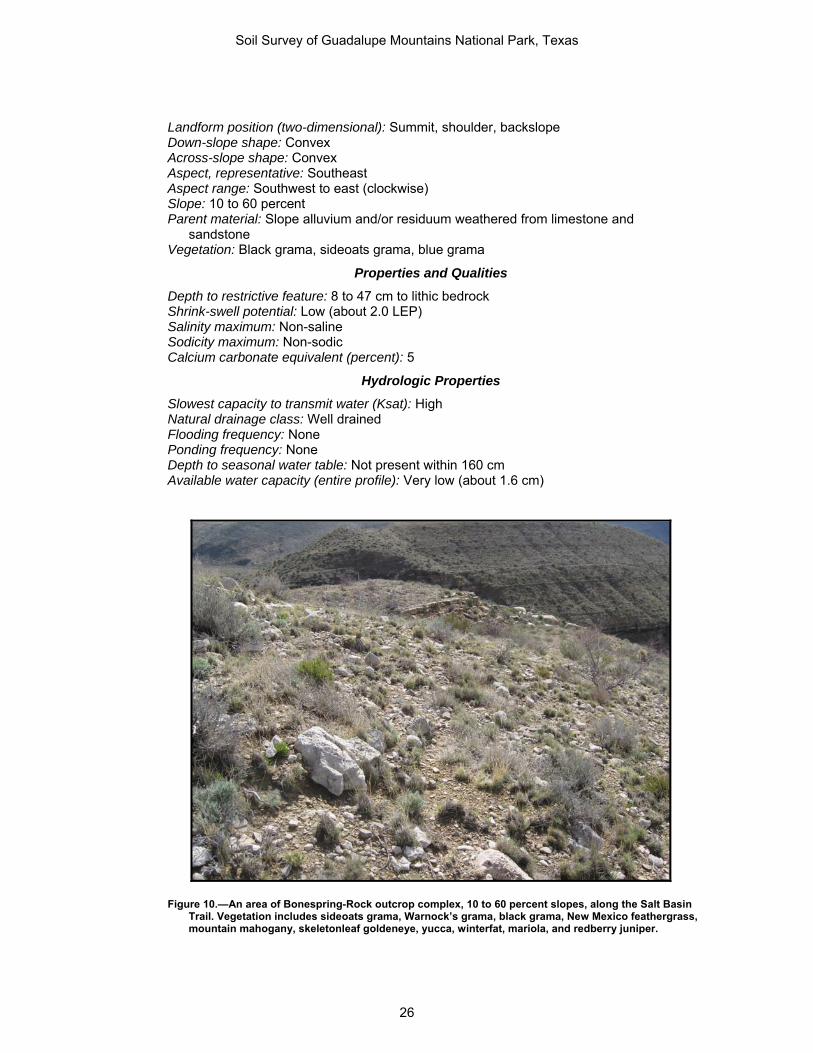
Landform position (two-dimensional): Summit, shoulder, backslope Down-slope shape: Convex Across-slope shape: Convex Aspect, representative: Southeast Aspect range: Southwest to east (clockwise) Slope: 10 to 60 percent Parent material: Slope alluvium and/or residuum weathered from limestone and
sandstone Vegetation: Black grama, sideoats grama, blue grama
Properties and Qualities
Depth to restrictive feature: 8 to 47 cm to lithic bedrock Shrink-swell potential: Low (about 2.0 LEP) Salinity maximum: Non-saline Sodicity maximum: Non-sodic Calcium carbonate equivalent (percent): 5
Hydrologic Properties
Slowest capacity to transmit water (Ksat): High Natural drainage class: Well drained Flooding frequency: None Ponding frequency: None Depth to seasonal water table: Not present within 160 cm Available water capacity (entire profile): Very low (about 1.6 cm)
Figure 10.—An area of Bonespring-Rock outcrop complex, 10 to 60 percent slopes, along the Salt Basin Trail. Vegetation includes sideoats grama, Warnock’s grama, black grama, New Mexico feathergrass, mountain mahogany, skeletonleaf goldeneye, yucca, winterfat, mariola, and redberry juniper.
Soil Survey of Guadalupe Mountains National Park, Texas
26

Interpretive Groups
Land capability subclass (nonirrigated): 6c Ecological site: Sandstone Hill (R070DY749TX) Hydric soil status: No Hydrologic soil group: D Soil classification: Loamy-skeletal, mixed, superactive, calcareous, thermic Aridic Lithic
Ustorthents
Typical Profile
A—0 to 9 cm; very channery sandy loam Bk—9 to 28 cm; extremely gravelly sandy loam R—28 to 53 cm; sandstone bedrock
Rock outcrop
Setting
Landscape: Hills Slope: 10 to 60 percent Parent material: Sandstone
Properties and Qualities
Depth to restrictive feature: Lithic bedrock at surface Salinity maximum: Non-saline Sodicity maximum: Non-sodic Calcium carbonate equivalent (percent): No carbonates
Hydrologic Properties
Flooding frequency: None Ponding frequency: None
Interpretive Groups
Land capability subclass (nonirrigated): Not assigned Hydric soil status: No
CAD—Chispa-Tenneco complex, 2 to 9 percent slopes
Map unit setting: Hills Major Land Resource Area: MLRA 42—Southern Desertic Basins, Plains, and Mountains Elevation: 1,121 to 1,377 m Mean annual precipitation: 254 to 381 cm Mean annual air temperature: 15 to 19 degrees C Frost-free period: 187 to 239 days
Map Unit Composition
Chispa: 50 percent Tenneco: 33 percent Minor components:
Unnamed soils—17 percent; not hydric
Chispa
Setting
Landscape: Hills Landform: Fans
Soil Survey of Guadalupe Mountains National Park, Texas
27

Landform position (two-dimensional): Shoulder, backslope Down-slope shape: Convex Across-slope shape: Convex Aspect, representative: Northwest Aspect range: All aspects Slope: 2 to 9 percent Parent material: Loamy alluvium derived from limestone and dolomite Vegetation: Black grama, bush muhly, sideoats grama, creosote bush, Arizona cottontop,
other forbs
Properties and Qualities
Depth to restrictive feature: None within 150 cm Shrink-swell potential: Low (about 1.5 LEP) Salinity maximum: Very slightly saline (about 3.0 dS/m) Sodicity maximum: Non-sodic Calcium carbonate equivalent (percent): 25
Hydrologic Properties
Slowest capacity to transmit water (Ksat): Moderately high Natural drainage class: Well drained Flooding frequency: None Ponding frequency: None Depth to seasonal water table: Not present within 160 cm Available water capacity (entire profile): Very high (about 24.8 cm)
Interpretive Groups
Land capability subclass (nonirrigated): 6s Ecological site: Gravelly (Desert Grassland) (R042XC244TX) Hydric soil status: No Hydrologic soil group: B Soil classification: Fine-loamy, mixed, superactive, thermic Ustic Haplocalcids
Typical Profile
A—0 to 15 cm; loam Bk—15 to 203 cm; loam
Tenneco
Setting
Landscape: Hills Landform: Alluvial fans Landform position (two-dimensional): Footslope Down-slope shape: Linear Across-slope shape: Concave Aspect, representative: Northwest Aspect range: All aspects Slope: 2 to 5 percent Parent material: Loamy alluvium derived from limestone and dolomite Vegetation: Tobosa, blue grama, black grama, burrograss
Properties and Qualities
Depth to restrictive feature: None within 150 cm Shrink-swell potential: Moderate (about 4.5 LEP) Salinity maximum: Slightly saline (about 5.0 dS/m)
Soil Survey of Guadalupe Mountains National Park, Texas
28

Sodicity maximum: Non-sodic Calcium carbonate equivalent (percent): 19
Hydrologic Properties
Slowest capacity to transmit water (Ksat): Moderately high Natural drainage class: Well drained Flooding frequency: None Ponding frequency: None Depth to seasonal water table: Not present within 160 cm Available water capacity (entire profile): Very high (about 36.4 cm)
Interpretive Groups
Land capability subclass (nonirrigated): 6c Ecological site: Loamy (R042XC007NM) Hydric soil status: No Hydrologic soil group: B Soil classification: Fine-loamy, mixed, superactive, thermic Ustic Haplocambids
Typical Profile
A—0 to 13 cm; very fine sandy loam Bw1—13 to 72 cm; very fine sandy loam Bw2—72 to 110 cm; loam Bk—110 to 203 cm; loam
CCD—Chilicotal-Chispa complex, 3 to 13 percent slopes
Map unit setting: Fan Piedmonts (fig. 11) Major Land Resource Area: MLRA 42—Southern Desertic Basins, Plains, and Mountains Elevation: 1,142 to 1,724 m Mean annual precipitation: 254 to 381 cm Mean annual air temperature: 15 to 19 degrees C Frost-free period: 187 to 239 days
Map Unit Composition
Chilicotal: 51 percent Chispa: 28 percent Minor components:
Tenneco soils—12 percent; on alluvial fans; not hydric Unnamed soils—9 percent; not hydric
Chilicotal
Setting
Landscape: Fan piedmonts Landform: Fan remnants Landform position (two-dimensional): Backslope Down-slope shape: Linear Across-slope shape: Convex Aspect, representative: Southwest Aspect range: South to north (clockwise) Slope: 3 to 13 percent Parent material: Gravelly alluvium derived from limestone and dolomite
Soil Survey of Guadalupe Mountains National Park, Texas
29

Figure 11.—An area of Chilicotal-Chispa complex, 3 to 13 percent slopes, along the Williams Ranch Road. The hills in the background are the Patterson Hills. Vegetation includes tobosa, burrograss, plains bristlegrass, creosote bush, tarbush, and western honey mesquite.
Properties and Qualities
Depth to restrictive feature: None within 150 cm Shrink-swell potential: Low (about 1.5 LEP) Salinity maximum: Non-saline (about 1.0 dS/m) Sodicity maximum: Non-sodic Calcium carbonate equivalent (percent): 35
Hydrologic Properties
Slowest capacity to transmit water (Ksat): Moderately high Natural drainage class: Well drained Flooding frequency: None Ponding frequency: None Depth to seasonal water table: Not present within 160 cm Available water capacity (entire profile): Very high (about 13.7 cm)
Interpretive Groups
Land capability subclass (nonirrigated): 7s Ecological site: Gravelly (Desert Grassland) (R042XC244TX) Hydric soil status: No Hydrologic soil group: B Soil classification: Loamy-skeletal, mixed, superactive, thermic Ustic Haplocalcids
Soil Survey of Guadalupe Mountains National Park, Texas
30
Typical Profile
A—0 to 21 cm; gravelly loam Bk1—21 to 55 cm; very cobbly loam Bk2—55 to 157 cm; very gravelly sandy loam
Chispa
Setting
Landscape: Fan piedmonts Landform: Fan remnants Landform position (two-dimensional): Backslope Down-slope shape: Linear Across-slope shape: Convex Aspect, representative: Southwest Aspect range: South to north (clockwise) Slope: 3 to 13 percent Parent material: Gravelly alluvium derived from limestone and dolomite
Properties and Qualities
Depth to restrictive feature: None within 150 cm Shrink-swell potential: Low (about 1.5 LEP) Salinity maximum: Non-saline (about 1.2 dS/m) Sodicity maximum: Non-sodic Calcium carbonate equivalent (percent): 17
Hydrologic Properties
Slowest capacity to transmit water (Ksat): Moderately high Natural drainage class: Well drained Flooding frequency: None Ponding frequency: None Depth to seasonal water table: Not present within 160 cm Available water capacity (entire profile): Very high (about 18.6 cm)
Interpretive Groups
Land capability subclass (nonirrigated): 6s Ecological site: Gravelly (Desert Grassland) (R042XC244TX) Hydric soil status: No Hydrologic soil group: B Soil classification: Fine-loamy, mixed, superactive, thermic Ustic Haplocalcids
Typical Profile
A—0 to 8 cm; fine sandy loam Bk1—8 to 19 cm; fine sandy loam Bk2—19 to 157 cm; loam
COC—Copia loamy fine sand, 2 to 7 percent slopes
Map unit setting: Basin floors Major Land Resource Area: MLRA 42—Southern Desertic Basins, Plains, and Mountains Elevation: 1,108 to 1,181 m Mean annual precipitation: 150 to 319 cm Mean annual air temperature: 15 to 19 degrees C Frost-free period: 180 to 214 days
Soil Survey of Guadalupe Mountains National Park, Texas
31

Map Unit Composition
Copia: 90 percent Minor components:
Unnamed soils—10 percent; not hydric
Copia
Setting
Landscape: Basin floors Landform: Dunes (fig. 12) Landform position (three-dimensional): Rise Down-slope shape: Convex Across-slope shape: Convex Aspect, representative: West Aspect range: All aspects Slope: 2 to 7 percent Parent material: Eolian sands Vegetation: Giant dropseed, mesa dropseed, perennial forbs
Properties and Qualities
Depth to restrictive feature: None within 150 cm Shrink-swell potential: Low (about 1.5 LEP) Salinity maximum: Non-saline (about 0.3 dS/m) Sodicity maximum: Non-sodic Calcium carbonate equivalent (percent): No carbonates
Figure 12.—An area of Copia loamy fine sand, 2 to 7 percent slopes, in the quartz dunes area on the west side of the park. Vegetation includes spike dropseed, sand dropseed, mesa dropseed, giant dropseed, black grama, bush muhly, broom dalea, western honey mesquite, soaptree yucca, and croton.
Soil Survey of Guadalupe Mountains National Park, Texas
32

Hydrologic Properties
Slowest capacity to transmit water (Ksat): High Natural drainage class: Excessively drained Flooding frequency: None Ponding frequency: None Depth to seasonal water table: Not present within 160 cm Available water capacity (entire profile): Very high (about 12.2 cm)
Interpretive Groups
Land capability subclass (nonirrigated): 7c Ecological site: Deep Sand (R042XB011NM) Hydric soil status: No Hydrologic soil group: A Soil classification: Mixed, thermic Typic Torripsamments
Typical Profile
A—0 to 4 cm; loamy fine sand C—4 to 203 cm; fine sand
CPB—Corvus-Peligro complex, 1 to 5 percent slopes
Map unit setting: Basins (fig. 13) Major Land Resource Area: MLRA 42—Southern Desertic Basins, Plains, and Mountains Elevation: 1,104 to 1,123 m Mean annual precipitation: 150 to 319 cm Mean annual air temperature: 15 to 19 degrees C Frost-free period: 180 to 214 days
Map Unit Composition
Corvus: 43 percent Peligro: 27 percent Minor components:
Lark soils—7 percent; on dune fields; not hydric Monahans soils—3 percent; on alluvial fans; not hydric Nasa soils—20 percent; on relict stabilized gypsum dunes on basin floors; not hydric
Corvus
Setting
Landscape: Basins Landform: Relict stabilized gypsum dunes on basin floors Landform position (three-dimensional): Rise Down-slope shape: Convex Across-slope shape: Convex Aspect, representative: West Aspect range: All aspects Slope: 1 to 5 percent Parent material: Gypsiferous loamy eolian deposits Vegetation: Gyp grama, gyp coldenia, gyp dropseed
Properties and Qualities
Depth to restrictive feature: 31 to 52 cm to petrogypsic Shrink-swell potential: Low (about 1.5 LEP) Salinity maximum: Very slightly saline (about 3.0 dS/m)
Soil Survey of Guadalupe Mountains National Park, Texas
33

Figure 13.—An area of Corvus-Peligro complex, 1 to 5 percent slopes, in the salt basin area on the west side of the park. The less vegetated area with a cryptogrammic crust is the Corvus soil. Vegetation on the Corvus soil includes gyp grama, gyp dropseed, gyp coldenia, and gyp monopod. The area with increased plant cover is the Peligro soil. This increase in vegetation is because of the slightly thicker A horizon. Vegetation on the Peligro soil includes alkali sacaton, spike dropseed, gyp grama, fourwing saltbush, gyp coldenia, and tasajillo.
Sodicity maximum: Sodium adsorption ratio is about 1.0 Calcium carbonate equivalent (percent): 4
Hydrologic Properties
Slowest capacity to transmit water (Ksat): Very low Natural drainage class: Well drained Flooding frequency: None Ponding frequency: None Depth to seasonal water table: Not present within 160 cm Available water capacity (entire profile): Moderate (about 6.5 cm)
Interpretive Groups
Land capability subclass (nonirrigated): 7c Ecological site: Gyp Outcrop (R042XB007NM) Hydric soil status: No Hydrologic soil group: D Soil classification: Loamy, hypergypsic, thermic, shallow Typic Petrogypsids
Typical Profile
A—0 to 6 cm; gypsiferous very fine sandy loam By—6 to 49 cm; gypsiferous fine sandy loam; gypsiferous loamy fine sand Bym—49 to 74 cm; cemented gypsiferous material
Soil Survey of Guadalupe Mountains National Park, Texas
34

Peligro
Setting
Landscape: Basins Landform: Relict playa dunes on basin floors Landform position (three-dimensional): Rise Down-slope shape: Convex Across-slope shape: Convex Aspect, representative: West Aspect range: All aspects Slope: 1 to 5 percent Parent material: Gypsiferous eolian deposits
Properties and Qualities
Depth to restrictive feature: None within 150 cm Shrink-swell potential: Low (about 2.0 LEP) Salinity maximum: Slightly saline (about 4.0 dS/m) Sodicity maximum: Sodium adsorption ratio is about 1.0 Calcium carbonate equivalent (percent): 4
Hydrologic Properties
Slowest capacity to transmit water (Ksat): High Natural drainage class: Well drained Flooding frequency: None Ponding frequency: None Depth to seasonal water table: Not present within 160 cm Available water capacity (entire profile): Very high (about 29.3 cm)
Interpretive Groups
Land capability subclass (nonirrigated): 7c Ecological site: Gyp Upland (R042XB006NM) Hydric soil status: No Hydrologic soil group: A Soil classification: Coarse-gypseous, hypergypsic, thermic Leptic Haplogypsids
Typical Profile
A—0 to 5 cm; very fine sandy loam By—5 to 112 cm; gypsiferous fine sandy loam Cy—112 to 203 cm; gypsiferous very fine sandy loam
LAD—Lazarus loam, 2 to 9 percent slopes
Map unit setting: Mountains Major Land Resource Area: MLRA 70C—Central New Mexico Highlands Elevation: 1,834 to 2,104 m Mean annual precipitation: 508 to 660 cm Mean annual air temperature: 8 to 16 degrees C Frost-free period: 135 to 250 days
Map Unit Composition
Lazarus: 80 percent Minor components:
Desario soils—8 percent; on hills; not hydric
Soil Survey of Guadalupe Mountains National Park, Texas
35

McKittrick soils—8 percent; on flood plain steps on valley floors; not hydric Penasco soils—4 percent; on valley sides on canyons, valley floors on canyons; not hydric
Lazarus
Setting
Landscape: Mountains Landform: Valley sides on canyons, valley floors on canyons (fig. 14) Landform position (two-dimensional): Footslope, toeslope Down-slope shape: Concave Across-slope shape: Concave Aspect, representative: Northwest Aspect range: All aspects Slope: 2 to 9 percent Parent material: Alluvium derived from limestone and dolomite Vegetation: Western wheatgrass, blue grama, sideoats grama, Texas needlegrass, little
bluestem
Properties and Qualities
Depth to restrictive feature: None within 150 cm Shrink-swell potential: Moderate (about 4.5 LEP) Salinity maximum: Non-saline (about 0.4 dS/m) Sodicity maximum: Non-sodic Calcium carbonate equivalent (percent): No carbonates
Figure 14.—An area of Lazarus loam, 2 to 9 percent slopes, in West Dog Canyon. An area of Biduya-Desario-Rock outcrop, 10 to 50 percent slopes, is on the hills in the background. Vegetation includes finestem needlegrass, New Mexico feathergrass, western wheatgrass, wolftail, blue grama, cholla, oneseed juniper, and pinyon pine.
Soil Survey of Guadalupe Mountains National Park, Texas
36

Hydrologic Properties
Slowest capacity to transmit water (Ksat): Moderately high Natural drainage class: Well drained Flooding frequency: None Ponding frequency: None Depth to seasonal water table: Not present within 160 cm Available water capacity (entire profile): Very high (about 40.6 cm)
Interpretive Groups
Land capability subclass (nonirrigated): 7e Ecological site: Loamy (R070CY109NM) Hydric soil status: No Hydrologic soil group: C Soil classification: Fine-silty, mixed, superactive, mesic Pachic Argiustolls
Typical Profile
A—0 to 19 cm; loam Bt1—19 to 109 cm; clay loam Bt2—109 to 203 cm; loam
LPC—Lark-Peligro complex, 1 to 8 percent slopes
Map unit setting: Basins (fig. 15) Major Land Resource Area: MLRA 42—Southern Desertic Basins, Plains, and Mountains Elevation: 1,106 to 1,130 m Mean annual precipitation: 150 to 319 cm Mean annual air temperature: 15 to 19 degrees C Frost-free period: 180 to 214 days
Map Unit Composition
Lark: 50 percent Peligro: 40 percent Minor components:
Nasa soils—10 percent; on relict stabilized gypsum dunes on basin floors; not hydric
Lark
Setting
Landscape: Basins Landform: Dune fields Landform position (three-dimensional): Rise Down-slope shape: Convex Across-slope shape: Convex Aspect, representative: West Aspect range: All aspects Slope: 5 to 8 percent Parent material: Gypseous eolian sands
Properties and Qualities
Depth to restrictive feature: None within 150 cm Shrink-swell potential: Low (about 0.0 LEP) Salinity maximum: Very slightly saline (about 2.1 dS/m)
Soil Survey of Guadalupe Mountains National Park, Texas
37

Figure 15.—An area of Lark-Peligro complex, 1 to 8 percent slopes, in the salt basin area on the west side of the park. Lark soils are on the high dune areas. Vegetation on the Lark soil includes gyp grama, Indian ricegrass, frosted mint, soaptree yucca, and gyp coldenia. The lower interdune area is the Peligro soil. Vegetation on the Peligro soil includes alkali sacaton, spike dropseed, gyp grama, fourwing saltbush, gyp coldenia, and tasajillo.
Sodicity maximum: Non-sodic Calcium carbonate equivalent (percent): No carbonates
Hydrologic Properties
Slowest capacity to transmit water (Ksat): High Natural drainage class: Excessively drained Flooding frequency: None Ponding frequency: None Depth to seasonal water table: Not present within 160 cm Available water capacity (entire profile): Very high (about 12.2 cm)
Interpretive Groups
Land capability subclass (nonirrigated): 7c Ecological site: Vegetated Gypsum Dunes (R042XB003NM) Hydric soil status: No Hydrologic soil group: A Soil classification: Gypsic, thermic Typic Torripsamments
Typical Profile
Ay—0 to 27 cm; gypsiferous fine sand Cy—27 to 203 cm; gypsiferous fine sand
Soil Survey of Guadalupe Mountains National Park, Texas
38

Peligro
Setting
Landscape: Basins Landform: Interdunes Landform position (three-dimensional): Dip Down-slope shape: Linear Across-slope shape: Linear Aspect, representative: West Aspect range: All aspects Slope: 1 to 8 percent Parent material: Gypsiferous eolian deposits Vegetation: Gyp dropseed, fourwing saltbush
Properties and Qualities
Depth to restrictive feature: None within 150 cm Shrink-swell potential: Low (about 2.0 LEP) Salinity maximum: Very slightly saline (about 3.0 dS/m) Sodicity maximum: Sodium adsorption ratio is about 1.0 Calcium carbonate equivalent (percent): 1
Hydrologic Properties
Slowest capacity to transmit water (Ksat): High Natural drainage class: Well drained Flooding frequency: None Ponding frequency: None Depth to seasonal water table: Not present within 160 cm Available water capacity (entire profile): Very high (about 27.2 cm)
Interpretive Groups
Land capability subclass (nonirrigated): 7c Ecological site: Gyp Upland (R042XB006NM) Hydric soil status: No Hydrologic soil group: A Soil classification: Coarse-gypseous, hypergypsic, thermic Leptic Haplogypsids
Typical Profile
A—0 to 18 cm; loamy fine sand By—18 to 43 cm; gypsiferous sandy loam Cy—43 to 203 cm; gypsiferous fine sandy loam
LRH—Lostpeak-Rock outcrop complex, 40 to 95 percent slopes
Map unit setting: Mountains (fig. 16) Major Land Resource Area: MLRA 70C—Central New Mexico Highlands Elevation: 1,426 to 2,647 m Mean annual precipitation: 330 to 381 cm Mean annual air temperature: 8 to 16 degrees C Frost-free period: 135 to 250 days
Soil Survey of Guadalupe Mountains National Park, Texas
39
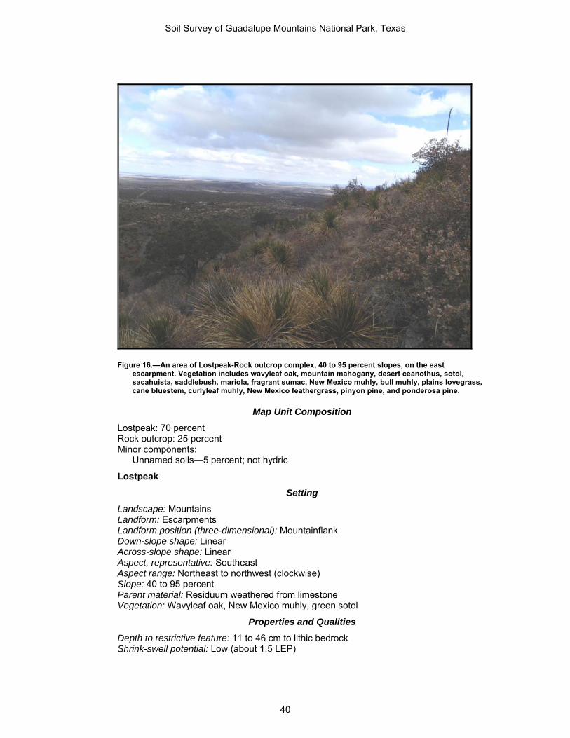
Figure 16.—An area of Lostpeak-Rock outcrop complex, 40 to 95 percent slopes, on the east escarpment. Vegetation includes wavyleaf oak, mountain mahogany, desert ceanothus, sotol, sacahuista, saddlebush, mariola, fragrant sumac, New Mexico muhly, bull muhly, plains lovegrass, cane bluestem, curlyleaf muhly, New Mexico feathergrass, pinyon pine, and ponderosa pine.
Map Unit Composition
Lostpeak: 70 percent Rock outcrop: 25 percent Minor components:
Unnamed soils—5 percent; not hydric
Lostpeak
Setting
Landscape: Mountains Landform: Escarpments Landform position (three-dimensional): Mountainflank Down-slope shape: Linear Across-slope shape: Linear Aspect, representative: Southeast Aspect range: Northeast to northwest (clockwise) Slope: 40 to 95 percent Parent material: Residuum weathered from limestone Vegetation: Wavyleaf oak, New Mexico muhly, green sotol
Properties and Qualities
Depth to restrictive feature: 11 to 46 cm to lithic bedrock Shrink-swell potential: Low (about 1.5 LEP)
Soil Survey of Guadalupe Mountains National Park, Texas
40

Salinity maximum: Non-saline (about 0.7 dS/m) Sodicity maximum: Non-sodic Calcium carbonate equivalent (percent): 9
Hydrologic Properties
Slowest capacity to transmit water (Ksat): Moderately high Natural drainage class: Well drained Flooding frequency: None Ponding frequency: None Depth to seasonal water table: Not present within 160 cm Available water capacity (entire profile): Very low (about 1.7 cm)
Interpretive Groups
Land capability subclass (nonirrigated): 7s Ecological site: Breaks (R070CY115NM) Hydric soil status: No Hydrologic soil group: D Soil classification: Loamy-skeletal, mixed, superactive, mesic Aridic Lithic Haplustolls
Typical Profile
A—0 to 19 cm; very gravelly clay loam R—19 to 44 cm; limestone bedrock
Rock outcrop
Setting
Landscape: Mountains Slope: 40 to 95 percent Parent material: Limestone
Properties and Qualities
Depth to restrictive feature: Lithic bedrock at surface Salinity maximum: Non-saline Sodicity maximum: Non-sodic Calcium carbonate equivalent (percent): No carbonates
Hydrologic Properties
Flooding frequency: None Ponding frequency: None
Interpretive Groups
Land capability subclass (nonirrigated): Not assigned Hydric soil status: No
MCB—McKittrick-Riverwash complex, flooded, 0 to 3 percent slopes
Map unit setting: Canyonlands (fig. 17) Major Land Resource Area: MLRA 70C—Central New Mexico Highlands Elevation: 1,511 to 1,960 m Mean annual precipitation: 508 to 660 cm Mean annual air temperature: 8 to 16 degrees C Frost-free period: 135 to 250 days
Soil Survey of Guadalupe Mountains National Park, Texas
41

Figure 17.—An area of McKittrick-Riverwash complex, flooded, 0 to 3 percent slopes, in McKittrick Canyon. An area of Lostpeak-Rock outcrop complex, 40 to 95 percent slopes, is on the mountainsides in the background. Vegetation includes little bluestem, yellow Indiangrass, bull muhly, pinyon ricegrass, pine muhly, sedges, sotol, apache plume, bigtooth maple, chinquapin oak, velvet ash, madrone, hoptree, alligator juniper, ponderosa pine, and pinyon pine.
Map Unit Composition
McKittrick: 31 percent Riverwash: 22 percent McKittrick: 20 percent Minor components:
Unnamed soils—27 percent; not hydric
McKittrick soils, occasionally flooded
Setting
Landscape: Canyonlands Landform: Flood-plain steps on valley floors Landform position (three-dimensional): Tread, rise Down-slope shape: Linear Across-slope shape: Linear, convex Aspect, representative: Southeast Aspect range: All aspects Slope: 0 to 3 percent Parent material: Gravelly alluvium derived from limestone and dolomite Vegetation: Bigtooth maple
Soil Survey of Guadalupe Mountains National Park, Texas
42

Properties and Qualities
Depth to restrictive feature: None within 150 cm Shrink-swell potential: Moderate (about 3.0 LEP) Salinity maximum: Non-saline (about 0.4 dS/m) Sodicity maximum: Non-sodic Calcium carbonate equivalent (percent): 30
Hydrologic Properties
Slowest capacity to transmit water (Ksat): Moderately high Natural drainage class: Well drained Flooding frequency: Occasional (see Water Features table) Ponding frequency: None Depth to seasonal water table: Not present within 160 cm Available water capacity (entire profile): Moderate (about 6.7 cm)
Interpretive Groups
Land capability subclass (nonirrigated): 6e Ecological site: Limestone Canyon (R070CY745TX) Hydric soil status: No Hydrologic soil group: B Soil classification: Loamy-skeletal, carbonatic, superactive, mesic Fluventic Haplustolls
Typical Profile
A—0 to 12 cm; gravelly sandy loam Bw—12 to 41 cm; very gravelly sandy loam BC—41 to 157 cm; extremely cobbly coarse sandy loam
McKittrick soils, frequently flooded
Setting
Landscape: Canyonlands Landform: Flood-plain steps on valley floors Landform position (three-dimensional): Tread, rise Down-slope shape: Linear Across-slope shape: Linear, convex Aspect, representative: Southeast Aspect range: All aspects Slope: 0 to 3 percent Parent material: Gravelly alluvium derived from limestone and dolomite Vegetation: Sideoats grama, black grama, juniper, little bluestem, mountain muhly, New
Mexico feathergrass
Properties and Qualities
Depth to restrictive feature: None within 150 cm Shrink-swell potential: Moderate (about 3.0 LEP) Salinity maximum: Non-saline (about 0.4 dS/m) Sodicity maximum: Non-sodic Calcium carbonate equivalent (percent): 30
Hydrologic Properties
Slowest capacity to transmit water (Ksat): Moderately high Natural drainage class: Well drained Flooding frequency: Frequent
Soil Survey of Guadalupe Mountains National Park, Texas
43

Ponding frequency: None Depth to seasonal water table: Not present within 160 cm Available water capacity (entire profile): Moderate (about 6.7 cm)
Interpretive Groups
Land capability subclass (nonirrigated): 6w Ecological site: Gravelly (R070DY156NM) Hydric soil status: No Hydrologic soil group: B Soil classification: Loamy-skeletal, carbonatic, superactive, mesic Fluventic Haplustolls
Typical Profile
A—0 to 12 cm; gravelly sandy loam Bw—12 to 41 cm; very gravelly sandy loam BC—41 to 157 cm; extremely cobbly coarse sandy loam
Riverwash
Setting
Landscape: Canyonlands Slope: 0 to 1 percent Parent material: Recent alluvium
Properties and Qualities
Depth to restrictive feature: None within 150 cm Salinity maximum: Non-saline Sodicity maximum: Non-sodic Calcium carbonate equivalent (percent): No carbonates
Hydrologic Properties
Slowest capacity to transmit water (Ksat): Unspecified Natural drainage class: Excessively drained Flooding frequency: Frequent Ponding frequency: None Depth to seasonal water table: Not present within 160 cm
Interpretive Groups
Land capability subclass (nonirrigated): Not assigned Hydric soil status: No
MPB—Monahans-Pajarito complex, 0 to 5 percent slopes
Map unit setting: Basins (fig. 18) Major Land Resource Area: MLRA 42—Southern Desertic Basins, Plains, and Mountains Elevation: 1,108 to 1,237 m Mean annual precipitation: 150 to 319 cm Mean annual air temperature: 15 to 19 degrees C Frost-free period: 180 to 214 days
Map Unit Composition
Monahans: 60 percent Pajarito: 21 percent Minor components:
Corvus soils—3 percent; on relict stabilized gypsum dunes on basin floors; not hydric
Soil Survey of Guadalupe Mountains National Park, Texas
44

Lark soils—3 percent; on dune fields; not hydric Nasa soils—13 percent; on relict stabilized gypsum dunes on basin floors; not hydric
Monahans
Setting
Landscape: Basins Landform: Alluvial fans Landform position (three-dimensional): Talf Down-slope shape: Linear Across-slope shape: Linear Aspect, representative: West Aspect range: All aspects Slope: 0 to 5 percent Parent material: Calcareous and gypsiferous coarse-loamy alluvium Vegetation: Black grama, bush muhly, sand dropseed, spike dropseed, mesa dropseed
Properties and Qualities
Depth to restrictive feature: None within 150 cm Shrink-swell potential: Low (about 1.5 LEP) Salinity maximum: Very slightly saline (about 2.6 dS/m) Sodicity maximum: Sodium adsorption ratio is about 2.0 Calcium carbonate equivalent (percent): 13
Hydrologic Properties
Slowest capacity to transmit water (Ksat): High Natural drainage class: Well drained Flooding frequency: None Ponding frequency: None
Figure 18.—An area of Monahans-Pajarito complex, 0 to 5 percent slopes, on the lower end of the alluvial fans on the west side of the park. Vegetation in this map unit includes mesa dropseed, bush muhly, plains bristlegrass, threeawns, creosote bush, soaptree yucca, and fourwing saltbush.
Soil Survey of Guadalupe Mountains National Park, Texas
45
Depth to seasonal water table: Not present within 160 cm Available water capacity (entire profile): Very high (about 22.9 cm)
Interpretive Groups
Land capability subclass (nonirrigated): 7e Ecological site: Sandy (R042XB012NM) Hydric soil status: No Hydrologic soil group: A Soil classification: Coarse-loamy, mixed, superactive, thermic Typic Calcigypsids
Typical Profile
A—0 to 10 cm; fine sandy loam Bk—10 to 33 cm; fine sandy loam Bky—33 to 203 cm; fine sandy loam
Pajarito
Setting
Landscape: Basins Landform: Alluvial fans Landform position (three-dimensional): Talf Down-slope shape: Linear Across-slope shape: Linear Aspect, representative: West Aspect range: All aspects Slope: 0 to 5 percent Parent material: Eolian sands and/or alluvium derived from limestone and sandstone
Properties and Qualities
Depth to restrictive feature: None within 150 cm Shrink-swell potential: Low (about 1.5 LEP) Salinity maximum: Non-saline (about 1.0 dS/m) Sodicity maximum: Sodium adsorption ratio is about 1.0 Calcium carbonate equivalent (percent): 3
Hydrologic Properties
Slowest capacity to transmit water (Ksat): High Natural drainage class: Well drained Flooding frequency: None Ponding frequency: None Depth to seasonal water table: Not present within 160 cm Available water capacity (entire profile): Very high (about 28.4 cm)
Interpretive Groups
Land capability subclass (nonirrigated): 7e Ecological site: Sandy (R042XB012NM) Hydric soil status: No Hydrologic soil group: A Soil classification: Coarse-loamy, mixed, superactive, thermic Typic Haplocambids
Typical Profile
A—0 to 28 cm; very fine sandy loam Bw—28 to 98 cm; very fine sandy loam Bk—98 to 203 cm; very fine sandy loam
Soil Survey of Guadalupe Mountains National Park, Texas
46

PCG—Pinery, Choza, and Altuda soils, 5 to 60 percent slopes, very rocky
Map unit setting: Piedmonts (fig. 19) Major Land Resource Area: MLRA 70D—Southern Desert Foothills Elevation: 1,370 to 1,995 m Mean annual precipitation: 287 to 523 cm Mean annual air temperature: 14 to 19 degrees C Frost-free period: 203 to 255 days
Map Unit Composition
Pinery: 32 percent Choza: 27 percent Altuda: 20 percent Minor components:
Murray soils—9 percent; on alluvial fans; not hydric Rock outcrop—8 percent; not hydric Unnamed soils—4 percent; not hydric
Altuda
Setting
Landscape: Piedmont Landform: Hillslopes
Figure 19.—An area of Pinery, Choza, and Altuda soils, 5 to 60 percent slopes, very rocky. The Pinery soil is on the steep fan at the base of the mountains, Altuda is at the base of the mountains and on ridges, and the Choza soil is on the less sloping area in the foreground. Vegetation includes sideoats grama, blue grama, curlyleaf muhly, New Mexico feathergrass, fragrant sumac, desert ceanothus, mountain mahogany, wavyleaf oak, black grama, hairy grama, cane bluestem, little bluestem, hairy grama, skunkbush sumac, sotol, pricklypear, redberry juniper, oaks, and pinyon pine.
Soil Survey of Guadalupe Mountains National Park, Texas
47
Down-slope shape: Convex Across-slope shape: Convex Aspect, representative: South Aspect range: All aspects Slope: 10 to 60 percent Parent material: Residuum weathered from limestone Vegetation: Sideoats grama, curlyleaf muhly, blue grama, other forbs
Properties and Qualities
Depth to restrictive feature: 18 to 52 cm to lithic bedrock Shrink-swell potential: Low (about 1.5 LEP) Salinity maximum: Non-saline (about 0.5 dS/m) Sodicity maximum: Non-sodic Calcium carbonate equivalent (percent): 20
Hydrologic Properties
Slowest capacity to transmit water (Ksat): Moderately high Natural drainage class: Well drained Flooding frequency: None Ponding frequency: None Depth to seasonal water table: Not present within 160 cm Available water capacity (entire profile): Very low (about 2.9 cm)
Interpretive Groups
Land capability subclass (nonirrigated): 7s Ecological site: Limestone Hills (R070DY151NM) Hydric soil status: No Hydrologic soil group: D Soil classification: Loamy-skeletal, mixed, superactive, thermic Lithic Calciustolls
Typical Profile
A—0 to 12 cm; very gravelly loam Bk—12 to 28 cm; very gravelly loam R—28 to 53 cm; limestone bedrock
Pinery
Setting
Landscape: Piedmont Landform: Alluvial fans Landform position (two-dimensional): Backslope Down-slope shape: Linear Across-slope shape: Convex Aspect, representative: Southeast Aspect range: North to south (clockwise) Slope: 5 to 20 percent Parent material: Gravelly alluvium derived from limestone and dolomite Vegetation: Sideoats grama, cane bluestem, blue grama, little bluestem, New Mexico
feathergrass, other forbs
Properties and Qualities
Depth to restrictive feature: None within 150 cm Shrink-swell potential: Low (about 1.5 LEP) Salinity maximum: Non-saline (about 0.3 dS/m)
Soil Survey of Guadalupe Mountains National Park, Texas
48
Sodicity maximum: Non-sodic Calcium carbonate equivalent (percent): 15
Hydrologic Properties
Slowest capacity to transmit water (Ksat): Moderately high Natural drainage class: Well drained Flooding frequency: None Ponding frequency: None Depth to seasonal water table: Not present within 160 cm Available water capacity (entire profile): Very high (about 16.7 cm)
Interpretive Groups
Land capability subclass (nonirrigated): 6e Ecological site: Gravelly (R070DY156NM) Hydric soil status: No Hydrologic soil group: B Soil classification: Loamy-skeletal, mixed, superactive, thermic Aridic Calciustolls
Typical Profile
A1—0 to 26 cm; gravelly loam A2—26 to 48 cm; very gravelly loam BCk—48 to 157 cm; extremely cobbly loam
Choza
Setting
Landscape: Piedmont Landform: Fan remnants Landform position (three-dimensional): Sideslope Down-slope shape: Linear Across-slope shape: Convex Aspect, representative: Southeast Aspect range: North to south (clockwise) Slope: 5 to 20 percent Parent material: Gravelly alluvium derived from limestone and dolomite Vegetation: Curlyleaf muhly, blue grama, black grama, sideoats grama
Properties and Qualities
Depth to restrictive feature: 13 to 49 cm to petrocalcic Shrink-swell potential: Low (about 1.5 LEP) Salinity maximum: Non-saline (about 0.3 dS/m) Sodicity maximum: Non-sodic Calcium carbonate equivalent (percent): 11
Hydrologic Properties
Slowest capacity to transmit water (Ksat): Moderately high Natural drainage class: Well drained Flooding frequency: None Ponding frequency: None Depth to seasonal water table: Not present within 160 cm Available water capacity (entire profile): Very low (about 2.9 cm)
Soil Survey of Guadalupe Mountains National Park, Texas
49

Interpretive Groups
Land capability subclass (nonirrigated): 6s Ecological site: Shallow (R070DY152NM) Hydric soil status: No Hydrologic soil group: D Soil classification: Loamy-skeletal, mixed, superactive, thermic, shallow Petrocalcic
Calciustolls
Typical Profile
A1—0 to 15 cm; very gravelly loam A2—15 to 26 cm; very gravelly loam Bkm—26 to 51 cm; cemented material
VLG—Victorio-Lozen-Rock outcrop complex, 10 to 60 percent slopes
Map unit setting: Mountains (fig. 20) Major Land Resource Area: MLRA 70C—Central New Mexico Highlands Elevation: 1,911 to 2,632 m Mean annual precipitation: 508 to 660 cm Mean annual air temperature: 8 to 14 degrees C Frost-free period: 135 to 250 days
Figure 20.—An area of Lozen in the Victorio-Lozen-Rock outcrop complex, 10 to 60 percent slopes, along the Blue Ridge Trail. Vegetation includes ponderosa pine, alligator juniper, oneseed juniper, oaks, pine muhly, mountain muhly, New Mexico muhly, bull muhly, little bluestem, big bluestem, yellow Indiangrass, finestem needlegrass, pinyon ricegrass, Arizona fescue, plains lovegrass, cliff fendlerbush, mountain mahogany, and New Mexico agave.
Soil Survey of Guadalupe Mountains National Park, Texas
50

Map Unit Composition
Victorio: 51 percent Lozen: 33 percent Rock outcrop: 12 percent Minor components:
Unnamed soils—4 percent; not hydric
Victorio
Setting
Landscape: Mountains Landform: Mountain slopes, ridges Landform position (two-dimensional): Backslope, footslope Landform position (three-dimensional): Mountainflank Down-slope shape: Linear Across-slope shape: Convex Aspect, representative: North Aspect range: All aspects Slope: 25 to 60 percent Parent material: Colluvium and residuum weathered from limestone and dolomite
Properties and Qualities
Depth to restrictive feature: 18 to 49 cm to lithic bedrock Shrink-swell potential: High (about 8.0 LEP) Salinity maximum: Non-saline Sodicity maximum: Non-sodic Calcium carbonate equivalent (percent): No carbonates
Hydrologic Properties
Slowest capacity to transmit water (Ksat): High Natural drainage class: Well drained Flooding frequency: None Ponding frequency: None Depth to seasonal water table: Not present within 160 cm Available water capacity (entire profile): Low (about 4.0 cm)
Interpretive Groups
Land capability subclass (nonirrigated): 7s Ecological site: Pseudotsuga menziesii var. glauca-Quercus gambelii/Amelanchier
utahensis-Fendlera rupicola/Muhlenbergia pauciflora (F070CY020TX) Hydric soil status: No Hydrologic soil group: D Soil classification: Clayey-skeletal, mixed, superactive, mesic Lithic Argiustolls
Typical Profile
Oi—0 to 7 cm; decomposed plant material A—7 to 17 cm; gravelly loam Bt—17 to 47 cm; very cobbly clay loam and very cobbly clay R—47 to 72 cm; limestone bedrock
Lozen
Setting
Landscape: Mountains Landform: Mountain slopes, ridges
Soil Survey of Guadalupe Mountains National Park, Texas
51

Landform position (two-dimensional): Summit, shoulder Landform position (three-dimensional): Mountainflank Down-slope shape: Linear Across-slope shape: Convex Aspect, representative: South Aspect range: All aspects Slope: 10 to 45 percent Parent material: Colluvium and residuum weathered from limestone and dolomite Vegetation: Ponderosa pine, little bluestem, yellow Indiangrass, alligator juniper
Properties and Qualities
Depth to restrictive feature: 11 to 44 cm to lithic bedrock Shrink-swell potential: Low (about 1.5 LEP) Salinity maximum: Non-saline Sodicity maximum: Non-sodic Calcium carbonate equivalent (percent): No carbonates
Hydrologic Properties
Slowest capacity to transmit water (Ksat): Moderately high Natural drainage class: Well drained Flooding frequency: None Ponding frequency: None Depth to seasonal water table: Not present within 160 cm Available water capacity (entire profile): Very low (about 1.1 cm)
Interpretive Groups
Land capability subclass (nonirrigated): 7s Ecological site: Pinus ponderosa var. scopulorum-Pinus edulis/Quercus undulata-
Cercocarpus montanus/Muhlenbergia dubia (F070CY021TX) Hydric soil status: No Hydrologic soil group: D Soil classification: Loamy-skeletal, mixed, superactive, mesic Lithic Haplustolls
Typical Profile
A—0 to 12 cm; very gravelly loam R—12 to 37 cm; limestone bedrock
Rock outcrop
Setting
Landscape: Mountains Slope: 10 to 60 percent Parent material: Limestone
Properties and Qualities
Depth to restrictive feature: Lithic bedrock at surface Salinity maximum: Non-saline Sodicity maximum: Non-sodic Calcium carbonate equivalent (percent): No carbonates
Hydrologic Properties
Flooding frequency: None Ponding frequency: None
Soil Survey of Guadalupe Mountains National Park, Texas
52

Interpretive Groups
Land capability subclass (nonirrigated): Not assigned Hydric soil status: No
VLH—Victorio-Lozen-Rock outcrop complex, 40 to 95 percent slopes
Map unit setting: Mountains (fig. 21) Major Land Resource Area: MLRA 70C—Central New Mexico Highlands Elevation: 1,548 to 2,664 m Mean annual precipitation: 508 to 660 cm Mean annual air temperature: 8 to 14 degrees C Frost-free period: 135 to 250 days
Map Unit Composition
Victorio: 35 percent Lozen: 25 percent Victorio: 20 percent Rock outcrop: 20 percent
Victorio soils, 60 to 95 percent slopes
Setting
Landscape: Mountains Landform: Mountain slopes, ridges
Figure 21.—An area of Victorio soils in the Victorio-Lozen-Rock outcrop complex, 40 to 95 percent slopes, along the Tejas Trail. Vegetation includes Douglas fir, southwestern white pine, ponderosa pine, Gambel oak, Knowlton hophornbeam, Utah serviceberry, New Mexico muhly, Arizona fescue, and nodding brome.
Soil Survey of Guadalupe Mountains National Park, Texas
53

Landform position (two-dimensional): Backslope, footslope Landform position (three-dimensional): Mountainflank Down-slope shape: Linear Across-slope shape: Convex Aspect, representative: North Aspect range: All aspects Slope: 60 to 95 percent Parent material: Colluvium and residuum weathered from limestone and dolomite
Properties and Qualities
Depth to restrictive feature: 40 to 52 cm to lithic bedrock Shrink-swell potential: High (about 8.0 LEP) Salinity maximum: Non-saline Sodicity maximum: Non-sodic Calcium carbonate equivalent (percent): No carbonates
Hydrologic Properties
Slowest capacity to transmit water (Ksat): High Natural drainage class: Well drained Flooding frequency: None Ponding frequency: None Depth to seasonal water table: Not present within 160 cm Available water capacity (entire profile): Moderate (about 6.2 cm)
Interpretive Groups
Land capability subclass (nonirrigated): 7s Ecological site: Pseudotsuga menziesii var. glauca-Quercus gambelii/Amelanchier
utahensis-Fendlera rupicola/Muhlenbergia pauciflora (F070CY020TX) Hydric soil status: No Hydrologic soil group: D Soil classification: Clayey-skeletal, mixed, superactive, mesic Lithic Argiustolls
Typical Profile
A—0 to 10 cm; very gravelly clay loam Bt—10 to 42 cm; very cobbly clay R—42 to 67 cm; limestone bedrock
Victorio soils, 40 to 60 percent slopes
Setting
Landscape: Mountains Landform: Mountain slopes, ridges Landform position (two-dimensional): Backslope, footslope Landform position (three-dimensional): Mountainflank Down-slope shape: Linear Across-slope shape: Convex Aspect, representative: North Aspect range: All aspects Slope: 40 to 60 percent Parent material: Colluvium and residuum weathered from limestone and dolomite
Properties and Qualities
Depth to restrictive feature: 40 to 52 cm to lithic bedrock Shrink-swell potential: High (about 8.0 LEP) Salinity maximum: Non-saline
Soil Survey of Guadalupe Mountains National Park, Texas
54

Sodicity maximum: Non-sodic Calcium carbonate equivalent (percent): No carbonates
Hydrologic Properties
Slowest capacity to transmit water (Ksat): High Natural drainage class: Well drained Flooding frequency: None Ponding frequency: None Depth to seasonal water table: Not present within 160 cm Available water capacity (entire profile): Moderate (about 6.2 cm)
Interpretive Groups
Land capability subclass (nonirrigated): 7s Ecological site: Pseudotsuga menziesii var. glauca-Quercus gambelii/Amelanchier
utahensis-Fendlera rupicola/Muhlenbergia pauciflora (F070CY020TX) Hydric soil status: No Hydrologic soil group: D Soil classification: Clayey-skeletal, mixed, superactive, mesic Lithic Argiustolls
Typical Profile
A—0 to 10 cm; very gravelly clay loam Bt—10 to 42 cm; very cobbly clay R—42 to 67 cm; limestone bedrock
Lozen
Setting
Landscape: Mountains Landform: Mountain slopes, ridges Landform position (two-dimensional): Summit, shoulder Landform position (three-dimensional): Mountainflank Down-slope shape: Linear Across-slope shape: Convex Aspect, representative: South Aspect range: All aspects Slope: 40 to 95 percent Parent material: Colluvium and residuum weathered from limestone and dolomite
Properties and Qualities
Depth to restrictive feature: 40 to 45 cm to lithic bedrock Shrink-swell potential: Low (about 1.5 LEP) Salinity maximum: Non-saline Sodicity maximum: Non-sodic Calcium carbonate equivalent (percent): No carbonates
Hydrologic Properties
Slowest capacity to transmit water (Ksat): Moderately high Natural drainage class: Well drained Flooding frequency: None Ponding frequency: None Depth to seasonal water table: Not present within 160 cm Available water capacity (entire profile): Low (about 3.9 cm)
Soil Survey of Guadalupe Mountains National Park, Texas
55

Interpretive Groups
Land capability subclass (nonirrigated): 7s Ecological site: Pinus ponderosa var. scopulorum-Pinus edulis/Quercus undulata-
Cercocarpus montanus/Muhlenbergia dubia (F070CY021TX) Hydric soil status: No Hydrologic soil group: D Soil classification: Loamy-skeletal, mixed, superactive, mesic Lithic Haplustolls
Typical Profile
A—0 to 43 cm; very gravelly loam R—43 to 68 cm; limestone bedrock
Rock outcrop
Setting
Landscape: Mountains Slope: 40 to 95 percent Parent material: Limestone
Properties and Qualities
Depth to restrictive feature: Lithic bedrock at surface Salinity maximum: Non-saline Sodicity maximum: Non-sodic Calcium carbonate equivalent (percent): No carbonates
Hydrologic Properties
Flooding frequency: None Ponding frequency: None
Interpretive Groups
Land capability subclass (nonirrigated): Not assigned Hydric soil status: No
Soil Survey of Guadalupe Mountains National Park, Texas
56

Prime Farmland
Prime farmland is one of several kinds of important farmland defined by the U.S. Department of Agriculture. It is of major importance in meeting the Nation's short- and long-range needs for food and fiber. Because the supply of high-quality farmland is limited, the U.S. Department of Agriculture recognizes that responsible levels of government, as well as individuals, should encourage and facilitate the wise use of our Nation's prime farmland.
Prime farmland, as defined by the U.S. Department of Agriculture, is land that has the best combination of physical and chemical characteristics for producing food, feed, forage, fiber, and oilseed crops and is available for these uses. It could be cultivated land, pastureland, forestland, or other land, but it is not urban or built-up land or water areas. The soil qualities, growing season, and moisture supply are those needed for the soil to economically produce sustained high yields of crops when proper management, including water management, and acceptable farming methods are applied. In general, prime farmland has an adequate and dependable supply of moisture from precipitation or irrigation, a favorable temperature and growing season, acceptable acidity or alkalinity, an acceptable salt and sodium content, and few or no rocks. It is permeable to water and air. It is not excessively erodible or saturated with water for long periods, and it either is not frequently flooded during the growing season or is protected from flooding. Slope ranges mainly from 0 to 6 percent. More detailed information about the criteria for prime farmland is available at the local office of the Natural Resources Conservation Service.
There are no areas in Guadalupe Mountains National Park that meet the soil requirements for prime farmland.
57


Use and Management of the Soils
This soil survey is an inventory and evaluation of the soils in the survey area. It can be used to adjust land uses to the limitations and potentials of natural resources and the environment. In addition, it can help to prevent soil-related failures in land uses.
In preparing a soil survey, soil scientists, conservationists, engineers, and others collect extensive field data about the nature and behavioral characteristics of the soils. They collect data on erosion, droughtiness, flooding, and other factors that affect various soil uses and management. Field experience and collected data on soil properties and performance are used as a basis in predicting soil behavior.
Information in this section can be used to plan the use and management of soils for rangeland; as sites for buildings, sanitary facilities, highways and other transportation systems, and parks and other recreational facilities; and for wildlife habitat. It can be used to identify the potentials and limitations of each soil for specific land uses and to help prevent construction failures caused by unfavorable soil properties.
Planners and others using soil survey information can evaluate the effect of specific land uses on productivity and on the environment in all or part of the survey area. The survey can help planners to maintain or create a land use pattern in harmony with the natural soil.
Contractors can use this survey to locate sources of sand and gravel, roadfill, and topsoil. They can use it to identify areas where bedrock, wetness, or very firm soil layers can cause difficulty in excavation.
Health officials, highway officials, engineers, and others may also find this survey useful. The survey can help them plan the safe disposal of wastes and locate sites for pavements, sidewalks, campgrounds, and lawns.
Interpretive Ratings The interpretive tables in this survey rate the soils in the survey area for various
uses. Many of the tables identify the limitations that affect specified uses and indicate the severity of those limitations. The ratings in these tables are both verbal and numerical.
Rating Class Terms Rating classes are expressed in the tables in terms that indicate the extent to
which the soils are limited by all of the soil features that affect a specified use or in terms that indicate the suitability of the soils for the use. Thus, the tables may show limitation classes or suitability classes. Terms for the limitation classes are not limited, somewhat limited, and very limited. The suitability ratings are expressed as well suited, moderately suited, poorly suited, and unsuited or as good, fair, and poor.
Numerical Ratings Numerical ratings in the tables indicate the relative severity of individual
limitations. The ratings are shown as decimal fractions ranging from 0.00 to 1.00. They indicate gradations between the point at which a soil feature has the greatest negative impact on the use and the point at which the soil feature is not a limitation.
59

The limitations appear in order from the most limiting to the least limiting. Thus, if more than one limitation is identified, the most severe limitation is listed first and the least severe one is listed last.
Land Management
In Table 5, Table 6, Table 7, and Table 8, interpretive ratings are given for various aspects of land management. The ratings are both descriptive and numerical.
Some rating class terms indicate the degree to which the soils are suited to a specified aspect of forestland management. Well suited indicates that the soil has features that are favorable for the specified management aspect and has no limitations. Good performance can be expected, and little or no maintenance is needed. Moderately suited indicates that the soil has features that are moderately favorable for the specified management aspect. One or more soil properties are less than desirable, and fair performance can be expected. Some maintenance is needed. Poorly suited indicates that the soil has one or more properties that are unfavorable for the specified management aspect. Overcoming the unfavorable properties requires special design, extra maintenance, and costly alteration. Unsuited indicates that the expected performance of the soil is unacceptable for the specified management aspect or that extreme measures are needed to overcome the undesirable soil properties.
Numerical ratings in the tables indicate the severity of individual limitations. The ratings are shown as decimal fractions ranging from 0.01 to 1.00. They indicate gradations between the point at which a soil feature has the greatest negative impact on the specified aspect of forestland management (1.00) and the point at which the soil feature is not a limitation (0.00).
Ratings in the columns suitability for hand planting and suitability for mechanical planting are based on slope, depth to a restrictive layer, content of sand, plasticity index, rock fragments on or below the surface, depth to a water table, and ponding. The soils are described as well suited, moderately suited, poorly suited, or unsuited to these methods of planting. It is assumed that necessary site preparation is completed before seedlings are planted.
Ratings in the column soil rutting for equipment use are based on depth to a water table, rock fragments on or below the surface, the Unified classification, depth to a restrictive layer, and slope. Ruts form as a result of the operation of forestland equipment. The hazard is described as slight, moderate, or severe. A rating of "slight" indicates that the soil is subject to little or no rutting, "moderate" indicates that rutting is likely, and "severe" indicates that ruts form readily.
Ratings in the column hazard of erosion are based on slope and on soil erodibility factor K. The soil loss is caused by sheet or rill erosion in off-road or off-trail areas where 50 to 75 percent of the surface has been exposed by logging, grazing, mining, or other kinds of disturbance. The hazard is described as slight, moderate, severe, or very severe. A rating of slight indicates that erosion is unlikely under ordinary climatic conditions; moderate indicates that some erosion is likely and that erosion-control measures may be needed; severe indicates that erosion is very likely and that erosion-control measures, including revegetation of bare areas, are advised; and very severe indicates that significant erosion is expected, loss of soil productivity and off-site damage are likely, and erosion-control measures are costly and generally impractical.
Ratings in the column hazard of erosion on roads and trails are based on the soil erodibility factor K, slope, and content of rock fragments. The ratings apply to unsurfaced roads and trails. The hazard is described as slight, moderate, or severe. A rating of slight indicates that little or no erosion is likely; moderate indicates that some erosion is likely, that the roads or trails may require occasional maintenance and that simple erosion-control measures are needed; and severe indicates that significant erosion is expected,
Soil Survey of Guadalupe Mountains National Park, Texas
60

that the roads or trails require frequent maintenance, and that costly erosion-control measures are needed.
Ratings in the column suitability for roads (natural surface) are based on slope, rock fragments on the surface, plasticity index, content of sand, the Unified classification, depth to a water table, ponding, flooding, and the hazard of soil slippage. The ratings indicate the suitability for using the natural surface of the soil for roads. The soils are described as well suited, moderately suited, or poorly suited to this use.
Ratings in the column suitability for mechanical site preparation and mechanical site restoration (surface) are based on slope, depth to a restrictive layer, plasticity index, rock fragments on or below the surface, depth to a water table, and ponding. The soils are described as well suited, poorly suited, or unsuited to this management activity. The part of the soil from the surface to a depth of about 1 foot is considered in the ratings.
Ratings in the column suitability for mechanical site preparation and mechanical site restoration (deep) are based on slope, depth to a restrictive layer, rock fragments on or below the surface, depth to a water table, and ponding. The soils are described as well suited, poorly suited, or unsuited to this management activity. The part of the soil from the surface to a depth of about 3 feet is considered in the ratings.
Ratings in the column potential for damage to soil by fire are based on texture of the surface layer, content of rock fragments and organic matter in the surface layer, thickness of the surface layer, and slope. The soils are described as having a low, moderate, or high potential for this kind of damage. The ratings indicate an evaluation of the potential impact of prescribed fires or wildfires that are intense enough to remove the duff layer and consume organic matter in the surface layer.
Ratings in the column potential for seedling mortality are based on flooding, ponding, depth to a water table, content of lime, reaction, salinity, available water capacity, soil moisture regime, soil temperature regime, aspect, and slope. The soils are described as having a low, moderate, or high potential for seedling mortality.
Land Capability Classification Land capability classification shows, in a general way, the suitability of soils for most
kinds of field crops. Crops that require special management are excluded. The soils are grouped according to their limitations for field crops, the risk of damage if they are used for crops, and the way they respond to management. The criteria used in grouping the soils do not include major and generally expensive landforming that would change slope, depth, or other characteristics of the soils, nor do they include possible but unlikely major reclamation projects. Capability classification is not a substitute for interpretations designed to show suitability and limitations of groups of soils for rangeland, for forestland, or for engineering purposes.
In the capability system, soils are generally grouped at three levels—capability class, subclass, and unit (USDA, 1961).
Capability classes, the broadest groups, are designated by the numbers 1 through 8. The numbers indicate progressively greater limitations and narrower choices for practical use. The classes are defined as follows:
Class 1 soils have slight limitations that restrict their use. Class 2 soils have moderate limitations that restrict the choice of plants or that require
moderate conservation practices. Class 3 soils have severe limitations that restrict the choice of plants or that require
special conservation practices, or both. Class 4 soils have very severe limitations that restrict the choice of plants or that
require very careful management, or both. Class 5 soils are subject to little or no erosion but have other limitations, impractical to
remove, that restrict their use mainly to pasture, rangeland, forestland, or wildlife habitat.
Soil Survey of Guadalupe Mountains National Park, Texas
61

Class 6 soils have severe limitations that make them generally unsuitable for cultivation and that restrict their use mainly to pasture, rangeland, forestland, or wildlife habitat.
Class 7 soils have very severe limitations that make them unsuitable for cultivation and that restrict their use mainly to grazing, forestland, or wildlife habitat.
Class 8 soils and miscellaneous areas have limitations that preclude commercial plant production and that restrict their use to recreational purposes, wildlife habitat, watershed, or aesthetic purposes.
Capability subclasses are soil groups within one class. They are designated by adding a small letter, e, w, s, or c, to the class numeral, for example, 2e. The letter e shows that the main hazard is the risk of erosion unless close-growing plant cover is maintained; w shows that water in or on the soil interferes with plant growth or cultivation (in some soils the wetness can be partly corrected by artificial drainage); s shows that the soil is limited mainly because it is shallow, droughty, or stony; and c, used in only some parts of the United States, shows that the chief limitation is climate that is very cold or very dry.
In class 1 there are no subclasses because the soils of this class have few limitations. Class 5 contains only the subclasses indicated by w, s, or c because the soils in class 5 are subject to little or no erosion. They have other limitations that restrict their use to pasture, rangeland, forestland, wildlife habitat, or recreation.
Capability units are soil groups within a subclass. The soils in a capability unit are enough alike to be suited to the same crops and pasture plants, to require similar management, and to have similar productivity. Capability units are generally designated by adding an Arabic numeral to the subclass symbol, for example, 2e-4 and 3e-6. These units are not given in all soil surveys.
The capability classification of the soils in this survey area is provided in the section Detailed Soil Map Units, and in Table 9.
Ecological Site Descriptions for Guadalupe Mountains National Park The Natural Resources Conservation Service divides both forest and rangelands into
ecological sites for the purposes of inventory, evaluation, and management. An ecological site is defined as a distinctive kind of land with specific physical characteristics that differs from other kinds of land in its ability to produce a distinctive kind and amount of vegetation. An ecological site is the product of all the environmental factors responsible for its development, and it has a set of key characteristics that are included in the ecological site description such as characteristic soils. Ecological sites incorporate state and transition models to describe the succession of community phases and ecological processes that affect the site and they are classified according to the potential native plant community, or reference plant community, which develops under natural conditions. Additional information about ecological sites can be found in the USDA-NRCS, National Range and Pasture Handbook, on the internet at http://www.glti.nrcs.usda.gov.
Ecological sites are classified as either forestland or rangeland ecological sites as shown in Table 10. For the purposes of developing ecological site descriptions, forestland is defined where the historic climax plant community was dominated by a minimum of 25 percent overstory canopy cover of tree species, as determined by a crown perimeter-vertical projection. The historic climax plant community in North America is defined as the plant community that existed at the time of European immigration and settlement. It developed in equilibrium with natural disturbances, such as drought, fire, and insects. During different points of disturbance, the historic plant community may be represented by different seral stages. Vegetation on forestland provides many habitat components, aids in controlling soil erosion, is suitable for grazing or browsing by wildlife, and offers scenic and recreational opportunities.
Soil Survey of Guadalupe Mountains National Park, Texas
62

Rangeland ecological sites, on the other hand, do not have the potential to produce more than 25 percent forest canopy cover. Vegetation on rangeland provides many habitat components, aids in controlling soil erosion, is suitable for grazing or browsing by wildlife and domestic animals, and offers scenic and recreational opportunities. There are a total of 18 ecological sites delineated at Guadalupe Mountains National Park soil survey. Of those, 16 are classified as rangeland ecological sites and two are classified as forestland ecological sites.
General Description of Vegetation The composition and production of the natural plant communities at Guadalupe
Mountains National Park is determined primarily by varying soil types as determined by the integrated effect of climate and living matter acting upon parent material, as conditioned by relief over periods of time. In many locations the park showcases abrupt changes in vegetation types because of differences in elevation, aspect, landform, and effective precipitation as shown in Figure 22.
Table 11 shows the relationship of slope, elevation, mean annual precipitation (map), landscape setting, and parent materials to the ecological site assigned to major components of the map units.
In general, some major vegetation formations within the park include Chihuahuan Desert shrublands and grasslands, mixed prairie grasslands, pinyon-juniper woodlands,
Figure 22.—Aspect and landform are important environment factors separating ecological sites within Guadalupe Mountains National Park. In this picture, the Limestone Mountain (North Aspect) forestland ecological site, consisting of mostly mixed conifers, occurs within the Victorio-Lozen-Rock outcrop complex, 10 to 60 percent slopes map unit while the Breaks rangeland ecological site, consisting of mostly shrubs and grasses, occurs within the Lostpeak-Rock outcrop complex, 40 to 95 percent slopes map unit. Guadalupe Peak can be seen in the background.
Soil Survey of Guadalupe Mountains National Park, Texas
63

riparian woodlands, mountain shrublands, ponderosa pine savannas, and a mixed conifer forest. These general vegetation formations do not follow any particular classification system but are used for the purposes of communicating during the development of ecological sites. Several ecological sites can occur within each of these broad categories of vegetation formations.
The Chihuahuan Desert shrublands occur primarily at the lower elevations (975 to 1,371 m) of the park mostly within the southwestern portion. Characteristic plants of these shrublands include creosote bush, lechuguilla, ocotillo, whitethorn acacia, gyp coldenia, black grama, and slim tridens. Soils are classified as Aridisols and are generally very gravelly and droughty. Specific areas in the park include the Patterson Hills, the surrounding alluvial fans, and shallow gypsum hills located within the salt basin. These areas are the most susceptible to disturbances such as overgrazing since natural recovery is slow or nearly impossible if compositional and/or functional thresholds are crossed.
The Chihuahuan Desert grasslands occur primarily at the lower elevations of the park (975 to 1,371 m) in association with desert shrublands. Characteristic plants include numerous varieties of dropseed, black grama, sideoats grama, alkali sacaton, fourwing saltbush, soaptree yucca, and western honey mesquite. Soils are classified as Aridisols and are generally deep and nongravelly. Specific areas in the park include the quartz sands and deep gypsum soils located within or near the salt basin. As with the associated shrublands, these areas are susceptible to disturbances such as overgrazing since natural recovery is slow or nearly impossible if compositional and/or functional thresholds are crossed.
The mixed prairie grasslands are found mostly at mid elevations (1,524 to 1,828 m) of the park. Characteristic plants include blue grama, sideoats grama, curlyleaf muhly, pine muhly, New Mexico feathergrass, finestem needlegrass, fragrant sumac, redberry juniper, oaks, and pinyon pine. Soils are classified as Mollisols and range from shallow to deep and gravelly to nongravelly. Specific areas of the park include the southern front range of the park around Pine Springs Visitor Center, Frijole Ranch Historical Museum, and clayey meadows in the northern part of the park around West Dog Canyon and Dog Canyon. Higher effective precipitation allows for higher productivity and resiliency than the desert shrublands and allows for increased management options such as the use of prescribed fire. However, these grasslands can be susceptible to juniper encroachment as well as other woody plants.
The pinyon-juniper woodlands are found mostly at mid elevations (1,828 to 2,133 m) of the park. Characteristic plants include oneseed juniper, pinyon pine, wavyleaf oak, cholla, blue grama, sideoats grama, pine muhly, New Mexico muhly, and New Mexico feathergrass. Soils are classified as Mollisols and mostly shallow to limestone bedrock. Specific areas of the park include the limestone hills and ridges around PX Flat. The PX Flat itself is in a woodland state but historically was probably a more open grassland with scattered trees. Cover of woody trees will fluctuate depending on fire frequency.
The riparian woodlands are found within the major canyons of the park including McKittrick, Pine Springs, and Dog Canyon. Characteristic plants include bigtooth maple, velvet ash, madrone, alligator juniper, rocky mountain juniper, ponderosa pine, hoptree, apache plume, catclaw mimosa, pine muhly, bull muhly, little bluestem, yellow Indiangrass, and pinyon ricegrass. Soils are Mollisols and mostly deep and cobbly. Depth to water table, landform, and amount of shade from canyon slopes effects plant community composition and structure.
Mountain shrublands, or chaparral, are found on very steep mountain escarpments. Elevation ranges from (1,584 to 2,590 m). Soils are classified as Mollisols and are shallow to limestone bedrock. The reference plant community is a mountain shrubland with few scattered trees. Characteristic plants include wavyleaf oak, mountain mahogany, desert ceanothus, sotol, sacahuista, saddlebush, mariola, fragrant sumac, New Mexico muhly, bull muhly, plains lovegrass, cane bluestem, curlyleaf muhly, New Mexico feathergrass, pinyon pine, and ponderosa pine. Variability in shrub dominance is likely attributed to differences in soil texture, aspect, elevation, and/or rock outcrop.
Soil Survey of Guadalupe Mountains National Park, Texas
64

The mixed conifer forests occur on mountain slopes and ridgetops at the highest elevations (2,200 to 2,700 m) of the park. Soils are classified as Mollisols and are generally clayey or loamy and shallow to limestone bedrock. Characteristic trees include Douglas fir, ponderosa pine, southwestern white pine, and pinyon pine. Shrubs or small trees in the understory include Gambel oak, Knowlton hophornbeam, Mescalero currant, mountain mahogany, and Utah serviceberry. Canopy cover and composition of woody trees will fluctuate depending on natural disturbances such as fire.
Description of Rangeland and Annual Production Tables Table 12 lists the ecological site for a particular soil component, the total annual
production of vegetation in favorable, normal, and unfavorable years, the characteristic vegetation using common names, and the average species composition by annual production (percent of total annual air-dry weight) and by cover (crown perimeter-vertical projection ).
Total production is the amount of vegetation that can be expected to grow annually on well managed rangeland that is supporting the potential natural plant community. It includes all vegetation, whether or not it is palatable to grazing animals. It includes the current year’s growth of leaves, twigs, and fruits of woody plants. It does not include the increase in stem diameter of trees and shrubs. It is expressed in pounds per acre of air-dry vegetation for favorable, normal, and unfavorable years. In a favorable year, the amount and distribution of precipitation make growing conditions substantially better than average. In a normal year, growing conditions are about average. In an unfavorable year, growing conditions are well below average, generally because of low available soil moisture.
Dry weight is the total annual yield per acre of air-dry vegetation. Yields are adjusted to a common percent of air-dry moisture content. The relationship of green weight to air-dry weight varies according to such factors as exposure, amount of shade, recent rains, and unseasonable dry periods. These production amounts can be used to calculate carrying capacity and stocking rates for management of domestic or wild animals, or to determine fuel-loading in preparation of prescribed burning plans or fire modeling.
Characteristic vegetation, the grasses, forbs, shrubs, and trees that make up most of the potential natural plant community on each soil component, is listed by common name. Under composition, the expected percentage of the total annual production is given for each species making up the characteristic vegetation. The amount that can be used as forage depends on the kinds of grazing animals and on the grazing season.
Forest Productivity and Management The table in this section can help forest managers plan the use of soils for managing
forest ecosystems. They show the potential productivity of the soils for forest production and rate the soils according to the limitations that affect various aspects of forest management.
In Table 13, the potential productivity of merchantable or common trees on a soil is expressed as a site index and as a volume number. Site index average is the average height, in feet, that dominant and codominant trees of a given species attain in a specified number of years. The site index applies to fully stocked, even-aged, unmanaged stands. Site index base is a number that refers to the site index curve used to determine the site index for a specific tree species. Site index base age indicates the age used for the site curves. More detailed information regarding site index is available in the “National Forestry Manual,” which is available in local offices of the Natural Resources Conservation Service or on the internet at http://soils.usda.gov/technical/nfmanual/.
The volume of wood fiber, a number, is the yield likely to be produced by the most important tree species at the age of culmination of the mean annual increment (CMAI). It is the amount of fiber produced in a fully stocked, even-aged, unmanaged stand. CMAI age is the point at which the stand reaches its maximum annual rate of growth. Forest trees are all trees that occur in a forest type, including the less common ones.
Soil Survey of Guadalupe Mountains National Park, Texas
65
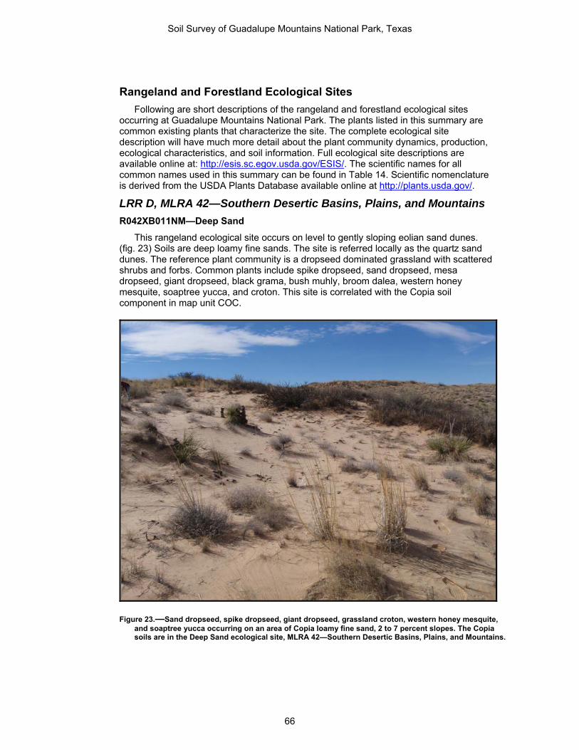
Rangeland and Forestland Ecological Sites Following are short descriptions of the rangeland and forestland ecological sites
occurring at Guadalupe Mountains National Park. The plants listed in this summary are common existing plants that characterize the site. The complete ecological site description will have much more detail about the plant community dynamics, production, ecological characteristics, and soil information. Full ecological site descriptions are available online at: http://esis.sc.egov.usda.gov/ESIS/. The scientific names for all common names used in this summary can be found in Table 14. Scientific nomenclature is derived from the USDA Plants Database available online at http://plants.usda.gov/.
LRR D, MLRA 42—Southern Desertic Basins, Plains, and Mountains
R042XB011NM—Deep Sand
This rangeland ecological site occurs on level to gently sloping eolian sand dunes. (fig. 23) Soils are deep loamy fine sands. The site is referred locally as the quartz sand dunes. The reference plant community is a dropseed dominated grassland with scattered shrubs and forbs. Common plants include spike dropseed, sand dropseed, mesa dropseed, giant dropseed, black grama, bush muhly, broom dalea, western honey mesquite, soaptree yucca, and croton. This site is correlated with the Copia soil component in map unit COC.
Figure 23.—Sand dropseed, spike dropseed, giant dropseed, grassland croton, western honey mesquite, and soaptree yucca occurring on an area of Copia loamy fine sand, 2 to 7 percent slopes. The Copia soils are in the Deep Sand ecological site, MLRA 42—Southern Desertic Basins, Plains, and Mountains.
Soil Survey of Guadalupe Mountains National Park, Texas
66

R042XB007NM—Gyp Outcrop
This rangeland ecological site occurs on gently undulating relic and stabilized gypsum dunes. (fig. 24) Soils range from very shallow to shallow with periodic outcrops of gypsiferous rock. This site is characterized by a high percentage of a biological crust on the soil surface. The reference plant community is a very sparse dwarf shrubland consisting of mostly gypsofiles. Common plants include gyp grama, gyp dropseed, gyp coldenia, rough coldenia, and gyp moonpod. This site is correlated with the Corvus soil component in map unit CPB.
Figure 24.—Sparse vegetation growing on an area of Corvus-Peligro, 1 to 5 percent slopes. Plants pictured include rough coldenia, gyp dropseed, and gyp grama. This site is characterized by high amounts of biological crusts covering the soil surface. Pictured is the Corvus soil component that is in the Gyp Outcrop Ecological Site. MLRA 42—Southern Desertic Basins, Plains, and Mountains.
Soil Survey of Guadalupe Mountains National Park, Texas
67

R042XB006NM—Gyp Upland
This rangeland ecological site occurs on nearly level to undulating relic playa dunes located on basin floors. (fig. 25) Soils are very deep, coarse-loamy, and were formed in eolian gypsiferous sediments. The reference plant community is a midgrass dominated grassland with scattered shrubs and forbs. Common plants include alkali sacaton, spike dropseed, gyp grama, fourwing saltbush, gyp coldenia, and tasajillo. This site is correlated with the Peligro soil component in map units CPB and LPC.
Figure 25.—Alkali sacaton and fourwing saltbush growing within the Corvus-Peligro, 1 to 5 percent slopes map unit. Pictured is the Peligro soil component that is in the Gyp Upland ecological site, MLRA 42—Southern Desertic Basins, Plains, and Mountains.
Soil Survey of Guadalupe Mountains National Park, Texas
68

R042XB012NM—Sandy
This rangeland ecological site occurs on level to gently sloping alluvial fans at elevations between 1,097 to 1,219 m and is found mostly upslope from the salt basin dunes. (fig. 26) Soils are mostly deep sandy loams. The reference plant community is desert grassland with scattered forbs and shrubs. Associated plants include sand dropseed, mesa dropseed, bush muhly, plains bristlegrass, threeawns, creosote bush, soaptree yucca, and fourwing saltbush. This site is correlated with the Monahans and Pajarito soil components in map unit MPB.
Figure 26.—Sand dropseed, mesa dropseed, fourwing saltbush, and soaptree yucca occurring on an area of Monahans-Pajarito complex, 0 to 5 percent slopes. These soils are in the Sandy Ecological Site in MLRA 42—Southern Desertic Basins, Plains, and Mountains.
Soil Survey of Guadalupe Mountains National Park, Texas
69

R042XB003NM—Vegetated Gypsum Dunes
This rangeland ecological site occurs on active gypsum dunes located within the salt basin. (fig. 27) Soils are deep gypsiferous sands. The reference plant community is a sparse shrubland with scattered grasses and forbs. Common plants include gyp grama, Indian ricegrass, frosted mint, soaptree yucca, and gyp coldenia. This site is correlated with the Lark soil component in map unit LPC.
Figure 27.—Frosted mint, gyp grama, and soaptree yucca occurring on gypsum dunes on an area of Lark-Peligro complex, 1 to 8 percent slopes. The Lark soils are in the Vegetated Gypsum Dunes Ecological Site in MLRA 42—Southern Desertic Basins, Plains, and Mountains.
Soil Survey of Guadalupe Mountains National Park, Texas
70

LRR D, MLRA 42—Southern Desertic Basins, Plains, and Mountains
R042XC244TX—Gravelly
This rangeland ecological site occurs on gravelly alluvial fan remnants from limestone hills and mountains that are located primarily along Williams Ranch Road and adjacent areas. (fig. 28) Soils are deep, gravelly, and loamy. The reference plant community is desert grassland with scattered shrubs and forbs. Common plants include black grama, sideoats grama, bush muhly, slim tridens, creosote bush, skeletonleaf goldeneye, range ratany, lechuguilla, western honey mesquite, and tasajillo. This site is correlated to the Chispa soil component in map units CAD and CCD and the Chilicotal soil component in map unit CCD.
Figure 28.—Creosote bush, western honey mesquite, skeletonleaf goldeneye, black grama, and bush muhly occurring on an area of Chilicotal-Chispa complex, 3 to 13 percent slopes. These soils are in the Gravelly (Desert Grassland) Ecological Site, MLRA 42—Southern Desertic Basins, Plains, and Mountains. The historic Williams Ranch house can be seen in the background.
Soil Survey of Guadalupe Mountains National Park, Texas
71

R042XC249TX—Limestone Hill and Mountain
This rangeland ecological site occurs on strongly rolling to steep limestone hills and mountains. (fig. 29) This site includes the Patterson Hills and the steep western most escarpments of the Guadalupe Mountains. Soils are loamy, gravelly, and very shallow. Runoff potential is very high. Outcrops of limestone bedrock are a common feature of this site. The reference plant community is a diverse shrubland with mid and shortgrasses and scattered forbs. Common plants include black grama, sideoats grama, sand dropseed, mariola, creosote bush, ocotillo, lechuguilla, rough ephedra, Gregg’s coldenia, slim tridens, and pricklypear. This site is correlated to the Bissett soil component in map unit BRG.
Figure 29.—Creosote bush, ocotillo, lechuguilla, Gregg’s coldenia, black grama, and slim tridens, growing on an area of Bissett-Rock outcrop complex, 15 to 60 percent slopes. The Bissett soils are in the Limestone Hill and Mountain Ecological Site, MLRA 42—Southern Desertic Basins, Plains, and Mountains.
Soil Survey of Guadalupe Mountains National Park, Texas
72

R042XC007NM—Loamy
This rangeland ecological site occurs on gently undulating basin floors and alluvial fans. (fig. 30) Soils are very deep and mostly fine loamy. The reference plant community is grassland with scattered shrubs and forbs. Common plants include tobosa, burrograss, plains bristlegrass, creosote bush, tarbush, bush muhly, soaptree yucca, and western honey mesquite. This site is correlated to the Tenneco soil component in map unit CAD.
Figure 30.—Plains bristlegrass, bush muhly, tarbush, western honey mesquite, and soaptree yucca growing on Tenneco soils within the Chispa-Tenneco complex, 2 to 9 percent slopes map unit. Patterson Hills can be seen in the background. Tenneco soils are in the Loamy ecological site in MLRA 42—Southern Desertic Basins, Plains, and Mountains.
Soil Survey of Guadalupe Mountains National Park, Texas
73

LRR G, MLRA 70C—Central New Mexico Highlands
F070CY020TX—Limestone Mountain (North Aspect)—(Pseudotsuga menziesii var. glauca-Quercus gambelii/Amelanchier utahensis-Fendlera ruipicola/ Muhlenbergia pauciflora
This forestland ecological site occurs on steep north facing slopes mostly above 2,286 m in elevation. (fig. 31) This site includes high elevation drainages such as at the junction of Tejas and Juniper Trails. Soils are mostly shallow to limestone bedrock and clayey. The reference plant community is a mixed conifer forest. The three conifers characterizing this site are Douglas fir, southwestern white pine, and ponderosa pine. Shrubs or small trees in the understory include Gambel oak, Knowlton hophornbeam, and Utah serviceberry. Limited sunlight allows for significant grass cover, some grasses that occur in this site include New Mexico muhly, Arizona fescue, and nodding brome. This site is correlated with the Victorio soil component in map units VLG and VLH.
Figure 31.—Douglas fir and southwestern white pine growing on an area of Victorio-Lozen-Rock outcrop complex, 10 to 60 percent slopes. The Victorio soil is in the Limestone Mountain (North Aspect) Ecological Site, MLRA 70C—Central New Mexico Highlands.
Soil Survey of Guadalupe Mountains National Park, Texas
74

F070CY747TX—Limestone Mountain (South Aspect), Pinus Ponderosa car. Scopulorum-Pinus edulis/Quercus undulata-Cercocarpus montanus/ Muhlenbergia dubia.
This forestland ecological site occurs on mountain slopes and ridgetops, at elevations generally above 2,286 m. (fig. 32) Aspects are predominantly south facing or neutral. Soils are mostly shallow to limestone bedrock, gravelly, and loamy. The reference plant community is a ponderosa pine savanna. Associated plants include pinyon pine, alligator juniper, oneseed juniper, wavyleaf oak, pine muhly, mountain muhly, New Mexico muhly, bull muhly, little bluestem, big bluestem, yellow Indiangrass, finestem needlegrass, pinyon ricegrass, Arizona fescue, plains lovegrass, cliff fendlerbush, mountain mahogany, and New Mexico agave. This site is correlated with the Lozen soil component in map units VLG and VLH.
Figure 32.—Ponderosa pine, pinyon pine, alligator juniper, wavyleaf oak, pine muhly, mountain muhly, little bluestem, and yellow Indiangrass on an area of Victorio-Lozen-Rock outcrop complex, 10 to 60 percent slopes. The Lozen soils are within the Limestone Mountain (South Aspect) Ecological Site, MLRA 70C—Central New Mexico Highlands.
Soil Survey of Guadalupe Mountains National Park, Texas
75

R070CY115NM—Breaks
This rangeland ecological site occurs on very steep mountain escarpments. (fig. 33) Elevation ranges from 1,584 to 2,590 m. Soils are shallow to limestone bedrock, loamy, and gravelly. Runoff potential is very high. The reference plant community is a mountain shrubland with few scattered trees. Variability in shrub dominance is likely attributed to differences in soil texture, aspect, elevation, and/or rock outcrop. Common plants include wavyleaf oak, mountain mahogany, desert ceanothus, sotol, sacahuista, saddlebush, mariola, fragrant sumac, New Mexico muhly, bull muhly, plains lovegrass, cane bluestem, curlyleaf muhly, and New Mexico feathergrass. This site is correlated to the Lostpeak soil component in map unit LRG.
Figure 33.—Wavyleaf oak, desert ceanothus, mountain mahogany, sotol, New Mexico muhly, and bull muhly growing within Lostpeak-Rock outcrop complex, 40 to 95 percent slopes map unit. The Lostpeak soils are in the Breaks ecological site, MLRA 70C—Central New Mexico Highlands.
Soil Survey of Guadalupe Mountains National Park, Texas
76
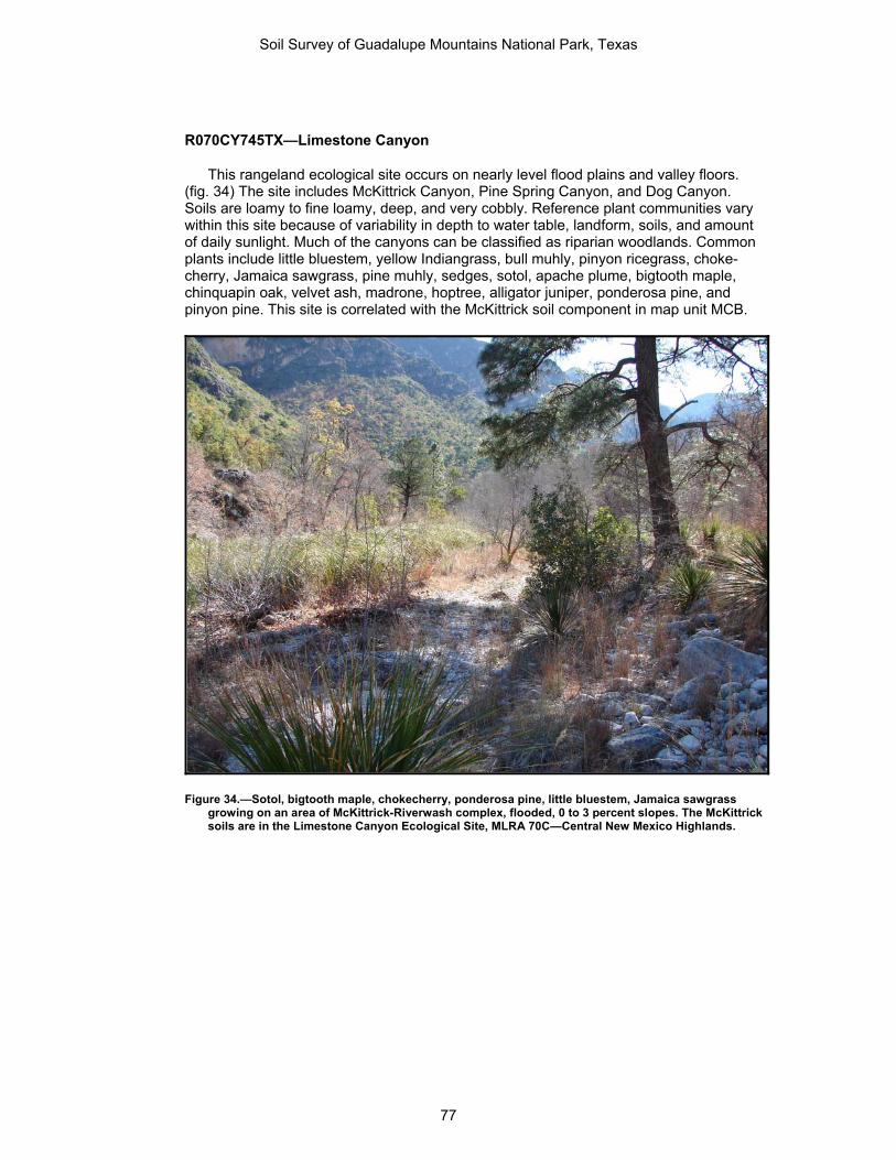
R070CY745TX—Limestone Canyon
This rangeland ecological site occurs on nearly level flood plains and valley floors. (fig. 34) The site includes McKittrick Canyon, Pine Spring Canyon, and Dog Canyon. Soils are loamy to fine loamy, deep, and very cobbly. Reference plant communities vary within this site because of variability in depth to water table, landform, soils, and amount of daily sunlight. Much of the canyons can be classified as riparian woodlands. Common plants include little bluestem, yellow Indiangrass, bull muhly, pinyon ricegrass, choke-cherry, Jamaica sawgrass, pine muhly, sedges, sotol, apache plume, bigtooth maple, chinquapin oak, velvet ash, madrone, hoptree, alligator juniper, ponderosa pine, and pinyon pine. This site is correlated with the McKittrick soil component in map unit MCB.
Figure 34.—Sotol, bigtooth maple, chokecherry, ponderosa pine, little bluestem, Jamaica sawgrass growing on an area of McKittrick-Riverwash complex, flooded, 0 to 3 percent slopes. The McKittrick soils are in the Limestone Canyon Ecological Site, MLRA 70C—Central New Mexico Highlands.
Soil Survey of Guadalupe Mountains National Park, Texas
77

R070CY746TX—Limestone Hill
This rangeland ecological site occurs on limestone hills located mostly around West Dog Canyon in the northwestern part of the park. (fig. 35) Soils are shallow to limestone bedrock, loamy, and gravelly. The reference plant community is mixed prairie grassland with scattered forbs, shrubs, and trees. Common plants include New Mexico feathergrass, agarito, pine muhly, curlyleaf muhly, New Mexico muhly, sideoats grama, sacahuista, mountain mahogany, sotol, pinyon pine, and oneseed juniper. This site is correlated with Biduya and Desario soil components in map unit BDG.
Figure 35.—Sacahuista, agarito, pine muhly, New Mexico muhly, New Mexico feathergrass, and sideoats grama on an area of Biduya-Desario-Rock outcrop complex, 10 to 50 percent slopes. The Biduya and Desario soils are in the Limestone Hill Ecological Site, MLRA 70C—Central New Mexico Highlands.
Soil Survey of Guadalupe Mountains National Park, Texas
78

R070CY109NM—Loamy
This rangeland ecological site occurs on nearly level valley floors located around Dog Canyon, West Dog Canyon, and PX Flat. (fig. 36) Soils are very deep loams. The reference plant community is mixed prairie grassland with scattered shrubs, forbs, and trees. Common plants include blue grama, western wheatgrass, finestem needlegrass, New Mexico feathergrass, wolftail cholla, agarito, oneseed juniper, and pinyon pine. This site is correlated with the Lazarus soil component in map unit LAD.
Figure 36.—Blue grama, finestem needlegrass, wolftail, cholla, and agarito growing on an area of Lazarus loam, 2 to 9 percent slopes map unit. The Lazarus soil is in the Loamy ecological site, MLRA 70C—Central New Mexico Highlands.
Soil Survey of Guadalupe Mountains National Park, Texas
79
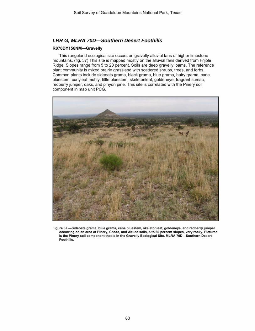
LRR G, MLRA 70D—Southern Desert Foothills
R070DY156NM—Gravelly
This rangeland ecological site occurs on gravelly alluvial fans of higher limestone mountains. (fig. 37) This site is mapped mostly on the alluvial fans derived from Frijole Ridge. Slopes range from 5 to 20 percent. Soils are deep gravelly loams. The reference plant community is mixed prairie grassland with scattered shrubs, trees, and forbs. Common plants include sideoats grama, black grama, blue grama, hairy grama, cane bluestem, curlyleaf muhly, little bluestem, skeletonleaf, goldeneye, fragrant sumac, redberry juniper, oaks, and pinyon pine. This site is correlated with the Pinery soil component in map unit PCG.
Figure 37.—Sideoats grama, blue grama, cane bluestem, skeletonleaf, goldeneye, and redberry juniper occurring on an area of Pinery, Choza, and Altuda soils, 5 to 60 percent slopes, very rocky. Pictured is the Pinery soil component that is in the Gravelly Ecological Site, MLRA 70D—Southern Desert Foothills.
Soil Survey of Guadalupe Mountains National Park, Texas
80

R070DY151NM—Limestone Hills
This rangeland ecological site occurs on limestone hills and footslopes of higher mountains. (fig. 38) Slopes range from 10 to 60 percent. Soils are shallow, gravelly, and loamy. The reference plant community is mixed prairie grassland with scattered shrubs, forbs, and trees. Common plants include sideoats grama, blue grama, curlyleaf muhly, silver dalea, sotol, bull muhly, pine muhly, plains lovegrass, New Mexico feathergrass, fragrant sumac, desert ceanothus, mountain mahogany, wavyleaf oak, redberry juniper, and pinyon pine. This site is associated with the Altuda soil component in map unit PCG.
Figure 38.—Silver dalea, sotol, redberry juniper, sideoats grama, bull muhly, pine muhly, plains lovegrass growing on a recently burned hill side of Altuda soils within the Pinery, Choza and Altuda soils, 5 to 60 percent slopes map unit. Wilderness Ridge can be seen in the background. Altuda soils are in the Limestone Hills ecological site in MLRA 70D—Southern Desert Foothills.
Soil Survey of Guadalupe Mountains National Park, Texas
81

R070DY749TX—Sandstone Hill
This rangeland ecological site occurs on sandstone hills and ridges located primarily around Guadalupe Canyon. (fig. 39) Slopes range from 10 to 60 percent. Soils are coarse loamy, shallow, and gravelly. The reference plant community is mixed prairie grassland with scattered shrubs, trees, and forbs. Common plants include sideoats grama, Warnock’s grama, black grama, New Mexico feathergrass, saddlebush, sotol, New Mexico agave, curlyleaf muhly, mountain mahogany, skeletonleaf goldeneye, yucca, winterfat, mariola, and redberry juniper. This site is correlated to the Bonespring soil component in map unit BSG.
Figure 39.—Saddlebush, mountain mahogany, skeletonleaf goldeneye, sotol, New Mexico Agave, New Mexico feathergrass, Warnock’s grama, and curlyleaf muhly growing within the Bonespring-Rock outcrop complex, 10 to 60 percent slopes map unit. The Bonespring soils are in the Sandstone Hill Ecological Site, MLRA 70D—Southern Desert Foothills.
Soil Survey of Guadalupe Mountains National Park, Texas
82

R070DY152NM—Shallow
This rangeland ecological site occurs on gravelly alluvial fans of higher limestone mountains. (fig. 40) This site is mapped mostly on the alluvial fans derived from Frijole Ridge. Slopes range from 5 to 20 percent. Soils are loamy, gravelly, and very shallow to a petrocalcic horizon also known as a root restricting layer. The reference plant community is mixed prairie grassland with scattered shrubs, trees, and forbs. This site is similar to R070DY156NM Gravelly, but herbaceous plant production is less and curlyleaf muhly dominates the site. Other associated plants include hairy grama, black grama, skunkbush sumac, sotol, pricklypear, redberry juniper, wavyleaf oaks, and pinyon pine. This site is correlated to the Choza soil component in map unit PCG.
Figure 40.—Curlyleaf muhly, sotol, wavyleaf oak, redberry juniper, and pricklypear occurring on an area of Pinery, Choza, and Altuda soils, 5 to 60 percent slopes, very rocky. Pictured is the Choza soil component which is in the Shallow Ecological Site, MLRA 70D—Southern Desert Foothills.
Soil Survey of Guadalupe Mountains National Park, Texas
83

Recreation
The soils of the survey area are rated in Table 15 and Table 16 according to limitations that affect their suitability for recreation. The ratings are both verbal and numerical. Rating class terms indicate the extent to which the soils are limited by all of the soil features that affect the recreational uses. Not limited indicates that the soil has features that are very favorable for the specified use. Good performance and very low maintenance can be expected. Somewhat limited indicates that the soil has features that are moderately favorable for the specified use. The limitations can be overcome or minimized by special planning, design, or installation. Fair performance and moderate maintenance can be expected. Very limited indicates that the soil has one or more features that are unfavorable for the specified use. The limitations generally cannot be overcome without major soil reclamation, special design, or expensive installation procedures. Poor performance and high maintenance can be expected.
Numerical ratings in the tables indicate the severity of individual limitations. The ratings are shown as decimal fractions ranging from 0.01 to 1.00. They indicate gradations between the point at which a soil feature has the greatest negative impact on the use (1.00) and the point at which the soil feature is not a limitation (0.00).
The ratings in the tables are based on restrictive soil features, such as wetness, slope, and texture of the surface layer. Susceptibility to flooding is considered. Not considered in the ratings, but important in evaluating a site, are the location and accessibility of the area, the size and shape of the area and its scenic quality, vegetation, access to water, potential water impoundment sites, and access to public sewer lines. The capacity of the soil to absorb septic tank effluent and the ability of the soil to support vegetation also are important. Soils that are subject to flooding are limited for recreational uses by the duration and intensity of flooding and the season when flooding occurs. In planning recreational facilities, onsite assessment of the height, duration, intensity, and frequency of flooding is essential.
The information in Table 15 and Table 16 can be supplemented by other information in this survey, for example, interpretations for building site development, construction materials, sanitary facilities, and water management.
Camp areas require site preparation, such as shaping and leveling the tent and parking areas, stabilizing roads and intensively used areas, and installing sanitary facilities and utility lines. Camp areas are subject to heavy foot traffic and some vehicular traffic. The ratings are based on the soil properties that affect the ease of developing camp areas and the performance of the areas after development. Slope, stoniness, and depth to bedrock or a cemented pan are the main concerns affecting the development of camp areas. The soil properties that affect the performance of the areas after development are those that influence trafficability and promote the growth of vegetation, especially in heavily used areas. For good trafficability, the surface of camp areas should absorb rainfall readily, remain firm under heavy foot traffic, and not be dusty when dry. The soil properties that influence trafficability are texture of the surface layer, depth to a water table, ponding, flooding, permeability, and large stones. The soil properties that affect the growth of plants are depth to bedrock or a cemented pan, permeability, and toxic substances in the soil.
Picnic areas are subject to heavy foot traffic. Most vehicular traffic is confined to access roads and parking areas. The ratings are based on the soil properties that affect the ease of developing picnic areas and that influence trafficability and the growth of vegetation after development. Slope and stoniness are the main concerns affecting the development of picnic areas. For good trafficability, the surface of picnic areas should absorb rainfall readily, remain firm under heavy foot traffic, and not be dusty when dry. The soil properties that influence trafficability are texture of the surface layer, depth to a water table, ponding, flooding, permeability, and large stones. The soil properties that affect the growth of plants are depth to bedrock or a cemented pan, permeability, and toxic substances in the soil.
Soil Survey of Guadalupe Mountains National Park, Texas
84

Paths and trails for foot traffic and equestrian trails should require little or no slope modification through cutting and filling. The ratings are based on the soil properties that affect trafficability and erodibility. These properties are stoniness, depth to a water table, ponding, flooding, slope, and texture of the surface layer.
Mountain biking and off-road vehicle trails require little or no site preparation. They are not covered with surfacing material or vegetation. Considerable compaction of the soil material is likely. The ratings are based on the soil properties that influence erodibility, trafficability, dustiness, and the ease of revegetation. These properties are stoniness, slope, depth to a seasonal high water table, ponding, flooding, and texture of the surface layer.
Wildlife Soils affect the kind and amount of vegetation that is available to wildlife as food and
cover. They also affect the construction of water impoundments. The kind and abundance of wildlife depend largely on the amount and distribution of food, cover, and water. Wildlife habitat can be created or improved by planting appropriate vegetation, by maintaining the existing plant cover, or by promoting the natural establishment of desirable plants.
Historically, the kinds and numbers of wildlife have changed considerably since the settlement by European man. Prior to early settlements, the grasslands and mountains of Guadalupe Mountains National Park supported elk, pronghorn antelope, bighorn sheep, mule deer, white-tailed deer, gray wolf, black bear, and mountain lion plus hundreds of species of smaller animals.
Guadalupe Mountains National Park supports an abundance of wildlife. The basic habitat needs of any wildlife population are food, cover, water and space in the right combination and arrangement. Each species of animal has its own unique requirements for these habitat elements. In order for wildlife to inhabit an area, the land must either naturally provide the habitat needs, or it must be managed by man so that specific habitat needs are met.
Soils have a great influence on the kinds and amounts of plants that are available for wildlife food and cover. The soils in the survey area are grouped into ecological sites according to the kinds, amounts and proportions of plants which the soils and climate can support as shown in Table 10. Ecological sites vary in their ability to meet habitat needs, and can be managed to either harm or benefit wildlife. Soils and geology influence the distribution of surface water used by wildlife. The past and present management of the land also influences wildlife habitat. Therefore, a good understanding of soils, ecological sites, and their response to management is important to proper wildlife habitat management. For detailed information on ecological sites, refer to the Ecological Site Descriptions for Guadalupe Mountains National Park section of this soil survey.
Wildlife is a valuable part of the natural resources in the survey area. Wildlife has aesthetic value, enriching the lives of people who enjoy seeing them. They have ecological value, with each species playing a role in the complex balance of nature. Some species may have scientific value that is not yet recognized. Some kinds of wildlife also have a legitimate economic value which encourages proper habitat management. The conservation of wildlife as well as the soil, water, and plant resources is an important part of man's stewardship of the land.
The Guadalupe Mountains rise sharply from the surrounding desert floor to form an island of outstanding diversity. Several different ecosystems, or life zones, are found within the park. These include the harsh Chihuahuan desert community, lush streamside woodlands of oaks and maples, rocky canyons, and mountaintop forests of ponderosa pine and Douglas fir. Together, these ecosystems provide habitat for 60 species of mammals, 289 species of birds, and 55 species of reptiles.
Soil Survey of Guadalupe Mountains National Park, Texas
85

At first glance, the desert may seem barren and nearly devoid of life. A closer look however, will reveal that it actually supports an amazing diversity of wildlife. Desert animals are often difficult to view since many of them are nocturnal. Many desert animals adapt to the hot, dry environment by coming out after dark, when temperatures are much cooler and conditions are not quite so dry. Nocturnal desert animals include the kit fox, coyote, mountain lion, bobcat, badger, Texas banded gecko, and about 16 species of bats. Mule deer, javelinas, and black-tailed jackrabbits are seen early in the morning or late in the evening when temperatures are cooler.
Desert reptiles include the western diamondback rattlesnake, bullsnake, coachwhip snake, prairie lizard, collared lizard, crevice spiny lizard, and the Chihuahuan spotted whiptail. Almost all of the lizards found in the park can be seen during the day. Scorpions and desert centipedes are nocturnal hunters that search the night for insects, spiders, and small lizards. In the fall, tarantulas can often be seen looking for mates. The rest of the year, tarantulas rarely leave the shelter of their burrows.
One of the most unique and unexpected ecosystems in the Guadalupe Mountains is the riparian or streamside woodland. Riparian woodlands occur in places where there is water. Mule deer are one of the most common animals seen in the riparian areas. Nocturnal mammals such as skunks and raccoons can also be found here. Long-ear sunfish can be seen in some of the springs in the park, as well as in McKittrick Canyon. The stream through McKittrick Canyon is also home to a small population of rainbow trout. Although amphibians are rare in the desert, the Rio Grande leopard frog can occasionally be encountered near spring-fed pools in McKittrick Canyon, or at Manzanita and Smith Springs.
Rocky canyons are home to ringtails, rock squirrels, and a variety of reptiles including rock and black-tailed rattlesnakes, mountain patchnose snakes, and tree lizards.
On the mountaintops, over 914 m above the desert, one can find extensive pine forests. It is usually at least ten degrees cooler on the mountaintops than at the lower elevations. Mountaintop forests are home to animals such as elk, black bear, gray foxes, striped and hog-nosed skunks, porcupine, mule deer, mountain lions, and mountain short-horned lizards. For more information on the animals in the park, visit the website at http://www.nps.gov/gumo/naturescience/animals.htm
Wildlife Habitat Soils affect the kind and amount of vegetation that is available to wildlife as food and
cover. They also affect the construction of water impoundments. The kind and abundance of wildlife depend largely on the amount and distribution of food, cover, and water. Wildlife habitat can be created or improved by planting appropriate vegetation, by maintaining the existing plant cover, or by promoting the natural establishment of desirable plants.
Table 17, Table 18, and Table 19 show the degree and kind of soil limitations that affect various kinds of habitat for wildlife. The tables show limitations of the soils for upland native herbaceous plants; upland desertic shrubs and trees; upland shrubs and vines; upland deciduous trees; upland coniferous trees; riparian herbaceous plants; and riparian shrubs, vines, and trees, This information can be used in planning parks, wildlife refuges, nature study areas, and other developments for wildlife; in selecting areas for establishing, improving, or maintaining specific elements of wildlife habitat; and in determining the intensity of management needed for each element of the habitat.
Rating class terms indicate the extent to which the soils are limited by all of the soil features that affect the element or kind of habitat. Not limited indicates that the soil has features that are very favorable for the element or kind of habitat. Good performance and very low maintenance can be expected. Slightly limited indicates that the soil has features that are favorable for the specified use. The limitations are minor and can be easily overcome. Good performance and low maintenance can be expected. Somewhat limited indicates that the soil has features that are moderately favorable for the specified
Soil Survey of Guadalupe Mountains National Park, Texas
86

use. The limitations can be overcome or minimized by special planning, design, or installation. Fair performance and moderate maintenance can be expected. Very limited indicates that the soil has one or more features that are unfavorable for the specified use. The limitations generally cannot be overcome without major soil reclamation, special design, or expensive installation procedures. Creating, improving, or maintaining habitat is impractical or impossible.
Numerical ratings in the tables indicate the severity of individual limitations. The ratings are shown as decimal fractions ranging from 0.01 to 1.00. They indicate gradations between the point at which a soil feature has the greatest negative impact on the use (1.00) and the point at which the soil feature is not a limitation (0.00).
Ratings for upland native herbaceous plants indicate the limitation of the soils as a growing medium for a diverse upland herbaceous plant community. This community is adapted to soils that are drier than the common soils in moist riparian and wetland zones but that are not as dry as the soils in upland desert areas. The soil properties and features that affect the ability of these species to thrive include soil texture, available water capacity, the presence of excess salts in the soil, soil moisture and temperature regimes, depth to a high water table, and rock fragments on the soil surface. Examples of upland native herbaceous plants are gyp coldenia, black grama, slim tridens, dropseeds, black grama, sideoats grama, alkali sacaton, fourwing saltbush, soaptree yucca, blue grama, sideoats grama, curlyleaf muhly, pine muhly, New Mexico feathergrass, and finestem needlegrass
Ratings for upland desertic shrubs and trees provide guidelines for determining soil quality as a medium for growing a diverse upland herbaceous plant community which is adapted to soil conditions in an arid or semiarid environment that is drier than that common to moist riparian and wetland zones and subhumid, humid, or tropical areas. Soil properties and features that affect the ability of these species to thrive include: soil texture, available water capacity, depth to high water table, the presence of excess salts in the soil, soil reaction (pH), soil moisture and temperature regimes, and the presence of rock fragments at the soil surface. Examples of upland desertic shrubs and trees are creosote bush, lechuguilla, ocotillo, whitethorn acacia, and western honey mesquite
Ratings for upland shrubs and vines indicate the limitation of the soils as a growing medium for a diverse upland shrub and vine community. This community is adapted to soils that are drier than those common in the moist riparian and wetland zones but that are not as dry as those in upland desert areas. The soil properties and features that affect the ability of these species to thrive include soil texture, content of organic matter, available water capacity, depth to bedrock or a cemented pan, the presence of excess salts in the soil, soil moisture and temperature regimes, depth to a high water table, and rock fragments on the soil surface. Examples of upland shrubs and vines are fragrant sumac, redberry juniper, oaks, oneseed juniper, pinyon pine, wavyleaf oak, cholla, Gambel oak, Knowlton hophornbeam, Mescalero currant, and Utah serviceberry
Ratings for upland deciduous trees provide guidelines for determining soil quality as a medium for growing a diverse upland deciduous tree community that meet specific local habitat requirements for targeted and non-targeted species of wildlife. Typically, deciduous trees require better soil conditions than geographically related conifers. The soil properties and features that affect the ability of these species to thrive include available water capacity, depth to high water table, depth to bedrock or pan, and soil moisture and temperature regime. Examples of upland deciduous trees are bigtooth maple, velvet ash, and madrone
Ratings for upland coniferous trees provide guidelines for determining soil quality as a medium for growing a diverse upland coniferous tree community that meet specific local habitat requirements for targeted and non-targeted species of wildlife. Typically, coniferous trees can subsist in harsher soil conditions than geographically related hardwoods and the soil properties and features that affect the ability of these species to thrive include available water capacity, depth to high water table, depth to bedrock or
Soil Survey of Guadalupe Mountains National Park, Texas
87

pan, and soil moisture and temperature regime. Examples of upland coniferous trees are Douglas fir, ponderosa pine, and southwestern white pine
Ratings for riparian herbaceous plants indicate the limitation of the soils as a growing medium for herbaceous plants that are adapted to soil conditions that are wetter than those common in the drier upland areas. The soils suitable for this habitat generally are on flood plains, in depressions, on bottomland, in drainageways adjacent to streams, or in any other area where the soil either is saturated for some period during the year or is subject to periodic overflow from ponding or flooding. The soil properties and features that affect the ability of riparian herbaceous plants to persist include soil texture, content of organic matter, depth to a high water table, the frequency and duration of ponding and flooding, the presence of excess salts in the soil, rock fragments, and the soil temperature regime. Examples of riparian herbaceous plants are pine muhly, bull muhly, little bluestem, yellow Indiangrass, big bluestem, and pinyon ricegrass
Ratings for riparian shrubs, vines, and trees indicate the limitation of the soils as a growing medium for shrubs, vines, and trees that are adapted to soil conditions that are wetter than those common in the drier upland areas. The soils suitable for this habitat generally are on flood plains, in depressions, on bottomland, in drainageways adjacent to streams, in areas of springs and seeps, or in any other area where the soil is either saturated for some period during the year or is subject to periodic overflow from ponding or flooding. The soil properties and features that affect the ability of riparian shrubs, vines, and trees to persist include available water capacity, depth to a high water table, the frequency and duration of ponding and flooding, the presence of excess salts in the soil, and the soil temperature regime. Examples of riparian shrubs, vines, and trees are bigtooth maple, velvet ash, madrone, alligator juniper, rocky mountain juniper, ponderosa pine, hoptree, apache plume, and catclaw mimosa.
Hydric Soils In this section, hydric soils are defined and described and the hydric soils in the
survey area, if present, are listed. The three essential characteristics of wetlands are hydrophytic vegetation, hydric
soils, and wetland hydrology (Cowardin and others, 1979; U.S. Army Corps of Engineers, 1987; National Research Council, 1995; Tiner, 1985). Criteria for each of the characteristics must be met for areas to be identified as wetlands. Undrained hydric soils that have natural vegetation should support a dominant population of ecological wetland plant species. Hydric soils that have been converted to other uses should be capable of being restored to wetlands.
Hydric soils are defined by the National Technical Committee for Hydric Soils (NTCHS) as soils that formed under conditions of saturation, flooding, or ponding long enough during the growing season to develop anaerobic conditions in the upper part (Federal Register, 1994). These soils are either saturated or inundated long enough during the growing season to support the growth and reproduction of hydrophytic vegetation.
The NTCHS definition identifies general soil properties that are associated with wetness. In order to determine whether a specific soil is a hydric soil or nonhydric soil, however, more specific information, such as information about the depth and duration of the water table, is needed. Thus, criteria that identify those estimated soil properties unique to hydric soils have been established (Federal Register, 1995). These criteria are used to identify a phase of a soil series that normally is associated with wetlands. The criteria used are selected estimated soil properties that are described in "Soil Taxonomy" (Soil Survey Staff, 1999) and "Keys to Soil Taxonomy" (Soil Survey Staff, 1998) and in the "Soil Survey Manual" (Soil Survey Division Staff, 1993).
If soils are wet enough for a long enough period to be considered hydric, they should exhibit certain properties that can be easily observed in the field. These visible properties
Soil Survey of Guadalupe Mountains National Park, Texas
88

are indicators of hydric soils. The indicators used to make onsite determinations of hydric soils in this survey area are specified in "Field Indicators of Hydric Soils in the United States" (Hurt and others, 1998).
Hydric soils are identified by examining and describing the soil to a depth of about 20 inches. This depth may be greater if determination of an appropriate indicator so requires. It is always recommended that soils be excavated and described to the depth necessary for an understanding of the redoximorphic processes. Then, using the completed soil descriptions, soil scientists can compare the soil features required by each indicator and specify which indicators have been matched with the conditions observed in the soil. The soil can be identified as a hydric soil if at least one of the approved indicators is present.
Map units that are made up of hydric soils may have small areas, or inclusions, of nonhydric soils in the higher positions on the landform, and map units made up of nonhydric soils may have inclusions of hydric soils in the lower positions on the landform.
There are no hydric soils identified in Guadalupe Mountains National Park.
Engineering This section provides information for planning land uses related to urban development
and to water management. Soils are rated for various uses, and the most limiting features are identified. Ratings are given for building site development, sanitary facilities, construction materials, and water management. The ratings are based on observed performance of the soils and on the data in the tables described under the heading "Soil Properties."
Information in this section is intended for land use planning, for evaluating land use alternatives, and for planning site investigations prior to design and construction. The information, however, has limitations. For example, estimates and other data generally apply only to that part of the soil between the surface and a depth of 5 to 7 feet. Because of the map scale, small areas of different soils may be included within the mapped areas of a specific soil.
The information is not site specific and does not eliminate the need for onsite investigation of the soils or for testing and analysis by personnel experienced in the design and construction of engineering works.
Government ordinances and regulations that restrict certain land uses or impose specific design criteria were not considered in preparing the information in this section. Local ordinances and regulations should be considered in planning, in site selection, and in design.
Soil properties, site features, and observed performance were considered in determining the ratings in this section. During the fieldwork for this soil survey, determinations were made about particle-size distribution, liquid limit, plasticity index, soil reaction, depth to bedrock, hardness of bedrock within 5 to 7 feet of the surface, soil wetness, depth to a water table, ponding, slope, likelihood of flooding, natural soil structure aggregation, and soil density. Data were collected about kinds of clay minerals, mineralogy of the sand and silt fractions, and the kinds of adsorbed cations. Estimates were made for erodibility, permeability, corrosivity, shrink-swell potential, available water capacity, and other behavioral characteristics affecting engineering uses.
This information can be used to evaluate the potential of areas for residential, commercial, industrial, and recreational uses; make preliminary estimates of construction conditions; evaluate alternative routes for roads, streets, highways, pipelines, and underground cables; evaluate alternative sites for sanitary landfills, septic tank absorption fields, and sewage lagoons; plan detailed onsite investigations of soils and geology; locate potential sources of gravel, sand, earthfill, and topsoil; plan drainage systems, irrigation systems, ponds, terraces, and other structures for soil and water conservation;
Soil Survey of Guadalupe Mountains National Park, Texas
89

and predict performance of proposed small structures and pavements by comparing the performance of existing similar structures on the same or similar soils.
The information in the tables, along with the soil maps, the soil descriptions, and other data provided in this survey, can be used to make additional interpretations.
Some of the terms used in this soil survey have a special meaning in soil science and are defined in the Glossary.
Building Site Development Soil properties influence the development of building sites, including the selection of
the site, the design of the structure, construction, performance after construction, and maintenance. Table 20 and Table 21 shows the degree and kind of soil limitations that affect dwellings with and without basements, small commercial buildings, local roads and streets, shallow excavations, and lawns and landscaping.
Rating class terms indicate the extent to which the soils are limited by all of the soil features that affect building site development. Not limited indicates that the soil has features that are very favorable for the specified use. Good performance and very low maintenance can be expected. Somewhat limited indicates that the soil has features that are moderately favorable for the specified use. The limitations can be overcome or minimized by special planning, design, or installation. Fair performance and moderate maintenance can be expected. Very limited indicates that the soil has one or more features that are unfavorable for the specified use. The limitations generally cannot be overcome without major soil reclamation, special design, or expensive installation procedures. Poor performance and high maintenance can be expected.
Numerical ratings in the tables indicate the severity of individual limitations. The ratings are shown as decimal fractions ranging from 0.01 to 1.00. They indicate gradations between the point at which a soil feature has the greatest negative impact on the use (1.00) and the point at which the soil feature is not a limitation (0.00).
Dwellings are single-family houses of three stories or less. For dwellings without basements, the foundation is assumed to consist of spread footings of reinforced concrete built on undisturbed soil at a depth of 2 feet or at the depth of maximum frost penetration, whichever is deeper. For dwellings with basements, the foundation is assumed to consist of spread footings of reinforced concrete built on undisturbed soil at a depth of about 7 feet. The ratings for dwellings are based on the soil properties that affect the capacity of the soil to support a load without movement and on the properties that affect excavation and construction costs. The properties that affect the load-supporting capacity include depth to a water table, ponding, flooding, subsidence, linear extensibility (shrink-swell potential), and compressibility. Compressibility is inferred from the Unified classification. The properties that affect the ease and amount of excavation include depth to a water table, ponding, flooding, slope, depth to bedrock or a cemented pan, hardness of bedrock or a cemented pan, and the amount and size of rock fragments.
Small commercial buildings are structures that are less than three stories high and do not have basements. The foundation is assumed to consist of spread footings of reinforced concrete built on undisturbed soil at a depth of 2 feet or at the depth of maximum frost penetration, whichever is deeper. The ratings are based on the soil properties that affect the capacity of the soil to support a load without movement and on the properties that affect excavation and construction costs. The properties that affect the load-supporting capacity include depth to a water table, ponding, flooding, subsidence, linear extensibility (shrink-swell potential), and compressibility (which is inferred from the Unified classification). The properties that affect the ease and amount of excavation include flooding, depth to a water table, ponding, slope, depth to bedrock or a cemented pan, hardness of bedrock or a cemented pan, and the amount and size of rock fragments.
Local roads and streets have an all-weather surface and carry automobile and light truck traffic all year. They have a subgrade of cut or fill soil material; a base of gravel,
Soil Survey of Guadalupe Mountains National Park, Texas
90

crushed rock, or soil material stabilized by lime or cement; and a surface of flexible material (asphalt), rigid material (concrete), or gravel with a binder. The ratings are based on the soil properties that affect the ease of excavation and grading and the traffic-supporting capacity. The properties that affect the ease of excavation and grading are depth to bedrock or a cemented pan, hardness of bedrock or a cemented pan, depth to a water table, ponding, flooding, the amount of large stones, and slope. The properties that affect the traffic-supporting capacity are soil strength (as inferred from the AASHTO group index number), subsidence, linear extensibility (shrink-swell potential), the potential for frost action, depth to a water table, and ponding.
Shallow excavations are trenches or holes dug to a maximum depth of 5 or 6 feet for graves, utility lines, open ditches, or other purposes. The ratings are based on the soil properties that influence the ease of digging and the resistance to sloughing. Depth to bedrock or a cemented pan, hardness of bedrock or a cemented pan, the amount of large stones, and dense layers influence the ease of digging, filling, and compacting. Depth to the seasonal high water table, flooding, and ponding may restrict the period when excavations can be made. Slope influences the ease of using machinery. Soil texture, depth to the water table, and linear extensibility (shrink-swell potential) influence the resistance to sloughing.
Landscaping requires soils on which turf and ornamental trees and shrubs can be established and maintained. Irrigation is not considered in the ratings. The ratings are based on the soil properties that affect plant growth and trafficability after vegetation is established. The properties that affect plant growth are reaction; depth to a water table; ponding; depth to bedrock or a cemented pan; the available water capacity in the upper 40 inches; the content of salts, sodium, or calcium carbonate; and sulfidic materials. The properties that affect trafficability are flooding, depth to a water table, ponding, slope, stoniness, and the amount of sand, clay, or organic matter in the surface layer.
Sanitary Facilities Table 22 shows the degree and kind of soil limitations that affect septic tank
absorption fields, sewage lagoons, sanitary landfills, and daily cover for landfill. The ratings are both verbal and numerical. Rating class terms indicate the extent to which the soils are limited by all of the soil features that affect these uses. Not limited indicates that the soil has features that are very favorable for the specified use. Good performance and very low maintenance can be expected. Somewhat limited indicates that the soil has features that are moderately favorable for the specified use. The limitations can be overcome or minimized by special planning, design, or installation. Fair performance and moderate maintenance can be expected. Very limited indicates that the soil has one or more features that are unfavorable for the specified use. The limitations generally cannot be overcome without major soil reclamation, special design, or expensive installation procedures. Poor performance and high maintenance can be expected.
Numerical ratings in the tables indicate the severity of individual limitations. The ratings are shown as decimal fractions ranging from 0.01 to 1.00. They indicate gradations between the point at which a soil feature has the greatest negative impact on the use (1.00) and the point at which the soil feature is not a limitation (0.00).
Septic tank absorption fields are areas in which effluent from a septic tank is distributed into the soil through subsurface tiles or perforated pipe. Only that part of the soil between depths of 24 and 60 inches is evaluated. The ratings are based on the soil properties that affect absorption of the effluent, construction and maintenance of the system, and public health. Permeability, depth to a water table, ponding, depth to bedrock or a cemented pan, and flooding affect absorption of the effluent. Stones and boulders, ice, and bedrock or a cemented pan interfere with installation. Subsidence interferes with installation and maintenance. Excessive slope may cause lateral seepage and surfacing of the effluent in down slope areas.
Soil Survey of Guadalupe Mountains National Park, Texas
91

Some soils are underlain by loose sand and gravel or fractured bedrock at a depth of less than 4 feet below the distribution lines. In these soils the absorption field may not adequately filter the effluent, particularly when the system is new. As a result, the ground water may become contaminated.
Sewage lagoons are shallow ponds constructed to hold sewage while aerobic bacteria decompose the solid and liquid wastes. Lagoons should have a nearly level floor surrounded by cut slopes or embankments of compacted soil. Nearly impervious soil material for the lagoon floor and sides is required to minimize seepage and contamination of ground water. Considered in the ratings are slope, permeability, depth to a water table, ponding, depth to bedrock or a cemented pan, flooding, large stones, and content of organic matter.
Soil permeability is a critical property affecting the suitability for sewage lagoons. Most porous soils eventually become sealed when they are used as sites for sewage lagoons. Until sealing occurs, however, the hazard of pollution is severe. Soils that have a permeability rate of more than 2 inches per hour are too porous for the proper functioning of sewage lagoons. In these soils, seepage of the effluent can result in contamination of the ground water. Ground-water contamination is also a hazard if fractured bedrock is within a depth of 40 inches, if the water table is high enough to raise the level of sewage in the lagoon, or if floodwater overtops the lagoon.
A high content of organic matter is detrimental to proper functioning of the lagoon because it inhibits aerobic activity. Slope, bedrock, and cemented pans can cause construction problems, and large stones can hinder compaction of the lagoon floor. If the lagoon is to be uniformly deep throughout, the slope must be gentle enough and the soil material must be thick enough over bedrock or a cemented pan to make land smoothing practical.
Construction Materials Table 23 and Table 24 provides information about the soils as potential sources of
gravel, sand, topsoil, reclamation material, and roadfill. Normal compaction, minor processing, and other standard construction practices are assumed.
Sand and gravel are natural aggregates suitable for commercial use with a minimum of processing. They are used in many kinds of construction. Specifications for each use vary widely. In Table 23, only the likelihood of finding material in suitable quantity is evaluated. The suitability of the material for specific purposes is not evaluated, nor are factors that affect excavation of the material. The properties used to evaluate the soil as a source of sand or gravel are gradation of grain sizes (as indicated by the Unified classification of the soil), the thickness of suitable material, and the content of rock fragments. If the bottom layer of the soil contains sand or gravel, the soil is considered a likely source regardless of thickness. The assumption is that the sand or gravel layer below the depth of observation exceeds the minimum thickness.
The soils are rated good, fair, or poor as potential sources of sand and gravel. A rating of good or fair means that the source material is likely to be in or below the soil. The bottom layer and the thickest layer of the soils are assigned numerical ratings. These ratings indicate the likelihood that the layer is a source of sand or gravel. The number 0.00 indicates that the layer is a poor source. The number 1.00 indicates that the layer is a good source. A number between 0.00 and 1.00 indicates the degree to which the layer is a likely source.
The soils are rated good, fair, or poor as potential sources of topsoil, reclamation material, and roadfill. The features that limit the soils as sources of these materials are specified in the tables. The numerical ratings given after the specified features indicate the degree to which the features limit the soils as sources of topsoil, reclamation material, or roadfill. The lower the number, the greater the limitation.
Reclamation source is used in areas that have been drastically disturbed by surface mining or similar activities. When these areas are reclaimed, layers of soil material or
Soil Survey of Guadalupe Mountains National Park, Texas
92

unconsolidated geological material, or both, are replaced in a vertical sequence. The reconstructed soil favors plant growth. The ratings in the table do not apply to quarries and other mined areas that require an offsite source of reconstruction material. The ratings are based on the soil properties that affect erosion and stability of the surface and the productive potential of the reconstructed soil. These properties include the content of sodium, salts, and calcium carbonate; reaction; available water capacity; erodibility; texture; content of rock fragments; and content of organic matter and other features that affect fertility.
Roadfill source is soil material that is excavated in one place and used in road embankments in another place. In this table, the soils are rated as a source of roadfill for low embankments, generally less than 6 feet high and less exacting in design than higher embankments.
The ratings are for the whole soil, from the surface to a depth of about 5 feet. It is assumed that soil layers will be mixed when the soil material is excavated and spread.
The ratings are based on the amount of suitable material and on soil properties that affect the ease of excavation and the performance of the material after it is in place. The thickness of the suitable material is a major consideration. The ease of excavation is affected by large stones, depth to a water table, and slope. How well the soil performs in place after it has been compacted and drained is determined by its strength (as inferred from the AASHTO classification of the soil) and linear extensibility (shrink-swell potential).
Topsoil source is used to cover an area so that vegetation can be established and maintained. The upper 40 inches of a soil is evaluated for use as topsoil. Also evaluated is the reclamation potential of the borrow area. The ratings are based on the soil properties that affect plant growth; the ease of excavating, loading, and spreading the material; and reclamation of the borrow area. Toxic substances, soil reaction, and the properties that are inferred from soil texture, such as available water capacity and fertility, affect plant growth. The ease of excavating, loading, and spreading is affected by rock fragments, slope, depth to a water table, soil texture, and thickness of suitable material. Reclamation of the borrow area is affected by slope, depth to a water table, rock fragments, depth to bedrock or a cemented pan, and toxic material.
The surface layer of most soils is generally preferred for topsoil because of its organic matter content. Organic matter greatly increases the absorption and retention of moisture and nutrients for plant growth.
Water Management Table 25 provides information on the soil properties and site features that affect water
management. The degree and kind of soil limitations are given for pond reservoir areas; embankments, dikes, and levees; and aquifer-fed excavated ponds. The ratings are both verbal and numerical. Rating class terms indicate the extent to which the soils are limited by all of the soil features that affect these uses. Not limited indicates that the soil has features that are very favorable for the specified use. Good performance and very low maintenance can be expected. Somewhat limited indicates that the soil has features that are moderately favorable for the specified use. The limitations can be overcome or minimized by special planning, design, or installation. Fair performance and moderate maintenance can be expected. Very limited indicates that the soil has one or more features that are unfavorable for the specified use. The limitations generally cannot be overcome without major soil reclamation, special design, or expensive installation procedures. Poor performance and high maintenance can be expected.
Numerical ratings in the tables indicate the severity of individual limitations. The ratings are shown as decimal fractions ranging from 0.01 to 1.00. They indicate gradations between the point at which a soil feature has the greatest negative impact on the use (1.00) and the point at which the soil feature is not a limitation (0.00).
Pond reservoir areas (fig. 17) hold water behind a dam or embankment. Soils best suited to this use have low seepage potential in the upper 60 inches. The seepage
Soil Survey of Guadalupe Mountains National Park, Texas
93

potential is determined by the permeability of the soil and the depth to fractured bedrock or other permeable material. Excessive slope can affect the storage capacity of the reservoir area.
Embankments, dikes, and levees are raised structures of soil material, generally less than 20 feet high, constructed to impound water or to protect land against overflow. Embankments that have zoned construction (core and shell) are not considered. In this table, the soils are rated as a source of material for embankment fill. The ratings apply to the soil material below the surface layer to a depth of about 5 feet. It is assumed that soil layers will be uniformly mixed and compacted during construction.
The ratings do not indicate the ability of the natural soil to support an embankment. Soil properties to a depth even greater than the height of the embankment can affect performance and safety of the embankment. Generally, deeper onsite investigation is needed to determine these properties.
Soil material in embankments must be resistant to seepage, piping, and erosion and have favorable compaction characteristics. Unfavorable features include less than 5 feet of suitable material and a high content of stones or boulders, organic matter, or salts or sodium. A high water table affects the amount of usable material. It also affects trafficability.
Aquifer-fed excavated ponds are pits or dugouts that extend to a ground-water aquifer or to a depth below a permanent water table. Excluded are ponds that are fed only by surface runoff and embankment ponds that impound water 3 feet or more above the original surface. Excavated ponds are affected by depth to a permanent water table, permeability of the aquifer, and quality of the water as inferred from the salinity of the soil. Depth to bedrock and the content of large stones affect the ease of excavation.
Soil Survey of Guadalupe Mountains National Park, Texas
94

Soil Properties
Data relating to soil properties are collected during the course of the soil survey. Soil properties are ascertained by field examination of the soils and by laboratory
index testing of some benchmark soils. Established standard procedures are followed. During the survey, many shallow borings are made and examined to identify and classify the soils and to delineate them on the soil maps. Samples are taken from some typical profiles and tested in the laboratory to determine particle-size distribution, plasticity, and compaction characteristics.
Estimates of soil properties are based on field examinations, on laboratory tests of samples from the survey area, and on laboratory tests of samples of similar soils in nearby areas. Tests verify field observations, verify properties that cannot be estimated accurately by field observation, and help to characterize key soils.
The estimates of soil properties are shown in tables. They include engineering properties, and physical and chemical properties.
Engineering Properties Table 26 provides the engineering classifications and the range of engineering
properties for the layers of each soil in the survey area. Depth to the upper and lower boundaries of each layer is indicated. Texture is given in the standard terms used by the U.S. Department of
Agriculture. These terms are defined according to percentages of sand, silt, and clay in the fraction of the soil that is less than 2 millimeters across. "Loam," for example, is soil that is 7 to 27 percent clay, 28 to 50 percent silt, and less than 52 percent sand. If the content of particles coarser than sand is 15 percent or more, an appropriate modifier is added, for example, "gravelly." Textural terms are defined in the Glossary.
Classification of the soils is determined according to the Unified soil classification system (ASTM, 2005) and the system adopted by the American Association of State Highway and Transportation Officials (AASHTO, 2004).
The Unified system classifies soils according to properties that affect their use as construction material. Soils are classified according to particle-size distribution of the fraction less than 3 inches across and according to plasticity index, liquid limit, and organic matter content. Sandy and gravelly soils are identified as GW, GP, GM, GC, SW, SP, SM, and SC; silty and clayey soils as ML, CL, OL, MH, CH, and OH; and highly organic soils as PT. Soils exhibiting engineering properties of two groups can have a dual classification, for example, CL-ML.
The AASHTO system classifies soils according to those properties that affect roadway construction and maintenance. In this system, the fraction of a mineral soil that is less than 3 inches across is classified in one of seven groups from A-1 through A-7 on the basis of particle-size distribution, liquid limit, and plasticity index. Soils in group A-1 are coarse grained and low in content of fines (silt and clay). At the other extreme, soils in group A-7 are fine grained. Highly organic soils are classified in group A-8 on the basis of visual inspection. If laboratory data are available, the A-1, A-2, and A-7 groups are further classified as A-1-a, A-1-b, A-2-4, A-2-5, A-2-6, A-2-7, A-7-5, or A-7-6. As an additional refinement, the suitability of a soil as subgrade material can be indicated by a group index number. Group index numbers range from 0 for the best subgrade material to 20 or higher for the poorest.
95

Rock fragments larger than 10 inches across and 3 to 10 inches across are indicated as a percentage of the total soil on a dry-weight basis. The percentages are estimates determined mainly by converting volume percentage in the field to weight percentage.
Percentage (of soil particles) passing designated sieves is the percentage of the soil fraction less than 3 inches across based on an ovendry weight. The sieves, numbers 4, 10, 40, and 200 (USA Standard Series), have openings of 4.76, 2.00, 0.420, and 0.074 millimeters, respectively. Estimates are based on laboratory tests of soils sampled in the survey area and in nearby areas and on estimates made in the field.
Liquid limit and plasticity index (Atterberg limits) indicate the plasticity characteristics of a soil. The estimates are based on test data from the survey area or from nearby areas and on field examination.
The estimates of particle-size distribution, liquid limit, and plasticity index are generally rounded to the nearest 5 percent. Thus, if the ranges of gradation and Atterberg limits extend a marginal amount (1 or 2 percentage points) across classification boundaries, the classification in the marginal zone is generally omitted in the table.
Physical Soil Properties Table 27 shows estimates of some physical characteristics and features that
affect soil behavior. These estimates are given for the layers of each soil in the survey area. The estimates are based on field observations and on test data for these and similar soils.
Depth to the upper and lower boundaries of each layer is indicated. Particle-size (sand, silt, and clay) is the effective diameter of a soil particle as
measured by sedimentation, sieving, or micrometric methods. Particle-sizes are expressed as classes with specific effective diameter class limits. The broad classes are sand, silt, and clay, ranging from the larger to the smaller.
Sand as a soil separate consists of mineral soil particles that are 0.05 millimeter to 2 millimeters in diameter. In the table, the estimated sand content of each soil layer is given as a percentage, by weight, of the soil material that is less than 2 millimeters in diameter.
Silt as a soil separate consists of mineral soil particles that are 0.002 to 0.05 millimeter in diameter. In the table, the estimated silt content of each soil layer is given as a percentage, by weight, of the soil material that is less than 2 millimeters in diameter.
Clay as a soil separate consists of mineral soil particles that are less than 0.002 millimeter in diameter. In Table 27, the estimated clay content of each soil layer is given as a percentage, by weight, of the soil material that is less than 2 millimeters in diameter.
The content of sand, silt, and clay affects the physical behavior of a soil. Particle-size is important for engineering and agronomic interpretations, for determination of soil hydrologic qualities, and for soil classification.
The amount and kind of clay affect the fertility and physical condition of the soil and the ability of the soil to adsorb cations and to retain moisture. They influence shrink-swell potential, permeability, plasticity, the ease of soil dispersion, and other soil properties. The amount and kind of clay in a soil also affect tillage and earthmoving operations.
Moist bulk density is the weight of soil (ovendry) per unit volume. Volume is measured when the soil is at field moisture capacity, that is, the moisture content at 1/3 bar or 1/10 bar (33kPa or 10kPa) moisture tension. Weight is determined after the soil is dried at 105 degrees C. In the table, the estimated moist bulk density of each soil horizon is expressed in grams per cubic centimeter of soil material that is less
Soil Survey of Guadalupe Mountains National Park, Texas
96

than 2 millimeters in diameter. Bulk density data are used to compute shrink-swell potential, available water capacity, total pore space, and other soil properties. The moist bulk density of a soil indicates the pore space available for water and roots. Depending on soil texture, a bulk density of more than 1.4 can restrict water storage and root penetration. Moist bulk density is influenced by texture, kind of clay, content of organic matter, and soil structure.
Permeability (K-sat) refers to the ability of a soil to transmit water or air. The term "permeability," as used in soil surveys, indicates saturated hydraulic conductivity (K-sat). The estimates in the table indicate the rate of water movement, in inches per hour, when the soil is saturated. They are based on soil characteristics observed in the field, particularly structure, porosity, and texture. Permeability is considered in the design of soil drainage systems and septic tank absorption fields.
Available water capacity refers to the quantity of water that the soil is capable of storing for use by plants. The capacity for water storage is given in inches of water per inch of soil for each soil layer. The capacity varies, depending on soil properties that affect retention of water. The most important properties are the content of organic matter, soil texture, bulk density, and soil structure. Available water capacity is an important factor in the choice of plants or crops to be grown and in the design and management of irrigation systems. Available water capacity is not an estimate of the quantity of water actually available to plants at any given time.
Shrink-swell potential is the potential for volume change in a soil with a loss or gain in moisture. Volume change occurs mainly because of the interaction of clay minerals with water and varies with the amount and type of clay minerals in the soil. The size of the load on the soil and the magnitude of the change in soil moisture content influence the amount of swelling of soils in place. Laboratory measurements of swelling of undisturbed clods were made for many soils. For others, swelling was estimated on the basis of the kind and amount of clay minerals in the soil and on measurements of similar soils.
If the shrink-swell potential is rated moderate to very high, shrinking and swelling can cause damage to buildings, roads, and other structures. Special design is often needed.
Shrink-swell potential classes are based on the change in length of an unconfined clod as moisture content is increased from air-dry to field capacity. The classes are low, a change of less than 3 percent; moderate, 3 to 6 percent; high, more than 6 percent; and very high, greater than 9 percent.
Organic matter is the plant and animal residue in the soil at various stages of decomposition. In Table 27, the estimated content of organic matter is expressed as a percentage, by weight, of the soil material that is less than 2 millimeters in diameter.
The content of organic matter in a soil can be maintained by returning crop residue to the soil. Organic matter has a positive effect on available water capacity, water infiltration, soil organism activity, and tilth. It is a source of nitrogen and other nutrients for crops and soil organisms.
Erosion Properties Erosion factors are shown in Table 28 as the K factor (Kw and Kf) and the T
factor. Erosion factor K indicates the susceptibility of a soil to sheet and rill erosion by water. Factor K is one of several factors used in the Universal Soil Loss Equation (USLE) and the Revised Universal Soil Loss Equation (RUSLE) to predict the average annual rate of soil loss by sheet and rill erosion in tons per acre per year. The estimates are based primarily on percentage of silt, sand, and organic matter and on soil structure and permeability. Values of K range from 0.02 to 0.69. Other factors being equal, the higher the value, the more susceptible the soil is to sheet and rill erosion by water.
Soil Survey of Guadalupe Mountains National Park, Texas
97

Depth to the upper and lower boundaries of each layer is indicated. Erosion factor Kw indicates the erodibility of the whole soil. The estimates are
modified by the presence of rock fragments. Erosion factor Kf indicates the erodibility of the fine-earth fraction, or the material
less than 2 mm in size. Erosion factor T is an estimate of the maximum average annual rate of soil
erosion by wind or water that can occur without affecting crop productivity over a sustained period. The rate is in tons per acre per year.
Wind erodibility groups are made up of soils that have similar properties affecting their susceptibility to wind erosion in cultivated areas. The soils assigned to group 1 are the most susceptible to wind erosion, and those assigned to group 8 are the least susceptible. A description of the wind erodibility groups is available in the National Soil Survey Handbook (http://soils.usda.gov/technical/handbook/)
Wind erodibility index is a numerical value indicating the susceptibility of soil to wind erosion, or the tons per acre per year that can be expected to be lost to wind erosion. There is a close correlation between wind erosion and the texture of the surface layer, the size and durability of surface clods, rock fragments, organic matter, and a calcareous reaction. Soil moisture and frozen soil layers also influence wind erosion.
Chemical Soil Properties Table 29 shows estimates of some chemical characteristics and features that
affect soil behavior. These estimates are given for the layers of each soil in the survey area. The estimates are based on field observations and on test data for these and similar soils.
Depth to the upper and lower boundaries of each layer is indicated. Cation-exchange capacity is the total amount of extractable bases that can be
held by the soil, expressed in terms of milliequivalents per 100 grams of soil at neutrality (pH 7.0) or at some other stated pH value. Soils having a low cation-exchange capacity hold fewer cations and may require more frequent applications of fertilizer than soils having a high cation-exchange capacity. The ability to retain cations reduces the hazard of ground-water pollution.
Soil reaction is a measure of acidity or alkalinity. The pH of each soil horizon is based on many field tests. For many soils, values have been verified by laboratory analyses. Soil reaction is important in selecting crops and other plants, in evaluating soil amendments for fertility and stabilization, and in determining the risk of corrosion.
Calcium carbonate equivalent is the percent of carbonates, by weight, in the fraction of the soil less than 2 millimeters in size. The availability of plant nutrients is influenced by the amount of carbonates in the soil. Incorporating nitrogen fertilizer into calcareous soils helps to prevent nitrite accumulation and ammonium-N volatilization.
Gypsum is expressed as a percent, by weight, of hydrated calcium sulfates in the fraction of the soil less than 20 millimeters in size. Gypsum is partially soluble in water. Soils that have a high content of gypsum may collapse if the gypsum is removed by percolating water.
Salinity is a measure of soluble salts in the soil at saturation. It is expressed as the electrical conductivity of the saturation extract, in millimhos per centimeter (dS/m) or decisiemens per meter (dS/m) at 25 degrees C. Estimates are based on field and laboratory measurements at representative sites of nonirrigated soils. The salinity of irrigated soils is affected by the quality of the irrigation water and by the frequency of water application. Hence, the salinity of soils in individual fields can differ greatly from the value given in the table. Salinity affects the suitability of a soil for crop production,
Soil Survey of Guadalupe Mountains National Park, Texas
98

the stability of soil if used as construction material, and the potential of the soil to corrode metal and concrete.
Sodium adsorption ratio (SAR) is a measure of the amount of sodium (Na) relative to calcium (Ca) and magnesium (Mg) in the water extract from saturated soil paste. It is the ratio of the Na concentration divided by the square root of one-half of the Ca + Mg concentration. Soils that have SAR values of 13 or more may be characterized by an increased dispersion of organic matter and clay particles, reduced permeability and aeration, and a general degradation of soil structure.
Soil Organic Carbon Table 30 provides estimates of soil total carbon. Soil carbon is soil organic carbon
and soil inorganic carbon. Soil organic carbon (SOC) is carbon (C) in soil that originated from a biological
source, such as plants, animals, or microorganisms. SOC is found in both organic and mineral soil layers. The term “soil organic carbon” refers only to the carbon occurring in soil organic matter (SOM). Soil organic carbon makes up about one-half the weight of soil organic matter. The rest of SOM is mostly oxygen, nitrogen, and hydrogen.
Soil inorganic carbon (SIC) is carbon found in soil carbonates, usually as calcium carbonate layers in the soil or as clay-sized fractions throughout the soil. Carbonates in soils are most commonly found in areas where evaporation rates exceed precipitation as is the case in most desert environments. Usually the carbonates accumulated from carbonatic dust or from solution when wetter climates existed. Soil inorganic carbon also exists in soils forming from marl in all regions of the country.
The SOC and SIC contents are reported in kilogram per meter to a 2-meter depth or to a representative depth of either hard bedrock or a cemented horizon. The SOC and SIC values are on a whole soil basis, corrected for rock fragments. SOC and SIC are reported on a volumetric whole soil basis, corrected for representative rock fragments in the database. The soil organic carbon is converted from horizon soil organic matter content of the less than 2 mm fraction of the soil. If soil organic matter in the database is NULL, SOC is assumed to be zero. The soil inorganic carbon is converted from horizon calcium carbonate content of the less than 2mm fraction of the soil. If horizon calcium carbonate in the database is NULL, SIC is assumed to be zero. A weighted average of all horizons is used in the calculations.
SOC can be an indicator of overall soil fertility and soil quality that affects ecosystem function. SOM is also the main reservoir for most plant nutrients like phosphorus and nitrogen. Managing for SOC by managing for SOM increases these elements and increases soil resiliency.
Soil organic matter binds soil particles together, which increases soil porosity and infiltration. This allows better root penetration and water flow in to the soil. Greater inflow of water decreases soil erosion and water runoff potential.
Greater SOC levels improve not only soil quality but the quality of air and water. Soil acts as a filter and improves water quality. Fertile soils that support plant life remove carbon dioxide (CO2) from the atmosphere and increase oxygen levels by photosynthesis. Maintaining soil organic carbon levels reduces carbon (C) release in to the atmosphere which can lessen the effects of global warming.
SIC influences the types of plants that will grow. High SIC levels are usually associated also with higher soil pH which limits the types of plants that will thrive.
Soil carbonates, the source of SIC, also binds soil particles together, but also fills voids in the soil that can reduce soil porosity. Compacted soil carbonates may restrict root penetration and water flow in to the soil.
Soil Survey of Guadalupe Mountains National Park, Texas
99

Water Features Table 31 provides estimates of various water features. The estimates are used in
land use planning that involves engineering considerations. Hydrologic soil groups are based on estimates of runoff potential. Soils are
assigned to one of four groups according to the rate of water infiltration when the soils are not protected by vegetation, are thoroughly wet, and receive precipitation from long-duration storms.
The four hydrologic soil groups are: Group A. Soils having a high infiltration rate (low runoff potential) when thoroughly
wet. These consist mainly of deep, well drained to excessively drained sands or gravelly sands. These soils have a high rate of water transmission.
Group B. Soils having a moderate infiltration rate when thoroughly wet. These consist chiefly of moderately deep or deep, moderately well drained or well drained soils that have moderately fine texture to moderately coarse texture. These soils have a moderate rate of water transmission.
Group C. Soils having a slow infiltration rate when thoroughly wet. These consist chiefly of soils having a layer that impedes the downward movement of water or soils of moderately fine texture or fine texture. These soils have a slow rate of water transmission.
Group D. Soils having a very slow infiltration rate (high runoff potential) when thoroughly wet. These consist chiefly of clays that have a high shrink-swell potential, soils that have a high water table, soils that have a claypan or clay layer at or near the surface, and soils that are shallow over nearly impervious material. These soils have a very slow rate of water transmission.
The months in the table indicate the portion of the year in which the feature is most likely to be a concern.
Water table refers to a saturated zone in the soil. Table 31 indicates, by month, depth to the top (upper limit) and base (lower limit) of the saturated zone in most years. Estimates of the upper and lower limits are based mainly on observations of the water table at selected sites and on evidence of a saturated zone, namely grayish colors or mottles (redoximorphic features) in the soil. A saturated zone that lasts for less than a month is not considered a water table.
Ponding is standing water in a closed depression. Unless a drainage system is installed, the water is removed only by percolation, transpiration, or evaporation. Table 31 indicates surface water depth and the duration and frequency of ponding. Duration is expressed as very brief if less than 2 days, brief if 2 to 7 days, long if 7 to 30 days, and very long if more than 30 days. Frequency is expressed as none, rare, occasional, and frequent. None means that ponding is not probable; rare that it is unlikely but possible under unusual weather conditions (the chance of ponding is nearly 0 percent to 5 percent in any year); occasional that it occurs, on the average, once or less in 2 years (the chance of ponding is 5 to 50 percent in any year); and frequent that it occurs, on the average, more than once in 2 years (the chance of ponding is more than 50 percent in any year).
Flooding is the temporary inundation of an area caused by overflowing streams, by runoff from adjacent slopes, or by tides. Water standing for short periods after rainfall or snowmelt is not considered flooding, and water standing in swamps and marshes is considered ponding rather than flooding.
Duration and frequency are estimated. Duration is expressed as extremely brief if 0.1 hour to 4 hours, very brief if 4 hours to 2 days, brief if 2 to 7 days, long if 7 to 30 days, and very long if more than 30 days. Frequency is expressed as none, very rare, rare, occasional, frequent, and very frequent. None means that flooding is not probable; very rare that it is very unlikely but possible under extremely unusual weather conditions (the chance of flooding is less than 1 percent in any year); rare that it is unlikely but possible
Soil Survey of Guadalupe Mountains National Park, Texas
100

under unusual weather conditions (the chance of flooding is 1 to 5 percent in any year); occasional that it occurs infrequently under normal weather conditions (the chance of flooding is 5 to 50 percent in any year); frequent that it is likely to occur often under normal weather conditions (the chance of flooding is more than 50 percent in any year but is less than 50 percent in all months in any year); and very frequent that it is likely to occur very often under normal weather conditions (the chance of flooding is more than 50 percent in all months of any year).
The information is based on evidence in the soil profile, namely thin strata of gravel, sand, silt, or clay deposited by floodwater; irregular decrease in organic matter content with increasing depth; and little or no horizon development.
Also considered is local information about the extent and levels of flooding and the relation of each soil on the landscape to historic floods. Information on the extent of flooding based on soil data is less specific than that provided by detailed engineering surveys that delineate flood-prone areas at specific flood frequency levels.
Soil Features Table 32 provides estimates of various soil features. The estimates are used in
land use planning that involves engineering considerations. A restrictive layer is a nearly continuous layer that has one or more physical,
chemical, or thermal properties that significantly impede the movement of water and air through the soil or that restrict roots or otherwise provide an unfavorable root environment. Examples are bedrock, cemented layers, dense layers, and frozen layers. The table indicates the hardness and thickness of the restrictive layer, both of which significantly affect the ease of excavation. Depth to top is the vertical distance from the soil surface to the upper boundary of the restrictive layer.
Potential for frost action is the likelihood of upward or lateral expansion of the soil caused by the formation of segregated ice lenses (frost heave) and the subsequent collapse of the soil and loss of strength on thawing. Frost action occurs when moisture moves into the freezing zone of the soil. Temperature, texture, density, permeability, content of organic matter, and depth to the water table are the most important factors considered in evaluating the potential for frost action. It is assumed that the soil is not insulated by vegetation or snow and is not artificially drained. Silty and highly structured, clayey soils that have a high water table in winter are the most susceptible to frost action. Well drained, very gravelly, or very sandy soils are the least susceptible. Frost heave and low soil strength during thawing cause damage to pavements and other rigid structures.
Risk of corrosion pertains to potential soil-induced electrochemical or chemical action that corrodes or weakens uncoated steel or concrete. The rate of corrosion of uncoated steel is related to such factors as soil moisture, particle-size distribution, acidity, and electrical conductivity of the soil. The rate of corrosion of concrete is based mainly on the sulfate and sodium content, texture, moisture content, and acidity of the soil. Special site examination and design may be needed if the combination of factors results in a severe hazard of corrosion. The steel or concrete in installations that intersect soil boundaries or soil layers is more susceptible to corrosion than the steel or concrete in installations that are entirely within one kind of soil or within one soil layer.
For uncoated steel, the risk of corrosion, expressed as low, moderate, or high, is based on soil drainage class, total acidity, electrical resistivity near field capacity, and electrical conductivity of the saturation extract.
For concrete, the risk of corrosion also is expressed as low, moderate, or high. It is based on soil texture, acidity, and amount of sulfates in the saturation extract.
Soil Survey of Guadalupe Mountains National Park, Texas
101


Classification of the Soils
The system of soil classification used by the National Cooperative Soil Survey has six categories (Soil Survey Staff, 1998 and 1999). Beginning with the broadest, these categories are the order, suborder, great group, subgroup, family, and series. Classification is based on soil properties observed in the field or inferred from those observations or from laboratory measurements. Table 33 shows the classification of the soils in the survey area. The categories are defined in the following paragraphs.
ORDER. Twelve soil orders are recognized. The differences among orders reflect the dominant soil-forming processes and the degree of soil formation. Each order is identified by a word ending in sol. An example is Mollisol.
SUBORDER. Each order is divided into suborders primarily on the basis of properties that influence soil genesis and are important to plant growth or properties that reflect the most important variables within the orders. The last syllable in the name of a suborder indicates the order. An example is Ustoll (Us, meaning dry, plus oll, from Mollisol).
GREAT GROUP. Each suborder is divided into great groups on the basis of close similarities in kind, arrangement, and degree of development of pedogenic horizons; soil moisture and temperature regimes; type of saturation; and base status. Each great group is identified by the name of a suborder and by a prefix that indicates a property of the soil. An example is Argiustolls (Arg meaning presence of an argillic horizon, plus ustolls, the suborder of the Mollisols that has an ustic moisture regime).
SUBGROUP. Each great group has a typic subgroup. Other subgroups are intergrades or extragrades. The typic subgroup is the central concept of the great orders, suborders, or great groups. Extragrades have some properties that are not representative of the great group but do not indicate transitions to any other taxonomic class. Each subgroup is identified by one or more adjectives preceding the name of the great group. The adjective Lithic identifies the subgroup that typifies the great group. Lithic means the presence of a shallow Lithic contact. An example is Lithic Argiustolls.
FAMILY. Families are established within a subgroup on the basis of physical and chemical properties and other characteristics that affect management. Generally, the properties are those of horizons below plow depth where there is much biological activity. Among the properties and characteristics considered are particle-size class, mineralogy class, cation-exchange activity class, soil temperature regime, soil depth, and reaction class. A family name consists of the name of a subgroup preceded by terms that indicate soil properties. An example is clayey-skeletal, mixed, superactive, mesic Lithic Argiustolls.
SERIES. The series consists of soils within a family that have horizons similar in color, texture, structure, reaction, consistence, mineral and chemical composition, and arrangement in the profile.
Soil Series and Their Morphology In this section, each soil series recognized in the survey area is described.
Characteristics of the soil and the material in which it formed are identified for each series. A pedon, a small three-dimensional area of soil that is typical of the series in the survey area is described. The detailed description of each soil horizon follows standards in the "Soil Survey Manual" (Soil Survey Division Staff, 1993). Many of the
103

technical terms used in the descriptions are defined in "Soil Taxonomy" (Soil Survey Staff, 1999) and in "Keys to Soil Taxonomy" (Soil Survey Staff, 1998). Unless otherwise indicated, colors in the descriptions are for dry soil. Following the pedon description is the range of important characteristics of the soils in the series.
Altuda Series Classification: Loamy-skeletal, mixed, superactive, thermic Lithic Calciustolls Depth class: Very shallow and shallow Drainage class: Well drained Permeability: Moderate and moderately slow Landform: Limestone hills and mountains Parent material: Residuum and colluvium from Permian age limestone Slope: 5 to 65 percent Elevation: 1,370 to 1,995 m Mean annual precipitation: 287 to 523 mm Mean annual air temperature: 14 to 19 degrees C Frost-free period: 203 to 255 days
Typical Pedon
Altuda very gravelly loam in an area of Pinery, Choza, and Altuda soils, 5 to 60 percent slopes, map unit PCG; on lower third of mountainflank on mountain range sloping 12 percent at 1,827 m elevation in rangeland. Culberson County, TX; USGS Guadalupe Peak, Texas 7.5 minute topographic quadrangle; Latitude 31 degrees, 52 minutes, 59.65 seconds North and Longitude 104 degrees, 50 minutes, 6.40 seconds West, NAD 83. UTM Easting: 515594 m, UTM Northing: 3527505 m, UTM Zone 13.
A—0 to 12 cm; very dark grayish brown (10YR 3/2) very gravelly loam, very dark brown (10YR 2/2), moist; weak fine and medium subangular blocky structure; friable, soft, slightly sticky, nonplastic; many very fine and fine roots; 5 percent fine platy strongly cemented carbonate masses with sharp boundaries around rock fragments; 15 percent subangular very strongly cemented 76 to 150 mm limestone fragments, and 30 percent subangular very strongly cemented 5 to 75 mm limestone fragments; EC is 0.5 dS/m; strongly effervescent; slightly alkaline; clear smooth boundary.
Bk—12 to 28 cm; pale brown (10YR 6/3) very gravelly loam, yellowish brown (10YR 5/4), moist; weak fine and medium granular structure; friable, soft, slightly sticky, nonplastic; common very fine and fine roots; 5 percent fine prominent platy moderately cemented carbonate masses with sharp boundaries around rock fragments, and 5 percent medium prominent irregular strongly cemented carbonate nodules with sharp boundaries; 15 percent subangular very strongly cemented 76 to 150 mm limestone fragments, and 40 percent subangular very strongly cemented 5 to 75 mm limestone fragments; strongly effervescent; abrupt smooth boundary.
R—28 to 53 cm; white (10YR 8/1) bedrock, very pale brown (10YR 8/3), moist; very high excavation difficulty; slightly effervescent.
Range in Characteristics
(Depths given are measured from the mineral soil surface)
Soil moisture: Aridic ustic moisture regime Mean annual soil temperature: 15 to 20 degrees C Thickness of mollic epipedon: 12 to 48 cm Depth to calcic horizon: 4 to 27 cm Depth to lithic contact: 18 to 48 cm
Soil Survey of Guadalupe Mountains National Park, Texas
104

Particle-size control section (weighted average): Coarse fragments: 35 to 75 percent total
Gravel size: 5 to 40 percent Cobble size: 10 to 40 percent
Calcium carbonate equivalent: 15 to 35 percent by weight
A horizon
Hue: 7.5YR or 10YR, Value: 4 or 5 dry, 2 or 3 moist Chroma: 2 or 3, dry or moist Texture of the fine-earth fraction: Loam, silt loam Clay content: 20 to 35 percent Effervescence: Strong or violent Reaction: Slightly alkaline or moderately alkaline
Bk horizon
Hue: 7.5YR or 10YR, Value: 4 or 5 dry, 2 or 3 moist Chroma: 2 or 3, dry or moist Texture of the fine-earth fraction: Loam, silt loam Clay content: 20 to 35 percent Calcium carbonate: Coatings on fragments in the Bk horizon range from a few
threads, spherical masses, and films to 5 mm thick pendants on the underside of coarse fragments
Effervescence: Strong or violent Reaction: Slightly alkaline or moderately alkaline
R layer
Fractures: Greater than 10 cm apart Bedrock kind: Indurated limestone and dolomite
Biduya Series Classification: Loamy-skeletal, mixed, superactive, mesic Aridic Lithic Haplustolls Depth class: Very shallow and shallow Drainage class: Well drained Permeability: Moderate Landform: Hills, ridges Parent material: Loamy residuum and colluvium weathered from Permian Limestone
and Dolomite bedrock Slope: 10 to 25 percent Elevation: 1,832 to 2,441 m Mean annual precipitation: 330 to 381 mm Mean annual air temperature: 8 to 14 degrees C Frost-free period: 135 to 250 days
Typical Pedon
Biduya very cobbly loam (fig. 41) in an area Biduya-Desario-Rock outcrop complex, 10 to 50 percent slopes, map unit BDG; on lower third of a hill in a mountain range sloping 15 percent at 2,012 m elevation in rangeland. Culberson County, TX; USGS PX Flat, TX 7.5 minute topographic quadrangle; Latitude 31 degrees, 58 minutes, 56 seconds North and Longitude 104 degrees, 53 minutes, 47 seconds West, NAD 83. UTM Easting: 509798, UTM Northing; 3538481, UTM Zone 13.
Soil Survey of Guadalupe Mountains National Park, Texas
105

Figure 41.—Profile of Biduya very cobbly loam, in an area of Biduya-Desario-Rock outcrop complex, 10 to 50 percent slopes. The soil has a gravelly mollic epipedon over a lithic contact. The parent material is fractured limestone bedrock. (Scale in CM-centimeters)
A—0 to 13 cm very dark grayish brown (10YR 3/2) very cobbly loam, very dark brown (10YR 2/2), moist; weak fine and medium subangular blocky structure; friable, slightly sticky, nonplastic; common very fine and fine roots; 15 percent angular indurated 5 to 75 mm limestone fragments and 35 percent angular indurated 76 to 250 mm limestone fragments; strongly effervescent; moderately alkaline, very abrupt smooth boundary.
R—13 to 38 cm; indurated limestone bedrock.
Range in Characteristics
(Depths given are measured from the mineral soil surface)
Soil moisture: Aridic ustic soil moisture regime Mean annual soil temperature: 9.0 to 15.0 degrees C Thickness of mollic epipedon: 10 to 32 cm Depth to lithic contact: 10 to 32 cm Particle-size control section (weighted average):
Clay content: 15 to 29 percent Rock fragment content: 35 to 70 percent
Gravel size: 20 to 70 percent Cobble size: 0 to 50 percent
A horizon
Hue: 7.5YR or 10YR
Soil Survey of Guadalupe Mountains National Park, Texas
106

Value: 3 to 5 dry, 2 or 3 moist Chroma: 2 or 3 dry, 1 to 3 moist Texture of the fine-earth fraction: Loam, silt loam, clay loam Clay content: 15 to 29 percent Coarse fragments: 20 to 70 percent Effervescence: None to violent Reaction: Slightly alkaline or moderately alkaline
Bw horizon (where present)
Hue: 7.5YR or 10YR Value: 3 to 5 dry, 2 or 3 moist Chroma: 2 to 4 dry, 1 to 3 moist Texture of the fine-earth fraction: Loam, silt loam, clay loam Clay content: 21 to 31 percent Coarse fragments: 5 to 50 percent Effervescence: None to strong Reaction: Slightly alkaline
R layer
Fractures: Greater than 10 cm apart Bedrock kind: Indurated limestone and dolomite
Bissett Series Classification: Loamy-skeletal, mixed, superactive, thermic Lithic Ustic Haplocalcids Depth class: Very shallow and shallow Drainage class: Well drained Permeability: Moderately slow Landform: Hills, mountains Parent material: Residuum weathered from limestone Slope: 15 to 60 percent Elevation: 1,192 to 2,111 m Mean annual precipitation: 254 to 381 mm Mean annual air temperature: 15 to 19.0 degrees C Frost-free period: 187 to 239 days
Typical Pedon
Bissett loam (fig. 42) in an area of Bissett-Rock outcrop complex, 15 to 60 percent slopes, map unit BRG; on a convex backslope on a hill sloping 28 percent at 1,454 m elevation in rangeland. Culberson County, TX; USGS Patterson Hills, TX 7.5 minute topographic quadrangle; Latitude 31 degrees, 51 minutes, 28.46 seconds North and Longitude 104 degrees, 53 minutes, 36.35 seconds West, NAD 83. UTM Easting: 510081 m, UTM Northing: 3524691 m, UTM Zone 13.
A—0 to 4 cm; brown (10YR 5/3) loam, brown (10YR 4/3), moist; moderate medium granular structure; very friable, soft, slightly sticky, slightly plastic; common fine roots throughout; EC is 0.6 dS/m; strongly effervescent; moderately alkaline; clear smooth boundary.
Bk—4 to 34 cm; brown (10YR 4/3) very gravelly loam, brown (10YR 4/3), moist; weak medium subangular blocky structure; very friable, soft, slightly sticky, nonplastic; common very fine and fine roots; 10 percent medium distinct irregular moderately cemented carbonate masses with sharp boundaries in matrix; 40 percent nonflat subangular indurated 2 to 75 mm limestone fragments; EC is 1.4 dS/m; strongly effervescent; moderately alkaline; very abrupt smooth boundary.
R—34 to 59 cm; limestone bedrock.
Soil Survey of Guadalupe Mountains National Park, Texas
107

Figure 42.—Profile of Bissett gravelly loam, in an area of Bissett-Rock outcrop complex, 15 to 60 percent slopes. This pedon has a calcic horizon starting at about 13 cm and a lithic contact at about 29 cm. The parent material is fractured limestone bedrock. (Scale in CM-centimeters)
Range in Characteristics
(Depths given are measured from the mineral soil surface)
Soil moisture: Ustic aridic moisture regime Mean annual soil temperature: 16 to 20.0 degrees C Thickness of ochric epipedon: 4 to 25 cm Depth to calcic horizon: 4 to 14 cm Depth to lithic contact: 18 to 34 cm Particle-size control section:
Rock fragment content: 35 to 60 percent Gravel size: 10 to 60 percent Cobble size: 0 to 50 percent
Calcium carbonate equivalent: 15 to 30 percent by volume
A horizon
Hue: 7.5YR or 10YR Value: 3 to 5, dry or moist Chroma: 2 or 3, dry or moist Texture: Loam, clay loam Clay content: 25 to 35 percent
Soil Survey of Guadalupe Mountains National Park, Texas
108

Coarse fragments: 25 to 60 percent, but average greater than 35 percent Other features: Coarse fragments have few to many coatings of calcium carbonate
and pendants on lower surfaces Effervescence: Strong or violent Reaction: Slightly alkaline or moderately alkaline
Bk horizon
Hue: 7.5YR or 10YR Value: 3 to 5, dry or moist Chroma: 2 or 3, dry or moist Texture: Loam, clay loam Clay content: 25 to 35 percent Coarse fragments: 25 to 60 percent, but average greater than 35 percent Other features: Coarse fragments have few to many coatings of calcium carbonate
and pendants on lower surfaces Effervescence: Strong or violent Reaction: Slightly alkaline or moderately alkaline
R layer
Fractures: Greater than 10 cm apart Bedrock kind: Indurated limestone and dolomite
Bonespring Series Classification: Loamy-skeletal, mixed, superactive, calcareous, thermic Aridic Lithic
Ustorthents Depth class: Very shallow and shallow Drainage class: Well drained Permeability: Moderately rapid Landform: Hills, hillslopes, ridges Parent material: Loamy residuum and colluvium weathered from Permian sandstone
bedrock Slope: 10 to 60 percent Elevation: 1,346 to 2,461 m Mean annual precipitation: 287 to 523 mm Mean annual air temperature: 14 to 19 degrees C Frost-free period: 203 to 255 days
Typical Pedon
Bonespring very gravelly sandy loam (fig. 43) in an area of Bonespring-Rock outcrop complex, 10 to 60 percent slopes, map unit BSG; on a hill sloping 31 percent at 1,711 m elevation in rangeland. Culberson County, TX; USGS Guadalupe Pass, TX 7.5 minute topographic quadrangle; Latitude 31 degrees, 52 minutes, 13 seconds North and Longitude 104 degrees, 50 minutes, 41 seconds West, NAD 83. UTM Easting: 514692 m, UTM Northing: 3526072 m, UTM Zone 13.
A1—0 to 9 cm; light brown (7.5YR 6/3) very channery sandy loam, brown (7.5YR 4/3), moist; weak fine and medium granular structure; soft, friable, nonsticky, nonplastic; common very fine and fine roots; 5 percent very angular strongly cemented 76 to 250 mm sandstone fragments, and 50 percent very angular strongly cemented 5 to 75 mm sandstone fragments; violently effervescent; slightly alkaline; clear smooth boundary.
A2—9 to 28 cm; light brown (7.5YR 6/4) extremely gravelly sandy loam, brown (7.5YR 5/4), moist; weak fine granular structure; loose, loose, nonsticky, nonplastic; common very fine and fine roots; 5 percent very angular strongly
Soil Survey of Guadalupe Mountains National Park, Texas
109
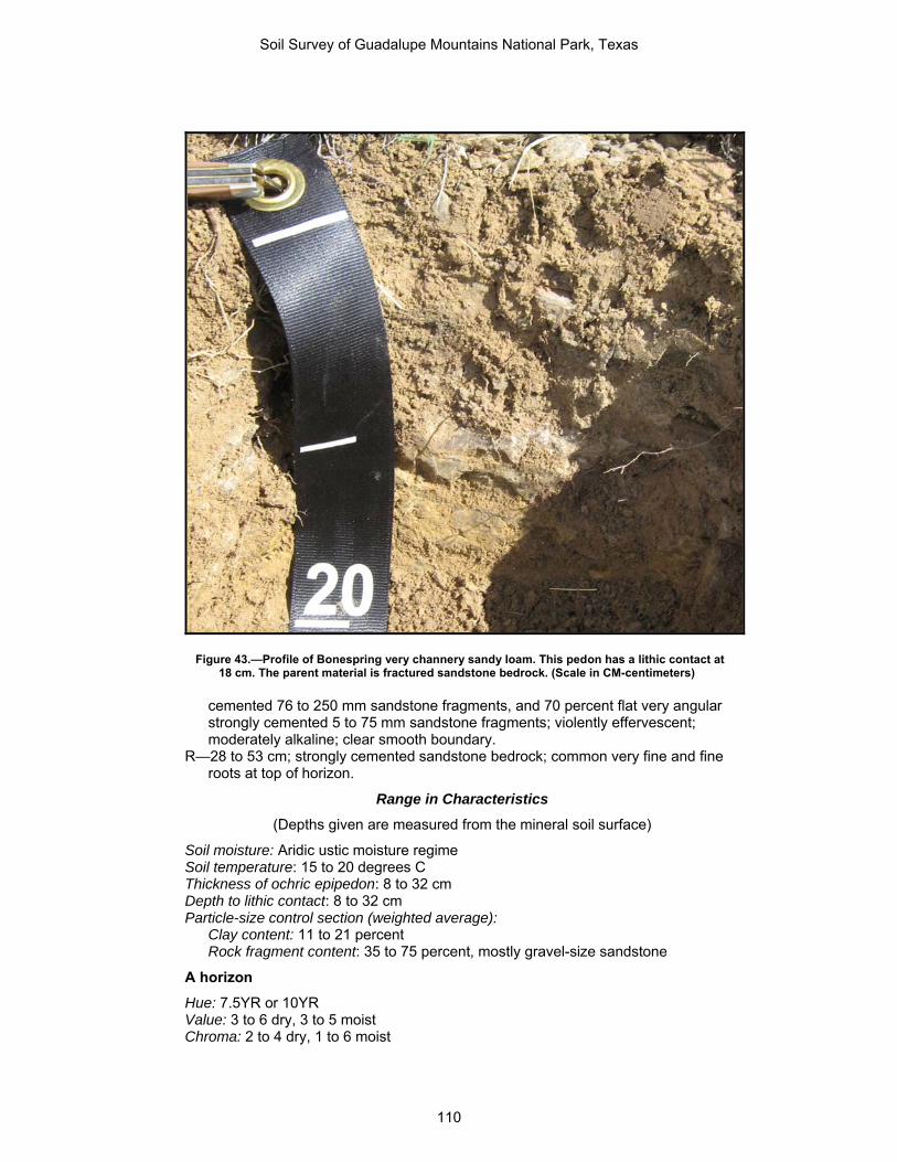
Figure 43.—Profile of Bonespring very channery sandy loam. This pedon has a lithic contact at 18 cm. The parent material is fractured sandstone bedrock. (Scale in CM-centimeters)
cemented 76 to 250 mm sandstone fragments, and 70 percent flat very angular strongly cemented 5 to 75 mm sandstone fragments; violently effervescent; moderately alkaline; clear smooth boundary.
R—28 to 53 cm; strongly cemented sandstone bedrock; common very fine and fine roots at top of horizon.
Range in Characteristics
(Depths given are measured from the mineral soil surface)
Soil moisture: Aridic ustic moisture regime Soil temperature: 15 to 20 degrees C Thickness of ochric epipedon: 8 to 32 cm Depth to lithic contact: 8 to 32 cm Particle-size control section (weighted average):
Clay content: 11 to 21 percent Rock fragment content: 35 to 75 percent, mostly gravel-size sandstone
A horizon
Hue: 7.5YR or 10YR Value: 3 to 6 dry, 3 to 5 moist Chroma: 2 to 4 dry, 1 to 6 moist
Soil Survey of Guadalupe Mountains National Park, Texas
110

Texture of the fine-earth fraction: Sandy loam, fine sandy loam, very fine sandy loam, or loam
Clay content: 11 to 21 percent Effervescence: Very slight to violent Reaction: Slightly alkaline or moderately alkaline
B horizon (where present)
Hue: 7.5YR or 10YR Value: 4 to 6 dry, 4 to 5 moist Chroma: 4 to 6 dry or moist Texture of the fine-earth fraction: Sandy loam, fine sandy loam, or loam Clay content: 13 to 21 percent Effervescence: Very slight to violent Reaction: Slightly alkaline or moderately alkaline
R layer
Fractures: Greater than 10 cm apart Bedrock kind: Indurated sandstone
Chilicotal Series Classification: Loamy-skeletal, mixed, superactive, thermic Ustic Haplocalcids Depth class: Very deep Drainage class: Well drained Permeability: Moderate Landform: Piedmont slopes below hills and mountains Parent material: Alluvium derived from limestone and dolomite Slope: 3 to 13 percent Elevation: 1,142 to 1,724 m Mean annual precipitation: 254 to 381 mm Mean annual air temperature: 15.0 to 19.0 degrees C Frost-free period: 187 to 239 days
Typical Pedon
Chilicotal gravelly loam in an area of Chilicotal-Chispa complex, 3 to 13 percent slopes, map unit CCD; on a linear side slope on a fan sloping 10 percent at 1,409 m elevation in rangeland. Culberson County, TX; USGS Patterson Hills, TX 7.5 minute topographic quadrangle; Latitude 31 degrees, 51 minutes, 17.04 seconds North and Longitude 104 degrees, 52 minutes, 47.48 seconds West, NAD 83. UTM Easting: 511366 m, UTM Northing: 3524340 m, UTM Zone 13.
A—0 to 21 cm; light yellowish brown (10YR 6/4) gravelly loam, yellowish brown (10YR 5/4), moist; weak fine and medium granular structure; very friable, soft, slightly sticky, nonplastic; common fine and medium roots; 15 percent subrounded 5 to 76 mm limestone fragments; EC is 0.4 dS/m; violently effervescent; slightly alkaline; clear smooth boundary.
Bk1—21 to 39 cm; pale brown (10YR 6/3) very cobbly loam, light yellowish brown (10YR 6/4), moist; weak fine subangular blocky structure; very friable, soft, slightly sticky, nonplastic; common fine and medium roots; finely disseminated carbonate, and 5 percent medium carbonate nodules around rock fragments; 25 percent subrounded 5 to 76 mm limestone fragments, and 30 percent subrounded 76 to 250 mm limestone fragments; EC is 0.3 dS/m; violently effervescent; moderately alkaline; abrupt smooth boundary.
Bk2—39 to 55 cm; pale brown (10YR 6/3) very cobbly loam, brown (10YR 5/3), moist; weak fine subangular blocky structure; very friable, soft, slightly sticky,
Soil Survey of Guadalupe Mountains National Park, Texas
111

nonplastic; common fine roots; finely disseminated carbonates, 3 percent medium carbonate masses, 5 percent medium carbonate nodules around rock fragments, and 5 percent coarse carbonate nodules; 20 percent subrounded 5 to 76 mm limestone fragments, and 20 percent subrounded 76 to 250 mm limestone fragments; EC is 0.9 dS/m; violently effervescent; moderately alkaline; abrupt smooth boundary.
Bk3—55 to 157 cm; very pale brown (10YR 7/3) very gravelly sandy loam, pale brown (10YR 6/3), moist; weak fine granular structure; very friable, soft, slightly sticky, nonplastic; common fine and medium, and common coarse roots; finely disseminated carbonates, 5 percent medium carbonate nodules around rock fragments, 20 percent medium carbonate masses, and 5 percent coarse carbonate nodules throughout; 33 percent subrounded 5 to 76 mm limestone fragments; EC is 1.8 dS/m; violently effervescent; moderately alkaline.
Range in Characteristics
(Depths given are measured from the mineral soil surface)
Soil moisture: Ustic aridic moisture regime Soil temperature: 16 to 20 degrees C Thickness of ochric epipedon: 6 to 28 cm Depth to calcic horizon: 6 to 48 cm Solum thickness: Greater than 203 cm Particle-size control section (weighted average):
Clay content: 15 to 27 percent Rock fragment content: 35 to 70 percent
Gravel size: 10 to 55 percent Cobble size: 0 to 55 percent
Calcium carbonate equivalent: 15 to 40 percent
A horizon
Hue: 10YR Value: 4 to 6, dry or moist Chroma: 2 to 4, dry or moist Calcium carbonate equivalent: 10 to 30 percent Effervescence: Strong or violent Reaction: Moderately alkaline
Bw horizon (where present)
Hue: 10YR Value: 4 to 6, dry or moist Chroma: 2 to 4, dry or moist Calcium carbonate equivalent: 10 to 30 percent Effervescence: Strong or violent Reaction: Moderately alkaline
Bk horizon
Hue: 10YR Value: 4 to 7, dry or moist Chroma: 2 to 4, dry or moist Calcium carbonate equivalent: 15 to 40 percent Other features: Below 102 cm, most pedons have underlying layers of varying
thickness, fine-earth textures, and size and content of coarse fragments Effervescence: Strong or violent Reaction: Moderately alkaline
Soil Survey of Guadalupe Mountains National Park, Texas
112

Chispa Series Classification: Fine-loamy, mixed, superactive, thermic Ustic Haplocalcids Depth class: Very deep Drainage class: Well drained Permeability: Moderate Landform: Ridges and fans on broad plains and valleys Parent material: Alluvium derived from limestone and dolomite Slope: 3 to 13 percent Elevation: 1,142 to 1,724 m Mean annual precipitation: 254 to 381 mm Mean annual air temperature: 15.0 to 19.0 degrees C Frost-free period: 187 to 239 days
Typical Pedon
Chispa fine sandy loam in an area of Chilicotal-Chispa complex, 3 to 13 percent slopes, map unit CCD; on a linear backslope on a fan sloping 5 percent at 1,256 m elevation in rangeland. Hudspeth County, TX; USGS P X Flat, TX 7.5 minute topographic quadrangle; Latitude 31 degrees, 52 minutes, 33.97 seconds North and Longitude 104 degrees, 55 minutes, 26.66 seconds West, NAD 83. UTM Easting: 507181 m, UTM Northing: 3526705 m, UTM Zone 13.
A—0 to 8 cm; light yellowish brown (10YR 6/4) fine sandy loam, yellowish brown (10YR 5/4), moist; weak fine granular structure; 2 percent nonflat subrounded indurated 2 to 75 mm limestone fragments; EC is 0.3 dS/m; strongly effervescent; slightly alkaline; gradual smooth boundary.
Bk1—8 to 19 cm; very pale brown (10YR 7/4) fine sandy loam, light yellowish brown (10YR 6/4), moist; weak fine granular structure; 2 percent nonflat subrounded indurated 2 to 75 mm limestone fragments; EC is 0.3 dS/m; violently effervescent; moderately alkaline; clear smooth boundary.
Bk2—19 to 48 cm; very pale brown (10YR 7/4) loam, light yellowish brown (10YR 6/4), moist; weak fine granular structure; 2 percent carbonate, finely disseminated; 4 percent nonflat subrounded indurated 2 to 75 mm sandstone fragments, and 5 percent nonflat subrounded indurated 2 to 75 mm limestone fragments; EC is 0.9 dS/m; violently effervescent; moderately alkaline; clear smooth boundary.
Bk3—48 to 157 cm; very pale brown (10YR 7/4) loam, light yellowish brown (10YR 6/4), moist; weak fine granular structure; 3 percent carbonate, finely disseminated; 6 percent nonflat subrounded indurated 2 to 75 mm limestone fragments, and 7 percent nonflat subrounded indurated 2 to 75 mm sandstone fragments; EC is 2.0 dS/m; violently effervescent; moderately alkaline.
Range in Characteristics
(Depths given are measured from the mineral soil surface)
Soil moisture: Ustic aridic moisture regime Mean annual soil temperature: 15.5 to 20 degrees C Thickness of ochric epipedon: 7 to 22 cm Depth to calcic horizon: 8 to 46 cm Solum thickness: 150 cm to more than 203 cm Particle-size control section (weighted average):
Clay content: 18 to 25 percent Rock fragment content: 0 to 20 percent
Calcium carbonate equivalent: 10 to 20 percent
Soil Survey of Guadalupe Mountains National Park, Texas
113

A horizon
Hue: 7.5YR or 10YR Value: 4 to 6, dry or moist Chroma: 2 to 4, dry or moist Texture: Loam, fine sandy loam Effervescence: Strong or violent Reaction: Moderately alkaline
Bk horizon
Hue: 7.5YR or 10YR Value: 5 to 7, dry or moist Chroma: 3 to 6, dry or moist Texture: Loam, fine sandy loam Carbonates: Below 25 cm, the volume of weakly cemented masses of calcium
carbonate ranges from 5 to 30 percent Effervescence: Strong or violent Reaction: Moderately alkaline
Choza Series Classification: Loamy-skeletal, mixed, superactive, thermic, shallow Petrocalcic
Calciustolls Depth class: Very shallow and shallow Drainage class: Well drained Permeability: Moderately rapid Landform: Piedmont slopes, alluvial fans Parent material: Fan alluvium from limestone sources Slope: 5 to 20 percent Elevation: 1,370 to 1,995 m Mean annual precipitation: 287 to 523 mm Mean annual air temperature: 14 to 19 degrees C Frost-free period: 203 to 255 days
Typical Pedon
Choza very gravelly loam (fig. 44) in an area of Pinery, Choza, and Altuda soils, 5 to 20 percent slopes, map unit PCG; on a convex alluvial fan remnant sloping 5 percent at 1,678 m elevation in rangeland. Culberson County, TX; USGS Guadalupe Peak, TX 7.5 minute topographic quadrangle; Latitude 31 degrees, 54 minutes, 31 seconds North and Longitude 104 degrees, 47 minutes, 57 seconds West, NAD 83. UTM Easting: 518989, UTM Northing; 3530309, UTM Zone 13.
A1—0 to 15 cm; dark grayish brown (10YR 4/2) very gravelly loam, very dark grayish brown (10YR 3/2), moist; moderate fine and medium granular structure; soft, friable, slightly sticky, moderately plastic; 5 percent subrounded 76 to 250 mm limestone fragments, and 30 percent subrounded 5 to 75 mm limestone fragments; strongly effervescent; moderately alkaline, clear smooth boundary.
A2—15 to 26 cm; brown (10YR 4/3) very gravelly loam, dark brown (10YR 3/3), moist; moderate fine and medium subangular blocky structure; slightly hard, friable, slightly sticky, moderately plastic; 5 percent subrounded 76 to 250 mm limestone fragments, and 30 percent subrounded 5 to 75 mm limestone fragments; strongly effervescent; moderately alkaline, very abrupt smooth boundary.
Soil Survey of Guadalupe Mountains National Park, Texas
114
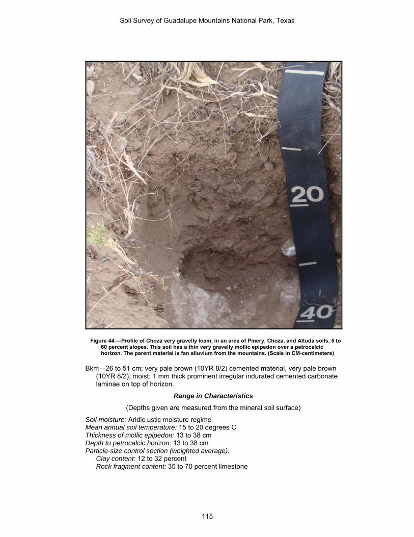
Figure 44.—Profile of Choza very gravelly loam, in an area of Pinery, Choza, and Altuda soils, 5 to 60 percent slopes. This soil has a thin very gravelly mollic epipedon over a petrocalcic horizon. The parent material is fan alluvium from the mountains. (Scale in CM-centimeters)
Bkm—26 to 51 cm; very pale brown (10YR 8/2) cemented material, very pale brown (10YR 8/2), moist; 1 mm thick prominent irregular indurated cemented carbonate laminae on top of horizon.
Range in Characteristics
(Depths given are measured from the mineral soil surface)
Soil moisture: Aridic ustic moisture regime Mean annual soil temperature: 15 to 20 degrees C Thickness of mollic epipedon: 13 to 38 cm Depth to petrocalcic horizon: 13 to 38 cm Particle-size control section (weighted average):
Clay content: 12 to 32 percent Rock fragment content: 35 to 70 percent limestone
Soil Survey of Guadalupe Mountains National Park, Texas
115

A horizon
Hue: 7.5YR or 10YR Value: 3 or 4 dry, 2 or 3 moist Chroma: 2 or 3 dry, 1 to 3 moist Texture of the fine-earth fraction: Fine sandy loam, loam, sandy clay loam Clay content: 12 to 32 percent Coarse fragments: 35 to 65 percent Effervescence: Strong or violent Reaction: Slightly alkaline or moderately alkaline
Bk horizon (where present)
Hue: 7.5YR or 10YR Value: 4 to 8 dry, 3 to 7 moist Chroma: 2 to 4 dry or moist Texture of the fine-earth fraction: Loam, sandy clay loam Clay content: 20 to 25 percent Coarse fragments: 35 to 45 percent Effervescence: Strong or violent Reaction: Moderately alkaline or strongly alkaline
Bkm horizon
Hue: 7.5YR or 10YR Value: 7 or 8 dry or moist Chroma: 2 or 3 dry or moist Texture of the fine-earth fraction: Cemented material Clay content: 20 to 25 percent Effervescence: Strong or violent Reaction: Slightly alkaline or moderately alkaline
Copia Series Classification: Mixed, thermic Typic Torripsamments Depth class: Very deep Drainage class: Excessively drained Permeability: Moderately rapid Landform: Dunes and shrub-coppice dunes Parent material: Eolian sands Slope: 2 to 7 percent Elevation: 1,108 to 1,181 m Mean annual precipitation: 150 to 319 mm Mean annual air temperature: 15.0 to 19.0 degrees C Frost-free period: 180 to 214 days
Typical Pedon
Copia loamy fine sand in an area of Copia loamy fine sand, 2 to 7 percent slopes, map unit COC; on convex dune in a dune field sloping 4 percent at 1,118 m elevation in rangeland. Hudspeth County, TX; USGS PX Flat, TX 7.5 minute topographic quadrangle; Latitude 31 degrees, 56 minutes, 17.91 seconds North and Longitude 104 degrees, 58 minutes, 43.03 seconds West, NAD 83. UTM Easting: 502021 m, UTM Northing: 3533598 m, UTM Zone 13.
A—0 to 4 cm; very pale brown (10YR 7/4) loamy fine sand, light yellowish brown (10YR 6/4), moist; weak fine granular structure; very friable, soft, nonsticky,
Soil Survey of Guadalupe Mountains National Park, Texas
116

nonplastic; EC is 0.3 dS/m; slightly effervescent; moderately alkaline; abrupt smooth boundary.
C1—4 to 50 cm; very pale brown (10YR 7/4) fine sand, light yellowish brown (10YR 6/4), moist; structureless; loose, loose, nonsticky, nonplastic; EC is 0.1 dS/m; slightly effervescent; strongly alkaline; gradual smooth boundary.
C2—50 to 203 cm; very pale brown (10YR 7/4) fine sand, light yellowish brown (10YR 6/4), moist; structureless; loose, loose, nonsticky, nonplastic; EC is 0.1 dS/m; slightly effervescent; strongly alkaline.
Range in Characteristics
(Depths given are measured from the mineral soil surface)
Soil moisture: Typic aridic soil moisture regime Texture: Dominantly fine sand or loamy fine sand throughout. Thin horizons of loamy
sand may be present in some pedons, but texture in the particle-size control section averages fine sand or loamy fine sand with less than 11 percent silt plus clay.
A horizon
Hue: 7.5YR Value: 6 or 7, dry or moist Chroma: 4 to 6, dry or moist Effervescence: None to slight Reaction: Moderately alkaline
C horizon
Hue: 7.5YR Value: 5 to 7 dry, 4 to 6 moist Chroma: 6 or 8, dry or moist Effervescence: Slight or strong Reaction: Strongly alkaline
Corvus Series Classification: Loamy, hypergypsic, thermic, shallow Typic Petrogypsids Depth class: Very shallow and shallow Drainage class: Well drained Permeability: Moderate Landform: Relict gypsum dunes and fan piedmonts Parent material: Eolian sands derived from gypsum Slope: 1 to 5 percent Elevation: 1,104 to 1,123 m Mean annual precipitation: 150 to 319 mm Mean annual air temperature: 15.0 to 19.0 degrees C Frost-free period: 180 to 214 days
Typical Pedon
Corvus gypsiferous very fine sandy loam in an area of Corvus-Peligro complex, 1 to 5 percent slopes, map unit CPB; on a relict dune on a basin floor sloping 1 percent at 1,107 m elevation in rangeland. Hudspeth County, TX; USGS P X Flat, Texas 7.5 minute topographic quadrangle; Latitude 31 degrees, 52 minutes, 40.87 seconds North and Longitude 104 degrees, 59 minutes, 50.09 seconds West, NAD 83. UTM Easting: 500260 m, UTM Northing: 3526915 m, UTM Zone 13.
Soil Survey of Guadalupe Mountains National Park, Texas
117

Ay—0 to 6 cm; light yellowish brown (10YR 6/4) gypsiferous very fine sandy loam, dark yellowish brown (10YR 4/4), moist; weak fine granular structure; very friable, soft, nonsticky, nonplastic; common very fine and fine roots; EC is 2.1 dS/m; slightly effervescent; slightly alkaline; very abrupt smooth boundary.
By1—6 to 41 cm; light gray (10YR 7/2) gypsiferous fine sandy loam, pale brown (10YR 6/3), moist; weak fine and medium subangular blocky structure; friable, soft, nonsticky, nonplastic; common very fine and fine roots; 3 percent medium distinct irregular gypsum crystals; EC is 2.3 dS/m; slightly effervescent; moderately alkaline; clear smooth boundary.
By2—41 to 49 cm; light gray (10YR 7/1) gypsiferous loamy fine sand, pale brown (10YR 6/3), moist; weak fine and medium subangular blocky structure; very firm, hard, extremely weakly cemented, nonsticky, nonplastic; low excavation difficulty; 15 percent medium distinct irregular gypsum crystals; EC is 5.7 dS/m; strongly effervescent; strongly alkaline; abrupt smooth boundary.
Bym—49 to 74 cm; white (10YR 8/1) gypsiferous material, yellow (10YR 8/8), moist; weak fine and medium platy structure; very rigid, extremely hard, very strongly cemented, nonsticky, nonplastic; extremely high excavation difficulty; common very fine and fine roots top of horizon; EC is 5.8 dS/m; strongly effervescent; moderately alkaline.
Range in Characteristics
(Depths given are measured from the mineral soil surface)
Soil moisture: Typic aridic soil moisture regime Mean annual soil temperature: 15.5 to 20.0 degrees C Thickness of ochric epipedon: 5 to 13 cm Depth to gypsic horizon: 5 to 22 cm Depth to petrogypsic horizon: 13 to 49 cm Particle-size control section (weighted average):
Clay content: 8 to 15 percent Gypsum content: 60 to 95 percent
Electrical conductivity: 2 to 6 dS/m SAR: 0 to 5
Ay horizon
Hue: 10YR Value: 5 or 6 dry, 4 or 5 moist Chroma: 1 to 4, dry or moist Texture: Gypsiferous very fine sandy loam, gypsiferous sandy loam, gypsiferous fine
sandy loam Gypsum: 60 to 90 percent EC: 2 to 3 dS/m SAR: 0 to 4
By horizon
Hue: 10YR Value: 6 to 8 dry, 5 to 8 moist Chroma: 1 to 4, dry or moist Texture: Gypsiferous very fine sandy loam, gypsiferous sandy loam, gypsiferous fine
sandy loam Gypsum: 60 to 95 percent EC: 2 to 6 dS/m SAR: 0 to 5
Soil Survey of Guadalupe Mountains National Park, Texas
118
Bym horizon
Hue: 10YR Value: 6 to 8 dry, 5 to 8 moist Chroma: 1 to 4, dry or moist Gypsum: 80 to 95 percent EC: 2 to 6 dS/m SAR: 0 to 5
Cy horizon (where present)
Hue: 10YR Value: 6 to 8 dry, 5 to 8 moist Chroma: 1 to 4, dry or moist Texture: Gypsiferous very fine sandy loam, gypsiferous sandy loam, gypsiferous fine
sandy loam Gypsum: 60 to 95 percent EC: 2 to 6 dS/m SAR: 0 to 5
Desario Series Classification: Loamy-skeletal, mixed, superactive, mesic Lithic Calciustolls Depth class: Shallow Drainage class: Well drained Permeability: Moderately slow Landform: Hills, ridges, mesas, plateaus Parent material: Residuum weathered from limestone Slope: 20 to 50 percent Elevation: 1,832 to 2,441 m Mean annual precipitation: 330 to 381 mm Mean annual air temperature: 8 to 14 degrees C Frost-free period: 135 to 250 days
Typical Pedon
Desario gravelly loam (fig. 45) in an area of Biduya-Desario-Rock outcrop complex, 10 to 50 percent slopes, map unit BDG; on a hill in a mountain range sloping 16 percent at 1,989 m elevation in rangeland. Culberson County, TX; USGS P X Flat, Texas, 7.5 minute topographic quadrangle; Latitude 31 degrees, 58 minutes, 43.53 seconds North and Longitude 104 degrees, 53 minutes, 17.70 seconds West, NAD 83. UTM Easting: 510558 m, UTM Northing: 3538087 m, UTM Zone 13.
A—0 to 12 cm; dark grayish brown (10YR 4/2 ) gravelly loam, very dark brown (10YR 2/2), moist; moderate fine and medium subangular blocky structure; firm, slightly sticky, slightly plastic; common very fine and fine roots; 20 percent subangular moderately cemented 5 to 75 mm limestone fragments; violently effervescent; clear smooth boundary.
Bk—12 to 31 cm; brown (10YR 4/3 ) very gravelly loam, dark brown (10YR 3/3), moist; moderate fine and medium subangular blocky structure; firm, slightly sticky, slightly plastic; common very fine and fine roots; 5 percent medium strongly cemented carbonate nodules around rock fragments, and 5 percent medium spherical strongly cemented carbonate nodules throughout; 10 percent subangular strongly cemented 76 to 250 mm limestone fragments, and 30 percent subangular moderately cemented 5 to 75 mm limestone fragments; violently effervescent; clear smooth boundary.
Soil Survey of Guadalupe Mountains National Park, Texas
119

Figure 45.—Profile of Desario gravelly loam, in an area of Biduya-Desario-Rock outcrop complex, 10 to 50 percent slopes. The soil has a gravelly mollic epipedon over a very gravelly calcic horizon over a lithic contact. The parent material is fractured limestone bedrock. (Scale in CM-centimeters)
R—31 to 56 cm; indurated limestone bedrock, fractured at intervals of 100 cm to less than 200 cm; extremely high excavation difficulty.
Range in Characteristics
(Depths given are measured from the mineral soil surface)
Soil moisture: Typic ustic soil moisture regime Mean annual soil temperature: 9.0 to 15.0 degrees C Thickness of mollic epipedon: 10 to 31 cm Depth to calcic horizon: 10 to 31 cm Depth to lithic contact: 29 to 50 cm Particle-size control section (weighted average):
Clay content: 18 to 27 percent Rock fragment content: 35 to 85 percent
Soil Survey of Guadalupe Mountains National Park, Texas
120

A horizon
Hue: 7.5YR, or 10YR Value: 3 or 4 dry, 2 or 3 moist Chroma: 2 or 3, dry or moist Texture: Loam Rock fragments: 20 to 35 percent Effervescence: Slight to strong Reaction: Slightly alkaline to strongly alkaline
Bk horizon
Hue: 7.5YR, or 10YR Value: 4 to 7 dry, 3 to 6 moist Chroma: 2 to 4, dry or moist Texture: Loam or sandy loam Rock fragments: 35 to 55 percent Effervescence: Strong or violent Reaction: Slightly alkaline to strongly alkaline
R layer
Fractures: Greater than 10 cm apart Bedrock kind: Indurated limestone or sandstone
Lark Series Classification: Gypsic, thermic Typic Torripsamments Depth class: Very deep Drainage class: Excessively drained Permeability: Very rapid Landform: Vegetated dunes on dune fields Parent material: Sandy gypsiferous eolian deposits Slope: 5 to 8 percent Elevation: 1,106 to 1,130 m Mean annual precipitation: 150 to 319 mm Mean annual air temperature: 15.0 to 19.0 degrees C Frost-free period: 180 to 214 days
Typical Pedon
Lark gypsiferous fine sand in an area of Lark-Peligro complex, 1 to 8 percent slopes, map unit LPC; on a dune sloping 5 percent at 1,110 m elevation in rangeland. Hudspeth County, TX; USGS P X Flat, Texas 7.5 minute topographic quadrangle; Latitude 31 degrees, 54 minutes, 20.07 seconds North and Longitude 104 degrees, 59 minutes, 37.14 seconds West, NAD 83. UTM Easting: 500600 m, UTM Northing: 3529970 m, UTM Zone 13.
Ay—0 to 27 cm; light gray (10YR 8/2) gypsiferous fine sand, light gray (10YR 8/2), moist; single grain; EC is 2.0 dS/m; noneffervescent; moderately alkaline; clear smooth boundary.
Cy1—27 to 67 cm; white (10YR 8/1) gypsiferous fine sand, white (10YR 8/1), moist; single grain; EC is 2.1 dS/m; noneffervescent; moderately alkaline; diffuse irregular boundary.
Cy2—67 to 203 cm; white (10YR 8/1) gypsiferous fine sand, white (10YR 8/1), moist; single grain; EC is 2.1 dS/m; noneffervescent; moderately alkaline.
Soil Survey of Guadalupe Mountains National Park, Texas
121

Range in Characteristics
(Depths given are measured from the mineral soil surface)
Soil moisture: Typic aridic soil moisture regime Mean annual soil temperature: 16.0 to 20.0 degrees C Particle-size control section (weighted average):
Clay content: 0 to 2 percent Gypsum content: 60 to 100 percent
Ay horizon
Hue: 10YR or 2.5Y Value: 8 dry, 7 to 8 moist Chroma: 1 to 4, dry or moist Texture: Gypsiferous sand, gypsiferous fine sand, gypsiferous coarse sand Clay content: 0 to 2 percent Calcium carbonate equivalent: 0 percent Gypsum content: 60 to 100 percent Salinity: Very slight to moderate Reaction: Moderately alkaline
Cy horizon
Hue: 10YR or 2.5Y Value: 8 or 9 dry, 7 to 8.5 moist Chroma: 1 to 4, dry or moist Texture: Gypsiferous sand, gypsiferous fine sand, gypsiferous coarse sand Clay content: 0 to 2 percent Calcium carbonate equivalent: 0 percent Gypsum content: 60 to 100 percent Salinity: Very slight to moderate Reaction: Slightly alkaline or moderately alkaline
Lazarus Series Classification: Fine-silty, mixed, superactive, mesic Pachic Argiustolls Depth class: Very deep Drainage class: Well drained Permeability: Moderate Landform: Canyons, terraces, drainageways Parent material: Alluvium from limestone sources Slope: 2 to 9 percent Elevation: 1,834 to 2,104 m Mean annual precipitation: 508 to 660 mm Mean annual air temperature: 8 to 14 degrees C Frost-free period: 135 to 250 days
Typical Pedon
Lazarus loam (fig. 46) in an area of Lazarus loam, 2 to 9 percent slopes, map unit LAD; in a canyon sloping 3 percent at 1,928 m elevation in rangeland. Culberson County, TX; USGS Guadalupe Peak, TX 7.5 minute topographic quadrangle; Latitude 31 degrees, 58 minutes, 48 seconds North and Longitude 104 degrees, 52 minutes, 09 seconds West, NAD 83. UTM Easting: 512360, UTM Northing: 3538225, UTM Zone 13.
Soil Survey of Guadalupe Mountains National Park, Texas
122

Figure 46.—Profile of Lazarus loam, 1 to 8 percent slopes. This soil has a thick loam mollic epipedon and a clay loam argillic horizon. The parent material is alluvium from the surrounding hills and mountains. (Scale in CM-centimeters)
A—0 to 19 cm; very dark grayish brown (10YR 3/2) loam, very dark brown (10YR 2/2), moist; moderate fine and medium granular structure; soft, friable, slightly sticky, slightly plastic; common very fine and fine roots; neutral, clear smooth boundary.
Bt1—19 to 38 cm; dark brown (7.5YR 3/2) clay loam, very dark brown (7.5YR 2.5/2), moist; moderate fine and medium subangular blocky structure; slightly hard,
Soil Survey of Guadalupe Mountains National Park, Texas
123

friable, moderately sticky, slightly plastic; common very fine and fine roots; 10 percent distinct clay films on all ped faces; neutral, clear smooth boundary.
Bt2—38 to 62 cm; dark brown (7.5YR 3/2) clay loam, very dark brown (7.5YR 2.5/2), moist; strong fine and medium subangular blocky structure; slightly hard, firm, moderately sticky, moderately plastic; common very fine and fine roots; 20 percent distinct clay films on all ped faces; slightly acid, gradual smooth boundary.
Bt3—62 to 109 cm; brown (7.5YR 4/4) clay loam, dark brown (7.5YR 3/4), moist; strong fine and medium subangular blocky structure; slightly hard, firm, moderately sticky, slightly plastic; common very fine and fine roots; 10 percent distinct clay films on all ped faces; slightly acid, clear smooth boundary.
Bt4—109 to 203 cm; brown (7.5YR 4/4) loam, dark brown (7.5YR 3/4), moist; weak fine and medium subangular blocky structure; soft, friable, slightly sticky, nonplastic; 5 percent distinct clay films on all ped faces; slightly acid.
Range in Characteristics
(Depths given are measured from the mineral soil surface)
Soil moisture: Typic ustic soil moisture regime Mean annual soil temperature: 9.0 to 15.0 degrees C Thickness of mollic epipedon: 52 to 150 cm Depth to argillic horizon: 10 to 27 cm Particle-size control section (weighted average):
Clay content: 20 to 34 percent Rock fragment content: 0 to 20 percent limestone
A horizon
Hue: 7.5YR or 10YR Value: 3 or 4 dry, 2 or 3 moist Chroma: 1 to 3 dry and moist Texture of the fine-earth fraction: Fine sandy loam, loam, silt loam, sandy clay loam,
silty clay loam Clay content: 14 to 34 percent Coarse fragments: 10 to 45 percent Effervescence: None to strong Reaction: Neutral to slightly alkaline
Bt horizon
Hue: 7.5YR or 10YR Value: 3 to 6 dry, 2 to 5 moist Chroma: 2 to 4 dry, 1 to 4 moist Texture of the fine-earth fraction: Loam, silt loam, sandy clay loam, silty clay loam,
clay loam Clay content: 16 to 34 percent Coarse fragments: 35 to 50 percent Effervescence: None to strong Reaction: Slightly acid to slightly alkaline
Bk horizon (where present)
Hue: 7.5YR or 10YR Value: 4 to 6 dry, 3 to 5 moist Chroma: 2 to 4 dry and moist Texture of the fine-earth fraction: Fine sandy loam, loam, silt loam, sandy clay loam,
silty clay loam, clay loam Clay content: 8 to 12 percent
Soil Survey of Guadalupe Mountains National Park, Texas
124

Coarse fragments: 35 to 80 percent Effervescence: Very slight to violent Reaction: Slightly alkaline
Lostpeak Series Classification: Loamy-skeletal, mixed, superactive, mesic Aridic Lithic Haplustolls Depth class: Very shallow and shallow Drainage class: Well drained Permeability: Moderate Landform: Mountainsides, ridges, escarpments Parent material: Colluvium and residuum weathered from Permian age limestone and
dolomite Slope: 40 to 95 percent Elevation: 1,426 to 2,647 m Mean annual precipitation: 330 to 381 mm Mean annual air temperature: 8 to 14 degrees C Frost-free period: 135 to 250 days
Typical Pedon
Lostpeak very gravelly clay loam (fig. 47) in an area of Lostpeak-Rock outcrop complex, 40 to 95 percent slopes, map unit LRH; on an escarpment sloping 62 percent at 1,770 m elevation in rangeland. Culberson County, TX; USGS Guadalupe Peak, TX 7.5 minute topographic quadrangle; Latitude 31 degrees, 57 minutes, 29 seconds North and Longitude 104 degrees, 46 minutes, 16 seconds West, NAD 83. UTM Easting: 521638, UTM Northing: 3535818, UTM Zone 13.
A—0 to 19 cm; dark grayish brown (10YR 4/2) very gravelly clay loam, very dark brown (10YR 2/2), moist; weak fine granular structure; soft, friable, slightly sticky, nonplastic; common very fine and fine roots; 3 percent subangular indurated 76 to 250 mm limestone fragments, and 40 percent subangular indurated 5 to 75 mm limestone fragments; very slightly effervescent; strongly alkaline, very abrupt smooth boundary.
R—19 to 44 cm; indurated limestone bedrock.
Range in Characteristics
(Depths given are measured from the mineral soil surface)
Soil moisture: Aridic ustic soil moisture regime Mean annual soil temperature: 9.0 to 15.0 degrees C Thickness of mollic epipedon: 11 to 35 cm Depth to lithic contact: 11 to 46 cm Particle-size control section (weighted average):
Clay content: 14 to 29 percent Rock fragment content: 35 to 65 percent
Gravel size: 20 to 40 percent Cobble size: 0 to 65 percent
A horizon
Hue: 10YR Value: 3 to 5 dry, 2 or 3 moist Chroma: 2 or 3 dry, 2 moist Texture of the fine-earth fraction: Loam, clay loam Clay content: 14 to 29 percent Coarse fragments: 35 to 65 percent
Soil Survey of Guadalupe Mountains National Park, Texas
125

Figure 47.—Profile of the Lostpeak very gravelly clay loam, in an area of Lostpeak-Rock outcrop complex, 40 to 95 percent slopes. The soil has a very gravelly mollic epipedon over a lithic contact. The parent material is fractured limestone bedrock. (Scale in CM-centimeters)
Effervescence: Very slight to violent Reaction: Moderately alkaline or strongly alkaline
R layer
Fractures: Greater than 10 cm apart Bedrock kind: Indurated limestone and dolomite
Lozen Series Classification: Loamy-skeletal, mixed, superactive, mesic Lithic Haplustolls Depth class: Very shallow and shallow Drainage class: Well drained Permeability: Moderate Landform: Mountainsides, ridges
Soil Survey of Guadalupe Mountains National Park, Texas
126

Parent material: Residuum and colluvium weathered from Permian Limestone and Dolomite bedrock
Slope: 10 to 95 percent Elevation: 1,584 to 2,664 m Mean annual precipitation: 508 to 660 mm Mean annual air temperature: 8.0 to 14.0 degrees C Frost-free period: 135 to 250 days
Typical Pedon
Lozen very gravelly loam in an area of Victorio-Lozen-Rock outcrop complex, 40 to 95 percent slopes, map unit VLH; on upper third of mountain slope on mountain range sloping 50 percent at 2,658 m elevation in forestland. Culberson County; USGS Guadalupe Peak, Texas 7.5 minute topographic quadrangle; Latitude 31 degrees, 55 minutes, 10.07 seconds North and Longitude 104 degrees, 50 minutes, 3.08 seconds West, NAD 83. UTM Easting: 515624 m, UTM Northing: 3531512 m, UTM Zone 13.
A1—0 to 22 cm; very dark brown (10YR 2/2) very gravelly loam, black (10YR 2/1) moist; moderate fine and medium granular structure; soft, friable, slightly sticky, slightly plastic; many very fine and fine roots; 10 percent subangular 251 to 600 mm limestone fragments and 60 percent subangular 76 to 250 mm limestone fragments; slightly alkaline; diffuse smooth boundary.
A2—22 to 43 cm; very dark brown (10YR 2/2) very cobbly loam, black (10YR 2/1), moist; moderate fine and medium granular structure; slightly hard, friable, slightly sticky, slightly plastic; common very fine and fine roots; 20 percent subangular 251 to 600 mm limestone fragments and 55 percent subangular 76 to 250 mm limestone fragments; slightly alkaline; very abrupt irregular boundary.
R—43 to 68 cm; indurated limestone bedrock.
Range in Characteristics
(Depths given are measured from the mineral soil surface)
Soil moisture: Typic ustic soil moisture regime Mean annual soil temperature: 9.0 to 15.0 degrees C Thickness of mollic epipedon: 11 to 45 cm Depth to lithic contact: 11 to 45 cm Particle-size control section (weighted average):
Clay content: 13 to 33 percent Rock fragment content: 35 to 80 percent
Gravel size: 5 to 65 percent Cobble size: 5 to 70 percent Stone size: 0 to 50 percent
A horizon
Hue: 7.5YR or 10YR Value: 2 to 4 dry, 2 or 3 moist Chroma: 1 to 4 dry, 1 to 3 moist Texture of the fine-earth fraction: Sandy loam, loam, silt loam, clay loam Clay content: 12 to 33 percent Coarse fragments: 25 to 80 percent Effervescence: None or very slight Reaction: Slightly alkaline
Bw horizon (where present)
Hue: 7.5YR or 10YR
Soil Survey of Guadalupe Mountains National Park, Texas
127

Value: 3 to 5 dry, 2 to 4 moist Chroma: 2 to 4 dry, 1 to 4 moist Texture of the fine-earth fraction: Sandy loam, loam, sandy clay loam, clay loam Clay content: 10 to 34 percent Coarse fragments: 35 to 75 percent Effervescence: None or very slight Reaction: Slightly alkaline
R horizon
Fractures: Greater than 10 cm (4 in) apart Bedrock kind: indurated limestone and dolomite
McKittrick Series Classification: Loamy-skeletal, carbonatic, superactive, mesic Fluventic Haplustolls Depth class: Very deep Drainage class: Well drained Permeability: Moderately rapid Landform: Canyons, drainageways Parent material: Gravelly alluvium Slope: 0 to 3 percent Elevation: 1,511 to 1,960 m Mean annual precipitation: 508 to 660 mm Mean annual air temperature: 8.0 to 14.0 degrees C Frost-free period: 135 to 250 days
Typical Pedon
McKittrick gravelly sandy loam (fig. 48) in an area of McKittrick-Riverwash complex, flooded, 0 to 3 percent slopes, map unit MCB; on drainageway in a canyon sloping 2 percent at 1,560 m elevation in rangeland. Culberson County, TX; USGS Guadalupe Peak, TX 7.5 minute topographic quadrangle; Latitude 31 degrees, 59 minutes, 10 seconds North and Longitude 104 degrees, 46 minutes, 10 seconds West, NAD 83. UTM Easting: 521785 m, UTM Northing: 3538931 m, UTM Zone 13.
A—0 to 12 cm; dark grayish brown (10YR 3/2) gravelly sandy loam, very dark gray (10YR 3/1), moist; moderate fine subangular blocky structure; friable, slightly sticky, nonplastic; many very fine and fine, and common medium and coarse roots; 10 percent subrounded very strongly cemented 76 to 250 mm limestone fragments, and 15 percent subrounded very strongly cemented 2 to 75 mm limestone fragments; strongly effervescent; neutral, clear smooth boundary.
Bw—12 to 41 cm; dark grayish brown (10YR 4/2) very gravelly sandy loam, very dark grayish brown (10YR 3/2), moist; moderate fine subangular blocky structure; friable, slightly sticky, nonplastic; many very fine and fine, and common medium and coarse roots; finely disseminated carbonate; 15 percent subrounded very strongly cemented 76 to 250 mm limestone fragments, and 30 percent subrounded very strongly cemented 2 to 75 mm limestone fragments; strongly effervescent; slightly alkaline, gradual smooth boundary.
BC—41 to 157 cm; dark yellowish brown (10YR 4/4) extremely cobbly coarse sandy loam, dark yellowish brown (10YR 3/4), moist; weak fine granular structure; loose, nonsticky, nonplastic; common very fine and fine, and common medium and coarse roots; finely disseminated carbonate; 35 percent subrounded very strongly cemented 2 to 75 mm limestone fragments, and 45 percent subrounded very strongly cemented 76 to 250 mm limestone fragments; strongly effervescent; slightly alkaline.
Soil Survey of Guadalupe Mountains National Park, Texas
128

Figure 48.—Profile of McKittrick gravelly sandy loam, in an area of McKittrick-Riverwash complex, flooded, 0 to 3 percent slopes. This soil has a thick gravelly mollic epipedon over a very gravelly subsurface horizon. The parent material is alluvium from the surrounding hills and mountains. (Scale in CM-centimeters)
Range in Characteristics
(Depths given are measured from the mineral soil surface)
Soil moisture: Typic ustic soil moisture regime Mean annual soil temperature: 9.0 to 15.0 degrees C
Soil Survey of Guadalupe Mountains National Park, Texas
129

Thickness of mollic epipedon: 21 to 45 cm Particle-size control section (weighted average):
Clay content: 14 to 29 percent Rock fragment content: 35 to 80 percent limestone
A horizon
Hue: 10YR Value: 2 or 3 dry and moist Chroma: 2 or 3 dry, 1 to 3 moist Texture of the fine-earth fraction: Fine sandy loam, loam, silt loam Clay content: 10 to 27 percent Coarse fragments: 10 to 45 percent Effervescence: None to strong Reaction: Neutral to slightly alkaline
Bk horizon
Hue: 10YR Value: 2 to 5 dry and moist Chroma: 2 or 3 dry, 2 to 4 moist Texture of the fine-earth fraction: Fine sandy loam, loam, silt loam Clay content: 10 to 24 percent Coarse fragments: 35 to 50 percent Effervescence: Slight to strong Reaction: Slightly alkaline or moderately alkaline
BCk horizon
Hue: 10YR Value: 2 to 5 dry and moist Chroma: 2 to 4 dry or moist Texture of the fine-earth fraction: Coarse sandy loam, sandy loam Clay content: 8 to 12 percent Coarse fragments: 35 to 80 percent Effervescence: Strong Reaction: Slightly alkaline or moderately alkaline
Monahans Series
Classification: Coarse-loamy, mixed, superactive, thermic Typic Calcigypsids Depth class: Very deep Drainage class: Well drained Permeability: Moderate Landform: Upland plains Parent material: Eolian sands Slope: 0 to 5 percent Elevation: 1,108 to 1,237 m Mean annual precipitation: 150 to 319 mm Mean annual air temperature: 15.0 to 19.0 degrees C Frost-free period: 180 to 214 days
Typical Pedon
Monahans fine sandy loam in an area of Monahans-Pajarito complex, 0 to 5 percent slopes, map unit MPB; on an alluvial fan on basin floor sloping 2 percent at 1,125 m elevation in rangeland. Hudspeth County, TX; USGS P X Flat, Texas 7.5 minute topographic quadrangle; Latitude 31 degrees, 54 minutes, 43.88 seconds North and
Soil Survey of Guadalupe Mountains National Park, Texas
130

Longitude 104 degrees, 58 minutes, 12.58 seconds West, NAD 83. UTM Easting: 502821 m, UTM Northing: 3530703 m, UTM Zone 13.
A—0 to 10 cm; pale brown (10YR 6/3) very fine sandy loam, yellowish brown (10YR 5/4), moist; weak fine granular structure; very friable, soft, nonsticky, nonplastic; common very fine and fine roots; EC is 0.6 dS/m; strongly effervescent; slightly alkaline; gradual smooth boundary.
Bk—10 to 33 cm; pale brown (10YR 6/3) fine sandy loam, yellowish brown (10YR 5/4), moist; weak fine and medium granular structure; very friable, soft, nonsticky, nonplastic; common very fine and fine roots; finely disseminated carbonate; EC is 0.3 dS/m; strongly effervescent; moderately alkaline; diffuse smooth boundary.
Bky1—33 to 104 cm; very pale brown (10YR 7/3) fine sandy loam, light yellowish brown (10YR 6/4), moist; weak fine granular structure; very friable, soft, nonsticky, nonplastic; few very fine and fine roots; finely disseminated carbonate and finely disseminated gypsum; EC is 2.1 dS/m; strongly effervescent; moderately alkaline; diffuse smooth boundary.
Bky2—104 to 203 cm; light gray (10YR 7/2) fine sandy loam, light yellowish brown (10YR 6/4), moist; weak fine and medium granular structure; very friable, soft, nonsticky, nonplastic; few very fine and fine roots; finely disseminated carbonate and finely disseminated gypsum; EC is 3.5 dS/m; strongly effervescent; moderately alkaline.
Range in Characteristics
(Depths given are measured from the mineral soil surface)
Soil moisture: Typic aridic moisture regime Mean annual soil temperature: 16.0 to 20.0 degrees C Thickness of ochric epipedon: 12 to 48 cm Depth to gypsic horizon: 12 to 72 cm Depth to calcic horizon: 12 to 72 cm Solum thickness: 150 cm to more than 203 cm Calcium carbonate plus gypsum: Averages less than 40 percent by weight Texture: Fine sandy loam, loam Particle-size control section (weighted average):
Silicate clay content: 7 to 18 percent
A horizon
Hue: 7.5YR or 10YR Value: 5 to 7, dry or moist Chroma: 2 to 4, dry or moist Texture: Very fine sandy loam or fine sandy loam Effervescence: Slight or strong Reaction: Slightly alkaline or moderately alkaline
Bk horizon or (Bw horizon, where present)
Hue: 7.5YR or 10YR Value: 5 to 7, dry or moist Chroma: 3 to 6, dry or moist Texture: Very fine sandy loam or fine sandy loam Effervescence: Slight or strong Reaction: Slightly alkaline or moderately alkaline
Bky horizon
Hue: 7.5YR or 10YR Value: 6 to 8, dry or moist
Soil Survey of Guadalupe Mountains National Park, Texas
131

Chroma: 2 to 6, dry or moist Texture: Very fine sandy loam, fine sandy loam, or loam Calcium carbonate: 10 to 20 percent visible calcium carbonate in the form of fine,
weakly cemented concretions and masses Calcium carbonate equivalent: 10 to 20 percent Gypsum: 5 to 15 percent of visible gypsum crystals Effervescence: Slight or strong Reaction: Slightly alkaline or moderately alkaline
Pajarito Series Classification: Coarse-loamy, mixed, superactive, thermic Typic Haplocambids Depth class: Very deep Drainage class: Well drained Permeability: Moderately rapid Landform: Upland plains, bajadas, and alluvial fans Parent material: Sandy to moderately sandy mixed sediments Slope: 0 to 5 percent Elevation: 1,108 to 1,237 m Mean annual precipitation: 150 to 319 mm Mean annual air temperature: 15.0 to 19.0 degrees C Frost-free period: 180 to 214 days
Typical Pedon
Pajarito very fine sandy loam in an area of Monahans-Pajarito complex, 0 to 5 percent slopes, map unit MPB; on an alluvial fan on a basin floor sloping 0 percent at 1,116 m elevation in rangeland. Culberson County, TX; USGS P X Flat, Texas 7.5 minute topographic quadrangle; Latitude 31 degrees, 54 minutes, 43.33 seconds North and Longitude 104 degrees, 58 minutes, 40.98 seconds West, NAD 83. UTM Easting: 502075 m, UTM Northing: 3530686 m, UTM Zone 13.
A—0 to 28 cm; pale brown (10YR 6/3) very fine sandy loam, yellowish brown (10YR 5/4), moist; weak fine granular structure; very friable, soft, nonsticky, nonplastic; common very fine and fine roots; strongly effervescent; moderately alkaline; gradual smooth boundary.
Bw—28 to 98 cm; very pale brown (10YR 7/4) very fine sandy loam, light yellowish brown (10YR 6/4), moist; weak fine and medium subangular blocky structure; very friable, soft, nonsticky, nonplastic; common very fine and fine roots, and common medium roots; 2 percent fine prominent irregular carbonate masses with sharp boundaries throughout; violently effervescent; moderately alkaline; diffuse smooth boundary.
Bk—98 to 203 cm; very pale brown (10YR 7/4) very fine sandy loam, light yellowish brown (10YR 6/4), moist; weak fine subangular blocky structure; very friable, soft, nonsticky, nonplastic; few very fine and fine roots; 3 percent fine prominent irregular carbonate masses with sharp boundaries throughout; violently effervescent; moderately alkaline.
Range in Characteristics
(Depths given are measured from the mineral soil surface)
Soil moisture: Typic aridic moisture regime Mean annual soil temperature: 16.0 to 20.0 degrees C Thickness of ochric epipedon: 10 to 28 cm Depth to secondary carbonate: 10 to 28 cm Solum thickness: 150 cm to more than 203 cm
Soil Survey of Guadalupe Mountains National Park, Texas
132

A horizon
Hue: 2.5YR, 5YR, 7.5YR, or 10YR Value: 4 to 6 dry, 3 to 5 moist Chroma: 2 to 6, dry or moist Texture: Very fine sandy loam Effervescence: Slight or strong Reaction: Neutral to moderately alkaline
Bw horizon
Hue: 2.5YR, 5YR, 7.5YR, or 10YR Value: 4 to 6 dry, 3 to 5 moist Chroma: 2 to 6, dry or moist Texture: Very fine sandy loam Effervescence: Slight or strong Reaction: Neutral to moderately alkaline
Bk horizon
Hue: 2.5YR, 5YR, 7.5YR, or 10YR Value: 4 to 6 dry, 3 to 5 moist Chroma: 2 to 6, dry or moist Texture: Very fine sandy loam Effervescence: Slight or strong Reaction: Neutral to moderately alkaline
Peligro Series Classification: Coarse-gypseous, hypergypsic, thermic Leptic Haplogypsids Depth class: Very deep Drainage class: Well drained Permeability: Moderate Landform: Relict playa dunes, interdunes on basin floors Parent material: Eolian gypsiferous sediments Slope: 1 to 5 percent Elevation: 1,104 to 1,123 m Mean annual precipitation: 150 to 319 mm Mean annual air temperature: 15.0 to 19.0 degrees C Frost-free period: 180 to 214 days
Typical Pedon
Peligro very fine sandy loam in an area of Corvus-Peligro complex, 1 to 5 percent slopes, map unit CPB; on a dune field, valley floor sloping 1 percent at 1,115 m elevation in rangeland. Hudspeth County, TX; USGS Linda Lake North, Texas 7.5 minute topographic quadrangle; Latitude 31 degrees, 53 minutes, 24.90 seconds North and Longitude 105 degrees, 00 minutes, 36.37 seconds West, NAD 83. UTM Easting: 499045 m, UTM Northing: 3528271 m, UTM Zone 13.
A—0 to 5 cm; brown (10YR 5/3) very fine sandy loam, brown (10YR 4/3), moist; weak medium subangular blocky structure; 1 percent fine prominent irregular gypsum crystals with sharp boundaries; EC is 1.8 dS/m; very slightly effervescent; slightly alkaline; abrupt wavy boundary.
By1—5 to 47 cm; white (2.5Y 8/1) fine sandy loam, pale yellow (2.5Y 8/2), moist; weak fine granular structure; 22 percent fine prominent irregular gypsum crystals with sharp boundaries, and 15 percent medium prominent irregular weakly
Soil Survey of Guadalupe Mountains National Park, Texas
133

cemented gypsum crystal clusters with sharp boundaries; EC is 2.6 dS/m; slightly effervescent; moderately alkaline; gradual smooth boundary.
By2—47 to 89 cm; white (2.5Y 8/1) very fine sandy loam, pale yellow (2.5Y 8/2), moist; weak fine granular structure; 42 percent fine prominent weakly cemented gypsum crystals, and 8 percent medium prominent irregular weakly cemented gypsum crystal clusters with clear boundaries; EC is 4.2 dS/m; slightly effervescent; moderately alkaline; clear smooth boundary.
By3—89 to 112 cm; pale yellow (2.5Y 8/3) fine sandy loam, pale yellow (2.5Y 7/3), moist; weak fine granular structure; 3 percent fine prominent irregular extremely weakly cemented reddish yellow (5YR 6/6), moist, masses of oxidized iron with sharp boundaries in matrix; 42 percent fine prominent weakly cemented gypsum crystals, and 8 percent medium prominent irregular weakly cemented gypsum crystal clusters with sharp boundaries; EC is 4.7 dS/m; strongly effervescent; moderately alkaline; clear smooth boundary.
Cy—112 to 203 cm; pale yellow (2.5Y 8/2) very fine sandy loam, light gray (2.5Y 7/2), moist; weak fine granular structure; 21 percent fine prominent irregular strongly cemented gypsum masses with sharp boundaries, and 58 percent fine prominent weakly cemented gypsum crystals; EC is 5.1 dS/m; slightly effervescent; slightly alkaline; abrupt smooth boundary.
Range in Characteristics
(Depths given are measured from the mineral soil surface)
Soil moisture: Typic aridic moisture regime Mean annual soil temperature: 16.0 to 20.0 degrees C Thickness of ochric epipedon: 5 to 18 cm Depth to gypsic horizon: 5 to 18 cm Particle-size control section (weighted average):
Clay content: 5 to 15 percent Coarse fragment content: None
A horizon
Hue: 10YR Value: 4 to 7 dry, 4 to 6 moist Chroma: 3 or 4 dry or moist Texture: Very fine sandy loam, fine sandy loam, sandy loam Effervescence: Very slight or slight Reaction: Slightly alkaline or moderately alkaline
By horizon
Hue: 10YR Value: 6 to 8 dry, 5 to 8 moist Chroma: 1 to 4, dry or moist Texture: Loamy sand, very fine sandy loam, fine sandy loam, sandy loam Gypsum percentage: 70 to 95 percent Calcium carbonate equivalent: 0 to 8 percent (in the less than 2 mm fraction) Effervescence: Slight or strong Reaction: Slightly alkaline or moderately alkaline
Cy horizon
Hue: 10YR Value: 7 to 8 dry, 6 to 7 moist Chroma: 1 to 4, dry or moist Texture: Fine sand, loamy sand, fine sandy loam Coarse fragments: None
Soil Survey of Guadalupe Mountains National Park, Texas
134
Gypsum percentage: 70 to 95 percent Calcium carbonate equivalent: 0 to 8 percent (in the less than 2 mm fraction) Effervescence: Slight to violent Reaction: Slightly alkaline or moderately alkaline
Pinery Series Classification: Loamy-skeletal, mixed, superactive, thermic Aridic Calciustolls Depth class: Very deep Drainage class: Well drained Permeability: Moderately rapid Landform: Piedmont slopes, alluvial fans Parent material: Fan alluvium from limestone sources Slope: 5 to 20 percent Elevation: 1,370 to 1,995 m Mean annual precipitation: 287 to 523 mm Mean annual air temperature: 14 to 19 degrees C Frost-free period: 203 to 255 days
Typical Pedon
Pinery gravelly loam in an area of Pinery, Choza, and Altuda soils, 5 to 60 percent slopes, map unit PCG; on an alluvial fan sloping 6 percent at 1,741 m elevation in rangeland. Culberson County, TX; USGS Guadalupe Peak, TX 7.5 minute topographic quadrangle; Latitude 31 degrees, 52 minutes, 54 seconds North and Longitude 104 degrees, 49 minutes, 44 seconds West, NAD 83. UTM Easting: 516191, UTM Northing: 3527324, UTM Zone 13.
A1—0 to 26 cm; very dark grayish brown (10YR 3/2) very gravelly loam, very dark brown (10YR 2/2), moist; weak fine and medium granular structure; soft, friable, many very fine and fine roots throughout; 5 percent subangular indurated 76 to 190 mm limestone fragments, and 10 percent subangular indurated 5 to 75 mm limestone fragments; strongly effervescent; moderately alkaline, diffuse smooth boundary.
A2—26 to 48 cm; brown (10YR 5/3) very gravelly loam, brown (10YR 4/3), moist; weak fine and medium granular structure; soft, friable, common very fine and fine roots throughout; 10 percent subangular indurated 76 to 190 mm limestone fragments, and 30 percent subangular indurated 5 to 75 mm limestone fragments; strongly effervescent; moderately alkaline; clear smooth boundary.
BCk—48 to 157 cm; light yellowish brown (10YR 6/4), extremely cobbly loam, yellowish brown (10YR 5/4), moist; weak fine granular structure; slightly hard, firm; finely disseminated carbonates, and 5 percent carbonate nodules around rock fragments; 25 percent subangular indurated 5 to 75 mm limestone fragments, and 35 percent rounded indurated 76 to 250 mm limestone fragments; violently effervescent; moderately alkaline.
Range in Characteristics
(Depths given are measured from the mineral soil surface)
Soil moisture: Aridic ustic moisture regime Mean annual soil temperature: 15 to 20 degrees C Thickness of mollic epipedon: 19 to 48 cm Depth to calcic horizon: 19 to 48 cm Particle-size control section (weighted average):
Clay content: 14 to 29 percent Rock fragment content: 35 to 70 percent limestone fragments
Soil Survey of Guadalupe Mountains National Park, Texas
135

A horizon
Hue: 7.5YR or 10YR Value: 3 to 5 dry, 2 or 3 moist Chroma: 2 to 4 dry, 2 or 3 moist Texture of the fine-earth fraction: Loam, silt loam, clay loam Clay content: 12 to 32 percent Effervescence: Very slight to violent Reaction: Slightly alkaline or moderately alkaline
Bk horizon (where present)
Hue: 7.5YR or 10YR Value: 3 to 6 dry, 2 to 5 moist Chroma: 2 to 6 dry or moist Texture of the fine-earth fraction: Loam, silt loam, clay loam, silty clay loam Clay content: 14 to 29 percent Effervescence: Strong or violent Reaction: Slightly alkaline or moderately alkaline
BCk horizon
Hue: 7.5YR or 10YR Value: 3 to 6 dry, 2 to 5 moist Chroma: 2 to 6 dry or moist Texture of the fine-earth fraction: Loam, silt loam, clay loam, silty clay loam Clay content: 14 to 29 percent Effervescence: Strong or violent Reaction: Slightly alkaline or moderately alkaline
Tenneco Series Classification: Fine-loamy, mixed, superactive, thermic Ustic Haplocambids Depth class: Very deep Drainage class: Well drained Permeability: Moderate to moderately slow Landform: Flood plains and alluvial fans Parent material: Alluvium derived from limestone Slope: 2 to 5 percent Elevation: 1,121 to 1,377 m Mean annual precipitation: 254 to 381 mm Mean annual air temperature: 15.0 to 19.0 degrees C Frost-free period: 187 to 239 days
Typical Pedon
Tenneco very fine sandy loam in an area of Chispa-Tenneco complex, 2 to 9 percent slopes, map unit CAD; on a convex tread of a terrace sloping 2 percent at 1,341 m elevation in rangeland. Culberson County, TX; USGS Patterson Hill, TX 7.5 minute topographic quadrangle; Latitude 31 degrees, 50 minutes, 36.65 seconds North and Longitude 104 degrees, 53 minutes, 42.38 seconds West, NAD 83. UTM Easting: 509925 m, UTM Northing: 3523095 m, UTM Zone 13.
A—0 to 13 cm; pale brown (10YR 6/3) very fine sandy loam, dark yellowish brown (10YR 4/4), moist; moderate fine granular structure; very friable, soft, nonsticky, nonplastic; common very fine and fine roots, and common medium roots; EC is 0.3 dS/m; strongly effervescent; moderately alkaline; clear smooth boundary.
Soil Survey of Guadalupe Mountains National Park, Texas
136

Bw1—13 to 72 cm; brown (10YR 5/3) very fine sandy loam, brown (10YR 4/3), moist; weak fine and medium subangular blocky structure; very friable, soft, nonsticky, nonplastic; common very fine and fine roots; EC is 0.5 dS/m; strongly effervescent; moderately alkaline; gradual smooth boundary.
Bw2—72 to 110 cm; light brown (7.5YR 6/4) loam, brown (7.5YR 5/4), moist; weak fine and medium subangular blocky structure; friable, soft, nonsticky, nonplastic; common very fine and fine roots; 2 percent fine distinct carbonate masses around rock fragments; EC is 4.5 dS/m; strongly effervescent; moderately alkaline; gradual smooth boundary.
Bk—110 to 203 cm; light brown (7.5YR 6/4) loam, brown (7.5YR 5/4), moist; weak fine and medium subangular blocky structure; friable, soft, nonsticky, nonplastic; common very fine and fine roots; 3 percent fine threadlike carbonate masses; EC is 7.7 dS/m; strongly effervescent; moderately alkaline.
Range in Characteristics
(Depths given are measured from the mineral soil surface)
Soil moisture: Ustic aridic soil moisture regime Mean annual soil temperature: 16.0 to 20.0 degrees C Thickness of ochric epipedon: 10 to 15 cm Depth to secondary carbonate: 45 to 72 cm Solum thickness: 150 cm to more than 203 cm Particle-size control section (weighted average):
Clay content: 18 to 25 percent Calcium carbonate equivalent: 5 to 15 percent
A horizon
Hue: 10YR Value: 4 to 6 dry, 3 or 4 moist Chroma: 3 or 4, dry or moist Texture: Very fine sandy loam or loam Effervescence: Slight to strong Reaction: Slightly alkaline or moderately alkaline
Bw horizon
Hue: 7.5YR or 10YR Value: 5 or 6 dry, 4 or 5 moist Chroma: 3 or 4, dry or moist Texture: Very fine sandy loam or loam Effervescence: Strong or violent Reaction: Slightly alkaline or moderately alkaline
Bk horizon (and C horizon, where present)
Hue: 10YR Value: 4 to 6 dry, 3 to 5 moist Chroma: 3 or 4, dry or moist Texture: Loam Effervescence: Strong or violent Reaction: Slightly alkaline or moderately alkaline
Victorio Series Classification: Clayey-skeletal, mixed, superactive, mesic Lithic Argiustolls Depth class: Very shallow and shallow Drainage class: Well drained
Soil Survey of Guadalupe Mountains National Park, Texas
137

Permeability: Moderately slow Landform: Mountainsides, ridges Parent material: Colluvium and residuum weathered from Permian age limestone and
dolomite Slope: 10 to 95 percent Elevation: 1,584 to 2,664 m Mean annual precipitation: 508 to 660 mm Mean annual air temperature: 8.0 to 14.0 degrees C Frost-free period: 135 to 250 days
Typical Pedon
Victorio gravelly loam (fig. 49) in an area of Victorio-Lozen-Rock outcrop complex, 10 to 60 percent slopes, map unit VLG; on a mountain flank sloping 25 percent at 2,363 m elevation in forestland. Culberson County, TX; USGS Guadalupe Peak, TX 7.5 minute topographic quadrangle; Latitude 31 degrees, 55 minutes, 09 seconds North and Longitude 104 degrees, 50 minutes, 25 seconds West, NAD 83. UTM Easting: 515110 m, UTM Northing: 3531485 m, UTM Zone 13.
Oi—0 to 7 cm; very dark brown (10YR 2/2) gravelly slightly decomposed plant material, black (10YR 2/1), moist; loose, loose; 20 percent subrounded indurated 10 to 76 mm limestone fragments; abrupt smooth boundary.
A—7 to 17 cm; very dark gray (10YR 3/1) gravelly loam, black (10YR 2/1), moist; moderate fine granular structure; soft, friable, slightly sticky, slightly plastic; 30 percent subrounded indurated 10 to 76 mm limestone fragments; neutral; clear smooth boundary.
Bt1—17 to 30 cm; brown (7.5YR 4/2) very cobbly clay loam, dark brown (7.5YR 3/2), moist; strong fine and medium subangular blocky structure; hard, firm, moderately sticky, moderately plastic; 30 percent distinct clay films on all faces of peds; 60 percent subrounded indurated 250 to 600 mm limestone fragments; neutral, clear smooth boundary.
Bt2—30 to 47 cm; light brown (7.5YR 6/4) very cobbly clay, brown (7.5YR 5/4), moist; strong fine and medium subangular blocky structure; hard, firm, moderately sticky, moderately plastic; 35 percent distinct clay films on all faces of peds; 60 percent subrounded indurated 250 to 600 mm limestone fragments; neutral, very abrupt smooth boundary.
R—47 to 72 cm; indurated limestone bedrock.
Range in Characteristics
(Depths given are measured from the mineral soil surface)
Soil moisture: Typic ustic soil moisture regime Mean annual soil temperature: 9.0 to 15.0 degrees C Thickness of mollic epipedon: 16 to 49 cm Depth to argillic horizon: 8 to 21 cm Depth to lithic contact: 19 to 49 cm Particle-size control section (weighted average):
Clay content: 36 to 49 percent Rock fragment content: 40 to 80 percent
Gravel size: 5 to 55 percent Cobble size: 10 to 70 percent Stone size: 0 to 65 percent
Soil Survey of Guadalupe Mountains National Park, Texas
138

Figure 49.—Profile of Victorio gravelly loam, in an area of Victoria-Lozen-Rock outcrop complex, 10 to 60 percent slopes. The soil has a gravelly mollic epipedon and a very cobbly argillic horizon over a lithic contact. The parent material is fractured limestone bedrock. Some pedons have a thin O horizon. (Scale in CM-centimeters)
Oi horizon (where present)
Hue: 10YR Value: 2 or 3 dry and moist Chroma: 1 to 3 dry and moist Texture of the fine-earth fraction: Slightly decomposed plant material
A horizon
Hue: 7.5YR or 10YR Value: 3 or 4 dry, 2 or 3 moist Chroma: 1 to 4 dry, 1 to 3 moist Texture of the fine-earth fraction: Loam, clay loam, or clay Clay content: 22 to 43 percent Coarse fragments: 10 to 65 percent Reaction: Neutral or slightly alkaline
Soil Survey of Guadalupe Mountains National Park, Texas
139

Bt horizon
Hue: 7.5YR or 10YR Value: 3 to 6 dry, 3 or 4 moist Chroma: 2 to 4 dry and moist Texture of the fine-earth fraction: Clay loam or clay Clay content: 34 to 54 percent Coarse fragments: 40 to 80 percent Reaction: Neutral
R layer
Fractures: Greater than 10 cm apart Bedrock kind: Indurated limestone and dolomite
Soil Survey of Guadalupe Mountains National Park, Texas
140
Formation of the Soils In this section, the factors of soil formation to include parent material, living
organisms, topography, climate, and time are discussed and are related to the formation of the soils in Guadalupe Mountains National Park. Also, the processes of horizon differentiation and the surface geology within the survey area are described.
Factors of Soil Formation Soil is a dynamic medium forming a living shell of varying thickness over the
rocky crust of the Earth. Soil, as used in this publication, is a natural body or a collection of natural bodies on the earth's surface, containing living matter and supporting or capable of supporting plant life. Its upper limit is air or shallow water. At its margins it grades to deep water or to barren areas of rock. Soil grades at its lower limit to bedrock or to earthy materials virtually devoid of roots, animals, or marks of other biologic activity (Soil Survey Staff, 1998; Soil Survey Staff, 1999; Soil Survey Staff, 2003; Soil Survey Staff, 2010).
Soil is the result of the interaction of five soil forming factors (Birkeland, 1984; Jenny, 1941). These factors determine the unique properties and characteristics of a soil at any given location. The five soil forming factors are: (1) the type and mineralogical composition of the parent material; (2) the living organisms on and in the soil; (3) the topography or relief features of a landscape; (4) the different climates that the soil has been exposed to; and (5) the length of time these development forces have acted upon the soil. The interrelationship of these factors is very complex and it is difficult to isolate the effects of any one factor. The effect of the factors also varies from place to place, but the interaction of the factors ultimately determines the kind of soil that forms. The term "pedogenesis" (soil genesis) is often used to connote the process of soil formation.
Parent Material Parent material is the unconsolidated organic and mineral matter in which soil
forms. Parent materials influence or wholly determine the color, texture, mineralogy, structure, consistency, reaction, erodibility, and natural fertility of soil.
Most mineral matter is ultimately derived from some type of rock. Guadalupe Mountains National Park has landscapes that in some areas are dominated by exposed bedrock. The vast majority of the bedrock types present here are limestone rocks. Smaller areas of sandstone bedrock occur. These rock layers are grouped together into mappable units called formations. Physical and chemical weathering of rocks in these exposed geologic formations, accompanied by natural erosion, provides an abundant source of loose rock debris for the parent materials of soils.
Since the parent materials derived from particular geologic formations have specific characteristics, the soils that form in them tend to also have specific characteristics that are related to or derived from these materials. Certain properties such as mineralogy and soil color are strongly influenced by the initial nature of the parent materials. Such properties are especially evident in dry regions where the rate of chemical alteration of most minerals is slow because of the lack of abundant soil moisture.
141

The soils in Guadalupe Mountains National Park formed in several types of parent material. Some soils have formed in only one type of material, while many others have formed in a combination of several types. The parent materials present are alluvium, residuum, colluvium, and eolian material. Each of these materials is discussed in the following paragraphs.
Alluvium is sediment that has been moved by running water. It may have been moved many miles or only a few feet. In this survey area, it commonly is derived from bedrock such as limestone, but it may also be derived from existing soils which are undergoing accelerated erosion.
Common landforms in this survey area where alluvium is a dominant parent material are flood plains, alluvial fans, and stream terraces. The fan remnants that have formed petrocalcic horizons in the Frijole Ranch area of the survey area are a distinctive feature denoting much older age. Some soils in Guadalupe Mountains National Park are forming in young, relatively unaltered Holocene alluvium and therefore lack diagnostic subsurface horizons.
Alluvial deposits are typically stratified because of the fluctuating nature of the processes involving erosion, transportation, and deposition of sediments. This inherent stratification is clearly evident in very young alluvial deposits, but is less evident in deposits where pedogenesis has altered or obscured it. Differences in particle or grain sizes because of stratification play an important role in the diagnostic horizons that may form in a soil. For example, calcic horizons in soils commonly form over or within layers having distinct differences in grain size. This effect is because of the change in the size of the pores from one strata or layer to the next, which affects water flow. These different layers slow the movement of soil water and allow compounds such as calcium carbonate held in suspension to be withdrawn into large soil pores where they accumulate over time.
Residuum is material formed in place by the physical and chemical weathering of bedrock. Common landform positions in this survey where residuum contributes to the soil material are mountains, hills, and escarpments.
Colluvium is material that has been moved down steep slopes by mass wasting processes. It is composed of material that has rolled, slid, or fallen down slope because of the influence of gravity. The size fractions of particles in most colluvial deposits are large and the material is unsorted. The rock fragments in colluvium are usually angular, except where the fragments are derived from rock formations or unconsolidated deposits that have preexisting, rounded fragments. Most often, colluvium is an important soil parent material on backslopes.
Eolian material is sediment that has been transported by wind. Thick eolian deposits are commonly composed of sand- and silt-sized particles, but may also be composed of aggregated clay-size particles. Eolian materials are sorted through transport where finer materials such as silt and very fine sand may move many miles from the source but coarser materials such as fine or medium sand will be deposited much closer to the source. Calcium carbonate and other chemical compounds such as sodium sulfate are also moved and redeposited by wind in the form of dust (Gile, et al., 1981; Harden, et al., 1991). Such atmospheric additions of dry clay and fine silt-size particles have a significant cumulative effect over a long period of time, especially on stable landform positions. Labile calcium released by calcareous dust into the soil water may combine with the sulfate anion present in saline soils to form accumulations of secondary gypsum.
Living Organisms Plant, animal, and microbial life affect many soil processes such as the physical
and chemical weathering of bedrock and parent material, the rates of organic matter decomposition and biochemical transformation, and plant nutrient cycling. Plant roots grow into bedrock and parent material, breaking it loose into individual particles and
Soil Survey of Guadalupe Mountains National Park, Texas
142

exerting strong pressures to force open joints in rock and unconsolidated materials, making them more porous. Organic matter is incorporated into the soil solum through root growth and death and also provides organic mulch at the soil surface by plant litter. In ecosystems with poor soil nutrition or low available moisture, plants can cycle nutrients from great depths or pull water from relatively dry materials in the soil, making them available to other plants and animals.
Animals have an impact on soil formation. Creatures such as ants, earthworms, cicada larvae, mice, moles, prairie dogs, and badgers live and burrow in the soil. Their activities mix layers and concentrate soil particles, while also increasing porosity, permeability, and recycling plant matter and nutrients. Certain soil bacteria participate symbiotically with plants in the basic enzymatic transformations of nitrification, and nitrogen fixation and are responsible for reduction and oxidation processes that induce sulfur oxidation, iron mobilization, and many other biochemical and geochemical transformations in the soil (Brady, 1974). Actinomycetes are bacteria-like fungi that are of great importance in the decomposition of soil organic matter and are also partly responsible for the aroma of fresh soil. Certain species of fungi may aid or speed the accumulation of calcium carbonate within desert soils (Monger et al., 1991).
Field research by ecologists is revealing the importance that algae and spore producing plants play in the health and stability of fragile soils in dry regions. Cryptogamic soil crusts form on and directly under the soil surface when symbiotic communities of algae, fungi, mosses, and lichens flourish. These crusts are characteristically dark and lumpy and can become well developed on sandy, saline, or gypsiferous soils which lack gravel lags or desert pavements. Cryptogamic crusts are important because they provide surface aggregation that stabilizes and protects otherwise sparsely vegetated soils from the hazards of water erosion and soil blowing (Anderson et al, 1982; Brotherson et al, 1983). Other benefits which cryptogam crusts provide is adding organic matter, fixing atmospheric nitrogen, increasing water infiltration, and protecting moisture within the upper inch of soil (Dunne, 1989). The soils Corvus and Peligro in the Salt Basin area of the park are examples of soils having a cryptogamic soil crust.
Humans alter the soil by building structures, manipulating rangeland plants for livestock, harvesting or chaining trees, and by leveling, tilling, planting, and irrigating for crop production. All of these activities can cause serious soil erosion and ecosystem degradation if land users are not careful and do not practice good soil conservation techniques. An example of this is in West Dog Canyon where a gully has formed along an old road leading to an old homestead.
Topography Topography has an important influence on soil formation, because of both slope
gradient and aspect. Slope gradient determines the rate of surface runoff and the hazard of soil erosion by water as well as the internal drainage of soils. The Bonespring soil has a high rate of surface runoff and a severe hazard of water erosion because of steep slopes, resulting in only minimal soil development. By contrast, the well developed Lazarus soil has a slow rate of surface runoff and only a slight hazard of water erosion because of it being on more gentle slopes.
The aspect, or geographic direction a slope faces, can also affect soil formation. In the northern hemisphere, steep north-facing slopes have cooler, more moderate temperatures and more effective soil moisture than steep south-facing slopes.
Topography affects the micro-climatic factors of soils in areas of deeply entrenched canyons. The phenomenon of nighttime cold air drainage into canyons effectively lengthens the frost-free period of soils on adjacent uplands, while shortening the period for the soils on the canyon floors. Upper McKittrick Canyon is an example of this affect.
Soil Survey of Guadalupe Mountains National Park, Texas
143

Climate Climate plays an important role in the formation of soils. Climate is a dynamic
factor that fluctuates diurnally, monthly and yearly in the mid-latitudes in response to the seasons. It has also undergone significant global changes over the long span of geologic time. A change in climate alters the balance of other soil forming factors, and soils often display morphologic features that formed under the influence of past climates. Many soils in dry regions which have argillic horizons overlying well developed calcic horizons probably display the effects of former climates. The early Holocene epoch was a time of continent-wide climatic change where increasingly arid conditions, especially in the western parts of the United States, caused additions of calcium carbonate to engulf the argillic horizons of many soils (Gile, 1981).
A wide range of soil temperature and moisture regimes exist within this survey area. Soil temperature regimes in the survey area range from thermic at low and middle elevations to mesic on the highest elevations. Temperature affects the rate of biological activity, the rate of decomposition of organic matter, and the rate of certain chemical reactions. Within these temperature regimes, rates of many processes can effectively double for every 10 degree C. rise in temperature (Brady, 1974).
Regional and local weather patterns determine when, what types, and in what amounts precipitation will fall. Guadalupe Mountains National Park has a distinct pattern of precipitation with significant amounts of moisture coming in late summer and early fall. Soils at the higher elevations receive much more winter precipitation than those at lower elevations. Moisture coming in the winter in the form of snow and gentle rain avoid high rates of evaporation and can penetrate deeply into soil profiles; consequently, higher elevation soils undergo greater degrees of leaching. Spring months are normally dry and windy with little rainfall. The strong spring winds intensify the dry climate and deplete soil moisture through high evaporation rates. Moisture coming in summer when evapotranspiration rates are high penetrates to only very shallow depths. Summer moisture typically comes as heavy rainfall from high-intensity thunderstorms of short duration. These summer monsoon storms, occurring between July and September, are isolated in extent and undependable in occurrence. Much of the moisture that falls from such high intensity storms runs off the soil surfaces and is unavailable for plant growth.
Soil moisture affects the types of native vegetation present, the rate of biologic activity, the rate of leaching of chemical compounds, and the degree of illuviation of soil colloids. Within certain limits, increasing amounts of soil moisture will result in greater soil development by increasing the amounts and rates of processes acting upon it.
Time The length of time that parent materials have been exposed to the effects of
climate and living organisms is an important factor in soil development. Soil age is the measure of this length of time and is important in identifying soil properties and characteristics. In general, the longer duration of time that a soil has been forming, the stronger degree of expression its diagnostic horizons will have.
The development of carbonate (Bk) horizons of pedogenic origin is a common occurrence in the survey area and is closely related to soil age (Gile, et al., 1981). The formation of Bk horizons can be divided into several identifiable and differentiable stages of maturity of which qualitative and sometimes quantitative age distinctions can be made between soils. This is often a useful and important tool in identifying landform types and positions.
Soil Survey of Guadalupe Mountains National Park, Texas
144

Processes of Horizon Differentiation The soil profile records the activities of the soil-forming factors. A succession of
layers or horizons is formed, extending from the surface down to the parent material. The horizons differ in one or more properties, for example, thickness, color, texture, structure, consistence, porosity, and reaction.
Most profiles consist of three major horizons, designated the A, B, and C horizons. In some young soils, the B horizons have not developed. In other soils, a Bkm horizon, which is an indurated calcium carbonate horizon, is present. Several processes are involved in the formation of horizons. In Guadalupe Mountains National Park, the main processes are leaching and accumulation of calcium carbonate and bases, and formation and translocation of silicate clay minerals. In most soils, several processes are active.
The A horizon is the surface layer. It is either a horizon of maximum accumulation of organic matter, called the A horizon, or a horizon of maximum leaching of materials, called the E horizon. None of the soils in the survey area has an E horizon, mainly because rainfall is not sufficient for maximum leaching.
The B horizon lies directly below the A horizon. It is the horizon of maximum accumulation of dissolved or suspended materials, for example, iron, clay, or calcium carbonate. It can be an altered horizon whose structure is distinct from that of the A horizon but shows little evidence of clay translocation or accumulation. An example of a B horizon in which calcium carbonate has accumulated and concentrated is a Bk horizon. A B horizon that contains a significant amount of carbonate accumulations to the point that it is cemented is called a Bkm horizon. An example of this is the Choza soil. A B horizon that contains a significant amount of clay accumulation is called a Bt horizon. It is generally firmer than the horizons directly above and below, and has blocky structure. Victorio and Lazarus series are the only soils which contain a Bt horizon. The By horizons have an accumulation of gypsum salts, which affects soil structure, water movement, and plant growth. Corvus, Peligro, and Monahans soils are examples of gypsum-affected soils. Subsurface horizons that show little evidence of accumulation, but have been altered in some way by the soil forming processes are Bw horizons. Pajarito and Pinery soils have these horizons.
The C horizon is relatively unchanged by the soil forming processes. Lark, Copia and McKittrick soils are examples.
An R layer underlies many of the soils in the survey area and is generally indurated limestone or sandstone bedrock. Victorio, Lozen, Lostpeak, Bonespring, Biduya, and Desario soils are examples.
Surface Geology This section describes the rocks and unconsolidated deposits that appear on the
digital geologic map of Guadalupe Mountains National Park, the environment in which those units were deposited, and the timing of geologic events that created the present landscape.
Geologic History
A portion of the rock record, spanning more than 1 billion years, is preserved in the Delaware Basin. These deposits range in age from the 1.3 billion year old Precambrian basement to the 10,000-year-old Holocene sediments of the Pecos River Valley. This geologic summary focuses on about 50 million years of this record, that is, the rocks of the Permian Period (299 to 251 million years ago). Because an estimated 95 percent of all the outcrops in the Delaware Basin date from this period,
Soil Survey of Guadalupe Mountains National Park, Texas
145
more is known about the Permian age rocks than all of the pre-Permian rocks combined.
Globally speaking, the supercontinent Pangaea had not yet broken apart during the Permian Period, and Texas and New Mexico occupied the western edge of this landmass near the equator. A vast Permian ocean, called the Tethys Ocean, surrounded Pangaea; a narrow inlet connected this ocean to the “Permian Basin,” which consisted of four subbasins: Val Verde, Midland, Delaware, and Marfa. The Delaware Basin contained the 240-km- (150-mi) long, 120-km- (75-mi) wide Delaware Sea. This sea was the depositional setting for the rocks now exposed in Guadalupe Mountains National Park.
Before and during the Cisuralian Epoch, the Delaware Basin subsided rapidly, accumulating sediments that would form limestone (e.g., Bone Spring and Victorio Peak Formations), dolomite (e.g., Yeso Formation), and shale (e.g., Cutoff Formation). Starting in the Cisuralian and continuing into the Guadalupian, these sediments record marine transgressions (e.g., San Andres Formation) and regressions (e.g., Grayburg Formation). Some of this material was deposited in incised submarine canyons, such as the Brushy Basin and Cutoff Formations; the Cutoff Formation is also notable for its debris flows. Ultimately, 3 to 5 km (2 to 3 mi) of sediments accumulated in the Permian Delaware Basin. Also during Cisuralian time, a reef bordering the Delaware Sea began to develop at the margins of the basin, and the general backreef-reefbasin sequence was established. Initially the reef was not a reef in the strictest sense of the word. Multiple reefs, really banks of carbonate sand, accumulated locally along the margins of the basin. These banks became the foundation upon which the later, more massive, Guadalupian reefs grew. The earlier “reef” banks were composed of mainly fusulinid foraminifers, oolitic grainstone, or other high-energy carbonate material.
As the ocean floor continued to slowly sink, reef deposits grew upward, remaining relatively near the water’s surface. By middle to late Guadalupian time, the sea had receded to the confines of the Delaware Basin, and conditions became favorable for massive reef growth. Over millions of years, calcareous sponges, algae, and other lime secreting marine organisms, along with calcium carbonate that precipitated from the water (a source of lime recently discovered to be primary in this process) built up to form the 640-km (400-mi) long, horseshoe-shaped Capitan Reef. This “stratigraphic reef” contains a small organic component and larger inorganic component bound together into a wave resistant structure. The Capitan Reef was a barrier reef in the Guadalupe, Apache, and Glass Mountains, but was broken into discontinuous mound-like structures by submarine canyons on the north and east sides of the basin. Part of the reef environment is the “forereef,” where the massive reef grew over its own debris. The forereef was composed of material from the front (seaward) side of the reef that had broken away from the steep slope, slipped to the bottom, and collected as sediments. The Goat Seep and Capitan Formations are the rock units composing the Guadalupian Reef.
Behind the reef, a broad, shallow shelf or “backreef” composed of eolian, tidal flat, and lagoon deposits formed. The Guadalupian backreef consists of the Grayburg, Queen, Seven Rivers, Yates, and Tansill Formations. Based on variations in the types of sediments composing these rock units, geologists have divided the backreef into four environments: outer shelf, shelf crest, inner shelf, and evaporite shelf. The evaporite shelf was the area nearest the shore and consisted of coastal sabkha and playa settings; as characterizes such settings, eolian processes were probably active. The deposits are red siltstone and evaporites (e.g., gypsum and some halite). The red color of the clastic deposits of the evaporite shelf is because of the oxidation of iron in the very shallow, nearshore zone. An abrupt transition of rock type from evaporites (sabkha) to dolomite (lagoon) occurs between the evaporite shelf and inner shelf. The inner shelf consisted of tidal flats and lagoons. Heading basinward,
Soil Survey of Guadalupe Mountains National Park, Texas
146

the shelf crest, sometimes called the pisolite shoal, existed a few miles behind the reef front. The shelf crest represents an alternately emerged and submerged, peritidal environment characterized by pisolite and tepee structures. Finally, the immediate backreef or outer shelf was located seaward from the shelf crest where the water became deeper. The outer shelf is noted for a thickening of sediment (i.e., interbedded siliciclastics) adjacent to the reef and its increasing, basinward dipping of strata towards the reef.
The Cherry Canyon and Bell Canyon Formations represent the strata of the Guadalupian age Delaware Basin. Earlier (Cisuralian) basin deposits are the Bone Spring and Cutoff Formations. Because of differences in lithology, geologists have separated the basin setting into the “basin” and “basin margin”. Reef sediments (i.e., limestone and dolomite) interfinger with basin sediments (i.e., siltstone and sandstone) in the basin margin. The basin sediments are primarily siliciclastics (rather than carbonates or fine-grained sedimentary rocks as in the basin margin), which is indicative of the long, anastomosing channels that covered much of the basin floor.
During the 10-million-year span of Guadalupian time, the Delaware Basin decreased in size. Sedimentation blocked the connection to the Permian Ocean and left the Delaware Basin as the last site of deep-water sedimentation and massive reef growth. Eventually the sea began to recede and by evaporation the water became saltier, killing the reef-building organisms. Normal marine carbonate deposition in the Delaware Basin ceased at the end of Guadalupian time.
With an abrupt end to its growth, the reef was buried in thousands of feet of sediments during Lopingian time. Rivers deposited debris and playa lakes evaporated, infilling the basin and forming the Castile and Salado Formations. Dolomites and evaporites of the Rustler Formation were deposited later in mudflats. Ultimately sedimentation entombed the reef for millions of years.
The Delaware Basin remained buried as part of a stable platform during the Mesozoic Era, but faulting on the west side of the basin resulted in the uplift of the Guadalupe Mountains about 26 million years ago. Uplifts exhumed the Capitan Reef and created the Western Escarpment, which runs from Bartlett Peak to El Capitan and includes the 2,666 m Guadalupe Peak, the highest mountain in Texas. During uplifts, sediments were shed onto the High Plains and the ancestral Pecos River Valley. Stream erosion has removed softer sediment and lowered the region to its present level. In addition, caves in the area formed in the limestone units; the largest are those in Carlsbad Caverns National Park. Wind and rain also helped to erode softer overlying sediments, leaving the more resistant limestone of the reef exposed. Because of the steep relief and sparse vegetation, landslides have eroded some hillsides, a process of mass wasting that continues in the present.
The uplift took place in several stages. After the first uplift, consequent streams formed on the sloping surface of the mountain block, and some of their courses are preserved with little modification today. Material washed from the mountains after the first uplift was deposited in the nearby lower areas and is probably represented by the oldest unconsolidated rocks of the Salt Basin. These materials are probably of Pliocene age.
A second period of uplift probably took place in late Pliocene or early Pleistocene time and raised the mountains nearly to their present height. This uplift gave rise in places to new consequent streams, which flowed along fault troughs. It also caused renewed degradation in the mountains. The resistant rocks of the Guadalupe Mountains were incised by deep canyons, and the less resistant rocks of the Delaware Mountains were worn down to a plain of about the same altitude as the present canyon bottoms.
In Pleistocene time, perhaps as a result of fluctuation in climate, a part of this lower country was buried under a sheet of gravel. Deposition of coarse-grained
Soil Survey of Guadalupe Mountains National Park, Texas
147

deposits took place west of the mountains also, partly as a result of climatic change but mainly in response to the uplift of the adjacent mountains. During this period the Salt Basin was probably covered by standing water, for the upper surface of the fine-grained deposits that form its floor has a conspicuous levelness, such as could not have been caused by streams or subaerial agencies. Faint beach ridges present in the Salt Basin indicate the existence of a lake in late Pleistocene time.
In late Pleistocene time, the area was again disturbed. Renewed movements of small amount took place along some of the faults on the west flank of the mountains, and some of the previously formed unconsolidated deposits were displaced. The disturbance also caused renewed dissection of the land surfaces. Erosion and sedimentation that followed this time of disturbance have shaped the mountains into their present form. (King, n.d.)
An expansion of the park boundary in 1987 added about 4,050 ha (10,000 ac) to the park’s western boundary and resulted in a significant portion of the red quartz and white gypsum dunes becoming incorporated into Guadalupe Mountains National Park. The National Park Service, various organizations, and individuals had long been interested in preservation of these dunes because of their scenic beauty. As the only area of gypsum dunes in United States outside of White Sands National Monument in New Mexico, these dunes are also geologically significant. In addition, the dunes contain unusual plant associations and rare species, marking their biological significance.
In 1948, P. B. King described the dunes as “a conspicuous feature of the basin floor”. Reaching a maximum height of 9 m (30 ft) in the northern area, the quartz dunes spread over the edge of the basin floor and appear to be moving up the slopes of the bajada to the east. The overall form and depressions within the dunes are irregular. Many of the dune surfaces are bare and ripple marked, though mesquite and yucca commonly grow between the dunes.
One possible origin of dune sand is reworked Permian sandstone of the Delaware Mountain Group. This model is based on observations that the sands are spatially restricted with the distribution of sand correlating with the toes of alluvial fans that drain the western slopes of the Guadalupe and Delaware Mountains on the eastern margin of Salt Basin. An absence of eolian sands in areas where runoff from the mountains is blocked by foothills further supports this model.
In 1999, Wilkins and Currey proposed a second source for the dune sands: thin sheets of reworked sands originally deposited on the basin floor at the mouths of ephemeral tributaries (i.e., in a delta). This model is based on observations of pockets of loose, drifting sand, similar to those found in the red dunes, the channel, and on the delta front of Eight-Mile Draw—a large, ephemeral tributary located across the playa floor to the south-southwest (i.e., upwind) of the quartz dunes area.
In addition to these quartz sand deposits, gypsum, deflated from the playa surface, forms active dunes in the northeastern portion of the basin. These dunes are much less extensive than the dunes of quartz sand; only one large tract in the Salt Basin covers about 10 km2 (4 mi2). The northeastern end of the tract is a crescent-shaped ridge a mile across, made up of white, shifting dunes, bare of vegetation, with an appearance similar to the well-known White Sands area of the Tularosa Basin in New Mexico. The gypsum sand dunes include an active front approximately 15 m (50 ft) high. These dunes are advancing to the northeast as evidenced by the alignment of the limbs of the parabolas. To the southwest, nearer the playa margins, the gypsum dunes are mostly stable and covered with vegetation. (Keller, 2008)
Soil Relationship to Geology and Landforms
The dominate landform in the park is the high mountains formed by Permian reef deposits. Because of the elevation this area has cooler temperatures and increased
Soil Survey of Guadalupe Mountains National Park, Texas
148

moisture which in turn affects the type of vegetation and soils that occur. It is referred to as a sky island in that they are cooler moist areas with a mixed conifer forest surrounded by the arid Chihuahua desert at lower elevations (fig. 50).
The Victorio and Lozen soils are located in these high forest covered mountains. These soils are in two map units that differ only in the range of slopes. The map unit Victorio-Lozen-Rock outcrop complex, 10 to 60 percent slopes, is generally located in the area bounded by the Bush Mountain Trail on the high west and south-facing escarpment, the Tejas Trail on the east and the Blue Ridge Trail on the north. It is also located in the forested area from Dog Canyon up to Lost Peak just to the east of Tejas Trail. It is characterized by rugged steep slopes with relatively open ridge tops.
The map unit Victorio-Lozen-Rock outcrop complex, 40 to 95 percent slopes, is generally located on the canyon walls of North and South McKittrick canyons and the north-facing slopes below Guadalupe, Shumard, and Bartlett Peaks. It is characterized by very rugged, very steep slopes with numerous cliff faces. The north-facing slopes along the Guadalupe Peak Trail are examples of this map unit.
The map unit Victorio-Lozen-Rock outcrop complex, 10 to 60 percent slopes is primarily mapped over the Carlsbad group with smaller areas of the Goat Seep and Capitan Limestone Formations. The map unit Victorio-Lozen-Rock outcrop complex, 40 to 95 percent slopes is primarily mapped over the Capitan Limestone Formation with a few areas over the Carlsbad group.
Figure 50.—Pattern of landforms and underlying materials in Guadalupe Mountains National Park.
Soil Survey of Guadalupe Mountains National Park, Texas
149

The Victorio soil formed in stabilized colluvium over residuum on the steep side slopes of ridges and mountainsides. It has a thin slightly decomposed organic layer formed from pine needles and grasses. Below this, is loam or clay loam mollic horizon high in organic matter followed by a clay loam or clay argillic horizon above a limestone bedrock layer. All horizons have a high percentage of gravels and cobbles, averaging over 35 percent by volume. The Lozen soils formed in residuum along ridge tops, shoulders, and stabilized ledges on lower slopes. It has a thin loam or clay loam mollic surface directly over a limestone bedrock layer. All horizons have a high percentage of gravels and cobbles, averaging over 35 percent by volume. Areas of unrecognized soils include deep colluvial material and soils that do not meet the color requirements for a mollic surface.
North from these map units but still over the Permian reef geologies, the map units change to Biduya-Desario-Rock outcrop complex, 10 to 50 percent slopes and Lazarus loam, 2 to 9 percent slopes. These map units are at a slightly lower elevation which affects the moisture and temperature. These soils are slightly drier with a mountain savanna and meadow vegetation zone. These map units are generally located in the area bounded by Cutoff Ridge to the west, Manzanita Ridge to the east, the forested area to the south, and the park boundary to the north. Another smaller area is located along Bush Mountain Trail between Manzanita Ridge and the Dog Canyon campgrounds. It is characterized by steep rolling hills and ridges with an open grassland and scattered juniper. It is dominantly mapped over the Carlsbad group to the east and Goat Seep Limestone members to the west.
The Biduya soil formed in residuum on the summits, shoulders, and upper sideslopes of hills and ridges. It has a thin loam mollic surface directly over a limestone bedrock layer. All horizons have a high percentage of gravels and cobbles, averaging over 35 percent by volume. The Desario soil formed in colluvium over residuum on the sideslopes of hills and ridges. It has a thin loam mollic surface followed by a loamy calcic horizon above a limestone bedrock layer. All horizons have a high percentage of gravels and cobbles, averaging over 35 percent by volume.
The Lazarus soil formed from alluvium on valley floors and valley sides. It is a very deep soil that has a thick loamy mollic surface followed by a clay loam argillic horizon. The mollic epipedon extends into the upper part of the argillic horizon in most pedons. This soil is very productive.
The transition from these high country map units to the low elevation areas of the park is very abrupt and marked by a very steep escarpment. The elevation change ranges up to 914 m in a very short horizontal distance. This escarpment was formed from the uplift of the reef deposits. The soil series Lostpeak is the only named soil mapped on these escarpments.
The Lostpeak-Rock outcrop complex, 40 to 95 percent slopes map unit occurs on all of the higher elevations very steep escarpments in the park. On the escarpments on the west side of the park it is mapped on the Victorio Peak and Goat Seep Limestone members along the southern portion of the escarpment gaining elevation toward Bush Mountain, then on the east facing escarpment on the Capitan Limestone member and into Pine Springs Canyon and on the south-facing slope in McKittrick Canyon. This map unit is characterized by very steep slopes and cliffs. This map unit also occurs on the escarpment in West Dog Canyon and below McKittrick Ridge Trail. The Lostpeak soil formed in colluvium over residuum on the mountain flanks and escarpments. It has a thin loam mollic surface above a limestone bedrock layer. All horizons have a high percentage of gravels and cobbles, averaging over 35 percent by volume. This soil is shallow over limestone and does not form any subsurface diagnostic horizons. Other unrecognized soils on the escarpment are very shallow Entisols and areas of deep colluvium.
Soil Survey of Guadalupe Mountains National Park, Texas
150

The map unit Bissett-Rock outcrop complex, 15 to 60 percent slopes, is mapped along the northern portion of the west escarpment on the Victorio Peak and Goat Seep Limestone members. The escarpment in this area is not as steep as it is in other parts of the park. This area is characterized by a steep west facing slope dissected by numerous canyons and draws The Bissett in this area tends to have a thinner surface and by consequence does not always meet the thickness requirements to form a calcic horizon. In these areas the minor component Mabray was found. On the lower one-third of the escarpment at an elevation of 1,450 m and lower, areas of gypsum were found interbedded with the Victorio Peak member. The source of the gypsum is presumed to be eolian from the salt basin to the west. Another possible source could be that this area was the contact between the evaporites (sabkha) and dolomite (lagoon) as discussed in the geology section above.
Below the east-facing escarpments are the strongly sloping alluvial fans and fan remnants. Within these fans are areas of more resistant bedrock controlled ridges and small hills. It is dissected by dry arroyos that expose the unconsolidated materials washed from the mountains.
The Pinery, Choza, and Altuda soils, 5 to 60 percent slopes, very rocky map unit occurs on the fans below the east escarpment and up into Pine Springs Canyon. This area is characterized by strongly sloping dissected fans and fan remnants with ridges and hills of the Bell and Cherry Canyon Formation. Many of the springs in the park are located in this map unit. The Pinery soil occurs on the proximal end of the fans and in the Young Quaternary alluvial deposits in association with the drains. This soil is very deep and has a loamy mollic surface followed by a thick calcic horizon averaging over 35 percent gravels. The Choza soil occurs on the fan remnants over the Old Quaternary deposits. This soil is shallow with a loamy mollic surface horizon over a cemented caliche layer. The Altuda soil occurs on the toeslope of the mountainflank and small ridges and hills within the fan over the Bell and Cherry Canyon Formations. This soil is shallow with a thin loamy mollic epipedon followed by a thin loamy calcic horizon over limestone bedrock.
South, below the El Capitan Peak the map unit changes to Bonespring-Rock outcrop complex, 10 to 60 percent slopes. This map unit generally follows the El Capitan Trail from Guadalupe Canyon to Shumard Canyon over the Brushy Creek, Bell Canyon, and Cherry Canyon Formations. It is characterized by steep ridges, escarpments, and large barren sandstone ledges and cliffs. The Bonespring soil has a thin surface horizon directly over sandstone bedrock. The soil averages over 35 percent flat very angular channers. Other unrecognized soils in this map unit are very shallow Mollisols and areas of deep colluvium.
Southwest, below the ledge created by the Brushy Creek Formation the map unit changes to Chilicotal-Chispa complex, 3 to 13 percent slopes. It is also at this point where the moisture regime changes considerably. The vegetation changes from grassland with scattered juniper to an arid Chihuahua desert vegetation.
The Chilicotal-Chispa complex, 3 to 13 percent slopes map unit occurs on Young Quaternary alluvial deposits and Young Quaternary fan and colluvium deposits. This area is characterized by moderately sloping dissected fans and fan remnants. The Chilicotal soil has a loamy ochric surface followed by a thick loamy calcic horizon averaging over 35 percent gravels. The Chispa soil has a loamy ochric surface followed by a thick loamy calcic horizon averaging less than 35 percent gravels. At depths below 100 cm, some of the pedons described contained gypsum. A possible explanation for the presence of this gypsum, is that it is eolian gypsum dunes similar to those in the salt flats area of the park but of much older age. As the mountains were uplifted the fan deposits buried these dunes.
The south end of the park contains the Patterson Hills. They are an isolated range of hills running southeast to the northwest. The map unit Bissett-Rock outcrop complex, 15 to 60 percent slopes is mapped on the Capitan member where it forms the Patterson
Soil Survey of Guadalupe Mountains National Park, Texas
151

Hills. This Capitan Limestone is identical to the Guadalupe Peak area but at a very much lower elevation. The Bissett soil occurs on all positions of the hills. This soil is shallow with a thin loamy ochric epipedon followed by a thin calcic horizon over limestone bedrock. The Bissett soil in the Patterson hills tends to have a well developed calcic compared to those on the west escarpment. Similar to the map unit along the western escarpment, the toeslopes of this map unit in the Patterson hills were underlain by gypsum in spots.
West of this area the map units change to the hottest and driest units in the park. This part of the park is referred to as the salt basin. This area is characterized by deep sandy and sandy loam soils. Moving from east to west the first map unit encountered is the Monahans-Pajarito complex, 0 to 5 percent slopes. It occurs on eolian sands reworked alluvial fan deposits. The Monahans soil is very deep with sandy loam ochric epipedon followed by a sandy loam calcic horizon and gypsic horizon. The Pajarito soil is very deep with a sandy loam surface horizon followed by a sandy loam cambic horizon. The next map unit to the west is the Lark-Peligro complex, 1 to 8 percent slopes. This map unit contains the white gypsum sand dunes. The Lark soil is very deep gypsum sand forming the dunes that are actively blowing covered with scattered vegetation. The Peligro soil is very deep with a sandy loam ochric epipedon followed by a sandy loam gypsic horizon. This soil is in the interdune area and is presumed to be the source of the gypsum particles forming the dunes. A few of the described pedons had redoximorphic features indicating the presence of a water table at some point in time. Just to the north of this gypsum dune map unit is the Copia loamy fine sand, 2 to 7 percent slopes, that is also dunes but are composed of quartz sand. The Copia soil is very deep quartz sand forming the dunes that are actively blowing covered with scattered vegetation. West of these two dune fields is the Corvus-Peligro complex, 1 to 5 percent slopes map unit. It occurs on gently undulating relict sand dunes. The Corvus soil is shallow with a sandy loam ochric epipedon followed by a gypsic horizon over a petrogypsic horizon. The Peligro soil is very deep with a sandy loam ochric epipedon followed by a sandy loam gypsic horizon. Both of these soils are presumed to be a source of gypsum sand for the gypsum sand dunes.
All of the soils in this soil survey, including the eight new soil series, Biduya, Bonespring, Choza, Lostpeak, Lozen, McKittrick, Pinery, and Victoria, were established in the park. It is possible that more areas of these soils occur in similar settings in other portions of the Guadalupe Mountains. The soils, however, have not yet been mapped elsewhere and are therefore currently unique to Guadalupe Mountains National Park.
Soil Survey of Guadalupe Mountains National Park, Texas
152
References
American Association of State Highway and Transportation Officials (AASHTO). 2004. Standard specifications for transportation materials and methods of sampling and testing. 24th edition.
American Society for Testing and Materials (ASTM). 2005. Standard classification of soils for engineering purposes. ASTM Standard D2487-00.
Anderson, David C., Kimball T. Harper, and Ralph C. Holmgren. 1982. Journal of Range Management, Vol. 35, No. 2 (Mar., 1982), pp. 180-185
Birkeland, Peter W. 1984. Soils and geomorphology. 2nd edition.
Brady, N.C., 1974, The Nature and Properties of Soils, 8th edition, New York, MacMillian Publishers.
Brotherson, J.D. and S.R. Rushforth. 1983. Influence of cryptogamic crusts on moisture relationships of soils in Navajo National Monument, Arizona, Great Basin Naturalist 43 (1983) pp. 73–78.
Cowardin, L.M., V. Carter, F.C. Golet, and E.T. LaRoe. 1979. Classification of wetlands and deep-water habitats of the United States. U.S. Fish and Wildlife Service FWS/OBS-79/31.
Dunne, Jim. 1989. Cryptogamic Soil Crusts in Arid Ecosystems Rangelands, Vol. 11, No. 4 (Aug., 1989), pp. 180-182
Federal Register. July 13, 1994. Changes in hydric soils of the United States.
Federal Register. February 24, 1995. Hydric soils of the United States.
Gile, L.H., J.W. Hawley, and R.B. Grossman. (1981) Soils and geomorphology in the Basin and Range area of Southern New Mexico -- Guidebook to the Desert Project. New Mexico Institute of Mining & Technology. State Bureau of Mines & Mineral Resources Memoir 39.
Handbook of Texas Online. Date accessed, June 2, 2010. Texas State Historical Society, Denton, Texas. http://www.tshaonline.org/handbook/online/articles/GG/gkg2.html (accessed).
Harden, J.W., E.M. Taylor, M.C. Reheis, and L.D. McFadden. 1991. Calcic, gypsic, and siliceous soil chronosequences in arid and semi-arid environments. In: W.D. Nettletton, Editor, Occurrence, Characteristics and Genesis of Carbonate, Gypsum, and Silica Accumulation in Soils, Soil Science Society of America, Madison, WI (1991), pp. 1–116.
Hurt, G.W., P.M. Whited, and R.F. Pringle, editors. Version 4.0, 1998. Field indicators of hydric soils in the United States.
Jackson, J.A. (ed) 1997. Glossary of geology, 4th Ed. American Geological Institute, Alexandria, VA. 769p. ISBN 0-922152-34-9
Jenny, Hans. 1941. Factors of soil formation.
153

Keller Lynn, K. 2008. Guadalupe Mountains National Park Geologic Resource Evaluation Report. Natural Resource Report NPS/NRPC/GRD/NRR—2008/023. National Park Service, Denver, Colorado. NPS D- 181, February 2008
King, Philip B. n.d. Geological Survey Professional Paper 215; Geology of the Southern Guadalupe Mountains, Texas.
Monger, H.C., L.A. Daugherty, W.C. Lindemann, and C.M. Liddell. 1991. Microbial precipitation of pedogenic calcite. Geology 19:997-1000.
National Research Council. 1995. Wetlands: Characteristics and boundaries. 59.
Schoeneberger, P.J. and D.A. Wysocki, (personal communication). 2010. National Soil Survey Center, NRCS, Lincoln, NE.
Schoeneberger, P.J., D.A. Wysocki, E.C. Benham, and W.D. Broderson, editors. 2002. Field book for describing and sampling soils. Version 2.0. U.S. Department of Agriculture, Natural Resources Conservation Service.
Soil Survey Division Staff. 1993. Soil survey manual. Soil Conservation Service. U.S. Department of Agriculture Handbook 18. http://soils.usda.gov/technical/
Soil Survey Staff. 1998. Keys to soil taxonomy. 8th edition. U.S. Department of Agriculture, Natural Resources Conservation Service.
Soil Survey Staff. 1999. Soil taxonomy: A basic system of soil classification for making and interpreting soil surveys. 2nd edition. Natural Resources Conservation Service. U.S. Department of Agriculture Handbook 436.
Soil Survey Staff. 2003. Keys to soil taxonomy. 9th edition. U.S. Department of Agriculture, Natural Resources Conservation Service.
Soil Survey Staff. 2010. Keys to soil taxonomy. 11th edition. U.S. Department of Agriculture, Natural Resources Conservation Service.
Tiner, R.W., Jr. 1985. Wetlands of Delaware. U.S. Fish and Wildlife Service and Delaware Department of Natural Resources and Environmental Control, Wetlands Section.
United States Army Corps of Engineers, Environmental Laboratory. 1987. Corps of Engineers wetlands delineation manual. Waterways Experiment Station Technical Report Y-87-1.
United States Department of Agriculture, Soil Conservation Service. 1961. Land capability classification. U.S. Department of Agriculture Handbook 210.
United States Department of Agriculture. Natural Resources Conservation Service. National Range and Pasture Handbook. http://www.glti.nrcs.usda.gov
United States Department of Agriculture. Natural Resources Conservation Service. Ecological site. http://esis.sc.egov.usda.gov/ESIS/.
United States Department of Agriculture. Natural Resources Conservation Service. USDA Plants Database. http://plants.usda.gov/
United States Department of Agriculture. Natural Resources Conservation Service. National Soil Survey Handbook. http://soils.usda.gov/technical.
United States Department of Interior. National Park Service. Guadalupe Mountains National Park. http://www.nps.gov/gumo/historyculture/people.htm.)
Soil Survey of Guadalupe Mountains National Park, Texas
154

Glossary
Many of the terms relating to landforms, geology, and geomorphology are defined in more detail in the "National Soil Survey Handbook" which is available in local offices of the Natural Resources Conservation Service or on the Internet at http://soils.usda.gov/technical.
ABC soil. A soil having an A, a B, and a C horizon. AC soil. A soil having only an A and a C horizon. Commonly, such soil formed in
recent alluvium or on steep, rocky slopes. Aeration, soil. The exchange of air in soil with air from the atmosphere. The air in a
well aerated soil is similar to that in the atmosphere; the air in a poorly aerated soil is considerably higher in carbon dioxide and lower in oxygen.
Aggregate, soil. Many fine particles held in a single mass or cluster. Natural soil aggregates, such as granules, blocks, or prisms, are called peds. Clods are aggregates produced by tillage or logging.
Alkali (sodic) soil. A soil having so high a degree of alkalinity (pH 8.5 or higher) or so high a percentage of exchangeable sodium (15 percent or more of the total exchangeable bases), or both, that plant growth is restricted.
Alluvial fan. A low, outspread mass of loose materials and/or rock material, commonly with gentle slopes. It is shaped like an open fan or a segment of a cone. The material was deposited by a stream at the place where it issues from a narrow mountain valley or upland valley or where a tributary stream is near or at its junction with the main stream. The fan is steepest near its apex, which points upstream, and slopes gently and convexly outward (downstream) with a gradual decrease in gradient.
Alluvium. Unconsolidated material, such as gravel, sand, silt, clay, and various mixtures of these, deposited on land by running water.
Anastomosing. (a) Pertaining to a network of branching and rejoining fault surfaces or surface traces. (b) Said of the channel pattern of a braided stream. (Jackson, 1997)
Aquic conditions. Current soil wetness characterized by saturation, reduction, and redoximorphic features.
Argillic horizon. A subsoil horizon characterized by an accumulation of illuvial clay. Arroyo. The flat-floored channel of an ephemeral stream, commonly with very steep
to vertical banks cut in unconsolidated material. It is usually dry but can be transformed into a temporary watercourse or short-lived torrent after heavy rain within the watershed.
Aspect. The direction toward which a slope faces. Also called slope aspect. Association, soil. A group of soils or miscellaneous areas geographically associated in
a characteristic repeating pattern and defined and delineated as a single map unit. Available water capacity (available moisture capacity). The capacity of soils to hold
water available for use by most plants. It is commonly defined as the difference between the amount of soil water at field moisture capacity and the amount at wilting point. It is commonly expressed as inches of water per inch of soil. The capacity, in centimeters (cm), in a 60-inch profile or to a limiting layer is expressed as:
Very low....................................................................... 0 to 7.5 Low ......................................................................... 7.5 to 15.0 Moderate .............................................................. 15.0 to 22.5 High ...................................................................... 22.5 to 30.0 Very high ......................................................... more than 30.0
155

Backslope. The position that forms the steepest and generally linear, middle portion of a hill slope. In profile, backslopes are commonly bounded by a convex shoulder above and a concave footslope below.
Base saturation. The degree to which material having cation-exchange properties is saturated with exchangeable bases (sum of Ca, Mg, Na, and K), expressed as a percentage of the total cation-exchange capacity.
Base slope (geomorphology). A geomorphic component of hills consisting of the concave to linear (perpendicular to the contour) slope that, regardless of the lateral shape, forms an apron or wedge at the bottom of a hillside dominated by colluvium and slope-wash sediments (for example, slope alluvium).
Bedding plane. A planar or nearly planar bedding surface that visibly separates each successive layer of stratified sediment or rock (of the same or different lithology) from the preceding or following layer; a plane of deposition. It commonly marks a change in the circumstances of deposition and may show a parting, a color difference, a change in particle-size, or various combinations of these. The term is commonly applied to any bedding surface, even one that is conspicuously bent or deformed by folding.
Bedrock. The solid rock that underlies the soil and other unconsolidated material or that is exposed at the surface.
Bedrock-controlled topography. A landscape where the configuration and relief of the landforms are determined or strongly influenced by the underlying bedrock.
Bench terrace. A raised, level or nearly level strip of earth constructed on or nearly on a contour, supported by a barrier of rocks or similar material, and designed to make the soil suitable for tillage and to prevent accelerated erosion.
Boulders. Rock fragments larger than 2 feet (60 centimeters) in diameter. Breaks. A landscape or tract of steep, rough or broken land dissected by ravines and
gullies and marking a sudden change in topography. Brush management. Use of mechanical, chemical, or biological methods to make
conditions favorable for reseeding or to reduce or eliminate competition from woody vegetation and thus allow understory grasses and forbs to recover. Brush management increases forage production and thus reduces the hazard of erosion. It can improve the habitat for some species of wildlife.
Butte. An isolated, generally flat-topped hill or mountain with relatively steep slopes and talus or precipitous cliffs and characterized by summit width that is less than the height of bounding escarpments; commonly topped by a caprock of resistant material and representing an erosion remnant carved from flat-lying rocks.
Calcareous soil. A soil containing enough calcium carbonate (commonly combined with magnesium carbonate) to effervesce visibly when treated with cold, dilute hydrochloric acid.
Caliche. A general term for a prominent zone of secondary carbonate accumulation in surficial materials in warm, subhumid to arid areas. Caliche is formed by both geologic and pedologic processes. Finely crystalline calcium carbonate forms a nearly continuous surface-coating and void-filling medium in geologic (parent) materials. Cementation ranges from weak in nonindurated forms to very strong in indurated forms. Other minerals (e.g., carbonates, silicate, and sulfate) may occur as accessory cements. Most petrocalcic horizons and some calcic horizons are caliche.
California bearing ratio (CBR). The load-supporting capacity of a soil as compared to that of standard crushed limestone, expressed as a ratio. First standardized in California. A soil having a CBR of 16 supports 16 percent of the load that would be supported by standard crushed limestone, per unit area, with the same degree of distortion.
Canyon. A long, deep, narrow valley with high, precipitous walls in an area of high local relief.
Soil Survey of Guadalupe Mountains National Park, Texas
156

Capillary water. Water held as a film around soil particles and in tiny spaces between particles. Surface tension is the adhesive force that holds capillary water in the soil.
Catena. A sequence, or "chain," of soils on a landscape that formed in similar kinds of parent material and under similar climatic conditions but that have different characteristics as a result of differences in relief and drainage.
Cation. An ion carrying a positive charge of electricity. The common soil cations are calcium, potassium, magnesium, sodium, and hydrogen.
Cation-exchange capacity. The total amount of exchangeable cations that can be held by the soil, expressed in terms of milliequivalents per 100 grams of soil at neutrality (pH 7.0) or at some other stated pH value. The term, as applied to soils, is synonymous with base-exchange capacity but is more precise in meaning.
Cement rock. Clayey limestone used in the manufacture of cement. Channery soil material. Soil material that has, by volume, 15 to 35 percent thin, flat
fragments of sandstone, shale, slate, limestone, or schist as much as 6 inches (15 centimeters) along the longest axis. A single piece is called a channer.
Chemical treatment. Control of unwanted vegetation through the use of chemicals. Cisuralian. A series of the Standard Global Chronostratigraphic Scale; Lower
Permian (below Guadalupian Series; above Carboniferous System). (Jackson, 1997)
Clay. As a soil separate, the mineral soil particles less than 0.002 millimeter in diameter. As a soil textural class, soil material that is 40 percent or more clay, less than 45 percent sand, and less than 40 percent silt.
Clay depletions. See Redoximorphic features. Clay film. A thin coating of oriented clay on the surface of a soil aggregate or lining
pores or root channels. Synonyms: clay coating, clay skin. Climax plant community. The stabilized plant community on a particular site. The
plant cover reproduces itself and does not change so long as the environment remains the same.
Coarse textured soil. Sand or loamy sand. Cobble (or cobblestone). A rounded or partly rounded fragment of rock 3 to 10
inches (7.6 to 25 centimeters) in diameter. Cobbly soil material. Material that has 15 to 35 percent, by volume, rounded or
partially rounded rock fragments 3 to 10 inches (7.6 to 25 centimeters) in diameter. Very cobbly soil material has 35 to 60 percent of these rock fragments, and extremely cobbly soil material has more than 60 percent.
COLE (coefficient of linear extensibility). See Linear extensibility. Colluvium. Unconsolidated, unsorted earth material being transported or deposited
on side slopes and/or at the base of slopes by mass movement (e.g., direct gravitational action) and by local, unconcentrated runoff.
Complex slope. Irregular or variable slope. Planning or establishing terraces, diversions, and other water-control structures on a complex slope is difficult.
Complex, soil. A map unit of two or more kinds of soil or miscellaneous areas in such an intricate pattern or so small in area that it is not practical to map them separately at the selected scale of mapping. The pattern and proportion of the soils or miscellaneous areas are somewhat similar in all areas.
Concretions. Cemented bodies with crude internal symmetry organized around a point, a line, or a plane. They typically take the form of concentric layers visible to the naked eye. Calcium carbonate, iron oxide, and manganese oxide are compounds making up concretions. See Redoximorphic features.
Conglomerate. A coarse grained, clastic sedimentary rock composed of rounded or subangular rock fragments more than 2 millimeters in diameter. It commonly has a matrix of sand and finer textured material. Conglomerate is the consolidated equivalent of gravel.
Soil Survey of Guadalupe Mountains National Park, Texas
157

Consistence, soil. Refers to the degree of cohesion and adhesion of soil material and its resistance to deformation when ruptured. Consistence includes resistance of soil material to rupture and to penetration; plasticity, toughness, and stickiness of puddled soil material; and the manner in which the soil material behaves when subject to compression. Terms describing consistence are defined in the "Soil Survey Manual."
Control section. The part of the soil on which classification is based. The thickness varies among different kinds of soil, but for many it is that part of the soil profile between depths of 25 cm and 100 or 200 cm.
Corrosion (geomorphology). A process of erosion whereby rocks and soil are removed or worn away by natural chemical processes, especially by the solvent action of running water, but also by other reactions, such as hydrolysis, hydration, carbonation, and oxidation.
Corrosion (soil survey interpretations). Soil-induced electrochemical or chemical action that dissolves or weakens concrete or uncoated steel.
Cutbanks cave (in tables). The walls of excavations tend to cave in or slough. Debris Flow [mass movement]. The process, associated sediments (debris flow
deposit) or resultant landform characterized by a very rapid type of flow dominated by a sudden downslope movement of a mass of rock, soil, and mud (more than 50 percent of the particles are more than 2mm), and whether saturated or comparatively dry, behaves much as a viscous fluid when moving. (Schoeneberger and Wysocki, 2010)
Decreasers. The most heavily grazed climax range plants. Because they are the most palatable, they are the first to be destroyed by overgrazing.
Deferred grazing. Postponing grazing or resting grazing land for a prescribed period. Dense layer (in tables). A very firm, massive layer that has a bulk density of more
than 1.8 grams per cubic centimeter. Such a layer affects the ease of digging and can affect filling and compacting.
Depth, soil. Generally, the thickness of the soil over bedrock. Very deep soils are more than 60 inches deep over bedrock; deep soils, 40 to 60 inches; moderately deep, 20 to 40 inches; shallow, 10 to 20 inches; and very shallow, less than 10 inches.
Diversion (or diversion terrace). A ridge of earth, generally a terrace, built to protect downslope areas by diverting runoff from its natural course.
Dolomite [rock]. A carbonate sedimentary rock consisting chiefly (more than 50 percent by weight or by areal percentages under the microscope) of the mineral dolomite. (Jackson, 1997)
Drainage class (natural). Refers to the frequency and duration of wet periods under conditions similar to those under which the soil formed. Alterations of the water regime by human activities, either through drainage or irrigation, are not a consideration unless they have significantly changed the morphology of the soil. Seven classes of natural soil drainage are recognized—excessively drained, somewhat excessively drained, well drained, moderately well drained, somewhat poorly drained, poorly drained, and very poorly drained. These classes are defined in the "Soil Survey Manual."
Drainage, surface. Runoff, or surface flow of water, from an area. Drainageway. A general term for a course or channel along which water moves in
draining an area. A term restricted to relatively small, linear depressions that at some time move concentrated water and either do not have a defined channel or have only a small defined channel.
Draw. A small stream valley that generally is shallower and more open than a ravine or gulch and that has a broader bottom. The present stream channel may appear inadequate to have cut the drainageway that it occupies.
Soil Survey of Guadalupe Mountains National Park, Texas
158

Duff. A generally firm organic layer on the surface of mineral soils. It consists of fallen plant material that is in the process of decomposition and includes everything from the litter on the surface to underlying pure humus.
Earthy fill. See Mine spoil. Ecological site. An area where climate, soil, and relief are sufficiently uniform to
produce a distinct natural plant community. An ecological site is the product of all the environmental factors responsible for its development. It is typified by an association of species that differ from those on other ecological sites in kind and/or proportion of species or in total production.
Eluviation. The movement of material in true solution or colloidal suspension from one place to another within the soil. Soil horizons that have lost material through eluviation are eluvial; those that have received material are illuvial.
Endosaturation. A type of saturation of the soil in which all horizons between the upper boundary of saturation and a depth of 2 meters are saturated.
Eolian deposit. Sand-, silt-, or clay-sized clastic material transported and deposited primarily by wind, commonly in the form of a dune or a sheet of sand or loess.
Ephemeral stream. A stream, or reach of a stream, that flows only in direct response to precipitation. It receives no long-continued supply from melting snow or other source, and its channel is above the water table at all times.
Epipedon. The epipedon (Gr. epi, over, upon, and pedon, soil) is a horizon that forms at or near the surface and in which most of the rock structure has been destroyed. It is darkened by organic matter or shows evidence of eluviation, or both.
Episaturation. A type of saturation indicating a perched water table in a soil in which saturated layers are underlain by one or more unsaturated layers within 2 meters of the surface.
Erosion. The wearing away of the land surface by water, wind, ice, or other geologic agents and by such processes as gravitational creep. Erosion (accelerated). Erosion much more rapid than geologic erosion, mainly as
a result of human or animal activities or of a catastrophe in nature, such as a fire, that exposes the surface.
Erosion (geologic). Erosion caused by geologic processes acting over long geologic periods and resulting in the wearing away of mountains and the building up of such landscape features as flood plains and coastal plains. Synonym: natural erosion.
Erosion pavement. A surficial lag concentration or layer of gravel and other rock fragments that remains on the soil surface after sheet or rill erosion or wind has removed the finer soil particles and that tends to protect the underlying soil from further erosion.
Erosion surface. A land surface shaped by the action of erosion, especially by running water.
Escarpment. A relatively continuous and steep slope or cliff breaking the general continuity of more gently sloping land surfaces and resulting from erosion or faulting. Most commonly applied to cliffs produced by differential erosion. Synonym: scarp.
Fan remnant. A general term for landforms that are the remaining parts of older fan landforms, such as alluvial fans, that have been either dissected or partially buried.
Fertility, soil. The quality that enables a soil to provide plant nutrients, in adequate amounts and in proper balance, for the growth of specified plants when light, moisture, temperature, tilth, and other growth factors are favorable.
Fibric soil material (peat). The least decomposed of all organic soil material. Peat contains a large amount of well preserved fiber that is readily identifiable
Soil Survey of Guadalupe Mountains National Park, Texas
159

according to botanical origin. Peat has the lowest bulk density and the highest water content at saturation of all organic soil material.
Field moisture capacity. The moisture content of a soil, expressed as a percentage of the ovendry weight, after the gravitational, or free, water has drained away; the field moisture content 2 or 3 days after a soaking rain; also called normal field capacity, normal moisture capacity, or capillary capacity.
Fill slope. A sloping surface consisting of excavated soil material from a road cut. It commonly is on the downhill side of the road.
Fine textured soil. Sandy clay, silty clay, or clay. Firebreak. An area cleared of flammable material to stop or help control creeping or
running fires. It also serves as a line from which to work and to facilitate the movement of firefighters and equipment. Designated roads also serve as firebreaks.
Flaggy soil material. Material that has, by volume, 15 to 35 percent flagstones. Very flaggy soil material has 35 to 60 percent flagstones, and extremely flaggy soil material has more than 60 percent flagstones.
Flagstone. A thin fragment of sandstone, limestone, slate, shale, or (rarely) schist 6 to 15 inches (15 to 38 centimeters) longitude
Flood plain. The nearly level plain that borders a stream and is subject to flooding unless protected artificially.
Flood-plain landforms. A variety of constructional and erosional features produced by stream channel migration and flooding. Examples include backswamps, flood-plain splays, meanders, meander belts, meander scrolls, oxbow lakes, and natural levees.
Flood-plain step. An essentially flat, terrace-like alluvial surface within a valley that is frequently covered by floodwater from the present stream; any approximately horizontal surface still actively modified by fluvial scour and/or deposition. May occur individually or as a series of steps.
Fluvial. Of or pertaining to rivers or streams; produced by stream or river action. Foothills. A region of steeply sloping hills that fringes a mountain range or high-
plateau escarpment. The hills have relief of as much as 1,000 feet (300 meters). Footslope. The concave surface at the base of a hill slope. A footslope is a transition
zone between upslope sites of erosion and transport (shoulders and backslopes) and downslope sites of deposition (toeslopes).
Foraminifers. Any protozoan belonging to the subclass of Sarcodina, order Foraminiferida, characterized by the presence of a test of one to many chambers composed of secreted calcite (rarely silica or aragonite) or of agglutinated particles. Most foraminifers are marine but freshwater forms are known. Range, Cambrian to Holocene. Colloquially shortened to forum. Pl: foraminifera; informally foraminifers. Latin, "foramen (pl. foramina)", small opening, + "-fer", carrier. (Jackson, 1997)
Forb. Any herbaceous plant not a grass or a sedge. Fusulinid. Any foraminifer belonging to the suborder Fusulinia, family Fusulinidae,
characterized by a multichambered elongate calcareous microgranular test, commonly resembling the shape of a grain of wheat. Range, Middle Pennsylvanian to Upper Permian. (Jackson, 1997)
Genesis, soil. The mode of origin of the soil. Refers especially to the processes or soil-forming factors responsible for the formation of the solum, or true soil, from the unconsolidated parent material.
Grainstone. A mud-free (less than 1 percent of material with diameters less than 20 micrometers), grain-supported, carbonate sedimentary rock. It may be current-laid or formed by mud being washed out from previously deposited sediment, or it may result from mud being bypassed while locally produced particles accumulated. (Jackson, 1997)
Soil Survey of Guadalupe Mountains National Park, Texas
160

Gravel. Rounded or angular fragments of rock as much as 3 inches (2 millimeters to 7.6 centimeters) in diameter. An individual piece is a pebble.
Gravelly soil material. Material that has 15 to 35 percent, by volume, rounded or angular rock fragments, not prominently flattened, as much as 3 inches (7.6 centimeters) in diameter.
Ground water. Water filling all the unblocked pores of the material below the water table.
Gully. A small channel with steep sides caused by erosion and cut in unconsolidated materials by concentrated but intermittent flow of water. The distinction between a gully and a rill is one of depth. A gully generally is an obstacle to farm machinery and is too deep to be obliterated by ordinary tillage; a rill is of lesser depth and can be smoothed over by ordinary tillage.
Gyp. A synonym of gypsum. Also spelled gyps. (Jackson, 1997) Gyprock. Obsolete synonym of rock gypsum. (Jackson, 1997) Gypsiferous. Gypsum-bearing, as gypsiferous shales. (Jackson, 1997) Gypsum. A widely distributed mineral consisting of aquated calcium sulfate (CaSO4-
2H2O. It is the commonest sulfate mineral, and is frequently associated with halite and andhydrite in evaporites, forming thick, extensive beds interstratified with limestone, shale, and clay (esp. in rock of Permian and Triassic age). Gypsum is soft (hardness of 2 on the Mohs scale); it is white or colorless when pure, but commonly has tints of gray, red, yellow, blue, or brown. It occurs massive (alabaster), fibrous (satin spar), or in monoclinic crystals (selenite). Gypsum is used chiefly as a soil amendment, as a retarder in portland cement, and in making Plaster of Paris. Greek "gypsos", chalk. (Jackson, 1997)
Halite. A cubic mineral: NaCl. It is native salt, occurring in massive, granular, compact, or cubic-crystalline forms, and having a distinctive salty taste. Halite is typically colorless, but certain occurrences provide red, yellow, blue, etc. colors owing to impurities and/or "color centers" in the structure. Symbol: Hl. Synonym: common salt, rock salt. (Jackson, 1997)
Hard bedrock. Bedrock that cannot be excavated except by blasting or by the use of special equipment that is not commonly used in construction.
Hard to reclaim (in tables). Reclamation is difficult after the removal of soil for construction and other uses. Revegetation and erosion control are extremely difficult.
Hardpan. A hardened or cemented soil horizon, or layer. The soil material is sandy, loamy, or clayey and is cemented by iron oxide, silica, calcium carbonate, or other substance.
Head slope (geomorphology). A geomorphic component of hills consisting of a laterally concave area of a hillside, especially at the head of a drainageway. The overland waterflow is converging.
Hill. A generic term for an elevated area of the land surface, rising as much as 1,000 feet above surrounding lowlands, commonly of limited summit area and having a well defined outline. Slopes are generally more than 15 percent. The distinction between a hill and a mountain is arbitrary and may depend on local usage.
Hill slope. A generic term for the steeper part of a hill between its summit and the drainage line, valley flat, or depression floor at the base of a hill.
Horizon, soil. A layer of soil, approximately parallel to the surface, having distinct characteristics produced by soil-forming processes. In the identification of soil horizons, an uppercase letter represents the major horizons. Numbers or lowercase letters that follow represent subdivisions of the major horizons. An explanation of the subdivisions is given in the "Soil Survey Manual." The major horizons of mineral soil are as follows:
Soil Survey of Guadalupe Mountains National Park, Texas
161

A horizon.—The mineral horizon at or near the surface in which an accumulation of humified organic matter is mixed with the mineral material. Also, a plowed surface horizon, most of which was originally part of a B horizon.
E horizon.—The mineral horizon in which the main feature is loss of silicate clay, iron, aluminum, or some combination of these.
B horizon.—The mineral horizon below an A horizon. The B horizon is in part a layer of transition from the overlying A to the underlying C horizon. The B horizon also has distinctive characteristics, such as (1) accumulation of clay, sesquioxides, humus, or a combination of these; (2) prismatic or blocky structure; (3) redder or browner colors than those in the A horizon; or (4) a combination of these.
C horizon.—The mineral horizon or layer, excluding indurated bedrock, that is little affected by soil-forming processes and does not have the properties typical of the overlying soil material. The material of a C horizon may be either like or unlike that in which the solum formed. If the material is known to differ from that in the solum, an Arabic numeral, commonly a 2, precedes the letter C.
R layer.—Consolidated bedrock beneath the soil. The bedrock commonly underlies a C horizon, but it can be directly below an A or a B horizon.
Humus. The well decomposed, more or less stable part of the organic matter in mineral soils.
Hydrologic soil groups. Refers to soils grouped according to their runoff potential. The soil properties that influence this potential are those that affect the minimum rate of water infiltration on a bare soil during periods after prolonged wetting when the soil is not frozen. These properties are depth to a seasonal high water table, the infiltration rate and permeability after prolonged wetting, and depth to a very slowly permeable layer. The slope and the kind of plant cover are not considered but are separate factors in predicting runoff.
Illuviation. The movement of soil material from one horizon to another in the soil profile. Generally, material is removed from an upper horizon and deposited in a lower horizon.
Impervious soil. A soil through which water, air, or roots penetrate slowly or not at all. No soil is absolutely impervious to air and water all the time.
Increasers. Species in the climax vegetation that increase in amount as the more desirable plants are reduced by close grazing. Increasers commonly are the shorter plants and the less palatable to livestock.
Infiltration. The downward entry of water into the immediate surface of soil or other material, as contrasted with percolation, which is movement of water through soil layers or material.
Infiltration capacity. The maximum rate at which water can infiltrate into a soil under a given set of conditions.
Infiltration rate. The rate at which water penetrates the surface of the soil at any given instant, usually expressed in inches per hour. The rate can be limited by the infiltration capacity of the soil or the rate at which water is applied at the surface.
Intake rate. The average rate of water entering the soil under irrigation. Most soils have a fast initial rate; the rate decreases with application time. Therefore, intake rate for design purposes is not a constant but is a variable depending on the net irrigation application. The rate of water intake, in inches per hour, is expressed as follows:
Less than 0.2 .............................................................. very low 0.2 to 0.4 ............................................................................ low 0.4 to 0.75 ....................................................... moderately low 0.75 to 1.25 .............................................................. moderate 1.25 to 1.75 ................................................... moderately high 1.75 to 2.5 ........................................................................ high More than 2.5 ........................................................... very high
Soil Survey of Guadalupe Mountains National Park, Texas
162

Interfluve. A landform composed of the relatively undissected upland or ridge between two adjacent valleys containing streams flowing in the same general direction. An elevated area between two drainageways that sheds water to those drainageways.
Interfluve (geomorphology). A geomorphic component of hills consisting of the uppermost, comparatively level or gently sloping area of a hill; shoulders of backwearing hillslopes can narrow the upland or can merge, resulting in a strongly convex shape.
Intermittent stream. A stream, or reach of a stream, that does not flow year-round but that is commonly dry for 3 or more months out of 12 and whose channel is generally below the local water table. It flows only during wet periods or when it receives ground-water discharge or long, continued contributions from melting snow or other surface and shallow subsurface sources.
Invaders. On range, plants that encroach into an area and grow after the climax vegetation has been reduced by grazing. Generally, plants invade following disturbance of the surface.
Iron depletions. See Redoximorphic features. Knoll. A small, low, rounded hill rising above adjacent landforms. K-sat. Saturated hydraulic conductivity. (See Permeability.) Landslide. A general, encompassing term for most types of mass movement
landforms and processes involving the downslope transport and outward deposition of soil and rock materials caused by gravitational forces; the movement may or may not involve saturated materials. The speed and distance of movement, as well as the amount of soil and rock material, vary greatly.
Large stones (in tables). Rock fragments 7.6 cm or more across. Large stones adversely affect the specified use of the soil.
Leaching. The removal of soluble material from soil or other material by percolating water.
Linear extensibility. Refers to the change in length of an unconfined clod as moisture content is decreased from a moist to a dry state. Linear extensibility is used to determine the shrink-swell potential of soils. It is an expression of the volume change between the water content of the clod at 1/3- or 1/10bar tension (33kPa or 10kPa tension) and oven dryness. Volume change is influenced by the amount and type of clay minerals in the soil. The volume change is the percent change for the whole soil. If it is expressed as a fraction, the resulting value is COLE, coefficient of linear extensibility.
Liquid limit. The moisture content at which the soil passes from a plastic to a liquid state.
Loam. Soil material that is 7 to 27 percent clay particles, 28 to 50 percent silt particles, and less than 52 percent sand particles.
Low strength. The soil is not strong enough to support loads. Marl. An earthy, unconsolidated deposit consisting chiefly of calcium carbonate
mixed with clay in approximately equal proportions; formed primarily under freshwater lacustrine conditions but also formed in more saline environments.
Mass movement. A generic term for the dislodgment and downslope transport of soil and rock material as a unit under direct gravitational stress.
Masses. Concentrations of substances in the soil matrix that do not have a clearly defined boundary with the surrounding soil material and cannot be removed as a discrete unit. Common compounds making up masses are calcium carbonate, gypsum or other soluble salts, iron oxide, and manganese oxide. See Redoximorphic features.
Mechanical treatment. Use of mechanical equipment for seeding, brush management, and other management practices.
Medium textured soil. Very fine sandy loam, loam, silt loam, or silt.
Soil Survey of Guadalupe Mountains National Park, Texas
163

Mesa. A broad, nearly flat topped and commonly isolated landmass bounded by steep slopes or precipitous cliffs and capped by layers of resistant, nearly horizontal rocky material. The summit width is characteristically greater than the height of the bounding escarpments.
Mineral soil. Soil that is mainly mineral material and low in organic material. Its bulk density is more than that of organic soil.
Miscellaneous area. A kind of map unit that has little or no natural soil and supports little or no vegetation.
Moderately coarse textured soil. Coarse sandy loam, sandy loam, or fine sandy loam. Moderately fine textured soil. Clay loam, sandy clay loam, or silty clay loam. Mollic epipedon. A thick, dark, humus-rich surface horizon (or horizons) that has high base
saturation and pedogenic soil structure. It may include the upper part of the subsoil. Morphology, soil. The physical makeup of the soil, including the texture, structure,
porosity, consistence, color, and other physical, mineral, and biological properties of the various horizons, and the thickness and arrangement of those horizons in the soil profile.
Mottling, soil. Irregular spots of different colors that vary in number and size. Descriptive terms are as follows: abundance—few, common, and many; size—fine, medium, and coarse; and contrast—faint, distinct, and prominent. The size measurements are of the diameter along the greatest dimension. Fine indicates less than 5 millimeters (about 0.2 inch); medium, from 5 to 15 millimeters (about 0.2 to 0.6 inch); and coarse, more than 15 millimeters (about 0.6 inch).
Mountain. A generic term for an elevated area of the land surface, rising more than 300 m above surrounding lowlands, commonly of restricted summit area (relative to a plateau) and generally having steep sides. A mountain can occur as a single, isolated mass or in a group forming a chain or range. Mountains are formed primarily by tectonic activity and/or volcanic action but can also be formed by differential erosion.
Munsell notation. A designation of color by degrees of three simple variables—hue, value, and chroma. For example, a notation of 10YR 6/4 is a color with hue of 10YR, value of 6, and chroma of 4.
Natric horizon. A special kind of argillic horizon that contains enough exchangeable sodium to have an adverse effect on the physical condition of the subsoil.
Neutral soil. A soil having a pH value of 6.6 to 7.3. (See Reaction, soil.) Nodules. Cemented bodies lacking visible internal structure. Calcium carbonate, iron
oxide, and manganese oxide are common compounds making up nodules. See Redoximorphic features.
Nose slope (geomorphology). A geomorphic component of hills consisting of the projecting end (laterally convex area) of a hillside. The overland waterflow is predominantly divergent. Nose slopes consist dominantly of colluvium and slope-wash sediments (for example, slope alluvium).
Nutrient, plant. Any element taken in by a plant essential to its growth. Plant nutrients are mainly nitrogen, phosphorus, potassium, calcium, magnesium, sulfur, iron, manganese, copper, boron, and zinc obtained from the soil and carbon, hydrogen, and oxygen obtained from the air and water.
Oolitic. Pertaining to an oolite, or to a rock or mineral made up of ooliths; e.g., an "oolitic ironstone", in which iron oxide or iron carbonate has replaced the calcium carbonate of an oolitic limestone. (Jackson, 1997)
Organic matter. Plant and animal residue in the soil in various stages of decomposition. The content of organic matter in the surface layer is described as follows:
Very low.................................................. less than 0.5 percent Low .............................................................. 0.5 to 1.0 percent Moderately low ............................................ 1.0 to 2.0 percent Moderate ..................................................... 2.0 to 4.0 percent High ............................................................. 4.0 to 8.0 percent Very high .............................................. more than 8.0 percent
Soil Survey of Guadalupe Mountains National Park, Texas
164

Pan. A compact, dense layer in a soil that impedes the movement of water and the growth of roots. For example, hardpan, fragipan, claypan, plowpan, and traffic pan.
Parent material. The unconsolidated organic and mineral material in which soil forms.
Peat. Unconsolidated material, largely undecomposed organic matter that has accumulated under excess moisture. (See Fibric soil material.)
Ped. An individual natural soil aggregate, such as a granule, a prism, or a block. Pedon. The smallest volume that can be called "a soil." A pedon is three-dimensional
and large enough to permit study of all horizons. Its area ranges from about 10 to 100 square feet (1 square meter to 10 square meters), depending on the variability of the soil.
Percolation. The movement of water through the soil. Permeability. The quality of the soil that enables water or air to move downward
through the profile. The rate at which a saturated soil transmits water is accepted as a measure of this quality. In soil physics, the rate is referred to as "saturated hydraulic conductivity," which is defined in the "Soil Survey Manual." In line with conventional usage in the engineering profession and with traditional usage in published soil surveys, this rate of flow continues to be expressed as "permeability." Terms describing permeability, measured in micrometers per second, are as follows:
Impermeable ............................................ less than 0.01 µm/s Very slow ..................................................... 0.01 to 0.42 µm/s Slow............................................................. 0.42 to 1.41 µm/s Moderately slow .......................................... 1.41 to 4.23 µm/s Moderate ........................................... 4.23 inch to 14.11 µm/s Moderately rapid ..................................... 14.11 to 42.36 µm/s Rapid ..................................................... 42.36 to 705.00 µm/s Very rapid ........................................... more than 705.00 µm/s
Petrogypsic horizon. A continuous, strongly cemented, massive, gypsic horizon cemented by calcium sulfate. It can be chipped with a spade when dry. Dry fragments do not slake in water and it is impenetrable to roots. (Jackson, 1997)
pH value. A numerical designation of acidity and alkalinity in soil. (See Reaction, soil.)
Phase, soil. A subdivision of a soil series based on features that affect its use and management, such as slope, stoniness, and flooding.
Piping (in tables). Formation of subsurface tunnels or pipelike cavities by water moving through the soil.
Pisolite [sediment]. (a) A sedimentary rock, usually a limestone, made up chiefly of pisoids cemented together. (b) A term often used for a pisolith, or one of the spherical particles of a pisolite. Greek "pisos" "pea". (Jackson, 1997)
Pitting (in tables). Pits caused by melting around ice. They form on the soil after plant cover is removed.
Plastic limit. The moisture content at which a soil changes from semisolid to plastic. Plasticity index. The numerical difference between the liquid limit and the plastic
limit; the range of moisture content within which the soil remains plastic. Plateau (geomorphology). A comparatively flat area of great extent and elevation;
specifically, an extensive land region that is considerably elevated (more than 100 meters) above the adjacent lower lying terrain, is commonly limited on at least one side by an abrupt descent, and has a flat or nearly level surface. A comparatively large part of a plateau surface is near summit level.
Playa. The generally dry and nearly level lake plain that occupies the lowest parts of closed depressions, such as those on intermontane basin floors. Temporary flooding occurs primarily in response to precipitation and runoff. Playa deposits
Soil Survey of Guadalupe Mountains National Park, Texas
165

are fine grained and may or may not have a high water table and saline conditions.
Ponding. Standing water on soils in closed depressions. Unless the soils are artificially drained, the water can be removed only by percolation or evapotranspiration.
Poorly graded. Refers to a coarse grained soil or soil material consisting mainly of particles of nearly the same size. Because there is little difference in size of the particles, density can be increased only slightly by compaction.
Pore linings. See Redoximorphic features. Potential native plant community. See Climax plant community. Potential rooting depth (effective rooting depth). Depth to which roots could
penetrate if the content of moisture in the soil were adequate. The soil has no properties restricting the penetration of roots to this depth.
Prescribed burning. Deliberately burning an area for specific management purposes, under the appropriate conditions of weather and soil moisture and at the proper time of day.
Productivity, soil. The capability of a soil for producing a specified plant or sequence of plants under specific management.
Profile, soil. A vertical section of the soil extending through all its horizons and into the parent material.
Proximal [sedimentology] (adjective). Said of a sedimentary deposit consisting of coarse clastics and deposited nearest the source area. (Jackson, 1997)
Rangeland. Land on which the potential natural vegetation is predominantly grasses, grasslike plants, forbs, or shrubs suitable for grazing or browsing. It includes natural grasslands, savannas, many wetlands, some deserts, tundras, and areas that support certain forb and shrub communities.
Reaction, soil. A measure of acidity or alkalinity of a soil, expressed as pH values. A soil that tests to pH 7.0 is described as precisely neutral in reaction because it is neither acid nor alkaline. The degrees of acidity or alkalinity, expressed as pH values, are:
Ultra acid ............................................................. less than 3.5 Extremely acid .......................................................... 3.5 to 4.4 Very strongly acid ..................................................... 4.5 to 5.0 Strongly acid ............................................................ 5.1 to 5.5 Moderately acid ........................................................ 5.6 to 6.0 Slightly acid .............................................................. 6.1 to 6.5 Neutral ...................................................................... 6.6 to 7.3 Slightly alkaline ........................................................ 7.4 to 7.8 Moderately alkaline .................................................. 7.9 to 8.4 Strongly alkaline ....................................................... 8.5 to 9.0 Very strongly alkaline ....................................... 9.1 and higher
Redoximorphic concentrations. See Redoximorphic features. Redoximorphic depletions. See Redoximorphic features. Redoximorphic features. Redoximorphic features are associated with wetness and
result from alternating periods of reduction and oxidation of iron and manganese compounds in the soil. Reduction occurs during saturation with water, and oxidation occurs when the soil is not saturated. Characteristic color patterns are created by these processes. The reduced iron and manganese ions may be removed from a soil if vertical or lateral fluxes of water occur, in which case there is no iron or manganese precipitation in that soil. Wherever the iron and manganese are oxidized and precipitated, they form either masses or hard concretions or nodules. Movement of iron and manganese as a result of redoximorphic processes in a soil may result in redoximorphic features that are defined as follows:
Soil Survey of Guadalupe Mountains National Park, Texas
166

1. Redoximorphic concentrations.—These are zones of apparent accumulation of iron-manganese oxides, including: a. Nodules and concretions, which are cemented bodies that can be removed
from the soil intact. Concretions are distinguished from nodules on the basis of internal organization. A concretion typically has concentric layers that are visible to the naked eye. Nodules do not have visible organized internal structure; and
b. Masses, which are noncemented concentrations of substances within the soil matrix; and
c. Pore linings, i.e., zones of accumulation along pores that may be either coatings on pore surfaces or impregnations from the matrix adjacent to the pores.
2. Redoximorphic depletions.—These are zones of low chroma (chromas less than those in the matrix) where either iron-manganese oxides alone or both iron-manganese oxides and clay have been stripped out, including: a. Iron depletions, i.e., zones that contain low amounts of iron and
manganese oxides but have a clay content similar to that of the adjacent matrix; and
b. Clay depletions, i.e., zones that contain low amounts of iron, manganese, and clay (often referred to as silt coatings or skeletans).
3. Reduced matrix.—This is a soil matrix that has low chroma in situ but undergoes a change in hue or chroma within 30 minutes after the soil material has been exposed to air.
Reduced matrix. See Redoximorphic features. Regolith. All unconsolidated earth materials above the solid bedrock. It includes
material weathered in place from all kinds of bedrock and alluvial, glacial, eolian, lacustrine, and pyroclastic deposits.
Relief. The relative difference in elevation between the upland summits and the lowlands or valleys of a given region.
Residuum (residual soil material). Unconsolidated, weathered or partly weathered mineral material that accumulated as bedrock disintegrated in place.
Rill. A very small, steep-sided channel resulting from erosion and cut in unconsolidated materials by concentrated but intermittent flow of water. A rill generally is not an obstacle to wheeled vehicles and is shallow enough to be smoothed over by ordinary tillage.
Riser. The vertical or steep side slope (e.g., escarpment) of terraces, flood-plain steps, or other stepped landforms; commonly a recurring part of a series of natural, steplike landforms, such as successive stream terraces.
Road cut. A sloping surface produced by mechanical means during road construction. It is commonly on the uphill side of the road.
Rock fragments. Rock or mineral fragments having a diameter of 2 millimeters or more; for example, gravels, cobbles, stones, and boulders.
Root zone. The part of the soil that can be penetrated by plant roots. Runoff. The precipitation discharged into stream channels from an area. The water
that flows off the surface of the land without sinking into the soil is called surface runoff. Water that enters the soil before reaching surface streams is called ground-water runoff or seepage flow from ground water.
Sabkha. (a) A supratidal environment of sedimentation, formed under arid to semiarid conditions on restricted coastal plains just above normal high-tide level (a saline marine marsh). It is the gradational zone between the land surface and the intertidal environment. Sabkha are characterized by evaporite-saline minerals, tidal-flood, and eolian deposits, and are found on many modern coastlines, e.g. Persian Gulf, Gulf of California. (b) Any flat area, coastal or interior, where, through deflation and evaporation, saline minerals crystallize near or at the
Soil Survey of Guadalupe Mountains National Park, Texas
167

surface. (c) In the rock record, a sabkha facies may be indicated by evaporites, absence of fossils, thin flat-pebble conglomerates, stromatolitic laminae, desiccation features such as mud cracks, and diagenetic modifications, for example disrupted bedding, dissolution and replacement phenomena, and dolomitzation. The sabkha environment may have been significant in the formation of certain petroleum and sulfide-mineral deposits. (Jackson, 1997)
Saline soil. A soil containing soluble salts in an amount that impairs growth of plants. A saline soil does not contain excess exchangeable sodium.
Sand. As a soil separate, individual rock or mineral fragments from 0.05 millimeter to 2.0 millimeters in diameter. Most sand grains consist of quartz. As a soil textural class, a soil that is 85 percent or more sand and not more than 10 percent clay.
Sandstone. Sedimentary rock containing dominantly sand-sized particles. Saturated hydraulic conductivity (K-sat). See Permeability. Saturation. Wetness characterized by zero or positive pressure of the soil water.
Under conditions of saturation, the water will flow from the soil matrix into an unlined auger hole.
Sedimentary rock. A consolidated deposit of clastic particles, chemical precipitates, or organic remains accumulated at or near the surface of the earth under normal low temperature and pressure conditions. Sedimentary rocks include consolidated equivalents of alluvium, colluvium, drift, and eolian, lacustrine, and marine deposits. Examples are sandstone, siltstone, mudstone, claystone, shale, conglomerate, limestone, dolomite, and coal.
Sequum. A sequence consisting of an illuvial horizon and the overlying eluvial horizon. (See Eluviation.)
Series, soil. A group of soils that have profiles that are almost alike, except for differences in texture of the surface layer. All the soils of a series have horizons that are similar in composition, thickness, and arrangement.
Shale. Sedimentary rock that formed by the hardening of a deposit of clay, silty clay, or silty clay loam and that has a tendency to split into thin layers.
Sheet erosion. The removal of a fairly uniform layer of soil material from the land surface by the action of rainfall and surface runoff.
Shoulder. The convex, erosional surface near the top of a hill slope. A shoulder is a transition from summit to backslope.
Shrink-swell (in tables). The shrinking of soil when dry and the swelling when wet. Shrinking and swelling can damage roads, dams, building foundations, and other structures. It can also damage plant roots.
Shrub-coppice dunes. A small, streamlined dune that forms around brush and clump vegetation. (Jackson, 1997)
Side slope (geomorphology). A geomorphic component of hills consisting of a laterally planar area of a hillside. The overland waterflow is predominantly parallel. Side slopes are dominantly colluvium and slope-wash sediments.
Silica. A combination of silicon and oxygen. The mineral form is called quartz. Silica-sesquioxide ratio. The ratio of the number of molecules of silica to the
number of molecules of alumina and iron oxide. The more highly weathered soils or their clay fractions in warm-temperate, humid regions, and especially those in the tropics, generally have a low ratio.
Siliciclastic. Pertaining to clastic noncarbonated rocks "which are almost exclusively silicon-bearing, either as forms of quartz or as silicates." (Jackson, 1997)
Silt. As a soil separate, individual mineral particles that range in diameter from the upper limit of clay (0.002 millimeter) to the lower limit of very fine sand (0.05 millimeter). As a soil textural class, soil that is 80 percent or more silt and less than 12 percent clay.
Soil Survey of Guadalupe Mountains National Park, Texas
168

Similar soils. Soils that share limits of diagnostic criteria, behave and perform in a similar manner, and have similar conservation needs or management requirements for the major land uses in the survey area.
Slickensides (pedogenic). Grooved, striated, and/or glossy (shiny) slip faces on structural peds, such as wedges; produced by shrink-swell processes, most commonly in soils that have a high content of expansive clays.
Slope. The inclination of the land surface from the horizontal. Percentage of slope is the vertical distance divided by horizontal distance, then multiplied by 100. Thus, a slope of 20 percent is a drop of 20 feet in 100 feet of horizontal distance.
Slope alluvium. Sediment gradually transported down the slopes of mountains or hills primarily by nonchannel alluvial processes (i.e., slope-wash processes) and characterized by particle sorting. Lateral particle sorting is evident on long slopes. In a profile sequence, sediments may be distinguished by differences in size and/or specific gravity of rock fragments and may be separated by stone lines. Burnished peds and sorting of rounded or subrounded pebbles or cobbles distinguish these materials from unsorted colluvial deposits.
Slow refill (in tables). The slow filling of ponds, resulting from restricted permeability in the soil.
Sodic (alkali) soil. A soil having so high a degree of alkalinity (pH 8.5 or higher) or so high a percentage of exchangeable sodium (15 percent or more of the total exchangeable bases), or both, that plant growth is restricted.
Sodicity. The degree to which a soil is affected by exchangeable sodium. Sodicity is expressed as a sodium adsorption ratio (SAR) of a saturation extract, or the ratio of Na+ to Ca ++ + Mg++. The degrees of sodicity and their respective ratios are:
Slight ................................................................. less than 13:1 Moderate ..................................................................... 13-30:1 Strong .............................................................. more than 30:1
Sodium adsorption ratio (SAR). A measure of the amount of sodium (Na) relative to calcium (Ca) and magnesium (Mg) in the water extract from saturated soil paste. It is the ratio of the Na concentration divided by the square root of one-half of the Ca + Mg concentration.
Soft bedrock. Bedrock that can be excavated with trenching machines, backhoes, small rippers, and other equipment commonly used in construction.
Soil. A natural, three-dimensional body at the earth's surface. It is capable of supporting plants and has properties resulting from the integrated effect of climate and living matter acting on earthy parent material, as conditioned by relief and by the passage of time.
Soil separates. Mineral particles less than 2 millimeters in equivalent diameter and ranging between specified size limits. The names and sizes, in millimeters, of separates recognized in the United States are as follows:
Very coarse sand ..................................................... 2.0 to 1.0 Coarse sand ............................................................. 1.0 to 0.5 Medium sand .......................................................... 0.5 to 0.25 Fine sand ............................................................. 0.25 to 0.10 Very fine sand ...................................................... 0.10 to 0.05 Silt ...................................................................... 0.05 to 0.002 Clay ................................................................. less than 0.002
Solum. The upper part of a soil profile, above the C horizon, in which the processes of soil formation are active. The solum in soil consists of the A, E, and B horizons. Generally, the characteristics of the material in these horizons are unlike those of the material below the solum. The living roots and plant and animal activities are largely confined to the solum.
Stones. Rock fragments 10 to 24 inches (25 to 60 centimeters) in diameter if rounded or 15 to 24 inches (38 to 60 centimeters) in length if flat.
Soil Survey of Guadalupe Mountains National Park, Texas
169

Stony. Refers to a soil containing stones in numbers that interfere with or prevent tillage.
Stream terrace. One of a series of platforms in a stream valley, flanking and more or less parallel to the stream channel, originally formed near the level of the stream; represents the remnants of an abandoned flood plain, stream bed, or valley floor produced during a former state of fluvial erosion or deposition.
Structure, soil. The arrangement of primary soil particles into compound particles or aggregates. The principal forms of soil structure are—platy (laminated), prismatic (vertical axis of aggregates longer than horizontal), columnar (prisms with rounded tops), blocky (angular or subangular), and granular. Structureless soils are either single grain (each grain by itself, as in dune sand) or massive (the particles adhering without any regular cleavage, as in many hardpans).
Substratum. See Underlying material. Subsurface layer. Any surface soil horizon (A, E, A2, A3, A4) below the surface
layer. Summit. The topographically highest position of a hill slope. It has a nearly level
(planar or only slightly convex) surface. Surface layer. The soil ordinarily moved in tillage, or its equivalent in uncultivated
soil, ranging in depth from 4 to 10 inches (10 to 25 centimeters). Frequently designated as the "plow layer," or the "Ap horizon."
Surface soil. The A, E, AB, and EB horizons, considered collectively. It includes all subdivisions of these horizons.
Talus. Rock fragments of any size or shape (commonly coarse and angular) derived from and lying at the base of a cliff or very steep rock slope. The accumulated mass of such loose broken rock formed chiefly by falling, rolling, or sliding.
Taxadjuncts. Soils that cannot be classified in a series recognized in the classification system. Such soils are named for a series they strongly resemble and are designated as taxadjuncts to that series because they differ in ways too small to be of consequence in interpreting their use and behavior. Soils are recognized as taxadjuncts only when one or more of their characteristics are slightly outside the range defined for the family of the series for which the soils are named.
Terrace (geomorphology). A steplike surface, bordering a valley floor or shoreline that represents the former position of a flood plain, lake, or seashore. The term is usually applied both to the relatively flat summit surface (tread) that was cut or built by stream or wave action and to the steeper descending slope (scarp or riser) that has graded to a lower base level of erosion.
Texture, soil. The relative proportions of sand, silt, and clay particles in a mass of soil. The basic textural classes, in order of increasing proportion of fine particles, are sand, loamy sand, sandy loam, loam, silt loam, silt, sandy clay loam, clay loam, silty clay loam, sandy clay, silty clay, and clay. The sand, loamy sand, and sandy loam classes may be further divided by specifying "coarse," "fine," or "very fine."
Thin layer (in tables). Otherwise suitable soil material that is too thin for the specified use.
Toeslope. The gently inclined surface at the base of a hill slope. Toeslopes in profile are commonly gentle and linear and are constructional surfaces forming the lower part of a hill slope continuum that grades to valley or closed-depression floors.
Topsoil. The upper part of the soil, which is the most favorable material for plant growth. It is ordinarily rich in organic matter and is used to topdress roadbanks, lawns, and land affected by mining.
Trace elements. Chemical elements, for example, zinc, cobalt, manganese, copper, and iron, in soils in extremely small amounts. They are essential to plant growth.
Soil Survey of Guadalupe Mountains National Park, Texas
170

Tread. The flat to gently sloping, topmost, laterally extensive slope of terraces, flood-plain steps, or other stepped landforms; commonly a recurring part of a series of natural steplike landforms, such as successive stream terraces.
Upland. An informal, general term for the higher ground of a region, in contrast with a low-lying adjacent area, such as a valley or plain, or for land at a higher elevation than the flood plain or low stream terrace; land above the footslope zone of the hill slope continuum.
Underlying material. The part of the soil below the solum. Valley fill. The unconsolidated sediment deposited by any agent (water, wind, ice, or
mass wasting) so as to fill or partly fill a valley. Variegation. Refers to patterns of contrasting colors assumed to be inherited from
the parent material rather than to be the result of poor drainage. Weathering. All physical disintegration, chemical decomposition, and biologically
induced changes in rocks or other deposits at or near the earth's surface by atmospheric or biologic agents or by circulating surface waters but involving essentially no transport of the altered material.
Well graded. Refers to soil material consisting of coarse grained particles that are well distributed over a wide range in size or diameter. Such soil normally can be easily increased in density and bearing properties by compaction. Contrasts with poorly graded soil.
Wilting point (or permanent wilting point). The moisture content of soil, on an ovendry basis, at which a plant (specifically a sunflower) wilts so much that it does not recover when placed in a humid, dark chamber.
Soil Survey of Guadalupe Mountains National Park, Texas
171


Tables
173

Table 1.--Temperature and Precipitation
(Recorded for the period 1979-2000 at Dell City, Texas) __________________________________________________________________________________________________________ | Temperature (Degrees F) | Precipitation (Inches) |_______________________________________________________|______________________________________ | | | | 2 years in 10 |Average| |2 years in 10|Average |Average | | | | will have | number| | will have | number | number |_______|_______|_______|_______________________| of | |_____________|of days |of days Month |Average|Average|Average| Maximum | Minimum |growing|Average| less | more | w/0.1 |w/0.1 | daily | daily | |temperature|temperature|degree | | than | than | or |or more |maximum|minimum| |higher than| less than | days* | | | | more |of snow ___________|_______|_______|_______|___________|___________|_______|_______|______|______|________|_______ | | | | | | | | | | | January | 59.1 | 26.4 | 42.7 | 77 | 9 | 0 | 0.41 | 0.03| 0.70| 1 | 0.4 February | 64.7 | 30.7 | 47.7 | 82 | 12 | 0 | 0.35 | 0.16| 0.53| 1 | 0.2 March | 71.6 | 35.6 | 53.6 | 89 | 17 | 54 | 0.26 | 0.08| 0.41| 1 | 0.0 April | 79.4 | 42.6 | 61.0 | 95 | 24 | 440 | 0.20 | 0.00| 0.35| 0 | 0.0 May | 88.4 | 52.8 | 70.6 | 103 | 38 | 618 | 1.12 | 0.24| 1.85| 2 | 0.0 June | 96.3 | 60.8 | 78.5 | 109 | 48 | 724 | 1.13 | 0.00| 2.03| 2 | 0.0 July | 96.6 | 65.1 | 80.9 | 108 | 45 | 961 | 1.28 | 0.36| 2.13| 3 | 0.0 August | 93.7 | 63.5 | 78.6 | 104 | 55 | 727 | 1.56 | 0.67| 2.40| 3 | 0.0 September | 88.2 | 56.4 | 72.3 | 101 | 40 | 669 | 1.48 | 0.46| 2.35| 3 | 0.0 October | 79.7 | 44.6 | 62.2 | 95 | 25 | 378 | 0.91 | 0.14| 1.67| 2 | 0.0 November | 67.1 | 32.8 | 50.0 | 84 | 15 | 180 | 0.57 | 0.06| 1.06| 1 | 0.1 December | 58.3 | 26.0 | 42.1 | 75 | 5 | 0 | 0.55 | 0.00| 0.86| 1 | 0.0 ___________|_______|_______|_______|___________|___________|_______|_______|______|______|________|_______ | | | | | | | | | | | Yearly: | | | | | | | | | | | | | | | | | | | | | | Average | 78.6 | 44.8 | 61.7 | --- | --- | --- | --- | --- | --- | --- | --- | | | | | | | | | | | --- Extreme | 115 | -5 | --- | 110 | 4 | --- | --- | --- | --- | --- | --- | | | | | | | | | | | Total | --- | --- | --- | --- | --- | 4,751 | 9.81 | 5.94| 12.58| 20 | 0.7 ___________|_______|_______|_______|___________|___________|_______|_______|______|______|________|_______ Average number of days per year with at least 1 inch of snow on the ground: 0.7 *A growing degree day is a unit of heat available for plant growth. It can be calculated by adding the maximum and minimum daily temperatures, dividing the sum by 2, and subtracting the temperature below which growth is minimal for the principal crops in the area (Threshold: 50.0 degrees F)
Soil Survey of Guadalupe Mountains National Park, Texas
174

Table 2.--Freeze Dates in Spring and Fall
(Recorded in the period 1971-2000 at Dell City, Texas)
______________________________________________________________________________ | | Temperature |_______________________________________________ Probability | 24°F or lower | 28°F or lower | 32°F or lower ______________________________|_______________|_______________|_______________ | | | Last freezing | | | temperature | | | in spring: | | | | | | 1 year in 10 | | | later than-- | April 3 | April 14 | April 27 | | | 2 years in 10 | | | later than-- | March 27 | April 9 | April 22 | | | 5 years in 10 | | | later than-- | March 13 | March 31 | April 13 | | | First freezing | | | temperature | | | in fall: | | | | | | 1 year in 10 | | | earlier than-- | October 26 | October 19 | October 13 | | | 2 years in 10 | | | earlier than-- | November 1 | October 24 | October 18 | | | 5 years in 10 | | | earlier than-- | November 12 | November 3 | October 27 | | | ______________________________|_______________|_______________|_______________
Table 3.--Growing Season
(Recorded for the period 1971-2000 at Dell City, Texas) ______________________________________________________________________________ | | Daily Minimum Temperature |_______________________________________________________ Probability | Number of days | Number of days | Number of days | higher than 24°F | higher than 28°F | higher than 32°F ______________________|__________________|__________________|_________________ | | | | Days | Days | Days | | | 9 years in 10 | 214 | 201 | 180 | | | 8 years in 10 | 224 | 207 | 186 | | | 5 years in 10 | 242 | 218 | 197 | | | 2 years in 10 | 261 | 230 | 208 | | | 1 year in 10 | 270 | 236 | 214 | | | ______________________|__________________|__________________|_________________
Soil Survey of Guadalupe Mountains National Park, Texas
175
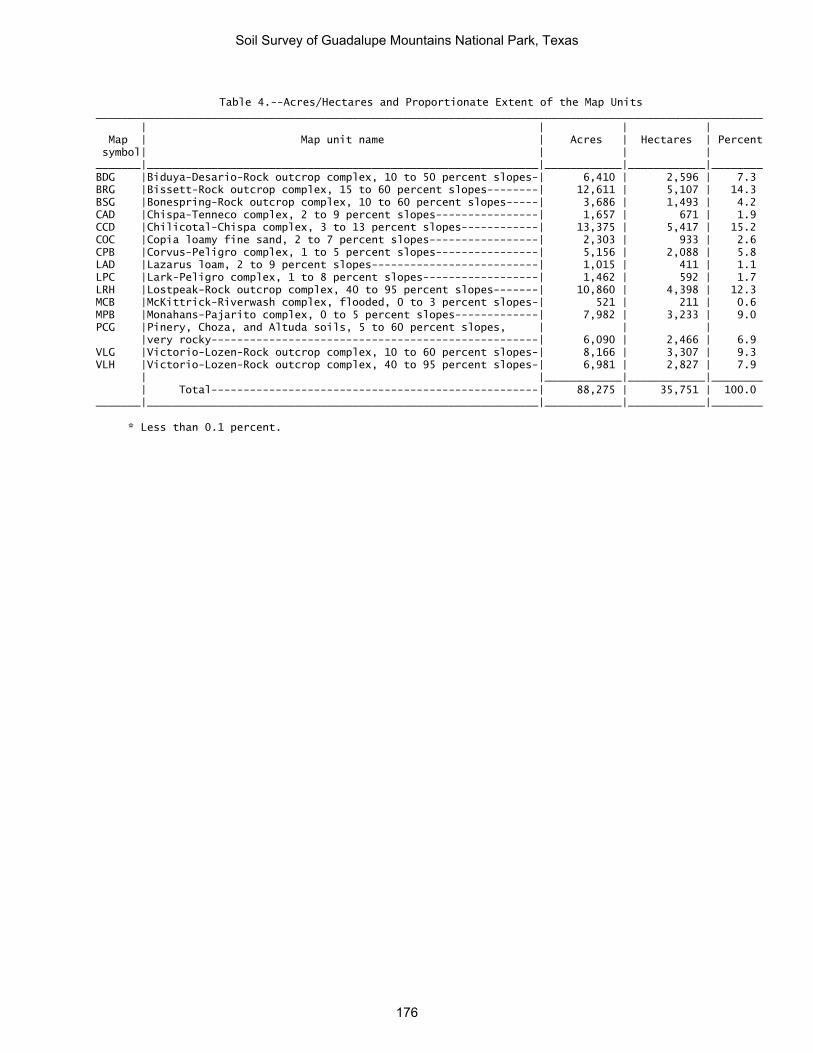
Table 4.--Acres/Hectares and Proportionate Extent of the Map Units ________________________________________________________________________________________________________ | | | | Map | Map unit name | Acres | Hectares | Percent symbol| | | | _______|_____________________________________________________________|____________|____________|________ BDG |Biduya-Desario-Rock outcrop complex, 10 to 50 percent slopes-| 6,410 | 2,596 | 7.3 BRG |Bissett-Rock outcrop complex, 15 to 60 percent slopes--------| 12,611 | 5,107 | 14.3 BSG |Bonespring-Rock outcrop complex, 10 to 60 percent slopes-----| 3,686 | 1,493 | 4.2 CAD |Chispa-Tenneco complex, 2 to 9 percent slopes----------------| 1,657 | 671 | 1.9 CCD |Chilicotal-Chispa complex, 3 to 13 percent slopes------------| 13,375 | 5,417 | 15.2 COC |Copia loamy fine sand, 2 to 7 percent slopes-----------------| 2,303 | 933 | 2.6 CPB |Corvus-Peligro complex, 1 to 5 percent slopes----------------| 5,156 | 2,088 | 5.8 LAD |Lazarus loam, 2 to 9 percent slopes--------------------------| 1,015 | 411 | 1.1 LPC |Lark-Peligro complex, 1 to 8 percent slopes------------------| 1,462 | 592 | 1.7 LRH |Lostpeak-Rock outcrop complex, 40 to 95 percent slopes-------| 10,860 | 4,398 | 12.3 MCB |McKittrick-Riverwash complex, flooded, 0 to 3 percent slopes-| 521 | 211 | 0.6 MPB |Monahans-Pajarito complex, 0 to 5 percent slopes-------------| 7,982 | 3,233 | 9.0 PCG |Pinery, Choza, and Altuda soils, 5 to 60 percent slopes, | | | |very rocky---------------------------------------------------| 6,090 | 2,466 | 6.9 VLG |Victorio-Lozen-Rock outcrop complex, 10 to 60 percent slopes-| 8,166 | 3,307 | 9.3 VLH |Victorio-Lozen-Rock outcrop complex, 40 to 95 percent slopes-| 6,981 | 2,827 | 7.9 | |____________|____________|________ | Total---------------------------------------------------| 88,275 | 35,751 | 100.0 _______|_____________________________________________________________|____________|____________|________ * Less than 0.1 percent.
Soil Survey of Guadalupe Mountains National Park, Texas
176

Table 5.--Land Management--Planting
(The information in this table indicates the dominant soil condition but does not eliminate the need for onsite investigation. The numbers in the value columns range from 0.01 to 1.00. The larger the value, the greater the limitation. See text for further explanation of ratings in this table.) ________________________________________________________________________________________________________ | | | | Map symbol |Pct.| Suitability for | Suitability for | Soil rutting with and soil name | of | hand planting | mechanical planting | equipment use | map| | | |unit| | | | |_________________________|_________________________|_________________________ | | Rating class and |Value| Rating class and |Value| Rating class and |Value | | limiting features | | limiting features | | limiting features | _____________________|____|___________________|_____|___________________|_____|___________________|_____ BDG: | | | | | | | Biduya--------------| 42 |Unsuited | |Unsuited | |Slight | | |Restrictive layer |1.00 |Rock fragments |1.00 |Strength |0.10 | |Rock fragments |0.50 |Slope |0.50 | | | | | |Restrictive layer |0.50 | | | | | | | | | Desario-------------| 28 |Moderately suited | |Unsuited | |Moderate | | |Slope |0.50 |Slope |1.00 |Low strength |0.50 | | | |Rock fragments |0.50 | | | | | | | | | Rock outcrop--------| 18 |Not rated | |Not rated | |Not rated | | | | | | | | BRG: | | | | | | | Bissett-------------| 45 |Poorly suited | |Unsuited | |Slight | | |Rock fragments |0.75 |Rock fragments |1.00 |Strength |0.10 | |Slope |0.50 |Slope |1.00 | | | | | | | | | Rock outcrop--------| 43 |Not rated | |Not rated | |Not rated | | | | | | | | BSG: | | | | | | | Bonespring----------| 63 |Unsuited | |Unsuited | |Moderate | | |Restrictive layer |1.00 |Slope |1.00 |Low strength |0.50 | |Rock fragments |0.50 |Rock fragments |1.00 | | | |Sandiness |0.50 |Sandiness |0.50 | | | |Slope |0.50 |Restrictive layer |0.50 | | | | | | | | | Rock outcrop--------| 20 |Not rated | |Not rated | |Not rated | | | | | | | | CAD: | | | | | | | Chispa--------------| 50 |Well suited | |Moderately suited | |Severe | | | | |Rock fragments |0.50 |Low strength |1.00 | | | |Slope |0.50 | | | | | | | | | Tenneco-------------| 33 |Well suited | |Moderately suited | |Severe | | | | |Slope |0.50 |Low strength |1.00 | | | | | | | CCD: | | | | | | | Chilicotal----------| 51 |Moderately suited | |Poorly suited | |Moderate | | |Rock fragments |0.50 |Rock fragments |0.75 |Low strength |0.50 | | | |Slope |0.50 | | | | | | | | | Chispa--------------| 28 |Well suited | |Moderately suited | |Severe | | | | |Slope |0.50 |Low strength |1.00 | | | | | | | COC: | | | | | | | Copia---------------| 90 |Moderately suited | |Moderately suited | |Moderate | | |Sandiness |0.50 |Sandiness |0.50 |Low strength |0.50 | | | |Slope |0.50 | | | | | | | | | CPB: | | | | | | | Corvus--------------| 43 |Well suited | |Well suited | |Severe | | | | | | |Low strength |1.00 | | | | | | |
Soil Survey of Guadalupe Mountains National Park, Texas
177

Table 5.--Land Management--Planting--Continued ________________________________________________________________________________________________________ | | | | Map symbol |Pct.| Suitability for | Suitability for | Soil rutting with and soil name | of | hand planting | mechanical planting | equipment use | map| | | |unit| | | | |_________________________|_________________________|_________________________ | | Rating class and |Value| Rating class and |Value| Rating class and |Value | | limiting features | | limiting features | | limiting features | _____________________|____|___________________|_____|___________________|_____|___________________|_____ Peligro-------------| 27 |Well suited | |Well suited | |Severe | | | | | | |Low strength |1.00 | | | | | | | LAD: | | | | | | | Lazarus-------------| 80 |Well suited | |Well suited | |Severe | | | | | | |Low strength |1.00 | | | | | | | LPC: | | | | | | | Lark----------------| 50 |Moderately suited | |Moderately suited | |Moderate | | |Sandiness |0.50 |Sandiness |0.50 |Low strength |0.50 | | | |Slope |0.50 | | | | | | | | | Peligro-------------| 40 |Well suited | |Moderately suited | |Moderate | | | | |Slope |0.50 |Low strength |0.50 | | | | | | | LRH: | | | | | | | Lostpeak------------| 70 |Unsuited | |Unsuited | |Moderate | | |Restrictive layer |1.00 |Slope |1.00 |Low strength |0.50 | |Slope |0.50 |Rock fragments |0.75 | | | |Rock fragments |0.50 |Restrictive layer |0.50 | | | |Stickiness; high |0.50 |Stickiness; high |0.50 | | | |plasticity index | |plasticity index | | | | | | | | | | Rock outcrop--------| 25 |Not rated | |Not rated | |Not rated | | | | | | | | MCB: | | | | | | | McKittrick, | | | | | | | occasionally | | | | | | | flooded------------| 31 |Moderately suited | |Moderately suited | |Moderate | | |Rock fragments |0.50 |Rock fragments |0.50 |Low strength |0.50 | | | | | | | McKittrick, | | | | | | | frequently flooded-| 20 |Moderately suited | |Moderately suited | |Moderate | | |Rock fragments |0.50 |Rock fragments |0.50 |Low strength |0.50 | | | | | | | Riverwash-----------| 22 |Not rated | |Not rated | |Not rated | | | | | | | | MPB: | | | | | | | Monahans------------| 60 |Well suited | |Well suited | |Severe | | | | | | |Low strength |1.00 | | | | | | | Pajarito------------| 21 |Well suited | |Well suited | |Severe | | | | | | |Low strength |1.00 | | | | | | | PCG: | | | | | | | Altuda--------------| 20 |Unsuited | |Unsuited | |Moderate | | |Restrictive layer |1.00 |Slope |1.00 |Low strength |0.50 | |Slope |0.50 |Rock fragments |0.50 | | | |Rock fragments |0.50 |Restrictive layer |0.50 | | | | | | | | | Pinery--------------| 32 |Well suited | |Moderately suited | |Moderate | | | | |Rock fragments |0.50 |Low strength |0.50 | | | |Slope |0.50 | | | | | | | | |
Soil Survey of Guadalupe Mountains National Park, Texas
178

Table 5.--Land Management--Planting--Continued ________________________________________________________________________________________________________ | | | | Map symbol |Pct.| Suitability for | Suitability for | Soil rutting with and soil name | of | hand planting | mechanical planting | equipment use | map| | | |unit| | | | |_________________________|_________________________|_________________________ | | Rating class and |Value| Rating class and |Value| Rating class and |Value | | limiting features | | limiting features | | limiting features | _____________________|____|___________________|_____|___________________|_____|___________________|_____ Choza---------------| 27 |Unsuited | |Moderately suited | |Moderate | | |Restrictive layer |1.00 |Slope |0.50 |Low strength |0.50 | | | |Rock fragments |0.50 | | | | | |Restrictive layer |0.50 | | | | | | | | | VLG: | | | | | | | Victorio------------| 51 |Unsuited | |Unsuited | |Severe | | |Restrictive layer |1.00 |Slope |1.00 |Low strength |1.00 | |Stickiness; high |0.75 |Rock fragments |0.75 | | | |plasticity index | | | | | | |Slope |0.50 |Stickiness; high |0.75 | | | | | |plasticity index | | | | |Rock fragments |0.50 |Restrictive layer |0.50 | | | | | | | | | Lozen---------------| 33 |Unsuited | |Poorly suited | |Moderate | | |Restrictive layer |1.00 |Slope |0.75 |Low strength |0.50 | |Rock fragments |0.50 |Rock fragments |0.75 | | | | | |Restrictive layer |0.50 | | | | | | | | | Rock outcrop--------| 12 |Not rated | |Not rated | |Not rated | | | | | | | | VLH: | | | | | | | Victorio, 60 to 95 | | | | | | | percent slopes-----| 35 |Moderately suited | |Unsuited | |Moderate | | |Slope |0.50 |Slope |1.00 |Low strength |0.50 | |Stickiness; high |0.50 |Rock fragments |0.50 | | | |plasticity index | | | | | | |Rock fragments |0.50 |Stickiness; high |0.50 | | | | | |plasticity index | | | | | | | | | | Victorio, 40 to 60 | | | | | | | percent slopes-----| 20 |Moderately suited | |Unsuited | |Moderate | | |Stickiness; high |0.50 |Slope |1.00 |Low strength |0.50 | |plasticity index | | | | | | |Slope |0.50 |Rock fragments |0.50 | | | |Rock fragments |0.50 |Stickiness; high |0.50 | | | | | |plasticity index | | | | | | | | | | Lozen---------------| 25 |Moderately suited | |Unsuited | |Moderate | | |Slope |0.50 |Slope |1.00 |Low strength |0.50 | |Rock fragments |0.50 |Rock fragments |1.00 | | | | | | | | | Rock outcrop--------| 20 |Not rated | |Not rated | |Not rated | _____________________|____|___________________|_____|___________________|_____|___________________|_____
Soil Survey of Guadalupe Mountains National Park, Texas
179

Table 6.--Land Management--Hazard of Erosion and Suitability for Roads (The information in this table indicates the dominant soil condition but does not eliminate the need for onsite investigation. The numbers in the value columns range from 0.01 to 1.00. The larger the value, the greater the limitation. See text for further explanation of ratings in this table.) ________________________________________________________________________________________________________ | | | | Map symbol |Pct.| Hazard of erosion | Hazard of erosion on | Suitability for roads and soil name | of | | roads and trails | (natural surface) | map| | | |unit| | | | |_________________________|_________________________|_________________________ | | Rating class and |Value| Rating class and |Value| Rating class and |Value | | limiting features | | limiting features | | limiting features | _____________________|____|___________________|_____|___________________|_____|___________________|_____ BDG: | | | | | | | Biduya--------------| 42 |Moderate | |Moderate | |Poorly suited | | |Slope/erodibility |0.50 |Slope/erodibility |0.50 |Slope |1.00 | | | | | | | Desario-------------| 28 |Moderate | |Severe | |Poorly suited | | |Slope/erodibility |0.50 |Slope/erodibility |0.95 |Slope |1.00 | | | | | | | Rock outcrop--------| 18 |Not rated | |Not rated | |Not rated | | | | | | | | BRG: | | | | | | | Bissett-------------| 45 |Severe | |Severe | |Poorly suited | | |Slope/erodibility |0.75 |Slope/erodibility |0.95 |Slope |1.00 | | | | | |Rock fragments |0.50 | | | | | | | Rock outcrop--------| 43 |Not rated | |Not rated | |Not rated | | | | | | | | BSG: | | | | | | | Bonespring----------| 63 |Severe | |Severe | |Poorly suited | | |Slope/erodibility |0.75 |Slope/erodibility |0.95 |Slope |1.00 | | | | | | | Rock outcrop--------| 20 |Not rated | |Not rated | |Not rated | | | | | | | | CAD: | | | | | | | Chispa--------------| 50 |Slight | |Moderate | |Moderately suited | | | | |Slope/erodibility |0.50 |Low strength |0.50 | | | | | |Slope |0.50 | | | | | | | Tenneco-------------| 33 |Slight | |Moderate | |Moderately suited | | | | |Slope/erodibility |0.50 |Low strength |0.50 | | | | | |Slope |0.50 | | | | | | | CCD: | | | | | | | Chilicotal----------| 51 |Slight | |Moderate | |Moderately suited | | | | |Slope/erodibility |0.50 |Slope |0.50 | | | | | | | Chispa--------------| 28 |Slight | |Severe | |Moderately suited | | | | |Slope/erodibility |0.95 |Slope |0.50 | | | | | |Low strength |0.50 | | | | | | | COC: | | | | | | | Copia---------------| 90 |Slight | |Moderate | |Moderately suited | | | | |Slope/erodibility |0.50 |Sandiness |0.50 | | | | | | | CPB: | | | | | | | Corvus--------------| 43 |Slight | |Slight | |Well suited | | | | | | | | Peligro-------------| 27 |Slight | |Slight | |Well suited | | | | | | | | LAD: | | | | | | | Lazarus-------------| 80 |Slight | |Moderate | |Moderately suited | | | | |Slope/erodibility |0.50 |Low strength |0.50 | | | | | | |
Soil Survey of Guadalupe Mountains National Park, Texas
180

Table 6.--Land Management--Hazard of Erosion and Suitability for Roads--Continued ________________________________________________________________________________________________________ | | | | Map symbol |Pct.| Hazard of erosion | Hazard of erosion on | Suitability for roads and soil name | of | | roads and trails | (natural surface) | map| | | |unit| | | | |_________________________|_________________________|_________________________ | | Rating class and |Value| Rating class and |Value| Rating class and |Value | | limiting features | | limiting features | | limiting features | _____________________|____|___________________|_____|___________________|_____|___________________|_____ LPC: | | | | | | | Lark----------------| 50 |Slight | |Moderate | |Moderately suited | | | | |Slope/erodibility |0.50 |Sandiness |0.50 | | | | | | | Peligro-------------| 40 |Slight | |Moderate | |Well suited | | | | |Slope/erodibility |0.50 | | | | | | | | | LRH: | | | | | | | Lostpeak------------| 70 |Very severe | |Severe | |Poorly suited | | |Slope/erodibility |0.95 |Slope/erodibility |0.95 |Slope |1.00 | | | | | | | Rock outcrop--------| 25 |Not rated | |Not rated | |Not rated | | | | | | | | MCB: | | | | | | | McKittrick, | | | | | | | occasionally | | | | | | | flooded------------| 31 |Slight | |Slight | |Moderately suited | | | | | | |Flooding |0.50 | | | | | | | McKittrick, | | | | | | | frequently flooded-| 20 |Slight | |Slight | |Poorly suited | | | | | | |Flooding |1.00 | | | | | | | Riverwash-----------| 22 |Not rated | |Not rated | |Not rated | | | | | | | | MPB: | | | | | | | Monahans------------| 60 |Slight | |Moderate | |Moderately suited | | | | |Slope/erodibility |0.50 |Low strength |0.50 | | | | | | | Pajarito------------| 21 |Slight | |Moderate | |Moderately suited | | | | |Slope/erodibility |0.50 |Low strength |0.50 | | | | | | | PCG: | | | | | | | Altuda--------------| 20 |Severe | |Severe | |Poorly suited | | |Slope/erodibility |0.75 |Slope/erodibility |0.95 |Slope |1.00 | | | | | | | Pinery--------------| 32 |Slight | |Moderate | |Poorly suited | | | | |Slope/erodibility |0.50 |Slope |1.00 | | | | | | | Choza---------------| 27 |Slight | |Moderate | |Poorly suited | | | | |Slope/erodibility |0.50 |Slope |1.00 | | | | | | | VLG: | | | | | | | Victorio------------| 51 |Severe | |Severe | |Poorly suited | | |Slope/erodibility |0.75 |Slope/erodibility |0.95 |Slope |1.00 | | | | | |Low strength |0.50 | | | | | | | Lozen---------------| 33 |Moderate | |Severe | |Poorly suited | | |Slope/erodibility |0.50 |Slope/erodibility |0.95 |Slope |1.00 | | | | | | | Rock outcrop--------| 12 |Not rated | |Not rated | |Not rated | | | | | | | |
Soil Survey of Guadalupe Mountains National Park, Texas
181

Table 6.--Land Management--Hazard of Erosion and Suitability for Roads--Continued ________________________________________________________________________________________________________ | | | | Map symbol |Pct.| Hazard of erosion | Hazard of erosion on | Suitability for roads and soil name | of | | roads and trails | (natural surface) | map| | | |unit| | | | |_________________________|_________________________|_________________________ | | Rating class and |Value| Rating class and |Value| Rating class and |Value | | limiting features | | limiting features | | limiting features | _____________________|____|___________________|_____|___________________|_____|___________________|_____ VLH: | | | | | | | Victorio, 60 to 95 | | | | | | | percent slopes-----| 35 |Very severe | |Severe | |Poorly suited | | |Slope/erodibility |0.95 |Slope/erodibility |0.95 |Slope |1.00 | | | | | | | | | | | | | | Victorio, 40 to 60 | | | | | | | percent slopes-----| 20 |Severe | |Severe | |Poorly suited | | |Slope/erodibility |0.75 |Slope/erodibility |0.95 |Slope |1.00 | | | | | | | Lozen---------------| 25 |Very severe | |Severe | |Poorly suited | | |Slope/erodibility |0.95 |Slope/erodibility |0.95 |Slope |1.00 | | | | | |Low strength |0.50 | | | | | | | Rock outcrop--------| 20 |Not rated | |Not rated | |Not rated | _____________________|____|___________________|_____|___________________|_____|___________________|_____
Soil Survey of Guadalupe Mountains National Park, Texas
182

Table 7.--Land Management--Mechanical Site Preparation and Mechanical Site Restoration
(The information in this table indicates the dominant soil condition but does not eliminate the need for onsite investigation. The numbers in the value columns range from 0.01 to 1.00. The larger the value, the greater the limitation. See text for further explanation of ratings in this table.)
______________________________________________________________________________ | | | Map symbol |Pct.| Mechanical Site | Mechanical Site and soil name | of | Preparation and | Preparation and | map| Restoration (Deep) | Restoration (Surface) |unit| | | |_________________________|_________________________ | | Rating class and |Value| Rating class and |Value | | limiting features | | limiting features | _____________________|____|___________________|_____|___________________|_____ BDG: | | | | | Biduya--------------| 42 |Unsuited | |Poorly suited | | |Restrictive layer |1.00 |Rock fragments |0.50 | |Slope |0.50 |Slope |0.50 | | | |Restrictive layer |0.50 | | | | | Desario-------------| 28 |Unsuited | |Poorly suited | | |Restrictive layer |1.00 |Slope |0.50 | |Slope |0.50 | | | | | | | Rock outcrop--------| 18 |Not rated | |Not rated | | | | | | BRG: | | | | | Bissett-------------| 45 |Unsuited | |Poorly suited | | |Restrictive layer |1.00 |Slope |1.00 | |Slope |1.00 |Rock fragments |0.50 | | | | | Rock outcrop--------| 43 |Not rated | |Not rated | | | | | | BSG: | | | | | Bonespring----------| 63 |Unsuited | |Poorly suited | | |Restrictive layer |1.00 |Slope |1.00 | |Slope |1.00 |Rock fragments |0.50 | | | |Restrictive layer |0.50 | | | | | Rock outcrop--------| 20 |Not rated | |Not rated | | | | | | CAD: | | | | | Chispa--------------| 50 |Well suited | |Well suited | | | | | | Tenneco-------------| 33 |Well suited | |Well suited | | | | | | CCD: | | | | | Chilicotal----------| 51 |Well suited | |Poorly suited | | | | |Rock fragments |0.50 | | | | | Chispa--------------| 28 |Well suited | |Well suited | | | | | | COC: | | | | | Copia---------------| 90 |Well suited | |Well suited | | | | | | CPB: | | | | | Corvus--------------| 43 |Well suited | |Well suited | | | | | | Peligro-------------| 27 |Well suited | |Well suited | | | | | | LAD: | | | | | Lazarus-------------| 80 |Well suited | |Well suited | | | | | |
Soil Survey of Guadalupe Mountains National Park, Texas
183

Table 7.--Land Management--Mechanical Site Preparation and Mechanical Site Restoration--Continued
______________________________________________________________________________ | | | Map symbol |Pct.| Mechanical Site | Mechanical Site and soil name | of | Preparation and | Preparation and | map| Restoration (Deep) | Restoration (Surface) |unit| | | |_________________________|_________________________ | | Rating class and |Value| Rating class and |Value | | limiting features | | limiting features | _____________________|____|___________________|_____|___________________|_____ LPC: | | | | | Lark----------------| 50 |Well suited | |Well suited | | | | | | Peligro-------------| 40 |Well suited | |Well suited | | | | | | LRH: | | | | | Lostpeak------------| 70 |Unsuited | |Poorly suited | | |Slope |1.00 |Slope |1.00 | |Restrictive layer |1.00 |Rock fragments |0.50 | | | |Restrictive layer |0.50 | | | | | Rock outcrop--------| 25 |Not rated | |Not rated | | | | | | MCB: | | | | | McKittrick, | | | | | occasionally | | | | | flooded------------| 31 |Poorly suited | |Poorly suited | | |Rock fragments |0.50 |Rock fragments |0.50 | | | | | McKittrick, | | | | | frequently flooded-| 20 |Poorly suited | |Poorly suited | | |Rock fragments |0.50 |Rock fragments |0.50 | | | | | Riverwash-----------| 22 |Not rated | |Not rated | | | | | | MPB: | | | | | Monahans------------| 60 |Well suited | |Well suited | | | | | | Pajarito------------| 21 |Well suited | |Well suited | | | | | | PCG: | | | | | Altuda--------------| 20 |Unsuited | |Poorly suited | | |Restrictive layer |1.00 |Slope |1.00 | |Slope |1.00 |Restrictive layer |0.50 | | | |Rock fragments |0.50 | | | | | Pinery--------------| 32 |Poorly suited | |Well suited | | |Rock fragments |0.50 | | | | | | | Choza---------------| 27 |Unsuited | |Poorly suited | | |Restrictive layer |1.00 |Restrictive layer |0.50 | | | | | VLG: | | | | | Victorio------------| 51 |Unsuited | |Poorly suited | | |Restrictive layer |1.00 |Slope |1.00 | |Slope |1.00 |Restrictive layer |0.50 | | | |Stickiness; high |0.50 | | | |plasticity index | | | | |Rock fragments |0.50 | | | | | Lozen---------------| 33 |Unsuited | |Poorly suited | | |Restrictive layer |1.00 |Slope |0.50 | |Slope |0.50 |Rock fragments |0.50 | | | |Restrictive layer |0.50 | | | | | Rock outcrop--------| 12 |Not rated | |Not rated | | | | | |
Soil Survey of Guadalupe Mountains National Park, Texas
184

Table 7.--Land Management--Mechanical Site Preparation and Mechanical Site Restoration--Continued
______________________________________________________________________________ | | | Map symbol |Pct.| Mechanical Site | Mechanical Site and soil name | of | Preparation and | Preparation and | map| Restoration (Deep) | Restoration (Surface) |unit| | | |_________________________|_________________________ | | Rating class and |Value| Rating class and |Value | | limiting features | | limiting features | _____________________|____|___________________|_____|___________________|_____ VLH: | | | | | Victorio, 60 to 95 | | | | | percent slopes-----| 35 |Unsuited | |Poorly suited | | |Slope |1.00 |Slope |1.00 | |Restrictive layer |1.00 |Stickiness; high |0.50 | | | |plasticity index | | | | |Rock fragments |0.50 | | | | | Victorio, 40 to 60 | | | | | percent slopes-----| 20 |Unsuited | |Poorly suited | | |Slope |1.00 |Slope |1.00 | |Restrictive layer |1.00 |Stickiness; high |0.50 | | | |plasticity index | | | | |Rock fragments |0.50 | | | | | Lozen---------------| 25 |Unsuited | |Poorly suited | | |Slope |1.00 |Slope |1.00 | |Restrictive layer |1.00 |Rock fragments |0.50 | |Rock fragments |0.50 | | | | | | | Rock outcrop--------| 20 |Not rated | |Not rated | _____________________|____|___________________|_____|___________________|_____
Soil Survey of Guadalupe Mountains National Park, Texas
185

Table 8.--Damage by Fire and Seedling Mortality on Forestland
(The information in this table indicates the dominant soil condition but does not eliminate the need for onsite investigation. The numbers in the value columns range from 0.01 to 1.00. The larger the value, the greater the limitation. See text for further explanation of ratings in this table.) _________________________________________________________________________________ | | | | | Map symbol |Pct.| Potential for damage| | Potential for | and soil name | of | to soil by fire | |seedling mortality | | map| | | | |unit| | | | |____|_____________________|_____|___________________|______ | | Rating class and |Value| Rating class and |Value | | limiting features | | limiting features | _____________________|____|_____________________|_____|___________________|______ BDG: | | | | | Biduya--------------| 42 |Low | |High | | |Texture/rock |0.10 |Available water |1.00 | |fragments | | | | | | |Soil reaction |0.50 | | | | | Desario-------------| 28 |Low | |Moderate | | |Texture/slope/rock |0.10 |Carbonate content |0.50 | |fragments | | | | | | |Soil reaction |0.50 | | | |Available water |0.50 | | | | | Rock outcrop--------| 18 |Not rated | |Not rated | | | | | | BRG: | | | | | Bissett-------------| 45 |Moderate | |Moderate | | |Texture/slope/surface|0.50 |Carbonate content |0.50 | | depth/rock | | | | |fragments | | | | | | | | Rock outcrop--------| 43 |Not rated | |Not rated | | | | | | BSG: | | | | | Bonespring----------| 63 |High | |High | | |Texture/slope/surface|1.00 |Available water |1.00 | | depth/rock | | | | |fragments | | | | | | | | Rock outcrop--------| 20 |Not rated | |Not rated | | | | | | CAD: | | | | | Chispa--------------| 50 |Moderate | |Moderate | | |Texture/rock |0.50 |Carbonate content |0.50 | |fragments | | | | | | | | Tenneco-------------| 33 |Moderate | |Moderate | | |Texture/rock |0.50 |Carbonate content |0.50 | |fragments | | | | | | |Soil reaction |0.50 | | | | | CCD: | | | | | Chilicotal----------| 51 |Moderate | |Moderate | | |Texture/rock |0.50 |Carbonate content |0.50 | |fragments | | | | | | | | Chispa--------------| 28 |Moderate | |Moderate | | |Texture/rock |0.50 |Carbonate content |0.50 | |fragments | | | | | | | |
Soil Survey of Guadalupe Mountains National Park, Texas
186

Table 8.--Damage by Fire and Seedling Mortality on Forestland--Continued _________________________________________________________________________________ | | | | | Map symbol |Pct.| Potential for damage| | Potential for | and soil name | of | to soil by fire | |seedling mortality | | map| | | | |unit| | | | |____|_____________________|_____|___________________|______ | | Rating class and |Value| Rating class and |Value | | limiting features | | limiting features | _____________________|____|_____________________|_____|___________________|______ COC: | | | | | Copia---------------| 90 |High | |Moderate | | |Texture/surface |1.00 |Soil reaction |0.50 | |depth/rock | | | | |fragments | | | | | | | | CPB: | | | | | Corvus--------------| 43 |High | |Low | | |Texture/surface |1.00 | | | |depth/rock | | | | |fragments | | | | | | | | Peligro-------------| 27 |High | |Low | | |Texture/surface |1.00 | | | |depth/rock | | | | |fragments | | | | | | | | LAD: | | | | | Lazarus-------------| 80 |Low | |Low | | |Texture/rock |0.10 | | | |fragments | | | | | | | | LPC: | | | | | Lark----------------| 50 |High | |Moderate | | |Texture/rock |1.00 |Soil reaction |0.50 | |fragments | | | | | | | | Peligro-------------| 40 |High | |Moderate | | |Texture/rock |1.00 |Soil reaction |0.50 | |fragments | | | | | | | | LRH: | | | | | Lostpeak------------| 70 |Low | |High | | | | |Available water |1.00 | | | |Soil reaction |0.50 | | | | | Rock outcrop--------| 25 |Not rated | |Not rated | | | | | | MCB: | | | | | McKittrick, | | | | | occasionally | | | | | flooded------------| 31 |Moderate | |High | | |Texture/rock |0.50 |Available water |1.00 | |fragments | | | | | | |Wetness |1.00 | | | |Carbonate content |0.50 | | | | | McKittrick, | | | | | frequently flooded-| 20 |Moderate | |High | | |Texture/rock |0.50 |Available water |1.00 | |fragments | | | | | | |Wetness |1.00 | | | |Carbonate content |0.50 | | | | | Riverwash-----------| 22 |Not rated | |Not rated | | | | | |
Soil Survey of Guadalupe Mountains National Park, Texas
187

Table 8.--Damage by Fire and Seedling Mortality on Forestland--Continued _________________________________________________________________________________ | | | | | Map symbol |Pct.| Potential for damage| | Potential for | and soil name | of | to soil by fire | |seedling mortality | | map| | | | |unit| | | | |____|_____________________|_____|___________________|______ | | Rating class and |Value| Rating class and |Value | | limiting features | | limiting features | _____________________|____|_____________________|_____|___________________|______ MPB: | | | | | Monahans------------| 60 |High | |Low | | |Texture/surface |1.00 | | | |depth/rock | | | | |fragments | | | | | | | | Pajarito------------| 21 |Moderate | |Moderate | | |Texture/rock |0.50 |Soil reaction |0.50 | |fragments | | | | | | | | PCG: | | | | | Altuda--------------| 20 |High | |High | | |Texture/slope/rock |1.00 |Available water |1.00 | |fragments | | | | | | |Carbonate content |0.50 | | | | | Pinery--------------| 32 |Moderate | |High | | |Texture/rock |0.50 |Available water |1.00 | |fragments | | | | | | |Soil reaction |0.50 | | | | | Choza---------------| 27 |High | |High | | |Texture/rock |1.00 |Available water |1.00 | |fragments | | | | | | |Soil reaction |0.50 | | | | | VLG: | | | | | Victorio------------| 51 |Low | |Moderate | | |Texture/slope/rock |0.10 |Available water |0.50 | |fragments | | | | | | | | Lozen---------------| 33 |Moderate | |High | | |Texture/rock |0.50 |Available water |1.00 | |fragments | | | | | | | | Rock outcrop--------| 12 |Not rated | |Not rated | | | | | | VLH: | | | | | Victorio, 60 to 95 | | | | | percent slopes-----| 35 |Moderate | |Low | | |Texture/slope/surface|0.50 | | | | depth/rock | | | | |fragments | | | | | | | | Victorio, 40 to 60 | | | | | percent slopes-----| 20 |Moderate | |Low | | |Texture/slope/surface|0.50 | | | | depth/rock | | | | |fragments | | | | | | | | Lozen---------------| 25 |Moderate | |High | | |Texture/rock |0.50 |Available water |1.00 | |fragments | | | | | | | | Rock outcrop--------| 20 |Not rated | |Not rated | _____________________|____|_____________________|_____|___________________|_____
Soil Survey of Guadalupe Mountains National Park, Texas
188

Table 9.--Land Capability Classification
(Land capability is a system of grouping soils primarily on the basis of their capability to produce common cultivated crops and pasture plants without deteriorating over a long period of time.) _________________________________________________________________ | Land | Capability | Map symbol and soil name |_____________ | N | I ___________________________________________________|______|______ | | BDG: | | Biduya-------------------------------------------| 6s | --- Desario------------------------------------------| 7e | --- Rock outcrop-------------------------------------| ---| --- | | BRG: | | Bissett------------------------------------------| 7s | --- Rock outcrop-------------------------------------| ---| --- | | BSG: | | Bonespring---------------------------------------| 6c | --- Rock outcrop-------------------------------------| ---| --- | | CAD: | | Chispa-------------------------------------------| 6s | --- Tenneco------------------------------------------| 6c | --- | | CCD: | | Chilicotal---------------------------------------| 7s | --- Chispa-------------------------------------------| 6s | --- | | COC: | | Copia--------------------------------------------| 7c | --- | | CPB: | | Corvus-------------------------------------------| 7c | --- Peligro------------------------------------------| 7c | --- | | LAD: | | Lazarus------------------------------------------| 7e | 2e | | LPC: | | Lark---------------------------------------------| 7c | --- Peligro------------------------------------------| 7c | --- | | LRH: | | Lostpeak-----------------------------------------| 7s | --- | | MCB: | | McKittrick, occasionally flooded-----------------| 6e | --- McKittrick, frequently flooded-------------------| 6w | --- Riverwash----------------------------------------| ---| --- | | MPB: | | Monahans-----------------------------------------| 7e | 2e Pajarito-----------------------------------------| 7e | 3e | | PCG: | | Altuda-------------------------------------------| 7s | --- Pinery-------------------------------------------| 6e | --- Choza--------------------------------------------| 6s | --- | |
Soil Survey of Guadalupe Mountains National Park, Texas
189

Table 9.--Land Capability Classification--Continued _________________________________________________________________ | | Land | Capability | Map symbol and soil name |_____________ | N | I __________________________________________________|______|______ | | VLG: | | Victorio-----------------------------------------| 7s | --- Lozen--------------------------------------------| 7s | --- | | VLH: | | Victorio, 60 to 95 percent slopes----------------| 7s | --- Victorio, 40 to 60 percent slopes----------------| 7s | --- Lozen--------------------------------------------| 7s | --- Rock outcrop-------------------------------------| ---| --- ___________________________________________________|______|______
Soil Survey of Guadalupe Mountains National Park, Texas
190

Table 10.--Ecological Site--Soil Correlation
(Only soils and miscellaneous land types with correlated ecological sites are shown) ____________________________________________________________________________________________ Map unit symbol | Ecological | Ecological | Ecological soil percent (%) and soil name | site name | site type | site ID ___________________________________|______________________________|____________|____________ BDG: | | | 42%-Biduya------------------------|Shallow Limestone | Rangeland | R070CY102NM | | | 28%-Desario-----------------------|Shallow Limestone | Rangeland | R070CY102NM | | | BRG: | | | 45%-Bissett-----------------------|Limestone Hill and Mountain | Rangeland | R042XC249TX | (Desert Grassland) | | | | | BSG: | | | 63%-Bonespring--------------------|Sandstone Hill | Rangeland | R070DY749TX | | | CAD: | | | 50%-Chispa------------------------|Gravelly (Desert Grassland) | Rangeland | R042XC244TX | | | 33%-Tenneco-----------------------|Loamy | Rangeland | R042XC007NM | | | CCD: | | | 51%-Chilicotal--------------------|Gravelly (Desert Grassland) | Rangeland | R042XC244TX | | | 28%-Chispa------------------------|Gravelly (Desert Grassland) | Rangeland | R042XC244TX | | | COC: | | | 90%-Copia-------------------------|Deep Sand | Rangeland | R042XB011NM | | | CPB: | | | 43%-Corvus------------------------|Gyp outcrop | Rangeland | R042XB007NM | | | 27%-Peligro-----------------------|Gyp Upland | Rangeland | R042XB006NM | | | LAD: | | | 80%-Lazarus-----------------------|Loamy | Rangeland | R070CY109NM | | | LPC: | | | 50%-Lark--------------------------|Vegetated Gypsum Dunes | Rangeland | R042XB003NM | | | 40%-Peligro-----------------------|Gyp Upland | Rangeland | R042XB006NM | | | LRH: | | | 70%-Lostpeak----------------------|Breaks | Rangeland | R070CY115NM | | | MCB: | | | 31%-McKittrick, occasionally | | | flooded--------------------------|Limestone Canyon | Rangeland | R070CY745TX | | | 20%-McKittrick, frequently | | | flooded--------------------------|Gravelly | Rangeland | R070DY156NM | | | MPB: | | | 60%-Monahans----------------------|Sandy | Rangeland | R042XB012NM | | | 21%-Pajarito----------------------|Sandy | Rangeland | R042XB012NM | | | PCG: | | | 32%-Pinery------------------------|Gravelly | Rangeland | R070DY156NM | | | 27%-Choza-------------------------|Shallow | Rangeland | R070DY152NM | | | 20%-Altuda------------------------|Limestone Hills | Rangeland | R070DY151NM | | |
Soil Survey of Guadalupe Mountains National Park, Texas
191

Table 10.--Ecological Site--Soil Correlation--Continued ____________________________________________________________________________________________ Map unit symbol | Ecological | Ecological | Ecological soil percent (%) and soil name | site name | site type | site ID ___________________________________|______________________________|____________|____________ VLG: | | | 51%-Victorio----------------------|Pseudotsuga menziesii var. | Forestland | F070CY020TX | glauca-Quercus | | | gambelii/Amelanchier | | | utahensis-Fendlera | | | rupicola/Muhlenbergia | | | pauciflora | | | | | 33%-Lozen-------------------------|Pinus ponderosa var. | Forestland | F070CY021TX | scopulorum-Pinus | | | edulis/Quercus | | | undulata-Cercocarpus | | | montanus/Muhlenbergia dubia | | | | | VLH: | | | 35%-Victorio, 60 to 95------------|Pseudotsuga menziesii var. | Forestland | F070CY020TX percent slopes | glauca-Quercus | | | gambelii/Amelanchier | | | utahensis-Fendlera | | | rupicola/Muhlenbergia | | | pauciflora | | | | | 25%-Lozen-------------------------|Pinus ponderosa var. | Forestland | F070CY021TX | scopulorum-Pinus | | | edulis/Quercus | | | undulata-Cercocarpus | | | montanus/Muhlenbergia dubia | | | | | 20%-Victorio, 40 to 60------------|Pseudotsuga menziesii var. | Forestland | F070CY020TX percent slopes | glauca-Quercus | | | gambelii/Amelanchier | | | utahensis-Fendlera | | | rupicola/Muhlenbergia | | | pauciflora | | | | | 20%-Victorio, 40 to 60------------|Pseudotsuga menziesii var. | Forestland | F070CY020TX percent slopes | glauca-Quercus | | | gambelii/Amelanchier | | | utahensis-Fendlera | | | rupicola/Muhlenbergia | | | pauciflora | | ___________________________________|______________________________|____________|____________
Soil Survey of Guadalupe Mountains National Park, Texas
192

Table 11.--Mean Annual Precipitation (MAP), Landscape, Parent Material, and Ecological Site Identification
(Miscellaneous non-soil components are not displayed in this report. Component percents may not add up to 100 percent) _________________________________________________________________________________________________________________________________________ | | | | | | | | |Percent| | | | | | | Map unit symbol | of map| Slope | Elevation | MAP | Landscape | Landform | Parent | Ecological site and soil name | unit | | | | | | material | name and number ____________________|_______|_______|____________|_________|_____________|_______________|____________________|_________________________ | Pct | Pct | Meters | mm | | | | BDG: | | | | | | | | Biduya-------------| 42 | 10-25 |1,832-2,441 | 330-381 |Mountains |Hill |Residuum weathered |Shallow Limestone, | | | | | | | from limestone and | R070CY102NM | | | | | | | sandstone gravelly | | | | | | | | colluvium derived | | | | | | | | from limestone and | | | | | | | | sandstone | | | | | | | | | Desario------------| 28 | 20-50 |1,832-2,441 | 330-381 |Mountains |Hill |Residuum weathered |Shallow Limestone, | | | | | | | from limestone and | R070CY102NM | | | | | | | sandstone gravelly | | | | | | | | colluvium derived | | | | | | | | from limestone and | | | | | | | | sandstone | | | | | | | | | BRG: | | | | | | | | Bissett------------| 45 | 15-60 |1,192-2,111 | 254-381 |Hills |Hillslope |Gravelly residuum |Limestone Hill & | | | | | | | weathered from | Mountain (Desert | | | | | | | limestone | Grassland), R042XC249TX | | | | | | | | BSG: | | | | | | | | Bonespring---------| 63 | 10-60 |1,346-2,461 | 287-523 |Mountains |Ridge |Slope alluvium |Sandstone Hill, | | | | | | | and/or residuum | R070DY749TX | | | | | | | weathered from | | | | | | | | limestone and | | | | | | | | sandstone | | | | | | | | | CAD: | | | | | | | | Chispa-------------| 50 | 2-9 |1,121-1,377 | 254-381 |Hills |Fan |Loamy alluvium |Gravelly (Desert | | | | | | | derived from | Grassland), R042XC244TX | | | | | | | limestone and | | | | | | | | dolomite | | | | | | | | | Tenneco------------| 33 | 2-5 |1,121-1,377 | 254-381 |Hills |Alluvial fan |Loamy alluvium |Loamy, R042XC007NM | | | | | | | derived from | | | | | | | | limestone and | | | | | | | | dolomite | | | | | | | | |
Soil S
urvey of Guadalupe M
ountains National P
ark, Texas
193

Table 11.--Mean Annual Precipitation (MAP), Landscape, Parent Material, and Ecological Site Identification--Continued _________________________________________________________________________________________________________________________________________ | | | | | | | | |Percent| | | | | | | Map unit symbol | of map| Slope | Elevation | MAP | Landscape | Landform | Parent | Ecological site and soil name | unit | | | | | | material | name and number ____________________|_______|_______|____________|_________|_____________|_______________|____________________|_________________________ | Pct | Pct | Meters | mm | | | | CCD: | | | | | | | | Chilicotal---------| 51 | 3-13 |1,142-1,724 | 254-381 |Piedmont |Fan remnant |Gravelly alluvium |Gravelly (Desert | | | | | | | derived from | Grassland), R042XC244TX | | | | | | | limestone and | | | | | | | | dolomite | | | | | | | | | Chispa-------------| 28 | 3-13 |1,142-1,724 | 254-381 |Piedmont |Fan remnant |Gravelly alluvium |Gravelly (Desert | | | | | | | derived from | Grassland), R042XC244TX | | | | | | | limestone and | | | | | | | | dolomite | | | | | | | | | COC: | | | | | | | | Copia--------------| 90 | 2-7 |1,108-1,181 | 150-319 |Basin floor |Dune |Eolian sands |Deep Sand, R042XB011NM | | | | | | | | CPB: | | | | | | | | Corvus-------------| 43 | 1-5 |1,104-1,123 | 150-319 |Basin |Relict |Gypsiferous loamy |Gyp outcrop, R042XB007NM | | | | | | stabilized | eolian deposits | | | | | | | gypsum dune | | | | | | | | on basin floor| | | | | | | | | | Peligro------------| 27 | 1-5 |1,104-1,123 | 150-319 |Basin |Relict playa |Gypsiferous eolian |Gyp Upland, R042XB006NM | | | | | | dune on basin | deposits | | | | | | | floor | | | | | | | | | | LAD: | | | | | | | | Lazarus------------| 80 | 2-9 |1,834-2,104 | 508-660 |Mountains |Valley floor |Alluvium derived |Loamy, R070CY109NM | | | | | | on canyon | from limestone and | | | | | | | | dolomite | | | | | | |Valley side on | | | | | | | | canyon | | | | | | | | | | LPC: | | | | | | | | Lark---------------| 50 | 5-8 |1,106-1,130 | 150-319 |Basin |Dune field |Gypseous eolian |Vegetated Gypsum Dunes, | | | | | | | sands | R042XB003NM | | | | | | | | Peligro------------| 40 | 1-8 |1,106-1,130 | 150-319 |Basin |Interdune |Gypsiferous eolian |Gyp Upland, R042XB006NM | | | | | | | deposits | | | | | | | | | LRH: | | | | | | | | Lostpeak-----------| 70 | 40-95 |1,426-2,647 | 330-381 |Mountains |Escarpment |Residuum weathered |Breaks, R070CY115NM | | | | | | | from limestone | | | | | | | | | | | | | | | | |
Soil S
urvey of Guadalupe M
ountains National P
ark, Texas
194

Table 11.--Mean Annual Precipitation (MAP), Landscape, Parent Material, and Ecological Site Identification--Continued _________________________________________________________________________________________________________________________________________ | | | | | | | | |Percent| | | | | | | Map unit symbol | of map| Slope | Elevation | MAP | Landscape | Landform | Parent | Ecological site and soil name | unit | | | | | | material | name and number ____________________|_______|_______|____________|_________|_____________|_______________|____________________|_________________________ | Pct | Pct | Meters | mm | | | | MCB: | | | | | | | | McKittrick, | 31 | 0-3 |1,511-1,960 | 508-660 |Canyonlands |Flood-plain |Gravelly alluvium |Limestone Canyon, occasionally | | | | | | step on | derived from | R070CY745TX flooded-----------| | | | | | valley floor | limestone and | | | | | | | | dolomite | | | | | | | | | McKittrick, | 20 | 0-3 |1,511-1,960 | 508-660 |Canyonlands |Flood-plain |Gravelly alluvium |Limestone Canyon, frequently flooded| | | | | | step on | derived from | R070CY745TX | | | | | | valley floor | limestone and | | | | | | | | dolomite | | | | | | | | | MPB: | | | | | | | | Monahans-----------| 60 | 0-5 |1,108-1,237 | 150-319 |Piedmont |Alluvial fan |Calcareous and |Sandy, R042XB012NM | | | | | | | gypsiferous | | | | | | | | coarse-loamy | | | | | | | | alluvium | | | | | | | | | Pajarito-----------| 21 | 0-5 |1,108-1,237 | 150-319 |Piedmont |Alluvial fan |Eolian sands and/or |Sandy, R042XB012NM | | | | | | | alluvium derived | | | | | | | | from limestone and | | | | | | | | sandstone | | | | | | | | | PCG: | | | | | | | | Pinery-------------| 32 | 5-20 |1,370-1,995 | 287-523 |Piedmont |Alluvial fan |Gravelly alluvium |Gravelly, R070DY156NM | | | | | | | derived from | | | | | | | | limestone and | | | | | | | | dolomite | | | | | | | | | Choza--------------| 27 | 5-20 |1,370-1,995 | 287-523 |Piedmont |Fan remnant |Gravelly alluvium |Shallow, R070DY152NM | | | | | | | derived from | | | | | | | | limestone and | | | | | | | | dolomite | | | | | | | | | Altuda-------------| 20 | 10-60 |1,370-1,995 | 287-523 |Hills |Hillslope |Residuum weathered |Limestone Hills, | | | | | | | from limestone | R070DY151NM | | | | | | | |
Soil S
urvey of Guadalupe M
ountains National P
ark, Texas
195

Table 11.--Mean Annual Precipitation (MAP), Landscape, Parent Material, and Ecological Site Identification--Continued _________________________________________________________________________________________________________________________________________ | | | | | | | | |Percent| | | | | | | Map unit symbol | of map| Slope | Elevation | MAP | Landscape | Landform | Parent | Ecological site and soil name | unit | | | | | | material | name and number ____________________|_______|_______|____________|_________|_____________|_______________|____________________|_________________________ | Pct | Pct | Meters | mm | | | | VLG: | | | | | | | | Victorio-----------| 51 | 25-60 |1,911-2,632 | 508-660 |Mountains |Mountain slope |Colluvium and |Pseudotsuga menziesii | | | | | | | residuum weathered | var. glauca-Quercus | | | | | | | from limestone and | gambelii/Amelanchier | | | | | | | dolomite | utahensis-Fendlera | | | | | | | | rupicola/Muhlenbergia | | | | | | | | pauciflora, F070CY020TX | | | | | |Ridge | | | | | | | | | | | | | | | | | | Lozen--------------| 33 | 10-45 |1,911-2,632 | 508-660 |Mountains |Mountain slope |Colluvium and |Pinus ponderosa var. | | | | | | | residuum weathered | scopulorum-Pinus | | | | | | | from limestone and | edulis/Quercus | | | | | | | dolomite | undulata-Cercocarpus | | | | | | | | montanus/Muhlenbergia | | | | | | | | dubia, F070CY021TX | | | | | |Ridge | | | | | | | | | | VLH: | | | | | | | | Victorio, 60 to 95 | 35 | 60-95 |1,548-2,664 | 508-660 |Mountains |Mountain slope |Colluvium and |Pseudotsuga menziesii percent slopes----| | | | | | | residuum weathered | var. glauca-Quercus | | | | | | | from limestone and | gambelii/Amelanchier | | | | | | | dolomite | utahensis-Fendlera | | | | | | | | rupicola/Muhlenbergia | | | | | | | | pauciflora, F070CY020TX | | | | | |Ridge | | | | | | | | | | Lozen--------------| 25 | 40-95 |1,548-2,664 | 508-660 |Mountains |Mountain slope |Colluvium and |Pinus ponderosa var. | | | | | | | residuum weathered | scopulorum-Pinus | | | | | | | from limestone and | edulis/Quercus | | | | | | | dolomite | undulata-Cercocarpus | | | | | | | | montanus/Muhlenbergia | | | | | | | | dubia, F070CY021TX | | | | | |Ridge | | | | | | | | | |
Soil S
urvey of Guadalupe M
ountains National P
ark, Texas
196

Table 11.--Mean Annual Precipitation (MAP), Landscape, Parent Material, and Ecological Site Identification--Continued _________________________________________________________________________________________________________________________________________ | | | | | | | | |Percent| | | | | | | Map unit symbol | of map| Slope | Elevation | MAP | Landscape | Landform | Parent | Ecological site and soil name | unit | | | | | | material | name and number ____________________|_______|_______|____________|_________|_____________|_______________|____________________|_________________________ | Pct | Pct | Meters | mm | | | | VLH: | | | | | | | | Victorio, 40 to 60 | 20 | 40-60 |1,548-2,664 | 508-660 |Mountains |Mountain slope |Colluvium and |Pseudotsuga menziesii percent slopes----| | | | | | | residuum weathered | var. glauca-Quercus | | | | | | | from limestone and | gambelii/Amelanchier | | | | | | | dolomite | utahensis-Fendlera | | | | | | | | rupicola/Muhlenbergia | | | | | | | | pauciflora, F070CY020TX | | | | | |Ridge | | | | | | | | | | ___________________|_______|_______|____________|_________|_____________|_______________|____________________|_________________________
Soil S
urvey of Guadalupe M
ountains National P
ark, Texas
197

Table 12.--Rangeland and Forest Understory Productivity with Existing Plant Communities
(Absence of a composition percent indicates trace amounts of that species) _______________________________________________________________________________________________________________________ | | Total production | | Composition Map symbol | Ecological site (number) |_____________________| Existing vegetation |_____________ and soil name | |Kind of year | Dry | |Forest|Range | | | weight| | | _________________|________________________________|_____________|_______|________________________________|______|______ | | |Lb/acre| | Pct | Pct BDG: | | | | | | Biduya----------|Shallow Limestone (R070CY102NM)|Favorable | 1,450|New Mexico muhly | | 15 | |Normal | 1,000|pine muhly | | 15 | |Unfavorable | 650|New Mexico Feathergrass | | 10 | | | |curlyleaf muhly | | 10 | | | |green spangletop | | 5 | | | |plains lovegrass | | 5 | | | |true mountain mahogany | | 5 | | | |sacahuista | | 5 | | | |wavyleaf oak | | 5 | | | |pinyon pine | | 3 | | | |oneseed juniper | | 2 | | | |other perennial grasses | | 10 | | | |other shrubs | | 5 | | | |other forbs | | 5 | | | | | | Desario---------|Shallow Limestone (R070CY102NM)|Favorable | 1,450|New Mexico muhly | | 15 | |Normal | 1,000|Metcalfe's muhly | | 15 | |Unfavorable | 650|New Mexico Feathergrass | | 10 | | | |curlyleaf muhly | | 10 | | | |green spangletop | | 5 | | | |plains lovegrass | | 5 | | | |true mountain mahogany | | 5 | | | |sacahuista | | 5 | | | |wavyleaf oak | | 5 | | | |pinyon pine | | 3 | | | |oneseed juniper | | 2 | | | |other perennial grasses | | 10 | | | |other shrubs | | 5 | | | |other forbs | | 5 | | | | | | Rock outcrop----|--- |Favorable | --- | | | | |Normal | --- | | | | |Unfavorable | --- | | | | | | | | |
Soil S
urvey of Guadalupe M
ountains National P
ark, Texas
198

Table 12.--Rangeland and Forest Understory Productivity with Existing Plant Communities--Continued _______________________________________________________________________________________________________________________ | | Total production | | Composition Map symbol | Ecological site (number) |_____________________| Existing vegetation |_____________ and soil name | |Kind of year | Dry | |Forest|Range | | | weight| | | _________________|________________________________|_____________|_______|________________________________|______|______ | | |Lb/acre| | Pct | Pct BRG: | | | | | | Bissett---------|Limestone Hill and Mountain |Favorable | 740|black grama | | 25 | (Desert Grassland) |Normal | 635|sideoats grama | | 15 | (R042XC249TX) |Unfavorable | 555|Arizona cottontop | | 10 | | | |Aristida | | 5 | | | |slim tridens | | 5 | | | |Hall panicum | | 5 | | | |mariola | | 2 | | | |ocotillo | | 2 | | | |lechuguilla | | 2 | | | |green sotol | | 2 | | | |range ratany | | 2 | | | |rough menodora | | 1 | | | |other perennial grasses | | 10 | | | |other shrubs | | 5 | | | |other forbs | | 9 | | | | | | Rock outcrop----|--- |Favorable | --- | | | | |Normal | --- | | | | |Unfavorable | --- | | | | | | | | | BSG: | | | | | | Bonespring------|Sandstone Hill (R070DY749TX) |Favorable | 1,200|black grama | | 20 | |Normal | 900|sideoats grama | | 10 | |Unfavorable | 600|Warnock's grama | | 10 | | | |blue grama | | 10 | | | |hairy grama | | 5 | | | |New Mexico Feathergrass | | 5 | | | |sand dropseed | | 5 | | | |skeletonleaf goldeneye | | 2 | | | |winterfat | | 2 | | | |true mountain mahogany | | 2 | | | |desert ceanothus | | 2 | | | |feather dalea | | 1 | | | |cholla | | 1 | | | |other perennial grasses | | 10 | | | |other annual forbs | | 10 | | | |other shrubs | | 5 | | | | | | Rock outcrop----|--- |Favorable | --- | | | | |Normal | --- | | | | |Unfavorable | --- | | | | | | | | |
Soil S
urvey of Guadalupe M
ountains National P
ark, Texas
199

Table 12.--Rangeland and Forest Understory Productivity with Existing Plant Communities--Continued _______________________________________________________________________________________________________________________ | | Total production | | Composition Map symbol | Ecological site (number) |_____________________| Existing vegetation |_____________ and soil name | |Kind of year | Dry | |Forest|Range | | | weight| | | _________________|________________________________|_____________|_______|________________________________|______|______ | | |Lb/acre| | Pct | Pct CAD: | | | | | | Chispa----------|Gravelly (Desert Grassland) |Favorable | 880|black grama | | 15 | (R042XC244TX) |Normal | 660|bush muhly | | 12 | |Unfavorable | 440|sideoats grama | | 10 | | | |Arizona cottontop | | 8 | | | |slim tridens | | 5 | | | |sand dropseed | | 5 | | | |creosotebush | | 10 | | | |littleleaf ratany | | 2 | | | |mariola | | 2 | | | |rough menodora | | 2 | | | |other perennial grasses | | 10 | | | |other shrubs | | 11 | | | |other forbs | | 8 | | | | | | Tenneco---------|Loamy (R042XC007NM) |Favorable | 1,200|tobosa | | 30 | |Normal | 925|blue grama | | 20 | |Unfavorable | 650|black grama | | 10 | | | |burrograss | | 10 | | | |sideoats grama | | 5 | | | |bristlegrass | | 5 | | | |tarbush | | 1 | | | |western honey mesquite | | 1 | | | |globemallow | | 1 | | | |other perennial grasses | | 10 | | | |other shrubs | | 2 | | | |other forbs | | 5 | | | | | | CCD: | | | | | | Chilicotal------|Gravelly (Desert Grassland) |Favorable | 880|black grama | | 15 | (R042XC244TX) |Normal | 660|bush muhly | | 12 | |Unfavorable | 440|sideoats grama | | 10 | | | |Arizona cottontop | | 8 | | | |slim tridens | | 5 | | | |sand dropseed | | 5 | | | |creosotebush | | 10 | | | |littleleaf ratany | | 2 | | | |mariola | | 2 | | | |rough menodora | | 2 | | | |other perennial grasses | | 10 | | | |other shrubs | | 11 | | | |other forbs | | 8 | | | | | |
Soil S
urvey of Guadalupe M
ountains National P
ark, Texas
200

Table 12.--Rangeland and Forest Understory Productivity with Existing Plant Communities--Continued _______________________________________________________________________________________________________________________ | | Total production | | Composition Map symbol | Ecological site (number) |_____________________| Existing vegetation |_____________ and soil name | |Kind of year | Dry | |Forest|Range | | | weight| | | _________________|________________________________|_____________|_______|________________________________|______|______ | | |Lb/acre| | Pct | Pct Chispa----------|Gravelly (Desert Grassland) |Favorable | 880|black grama | | 15 | (R042XC244TX) |Normal | 660|bush muhly | | 12 | |Unfavorable | 440|sideoats grama | | 10 | | | |Arizona cottontop | | 8 | | | |slim tridens | | 5 | | | |sand dropseed | | 5 | | | |creosotebush | | 10 | | | |littleleaf ratany | | 2 | | | |mariola | | 2 | | | |rough menodora | | 2 | | | |other perennial grasses | | 10 | | | |other shrubs | | 11 | | | |other forbs | | 8 | | | | | | COC: | | | | | | Copia-----------|Deep Sand (R042XB011NM) |Favorable | 600|giant dropseed | | 30 | |Normal | 388|mesa dropseed | | 15 | |Unfavorable | 175|sand dropseed | | 5 | | | |spike dropseed | | 5 | | | |other annual forbs | | 5 | | | |perennial forbs | | 8 | | | |sand sagebrush | | 5 | | | |broom dalea | | 5 | | | |soaptree yucca | | 3 | | | |longleaf jointfir | | 3 | | | | | | CPB: | | | | | | Corvus----------|Gyp outcrop (R042XB007NM) |Favorable | 300|gyp grama | | 25 | |Normal | 200|gyp dropseed | | 15 | |Unfavorable | 100|rough coldenia | | 25 | | | |fourwing saltbush | | 5 | | | |Torrey's jointfir | | 3 | | | |gyp moonpod | | 2 | | | |other perennial grasses | | 5 | | | |other shrubs | | 7 | | | |other forbs | | 13 | | | | | |
Soil S
urvey of Guadalupe M
ountains National P
ark, Texas
201

Table 12.--Rangeland and Forest Understory Productivity with Existing Plant Communities--Continued _______________________________________________________________________________________________________________________ | | Total production | | Composition Map symbol | Ecological site (number) |_____________________| Existing vegetation |_____________ and soil name | |Kind of year | Dry | |Forest|Range | | | weight| | | _________________|________________________________|_____________|_______|________________________________|______|______ | | |Lb/acre| | Pct | Pct Peligro---------|Gyp Upland (R042XB006NM) |Favorable | 800|alkali sacaton | | 35 | |Normal | 588|gyp dropseed | | 10 | |Unfavorable | 375|gyp grama | | 10 | | | |bristlegrass | | 5 | | | |sand dropseed | | 5 | | | |fourwing saltbush | | 10 | | | |Torrey's jointfir | | 1 | | | |rough coldenia | | 1 | | | |other perennial grasses | | 10 | | | |other shrubs | | 3 | | | |other forbs | | 10 | | | | | | LAD: | | | | | | Lazarus---------|Loamy (R070CY109NM) |Favorable | 1,800|western wheatgrass | | 15 | |Normal | 1,300|blue grama | | 15 | |Unfavorable | 800|sideoats grama | | 10 | | | |Texas needlegrass | | 10 | | | |little bluestem | | 10 | | | |New Mexico Feathergrass | | 5 | | | |wolftail | | 3 | | | |vine mesquite | | 2 | | | |bottlebrush squirreltail | | 2 | | | |agarito | | 2 | | | |cholla | | 1 | | | |oneseed juniper | | 1 | | | |other perennial grasses | | 8 | | | |other shrubs | | 6 | | | |other forbs | | 10 | | | | | | LPC: | | | | | | Lark------------|Vegetated Gypsum Dunes |Favorable | 465|gyp grama | | 25 | (R042XB003NM) |Normal | 315|Indian ricegrass | | 5 | |Unfavorable | 155|rosemary mint | | 20 | | | |soaptree yucca | | 12 | | | |fourwing saltbush | | 12 | | | |Torrey's jointfir | | 5 | | | |rough coldenia | | 5 | | | |other perennial grasses | | 2 | | | |other forbs | | 10 | | | |other shrubs | | 4 | | | | | |
Soil S
urvey of Guadalupe M
ountains National P
ark, Texas
202

Table 12.--Rangeland and Forest Understory Productivity with Existing Plant Communities--Continued _______________________________________________________________________________________________________________________ | | Total production | | Composition Map symbol | Ecological site (number) |_____________________| Existing vegetation |_____________ and soil name | |Kind of year | Dry | |Forest|Range | | | weight| | | _________________|________________________________|_____________|_______|________________________________|______|______ | | |Lb/acre| | Pct | Pct Peligro---------|Gyp Upland (R042XB006NM) |Favorable | 800|alkali sacaton | | 35 | |Normal | 588|gyp dropseed | | 10 | |Unfavorable | 375|gyp grama | | 10 | | | |bristlegrass | | 5 | | | |sand dropseed | | 5 | | | |fourwing saltbush | | 10 | | | |Torrey's jointfir | | 1 | | | |rough coldenia | | 1 | | | |other perennial grasses | | 10 | | | |other shrubs | | 3 | | | |other forbs | | 10 LRH: | | | | | | Lostpeak--------|Breaks (R070CY115NM) |Favorable | 1,400|New Mexico muhly | | 10 | |Normal | 900|plains lovegrass | | 5 | |Unfavorable | 400|cane bluestem | | 5 | | | |New Mexico Feathergrass | | 5 | | | |bullgrass | | 5 | | | |wavyleaf oak | | 20 | | | |green sotol | | 10 | | | |true mountain mahogany | | 5 | | | |desert ceanothus | | 5 | | | |evergreen sumac | | 5 | | | |Damianita | | 2 | | | |skeletonleaf goldeneye | | 2 | | | |other shrubs | | 6 | | | |other perennial grasses | | 5 | | | |other forbs | | 5 Rock outcrop----|--- |Favorable | --- | | | | |Normal | --- | | | | |Unfavorable | --- | | | | | | | | |
Soil S
urvey of Guadalupe M
ountains National P
ark, Texas
203

Table 12.--Rangeland and Forest Understory Productivity with Existing Plant Communities--Continued _______________________________________________________________________________________________________________________ | | Total production | | Composition Map symbol | Ecological site (number) |_____________________| Existing vegetation |_____________ and soil name | |Kind of year | Dry | |Forest|Range | | | weight| | | _________________|________________________________|_____________|_______|________________________________|______|______ | | |Lb/acre| | Pct | Pct MCB: | | | | | | McKittrick------|Limestone Canyon (R070CY745TX) |Favorable | 2,500|little bluestem | | 5 | |Normal | 2,100|big bluestem | | 5 | |Unfavorable | 1,700|yellow Indiangrass | | 5 | | | |pine muhly | | 5 | | | |bullgrass | | 5 | | | |sideoats grama | 0| 5 | | | |pinyon ricegrass | 0| 2 | | | |apache plume | | 3 | | | |bigtooth maple | | 10 | | | |little walnut | | 5 | | | |ponderosa pine | | 5 | | | |chinquapin oak | | 5 | | | |madrone | | 5 | | | |other perennial grasses | | 12 | | | |green sotol | | 2 | | | |other shrubs | | 10 | | | |other trees | | 10 | | | |other forbs | | 5 | | | | | | McKittrick------|Gravelly (R070DY156NM) |Favorable | 1,400|sideoats grama | | 20 | |Normal | --- |black grama | | 15 | |Unfavorable | 400|juniper | | 10 | | | |little bluestem | | 10 | | | |mountain muhly | | 10 | | | |New Mexico Feathergrass | | 10 | | | |other shrubs | | 10 | | | |other perennial forbs | | 5 | | | |other perennial grasses | | 5 | | | |twoneedle pinyon | | 5 | | | | | | Riverwash-------|--- |Favorable | --- | | | | |Normal | --- | | | | |Unfavorable | --- | | | | | | | | |
Soil S
urvey of Guadalupe M
ountains National P
ark, Texas
204

Table 12.--Rangeland and Forest Understory Productivity with Existing Plant Communities--Continued _______________________________________________________________________________________________________________________ | | Total production | | Composition Map symbol | Ecological site (number) |_____________________| Existing vegetation |_____________ and soil name | |Kind of year | Dry | |Forest|Range | | | weight| | | _________________|________________________________|_____________|_______|________________________________|______|______ | | |Lb/acre| | Pct | Pct MPB: | | | | | | Monahans--------|Sandy (R042XB012NM) |Favorable | 650|black grama | | 25 | |Normal | 438|sand dropseed | | 6 | |Unfavorable | 225|spike dropseed | | 6 | | | |mesa dropseed | | 6 | | | |bush muhly | | 10 | | | |Arizona cottontop | | 5 | | | |soaptree yucca | | 4 | | | |longleaf jointfir | | 4 | | | |broom dalea | | 2 | | | |croton | | 2 | | | |other perennial grasses | | 18 | | | |other shrubs | | 2 | | | |other forbs | | 10 | | | | | | Pajarito--------|Sandy (R042XB012NM) |Favorable | 650|black grama | | 25 | |Normal | 438|sand dropseed | | 6 | |Unfavorable | 225|spike dropseed | | 6 | | | |mesa dropseed | | 6 | | | |bush muhly | | 10 | | | |Arizona cottontop | | 5 | | | |soaptree yucca | | 4 | | | |longleaf jointfir | | 4 | | | |broom dalea | | 2 | | | |croton | | 2 | | | |other perennial grasses | | 18 | | | |other shrubs | | 2 | | | |other forbs | | 10 | | | | | | PCG: | | | | | | Altuda----------|Limestone Hills (R070DY151NM) |Favorable | 1,000|sideoats grama | | 10 | |Normal | 800|curlyleaf muhly | | 10 | |Unfavorable | 500|blue grama | | 10 | | | |black grama | | 5 | | | |hairy grama | | 5 | | | |New Mexico Feathergrass | | 5 | | | |wavyleaf oak | | 5 | | | |redberry juniper | | 5 | | | |desert ceanothus | | 3 | | | |true mountain mahogany | | 3 | | | |pinyon pine | | 5 | | | |other shrubs | | 5 | | | |other perennial grasses | | 15 | | | |other forbs | | 10
Soil S
urvey of Guadalupe M
ountains National P
ark, Texas
205

Table 12.--Rangeland and Forest Understory Productivity with Existing Plant Communities--Continued _______________________________________________________________________________________________________________________ | | Total production | | Composition Map symbol | Ecological site (number) |_____________________| Existing vegetation |_____________ and soil name | |Kind of year | Dry | |Forest|Range | | | weight| | | _________________|________________________________|_____________|_______|________________________________|______|______ | | |Lb/acre| | Pct | Pct | | | | | | Pinery----------|Gravelly (R070DY156NM) |Favorable | 1,200|sideoats grama | | 20 | |Normal | 900|cane bluestem | | 15 | |Unfavorable | 700|blue grama | | 10 | | | |little bluestem | | 10 | | | |New Mexico Feathergrass | | 10 | | | |redberry juniper | | 5 | | | |skunkbush sumac | | 3 | | | |pinyon pine | | 3 | | | |gray oak | | 2 | | | |other perennial grasses | | 5 | | | |other shrubs | | 7 | | | |other forbs | | 10 | | | | | | Choza-----------|Shallow (R070DY152NM) |Favorable | 900|curlyleaf muhly | | 15 | |Normal | 700|blue grama | | 10 | |Unfavorable | 400|black grama | | 10 | | | |sideoats grama | | 10 | | | |hairy grama | | 5 | | | |slim tridens | | 5 | | | |wavyleaf oak | | 5 | | | |redberry juniper | | 5 | | | |feathery dalea | | 1 | | | |sacahuista | | 2 | | | |pricklypear | | 2 | | | |pinyon pine | | 2 | | | |other perennial grasses | | 10 | | | |other shrubs | | 10 | | | |other forbs | | 8 | | | | | | VLG: | | | | | | Victorio--------|Pseudotsuga menziesii var. |Favorable | 0| | | | glauca-Quercus |Normal | 0| | | | gambelii/Amelanchier |Unfavorable | 0| | | | utahensis-Fendlera | | | | | | rupicola/Muhlenbergia | | | | | | pauciflora (F070CY020TX) | | | | | | | | | | |
Soil S
urvey of Guadalupe M
ountains National P
ark, Texas
206

Table 12.--Rangeland and Forest Understory Productivity with Existing Plant Communities--Continued _______________________________________________________________________________________________________________________ | | Total production | | Composition Map symbol | Ecological site (number) |_____________________| Existing vegetation |_____________ and soil name | |Kind of year | Dry | |Forest|Range | | | weight| | | _________________|________________________________|_____________|_______|________________________________|______|______ | | |Lb/acre| | Pct | Pct Lozen-----------|Pinus ponderosa var. |Favorable | 3,000|little bluestem | 0| 10 | scopulorum-Pinus |Normal | 2,500|yellow Indiangrass | 0| 10 | edulis/Quercus |Unfavorable | 2,000|mountain muhly | 0| 10 | undulata-Cercocarpus | | |pine muhly | | 10 | montanus/Muhlenbergia dubia | | |Arizona fescue | | 5 | (F070CY021TX) | | |pinyon ricegrass | | 2 | | | |New Mexico muhly | 0| 3 | | | |ponderosa pine | 0| 15 | | | |alligator juniper | 0| 10 | | | |pinyon pine | 0| 2 | | | |oneseed juniper | 0| 2 | | | |desert rose | | 1 | | | |wavyleaf oak | 0| 2 | | | |cliff fendlerbush | 0| 1 | | | |other trees | | 1 | | | |other perennial grasses | | 12 | | | |other shrubs | | 1 | | | |other perennial forbs | | 3 | | | | | | Rock outcrop----|--- |Favorable | --- | | | | |Normal | --- | | | | |Unfavorable | --- | | | | | | | | |
Soil S
urvey of Guadalupe M
ountains National P
ark, Texas
207

Table 12.--Rangeland and Forest Understory Productivity with Existing Plant Communities--Continued _______________________________________________________________________________________________________________________ | | Total production | | Composition Map symbol | Ecological site (number) |_____________________| Existing vegetation |_____________ and soil name | |Kind of year | Dry | |Forest|Range | | | weight| | | _________________|________________________________|_____________|_______|________________________________|______|______ | | |Lb/acre| | Pct | Pct VLH: | | | | | | Victorio--------|Pseudotsuga menziesii var. |Favorable | 0| | | | glauca-Quercus |Normal | 0| | | | gambelii/Amelanchier |Unfavorable | 0| | | | utahensis-Fendlera | | | | | | rupicola/Muhlenbergia | | | | | | pauciflora (F070CY020TX) | | | | | | | | | | | Lozen-----------|Pinus ponderosa var. |Favorable | 0|little bluestem | 0| 10 | scopulorum-Pinus |Normal | 0|yellow Indiangrass | 0| 10 | edulis/Quercus |Unfavorable | 0|mountain muhly | 0| 10 | undulata-Cercocarpus | | |pine muhly | | 10 | montanus/Muhlenbergia dubia | | |Arizona fescue | | 5 | (F070CY021TX) | | |pinyon ricegrass | | 2 | | | |New Mexico muhly | 0| 3 | | | |ponderosa pine | 0| 15 | | | |alligator juniper | 0| 10 | | | |pinyon pine | 0| 2 | | | |oneseed juniper | 0| 2 | | | |desert rose | | 1 | | | |wavyleaf oak | 0| 2 | | | |cliff fendlerbush | 0| 1 | | | |other trees | | 1 | | | |other perennial grasses | | 12 | | | |other shrubs | | 1 | | | |other perennial forbs | | 3 | | | | | | Rock outcrop----|--- |Favorable | --- | | | | |Normal | --- | | | | |Unfavorable | --- | | | _________________|________________________________|_____________|_______|________________________________|______|______
Soil S
urvey of Guadalupe M
ountains National P
ark, Texas
208

Table 13.--Forestland Productivity
(Only map units with information are provided in this table) _________________________________________________________________________________ | Potential productivity | |___________________________________| Map symbol and | Common trees | Site| Volume | Trees to manage soil name | |index| of wood| | | | fiber | _________________________|____________________|_____|________|___________________ | | |cu ft/ac| BSG: | | | | Bonespring--------------| --- | --- | --- |juniper, pinyon | | | | Rock outcrop------------| --- | --- | --- | --- | | | | VLG: | | | | Victorio----------------|Douglas fir---------| --- | --- | --- |ponderosa pine------| 65 | 51 | | | | | Lozen-------------------|ponderosa pine------| 60 | 46 | --- | | | | Rock outcrop------------| --- | --- | --- | --- | | | | VLH: | | | | Victorio, 60 to 95 | | | | percent slopes---------| --- | --- | --- | --- | | | | Victorio, 40 to 60 | | | | percent slope----------|Douglas fir---------| --- | --- | --- |ponderosa pine------| 65 | 51 | | | | | Lozen-------------------|ponderosa pine------| 60 | 46 | --- | | | | Rock outcrop------------| --- | --- | --- | --- _________________________|____________________|_____|________|___________________
Soil Survey of Guadalupe Mountains National Park, Texas
209

Table 14.--Common Name and Scientific Nomenclature of Plants within Guadalupe Mountains National Park
Common Name
Scientific Name
Common Name
Scientific Name
alkali sacaton Sporobolus airodes mesa dropseed Sporobolus flexuosus
alligator juniper Juniperus deppeana mountain mahogany Cercocarpus montanus
apache plume Fallugia paradoxa New Mexico agave Agave parryi ssp. neomexicana
Arizona fescue Festuca arizonica New Mexico feathergrass
Hesperostipa neomexicana
big bluestem Andropogon gerardii var. chrysocomus
New Mexico muhly Muhlenbergia pauciflora
bigtooth maple Acer grandidentatum nodding brome Bromus anomalus
black grama Bouteloua eriopoda oaks Quercus spp.
blue grama Bouteloua gracilis ocotillo Fouquieria splendens
broom dalea Psorothamnus scoparius oneseed juniper Juniperus monosperma
bull muhly Muhlenbergia emersleyi pine muhly Muhlenbergia dubia
burrograss Scleropogon brevifolous
pinyon pine Pinus edulis
bush muhly Muhlenbergia porteri pinyon ricegrass Piptochaetium fimbriatum
cane bluestem Bothriochloa barbinodis
plains bristlegrass
Seteria leucopila
catclaw mimosa Mimosa aculeaticarpa plains lovegrass Eragrostis intermedia
chinkapin oak Quercus muehlenbergii ponderosa pine Pinus ponderosa var. scopulorum
cholla Cylindropuntia imbricata
pricklypear Opuntia spp.
cliff fendlerbush Fendlera rupicola range rantany Krameria erecta
creosote bush Larrea tridentata redberry juniper Juniperus pinchotii
croton Croton spp. rough ephedra Ephedra aspera
curlyleaf muhly Muhlenbergia setifolia sacahuista Nolina texana
desert ceanothus Ceanothus greggiii sedges Carex spp.
finestem needlegrass
Nassella tenuis sideoats grama Bouteloua curtipendula
fourwing saltbush Atriplex canescens skeletonleaf goldeneye
Viguiera stenoloba
fragrant sumac Rhus aromatica slim tridens Tridens muticus
frosted mint Poliomintha incana soaptree yucca Yuccal elata
Gambel oak Quercus gambelii sotol Dasylirion leiophyllum
giant dropseed Sporobolus giganteus southwestern white pine
Pinus strobiformis
Gregg's coldenia Tiquilia greggii spike dropseed Sporobolus contractus
gyp coldenia Tiquilia hispidissima tasajillo Cylindropuntia leptocaulis
gyp dropseed Sporobolus nealleyi threeawns Aristida spp.
gyp grama Bouteloua breviseta tobosa Pleuraphis mutica
gyp moonpod Selinocarpus lanceolatus
Utah serviceberry Amelanchier utahensis
hairy grama Bouteloua hirsuta velvet ash Fraxinus velutina
hoptree Ptelea trifoliata Warnock's grama Bouteloua warnockii
Indian ricegrass Achnatherum hymenoides wavyleaf oak Quercus pungens
Soil Survey of Guadalupe Mountains National Park, Texas
210

Table 14.--Common Name and Scientific Nomenclature of Plants within Guadalupe Mountains National Park--Continued
Common Name
Scientific Name
Common Name
Scientific Name Knowlton hophornbeam
Ostrya knowltonii western honey mesquite
Prosopis glandulosa var. torreyana
lechuguilla Agave lechuguilla western wheatgrass
Pascopyrum smithii
little bluestem Schizachyrium scoparium
winterfat Krascheninnikovia lanata
madrone Arbutus xalapensis wolftail Lycurus phleoides
mariola Parthenium incanum yellow Indiangrass
Sorghastrum nutans
Soil Survey of Guadalupe Mountains National Park, Texas
211

Table 15.--Camp and Picnic Areas
(The information in this table indicates the dominant soil condition but does Not eliminate the need for onsite investigation. The numbers in the value Columns range from 0.01 to 1.00. The larger the value, the greater the limitation. See text for further explanation of ratings in this table.) _______________________________________________________________________________ | | | Map symbol |Pct.| Camp | Picnic and soil name | of | areas | areas | map| | |unit| | | |_________________________|_________________________ | | Rating class and |Value| Rating class and |Value | | limiting features | | limiting features | _____________________|____|___________________|_____|___________________|_____ BDG: | | | | | Biduya--------------| 42 |Very limited | |Very limited | | |Depth to bedrock |1.00 |Depth to bedrock |1.00 | |Too steep |1.00 |Too steep |1.00 | |Large stones |0.16 |Large stones |0.16 | |content | |content | | |Dusty |0.50 |Dusty |0.50 | | | | | Desario-------------| 28 |Very limited | |Very limited | | |Too steep |1.00 |Too steep |1.00 | |Depth to bedrock |1.00 |Depth to bedrock |1.00 | |Dusty |0.50 |Dusty |0.50 | | | | | Rock outcrop--------| 18 |Not rated | |Not rated | | | | | | BRG: | | | | | Bissett-------------| 45 |Very limited | |Very limited | | |Too steep |1.00 |Too steep |1.00 | |Depth to bedrock |1.00 |Depth to bedrock |1.00 | |Dusty |0.50 |Dusty |0.50 | | | | | Rock outcrop--------| 43 |Not rated | |Not rated | | | | | | BSG: | | | | | Bonespring----------| 63 |Very limited | |Very limited | | |Depth to bedrock |1.00 |Depth to bedrock |1.00 | |Too steep |1.00 |Too steep |1.00 | |Gravel |1.00 |Gravel |1.00 | | | | | Rock outcrop--------| 20 |Not rated | |Not rated | | | | | | CAD: | | | | | Chispa--------------| 50 |Somewhat limited | |Somewhat limited | | |Dusty |0.50 |Dusty |0.50 | | | | | Tenneco-------------| 33 |Somewhat limited | |Somewhat limited | | |Dusty |0.50 |Dusty |0.50 | | | | | CCD: | | | | | Chilicotal----------| 51 |Somewhat limited | |Somewhat limited | | |Slope |0.04 |Slope |0.04 | |Dusty |0.50 |Dusty |0.50 | | | | | Chispa--------------| 28 |Somewhat limited | |Somewhat limited | | |Slope |0.04 |Slope |0.04 | |Dusty |0.50 |Dusty |0.50 | | | | | COC: | | | | | Copia---------------| 90 |Very limited | |Very limited | | |Too sandy |1.00 |Too sandy |1.00 | | | | |
Soil Survey of Guadalupe Mountains National Park, Texas
212

Table 15.--Camp and Picnic Areas--Continued _______________________________________________________________________________ | | | Map symbol |Pct.| Camp | Picnic and soil name | of | areas | areas | map| | |unit| | | |_________________________|_________________________ | | Rating class and |Value| Rating class and |Value | | limiting features | | limiting features | _____________________|____|___________________|_____|___________________|_____ CPB: | | | | | Corvus--------------| 43 |Very limited | |Very limited | | |Depth to cemented |1.00 |Depth to cemented |1.00 | |pan | |pan | | |Dusty |0.50 |Dusty |0.50 | | | | | Peligro-------------| 27 |Somewhat limited | |Somewhat limited | | |Dusty |0.50 |Dusty |0.50 | | | | | LAD: | | | | | Lazarus-------------| 80 |Not limited | |Not limited | | | | | | LPC: | | | | | Lark----------------| 50 |Not limited | |Not limited | | | | | | Peligro-------------| 40 |Somewhat limited | |Somewhat limited | | |Too sandy |0.68 |Too sandy |0.68 | | | | | LRH: | | | | | Lostpeak------------| 70 |Very limited | |Very limited | | |Too steep |1.00 |Too steep |1.00 | |Gravel |1.00 |Gravel |1.00 | |Depth to bedrock |1.00 |Depth to bedrock |1.00 | | | | | Rock outcrop--------| 25 |Not rated | |Not rated | | | | | | MCB: | | | | | McKittrick, | | | | | occasionally | | | | | flooded------------| 31 |Very limited | |Not limited | | |Flooding |1.00 | | | | | | | McKittrick, | | | | | frequently flooded-| 20 |Very limited | |Somewhat limited | | |Flooding |1.00 |Flooding |0.40 | | | | | Riverwash-----------| 22 |Not rated | |Not rated | | | | | | MPB: | | | | | Monahans------------| 60 |Not limited | |Not limited | | | | | | Pajarito------------| 21 |Somewhat limited | |Somewhat limited | | |Dusty |0.50 |Dusty |0.50 | | | | | PCG: | | | | | Altuda--------------| 20 |Very limited | |Very limited | | |Too steep |1.00 |Too steep |1.00 | |Depth to bedrock |1.00 |Depth to bedrock |1.00 | |Gravel |0.06 |Gravel |0.06 | |Dusty |0.50 |Dusty |0.50 | | | | | Pinery--------------| 32 |Somewhat limited | |Somewhat limited | | |Slope |0.96 |Slope |0.96 | |Gravel |0.09 |Gravel |0.09 | |Dusty |0.50 |Dusty |0.50 | | | | |
Soil Survey of Guadalupe Mountains National Park, Texas
213

Table 15.--Camp and Picnic Areas--Continued _______________________________________________________________________________ | | | Map symbol |Pct.| Camp | Picnic and soil name | of | areas | areas | map| | |unit| | | |_________________________|_________________________ | | Rating class and |Value| Rating class and |Value | | limiting features | | limiting features | _____________________|____|___________________|_____|___________________|_____ Choza---------------| 27 |Very limited | |Very limited | | |Depth to cemented |1.00 |Depth to cemented |1.00 | |pan | |pan | | |Slope |0.96 |Slope |0.96 | |Gravel |0.34 |Gravel |0.34 | |Dusty |0.50 |Dusty |0.50 | | | | | VLG: | | | | | Victorio------------| 51 |Very limited | |Very limited | | |Too steep |1.00 |Too steep |1.00 | |Depth to bedrock |1.00 |Depth to bedrock |1.00 | | | | | Lozen---------------| 33 |Very limited | |Very limited | | |Gravel |1.00 |Gravel |1.00 | |Depth to bedrock |1.00 |Depth to bedrock |1.00 | |Too steep |1.00 |Too steep |1.00 | | | | | Rock outcrop--------| 12 |Not rated | |Not rated | | | | | | VLH: | | | | | Victorio, 60 to 95 | | | | | percent slopes-----| 35 |Very limited | |Very limited | | |Too steep |1.00 |Too steep |1.00 | |Depth to bedrock |1.00 |Depth to bedrock |1.00 | |Gravel |0.39 |Gravel |0.39 | | | | | Victorio, 40 to 60 | | | | | percent slopes-----| 20 |Very limited | |Very limited | | |Too steep |1.00 |Too steep |1.00 | |Depth to bedrock |1.00 |Depth to bedrock |1.00 | |Gravel |0.39 |Gravel |0.39 | | | | | Lozen---------------| 25 |Very limited | |Very limited | | |Too steep |1.00 |Too steep |1.00 | |Depth to bedrock |1.00 |Depth to bedrock |1.00 | |Large stones |0.96 |Large stones |0.96 | |content | |content | | | | | | Rock outcrop--------| 20 |Not rated | |Not rated | _____________________|____|___________________|_____|___________________|_____
Soil Survey of Guadalupe Mountains National Park, Texas
214
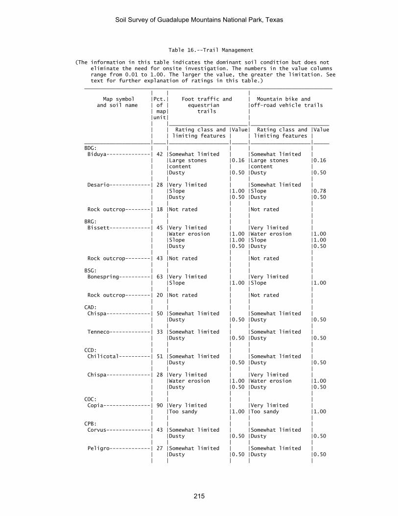
Table 16.--Trail Management
(The information in this table indicates the dominant soil condition but does not eliminate the need for onsite investigation. The numbers in the value columns range from 0.01 to 1.00. The larger the value, the greater the limitation. See text for further explanation of ratings in this table.)
_______________________________________________________________________________ | | | Map symbol |Pct.| Foot traffic and | Mountain bike and and soil name | of | equestrian |off-road vehicle trails | map| trails | |unit| | | |_________________________|_________________________ | | Rating class and |Value| Rating class and |Value | | limiting features | | limiting features | _____________________|____|___________________|_____|___________________|_____ BDG: | | | | | Biduya--------------| 42 |Somewhat limited | |Somewhat limited | | |Large stones |0.16 |Large stones |0.16 | |content | |content | | |Dusty |0.50 |Dusty |0.50 | | | | | Desario-------------| 28 |Very limited | |Somewhat limited | | |Slope |1.00 |Slope |0.78 | |Dusty |0.50 |Dusty |0.50 | | | | | Rock outcrop--------| 18 |Not rated | |Not rated | | | | | | BRG: | | | | | Bissett-------------| 45 |Very limited | |Very limited | | |Water erosion |1.00 |Water erosion |1.00 | |Slope |1.00 |Slope |1.00 | |Dusty |0.50 |Dusty |0.50 | | | | | Rock outcrop--------| 43 |Not rated | |Not rated | | | | | | BSG: | | | | | Bonespring----------| 63 |Very limited | |Very limited | | |Slope |1.00 |Slope |1.00 | | | | | Rock outcrop--------| 20 |Not rated | |Not rated | | | | | | CAD: | | | | | Chispa--------------| 50 |Somewhat limited | |Somewhat limited | | |Dusty |0.50 |Dusty |0.50 | | | | | Tenneco-------------| 33 |Somewhat limited | |Somewhat limited | | |Dusty |0.50 |Dusty |0.50 | | | | | CCD: | | | | | Chilicotal----------| 51 |Somewhat limited | |Somewhat limited | | |Dusty |0.50 |Dusty |0.50 | | | | | Chispa--------------| 28 |Very limited | |Very limited | | |Water erosion |1.00 |Water erosion |1.00 | |Dusty |0.50 |Dusty |0.50 | | | | | COC: | | | | | Copia---------------| 90 |Very limited | |Very limited | | |Too sandy |1.00 |Too sandy |1.00 | | | | | CPB: | | | | | Corvus--------------| 43 |Somewhat limited | |Somewhat limited | | |Dusty |0.50 |Dusty |0.50 | | | | | Peligro-------------| 27 |Somewhat limited | |Somewhat limited | | |Dusty |0.50 |Dusty |0.50 | | | | |
Soil Survey of Guadalupe Mountains National Park, Texas
215

Table 16.--Trail Management--Continued _______________________________________________________________________________ | | | Map symbol |Pct.| Foot traffic and | Mountain bike and and soil name | of | equestrian |off-road vehicle trails | map| trails | |unit| | | |_________________________|_________________________ | | Rating class and |Value| Rating class and |Value | | limiting features | | limiting features | _____________________|____|___________________|_____|___________________|_____ LAD: | | | | | Lazarus-------------| 80 |Not limited | |Not limited | | | | | | LPC: | | | | | Lark----------------| 50 |Not limited | |Not limited | | | | | | Peligro-------------| 40 |Somewhat limited | |Somewhat limited | | |Too sandy |0.68 |Too sandy |0.68 | | | | | LRH: | | | | | Lostpeak------------| 70 |Very limited | |Very limited | | |Slope |1.00 |Slope |1.00 | | | | | Rock outcrop--------| 25 |Not rated | |Not rated | | | | | | MCB: | | | | | McKittrick, | | | | | occasionally | | | | | flooded------------| 31 |Not limited | |Not limited | | | | | | McKittrick, | | | | | frequently flooded-| 20 |Somewhat limited | |Somewhat limited | | |Flooding |0.40 |Flooding |0.40 | | | | | Riverwash-----------| 22 |Not rated | |Not rated | | | | | | MPB: | | | | | Monahans------------| 60 |Not limited | |Not limited | | | | | | Pajarito------------| 21 |Somewhat limited | |Somewhat limited | | |Dusty |0.50 |Dusty |0.50 | | | | | PCG: | | | | | Altuda--------------| 20 |Very limited | |Very limited | | |Slope |1.00 |Slope |1.00 | |Dusty |0.50 |Dusty |0.50 | | | | | Pinery--------------| 32 |Somewhat limited | |Somewhat limited | | |Dusty |0.50 |Dusty |0.50 | | | | | Choza---------------| 27 |Somewhat limited | |Somewhat limited | | |Dusty |0.50 |Dusty |0.50 | | | | | VLG: | | | | | Victorio------------| 51 |Very limited | |Very limited | | |Slope |1.00 |Slope |1.00 | | | | | Lozen---------------| 33 |Very limited | |Not limited | | |Slope |1.00 | | | | | | | Rock outcrop--------| 12 |Not rated | |Not rated | | | | | |
Soil Survey of Guadalupe Mountains National Park, Texas
216

Table 16.--Trail Management--Continued _______________________________________________________________________________ | | | Map symbol |Pct.| Foot traffic and | Mountain bike and and soil name | of | equestrian |off-road vehicle trails | map| trails | |unit| | | |_________________________|_________________________ | | Rating class and |Value| Rating class and |Value | | limiting features | | limiting features | _____________________|____|___________________|_____|___________________|_____ VLH: | | | | | Victorio, 60 to 95 | | | | | percent slopes-----| 35 |Very limited | |Very limited | | |Slope |1.00 |Slope |1.00 | | | | | Victorio, 40 to 60 | | | | | percent slopes-----| 20 |Very limited | |Very limited | | |Slope |1.00 |Slope |1.00 | | | | | Lozen---------------| 25 |Very limited | |Very limited | | |Slope |1.00 |Slope |1.00 | |Large stones |0.96 |Large stones |0.96 | |content | |content | | | | | | Rock outcrop--------| 20 |Not rated | |Not rated | _____________________|____|___________________|_____|___________________|_____
Soil Survey of Guadalupe Mountains National Park, Texas
217

Table 17.--Upland Native Herbaceous Plants, Upland Desertic Shrubs and Trees, and Upland Shrubs and Vines (The information in this table indicates the dominant soil condition but does not eliminate the need For onsite investigation. The numbers in the value columns range from 0.01 to 1.00. The larger the value, the greater the limitation. See text for further explanation of ratings in this table.) ________________________________________________________________________________________________________ | | | | Map symbol |Pct.| Upland Native Herbaceous| Upland Desertic Shrubs | Upland Shrubs and soil name | of | Plants | and | and | map| | Trees | Vines |unit| | | | |_________________________|_________________________|_________________________ | | Rating class and |Value| Rating class and |Value| Rating class and |Value | | limiting features | | limiting features | | limiting features | _____________________|____|___________________|_____|___________________|_____|___________________|_____ BDG: | | | | | | | Biduya--------------| 42 |Somewhat limited | |Somewhat limited | |Somewhat limited | | | Too gravelly, |0.07 | Too gravelly, |0.07 | Too gravelly, |0.07 | | cobbly, or stony| | cobbly, or stony| | cobbly, or stony| | | Droughty |0.50 | Droughty |0.50 | Droughty |0.50 | | | | | | | Desario-------------| 28 |Somewhat limited | |Somewhat limited | |Somewhat limited | | | Droughty |0.50 | Droughty |0.50 | Droughty |0.50 | | | | | |Bedrock |0.11 | | | | | | | Rock outcrop--------| 18 |Not rated | |Not rated | |Not rated | | | | | | | | BRG: | | | | | | | Bissett-------------| 45 |Somewhat limited | |Somewhat limited | |Somewhat limited | | | Droughty |0.50 | Droughty |0.50 | Droughty |0.50 | | | | | |Bedrock |0.14 | | | | | | | Rock outcrop--------| 43 |Not rated | |Not rated | |Not rated | | | | | | | | BSG: | | | | | | | Bonespring----------| 63 |Somewhat limited | |Somewhat limited | |Somewhat limited | | | Too gravelly, |0.11 | Too gravelly, |0.11 | Too gravelly, |0.11 | | cobbly, or stony| | cobbly, or stony| | cobbly, or stony| | | Droughty |0.50 | Droughty |0.50 | Droughty |0.50 | | | | | |Bedrock |0.08 | | | | | | | Rock outcrop--------| 20 |Not rated | |Not rated | |Not rated | | | | | | | | CAD: | | | | | | | Chispa--------------| 50 |Not limited | |Not limited | |Not limited | | | | | | | | Tenneco-------------| 33 |Not limited | |Not limited | |Not limited | | | | | | | | CCD: | | | | | | | Chilicotal----------| 51 |Not limited | |Not limited | |Not limited | | | | | | | | Chispa--------------| 28 |Not limited | |Not limited | |Not limited | | | | | | | | COC: | | | | | | | Copia---------------| 90 |Somewhat limited | |Somewhat limited | |Somewhat limited | | | Sandy surface |0.60 | Sandy surface |0.60 | Sandy surface |0.60 | | | | | | | CPB: | | | | | | | Corvus--------------| 43 |Not limited | |Not limited | |Somewhat limited | | | | | | |Cemented pan |0.62 | | | | | | | Peligro-------------| 27 |Not limited | |Not limited | |Not limited | | | | | | | | LAD: | | | | | | | Lazarus-------------| 80 |Not limited | |Not limited | |Not limited | | | | | | | |
Soil Survey of Guadalupe Mountains National Park, Texas
218

Table 17.--Upland Native Herbaceous Plants, Upland Desertic Shrubs and Trees, and Upland Shrubs and Vines--Continued
________________________________________________________________________________________________________ | | | | Map symbol |Pct.| Upland Native Herbaceous| Upland Desertic Shrubs | Upland Shrubs and soil name | of | Plants | and | and | map| | Trees | Vines |unit| | | | |_________________________|_________________________|_________________________ | | Rating class and |Value| Rating class and |Value| Rating class and |Value | | limiting features | | limiting features | | limiting features | _____________________|____|___________________|_____|___________________|_____|___________________|_____ LPC: | | | | | | | Lark----------------| 50 |Somewhat limited | |Somewhat limited | |Somewhat limited | | | Sandy surface |0.40 | Sandy surface |0.40 | Sandy surface |0.40 | | | | | | | Peligro-------------| 40 |Somewhat limited | |Somewhat limited | |Somewhat limited | | | Sandy surface |0.60 | Sandy surface |0.60 | Sandy surface |0.60 | | | | | | | LRH: | | | | | | | Lostpeak------------| 70 |Somewhat limited | |Somewhat limited | |Somewhat limited | | | Droughty |0.50 | Droughty |0.50 | Droughty |0.50 | | Too gravelly, |0.02 | Too gravelly, |0.02 | Too gravelly, |0.02 | | cobbly, or stony| | cobbly, or stony| | cobbly, or stony| | | | | | |Bedrock |0.02 | | | | | | | Rock outcrop--------| 25 |Not rated | |Not rated | |Not rated | | | | | | | | MCB: | | | | | | | McKittrick, | | | | | | | occasionally | | | | | | | flooded------------| 31 |Not limited | |Not limited | |Not limited | | | | | | | | McKittrick, | | | | | | | frequently flooded-| 20 |Not limited | |Not limited | |Not limited | | | | | | | | Riverwash-----------| 22 |Not rated | |Not rated | |Not rated | | | | | | | | MPB: | | | | | | | Monahans------------| 60 |Not limited | |Not limited | |Not limited | | | | | | | | Pajarito------------| 21 |Not limited | |Not limited | |Not limited | | | | | | | | PCG: | | | | | | | Altuda--------------| 20 |Somewhat limited | |Somewhat limited | |Somewhat limited | | | Droughty |0.50 | Droughty |0.50 | Droughty |0.50 | | | | | |Bedrock |0.08 | | | | | | | Pinery--------------| 32 |Not limited | |Not limited | |Not limited | | | | | | | | Choza---------------| 27 |Somewhat limited | |Somewhat limited | |Somewhat limited | | | Droughty |0.50 | Droughty |0.50 | Cemented pan |0.94 | | | | | |Droughty |0.50 | | | | | | | VLG: | | | | | | | Victorio------------| 51 |Somewhat limited | |Somewhat limited | |Somewhat limited | | | Droughty |0.50 | Droughty |0.50 | Droughty |0.50 | | | | | |Bedrock |0.07 | | | | | | | Lozen---------------| 33 |Somewhat limited | |Somewhat limited | |Somewhat limited | | | Droughty |0.50 | Droughty |0.50 | Droughty |0.50 | | Too gravelly, |0.02 | Too gravelly, |0.02 | Too gravelly, |0.02 | | cobbly, or stony| | cobbly, or stony| | cobbly, or stony| | | | | | | | Rock outcrop--------| 12 |Not rated | |Not rated | |Not rated | | | | | | | |
Soil Survey of Guadalupe Mountains National Park, Texas
219

Table 17.--Upland Native Herbaceous Plants, Upland Desertic Shrubs and Trees, and Upland Shrubs and Vines--Continued
________________________________________________________________________________________________________ | | | | Map symbol |Pct.| Upland Native Herbaceous| Upland Desertic Shrubs | Upland Shrubs and soil name | of | Plants | and | and | map| | Trees | Vines |unit| | | | |_________________________|_________________________|_________________________ | | Rating class and |Value| Rating class and |Value| Rating class and |Value | | limiting features | | limiting features | | limiting features | _____________________|____|___________________|_____|___________________|_____|___________________|_____ VLH: | | | | | | | Victorio, 60 to 95 | | | | | | | percent slope------| 35 |Not limited | |Not limited | |Somewhat limited | | | | | | |Bedrock |0.25 | | | | | | | Victorio, 40 to 60 | | | | | | | percent slope------| 20 |Not limited | |Not limited | |Somewhat limited | | | | | | |Bedrock |0.25 | | | | | | | Lozen---------------| 25 |Somewhat limited | |Somewhat limited | |Somewhat limited | | | Too gravelly, |0.26 | Too gravelly, |0.26 | Too gravelly, |0.26 | | cobbly, or stony| | cobbly, or stony| | cobbly, or stony| | | Droughty |0.50 | Droughty |0.50 | Droughty |0.50 | | | | | |Bedrock |0.27 | | | | | | | Rock outcrop--------| 20 |Not rated | |Not rated | |Not rated | _____________________|____|___________________|_____|___________________|_____|___________________|_____
Soil Survey of Guadalupe Mountains National Park, Texas
220

Table 18.--Upland Deciduous Trees and Upland Coniferous Trees
(The information in this table indicates the dominant soil condition but does not eliminate the need for onsite investigation. The numbers in the value columns range from 0.01 to 1.00. The larger the value, the greater the limitation. See text for further explanation of ratings in this table.) ______________________________________________________________________________ | | | Map symbol |Pct.| Upland Deciduous Trees | Upland Coniferous Trees and soil name | of | | | map| | |unit| | | |_________________________|_________________________ | | Rating class and |Value| Rating class and |Value | | limiting features | | limiting features | _____________________|____|___________________|_____|___________________|_____ BDG: | | | | | Biduya--------------| 42 |Very limited | |Very limited | | | Droughty |1.00 | Droughty |1.00 | | Bedrock |1.00 | Bedrock |1.00 | | Too arid |1.00 | Too arid |0.50 | | | | | Desario-------------| 28 |Very limited | |Very limited | | | Droughty |1.00 | Droughty |1.00 | | Bedrock |1.00 | Bedrock |1.00 | | Too arid |0.50 | | | | | | | Rock outcrop--------| 18 |Not rated | |Not rated | | | | | | BRG: | | | | | Bissett-------------| 45 |Very limited | |Very limited | | | Droughty |1.00 | Droughty |1.00 | | Bedrock |1.00 | Bedrock |1.00 | | Too arid |1.00 | | | | | | | Rock outcrop--------| 43 |Not rated | |Not rated | | | | | | BSG: | | | | | Bonespring----------| 63 |Very limited | |Very limited | | | Droughty |1.00 | Droughty |1.00 | | Bedrock |1.00 | Bedrock |1.00 | | Too arid |1.00 | | | | | | | Rock outcrop--------| 20 |Not rated | |Not rated | | | | | | CAD: | | | | | Chispa--------------| 50 |Very limited | |Not limited | | | Too arid |1.00 | | | | | | | | | | | | Tenneco-------------| 33 |Very limited | |Not limited | | | Too arid |1.00 | | | | | | | CCD: | | | | | Chilicotal----------| 51 |Very limited | |Somewhat limited | | | Too arid |1.00 | Droughty |0.05 | | Droughty |0.05 | | | | | | | Chispa--------------| 28 |Very limited | |Not limited | | | Too arid |1.00 | | | | | | | | | | | | COC: | | | | | Copia---------------| 90 |Somewhat limited | |Somewhat limited | | | Droughty |0.92 | Droughty |0.92 | | | | |
Soil Survey of Guadalupe Mountains National Park, Texas
221

Table 18.--Upland Deciduous Trees and Upland Coniferous Trees--Continued ______________________________________________________________________________ | | | Map symbol |Pct.| Upland Deciduous Trees | Upland Coniferous Trees and soil name | of | | | map| | |unit| | | |_________________________|_________________________ | | Rating class and |Value| Rating class and |Value | | limiting features | | limiting features | _____________________|____|___________________|_____|___________________|_____ CPB: | | | | | Corvus--------------| 43 |Very limited | |Very limited | | | Cemented pan |1.00 | Cemented pan |1.00 | | Droughty |0.81 | Droughty |0.81 | | | | | Peligro-------------| 27 |Not limited | |Not limited | | | | | | LAD: | | | | | Lazarus-------------| 80 |Somewhat limited | |Not limited | | | Too arid |0.50 | | | | | | | LPC: | | | | | Lark----------------| 50 |Somewhat limited | |Somewhat limited | | | Droughty |0.92 | Droughty |0.92 | | | | | Peligro-------------| 40 |Not limited | |Not limited | | | | | | LRH: | | | | | Lostpeak------------| 70 |Very limited | |Very limited | | | Droughty |1.00 | Droughty |1.00 | | Bedrock |1.00 | Bedrock |1.00 | | Too arid |1.00 | Too arid |0.50 | | | | | Rock outcrop--------| 25 |Not rated | |Not rated | | | | | | MCB: | | | | | McKittrick, | | | | | occasionally | | | | | flooded------------| 31 |Very limited | |Very limited | | | Droughty |1.00 | Droughty |1.00 | | Too arid |0.50 | | | | | | | McKittrick, | | | | | frequently flooded-| 20 |Very limited | |Very limited | | | Droughty |1.00 | Droughty |1.00 | | Too arid |0.50 | | | | | | | Riverwash-----------| 22 |Not rated | |Not rated | | | | | | MPB: | | | | | Monahans------------| 60 |Not limited | |Not limited | | | | | | Pajarito------------| 21 |Not limited | |Not limited | | | | | | PCG: | | | | | Altuda--------------| 20 |Very limited | |Very limited | | | Droughty |1.00 | Droughty |1.00 | | Bedrock |1.00 | Bedrock |1.00 | | Too arid |0.50 | | | | | | | Pinery--------------| 32 |Very limited | |Somewhat limited | | | Too arid |1.00 | Too arid |0.50 | | | | | | | | | |
Soil Survey of Guadalupe Mountains National Park, Texas
222

Table 18.--Upland Deciduous Trees and Upland Coniferous Trees--Continued ______________________________________________________________________________ | | | Map symbol |Pct.| Upland Deciduous Trees | Upland Coniferous Trees and soil name | of | | | map| | |unit| | | |_________________________|_________________________ | | Rating class and |Value| Rating class and |Value | | limiting features | | limiting features | _____________________|____|___________________|_____|___________________|_____ Choza---------------| 27 |Very limited | |Very limited | | | Droughty |1.00 | Droughty |1.00 | | Cemented pan |1.00 | Cemented pan |1.00 | | Too arid |0.50 | | | | | | | VLG: | | | | | Victorio------------| 51 |Very limited | |Very limited | | | Droughty |1.00 | Droughty |1.00 | | Bedrock |1.00 | Bedrock |1.00 | | Too arid |0.50 | | | | | | | Lozen---------------| 33 |Very limited | |Very limited | | | Droughty |1.00 | Droughty |1.00 | | Bedrock |1.00 | Bedrock |1.00 | | Too arid |0.50 | | | | | | | Rock outcrop--------| 12 |Not rated | |Not rated | | | | | | VLH: | | | | | Victorio, 60 to 95 | | | | | percent slopes-----| 35 |Very limited | |Very limited | | | Bedrock |1.00 | Bedrock |1.00 | | Droughty |0.88 | Droughty |0.88 | | Too arid |0.50 | | | | | | | Victorio, 40 to 60 | | | | | percent slopes-----| 20 |Very limited | |Very limited | | | Bedrock |1.00 | Bedrock |1.00 | | Droughty |0.88 | Droughty |0.88 | | Too arid |0.50 | | | | | | | Lozen---------------| 25 |Very limited | |Very limited | | | Droughty |1.00 | Droughty |1.00 | | Bedrock |1.00 | Bedrock |1.00 | | Too arid |0.50 | | | | | | | Rock outcrop--------| 20 |Not rated | |Not rated | | | | | | _____________________|____|___________________|_____|___________________|_____
Soil Survey of Guadalupe Mountains National Park, Texas
223

Table 19.--Riparian Herbaceous Plants and Riparian Shrubs, Vines, and Trees
(The information in this table indicates the dominant soil condition but does not eliminate the need for onsite investigation. The numbers in the value columns range from 0.01 to 1.00. The larger the value, the greater the limitation. See text for further explanation of ratings in this table.) ______________________________________________________________________________ | | | Map symbol |Pct.| Riparian Herbaceous | Riparian Shrubs, Vines, and soil name | of | Plants | and Trees | map| | |unit| | | |_________________________|_________________________ | | Rating class and |Value| Rating class and |Value | | limiting features | | limiting features | _____________________|____|___________________|_____|___________________|_____ BDG: | | | | | Biduya--------------| 42 |Very limited | |Very limited | | | Too dry |1.00 | Droughty |1.00 | | Infrequent |1.00 | Too dry |1.00 | | flooding | | | | | Too gravelly, |0.27 | | | | cobbly, or stony| | | | | | | | Desario-------------| 28 |Very limited | |Very limited | | | Too dry |1.00 | Droughty |1.00 | | Infrequent |1.00 | Too dry |1.00 | | flooding | | | | | | | | Rock outcrop--------| 18 |Not rated | |Not rated | | | | | | BRG: | | | | | Bissett-------------| 45 |Very limited | |Very limited | | | Too dry |1.00 | Droughty |1.00 | | Infrequent |1.00 | Too dry |1.00 | | flooding | | | | | | | | Rock outcrop--------| 43 |Not rated | |Not rated | | | | | | BSG: | | | | | Bonespring----------| 63 |Very limited | |Very limited | | | Too dry |1.00 | Droughty |1.00 | | Infrequent |1.00 | Too dry |1.00 | | flooding | | | | | Too gravelly, |0.42 | | | | cobbly, or stony| | | | | | | | Rock outcrop--------| 20 |Not rated | |Not rated | | | | | | CAD: | | | | | Chispa--------------| 50 |Very limited | |Very limited | | | Too dry |1.00 | Too dry |1.00 | | Infrequent |1.00 | | | | flooding | | | | | | | | Tenneco-------------| 33 |Very limited | |Very limited | | | Too dry |1.00 | Too dry |1.00 | | Infrequent |1.00 | | | | flooding | | | | | | | | CCD: | | | | | Chilicotal----------| 51 |Very limited | |Very limited | | | Too dry |1.00 | Too dry |1.00 | | Infrequent |1.00 | Droughty |0.05 | | flooding | | | | | | | |
Soil Survey of Guadalupe Mountains National Park, Texas
224

Table 19.--Riparian Herbaceous Plants and Riparian Shrubs, Vines, and Trees--Continued
______________________________________________________________________________ | | | Map symbol |Pct.| Riparian Herbaceous | Riparian Shrubs, Vines, and soil name | of | Plants | and Trees | map| | |unit| | | |_________________________|_________________________ | | Rating class and |Value| Rating class and |Value | | limiting features | | limiting features | _____________________|____|___________________|_____|___________________|_____ Chispa--------------| 28 |Very limited | |Very limited | | | Too dry |1.00 | Too dry |1.00 | | Infrequent |1.00 | | | | flooding | | | | | | | | COC: | | | | | Copia---------------| 90 |Very limited | |Very limited | | | Too dry |1.00 | Too dry |1.00 | | Infrequent |1.00 | Droughty |0.92 | | flooding | | | | | Too sandy |0.50 | | | | | | | CPB: | | | | | Corvus--------------| 43 |Very limited | |Very limited | | | Too dry |1.00 | Too dry |1.00 | | Infrequent |1.00 | Droughty |0.81 | | flooding | | | | | | | | Peligro-------------| 27 |Very limited | |Very limited | | | Too dry |1.00 | Too dry |1.00 | | Infrequent |1.00 | | | | flooding | | | | | | | | LAD: | | | | | Lazarus-------------| 80 |Very limited | |Very limited | | | Too dry |1.00 | Too dry |1.00 | | Infrequent |1.00 | | | | flooding | | | | | | | | LPC: | | | | | Lark----------------| 50 |Very limited | |Very limited | | | Too sandy |1.00 | Too dry |1.00 | | Too dry |1.00 | Droughty |0.92 | | Infrequent |1.00 | | | | flooding | | | | | | | | Peligro-------------| 40 |Very limited | |Very limited | | | Too dry |1.00 | Too dry |1.00 | | Infrequent |1.00 | | | | flooding | | | | | Too sandy |0.50 | | | | | | | LRH: | | | | | Lostpeak------------| 70 |Very limited | |Very limited | | | Too dry |1.00 | Droughty |1.00 | | Infrequent |1.00 | Too dry |1.00 | | flooding | | | | | Too gravelly, |0.08 | | | | cobbly, or stony| | | | | | | | Rock outcrop--------| 25 |Not rated | |Not rated | | | | | |
Soil Survey of Guadalupe Mountains National Park, Texas
225

Table 19.--Riparian Herbaceous Plants and Riparian Shrubs, Vines, and Trees--Continued
______________________________________________________________________________ | | | Map symbol |Pct.| Riparian Herbaceous | Riparian Shrubs, Vines, and soil name | of | Plants | and Trees | map| | |unit| | | |_________________________|_________________________ | | Rating class and |Value| Rating class and |Value | | limiting features | | limiting features | _____________________|____|___________________|_____|___________________|_____ MCB: | | | | | McKittrick, | | | | | occasionally | | | | | flooded------------| 31 |Very limited | |Very limited | | | Too dry |1.00 | Too dry |1.00 | | Infrequent |1.00 | Droughty |1.00 | | flooding | | | | | | | | McKittrick, | | | | | frequently flooded-| 20 |Very limited | |Very limited | | | Too dry |1.00 | Too dry |1.00 | | | |Droughty |1.00 | | | | | Riverwash-----------| 22 |Not rated | |Not rated | | | | | | MPB: | | | | | Monahans------------| 60 |Very limited | |Very limited | | | Too dry |1.00 | Too dry |1.00 | | Infrequent |1.00 | | | | flooding | | | | | | | | Pajarito------------| 21 |Very limited | |Very limited | | | Too dry |1.00 | Too dry |1.00 | | Infrequent |1.00 | | | | flooding | | | | | | | | PCG: | | | | | Altuda--------------| 20 |Very limited | |Very limited | | | Too dry |1.00 | Droughty |1.00 | | Infrequent |1.00 | Too dry |1.00 | | flooding | | | | | | | | Pinery--------------| 32 |Very limited | |Very limited | | | Too dry |1.00 | Too dry |1.00 | | Infrequent |1.00 | | | | flooding | | | | | | | | Choza---------------| 27 |Very limited | |Very limited | | | Too dry |1.00 | Droughty |1.00 | | Infrequent |1.00 | Too dry |1.00 | | flooding | | | | | Too gravelly, |0.01 | | | | cobbly, or stony| | | | | | | | VLG: | | | | | Victorio------------| 51 |Very limited | |Very limited | | | Too dry |1.00 | Droughty |1.00 | | Infrequent |1.00 | Too dry |1.00 | | flooding | | | | | | | | Lozen---------------| 33 |Very limited | |Very limited | | | Too dry |1.00 | Droughty |1.00 | | Infrequent |1.00 | Too dry |1.00 | | flooding | | | | | Too gravelly, |0.08 | | | | cobbly, or stony| | |
Soil Survey of Guadalupe Mountains National Park, Texas
226

Table 19.--Riparian Herbaceous Plants and Riparian Shrubs, Vines, and Trees--Continued
______________________________________________________________________________ | | | Map symbol |Pct.| Riparian Herbaceous | Riparian Shrubs, Vines, and soil name | of | Plants | and Trees | map| | |unit| | | |_________________________|_________________________ | | Rating class and |Value| Rating class and |Value | | limiting features | | limiting features | _____________________|____|___________________|_____|___________________|_____ Rock outcrop--------| 12 |Not rated | |Not rated | | | | | | VLH: | | | | | Victorio, 60 to 95 | | | | | percent slopes-----| 35 |Very limited | |Very limited | | | Too dry |1.00 | Too dry |1.00 | | Infrequent |1.00 | Droughty |0.88 | | flooding | | | | | | | | Victorio, 40 to 60 | | | | | percent slopes-----| 20 |Very limited | |Very limited | | | Too dry |1.00 | Too dry |1.00 | | Infrequent |1.00 | Droughty |0.88 | | flooding | | | | | | | | Lozen---------------| 25 |Very limited | |Very limited | | | Too dry |1.00 | Droughty |1.00 | | Infrequent |1.00 | Too dry |1.00 | | flooding | | | | | Too gravelly, |0.84 | | | | cobbly, or stony| | | | | | | | Rock outcrop--------| 20 |Not rated | |Not rated | _____________________|____|___________________|_____|___________________|_____
Soil Survey of Guadalupe Mountains National Park, Texas
227

Table 20.--Dwellings and Small Commercial Buildings (The information in this table indicates the dominant soil condition but does not eliminate the need for onsite investigation. The numbers in the value columns range from 0.01 to 1.00. The larger the value, the greater the limitation. See text for further explanation of ratings in this table.) ________________________________________________________________________________________________________ | | | | Map symbol |Pct.| Dwellings | Dwellings | Small Commercial and soil name | of | without | with | Buildings | map| Basements | Basements | |unit| | | | |_________________________|_________________________|_________________________ | | Rating class and |Value| Rating class and |Value| Rating class and |Value | | limiting features | | limiting features | | limiting features | _____________________|____|___________________|_____|___________________|_____|___________________|_____ BDG: | | | | | | | Lazarus-------------| 4 |Not rated | |Not rated | |Not rated | | | | | | | | Biduya--------------| 42 |Very limited | |Very limited | |Very limited | | |Depth to hard |1.00 |Depth to hard |1.00 |Slope |1.00 | |bedrock | |bedrock | | | | |Too steep |1.00 |Too steep |1.00 |Depth to hard |1.00 | | | | | |bedrock | | |Large stones |0.61 |Large stones |0.61 |Large stones |0.61 | | | | | | | Desario-------------| 28 |Very limited | |Very limited | |Very limited | | |Too steep |1.00 |Too steep |1.00 |Slope |1.00 | |Depth to hard |1.00 |Depth to hard |1.00 |Depth to hard |1.00 | |bedrock | |bedrock | |bedrock | | |Shrink-swell |0.50 |Shrink-swell |0.50 |Shrink-swell |0.50 | | | | | | | Rock outcrop--------| 18 |Not rated | |Not rated | |Not rated | | | | | | | | BRG: | | | | | | | Chispa--------------| 8 |Not rated | |Not rated | |Not rated | | | | | | | | Bissett-------------| 45 |Very limited | |Very limited | |Very limited | | |Too steep |1.00 |Too steep |1.00 |Slope |1.00 | |Depth to hard |1.00 |Depth to hard |1.00 |Depth to hard |1.00 | |bedrock | |bedrock | |bedrock | | | | | | | | Rock outcrop--------| 43 |Not rated | |Not rated | |Not rated | | | | | | | | BSG: | | | | | | | Bonespring----------| 63 |Very limited | |Very limited | |Very limited | | |Depth to hard |1.00 |Depth to hard |1.00 |Slope |1.00 | |bedrock | |bedrock | | | | |Too steep |1.00 |Too steep |1.00 |Depth to hard |1.00 | | | | | |bedrock | | | | | | | | Rock outcrop--------| 20 |Not rated | |Not rated | |Not rated | | | | | | | | CAD: | | | | | | | Chispa--------------| 50 |Not limited | |Not limited | |Somewhat limited | | | | | | |Slope |0.50 | | | | | | | Tenneco-------------| 33 |Not limited | |Not limited | |Somewhat limited | | | | | | |Slope |0.50 | | | | | | | CCD: | | | | | | | Chilicotal----------| 51 |Somewhat limited | |Somewhat limited | |Very limited | | |Slope |0.04 |Slope |0.04 |Slope |1.00 | | | | | | | Chispa--------------| 28 |Somewhat limited | |Somewhat limited | |Very limited | | |Slope |0.04 |Slope |0.04 |Slope |1.00 | | | | | | |
Soil Survey of Guadalupe Mountains National Park, Texas
228

Table 20.--Dwellings and Small Commercial Buildings--Continued ________________________________________________________________________________________________________ | | | | Map symbol |Pct.| Dwellings | Dwellings | Small Commercial and soil name | of | without | with | Buildings | map| Basements | Basements | |unit| | | | |_________________________|_________________________|_________________________ | | Rating class and |Value| Rating class and |Value| Rating class and |Value | | limiting features | | limiting features | | limiting features | _____________________|____|___________________|_____|___________________|_____|___________________|_____ COC: | | | | | | | Copia---------------| 90 |Not limited | |Not limited | |Somewhat limited | | | | | | |Slope |0.12 | | | | | | | CPB: | | | | | | | Corvus--------------| 43 |Very limited | |Very limited | |Very limited | | |Depth to thick |1.00 |Depth to thick |1.00 |Depth to thick |1.00 | |cemented pan | |cemented pan | |cemented pan | | | | |Depth to thin |1.00 |Depth to thin |1.00 | | | |cemented pan | |cemented pan | | | | | | | | Peligro-------------| 27 |Not limited | |Not limited | |Not limited | | | | | | | | LAD: | | | | | | | Lazarus-------------| 80 |Somewhat limited | |Somewhat limited | |Somewhat limited | | |Shrink-swell |0.50 |Shrink-swell |0.50 |Shrink-swell |0.50 | | | | | | | LPC: | | | | | | | Lark----------------| 50 |Not limited | |Not limited | |Somewhat limited | | | | | | |Slope |0.12 | | | | | | | Peligro-------------| 40 |Not limited | |Not limited | |Somewhat limited | | | | | | |Slope |0.12 | | | | | | | LRH: | | | | | | | Lostpeak------------| 70 |Very limited | |Very limited | |Very limited | | |Too steep |1.00 |Too steep |1.00 |Slope |1.00 | |Depth to hard |1.00 |Depth to hard |1.00 |Depth to hard |1.00 | |bedrock | |bedrock | |bedrock | | | | | | | | Rock outcrop--------| 25 |Not rated | |Not rated | |Not rated | | | | | | | | MCB: | | | | | | | McKittrick, | | | | | | | occasionally | | | | | | | flooded------------| 31 |Very limited | |Very limited | |Very limited | | |Flooding |1.00 |Flooding |1.00 |Flooding |1.00 | |Large stones |0.43 |Large stones |0.43 |Large stones |0.43 | | | | | | | McKittrick, | | | | | | | frequently flooded-| 20 |Very limited | |Very limited | |Very limited | | |Flooding |1.00 |Flooding |1.00 |Flooding |1.00 | |Large stones |0.43 |Large stones |0.43 |Large stones |0.43 | | | | | | | Riverwash-----------| 22 |Not rated | |Not rated | |Not rated | | | | | | | | MPB: | | | | | | | Monahans------------| 60 |Not limited | |Not limited | |Not limited | | | | | | | | Pajarito------------| 21 |Not limited | |Not limited | |Not limited | | | | | | | |
Soil Survey of Guadalupe Mountains National Park, Texas
229

Table 20.--Dwellings and Small Commercial Buildings--Continued ________________________________________________________________________________________________________ | | | | Map symbol |Pct.| Dwellings | Dwellings | Small Commercial and soil name | of | without | with | Buildings | map| Basements | Basements | |unit| | | | |_________________________|_________________________|_________________________ | | Rating class and |Value| Rating class and |Value| Rating class and |Value | | limiting features | | limiting features | | limiting features | _____________________|____|___________________|_____|___________________|_____|___________________|_____ PCG: | | | | | | | Altuda--------------| 20 |Very limited | |Very limited | |Very limited | | |Depth to hard |1.00 |Depth to hard |1.00 |Slope |1.00 | |bedrock | |bedrock | | | | |Too steep |1.00 |Too steep |1.00 |Depth to hard |1.00 | | | | | |bedrock | | | | | | | | Pinery--------------| 32 |Somewhat limited | |Somewhat limited | |Very limited | | |Slope |0.96 |Slope |0.96 |Slope |1.00 | |Large stones |0.41 |Large stones |0.41 |Large stones |0.41 | | | | | | | Choza---------------| 27 |Very limited | |Very limited | |Very limited | | |Depth to thick |1.00 |Depth to thick |1.00 |Depth to thick |1.00 | |cemented pan | |cemented pan | |cemented pan | | |Slope |0.96 |Depth to thin |1.00 |Depth to thin |1.00 | | | |cemented pan | |cemented pan | | | | |Slope |0.96 |Slope |1.00 | | | | | | | VLG: | | | | | | | Victorio------------| 51 |Very limited | |Very limited | |Very limited | | |Too steep |1.00 |Too steep |1.00 |Slope |1.00 | |Shrink-swell |1.00 |Shrink-swell |1.00 |Shrink-swell |1.00 | |Depth to hard |1.00 |Depth to hard |1.00 |Depth to hard |1.00 | |bedrock | |bedrock | |bedrock | | |Large stones |0.11 |Large stones |0.11 |Large stones |0.11 | | | | | | | Lozen---------------| 33 |Very limited | |Very limited | |Very limited | | |Depth to hard |1.00 |Depth to hard |1.00 |Slope |1.00 | |bedrock | |bedrock | | | | |Too steep |1.00 |Too steep |1.00 |Depth to hard |1.00 | | | | | |bedrock | | | | | | | | Rock outcrop--------| 12 |Not rated | |Not rated | |Not rated | | | | | | | | VLH: | | | | | | | Victorio, 60 to 95 | | | | | | | percent slopes-----| 35 |Very limited | |Very limited | |Very limited | | |Too steep |1.00 |Too steep |1.00 |Slope |1.00 | |Shrink-swell |1.00 |Shrink-swell |1.00 |Shrink-swell |1.00 | |Depth to hard |1.00 |Depth to hard |1.00 |Depth to hard |1.00 | |bedrock | |bedrock | |bedrock | | | | | | | | Victorio, 40 to 60 | | | | | | | percent slopes-----| 20 |Very limited | |Very limited | |Very limited | | |Too steep |1.00 |Too steep |1.00 |Slope |1.00 | |Shrink-swell |1.00 |Shrink-swell |1.00 |Shrink-swell |1.00 | |Depth to hard |1.00 |Depth to hard |1.00 |Depth to hard |1.00 | |bedrock | |bedrock | |bedrock | | | | | | | | Lozen---------------| 25 |Very limited | |Very limited | |Very limited | | |Too steep |1.00 |Too steep |1.00 |Slope |1.00 | |Depth to hard |1.00 |Depth to hard |1.00 |Depth to hard |1.00 | |bedrock | |bedrock | |bedrock | | |Large stones |1.00 |Large stones |1.00 |Large stones |1.00 | | | | | | | Rock outcrop--------| 20 |Not rated | |Not rated | |Not rated | _____________________|____|___________________|_____|___________________|_____|___________________|_____
Soil Survey of Guadalupe Mountains National Park, Texas
230

Table 21.--Roads and Streets, Shallow Excavations, and Landscaping (The information in this table indicates the dominant soil condition but does not eliminate the need for onsite investigation. The numbers in the value columns range from 0.01 to 1.00. The larger the value, the greater the limitation. See text for further explanation of ratings in this table.) ________________________________________________________________________________________________________ | | | | Map symbol |Pct.| Local roads and | Shallow excavations | Landscaping and soil name | of | streets | | | map| | | |unit| | | | |_________________________|_________________________|_________________________ | | Rating class and |Value| Rating class and |Value| Rating class and |Value | | limiting features | | limiting features | | limiting features | _____________________|____|___________________|_____|___________________|_____|___________________|_____ BDG: | | | | | | | Biduya--------------| 42 |Very limited | |Very limited | |Very limited | | |Depth to hard |1.00 |Depth to hard |1.00 |Depth to bedrock |1.00 | |bedrock | |bedrock | | | | |Too steep |1.00 |Too steep |1.00 |Large stones |1.00 | |Large stones |0.61 |Large stones |0.61 |Droughty |1.00 | |Frost action |0.50 |Unstable |0.50 |Too steep |1.00 | | | |excavation walls | | | | | | | | | | Desario-------------| 28 |Very limited | |Very limited | |Very limited | | |Depth to hard |1.00 |Depth to hard |1.00 |Depth to bedrock |1.00 | |bedrock | |bedrock | | | | |Too steep |1.00 |Too steep |1.00 |Too steep |1.00 | |Shrink-swell |0.50 |Unstable |0.10 |Droughty |1.00 | | | |excavation walls | | | | |Frost action |0.50 | | |Large stones |0.03 | | | | | | | Rock outcrop--------| 18 |Not rated | |Not rated | |Not rated | | | | | | | | BRG: | | | | | | | Bissett-------------| 45 |Very limited | |Very limited | |Very limited | | |Depth to hard |1.00 |Depth to hard |1.00 |Depth to bedrock |1.00 | |bedrock | |bedrock | | | | |Too steep |1.00 |Too steep |1.00 |Too steep |1.00 | | | |Unstable |0.10 |Droughty |1.00 | | | |excavation walls | | | | | | | | | | Rock outcrop--------| 43 |Not rated | |Not rated | |Not rated | | | | | | | | BSG: | | | | | | | Bonespring----------| 63 |Very limited | |Very limited | |Very limited | | |Depth to hard |1.00 |Depth to hard |1.00 |Depth to bedrock |1.00 | |bedrock | |bedrock | | | | |Too steep |1.00 |Too steep |1.00 |Droughty |1.00 | | | |Unstable |0.10 |Too steep |1.00 | | | |excavation walls | | | | | | | | |Gravel |1.00 | | | | | | | Rock outcrop--------| 20 |Not rated | |Not rated | |Not rated | | | | | | | | CAD: | | | | | | | Chispa--------------| 50 |Somewhat limited | |Somewhat limited | |Very limited | | |Low strength |0.22 |Unstable |0.10 |Too dense |1.00 | | | |excavation walls | | | | | | | | |Large stones |0.01 | | | | | | | Tenneco-------------| 33 |Very limited | |Somewhat limited | |Not limited | | |Low strength |1.00 |Unstable |0.10 | | | | | |excavation walls | | | | | | | | | |
Soil Survey of Guadalupe Mountains National Park, Texas
231

Table 21.--Roads and Streets, Shallow Excavations, and Landscaping--Continued ________________________________________________________________________________________________________ | | | | Map symbol |Pct.| Local roads and | Shallow excavations | Landscaping and soil name | of | streets | | | map| | | |unit| | | | |_________________________|_________________________|_________________________ | | Rating class and |Value| Rating class and |Value| Rating class and |Value | | limiting features | | limiting features | | limiting features | _____________________|____|___________________|_____|___________________|_____|___________________|_____ CCD: | | | | | | | Chilicotal----------| 51 |Somewhat limited | |Very limited | |Somewhat limited | | |Slope |0.04 |Unstable |1.00 |Droughty |0.06 | | | |excavation walls | | | | | | |Slope |0.04 |Slope |0.04 | | | | | | | Chispa--------------| 28 |Somewhat limited | |Somewhat limited | |Somewhat limited | | |Slope |0.04 |Slope |0.04 |Slope |0.04 | | | |Unstable |0.10 | | | | | |excavation walls | | | | | | | | | | COC: | | | | | | | Copia---------------| 90 |Not limited | |Very limited | |Somewhat limited | | | | |Unstable |1.00 |Droughty |0.92 | | | |excavation walls | | | | | | | | | | CPB: | | | | | | | Corvus--------------| 43 |Very limited | |Very limited | |Very limited | | |Depth to thick |1.00 |Depth to thick |1.00 |Depth to cemented |1.00 | |cemented pan | |cemented pan | |pan | | |Depth to thin |1.00 |Depth to thin |1.00 |Droughty |0.81 | |cemented pan | |cemented pan | | | | | | |Dense layer |0.50 | | | | | |Unstable |0.10 | | | | | |excavation walls | | | | | | | | | | Peligro-------------| 27 |Not limited | |Somewhat limited | |Not limited | | | | |Unstable |0.10 | | | | | |excavation walls | | | | | | | | | | LAD: | | | | | | | Lazarus-------------| 80 |Very limited | |Somewhat limited | |Not limited | | |Low strength |1.00 |Unstable |0.10 | | | | | |excavation walls | | | | |Shrink-swell |0.50 | | | | | |Frost action |0.50 | | | | | | | | | | | LPC: | | | | | | | Lark----------------| 50 |Not limited | |Very limited | |Somewhat limited | | | | |Unstable |1.00 |Droughty |0.92 | | | |excavation walls | | | | | | | | | | Peligro-------------| 40 |Not limited | |Somewhat limited | |Not limited | | | | |Unstable |0.10 | | | | | |excavation walls | | | | | | | | | | LRH: | | | | | | | Lostpeak------------| 70 |Very limited | |Very limited | |Very limited | | |Depth to hard |1.00 |Depth to hard |1.00 |Depth to bedrock |1.00 | |bedrock | |bedrock | | | | |Too steep |1.00 |Too steep |1.00 |Too steep |1.00 | |Frost action |0.50 |Unstable |0.50 |Gravel |1.00 | | | |excavation walls | | | | | | | | |Droughty |1.00 | | | | | | | Rock outcrop--------| 25 |Not rated | |Not rated | |Not rated | | | | | | | |
Soil Survey of Guadalupe Mountains National Park, Texas
232

Table 21.--Roads and Streets, Shallow Excavations, and Landscaping--Continued ________________________________________________________________________________________________________ | | | | Map symbol |Pct.| Local roads and | Shallow excavations | Landscaping and soil name | of | streets | | | map| | | |unit| | | | |_________________________|_________________________|_________________________ | | Rating class and |Value| Rating class and |Value| Rating class and |Value | | limiting features | | limiting features | | limiting features | _____________________|____|___________________|_____|___________________|_____|___________________|_____ MCB: | | | | | | | McKittrick, | | | | | | | occasionally | | | | | | | flooded------------| 31 |Very limited | |Somewhat limited | |Very limited | | |Flooding |1.00 |Large stones |0.43 |Droughty |1.00 | |Large stones |0.43 |Flooding |0.60 |Large stones |0.38 | |Frost action |0.50 |Unstable |0.10 |Flooding |0.60 | | | |excavation walls | | | | | | | | | | McKittrick, | | | | | | | frequently flooded-| 20 |Very limited | |Somewhat limited | |Very limited | | |Flooding |1.00 |Large stones |0.43 |Flooding |1.00 | |Large stones |0.43 |Flooding |0.80 |Droughty |1.00 | |Frost action |0.50 |Unstable |0.10 |Large stones |0.38 | | | |excavation walls | | | | | | | | | | Riverwash-----------| 22 |Not rated | |Not rated | |Not rated | | | | | | | | MPB: | | | | | | | Monahans------------| 60 |Not limited | |Somewhat limited | |Not limited | | | | |Unstable |0.10 | | | | | |excavation walls | | | | | | | | | | Pajarito------------| 21 |Not limited | |Somewhat limited | |Not limited | | | | |Unstable |0.10 | | | | | |excavation walls | | | | | | | | | | PCG: | | | | | | | Altuda--------------| 20 |Very limited | |Very limited | |Very limited | | |Depth to hard |1.00 |Depth to hard |1.00 |Depth to bedrock |1.00 | |bedrock | |bedrock | | | | |Too steep |1.00 |Too steep |1.00 |Droughty |1.00 | | | |Unstable |0.10 |Too steep |1.00 | | | |excavation walls | | | | | | | | |Large stones |0.74 | | | | | |Gravel |0.06 | | | | | | | Pinery--------------| 32 |Somewhat limited | |Somewhat limited | |Somewhat limited | | |Slope |0.96 |Slope |0.96 |Slope |0.96 | |Large stones |0.41 |Large stones |0.41 |Large stones |0.54 | | | |Unstable |0.10 |Gravel |0.09 | | | |excavation walls | | | | | | | | | | Choza---------------| 27 |Very limited | |Very limited | |Very limited | | |Depth to thick |1.00 |Depth to thick |1.00 |Depth to cemented |1.00 | |cemented pan | |cemented pan | |pan | | |Depth to thin |1.00 |Depth to thin |1.00 |Droughty |1.00 | |cemented pan | |cemented pan | | | | |Slope |0.96 |Slope |0.96 |Slope |0.96 | | | |Unstable |0.10 |Gravel |0.34 | | | |excavation walls | | | | | | | | |Large stones |0.38 | | | | | | |
Soil Survey of Guadalupe Mountains National Park, Texas
233

Table 21.--Roads and Streets, Shallow Excavations, and Landscaping--Continued ________________________________________________________________________________________________________ | | | | Map symbol |Pct.| Local roads and | Shallow excavations | Landscaping and soil name | of | streets | | | map| | | |unit| | | | |_________________________|_________________________|_________________________ | | Rating class and |Value| Rating class and |Value| Rating class and |Value | | limiting features | | limiting features | | limiting features | _____________________|____|___________________|_____|___________________|_____|___________________|_____ VLG: | | | | | | | Victorio------------| 51 |Very limited | |Very limited | |Very limited | | |Depth to hard |1.00 |Depth to hard |1.00 |Depth to bedrock |1.00 | |bedrock | |bedrock | | | | |Too steep |1.00 |Too steep |1.00 |Too steep |1.00 | |Shrink-swell |1.00 |Large stones |0.11 |Droughty |1.00 | |Low strength |0.78 |Unstable |0.10 |Large stones |0.61 | | | |excavation walls | | | | |Large stones |0.11 | | | | | | | | | | | Lozen---------------| 33 |Very limited | |Very limited | |Very limited | | |Depth to hard |1.00 |Depth to hard |1.00 |Depth to bedrock |1.00 | |bedrock | |bedrock | | | | |Too steep |1.00 |Too steep |1.00 |Gravel |1.00 | |Frost action |0.50 |Unstable |0.50 |Droughty |1.00 | | | |excavation walls | | | | | | | | |Too steep |1.00 | | | | | | | Rock outcrop--------| 12 |Not rated | |Not rated | |Not rated | | | | | | | | VLH: | | | | | | | Victorio, 60 to 95 | | | | | | | percent slopes-----| 35 |Very limited | |Very limited | |Very limited | | |Depth to hard |1.00 |Depth to hard |1.00 |Depth to bedrock |1.00 | |bedrock | |bedrock | | | | |Too steep |1.00 |Too steep |1.00 |Too steep |1.00 | |Shrink-swell |1.00 |Unstable |0.10 |Gravel |0.39 | | | |excavation walls | | | | |Low strength |0.78 | | |Large stones |0.26 | | | | | |Droughty |0.89 | | | | | | | Victorio, 40 to 60 | | | | | | | percent slopes-----| 20 |Very limited | |Very limited | |Very limited | | |Depth to hard |1.00 |Depth to hard |1.00 |Depth to bedrock |1.00 | |bedrock | |bedrock | | | | |Too steep |1.00 |Too steep |1.00 |Too steep |1.00 | |Shrink-swell |1.00 |Unstable |0.10 |Gravel |0.39 | | | |excavation walls | | | | |Low strength |0.78 | | |Large stones |0.26 | | | | | |Droughty |0.89 | | | | | | | Lozen---------------| 25 |Very limited | |Very limited | |Very limited | | |Depth to hard |1.00 |Depth to hard |1.00 |Depth to bedrock |1.00 | |bedrock | |bedrock | | | | |Too steep |1.00 |Too steep |1.00 |Too steep |1.00 | |Large stones |1.00 |Large stones |1.00 |Large stones |1.00 | |Low strength |1.00 |Unstable |0.10 |Droughty |1.00 | | | |excavation walls | | | | |Frost action |0.50 | | | | | | | | | | | Rock outcrop--------| 20 |Not rated | |Not rated | |Not rated | _____________________|____|___________________|_____|___________________|_____|___________________|_____
Soil Survey of Guadalupe Mountains National Park, Texas
234

Table 22.--Sewage Disposal (The information in this table indicates the dominant soil condition but does not eliminate the need for onsite investigation. The numbers in the value columns range from 0.01 to 1.00. The larger the value, the greater the limitation. See text for further explanation of ratings in this table.) _______________________________________________________________________________ | | | Map symbol |Pct.| Septic Tank | Sewage Lagoons and soil name | of | Absorption Fields | | map| | |unit| | | |_________________________|_________________________ | | Rating class and |Value| Rating class and |Value | | limiting features | | limiting features | _____________________|____|___________________|_____|___________________|_____ BDG: | | | | | Biduya--------------| 42 |Very limited | |Very limited | | |Depth to bedrock |1.00 |Depth to hard |1.00 | | | |bedrock | | |Too steep |1.00 |Slope |1.00 | |Large stones |0.61 |Large stones |1.00 | | | |Seepage |0.18 | | | | | Desario-------------| 28 |Very limited | |Very limited | | |Depth to bedrock |1.00 |Depth to hard |1.00 | | | |bedrock | | |Too steep |1.00 |Slope |1.00 | | | |Seepage |0.50 | | | | | Rock outcrop--------| 18 |Not rated | |Not rated | | | | | | BRG: | | | | | Bissett-------------| 45 |Very limited | |Very limited | | |Depth to bedrock |1.00 |Depth to hard |1.00 | | | |bedrock | | |Too steep |1.00 |Slope |1.00 | | | |Seepage |0.50 | | | |Large stones |0.04 | | | | | Rock outcrop--------| 43 |Not rated | |Not rated | | | | | | BSG: | | | | | Bonespring----------| 63 |Very limited | |Very limited | | |Depth to bedrock |1.00 |Depth to hard |1.00 | | | |bedrock | | |Too steep |1.00 |Slope |1.00 | | | |Seepage |0.27 | | | | | Rock outcrop--------| 20 |Not rated | |Not rated | | | | | | CAD: | | | | | Chispa--------------| 50 |Somewhat limited | |Somewhat limited | | |Slow water movement|0.50 |Slope |0.92 | | | |Seepage |0.50 | | | | | Tenneco-------------| 33 |Very limited | |Somewhat limited | | |Slow water movement|1.00 |Slope |0.92 | | | |Seepage |0.50 | | | | | CCD: | | | | | Chilicotal----------| 51 |Somewhat limited | |Very limited | | |Slow water movement|0.46 |Slope |1.00 | |Slope |0.04 |Seepage |0.53 | | | | | Chispa--------------| 28 |Somewhat limited | |Very limited | | |Slow water movement|0.50 |Slope |1.00 | |Slope |0.04 |Seepage |0.50
Soil Survey of Guadalupe Mountains National Park, Texas
235
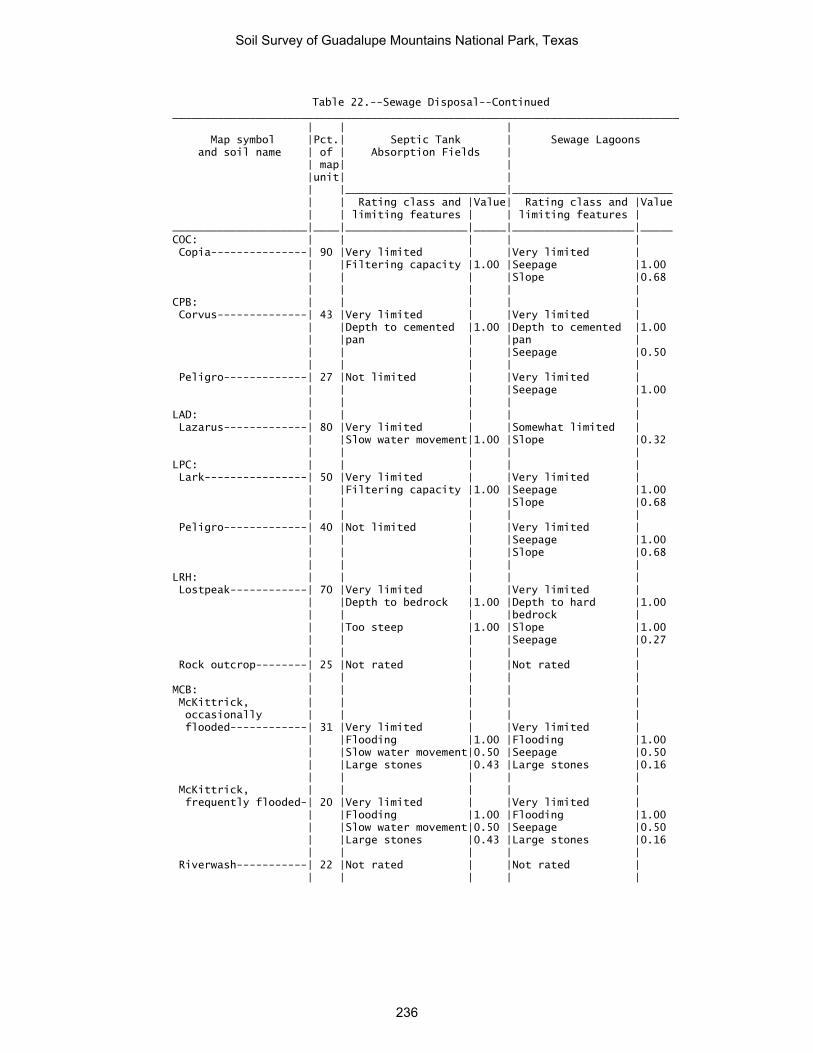
Table 22.--Sewage Disposal--Continued _______________________________________________________________________________ | | | Map symbol |Pct.| Septic Tank | Sewage Lagoons and soil name | of | Absorption Fields | | map| | |unit| | | |_________________________|_________________________ | | Rating class and |Value| Rating class and |Value | | limiting features | | limiting features | _____________________|____|___________________|_____|___________________|_____ COC: | | | | | Copia---------------| 90 |Very limited | |Very limited | | |Filtering capacity |1.00 |Seepage |1.00 | | | |Slope |0.68 | | | | | CPB: | | | | | Corvus--------------| 43 |Very limited | |Very limited | | |Depth to cemented |1.00 |Depth to cemented |1.00 | |pan | |pan | | | | |Seepage |0.50 | | | | | Peligro-------------| 27 |Not limited | |Very limited | | | | |Seepage |1.00 | | | | | LAD: | | | | | Lazarus-------------| 80 |Very limited | |Somewhat limited | | |Slow water movement|1.00 |Slope |0.32 | | | | | LPC: | | | | | Lark----------------| 50 |Very limited | |Very limited | | |Filtering capacity |1.00 |Seepage |1.00 | | | |Slope |0.68 | | | | | Peligro-------------| 40 |Not limited | |Very limited | | | | |Seepage |1.00 | | | |Slope |0.68 | | | | | LRH: | | | | | Lostpeak------------| 70 |Very limited | |Very limited | | |Depth to bedrock |1.00 |Depth to hard |1.00 | | | |bedrock | | |Too steep |1.00 |Slope |1.00 | | | |Seepage |0.27 | | | | | Rock outcrop--------| 25 |Not rated | |Not rated | | | | | | MCB: | | | | | McKittrick, | | | | | occasionally | | | | | flooded------------| 31 |Very limited | |Very limited | | |Flooding |1.00 |Flooding |1.00 | |Slow water movement|0.50 |Seepage |0.50 | |Large stones |0.43 |Large stones |0.16 | | | | | McKittrick, | | | | | frequently flooded-| 20 |Very limited | |Very limited | | |Flooding |1.00 |Flooding |1.00 | |Slow water movement|0.50 |Seepage |0.50 | |Large stones |0.43 |Large stones |0.16 | | | | | Riverwash-----------| 22 |Not rated | |Not rated | | | | | |
Soil Survey of Guadalupe Mountains National Park, Texas
236

Table 22.--Sewage Disposal--Continued _______________________________________________________________________________ | | | Map symbol |Pct.| Septic Tank | Sewage Lagoons and soil name | of | Absorption Fields | | map| | |unit| | | |_________________________|_________________________ | | Rating class and |Value| Rating class and |Value | | limiting features | | limiting features | _____________________|____|___________________|_____|___________________|_____ MPB: | | | | | Monahans------------| 60 |Not limited | |Very limited | | | | |Seepage |1.00 | | | |Slope |0.08 | | | | | Pajarito------------| 21 |Not limited | |Very limited | | | | |Seepage |1.00 | | | |Slope |0.08 | | | | | PCG: | | | | | Altuda--------------| 20 |Very limited | |Very limited | | |Depth to bedrock |1.00 |Depth to hard |1.00 | | | |bedrock | | |Too steep |1.00 |Slope |1.00 | | | |Seepage |0.21 | | | | | Pinery--------------| 32 |Somewhat limited | |Very limited | | |Slope |0.96 |Slope |1.00 | |Slow water movement|0.50 |Seepage |0.50 | |Large stones |0.41 |Large stones |0.11 | | | | | Choza---------------| 27 |Very limited | |Very limited | | |Depth to cemented |1.00 |Depth to cemented |1.00 | |pan | |pan | | |Slope |0.96 |Slope |1.00 | | | | | VLG: | | | | | Victorio------------| 51 |Very limited | |Very limited | | |Depth to bedrock |1.00 |Depth to hard |1.00 | | | |bedrock | | |Too steep |1.00 |Slope |1.00 | |Seepage, bottom |1.00 |Seepage |1.00 | |layer | | | | |Large stones |0.11 |Large stones |0.97 | | | | | Lozen---------------| 33 |Very limited | |Very limited | | |Depth to bedrock |1.00 |Depth to hard |1.00 | | | |bedrock | | |Too steep |1.00 |Slope |1.00 | | | |Seepage |0.27 | | | | | Rock outcrop--------| 12 |Not rated | |Not rated |
Soil Survey of Guadalupe Mountains National Park, Texas
237

Table 22.--Sewage Disposal--Continued _______________________________________________________________________________ | | | Map symbol |Pct.| Septic Tank | Sewage Lagoons and soil name | of | Absorption Fields | | map| | |unit| | | |_________________________|_________________________ | | Rating class and |Value| Rating class and |Value | | limiting features | | limiting features | _____________________|____|___________________|_____|___________________|_____ VLH: | | | | | Victorio, 60 to 95 | | | | | percent slopes-----| 35 |Very limited | |Very limited | | |Depth to bedrock |1.00 |Depth to hard |1.00 | | | |bedrock | | |Too steep |1.00 |Slope |1.00 | |Seepage, bottom |1.00 |Seepage |1.00 | |layer | | | | | | | | Victorio, 40 to 60 | | | | | percent slopes-----| 20 |Very limited | |Very limited | | |Depth to bedrock |1.00 |Depth to hard |1.00 | | | |bedrock | | |Too steep |1.00 |Slope |1.00 | |Seepage, bottom |1.00 |Seepage |1.00 | |layer | | | | | | | | Lozen---------------| 25 |Very limited | |Very limited | | |Depth to bedrock |1.00 |Depth to hard |1.00 | | | |bedrock | | |Too steep |1.00 |Slope |1.00 | |Large stones |1.00 |Large stones |1.00 | | | |Seepage |0.50 | | | | | Rock outcrop--------| 20 |Not rated | |Not rated | _____________________|____|___________________|_____|___________________|_____
Soil Survey of Guadalupe Mountains National Park, Texas
238

Table 23.--Source of Gravel and Sand (The information in this table indicates the dominant soil condition but does not eliminate the need for onsite investigation. The ratings given for the thickest layer are for the thickest layer above and excluding the bottom layer. The numbers in the value columns range from 0.00 to 0.99. The greater the value, the greater the likelihood that the bottom layer or thickest layer of the soil is a source of sand or gravel. See text for further explanation of ratings in this table.) _______________________________________________________________________________ | | | Map symbol |Pct.| Gravel Source | Sand Source and soil name | of | | | map| | |unit| | | |_________________________|_________________________ | | Rating class and |Value| Rating class and |Value | | limiting features | | limiting features | _____________________|____|___________________|_____|___________________|_____ BDG: | | | | | Biduya--------------| 42 |Poor | |Poor | | |Thickest layer |0.00 |Bottom layer |0.00 | |Bottom layer |0.00 |Thickest layer |0.00 | | | | | Desario-------------| 28 |Poor | |Poor | | |Thickest layer |0.00 |Bottom layer |0.00 | |Bottom layer |0.00 |Thickest layer |0.00 | | | | | Rock outcrop--------| 18 |Not rated | |Not rated | | | | | | BRG: | | | | | Bissett-------------| 45 |Fair | |Poor | | |Thickest layer |0.00 |Bottom layer |0.00 | |Bottom layer |0.15 |Thickest layer |0.00 | | | | | Rock outcrop--------| 43 |Not rated | |Not rated | | | | | | BSG: | | | | | Bonespring----------| 63 |Fair | |Poor | | |Thickest layer |0.00 |Bottom layer |0.00 | |Bottom layer |0.72 |Thickest layer |0.00 | | | | | Rock outcrop--------| 20 |Not rated | |Not rated | | | | | | CAD: | | | | | Chispa--------------| 50 |Poor | |Poor | | |Bottom layer |0.00 |Bottom layer |0.00 | |Thickest layer |0.00 |Thickest layer |0.00 | | | | | Tenneco-------------| 33 |Poor | |Poor | | |Bottom layer |0.00 |Bottom layer |0.00 | |Thickest layer |0.00 |Thickest layer |0.00 | | | | | CCD: | | | | | Chilicotal----------| 51 |Poor | |Poor | | |Thickest layer |0.00 |Bottom layer |0.00 | |Bottom layer |0.00 |Thickest layer |0.00 | | | | | Chispa--------------| 28 |Poor | |Poor | | |Bottom layer |0.00 |Bottom layer |0.00 | |Thickest layer |0.00 |Thickest layer |0.00 | | | | | COC: | | | | | Copia---------------| 90 |Poor | |Fair | | |Bottom layer |0.00 |Bottom layer |0.90 | |Thickest layer |0.00 |Thickest layer |0.90 | | | | |
Soil Survey of Guadalupe Mountains National Park, Texas
239

Table 23.--Source of Gravel and Sand--Continued _______________________________________________________________________________ | | | Map symbol |Pct.| Gravel Source | Sand Source and soil name | of | | | map| | |unit| | | |_________________________|_________________________ | | Rating class and |Value| Rating class and |Value | | limiting features | | limiting features | _____________________|____|___________________|_____|___________________|_____ CPB: | | | | | Corvus--------------| 43 |Poor | |Fair | | |Bottom layer |0.00 |Bottom layer |0.00 | |Thickest layer |0.00 |Thickest layer |0.02 | | | | | Peligro-------------| 27 |Poor | |Poor | | |Bottom layer |0.00 |Bottom layer |0.00 | |Thickest layer |0.00 |Thickest layer |0.00 | | | | | LAD: | | | | | Lazarus-------------| 80 |Poor | |Poor | | |Bottom layer |0.00 |Bottom layer |0.00 | |Thickest layer |0.00 |Thickest layer |0.00 | | | | | LPC: | | | | | Lark----------------| 50 |Poor | |Fair | | |Bottom layer |0.00 |Thickest layer |0.36 | |Thickest layer |0.00 |Bottom layer |0.43 | | | | | Peligro-------------| 40 |Poor | |Poor | | |Bottom layer |0.00 |Bottom layer |0.00 | |Thickest layer |0.00 |Thickest layer |0.00 | | | | | LRH: | | | | | Lostpeak------------| 70 |Fair | |Poor | | |Thickest layer |0.00 |Bottom layer |0.00 | |Bottom layer |0.12 |Thickest layer |0.00 | | | | | Rock outcrop--------| 25 |Not rated | |Not rated | | | | | | MCB: | | | | | McKittrick, | | | | | occasionally | | | | | flooded------------| 31 |Poor | |Poor | | |Bottom layer |0.00 |Bottom layer |0.00 | |Thickest layer |0.00 |Thickest layer |0.00 | | | | | McKittrick, | | | | | frequently flooded-| 20 |Poor | |Poor | | |Bottom layer |0.00 |Bottom layer |0.00 | |Thickest layer |0.00 |Thickest layer |0.00 | | | | | Riverwash-----------| 22 |Not rated | |Not rated | | | | | | MPB: | | | | | Monahans------------| 60 |Poor | |Poor | | |Bottom layer |0.00 |Bottom layer |0.00 | |Thickest layer |0.00 |Thickest layer |0.00 | | | | | Pajarito------------| 21 |Poor | |Poor | | |Bottom layer |0.00 |Bottom layer |0.00 | |Thickest layer |0.00 |Thickest layer |0.00 | | | | |
Soil Survey of Guadalupe Mountains National Park, Texas
240

Table 23.--Source of Gravel and Sand--Continued _______________________________________________________________________________ | | | Map symbol |Pct.| Gravel Source | Sand Source and soil name | of | | | map| | |unit| | | |_________________________|_________________________ | | Rating class and |Value| Rating class and |Value | | limiting features | | limiting features | _____________________|____|___________________|_____|___________________|_____ PCG: | | | | | Altuda--------------| 20 |Poor | |Poor | | |Thickest layer |0.00 |Bottom layer |0.00 | |Bottom layer |0.00 |Thickest layer |0.00 | | | | | Pinery--------------| 32 |Poor | |Poor | | |Bottom layer |0.00 |Bottom layer |0.00 | |Thickest layer |0.00 |Thickest layer |0.00 | | | | | Choza---------------| 27 |Poor | |Poor | | |Bottom layer |0.00 |Bottom layer |0.00 | |Thickest layer |0.00 |Thickest layer |0.00 | | | | | VLG: | | | | | Victorio------------| 51 |Poor | |Poor | | |Thickest layer |0.00 |Bottom layer |0.00 | |Bottom layer |0.00 |Thickest layer |0.00 | | | | | Lozen---------------| 33 |Fair | |Poor | | |Thickest layer |0.00 |Bottom layer |0.00 | |Bottom layer |0.12 |Thickest layer |0.00 | | | | | Rock outcrop--------| 12 |Not rated | |Not rated | | | | | | VLH: | | | | | Victorio, 60 to 95 | | | | | percent slopes-----| 35 |Poor | |Poor | | |Thickest layer |0.00 |Bottom layer |0.00 | |Bottom layer |0.00 |Thickest layer |0.00 | | | | | Victorio, 40 to 60 | | | | | percent slopes-----| 20 |Poor | |Poor | | |Thickest layer |0.00 |Bottom layer |0.00 | |Bottom layer |0.00 |Thickest layer |0.00 | | | | | Lozen---------------| 25 |Poor | |Poor | | |Bottom layer |0.00 |Bottom layer |0.00 | |Thickest layer |0.00 |Thickest layer |0.00 | | | | | Rock outcrop--------| 20 |Not rated | |Not rated | _____________________|____|___________________|_____|___________________|_____
Soil Survey of Guadalupe Mountains National Park, Texas
241

Table 24.--Source of Reclamation Material, Roadfill, and Topsoil (The information in this table indicates the dominant soil condition but does not eliminate the need for onsite investigation. The ratings given for the thickest layer are for the thickest layer above and excluding the bottom layer. The numbers in the value columns range from 0.00 to 0.99. The greater the value, the greater the likelihood that the bottom layer or thickest layer of the soil is a source of sand or gravel. See text for further explanation of ratings in this table.) ________________________________________________________________________________________________________ | | | | Map symbol |Pct.| Reclamation Source | Roadfill Source | Topsoil Source and soil name | of | | | | map| | | |unit| | | |____|_________________________|_________________________|_________________________ | | Rating class and |Value| Rating class and |Value| Rating class and |Value | | limiting features | | limiting features | | limiting features | _____________________|____|___________________|_____|___________________|_____|___________________|_____ BDG: | | | | | | | Biduya--------------| 42 |Poor | |Poor | |Poor | | |Droughty |0.00 |Depth to bedrock |0.00 |Rock fragments |0.00 | |Depth to bedrock |0.00 |Cobble content |0.00 |Depth to bedrock |0.00 | |Cobble content |0.39 | | |Slope |0.00 | | | | | | | Desario-------------| 28 |Poor | |Poor | |Poor | | |Droughty |0.00 |Depth to bedrock |0.00 |Depth to bedrock |0.00 | |Depth to bedrock |0.00 |Slope |0.00 |Slope |0.00 | |Organic matter |0.68 |Shrink-swell |0.87 |Rock fragments |0.00 | |content low | | | | | | | | | | | | Rock outcrop--------| 18 |Not rated | |Not rated | |Not rated | | | | | | | | BRG: | | | | | | | Bissett-------------| 45 |Poor | |Poor | |Poor | | |Droughty |0.00 |Depth to bedrock |0.00 |Rock fragments |0.00 | |Depth to bedrock |0.00 |Slope |0.00 |Depth to bedrock |0.00 | |Carbonate content |0.03 |Cobble content |0.75 |Slope |0.00 | | | | | | | Rock outcrop--------| 43 |Not rated | |Not rated | |Not rated | | | | | | | | BSG: | | | | | | | Bonespring----------| 63 |Poor | |Poor | |Poor | | |Droughty |0.00 |Depth to bedrock |0.00 |Rock fragments |0.00 | |Depth to bedrock |0.00 |Slope |0.00 |Depth to bedrock |0.00 | | | | | |Slope |0.00 | | | | | | | Rock outcrop--------| 20 |Not rated | |Not rated | |Not rated | | | | | | | | CAD: | | | | | | | Chispa--------------| 50 |Fair | |Fair | |Fair | | |Water erosion |0.90 |Low strength |0.78 |Carbonate content |0.84 | |Carbonate content |0.68 | | |Hard to reclaim |0.98 | | | | | |(rock fragments) | | |Organic matter |0.88 | | |Rock fragments |0.98 | |content low | | | | | | | | | | | | Tenneco-------------| 33 |Fair | |Poor | |Fair | | |Water erosion |0.68 |Low strength |0.00 |Carbonate content |0.97 | |Organic matter |0.50 | | | | | |content low | | | | | | |Carbonate content |0.95 | | | | | | | | | | |
Soil Survey of Guadalupe Mountains National Park, Texas
242

Table 24.--Source of Reclamation Material, Roadfill, and Topsoil--Continued ________________________________________________________________________________________________________ | | | | Map symbol |Pct.| Reclamation Source | Roadfill Source | Topsoil Source and soil name | of | | | | map| | | |unit| | | |____|_________________________|_________________________|_________________________ | | Rating class and |Value| Rating class and |Value| Rating class and |Value | | limiting features | | limiting features | | limiting features | _____________________|____|___________________|_____|___________________|_____|___________________|_____ CCD: | | | | | | | Chilicotal----------| 51 |Fair | |Fair | |Poor | | |Organic matter |0.18 |Cobble content |0.99 |Rock fragments |0.00 | |content low | | | | | | |Carbonate content |0.08 | | |Hard to reclaim |0.08 | | | | | |(rock fragments) | | |Droughty |0.94 | | |Carbonate content |0.21 | | | | | | | Chispa--------------| 28 |Fair | |Good | |Fair | | |Water erosion |0.99 | | |Rock fragments |0.68 | |Organic matter |0.88 | | |Slope |0.96 | |content low | | | | | | |Carbonate content |0.99 | | |Carbonate content |0.99 | | | | | | | COC: | | | | | | | Copia---------------| 90 |Poor | |Good | |Poor | | |Too sandy |0.00 | | |Too sandy |0.00 | |Wind erosion |0.00 | | | | | |Organic matter |0.50 | | | | | |content low | | | | | | | | | | | | CPB: | | | | | | | Corvus--------------| 43 |Poor | |Poor | |Poor | | |Droughty |0.00 |Depth to cemented |0.00 |Depth to cemented |0.00 | | | |pan | |pan | | |Depth to cemented |0.00 | | |Too sandy |0.96 | |pan | | | | | | |Water erosion |0.37 | | | | | | | | | | | Peligro-------------| 27 |Fair | |Good | |Fair | | |Organic matter |0.18 | | |Too sandy |0.99 | |content low | | | | | | |Water erosion |0.90 | | | | | |Too sandy |0.99 | | | | | | | | | | | LAD: | | | | | | | Lazarus-------------| 80 |Fair | |Poor | |Good | | |Water erosion |0.99 |Low strength |0.00 | | | | | |Shrink-swell |0.90 | | | | | | | | | LPC: | | | | | | | Lark----------------| 50 |Poor | |Good | |Poor | | |Too sandy |0.00 | | |Too sandy |0.00 | |Wind erosion |0.00 | | | | | |Organic matter |0.18 | | | | | |content low | | | | | | | | | | | | Peligro-------------| 40 |Poor | |Good | |Fair | | |Wind erosion |0.00 | | |Too sandy |0.99 | |Organic matter |0.18 | | | | | |content low | | | | | | |Water erosion |0.68 | | | | | | | | | | |
Soil Survey of Guadalupe Mountains National Park, Texas
243
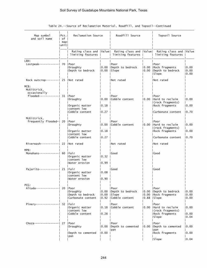
Table 24.--Source of Reclamation Material, Roadfill, and Topsoil--Continued ________________________________________________________________________________________________________ | | | | Map symbol |Pct.| Reclamation Source | Roadfill Source | Topsoil Source and soil name | of | | | | map| | | |unit| | | |____|_________________________|_________________________|_________________________ | | Rating class and |Value| Rating class and |Value| Rating class and |Value | | limiting features | | limiting features | | limiting features | _____________________|____|___________________|_____|___________________|_____|___________________|_____ LRH: | | | | | | | Lostpeak------------| 70 |Poor | |Poor | |Poor | | |Droughty |0.00 |Depth to bedrock |0.00 |Rock fragments |0.00 | |Depth to bedrock |0.00 |Slope |0.00 |Depth to bedrock |0.00 | | | | | |Slope |0.00 | | | | | | | Rock outcrop--------| 25 |Not rated | |Not rated | |Not rated | | | | | | | | MCB: | | | | | | | McKittrick, | | | | | | | occasionally | | | | | | | flooded------------| 31 |Poor | |Poor | |Poor | | |Droughty |0.00 |Cobble content |0.00 |Hard to reclaim |0.00 | | | | | |(rock fragments) | | |Organic matter |0.18 | | |Rock fragments |0.00 | |content low | | | | | | |Cobble content |0.27 | | |Carbonate content |0.70 | | | | | | | McKittrick, | | | | | | | frequently flooded-| 20 |Poor | |Poor | |Poor | | |Droughty |0.00 |Cobble content |0.00 |Hard to reclaim |0.00 | | | | | |(rock fragments) | | |Organic matter |0.18 | | |Rock fragments |0.00 | |content low | | | | | | |Cobble content |0.27 | | |Carbonate content |0.70 | | | | | | | Riverwash-----------| 22 |Not rated | |Not rated | |Not rated | | | | | | | | MPB: | | | | | | | Monahans------------| 60 |Fair | |Good | |Good | | |Organic matter |0.32 | | | | | |content low | | | | | | |Water erosion |0.99 | | | | | | | | | | | Pajarito------------| 21 |Fair | |Good | |Good | | |Organic matter |0.08 | | | | | |content low | | | | | | |Water erosion |0.90 | | | | | | | | | | | PCG: | | | | | | | Altuda--------------| 20 |Poor | |Poor | |Poor | | |Droughty |0.00 |Depth to bedrock |0.00 |Depth to bedrock |0.00 | |Depth to bedrock |0.00 |Slope |0.00 |Rock fragments |0.00 | |Carbonate content |0.92 |Cobble content |0.88 |Slope |0.00 | | | | | | | Pinery--------------| 32 |Fair | |Poor | |Poor | | |Organic matter |0.18 |Cobble content |0.00 |Hard to reclaim |0.00 | |content low | | | |(rock fragments) | | |Cobble content |0.28 | | |Rock fragments |0.00 | | | | | |Slope |0.04 | | | | | | | Choza---------------| 27 |Poor | |Poor | |Poor | | |Droughty |0.00 |Depth to cemented |0.00 |Depth to cemented |0.00 | | | |pan | |pan | | |Depth to cemented |0.00 | | |Rock fragments |0.00 | |pan | | | | | | | | | | |Slope |0.04
Soil Survey of Guadalupe Mountains National Park, Texas
244

Table 24.--Source of Reclamation Material, Roadfill, and Topsoil--Continued ________________________________________________________________________________________________________ | | | | Map symbol |Pct.| Reclamation Source | Roadfill Source | Topsoil Source and soil name | of | | | | map| | | |unit| | | |____|_________________________|_________________________|_________________________ | | Rating class and |Value| Rating class and |Value| Rating class and |Value | | limiting features | | limiting features | | limiting features | _____________________|____|___________________|_____|___________________|_____|___________________|_____ VLG: | | | | | | | Victorio------------| 51 |Poor | |Poor | |Poor | | |Droughty |0.00 |Depth to bedrock |0.00 |Depth to bedrock |0.00 | |Depth to bedrock |0.00 |Slope |0.00 |Slope |0.00 | |Too clayey |0.00 |Shrink-swell |0.06 |Too clayey |0.00 | | | | | | | Lozen---------------| 33 |Poor | |Poor | |Poor | | |Droughty |0.00 |Depth to bedrock |0.00 |Rock fragments |0.00 | |Depth to bedrock |0.00 |Slope |0.00 |Depth to bedrock |0.00 | | | | | |Slope |0.00 | | | | | | | Rock outcrop--------| 12 |Not rated | |Not rated | |Not rated | | | | | | | | VLH: | | | | | | | Victorio, 60 to 95 | | | | | | | percent slopes-----| 35 |Poor | |Poor | |Poor | | |Droughty |0.00 |Depth to bedrock |0.00 |Depth to bedrock |0.00 | |Depth to bedrock |0.00 |Slope |0.00 |Slope |0.00 | |Too clayey |0.00 |Shrink-swell |0.06 |Rock fragments |0.00 | | | | | | | Victorio, 40 to 60 | | | | | | | percent slopes-----| 20 |Poor | |Poor | |Poor | | |Droughty |0.00 |Depth to bedrock |0.00 |Depth to bedrock |0.00 | |Depth to bedrock |0.00 |Slope |0.00 |Slope |0.00 | |Too clayey |0.00 |Shrink-swell |0.06 |Rock fragments |0.00 | | | | | | | Lozen---------------| 25 |Poor | |Poor | |Poor | | |Stone content |0.00 |Depth to bedrock |0.00 |Depth to bedrock |0.00 | |Droughty |0.00 |Slope |0.00 |Slope |0.00 | |Depth to bedrock |0.00 |Stones |0.00 |Rock fragments |0.00 | | | | | | | Rock outcrop--------| 20 |Not rated | |Not rated | |Not rated | _____________________|____|___________________|_____|___________________|_____|___________________|_____
Soil Survey of Guadalupe Mountains National Park, Texas
245

Table 25.--Ponds and Embankments (The information in this table indicates the dominant soil condition but does not eliminate the need for onsite investigation. The numbers in the value columns range from 0.01 to 1.00. The larger the value, the greater the limitation. See text for further explanation of ratings in this table.) ________________________________________________________________________________________________________ | | | | Map symbol |Pct.| Pond reservoir areas | Embankments, dikes, and | Aquifer-fed and soil name | of | | levees | excavated ponds | map| | | |unit| | | | |_________________________|_________________________|_________________________ | | Rating class and |Value| Rating class and |Value| Rating class and |Value | | limiting features | | limiting features | | limiting features | _____________________|____|___________________|_____|___________________|_____|___________________|_____ BDG: | | | | | | | Biduya--------------| 42 |Very limited | |Very limited | |Very limited | | |Slope |1.00 |Thin layer |1.00 |Depth to water |1.00 | |Depth to bedrock |1.00 |Large stones |0.61 | | | | | | | | | Desario-------------| 28 |Very limited | |Very limited | |Very limited | | |Slope |1.00 |Thin layer |1.00 |Depth to water |1.00 | |Depth to bedrock |1.00 | | | | | | | | | | | Rock outcrop--------| 18 |Not rated | |Not rated | |Not rated | | | | | | | | BRG: | | | | | | | Bissett-------------| 45 |Very limited | |Very limited | |Very limited | | |Slope |1.00 |Thin layer |1.00 |Depth to water |1.00 | |Depth to bedrock |1.00 |Seepage |0.40 | | | | | | | | | Rock outcrop--------| 43 |Not rated | |Not rated | |Not rated | | | | | | | | BSG: | | | | | | | Bonespring----------| 63 |Very limited | |Very limited | |Very limited | | |Slope |1.00 |Seepage |1.00 |Depth to water |1.00 | |Depth to bedrock |1.00 |Thin layer |1.00 | | | |Seepage |0.53 | | | | | | | | | | | Rock outcrop--------| 20 |Not rated | |Not rated | |Not rated | | | | | | | | CAD: | | | | | | | Chispa--------------| 50 |Somewhat limited | |Somewhat limited | |Very limited | | |Seepage |0.70 |Piping |0.70 |Depth to water |1.00 | |Slope |0.68 | | | | | | | | | | | Tenneco-------------| 33 |Somewhat limited | |Somewhat limited | |Very limited | | |Seepage |0.70 |Piping |0.30 |Depth to water |1.00 | |Slope |0.68 | | | | | | | | | | | CCD: | | | | | | | Chilicotal----------| 51 |Very limited | |Not limited | |Very limited | | |Slope |1.00 | | |Depth to water |1.00 | |Seepage |0.72 | | | | | | | | | | | Chispa--------------| 28 |Very limited | |Somewhat limited | |Very limited | | |Slope |1.00 |Piping |0.95 |Depth to water |1.00 | |Seepage |0.70 | | | | | | | | | | | COC: | | | | | | | Copia---------------| 90 |Very limited | |Very limited | |Very limited | | |Seepage |1.00 |Seepage |1.00 |Depth to water |1.00 | |Slope |0.32 | | | | | | | | | | |
Soil Survey of Guadalupe Mountains National Park, Texas
246

Table 25.--Ponds and Embankments--Continued ________________________________________________________________________________________________________ | | | | Map symbol |Pct.| Pond reservoir areas | Embankments, dikes, and | Aquifer-fed and soil name | of | | levees | excavated ponds | map| | | |unit| | | | |_________________________|_________________________|_________________________ | | Rating class and |Value| Rating class and |Value| Rating class and |Value | | limiting features | | limiting features | | limiting features | _____________________|____|___________________|_____|___________________|_____|___________________|_____ CPB: | | | | | | | Corvus--------------| 43 |Very limited | |Very limited | |Very limited | | |Depth to cemented |1.00 |Seepage |1.00 |Depth to water |1.00 | |pan | | | | | | |Gypsum content |1.00 |Piping |1.00 | | | | | |Thin layer |1.00 | | | | | | | | | Peligro-------------| 27 |Very limited | |Very limited | |Very limited | | |Seepage |1.00 |Piping |1.00 |Depth to water |1.00 | |Gypsum content |1.00 | | | | | | | | | | | LAD: | | | | | | | Lazarus-------------| 80 |Somewhat limited | |Somewhat limited | |Very limited | | |Slope |0.08 |Piping |0.03 |Depth to water |1.00 | |Seepage |0.03 | | | | | | | | | | | LPC: | | | | | | | Lark----------------| 50 |Very limited | |Very limited | |Very limited | | |Seepage |1.00 |Seepage |1.00 |Depth to water |1.00 | |Gypsum content |1.00 |Piping |1.00 | | | |Slope |0.32 | | | | | | | | | | | Peligro-------------| 40 |Very limited | |Very limited | |Very limited | | |Seepage |1.00 |Piping |1.00 |Depth to water |1.00 | |Gypsum content |1.00 |Seepage |0.49 | | | |Slope |0.32 | | | | | | | | | | | LRH: | | | | | | | Lostpeak------------| 70 |Very limited | |Very limited | |Very limited | | |Slope |1.00 |Thin layer |1.00 |Depth to water |1.00 | |Depth to bedrock |1.00 | | | | | | | | | | | Rock outcrop--------| 25 |Not rated | |Not rated | |Not rated | | | | | | | | MCB: | | | | | | | McKittrick, | | | | | | | occasionally | | | | | | | flooded------------| 31 |Somewhat limited | |Very limited | |Very limited | | |Seepage |0.70 |Seepage |1.00 |Depth to water |1.00 | | | |Large stones |0.43 | | | | | | | | | McKittrick, | | | | | | | frequently flooded-| 20 |Somewhat limited | |Very limited | |Very limited | | |Seepage |0.70 |Seepage |1.00 |Depth to water |1.00 | | | |Large stones |0.43 | | | | | | | | | Riverwash-----------| 22 |Not rated | |Not rated | |Not rated | | | | | | | | MPB: | | | | | | | Monahans------------| 60 |Very limited | |Somewhat limited | |Very limited | | |Seepage |1.00 |Piping |0.12 |Depth to water |1.00 | | | | | | | Pajarito------------| 21 |Very limited | |Not limited | |Very limited | | |Seepage |1.00 | | |Depth to water |1.00 | | | | | | |
Soil Survey of Guadalupe Mountains National Park, Texas
247

Table 25.--Ponds and Embankments--Continued ________________________________________________________________________________________________________ | | | | Map symbol |Pct.| Pond reservoir areas | Embankments, dikes, and | Aquifer-fed and soil name | of | | levees | excavated ponds | map| | | |unit| | | | |_________________________|_________________________|_________________________ | | Rating class and |Value| Rating class and |Value| Rating class and |Value | | limiting features | | limiting features | | limiting features | _____________________|____|___________________|_____|___________________|_____|___________________|_____ PCG: | | | | | | | Altuda--------------| 20 |Very limited | |Very limited | |Very limited | | |Slope |1.00 |Thin layer |1.00 |Depth to water |1.00 | |Depth to bedrock |1.00 | | | | | |Seepage |0.45 | | | | | | | | | | | Pinery--------------| 32 |Very limited | |Somewhat limited | |Very limited | | |Slope |1.00 |Large stones |0.41 |Depth to water |1.00 | |Seepage |0.70 | | | | | | | | | | | Choza---------------| 27 |Very limited | |Very limited | |Very limited | | |Depth to cemented |1.00 |Thin layer |1.00 |Depth to water |1.00 | |pan | | | | | | |Slope |1.00 | | | | | | | | | | | VLG: | | | | | | | Victorio------------| 51 |Very limited | |Very limited | |Very limited | | |Slope |1.00 |Thin layer |1.00 |Depth to water |1.00 | |Depth to bedrock |1.00 |Large stones |0.11 | | | |Seepage |0.46 |Hard to pack |0.40 | | | | | | | | | Lozen---------------| 33 |Very limited | |Very limited | |Very limited | | |Slope |1.00 |Thin layer |1.00 |Depth to water |1.00 | |Depth to bedrock |1.00 | | | | | | | | | | | Rock outcrop--------| 12 |Not rated | |Not rated | |Not rated | | | | | | | | VLH: | | | | | | | Victorio, 60 to 95 | | | | | | | percent slopes-----| 35 |Very limited | |Very limited | |Very limited | | |Slope |1.00 |Thin layer |1.00 |Depth to water |1.00 | |Depth to bedrock |1.00 |Hard to pack |0.35 | | | |Seepage |0.46 | | | | | | | | | | | Victorio, 40 to 60 | | | | | | | percent slopes-----| 20 |Very limited | |Very limited | |Very limited | | |Slope |1.00 |Thin layer |1.00 |Depth to water |1.00 | |Depth to bedrock |1.00 |Hard to pack |0.35 | | | |Seepage |0.46 | | | | | | | | | | | Lozen---------------| 25 |Very limited | |Very limited | |Very limited | | |Slope |1.00 |Thin layer |1.00 |Depth to water |1.00 | |Depth to bedrock |1.00 |Large stones |1.00 | | | |Seepage |0.53 |Piping |0.50 | | | | | | | | | Rock outcrop--------| 20 |Not rated | |Not rated | |Not rated | _____________________|____|___________________|_____|___________________|_____|___________________|_____
Soil Survey of Guadalupe Mountains National Park, Texas
248

Table 26.--Engineering Properties
(Absence of an entry indicates that the data were not estimated.) ______________________________________________________________________________________________________________________________________ | | | Classification | Fragments | Percentage passing | | Map symbol | Depth | USDA texture |___________________________|_____________| sieve number-- |Liquid| Plas- and soil name | | | | | >250 |75-250|___________________________| limit|ticity | | | Unified | AASHTO | mm | mm | 4 | 10 | 40 | 200 | |index _________________|_______|________________________|_____________|_____________|______|______|______|______|______|______|______|______ | Cm | | | | Pct | Pct | | | | | Pct | BDG: | | | | | | | | | | | | Biduya----------| 0-13 |Very cobbly loam |CL, GC |A-2-6, A-6 | 0 |29-53 |49-79 |49-79 |44-79 |33-61 |30-40 |11-19 | 13-38 |Bedrock | | | --- | --- | --- | --- | --- | --- | --- | --- | | | | | | | | | | | | Desario---------| 0-12 |Gravelly loam |CL, SC |A-2-6, A-6 | 0 | 0-14 |65-83 |65-83 |53-75 |38-56 |29-40 |12-18 | 12-31 |Very gravelly loam, |CL, GC |A-2-6, A-7-6 | 0 | 7-24 |36-75 |36-75 |30-71 |21-53 |32-44 |13-23 | | very gravelly clay loam| | | | | | | | | | | 31-56 |Bedrock | | | --- | --- | --- | --- | --- | --- | --- | --- | | | | | | | | | | | | Rock outcrop----| --- | --- | --- | --- | --- | --- | --- | --- | --- | --- | --- | --- | | | | | | | | | | | | BRG: | | | | | | | | | | | | Bissett---------| 0-4 |Loam |ML, CL-ML |A-4, A-6 | 0 | 0 |84-100|83-100|71-91 |53-72 |25-39 | 6-12 | 4-34 |Very gravelly loam |GC, GM |A-6, A-2-4 | 0 |14-61 |30-72 |27-70 |23-63 |16-47 |24-35 | 8-14 | 34-59 |Bedrock | | | --- | --- | --- | --- | --- | --- | --- | --- | | | | | | | | | | | | Rock outcrop----| --- | --- | --- | --- | --- | --- | --- | --- | --- | --- | --- | --- | | | | | | | | | | | | BSG: | | | | | | | | | | | | Bonespring------| 0-9 |Very channery sandy loam|GP-GC, GC |A-6, A-2-4 | 0 | 0-16 |19-73 |16-72 |14-68 | 7-38 |24-34 | 7-13 | 9-28 |Extremely gravelly |GP-GC, GW, GC|A-2-4, | 0 | 0-15 |11-56 | 7-54 | 7-53 | 3-28 |22-32 | 6-12 | | sandy loam | | A-1-a, A-2-6| | | | | | | | | 28-53 |Bedrock | | | --- | --- | --- | --- | --- | --- | --- | --- | | | | | | | | | | | | Rock outcrop----| --- | --- | --- | --- | --- | --- | --- | --- | --- | --- | --- | --- | | | | | | | | | | | | CAD: | | | | | | | | | | | | Chispa----------| 0-15 |Loam |SC, CL |A-4, A-6 | 0 | 0-29 |75-100|73-100|67-100|46-76 |26-40 | 9-19 | 15-203|Loam, sandy loam, |CL, SC, SM |A-6, A-4 | 0 | 0-26 |68-100|67-100|60-100|42-74 |26-39 | 9-19 | | gravelly sandy clay | | | | | | | | | | | | loam | | | | | | | | | | | | | | | | | | | | | | Tenneco---------| 0-13 |Very fine sandy loam |ML, ML-CL |A-4, A-2-4 | 0 | 0 | 100 | 100 |96-100|58-70 |24-39 | 9-17 | 13-72 |Loam, very fine sandy |CL |A-6 | 0 | 0 | 100 | 100 |95-100|71-81 |26-39 |11-19 | | loam | | | | | | | | | | | 72-203|Loam, clay loam |CL |A-6 | 0 | 0 |83-100|83-100|77-100|50-73 |26-39 |13-23 | | | | | | | | | | | |
Soil S
urvey of Guadalupe M
ountains National P
ark, Texas
249

Table 26.--Engineering Properties--Continued ______________________________________________________________________________________________________________________________________ | | | Classification | Fragments | Percentage passing | | Map symbol | Depth | USDA texture |___________________________|_____________| sieve number-- |Liquid| Plas- and soil name | | | | | >250 |75-250|___________________________| limit|ticity | | | Unified | AASHTO | mm | mm | 4 | 10 | 40 | 200 | |index _________________|_______|________________________|_____________|_____________|______|______|______|______|______|______|______|______ | Cm | | | | Pct | Pct | | | | | Pct | CCD: | | | | | | | | | | | | Chilicotal------| 0-21 |Gravelly loam |SC, CL, GC |A-4, A-6 | 0 | 0 |64-84 |63-84 |53-78 |37-57 |26-39 | 9-17 | 21-157|Very gravelly sandy |GC, GM |A-2-6, A-6 | 0 |15-26 |48-68 |46-67 |40-64 |25-43 |27-38 |12-19 | | loam, very cobbly | | | | | | | | | | | | loam, extremely | | | | | | | | | | | | gravelly sandy loam | | | | | | | | | | | | | | | | | | | | | | Chispa----------| 0-19 |Fine sandy loam |SC-SM, SM |A-4 | 0 | 0 |89-100|88-100|74-94 |47-63 |20-32 | 4-12 | 19-157|Loam, sandy loam |SC, CL |A-6, A-4 | 0 | 0 |76-100|75-100|70-95 |47-65 |28-33 |12-13 | | | | | | | | | | | | COC: | | | | | | | | | | | | Copia-----------| 0-4 |Loamy fine sand |SP-SM |A-2-4, A-3 | 0 | 0 | 100 | 100 |93-98 | 6-11 | 0-22 |NP-3 | 4-203|Fine sand |SP-SM, SP |A-2-4, A-3 | 0 | 0 | 100 | 100 |92-97 | 5-10 | 0-20 |NP-3 | | | | | | | | | | | | CPB: | | | | | | | | | | | | Corvus----------| 0-6 |Gypsiferous very fine |CL-ML, CL |A-6, A-4 | 0 | 0 | 100 | 100 |96-100|64-71 |21-30 | 6-11 | | sandy loam | | | | | | | | | | | 6-49 |Gypsiferous fine sandy |SC, SC-SM |A-4 | 0 | 0 | 100 | 100 |84-91 |36-43 |19-27 | 4-10 | | loam, Gypsiferous loamy| | | | | | | | | | | | fine sand | | | | | | | | | | | 49-74 |Cemented material | --- | --- | --- | --- | --- | --- | --- | --- | --- | --- | | | | | | | | | | | | Peligro---------| 0-5 |Very fine sandy loam |ML, ML-CL |A-4 | 0 | 0 | 100 | 100 |91-100|58-68 |19-30 | 3-11 | 5-112|Gypsiferous fine sandy |SM, SM-SC |A-4 | 0 | 0 | 100 | 100 |90-100|41-51 |16-26 | 2-9 | | loam | | | | | | | | | | |112-203|Gypsiferous very fine |SM, SM-SC |A-4 | 0 | 0 | 100 | 100 |86-94 |36-44 |17-26 | 2-8 | | sandy loam | | | | | | | | | | | | | | | | | | | | | | LAD: | | | | | | | | | | | | Lazarus---------| 0-19 |Loam |SC, CL |A-6, A-4 | 0 | 0 | 100 | 100 |93-100|69-84 |26-39 | 9-17 | 19-203|Clay loam, loam, silty |CL, SC, ML |A-6, A-7-6 | 0 | 0 | 100 | 100 |91-100|68-83 |32-50 |13-25 | | clay loam | | | | | | | | | | | | | | | | | | | | | | LPC: | | | | | | | | | | | | Lark------------| 0-27 |Gypsiferous fine sand |SP-SM |A-3, A-2-4 | 0 | 0 | 100 | 100 |81-87 | 9-15 | 0-21 |NP-4 | 27-203|Gypsiferous fine sand |SP-SM |A-3, A-2-4 | 0 | 0 | 100 | 100 |85-91 |10-16 | 0-20 |NP-4 | | | | | | | | | | | | Peligro---------| 0-18 |Loamy fine sand |SC, SM, SC-SM|A-2-4 | 0 | 0 | 100 | 100 |91-99 |26-34 |19-29 | 3-10 | 18-43 |Gypsiferous sandy loam |CL-ML, ML |A-4 | 0 | 0 | 100 | 100 |94-99 |61-66 |16-22 | 2-6 | 43-203|Gypsiferous fine sandy |SM, SC-SM |A-4 | 0 | 0 | 100 | 100 |94-98 |45-49 |17-22 | 2-5 | | loam | | | | | | | | | | | | | | | | | | | | | |
Soil S
urvey of Guadalupe M
ountains National P
ark, Texas
250

Table 26.--Engineering Properties--Continued ______________________________________________________________________________________________________________________________________ | | | Classification | Fragments | Percentage passing | | Map symbol | Depth | USDA texture |___________________________|_____________| sieve number-- |Liquid| Plas- and soil name | | | | | >250 |75-250|___________________________| limit|ticity | | | Unified | AASHTO | mm | mm | 4 | 10 | 40 | 200 | |index _________________|_______|________________________|_____________|_____________|______|______|______|______|______|______|______|______ | Cm | | | | Pct | Pct | | | | | Pct | LRH: | | | | | | | | | | | | Lostpeak--------| 0-19 |Very gravelly clay loam |GC |A-7-6, A-2-6,| 0 | 0 |35-50 |35-50 |32-50 |27-44 |35-49 |16-24 | | | | A-2-7 | | | | | | | | | 19-44 |Bedrock | --- | --- | --- | --- | --- | --- | --- | --- | --- | --- | | | | | | | | | | | | Rock outcrop----| --- | --- | --- | --- | --- | --- | --- | --- | --- | --- | --- | --- | | | | | | | | | | | | MCB: | | | | | | | | | | | | McKittrick, | | | | | | | | | | | | occasionally | | | | | | | | | | | | flooded--------| 0-12 |Gravelly sandy loam |GC-GM, CL, SC|A-6, A-1-b | 0 | 9-28 |53-90 |51-89 |42-88 |25-58 |24-40 | 6-18 | 12-41 |Very gravelly sandy loam|GP-GC, GM |A-6, A-1-a, | 0 |15-37 |17-66 |14-65 |11-61 | 7-40 |22-36 | 6-17 | | | | A-2-6 | | | | | | | | | 41-157|Extremely cobbly coarse |GM, GP-GM, |A-2-6, A-2-4,| 0 |43-60 |19-47 |16-45 |10-34 | 5-20 |18-33 | 3-15 | | sandy loam | GP-GC | A-1-a | | | | | | | | | | | | | | | | | | | | McKittrick, | | | | | | | | | | | | frequently | | | | | | | | | | | | flooded--------| 0-12 |Gravelly sandy loam |GC-GM, CL, SC|A-6, A-1-b | 0 | 9-28 |53-90 |51-89 |42-88 |25-58 |24-40 | 6-18 | 12-41 |Very gravelly sandy loam|GP-GC, GM |A-6, A-1-a, | 0 |15-37 |17-66 |14-65 |11-61 | 7-40 |22-36 | 6-17 | | | | A-2-6 | | | | | | | | | 41-157|Extremely cobbly coarse |GC, GP-GM, |A-2-6, A-2-4,| 0 |43-60 |19-47 |16-45 |10-34 | 5-20 |18-33 | 3-15 | | sandy loam | GP-GC | A-1-a | | | | | | | | | | | | | | | | | | | | Riverwash-------| --- | --- | --- | --- | --- | --- | --- | --- | --- | --- | --- | --- | | | | | | | | | | | | MPB: | | | | | | | | | | | | Monahans--------| 0-10 |Very fine sandy loam |ML, CL, SM |A-4 | 0 | 0 | 100 | 100 |95-100|50-61 |18-30 | 3-12 | 10-33 |Fine sandy loam, loam |SC-SM, SM |A-4, A-2-4 | 0 | 0 | 100 | 100 |91-100|48-57 |21-30 | 6-12 | 33-203|Fine sandy loam, loam |SM, SC-SM, CL|A-2-4, A-4 | 0 | 0 | 100 | 100 |92-100|42-56 |15-30 | 1-12 | | | | | | | | | | | | | | | | | | | | | | | | Pajarito--------| 0-28 |Very fine sandy loam |ML, SM, |A-2-4, A-4 | 0 | 0 | 100 | 100 |89-93 |48-52 |26-32 | 9-13 | | | SM-SC | | | | | | | | | | 28-98 |Very fine sandy loam, |ML, SM, |A-4, A-2-6, | 0 | 0 | 100 | 100 |89-95 |46-52 |25-32 | 9-13 | | fine sandy loam, sandy | SM-SC | A-2-4 | | | | | | | | | | loam | | | | | | | | | | | 98-203|Very fine sandy loam, |ML, SM, |A-2-4, A-4 | 0 | 0 | 100 | 100 |89-95 |46-50 |25-32 | 9-16 | | loam, fine sandy loam, | SM-SC | | | | | | | | | | | sandy loam | | | | | | | | | | | | | | | | | | | | | |
Soil S
urvey of Guadalupe M
ountains National P
ark, Texas
251

Table 26.--Engineering Properties--Continued ______________________________________________________________________________________________________________________________________ | | | Classification | Fragments | Percentage passing | | Map symbol | Depth | USDA texture |___________________________|_____________| sieve number-- |Liquid| Plas- and soil name | | | | | >250 |75-250|___________________________| limit|ticity | | | Unified | AASHTO | mm | mm | 4 | 10 | 40 | 200 | |index _________________|_______|________________________|_____________|_____________|______|______|______|______|______|______|______|______ | Cm | | | | Pct | Pct | | | | | Pct | PCG: | | | | | | | | | | | | Altuda----------| 0-12 |Very gravelly loam |CL, GM |A-2-6, A-6 | 0 |16-31 |46-90 |44-90 |39-86 |28-64 |29-39 |13-19 | 12-28 |Very gravelly loam, |CL, GM |A-2-6, A-6 | 0 |15-24 |39-83 |36-82 |32-81 |23-60 |29-39 |12-19 | | extremely cobbly loam | | | | | | | | | | | 28-53 |Bedrock | --- | --- | --- | --- | --- | --- | --- | --- | --- | --- | | | | | | | | | | | | Pinery----------| 0-48 |Gravelly loam |CL, GM |A-6, A-4 | 0 | 8-35 |31-91 |28-90 |26-90 |20-71 |25-39 |13-19 | 48-157|Extremely cobbly loam, |GC, GP-GC |A-2-6, A-6 | 0 |29-68 |18-80 |15-79 |14-78 |10-60 |29-38 |13-19 | | very gravelly loam | | | | | | | | | | | | | | | | | | | | | | Choza-----------| 0-26 |Very gravelly loam |GM, GC |A-4, A-6 | 0 | 8-25 |50-83 |48-82 |43-81 |30-59 |25-39 |12-19 | 26-51 |Cemented material | --- | --- | --- | --- | --- | --- | --- | --- | --- | --- | | | | | | | | | | | | VLG: | | | | | | | | | | | | Victorio--------| 0-17 |Gravelly loam |GM, CL, GW-GC|A-2-6 | 0-10 | 8-31 |12-91 | 8-90 | 7-90 | 6-75 |25-39 | 9-17 | 17-47 |Very cobbly clay, very |GC, CH, GP-GC|A-7-6, A-2-7 | 0-10 |15-52 |16-82 |12-81 |11-81 | 9-76 |47-70 |25-40 | | gravelly silty clay | | | | | | | | | | | | loam, very gravelly | | | | | | | | | | | | clay loam | | | | | | | | | | | 47-72 |Bedrock | | | --- | --- | --- | --- | --- | --- | --- | --- | | | | | | | | | | | | Lozen-----------| 0-12 |Very gravelly loam |GM, GC |A-2-7, A-2-6 | 0 | 0 |35-50 |35-50 |31-49 |23-38 |25-39 |11-19 | 12-37 |Bedrock | --- | --- | --- | --- | --- | --- | --- | --- | --- | --- | | | | | | | | | | | | Rock outcrop----| --- | --- | --- | --- | --- | --- | --- | --- | --- | --- | --- | --- | | | | | | | | | | | | VLH: | | | | | | | | | | | | Victorio, 60 to | | | | | | | | | | | | 95 percent | | | | | | | | | | | | slopes---------| 0-10 |Very gravelly clay |GC, GW-GC |A-2-6, A-7-6 | 0 |14-31 |12-82 | 8-81 | 7-80 | 6-71 |38-53 |17-25 | | loam | | | | | | | | | | | 10-42 |Very cobbly clay, very |GC |A-7-6, A-2-7 | 0 |15-43 |25-74 |21-73 |20-73 |17-70 |47-66 |25-36 | | gravelly silty clay | | | | | | | | | | | | loam, very gravelly | | | | | | | | | | | | clay loam | | | | | | | | | | | 42-67 |Bedrock | --- | --- | --- | --- | --- | --- | --- | --- | --- | --- | | | | | | | | | | | |
Soil S
urvey of Guadalupe M
ountains National P
ark, Texas
252

Table 26.--Engineering Properties--Continued ______________________________________________________________________________________________________________________________________ | | | Classification | Fragments | Percentage passing | | Map symbol | Depth | USDA texture |___________________________|_____________| sieve number-- |Liquid| Plas- and soil name | | | | | >250 |75-250|___________________________| limit|ticity | | | Unified | AASHTO | mm | mm | 4 | 10 | 40 | 200 | |index _________________|_______|________________________|_____________|_____________|______|______|______|______|______|______|______|______ | Cm | | | | Pct | Pct | | | | | Pct | Victorio, 40 to | | | | | | | | | | | | 60 percent | | | | | | | | | | | | slopes---------| 0-10 |Very gravelly clay |GC, GW-GC |A-2-6, A-7-6 | 0 |14-31 |12-82 | 8-81 | 7-80 | 6-71 |38-53 |17-25 | | loam | | | | | | | | | | | 10-42 |Very cobbly clay, very |GC |A-7-6, A-2-7 | 0 |15-43 |25-74 |21-73 |20-73 |17-70 |47-66 |25-36 | | gravelly silty clay | | | | | | | | | | | | loam, very gravelly | | | | | | | | | | | | clay loam | | | | | | | | | | | 42-67 |Bedrock | --- | --- | --- | --- | --- | --- | --- | --- | --- | --- | | | | | | | | | | | | Lozen-----------| 0-43 |Very cobbly loam |GM, GC |A-4, A-6 |15-37 |15-53 | 100 | 100 |85-94 |62-71 |25-39 |11-18 | 43-68 |Bedrock | --- | --- | --- | --- | --- | --- | --- | --- | --- | --- | | | | | | | | | | | | Rock outcrop----| --- | --- | --- | --- | --- | --- | --- | --- | --- | --- | --- | --- _________________|_______|________________________|_____________|_____________|______|______|______|______|______|______|______|______
Soil S
urvey of Guadalupe M
ountains National P
ark, Texas
253

Table 27.--Physical Soil Properties (Sand, silt and clay values show ranges where populated, otherwise a representative value (rv) is shown. Absence of an entry, either blank or marked with --- indicates that data were not estimated. Soil properties are measured or inferred from direct observations in the field or laboratory.)
______________________________________________________________________________________________________________ Map symbol | Depth | Particle size | Moist | Permeability| Available | Shrink- | Organic and soil name | |_______________________| bulk | (K-sat) | water | swell | matter | | Sand | Silt | Clay | density | | capacity |potential| _________________|_______|_______|_______|_______|___________|_____________|____________|_________|___________ | Cm | Pct | Pct | Pct | g/cc | μm/sec | Cm/cm | Pct | Pct BDG: | | | | | | | | | Biduya ---------| 0-13 | 41 | 36 | 18-28| 1.30-1.55 | 4.0-14.0 | 0.08-0.10 | 0.0-2.9 | 1.5-2.5 | 13-38 | | | | --- | 0.4-14.0 | --- | --- | --- | | | | | | | | | Desario --------| 0-12 | 44 | 33 | 18-27| 1.30-1.55 | 4.0-14.0 | 0.06-0.08 | 0.0-2.9 | 1.0-3.0 | 12-31 | 42 | 33 | 20-32| 1.40-1.65 | 4.0-14.0 | 0.05-0.07 | 3.0-5.9 | 0.5-0.7 | 31-56 | | | | --- | 0.0-0.4 | --- | --- | --- | | | | | | | | | BRG: | | | | | | | | | Bissett --------| 0-4 | 40-51| 36-45| 11-19| 1.30-1.55 | 4.0-14.0 | 0.15-0.20 | 1.0-2.9 | 1.4-4.2 | 4-34 | 38-53| 34-43| 13-21| 1.30-1.55 | 4.0-14.0 | 0.09-0.13 | 1.0-2.9 | 0.5-1.5 | 34-59 | | | | --- | --- | --- | --- | --- | | | | | | | | | BSG: | | | | | | | | | Bonespring -----| 0-9 | 67 | 17 | 12-20| 1.30-1.55 | 14.0-42.0 | 0.06-0.08 | 1.0-3.0 | 0.5-1.5 | 9-28 | 70 | 17 | 10-18| 1.30-1.55 | 14.0-42.0 | 0.04-0.06 | 1.0-3.0 | 0.5-1.5 | 28-53 | | | | --- | 1.4-14.0 | 0.00-0.00 | --- | --- | | | | | | | | | CAD: | | | | | | | | | Chispa ---------| 0-15 | 23-52| 28-50| 15-27| 1.60-1.70 | 4.0-14.0 | 0.12-0.18 | 0.0-2.9 | 0.5-1.5 | 15-203| 23-52| 28-50| 15-27| 1.60-1.70 | 4.0-14.0 | 0.08-0.15 | 0.0-2.9 | 0.5-1.0 | | | | | | | | | Tenneco --------| 0-13 | 58 | 23 | 13-25| 1.30-1.55 | 4.0-14.0 | 0.16-0.18 | 0.0-2.9 | 0.0-2.0 | 13-72 | 41 | 37 | 17-27| 1.30-1.55 | 4.0-14.0 | 0.16-0.18 | 0.0-2.9 | 0.0-1.0 | 72-203| 38 | 36 | 20-32| 1.30-1.55 | 1.4-4.0 | 0.17-0.21 | 3.0-5.9 | 0.0-0.0 | | | | | | | | | CCD: | | | | | | | | | Chilicotal -----| 0-21 | 44 | 35 | 15-25| 1.40-1.60 | 4.0-14.0 | 0.08-0.12 | 0.0-2.9 | 0.8-2.0 | 21-157| 47 | 31 | 18-27| 1.40-1.65 | 4.0-14.0 | 0.05-0.12 | 0.0-2.9 | 0.1-0.5 | | | | | | | | | Chispa ---------| 0-19 | 56 | 29 | 8-18| 1.30-1.55 | 4.0-14.0 | 0.12-0.18 | 0.0-2.9 | 0.5-1.5 | 19-157| 52 | 29 | 18-20| 1.40-1.65 | 4.0-14.0 | 0.08-0.15 | 0.0-2.9 | 0.5-1.0 | | | | | | | | | COC: | | | | | | | | | Copia ----------| 0-4 | 95 | 2 | 1-6 | 1.50-1.70 | 42.0-141.0 | 0.05-0.08 | 1.0-2.9 | 0.5-1.5 | 4-203| 96 | 1 | 1-6 | 1.50-1.70 | 42.0-141.0 | 0.05-0.08 | 1.0-2.9 | 0.3-0.8 | | | | | | | | |
Soil S
urvey of Guadalupe M
ountains National P
ark, Texas
254

Table 27.--Physical Soil Properties--Continued ______________________________________________________________________________________________________________ Map symbol | Depth | Particle size | Moist | Permeability| Available | Shrink- | Organic and soil name | |_______________________| bulk | (K-sat) | water | swell | matter | | Sand | Silt | Clay | density | | capacity |potential| _________________|_______|_______|_______|_______|___________|_____________|____________|_________|___________ | Cm | Pct | Pct | Pct | g/cc | μm/sec | Cm/cm | Pct | Pct CPB: | | | | | | | | | Corvus ---------| 0-6 | 57 | 29 | 10-17| 1.25-1.40 | 4.0-14.0 | 0.13-0.20 | 0.0-2.9 | 0.5-1.0 | 6-49 | 72 | 18 | 8-15| 1.25-1.40 | 4.0-14.0 | 0.11-0.15 | 0.0-2.9 | 0.1-0.5 | 49-74 | | | | 1.80-1.95 | 0.0-1.4 | --- | --- | --- | | | | | | | | | Peligro --------| 0-5 | 56 | 29 | 7-17| 1.35-1.50 | 42.0-141.0 | 0.13-0.20 | 1.0-3.0 | 0.4-1.1 | 5-112| 71 | 18 | 5-15| 1.45-1.60 | 14.0-42.0 | 0.11-0.15 | 0.0-1.0 | 0.2-0.5 |112-203| 76 | 12 | 5-13| 1.45-1.60 | 14.0-42.0 | 0.13-0.20 | 1.0-3.0 | 0.2-0.5 | | | | | | | | | LAD: | | | | | | | | | Lazarus --------| 0-19 | 41 | 34 | 20-35| 1.30-1.60 | 1.4-4.0 | 0.19-0.21 | 3.0-6.0 | 2.0-3.0 | 19-203| 39 | 33 | 20-35| 1.45-1.70 | 1.4-4.0 | 0.19-0.21 | 3.0-6.0 | 0.8-2.3 | | | | | | | | | LPC: | | | | | | | | | Lark -----------| 0-27 | 96 | 0 | 2-8 | 1.45-1.60 | 42.0-141.0 | 0.05-0.07 | 0.0-1.0 | 0.5-1.0 | 27-203| 94 | 2 | 2-8 | 1.45-1.60 | 42.0-141.0 | 0.05-0.07 | 0.0-1.0 | 0.1-0.5 | | | | | | | | | Peligro --------| 0-18 | 82 | 9 | 7-15| 1.35-1.50 | 42.0-141.0 | 0.09-0.11 | 1.0-3.0 | 0.4-1.1 | 18-43 | 48 | 46 | 5-10| 1.45-1.60 | 14.0-42.0 | 0.11-0.13 | 0.0-1.0 | 0.2-0.5 | 43-203| 71 | 22 | 5-9 | 1.45-1.60 | 14.0-42.0 | 0.13-0.15 | 1.0-3.0 | 0.2-0.5 | | | | | | | | | LRH: | | | | | | | | | Lostpeak -------| 0-19 | 28 | 43 | 24-35| 1.30-1.60 | 4.0-14.0 | 0.08-0.10 | 0.0-2.9 | 1.5-3.0 | 19-44 | | | | --- | 1.4-14.0 | --- | --- | --- | | | | | | | | | MCB: | | | | | | | | | McKittrick | | | | | | | | | occasionally | | | | | | | | | flooded -------| 0-12 | 56 | 27 | 10-26| 1.20-1.30 | 4.0-14.0 | 0.10-0.12 | 2.0-5.0 | 1.0-2.0 | 12-41 | 56 | 27 | 10-24| 1.30-1.45 | 4.0-14.0 | 0.06-0.08 | 2.0-4.0 | 0.5-0.7 | 41-157| 74 | 14 | 7-22| 1.30-1.40 | 4.0-14.0 | 0.02-0.04 | 0.0-2.0 | 0.1-0.5 | | | | | | | | | McKittrick | | | | | | | | | frequently | | | | | | | | | flooded -------| 0-12 | 56 | 27 | 10-26| 1.20-1.30 | 4.0-14.0 | 0.10-0.12 | 2.0-5.0 | 1.0-2.0 | 12-41 | 56 | 27 | 10-24| 1.30-1.45 | 4.0-14.0 | 0.06-0.08 | 2.0-4.0 | 0.5-0.7 | 41-157| 74 | 14 | 7-22| 1.30-1.40 | 4.0-14.0 | 0.02-0.04 | 0.0-2.0 | 0.1-0.5 | | | | | | | | |
Soil S
urvey of Guadalupe M
ountains National P
ark, Texas
255

Table 27.--Physical Soil Properties--Continued ______________________________________________________________________________________________________________ Map symbol | Depth | Particle size | Moist | Permeability| Available | Shrink- | Organic and soil name | |_______________________| bulk | (K-sat) | water | swell | matter | | Sand | Silt | Clay | density | | capacity |potential| _________________|_______|_______|_______|_______|___________|_____________|____________|_________|___________ | Cm | Pct | Pct | Pct | g/cc | μm/sec | Cm/cm | Pct | Pct MPB: | | | | | | | | | Monahans -------| 0-10 | 63 | 27 | 5-16| 1.40-1.70 | 14.0-42.0 | 0.09-0.15 | 0.0-2.9 | 0.4-1.1 | 10-33 | 63 | 23 | 10-19| 1.40-1.70 | 14.0-42.0 | 0.10-0.16 | 0.0-2.9 | 0.3-0.8 | 33-203| 66 | 23 | 4-18| 1.40-1.70 | 14.0-42.0 | 0.07-0.14 | 0.0-2.9 | 0.2-0.6 | | | | | | | | | Pajarito -------| 0-28 | 68 | 24 | 6-10| 1.45-1.55 | 14.0-42.0 | 0.13-0.15 | 0.0-2.9 | 0.5-0.8 | 28-98 | 68 | 22 | 6-12| 1.45-1.55 | 14.0-42.0 | 0.13-0.15 | 0.0-2.9 | 0.2-0.5 | 98-203| 71 | 18 | 9-13| 1.35-1.45 | 14.0-42.0 | 0.13-0.15 | 0.0-2.9 | 0.1-0.3 | | | | | | | | | PCG: | | | | | | | | | Altuda ---------| 0-12 | 47 | 30 | 20-27| 1.30-1.50 | 4.0-14.0 | 0.09-0.13 | 0.0-3.0 | 1.0-2.0 | 12-28 | 48 | 32 | 18-27| 1.40-1.65 | 4.0-14.0 | 0.08-0.11 | 0.0-3.0 | 1.0-2.0 | 28-53 | | | | --- | 0.4-14.0 | --- | --- | --- | | | | | | | | | Pinery ---------| 0-48 | 41 | 36 | 20-27| 1.25-1.45 | 4.0-14.0 | 0.09-0.13 | 0.0-2.9 | 1.0-2.0 | 48-157| 41 | 35 | 20-27| 1.25-1.50 | 4.0-14.0 | 0.09-0.13 | 0.0-2.9 | 0.1-0.5 | | | | | | | | | Choza ----------| 0-26 | 46 | 29 | 18-27| 1.35-1.55 | 4.0-14.0 | 0.09-0.13 | 0.0-2.9 | 1.0-2.0 | 26-51 | | | | --- | --- | --- | --- | --- | | | | | | | | | VLG: | | | | | | | | | Victorio -------| 0-17 | 30 | 38 | 25-38| 1.35-1.60 | 14.0-42.0 | 0.13-0.15 | 3.0-6.0 | 1.3-3.8 | 17-47 | 24 | 31 | 35-55| 1.35-1.60 | 14.0-42.0 | 0.14-0.16 | 6.0-9.0 | 1.0-3.0 | 47-72 | | | | --- | 0.4-14.0 | --- | --- | --- | | | | | | | | | Lozen ----------| 0-12 | 35 | 41 | 18-28| 1.30-1.60 | 4.0-14.0 | 0.08-0.10 | 0.0-2.9 | 2.0-4.0 | 12-37 | | | | --- | 1.4-14.0 | --- | --- | --- | | | | | | | | | VLH: | | | | | | | | | Victorio | | | | | | | | | 60 to 95 | | | | | | | | | percent slopes-| 0-10 | 21 | 46 | 25-35| 1.35-1.60 | 14.0-42.0 | 0.13-0.15 | 3.0-6.0 | 1.3-3.8 | 10-42 | 20 | 39 | 35-50| 1.35-1.60 | 14.0-42.0 | 0.14-0.16 | 6.0-9.0 | 1.0-3.0 | 42-67 | | | | --- | 0.4-14.0 | --- | --- | --- | | | | | | | | | Victorio | | | | | | | | | 40 to 60 | | | | | | | | | percent slopes-| 0-10 | 21 | 46 | 25-35| 1.35-1.60 | 14.0-42.0 | 0.13-0.15 | 3.0-6.0 | 1.3-3.8 | 10-42 | 20 | 39 | 35-50| 1.35-1.60 | 14.0-42.0 | 0.14-0.16 | 6.0-9.0 | 1.0-3.0 | 42-67 | | | | --- | 0.4-14.0 | --- | --- | --- | | | | | | | | | Lozen ----------| 0-43 | 40 | 38 | 18-27| 1.30-1.60 | 4.0-14.0 | 0.08-0.10 | 0.0-2.9 | 2.0-4.0 | 43-68 | | | | --- | 1.4-14.0 | --- | --- | --- _________________|_______|_______|_______|_______|___________|_____________|____________|_________|___________
Soil S
urvey of Guadalupe M
ountains National P
ark, Texas
256

Table 28.--Erosion Properties of Soils (Entries under "Erosion factors" apply to the entire profile. Entries under "Wind erodibility group" and "wind erodibility index" apply only to the surface layer) ________________________________________________________________________________________________________ | | Erosion factors | Wind | Wind Map symbol | Depth |___________________________| erodi- | erodi- and soil name | | | | | bility | bility | inches | Kw | Kf | T | group | index ________________________________________|____________|_________|_________|_______|__________|__________ | | | | | | BDG: | | | | | | Biduya---------------------------------| 0-5 | .15 | .37 | 1 | 8 | 0 | 5-15 | --- | --- | | | | | | | | | Desario--------------------------------| 0-5 | .24 | .37 | 1 | 5 | 56 | 5-12 | .15 | .37 | | | | 12-22 | --- | --- | | | | | | | | | Rock outcrop---------------------------| --- | --- | --- | - | --- | --- | | | | | | BRG: | | | | | | Bissett--------------------------------| 0-2 | .37 | .37 | 1 | 4L | 86 | 2-13 | .10 | .43 | | | | 13-23 | --- | --- | | | | | | | | | Rock outcrop---------------------------| --- | --- | --- | - | --- | --- | | | | | | BSG: | | | | | | Bonespring-----------------------------| 0-4 | .10 | .28 | 1 | 6 | 48 | 4-11 | .05 | .28 | | | | 11-21 | --- | --- | | | | | | | | | Rock outcrop---------------------------| --- | --- | --- | - | --- | --- | | | | | | CAD: | | | | | | Chispa---------------------------------| 0-6 | .37 | .37 | 5 | 4L | 86 | 6-80 | .43 | .43 | | | | | | | | | Tenneco--------------------------------| 0-5 | .37 | .37 | 5 | 3 | 86 | 5-43 | .49 | .49 | | | | 43-80 | .32 | .32 | | | | | | | | | CCD: | | | | | | Chilicotal-----------------------------| 0-8 | .20 | .28 | 5 | 5 | 56 | 8-62 | .10 | .32 | | | | | | | | | Chispa---------------------------------| 0-7 | .37 | .37 | 5 | 3 | 86 | 7-62 | .37 | .37 | | | | | | | | | COC: | | | | | | Copia----------------------------------| 0-2 | .05 | .05 | 5 | 1 | 250 | 2-80 | .02 | .02 | | | | | | | | | CPB: | | | | | | Corvus---------------------------------| 0-2 | .55 | .55 | 2 | 3 | 86 | 2-19 | .37 | .37 | | | | 19-29 | --- | --- | | | | | | | | | Peligro--------------------------------| 0-2 | .43 | .43 | 2 | 3 | 86 | 2-44 | .32 | .32 | | | | 44-80 | .37 | .37 | | | | | | | | | LAD: | | | | | | Lazarus--------------------------------| 0-24 | .37 | .37 | 5 | 6 | 48 | 24-80 | .37 | .37 | | | | | | | | |
Soil Survey of Guadalupe Mountains National Park, Texas
257

Table 28.--Erosion Properties of Soils--Continued ________________________________________________________________________________________________________ | | Erosion factors | Wind | Wind Map symbol | Depth |___________________________| erodi- | erodi- and soil name | centimeters| | | | bility | bility | | Kw | Kf | T | group | index ________________________________________|____________|_________|_________|_______|__________|__________ | | | | | | LPC: | | | | | | Lark-----------------------------------| 0-11 | .02 | .02 | 5 | 1 | 250 | 11-80 | .02 | .02 | | | | | | | | | Peligro--------------------------------| 0-7 | .15 | .15 | 2 | 2 | 134 | 7-17 | .49 | .49 | | | | 17-80 | .43 | .43 | | | | | | | | | LRH: | | | | | | Lostpeak-------------------------------| 0-7 | .10 | .28 | 1 | 6 | 48 | 7-17 | --- | --- | | | | | | | | | Rock outcrop---------------------------| --- | --- | --- | - | --- | --- | | | | | | MCB: | | | | | | McKittrick, occasionally flooded-------| 0-5 | .17 | .32 | 5 | 5 | 56 | 5-16 | .10 | .37 | | | | 16-62 | .02 | .17 | | | | | | | | | McKittrick, frequently flooded---------| 0-5 | .17 | .32 | | | | 5-16 | .10 | .37 | | | | 16-62 | .02 | .17 | | | | | | | | | Riverwash------------------------------| --- | --- | --- | - | --- | --- | | | | | | MPB: | | | | | | Monahans-------------------------------| 0-4 | .37 | .37 | 5 | 3 | 86 | 4-13 | .32 | .32 | | | | 13-80 | .32 | .32 | | | | | | | | | Pajarito-------------------------------| 0-11 | .37 | .37 | 5 | 3 | 86 | 11-39 | .43 | .43 | | | | 39-80 | .43 | .43 | | | PCG: | | | | | | Altuda---------------------------------| 0-5 | .15 | .37 | 1 | 6 | 48 | 5-11 | .10 | .32 | | | | 11-21 | --- | --- | | | | | | | | | Pinery---------------------------------| 0-19 | .17 | .37 | 2 | 5 | 56 | 19-62 | .10 | .43 | | | | | | | | | Choza----------------------------------| 0-10 | .15 | .37 | 1 | 6 | 48 | 10-20 | --- | --- | | | | | | | | | VLG: | | | | | | Victorio-------------------------------| 0-7 | .15 | .28 | 1 | 7 | 38 | 7-19 | .05 | .20 | | | | 19-28 | --- | --- | | | | | | | | | Lozen----------------------------------| 0-5 | .10 | .24 | 1 | 8 | 0 | 5-15 | --- | --- | | | | | | | | | Rock outcrop---------------------------| --- | --- | --- | - | --- | --- | | | | | |
Soil Survey of Guadalupe Mountains National Park, Texas
258

Table 28.--Erosion Properties of Soils--Continued _______________________________________________________________________________________________________ | | Erosion factors | Wind | Wind Map symbol | Depth |___________________________| erodi- | erodi- and soil name | centimeters| | | | bility | bility | | Kw | Kf | T | group | index ________________________________________|____________|_________|_________|_______|__________|__________ | | | | | | VLH: | | | | | | Victorio, 60 to 95 % slope-------------| 0-4 | .10 | .24 | 1 | 8 | 0 | 4-17 | .10 | .24 | | | | 17-26 | --- | --- | | | | | | | | | Victorio, 40 to 60 % slope-------------| 0-4 | .10 | .24 | | | | 4-17 | .10 | .24 | | | | 17-26 | --- | --- | | | | | | | | | | | | | | | Lozen----------------------------------| 0-17 | .05 | .24 | 1 | 8 | 0 | 17-27 | --- | --- | | | | | | | | | Rock outcrop---------------------------| --- | --- | --- | - | --- | --- | | | | | | ________________________________________|____________|_________|_________|_______|__________|__________
Soil Survey of Guadalupe Mountains National Park, Texas
259

Table 29.--Chemical Soil Properties
(Absence of an entry indicates that data were not estimated.) _____________________________________________________________________________________________ | | | | | | | Map symbol | Depth | Cation | Soil |Calcium| Gypsum | Salinity | Sodium and soil name | | exchange| reaction|carbon-| | | adsorp- | | capacity| | ate | | | tion | | | | | | | ratio ______________________|________|_________|_________|_______|________|_______________|_________ | Cm |meq/100 g| pH | Pct | Pct | dS/m | BDG: | | | | | | | Biduya---------------| 0-13 | 15-23 | 7.6-8.3 | 0-4 | 0 | 0.0-1.0 | 0 | 13-38 | --- | --- | --- | --- | --- | --- | | | | | | | Desario--------------| 0-12 | 15-23 | 7.9-8.4 | 10-30 | 0 | 0.0-0.5 | 0 | 12-31 | 16-25 | 7.9-8.4 | 15-40 | 0 | 0.0-0.8 | 0 | 31-56 | --- | --- | --- | --- | --- | --- | | | | | | | BRG: | | | | | | | Bissett--------------| 0-4 | 9.1-15 | 7.6-8.3 | 17-32 | --- | 0.3-0.6 | --- | 4-34 | 9.7-16 | 7.6-8.2 | 30-40 | --- | 0.3-1.4 | --- | 34-59 | --- | --- | --- | --- | --- | --- | | | | | | | BSG: | | | | | | | Bonespring-----------| 0-9 | 8.6-15 | 7.4-7.9 | 0-10 | 0 | 0 | 0 | 9-28 | 7.4-13 | 7.6-8.4 | 0-15 | 0 | 0 | 0 | 28-53 | --- | --- | --- | --- | --- | --- | | | | | | | CAD: | | | | | | | Chispa---------------| 0-15 | 13-22 | 7.6-8.4 | 5-25 | 0 | 0.0-1.0 | 0 | 15-203 | 13-22 | 7.6-8.4 | 15-30 | 0 | 0.0-7.0 | 0 | | | | | | | Tenneco--------------| 0-13 | 9.6-21 | 7.6-8.4 | 5-15 | 0 | 0.0-1.0 | --- | 13-72 | 12-22 | 7.6-8.4 | 10-25 | 0 | 0.0-6.0 | --- | 72-203 | 14-22 | 7.6-8.4 | 10-25 | 0 | 0.0-8.0 | --- | | | | | | | CCD: | | | | | | | Chilicotal-----------| 0-21 | 13-21 | 7.6-8.2 | 10-30 | 0 | 0.0-2.0 | --- | 21-157 | 14-21 | 7.6-8.6 | 20-50 | 0-5 | 0.0-2.0 | --- | | | | | | | Chispa---------------| 0-19 | 7.1-15 | 7.6-8.4 | 5-25 | 0 | 0.0-1.0 | 0 | 19-157 | 15-17 | 7.6-8.4 | 5-25 | 0 | 0.0-4.0 | 0 | | | | | | | COC: | | | | | | | Copia----------------| 0-4 | 1.0-5.1 | 8.0-8.4 | 0 | 0 | 0.0-0.5 | 0 | 4-203 | 0.9-4.9 | 8.0-8.4 | 0 | 0 | 0.0-0.3 | 0 | | | | | | | CPB: | | | | | | | Corvus---------------| 0-6 | 1.2-3.5 | 7.6-8.2 | 1-6 | 70-95 | 1.0-4.0 | 0-2 | 6-49 | 0.7-2.6 | 7.6-8.6 | 1-6 | 80-100 | 2.0-6.0 | 0-2 | 49-74 | --- | 7.6-8.6 | 1-6 | 80-100 | 2.0-6.0 | 0-2 | | | | | | | Peligro--------------| 0-5 | 4.4-13 | 7.6-8.4 | 0-8 | 3-10 | 1.0-4.0 | 0-2 | 5-112 | 3.5-6.3 | 7.9-8.4 | 0-2 | 40-70 | 2.0-5.0 | 0-2 |112-203 | 3.5-6.3 | 7.6-8.4 | 0-2 | 40-70 | 2.0-6.0 | 0-2 | | | | | | | LAD: | | | | | | | Lazarus--------------| 0-19 | 17-29 | 6.6-7.3 | 0 | 0 | 0.0-0.4 | 0 | 19-203 | 16-28 | 6.1-6.5 | 0 | 0 | 0.0-0.5 | 0 | | | | | | | LPC: | | | | | | | Lark-----------------| 0-27 | 0.0-10 | 7.9-8.4 | 0 | 40-60 | --- | --- | 27-203 | 0.0-10 | 7.9-8.4 | 0 | 50-90 | --- | --- | | | | | | | Peligro--------------| 0-18 | 9.4-13 | 7.9-8.4 | 0-2 | 3-10 | 2.0-4.0 | 0-2 | 18-43 | 3.5-6.3 | 7.9-8.4 | 0-2 | 40-70 | 2.0-4.0 | 0-2 | 43-203 | 3.5-6.3 | 7.9-8.4 | 0-2 | 40-70 | 2.0-4.0 | 0-2
Soil Survey of Guadalupe Mountains National Park, Texas
260

Table 29.--Chemical Soil Properties--Continued _____________________________________________________________________________________________ | | | | | | | Map symbol | Depth | Cation | Soil |Calcium| Gypsum | Salinity | Sodium and soil name | | exchange| reaction|carbon-| | | adsorp- | | capacity| | ate | | | tion | | | | | | | ratio ______________________|________|_________|_________|_______|________|_______________|_________ | Cm |meq/100 g| pH | Pct | Pct | dS/m | LRH: | | | | | | | Lostpeak-------------| 0-19 | 20-29 | 8.0-8.4 | 0-15 | 0 | 0.0-1.0 | 0 | 19-44 | --- | --- | --- | --- | --- | --- | | | | | | | MCB: | | | | | | | McKittrick, | | | | | | | occasionally flooded| 0-12 | 8.9-22 | 6.6-7.3 | 0-15 | 0 | 0.0-1.0 | --- | 12-41 | 8.6-19 | 7.4-7.8 | 15-25 | 0 | 0.0-1.0 | --- | 41-157 | 5.9-18 | 7.4-7.8 | 25-40 | 0 | 0.0-1.0 | --- | | | | | | | McKittrick, | | | | | | | frequently flooded--| 0-12 | 8.9-22 | 6.6-7.3 | 0-15 | 0 | 0.0-1.0 | --- | 12-41 | 8.6-19 | 7.4-7.8 | 15-25 | 0 | 0.0-1.0 | --- | 41-157 | 5.9-18 | 7.4-7.8 | 25-40 | 0 | 0.0-1.0 | --- | | | | | | | MPB: | | | | | | | Monahans-------------| 0-10 | 4.5-12 | 7.4-8.0 | 5-10 | 0-3 | 0.0-1.0 | 0-4 | 10-33 | 5.1-10 | 7.9-8.4 | 10-15 | 5-10 | 0.0-1.0 | 0-4 | 33-203 | 1.9-9.4 | 7.9-8.4 | 10-15 | 10-15 | 2.0-4.0 | 0-4 | | | | | | | Pajarito-------------| 0-28 | 11-15 | 7.4-8.4 | 0-5 | 0 | 0.0-2.0 | 0-2 | 28-98 | 11-14 | 7.9-8.4 | 0-5 | 0 | 0.0-2.0 | 0-2 | 98-203 | 11-16 | 7.9-8.4 | 0-5 | 0 | 0.0-2.0 | 0-2 | | | | | | | PCG: | | | | | | | Altuda---------------| 0-12 | 17-22 | 7.4-8.2 | 5-25 | 0 | 0.0-1.0 | 0 | 12-28 | 15-22 | 7.6-8.4 | 10-30 | 0 | 0.0-1.0 | 0 | 28-53 | --- | --- | --- | --- | --- | --- | | | | | | | Pinery---------------| 0-48 | 17-22 | 7.9-8.4 | 10-15 | 0 | 0.0-0.5 | --- | 48-157 | 15-21 | 7.9-8.4 | 10-25 | 0 | 0.0-0.5 | --- | | | | | | | Choza----------------| 0-26 | 15-22 | 7.6-8.2 | 8-15 | 0 | 0.0-0.5 | --- | 26-51 | --- | --- | --- | --- | --- | --- | | | | | | | VLG: | | | | | | | Victorio-------------| 0-17 | 21-31 | 6.6-7.4 | 0 | 0 | --- | --- | 17-47 | 28-43 | 6.6-7.4 | 0 | 0 | --- | --- | 47-72 | --- | --- | --- | --- | --- | --- | | | | | | | Lozen----------------| 0-12 | 16-24 | 6.6-7.3 | 0 | 0 | --- | --- | 12-37 | --- | --- | --- | --- | --- | --- | | | | | | | VLH: | | | | | | | Victorio, 60 to 95 | | | | | | | percent slopes------| 0-10 | 21-29 | 7.4-8.0 | 0 | 0 | --- | --- | 10-42 | 28-40 | 7.4-8.0 | 0 | 0 | --- | --- | 42-67 | --- | --- | --- | --- | --- | --- | | | | | | | Victorio, 40 to 60 | | | | | | | percent slopes------| 0-10 | 21-29 | 7.4-8.0 | 0 | 0 | --- | --- | 10-42 | 28-40 | 7.4-8.0 | 0 | 0 | --- | --- | 42-67 | --- | --- | --- | --- | --- | --- | | | | | | | Lozen----------------| 0-43 | 16-23 | 6.6-7.3 | 0 | 0 | --- | --- | 43-68 | --- | --- | --- | --- | --- | --- ______________________|________|_________|_________|_______|________|_______________|__________
Soil Survey of Guadalupe Mountains National Park, Texas
261

Table 30.--Total Soil Carbon (This report displays soil organic carbon (SOC) and soil inorganic carbon (SIC) in kilograms per square meter to a 2 meter depth or to representative top depth of any bedrock kind or any cemented soil horizon. Only major components of a map unit are displayed in this report.) ________________________________________________________________ | Map unit symbol and component name |_____________ | SOC | SIC __________________________________________________|______|______ |kg/m2 |kg/m2 BDG: | | Biduya-------------------------------------------| 1 | 0 Desario------------------------------------------| 3 | 9 Rock outcrop-------------------------------------| 0 | 0 | | BRG: | | Bissett------------------------------------------| 2 | 10 Rock outcrop-------------------------------------| 0 | 0 | | BSG: | | Bonespring---------------------------------------| 1 | 1 Rock outcrop-------------------------------------| 0 | 0 | | CAD: | | Chispa-------------------------------------------| 13 | 89 Tenneco------------------------------------------| 5 | 59 | | CCD: | | Chilicotal---------------------------------------| 4 | 56 Chispa-------------------------------------------| 10 | 42 | | COC: | | Copia--------------------------------------------| 9 | 0 | | CPB: | | Corvus-------------------------------------------| 1 | 5 Peligro------------------------------------------| 5 | 4 | | LAD: | | Lazarus------------------------------------------| 32 | 0 | | LPC: | | Lark---------------------------------------------| 6 | 0 Peligro------------------------------------------| 6 | 4 | | LRH: | | Lostpeak-----------------------------------------| 2 | 2 Rock outcrop-------------------------------------| 0 | 0 | | MCB: | | McKittrick, occasionally flooded-----------------| 2 | 18 McKittrick, frequently flooded-------------------| 2 | 18 Riverwash----------------------------------------| 0 | 0 | | MPB: | | Monahans-----------------------------------------| 8 | 43 Pajarito-----------------------------------------| 5 | 10 | | | |
Soil Survey of Guadalupe Mountains National Park, Texas
262

Table 30.--Total Soil Carbon--Continued ________________________________________________________________ | Map unit symbol and component name |_____________ | SOC | SIC __________________________________________________|______|______ |kg/m2 |kg/m2 PCG: | | Altuda-------------------------------------------| 2 | 5 Pinery-------------------------------------------| 5 | 17 Choza--------------------------------------------| 2 | 3 | | VLG: | | Victorio-----------------------------------------| 3 | 0 Lozen--------------------------------------------| 2 | 0 Rock outcrop-------------------------------------| 0 | 0 | | VLH: | | Victorio, 60 to 95 percent slopes----------------| 5 | 0 Victorio, 40 to 60 percent slopes----------------| 5 | 0 Lozen--------------------------------------------| 5 | 0 Rock outcrop-------------------------------------| 0 | 0 __________________________________________________|______|______
Soil Survey of Guadalupe Mountains National Park, Texas
263
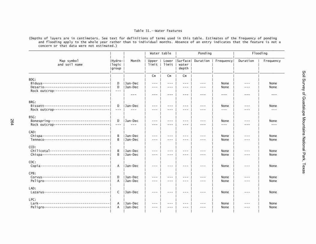
Table 31.--Water Features (Depths of layers are in centimeters. See text for definitions of terms used in this table. Estimates of the frequency of ponding and flooding apply to the whole year rather than to individual months. Absence of an entry indicates that the feature is not a concern or that data were not estimated.) _____________________________________________________________________________________________________________________________________ | | | Water table | Ponding | Flooding | | |_______________|_____________________________|__________________________ Map symbol |Hydro-| Month | Upper | Lower |Surface| Duration | Frequency| Duration | Frequency and soil name |logic | | limit | limit | water | | | | |group | | | | depth | | | | __________________________________________|______|__________|_______|_______|_______|__________|__________|____________|_____________ | | | Cm | Cm | Cm | | | | BDG: | | | | | | | | | Biduya-----------------------------------| D |Jan-Dec | --- | --- | --- | --- | None | --- | None Desario----------------------------------| D |Jan-Dec | --- | --- | --- | --- | None | --- | None Rock outcrop-----------------------------| --- | | | | | | | | | | --- | --- | --- | --- | --- | --- | --- | --- | | | | | | | | | BRG: | | | | | | | | | Bissett----------------------------------| D |Jan-Dec | --- | --- | --- | --- | None | --- | None Rock outcrop-----------------------------| --- | --- | --- | --- | --- | --- | --- | --- | --- | | | | | | | | | BSG: | | | | | | | | | Bonespring-------------------------------| D |Jan-Dec | --- | --- | --- | --- | None | --- | None Rock outcrop-----------------------------| --- | --- | --- | --- | --- | --- | --- | --- | --- | | | | | | | | | CAD: | | | | | | | | | Chispa-----------------------------------| B |Jan-Dec | --- | --- | --- | --- | None | --- | None Tenneco----------------------------------| B |Jan-Dec | --- | --- | --- | --- | None | --- | None | | | | | | | | | CCD: | | | | | | | | | Chilicotal-------------------------------| B |Jan-Dec | --- | --- | --- | --- | None | --- | None Chispa-----------------------------------| B |Jan-Dec | --- | --- | --- | --- | None | --- | None | | | | | | | | | COC: | | | | | | | | | Copia------------------------------------| A |Jan-Dec | --- | --- | --- | --- | None | --- | None | | | | | | | | | CPB: | | | | | | | | | Corvus-----------------------------------| D |Jan-Dec | --- | --- | --- | --- | None | --- | None Peligro----------------------------------| A |Jan-Dec | --- | --- | --- | --- | None | --- | None | | | | | | | | | LAD: | | | | | | | | | Lazarus----------------------------------| C |Jan-Dec | --- | --- | --- | --- | None | --- | None | | | | | | | | | LPC: | | | | | | | | | Lark-------------------------------------| A |Jan-Dec | --- | --- | --- | --- | None | --- | None Peligro----------------------------------| A |Jan-Dec | --- | --- | --- | --- | None | --- | None | | | | | | | | |
Soil S
urvey of Guadalupe M
ountains National P
ark, Texas
264

Table 31.--Water Features--Continued _____________________________________________________________________________________________________________________________________ | | | Water table | Ponding | Flooding | | |_______________|_____________________________|__________________________ Map symbol |Hydro-| Month | Upper | Lower |Surface| Duration | Frequency| Duration | Frequency and soil name |logic | | limit | limit | water | | | | |group | | | | depth | | | | __________________________________________|______|__________|_______|_______|_______|__________|__________|____________|_____________ | | | Cm | Cm | Cm | | | | LRH: | | | | | | | | | Lostpeak---------------------------------| D |Jan-Dec | --- | --- | --- | --- | None | --- | None Rock outcrop-----------------------------| --- | --- | --- | --- | --- | --- | --- | --- | --- | | | | | | | | | MCB: | | | | | | | | | McKittrick, occasionally flooded---------| B |Jun-Sep | --- | --- | --- | --- | None | Extremely | Occasional | | | | | | | | brief | | | | | | | | | | McKittrick, frequently flooded-----------| B |Jun-Sep | --- | --- | --- | --- | None | Very brief | Frequent | | | | | | | | | Riverwash--------------------------------| --- |Jun-Sep | --- | --- | --- | --- | None | Brief | Frequent | | | | | | | | | MPB: | | | | | | | | | Monahans---------------------------------| A |Jan-Dec | --- | --- | --- | --- | None | --- | None Pajarito---------------------------------| A |Jan-Dec | --- | --- | --- | --- | None | --- | None | | | | | | | | | PCG: | | | | | | | | | Altuda-----------------------------------| D |Jan-Dec | --- | --- | --- | --- | None | --- | None Pinery-----------------------------------| B |Jan-Dec | --- | --- | --- | --- | None | --- | None Choza------------------------------------| D |Jan-Dec | --- | --- | --- | --- | None | --- | None | | | | | | | | | VLG: | | | | | | | | | Victorio---------------------------------| D |Jan-Dec | --- | --- | --- | --- | None | --- | None Lozen------------------------------------| D |Jan-Dec | --- | --- | --- | --- | None | --- | None Rock outcrop-----------------------------| --- | --- | --- | --- | --- | --- | --- | --- | --- | | | | | | | | | VLH: | | | | | | | | | Victorio, 60 to 95 percent slope---------| D |Jan-Dec | --- | --- | --- | --- | None | --- | None Victorio, 40 to 60 percent slope---------| D |Jan-Dec | --- | --- | --- | --- | None | --- | None Lozen------------------------------------| D |Jan-Dec | --- | --- | --- | --- | None | --- | None Rock outcrop-----------------------------| --- | | | | | | | | __________________________________________|______|__________|_______|_______|_______|__________|__________|____________|_____________
Soil S
urvey of Guadalupe M
ountains National P
ark, Texas
265

Table 32.--Soil Features (See text for definitions of terms used in this table. Absence of an entry indicates that data were not populated. Components with no data in all columns will not display. Depths are in metric) ____________________________________________________________________________________________________________________________________ | Restrictive layer | | Risk of corrosion Map symbol |_____________________________________________________| Potential |_________________________ and soil name | | Depth | | | for | Uncoated | | Kind | to top|Thickness| Hardness |frost action| steel | Concrete _______________________________________|_________________|_______|_________|_________________|____________|____________|____________ | | cm | cm | | | | BDG: | | | | | | | Biduya--------------------------------| Lithic bedrock | 10-43 | --- | Very strongly | Moderate | Moderate | Low | | | | cemented | | | | | | | | | | Desario-------------------------------| Lithic bedrock | 29-52 | --- | Very strongly | Moderate | Moderate | Low | | | | cemented | | | | | | | | | | Rock outcrop--------------------------| Lithic bedrock | 0 | --- | Indurated | --- | --- | --- | | | | | | | BRG: | | | | | | | Bissett-------------------------------| Lithic bedrock | 18-49 | --- | Very strongly | None | Moderate | Low | | | | cemented | | | | | | | | | | Rock outcrop--------------------------| Lithic bedrock | 0 | --- | Indurated | --- | --- | --- | | | | | | | BSG: | | | | | | | Bonespring----------------------------| Lithic bedrock | 8-47 | --- | Very strongly | None | Moderate | Low | | | | cemented | | | | | | | | | | Rock outcrop--------------------------| Lithic bedrock | 0 | --- | Indurated | --- | --- | --- | | | | | | | CAD: | | | | | | | Chispa--------------------------------| No restriction | --- | --- | --- | None | Moderate | Moderate | | | | | | | Tenneco-------------------------------| No restriction | --- | --- | --- | None | High | Moderate | | | | | | | CCD: | | | | | | | Chilicotal----------------------------| No restriction | --- | --- | --- | None | Moderate | Low | | | | | | | Chispa--------------------------------| No restriction | --- | --- | --- | None | Moderate | Low | | | | | | | COC: | | | | | | | Copia---------------------------------| No restriction | --- | --- | --- | None | Low | Low | | | | | | | CPB: | | | | | | | Corvus--------------------------------| Petrogypsic | 31-52 | --- | Moderately | None | Moderate | High | | | | cemented | | | | | | | | | | Peligro-------------------------------| No restriction | --- | --- | --- | None | Moderate | High | | | | | | |
Soil S
urvey of Guadalupe M
ountains National P
ark, Texas
266

Table 32.--Soil Features--Continued ____________________________________________________________________________________________________________________________________ | Restrictive layer | | Risk of corrosion Map symbol |_____________________________________________________| Potential |_________________________ and soil name | | Depth | | | for | Uncoated | | Kind | to top|Thickness| Hardness |frost action| steel | Concrete _______________________________________|_________________|_______|_________|_________________|____________|____________|____________ | | cm | cm | | | | LAD: | | | | | | | Lazarus-------------------------------| No restriction | --- | --- | --- | Moderate | Low | Low | | | | | | | LPC: | | | | | | | Lark----------------------------------| No restriction | --- | --- | --- | None | Moderate | High | | | | | | | Peligro-------------------------------| No restriction | --- | --- | --- | None | Moderate | High | | | | | | | LRH: | | | | | | | Lostpeak------------------------------| Lithic bedrock | 11-46 | --- | Very strongly | Moderate | Moderate | Low | | | | cemented | | | | | | | | | | Rock outcrop--------------------------| Lithic bedrock | 0 | --- | Indurated | None | --- | Low | | | | | | | MCB: | | | | | | | McKittrick, occasionally flooded------| No restriction | --- | --- | --- | Moderate | Moderate | Low | | | | | | | McKittrick, frequently flooded--------| No restriction | --- | --- | --- | Moderate | Moderate | Low | | | | | | | Riverwash-----------------------------| No restriction | --- | --- | --- | --- | --- | --- | | | | | | | MPB: | | | | | | | Monahans------------------------------| No restriction | --- | --- | --- | None | Moderate | High | | | | | | | Pajarito------------------------------| No restriction | --- | --- | --- | None | Moderate | Low | | | | | | | PCG: | | | | | | | Altuda--------------------------------| Lithic bedrock | 18-52 | --- | Very strongly | None | Moderate | Low | | | | cemented | | | | | | | | | | Pinery--------------------------------| No restriction | --- | --- | --- | None | Moderate | Low | | | | | | | Choza---------------------------------| Petrocalcic | 13-49 | --- | Very strongly | None | Moderate | Low | | | | cemented | | | | | | | | | | VLG: | | | | | | | Victorio------------------------------| Lithic bedrock | 18-49 | --- | Very strongly | Low | High | Low | | | | cemented | | | | | | | | | | Lozen---------------------------------| Lithic bedrock | 11-44 | --- | Very strongly | Moderate | Moderate | Low | | | | cemented | | | | | | | | | | Rock outcrop--------------------------| Lithic bedrock | 0 | --- | Indurated | --- | --- | --- | | | | | | |
Soil S
urvey of Guadalupe M
ountains National P
ark, Texas
267

Table 32.--Soil Features--Continued ____________________________________________________________________________________________________________________________________ | Restrictive layer | | Risk of corrosion Map symbol |_____________________________________________________| Potential |_________________________ and soil name | | Depth | | | for | Uncoated | | Kind | to top|Thickness| Hardness |frost action| steel | Concrete _______________________________________|_________________|_______|_________|_________________|____________|____________|____________ | | cm | cm | | | | VLH: | | | | | | | Victorio, 60 to 95 percent slopes-----| Lithic bedrock | 40-52 | --- | Very strongly | Low | High | Low | | | | cemented | | | | | | | | | | Victorio, 40 to 60 percent slopes-----| Lithic bedrock | 40-52 | --- | Very strongly | Low | High | Low | | | | cemented | | | | | | | | | | Lozen---------------------------------| Lithic bedrock | 40-45 | --- | Very strongly | Moderate | Moderate | Low | | | | cemented | | | | | | | | | | Rock outcrop--------------------------| Lithic bedrock | 0 | --- | Indurated | --- | --- | --- _______________________________________|_________________|_______|_________|_________________|____________|____________|____________
Soil S
urvey of Guadalupe M
ountains National P
ark, Texas
268

Table 33.--Taxonomic Classification of the Soils
(See text for a description of the characteristics that are outside the range of the series.) ______________________________________________________________________________________________________ | Soil name | Family or higher taxonomic class __________________________|___________________________________________________________________________ *Altuda-------------------|Loamy-skeletal, mixed, superactive, thermic Lithic Calciustolls Biduya-------------------|Loamy-skeletal, mixed, superactive, mesic Aridic Lithic Haplustolls *Bissett------------------|Loamy-skeletal, mixed, superactive, thermic Lithic Ustic Haplocalcids Bonespring---------------|Loamy-skeletal, mixed, superactive, calcareous, thermic Aridic Lithic | Ustorthents Chilicotal---------------|Loamy-skeletal, mixed, superactive, thermic Ustic Haplocalcids Chispa-------------------|Fine-loamy, mixed, superactive, thermic Ustic Haplocalcids Choza--------------------|Loamy-skeletal, mixed, superactive, thermic, shallow Petrocalcic | Calciustolls Copia--------------------|Mixed, thermic Typic Torripsamments Corvus-------------------|Loamy, hypergypsic, thermic, shallow Typic Petrogypsids Desario------------------|Loamy-skeletal, mixed, superactive, mesic Lithic Calciustolls Lark---------------------|Gypsic, thermic Typic Torripsamments Lazarus------------------|Fine-silty, mixed, superactive, mesic Pachic Argiustolls Lostpeak-----------------|Loamy-skeletal, mixed, superactive, mesic Aridic Lithic Haplustolls Lozen--------------------|Loamy-skeletal, mixed, superactive, mesic Lithic Haplustolls McKittrick---------------|Loamy-skeletal, carbonatic, superactive, mesic Fluventic Haplustolls Monahans-----------------|Coarse-loamy, mixed, superactive, thermic Typic Calcigypsids **Murray-----------------|Fine-loamy, mixed, superactive, thermic Aridic Calciustolls **Nasa-------------------|Coarse-loamy, gypsic, thermic Typic Petrogypsids Pajarito-----------------|Coarse-loamy, mixed, superactive, thermic Typic Haplocambids Peligro------------------|Coarse-gypseous, hypergypsic, thermic Leptic Haplogypsids **Penasco----------------|Loamy-skeletal, carbonatic, mesic, shallow Petrocalcic Calciustolls Pinery-------------------|Loamy-skeletal, mixed, superactive, thermic Aridic Calciustolls Tenneco------------------|Fine-loamy, mixed, superactive, thermic Ustic Haplocambids Victorio-----------------|Clayey-skeletal, mixed, superactive, mesic Lithic Argiustolls __________________________|___________________________________________________________________________ * Indicates a taxadjunct to the series ** Minor components listed in Detailed Soil Map Unit section
Soil Survey of Guadalupe Mountains National Park, Texas
269


The Natural Resources Conservation Service (NRCS) is committed to making itsinformation accessible to all of its customers and employees. If you are experiencingaccessibility issues and need assistance, please contact our Helpdesk by phone at1-800-457-3642 or by e-mail at [email protected]. For assistance withpublications that include maps, graphs, or similar forms of information, you may alsowish to contact our State or local office. You can locate the correct office and phonenumber at http://offices.sc.egov.usda.gov/locator/app.
NRCS Accessibility Statement