soil survey of florence county, wisconsin - home | nrcs€¦ · soil survey of florence county,...
TRANSCRIPT

United StatesDepartment ofAgriculture
NaturalResourcesConservationService
Soil Survey ofFlorence County,Wisconsin
In cooperation withthe Research Division ofthe College of Agriculturaland Life Sciences,University of Wisconsin

The Natural Resources Conservation Service (NRCS) is committed to making itsinformation accessible to all of its customers and employees. If you are experiencingaccessibility issues and need assistance, please contact our Helpdesk by phone at1-800-457-3642 or by e-mail at [email protected]. For assistance withpublications that include maps, graphs, or similar forms of information, you may alsowish to contact our State or local office. You can locate the correct office and phonenumber at http://offices.sc.egov.usda.gov/locator/app.
NRCS Accessibility Statement

Detailed Soil Maps
The detailed soil maps can be useful in planning the use and management of small areas.
To find information about your area of interest, locate that area on the Index to Map Sheets. Note the number ofthe map sheet and turn to that sheet.
Locate your area of interest on the map sheet. Note the map unit symbols that are in that area. Turn to theContents, which lists the map units by symbol and name and shows the page where each map unit is described.
The Contents shows which table has data on a specific land use for each detailed soil map unit. Also see theContents for sections of this publication that may address your specific needs.
3
How To Use This Soil Survey

4
Additional information about the Nation’s natural resources is available on theNatural Resources Conservation Service homepage on the World Wide Web. Theaddress is http://www.nrcs.usda.gov.
This soil survey is a publication of the National Cooperative Soil Survey, a joint effortof the United States Department of Agriculture and other Federal agencies, Stateagencies including the Agricultural Experiment Stations, and local agencies. TheNatural Resources Conservation Service (formerly the Soil Conservation Service) hasleadership for the Federal part of the National Cooperative Soil Survey.
Major fieldwork for this soil survey was completed in 1995. Soil names anddescriptions were approved in 1995. Unless otherwise indicated, statements in thispublication refer to conditions in the survey area in 1995. This survey was madecooperatively by the Natural Resources Conservation Service; the Forest Service; andthe Research Division of the College of Agricultural and Life Sciences, University ofWisconsin. The survey is part of the technical assistance furnished to the FlorenceCounty Land Conservation Committee, which also helped finance the fieldwork for thesurvey.
Soil maps in this survey may be copied without permission. Enlargement of thesemaps, however, could cause misunderstanding of the detail of mapping. If enlarged,maps do not show the small areas of contrasting soils that could have been shown at alarger scale.
The United States Department of Agriculture (USDA) prohibits discrimination in all ofits programs on the basis of race, color, national origin, gender, religion, age, disability,political beliefs, sexual orientation, and marital or family status. (Not all prohibited basesapply to all programs.) Persons with disabilities who require alternative means forcommunication of program information (Braille, large print, audiotape, etc.) shouldcontact the USDA’s TARGET Center at 202-720-2600 (voice or TDD).
To file a complaint of discrimination, write USDA, Director, Office of Civil Rights,Room 326W, Whitten Building, 14th and Independence Avenue SW, Washington, DC20250-9410, or call 202-720-5964 (voice or TDD). USDA is an equal opportunityprovider and employer.
Cover: LaSalle Falls on the Pine River in an area of Rock outcrop-Metonga-Sarona complex, 15 to35 percent slopes. The amber color of the water is caused by organic materials derived from wetlandvegetation.

5
Contents
How To Use This Soil Survey ................................. 3Foreword ................................................................. 9General Nature of the County ................................. 12
Physiography, Relief, and Drainage .................... 12Climate ............................................................... 12Water Supply ...................................................... 12History and Development ................................... 13Transportation Facilities and Industry ................. 14
How This Survey Was Made ................................... 14Detailed Soil Map Units ........................................ 17
AnB—Annalake fine sandy loam, 0 to 6percent slopes ............................................. 18
AnC—Annalake fine sandy loam, 6 to 15percent slopes ............................................. 19
Au—Au Gres loamy sand, 0 to 2 percentslopes .......................................................... 21
Ca—Capitola muck, 0 to 2 percent slopes,very stony .................................................... 23
CoA—Crossett silt loam, 0 to 3 percentslopes .......................................................... 24
CrA—Croswell loamy sand, 0 to 3 percentslopes .......................................................... 25
CuA—Cublake loamy sand, 0 to 3 percentslopes .......................................................... 27
EdB—Ellwood silt loam, 1 to 6 percent slopes ... 28EdC—Ellwood silt loam, 6 to 15 percent
slopes .......................................................... 30ElB—Ellwood-Crossett silt loams, 0 to 6
percent slopes ............................................. 31EmB—Ellwood-Iosco-Morganlake complex,
0 to 6 percent slopes.................................... 33EnC—Ellwood-Iosco-Vilas complex, 0 to 15
percent slopes ............................................. 37EoD—Ellwood-Vilas-Padus complex, 10 to 30
percent slopes ............................................. 40Ep—Epiaquents and Epiaquods, nearly level ..... 42FeB—Fence silt loam, 0 to 6 percent slopes ...... 44Fm—Fordum loam, 0 to 2 percent slopes........... 45GaA—Gastrow silt loam, 0 to 3 percent
slopes .......................................................... 47GmC—Goodman silt loam, 6 to 15 percent
slopes, very stony ........................................ 48GmD—Goodman silt loam, 15 to 25 percent
slopes, very stony ........................................ 49
GwB—Goodwit silt loam, 1 to 6 percentslopes, very stony ........................................ 51
IsA—Iosco loamy fine sand, 0 to 3 percentslopes .......................................................... 52
Kr—Kinross muck, 0 to 2 percent slopes ............ 54Lo—Loxley, Beseman, and Dawson peats,
0 to 1 percent slopes.................................... 55Lu—Lupton, Cathro, and Markey mucks,
0 to 1 percent slopes.................................... 57MaA—Manitowish sandy loam, 0 to 3
percent slopes ............................................. 59Mn—Minocqua muck, 0 to 2 percent
slopes .......................................................... 60MrB—Morganlake loamy fine sand, 0 to 6
percent slopes ............................................. 62MuB—Mudlake silt loam, 1 to 6 percent
slopes, very stony ........................................ 64M-W—Miscellaneous water ................................ 65PaB—Padus sandy loam, 0 to 6 percent
slopes .......................................................... 66PaC—Padus sandy loam, 6 to 15 percent
slopes .......................................................... 67PaD—Padus sandy loam, 15 to 35 percent
slopes .......................................................... 69PeB—Padus-Pence sandy loams, 0 to 6
percent slopes ............................................. 70PeC—Padus-Pence sandy loams, 6 to 15
percent slopes ............................................. 72PeD—Padus-Pence sandy loams, 15 to 35
percent slopes ............................................. 74PnB—Pence sandy loam, 0 to 6 percent
slopes .......................................................... 76PnC—Pence sandy loam, 6 to 15 percent
slopes .......................................................... 77PnD—Pence sandy loam, 15 to 35 percent
slopes .......................................................... 79PsB—Pence-Vilas complex, 0 to 6 percent
slopes .......................................................... 80PsC—Pence-Vilas complex, 6 to 15 percent
slopes .......................................................... 82PsD—Pence-Vilas complex, 15 to 35 percent
slopes .......................................................... 83Pt—Pits, gravel ................................................... 85Px—Pits, mine .................................................... 85

6
Rb—Robago fine sandy loam, 0 to 2 percentslopes .......................................................... 87
RkC—Rock outcrop-Ishpeming-Vilas complex,1 to 15 percent slopes.................................. 88
RkD—Rock outcrop-Ishpeming-Vilas complex,15 to 35 percent slopes ................................ 90
RmC—Rock outcrop-Metonga-Saronacomplex, 1 to 15 percent slopes .................. 92
RmD—Rock outcrop-Metonga-Saronacomplex, 15 to 35 percent slopes ................ 95
RsB—Rousseau loamy fine sand, 0 to 6percent slopes ............................................. 97
RsC—Rousseau loamy fine sand, 6 to 15percent slopes ............................................. 98
SaB—Sarona fine sandy loam, 1 to 6percent slopes, very stony ......................... 100
SaC—Sarona fine sandy loam, 6 to 15percent slopes, very stony ......................... 101
SaD—Sarona fine sandy loam, 15 to 25percent slopes, very stony ......................... 103
SdB—Sarona-Padus complex, 0 to 6percent slopes, very stony ......................... 104
SdC—Sarona-Padus complex, 6 to 15percent slopes, very stony ......................... 106
SdD—Sarona-Padus complex, 15 to 30percent slopes, very stony ......................... 108
SlB—Sarona-Vilas complex, 0 to 6 percentslopes, very stony ...................................... 110
SlC—Sarona-Vilas complex, 6 to 15 percentslopes, very stony ...................................... 112
SlD—Sarona-Vilas complex, 15 to 30percent slopes, very stony ......................... 114
SnB—Sayner loamy sand, 0 to 6 percentslopes ........................................................ 116
SnC—Sayner loamy sand, 6 to 15 percentslopes ........................................................ 117
SnD—Sayner loamy sand, 15 to 30 percentslopes ........................................................ 118
SoD—Soperton-Goodman silt loams, 15 to35 percent slopes, very stony .................... 120
StC—Stambaugh silt loam, 6 to 15 percentslopes ........................................................ 121
StD—Stambaugh silt loam, 15 to 25 percentslopes ........................................................ 123
SuC—Stambaugh-Goodman silt loams, 6 to15 percent slopes, very stony .................... 124
SuD—Stambaugh-Goodman silt loams, 15to 35 percent slopes, very stony ................ 126
TpA—Tipler sandy loam, 0 to 3 percentslopes ........................................................ 128
VaB—Vanzile silt loam, 0 to 6 percent slopes ... 129VgB—Vanzile-Goodwit silt loams, 0 to 6
percent slopes, very stony ......................... 130VsB—Vilas loamy sand, 0 to 6 percent
slopes ........................................................ 132VsC—Vilas loamy sand, 6 to 15 percent
slopes ........................................................ 134VsD—Vilas loamy sand, 15 to 30 percent
slopes ........................................................ 135W—Water ......................................................... 136WaC—Wabeno-Goodman silt loams, 6 to 15
percent slopes, very stony ......................... 137WbB—Wabeno-Goodwit silt loams, 1 to 6
percent slopes, very stony ......................... 139WkB—Wakefield silt loam, 1 to 6 percent
slopes, very stony ...................................... 141WkC—Wakefield silt loam, 6 to 15 percent
slopes, very stony ...................................... 142WrA—Worcester sandy loam, 0 to 3 percent
slopes ........................................................ 144Use and Management of the Soils .................... 147
Woodland Management and Productivity ......... 147Forest Habitat Types .................................... 155
Crops and Pasture ........................................... 157Yields per Acre ............................................. 160Land Capability Classification ...................... 162Prime Farmland ........................................... 162
Windbreaks and Environmental Plantings ........ 163Recreation ........................................................ 163Wildlife Habitat ................................................. 165Engineering ...................................................... 169
Building Site Development ........................... 170Sanitary Facilities ......................................... 170Construction Materials ................................. 172Water Management ...................................... 173
Soil Properties .................................................... 175Engineering Index Properties ........................... 175Physical and Chemical Properties .................... 176

7
Soil and Water Features ................................... 177Engineering Index Test Data ............................. 179
Classification of the Soils .................................. 181Soil Series and Their Morphology ......................... 181
Annalake Series ............................................... 181Au Gres Series ................................................. 182Beseman Series ............................................... 183Capitola Series ................................................. 184Cathro Series ................................................... 185Crossett Series ................................................ 186Croswell Series ................................................ 187Cublake Series ................................................. 187Dawson Series ................................................. 188Ellwood Series ................................................. 189Fence Series .................................................... 190Fordum Series .................................................. 191Gastrow Series ................................................. 192Goodman Series .............................................. 193Goodwit Series ................................................. 194Iosco Series ..................................................... 195Ishpeming Series ............................................. 196Kinross Series .................................................. 197Loxley Series .................................................... 197Lupton Series ................................................... 198Manitowish Series ............................................ 198Markey Series .................................................. 203Metonga Series ................................................ 204Minocqua Series .............................................. 205Morganlake Series ........................................... 206Mudlake Series ................................................ 207Padus Series .................................................... 208Pence Series .................................................... 209Robago Series ................................................. 210Rousseau Series .............................................. 211Sarona Series .................................................. 211Sayner Series ................................................... 213Soperton Series ............................................... 214Stambaugh Series ............................................ 215Tipler Series ..................................................... 216Vanzile Series .................................................. 217Vilas Series ...................................................... 218
Wabeno Series ................................................. 219Wakefield Series .............................................. 220Worcester Series .............................................. 221
Formation of the Soils ........................................ 223Geology and Underlying Material ..................... 223Factors of Soil Formation ................................. 224
Climate ......................................................... 225Plant and Animal Life ................................... 225Relief and Drainage ..................................... 225Parent Material ............................................. 226Time ............................................................. 226
Processes of Soil Formation............................. 226References .......................................................... 229Glossary .............................................................. 231Tables .................................................................. 241
Table 1.—Temperature and Precipitation .......... 242Table 2.—Freeze Dates in Spring and
Fall ............................................................. 243Table 3.—Growing Season ............................... 243Table 4.—Acreage and Proportionate Extent
of the Soils ................................................. 244Table 5.—Woodland Management and
Productivity ................................................ 246Table 6.—Woodland Equipment Use ................ 262Table 7.—Land Capability and Yields per
Acre of Crops and Pasture ......................... 269Table 8.—Prime Farmland ................................ 274Table 9.—Windbreaks and Environmental
Plantings .................................................... 275Table 10.—Recreational Development .............. 284Table 11.—Wildlife Habitat ................................ 292Table 12.—Building Site Development .............. 298Table 13.—Sanitary Facilities ........................... 307Table 14.—Construction Materials .................... 316Table 15.—Water Management ........................ 324Table 16.—Engineering Index Properties ......... 331Table 17.—Physical and Chemical Properties
of the Soils ................................................. 350Table 18.—Soil and Water Features ................. 358Table 19.—Engineering Index Test Data ........... 363Table 20.—Classification of the Soils ................ 367
Issued 2004

9
This soil survey contains information that affects land use planning in this surveyarea. It contains predictions of soil behavior for selected land uses. The survey alsohighlights soil limitations, improvements needed to overcome the limitations, and theimpact of selected land uses on the environment.
This soil survey is designed for many different users. Foresters, farmers, andagronomists can use it to evaluate the potential of the soil and the management neededfor maximum food and fiber production. Planners, community officials, engineers,developers, builders, and home buyers can use the survey to plan land use, select sitesfor construction, and identify special practices needed to ensure proper performance.Conservationists, teachers, students, and specialists in recreation, wildlifemanagement, waste disposal, and pollution control can use the survey to help themunderstand, protect, and enhance the environment.
Various land use regulations of Federal, State, and local governments may imposespecial restrictions on land use or land treatment. The information in this report isintended to identify soil properties that are used in making various land use or landtreatment decisions. Statements made in this report are intended to help the land usersidentify and reduce the effects of soil limitations on various land uses. The landowner oruser is responsible for identifying and complying with existing laws and regulations.
Great differences in soil properties can occur within short distances. Some soils areseasonally wet or subject to flooding. Some are shallow to bedrock. Some are toounstable to be used as a foundation for buildings or roads. Clayey or wet soils arepoorly suited to use as septic tank absorption fields. A high water table makes a soilpoorly suited to basements or underground installations.
These and many other soil properties that affect land use are described in this soilsurvey. The location of each soil is shown on the detailed soil maps. Each soil in thesurvey area is described, and information on specific uses is given. Help in using thispublication and additional information are available at the local office of the NaturalResources Conservation Service, the Cooperative Extension Service, or private soilscience consultants.
Patricia S. LeavenworthState ConservationistNatural Resources Conservation Service
Foreword


11
FLORENCE COUNTY is in the extreme northeasternpart of Wisconsin (fig. 1). It is bound on the north andalong most of its eastern border by the Brule andMenominee Rivers, which form the Wisconsin-Michigan boundary; on the west and south by ForestCounty; and on the south and east by MarinetteCounty. Florence County has a total area of 318,215acres. In 1990, the county had a population of 4,590.Florence, the county seat, is unincorporated.Recreation, tourism, agriculture, logging, lumbering,manufacturing, and retail trade industries areimportant in the county.
A reconnaissance soil survey of Florence Countywas made prior to 1916 by the Soil Survey Division,Wisconsin Geological and Natural History Survey,State of Wisconsin, in cooperation with the U.S.Department of Agriculture, Bureau of Soils (Whitsonand others, 1916). That survey is part of a report onnortheastern Wisconsin published by the State ofWisconsin in 1916. Another soil survey of FlorenceCounty was made during the period 1958 to 1961 bythe Soil Survey Division, Wisconsin Geological andNatural History Survey, State of Wisconsin, incooperation with the Soils Department, College ofAgriculture, University of Wisconsin, and the U.S.Department of Agriculture, Soil ConservationService (Hole and others, 1962). That survey waspublished in 1962 by the State of Wisconsin. Thecurrent survey updates the two earlier surveys. It
provides more interpretive information and haslarger maps, which show the soils in greaterdetail.
Soil Survey of
Florence County, WisconsinBy Joseph M. Boelter and Angela M. Elg, Natural Resources Conservation Service
Fieldwork by Joseph M. Boelter, Angela M. Elg, David J. Hvizdak, A.J. Klingelhoets,Howard E. Lorenz, Larry L. Natzke, Harvey V. Strelow, Jeff A. Talsky, andStacy S. Webb, Natural Resources Conservation Service, and Lance R. Lindwalland Edward W. Neumann, Forest Service
United States Department of Agriculture, Natural Resources Conservation Service andForest Service,in cooperation withthe Research Division of the College of Agricultural and Life Sciences, University ofWisconsin
Figure 1.—Location of Florence County in Wisconsin.

12 Soil Survey of
General Nature of the CountyThis section provides general information about the
county. It describes physiography, relief, and drainage;climate; water supply; history and development; andtransportation facilities and industry.
Physiography, Relief, and Drainage
Florence County is in the Northern Highlandphysiographic region of Wisconsin. Elevations rangefrom about 1,033 feet above sea level at the easternedge of the county to about 1,732 feet in the northwest(Clayton, 1986).
Landforms in Florence County are mostly of glacialorigin. In the eastern part of the county, however, aconsiderable degree of bedrock-controlled topographyis evident. The majority of Florence County is anoutwash plain, much of which is pitted as the result ofmelting of buried ice blocks. The most extensive areasof drumlins occur in the northwestern part of thecounty and extend into neighboring Forest County. Thegeneral flow of ice was from northeast to southwest,as indicated by the orientation of the drumlins. Groundmoraines are most numerous in the central part of thecounty, and end moraines occur in the southeasternand eastern parts. Esker and esker-like ridges occurmostly in the western half of the county. Glacial lakeplains are most common in Homestead Township inthe southeastern part of Florence County. Althoughflood plains, bogs, and other depressional areaswhere organic soils have formed are scatteredthroughout the county, they are most common in thewestern half.
Most of Florence County is drained by the Brule,Pine, Popple, Little Popple, and Pemebonwon Riversand their tributaries eastward to the Menominee River,which empties into Green Bay of Lake Michigan in theSt. Lawrence River drainage system. A small portionof Florence County is drained by KC Creeksoutheastward into the Pike River system in MarinetteCounty. This system empties into the MenomineeRiver about 20 miles southeast of Florence County.
Climate
Table 1 gives data on temperature and precipitationfor the survey area as recorded at Brule Island,Wisconsin, in the period 1951 to 1984. Table 2 showsprobable dates of the first freeze in fall and the lastfreeze in spring. Table 3 provides data on length of thegrowing season.
In winter, the average temperature is 13 degrees Fand the average daily minimum temperature is 2
degrees. The lowest temperature on record, whichoccurred on February 17, 1979, is -48 degrees. Insummer, the average temperature is 63 degrees andthe average daily maximum temperature is 77degrees. The highest recorded temperature, whichoccurred on July 19, 1977, is 102 degrees.
Growing degree days are shown in table 1. Theyare equivalent to “heat units.” During the month,growing degree days accumulate by the amount thatthe average temperature each day exceeds a basetemperature (50 degrees F). The normal monthlyaccumulation is used to schedule single or successiveplantings of a crop between the last freeze in springand the first freeze in fall.
The total annual precipitation is 30.42 inches. Ofthis total, 21.29 inches, or about 70 percent, usuallyfalls in April through September. The growing seasonfor most crops falls within this period. In 2 years out of10, the rainfall in April through September is less than18 inches. The heaviest 1-day rainfall during the periodof record was 3.74 inches on August 16, 1972.Thunderstorms occur on about 34 days each year.
The average seasonal snowfall is 59 inches. Thegreatest snow depth at any one time during the periodof record was 43 inches. On the average, 84 days ofthe year have at least 1 inch of snow on the ground.The number of such days varies greatly from year toyear.
The average relative humidity in midafternoon isabout 60 percent. Humidity is higher at night, and theaverage at dawn is about 80 percent. The sun shines65 percent of the time possible in summer and 45percent in winter. The prevailing wind is from thesouthwest. Average windspeed is highest, 12 milesper hour, in spring.
Water Supply
Thomas J. Alvarez and Michael T. McCawly, geologists, NaturalResources Conservation Service, helped prepare this section.
Florence County has many streams, lakes, andrivers that furnish a good supply of surface water.Ground water is available in quantities that areadequate to meet present and anticipated futureneeds for domestic, agricultural, municipal, andindustrial needs because only a small part of the totalpotential is being utilized. Areas of large-scalepumpage are relatively few, and the population densityis low. The availability of ground water differs locally,however, and detailed studies are needed to guide thedevelopment of ground-water resources, especially inpresent and anticipated pumpage centers.
Sand and gravel aquifers are the most productive inFlorence County. These aquifers occur mainly in the

Florence County, Wisconsin 13
western and northeastern parts of the county. Wells inthese areas generally yield 100 to 500 gallons of waterper minute (Oakes and Hamilton, 1973). The greatestyields occur where the saturated glacial deposits areat least 50 feet thick. In the central and southeasternparts of the county, the sand and gravel aquifers aretypically isolated, shallow, and less permeable. Wellsin these areas generally yield 10 to 100 gallons perminute.
The bedrock aquifers in Florence County generallyare not very productive. More than half of the wells inthis aquifer yield less than 5 gallons per minute. Thebedrock aquifers are typically small, are limited to thefractured or decomposed portions of the bedrock, andtypically depend on nearby glacial deposits forrecharge. Bedrock aquifers are utilized whereverglacial deposits are small, thin, isolated, orimpermeable.
The ground water in Florence County generally is ofgood quality. The least mineralized water is from thesand and gravel aquifers. This water has moved alongrelatively short flow paths, typically through sand andgravel with rapid or very rapid permeability, and therehas been relatively little contact time between thewater and soluble minerals. The mineralization of thesand and gravel aquifer is higher in areas near groundmoraines and glacial lake plains and lower in areasnear end moraines and outwash plains. The totalmineralization in the sand and gravel aquifers inFlorence County is less than 300 milligrams per liter.Water in the bedrock aquifers has had the longestcontact time with soluble minerals and may have ahigh concentration of calcium magnesium bicarbonate,calcium magnesium sulfate, or sodium chloride. Datafor the bedrock aquifers in Florence County areinsufficient to measure water quality. A deep welldrilled in the Florence iron pit in 1910 struck stagnant,saline water that had an artesian flow (Carlson andothers, 1971).
Minor water use problems in Florence County arecaused by hardness and, in some areas, by highconcentrations of iron.
Florence County has a total of 261 lakes andimpoundments and 165 rivers and streams (Carlsonand others, 1971). Natural lakes account for 79percent of the lake area, and five impoundments makeup 21 percent of the lake surface area. Lakes smallerthan 10 acres make up 63 percent of the total numberof lakes but only 5 percent of the lake acreage. Only16 lakes are 100 acres or larger; however, these lakesmake up 57 percent of the lake acreage. Fifty-onepercent of the lakes are less than 8 feet deep, butthese shallow lakes make up only 10 percent of thetotal lake acreage. Natural lake depths range from less
than 1 foot in several spring ponds to a maximum of82 feet in Sealion Lake. Some iron mine shafts, nowfilled with water, are as much as 147 feet deep. TwinFalls Flowage is the largest body of water in thecounty (681.7 acres).
Pollution of the Brule and Menominee Rivers byeffluent and mining spoil has been identified as aconcern. Recently, the Wisconsin Department ofNatural Resources and the Wisconsin Division ofHealth have identified the Brule River (at the PaintRiver Pond) and Emily Lake, Sand Lake, and SealionLake as habitat where high concentrations of mercurycan occur in some fish. Other pollution problems inFlorence County are minor; in lakeshore areas,however, where the development of cottages andhomes is dense, lakes may be affected by effluentfrom sewage disposal facilities. The results arepollution of the water and excessive growth ofundesirable weeds and algae. Overall, FlorenceCounty, with its extensive forest land and limiteddevelopment, has relatively few problems resultingfrom human influences on surface waters. In thefuture, however, a policy that prevents pollution andshoreland damage will be needed if the present highquality of water is to be maintained.
History and Development
Florence County is one of the few counties inWisconsin in which the early pioneering era is stillfairly recent. The area was undoubtedly visited byearly French voyageurs and missionaries from theGreen Bay region. The first European to leave anydescription of his journey along the Menominee andBrule Rivers was Captain Thomas Jefferson Cram,who surveyed the northwest boundary of Wisconsin in1840-41 (Carlson and others, 1971). Cram surveyedthe Brule River, which forms part of the boundary withMichigan, and reported many Chippewa andMenominee Indians there.
Florence County was created in 1882 from territorythat included parts of Marinette and Oconto Counties.The county was named for Florence Hulst, the wife ofN.P. Hulst, who discovered a number of iron mines inthe area.
Florence County was a hunting and trapping regionuntil iron ore was discovered in 1877. Three yearsearlier, iron had been discovered on the Michigan sideof the border. Mining operations began during thewinter of 1879-80, and peak production was reachedin 1920. The population of the area that becameFlorence County increased from fewer than 300 in1880 to 2,604 in 1890, only 8 years after the countywas organized.

14 Soil Survey of
The logging and lumbering in Florence County areassociated with those industries in Marinette andOconto Counties. The first sawmill in the territory wasbuilt in what is now Marinette County by WilliamFarnsworth and Charles N. Bush in 1832. Althoughthis date marked the beginning of lumbering in theterritory, very little lumbering was done in the surveyarea prior to 1865. The primary timber in the earlylogging period was eastern white pine; a limitedamount of red pine also was logged. By 1898, most ofthe eastern white pine had been cut. In the early 20thcentury, when the pine was gone, the logging ofeastern hemlock and hardwoods was begun.
Farming in Florence County had its origin in theneed for agricultural products by the lumbercompanies. In 1890, there were 90 farms in the county.Farm numbers increased to 349 farms in 1920 and580 farms in 1935. After this period, the number offarms in Florence County declined with the failing ofsmall family farms and the growth of larger commercialfarms. In 1959, Florence County had a total of 185farms and an average of 185.5 acres per farm. In1990, Florence County had a total of 90 farms and anaverage of 255.6 acres per farm (WisconsinAgricultural Statistics Service, 1991).
Transportation Facilities and Industry
Florence County is served by U.S. Highway 2-141,which crosses the northeastern part of the county. Themajor north-south routes are State Highways 101 and139. State Highway 70 is the principal east-west route.Florence County is also served by six countyhighways, which are mainly in the eastern half of thecounty. Commercial air transportation is available atFord Airport near Iron Mountain, Michigan. Anabandoned rail line runs north and south in thewestern part of Florence County.
The recreation and tourism industry is an importantpart of the local economy. This industry includesrestaurants, taverns, hotels, motels, resorts,campgrounds, sporting goods stores, and amusementand recreation establishments. Fishing, boating,camping, hunting, skiing, swimming, hiking,snowmobiling, auto touring, and other sports as wellas the natural beauty of the county attract manyvacationers and make recreation and tourism a year-round industry. The county-owned Keyes Peak ski hilloffers downhill skiing. The many lakes, rivers, andstreams and the surrounding forest land provideexcellent opportunities for expanding the recreationand tourism industry in Florence County.
Manufacturing and retail trade industries also aresignificant parts of the Florence County economy. In
Florence, the 114-acre In-Comm Center industrialpark, which was created in 1986, includes severalmanufacturing firms. Some light industry is also inAurora.
The logging industry is an important part of theeconomy in the county. Forest products includesawtimber, poletimber, pulpwood, and veneer logs. Anumber of sawmills are located near Tipler and LongLake in western Florence County. The production ofmaple syrup is a seasonal enterprise of localimportance.
Hay, corn, and oats are the main crops grown inFlorence County. Potatoes, a specialty crop, also aregrown. Dairy farming and beef production areimportant parts of the county’s agriculture.
Presently, excavation for minerals is of minor extentin the county. Minerals mined include sand and gravel.Recently, some of the finer textured soils in theeastern part of the county have been identified assuitable for use as landfill liner. Also, some topsoil isbeing removed for construction and landscapingpurposes. Some mineral exploration has taken placein Florence County.
How This Survey Was MadeThis survey was made to provide information about
the soils and miscellaneous areas in the survey area.The information includes a description of the soils andmiscellaneous areas and their location and adiscussion of their suitability, limitations, andmanagement for specified uses. Soil scientistsobserved the steepness, length, and shape of theslopes; the general pattern of drainage; the kinds ofcrops and native plants; and the kinds of bedrock.They dug many holes to study the soil profile, which isthe sequence of natural layers, or horizons, in a soil.The profile extends from the surface down into theunconsolidated material in which the soil formed. Theunconsolidated material is devoid of roots and otherliving organisms and has not been changed by otherbiological activity.
The soils and miscellaneous areas in the surveyarea are in an orderly pattern that is related to thegeology, landforms, relief, climate, and naturalvegetation of the area. Each kind of soil andmiscellaneous area is associated with a particular kindof landform or with a segment of the landform. Byobserving the soils and miscellaneous areas in thesurvey area and relating their position to specificsegments of the landform, a soil scientist develops aconcept or model of how they were formed. Thus,during mapping, this model enables the soil scientistto predict with a considerable degree of accuracy the

Florence County, Wisconsin 15
kind of soil or miscellaneous area at a specific locationon the landscape.
Commonly, individual soils on the landscape mergeinto one another as their characteristics graduallychange. To construct an accurate soil map, however,soil scientists must determine the boundaries betweenthe soils. They can observe only a limited number ofsoil profiles. Nevertheless, these observations,supplemented by an understanding of the soil-vegetation-landscape relationship, are sufficient toverify predictions of the kinds of soil in an area and todetermine the boundaries.
Soil scientists recorded the characteristics of thesoil profiles that they studied. They noted soil color,texture, size and shape of soil aggregates, kind andamount of rock fragments, distribution of plant roots,reaction, and other features that enable them toidentify soils. After describing the soils in the surveyarea and determining their properties, the soilscientists assigned the soils to taxonomic classes(units). Taxonomic classes are concepts. Eachtaxonomic class has a set of soil characteristics withprecisely defined limits. The classes are used as abasis for comparison to classify soils systematically.Soil taxonomy, the system of taxonomic classificationused in the United States, is based mainly on the kindand character of soil properties and the arrangementof horizons within the profile. After the soil scientistsclassified and named the soils in the survey area, theycompared the individual soils with similar soils in thesame taxonomic class in other areas so that theycould confirm data and assemble additional databased on experience and research.
While a soil survey is in progress, samples of someof the soils in the area generally are collected forlaboratory analyses and for engineering tests. Soilscientists interpret the data from these analyses andtests as well as the field-observed characteristics and
the soil properties to determine the expected behaviorof the soils under different uses. Interpretations for allof the soils are field tested through observation of thesoils in different uses and under different levels ofmanagement. Some interpretations are modified to fitlocal conditions, and some new interpretations aredeveloped to meet local needs. Data are assembledfrom other sources, such as research information,production records, and field experience of specialists.For example, data on crop yields under defined levelsof management are assembled from farm records andfrom field or plot experiments on the same kinds ofsoil.
Predictions about soil behavior are based not onlyon soil properties but also on such variables asclimate and biological activity. Soil conditions arepredictable over long periods of time, but they are notpredictable from year to year. For example, soilscientists can predict with a fairly high degree ofaccuracy that a given soil will have a high water tablewithin certain depths in most years, but they cannotpredict that a high water table will always be at aspecific level in the soil on a specific date.
After soil scientists located and identified thesignificant natural bodies of soil in the survey area,they drew the boundaries of these bodies on aerialphotographs and identified each as a specific mapunit. Aerial photographs show trees, buildings, fields,roads, and rivers, all of which help in locatingboundaries accurately.
The descriptions, names, and delineations of thesoils in this survey area do not fully agree with thoseof the soils in the surveys of Forest and MarinetteCounties, Wisconsin. The differences are a result ofvariations in the extent of the soils in the counties. TheBrule and Menominee Rivers form the boundary withDickinson and Iron Counties, Michigan.


17
The map units delineated on the detailed soil mapsin this survey represent the soils or miscellaneousareas in the survey area. The map unit descriptions inthis section, along with the maps, can be used todetermine the suitability and potential of a unit forspecific uses. They also can be used to plan themanagement needed for those uses.
A map unit delineation on a soil map represents anarea dominated by one or more major kinds of soil ormiscellaneous areas. A map unit is identified andnamed according to the taxonomic classification of thedominant soils. Within a taxonomic class there areprecisely defined limits for the properties of the soils.On the landscape, however, the soils are naturalphenomena, and they have the characteristicvariability of all natural phenomena. Thus, the range ofsome observed properties may extend beyond thelimits defined for a taxonomic class. Areas of soils of asingle taxonomic class rarely, if ever, can be mappedwithout including areas of other taxonomic classes.Consequently, every map unit is made up of the soilsor miscellaneous areas for which it is named andsome minor components that belong to taxonomicclasses other than those of the major soils.
Most minor soils have properties similar to those ofthe dominant soil or soils in the map unit, and thusthey do not affect use and management. These arecalled noncontrasting, or similar, inclusions. They mayor may not be mentioned in a particular map unitdescription. Other minor components, however, haveproperties and behavioral characteristics divergentenough to affect use or to require differentmanagement. These are called contrasting, ordissimilar, inclusions. They generally are in smallareas and could not be mapped separately because ofthe scale used. Some small areas of stronglycontrasting soils or miscellaneous areas are identifiedby a special symbol on the maps. The contrastingcomponents are mentioned in the map unitdescriptions. A few areas of minor components maynot have been observed, and consequently they arenot mentioned in the descriptions, especially wherethe pattern was so complex that it was impractical tomake enough observations to identify all the soils andmiscellaneous areas on the landscape.
The presence of minor components in a map unit inno way diminishes the usefulness or accuracy of thedata. The objective of mapping is not to delineate puretaxonomic classes but rather to separate thelandscape into landforms or landform segments thathave similar use and management requirements. Thedelineation of such segments on the map providessufficient information for the development of resourceplans. If intensive use of small areas is planned,however, onsite investigation is needed to define andlocate the soils and miscellaneous areas.
An identifying symbol precedes the map unit namein the map unit descriptions. Each description includesgeneral facts about the unit and gives the principalhazards and limitations to be considered in planningfor specific uses.
Soils that have profiles that are almost alike makeup a soil series. Except for differences in texture of thesurface layer, all the soils of a series have majorhorizons that are similar in composition, thickness,and arrangement.
Soils of one series can differ in texture of thesurface layer, slope, stoniness, salinity, degree oferosion, and other characteristics that affect their use.On the basis of such differences, a soil series isdivided into soil phases. Most of the areas shown onthe detailed soil maps are phases of soil series. Thename of a soil phase commonly indicates a featurethat affects use or management. For example, Vilasloamy sand, 0 to 6 percent slopes, is a phase of theVilas series.
Some map units are made up of two or more majorsoils or miscellaneous areas. These map units arecomplexes or undifferentiated groups.
A complex consists of two or more soils ormiscellaneous areas in such an intricate pattern or insuch small areas that they cannot be shownseparately on the maps. The pattern and proportion ofthe soils or miscellaneous areas are somewhat similarin all areas. Pence-Vilas complex, 6 to 15 percentslopes, is an example.
An undifferentiated group is made up of two ormore soils or miscellaneous areas that could bemapped individually but are mapped as one unitbecause similar interpretations can be made for use
Detailed Soil Map Units

18 Soil Survey of
and management. The pattern and proportion of thesoils or miscellaneous areas in a mapped area are notuniform. An area can be made up of only one of themajor soils or miscellaneous areas, or it can be madeup of all of them. Loxley, Beseman, and Dawsonpeats, 0 to 1 percent slopes, is an undifferentiatedgroup in this survey area.
This survey includes miscellaneous areas. Suchareas have little or no soil material and support little orno vegetation. Pits, gravel, is an example.
Table 4 gives the acreage and proportionate extentof each map unit. Other tables give properties of thesoils and the limitations, capabilities, and potentials formany uses. The Glossary defines many of the termsused in describing the soils or miscellaneous areas.
AnB—Annalake fine sandy loam, 0 to 6percent slopes
Setting
Landform: Outwash plains, glacial lake plains, andmoraines
Landscape position: Linear and slightly concavetoeslopes
Shape of areas: IrregularSize of areas: 10 to 70 acres
Representative Profile
Surface layer:0 to 3 inches—very dark gray, friable fine sandy
loam
Subsurface layer:3 to 6 inches—brown, friable fine sandy loam
Subsoil:6 to 31 inches—dark brown, brown, and dark
yellowish brown, friable fine sandy loam31 to 39 inches—brown, mottled, friable sandy
loam
Substratum:39 to 60 inches—brown, mottled, friable, stratified
fine sand, very fine sand, loamy very fine sand,very fine sandy loam, and silt loam
Composition
Annalake soil and similar inclusions: 85 to 95 percentContrasting inclusions: 5 to 15 percent
Inclusions
Contrasting inclusions:• The well drained Padus and moderately well drainedTipler soils, which are underlain by sandy or sandyand gravelly glacial outwash
• The somewhat poorly drained Robago soils indepressions and drainageways• The well drained Rousseau soils, which formed insandy glacial outwash or lacustrine deposits; in slightlyconvex areas• Soils that have layers of clay loam or silty clay loamin the subsoil and substratum• Areas of well drained soils• Soils that have stones or boulders on the surface• Sloping areas of Annalake soils
Similar inclusions:• Areas of soils in which the upper layers are silt loam,very fine sandy loam, sandy loam, or loamy sand• Areas of eroded soils• Soils that have an apparent seasonal high watertable
Soil Properties and Qualities
Drainage class: Moderately well drainedSeasonal high water table: Perched, 2.5 to 3.5 feet
below the surfaceDepth class: Very deepPermeability: ModerateAvailable water capacity: ModerateOrganic matter content: Moderately low or moderate in
the surface layer
Use and Management
Land uses: Dominant uses—woodland, wildlifehabitat; other uses—cropland, pasture
Woodland
Suitability: SuitedMajor management concerns: Equipment limitation,
plant competitionManagement considerations:• Ruts form easily on unsurfaced roads during wetperiods. Log landings and haul roads can be stabilizedwith gravel.• Plant competition can be controlled by mechanicalsite preparation or by limited use of herbicides.
Cropland
Suitability: Well suitedMajor management concerns: Water erosion, soil
blowing, droughtiness, nutrient and pesticide loss,poor tilth
Management considerations:• A conservation tillage system that leaves cropresidue on the surface, contour stripcropping, andcrop rotations that include close-growing crops help tocontrol water erosion in the more sloping areas.• Grassed waterways, diversions, and grade-

Florence County, Wisconsin 19
stabilization structures help to prevent gully erosionand erosion from concentrated flow.• Field windbreaks, wind stripcropping, a cover of cropresidue, and a winter cover crop reduce the hazard ofsoil blowing and help to prevent the damage to plantscaused by windblown sand.• Crop yields are somewhat limited during dry yearsby the restricted available water capacity.• Crop residue management, additions of organicmaterial, conservation tillage, and field windbreaksincrease the water-holding capacity of the soil andconserve moisture. Reducing plant populations helpsto ensure adequate moisture for all plants.• Providing protection from water erosion, reducingchemical applications, and incorporating phosphorusfertilizer at recommended rates help to protect thequality of surface water by reducing runoff losses tolakes and streams.• Leaving crop residue on the surface or regularlyadding other organic material helps to maintain fertilityand good tilth and minimizes crusting.
Pasture
Suitability: Well suitedMajor management concerns: Water erosion, soil
blowing, nutrient and pesticide lossManagement considerations:• Establishing a high-quality cover of grasses andlegumes reduces the hazards of water erosion andsoil blowing.• Overgrazing depletes the plant cover, increases thehazards of water erosion and soil blowing, andincreases the extent of undesirable plant species.• Reducing chemical applications and applyingphosphorus fertilizer at recommended rates help toprotect the quality of surface water by reducing runofflosses to lakes and streams.
Septic tank absorption fields
Severity of soil limitations: SevereMajor restrictive features: Restricted permeability,
wetnessManagement considerations:• Onsite investigation is needed. The design ofabsorption fields should meet local and Stateguidelines.
Dwellings without basements
Suitability: Well suitedMajor management concerns: Water erosion, soil
blowingManagement considerations:• Onsite investigation is needed.
• Seeding and mulching exposed areas can help tocontrol water erosion and soil blowing during and afterconstruction.
Dwellings with basements
Suitability: Moderately well suitedMajor management concerns: Wetness, water erosion,
soil blowing, caving of cutbanksManagement considerations:• Onsite investigation is needed.• Installing a subsurface drainage system and addingfill material to raise the elevation of the site can help toovercome the wetness.• Seeding and mulching exposed areas can help tocontrol water erosion and soil blowing during and afterconstruction.• In excavated or cut and fill areas, stabilizing orsloping the cutbanks can minimize the safety hazardand prevent the damage caused by caving.
Interpretive Groups
Land capability classification: IIeWoodland ordination symbol: 3L (sugar maple)Primary forest habitat type: ATDSecondary forest habitat type: ATM
AnC—Annalake fine sandy loam, 6 to 15percent slopes
Setting
Landform: Outwash plains, glacial lake plains, andmoraines
Landscape position: Side slopesShape of areas: IrregularSize of areas: 8 to 40 acres
Representative Profile
Surface layer:0 to 2 inches—very dark gray, friable fine sandy
loam
Subsurface layer:2 to 4 inches—grayish brown, friable fine sandy
loam
Subsoil:4 to 24 inches—dark brown and brown, friable fine
sandy loam24 to 30 inches—brown, friable sandy loam
Substratum:30 to 60 inches—yellowish brown, mottled, friable,
stratified fine sand, very fine sand, loamy veryfine sand, very fine sandy loam, and silt loam

20 Soil Survey of
Composition
Annalake soil and similar inclusions: 85 to 95 percentContrasting inclusions: 5 to 15 percent
Inclusions
Contrasting inclusions:• The well drained Padus soils, which are underlain bysandy or sandy and gravelly glacial outwash• The well drained Rousseau soils, which formed insandy glacial outwash or lacustrine deposits• The excessively drained Vilas soils, which formed insandy glacial outwash• Soils that have layers of clay loam or silty clay loamin the subsoil and substratum• Areas of well drained soils• Soils that have stones and boulders on the surface• Areas of wet soils in depressions• Gently sloping or moderately steep areas ofAnnalake soils
Similar inclusions:• Areas of soils in which the upper layers are silt loam,very fine sandy loam, sandy loam, or loamy sand• Areas of eroded soils
Soil Properties and Qualities
Drainage class: Moderately well drainedSeasonal high water table: Perched, 2.5 to 3.5 feet
below the surfaceDepth class: Very deepPermeability: ModerateAvailable water capacity: ModerateOrganic matter content: Moderately low or moderate in
the surface layer
Use and Management
Land uses: Dominant uses—woodland, wildlifehabitat; other uses—cropland, pasture
Woodland
Suitability: SuitedMajor management concerns: Equipment limitation,
plant competitionManagement considerations:• The slope limits the selection of log landing sites.Landings can be established on suitable nearly level orgently sloping adjacent or included soils.• Ruts form easily on unsurfaced roads during wetperiods. Log landings and haul roads can be stabilizedwith gravel.• Plant competition can be controlled by mechanicalsite preparation or by limited use of herbicides.
Cropland
Suitability: Moderately well suitedMajor management concerns: Water erosion, soil
blowing, droughtiness, nutrient and pesticide loss,poor tilth
Management considerations:• A conservation tillage system that leaves cropresidue on the surface, contour stripcropping, andcrop rotations that include close-growing crops help tocontrol water erosion.• Grassed waterways, diversions, and grade-stabilization structures help to prevent gully erosionand erosion from concentrated flow.• Field windbreaks, wind stripcropping, a cover of cropresidue, and a winter cover crop reduce the hazard ofsoil blowing and help to prevent the damage to plantscaused by windblown sand.• Crop yields are somewhat limited during dry yearsby the restricted available water capacity.• Crop residue management, additions of organicmaterial, conservation tillage, and field windbreaksincrease the water-holding capacity of the soil andconserve moisture. Reducing plant populations helpsto ensure adequate moisture for all plants.• Providing protection from water erosion, reducingchemical applications, and incorporating phosphorusfertilizer at recommended rates help to protect thequality of surface water by reducing runoff losses tolakes and streams.• Leaving crop residue on the surface or regularlyadding other organic material helps to maintain fertilityand good tilth and minimizes crusting.
Pasture
Suitability: Well suitedMajor management concerns: Water erosion, soil
blowing, nutrient and pesticide lossManagement considerations:• Establishing a high-quality cover of grasses andlegumes reduces the hazards of water erosion andsoil blowing.• Overgrazing depletes the plant cover, increases thehazards of water erosion and soil blowing, andincreases the extent of undesirable plant species.• Reducing chemical applications and applyingphosphorus fertilizer at recommended rates help toprotect the quality of surface water by reducing runofflosses to lakes and streams.
Septic tank absorption fields
Severity of soil limitations: Severe

Florence County, Wisconsin 21
Major restrictive features: Restricted permeability,wetness, slope
Management considerations:• Onsite investigation is needed. The design ofabsorption fields should meet local and State guidelines.
Dwellings without basements
Suitability: Moderately well suitedMajor management concerns: Slope, water erosion,
soil blowing, caving of cutbanksManagement considerations:• Onsite investigation is needed.• Buildings can be designed so that they conform tothe natural slope of the land. The slope can bemodified by cutting and filling.• Seeding and mulching exposed areas can help tocontrol water erosion and soil blowing during and afterconstruction.• In excavated or cut and fill areas, stabilizing orsloping the cutbanks can minimize the safety hazardand prevent the damage caused by caving.
Dwellings with basements
Suitability: Moderately well suitedMajor management concerns: Wetness, slope, water
erosion, soil blowing, caving of cutbanksManagement considerations:• Onsite investigation is needed.• Installing a subsurface drainage system and addingfill material to raise the elevation of the site can help toovercome the wetness.• Buildings can be designed so that they conform tothe natural slope of the land. The slope can bemodified by cutting and filling.• Seeding and mulching exposed areas can help tocontrol water erosion and soil blowing during and afterconstruction.• In excavated or cut and fill areas, stabilizing orsloping the cutbanks can minimize the safety hazardand prevent the damage caused by caving.
Interpretive Groups
Land capability classification: IIIeWoodland ordination symbol: 3L (sugar maple)Primary forest habitat type: ATDSecondary forest habitat type: ATM
Au—Au Gres loamy sand, 0 to 2 percentslopes
Setting
Landform: Outwash plains and stream terracesLandscape position: Linear areas, depressions, and
drainageways
Shape of areas: Irregular or long and narrowSize of areas: 5 to 30 acres
Representative Profile
Organic layer:0 to 2 inches—black, very friable muck
Mineral surface layer:2 to 7 inches—grayish brown, very friable loamy
sand
Subsoil:7 to 17 inches—dark brown, mottled, very friable
loamy sand17 to 26 inches—strong brown, mottled, very
friable sand
Substratum:26 to 62 inches—dark yellowish brown, mottled,
loose sand
Composition
Au Gres soil and similar inclusions: 85 to 95 percentContrasting inclusions: 5 to 15 percent
Inclusions
Contrasting inclusions:• The very poorly drained Beseman, Cathro, Dawson,and Markey soils, which have organic layers 16 to 51inches thick• The moderately well drained Croswell soils inslightly convex areas• The poorly drained Kinross soils in the lowerdepressions and drainageways• Areas of stratified sandy, loamy, and siltydeposits
Similar inclusions:• Areas of soils in which the upper layers are sand,loamy fine sand, sandy loam, or fine sandy loam• Areas of soils that are fine sand or very fine sandthroughout• Soils that have a substratum of gravelly sand• Soils that have a perched seasonal high watertable
Soil Properties and Qualities
Drainage class: Somewhat poorly drainedSeasonal high water table: Apparent, 0.5 foot to 1.5
feet below the surfaceDepth class: Very deepPermeability: RapidAvailable water capacity: LowOrganic matter content: Very high in the organic layer;
moderate in the mineral surface layer

22 Soil Survey of
Use and Management
Land uses: Dominant uses—woodland, wildlifehabitat; other uses—cropland, pasture
Woodland
Suitability: SuitedMajor management concerns: Equipment limitation,
windthrow hazard, plant competition, seedlingmortality
Management considerations:• Wetness and low soil strength frequently limitaccess by machinery to the dry summer months or toperiods when the soil is frozen or snow cover is thick.• Ruts form easily on unsurfaced roads during wetperiods. Log landings and haul roads can be stabilizedwith gravel.• Windthrow can be minimized by using harvestmethods that do not leave the remaining trees widelyspaced. The periodic salvaging of windthrown treesmay be needed.• Plant competition can be controlled by mechanicalsite preparation or by limited use of herbicides.• Seedling mortality can be minimized by plantingvigorous nursery stock on the crest of cradle-knolls oron prepared ridges.
Cropland
Suitability: Poorly suitedMajor management concerns: Soil blowing,
droughtiness, nutrient and pesticide loss, wetnessManagement considerations:• Field windbreaks, wind stripcropping, a cover of cropresidue, and a winter cover crop reduce the hazard ofsoil blowing and help to prevent the damage to plantscaused by windblown sand.• If the water table is lowered, crop yields are limitedduring most years by the restricted available watercapacity. Irrigation can improve productivity.• Crop residue management, additions of organicmaterial, conservation tillage, and field windbreaksincrease the water-holding capacity of the soil andconserve moisture. Reducing plant populations helpsto ensure adequate moisture for all plants.• Reducing chemical applications and providing splitapplications of nitrogen fertilizer at recommendedrates during the growing season can reduce leachinglosses and protect the quality of ground water.• Proper irrigation scheduling helps to minimize theleaching of plant nutrients and other chemicals out ofthe root zone and into the underlying ground water.• The seasonal high water table may delay springplanting in wet years. Providing adequate drainage canimprove crop production.
• Open ditches and tile drains remove excess surfacewater and improve internal drainage.• Loose sand enters the tile lines unless a suitablefilter covers the tile.• Grading ditchbanks and protecting them with a plantcover help to prevent caving and erosion caused byflowing water.
Pasture
Suitability: Moderately well suitedMajor management concerns: Soil blowing, nutrient
and pesticide lossManagement considerations:• Establishing a high-quality cover of grasses andlegumes can reduce the hazard of soil blowing.• Overgrazing depletes the plant cover, increases thehazard of soil blowing, and increases the extent ofundesirable plant species.• Reducing chemical applications and applyingnitrogen fertilizer at recommended rates can reduceleaching losses and protect the quality of groundwater.
Septic tank absorption fields
Severity of soil limitations: SevereMajor restrictive features: Poor filtering capacity,
wetnessManagement considerations:• Onsite investigation is needed. The design ofabsorption fields should meet local and Stateguidelines.
Dwellings
Suitability: Poorly suitedMajor management concerns: Dwellings without
basements—wetness, soil blowing; dwellings withbasements—wetness, soil blowing, caving ofcutbanks
Management considerations:• Onsite investigation is needed.• Installing a subsurface drainage system and addingfill material to raise the elevation of the site can help toovercome the wetness.• Seeding and mulching exposed areas can help tocontrol soil blowing during and after construction.• In excavated or cut and fill areas, stabilizing orsloping the cutbanks can minimize the safety hazardand prevent the damage caused by caving.
Interpretive Groups
Land capability classification: IVwWoodland ordination symbol: 6W (quaking aspen)Primary forest habitat type: TMC

Florence County, Wisconsin 23
Ca—Capitola muck, 0 to 2 percent slopes,very stony
Setting
Landform: Drumlins and morainesLandscape position: Linear areas, depressions, and
drainagewaysShape of areas: Irregular or long and narrowSize of areas: 5 to 90 acres
Representative Profile
Surface layer:0 to 5 inches—black, very friable muck
Subsoil:5 to 20 inches—dark grayish brown, mottled,
friable silt loam20 to 34 inches—brown, mottled, friable sandy
loam
Substratum:34 to 60 inches—brown, mottled, friable sandy
loam
Composition
Capitola soil and similar inclusions: 85 to 95 percentContrasting inclusions: 5 to 15 percent
Inclusions
Contrasting inclusions:• The very poorly drained Cathro, Lupton, and Markeysoils, which have organic layers 16 to more than 51inches thick• The somewhat poorly drained Mudlake soils in thehigher landscape positions• Areas of Capitola soils that are not stony or that arebouldery• Soils that have bedrock within a depth of 60 inches
Similar inclusions:• Areas of soils in which the upper layers are sandyloam, fine sandy loam, or loam• Areas of stratified sandy, loamy, and silty deposits• Soils that have a substratum of sand or gravellysand• Soils in which the lower part of the subsoil and thesubstratum are loam, clay loam, or gravelly loam
Soil Properties and Qualities
Drainage class: Poorly drainedSeasonal high water table: Perched, above or near the
surfaceDepth class: Very deepPermeability: Moderate or moderately slow in the
upper part; moderately slow in the lower part
Available water capacity: Moderate or highOrganic matter content: Very high in the surface layerPercent of surface covered by stones: About 0.1 to 3.0
percent
Use and Management
Land uses: Dominant uses—woodland, wetlandwildlife habitat; other use—pasture
Woodland
Suitability: SuitedMajor management concerns: Equipment limitation,
windthrow hazard, plant competition, seedlingmortality
Management considerations:• Wetness and low soil strength generally limit accessby machinery to the dry summer months or to periodswhen the soil is frozen or snow cover is thick.Reforestation is generally limited to naturalregeneration or hand planting.• Ruts form easily on unsurfaced roads during wetperiods. Log landings and haul roads can be stabilizedwith gravel.• Windthrow can be minimized by using harvestmethods that do not leave the remaining trees widelyspaced. The periodic salvaging of windthrown treesmay be needed.• Plant competition can be controlled by mechanicalsite preparation or by limited use of herbicides.• Seedling mortality can be minimized by plantingvigorous nursery stock on the crest of cradle-knolls oron prepared ridges.
Wetland wildlife habitat
Suitability: Suited in undrained areasMajor management concerns: Excessive
sedimentation, chemical and nutrient pollutionManagement considerations:• Undrained areas of this soil can provide wetlandwildlife habitat, provide for water purification andground-water recharge, and minimize runoff andsedimentation.• Maintaining a saturated condition, controllingsedimentation, and following recommended nutrientand chemical management practices on adjacent landhelp to protect wetland areas.• In cultivated areas, providing adjacent nesting covercan enhance the habitat.
Pasture
Suitability: Poorly suitedMajor management concerns: Soil blowing, wetness,
ponding, rock fragments, low strength

24 Soil Survey of
Management considerations:• Establishing a high-quality cover of grasses andlegumes can reduce the hazard of soil blowing.• Overgrazing depletes the plant cover, increases thehazard of soil blowing, and increases the extent ofundesirable plant species.• The number of suitable forage plants is limited by theseasonal high water table.• Establishing or maintaining an improved pasture isdifficult because of the ponding.• Stones on the surface may interfere with the use ofmachinery.• Low strength restricts the use of machinery.Livestock hooves cut the soil and damage the plantcover.
Cropland
Suitability: Generally unsuited because of excessivewetness, ponding, surface stones, a severe frosthazard, and low strength
Septic tank absorption fields
Severity of soil limitations: SevereMajor restrictive features: Restricted permeability,
wetness, pondingManagement considerations:• Onsite investigation is needed. The design ofabsorption fields should meet local and Stateguidelines.
Dwellings without basements
Suitability: Poorly suitedMajor management concerns: Wetness, ponding, soil
blowingManagement considerations:• Onsite investigation is needed.• Providing surface drainage, installing a subsurfacedrainage system, and adding fill material to raise theelevation of the site can help to overcome the wetnessand the ponding.• Seeding and mulching exposed areas can help tocontrol soil blowing during and after construction.
Dwellings with basements
Suitability: Generally unsuited because of ponding
Interpretive Groups
Land capability classification: VIIw in very stony areas;VIw in areas that are not stony
Woodland ordination symbol: 7W (balsam fir)Primary forest habitat type: Not assigned
CoA—Crossett silt loam, 0 to 3 percentslopes
Setting
Landform: MorainesLandscape position: Linear areas, depressions, and
drainagewaysShape of areas: Irregular or long and narrowSize of areas: 10 to 30 acres
Representative Profile
Surface layer:0 to 7 inches—dark grayish brown, friable silt loam
Next layer:7 to 13 inches—brown, mottled, friable silt loam
and reddish brown, mottled, firm silty clay loam
Subsoil:13 to 30 inches—reddish brown, mottled, firm silty
clay loam30 to 80 inches—dark reddish brown, firm silty
clay loam
Composition
Crossett soil and similar inclusions: 85 to 95 percentContrasting inclusions: 5 to 15 percent
Inclusions
Contrasting inclusions:• Au Gres soils, which are sandy throughout• The moderately well drained Ellwood soils in slightlyconvex areas• Iosco soils, which have sandy upper layers• Poorly drained soils in the lower depressions anddrainageways• Areas of stratified sandy, loamy, and silty deposits• Soils that have stones or boulders on the surface• Soils that have bedrock within a depth of 60 inches
Similar inclusions:• Areas of soils in which the upper layers are finesandy loam, very fine sandy loam, sandy loam, orloam• Soils that have a subsoil of silt loam, loam, clayloam, silty clay, or clay• Areas of Crossett soils on glacial lake plains
Soil Properties and Qualities
Drainage class: Somewhat poorly drainedSeasonal high water table: Perched, 0.5 foot to 2.5 feet
below the surfaceDepth class: Very deep

Florence County, Wisconsin 25
Permeability: Moderately slowAvailable water capacity: highOrganic matter content: Moderately low or moderate in
the surface layer
Use and Management
Land uses: Dominant uses—cropland, pasture; otheruses—woodland, wildlife habitat
Cropland
Suitability: Well suitedMajor management concerns: Wetness, poor tilth, low
strengthManagement considerations:• The seasonal high water table may delay springplanting in wet years. Providing adequate drainage canimprove crop production.• Open ditches and tile drains remove excess surfacewater and improve internal drainage.• Grading ditchbanks and protecting them with a plantcover help to prevent caving and erosion caused byflowing water.• Leaving crop residue on the surface, adding otherorganic material to the soil, minimizing tillage, tillingand harvesting at the proper soil moisture content, andincluding grasses and legumes in the croppingsequence help to prevent excessive compaction,minimize crusting, and maintain good tilth.• Low soil strength limits the use of farm equipment toperiods when the soil is not wet.
Pasture
Suitability: Well suitedMajor management concerns: Low strengthManagement considerations:• Low strength restricts the use of machinery.
Woodland
Suitability: SuitedMajor management concerns: Equipment limitation,
windthrow hazard, plant competition, seedlingmortality
Management considerations:• Wetness and low soil strength frequently limitaccess by machinery to the dry summer months or toperiods when the soil is frozen or snow cover is thick.• Ruts form easily on unsurfaced roads during wetperiods. Log landings and haul roads can be stabilizedwith gravel.• Windthrow can be minimized by using harvestmethods that do not leave the remaining trees widelyspaced. The periodic salvaging of windthrown treesmay be needed.
• Plant competition can be controlled by mechanicalsite preparation or by limited use of herbicides.• Seedling mortality can be minimized by plantingvigorous nursery stock on the crest of cradle-knolls oron prepared ridges.
Septic tank absorption fields
Severity of soil limitations: SevereMajor restrictive features: Restricted permeability,
wetnessManagement considerations:• Onsite investigation is needed. The design ofabsorption fields should meet local and Stateguidelines.
Dwellings
Suitability: Poorly suitedMajor management concerns: Wetness, shrink-swell
potentialManagement considerations:• Onsite investigation is needed.• Installing a subsurface drainage system and addingfill material to raise the elevation of the site can help toovercome the wetness.• Adding coarse textured material under and aroundthe foundation and properly reinforcing the foundationhelp to prevent the structural damage caused byshrinking and swelling.
Interpretive Groups
Land capability classification: IIwWoodland ordination symbol: 3W (red maple)Primary forest habitat type: TMCSecondary forest habitat type: ATD
CrA—Croswell loamy sand, 0 to 3 percentslopes
Setting
Landform: Outwash plains and stream terracesLandscape position: Linear areas, toeslopes, and
footslopesShape of areas: Irregular or long and narrowSize of areas: 5 to 40 acres
Representative Profile
Organic layer:0 to 2 inches—black, very friable muck
Mineral surface layer:2 to 5 inches—brown, very friable loamy sand
Subsoil:5 to 12 inches—dark brown, very friable loamy
sand

26 Soil Survey of
12 to 27 inches—brown and strong brown, veryfriable sand
Substratum:27 to 62 inches—yellowish brown, mottled, loose
sand
Composition
Croswell soil and similar inclusions: 85 to 95 percentContrasting inclusions: 5 to 15 percent
Inclusions
Contrasting inclusions:• The somewhat poorly drained Au Gres soils indepressions and drainageways• Cublake soils, which are underlain by stratifiedlacustrine deposits• The excessively drained Vilas soils in slightly convexareas• Areas of Croswell soils that have slopes of 3 to 6percent
Similar inclusions:• Areas of soils in which the upper layers are sand,loamy fine sand, sandy loam, or fine sandy loam• Areas of soils that are fine sand or very fine sandthroughout• Soils that have a substratum of gravelly sand• Soils that have a perched seasonal high water table
Soil Properties and Qualities
Drainage class: Moderately well drainedSeasonal high water table: Apparent, 2.0 to 3.5 feet
below the surfaceDepth class: Very deepPermeability: RapidAvailable water capacity: LowOrganic matter content: Very high in the organic layer;
low or moderately low in the mineral surface layer
Use and Management
Land uses: Dominant uses—woodland, wildlifehabitat; other uses—cropland, pasture
Woodland
Suitability: SuitedMajor management concerns: Windthrow hazard,
plant competitionManagement considerations:• Windthrow can be minimized by using harvestmethods that do not leave the remaining trees widelyspaced. The periodic salvaging of windthrown treesmay be needed.• Plant competition can be controlled by mechanicalsite preparation or by limited use of herbicides.
Cropland
Suitability: Poorly suitedMajor management concerns: Soil blowing,
droughtiness, nutrient and pesticide lossManagement considerations:• Field windbreaks, wind stripcropping, a cover of cropresidue, and a winter cover crop reduce the hazard ofsoil blowing and help to prevent the damage to plantscaused by windblown sand.• Crop yields are limited during most years by therestricted available water capacity. Irrigation canimprove productivity.• Crop residue management, additions of organicmaterial, conservation tillage, and field windbreaksincrease the water-holding capacity of the soil andconserve moisture. Reducing plant populations helpsto ensure adequate moisture for all plants.• Reducing chemical applications and providing splitapplications of nitrogen fertilizer at recommendedrates during the growing season can reduce leachinglosses and protect the quality of ground water.• Proper irrigation scheduling helps to minimize theleaching of plant nutrients and other chemicals out ofthe root zone and into the underlying ground water.
Pasture
Suitability: Moderately well suitedMajor management concerns: Soil blowing,
droughtiness, nutrient and pesticide lossManagement considerations:• Establishing a high-quality cover of grasses andlegumes can reduce the hazard of soil blowing.• Overgrazing depletes the plant cover, increases thehazard of soil blowing, and increases the extent ofundesirable plant species.• Forage yields are limited during most years by therestricted available water capacity. Drought-tolerantspecies are best suited to this soil.• Restricting grazing during dry periods helps tomaintain a high-quality cover of pasture plants.• Reducing chemical applications and applyingnitrogen fertilizer at recommended rates can reduceleaching losses and protect the quality of groundwater.
Septic tank absorption fields
Severity of soil limitations: SevereMajor restrictive features: Poor filtering capacity,
wetnessManagement considerations:• Onsite investigation is needed. The design ofabsorption fields should meet local and Stateguidelines.

Florence County, Wisconsin 27
Dwellings without basements
Suitability: Moderately well suitedMajor management concerns: Wetness, soil blowingManagement considerations:• Onsite investigation is needed.• Installing a subsurface drainage system and addingfill material to raise the elevation of the site can help toovercome the wetness.• Seeding and mulching exposed areas can help tocontrol soil blowing during and after construction.
Dwellings with basements
Suitability: Poorly suitedMajor management concerns: Wetness, soil blowing,
caving of cutbanksManagement considerations:• Onsite investigation is needed.• Installing a subsurface drainage system and addingfill material to raise the elevation of the site can help toovercome the wetness.• Seeding and mulching exposed areas can help tocontrol soil blowing during and after construction.• In excavated or cut and fill areas, stabilizing orsloping the cutbanks can minimize the safety hazardand prevent the damage caused by caving.
Interpretive Groups
Land capability classification: IVsWoodland ordination symbol: 5S (quaking aspen)Primary forest habitat type: AQVSecondary forest habitat type: PMV
CuA—Cublake loamy sand, 0 to 3 percentslopes
Setting
Landform: Outwash plains, stream terraces, andglacial lake plains
Landscape position: Linear areas, toeslopes, andfootslopes
Shape of areas: IrregularSize of areas: 10 to 120 acres
Representative Profile
Surface layer:0 to 3 inches—black, very friable loamy sand
Subsurface layer:3 to 4 inches—brown, very friable loamy sand
Subsoil:4 to 23 inches—dark brown and brown, very
friable loamy sand
23 to 32 inches—dark yellowish brown, loosesand
Substratum:32 to 40 inches—yellowish brown, mottled, loose
sand40 to 48 inches—yellowish brown, mottled, very
friable fine sand with thin strata of very finesand
48 to 60 inches—brown, mottled, friable, stratifiedvery fine sandy loam and silt loam with a fewthin strata of very fine sand
Composition
Cublake soil and similar inclusions: 85 to 95 percentContrasting inclusions: 5 to 15 percent
Inclusions
Contrasting inclusions:• Annalake soils, which formed in primarily loamydeposits underlain by stratified lacustrine deposits• The somewhat poorly drained Au Gres soils indepressions and drainageways• Croswell soils, which are sandy throughout• The excessively drained Vilas soils, which are sandythroughout; in slightly convex areas• Areas of Cublake soils that have slopes of 3 to 6percent
Similar inclusions:• Areas of soils in which the upper layers are sand,loamy fine sand, or sandy loam• Soils that have a substratum of gravelly sandy loam,gravelly loamy sand, clay loam, or silty clay loam• Areas of soils in which the stratified sandy, loamy,and silty deposits are at a depth of less than 40 inches• Soils that have an apparent seasonal high watertable
Soil Properties and Qualities
Drainage class: Moderately well drainedSeasonal high water table: Perched, 2.0 to 3.5 feet
below the surfaceDepth class: Very deepPermeability: Moderately rapid or rapid in the upper
part; moderate or moderately slow in the lowerpart
Available water capacity: LowOrganic matter content: Moderately low in the surface
layer
Use and Management
Land uses: Dominant uses—woodland, wildlifehabitat; other uses—cropland, pasture

28 Soil Survey of
Woodland
Suitability: SuitedMajor management concerns: Windthrow hazard,
plant competitionManagement considerations:• Windthrow can be minimized by using harvestmethods that do not leave the remaining trees widelyspaced. The periodic salvaging of windthrown treesmay be needed.• Plant competition can be controlled by mechanicalsite preparation or by limited use of herbicides.
Cropland
Suitability: Poorly suitedMajor management concerns: Soil blowing,
droughtiness, nutrient and pesticide lossManagement considerations:• Field windbreaks, wind stripcropping, a cover of cropresidue, and a winter cover crop reduce the hazard ofsoil blowing and help to prevent the damage to plantscaused by windblown sand.• Crop yields are limited during most years by therestricted available water capacity. Irrigation canimprove productivity.• Crop residue management, additions of organicmaterial, conservation tillage, and field windbreaksincrease the water-holding capacity of the soil andconserve moisture. Reducing plant populations helpsto ensure adequate moisture for all plants.• Reducing chemical applications and providing splitapplications of nitrogen fertilizer at recommendedrates during the growing season can reduce leachinglosses and protect the quality of ground water.• Proper irrigation scheduling helps to minimize theleaching of plant nutrients and other chemicals out ofthe root zone and into the underlying ground water.
Pasture
Suitability: Moderately well suitedMajor management concerns: Soil blowing,
droughtiness, nutrient and pesticide lossManagement considerations:• Establishing a high-quality cover of grasses andlegumes can reduce the hazard of soil blowing.• Overgrazing depletes the plant cover, increases thehazard of soil blowing, and increases the extent ofundesirable plant species.• Forage yields are limited during most years by therestricted available water capacity. Drought-tolerantspecies are best suited to this soil.• Restricting grazing during dry periods helps tomaintain a high-quality cover of pasture plants.• Reducing chemical applications and applyingnitrogen fertilizer at recommended rates can reduce
leaching losses and protect the quality of groundwater.
Septic tank absorption fields
Severity of soil limitations: SevereMajor restrictive features: Poor filtering capacity,
restricted permeability, wetnessManagement considerations:• Onsite investigation is needed. The design ofabsorption fields should meet local and Stateguidelines.
Dwellings without basements
Suitability: Moderately well suitedMajor management concerns: Wetness, soil blowingManagement considerations:• Onsite investigation is needed.• Installing a subsurface drainage system and addingfill material to raise the elevation of the site can help toovercome the wetness.• Seeding and mulching exposed areas can help tocontrol soil blowing during and after construction.
Dwellings with basements
Suitability: Poorly suitedMajor management concerns: Wetness, soil blowing,
caving of cutbanksManagement considerations:• Onsite investigation is needed.• Installing a subsurface drainage system and addingfill material to raise the elevation of the site can help toovercome the wetness.• Seeding and mulching exposed areas can help tocontrol soil blowing during and after construction.• In excavated or cut and fill areas, stabilizing orsloping the cutbanks can minimize the safety hazardand prevent the damage caused by caving.
Interpretive Groups
Land capability classification: IVsWoodland ordination symbol: 7S (red pine)Primary forest habitat type: AQVSecondary forest habitat type: PMV
EdB—Ellwood silt loam, 1 to 6 percentslopes
Setting
Landform: MorainesLandscape position: Shoulders and linear and slightly
convex summitsShape of areas: IrregularSize of areas: 5 to 250 acres

Florence County, Wisconsin 29
Representative Profile
Surface layer:0 to 7 inches—very dark grayish brown, friable silt
loam
Subsurface layer:7 to 10 inches—reddish gray, friable silt loam
Subsoil:10 to 15 inches—dark reddish brown, mottled, firm
silty clay loam and reddish gray, friable silt loam15 to 80 inches—dark reddish brown, firm silty
clay loam
Composition
Ellwood soil and similar inclusions: 85 to 95 percentContrasting inclusions: 5 to 15 percent
Inclusions
Contrasting inclusions:• The somewhat poorly drained Crossett soils indepressions and drainageways• The somewhat poorly drained Iosco and Morganlakesoils, which have sandy upper layers• Poorly drained soils in depressions anddrainageways• Soils that have bedrock within a depth of 60 inches• Areas of stratified sandy, loamy, and silty deposits• Areas of well drained soils• Soils that have stones or boulders on the surface• Sloping areas of Ellwood soils
Similar inclusions:• Areas of soils in which the upper layers are sandyloam, fine sandy loam, very fine sandy loam, or loam• Areas of soils in which the lower part of the subsoilis silt loam, loam, clay loam, silty clay, or clay• Areas of eroded soils• Areas of Ellwood soils on glacial lake plains
Soil Properties and Qualities
Drainage class: Moderately well drainedSeasonal high water table: Perched, 1.5 to 3.5 feet
below the surfaceDepth class: Very deepPermeability: Moderately slowAvailable water capacity: HighOrganic matter content: Moderately low or moderate in
the surface layer
Use and Management
Land uses: Dominant uses—cropland, pasture; otheruses—woodland, wildlife habitat
Cropland
Suitability: Well suitedMajor management concerns: Water erosion, nutrient
and pesticide loss, poor tilthManagement considerations:• A conservation tillage system that leaves cropresidue on the surface, contour stripcropping, andcrop rotations that include close-growing crops help tocontrol water erosion in the more sloping areas.• Grassed waterways, diversions, and grade-stabilization structures help to prevent gully erosionand erosion from concentrated flow.• Providing protection from water erosion, reducingchemical applications, and incorporating phosphorusfertilizer at recommended rates help to protect thequality of surface water by reducing runoff losses tolakes and streams.• Leaving crop residue on the surface or regularlyadding other organic material helps to maintain fertilityand good tilth and minimizes crusting.
Pasture
Suitability: Well suitedMajor management concerns: Water erosion, nutrient
and pesticide lossManagement considerations:• Establishing a high-quality cover of grasses andlegumes can reduce the hazard of water erosion.• Overgrazing depletes the plant cover, increases thehazard of water erosion, and increases the extent ofundesirable plant species.• Reducing chemical applications and applyingphosphorus fertilizer at recommended rates help toprotect the quality of surface water by reducing runofflosses to lakes and streams.
Woodland
Suitability: SuitedMajor management concerns: Equipment limitation,
windthrow hazard, plant competitionManagement considerations:• Ruts form easily on unsurfaced roads during wetperiods. Log landings and haul roads can be stabilizedwith gravel.• Windthrow can be minimized by using harvestmethods that do not leave the remaining trees widelyspaced. The periodic salvaging of windthrown treesmay be needed.• Plant competition can be controlled by mechanicalsite preparation or by limited use of herbicides.
Septic tank absorption fields
Severity of soil limitations: Severe

30 Soil Survey of
Major restrictive features: Restricted permeability,wetness
Management considerations:• Onsite investigation is needed. The design ofabsorption fields should meet local and Stateguidelines.
Dwellings
Suitability: Dwellings without basements—moderatelywell suited; dwellings with basements—poorlysuited
Major management concerns: Wetness, shrink-swellpotential, water erosion
Management considerations:• Onsite investigation is needed.• Installing a subsurface drainage system and addingfill material to raise the elevation of the site can help toovercome the wetness.• Adding coarse textured material under and aroundthe foundation and properly reinforcing the foundationhelp to prevent the structural damage caused byshrinking and swelling.• Seeding and mulching exposed areas can help tocontrol water erosion during and after construction.
Interpretive Groups
Land capability classification: IIeWoodland ordination symbol: 3L (sugar maple)Primary forest habitat type: ATD
EdC—Ellwood silt loam, 6 to 15 percentslopes
Setting
Landform: MorainesLandscape position: Side slopesShape of areas: IrregularSize of areas: 5 to 50 acres
Representative Profile
Surface layer:0 to 7 inches—dark brown, friable silt loam
Subsoil:7 to 14 inches—dark reddish brown, firm silty clay
loam and reddish gray, mottled, friable silt loam14 to 80 inches—dark reddish brown, firm silty
clay loam
Composition
Ellwood soil and similar inclusions: 85 to 95 percentContrasting inclusions: 5 to 15 percent
Inclusions
Contrasting inclusions:• Morganlake soils, which have sandy upper layers• Soils that have bedrock within a depth of 60 inches• Areas of wet soils in depressions• Areas of stratified sandy, loamy, and silty deposits• Areas of well drained soils• Soils that have stones or boulders on the surface• Gently sloping or moderately steep areas of Ellwoodsoils
Similar inclusions:• Areas of soils in which the upper layers are sandyloam, fine sandy loam, very fine sandy loam, or loam• Areas of soils in which the lower part of the subsoilis silt loam, loam, clay loam, silty clay, or clay• Areas of eroded soils• Areas of Ellwood soils on glacial lake plains
Soil Properties and Qualities
Drainage class: Moderately well drainedSeasonal high water table: Perched, 1.5 to 3.5 feet
below the surfaceDepth class: Very deepPermeability: Moderately slowAvailable water capacity: HighOrganic matter content: Moderately low or moderate in
the surface layer
Use and Management
Land uses: Dominant uses—cropland, pasture; otheruses—woodland, wildlife habitat
Cropland
Suitability: Moderately well suitedMajor management concerns: Water erosion, nutrient
and pesticide loss, poor tilthManagement considerations:• A conservation tillage system that leaves cropresidue on the surface, contour stripcropping, andcrop rotations that include close-growing crops help tocontrol water erosion.• Grassed waterways, diversions, and grade-stabilization structures help to prevent gully erosionand erosion from concentrated flow.• Providing protection from water erosion, reducingchemical applications, and incorporating phosphorusfertilizer at recommended rates help to protect thequality of surface water by reducing runoff losses tolakes and streams.• Leaving crop residue on the surface or regularly

Florence County, Wisconsin 31
adding other organic material helps to maintain fertilityand good tilth and minimizes crusting.
Pasture
Suitability: Well suitedMajor management concerns: Water erosion, nutrient
and pesticide lossManagement considerations:• Establishing a high-quality cover of grasses andlegumes can reduce the hazard of water erosion.• Overgrazing depletes the plant cover, increases thehazard of water erosion, and increases the extent ofundesirable plant species.• Reducing chemical applications and applyingphosphorus fertilizer at recommended rates help toprotect the quality of surface water by reducing runofflosses to lakes and streams.
Woodland
Suitability: SuitedMajor management concerns: Equipment limitation,
windthrow hazard, plant competitionManagement considerations:• The slope limits the selection of log landing sites.Landings can be established on suitable nearly level orgently sloping adjacent or included soils.• Ruts form easily on unsurfaced roads during wetperiods. Log landings and haul roads can be stabilizedwith gravel.• Windthrow can be minimized by using harvestmethods that do not leave the remaining trees widelyspaced. The periodic salvaging of windthrown treesmay be needed.• Plant competition can be controlled by mechanicalsite preparation or by limited use of herbicides.
Septic tank absorption fields
Severity of soil limitations: SevereMajor restrictive features: Restricted permeability,
wetness, slopeManagement considerations:• Onsite investigation is needed. The design ofabsorption fields should meet local and Stateguidelines.
Dwellings
Suitability: Dwellings without basements—moderatelywell suited; dwellings with basements—poorlysuited
Major management concerns: Wetness, slope, shrink-swell potential, water erosion
Management considerations:• Onsite investigation is needed.• Installing a subsurface drainage system and adding
fill material to raise the elevation of the site can help toovercome the wetness.• Buildings can be designed so that they conform tothe natural slope of the land. The slope can bemodified by cutting and filling.• Adding coarse textured material under and aroundthe foundation and properly reinforcing the foundationhelp to prevent the structural damage caused byshrinking and swelling.• Seeding and mulching exposed areas can help tocontrol water erosion during and after construction.
Interpretive Groups
Land capability classification: IIIeWoodland ordination symbol: 3L (sugar maple)Primary forest habitat type: ATD
ElB—Ellwood-Crossett silt loams, 0 to 6percent slopes
Setting
Landform: MorainesLandscape position: Ellwood—shoulders and linear
and slightly convex summits; Crossett—depressions and drainageways
Slope range: Ellwood—1 to 6 percent; Crossett—0 to3 percent
Shape of areas: IrregularSize of areas: 20 to 600 acres
Representative Profile
Ellwood
Surface layer:0 to 8 inches—dark brown, friable silt loam
Subsoil:8 to 15 inches—dark reddish brown, mottled, firm
clay loam and reddish brown, friable silt loam15 to 25 inches—dark reddish brown, mottled, firm
clay loam25 to 80 inches—dark reddish brown, firm silty
clay loam
Crossett
Surface layer:0 to 9 inches—brown, friable silt loam
Next layer:9 to 19 inches—brown, mottled, friable silt loam
and reddish brown, firm silty clay loam
Subsoil:19 to 38 inches—dark reddish brown, mottled, firm
silty clay loam

32 Soil Survey of
38 to 80 inches—dark reddish brown, firm siltyclay loam
Composition
Ellwood soil and similar inclusions: 40 to 50 percentCrossett soil and similar inclusions: 30 to 40 percentContrasting inclusions: 15 to 25 percent
Inclusions
Contrasting inclusions:• The somewhat poorly drained Iosco soils and themoderately well drained Morganlake soils, which havesandy upper layers• Poorly drained soils in the lower depressions anddrainageways• Soils that have bedrock within a depth of 60 inches• Soils that have stones or boulders on the surface• Areas of stratified sandy, loamy, and silty deposits• Areas of Ellwood soils that are well drained• Sloping areas of Ellwood soils
Similar inclusions:• Areas of soils in which the upper layers are sandyloam, fine sandy loam, very fine sandy loam, or loam• Areas of soils in which the lower part of the subsoilis silt loam, loam, clay loam, silty clay, or clay• Areas of Ellwood and Crossett soils on glacial lakeplains• Areas of eroded soils
Soil Properties and Qualities
Drainage class: Ellwood—moderately well drained;Crossett—somewhat poorly drained
Seasonal high water table: Ellwood—perched, 1.5 to3.5 feet below the surface; Crossett—perched, 0.5foot to 2.5 feet below the surface
Depth class: Very deepPermeability: Moderately slowAvailable water capacity: HighOrganic matter content: Moderately low or moderate in
the surface layer
Use and Management
Land uses: Dominant uses—cropland, pasture; otheruses—woodland, wildlife habitat
Cropland
Suitability: Well suitedMajor management concerns: Ellwood—water
erosion, nutrient and pesticide loss, poor tilth;Crossett—wetness, poor tilth, low strength
Management considerations:• A conservation tillage system that leaves cropresidue on the surface, contour stripcropping, andcrop rotations that include close-growing crops help to
control water erosion in the more sloping areas of theEllwood soil.• Grassed waterways, diversions, and grade-stabilization structures help to prevent gully erosionand erosion from concentrated flow.• Providing protection from water erosion, reducingchemical applications, and incorporating phosphorusfertilizer at recommended rates help to protect thequality of surface water in areas of the Ellwood soil byreducing runoff losses to lakes and streams.• In areas of the Crossett soil, the seasonal high watertable may delay spring planting in wet years. Providingadequate drainage can improve crop production.• Open ditches and tile drains remove excess surfacewater and improve internal drainage.• Grading ditchbanks and protecting them with a plantcover help to prevent caving and erosion caused byflowing water.• Leaving crop residue on the surface, adding otherorganic material to the soil, minimizing tillage, tillingand harvesting at the proper soil moisture content, andincluding grasses and legumes in the croppingsequence help to prevent excessive compaction,minimize crusting, and maintain good tilth.• In areas of the Crossett soil, low soil strength limitsthe use of farm equipment to periods when the soil isnot wet.
Pasture
Suitability: Well suitedMajor management concerns: Ellwood—water
erosion, nutrient and pesticide loss; Crossett—lowstrength
Management considerations:• Establishing a high-quality cover of grasses andlegumes can reduce the hazard of water erosion inareas of the Ellwood soil.• Overgrazing depletes the plant cover, increases thehazard of water erosion, and increases the extent ofundesirable plant species.• Reducing chemical applications and applyingphosphorus fertilizer at recommended rates help toprotect the quality of surface water in areas of theEllwood soil by reducing runoff losses to lakes andstreams.• In areas of the Ellwood soil, low strength restricts theuse of machinery.
Woodland
Suitability: SuitedMajor management concerns: Ellwood—equipment
limitation, windthrow hazard, plant competition;Crossett—equipment limitation, windthrow hazard,plant competition, seedling mortality

Florence County, Wisconsin 33
Management considerations:• In areas of the Crossett soil, wetness and low soilstrength frequently limit access by machinery to thedry summer months or to periods when the soil isfrozen or snow cover is thick.• Ruts form easily on unsurfaced roads during wetperiods. Log landings and haul roads can be stabilizedwith gravel.• Windthrow can be minimized by using harvestmethods that do not leave the remaining trees widelyspaced. The periodic salvaging of windthrown treesmay be needed.• Plant competition can be controlled by mechanicalsite preparation or by limited use of herbicides.• Seedling mortality on the Crossett soil can beminimized by planting vigorous nursery stock on thecrest of cradle-knolls or on prepared ridges.
Septic tank absorption fields
Severity of soil limitations: SevereMajor restrictive features: Restricted permeability,
wetnessManagement considerations:• Onsite investigation is needed. The design ofabsorption fields should meet local and Stateguidelines.
Dwellings without basements
Suitability: Ellwood—moderately well suited;Crossett—poorly suited
Major management concerns: Ellwood—wetness,shrink-swell potential, water erosion; Crossett—wetness, shrink-swell potential
Management considerations:• Onsite investigation is needed.• Installing a subsurface drainage system and addingfill material to raise the elevation of the site can help toovercome the wetness.• Adding coarse textured material under and aroundthe foundation and properly reinforcing the foundationhelp to prevent the structural damage caused byshrinking and swelling (fig. 2).• Seeding and mulching exposed areas can help tocontrol water erosion in areas of the Ellwood soilduring and after construction.
Dwellings with basements
Suitability: Poorly suitedMajor management concerns: Ellwood—wetness,
shrink-swell potential, water erosion; Crossett—wetness, shrink-swell potential
Management considerations:• Onsite investigation is needed.• Installing a subsurface drainage system and adding
fill material to raise the elevation of the site can help toovercome the wetness.• Adding coarse textured material under and aroundthe foundation and properly reinforcing the foundationhelp to prevent the structural damage caused byshrinking and swelling.• Seeding and mulching exposed areas can help tocontrol water erosion in areas of the Ellwood soilduring and after construction.
Interpretive Groups
Land capability classification: IIeWoodland ordination symbol: Ellwood—3L (sugar
maple); Crossett—3W (red maple)Primary forest habitat type: ATDSecondary forest habitat type: TMC
EmB—Ellwood-Iosco-Morganlakecomplex, 0 to 6 percent slopes
Setting
Landform: MorainesLandscape position: Ellwood and Morganlake—
shoulders and linear and slightly convex summits;Iosco—depressions and drainageways
Slope range: Ellwood—1 to 6 percent; Iosco—0 to 3percent; Morganlake—0 to 6 percent
Shape of areas: IrregularSize of areas: 10 to 250 acres
Representative Profile
Ellwood
Surface layer:0 to 8 inches—dark brown, friable silt loam
Subsoil:8 to 15 inches—dark reddish brown, mottled, firm
silty clay loam and reddish brown, friable siltloam
15 to 80 inches—dark reddish brown, firm siltyclay loam
Iosco
Surface layer:0 to 9 inches—dark brown, very friable loamy fine
sand
Subsurface layer:9 to 10 inches—brown, very friable loamy fine
sand
Subsoil:10 to 27 inches—dark reddish brown and brown,
mottled, very friable loamy sand

34 Soil Survey of
27 to 40 inches—reddish brown, mottled, firm siltyclay loam
Substratum:40 to 60 inches—reddish brown, firm silty clay
loam
Morganlake
Surface layer:0 to 9 inches—dark brown, friable loamy fine sand
Subsurface layer:9 to 10 inches—brown, very friable loamy fine
sand
Subsoil:10 to 20 inches—dark brown and brown, very
friable loamy fine sand20 to 23 inches—brown, very friable loamy fine
sand23 to 31 inches—reddish brown, very friable fine
sandy loam and reddish brown, mottled, firmsilty clay loam
31 to 37 inches—reddish brown, firm silty clayloam
Substratum:37 to 60 inches—reddish brown, firm silty clay
loam
Figure 2.—Structural damage caused by shrinking and swelling in an area of Ellwood-Crossett silt loams, 0 to 6 percent slopes.

Florence County, Wisconsin 35
Composition
Ellwood soil and similar inclusions: 45 to 55 percentIosco soil and similar inclusions: 15 to 25 percentMorganlake soil and similar inclusions: 15 to 25
percentContrasting inclusions: 15 to 25 percent
Inclusions
Contrasting inclusions:• The somewhat poorly drained Crossett soils, whichare silt loam in the upper layers• The somewhat poorly drained Au Gres soils, themoderately well drained Croswell soils, and theexcessively drained Vilas soils, which are sandythroughout• Poorly drained soils in the lower depressions anddrainageways• Soils that have bedrock within a depth of 60 inches• Soils that have stones or boulders on the surface• Areas of stratified sandy, loamy, and silty deposits• Areas of Ellwood and Morganlake soils that are welldrained• Sloping areas of Ellwood and Morganlake soils
Similar inclusions:• Areas of soils in which the upper layers are finesandy loam, sandy loam, very fine sandy loam, orloam• Areas of soils in which the lower layer is silt loam,loam, clay loam, silty clay, or clay• Areas of Ellwood, Iosco, and Morganlake soils onglacial lake plains• Areas of eroded soils• Iosco soils that have a perched seasonal high watertable
Soil Properties and Qualities
Drainage class: Ellwood and Morganlake—moderatelywell drained; Iosco—somewhat poorly drained
Seasonal high water table: Ellwood—perched, 1.5 to3.5 feet below the surface; Iosco—apparent, 0.5foot to 1.5 feet below the surface; Morganlake—perched, 1.5 to 3.5 feet below the surface
Depth class: Very deepPermeability: Ellwood—moderately slow; Iosco—rapid
in the upper part and moderately slow in the lowerpart; Morganlake—moderately rapid or rapid in theupper part and moderately slow in the lower part
Available water capacity: Ellwood—high; Iosco andMorganlake—low or moderate
Organic matter content: Moderately low or moderate inthe surface layer
Use and Management
Land uses: Dominant uses—cropland, pasture; otheruses—woodland, wildlife habitat
Cropland
Suitability: Well suitedMajor management concerns: Ellwood—water
erosion, nutrient and pesticide loss, poor tilth;Iosco—soil blowing, droughtiness, nutrient andpesticide loss, wetness; Morganlake—soil blowing,droughtiness, nutrient and pesticide loss
Management considerations:• A conservation tillage system that leaves cropresidue on the surface, contour stripcropping, andcrop rotations that include close-growing crops help tocontrol water erosion in the more sloping areas of theEllwood soil.• Grassed waterways, diversions, and grade-stabilization structures help to prevent gully erosionand erosion from concentrated flow.• Field windbreaks, wind stripcropping, a cover of cropresidue, and a winter cover crop reduce the hazard ofsoil blowing in areas of the Iosco and Morganlake soilsand prevent damage to plants caused by windblownsand.• In areas of the Morganlake soil, crop yields arelimited during most years by the restricted availablewater capacity. Irrigation can improve productivity.• If the water table is lowered in areas of the Ioscosoil, crop yields are limited during most years by therestricted available water capacity. Irrigation canimprove productivity.• Crop residue management, additions of organicmaterial, conservation tillage, and field windbreaksincrease the water-holding capacity of the soils andconserve moisture. Reducing plant populations helpsto ensure adequate moisture for all plants.• Providing protection from water erosion, reducingchemical applications, and incorporating phosphorusfertilizer at recommended rates help to protect thequality of surface water in areas of the Ellwood soil byreducing runoff losses to lakes and streams.• Reducing chemical applications and providing splitapplications of nitrogen fertilizer at recommendedrates during the growing season can reduce leachinglosses in areas of the Iosco and Morganlake soils andprotect the quality of ground water.• Proper irrigation scheduling helps to minimize theleaching of plant nutrients and other chemicals out ofthe root zone and into the underlying ground water.• In areas of the Iosco soil, the seasonal high water
36 Soil Survey of
table may delay spring planting in wet years. Providingadequate drainage can improve crop production.• Open ditches and tile drains remove excess surfacewater and improve internal drainage.• Loose sand enters the tile lines unless a suitablefilter covers the tile.• Grading ditchbanks and protecting them with a plantcover help to prevent caving and erosion caused byflowing water.• Leaving crop residue on the surface or regularlyadding other organic material helps to maintain fertilityand good tilth and minimizes crusting in areas of theEllwood soil.
Pasture
Suitability: Well suitedMajor management concerns: Ellwood—water
erosion, nutrient and pesticide loss; Iosco—soilblowing, nutrient and pesticide loss; Morganlake—soil blowing, droughtiness, nutrient and pesticideloss
Management considerations:• Establishing a high-quality cover of grasses andlegumes reduces the hazard of water erosion in areasof the Ellwood soil and helps to control soil blowing inareas of the Iosco and Morganlake soils.• Overgrazing depletes the plant cover, increases thehazards of water erosion and soil blowing, andincreases the extent of undesirable plant species.• In areas of the Morganlake soil, forage yields arelimited during most years. Drought-tolerant speciesare best suited to this soil.• Restricting grazing during dry periods helps tomaintain a high-quality cover of pasture plants.• Reducing chemical applications and applyingnitrogen fertilizer at recommended rates reduceleaching losses in areas of the Iosco and Morganlakesoils and protect the quality of ground water.• Reducing chemical applications and applyingphosphorus fertilizer at recommended rates help toprotect the quality of surface water in areas of theEllwood soil by reducing runoff losses to lakes andstreams.
Woodland
Suitability: SuitedMajor management concerns: Ellwood—equipment
limitation, windthrow hazard, plant competition;Iosco—equipment limitation, windthrow hazard,plant competition, seedling mortality;Morganlake—windthrow hazard, plant competition
Management considerations:• In areas of the Iosco soil, wetness and low soilstrength frequently limit access by machinery to the
dry summer months or to periods when the soil isfrozen or snow cover is thick.• Ruts form easily on unsurfaced roads in areas ofEllwood and Iosco soils during wet periods. Loglandings and haul roads can be stabilized with gravel.• Windthrow can be minimized by using harvestmethods that do not leave the remaining trees widelyspaced. The periodic salvaging of windthrown treesmay be needed.• Plant competition can be controlled by mechanicalsite preparation or by limited use of herbicides.• In areas of the Iosco soil, seedling mortality can beminimized by planting vigorous nursery stock on thecrest of cradle-knolls or on prepared ridges.
Septic tank absorption fields
Severity of soil limitations: SevereMajor restrictive features: Ellwood—restricted
permeability, wetness; Iosco and Morganlake—poor filtering capacity, restricted permeability,wetness
Management considerations:• Onsite investigation is needed. The design ofabsorption fields should meet local and Stateguidelines.
Dwellings without basements
Suitability: Ellwood—moderately well suited; Iosco—poorly suited; Morganlake—moderately wellsuited
Major management concerns: Ellwood—wetness,shrink-swell potential, water erosion; Iosco—wetness, soil blowing; Morganlake—wetness, soilblowing
Management considerations:• Onsite investigation is needed.• Installing a subsurface drainage system and addingfill material to raise the elevation of the site can help toovercome the wetness.• Adding coarse textured material under and aroundthe foundation and properly reinforcing the foundationhelp to prevent the structural damage caused byshrinking and swelling in areas of the Ellwood soil.• Seeding and mulching exposed areas can help tocontrol water erosion on the Ellwood soil and soilblowing on the Iosco and Morganlake soils during andafter construction.
Dwellings with basements
Suitability: Poorly suitedMajor management concerns: Ellwood—wetness,
shrink-swell potential, water erosion; Iosco andMorganlake—wetness, shrink-swell potential, soilblowing, caving of cutbanks

Florence County, Wisconsin 37
Management considerations:• Onsite investigation is needed.• Installing a subsurface drainage system and addingfill material to raise the elevation of the site can help toovercome the wetness.• Adding coarse textured material under and aroundthe foundation and properly reinforcing the foundationhelp to prevent the structural damage caused byshrinking and swelling.• Seeding and mulching exposed areas can help tocontrol water erosion on the Ellwood soil and soilblowing on the Iosco and Morganlake soils during andafter construction.• In excavated or cut and fill areas of the Iosco andMorganlake soils, stabilizing or sloping the cutbankscan minimize the safety hazard and prevent thedamage caused by caving.
Interpretive Groups
Land capability classification: IIeWoodland ordination symbol: Ellwood—3L (sugar
maple); Iosco—5W (quaking aspen);Morganlake—6S (quaking aspen)
Primary forest habitat type: ATD
EnC—Ellwood-Iosco-Vilas complex, 0 to15 percent slopes
Setting
Landform: MorainesLandscape position: Ellwood and Vilas—side slopes;
Iosco—depressions and drainagewaysSlope range: Ellwood and Vilas—6 to 15 percent;
Iosco—0 to 3 percentShape of areas: IrregularSize of areas: 10 to 200 acres
Representative Profile
Ellwood
Surface layer:0 to 3 inches—dark brown, friable silt loam
Subsurface layer:3 to 6 inches—brown, friable silt loam
Subsoil:6 to 19 inches—dark reddish brown, mottled, firm
silty clay loam and reddish brown, friable siltloam
19 to 80 inches—dark reddish brown, firm siltyclay loam
Iosco
Surface layer:0 to 3 inches—dark brown, very friable loamy
sand
Subsurface layer:3 to 5 inches—brown, mottled, very friable loamy
sand
Subsoil:5 to 29 inches—dark reddish brown, reddish
brown, and brown, mottled, very friable loamysand
29 to 35 inches—dark reddish brown, mottled, firmsilty clay loam
Substratum:35 to 60 inches—dark reddish brown, firm silty
clay loam
Vilas
Surface layer:0 to 3 inches—black, very friable loamy sand
Subsurface layer:3 to 5 inches—brown, very friable loamy sand
Subsoil:5 to 17 inches—dark reddish brown and brown,
friable loamy sand17 to 29 inches—strong brown, very friable sand
Substratum:29 to 60 inches—brown, loose sand
Composition
Ellwood soil and similar inclusions: 45 to 55 percentIosco soil and similar inclusions: 15 to 25 percentVilas soil and similar inclusions: 15 to 25 percentContrasting inclusions: 15 to 25 percent
Inclusions
Contrasting inclusions:• The somewhat poorly drained Crossett soils, whichare silt loam in the upper layers and are underlain byloamy, silty, or clayey glacial till• The somewhat poorly drained Au Gres soils, whichare sandy throughout• The well drained Padus and somewhat excessivelydrained Pence soils, which have loamy upper layersunderlain by sandy or sandy and gravelly glacialoutwash• Soils that have bedrock within a depth of 60 inches• Poorly drained soils in the lower depressions anddrainageways

38 Soil Survey of
• Soils that have stones or boulders on the surface• Areas of stratified sandy, loamy, and silty deposits• Areas of Ellwood soils that are well drained• Gently sloping or moderately steep areas of Ellwoodand Vilas soils
Similar inclusions:• Areas of soils in which the upper layers are loamyfine sand, sandy loam, fine sandy loam, very finesandy loam, or loam• Areas of Ellwood and Iosco soils in which the lowerlayer is silt loam, loam, clay loam, silty clay, or clay• Areas of eroded soils• Areas of Iosco soils that have a perched seasonalhigh water table
Soil Properties and Qualities
Drainage class: Ellwood—moderately well drained;Iosco—somewhat poorly drained; Vilas—excessively drained
Seasonal high water table: Ellwood—perched, 1.5 to3.5 feet below the surface; Iosco—apparent, 0.5foot to 1.5 feet below the surface
Depth class: Very deepPermeability: Ellwood—moderately slow; Iosco—rapid
in the upper part and moderately slow in the lowerpart; Vilas—rapid
Available water capacity: Ellwood—high; Iosco—low ormoderate; Vilas—low
Organic matter content: Moderately low or moderate inthe surface layer
Use and Management
Land uses: Dominant uses—woodland, wildlifehabitat; other uses—cropland, pasture
Woodland
Suitability: SuitedMajor management concerns: Ellwood—equipment
limitation, windthrow hazard, plant competition;Iosco—equipment limitation, windthrow hazard,plant competition, seedling mortality; Vilas—equipment limitation
Management considerations:• In areas of the Iosco soil, wetness and low soilstrength frequently limit access by machinery to thedry summer months or to periods when the soil isfrozen or snow cover is thick.• The slope limits the selection of log landing sites inareas of the Ellwood and Vilas soils. Landings can beestablished on suitable nearly level or gently slopingadjacent or included soils.• Ruts form easily on unsurfaced roads in areas of theEllwood and Iosco soils during wet periods. Loglandings and haul roads can be stabilized with gravel.
• Windthrow in areas of the Ellwood and Iosco soilscan be minimized by using harvest methods that donot leave the remaining trees widely spaced. Theperiodic salvaging of windthrown trees may beneeded.• Plant competition in areas of the Ellwood and Ioscosoils can be controlled by mechanical site preparationor by limited use of herbicides.• In areas of the Iosco soil, seedling mortality can beminimized by planting vigorous nursery stock on thecrest of cradle-knolls or on prepared ridges.
Cropland
Suitability: Moderately well suitedMajor management concerns: Ellwood—water
erosion, nutrient and pesticide loss, poor tilth;Iosco—soil blowing, droughtiness, nutrient andpesticide loss, wetness; Vilas—water erosion,soil blowing, droughtiness, nutrient and pesticideloss
Management considerations:• A conservation tillage system that leaves cropresidue on the surface, contour stripcropping, andcrop rotations that include close-growing crops help tocontrol water erosion in areas of the Ellwood and Vilassoils.• Grassed waterways, diversions, and grade-stabilization structures help to prevent gully erosionand erosion from concentrated flow.• Field windbreaks, wind stripcropping, a cover of cropresidue, and a winter cover crop reduce the hazard ofsoil blowing in areas of the Iosco and Vilas soils andprevent damage to plants caused by windblown sand.• In areas of the Vilas soil, crop yields are limitedduring most years by the restricted available watercapacity. Irrigation can improve productivity.• If the water table is lowered in areas of the Ioscosoil, crop yields are limited during most years by therestricted available water capacity. Irrigation canimprove productivity.• Crop residue management, additions of organicmaterial, conservation tillage, and field windbreaksincrease the water-holding capacity of the soils andconserve moisture. Reducing plant populations helpsto ensure adequate moisture for all plants.• Providing protection from water erosion, reducingchemical applications, and incorporating phosphorusfertilizer at recommended rates help to protect thequality of surface water in areas of the Ellwood andVilas soils by reducing runoff losses to lakes andstreams.• Reducing chemical applications and providing splitapplications of nitrogen fertilizer at recommendedrates during the growing season reduce leaching

Florence County, Wisconsin 39
losses in areas of the Iosco and Vilas soils and protectthe quality of ground water.• Proper irrigation scheduling helps to minimize theleaching of plant nutrients and other chemicals out ofthe root zone and into the underlying ground water.• In areas of the Iosco soil, the seasonal high watertable may delay spring planting in wet years. Providingadequate drainage can improve crop production.• Open ditches and tile drains remove excess surfacewater and improve internal drainage.• Loose sand enters the tile lines unless a suitablefilter covers the tile.• Grading ditchbanks and protecting them with a plantcover help to prevent caving and erosion caused byflowing water.• Leaving crop residue on the surface or regularlyadding other organic material helps to maintain fertilityand good tilth and minimizes crusting in areas of theEllwood soil.
Pasture
Suitability: Well suitedMajor management concerns: Ellwood—water
erosion, nutrient and pesticide loss; Iosco—soilblowing, nutrient and pesticide loss; Vilas—watererosion, soil blowing, droughtiness, nutrient andpesticide loss
Management considerations:• Establishing a high-quality cover of grasses andlegumes reduces the hazard of water erosion in areasof the Ellwood and Vilas soils and helps to control soilblowing in areas of the Iosco and Vilas soils.• Overgrazing depletes the plant cover, increases thehazards of water erosion and soil blowing, andincreases the extent of undesirable plant species.• Forage yields in areas of the Vilas soil are limitedduring most years by the restricted available watercapacity. Drought-tolerant species are best suited tothis soil.• Restricting grazing during dry periods helps tomaintain a high-quality cover of pasture plants.• Reducing chemical applications and applyingnitrogen fertilizer at recommended rates reduceleaching losses in areas of the Iosco and Vilas soilsand protect the quality of ground water.• Reducing chemical applications and applyingphosphorus fertilizer at recommended rates help toprotect the quality of surface water in areas of theEllwood and Vilas soils by reducing runoff losses tolakes and streams.
Septic tank absorption fields
Severity of soil limitations: SevereMajor restrictive features: Ellwood—restricted
permeability, wetness, slope; Iosco—poor filteringcapacity, restricted permeability, wetness; Vilas—poor filtering capacity, slope
Management considerations:• Onsite investigation is needed. The design ofabsorption fields should meet local and Stateguidelines.
Dwellings without basements
Suitability: Ellwood and Vilas—moderately well suited;Iosco—poorly suited
Major management concerns: Ellwood—wetness,slope, shrink-swell potential, water erosion;Iosco—wetness, soil blowing; Vilas—slope, watererosion, soil blowing, caving of cutbanks
Management considerations:• Onsite investigation is needed.• Installing a subsurface drainage system and addingfill material to raise the elevation of the site can help toovercome the wetness in areas of the Ellwood andIosco soils.• In areas of the Ellwood and Vilas soils, buildings canbe designed so that they conform to the natural slopeof the land. The slope can be modified by cutting andfilling.• Adding coarse textured material under and aroundthe foundation and properly reinforcing the foundationhelp to prevent the structural damage caused byshrinking and swelling in areas of the Ellwood soil.• Seeding and mulching exposed areas can help tocontrol water erosion on the Ellwood and Vilas soilsand soil blowing on the Iosco and Vilas soils duringand after construction.• In excavated or cut and fill areas of the Vilas soil,stabilizing or sloping the cutbanks can minimize thesafety hazard and prevent the damage caused bycaving.
Dwellings with basements
Suitability: Ellwood and Iosco—poorly suited; Vilas—moderately well suited
Major management concerns: Ellwood—wetness,slope, shrink-swell potential, water erosion;Iosco—wetness, shrink-swell potential, soilblowing, caving of cutbanks; Vilas—slope, watererosion, soil blowing, caving of cutbanks
Management considerations:• Onsite investigation is needed.• Installing a subsurface drainage system and addingfill material to raise the elevation of the site can help toovercome the wetness in areas of the Ellwood andIosco soils.• In areas of the Ellwood and Vilas soils, buildings canbe designed so that they conform to the natural slope

40 Soil Survey of
of the land. The slope can be modified by cutting andfilling.• Adding coarse textured material under and aroundthe foundation and properly reinforcing the foundationhelp to prevent the structural damage caused byshrinking and swelling in areas of the Ellwood andIosco soils.• Seeding and mulching exposed areas can help tocontrol water erosion on the Ellwood and Vilas soilsand soil blowing on the Iosco and Vilas soils duringand after construction.• In excavated or cut and fill areas of the Iosco andVilas soils, stabilizing or sloping the cutbanks canminimize the safety hazard and prevent the damagecaused by caving.
Interpretive Groups
Land capability classification: IIIeWoodland ordination symbol: Ellwood—3L (sugar
maple); Iosco—5W (quaking aspen); Vilas—6A(red pine)
Primary forest habitat type: ATD
EoD—Ellwood-Vilas-Padus complex, 10 to30 percent slopes
Setting
Landform: MorainesLandscape position: Side slopesSlope range: Ellwood—10 to 15 percent; Vilas and
Padus—15 to 30 percentShape of areas: Irregular or long and narrowSize of areas: 10 to 120 acres
Representative Profile
Ellwood
Surface layer:0 to 6 inches—dark reddish brown, friable silt
loam
Subsoil:6 to 11 inches—reddish brown, mottled, firm silty
clay loam and brown, mottled, friable silt loam11 to 80 inches—reddish brown, firm silty clay
loam
Vilas
Surface layer:0 to 2 inches—black, very friable loamy sand
Subsurface layer:2 to 3 inches—brown, very friable loamy sand
Subsoil:3 to 19 inches—dark brown and brown, very
friable loamy sand19 to 30 inches—strong brown, very friable sand
Substratum:30 to 60 inches—brown, loose sand
Padus
Surface layer:0 to 4 inches—very dark grayish brown, friable
sandy loam
Subsurface layer:4 to 5 inches—grayish brown, friable sandy loam
Subsoil:5 to 20 inches—dark brown, friable sandy loam20 to 27 inches—brown, friable sandy loam27 to 30 inches—brown, very friable gravelly
loamy sand
Substratum:30 to 60 inches—brown, stratified sand and
gravelly coarse sand
Composition
Ellwood soil and similar inclusions: 45 to 55 percentVilas soil and similar inclusions: 15 to 25 percentPadus soil and similar inclusions: 15 to 25 percentContrasting inclusions: 15 to 25 percent
Inclusions
Contrasting inclusions:• The somewhat excessively drained Pence soils,which have loamy upper layers less than 20 inchesthick over sandy and gravelly glacial outwash• Areas of wet soils in depressions• Soils that have stones or boulders on the surface• Areas of stratified sandy, loamy, and silty deposits• Areas of Ellwood soils that are well drained• Soils that have bedrock within a depth of 60 inches• Gently sloping or sloping areas of Padus and Vilassoils• Gently sloping or moderately steep areas of Ellwoodsoils
Similar inclusions:• Areas of soils in which the upper layers are loamyfine sand, fine sandy loam, very fine sandy loam, orloam• Areas of Ellwood soils in which the lower layer is siltloam, loam, clay loam, silty clay, or clay• Areas of eroded soils

Florence County, Wisconsin 41
Soil Properties and Qualities
Drainage class: Ellwood—moderately well drained;Vilas—excessively drained; Padus—well drained
Seasonal high water table: Ellwood—perched, 1.5 to3.5 feet below the surface; Vilas and Padus—morethan 6 feet below the surface
Depth class: Very deepPermeability: Ellwood—moderately slow; Vilas—rapid;
Padus—moderate in the upper part and rapid orvery rapid in the substratum
Available water capacity: Ellwood—high; Vilas—low;Padus—low or moderate
Organic matter content: Moderately low or moderate inthe surface layer
Use and Management
Land uses: Dominant uses—woodland, wildlifehabitat; other use—pasture
Woodland
Suitability: SuitedMajor management concerns: Ellwood—equipment
limitation, windthrow hazard, plant competition;Vilas—equipment limitation, erosion hazard;Padus—equipment limitation, erosion hazard,plant competition
Management considerations:• The slope limits the selection of log landing sites.Landings can be established on suitable nearly level orgently sloping adjacent or included soils.• Because the slope limits the use of conventionalequipment, special harvesting and planting methods,such as yarding the logs by cable or planting seedlingsby hand, may be needed in areas of the Padus andVilas soils.• In areas of the Padus and Vilas soils, carefullylocating skid trails and building haul roads on thecontour help to control erosion and minimizeequipment limitations.• In areas of the Ellwood and Padus soils, ruts formeasily on unsurfaced roads during wet periods. Loglandings and haul roads can be stabilized with gravel.• Seeding and mulching exposed areas after logging,sloping road surfaces to remove runoff water, andinstalling water bars, culverts, and drop structuresreduce the hazard of erosion in areas of the Padusand Vilas soils.• In areas of the Ellwood soil, windthrow can beminimized by using harvest methods that do not leavethe remaining trees widely spaced.• Plant competition in areas of the Ellwood and Padussoils can be controlled by mechanical site preparationor by limited use of herbicides.
Pasture
Suitability: Moderately well suitedMajor management concerns: Ellwood—water
erosion, nutrient and pesticide loss; Vilas andPadus—water erosion, soil blowing, droughtiness,nutrient and pesticide loss
Management considerations:• The steeper areas of the Padus and Vilas soils aregenerally limited to pasture of existing forage species.Maintaining a high-quality cover of pasture plantsreduces the hazards of water erosion and soil blowing.• Overgrazing depletes the plant cover, increases thehazards of water erosion and soil blowing, andincreases the extent of undesirable plant species.• In areas of the Vilas soil and in areas of the Padussoil where the available water capacity is low, forageyields are limited during most years. Drought-tolerantspecies are best suited to these soils.• Restricting grazing during dry periods helps tomaintain a high-quality cover of pasture plants.• Reducing chemical applications and applyingnitrogen fertilizer at recommended rates reduceleaching losses in areas of the Vilas soil and protectthe quality of ground water.• Reducing chemical applications and applyingphosphorus fertilizer at recommended rates help toprotect the quality of surface water by reducing runofflosses to lakes and streams.
Cropland
Suitability: Generally unsuited because of the slopeand the hazard of water erosion in areas of thePadus and Vilas soils and because of thedroughtiness in areas of the Vilas soil
Septic tank absorption fields
Severity of soil limitations: SevereMajor restrictive features: Ellwood—restricted
permeability, wetness, slope; Vilas and Padus—poor filtering capacity, slope
Management considerations:• Onsite investigation is needed. The design ofabsorption fields should meet local and Stateguidelines.
Dwellings without basements
Suitability: Ellwood—moderately well suited; Vilas andPadus—poorly suited in the less sloping areasand generally unsuited in other areas
Major management concerns: Ellwood—wetness,slope, shrink-swell potential, water erosion; Vilasand Padus—slope, water erosion, soil blowing,caving of cutbanks

42 Soil Survey of
Management considerations:• Onsite investigation is needed.• Installing a subsurface drainage system and addingfill material to raise the elevation of the site can help toovercome the wetness in areas of the Ellwood soil.• In areas of the Ellwood soil and in the less slopingareas of the Padus and Vilas soils, buildings can bedesigned so that they conform to the natural slope ofthe land. The slope can be modified by cutting andfilling.• In areas of the Ellwood soil, adding coarse texturedmaterial under and around the foundation and properlyreinforcing the foundation help to prevent the structuraldamage caused by shrinking and swelling.• Seeding and mulching exposed areas help to controlwater erosion and soil blowing during and afterconstruction.• In excavated or cut and fill areas of the Padus andVilas soils, stabilizing or sloping the cutbanks canminimize the safety hazard and prevent the damagecaused by caving.
Dwellings with basements
Suitability: Ellwood—poorly suited; Vilas and Padus—poorly suited in the less sloping areas andgenerally unsuited in other areas
Major management concerns: Ellwood—wetness,slope, shrink-swell potential, water erosion; Vilasand Padus—slope, water erosion, soil blowing,caving of cutbanks
Management considerations:• Onsite investigation is needed.• Installing a subsurface drainage system and addingfill material to raise the elevation of the site can help toovercome the wetness in areas of the Ellwood soil.• In areas of the Ellwood soil and in the less slopingareas of the Padus and Vilas soils, buildings can bedesigned so that they conform to the natural slope ofthe land. The slope can be modified by cutting andfilling.• In areas of the Ellwood soil, adding coarse texturedmaterial under and around the foundation and properlyreinforcing the foundation help to prevent the structuraldamage caused by shrinking and swelling.• Seeding and mulching exposed areas can help tocontrol water erosion and soil blowing during and afterconstruction.• In excavated or cut and fill areas of the Padus andVilas soils, stabilizing or sloping the cutbanks canminimize the safety hazard and prevent the damagecaused by caving.
Interpretive Groups
Land capability classification: VIe
Woodland ordination symbol: Ellwood—3L (sugarmaple); Vilas—6R (red pine); Padus—3R (sugarmaple)
Primary forest habitat type: ATD
Ep—Epiaquents and Epiaquods, nearlylevel
Setting
Landform: Moraines and glacial lake plainsLandscape position: Depressions and drainagewaysSlope range: 0 to 2 percentShape of areas: Irregular or long and narrowSize of areas: 5 to 50 acres
Representative Profile
Epiaquents
The texture, color, thickness, and other propertiesof the individual soil layers are highly variable. Mostprofiles have a surface layer, subsurface layer, andsubstratum. Typically, the surface layer is 8 inches ofvery dark grayish brown to black muck. Thesubsurface layer is 3 inches of very dark brown orblack loamy sand, sandy loam, fine sandy loam, veryfine sandy loam, loam, or silt loam or the muckyanalogs of these textures. The substratum is lightyellowish brown to very dark gray sand, loamy sand,sandy loam, fine sandy loam, very fine sandy loam,loam, silt loam, clay loam, or silty clay loam.
Epiaquods
The texture, color, thickness, and other propertiesof the individual soil layers are highly variable. Mostprofiles have a surface layer, subsurface layer, subsoil,and substratum. Typically, the surface layer is 8 inchesof very dark grayish brown to black muck. Thesubsurface layer is 4 inches of light brownish gray todark gray, mottled sand, loamy sand, loamy fine sand,loamy very fine sand, sandy loam, fine sandy loam,very fine sandy loam, or loam. The subsoil is 11inches of dark brown to very dusky red, mottled sand,loamy sand, loamy fine sand, loamy very fine sand,sandy loam, fine sandy loam, very fine sandy loam, orloam. The substratum is light yellowish brown to verydark gray, mottled sand, loamy sand, sandy loam, orloam or the gravelly analogs of these textures.
Composition
The composition of individual delineations of thismap unit is variable. Some areas are 60 to 90 percentEpiaquents and similar inclusions and 0 to 30 percentEpiaquods and similar inclusions; other areas are 60to 90 percent Epiaquods and similar inclusions and 0

Florence County, Wisconsin 43
to 30 percent Epiaquents and similar inclusions; andsome areas are 30 to 45 percent Epiaquents andsimilar inclusions and 30 to 45 percent Epiaquods andsimilar inclusions. Contrasting inclusions make up 10to 25 percent of the map unit.
Inclusions
Contrasting inclusions:• The very poorly drained Cathro and Markey soils,which have organic layers 16 to 51 inches thick• Somewhat poorly drained soils in the higher convexareas• Soils that have stones or boulders on the surface
Similar inclusions:• Areas of Epiaquents that have a substratum of siltyclay or clay• Soils that have an apparent seasonal high watertable
Soil Properties and Qualities
Drainage class: Poorly drainedSeasonal high water table: Perched, above or near the
surfaceDepth class: Very deepPermeability: Epiaquents—moderate or moderately
rapid in the upper part and moderately slow torapid in the lower part; Epiaquods—moderate torapid
Available water capacity: Low to highOrganic matter content: Very high in the surface layer
Use and Management
Land uses: Dominant uses—woodland, wetlandwildlife habitat; other use—pasture
Woodland
Suitability: SuitedMajor management concerns: Equipment limitation,
windthrow hazard, plant competition, seedlingmortality
Management considerations:• Wetness and low soil strength generally limit accessby machinery to the dry summer months or to periodswhen the soil is frozen or snow cover is thick.Reforestation is generally limited to naturalregeneration or hand planting.• Ruts form easily on unsurfaced roads during wetperiods. Log landings and haul roads can be stabilizedwith gravel.• Windthrow can be minimized by using harvestmethods that do not leave the remaining trees widelyspaced. The periodic salvaging of windthrown treesmay be needed.• Plant competition can be controlled by mechanical
site preparation or by limited use of herbicides.• Seedling mortality can be minimized by plantingvigorous nursery stock on the crest of cradle-knolls oron prepared ridges.
Wetland wildlife habitat
Suitability: Suited in undrained areasMajor management concerns: Excessive
sedimentation, chemical and nutrient pollutionManagement considerations:• Undrained areas of these soils can provide wetlandwildlife habitat, provide for water purification andground-water recharge, and minimize runoff andsedimentation.• Maintaining a saturated condition, controllingsedimentation, and following recommended nutrientand chemical management practices on adjacent landhelp to protect wetland areas.• In cultivated areas, providing adjacent nesting covercan enhance the habitat.
Pasture
Suitability: Poorly suitedMajor management concerns: Soil blowing, nutrient
and pesticide loss, wetness, ponding, low strengthManagement considerations:• Establishing a high-quality cover of grasses andlegumes can reduce the hazard of soil blowing.• Overgrazing depletes the plant cover, increases thehazard of soil blowing, and increases the extent ofundesirable plant species.• Reducing chemical applications and applyingnitrogen fertilizer at recommended rates can reduceleaching losses and protect the quality of groundwater.• The number of suitable forage plants is limited by theseasonal high water table.• Establishing or maintaining an improved pasture isdifficult because of the ponding.• Low strength restricts the use of machinery.Livestock hooves cut the soil and damage the plantcover.
Cropland
Suitability: Generally unsuited because of excessivewetness, ponding, a severe frost hazard, and lowstrength
Septic tank absorption fields
Severity of soil limitations: SevereMajor restrictive features: Poor filtering capacity,
restricted permeability, wetness, pondingManagement considerations:• Onsite investigation is needed. The design of

44 Soil Survey of
absorption fields should meet local and Stateguidelines.
Dwellings without basements
Suitability: Poorly suitedMajor management concerns: Wetness, ponding, soil
blowingManagement considerations:• Onsite investigation is needed.• Providing surface drainage, installing a subsurfacedrainage system, and adding fill material to raise theelevation of the site can help to overcome the wetnessand the ponding.• Seeding and mulching exposed areas can help tocontrol soil blowing during and after construction.
Dwellings with basements
Suitability: Generally unsuited because of ponding
Interpretive Groups
Land capability classification: VIwWoodland ordination symbol: 2W (red maple)Primary forest habitat type: Not assigned
FeB—Fence silt loam, 0 to 6 percentslopes
Setting
Landform: Outwash plains, glacial lake plains, andmoraines
Landscape position: Linear and slightly concavetoeslopes
Shape of areas: Irregular or long and narrowSize of areas: 10 to 40 acres
Representative Profile
Surface layer:0 to 2 inches—dark brown, friable silt loam
Subsurface layer:2 to 6 inches—brown, friable silt loam
Subsoil:6 to 14 inches—dark brown, friable silt loam14 to 25 inches—brown and reddish brown, friable
silt loam25 to 42 inches—reddish brown and brown,
mottled, friable silt loam
Substratum:42 to 60 inches—brown, mottled, stratified silt
loam and very fine sandy loam
Composition
Fence soil and similar inclusions: 85 to 95 percent
Contrasting inclusions: 5 to 15 percent
Inclusions
Contrasting inclusions:• The somewhat poorly drained Gastrow soils indepressions and drainageways• Goodwit soils, which are underlain by sandy orloamy glacial till or glacial mudflow sediment; in slightlyconvex areas• Tipler and Vanzile soils, which are underlain bysandy or sandy and gravelly glacial outwash• Soils that have a substratum of silty clay loam orclay loam• Areas of well drained soils• Soils that have stones or boulders on the surface• Sloping areas of Fence soils
Similar inclusions:• Areas of soils in which the upper layers are finesandy loam, very fine sandy loam, loam, or silt• Areas of eroded soils• Soils that have an apparent seasonal high watertable
Soil Properties and Qualities
Drainage class: Moderately well drainedSeasonal high water table: Perched, 2.5 to 3.5 feet
below the surfaceDepth class: Very deepPermeability: Moderate in the upper part and
moderately slow in the substratumAvailable water capacity: HighOrganic matter content: Moderately low in the surface
layer
Use and Management
Land uses: Dominant uses—woodland, wildlifehabitat; other uses—cropland, pasture
Woodland
Suitability: SuitedMajor management concerns: Equipment limitation,
plant competitionManagement considerations:• Ruts form easily on unsurfaced roads during wetperiods. Log landings and haul roads can be stabilizedwith gravel.• Plant competition can be controlled by mechanicalsite preparation or by limited use of herbicides.
Cropland
Suitability: Well suitedMajor management concerns: Water erosion, nutrient
and pesticide loss, poor tilth, low strength

Florence County, Wisconsin 45
Management considerations:• A conservation tillage system that leaves cropresidue on the surface, contour stripcropping, andcrop rotations that include close-growing crops help tocontrol water erosion in the more sloping areas.• Grassed waterways, diversions, and grade-stabilization structures help to prevent gully erosionand erosion from concentrated flow.• Providing protection from water erosion, reducingchemical applications, and incorporating phosphorusfertilizer at recommended rates help to protect thequality of surface water by reducing runoff losses tolakes and streams.• Leaving crop residue on the surface or regularlyadding other organic material helps to maintain fertilityand good tilth and minimizes crusting.• Low soil strength limits the use of farm equipment toperiods when the soil is not wet.
Pasture
Suitability: Well suitedMajor management concerns: Water erosion, nutrient
and pesticide loss, low strengthManagement considerations:• Establishing a high-quality cover of grasses andlegumes can reduce the hazard of water erosion.• Overgrazing depletes the plant cover, increases thehazard of water erosion, and increases the extent ofundesirable plant species.• Reducing chemical applications and applyingphosphorus fertilizer at recommended rates help toprotect the quality of surface water by reducing runofflosses to lakes and streams.• Low strength restricts the use of machinery.
Septic tank absorption fields
Severity of soil limitations: SevereMajor restrictive features: Restricted permeability,
wetnessManagement considerations:• Onsite investigation is needed. The design ofabsorption fields should meet local and Stateguidelines.
Dwellings without basements
Suitability: Well suitedMajor management concerns: Water erosionManagement considerations:• Onsite investigation is needed.• Seeding and mulching exposed areas can help tocontrol water erosion during and after construction.
Dwellings with basements
Suitability: Moderately well suited
Major management concerns: Wetness, water erosion,caving of cutbanks
Management considerations:• Onsite investigation is needed.• Installing a subsurface drainage system and addingfill material to raise the elevation of the site can help toovercome the wetness.• Seeding and mulching exposed areas can help tocontrol water erosion during and after construction.• In excavated or cut and fill areas, stabilizing orsloping the cutbanks can minimize the safety hazardand prevent the damage caused by caving.
Interpretive Groups
Land capability classification: IIeWoodland ordination symbol: 3L (sugar maple)Primary forest habitat type: AViO
Fm—Fordum loam, 0 to 2 percent slopes
Setting
Landform: Flood plainsShape of areas: Long and narrowSize of areas: 10 to 120 acres
Representative Profile
Surface layer:0 to 9 inches—black, friable loam
Substratum:9 to 15 inches—dark gray, mottled, very friable
very fine sandy loam15 to 17 inches—black, very friable muck17 to 29 inches—dark gray, mottled, friable fine
sandy loam29 to 60 inches—dark gray, loose sand
Composition
Fordum soil and similar inclusions: 85 to 95 percentContrasting inclusions: 5 to 15 percent
Inclusions
Contrasting inclusions:• The very poorly drained Cathro, Lupton, and Markeysoils, which have organic layers 16 to more than 51inches thick; in depressions and drainageways• Moderately well drained or somewhat poorly drainedsoils in slightly convex areas• Areas of water• Areas along rivers where rocks, sand, and gravel areexposed
Similar inclusions:• Areas of soils in which the surface layer is muck,

46 Soil Survey of
silty clay, silty clay loam, silt loam, very fine sandyloam, fine sandy loam, sandy loam, or loamy sand• Soils that have strata of gravel throughout• Soils that are sandy throughout• Soils that have sand at a depth of more than 60inches
Soil Properties and Qualities
Drainage class: Poorly drainedSeasonal high water table: Apparent, above or near
the surfaceDepth class: Very deepPermeability: Moderate or moderately rapid in the
upper part and rapid or very rapid in the lower partAvailable water capacity: Low or moderateOrganic matter content: High or very high in the
surface layerFlooding: Frequent for brief or long periods
Use and Management
Land uses: Dominant uses—woodland, wetlandwildlife habitat; other use—pasture
Woodland
Suitability: SuitedMajor management concerns: Equipment limitation,
windthrow hazard, plant competition, seedlingmortality
Management considerations:• Wetness and low soil strength generally limit accessby machinery to the dry summer months or to periodswhen the soil is frozen or snow cover is thick.Reforestation is generally limited to naturalregeneration or hand planting.• Planting and harvesting operations are limited duringperiods of flooding. Seedling mortality may be highunless protection from flooding is provided.• Ruts form easily on unsurfaced roads during wetperiods. Log landings and haul roads can be stabilizedwith gravel.• Windthrow can be minimized by using harvestmethods that do not leave the remaining trees widelyspaced. The periodic salvaging of windthrown treesmay be needed.• Plant competition can be controlled by mechanicalsite preparation or by limited use of herbicides.• Seedling mortality can be minimized by plantingvigorous nursery stock on the crest of cradle-knolls oron prepared ridges.
Wetland wildlife habitat
Suitability: Suited in undrained areas
Major management concerns: Excessivesedimentation, chemical and nutrient pollution
Management considerations:• Undrained areas of this soil can provide wetlandwildlife habitat, provide for water purification andground-water recharge, and minimize runoff andsedimentation.• Maintaining a saturated condition, controllingsedimentation, and following recommended nutrientand chemical management practices on adjacent landhelp to protect wetland areas.• In cultivated areas, providing adjacent nesting covercan enhance the habitat.
Pasture
Suitability: Poorly suitedMajor management concerns: Nutrient and pesticide
loss, wetness, ponding, flooding, low strengthManagement considerations:• Providing flooding protection, reducing chemicalapplications, and applying phosphorus fertilizer atrecommended rates help to protect the quality ofsurface water by reducing runoff losses to lakes andstreams.• The number of suitable forage plants is limited by theseasonal high water table.• Establishing or maintaining an improved pasture isdifficult because of the ponding and flooding.• Low strength restricts the use of machinery.
Cropland
Suitability: Generally unsuited because of excessivewetness, ponding, frequent flooding, a severe frosthazard, and low strength
Septic tank absorption fields
Severity of soil limitations: SevereMajor restrictive features: Poor filtering capacity,
wetness, ponding, floodingManagement considerations:• Onsite investigation is needed. The design ofabsorption fields should meet local and Stateguidelines.
Dwellings
Suitability: Generally unsuited because of the floodingand ponding
Interpretive Groups
Land capability classification: VIwWoodland ordination symbol: 2W (silver maple)Primary forest habitat type: Not assigned

Florence County, Wisconsin 47
GaA—Gastrow silt loam, 0 to 3 percentslopes
Setting
Landform: Outwash plains, glacial lake plains, andmoraines
Landscape position: Linear areas, depressions, anddrainageways
Shape of areas: IrregularSize of areas: 5 to 20 acres
Representative Profile
Surface layer:0 to 3 inches—very dark gray, friable silt loam
Subsurface layer:3 to 6 inches—dark grayish brown, mottled, friable
silt loam
Subsoil:6 to 31 inches—brown, mottled, friable silt loam31 to 37 inches—dark brown, mottled, friable fine
sandy loam
Substratum:37 to 60 inches—brown and yellowish brown,
mottled, friable, stratified fine sand, fine sandyloam, very fine sandy loam, and silt loam
Composition
Gastrow soil and similar inclusions: 90 to 95 percentContrasting inclusions: 5 to 10 percent
Inclusions
Contrasting inclusions:• The moderately well drained Annalake soils, whichformed in primarily loamy deposits underlain bystratified lacustrine deposits; in slightly convex areas• The moderately well drained Fence soils in slightlyconvex areas• Areas of poorly drained soils in the lowerdepressions and drainageways• Soils that have stones or boulders on the surface
Similar inclusions:• Areas of soils in which the upper layers are sandyloam, fine sandy loam, very fine sandy loam, or loam• Soils that have a substratum of sand, gravelly sand,clay loam, or silty clay loam• Soils that have a perched seasonal high water table
Soil Properties and Qualities
Drainage class: Somewhat poorly drainedSeasonal high water table: Apparent, 0.5 foot to 2.0
feet below the surfaceDepth class: Very deep
Permeability: ModerateAvailable water capacity: HighOrganic matter content: Moderate in the surface layer
Use and Management
Land uses: Dominant uses—woodland, wildlifehabitat; other uses—cropland, pasture
Woodland
Suitability: SuitedMajor management concerns: Equipment limitation,
windthrow hazard, plant competition, seedlingmortality
Management considerations:• Wetness and low soil strength frequently limitaccess by machinery to the dry summer months or toperiods when the soil is frozen or snow cover is thick.• Ruts form easily on unsurfaced roads during wetperiods. Log landings and haul roads can be stabilizedwith gravel.• Windthrow can be minimized by using harvestmethods that do not leave the remaining trees widelyspaced. The periodic salvaging of windthrown treesmay be needed.• Plant competition can be controlled by mechanicalsite preparation or by limited use of herbicides.• Seedling mortality can be minimized by plantingvigorous nursery stock on the crest of cradle-knolls oron prepared ridges.
Cropland
Suitability: Well suitedMajor management concerns: Wetness, poor tilth, low
strengthManagement considerations:• The seasonal high water table may delay springplanting in wet years. Providing adequate drainage canimprove crop production.• Open ditches and tile drains remove excess surfacewater and improve internal drainage.• Loose sand enters the tile lines unless a suitablefilter covers the tile.• Grading ditchbanks and protecting them with a plantcover help to prevent caving and erosion caused byflowing water.• Leaving crop residue on the surface, adding otherorganic material to the soil, minimizing tillage, tillingand harvesting at the proper soil moisture content, andincluding grasses and legumes in the croppingsequence help to prevent excessive compaction,minimize crusting, and maintain good tilth.• Low soil strength limits the use of farm equipment toperiods when the soil is not wet.

48 Soil Survey of
Pasture
Suitability: Well suitedMajor management concerns: Low strengthManagement considerations:• Low strength restricts the use of machinery.
Septic tank absorption fields
Severity of soil limitations: SevereMajor restrictive features: Restricted permeability,
wetnessManagement considerations:• Onsite investigation is needed. The design ofabsorption fields should meet local and Stateguidelines.
Dwellings
Suitability: Poorly suitedMajor management concerns: Dwellings without
basements—wetness; dwellings withbasements—wetness, caving of cutbanks
Management considerations:• Onsite investigation is needed.• Installing a subsurface drainage system and addingfill material to raise the elevation of the site can help toovercome the wetness.• In excavated or cut and fill areas, stabilizing orsloping the cutbanks can minimize the safety hazardand prevent the damage caused by caving.
Interpretive Groups
Land capability classification: IIwWoodland ordination symbol: 3W (sugar maple)Primary forest habitat type: ATDSecondary forest habitat type: AViO or TMC
GmC—Goodman silt loam, 6 to 15 percentslopes, very stony
Setting
Landform: Drumlins and morainesLandscape position: Side slopesShape of areas: Irregular or long and narrowSize of areas: 8 to 40 acres
Representative Profile
Organic layer:0 to 2 inches—black, very friable muck
Mineral surface layer:2 to 4 inches—grayish brown, friable silt loam
Subsoil:4 to 31 inches—brown, friable silt loam31 to 35 inches—brown, friable sandy loam
Substratum:35 to 62 inches—brown gravelly sandy loam
Composition
Goodman soil and similar inclusions: 85 to 95 percentContrasting inclusions: 5 to 15 percent
Inclusions
Contrasting inclusions:• The moderately well drained Fence soils, which areunderlain by stratified lacustrine deposits• The moderately well drained Goodwit soils• Padus and Stambaugh soils, which are underlain bysandy or sandy and gravelly glacial outwash• Areas of wet soils in depressions• Areas of Goodman soils that are not stony or thatare bouldery• Gently sloping or moderately steep areas ofGoodman soils
Similar inclusions:• Areas of soils in which the upper layers are sandyloam, fine sandy loam, very fine sandy loam, or loam• Areas of soils in which the lower part of the subsoiland the substratum are loam, clay loam, or gravellyloam• Soils that have a substratum of sandy loam, loamysand, or gravelly loamy sand• Areas in which the silty deposits are as much as 60inches thick
Soil Properties and Qualities
Drainage class: Well drainedDepth class: Very deepPermeability: Moderate in the upper part and
moderate or moderately rapid in the lower partAvailable water capacity: Moderate or highOrganic matter content: Very high in the organic layer;
moderate in the mineral surface layerPercent of surface covered by stones: About 0.1 to 3.0
percent
Use and Management
Land uses: Dominant uses—woodland, wildlifehabitat; other uses—cropland, pasture
Woodland
Suitability: SuitedMajor management concerns: Equipment limitation,
plant competitionManagement considerations:• The slope limits the selection of log landing sites.Landings can be established on suitable nearly level orgently sloping adjacent or included soils.• Ruts form easily on unsurfaced roads during wet

Florence County, Wisconsin 49
periods. Log landings and haul roads can be stabilizedwith gravel.• Plant competition can be controlled by mechanicalsite preparation or by limited use of herbicides.
Cropland
Suitability: Moderately well suited in areas wheresurface stones have been removed; generallyunsuited in other areas
Major management concerns: Water erosion,droughtiness, nutrient and pesticide loss, poortilth, rock fragments
Management considerations:• A conservation tillage system that leaves cropresidue on the surface, contour stripcropping, andcrop rotations that include close-growing crops help tocontrol water erosion.• Grassed waterways, diversions, and grade-stabilization structures help to prevent gully erosionand erosion from concentrated flow.• Crop yields are somewhat limited during dry years inareas where the available water capacity is moderate.• Crop residue management, additions of organicmaterial, conservation tillage, and field windbreaksincrease the water-holding capacity of the soil andconserve moisture. Reducing plant populations helpsto ensure adequate moisture for all plants.• Providing protection from water erosion, reducingchemical applications, and incorporating phosphorusfertilizer at recommended rates help to protect thequality of surface water by reducing runoff losses tolakes and streams.• Leaving crop residue on the surface or regularlyadding other organic material helps to maintain fertilityand good tilth and minimizes crusting.• Some areas have stones on the surface. Unless theyare removed, the stones interfere with tillage.
Pasture
Suitability: Moderately well suitedMajor management concerns: Water erosion, nutrient
and pesticide loss, rock fragmentsManagement considerations:• Establishing a high-quality cover of grasses andlegumes can reduce the hazard of water erosion.• Overgrazing depletes the plant cover, increases thehazard of water erosion, and increases the extent ofundesirable plant species.• Reducing chemical applications and applyingphosphorus fertilizer at recommended rates help toprotect the quality of surface water by reducing runofflosses to lakes and streams.• Stones on the surface may interfere with the use ofmachinery.
Septic tank absorption fields
Severity of soil limitations: ModerateMajor restrictive features: Restricted permeability,
slopeManagement considerations:• Onsite investigation is needed. The design ofabsorption fields should meet local and Stateguidelines.
Dwellings
Suitability: Moderately well suitedMajor management concerns: Slope, water erosion,
caving of cutbanksManagement considerations:• Onsite investigation is needed.• Buildings can be designed so that they conform tothe natural slope of the land. The slope can bemodified by cutting and filling.• Seeding and mulching exposed areas can help tocontrol erosion during and after construction.• In excavated or cut and fill areas, stabilizing orsloping the cutbanks can minimize the safety hazardand prevent the damage caused by caving.
Interpretive Groups
Land capability classification: VIs in very stony areas;IIIe in areas that are not stony
Woodland ordination symbol: 3L (sugar maple)Primary forest habitat type: AViO
GmD—Goodman silt loam, 15 to 25percent slopes, very stony
Setting
Landform: Drumlins and morainesLandscape position: Side slopesShape of areas: Irregular or long and narrowSize of areas: 10 to 30 acres
Representative Profile
Surface layer:0 to 1 inch—dark brown, friable silt loam
Subsurface layer:1 to 2 inches—brown, friable silt loam
Subsoil:2 to 5 inches—dark brown, friable silt loam5 to 38 inches—brown, friable silt loam
Substratum:38 to 60 inches—brown gravelly sandy loam

50 Soil Survey of
Composition
Goodman soil and similar inclusions: 85 to 95 percentContrasting inclusions: 5 to 15 percent
Inclusions
Contrasting inclusions:• The moderately well drained Fence soils, which areunderlain by stratified lacustrine deposits• The moderately well drained Goodwit soils• Padus and Stambaugh soils, which are underlain bysandy or sandy and gravelly glacial outwash• Areas of wet soils in depressions• Areas of Goodman soils that are not stony or thatare bouldery• Gently sloping, sloping, or steep areas of Goodmansoils
Similar inclusions:• Areas of soils in which the upper layers are sandyloam, fine sandy loam, very fine sandy loam, or loam• Areas of soils in which the lower part of the subsoiland the substratum are loam, clay loam, or gravellyloam• Soils that have a substratum of sandy loam, loamysand, or gravelly loamy sand• Areas in which the silty deposits are as much as 60inches thick
Soil Properties and Qualities
Drainage class: Well drainedDepth class: Very deepPermeability: Moderate in the upper part and
moderate or moderately rapid in the lower partAvailable water capacity: Moderate or highOrganic matter content: Moderate in the surface layerPercent of surface covered by stones: About 0.1 to 3.0
percent
Use and Management
Land uses: Dominant uses—woodland, wildlifehabitat; other use—pasture
Woodland
Suitability: SuitedMajor management concerns: Equipment limitation,
erosion hazard, plant competitionManagement considerations:• The slope limits the selection of log landing sites.Landings can be established on suitable nearly level orgently sloping adjacent or included soils.• Because the slope limits the use of conventionalequipment, special harvesting and planting methods,such as yarding the logs by cable and plantingseedlings by hand, may be needed.
• Carefully locating skid trails and building haul roadson the contour help to control erosion and minimizeequipment limitations.• Ruts form easily on unsurfaced roads during wetperiods. Log landings and haul roads can be stabilizedwith gravel.• Seeding and mulching exposed areas after logging,sloping road surfaces to remove runoff water, andinstalling water bars, culverts, and drop structuresreduce the hazard of erosion.• Plant competition can be controlled by mechanicalsite preparation or by limited use of herbicides.
Pasture
Suitability: Poorly suitedMajor management concerns: Water erosion, nutrient
and pesticide loss, rock fragmentsManagement considerations:• The steeper areas are generally limited to pasture ofexisting forage species. Maintaining a high-qualitycover of pasture plants can reduce the hazard of watererosion.• Overgrazing depletes the plant cover, increases thehazard of water erosion, and increases the extent ofundesirable plant species.• Reducing chemical applications and applyingphosphorus fertilizer at recommended rates help toprotect the quality of surface water by reducing runofflosses to lakes and streams.• Stones on the surface may interfere with the use ofmachinery.
Cropland
Suitability: Generally unsuited because of surfacestones, the slope, and the very severe hazard ofwater erosion
Septic tank absorption fields
Severity of soil limitations: SevereMajor restrictive features: Restricted permeability,
slopeManagement considerations:• Onsite investigation is needed. The design ofabsorption fields should meet local and Stateguidelines.
Dwellings
Suitability: Poorly suitedMajor management concerns: Slope, water erosion,
caving of cutbanksManagement considerations:• Onsite investigation is needed.• Buildings can be designed so that they conform to

Florence County, Wisconsin 51
the natural slope of the land. The slope can bemodified by cutting and filling.• Seeding and mulching exposed areas can help tocontrol water erosion during and after construction.• In excavated or cut and fill areas, stabilizing orsloping the cutbanks can minimize the safety hazardand prevent the damage caused by caving.
Interpretive Groups
Land capability classification: VIIe in very stony areas;VIe in areas that are not stony
Woodland ordination symbol: 3R (sugar maple)Primary forest habitat type: AViO
GwB—Goodwit silt loam, 1 to 6 percentslopes, very stony
Setting
Landform: Drumlins and morainesLandscape position: Shoulders and linear and slightly
convex summitsShape of areas: Irregular or long and narrowSize of areas: 10 to 1,000 acres
Representative Profile
Organic layer:0 to 2 inches—very dark grayish brown mucky
peat
Mineral surface layer:2 to 5 inches—dark brown, friable silt loam
Subsurface layer:5 to 6 inches—brown, friable silt loam
Subsoil:6 to 21 inches—brown, friable silt loam21 to 40 inches—brown, mottled, friable silt loam40 to 47 inches—reddish brown, friable sandy
loam
Substratum:47 to 62 inches—reddish brown, friable gravelly
sandy loam
Composition
Goodwit soil and similar inclusions: 85 to 95 percentContrasting inclusions: 5 to 15 percent
Inclusions
Contrasting inclusions:• Fence soils, which are underlain by stratifiedlacustrine deposits• The well drained Goodman soils
• The somewhat poorly drained Mudlake soils and thepoorly drained Capitola soils in depressions• The well drained Stambaugh and Vanzile soils,which are underlain by sandy or sandy and gravellyglacial outwash• Areas of Goodwit soils that are not stony or that arebouldery• Sloping areas of Goodwit soils
Similar inclusions:• Areas of soils in which the upper layers are sandyloam, fine sandy loam, very fine sandy loam, or loam• Areas of soils in which the lower part of the subsoiland the substratum are loam, clay loam, or gravellyloam• Soils that have a substratum of sandy loam, loamysand, or gravelly loamy sand• Areas in which the silty deposits are as much as 60inches thick
Soil Properties and Qualities
Drainage class: Moderately well drainedSeasonal high water table: Perched, 2.5 to 3.5 feet
below the surfaceDepth class: Very deepPermeability: ModerateAvailable water capacity: Moderate or highOrganic matter content: Very high in the organic layer;
moderate in the mineral surface layerPercent of surface covered by stones: About 0.1 to 3.0
percent
Use and Management
Land uses: Dominant uses—woodland, wildlifehabitat; other uses—cropland, pasture
Woodland
Suitability: SuitedMajor management concerns: Equipment limitation,
plant competitionManagement considerations:• Ruts form easily on unsurfaced roads during wetperiods. Log landings and haul roads can be stabilizedwith gravel.• Plant competition can be controlled by mechanicalsite preparation or by limited use of herbicides.
Cropland
Suitability: Well suited in areas where surface stoneshave been removed; poorly suited in other areas
Major management concerns: Water erosion,droughtiness, nutrient and pesticide loss, poortilth, rock fragments

52 Soil Survey of
Management considerations:• A conservation tillage system that leaves cropresidue on the surface, contour stripcropping, andcrop rotations that include close-growing crops help tocontrol water erosion in the more sloping areas.• Grassed waterways, diversions, and grade-stabilization structures help to prevent gully erosionand erosion from concentrated flow.• Crop yields are somewhat limited during dry years inareas where the available water capacity is moderate.• Crop residue management, additions of organicmaterial, conservation tillage, and field windbreaksincrease the water-holding capacity of the soil andconserve moisture. Reducing plant populations helpsto ensure adequate moisture for all plants• Providing protection from water erosion, reducingchemical applications, and incorporating phosphorusfertilizer at recommended rates help to protect thequality of surface water by reducing runoff losses tolakes and streams.• Leaving crop residue on the surface or regularlyadding other organic material helps to maintain fertilityand good tilth and minimizes crusting.• Some areas have stones on the surface. Unless theyare removed, the stones interfere with tillage.
Pasture
Suitability: Moderately well suitedMajor management concerns: Rock fragmentsManagement considerations:• Stones on the surface may interfere with the use ofmachinery.
Septic tank absorption fields
Severity of soil limitations: SevereMajor restrictive features: Restricted permeability,
wetnessManagement considerations:• Onsite investigation is needed. The design ofabsorption fields should meet local and Stateguidelines.
Dwellings without basements
Suitability: Well suitedMajor management concerns: Water erosionManagement considerations:• Onsite investigation is needed.• Seeding and mulching exposed areas can help tocontrol water erosion during and after construction.
Dwellings with basements
Suitability: Moderately well suitedMajor management concerns: Wetness, water erosion,
caving of cutbanks
Management considerations:• Onsite investigation is needed.• Installing a subsurface drainage system and addingfill material to raise the elevation of the site can help toovercome the wetness.• Seeding and mulching exposed areas can help tocontrol water erosion during and after construction.• In excavated or cut and fill areas, stabilizing orsloping the cutbanks can minimize the safety hazardand prevent the damage caused by caving.
Interpretive Groups
Land capability classification: IVs in very stony areas;IIe in areas that are not stony
Woodland ordination symbol: 3L (sugar maple)Primary forest habitat type: AViO
IsA—Iosco loamy fine sand, 0 to 3 percentslopes
Setting
Landform: MorainesLandscape position: Linear areas, depressions, and
drainagewaysShape of areas: Round, irregular, or long and narrowSize of areas: 10 to 250 acres
Representative Profile
Surface layer:0 to 9 inches—dark brown, very friable loamy fine
sand
Subsurface layer:9 to 11 inches—brown, very friable loamy fine
sand
Subsoil:11 to 33 inches—dark reddish brown and reddish
brown, mottled, very friable loamy sand33 to 44 inches—reddish brown, mottled, firm silty
clay loam
Substratum:44 to 60 inches—reddish brown, firm silty clay
loam
Composition
Iosco soil and similar inclusions: 85 to 95 percentContrasting inclusions: 5 to 15 percent
Inclusions
Contrasting inclusions:• Au Gres soils, which are sandy throughout• Crossett soils, which are silt loam in the upperlayers
Florence County, Wisconsin 53
• The moderately well drained Morganlake soils in thehigher landscape positions• Areas of poorly drained soils in the lowerdepressions and drainageways• Areas of stratified sandy, loamy, and silty deposits• Soils that have stones or boulders on the surface
Similar inclusions:• Areas of soils in which the upper layers are loamysand, sandy loam, or fine sandy loam• Areas of soils in which the lower part of the subsoiland the substratum are silt loam, loam, clay loam, siltyclay, or clay• Areas of Iosco soils on glacial lake plains• Soils that have a perched seasonal high water table• Areas in which the silty deposits are at a depth of 40to 60 inches
Soil Properties and Qualities
Drainage class: Somewhat poorly drainedSeasonal high water table: Apparent, 0.5 foot to 1.5
feet below the surfaceDepth class: Very deepPermeability: Rapid in the upper part and moderately
slow in the lower partAvailable water capacity: Low or moderateOrganic matter content: Moderately low or moderate in
the surface layer
Use and Management
Land uses: Dominant uses—cropland, pasture; otheruses—woodland, wildlife habitat
Cropland
Suitability: Moderately well suitedMajor management concerns: Soil blowing,
droughtiness, nutrient and pesticide loss, wetnessManagement considerations:• Field windbreaks, wind stripcropping, a cover of cropresidue, and a winter cover crop reduce the hazard ofsoil blowing and help to prevent the damage to plantscaused by windblown sand.• If the water table is lowered, crop yields are limitedduring most years by the restricted available watercapacity. Irrigation can improve productivity.• Crop residue management, additions of organicmaterial, conservation tillage, and field windbreaksincrease the water-holding capacity of the soil andconserve moisture. Reducing plant populations helpsto ensure adequate moisture for all plants.• Reducing chemical applications and providing splitapplications of nitrogen fertilizer at recommendedrates during the growing season can reduce leachinglosses and protect the quality of ground water.• Proper irrigation scheduling helps to minimize the
leaching of plant nutrients and other chemicals out ofthe root zone and into the underlying ground water.• The seasonal high water table may delay springplanting in wet years. Providing adequate drainage canimprove crop production.• Open ditches and tile drains remove excess surfacewater and improve internal drainage.• Loose sand enters the tile lines unless a suitablefilter covers the tile.• Grading ditchbanks and protecting them with a plantcover help to prevent caving and erosion caused byflowing water.
Pasture
Suitability: Well suitedMajor management concerns: Soil blowing, nutrient
and pesticide lossManagement considerations:• Establishing a high-quality cover of grasses andlegumes can reduce the hazard of soil blowing.• Overgrazing depletes the plant cover, increases thehazard of soil blowing, and increases the extent ofundesirable plant species.• Reducing chemical applications and applyingnitrogen fertilizer at recommended rates can reduceleaching losses and protect the quality of groundwater.
Woodland
Suitability: SuitedMajor management concerns: Equipment limitation,
windthrow hazard, plant competition, seedlingmortality
Management considerations:• Wetness and low soil strength frequently limitaccess by machinery to the dry summer months or toperiods when the soil is frozen or snow cover is thick.• Ruts form easily on unsurfaced roads during wetperiods. Log landings and haul roads can be stabilizedwith gravel.• Windthrow can be minimized by using harvestmethods that do not leave the remaining trees widelyspaced. The periodic salvaging of windthrown treesmay be needed.• Plant competition can be controlled by mechanicalsite preparation or by limited use of herbicides.• Seedling mortality can be minimized by plantingvigorous nursery stock on the crest of cradle-knolls oron prepared ridges.
Septic tank absorption fields
Severity of soil limitations: SevereMajor restrictive features: Poor filtering capacity,
restricted permeability, wetness

54 Soil Survey of
Management considerations:• Onsite investigation is needed. The design ofabsorption fields should meet local and Stateguidelines.
Dwellings
Suitability: Poorly suitedMajor management concerns: Dwellings without
basements—wetness, soil blowing; dwellings withbasements—wetness, shrink-swell potential, soilblowing, caving of cutbanks
Management considerations:• Onsite investigation is needed.• Installing a subsurface drainage system and addingfill material to raise the elevation of the site can help toovercome the wetness.• Adding coarse textured material under and aroundthe foundation and properly reinforcing the foundationhelp to prevent the structural damage caused byshrinking and swelling.• Seeding and mulching exposed areas can help tocontrol soil blowing during and after construction.• In excavated or cut and fill areas, stabilizing orsloping the cutbanks can minimize the safety hazardand prevent the damage caused by caving.
Interpretive Groups
Land capability classification: IIIwWoodland ordination symbol: 5W (quaking aspen)Primary forest habitat type: TMC
Kr—Kinross muck, 0 to 2 percent slopes
Setting
Landform: Outwash plains and stream terracesLandscape position: Linear areas, depressions, and
drainagewaysShape of areas: Round, irregular, or long and narrowSize of areas: 5 to 25 acres
Representative Profile
Surface layer:0 to 2 inches—black, very friable muck
Subsurface layer:2 to 9 inches—brown, very friable sand
Subsoil:9 to 39 inches—dark reddish brown, dark brown,
and brown, mottled, very friable sand
Substratum:39 to 60 inches—dark yellowish brown, loose
sand
Composition
Kinross soil and similar inclusions: 85 to 95 percentContrasting inclusions: 5 to 15 percent
Inclusions
Contrasting inclusions:• The somewhat poorly drained Au Gres soils inslightly convex areas• The very poorly drained Beseman, Cathro, Dawson,and Markey soils, which have organic layers 16 to 51inches thick
Similar inclusions:• Areas of soils in which the upper layers are loamysand, fine sand, loamy fine sand, sandy loam, or finesandy loam• Soils that have strata of gravel throughout• Soils that have cemented layers in the subsoil• Areas of stratified sandy, loamy, and silty deposits
Soil Properties and Qualities
Drainage class: Poorly drainedSeasonal high water table: Apparent, above or near
the surfaceDepth class: Very deepPermeability: RapidAvailable water capacity: LowOrganic matter content: Very high in the surface layer
Use and Management
Land uses: Dominant uses—woodland, wetlandwildlife habitat; other use—pasture
Woodland
Suitability: SuitedMajor management concerns: Equipment limitation,
windthrow hazard, plant competition, seedlingmortality
Management considerations:• Wetness and low soil strength generally limit accessby machinery to the dry summer months or to periodswhen the soil is frozen or snow cover is thick.Reforestation is generally limited to naturalregeneration or hand planting.• Ruts form easily on unsurfaced roads during wetperiods. Log landings and haul roads can be stabilizedwith gravel.• The sandy soil can interfere with the traction ofwheeled equipment, especially during dry periods.• Windthrow can be minimized by using harvestmethods that do not leave the remaining trees widelyspaced. The periodic salvaging of windthrown treesmay be needed.

Florence County, Wisconsin 55
• Plant competition can be controlled by mechanicalsite preparation or by limited use of herbicides.• Seedling mortality can be minimized by usingharvest methods that leave some mature trees toprovide shade and protection and by planting vigorousnursery stock on the crest of cradle-knolls or onprepared ridges.
Wetland wildlife habitat
Suitability: Suited in undrained areasMajor management concerns: Excessive
sedimentation, chemical and nutrient pollutionManagement considerations:• Undrained areas of this soil can provide wetlandwildlife habitat, provide for water purification andground-water recharge, and minimize runoff andsedimentation.• Maintaining a saturated condition, controllingsedimentation, and following recommended nutrientand chemical management practices on adjacent landhelp to protect wetland areas.• In cultivated areas, providing adjacent nesting covercan enhance the habitat.
Pasture
Suitability: Poorly suitedMajor management concerns: Soil blowing, nutrient
and pesticide loss, wetness, pondingManagement considerations:• Establishing a high-quality cover of grasses andlegumes can reduce the hazard of soil blowing.• Overgrazing depletes the plant cover, increases thehazard of soil blowing, and increases the extent ofundesirable plant species.• Reducing chemical applications and applyingnitrogen fertilizer at recommended rates can reduceleaching losses and protect the quality of groundwater.• The number of suitable forage plants is limited by theseasonal high water table.• Establishing or maintaining an improved pasture isdifficult because of the ponding.
Cropland
Suitability: Generally unsuited because of excessivewetness, ponding, and a severe frost hazard
Septic tank absorption fields
Severity of soil limitations: SevereMajor restrictive features: Poor filtering capacity,
wetness, pondingManagement considerations:• Onsite investigation is needed. The design of
absorption fields should meet local and Stateguidelines.
Dwellings without basements
Suitability: Poorly suitedMajor management concerns: Wetness, ponding, soil
blowingManagement considerations:• Onsite investigation is needed.• Providing surface drainage, installing a subsurfacedrainage system, and adding fill material to raise theelevation of the site can help to overcome the wetnessand the ponding.• Seeding and mulching exposed areas can help tocontrol soil blowing during and after construction.
Dwellings with basements
Suitability: Generally unsuited because of ponding
Interpretive Groups
Land capability classification: VIwWoodland ordination symbol: 2W (quaking aspen)Primary forest habitat type: Not assigned
Lo—Loxley, Beseman, and Dawson peats,0 to 1 percent slopes
Setting
Landform: Outwash plains, glacial lake plains, andmoraines
Landscape position: Depressions and basinsShape of areas: Round, irregular, or long and
narrowSize of areas: 5 to 240 acres
Representative Profile
Loxley
Surface layer:0 to 9 inches—dark reddish brown, very friable
peat
Next layer:9 to 60 inches—dark reddish brown and black,
very friable muck
Beseman
Surface layer:0 to 12 inches—dark brown, very friable peat
Next layer:12 to 36 inches—dark reddish brown and black,
friable muck

56 Soil Survey of
Substratum:36 to 60 inches—dark gray, friable silt loam
Dawson
Surface layer:0 to 10 inches—dark reddish brown, very friable
peat
Next layer:10 to 44 inches—dark reddish brown, very friable
muck
Substratum:44 to 60 inches—brown, loose sand
Composition
The composition of individual delineations of thismap unit is variable. Some areas are 50 to 60 percentLoxley soil and similar inclusions, 0 to 15 percentBeseman soil and similar inclusions, and 10 to 20percent Dawson soil and similar inclusions; otherareas are 0 to 20 percent Loxley soil and similarinclusions, 50 to 65 percent Beseman soil and similarinclusions, and 5 to 15 percent Dawson soil andsimilar inclusions; and some areas are 0 to 15 percentLoxley soil and similar inclusions, 0 to 15 percentBeseman soil and similar inclusions, and 50 to 60percent Dawson soil and similar inclusions.Contrasting inclusions make up 10 to 25 percent of themap unit.
Inclusions
Contrasting inclusions:• Areas where the soils are less acid and supporttrees of merchantable size and quality• Areas of poorly drained to excessively drained soilsin the higher landscape positions• Areas of water• Areas that are inundated throughout most of the year
Similar inclusions:• Soils that have a surface layer of muck or muckypeat• Areas of Beseman soils that have a substratum ofsandy loam, gravelly sandy loam, fine sandy loam, orloam• Areas of Dawson soils that have a substratum of finesand, loamy fine sand, loamy sand, gravelly loamysand, or gravelly sand
Soil Properties and Qualities
Drainage class: Very poorly drainedSeasonal high water table: Apparent, above or near
the surfaceDepth class: Very deepPermeability: Loxley—moderately slow to moderately
rapid; Beseman—moderate or moderately rapid inthe organic material and moderately slow in thesubstratum; Dawson—moderately slow tomoderately rapid in the organic material and rapidin the substratum
Available water capacity: Very highOrganic matter content: Very high in the surface layer
Use and Management
Land uses: Dominant use—wetland wildlife habitat
Wetland wildlife habitat
Suitability: Suited in undrained areasMajor management concerns: Excessive
sedimentation, chemical and nutrient pollutionManagement considerations:• Undrained areas of these soils can provide wetlandwildlife habitat, provide for water purification andground-water recharge, and minimize runoff andsedimentation.• Maintaining a saturated condition, controllingsedimentation, and following recommended nutrientand chemical management practices on adjacent landhelp to protect wetland areas.• In cultivated areas, providing adjacent nesting covercan enhance the habitat.
Woodland
Suitability: Generally unsuited because of excessivewetness, ponding, extreme acidity, and lowstrength. These soils do not support trees ofmerchantable size or quality.
Cropland or pasture
Suitability: Generally unsuited because of excessivewetness, ponding, a scarcity of suitable drainageoutlets, extreme acidity, a severe frost hazard, andlow strength
Septic tank absorption fields
Severity of soil limitations: SevereMajor restrictive features: Restricted permeability,
wetness, ponding, subsidenceManagement considerations:• Onsite investigation is needed. The design ofabsorption fields should meet local and Stateguidelines.
Dwellings
Suitability: Generally unsuited because of wetness,ponding, subsidence, and low strength
Interpretive Groups
Land capability classification: VIIw

Florence County, Wisconsin 57
Woodland ordination symbol: Not assignedPrimary forest habitat type: Not assigned
Lu—Lupton, Cathro, and Markey mucks,0 to 1 percent slopes
Setting
Landform: Outwash plains, glacial lake plains, andmoraines
Landscape position: Depressions and drainagewaysShape of areas: Round, irregular, or long and narrowSize of areas: 10 to 600 acres
Representative ProfileLupton
Surface layer:0 to 6 inches—black, very friable muck
Next layer:6 to 60 inches—black, very friable muck
Cathro
Surface layer:0 to 8 inches—black, very friable muck
Next layer:8 to 30 inches—black, very friable muck
Substratum:30 to 37 inches—gray, friable silt loam37 to 60 inches—grayish brown and brown,
mottled, friable sandy loam
Markey
Surface layer:0 to 17 inches—black, very friable muck
Next layers:17 to 21 inches—black, very friable mucky peat21 to 36 inches—black, very friable muck
Substratum:36 to 60 inches—grayish brown, loose sand
Composition
The composition of individual delineations of thismap unit is variable. Some areas are 50 to 60 percentLupton soil and similar inclusions, 0 to 15 percentCathro soil and similar inclusions, and 10 to 20percent Markey soil and similar inclusions; other areasare 0 to 20 percent Lupton soil and similar inclusions,50 to 65 percent Cathro soil and similar inclusions,and 5 to 15 percent Markey soil and similar inclusions;and some areas are 0 to 15 percent Lupton soil andsimilar inclusions, 0 to 15 percent Cathro soil andsimilar inclusions, and 50 to 60 percent Markey soil
and similar inclusions. Contrasting inclusions make up10 to 25 percent of the map unit.
Inclusions
Contrasting inclusions:• The poorly drained Fordum soils, which formed inprimarily loamy alluvium underlain by sandy or sandyand gravelly deposits; on flood plains• Areas where the soils are more acid and do notsupport trees of merchantable size and quality• Areas of poorly drained to excessively drained soilsin the higher landscape positions• Areas of water• Areas that are inundated throughout most of theyear• Soils that have stones and boulders on the surface
Similar inclusions:• Soils that have a surface layer of mucky peat or peat• Areas of Markey soils that have a substratum ofgravelly sand, fine sand, loamy sand, gravelly loamysand, or loamy fine sand• Areas of Cathro soils that have a substratum of finesandy loam, very fine sandy loam, loam, silty clayloam, or clay loam
Soil Properties and Qualities
Drainage class: Very poorly drainedSeasonal high water table: Apparent, above or near
the surfaceDepth class: Very deepPermeability: Lupton—moderately slow to moderately
rapid; Cathro—moderately slow to moderatelyrapid in the organic material and moderately slowor moderate in the substratum; Markey—moderately slow to moderately rapid in the organicmaterial and very rapid in the substratum
Available water capacity: Very highOrganic matter content: Very high in the surface layer
Use and Management
Land uses: Dominant uses—woodland, wetlandwildlife habitat
Woodland
Suitability: SuitedMajor management concerns: Equipment limitation,
windthrow hazard, plant competition, seedlingmortality
Management considerations:• Wetness and low soil strength generally limit accessby machinery to periods when the soil is frozen orsnow cover is thick. Reforestation is generally limitedto natural regeneration.• Windthrow can be minimized by using harvest

58 Soil Survey of
methods that do not leave the remaining trees widelyspaced. The periodic salvaging of windthrown treesmay be needed.• Plant competition can be controlled by mechanicalsite preparation or by limited use of herbicides.
Wetland wildlife habitat
Suitability: Suited in undrained areasMajor management concerns: Excessive
sedimentation, chemical and nutrient pollutionManagement considerations:• Undrained areas of these soils can provide wetlandwildlife habitat, provide for water purification andground-water recharge, and minimize runoff andsedimentation (fig. 3).• Maintaining a saturated condition, controllingsedimentation, and following recommended nutrientand chemical management practices on adjacent landhelp to protect wetland areas.
• In cultivated areas, providing adjacent nesting covercan enhance the habitat.
Cropland
Suitability: Generally unsuited because of excessivewetness, ponding, a scarcity of suitable drainageoutlets, low strength, a severe frost hazard, andlow strength
Pasture
Suitability: Poorly suitedMajor management concerns: Soil blowing, nutrient
and pesticide loss, wetness, ponding, low strengthManagement considerations:• Establishing a high-quality cover of grasses andlegumes can reduce the hazard of soil blowing.• Overgrazing depletes the plant cover, increases thehazard of soil blowing, and increases the extent ofundesirable plant species.
Figure 3.—Wetland wildlife habitat consisting of grasses, sedges, reeds, shrubs, and trees in an area of Lupton, Cathro, and Markeymucks, 0 to 1 percent slopes, adjacent to a small stream.

Florence County, Wisconsin 59
• Reducing chemical applications and applyingnitrogen fertilizer at recommended rates can reduceleaching losses and protect the quality of groundwater.• The number of suitable forage plants is limited by theseasonal high water table.• Establishing or maintaining an improved pasture isdifficult because of the ponding.• Low strength restricts the use of machinery.Livestock hooves cut the soil and damage the plantcover.
Septic tank absorption fields
Severity of soil limitations: SevereMajor restrictive features: Lupton—restricted
permeability, wetness, ponding, subsidence;Cathro—restricted permeability, wetness, ponding;Markey—poor filtering capacity, restrictedpermeability, wetness, ponding, subsidence
Management considerations:• Onsite investigation is needed. The design ofabsorption fields should meet local and Stateguidelines.
Dwellings
Suitability: Generally unsuited because of wetness,ponding, subsidence, and low strength
Interpretive Groups
Land capability classification: VIwWoodland ordination symbol: Lupton—6W (balsam
fir); Cathro—5W (balsam fir); Markey—7W(balsam fir)
Primary forest habitat type: Not assigned
MaA—Manitowish sandy loam, 0 to 3percent slopes
Setting
Landform: Outwash plains and stream terracesLandscape position: Linear areas, toeslopes, and
footslopesShape of areas: Irregular or long and narrowSize of areas: 10 to 30 acres
Representative Profile
Organic layer:0 to 2 inches—very dark grayish brown, very
friable peat
Mineral surface layer:2 to 4 inches—brown, very friable sandy loam
Subsoil:4 to 13 inches—dark brown, very friable sandy
loam13 to 18 inches—brown, very friable loamy sand18 to 29 inches—strong brown, loose gravelly
sand
Substratum:29 to 62 inches—strong brown, mottled, loose,
stratified sand and gravelly sand
Composition
Manitowish soil and similar inclusions: 90 to 95percent
Contrasting inclusions: 5 to 10 percent
Inclusions
Contrasting inclusions:• The somewhat poorly drained Au Gres soils, whichare sandy throughout; in depressions anddrainageways• The well drained Padus and Tipler soils, which aredeeper than the Manitowish soil over sandy or sandyand gravelly glacial outwash• The somewhat excessively drained Pence soils inslightly convex areas• The somewhat poorly drained Worcester soils, whichare deeper than the Manitowish soil over sandy orsandy and gravelly glacial outwash; in depressionsand drainageways• Soils that have stones or boulders on the surface• Areas of stratified sandy, loamy, and silty deposits• Areas of Manitowish soils that have slopes of 3 to 6percent
Similar inclusions:• Areas of soils in which the upper layers are loamysand, fine sandy loam, or loam• Soils that have a substratum of sand, gravellycoarse sand, or stratified sand and gravelly coarsesand
Soil Properties and Qualities
Drainage class: Moderately well drainedSeasonal high water table: Apparent, 2.5 to 3.5 feet
below the surfaceDepth class: Very deepPermeability: Moderate or moderately rapid in the
upper part and rapid or very rapid in the lower partAvailable water capacity: LowOrganic matter content: Very high in the organic layer;
moderately low or moderate in the mineral surfacelayer

60 Soil Survey of
Use and Management
Land uses: Dominant uses—woodland, wildlifehabitat; other uses—cropland, pasture
Woodland
Suitability: SuitedMajor management concerns: Plant competitionManagement considerations:• Plant competition can be controlled by mechanicalsite preparation or by limited use of herbicides.
Cropland
Suitability: Moderately well suitedMajor management concerns: Soil blowing,
droughtiness, nutrient and pesticide lossManagement considerations:• Field windbreaks, wind stripcropping, a cover of cropresidue, and a winter cover crop reduce the hazard ofsoil blowing and help to prevent the damage to plantscaused by windblown sand.• Crop yields are limited during most years by therestricted available water capacity. Irrigation canimprove productivity.• Crop residue management, additions of organicmaterial, conservation tillage, and field windbreaksincrease the water-holding capacity of the soil andconserve moisture. Reducing plant populations helpsto ensure adequate moisture for all plants.• Reducing chemical applications and providing splitapplications of nitrogen fertilizer at recommendedrates during the growing season can reduce leachinglosses and protect the quality of ground water.• Proper irrigation scheduling helps to minimize theleaching of plant nutrients and other chemicals out ofthe root zone and into the underlying ground water.
Pasture
Suitability: Well suitedMajor management concerns: Soil blowing,
droughtiness, nutrient and pesticide lossManagement considerations:• Establishing a high-quality cover of grasses andlegumes can reduce the hazard of soil blowing.• Overgrazing depletes the plant cover, increases thehazard of soil blowing, and increases the extent ofundesirable plant species.• Forage yields are limited during most years by therestricted available water capacity. Drought-tolerantspecies are best suited to this soil.• Restricting grazing during dry periods helps tomaintain a high-quality cover of pasture plants.• Reducing chemical applications and applying
nitrogen fertilizer at recommended rates can reduceleaching losses and protect the quality of groundwater.
Septic tank absorption fields
Severity of soil limitations: SevereMajor restrictive features: Poor filtering capacity,
wetnessManagement considerations:• Onsite investigation is needed. The design ofabsorption fields should meet local and Stateguidelines.
Dwellings without basements
Suitability: Well suitedMajor management concerns: Soil blowingManagement considerations:• Onsite investigation is needed.• Seeding and mulching exposed areas can help tocontrol soil blowing during and after construction.
Dwellings with basements
Suitability: Moderately well suitedMajor management concerns: Wetness, soil blowing,
caving of cutbanksManagement considerations:• Onsite investigation is needed.• Installing a subsurface drainage system and addingfill material to raise the elevation of the site can help toovercome the wetness.• Seeding and mulching exposed areas can help tocontrol soil blowing during and after construction.• In excavated or cut and fill areas, stabilizing orsloping the cutbanks can minimize the safety hazardand prevent the damage caused by caving.
Interpretive Groups
Land capability classification: IIIsWoodland ordination symbol: 3A (sugar maple)Primary forest habitat type: ATMSecondary forest habitat type: TMC
Mn—Minocqua muck, 0 to 2 percentslopes
Setting
Landform: Outwash plains and stream terracesLandscape position: Linear areas, depressions, and
drainagewaysShape of areas: Round, irregular, or long and narrowSize of areas: 5 to 40 acres

Florence County, Wisconsin 61
Representative Profile
Surface layer:0 to 5 inches—black, very friable muck
Subsurface layer:5 to 13 inches—grayish brown, friable fine sandy
loam
Subsoil:13 to 21 inches—gray, mottled, friable fine sandy
loam21 to 25 inches—olive gray, mottled, very friable
gravelly loamy coarse sand
Substratum:25 to 60 inches—grayish brown, mottled, loose
sand
Composition
Minocqua soil and similar inclusions: 85 to 95 percentContrasting inclusions: 5 to 15 percent
Inclusions
Contrasting inclusions:• The very poorly drained Lupton, Cathro, and Markeysoils, which have organic layers 16 to more than 51inches thick• The somewhat poorly drained Worcester soils in theslightly higher landscape positions• Soils that have stones or boulders on the surface
Similar inclusions:• Areas of soils in which the upper layers are silt loam,loam, sandy loam, or loamy sand• Soils in which the depth to sandy or sandy andgravelly glacial outwash is less than 20 inches or morethan 40 inches• Areas of stratified sandy, loamy, and silty deposits• Soils that have a substratum of coarse sand,gravelly coarse sand, very gravelly coarse sand,stratified sand and gravelly coarse sand, or stratifiedsand and very gravelly coarse sand
Soil Properties and Qualities
Drainage class: Poorly drainedSeasonal high water table: Apparent, above or near
the surfaceDepth class: Very deepPermeability: Moderate in the upper part and rapid or
very rapid in the lower partAvailable water capacity: Low or moderateOrganic matter content: Very high in the surface layer
Use and Management
Land uses: Dominant uses—woodland, wetlandwildlife habitat; other use—pasture
Woodland
Suitability: SuitedMajor management concerns: Equipment limitation,
windthrow hazard, plant competition, seedlingmortality
Management considerations:• Wetness and low soil strength generally limit accessby machinery to the dry summer months or to periodswhen the soil is frozen or snow cover is thick.Reforestation is generally limited to naturalregeneration or hand planting.• Ruts form easily on unsurfaced roads during wetperiods. Log landings and haul roads can be stabilizedwith gravel.• Windthrow can be minimized by using harvestmethods that do not leave the remaining trees widelyspaced. The periodic salvaging of windthrown treesmay be needed.• Plant competition can be controlled by mechanicalsite preparation or by limited use of herbicides.• Seedling mortality can be minimized by plantingvigorous nursery stock on the crest of cradle-knolls oron prepared ridges.
Wetland wildlife habitat
Suitability: Suited in undrained areasMajor management concerns: Excessive
sedimentation, chemical and nutrient pollutionManagement considerations:• Undrained areas of this soil can provide wetlandwildlife habitat, provide for water purification andground-water recharge, and minimize runoff andsedimentation.• Maintaining a saturated condition, controllingsedimentation, and following recommended nutrientand chemical management practices on adjacent landhelp to protect wetland areas.• In cultivated areas, providing adjacent nesting covercan enhance the habitat.
Pasture
Suitability: Poorly suitedMajor management concerns: Soil blowing, nutrient
and pesticide loss, wetness, ponding, low strengthManagement considerations:• Establishing a high-quality cover of grasses andlegumes can reduce the hazard of soil blowing.• Overgrazing depletes the plant cover, increases thehazard of soil blowing, and increases the extent ofundesirable plant species.• Reducing chemical applications and applyingnitrogen fertilizer at recommended rates can reduceleaching losses and protect the quality of groundwater.

62 Soil Survey of
• The number of suitable forage plants is limited by theseasonal high water table.• Establishing or maintaining an improved pasture isdifficult because of the ponding.• Low strength restricts the use of machinery.Livestock hooves cut the soil and damage the plantcover.
Cropland
Suitability: Generally unsuited because of excessivewetness, ponding, a severe frost hazard, and lowstrength
Septic tank absorption fields
Severity of soil limitations: SevereMajor restrictive features: Poor filtering capacity,
wetness, pondingManagement considerations:• Onsite investigation is needed. The design ofabsorption fields should meet local and Stateguidelines.
Dwellings without basements
Suitability: Poorly suitedMajor management concerns: Wetness, ponding, soil
blowingManagement considerations:• Onsite investigation is needed.• Providing surface drainage, installing a subsurfacedrainage system, and adding fill material to raise theelevation of the site can help to overcome the wetnessand the ponding.• Seeding and mulching exposed areas can help tocontrol soil blowing during and after construction.
Dwellings with basements
Suitability: Generally unsuited because of ponding
Interpretive Groups
Land capability classification: VIwWoodland ordination symbol: 7W (balsam fir)Primary forest habitat type: Not assigned
MrB—Morganlake loamy fine sand, 0 to 6percent slopes
Setting
Landform: MorainesLandscape position: Linear and slightly convex
summits, shoulders, footslopes, and toeslopesShape of areas: Irregular or long and narrowSize of areas: 5 to 100 acres
Representative Profile
Surface layer:0 to 7 inches—dark brown, very friable loamy fine
sand
Subsurface layer:7 to 8 inches—brown, very friable loamy fine sand
Subsoil:8 to 26 inches—dark brown and brown, very
friable loamy fine sand26 to 31 inches—strong brown, mottled, very
friable loamy fine sand31 to 40 inches—dark reddish brown, firm silty
clay loam and brown, mottled, friable silt loam
Substratum:40 to 60 inches—dark reddish brown, firm silty
clay loam
Composition
Morganlake soil and similar inclusions: 85 to 95percent
Contrasting inclusions: 5 to 15 percent
Inclusions
Contrasting inclusions:• The somewhat poorly drained Au Gres soils, whichare sandy throughout; in depressions anddrainageways• The somewhat poorly drained Iosco soils indepressions and drainageways• The well drained Rousseau soils and theexcessively drained Vilas soils, which are sandythroughout• Ellwood soils, which are silt loam in the upperlayers• Areas of stratified sandy, loamy, and silty deposits• Areas of well drained soils• Soils that have stones or boulders on the surface• Sloping areas of Morganlake soils
Similar inclusions:• Areas of soils in which the upper layers are sandyloam, fine sandy loam, or loamy sand• Areas where the silty deposits are at a depth of 40to 60 inches• Areas of soils in which the lower part of the subsoiland the substratum are silt loam, loam, clay loam, siltyclay, or clay• Areas of eroded soils• Areas of Morganlake soils on glacial lake plains
Soil Properties and Qualities
Drainage class: Moderately well drained

Florence County, Wisconsin 63
Seasonal high water table: Perched, 1.5 to 3.5 feetbelow the surface
Depth class: Very deepPermeability: Moderately rapid or rapid in the upper
part and moderately slow in the lower partAvailable water capacity: Low or moderateOrganic matter content: Moderately low or moderate in
the surface layer
Use and Management
Land uses: Dominant uses—cropland, pasture; otheruses—woodland, wildlife habitat
Cropland
Suitability: Moderately well suitedMajor management concerns: Soil blowing,
droughtiness, nutrient and pesticide lossManagement considerations:• Field windbreaks, wind stripcropping, a cover of cropresidue, and a winter cover crop reduce the hazard ofsoil blowing and help to prevent the damage to plantscaused by windblown sand.• Crop yields are limited during most years by therestricted available water capacity. Irrigation canimprove productivity.• Crop residue management, additions of organicmaterial, conservation tillage, and field windbreaksincrease the water-holding capacity of the soil andconserve moisture. Reducing plant populations helpsto ensure adequate moisture for all plants.• Reducing chemical applications and providing splitapplications of nitrogen fertilizer at recommendedrates during the growing season can reduce leachinglosses and protect the quality of ground water.• Proper irrigation scheduling helps to minimize theleaching of plant nutrients and other chemicals out ofthe root zone and into the underlying ground water.
Pasture
Suitability: Well suitedMajor management concerns: Soil blowing,
droughtiness, nutrient and pesticide lossManagement considerations:• Establishing a high-quality cover of grasses andlegumes can reduce the hazard of soil blowing.• Overgrazing depletes the plant cover, increases thehazard of soil blowing, and increases the extent ofundesirable plant species.• Forage yields are limited during most years in areaswhere the available water capacity is low. Drought-tolerant species are best suited to this soil.• Restricting grazing during dry periods helps tomaintain a high-quality cover of pasture plants.• Reducing chemical applications and applying
nitrogen fertilizer at recommended rates can reduceleaching losses and protect the quality of groundwater.
Woodland
Suitability: SuitedMajor management concerns: Windthrow hazard,
plant competitionManagement considerations:• Windthrow can be minimized by using harvestmethods that do not leave the remaining trees widelyspaced. The periodic salvaging of windthrown treesmay be needed.• Plant competition can be controlled by mechanicalsite preparation or by limited use of herbicides.
Septic tank absorption fields
Severity of soil limitations: SevereMajor restrictive features: Poor filtering capacity,
restricted permeability, wetnessManagement considerations:• Onsite investigation is needed. The design ofabsorption fields should meet local and Stateguidelines.
Dwellings without basements
Suitability: Moderately well suitedMajor management concerns: Wetness, soil blowingManagement considerations:• Onsite investigation is needed.• Installing a subsurface drainage system and addingfill material to raise the elevation of the site can help toovercome the wetness.• Seeding and mulching exposed areas can help tocontrol soil blowing during and after construction.
Dwellings with basements
Suitability: Poorly suitedMajor management concerns: Wetness, shrink-swell
potential, soil blowing, caving of cutbanksManagement considerations:• Onsite investigation is needed.• Installing a subsurface drainage system and addingfill material to raise the elevation of the site can help toovercome the wetness.• Adding coarse textured material under and aroundthe foundation and properly reinforcing the foundationhelp to prevent the structural damage caused byshrinking and swelling.• Seeding and mulching exposed areas can help tocontrol soil blowing during and after construction.• In excavated or cut and fill areas, stabilizing orsloping the cutbanks can minimize the safety hazardand prevent the damage caused by caving.

64 Soil Survey of
Interpretive Groups
Land capability classification: IIIsWoodland ordination symbol: 6S (quaking aspen)Primary forest habitat type: ATMSecondary forest habitat type: AQVib
MuB—Mudlake silt loam, 1 to 6 percentslopes, very stony
Setting
Landform: Drumlins and morainesLandscape position: Depressions, drainageways,
toeslopes, and footslopesShape of areas: Irregular or long and narrowSize of areas: 5 to 100 acres
Representative Profile
Surface layer:0 to 4 inches—very dark gray, very friable silt loam
Subsurface layer:4 to 5 inches—brown, friable silt loam
Subsoil:5 to 34 inches—brown, mottled, friable silt loam34 to 43 inches—reddish brown, mottled, friable
sandy loam
Substratum:43 to 70 inches—reddish brown, friable sandy
loam
Composition
Mudlake soil and similar inclusions: 85 to 95 percentContrasting inclusions: 5 to 15 percent
Inclusions
Contrasting inclusions:• The poorly drained Capitola soils in the lowerdepressions and drainageways• Gastrow soils, which are underlain by stratifiedlacustrine deposits• The moderately well drained Goodwit, Wabeno, andWakefield soils and the well drained Sarona soils inslightly convex areas• Areas of Mudlake soils that are not stony or that arebouldery• Areas of Mudlake soils that have slopes of 6 to 10percent• Soils that have bedrock within a depth of 60 inches
Similar inclusions:• Areas of soils in which the upper layers are loam,very fine sandy loam, fine sandy loam, or sandy loam
• Soils that have an apparent seasonal high watertable• Soils that have a substratum of sand or gravellysand• Areas of soils in which the lower layers are loam,gravelly loam, clay loam, gravelly sandy loam, loamysand, gravelly loamy sand, cobbly sandy loam, orcobbly loamy sand
Soil Properties and Qualities
Drainage class: Somewhat poorly drainedSeasonal high water table: Perched, 0.5 foot to 2.0 feet
below the surfaceDepth class: Very deepPermeability: Moderate in the upper part and
moderate or moderately rapid in the lower partAvailable water capacity: Moderate or highOrganic matter content: Moderate in the surface layerPercent of surface covered by stones: About 0.1 to 3.0
percent
Use and Management
Land uses: Dominant uses—woodland, wildlifehabitat; other uses—cropland, pasture
Woodland
Suitability: SuitedMajor management concerns: Equipment limitation,
windthrow hazard, plant competition, seedlingmortality
Management considerations:• Wetness and low soil strength frequently limitaccess by machinery to the dry summer months or toperiods when the soil is frozen or snow cover is thick.• Ruts form easily on unsurfaced roads during wetperiods. Log landings and haul roads can be stabilizedwith gravel.• Windthrow can be minimized by using harvestmethods that do not leave the remaining trees widelyspaced. The periodic salvaging of windthrown treesmay be needed.• Plant competition can be controlled by mechanicalsite preparation or by limited use of herbicides.• Seedling mortality can be minimized by plantingvigorous nursery stock on the crest of cradle-knolls oron prepared ridges.
Cropland
Suitability: Well suited in areas where surface stoneshave been removed; poorly suited in other areas
Major management concerns: Water erosion,droughtiness, nutrient and pesticide loss, wetness,poor tilth, rock fragments, low strength

Florence County, Wisconsin 65
Management considerations:• A conservation tillage system that leaves cropresidue on the surface, contour stripcropping, andcrop rotations that include close-growing crops help tocontrol water erosion in the more sloping areas.• Grassed waterways, diversions, and grade-stabilization structures help to prevent gully erosionand erosion from concentrated flow.• If the water table is lowered, crop yields aresomewhat limited during dry years in areas where theavailable water capacity is moderate.• Crop residue management, additions of organicmaterial, conservation tillage, and field windbreaksincrease the water-holding capacity of the soil andconserve moisture. Reducing plant populations helpsto ensure adequate moisture for all plants.• Providing protection from water erosion, reducingchemical applications, and incorporating phosphorusfertilizer at recommended rates help to protect thequality of surface water by reducing runoff losses tolakes and streams.• The seasonal high water table may delay springplanting in wet years. Providing adequate drainage canimprove crop production.• Open ditches and tile drains remove excess surfacewater and improve internal drainage.• Loose sand enters the tile lines unless a suitablefilter covers the tile.• Grading ditchbanks and protecting them with a plantcover help to prevent caving and erosion caused byflowing water.• Leaving crop residue on the surface, adding otherorganic material to the soil, minimizing tillage, tillingand harvesting at the proper soil moisture content, andincluding grasses and legumes in the croppingsequence help to prevent excessive compaction,minimize crusting, and maintain good tilth.• Some areas have stones on the surface. Unless theyare removed, the stones interfere with tillage.• Low soil strength limits the use of farm equipment toperiods when the soil is not wet.
Pasture
Suitability: Moderately well suitedMajor management concerns: Rock fragments, low
strengthManagement considerations:• Stones on the surface may interfere with the use ofmachinery.• Low strength restricts the use of machinery.
Septic tank absorption fields
Severity of soil limitations: Severe
Major restrictive features: Restricted permeability,wetness
Management considerations:• Onsite investigation is needed. The design ofabsorption fields should meet local and Stateguidelines.
Dwellings
Suitability: Poorly suitedMajor management concerns: Dwellings without
basements—wetness, water erosion; dwellingswith basements—wetness, water erosion, cavingof cutbanks
Management considerations:• Onsite investigation is needed.• Installing a subsurface drainage system and addingfill material to raise the elevation of the site can help toovercome the wetness.• Seeding and mulching exposed areas can help tocontrol water erosion during and after construction.• In excavated or cut and fill areas, stabilizing orsloping the cutbanks can minimize the safety hazardand prevent the damage caused by caving.
Interpretive Groups
Land capability classification: IVs in very stony areas;IIe in areas that are not stony
Woodland ordination symbol: 3W (red maple)Primary forest habitat type: ATDSecondary forest habitat type: AViO
M-W—Miscellaneous water
Setting
Landform: Mostly outwash plains and glacial lakeplains
Shape of areas: RectangularSize of areas: 5 to 15 acres
General Description
• This map unit occurs as small manmade areas ofwater and spoil consisting of excavated soil material.Typically, these areas contain water most of the year.The spoil is partially revegetated with grasses andweeds.
Composition
Miscellaneous water and similar inclusions: 95 to 100percent
Contrasting inclusions: 0 to 5 percent

66 Soil Survey of
Inclusions
Contrasting inclusions:• Access roads and walkways
Similar inclusions:• Areas of sandy, loamy, or silty soil material betweenareas of the excavated spoil material
Use and Management
Land uses: Dominant uses—industrial, sanitary, ormining applications; other use—wetland wildlifehabitat
Interpretive Groups
Land capability classification: Not assignedWoodland ordination symbol: Not assignedPrimary forest habitat type: Not assigned
PaB—Padus sandy loam, 0 to 6 percentslopes
Setting
Landform: Outwash plains, stream terraces, eskers,and kames
Landscape position: Toeslopes, side slopes, and linearand slightly convex summits
Shape of areas: IrregularSize of areas: 5 to 200 acres
Representative Profile
Surface layer:0 to 2 inches—dark brown, friable sandy loam
Subsurface layer:2 to 3 inches—pinkish gray, very friable sandy
loam
Subsoil:3 to 19 inches—dark brown and brown, friable
sandy loam19 to 38 inches—brown, friable sandy loam
Substratum:38 to 60 inches—yellowish brown, loose, stratified
sand and gravelly coarse sand
Composition
Padus soil and similar inclusions: 85 to 95 percentContrasting inclusions: 5 to 15 percent
Inclusions
Contrasting inclusions:• The moderately well drained Manitowish soils andthe somewhat excessively drained Pence soils, which
have thinner loamy deposits than those of the Padussoil• The moderately well drained Tipler soils• The somewhat poorly drained Worcester soils indepressions• Areas of stratified sandy, loamy, and silty deposits• Soils that have stones or boulders on the surface• Soils that have pockets of sandy loam, loamy sand,gravelly sandy loam, or gravelly loamy sand in thesubstratum• Sloping areas of Padus soils
Similar inclusions:• Areas of soils in which the upper layers are loamysand, fine sandy loam, very fine sandy loam, loam, orsilt loam• Soils that have a substratum of sand or coarse sandor the gravelly, very gravelly, cobbly, or very cobblyanalogs of these textures• Soils that have a substratum at a depth of more than40 inches• Areas of eroded soils
Soil Properties and Qualities
Drainage class: Well drainedDepth class: Very deepPermeability: Moderate in the upper part and rapid or
very rapid in the substratumAvailable water capacity: Low or moderateOrganic matter content: Moderately low or moderate in
the surface layer
Use and Management
Land uses: Dominant uses—woodland, wildlifehabitat; other uses—cropland, pasture
Woodland
Suitability: SuitedMajor management concerns: Equipment limitation,
plant competitionManagement considerations:• Ruts form easily on unsurfaced roads during wetperiods. Log landings and haul roads can be stabilizedwith gravel.• Plant competition can be controlled by mechanicalsite preparation or by limited use of herbicides.
Cropland
Suitability: Well suitedMajor management concerns: Water erosion, soil
blowing, droughtiness, nutrient and pesticide lossManagement considerations:• A conservation tillage system that leaves crop

Florence County, Wisconsin 67
residue on the surface, contour stripcropping, andcrop rotations that include close-growing crops help tocontrol water erosion in the more sloping areas.• Grassed waterways, diversions, and grade-stabilization structures help to prevent gully erosionand erosion from concentrated flow.• Field windbreaks, wind stripcropping, a cover of cropresidue, and a winter cover crop reduce the hazard ofsoil blowing and help to prevent the damage to plantscaused by windblown sand.• Crop yields are limited during most years by therestricted available water capacity. Irrigation canimprove productivity.• Crop residue management, additions of organicmaterial, conservation tillage, and field windbreaksincrease the water-holding capacity of the soil andconserve moisture. Reducing plant populations helpsto ensure adequate moisture for all plants.• Providing protection from water erosion, reducingchemical applications, and incorporating phosphorusfertilizer at recommended rates help to protect thequality of surface water by reducing runoff losses tolakes and streams.
Pasture
Suitability: Well suitedMajor management concerns: Water erosion, soil
blowing, droughtiness, nutrient and pesticide lossManagement considerations:• Establishing a high-quality cover of grasses andlegumes reduces the hazards of water erosion andsoil blowing.• Overgrazing depletes the plant cover, increases thehazards of water erosion and soil blowing, andincreases the extent of undesirable plant species.• Forage yields are limited during most years in areaswhere the available water capacity is low. Drought-tolerant species are best suited to this soil.• Restricting grazing during dry periods helps tomaintain a high-quality cover of pasture plants.• Reducing chemical applications and applyingphosphorus fertilizer at recommended rates help toprotect the quality of surface water by reducing runofflosses to lakes and streams.
Septic tank absorption fields
Severity of soil limitations: SevereMajor restrictive features: Poor filtering capacityManagement considerations:• Onsite investigation is needed. The design ofabsorption fields should meet local and Stateguidelines.
Dwellings
Suitability: Well suitedMajor management concerns: Dwellings without
basements—water erosion, soil blowing; dwellingswith basements—water erosion, soil blowing,caving of cutbanks
Management considerations:• Onsite investigation is needed.• Seeding and mulching exposed areas can help tocontrol water erosion and soil blowing during and afterconstruction.• In excavated or cut and fill areas, stabilizing orsloping the cutbanks can minimize the safety hazardand prevent the damage caused by caving.
Interpretive Groups
Land capability classification: IIeWoodland ordination symbol: 3L (sugar maple)Primary forest habitat type: ATDSecondary forest habitat type: ATM
PaC—Padus sandy loam, 6 to 15 percentslopes
Setting
Landform: Outwash plains, stream terraces, eskers,and kames
Landscape position: Side slopesShape of areas: Irregular or long and narrowSize of areas: 5 to 200 acres
Representative Profile
Organic layer:0 to 1 inch—very dark grayish brown, very friable
mucky peat
Mineral surface layer:1 to 2 inches—very dark brown, friable sandy
loam
Subsurface layer:2 to 3 inches—grayish brown, friable sandy loam
Subsoil:3 to 30 inches—dark brown and brown, friable
sandy loam30 to 36 inches—brown, very friable gravelly
loamy sand
Substratum:36 to 61 inches—yellowish brown, loose, stratified
sand and gravelly coarse sand

68 Soil Survey of
Composition
Padus soil and similar inclusions: 85 to 95 percentContrasting inclusions: 5 to 15 percent
Inclusions
Contrasting inclusions:• The somewhat excessively drained Pence soils,which have thinner loamy deposits than those of thePadus soil• The excessively drained Sayner soils, which aresandy throughout• Areas of stratified sandy, loamy, and silty deposits• Soils that have stones or boulders on the surface• Areas of wet soils in depressions• Soils that have pockets of sandy loam, loamy sand,gravelly sandy loam, or gravelly loamy sand in thesubstratum• Gently sloping or moderately steep areas of Padussoils
Similar inclusions:• Areas of soils in which the upper layers are finesandy loam, very fine sandy loam, loam, or silt loam• Soils that have a substratum of sand or coarse sandor the gravelly, very gravelly, cobbly, or very cobblyanalogs of these textures• Soils that have a substratum at a depth of more than40 inches• Areas of eroded soils
Soil Properties and Qualities
Drainage class: Well drainedDepth class: Very deepPermeability: Moderate in the upper part and rapid or
very rapid in the substratumAvailable water capacity: Low or moderateOrganic matter content: Very high in the organic layer;
moderately low or moderate in the surface layer
Use and Management
Land uses: Dominant uses—woodland, wildlifehabitat; other uses—cropland, pasture
Woodland
Suitability: SuitedMajor management concerns: Equipment limitation,
plant competitionManagement considerations:• The slope limits the selection of log landing sites.Landings can be established on suitable nearly level orgently sloping adjacent or included soils.• Ruts form easily on unsurfaced roads during wetperiods. Log landings and haul roads can be stabilizedwith gravel.
• Plant competition can be controlled by mechanicalsite preparation or by limited use of herbicides.
Cropland
Suitability: Moderately well suitedMajor management concerns: Water erosion, soil
blowing, droughtiness, nutrient and pesticideloss
Management considerations:• A conservation tillage system that leaves cropresidue on the surface, contour stripcropping, andcrop rotations that include close-growing crops help tocontrol water erosion.• Grassed waterways, diversions, and grade-stabilization structures help to prevent gully erosionand erosion from concentrated flow.• Field windbreaks, wind stripcropping, a cover of cropresidue, and a winter cover crop reduce the hazard ofsoil blowing and help to prevent the damage to plantscaused by windblown sand.• Crop yields are limited during most years by therestricted available water capacity. Irrigation canimprove productivity.• Crop residue management, additions of organicmaterial, conservation tillage, and field windbreaksincrease the water-holding capacity of the soil andconserve moisture. Reducing plant populations helpsto ensure adequate moisture for all plants.• Providing protection from water erosion, reducingchemical applications, and incorporating phosphorusfertilizer at recommended rates help to protect thequality of surface water by reducing runoff losses tolakes and streams.
Pasture
Suitability: Well suitedMajor management concerns: Water erosion, soil
blowing, droughtiness, nutrient and pesticide lossManagement considerations:• Establishing a high-quality cover of grasses andlegumes reduces the hazards of water erosion andsoil blowing.• Overgrazing depletes the plant cover, increases thehazards of water erosion and soil blowing, andincreases the extent of undesirable plant species.• Forage yields are limited during most years in areaswhere the available water capacity is low. Drought-tolerant species are best suited to this soil.• Restricting grazing during dry periods helps tomaintain a high-quality cover of pasture plants.• Reducing chemical applications and applyingphosphorus fertilizer at recommended rates help toprotect the quality of surface water by reducing runofflosses to lakes and streams.
Florence County, Wisconsin 69
Septic tank absorption fields
Severity of soil limitations: SevereMajor restrictive features: Poor filtering capacity, slopeManagement considerations:• Onsite investigation is needed. The design ofabsorption fields should meet local and Stateguidelines.
Dwellings
Suitability: Moderately well suitedMajor management concerns: Slope, water erosion,
soil blowing, caving of cutbanksManagement considerations:• Onsite investigation is needed.• Buildings can be designed so that they conform tothe natural slope of the land. The slope can bemodified by cutting and filling.• Seeding and mulching exposed areas can help tocontrol water erosion and soil blowing during and afterconstruction.• In excavated or cut and fill areas, stabilizing orsloping the cutbanks can minimize the safety hazardand prevent the damage caused by caving.
Interpretive Groups
Land capability classification: IIIeWoodland ordination symbol: 3L (sugar maple)Primary forest habitat type: ATDSecondary forest habitat type: ATM
PaD—Padus sandy loam, 15 to 35 percentslopes
Setting
Landform: Outwash plains, stream terraces, eskers,and kames
Landscape position: Side slopesShape of areas: Irregular or long and narrowSize of areas: 5 to 50 acres
Representative Profile
Surface layer:0 to 2 inches—very dark brown, friable sandy
loam
Subsurface layer:2 to 3 inches—brown, friable sandy loam
Subsoil:3 to 29 inches—dark brown and brown, friable
sandy loam29 to 34 inches—brown, very friable gravelly
loamy sand
Substratum:34 to 60 inches—yellowish brown and light
yellowish brown, loose, stratified sand andgravelly coarse sand
Composition
Padus soil and similar inclusions: 85 to 95 percentContrasting inclusions: 5 to 15 percent
Inclusions
Contrasting inclusions:• The somewhat excessively drained Pence soils,which have thinner loamy deposits than those of thePadus soil• The excessively drained Sayner soils, which aresandy throughout• Areas of stratified sandy, loamy, and silty deposits• Soils that have stones or boulders on the surface• Soils that have pockets of sandy loam, loamy sand,gravelly sandy loam, or gravelly loamy sand in thesubstratum• Areas of wet soils in depressions• Gently sloping or sloping areas of Padus soils orareas of Padus soils that have slopes of more than 35percent
Similar inclusions:• Areas of soils in which the upper layers are finesandy loam, very fine sandy loam, loam, or silt loam• Soils that have a substratum of sand or coarse sandor the gravelly, very gravelly, cobbly, or very cobblyanalogs of these textures• Soils that have a substratum at a depth of more than40 inches• Areas of eroded soils
Soil Properties and Qualities
Drainage class: Well drainedDepth class: Very deepPermeability: Moderate in the upper part and rapid or
very rapid in the substratumAvailable water capacity: Low or moderateOrganic matter content: Moderately low or moderate in
the surface layer
Use and Management
Land uses: Dominant uses—woodland, wildlifehabitat; other use—pasture
Woodland
Suitability: SuitedMajor management concerns: Equipment limitation,
erosion hazard, plant competition

70 Soil Survey of
Management considerations:• The slope limits the selection of log landing sites.Landings can be established on suitable nearly level orgently sloping adjacent or included soils.• Because the slope limits the use of conventionalequipment, special harvesting and planting methods,such as yarding the logs by cable and plantingseedlings by hand, may be needed.• Carefully locating skid trails and building haul roadson the contour help to control erosion and minimizeequipment limitations.• Ruts form easily on unsurfaced roads during wetperiods. Log landings and haul roads can be stabilizedwith gravel.• Seeding and mulching exposed areas after logging,sloping road surfaces to remove runoff water, andinstalling water bars, culverts, and drop structuresreduce the hazard of erosion.• Plant competition can be controlled by mechanicalsite preparation or by limited use of herbicides.
Pasture
Suitability: Moderately well suitedMajor management concerns: Water erosion, soil
blowing, droughtiness, nutrient and pesticide lossManagement considerations:• The steeper areas are generally limited to pasture ofexisting forage species. Maintaining a high-qualitycover of pasture plants reduces the hazards of watererosion and soil blowing.• Overgrazing depletes the plant cover, increases thehazards of water erosion and soil blowing, andincreases the extent of undesirable plant species.• Forage yields are limited during most years in areaswhere the available water capacity is low. Drought-tolerant species are best suited to this soil.• Restricting grazing during dry periods helps tomaintain a high-quality cover of pasture plants.• Reducing chemical applications and applyingphosphorus fertilizer at recommended rates help toprotect the quality of surface water by reducing runofflosses to lakes and streams.
Cropland
Suitability: Generally unsuited because of the slopeand the very severe hazard of water erosion
Septic tank absorption fields
Severity of soil limitations: SevereMajor restrictive features: Poor filtering capacity, slopeManagement considerations:• Onsite investigation is needed. The design ofabsorption fields should meet local and Stateguidelines.
Dwellings
Suitability: Poorly suited in the less sloping areas;generally unsuited in other areas
Major management concerns: Slope, water erosion,soil blowing, caving of cutbanks
Management considerations:• Onsite investigation is needed.• In the less sloping areas, buildings can be designedso that they conform to the natural slope of the land.The slope can be modified by cutting and filling.• Seeding and mulching exposed areas can help tocontrol water erosion and soil blowing during and afterconstruction.• In excavated or cut and fill areas, stabilizing orsloping the cutbanks can minimize the safety hazardand prevent the damage caused by caving.
Interpretive Groups
Land capability classification: VIeWoodland ordination symbol: 3R (sugar maple)Primary forest habitat type: ATDSecondary forest habitat type: ATM
PeB—Padus-Pence sandy loams, 0 to 6percent slopes
Setting
Landform: Outwash plains, stream terraces, eskers,and kames
Landscape position: Toeslopes, side slopes, and linearand slightly convex summits
Shape of areas: Irregular or long and narrowSize of areas: 5 to 300 acres
Representative Profile
Padus
Surface layer:0 to 3 inches—dark brown, friable sandy loam
Subsurface layer:3 to 5 inches—brown, friable sandy loam
Subsoil:5 to 17 inches—dark brown and brown, friable
sandy loam17 to 35 inches—brown, friable sandy loam
Substratum:35 to 60 inches—yellowish brown, loose, stratified
sand and gravelly coarse sand
Pence
Surface layer:0 to 3 inches—black, friable sandy loam

Florence County, Wisconsin 71
Subsurface layer:3 to 6 inches—brown, friable sandy loam
Subsoil:6 to 18 inches—dark brown and brown, friable
sandy loam18 to 30 inches—strong brown, very friable
gravelly loamy sand
Substratum:30 to 60 inches—yellowish brown, loose, stratified
sand and gravelly coarse sand
Composition
Padus soil and similar inclusions: 65 to 75 percentPence soil and similar inclusions: 15 to 25 percentContrasting inclusions: 5 to 15 percent
Inclusions
Contrasting inclusions:• The moderately well drained Manitowish and Tiplersoils• The well drained Rousseau soils and theexcessively drained Sayner and Vilas soils, which aresandy throughout• The somewhat poorly drained Worcester soils indepressions• Soils that have stones or boulders on the surface• Areas of stratified sandy, loamy, and silty deposits• Soils that have pockets of sandy loam, loamy sand,gravelly sandy loam, or gravelly loamy sand in thesubstratum• Sloping areas of Padus and Pence soils
Similar inclusions:• Areas of soils in which the upper layers are finesandy loam, loam, very fine sandy loam, or silt loam• Soils that have a substratum of sand or coarse sandor the gravelly, very gravelly, cobbly, or very cobblyanalogs of these textures• Soils that have a substratum at a depth of more than40 inches• Areas of eroded soils
Soil Properties and Qualities
Drainage class: Padus—well drained; Pence—somewhat excessively drained
Depth class: Very deepPermeability: Padus—moderate in the upper part and
rapid or very rapid in the substratum; Pence—moderate or moderately rapid in the upper partand rapid or very rapid in the lower part
Available water capacity: Padus—low or moderate;Pence—low
Organic matter content: Moderately low or moderate inthe surface layer
Use and Management
Land uses: Dominant uses—woodland, wildlifehabitat; other uses—cropland, pasture
Woodland
Suitability: SuitedMajor management concerns: Padus—equipment
limitation, plant competition; Pence—no major soillimitations or hazards
Major management concerns:• In areas of the Padus soil, ruts form easily onunsurfaced roads during wet periods. Log landingsand haul roads can be stabilized with gravel.• Plant competition in areas of the Padus soil can becontrolled by mechanical site preparation or by limiteduse of herbicides.
Cropland
Suitability: Moderately well suitedMajor management concerns: Water erosion, soil
blowing, droughtiness, nutrient and pesticide lossManagement considerations:• A conservation tillage system that leaves cropresidue on the surface, contour stripcropping, andcrop rotations that include close-growing crops help tocontrol water erosion in the more sloping areas.• Grassed waterways, diversions, and grade-stabilization structures help to prevent gully erosionand erosion from concentrated flow.• Field windbreaks, wind stripcropping, a cover of cropresidue, and a winter cover crop reduce the hazard ofsoil blowing and help to prevent the damage to plantscaused by windblown sand.• Crop yields are limited during most years by therestricted available water capacity. Irrigation canimprove productivity.• Crop residue management, additions of organicmaterial, conservation tillage, and field windbreaksincrease the water-holding capacity of the soil andconserve moisture. Reducing plant populations helpsto ensure adequate moisture for all plants.• Providing protection from water erosion, reducingchemical applications, and incorporating phosphorusfertilizer at recommended rates help to protect thequality of surface water by reducing runoff losses tolakes and streams.• Properly scheduling irrigation, reducing chemicalapplications, and providing split applications ofnitrogen fertilizer at recommended rates during thegrowing season reduce leaching losses in areas of thePence soil and protect the quality of ground water.
Pasture
Suitability: Well suited

72 Soil Survey of
Major management concerns: Water erosion, soilblowing, droughtiness, nutrient and pesticideloss
Management considerations:• Establishing a high-quality cover of grasses andlegumes reduces the hazards of water erosion andsoil blowing.• Overgrazing depletes the plant cover, increases thehazards of water erosion and soil blowing, andincreases the extent of undesirable plant species.• Forage yields are limited during most years inareas where the available water capacity is low.Drought-tolerant species are best suited to thesesoils.• Restricting grazing during dry periods helps tomaintain a high-quality cover of pasture plants.• Reducing chemical applications and applyingnitrogen fertilizer at recommended rates reduceleaching losses in areas of the Pence soil and protectthe quality of ground water.• Reducing chemical applications and applyingphosphorus fertilizer at recommended rates help toprotect the quality of surface water by reducing runofflosses to lakes and streams.
Septic tank absorption fields
Severity of soil limitations: SevereMajor restrictive features: Poor filtering capacityManagement considerations:• Onsite investigation is needed. The design ofabsorption fields should meet local and Stateguidelines.
Dwellings
Suitability: Well suitedMajor management concerns: Dwellings without
basements—water erosion, soil blowing; dwellingswith basements—water erosion, soil blowing,caving of cutbanks
Management considerations:• Onsite investigation is needed.• Seeding and mulching exposed areas can help tocontrol water erosion and soil blowing during and afterconstruction.• In excavated or cut and fill areas, stabilizing orsloping the cutbanks can minimize the safety hazardand prevent the damage caused by caving.
Interpretive Groups
Land capability classification: IIIeWoodland ordination symbol: Padus—3L (sugar
maple); Pence—3A (sugar maple)Primary forest habitat type: ATDSecondary forest habitat type: PMV or ATM
PeC—Padus-Pence sandy loams, 6 to 15percent slopes
Setting
Landform: Outwash plains, stream terraces, eskers,and kames
Landscape position: Side slopesShape of areas: Irregular or long and narrowSize of areas: 5 to 250 acres
Representative Profile
Padus
Surface layer:0 to 2 inches—dark brown, friable sandy loam
Subsurface layer:2 to 4 inches—brown, friable sandy loam
Subsoil:4 to 20 inches—dark brown and brown, friable
sandy loam20 to 33 inches—brown, friable sandy loam
Substratum:33 to 60 inches—brown and yellowish brown,
loose, stratified sand and gravelly coarse sand
Pence
Organic layer:0 to 1 inch—black, very friable muck
Mineral surface layer:1 to 3 inches—very dark gray, friable sandy loam
Subsurface layer:3 to 5 inches—brown, friable sandy loam
Subsoil:5 to 16 inches—reddish brown and dark brown,
friable sandy loam16 to 27 inches—strong brown, very friable
gravelly loamy sand
Substratum:27 to 61 inches—brown, loose, stratified sand and
gravelly coarse sand
Composition
Padus soil and similar inclusions: 60 to 70 percentPence soil and similar inclusions: 20 to 30 percentContrasting inclusions: 10 to 20 percent
Inclusions
Contrasting inclusions:• The excessively drained Sayner and Vilas soils,which are sandy throughout

Florence County, Wisconsin 73
• Soils that have stones or boulders on the surface• Areas of wet soils in depressions• Areas of stratified sandy, loamy, and silty deposits• Soils that have pockets of sandy loam, loamy sand,gravelly sandy loam, or gravelly loamy sand in thesubstratum• Gently sloping or moderately steep areas of Padusand Pence soils
Similar inclusions:• Areas of soils in which the upper layers are finesandy loam, loam, very fine sandy loam, or silt loam• Soils that have a substratum of sand or coarse sandor the gravelly, very gravelly, cobbly, or very cobblyanalogs of these textures• Areas of eroded soils
Soil Properties and Qualities
Drainage class: Padus—well drained; Pence—somewhat excessively drained
Depth class: Very deepPermeability: Padus—moderate in the upper part and
rapid or very rapid in the substratum; Pence—moderate or moderately rapid in the upper partand rapid or very rapid in the lower part
Available water capacity: Padus—low or moderate;Pence—low
Organic matter content: Padus—moderately low ormoderate in the surface layer; Pence—very high inthe organic layer and moderately low or moderatein the mineral surface layer
Use and Management
Land uses: Dominant uses—woodland, wildlifehabitat; other uses—cropland, pasture
Woodland
Suitability: SuitedMajor management concerns: Padus—equipment
limitation, plant competition; Pence—equipmentlimitation
Management considerations:• The slope limits the selection of log landing sites.Landings can be established on suitable nearly level orgently sloping adjacent or included soils.• In areas of the Padus soil, ruts form easily onunsurfaced roads during wet periods. Log landingsand haul roads can be stabilized with gravel.• Plant competition in areas of the Padus soil can becontrolled by mechanical site preparation or by limiteduse of herbicides.
Cropland
Suitability: Poorly suitedMajor management concerns: Water erosion, soil
blowing, droughtiness, nutrient and pesticideloss
Management considerations:• A conservation tillage system that leaves cropresidue on the surface, contour stripcropping, andcrop rotations that include close-growing crops help tocontrol water erosion.• Grassed waterways, diversions, and grade-stabilization structures help to prevent gully erosionand erosion from concentrated flow.• Field windbreaks, wind stripcropping, a cover of cropresidue, and a winter cover crop reduce the hazard ofsoil blowing and help to prevent the damage to plantscaused by windblown sand.• Crop yields are limited during most years by therestricted available water capacity. Irrigation canimprove productivity.• Crop residue management, additions of organicmaterial, conservation tillage, and field windbreaksincrease the water-holding capacity of the soil andconserve moisture. Reducing plant populations helpsto ensure adequate moisture for all plants.• Providing protection from water erosion, reducingchemical applications, and incorporating phosphorusfertilizer at recommended rates help to protect thequality of surface water by reducing runoff losses tolakes and streams.• Properly scheduling irrigation, reducing chemicalapplications, and providing split applications ofnitrogen fertilizer at recommended rates during thegrowing season reduce leaching losses in areas of thePence soil and protect the quality of ground water.
Pasture
Suitability: Moderately well suitedMajor management concerns: Water erosion, soil
blowing, droughtiness, nutrient and pesticide lossManagement considerations:• Establishing a high-quality cover of grasses andlegumes reduces the hazards of water erosion andsoil blowing.• Overgrazing depletes the plant cover, increases thehazards of water erosion and soil blowing, andincreases the extent of undesirable plant species.• Forage yields are limited during most years in areaswhere the available water capacity is low. Drought-tolerant species are best suited to these soils.• Restricting grazing during dry periods helps tomaintain a high-quality cover of pasture plants.• Reducing chemical applications and applyingnitrogen fertilizer at recommended rates reduceleaching losses in areas of the Pence soil and protectthe quality of ground water.• Reducing chemical applications and applying

74 Soil Survey of
phosphorus fertilizer at recommended rates help toprotect the quality of surface water by reducing runofflosses to lakes and streams.
Septic tank absorption fields
Severity of soil limitations: SevereMajor restrictive features: Poor filtering capacity, slopeManagement considerations:• Onsite investigation is needed. The design ofabsorption fields should meet local and Stateguidelines.
Dwellings
Suitability: Moderately well suitedMajor management concerns: Slope, water erosion,
soil blowing, caving of cutbanksManagement considerations:• Onsite investigation is needed.• Buildings can be designed so that they conform tothe natural slope of the land. The slope can bemodified by cutting and filling.• Seeding and mulching exposed areas can help tocontrol water erosion and soil blowing during and afterconstruction.• In excavated or cut and fill areas, stabilizing orsloping the cutbanks can minimize the safety hazardand prevent the damage caused by caving.
Interpretive Groups
Land capability classification: IVeWoodland ordination symbol: Padus—3L (sugar
maple); Pence—3A (sugar maple)Primary forest habitat type: ATDSecondary forest habitat type: PMV or ATM
PeD—Padus-Pence sandy loams, 15 to 35percent slopes
Setting
Landform: Outwash plains, stream terraces, eskers,and kames
Landscape position: Side slopesShape of areas: Irregular or long and narrowSize of areas: 5 to 300 acres
Representative Profile
Padus
Organic layer:0 to 1 inch—black, very friable muck
Mineral surface layer:1 to 3 inches—grayish brown, friable sandy
loam
Subsoil:3 to 30 inches—dark brown and brown, friable
sandy loam
Substratum:30 to 61 inches—yellowish brown, loose, stratified
sand and gravelly coarse sand
Pence
Surface layer:0 to 1 inch—very dark brown, friable sandy loam
Subsurface layer:1 to 2 inches—brown, friable sandy loam
Subsoil:2 to 16 inches—dark brown and brown, friable
sandy loam16 to 28 inches—strong brown, friable gravelly
loamy sand
Substratum:28 to 60 inches—yellowish brown, loose, stratified
sand and gravelly coarse sand
Composition
Padus soil and similar inclusions: 55 to 65 percentPence soil and similar inclusions: 25 to 35 percentContrasting inclusions: 10 to 20 percent
Inclusions
Contrasting inclusions:• The excessively drained Sayner and Vilas soils,which are sandy throughout• Soils that have stones or boulders on the surface• Areas of wet soils in depressions• Areas of stratified sandy, loamy, and silty deposits• Soils that have pockets of sandy loam, loamy sand,gravelly sandy loam, or gravelly loamy sand in thesubstratum• Gently sloping or sloping areas of Padus and Pencesoils or areas of Padus and Pence soils that haveslopes of more than 35 percent
Similar inclusions:• Areas of soils in which the upper layers are loamyfine sandy loam, loam, very fine sandy loam, or siltloam• Soils that have a substratum of sand or coarse sandor the gravelly, very gravelly, cobbly, or very cobblyanalogs of these textures• Areas of eroded soils
Soil Properties and Qualities
Drainage class: Padus—well drained; Pence—somewhat excessively drained

Florence County, Wisconsin 75
Depth class: Very deepPermeability: Padus—moderate in the upper part and
rapid or very rapid in the substratum; Pence—moderate or moderately rapid in the upper partand rapid or very rapid in the lower part
Available water capacity: Padus—low or moderate;Pence—low
Organic matter content: Padus—very high in theorganic layer and moderately low or moderate inthe mineral surface layer; Pence—moderately lowor moderate in the surface layer
Use and Management
Land uses: Dominant uses—woodland, wildlifehabitat; other use—pasture
Woodland
Suitability: SuitedMajor management concerns: Padus—equipment
limitation, erosion hazard, plant competition;Pence—equipment limitation, erosion hazard
Management considerations:• The slope limits the selection of log landing sites.Landings can be established on suitable nearly level orgently sloping adjacent or included soils.• Because the slope limits the use of conventionalequipment, special harvesting and planting methods,such as yarding the logs by cable and plantingseedlings by hand, may be needed.• Carefully locating skid trails and building haul roadson the contour help to control erosion and minimizeequipment limitations.• In areas of the Padus soil, ruts form easily onunsurfaced roads during wet periods. Log landingsand haul roads can be stabilized with gravel.• Seeding and mulching exposed areas after logging,sloping road surfaces to remove runoff water, andinstalling water bars, culverts, and drop structuresreduce the hazard of erosion.• Plant competition in areas of the Padus soil can becontrolled by mechanical site preparation or by limiteduse of herbicides.
Pasture
Suitability: Poorly suitedMajor management concerns: Water erosion, soil
blowing, droughtiness, nutrient and pesticide lossManagement considerations:• The steeper areas are generally limited to pasture ofexisting forage species. Maintaining a high-qualitycover of pasture plants reduces the hazards of watererosion and soil blowing.
• Overgrazing depletes the plant cover, increases thehazards of water erosion and soil blowing, andincreases the extent of undesirable plant species.• Forage yields are limited during most years in areaswhere the available water capacity is low. Drought-tolerant species are best suited to these soils.• Restricting grazing during dry periods helps tomaintain a high-quality cover of pasture plants.• Reducing chemical applications and applyingnitrogen fertilizer at recommended rates reduceleaching losses in areas of the Pence soil and protectthe quality of ground water.• Reducing chemical applications and applyingphosphorus fertilizer at recommended rates help toprotect the quality of surface water by reducing runofflosses to lakes and streams.
Cropland
Suitability: Generally unsuited because of the slopeand the very severe hazard of water erosion
Septic tank absorption fields
Severity of soil limitations: SevereMajor restrictive features: Poor filtering capacity,
slopeManagement considerations:• Onsite investigation is needed. The design ofabsorption fields should meet local and Stateguidelines.
Dwellings
Suitability: Poorly suited in the less sloping areas;generally unsuited in other areas
Major management concerns: Slope, water erosion,soil blowing, caving of cutbanks
Management considerations:• Onsite investigation is needed.• In the less sloping areas, buildings can be designedso that they conform to the natural slope of the land.The slope can be modified by cutting and filling.• Seeding and mulching exposed areas can help tocontrol water erosion and soil blowing during and afterconstruction.• In excavated or cut and fill areas, stabilizing orsloping the cutbanks can minimize the safety hazardand prevent the damage caused by caving.
Interpretive Groups
Land capability classification: VIIeWoodland ordination symbol: 3R (sugar maple)Primary forest habitat type: ATDSecondary forest habitat type: PMV or ATM
76 Soil Survey of
PnB—Pence sandy loam, 0 to 6 percentslopes
Setting
Landform: Outwash plains, stream terraces, eskers,and kames
Landscape position: Toeslopes, side slopes, and linearand slightly convex summits
Shape of areas: IrregularSize of areas: 10 to 500 acres
Representative Profile
Surface layer:0 to 3 inches—black, very friable sandy loam
Subsurface layer:3 to 4 inches—brown, very friable sandy loam
Subsoil:4 to 15 inches—dark brown and brown, very
friable sandy loam15 to 31 inches—strong brown, very friable
gravelly coarse sand
Substratum:31 to 60 inches—brown, loose, stratified sand and
gravelly coarse sand
Composition
Pence soil and similar inclusions: 85 to 95 percentContrasting inclusions: 5 to 15 percent
Inclusions
Contrasting inclusions:• The moderately well drained Manitowish soils• The well drained Padus soils and the moderatelywell drained Tipler soils, which are deeper than thePence soil over sandy or sandy and gravelly glacialoutwash• The excessively drained Sayner and Vilas soils,which are sandy throughout• Areas of stratified sandy, loamy, and silty deposits• Soils that have pockets of sandy loam, loamy sand,gravelly sandy loam, or gravelly loamy sand in thesubstratum• Soils that have stones or boulders on the surface• Sloping areas of Pence soils
Similar inclusions:• Areas of soils in which the upper layers are finesandy loam or loam• Areas of eroded soils• Soils that have a substratum of sand or coarse sandor the gravelly, very gravelly, cobbly, or very cobblyanalogs of these textures
Soil Properties and Qualities
Drainage class: Somewhat excessively drainedDepth class: Very deepPermeability: Moderate or moderately rapid in the
upper part and rapid or very rapid in the lower partAvailable water capacity: LowOrganic matter content: Moderately low or moderate in
the surface layer
Use and Management
Land uses: Dominant uses—woodland, wildlifehabitat; other uses—cropland, pasture
Woodland
Suitability: SuitedMajor management concerns: No major soil limitations
or hazards
Cropland
Suitability: Moderately well suitedMajor management concerns: Water erosion, soil
blowing, droughtiness, nutrient and pesticide lossManagement considerations:• A conservation tillage system that leaves cropresidue on the surface, contour stripcropping, andcrop rotations that include close-growing crops help tocontrol water erosion in the more sloping areas.• Grassed waterways, diversions, and grade-stabilization structures help to prevent gully erosionand erosion from concentrated flow.• Field windbreaks, wind stripcropping, a cover of cropresidue, and a winter cover crop reduce the hazard ofsoil blowing and help to prevent the damage to plantscaused by windblown sand.• Crop yields are limited during most years by therestricted available water capacity. Irrigation canimprove productivity.• Crop residue management, additions of organicmaterial, conservation tillage, and field windbreaksincrease the water-holding capacity of the soil andconserve moisture. Reducing plant populations helpsto ensure adequate moisture for all plants.• Providing protection from water erosion, reducingchemical applications, and incorporating phosphorusfertilizer at recommended rates help to protect thequality of surface water by reducing runoff losses tolakes and streams.• Properly scheduling irrigation, reducing chemicalapplications, and providing split applications ofnitrogen fertilizer at recommended rates during thegrowing season can reduce leaching losses andprotect the quality of ground water.

Florence County, Wisconsin 77
Pasture
Suitability: Well suitedMajor management concerns: Water erosion, soil
blowing, droughtiness, nutrient and pesticide lossManagement considerations:• Establishing a high-quality cover of grasses andlegumes reduces the hazards of water erosion andsoil blowing.• Overgrazing depletes the plant cover, increases thehazards of water erosion and soil blowing, andincreases the extent of undesirable plant species.• Forage yields are limited during most years by therestricted available water capacity. Drought-tolerantspecies are best suited to this soil.• Restricting grazing during dry periods helps tomaintain a high-quality cover of pasture plants.• Reducing chemical applications and applyingnitrogen fertilizer at recommended rates can reduceleaching losses and protect the quality of groundwater.• Reducing chemical applications and applyingphosphorus fertilizer at recommended rates help toprotect the quality of surface water by reducing runofflosses to lakes and streams.
Septic tank absorption fields
Severity of soil limitations: SevereMajor restrictive features: Poor filtering capacityManagement considerations:• Onsite investigation is needed. The design ofabsorption fields should meet local and Stateguidelines.
Dwellings
Suitability: Well suitedMajor management concerns: Dwellings without
basements—water erosion, soil blowing; dwellingswith basements—water erosion, soil blowing,caving of cutbanks
Management considerations:• Onsite investigation is needed.• Seeding and mulching exposed areas can help tocontrol water erosion and soil blowing during and afterconstruction.• In excavated or cut and fill areas, stabilizing orsloping the cutbanks can minimize the safety hazardand prevent the damage caused by caving.
Interpretive Groups
Land capability classification: IIIeWoodland ordination symbol: 3A (sugar maple)Primary forest habitat type: ATMSecondary forest habitat type: PMV
PnC—Pence sandy loam, 6 to 15 percentslopes
Setting
Landform: Outwash plains, stream terraces, eskers,and kames
Landscape position: Side slopesShape of areas: Irregular or long and narrowSize of areas: 10 to 250 acres
Representative Profile
Organic layer:0 to 1 inch—very dark brown, very friable mucky
peat
Mineral surface layer:1 to 3 inches—black, very friable sandy loam
Subsurface layer:3 to 5 inches—brown, very friable sandy loam
Subsoil:5 to 14 inches—dark reddish brown and brown,
very friable sandy loam14 to 26 inches—strong brown, very friable
gravelly coarse sand
Substratum:26 to 61 inches—brown, loose, stratified sand and
gravelly coarse sand
Composition
Pence soil and similar inclusions: 85 to 95 percentContrasting inclusions: 5 to 15 percent
Inclusions
Contrasting inclusions:• The well drained Padus soils, which are deeper thanthe Pence soil over sandy or sandy and gravellyglacial outwash• The excessively drained Sayner and Vilas soils,which are sandy throughout• Areas of stratified sandy, loamy, and silty deposits• Soils that have pockets of sandy loam, loamy sand,gravelly sandy loam, or gravelly loamy sand in thesubstratum• Soils that have stones or boulders on the surface• Areas of wet soils in depressions• Gently sloping or moderately steep areas of Pencesoils
Similar inclusions:• Areas of soils in which the upper layers are finesandy loam or loam• Areas of eroded soils• Soils that have a substratum of sand or coarse sand

78 Soil Survey of
or the gravelly, very gravelly, cobbly, or very cobblyanalogs of these textures
Soil Properties and Qualities
Drainage class: Somewhat excessively drainedDepth class: Very deepPermeability: Moderate or moderately rapid in the
upper part and rapid or very rapid in the lower partAvailable water capacity: LowOrganic matter content: Very high in the organic layer;
moderately low or moderate in the mineral surfacelayer
Use and Management
Land uses: Dominant uses—woodland, wildlifehabitat; other uses—cropland, pasture
Woodland
Suitability: SuitedMajor management concerns: Equipment limitationManagement considerations:• The slope limits the selection of log landing sites.Landings can be established on suitable nearly level orgently sloping adjacent or included soils.
Cropland
Suitability: Poorly suitedMajor management concerns: Water erosion, soil
blowing, droughtiness, nutrient and pesticide lossManagement considerations:• A conservation tillage system that leaves cropresidue on the surface, contour stripcropping, andcrop rotations that include close-growing crops help tocontrol water erosion.• Grassed waterways, diversions, and grade-stabilization structures help to prevent gully erosionand erosion from concentrated flow.• Field windbreaks, wind stripcropping, a cover of cropresidue, and a winter cover crop reduce the hazard ofsoil blowing and help to prevent the damage to plantscaused by windblown sand.• Crop yields are limited during most years by therestricted available water capacity. Irrigation canimprove productivity.• Crop residue management, additions of organicmaterial, conservation tillage, and field windbreaksincrease the water-holding capacity of the soil andconserve moisture. Reducing plant populations helpsto ensure adequate moisture for all plants.• Providing protection from water erosion, reducingchemical applications, and incorporating phosphorusfertilizer at recommended rates help to protect thequality of surface water by reducing runoff losses tolakes and streams.
• Properly scheduling irrigation, reducing chemicalapplications, and providing split applications ofnitrogen fertilizer at recommended rates during thegrowing season can reduce leaching losses andprotect the quality of ground water.
Pasture
Suitability: Moderately well suitedMajor management concerns: Water erosion, soil
blowing, droughtiness, nutrient and pesticide lossManagement considerations:• Establishing a high-quality cover of grasses andlegumes reduces the hazards of water erosion andsoil blowing.• Overgrazing depletes the plant cover, increases thehazards of water erosion and soil blowing, andincreases the extent of undesirable plant species.• Forage yields are limited during most years by therestricted available water capacity. Drought-tolerantspecies are best suited to this soil.• Restricting grazing during dry periods helps tomaintain a high-quality cover of pasture plants.• Reducing chemical applications and applyingnitrogen fertilizer at recommended rates can reduceleaching losses and protect the quality of groundwater.• Reducing chemical applications and applyingphosphorus fertilizer at recommended rates help toprotect the quality of surface water by reducing runofflosses to lakes and streams.
Septic tank absorption fields
Severity of soil limitations: SevereMajor restrictive features: Poor filtering capacity, slopeManagement considerations:• Onsite investigation is needed. The design ofabsorption fields should meet local and Stateguidelines.
Dwellings
Suitability: Moderately well suitedMajor management concerns: Slope, water erosion,
soil blowing, caving of cutbanksManagement considerations:• Onsite investigation is needed.• Buildings can be designed so that they conform tothe natural slope of the land. The slope can bemodified by cutting and filling.• Seeding and mulching exposed areas can help tocontrol water erosion and soil blowing during and afterconstruction.• In excavated or cut and fill areas, stabilizing orsloping the cutbanks can minimize the safety hazardand prevent the damage caused by caving.

Florence County, Wisconsin 79
Interpretive Groups
Land capability classification: IVeWoodland ordination symbol: 3A (sugar maple)Primary forest habitat type: ATMSecondary forest habitat type: PMV
PnD—Pence sandy loam, 15 to 35 percentslopes
Setting
Landform: Outwash plains, stream terraces, eskers,and kames
Landscape position: Side slopesShape of areas: Irregular or long and narrowSize of areas: 10 to 100 acres
Representative Profile
Surface layer:0 to 1 inch—black, very friable sandy loam
Subsurface layer:1 to 2 inches—brown, very friable sandy loam
Subsoil:2 to 15 inches—dark brown and brown, very
friable sandy loam15 to 22 inches—strong brown, very friable
gravelly coarse sand
Substratum:22 to 60 inches—light brown, loose, stratified sand
and gravelly coarse sand
Composition
Pence soil and similar inclusions: 85 to 95 percentContrasting inclusions: 5 to 15 percent
Inclusions
Contrasting inclusions:• The well drained Padus soils, which are deeper thanthe Pence soil over sandy or sandy and gravellyglacial outwash• The excessively drained Sayner and Vilas soils,which are sandy throughout• Areas of stratified sandy, loamy, and silty deposits• Soils that have pockets of sandy loam, loamy sand,gravelly sandy loam, or gravelly loamy sand in thesubstratum• Soils that have stones or boulders on the surface• Areas of wet soils in depressions• Gently sloping or sloping areas of Pence soils orareas of Pence soils that have slopes of more than 35percent
Similar inclusions:• Areas of soils in which the upper layers are finesandy loam or loam• Areas of eroded soils• Soils that have a substratum of sand or coarse sandor the gravelly, very gravelly, cobbly, or very cobblyanalogs of these textures
Soil Properties and Qualities
Drainage class: Somewhat excessively drainedDepth class: Very deepPermeability: Moderate or moderately rapid in the
upper part and rapid or very rapid in the lower partAvailable water capacity: LowOrganic matter content: Moderately low or moderate in
the surface layer
Use and Management
Land uses: Dominant uses—woodland, wildlifehabitat; other use—pasture
Woodland
Suitability: SuitedMajor management concerns: Equipment limitation,
erosion hazardManagement considerations:• The slope limits the selection of log landing sites.Landings can be established on suitable nearly level orgently sloping adjacent or included soils.• Because the slope limits the use of conventionalequipment, special harvesting and planting methods,such as yarding the logs by cable and plantingseedlings by hand, may be needed.• Carefully locating skid trails and building haul roadson the contour help to control erosion and minimizeequipment limitations.• Seeding and mulching exposed areas after logging,sloping road surfaces to remove runoff water, andinstalling water bars, culverts, and drop structuresreduce the hazard of erosion.
Pasture
Suitability: Poorly suitedMajor management concerns: Water erosion, soil
blowing, droughtiness, nutrient and pesticide lossManagement considerations:• The steeper areas are generally limited to pasture ofexisting forage species. Maintaining a high-qualitycover of pasture plants reduces the hazards of watererosion and soil blowing.• Overgrazing depletes the plant cover, increases thehazards of water erosion and soil blowing, andincreases the extent of undesirable plant species.

80 Soil Survey of
• Forage yields are limited during most years by therestricted available water capacity. Drought-tolerantspecies are best suited to this soil.• Restricting grazing during dry periods helps tomaintain a high-quality cover of pasture plants.• Reducing chemical applications and applying nitrogenfertilizer at recommended rates can reduce leachinglosses and protect the quality of ground water.• Reducing chemical applications and applyingphosphorus fertilizer at recommended rates help toprotect the quality of surface water by reducing runofflosses to lakes and streams.
Cropland
Suitability: Generally unsuited because of the slopeand the very severe hazard of water erosion
Septic tank absorption fields
Severity of soil limitations: SevereMajor restrictive features: Poor filtering capacity, slopeManagement considerations:• Onsite investigation is needed. The design ofabsorption fields should meet local and State guidelines.
Dwellings
Suitability: Poorly suited in the less sloping areas;generally unsuited in other areas
Major management concerns: Slope, water erosion,soil blowing, caving of cutbanks
Management considerations:• Onsite investigation is needed.• In the less sloping areas, buildings can be designedso that they conform to the natural slope of the land.The slope can be modified by cutting and filling.• Seeding and mulching exposed areas can help tocontrol water erosion and soil blowing during and afterconstruction.• In excavated or cut and fill areas, stabilizing orsloping the cutbanks can minimize the safety hazardand prevent the damage caused by caving.
Interpretive Groups
Land capability classification: VIIeWoodland ordination symbol: 3R (sugar maple)Primary forest habitat type: ATMSecondary forest habitat type: PMV
PsB—Pence-Vilas complex, 0 to 6 percentslopes
Setting
Landform: Outwash plains, stream terraces, eskers,and kames
Landscape position: Toeslopes, side slopes, and linearand slightly convex summits
Shape of areas: Irregular or long and narrowSize of areas: 10 to 40 acres
Representative Profile
Pence
Surface layer:0 to 2 inches—black, very friable sandy loam
Subsurface layer:2 to 4 inches—brown, very friable sandy loam
Subsoil:4 to 16 inches—dark brown and brown, very
friable sandy loam16 to 29 inches—brown, very friable gravelly
loamy sand
Substratum:29 to 60 inches—yellowish brown, loose, stratified
sand and gravelly coarse sand
Vilas
Organic layer:0 to 1 inch—black, very friable mucky peat
Mineral surface layer:1 to 3 inches—brown, very friable loamy sand
Subsoil:3 to 21 inches—dark brown and brown, very
friable loamy sand21 to 29 inches—yellowish brown, very friable
sand
Substratum:29 to 61 inches—brownish yellow and light
yellowish brown, loose sand
Composition
Pence soil and similar inclusions: 55 to 65 percentVilas soil and similar inclusions: 25 to 35 percentContrasting inclusions: 5 to 15 percent
Inclusions
Contrasting inclusions:• The moderately well drained Croswell andManitowish soils in the lower landscape positions• The well drained Padus soils, which have loamyupper layers 24 to 40 inches thick• Areas of stratified sandy, loamy, and siltydeposits• Soils that have stones or boulders on the surface• Sloping areas of Pence and Vilas soils

Florence County, Wisconsin 81
Similar inclusions:• Areas of soils in which the upper layers are sand,loamy fine sand, fine sandy loam, or loam• Areas of eroded soils
Soil Properties and Qualities
Drainage class: Pence—somewhat excessivelydrained; Vilas—excessively drained
Depth class: Very deepPermeability: Pence—moderate or moderately rapid in
the upper part and rapid or very rapid in the lowerpart; Vilas—rapid
Available water capacity: LowOrganic matter content: Pence—moderately low or
moderate in the surface layer; Vilas—very high inthe organic layer and moderately low or moderatein the mineral surface layer
Use and Management
Land uses: Dominant uses—woodland, wildlifehabitat; other uses—cropland, pasture
Woodland
Suitability: SuitedMajor management concerns: No major soil limitations
or hazards
Cropland
Suitability: Poorly suitedMajor management concerns: Pence—water erosion,
soil blowing, droughtiness, nutrient and pesticideloss; Vilas—soil blowing, droughtiness, nutrientand pesticide loss
Management considerations:• A conservation tillage system that leaves cropresidue on the surface, contour stripcropping, andcrop rotations that include close-growing crops help tocontrol water erosion in the more sloping areas of thePence soil• Grassed waterways, diversions, and grade-stabilization structures help to prevent gully erosionand erosion from concentrated flow.• Field windbreaks, wind stripcropping, a cover of cropresidue, and a winter cover crop reduce the hazard ofsoil blowing and help to prevent the damage to plantscaused by windblown sand.• Crop yields are limited during most years by therestricted available water capacity. Irrigation canimprove productivity.• Crop residue management, additions of organicmaterial, conservation tillage, and field windbreaksincrease the water-holding capacity of the soil andconserve moisture. Reducing plant populations helpsto ensure adequate moisture for all plants.
• Providing protection from water erosion, reducingchemical applications, and incorporating phosphorusfertilizer at recommended rates help to protect thequality of surface water in areas of the Pence soil byreducing runoff losses to lakes and streams.• Properly scheduling irrigation, reducing chemicalapplications, and providing split applications ofnitrogen fertilizer at recommended rates during thegrowing season can reduce leaching losses andprotect the quality of ground water.
Pasture
Suitability: Moderately well suitedMajor management concerns: Pence—water erosion,
soil blowing, droughtiness, nutrient and pesticideloss; Vilas—soil blowing, droughtiness, nutrientand pesticide loss
Management considerations:• Establishing a high-quality cover of grasses andlegumes reduces the hazards of water erosion andsoil blowing.• Overgrazing depletes the plant cover, increases thehazards of water erosion and soil blowing, andincreases the extent of undesirable plant species.• Forage yields are limited during most years by therestricted available water capacity. Drought-tolerantspecies are best suited to these soils.• Restricting grazing during dry periods helps tomaintain a high-quality cover of pasture plants.• Reducing chemical applications and applyingnitrogen fertilizer at recommended rates can reduceleaching losses and protect the quality of groundwater.• Reducing chemical applications and applyingphosphorus fertilizer at recommended rates help toprotect the quality of surface water in areas of thePence soil by reducing runoff losses to lakes andstreams.
Septic tank absorption fields
Severity of soil limitations: SevereMajor restrictive features: Poor filtering capacityManagement considerations:• Onsite investigation is needed. The design ofabsorption fields should meet local and Stateguidelines.
Dwellings without basements
Suitability: Well suitedMajor management concerns: Pence—water erosion,
soil blowing; Vilas—soil blowingManagement considerations:• Onsite investigation is needed.• Seeding and mulching exposed areas can help to

82 Soil Survey of
control water erosion and soil blowing during and afterconstruction.
Dwellings with basements
Suitability: Well suitedMajor management concerns: Pence—water erosion,
soil blowing, caving of cutbanks; Vilas—soilblowing, caving of cutbanks
Management considerations:• Onsite investigation is needed.• Seeding and mulching exposed areas can help tocontrol water erosion and soil blowing during and afterconstruction.• In excavated or cut and fill areas, stabilizing orsloping the cutbanks can minimize the safety hazardand prevent the damage caused by caving.
Interpretive Groups
Land capability classification: IVsWoodland ordination symbol: Pence—3A (sugar
maple); Vilas—6A (red pine)Primary forest habitat type: ATMSecondary forest habitat type: PMV
PsC—Pence-Vilas complex, 6 to 15percent slopes
Setting
Landform: Outwash plains, stream terraces, eskers,and kames
Landscape position: Side slopesShape of areas: Irregular or long and narrowSize of areas: 10 to 300 acres
Representative Profile
Pence
Surface layer:0 to 2 inches—very dark brown, friable sandy
loam
Subsurface layer:2 to 3 inches—brown, friable sandy loam
Subsoil:3 to 16 inches—dark brown and brown, friable
sandy loam16 to 29 inches—strong brown, very friable
gravelly loamy sand
Substratum:29 to 60 inches—yellowish brown, loose, stratified
sand and gravelly coarse sand
Vilas
Organic layer:0 to 1 inch—very dark brown, very friable muck
Mineral surface layer:1 to 2 inches—dark brown, very friable loamy
sand
Subsurface layer:2 to 3 inches—brown, very friable loamy sand
Subsoil:3 to 18 inches—dark brown and brown, very
friable loamy sand18 to 28 inches—strong brown, very friable sand
Substratum:28 to 61 inches—yellowish brown, loose sand
Composition
Pence soil and similar inclusions: 50 to 60 percentVilas soil and similar inclusions: 30 to 40 percentContrasting inclusions: 5 to 15 percent
Inclusions
Contrasting inclusions:• The well drained Padus soils, which have loamyupper layers 24 to 40 inches thick• Areas of stratified sandy, loamy, and silty deposits• Areas of wet soils in depressions• Soils that have stones or boulders on the surface• Gently sloping or moderately steep areas of Penceand Vilas soils
Similar inclusions:• Areas of soils in which the upper layers are sand,loamy fine sand, fine sandy loam, or loam• Areas of eroded soils
Soil Properties and Qualities
Drainage class: Pence—somewhat excessivelydrained; Vilas—excessively drained
Depth class: Very deepPermeability: Pence—moderate or moderately rapid in
the upper part and rapid or very rapid in the lowerpart; Vilas—rapid
Available water capacity: LowOrganic matter content: Pence—moderately low or
moderate in the surface layer; Vilas—very high inthe organic layer and moderately low or moderatein the mineral surface layer
Use and Management
Land uses: Dominant uses—woodland, wildlifehabitat; other use—pasture

Florence County, Wisconsin 83
Woodland
Suitability: SuitedMajor management concerns: Equipment limitationManagement considerations:• The slope limits the selection of log landing sites.Landings can be established on suitable nearly level orgently sloping adjacent or included soils.
Cropland
Suitability: Poorly suitedMajor management concerns: Water erosion, soil
blowing, droughtiness, nutrient and pesticide lossManagement considerations:• A conservation tillage system that leaves cropresidue on the surface, contour stripcropping, andcrop rotations that include close-growing crops help tocontrol water erosion.• Grassed waterways, diversions, and grade-stabilization structures help to prevent gully erosionand erosion from concentrated flow.• Field windbreaks, wind stripcropping, a cover of cropresidue, and a winter cover crop reduce the hazard ofsoil blowing and help to prevent the damage to plantscaused by windblown sand.• Crop yields are limited during most years by therestricted available water capacity. Irrigation canimprove productivity.• Crop residue management, additions of organicmaterial, conservation tillage, and field windbreaksincrease the water-holding capacity of the soil andconserve moisture. Reducing plant populations helpsto ensure adequate moisture for all plants.• Providing protection from water erosion, reducingchemical applications, and incorporating phosphorusfertilizer at recommended rates help to protect thequality of surface water by reducing runoff losses tolakes and streams.• Properly scheduling irrigation, reducing chemicalapplications, and providing split applications ofnitrogen fertilizer at recommended rates during thegrowing season can reduce leaching losses andprotect the quality of ground water.
Pasture
Suitability: Moderately well suitedMajor management concerns: Water erosion, soil
blowing, droughtiness, nutrient and pesticide lossManagement considerations:• Establishing a high-quality cover of grasses andlegumes reduces the hazards of water erosion andsoil blowing.• Overgrazing depletes the plant cover, increases thehazards of water erosion and soil blowing, andincreases the extent of undesirable plant species.
• Forage yields are limited during most years by therestricted available water capacity. Drought-tolerantspecies are best suited to these soils.• Restricting grazing during dry periods helps tomaintain a high-quality cover of pasture plants.• Reducing chemical applications and applyingnitrogen fertilizer at recommended rates can reduceleaching losses and protect the quality of groundwater.• Reducing chemical applications and applyingphosphorus fertilizer at recommended rates help toprotect the quality of surface water by reducing runofflosses to lakes and streams.
Septic tank absorption fields
Severity of soil limitations: SevereMajor restrictive features: Poor filtering capacity, slopeManagement considerations:• Onsite investigation is needed. The design ofabsorption fields should meet local and State guidelines.
Dwellings
Suitability: Moderately well suitedMajor management concerns: Slope, water erosion,
soil blowing, caving of cutbanksManagement considerations:• Onsite investigation is needed.• Buildings can be designed so that they conform tothe natural slope of the land. The slope can bemodified by cutting and filling.• Seeding and mulching exposed areas can help tocontrol water erosion and soil blowing during and afterconstruction.• In excavated or cut and fill areas, stabilizing orsloping the cutbanks can minimize the safety hazardand prevent the damage caused by caving.
Interpretive Groups
Land capability classification: VIsWoodland ordination symbol: Pence—3A (sugar
maple); Vilas—6A (red pine)Primary forest habitat type: ATMSecondary forest habitat type: PMV
PsD—Pence-Vilas complex, 15 to 35percent slopes
Setting
Landform: Outwash plains, stream terraces, eskers,and kames
Landscape position: Side slopesShape of areas: Irregular or long and narrowSize of areas: 5 to 400 acres
84 Soil Survey of
Representative ProfilePence
Surface layer:0 to 1 inch—black, friable sandy loam
Subsurface layer:1 to 2 inches—brown, friable sandy loam
Subsoil:2 to 16 inches—dark brown and brown, friable
sandy loam16 to 28 inches—strong brown, very friable
gravelly loamy sand
Substratum:28 to 60 inches—brown, loose, stratified sand and
gravelly coarse sand
Vilas
Surface layer:0 to 1 inch—very dark brown, very friable loamy
sand
Subsurface layer:1 to 2 inches—brown, very friable loamy sand
Subsoil:2 to 14 inches—dark brown and brown, very
friable loamy sand14 to 24 inches—strong brown, very friable sand
Substratum:24 to 60 inches—yellowish brown, loose sand
Composition
Pence soil and similar inclusions: 45 to 55 percentVilas soil and similar inclusions: 35 to 45 percentContrasting inclusions: 5 to 15 percent
Inclusions
Contrasting inclusions:• The well drained Padus soils, which have loamyupper layers 24 to 40 inches thick• Areas of stratified sandy, loamy, and silty deposits• Areas of wet soils in depressions• Soils that have stones or boulders on the surface• Gently sloping or sloping areas of Pence and Vilassoils or areas of Pence and Vilas soils that haveslopes of more than 35 percent
Similar inclusions:• Areas of soils in which the upper layers are sand,loamy fine sand, fine sandy loam, or loam• Areas of eroded soils
Soil Properties and Qualities
Drainage class: Pence—somewhat excessivelydrained; Vilas—excessively drained
Depth class: Very deepPermeability: Pence—moderate or moderately rapid in
the upper part and rapid or very rapid in the lowerpart; Vilas—rapid
Available water capacity: LowOrganic matter content: Moderately low or moderate in
the surface layer
Use and Management
Land uses: Dominant uses—woodland, wildlifehabitat; other use—pasture
Woodland
Suitability: SuitedMajor management concerns: Equipment limitation,
erosion hazardManagement considerations:• The slope limits the selection of log landing sites.Landings can be established on suitable nearly level orgently sloping adjacent or included soils.• Because the slope limits the use of conventionalequipment, special harvesting and planting methods,such as yarding the logs by cable and plantingseedlings by hand, may be needed.• Carefully locating skid trails and building haul roadson the contour help to control erosion and minimizeequipment limitations.• Seeding and mulching exposed areas after logging,sloping road surfaces to remove runoff water, andinstalling water bars, culverts, and drop structuresreduce the hazard of erosion.
Pasture
Suitability: Poorly suitedMajor management concerns: Water erosion, soil
blowing, droughtiness, nutrient and pesticide lossManagement considerations:• The steeper areas are generally limited to pasture ofexisting forage species. Maintaining a high-qualitycover of pasture plants reduces the hazards of watererosion and soil blowing.• Overgrazing depletes the plant cover, increases thehazards of water erosion and soil blowing, andincreases the extent of undesirable plant species.• Forage yields are limited during most years by therestricted available water capacity. Drought-tolerantspecies are best suited to these soils.• Restricting grazing during dry periods helps tomaintain a high-quality cover of pasture plants.

Florence County, Wisconsin 85
• Reducing chemical applications and applyingnitrogen fertilizer at recommended rates can reduceleaching losses and protect the quality of groundwater.• Reducing chemical applications and applyingphosphorus fertilizer at recommended rates help toprotect the quality of surface water by reducing runofflosses to lakes and streams.
Cropland
Suitability: Generally unsuited because of the slope,droughtiness, and the very severe hazard of watererosion
Septic tank absorption fields
Severity of soil limitations: SevereMajor restrictive features: Poor filtering capacity, slopeManagement considerations:• Onsite investigation is needed. The design ofabsorption fields should meet local and Stateguidelines.
Dwellings
Suitability: Poorly suited in the less sloping areas;generally unsuited in other areas
Major management concerns: Slope, water erosion,soil blowing, caving of cutbanks
Management considerations:• Onsite investigation is needed.• In the less sloping areas, buildings can be designedso that they conform to the natural slope of the land.The slope can be modified by cutting and filling.• Seeding and mulching exposed areas can help tocontrol water erosion and soil blowing during and afterconstruction.• In excavated or cut and fill areas, stabilizing orsloping the cutbanks can minimize the safety hazardand prevent the damage caused by caving.
Interpretive Groups
Land capability classification: VIIeWoodland ordination symbol: Pence—3R (sugar
maple); Vilas—6R (red pine)Primary forest habitat type: ATMSecondary forest habitat type: PMV
Pt—Pits, gravelSetting
Landform: Mostly outwash plains, stream terraces,eskers, kames, drumlins, and moraines
Shape of areas: Irregular, round, or oblongSize of areas: 5 to 15 acres
General Description
• This map unit consists of pits where sand, sand andgravel, glacial till, or glacial drift has been removed toa depth of at least several feet and includes adjacentareas where sand, sand and gravel, or other soilmaterial has been stockpiled. Typically, the activelymined pits are not vegetated. Abandoned pits arecovered with trees, brush, and weeds. The materialremaining on the bottom and side walls of the pits issand, sand and gravel, or sandy or loamy glacial till orglacial drift.
Composition
Pits and similar inclusions: 90 to 95 percentContrasting inclusions: 5 to 10 percent
Inclusions
Contrasting inclusions:• Areas of water• Access roads and buildings• Areas of wet soils on the bottom of the pits• Piles of discarded nonsoil material, such as oldmachinery or stones and boulders that are too large tobe crushed
Similar inclusions:• Pits where silty soil material has been removed foruse as fill material
Use and Management
Land uses:• This unit is used dominantly as actively excavatedgravel pits. Some pits have been abandoned and arecovered with trees, brush, and weeds, which providegood wildlife habitat. A few abandoned pits are usedfor dirt bike trails or as firing ranges, and some areused as sanitary landfills.• Because of the variable nature of this map unit,onsite investigation is needed to determine thesuitability for proposed uses. Land shaping and theaddition of suitable topsoil are commonly requiredbefore a plant cover can be established.
Interpretive Groups
Land capability classification: Not assignedWoodland ordination symbol: Not assignedPrimary forest habitat type: Not assigned
Px—Pits, mine
Setting
Landform: Mostly moraines underlain by metamorphicbedrock

86 Soil Survey of
Shape of areas: IrregularSize of areas: 15 to 30 acres
General Description
• This map unit consists of pits where soil andmetamorphic bedrock have been excavated duringpast open-pit iron mining operations (fig. 4). It includesadjacent areas where spoil has been piled. The spoilconsists of angular and flat or irregularly shapedpieces of bedrock and soil material pushed from thesite before excavation. Typically, the sidewalls of the
pits are metamorphic bedrock. The bottom of the pitsis covered with water. The spoil piles have beenpartially revegetated with trees, brush, and weeds.
Composition
Pits and similar inclusions: 90 to 95 percentContrasting inclusions: 5 to 10 percent
Inclusions
Contrasting inclusions:• Access roads
Figure 4.—An area of Pits, mine. The sidewalls of the pit are metamorphic bedrock, and the bottom is covered with water.

Florence County, Wisconsin 87
• Piles of discarded nonsoil material, such as oldmachinery
Similar inclusions:• Areas of sandy, loamy, or silty soil material betweenthe piles of spoil material
Use and Management
Land uses:• Areas of this map unit have been abandoned. Somepits are filled with water and are used for swimming orcould be stocked with fish if the pH is suitable. Someof the spoil piles could be used as a source of fillmaterial.• Because of the variable nature of this map unit,onsite investigation is needed to determine thesuitability for proposed uses.
Interpretive Groups
Land capability classification: Not assignedWoodland ordination symbol: Not assignedPrimary forest habitat type: Not assigned
Rb—Robago fine sandy loam, 0 to 2percent slopes
Setting
Landform: Outwash plains, glacial lake plains, andmoraines
Landscape position: Linear areas, depressions, anddrainageways
Shape of areas: IrregularSize of areas: 5 to 30 acres
Representative Profile
Organic layer:0 to 2 inches—black, very friable muck
Mineral surface layer:2 to 7 inches—grayish brown, friable fine sandy
loam
Subsoil:7 to 17 inches—dark brown and brown, mottled,
friable fine sandy loam17 to 38 inches—brown, mottled, friable fine
sandy loam
Substratum:38 to 62 inches—dark yellowish brown, mottled,
friable, stratified very fine sandy loam and siltloam with thin strata of very fine sand and finesand
Composition
Robago soil and similar inclusions: 85 to 95 percentContrasting inclusions: 5 to 15 percent
Inclusions
Contrasting inclusions:• The moderately well drained Annalake soils inslightly convex areas• Au Gres soils, which are sandy throughout• Areas of poorly drained soils in the lowerdepressions and drainageways• Soils that have stones or boulders on the surface
Similar inclusions:• Areas of soils in which the upper layers are loamysand, loamy fine sand, sandy loam, loam, very finesandy loam, or silt loam• Soils that have a substratum of sand, gravelly sand,clay loam, or silty clay loam• Soils that have a perched seasonal high water table
Soil Properties and Qualities
Drainage class: Somewhat poorly drainedSeasonal high water table: Apparent, 0.5 foot to 2.0
feet below the surfaceDepth class: Very deepPermeability: ModerateAvailable water capacity: ModerateOrganic matter content: Very high in the organic layer;
moderate in the mineral surface layer
Use and Management
Land uses: Dominant uses—woodland, wildlifehabitat; other uses—cropland, pasture
Woodland
Suitability: SuitedMajor management concerns: Equipment limitation,
windthrow hazard, plant competition, seedlingmortality
Management considerations:• Wetness and low soil strength frequently limitaccess by machinery to the dry summer months or toperiods when the soil is frozen or snow cover is thick.• Ruts form easily on unsurfaced roads during wetperiods. Log landings and haul roads can be stabilizedwith gravel.• Windthrow can be minimized by using harvestmethods that do not leave the remaining trees widelyspaced. The periodic salvaging of windthrown treesmay be needed.• Plant competition can be controlled by mechanicalsite preparation or by limited use of herbicides.

88 Soil Survey of
• Seedling mortality can be minimized by plantingvigorous nursery stock on the crest of cradle-knolls oron prepared ridges.
Cropland
Suitability: Well suitedMajor management concerns: Soil blowing,
droughtiness, wetness, poor tilth, low strengthManagement considerations:• Field windbreaks, wind stripcropping, a cover of cropresidue, and a winter cover crop reduce the hazard ofsoil blowing and help to prevent the damage to plantscaused by windblown sand.• If the water table is lowered, crop yields aresomewhat limited during dry years by the restrictedavailable water capacity.• Crop residue management, additions of organicmaterial, conservation tillage, and field windbreaksincrease the water-holding capacity of the soil andconserve moisture. Reducing plant populations helpsto ensure adequate moisture for all plants.• The seasonal high water table may delay springplanting in wet years. Providing adequate drainage canimprove crop production.• Open ditches and tile drains remove excess surfacewater and improve internal drainage.• Loose sand enters the tile lines unless a suitablefilter covers the tile.• Grading ditchbanks and protecting them with a plantcover help to prevent caving and erosion caused byflowing water.• Leaving crop residue on the surface or regularlyadding other organic material helps to maintain fertilityand good tilth and minimizes crusting.• Low soil strength limits the use of farm equipment toperiods when the soil is not wet.
Pasture
Suitability: Well suitedMajor management concerns: Soil blowing, low
strengthManagement considerations:• Establishing a high-quality cover of grasses andlegumes can reduce the hazard of soil blowing.• Overgrazing depletes the plant cover, increases thehazard of soil blowing, and increases the extent ofundesirable plant species.• Low strength restricts the use of machinery.
Septic tank absorption fields
Severity of soil limitations: SevereMajor restrictive features: Restricted permeability,
wetness
Management considerations:• Onsite investigation is needed. The design ofabsorption fields should meet local and Stateguidelines.
Dwellings without basements
Suitability: Poorly suitedMajor management concerns: Wetness, soil blowingManagement considerations:• Onsite investigation is needed.• Installing a subsurface drainage system and addingfill material to raise the elevation of the site can help toovercome the wetness.• Seeding and mulching exposed areas can help tocontrol soil blowing during and after construction.
Dwellings with basements
Suitability: Poorly suitedMajor management concerns: Wetness, soil blowing,
caving of cutbanksManagement considerations:• Onsite investigation is needed.• Installing a subsurface drainage system and addingfill material to raise the elevation of the site can help toovercome the wetness.• Seeding and mulching exposed areas can help tocontrol soil blowing during and after construction.• In excavated or cut and fill areas, stabilizing orsloping the cutbanks can minimize the safety hazardand prevent the damage caused by caving.
Interpretive Groups
Land capability classification: IIwWoodland ordination symbol: 3W (sugar maple)Primary forest habitat type: TMCSecondary forest habitat type: ATD
RkC—Rock outcrop-Ishpeming-Vilascomplex, 1 to 15 percent slopes
Setting
Landform: Outwash plains and morainesLandscape position: Convex summits and side slopesShape of areas: Round, long and narrow, or irregularSize of areas: 5 to 100 acres
Representative Profile
Rock outcrop
Type of material: Exposed schist bedrock
Ishpeming
Organic layer:0 to 1 inch—dark brown, very friable mucky peat

Florence County, Wisconsin 89
Mineral surface layer:1 to 4 inches—brown, very friable loamy sand
Subsoil:4 to 16 inches—dark reddish brown and brown,
very friable loamy sand16 to 32 inches—strong brown, very friable sand
Bedrock:32 inches—schist
Vilas
Organic layer:0 to 2 inches—black, very friable muck
Mineral surface layer:2 to 4 inches—brown, very friable loamy sand
Subsoil:4 to 18 inches—dark brown and brown, very
friable loamy sand18 to 35 inches—strong brown, very friable sand
Substratum:35 to 62 inches—brown, loose sand
Composition
Rock outcrop: 35 to 45 percentIshpeming soil and similar inclusions: 25 to 35 percentVilas soil and similar inclusions: 15 to 25 percentContrasting inclusions: 15 to 25 percent
Inclusions
Contrasting inclusions:• Areas of stratified sandy, loamy, and silty deposits• Areas of wet soils in depressions• Areas that do not have rock outcrops• Areas of nearly vertical bedrock escarpments• Moderately steep or steep areas of Ishpeming andVilas soils
Similar inclusions:• Areas of soils in which the upper layers are sand,loamy fine sand, sandy loam, or fine sandy loam• Areas where the bedrock is igneous rock ormetamorphic rock other than schist• Soils that have gravelly bands in the subsoil orsubstratum• Soils that have bedrock at a depth of less than 20inches or between depths of 40 and 60 inches
Soil Properties and Qualities
Drainage class: Ishpeming—somewhat excessivelydrained; Vilas—excessively drained
Depth class: Ishpeming—moderately deep to hardigneous or metamorphic bedrock; Vilas—verydeep
Permeability: Ishpeming—rapid in the upper part of thesoil and very slow to rapid in the bedrock; Vilas—rapid
Available water capacity: Ishpeming—very low; Vilas—low
Organic matter content: Ishpeming—very high in theorganic layer and moderately low in the mineralsurface layer; Vilas—very high in the organic layerand moderately low or moderate in the mineralsurface layer
Use and Management
Land uses: Dominant uses—woodland, wildlifehabitat; other use—pasture
Woodland
Suitability: Rock outcrop—generally unsuited;Ishpeming and Vilas—suited
Major management concerns: Ishpeming—equipmentlimitation, windthrow hazard; Vilas—equipmentlimitation
Management considerations:• The selection of log landing sites is limited in areasof the Ishpeming and Vilas soils that have slopes ofmore than about 6 percent. Landings can beestablished in the less sloping areas or on suitablenearly level or gently sloping adjacent or includedsoils.• In areas of the Ishpeming soil, hard bedrock limitsthe depth of cuts and interferes with the constructionof haul roads and log landings.• Bedrock outcrops and escarpments severely restrictthe movement of logging equipment. The carefullocation of logging roads is necessary.• Windthrow in areas of the Ishpeming soil can beminimized by using harvest methods that do not leavethe remaining trees widely spaced.
Pasture
Suitability: Rock outcrop—unsuited; Ishpeming andVilas—moderately well suited
Major management concerns: Ishpeming and Vilas—water erosion, soil blowing, droughtiness, nutrientand pesticide loss
Management considerations:• Establishing a high-quality cover of grasses andlegumes on the Ishpeming and Vilas soils reduces thehazards of water erosion and soil blowing.• Overgrazing depletes the plant cover, increases thehazards of water erosion and soil blowing, andincreases the extent of undesirable plant species.• Forage yields in areas of the Ishpeming and Vilassoils are limited by the restricted available water

90 Soil Survey of
capacity. Drought-tolerant species are best suited tothese soils.• Restricting grazing during dry periods helps tomaintain a high-quality cover of pasture plants.• Reducing chemical applications and applyingnitrogen fertilizer at recommended rates reduceleaching losses in areas of the Ishpeming and Vilassoils and protect the quality of ground water.• Reducing chemical applications and applyingphosphorus fertilizer at recommended rates help toprotect the quality of surface water in areas of theIshpeming and Vilas soils by reducing runoff losses tolakes and streams.
Cropland
Suitability: Generally unsuited because ofdroughtiness and the rock outcrops
Septic tank absorption fields
Severity of soil limitations or suitability: Rock outcrop—unsuited; Ishpeming and Vilas—severe
Major restrictive features: Ishpeming—poor filteringcapacity, slope, depth to rock; Vilas—poor filteringcapacity, slope
Management considerations:• Onsite investigation is needed. The design ofabsorption fields should meet local and Stateguidelines.
Dwellings without basements
Suitability: Rock outcrop—unsuited; Ishpeming andVilas—moderately well suited
Major management concerns: Ishpeming—slope,depth to rock, water erosion, soil blowing, cavingof cutbanks; Vilas—slope, water erosion, soilblowing, caving of cutbanks
Management considerations:• Onsite investigation is needed.• In areas of the Ishpeming and Vilas soils, buildingscan be designed so that they conform to the naturalslope of the land. The slope can be modified by cuttingand filling. The underlying hard bedrock, however,limits the depth of cuts in areas of the Ishpeming soil.The bedrock can be excavated by blasting or usingsuitable power equipment.• Seeding and mulching exposed areas can help tocontrol water erosion and soil blowing during and afterconstruction.• In excavated or cut and fill areas, stabilizing orsloping the cutbanks can minimize the safety hazardand prevent the damage caused by caving.
Dwellings with basements
Suitability: Rock outcrop—unsuited; Ishpeming—poorly suited; Vilas—moderately well suited
Major management concerns: Ishpeming—slope,depth to rock, water erosion, soil blowing, cavingof cutbanks; Vilas—slope, water erosion, soilblowing, caving of cutbanks
Management considerations:• Onsite investigation is needed.• In areas of the Ishpeming and Vilas soils, buildingscan be designed so that they conform to the naturalslope of the land. The slope can be modified by cuttingand filling. The underlying hard bedrock, however,limits the depth of cuts in areas of the Ishpeming soil.The bedrock can be excavated by blasting or usingsuitable power equipment.• Seeding and mulching exposed areas can help tocontrol water erosion and soil blowing during and afterconstruction.• In excavated or cut and fill areas, stabilizing orsloping the cutbanks can minimize the safety hazardand prevent the damage caused by caving.
Interpretive Groups
Land capability classification: VIsWoodland ordination symbol: Rock outcrop—not
assigned; Ishpeming—5D (quaking aspen);Vilas—6A (red pine)
Primary forest habitat type: AQVSecondary forest habitat type: PMV
RkD—Rock outcrop-Ishpeming-Vilascomplex, 15 to 35 percent slopes
Setting
Landform: Outwash plains and morainesLandscape position: Convex summits and side slopesShape of areas: Round, long and narrow, or irregularSize of areas: 10 to 30 acres
Representative Profile
Rock outcrop
Type of material: Exposed schist bedrock
Ishpeming
Surface layer:0 to 1 inch—dark brown, very friable loamy sand
Subsurface layer:1 to 2 inches—brown, very friable loamy sand

Florence County, Wisconsin 91
Subsoil:2 to 28 inches—dark brown, brown, and strong
brown, very friable loamy sand
Bedrock:28 inches—schist
Vilas
Surface layer:0 to 2 inches—black, very friable loamy sand
Subsurface layer:2 to 3 inches—brown, very friable loamy sand
Subsoil:3 to 19 inches—dark brown and brown, very
friable loamy sand19 to 30 inches—strong brown, very friable sand
Substratum:30 to 60 inches—brown, loose sand
Composition
Rock outcrop: 35 to 45 percentIshpeming soil and similar inclusions: 25 to 35 percentVilas soil and similar inclusions: 15 to 25 percentContrasting inclusions: 15 to 25 percent
Inclusions
Contrasting inclusions:• Areas of stratified sandy, loamy, and silty deposits• Areas of wet soils in depressions• Areas that do not have rock outcrops• Areas of nearly vertical bedrock escarpments• Gently sloping or sloping areas of Ishpeming andVilas soils or areas of Ishpeming and Vilas soils thathave slopes of more than 35 percent
Similar inclusions:• Areas of soils in which the upper layers are sand,loamy fine sand, sandy loam, or fine sandy loam• Areas where the bedrock is igneous rock ormetamorphic rock other than schist• Soils that have gravelly bands in the subsoil orsubstratum• Soils that have bedrock at a depth of less than 20inches or between depths of 40 and 60 inches
Soil Properties and Qualities
Drainage class: Ishpeming—somewhat excessivelydrained; Vilas—excessively drained
Depth class: Ishpeming—moderately deep to hardigneous or metamorphic bedrock; Vilas—verydeep
Permeability: Ishpeming—rapid in the upper part of thesoil and very slow to rapid in the bedrock; Vilas—rapid
Available water capacity: Ishpeming—very low; Vilas—low
Organic matter content: Ishpeming—moderately low inthe surface layer; Vilas—moderately low ormoderate in the surface layer
Use and Management
Land uses: Dominant uses—woodland, wildlifehabitat; other use—pasture
Woodland
Suitability: Rock outcrop—generally unsuited;Ishpeming and Vilas—suited
Major management concerns: Ishpeming—equipmentlimitation, erosion hazard, windthrow hazard;Vilas—equipment limitation, erosion hazard
Management considerations:• In areas of the Ishpeming and Vilas soils, the slopelimits the selection of log landing sites. Landings canbe established on suitable nearly level or gentlysloping adjacent or included soils.• Because the slope limits the use of conventionalequipment, special harvesting and planting methods,such as yarding the logs by cable and plantingseedlings by hand, may be needed in areas of theIshpeming and Vilas soils.• Carefully locating skid trails and building haul roadson the contour help to control erosion and minimizeequipment limitations.• In areas of the Ishpeming soil, hard bedrock limitsthe depth of cuts and interferes with the constructionof haul roads and log landings.• Bedrock outcrops and escarpments severely restrictthe movement of logging equipment. The carefullocation of logging roads is necessary.• Seeding and mulching exposed areas after logging,sloping road surfaces to remove runoff water, andinstalling water bars, culverts, and drop structuresreduce the hazard of erosion in areas of theIshpeming and Vilas soils.• Windthrow in areas of the Ishpeming soil can beminimized by using harvest methods that do not leavethe remaining trees widely spaced. The periodicsalvaging of windthrown trees may be needed.
Pasture
Suitability: Rock outcrop—unsuited; Ishpeming andVilas—poorly suited
Major management concerns: Water erosion, soilblowing, droughtiness, nutrient and pesticide loss
Management considerations:• The steeper areas of the Ishpeming and Vilas soilsare generally limited to pasture of existing foragespecies. Maintaining a high-quality cover of pasture

92 Soil Survey of
plants reduces the hazards of water erosion and soilblowing.• Overgrazing depletes the plant cover, increases thehazards of water erosion and soil blowing, andincreases the extent of undesirable plant species.• Forage yields on the Ishpeming and Vilas soils arelimited by the restricted available water capacity.Drought-tolerant species are best suited to these soils.• Restricting grazing during dry periods helps tomaintain a high-quality cover of pasture plants.• Reducing chemical applications and applyingnitrogen fertilizer at recommended rates reduceleaching losses in areas of the Ishpeming and Vilassoils and protect the quality of ground water.• Reducing chemical applications and applyingphosphorus fertilizer at recommended rates help toprotect the quality of surface water in areas of theIshpeming and Vilas soils by reducing runoff losses tolakes and streams.
Cropland
Suitability: Generally unsuited because of the rockoutcrops, the slope, droughtiness, and the verysevere hazard of water erosion
Septic tank absorption fields
Severity of soil limitations or suitability: Rock outcrop—unsuited; Ishpeming and Vilas—severe
Major restrictive features: Ishpeming—poor filteringcapacity, slope, depth to rock; Vilas—poor filteringcapacity, slope
Management considerations:• Onsite investigation is needed. The design ofabsorption fields should meet local and Stateguidelines.
Dwellings without basements
Suitability: Rock outcrop—unsuited; Ishpeming andVilas—poorly suited in the less sloping areas andgenerally unsuited in other areas
Major management concerns: Ishpeming—slope,depth to rock, water erosion, soil blowing, cavingof cutbanks; Vilas—slope, water erosion, soilblowing, caving of cutbanks
Management considerations:• Onsite investigation is needed.• In the less sloping areas of the Ishpeming and Vilassoils, buildings can be designed so that they conformto the natural slope of the land. The slope can bemodified by cutting and filling. The underlying hardbedrock, however, limits the depth of cuts in areas of
the Ishpeming soil. The bedrock can be excavated byblasting or using suitable power equipment.• Seeding and mulching exposed areas can help tocontrol water erosion and soil blowing during and afterconstruction.• In excavated or cut and fill areas, stabilizing orsloping the cutbanks can minimize the safety hazardand prevent the damage caused by caving.
Dwellings with basements
Suitability: Rock outcrop—unsuited; Ishpeming—generally unsuited because of the slope and thedepth to rock; Vilas—poorly suited in the lesssloping areas and generally unsuited in otherareas
Major management concerns: Vilas—slope, watererosion, soil blowing, caving of cutbanks
Management considerations:• Onsite investigation is needed.• In the less sloping areas of the Vilas soil, buildingscan be designed so that they conform to the naturalslope of the land. The slope can be modified by cuttingand filling.• Seeding and mulching exposed areas can help tocontrol water erosion and soil blowing during and afterconstruction.• In excavated or cut and fill areas, stabilizing orsloping the cutbanks can minimize the safety hazardand prevent the damage caused by caving.
Interpretive Groups
Land capability classification: VIIsWoodland ordination symbol: Rock outcrop—not
assigned; Ishpeming—5R (quaking aspen);Vilas—6R (red pine)
Primary forest habitat type: AQVSecondary forest habitat type: PMV
RmC—Rock outcrop-Metonga-Saronacomplex, 1 to 15 percent slopes
Setting
Landform: MorainesLandscape position: Convex summits and side slopesShape of areas: Round, long and narrow, or irregularSize of areas: 10 to 200 acres
Representative Profile
Rock outcrop
Type of material: Exposed granite bedrock

Florence County, Wisconsin 93
Metonga
Organic layer:0 to 1 inch—dark brown, very friable mucky peat
Mineral surface layer:1 to 2 inches—black, very friable fine sandy loam
Subsurface layer:2 to 4 inches—brown, very friable fine sandy loam
Subsoil:4 to 17 inches—dark reddish brown and brown,
friable fine sandy loam17 to 39 inches—dark reddish brown, friable
gravelly sandy loam
Bedrock:39 inches—granite
Sarona
Surface layer:0 to 1 inch—black, very friable fine sandy loam
Subsurface layer:1 to 3 inches—brown, very friable fine sandy loam
Subsoil:3 to 6 inches—dark reddish brown, friable fine
sandy loam6 to 16 inches—brown, friable fine sandy loam16 to 41 inches—brown, friable sandy loam
Substratum:41 to 60 inches—brown, friable gravelly sandy
loam
Composition
Rock outcrop: 35 to 45 percentMetonga soil and similar inclusions: 25 to 35 percentSarona soil and similar inclusions: 15 to 25 percentContrasting inclusions: 15 to 25 percent
Inclusions
Contrasting inclusions:• The moderately well drained Ellwood soils and thesomewhat poorly drained Crossett soils, which havesilty upper layers underlain by loamy, silty, or clayeyglacial till• Padus soils and the somewhat excessively drainedPence soils, which are underlain by sandy or sandyand gravelly glacial outwash• Rousseau soils and the excessively drained Vilassoils, which are sandy throughout• Areas of stratified sandy, loamy, and silty deposits• Areas of wet soils in depressions• Soils that have stones or boulders on the surface
• Areas where the bedrock is weathered and can beexcavated with hand tools• Areas of nearly vertical bedrock escarpments• Areas that do not have rock outcrops• Moderately steep and steep areas of Metonga andSarona soils
Similar inclusions:• Areas of soils in which the upper layers are sandyloam, very fine sandy loam, loam, or silt loam• Areas of soils in which the lower layers are loam,loamy sand, gravelly loam, or gravelly loamy sand orthe very channery or very flaggy analogs of loamysand or sandy loam• Areas where the bedrock is metamorphic rock• Soils that have bedrock at a depth of less than 20inches or between depths of 40 and 60 inches
Soil Properties and Qualities
Drainage class: Well drainedDepth class: Metonga—moderately deep to hard
igneous or metamorphic bedrock; Sarona—verydeep
Permeability: Metonga—moderate in the upper part ofthe soil and very slow to rapid in the bedrock;Sarona—moderate or moderately rapid
Available water capacity: Metonga—low; Sarona—moderate
Organic matter content: Metonga—very high in theorganic layer and moderately low or moderate inthe mineral surface layer; Sarona—moderately lowor moderate in the surface layer
Use and Management
Land uses: Dominant uses—woodland, wildlifehabitat; other use—pasture
Woodland
Suitability: Rock outcrop—generally unsuited; Metongaand Sarona—suited
Major management concerns: Metonga—equipmentlimitation, windthrow hazard, plant competition;Sarona—equipment limitation, plant competition
Management considerations:• The selection of log landing sites is limited in areasof the Metonga and Sarona soils that have slopes ofmore than about 6 percent. Landings can beestablished in the less sloping areas or on suitablenearly level or gently sloping adjacent or includedsoils.• In areas of the Metonga soil, hard bedrock limits thedepth of cuts and interferes with the construction ofhaul roads and log landings.

94 Soil Survey of
• Bedrock outcrops and escarpments severely restrictthe movement of logging equipment. The carefullocation of logging roads is necessary.• In areas of the Metonga and Sarona soils, ruts formeasily on unsurfaced roads during wet periods. Loglandings and haul roads can be stabilized with gravel.• Windthrow in areas of the Metonga soil can beminimized by using harvest methods that do not leavethe remaining trees widely spaced. The periodicsalvaging of windthrown trees may be needed.• Plant competition in areas of the Metonga andSarona soils can be controlled by mechanical sitepreparation or by limited use of herbicides.
Pasture
Suitability: Rock outcrop—unsuited; Metonga—moderately well suited; Sarona—well suited
Major management concerns: Metonga—watererosion, soil blowing, droughtiness, nutrient andpesticide loss; Sarona—water erosion, soilblowing, nutrient and pesticide loss
Management considerations:• Establishing a high-quality cover of grasses andlegumes reduces the hazards of water erosion andsoil blowing in areas of the Metonga and Sarona soils.• Overgrazing depletes the plant cover, increases thehazards of water erosion and soil blowing, andincreases the extent of undesirable plant species.• Forage yields on the Metonga soil are limited duringmost years by the restricted available water capacity.Drought-tolerant species are best suited to this soil.• Restricting grazing during dry periods helps tomaintain a high-quality cover of pasture plants.• Reducing chemical applications and applyingphosphorus fertilizer at recommended rates help toprotect the quality of surface water in areas of theMetonga and Sarona soils by reducing runoff losses tolakes and streams.
Cropland
Suitability: Generally unsuited because of the rockoutcrops
Septic tank absorption fields
Severity of soil limitations or suitability: Rock outcrop—unsuited; Metonga—severe; Sarona—moderate
Major restrictive features: Metonga—restrictedpermeability, slope, depth to rock; Sarona—restricted permeability, slope
Management considerations:• Onsite investigation is needed. The design ofabsorption fields should meet local and Stateguidelines.
Dwellings without basements
Suitability: Rock outcrop—unsuited; Metonga andSarona—moderately well suited
Major management concerns: Metonga—slope, depthto rock, water erosion, soil blowing; Sarona—slope,water erosion, soil blowing, caving of cutbanks
Management considerations:• Onsite investigation is needed.• In areas of the Metonga and Sarona soils, buildingscan be designed so that they conform to the naturalslope of the land. The slope can be modified by cuttingand filling. The underlying hard bedrock, however,limits the depth of cuts in areas of the Metonga soil.The bedrock can be excavated by blasting or usingsuitable power equipment.• Seeding and mulching exposed areas can help tocontrol water erosion and soil blowing during and afterconstruction.• In excavated or cut and fill areas of the Sarona soil,stabilizing or sloping the cutbanks can minimize thesafety hazard and prevent the damage caused bycaving.
Dwellings with basements
Suitability: Rock outcrop—unsuited; Metonga—poorlysuited; Sarona—moderately well suited
Major management concerns: Metonga—slope, depthto rock, water erosion, soil blowing; Sarona—slope,water erosion, soil blowing, caving of cutbanks
Management considerations:• Onsite investigation is needed.• In areas of the Metonga and Sarona soils, buildingscan be designed so that they conform to the naturalslope of the land. The slope can be modified by cuttingand filling. The underlying hard bedrock, however,limits the depth of cuts in areas of the Metonga soil.The bedrock can be excavated by blasting or usingsuitable power equipment.• Seeding and mulching exposed areas can help tocontrol water erosion and soil blowing during and afterconstruction.• In excavated or cut and fill areas of the Sarona soil,stabilizing or sloping the cutbanks can minimize thesafety hazard and prevent the damage caused bycaving.
Interpretive Groups
Land capability classification: VIsWoodland ordination symbol: Rock outcrop—not
assigned; Metonga—3D (sugar maple); Sarona—3L (sugar maple)
Primary forest habitat type: ATDSecondary forest habitat type: AQVib or AVVib

Florence County, Wisconsin 95
RmD—Rock outcrop-Metonga-Saronacomplex, 15 to 35 percent slopes
Setting
Landform: MorainesLandscape position: Convex summits and side slopesShape of areas: Round, long and narrow, or irregularSize of areas: 10 to 200 acres
Representative Profile
Rock outcrop
Type of material: Exposed granite bedrock
Metonga
Surface layer:0 to 1 inch—dark brown, very friable fine sandy
loam
Subsurface layer:1 to 2 inches—brown, very friable fine sandy loam
Subsoil:2 to 15 inches—dark reddish brown and reddish
brown, friable fine sandy loam15 to 35 inches—brown, friable gravelly sandy
loam
Bedrock:35 inches—granite
Sarona
Organic layer:0 to 1 inch—black, very friable mucky peat
Mineral surface layer:1 to 2 inches—dark brown, very friable fine sandy
loam
Subsurface layer:2 to 3 inches—brown, very friable fine sandy loam
Subsoil:3 to 16 inches—dark reddish brown and reddish
brown, very friable fine sandy loam16 to 40 inches—brown, friable sandy loam
Substratum:40 to 60 inches—dark brown, friable gravelly
sandy loam
Composition
Rock outcrop: 35 to 45 percentMetonga soil and similar inclusions: 25 to 35
percentSarona soil and similar inclusions: 15 to 25 percentContrasting inclusions: 15 to 25 percent
Inclusions
Contrasting inclusions:• The moderately well drained Ellwood soils, whichhave silty upper layers underlain by loamy, silty, orclayey glacial till• Padus soils and the somewhat excessively drainedPence soils, which are underlain by sandy or sandyand gravelly glacial outwash• Rousseau soils and the excessively drained Vilassoils, which are sandy throughout• Areas of stratified sandy, loamy, and silty deposits• Areas of wet soils in depressions• Soils that have stones or boulders on the surface• Areas where the bedrock is weathered and can beexcavated with hand tools• Areas of nearly vertical bedrock escarpments• Areas that do not have rock outcrops• Gently sloping or sloping areas of Metonga andSarona soils or areas of Metonga and Sarona soilsthat have slopes of more than 35 percent
Similar inclusions:• Areas of soils in which the upper layers are sandyloam, very fine sandy loam, loam, or silt loam• Areas of soils in which the lower layers are loam,loamy sand, gravelly loam, gravelly loamy sand, or thevery channery or very flaggy analogs of sandy loam orloamy sand• Areas where the bedrock is metamorphic rock• Soils that have bedrock at a depth of less than 20inches or between depths of 40 and 60 inches
Soil Properties and Qualities
Drainage class: Well drainedDepth class: Metonga—moderately deep to hard
igneous or metamorphic bedrock; Sarona—verydeep
Permeability: Metonga—moderate in the upper part ofthe soil and very slow to rapid in the bedrock;Sarona—moderate or moderately rapid
Available water capacity: Metonga—low; Sarona—moderate
Organic matter content: Metonga—moderately low ormoderate in the surface layer; Sarona—very highin the organic layer and moderately low ormoderate in the mineral surface layer
Use and Management
Land uses: Dominant uses—woodland, wildlifehabitat; other use—pasture
Woodland
Suitability: Rock outcrop—generally unsuited; Metongaand Sarona—suited

96 Soil Survey of
Major management concerns: Metonga—equipmentlimitation, erosion hazard, windthrow hazard, plantcompetition; Sarona—equipment limitation,erosion hazard, plant competition
Management considerations:• The selection of log landing sites is limited in areasof the Metonga and Sarona soils. Landings can beestablished on suitable nearly level or gently slopingadjacent or included soils.• Because the slope limits the use of conventionalequipment, special harvesting and planting methods,such as yarding the logs by cable and plantingseedlings by hand, may be needed in areas of theMetonga and Sarona soils.• Carefully locating skid trails and building haul roadson the contour help to control erosion and minimizeequipment limitations.• In areas of the Metonga soil, hard bedrock limits thedepth of cuts and interferes with the construction ofhaul roads and log landings.• Bedrock outcrops and escarpments severely restrictthe movement of logging equipment. The carefullocation of logging roads is necessary.• In areas of the Metonga and Sarona soils, ruts formeasily on unsurfaced roads during wet periods. Loglandings and haul roads can be stabilized with gravel.• Seeding and mulching exposed areas after logging,sloping road surfaces to remove runoff water, andinstalling water bars, culverts, and drop structuresreduce the hazard of erosion in areas of the Metongaand Sarona soils.• Windthrow in areas of the Metonga soil can beminimized by using harvest methods that do not leavethe remaining trees widely spaced. The periodicsalvaging of windthrown trees may be needed.• Plant competition in areas of the Metonga andSarona soils can be controlled by mechanical sitepreparation or by limited use of herbicides.
Pasture
Suitability: Rock outcrop—unsuited; Metonga—poorlysuited; Sarona—moderately well suited
Major management concerns: Metonga—watererosion, soil blowing, droughtiness, nutrient andpesticide loss; Sarona—water erosion, soilblowing, nutrient and pesticide loss
Management considerations:• The steeper areas of the Metonga and Sarona soilsgenerally are limited to pasture of existing foragespecies. Maintaining a high-quality cover of pastureplants reduces the hazards of water erosion and soilblowing.• Overgrazing depletes the plant cover, increases the
hazards of water erosion and soil blowing, andincreases the extent of undesirable plant species.• Forage yields on the Metonga soil are limited duringmost years by the restricted available water capacity.Drought-tolerant species are best suited to this soil.• Restricting grazing during dry periods helps tomaintain a high-quality cover of pasture plants.• Reducing chemical applications and applyingphosphorus fertilizer at recommended rates help toprotect the quality of surface water in areas of theMetonga and Sarona soils by reducing runoff losses tolakes and streams.
Cropland
Suitability: Generally unsuited because of the rockoutcrops, the slope, and the very severe hazard ofwater erosion
Septic tank absorption fields
Severity of soil limitations or suitability: Rock outcrop—unsuited; Metonga and Sarona—severe
Major restrictive features: Metonga—restrictedpermeability, slope, depth to rock; Sarona—restricted permeability, slope
Management considerations:• Onsite investigation is needed. The design ofabsorption fields should meet local and Stateguidelines.
Dwellings without basements
Suitability: Rock outcrop—unsuited; Metonga andSarona—poorly suited in the less sloping areasand generally unsuited in other areas
Major management concerns: Metonga—slope,depth to rock, water erosion, soil blowing;Sarona—slope, water erosion, soil blowing, cavingof cutbanks
Management considerations:• Onsite investigation is needed.• In the less sloping areas of the Metonga and Saronasoils, buildings can be designed so that they conformto the natural slope of the land. The slope can bemodified by cutting and filling. The underlying hardbedrock, however, limits the depth of cuts in areas ofthe Metonga soil. The bedrock can be excavated byblasting or using suitable power equipment.• Seeding and mulching exposed areas can help tocontrol water erosion and soil blowing during and afterconstruction.• In excavated or cut and fill areas of the Sarona soil,stabilizing or sloping the cutbanks can minimize thesafety hazard and prevent the damage caused bycaving.

Florence County, Wisconsin 97
Dwellings with basements
Suitability: Rock outcrop—unsuited; Metonga—generally unsuited because of the slope and thedepth to rock; Sarona—poorly suited in the lesssloping areas and generally unsuited in otherareas
Major management concerns: Sarona—slope, watererosion, soil blowing, caving of cutbanks
Management considerations:• Onsite investigation is needed.• In the less sloping areas of the Sarona soil, buildingscan be designed so that they conform to the naturalslope of the land. The slope can be modified by cuttingand filling.• Seeding and mulching exposed areas can help tocontrol water erosion and soil blowing during and afterconstruction.• In excavated or cut and fill areas of the Sarona soil,stabilizing or sloping the cutbanks can minimize thesafety hazard and prevent the damage caused bycaving.
Interpretive Groups
Land capability classification: VIIsWoodland ordination symbol: Rock outcrop—not
assigned; Metonga and Sarona—3R (sugarmaple)
Primary forest habitat type: ATDSecondary forest habitat type: AQVib or AVVib
RsB—Rousseau loamy fine sand, 0 to 6percent slopes
Setting
Landform: Outwash plains, moraines, and glacial lakeplains
Landscape position: Toeslopes, side slopes, and linearand slightly convex summits
Shape of areas: IrregularSize of areas: 5 to 30 acres
Representative Profile
Surface layer:0 to 3 inches—very dark gray, very friable loamy
fine sand
Subsurface layer:3 to 6 inches—brown, very friable loamy fine
sand
Subsoil:6 to 12 inches—dark brown, very friable loamy
fine sand12 to 36 inches—brown, very friable fine sand
Substratum:36 to 60 inches—yellowish brown, loose fine sand
Composition
Rousseau soil and similar inclusions: 85 to 95 percentContrasting inclusions: 5 to 15 percent
Inclusions
Contrasting inclusions:• The moderately well drained Annalake soils, whichhave more silt and clay than the Rousseau soil• The moderately well drained Croswell soils in thelower landscape positions• The excessively drained Vilas soils• Soils that have stratified sandy, loamy, and siltydeposits in the subsoil and substratum• Areas of moderately well drained soils• Sloping areas of Rousseau soils
Similar inclusions:• Areas of soils in which the upper layers are finesand, very fine sand, loamy sand, loamy very finesand, or fine sandy loam• Soils that have a substratum of sand or stratifiedsand and gravelly sand• Areas of eroded soils
Soil Properties and Qualities
Drainage class: Well drainedDepth class: Very deepPermeability: RapidAvailable water capacity: LowOrganic matter content: Moderately low in the surface
layer
Use and Management
Land uses: Dominant uses—woodland, wildlifehabitat; other uses—cropland, pasture
Woodland
Suitability: SuitedMajor management concerns: Plant competitionManagement considerations:• Plant competition can be controlled by mechanicalsite preparation or by limited use of herbicides.
Cropland
Suitability: Moderately well suitedMajor management concerns: Soil blowing,
droughtiness, nutrient and pesticide lossManagement considerations:• Field windbreaks, wind stripcropping, a cover of cropresidue, and a winter cover crop reduce the hazard ofsoil blowing and help to prevent the damage to plantscaused by windblown sand.
98 Soil Survey of
• Crop yields are limited during most years by therestricted available water capacity. Irrigation canimprove productivity.• Crop residue management, additions of organicmaterial, conservation tillage, and field windbreaksincrease the water-holding capacity of the soil andconserve moisture. Reducing plant populations helpsto ensure adequate moisture for all plants.• Reducing chemical applications and providing splitapplications of nitrogen fertilizer at recommendedrates during the growing season can reduce leachinglosses and protect the quality of ground water.• Proper irrigation scheduling helps to minimize theleaching of plant nutrients and other chemicals out ofthe root zone and into the underlying ground water.
Pasture
Suitability: Well suitedMajor management concerns: Soil blowing,
droughtiness, nutrient and pesticide lossManagement considerations:• Establishing a high-quality cover of grasses andlegumes can reduce the hazard of soil blowing.• Overgrazing depletes the plant cover, increases thehazard of soil blowing, and increases the extent ofundesirable plant species.• Forage yields are limited during most years by therestricted available water capacity. Drought-tolerantspecies are best suited to this soil.• Restricting grazing during dry periods helps tomaintain a high-quality cover of pasture plants.• Reducing chemical applications and applyingnitrogen fertilizer at recommended rates can reduceleaching losses and protect the quality of groundwater.
Septic tank absorption fields
Severity of soil limitations: SevereMajor restrictive features: Poor filtering capacityManagement considerations:• Onsite investigation is needed. The design ofabsorption fields should meet local and Stateguidelines.
Dwellings
Suitability: Well suitedMajor management concerns: Dwellings without
basements—soil blowing; dwellings withbasements—soil blowing, caving of cutbanks
Management considerations:• Onsite investigation is needed.• Seeding and mulching exposed areas can help tocontrol soil blowing during and after construction.• In excavated or cut and fill areas, stabilizing or
sloping the cutbanks can minimize the safety hazardand prevent the damage caused by caving.
Interpretive Groups
Land capability classification: IIIsWoodland ordination symbol: 5A (quaking aspen)Primary forest habitat type: PMVSecondary forest habitat type: AQV
RsC—Rousseau loamy fine sand, 6 to 15percent slopes
Setting
Landform: Outwash plains, moraines, and glacial lakeplains
Landscape position: Side slopesShape of areas: IrregularSize of areas: 5 to 30 acres
Representative Profile
Surface layer:0 to 3 inches—black, very friable loamy fine sand
Subsurface layer:3 to 7 inches—brown, very friable loamy fine sand
Subsoil:7 to 10 inches—dark brown, very friable loamy
fine sand10 to 27 inches—brown and strong brown, very
friable fine sand
Substratum:27 to 60 inches—brown, loose fine sand
Composition
Rousseau soil and similar inclusions: 85 to 95 percentContrasting inclusions: 5 to 15 percent
Inclusions
Contrasting inclusions:• The moderately well drained Annalake soils, whichhave more silt and clay than the Rousseau soil• The excessively drained Vilas soils• Soils that have stratified sandy, loamy, and siltydeposits in the subsoil and substratum• Areas of moderately well drained soils• Areas of wet soils in depressions• Gently sloping or moderately steep areas ofRousseau soils
Similar inclusions:• Areas of soils in which the upper layers are finesand, very fine sand, loamy sand, loamy very finesand, or fine sandy loam

Florence County, Wisconsin 99
• Soils that have a substratum of sand or stratifiedsand and gravelly sand• Areas of eroded soils
Soil Properties and Qualities
Drainage class: Well drainedDepth class: Very deepPermeability: RapidAvailable water capacity: LowOrganic matter content: Moderately low in the surface
layer
Use and Management
Land uses: Dominant uses—woodland, wildlifehabitat; other uses—cropland, pasture
Woodland
Suitability: SuitedMajor management concerns: Equipment limitation,
plant competitionManagement considerations:• The slope limits the selection of log landing sites.Landings can be established on suitable nearly level orgently sloping adjacent or included soils.• Plant competition can be controlled by mechanicalsite preparation or by limited use of herbicides.
Cropland
Suitability: Moderately well suitedMajor management concerns: Water erosion, soil
blowing, droughtiness, nutrient and pesticide lossManagement considerations:• A conservation tillage system that leaves cropresidue on the surface, contour stripcropping, andcrop rotations that include close-growing crops help tocontrol water erosion.• Grassed waterways, diversions, and grade-stabilization structures help to prevent gully erosionand erosion from concentrated flow.• Field windbreaks, wind stripcropping, a cover of cropresidue, and a winter cover crop reduce the hazard ofsoil blowing and help to prevent the damage to plantscaused by windblown sand.• Crop yields are limited during most years by therestricted available water capacity. Irrigation canimprove productivity.• Crop residue management, additions of organicmaterial, conservation tillage, and field windbreaksincrease the water-holding capacity of the soil andconserve moisture. Reducing plant populations helpsto ensure adequate moisture for all plants.• Providing protection from water erosion, reducingchemical applications, and incorporating phosphorusfertilizer at recommended rates help to protect the
quality of surface water by reducing runoff losses tolakes and streams.• Properly scheduling irrigation, reducing chemicalapplications, and providing split applications ofnitrogen fertilizer at recommended rates during thegrowing season can reduce leaching losses andprotect the quality of ground water.
Pasture
Suitability: Well suitedMajor management concerns: Water erosion, soil
blowing, droughtiness, nutrient and pesticide lossManagement considerations:• Establishing a high-quality cover of grasses andlegumes reduces the hazards of water erosion andsoil blowing.• Overgrazing depletes the plant cover, increases thehazards of water erosion and soil blowing, andincreases the extent of undesirable plant species.• Forage yields are limited during most years by therestricted available water capacity. Drought-tolerantspecies are best suited to this soil.• Restricting grazing during dry periods helps tomaintain a high-quality cover of pasture plants.• Reducing chemical applications and applyingnitrogen fertilizer at recommended rates can reduceleaching losses and protect the quality of groundwater.• Reducing chemical applications and applyingphosphorus fertilizer at recommended rates help toprotect the quality of surface water by reducing runofflosses to lakes and streams.
Septic tank absorption fields
Severity of soil limitations: SevereMajor restrictive features: Poor filtering capacity, slopeManagement considerations:• Onsite investigation is needed. The design ofabsorption fields should meet local and Stateguidelines.
Dwellings
Suitability: Moderately well suitedMajor management concerns: Slope, water erosion,
soil blowing, caving of cutbanksManagement considerations:• Onsite investigation is needed.• Buildings can be designed so that they conform tothe natural slope of the land. The slope can bemodified by cutting and filling.• Seeding and mulching exposed areas can help tocontrol water erosion and soil blowing during and afterconstruction.• In excavated or cut and fill areas, stabilizing or
100 Soil Survey of
sloping the cutbanks can minimize the safety hazardand prevent the damage caused by caving.
Interpretive Groups
Land capability classification: IIIeWoodland ordination symbol: 5A (quaking aspen)Primary forest habitat type: PMVSecondary forest habitat type: AQV
SaB—Sarona fine sandy loam, 1 to 6percent slopes, very stony
Setting
Landform: Drumlins and morainesLandscape position: Shoulders and linear and slightly
convex summitsShape of areas: Irregular or long and narrowSize of areas: 10 to 1,000 acres
Representative Profile
Organic layer:0 to 1 inch—black, very friable muck
Mineral surface layer:1 to 3 inches—brown, friable fine sandy loam
Subsoil:3 to 17 inches—brown, friable fine sandy loam17 to 29 inches—brown, friable fine sandy loam
and brown, friable sandy loam29 to 66 inches—dark reddish brown, friable
gravelly sandy loam and brown, friable gravellyloamy sand
Substratum:66 to 73 inches—reddish brown, friable gravelly
sandy loam
Composition
Sarona soil and similar inclusions: 85 to 95 percentContrasting inclusions: 5 to 15 percent
Inclusions
Contrasting inclusions:• Padus soils and the somewhat excessively drainedPence soils, which are underlain by sandy or sandyand gravelly glacial outwash• The excessively drained Sayner and Vilas soils,which are sandy throughout• Somewhat poorly drained areas in depressions anddrainageways• Areas of moderately well drained soils• Areas of soils in which the lower layers are clay loamor silty clay loam• Areas of stratified sandy, loamy, and silty deposits
• Soils that have firm layers in the subsoil• Soils that have bedrock within a depth of 60 inches• Areas of Sarona soils that are not stony or that arebouldery• Sloping areas of Sarona soils
Similar inclusions:• Areas of soils in which the upper layers are sandyloam, very fine sandy loam, loam, silt loam, or loamyfine sand• Areas of soils in which the lower layers are loamysand, sandy loam, loam, or gravelly loam
Soil Properties and Qualities
Drainage class: Well drainedDepth class: Very deepPermeability: Moderate or moderately rapidAvailable water capacity: ModerateOrganic matter content: Very high in the organic layer;
moderately low or moderate in the mineral surfacelayer
Percent of surface covered by stones: About 0.1 to 3.0percent
Use and Management
Land uses: Dominant uses—woodland, wildlifehabitat; other uses—cropland, pasture
Woodland
Suitability: SuitedMajor management concerns: Equipment limitation,
plant competitionManagement considerations:• Ruts form easily on unsurfaced roads during wetperiods. Log landings and haul roads can be stabilizedwith gravel.• Plant competition can be controlled by mechanicalsite preparation or by limited use of herbicides.
Cropland
Suitability: Well suited in areas where surface stoneshave been removed; poorly suited in other areas
Major management concerns: Water erosion, soilblowing, droughtiness, nutrient and pesticide loss,poor tilth, rock fragments
Management considerations:• A conservation tillage system that leaves cropresidue on the surface, contour stripcropping, andcrop rotations that include close-growing crops help tocontrol water erosion in the more sloping areas.• Grassed waterways, diversions, and grade-stabilization structures help to prevent gully erosionand erosion from concentrated flow.• Field windbreaks, wind stripcropping, a cover of cropresidue, and a winter cover crop reduce the hazard of

Florence County, Wisconsin 101
soil blowing and help to prevent the damage to plantscaused by windblown sand.• Crop yields are somewhat limited during dry yearsby the restricted available water capacity.• Crop residue management, additions of organicmaterial, conservation tillage, and field windbreaksincrease the water-holding capacity of the soil andconserve moisture. Reducing plant populations helpsto ensure adequate moisture for all plants.• Providing protection from water erosion, reducingchemical applications, and incorporating phosphorusfertilizer at recommended rates help to protect thequality of surface water by reducing runoff losses tolakes and streams.• Leaving crop residue on the surface or regularlyadding other organic material helps to maintain fertilityand good tilth and minimizes crusting.• Some areas have stones on the surface. Unless theyare removed, the stones interfere with tillage.
Pasture
Suitability: Moderately well suitedMajor management concerns: Soil blowing, rock
fragmentsManagement considerations:• Establishing a high-quality cover of grasses andlegumes can reduce the hazard of soil blowing.• Overgrazing depletes the plant cover, increases thehazard of soil blowing, and increases the extent ofundesirable plant species.• Stones on the surface may interfere with the use ofmachinery.
Septic tank absorption fields
Severity of soil limitations: ModerateMajor restrictive features: Restricted permeabilityManagement considerations:• Onsite investigation is needed. The design ofabsorption fields should meet local and Stateguidelines.
Dwellings
Suitability: Well suitedMajor management concerns: Dwellings without
basements—water erosion, soil blowing; dwellingswith basements—water erosion, soil blowing,caving of cutbanks
Management considerations:• Onsite investigation is needed.• Seeding and mulching exposed areas can help tocontrol water erosion and soil blowing during and afterconstruction.• In excavated or cut and fill areas, stabilizing or
sloping the cutbanks can minimize the safety hazardand prevent the damage caused by caving.
Interpretive Groups
Land capability classification: IVs in very stony areas;IIe in areas that are not stony
Woodland ordination symbol: 3L (sugar maple)Primary forest habitat type: ATDSecondary forest habitat type: AQVib or AVVib
SaC—Sarona fine sandy loam, 6 to 15percent slopes, very stony
Setting
Landform: Drumlins and morainesLandscape position: Side slopesShape of areas: Irregular or long and narrowSize of areas: 10 to 200 acres
Representative Profile
Organic layer:0 to 1 inch—black, very friable muck
Mineral surface layer:1 to 2 inches—black, very friable fine sandy loam
Subsurface layer:2 to 3 inches—brown, very friable fine sandy loam
Subsoil:3 to 17 inches—dark brown and brown, friable fine
sandy loam17 to 21 inches—brown, friable fine sandy loam21 to 61 inches—brown, friable gravelly loamy
sand and brown, friable gravelly sandy loam
Substratum:61 to 80 inches—reddish brown, friable gravelly
sandy loam
Composition
Sarona soil and similar inclusions: 85 to 95 percentContrasting inclusions: 5 to 15 percent
Inclusions
Contrasting inclusions:• Padus soils and the somewhat excessively drainedPence soils, which are underlain by sandy or sandyand gravelly glacial outwash• The excessively drained Sayner and Vilas soils,which are sandy throughout• Areas of soils in which the lower layers are clay loamor silty clay loam• Areas of wet soils in depressions

102 Soil Survey of
• Areas of stratified sandy, loamy, and silty deposits• Soils that have firm layers in the subsoil• Soils that have bedrock within a depth of 60 inches• Areas of Sarona soils that are not stony or that arebouldery• Gently sloping or moderately steep areas of Saronasoils
Similar inclusions:• Areas of soils in which the upper layers are loamyfine sand, sandy loam, very fine sandy loam, loam, orsilt loam• Areas of soils in which the lower layers are loamysand, sandy loam, loam, or gravelly loam
Soil Properties and Qualities
Drainage class: Well drainedDepth class: Very deepPermeability: Moderate or moderately rapidAvailable water capacity: ModerateOrganic matter content: Very high in the organic layer;
moderately low or moderate in the mineral surfacelayer
Percent of surface covered by stones: About 0.1 to 3.0percent
Use and Management
Land uses: Dominant uses—woodland, wildlifehabitat; other uses—cropland, pasture
Woodland
Suitability: SuitedMajor management concerns: Equipment limitation,
plant competitionManagement considerations:• The slope limits the selection of log landing sites.Landings can be established on suitable nearly level orgently sloping adjacent or included soils.• Ruts form easily on unsurfaced roads during wetperiods. Log landings and haul roads can be stabilizedwith gravel.• Plant competition can be controlled by mechanicalsite preparation or by limited use of herbicides.
Cropland
Suitability: Moderately well suited in areas wheresurface stones have been removed; generallyunsuited in other areas
Major management concerns: Water erosion, soilblowing, droughtiness, nutrient and pesticide loss,poor tilth, rock fragments
Management considerations:• A conservation tillage system that leaves cropresidue on the surface, contour stripcropping, and
crop rotations that include close-growing crops help tocontrol water erosion.• Grassed waterways, diversions, and grade-stabilization structures help to prevent gully erosionand erosion from concentrated flow.• Field windbreaks, wind stripcropping, a cover of cropresidue, and a winter cover crop reduce the hazard ofsoil blowing and help to prevent the damage to plantscaused by windblown sand.• Crop yields are somewhat limited during dry yearsby the restricted available water capacity.• Crop residue management, additions of organicmaterial, conservation tillage, and field windbreaksincrease the water-holding capacity of the soil andconserve moisture. Reducing plant populations helpsto ensure adequate moisture for all plants.• Providing protection from water erosion, reducingchemical applications, and incorporating phosphorusfertilizer at recommended rates help to protect thequality of surface water by reducing runoff losses tolakes and streams.• Leaving crop residue on the surface or regularlyadding other organic material helps to maintain fertilityand good tilth and minimizes crusting.• Some areas have stones on the surface. Unless theyare removed, the stones interfere with tillage.
Pasture
Suitability: Moderately well suitedMajor management concerns: Water erosion, soil
blowing, nutrient and pesticide loss, rockfragments
Management considerations:• Establishing a high-quality cover of grasses andlegumes reduces the hazards of water erosion andsoil blowing.• Overgrazing depletes the plant cover, increases thehazards of water erosion and soil blowing, andincreases the extent of undesirable plant species.• Reducing chemical applications and applyingphosphorus fertilizer at recommended rates help toprotect the quality of surface water by reducing runofflosses to lakes and streams.• Stones on the surface may interfere with the use ofmachinery.
Septic tank absorption fields
Severity of soil limitations: ModerateMajor restrictive features: Restricted permeability,
slopeManagement considerations:• Onsite investigation is needed. The design ofabsorption fields should meet local and Stateguidelines.

Florence County, Wisconsin 103
Dwellings
Suitability: Moderately well suitedMajor management concerns: Slope, water erosion,
soil blowing, caving of cutbanksManagement considerations:• Onsite investigation is needed.• Buildings can be designed so that they conform tothe natural slope of the land. The slope can bemodified by cutting and filling.• Seeding and mulching exposed areas can help tocontrol water erosion and soil blowing during and afterconstruction.• In excavated or cut and fill areas, stabilizing orsloping the cutbanks can minimize the safety hazardand prevent the damage caused by caving.
Interpretive Groups
Land capability classification: VIs in very stony areas;IIIe in areas that are not stony
Woodland ordination symbol: 3L (sugar maple)Primary forest habitat type: ATDSecondary forest habitat type: AQVib or AVVib
SaD—Sarona fine sandy loam, 15 to 25percent slopes, very stony
Setting
Landform: Drumlins and morainesLandscape position: Side slopesShape of areas: Irregular or long and narrowSize of areas: 10 to 150 acres
Representative Profile
Surface layer:0 to 2 inches—very dark brown, very friable fine
sandy loam
Subsurface layer:2 to 4 inches—brown, very friable fine sandy loam
Subsoil:4 to 21 inches—dark brown and brown, friable fine
sandy loam21 to 25 inches—brown, very friable loamy sand25 to 60 inches—brown, friable gravelly loamy
sand and brown, friable gravelly sandy loam
Substratum:60 to 65 inches—brown, friable gravelly sandy
loam
Composition
Sarona soil and similar inclusions: 85 to 95 percentContrasting inclusions: 5 to 15 percent
Inclusions
Contrasting inclusions:• Padus soils and the somewhat excessively drainedPence soils, which are underlain by sandy or sandyand gravelly outwash• The excessively drained Sayner and Vilas soils,which are sandy throughout• Areas of soils in which the lower layers are clay loamor silty clay loam• Areas of wet soils in depressions• Areas of stratified sandy, loamy, and silty deposits• Soils that have firm layers in the subsoil• Soils that have bedrock within a depth of 60 inches• Areas of Sarona soils that are not stony or that arebouldery• Gently sloping, sloping, or steep areas of Saronasoils
Similar inclusions:• Areas of soils in which the upper layers are loamyfine sand, sandy loam, very fine sandy loam, loam, orsilt loam• Areas of soils in which the lower layers are loamysand, sandy loam, loam, or gravelly loam
Soil Properties and Qualities
Drainage class: Well drainedDepth class: Very deepPermeability: Moderate or moderately rapidAvailable water capacity: ModerateOrganic matter content: Moderately low or moderate in
the surface layerPercent of surface covered by stones: About 0.1 to 3.0
percent
Use and Management
Land uses: Dominant uses—woodland, wildlifehabitat; other use—pasture
Woodland
Suitability: SuitedMajor management concerns: Equipment limitation,
erosion hazard, plant competitionManagement considerations:• The slope limits the selection of log landing sites.Landings can be established on suitable nearly level orgently sloping adjacent or included soils.• Because the slope limits the use of conventionalequipment, special harvesting and planting methods,such as yarding the logs by cable and planting theseedlings by hand, may be needed.• Carefully locating skid trails and building haul roadson the contour help to control erosion and minimizeequipment limitations.

104 Soil Survey of
• Ruts form easily on unsurfaced roads during wetperiods. Log landings and haul roads can be stabilizedwith gravel.• Seeding and mulching exposed areas after logging,sloping road surfaces to remove runoff water, andinstalling water bars, culverts, and drop structuresreduce the hazard of erosion.• Plant competition can be controlled by mechanicalsite preparation or by limited use of herbicides.
Pasture
Suitability: Poorly suitedMajor management concerns: Water erosion, soil
blowing, nutrient and pesticide loss, rockfragments
Management considerations:• The steeper areas are generally limited to pasture ofexisting forage species. Maintaining a high-qualitycover of pasture plants reduces the hazards of watererosion and soil blowing.• Overgrazing depletes the plant cover, increases thehazards of water erosion and soil blowing, andincreases the extent of undesirable plant species.• Reducing chemical applications and applyingphosphorus fertilizer at recommended rates help toprotect the quality of surface water by reducing runofflosses to lakes and streams.• Stones on the surface may interfere with the use ofmachinery.
Cropland
Suitability: Generally unsuited because of surfacestones, the slope, and the very severe hazard ofwater erosion
Septic tank absorption fields
Severity of soil limitations: SevereMajor restrictive features: Restricted permeability,
slopeManagement considerations:• Onsite investigation is needed. The design ofabsorption fields should meet local and Stateguidelines.
Dwellings
Suitability: Poorly suitedMajor management concerns: Slope, water erosion,
soil blowing, caving of cutbanksManagement considerations:• Onsite investigation is needed.• Buildings can be designed so that they conform tothe natural slope of the land. The slope can bemodified by cutting and filling.• Seeding and mulching exposed areas can help to
control water erosion and soil blowing during and afterconstruction.• In excavated or cut and fill areas, stabilizing orsloping the cutbanks can minimize the safety hazardand prevent the damage caused by caving.
Interpretive Groups
Land capability classification: VIIe in very stony areas;VIe in areas that are not stony
Woodland ordination symbol: 3R (sugar maple)Primary forest habitat type: ATDSecondary forest habitat type: AQVib or AVVib
SdB—Sarona-Padus complex, 0 to 6percent slopes, very stony
Setting
Landform: Drumlins and morainesLandscape position: Shoulders and linear and slightly
convex summitsSlope range: Sarona—1 to 6 percent; Padus—0 to 6
percentShape of areas: Irregular or long and narrowSize of areas: 10 to 150 acres
Representative Profile
Sarona
Surface layer:0 to 2 inches—dark brown, very friable fine sandy
loam
Subsurface layer:2 to 4 inches—brown, very friable fine sandy loam
Subsoil:4 to 14 inches—dark brown and brown, friable fine
sandy loam14 to 17 inches—brown, friable fine sandy loam17 to 63 inches—brown, friable gravelly loamy
sand and brown, friable gravelly sandy loam
Substratum:63 to 70 inches—brown, friable gravelly sandy
loam
Padus
Surface layer:0 to 2 inches—dark brown, friable sandy loam
Subsurface layer:2 to 5 inches—brown, friable sandy loam
Subsoil:5 to 34 inches—dark brown and brown, friable
sandy loam

Florence County, Wisconsin 105
Substratum:34 to 60 inches—strong brown, stratified sand and
gravelly coarse sand
Composition
Sarona soil and similar inclusions: 55 to 65 percentPadus soil and similar inclusions: 20 to 30 percentContrasting inclusions: 15 to 25 percent
Inclusions
Contrasting inclusions:• The somewhat excessively drained Pence soils,which have loamy upper layers less than 20 inchesthick underlain by sandy and gravelly glacial outwash• Rousseau soils and the excessively drained Saynerand Vilas soils, which are sandy throughout• Areas of wet soils in depressions• Areas of Sarona soils in which the lower layers areclay loam or silty clay loam• Areas of moderately well drained soils• Soils that have firm layers in the subsoil• Areas of stratified sandy, loamy, and silty deposits• Soils that have bedrock within a depth of 60 inches• Areas of bouldery soils• Sloping areas of Sarona and Padus soils
Similar inclusions:• Areas of soils in which the upper layers are loamyfine sand, very fine sandy loam, loam, or silt loam• Areas of Sarona soils in which the lower layers areloamy sand, sandy loam, loam, or gravelly loam
Soil Properties and Qualities
Drainage class: Well drainedDepth class: Very deepPermeability: Sarona—moderate or moderately rapid;
Padus—moderate in the upper part and rapid orvery rapid in the substratum
Available water capacity: Sarona—moderate; Padus—low or moderate
Organic matter content: Moderately low or moderate inthe surface layer
Percent of surface covered by stones: Sarona—about0.1 to 3.0 percent; Padus—none
Use and Management
Land uses: Dominant uses—woodland, wildlifehabitat; other uses—cropland, pasture
Woodland
Suitability: SuitedMajor management concerns: Equipment limitation,
plant competitionManagement considerations:• Ruts form easily on unsurfaced roads during wet
periods. Log landings and haul roads can be stabilizedwith gravel.• Plant competition can be controlled by mechanicalsite preparation or by limited use of herbicides.
Cropland
Suitability: Well suited in areas where surfacestones have been removed; poorly suited in otherareas
Major management concerns: Sarona—water erosion,soil blowing, droughtiness, nutrient and pesticideloss, poor tilth, rock fragments; Padus—watererosion, soil blowing, droughtiness, nutrient andpesticide loss
Management considerations:• A conservation tillage system that leaves cropresidue on the surface, contour stripcropping, andcrop rotations that include close-growing crops help tocontrol water erosion in the more sloping areas.• Grassed waterways, diversions, and grade-stabilization structures help to prevent gully erosionand erosion from concentrated flow.• Field windbreaks, wind stripcropping, a cover of cropresidue, and a winter cover crop reduce the hazard ofsoil blowing and help to prevent the damage to plantscaused by windblown sand.• Crop yields are limited during most years by therestricted available water capacity. Irrigation canimprove productivity.• Crop residue management, additions of organicmaterial, conservation tillage, and field windbreaksincrease the water-holding capacity of the soil andconserve moisture. Reducing plant populations helpsto ensure adequate moisture for all plants.• Providing protection from water erosion, reducingchemical applications, and incorporating phosphorusfertilizer at recommended rates help to protect thequality of surface water by reducing runoff losses tolakes and streams.• Leaving crop residue on the surface or regularlyadding other organic material helps to maintain fertilityand good tilth and minimizes crusting in areas of theSarona soil.• Some areas of the Sarona soil have stones on thesurface. Unless they are removed, the stones interferewith tillage.
Pasture
Suitability: Moderately well suitedMajor management concerns: Sarona—soil blowing,
rock fragments; Padus—water erosion, soilblowing, droughtiness, nutrient and pesticide loss
Management considerations:• Establishing a high-quality cover of grasses and

106 Soil Survey of
legumes reduces the hazards of water erosion andsoil blowing.• Overgrazing depletes the plant cover, increases thehazards of water erosion and soil blowing, andincreases the extent of undesirable plant species.• Forage yields on the Padus soil are limited duringmost years in areas where the available watercapacity is restricted. Drought-tolerant species arebest suited to this soil.• Restricting grazing during dry periods helps tomaintain a high-quality cover of pasture plants.• Reducing chemical applications and applyingphosphorus fertilizer at recommended rates help toprotect the quality of surface water in areas of thePadus soil by reducing runoff losses to lakes andstreams.• Stones on the surface of the Sarona soil mayinterfere with the use of machinery.
Septic tank absorption fields
Severity of soil limitations: Sarona—moderate;Padus—severe
Major restrictive features: Sarona—restrictedpermeability; Padus—poor filtering capacity
Management considerations:• Onsite investigation is needed. The design ofabsorption fields should meet local and Stateguidelines.
Dwellings
Suitability: Well suitedMajor management concerns: Dwellings without
basements—water erosion, soil blowing; dwellingswith basements—water erosion, soil blowing,caving of cutbanks
Management considerations:• Onsite investigation is needed.• Seeding and mulching exposed areas can help tocontrol water erosion and soil blowing during and afterconstruction.• In excavated or cut and fill areas, stabilizing orsloping the cutbanks can minimize the safety hazardand prevent the damage caused by caving.
Interpretive Groups
Land capability classification: IVs in very stony areas;IIe in areas that are not stony
Woodland ordination symbol: 3L (sugar maple)Primary forest habitat type: ATD
SdC—Sarona-Padus complex, 6 to 15percent slopes, very stony
Setting
Landform: Drumlins and morainesLandscape position: Side slopesShape of areas: Irregular or long and narrowSize of areas: 10 to 200 acres
Representative Profile
Sarona
Surface layer:0 to 1 inch—dark brown, very friable fine sandy
loam
Subsurface layer:1 to 2 inches—brown, very friable fine sandy loam
Subsoil:2 to 18 inches—dark brown and brown, friable fine
sandy loam18 to 21 inches—brown, friable fine sandy loam21 to 55 inches—brown, friable gravelly loamy
sand and brown, friable gravelly sandy loam
Substratum:55 to 60 inches—brown gravelly sandy loam
Padus
Surface layer:0 to 1 inch—very dark brown, friable sandy loam
Subsurface layer:1 to 3 inches—brown, friable sandy loam
Next layer:3 to 33 inches—brown and dark brown, friable
sandy loam
Substratum:33 to 60 inches—yellowish brown and light
yellowish brown, loose, stratified sand andgravelly coarse sand
Composition
Sarona soil and similar inclusions: 50 to 60 percentPadus soil and similar inclusions: 25 to 35 percentContrasting inclusions: 15 to 25 percent
Inclusions
Contrasting inclusions:• The somewhat excessively drained Pence soils,

Florence County, Wisconsin 107
which have loamy upper layers less than 20 inchesthick underlain by sandy and gravelly glacial outwash• Rousseau soils and the excessively drained Saynerand Vilas soils, which are sandy throughout• Areas of wet soils in depressions• Areas of Sarona soils in which the lower layers areclay loam or silty clay loam• Areas of moderately well drained soils• Soils that have firm layers in the subsoil• Areas of stratified sandy, loamy, and silty deposits• Soils that have bedrock within a depth of 60 inches• Areas of bouldery soils• Gently sloping or moderately steep areas of Padusand Sarona soils
Similar inclusions:• Areas of soils in which the upper layers are loamyfine sand, very fine sandy loam, loam, or silt loam• Areas of Sarona soils in which the lower layers areloamy sand, sandy loam, loam, or gravelly loam
Soil Properties and Qualities
Drainage class: Well drainedDepth class: Very deepPermeability: Sarona—moderate or moderately rapid;
Padus—moderate in the upper part and rapid orvery rapid in the substratum
Available water capacity: Sarona—moderate; Padus—low or moderate
Organic matter content: Moderately low or moderate inthe surface layer
Percent of surface covered by stones: Sarona—about0.1 to 3.0 percent; Padus—none
Use and Management
Land uses: Dominant uses—woodland, wildlifehabitat; other uses—cropland, pasture
Woodland
Suitability: SuitedMajor management concerns: Equipment limitation,
plant competitionManagement considerations:• The slope limits the selection of log landing sites.Landings can be established on suitable nearly level orgently sloping adjacent or included soils.• Ruts form easily on unsurfaced roads during wetperiods. Log landings and haul roads can be stabilizedwith gravel.• Plant competition can be controlled by mechanicalsite preparation or by limited use of herbicides.
Cropland
Suitability: Moderately well suited in areas wheresurface stones have been removed; generallyunsuited in other areas
Major management concerns: Sarona—water erosion,soil blowing, droughtiness, nutrient and pesticideloss, poor tilth, rock fragments; Padus—watererosion, soil blowing, droughtiness, nutrient andpesticide loss
Management considerations:• A conservation tillage system that leaves cropresidue on the surface, contour stripcropping, andcrop rotations that include close-growing crops help tocontrol water erosion.• Grassed waterways, diversions, and grade-stabilization structures help to prevent gully erosionand erosion from concentrated flow.• Field windbreaks, wind stripcropping, a cover of cropresidue, and a winter cover crop reduce the hazard ofsoil blowing and help to prevent the damage to plantscaused by windblown sand.• Crop yields are limited during most years by therestricted available water capacity. Irrigation canimprove productivity.• Crop residue management, additions of organicmaterial, conservation tillage, and field windbreaksincrease the water-holding capacity of the soil andconserve moisture. Reducing plant populations helpsto ensure adequate moisture for all plants.• Providing protection from water erosion, reducingchemical applications, and incorporating phosphorusfertilizer at recommended rates help to protect thequality of surface water by reducing runoff losses tolakes and streams.• Leaving crop residue on the surface or regularlyadding other organic material helps to maintain fertilityand good tilth and minimizes crusting in areas of theSarona soil.• Some areas of the Sarona soil have stones on thesurface. Unless they are removed, the stones interferewith tillage.
Pasture
Suitability: Moderately well suitedMajor management concerns: Sarona—water erosion,
soil blowing, nutrient and pesticide loss, rockfragments; Padus—water erosion, soil blowing,droughtiness, nutrient and pesticide loss
Management considerations:• Establishing a high-quality cover of grasses and

108 Soil Survey of
legumes reduces the hazards of water erosion andsoil blowing.• Overgrazing depletes the plant cover, increases thehazards of water erosion and soil blowing, andincreases the extent of undesirable plant species.• Forage yields on the Padus soil are limited duringmost years in areas where the available watercapacity is restricted. Drought-tolerant species arebest suited to this soil.• Restricting grazing during dry periods helps tomaintain a high-quality cover of pasture plants.• Reducing chemical applications and applyingphosphorus fertilizer at recommended rates help toprotect the quality of surface water by reducing runofflosses to lakes and streams.• Stones on the surface of the Sarona soil mayinterfere with the use of machinery.
Septic tank absorption fields
Severity of soil limitations: Sarona—moderate;Padus—severe
Major restrictive features: Sarona—restrictedpermeability, slope; Padus—poor filtering capacity,slope
Management considerations:• Onsite investigation is needed. The design ofabsorption fields should meet local and Stateguidelines.
Dwellings
Suitability: Moderately well suitedMajor management concerns: Slope, water erosion,
soil blowing, caving of cutbanksManagement considerations:• Onsite investigation is needed.• Buildings can be designed so that they conform tothe natural slope of the land. The slope can bemodified by cutting and filling.• Seeding and mulching exposed areas can help tocontrol water erosion and soil blowing during and afterconstruction.• In excavated or cut and fill areas, stabilizing orsloping the cutbanks can minimize the safety hazardand prevent the damage caused by caving.
Interpretive Groups
Land capability classification: VIs in very stony areas;IIIe in areas that are not stony
Woodland ordination symbol: 3L (sugar maple)Primary forest habitat type: ATD
SdD—Sarona-Padus complex, 15 to 30percent slopes, very stony
Setting
Landform: Drumlins and morainesLandscape position: Side slopesShape of areas: Irregular or long and narrowSize of areas: 10 to 50 acres
Representative Profile
Sarona
Organic layer:0 to 1 inch—black, very friable muck
Mineral surface layer:1 to 3 inches—dark brown, very friable fine sandy
loam
Subsurface layer:3 to 5 inches—brown, very friable fine sandy loam
Subsoil:5 to 18 inches—brown, friable fine sandy loam18 to 54 inches—brown, friable gravelly sandy
loam and brown, friable gravelly loamy sand
Substratum:54 to 61 inches—brown, friable gravelly sandy
loam
Padus
Surface layer:0 to 1 inch—dark brown, very friable sandy
loam
Subsurface layer:1 to 2 inches—brown, very friable sandy loam
Subsoil:2 to 14 inches—dark brown and brown, friable
sandy loam14 to 25 inches—brown, friable sandy loam25 to 30 inches—strong brown, very friable
gravelly loamy sand
Substratum:30 to 60 inches—yellowish brown, loose, stratified
sand and gravelly coarse sand
Composition
Sarona soil and similar inclusions: 45 to 55 percentPadus soil and similar inclusions: 30 to 40 percentContrasting inclusions: 15 to 25 percent

Florence County, Wisconsin 109
Inclusions
Contrasting inclusions:• The somewhat excessively drained Pence soils,which have loamy upper layers less than 20 inchesthick underlain by sandy and gravelly glacial outwash• Rousseau soils and the excessively drained Saynerand Vilas soils, which are sandy throughout• Areas of wet soils in depressions• Areas of Sarona soils in which the lower layers areclay loam or silty clay loam• Soils that have firm layers in the subsoil• Areas of stratified sandy, loamy, and silty deposits• Soils that have bedrock within a depth of 60 inches• Areas of bouldery soils• Gently sloping or sloping areas of Sarona andPadus soils or areas of Sarona and Padus soils thathave slopes of more than 30 percent
Similar inclusions:• Areas of soils in which the upper layers are loamyfine sand, very fine sandy loam, loam, or silt loam• Areas of Sarona soils in which the lower layers areloamy sand, sandy loam, loam, or gravelly loam
Soil Properties and Qualities
Drainage class: Well drainedDepth class: Very deepPermeability: Sarona—moderate or moderately rapid;
Padus—moderate in the upper part and rapid orvery rapid in the substratum
Available water capacity: Sarona—moderate; Padus—low or moderate
Organic matter content: Sarona—very high in theorganic layer and moderately low or moderate inthe mineral surface layer; Padus—moderately lowor moderate in the surface layer
Percent of surface covered by stones: Sarona—about0.1 to 3.0 percent; Padus—none
Use and Management
Land uses: Dominant uses—woodland, wildlifehabitat; other use—pasture
Woodland
Suitability: SuitedMajor management concerns: Equipment limitation,
erosion hazard, plant competitionManagement considerations:• The slope limits the selection of log landing sites.Landings can be established on suitable nearly level orgently sloping adjacent or included soils.• Because the slope limits the use of conventionalequipment, special harvesting and planting methods,
such as yarding the logs by cable and plantingseedlings by hand, may be needed.• Carefully locating skid trails and building haul roadson the contour help to control erosion and minimizeequipment limitations.• Ruts form easily on unsurfaced roads during wetperiods. Log landings and haul roads can be stabilizedwith gravel.• Seeding and mulching exposed areas after logging,sloping road surfaces to remove runoff water, andinstalling water bars, culverts, and drop structuresreduce the hazard of erosion.• Plant competition can be controlled by mechanicalsite preparation or by limited use of herbicides.
Pasture
Suitability: Poorly suitedMajor management concerns: Sarona—water erosion,
soil blowing, nutrient and pesticide loss, rockfragments; Padus—water erosion, soil blowing,droughtiness, nutrient and pesticide loss
Management considerations:• The steeper areas are generally limited to pasture ofexisting forage species. Maintaining a high-qualitycover of pasture plants reduces the hazards of watererosion and soil blowing.• Overgrazing depletes the plant cover, increases thehazards of water erosion and soil blowing, andincreases the extent of undesirable plant species.• Forage yields on the Padus soil are limited duringmost years in areas where the available watercapacity is restricted. Drought-tolerant species arebest suited to this soil.• Restricting grazing during dry periods helps tomaintain a high-quality cover of pasture plants.• Reducing chemical applications and applyingphosphorus fertilizer at recommended rates help toprotect the quality of surface water by reducing runofflosses to lakes and streams.• Stones on the surface of the Sarona soil mayinterfere with the use of machinery.
Cropland
Suitability: Generally unsuited because of surfacestones, the slope, and the very severe hazard ofwater erosion
Septic tank absorption fields
Severity of soil limitations: SevereMajor restrictive features: Sarona—restricted
permeability, slope; Padus—poor filtering capacity,slope
Management considerations:• Onsite investigation is needed. The design of

110 Soil Survey of
absorption fields should meet local and Stateguidelines.
Dwellings
Suitability: Poorly suited in the less sloping areas;generally unsuited in other areas
Major management concerns: Slope, water erosion,soil blowing, caving of cutbanks
Management considerations:• Onsite investigation is needed.• In the less sloping areas, buildings can be designedso that they conform to the natural slope of the land.The slope can be modified by cutting and filling.• Seeding and mulching exposed areas can help tocontrol water erosion and soil blowing during and afterconstruction.• In excavated or cut and fill areas, stabilizing orsloping the cutbanks can minimize the safety hazardand prevent the damage caused by caving.
Interpretive Groups
Land capability classification: VIIe in very stony areas;VIe in areas that are not stony
Woodland ordination symbol: 3R (sugar maple)Primary forest habitat type: ATD
SlB—Sarona-Vilas complex, 0 to 6percent slopes, very stony
Setting
Landform: MorainesLandscape position: Shoulders and linear and slightly
convex summitsSlope range: Sarona—1 to 6 percent; Vilas—0 to 6
percentShape of areas: Irregular or long and narrowSize of areas: 10 to 200 acres
Representative Profile
Sarona
Organic layer:0 to 1 inch—black, very friable muck
Mineral surface layer:1 to 2 inches—dark brown, very friable fine sandy
loam
Subsurface layer:2 to 3 inches—brown, very friable fine sandy loam
Subsoil:3 to 16 inches—dark brown and brown, very
friable fine sandy loam
16 to 30 inches—brown, friable fine sandy loamand reddish brown, friable gravelly sandy loam
30 to 61 inches—brown, friable gravelly loamysand and reddish brown, friable gravelly sandyloam
Substratum:61 to 70 inches—reddish brown, friable gravelly
sandy loam
Vilas
Surface layer:0 to 2 inches—black, very friable loamy sand
Subsurface layer:2 to 5 inches—brown, very friable loamy sand
Subsoil:5 to 15 inches—dark brown and brown, very
friable loamy sand15 to 27 inches—strong brown, very friable sand
Substratum:27 to 60 inches—yellowish brown, loose sand
Composition
Sarona soil and similar inclusions: 55 to 65 percentVilas soil and similar inclusions: 20 to 30 percentContrasting inclusions: 15 to 25 percent
Inclusions
Contrasting inclusions:• The well drained Padus soils and the somewhatexcessively drained Pence soils, which have loamyupper layers underlain by sandy or sandy and gravellyglacial outwash• Areas of moderately well drained soils• Areas of stratified sandy, loamy, and silty deposits• Areas of Sarona soils in which the lower layers areclay loam or silty clay loam• Areas of Sarona soils that have firm layers in thesubsoil• Areas of wet soils in depressions• Soils that have bedrock within a depth of 60 inches• Sloping areas of Sarona and Vilas soils
Similar inclusions:• Areas of soils in which the upper layers are loamyfine sand, sandy loam, very fine sandy loam, or loam• Areas of Sarona soils in which the lower layers aresandy loam, loamy sand, loam, or gravelly loam
Soil Properties and Qualities
Drainage class: Sarona—well drained; Vilas—excessively drained

Florence County, Wisconsin 111
Depth class: Very deepPermeability: Sarona—moderate or moderately rapid;
Vilas—rapidAvailable water capacity: Sarona—moderate; Vilas—
lowOrganic matter content: Sarona—very high in the
organic layer and moderately low or moderate inthe mineral surface layer; Vilas—moderately lowor moderate in the surface layer
Percent of surface covered by stones: Sarona—about0.1 to 3.0 percent; Vilas—none
Use and Management
Land uses: Dominant uses—woodland, wildlifehabitat; other uses—cropland, pasture
Woodland
Suitability: SuitedMajor management concerns: Sarona—equipment
limitation, plant competition; Vilas—no major soillimitations or hazards
Management considerations:• In areas of the Sarona soil, ruts form easily onunsurfaced roads during wet periods. Log landingsand haul roads can be stabilized with gravel.• Plant competition in areas of the Sarona soil can becontrolled by mechanical site preparation or by limiteduse of herbicides.
Cropland
Suitability: Moderately well suited in areas wheresurface stones have been removed; generallyunsuited in other areas
Major management concerns: Sarona—water erosion,soil blowing, droughtiness, nutrient and pesticideloss, poor tilth, rock fragments; Vilas—soil blowing,droughtiness, nutrient and pesticide loss
Management considerations:• A conservation tillage system that leaves cropresidue on the surface, contour stripcropping, andcrop rotations that include close-growing crops help tocontrol water erosion in the more sloping areas of theSarona soil.• Grassed waterways, diversions, and grade-stabilization structures help to prevent gully erosionand erosion from concentrated flow.• Field windbreaks, wind stripcropping, a cover of cropresidue, and a winter cover crop reduce the hazard ofsoil blowing and help to prevent the damage to plantscaused by windblown sand.• Crop yields are limited during most years by therestricted available water capacity. Irrigation canimprove productivity.• Crop residue management, additions of organic
material, conservation tillage, and field windbreaksincrease the water-holding capacity of the soil andconserve moisture. Reducing plant populations helpsto ensure adequate moisture for all plants.• Providing protection from water erosion, reducingchemical applications, and incorporating phosphorusfertilizer at recommended rates help to protect thequality of surface water in areas of the Sarona soil byreducing runoff losses to lakes and streams.• Properly scheduling irrigation, reducing chemicalapplications, and providing split applications ofnitrogen fertilizer at recommended rates during thegrowing season reduce leaching losses in areas of theVilas soil and protect the quality of ground water.• Leaving crop residue on the surface or regularlyadding other organic material helps to maintain fertilityand good tilth and minimizes crusting in areas of theSarona soil.• Some areas of the Sarona soil have stones on thesurface. Unless they are removed, the stones interferewith tillage.
Pasture
Suitability: Moderately well suitedMajor management concerns: Sarona—soil blowing,
rock fragments; Vilas—soil blowing, droughtiness,nutrient and pesticide loss
Management considerations:• Establishing a high-quality cover of grasses andlegumes can reduce the hazard of soil blowing.• Overgrazing depletes the plant cover, increases thehazard of soil blowing, and increases the extent ofundesirable plant species.• Forage yields on the Vilas soil are limited duringmost years by the restricted available water capacity.Drought-tolerant species are best suited to this soil.• Restricting grazing during dry periods helps tomaintain a high-quality cover of pasture plants.• Reducing chemical applications and applyingnitrogen fertilizer at recommended rates reduceleaching losses in areas of the Vilas soil and protectthe quality of ground water.• Stones on the surface of the Sarona soil mayinterfere with the use of machinery.
Septic tank absorption fields
Severity of soil limitations: Sarona—moderate; Vilas—severe
Major restrictive features: Sarona—restrictedpermeability; Vilas—poor filtering capacity
Management considerations:• Onsite investigation is needed. The design ofabsorption fields should meet local and Stateguidelines.

112 Soil Survey of
Dwellings without basements
Suitability: Well suitedMajor management concerns: Sarona—water erosion,
soil blowing; Vilas—soil blowingManagement considerations:• Onsite investigation is needed.• Seeding and mulching exposed areas can help tocontrol water erosion and soil blowing during and afterconstruction.
Dwellings with basements
Suitability: Well suitedMajor management concerns: Sarona—water erosion,
soil blowing, caving of cutbanks; Vilas—soilblowing, caving of cutbanks
Management considerations:• Onsite investigation is needed.• Seeding and mulching exposed areas can help tocontrol water erosion and soil blowing during and afterconstruction.• In excavated or cut and fill areas, stabilizing orsloping the cutbanks can minimize the safety hazardand prevent the damage caused by caving.
Interpretive Groups
Land capability classification: VIs in very stony areas;IIIe in areas that are not stony
Woodland ordination symbol: Sarona—3L (sugarmaple); Vilas—6A (red pine)
Primary forest habitat type: AVVibSecondary forest habitat type: AQVib or AQV
SlC—Sarona-Vilas complex, 6 to 15percent slopes, very stony
Setting
Landform: MorainesLandscape position: Side slopesShape of areas: Irregular or long and narrowSize of areas: 10 to 150 acres
Representative Profile
Sarona
Surface layer:0 to 2 inches—dark brown, very friable fine sandy
loam
Subsurface layer:2 to 3 inches—brown, very friable fine sandy loam
Subsoil:3 to 16 inches—dark brown and brown, friable fine
sandy loam
16 to 59 inches—brown, friable gravelly loamysand and brown, friable gravelly sandy loam
Substratum:59 to 65 inches—brown, friable gravelly sandy
loam
Vilas
Surface layer:0 to 2 inches—dark brown, very friable loamy
sand
Subsurface layer:2 to 3 inches—brown, very friable loamy sand
Subsoil:3 to 13 inches—dark brown and brown, very
friable loamy sand13 to 19 inches—yellowish brown, very friable
sand
Substratum:19 to 60 inches—yellowish brown and brownish
yellow, loose sand
Composition
Sarona soil and similar inclusions: 50 to 60 percentVilas soil and similar inclusions: 25 to 35 percentContrasting inclusions: 15 to 25 percent
Inclusions
Contrasting inclusions:• The well drained Padus soils and the somewhatexcessively drained Pence soils, which have loamyupper layers underlain by sandy or sandy and gravellyglacial outwash• Areas of moderately well drained soils• Areas of stratified sandy, loamy, and silty deposits• Areas of Sarona soils in which the lower layers areclay loam or silty clay loam• Areas of Sarona soils that have firm layers in thesubsoil• Areas of wet soils in depressions• Soils that have bedrock within a depth of 60 inches• Gently sloping or moderately steep areas of Saronaand Vilas soils
Similar inclusions:• Areas of soils in which the upper layers are loamyfine sand, sandy loam, very fine sandy loam, or loam• Areas of Sarona soils in which the lower layers areloamy sand, sandy loam, loam, or gravelly loam
Soil Properties and Qualities
Drainage class: Sarona—well drained; Vilas—excessively drained
Depth class: Very deep

Florence County, Wisconsin 113
Permeability: Sarona—moderate or moderately rapid;Vilas—rapid
Available water capacity: Sarona—moderate; Vilas—low
Organic matter content: Moderately low or moderate inthe surface layer
Percent of surface covered by stones: Sarona—about0.1 to 3.0 percent; Vilas—none
Use and Management
Land uses: Dominant uses—woodland, wildlifehabitat; other uses—cropland, pasture
Woodland
Suitability: SuitedMajor management concerns: Sarona—equipment
limitation, plant competition; Vilas—equipmentlimitation
Management considerations:• The slope limits the selection of log landing sites.Landings can be established on suitable nearly level orgently sloping adjacent or included soils.• In areas of the Sarona soil, ruts form easily onunsurfaced roads during wet periods. Log landingsand haul roads can be stabilized with gravel.• Plant competition in areas of the Sarona soil can becontrolled by mechanical site preparation or by limiteduse of herbicides.
Cropland
Suitability: Poorly suited in areas where surface stoneshave been removed; generally unsuited in otherareas
Major management concerns: Sarona—water erosion,soil blowing, droughtiness, nutrient and pesticideloss, poor tilth, rock fragments; Vilas—watererosion, soil blowing, droughtiness, nutrient andpesticide loss
Management considerations:• A conservation tillage system that leaves cropresidue on the surface, contour stripcropping, andcrop rotations that include close-growing crops help tocontrol water erosion.• Grassed waterways, diversions, and grade-stabilization structures help to prevent gully erosionand erosion from concentrated flow.• Field windbreaks, wind stripcropping, a cover of cropresidue, and a winter cover crop reduce the hazard ofsoil blowing and help to prevent the damage to plantscaused by windblown sand.• Crop yields are limited during most years by therestricted available water capacity. Irrigation canimprove productivity.• Crop residue management, additions of organic
material, conservation tillage, and field windbreaksincrease the water-holding capacity of the soil andconserve moisture. Reducing plant populations helpsto ensure adequate moisture for all plants.• Providing protection from water erosion, reducingchemical applications, and incorporating phosphorusfertilizer at recommended rates help to protect thequality of surface water by reducing runoff losses tolakes and streams.• Properly scheduling irrigation, reducing chemicalapplications, and providing split applications ofnitrogen fertilizer at recommended rates during thegrowing season reduce leaching losses in areas of theVilas soil and protect the quality of ground water.• Leaving crop residue on the surface or regularlyadding other organic material helps to maintain fertilityand good tilth and minimizes crusting in areas of theSarona soil.• Some areas of the Sarona soil have stones on thesurface. Unless they are removed, the stones interferewith tillage.
Pasture
Suitability: Moderately well suitedMajor management concerns: Sarona—water erosion,
soil blowing, nutrient and pesticide loss, rockfragments; Vilas—water erosion, soil blowing,droughtiness, nutrient and pesticide loss
Management considerations:• Establishing a high-quality cover of grasses andlegumes reduces the hazards of water erosion andsoil blowing.• Overgrazing depletes the plant cover, increases thehazards of water erosion and soil blowing, andincreases the extent of undesirable plant species.• Forage yields on the Vilas soil are limited duringmost years by the restricted available water capacity.Drought-tolerant species are best suited to this soil.• Restricting grazing during dry periods helps tomaintain a high-quality cover of pasture plants.• Reducing chemical applications and applyingnitrogen fertilizer at recommended rates reduceleaching losses in areas of the Vilas soil and protectthe quality of ground water.• Reducing chemical applications and applyingphosphorus fertilizer at recommended rates help toprotect the quality of surface water by reducing runofflosses to lakes and streams.• Stones on the surface of the Sarona soil mayinterfere with the use of machinery.
Septic tank absorption fields
Severity of soil limitations: Sarona—moderate; Vilas—severe
114 Soil Survey of
Major restrictive features: Sarona—restrictedpermeability, slope; Vilas—poor filtering capacity,slope
Management considerations:• Onsite investigation is needed. The design ofabsorption fields should meet local and Stateguidelines.
Dwellings
Suitability: Moderately well suitedMajor management concerns: Slope, water erosion,
soil blowing, caving of cutbanksManagement considerations:• Onsite investigation is needed.• Buildings can be designed so that they conform tothe natural slope of the land. The slope can bemodified by cutting and filling.• Seeding and mulching exposed areas can help tocontrol water erosion and soil blowing during and afterconstruction.• In excavated or cut and fill areas, stabilizing orsloping the cutbanks can minimize the safety hazardand prevent the damage caused by caving.
Interpretive Groups
Land capability classification: VIs in very stony areas;IVe in areas that are not stony
Woodland ordination symbol: Sarona—3L (sugarmaple); Vilas—6A (red pine)
Primary forest habitat type: AVVibSecondary forest habitat type: AQVib or AQV
SlD—Sarona-Vilas complex, 15 to 30percent slopes, very stony
Setting
Landform: MorainesLandscape position: Side slopesShape of areas: Irregular or long and narrowSize of areas: 10 to 100 acres
Representative Profile
Sarona
Organic layer:0 to 1 inch—very dark brown, very friable mucky
peat
Mineral surface layer:1 to 2 inches—dark brown, very friable fine sandy
loam
Subsurface layer:2 to 3 inches—brown, very friable fine sandy loam
Subsoil:3 to 17 inches—dark brown and brown, friable fine
sandy loam17 to 56 inches—brown, friable gravelly loamy
sand and brown, friable gravelly sandy loam
Substratum:56 to 61 inches—brown, friable gravelly sandy
loam
Vilas
Surface layer:0 to 1 inch—black, very friable loamy sand
Subsurface layer:1 to 2 inches—brown, very friable loamy sand
Subsoil:2 to 12 inches—dark brown and brown, very
friable loamy sand12 to 25 inches—strong brown, very friable sand
Substratum:25 to 60 inches—brown, loose sand
Composition
Sarona soil and similar inclusions: 45 to 55 percentVilas soil and similar inclusions: 30 to 40 percentContrasting inclusions: 15 to 25 percent
Inclusions
Contrasting inclusions:• The well drained Padus soils and the somewhatexcessively drained Pence soils, which have loamyupper layers underlain by sandy or sandy and gravellyglacial outwash• Areas of stratified sandy, loamy, and silty deposits• Areas of Sarona soils in which the lower layers areclay loam or silty clay loam• Areas of Sarona soils that have firm layers in thesubsoil• Areas of wet soils in depressions• Soils that have bedrock within a depth of 60 inches• Gently sloping or sloping areas of Sarona and Vilassoils or areas of Sarona and Vilas soils that haveslopes of more than 30 percent
Similar inclusions:• Areas of soils in which the upper layers are loamyfine sand, sandy loam, very fine sandy loam, or loam• Areas of Sarona soils in which the lower layers areloamy sand, sandy loam, loam, or gravelly loam
Soil Properties and Qualities
Drainage class: Sarona—well drained; Vilas—excessively drained

Florence County, Wisconsin 115
Depth class: Very deepPermeability: Sarona—moderate or moderately rapid;
Vilas—rapidAvailable water capacity: Sarona—moderate; Vilas—
lowOrganic matter content: Sarona—very high in the
organic layer and moderately low or moderate inthe mineral surface layer; Vilas—moderately lowor moderate in the surface layer
Percent of surface covered by stones: Sarona—about0.1 to 3.0 percent; Vilas—none
Use and Management
Land uses: Dominant uses—woodland, wildlifehabitat; other use—pasture
Woodland
Suitability: SuitedMajor management concerns: Sarona—equipment
limitation, erosion hazard, plant competition;Vilas—equipment limitation, erosion hazard
Management considerations:• The slope limits the selection of log landing sites.Landings can be established on suitable nearly level orgently sloping adjacent or included soils.• Because the slope limits the use of conventionalequipment, special planting and harvesting methods,such as yarding the logs by cable and plantingseedlings by hand, may be needed.• Carefully locating skid trails and building haul roadson the contour help to control erosion and minimizeequipment limitations.• In areas of the Sarona soil, ruts form easily onunsurfaced roads during wet periods. Log landingsand haul roads can be stabilized with gravel.• Seeding and mulching exposed areas after logging,sloping road surfaces to remove runoff water, andinstalling water bars, culverts, and drop structuresreduce the hazard of erosion.• Plant competition in areas of the Sarona soil can becontrolled by mechanical site preparation or by limiteduse of herbicides.
Pasture
Suitability: Poorly suitedMajor management concerns: Sarona—water erosion,
soil blowing, nutrient and pesticide loss, rockfragments; Vilas—water erosion, soil blowing,droughtiness, nutrient and pesticide loss
Management considerations:• The steeper areas are generally limited to pasture ofexisting forage species. Maintaining a high-qualitycover of pasture plants reduces the hazards of watererosion and soil blowing.
• Overgrazing depletes the plant cover, increases thehazards of water erosion and soil blowing, andincreases the extent of undesirable plant species.• Forage yields on the Vilas soil are limited duringmost years by the restricted available water capacity.Drought-tolerant species are best suited to this soil.• Restricting grazing during dry periods helps tomaintain a high-quality cover of pasture plants.• Reducing chemical applications and applyingnitrogen fertilizer at recommended rates reduceleaching losses in areas of the Vilas soil and protectthe quality of ground water.• Reducing chemical applications and applyingphosphorus fertilizer at recommended rates help toprotect the quality of surface water by reducing runofflosses to lakes and streams.• Some areas of the Sarona soil have stones on thesurface. Unless they are removed, the stones interferewith tillage.
Cropland
Suitability: Generally unsuited because of surfacestones, the slope, and the very severe hazard ofwater erosion
Septic tank absorption fields
Severity of soil limitations: SevereMajor restrictive features: Sarona—restricted
permeability, slope; Vilas—poor filtering capacity,slope
Management considerations:• Onsite investigation is needed. The design ofabsorption fields should meet local and Stateguidelines.
Dwellings
Suitability: Poorly suited in the less sloping areas;generally unsuited in other areas
Major management concerns: Slope, water erosion,soil blowing, caving of cutbanks
Management considerations:• Onsite investigation is needed.• In the less sloping areas, buildings can be designedso that they conform to the natural slope of the land.The slope can be modified by cutting and filling.• Seeding and mulching exposed areas can help tocontrol water erosion and soil blowing during and afterconstruction.• In excavated or cut and fill areas, stabilizing orsloping the cutbanks can minimize the safety hazardand prevent the damage caused by caving.
Interpretive Groups
Land capability classification: VIIe in very stony areas;

116 Soil Survey of
VIe in areas where surface stones have beenremoved
Woodland ordination symbol: Sarona—3R (sugarmaple); Vilas—6R (red pine)
Primary forest habitat type: AVVibSecondary forest habitat type: AQVib or AQV
SnB—Sayner loamy sand, 0 to 6 percentslopes
Setting
Landform: Outwash plains, stream terraces, kames,and eskers
Landscape position: Toeslopes, side slopes, and linearand slightly convex summits
Shape of areas: IrregularSize of areas: 10 to 150 acres
Representative Profile
Surface layer:0 to 2 inches—very dark grayish brown, very
friable loamy sand
Subsurface layer:2 to 4 inches—brown, very friable loamy sand
Subsoil:4 to 18 inches—dark brown and brown, very
friable loamy sand18 to 30 inches—brown, very friable sand
Substratum:30 to 60 inches—strong brown and reddish yellow,
loose gravelly sand
Composition
Sayner soil and similar inclusions: 85 to 95 percentContrasting inclusions: 5 to 15 percent
Inclusions
Contrasting inclusions:• The well drained Padus soils and the somewhatexcessively drained Pence soils, which have loamyupper layers• Areas of stratified sandy and loamy deposits• Soils that have strata or pockets of loamy sand orgravelly loamy sand in the substratum• Areas of moderately well drained soils• Soils that have stones or boulders on the surface• Sloping areas of Sayner soils
Similar inclusions:• Areas of soils in which the upper layers are sand,gravelly sand, or gravelly loamy sand• Soils that contain little or no gravel in the substratum• Areas of eroded soils
Soil Properties and Qualities
Drainage class: Excessively drainedDepth class: Very deepPermeability: Moderately rapid or rapid in the upper
part and rapid or very rapid in the substratumAvailable water capacity: LowOrganic matter content: Moderately low in the surface
layer
Use and Management
Land uses: Dominant uses—woodland, wildlifehabitat; other uses—cropland, pasture
Woodland
Suitability: SuitedMajor management concerns: No major soil limitations
or hazards
Cropland
Suitability: Poorly suitedMajor management concerns: Soil blowing,
droughtiness, nutrient and pesticide lossManagement considerations:• Field windbreaks, wind stripcropping, a cover of cropresidue, and a winter cover crop reduce the hazard ofsoil blowing and help to prevent the damage to plantscaused by windblown sand.• Crop yields are limited during most years by therestricted available water capacity. Irrigation canimprove productivity.• Crop residue management, additions of organicmaterial, conservation tillage, and field windbreaksincrease the water-holding capacity of the soil andconserve moisture. Reducing plant populations helpsto ensure adequate moisture for all plants.• Reducing chemical applications and providing splitapplications of nitrogen fertilizer at recommendedrates during the growing season can reduce leachinglosses and protect the quality of ground water.• Proper irrigation scheduling helps to minimize theleaching of plant nutrients and other chemicals out ofthe root zone and into the underlying ground water.
Pasture
Suitability: Moderately well suitedMajor management concerns: Soil blowing,
droughtiness, nutrient and pesticide lossManagement considerations:• Establishing a high-quality cover of grasses andlegumes can reduce the hazard of soil blowing.• Overgrazing depletes the plant cover, increases thehazard of soil blowing, and increases the extent ofundesirable plant species.• Forage yields are limited during most years by the

Florence County, Wisconsin 117
restricted available water capacity. Drought-tolerantspecies are best suited to this soil.• Restricting grazing during dry periods helps tomaintain a high-quality cover of pasture plants.• Reducing chemical applications and applyingnitrogen fertilizer at recommended rates can reduceleaching losses and protect the quality of groundwater.
Septic tank absorption fields
Severity of soil limitations: SevereMajor restrictive features: Poor filtering capacityManagement considerations:• Onsite investigation is needed. The design ofabsorption fields should meet local and Stateguidelines.
Dwellings
Suitability: Well suitedMajor management concerns: Dwellings without
basements—soil blowing; dwellings withbasements—soil blowing, caving of cutbanks
Management considerations:• Onsite investigation is needed.• Seeding and mulching exposed areas can help tocontrol soil blowing during and after construction.• In excavated or cut and fill areas, stabilizing orsloping the cutbanks can minimize the safety hazardand prevent the damage caused by caving.
Interpretive Groups
Land capability classification: IVsWoodland ordination symbol: 7A (red pine)Primary forest habitat type: AQVSecondary forest habitat type: PMV
SnC—Sayner loamy sand, 6 to 15 percentslopes
Setting
Landform: Outwash plains, stream terraces, eskers,and kames
Landscape position: Side slopesShape of areas: Irregular or long and narrowSize of areas: 10 to 80 acres
Representative Profile
Organic layer:0 to 3 inches—black, very friable mucky peat
Mineral surface layer:3 to 4 inches—dark reddish gray, very friable
loamy sand
Subsoil:4 to 17 inches—dark reddish brown and reddish
brown, very friable loamy sand17 to 27 inches—brown, very friable gravelly
sand
Substratum:27 to 63 inches—strong brown, loose gravelly
sand
Composition
Sayner soil and similar inclusions: 85 to 95 percentContrasting inclusions: 5 to 15 percent
Inclusions
Contrasting inclusions:• The well drained Padus soils and the somewhatexcessively drained Pence soils, which have loamyupper layers• Areas of stratified sandy and loamy deposits• Soils that have strata or pockets of loamy sand orgravelly loamy sand in the substratum• Areas of wet soils in depressions• Soils that have stones or boulders on the surface• Gently sloping or moderately steep areas of Saynersoils
Similar inclusions:• Areas of soils in which the upper layers are sand,gravelly sand, or gravelly loamy sand• Soils that contain little or no gravel in the substratum• Areas of eroded soils
Soil Properties and Qualities
Drainage class: Excessively drainedDepth class: Very deepPermeability: Moderately rapid or rapid in the upper
part and rapid or very rapid in the substratumAvailable water capacity: LowOrganic matter content: Very high in the organic layer;
moderately low or moderate in the mineral surfacelayer
Use and Management
Land uses: Dominant uses—woodland, wildlifehabitat; other uses—cropland, pasture
Woodland
Suitability: SuitedMajor management concerns: Equipment limitationManagement considerations:• The slope limits the selection of log landing sites.Landings can be established on suitable nearly level orgently sloping adjacent or included soils.

118 Soil Survey of
Cropland
Suitability: Poorly suitedMajor management concerns: Water erosion, soil
blowing, droughtiness, nutrient and pesticide lossManagement considerations:• A conservation tillage system that leaves cropresidue on the surface, contour stripcropping, andcrop rotations that include close-growing crops help tocontrol water erosion.• Grassed waterways, diversions, and grade-stabilization structures help to prevent gully erosionand erosion from concentrated flow.• Field windbreaks, wind stripcropping, a cover of cropresidue, and a winter cover crop reduce the hazard ofsoil blowing and help to prevent the damage to plantscaused by windblown sand.• Crop yields are limited during most years by therestricted available water capacity. Irrigation canimprove productivity.• Crop residue management, additions of organicmaterial, conservation tillage, and field windbreaksincrease the water-holding capacity of the soil andconserve moisture. Reducing plant populations helpsto ensure adequate moisture for all plants.• Providing protection from water erosion, reducingchemical applications, and incorporating phosphorusfertilizer at recommended rates help to protect thequality of surface water by reducing runoff losses tolakes and streams.• Properly scheduling irrigation, reducing chemicalapplications, and providing split applications ofnitrogen fertilizer at recommended rates during thegrowing season can reduce leaching losses andprotect the quality of ground water.
Pasture
Suitability: Moderately well suitedMajor management concerns: Water erosion, soil
blowing, droughtiness, nutrient and pesticide lossManagement considerations:• Establishing a high-quality cover of grasses andlegumes reduces the hazards of water erosion andsoil blowing.• Overgrazing depletes the plant cover, increases thehazards of water erosion and soil blowing, andincreases the extent of undesirable plant species.• Forage yields are limited during most years by therestricted available water capacity. Drought-tolerantspecies are best suited to this soil.• Restricting grazing during dry periods helps tomaintain a high-quality cover of pasture plants.• Reducing chemical applications and applyingnitrogen fertilizer at recommended rates can reduce
leaching losses and protect the quality of groundwater.• Reducing chemical applications and applyingphosphorus fertilizer at recommended rates help toprotect the quality of surface water by reducing runofflosses to lakes and streams.
Septic tank absorption fields
Severity of soil limitations: SevereMajor restrictive features: Poor filtering capacity, slopeManagement considerations:• Onsite investigation is needed. The design ofabsorption fields should meet local and Stateguidelines.
Dwellings
Suitability: Moderately well suitedMajor management concerns: Slope, water erosion,
soil blowing, caving of cutbanksManagement considerations:• Onsite investigation is needed.• Buildings can be designed so that they conform tothe natural slope of the land. The slope can bemodified by cutting and filling.• Seeding and mulching exposed areas can help tocontrol water erosion and soil blowing during and afterconstruction.• In excavated or cut and fill areas, stabilizing orsloping the cutbanks can minimize the safety hazardand prevent the damage caused by caving.
Interpretive Groups
Land capability classification: VIsWoodland ordination symbol: 7A (red pine)Primary forest habitat type: AQVSecondary forest habitat type: PMV
SnD—Sayner loamy sand, 15 to 30percent slopes
Setting
Landform: Outwash plains, stream terraces, eskers,and kames
Landscape position: Side slopesShape of areas: Irregular or long and narrowSize of areas: 10 to 200 acres
Representative Profile
Organic mat:0 to 1 inch—black, very friable mucky peat
Mineral surface layer:1 to 4 inches—brown, very friable loamy sand

Florence County, Wisconsin 119
Subsoil:4 to 17 inches—dark reddish brown and reddish
brown, very friable loamy sand
Substratum:17 to 61 inches—strong brown, loose gravelly
sand
Composition
Sayner soil and similar inclusions: 85 to 95 percentContrasting inclusions: 5 to 15 percent
Inclusions
Contrasting inclusions:• The somewhat excessively drained Pence soils,which have loamy upper layers• Areas of stratified sandy and loamy deposits• Soils that have strata or pockets of loamy sand orgravelly loamy sand in the substratum• Areas of wet soils in depressions• Soils that have stones or boulders on the surface• Gently sloping or sloping areas of Sayner soils orareas of Sayner soils that have slopes of more than 30percent
Similar inclusions:• Areas of soils in which the upper layers are sand,gravelly sand, or gravelly loamy sand• Soils that contain little or no gravel in the substratum• Areas of eroded soils
Soil Properties and Qualities
Drainage class: Excessively drainedDepth class: Very deepPermeability: Moderately rapid or rapid in the upper
part and rapid or very rapid in the substratumAvailable water capacity: LowOrganic matter content: Very high in the organic layer;
moderately low or moderate in the mineral surfacelayer
Use and Management
Land uses: Dominant uses—woodland, wildlifehabitat; other use—pasture
Woodland
Suitability: SuitedMajor management concerns: Equipment limitation,
erosion hazardManagement considerations:• The slope limits the selection of log landing sites.Landings can be established on suitable nearly level orgently sloping adjacent or included soils.• Because the slope limits the use of conventionalequipment, special harvesting and planting methods,
such as yarding the logs by cable and plantingseedlings by hand, may be needed.• Carefully locating skid trails and building haul roadson the contour help to control erosion and minimizeequipment limitations.• Seeding and mulching exposed areas after logging,sloping road surfaces to remove runoff water, andinstalling water bars, culverts, and drop structuresreduce the hazard of erosion.
Pasture
Suitability: Poorly suitedMajor management concerns: Water erosion, soil
blowing, droughtiness, nutrient and pesticide lossManagement considerations:• The steeper areas are generally limited to pasture ofexisting forage species. Maintaining a high-qualitycover of pasture plants reduces the hazards of watererosion and soil blowing.• Overgrazing depletes the plant cover, increases thehazards of water erosion and soil blowing, andincreases the extent of undesirable plant species.• Forage yields are limited during most years by therestricted available water capacity. Drought-tolerantspecies are best suited to this soil.• Restricting grazing during dry periods helps tomaintain a high-quality cover of pasture plants.• Reducing chemical applications and applyingnitrogen fertilizer at recommended rates can reduceleaching losses and protect the quality of groundwater.• Reducing chemical applications and applyingphosphorus fertilizer at recommended rates help toprotect the quality of surface water by reducing runofflosses to lakes and streams.
Cropland
Suitability: Generally unsuited because ofdroughtiness, the slope, and the very severehazard of water erosion
Septic tank absorption fields
Severity of soil limitations: SevereMajor restrictive features: Poor filtering capacity, slopeManagement considerations:• Onsite investigation is needed. The design ofabsorption fields should meet local and Stateguidelines.
Dwellings
Suitability: Poorly suited in the less sloping areas;generally unsuited in other areas
Major management concerns: Slope, water erosion,soil blowing, caving of cutbanks

120 Soil Survey of
Management considerations:• Onsite investigation is needed.• In the less sloping areas, buildings can be designedso that they conform to the natural slope of the land.The slope can be modified by cutting and filling.• Seeding and mulching exposed areas can help tocontrol water erosion and soil blowing during and afterconstruction.• In excavated or cut and fill areas, stabilizing orsloping the cutbanks can minimize the safety hazardand prevent the damage caused by caving.
Interpretive Groups
Land capability classification: VIIsWoodland ordination symbol: 7R (red pine)Primary forest habitat type: AQVSecondary forest habitat type: PMV
SoD—Soperton-Goodman silt loams, 15to 35 percent slopes, very stony
Setting
Landform: Drumlins and morainesLandscape position: Side slopesShape of areas: Long and narrowSize of areas: 10 to 30 acres
Representative Profile
Soperton
Organic layer:0 to 1 inch—black, very friable muck
Mineral surface layer:1 to 3 inches—black, friable silt loam
Subsurface layer:3 to 5 inches—brown, friable silt loam
Subsoil:5 to 15 inches—dark brown and brown, friable silt
loam15 to 22 inches—brown, friable silt loam22 to 42 inches—brown, firm sandy loam
Substratum:42 to 61 inches—brown, friable gravelly loamy
sand
Goodman
Organic layer:0 to 1 inch—black, very friable muck
Mineral surface layer:1 to 3 inches—black, friable silt loam
Subsurface layer:3 to 6 inches—brown, friable silt loam
Subsoil:6 to 19 inches—dark brown and brown, friable silt
loam19 to 27 inches—brown, friable silt loam27 to 34 inches—brown, friable sandy loam
Substratum:34 to 61 inches—brown gravelly loamy sand
Composition
Soperton soil and similar inclusions: 65 to 75 percentGoodman soil and similar inclusions: 15 to 25 percentContrasting inclusions: 10 to 20 percent
Inclusions
Contrasting inclusions:• The moderately well drained Goodwit and Wabenosoils• Padus and Stambaugh soils and the somewhatexcessively drained Pence soils, all of which areunderlain by sandy or sandy and gravelly glacialoutwash• Areas of stratified sandy, loamy, and silty deposits• Areas of wet soils in depressions• Areas of Soperton and Goodman soils that are notstony or that are bouldery• Gently sloping or sloping areas of Soperton andGoodman soils or areas of Soperton and Goodmansoils that have slopes of more than 35 percent
Similar inclusions:• Areas of soils in which the upper layers are sandyloam, fine sandy loam, very fine sandy loam, or loam• Soils that have a substratum of loamy sand, sandyloam, or gravelly sandy loam• Areas where the silty deposits are as much as 60inches thick
Soil Properties and Qualities
Drainage class: Well drainedDepth class: Soperton—moderately deep to a
fragipan; Goodman—very deepPermeability: Soperton—moderate in the upper part,
slow in the fragipan, and moderate or moderatelyrapid in the substratum; Goodman—moderate inthe upper part and moderate or moderately rapidin the lower part
Available water capacity: Soperton—low; Goodman—moderate or high
Organic matter content: Very high in the organic layer;moderate in the mineral surface layer

Florence County, Wisconsin 121
Percent of surface covered by stones: About 0.1 to 3.0percent
Use and Management
Land uses: Dominant uses—woodland, wildlifehabitat; other use—pasture
Woodland
Suitability: SuitedMajor management concerns: Soperton—equipment
limitation, erosion hazard, windthrow hazard, plantcompetition; Goodman—equipment limitation,erosion hazard, plant competition
Management considerations:• The slope limits the selection of log landing sites.Landings can be established on suitable nearly level orgently sloping adjacent or included soils.• Because the slope limits the use of conventionalequipment, special harvesting and planting methods,such as yarding the logs by cable and plantingseedlings by hand, may be needed.• Carefully locating skid trails and building haul roadson the contour help to control erosion and minimizeequipment limitations.• Ruts form easily on unsurfaced roads during wetperiods. Log landings and haul roads can be stabilizedwith gravel.• Seeding and mulching exposed areas after logging,sloping road surfaces to remove runoff water, andinstalling water bars, culverts, and drop structuresreduce the hazard of erosion.• Windthrow in areas of the Soperton soil can beminimized by using harvest methods that do notleave the remaining trees widely spaced. Theperiodic salvaging of windthrown trees may beneeded.• Plant competition can be controlled by mechanicalsite preparation or by limited use of herbicides.
Pasture
Suitability: Poorly suitedMajor management concerns: Soperton—water
erosion, droughtiness, nutrient and pesticide loss,rock fragments; Goodman—water erosion,nutrient and pesticide loss, rock fragments
Management considerations:• The steeper areas are generally limited to pasture ofexisting forage species. Maintaining a high-qualitycover of pasture plants can reduce the hazard of watererosion.• Overgrazing depletes the plant cover, increases thehazard of water erosion, and increases the extent ofundesirable plant species.• Forage yields on the Soperton soil are limited during
most years by the restricted available water capacity.Drought-tolerant species are best suited to this soil.• Restricting grazing during dry periods helps tomaintain a high-quality cover of pasture plants.• Reducing chemical applications and applyingphosphorus fertilizer at recommended rates help toprotect the quality of surface water by reducing runofflosses to lakes and streams.• Stones on the surface may interfere with the use ofmachinery.
Cropland
Suitability: Generally unsuited because of surfacestones, the slope, and the very severe hazard ofwater erosion
Septic tank absorption fields
Severity of soil limitations: SevereMajor restrictive features: Restricted permeability,
slopeManagement considerations:• Onsite investigation is needed. The design ofabsorption fields should meet local and Stateguidelines.
Dwellings
Suitability: Poorly suited in the less sloping areas;generally unsuited in other areas
Major management concerns: Slope, water erosion,caving of cutbanks
Management considerations:• Onsite investigation is needed.• In the less sloping areas, buildings can be designedso that they conform to the natural slope of the land.The slope can be modified by cutting and filling.• Seeding and mulching exposed areas can help tocontrol water erosion during and after construction.• In excavated or cut and fill areas, stabilizing orsloping the cutbanks can minimize the safety hazardand prevent the damage caused by caving.
Interpretive Groups
Land capability classification: VIIe in very stony areas;VIe in areas that are not stony
Woodland ordination symbol: 3R (sugar maple)Primary forest habitat type: AViO
StC—Stambaugh silt loam, 6 to 15percent slopes
Setting
Landform: Outwash plains and stream terracesLandscape position: Side slopes

122 Soil Survey of
Shape of areas: Irregular or long and narrowSize of areas: 10 to 400 acres
Representative Profile
Organic layer:0 to 1 inch—very dark grayish brown, very friable
peat
Mineral surface layer:1 to 4 inches—black, friable silt loam
Subsurface layer:4 to 6 inches—grayish brown, friable silt loam
Subsoil:6 to 17 inches—dark brown and brown, friable silt
loam17 to 33 inches—brown, friable silt loam
Substratum:33 to 61 inches—dark yellowish brown, loose,
stratified sand and gravelly coarse sand
Composition
Stambaugh soil and similar inclusions: 85 to 95percent
Contrasting inclusions: 5 to 15 percent
Inclusions
Contrasting inclusions:• The moderately well drained Fence soils, which areunderlain by stratified lacustrine deposits• The somewhat excessively drained Pence soils,which have loamy layers 10 to 20 inches thick• The moderately well drained Vanzile soils in the lesssloping areas• Areas of wet soils in depressions• Soils that have stones or boulders on the surface• Gently sloping or moderately steep areas ofStambaugh soils
Similar inclusions:• Areas of soils in which the upper layers are finesandy loam, very fine sandy loam, sandy loam, orloam• Soils in which the substratum is at a depth of morethan 40 inches• Areas of eroded soils• Soils that contain little or no gravel in the substratum
Soil Properties and Qualities
Drainage class: Well drainedDepth class: Very deepPermeability: Moderately slow in the upper part and
very rapid in the substratumAvailable water capacity: Moderate
Organic matter content: Very high in the organic layer;moderately low or moderate in the mineral surfacelayer
Use and Management
Land uses: Dominant uses—woodland, wildlifehabitat; other uses—cropland, pasture
Woodland
Suitability: SuitedMajor management concerns: Equipment limitation,
plant competitionManagement considerations:• The slope limits the selection of log landing sites.Landings can be established on suitable nearly level orgently sloping adjacent or included soils.• Ruts form easily on unsurfaced roads during wetperiods. Log landings and haul roads can be stabilizedwith gravel.• Plant competition can be controlled by mechanicalsite preparation or by limited use of herbicides.
Cropland
Suitability: Moderately well suitedMajor management concerns: Water erosion,
droughtiness, nutrient and pesticide loss, poor tilthManagement considerations:• A conservation tillage system that leaves cropresidue on the surface, contour stripcropping, andcrop rotations that include close-growing crops help tocontrol water erosion.• Grassed waterways, diversions, and grade-stabilization structures help to prevent gully erosionand erosion from concentrated flow.• Crop yields are somewhat limited during dry yearsby the restricted available water capacity.• Crop residue management, additions of organicmaterial, conservation tillage, and field windbreaksincrease the water-holding capacity of the soil andconserve moisture. Reducing plant populations helpsto ensure adequate moisture for all plants.• Providing protection from water erosion, reducingchemical applications, and incorporating phosphorusfertilizer at recommended rates help to protect thequality of surface water by reducing runoff losses tolakes and streams.• Leaving crop residue on the surface or regularlyadding other organic material helps to maintain fertilityand good tilth and minimizes crusting.
Pasture
Suitability: Well suitedMajor management concerns: Water erosion, nutrient
and pesticide loss

Florence County, Wisconsin 123
Management considerations:• Establishing a high-quality cover of grasses andlegumes can reduce the hazard of water erosion.• Overgrazing depletes the plant cover, increases thehazard of water erosion, and increases the extent ofundesirable plant species.• Reducing chemical applications and applyingphosphorus fertilizer at recommended rates help toprotect the quality of surface water by reducing runofflosses to lakes and streams.
Septic tank absorption fields
Severity of soil limitations: SevereMajor restrictive features: Poor filtering capacity,
restricted permeability, slopeManagement considerations:• Onsite investigation is needed. The design ofabsorption fields should meet local and Stateguidelines.
Dwellings
Suitability: Moderately well suitedMajor management concerns: Slope, water erosion,
caving of cutbanksManagement considerations:• Onsite investigation is needed.• Buildings can be designed so that they conform tothe natural slope of the land. The slope can bemodified by cutting and filling.• Seeding and mulching exposed areas can help tocontrol water erosion during and after construction.• In excavated or cut and fill areas, stabilizing orsloping the cutbanks can minimize the safety hazardand prevent the damage caused by caving.
Interpretive Groups
Land capability classification: IIIeWoodland ordination symbol: 3L (sugar maple)Primary forest habitat type: AViO
StD—Stambaugh silt loam, 15 to 25percent slopes
Setting
Landform: Outwash plains and stream terracesLandscape position: Side slopesShape of areas: Irregular or long and narrowSize of areas: 10 to 20 acres
Representative Profile
Organic layer:0 to 1 inch—black, very friable peat
Mineral surface layer:1 to 3 inches—black, friable silt loam
Subsurface layer:3 to 4 inches—grayish brown, friable silt loam
Subsoil:4 to 16 inches—dark brown, friable silt loam16 to 30 inches—brown, friable silt loam
Substratum:30 to 61 inches—brown and dark yellowish brown,
loose, stratified sand and gravelly coarse sand
Composition
Stambaugh soil and similar inclusions: 85 to 95percent
Contrasting inclusions: 5 to 15 percent
Inclusions
Contrasting inclusions:• The somewhat excessively drained Pence soils,which have loamy upper layers 10 to 20 inches thick• Areas of wet soils in depressions• Soils that have stones or boulders on the surface• Areas of stratified sandy, loamy, and silty deposits• Gently sloping, sloping, or steep areas ofStambaugh soils
Similar inclusions:• Areas of soils in which the upper layers are sandyloam, fine sandy loam, very fine sandy loam, or loam• Soils in which the substratum is at a depth of morethan 40 inches• Areas of eroded soils• Soils that contain little or no gravel in the substratum
Soil Properties and Qualities
Drainage class: Well drainedDepth class: Very deepPermeability: Moderately slow in the upper part and
very rapid in the substratumAvailable water capacity: ModerateOrganic matter content: Very high in the organic layer;
moderately low or moderate in the mineral surfacelayer
Use and Management
Land uses: Dominant uses—woodland, wildlifehabitat; other use—pasture
Woodland
Suitability: SuitedMajor management concerns: Equipment limitation,
erosion hazard, plant competition

124 Soil Survey of
Management considerations:• The slope limits the selection of log landing sites.Landings can be established on suitable nearly level orgently sloping adjacent or included soils.• Because the slope limits the use of conventionalequipment, special harvesting and planting methods,such as yarding the logs by cable and plantingseedlings by hand, may be needed.• Carefully locating skid trails and building haul roadson the contour help to control erosion and minimizeequipment limitations.• Ruts form easily on unsurfaced roads during wetperiods. Log landings and haul roads can be stabilizedwith gravel.• Seeding and mulching exposed areas after logging,sloping road surfaces to remove runoff water, andinstalling water bars, culverts, and drop structuresreduce the hazard of erosion.• Plant competition can be controlled by mechanicalsite preparation or by limited use of herbicides.
Pasture
Suitability: Moderately well suitedMajor management concerns: Water erosion, nutrient
and pesticide lossManagement considerations:• The steeper areas are generally limited to pasture ofexisting forage species. Maintaining a high-qualitycover of pasture plants can reduce the hazard of watererosion.• Overgrazing depletes the plant cover, increases thehazard of water erosion, and increases the extent ofundesirable plant species.• Reducing chemical applications and applyingphosphorus fertilizer at recommended rates help toprotect the quality of surface water by reducing runofflosses to lakes and streams.
Cropland
Suitability: Generally unsuited because of the slopeand the very severe hazard of water erosion
Septic tank absorption fields
Severity of soil limitations: SevereMajor restrictive features: Poor filtering capacity,
restricted permeability, slopeManagement considerations:• Onsite investigation is needed. The design ofabsorption fields should meet local and Stateguidelines.
Dwellings
Suitability: Poorly suited
Major management concerns: Slope, water erosion,caving of cutbanks
Management considerations:• Onsite investigation is needed.• Buildings can be designed so that they conform tothe natural slope of the land. The slope can bemodified by cutting and filling.• Seeding and mulching exposed areas can help tocontrol water erosion during and after construction.• In excavated or cut and fill areas, stabilizing orsloping the cutbanks can minimize the safety hazardand prevent the damage caused by caving.
Interpretive Groups
Land capability classification: VIeWoodland ordination symbol: 3R (sugar maple)Primary forest habitat type: AViO
SuC—Stambaugh-Goodman silt loams, 6to 15 percent slopes, very stony
Setting
Landform: Drumlins and morainesLandscape position: Side slopesShape of areas: Irregular or long and narrowSize of areas: 10 to 40 acres
Representative Profile
Stambaugh
Organic layer:0 to 1 inch—black, very friable peat
Mineral surface layer:1 to 3 inches—brown, friable silt loam
Subsoil:3 to 13 inches—dark brown and brown, friable silt
loam13 to 35 inches—brown, friable silt loam
Substratum:35 to 61 inches—brown, loose, stratified sand and
gravelly coarse sand
Goodman
Surface layer:0 to 2 inches—black, friable silt loam
Subsurface layer:2 to 3 inches—brown, friable silt loam
Subsoil:3 to 29 inches—brown, friable silt loam29 to 37 inches—brown, friable gravelly sandy
loam

Florence County, Wisconsin 125
Substratum:37 to 60 inches—brown, friable gravelly sandy
loam
Composition
Stambaugh soil and similar inclusions: 55 to 65percent
Goodman soil and similar inclusions: 25 to 35 percentContrasting inclusions: 5 to 15 percent
Inclusions
Contrasting inclusions:• The somewhat excessively drained Pence soils,which have loamy upper layers less than 20 inchesthick underlain by sandy and gravelly glacial outwash• Areas of stratified sandy, loamy, and silty deposits• Areas of moderately well drained soils• Areas of bouldery soils• Areas of wet soils in depressions• Gently sloping or moderately steep areas ofGoodman and Stambaugh soils
Similar inclusions:• Areas of soils in which the upper layers are sandyloam, fine sandy loam, very fine sandy loam, or loam• Areas in which the silty deposits are as much as 60inches thick• Areas of Goodman soils in which the substratum issandy loam, loamy sand, or gravelly loamy sand
Soil Properties and Qualities
Drainage class: Well drainedDepth class: Very deepPermeability: Stambaugh—moderately slow in the
upper part and very rapid in the substratum;Goodman—moderate in the upper part andmoderate or moderately rapid in the lower part
Available water capacity: Stambaugh—moderate;Goodman—moderate or high
Organic matter content: Stambaugh—very high in theorganic layer and moderately low or moderate inthe mineral surface layer; Goodman—moderate inthe surface layer
Percent of surface covered by stones: Stambaugh—none; Goodman—about 0.1 to 3.0 percent
Use and Management
Land uses: Dominant uses—woodland, wildlifehabitat; other uses—cropland, pasture
Woodland
Suitability: SuitedMajor management concerns: Equipment limitation,
plant competition
Management considerations:• The slope limits the selection of log landing sites.Landings can be established on suitable nearly level orgently sloping adjacent or included soils.• Ruts form easily on unsurfaced roads during wetperiods. Log landings and haul roads can be stabilizedwith gravel.• Plant competition can be controlled by mechanicalsite preparation or by limited use of herbicides.
Cropland
Suitability: Moderately well suited in areas wheresurface stones have been removed; generallyunsuited in other areas
Major management concerns: Stambaugh—watererosion, droughtiness, nutrient and pesticide loss,poor tilth; Goodman—water erosion, droughtiness,nutrient and pesticide loss, poor tilth, rockfragments
Management considerations:• A conservation tillage system that leaves cropresidue on the surface, contour stripcropping, andcrop rotations that include close-growing crops help tocontrol water erosion.• Grassed waterways, diversions, and grade-stabilization structures help to prevent gully erosionand erosion from concentrated flow.• Crop yields are somewhat limited during dry yearsin areas where the available water capacity isrestricted.• Crop residue management, additions of organicmaterial, conservation tillage, and field windbreaksincrease the water-holding capacity of the soil andconserve moisture. Reducing plant populations helpsto ensure adequate moisture for all plants.• Providing protection from water erosion, reducingchemical applications, and incorporating phosphorusfertilizer at recommended rates help to protect thequality of surface water by reducing runoff losses tolakes and streams.• Leaving crop residue on the surface or regularlyadding other organic material helps to maintain fertilityand good tilth and minimizes crusting.• Some areas of the Goodman soil have stones on thesurface. Unless they are removed, the stones interferewith tillage.
Pasture
Suitability: Moderately well suitedMajor management concerns: Stambaugh—water
erosion, nutrient and pesticide loss; Goodman—water erosion, nutrient and pesticide loss, rockfragments

126 Soil Survey of
Management considerations:• Establishing a high-quality cover of grasses andlegumes can reduce the hazard of water erosion.• Overgrazing depletes the plant cover, increases thehazard of water erosion, and increases the extent ofundesirable plant species.• Reducing chemical applications and applyingphosphorus fertilizer at recommended rates help toprotect the quality of surface water by reducing runofflosses to lakes and streams.• Stones on the surface of the Goodman soil mayinterfere with the use of machinery.
Septic tank absorption fields
Severity of soil limitations: Stambaugh—severe;Goodman—moderate
Major restrictive features: Stambaugh—poor filteringcapacity, restricted permeability, slope;Goodman—restricted permeability, slope
Management considerations:• Onsite investigation is needed. The design ofabsorption fields should meet local and Stateguidelines.
Dwellings
Suitability: Moderately well suitedMajor management concerns: Slope, water erosion,
caving of cutbanksManagement considerations:• Onsite investigation is needed.• Buildings can be designed so that they conform tothe natural slope of the land. The slope can bemodified by cutting and filling.• Seeding and mulching exposed areas can help tocontrol water erosion during and after construction.• In excavated or cut and fill areas, stabilizing orsloping the cutbanks can minimize the safety hazardand prevent the damage caused by caving.
Interpretive Groups
Land capability classification: VIs in very stony areas;IIIe in areas that are not stony
Woodland ordination symbol: 3L (sugar maple)Primary forest habitat type: AViO
SuD—Stambaugh-Goodman silt loams, 15to 35 percent slopes, very stony
Setting
Landform: Drumlins and morainesLandscape position: Side slopesSlope range: Stambaugh—15 to 25 percent;
Goodman—15 to 35 percent
Shape of areas: Irregular or long and narrowSize of areas: 5 to 40 acres
Representative Profile
Stambaugh
Surface layer:0 to 1 inch—very dark brown, friable silt loam
Subsurface layer:1 to 2 inches—grayish brown, friable silt loam
Subsoil:2 to 28 inches—brown, friable silt loam
Substratum:28 to 60 inches—yellowish brown, loose, stratified
sand and gravelly coarse sand
Goodman
Surface layer:0 to 1 inch—very dark brown, friable silt loam
Subsurface layer:1 to 2 inches—brown, friable silt loam
Subsoil:2 to 27 inches—dark brown and brown, friable silt
loam27 to 35 inches—brown, friable sandy loam
Substratum:35 to 60 inches—brown gravelly sandy loam
Composition
Stambaugh soil and similar inclusions: 60 to 70percent
Goodman soil and similar inclusions: 20 to 30 percentContrasting inclusions: 5 to 15 percent
Inclusions
Contrasting inclusions:• The somewhat excessively drained Pence soils,which have loamy upper layers less than 20 inchesthick underlain by sandy and gravelly glacial outwash• Areas of stratified sandy, loamy, and silty deposits• Areas of bouldery soils• Areas of moderately well drained soils• Areas of wet soils in depressions• Gently sloping or sloping areas of Stambaugh andGoodman soils, areas of Goodman soils that haveslopes of more than 35 percent, or areas ofStambaugh soils that have slopes of more than 25percent
Similar inclusions:• Areas of soils in which the upper layers are sandyloam, fine sandy loam, very fine sandy loam, or loam

Florence County, Wisconsin 127
• Areas in which the silty deposits are as much as 60inches thick• Areas of Goodman soils in which the substratum issandy loam, loamy sand, or gravelly loamy sand
Soil Properties and Qualities
Drainage class: Well drainedDepth class: Very deepPermeability: Stambaugh—moderately slow in the
upper part and very rapid in the substratum;Goodman—moderate in the upper part andmoderate or moderately rapid in the lower part
Available water capacity: Stambaugh—moderate;Goodman—moderate or high
Organic matter content: Stambaugh—moderately lowor moderate in the surface layer; Goodman—moderate in the surface layer
Percent of surface covered by stones: Stambaugh—none; Goodman—about 0.1 to 3.0 percent
Use and Management
Land uses: Dominant uses—woodland, wildlifehabitat; other use—pasture
Woodland
Suitability: SuitedMajor management concerns: Equipment limitation,
erosion hazard, plant competitionManagement considerations:• The slope limits the selection of log landing sites.Landings can be established on suitable nearly level orgently sloping adjacent or included soils.• Because the slope limits the use of conventionalequipment, special harvesting and planting methods,such as yarding the logs by cable and planting theseedlings by hand, may be needed.• Carefully locating skid trails and building haul roadson the contour help to control erosion and minimizeequipment limitations.• Ruts form easily on unsurfaced roads during wetperiods. Log landings and haul roads can be stabilizedwith gravel.• Seeding and mulching exposed areas after logging,sloping road surfaces to remove runoff water, andinstalling water bars, culverts, and drop structuresreduce the hazard of erosion.• Plant competition can be controlled by mechanicalsite preparation or by limited use of herbicides.
Pasture
Suitability: Poorly suitedMajor management concerns: Stambaugh—water
erosion, nutrient and pesticide loss; Goodman—
water erosion, nutrient and pesticide loss, rockfragments
Management considerations:• The steeper areas are generally limited to pasture ofexisting forage species. Maintaining a high-qualitycover of pasture plants can reduce the hazard of watererosion.• Overgrazing depletes the plant cover, increases thehazard of water erosion, and increases the extent ofundesirable plant species.• Reducing chemical applications and applyingphosphorus fertilizer at recommended rates help toprotect the quality of surface water by reducing runofflosses to lakes and streams.• Stones on the surface of the Goodman soil mayinterfere with the use of machinery.
Cropland
Suitability: Generally unsuited because of surfacestones, the slope, and the very severe hazard ofwater erosion
Septic tank absorption fields
Severity of soil limitations: SevereMajor restrictive features: Stambaugh—poor filtering
capacity, restricted permeability, slope;Goodman—restricted permeability, slope
Management considerations:• Onsite investigation is needed. The design ofabsorption fields should meet local and State guidelines.
Dwellings
Suitability: Stambaugh—poorly suited; Goodman—poorly suited in the less sloping areas andgenerally unsuited in other areas
Major management concerns: Slope, water erosion,caving of cutbanks
Management considerations:• Onsite investigation is needed.• In the less sloping areas, buildings can be designedso that they conform to the natural slope of the land.The slope can be modified by cutting and filling.• Seeding and mulching exposed areas can help tocontrol water erosion during and after construction.• In excavated or cut and fill areas, stabilizing orsloping the cutbanks can minimize the safety hazardand prevent the damage caused by caving.
Interpretive Groups
Land capability classification: VIIe in very stony areas;VIe in areas that are not stony
Woodland ordination symbol: 3R (sugar maple)Primary forest habitat type: AViO

128 Soil Survey of
TpA—Tipler sandy loam, 0 to 3 percentslopes
Setting
Landform: Outwash plains and stream terracesLandscape position: Linear areas, toeslopes, and
footslopesShape of areas: Irregular or long and narrowSize of areas: 5 to 50 acres
Representative Profile
Surface layer:0 to 2 inches—very dark grayish brown, friable
sandy loam
Subsurface layer:2 to 4 inches—brown, friable sandy loam
Subsoil:4 to 15 inches—dark reddish brown and dark
brown, friable sandy loam15 to 22 inches—brown, friable sandy loam22 to 31 inches—brown, mottled, friable sandy
loam
Substratum:31 to 60 inches—brown, mottled, loose, stratified
sand and gravelly coarse sand
Composition
Tipler soil and similar inclusions: 85 to 95 percentContrasting inclusions: 5 to 15 percent
Inclusions
Contrasting inclusions:• Manitowish soils and the somewhat excessivelydrained Pence soils, which have thinner loamydeposits than those of the Tipler soil• The well drained Padus soils in the higher landscapepositions• The somewhat poorly drained Worcester soils indepressions• Areas of stratified sandy, loamy, and silty deposits• Soils that have stones or boulders on the surface• Soils that have bedrock within a depth of 60 inches• Areas of Tipler soils that have slopes of 3 to 6percent
Similar inclusions:• Areas of soils in which the upper layers are finesandy loam, very fine sandy loam, loam, or silt loam• Soils that have a substratum of sand or coarse sandor the gravelly, very gravelly, cobbly, or very cobblyanalogs of these textures• Soils that have a perched seasonal high water table
• Soils in which the substratum is at a depth of morethan 40 inches
Soil Properties and Qualities
Drainage class: Moderately well drainedSeasonal high water table: Apparent, 2.5 to 3.5 feet
below the surfaceDepth class: Very deepPermeability: Moderate in the upper part and rapid or
very rapid in the substratumAvailable water capacity: Low or moderateOrganic matter content: Moderate in the surface layer
Use and Management
Land uses: Dominant uses—woodland, wildlifehabitat; other uses—cropland, pasture
Woodland
Suitability: SuitedMajor management concerns: Equipment limitation,
plant competitionManagement considerations:• Ruts form easily on unsurfaced roads during wetperiods. Log landings and haul roads can be stabilizedwith gravel.• Plant competition can be controlled by mechanicalsite preparation or by limited use of herbicides.
Cropland
Suitability: Well suitedMajor management concerns: Soil blowing,
droughtinessManagement considerations:• Field windbreaks, wind stripcropping, a cover of cropresidue, and a winter cover crop reduce the hazard ofsoil blowing and help to prevent the damage to plantscaused by windblown sand.• Crop yields are limited during most years by therestricted available water capacity. Irrigation canimprove productivity.• Crop residue management, additions of organicmaterial, conservation tillage, and field windbreaksincrease the water-holding capacity of the soil andconserve moisture. Reducing plant populations helpsto ensure adequate moisture for all plants.
Pasture
Suitability: Well suitedMajor management concerns: Soil blowing,
droughtinessManagement considerations:• Establishing a high-quality cover of grasses andlegumes can reduce the hazard of soil blowing.

Florence County, Wisconsin 129
• Overgrazing depletes the plant cover, increases thehazard of soil blowing, and increases the extent ofundesirable plant species.• Forage yields are limited during most years in areaswhere the available water capacity is restricted.Drought-tolerant species are best suited to this soil.• Restricting grazing during dry periods helps tomaintain a high-quality cover of pasture plants.
Septic tank absorption fields
Severity of soil limitations: SevereMajor restrictive features: Poor filtering capacity,
wetnessManagement considerations:• Onsite investigation is needed. The design ofabsorption fields should meet local and Stateguidelines.
Dwellings without basements
Suitability: Well suitedMajor management concerns: Soil blowingManagement considerations:• Onsite investigation is needed.• Seeding and mulching exposed areas can help tocontrol soil blowing during and after construction.
Dwellings with basements
Suitability: Moderately well suitedMajor management concerns: Wetness, soil blowing,
caving of cutbanksManagement considerations:• Onsite investigation is needed.• Installing a subsurface drainage system and addingfill material to raise the elevation of the site can help toovercome the wetness.• Seeding and mulching exposed areas can help tocontrol soil blowing during and after construction.• In excavated or cut and fill areas, stabilizing orsloping the cutbanks can minimize the safety hazardand prevent the damage caused by caving.
Interpretive Groups
Land capability classification: IIsWoodland ordination symbol: 3L (sugar maple)Primary forest habitat type: ATDSecondary forest habitat type: ATM
VaB—Vanzile silt loam, 0 to 6 percentslopes
Setting
Landform: Outwash plains and stream terracesLandscape position: Linear areas, toeslopes, and
footslopes
Shape of areas: IrregularSize of areas: 10 to 250 acres
Representative Profile
Surface layer:0 to 1 inch—black, friable silt loam
Subsurface layer:1 to 4 inches—brown, friable silt loam
Subsoil:4 to 13 inches—dark brown and brown, friable silt
loam13 to 17 inches—brown, friable silt loam17 to 33 inches—brown, mottled, friable silt loam
Substratum:33 to 60 inches—dark yellowish brown, loose,
stratified sand and gravelly coarse sand
Composition
Vanzile soil and similar inclusions: 85 to 95 percentContrasting inclusions: 5 to 15 percent
Inclusions
Contrasting inclusions:• Fence soils, which are underlain by stratifiedlacustrine deposits• The somewhat excessively drained Pence soils,which have loamy upper layers 10 to 20 inches thick• Areas of somewhat poorly drained soils• Areas of well drained soils• Soils that have stones or boulders on the surface• Soils that have an apparent seasonal high watertable 2.5 to 3.5 feet below the surface• Sloping areas of Vanzile soils
Similar inclusions:• Areas of soils in which the upper layers are finesandy loam, very fine sandy loam, sandy loam, orloam• Soils in which the substratum is at a depth of morethan 40 inches• Areas of eroded soils• Soils that contain little or no gravel in the substratum
Soil Properties and Qualities
Drainage class: Moderately well drainedSeasonal high water table: More than 6 feet below the
surface; mottled zone of seasonal saturation 1.5 to3.5 feet below the surface
Depth class: Very deepPermeability: Moderate or moderately slow in the
upper part and rapid or very rapid in thesubstratum
Available water capacity: Moderate

130 Soil Survey of
Organic matter content: Moderately low or moderate inthe surface layer
Use and Management
Land uses: Dominant uses—woodland, wildlifehabitat; other uses—cropland, pasture
Woodland
Suitability: SuitedMajor management concerns: Equipment limitation,
plant competitionManagement considerations:• Ruts form easily on unsurfaced roads during wetperiods. Log landings and haul roads can be stabilizedwith gravel.• Plant competition can be controlled by mechanicalsite preparation or by limited use of herbicides.
Cropland
Suitability: Well suitedMajor management concerns: Water erosion,
droughtiness, nutrient and pesticide loss, poor tilthManagement considerations:• A conservation tillage system that leaves cropresidue on the surface, contour stripcropping, andcrop rotations that include close-growing crops help tocontrol water erosion in the more sloping areas.• Grassed waterways, diversions, and grade-stabilization structures help to prevent gully erosionand erosion from concentrated flow.• Crop yields are somewhat limited during dry yearsby the restricted available water capacity.• Crop residue management, additions of organicmaterial, conservation tillage, and field windbreaksincrease the water-holding capacity of the soil andconserve moisture. Reducing plant populations helpsto ensure adequate moisture for all plants.• Providing protection from water erosion, reducingchemical applications, and incorporating phosphorusfertilizer at recommended rates help to protect thequality of surface water by reducing runoff losses tolakes and streams.• Leaving crop residue on the surface or regularlyadding other organic material helps to maintain fertilityand good tilth and minimizes crusting.
Pasture
Suitability: Well suitedMajor management concerns: Water erosion, nutrient
and pesticide lossManagement considerations:• Establishing a high-quality cover of grasses andlegumes can reduce the hazard of water erosion.• Overgrazing depletes the plant cover, increases the
hazard of water erosion, and increases the extent ofundesirable plant species.• Reducing chemical applications and applyingphosphorus fertilizer at recommended rates help toprotect the quality of surface water by reducing runofflosses to lakes and streams.
Septic tank absorption fields
Severity of soil limitations: SevereMajor restrictive features: Poor filtering capacity,
restricted permeabilityManagement considerations:• Onsite investigation is needed. The design ofabsorption fields should meet local and Stateguidelines.
Dwellings
Suitability: Well suitedMajor management concerns: Dwellings without
basements—water erosion; dwellings withbasements—water erosion, caving of cutbanks
Management considerations:• Onsite investigation is needed.• Seeding and mulching exposed areas can help tocontrol water erosion during and after construction.• In excavated or cut and fill areas, stabilizing orsloping the cutbanks can minimize the safety hazardand prevent the damage caused by caving.
Interpretive Groups
Land capability classification: IIeWoodland ordination symbol: 3L (sugar maple)Primary forest habitat type: AViO
VgB—Vanzile-Goodwit silt loams, 0 to 6percent slopes, very stony
Setting
Landform: Drumlins and morainesLandscape position: Shoulders and linear and slightly
convex summitsSlope range: Vanzile—0 to 6 percent; Goodwit—1 to 6
percentShape of areas: IrregularSize of areas: 10 to 40 acres
Representative Profile
Vanzile
Surface layer:0 to 2 inches—black, friable silt loam
Subsurface layer:2 to 4 inches—brown, friable silt loam

Florence County, Wisconsin 131
Subsoil:4 to 20 inches—brown, friable silt loam20 to 37 inches—brown, mottled, friable silt loam
Substratum:37 to 60 inches—yellowish brown, loose, stratified
sand and gravelly coarse sand
Goodwit
Surface layer:0 to 1 inch—black, friable silt loam
Subsurface layer:1 to 2 inches—brown, friable silt loam
Subsoil:2 to 21 inches—brown, friable silt loam21 to 35 inches—brown, mottled, friable silt loam35 to 38 inches—brown, friable sandy loam
Substratum:38 to 60 inches—brown, friable gravelly sandy
loam
Composition
Vanzile soil and similar inclusions: 45 to 55 percentGoodwit soil and similar inclusions: 35 to 45 percentContrasting inclusions: 5 to 15 percent
Inclusions
Contrasting inclusions:• The somewhat poorly drained Mudlake soils indepressions and drainageways• The somewhat excessively drained Pence soils,which have loamy upper layers less than 20 inchesthick underlain by sandy and gravelly glacial outwash• Areas of stratified sandy, loamy, and silty deposits• Areas of bouldery soils• Areas of well drained soils• Sloping areas of Vanzile and Goodwit soils
Similar inclusions:• Areas of soils in which the upper layers are finesandy loam, very fine sandy loam, sandy loam, orloam• Areas in which the silty deposits are as much as 60inches thick• Areas of Goodwit soils in which the substratum issandy loam, loamy sand, or gravelly loamy sand
Soil Properties and Qualities
Drainage class: Moderately well drainedSeasonal high water table: Vanzile—more than 6 feet
below the surface (mottled zone of seasonalsaturation 1.5 to 3.5 feet below the surface);Goodwit—perched, 2.5 to 3.5 feet below thesurface
Depth class: Very deepPermeability: Vanzile—moderate or moderately slow in
the upper part and rapid or very rapid in thesubstratum; Goodwit—moderate
Available water capacity: Vanzile—moderate;Goodwit—moderate or high
Organic matter content: Vanzile—moderately low ormoderate in the surface layer; Goodwit—moderatein the surface layer
Percent of surface covered by stones: Vanzile—none;Goodwit—about 0.1 to 3.0 percent
Use and Management
Land uses: Dominant uses—woodland, wildlifehabitat; other uses—cropland, pasture
Woodland
Suitability: SuitedMajor management concerns: Equipment limitation,
plant competitionManagement considerations:• Ruts form easily on unsurfaced roads during wetperiods. Log landings and haul roads can be stabilizedwith gravel.• Plant competition can be controlled by mechanicalsite preparation or by limited use of herbicides.
Cropland
Suitability: Well suited in areas where surfacestones have been removed; poorly suited in otherareas
Major management concerns: Vanzile—water erosion,droughtiness, nutrient and pesticide loss, poortilth; Goodwit—water erosion, droughtiness,nutrient and pesticide loss, poor tilth, rockfragments
Management considerations:• A conservation tillage system that leaves cropresidue on the surface, contour stripcropping, andcrop rotations that include close-growing crops help tocontrol water erosion in the more sloping areas.• Grassed waterways, diversions, and grade-stabilization structures help to prevent gully erosionand erosion from concentrated flow.• Crop yields are somewhat limited during dry years inareas where the available water capacity is restricted.• Crop residue management, additions of organicmaterial, conservation tillage, and field windbreaksincrease the water-holding capacity of the soil andconserve moisture. Reducing plant populations helpsto ensure adequate moisture for all plants.• Providing protection from water erosion, reducingchemical applications, and incorporating phosphorusfertilizer at recommended rates help to protect the

132 Soil Survey of
quality of surface water by reducing runoff losses tolakes and streams.• Leaving crop residue on the surface or regularlyadding other organic material helps to maintain fertilityand good tilth and minimizes crusting.• Some areas of the Goodwit soil have stones on thesurface. Unless they are removed, the stones interferewith tillage.
Pasture
Suitability: Moderately well suitedMajor management concerns: Vanzile—water erosion,
nutrient and pesticide loss; Goodwit—rockfragments
Management considerations:• Establishing a high-quality cover of grasses andlegumes can reduce the hazard of water erosion inareas of the Vanzile soil.• Overgrazing depletes the plant cover, increases thehazard of water erosion, and increases the extent ofundesirable plant species.• Reducing chemical applications and applyingphosphorus fertilizer at recommended rates help toprotect the quality of surface water in areas of theVanzile soil by reducing runoff losses to lakes andstreams.• Stones on the surface of the Goodwit soil mayinterfere with the use of machinery.
Septic tank absorption fields
Severity of soil limitations: SevereMajor restrictive features: Vanzile—poor filtering
capacity, restricted permeability; Goodwit—restricted permeability, wetness
Management considerations:• Onsite investigation is needed. The design ofabsorption fields should meet local and Stateguidelines.
Dwellings without basements
Suitability: Well suitedMajor management concerns: Water erosionManagement considerations:• Onsite investigation is needed.• Seeding and mulching exposed areas can help tocontrol water erosion during and after construction.
Dwellings with basements
Suitability: Vanzile—well suited; Goodwit—moderatelywell suited
Major management concerns: Vanzile—water erosion,caving of cutbanks; Goodwit—wetness, watererosion, caving of cutbanks
Management considerations:• Onsite investigation is needed.• Installing a subsurface drainage system and addingfill material to raise the elevation of the site can help toovercome the wetness in areas of the Goodwit soil.• Seeding and mulching exposed areas can help tocontrol water erosion during and after construction.• In excavated or cut and fill areas, stabilizing orsloping the cutbanks can minimize the safety hazardand prevent the damage caused by caving.
Interpretive Groups
Land capability classification: IVs in very stony areas;IIe in areas that are not stony
Woodland ordination symbol: 3L (sugar maple)Primary forest habitat type: AViO
VsB—Vilas loamy sand, 0 to 6 percentslopes
Setting
Landform: Outwash plains, stream terraces, kames,and moraines
Landscape position: Toeslopes, side slopes, and linearand slightly convex summits
Shape of areas: Irregular or long and narrowSize of areas: 10 to 300 acres
Representative Profile
Organic layer:0 to 2 inches—very dark grayish brown, very
friable peat
Mineral surface layer:2 to 4 inches—black, very friable loamy sand
Subsurface layer:4 to 5 inches—brown, very friable loamy sand
Subsoil:5 to 19 inches—dark reddish brown and brown,
very friable loamy sand19 to 37 inches—strong brown, very friable sand
Substratum:37 to 62 inches—yellowish brown, loose sand
Composition
Vilas soil and similar inclusions: 85 to 95 percentContrasting inclusions: 5 to 15 percent
Inclusions
Contrasting inclusions:• The moderately well drained Croswell soils in thelower landscape positions

Florence County, Wisconsin 133
• The well drained Rousseau soils, which containmore fine sand than the Vilas soil• Soils that have strata or pockets of loamy sand,loamy fine sand, loamy very fine sand, fine sandyloam, very fine sandy loam, or silt loam in thesubstratum• Soils that have stones or boulders on the surface• Soils that have cemented layers in the subsoil• Sloping areas of Vilas soils
Similar inclusions:• Areas of soils in which the upper layers are sand,loamy fine sand, fine sand, sandy loam, or fine sandyloam• Soils that have strata of gravelly sand in thesubstratum• Areas of eroded soils
Soil Properties and Qualities
Drainage class: Excessively drainedDepth class: Very deepPermeability: RapidAvailable water capacity: LowOrganic matter content: Very high in the organic layer;
moderately low or low in the mineral surface layer
Use and Management
Land uses: Dominant uses—woodland, wildlifehabitat; other uses—cropland, pasture
Woodland
Suitability: SuitedMajor management concerns: No major soil limitations
or hazards
Cropland
Suitability: Poorly suitedMajor management concerns: Soil blowing,
droughtiness, nutrient and pesticide lossManagement considerations:• Field windbreaks, wind stripcropping, a cover of cropresidue, and a winter cover crop reduce the hazard ofsoil blowing and help to prevent the damage to plantscaused by windblown sand.• Crop yields are limited during most years by therestricted available water capacity. Irrigation canimprove productivity.• Crop residue management, additions of organicmaterial, conservation tillage, and field windbreaksincrease the water-holding capacity of the soil andconserve moisture. Reducing plant populations helpsto ensure adequate moisture for all plants.• Reducing chemical applications and providing split
applications of nitrogen fertilizer at recommendedrates during the growing season can reduce leachinglosses and protect the quality of ground water.• Proper irrigation scheduling helps to minimize theleaching of plant nutrients and other chemicals out ofthe root zone and into the underlying ground water.
Pasture
Suitability: Moderately well suitedMajor management concerns: Soil blowing,
droughtiness, nutrient and pesticide lossManagement considerations:• Establishing a high-quality cover of grasses andlegumes can reduce the hazard of soil blowing.• Overgrazing depletes the plant cover, increases thehazard of soil blowing, and increases the extent ofundesirable plant species.• Forage yields are limited during most years by therestricted available water capacity. Drought-tolerantspecies are best suited to this soil.• Restricting grazing during dry periods helps tomaintain a high-quality cover of pasture plants.• Reducing chemical applications and applyingnitrogen fertilizer at recommended rates can reduceleaching losses and protect the quality of groundwater.
Septic tank absorption fields
Severity of soil limitations: SevereMajor restrictive features: Poor filtering capacityManagement considerations:• Onsite investigation is needed. The design ofabsorption fields should meet local and Stateguidelines.
Dwellings
Suitability: Well suitedMajor management concerns: Dwellings without
basements—soil blowing; dwellings withbasements—soil blowing, caving of cutbanks
Management considerations:• Onsite investigation is needed.• Seeding and mulching exposed areas can help tocontrol soil blowing during and after construction.• In excavated or cut and fill areas, stabilizing orsloping the cutbanks can minimize the safety hazardand prevent the damage caused by caving.
Interpretive Groups
Land capability classification: IVsWoodland ordination symbol: 6A (red pine)Primary forest habitat type: AQV

134 Soil Survey of
VsC—Vilas loamy sand, 6 to 15 percentslopes
Setting
Landform: Outwash plains, stream terraces, kames,and moraines
Landscape position: Side slopesShape of areas: Irregular or long and narrowSize of areas: 10 to 200 acres
Representative Profile
Surface layer:0 to 2 inches—dark brown, very friable loamy
sand
Subsurface layer:2 to 3 inches—brown, very friable loamy sand
Subsoil:3 to 26 inches—dark reddish brown and reddish
brown, very friable loamy sand
Substratum:26 to 60 inches—light brown, loose sand
Composition
Vilas soil and similar inclusions: 85 to 95 percentContrasting inclusions: 5 to 15 percent
Inclusions
Contrasting inclusions:• The well drained Rousseau soils, which containmore fine sand than the Vilas soil• Soils that have strata or pockets of loamy sand, loamyfine sand, loamy very fine sand, fine sandy loam, veryfine sandy loam, or silt loam in the substratum• Areas of wet soils in depressions• Soils that have stones or boulders on the surface• Soils that have cemented layers in the subsoil• Gently sloping or moderately steep areas of Vilassoils
Similar inclusions:• Areas of soils in which the upper layers are sand,loamy fine sand, fine sand, sandy loam, or fine sandyloam• Soils that have strata of gravelly sand in thesubstratum• Areas of eroded soils
Soil Properties and Qualities
Drainage class: Excessively drainedDepth class: Very deepPermeability: RapidAvailable water capacity: Low
Organic matter content: Moderately low or moderate inthe surface layer
Use and Management
Land uses: Dominant uses—woodland, wildlifehabitat; other uses—cropland, pasture
Woodland
Suitability: SuitedMajor management concerns: Equipment limitationManagement considerations:• The slope limits the selection of log landing sites.Landings can be established on suitable nearly level orgently sloping adjacent or included soils.
Cropland
Suitability: Poorly suitedMajor management concerns: Water erosion, soil
blowing, droughtiness, nutrient and pesticide lossManagement considerations:• A conservation tillage system that leaves cropresidue on the surface, contour stripcropping, andcrop rotations that include close-growing crops help tocontrol water erosion.• Grassed waterways, diversions, and grade-stabilization structures help to prevent gully erosionand erosion from concentrated flow.• Field windbreaks, wind stripcropping, a cover of cropresidue, and a winter cover crop reduce the hazard ofsoil blowing and help to prevent the damage to plantscaused by windblown sand.• Crop yields are limited during most years by therestricted available water capacity. Irrigation canimprove productivity.• Crop residue management, additions of organicmaterial, conservation tillage, and field windbreaksincrease the water-holding capacity of the soil andconserve moisture. Reducing plant populations helpsto ensure adequate moisture for all plants.• Providing protection from water erosion, reducingchemical applications, and incorporating phosphorusfertilizer at recommended rates help to protect thequality of surface water by reducing runoff losses tolakes and streams.• Properly scheduling irrigation, reducing chemicalapplications, and providing split applications ofnitrogen fertilizer at recommended rates during thegrowing season can reduce leaching losses andprotect the quality of ground water.
Pasture
Suitability: Moderately well suitedMajor management concerns: Water erosion, soil
blowing, droughtiness, nutrient and pesticide loss

Florence County, Wisconsin 135
Management considerations:• Establishing a high-quality cover of grasses andlegumes reduces the hazards of water erosion andsoil blowing.• Overgrazing depletes the plant cover, increasesthe hazards of water erosion and soil blowing,and increases the extent of undesirable plantspecies.• Forage yields are limited during most years by therestricted available water capacity. Drought-tolerantspecies are best suited to this soil.• Restricting grazing during dry periods helps tomaintain a high-quality cover of pasture plants.• Reducing chemical applications and applyingnitrogen fertilizer at recommended rates can reduceleaching losses and protect the quality of groundwater.• Reducing chemical applications and applyingphosphorus fertilizer at recommended rates help toprotect the quality of surface water by reducing runofflosses to lakes and streams.
Septic tank absorption fields
Severity of soil limitations: SevereMajor restrictive features: Poor filtering capacity,
slopeManagement considerations:• Onsite investigation is needed. The design ofabsorption fields should meet local and Stateguidelines.
Dwellings
Suitability: Moderately well suitedMajor management concerns: Slope, water erosion,
soil blowing, caving of cutbanksManagement considerations:• Onsite investigation is needed.• Buildings can be designed so that they conform tothe natural slope of the land. The slope can bemodified by cutting and filling.• Seeding and mulching exposed areas can help tocontrol water erosion and soil blowing during and afterconstruction.• In excavated or cut and fill areas, stabilizing orsloping the cutbanks can minimize the safety hazardand prevent the damage caused by caving.
Interpretive Groups
Land capability classification: VIsWoodland ordination symbol: 6A (red pine)Primary forest habitat type: AQV
VsD—Vilas loamy sand, 15 to 30 percentslopes
Setting
Landform: Outwash plains, stream terraces, kames,and moraines
Landscape position: Side slopesShape of areas: Irregular or long and narrowSize of areas: 10 to 500 acres
Representative Profile
Organic layer:0 to 1 inch—black, very friable peat
Mineral surface layer:1 to 3 inches—brown, very friable loamy sand
Subsoil:3 to 20 inches—dark reddish brown and reddish
brown, very friable loamy sand20 to 32 inches—brown, very friable sand
Substratum:32 to 61 inches—strong brown, loose sand
Composition
Vilas soil and similar inclusions: 85 to 95 percentContrasting inclusions: 5 to 15 percent
Inclusions
Contrasting inclusions:• The well drained Rousseau soils, which containmore fine sand than the Vilas soil• Soils that have strata or pockets of loamy sand,loamy fine sand, loamy very fine sand, fine sandyloam, very fine sandy loam, or silt loam in thesubstratum• Areas of wet soils in depressions• Soils that have stones or boulders on the surface• Soils that have cemented layers in the subsoil• Gently sloping or sloping areas of Vilas soils orareas of Vilas soils that have slopes of more than 30percent
Similar inclusions:• Areas of soils in which the upper layers are sand,loamy fine sand, fine sand, sandy loam, or fine sandyloam• Soils that have strata of gravelly sand in thesubstratum• Areas of eroded soils
Soil Properties and Qualities
Drainage class: Excessively drained

136 Soil Survey of
Depth class: Very deepPermeability: RapidAvailable water capacity: LowOrganic matter content: Very high in the organic layer;
moderately low or moderate in the mineral surfacelayer
Use and Management
Land uses: Dominant uses—woodland, wildlifehabitat; other use—pasture
Woodland
Suitability: SuitedMajor management concerns: Equipment limitation,
erosion hazardManagement considerations:• The slope limits the selection of log landing sites.Landings can be established on suitable nearly level orgently sloping adjacent or included soils.• Because the slope limits the use of conventionalequipment, special harvesting and planting methods,such as yarding the logs by cable and plantingseedlings by hand, may be needed.• Carefully locating skid trails and building haul roadson the contour help to control erosion and minimizeequipment limitations.• Seeding and mulching exposed areas after logging,sloping road surfaces to remove runoff water, andinstalling water bars, culverts, and drop structuresreduce the hazard of erosion.
Pasture
Suitability: Poorly suitedMajor management concerns: Water erosion, soil
blowing, droughtiness, nutrient and pesticide lossManagement considerations:• The steeper areas are generally limited to pasture ofexisting forage species. Maintaining a high-qualitycover of pasture plants reduces the hazards of watererosion and soil blowing.• Overgrazing depletes the plant cover, increases thehazards of water erosion and soil blowing, andincreases the extent of undesirable plant species.• Forage yields are limited during most years by therestricted available water capacity. Drought-tolerantspecies are best suited to this soil.• Restricting grazing during dry periods helps tomaintain a high-quality cover of pasture plants.• Reducing chemical applications and applyingnitrogen fertilizer at recommended rates can reduceleaching losses and protect the quality of groundwater.• Reducing chemical applications and applyingphosphorus fertilizer at recommended rates help to
protect the quality of surface water by reducing runofflosses to lakes and streams.
Cropland
Suitability: Generally unsuited because of the slope,droughtiness, and the very severe hazard of watererosion
Septic tank absorption fields
Severity of soil limitations: SevereMajor restrictive features: Poor filtering capacity, slopeManagement considerations:• Onsite investigation is needed. The design ofabsorption fields should meet local and Stateguidelines.
Dwellings
Suitability: Poorly suited in the less sloping areas;generally unsuited in other areas
Major management concerns: Slope, water erosion,soil blowing, caving of cutbanks
Management considerations:• Onsite investigation is needed.• In the less sloping areas, buildings can be designedso that they conform to the natural slope of the land.The slope can be modified by cutting and filling.• Seeding and mulching exposed areas can help tocontrol water erosion and soil blowing during and afterconstruction.• In excavated or cut and fill areas, stabilizing orsloping the cutbanks can minimize the safety hazardand prevent the damage caused by caving.
Interpretive Groups
Land capability classification: VIIsWoodland ordination symbol: 6R (red pine)Primary forest habitat type: AQV
W—Water
Setting
Landform: Mostly stream terraces, outwash plains,and moraines
Shape of areas: Round or irregularSize of areas: 2 to 520 acres
General Description
• This map unit consists of areas that typically containwater throughout the year.
Composition
Water: 95 to 100 percentContrasting inclusions: 0 to 5 percent
Florence County, Wisconsin 137
Inclusions
Contrasting inclusions:• Shoreline areas and sandbars exposed duringperiods of low water• Areas of floating aquatic vegetation
Use and Management
Land uses: Dominant use—wetland wildlife habitat;other uses—water-based recreation
Interpretive Groups
Land capability classification: Not assignedWoodland ordination symbol: Not assignedPrimary forest habitat type: Not assigned
WaC—Wabeno-Goodman silt loams, 6 to15 percent slopes, very stony
Setting
Landform: Drumlins and morainesLandscape position: Side slopesShape of areas: Long and narrowSize of areas: 10 to 40 acres
Representative Profile
Wabeno
Organic layer:0 to 2 inches—black, very friable mucky peat
Mineral surface layer:2 to 4 inches—brown, friable silt loam
Subsoil:4 to 16 inches—brown, friable silt loam16 to 22 inches—brown, mottled, friable silt loam22 to 60 inches—brown, firm sandy loam
Substratum:60 to 62 inches—brown, friable loamy sand
Goodman
Organic layer:0 to 1 inch—black, very friable muck
Mineral surface layer:1 to 2 inches—dark brown, friable silt loam
Subsurface layer:2 to 4 inches—brown, friable silt loam
Subsoil:4 to 13 inches—brown, friable silt loam13 to 39 inches—brown and reddish brown, friable
silt loam
39 to 47 inches—reddish brown, friable gravellysandy loam
Substratum:47 to 61 inches—reddish brown, friable gravelly
sandy loam
Composition
Wabeno soil and similar inclusions: 55 to 65 percentGoodman soil and similar inclusions: 25 to 35 percentContrasting inclusions: 10 to 20 percent
Inclusions
Contrasting inclusions:• Padus and Stambaugh soils and the somewhatexcessively drained Pence soils, all of which areunderlain by sandy or sandy and gravelly glacialoutwash• Areas of wet soils in depressions• Areas of Wabeno and Goodman soils that are notstony or that are bouldery• Gently sloping or moderately steep areas of Wabenoand Goodman soils
Similar inclusions:• Areas of soils in which the upper layers are sandyloam, fine sandy loam, very fine sandy loam, or loam• Soils that have a substratum of sandy loam orgravelly loamy sand• Areas in which the silty deposits are as much as 60inches thick
Soil Properties and Qualities
Drainage class: Wabeno—moderately well drained;Goodman—well drained
Seasonal high water table: Wabeno—perched, 1.5 to3.0 feet below the surface; Goodman—more than6 feet below the surface
Depth class: Wabeno—moderately deep to a fragipan;Goodman—very deep
Permeability: Wabeno—moderate in the upper layers,slow in the fragipan, and moderate in thesubstratum; Goodman—moderate in the upperpart and moderate or moderately rapid in thelower part
Available water capacity: Wabeno—low; Goodman—moderate or high
Organic matter content: Wabeno—very high in theorganic layer and moderately low or moderate inthe mineral surface layer; Goodman—very high inthe organic layer and moderate in the mineralsurface layer
Percent of surface covered by stones: About 0.1 to 3.0percent

138 Soil Survey of
Use and Management
Land uses: Dominant uses—woodland, wildlifehabitat; other uses—cropland, pasture
Woodland
Suitability: SuitedMajor management concerns: Wabeno—equipment
limitation, windthrow hazard, plant competition;Goodman—equipment limitation, plant competition
Management considerations:• The slope limits the selection of log landing sites.Landings can be established on suitable nearly level orgently sloping adjacent or included soils.• Ruts form easily on unsurfaced roads during wetperiods. Log landings and haul roads can be stabilizedwith gravel.• Windthrow in areas of the Wabeno soil can beminimized by using harvest methods that do not leavethe remaining trees widely spaced. The periodicsalvaging of windthrown trees may be needed.• Plant competition can be controlled by mechanicalsite preparation or by limited use of herbicides.
Cropland
Suitability: Moderately well suited in areas wheresurface stones have been removed; generallyunsuited in other areas
Major management concerns: Water erosion,droughtiness, nutrient and pesticide loss, poortilth, rock fragments
Management considerations:• A conservation tillage system that leaves cropresidue on the surface, contour stripcropping, andcrop rotations that include close-growing crops help tocontrol water erosion.• Grassed waterways, diversions, and grade-stabilization structures help to prevent gully erosionand erosion from concentrated flow.• Crop yields are somewhat limited during dry years inareas where the available water capacity is restricted.Irrigation can improve productivity.• Crop residue management, additions of organicmaterial, conservation tillage, and field windbreaksincrease the water-holding capacity of the soil andconserve moisture. Reducing plant populations helpsto ensure adequate moisture for all plants.• Providing protection from water erosion, reducingchemical applications, and incorporating phosphorusfertilizer at recommended rates help to protect thequality of surface water by reducing runoff losses tolakes and streams.• Leaving crop residue on the surface or regularlyadding other organic material helps to maintain fertilityand good tilth and minimizes crusting.
• Some areas have stones on the surface. Unless theyare removed, the stones interfere with tillage.
Pasture
Suitability: Moderately well suitedMajor management concerns: Wabeno—water
erosion, droughtiness, nutrient and pesticide loss,rock fragments; Goodman—water erosion,nutrient and pesticide loss, rock fragments
Management considerations:• Establishing a high-quality cover of grasses andlegumes can reduce the hazard of water erosion.• Overgrazing depletes the plant cover, increases thehazard of water erosion, and increases the extent ofundesirable plant species.• Forage yields on the Wabeno soil are limited duringmost years by the restricted available water capacity.Drought-tolerant species are best suited to this soil.• Restricting grazing during dry periods helps tomaintain a high-quality cover of pasture plants.• Reducing chemical applications and applyingphosphorus fertilizer at recommended rates help toprotect the quality of surface water by reducing runofflosses to lakes and streams.• Stones on the surface may interfere with the use ofmachinery.
Septic tank absorption fields
Severity of soil limitations: Wabeno—severe;Goodman—moderate
Major restrictive features: Wabeno—restrictedpermeability, wetness, slope; Goodman—restricted permeability, slope
Management considerations:• Onsite investigation is needed. The design ofabsorption fields should meet local and Stateguidelines.
Dwellings without basements
Suitability: Moderately well suitedMajor management concerns: Wabeno—wetness,
slope, water erosion, caving of cutbanks;Goodman—slope, water erosion, caving ofcutbanks
Management considerations:• Onsite investigation is needed.• Installing a subsurface drainage system and addingfill material to raise the elevation of the site can help toovercome the wetness in areas of the Wabeno soil.• Buildings can be designed so that they conform tothe natural slope of the land. The slope can bemodified by cutting and filling.• Seeding and mulching exposed areas can help tocontrol water erosion during and after construction.
Florence County, Wisconsin 139
• In excavated or cut and fill areas, stabilizing orsloping the cutbanks can minimize the safety hazardand prevent the damage caused by caving.
Dwellings with basements
Suitability: Wabeno—poorly suited; Goodman—moderately well suited
Major management concerns: Wabeno—wetness,slope, water erosion, caving of cutbanks;Goodman—slope, water erosion, caving ofcutbanks
Management considerations:• Onsite investigation is needed.• Installing a subsurface drainage system and addingfill material to raise the elevation of the site can help toovercome the wetness in areas of the Wabeno soil.• Buildings can be designed so that they conform tothe natural slope of the land. The slope can bemodified by cutting and filling.• Seeding and mulching exposed areas can help tocontrol water erosion during and after construction.• In excavated or cut and fill areas, stabilizing orsloping the cutbanks can minimize the safety hazardand prevent the damage caused by caving.
Interpretive Groups
Land capability classification: VIs in very stony areas;IIIe in areas that are not stony
Woodland ordination symbol: 3L (sugar maple)Primary forest habitat type: AViO
WbB—Wabeno-Goodwit silt loams, 1 to 6percent slopes, very stony
Setting
Landform: Drumlins and morainesLandscape position: Shoulders and linear and slightly
convex summitsShape of areas: Irregular or long and narrowSize of areas: 10 to 100 acres
Representative Profile
Wabeno
Organic layer:0 to 3 inches—black, very friable muck
Mineral surface layer:3 to 5 inches—brown, friable silt loam
Subsoil:5 to 11 inches—brown, friable silt loam11 to 15 inches—brown, friable silt15 to 24 inches—dark brown and brown, mottled,
friable silt loam
24 to 55 inches—dark brown, firm gravelly sandyloam
Substratum:55 to 63 inches—dark brown, friable gravelly
sandy loam
Goodwit
Surface layer:0 to 1 inch—black, friable silt loam
Subsurface layer:1 to 3 inches—brown, friable silt loam
Subsoil:3 to 21 inches—brown, friable silt loam21 to 38 inches—brown, mottled, friable silt loam38 to 45 inches—brown, friable gravelly sandy
loam
Substratum:45 to 60 inches—brown gravelly sandy loam
Composition
Wabeno soil and similar inclusions: 45 to 55 percentGoodwit soil and similar inclusions: 35 to 45 percentContrasting inclusions: 5 to 15 percent
Inclusions
Contrasting inclusions:• Fence soils, which are underlain by stratifiedlacustrine deposits• The well drained Goodman soils• The somewhat poorly drained Mudlake soils and thepoorly drained Capitola soils in depressions• The well drained Padus and Stambaugh soils andVanzile soils, all of which are underlain by sandy orsandy and gravelly glacial outwash• Areas of Wabeno and Goodwit soils that are notstony or that are bouldery• Sloping areas of Wabeno and Goodwit soils
Similar inclusions:• Areas of soils in which the upper layers are sandyloam, fine sandy loam, very fine sandy loam, or loam• Soils that have a substratum of sandy loam, loamysand, or gravelly loamy sand• Areas in which the silty deposits are as much as 60inches thick
Soil Properties and Qualities
Drainage class: Moderately well drainedSeasonal high water table: Wabeno—perched, 1.5 to
3.0 feet below the surface; Goodwit—perched, 2.5to 3.5 feet below the surface
Depth class: Wabeno—moderately deep to a fragipan;Goodwit—very deep

140 Soil Survey of
Permeability: Wabeno—moderate in the upper part,slow in the fragipan, and moderate in thesubstratum; Goodwit—moderate
Available water capacity: Wabeno—low; Goodwit—moderate or high
Organic matter content: Wabeno—very high in theorganic layer and moderately low or moderate inthe mineral surface layer; Goodwit—moderate inthe surface layer
Percent of surface covered by stones: About 0.1 to 3.0percent
Use and Management
Land uses: Dominant uses—woodland, wildlifehabitat; other uses—cropland, pasture
Woodland
Suitability: SuitedMajor management concerns: Wabeno—equipment
limitation, windthrow hazard, plant competition;Goodwit—equipment limitation, plant competition
Management considerations:• Ruts form easily on unsurfaced roads during wetperiods. Log landings and haul roads can be stabilizedwith gravel.• Windthrow in areas of the Wabeno soil can beminimized by using harvest methods that do not leavethe remaining trees widely spaced. The periodicsalvaging of windthrown trees may be needed.• Plant competition can be controlled by mechanicalsite preparation or by limited use of herbicides.
Cropland
Suitability: Well suited in areas where surface stoneshave been removed; poorly suited in other areas
Major management concerns: Water erosion,droughtiness, nutrient and pesticide loss, poortilth, rock fragments
Management considerations:• A conservation tillage system that leaves cropresidue on the surface, contour stripcropping, andcrop rotations that include close-growing crops help tocontrol water erosion in the more sloping areas.• Grassed waterways, diversions, and grade-stabilization structures help to prevent gully erosionand erosion from concentrated flow.• Crop yields are somewhat limited during dry years inareas where the available water capacity is restricted.• Crop residue management, additions of organicmaterial, conservation tillage, and field windbreaksincrease the water-holding capacity of the soil andconserve moisture. Reducing plant populations helpsto ensure adequate moisture for all plants.• Providing protection from water erosion, reducing
chemical applications, and incorporating phosphorusfertilizer at recommended rates help to protect thequality of surface water by reducing runoff losses tolakes and streams.• Leaving crop residue on the surface or regularlyadding other organic material helps to maintain fertilityand good tilth and minimizes crusting.• Some areas have stones on the surface. Unless theyare removed, the stones interfere with tillage.
Pasture
Suitability: Moderately well suitedMajor management concerns: Wabeno—droughtiness,
rock fragments; Goodwit—rock fragmentsManagement considerations:• Forage yields on the Wabeno soil are limited duringmost years by the restricted available water capacity.Drought-tolerant species are best suited to this soil.• Restricting grazing during dry periods helps tomaintain a high-quality cover of pasture plants.• Stones on the surface may interfere with the use ofmachinery.
Septic tank absorption fields
Severity of soil limitations: SevereMajor restrictive features: Restricted permeability,
wetnessManagement considerations:• Onsite investigation is needed. The design ofabsorption fields should meet local and State guidelines.
Dwellings without basements
Suitability: Wabeno—moderately well suited;Goodwit—well suited
Major management concerns: Wabeno—wetness,water erosion; Goodwit—water erosion
Management considerations:• Onsite investigation is needed.• Installing a subsurface drainage system and addingfill material to raise the elevation of the site can help toovercome the wetness in areas of the Wabeno soil.• Seeding and mulching exposed areas can help tocontrol water erosion during and after construction.
Dwellings with basements
Suitability: Wabeno—poorly suited; Goodwit—moderately well suited
Major management concerns: Wetness, water erosion,caving of cutbanks
Management considerations:• Onsite investigation is needed.• Installing a subsurface drainage system and addingfill material to raise the elevation of the site can help toovercome the wetness.

Florence County, Wisconsin 141
• Seeding and mulching exposed areas can help tocontrol water erosion during and after construction.• In excavated or cut and fill areas, stabilizing orsloping the cutbanks can minimize the safety hazardand prevent the damage caused by caving.
Interpretive Groups
Land capability classification: IVs in very stony areas;IIe in areas that are not stony
Woodland ordination symbol: 3L (sugar maple)Primary forest habitat type: AViO
WkB—Wakefield silt loam, 1 to 6 percentslopes, very stony
Setting
Landform: MorainesLandscape position: Shoulders and linear and slightly
convex summitsShape of areas: Irregular or elongatedSize of areas: 5 to 350 acres
Representative Profile
Surface layer:0 to 5 inches—dark reddish brown, friable silt
loam
Subsurface layer:5 to 6 inches—brown, friable silt loam
Subsoil:6 to 16 inches—dark reddish brown, friable silt
loam16 to 27 inches—reddish brown, mottled, firm fine
sandy loam and dark reddish brown, mottled,firm loam
27 to 50 inches—dark reddish brown, firm loam
Substratum:50 to 60 inches—reddish brown, friable loam
Composition
Wakefield soil and similar inclusions: 85 to 95 percentContrasting inclusions: 5 to 15 percent
Inclusions
Contrasting inclusions:• Goodwit soils, which do not have a fragipan andcontain less silt and clay in the substratum than theWakefield soil• The well drained Padus and Stambaugh soils andVanzile soils, all of which are underlain by sandy orsandy and gravelly glacial outwash
• Areas of somewhat poorly drained or poorly drainedsoils in depressions• Soils that have sandy and gravelly strata in the lowerpart of the subsoil• Areas of Wakefield soils that are not stony or thatare bouldery• Areas of well drained soils• Soils that have bedrock within a depth of 60 inches• Sloping areas of Wakefield soils
Similar inclusions:• Areas of soils in which the upper layers are sandyloam, fine sandy loam, very fine sandy loam, or loam• Areas of soils in which the lower layers are loamysand, sandy loam, or fine sandy loam or the gravellyanalogs of these textures or are clay loam or gravellyloam
Soil Properties and Qualities
Drainage class: Moderately well drainedSeasonal high water table: Perched, 1.0 foot to 1.5 feet
below the surfaceDepth class: Shallow to a fragipanPermeability: Moderate in the upper part, very slow in
the fragipan, and moderate in the lower partAvailable water capacity: LowOrganic matter content: Moderately low or moderate in
the surface layerPercent of surface covered by stones: About 0.1 to 3.0
percent
Use and Management
Land uses: Dominant uses—woodland, wildlifehabitat; other uses—cropland, pasture
Woodland
Suitability: SuitedMajor management concerns: Equipment limitation,
windthrow hazard, plant competition, seedlingmortality
Management considerations:• Ruts form easily on unsurfaced roads during wetperiods. Log landings and haul roads can be stabilizedwith gravel.• Windthrow can be minimized by using harvestmethods that do not leave the remaining trees widelyspaced. The periodic salvaging of windthrown treesmay be needed.• Plant competition can be controlled by mechanicalsite preparation or by limited use of herbicides.• Seedling mortality can be minimized by usingharvest methods that leave some mature trees toprovide shade and protection and by planting vigorous

142 Soil Survey of
nursery stock on the crest of cradle-knolls or onprepared ridges.
Cropland
Suitability: Well suited in areas where surface stoneshave been removed; poorly suited in other areas
Major management concerns: Water erosion,droughtiness, nutrient and pesticide loss, poortilth, rock fragments
Management considerations:• A conservation tillage system that leaves cropresidue on the surface, contour stripcropping, andcrop rotations that include close-growing crops help tocontrol water erosion in the more sloping areas.• Grassed waterways, diversions, and grade-stabilization structures help to prevent gully erosionand erosion from concentrated flow.• Crop yields are limited during most years by therestricted available water capacity. Irrigation canimprove productivity.• Crop residue management, additions of organicmaterial, conservation tillage, and field windbreaksincrease the water-holding capacity of the soil andconserve moisture. Reducing plant populations helpsto ensure adequate moisture for all plants.• Providing protection from water erosion, reducingchemical applications, and incorporating phosphorusfertilizer at recommended rates help to protect thequality of surface water by reducing runoff losses tolakes and streams.• Leaving crop residue on the surface or regularlyadding other organic material helps to maintain fertilityand good tilth and minimizes crusting.• Some areas have stones on the surface. Unless theyare removed, the stones interfere with tillage.
Pasture
Suitability: Moderately well suitedMajor management concerns: Droughtiness, rock
fragmentsManagement considerations:• Forage yields are limited during most years by therestricted available water capacity. Drought-tolerantspecies are best suited to this soil.• Restricting grazing during dry periods helps tomaintain a high-quality cover of pasture plants.• Stones on the surface may interfere with the use ofmachinery.
Septic tank absorption fields
Severity of soil limitations: SevereMajor restrictive features: Restricted permeability,
wetness
Management considerations:• Onsite investigation is needed. The design ofabsorption fields should meet local and Stateguidelines.
Dwellings
Suitability: Poorly suitedMajor management concerns: Wetness, water erosionManagement considerations:• Onsite investigation is needed.• Installing a subsurface drainage system and addingfill material to raise the elevation of the site can help toovercome the wetness.• Seeding and mulching exposed areas can help tocontrol water erosion during and after construction.
Interpretive Groups
Land capability classification: IVs in very stony areas;IIe in areas that are not stony
Woodland ordination symbol: 3W (sugar maple)Primary forest habitat type: AViOSecondary forest habitat type: ATD
WkC—Wakefield silt loam, 6 to 15 percentslopes, very stony
Setting
Landform: MorainesLandscape position: Side slopesShape of areas: Irregular or elongatedSize of areas: 5 to 200 acres
Representative Profile
Surface layer:0 to 4 inches—dark brown, friable silt loam
Subsurface layer:4 to 5 inches—brown, friable silt loam
Subsoil:5 to 12 inches—dark brown, friable silt loam12 to 14 inches—reddish brown, firm fine sandy
loam14 to 28 inches—dark reddish brown, mottled, firm
loam and reddish brown, mottled, firm finesandy loam
28 to 40 inches—dark reddish brown, firm loam
Substratum:40 to 60 inches—reddish brown, friable loam
Composition
Wakefield soil and similar inclusions: 85 to 95 percentContrasting inclusions: 5 to 15 percent

Florence County, Wisconsin 143
Inclusions
Contrasting inclusions:• Goodwit soils and the well drained Goodman soils,which do not have a fragipan and contain less silt andclay in the substratum than the Wakefield soil• The well drained Padus and Stambaugh soils, whichare underlain by sandy or sandy and gravelly glacialoutwash• Areas of somewhat poorly drained or poorly drainedsoils in depressions• Soils that have sandy and gravelly strata in the lowerpart of the subsoil• Areas of Wakefield soils that are not stony or thatare bouldery• Areas of well drained soils• Soils that have bedrock within a depth of 60inches• Gently sloping or moderately steep areas ofWakefield soils
Similar inclusions:• Areas of soils in which the upper layers are sandyloam, fine sandy loam, very fine sandy loam, or loam• Areas of soils in which the lower layers are loamysand, sandy loam, or fine sandy loam or the gravellyanalogs of these textures or are clay loam or gravellyloam
Soil Properties and Qualities
Drainage class: Moderately well drainedSeasonal high water table: Perched, 1.0 foot to 1.5 feet
below the surfaceDepth class: Shallow to a fragipanPermeability: Moderate in the upper part, very slow in
the fragipan, and moderate in the lower partAvailable water capacity: LowOrganic matter content: Moderately low or moderate in
the surface layerPercent of surface covered by stones: About 0.1 to 3.0
percent
Use and Management
Land uses: Dominant uses—woodland, wildlifehabitat; other uses—cropland, pasture
Woodland
Suitability: SuitedMajor management concerns: Equipment limitation,
windthrow hazard, plant competition, seedlingmortality
Management considerations:• The slope limits the selection of log landing sites.Landings can be established on suitable nearly level orgently sloping adjacent or included soils.
• Ruts form easily on unsurfaced roads during wetperiods. Log landings and haul roads can be stabilizedwith gravel.• Windthrow can be minimized by using harvestmethods that do not leave the remaining trees widelyspaced. The periodic salvaging of windthrown treesmay be needed.• Plant competition can be controlled by mechanicalsite preparation or by limited use of herbicides.• Seedling mortality can be minimized by usingharvest methods that leave some mature trees toprovide shade and protection and by planting vigorousnursery stock on the crest of cradle-knolls or onprepared ridges.
Cropland
Suitability: Moderately well suited in areas wheresurface stones have been removed; generallyunsuited in other areas
Major management concerns: Water erosion,droughtiness, nutrient and pesticide loss, poortilth, rock fragments
Management considerations:• A conservation tillage system that leaves cropresidue on the surface, contour stripcropping, andcrop rotations that include close-growing crops help tocontrol water erosion.• Grassed waterways, diversions, and grade-stabilization structures help to prevent gully erosionand erosion from concentrated flow.• Crop yields are limited during most years by therestricted available water capacity. Irrigation canimprove productivity.• Crop residue management, additions of organicmaterial, conservation tillage, and field windbreaksincrease the water-holding capacity of the soil andconserve moisture. Reducing plant populations helpsto ensure adequate moisture for all plants.• Providing protection from water erosion, reducingchemical applications, and incorporating phosphorusfertilizer at recommended rates help to protect thequality of surface water by reducing runoff losses tolakes and streams.• Leaving crop residue on the surface or regularlyadding other organic material helps to maintain fertilityand good tilth and minimizes crusting.• Some areas have stones on the surface. Unless theyare removed, the stones interfere with tillage.
Pasture
Suitability: Moderately well suitedMajor management concerns: Water erosion,
droughtiness, nutrient and pesticide loss, rockfragments

144 Soil Survey of
Management considerations:• Establishing a high-quality cover of grassesand legumes can reduce the hazard of watererosion.• Overgrazing depletes the plant cover, increases thehazard of water erosion, and increases the extent ofundesirable plant species.• Forage yields are limited during most years by therestricted available water capacity. Drought-tolerantspecies are best suited to this soil.• Restricting grazing during dry periods helps tomaintain a high-quality cover of pasture plants.• Reducing chemical applications and applyingphosphorus fertilizer at recommended rates help toprotect the quality of surface water by reducing runofflosses to lakes and streams.• Stones on the surface may interfere with the use ofmachinery.
Septic tank absorption fields
Severity of soil limitations: SevereMajor restrictive features: Restricted permeability,
wetness, slopeManagement considerations:• Onsite investigation is needed. The design ofabsorption fields should meet local and Stateguidelines.
Dwellings
Suitability: Poorly suitedMajor management concerns: Wetness, slope, water
erosionManagement considerations:• Onsite investigation is needed.• Installing a subsurface drainage system and addingfill material to raise the elevation of the site can help toovercome the wetness.• Buildings can be designed so that they conform tothe natural slope of the land. The slope can bemodified by cutting and filling.• Seeding and mulching exposed areas can help tocontrol water erosion during and after construction.
Interpretive Groups
Land capability classification: VIs in very stony areas;IIIe in areas that are not stony
Woodland ordination symbol: 3W (sugar maple)Primary forest habitat type: AViOSecondary forest habitat type: ATD
WrA—Worcester sandy loam, 0 to 3percent slopes
Setting
Landform: Outwash plains and stream terracesLandscape position: Linear areas, depressions, and
drainagewaysShape of areas: IrregularSize of areas: 5 to 45 acres
Representative Profile
Organic layer:0 to 2 inches—black, very friable muck
Mineral surface layer:2 to 5 inches—reddish gray, very friable sandy
loam
Subsoil:5 to 9 inches—dark reddish brown, very friable
sandy loam9 to 30 inches—brown, mottled, friable sandy
loam30 to 34 inches—brown, mottled, very friable
gravelly loamy sand
Substratum:34 to 62 inches—dark yellowish brown, mottled,
loose, stratified sand and gravelly coarse sand
Composition
Worcester soil and similar inclusions: 85 to 95 percentContrasting inclusions: 5 to 15 percent
Inclusions
Contrasting inclusions:• The poorly drained Minocqua soils in the lowerdepressions and drainageways• The well drained Padus soils and the moderatelywell drained Tipler soils in convex areas• Areas that are subject to flooding• Soils that have stones or boulders on the surface• Soils that have pockets of loamy sand, sandy loam,gravelly loamy sand, or gravelly sandy loam in thesubstratum
Similar inclusions:• Areas of soils in which the upper layers are loamysand, loamy fine sand, fine sandy loam, very finesandy loam, loam, or silt loam• Soils in which the substratum is at a depth of 40 to60 inches

Florence County, Wisconsin 145
• Areas in which the loamy deposits are less than 24inches thick• Soils that have a substratum of sand or coarse sandor the gravelly or very gravelly analogs of thesetextures
Soil Properties and Qualities
Drainage class: Somewhat poorly drainedSeasonal high water table: Apparent, 0.5 foot to 2.0
feet below the surfaceDepth class: Very deepPermeability: Moderate in the upper part and rapid or
very rapid in the lower partAvailable water capacity: Low or moderateOrganic matter content: Very high in the organic layer;
moderately low or moderate in the mineral surfacelayer
Use and Management
Land uses: Dominant uses—woodland, wildlifehabitat; other uses—cropland, pasture
Woodland
Suitability: SuitedMajor management concerns: Equipment limitation,
windthrow hazard, plant competition, seedlingmortality
Management considerations:• Wetness and low soil strength frequently limitaccess by machinery to the dry summer months or toperiods when the soil is frozen or snow cover is thick.• Ruts form easily on unsurfaced roads during wetperiods. Log landings and haul roads can be stabilizedwith gravel.• Windthrow can be minimized by using harvestmethods that do not leave the remaining trees widelyspaced. The periodic salvaging of windthrown treesmay be needed.• Plant competition can be controlled by mechanicalsite preparation or by limited use of herbicides.• Seedling mortality can be minimized by plantingvigorous nursery stock on the crest of cradle-knolls oron prepared ridges.
Cropland
Suitability: Well suitedMajor management concerns: Soil blowing,
droughtiness, wetness, low strengthManagement considerations:• Field windbreaks, wind stripcropping, a cover of cropresidue, and a winter cover crop reduce the hazard of
soil blowing and help to prevent the damage to plantscaused by windblown sand.• If the water table is lowered, crop yields are limitedduring most years by the restricted available watercapacity. Irrigation can improve productivity.• Crop residue management, additions of organicmaterial, conservation tillage, and field windbreaksincrease the water-holding capacity of the soil andconserve moisture. Reducing plant populations helpsto ensure adequate moisture for all plants.• The seasonal high water table may delay springplanting in wet years. Providing adequate drainage canimprove crop production.• Open ditches and tile drains remove excess surfacewater and improve internal drainage.• Loose sand enters the tile lines unless a suitablefilter covers the tile.• Grading ditchbanks and protecting them with a plantcover help to prevent caving and erosion caused byflowing water.• Low soil strength limits the use of farm equipment toperiods when the soil is not wet.
Pasture
Suitability: Well suitedMajor management concerns: Soil blowing, low
strengthManagement considerations:• Establishing a high-quality cover of grasses andlegumes can reduce the hazard of soil blowing.• Overgrazing depletes the plant cover, increases thehazard of soil blowing, and increases the extent ofundesirable plant species.• Low strength restricts the use of machinery.
Septic tank absorption fields
Severity of soil limitations: SevereMajor restrictive features: Poor filtering capacity,
wetnessManagement considerations:• Onsite investigation is needed. The design ofabsorption fields should meet local and Stateguidelines.
Dwellings
Suitability: Poorly suitedMajor management concerns: Dwellings without
basements—wetness, soil blowing; dwellings withbasements—wetness, soil blowing, caving ofcutbanks

146
Management considerations:• Onsite investigation is needed.• Installing a subsurface drainage system andadding fill material to raise the elevation of the sitecan help to overcome the wetness.• Seeding and mulching exposed areas can helpto control soil blowing during and afterconstruction.
• In excavated or cut and fill areas, stabilizing orsloping the cutbanks can minimize the safety hazardand prevent the damage caused by caving.
Interpretive Groups
Land capability classification: IIwWoodland ordination symbol: 2W (red maple)Primary forest habitat type: TMC

147
This soil survey is an inventory and evaluation ofthe soils in the survey area. It can be used to adjustland uses to the limitations and potentials of naturalresources and the environment. Also, it can help toprevent soil-related failures in land uses.
In preparing a soil survey, soil scientists,conservationists, engineers, and others collectextensive field data about the nature and behavioralcharacteristics of the soils. They collect data onerosion, droughtiness, flooding, and other factors thataffect various soil uses and management. Fieldexperience and collected data on soil properties andperformance are used as a basis in predicting soilbehavior.
Information in this section can be used to plan theuse and management of soils as woodland; for cropsand pasture; as sites for buildings, sanitary facilities,highways and other transportation systems, and parksand other recreational facilities; and for wildlife habitat.It can be used to identify the suitability and limitationsof each soil for specific land uses and to help preventconstruction failures caused by unfavorable soilproperties.
Planners and others using soil survey informationcan evaluate the effect of specific land uses onproductivity and on the environment in all or part of thesurvey area. The survey can help planners to maintainor create a land use pattern in harmony with thenatural soil.
Contractors can use this survey to locate sourcesof sand and gravel, roadfill, and topsoil. They can useit to identify areas where bedrock, wetness, or veryfirm soil layers can cause difficulty in excavation.
Health officials, highway officials, engineers, andothers may also find this survey useful. The surveycan help them plan the safe disposal of wastes andlocate sites for pavements, sidewalks, campgrounds,playgrounds, lawns, and trees and shrubs.
Woodland Management andProductivity
Forest resources are of major importance inFlorence County. In 1983, about 82 percent of the land
area in the county was forested (USDA, 1984).Approximately 96 percent of the forested acreage wasin commercial forest. About 47 percent of commercialforests are publicly owned.
The composition of commercial forest land bystand-size class in 1983 was about 34 percentsawtimber, 46 percent poletimber, and 18 percentsaplings and seedlings. About 2 percent wasnonstocked. The sawtimber was mostly sugar maple,eastern hemlock, and aspen and smaller numbers ofyellow birch, American basswood, red pine, whitespruce, northern whitecedar, and eastern white pine.Poletimber, saplings, and seedlings were mostlyaspen and sugar maple, but birch, Americanbasswood, eastern hemlock, fir, pine, spruce, andother species were also included.
The composition of forest land by timber type in1983 was about 40 percent sugar maple-hemlock-basswood-yellow birch, 37 percent aspen-birch, 4percent pine, 13 percent spruce-fir and other conifers,3 percent oak, and 1 percent elm-ash and otherlowland hardwoods. About 2 percent was nonstocked.
In 1983, the volume of growing stock was284,632,000 cubic feet, the annual growth was7,850,000 cubic feet, and the annual removal was6,145,000 cubic feet. For sawtimber, the volume was676,752,000 board feet, the annual growth was25,888,000 board feet, and the annual removal was14,220,000 board feet.
Northern hardwoods are dominant in the uplandareas of Florence County. Sugar maple is thedominant tree species in some areas of Goodwit,Padus, Pence, Vanzile, and Wabeno soils, but alsonorthern hardwoods also grow in the stands. Themajor species are sugar maple, American basswood,yellow birch, northern red oak, and eastern hemlock(fig. 5). Species that occur as minor components instands are balsam fir, red maple, American elm, blackcherry, white ash, eastern white pine, and whitespruce. Aspen and paper birch stands are commonbut are often replaced by sugar maple and othernorthern hardwoods.
Sugar maple and northern red oak are thedominant species in most timber stands in areas ofAnnalake, Ellwood, Goodwit, Iosco, Padus, Sarona,
Use and Management of the Soils

148 Soil Survey of
and Vilas soils. American basswood, eastern hemlock,yellow birch, white ash, paper birch, red pine, easternwhite pine, red maple, white spruce, aspen, balsam fir,and northern pin oak also occur.
Pine and aspen are dominant in some areas ofPence and Vilas soils, but other species include jackpine, red pine, eastern white pine, aspen, paper birch,red maple, northern red oak, northern pin oak, whitespruce, and balsam fir. Many pine plantations are inareas of these soils (fig. 6).
Species in areas of Metonga and Ishpeming soilsinclude sugar maple, yellow birch, red maple, aspen,
paper birch, balsam fir, northern red oak, northern pinoak, American basswood, eastern hemlock, easternwhite pine, red pine, and jack pine.
Wooded swamps are mostly balsam fir, northernwhitecedar, and black ash. Red maple, American elm,aspen, paper birch, and yellow birch are in somestands. In the bogs that are scattered throughout thecounty, the species are typically limited to stuntedblack spruce and tamarack.
Management of the different soils for forestproducts varies, but it should be governed by thespecies in the stand, the suitability of the soils for the
Figure 5.—Mixed northern hardwoods in an area of Wabeno-Goodwit silt loams, 1 to 6 percent slopes, very stony.

Florence County, Wisconsin 149
species, and the objectives of the landowner. Currentmanagement alternatives include a selection harvestapproach for sawlogs or an even-aged approach forsawlog or pulpwood production. Even-agedmanagement that favors pine species and northernred oak is desirable if the stand includes significantamounts of these species. Management shouldinclude controlling water erosion, planting trees wherenatural regeneration is unreliable, controllingvegetation that competes with natural or planted
regeneration, improving the seedling survival rate,minimizing windthrow on the wetter sites, harvesting ina timely manner, controlling damage by insects anddiseases, removing cull trees and undesirable species,maintaining optimum basal area, overcoming soil-related equipment limitations, preventing woodlandfires, and excluding livestock from the woodland.
Water erosion can occur as a result of sitepreparation and cutting if the soil is exposed alongroads, skid trails, and fire lanes and on landings.
Figure 6.—A plantation of mixed pines in an area of Vilas loamy sand, 0 to 6 percent slopes. Thinning this plantation would providepulpwood and permit the remaining trees to grow larger.

150 Soil Survey of
Burned areas also are subject to erosion. Erosiongenerally is a hazard on forest land if the slope is 15percent or more. It is a problem in the steeper areas ofsuch soils as Goodman, Padus, and Vilas soils.Excessive soil loss can be prevented by using properlogging techniques, planting trees, and establishingroads and trails on the contour; yarding uphill with acable; removing water with water bars, out-slopingroad surfaces, and culverts; preventing fires; andexcluding livestock from the woodland. Drop structuresmay be needed to stabilize highly erodible areas.
Seeding areas exposed by logging activities helps toestablish a protective cover of vegetation.
Soil strength can limit the use of equipment onupland soils during the spring thaw and otherexcessively wet periods. Upland soils, such as Fence,Goodman, Goodwit, Metonga, Padus, Sarona,Soperton, Stambaugh, Tipler, and Wabeno soils, havelow strength during wet periods. Ruts can form ifwheeled vehicles are used when these soils are wet(fig. 7). Deep ruts tend to restrict lateral drainage andresult in damage to tree roots. Wheeled vehicles
Figure 7.—Ruts caused by the use of wheeled vehicles in an area of Padus sandy loam, 0 to 6 percent slopes. Ruts can form easilyif wheeled forestry equipment is used during wet periods.

Florence County, Wisconsin 151
should be used only when the soil is dry or has a thicksnow cover. Stabilizing landings and roads with gravelcan help to prevent the damage caused by therepeated use of heavy equipment.
Soil wetness is the result of a high water table,flooding, or ponding. It causes seeding mortality, limitsthe use of equipment, results in the invasion or growthof undesirable plants following harvest, and increasesthe likelihood of windthrow by restricting the rootingdepth of some tree species.
Seedling mortality is high in areas of poorly drainedsoils, such as Capitola, Kinross, and Minocqua soils. Itcan also be a problem in areas of somewhat poorlydrained soils, such as Au Gres soils, and in areaswhere water ponds in the swales between cradle-knolls. The seedling survival rate can be improved byplanting vigorous nursery stock on prepared ridges oron the crest of cradle-knolls. In areas wheremechanical tree planters cannot be used because ofwetness during the tree planting season, handplanting of trees is necessary if natural treeregeneration is unreliable.
The use of wheeled vehicles in areas of somewhatpoorly drained, poorly drained, and very poorlydrained soils is frequently limited to the dry summermonths or to periods when the ground is frozen orsnow cover is thick. In these areas, a gravel base forroads and landings can improve the ability of soils towithstand the repeated use of heavy equipment.Landings can also be established on suitable adjacentsoils that are better drained. Providing adequateculverts for graveled roads helps to maintain thenatural drainage system.
Trees are shallow rooted where the water table isnear the surface, and they can be blown down duringperiods of strong winds. Using a harvest method thatdoes not leave the remaining trees widely spaced,such as a shelter-wood cut, can minimize thewindthrow of trees. This method of harvesting alsohelps to ensure natural regeneration of trees bycontrolling the extent of competing vegetation.
Plant competition is a problem on most of thewoodland in the county because soil productivity is sohigh that undesirable plants grow when a harvestcreates openings in the tree canopy. Competition fromunwanted plants can delay or prevent naturalregeneration of the desired tree species and hinderthe establishment of planted trees. Plant competition ismore severe on the wetter soils than on other soils. Itcan be controlled by using a method of selectivecutting that maintains most of the tree canopy, byestablishing the new forest soon after harvesting, or byremoving the undesirable plants with herbicides. In
areas where equipment can be used, the unwantedplants can be removed by machinery. Skidding mayexpose enough soil for adequate regeneration. Beforetrees are planted, site preparation by mechanical orchemical means generally is needed to controlcompeting vegetation. Subsequent control of invadingspecies may be needed on the more fertile soils,especially the wetter ones.
Slope and rock outcrops can limit the use offorestry equipment. Slope is a problem in areas whereit is 15 percent or more. Bedrock outcrops alsointerfere with the use of equipment. Rock outcrop iscommon in areas of Ishpeming and Metonga soils(fig. 8). Trees should be planted by hand and yardedwith a cable in areas where the slope or rock outcropprohibits the use of equipment. Logging roads can bebuilt on the contour. Roads and landings can beestablished in the less sloping areas.
Soil droughtiness can cause seedling mortality. Thesteeper slopes facing south or west are especiallydroughty because of high soil temperatures andevaporation rates. Seedling mortality can be minimizedby using harvest methods that leave some maturetrees to provide shade and protection and by plantingvigorous nursery stock in the early spring when thesoil is moist. Reinforcement planting may be neededon very dry sites.
Tables 5 and 6 can be used by woodland owners orforest managers in planning the use of soils for woodcrops. Only those soils suitable for wood crops arelisted. Table 5 lists the ordination symbol for each soil.Soils assigned the same ordination symbol require thesame general management and have about the samepotential productivity.
The first part of the ordination symbol, a number,indicates the potential productivity of the soils for anindicator tree species. The number indicates thevolume, in cubic meters per hectare per year, whichthe indicator species can produce in a pure standunder natural conditions. The number 1 indicates lowpotential productivity; 2 or 3, moderate; 4 or 5,moderately high; 6 to 8, high; 9 to 11, very high; and12 to 39, extremely high. The second part of thesymbol, a letter, indicates the major kind of soillimitation. The letter R indicates steep slopes; X,stoniness or rockiness; W, excess water in or on thesoil; T, toxic substances in the soil; D, restricted rootingdepth; C, clay in the upper part of the soil; S, sandytexture; F, a high content of rock fragments in the soil;and L, low strength. The letter A indicates thatlimitations or restrictions are insignificant. If a soil hasmore than one limitation, the priority is as follows: R,X, W, T, D, C, S, F, and L.

152 Soil Survey of
In table 5, slight, moderate, and severe indicate thedegree of the major soil limitations to be considered inmanagement.
Erosion hazard is the probability that damage willoccur as a result of site preparation and cutting wherethe soil is exposed along roads, skid trails, and firelanes and in log-handling areas. Forests that havebeen burned or overgrazed also are subject to erosion.Ratings of the erosion hazard are based on thepercent of the slope and on the content of rockfragments in the surface layer. A rating of slight
indicates that no particular prevention measures areneeded under ordinary conditions. A rating ofmoderate indicates that erosion-control measures areneeded in certain silvicultural activities. A rating ofsevere indicates that special precautions are neededto control erosion in most silvicultural activities.
Seedling mortality refers to the death of naturallyoccurring or planted tree seedlings, as influenced bythe kinds of soil, soil wetness, or topographicconditions. The factors used in rating the soils forseedling mortality are texture, depth to a seasonal
Figure 8.—Schist outcrop along State Highway 101.

Florence County, Wisconsin 153
high water table, rock fragments in the upper 20inches of the soil, effective rooting depth, and slopeaspect. A rating of slight indicates that seedlingmortality is not likely to be a problem under normalconditions. Expected mortality is less than 25 percent.A rating of moderate indicates that some problemsfrom seedling mortality can be expected. Extraprecautions are advisable. Expected mortality is 25 to50 percent. A rating of severe indicates that seedlingmortality is a serious problem. Extra precautions areimportant. Replanting may be necessary. Expectedmortality is more than 50 percent.
Windthrow hazard is the likelihood that trees will beuprooted by the wind because the soil is not deepenough for adequate root anchorage. The mainrestrictions that affect rooting are a seasonal highwater table and the depth to bedrock, a fragipan, orother limiting layers. A rating of slight indicates thatunder normal conditions no trees are blown down bythe wind. Strong winds may damage trees, but they donot uproot them. A rating of moderate indicates thatsome trees can be blown down during periods whenthe soil is wet and winds are moderate or strong. Arating of severe indicates that many trees can beblown down during these periods.
Plant competition ratings indicate the degree towhich undesirable species are expected to invade andgrow when openings are made in the tree canopy. Themain factors that affect plant competition are depth tothe water table and the available water capacity. Arating of slight indicates that competition fromundesirable plants is not likely to prevent naturalregeneration or suppress the more desirable species.Planted seedlings can become established withoutundue competition. A rating of moderate indicates thatcompetition may delay the establishment of desirablespecies. Competition may hamper stand development,but it will not prevent the eventual development of fullystocked stands. A rating of severe indicates thatcompetition can be expected to prevent regenerationunless precautionary measures are applied.
The potential productivity of merchantable orcommon trees on a soil is expressed as a site indexand as a volume number. The site index is the averageheight, in feet, that dominant and codominant trees ofa given species attain in 50 years. The site indexapplies to fully stocked, even-aged, unmanagedstands. Commonly grown trees are those thatwoodland managers generally favor in intermediate orimprovement cuttings. They are selected on the basisof growth rate, quality, value, and marketability.
The volume, a number, is the yield likely to beproduced by the most important trees. This number,expressed as cubic feet per acre per year, indicates
the amount of fiber produced in a fully stocked, even-aged, unmanaged stand.
The first species listed under common trees for asoil is the indicator species for that soil. It generally isthe most common species on the soil and is the onethat determines the ordination class.
Trees to plant are those that are suitable forcommercial wood production. Additional informationabout these trees is available in the local office of theNatural Resources Conservation Service.
Table 6 gives information about operating forestryequipment in logging areas and along skid trails, onlog landings, along haul roads, and in site preparationand planting, which includes row seeding. Limitationsare given for the most limiting season. In FlorenceCounty the most limiting season generally is spring.The limitations can also apply, however, during otherexcessively wet periods, such as after a heavy rainfall.The preferred operating season is the period when theuse of forestry equipment causes the least amount ofsoil damage. This period generally is when the soil isnot too wet or when the ground is frozen.
In table 6, the equipment limitations reflect thecharacteristics and conditions of the soil that restrictuse of the equipment generally needed in woodlandharvesting and regeneration activities. The chiefcharacteristics and conditions considered in theratings are soil wetness, the hazard of flooding, rockoutcrops, stones and boulders on the surface, textureof the surface layer, slope, depth to hard bedrock,traffic-supporting capacity (or soil strength), and thepotential for frost action. Soils that have a moderate orhigh content of silt have low strength in the extendedspring thaw period and during extended periods ofhigh rainfall. Ruts can form easily in areas of thesesoils during these wet periods.
The ratings of slight, moderate, or severe in thetable are based on the use of conventional equipmentand procedures. Special procedures or types ofequipment can sometimes be utilized to reduce orovercome the site limitations. If wetness is a limitation,for example, the use of high flotation equipment mayprevent the formation of ruts. Restrictions on the useof equipment indicate the need for choosing the rightequipment to be used and the need for accurate timingof operations to avoid seasonal limitations. The cost ofoperations generally increases as the limitationsbecome more severe. The ratings for log landings andhaul roads can be used as a guide for establishingthem in the least costly locations.
Logging areas and skid trails include areas wheresome or all of the trees are being cut. Generally,equipment traffic is least intensive in the logging areas.Skid trails, which generally are within the logging area,

154 Soil Survey of
are roads or trails over which the logs are dragged orhauled from the stump to a log landing. A rating ofslight indicates that the use of conventional equipmentis not normally restricted by the physical siteconditions. A rating of moderate indicates that the useof equipment or season of use is restricted because ofone or more soil factors. A rating of severe indicatesthat special equipment or techniques are needed toovercome the limitations or that the time of efficientoperation is very limited.
Log landings are areas where logs are assembledfor transportation (fig. 9). Wheeled equipment may beused more frequently in these areas than in any otherareas affected by logging. Considerable soilcompaction can be expected in these areas. Goodareas for landings require little or no surfacepreparation or cutting and filling. A rating of slightindicates that the soil is a good site for landings and
the area can readily be returned to forest use. A ratingof moderate indicates that the season of use issomewhat limited or that such practices as grading,cutting, filling, or drainage are usually required tomake the site suitable for a landing and returning thesite to forest use is difficult. A rating of severe indicatesthat the season of use is very limited or that special orexpensive techniques are needed to overcome thelimitations. There may also be significant risk ofenvironmental damage, which makes returning thearea to forest use very difficult or impossible.
Haul roads are access roads leading from loglandings to primary or surfaced roads. The haul roadsserve as transportation routes for wheeled loggingequipment. Generally, they are unpaved roads and arenot graveled. The wetter soils and the silty uplandsoils, which are slippery and easily rutted during wetperiods, commonly provide poor locations for haul
Figure 9.—A log landing in an area of Padus-Pence sandy loams, 0 to 6 percent slopes.

Florence County, Wisconsin 155
roads. A rating of slight indicates that no seriouslimitations affect the location, construction, andmaintenance of haul roads or the season of use. Arating of moderate indicates some limitations, but thelimitations can be overcome with routine constructiontechniques. A rating of severe indicates that it isdifficult and expensive to establish and maintain haulroads on the soil or that the season of use may beseverely restricted.
Site preparation and planting are the mechanizedoperations for establishing planted trees in an area.The ratings are based on limitations that affect theefficient use of equipment and the risk of damage tothe site caused by the equipment. Operatingtechniques should not displace or remove topsoil fromthe site or create channels that concentrate stormrunoff. A rating of slight indicates that no seriouslimitations affect site preparation and planting. A ratingof moderate indicates that the site conditions preventthe efficient use of the equipment or that the site maybe damaged by the equipment. A rating of severeindicates that special equipment or techniques, suchas hand planting of trees, are needed to overcome thelimitations.
Additional information about woodlandmanagement and productivity can be obtained fromthe Wisconsin Department of Natural Resources, thelocal office of the Natural Resources ConservationService, or the Cooperative Extension Service.
Forest Habitat Types
John Kotar, senior research scientist, Department of Forestry,University of Wisconsin-Madison, helped prepare this section.
The forest habitat type system used in FlorenceCounty is derived from a field guide developed fornorthern Wisconsin (Kotar and others, 1988). Thesystem of habitat classification is based on theconcept that plants, including trees, normally occur inpredictable patterns or communities and that thesecommunities reflect differences in site characteristics,primarily the moisture content and fertility of the soils.A forest habitat type is an association of dominant treeand ground flora species in a climax plant community.It encompasses all soils capable of producing similarplant communities at climax, which is the stage inecological development when the vegetativecommunity becomes stable and perpetuates itself.
A habitat type can be identified during most stagesof successional growth by examining the reproductivesuccess of various tree species and by inspecting theground flora, which becomes relatively stable soon
after the establishment of a forest canopy. In a youngforest, the patterns or associations of understoryplants can be used to predict the dominant treespecies in the climax forest.
The successional stages and trends also arepredictable for the various habitat types. Thispredictability allows forest managers to make accurateprescriptions for manipulating vegetation based on theecological potential of the soil rather than on thecurrent forest cover type, which can vary dependinglargely on how the forest has been disturbed.Additional management implications for each habitattype are in the “Field Guide to Forest Habitat Types ofNorthern Wisconsin” (Kotar and others, 1988).
Habitat types have been determined for most of thesoils in Florence County. They are specified at the endof each map unit description in the section “DetailedSoil Map Units.” Although soil map units do notcoincide exactly with habitat types, there is a strongcorrelation between them. If more than one habitattype is associated with a detailed soil map unit, thehabitat types are identified as primary and secondary.The primary habitat type is the one that is mostcommon on the map unit. The secondary habitat typeis less common. The assigned habitat types may bedifferent in some small areas included in mapping. Thefollowing paragraphs provide brief descriptions of thehabitat types in the county. The name of each habitattype is derived from the potential climax vegetation ona site. It represents a combination of tree species,which are listed first, and ground flora species. Thedescriptions provide information about the potentialclimax tree species and some of the commonunderstory species.
AQV—Acer-Quercus/Vaccinium (Red Maple-RedOak/Low Sweet Blueberry) habitat type. Thepresumed climax overstory of this habitat type isdominated by red maple and northern red oak andcommonly includes some eastern white pine. Presentstands are dominated almost entirely by earlysuccessional species, such as aspen, paper birch,jack pine, red pine, and eastern white pine.
The understory vegetation consists primarily ofbeaked hazelnut, brackenfern, blueberries, wild lily-of-the-valley, and large-leaved aster.
This habitat type is suitable for management of thenative species, including pine, aspen, and paper birch.Of the hardwoods, only northern red oak and redmaple are suitable for fiber production or wildlifehabitat.
PMV—Pinus/Maianthemum-Vaccinium (WhitePine/Wild Lily-of-the-Valley-Low Sweet Blueberry)habitat type. The presumed climax overstory of this

156 Soil Survey of
habitat type is dominated by eastern white pine, but itmay include balsam fir, white spruce, red maple, ornorthern red oak as a second canopy.
Present stands are largely dominated by mixturesof jack pine, red pine, eastern white pine, aspen, redmaple, and northern red oak. The understoryvegetation is similar to that of the AQV habitat type,but the herb layer generally is better developed.
This habitat type is considered optimal formanagement of red pine or eastern white pine. Yieldsare nearly as high as those of the more mesic habitattypes, but the potential for competition from hardwoodspecies is much lower. Except for northern red oak,hardwoods are suitable only for fiber production or forwildlife habitat. The potential for production of aspen isvery high.
AQVib—Acer-Quercus/Viburnum (Sugar Maple-Red Oak/Mapleleaf Viburnum) habitat type. Thepresumed climax species of this habitat type isdominated by sugar maple. The succession to sugarmaple on logged-over sites, however, is less rapidthan on other habitat types where this species iscapable of growing. Present successional stands onAQVib are most commonly dominated by mixtures ofnorthern red oak and red maple. Mixtures of aspen,paper birch, and eastern white pine also are common.Productivity potential is very high for eastern whitepine and red pine; high for northern red oak, redmaple, white ash, and American basswood; andmoderate to low for sugar maple.
Characteristic understory species are mapleleafviburnum, witch hazel, and pointed-leaved tick trefoil.Other common species include beaked hazelnut, hogpeanut, large-leaved aster, and brackenfern.
ATM—Acer-Tsuga/Maianthemum (Sugar Maple-Hemlock/Wild Lily-of-the-Valley) habitat type. Thepresumed climax overstory of this habitat type isdominated by sugar maple, eastern hemlock, andyellow birch. Successional stages, however, can bevery diverse because many native tree species growwell in areas of this habitat type. Management optionsgenerally are determined by the condition of currentstands rather than by site limitations.
The diversity of understory species is relatively low.The most common species are wild lily-of-the-valley,wild sarsaparilla, large-leaved aster, and beakedhazelnut.
TMC—Tsuga/Maianthemum-Coptis (Hemlock/WildLily-of-the-Valley-Goldthread) habitat type. Thepresumed climax overstory of this habitat typeconsists of eastern hemlock, yellow birch, red maple,and sugar maple.
This habitat type commonly occurs in low areaswithin many of the other habitat types and as a
transitional type in areas between lake shores orswamps and upland areas. Conifers, such as balsamfir, northern whitecedar, and white spruce, also occurin areas of this habitat type. Characteristic understoryspecies are wild lily-of-the-valley, goldthread,bunchberry, clubmoss, and yellow beadlily.Blueberries, brackenfern, and large-leaved aster areabundant in some areas.
Eastern hemlock and yellow birch have the highestpotential for forestry products, and northernwhitecedar, balsam fir, and white spruce are suitableas wildlife habitat or for fiber production. Althoughsugar maple reproduces in areas of this type, it growspoorly and exhibits poor form. Areas of this type thatare in the better drained positions are well suited tomanagement for eastern white pine.
ATD—Acer-Tsuga/Dryopteris (Sugar Maple-Hemlock/Spinulose Shield Fern) habitat type. Thepresumed climax overstory of this habitat type isdominated by sugar maple, eastern hemlock, andyellow birch.
Although most hardwoods grow well on this habitattype once they are established, sugar maple tends todominate both the young and mature stands. For thisreason, management is difficult for intolerant and mid-tolerant species in areas of this habitat type.
The understory is typically poorly developed. Ashrub layer is normally absent, and ground vegetationis sparse. The most conspicuous species arespinulose shield fern, lady fern, wild lily-of-the-valley,and sugar maple seedlings.
AVVib—Acer/Vaccinium-Viburnum (SugarMaple/Low Sweet Blueberry-Mapleleaf Viburnum)habitat type. The presumed climax overstory of thishabitat type is dominated by sugar maple, red maple,and northern red oak.
The shrub layer on this type consists of mapleleafviburnum, beaked hazelnut, and leatherwood. Groundvegetation tends to be poorly developed. Large-leavedaster, brackenfern, and wild sarsaparilla are the mostcommon species.
In pre-logging eras, this type was dominated byeastern white pine and red pine and wascharacterized by exceptional yields. Present standsare most commonly dominated by aspen or mixturesof northern red oak, red maple, and sugar maple.Although sugar maple reproduces in areas of thishabitat type, it grows slowly and exhibits poor form.The optimal species for management on this type arenorthern red oak, eastern white pine, and aspen. Redpine yields also are high, but competition is a seriousconcern.
AViO—Acer/Viola-Osmorhiza (Sugar Maple/YellowViolet-Sweet Cicely) habitat type. The presumed

Florence County, Wisconsin 157
climax overstory of this habitat type is dominated bysugar maple. Early and mid-successional stages mayhave a mixture of several hardwood species, includingAmerican basswood, white ash, yellow birch, andnorthern red oak. With the exception of easternhemlock, conifers generally are absent from thishabitat type. The growth potential for all nativehardwoods is very high.
The understory vegetation in areas of this typegenerally is well developed, and the diversity ofspecies is high. The most characteristic species aresweet cicely, trillium, yellow violet, lady fern, spinuloseshield fern, hairy Solomon’s seal, false Solomon’sseal, jack-in-the-pulpit, and blue cohosh.
Crops and PastureJohn W. Pingry, agronomist, Natural Resources Conservation
Service, helped prepare this section.
General management needed for crops and pastureis suggested in this section. The estimated yields ofthe main crops and pasture plants are listed, thesystem of land capability classification used by theNatural Resources Conservation Service is explained,and prime farmland is described.
Planners of management systems for individualfields or farms should consider the detailedinformation given in the description of each soil underthe heading “Detailed Soil Map Units.” Specificinformation can be obtained from the local office of theNatural Resources Conservation Service or theCooperative Extension Service.
In 1990, about 23,000 acres in Florence Countywas farmland (Wisconsin Agricultural StatisticsService, 1991). Of this total, 11,000 acres was usedfor corn, mainly corn for silage; 400 acres for oats; 200acres for barley; 3,300 acres for alfalfa hay; 2,000acres for other hay; and 450 acres for potatoes. Therest of the acreage was used for other crops, pasture,woodlots, or other farm uses.
The soils in Florence County have potential forincreased production of crops. Food production couldbe increased by extending the latest crop productiontechnology to all cropland in the county. This soilsurvey can greatly facilitate the application of suchtechnology. Some acreage currently being used aswoodland could be cleared and used for cropproduction. However, climatic conditions and marketavailability make this unlikely.
Management varies on the different kinds of soil inFlorence County. Basic management, however, isneeded on practically all of the soils. Basicmanagement of cropland includes controlling water
erosion, providing an adequate drainage system,maintaining fertility, maintaining or improving tilth,applying lime, preparing a good seedbed, andharvesting in a timely manner. Basic management ofpasture includes pasture renovation, proper stockingrates, and clipping or mowing where feasible. Clippingand mowing remove weeds and brush and encourageuniform regrowth and grazing. Timely deferment ofgrazing is also needed to keep the pasture in goodcondition.
The paragraphs that follow describe the majormanagement concerns in areas of cropland andpasture in the county.
Water erosion is a major problem on much of thecropland and pasture in the county. It generally is ahazard in areas where the slope is more than about 2percent. Much of the acreage in Florence County issusceptible to water erosion, but most of this acreagehas a protective cover of vegetation. Erosion is aconcern in areas where erodible soils are used for rowcrops.
Erosion is damaging for three main reasons. First,productivity is reduced as the surface layer is lost andthe less fertile subsurface layer and part of the subsoilare incorporated into the plow layer. Loss of theorganic-rich surface layer is especially damaging onsoils that have a layer in or below the subsoil thatlimits the depth of the root zone. Wabeno soils, forexample, have such a layer in the subsoil. Second,erosion adversely affects tilth and the infiltration ofwater. Eroded soils are generally more difficult to tillthan uneroded soils because the clay content of theplow layer generally increases when part of thesubsoil is incorporated into the plow layer. Third,erosion results in the sedimentation of lakes andstreams. Control of erosion helps to minimize thissedimentation and improves the quality of water formunicipal use, for recreation, and for fish and wildlife.
Erosion-control practices should provide aprotective cover, reduce the runoff rate, and increasethe rate of water infiltration. A conservation croppingsystem that keeps a vegetative cover on the soil forextended periods can hold soil erosion to amountsthat do not reduce the productive capacity of the soils.On livestock farms, which require pasture and hay,including legumes or legume and grass forage cropsin the cropping system helps to control erosion andalso provides nitrogen and improves tilth for othercrops grown in rotation.
A conservation tillage system that leaves protectiveamounts of plant residue on the surface after planting,such as mulch tillage using a chisel or a disc,increases the rate of water infiltration, reduces therunoff rate, and helps to control water erosion.

158 Soil Survey of
Conservation tillage systems that clear a narrow bandof residue away from the seed help to overcome coolsoil temperatures in the spring.
Contour stripcropping and contour farming alsohelp to control runoff and erosion. These practices arebest suited to soils that generally have uniform slopes,such as Goodman and Wabeno soils. Grassedwaterways remove excess surface water and reducethe hazard of erosion along natural drainageways.Diversions direct runoff away from erodible areas.Terraces reduce the length of slopes and provide safeoutlets for runoff.
Critical-area plantings, such as those alongroadsides and in gravel pits, help to stabilize highlyerodible soils where vegetation is difficult to establish.
Soil blowing is a hazard on many of the soils inFlorence County, especially the sandy soils, such asCroswell, Cublake, Rousseau, and Vilas soils. It canresult in soil loss and can damage young crops in afew hours if winds are strong and the soils are dry andbare of vegetation or crop residue. Windbreaks help toprevent the damage to soils and crops caused by soilblowing. They also conserve soil moisture. Small graincrops can be planted as a cover, and green manurecrops and a system of conservation tillage can beused to maintain surface cover, maintain the contentof organic matter, and reduce the hazard of soilblowing.
Further information about the design of erosion-control practices for each kind of soil can be obtainedat the local office of the Natural ResourcesConservation Service.
Soil wetness is a major management concern onsome of the acreage used for crops and pasture in thecounty. The poorly drained Kinross and Minocqua soilsare naturally so wet that the production of cropscommonly grown in the county is generally notpossible unless the soils are drained. Unless drained,somewhat poorly drained soils, such as Gastrow andWorcester soils, are so wet that crops are damagedduring most years.
If organic soils are drained and used as cropland,they oxidize, subside, and are subject to soil blowingwhen the pore space is filled with air. Special drainagesystems are needed to control the depth and period ofdrainage. Keeping the water table at the level requiredby crops during the growing season and raising it tothe surface during other times of the year can help tominimize oxidation and subsidence and reduce thehazard of soil blowing in areas of organic soils.
The design of both surface and subsurfacedrainage systems varies with the kind of soil and withparticular site conditions. In some cases, artificial
drainage is impossible or impractical because of a lackof suitable outlets.
Crops grown in most areas of poorly drained andvery poorly drained soils are subject to frost damagebecause of the low position of these soils on thelandscape. The number of frost-free days per seasonis lower in these areas than on adjacent uplandsbecause of cold air drainage to the lowlands.
Further information about the design of drainagesystems for each kind of soil can be obtained at thelocal office of the Natural Resources ConservationService.
Soil fertility is naturally low or medium in most of thesoils in the county. Fertility can be improved byapplying nutrients and by choosing a cropping systemthat adds organic material to the soil. On dairy farms,a diversified cropping system and applications ofmanure help to maintain the content of organic matter.If specialty crops, such as potatoes, are grown, greenmanure crops are needed to maintain the content oforganic matter.
The addition of nutrients increases the yields ofmost crops. Most soils in the county are naturally acidand require applications of lime, which can raise thepH level sufficiently for good growth of alfalfa and othercrops that grow best on nearly neutral soils. Somesoils in the eastern part of the county, such asCrossett and Ellwood soils, are naturally acid orneutral in the upper layers and alkaline in the lowerlayers. On all soils, additions of lime and nutrientsshould be based on the results of soil tests, on theneeds of the crop, and on the expected level of yields.The University of Wisconsin Extension Service canhelp in determining the kind and amount of nutrientsand lime to be applied.
Soil tilth is an important factor affecting thegermination of seeds, the emergence of seedlings,and the infiltration of water into the soil. Soils that havegood tilth are granular and porous. Tilling or grazingwhen the soil is too wet can cause poor tilth,especially if the surface layer is loam or silt loam.Intense rainfall on bare soil can cause the formation ofa crust on the surface. The crust reduces the rate ofwater infiltration and increases the runoff rate and thehazard of erosion. Good soil tilth is more difficult tomaintain on eroded soils than in areas that are noteroded because the eroded soils have a lower contentof organic matter. Returning crop residue to the soil,growing green manure crops, and regularly addingmanure or other organic material improve soilstructure and tilth and minimize crusting.
Excessive tillage, use of heavy farm machinery,overgrazing, and tilling or grazing when the soil is too

Florence County, Wisconsin 159
wet can result in surface compaction and, thus, in poortilth. Excessive tillage can be avoided by using asystem of conservation tillage. Proper stocking ratesand rotation grazing can prevent overgrazing. Chiselplowing helps to loosen compacted soil.
Some soils in the survey area have stones on thesurface. Examples are areas of Goodman, Sarona,and Wabeno soils. These areas cannot be tilled unlessthe stones are removed.
Irrigation is well suited to some of the nearly leveland gently sloping soils that have a very low, low, ormoderate available water capacity, such asManitowish, Padus, Pence, Rousseau, Sayner, andVilas soils. Irrigation helps to maintain a sufficientamount of available water for sustained crop yields.Because of the rapid and very rapid permeability inthese soils, the irrigation rate should be limited.Limiting the irrigation rate can minimize the leaching ofchemicals and nutrients, especially nitrogen, out of the
root zone and into the ground water. The water forirrigation is generally drawn from wells or ponds.Strong winds can prevent uniform applications ofwater from sprinkler systems. Field windbreaks andvegetative row barriers help to deflect the force of thewind and conserve available water.
Further information about the design of irrigationsystems for each kind of soil can be obtained at thelocal office of the Natural Resources ConservationService.
Field crops commonly grown in the county includecorn, oats, and barley (fig. 10). Most of the corn isused for silage. Small acreages of wheat and rye aregrown in some years. Because of the beef and dairyherds in the county, hay is an important crop. Mixturesof bromegrass and alfalfa and mixtures of timothy andred clover are the dominant hay crops (fig. 11).
Pastures are vegetated with the same grass-legume mixtures used for hay. A good system of
Figure 10.—Barley in an area of Pence sandy loam, 0 to 6 percent slopes.

160 Soil Survey of
fertilization and a system of rotation grazing thatincludes adequate rest periods would improve mostpastures substantially. Forage yields on droughty soils,such as Pence and Vilas soils, are generallysomewhat limited. Planting early in spring, before thesurface layer has a chance to dry, is most effective inareas of these soils. Restricted use during dry periodshelps to keep the pasture in good condition.Overgrazing reduces the plant cover and thus canincrease the hazard of erosion. It also affects soil tilth.Fertilization, renovation, and controlled grazing help tomaintain the plant cover. In areas of the finer texturedsoils, restricting grazing during wet periods also helpsto keep the pasture in good condition.
Specialty crops, including potatoes (fig. 12), aregrown commercially in the county on a very limitedbasis. Small acreages of sweet corn, tomatoes,
asparagus, strawberries, raspberries, and pumpkinsalso are grown. The latest information about growingspecialty crops can be obtained from the local officesof the Cooperative Extension Service and the NaturalResources Conservation Service.
Yields per Acre
The average yields per acre that can be expectedof the principal crops under a high level ofmanagement are shown in table 7. In any given year,yields may be higher or lower than those indicated inthe table because of variations in rainfall and otherclimatic factors. The land capability classification ofmap units in the survey area also is shown in thetable.
The yields are based mainly on the experience and
Figure 11.—An area of Padus sandy loam, 0 to 6 percent slopes, used as hayland.

Florence County, Wisconsin 161
records of farmers, conservationists, and extensionagents. Available yield data from nearby counties andresults of field trials and demonstrations also areconsidered.
The management needed to obtain the indicatedyields of the various crops depends on the kind of soiland the crop. Management can include drainage,erosion control, and protection from flooding; theproper planting and seeding rates; suitable high-yielding crop varieties; appropriate and timely tillage;control of weeds, plant diseases, and harmful insects;favorable soil reaction and optimum levels of nitrogen,phosphorus, potassium, and trace elements for each
crop; effective use of crop residue, barnyard manure,and green manure crops; and harvesting that ensuresthe smallest possible loss.
The estimated yields reflect the productive capacityof each soil for each of the principal crops. Yields arelikely to increase as new production technology isdeveloped. The productivity of a given soil comparedwith that of other soils, however, is not likely tochange.
Crops other than those shown in table 7 are grownin the survey area, but estimated yields are not listedbecause the acreage of such crops is small. The localoffice of the Natural Resources Conservation Service
Figure 12.—Potatoes in an area of Padus-Pence sandy loams, 0 to 6 percent slopes.

162 Soil Survey of
or of the Cooperative Extension Service can provideinformation about the management and productivity ofthe soils for those crops.
Land Capability Classification
Land capability classification shows, in a generalway, the suitability of soils for most kinds of field crops.Crops that require special management are excluded.The soils are grouped according to their limitations forfield crops, the risk of damage if they are used forcrops, and the way they respond to management. Thecriteria used in grouping the soils do not include majorand generally expensive landforming that wouldchange slope, depth, or other characteristics of thesoils, nor do they include possible but unlikely majorreclamation projects. Capability classification is not asubstitute for interpretations designed to showsuitability and limitations of groups of soils forwoodland or for engineering purposes.
In the capability system, soils are generally groupedat three levels—capability class, subclass, and unit(USDA, 1961). Only class and subclass are used inthis survey.
Capability classes, the broadest groups, aredesignated by Roman numerals I through VIII. Thenumerals indicate progressively greater limitations andnarrower choices for practical use. The classes aredefined as follows:
Class I soils have slight limitations that restrict theiruse.
Class II soils have moderate limitations that restrictthe choice of plants or that require moderateconservation practices.
Class III soils have severe limitations that restrictthe choice of plants or that require specialconservation practices, or both.
Class IV soils have very severe limitations thatrestrict the choice of plants or that require very carefulmanagement, or both.
Class V soils are subject to little or no erosion buthave other limitations, impractical to remove, that limittheir use.
Class VI soils have severe limitations that makethem generally unsuitable for cultivation.
Class VII soils have very severe limitations thatmake them unsuitable for cultivation.
Class VIII soils and miscellaneous areas havelimitations that nearly preclude their use forcommercial crop production.
Capability subclasses are soil groups within oneclass. They are designated by adding a small letter, e,w, s, or c, to the class numeral, for example, IIe. Theletter e shows that the main hazard is the risk of
erosion unless close-growing plant cover ismaintained; w shows that water in or on the soilinterferes with plant growth or cultivation (in some soilsthe wetness can be partly corrected by artificialdrainage); s shows that the soil is limited mainlybecause it is shallow, droughty, or stony; and c, usedin only some parts of the United States, shows that thechief limitation is climate that is very cold or very dry.
In class I there are no subclasses because the soilsof this class have few limitations. Class V contains onlythe subclasses indicated by w, s, or c because thesoils in class V are subject to little or no erosion. Theyhave other limitations that restrict their use to pasture,woodland, wildlife habitat, or recreation.
The capability classification of map units in thissurvey area is given in the section “Detailed Soil MapUnits” and in the yields table.
Prime Farmland
Prime farmland is one of several kinds of importantfarmland defined by the U.S. Department ofAgriculture. It is of major importance in meeting theNation’s short- and long-range needs for food andfiber. Because the supply of high-quality farmland islimited, the U.S. Department of Agriculture recognizesthat responsible levels of government, as well asindividuals, should encourage and facilitate the wiseuse of our Nation’s prime farmland.
Prime farmland, as defined by the U.S. Departmentof Agriculture, is land that has the best combination ofphysical and chemical characteristics for producingfood, feed, forage, fiber, and oilseed crops and isavailable for these uses. It could be cultivated land,pastureland, woodland, or other land, but it is noturban or built-up land or water areas. The soil qualities,growing season, and moisture supply are thoseneeded for the soil to economically produce sustainedhigh yields of crops when proper management,including water management, and acceptable farmingmethods are applied. In general, prime farmland hasan adequate and dependable supply of moisture fromprecipitation or irrigation, a favorable temperature andgrowing season, acceptable acidity or alkalinity, anacceptable salt and sodium content, and few or norocks. It is permeable to water and air. It is notexcessively erodible or saturated with water for longperiods, and it either is not frequently flooded duringthe growing season or is protected from flooding.Slope ranges mainly from 0 to 6 percent. Moredetailed information about the criteria for primefarmland is available at the local office of the NaturalResources Conservation Service.
About 80,472 acres in Florence County, or 25.9

Florence County, Wisconsin 163
percent of the land area, is prime farmland. This landis in scattered areas throughout the county. Much ofthis land remains wooded, but some is used for crops,mainly corn, oats, hay, and potatoes.
A recent trend in land use in some parts of thesurvey area has been the loss of some prime farmlandto industrial and urban uses. The loss of primefarmland to other uses puts pressure on marginallands, which generally are more erodible, droughty,and less productive and cannot be easily cultivated.
The map units in the survey area that areconsidered prime farmland are listed in table 8. Thislist does not constitute a recommendation for aparticular land use. On some soils included in the list,measures that overcome a hazard or limitation, suchas flooding, wetness, and droughtiness, are needed.Onsite evaluation is needed to determine whether ornot the hazard or limitation has been overcome bycorrective measures. The extent of each listed mapunit is shown in table 4. The location is shown on thedetailed soil maps. The soil qualities that affect useand management are described under the heading“Detailed Soil Map Units.”
Windbreaks and EnvironmentalPlantings
There are few windbreaks in Florence Countybecause the county is mostly wooded, and individualtracts of cropland are surrounded by naturallyoccurring woodland. Because most homesites alsoare surrounded by woodland, there is little need forwindbreaks, shelterbelts, or environmental plantings.
Most windbreaks are used in areas of Padus,Pence, Stambaugh, and Vanzile soils. Norway spruce,white spruce, Colorado blue spruce, and red pine arethe most commonly planted species. The plantings aremostly on the west or north sides of the protectedareas or are on both sides. Multi-row plantings,ranging from two to six rows, are generally used.
Windbreaks protect livestock, buildings, yards, fruittrees, gardens, and cropland from wind and snow;help to keep snow on fields; and provide food andcover for wildlife. Field windbreaks are narrowplantings made at right angles to the prevailing windand at specific intervals across the field. The intervaldepends on the erodibility of the soil.
Environmental plantings help to beautify and screenhouses and other buildings and to abate noise. Theplants, mostly evergreen shrubs and trees, are closelyspaced. To ensure plant survival, a healthy plantingstock of suitable species should be planted properly
on a well prepared site and maintained in goodcondition.
Table 9 shows the height that locally grown treesand shrubs are expected to reach in 20 years onvarious soils. The estimates in table 9 are based onmeasurements and observation of establishedplantings that have been given adequate care. Theycan be used as a guide in planning windbreaks andscreens. Additional information on planningwindbreaks and screens and planting and caring fortrees and shrubs can be obtained from the local officeof the Natural Resources Conservation Service or ofthe Cooperative Extension Service or from acommercial nursery.
RecreationThe lakes, rivers, streams, and woodlands in
Florence County have made the county a popularvacation area. Water-based recreation, such asfishing, boating, water skiing, and swimming, areimportant. The rivers and streams in the county offerexcellent trout fishing. Three major rivers—the Brule,Pine, and Popple Rivers—provide challengingopportunities for the use of canoes, innertubes, andkayaks. The Pine and Popple Rivers are designated bythe State as Wild Rivers (fig. 13).
The large wooded areas in Florence County attractmany ruffed grouse hunters during the bird seasonand many deer and bear hunters during the archeryand gun seasons. Wild turkey hunting is alsobecoming popular in the southeastern part of thecounty. The Nicolet National Forest, the FlorenceCounty Forest, and many State holdings provide areasfor sightseeing, camping, hiking, and hunting. There isa public golf course along U.S. Highway 2-141between Florence and Spread Eagle. During thewinter months, snowmobiling and cross-country skiingare common on the many miles of groomed trails inFlorence County. Downhill skiing is also offered atKeyes Peak Ski Hill, which is operated by the county.Ice fishing is also a very popular winter sport.
The soils of the survey area are rated in table 10according to limitations that affect their suitability forrecreation. The ratings are based on restrictive soilfeatures, such as wetness, slope, and texture of thesurface layer. Susceptibility to flooding is considered.Not considered in the ratings, but important inevaluating a site, are the location and accessibility ofthe area, the size and shape of the area and its scenicquality, vegetation, access to water, potential waterimpoundment sites, and access to public sewer lines.The capacity of the soil to absorb septic tank effluent

164 Soil Survey of
and the ability of the soil to support vegetation also areimportant. Soils that are subject to flooding are limitedfor recreational uses by the duration and intensity offlooding and the season when flooding occurs. Inplanning recreational facilities, onsite assessment ofthe height, duration, intensity, and frequency offlooding is essential.
In table 10, the degree of soil limitation is expressedas slight, moderate, or severe. Slight means that soilproperties are generally favorable and that limitationsare minor and easily overcome. Moderate means thatlimitations can be overcome or alleviated by planning,design, or special maintenance. Severe means thatsoil properties are unfavorable and that limitations canbe offset only by costly soil reclamation, special
design, intensive maintenance, limited use, or acombination of these.
The information in table 10 can be supplemented byother information in this survey, for example,interpretations for septic tank absorption fields in table13 and interpretations for dwellings without basementsand for local roads and streets in table 12.
Camp areas require site preparation, such asshaping and leveling the tent and parking areas,stabilizing roads and intensively used areas, andinstalling sanitary facilities and utility lines. Campareas are subject to heavy foot traffic and somevehicular traffic. The best soils have mild slopes andare not wet or subject to flooding during the period ofuse. The surface has few or no stones or boulders,
Figure 13.—The Popple River in southern Florence County provides good trout fishing and offers opportunities for other forms ofwater-based recreational activities.

Florence County, Wisconsin 165
absorbs rainfall readily but remains firm, and is notdusty when dry. Strong slopes and stones or boulderscan greatly increase the cost of constructingcampsites.
Picnic areas are subject to heavy foot traffic. Mostvehicular traffic is confined to access roads andparking areas. The best soils for picnic areas are firmwhen wet, are not dusty when dry, are not subject toflooding during the period of use, and do not haveslopes or stones or boulders that increase the cost ofshaping sites or of building access roads and parkingareas.
Playgrounds require soils that can withstandintensive foot traffic. The best soils are almost leveland are not wet or subject to flooding during theseason of use. The surface is free of stones andboulders, is firm after rains, and is not dusty when dry.If grading is needed, the depth of the soil over bedrockor a hardpan should be considered.
Paths and trails for hiking and horseback ridingshould require little or no cutting and filling. The bestsoils are not wet, are firm after rains, are not dustywhen dry, and are not subject to flooding more thanonce a year during the period of use. They havemoderate slopes and few or no stones or boulders onthe surface.
Golf fairways are subject to heavy foot traffic andsome light vehicular traffic. Cutting or filling may berequired. The best soils for use as golf fairways arefirm when wet, are not dusty when dry, and are notsubject to prolonged flooding during the period of use.They have moderate slopes and no stones or boulderson the surface. The suitability of the soil for tees orgreens is not considered in rating the soils.
Wildlife HabitatRobert D. Weihrouch, biologist, Natural Resources
Conservation Service, helped prepare this section.
Soils affect the kind and amount of vegetation thatis available to wildlife as food and cover. They alsoaffect the construction of water impoundments. Thespecies and abundance of wildlife depend largely onthe amount and distribution of food, cover, and water.The diversity of habitat types is of major importance.Land use also is a factor. Florence County has adiversity of wildlife habitats that sustain species suitedto wilderness forest areas as well as farmland. Thewooded wetlands scattered throughout the county addto the diversity of habitats. The quality of wildlifehabitat improves where the upland forests areassociated with adjacent wetlands.
In general, the sandy soils have open areas, which
promote grass, shrub, and oak woodlands. Loamy andsilty soils favor sugar maple hardwood forests, whichhave dense canopies and provide little understory foodand cover. Wildlife habitat can be created or improvedby maintaining the existing plant cover or by promotingthe natural establishment of desirable plants.
The majority of land in Florence County is forested.The western one-third is part of the Nicolet NationalForest. Wildlife species in the densely canopiedhardwood forests include white-tailed deer, black bear,gray wolf, bobcat, coyote, snowshoe hare, red squirrel,flying squirrel, porcupine, and short-tailed shrew. Thefisher, reintroduced in the late 1960s, is now commonin the forests. Forest birds include thrushes, warblers,vireos, pileated woodpeckers, great crestedflycatchers, broadwinged hawks, goshawks, baldeagles, saw-whet owls, and barred owls.
The more open oak-aspen forest, which includesscattered wetlands, provides excellent habitat forwhite-tailed deer, black bear, coyote, bobcat,snowshoe hare, red squirrels, gray squirrels,porcupine, deer mice, and meadow voles. Maintainingaspen of different age classes provides optimum foodand cover for these wildlife species. Birds that frequentdisturbed or open woodland areas include ruffedgrouse, sharp-tailed grouse, woodcock, uplandsandpipers, sparrows, towhee, indigo buntings,chickadees, goldfinches, blue jays, red-tailed hawks,and great horned owls.
Most agricultural land is in the eastern half of thecounty. Cropland, pasture, hay fields, woodlots, andedge areas provide specific habitat elements. Wildlifespecies typical of agricultural areas include white-tailed deer, black bear, coyote, red fox, cottontailrabbit, skunk, badger, woodchuck, raccoon, androdents. Grassland birds associated with agricultureinclude meadowlarks, bluebirds, sparrows, and red-tailed hawks. Ruffed grouse, wild turkeys, woodcock,gray squirrels, and red squirrels are common in theadjacent woodlots. Canada geese feed in the cropfields during their annual migrations, and wild turkeysrely on cropland for food during periods of deep snow.
Lakes, streams, wetlands, and riparian areasprovide important habitat for waterfowl, furbearers,reptiles, and amphibians. Although the county is not ona principal flyway, ducks and geese migrate throughthe area. Wood ducks, mallards, black ducks, blue-winged teal, hooded mergansers, and great blueherons are common in streams and beaver pondsthroughout the county. Loons, marsh birds, shorebirds, bald eagles, and osprey live and feed along thelarger lakes and rivers. White-tailed deer, black bear,bobcat, snowshoe hare, red squirrels, raccoon, fisher,otter, mink, beaver, muskrat, ruffed grouse, woodcock,

166 Soil Survey of
saw-whet owls, and red-shouldered hawks can befound in areas of wetland and riparian habitat. Coniferswamps and hemlock stands provide winter cover fordeer.
The paragraphs that follow provide somegeneralized information about the kinds of wildlife andwildlife habitat in areas of specific soils.
Most areas of the mucky organic soils, such asLupton soils, the loamy and silty lacustrine soils, suchas Annalake and Gastrow soils, and the loamy andsandy soils that are relatively shallow over bedrock,such as Metonga and Ishpeming soils, are woodlandor wetland. A few areas are cropland or pasture. Themajor upland tree species are sugar maple, yellowbirch, American basswood, red maple, quaking aspen,paper birch, balsam fir, northern red oak, easternwhite pine, red pine, jack pine, eastern hemlock, andnorthern pin oak. Scattered wetlands contain northernwhitecedar, red maple, black spruce, balsam fir,American elm, and tamarack. Areas of these soilsprovide good habitat for wildlife species associatedwith hardwood forest, open oak woodland, andwetlands. Scattered areas of cropland and pastureprovide habitat for wildlife typical of agricultural areas.
Most areas of the silty and loamy till soils, such asGoodwit, Sarona, and Wabeno soils, are private orcommercial woodland, county forest, or part of theNicolet National Forest. These soils support northernhardwoods. The major tree species are sugar maple,northern red oak, American basswood, white ash,yellow birch, American elm, eastern hophornbeam,red maple, eastern white pine, white spruce, blackcherry, and eastern hemlock. Aspen and paper birchregenerate after logging, but these species arecommonly replaced by sugar maple and othernorthern hardwoods. These upland areas producesome of the best timber in the county but provide littleunderstory food and cover for wildlife. The habitat isimportant for many canopy-nesting species ofsongbirds and hardwood forest wildlife species.
Most areas of the loamy and silty outwash soils,such as Padus, Pence, and Vanzile soils, are privateor commercial woodland or part of the Nicolet NationalForest. A few areas are wetland or cropland. Thevariety of soil types and the pitted landscape result ina diversity of wildlife habitats. The major tree speciesare sugar maple, northern red oak, Americanbasswood, white ash, yellow birch, eastern hemlock,American elm, red maple, black cherry, paper birch,white spruce, eastern white pine, quaking aspen, andbalsam fir. Scattered wetlands, swales, and creekbottoms support northern whitecedar, red maple,American elm, balsam fir, black ash, tamarack, andblack spruce. Areas of these soils provide good habitat
for wildlife species associated with hardwood forestand with some agricultural and wetland areas. Theendangered wood turtle has been observed in areasof these soils.
Most areas of loamy, sandy, and silty soils, such asEllwood, Iosco, Padus, Sarona, and Vilas soils, areprivate or commercial woodland, county forest, orcropland. A few areas are wetland. The major treespecies are sugar maple, northern red oak, Americanbasswood, eastern hemlock, yellow birch, white ash,paper birch, red pine, eastern white pine, red maple,white spruce, quaking aspen, balsam fir, and northernpin oak. Scattered wetlands support northernwhitecedar, balsam fir, black spruce, black ash, redmaple, American elm, and tamarack. These areasprovide good habitat for wildlife species associatedwith hardwood forest, open oak woodland, agriculturalareas, and wetlands. Bald eagles feed below the damson the Menominee River. Most areas of the sandy andloamy outwash soils, such as Pence and Vilas soils, areprivate or commercial woodland or county forest. A fewareas are cropland or wetland. Areas of these soilsinclude a sandy “natural area” with unique vegetation.The major tree species are jack pine and quakingaspen. Northern pin oak (fig. 14), red pine, eastern whitepine, paper birch, red maple, northern red oak, whitespruce, and balsam fir are also included. Areas of thesesoils provide excellent habitat for upland wildlife. Redpine plantations are also common. Scattered wetlandssupport northern whitecedar, balsam fir, black spruce,tamarack, red maple, black ash, and American elm.These soils provide habitat for wildlife speciesassociated with open oak woodland and with wetlands.They are too sandy for woodcock, but they providehabitat for the upland sandpiper, the sharp-tailed grouse,and the endangered Karner blue butterfly. Scatteredareas of cropland provide habitat for wildlife typical ofagricultural areas.
The bogs scattered throughout much of the countysupport some rare and interesting plants and wildlifespecies that rely specifically on this type of habitat.These areas generally support wetland plants, suchas leatherleaf, bog rosemary, pale laurel, Labradortea, and sphagnum moss. Tree species are generallylimited to scattered black spruce and tamarack(fig. 15). Swamps generally support marsh grasses,sedges, reeds, alder, and cattail. Tree species includenorthern whitecedar, balsam fir, black ash, Americanelm, and red maple. These areas provide good habitatfor wetland wildlife and are winter deer yarding areas.
In table 11, the soils in the survey area are ratedaccording to their potential for providing habitat forvarious kinds of wildlife. This information can be usedin planning parks, wildlife refuges, nature study areas,

Florence County, Wisconsin 167
and other developments for wildlife; in selecting soilsthat are suitable for establishing, improving, ormaintaining specific elements of wildlife habitat; and indetermining the intensity of management needed foreach element of the habitat.
The potential of the soil is rated good, fair, poor, orvery poor. A rating of good indicates that the elementor kind of habitat is easily established, improved, ormaintained. Few or no limitations affect management,and satisfactory results can be expected. A rating offair indicates that the element or kind of habitat can beestablished, improved, or maintained in most places.Moderately intensive management is required forsatisfactory results. A rating of poor indicates thatlimitations are severe for the designated element or
kind of habitat. Habitat can be created, improved, ormaintained in most places, but management is difficultand must be intensive. A rating of very poor indicatesthat restrictions for the element or kind of habitat arevery severe and that unsatisfactory results can beexpected. Creating, improving, or maintaining habitatis impractical or impossible.
The elements of wildlife habitat are described in thefollowing paragraphs.
Grain and seed crops are domestic grains andseed-producing herbaceous plants. Soil propertiesand features that affect the growth of grain and seedcrops are depth of the root zone, texture of the surfacelayer, available water capacity, wetness, slope, surfacestoniness, and flooding. Soil temperature and soil
Figure 14.—Northern pin oak in an area of Vilas loamy sand, 0 to 6 percent slopes. Brackenfern is a common understory species onthis soil.

168 Soil Survey of
moisture also are considerations. Examples of grainand seed crops are corn, wheat, oats, and barley.
Grasses and legumes are domestic perennialgrasses and herbaceous legumes. Soil properties andfeatures that affect the growth of grasses and legumesare depth of the root zone, texture of the surface layer,available water capacity, wetness, surface stoniness,flooding, and slope. Soil temperature and soil moisturealso are considerations. Examples of grasses andlegumes are bluegrass, timothy, bromegrass, clover,and alfalfa.
Wild herbaceous plants are native or naturally
established grasses and forbs, including weeds. Soilproperties and features that affect the growth of theseplants are depth of the root zone, texture of thesurface layer, available water capacity, wetness,surface stoniness, and flooding. Soil temperature andsoil moisture also are considerations. Examples of wildherbaceous plants are pigweed, lambsquarter,goldenrod, and common yarrow.
Hardwood trees and woody understory producenuts or other fruit, buds, catkins, twigs, bark, andfoliage. Soil properties and features that affect thegrowth of hardwood trees and shrubs are depth of the
Figure 15.—Leatherleaf and Labrador tea and stunted black spruce and tamarack in an area of Loxley, Beseman, and Dawson peats,0 to 1 percent slopes.

Florence County, Wisconsin 169
root zone, available water capacity, and wetness.Examples of these plants are oak, aspen, cherry,dogwood, beaked hazelnut, raspberry, blackberry, andblueberry. Examples of fruit-producing shrubs that aresuitable for planting on soils rated good are Russian-olive, highbush cranberry, and crabapple.
Coniferous plants furnish browse and seeds. Soilproperties and features that affect the growth ofconiferous trees, shrubs, and ground cover are depthof the root zone, available water capacity, andwetness. Examples of coniferous plants are pine,spruce, fir, cedar, and hemlock.
Wetland plants are annual and perennial wildherbaceous plants that grow on moist or wet sites.Submerged or floating aquatic plants are excluded.Soil properties and features affecting wetland plantsare texture of the surface layer, wetness, reaction,slope, and surface stoniness. Examples of wetlandplants are smartweed, wild millet, wild rice, cordgrass,rushes, sedges, and reeds.
Shallow water areas have an average depth of lessthan 5 feet. Some are naturally wet areas. Others arecreated by dams, levees, or other water-controlstructures. Soil properties and features affectingshallow water areas are depth to bedrock, wetness,surface stoniness, slope, and permeability. Examplesof shallow water areas are marshes, waterfowl feedingareas, and ponds.
The habitat for various kinds of wildlife is describedin the following paragraphs.
Habitat for openland wildlife consists of cropland,pasture, meadows, and areas that are overgrown withgrasses, herbs, shrubs, and vines. These areasproduce grain and seed crops, grasses and legumes,and wild herbaceous plants. Wildlife attracted to theseareas include meadowlark, field sparrow, cottontail,and red fox.
Habitat for woodland wildlife consists of areas ofdeciduous and/or coniferous plants and associatedgrasses, legumes, and wild herbaceous plants. Wildlifeattracted to these areas include ruffed grouse,woodcock, thrushes, woodpeckers, squirrels,snowshoe hare, raccoon, deer, and bear.
Habitat for wetland wildlife consists of open, marshyor swampy shallow water areas. Some of the wildlifeattracted to such areas are ducks, geese, herons,shore birds, muskrat, mink, and beaver.
Further information on habitat management fordifferent species of wildlife can be obtained from thelocal office of the Natural Resources ConservationService or the Wisconsin Department of NaturalResources.
EngineeringThis section provides information for planning land
uses related to urban development and to watermanagement. Soils are rated for various uses, and themost limiting features are identified. Ratings are givenfor building site development, sanitary facilities,construction materials, and water management. Theratings are based on observed performance of thesoils and on the data in the tables described under theheading “Soil Properties.”
Information in this section is intended for land useplanning, for evaluating land use alternatives, and forplanning site investigations prior to design andconstruction. The information, however, has limitations.For example, estimates and other data generally applyonly to that part of the soil within a depth of 5 or 6 feet.Because of the map scale, small areas of differentsoils may be included within the mapped areas of aspecific soil.
The information is not site specific and does noteliminate the need for onsite investigation of the soilsor for testing and analysis by personnel experienced inthe design and construction of engineering works.
Government ordinances and regulations thatrestrict certain land uses or impose specific designcriteria were not considered in preparing theinformation in this section. Local ordinances andregulations should be considered in planning, in siteselection, and in design.
Soil properties, site features, and observedperformance were considered in determining theratings in this section. During the fieldwork for this soilsurvey, determinations were made about grain-sizedistribution, liquid limit, plasticity index, soil reaction,depth to bedrock, hardness of bedrock within 5 or 6feet of the surface, soil wetness, depth to a seasonalhigh water table, slope, likelihood of flooding, naturalsoil structure aggregation, and soil density. Data werecollected about kinds of clay minerals, mineralogy ofthe sand and silt fractions, and the kinds of adsorbedcations. Estimates were made for erodibility,permeability, corrosivity, shrink-swell potential,available water capacity, and other behavioralcharacteristics affecting engineering uses.
This information can be used to evaluate thepotential of areas for residential, commercial,industrial, and recreational uses; make preliminaryestimates of construction conditions; evaluatealternative routes for roads, streets, highways,pipelines, and underground cables; evaluatealternative sites for sanitary landfills, septic tank

170 Soil Survey of
absorption fields, and sewage lagoons; plan detailedonsite investigations of soils and geology; locatepotential sources of gravel, sand, earthfill, and topsoil;plan drainage systems, irrigation systems, ponds,terraces, and other structures for soil and waterconservation; and predict performance of proposedsmall structures and pavements by comparing theperformance of existing similar structures on the sameor similar soils.
The information in the tables, along with the soilmaps, the soil descriptions, and other data provided inthis survey, can be used to make additionalinterpretations.
Some of the terms used in this soil survey have aspecial meaning in soil science and are defined in theGlossary.
Building Site Development
Table 12 shows the degree and kind of soillimitations that affect shallow excavations, dwellingswith and without basements, small commercialbuildings, local roads and streets, and lawns andlandscaping. The limitations are considered slight ifsoil properties and site features are generallyfavorable for the indicated use and limitations areminor and easily overcome; moderate if soil propertiesor site features are not favorable for the indicated useand special planning, design, or maintenance isneeded to overcome or minimize the limitations; andsevere if soil properties or site features are sounfavorable or so difficult to overcome that specialdesign, significant increases in construction costs, andpossibly increased maintenance are required. Specialfeasibility studies may be required where the soillimitations are severe.
Shallow excavations are trenches or holes dug to amaximum depth of 5 or 6 feet for basements, graves,utility lines, open ditches, or other purposes. Theratings are based on soil properties, site features, andobserved performance of the soils. The ease ofdigging, filling, and compacting is affected by the depthto bedrock, a cemented pan, or a very firm denselayer; stone content; soil texture; and slope. The timeof the year that excavations can be made is affectedby the depth to a seasonal high water table and thesusceptibility of the soil to flooding. The resistance ofthe excavation walls or banks to sloughing or caving isaffected by soil texture and depth to the water table.
Dwellings and small commercial buildings arestructures built on shallow foundations on undisturbedsoil. The load limit is the same as that for single-familydwellings no higher than three stories. Ratings are
made for small commercial buildings withoutbasements, for dwellings with basements, and fordwellings without basements. The ratings are basedon soil properties, site features, and observedperformance of the soils. A high water table, flooding,shrinking and swelling, and organic layers can causethe movement of footings. A high water table, depth tobedrock or to a cemented pan, large stones, slope,and flooding affect the ease of excavation andconstruction. Landscaping and grading that requirecuts and fills of more than 5 or 6 feet are notconsidered.
Local roads and streets have an all-weather surfaceand carry automobile and light truck traffic all year.They have a subgrade of cut or fill soil material; a baseof gravel, crushed rock, or stabilized soil material; anda flexible or rigid surface. Cuts and fills are generallylimited to less than 6 feet. The ratings are based onsoil properties, site features, and observedperformance of the soils. Depth to bedrock or to acemented pan, a high water table, flooding, largestones, and slope affect the ease of excavating andgrading. Soil strength (as inferred from the engineeringclassification of the soil), shrink-swell potential, frostaction potential, and depth to a high water table affectthe traffic-supporting capacity.
Lawns and landscaping require soils on which turfand ornamental trees and shrubs can be establishedand maintained. The ratings are based on soilproperties, site features, and observed performance ofthe soils. Soil reaction, a high water table, depth tobedrock or to a cemented pan, and the available watercapacity in the upper 40 inches affect plant growth.Flooding, wetness, slope, stoniness, and the amountof sand, clay, or organic matter in the surface layeraffect trafficability after vegetation is established.
Sanitary Facilities
Table 13 shows the degree and kind of soillimitations that affect septic tank absorption fields,sewage lagoons, and sanitary landfills. The limitationsare considered slight if soil properties and site featuresare generally favorable for the indicated use andlimitations are minor and easily overcome; moderate ifsoil properties or site features are not favorable for theindicated use and special planning, design, ormaintenance is needed to overcome or minimize thelimitations; and severe if soil properties or site featuresare so unfavorable or so difficult to overcome thatspecial design, significant increases in constructioncosts, and possibly increased maintenance arerequired.

Florence County, Wisconsin 171
The table also shows the suitability of the soils foruse as daily cover for landfill. A rating of goodindicates that soil properties and site features arefavorable for the use and good performance and lowmaintenance can be expected; fair indicates that soilproperties and site features are moderately favorablefor the use and one or more soil properties or sitefeatures make the soil less desirable than the soilsrated good; and poor indicates that one or more soilproperties or site features are unfavorable for the useand overcoming the unfavorable properties requiresspecial design, extra maintenance, or costly alteration.
Septic tank absorption fields are areas in whicheffluent from a septic tank is distributed into the soilthrough subsurface tiles or perforated pipe. Only thatpart of the soil between depths of 24 and 72 inches isevaluated. The ratings are based on soil properties,site features, and observed performance of the soils.Permeability, a high water table, depth to bedrock or toa cemented pan, and flooding affect absorption of theeffluent. Large stones and bedrock or a cemented paninterfere with installation.
Unsatisfactory performance of septic tankabsorption fields, including excessively slowabsorption of effluent, surfacing of effluent, and hillsideseepage, can affect public health. Ground water canbe polluted if highly permeable sand and gravel orfractured bedrock is less than 4 feet below the base ofthe absorption field, if slope is excessive, or if thewater table is near the surface. There must beunsaturated soil material beneath the absorption fieldto filter the effluent effectively. Many local ordinancesrequire that this material be of a certain thickness.
Sewage lagoons are shallow ponds constructed tohold sewage while aerobic bacteria decompose thesolid and liquid wastes. Lagoons should have a nearlylevel floor surrounded by cut slopes or embankmentsof compacted soil. Lagoons generally are designed tohold the sewage within a depth of 2 to 5 feet. Nearlyimpervious soil material for the lagoon floor and sidesis required to minimize seepage and contamination ofground water.
The table gives ratings for the natural soil thatmakes up the lagoon floor. The surface layer and,generally, 1 or 2 feet of soil material below the surfacelayer are excavated to provide material for theembankments. The ratings are based on soilproperties, site features, and observed performance ofthe soils. Considered in the ratings are slope,permeability, a high water table, depth to bedrock or toa cemented pan, flooding, large stones, and content oforganic matter.
Excessive seepage resulting from rapidpermeability in the soil or a water table that is highenough to raise the level of sewage in the lagooncauses a lagoon to function unsatisfactorily. Pollutionresults if seepage is excessive or if floodwaterovertops the lagoon. A high content of organic matteris detrimental to proper functioning of the lagoonbecause it inhibits aerobic activity. Slope, bedrock, andcemented pans can cause construction problems, andlarge stones can hinder compaction of the lagoon floor.
Sanitary landfills are areas where solid waste isdisposed of by burying it in soil. There are two types oflandfill—trench and area. In a trench landfill, the wasteis placed in a trench. It is spread, compacted, andcovered daily with a thin layer of soil excavated at thesite. In an area landfill, the waste is placed insuccessive layers on the surface of the soil. The wasteis spread, compacted, and covered daily with a thinlayer of soil from a source away from the site.
Both types of landfill must be able to bear heavyvehicular traffic. Both types involve a risk of ground-water pollution. Ease of excavation and revegetationshould be considered.
The ratings in the table are based on soilproperties, site features, and observed performance ofthe soils. Permeability, depth to bedrock or to acemented pan, a high water table, slope, and floodingaffect both types of landfill. Texture, stones andboulders, highly organic layers, and soil reaction affecttrench landfills. Unless otherwise stated, the ratingsapply only to that part of the soil within a depth ofabout 6 feet. For deeper trenches, a limitation ratedslight or moderate may not be valid. Onsiteinvestigation is needed.
Daily cover for landfill is the soil material that isused to cover compacted solid waste in an areasanitary landfill. The soil material is obtained offsite,transported to the landfill, and spread over the waste.
Soil texture, wetness, rock fragments, and slopeaffect the ease of removing and spreading the materialduring wet and dry periods. Loamy or silty soils thatare free of large stones or excess gravel are the bestcover for a landfill. Clayey soils are sticky or cloddyand are difficult to spread; sandy soils are subject tosoil blowing.
After soil material has been removed, the soilmaterial remaining in the borrow area must be thickenough over bedrock, a cemented pan, or the watertable to permit revegetation. The soil material used asthe final cover for a landfill should be suitable forplants. The surface layer generally has the bestworkability, more organic matter, and the best potential

172 Soil Survey of
for plants. Material from the surface layer should bestockpiled for use as the final cover.
Construction Materials
Table 14 gives information about the soils as asource of roadfill, sand, gravel, and topsoil. The soilsare rated good, fair, or poor as a source of roadfill andtopsoil. They are rated as a probable or improbablesource of sand and gravel. The ratings are based onsoil properties and site features that affect the removalof the soil and its use as construction material. Normalcompaction, minor processing, and other standardconstruction practices are assumed. Each soil isevaluated to a depth of 5 or 6 feet.
Roadfill is soil material that is excavated in oneplace and used in road embankments in anotherplace. In this table, the soils are rated as a source ofroadfill for low embankments, generally less than 6feet high and less exacting in design than higherembankments.
The ratings are for the soil material below thesurface layer to a depth of 5 or 6 feet. It is assumedthat soil layers will be mixed during excavating andspreading. Many soils have layers of contrastingsuitability within their profile. The table showingengineering index properties provides detailedinformation about each soil layer. This information canhelp to determine the suitability of each layer for useas roadfill. The performance of soil after it is stabilizedwith lime or cement is not considered in the ratings.
The ratings are based on soil properties, sitefeatures, and observed performance of the soils. Thethickness of suitable material is a major consideration.The ease of excavation is affected by large stones, ahigh water table, and slope. How well the soil performsin place after it has been compacted and drained isdetermined by its strength (as inferred from theengineering classification of the soil) and shrink-swellpotential.
Soils rated good contain significant amounts ofsand or gravel or both. They have at least 5 feet ofsuitable material, a low shrink-swell potential, fewcobbles and stones, and slopes of 15 percent or less.Depth to the water table is more than 3 feet. Soilsrated fair are more than 35 percent silt- and clay-sizedparticles and have a plasticity index of less than 10.They have a moderate shrink-swell potential, slopes of15 to 25 percent, or many stones. Depth to the watertable is 1 to 3 feet. Soils rated poor have a plasticityindex of more than 10, a high shrink-swell potential,many stones, or slopes of more than 25 percent. Theyare wet and have a water table at a depth of less than
1 foot. They may have layers of suitable material, butthe material is less than 3 feet thick.
Sand and gravel are natural aggregates suitable forcommercial use with a minimum of processing. Theyare used in many kinds of construction. Specificationsfor each use vary widely. In table 14, only theprobability of finding material in suitable quantity isevaluated. The suitability of the material for specificpurposes is not evaluated, nor are factors that affectexcavation of the material.
The properties used to evaluate the soil as a sourceof sand or gravel are gradation of grain sizes (asindicated by the engineering classification of the soil),the thickness of suitable material, and the content ofrock fragments. Kinds of rock, acidity, and stratificationare given in the soil series descriptions. Gradation ofgrain sizes is given in the table on engineering indexproperties.
A soil rated as a probable source has a layer ofclean sand or gravel or a layer of sand or gravel that isup to 12 percent silty fines. This material must be atleast 3 feet thick and less than 50 percent, by weight,large stones. All other soils are rated as an improbablesource. Coarse fragments of soft bedrock, such asshale and siltstone, are not considered to be sand andgravel.
Topsoil is used to cover an area so that vegetationcan be established and maintained. The upper 40inches of a soil is evaluated for use as topsoil. Alsoevaluated is the reclamation potential of the borrowarea.
Plant growth is affected by toxic material and bysuch properties as soil reaction, available watercapacity, and fertility. The ease of excavating, loading,and spreading is affected by rock fragments, slope, awater table, soil texture, and thickness of suitablematerial. Reclamation of the borrow area is affected byslope, a water table, rock fragments, bedrock, andtoxic material.
Soils rated good have friable, loamy material to adepth of at least 40 inches. They are free of stonesand cobbles, have little or no gravel, and have slopesof less than 8 percent. They are naturally fertile orrespond well to fertilizer and are not so wet thatexcavation is difficult.
Soils rated fair are sandy soils, loamy soils thathave a relatively high content of clay, soils that haveonly 20 to 40 inches of suitable material, soils thathave an appreciable amount of gravel or stones, orsoils that have slopes of 8 to 15 percent. The soils arenot so wet that excavation is difficult.
Soils rated poor are very sandy or clayey, have lessthan 20 inches of suitable material, have a large

Florence County, Wisconsin 173
amount of gravel or stones, have slopes of more than15 percent, or have a seasonal high water table at ornear the surface.
The surface layer of most soils is generallypreferred for topsoil because of its organic mattercontent. Organic matter greatly increases theabsorption and retention of moisture and nutrients forplant growth.
Water Management
Table 15 gives information on the soil propertiesand site features that affect water management. Thedegree and kind of soil limitations are given for pondreservoir areas and for embankments, dikes, andlevees. The limitations are considered slight if soilproperties and site features are generally favorable forthe indicated use and limitations are minor and areeasily overcome; moderate if soil properties or sitefeatures are not favorable for the indicated use andspecial planning, design, or maintenance is needed toovercome or minimize the limitations; and severe if soilproperties or site features are so unfavorable or sodifficult to overcome that special design, significantincrease in construction costs, and possibly increasedmaintenance are required.
This table also gives for each soil the restrictivefeatures that affect drainage, irrigation, terraces anddiversions, and grassed waterways.
Pond reservoir areas hold water behind a dam orembankment. Soils best suited to this use have lowseepage potential in the upper 60 inches. Theseepage potential is determined by the permeability ofthe soil and the depth to fractured bedrock or otherpermeable material. Excessive slope can affect thestorage capacity of the reservoir area.
Embankments, dikes, and levees are raisedstructures of soil material, generally less than 20 feethigh, constructed to impound water or to protect landagainst overflow. In this table, the soils are rated as asource of material for embankment fill. The ratingsapply to the soil material below the surface layer to adepth of about 5 feet. It is assumed that soil layers willbe uniformly mixed and compacted duringconstruction.
The ratings do not indicate the ability of the naturalsoil to support an embankment. Soil properties to adepth even greater than the height of the embankmentcan affect performance and safety of the embankment.Generally, deeper onsite investigation is needed todetermine these properties.
Soil material in embankments must be resistant to
seepage, piping, and erosion and have favorablecompaction characteristics. Unfavorable featuresinclude less than 5 feet of suitable material and a highcontent of stones or boulders or organic matter. A highwater table affects the amount of usable material. Italso affects trafficability.
Drainage is the removal of excess surface andsubsurface water from the soil. How easily andeffectively the soil is drained depends on the depth tobedrock, to a cemented pan, or to other layers thataffect the rate of water movement; permeability; depthto a high water table or depth of standing water if thesoil is subject to ponding; slope; susceptibility toflooding; subsidence of organic layers; and thepotential for frost action. Excavating and grading andthe stability of ditchbanks are affected by depth tobedrock or to a cemented pan, large stones, slope,and the hazard of cutbanks caving. The productivity ofthe soil after drainage is adversely affected by extremeacidity or by toxic substances in the root zone.Availability of drainage outlets is not considered in theratings.
Irrigation is the controlled application of water tosupplement rainfall and support plant growth. Thedesign and management of an irrigation system areaffected by depth to the water table, the need fordrainage, flooding, available water capacity, intakerate, permeability, erosion hazard, and slope. Theconstruction of a system is affected by large stonesand depth to bedrock or to a cemented pan. Theperformance of a system is affected by the depth ofthe root zone and by soil reaction.
Terraces and diversions are embankments or acombination of channels and ridges constructedacross a slope to control water erosion and conservemoisture by intercepting runoff. Slope, wetness, largestones, and depth to bedrock or to a cemented panaffect the construction of terraces and diversions. Arestricted rooting depth, a severe hazard of soilblowing or water erosion, an excessively coarsetexture, and restricted permeability adversely affectmaintenance.
Grassed waterways are natural or constructedchannels, generally broad and shallow, that conductsurface water to outlets at a nonerosive velocity. Largestones, wetness, slope, and depth to bedrock or to acemented pan affect the construction of grassedwaterways. A hazard of soil blowing, low availablewater capacity, restricted rooting depth, toxicsubstances, and restricted permeability adverselyaffect the growth and maintenance of the grass afterconstruction.

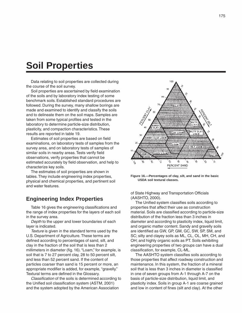
175
Data relating to soil properties are collected duringthe course of the soil survey.
Soil properties are ascertained by field examinationof the soils and by laboratory index testing of somebenchmark soils. Established standard procedures arefollowed. During the survey, many shallow borings aremade and examined to identify and classify the soilsand to delineate them on the soil maps. Samples aretaken from some typical profiles and tested in thelaboratory to determine particle-size distribution,plasticity, and compaction characteristics. Theseresults are reported in table 19.
Estimates of soil properties are based on fieldexaminations, on laboratory tests of samples from thesurvey area, and on laboratory tests of samples ofsimilar soils in nearby areas. Tests verify fieldobservations, verify properties that cannot beestimated accurately by field observation, and help tocharacterize key soils.
The estimates of soil properties are shown intables. They include engineering index properties,physical and chemical properties, and pertinent soiland water features.
Engineering Index PropertiesTable 16 gives the engineering classifications and
the range of index properties for the layers of each soilin the survey area.
Depth to the upper and lower boundaries of eachlayer is indicated.
Texture is given in the standard terms used by theU.S. Department of Agriculture. These terms aredefined according to percentages of sand, silt, andclay in the fraction of the soil that is less than 2millimeters in diameter (fig. 16). “Loam,” for example, issoil that is 7 to 27 percent clay, 28 to 50 percent silt,and less than 52 percent sand. If the content ofparticles coarser than sand is 15 percent or more, anappropriate modifier is added, for example, “gravelly.”Textural terms are defined in the Glossary.
Classification of the soils is determined according tothe Unified soil classification system (ASTM, 2001)and the system adopted by the American Association
of State Highway and Transportation Officials(AASHTO, 2000).
The Unified system classifies soils according toproperties that affect their use as constructionmaterial. Soils are classified according to particle-sizedistribution of the fraction less than 3 inches indiameter and according to plasticity index, liquid limit,and organic matter content. Sandy and gravelly soilsare identified as GW, GP, GM, GC, SW, SP, SM, andSC; silty and clayey soils as ML, CL, OL, MH, CH, andOH; and highly organic soils as PT. Soils exhibitingengineering properties of two groups can have a dualclassification, for example, CL-ML.
The AASHTO system classifies soils according tothose properties that affect roadway construction andmaintenance. In this system, the fraction of a mineralsoil that is less than 3 inches in diameter is classifiedin one of seven groups from A-1 through A-7 on thebasis of particle-size distribution, liquid limit, andplasticity index. Soils in group A-1 are coarse grainedand low in content of fines (silt and clay). At the other
Soil Properties
Figure 16.—Percentages of clay, silt, and sand in the basicUSDA soil textural classes.

176 Soil Survey of
extreme, soils in group A-7 are fine grained. Highlyorganic soils are classified in group A-8 on the basis ofvisual inspection.
If laboratory data are available, the A-1, A-2, andA-7 groups are further classified as A-1-a, A-1-b,A-2-4, A-2-5, A-2-6, A-2-7, A-7-5, or A-7-6. As anadditional refinement, the suitability of a soil assubgrade material can be indicated by a group indexnumber. Group index numbers range from 0 for thebest subgrade material to 20 or higher for the poorest.The AASHTO classification for soils tested, with groupindex numbers in parentheses, is given in table 19.
Rock fragments larger than 10 inches in diameterand 3 to 10 inches in diameter are indicated as apercentage of the total soil on a dry-weight basis. Thepercentages are estimates determined mainly byconverting volume percentage in the field to weightpercentage.
Percentage (of soil particles) passing designatedsieves is the percentage of the soil fraction less than 3inches in diameter based on an ovendry weight. Thesieves, numbers 4, 10, 40, and 200 (USA StandardSeries), have openings of 4.76, 2.00, 0.420, and 0.074millimeters, respectively. Estimates are based onlaboratory tests of soils sampled in the survey areaand in nearby areas and on estimates made in thefield.
Liquid limit and plasticity index (Atterberg limits)indicate the plasticity characteristics of a soil. Theestimates are based on test data from the survey areaor from nearby areas and on field examination.
The estimates of particle-size distribution, liquidlimit, and plasticity index are generally rounded to thenearest 5 percent. Thus, if the ranges of gradation andAtterberg limits extend a marginal amount (1 or 2percentage points) across classification boundaries,the classification in the marginal zone is generallyomitted in the table.
Physical and Chemical PropertiesTable 17 shows estimates of some characteristics
and features that affect soil behavior. These estimatesare given for the major layers of each soil in the surveyarea. The estimates are based on field observationsand on test data for these and similar soils.
Depth to the upper and lower boundaries of eachlayer is indicated.
Clay as a soil separate consists of mineral soilparticles that are less than 0.002 millimeter indiameter. In the table, the estimated clay content ofeach major soil layer is given as a percentage, byweight, of the soil material that is less than 2millimeters in diameter.
The amount and kind of clay greatly affect thefertility and physical condition of the soil. Theydetermine the ability of the soil to adsorb cations andto retain moisture. They influence shrink-swellpotential, permeability, plasticity, the ease of soildispersion, and other soil properties. The amount andkind of clay in a soil also affect tillage and earthmovingoperations.
Moist bulk density is the weight of soil (ovendry) perunit volume. Volume is measured when the soil is atfield moisture capacity, that is, the moisture content at1/3-bar moisture tension. Weight is determined after thesoil is dried at 105 degrees C. In table 17, theestimated moist bulk density of each major soilhorizon is expressed in grams per cubic centimeter ofsoil material that is less than 2 millimeters in diameter.Bulk density data are used to compute shrink-swellpotential, available water capacity, total pore space,and other soil properties. The moist bulk density of asoil indicates the pore space available for water androots. A bulk density of more than 1.6 can restrictwater storage and root penetration. Moist bulk densityis influenced by texture, kind of clay, content of organicmatter, and soil structure.
Permeability (Ksat ) refers to the ability of a soil totransmit water or air. The term “permeability,” as usedin soil surveys, indicates saturated hydraulicconductivity (K
sat ). The estimates in the table indicate
the rate of water movement, in inches per hour, whenthe soil is saturated. They are based on soilcharacteristics observed in the field, particularlystructure, porosity, and texture. Permeability isconsidered in the design of soil drainage systems andseptic tank absorption fields.
Available water capacity refers to the quantity ofwater that the soil is capable of storing for use byplants. The capacity for water storage is given ininches of water per inch of soil for each major soillayer. The capacity varies, depending on soilproperties that affect retention of water and depth ofthe root zone. The most important properties are thecontent of organic matter, soil texture, bulk density,and soil structure. Available water capacity is animportant factor in the choice of plants or crops to begrown and in the design and management of irrigationsystems. Available water capacity is not an estimate ofthe quantity of water actually available to plants at anygiven time.
Soil reaction is a measure of acidity or alkalinity andis expressed as a range in pH values. The range in pHof each major horizon is based on many field tests. Formany soils, values have been verified by laboratoryanalyses. Soil reaction is important in selecting cropsand other plants, in evaluating soil amendments for

Florence County, Wisconsin 177
fertility and stabilization, and in determining the risk ofcorrosion.
Shrink-swell potential is the potential for volumechange in a soil with a loss or gain in moisture. Volumechange occurs mainly because of the interaction ofclay minerals with water and varies with the amountand type of clay minerals in the soil. The size of theload on the soil and the magnitude of the change insoil moisture content influence the amount of swellingof soils in place. Laboratory measurements of swellingof undisturbed clods were made for many soils. Forothers, swelling was estimated on the basis of the kindand amount of clay minerals in the soil and on thebasis of measurements of similar soils.
If the shrink-swell potential is rated moderate tovery high, shrinking and swelling can cause damageto buildings, roads, and other structures. Specialdesign is often needed.
Shrink-swell potential classes are based on thechange in length of an unconfined clod as moisturecontent is increased from air-dry to field capacity. Theclasses are low, a change of less than 3 percent;moderate, 3 to 6 percent; high, 6 to 9 percent; andvery high, greater than 9 percent.
Erosion factor K indicates the susceptibility of a soilto sheet and rill erosion by water. Factor K is one of sixfactors used in the Universal Soil Loss Equation(USLE) to predict the average annual rate of soil lossby sheet and rill erosion in tons per acre per year. Theestimates are based primarily on percentage of silt,sand, and organic matter (up to 4 percent) and on soilstructure and permeability. Values of K range from0.02 to 0.64. Other factors being equal, the higher thevalue, the more susceptible the soil is to sheet and rillerosion by water.
Erosion factor Kf indicates the erodibility of the fine-earth fraction, or the material less than 2 millimeters insize.
Erosion factor T is an estimate of the maximumaverage annual rate of soil erosion by wind or waterthat can occur without affecting crop productivity overa sustained period. The rate is in tons per acre peryear.
Wind erodibility groups are made up of soils thathave similar properties affecting their resistance to soilblowing in cultivated areas. The groups indicate thesusceptibility to soil blowing. The soils assigned togroup 1 are the most susceptible to soil blowing, andthose assigned to group 8 are the least susceptible.The groups are as follows:
1. Coarse sands, sands, fine sands, and very finesands.
2. Loamy coarse sands, loamy sands, loamy finesands, loamy very fine sands, ash material, and sapricsoil material.
3. Coarse sandy loams, sandy loams, fine sandyloams, and very fine sandy loams.
4L. Calcareous loams, silt loams, clay loams, andsilty clay loams.
4. Clays, silty clays, noncalcareous clay loams,and silty clay loams that are more than 35 percentclay.
5. Noncalcareous loams and silt loams that areless than 20 percent clay and sandy clay loams, sandyclays, and hemic soil material.
6. Noncalcareous loams and silt loams that aremore than 20 percent clay and noncalcareous clayloams that are less than 35 percent clay.
7. Silts, noncalcareous silty clay loams that areless than 35 percent clay, and fibric soil material.
8. Soils that are not subject to soil blowingbecause of rock fragments on the surface or becauseof surface wetness.
Organic matter is the plant and animal residue inthe soil at various stages of decomposition. In table17, the estimated content of organic matter isexpressed as a percentage, by weight, of the soilmaterial that is less than 2 millimeters in diameter.
The content of organic matter in a soil can bemaintained or increased by returning crop residue tothe soil. Organic matter affects the available watercapacity, infiltration rate, and tilth. It is a source ofnitrogen and other nutrients for crops.
Soil and Water FeaturesTable 18 gives estimates of various soil and water
features. The estimates are used in land use planningthat involves engineering considerations.
Hydrologic soil groups are based on estimates ofrunoff potential. Soils are assigned to one of fourgroups according to the rate of water infiltration whenthe soils are not protected by vegetation, arethoroughly wet, and receive precipitation from long-duration storms.
The four hydrologic soil groups are:Group A. Soils having a high infiltration rate (low
runoff potential) when thoroughly wet. These consistmainly of deep, well drained to excessively drainedsands or gravelly sands. These soils have a high rateof water transmission.
Group B. Soils having a moderate infiltration ratewhen thoroughly wet. These consist chiefly ofmoderately deep or deep, moderately well drained or

178 Soil Survey of
well drained soils that have moderately fine texture tomoderately coarse texture. These soils have amoderate rate of water transmission.
Group C. Soils having a slow infiltration rate whenthoroughly wet. These consist chiefly of soils having alayer that impedes the downward movement of wateror soils of moderately fine texture or fine texture.These soils have a slow rate of water transmission.
Group D. Soils having a very slow infiltration rate(high runoff potential) when thoroughly wet. Theseconsist chiefly of clays that have a high shrink-swellpotential, soils that have a high water table, soils thathave a claypan or clay layer at or near the surface,and soils that are shallow over nearly imperviousmaterial. These soils have a very slow rate of watertransmission.
If a soil is assigned to two hydrologic groups in thetable, the first letter is for drained areas and thesecond is for undrained areas.
Flooding, the temporary inundation of an area, iscaused by overflowing streams or by runoff fromadjacent slopes. Water standing for short periods afterrainfall or snowmelt is not considered flooding, andwater standing in swamps and marshes is consideredponding rather than flooding.
The table gives the frequency and duration offlooding and the time of year when flooding is mostlikely.
Frequency, duration, and probable dates ofoccurrence are estimated. Frequency is expressed asnone, rare, occasional, and frequent. None means thatflooding is not probable; rare that it is unlikely butpossible under unusual weather conditions (thechance of flooding is nearly 0 percent to 5 percent inany year); occasional that it occurs, on the average,once or less in 2 years (the chance of flooding is 5 to50 percent in any year); and frequent that it occurs, onthe average, more than once in 2 years (the chance offlooding is more than 50 percent in any year). Durationis expressed as very brief if less than 2 days, brief if 2to 7 days, long if 7 days to 1 month, and very long ifmore than 1 month. Probable dates are expressed inmonths. About two-thirds to three-fourths of all floodingoccurs during the stated period.
The information is based on evidence in the soilprofile, namely thin strata of gravel, sand, silt, or claydeposited by floodwater; irregular decrease in organicmatter content with increasing depth; and little or nohorizon development.
Also considered are local information about theextent and levels of flooding and the relation of eachsoil on the landscape to historic floods. Information onthe extent of flooding based on soil data is less
specific than that provided by detailed engineeringsurveys that delineate flood-prone areas at specificflood frequency levels.
High water table (seasonal) is the highest level of asaturated zone in the soil in most years. The estimatesare based mainly on observations of the water table atselected sites and on the evidence of a saturatedzone, namely grayish colors or mottles (redoximorphicfeatures) in the soil. Indicated in the table are depth tothe seasonal high water table, the kind of water table,and the months of the year that the water tablecommonly is high. A water table that is seasonally highfor less than 1 month is not indicated in the table.
An apparent water table is a thick zone of free waterin the soil. It is indicated by the level at which waterstands in an uncased borehole after adequate time isallowed for adjustment in the surrounding soil. Aperched water table is water standing above anunsaturated zone. In places an upper, or perched,water table is separated from a lower one by a dryzone.
Two numbers in the column showing depth to thewater table indicate the normal range in depth to asaturated zone. Depth is given to the nearest half foot.The first numeral in the range indicates the highestwater level. A plus sign preceding the range in depthindicates that the water table is above the surface ofthe soil. “More than 6.0” indicates that the water tableis below a depth of 6 feet or that it is within a depth of6 feet for less than a month.
Depth to bedrock is given if bedrock is within adepth of 5 feet. The depth is based on many soilborings and on observations during soil mapping. Therock is either soft or hard. If the rock is soft orfractured, excavations can be made with trenchingmachines, backhoes, or small rippers. If the rock ishard or massive, blasting or special equipmentgenerally is needed for excavation.
Subsidence is the settlement of organic soils or ofsaturated mineral soils of very low density. Subsidencegenerally results from either desiccation andshrinkage or oxidation of organic material, or both,following drainage. Subsidence takes place gradually,usually over a period of several years. The table showsthe expected total subsidence, which usually is aresult of drainage and oxidation.
Potential frost action is the likelihood of upward orlateral expansion of the soil caused by the formation ofsegregated ice lenses (frost heave) and thesubsequent collapse of the soil and loss of strength onthawing. Frost action occurs when moisture movesinto the freezing zone of the soil. Temperature, texture,density, permeability, content of organic matter, and

Florence County, Wisconsin 179
depth to the water table are the most important factorsconsidered in evaluating the potential for frost action. Itis assumed that the soil is not insulated by vegetationor snow and is not artificially drained. Silty and highlystructured, clayey soils that have a high water table inwinter are the most susceptible to frost action. Welldrained, very gravelly, or very sandy soils are the leastsusceptible. Frost heave and low soil strength duringthawing cause damage mainly to pavements and otherrigid structures.
Risk of corrosion pertains to potential soil-inducedelectrochemical or chemical action that dissolves orweakens uncoated steel or concrete. The rate ofcorrosion of uncoated steel is related to such factorsas soil moisture, particle-size distribution, acidity, andelectrical conductivity of the soil. The rate of corrosionof concrete is based mainly on the texture, moisturecontent, and acidity of the soil. Special siteexamination and design may be needed if thecombination of factors results in a severe hazard ofcorrosion. The steel in installations that intersect soilboundaries or soil layers is more susceptible tocorrosion than steel in installations that are entirelywithin one kind of soil or within one soil layer.
For uncoated steel, the risk of corrosion, expressedas low, moderate, or high, is based on soil drainageclass, total acidity, electrical resistivity near field
capacity, and electrical conductivity of the saturationextract.
For concrete, the risk of corrosion also is expressedas low, moderate, or high. It is based on soil texture,acidity, and amount of sulfates in the saturationextract.
Engineering Index Test DataTable 19 shows laboratory test data for several
pedons sampled at carefully selected sites in thesurvey area. The pedons are representative of theseries described in the section “Soil Series and TheirMorphology.” The soil samples were tested by theWisconsin Department of Transportation, Division ofHighways and Transportation Facilities.
The testing methods generally are those of theAmerican Association of State Highway andTransportation Officials (AASHTO) or the AmericanSociety for Testing and Materials (ASTM).
The tests and methods are Moisture density—T 99(AASHTO), D 698 (ASTM); Mechanical analysis—T 88(AASHTO), D 422 (ASTM), D 2217 (ASTM); Liquidlimit—T 89 (AASHTO), D 4318 (ASTM); Plasticityindex—T 90 (AASHTO), D 4318 (ASTM); AASHTOclassification—M 145 (AASHTO), D 3282 (ASTM); andUnified classification—D 2487 (ASTM).


181
The system of soil classification used by theNational Cooperative Soil Survey has six categories(Soil Survey Staff, 1999). Beginning with the broadest,these categories are the order, suborder, great group,subgroup, family, and series. Classification is based onsoil properties observed in the field or inferred fromthose observations or from laboratory measurements.Table 20 shows the classification of the soils in thesurvey area. The categories are defined in thefollowing paragraphs.
ORDER. Twelve soil orders are recognized. Thedifferences among orders reflect the dominant soil-forming processes and the degree of soil formation.Each order is identified by a word ending in sol. Anexample is Spodosol.
SUBORDER. Each order is divided into subordersprimarily on the basis of properties that influence soilgenesis and are important to plant growth orproperties that reflect the most important variableswithin the orders. The last syllable in the name of asuborder indicates the order. An example is Aquod(Aqu, meaning water, plus od, from Spodosol).
GREAT GROUP. Each suborder is divided intogreat groups on the basis of close similarities in kind,arrangement, and degree of development ofpedogenic horizons; soil moisture and temperatureregimes; type of saturation; and base status. Eachgreat group is identified by the name of a suborderand by a prefix that indicates a property of the soil. Anexample is Endoaquods (Endo, referring toendosaturation, plus aquod, the suborder of theSpodosols that has aquic conditions).
SUBGROUP. Each great group has a typicsubgroup. Other subgroups are intergrades orextragrades. The typic subgroup is the central conceptof the great group; it is not necessarily the mostextensive. Intergrades are transitions to other orders,suborders, or great groups. Extragrades have someproperties that are not representative of the greatgroup but do not indicate transitions to any othertaxonomic class. Each subgroup is identified by one ormore adjectives preceding the name of the greatgroup. The adjective Typic identifies the subgroup thattypifies the great group. An example is TypicEndoaquods.
FAMILY. Families are established within asubgroup on the basis of physical and chemicalproperties and other characteristics that affectmanagement. Generally, the properties are those ofhorizons below plow depth where there is muchbiological activity. Among the properties andcharacteristics considered are particle-size class,mineralogy class, cation-exchange activity class, soiltemperature regime, soil depth, and reaction class. Afamily name consists of the name of a subgrouppreceded by terms that indicate soil properties. Anexample is sandy, mixed, frigid Typic Endoaquods.
SERIES. The series consists of soils within afamily that have horizons similar in color, texture,structure, reaction, consistence, mineral and chemicalcomposition, and arrangement in the profile.
Soil Series and Their MorphologyIn this section, each soil series recognized in the
survey area is described. Characteristics of the soiland the material in which it formed are identified foreach series. A pedon, a small three-dimensional areaof soil, that is typical of the series in the survey area isdescribed. The detailed description of each soilhorizon follows standards in the “Soil Survey Manual”(Soil Survey Division Staff, 1993). Many of thetechnical terms used in the descriptions are defined in“Soil Taxonomy” (Soil Survey Staff, 1999) and in “Keysto Soil Taxonomy” (Soil Survey Staff, 1994). Unlessotherwise indicated, colors in the descriptions are formoist soil. Following the pedon description is the rangeof important characteristics of the soils in the series.
Annalake Series
Depth class: Very deepDrainage class: Moderately well drainedPermeability: ModerateLandform: Outwash plains, glacial lake plains, and
morainesParent material: Primarily loamy deposits underlain by
stratified lacustrine depositsSlope range: 0 to 15 percent
Classification of the Soils

182 Soil Survey of
Taxonomic classification: Coarse-loamy, mixed,frigid Oxyaquic Haplorthods
Typical Pedon
Annalake fine sandy loam, 0 to 6 percent slopes,approximately 1,800 feet south and 1,650 feet east ofthe northwest corner of sec. 33, T. 38 N., R. 16 E.
A—0 to 3 inches; very dark gray (10YR 3/1) fine sandyloam, gray (10YR 5/1) dry; moderate medium andcoarse granular structure; friable; many very fineand fine roots; strongly acid; abrupt brokenboundary.
E—3 to 6 inches; brown (7.5YR 5/2) fine sandy loam,pinkish gray (7.5YR 6/2) dry; weak very thick platystructure parting to moderate medium subangularblocky; friable; many very fine and fine roots;strongly acid; clear wavy boundary.
Bs1—6 to 9 inches; dark brown (7.5YR 3/4) fine sandyloam; moderate medium and coarse subangularblocky structure; friable; many very fine and fineroots; very strongly acid; clear wavy boundary.
Bs2—9 to 17 inches; brown (7.5YR 4/4) fine sandyloam; moderate medium subangular blockystructure; friable; common very fine and fine roots;very strongly acid; abrupt wavy boundary.
E/B—17 to 31 inches; 75 percent brown (10YR 5/3)fine sandy loam (E´), very pale brown (10YR 7/3)dry; moderate thin platy structure; friable; tonguinginto and surrounding remnants of dark yellowishbrown (10YR 4/4) fine sandy loam (Bt); moderatemedium subangular blocky structure; friable; fewvery fine and fine roots; few distinct dark brown(7.5YR 3/4) clay films on faces of some peds; verystrongly acid; clear wavy boundary.
Bt—31 to 39 inches; brown (7.5YR 4/4) sandy loam;moderate medium and coarse subangular blockystructure; friable; few faint dark brown (7.5YR 3/4)clay films on faces of some peds; few fine distinctstrong brown (7.5YR 5/6) masses of ironaccumulation; strongly acid; abrupt wavyboundary.
C—39 to 60 inches; brown (7.5YR 4/4 and 5/4),stratified fine sand, very fine sand, loamy very finesand, very fine sandy loam, and silt loam;massive; friable; few fine distinct strong brown(7.5YR 5/6) masses of iron accumulation;moderately acid.
Range in Characteristics
Thickness of the solum: 30 to more than 60 inchesContent of gravel: 0 to 10 percent throughout the
profile
O horizon (if it occurs):Hue—10YR, 7.5YR, 5YR, or NValue—2 to 3Chroma—0 to 2Texture—sapric or hemic material
A horizon:Hue—10YR, 7.5YR, 5YR, or NValue—2 to 3Chroma—0 to 2Texture—fine sandy loam
E horizon:Hue—10YR, 7.5YR, or 5YRValue—5Chroma—2Texture—fine sandy loam or loamy fine sand
Bs horizon:Hue—7.5YR or 5YRValue—3 or 4Chroma—4Texture—sandy loam or fine sandy loam
E´ part of E/B horizon:Hue—10YR, 7.5YR, or 5YRValue—5Chroma—3Texture—loamy sand, loamy fine sand, sandy
loam, or fine sandy loam
Bt horizon and Bt part of E/B horizon:Hue—10YR, 7.5YR, or 5YRValue—4Chroma—4Texture—fine sandy loam or sandy loam
C horizon:Hue—10YR, 7.5YR, or 5YRValue—4 or 5Chroma—3 or 4Texture—stratified fine sand, very fine sand, loamy
very fine sand, very fine sandy loam, and siltloam
Au Gres Series
Depth class: Very deepDrainage class: Somewhat poorly drainedPermeability: RapidLandform: Outwash plains and stream terracesParent material: Primarily sandy glacial outwashSlope range: 0 to 2 percent
Taxonomic classification: Sandy, mixed, frigid TypicEndoaquods

Florence County, Wisconsin 183
Typical Pedon
Au Gres loamy sand, 0 to 2 percent slopes,approximately 2,000 feet north and 300 feet east ofthe southwest corner of sec. 14, T. 38 N., R. 17 E.
Oa—0 to 2 inches; black (10YR 2/1) (broken face andrubbed) muck (sapric material, which is a mat ofpartially decomposed forest litter); about 40percent fiber, 10 percent rubbed; weak mediumgranular structure; very friable; many very fine andfine and few medium and coarse roots; extremelyacid (pH 4.3 in water 1:1); abrupt smoothboundary.
E—2 to 7 inches; grayish brown (10YR 5/2) loamysand, light gray (10YR 7/1) dry; weak thick platystructure; very friable; common very fine and fineand few medium and coarse roots; very stronglyacid; abrupt irregular boundary.
Bhs—7 to 8 inches; dark brown (7.5YR 3/3) loamysand; weak fine subangular blocky structure; veryfriable; common very fine and fine and fewmedium and coarse roots; few fine distinct strongbrown (7.5YR 4/6) masses of iron accumulation;very strongly acid; abrupt broken boundary.
Bs—8 to 17 inches; dark brown (7.5YR 3/4) loamysand; weak fine and medium subangular blockystructure; very friable; common very fine and fineand few medium and coarse roots; many mediumand coarse distinct strong brown (7.5YR 4/6)masses of iron accumulation; strongly acid; clearwavy boundary.
BC—17 to 26 inches; strong brown (7.5YR 4/6) sand;weak coarse subangular blocky structure; veryfriable; few very fine and fine roots; many mediumand coarse distinct yellowish red (5YR 4/6)masses of iron accumulation and common fineand medium distinct brown (7.5YR 4/2) irondepletions; strongly acid; clear wavy boundary.
C—26 to 62 inches; dark yellowish brown (10YR 4/4)sand; single grain; loose; many coarse prominentyellowish red (5YR 4/6) masses of ironaccumulation and many medium and coarsebrown (7.5YR 5/2) iron depletions; moderatelyacid.
Range in Characteristics
Thickness of the solum: 20 to 40 inchesContent of gravel: 0 to 10 percent throughout the
profileNote: Unless otherwise indicated, depths and
thicknesses are measured from the top of themineral soil.
O horizon:Hue—10YR, 7.5YR, 5YR, or N
Value—2 to 3Chroma—0 to 2Texture—sapric or hemic material
A horizon (if it occurs):Hue—10YR, 7.5YR, 5YR, or NValue—2 to 3Chroma—0 to 2Texture—loamy sand
E horizon:Hue—10YR, 7.5YR, or 5YRValue—4 to 6Chroma—2Texture—loamy sand
Bhs horizon:Hue—7.5YR or 5YRValue—2 or 3Chroma—2 or 3Texture—loamy sand
Bs horizon:Hue—7.5YR or 5YRValue—3 or 4Chroma—4Texture—loamy sand or sand
C horizon:Hue—10YR or 7.5YRValue—4 to 6Chroma—3 to 8Texture—sand
Beseman Series
Depth class: Very deepDrainage class: Very poorly drainedPermeability: Moderate or moderately rapid in the
organic material; moderately slow in thesubstratum
Landform: Outwash plains, glacial lake plains, andmoraines
Parent material: Sphagnum moss and herbaceousorganic material 16 to 51 inches thick over loamyor silty deposits
Slope range: 0 to 1 percent
Taxonomic classification: Loamy, mixed, dysic TerricBorosaprists
Typical Pedon
Beseman peat, in an area of Loxley, Beseman, andDawson peats, 0 to 1 percent slopes, approximately1,995 feet west and 1,200 feet south of the northeastcorner of sec. 28, T. 38 N., R. 13 E., in Forest County,Wisconsin:

184 Soil Survey of
Oi—0 to 12 inches; peat, dark brown (10YR 3/3)broken face and rubbed; about 90 percent fiber, 50percent rubbed; weak coarse subangular blockystructure; very friable; many fine roots; fibers areprimarily sphagnum moss; extremely acid (pH 4.0in water 1:1); clear wavy boundary.
Oa1—12 to 22 inches; muck, dark reddish brown (5YR2.5/2) broken face and rubbed; about 45 percentfiber, 5 percent rubbed; weak coarse subangularblocky structure; friable; few fine roots; fibers areprimarily herbaceous; extremely acid (pH 4.0 inwater 1:1); gradual wavy boundary.
Oa2—22 to 36 inches; muck, black (5YR 2.5/1) brokenface and rubbed; about 40 percent fiber, 5 percentrubbed; moderate coarse subangular blockystructure; friable; few fine roots; fibers are primarilyherbaceous; about 10 percent mineral material;extremely acid (pH 4.0 in water 1:1); abrupt wavyboundary.
Cg—36 to 60 inches; dark gray (5Y 4/1) silt loam;massive; friable; about 3 percent gravel; few highlydecomposed root fibers in channels; very stronglyacid.
Range in Characteristics
Thickness of the organic material: 16 to 51 inchesKind of organic material: Upper layer—peat; lower
layers—dominantly muck (thin layers of muckypeat or peat in some pedons)
Content of woody fragments: 0 to 10 percent
Oi horizon:Hue—10YR, 7.5YR, or 5YRValue—2 to 3Chroma—2 or 3Texture—peat
Oa horizon:Hue—10YR, 7.5YR, or 5YRValue—2 to 3Chroma—1 or 2Texture—muck
C horizon:Hue—5Y, 2.5Y, 10YR, or 7.5YRValue—4 to 6Chroma—1 to 3Texture—silt loam, loam, sandy loam, or fine
sandy loam
Capitola Series
Depth class: Very deepDrainage class: Poorly drained
Permeability: Moderate or moderately slow in thesolum and moderately slow in the substratum
Landform: Drumlins and morainesParent material: Primarily silty deposits underlain by
sandy or loamy glacial till or glacial mudflowsediment
Slope range: 0 to 2 percent
Taxonomic classification: Coarse-loamy, mixed,frigid Mollic Epiaqualfs
Typical Pedon
Capitola muck, 0 to 2 percent slopes, very stony,approximately 1,900 feet north and 2,110 feet west ofthe southeast corner of sec. 25, T. 40 N., R. 16 E.
Oa—0 to 5 inches; muck, black (10YR 2/1) brokenface, very dark brown (10YR 2/2) rubbed; about30 percent fiber, 5 percent rubbed; weak mediumsubangular blocky structure; very friable; manyvery fine and fine roots; fibers are primarilyherbaceous; very strongly acid (pH 4.7 in water1:1); abrupt smooth boundary.
Bg—5 to 20 inches; dark grayish brown (2.5Y 4/2) siltloam; moderate medium subangular blockystructure; friable; few very fine and fine roots; fewfine prominent yellowish brown (10YR 5/6)masses of iron accumulation; about 1 percentgravel and 1 percent cobbles; very strongly acid;clear wavy boundary.
2Btg—20 to 34 inches; brown (7.5YR 4/2) sandy loam;moderate medium subangular blocky structure;friable; few faint dark brown (7.5YR 3/2) clay filmson faces of some peds; many medium prominentyellowish red (5YR 4/6) masses of ironaccumulation and common fine and mediumprominent grayish brown (2.5Y 5/2) irondepletions; about 5 percent gravel and 1 percentcobbles; strongly acid; clear wavy boundary.
2C—34 to 60 inches; brown (7.5YR 4/4) gravellysandy loam; massive; friable; many mediumprominent yellowish red (5YR 4/6) masses of ironaccumulation and common medium prominentgrayish brown (10YR 5/2) iron depletions; about20 percent gravel and 1 percent cobbles;moderately acid.
Range in Characteristics
Thickness of the solum: 20 to 40 inchesThickness of the silty mantle: 15 to 36 inchesContent of gravel: 0 to 10 percent in the upper part of
the solum; 5 to 25 percent in the lower part of thesolum and in the substratum
Content of cobbles: 0 to 15 percent throughout theprofile

Florence County, Wisconsin 185
Content of stones: 0 to 5 percent throughout the profilePercent of surface covered by stones: 0.1 to 3.0
percent
Oa horizon:Hue—10YR, 7.5YR, 5YR, or NValue—2 or 3Chroma—0 to 2Texture—muck
A horizon (if it occurs):Hue—10YRValue—2 or 3Chroma—1 or 2Texture—silt loam
Bg horizon:Hue—2.5Y, 10YR, or 7.5YRValue—4 to 6Chroma—1 or 2Texture—silt loam
2Btg horizon:Hue—7.5YR or 5YRValue—4 to 6Chroma—1 or 2Texture—sandy loam or gravelly sandy loam
2C horizon:Hue—7.5YR or 5YRValue—4 to 6Chroma—2 to 4Texture—sandy loam, loamy sand, gravelly sandy
loam, or gravelly loamy sand
Cathro Series
Depth class: Very deepDrainage class: Very poorly drainedPermeability: Moderately slow to moderately rapid in
the organic material; moderately slow or moderatein the substratum
Landform: Outwash plains, glacial lake plains, andmoraines
Parent material: Herbaceous organic material 16 to 51inches thick over loamy or silty deposits
Slope range: 0 to 1 percent
Taxonomic classification: Loamy, mixed, euic TerricBorosaprists
Typical Pedon
Cathro muck, in an area of Lupton, Cathro, andMarkey mucks, 0 to 1 percent slopes, approximately150 feet east and 2,300 feet south of the northwestcorner of sec. 30, T. 35 N., R. 15 E., in Forest County,Wisconsin:
Oa1—0 to 8 inches; muck, black (N 2.5/0) broken faceand rubbed; about 45 percent fiber, 9 percentrubbed; moderate fine granular structure; veryfriable; many fine and very fine and commonmedium roots; fibers are primarily herbaceous;neutral (pH 7.0 in water 1:1); clear wavyboundary.
Oa2—8 to 16 inches; muck, black (N 2.5/0) brokenface, black (10YR 2/1) rubbed; about 40 percentfiber, 4 percent rubbed; moderate fine granularstructure; very friable; common fine and very fineand few medium roots; fibers are primarilyherbaceous; neutral (pH 6.9 in water 1:1); clearwavy boundary.
Oa3—16 to 30 inches; muck, black (N 2.5/0) brokenface, black (10YR 2/1) rubbed; about 40 percentfiber, 4 percent rubbed; weak medium subangularblocky structure; very friable; fibers are primarilyherbaceous; about 3 percent mineral material;neutral (pH 7.2 in water 1:1); abrupt wavyboundary.
Cg1—30 to 37 inches; gray (5Y 5/1) silt loam; massive;friable; black (10YR 2/1) organic staining in theupper one-half inch; slightly alkaline; abrupt wavyboundary.
Cg2—37 to 45 inches; grayish brown (10YR 5/2)sandy loam; massive; friable; few fine distinctyellowish brown (10YR 5/4) masses of ironaccumulation; about 4 percent gravel; slightlyalkaline; gradual wavy boundary.
C—45 to 60 inches; brown (10YR 5/3) sandy loam;massive; friable; common medium distinct darkyellowish brown (10YR 4/4) masses of ironaccumulation; about 4 percent gravel; slightlyalkaline.
Range in Characteristics
Thickness of the organic material: 16 to 51 inchesKind of organic material: Dominantly muck; thin layers
of mucky peat or peat in some pedonsContent of woody fragments: 0 to 10 percent
Oa horizon:Hue—10YR, 7.5YR, 5YR, or NValue—2 to 3Chroma—0 to 2Texture—muck
C horizon:Hue—5Y, 2.5Y, 10YR, or 7.5YRValue—4 to 6Chroma—1 to 3Texture—sandy loam, fine sandy loam, very fine
sandy loam, silt loam, silty clay loam, clay loam,or loam

186 Soil Survey of
Crossett Series
Depth class: Very deepDrainage class: Somewhat poorly drainedPermeability: Moderately slowLandform: MorainesParent material: Silty deposits underlain by silty, loamy,
or clayey glacial tillSlope range: 0 to 3 percent
Taxonomic classification: Fine-loamy, mixedGlossaquic Eutroboralfs
Typical Pedon
Crossett silt loam, in an area of Ellwood-Crossett siltloams, 0 to 6 percent slopes, approximately 1,420 feetnorth and 1,170 feet west of the southeast corner ofsec. 3, T. 38 N., R. 18 E.
Ap—0 to 9 inches; brown (7.5YR 4/2) silt loam, pinkishgray (7.5YR 6/2) dry; weak fine subangular blockystructure; friable; many very fine and fine and fewmedium and coarse roots; about 4 percent gravel;neutral; abrupt smooth boundary.
E/B—9 to 19 inches; 70 percent brown (7.5YR 5/2) siltloam (E), pinkish gray (7.5YR 7/2) dry; moderatethick platy structure; friable; many fine andmedium prominent yellowish red (5YR 4/6)masses of iron accumulation; extending into andsurrounding remnants of reddish brown (5YR 4/4)silty clay loam (Bt); moderate medium prismaticstructure parting to strong fine angular blocky;firm; common very fine and fine and few mediumand coarse roots; common fine and mediumdistinct yellowish red (5YR 4/6) masses of ironaccumulation; about 4 percent gravel; slightly acid;clear wavy boundary.
Bt1—19 to 30 inches; dark reddish brown (5YR 3/4)silty clay loam; moderate medium prismaticstructure parting to strong fine and mediumangular blocky; firm; few very fine, fine, medium,and coarse roots; common faint dark reddishbrown (5YR 3/4) and reddish brown (5YR 4/3) clayfilms on faces of peds and in some pores; few fineand medium distinct yellowish red (5YR 4/6)masses of iron accumulation; few fine prominentgrayish brown (10YR 5/2) iron depletions; few softblack (N 2.5/0) masses (iron-manganese oxides);about 5 percent gravel; slightly acid; clear wavyboundary.
Bt2—30 to 38 inches; dark reddish brown (5YR 3/4)silty clay loam; moderate medium prismaticstructure parting to strong fine and mediumangular blocky; firm; few very fine, fine, andmedium roots; common faint reddish brown (5YR
4/3) clay films on faces of some peds and in somepores; few fine distinct yellowish red (5YR 4/6)masses of iron accumulation; few soft black (N2.5/0) masses (iron-manganese oxides); about 5percent gravel; neutral; clear wavy boundary.
Btk1—38 to 62 inches; dark reddish brown (5YR 3/4)silty clay loam; weak coarse prismatic structureparting to strong medium and coarse angularblocky; firm; few very fine and fine roots; few faintreddish brown (5YR 4/3) clay films on faces ofsome peds and in some pores; few soft black (N2.5/0) masses (iron-manganese oxides); about 10percent gravel; strongly effervescent; slightlyalkaline; gradual wavy boundary.
Btk2—62 to 80 inches; dark reddish brown (5YR 3/4)silty clay loam; weak coarse prismatic structureparting to strong medium and coarse angularblocky; firm; few very fine and fine roots; few faintreddish brown (5YR 4/3) clay films on faces ofpeds; few soft black (N 2.5/0) masses (iron-manganese oxides); about 5 percent gravel;strongly effervescent; moderately alkaline.
Range in Characteristics
Thickness of the solum: 40 to more than 80 inchesDepth to carbonates: 20 to 40 inchesContent of gravel: 0 to 15 percent throughout the
profileContent of cobbles: 0 to 5 percent throughout the
profile
Ap horizon:Hue—10YR, 7.5YR, or 5YRValue—3 or 4Chroma—2 or 3Texture—silt loam
E part of E/B horizon:Hue—10YR, 7.5YR, or 5YRValue—4 to 6Chroma—2 or 3Texture—silt loam, loam, or fine sandy loam
Bt horizon, Bt part of E/B horizon, and Btk horizon:Hue—5YR or 2.5YRValue—3 or 4Chroma—4Texture—silt loam, loam, clay loam, silty clay
loam, silty clay, or clay
C horizon (if it occurs):Hue—5YR or 2.5YRValue—3 or 4Chroma—4Texture—silt loam, loam, clay loam, silty clay
loam, silty clay, or clay

Florence County, Wisconsin 187
Croswell Series
Depth class: Very deepDrainage class: Moderately well drainedPermeability: RapidLandform: Outwash plains and stream terracesParent material: Primarily sandy glacial outwashSlope range: 0 to 3 percent
Taxonomic classification: Sandy, mixed, frigidOxyaquic Haplorthods
Typical Pedon
Croswell loamy sand, 0 to 3 percent slopes,approximately 100 feet north and 3,050 feet east ofthe southwest corner of sec. 13, T. 38 N., R. 17 E.
Oa—0 to 2 inches; black (10YR 2/1) (broken face andrubbed) muck (sapric material, which is a mat ofpartially decomposed forest litter); about 35percent fiber, 10 percent rubbed; weak mediumgranular structure; very friable; many very fine andfine and few medium and coarse roots; extremelyacid (pH 4.3 in water 1:1); abrupt smoothboundary.
E—2 to 5 inches; brown (7.5YR 5/2) loamy sand,pinkish gray (7.5YR 6/2) dry; weak fine subangularblocky structure; very friable; common very fineand fine and few medium roots; extremely acid;abrupt wavy boundary.
Bs1—5 to 12 inches; dark brown (7.5YR 3/4) loamysand; weak fine and medium subangular blockystructure; very friable; common very fine and fineand few medium roots; very strongly acid; clearwavy boundary.
Bs2—12 to 21 inches; brown (7.5YR 4/4) sand; weakmedium and coarse subangular blocky structure;very friable; few very fine and fine roots;moderately acid; clear wavy boundary.
BC—21 to 27 inches; strong brown (7.5YR 5/6) sand;weak coarse subangular blocky structure; veryfriable; moderately acid; clear wavy boundary.
C—27 to 62 inches; yellowish brown (10YR 5/4) sand;many coarse prominent strong brown (7.5YR 5/8)masses of iron accumulation; single grain; loose;slightly acid.
Range in Characteristics
Thickness of the solum: 20 to 42 inchesContent of gravel: 0 to 15 percent throughout the
profileNote: Unless otherwise indicated, depths and
thicknesses are measured from the top of themineral soil.
O horizon:Hue—10YR, 7.5YR, 5YR, or NValue—2 to 3Chroma—0 to 2Texture—sapric or hemic material
A horizon (if it occurs):Hue—10YR, 7.5YR, 5YR, or NValue—2 to 3Chroma—0 to 2Texture—loamy sand
E horizon:Hue—10YR, 7.5YR, or 5YRValue—4 to 6Chroma—2Texture—loamy sand
Bs horizon:Hue—7.5YR or 5YRValue—3 or 4Chroma—4Texture—loamy sand or sand
C horizon:Hue—10YR or 7.5YRValue—4 to 6Chroma—3 to 6Texture—sand
Cublake Series
Depth class: Very deepDrainage class: Moderately well drainedPermeability: Moderately rapid or rapid in the upper
layers; moderate or moderately slow in the lowerlayer
Landform: Outwash plains, glacial lake plains, andstream terraces
Parent material: Sandy glacial outwash underlain bystratified lacustrine deposits
Slope range: 0 to 3 percent
Taxonomic classification: Sandy, mixed, frigidOxyaquic Haplorthods
Typical Pedon
Cublake loamy sand, 0 to 3 percent slopes,approximately 3,800 feet north and 3,000 feet east ofthe southwest corner of sec. 7, T. 38 N., R. 18 E.
A—0 to 3 inches; black (10YR 2/1) loamy sand, darkgray (10YR 4/1) dry; weak fine granular structure;very friable; many very fine and fine and fewmedium and coarse roots; about 1 percent gravel;very strongly acid; clear smooth boundary.

188 Soil Survey of
E—3 to 4 inches; brown (7.5YR 4/2) loamy sand,pinkish gray (7.5YR 6/2) dry; weak fine subangularblocky structure; very friable; many very fine andfine and few medium and coarse roots; about 1percent gravel; very strongly acid; abrupt brokenboundary.
Bs1—4 to 10 inches; dark brown (7.5YR 3/4) loamysand; weak fine and medium subangular blockystructure; very friable; common very fine and fineand few medium and coarse roots; about 3percent gravel; strongly acid; clear wavy boundary.
Bs2—10 to 23 inches; brown (7.5YR 4/4) loamy sand;weak fine and medium subangular blockystructure; very friable; common very fine and fineand few medium and coarse roots; about 3percent gravel; moderately acid; clear wavyboundary.
BC—23 to 32 inches; dark yellowish brown (10YR 4/4)sand; single grain; loose; few fine roots; about 8percent gravel; moderately acid; abrupt wavyboundary.
C1—32 to 40 inches; yellowish brown (10YR 5/4)sand; single grain; loose; few fine prominent strongbrown (7.5YR 5/8) masses of iron accumulation;about 8 percent gravel; moderately acid; abruptwavy boundary.
C2—40 to 48 inches; yellowish brown (10YR 5/4) finesand with thin strata of very fine sand; massive;very friable; few fine and medium prominent strongbrown (7.5YR 5/8) masses of iron accumulation;moderately acid; abrupt wavy boundary.
2C3—48 to 60 inches; brown (7.5YR 4/4), stratifiedvery fine sandy loam and silt loam with a few thinstrata of very fine sand; massive; friable; many finedistinct strong brown (7.5YR 5/6) masses of ironaccumulation; strongly acid.
Range in Characteristics
Thickness of the solum: 20 to 40 inchesThickness of the sandy mantle: 40 to 60 inchesContent of gravel: 0 to 15 percent in the sandy glacial
outwash and 0 to 5 percent in the stratifiedlacustrine deposits
O horizon (if it occurs):Hue—10YR, 7.5YR, 5YR, or NValue—2 to 3Chroma—0 to 2Texture—sapric or hemic material
A horizon:Hue—10YR, 7.5YR, or 5YRValue—2 to 3Chroma—1 or 2Texture—loamy sand
E horizon:Hue—10YR, 7.5YR, or 5YRValue—4 to 6Chroma—2Texture—sand or loamy sand
Bs horizon:Hue—7.5YR or 5YRValue—3 or 4Chroma—4Texture—sand or loamy sand
C horizon:Hue—10YR or 7.5YRValue—4 to 6Chroma—4 or 6Texture—sand or fine sand with thin strata of very
fine sand
2C horizon:Hue—10YR, 7.5YR, or 5YRValue—4 to 6Chroma—3 to 6Texture—stratified very fine sandy loam and silt
loam with a few thin strata of very fine sand
Dawson Series
Depth class: Very deepDrainage class: Very poorly drainedPermeability: Moderately slow to moderately rapid in
the organic material; rapid in the substratumLandform: Outwash plains, glacial lake plains, and
morainesParent material: Sphagnum moss and herbaceous
organic material 16 to 51 inches thick over sandyor sandy and gravelly deposits
Slope range: 0 to 1 percent
Taxonomic classification: Sandy or sandy-skeletal,mixed, dysic Terric Borosaprists
Typical Pedon
Dawson peat, in an area of Loxley, Beseman, andDawson peats, 0 to 1 percent slopes, approximately3,000 feet north and 10 feet west of the southeastcorner of sec. 7, T. 38 N., R. 18 E.
Oi—0 to 10 inches; peat, dark reddish brown (5YR3/4) broken face and rubbed; about 95 percentfiber, 90 percent rubbed; massive; very friable;fibers are primarily sphagnum moss; extremelyacid (pH 4.3 in water 1:1); abrupt smoothboundary.
Oa1—10 to 29 inches; muck, dark reddish brown (5YR2.5/2) broken face and rubbed; about 40 percent

Florence County, Wisconsin 189
fiber, 5 percent rubbed; massive; very friable;fibers are primarily herbaceous; extremely acid(pH 4.3 in water 1:1); clear smooth boundary.
Oa2—29 to 44 inches; muck, dark reddish brown (5YR2.5/2) broken face and rubbed; about 30 percentfiber, 7 percent rubbed; massive; very friable;fibers are primarily herbaceous; about 5 percentsand; extremely acid (pH 4.3 in water 1:1); abruptsmooth boundary.
C—44 to 60 inches; brown (10YR 4/3) sand; singlegrain; loose; few thin strata and pockets of loamyfine sand; very strongly acid.
Range in Characteristics
Thickness of the organic material: 16 to 51 inchesKind of organic material: Upper layer—peat; lower
layers—dominantly muck (thin layers of muckypeat or peat in some pedons)
Content of woody fragments: 0 to 10 percent
Oi horizon:Hue—10YR, 7.5YR, or 5YRValue—3 to 6Chroma—2 to 4Texture—peat
Oa horizon:Hue—10YR, 7.5YR, or 5YRValue—2 to 3Chroma—1 or 2Texture—muck
C horizon:Hue—10YR, 7.5YR, 5YR, or NValue—4 to 6Chroma—0 to 4Texture—sand, fine sand, loamy fine sand, loamy
sand, gravelly loamy sand, or gravelly sand
Ellwood Series
Depth class: Very deepDrainage class: Moderately well drainedPermeability: Moderately slowLandform: MorainesParent material: Silty deposits underlain by silty, loamy,
or clayey glacial tillSlope range: 1 to 15 percent
Taxonomic classification: Fine-loamy, mixedOxyaquic Eutroboralfs
Typical Pedon
Ellwood silt loam (fig. 17), in an area of Ellwood-Crossett silt loams, 0 to 6 percent slopes,
approximately 1,290 feet west and 1,500 feet north ofthe southeast corner of sec. 3, T. 38 N., R. 18 E.
Ap—0 to 8 inches; dark brown (7.5YR 3/2) silt loam,pinkish gray (7.5YR 6/2) dry; weak mediumsubangular blocky structure; friable; common fineand few medium and coarse roots; about 8percent gravel; moderately acid; abrupt smoothboundary.
B/E—8 to 15 inches; 80 percent dark reddish brown(5YR 3/4) clay loam (Bt); moderate mediumprismatic structure parting to strong fine angularblocky; firm; many faint reddish brown (5YR 4/4)clay films on faces of peds and in some pores;penetrated by reddish brown (5YR 4/3) silt loam(E), pink (5YR 7/3) dry; moderate medium platystructure; friable; common fine and few mediumand coarse roots; few fine distinct yellowish red(5YR 4/6) masses of iron accumulation; few softblack (N 2.5/0) masses (iron-manganese oxides);about 3 percent gravel; neutral; clear wavyboundary.
Bt1—15 to 25 inches; dark reddish brown (5YR 3/4)clay loam; moderate medium prismatic structureparting to strong fine angular blocky; firm;common fine and few medium and coarse roots;many faint reddish brown (5YR 4/4) clay films onfaces of peds and in pores; few fine distinctyellowish red (5YR 4/6) masses of ironaccumulation; few soft black (N 2.5/0) masses(iron-manganese oxides); about 2 percent gravel;slightly acid; clear wavy boundary.
Bt2—25 to 35 inches; dark reddish brown (5YR 3/4)silty clay loam; moderate medium prismaticstructure parting to strong very fine and fineangular blocky; firm; many faint reddish brown(5YR 4/4) clay films on faces of peds and in pores;few soft black (N 2.5/0) masses (iron-manganeseoxides); about 2 percent gravel; neutral; abruptsmooth boundary.
Btk1—35 to 42 inches; dark reddish brown (5YR 3/4)silty clay loam; moderate medium prismaticstructure parting to strong very fine and fineangular blocky; firm; common faint reddish brown(5YR 4/4) clay films on faces of peds and in pores;few soft black (N 2.5/0) masses (iron-manganeseoxides); few reddish brown (5YR 5/4) calciumcarbonate accumulations in soft mycelial masses;about 2 percent gravel; slightly effervescent;moderately alkaline; abrupt smooth boundary.
Btk2—42 to 51 inches; dark reddish brown (5YR 3/4)silty clay loam; moderate medium prismaticstructure parting to strong very fine and fineangular blocky; firm; common faint reddish brown

190 Soil Survey of
(5YR 4/4) clay films on faces of some peds and insome pores; few soft black (N 2.5/0) masses (iron-manganese oxides); common reddish brown (5YR5/4) calcium carbonate accumulations in softmycelial masses; about 11 percent gravel; slightlyeffervescent; moderately alkaline; abrupt smoothboundary.
Btk3—51 to 80 inches; dark reddish brown (5YR 3/4)silty clay loam; weak coarse prismatic structureparting to strong medium and coarse angularblocky; firm; common faint reddish brown (5YR4/4) clay films on faces of some peds and in somepores; few soft black (N 2.5/0) masses (iron-manganese oxides); common reddish brown (5YR5/4) calcium carbonate accumulations in softmycelial masses; about 5 percent gravel; slightlyeffervescent; moderately alkaline.
Range in Characteristics
Thickness of the solum: 40 to more than 80 inchesDepth to carbonates: 20 to 40 inchesContent of gravel: 0 to 15 percent throughout the
profileContent of cobbles: 0 to 5 percent throughout the
profile
Ap horizon:Hue—10YR, 7.5YR, or 5YRValue—3 or 4Chroma—2 or 3Texture—silt loam
E part of B/E horizon:Hue—10YR, 7.5YR, or 5YRValue—4 to 6Chroma—2 to 3Texture—silt loam or loam
Bt horizon, Bt part of B/E horizon, and Btk horizon:Hue—5YR or 2.5YRValue—3 or 4Chroma—4Texture—silt loam, loam, silty clay loam, clay
loam, silty clay, or clay
C horizon (if it occurs):Hue—5YR or 2.5YRValue—3 or 4Chroma—4Texture—silt loam, loam, silty clay loam, clay
loam, silty clay, or clay
Fence Series
Depth class: Very deepDrainage class: Moderately well drained
Permeability: Moderate in the solum; moderately slowin the substratum
Landform: Outwash plains, glacial lake plains, andmoraines
Parent material: Primarily silty deposits underlain bystratified lacustrine deposits
Slope range: 0 to 6 percent
Taxonomic classification: Coarse-silty, mixed, frigidOxyaquic Haplorthods
Typical Pedon
Fence silt loam, 0 to 6 percent slopes, approximately2,370 feet east and 1,080 feet north of the southwestcorner of sec. 12, T. 40 N., R. 15 E.
A—0 to 2 inches; dark brown (7.5YR 3/2) silt loam,brown (7.5YR 5/2) dry; moderate fine granularstructure; friable; many fine roots; moderately acid;clear wavy boundary.
E—2 to 6 inches; brown (7.5YR 5/2) silt loam, pinkishgray (7.5YR 7/2) dry; moderate fine subangularblocky structure; friable; many fine roots; verystrongly acid; clear wavy boundary.
Bs—6 to 14 inches; brown (7.5YR 4/4) silt loam;moderate fine subangular blocky structure; friable;common fine roots; very strongly acid; clear wavyboundary.
E´—14 to 20 inches; brown (7.5YR 5/3) silt loam, pink(7.5YR 7/3) dry; moderate thin platy structure;friable; few fine roots; moderately acid; clear wavyboundary.
E/B—20 to 25 inches; 70 percent brown (7.5YR 5/3)silt loam (E´), pink (7.5YR 7/3) dry; moderate thinplaty structure; friable; tonguing into andsurrounding remnants of reddish brown (5YR 4/4)silt loam (Bt); moderate fine subangular blockystructure; friable; few fine roots; few distinctyellowish red (5YR 4/6) clay films on faces ofsome peds; strongly acid; clear irregular boundary.
B/E—25 to 42 inches; 70 percent reddish brown (5YR4/4) silt loam (Bt); strong coarse prismaticstructure parting to moderate medium subangularblocky; friable; common distinct yellowish red (5YR4/6) clay films on faces of prisms and some peds;penetrated by tongues of brown (7.5YR 5/3) siltloam (E´), pink (7.5YR 7/3) dry; moderate finesubangular blocky structure; friable; few fine roots;many fine prominent and distinct strong brown(7.5YR 5/6) masses of iron accumulation; few thinstrata of very fine sand; strongly acid; abruptsmooth boundary.
C—42 to 60 inches; brown (7.5YR 5/4), stratified siltloam and very fine sandy loam; massive; breaks toweak thick plates along depositional strata; friable;

Florence County, Wisconsin 191
common fine distinct strong brown (7.5YR 5/6)masses of iron accumulation and few fine faintbrown (7.5YR 5/3) iron depletions; few thin strataof very fine sand; strongly acid.
Range in Characteristics
Thickness of the solum: 5 to 50 inchesContent of gravel: Less than 2 percent throughout the
profile
O horizon (if it occurs):Hue—10YR, 7.5YR, or NValue—2 to 3Chroma—0 to 2Texture—sapric or hemic material
A horizon:Hue—10YR, 7.5YR, or 5YRValue—2 to 3Chroma—1 or 2Texture—silt loam
E horizon:Hue—10YR, 7.5YR, or 5YRValue—4 or 5Chroma—2 or 3Texture—silt loam, silt, or very fine sandy
loam
Bs horizon:Hue—7.5YR or 5YRValue—3 or 4Chroma—4Texture—silt loam, silt, or very fine sandy
loam
E´ horizon and E´ part of E/B and B/E horizons:Hue—10YR, 7.5YR, or 5YRValue—4 or 5Chroma—2 or 3Texture—very fine sandy loam, silt loam, or
silt
Bt part of E/B and B/E horizons:Hue—10YR, 7.5YR, or 5YRValue—4 or 5Chroma—4 or 6Texture—silt loam, silt, or very fine sandy loam
C horizon:Hue—10YR, 7.5YR, or 5YRValue—4 or 5Chroma—3 to 6Texture—stratified silt loam and very fine sandy
loam with thin strata of very fine sand orstratified silt loam, fine sandy loam, and finesand
Fordum Series
Depth class: Very deepDrainage class: Poorly drainedPermeability: Moderate or moderately rapid in the
upper layers; rapid or very rapid in the lower layerLandform: Flood plainsParent material: Primarily loamy alluvium underlain by
sandy or sandy and gravelly depositsSlope range: 0 to 2 percent
Taxonomic classification: Coarse-loamy, mixed,nonacid, frigid Mollic Fluvaquents
Typical Pedon
Fordum loam, 0 to 2 percent slopes, approximately 20feet north and 1,100 feet west of the southeast cornerof sec. 22, T. 40 N., R. 18 E.
A—0 to 9 inches; black (10YR 2/1) loam, dark gray(10YR 4/1) dry; weak fine and medium subangularblocky structure; friable; many very fine and fineand few medium roots; neutral; abrupt smoothboundary.
Cg—9 to 15 inches; dark gray (10YR 4/1) very finesandy loam; common fine and medium prominentolive brown (2.5Y 4/4) masses of ironaccumulation; massive; very friable; few very fineand fine roots; slightly alkaline; abrupt smoothboundary.
Oa—15 to 17 inches; muck, black (N 2.5/0) brokenface and rubbed; about 20 percent fiber, 5 percentrubbed; massive; very friable; fibers are primarilyherbaceous; about 5 percent sand; neutral (pH 7.0in water 1:1); abrupt smooth boundary.
C´g1—17 to 29 inches; dark gray (10YR 4/1) finesandy loam, common fine and medium prominentolive brown (2.5Y 4/4) masses of ironaccumulation; massive; friable; about 5 percentgravel and 1 percent cobbles; moderately alkaline;abrupt smooth boundary.
C´g2—29 to 60 inches; dark gray (10YR 4/1) sand;single grain; loose; about 10 percent gravel and 4percent cobbles; moderately alkaline.
Range in Characteristics
Depth to sand or sandy and gravelly deposits: 24 to 40inches
Content of gravel: 0 to 15 percent in the upper part; 0to 60 percent in the lower part
Content of cobbles: 0 to 10 percent throughout theprofile
A horizon:Hue—2.5Y, 10YR, 7.5YR, or N

192 Soil Survey of
Value—2 or 3Chroma—0 to 3Texture—loam
Cg and C´g1 horizons:Hue—10YR or 7.5YRValue—4 to 6Chroma—1 to 4Texture—silt loam, loam, sandy loam, fine sandy
loam, or very fine sandy loam; some pedonscontain thin strata of fine sand, very fine sand,loamy fine sand, or loamy very fine sand or thegravelly or mucky analogs of these textures
C´g2 horizon:Hue—10YR or 7.5YRValue—4 to 6Chroma—1 to 4Texture—sand, coarse sand, or fine sand or the
gravelly or very gravelly analogs of thesetextures
Gastrow Series
Depth class: Very deepDrainage class: Somewhat poorly drainedPermeability: ModerateLandform: Outwash plains, glacial lake plains, and
morainesParent material: Primarily silty deposits underlain by
stratified lacustrine depositsSlope range: 0 to 3 percent
Taxonomic classification: Coarse-loamy, mixed,frigid Argic Endoaquods
Typical Pedon
Gastrow silt loam, 0 to 3 percent slopes,approximately 1,000 feet west and 1,350 feet north ofthe southeast corner of sec. 32, T. 38 N., R. 16 E.
A—0 to 3 inches; very dark gray (10YR 3/1) silt loam,gray (10YR 5/1) dry; weak medium and finegranular structure; friable; many very fine and fineand few medium and coarse roots; very stronglyacid; abrupt wavy boundary.
E—3 to 6 inches; dark grayish brown (10YR 4/2) siltloam, light gray (10YR 7/2) dry; weak medium andthick platy structure; friable; many very fine andfine and few medium and coarse roots; few fineand medium distinct yellowish brown (10YR 5/6)masses of iron accumulation; very strongly acid;abrupt wavy boundary.
Bs—6 to 10 inches; brown (7.5YR 4/4) silt loam;moderate medium and coarse subangular blockystructure; friable; many very fine and fine and few
medium and coarse roots; few fine and mediumprominent yellowish brown (10YR 5/6) masses ofiron accumulation; strongly acid; abrupt wavyboundary.
E/B—10 to 21 inches; 70 percent brown (10YR 5/3)silt loam (E´), very pale brown (10YR 7/3) dry;moderate thin platy structure; friable; tonguing intoand surrounding remnants of brown (7.5YR 4/4)silt loam (Bt); moderate medium subangularblocky structure; friable; few faint dark brown(7.5YR 3/4) clay films on faces of some peds;common very fine and fine and few medium andcoarse roots; few fine prominent and distinctstrong brown (7.5YR 4/6) masses of ironaccumulation; strongly acid; clear wavy boundary.
B/E—21 to 31 inches; 70 percent brown (7.5YR 4/4)silt loam (Bt); moderate medium and coarsesubangular blocky structure; friable; few faint darkbrown (7.5YR 3/4) clay films on faces of peds;penetrated by tongues of brown (10YR 5/3) siltloam (E´), very pale brown (10YR 7/3) dry; weakfine subangular blocky structure; friable; few fineroots; many medium distinct and prominent strongbrown (7.5YR 5/6) masses of iron accumulationand few fine prominent reddish gray (5YR 5/2) irondepletions; strongly acid; clear wavy boundary.
Bt—31 to 37 inches; brown (7.5YR 4/4) fine sandyloam; moderate medium and coarse subangularblocky structure; friable; few fine dark brown(7.5YR 4/4) clay films on faces of peds; manymedium prominent grayish brown (10YR 5/2) irondepletions and many medium distinct strongbrown (7.5YR 4/6) masses of iron accumulation;moderately acid; clear wavy boundary.
C—37 to 60 inches; brown (7.5YR 4/4) and yellowishbrown (10YR 5/4), stratified fine sand, fine sandyloam, very fine sandy loam, and silt loam;massive; friable; many medium distinct strongbrown (7.5YR 4/6) masses of iron accumulation;moderately acid.
Range in Characteristics
Thickness of the solum: 20 to 45 inches
O horizon (if it occurs):Hue—10YR, 7.5YR, or NValue—2 to 3Chroma—0 to 2Texture—sapric or hemic material
A horizon:Hue—10YR or 7.5YRValue—2 to 3Chroma—1 or 2Texture—silt loam

Florence County, Wisconsin 193
E horizon:Hue—10YR or 7.5YRValue—4 to 6Chroma—2Texture—silt loam or very fine sandy loam
Bs horizon:Hue—7.5YR or 5YRValue—3 or 4Chroma—4Texture—silt loam or very fine sandy loam
E´ part of E/B and B/E horizons:Hue—10YR or 7.5YRValue—4 or 5Chroma—2 or 3Texture—silt loam or very fine sandy loam
Bt horizon and Bt part of E/B and B/E horizons:Hue—7.5YR or 5YRValue—4 or 5Chroma—3 or 4Texture—silt loam, very fine sandy loam, or fine
sandy loam
C horizon:Hue—10YR or 7.5YRValue—4 or 5Chroma—3 or 4Texture—stratified fine sand, fine sandy loam, very
fine sandy loam, and silt loam
Goodman Series
Depth class: Very deepDrainage class: Well drainedPermeability: Moderate in the upper layers; moderate
or moderately rapid in the lower layerLandform: Drumlins and morainesParent material: Primarily silty deposits underlain by
sandy or loamy glacial till or glacial mudflowsediment
Slope range: 6 to 35 percent
Taxonomic classification: Coarse-loamy, mixed,frigid Alfic Haplorthods
Typical Pedon
Goodman silt loam, 6 to 15 percent slopes, very stony,approximately 950 feet north and 200 feet west of thesoutheast corner of sec. 24, T. 38 N., R. 16 E.
Oa—0 to 2 inches; black (10YR 2/1) (broken face andrubbed) muck (sapric material, which is a mat ofpartially decomposed forest litter); about 25percent fiber, 10 percent rubbed; weak finegranular structure; very friable; many very fine and
fine and few medium and coarse roots; verystrongly acid (pH 5.0 in water 1:1); abrupt smoothboundary.
E—2 to 4 inches; grayish brown (10YR 5/2) silt loam,light gray (10YR 7/2) dry; weak thick platystructure; friable; common very fine and fine andfew medium and coarse roots; moderately acid;abrupt wavy boundary.
Bs—4 to 15 inches; brown (7.5YR 4/4) silt loam; weakmedium subangular blocky structure; friable;common very fine and fine and few medium andcoarse roots; strongly acid; abrupt wavyboundary.
E´—15 to 20 inches; brown (10YR 5/3) silt loam, verypale brown (10YR 7/3) dry; weak medium andthick platy structure; friable; few very fine and fineroots; moderately acid; clear wavy boundary.
B/E—20 to 31 inches; 80 percent brown (7.5YR 4/4)silt loam (Bt); moderate medium subangularblocky structure; friable; few faint dark brown(7.5YR 4/3) clay films on faces of some peds;penetrated by tongues of brown (10YR 5/3) siltloam (E´), very pale brown (10YR 7/3) dry;moderate fine subangular blocky structure; friable;strongly acid; clear wavy boundary.
2Bt—31 to 35 inches; brown (7.5YR 4/4) sandy loam;moderate medium subangular blocky structure;friable; few faint dark brown (7.5YR 3/4) clay filmson faces of some peds; about 10 percent graveland 1 percent cobbles; strongly acid; clear wavyboundary.
2C—35 to 62 inches; brown (7.5YR 4/4) gravellysandy loam; massive; friable; about 20 percentgravel and 2 percent cobbles; moderately acid.
Range in Characteristics
Thickness of the solum: 30 to more than 60 inchesThickness of the silty mantle: 12 to 40 inchesContent of gravel: 0 to 5 percent in the upper part of
the solum; 3 to 30 percent in the lower part of thesolum and in the substratum
Content of cobbles: 0 to 10 percent throughout theprofile
Content of stones: 0 to 5 percent throughout the profilePercent of surface covered by stones: 0.1 to 3.0
percentNote: Unless otherwise indicated, depths and
thicknesses are measured from the top of themineral soil.
O horizon:Hue—10YR, 7.5YR, or NValue—2 to 3Chroma—0 to 2Texture—sapric or hemic material

194 Soil Survey of
A horizon (if it occurs):Hue—10YR, 7.5YR, 5YR, or NValue—2 to 3Chroma—0 to 2Texture—silt loam
E horizon:Hue—10YR, 7.5YR, or 5YRValue—4 to 6Chroma—2 or 3Texture—silt loam or silt
Bs horizon:Hue—7.5YR or 5YRValue—3 or 4Chroma—4Texture—silt loam
E´ horizon and E´ part of B/E horizon:Hue—10YR or 7.5YRValue—5 or 6Chroma—3Texture—silt loam or silt
Bt part of B/E horizon:Hue—7.5YR or 5YRValue—4 or 5Chroma—4 or 6Texture—silt loam
2Bt horizon:Hue—7.5YR or 5YRValue—4 or 5Chroma—4 or 6Texture—loamy sand, sandy loam, fine sandy
loam, or loam or the gravelly analogs of thesetextures
2C horizon:Hue—7.5YR or 5YRValue—4 or 5Chroma—4 or 6Texture—sandy loam, loamy sand, gravelly sandy
loam, or gravelly loamy sand
Goodwit Series
Depth class: Very deepDrainage class: Moderately well drainedPermeability: ModerateLandform: Drumlins and morainesParent material: Primarily silty deposits underlain by
sandy or loamy glacial till or glacial mudflowsediment
Slope range: 1 to 6 percent
Taxonomic classification: Coarse-loamy, mixed,frigid Oxyaquic Haplorthods
Typical Pedon
Goodwit silt loam, 1 to 6 percent slopes, very stony,approximately 2,520 feet south and 390 feet west ofthe northeast corner of sec. 34, T. 38 N., R. 16 E.
Oe—0 to 2 inches; very dark grayish brown (10YR3/2) (broken face and rubbed) mucky peat (hemicmaterial, which is a mat of partially decomposedforest litter); about 45 percent fiber, 20 percentrubbed; weak fine granular structure; very friable;common very fine and fine roots; strongly acid (pH5.2 in water 1:1); abrupt wavy boundary.
A—2 to 5 inches; dark brown (7.5YR 3/2) silt loam,brown (7.5YR 5/2) dry; moderate fine and mediumgranular structure; friable; many fine roots; about 1percent gravel; very strongly acid; clear wavyboundary.
E—5 to 6 inches; brown (7.5YR 5/2) silt loam, pinkishgray (7.5YR 7/2) dry; weak thick platy structureparting to moderate fine subangular blocky; friable;many fine roots; about 1 percent gravel; verystrongly acid; abrupt broken boundary.
Bs—6 to 17 inches; brown (7.5YR 4/4) silt loam;moderate medium subangular blocky structure;friable; many fine roots; about 1 percent gravel;very strongly acid; clear wavy boundary.
E/B—17 to 21 inches; 70 percent brown (7.5YR 5/3)silt loam (E´), pink (7.5YR 7/3) dry; weak thickplaty structure; friable; tonguing into andsurrounding remnants of brown (7.5YR 4/4) siltloam (Bt); moderate fine subangular blockystructure; friable; common fine roots; about 1percent gravel; strongly acid; clear wavy boundary.
B/E—21 to 40 inches; 60 percent brown (7.5YR 4/4)silt loam (Bt); moderate fine and mediumsubangular blocky structure; friable; few faint darkbrown (7.5YR 3/4) clay films on faces of somepeds; penetrated by tongues of brown (7.5YR 5/3)silt loam (E´), pink (7.5YR 7/3) dry; moderate finesubangular blocky structure; friable; common fineroots; few fine distinct strong brown (7.5YR 5/6)masses of iron accumulation; about 1 percentgravel; strongly acid; clear smooth boundary.
2Bt—40 to 47 inches; reddish brown (5YR 4/4) sandyloam; moderate medium subangular blockystructure; friable; few fine roots; few distinctyellowish red (5YR 5/6) clay films on faces ofsome peds; about 3 percent gravel and 2 percentcobbles; strongly acid; clear irregular boundary.
2C—47 to 62 inches; reddish brown (5YR 4/4) gravelly

Florence County, Wisconsin 195
sandy loam; massive; friable; about 12 percentgravel and 3 percent cobbles; moderately acid.
Range in Characteristics
Thickness of the solum: 30 to more than 60 inchesThickness of the silty mantle: 12 to 40 inchesContent of gravel: 0 to 5 percent in the upper part of
the solum; 3 to 30 percent in the lower part of thesolum and in the substratum
Content of cobbles: 0 to 10 percent throughout theprofile
Content of stones: 0 to 5 percent throughout the profilePercent of surface covered by stones: 0.1 to 3.0
percentNote: Unless otherwise indicated, depths and
thicknesses are measured from the top of themineral soil.
O horizon:Hue—10YR, 7.5YR, or NValue—2 to 3Chroma—0 to 2Texture—sapric or hemic material
A horizon:Hue—10YR, 7.5YR, 5YR, or NValue—2 to 3Chroma—0 to 2Texture—silt loam
E horizon:Hue—10YR, 7.5YR, or 5YRValue—4 to 6Chroma—2 or 3Texture—silt loam or silt
Bs horizon:Hue—7.5YR or 5YRValue—3 or 4Chroma—4Texture—silt loam
E´ part of E/B and B/E horizons:Hue—10YR or 7.5YRValue—5 or 6Chroma—3Texture—silt loam or silt
Bt part of E/B and B/E horizons:Hue—7.5YR or 5YRValue—4 or 5Chroma—4 or 6Texture—silt loam
2Bt horizon:Hue—7.5YR or 5YRValue—4 or 5
Chroma—4 or 6Texture—sandy loam, loam, fine sandy loam, or
loamy sand or the gravelly analogs of thesetextures
2C horizon:Hue—7.5YR or 5YRValue—4 or 5Chroma—4 or 6Texture—sandy loam, loamy sand, gravelly sandy
loam, or gravelly loamy sand
Iosco Series
Depth class: Very deepDrainage class: Somewhat poorly drainedPermeability: Rapid in the upper layers; moderately
slow in the lower layersLandform: MorainesParent material: Sandy deposits underlain by loamy or
silty glacial tillSlope range: 0 to 3 percent
Taxonomic classification: Sandy over loamy, mixed,frigid Argic Endoaquods
Typical Pedon
Iosco loamy fine sand, 0 to 3 percent slopes,approximately 150 feet east and 2,600 feet north ofthe southwest corner of sec. 3, T. 39 N., R. 18 E.
Ap—0 to 9 inches; dark brown (7.5YR 3/2) loamy finesand, brown (7.5YR 5/2) dry; weak mediumgranular structure; very friable; common fine roots;neutral; clear wavy boundary.
E—9 to 11 inches; brown (7.5YR 5/2) loamy fine sand,pinkish gray (7.5YR 6/2) dry; weak fine subangularblocky structure; very friable; common fine roots;neutral; abrupt wavy boundary.
Bs1—11 to 19 inches; dark reddish brown (5YR 3/4)loamy sand; weak fine subangular blockystructure; very friable; common fine roots; fewmedium distinct red (2.5YR 4/6) masses of ironaccumulation; moderately acid; clear wavyboundary.
Bs2—19 to 33 inches; reddish brown (5YR 4/4) loamysand; weak fine and medium subangular blockystructure; very friable; few fine roots; commonmedium prominent reddish gray (5YR 5/2) irondepletions and common fine distinct red (2.5YR4/6) masses of iron accumulation; about 1 percentgravel; moderately acid; abrupt wavy boundary.
2Bt—33 to 44 inches; reddish brown (5YR 4/4) siltyclay loam; moderate medium angular blocky

196 Soil Survey of
structure; firm; few faint dark reddish brown (5YR3/3) clay films on faces of peds; common mediumdistinct dark reddish gray (5YR 4/2) irondepletions; about 5 percent gravel; slightly acid;clear wavy boundary.
2C—44 to 60 inches; reddish brown (5YR 4/4) siltyclay loam; massive; firm; about 5 percent gravel;neutral.
Range in Characteristics
Thickness of the sandy mantle: 20 to 40 inchesContent of gravel: 0 to 5 percent throughout the profileContent of cobbles: 0 to 5 percent throughout the
profile
Ap horizon:Hue—10YR or 7.5YRValue—3 or 4Chroma—1 or 2Texture—loamy fine sand
E horizon:Hue—7.5YR or 5YRValue—4 to 6Chroma—2Texture—loamy sand, loamy fine sand, fine sand,
or sand
Bs horizon:Hue—7.5YR or 5YRValue—3 or 4Chroma—4Texture—loamy sand, loamy fine sand, fine sand,
or sand
2Bt and 2C horizons:Hue—5YR or 2.5YRValue—3 or 4Chroma—4Texture—silt loam, loam, silty clay loam, or clay
loam
Ishpeming Series
Depth class: Moderately deep to hard igneous ormetamorphic bedrock
Drainage class: Somewhat excessively drainedPermeability: Rapid in the solum; very slow to rapid in
the bedrockLandform: Outwash plains and morainesParent material: Primarily sandy deposits underlain by
igneous or metamorphic bedrockSlope range: 1 to 35 percent
Taxonomic classification: Sandy, mixed, frigid EnticHaplorthods
Typical Pedon
Ishpeming loamy sand, in an area of Rock outcrop-Ishpeming-Vilas complex, 1 to 15 percent slopes,approximately 2,300 feet south and 700 feet east ofthe northwest corner of sec. 4, T. 38 N., R. 18 E.
Oe—0 to 1 inch; dark brown (7.5YR 3/2) (broken faceand rubbed) mucky peat (hemic material, which isa mat of partially decomposed forest litter); about40 percent fiber, 20 percent rubbed; weak finegranular structure; very friable; common very fineand fine roots; strongly acid (pH 5.2 in water 1:1);abrupt wavy boundary.
E—1 to 4 inches; brown (7.5YR 5/2) loamy sand, lightgray (10YR 7/1) dry; weak fine and mediumsubangular blocky structure; very friable; commonvery fine and fine roots; very strongly acid; abruptwavy boundary.
Bs1—4 to 8 inches; dark reddish brown (5YR 3/4)loamy sand; weak fine and medium subangularblocky structure; very friable; common very fineand fine roots; few small pieces of ortstein;moderately acid; clear wavy boundary.
Bs2—8 to 16 inches; brown (7.5YR 4/4) loamy sand;weak fine and medium subangular blockystructure; very friable; few fine roots; few smallpieces of ortstein; moderately acid; clear wavyboundary.
BC—16 to 32 inches; strong brown (7.5YR 4/6) sand;weak coarse subangular blocky structure; veryfriable; about 3 percent gravel; moderately acid;abrupt smooth boundary.
2R—32 inches; schist bedrock.
Range in Characteristics
Depth to bedrock: 20 to 40 inchesContent of gravel: 0 to 10 percent throughout the
solumContent of cobbles: 0 to 10 percent throughout the
solumNote: Unless otherwise indicated, depths and
thicknesses are measured from the top of themineral soil.
O horizon:Hue—10YR, 7.5YR, 5YR, or NValue—2 to 3Chroma—0 to 2Texture—sapric or hemic material
A horizon (if it occurs):Hue—10YR, 7.5YR, or 5YRValue—2 to 3Chroma—1 or 2Texture—loamy sand

Florence County, Wisconsin 197
E horizon:Hue—7.5YR or 5YRValue—5Chroma—2Texture—loamy sand
Bs horizon:Hue—7.5YR or 5YRValue—3 or 4Chroma—4Texture—loamy sand or sand
2R layer:Type of bedrock—igneous or metamorphic
Kinross Series
Depth class: Very deepDrainage class: Poorly drainedPermeability: RapidLandform: Outwash plains and stream terracesParent material: Primarily sandy glacial outwashSlope range: 0 to 2 percent
Taxonomic classification: Sandy, mixed, frigid TypicEndoaquods
Typical Pedon
Kinross muck, 0 to 2 percent slopes, approximately200 feet east and 3,100 feet north of the southwestcorner of sec. 28, T. 38 N., R. 18 W.
Oa—0 to 2 inches; muck, black (N 2.5/0) broken faceand rubbed; about 40 percent fiber, 5 percentrubbed; weak thin platy structure; very friable;many very fine and fine roots; fibers are primarilyherbaceous; extremely acid (pH 4.0 in water 1:1);abrupt smooth boundary.
E—2 to 9 inches; brown (7.5YR 5/2) sand, pinkishgray (7.5YR 6/2) dry; weak medium subangularblocky structure; very friable; few very fine and fineroots; very strongly acid; abrupt wavy boundary.
Bhs—9 to 12 inches; dark reddish brown (5YR 3/2)sand; many fine and medium prominent strongbrown (7.5YR 4/6) masses of iron accumulation;weak medium subangular blocky structure; veryfriable; few brittle peds; few very fine and fineroots; very strongly acid; clear wavy boundary.
Bs—12 to 17 inches; dark brown (7.5YR 3/4) sand;common fine distinct strong brown (7.5YR 4/6)masses of iron accumulation; weak mediumsubangular blocky structure; very friable; stronglyacid; clear wavy boundary.
BC—17 to 39 inches; brown (7.5YR 4/4) sand; manyfine and medium prominent yellowish red (5YR
5/8) masses of iron accumulation; weak mediumand coarse subangular blocky structure; veryfriable; moderately acid; clear wavy boundary.
C—39 to 60 inches; dark yellowish brown (10YR 4/4)sand; single grain; loose; moderately acid.
Range in Characteristics
Thickness of the solum: 20 to 50 inchesContent of gravel: 0 to 5 percent throughout the profile
Oa horizon:Hue—10YR, 7.5YR, 5YR, or NValue—2 to 3Chroma—0 to 2Texture—muck
A horizon (if it occurs):Hue—10YR, 7.5YR, or 5YRValue—2 to 3Chroma—1 or 2Texture—loamy sand or sand
E horizon:Hue—10YR or 7.5YRValue—4 to 6Chroma—1 or 2Texture—loamy sand or sand
Bhs horizon:Hue—7.5YR or 5YRValue—2 to 3Chroma—2 or 3Texture—loamy sand or sand
Bs horizon:Hue—7.5YR or 5YRValue—3 or 4Chroma—4Texture—loamy sand or sand
C horizon:Hue—10YR, 7.5YR, or 5YRValue—4 to 6Chroma—3 to 6Texture—sand
Loxley Series
Depth class: Very deepDrainage class: Very poorly drainedPermeability: Moderately slow to moderately rapidLandform: Outwash plains, glacial lake plains, and
morainesParent material: Sphagnum moss and herbaceous
organic material more than 51 inches thickSlope range: 0 to 1 percent

198 Soil Survey of
Taxonomic classification: Dysic Typic Borosaprists
Typical Pedon
Loxley peat, in an area of Loxley, Beseman, andDawson peats, 0 to 1 percent slopes, approximately2,000 feet south and 650 feet west of the northeastcorner of sec. 32, T. 39 N., R. 15 E.
Oi—0 to 9 inches; peat, dark reddish brown (5YR 3/4)broken face and rubbed; about 90 percent fiber, 75percent rubbed; massive; very friable; fibers areprimarily sphagnum moss; few branches andtwigs; extremely acid (pH 4.0 in water 1:1); clearsmooth boundary.
Oa1—9 to 36 inches; muck, dark reddish brown (5YR2.5/2) broken face and rubbed; about 30 percentfiber, 8 percent rubbed; massive; very friable;fibers are primarily herbaceous; few branches andtwigs; extremely acid (pH 4.0 in water 1:1); clearsmooth boundary.
Oa2—36 to 60 inches; muck, black (5YR 2.5/1) brokenface and rubbed; about 20 percent fiber, 5 percentrubbed; massive; very friable; fibers are primarilyherbaceous; extremely acid (pH 4.4 in water 1:1).
Range in Characteristics
Thickness of the organic material: More than 51inches
Kind of organic material: Upper layer—peat; lowerlayers—dominantly muck (thin layers of muckypeat or peat in some pedons)
Content of woody fragments: 0 to 10 percent
Oi horizon:Hue—10YR, 7.5YR, or 5YRValue—3 or 4Chroma—2 to 4Texture—peat
Oa horizon:Hue—10YR, 7.5YR, or 5YRValue—2 to 3Chroma—1 to 3Texture—muck
Lupton Series
Depth class: Very deepDrainage class: Very poorly drainedPermeability: Moderately slow to moderately rapidLandform: Outwash plains, glacial lake plains, and
morainesParent material: Herbaceous and woody organic
material more than 51 inches thickSlope range: 0 to 1 percent
Taxonomic classification: Euic Typic Borosaprists
Typical Pedon
Lupton muck, in an area of Lupton, Cathro, andMarkey mucks, 0 to 1 percent slopes, approximately1,350 feet west and 1,300 feet south of the northeastcorner of sec. 20, T. 38 N., R. 16 E.
Oa1—0 to 6 inches; muck, black (N 2.5/0) broken faceand rubbed; about 10 percent fiber, 4 percentrubbed; weak fine and medium granular structure;very friable; fibers are primarily herbaceous; about10 percent woody fragments; slightly alkaline (pH7.5 in water 1:1); abrupt smooth boundary.
Oa2—6 to 22 inches; muck, black (10YR 2/1) brokenface and rubbed; about 25 percent fiber, 7 percentrubbed; massive; very friable; fibers are primarilyherbaceous; about 10 percent woody fragments;neutral (pH 7.0 in water 1:1); clear smoothboundary.
Oa3—22 to 28 inches; muck, black (10YR 2/1) brokenface and rubbed; about 35 percent fiber, 8 percentrubbed; massive; very friable; fibers are primarilyherbaceous; about 10 percent woody fragments;neutral (pH 7.0 in water 1:1); abrupt smoothboundary.
Oa4—28 to 40 inches; muck, black (N 2.5/0) brokenface and rubbed; about 20 percent fiber, 5 percentrubbed; massive; very friable; fibers are primarilyherbaceous; about 10 percent woody fragments;neutral (pH 7.0 in water 1:1); clear smoothboundary.
Oa5—40 to 60 inches; muck, black (10YR 2/1) brokenface and rubbed; about 25 percent fiber, 8 percentrubbed; massive; very friable; fibers are primarilyherbaceous; about 10 percent woody fragments;slightly alkaline (pH 7.5 in water 1:1).
Range in Characteristics
Thickness of the organic material: More than 51inches
Kind of organic material: Dominantly muck; thin layersof mucky peat or muck in some pedons
Content of woody fragments: 5 to 30 percent
Oa horizon:Hue—10YR, 7.5YR, 5YR, or NValue—2 to 3Chroma—0 to 2Texture—muck
Manitowish Series
Depth class: Very deepDrainage class: Moderately well drained

Florence County, Wisconsin 199
Figure 17.—Profile of an Ellwood soil. The dark plow layer isunderlain, between depths of about 8 and 15 inches, by alight-colored zone of degradation from which clay andfree iron oxides have been removed. Calcium carbonateaccumulations occur below a depth of about 35 inches.Depth is marked in feet.
Figure 18.—Profile of a Markey soil. The herbaceous organicmaterial is underlain by lighter colored sandy deposits ata depth of about 36 inches. Depth is marked in feet.

200 Soil Survey of
Figure 19.—Profile of a Padus soil. The dark surface layer isunderlain by a lighter colored subsurface layer. Sandyand gravelly glacial outwash is at a depth of about 30inches. Depth is marked in feet.
Figure 20.—Profile of a Pence soil. The thin, light-coloredsubsurface layer is underlain by a subsoil that has a highcontent of organic matter and iron and aluminumcompounds. Depth is marked in feet.

Florence County, Wisconsin 201
Figure 21.—Profile of a Sarona soil. The top arrow indicatesthe leached subsurface layer. The substratum, which hasundergone relatively little change since it was deposited,begins at a depth of about 48 inches and is indicated bythe lower arrow. Depth is marked in feet.
Figure 22.—Profile of a Tipler soil. The wetness characteristicsare apparent in the lower part of the subsoil, whereyellowish red mottles occur. Depth is marked in feet.
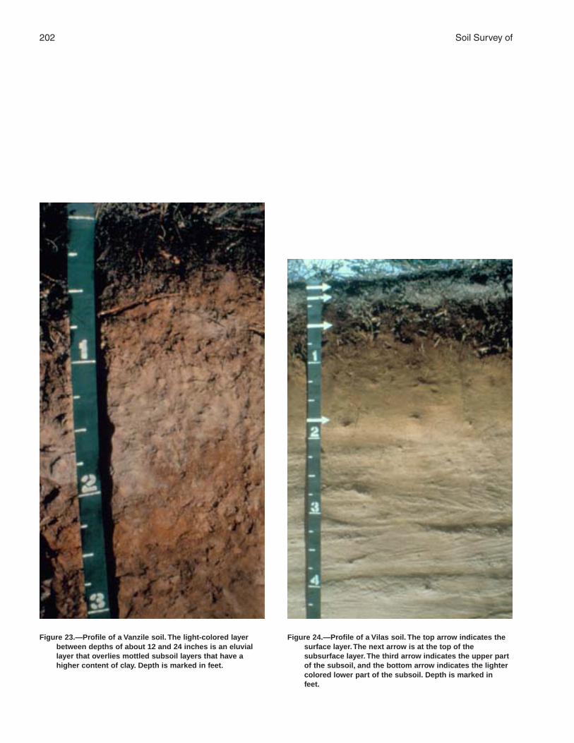
202 Soil Survey of
Figure 23.—Profile of a Vanzile soil. The light-colored layerbetween depths of about 12 and 24 inches is an eluviallayer that overlies mottled subsoil layers that have ahigher content of clay. Depth is marked in feet.
Figure 24.—Profile of a Vilas soil. The top arrow indicates thesurface layer. The next arrow is at the top of thesubsurface layer. The third arrow indicates the upper partof the subsoil, and the bottom arrow indicates the lightercolored lower part of the subsoil. Depth is marked infeet.

Florence County, Wisconsin 203
Permeability: Moderate or moderately rapid in theupper layers; moderately rapid or very rapid in thelower layers
Landform: Outwash plains and stream terracesParent material: Primarily loamy deposits underlain by
sandy and gravelly glacial outwashSlope range: 0 to 3 percent
Taxonomic classification: Sandy, mixed, frigidOxyaquic Haplorthods
Typical Pedon
Manitowish sandy loam, 0 to 3 percent slopes,approximately 750 feet east and 1,850 feet north ofthe southwest corner of sec. 31, T. 38 N., R. 16 E.
Oi—0 to 2 inches; very dark grayish brown (10YR 3/2)(broken face and rubbed) peat (fibric material,which is a mat of partially decomposed forestlitter); about 80 percent fiber, 45 percent rubbed;massive; very friable; many very fine and fine andfew medium and coarse roots; extremely acid (pH4.3 in water 1:1); abrupt wavy boundary.
E—2 to 4 inches; brown (7.5YR 5/2) sandy loam,pinkish gray (7.5YR 6/2) dry; weak mediumsubangular blocky structure; very friable; manyvery fine and fine and few medium and coarseroots; about 5 percent gravel; very strongly acid;abrupt smooth boundary.
Bs1—4 to 13 inches; dark brown (7.5YR 3/4) sandyloam; weak medium subangular blocky structure;very friable; many very fine and fine and fewmedium and coarse roots; about 10 percentgravel; very strongly acid; abrupt wavy boundary.
2Bs2—13 to 18 inches; brown (7.5YR 4/4) loamysand; weak medium subangular blocky structure;very friable; common very fine and fine and fewmedium and coarse roots; about 10 percentgravel; strongly acid; clear wavy boundary.
2BC—18 to 29 inches; strong brown (7.5YR 5/6)gravelly sand; single grain; loose; few very fine andfine roots; about 15 percent gravel and 3 percentcobbles; moderately acid; clear wavy boundary.
2C—29 to 62 inches; strong brown (7.5YR 4/6),stratified sand and gravelly sand; few fine distinctstrong brown (7.5YR 5/8) masses of ironaccumulation; single grain; loose; about 15 percentgravel and 3 percent cobbles; slightly acid.
Range in Characteristics
Thickness of the solum: 18 to 36 inchesContent of gravel: 0 to 35 percent in the solum; 15 to
35 percent in the substratumContent of cobbles: 0 to 5 percent throughout the
profile
Note: Unless otherwise indicated, depths andthicknesses are measured from the top of themineral soil.
O horizon:Hue—10YR, 7.5YR, 5YR, or NValue—2 to 3Chroma—0 to 2Texture—sapric, hemic, or fibric material
A horizon (if it occurs):Hue—10YR, 7.5YR, or 5YRValue—2 to 3Chroma—1 or 2Texture—sandy loam
E horizon:Hue—7.5YR or 5YRValue—4 or 5Chroma—2Texture—sandy loam
Bs horizon:Hue—7.5YR or 5YRValue—3 or 4Chroma—4Texture—sandy loam
2Bs horizon:Hue—7.5YR or 5YRValue—4Chroma—4Texture—loamy sand or gravelly loamy sand
2C horizon:Hue—10YR or 7.5YRValue—4 or 5Chroma—4 or 6Texture—gravelly sand, gravelly coarse sand,
stratified sand and gravelly sand, or stratifiedsand and gravelly coarse sand
Markey Series
Depth class: Very deepDrainage class: Very poorly drainedPermeability: Moderately slow to moderately rapid in
the organic material; very rapid in the substratumLandform: Outwash plains, glacial lake plains, and
morainesParent material: Herbaceous organic material 16 to 51
inches thick over sandy or sandy and gravellydeposits
Slope range: 0 to 1 percent
Taxonomic classification: Sandy or sandy-skeletal,mixed, euic Terric Borosaprists

204 Soil Survey of
Typical Pedon
Markey muck (fig. 18), in an area of Lupton, Cathro,and Markey mucks, 0 to 1 percent slopes,approximately 150 feet south and 200 feet east of thenorthwest corner of sec. 12, T. 38 N., R. 17 E.
Oa—0 to 17 inches; muck, black (N 2.5/0) broken faceand rubbed; about 35 percent fiber, 5 percentrubbed; massive; very friable; fibers are primarilyherbaceous; about 5 percent sand; neutral (pH 6.8in water 1:1); clear wavy boundary.
Oe—17 to 21 inches; mucky peat, black (N 2.5/0)broken face and rubbed; about 50 percent fiber, 15percent rubbed; massive; very friable; fibers areprimarily herbaceous; about 10 percent sand;neutral (pH 6.8 in water 1:1); clear smoothboundary.
O´a—21 to 36 inches; muck, black (N 2.5/0) brokenface and rubbed; about 30 percent fiber, 8 percentrubbed; massive; very friable; fibers are primarilyherbaceous; about 10 percent sand; neutral (pH6.9 in water 1:1); abrupt smooth boundary.
2C—36 to 60 inches; grayish brown (10YR 5/2) sand;single grain; loose; few thin strata and pockets ofloamy sand; about 3 percent gravel; neutral.
Range in Characteristics
Thickness of the organic material: 16 to 51 inchesKind of organic material: Dominantly muck; thin layers
of mucky peat or peat in most pedonsContent of woody fragments: 0 to 10 percent
Oa horizon:Hue—10YR, 7.5YR, 5YR, or NValue—2 to 3Chroma—0 to 3Texture—muck
2C horizon:Hue—2.5Y, 10YR, 7.5YR, or NValue—4 to 6Chroma—0 to 4Texture—sand, fine sand, loamy fine sand, or
gravelly sand
Metonga Series
Depth class: Moderately deep to hard igneous ormetamorphic bedrock
Drainage class: Well drainedPermeability: Moderate in the solum; very slow to rapid
in the bedrockLandform: MorainesParent material: Primarily loamy deposits over loamy
glacial till underlain by igneous or metamorphicbedrock
Slope range: 1 to 35 percent
Taxonomic classification: Coarse-loamy, mixed,frigid Entic Haplorthods
Typical Pedon
Metonga fine sandy loam, in an area of Rock outcrop-Metonga-Sarona complex, 1 to 15 percent slopes,approximately 300 feet south of the northwest cornerof sec. 2, T. 38 N., R. 17 E.
Oe—0 to 1 inch; dark brown (7.5YR 3/2) (broken faceand rubbed) mucky peat (hemic material, which isa mat of partially decomposed forest litter); about50 percent fiber, 20 percent rubbed; weak finegranular structure; very friable; many very fine andfine roots; very strongly acid (pH 4.9 in water 1:1);abrupt wavy boundary.
A—1 to 2 inches; black (10YR 2/1) fine sandy loam,dark gray (10YR 4/1) dry; weak fine granularstructure; very friable; many very fine and fineroots; very strongly acid; abrupt smooth boundary.
E—2 to 4 inches; brown (7.5YR 5/2) fine sandy loam,light gray (10YR 7/1) dry; weak fine subangularblocky structure; very friable; many very fine andfine roots; strongly acid; abrupt wavy boundary.
Bs1—4 to 9 inches; dark reddish brown (5YR 3/4) finesandy loam; moderate fine and mediumsubangular blocky structure; friable; many veryfine and fine roots; about 5 percent gravel; stronglyacid; clear wavy boundary.
Bs2—9 to 17 inches; brown (7.5YR 4/4) fine sandyloam; moderate fine and medium subangularblocky structure; friable; common fine roots; about5 percent gravel; moderately acid; clear wavyboundary.
2Bw—17 to 39 inches; dark reddish brown (5YR 3/4)gravelly sandy loam; weak medium subangularblocky structure; friable; few fine roots; about 15percent gravel; moderately acid; abrupt irregularboundary.
3R—39 inches; granite bedrock.
Range in Characteristics
Depth to bedrock: 20 to 40 inchesContent of gravel: 0 to 5 percent in the upper layers; 5
to 35 percent in the tillContent of cobbles: 0 to 5 percent in the upper layers;
0 to 10 percent in the tillNote: Unless otherwise indicated, depths and
thicknesses are measured from the top of themineral soil.

Florence County, Wisconsin 205
O horizon:Hue—10YR, 7.5YR, 5YR, or NValue—2 to 3Chroma—0 to 2Texture—sapric or hemic material
A horizon:Hue—10YR, 7.5YR, or 5YRValue—2 to 3Chroma—1 or 2Texture—fine sandy loam
E horizon:Hue—7.5YR or 5YRValue—4 to 6Chroma—2 or 3Texture—fine sandy loam
Bs horizon:Hue—7.5YR or 5YRValue—3 or 4Chroma—4Texture—fine sandy loam or sandy loam
2Bw horizon:Hue—7.5YR or 5YRValue—3 to 6Chroma—3 or 4Texture—sandy loam or gravelly sandy loam
3R layer:Type of bedrock—igneous or metamorphic
Minocqua Series
Depth class: Very deepDrainage class: Poorly drainedPermeability: Moderate in the upper layers; rapid or
very rapid in the lower layersLandform: Outwash plains and stream terracesParent material: Primarily loamy deposits underlain by
sandy or sandy and gravelly glacial outwashSlope range: 0 to 2 percent
Taxonomic classification: Coarse-loamy over sandyor sandy-skeletal, mixed, nonacid, frigid TypicEndoaquepts
Typical Pedon
Minocqua muck, 0 to 2 percent slopes, approximately2,900 feet south and 1,650 feet east of the northwestcorner of sec. 26, T. 38 N., R. 19 E.
Oa—0 to 5 inches; muck, black (N 2.5/0) broken faceand rubbed; about 30 percent fiber, 2 percentrubbed; weak fine granular structure; very friable;many very fine and fine roots; fibers are primarily
herbaceous; few branches and twigs; moderatelyacid (pH 6.0 in water 1:1); abrupt wavy boundary.
Eg—5 to 13 inches; grayish brown (10YR 5/2) finesandy loam, light gray (10YR 7/2) dry; weak thickplaty structure parting to weak fine subangularblocky; friable; common fine and very fine roots;few very dark gray (10YR 3/1) root channels;about 1 percent gravel; strongly acid; clear wavyboundary.
Bg—13 to 21 inches; gray (5Y 6/1) fine sandy loam;moderate medium and coarse subangular blockystructure; friable; few very fine and fine roots;many fine and medium prominent dark yellowishbrown (10YR 4/6) masses of iron accumulation;about 1 percent gravel; very strongly acid; abruptwavy boundary.
2BCg—21 to 25 inches; olive gray (5Y 4/2) gravellyloamy coarse sand; weak medium and coarsesubangular blocky structure; very friable; few fineprominent light yellowish brown (2.5Y 6/4) massesof iron accumulation; about 15 percent gravel;strongly acid; clear wavy boundary.
2Cg—25 to 60 inches; grayish brown (2.5Y 5/2) sandwith a few thin strata of gravelly sand; single grain;loose; few fine distinct light yellowish brown (2.5Y6/4) masses of iron accumulation; about 3 percentgravel; slightly acid.
Range in Characteristics
Thickness of the solum: 20 to 40 inchesThickness of the loamy mantle: 20 to 40 inchesContent of gravel: 0 to 15 percent in the solum; 3 to 50
percent in the substratumContent of cobbles: 0 to 5 percent throughout the
profile
Oa horizon:Hue—10YR, 7.5YR, or NValue—2 to 3Chroma—0 to 2Texture—muck
A horizon (if it occurs):Hue—10YR, 7.5YR, or 5YRValue—2 to 3Chroma—1 or 2Texture—silt loam, loam, sandy loam, or fine
sandy loam or the mucky analogs of thesetextures
Eg horizon:Hue—10YR or 7.5YRValue—4 to 6Chroma—1 or 2Texture—silt loam, loam, sandy loam, or fine
sandy loam

206 Soil Survey of
Bg horizon:Hue—5Y, 2.5Y, 10YR, or 7.5YRValue—4 to 6Chroma—1 or 2Texture—silt loam, loam, sandy loam, or fine
sandy loam
2C horizon:Hue—5Y, 2.5Y, 10YR, or 7.5YRValue—4 to 6Chroma—2 to 4Texture—sand or coarse sand or the gravelly or
very gravelly analogs of these textures
Morganlake Series
Depth class: Very deepDrainage class: Moderately well drainedPermeability: Moderately rapid or rapid in the upper
layers; moderately slow in the lower layersLandform: MorainesParent material: Sandy deposits underlain by silty or
loamy glacial tillSlope range: 0 to 6 percent
Taxonomic classification: Sandy over loamy, mixed,frigid Oxyaquic Haplorthods
Typical Pedon
Morganlake loamy fine sand, 0 to 6 percent slopes,approximately 1,800 feet west and 1,800 feet north ofthe southeast corner of sec. 16, T. 39 N., R. 18 E.
Ap—0 to 7 inches; dark brown (10YR 3/3) loamy finesand, grayish brown (10YR 5/2) dry; weakmedium granular structure; very friable; many veryfine and fine and few medium roots; strongly acid;abrupt smooth boundary.
E—7 to 8 inches; brown (7.5YR 5/2) loamy fine sand,light gray (5YR 7/1) dry; weak fine subangularblocky structure; very friable; common very fineand fine roots; moderately acid; abrupt brokenboundary.
Bs1—8 to 11 inches; dark brown (7.5YR 3/4) loamyfine sand; weak fine and medium subangularblocky structure; very friable; common very fineand fine roots; strongly acid; clear wavy boundary.
Bs2—11 to 26 inches; brown (7.5YR 4/4) loamy finesand; weak fine and medium subangular blockystructure; very friable; common very fine and fineroots; moderately acid; abrupt wavy boundary.
Bw—26 to 31 inches; strong brown (7.5YR 4/6) loamyfine sand; weak thick platy structure; very friable;few very fine and fine roots; common fine andmedium distinct strong brown (7.5YR 5/6 and 5/8)
masses of iron accumulation; about 3 percentgravel; moderately acid; abrupt smooth boundary.
2B/E—31 to 40 inches; about 80 percent dark reddishbrown (5YR 3/4) silty clay loam (2Bt); moderatemedium prismatic structure parting to strongmedium angular blocky; firm; common distinctdark reddish brown (2.5YR 3/4) clay films on facesof some peds and in some pores; penetrated bytongues of brown (7.5YR 5/3) silt loam (2E´), pink(7.5YR 7/3) dry; weak medium subangular blockystructure; friable; few very fine and fine roots; fewfine and medium prominent and distinct strongbrown (7.5YR 5/6 and 5/8) masses of ironaccumulation; about 4 percent gravel; moderatelyacid; clear wavy boundary.
2C—40 to 60 inches; dark reddish brown (2.5YR 3/4)silty clay loam; massive; firm; about 4 percentgravel; neutral.
Range in Characteristics
Thickness of the sandy mantle: 20 to 40 inchesContent of gravel: 0 to 5 percent in the upper part of
the solum; 3 to 15 percent in the lower part of thesolum and in the substratum
Ap horizon:Hue—10YR, 7.5YR, or 5YRValue—3 or 4Chroma—2 or 3Texture—loamy fine sand
E horizon:Hue—10YR, 7.5YR, or 5YRValue—4 to 6Chroma—2Texture—sand, loamy sand, loamy fine sand, or
fine sand
Bs horizon:Hue—7.5YR or 5YRValue—3 or 4Chroma—4Texture—sand, loamy sand, loamy fine sand, or
fine sand
Bw horizon:Hue—10YR, 7.5YR, or 5YRValue—4 to 6Chroma—4 or 6Texture—sand, loamy sand, or loamy fine sand
2E´ part of 2B/E horizon:Hue—7.5YR, 5YR, or 2.5YRValue—4 to 6Chroma—2 or 3Texture—silt loam, loam, sandy loam, fine sandy
loam, clay loam, or silty clay loam

Florence County, Wisconsin 207
2Bt part of 2B/E horizon and 2C horizon:Hue—5YR or 2.5YRValue—3 or 4Chroma—4Texture—silt loam, loam, silty clay loam, or clay
loam
Mudlake Series
Depth class: Very deepDrainage class: Somewhat poorly drainedPermeability: Moderate in the upper layers; moderate
or moderately rapid in the lower layersLandform: Drumlins and morainesParent material: Silty deposits underlain by sandy or
loamy glacial till or glacial mudflow sedimentSlope range: 1 to 6 percent
Taxonomic classification: Coarse-loamy, mixed,frigid Alfic Epiaquods
Typical Pedon
Mudlake silt loam, 1 to 6 percent slopes, very stony,approximately 1,200 feet east and 2,800 feet south ofthe northwest corner of sec. 32, T. 39 N., R. 17 E.
A—0 to 4 inches; very dark gray (10YR 3/1) silt loam,gray (10YR 5/1) dry; moderate fine and mediumgranular structure; very friable; many very fine andfine and common medium and coarse roots; about1 percent gravel and 1 percent cobbles;moderately acid; abrupt wavy boundary.
E—4 to 5 inches; brown (7.5YR 5/2) silt loam, pinkishgray (7.5YR 6/2) dry; moderate medium platystructure; friable; common very fine and fine andfew medium and coarse roots; about 1 percentgravel and 1 percent cobbles; strongly acid; abruptbroken boundary.
Bs—5 to 12 inches; brown (7.5YR 4/4) silt loam;moderate medium subangular blocky structure;friable; few very fine and fine roots; common finedistinct strong brown (7.5YR 5/6) masses of ironaccumulation; about 1 percent gravel and 1percent cobbles; moderately acid; clear wavyboundary.
E/B—12 to 27 inches; 70 percent brown (10YR 5/3)silt loam (E´), very pale brown (10YR 7/3) dry;moderate medium subangular blocky structure;friable; tonguing into and surrounding remnants ofbrown (7.5YR 4/4) silt loam (Bt); moderatemedium subangular blocky structure; friable; fewvery fine and fine roots; few fine distinct andprominent strong brown (7.5YR 5/6) masses ofiron accumulation and few fine distinct brown(7.5YR 5/2) iron depletions; about 1 percent gravel
and 1 percent cobbles; moderately acid; clearwavy boundary.
Bt1—27 to 34 inches; brown (7.5YR 4/4) silt loam;moderate medium subangular blocky structure;friable; few faint brown (7.5YR 4/3) clay films onfaces of some peds; common medium distinctstrong brown (7.5YR 5/6) masses of ironaccumulation and few fine distinct brown (7.5YR5/2) iron depletions; about 1 percent gravel and 1percent cobbles; moderately acid; clear wavyboundary.
2Bt2—34 to 43 inches; reddish brown (5YR 4/4) sandyloam; moderate medium subangular blockystructure; friable; few faint brown (7.5YR 4/3) clayfilms on faces of some peds; few fine distinctyellowish red (5YR 4/6) masses of ironaccumulation; about 12 percent gravel and 1percent cobbles; moderately acid; clear wavyboundary.
2C—43 to 70 inches; reddish brown (5YR 4/4) sandyloam; massive; friable; about 12 percent graveland 1 percent cobbles; moderately acid.
Range in Characteristics
Thickness of the solum: 30 to more than 60 inchesThickness of the silty mantle: 12 to 40 inchesContent of gravel: 0 to 5 percent in the upper part of
the solum; 5 to 35 percent in the lower part of thesolum and in the substratum
Content of cobbles: 0 to 15 percent throughout theprofile
Content of stones: 0 to 5 percent throughout the profilePercent of surface covered by stones: 0.1 to 3.0
percent
O horizon (if it occurs):Hue—10YR, 7.5YR, 5YR, or NValue—2 to 3Chroma—0 to 2Texture—sapric or hemic material
A horizon:Hue—10YR, 7.5YR, or 5YRValue—2 to 3Chroma—1 or 2Texture—silt loam
E horizon:Hue—10YR, 7.5YR, or 5YRValue—4 to 6Chroma—2 or 3Texture—silt loam or silt
Bs horizon:Hue—7.5YR or 5YRValue—3 or 4

208 Soil Survey of
Chroma—4Texture—silt loam
E´ part of E/B horizon:Hue—10YR, 7.5YR, or 5YRValue—5 or 6Chroma—3Texture—silt loam or silt
Bt horizon and Bt part of E/B horizon:Hue—7.5YR or 5YRValue—4 or 5Chroma—4 or 6Texture—silt loam
2Bt horizon:Hue—7.5YR or 5YRValue—3 to 6Chroma—4 or 6Texture—loam, fine sandy loam, sandy loam, or
loamy sand or the gravelly or cobbly analogs ofthese textures
2C horizon:Hue—7.5YR or 5YRValue—3 to 6Chroma—4 or 6Texture—sandy loam or loamy sand or the
gravelly or cobbly analogs of these textures
Padus Series
Depth class: Very deepDrainage class: Well drainedPermeability: Moderate in the solum; rapid or very
rapid in the substratumLandform: Outwash plains, stream terraces, eskers,
kames, drumlins, and morainesParent material: Loamy deposits underlain by sandy or
sandy and gravelly glacial outwashSlope range: 0 to 35 percent
Taxonomic classification: Coarse-loamy, mixed,frigid Alfic Haplorthods
Typical Pedon
Padus sandy loam (fig. 19), 0 to 6 percent slopes,approximately 2,100 feet west and 150 feet north ofthe southeast corner of sec. 30, T. 38 N., R. 16 E.
A—0 to 2 inches; dark brown (7.5YR 3/2) sandy loam,gray (N 5/0) dry; moderate medium and finegranular structure; friable; many very fine and fineand few medium and coarse roots; very stronglyacid; abrupt wavy boundary.
E—2 to 3 inches; pinkish gray (7.5YR 6/2) sandyloam, pinkish gray (7.5YR 7/2) dry; weak medium
subangular blocky structure; very friable; manyvery fine and fine and few medium and coarseroots; very strongly acid; abrupt broken boundary.
Bs1—3 to 8 inches; dark brown (7.5YR 3/4) sandyloam; moderate medium subangular blockystructure; friable; common very fine and fine andfew medium and coarse roots; very strongly acid;abrupt wavy boundary.
Bs2—8 to 19 inches; brown (7.5YR 4/4) sandy loam;moderate medium subangular blocky structure;friable; common very fine and fine and fewmedium and coarse roots; very strongly acid; clearwavy boundary.
E/B—19 to 26 inches; about 85 percent brown (10YR5/3) sandy loam (E´), very pale brown (10YR 7/3)dry; weak very thick platy structure; friable;extending into and surrounding remnants of brown(7.5YR 4/4) sandy loam (Bt); moderate mediumsubangular blocky structure; friable; few fine roots;very strongly acid; gradual wavy boundary.
B/E—26 to 38 inches; about 80 percent brown (7.5YR4/4) sandy loam (Bt); moderate medium andcoarse subangular blocky structure; friable; fewfaint dark brown (7.5YR 3/4) clay films on faces ofpeds; penetrated by tongues of brown (10YR 5/3)sandy loam (E´), very pale brown (10YR 7/3) dry;moderate fine subangular blocky structure; friable;about 12 percent gravel; very strongly acid; abruptwavy boundary.
2C—38 to 60 inches; yellowish brown (10YR 5/4),stratified sand and gravelly coarse sand; singlegrain; loose; about 20 percent gravel; slightly acid.
Range in Characteristics
Thickness of the solum: 24 to 40 inchesThickness of the loamy mantle: 24 to 40 inchesContent of gravel: 0 to 15 percent in the upper part of
the solum; 3 to 50 percent in the lower part of thesolum and in the substratum
Content of cobbles: 0 to 5 percent throughout theprofile
O horizon (if it occurs):Hue—10YR, 7.5YR, or NValue—2 to 3Chroma—0 or 2Texture—sapric or hemic material
A horizon:Hue—10YR, 7.5YR, or 5YRValue—2 to 3Chroma—1 or 2Texture—sandy loam
E horizon:Hue—10YR, 7.5YR, or 5YR

Florence County, Wisconsin 209
Value—4 to 6Chroma—2 or 3Texture—sandy loam
Bs horizon:Hue—7.5YR or 5YRValue—3 or 4Chroma—4Texture—sandy loam
E´ part of E/B and B/E horizons:Hue—10YR, 7.5YR, or 5YRValue—4 or 5Chroma—3Texture—sandy loam, fine sandy loam, or loam
Bt part of E/B and B/E horizons:Hue—10YR, 7.5YR, or 5YRValue—4 or 5Chroma—4 or 6Texture—sandy loam, fine sandy loam, or loam
2C horizon:Hue—10YR, 7.5YR, or 5YRValue—4 to 6Chroma—3 to 6Texture—stratified sand or coarse sand or the
gravelly or very gravelly analogs of thesetextures
Pence Series
Depth class: Very deepDrainage class: Somewhat excessively drainedPermeability: Moderate or moderately rapid in the
upper layers; moderately rapid to very rapid in thelower layers
Landform: Outwash plains, stream terraces, eskers,and kames
Parent material: Loamy deposits underlain by sandyand gravelly glacial outwash
Slope range: 0 to 35 percent
Taxonomic classification: Sandy, mixed, frigid EnticHaplorthods
Typical Pedon
Pence sandy loam (fig. 20), 0 to 6 percent slopes,approximately 3,100 feet north and 2,400 feet east ofthe southwest corner of sec. 8, T. 39 N., R. 19 E.
A—0 to 3 inches; black (N 2.5/0) sandy loam, darkgray (10YR 4/1) dry; weak fine and mediumgranular structure; very friable; many very fine andfine and few medium roots; many uncoated sandgrains; few charcoal fragments; strongly acid;abrupt smooth boundary.
E—3 to 4 inches; brown (7.5YR 5/2) sandy loam,pinkish gray (7.5YR 7/2) dry; weak fine subangularblocky structure; very friable; common very fineand fine roots; strongly acid; abrupt smoothboundary.
Bs1—4 to 7 inches; dark brown (7.5YR 3/4) sandyloam; weak medium subangular blocky structure;very friable; common very fine and fine roots; fewblack (10YR 2/1) wormcasts; about 1 percentgravel; strongly acid; clear wavy boundary.
Bs2—7 to 15 inches; brown (7.5YR 4/4) sandy loam;weak medium and coarse subangular blockystructure; very friable; few very fine and fine roots;about 1 percent gravel; strongly acid; clear wavyboundary.
2BC—15 to 31 inches; strong brown (7.5YR 4/6)gravelly coarse sand; weak coarse subangularblocky structure; very friable; about 25 percentgravel; slightly acid; clear wavy boundary.
2C—31 to 60 inches; brown (7.5YR 5/4), stratifiedsand and gravelly coarse sand; single grain; loose;about 20 percent gravel; slightly acid.
Range in Characteristics
Thickness of the solum: 18 to 36 inchesThickness of the loamy mantle: 10 to 20 inchesContent of gravel: 0 to 35 percent in the upper part of
the solum; 3 to 35 percent in the lower part of thesolum; 15 to 35 percent in the substratum
Content of cobbles: 0 to 10 percent throughout theprofile
O horizon (if it occurs):Hue—10YR, 7.5YR, 5YR, or NValue—2 to 3Chroma—0 to 2Texture—hemic or sapric material
A horizon:Hue—10YR, 7.5YR, 5YR, or NValue—2 to 3Chroma—0 to 2Texture—sandy loam
E horizon:Hue—7.5YR or 5YRValue—4 to 6Chroma—2Texture—sandy loam
Bs horizon:Hue—7.5YR or 5YRValue—3 or 4Chroma—4Texture—sandy loam, loam, gravelly sandy loam,
or gravelly loam

210 Soil Survey of
2C horizon:Hue—10YR, 7.5YR, or 5YRValue—4 to 6Chroma—4 or 6Texture—gravelly sand, gravelly coarse sand,
stratified sand and gravelly sand, or stratifiedsand and gravelly coarse sand
Robago Series
Depth class: Very deepDrainage class: Somewhat poorly drainedPermeability: ModerateLandform: Outwash plains, glacial lake plains, and
morainesParent material: Primarily loamy deposits underlain by
stratified lacustrine depositsSlope range: 0 to 2 percent
Taxonomic classification: Coarse-loamy, mixed,frigid Argic Endoaquods
Typical Pedon
Robago fine sandy loam, 0 to 2 percent slopes,approximately 1,350 feet south and 700 feet east ofthe northwest corner of sec. 36, T. 38 N., R. 16 E.
Oa—0 to 2 inches; black (10YR 2/1) (broken face andrubbed) muck (sapric material, which is a mat ofpartially decomposed forest litter); about 40percent fiber, 10 percent rubbed; weak finegranular structure; very friable; many very fine andfine and few medium and coarse roots; extremelyacid (pH 4.3 in water 1:1); abrupt wavy boundary.
E—2 to 7 inches; grayish brown (10YR 5/2) fine sandyloam, light gray (10YR 7/1) dry; weak mediumplaty structure; friable; few very fine and fine roots;very strongly acid; clear broken boundary.
Bs1—7 to 11 inches; dark brown (7.5YR 3/4) finesandy loam; weak medium and coarse subangularblocky structure; friable; few fine prominentyellowish red (5YR 5/6) masses of ironaccumulation; very strongly acid; clear wavyboundary.
Bs2—11 to 17 inches; brown (7.5YR 4/4) fine sandyloam; weak medium and coarse subangular blockystructure; friable; many fine distinct strong brown(7.5YR 4/6) masses of iron accumulation; stronglyacid; clear wavy boundary.
E´—17 to 20 inches; brown (10YR 5/3) fine sandyloam, very pale brown (10YR 7/3) dry; weak verythick platy structure; friable; many fine prominentstrong brown (7.5YR 5/8) masses of ironaccumulation; moderately acid; clear wavyboundary.
E/B—20 to 27 inches; 70 percent brown (10YR 5/3)fine sandy loam (E´), very pale brown (10YR 7/3)dry; weak very thick platy structure; friable;tonguing into and surrounding remnants of brown(7.5YR 4/4) fine sandy loam (Bt); moderatemedium and coarse subangular blocky structure;friable; few faint brown (7.5YR 4/3) clay films onfaces of some peds; many medium prominentyellowish red (5YR 4/6) masses of ironaccumulation and few fine faint and prominent lightbrownish gray (10YR 6/2) iron depletions; slightlyacid; clear wavy boundary.
B/E—27 to 38 inches; 70 percent brown (7.5YR 4/4)fine sandy loam (Bt); moderate medium and coarsesubangular blocky structure; friable; few faint brown(7.5YR 4/3) clay films on faces of some peds;penetrated by tongues of brown (10YR 5/3) finesandy loam (E´), very pale brown (10YR 7/3) dry;moderate fine subangular blocky structure; friable;many medium prominent red (2.5YR 4/8) masses ofiron accumulation and few fine prominent and faintlight brownish gray (10YR 6/2) iron depletions;slightly acid; abrupt wavy boundary.
C—38 to 62 inches; dark yellowish brown (10YR 4/4),stratified very fine sandy loam and silt loam withthin strata of very fine sand and fine sand;massive; friable; many medium distinct grayishbrown (10YR 5/2) iron depletions and manymedium prominent strong brown (7.5YR 4/6)masses of iron accumulation; neutral.
Range in Characteristics
Thickness of the solum: 24 to 40 inchesContent of gravel: 0 to 10 percent throughout the
profileNote: Unless otherwise indicated, depths and
thicknesses are measured from the top of themineral soil.
O horizon:Hue—10YR, 7.5YR, or NValue—2 to 3Chroma—0 to 2Texture—sapric or hemic material
A horizon (if it occurs):Hue—10YR, 7.5YR, or 5YRValue—2 to 3Chroma—1 or 2Texture—fine sandy loam
E horizon:Hue—10YR, 7.5YR, or 5YRValue—5 or 6Chroma—2Texture—fine sandy loam

Florence County, Wisconsin 211
Bs horizon:Hue—7.5YR or 5YRValue—3 or 4Chroma—4Texture—fine sandy loam or sandy loam
E´ horizon and E´ part of E/B and B/E horizons:Hue—10YR, 7.5YR, or 5YRValue—5Chroma—3Texture—sandy loam or fine sandy loam
Bt part of E/B and B/E horizons:Hue—7.5YR or 5YRValue—4Chroma—4Texture—fine sandy loam or sandy loam
C horizon:Hue—10YR, 7.5YR, or 5YRValue—4 or 5Chroma—4Texture—stratified fine sand, very fine sand, very
fine sandy loam, and silt loam
Rousseau Series
Depth class: Very deepDrainage class: Well drainedPermeability: RapidLandform: Outwash plains, moraines, and glacial lake
plainsParent material: Sandy glacial outwash or lacustrine
depositsSlope range: 0 to 15 percent
Taxonomic classification: Sandy, mixed, frigid EnticHaplorthods
Typical Pedon
Rousseau loamy fine sand, 0 to 6 percent slopes,approximately 1,200 feet south and 100 feet east ofthe northwest corner of sec. 3, T. 38 N., R. 19 E.
A—0 to 3 inches; very dark gray (10YR 3/1) loamy finesand, dark gray (10YR 4/1) dry; weak fine granularstructure; very friable; many very fine and fine andfew medium and coarse roots; moderately acid;abrupt wavy boundary.
E—3 to 6 inches; brown (7.5YR 4/2) loamy fine sand,pinkish gray (7.5YR 6/2) dry; weak fine subangularblocky structure; very friable; common very fineand fine and few medium and coarse roots; verystrongly acid; clear wavy boundary.
Bs—6 to 12 inches; dark brown (7.5YR 3/4) loamy finesand; weak fine subangular blocky structure; very
friable; common very fine and fine and fewmedium and coarse roots; strongly acid; clearwavy boundary.
BC1—12 to 31 inches; brown (7.5YR 4/4) fine sand;weak fine subangular blocky structure; veryfriable; common very fine and fine and fewmedium and coarse roots; strongly acid; clearwavy boundary.
BC2—31 to 36 inches; brown (7.5YR 5/4) fine sand;weak coarse subangular blocky structure; veryfriable; few very fine and fine roots; strongly acid;clear wavy boundary.
C—36 to 60 inches; yellowish brown (10YR 5/4) finesand; single grain; loose; strongly acid.
Range in Characteristics
Thickness of the solum: 20 to 45 inches
O horizon (if it occurs):Hue—10YR, 7.5YR, 5YR, or NValue—2 to 3Chroma—0 to 2Texture—sapric or hemic material
A horizon:Hue—10YR, 7.5YR, 5YR, or NValue—2 to 3Chroma—0 to 2Texture—loamy fine sand
E horizon:Hue—7.5YR or 5YRValue—4 to 6Chroma—2Texture—fine sand or loamy fine sand
Bs horizon:Hue—7.5YR or 5YRValue—3 or 4Chroma—4Texture—fine sand or loamy fine sand
C horizon:Hue—10YR, 7.5YR, or 5YRValue—5 or 6Chroma—3 to 6Texture—fine sand
Sarona Series
Depth class: Very deepDrainage class: Well drainedPermeability: Moderate or moderately rapidLandform: Drumlins and morainesParent material: Primarily loamy deposits underlain by

212 Soil Survey of
loamy or sandy glacial till or glacial mudflowsediment
Slope range: 1 to 35 percent
Taxonomic classification: Coarse-loamy, mixed,frigid Alfic Haplorthods
Typical Pedon
Sarona fine sandy loam (fig. 21), 1 to 6 percentslopes, very stony, approximately 70 feet east and 300feet north of the southwest corner of sec. 24, T. 38 N.,R. 17 E.
Oa—0 to 1 inch; black (10YR 2/1) (broken face andrubbed) muck (sapric material, which is a mat ofpartially decomposed forest litter); about 25percent fiber, 5 percent rubbed; weak fine granularstructure; very friable; extremely acid (pH 4.3 inwater 1:1); abrupt wavy boundary.
E—1 to 3 inches; brown (7.5YR 5/2) fine sandy loam,pinkish gray (7.5YR 6/2) dry; weak thick platystructure; friable; many very fine and fine and fewmedium and coarse roots; about 5 percent graveland 2 percent cobbles; very strongly acid; abruptwavy boundary.
Bs—3 to 17 inches; brown (7.5YR 4/4) fine sandyloam; weak fine and medium subangular blockystructure; friable; many very fine and fine andcommon medium and coarse roots; about 5percent gravel and 2 percent cobbles; moderatelyacid; abrupt wavy boundary.
E/B—17 to 29 inches; about 60 percent brown (7.5YR5/3) fine sandy loam (E´), pink (7.5YR 7/3) dry;weak thick platy structure; friable; tonguing intoand surrounding remnants of brown (7.5YR 4/4)sandy loam (Bt); moderate medium subangularblocky structure; friable; common very fine andfine roots; about 8 percent gravel and 2 percentcobbles; slightly brittle; moderately acid; clearwavy boundary.
B/E—29 to 48 inches; about 60 percent dark reddishbrown (5YR 3/4) gravelly sandy loam (Bt); weakfine subangular blocky structure; friable; breaks toweak thick plates along horizontal cleavage planesinherited from the parent material; common faintreddish brown (5YR 4/4) clay films on faces ofpeds; penetrated by tongues of brown (7.5YR 5/3)gravelly loamy sand (E´), pink (7.5YR 7/3) dry;weak medium platy structure; friable; few very fineand fine roots; many very fine and fine and fewmedium vesicular pores; about 15 percent graveland 5 percent cobbles; slightly brittle; moderatelyacid; abrupt wavy boundary.
Bt—48 to 66 inches; dark reddish brown (5YR 3/4)gravelly sandy loam; weak fine subangular blocky
structure; friable; breaks to weak thick plates alonghorizontal cleavage planes inherited from theparent material; many very fine and fine and fewmedium vesicular pores; common faint reddishbrown (5YR 4/4) clay films on faces of peds and insome pores; about 15 percent gravel and 5percent cobbles; slightly brittle; moderately acid;gradual wavy boundary.
C—66 to 73 inches; reddish brown (5YR 4/4) gravellysandy loam; massive; friable; about 20 percentgravel and 5 percent cobbles; slightly acid.
Range in Characteristics
Thickness of the solum: 35 to more than 60 inchesContent of gravel: 1 to 35 percent throughout the
profileContent of cobbles: 0 to 10 percent throughout the
profileContent of stones: 0 to 5 percent throughout the profilePercent of surface covered by stones: 0.1 to 3.0
percentNote: Unless otherwise indicated, depths and
thicknesses are measured from the top of themineral soil.
O horizon:Hue—10YR, 7.5YR, or NValue—2 to 3Chroma—0 to 2Texture—sapric or hemic material
A horizon (if it occurs):Hue—10YR, 7.5YR, or 5YRValue—2 to 3Chroma—1 or 2Texture—fine sandy loam
E horizon:Hue—10YR, 7.5YR, or 5YRValue—4 to 6Chroma—2 or 3Texture—fine sandy loam
Bs horizon:Hue—7.5YR or 5YRValue—3 or 4Chroma—4Texture—fine sandy loam or sandy loam
E´ part of E/B and B/E horizons:Hue—10YR, 7.5YR, or 5YRValue—5 or 6Chroma—3Texture—fine sandy loam, sandy loam, loamy
sand, or loamy fine sand or the gravelly analogsof these textures

Florence County, Wisconsin 213
Bt horizon and Bt part of E/B and B/E horizons:Hue—10YR, 7.5YR, 5YR, or 2.5YRValue—3 or 4Chroma—4 or 6Texture—loamy sand, sandy loam, gravelly loamy
sand, or gravelly sandy loam
C horizon:Hue—10YR, 7.5YR, 5YR, or 2.5YRValue—4 to 6Chroma—4 or 6Texture—loamy sand, sandy loam, gravelly loamy
sand, or gravelly sandy loam
Sayner Series
Depth class: Very deepDrainage class: Excessively drainedPermeability: Moderately rapid or rapid in the solum;
rapid or very rapid in the substratumLandform: Outwash plains, stream terraces, kames,
and eskersParent material: Primarily sandy deposits underlain by
sandy and gravelly glacial outwashSlope range: 0 to 30 percent
Taxonomic classification: Sandy, mixed, frigid EnticHaplorthods
Typical Pedon
Sayner loamy sand, 6 to 15 percent slopes,approximately 400 feet west and 2,200 feet south ofthe northeast corner of sec. 4, T. 40 N., R. 15 E.
Oe—0 to 3 inches; black (10YR 2/1) (broken face andrubbed) mucky peat (hemic material, which is amat of partially decomposed forest litter); about 50percent fiber, 20 percent rubbed; weak finegranular structure; very friable; many very fine andfine roots; extremely acid (pH 4.2 in water 1:1);abrupt wavy boundary.
E—3 to 4 inches; dark reddish gray (5YR 4/2) loamysand, pinkish gray (5YR 6/2) dry; weak fine andmedium subangular blocky structure; very friable;common very fine and fine roots; about 5 percentgravel; very strongly acid; clear wavy boundary.
Bs1—4 to 7 inches; dark reddish brown (5YR 3/4)loamy sand; weak fine and medium subangularblocky structure; very friable; common very fineand fine roots; about 5 percent gravel; stronglyacid; clear wavy boundary.
Bs2—7 to 17 inches; reddish brown (5YR 4/4) loamysand; weak fine and medium subangular blocky
structure; very friable; common very fine and fineroots; about 5 percent gravel; strongly acid; clearwavy boundary.
Bs3—17 to 27 inches; brown (7.5YR 4/4) gravellysand; weak coarse subangular blocky structure;very friable; few very fine and fine roots; about 15percent gravel; moderately acid; abrupt wavyboundary.
C—27 to 63 inches; strong brown (7.5YR 5/6) gravellysand; single grain; loose; about 25 percent gravel;moderately acid.
Range in Characteristics
Thickness of the solum: 12 to 36 inchesContent of gravel: 0 to 35 percent in the solum; 15 to
35 percent in the substratumContent of cobbles: 0 to 10 percent throughout the
profileNote: Unless otherwise indicated, depths and
thicknesses are measured from the top of themineral soil.
O horizon:Hue—10YR, 7.5YR, or NValue—2 to 3Chroma—0 to 2Texture—sapric or hemic material
A horizon (if it occurs):Hue—10YR, 7.5YR, or 5YRValue—2 to 3Chroma—1 or 2Texture—loamy sand
E horizon:Hue—10YR, 7.5YR, or 5YRValue—4 to 6Chroma—2Texture—loamy sand
Bs horizon:Hue—7.5YR or 5YRValue—3 or 4Chroma—4Texture—loamy sand, sand, gravelly loamy sand,
or gravelly sand
C horizon:Hue—10YR, 7.5YR, or 5YRValue—4 to 6Chroma—4 or 6Texture—gravelly sand, stratified sand and
gravelly sand, or stratified sand and gravellycoarse sand

214 Soil Survey of
Soperton Series
Depth class: Moderately deep to a fragipanDrainage class: Well drainedPermeability: Moderate in the upper layers, slow in the
fragipan, and moderate or moderately rapid in thesubstratum
Landform: Drumlins and morainesParent material: Primarily silty deposits underlain by
loamy or sandy glacial till or glacial mudflowsediment
Slope range: 15 to 35 percent
Taxonomic classification: Coarse-loamy, mixed,frigid Alfic Fragiorthods
Typical Pedon
Soperton silt loam, in an area of Soperton-Goodmansilt loams, 15 to 35 percent slopes, very stony,approximately 1,100 feet east and 20 feet south of thenorthwest corner of sec. 8, T. 40 N., R. 15 E.
Oa—0 to 1 inch; black (10YR 2/1) (broken face andrubbed) muck (sapric material, which is a mat ofpartially decomposed forest litter); about 25percent fiber, 10 percent rubbed; weak finegranular structure; very friable; many very fine andfine and common medium roots; extremely acid(pH 4.1 in water 1:1); abrupt smooth boundary.
A—1 to 3 inches; black (10YR 2/1) silt loam, gray(10YR 5/1) dry; moderate fine and mediumgranular structure; friable; many very fine and fineand common medium roots; moderately acid;abrupt wavy boundary.
E—3 to 5 inches; brown (7.5YR 5/2) silt loam, pinkishgray (7.5YR 6/2) dry; weak thick platy structure;friable; common very fine and fine and fewmedium roots; moderately acid; abrupt brokenboundary.
Bs1—5 to 9 inches; dark brown (7.5YR 3/4) silt loam;moderate fine and medium subangular blockystructure; friable; few very fine, fine, and mediumroots; strongly acid; clear wavy boundary.
Bs2—9 to 15 inches; brown (7.5YR 4/4) silt loam;moderate fine subangular blocky structure; friable;few very fine, fine, and medium roots; moderatelyacid; clear wavy boundary.
E´—15 to 22 inches; brown (10YR 5/3) silt loam, verypale brown (10YR 7/3) dry; moderate thick platystructure; friable; few very fine and fine roots;moderately acid; clear wavy boundary.
2B/Ex—22 to 31 inches; 80 percent brown (7.5YR 4/4)sandy loam (2Bt); strong coarse prismaticstructure parting to moderate medium subangularblocky; firm; brittle; few faint dark brown (7.5YR
3/4) clay films on faces of some peds and in somepores; penetrated by tongues of brown (10YR 5/3)sandy loam (2E´), very pale brown (10YR 7/3) dry;moderate medium subangular blocky structure;firm; brittle; common very fine vesicular pores;about 10 percent gravel and 2 percent cobbles;moderately acid; clear wavy boundary.
2BCx—31 to 42 inches; brown (7.5YR 4/4) sandyloam; moderate coarse prismatic structure partingto moderate medium and coarse subangularblocky; firm; brittle; common very fine vesicularpores; about 10 percent gravel and 2 percentcobbles; moderately acid; clear wavy boundary.
2C—42 to 61 inches; brown (7.5YR 4/4) gravellyloamy sand with a few chunks of sandy loam;massive; friable; about 20 percent gravel and 3percent cobbles; slightly acid.
Range in Characteristics
Thickness of the solum: 40 to more than 60 inchesThickness of the silty mantle: 12 to 36 inchesDepth to the fragipan: 20 to 40 inchesContent of gravel: 0 to 10 percent in the upper part of
the solum; 5 to 25 percent in the lower part of thesolum and in the substratum
Content of cobbles: 0 to 10 percent in the upper part ofthe solum; 0 to 20 percent in the lower part of thesolum and in the substratum
Content of stones: 0 to 5 percent throughout the profilePercent of surface covered by stones: 0.1 to 3.0
percentNote: Unless otherwise indicated, depths and
thicknesses are measured from the top of themineral soil.
O horizon:Hue—10YR, 7.5YR, or NValue—2 to 3Chroma—0 or 2Texture—sapric or hemic material
A horizon:Hue—10YR, 7.5YR, or 5YRValue—2 to 3Chroma—1 or 2Texture—silt loam
E horizon:Hue—10YR, 7.5YR, or 5YRValue—4 to 7Chroma—2 or 3Texture—silt loam or silt
Bs horizon:Hue—7.5YR or 5YRValue—3 or 4

Florence County, Wisconsin 215
Chroma—4Texture—silt loam
E´ horizon:Hue—10YR or 7.5YRValue—4 to 7Chroma—2 or 3Texture—silt loam or silt
2E´ part of 2B/Ex horizon:Hue—10YR or 7.5YRValue—4 to 7Chroma—2 or 3Texture—sandy loam, loamy sand, or loam or the
gravelly or cobbly analogs of these textures
2Bt part of 2B/Ex horizon:Hue—10YR or 7.5YRValue—3 to 5Chroma—4 or 6Texture—sandy loam or loam or the gravelly or
cobbly analogs of these textures
2C horizon:Hue—10YR or 7.5YRValue—3 to 6Chroma—4 or 6Texture—sandy loam or loamy sand or the
gravelly or cobbly analogs of these textures
Stambaugh Series
Depth class: Very deepDrainage class: Well drainedPermeability: Moderately slow in the solum; very rapid
in the substratumLandform: Outwash plains, stream terraces, drumlins,
and morainesParent material: Primarily silty deposits underlain by
sandy and gravelly glacial outwashSlope range: 6 to 25 percent
Taxonomic classification: Coarse-silty over sandy orsandy-skeletal, mixed, frigid Alfic Haplorthods
Typical Pedon
Stambaugh silt loam, 6 to 15 percent slopes,approximately 2,660 feet south and 1,600 feet west ofthe northeast corner of sec. 36, T. 38 N., R. 16 E.
Oi—0 to 1 inch; very dark grayish brown (10YR 3/2)(broken face and rubbed) peat (fibric material,which is a mat of partially decomposed forestlitter); about 80 percent fiber, 55 percent rubbed;massive; very friable; many very fine and fine andfew medium and coarse roots; strongly acid (pH5.5 in water 1:1); abrupt smooth boundary.
A—1 to 4 inches; black (10YR 2/1) silt loam, gray(10YR 5/1) dry; moderate medium granularstructure; friable; many very fine and fine and fewmedium and coarse roots; moderately acid; abruptwavy boundary.
E—4 to 6 inches; grayish brown (10YR 5/2) silt loam,light gray (10YR 7/2) dry; weak medium platystructure; friable; many very fine and fine and fewmedium and coarse roots; moderately acid; abruptirregular boundary.
Bs1—6 to 9 inches; dark brown (7.5YR 3/4) silt loam;moderate medium subangular blocky structure;friable; many very fine and fine and few mediumand coarse roots; very strongly acid; clear wavyboundary.
Bs2—9 to 17 inches; brown (7.5YR 4/4) silt loam;moderate medium subangular blocky structure;friable; common very fine and fine and fewmedium and coarse roots; very strongly acid;abrupt wavy boundary.
E/B—17 to 24 inches; 70 percent brown (10YR 5/3)silt loam (E´), very pale brown (10YR 7/3) dry;weak thin platy structure; friable; tonguing into andsurrounding remnants of brown (7.5YR 4/4) siltloam (Bt); moderate medium subangular blockystructure; friable; few very fine and fine roots;about 1 percent gravel; very strongly acid; clearwavy boundary.
B/E—24 to 33 inches; 70 percent brown (7.5YR 4/4)silt loam (Bt); moderate medium subangularblocky structure; friable; few faint dark brown(7.5YR 3/4) clay films on faces of some peds;penetrated by tongues of brown (10YR 5/3) siltloam (E´), very pale brown (10YR 7/3) dry;moderate fine subangular blocky structure; friable;about 2 percent gravel; very strongly acid; clearwavy boundary.
2C—33 to 61 inches; dark yellowish brown (10YR4/4), stratified sand and gravelly coarse sand;single grain; loose; about 25 percent gravel;slightly acid.
Range in Characteristics
Thickness of the solum: 24 to 40 inchesThickness of the silty mantle: 24 to 40 inchesContent of gravel: 0 to 5 percent in the solum; 25 to 55
percent in the substratumContent of cobbles: 0 to 5 percent throughout the
profileNote: Unless otherwise indicated, depths and
thicknesses are measured from the top of themineral soil.
O horizon:Hue—10YR, 7.5YR, 5YR, or N

216 Soil Survey of
Value—2 to 3Chroma—0 to 2Texture—sapric, hemic, or fibric material
A horizon:Hue—10YR, 7.5YR, or 5YRValue—2 to 3Chroma—1 or 2Texture—silt loam
E horizon:Hue—10YR or 7.5YRValue—4 or 5Chroma—2Texture—silt loam
Bs horizon:Hue—7.5YR or 5YRValue—3 or 4Chroma—4Texture—silt loam
E´ part of E/B and B/E horizons:Hue—10YR, 7.5YR, or 5YRValue—4 or 5Chroma—2 or 3Texture—silt loam or very fine sandy loam
Bt part of E/B and B/E horizons:Hue—7.5YR or 5YRValue—4Chroma—4Texture—silt loam
C horizon:Hue—10YR or 7.5YRValue—4 or 5Chroma—3 to 6Texture—gravelly sand, very gravelly sand, or
stratified sand and gravelly coarse sand
Tipler Series
Depth class: Very deepDrainage class: Moderately well drainedPermeability: Moderate in the solum; rapid or very
rapid in the substratumLandform: Outwash plains and stream terracesParent material: Loamy deposits underlain by sandy or
sandy and gravelly glacial outwashSlope range: 0 to 3 percent
Taxonomic classification: Coarse-loamy, mixed,frigid Oxyaquic Haplorthods
Typical Pedon
Tipler sandy loam (fig. 22), 0 to 3 percent slopes,
approximately 2,100 feet east and 400 feet north ofthe southwest corner of sec. 22, T. 38 N., R. 16 E.
A—0 to 2 inches; very dark grayish brown (10YR 3/2)sandy loam, gray (10YR 5/1) dry; moderatemedium granular structure; friable; many very fineand fine and few medium roots; very strongly acid;abrupt wavy boundary.
E—2 to 4 inches; brown (7.5YR 5/2) sandy loam,pinkish gray (7.5YR 6/2) dry; moderate mediumand coarse subangular blocky structure; friable;many very fine and fine and few medium roots;common dark brown (7.5YR 3/2) wormcasts; verystrongly acid; abrupt wavy boundary.
Bs1—4 to 8 inches; dark reddish brown (5YR 3/4)sandy loam; moderate medium subangular blockystructure; friable; many very fine and fine and fewmedium roots; very strongly acid; clear wavyboundary.
Bs2—8 to 15 inches; brown (7.5YR 4/4) sandy loam;moderate medium and coarse subangular blockystructure; friable; common very fine and fine roots;strongly acid; clear wavy boundary.
E/B—15 to 22 inches; 70 percent brown (7.5YR 5/3)sandy loam (E´), pink (7.5YR 7/3) dry; weak verythick platy structure; friable; tonguing into andsurrounding remnants of brown (7.5YR 4/4) sandyloam (Bt); moderate medium subangular blockystructure; friable; few very fine and fine roots;about 5 percent gravel; strongly acid; clear wavyboundary.
B/E—22 to 31 inches; 70 percent brown (7.5YR 4/4)sandy loam (Bt); moderate medium subangularblocky structure; friable; few faint dark brown(7.5YR 3/4) clay films on faces of some peds;penetrated by tongues of brown (7.5YR 5/3) sandyloam (E´), pink (7.5YR 7/3) dry; moderate finesubangular blocky structure; friable; few fineprominent yellowish brown (10YR 5/8) masses ofiron accumulation; about 5 percent gravel; stronglyacid; abrupt wavy boundary.
2C—31 to 60 inches; brown (10YR 5/3 and 4/3),stratified sand and gravelly coarse sand; singlegrain; loose; few fine prominent yellowish brown(10YR 5/8) masses of iron accumulation; about 15percent gravel; slightly acid.
Range in Characteristics
Thickness of the solum: 24 to 40 inchesThickness of the loamy mantle: 24 to 40 inchesContent of gravel: 0 to 15 percent in the upper part of
the solum; 3 to 35 percent in the lower part of thesolum; 3 to 50 percent in the substratum
Content of cobbles: 0 to 5 percent throughout theprofile
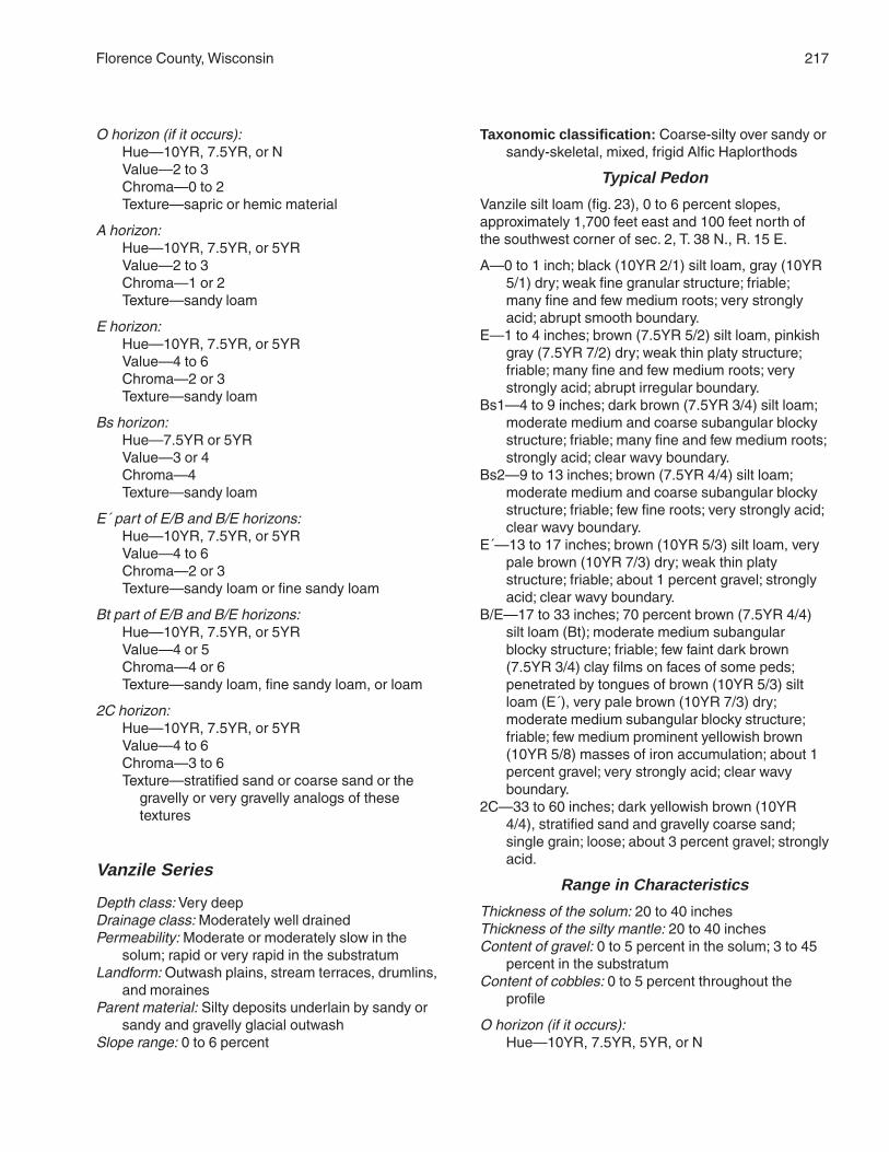
Florence County, Wisconsin 217
O horizon (if it occurs):Hue—10YR, 7.5YR, or NValue—2 to 3Chroma—0 to 2Texture—sapric or hemic material
A horizon:Hue—10YR, 7.5YR, or 5YRValue—2 to 3Chroma—1 or 2Texture—sandy loam
E horizon:Hue—10YR, 7.5YR, or 5YRValue—4 to 6Chroma—2 or 3Texture—sandy loam
Bs horizon:Hue—7.5YR or 5YRValue—3 or 4Chroma—4Texture—sandy loam
E´ part of E/B and B/E horizons:Hue—10YR, 7.5YR, or 5YRValue—4 to 6Chroma—2 or 3Texture—sandy loam or fine sandy loam
Bt part of E/B and B/E horizons:Hue—10YR, 7.5YR, or 5YRValue—4 or 5Chroma—4 or 6Texture—sandy loam, fine sandy loam, or loam
2C horizon:Hue—10YR, 7.5YR, or 5YRValue—4 to 6Chroma—3 to 6Texture—stratified sand or coarse sand or the
gravelly or very gravelly analogs of thesetextures
Vanzile Series
Depth class: Very deepDrainage class: Moderately well drainedPermeability: Moderate or moderately slow in the
solum; rapid or very rapid in the substratumLandform: Outwash plains, stream terraces, drumlins,
and morainesParent material: Silty deposits underlain by sandy or
sandy and gravelly glacial outwashSlope range: 0 to 6 percent
Taxonomic classification: Coarse-silty over sandy orsandy-skeletal, mixed, frigid Alfic Haplorthods
Typical Pedon
Vanzile silt loam (fig. 23), 0 to 6 percent slopes,approximately 1,700 feet east and 100 feet north ofthe southwest corner of sec. 2, T. 38 N., R. 15 E.
A—0 to 1 inch; black (10YR 2/1) silt loam, gray (10YR5/1) dry; weak fine granular structure; friable;many fine and few medium roots; very stronglyacid; abrupt smooth boundary.
E—1 to 4 inches; brown (7.5YR 5/2) silt loam, pinkishgray (7.5YR 7/2) dry; weak thin platy structure;friable; many fine and few medium roots; verystrongly acid; abrupt irregular boundary.
Bs1—4 to 9 inches; dark brown (7.5YR 3/4) silt loam;moderate medium and coarse subangular blockystructure; friable; many fine and few medium roots;strongly acid; clear wavy boundary.
Bs2—9 to 13 inches; brown (7.5YR 4/4) silt loam;moderate medium and coarse subangular blockystructure; friable; few fine roots; very strongly acid;clear wavy boundary.
E´—13 to 17 inches; brown (10YR 5/3) silt loam, verypale brown (10YR 7/3) dry; weak thin platystructure; friable; about 1 percent gravel; stronglyacid; clear wavy boundary.
B/E—17 to 33 inches; 70 percent brown (7.5YR 4/4)silt loam (Bt); moderate medium subangularblocky structure; friable; few faint dark brown(7.5YR 3/4) clay films on faces of some peds;penetrated by tongues of brown (10YR 5/3) siltloam (E´), very pale brown (10YR 7/3) dry;moderate medium subangular blocky structure;friable; few medium prominent yellowish brown(10YR 5/8) masses of iron accumulation; about 1percent gravel; very strongly acid; clear wavyboundary.
2C—33 to 60 inches; dark yellowish brown (10YR4/4), stratified sand and gravelly coarse sand;single grain; loose; about 3 percent gravel; stronglyacid.
Range in Characteristics
Thickness of the solum: 20 to 40 inchesThickness of the silty mantle: 20 to 40 inchesContent of gravel: 0 to 5 percent in the solum; 3 to 45
percent in the substratumContent of cobbles: 0 to 5 percent throughout the
profile
O horizon (if it occurs):Hue—10YR, 7.5YR, 5YR, or N

218 Soil Survey of
Value—2 to 3Chroma—0 to 2Texture—sapric or hemic material
A horizon:Hue—10YR, 7.5YR, or 5YRValue—2 to 3Chroma—1 or 2Texture—silt loam
E horizon:Hue—10YR or 7.5YRValue—4 to 6Chroma—2 or 3Texture—silt loam or silt
Bs horizon:Hue—7.5YR or 5YRValue—3 or 4Chroma—4Texture—silt loam
E´ horizon and E´ part of B/E horizon:Hue—10YR, 7.5YR, or 5YRValue—4 to 6Chroma—2 or 3Texture—silt loam or silt
Bt part of B/E horizon:Hue—7.5YR or 5YRValue—4Chroma—4Texture—silt loam
2C horizon:Hue—10YR, 7.5YR, or 5YRValue—4 to 6Chroma—3 to 6Texture—stratified sand or coarse sand or the
gravelly or very gravelly analogs of thesetextures
Vilas Series
Depth class: Very deepDrainage class: Excessively drainedPermeability: RapidLandform: Outwash plains, stream terraces, eskers,
kames, and morainesParent material: Primarily sandy glacial outwashSlope range: 0 to 35 percent
Taxonomic classification: Sandy, mixed, frigid EnticHaplorthods
Typical Pedon
Vilas loamy sand (fig. 24), 0 to 6 percent slopes,
approximately 500 feet south and 100 feet west of thenortheast corner of sec. 14, T. 38 N., R. 17 E.
Oi—0 to 2 inches; very dark grayish brown (10YR 3/2)(broken face and rubbed) peat (fibric material,which is a mat of partially decomposed forestlitter); about 90 percent fiber, 40 percent rubbed;massive; very friable; many fine and mediumroots; very strongly acid (pH 5.0 in water 1:1);abrupt smooth boundary.
A—2 to 4 inches; black (N 2.5/0) loamy sand, verydark gray (N 3/0) dry; weak medium granularstructure; very friable; many fine and mediumroots; many uncoated sand grains; few charcoalfragments; very strongly acid; clear wavyboundary.
E—4 to 5 inches; brown (7.5YR 4/2) loamy sand,brown (7.5YR 5/2) dry; weak fine and mediumsubangular blocky structure; very friable; manyfine and medium roots; very strongly acid; abruptbroken boundary.
Bs1—5 to 8 inches; dark reddish brown (5YR 3/4)loamy sand; weak medium subangular blockystructure; very friable; many fine and mediumroots; very strongly acid; clear wavy boundary.
Bs2—8 to 19 inches; brown (7.5YR 4/4) loamy sand;weak coarse subangular blocky structure; veryfriable; common fine and medium roots; verystrongly acid; clear wavy boundary.
BC—19 to 37 inches; strong brown (7.5YR 4/6) sand;weak coarse subangular blocky structure; veryfriable; few medium and coarse roots; slightly acid;clear wavy boundary.
C—37 to 62 inches; yellowish brown (10YR 5/4) sand;single grain; loose; slightly acid.
Range in Characteristics
Thickness of the solum: 18 to 40 inchesThickness of the loamy sand mantle: 10 to 20 inchesContent of gravel: 0 to 15 percent throughout the
profileNote: Unless otherwise indicated, depths and
thicknesses are measured from the top of themineral soil.
O horizon:Hue—10YR, 7.5YR, 5YR, or NValue—2 to 3Chroma—0 to 2Texture—sapric, hemic, or fibric material
A horizon:Hue—10YR, 7.5YR, 5YR, or NValue—2 to 3Chroma—0 to 3Texture—loamy sand

Florence County, Wisconsin 219
E horizon:Hue—7.5YR or 5YRValue—4 to 6Chroma—2Texture—loamy sand
Bs horizon:Hue—7.5YR or 5YRValue—3 or 4Chroma—4Texture—loamy sand or sand
C horizon:Hue—10YR, 7.5YR, or 5YRValue—4 to 6Chroma—4 or 6Texture—sand
Wabeno Series
Depth class: Moderately deep to a fragipanDrainage class: Moderately well drainedPermeability: Moderate in the upper layers, slow in the
fragipan, and moderate in the substratumLandform: Drumlins and morainesParent material: Primarily silty deposits underlain by
sandy or loamy glacial till or glacial mudflowsediment
Slope range: 1 to 15 percent
Taxonomic classification: Coarse-loamy, mixed,frigid Oxyaquic Fragiorthods
Typical Pedon
Wabeno silt loam, in an area of Wabeno-Goodwit siltloams, 1 to 6 percent slopes, very stony,approximately 600 feet west and 1,100 feet north ofthe southeast corner of sec. 26, T. 40 N., R. 15 E.
Oa—0 to 3 inches; black (10YR 2/1) (broken face andrubbed) muck (sapric material, which is a mat ofpartially decomposed forest litter); about 20percent fiber, 5 percent rubbed; weak fine granularstructure; very friable; many fine and few mediumroots; strongly acid (pH 5.3 in water 1:1); abruptwavy boundary.
E—3 to 5 inches; brown (10YR 5/3) silt loam, pink(7.5YR 7/3) dry; weak thin platy structure; friable;many fine and few medium roots; about 1 percentgravel and 5 percent cobbles; strongly acid; clearbroken boundary.
Bs—5 to 11 inches; brown (7.5YR 4/4) silt loam;moderate medium subangular blocky structure;friable; many fine and few medium roots; about 1percent gravel and 5 percent cobbles; verystrongly acid; clear wavy boundary.
E´—11 to 15 inches; brown (10YR 5/3) silt, very palebrown (10YR 7/3) dry; moderate thin platystructure; friable; common fine and medium roots;about 1 percent gravel and 5 percent cobbles;strongly acid; clear wavy boundary.
B/E—15 to 24 inches; about 65 percent dark brown(7.5YR 3/4) silt loam (Bt); moderate finesubangular and angular blocky structure; friable;few distinct reddish brown (5YR 4/4) clay films onfaces of peds; penetrated by tongues of brown(10YR 5/3) silt loam (E´), very pale brown (10YR7/3) dry; moderate fine subangular blockystructure; friable; common fine and medium roots;few fine and medium prominent yellowish red(5YR 5/6) masses of iron accumulation; about 1percent gravel and 5 percent cobbles; stronglyacid; clear wavy boundary.
2Btx1—24 to 29 inches; dark brown (7.5YR 3/4)gravelly sandy loam; strong coarse prismaticstructure parting to moderate fine and mediumsubangular and angular blocky; firm; brittle; fewfine roots; few prominent yellowish red (5YR 4/6)clay films on faces of some peds and in somepores; common very fine vesicular pores; about 15percent gravel and 5 percent cobbles; stronglyacid; gradual irregular boundary.
2Btx2—29 to 55 inches; dark brown (7.5YR 3/4)gravelly sandy loam with strata of brown (7.5YR4/4) gravelly loamy sand and sand 1/2 inch to 11/2inches thick; moderate coarse prismatic structure;firm; brittle; breaks to strong medium plates ofdepositional strata; common very fine vesicularpores; few prominent yellowish red (5YR 4/6) clayfilms on faces of peds; about 16 percent graveland 5 percent cobbles; strongly acid; gradualirregular boundary.
2C—55 to 63 inches; dark brown (7.5YR 3/4) gravellysandy loam with strata of brown (7.5YR 4/4)gravelly loamy sand and sand 1/2 inch to 11/2
inches thick; massive; friable; common very finevesicular pores in the sandy loam; about 15percent gravel and 5 percent cobbles; moderatelyacid.
Range in Characteristics
Thickness of the solum: 35 to more than 60 inchesThickness of the silty mantle: 12 to 36 inchesDepth to the fragipan: 20 to 40 inchesContent of gravel: 0 to 10 percent in the upper part of
the solum; 5 to 25 percent in the lower part of thesolum and in the substratum
Content of cobbles: 0 to 10 percent in the upper part ofthe solum; 0 to 20 percent in the lower part of thesolum and in the substratum

220 Soil Survey of
Content of stones: 0 to 5 percent throughout theprofile
Percent of surface covered by stones: 0.1 to 3.0percent
Note: Unless otherwise indicated, depths andthicknesses are measured from the top of themineral soil.
O horizon:Hue—10YR, 7.5YR, 5YR, or NValue—2 to 3Chroma—0 to 2Texture—sapric or hemic material
A horizon (if it occurs):Hue—10YR, 7.5YR, or 5YRValue—2 to 3Chroma—1 or 2Texture—silt loam
E horizon:Hue—10YR, 7.5YR, or 5YRValue—4 to 6Chroma—2 or 3Texture—silt loam
Bs horizon:Hue—7.5YR or 5YRValue—3 or 4Chroma—4Texture—silt loam
E´ horizon and E´ part of B/E horizon:Hue—10YR or 7.5YRValue—4 to 6Chroma—2 or 3Texture—silt loam or silt
Bt part of B/E horizon:Hue—10YR or 7.5YRValue—3 or 4Chroma—4 or 6Texture—silt loam
2Btx horizon:Hue—10YR or 7.5YRValue—3 to 6Chroma—4 or 6Texture—sandy loam or loam or the gravelly or
cobbly analogs of these textures
2C horizon:Hue—10YR or 7.5YRValue—3 to 6Chroma—4 or 6Texture—sandy loam or loamy sand or the
gravelly or cobbly analogs of these textures
Wakefield Series
Depth class: Shallow to a fragipanDrainage class: Moderately well drainedPermeability: Moderate in the upper layers, very slow
in the fragipan, and moderate in the lower layersLandform: MorainesParent material: Silty deposits underlain by loamy
glacial tillSlope range: 1 to 15 percent
Taxonomic classification: Coarse-loamy, mixed,frigid Oxyaquic Fragiorthods
Typical Pedon
Wakefield silt loam, 1 to 6 percent slopes, very stony,approximately 700 feet west and 2,500 feet south ofthe northeast corner of sec. 22, T. 40 N., R. 17 E.
A—0 to 5 inches; dark reddish brown (5YR 3/2) siltloam, pinkish gray (5YR 6/2) dry; moderate fineand medium granular structure; friable; many veryfine and fine and common medium and coarseroots; about 3 percent gravel; very strongly acid;clear wavy boundary.
E—5 to 6 inches; brown (7.5YR 5/3) silt loam, pink(7.5YR 7/3) dry; weak medium platy structure;friable; many very fine and fine and commonmedium and coarse roots; about 3 percent gravel;very strongly acid; abrupt broken boundary.
Bs—6 to 16 inches; dark reddish brown (5YR 3/4) siltloam; moderate medium subangular blockystructure; friable; common very fine and fine andfew medium and coarse roots; about 3 percentgravel; very strongly acid; abrupt smoothboundary.
2E/Bx—16 to 20 inches; 80 percent reddish brown(5YR 5/3) fine sandy loam (2E´), pink (5YR 7/3)dry; moderate thick platy structure; firm; brittle;tonguing into and surrounding remnants of darkreddish brown (2.5YR 3/4) loam (2Bt); moderatethick platy structure; firm; brittle; few fine roots; fewfine prominent yellowish red (5YR 5/8) masses ofiron accumulation; about 8 percent gravel; verystrongly acid; clear wavy boundary.
2B/Ex—20 to 27 inches; 80 percent dark reddishbrown (2.5YR 3/4) loam (2Bt); moderate mediumsubangular blocky structure; firm; brittle; manyfaint dark reddish brown (2.5YR 3/3) clay films onfaces of peds; penetrated by tongues of reddishbrown (5YR 5/3) fine sandy loam (2E´), pink (5YR7/3) dry; moderate medium subangular blockystructure; firm; brittle; few fine roots; few fineprominent yellowish red (5YR 5/8) masses of iron

Florence County, Wisconsin 221
accumulation; about 8 percent gravel and 2percent cobbles; strongly acid; clear wavyboundary.
2Bt—27 to 50 inches; dark reddish brown (2.5YR 3/4)loam; strong medium and coarse subangularblocky structure; firm; few fine roots; many faintdark reddish brown (2.5YR 3/3) clay films on facesof peds; about 8 percent gravel and 2 percentcobbles; moderately acid; clear wavy boundary.
2C—50 to 60 inches; reddish brown (2.5YR 4/3) loam;massive; friable; about 8 percent gravel and 2percent cobbles; slightly acid.
Range in Characteristics
Thickness of the solum: 30 to 64 inchesThickness of the silty mantle: 12 to 18 inchesDepth to the fragipan: 12 to 20 inchesContent of gravel: 3 to 15 percent throughout the
profileContent of cobbles: 0 to 5 percent throughout the
profileContent of stones: 0 to 5 percent throughout the profilePercent of surface covered by stones: 0.1 to 3.0
percent
O horizon (if it occurs):Hue—10YR, 7.5YR, 5YR, or NValue—2 to 3Chroma—0 to 2Texture—sapric or hemic material
A horizon:Hue—7.5YR or 5YRValue—2 or 3Chroma—1 or 2Texture—silt loam
E horizon:Hue—7.5YR or 5YRValue—4 to 6Chroma—2 or 3Texture—silt loam
Bs horizon:Hue—7.5YR or 5YRValue—3 or 4Chroma—4Texture—silt loam
2E´ part of 2E/Bx and 2B/Ex horizons:Hue—5YR or 2.5YRValue—4 or 5Chroma—2 or 3Texture—fine sandy loam or sandy loam
2Bt horizon and 2Bt part of 2E/Bx and 2B/Ex horizons:Hue—5YR or 2.5YR
Value—3 or 4Chroma—3 or 4Texture—loam or clay loam
2C horizon:Hue—5YR or 2.5YRValue—4 or 5Chroma—3 or 4Texture—loam or fine sandy loam
Worcester Series
Depth class: Very deepDrainage class: Somewhat poorly drainedPermeability: Moderate in the upper layers; rapid or
very rapid in the lower layersLandform: Outwash plains and stream terracesParent material: Primarily loamy deposits underlain by
sandy or sandy and gravelly glacial outwashSlope range: 0 to 3 percent
Taxonomic classification: Coarse-loamy, mixed,frigid Argic Endoaquods
Typical Pedon
Worcester sandy loam, 0 to 3 percent slopes,approximately 1,800 feet east and 400 feet south ofthe northwest corner of sec. 27, T. 38 N., R. 16 E.
Oa—0 to 2 inches; black (10YR 2/1) (broken face andrubbed) muck (sapric material, which is a mat ofpartially decomposed forest litter); about 25percent fiber, 10 percent rubbed; weak finegranular structure; very friable; many very fine andfine and common medium and coarse roots;common charcoal fragments; extremely acid (pH4.3 in water 1:1); abrupt wavy boundary.
E—2 to 5 inches; reddish gray (5YR 5/2) sandy loam,pinkish gray (5YR 7/2) dry; weak medium platystructure; very friable; common very fine, fine,medium, and coarse roots; about 1 percent gravel;very strongly acid; abrupt wavy boundary.
Bs1—5 to 9 inches; dark reddish brown (5YR 3/4)sandy loam; weak medium subangular blockystructure; very friable; common very fine, fine,medium, and coarse roots; about 1 percent gravel;strongly acid; clear wavy boundary.
Bs2—9 to 21 inches; brown (7.5YR 4/4) sandy loam;moderate medium subangular blocky structure;friable; common very fine and fine and fewmedium and coarse roots; few fine distinct strongbrown (7.5YR 4/6) masses of iron accumulation;about 1 percent gravel; moderately acid; clearwavy boundary.
B/E—21 to 30 inches; 60 percent brown (7.5YR 4/4)

222
sandy loam (Bt); moderate medium subangularblocky structure; friable; common faint dark brown(7.5YR 4/3) clay films on faces of peds; penetratedby tongues of brown (7.5YR 5/3) sandy loam (E´),pink (7.5YR 7/3) dry; weak medium platystructure; friable; few very fine, fine, medium, andcoarse roots; many fine and medium distinctstrong brown (7.5YR 5/6) masses of ironaccumulation and few fine faint brown (7.5YR 5/2)iron depletions; about 2 percent gravel; verystrongly acid; clear wavy boundary.
2Bt—30 to 34 inches; brown (7.5YR 4/4) gravellyloamy sand; moderate medium and coarsesubangular blocky structure; very friable; few veryfine, fine, medium, and coarse roots; common faintdark brown (7.5YR 3/4) clay bridging betweensand grains; many fine and medium prominentyellowish red (5YR 4/6 and 5/8) masses of ironaccumulation and few fine distinct brown (7.5YR5/2) iron depletions; about 15 percent gravel;moderately acid; clear wavy boundary.
2C—34 to 62 inches; dark yellowish brown (10YR 4/4),stratified sand and gravelly coarse sand; singlegrain; loose; many medium prominent yellowish red(5YR 4/6) masses of iron accumulation; about 25percent gravel; moderately acid.
Range in Characteristics
Thickness of the solum: 24 to 40 inchesThickness of the loamy mantle: 24 to 40 inchesContent of gravel: 0 to 15 percent in the upper part of
the solum; 3 to 50 percent in the lower part of thesolum and in the substratum
Content of cobbles: 0 to 5 percent throughout theprofile
Note: Unless otherwise indicated, depths andthicknesses are measured from the top of themineral soil.
O horizon:Hue—10YR, 7.5YR, or NValue—2 to 3Chroma—0 to 2Texture—sapric or hemic material
A horizon (if it occurs):Hue—10YR, 7.5YR, 5YR, or NValue—2 to 3Chroma—0 to 3Texture—sandy loam
E horizon:Hue—10YR, 7.5YR, or 5YRValue—4 to 6Chroma—2 or 3Texture—sandy loam
Bs horizon:Hue—7.5YR or 5YRValue—3 or 4Chroma—4Texture—sandy loam
E´ part of B/E horizon:Hue—10YR or 7.5YRValue—4 to 6Chroma—2 or 3Texture—sandy loam, fine sandy loam, or loamy
sand
Bt part of B/E horizon:Hue—10YR, 7.5YR, or 5YRValue—4 to 6Chroma—3 to 6Texture—sandy loam, fine sandy loam, or loam or
the gravelly analogs of these textures
2Bt horizon:Hue—10YR, 7.5YR, or 5YRValue—3 to 6Chroma—4 or 6Texture—loamy sand or loamy coarse sand or the
gravelly or very gravelly analogs of thesetextures
2C horizon:Hue—10YR, 7.5YR, or 5YRValue—4 to 6Chroma—3 to 6Texture—stratified sand or coarse sand or the
gravelly or very gravelly analogs of thesetextures

223
This section describes the geology and underlyingmaterial in Florence County, relates the factors of soilformation to the soils in the county, and explains theprocesses of soil formation.
Geology and Underlying MaterialThomas J. Alvarez and Michael T. McCawley, geologists,
Natural Resources Conservation Service, helped prepare thissection.
Florence County, which is in the Northern Highlandof Wisconsin, is underlain by a variety of igneous andmetamorphic rock types that formed during thePrecambrian (Clayton, 1986). These rocks are overlainin most places by glacial till, glacial outwash, orlacustrine deposits deposited during the Pleistocene.The surface of the Precambrian rock in FlorenceCounty is irregular, with relief of over 655 feet. As aresult, the thickness of the Pleistocene material isirregular, ranging from 0 to more than 160 feet within adistance of less than a mile. Similarly, the lithologiccomposition of the Pleistocene material changesconspicuously within short distances, depending onthe nature of the Precambrian or Pleistocene materialthe glacier overrode.
Bedrock outcrops occur mostly in a zone about 9miles wide extending from the northeast corner of thecounty, to the center of the county, and then to thesoutheast corner of the county. Rock types exposed inthis zone range mainly from dense metavolcanic rocksin the northeastern part to slaty metasediments in themiddle part to schists and various metamorphic rocksin the southeastern part (fig. 25).
Florence County was glaciated many times duringthe Pleistocene epoch, but little is known about anybut the last few of these events. During the last part ofthe Wisconsin glaciation, the ice sheet readvancedseveral times, reaching Langlade County (southwestof Florence County) between about 20,000 and15,000 years ago. The ice sheet then wasted backacross the survey area, with several minor readvancesbetween about 14,000 and 12,000 years ago. Duringthis time, the Langlade Lobe deposited units of theCopper Falls Formation in western Florence County
and the Green Bay Lobe deposited units of theKewaunee Formation in the eastern part of thecounty.
The Copper Falls Formation, which occurs overabout the western two-thirds of the survey area,consists of two units—the Nashville Member andMember W. The glacial till of these two units isassociated with the early Mountain advances of lateWisconsin glaciation. The Nashville Member consistsmainly of glacial till and glacial outwash deposits. Thetexture of the Nashville till is mainly sandy loam orloamy sand or the gravelly analogs of these textures.In the glacial outwash deposits, the amount of sandand gravel varies widely. In north-central FlorenceCounty just west of the community of Florence, theglacial till of the Nashville Member grades laterally intothe glacial till of Member W. This till contains slightlymore clay, is a little redder, and contains more rockfragments than the adjacent Nashville till.
The Kewaunee Formation, which occurs over aboutthe eastern third of Florence County, consists of threeunits—the Florence Member, Member E, and theSilver Cliff Member. The Florence Member andMember E were deposited during the middle Mountainadvance of the late Wisconsin glaciation, and theSilver Cliff Member is associated with the lateMountain and early Athelstane advances. TheFlorence Member is interpreted to be glacial till withdark reddish brown or reddish brown colors and adominant texture of silty clay loam. It is typicallyleached of carbonates to a depth of about 40 inches.Member E of the Kewaunee Formation resemblesMember W to the west in color and texture butcontains more dolomite. Throughout Florence County,Member E is apparently overlain by the Silver CliffMember. The Silver Cliff Member consists mainly ofglacial till, glacial outwash, and lacustrine deposits.The glacial till is generally sandy loam, loam, or loamysand or the gravelly analogs of these textures. Boththe glacial till and glacial outwash of the Silver CliffMember have typically been leached of carbonates toa depth of more than 80 inches. The lacustrinematerial consists of sand, silt, and clay, which in someplaces are overlain by windblown sand.
Formation of the Soils

224 Soil Survey of
Factors of Soil FormationSoil is produced by soil-forming processes acting
on materials deposited or accumulated by geologicagencies. The characteristics of the soil at any givenpoint are determined by the climate under which thesoil material has accumulated and existed sinceaccumulation; the plant and animal life on and in thesoil; the relief, or lay of the land; the physical andmineralogical composition of the parent material; andthe length of time the forces of soil formation haveacted on the soil material (Jenny, 1941).
Climate and plant and animal life, chiefly plants, are
the active factors of soil formation. They act on theparent material that has accumulated through theweathering or physical disintegration of rocks andslowly change it into a natural body that hasgenetically related horizons. Relief conditions theeffects of climate and plant and animal life. The parentmaterial affects the kind of soil profile that forms; insome areas it is almost entirely responsible for thekind of soil profile that forms. Finally, time is needed forthe transformation of the parent material into a soil.Some time is always required for the differentiation ofsoil horizons. Usually, a long time is required for thedevelopment of distinct horizons.
Figure 25.—A recumbent fold in the slate bedrock south of Florence.

Florence County, Wisconsin 225
The factors of soil formation are so closelyinterrelated in their effects on the soil that fewgeneralizations can be made regarding the effects ofany one factor unless conditions are specified for theother four. Many of the processes of soil developmentare still unknown.
Climate
Climate directly affects soil formation through theweathering of rocks. It also alters the parent materialthrough the mechanical action of freezing and thawing.It indirectly affects the accumulation of organic matterby supplying energy and a suitable environment for thegrowth of both plant and animal organisms.
Precipitation and temperature are the chiefelements of climate responsible for soil features.These elements determine the amount of wateravailable for percolation and the formation anddecomposition of organic matter, the major processesin the formation of soils.
Percolating water from rainfall and snowmelt affectsboth the solution and hydration of mineral material andthe organic substances. The movement of this wateralso controls the distribution of substances throughoutthe soil.
Florence County has a continental type of climate inwhich variations in temperature are great fromsummer to winter. During the winter the soil-formingprocesses are largely inactive, although somealternate freezing and thawing activity continues.
The physical action of frost heave also affectsprofile development. The high temperature in summerincreases the evaporation and transpiration ofmoisture, thus limiting the amount of percolating wateravailable for soil formation. Temperature also affectsthe growth and decomposition of organic matter.Decomposition is much slower in cooler climates thanin warmer ones.
Wind indirectly affects the moisture content of soilsby influencing the rate of evaporation. In addition, thewind often blows away particles of soil and organicmaterial, thereby eroding the surface layer. Theseparticles are deposited elsewhere as new parentmaterial.
Climate is modified by variations in slope aspect.The soils on south- or west-facing slopes are warmedand dried by the sun and wind more thoroughly thanthose on north- and east-facing slopes. The soils oncooler, more humid north- and east-facing slopesgenerally contain more moisture and are frozen for alonger period.
Plant and Animal Life
Living organisms, such as plants, bacteria, fungi,insects, earthworms, and rodents, influence theformation of soils. Plants generally have the greatestinfluence on soil formation. Plant roots penetrate thesoil body, thereby creating channels for percolatingwater. The roots excrete a number of acid substancesthat act on rocks and minerals and bring nutrients ormineral substances into solution. These nutrients areabsorbed and translocated upward to stems andleaves. When the plants die, the translocated mineralsare released to the upper soil layers. The organic acidsformed from the decaying plant residue accelerate soilformation by reacting with rock and mineralconstituents.
Plants indirectly affect soil formation by modifyingthe effects of climate. For example, they reduce theforce of winds, thereby influencing the evaporation rateof percolating water and the deposition of windblownparent material. Most of the soils in Florence Countyformed under forest vegetation. As a result, they havea lighter colored or a thinner surface layer than thesoils that formed under grass.
Animals burrow into the soil and mix the material ofthe different layers. Roots and percolating water followthe channels created by the animals. Animal lifeaffects soil structure, helps to decompose organicmatter, and carries nutrients upward in the soil profile.When these animals die, they contribute to the supplyof organic matter in the soil.
Human activities recently have had importanteffects on the soils in the county. The original conditionof some soils has been altered by these activities,which include removing the native vegetation, mixingthe upper layers through cultivation, and plantingcrops that are different from the native vegetation.Removal of the native vegetation has acceleratederosion on sloping soils. Applications of lime andfertilizer have altered the pH value and fertility of soils.Some cropping practices have reduced the content oforganic matter. The content of soil moisture has beenaltered by irrigation and artificial drainage. Some of theeffects of human activities, such as the addition offertilizer, pesticide, herbicide, and fungicide, may notbe known for many years.
Relief and Drainage
Relief influences soil formation by affecting theamount of precipitation absorbed in the soil, byinfluencing the erosion rate, and by directing the

226 Soil Survey of
movement of materials in suspension or solution fromone part of the profile to another. Generally, thesteeper soils have a thinner solum and less welldeveloped profiles than gently sloping soils, whichhave more water percolating through the profile.
Relief directly affects external and internal drainagein the soils. In Florence County, the Vilas, Croswell, AuGres, and Kinross soils form a drainage sequence.The excessively drained Vilas soils are on linear andslightly convex summits, toeslopes, and side slopesand are nearly level to steep. The moderately welldrained Croswell soils are in linear areas, ontoeslopes, and on footslopes and are nearly level andgently sloping. The somewhat poorly drained Au Gressoils and the poorly drained Kinross soils are in linearareas and in depressions and drainageways and arenearly level.
Parent Material
The parent material of most soils in FlorenceCounty was deposited by glaciers or by meltwater asthe glaciers receded. The parent material of somesoils on flood plains is recent alluvium. The parentmaterial of organic soils consists of plant remains thataccumulated and were preserved under water inswamps or shallow lakes. Some soils formed in morethan one kind of parent material. The nature of theparent material has much to do with the texture,mineral composition, and chemical properties of thesoil.
Glacial outwash was deposited by running waterfrom melting glaciers. The size of the particles thatmake up outwash varies, depending on the speed ofthe stream of water that carried the material. As theswiftly flowing water slowed down, the coarserparticles were deposited. The more slowly movingwater could carry the finer particles, such as very finesand and silt. Glacial outwash deposits generally arestratified, and the layers contain particles of similarsize (fig. 26). Padus soils formed in loamy depositsunderlain by sandy or sandy and gravelly glacialoutwash. Vilas soils formed primarily in sandy glacialoutwash.
The glacial till soils formed in unsorted, nonstratifiedglacial drift consisting of clay, silt, sand, gravel,cobbles, stones, and boulders transported anddeposited by glacial ice. Most glacial till in FlorenceCounty is loamy sand or sandy loam or the gravellyanalogs of these textures. The glacial till in some partsof eastern Florence County is predominantly silty clayloam, but a small area of till that is mainly loam occursin the north-central part of the county. Glacial mudflowsediment is material that was let down from the ice
surface and has undergone some flow or massmovement. Ellwood, Crossett, and Wakefield soils areexamples of soils that formed in silty depositsunderlain by glacial till.
Lacustrine deposits were laid down in still water informer glacial lake basins. These deposits arecharacterized by stratified deposits ranging from sandto clay. Fence and Gastrow soils are examples of soilsthat formed primarily in silty deposits underlain bystratified lacustrine deposits. Cublake soils formed insandy glacial outwash underlain by stratified lacustrinedeposits.
Organic material consists of deposits of plantremains. After the glaciers receded from FlorenceCounty, water stood in depressions. Grasses, reeds,sedges, and trees grew and died at the edges of thesebodies of water, and their remains fell to the bottom.These bodies of water were eventually filled withorganic material and thus developed into areas ofpeat. In some areas the peat subsequentlydecomposed to muck. In other areas it has changedlittle since deposition. Cathro soils formed inherbaceous organic material 16 to 51 inches thickover loamy or silty deposits. Loxley soils formed insphagnum moss and herbaceous organic materialmore than 51 inches thick.
Alluvial deposits are of recent origin. They weredeposited on flood plains and in drainageways byfloodwater. Soils that formed in alluvium generallyshow little or no horizon development. Fordum soilsformed primarily in loamy alluvium underlain by sandyor sandy and gravelly deposits.
Time
Time is needed for the parent material to changeinto a soil. Some time is always required for horizondifferentiation. Soils can have horizons that are welldeveloped, horizons that are poorly developed, orhorizons that are somewhere in between, dependingon the length of time the soil-forming factors havebeen active. Padus soils, for example, havemoderately distinct horizons and are considered to befairly mature. Soils that formed in recently depositedalluvium, on the other hand, show little or no horizondevelopment. Fordum soils are examples.
Processes of Soil FormationHorizons are differentiated in a soil as a result of
the action of certain basic soil-forming processes.These processes are gains, losses, transfers, andtransformations. They generally do not act alone.Some changes promote horizon differentiation, and

Florence County, Wisconsin 227
others retard or offset it. The balance among thechanges determines the nature of the soil at any givenpoint.
The interaction among these soil-forming processesis evident in Vanzile soils. These soils formed in siltydeposits underlain by sandy or sandy and gravellyglacial outwash. The climate of Florence Countyfavored the growth of plants. Plants and animalscontribute to the accumulation of organic matter andorganic acids, and they mixed the soil to some extent.These processes accelerated as more and higherforms of organisms grew in the soil and producedmore organic residue and acids. The decomposedorganic matter darkened the surface layer of thesesoils.
While organic matter was being decomposed,minerals within the Vanzile soils were being chemicallyweathered by organic acids. Also, iron was beingoxidized. Percolating water then translocated theweathered minerals, oxidized iron, and some organicmatter to the lower parts of the profile. The result wasthe formation of a thin, bleached, brown subsurfacelayer and a subsoil of accumulated dark brownminerals.
The percolating water also translocated suspendedparticles of clay downward. As a result, the lower partof the subsoil has more clay than other parts of theprofile. The underlying glacial outwash, which typicallyis at a depth of about 33 inches, is unweathered. It haschanged little since it was deposited.
Figure 26.—A pit exposure of stratified glacial outwash. The amount of sand and gravel varies widely in these deposits.

228
The processes that were active in the formation ofthe Vanzile soils were gains in the organic matter inthe surface layer, loss of weathered minerals and clayfrom the upper part of the soil and the subsequenttransfer of these to the upper and lower parts of thesubsoil, and the transformation of iron compounds inthe subsoil. All of these processes have been active in
the soils of Florence County. The kinds of parentmaterial and the relief to a great extent havedetermined the kinds of processes that are dominantin the formation of all the soils. These processes, inturn, largely determine the differences and similaritiesamong the soils.

229
American Association of State Highway and Transportation Officials (AASHTO). 2000.Standard specifications for transportation materials and methods of sampling andtesting. 20th edition, 2 volumes.
American Society for Testing and Materials (ASTM). 2001. Standard classification ofsoils for engineering purposes. ASTM Standard D 2487-00.
Carlson, Harlan, Lloyd M. Andrews, and C.W. Threinen. 1971. Surface water resourcesof Florence County. Wisconsin Department of Natural Resources.
Clayton, Lee. 1986. Pleistocene geology of Florence County, Wisconsin. WisconsinGeological and Natural History Survey, Information Circular 51.
Hole, Francis D., and others. 1962. Soil survey of Florence County, Wisconsin. State ofWisconsin, Soil Series 59, Bulletin 84.
Jenny, Hans. 1941. Factors of soil formation.
Kotar, John, Joseph A. Kovach, and Craig T. Locey. 1988. Field guide to forest habitattypes of northern Wisconsin. University of Wisconsin-Madison, Department of Forestry,and Wisconsin Department of Natural Resources.
Oakes, E.L., and L.J. Hamilton. 1973. Water resources of Wisconsin-Menominee-Oconto-Peshtigo River basin. U.S. Geological Survey, Atlas HA-470.
Soil Survey Division Staff. 1993. Soil survey manual. Soil Conservation Service. U.S.Department of Agriculture Handbook 18.
Soil Survey Staff. 1994. Keys to soil taxonomy. 6th edition. U.S. Department ofAgriculture, Soil Conservation Service.
Soil Survey Staff. 1999. Soil taxonomy: A basic system of soil classification for makingand interpreting soil surveys. 2nd edition. Natural Resources Conservation Service.U.S. Department of Agriculture Handbook 436.
United States Department of Agriculture. 1961. Land capability classification. SoilConservation Service. U.S. Department of Agriculture Handbook 210.
United States Department of Agriculture. 1984. Timber resource of Wisconsin’snortheast survey unit, 1983. Research Bulletin NC-78.
References

230
Whitson, A.R., and others. 1916. Reconnaissance soil survey of northeasternWisconsin. State of Wisconsin, Soil Series 12, Bulletin 47.
Wisconsin Agricultural Statistics Service. 1991. Wisconsin 1991 agricultural statistics.State of Wisconsin.
231
Alluvium. Material, such as sand, silt, or clay,deposited on land by streams.
Alpha,alpha-dipyridyl. A dye that when dissolved in1N ammonium acetate is used to detect thepresence of reduced iron (Fe II) in the soil. Apositive reaction indicates a type of redoximorphicfeature.
Animal unit month (AUM). The amount of foragerequired by one mature cow of approximately1,000 pounds weight, with or without a calf, for 1month.
Aquic conditions. Current soil wetness characterizedby saturation, reduction, and redoximorphicfeatures.
Area reclaim (in tables). An area difficult to reclaimafter the removal of soil for construction and otheruses. Revegetation and erosion control areextremely difficult.
Available water capacity (available moisturecapacity). The capacity of soils to hold wateravailable for use by most plants. It is commonlydefined as the difference between the amount ofsoil water at field moisture capacity and theamount at wilting point. It is commonly expressedas inches of water per inch of soil. The capacity, ininches, in a 60-inch profile or to a limiting layer isexpressed as:
Very low ............................................................ 0 to 3
Low ................................................................... 3 to 6
Moderate .......................................................... 6 to 9
High ................................................................ 9 to 12
Very high .............................................. more than 12
Backslope. The position that forms the steepest andgenerally linear, middle portion of a hillslope. Inprofile, backslopes are commonly bounded by aconvex shoulder above and a concave footslopebelow.
Base saturation. The degree to which material havingcation-exchange properties is saturated withexchangeable bases (sum of Ca, Mg, Na, and K),expressed as a percentage of the total cation-exchange capacity.
Bedrock. The solid rock that underlies the soil and
other unconsolidated material or that is exposed atthe surface.
Bedrock-controlled topography. A landscape wherethe configuration and relief of the landforms aredetermined or strongly influenced by theunderlying bedrock.
Board foot. A unit of measurement represented by aboard 1 foot wide, 1 foot long, and 1 inch thick.
Boulders. Rock fragments larger than 2 feet (60centimeters) in diameter.
Canopy. The leafy crown of trees or shrubs. (SeeCrown.)
Cation. An ion carrying a positive charge of electricity.The common soil cations are calcium, potassium,magnesium, sodium, and hydrogen.
Cation-exchange capacity. The total amount ofexchangeable cations that can be held by the soil,expressed in terms of milliequivalents per 100grams of soil at neutrality (pH 7.0) or at someother stated pH value. The term, as applied tosoils, is synonymous with base-exchange capacitybut is more precise in meaning.
Chiseling. Tillage with an implement having one ormore soil-penetrating points that shatter or loosenhard, compacted layers to a depth below normalplow depth.
Clay. As a soil separate, the mineral soil particles lessthan 0.002 millimeter in diameter. As a soil texturalclass, soil material that is 40 percent or more clay,less than 45 percent sand, and less than 40percent silt.
Clay depletions. Low-chroma zones having a lowcontent of iron, manganese, and clay because ofthe chemical reduction of iron and manganeseand the removal of iron, manganese, and clay. Atype of redoximorphic depletion.
Clay film. A thin coating of oriented clay on thesurface of a soil aggregate or lining pores or rootchannels. Synonyms: clay coating, clay skin.
Clayey. General term for the soil textural classes clay,silty clay, and sandy clay.
Clearcutting. The removal of all the timber in a standwhen trees are harvested.
Climax plant community. The stabilized plant
Glossary

232 Soil Survey of
community on a particular site. The plant coverreproduces itself and does not change so long asthe environment remains the same.
Coarse textured soil. Sand or loamy sand.Cobble (or cobblestone). A rounded or partly
rounded fragment of rock 3 to 10 inches (7.6 to 25centimeters) in diameter.
Cobbly soil material. Material that has 15 to 35percent, by volume, rounded or partially roundedrock fragments 3 to 10 inches (7.6 to 25centimeters) in diameter. Very cobbly soil materialhas 35 to 60 percent of these rock fragments, andextremely cobbly soil material has more than 60percent.
Complex slope. Irregular or variable slope. Planningor establishing terraces, diversions, and otherwater-control structures on a complex slope isdifficult.
Complex, soil. A map unit of two or more kinds of soilor miscellaneous areas in such an intricate patternor so small in area that it is not practical to mapthem separately at the selected scale of mapping.The pattern and proportion of the soils ormiscellaneous areas are somewhat similar in allareas.
Concretions. Cemented bodies with crude internalsymmetry organized around a point, a line, or aplane. They typically take the form of concentriclayers visible to the naked eye. Calcium carbonate,iron oxide, and manganese oxide are commoncompounds making up concretions. If formed inplace, concretions of iron oxide or manganeseoxide are generally considered a type ofredoximorphic concentration.
Conservation cropping system. Growing crops incombination with needed cultural andmanagement practices. In a good conservationcropping system, the soil-improving crops andpractices more than offset the effects of the soil-depleting crops and practices. Cropping systemsare needed on all tilled soils. Soil-improvingpractices in a conservation cropping systeminclude the use of rotations that contain grassesand legumes and the return of crop residue to thesoil. Other practices include the use of greenmanure crops of grasses and legumes, propertillage, adequate fertilization, and weed and pestcontrol.
Conservation tillage. A tillage system that does notinvert the soil and that leaves a protective amountof crop residue on the surface throughout the year.
Consistence, soil. Refers to the degree of cohesionand adhesion of soil material and its resistance todeformation when ruptured. Consistence includes
resistance of soil material to rupture and topenetration; plasticity, toughness, and stickiness ofpuddled soil material; and the manner in which thesoil material behaves when subject tocompression. Terms describing consistence aredefined in the “Soil Survey Manual.”
Contour stripcropping. Growing crops in strips thatfollow the contour. Strips of grass or close-growingcrops are alternated with strips of clean-tilledcrops or summer fallow.
Control section. The part of the soil on whichclassification is based. The thickness variesamong different kinds of soil, but for many it is thatpart of the soil profile between depths of 10 inchesand 40 or 80 inches.
Cord. A unit of measurement of stacked wood. Astandard cord occupies 128 cubic feet withdimensions of 4 feet by 4 feet by 8 feet.
Corrosion. Soil-induced electrochemical or chemicalaction that dissolves or weakens concrete oruncoated steel.
Cover crop. A close-growing crop grown primarily toimprove and protect the soil between periods ofregular crop production, or a crop grown betweentrees and vines in orchards and vineyards.
Cradle-knoll. A small mound made up of soil materialthat temporarily clung to the roots when a treewas uprooted.
Critical-area planting. Planting stabilizing vegetationin highly erodible or critically eroding areas. Theareas typically cannot be stabilized by ordinaryconservation treatment and management, andleaving them untreated can result in severeerosion or in damage from sediment.
Crop residue management. Returning crop residueto the soil, which helps to maintain soil structure,organic matter content, and fertility and helps tocontrol erosion.
Cropping system. Growing crops according to aplanned system of rotation and managementpractices.
Crown. The upper part of a tree or shrub, including theliving branches and their foliage.
Culmination of the mean annual increment (CMAI).The average annual increase per acre in thevolume of a stand. Computed by dividing the totalvolume of the stand by its age. As the standincreases in age, the mean annual incrementcontinues to increase until mortality begins toreduce the rate of increase. The point where thestand reaches its maximum annual rate of growthis called the culmination of the mean annualincrement.
Cut area. A special symbol used on the soil maps to

Florence County, Wisconsin 233
indicate a small area where the soil has beenaltered by the removal of more than about a foot ofsoil material.
Cutbanks cave (in tables). The walls of excavationstend to cave in or slough.
Decreasers. The most heavily grazed climax rangeplants. Because they are the most palatable, theyare the first to be destroyed by overgrazing.
Deep to water (in tables). The soil is deep to apermanent water table (typically more than 5 feet)during the dry season.
Deferred grazing. Postponing grazing or restinggrazing land for a prescribed period.
Depression, closed. A special symbol used on thesoil maps to indicate a small, concave area themiddle of which is generally at least 5 feet lower inelevation than the surrounding map unit.
Depth, soil. Generally, the thickness of the soil overbedrock. Very deep soils are more than 60 inchesdeep over bedrock; deep soils, 40 to 60 inches;moderately deep, 20 to 40 inches; shallow, 10 to20 inches; and very shallow, less than 10 inches.
Depth to rock (in tables). Bedrock is too near thesurface for the specified use.
Diversion (or diversion terrace). A ridge of earth,generally a terrace, built to protect downslopeareas by diverting runoff from its natural course.
Drainage class (natural). Refers to the frequency andduration of wet periods under conditions similar tothose under which the soil formed. Alterations ofthe water regime by human activities, eitherthrough drainage or irrigation, are not aconsideration unless they have significantlychanged the morphology of the soil. Sevenclasses of natural soil drainage are recognized—excessively drained, somewhat excessivelydrained, well drained, moderately well drained,somewhat poorly drained, poorly drained, andvery poorly drained. These classes are defined inthe “Soil Survey Manual.”
Drainage, surface. Runoff, or surface flow of water,from an area.
Droughty (in tables). The soil holds too little water forplants during dry periods.
Drumlin. A low, smooth, elongated oval hill, mound, orridge of compact glacial till. The longer axis isparallel to the path of the glacier and commonlyhas a blunt nose pointing in the direction fromwhich the ice approached.
Dry spot. A special symbol used on the soil maps toindicate a small area of mineral soil within an areaof organic soils.
Eluviation. The movement of material in true solutionor colloidal suspension from one place to another
within the soil. Soil horizons that have lost materialthrough eluviation are eluvial; those that havereceived material are illuvial.
Endosaturation. A type of saturation of the soil inwhich all horizons between the upper boundary ofsaturation and a depth of 2 meters are saturated.
Episaturation. A type of saturation indicating aperched water table in a soil in which saturatedlayers are underlain by one or more unsaturatedlayers within 2 meters of the surface.
Erosion. The wearing away of the land surface bywater, wind, ice, or other geologic agents and bysuch processes as gravitational creep.Erosion (geologic). Erosion caused by geologicprocesses acting over long geologic periods andresulting in the wearing away of mountains andthe building up of such landscape features asflood plains and coastal plains. Synonym: naturalerosion.Erosion (accelerated). Erosion much more rapidthan geologic erosion, mainly as a result of humanor animal activities or of a catastrophe in nature,such as a fire, that exposes the surface.
Esker. A narrow, winding ridge of stratified gravellyand sandy drift deposited by a stream flowing in atunnel beneath a glacier.
Eutrophication. The aging process of lakes in whichaquatic plants become abundant and watersbecome deficient in oxygen. The process isusually accelerated by enrichment of waters withsurface runoff containing nitrogen andphosphorus.
Excess fines (in tables). Excess silt and clay in thesoil. The soil does not provide a source of gravelor sand for construction purposes.
Excess humus (in tables). The content of organicmatter is so high that it adversely affects thespecified use.
Fast intake (in tables). The rapid movement of waterinto the soil.
Fertility, soil. The quality that enables a soil to provideplant nutrients, in adequate amounts and in properbalance, for the growth of specified plants whenlight, moisture, temperature, tilth, and other growthfactors are favorable.
Fibric soil material (peat). The least decomposed ofall organic soil material. Peat contains a largeamount of well preserved fiber that is readilyidentifiable according to botanical origin. Peathas the lowest bulk density and the highestwater content at saturation of all organic soilmaterial.
Field border. A strip of perennial vegetationestablished at the edge of a field.

234 Soil Survey of
Field windbreak. A strip of trees or shrubsestablished within or adjacent to a field.
Fill area. A special symbol used on the soil maps toindicate a small area covered with 1 foot to severalfeet of graded or filled soil material.
Fine textured soil. Sandy clay, silty clay, or clay.Flood plain. A nearly level alluvial plain that borders a
stream and is subject to flooding unless protectedartificially.
Footslope. The position that forms the inner, gentlyinclined surface at the base of a hillslope. Inprofile, footslopes are commonly concave. Afootslope is a transition zone between upslopesites of erosion and transport (shoulders andbackslopes) and downslope sites of deposition(toeslopes).
Forb. Any herbaceous plant not a grass or a sedge.Forest cover. All trees and other woody plants
(underbrush) covering the ground in a forest.Forest cover type. The dominant tree species in a
tract of forest land.Forest habitat type. An association of dominant trees
and ground flora species in a climax plantcommunity.
Fragipan. A loamy, brittle subsurface horizon low inporosity and content of organic matter and low ormoderate in clay but high in silt or very fine sand.A fragipan appears cemented and restricts roots.When dry, it is hard or very hard and has a higherbulk density than the horizon or horizons above.When moist, it tends to rupture suddenly underpressure rather than to deform slowly.
Frost action (in tables). Freezing and thawing of soilmoisture. Frost action can damage roads,buildings and other structures, and plant roots.
Glacial drift. Pulverized and other rock materialtransported by glacial ice and then deposited.Also, the sorted and unsorted material depositedby streams flowing from glaciers.
Glacial mudflow sediment (geology). Clay, silt, sand,gravel, cobbles, stones, and boulders that were letdown from the surface of glacial ice and haveundergone some flow or mass movement.
Glacial outwash. Gravel, sand, and silt, commonlystratified, deposited by glacial meltwater.
Glacial till. Unsorted, nonstratified glacial driftconsisting of clay, silt, sand, and boulderstransported and deposited by glacial ice.
Gleyed soil. Soil that formed under poor drainage,resulting in the reduction of iron and otherelements in the profile and in gray colors.
Grassed waterway. A natural or constructedwaterway, typically broad and shallow, seeded to
grass as protection against erosion. Conductssurface water away from cropland.
Gravel. Rounded or angular fragments of rock asmuch as 3 inches (2 millimeters to 7.6centimeters) in diameter. An individual piece is apebble.
Gravelly soil material. Material that has 15 to 35percent, by volume, rounded or angular rockfragments, not prominently flattened, as much as3 inches (7.6 centimeters) in diameter.
Green manure crop (agronomy). A soil-improvingcrop grown to be plowed under in an early stageof maturity or soon after maturity.
Ground water. Water filling all the unblocked pores ofthe material below the water table.
Hard bedrock. Bedrock that cannot be excavatedexcept by blasting or by the use of specialequipment that is not commonly used inconstruction.
Head slope. A geomorphic component of hillsconsisting of a laterally concave area of a hillside,especially at the head of a drainageway. Theoverland waterflow is converging.
Hemic soil material (mucky peat). Organic soilmaterial intermediate in degree of decompositionbetween the less decomposed fibric material andthe more decomposed sapric material.
High-chroma zones. Zones having chroma of 3 ormore. Typical color in areas of iron accumulations.
Horizon, soil. A layer of soil, approximately parallel tothe surface, having distinct characteristicsproduced by soil-forming processes. In theidentification of soil horizons, an uppercase letterrepresents the major horizons. Numbers orlowercase letters that follow representsubdivisions of the major horizons. An explanationof the subdivisions is given in the “Soil SurveyManual.” The major horizons of mineral soil are asfollows:O horizon.—An organic layer of fresh anddecaying plant residue.A horizon.—The mineral horizon at or near thesurface in which an accumulation of humifiedorganic matter is mixed with the mineral material.Also, a plowed surface horizon, most of which wasoriginally part of a B horizon.E horizon.—The mineral horizon in which the mainfeature is loss of silicate clay, iron, aluminum, orsome combination of these.B horizon.—The mineral horizon below an Ahorizon. The B horizon is in part a layer oftransition from the overlying A to the underlying Chorizon. The B horizon also has distinctive

Florence County, Wisconsin 235
characteristics, such as (1) accumulation of clay,sesquioxides, humus, or a combination of these;(2) prismatic or blocky structure; (3) redder orbrowner colors than those in the A horizon; or (4)a combination of these.C horizon.—The mineral horizon or layer,excluding indurated bedrock, that is little affectedby soil-forming processes and does not have theproperties typical of the overlying soil material.The material of a C horizon may be either like orunlike that in which the solum formed. If thematerial is known to differ from that in the solum,an Arabic numeral, commonly a 2, precedes theletter C.Cr horizon.—Soft, consolidated bedrock beneaththe soil.R layer.—Consolidated bedrock beneath the soil.The bedrock commonly underlies a C horizon, butit can be directly below an A or a B horizon.
Humus. The well decomposed, more or less stablepart of the organic matter in mineral soils.
Hydrologic soil groups. Refers to soils groupedaccording to their runoff potential. The soilproperties that influence this potential are thosethat affect the minimum rate of water infiltration ona bare soil during periods after prolonged wettingwhen the soil is not frozen. These properties aredepth to a seasonal high water table, theinfiltration rate and permeability after prolongedwetting, and depth to a very slowly permeablelayer. The slope and the kind of plant cover are notconsidered but are separate factors in predictingrunoff.
Igneous rock. Rock formed by solidification from amolten or partially molten state. Major varietiesinclude plutonic and volcanic rock. Examples areandesite, basalt, and granite.
Illuviation. The movement of soil material from onehorizon to another in the soil profile. Generally,material is removed from an upper horizon anddeposited in a lower horizon.
Impervious soil. A soil through which water, air, orroots penetrate slowly or not at all. No soil isabsolutely impervious to air and water all the time.
Increasers. Species in the climax vegetation thatincrease in amount as the more desirable plantsare reduced by close grazing. Increaserscommonly are the shorter plants and the lesspalatable to livestock.
Infiltration. The downward entry of water into theimmediate surface of soil or other material, ascontrasted with percolation, which is movement ofwater through soil layers or material.
Infiltration capacity. The maximum rate at which
water can infiltrate into a soil under a given set ofconditions.
Infiltration rate. The rate at which water penetratesthe surface of the soil at any given instant, usuallyexpressed in inches per hour. The rate can belimited by the infiltration capacity of the soil or therate at which water is applied at the surface.
Interfluve. An elevated area between twodrainageways that sheds water to thosedrainageways.
Iron accumulations. High-chroma zones having ahigh content of iron and manganese oxide buthaving a clay content similar to that of theadjacent matrix.
Iron depletions. Low-chroma zones having a lowcontent of iron and manganese oxide because ofchemical reduction and removal but having a claycontent similar to that of the adjacent matrix. Atype of redoximorphic depletion.
Irrigation. Application of water to soils to assist inproduction of crops.
Kame. An irregular, short ridge or hill of stratifiedglacial drift.
Knoll. A small, low, rounded hill rising above adjacentlandforms.
Ksat. Saturated hydraulic conductivity. (SeePermeability.)
Lacustrine deposit. Material deposited in lake waterand exposed when the water level is lowered orthe elevation of the land is raised.
Large stones (in tables). Rock fragments 3 inches(7.6 centimeters) or more across. Large stonesadversely affect the specified use of the soil.
Leaching. The removal of soluble material from soil orother material by percolating water.
Liquid limit. The moisture content at which the soilpasses from a plastic to a liquid state.
Loam. Soil material that is 7 to 27 percent clayparticles, 28 to 50 percent silt particles, and lessthan 52 percent sand particles.
Loamy. General term for the soil textural classes veryfine sandy loam, fine sandy loam, sandy loam,coarse sandy loam, loam, clay loam, and sandyclay loam.
Low strength. The soil is not strong enough tosupport loads.
Low-chroma zones. Zones having chroma of 2 orless. Typical color in areas of iron depletions.
Masses. Concentrations of substances in the soilmatrix that do not have a clearly defined boundarywith the surrounding soil material and cannot beremoved as a discrete unit. Common compoundsmaking up masses are calcium carbonate,gypsum or other soluble salts, iron oxide, and

236 Soil Survey of
manganese oxide. Masses consisting of iron oxideor manganese oxide generally are considered atype of redoximorphic concentration.
Medium textured soil. Very fine sandy loam, loam,silt loam, or silt.
Metamorphic rock. Rock of any origin altered inmineralogical composition, chemical composition,or structure by heat, pressure, and movement.Nearly all such rocks are crystalline.
Mineral soil. Soil that is mainly mineral material andlow in organic material. Its bulk density is morethan that of organic soil.
Minimum tillage. Only the tillage essential to cropproduction and prevention of soil damage.
Miscellaneous area. An area that has little or nonatural soil and supports little or no vegetation.
Moderately coarse textured soil. Coarse sandyloam, sandy loam, or fine sandy loam.
Moderately fine textured soil. Clay loam, sandy clayloam, or silty clay loam.
Mollic epipedon. A thick, dark, humus-rich surfacehorizon (or horizons) that has high base saturationand pedogenic soil structure. It may include theupper part of the subsoil.
Moraine. An accumulation of earth, stones, and otherdebris deposited by a glacier. Some types areterminal, lateral, medial, and ground.
Morphology, soil. The physical makeup of the soil,including the texture, structure, porosity,consistence, color, and other physical, mineral,and biological properties of the various horizons,and the thickness and arrangement of thosehorizons in the soil profile.
Mottling, soil. Irregular spots of different colors thatvary in number and size. Descriptive terms are asfollows: abundance—few, common, and many;size—fine, medium, and coarse; and contrast—faint, distinct, and prominent. The sizemeasurements are of the diameter along thegreatest dimension. Fine indicates less than 5millimeters (about 0.2 inch); medium, from 5 to 15millimeters (about 0.2 to 0.6 inch); and coarse,more than 15 millimeters (about 0.6 inch).
Muck. Dark, finely divided, well decomposed organicsoil material. (See Sapric soil material.)
Munsell notation. A designation of color by degreesof three simple variables—hue, value, andchroma. For example, a notation of 10YR 6/4 isa color with hue of 10YR, value of 6, and chromaof 4.
Neutral soil. A soil having a pH value of 6.6 to 7.3.(See Reaction, soil.)
No water (in tables). The ground water is too deep forthe specified use.
Nodules. Cemented bodies lacking visible internalstructure. Calcium carbonate, iron oxide, andmanganese oxide are common compoundsmaking up nodules. If formed in place, nodules ofiron oxide or manganese oxide are consideredtypes of redoximorphic concentrations.
Nose slope. A geomorphic component of hillsconsisting of the projecting end (laterally convexarea) of a hillside. The overland waterflow ispredominantly divergent.
Nutrient, plant. Any element taken in by a plantessential to its growth. Plant nutrients are mainlynitrogen, phosphorus, potassium, calcium,magnesium, sulfur, iron, manganese, copper,boron, and zinc obtained from the soil and carbon,hydrogen, and oxygen obtained from the air andwater.
Organic matter. Plant and animal residue in the soil invarious stages of decomposition. The content oforganic matter in the surface layer is described asfollows:
Very low ................................... less than 0.5 percent
Low ................................................ 0.5 to 1.0 percent
Moderately low .............................. 1.0 to 2.0 percent
Moderate ....................................... 2.0 to 4.0 percent
High ............................................... 4.0 to 8.0 percent
Very high ............................... more than 8.0 percent
Organic soil. A soil that contains 12 percent to morethan 18 percent organic carbon, depending on thecontent of mineral materials, and is 16 or moreinches thick.
Outwash plain. A landform of mainly sandy or coarsetextured material of glaciofluvial origin. Anoutwash plain is commonly smooth; where pitted,it generally is low in relief.
Paleoterrace. An erosional remnant of a terrace thatretains the surface form and alluvial deposits of itsorigin but was not emplaced by, and commonlydoes not grade to, a present-day stream ordrainage network.
Parent material. The unconsolidated organic andmineral material in which soil forms.
Peat. Unconsolidated material, largely undecomposedorganic matter, that has accumulated underexcess moisture. (See Fibric soil material.)
Ped. An individual natural soil aggregate, such as agranule, a prism, or a block.
Pedon. The smallest volume that can be called “a soil.”A pedon is three dimensional and large enough topermit study of all horizons. Its area ranges fromabout 10 to 100 square feet (1 square meter to 10square meters), depending on the variability of thesoil.

Florence County, Wisconsin 237
Perched water table. A water table that exists in thesoil above an unsaturated zone.
Percolation. The movement of water through the soil.Percs slowly (in tables). The slow movement of water
through the soil adversely affects the specifieduse.
Permeability. The quality of the soil that enables wateror air to move downward through the profile. Therate at which a saturated soil transmits water isaccepted as a measure of this quality. In soilphysics, the rate is referred to as “saturatedhydraulic conductivity,” which is defined in the “SoilSurvey Manual.” In line with conventional usage inthe engineering profession and with traditionalusage in published soil surveys, this rate of flowcontinues to be expressed as “permeability.” Termsdescribing permeability, measured in inches perhour, are as follows:
Impermeable ........................... less than 0.0015 inch
Very slow .................................... 0.0015 to 0.06 inch
Slow .................................................. 0.06 to 0.2 inch
Moderately slow ................................. 0.2 to 0.6 inch
Moderate ................................ 0.6 inch to 2.0 inches
Moderately rapid ............................ 2.0 to 6.0 inches
Rapid ............................................... 6.0 to 20 inches
Very rapid ................................. more than 20 inches
pH value. A numerical designation of acidity andalkalinity in soil. (See Reaction, soil.)
Phase, soil. A subdivision of a soil series based onfeatures that affect its use and management, suchas slope, stoniness, and flooding.
Piping (in tables). Formation of subsurface tunnels orpipelike cavities by water moving through the soil.
Pitted outwash. An outwash area characterized bymany irregular depressions, such as kettles,shallow pits, and potholes.
Plastic limit. The moisture content at which a soilchanges from semisolid to plastic.
Poletimber. Hardwood trees ranging from 5 to 11inches in diameter at breast height; coniferoustrees ranging from 5 to 9 inches in diameter atbreast height.
Ponding. Standing water on soils in closeddepressions. Unless the soils are artificiallydrained, the water can be removed only bypercolation or evapotranspiration.
Poor filter (in tables). Because of rapid or very rapidpermeability, the soil may not adequately filtereffluent from a waste disposal system.
Poorly graded. Refers to a coarse grained soil or soilmaterial consisting mainly of particles of nearlythe same size. Because there is little difference in
size of the particles, density can be increased onlyslightly by compaction.
Potential rooting depth (effective rooting depth).Depth to which roots could penetrate if the contentof moisture in the soil were adequate. The soil hasno properties restricting the penetration of roots tothis depth.
Productivity, soil. The capability of a soil forproducing a specified plant or sequence of plantsunder specific management.
Profile, soil. A vertical section of the soil extendingthrough all its horizons and into the parentmaterial.
Reaction, soil. A measure of acidity or alkalinity of asoil, expressed in pH values. A soil that tests to pH7.0 is described as precisely neutral in reactionbecause it is neither acid nor alkaline. Thedegrees of acidity or alkalinity, expressed as pHvalues, are:
Ultra acid .............................................. less than 3.5
Extremely acid ........................................... 3.5 to 4.4
Very strongly acid ...................................... 4.5 to 5.0
Strongly acid .............................................. 5.1 to 5.5
Moderately acid .......................................... 5.6 to 6.0
Slightly acid ................................................ 6.1 to 6.5
Neutral ........................................................ 6.6 to 7.3
Slightly alkaline .......................................... 7.4 to 7.8
Moderately alkaline .................................... 7.9 to 8.4
Strongly alkaline ........................................ 8.5 to 9.0
Very strongly alkaline ......................... 9.1 and higher
Redoximorphic concentrations. Nodules,concretions, soft masses, pore linings, and otherfeatures resulting from the accumulation of iron ormanganese oxide. An indication of chemicalreduction and oxidation resulting from saturation.
Redoximorphic depletions. Low-chroma zones fromwhich iron and manganese oxide or a combinationof iron and manganese oxide and clay has beenremoved. These zones are indications of thechemical reduction of iron resulting fromsaturation.
Redoximorphic features. Redoximorphicconcentrations, redoximorphic depletions, reducedmatrices, a positive reaction to alpha,alpha-dipyridyl, and other features indicating thechemical reduction and oxidation of iron andmanganese compounds resulting from saturation.
Reduced matrix. A soil matrix that has low chroma insitu because of chemically reduced iron (Fe II).The chemical reduction results from nearlycontinuous wetness. The matrix undergoes achange in hue or chroma within 30 minutes after

238 Soil Survey of
exposure to air as the iron is oxidized (Fe III). Atype of redoximorphic feature.
Relief. The elevations or inequalities of a land surface,considered collectively.
Residuum (residual soil material). Unconsolidated,weathered or partly weathered mineral materialthat accumulated as consolidated rockdisintegrated in place.
Rock fragments. Rock or mineral fragments having adiameter of 2 millimeters or more; for example,pebbles, cobbles, stones, and boulders.
Rock outcrop. A special symbol used on the soilmaps to indicate a small exposure of bedrock.
Root zone. The part of the soil that can be penetratedby plant roots.
Rooting depth (in tables). Shallow root zone. The soilis shallow over a layer that greatly restricts roots.
Runoff. The precipitation discharged into streamchannels from an area. The water that flows off thesurface of the land without sinking into the soil iscalled surface runoff. Water that enters the soilbefore reaching surface streams is called ground-water runoff or seepage flow from ground water.
Sand. As a soil separate, individual rock or mineralfragments from 0.05 millimeter to 2.0 millimeters indiameter. Most sand grains consist of quartz. As asoil textural class, a soil that is 85 percent or moresand and not more than 10 percent clay.
Sandy. General term for the soil textural classesloamy very fine sand, loamy fine sand, loamysand, loamy coarse sand, very fine sand, finesand, sand, and coarse sand.
Sapling. A tree ranging from 1 inch to 5 inches indiameter at breast height.
Sapric soil material (muck). The most highlydecomposed of all organic soil material. Muck hasthe least amount of plant fiber, the highest bulkdensity, and the lowest water content at saturationof all organic soil material.
Saturation. Wetness characterized by zero or positivepressure of the soil water. Under conditions ofsaturation, the water will flow from the soil matrixinto an unlined auger hole.
Sawtimber. Hardwood trees more than 11 inches indiameter at breast height; coniferous trees morethan 9 inches in diameter at breast height.
Sedimentary rock. Rock made up of particlesdeposited from suspension in water. The chiefkinds of sedimentary rock are conglomerate,formed from gravel; sandstone, formed from sand;shale, formed from clay; and limestone, formedfrom soft masses of calcium carbonate. There are
many intermediate types. Some wind-depositedsand is consolidated into sandstone.
Seedling. A tree less than 1 inch in diameter at breastheight.
Seepage (in tables). The movement of water throughthe soil. Seepage adversely affects the specifieduse.
Sequum. A sequence consisting of an illuvial horizonand the overlying eluvial horizon. (See Eluviation.)
Series, soil. A group of soils that have profiles that arealmost alike, except for differences in texture ofthe surface layer. All the soils of a series havehorizons that are similar in composition, thickness,and arrangement.
Shelterwood cut. A method of tree harvest in whichenough large trees are left to protect the youngerand shorter trees from windthrow and otherdamage.
Short steep slope. A special symbol used on the soilmaps to indicate a narrow, elongated area inwhich the slope is at least two classes greaterthan that of the surrounding area.
Shoulder. The position that forms the uppermostinclined surface near the top of a hillslope. It is atransition from backslope to summit. The surfaceis dominantly convex in profile and erosional inorigin.
Side slope. A geomorphic component of hillsconsisting of a laterally planar area of a hillside.The overland waterflow is predominantly parallel.
Silt. As a soil separate, individual mineral particlesthat range in diameter from the upper limit of clay(0.002 millimeter) to the lower limit of very finesand (0.05 millimeter). As a soil textural class, soilthat is 80 percent or more silt and less than 12percent clay.
Silty. General term for the soil textural classes silt, siltloam, and silty clay loam.
Similar soils. Soils that share limits of diagnosticcriteria, behave and perform in a similar manner,and have similar conservation needs ormanagement requirements for the major land usesin the survey area.
Site index. A designation of the quality of a forest sitebased on the height of the dominant stand at anarbitrarily chosen age. For example, if the averageheight attained by dominant and codominant treesin a fully stocked stand at the age of 50 years is75 feet, the site index is 75.
Slope. The inclination of the land surface from thehorizontal. Percentage of slope is the verticaldistance divided by horizontal distance, then

Florence County, Wisconsin 239
multiplied by 100. Thus, a slope of 20 percent is adrop of 20 feet in 100 feet of horizontal distance. Inthis survey, the slope classes are as follows:
Nearly level ......................................... 0 to 2 percent
Gently sloping ..................................... 2 to 6 percent
Sloping .............................................. 6 to 15 percent
Moderately steep ............................ 15 to 25 percent
Steep ............................................... 25 to 35 percent
Slope (in tables). Slope is great enough that specialpractices are required to ensure satisfactoryperformance of the soil for a specific use.
Small stones (in tables). Rock fragments less than 3inches (7.6 centimeters) in diameter. Small stonesadversely affect the specified use of the soil.
Sodium adsorption ratio (SAR). A measure of theamount of sodium (Na) relative to calcium (Ca)and magnesium (Mg) in the water extract fromsaturated soil paste. It is the ratio of the Naconcentration divided by the square root of one-half of the Ca + Mg concentration.
Soft bedrock. Bedrock that can be excavated withtrenching machines, backhoes, small rippers, andother equipment commonly used in construction.
Soil. A natural, three-dimensional body at the earth’ssurface. It is capable of supporting plants and hasproperties resulting from the integrated effect ofclimate and living matter acting on earthy parentmaterial, as conditioned by relief and by thepassage of time.
Soil blowing (in tables). The soil is easily moved bythe wind.
Soil separates. Mineral particles less than 2millimeters in equivalent diameter and rangingbetween specified size limits. The names andsizes, in millimeters, of separates recognized inthe United States are as follows:
Very coarse sand ....................................... 2.0 to 1.0
Coarse sand ............................................... 1.0 to 0.5
Medium sand ........................................... 0.5 to 0.25
Fine sand ............................................... 0.25 to 0.10
Very fine sand ........................................ 0.10 to 0.05
Silt ........................................................ 0.05 to 0.002
Clay .................................................. less than 0.002
Solum. The upper part of a soil profile, above the Chorizon, in which the processes of soil formationare active. The solum in soil consists of the A, E,and B horizons. Generally, the characteristics ofthe material in these horizons are unlike those ofthe material below the solum. The living roots andplant and animal activities are largely confined tothe solum.
Stones. Rock fragments 10 to 24 inches (25 to 60centimeters) in diameter if rounded or 15 to 24inches (38 to 60 centimeters) in length if flat.
Stony. Refers to a soil containing stones in numbersthat interfere with or prevent tillage.
Strip cut. A method of tree harvest in which thetimber is clearcut in strips, commonly 50 to 100feet wide.
Stripcropping. Growing crops in a systematicarrangement of strips or bands that providevegetative barriers to soil blowing and watererosion.
Structure, soil. The arrangement of primary soilparticles into compound particles or aggregates.The principal forms of soil structure are—platy(laminated), prismatic (vertical axis of aggregateslonger than horizontal), columnar (prisms withrounded tops), blocky (angular or subangular),and granular. Structureless soils are either singlegrain (each grain by itself, as in dune sand) ormassive (the particles adhering without anyregular cleavage, as in many hardpans).
Subsides (in tables). The settlement of organic soilsor soils containing semifluid layers.
Subsoil. Technically, the B horizon; roughly, the part ofthe solum below plow depth.
Substratum. The part of the soil below the solum.Subsurface layer. Any surface soil horizon (A, E, AB,
or EB) below the surface layer.Succession. The replacement of one plant community
by another. Shade-tolerant plant speciescommonly replace shade-intolerant species.
Summit. The topographically highest position of ahillslope. It has a nearly level (planar or onlyslightly convex) surface.
Surface layer. The A and Ap horizons and those E,Oi, Oe, and Oa horizons that extend all the way tothe land surface. The Oi, Oe, and Oa horizons insoils that are excessively drained, somewhatexcessively drained, well drained, moderately welldrained, or somewhat poorly drained areconsidered organic layers rather than surfacelayers.
Surface soil. The A, E, AB, and EB horizons,considered collectively. It includes all subdivisionsof these horizons.
Terrace. An embankment, or ridge, constructedacross sloping soils on the contour or at a slightangle to the contour. The terrace interceptssurface runoff so that water soaks into the soil orflows slowly to a prepared outlet. A terrace in afield generally is built so that the field can befarmed. A terrace intended mainly for drainage

240
has a deep channel that is maintained inpermanent sod.
Terrace (geologic). An old alluvial plain, ordinarily flator undulating, bordering a river, a lake, or the sea.
Texture, soil. The relative proportions of sand, silt,and clay particles in a mass of soil. The basictextural classes, in order of increasing proportionof fine particles, are sand, loamy sand, sandyloam, loam, silt loam, silt, sandy clay loam, clayloam, silty clay loam, sandy clay, silty clay, andclay. The sand, loamy sand, and sandy loamclasses may be further divided by specifying“coarse,” “fine,” or “very fine.”
Thin layer (in tables). Otherwise suitable soil materialthat is too thin for the specified use.
Tiers. Layers used to define the control section in theclassification of organic soils. The organic materialis divided into three tiers. The surface tier is theupper 12 inches, the subsurface tier is the next 24inches, and the bottom tier is the lower 16 inches.
Till plain. An extensive area of nearly level toundulating soils underlain by glacial till.
Tilth, soil. The physical condition of the soil as relatedto tillage, seedbed preparation, seedlingemergence, and root penetration.
Toeslope. The position that forms the gently inclinedsurface at the base of a hillslope. Toeslopes inprofile are commonly gentle and linear and areconstructional surfaces forming the lower part of a
hillslope continuum that grades to valley or closed-depression floors.
Too sandy (in tables). The soil is soft and loose,droughty, and low in fertility.
Topsoil. The upper part of the soil, which is the mostfavorable material for plant growth. It is ordinarilyrich in organic matter and is used to topdressroadbanks, lawns, and land affected by mining.
Upland. Land at a higher elevation, in general, thanthe alluvial plain or stream terrace; land above thelowlands along streams.
Weathering. All physical and chemical changesproduced in rocks or other deposits at or near theearth’s surface by atmospheric agents. Thesechanges result in disintegration anddecomposition of the material.
Well graded. Refers to soil material consisting ofcoarse grained particles that are well distributedover a wide range in size or diameter. Such soilnormally can be easily increased in density andbearing properties by compaction. Contrasts withpoorly graded soil.
Wilting point (or permanent wilting point). Themoisture content of soil, on an ovendry basis, atwhich a plant (specifically a sunflower) wilts somuch that it does not recover when placed in ahumid, dark chamber.
Windthrow. The uprooting and tipping over of trees bythe wind.

241
Tables

242 Soil Survey of
Table 1.--Temperature and Precipitation
(Recorded in the period 1951-84 at Brule Island, Wisconsin)
_______________________________________________________________________________________________________________ | | | Temperature | Precipitation | | __________________________________________________________________________________________________ | | | | 2 years in | | |2 years in 10| | | | | | 10 will have-- | | | will have-- | | _______________________ _____________ Month |Average|Average|Average| | | Average |Average| | | Average |Average | daily | daily | | Maximum | Minimum |number of| | Less | More |number of|snowfall |maximum|minimum| |temperature|temperature| growing | |than--|than--|days with| | | | | higher | lower | degree | | | |0.10 inch| | | | | than-- | than-- | days* | | | | or more |_______________________________________________________________________________________________________________ | oF | oF | oF | oF | oF | Units | In | In | In | | In | | | | | | | | | | | January----| 20.8 | -2.4 | 9.2 | 42 | -34 | 0 | 1.14 | 0.47| 1.71| 4 | 13.4 | | | | | | | | | | | February---| 26.3 | -.1 | 13.1 | 49 | -34 | 0 | .98 | .34| 1.50| 3 | 9.8 | | | | | | | | | | | March------| 36.1 | 11.1 | 23.6 | 60 | -25 | 0 | 1.68 | .69| 2.50| 5 | 10.9 | | | | | | | | | | | April------| 51.4 | 26.3 | 38.9 | 82 | 3 | 0 | 2.57 | 1.67| 3.38| 6 | 3.6 | | | | | | | | | | | May--------| 65.8 | 37.0 | 51.4 | 89 | 19 | 149 | 3.28 | 1.98| 4.44| 7 | .4 | | | | | | | | | | | June-------| 74.5 | 46.2 | 60.4 | 92 | 29 | 316 | 3.91 | 2.26| 5.37| 8 | .0 | | | | | | | | | | | July-------| 79.3 | 51.2 | 65.3 | 94 | 36 | 474 | 3.72 | 2.05| 5.19| 7 | .0 | | | | | | | | | | | August-----| 76.5 | 49.7 | 63.1 | 92 | 33 | 406 | 3.83 | 1.98| 5.43| 7 | .0 | | | | | | | | | | | September--| 65.9 | 41.8 | 53.9 | 88 | 24 | 136 | 3.67 | 1.76| 5.32| 8 | .0 | | | | | | | | | | | October----| 55.2 | 33.0 | 44.1 | 79 | 15 | 38 | 2.36 | .96| 3.53| 6 | .4 | | | | | | | | | | | November---| 38.4 | 21.5 | 30.0 | 62 | -4 | 0 | 1.79 | .91| 2.54| 5 | 6.1 | | | | | | | | | | | December---| 25.8 | 6.8 | 16.3 | 47 | -28 | 0 | 1.49 | .86| 2.05| 5 | 14.4 | | | | | | | | | | | Yearly: | | | | | | | | | | | | | | | | | | | | | | Average---| 51.3 | 27.1 | 39.1 | --- | --- | --- | --- | ---| ---| --- | --- | | | | | | | | | | | Extreme---| --- | --- | --- | 96 | -37 | --- | --- | ---| ---| --- | --- | | | | | | | | | | | Total-----| --- | --- | --- | --- | --- | 1,519 | 30.42 | 26.48| 34.22| 71 | 59.0 | | | | | | | | | | |_______________________________________________________________________________________________________________
* A growing degree day is a unit of heat available for plant growth. It can be calculated by adding themaximum and minimum daily temperatures, dividing the sum by 2, and subtracting the temperature below whichgrowth is minimal for the principal crops in the area (50 degrees F).

Florence County, Wisconsin 243
Table 2.--Freeze Dates in Spring and Fall
(Recorded in the period 1951-84 at Brule Island, Wisconsin)
_____________________________________________________________ | | Temperature |__________________________________________ Probability | | | | 24 oF | 28 oF | 32 oF | or lower | or lower | or lower_____________________________________________________________ | | | | | |Last freezing | | | temperature | | | in spring: | | | | | | 1 year in 10 | | | later than-- | May 22 | June 3 | June 18 | | | 2 years in 10 | | | later than-- | May 18 | May 29 | June 14 | | | 5 years in 10 | | | later than-- | May 10 | May 20 | June 4 | | |First freezing | | | temperature | | | in fall: | | | | | | 1 year in 10 | | | earlier than-- | Sept. 18 | Sept. 10 | Aug. 18 | | | 2 years in 10 | | | earlier than-- | Sept. 24 | Sept. 15 | Aug. 26 | | | 5 years in 10 | | | earlier than-- | Oct. 7 | Sept. 25 | Sept. 10 | | |_____________________________________________________________
Table 3.--Growing Season
(Recorded in the period 1951-84 at Brule Island, Wisconsin)
__________________________________________________ | | Daily minimum temperature | during growing season |___________________________________ Probability | | | | Higher | Higher | Higher | than | than | than | 24 oF | 28 oF | 32 oF__________________________________________________ | Days | Days | Days | | |9 years in 10 | 127 | 107 | 67 | | |8 years in 10 | 134 | 114 | 77 | | |5 years in 10 | 149 | 128 | 97 | | |2 years in 10 | 164 | 141 | 116 | | |1 year in 10 | 172 | 148 | 127 | | |__________________________________________________

244 Soil Survey of
Table 4.--Acreage and Proportionate Extent of the Soils______________________________________________________________________________________________________________ | | | Map | Soil name | Acres |Percentsymbol| | |______________________________________________________________________________________________________________ | | |AnB |Annalake fine sandy loam, 0 to 6 percent slopes------------------------------------| 1,920 | 0.6AnC |Annalake fine sandy loam, 6 to 15 percent slopes-----------------------------------| 403 | 0.1Au |Au Gres loamy sand, 0 to 2 percent slopes------------------------------------------| 658 | 0.2Ca |Capitola muck, 0 to 2 percent slopes, very stony-----------------------------------| 996 | 0.3CoA |Crossett silt loam, 0 to 3 percent slopes------------------------------------------| 490 | 0.2CrA |Croswell loamy sand, 0 to 3 percent slopes-----------------------------------------| 1,667 | 0.5CuA |Cublake loamy sand, 0 to 3 percent slopes------------------------------------------| 1,570 | 0.5EdB |Ellwood silt loam, 1 to 6 percent slopes-------------------------------------------| 1,252 | 0.4EdC |Ellwood silt loam, 6 to 15 percent slopes------------------------------------------| 144 | *ElB |Ellwood-Crossett silt loams, 0 to 6 percent slopes---------------------------------| 1,354 | 0.4EmB |Ellwood-Iosco-Morganlake complex, 0 to 6 percent slopes----------------------------| 1,525 | 0.5EnC |Ellwood-Iosco-Vilas complex, 0 to 15 percent slopes--------------------------------| 2,864 | 0.9EoD |Ellwood-Vilas-Padus complex, 10 to 30 percent slopes-------------------------------| 1,513 | 0.5Ep |Epiaquents and Epiaquods, nearly level---------------------------------------------| 1,219 | 0.4FeB |Fence silt loam, 0 to 6 percent slopes---------------------------------------------| 1,795 | 0.6Fm |Fordum loam, 0 to 2 percent slopes-------------------------------------------------| 3,295 | 1.0GaA |Gastrow silt loam, 0 to 3 percent slopes-------------------------------------------| 670 | 0.2GmC |Goodman silt loam, 6 to 15 percent slopes, very stony------------------------------| 3,070 | 1.0GmD |Goodman silt loam, 15 to 25 percent slopes, very stony-----------------------------| 628 | 0.2GwB |Goodwit silt loam, 1 to 6 percent slopes, very stony-------------------------------| 7,386 | 2.3IsA |Iosco loamy fine sand, 0 to 3 percent slopes---------------------------------------| 689 | 0.2Kr |Kinross muck, 0 to 2 percent slopes------------------------------------------------| 449 | 0.1Lo |Loxley, Beseman, and Dawson peats, 0 to 1 percent slopes---------------------------| 5,179 | 1.6Lu |Lupton, Cathro, and Markey mucks, 0 to 1 percent slopes----------------------------| 37,659 | 11.8MaA |Manitowish sandy loam, 0 to 3 percent slopes---------------------------------------| 1,377 | 0.4Mn |Minocqua muck, 0 to 2 percent slopes-----------------------------------------------| 2,147 | 0.7MrB |Morganlake loamy fine sand, 0 to 6 percent slopes----------------------------------| 468 | 0.1MuB |Mudlake silt loam, 1 to 6 percent slopes, very stony-------------------------------| 3,470 | 1.1M-W |Miscellaneous water----------------------------------------------------------------| 18 | *PaB |Padus sandy loam, 0 to 6 percent slopes--------------------------------------------| 9,209 | 2.9PaC |Padus sandy loam, 6 to 15 percent slopes-------------------------------------------| 14,902 | 4.7PaD |Padus sandy loam, 15 to 35 percent slopes------------------------------------------| 2,678 | 0.8PeB |Padus-Pence sandy loams, 0 to 6 percent slopes-------------------------------------| 7,421 | 2.3PeC |Padus-Pence sandy loams, 6 to 15 percent slopes------------------------------------| 12,878 | 4.0PeD |Padus-Pence sandy loams, 15 to 35 percent slopes-----------------------------------| 18,716 | 5.9PnB |Pence sandy loam, 0 to 6 percent slopes--------------------------------------------| 7,023 | 2.2PnC |Pence sandy loam, 6 to 15 percent slopes-------------------------------------------| 6,180 | 1.9PnD |Pence sandy loam, 15 to 35 percent slopes------------------------------------------| 4,150 | 1.3PsB |Pence-Vilas complex, 0 to 6 percent slopes-----------------------------------------| 3,641 | 1.1PsC |Pence-Vilas complex, 6 to 15 percent slopes----------------------------------------| 4,627 | 1.5PsD |Pence-Vilas complex, 15 to 35 percent slopes---------------------------------------| 3,438 | 1.1Pt |Pits, gravel-----------------------------------------------------------------------| 103 | *Px |Pits, mine-------------------------------------------------------------------------| 74 | *Rb |Robago fine sandy loam, 0 to 2 percent slopes--------------------------------------| 1,055 | 0.3RkC |Rock outcrop-Ishpeming-Vilas complex, 1 to 15 percent slopes-----------------------| 1,545 | 0.5RkD |Rock outcrop-Ishpeming-Vilas complex, 15 to 35 percent slopes----------------------| 469 | 0.1RmC |Rock outcrop-Metonga-Sarona complex, 1 to 15 percent slopes------------------------| 4,831 | 1.5RmD |Rock outcrop-Metonga-Sarona complex, 15 to 35 percent slopes-----------------------| 3,905 | 1.2RsB |Rousseau loamy fine sand, 0 to 6 percent slopes------------------------------------| 165 | 0.1RsC |Rousseau loamy fine sand, 6 to 15 percent slopes-----------------------------------| 173 | 0.1SaB |Sarona fine sandy loam, 1 to 6 percent slopes, very stony--------------------------| 7,297 | 2.3SaC |Sarona fine sandy loam, 6 to 15 percent slopes, very stony-------------------------| 3,346 | 1.1SaD |Sarona fine sandy loam, 15 to 25 percent slopes, very stony------------------------| 821 | 0.3SdB |Sarona-Padus complex, 0 to 6 percent slopes, very stony----------------------------| 4,659 | 1.5SdC |Sarona-Padus complex, 6 to 15 percent slopes, very stony---------------------------| 6,846 | 2.2SdD |Sarona-Padus complex, 15 to 30 percent slopes, very stony--------------------------| 3,208 | 1.0SlB |Sarona-Vilas complex, 0 to 6 percent slopes, very stony----------------------------| 4,487 | 1.4SlC |Sarona-Vilas complex, 6 to 15 percent slopes, very stony---------------------------| 5,224 | 1.6SlD |Sarona-Vilas complex, 15 to 30 percent slopes, very stony--------------------------| 2,203 | 0.7SnB |Sayner loamy sand, 0 to 6 percent slopes-------------------------------------------| 798 | 0.3SnC |Sayner loamy sand, 6 to 15 percent slopes------------------------------------------| 976 | 0.3SnD |Sayner loamy sand, 15 to 30 percent slopes-----------------------------------------| 1,706 | 0.5 | | |
See footnote at end of table.

Florence County, Wisconsin 245
Table 4.--Acreage and Proportionate Extent of the Soils--Continued______________________________________________________________________________________________________________ | | | Map | Soil name | Acres |Percentsymbol| | |______________________________________________________________________________________________________________ | | |SoD |Soperton-Goodman silt loams, 15 to 35 percent slopes, very stony-------------------| 781 | 0.2StC |Stambaugh silt loam, 6 to 15 percent slopes----------------------------------------| 12,757 | 4.0StD |Stambaugh silt loam, 15 to 25 percent slopes---------------------------------------| 482 | 0.2SuC |Stambaugh-Goodman silt loams, 6 to 15 percent slopes, very stony-------------------| 3,463 | 1.1SuD |Stambaugh-Goodman silt loams, 15 to 35 percent slopes, very stony------------------| 842 | 0.3TpA |Tipler sandy loam, 0 to 3 percent slopes-------------------------------------------| 3,605 | 1.1VaB |Vanzile silt loam, 0 to 6 percent slopes-------------------------------------------| 20,895 | 6.6VgB |Vanzile-Goodwit silt loams, 0 to 6 percent slopes, very stony----------------------| 2,937 | 0.9VsB |Vilas loamy sand, 0 to 6 percent slopes--------------------------------------------| 5,932 | 1.9VsC |Vilas loamy sand, 6 to 15 percent slopes-------------------------------------------| 5,287 | 1.7VsD |Vilas loamy sand, 15 to 30 percent slopes------------------------------------------| 3,294 | 1.0W |Water------------------------------------------------------------------------------| 7,599 | 2.4WaC |Wabeno-Goodman silt loams, 6 to 15 percent slopes, very stony----------------------| 2,190 | 0.7WbB |Wabeno-Goodwit silt loams, 1 to 6 percent slopes, very stony-----------------------| 5,506 | 1.7WkB |Wakefield silt loam, 1 to 6 percent slopes, very stony-----------------------------| 2,901 | 0.9WkC |Wakefield silt loam, 6 to 15 percent slopes, very stony----------------------------| 1,286 | 0.4WrA |Worcester sandy loam, 0 to 3 percent slopes----------------------------------------| 3,829 | 1.2 | |-----------|------- | Total-------------------------------------------------------------------------| 318,215 | 100.0 | | |______________________________________________________________________________________________________________
* Less than 0.05 percent.

246 Soil Survey of
Table 5.--Woodland Management and Productivity
(Only the soils suitable for production of commercial trees are listed. See text for definitions of terms used in this table. Absence of an entry indicates that information was not available)
______________________________________________________________________________________________________________ | | Management concerns | Potential productivity | ______________________________________________________________________ Soil name and |Ordi- | | | | | | | | map symbol |nation|Erosion |Seedling| Wind- | Plant | Common trees |Site |Volume*| Trees to |symbol|hazard |mortal- | throw |competi-| |index| | plant | | | ity | hazard | tion | | | |______________________________________________________________________________________________________________ | | | | | | | | |AnB, AnC--------| 3L |Slight |Slight |Slight |Moderate|Sugar maple---------| 61 | 38 |White spruce, Annalake | | | | | |Red maple-----------| --- | --- | red pine, | | | | | |Yellow birch--------| --- | --- | eastern white | | | | | |Balsam fir----------| --- | --- | pine. | | | | | |Paper birch---------| --- | --- | | | | | | |American basswood---| --- | --- | | | | | | |Eastern hemlock-----| --- | --- | | | | | | |Quaking aspen-------| --- | --- | | | | | | | | | |Au--------------| 6W |Slight |Moderate|Severe |Severe |Quaking aspen-------| 70 | 81 |White spruce, Au Gres | | | | | |Bigtooth aspen------| --- | --- | red pine, | | | | | |Balsam fir----------| --- | --- | eastern white | | | | | |Paper birch---------| --- | --- | pine. | | | | | |Yellow birch--------| --- | --- | | | | | | |Red maple-----------| 65 | 40 | | | | | | |Eastern hemlock-----| --- | --- | | | | | | |Eastern white pine--| --- | --- | | | | | | |Northern whitecedar-| --- | --- | | | | | | |Jack pine-----------| 51 | 69 | | | | | | |Red pine------------| 61 | 104 | | | | | | |Northern red oak----| --- | --- | | | | | | | | | |Ca--------------| 7W |Slight |Severe |Severe |Severe |Balsam fir----------| 52 | 100 |Balsam fir, red Capitola | | | | | |Red maple-----------| 56 | 36 | maple, white | | | | | |Black ash-----------| 48 | 32 | ash, black | | | | | |Quaking aspen-------| --- | --- | spruce, white | | | | | |Northern whitecedar-| --- | --- | spruce. | | | | | |Tamarack------------| --- | --- | | | | | | |American elm--------| --- | --- | | | | | | |Eastern hemlock-----| --- | --- | | | | | | | | | |CoA-------------| 3W |Slight |Moderate|Severe |Severe |Red maple-----------| 65 | 40 |Eastern white Crossett | | | | | |Sugar maple---------| --- | --- | pine, white | | | | | |White spruce--------| --- | --- | spruce. | | | | | |American elm--------| --- | --- | | | | | | |Quaking aspen-------| --- | --- | | | | | | |Paper birch---------| --- | --- | | | | | | |Eastern hemlock-----| --- | --- | | | | | | |Balsam fir----------| --- | --- | | | | | | | | | |CrA-------------| 5S |Slight |Slight |Moderate|Moderate|Quaking aspen-------| 68 | 78 |Red pine, Croswell | | | | | |Red pine------------| 55 | 88 | eastern white | | | | | |Jack pine-----------| 53 | 73 | pine, white | | | | | |Northern red oak----| --- | --- | spruce. | | | | | |Black cherry--------| --- | --- | | | | | | |Eastern white pine--| --- | --- | | | | | | |Bigtooth aspen------| 69 | 80 | | | | | | |Red maple-----------| --- | --- | | | | | | |Paper birch---------| 54 | 55 | | | | | | | | | |CuA-------------| 7S |Slight |Slight |Moderate|Moderate|Red pine------------| 60 | 101 |Red pine, Cublake | | | | | |Red maple-----------| --- | --- | eastern white | | | | | |Northern red oak----| --- | --- | pine, jack | | | | | |Paper birch---------| --- | --- | pine. | | | | | |Eastern white pine--| --- | --- | | | | | | |Balsam fir----------| --- | --- | | | | | | |Quaking aspen-------| --- | --- | | | | | | | | | |
See footnote at end of table.

Florence County, Wisconsin 247
Table 5.--Woodland Management and Productivity--Continued______________________________________________________________________________________________________________ | | Management concerns | Potential productivity | ______________________________________________________________________ Soil name and |Ordi- | | | | | | | | map symbol |nation|Erosion |Seedling| Wind- | Plant | Common trees |Site |Volume*| Trees to |symbol|hazard |mortal- | throw |competi-| |index| | plant | | | ity | hazard | tion | | | |______________________________________________________________________________________________________________ | | | | | | | | |EdB, EdC--------| 3L |Slight |Slight |Moderate|Severe |Sugar maple---------| 62 | 39 |White spruce, Ellwood | | | | | |Yellow birch--------| --- | --- | eastern white | | | | | |Red maple-----------| --- | --- | pine. | | | | | |American basswood---| --- | --- | | | | | | |Eastern hemlock-----| --- | --- | | | | | | |White spruce--------| --- | --- | | | | | | |Paper birch---------| --- | --- | | | | | | |Quaking aspen-------| --- | --- | | | | | | |Balsam fir----------| --- | --- | | | | | | | | | |ElB: | | | | | | | | | Ellwood--------| 3L |Slight |Slight |Moderate|Severe |Sugar maple---------| 62 | 39 |White spruce, | | | | | |Yellow birch--------| --- | --- | eastern white | | | | | |Red maple-----------| --- | --- | pine. | | | | | |American basswood---| --- | --- | | | | | | |Eastern hemlock-----| --- | --- | | | | | | |White spruce--------| --- | --- | | | | | | |Paper birch---------| --- | --- | | | | | | |Quaking aspen-------| --- | --- | | | | | | |Balsam fir----------| --- | --- | | | | | | | | | | Crossett-------| 3W |Slight |Moderate|Severe |Severe |Red maple-----------| 65 | 40 |Eastern white | | | | | |Sugar maple---------| --- | --- | pine, white | | | | | |White spruce--------| --- | --- | spruce. | | | | | |American elm--------| --- | --- | | | | | | |Quaking aspen-------| --- | --- | | | | | | |Paper birch---------| --- | --- | | | | | | |Eastern hemlock-----| --- | --- | | | | | | |Balsam fir----------| --- | --- | | | | | | | | | |EmB: | | | | | | | | | Ellwood--------| 3L |Slight |Slight |Moderate|Severe |Sugar maple---------| 62 | 39 |White spruce, | | | | | |Yellow birch--------| --- | --- | eastern white | | | | | |Red maple-----------| --- | --- | pine. | | | | | |American basswood---| --- | --- | | | | | | |Eastern hemlock-----| --- | --- | | | | | | |White spruce--------| --- | --- | | | | | | |Paper birch---------| --- | --- | | | | | | |Quaking aspen-------| --- | --- | | | | | | |Balsam fir----------| --- | --- | | | | | | | | | | Iosco----------| 5W |Slight |Moderate|Severe |Severe |Quaking aspen-------| 65 | 73 |Eastern white | | | | | |White ash-----------| --- | --- | pine, white | | | | | |Red maple-----------| --- | --- | spruce. | | | | | |Yellow birch--------| --- | --- | | | | | | |Northern pin oak----| --- | --- | | | | | | |Eastern white pine--| --- | --- | | | | | | |Balsam fir----------| 55 | 107 | | | | | | |Paper birch---------| 58 | 62 | | | | | | |White spruce--------| --- | --- | | | | | | | | | |
See footnote at end of table.

248 Soil Survey of
Table 5.--Woodland Management and Productivity--Continued______________________________________________________________________________________________________________ | | Management concerns | Potential productivity | ______________________________________________________________________ Soil name and |Ordi- | | | | | | | | map symbol |nation|Erosion |Seedling| Wind- | Plant | Common trees |Site |Volume*| Trees to |symbol|hazard |mortal- | throw |competi-| |index| | plant | | | ity | hazard | tion | | | |______________________________________________________________________________________________________________ | | | | | | | | |EmB: | | | | | | | | | Morganlake-----| 6S |Slight |Slight |Moderate|Moderate|Quaking aspen-------| 74 | 86 |Red pine, white | | | | | |Sugar maple---------| --- | --- | spruce, | | | | | |American basswood---| --- | --- | eastern white | | | | | |Northern red oak----| 63 | 56 | pine. | | | | | |White ash-----------| 77 | 76 | | | | | | |Black cherry--------| --- | --- | | | | | | |Paper birch---------| --- | --- | | | | | | |Bigtooth aspen------| 76 | 89 | | | | | | |Yellow birch--------| --- | --- | | | | | | |Red pine------------| 62 | 107 | | | | | | |Balsam fir----------| --- | --- | | | | | | | | | |EnC: | | | | | | | | | Ellwood--------| 3L |Slight |Slight |Moderate|Severe |Sugar maple---------| 62 | 39 |White spruce, | | | | | |Yellow birch--------| --- | --- | eastern white | | | | | |Red maple-----------| --- | --- | pine. | | | | | |American basswood---| --- | --- | | | | | | |Eastern hemlock-----| --- | --- | | | | | | |White spruce--------| --- | --- | | | | | | |Paper birch---------| --- | --- | | | | | | |Quaking aspen-------| --- | --- | | | | | | |Balsam fir----------| --- | --- | | | | | | | | | | Iosco----------| 5W |Slight |Moderate|Severe |Severe |Quaking aspen-------| 65 | 73 |Eastern white | | | | | |White ash-----------| --- | --- | pine, white | | | | | |Red maple-----------| --- | --- | spruce. | | | | | |Yellow birch--------| --- | --- | | | | | | |Northern pin oak----| --- | --- | | | | | | |Eastern white pine--| --- | --- | | | | | | |Balsam fir----------| 55 | 107 | | | | | | |Paper birch---------| 58 | 62 | | | | | | |White spruce--------| --- | --- | | | | | | | | | | Vilas----------| 6A |Slight |Slight |Slight |Slight |Red pine------------| 57 | 93 |Red pine, jack | | | | | |Jack pine-----------| 65 | 94 | pine, eastern | | | | | |Eastern white pine--| 56 | 109 | white pine. | | | | | |Northern pin oak----| --- | --- | | | | | | |Balsam fir----------| --- | --- | | | | | | |Quaking aspen-------| --- | --- | | | | | | |Northern red oak----| --- | --- | | | | | | |Red maple-----------| --- | --- | | | | | | |Paper birch---------| --- | --- | | | | | | | | | |EoD: | | | | | | | | | Ellwood--------| 3L |Slight |Slight |Moderate|Severe |Sugar maple---------| 62 | 39 |White spruce, | | | | | |Yellow birch--------| --- | --- | eastern white | | | | | |Red maple-----------| --- | --- | pine. | | | | | |American basswood---| --- | --- | | | | | | |Eastern hemlock-----| --- | --- | | | | | | |White spruce--------| --- | --- | | | | | | |Paper birch---------| --- | --- | | | | | | |Quaking aspen-------| --- | --- | | | | | | |Balsam fir----------| --- | --- | | | | | | | | | |
See footnote at end of table.
Florence County, Wisconsin 249
Table 5.--Woodland Management and Productivity--Continued______________________________________________________________________________________________________________ | | Management concerns | Potential productivity | ______________________________________________________________________ Soil name and |Ordi- | | | | | | | | map symbol |nation|Erosion |Seedling| Wind- | Plant | Common trees |Site |Volume*| Trees to |symbol|hazard |mortal- | throw |competi-| |index| | plant | | | ity | hazard | tion | | | |______________________________________________________________________________________________________________ | | | | | | | | |EoD: | | | | | | | | | Vilas----------| 6R |Moderate|Slight |Slight |Slight |Red pine------------| 57 | 93 |Red pine, jack | | | | | |Jack pine-----------| 65 | 94 | pine, eastern | | | | | |Eastern white pine--| 56 | 109 | white pine. | | | | | |Northern pin oak----| --- | --- | | | | | | |Balsam fir----------| --- | --- | | | | | | |Quaking aspen-------| --- | --- | | | | | | |Northern red oak----| --- | --- | | | | | | |Red maple-----------| --- | --- | | | | | | |Paper birch---------| --- | --- | | | | | | | | | | Padus----------| 3R |Moderate|Slight |Slight |Moderate|Sugar maple---------| 67 | 41 |Red pine, | | | | | |Northern red oak----| 70 | 66 | eastern white | | | | | |Bigtooth aspen------| 78 | 91 | pine, white | | | | | |White ash-----------| --- | --- | spruce. | | | | | |American basswood---| --- | --- | | | | | | |Red pine------------| --- | --- | | | | | | |Red maple-----------| --- | --- | | | | | | |Eastern hemlock-----| --- | --- | | | | | | | | | |Ep: | | | | | | | | | Epiaquents-----| 2W |Slight |Severe |Severe |Severe |Red maple-----------| 56 | 36 |Red maple, | | | | | |Balsam fir----------| --- | --- | balsam fir, | | | | | |White ash-----------| --- | --- | white ash, | | | | | |Black spruce--------| --- | --- | black spruce, | | | | | |Quaking aspen-------| --- | --- | white spruce. | | | | | |Tamarack------------| --- | --- | | | | | | |Black ash-----------| --- | --- | | | | | | |White spruce--------| --- | --- | | | | | | |Northern whitecedar-| --- | --- | | | | | | | | | | Epiaquods------| 2W |Slight |Severe |Severe |Severe |Red maple-----------| 56 | 36 |Red maple, | | | | | |Balsam fir----------| --- | --- | balsam fir, | | | | | |White ash-----------| --- | --- | white ash, | | | | | |Black spruce--------| --- | --- | black spruce, | | | | | |Quaking aspen-------| --- | --- | white spruce. | | | | | |Tamarack------------| --- | --- | | | | | | |Black ash-----------| --- | --- | | | | | | |White spruce--------| --- | --- | | | | | | |Northern whitecedar-| --- | --- | | | | | | | | | |FeB-------------| 3L |Slight |Slight |Slight |Severe |Sugar maple---------| 65 | 40 |Red pine, Fence | | | | | |Yellow birch--------| --- | --- | eastern white | | | | | |American basswood---| --- | --- | pine, white | | | | | |Quaking aspen-------| --- | --- | spruce. | | | | | |Bigtooth aspen------| --- | --- | | | | | | |Red maple-----------| --- | --- | | | | | | |Eastern hemlock-----| --- | --- | | | | | | |Balsam fir----------| --- | --- | | | | | | |Paper birch---------| --- | --- | | | | | | | | | |Fm--------------| 2W |Slight |Severe |Severe |Severe |Silver maple--------| 80 | 34 |Silver maple, Fordum | | | | | |Red maple-----------| --- | --- | red maple, | | | | | |White ash-----------| --- | --- | white ash. | | | | | |Northern whitecedar-| --- | --- | | | | | | |Tamarack------------| --- | --- | | | | | | |Black spruce--------| --- | --- | | | | | | |Balsam fir----------| --- | --- | | | | | | |White spruce--------| --- | --- | | | | | | | | | |
See footnote at end of table.
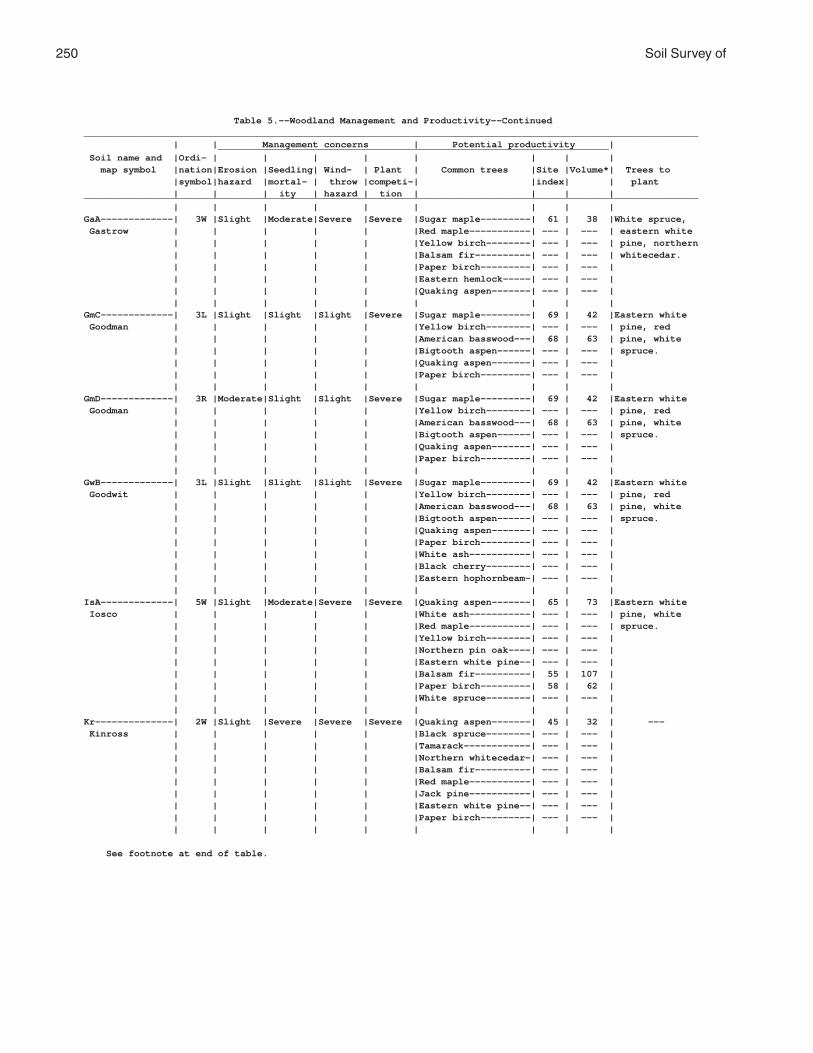
250 Soil Survey of
Table 5.--Woodland Management and Productivity--Continued______________________________________________________________________________________________________________ | | Management concerns | Potential productivity | ______________________________________________________________________ Soil name and |Ordi- | | | | | | | | map symbol |nation|Erosion |Seedling| Wind- | Plant | Common trees |Site |Volume*| Trees to |symbol|hazard |mortal- | throw |competi-| |index| | plant | | | ity | hazard | tion | | | |______________________________________________________________________________________________________________ | | | | | | | | |GaA-------------| 3W |Slight |Moderate|Severe |Severe |Sugar maple---------| 61 | 38 |White spruce, Gastrow | | | | | |Red maple-----------| --- | --- | eastern white | | | | | |Yellow birch--------| --- | --- | pine, northern | | | | | |Balsam fir----------| --- | --- | whitecedar. | | | | | |Paper birch---------| --- | --- | | | | | | |Eastern hemlock-----| --- | --- | | | | | | |Quaking aspen-------| --- | --- | | | | | | | | | |GmC-------------| 3L |Slight |Slight |Slight |Severe |Sugar maple---------| 69 | 42 |Eastern white Goodman | | | | | |Yellow birch--------| --- | --- | pine, red | | | | | |American basswood---| 68 | 63 | pine, white | | | | | |Bigtooth aspen------| --- | --- | spruce. | | | | | |Quaking aspen-------| --- | --- | | | | | | |Paper birch---------| --- | --- | | | | | | | | | |GmD-------------| 3R |Moderate|Slight |Slight |Severe |Sugar maple---------| 69 | 42 |Eastern white Goodman | | | | | |Yellow birch--------| --- | --- | pine, red | | | | | |American basswood---| 68 | 63 | pine, white | | | | | |Bigtooth aspen------| --- | --- | spruce. | | | | | |Quaking aspen-------| --- | --- | | | | | | |Paper birch---------| --- | --- | | | | | | | | | |GwB-------------| 3L |Slight |Slight |Slight |Severe |Sugar maple---------| 69 | 42 |Eastern white Goodwit | | | | | |Yellow birch--------| --- | --- | pine, red | | | | | |American basswood---| 68 | 63 | pine, white | | | | | |Bigtooth aspen------| --- | --- | spruce. | | | | | |Quaking aspen-------| --- | --- | | | | | | |Paper birch---------| --- | --- | | | | | | |White ash-----------| --- | --- | | | | | | |Black cherry--------| --- | --- | | | | | | |Eastern hophornbeam-| --- | --- | | | | | | | | | |IsA-------------| 5W |Slight |Moderate|Severe |Severe |Quaking aspen-------| 65 | 73 |Eastern white Iosco | | | | | |White ash-----------| --- | --- | pine, white | | | | | |Red maple-----------| --- | --- | spruce. | | | | | |Yellow birch--------| --- | --- | | | | | | |Northern pin oak----| --- | --- | | | | | | |Eastern white pine--| --- | --- | | | | | | |Balsam fir----------| 55 | 107 | | | | | | |Paper birch---------| 58 | 62 | | | | | | |White spruce--------| --- | --- | | | | | | | | | |Kr--------------| 2W |Slight |Severe |Severe |Severe |Quaking aspen-------| 45 | 32 | --- Kinross | | | | | |Black spruce--------| --- | --- | | | | | | |Tamarack------------| --- | --- | | | | | | |Northern whitecedar-| --- | --- | | | | | | |Balsam fir----------| --- | --- | | | | | | |Red maple-----------| --- | --- | | | | | | |Jack pine-----------| --- | --- | | | | | | |Eastern white pine--| --- | --- | | | | | | |Paper birch---------| --- | --- | | | | | | | | | |
See footnote at end of table.

Florence County, Wisconsin 251
Table 5.--Woodland Management and Productivity--Continued______________________________________________________________________________________________________________ | | Management concerns | Potential productivity | ______________________________________________________________________ Soil name and |Ordi- | | | | | | | | map symbol |nation|Erosion |Seedling| Wind- | Plant | Common trees |Site |Volume*| Trees to |symbol|hazard |mortal- | throw |competi-| |index| | plant | | | ity | hazard | tion | | | |______________________________________________________________________________________________________________ | | | | | | | | |Lu: | | | | | | | | | Lupton---------| 6W |Slight |Severe |Severe |Severe |Balsam fir----------| 46 | 86 | --- | | | | | |Black spruce--------| 20 | 29 | | | | | | |Black ash-----------| --- | --- | | | | | | |Northern whitecedar-| --- | --- | | | | | | |Paper birch---------| --- | --- | | | | | | |Tamarack------------| --- | --- | | | | | | |Red maple-----------| --- | --- | | | | | | |Quaking aspen-------| --- | --- | | | | | | |White spruce--------| --- | --- | | | | | | | | | | Cathro---------| 5W |Slight |Severe |Severe |Severe |Balsam fir----------| 40 | 71 |White spruce. | | | | | |Northern whitecedar-| --- | --- | | | | | | |Tamarack------------| --- | --- | | | | | | |Paper birch---------| --- | --- | | | | | | |Red maple-----------| --- | --- | | | | | | |Black spruce--------| --- | --- | | | | | | |White spruce--------| --- | --- | | | | | | | | | | Markey---------| 7W |Slight |Severe |Severe |Severe |Balsam fir----------| 52 | 100 | --- | | | | | |Quaking aspen-------| --- | --- | | | | | | |Black spruce--------| --- | --- | | | | | | |Tamarack------------| --- | --- | | | | | | |Black ash-----------| --- | --- | | | | | | |Northern whitecedar-| --- | --- | | | | | | |Paper birch---------| --- | --- | | | | | | |Red maple-----------| --- | --- | | | | | | |White spruce--------| --- | --- | | | | | | | | | |MaA-------------| 3A |Slight |Slight |Slight |Moderate|Sugar maple---------| 60 | 38 |Red pine, Manitowish | | | | | |Red pine------------| 59 | 99 | eastern white | | | | | |Quaking aspen-------| --- | --- | pine, jack | | | | | |Eastern white pine--| --- | --- | pine. | | | | | |Paper birch---------| --- | --- | | | | | | |Red maple-----------| --- | --- | | | | | | | | | |Mn--------------| 7W |Slight |Severe |Severe |Severe |Balsam fir----------| 54 | 105 |Red maple, Minocqua | | | | | |Red maple-----------| 55 | 35 | white ash, | | | | | |White ash-----------| --- | --- | white spruce, | | | | | |Black ash-----------| --- | --- | black spruce. | | | | | |Tamarack------------| 55 | 50 | | | | | | |Northern whitecedar-| --- | --- | | | | | | |Quaking aspen-------| --- | --- | | | | | | | | | |MrB-------------| 6S |Slight |Slight |Moderate|Moderate|Quaking aspen-------| 74 | 86 |Red pine, white Morganlake | | | | | |Sugar maple---------| --- | --- | spruce, | | | | | |American basswood---| --- | --- | eastern white | | | | | |Northern red oak----| 63 | 56 | pine. | | | | | |White ash-----------| 77 | 76 | | | | | | |Black cherry--------| --- | --- | | | | | | |Paper birch---------| --- | --- | | | | | | |Bigtooth aspen------| 76 | 89 | | | | | | |Yellow birch--------| --- | --- | | | | | | |Red pine------------| 62 | 107 | | | | | | |Balsam fir----------| --- | --- | | | | | | | | | |
See footnote at end of table.

252 Soil Survey of
Table 5.--Woodland Management and Productivity--Continued______________________________________________________________________________________________________________ | | Management concerns | Potential productivity | ______________________________________________________________________ Soil name and |Ordi- | | | | | | | | map symbol |nation|Erosion |Seedling| Wind- | Plant | Common trees |Site |Volume*| Trees to |symbol|hazard |mortal- | throw |competi-| |index| | plant | | | ity | hazard | tion | | | |______________________________________________________________________________________________________________ | | | | | | | | |MuB-------------| 3W |Slight |Moderate|Severe |Severe |Red maple-----------| 63 | 39 |Red maple, Mudlake | | | | | |Yellow birch--------| --- | --- | white ash, | | | | | |Sugar maple---------| --- | --- | white spruce, | | | | | |White ash-----------| --- | --- | eastern white | | | | | |Balsam fir----------| --- | --- | pine, red | | | | | |Quaking aspen-------| --- | --- | pine. | | | | | |Eastern hemlock-----| --- | --- | | | | | | |Paper birch---------| --- | --- | | | | | | | | | |PaB, PaC--------| 3L |Slight |Slight |Slight |Moderate|Sugar maple---------| 67 | 41 |Red pine, Padus | | | | | |Northern red oak----| 70 | 66 | eastern white | | | | | |Bigtooth aspen------| 78 | 91 | pine, white | | | | | |White ash-----------| --- | --- | spruce. | | | | | |American basswood---| --- | --- | | | | | | |Red pine------------| --- | --- | | | | | | |Red maple-----------| --- | --- | | | | | | |Eastern hemlock-----| --- | --- | | | | | | | | | |PaD-------------| 3R |Moderate|Slight |Slight |Moderate|Sugar maple---------| 67 | 41 |Red pine, Padus | | | | | |Northern red oak----| 70 | 66 | eastern white | | | | | |Bigtooth aspen------| 78 | 91 | pine, white | | | | | |White ash-----------| --- | --- | spruce. | | | | | |American basswood---| --- | --- | | | | | | |Red pine------------| --- | --- | | | | | | |Red maple-----------| --- | --- | | | | | | |Eastern hemlock-----| --- | --- | | | | | | | | | |PeB, PeC: | | | | | | | | | Padus----------| 3L |Slight |Slight |Slight |Moderate|Sugar maple---------| 67 | 41 |Red pine, | | | | | |Northern red oak----| 70 | 66 | eastern white | | | | | |Bigtooth aspen------| 78 | 91 | pine, white | | | | | |White ash-----------| --- | --- | spruce. | | | | | |American basswood---| --- | --- | | | | | | |Red pine------------| --- | --- | | | | | | |Red maple-----------| --- | --- | | | | | | |Eastern hemlock-----| --- | --- | | | | | | | | | | Pence----------| 3A |Slight |Slight |Slight |Slight |Sugar maple---------| 59 | 37 |Red pine, | | | | | |Red pine------------| 59 | 99 | eastern white | | | | | |Eastern white pine--| 57 | 112 | pine, jack | | | | | |American basswood---| --- | --- | pine. | | | | | |Balsam fir----------| --- | --- | | | | | | |Quaking aspen-------| --- | --- | | | | | | |Paper birch---------| --- | --- | | | | | | |Yellow birch--------| --- | --- | | | | | | |Red maple-----------| --- | --- | | | | | | |Northern red oak----| --- | --- | | | | | | |White ash-----------| --- | --- | | | | | | |Eastern hemlock-----| --- | --- | | | | | | | | | |PeD: | | | | | | | | | Padus----------| 3R |Moderate|Slight |Slight |Moderate|Sugar maple---------| 67 | 41 |Red pine, | | | | | |Northern red oak----| 70 | 66 | eastern white | | | | | |Bigtooth aspen------| 78 | 91 | pine, white | | | | | |White ash-----------| --- | --- | spruce. | | | | | |American basswood---| --- | --- | | | | | | |Red pine------------| --- | --- | | | | | | |Red maple-----------| --- | --- | | | | | | |Eastern hemlock-----| --- | --- | | | | | | | | | |
See footnote at end of table.

Florence County, Wisconsin 253
Table 5.--Woodland Management and Productivity--Continued______________________________________________________________________________________________________________ | | Management concerns | Potential productivity | ______________________________________________________________________ Soil name and |Ordi- | | | | | | | | map symbol |nation|Erosion |Seedling| Wind- | Plant | Common trees |Site |Volume*| Trees to |symbol|hazard |mortal- | throw |competi-| |index| | plant | | | ity | hazard | tion | | | |______________________________________________________________________________________________________________ | | | | | | | | |PeD: | | | | | | | | | Pence----------| 3R |Moderate|Slight |Slight |Slight |Sugar maple---------| 59 | 37 |Red pine, | | | | | |Red pine------------| 59 | 99 | eastern white | | | | | |Eastern white pine--| 57 | 112 | pine, jack | | | | | |American basswood---| --- | --- | pine. | | | | | |Balsam fir----------| --- | --- | | | | | | |Quaking aspen-------| --- | --- | | | | | | |Paper birch---------| --- | --- | | | | | | |Yellow birch--------| --- | --- | | | | | | |Red maple-----------| --- | --- | | | | | | |Northern red oak----| --- | --- | | | | | | |White ash-----------| --- | --- | | | | | | |Eastern hemlock-----| --- | --- | | | | | | | | | |PnB, PnC--------| 3A |Slight |Slight |Slight |Slight |Sugar maple---------| 59 | 37 |Red pine, Pence | | | | | |Red pine------------| 59 | 99 | eastern white | | | | | |Eastern white pine--| 57 | 112 | pine, jack | | | | | |American basswood---| --- | --- | pine. | | | | | |Balsam fir----------| --- | --- | | | | | | |Quaking aspen-------| --- | --- | | | | | | |Paper birch---------| --- | --- | | | | | | |Yellow birch--------| --- | --- | | | | | | |Red maple-----------| --- | --- | | | | | | |Northern red oak----| --- | --- | | | | | | |White ash-----------| --- | --- | | | | | | |Eastern hemlock-----| --- | --- | | | | | | | | | |PnD-------------| 3R |Moderate|Slight |Slight |Slight |Sugar maple---------| 59 | 37 |Red pine, Pence | | | | | |Red pine------------| 59 | 99 | eastern white | | | | | |Eastern white pine--| 57 | 112 | pine, jack | | | | | |American basswood---| --- | --- | pine. | | | | | |Balsam fir----------| --- | --- | | | | | | |Quaking aspen-------| --- | --- | | | | | | |Paper birch---------| --- | --- | | | | | | |Yellow birch--------| --- | --- | | | | | | |Red maple-----------| --- | --- | | | | | | |Northern red oak----| --- | --- | | | | | | |White ash-----------| --- | --- | | | | | | |Eastern hemlock-----| --- | --- | | | | | | | | | |PsB, PsC: | | | | | | | | | Pence----------| 3A |Slight |Slight |Slight |Slight |Sugar maple---------| 59 | 37 |Red pine, | | | | | |Red pine------------| 59 | 99 | eastern white | | | | | |Eastern white pine--| 57 | 112 | pine, jack | | | | | |American basswood---| --- | --- | pine. | | | | | |Balsam fir----------| --- | --- | | | | | | |Quaking aspen-------| --- | --- | | | | | | |Paper birch---------| --- | --- | | | | | | |Yellow birch--------| --- | --- | | | | | | |Red maple-----------| --- | --- | | | | | | |Northern red oak----| --- | --- | | | | | | |White ash-----------| --- | --- | | | | | | |Eastern hemlock-----| --- | --- | | | | | | | | | |
See footnote at end of table.

254 Soil Survey of
Table 5.--Woodland Management and Productivity--Continued______________________________________________________________________________________________________________ | | Management concerns | Potential productivity | ______________________________________________________________________ Soil name and |Ordi- | | | | | | | | map symbol |nation|Erosion |Seedling| Wind- | Plant | Common trees |Site |Volume*| Trees to |symbol|hazard |mortal- | throw |competi-| |index| | plant | | | ity | hazard | tion | | | |______________________________________________________________________________________________________________ | | | | | | | | |PsB, PsC: | | | | | | | | | Vilas----------| 6A |Slight |Slight |Slight |Slight |Red pine------------| 57 | 93 |Red pine, jack | | | | | |Jack pine-----------| 65 | 94 | pine, eastern | | | | | |Eastern white pine--| 56 | 109 | white pine. | | | | | |Northern pin oak----| --- | --- | | | | | | |Balsam fir----------| --- | --- | | | | | | |Quaking aspen-------| --- | --- | | | | | | |Northern red oak----| --- | --- | | | | | | |Red maple-----------| --- | --- | | | | | | |Paper birch---------| --- | --- | | | | | | | | | |PsD: | | | | | | | | | Pence----------| 3R |Moderate|Slight |Slight |Slight |Sugar maple---------| 59 | 37 |Red pine, | | | | | |Red pine------------| 59 | 99 | eastern white | | | | | |Eastern white pine--| 57 | 112 | pine, jack | | | | | |American basswood---| --- | --- | pine. | | | | | |Balsam fir----------| --- | --- | | | | | | |Quaking aspen-------| --- | --- | | | | | | |Paper birch---------| --- | --- | | | | | | |Yellow birch--------| --- | --- | | | | | | |Red maple-----------| --- | --- | | | | | | |Northern red oak----| --- | --- | | | | | | |White ash-----------| --- | --- | | | | | | |Eastern hemlock-----| --- | --- | | | | | | | | | | Vilas----------| 6R |Moderate|Slight |Slight |Slight |Red pine------------| 57 | 93 |Red pine, jack | | | | | |Jack pine-----------| 65 | 94 | pine, eastern | | | | | |Eastern white pine--| 56 | 109 | white pine. | | | | | |Northern pin oak----| --- | --- | | | | | | |Balsam fir----------| --- | --- | | | | | | |Quaking aspen-------| --- | --- | | | | | | |Northern red oak----| --- | --- | | | | | | |Red maple-----------| --- | --- | | | | | | |Paper birch---------| --- | --- | | | | | | | | | |Rb--------------| 3W |Slight |Moderate|Severe |Severe |Sugar maple---------| 61 | 38 |White spruce, Robago | | | | | |Red maple-----------| --- | --- | northern | | | | | |Yellow birch--------| --- | --- | whitecedar, | | | | | |Balsam fir----------| --- | --- | eastern white | | | | | |Paper birch---------| --- | --- | pine. | | | | | |Eastern hemlock-----| --- | --- | | | | | | |Quaking aspen-------| --- | --- | | | | | | | | | |RkC: | | | | | | | | | Rock outcrop. | | | | | | | | | | | | | | | | | | Ishpeming------| 5D |Slight |Slight |Moderate|Slight |Quaking aspen-------| 63 | 70 |Red pine, jack | | | | | |Balsam fir----------| --- | --- | pine. | | | | | |Red maple-----------| --- | --- | | | | | | |Eastern hemlock-----| --- | --- | | | | | | |Paper birch---------| 60 | 65 | | | | | | |Bigtooth aspen------| 68 | 78 | | | | | | |Sugar maple---------| --- | --- | | | | | | |Yellow birch--------| --- | --- | | | | | | |American basswood---| --- | --- | | | | | | | | | |
See footnote at end of table.

Florence County, Wisconsin 255
Table 5.--Woodland Management and Productivity--Continued______________________________________________________________________________________________________________ | | Management concerns | Potential productivity | ______________________________________________________________________ Soil name and |Ordi- | | | | | | | | map symbol |nation|Erosion |Seedling| Wind- | Plant | Common trees |Site |Volume*| Trees to |symbol|hazard |mortal- | throw |competi-| |index| | plant | | | ity | hazard | tion | | | |______________________________________________________________________________________________________________ | | | | | | | | |RkC: | | | | | | | | | Vilas----------| 6A |Slight |Slight |Slight |Slight |Red pine------------| 57 | 93 |Red pine, jack | | | | | |Jack pine-----------| 65 | 94 | pine, eastern | | | | | |Eastern white pine--| 56 | 109 | white pine. | | | | | |Northern pin oak----| --- | --- | | | | | | |Balsam fir----------| --- | --- | | | | | | |Quaking aspen-------| --- | --- | | | | | | |Northern red oak----| --- | --- | | | | | | |Red maple-----------| --- | --- | | | | | | |Paper birch---------| --- | --- | | | | | | | | | |RkD: | | | | | | | | | Rock outcrop. | | | | | | | | | | | | | | | | | | Ishpeming------| 5R |Moderate|Slight |Moderate|Slight |Quaking aspen-------| 63 | 70 |Red pine, jack | | | | | |Balsam fir----------| --- | --- | pine. | | | | | |Red maple-----------| --- | --- | | | | | | |Eastern hemlock-----| --- | --- | | | | | | |Paper birch---------| 60 | 65 | | | | | | |Bigtooth aspen------| 68 | 78 | | | | | | |Sugar maple---------| --- | --- | | | | | | |Yellow birch--------| --- | --- | | | | | | |American basswood---| --- | --- | | | | | | | | | | Vilas----------| 6R |Moderate|Slight |Slight |Slight |Red pine------------| 57 | 93 |Red pine, jack | | | | | |Jack pine-----------| 65 | 94 | pine, eastern | | | | | |Eastern white pine--| 56 | 109 | white pine. | | | | | |Northern pin oak----| --- | --- | | | | | | |Balsam fir----------| --- | --- | | | | | | |Quaking aspen-------| --- | --- | | | | | | |Northern red oak----| --- | --- | | | | | | |Red maple-----------| --- | --- | | | | | | |Paper birch---------| --- | --- | | | | | | | | | |RmC: | | | | | | | | | Rock outcrop. | | | | | | | | | | | | | | | | | | Metonga--------| 3D |Slight |Slight |Moderate|Moderate|Sugar maple---------| 60 | 38 |White spruce, | | | | | |Red maple-----------| --- | --- | eastern white | | | | | |Paper birch---------| --- | --- | pine. | | | | | |Yellow birch--------| 60 | 38 | | | | | | |Balsam fir----------| --- | --- | | | | | | |Bigtooth aspen------| --- | --- | | | | | | |Eastern hemlock-----| --- | --- | | | | | | |White spruce--------| --- | --- | | | | | | |Black cherry--------| --- | --- | | | | | | |Northern red oak----| --- | --- | | | | | | |American basswood---| --- | --- | | | | | | |Quaking aspen-------| --- | --- | | | | | | | | | | Sarona---------| 3L |Slight |Slight |Slight |Moderate|Sugar maple---------| 64 | 40 |Red pine, | | | | | |Northern red oak----| 72 | 69 | eastern white | | | | | |American basswood---| 70 | 66 | pine, white | | | | | |Quaking aspen-------| --- | --- | spruce. | | | | | |White ash-----------| 75 | 73 | | | | | | |Eastern hemlock-----| --- | --- | | | | | | | | | |
See footnote at end of table.

256 Soil Survey of
Table 5.--Woodland Management and Productivity--Continued______________________________________________________________________________________________________________ | | Management concerns | Potential productivity | ______________________________________________________________________ Soil name and |Ordi- | | | | | | | | map symbol |nation|Erosion |Seedling| Wind- | Plant | Common trees |Site |Volume*| Trees to |symbol|hazard |mortal- | throw |competi-| |index| | plant | | | ity | hazard | tion | | | |______________________________________________________________________________________________________________ | | | | | | | | |RmD: | | | | | | | | | Rock outcrop. | | | | | | | | | | | | | | | | | | Metonga--------| 3R |Moderate|Slight |Moderate|Moderate|Sugar maple---------| 60 | 38 |White spruce, | | | | | |Red maple-----------| --- | --- | eastern white | | | | | |Paper birch---------| --- | --- | pine. | | | | | |Yellow birch--------| 60 | 38 | | | | | | |Balsam fir----------| --- | --- | | | | | | |Bigtooth aspen------| --- | --- | | | | | | |Eastern hemlock-----| --- | --- | | | | | | |White spruce--------| --- | --- | | | | | | |Black cherry--------| --- | --- | | | | | | |Northern red oak----| --- | --- | | | | | | |American basswood---| --- | --- | | | | | | |Quaking aspen-------| --- | --- | | | | | | | | | | Sarona---------| 3R |Moderate|Slight |Slight |Moderate|Sugar maple---------| 64 | 40 |Red pine, | | | | | |Northern red oak----| 72 | 69 | eastern white | | | | | |American basswood---| 70 | 66 | pine, white | | | | | |Quaking aspen-------| --- | --- | spruce. | | | | | |White ash-----------| 75 | 73 | | | | | | |Eastern hemlock-----| --- | --- | | | | | | | | | |RsB, RsC--------| 5A |Slight |Slight |Slight |Moderate|Quaking aspen-------| 65 | 73 |Red pine, jack Rousseau | | | | | |Red maple-----------| 60 | 38 | pine. | | | | | |Balsam fir----------| --- | --- | | | | | | |Northern red oak----| --- | --- | | | | | | |Eastern hemlock-----| --- | --- | | | | | | |Red pine------------| --- | --- | | | | | | |Jack pine-----------| 62 | 89 | | | | | | |Paper birch---------| 65 | 73 | | | | | | |Yellow birch--------| --- | --- | | | | | | |Bigtooth aspen------| 66 | 75 | | | | | | | | | |SaB, SaC--------| 3L |Slight |Slight |Slight |Moderate|Sugar maple---------| 64 | 40 |Red pine, white Sarona | | | | | |Northern red oak----| 72 | 69 | spruce, | | | | | |American basswood---| 70 | 66 | eastern white | | | | | |Quaking aspen-------| --- | --- | pine. | | | | | |White ash-----------| 75 | 73 | | | | | | |Eastern hemlock-----| --- | --- | | | | | | | | | |SaD-------------| 3R |Moderate|Slight |Slight |Moderate|Sugar maple---------| 64 | 40 |Red pine, white Sarona | | | | | |Northern red oak----| 72 | 69 | spruce, | | | | | |American basswood---| 70 | 66 | eastern white | | | | | |Quaking aspen-------| --- | --- | pine. | | | | | |White ash-----------| 75 | 73 | | | | | | |Eastern hemlock-----| --- | --- | | | | | | | | | |SdB, SdC: | | | | | | | | | Sarona---------| 3L |Slight |Slight |Slight |Moderate|Sugar maple---------| 64 | 40 |Red pine, white | | | | | |Northern red oak----| 72 | 69 | spruce, | | | | | |American basswood---| 70 | 66 | eastern white | | | | | |Quaking aspen-------| --- | --- | pine. | | | | | |White ash-----------| 75 | 73 | | | | | | |Eastern hemlock-----| --- | --- | | | | | | | | | |
See footnote at end of table.

Florence County, Wisconsin 257
Table 5.--Woodland Management and Productivity--Continued______________________________________________________________________________________________________________ | | Management concerns | Potential productivity | ______________________________________________________________________ Soil name and |Ordi- | | | | | | | | map symbol |nation|Erosion |Seedling| Wind- | Plant | Common trees |Site |Volume*| Trees to |symbol|hazard |mortal- | throw |competi-| |index| | plant | | | ity | hazard | tion | | | |______________________________________________________________________________________________________________ | | | | | | | | |SdB, SdC: | | | | | | | | | Padus----------| 3L |Slight |Slight |Slight |Moderate|Sugar maple---------| 67 | 41 |Red pine, | | | | | |Northern red oak----| 70 | 66 | eastern white | | | | | |Bigtooth aspen------| 78 | 91 | pine, white | | | | | |White ash-----------| --- | --- | spruce. | | | | | |American basswood---| --- | --- | | | | | | |Red pine------------| --- | --- | | | | | | |Red maple-----------| --- | --- | | | | | | |Eastern hemlock-----| --- | --- | | | | | | | | | |SdD: | | | | | | | | | Sarona---------| 3R |Moderate|Slight |Slight |Moderate|Sugar maple---------| 64 | 40 |Red pine, white | | | | | |Northern red oak----| 72 | 69 | spruce, | | | | | |American basswood---| 70 | 66 | eastern white | | | | | |Quaking aspen-------| --- | --- | pine. | | | | | |White ash-----------| 75 | 73 | | | | | | |Eastern hemlock-----| --- | --- | | | | | | | | | | Padus----------| 3R |Moderate|Slight |Slight |Moderate|Sugar maple---------| 67 | 41 |Red pine, | | | | | |Northern red oak----| 70 | 66 | eastern white | | | | | |Bigtooth aspen------| 78 | 91 | pine, white | | | | | |White ash-----------| --- | --- | spruce. | | | | | |American basswood---| --- | --- | | | | | | |Red pine------------| --- | --- | | | | | | |Red maple-----------| --- | --- | | | | | | |Eastern hemlock-----| --- | --- | | | | | | | | | |SlB, SlC: | | | | | | | | | Sarona---------| 3L |Slight |Slight |Slight |Moderate|Sugar maple---------| 64 | 40 |Red pine, white | | | | | |Northern red oak----| 72 | 69 | spruce, | | | | | |American basswood---| 70 | 66 | eastern white | | | | | |Quaking aspen-------| --- | --- | pine. | | | | | |White ash-----------| 75 | 73 | | | | | | |Eastern hemlock-----| --- | --- | | | | | | | | | | Vilas----------| 6A |Slight |Slight |Slight |Slight |Red pine------------| 57 | 93 |Red pine, jack | | | | | |Jack pine-----------| 65 | 94 | pine, eastern | | | | | |Eastern white pine--| 56 | 109 | white pine. | | | | | |Northern pin oak----| --- | --- | | | | | | |Balsam fir----------| --- | --- | | | | | | |Quaking aspen-------| --- | --- | | | | | | |Northern red oak----| --- | --- | | | | | | |Red maple-----------| --- | --- | | | | | | |Paper birch---------| --- | --- | | | | | | | | | |SlD: | | | | | | | | | Sarona---------| 3R |Moderate|Slight |Slight |Moderate|Sugar maple---------| 64 | 40 |Red pine, white | | | | | |Northern red oak----| 72 | 69 | spruce, | | | | | |American basswood---| 70 | 66 | eastern white | | | | | |Quaking aspen-------| --- | --- | pine. | | | | | |White ash-----------| 75 | 73 | | | | | | |Eastern hemlock-----| --- | --- | | | | | | | | | |
See footnote at end of table.

258 Soil Survey of
Table 5.--Woodland Management and Productivity--Continued______________________________________________________________________________________________________________ | | Management concerns | Potential productivity | ______________________________________________________________________ Soil name and |Ordi- | | | | | | | | map symbol |nation|Erosion |Seedling| Wind- | Plant | Common trees |Site |Volume*| Trees to |symbol|hazard |mortal- | throw |competi-| |index| | plant | | | ity | hazard | tion | | | |______________________________________________________________________________________________________________ | | | | | | | | |SlD: | | | | | | | | | Vilas----------| 6R |Moderate|Slight |Slight |Slight |Red pine------------| 57 | 93 |Red pine, jack | | | | | |Jack pine-----------| 65 | 94 | pine, eastern | | | | | |Eastern white pine--| 56 | 109 | white pine. | | | | | |Northern pin oak----| --- | --- | | | | | | |Balsam fir----------| --- | --- | | | | | | |Quaking aspen-------| --- | --- | | | | | | |Northern red oak----| --- | --- | | | | | | |Red maple-----------| --- | --- | | | | | | |Paper birch---------| --- | --- | | | | | | | | | |SnB, SnC--------| 7A |Slight |Slight |Slight |Slight |Red pine------------| 59 | 99 |Red pine, jack Sayner | | | | | |Jack pine-----------| --- | --- | pine, eastern | | | | | |Eastern white pine--| 57 | 112 | white pine. | | | | | |Northern red oak----| --- | --- | | | | | | |Quaking aspen-------| --- | --- | | | | | | |Paper birch---------| --- | --- | | | | | | |Red maple-----------| --- | --- | | | | | | | | | |SnD-------------| 7R |Moderate|Slight |Slight |Slight |Red pine------------| 59 | 99 |Red pine, jack Sayner | | | | | |Jack pine-----------| --- | --- | pine, eastern | | | | | |Eastern white pine--| 57 | 112 | white pine. | | | | | |Northern red oak----| --- | --- | | | | | | |Quaking aspen-------| --- | --- | | | | | | |Paper birch---------| --- | --- | | | | | | |Red maple-----------| --- | --- | | | | | | | | | |SoD: | | | | | | | | | Soperton-------| 3R |Moderate|Slight |Moderate|Moderate|Sugar maple---------| 67 | 41 |White spruce, | | | | | |American basswood---| 74 | 72 | red pine. | | | | | |Yellow birch--------| 72 | 44 | | | | | | |White ash-----------| 78 | 78 | | | | | | |Eastern hemlock-----| 56 | --- | | | | | | | | | | Goodman--------| 3R |Moderate|Slight |Slight |Severe |Sugar maple---------| 69 | 42 |Eastern white | | | | | |Yellow birch--------| --- | --- | pine, red | | | | | |American basswood---| 68 | 63 | pine, white | | | | | |Bigtooth aspen------| --- | --- | spruce. | | | | | |Quaking aspen-------| --- | --- | | | | | | |Paper birch---------| --- | --- | | | | | | | | | |StC-------------| 3L |Slight |Slight |Slight |Severe |Sugar maple---------| 61 | 38 |Eastern white Stambaugh | | | | | |Yellow birch--------| --- | --- | pine, white | | | | | |American basswood---| --- | --- | spruce, red | | | | | |Eastern hemlock-----| --- | --- | pine. | | | | | |Eastern white pine--| --- | --- | | | | | | |Red maple-----------| --- | --- | | | | | | |Balsam fir----------| --- | --- | | | | | | | | | |StD-------------| 3R |Moderate|Slight |Slight |Severe |Sugar maple---------| 61 | 38 |Eastern white Stambaugh | | | | | |Yellow birch--------| --- | --- | pine, white | | | | | |American basswood---| --- | --- | spruce, red | | | | | |Eastern hemlock-----| --- | --- | pine. | | | | | |Eastern white pine--| --- | --- | | | | | | |Red maple-----------| --- | --- | | | | | | |Balsam fir----------| --- | --- | | | | | | | | | |
See footnote at end of table.
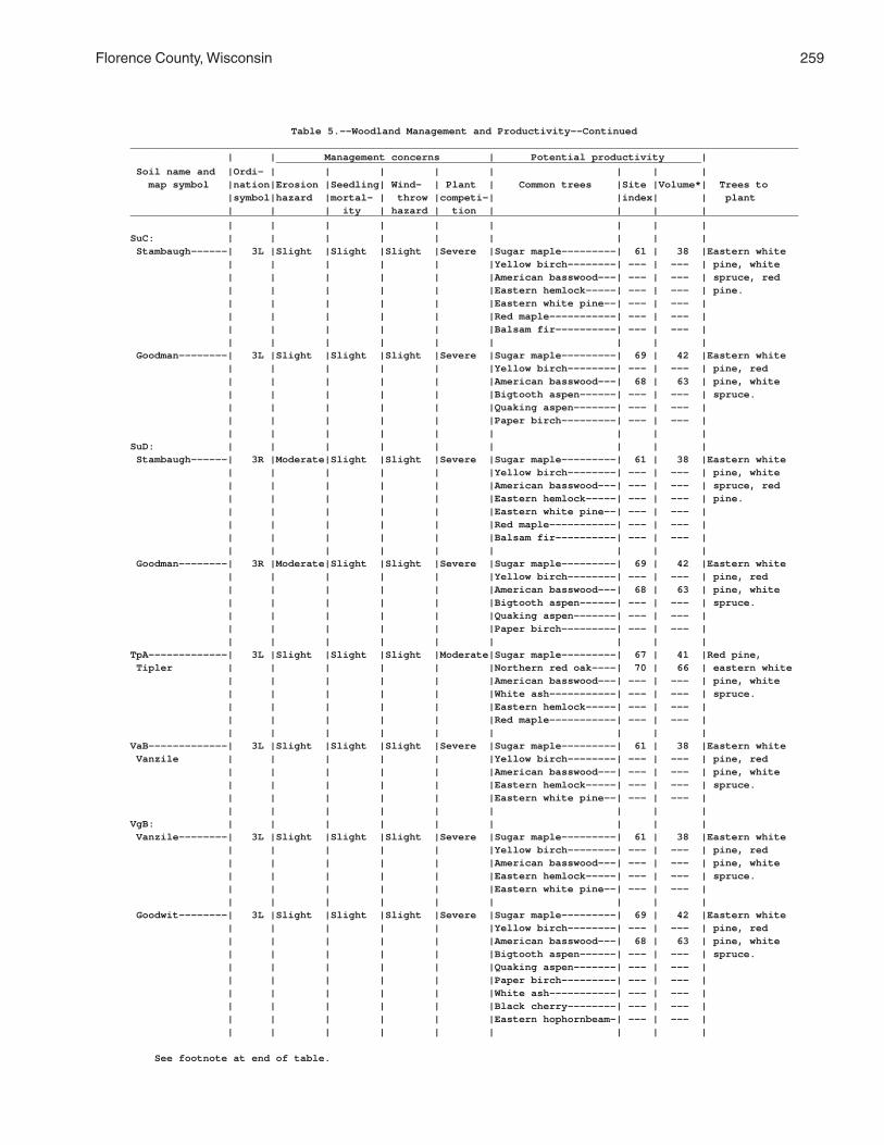
Florence County, Wisconsin 259
Table 5.--Woodland Management and Productivity--Continued______________________________________________________________________________________________________________ | | Management concerns | Potential productivity | ______________________________________________________________________ Soil name and |Ordi- | | | | | | | | map symbol |nation|Erosion |Seedling| Wind- | Plant | Common trees |Site |Volume*| Trees to |symbol|hazard |mortal- | throw |competi-| |index| | plant | | | ity | hazard | tion | | | |______________________________________________________________________________________________________________ | | | | | | | | |SuC: | | | | | | | | | Stambaugh------| 3L |Slight |Slight |Slight |Severe |Sugar maple---------| 61 | 38 |Eastern white | | | | | |Yellow birch--------| --- | --- | pine, white | | | | | |American basswood---| --- | --- | spruce, red | | | | | |Eastern hemlock-----| --- | --- | pine. | | | | | |Eastern white pine--| --- | --- | | | | | | |Red maple-----------| --- | --- | | | | | | |Balsam fir----------| --- | --- | | | | | | | | | | Goodman--------| 3L |Slight |Slight |Slight |Severe |Sugar maple---------| 69 | 42 |Eastern white | | | | | |Yellow birch--------| --- | --- | pine, red | | | | | |American basswood---| 68 | 63 | pine, white | | | | | |Bigtooth aspen------| --- | --- | spruce. | | | | | |Quaking aspen-------| --- | --- | | | | | | |Paper birch---------| --- | --- | | | | | | | | | |SuD: | | | | | | | | | Stambaugh------| 3R |Moderate|Slight |Slight |Severe |Sugar maple---------| 61 | 38 |Eastern white | | | | | |Yellow birch--------| --- | --- | pine, white | | | | | |American basswood---| --- | --- | spruce, red | | | | | |Eastern hemlock-----| --- | --- | pine. | | | | | |Eastern white pine--| --- | --- | | | | | | |Red maple-----------| --- | --- | | | | | | |Balsam fir----------| --- | --- | | | | | | | | | | Goodman--------| 3R |Moderate|Slight |Slight |Severe |Sugar maple---------| 69 | 42 |Eastern white | | | | | |Yellow birch--------| --- | --- | pine, red | | | | | |American basswood---| 68 | 63 | pine, white | | | | | |Bigtooth aspen------| --- | --- | spruce. | | | | | |Quaking aspen-------| --- | --- | | | | | | |Paper birch---------| --- | --- | | | | | | | | | |TpA-------------| 3L |Slight |Slight |Slight |Moderate|Sugar maple---------| 67 | 41 |Red pine, Tipler | | | | | |Northern red oak----| 70 | 66 | eastern white | | | | | |American basswood---| --- | --- | pine, white | | | | | |White ash-----------| --- | --- | spruce. | | | | | |Eastern hemlock-----| --- | --- | | | | | | |Red maple-----------| --- | --- | | | | | | | | | |VaB-------------| 3L |Slight |Slight |Slight |Severe |Sugar maple---------| 61 | 38 |Eastern white Vanzile | | | | | |Yellow birch--------| --- | --- | pine, red | | | | | |American basswood---| --- | --- | pine, white | | | | | |Eastern hemlock-----| --- | --- | spruce. | | | | | |Eastern white pine--| --- | --- | | | | | | | | | |VgB: | | | | | | | | | Vanzile--------| 3L |Slight |Slight |Slight |Severe |Sugar maple---------| 61 | 38 |Eastern white | | | | | |Yellow birch--------| --- | --- | pine, red | | | | | |American basswood---| --- | --- | pine, white | | | | | |Eastern hemlock-----| --- | --- | spruce. | | | | | |Eastern white pine--| --- | --- | | | | | | | | | | Goodwit--------| 3L |Slight |Slight |Slight |Severe |Sugar maple---------| 69 | 42 |Eastern white | | | | | |Yellow birch--------| --- | --- | pine, red | | | | | |American basswood---| 68 | 63 | pine, white | | | | | |Bigtooth aspen------| --- | --- | spruce. | | | | | |Quaking aspen-------| --- | --- | | | | | | |Paper birch---------| --- | --- | | | | | | |White ash-----------| --- | --- | | | | | | |Black cherry--------| --- | --- | | | | | | |Eastern hophornbeam-| --- | --- | | | | | | | | | |
See footnote at end of table.

260 Soil Survey of
Table 5.--Woodland Management and Productivity--Continued______________________________________________________________________________________________________________ | | Management concerns | Potential productivity | ______________________________________________________________________ Soil name and |Ordi- | | | | | | | | map symbol |nation|Erosion |Seedling| Wind- | Plant | Common trees |Site |Volume*| Trees to |symbol|hazard |mortal- | throw |competi-| |index| | plant | | | ity | hazard | tion | | | |______________________________________________________________________________________________________________ | | | | | | | | |VsB, VsC--------| 6A |Slight |Slight |Slight |Slight |Red pine------------| 57 | 93 |Red pine, jack Vilas | | | | | |Jack pine-----------| 65 | 94 | pine, eastern | | | | | |Eastern white pine--| 56 | 109 | white pine. | | | | | |Northern pin oak----| --- | --- | | | | | | |Balsam fir----------| --- | --- | | | | | | |Quaking aspen-------| --- | --- | | | | | | |Northern red oak----| --- | --- | | | | | | |Red maple-----------| --- | --- | | | | | | |Paper birch---------| --- | --- | | | | | | | | | |VsD-------------| 6R |Moderate|Slight |Slight |Slight |Red pine------------| 57 | 93 |Red pine, jack Vilas | | | | | |Jack pine-----------| 65 | 94 | pine, eastern | | | | | |Eastern white pine--| 56 | 109 | white pine. | | | | | |Northern pin oak----| --- | --- | | | | | | |Balsam fir----------| --- | --- | | | | | | |Quaking aspen-------| --- | --- | | | | | | |Northern red oak----| --- | --- | | | | | | |Red maple-----------| --- | --- | | | | | | |Paper birch---------| --- | --- | | | | | | | | | |WaC: | | | | | | | | | Wabeno---------| 3L |Slight |Slight |Moderate|Moderate|Sugar maple---------| 67 | 41 |White spruce, | | | | | |American basswood---| 74 | 72 | red pine. | | | | | |Yellow birch--------| 72 | 44 | | | | | | |White ash-----------| 78 | 78 | | | | | | | | | | Goodman--------| 3L |Slight |Slight |Slight |Severe |Sugar maple---------| 69 | 42 |Eastern white | | | | | |Yellow birch--------| --- | --- | pine, red | | | | | |American basswood---| 68 | 63 | pine, white | | | | | |Bigtooth aspen------| --- | --- | spruce. | | | | | |Quaking aspen-------| --- | --- | | | | | | |Paper birch---------| --- | --- | | | | | | | | | |WbB: | | | | | | | | | Wabeno---------| 3L |Slight |Slight |Moderate|Moderate|Sugar maple---------| 67 | 41 |White spruce, | | | | | |American basswood---| 74 | 72 | red pine. | | | | | |Yellow birch--------| 72 | 44 | | | | | | |White ash-----------| 78 | 78 | | | | | | | | | | Goodwit--------| 3L |Slight |Slight |Slight |Severe |Sugar maple---------| 69 | 42 |Eastern white | | | | | |Yellow birch--------| --- | --- | pine, red | | | | | |American basswood---| 68 | 63 | pine, white | | | | | |Bigtooth aspen------| --- | --- | spruce. | | | | | |Quaking aspen-------| --- | --- | | | | | | |Paper birch---------| --- | --- | | | | | | |White ash-----------| --- | --- | | | | | | |Black cherry--------| --- | --- | | | | | | |Eastern hophornbeam-| --- | --- | | | | | | | | | |WkB, WkC--------| 3W |Slight |Moderate|Severe |Severe |Sugar maple---------| 61 | 38 |White spruce, Wakefield | | | | | |American basswood---| --- | --- | eastern white | | | | | |Yellow birch--------| --- | --- | pine, jack | | | | | |Balsam fir----------| --- | --- | pine, red | | | | | |Eastern hemlock-----| --- | --- | pine. | | | | | | | | |
See footnote at end of table.

Florence County, Wisconsin 261
Table 5.--Woodland Management and Productivity--Continued______________________________________________________________________________________________________________ | | Management concerns | Potential productivity | ______________________________________________________________________ Soil name and |Ordi- | | | | | | | | map symbol |nation|Erosion |Seedling| Wind- | Plant | Common trees |Site |Volume*| Trees to |symbol|hazard |mortal- | throw |competi-| |index| | plant | | | ity | hazard | tion | | | |______________________________________________________________________________________________________________ | | | | | | | | |WrA-------------| 2W |Slight |Moderate|Severe |Severe |Red maple-----------| 55 | 35 |Red maple, Worcester | | | | | |Sugar maple---------| --- | --- | white spruce, | | | | | |Yellow birch--------| --- | --- | eastern white | | | | | |Balsam fir----------| --- | --- | pine. | | | | | |White spruce--------| --- | --- | | | | | | |Paper birch---------| --- | --- | | | | | | |Quaking aspen-------| --- | --- | | | | | | |Eastern hemlock-----| --- | --- | | | | | | | | | |______________________________________________________________________________________________________________
* Volume is the yield in cubic feet per acre per year calculated at the age of culmination of the meanannual increment for fully stocked natural stands.

262 Soil Survey of
Table 6.--Woodland Equipment Use
(Only the soils suitable for the production of commercial trees are listed. Some terms that describe restrictive soil features are defined in the Glossary. See text for definitions of "slight," "moderate," and "severe." Absence of an entry indicates that the soil was not rated)
_____________________________________________________________________________________________________ | Ratings for the most limiting season | _______________________________________________________________ Soil name and | Logging areas | | | Site | Preferred map symbol | and skid | Log landings | Haul roads | preparation | operating | trails | | | and planting | season(s)_____________________________________________________________________________________________________ | | | | |AnB------------------|Moderate: |Moderate: |Moderate: |Moderate: |Summer, fall, Annalake | low strength. | low strength. | low strength. | low strength. | winter. | | | | |AnC------------------|Moderate: |Moderate: |Moderate: |Moderate: |Summer, fall, Annalake | low strength. | low strength, | low strength. | low strength. | winter. | | slope. | | | | | | | |Au-------------------|Severe: |Severe: |Severe: |Severe: |Summer, winter. Au Gres | wetness. | wetness. | wetness. | wetness. | | | | | |Ca-------------------|Severe: |Severe: |Severe: |Severe: |Winter. Capitola | wetness, | wetness, | wetness, | wetness, | | low strength. | low strength. | low strength. | low strength. | | | | | |CoA------------------|Severe: |Severe: |Severe: |Severe: |Summer, Crossett | wetness, | wetness, | wetness, | wetness, | winter.* | low strength. | low strength. | low strength. | low strength. | | | | | |CrA------------------|Slight---------|Slight---------|Slight---------|Slight---------|Year round. Croswell | | | | | | | | | |CuA------------------|Slight---------|Slight---------|Slight---------|Slight---------|Year round. Cublake | | | | | | | | | |EdB------------------|Moderate: |Moderate: |Moderate: |Moderate: |Summer, fall, Ellwood | low strength. | low strength. | low strength. | low strength. | winter.* | | | | |EdC------------------|Moderate: |Moderate: |Moderate: |Moderate: |Summer, fall, Ellwood | low strength. | slope, | low strength. | low strength. | winter.* | | low strength. | | | | | | | |ElB: | | | | | Ellwood-------------|Moderate: |Moderate: |Moderate: |Moderate: |Summer, fall, | low strength. | low strength. | low strength. | low strength. | winter.* | | | | | Crossett------------|Severe: |Severe: |Severe: |Severe: |Summer, | wetness, | wetness, | wetness, | wetness, | winter.* | low strength. | low strength. | low strength. | low strength. | | | | | |EmB: | | | | | Ellwood-------------|Moderate: |Moderate: |Moderate: |Moderate: |Summer, fall, | low strength. | low strength. | low strength. | low strength. | winter.* | | | | | Iosco---------------|Severe: |Severe: |Severe: |Severe: |Summer, winter. | wetness. | wetness. | wetness. | wetness. | | | | | | Morganlake----------|Slight---------|Slight---------|Slight---------|Slight---------|Year round. | | | | |EnC: | | | | | Ellwood-------------|Moderate: |Moderate: |Moderate: |Moderate: |Summer, fall, | low strength. | slope, | low strength. | low strength. | winter.* | | low strength. | | | | | | | | Iosco---------------|Severe: |Severe: |Severe: |Severe: |Summer, winter. | wetness. | wetness. | wetness. | wetness. | | | | | |
See footnote at end of table.

Florence County, Wisconsin 263
Table 6.--Woodland Equipment Use--Continued_____________________________________________________________________________________________________ | Ratings for the most limiting season | _______________________________________________________________ Soil name and | Logging areas | | | Site | Preferred map symbol | and skid | Log landings | Haul roads | preparation | operating | trails | | | and planting | season(s)_____________________________________________________________________________________________________ | | | | |EnC: | | | | | Vilas---------------|Slight---------|Moderate: |Slight---------|Slight---------|Year round. | | slope. | | | | | | | |EoD: | | | | | Ellwood-------------|Moderate: |Moderate: |Moderate: |Moderate: |Summer, fall, | low strength. | slope, | low strength. | low strength. | winter.* | | low strength. | | | | | | | | Vilas---------------|Moderate: |Severe: |Moderate: |Moderate: |Year round. | slope. | slope. | slope. | slope. | | | | | | Padus---------------|Moderate: |Severe: |Moderate: |Moderate: |Summer, fall, | slope, | slope. | slope, | slope, | winter. | low strength. | | low strength. | low strength. | | | | | |Ep: | | | | | Epiaquents----------|Severe: |Severe: |Severe: |Severe: |Winter. | wetness, | wetness, | wetness, | wetness, | | low strength. | low strength. | low strength. | low strength. | | | | | | Epiaquods-----------|Severe: |Severe: |Severe: |Severe: |Winter. | wetness, | wetness, | wetness, | wetness, | | low strength. | low strength. | low strength. | low strength. | | | | | |FeB------------------|Severe: |Severe: |Severe: |Severe: |Summer, fall, Fence | low strength. | low strength. | low strength. | low strength. | winter.* | | | | |Fm-------------------|Severe: |Severe: |Severe: |Severe: |Winter. Fordum | wetness, | wetness, | wetness, | wetness, | | low strength. | flooding, | flooding, | low strength. | | | low strength. | low strength. | | | | | | |GaA------------------|Severe: |Severe: |Severe: |Severe: |Summer, Gastrow | wetness, | wetness, | wetness, | wetness, | winter.* | low strength. | low strength. | low strength. | low strength. | | | | | |GmC------------------|Moderate: |Moderate: |Moderate: |Moderate: |Summer, fall, Goodman | low strength. | slope, | low strength. | low strength. | winter.* | | low strength. | | | | | | | |GmD------------------|Moderate: |Severe: |Moderate: |Moderate: |Summer, fall, Goodman | slope, | slope. | slope, | slope, | winter.* | low strength. | | low strength. | low strength. | | | | | |GwB------------------|Moderate: |Moderate: |Moderate: |Moderate: |Summer, fall, Goodwit | low strength. | low strength. | low strength. | low strength. | winter.* | | | | |IsA------------------|Severe: |Severe: |Severe: |Severe: |Summer, fall. Iosco | wetness. | wetness. | wetness. | wetness. | | | | | |Kr-------------------|Severe: |Severe: |Severe: |Severe: |Winter. Kinross | wetness. | wetness. | wetness. | wetness. | | | | | |Lu: | | | | | Lupton--------------|Severe: |Severe: |Severe: |Severe: |Winter. | wetness, | wetness, | wetness, | wetness, | | low strength. | low strength. | low strength. | low strength. | | | | | | Cathro--------------|Severe: |Severe: |Severe: |Severe: |Winter. | wetness, | wetness, | wetness, | wetness, | | low strength. | low strength. | low strength. | low strength. | | | | | |
See footnote at end of table.

264 Soil Survey of
Table 6.--Woodland Equipment Use--Continued_____________________________________________________________________________________________________ | Ratings for the most limiting season | _______________________________________________________________ Soil name and | Logging areas | | | Site | Preferred map symbol | and skid | Log landings | Haul roads | preparation | operating | trails | | | and planting | season(s)_____________________________________________________________________________________________________ | | | | |Lu: | | | | | Markey--------------|Severe: |Severe: |Severe: |Severe: |Winter. | wetness, | wetness, | wetness, | wetness, | | low strength. | low strength. | low strength. | low strength. | | | | | |MaA------------------|Slight---------|Slight---------|Slight---------|Slight---------|Year round. Manitowish | | | | | | | | | |Mn-------------------|Severe: |Severe: |Severe: |Severe: |Winter. Minocqua | wetness, | wetness, | wetness, | wetness, | | low strength. | low strength. | low strength. | low strength. | | | | | |MrB------------------|Slight---------|Slight---------|Slight---------|Slight---------|Year round. Morganlake | | | | | | | | | |MuB------------------|Severe: |Severe: |Severe: |Severe: |Summer, Mudlake | wetness, | wetness, | wetness, | wetness, | winter.* | low strength. | low strength. | low strength. | low strength. | | | | | |PaB------------------|Moderate: |Moderate: |Moderate: |Moderate: |Summer, fall, Padus | low strength. | low strength. | low strength. | low strength. | winter. | | | | |PaC------------------|Moderate: |Moderate: |Moderate: |Moderate: |Summer, fall, Padus | low strength. | slope, | low strength. | low strength. | winter. | | low strength. | | | | | | | |PaD------------------|Moderate: |Severe: |Moderate: |Moderate: |Summer, fall, Padus | slope, | slope. | slope, | slope, | winter. | low strength. | | low strength. | low strength. | | | | | |PeB: | | | | | Padus---------------|Moderate: |Moderate: |Moderate: |Moderate: |Summer, fall, | low strength. | low strength. | low strength. | low strength. | winter. | | | | | Pence---------------|Slight---------|Slight---------|Slight---------|Slight---------|Year round. | | | | |PeC: | | | | | Padus---------------|Moderate: |Moderate: |Moderate: |Moderate: |Summer, fall, | low strength. | slope, | low strength. | low strength. | winter. | | low strength. | | | | | | | | Pence---------------|Slight---------|Moderate: |Slight---------|Slight---------|Year round. | | slope. | | | | | | | |PeD: | | | | | Padus---------------|Moderate: |Severe: |Moderate: |Moderate: |Summer, fall, | slope, | slope. | slope, | slope, | winter. | low strength. | | low strength. | low strength. | | | | | | Pence---------------|Moderate: |Severe: |Moderate: |Moderate: |Year round. | slope. | slope. | slope. | slope. | | | | | |PnB------------------|Slight---------|Slight---------|Slight---------|Slight---------|Year round. Pence | | | | | | | | | |PnC------------------|Slight---------|Moderate: |Slight---------|Slight---------|Year round. Pence | | slope. | | | | | | | |PnD------------------|Moderate: |Severe: |Moderate: |Moderate: |Year round. Pence | slope. | slope. | slope. | slope. | | | | | |
See footnote at end of table.

Florence County, Wisconsin 265
Table 6.--Woodland Equipment Use--Continued_____________________________________________________________________________________________________ | Ratings for the most limiting season | _______________________________________________________________ Soil name and | Logging areas | | | Site | Preferred map symbol | and skid | Log landings | Haul roads | preparation | operating | trails | | | and planting | season(s)_____________________________________________________________________________________________________ | | | | |PsB: | | | | | Pence---------------|Slight---------|Slight---------|Slight---------|Slight---------|Year round. | | | | | Vilas---------------|Slight---------|Slight---------|Slight---------|Slight---------|Year round. | | | | |PsC: | | | | | Pence---------------|Slight---------|Moderate: |Slight---------|Slight---------|Year round. | | slope. | | | | | | | | Vilas---------------|Slight---------|Moderate: |Slight---------|Slight---------|Year round. | | slope. | | | | | | | |PsD: | | | | | Pence---------------|Moderate: |Severe: |Moderate: |Moderate: |Year round. | slope. | slope. | slope. | slope. | | | | | | Vilas---------------|Moderate: |Severe: |Moderate: |Moderate: |Year round. | slope. | slope. | slope. | slope. | | | | | |Rb-------------------|Severe: |Severe: |Severe: |Severe: |Summer, winter. Robago | wetness, | wetness, | wetness, | wetness, | | low strength. | low strength. | low strength. | low strength. | | | | | |RkC: | | | | | Rock outcrop. | | | | | | | | | | Ishpeming-----------|Severe: |Severe: |Severe: |Severe: |Year round. | rock outcrop. | rock outcrop. | rock outcrop. | rock outcrop. | | | | | | Vilas---------------|Severe: |Severe: |Severe: |Severe: |Year round. | rock outcrop. | rock outcrop. | rock outcrop. | rock outcrop. | | | | | |RkD: | | | | | Rock outcrop. | | | | | | | | | | Ishpeming-----------|Severe: |Severe: |Severe: |Severe: |Year round. | rock outcrop. | rock outcrop, | rock outcrop. | rock outcrop. | | | slope. | | | | | | | | Vilas---------------|Severe: |Severe: |Severe: |Severe: |Year round. | rock outcrop. | rock outcrop, | rock outcrop. | rock outcrop. | | | slope. | | | | | | | |RmC: | | | | | Rock outcrop. | | | | | | | | | | Metonga-------------|Severe: |Severe: |Moderate: |Severe: |Summer, fall, | rock outcrop. | rock outcrop. | rock outcrop. | rock outcrop. | winter. | | | | | Sarona--------------|Severe: |Severe: |Severe: |Severe: |Summer, fall, | rock outcrop. | rock outcrop. | rock outcrop. | rock outcrop. | winter. | | | | |RmD: | | | | | Rock outcrop. | | | | | | | | | | Metonga-------------|Severe: |Severe: |Severe: |Severe: |Summer, fall, | rock outcrop. | rock outcrop, | rock outcrop. | rock outcrop. | winter. | | slope. | | | | | | | | Sarona--------------|Severe: |Severe: |Severe: |Severe: |Summer, fall, | rock outcrop. | rock outcrop, | rock outcrop. | rock outcrop. | winter. | | slope. | | | | | | | |
See footnote at end of table.

266 Soil Survey of
Table 6.--Woodland Equipment Use--Continued_____________________________________________________________________________________________________ | Ratings for the most limiting season | _______________________________________________________________ Soil name and | Logging areas | | | Site | Preferred map symbol | and skid | Log landings | Haul roads | preparation | operating | trails | | | and planting | season(s)_____________________________________________________________________________________________________ | | | | |RsB------------------|Slight---------|Slight---------|Slight---------|Slight---------|Year round. Rousseau | | | | | | | | | |RsC------------------|Slight---------|Moderate: |Slight---------|Slight---------|Year round. Rousseau | | slope. | | | | | | | |SaB------------------|Moderate: |Moderate: |Moderate: |Moderate: |Summer, fall, Sarona | low strength. | low strength. | low strength. | low strength. | winter. | | | | |SaC------------------|Moderate: |Moderate: |Moderate: |Moderate: |Summer, fall, Sarona | low strength. | slope, | low strength. | low strength. | winter. | | low strength. | | | | | | | |SaD------------------|Moderate: |Severe: |Moderate: |Moderate: |Summer, fall, Sarona | slope, | slope. | slope, | slope, | winter. | low strength. | | low strength. | low strength. | | | | | |SdB: | | | | | Sarona--------------|Moderate: |Moderate: |Moderate: |Moderate: |Summer, fall, | low strength. | low strength. | low strength. | low strength. | winter. | | | | | Padus---------------|Moderate: |Moderate: |Moderate: |Moderate: |Summer, fall, | low strength. | low strength. | low strength. | low strength. | winter. | | | | |SdC: | | | | | Sarona--------------|Moderate: |Moderate: |Moderate: |Moderate: |Summer, fall, | low strength. | slope, | low strength. | low strength. | winter. | | low strength. | | | | | | | | Padus---------------|Moderate: |Moderate: |Moderate: |Moderate: |Summer, fall, | low strength. | slope, | low strength. | low strength. | winter. | | low strength. | | | | | | | |SdD: | | | | | Sarona--------------|Moderate: |Severe: |Moderate: |Moderate: |Summer, fall, | slope, | slope. | slope, | slope, | winter. | low strength. | | low strength. | low strength. | | | | | | Padus---------------|Moderate: |Severe: |Moderate: |Moderate: |Summer, fall, | slope, | slope. | slope, | slope, | winter. | low strength. | | low strength. | low strength. | | | | | |SlB: | | | | | Sarona--------------|Moderate: |Moderate: |Moderate: |Moderate: |Summer, fall, | low strength. | low strength. | low strength. | low strength. | winter. | | | | | Vilas---------------|Slight---------|Slight---------|Slight---------|Slight---------|Year round. | | | | |SlC: | | | | | Sarona--------------|Moderate: |Moderate: |Moderate: |Moderate: |Summer, fall, | low strength. | slope, | low strength. | low strength. | winter. | | low strength. | | | | | | | | Vilas---------------|Slight---------|Moderate: |Slight---------|Slight---------|Year round. | | slope. | | | | | | | |SlD: | | | | | Sarona--------------|Moderate: |Severe: |Moderate: |Moderate: |Summer, fall, | slope, | slope. | slope, | slope, | winter. | low strength. | | low strength. | low strength. | | | | | |
See footnote at end of table.

Florence County, Wisconsin 267
Table 6.--Woodland Equipment Use--Continued_____________________________________________________________________________________________________ | Ratings for the most limiting season | _______________________________________________________________ Soil name and | Logging areas | | | Site | Preferred map symbol | and skid | Log landings | Haul roads | preparation | operating | trails | | | and planting | season(s)_____________________________________________________________________________________________________ | | | | |SlD: | | | | | Vilas---------------|Moderate: |Severe: |Moderate: |Moderate: |Year round. | slope. | slope. | slope. | slope. | | | | | |SnB------------------|Slight---------|Slight---------|Slight---------|Slight---------|Year round. Sayner | | | | | | | | | |SnC------------------|Slight---------|Moderate: |Slight---------|Slight---------|Year round. Sayner | | slope. | | | | | | | |SnD------------------|Moderate: |Severe: |Moderate: |Moderate: |Year round. Sayner | slope. | slope. | slope. | slope. | | | | | |SoD: | | | | | Soperton------------|Moderate: |Severe: |Moderate: |Moderate: |Summer, fall, | slope, | slope. | slope, | slope, | winter.* | low strength. | | low strength. | low strength. | | | | | | Goodman-------------|Moderate: |Severe: |Moderate: |Moderate: |Summer, fall, | slope, | slope. | slope, | slope, | winter.* | low strength. | | low strength. | low strength. | | | | | |StC------------------|Moderate: |Moderate: |Moderate: |Moderate: |Summer, fall, Stambaugh | low strength. | slope, | low strength. | low strength. | winter.* | | low strength. | | | | | | | |StD------------------|Moderate: |Severe: |Moderate: |Moderate: |Summer, fall, Stambaugh | slope, | slope. | slope, | slope, | winter.* | low strength. | | low strength. | low strength. | | | | | |SuC: | | | | | Stambaugh-----------|Moderate: |Moderate: |Moderate: |Moderate: |Summer, fall, | low strength. | slope, | low strength. | low strength. | winter.* | | low strength. | | | | | | | | Goodman-------------|Moderate: |Moderate: |Moderate: |Moderate: |Summer, fall, | low strength. | slope, | low strength. | low strength. | winter.* | | low strength. | | | | | | | |SuD: | | | | | Stambaugh-----------|Moderate: |Severe: |Moderate: |Moderate: |Summer, fall, | slope, | slope. | slope, | slope, | winter.* | low strength. | | low strength. | low strength. | | | | | | Goodman-------------|Moderate: |Severe: |Moderate: |Moderate: |Summer, fall, | slope, | slope. | slope, | slope, | winter.* | low strength. | | low strength. | low strength. | | | | | |TpA------------------|Moderate: |Moderate: |Moderate: |Moderate: |Summer, fall, Tipler | low strength. | low strength. | low strength. | low strength. | winter. | | | | |VaB------------------|Moderate: |Moderate: |Moderate: |Moderate: |Summer, fall, Vanzile | low strength. | low strength. | low strength. | low strength. | winter. | | | | |VgB: | | | | | Vanzile-------------|Moderate: |Moderate: |Moderate: |Moderate: |Summer, fall, | low strength. | low strength. | low strength. | low strength. | winter.* | | | | | Goodwit-------------|Moderate: |Moderate: |Moderate: |Moderate: |Summer, fall, | low strength. | low strength. | low strength. | low strength. | winter.* | | | | |
See footnote at end of table.

268 Soil Survey of
Table 6.--Woodland Equipment Use--Continued_____________________________________________________________________________________________________ | Ratings for the most limiting season | _______________________________________________________________ Soil name and | Logging areas | | | Site | Preferred map symbol | and skid | Log landings | Haul roads | preparation | operating | trails | | | and planting | season(s)_____________________________________________________________________________________________________ | | | | |VsB------------------|Slight---------|Slight---------|Slight---------|Slight---------|Year round. Vilas | | | | | | | | | |VsC------------------|Slight---------|Moderate: |Slight---------|Slight---------|Year round. Vilas | | slope. | | | | | | | |VsD------------------|Moderate: |Severe: |Moderate: |Moderate: |Year round. Vilas | slope. | slope. | slope. | slope. | | | | | |WaC: | | | | | Wabeno--------------|Moderate: |Moderate: |Moderate: |Moderate: |Summer, fall, | low strength. | slope, | low strength. | low strength. | winter.* | | low strength. | | | | | | | | Goodman-------------|Moderate: |Moderate: |Moderate: |Moderate: |Summer, fall, | low strength. | slope, | low strength. | low strength. | winter.* | | low strength. | | | | | | | |WbB: | | | | | Wabeno--------------|Moderate: |Moderate: |Moderate: |Moderate: |Summer, fall, | low strength. | low strength. | low strength. | low strength. | winter.* | | | | | Goodwit-------------|Moderate: |Moderate: |Moderate: |Moderate: |Summer, fall, | low strength. | low strength. | low strength. | low strength. | winter.* | | | | |WkB, WkC-------------|Severe: |Severe: |Severe: |Severe: |Summer, Wakefield | wetness. | wetness. | wetness. | wetness. | winter.* | | | | |WrA------------------|Severe: |Severe: |Severe: |Severe: |Summer, winter. Worcester | wetness, | wetness, | wetness, | wetness, | | low strength. | low strength. | low strength. | low strength. | | | | | |_____________________________________________________________________________________________________
* Equipment operations may be severely restricted after a heavy rainfall because the soil has ahigh content of silt. The soil is slippery when wet and can easily become rutted.

Florence County, Wisconsin 269
Table 7.--Land Capability and Yields per Acre of Crops and Pasture
(Yields are those that can be expected under a high level of management. Absence of a yield indicates that the soil is not suited to the crop or the crop generally is not grown on the soil)
_______________________________________________________________________________________________________________ | | | | | | | | Soil name and | Land | | | | | | | map symbol |capability| Corn |Corn silage| Oats |Bromegrass-|Timothy-red| Kentucky | Irish | | | | |alfalfa hay|clover hay | bluegrass | potatoes_______________________________________________________________________________________________________________ | | Bu | Tons | Bu | Tons | Tons | AUM* | Cwt | | | | | | | |AnB-------------| IIe | 70 | 11 | 65 | 4.0 | 2.8 | 2.9 | --- Annalake | | | | | | | | | | | | | | | |AnC-------------| IIIe | 65 | 10 | 60 | 3.8 | 2.6 | 2.7 | --- Annalake | | | | | | | | | | | | | | | |Au--------------| IVw | 50 | 8 | 45 | 2.5 | 2.5 | 2.2 | --- Au Gres | | | | | | | | | | | | | | | |Ca--------------| VIIw | --- | --- | --- | --- | --- | --- | --- Capitola | | | | | | | | | | | | | | | |CoA-------------| IIw | 75 | 12 | 70 | 3.5 | 3.0 | 1.3 | --- Crossett | | | | | | | | | | | | | | | |CrA-------------| IVs | 50 | 8 | 45 | 2.5 | 2.0 | 2.0 | --- Croswell | | | | | | | | | | | | | | | |CuA-------------| IVs | 55 | 9 | 55 | 2.8 | 2.5 | 2.1 | --- Cublake | | | | | | | | | | | | | | | |EdB-------------| IIe | 80 | 13 | 75 | 4.5 | 3.5 | 3.6 | --- Ellwood | | | | | | | | | | | | | | | |EdC-------------| IIIe | 75 | 12 | 70 | 4.3 | 3.3 | 3.4 | --- Ellwood | | | | | | | | | | | | | | | |ElB-------------| IIe | 80 | 13 | 75 | 4.1 | 3.3 | 3.0 | --- Ellwood- | | | | | | | | Crossett | | | | | | | | | | | | | | | |EmB-------------| IIe | 70 | 11 | 65 | 4.0 | 3.0 | 3.0 | --- Ellwood-Iosco- | | | | | | | | Morganlake | | | | | | | | | | | | | | | |EnC-------------| IIIe | 65 | 10 | 55 | 3.5 | 2.6 | 2.6 | --- Ellwood-Iosco- | | | | | | | | Vilas | | | | | | | | | | | | | | | |EoD-------------| VIe | --- | --- | --- | --- | --- | 2.3 | --- Ellwood-Vilas- | | | | | | | | Padus | | | | | | | | | | | | | | | |Ep--------------| VIw | --- | --- | --- | --- | --- | --- | --- Epiaquents and | | | | | | | | Epiaquods | | | | | | | | | | | | | | | |FeB-------------| IIe | 75 | 12 | 70 | 4.0 | 3.5 | 3.6 | --- Fence | | | | | | | | | | | | | | | |Fm--------------| VIw | --- | --- | --- | --- | --- | --- | --- Fordum | | | | | | | | | | | | | | | |GaA-------------| IIw | 75 | 12 | 70 | 3.5 | 3.0 | 3.2 | --- Gastrow | | | | | | | | | | | | | | | |
See footnotes at end of table.

270 Soil Survey of
Table 7.--Land Capability and Yields per Acre of Crops and Pasture--Continued_______________________________________________________________________________________________________________ | | | | | | | | Soil name and | Land | | | | | | | map symbol |capability| Corn |Corn silage| Oats |Bromegrass-|Timothy-red| Kentucky | Irish | | | | |alfalfa hay|clover hay | bluegrass | potatoes_______________________________________________________________________________________________________________ | | Bu | Tons | Bu | Tons | Tons | AUM* | Cwt | | | | | | | |GmC-------------| IIIe** | 75 | 12 | 70 | 4.3 | 3.3 | 3.4 | --- Goodman | | | | | | | | | | | | | | | |GmD-------------| VIIe | --- | --- | --- | --- | --- | 3.0 | --- Goodman | | | | | | | | | | | | | | | |GwB-------------| IIe** | 80 | 13 | 75 | 4.5 | 3.5 | 3.6 | --- Goodwit | | | | | | | | | | | | | | | |IsA-------------| IIIw | 70 | 11 | 65 | 3.0 | 2.5 | 2.7 | --- Iosco | | | | | | | | | | | | | | | |Kr--------------| VIw | --- | --- | --- | --- | --- | --- | --- Kinross | | | | | | | | | | | | | | | |Lo--------------| VIIw | --- | --- | --- | --- | --- | --- | --- Loxley, | | | | | | | | Beseman, and | | | | | | | | Dawson | | | | | | | | | | | | | | | |Lu--------------| VIw | --- | --- | --- | --- | --- | --- | --- Lupton, Cathro,| | | | | | | | and Markey | | | | | | | | | | | | | | | |MaA-------------| IIIs | 65 | 10 | 60 | 3.5 | 3.0 | 2.6 | 250 Manitowish | | | | | | | | | | | | | | | |Mn--------------| VIw | --- | --- | --- | --- | --- | --- | --- Minocqua | | | | | | | | | | | | | | | |MrB-------------| IIIs | 65 | 10 | 65 | 4.0 | 2.5 | 3.2 | --- Morganlake | | | | | | | | | | | | | | | |MuB-------------| IIe** | 75 | 12 | 70 | 3.5 | 3.0 | 3.2 | --- Mudlake | | | | | | | | | | | | | | | |PaB-------------| IIe | 70 | 11 | 70 | 4.0 | 3.0 | 3.2 | 375 Padus | | | | | | | | | | | | | | | |PaC-------------| IIIe | 65 | 10 | 65 | 3.8 | 2.8 | 3.0 | 350 Padus | | | | | | | | | | | | | | | |PaD-------------| VIe | --- | --- | --- | --- | --- | 2.1 | --- Padus | | | | | | | | | | | | | | | |PeB-------------| IIIe | 65 | 10 | 65 | 3.7 | 2.8 | 2.8 | 275 Padus-Pence | | | | | | | | | | | | | | | |PeC-------------| IVe | 60 | 10 | 60 | 3.5 | 2.5 | 2.6 | 250 Padus-Pence | | | | | | | | | | | | | | | |PeD-------------| VIIe | --- | --- | --- | --- | --- | 2.0 | --- Padus-Pence | | | | | | | | | | | | | | | |PnB-------------| IIIe | 60 | 10 | 55 | 3.5 | 2.5 | 2.5 | 250 Pence | | | | | | | | | | | | | | | |PnC-------------| IVe | 55 | 9 | 50 | 3.3 | 2.3 | 2.3 | 225 Pence | | | | | | | | | | | | | | | |
See footnotes at end of table.

Florence County, Wisconsin 271
Table 7.--Land Capability and Yields per Acre of Crops and Pasture--Continued_______________________________________________________________________________________________________________ | | | | | | | | Soil name and | Land | | | | | | | map symbol |capability| Corn |Corn silage| Oats |Bromegrass-|Timothy-red| Kentucky | Irish | | | | |alfalfa hay|clover hay | bluegrass | potatoes_______________________________________________________________________________________________________________ | | Bu | Tons | Bu | Tons | Tons | AUM* | Cwt | | | | | | | |PnD-------------| VIIe | --- | --- | --- | --- | --- | 1.7 | --- Pence | | | | | | | | | | | | | | | |PsB-------------| IVs | 55 | 9 | 50 | 2.9 | 2.1 | 2.2 | 225 Pence-Vilas | | | | | | | | | | | | | | | |PsC-------------| VIs | 50 | 8 | 45 | 2.7 | 1.9 | 1.8 | 200 Pence-Vilas | | | | | | | | | | | | | | | |PsD-------------| VIIe | --- | --- | --- | --- | --- | 1.3 | --- Pence-Vilas | | | | | | | | | | | | | | | |Pt. | | | | | | | | Pits, gravel | | | | | | | | | | | | | | | |Px. | | | | | | | | Pits, mine | | | | | | | | | | | | | | | |Rb--------------| IIw | 70 | 11 | 65 | 3.5 | 2.5 | 2.7 | --- Robago | | | | | | | | | | | | | | | |RkC-------------| VIs | --- | --- | --- | --- | --- | --- | --- Rock outcrop- | | | | | | | | Ishpeming- | | | | | | | | Vilas | | | | | | | | | | | | | | | |RkD-------------| VIIs | --- | --- | --- | --- | --- | --- | --- Rock outcrop- | | | | | | | | Ishpeming- | | | | | | | | Vilas | | | | | | | | | | | | | | | |RmC-------------| VIs | --- | --- | --- | --- | --- | --- | --- Rock outcrop- | | | | | | | | Metonga-Sarona| | | | | | | | | | | | | | | |RmD-------------| VIIs | --- | --- | --- | --- | --- | --- | --- Rock outcrop- | | | | | | | | Metonga-Sarona| | | | | | | | | | | | | | | |RsB-------------| IIIs | 55 | 9 | 55 | 3.0 | 2.2 | 2.2 | 225 Rousseau | | | | | | | | | | | | | | | |RsC-------------| IIIe | 50 | 8 | 50 | 2.8 | 2.0 | 2.0 | 200 Rousseau | | | | | | | | | | | | | | | |SaB-------------| IIe** | 75 | 12 | 70 | 4.0 | 3.1 | 3.3 | --- Sarona | | | | | | | | | | | | | | | |SaC-------------| IIIe** | 70 | 11 | 65 | 3.8 | 2.9 | 3.1 | --- Sarona | | | | | | | | | | | | | | | |SaD-------------| VIIe | --- | --- | --- | --- | --- | 2.5 | --- Sarona | | | | | | | | | | | | | | | |SdB-------------| IIe** | 75 | 12 | 70 | 4.0 | 3.1 | 3.3 | --- Sarona-Padus | | | | | | | | | | | | | | | |SdC-------------| IIIe** | 70 | 11 | 65 | 3.8 | 2.9 | 3.1 | --- Sarona-Padus | | | | | | | | | | | | | | | |
See footnotes at end of table.
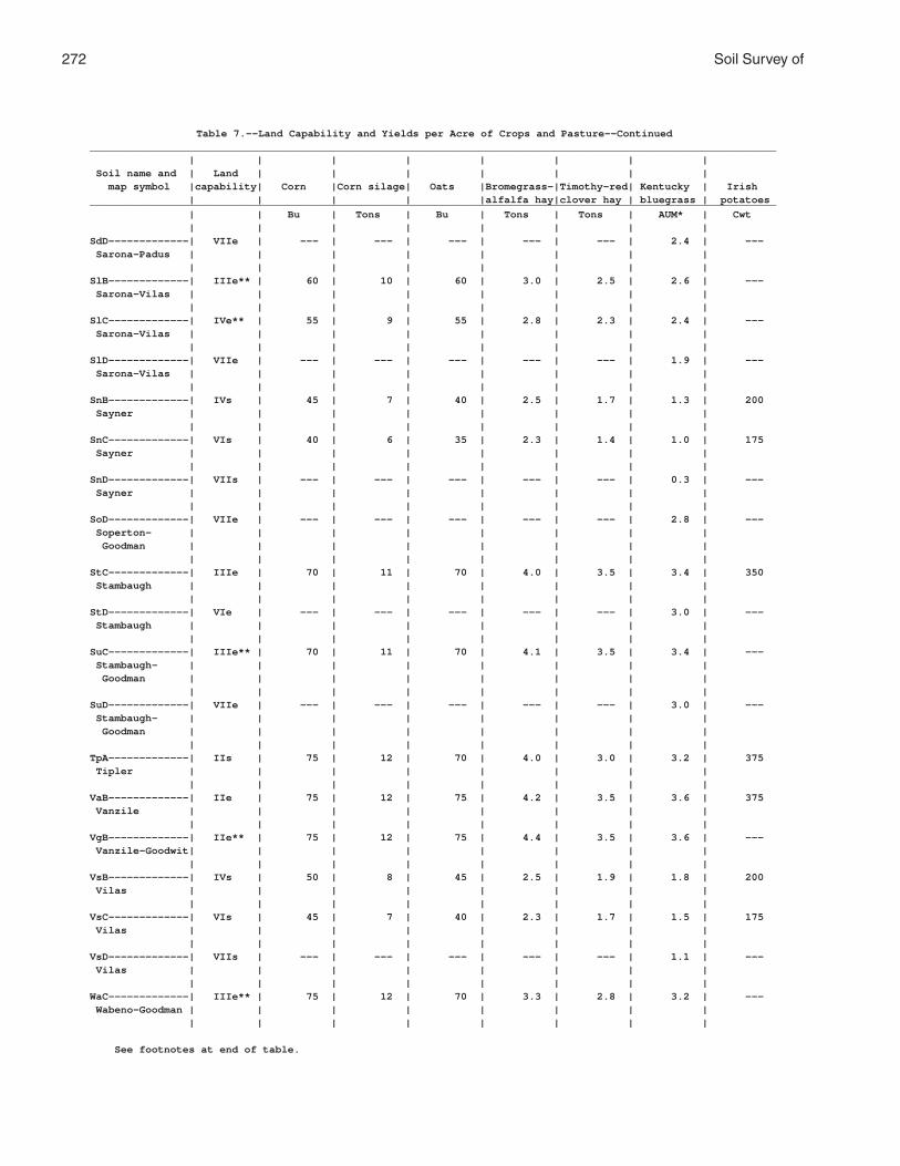
272 Soil Survey of
Table 7.--Land Capability and Yields per Acre of Crops and Pasture--Continued_______________________________________________________________________________________________________________ | | | | | | | | Soil name and | Land | | | | | | | map symbol |capability| Corn |Corn silage| Oats |Bromegrass-|Timothy-red| Kentucky | Irish | | | | |alfalfa hay|clover hay | bluegrass | potatoes_______________________________________________________________________________________________________________ | | Bu | Tons | Bu | Tons | Tons | AUM* | Cwt | | | | | | | |SdD-------------| VIIe | --- | --- | --- | --- | --- | 2.4 | --- Sarona-Padus | | | | | | | | | | | | | | | |SlB-------------| IIIe** | 60 | 10 | 60 | 3.0 | 2.5 | 2.6 | --- Sarona-Vilas | | | | | | | | | | | | | | | |SlC-------------| IVe** | 55 | 9 | 55 | 2.8 | 2.3 | 2.4 | --- Sarona-Vilas | | | | | | | | | | | | | | | |SlD-------------| VIIe | --- | --- | --- | --- | --- | 1.9 | --- Sarona-Vilas | | | | | | | | | | | | | | | |SnB-------------| IVs | 45 | 7 | 40 | 2.5 | 1.7 | 1.3 | 200 Sayner | | | | | | | | | | | | | | | |SnC-------------| VIs | 40 | 6 | 35 | 2.3 | 1.4 | 1.0 | 175 Sayner | | | | | | | | | | | | | | | |SnD-------------| VIIs | --- | --- | --- | --- | --- | 0.3 | --- Sayner | | | | | | | | | | | | | | | |SoD-------------| VIIe | --- | --- | --- | --- | --- | 2.8 | --- Soperton- | | | | | | | | Goodman | | | | | | | | | | | | | | | |StC-------------| IIIe | 70 | 11 | 70 | 4.0 | 3.5 | 3.4 | 350 Stambaugh | | | | | | | | | | | | | | | |StD-------------| VIe | --- | --- | --- | --- | --- | 3.0 | --- Stambaugh | | | | | | | | | | | | | | | |SuC-------------| IIIe** | 70 | 11 | 70 | 4.1 | 3.5 | 3.4 | --- Stambaugh- | | | | | | | | Goodman | | | | | | | | | | | | | | | |SuD-------------| VIIe | --- | --- | --- | --- | --- | 3.0 | --- Stambaugh- | | | | | | | | Goodman | | | | | | | | | | | | | | | |TpA-------------| IIs | 75 | 12 | 70 | 4.0 | 3.0 | 3.2 | 375 Tipler | | | | | | | | | | | | | | | |VaB-------------| IIe | 75 | 12 | 75 | 4.2 | 3.5 | 3.6 | 375 Vanzile | | | | | | | | | | | | | | | |VgB-------------| IIe** | 75 | 12 | 75 | 4.4 | 3.5 | 3.6 | --- Vanzile-Goodwit| | | | | | | | | | | | | | | |VsB-------------| IVs | 50 | 8 | 45 | 2.5 | 1.9 | 1.8 | 200 Vilas | | | | | | | | | | | | | | | |VsC-------------| VIs | 45 | 7 | 40 | 2.3 | 1.7 | 1.5 | 175 Vilas | | | | | | | | | | | | | | | |VsD-------------| VIIs | --- | --- | --- | --- | --- | 1.1 | --- Vilas | | | | | | | | | | | | | | | |WaC-------------| IIIe** | 75 | 12 | 70 | 3.3 | 2.8 | 3.2 | --- Wabeno-Goodman | | | | | | | | | | | | | | | |
See footnotes at end of table.

Florence County, Wisconsin 273
Table 7.--Land Capability and Yields per Acre of Crops and Pasture--Continued_______________________________________________________________________________________________________________ | | | | | | | | Soil name and | Land | | | | | | | map symbol |capability| Corn |Corn silage| Oats |Bromegrass-|Timothy-red| Kentucky | Irish | | | | |alfalfa hay|clover hay | bluegrass | potatoes_______________________________________________________________________________________________________________ | | Bu | Tons | Bu | Tons | Tons | AUM* | Cwt | | | | | | | |WbB-------------| IIe** | 80 | 13 | 75 | 3.5 | 3.0 | 3.4 | --- Wabeno-Goodwit | | | | | | | | | | | | | | | |WkB-------------| IIe** | 75 | 12 | 65 | 3.5 | 3.0 | 3.4 | --- Wakefield | | | | | | | | | | | | | | | |WkC-------------| IIIe** | 70 | 11 | 60 | 3.3 | 2.8 | 3.2 | --- Wakefield | | | | | | | | | | | | | | | |WrA-------------| IIw | 70 | 11 | 70 | 3.8 | 3.0 | 3.4 | --- Worcester | | | | | | | | | | | | | | | |_______________________________________________________________________________________________________________
* Animal unit month: The amount of forage or feed required to feed one animal unit (one cow, one horse,one mule, five sheep, or five goats) for 30 days. ** In areas where stones have been removed.

274 Soil Survey of
Table 8.--Prime Farmland
(Only the soils considered prime farmland are listed. Urban or built-up areas of the soils listed are not considered prime farmland. If a soil is prime farmland only under certain conditions, the conditions are specified in parentheses after the soil name)
______________________________________________________________________________________________________________ | Map | Soil name symbol |______________________________________________________________________________________________________________ | AnB |Annalake fine sandy loam, 0 to 6 percent slopes Ca |Capitola muck, 0 to 2 percent slopes, very stony (where drained) CoA |Crossett silt loam, 0 to 3 percent slopes (where drained) EdB |Ellwood silt loam, 1 to 6 percent slopes ElB |Ellwood-Crossett silt loams, 0 to 6 percent slopes (where drained) FeB |Fence silt loam, 0 to 6 percent slopes GaA |Gastrow silt loam, 0 to 3 percent slopes (where drained) GwB |Goodwit silt loam, 1 to 6 percent slopes, very stony Mn |Minocqua muck, 0 to 2 percent slopes (where drained) MuB |Mudlake silt loam, 1 to 6 percent slopes, very stony (where drained) PaB |Padus sandy loam, 0 to 6 percent slopes Rb |Robago fine sandy loam, 0 to 2 percent slopes (where drained) SaB |Sarona fine sandy loam, 1 to 6 percent slopes, very stony SdB |Sarona-Padus complex, 0 to 6 percent slopes, very stony TpA |Tipler sandy loam, 0 to 3 percent slopes VaB |Vanzile silt loam, 0 to 6 percent slopes VgB |Vanzile-Goodwit silt loams, 0 to 6 percent slopes, very stony WbB |Wabeno-Goodwit silt loams, 1 to 6 percent slopes, very stony WrA |Worcester sandy loam, 0 to 3 percent slopes (where drained) |______________________________________________________________________________________________________________

Florence County, Wisconsin 275
Table 9.--Windbreaks and Environmental Plantings
(Only the soils suitable for windbreaks and environmental plantings are listed. Absence of an entry indicates that trees generally do not grow to the given height on that soil)
_________________________________________________________________________________________________________________ | Trees having predicted 20-year average height, in feet, of-- ______________________________________________________________________________________________ Soil name and | | | | | map symbol | <8 | 8-15 | 16-25 | 26-35 | >35 | | | | |_________________________________________________________________________________________________________________ | | | | |AnB, AnC----------| --- |Arrowwood, |White spruce, |Eastern white |Imperial Carolina Annalake | | nannyberry | Norway spruce, | pine, red pine. | poplar. | | viburnum, | Manchurian | | | | Siberian | crabapple. | | | | peashrub, lilac, | | | | | silky dogwood, | | | | | American | | | | | cranberrybush. | | | | | | | |Au----------------| --- |American |White spruce, |Jack pine, Norway |Imperial Carolina Au Gres | | cranberrybush, | Manchurian | spruce, green | poplar. | | Amur maple, | crabapple. | ash, eastern | | | common ninebark, | | white pine. | | | nannyberry | | | | | viburnum, | | | | | northern | | | | | whitecedar. | | | | | | | |CoA---------------| --- |Northern |White spruce, |Eastern white | --- Crossett | | whitecedar, | Norway spruce. | pine, red pine, | | | lilac, American | | white ash, red | | | cranberrybush, | | maple. | | | Amur maple, silky| | | | | dogwood, gray | | | | | dogwood. | | | | | | | |CrA---------------|Manyflower |Amur maple, lilac,|Norway spruce-----|Eastern white | --- Croswell | cotoneaster. | Siberian | | pine, red pine, | | | peashrub, | | jack pine. | | | northern | | | | | whitecedar. | | | | | | | |CuA---------------|Manyflower |Siberian peashrub,|Manchurian |Eastern white | --- Cublake | cotoneaster. | lilac, smooth | crabapple, | pine, red pine, | | | sumac, staghorn | Austrian pine. | jack pine. | | | sumac, northern | | | | | whitecedar. | | | | | | | |EdB, EdC----------| --- |Northern |White spruce, |Eastern white | --- Ellwood | | whitecedar, | Norway spruce. | pine, red pine, | | | lilac, American | | white ash, red | | | cranberrybush, | | maple. | | | Amur maple, silky| | | | | dogwood, gray | | | | | dogwood. | | | | | | | |ElB: | | | | | Ellwood----------| --- |Northern |White spruce, |Eastern white | --- | | whitecedar, | Norway spruce. | pine, red pine, | | | lilac, American | | white ash, red | | | cranberrybush, | | maple. | | | Amur maple, silky| | | | | dogwood, gray | | | | | dogwood. | | | | | | | |

276 Soil Survey of
Table 9.--Windbreaks and Environmental Plantings--Continued_________________________________________________________________________________________________________________ | Trees having predicted 20-year average height, in feet, of-- ______________________________________________________________________________________________ Soil name and | | | | | map symbol | <8 | 8-15 | 16-25 | 26-35 | >35 | | | | |_________________________________________________________________________________________________________________ | | | | |ElB: | | | | | Crossett---------| --- |Northern |White spruce, |Eastern white | --- | | whitecedar, | Norway spruce. | pine, red pine, | | | lilac, American | | white ash, red | | | cranberrybush, | | maple. | | | Amur maple, silky| | | | | dogwood, gray | | | | | dogwood. | | | | | | | |EmB: | | | | | Ellwood----------| --- |Northern |White spruce, |Eastern white | --- | | whitecedar, | Norway spruce. | pine, red pine, | | | lilac, American | | white ash, red | | | cranberrybush, | | maple. | | | Amur maple, silky| | | | | dogwood, gray | | | | | dogwood. | | | | | | | | Iosco------------| --- |Common ninebark, |White spruce, |Green ash, eastern|Imperial Carolina | | northern | Manchurian | white pine, | poplar. | | whitecedar, | crabapple, Norway| red pine. | | | American | spruce. | | | | cranberrybush, | | | | | nannyberry | | | | | viburnum, lilac, | | | | | silky dogwood. | | | | | | | | Morganlake-------| --- |Lilac, nannyberry |White spruce, |Eastern white |Imperial Carolina | | viburnum, | Norway spruce, | pine, red pine, | poplar. | | northern | Manchurian | jack pine. | | | whitecedar. | crabapple. | | | | | | |EnC: | | | | | Ellwood----------| --- |Northern |White spruce, |Eastern white | --- | | whitecedar, | Norway spruce. | pine, red pine, | | | lilac, American | | white ash, red | | | cranberrybush, | | maple. | | | Amur maple, silky| | | | | dogwood, gray | | | | | dogwood. | | | | | | | | Iosco------------| --- |Common ninebark, |White spruce, |Green ash, eastern|Imperial Carolina | | northern | Manchurian | white pine, | poplar. | | whitecedar, | crabapple, Norway| red pine. | | | American | spruce. | | | | cranberrybush, | | | | | nannyberry | | | | | viburnum, lilac, | | | | | silky dogwood. | | | | | | | | Vilas------------|Manyflower |Northern |Norway spruce-----|Eastern white | --- | cotoneaster. | whitecedar, | | pine, red pine, | | | lilac, Amur | | jack pine. | | | maple, American | | | | | cranberrybush, | | | | | Siberian | | | | | peashrub, silky | | | | | dogwood, gray | | | | | dogwood. | | | | | | | |

Florence County, Wisconsin 277
Table 9.--Windbreaks and Environmental Plantings--Continued_________________________________________________________________________________________________________________ | Trees having predicted 20-year average height, in feet, of-- ______________________________________________________________________________________________ Soil name and | | | | | map symbol | <8 | 8-15 | 16-25 | 26-35 | >35 | | | | |_________________________________________________________________________________________________________________ | | | | |EoD: | | | | | Ellwood----------| --- |Northern |White spruce, |Eastern white | --- | | whitecedar, | Norway spruce. | pine, red pine, | | | lilac, American | | white ash, red | | | cranberrybush, | | maple. | | | Amur maple, silky| | | | | dogwood, gray | | | | | dogwood. | | | | | | | | Vilas------------|Manyflower |Northern |Norway spruce-----|Eastern white | --- | cotoneaster. | whitecedar, | | pine, red pine, | | | lilac, Amur | | jack pine. | | | maple, American | | | | | cranberrybush, | | | | | Siberian | | | | | peashrub, silky | | | | | dogwood, gray | | | | | dogwood. | | | | | | | | Padus------------|Manyflower |Gray dogwood, |Norway spruce-----|Jack pine, red | --- | cotoneaster. | silky dogwood, | | pine, eastern | | | Siberian | | white pine. | | | peashrub, | | | | | American | | | | | cranberrybush, | | | | | Amur maple, | | | | | lilac, eastern | | | | | redcedar, | | | | | northern | | | | | whitecedar. | | | | | | | |FeB---------------| --- |Northern |White spruce, |Eastern white | --- Fence | | whitecedar, | Norway spruce. | pine, red pine, | | | lilac, American | | white ash, red | | | cranberrybush, | | maple. | | | Amur maple, silky| | | | | dogwood, gray | | | | | dogwood. | | | | | | | |GaA---------------| --- |Common ninebark, |White spruce------|Red pine, eastern |Imperial Carolina Gastrow | | nannyberry | | white pine, white| poplar. | | viburnum, | | ash, red maple, | | | northern | | silver maple. | | | whitecedar, Amur | | | | | maple, lilac, | | | | | silky dogwood, | | | | | American | | | | | cranberrybush. | | | | | | | |GmC, GmD----------| --- |Amur maple, |White spruce, |Eastern white | --- Goodman | | northern | Norway spruce, | pine, red pine, | | | whitecedar, gray | Black Hills | white ash, red | | | dogwood, lilac, | spruce. | maple. | | | American | | | | | cranberrybush. | | | | | | | |GwB---------------| --- |Amur maple, |White spruce, |Eastern white | --- Goodwit | | northern | Norway spruce, | pine, red pine, | | | whitecedar, gray | Black Hills | white ash, red | | | dogwood, lilac, | spruce. | maple. | | | American | | | | | cranberrybush. | | | | | | | |

278 Soil Survey of
Table 9.--Windbreaks and Environmental Plantings--Continued_________________________________________________________________________________________________________________ | Trees having predicted 20-year average height, in feet, of-- ______________________________________________________________________________________________ Soil name and | | | | | map symbol | <8 | 8-15 | 16-25 | 26-35 | >35 | | | | |_________________________________________________________________________________________________________________ | | | | |IsA---------------| --- |Common ninebark, |White spruce, |Green ash, eastern|Imperial Carolina Iosco | | northern | Manchurian | white pine, | poplar. | | whitecedar, | crabapple, | red pine. | | | American | Norway spruce. | | | | cranberrybush, | | | | | nannyberry | | | | | viburnum, lilac, | | | | | silky dogwood. | | | | | | | |MaA---------------|Manyflower |Northern |Norway spruce-----|Eastern white | --- Manitowish | cotoneaster. | whitecedar, | | pine, red pine, | | | lilac, Amur | | jack pine. | | | maple, American | | | | | cranberrybush, | | | | | Siberian | | | | | peashrub, silky | | | | | dogwood, gray | | | | | dogwood. | | | | | | | |MrB---------------| --- |Lilac, nannyberry |White spruce, |Eastern white |Imperial Carolina Morganlake | | viburnum, | Norway spruce, | pine, red pine, | poplar. | | northern | Manchurian | jack pine. | | | whitecedar. | crabapple. | | | | | | |MuB---------------| --- |Silky dogwood, |White spruce------|Red maple, eastern| --- Mudlake | | northern | | white pine, white| | | whitecedar, | | ash, silver | | | nannyberry | | maple. | | | viburnum, | | | | | redosier dogwood,| | | | | lilac, American | | | | | cranberrybush. | | | | | | | |PaB, PaC, PaD-----|Manyflower |Gray dogwood, |Norway spruce-----|Jack pine, red | --- Padus | cotoneaster. | silky dogwood, | | pine, eastern | | | Siberian | | white pine. | | | peashrub, | | | | | American | | | | | cranberrybush, | | | | | Amur maple, | | | | | lilac, northern | | | | | whitecedar. | | | | | | | |PeB, PeC, PeD: | | | | | Padus------------|Manyflower |Gray dogwood, |Norway spruce-----|Jack pine, red | --- | cotoneaster. | silky dogwood, | | pine, eastern | | | Siberian | | white pine. | | | peashrub, | | | | | American | | | | | cranberrybush, | | | | | Amur maple, | | | | | lilac, northern | | | | | whitecedar. | | | | | | | | Pence------------|Manyflower |Northern |Norway spruce-----|Eastern white | --- | cotoneaster. | whitecedar, | | pine, red pine, | | | lilac, Amur | | jack pine. | | | maple, American | | | | | cranberrybush, | | | | | Siberian | | | | | peashrub, silky | | | | | dogwood, gray | | | | | dogwood. | | | | | | | |

Florence County, Wisconsin 279
Table 9.--Windbreaks and Environmental Plantings--Continued_________________________________________________________________________________________________________________ | Trees having predicted 20-year average height, in feet, of-- ______________________________________________________________________________________________ Soil name and | | | | | map symbol | <8 | 8-15 | 16-25 | 26-35 | >35 | | | | |_________________________________________________________________________________________________________________ | | | | |PnB, PnC, PnD-----|Manyflower |Northern |Norway spruce-----|Eastern white | --- Pence | cotoneaster. | whitecedar, | | pine, red pine, | | | lilac, Amur | | jack pine. | | | maple, American | | | | | cranberrybush, | | | | | Siberian | | | | | peashrub, silky | | | | | dogwood, gray | | | | | dogwood. | | | | | | | |PsB, PsC, PsD: | | | | | Pence------------|Manyflower |Northern |Norway spruce-----|Eastern white | --- | cotoneaster. | whitecedar, | | pine, red pine, | | | lilac, Amur | | jack pine. | | | maple, American | | | | | cranberrybush, | | | | | Siberian | | | | | peashrub, silky | | | | | dogwood, gray | | | | | dogwood. | | | | | | | | Vilas------------|Manyflower |Northern |Norway spruce-----|Eastern white | --- | cotoneaster. | whitecedar, | | pine, red pine, | | | lilac, Amur | | jack pine. | | | maple, American | | | | | cranberrybush, | | | | | Siberian | | | | | peashrub, silky | | | | | dogwood, gray | | | | | dogwood. | | | | | | | |Rb----------------| --- |Northern |White spruce------|Red maple, eastern|Imperial Carolina Robago | | whitecedar, | | white pine, green| poplar. | | American | | ash. | | | cranberrybush, | | | | | silky dogwood, | | | | | lilac, nannyberry| | | | | viburnum, common | | | | | ninebark, Amur | | | | | maple. | | | | | | | |RkC, RkD: | | | | | Rock outcrop. | | | | | | | | | | Ishpeming--------|Manyflower |Northern |Norway spruce-----|Eastern white | --- | cotoneaster. | whitecedar, Amur | | pine, red pine, | | | maple, Siberian | | jack pine. | | | peashrub, lilac. | | | | | | | | Vilas------------|Manyflower |Northern |Norway spruce-----|Eastern white | --- | cotoneaster. | whitecedar, | | pine, red pine, | | | lilac, Amur | | jack pine. | | | maple, American | | | | | cranberrybush, | | | | | Siberian | | | | | peashrub, silky | | | | | dogwood, gray | | | | | dogwood. | | | | | | | |

280 Soil Survey of
Table 9.--Windbreaks and Environmental Plantings--Continued_________________________________________________________________________________________________________________ | Trees having predicted 20-year average height, in feet, of-- ______________________________________________________________________________________________ Soil name and | | | | | map symbol | <8 | 8-15 | 16-25 | 26-35 | >35 | | | | |_________________________________________________________________________________________________________________ | | | | |RmC, RmD: | | | | | Rock outcrop. | | | | | | | | | | Metonga----------|Manyflower |Lilac, Amur maple,|Norway spruce-----|Eastern white | --- | cotoneaster. | American | | pine, red pine, | | | cranberrybush, | | jack pine. | | | Siberian | | | | | peashrub, silky | | | | | dogwood, gray | | | | | dogwood. | | | | | | | | Sarona-----------|Manyflower |Northern |Norway spruce-----|Eastern white | --- | cotoneaster. | whitecedar, | | pine, red pine, | | | Siberian | | jack pine. | | | peashrub, lilac, | | | | | American | | | | | cranberrybush, | | | | | Amur maple, silky| | | | | dogwood, gray | | | | | dogwood. | | | | | | | |RsB, RsC----------|Manyflower |Siberian |White spruce, |Red pine, eastern |Imperial Carolina Rousseau | cotoneaster. | crabapple, silky | Norway spruce. | white pine, jack | poplar. | | dogwood, Amur | | pine. | | | privet. | | | | | | | |SaB, SaC, SaD-----|Manyflower |Northern |Norway spruce-----|Eastern white | --- Sarona | cotoneaster. | whitecedar, | | pine, red pine, | | | Siberian | | jack pine. | | | peashrub, lilac, | | | | | American | | | | | cranberrybush, | | | | | Amur maple, silky| | | | | dogwood, gray | | | | | dogwood. | | | | | | | |SdB, SdC, SdD: | | | | | Sarona-----------|Manyflower |Northern |Norway spruce-----|Eastern white | --- | cotoneaster. | whitecedar, | | pine, red pine, | | | Siberian | | jack pine. | | | peashrub, lilac, | | | | | American | | | | | cranberrybush, | | | | | Amur maple, silky| | | | | dogwood, gray | | | | | dogwood. | | | | | | | | Padus------------|Manyflower |Gray dogwood, |Norway spruce-----|Jack pine, red | --- | cotoneaster. | silky dogwood, | | pine, eastern | | | Siberian | | white pine. | | | peashrub, | | | | | American | | | | | cranberrybush, | | | | | Amur maple, | | | | | lilac, northern | | | | | whitecedar. | | | | | | | |

Florence County, Wisconsin 281
Table 9.--Windbreaks and Environmental Plantings--Continued_________________________________________________________________________________________________________________ | Trees having predicted 20-year average height, in feet, of-- ______________________________________________________________________________________________ Soil name and | | | | | map symbol | <8 | 8-15 | 16-25 | 26-35 | >35 | | | | |_________________________________________________________________________________________________________________ | | | | |SlB, SlC, SlD: | | | | | Sarona-----------|Manyflower |Northern |Norway spruce-----|Eastern white | --- | cotoneaster. | whitecedar, | | pine, red pine, | | | Siberian | | jack pine. | | | peashrub, lilac, | | | | | American | | | | | cranberrybush, | | | | | Amur maple, silky| | | | | dogwood, gray | | | | | dogwood. | | | | | | | | Vilas------------|Manyflower |Northern |Norway spruce-----|Eastern white | --- | cotoneaster. | whitecedar, | | pine, red pine, | | | lilac, Amur | | jack pine. | | | maple, American | | | | | cranberrybush, | | | | | Siberian | | | | | peashrub, silky | | | | | dogwood, gray | | | | | dogwood. | | | | | | | |SnB, SnC, SnD-----|Manyflower |Siberian peashrub,|Norway spruce-----|Eastern white | --- Sayner | cotoneaster. | lilac, Amur | | pine, red pine, | | | maple, American | | jack pine. | | | cranberrybush, | | | | | silky dogwood, | | | | | gray dogwood, | | | | | northern | | | | | whitecedar. | | | | | | | |SoD: | | | | | Soperton---------| --- |Amur maple, |White spruce, |Eastern white | --- | | Siberian | Norway spruce, | pine, red pine, | | | peashrub, lilac, | Black Hills | white ash. | | | gray dogwood, | spruce. | | | | northern | | | | | whitecedar. | | | | | | | | Goodman----------| --- |Amur maple, |White spruce, |Eastern white | --- | | northern | Norway spruce, | pine, red pine, | | | whitecedar, gray | Black Hills | white ash, red | | | dogwood, lilac, | spruce. | maple. | | | American | | | | | cranberrybush. | | | | | | | |StC, StD----------| --- |Nannyberry |Norway spruce-----|Eastern white | --- Stambaugh | | viburnum, lilac, | | pine, red pine, | | | Amur maple, | | jack pine. | | | Siberian | | | | | peashrub, silky | | | | | dogwood, common | | | | | ninebark, | | | | | northern | | | | | whitecedar, | | | | | American | | | | | cranberrybush, | | | | | gray dogwood. | | | | | | | |

282 Soil Survey of
Table 9.--Windbreaks and Environmental Plantings--Continued_________________________________________________________________________________________________________________ | Trees having predicted 20-year average height, in feet, of-- ______________________________________________________________________________________________ Soil name and | | | | | map symbol | <8 | 8-15 | 16-25 | 26-35 | >35 | | | | |_________________________________________________________________________________________________________________ | | | | |SuC, SuD: | | | | | Stambaugh--------| --- |Nannyberry |Norway spruce-----|Eastern white | --- | | viburnum, lilac, | | pine, red pine, | | | Amur maple, | | jack pine. | | | Siberian | | | | | peashrub, silky | | | | | dogwood, common | | | | | ninebark, | | | | | northern | | | | | whitecedar, | | | | | American | | | | | cranberrybush, | | | | | gray dogwood. | | | | | | | | Goodman----------| --- |Amur maple, |White spruce, |Eastern white | --- | | northern | Norway spruce, | pine, red pine, | | | whitecedar, gray | Black Hills | white ash, red | | | dogwood, lilac, | spruce. | maple. | | | American | | | | | cranberrybush. | | | | | | | |TpA---------------|Manyflower |Gray dogwood, |Norway spruce-----|Jack pine, red | --- Tipler | cotoneaster. | silky dogwood, | | pine, eastern | | | Siberian | | white pine. | | | peashrub, | | | | | American | | | | | cranberrybush, | | | | | Amur maple, | | | | | lilac, northern | | | | | whitecedar. | | | | | | | |VaB---------------| --- |Silky dogwood, |Norway spruce, |Eastern white | --- Vanzile | | American | white spruce. | pine, red pine, | | | cranberrybush, | | red maple, white | | | gray dogwood, | | ash. | | | lilac, Amur | | | | | maple, northern | | | | | whitecedar. | | | | | | | |VgB: | | | | | Vanzile----------| --- |Silky dogwood, |Norway spruce, |Eastern white | --- | | American | white spruce. | pine, red pine, | | | cranberrybush, | | red maple, white | | | gray dogwood, | | ash. | | | lilac, Amur | | | | | maple, northern | | | | | whitecedar. | | | | | | | | Goodwit----------| --- |Amur maple, |White spruce, |Eastern white | --- | | northern | Norway spruce, | pine, red pine, | | | whitecedar, gray | Black Hills | white ash, red | | | dogwood, lilac, | spruce. | maple. | | | American | | | | | cranberrybush. | | | | | | | |VsB, VsC, VsD-----|Manyflower |Northern |Norway spruce-----|Eastern white | --- Vilas | cotoneaster. | whitecedar, | | pine, red pine, | | | lilac, Amur | | jack pine. | | | maple, American | | | | | cranberrybush, | | | | | Siberian | | | | | peashrub, silky | | | | | dogwood, gray | | | | | dogwood. | | | | | | | |

Florence County, Wisconsin 283
Table 9.--Windbreaks and Environmental Plantings--Continued_________________________________________________________________________________________________________________ | Trees having predicted 20-year average height, in feet, of-- ______________________________________________________________________________________________ Soil name and | | | | | map symbol | <8 | 8-15 | 16-25 | 26-35 | >35 | | | | |_________________________________________________________________________________________________________________ | | | | |WaC: | | | | | Wabeno-----------| --- |Siberian peashrub,|White spruce, |Eastern white | --- | | lilac, common | Norway spruce, | pine, red pine, | | | ninebark, Amur | Black Hills | white ash. | | | maple, northern | spruce. | | | | whitecedar. | | | | | | | | Goodman----------| --- |Amur maple, |White spruce, |Eastern white | --- | | northern | Norway spruce, | pine, red pine, | | | whitecedar, gray | Black Hills | white ash, red | | | dogwood, lilac, | spruce. | maple. | | | American | | | | | cranberrybush. | | | | | | | |WbB: | | | | | Wabeno-----------| --- |Siberian peashrub,|White spruce, |Eastern white | --- | | lilac, common | Norway spruce, | pine, red pine, | | | ninebark, Amur | Black Hills | white ash. | | | maple, northern | spruce. | | | | whitecedar. | | | | | | | | Goodwit----------| --- |Amur maple, |White spruce, |Eastern white | --- | | northern | Norway spruce, | pine, red pine, | | | whitecedar, gray | Black Hills | white ash, red | | | dogwood, lilac, | spruce. | maple. | | | American | | | | | cranberrybush. | | | | | | | |WkB, WkC----------| --- |Lilac, American |White spruce, |Eastern white | --- Wakefield | | cranberrybush, | Norway spruce. | pine, red pine, | | | silky dogwood, | | red maple. | | | arrowwood, common| | | | | ninebark, | | | | | nannyberry | | | | | viburnum. | | | | | | | |WrA---------------| --- |Common ninebark, |White spruce------|Eastern white | --- Worcester | | northern | | pine, silver | | | whitecedar, | | maple, red maple,| | | nannyberry | | white ash. | | | viburnum, | | | | | American | | | | | cranberrybush, | | | | | redosier dogwood,| | | | | silky dogwood, | | | | | lilac. | | | | | | | |_________________________________________________________________________________________________________________

284 Soil Survey of
Table 10.--Recreational Development
(Some terms that describe restrictive soil features are defined in the Glossary. See text for definitions of "slight," "moderate," and "severe." Absence of an entry indicates that the soil was not rated)
___________________________________________________________________________________________________________ | | | | | Soil name and | Camp areas | Picnic areas | Playgrounds |Paths and trails| Golf fairways map symbol | | | | | | | | | |___________________________________________________________________________________________________________ | | | | |AnB-------------------|Slight----------|Slight----------|Moderate: |Slight----------|Moderate: Annalake | | | slope, | | droughty. | | | small stones. | | | | | | |AnC-------------------|Moderate: |Moderate: |Severe: |Slight----------|Moderate: Annalake | slope. | slope. | slope. | | droughty, | | | | | slope. | | | | |Au--------------------|Severe: |Severe: |Severe: |Severe: |Severe: Au Gres | wetness. | wetness. | wetness. | wetness. | wetness. | | | | |Ca--------------------|Severe: |Severe: |Severe: |Severe: |Severe: Capitola | ponding, | ponding, | excess humus, | ponding, | ponding, | excess humus. | excess humus. | ponding. | excess humus. | excess humus. | | | | |CoA-------------------|Severe: |Severe: |Severe: |Severe: |Severe: Crossett | wetness. | wetness. | wetness. | wetness. | wetness. | | | | |CrA-------------------|Moderate: |Moderate: |Moderate: |Moderate: |Moderate: Croswell | wetness, | wetness, | small stones, | too sandy. | droughty. | too sandy. | too sandy. | too sandy, | | | | | wetness. | | | | | | |CuA-------------------|Moderate: |Moderate: |Moderate: |Moderate: |Moderate: Cublake | wetness, | wetness, | small stones, | too sandy. | droughty. | too sandy. | too sandy. | too sandy, | | | | | wetness. | | | | | | |EdB-------------------|Moderate: |Moderate: |Moderate: |Severe: |Moderate: Ellwood | wetness. | wetness. | slope, | erodes easily. | large stones, | | | small stones, | | wetness. | | | wetness. | | | | | | |EdC-------------------|Moderate: |Moderate: |Severe: |Severe: |Moderate: Ellwood | slope, | slope, | slope. | erodes easily. | large stones, | wetness. | wetness. | | | wetness, | | | | | slope. | | | | |ElB: | | | | | Ellwood--------------|Moderate: |Moderate: |Moderate: |Severe: |Moderate: | wetness. | wetness. | slope, | erodes easily. | large stones, | | | small stones, | | wetness. | | | wetness. | | | | | | | Crossett-------------|Severe: |Severe: |Severe: |Severe: |Severe: | wetness. | wetness. | wetness. | wetness. | wetness. | | | | |EmB: | | | | | Ellwood--------------|Moderate: |Moderate: |Moderate: |Severe: |Moderate: | wetness. | wetness. | slope, | erodes easily. | large stones, | | | small stones, | | wetness. | | | wetness. | | | | | | | Iosco----------------|Severe: |Severe: |Severe: |Severe: |Severe: | wetness. | wetness. | wetness. | wetness. | wetness. | | | | | Morganlake-----------|Moderate: |Moderate: |Moderate: |Moderate: |Moderate: | wetness, | wetness, | slope, | wetness, | wetness, | percs slowly. | too sandy. | too sandy, | too sandy. | droughty. | | | wetness. | | | | | | |

Florence County, Wisconsin 285
Table 10.--Recreational Development--Continued___________________________________________________________________________________________________________ | | | | | Soil name and | Camp areas | Picnic areas | Playgrounds |Paths and trails| Golf fairways map symbol | | | | | | | | | |___________________________________________________________________________________________________________ | | | | |EnC: | | | | | Ellwood--------------|Moderate: |Moderate: |Severe: |Severe: |Moderate: | wetness. | slope, | slope. | erodes easily. | large stones, | | wetness. | | | wetness, | | | | | slope. | | | | | Iosco----------------|Severe: |Severe: |Severe: |Severe: |Severe: | wetness. | wetness. | wetness. | wetness. | wetness. | | | | | Vilas----------------|Moderate: |Moderate: |Severe: |Moderate: |Moderate: | slope, | slope, | slope. | too sandy. | droughty, | too sandy. | too sandy. | | | slope. | | | | |EoD: | | | | | Ellwood--------------|Moderate: |Moderate: |Severe: |Severe: |Moderate: | slope, | slope, | slope. | erodes easily. | large stones, | wetness. | wetness. | | | wetness, | | | | | slope. | | | | | Vilas----------------|Severe: |Severe: |Severe: |Moderate: |Severe: | slope. | slope. | slope. | too sandy, | slope. | | | | slope. | | | | | | Padus----------------|Severe: |Severe: |Severe: |Moderate: |Severe: | slope. | slope. | slope, | slope. | slope. | | | small stones. | | | | | | |Ep: | | | | | Epiaquents-----------|Severe: |Severe: |Severe: |Severe: |Severe: | ponding, | ponding, | excess humus, | ponding, | ponding, | excess humus. | excess humus. | ponding. | excess humus. | excess humus. | | | | | Epiaquods------------|Severe: |Severe: |Severe: |Severe: |Severe: | ponding, | ponding, | excess humus, | ponding, | ponding, | excess humus. | excess humus. | ponding. | excess humus. | excess humus. | | | | |FeB-------------------|Slight----------|Slight----------|Moderate: |Severe: |Slight. Fence | | | slope. | erodes easily. | | | | | |Fm--------------------|Severe: |Severe: |Severe: |Severe: |Severe: Fordum | flooding, | ponding. | ponding, | ponding. | ponding, | ponding. | | flooding. | | flooding. | | | | |GaA-------------------|Severe: |Severe: |Severe: |Severe: |Severe: Gastrow | wetness. | wetness. | wetness. | wetness. | wetness. | | | | |GmC-------------------|Moderate: |Moderate: |Severe: |Severe: |Moderate: Goodman | slope. | slope. | slope. | erodes easily. | large stones, | | | | | slope. | | | | |GmD-------------------|Severe: |Severe: |Severe: |Severe: |Severe: Goodman | slope. | slope. | slope. | erodes easily. | slope. | | | | |GwB-------------------|Slight----------|Slight----------|Moderate: |Severe: |Moderate: Goodwit | | | slope, | erodes easily. | large stones. | | | small stones. | | | | | | |IsA-------------------|Severe: |Severe: |Severe: |Severe: |Severe: Iosco | wetness. | wetness. | wetness. | wetness. | wetness. | | | | |Kr--------------------|Severe: |Severe: |Severe: |Severe: |Severe: Kinross | ponding. | ponding. | ponding. | ponding. | ponding, | | | | | excess humus. | | | | |
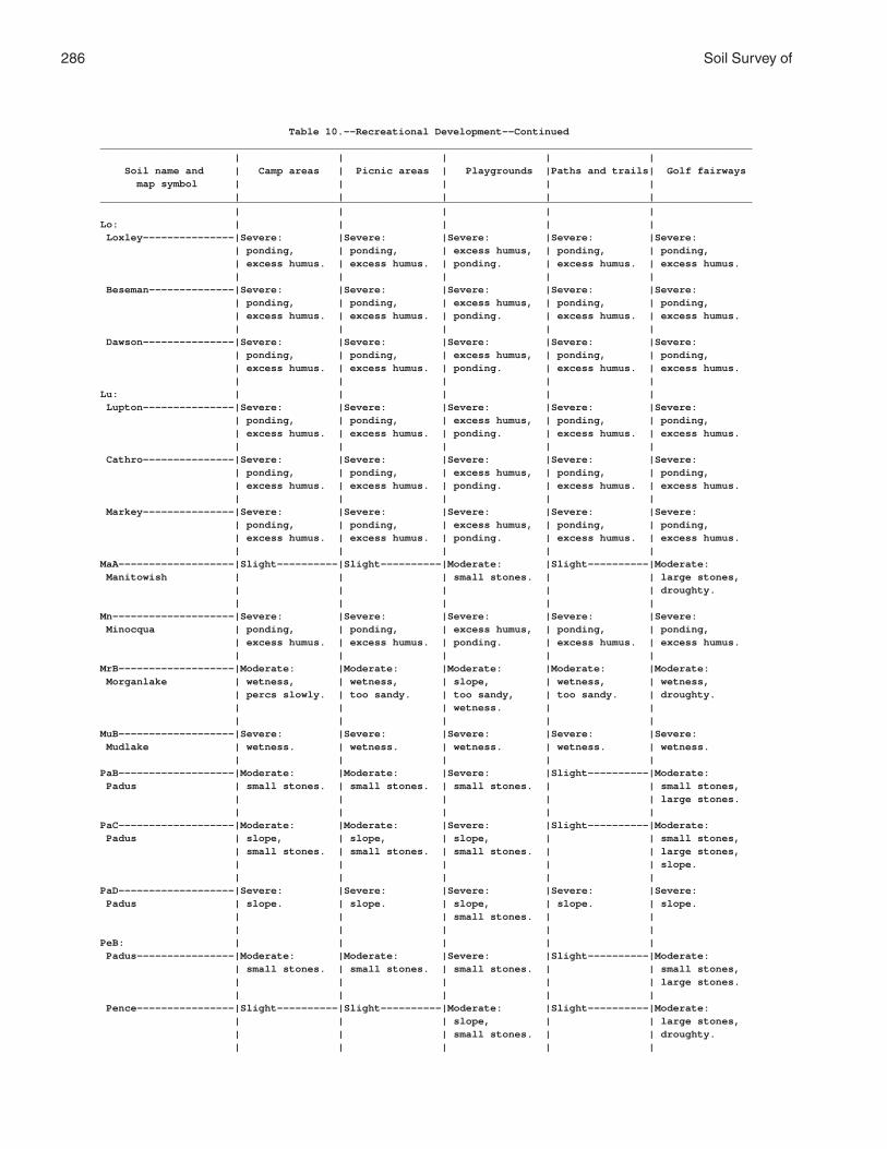
286 Soil Survey of
Table 10.--Recreational Development--Continued___________________________________________________________________________________________________________ | | | | | Soil name and | Camp areas | Picnic areas | Playgrounds |Paths and trails| Golf fairways map symbol | | | | | | | | | |___________________________________________________________________________________________________________ | | | | |Lo: | | | | | Loxley---------------|Severe: |Severe: |Severe: |Severe: |Severe: | ponding, | ponding, | excess humus, | ponding, | ponding, | excess humus. | excess humus. | ponding. | excess humus. | excess humus. | | | | | Beseman--------------|Severe: |Severe: |Severe: |Severe: |Severe: | ponding, | ponding, | excess humus, | ponding, | ponding, | excess humus. | excess humus. | ponding. | excess humus. | excess humus. | | | | | Dawson---------------|Severe: |Severe: |Severe: |Severe: |Severe: | ponding, | ponding, | excess humus, | ponding, | ponding, | excess humus. | excess humus. | ponding. | excess humus. | excess humus. | | | | |Lu: | | | | | Lupton---------------|Severe: |Severe: |Severe: |Severe: |Severe: | ponding, | ponding, | excess humus, | ponding, | ponding, | excess humus. | excess humus. | ponding. | excess humus. | excess humus. | | | | | Cathro---------------|Severe: |Severe: |Severe: |Severe: |Severe: | ponding, | ponding, | excess humus, | ponding, | ponding, | excess humus. | excess humus. | ponding. | excess humus. | excess humus. | | | | | Markey---------------|Severe: |Severe: |Severe: |Severe: |Severe: | ponding, | ponding, | excess humus, | ponding, | ponding, | excess humus. | excess humus. | ponding. | excess humus. | excess humus. | | | | |MaA-------------------|Slight----------|Slight----------|Moderate: |Slight----------|Moderate: Manitowish | | | small stones. | | large stones, | | | | | droughty. | | | | |Mn--------------------|Severe: |Severe: |Severe: |Severe: |Severe: Minocqua | ponding, | ponding, | excess humus, | ponding, | ponding, | excess humus. | excess humus. | ponding. | excess humus. | excess humus. | | | | |MrB-------------------|Moderate: |Moderate: |Moderate: |Moderate: |Moderate: Morganlake | wetness, | wetness, | slope, | wetness, | wetness, | percs slowly. | too sandy. | too sandy, | too sandy. | droughty. | | | wetness. | | | | | | |MuB-------------------|Severe: |Severe: |Severe: |Severe: |Severe: Mudlake | wetness. | wetness. | wetness. | wetness. | wetness. | | | | |PaB-------------------|Moderate: |Moderate: |Severe: |Slight----------|Moderate: Padus | small stones. | small stones. | small stones. | | small stones, | | | | | large stones. | | | | |PaC-------------------|Moderate: |Moderate: |Severe: |Slight----------|Moderate: Padus | slope, | slope, | slope, | | small stones, | small stones. | small stones. | small stones. | | large stones, | | | | | slope. | | | | |PaD-------------------|Severe: |Severe: |Severe: |Severe: |Severe: Padus | slope. | slope. | slope, | slope. | slope. | | | small stones. | | | | | | |PeB: | | | | | Padus----------------|Moderate: |Moderate: |Severe: |Slight----------|Moderate: | small stones. | small stones. | small stones. | | small stones, | | | | | large stones. | | | | | Pence----------------|Slight----------|Slight----------|Moderate: |Slight----------|Moderate: | | | slope, | | large stones, | | | small stones. | | droughty. | | | | |

Florence County, Wisconsin 287
Table 10.--Recreational Development--Continued___________________________________________________________________________________________________________ | | | | | Soil name and | Camp areas | Picnic areas | Playgrounds |Paths and trails| Golf fairways map symbol | | | | | | | | | |___________________________________________________________________________________________________________ | | | | |PeC: | | | | | Padus----------------|Moderate: |Moderate: |Severe: |Slight----------|Moderate: | slope, | slope, | slope, | | small stones, | small stones. | small stones. | small stones. | | large stones, | | | | | slope. | | | | | Pence----------------|Moderate: |Moderate: |Severe: |Slight----------|Moderate: | slope. | slope. | slope. | | large stones, | | | | | droughty, | | | | | slope. | | | | |PeD: | | | | | Padus----------------|Severe: |Severe: |Severe: |Severe: |Severe: | slope. | slope. | slope, | slope. | slope. | | | small stones. | | | | | | | Pence----------------|Severe: |Severe: |Severe: |Severe: |Severe: | slope. | slope. | slope. | slope. | slope. | | | | |PnB-------------------|Slight----------|Slight----------|Moderate: |Slight----------|Moderate: Pence | | | slope, | | large stones, | | | small stones. | | droughty. | | | | |PnC-------------------|Moderate: |Moderate: |Severe: |Slight----------|Moderate: Pence | slope. | slope. | slope. | | large stones, | | | | | droughty, | | | | | slope. | | | | |PnD-------------------|Severe: |Severe: |Severe: |Severe: |Severe: Pence | slope. | slope. | slope. | slope. | slope. | | | | |PsB: | | | | | Pence----------------|Slight----------|Slight----------|Moderate: |Slight----------|Moderate: | | | slope, | | large stones, | | | small stones. | | droughty. | | | | | Vilas----------------|Moderate: |Moderate: |Moderate: |Moderate: |Moderate: | too sandy. | too sandy. | slope, | too sandy. | droughty. | | | small stones, | | | | | too sandy. | | | | | | |PsC: | | | | | Pence----------------|Moderate: |Moderate: |Severe: |Slight----------|Moderate: | slope. | slope. | slope. | | large stones, | | | | | droughty, | | | | | slope. | | | | | Vilas----------------|Moderate: |Moderate: |Severe: |Moderate: |Moderate: | slope, | slope, | slope. | too sandy. | droughty, | too sandy. | too sandy. | | | slope. | | | | |PsD: | | | | | Pence----------------|Severe: |Severe: |Severe: |Severe: |Severe: | slope. | slope. | slope. | slope. | slope. | | | | | Vilas----------------|Severe: |Severe: |Severe: |Severe: |Severe: | slope. | slope. | slope. | slope. | slope. | | | | |Pt. | | | | | Pits, gravel | | | | | | | | | |Px. | | | | | Pits, mine | | | | | | | | | |

288 Soil Survey of
Table 10.--Recreational Development--Continued___________________________________________________________________________________________________________ | | | | | Soil name and | Camp areas | Picnic areas | Playgrounds |Paths and trails| Golf fairways map symbol | | | | | | | | | |___________________________________________________________________________________________________________ | | | | |Rb--------------------|Severe: |Severe: |Severe: |Severe: |Severe: Robago | wetness. | wetness. | wetness. | wetness. | wetness. | | | | |RkC: | | | | | Rock outcrop. | | | | | | | | | | Ishpeming------------|Moderate: |Moderate: |Severe: |Moderate: |Moderate: | slope, | slope, | slope. | too sandy. | large stones, | too sandy. | too sandy. | | | droughty, | | | | | slope. | | | | | Vilas----------------|Moderate: |Moderate: |Severe: |Moderate: |Moderate: | slope, | slope, | slope. | too sandy. | droughty, | too sandy. | too sandy. | | | slope. | | | | |RkD: | | | | | Rock outcrop. | | | | | | | | | | Ishpeming------------|Severe: |Severe: |Severe: |Severe: |Severe: | slope. | slope. | slope. | slope. | slope. | | | | | Vilas----------------|Severe: |Severe: |Severe: |Severe: |Severe: | slope. | slope. | slope. | slope. | slope. | | | | |RmC: | | | | | Rock outcrop. | | | | | | | | | | Metonga--------------|Moderate: |Moderate: |Severe: |Slight----------|Moderate: | slope. | slope. | slope. | | large stones, | | | | | slope, | | | | | depth to rock. | | | | | Sarona---------------|Moderate: |Moderate: |Severe: |Slight----------|Moderate: | slope. | slope. | slope. | | large stones, | | | | | droughty, | | | | | slope. | | | | |RmD: | | | | | Rock outcrop. | | | | | | | | | | Metonga--------------|Severe: |Severe: |Severe: |Severe: |Severe: | slope. | slope. | slope. | slope. | slope. | | | | | Sarona---------------|Severe: |Severe: |Severe: |Severe: |Severe: | slope. | slope. | slope. | slope. | slope. | | | | |RsB-------------------|Moderate: |Moderate: |Moderate: |Moderate: |Moderate: Rousseau | too sandy. | too sandy. | slope, | too sandy. | droughty. | | | too sandy. | | | | | | |RsC-------------------|Moderate: |Moderate: |Severe: |Moderate: |Moderate: Rousseau | slope, | slope, | slope. | too sandy. | droughty, | too sandy. | too sandy. | | | slope. | | | | |SaB-------------------|Slight----------|Slight----------|Moderate: |Slight----------|Moderate: Sarona | | | slope, | | large stones, | | | small stones. | | droughty. | | | | |SaC-------------------|Moderate: |Moderate: |Severe: |Slight----------|Moderate: Sarona | slope. | slope. | slope. | | large stones, | | | | | droughty, | | | | | slope. | | | | |

Florence County, Wisconsin 289
Table 10.--Recreational Development--Continued___________________________________________________________________________________________________________ | | | | | Soil name and | Camp areas | Picnic areas | Playgrounds |Paths and trails| Golf fairways map symbol | | | | | | | | | |___________________________________________________________________________________________________________ | | | | |SaD-------------------|Severe: |Severe: |Severe: |Moderate: |Severe: Sarona | slope. | slope. | slope. | slope. | slope. | | | | |SdB: | | | | | Sarona---------------|Slight----------|Slight----------|Moderate: |Slight----------|Moderate: | | | slope, | | large stones, | | | small stones. | | droughty. | | | | | Padus----------------|Moderate: |Moderate: |Severe: |Slight----------|Moderate: | small stones. | small stones. | small stones. | | small stones, | | | | | large stones. | | | | |SdC: | | | | | Sarona---------------|Moderate: |Moderate: |Severe: |Slight----------|Moderate: | slope. | slope. | slope. | | large stones, | | | | | droughty, | | | | | slope. | | | | | Padus----------------|Moderate: |Moderate: |Severe: |Slight----------|Moderate: | slope, | slope, | slope, | | small stones, | small stones. | small stones. | small stones. | | large stones, | | | | | slope. | | | | |SdD: | | | | | Sarona---------------|Severe: |Severe: |Severe: |Moderate: |Severe: | slope. | slope. | slope. | slope. | slope. | | | | | Padus----------------|Severe: |Severe: |Severe: |Moderate: |Severe: | slope. | slope. | slope, | slope. | slope. | | | small stones. | | | | | | |SlB: | | | | | Sarona---------------|Slight----------|Slight----------|Moderate: |Slight----------|Moderate: | | | slope, | | large stones, | | | small stones. | | droughty. | | | | | Vilas----------------|Moderate: |Moderate: |Moderate: |Moderate: |Moderate: | too sandy. | too sandy. | slope, | too sandy. | droughty. | | | small stones, | | | | | too sandy. | | | | | | |SlC: | | | | | Sarona---------------|Moderate: |Moderate: |Severe: |Slight----------|Moderate: | slope. | slope. | slope. | | large stones, | | | | | droughty, | | | | | slope. | | | | | Vilas----------------|Moderate: |Moderate: |Severe: |Moderate: |Moderate: | slope, | slope, | slope. | too sandy. | droughty, | too sandy. | too sandy. | | | slope. | | | | |SlD: | | | | | Sarona---------------|Severe: |Severe: |Severe: |Moderate: |Severe: | slope. | slope. | slope. | slope. | slope. | | | | | Vilas----------------|Severe: |Severe: |Severe: |Moderate: |Severe: | slope. | slope. | slope. | too sandy, | slope. | | | | slope. | | | | | |SnB-------------------|Moderate: |Moderate: |Moderate: |Moderate: |Severe: Sayner | too sandy. | too sandy. | slope, | too sandy. | droughty. | | | small stones, | | | | | too sandy. | | | | | | |

290 Soil Survey of
Table 10.--Recreational Development--Continued___________________________________________________________________________________________________________ | | | | | Soil name and | Camp areas | Picnic areas | Playgrounds |Paths and trails| Golf fairways map symbol | | | | | | | | | |___________________________________________________________________________________________________________ | | | | |SnC-------------------|Moderate: |Moderate: |Severe: |Moderate: |Severe: Sayner | slope, | slope, | slope. | too sandy. | droughty. | too sandy. | too sandy. | | | | | | | |SnD-------------------|Severe: |Severe: |Severe: |Moderate: |Severe: Sayner | slope. | slope. | slope. | too sandy, | droughty, | | | | slope. | slope. | | | | |SoD: | | | | | Soperton-------------|Severe: |Severe: |Severe: |Severe: |Severe: | slope. | slope. | slope. | slope, | slope. | | | | erodes easily. | | | | | | Goodman--------------|Severe: |Severe: |Severe: |Severe: |Severe: | slope. | slope. | slope. | slope, | slope. | | | | erodes easily. | | | | | |StC-------------------|Moderate: |Moderate: |Severe: |Severe: |Moderate: Stambaugh | slope, | slope, | slope. | erodes easily. | large stones, | percs slowly. | percs slowly. | | | slope. | | | | |StD-------------------|Severe: |Severe: |Severe: |Severe: |Severe: Stambaugh | slope. | slope. | slope. | erodes easily. | slope. | | | | |SuC: | | | | | Stambaugh------------|Moderate: |Moderate: |Severe: |Severe: |Moderate: | slope, | slope, | slope. | erodes easily. | large stones, | percs slowly. | percs slowly. | | | slope. | | | | | Goodman--------------|Moderate: |Moderate: |Severe: |Severe: |Moderate: | slope. | slope. | slope. | erodes easily. | large stones, | | | | | slope. | | | | |SuD: | | | | | Stambaugh------------|Severe: |Severe: |Severe: |Severe: |Severe: | slope. | slope. | slope. | erodes easily. | slope. | | | | | Goodman--------------|Severe: |Severe: |Severe: |Severe: |Severe: | slope. | slope. | slope. | slope, | slope. | | | | erodes easily. | | | | | |TpA-------------------|Moderate: |Moderate: |Severe: |Slight----------|Moderate: Tipler | small stones. | small stones. | small stones. | | small stones, | | | | | large stones. | | | | |VaB-------------------|Moderate: |Moderate: |Moderate: |Severe: |Moderate: Vanzile | percs slowly. | percs slowly. | slope, | erodes easily. | large stones. | | | percs slowly. | | | | | | |VgB: | | | | | Vanzile--------------|Moderate: |Moderate: |Moderate: |Severe: |Moderate: | percs slowly. | percs slowly. | slope, | erodes easily. | large stones. | | | percs slowly. | | | | | | | Goodwit--------------|Slight----------|Slight----------|Moderate: |Severe: |Moderate: | | | slope, | erodes easily. | large stones. | | | small stones. | | | | | | |VsB-------------------|Moderate: |Moderate: |Moderate: |Moderate: |Moderate: Vilas | too sandy. | too sandy. | slope, | too sandy. | droughty. | | | small stones, | | | | | too sandy. | | | | | | |
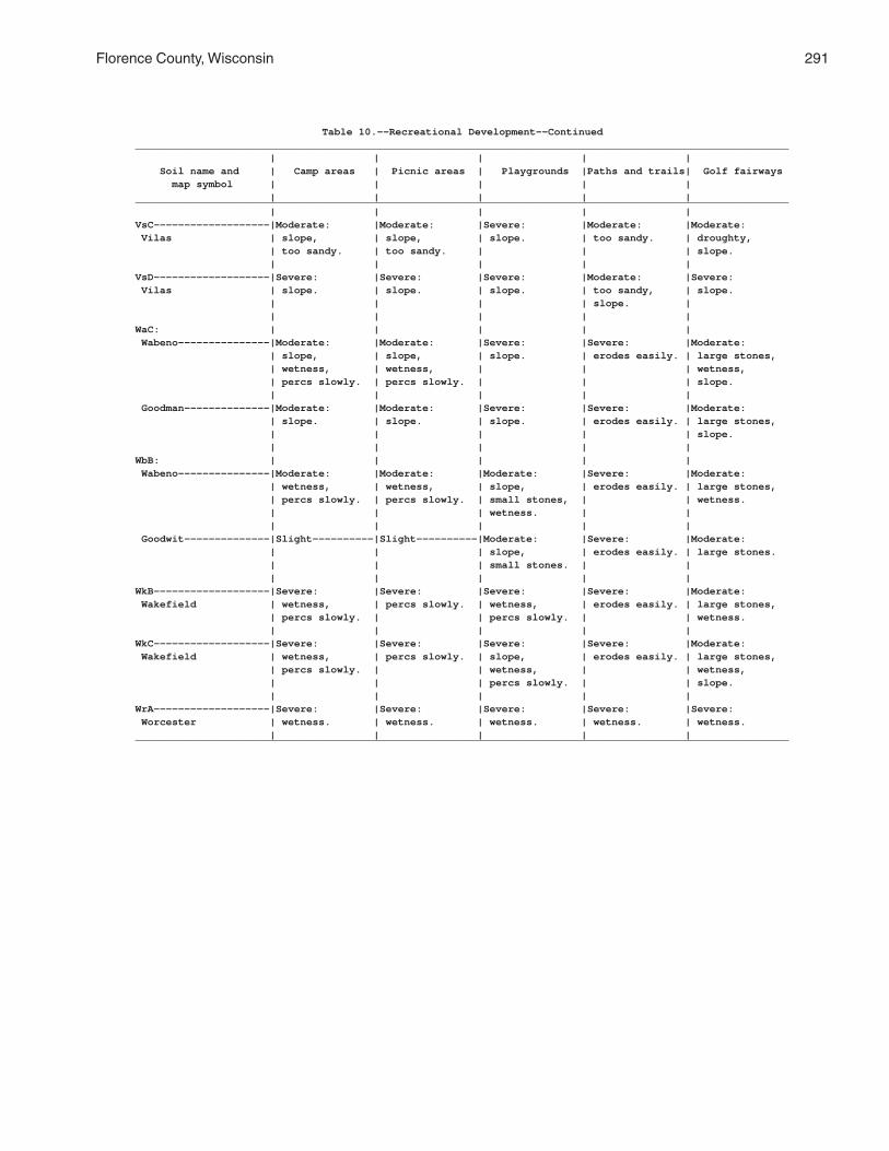
Florence County, Wisconsin 291
Table 10.--Recreational Development--Continued___________________________________________________________________________________________________________ | | | | | Soil name and | Camp areas | Picnic areas | Playgrounds |Paths and trails| Golf fairways map symbol | | | | | | | | | |___________________________________________________________________________________________________________ | | | | |VsC-------------------|Moderate: |Moderate: |Severe: |Moderate: |Moderate: Vilas | slope, | slope, | slope. | too sandy. | droughty, | too sandy. | too sandy. | | | slope. | | | | |VsD-------------------|Severe: |Severe: |Severe: |Moderate: |Severe: Vilas | slope. | slope. | slope. | too sandy, | slope. | | | | slope. | | | | | |WaC: | | | | | Wabeno---------------|Moderate: |Moderate: |Severe: |Severe: |Moderate: | slope, | slope, | slope. | erodes easily. | large stones, | wetness, | wetness, | | | wetness, | percs slowly. | percs slowly. | | | slope. | | | | | Goodman--------------|Moderate: |Moderate: |Severe: |Severe: |Moderate: | slope. | slope. | slope. | erodes easily. | large stones, | | | | | slope. | | | | |WbB: | | | | | Wabeno---------------|Moderate: |Moderate: |Moderate: |Severe: |Moderate: | wetness, | wetness, | slope, | erodes easily. | large stones, | percs slowly. | percs slowly. | small stones, | | wetness. | | | wetness. | | | | | | | Goodwit--------------|Slight----------|Slight----------|Moderate: |Severe: |Moderate: | | | slope, | erodes easily. | large stones. | | | small stones. | | | | | | |WkB-------------------|Severe: |Severe: |Severe: |Severe: |Moderate: Wakefield | wetness, | percs slowly. | wetness, | erodes easily. | large stones, | percs slowly. | | percs slowly. | | wetness. | | | | |WkC-------------------|Severe: |Severe: |Severe: |Severe: |Moderate: Wakefield | wetness, | percs slowly. | slope, | erodes easily. | large stones, | percs slowly. | | wetness, | | wetness, | | | percs slowly. | | slope. | | | | |WrA-------------------|Severe: |Severe: |Severe: |Severe: |Severe: Worcester | wetness. | wetness. | wetness. | wetness. | wetness. | | | | |___________________________________________________________________________________________________________

292 Soil Survey of
Table 11.--Wildlife Habitat
(See text for definitions of "good," "fair," "poor," and "very poor." Absence of an entry indicates that the soil was not rated)
______________________________________________________________________________________________________ | Potential for habitat elements |Potential as habitat for-- __________________________________________________________________________________ Soil name and | Grain | | Wild | | | | | Open- | Wood- | map symbol | and |Grasses|herba- | Hard- |Conif- |Wetland|Shallow| land | land |Wetland | seed | and | ceous | wood | erous |plants | water | wild- | wild- | wild- | crops |legumes|plants | trees |plants | | areas | life | life | life______________________________________________________________________________________________________ | | | | | | | | | |AnB----------------|Good |Good |Good |Good |Good |Poor |Poor |Good |Good |Poor. Annalake | | | | | | | | | | | | | | | | | | | |AnC----------------|Fair |Good |Good |Good |Good |Very |Very |Good |Good |Very Annalake | | | | | | poor. | poor. | | | poor. | | | | | | | | | |Au-----------------|Poor |Fair |Good |Good |Good |Poor |Poor |Fair |Good |Poor. Au Gres | | | | | | | | | | | | | | | | | | | |Ca-----------------|Very |Poor |Fair |Fair |Fair |Good |Good |Poor |Fair |Good. Capitola | poor. | | | | | | | | | | | | | | | | | | |CoA----------------|Fair |Good |Good |Good |Good |Fair |Fair |Good |Good |Fair. Crossett | | | | | | | | | | | | | | | | | | | |CrA----------------|Poor |Fair |Fair |Fair |Fair |Poor |Very |Fair |Fair |Very Croswell | | | | | | | poor. | | | poor. | | | | | | | | | |CuA----------------|Poor |Fair |Fair |Fair |Fair |Poor |Very |Fair |Fair |Very Cublake | | | | | | | poor. | | | poor. | | | | | | | | | |EdB----------------|Good |Good |Good |Good |Good |Poor |Poor |Good |Good |Poor. Ellwood | | | | | | | | | | | | | | | | | | | |EdC----------------|Fair |Good |Good |Good |Good |Very |Very |Good |Good |Very Ellwood | | | | | | poor. | poor. | | | poor. | | | | | | | | | |ElB: | | | | | | | | | | Ellwood-----------|Good |Good |Good |Good |Good |Poor |Poor |Good |Good |Poor. | | | | | | | | | | Crossett----------|Fair |Good |Good |Good |Good |Fair |Fair |Good |Good |Fair. | | | | | | | | | |EmB: | | | | | | | | | | Ellwood-----------|Good |Good |Good |Good |Good |Poor |Poor |Good |Good |Poor. | | | | | | | | | | Iosco-------------|Poor |Fair |Good |Good |Good |Fair |Fair |Fair |Good |Fair. | | | | | | | | | | Morganlake--------|Poor |Fair |Good |Good |Good |Poor |Poor |Fair |Good |Poor. | | | | | | | | | |EnC: | | | | | | | | | | Ellwood-----------|Fair |Good |Good |Good |Good |Very |Very |Good |Good |Very | | | | | | poor. | poor. | | | poor. | | | | | | | | | | Iosco-------------|Poor |Fair |Good |Good |Good |Fair |Fair |Fair |Good |Fair. | | | | | | | | | | Vilas-------------|Poor |Fair |Fair |Poor |Poor |Very |Very |Fair |Poor |Very | | | | | | poor. | poor. | | | poor. | | | | | | | | | |EoD: | | | | | | | | | | Ellwood-----------|Fair |Good |Good |Good |Good |Very |Very |Good |Good |Very | | | | | | poor. | poor. | | | poor. | | | | | | | | | | Vilas-------------|Poor |Poor |Fair |Poor |Poor |Very |Very |Poor |Poor |Very | | | | | | poor. | poor. | | | poor. | | | | | | | | | | Padus-------------|Poor |Fair |Good |Good |Good |Very |Very |Fair |Good |Very | | | | | | poor. | poor. | | | poor. | | | | | | | | | |

Florence County, Wisconsin 293
Table 11.--Wildlife Habitat--Continued______________________________________________________________________________________________________ | Potential for habitat elements |Potential as habitat for-- __________________________________________________________________________________ Soil name and | Grain | | Wild | | | | | Open- | Wood- | map symbol | and |Grasses|herba- | Hard- |Conif- |Wetland|Shallow| land | land |Wetland | seed | and | ceous | wood | erous |plants | water | wild- | wild- | wild- | crops |legumes|plants | trees |plants | | areas | life | life | life______________________________________________________________________________________________________ | | | | | | | | | |Ep: | | | | | | | | | | Epiaquents--------|Very |Fair |Fair |Fair |Fair |Good |Good |Poor |Fair |Good. | poor. | | | | | | | | | | | | | | | | | | | Epiaquods---------|Very |Fair |Fair |Fair |Fair |Good |Good |Poor |Fair |Good. | poor. | | | | | | | | | | | | | | | | | | |FeB----------------|Good |Good |Good |Good |Good |Poor |Poor |Good |Good |Poor. Fence | | | | | | | | | | | | | | | | | | | |Fm-----------------|Very |Very |Poor |Fair |Fair |Good |Good |Very |Fair |Good. Fordum | poor. | poor. | | | | | | poor. | | | | | | | | | | | |GaA----------------|Fair |Good |Good |Good |Good |Fair |Fair |Good |Good |Fair. Gastrow | | | | | | | | | | | | | | | | | | | |GmC, GmD-----------|Very |Poor |Good |Good |Good |Very |Very |Poor |Good |Very Goodman | poor. | | | | | poor. | poor. | | | poor. | | | | | | | | | |GwB----------------|Very |Poor |Good |Good |Good |Poor |Very |Poor |Good |Very Goodwit | poor. | | | | | | poor. | | | poor. | | | | | | | | | |IsA----------------|Poor |Poor |Good |Good |Good |Fair |Fair |Fair |Good |Fair. Iosco | | | | | | | | | | | | | | | | | | | |Kr-----------------|Very |Poor |Poor |Fair |Fair |Good |Good |Poor |Fair |Good. Kinross | poor. | | | | | | | | | | | | | | | | | | |Lo: | | | | | | | | | | Loxley------------|Very |Poor |Poor |Poor |Poor |Good |Good |Poor |Poor |Good. | poor. | | | | | | | | | | | | | | | | | | | Beseman-----------|Very |Poor |Poor |Poor |Poor |Good |Good |Poor |Poor |Good. | poor. | | | | | | | | | | | | | | | | | | | Dawson------------|Very |Poor |Poor |Poor |Poor |Good |Good |Poor |Poor |Good. | poor. | | | | | | | | | | | | | | | | | | |Lu: | | | | | | | | | | Lupton------------|Poor |Poor |Poor |Poor |Poor |Good |Good |Poor |Poor |Good. | | | | | | | | | | Cathro------------|Poor |Poor |Poor |Poor |Poor |Good |Good |Poor |Poor |Good. | | | | | | | | | | Markey------------|Poor |Poor |Poor |Poor |Poor |Good |Good |Poor |Poor |Good. | | | | | | | | | |MaA----------------|Fair |Fair |Good |Good |Good |Poor |Poor |Fair |Good |Poor. Manitowish | | | | | | | | | | | | | | | | | | | |Mn-----------------|Very |Fair |Fair |Fair |Fair |Good |Good |Poor |Fair |Good. Minocqua | poor. | | | | | | | | | | | | | | | | | | |MrB----------------|Poor |Fair |Good |Good |Good |Poor |Poor |Fair |Good |Poor. Morganlake | | | | | | | | | | | | | | | | | | | |MuB----------------|Very |Poor |Good |Good |Good |Poor |Very |Poor |Good |Very Mudlake | poor. | | | | | | poor. | | | poor. | | | | | | | | | | | | | | | | | | | |PaB, PaC-----------|Fair |Good |Good |Good |Good |Very |Very |Good |Good |Very Padus | | | | | | poor. | poor. | | | poor. | | | | | | | | | |

294 Soil Survey of
Table 11.--Wildlife Habitat--Continued______________________________________________________________________________________________________ | Potential for habitat elements |Potential as habitat for-- __________________________________________________________________________________ Soil name and | Grain | | Wild | | | | | Open- | Wood- | map symbol | and |Grasses|herba- | Hard- |Conif- |Wetland|Shallow| land | land |Wetland | seed | and | ceous | wood | erous |plants | water | wild- | wild- | wild- | crops |legumes|plants | trees |plants | | areas | life | life | life______________________________________________________________________________________________________ | | | | | | | | | |PaD----------------|Poor |Fair |Good |Good |Good |Very |Very |Fair |Good |Very Padus | | | | | | poor. | poor. | | | poor. | | | | | | | | | |PeB, PeC: | | | | | | | | | | Padus-------------|Fair |Good |Good |Good |Good |Very |Very |Good |Good |Very | | | | | | poor. | poor. | | | poor. | | | | | | | | | | Pence-------------|Fair |Fair |Fair |Fair |Fair |Very |Very |Fair |Fair |Very | | | | | | poor. | poor. | | | poor. | | | | | | | | | |PeD: | | | | | | | | | | Padus-------------|Poor |Fair |Good |Good |Good |Very |Very |Fair |Good |Very | | | | | | poor. | poor. | | | poor. | | | | | | | | | | Pence-------------|Poor |Fair |Fair |Fair |Fair |Very |Very |Fair |Fair |Very | | | | | | poor. | poor. | | | poor. | | | | | | | | | |PnB, PnC-----------|Fair |Fair |Fair |Fair |Fair |Very |Very |Fair |Fair |Very Pence | | | | | | poor. | poor. | | | poor. | | | | | | | | | |PnD----------------|Poor |Fair |Fair |Fair |Fair |Very |Very |Fair |Fair |Very Pence | | | | | | poor. | poor. | | | poor. | | | | | | | | | |PsB, PsC: | | | | | | | | | | Pence-------------|Fair |Fair |Fair |Fair |Fair |Very |Very |Fair |Fair |Very | | | | | | poor. | poor. | | | poor. | | | | | | | | | | Vilas-------------|Poor |Fair |Fair |Poor |Poor |Very |Very |Fair |Poor |Very | | | | | | poor. | poor. | | | poor. | | | | | | | | | |PsD: | | | | | | | | | | Pence-------------|Poor |Fair |Fair |Fair |Fair |Very |Very |Fair |Fair |Very | | | | | | poor. | poor. | | | poor. | | | | | | | | | | Vilas-------------|Very |Poor |Fair |Poor |Poor |Very |Very |Poor |Poor |Very | poor. | | | | | poor. | poor. | | | poor. | | | | | | | | | |Pt. | | | | | | | | | | Pits, gravel | | | | | | | | | | | | | | | | | | | |Px. | | | | | | | | | | Pits, mine | | | | | | | | | | | | | | | | | | | |Rb-----------------|Fair |Good |Good |Good |Good |Fair |Fair |Good |Good |Fair. Robago | | | | | | | | | | | | | | | | | | | |RkC: | | | | | | | | | | Rock outcrop. | | | | | | | | | | | | | | | | | | | | Ishpeming---------|Poor |Fair |Fair |Fair |Fair |Very |Very |Fair |Fair |Very | | | | | | poor. | poor. | | | poor. | | | | | | | | | | Vilas-------------|Poor |Fair |Fair |Poor |Poor |Very |Very |Fair |Poor |Very | | | | | | poor. | poor. | | | poor. | | | | | | | | | |RkD: | | | | | | | | | | Rock outcrop. | | | | | | | | | | | | | | | | | | | | Ishpeming---------|Very |Poor |Fair |Fair |Fair |Very |Very |Poor |Fair |Very | poor. | | | | | poor. | poor. | | | poor. | | | | | | | | | | Vilas-------------|Very |Poor |Fair |Poor |Poor |Very |Very |Poor |Poor |Very | poor. | | | | | poor. | poor. | | | poor. | | | | | | | | | |

Florence County, Wisconsin 295
Table 11.--Wildlife Habitat--Continued______________________________________________________________________________________________________ | Potential for habitat elements |Potential as habitat for-- __________________________________________________________________________________ Soil name and | Grain | | Wild | | | | | Open- | Wood- | map symbol | and |Grasses|herba- | Hard- |Conif- |Wetland|Shallow| land | land |Wetland | seed | and | ceous | wood | erous |plants | water | wild- | wild- | wild- | crops |legumes|plants | trees |plants | | areas | life | life | life______________________________________________________________________________________________________ | | | | | | | | | |RmC: | | | | | | | | | | Rock outcrop. | | | | | | | | | | | | | | | | | | | | Metonga-----------|Fair |Good |Good |Good |Good |Very |Very |Good |Good |Very | | | | | | poor. | poor. | | | poor. | | | | | | | | | | Sarona------------|Fair |Good |Good |Good |Good |Very |Very |Good |Good |Very | | | | | | poor. | poor. | | | poor. | | | | | | | | | |RmD: | | | | | | | | | | Rock outcrop. | | | | | | | | | | | | | | | | | | | | Metonga-----------|Poor |Fair |Good |Good |Good |Very |Very |Fair |Good |Very | | | | | | poor. | poor. | | | poor. | | | | | | | | | | Sarona------------|Poor |Fair |Good |Good |Good |Very |Very |Fair |Good |Very | | | | | | poor. | poor. | | | poor. | | | | | | | | | |RsB----------------|Poor |Fair |Good |Good |Good |Poor |Very |Fair |Good |Very Rousseau | | | | | | | poor. | | | poor. | | | | | | | | | |RsC----------------|Poor |Fair |Good |Good |Good |Very |Very |Fair |Good |Very Rousseau | | | | | | poor. | poor. | | | poor. | | | | | | | | | |SaB, SaC, SaD------|Very |Poor |Good |Good |Good |Very |Very |Poor |Good |Very Sarona | poor. | | | | | poor. | poor. | | | poor. | | | | | | | | | |SdB, SdC: | | | | | | | | | | Sarona------------|Very |Poor |Good |Good |Good |Very |Very |Poor |Good |Very | poor. | | | | | poor. | poor. | | | poor. | | | | | | | | | | Padus-------------|Fair |Good |Good |Good |Good |Very |Very |Good |Good |Very | | | | | | poor. | poor. | | | poor. | | | | | | | | | |SdD: | | | | | | | | | | Sarona------------|Very |Poor |Good |Good |Good |Very |Very |Poor |Good |Very | poor. | | | | | poor. | poor. | | | poor. | | | | | | | | | | Padus-------------|Poor |Fair |Good |Good |Good |Very |Very |Fair |Good |Very | | | | | | poor. | poor. | | | poor. | | | | | | | | | |SlB, SlC: | | | | | | | | | | Sarona------------|Very |Poor |Good |Good |Good |Very |Very |Poor |Good |Very | poor. | | | | | poor. | poor. | | | poor. | | | | | | | | | | Vilas-------------|Poor |Fair |Fair |Poor |Poor |Very |Very |Fair |Poor |Very | | | | | | poor. | poor. | | | poor. | | | | | | | | | |SlD: | | | | | | | | | | Sarona------------|Very |Poor |Good |Good |Good |Very |Very |Poor |Good |Very | poor. | | | | | poor. | poor. | | | poor. | | | | | | | | | | Vilas-------------|Poor |Poor |Fair |Poor |Poor |Very |Very |Poor |Poor |Very | | | | | | poor. | poor. | | | poor. | | | | | | | | | |SnB, SnC-----------|Poor |Fair |Fair |Poor |Poor |Very |Very |Fair |Poor |Very Sayner | | | | | | poor. | poor. | | | poor. | | | | | | | | | |SnD----------------|Very |Poor |Fair |Poor |Poor |Very |Very |Poor |Poor |Very Sayner | poor. | | | | | poor. | poor. | | | poor. | | | | | | | | | |

296 Soil Survey of
Table 11.--Wildlife Habitat--Continued______________________________________________________________________________________________________ | Potential for habitat elements |Potential as habitat for-- __________________________________________________________________________________ Soil name and | Grain | | Wild | | | | | Open- | Wood- | map symbol | and |Grasses|herba- | Hard- |Conif- |Wetland|Shallow| land | land |Wetland | seed | and | ceous | wood | erous |plants | water | wild- | wild- | wild- | crops |legumes|plants | trees |plants | | areas | life | life | life______________________________________________________________________________________________________ | | | | | | | | | |SoD: | | | | | | | | | | Soperton----------|Very |Poor |Good |Good |Good |Very |Very |Poor |Good |Very | poor. | | | | | poor. | poor. | | | poor. | | | | | | | | | | Goodman-----------|Very |Poor |Good |Good |Good |Very |Very |Poor |Good |Very | poor. | | | | | poor. | poor. | | | poor. | | | | | | | | | |StC----------------|Fair |Good |Good |Good |Good |Very |Very |Good |Good |Very Stambaugh | | | | | | poor. | poor. | | | poor. | | | | | | | | | |StD----------------|Poor |Fair |Good |Good |Good |Very |Very |Fair |Good |Very Stambaugh | | | | | | poor. | poor. | | | poor. | | | | | | | | | |SuC: | | | | | | | | | | Stambaugh---------|Fair |Good |Good |Good |Good |Very |Very |Good |Good |Very | | | | | | poor. | poor. | | | poor. | | | | | | | | | | Goodman-----------|Very |Poor |Good |Good |Good |Very |Very |Poor |Good |Very | poor. | | | | | poor. | poor. | | | poor. | | | | | | | | | |SuD: | | | | | | | | | | Stambaugh---------|Very |Fair |Good |Good |Good |Very |Very |Fair |Good |Very | poor. | | | | | poor. | poor. | | | poor. | | | | | | | | | | Goodman-----------|Very |Poor |Good |Good |Good |Very |Very |Poor |Good |Very | poor. | | | | | poor. | poor. | | | poor. | | | | | | | | | |TpA----------------|Fair |Good |Good |Good |Good |Poor |Very |Good |Good |Very Tipler | | | | | | | poor. | | | poor. | | | | | | | | | |VaB----------------|Good |Good |Good |Good |Good |Poor |Poor |Good |Good |Poor. Vanzile | | | | | | | | | | | | | | | | | | | |VgB: | | | | | | | | | | Vanzile-----------|Good |Good |Good |Good |Good |Poor |Poor |Good |Good |Poor. | | | | | | | | | | Goodwit-----------|Very |Poor |Good |Good |Good |Poor |Very |Poor |Good |Very | poor. | | | | | | poor. | | | poor. | | | | | | | | | |VsB, VsC-----------|Poor |Fair |Fair |Poor |Poor |Very |Very |Fair |Poor |Very Vilas | | | | | | poor. | poor. | | | poor. | | | | | | | | | |VsD----------------|Poor |Poor |Fair |Poor |Poor |Very |Very |Poor |Poor |Very Vilas | | | | | | poor. | poor. | | | poor. | | | | | | | | | |WaC: | | | | | | | | | | Wabeno------------|Very |Poor |Good |Good |Good |Very |Very |Poor |Good |Very | poor. | | | | | poor. | poor. | | | poor. | | | | | | | | | | Goodman-----------|Very |Poor |Good |Good |Good |Very |Very |Poor |Good |Very | poor. | | | | | poor. | poor. | | | poor. | | | | | | | | | |WbB: | | | | | | | | | | Wabeno------------|Very |Poor |Good |Good |Good |Poor |Very |Poor |Good |Very | poor. | | | | | | poor. | | | poor. | | | | | | | | | | Goodwit-----------|Very |Poor |Good |Good |Good |Poor |Very |Poor |Good |Very | poor. | | | | | | poor. | | | poor. | | | | | | | | | |WkB----------------|Very |Poor |Good |Good |Good |Poor |Very |Poor |Good |Very Wakefield | poor. | | | | | | poor. | | | poor. | | | | | | | | | |
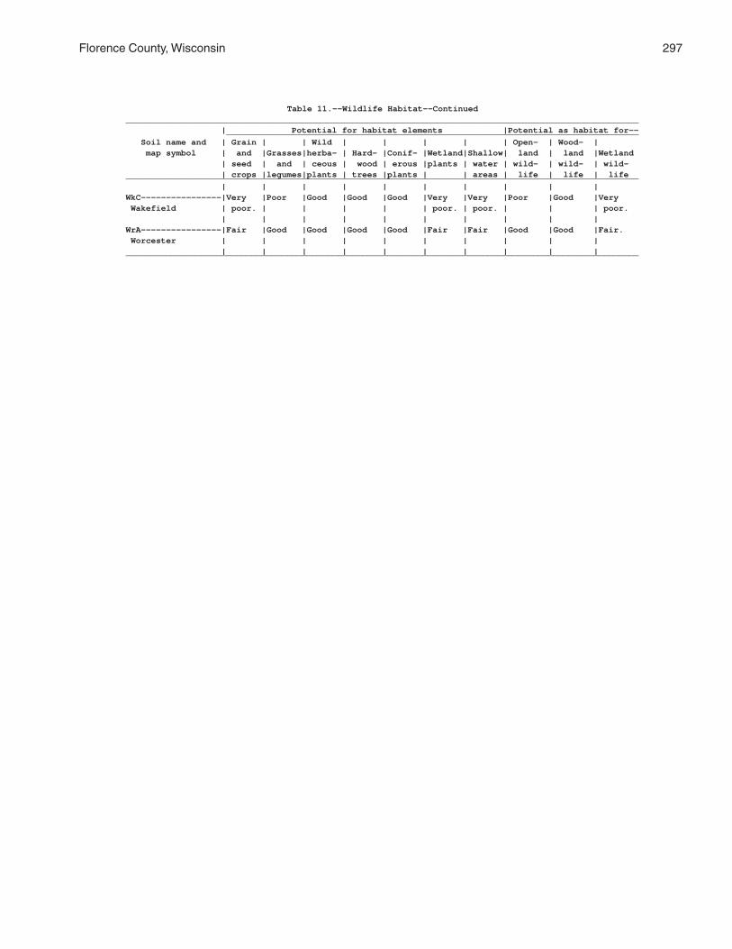
Florence County, Wisconsin 297
Table 11.--Wildlife Habitat--Continued______________________________________________________________________________________________________ | Potential for habitat elements |Potential as habitat for-- __________________________________________________________________________________ Soil name and | Grain | | Wild | | | | | Open- | Wood- | map symbol | and |Grasses|herba- | Hard- |Conif- |Wetland|Shallow| land | land |Wetland | seed | and | ceous | wood | erous |plants | water | wild- | wild- | wild- | crops |legumes|plants | trees |plants | | areas | life | life | life______________________________________________________________________________________________________ | | | | | | | | | |WkC----------------|Very |Poor |Good |Good |Good |Very |Very |Poor |Good |Very Wakefield | poor. | | | | | poor. | poor. | | | poor. | | | | | | | | | |WrA----------------|Fair |Good |Good |Good |Good |Fair |Fair |Good |Good |Fair. Worcester | | | | | | | | | | | | | | | | | | | |______________________________________________________________________________________________________

298 Soil Survey of
Table 12.--Building Site Development
(Some terms that describe restrictive soil features are defined in the Glossary. See text for definitions of "slight," "moderate," and "severe." Absence of an entry indicates that the soil was not rated. The information in this table indicates the dominant soil condition but does not eliminate the need for onsite investigation)
__________________________________________________________________________________________________________________ | | | | | | Soil name and | Shallow | Dwellings | Dwellings | Small | Local roads | Lawns and map symbol | excavations | without | with | commercial | and streets | landscaping | | basements | basements | buildings | |__________________________________________________________________________________________________________________ | | | | | |AnB---------------|Severe: |Slight---------|Moderate: |Slight---------|Moderate: |Moderate: Annalake | cutbanks cave.| | wetness. | | frost action. | droughty. | | | | | |AnC---------------|Severe: |Moderate: |Moderate: |Severe: |Moderate: |Moderate: Annalake | cutbanks cave.| slope. | wetness, | slope. | slope, | droughty, | | | slope. | | frost action. | slope. | | | | | |Au----------------|Severe: |Severe: |Severe: |Severe: |Severe: |Severe: Au Gres | cutbanks cave,| wetness. | wetness. | wetness. | wetness. | wetness. | wetness. | | | | | | | | | | |Ca----------------|Severe: |Severe: |Severe: |Severe: |Severe: |Severe: Capitola | cutbanks cave,| ponding. | ponding. | ponding. | ponding, | ponding, | ponding. | | | | frost action. | excess humus. | | | | | |CoA---------------|Severe: |Severe: |Severe: |Severe: |Severe: |Severe: Crossett | wetness. | wetness. | wetness. | wetness. | low strength, | wetness. | | | | | wetness, | | | | | | frost action. | | | | | | |CrA---------------|Severe: |Moderate: |Severe: |Moderate: |Moderate: |Moderate: Croswell | cutbanks cave,| wetness. | wetness. | wetness. | wetness. | droughty. | wetness. | | | | | | | | | | |CuA---------------|Severe: |Moderate: |Severe: |Moderate: |Moderate: |Severe: Cublake | cutbanks cave,| wetness. | wetness. | wetness. | wetness. | droughty. | wetness. | | | | | | | | | | |EdB---------------|Severe: |Moderate: |Severe: |Moderate: |Severe: |Moderate: Ellwood | wetness. | wetness, | wetness. | wetness, | low strength. | large stones, | | shrink-swell. | | shrink-swell. | | wetness. | | | | | |EdC---------------|Severe: |Moderate: |Severe: |Severe: |Severe: |Moderate: Ellwood | wetness. | wetness, | wetness. | slope. | low strength. | large stones, | | shrink-swell, | | | | wetness, | | slope. | | | | slope. | | | | | |ElB: | | | | | | Ellwood----------|Severe: |Moderate: |Severe: |Moderate: |Severe: |Moderate: | wetness. | wetness, | wetness. | wetness, | low strength. | large stones, | | shrink-swell. | | shrink-swell. | | wetness. | | | | | | Crossett---------|Severe: |Severe: |Severe: |Severe: |Severe: |Severe: | wetness. | wetness. | wetness. | wetness. | low strength, | wetness. | | | | | wetness, | | | | | | frost action. | | | | | | |EmB: | | | | | | Ellwood----------|Severe: |Moderate: |Severe: |Moderate: |Severe: |Moderate: | wetness. | wetness, | wetness. | wetness, | low strength. | large stones, | | shrink-swell. | | shrink-swell. | | wetness. | | | | | | Iosco------------|Severe: |Severe: |Severe: |Severe: |Severe: |Severe: | cutbanks cave,| wetness. | wetness. | wetness. | wetness. | wetness. | wetness. | | | | | | | | | | |

Florence County, Wisconsin 299
Table 12.--Building Site Development--Continued__________________________________________________________________________________________________________________ | | | | | | Soil name and | Shallow | Dwellings | Dwellings | Small | Local roads | Lawns and map symbol | excavations | without | with | commercial | and streets | landscaping | | basements | basements | buildings | |__________________________________________________________________________________________________________________ | | | | | |EmB: | | | | | | Morganlake-------|Severe: |Moderate: |Severe: |Moderate: |Moderate: |Moderate: | cutbanks cave,| wetness. | wetness. | wetness. | wetness. | wetness, | wetness. | | | | | droughty. | | | | | |EnC: | | | | | | Ellwood----------|Severe: |Moderate: |Severe: |Severe: |Severe: |Moderate: | wetness. | wetness, | wetness. | slope. | low strength. | large stones, | | shrink-swell, | | | | wetness, | | slope. | | | | slope. | | | | | | Iosco------------|Severe: |Severe: |Severe: |Severe: |Severe: |Severe: | cutbanks cave,| wetness. | wetness. | wetness. | wetness. | wetness. | wetness. | | | | | | | | | | | Vilas------------|Severe: |Moderate: |Moderate: |Severe: |Moderate: |Moderate: | cutbanks cave.| slope. | slope. | slope. | slope. | droughty, | | | | | | slope. | | | | | |EoD: | | | | | | Ellwood----------|Severe: |Moderate: |Severe: |Severe: |Severe: |Moderate: | wetness. | wetness, | wetness. | slope. | low strength. | large stones, | | shrink-swell, | | | | wetness, | | slope. | | | | slope. | | | | | | Vilas------------|Severe: |Severe: |Severe: |Severe: |Severe: |Severe: | cutbanks cave,| slope. | slope. | slope. | slope. | slope. | slope. | | | | | | | | | | | Padus------------|Severe: |Severe: |Severe: |Severe: |Severe: |Severe: | cutbanks cave,| slope. | slope. | slope. | slope. | slope. | slope. | | | | | | | | | | |Ep: | | | | | | Epiaquents-------|Severe: |Severe: |Severe: |Severe: |Severe: |Severe: | cutbanks cave,| ponding. | ponding. | ponding. | ponding, | ponding, | ponding. | | | | frost action. | excess humus. | | | | | | Epiaquods--------|Severe: |Severe: |Severe: |Severe: |Severe: |Severe: | cutbanks cave,| ponding. | ponding. | ponding. | ponding. | ponding, | ponding. | | | | | excess humus. | | | | | |FeB---------------|Severe: |Slight---------|Moderate: |Slight---------|Severe: |Slight. Fence | cutbanks cave.| | wetness. | | frost action. | | | | | | |Fm----------------|Severe: |Severe: |Severe: |Severe: |Severe: |Severe: Fordum | cutbanks cave,| flooding, | flooding, | flooding, | ponding, | ponding, | ponding. | ponding. | ponding. | ponding. | flooding, | flooding. | | | | | frost action. | | | | | | |GaA---------------|Severe: |Severe: |Severe: |Severe: |Severe: |Severe: Gastrow | cutbanks cave,| wetness. | wetness. | wetness. | wetness, | wetness. | wetness. | | | | frost action. | | | | | | |GmC---------------|Severe: |Moderate: |Moderate: |Severe: |Moderate: |Moderate: Goodman | cutbanks cave.| slope. | slope. | slope. | slope, | large stones, | | | | | frost action. | slope. | | | | | |GmD---------------|Severe: |Severe: |Severe: |Severe: |Severe: |Severe: Goodman | cutbanks cave,| slope. | slope. | slope. | slope. | slope. | slope. | | | | | | | | | | |

300 Soil Survey of
Table 12.--Building Site Development--Continued__________________________________________________________________________________________________________________ | | | | | | Soil name and | Shallow | Dwellings | Dwellings | Small | Local roads | Lawns and map symbol | excavations | without | with | commercial | and streets | landscaping | | basements | basements | buildings | |__________________________________________________________________________________________________________________ | | | | | |GwB---------------|Severe: |Slight---------|Moderate: |Slight---------|Moderate: |Moderate: Goodwit | cutbanks cave.| | wetness. | | frost action. | large stones. | | | | | | | | | | | |IsA---------------|Severe: |Severe: |Severe: |Severe: |Severe: |Severe: Iosco | cutbanks cave,| wetness. | wetness. | wetness. | wetness. | wetness. | wetness. | | | | | | | | | | |Kr----------------|Severe: |Severe: |Severe: |Severe: |Severe: |Severe: Kinross | cutbanks cave,| ponding. | ponding. | ponding. | ponding. | ponding, | ponding. | | | | | excess humus. | | | | | |Lo: | | | | | | Loxley-----------|Severe: |Severe: |Severe: |Severe: |Severe: |Severe: | excess humus, | subsides, | subsides, | subsides, | subsides, | ponding, | ponding. | ponding, | ponding, | ponding, | ponding, | excess humus. | | low strength. | low strength. | low strength. | frost action. | | | | | | | Beseman----------|Severe: |Severe: |Severe: |Severe: |Severe: |Severe: | excess humus, | subsides, | subsides, | subsides, | subsides, | ponding, | ponding. | ponding, | ponding. | ponding, | ponding, | excess humus. | | low strength. | | low strength. | frost action. | | | | | | | Dawson-----------|Severe: |Severe: |Severe: |Severe: |Severe: |Severe: | cutbanks cave,| subsides, | subsides, | subsides, | subsides, | ponding, | excess humus, | ponding, | ponding. | ponding, | ponding, | excess humus. | ponding. | low strength. | | low strength. | frost action. | | | | | | |Lu: | | | | | | Lupton-----------|Severe: |Severe: |Severe: |Severe: |Severe: |Severe: | excess humus, | subsides, | subsides, | subsides, | subsides, | ponding, | ponding. | ponding, | ponding, | ponding, | ponding, | excess humus. | | low strength. | low strength. | low strength. | frost action. | | | | | | | Cathro-----------|Severe: |Severe: |Severe: |Severe: |Severe: |Severe: | excess humus, | subsides, | subsides, | subsides, | subsides, | ponding, | ponding. | ponding, | ponding. | ponding, | ponding, | excess humus. | | low strength. | | low strength. | frost action. | | | | | | | Markey-----------|Severe: |Severe: |Severe: |Severe: |Severe: |Severe: | cutbanks cave,| subsides, | subsides, | subsides, | subsides, | ponding, | excess humus, | ponding, | ponding. | ponding, | ponding, | excess humus. | ponding. | low strength. | | low strength. | frost action. | | | | | | |MaA---------------|Severe: |Slight---------|Moderate: |Slight---------|Slight---------|Moderate: Manitowish | cutbanks cave.| | wetness. | | | large stones, | | | | | | droughty. | | | | | |Mn----------------|Severe: |Severe: |Severe: |Severe: |Severe: |Severe: Minocqua | cutbanks cave,| ponding. | ponding. | ponding. | ponding, | ponding, | ponding. | | | | frost action. | excess humus. | | | | | |MrB---------------|Severe: |Moderate: |Severe: |Moderate: |Moderate: |Moderate: Morganlake | cutbanks cave,| wetness. | wetness. | wetness. | wetness. | wetness, | wetness. | | | | | droughty. | | | | | |MuB---------------|Severe: |Severe: |Severe: |Severe: |Severe: |Severe: Mudlake | cutbanks cave,| wetness. | wetness. | wetness. | wetness, | wetness. | wetness. | | | | frost action. | | | | | | |PaB---------------|Severe: |Slight---------|Slight---------|Slight---------|Moderate: |Moderate: Padus | cutbanks cave.| | | | frost action. | small stones, | | | | | | large stones. | | | | | |

Florence County, Wisconsin 301
Table 12.--Building Site Development--Continued__________________________________________________________________________________________________________________ | | | | | | Soil name and | Shallow | Dwellings | Dwellings | Small | Local roads | Lawns and map symbol | excavations | without | with | commercial | and streets | landscaping | | basements | basements | buildings | |__________________________________________________________________________________________________________________ | | | | | |PaC---------------|Severe: |Moderate: |Moderate: |Severe: |Moderate: |Moderate: Padus | cutbanks cave.| slope. | slope. | slope. | slope, | small stones, | | | | | frost action. | large stones, | | | | | | slope. | | | | | |PaD---------------|Severe: |Severe: |Severe: |Severe: |Severe: |Severe: Padus | cutbanks cave,| slope. | slope. | slope. | slope. | slope. | slope. | | | | | | | | | | |PeB: | | | | | | Padus------------|Severe: |Slight---------|Slight---------|Slight---------|Moderate: |Moderate: | cutbanks cave.| | | | frost action. | small stones, | | | | | | large stones. | | | | | | Pence------------|Severe: |Slight---------|Slight---------|Slight---------|Slight---------|Moderate: | cutbanks cave.| | | | | large stones, | | | | | | droughty. | | | | | |PeC: | | | | | | Padus------------|Severe: |Moderate: |Moderate: |Severe: |Moderate: |Moderate: | cutbanks cave.| slope. | slope. | slope. | slope, | small stones, | | | | | frost action. | large stones, | | | | | | slope. | | | | | | Pence------------|Severe: |Moderate: |Moderate: |Severe: |Moderate: |Moderate: | cutbanks cave.| slope. | slope. | slope. | slope. | large stones, | | | | | | droughty, | | | | | | slope. | | | | | |PeD: | | | | | | Padus------------|Severe: |Severe: |Severe: |Severe: |Severe: |Severe: | cutbanks cave,| slope. | slope. | slope. | slope. | slope. | slope. | | | | | | | | | | | Pence------------|Severe: |Severe: |Severe: |Severe: |Severe: |Severe: | cutbanks cave,| slope. | slope. | slope. | slope. | slope. | slope. | | | | | | | | | | |PnB---------------|Severe: |Slight---------|Slight---------|Slight---------|Slight---------|Moderate: Pence | cutbanks cave.| | | | | large stones, | | | | | | droughty. | | | | | |PnC---------------|Severe: |Moderate: |Moderate: |Severe: |Moderate: |Moderate: Pence | cutbanks cave.| slope. | slope. | slope. | slope. | large stones, | | | | | | droughty, | | | | | | slope. | | | | | |PnD---------------|Severe: |Severe: |Severe: |Severe: |Severe: |Severe: Pence | cutbanks cave,| slope. | slope. | slope. | slope. | slope. | slope. | | | | | | | | | | |PsB: | | | | | | Pence------------|Severe: |Slight---------|Slight---------|Slight---------|Slight---------|Moderate: | cutbanks cave.| | | | | large stones, | | | | | | droughty. | | | | | | Vilas------------|Severe: |Slight---------|Slight---------|Slight---------|Slight---------|Moderate: | cutbanks cave.| | | | | droughty. | | | | | |

302 Soil Survey of
Table 12.--Building Site Development--Continued__________________________________________________________________________________________________________________ | | | | | | Soil name and | Shallow | Dwellings | Dwellings | Small | Local roads | Lawns and map symbol | excavations | without | with | commercial | and streets | landscaping | | basements | basements | buildings | |__________________________________________________________________________________________________________________ | | | | | |PsC: | | | | | | Pence------------|Severe: |Moderate: |Moderate: |Severe: |Moderate: |Moderate: | cutbanks cave.| slope. | slope. | slope. | slope. | large stones, | | | | | | droughty, | | | | | | slope. | | | | | | Vilas------------|Severe: |Moderate: |Moderate: |Severe: |Moderate: |Moderate: | cutbanks cave.| slope. | slope. | slope. | slope. | droughty, | | | | | | slope. | | | | | |PsD: | | | | | | Pence------------|Severe: |Severe: |Severe: |Severe: |Severe: |Severe: | cutbanks cave,| slope. | slope. | slope. | slope. | slope. | slope. | | | | | | | | | | | Vilas------------|Severe: |Severe: |Severe: |Severe: |Severe: |Severe: | cutbanks cave,| slope. | slope. | slope. | slope. | slope. | slope. | | | | | | | | | | |Pt. | | | | | | Pits, gravel | | | | | | | | | | | |Px. | | | | | | Pits, mine | | | | | | | | | | | |Rb----------------|Severe: |Severe: |Severe: |Severe: |Severe: |Severe: Robago | cutbanks cave,| wetness. | wetness. | wetness. | wetness, | too acid, | wetness. | | | | frost action. | wetness. | | | | | |RkC: | | | | | | Rock outcrop. | | | | | | | | | | | | Ishpeming--------|Severe: |Moderate: |Severe: |Severe: |Moderate: |Moderate: | depth to rock,| slope, | depth to rock.| slope. | depth to rock,| large stones, | cutbanks cave.| depth to rock.| | | slope. | droughty, | | | | | | slope. | | | | | | Vilas------------|Severe: |Moderate: |Moderate: |Severe: |Moderate: |Moderate: | cutbanks cave.| slope. | slope. | slope. | slope. | droughty, | | | | | | slope. | | | | | |RkD: | | | | | | Rock outcrop. | | | | | | | | | | | | Ishpeming--------|Severe: |Severe: |Severe: |Severe: |Severe: |Severe: | depth to rock,| slope. | depth to rock,| slope. | slope. | slope. | cutbanks cave,| | slope. | | | | slope. | | | | | | | | | | | Vilas------------|Severe: |Severe: |Severe: |Severe: |Severe: |Severe: | cutbanks cave,| slope. | slope. | slope. | slope. | slope. | slope. | | | | | | | | | | |RmC: | | | | | | Rock outcrop. | | | | | | | | | | | | Metonga----------|Severe: |Moderate: |Severe: |Severe: |Moderate: |Moderate: | depth to rock.| slope, | depth to rock.| slope. | depth to rock,| large stones, | | depth to rock.| | | slope, | slope, | | | | | frost action. | depth to rock. | | | | | |

Florence County, Wisconsin 303
Table 12.--Building Site Development--Continued__________________________________________________________________________________________________________________ | | | | | | Soil name and | Shallow | Dwellings | Dwellings | Small | Local roads | Lawns and map symbol | excavations | without | with | commercial | and streets | landscaping | | basements | basements | buildings | |__________________________________________________________________________________________________________________ | | | | | |RmC: | | | | | | Sarona-----------|Severe: |Moderate: |Moderate: |Severe: |Moderate: |Moderate: | cutbanks cave.| slope. | slope. | slope. | slope, | large stones, | | | | | frost action. | droughty, | | | | | | slope. | | | | | |RmD: | | | | | | Rock outcrop. | | | | | | | | | | | | Metonga----------|Severe: |Severe: |Severe: |Severe: |Severe: |Severe: | depth to rock,| slope. | depth to rock,| slope. | slope. | slope. | slope. | | slope. | | | | | | | | | Sarona-----------|Severe: |Severe: |Severe: |Severe: |Severe: |Severe: | cutbanks cave,| slope. | slope. | slope. | slope. | slope. | slope. | | | | | | | | | | |RsB---------------|Severe: |Slight---------|Slight---------|Slight---------|Slight---------|Moderate: Rousseau | cutbanks cave.| | | | | droughty. | | | | | |RsC---------------|Severe: |Moderate: |Moderate: |Severe: |Moderate: |Moderate: Rousseau | cutbanks cave.| slope. | slope. | slope. | slope. | droughty, | | | | | | slope. | | | | | |SaB---------------|Severe: |Slight---------|Slight---------|Slight---------|Moderate: |Moderate: Sarona | cutbanks cave.| | | | frost action. | large stones, | | | | | | droughty. | | | | | |SaC---------------|Severe: |Moderate: |Moderate: |Severe: |Moderate: |Moderate: Sarona | cutbanks cave.| slope. | slope. | slope. | slope, | large stones, | | | | | frost action. | droughty, | | | | | | slope. | | | | | |SaD---------------|Severe: |Severe: |Severe: |Severe: |Severe: |Severe: Sarona | cutbanks cave,| slope. | slope. | slope. | slope. | slope. | slope. | | | | | | | | | | |SdB: | | | | | | Sarona-----------|Severe: |Slight---------|Slight---------|Slight---------|Moderate: |Moderate: | cutbanks cave.| | | | frost action. | large stones, | | | | | | droughty. | | | | | | Padus------------|Severe: |Slight---------|Slight---------|Slight---------|Moderate: |Moderate: | cutbanks cave.| | | | frost action. | small stones, | | | | | | large stones. | | | | | |SdC: | | | | | | Sarona-----------|Severe: |Moderate: |Moderate: |Severe: |Moderate: |Moderate: | cutbanks cave.| slope. | slope. | slope. | slope, | large stones, | | | | | frost action. | droughty, | | | | | | slope. | | | | | | Padus------------|Severe: |Moderate: |Moderate: |Severe: |Moderate: |Moderate: | cutbanks cave.| slope. | slope. | slope. | slope, | small stones, | | | | | frost action. | large stones, | | | | | | slope. | | | | | |SdD: | | | | | | Sarona-----------|Severe: |Severe: |Severe: |Severe: |Severe: |Severe: | cutbanks cave,| slope. | slope. | slope. | slope. | slope. | slope. | | | | | | | | | | |

304 Soil Survey of
Table 12.--Building Site Development--Continued__________________________________________________________________________________________________________________ | | | | | | Soil name and | Shallow | Dwellings | Dwellings | Small | Local roads | Lawns and map symbol | excavations | without | with | commercial | and streets | landscaping | | basements | basements | buildings | |__________________________________________________________________________________________________________________ | | | | | |SdD: | | | | | | Padus------------|Severe: |Severe: |Severe: |Severe: |Severe: |Severe: | cutbanks cave,| slope. | slope. | slope. | slope. | slope. | slope. | | | | | | | | | | |SlB: | | | | | | Sarona-----------|Severe: |Slight---------|Slight---------|Slight---------|Moderate: |Moderate: | cutbanks cave.| | | | frost action. | large stones, | | | | | | droughty. | | | | | | Vilas------------|Severe: |Slight---------|Slight---------|Slight---------|Slight---------|Moderate: | cutbanks cave.| | | | | droughty. | | | | | |SlC: | | | | | | Sarona-----------|Severe: |Moderate: |Moderate: |Severe: |Moderate: |Moderate: | cutbanks cave.| slope. | slope. | slope. | slope, | large stones, | | | | | frost action. | droughty, | | | | | | slope. | | | | | | Vilas------------|Severe: |Moderate: |Moderate: |Severe: |Moderate: |Moderate: | cutbanks cave.| slope. | slope. | slope. | slope. | droughty, | | | | | | slope. | | | | | |SlD: | | | | | | Sarona-----------|Severe: |Severe: |Severe: |Severe: |Severe: |Severe: | cutbanks cave,| slope. | slope. | slope. | slope. | slope. | slope. | | | | | | | | | | | Vilas------------|Severe: |Severe: |Severe: |Severe: |Severe: |Severe: | cutbanks cave,| slope. | slope. | slope. | slope. | slope. | slope. | | | | | | | | | | |SnB---------------|Severe: |Slight---------|Slight---------|Slight---------|Slight---------|Severe: Sayner | cutbanks cave.| | | | | droughty. | | | | | |SnC---------------|Severe: |Moderate: |Moderate: |Severe: |Moderate: |Severe: Sayner | cutbanks cave.| slope. | slope. | slope. | slope. | droughty. | | | | | |SnD---------------|Severe: |Severe: |Severe: |Severe: |Severe: |Severe: Sayner | cutbanks cave,| slope. | slope. | slope. | slope. | droughty, | slope. | | | | | slope. | | | | | |SoD: | | | | | | Soperton---------|Severe: |Severe: |Severe: |Severe: |Severe: |Severe: | cutbanks cave,| slope. | slope. | slope. | slope. | slope. | slope. | | | | | | | | | | | Goodman----------|Severe: |Severe: |Severe: |Severe: |Severe: |Severe: | cutbanks cave,| slope. | slope. | slope. | slope. | slope. | slope. | | | | | | | | | | |StC---------------|Severe: |Moderate: |Moderate: |Severe: |Moderate: |Moderate: Stambaugh | cutbanks cave.| slope. | slope. | slope. | slope, | large stones, | | | | | frost action. | slope. | | | | | |StD---------------|Severe: |Severe: |Severe: |Severe: |Severe: |Severe: Stambaugh | cutbanks cave,| slope. | slope. | slope. | slope. | slope. | slope. | | | | | | | | | | |SuC: | | | | | | Stambaugh--------|Severe: |Moderate: |Moderate: |Severe: |Moderate: |Moderate: | cutbanks cave.| slope. | slope. | slope. | slope, | large stones, | | | | | frost action. | slope. | | | | | |

Florence County, Wisconsin 305
Table 12.--Building Site Development--Continued__________________________________________________________________________________________________________________ | | | | | | Soil name and | Shallow | Dwellings | Dwellings | Small | Local roads | Lawns and map symbol | excavations | without | with | commercial | and streets | landscaping | | basements | basements | buildings | |__________________________________________________________________________________________________________________ | | | | | |SuC: | | | | | | Goodman----------|Severe: |Moderate: |Moderate: |Severe: |Moderate: |Moderate: | cutbanks cave.| slope. | slope. | slope. | slope, | large stones, | | | | | frost action. | slope. | | | | | |SuD: | | | | | | Stambaugh--------|Severe: |Severe: |Severe: |Severe: |Severe: |Severe: | cutbanks cave,| slope. | slope. | slope. | slope. | slope. | slope. | | | | | | | | | | | Goodman----------|Severe: |Severe: |Severe: |Severe: |Severe: |Severe: | cutbanks cave,| slope. | slope. | slope. | slope. | slope. | slope. | | | | | | | | | | |TpA---------------|Severe: |Slight---------|Moderate: |Slight---------|Moderate: |Moderate: Tipler | cutbanks cave.| | wetness. | | frost action. | small stones, | | | | | | large stones. | | | | | |VaB---------------|Severe: |Slight---------|Slight---------|Slight---------|Moderate: |Moderate: Vanzile | cutbanks cave.| | | | frost action. | large stones. | | | | | |VgB: | | | | | | Vanzile----------|Severe: |Slight---------|Slight---------|Slight---------|Moderate: |Moderate: | cutbanks cave.| | | | frost action. | large stones. | | | | | | Goodwit----------|Severe: |Slight---------|Moderate: |Slight---------|Moderate: |Moderate: | cutbanks cave.| | wetness. | | frost action. | large stones. | | | | | |VsB---------------|Severe: |Slight---------|Slight---------|Slight---------|Slight---------|Moderate: Vilas | cutbanks cave.| | | | | droughty. | | | | | |VsC---------------|Severe: |Moderate: |Moderate: |Severe: |Moderate: |Moderate: Vilas | cutbanks cave.| slope. | slope. | slope. | slope. | droughty, | | | | | | slope. | | | | | |VsD---------------|Severe: |Severe: |Severe: |Severe: |Severe: |Severe: Vilas | cutbanks cave,| slope. | slope. | slope. | slope. | slope. | slope. | | | | | | | | | | |WaC: | | | | | | Wabeno-----------|Severe: |Moderate: |Severe: |Severe: |Moderate: |Moderate: | cutbanks cave,| wetness, | wetness. | slope. | wetness, | large stones, | wetness. | slope. | | | slope, | wetness, | | | | | frost action. | slope. | | | | | | Goodman----------|Severe: |Moderate: |Moderate: |Severe: |Moderate: |Moderate: | cutbanks cave.| slope. | slope. | slope. | slope, | large stones, | | | | | frost action. | slope. | | | | | |WbB: | | | | | | Wabeno-----------|Severe: |Moderate: |Severe: |Moderate: |Moderate: |Moderate: | cutbanks cave,| wetness. | wetness. | wetness. | wetness, | large stones, | wetness. | | | | frost action. | wetness. | | | | | | Goodwit----------|Severe: |Slight---------|Moderate: |Slight---------|Moderate: |Moderate: | cutbanks cave.| | wetness. | | frost action. | large stones. | | | | | |WkB---------------|Severe: |Severe: |Severe: |Severe: |Moderate: |Moderate: Wakefield | wetness. | wetness. | wetness. | wetness. | low strength, | large stones, | | | | | wetness. | wetness. | | | | | |

306 Soil Survey of
Table 12.--Building Site Development--Continued__________________________________________________________________________________________________________________ | | | | | | Soil name and | Shallow | Dwellings | Dwellings | Small | Local roads | Lawns and map symbol | excavations | without | with | commercial | and streets | landscaping | | basements | basements | buildings | |__________________________________________________________________________________________________________________ | | | | | |WkC---------------|Severe: |Severe: |Severe: |Severe: |Moderate: |Moderate: Wakefield | wetness. | wetness. | wetness. | wetness, | low strength, | large stones, | | | | slope. | wetness, | wetness, | | | | | slope. | slope. | | | | | |WrA---------------|Severe: |Severe: |Severe: |Severe: |Severe: |Severe: Worcester | cutbanks cave,| wetness. | wetness. | wetness. | wetness, | wetness. | wetness. | | | | frost action. | | | | | | |__________________________________________________________________________________________________________________

Florence County, Wisconsin 307
Table 13.--Sanitary Facilities
(Some terms that describe restrictive soil features are defined in the Glossary. See text for definitions of "moderate," "poor," and other terms. Absence of an entry indicates that the soil was not rated. The information in this table indicates the dominant soil condition but does not eliminate the need for onsite investigation)
______________________________________________________________________________________________________________ | | | | | Soil name and | Septic tank | Sewage lagoon | Trench | Area | Daily cover map symbol | absorption | areas | sanitary | sanitary | for landfill | fields | | landfill | landfill |______________________________________________________________________________________________________________ | | | | |AnB-----------------|Severe: |Severe: |Severe: |Moderate: |Poor: Annalake | wetness. | wetness. | too sandy. | wetness. | too sandy. | | | | |AnC-----------------|Severe: |Severe: |Severe: |Moderate: |Poor: Annalake | wetness. | slope, | too sandy. | wetness, | too sandy. | | wetness. | | slope. | | | | | |Au------------------|Severe: |Severe: |Severe: |Severe: |Poor: Au Gres | wetness, | seepage, | seepage, | seepage, | seepage, | poor filter. | wetness. | wetness, | wetness. | too sandy, | | | too sandy. | | wetness. | | | | |Ca------------------|Severe: |Severe: |Severe: |Severe: |Poor: Capitola | ponding, | excess humus, | ponding. | ponding. | seepage, | percs slowly. | ponding. | | | small stones, | | | | | ponding. | | | | |CoA-----------------|Severe: |Severe: |Severe: |Severe: |Poor: Crossett | wetness, | wetness. | wetness. | wetness. | wetness. | percs slowly. | | | | | | | | |CrA-----------------|Severe: |Severe: |Severe: |Severe: |Poor: Croswell | wetness, | seepage, | seepage, | seepage, | seepage, | poor filter. | wetness. | wetness, | wetness. | too sandy. | | | too sandy. | | | | | | |CuA-----------------|Severe: |Severe: |Severe: |Severe: |Poor: Cublake | wetness, | seepage, | too sandy. | seepage. | seepage, | percs slowly, | wetness. | | | too sandy. | poor filter. | | | | | | | | |EdB-----------------|Severe: |Severe: |Severe: |Moderate: |Fair: Ellwood | wetness, | wetness. | wetness. | wetness. | too clayey, | percs slowly. | | | | small stones. | | | | |EdC-----------------|Severe: |Severe: |Severe: |Moderate: |Fair: Ellwood | wetness, | slope, | wetness. | wetness, | too clayey, | percs slowly. | wetness. | | slope. | small stones, | | | | | slope. | | | | |ElB: | | | | | Ellwood------------|Severe: |Severe: |Severe: |Moderate: |Fair: | wetness, | wetness. | wetness. | wetness. | too clayey, | percs slowly. | | | | small stones. | | | | | Crossett-----------|Severe: |Severe: |Severe: |Severe: |Poor: | wetness, | wetness. | wetness. | wetness. | wetness. | percs slowly. | | | | | | | | |EmB: | | | | | Ellwood------------|Severe: |Severe: |Severe: |Moderate: |Fair: | wetness, | wetness. | wetness. | wetness. | too clayey, | percs slowly. | | | | small stones. | | | | | Iosco--------------|Severe: |Severe: |Severe: |Severe: |Poor: | wetness, | seepage, | wetness, | seepage, | seepage, | percs slowly, | wetness. | too sandy. | wetness. | too sandy, | poor filter. | | | | wetness. | | | | |

308 Soil Survey of
Table 13.--Sanitary Facilities--Continued______________________________________________________________________________________________________________ | | | | | Soil name and | Septic tank | Sewage lagoon | Trench | Area | Daily cover map symbol | absorption | areas | sanitary | sanitary | for landfill | fields | | landfill | landfill |______________________________________________________________________________________________________________ | | | | |EmB: | | | | | Morganlake---------|Severe: |Severe: |Severe: |Severe: |Fair: | wetness, | seepage, | wetness. | seepage. | too clayey, | percs slowly, | wetness. | | | wetness. | poor filter. | | | | | | | | |EnC: | | | | | Ellwood------------|Severe: |Severe: |Severe: |Moderate: |Fair: | wetness, | slope, | wetness. | wetness, | too clayey, | percs slowly. | wetness. | | slope. | small stones, | | | | | slope. | | | | | Iosco--------------|Severe: |Severe: |Severe: |Severe: |Poor: | wetness, | seepage, | wetness, | seepage, | seepage, | percs slowly, | wetness. | too sandy. | wetness. | too sandy, | poor filter. | | | | wetness. | | | | | Vilas--------------|Severe: |Severe: |Severe: |Severe: |Poor: | poor filter. | seepage, | seepage, | seepage. | seepage, | | slope. | too sandy. | | too sandy. | | | | |EoD: | | | | | Ellwood------------|Severe: |Severe: |Severe: |Moderate: |Fair: | wetness, | slope, | wetness. | wetness, | too clayey, | percs slowly. | wetness. | | slope. | small stones, | | | | | slope. | | | | | Vilas--------------|Severe: |Severe: |Severe: |Severe: |Poor: | poor filter, | seepage, | seepage, | seepage, | seepage, | slope. | slope. | slope, | slope. | too sandy, | | | too sandy. | | slope. | | | | | Padus--------------|Severe: |Severe: |Severe: |Severe: |Poor: | poor filter, | seepage, | seepage, | seepage, | seepage, | slope. | slope. | slope, | slope. | too sandy, | | | too sandy. | | small stones. | | | | |Ep: | | | | | Epiaquents---------|Severe: |Severe: |Severe: |Severe: |Poor: | ponding, | seepage, | seepage, | seepage, | too sandy, | percs slowly, | excess humus, | ponding, | ponding. | ponding. | poor filter. | ponding. | too sandy. | | | | | | | Epiaquods----------|Severe: |Severe: |Severe: |Severe: |Poor: | ponding, | seepage, | seepage, | seepage, | too sandy, | poor filter. | excess humus, | ponding, | ponding. | ponding. | | ponding. | too sandy. | | | | | | |FeB-----------------|Severe: |Severe: |Severe: |Moderate: |Fair: Fence | wetness, | wetness. | too sandy. | wetness. | too sandy, | percs slowly. | | | | wetness. | | | | |Fm------------------|Severe: |Severe: |Severe: |Severe: |Poor: Fordum | flooding, | seepage, | flooding, | flooding, | seepage, | ponding, | flooding. | seepage, | seepage, | too sandy, | poor filter. | | ponding. | ponding. | small stones. | | | | |GaA-----------------|Severe: |Severe: |Severe: |Severe: |Poor: Gastrow | wetness. | wetness. | wetness, | wetness. | too sandy, | | | too sandy. | | wetness. | | | | |

Florence County, Wisconsin 309
Table 13.--Sanitary Facilities--Continued______________________________________________________________________________________________________________ | | | | | Soil name and | Septic tank | Sewage lagoon | Trench | Area | Daily cover map symbol | absorption | areas | sanitary | sanitary | for landfill | fields | | landfill | landfill |______________________________________________________________________________________________________________ | | | | |GmC-----------------|Moderate: |Severe: |Severe: |Moderate: |Poor: Goodman | percs slowly, | seepage, | seepage. | slope. | seepage, | slope. | slope. | | | small stones. | | | | |GmD-----------------|Severe: |Severe: |Severe: |Severe: |Poor: Goodman | slope. | seepage, | seepage, | slope. | seepage, | | slope. | slope. | | small stones, | | | | | slope. | | | | |GwB-----------------|Severe: |Severe: |Moderate: |Moderate: |Poor: Goodwit | wetness. | wetness. | wetness. | wetness. | small stones. | | | | |IsA-----------------|Severe: |Severe: |Severe: |Severe: |Poor: Iosco | wetness, | seepage, | wetness, | seepage, | seepage, | percs slowly, | wetness. | too sandy. | wetness. | too sandy, | poor filter. | | | | wetness. | | | | |Kr------------------|Severe: |Severe: |Severe: |Severe: |Poor: Kinross | ponding, | seepage, | seepage, | seepage, | seepage, | poor filter. | excess humus, | ponding, | ponding. | too sandy, | | ponding. | too sandy. | | ponding. | | | | |Lo: | | | | | Loxley-------------|Severe: |Severe: |Severe: |Severe: |Poor: | subsides, | seepage, | seepage, | seepage, | ponding, | ponding, | excess humus, | ponding, | ponding. | excess humus. | percs slowly. | ponding. | excess humus. | | | | | | | Beseman------------|Severe: |Severe: |Severe: |Severe: |Poor: | subsides, | seepage, | ponding, | seepage, | ponding, | ponding, | excess humus, | excess humus. | ponding. | excess humus. | percs slowly. | ponding. | | | | | | | | Dawson-------------|Severe: |Severe: |Severe: |Severe: |Poor: | subsides, | seepage, | seepage, | seepage, | ponding, | ponding, | excess humus, | ponding, | ponding. | excess humus. | percs slowly. | ponding. | excess humus. | | | | | | |Lu: | | | | | Lupton-------------|Severe: |Severe: |Severe: |Severe: |Poor: | subsides, | seepage, | seepage, | seepage, | ponding, | ponding, | excess humus, | ponding, | ponding. | excess humus. | percs slowly. | ponding. | excess humus. | | | | | | | Cathro-------------|Severe: |Severe: |Severe: |Severe: |Poor: | ponding, | seepage, | ponding. | seepage, | ponding. | percs slowly. | excess humus, | | ponding. | | | ponding. | | | | | | | | Markey-------------|Severe: |Severe: |Severe: |Severe: |Poor: | subsides, | seepage, | seepage, | seepage, | seepage, | ponding, | excess humus, | ponding, | ponding. | too sandy, | percs slowly. | ponding. | too sandy. | | ponding. | | | | |MaA-----------------|Severe: |Severe: |Severe: |Severe: |Poor: Manitowish | wetness, | seepage, | seepage, | seepage, | seepage, | poor filter. | wetness. | wetness, | wetness. | too sandy, | | | too sandy. | | small stones. | | | | |Mn------------------|Severe: |Severe: |Severe: |Severe: |Poor: Minocqua | ponding, | seepage, | seepage, | seepage, | seepage, | poor filter. | excess humus, | ponding, | ponding. | too sandy, | | ponding. | too sandy. | | small stones. | | | | |

310 Soil Survey of
Table 13.--Sanitary Facilities--Continued______________________________________________________________________________________________________________ | | | | | Soil name and | Septic tank | Sewage lagoon | Trench | Area | Daily cover map symbol | absorption | areas | sanitary | sanitary | for landfill | fields | | landfill | landfill |______________________________________________________________________________________________________________ | | | | |MrB-----------------|Severe: |Severe: |Severe: |Severe: |Fair: Morganlake | wetness, | seepage, | wetness. | seepage. | too clayey, | percs slowly, | wetness. | | | wetness. | poor filter. | | | | | | | | |MuB-----------------|Severe: |Severe: |Severe: |Severe: |Poor: Mudlake | wetness. | seepage, | seepage, | seepage, | seepage, | | wetness. | wetness. | wetness. | small stones, | | | | | wetness. | | | | |PaB-----------------|Severe: |Severe: |Severe: |Severe: |Poor: Padus | poor filter. | seepage. | seepage, | seepage. | seepage, | | | too sandy. | | too sandy, | | | | | small stones. | | | | |PaC-----------------|Severe: |Severe: |Severe: |Severe: |Poor: Padus | poor filter. | seepage, | seepage, | seepage. | seepage, | | slope. | too sandy. | | too sandy, | | | | | small stones. | | | | |PaD-----------------|Severe: |Severe: |Severe: |Severe: |Poor: Padus | poor filter, | seepage, | seepage, | seepage, | seepage, | slope. | slope. | slope, | slope. | too sandy, | | | too sandy. | | small stones. | | | | |PeB: | | | | | Padus--------------|Severe: |Severe: |Severe: |Severe: |Poor: | poor filter. | seepage. | seepage, | seepage. | seepage, | | | too sandy. | | too sandy, | | | | | small stones. | | | | | Pence--------------|Severe: |Severe: |Severe: |Severe: |Poor: | poor filter. | seepage. | seepage, | seepage. | seepage, | | | too sandy. | | too sandy, | | | | | small stones. | | | | |PeC: | | | | | Padus--------------|Severe: |Severe: |Severe: |Severe: |Poor: | poor filter. | seepage, | seepage, | seepage. | seepage, | | slope. | too sandy. | | too sandy, | | | | | small stones. | | | | | Pence--------------|Severe: |Severe: |Severe: |Severe: |Poor: | poor filter. | seepage, | seepage, | seepage. | seepage, | | slope. | too sandy. | | too sandy, | | | | | small stones. | | | | |PeD: | | | | | Padus--------------|Severe: |Severe: |Severe: |Severe: |Poor: | poor filter, | seepage, | seepage, | seepage, | seepage, | slope. | slope. | slope, | slope. | too sandy, | | | too sandy. | | small stones. | | | | | Pence--------------|Severe: |Severe: |Severe: |Severe: |Poor: | poor filter, | seepage, | seepage, | seepage, | seepage, | slope. | slope. | slope, | slope. | too sandy, | | | too sandy. | | small stones. | | | | |PnB-----------------|Severe: |Severe: |Severe: |Severe: |Poor: Pence | poor filter. | seepage. | seepage, | seepage. | seepage, | | | too sandy. | | too sandy, | | | | | small stones. | | | | |

Florence County, Wisconsin 311
Table 13.--Sanitary Facilities--Continued______________________________________________________________________________________________________________ | | | | | Soil name and | Septic tank | Sewage lagoon | Trench | Area | Daily cover map symbol | absorption | areas | sanitary | sanitary | for landfill | fields | | landfill | landfill |______________________________________________________________________________________________________________ | | | | |PnC-----------------|Severe: |Severe: |Severe: |Severe: |Poor: Pence | poor filter. | seepage, | seepage, | seepage. | seepage, | | slope. | too sandy. | | too sandy, | | | | | small stones. | | | | |PnD-----------------|Severe: |Severe: |Severe: |Severe: |Poor: Pence | poor filter, | seepage, | seepage, | seepage, | seepage, | slope. | slope. | slope, | slope. | too sandy, | | | too sandy. | | small stones. | | | | |PsB: | | | | | Pence--------------|Severe: |Severe: |Severe: |Severe: |Poor: | poor filter. | seepage. | seepage, | seepage. | seepage, | | | too sandy. | | too sandy, | | | | | small stones. | | | | | Vilas--------------|Severe: |Severe: |Severe: |Severe: |Poor: | poor filter. | seepage. | seepage, | seepage. | seepage, | | | too sandy. | | too sandy. | | | | |PsC: | | | | | Pence--------------|Severe: |Severe: |Severe: |Severe: |Poor: | poor filter. | seepage, | seepage, | seepage. | seepage, | | slope. | too sandy. | | too sandy, | | | | | small stones. | | | | | Vilas--------------|Severe: |Severe: |Severe: |Severe: |Poor: | poor filter. | seepage, | seepage, | seepage. | seepage, | | slope. | too sandy. | | too sandy. | | | | |PsD: | | | | | Pence--------------|Severe: |Severe: |Severe: |Severe: |Poor: | poor filter, | seepage, | seepage, | seepage, | seepage, | slope. | slope. | slope, | slope. | too sandy, | | | too sandy. | | small stones. | | | | | Vilas--------------|Severe: |Severe: |Severe: |Severe: |Poor: | poor filter, | seepage, | seepage, | seepage, | seepage, | slope. | slope. | slope, | slope. | too sandy, | | | too sandy. | | slope. | | | | |Pt. | | | | | Pits, gravel | | | | | | | | | |Px. | | | | | Pits, mine | | | | | | | | | |Rb------------------|Severe: |Severe: |Severe: |Severe: |Poor: Robago | wetness. | wetness. | wetness, | wetness. | too sandy, | | | too sandy. | | wetness. | | | | |RkC: | | | | | Rock outcrop. | | | | | | | | | | Ishpeming----------|Severe: |Severe: |Severe: |Severe: |Poor: | depth to rock, | seepage, | depth to rock, | depth to rock, | depth to rock, | poor filter. | depth to rock, | seepage. | seepage. | seepage, | | slope. | | | too sandy. | | | | | Vilas--------------|Severe: |Severe: |Severe: |Severe: |Poor: | poor filter. | seepage, | seepage, | seepage. | seepage, | | slope. | too sandy. | | too sandy. | | | | |

312 Soil Survey of
Table 13.--Sanitary Facilities--Continued______________________________________________________________________________________________________________ | | | | | Soil name and | Septic tank | Sewage lagoon | Trench | Area | Daily cover map symbol | absorption | areas | sanitary | sanitary | for landfill | fields | | landfill | landfill |______________________________________________________________________________________________________________ | | | | |RkD: | | | | | Rock outcrop. | | | | | | | | | | Ishpeming----------|Severe: |Severe: |Severe: |Severe: |Poor: | depth to rock, | seepage, | depth to rock, | depth to rock, | depth to rock, | poor filter, | depth to rock, | seepage, | seepage, | seepage, | slope. | slope. | slope. | slope. | too sandy. | | | | | Vilas--------------|Severe: |Severe: |Severe: |Severe: |Poor: | poor filter, | seepage, | seepage, | seepage, | seepage, | slope. | slope. | slope, | slope. | too sandy, | | | too sandy. | | slope. | | | | |RmC: | | | | | Rock outcrop. | | | | | | | | | | Metonga------------|Severe: |Severe: |Severe: |Severe: |Poor: | depth to rock. | depth to rock, | depth to rock. | depth to rock. | depth to rock. | | slope. | | | | | | | | Sarona-------------|Moderate: |Severe: |Severe: |Severe: |Poor: | percs slowly, | seepage, | seepage. | seepage. | small stones. | slope. | slope. | | | | | | | |RmD: | | | | | Rock outcrop. | | | | | | | | | | Metonga------------|Severe: |Severe: |Severe: |Severe: |Poor: | depth to rock, | depth to rock, | depth to rock, | depth to rock, | depth to rock, | slope. | slope. | slope. | slope. | slope. | | | | | Sarona-------------|Severe: |Severe: |Severe: |Severe: |Poor: | slope. | seepage, | seepage, | seepage, | small stones, | | slope. | slope. | slope. | slope. | | | | |RsB-----------------|Severe: |Severe: |Severe: |Severe: |Poor: Rousseau | poor filter. | seepage. | seepage, | seepage. | seepage, | | | too sandy. | | too sandy. | | | | |RsC-----------------|Severe: |Severe: |Severe: |Severe: |Poor: Rousseau | poor filter. | seepage, | seepage, | seepage. | seepage, | | slope. | too sandy. | | too sandy. | | | | |SaB-----------------|Moderate: |Severe: |Severe: |Severe: |Poor: Sarona | percs slowly. | seepage. | seepage. | seepage. | small stones. | | | | |SaC-----------------|Moderate: |Severe: |Severe: |Severe: |Poor: Sarona | percs slowly, | seepage, | seepage. | seepage. | small stones. | slope. | slope. | | | | | | | |SaD-----------------|Severe: |Severe: |Severe: |Severe: |Poor: Sarona | slope. | seepage, | seepage, | seepage, | small stones, | | slope. | slope. | slope. | slope. | | | | |SdB: | | | | | Sarona-------------|Moderate: |Severe: |Severe: |Severe: |Poor: | percs slowly. | seepage. | seepage. | seepage. | small stones. | | | | | Padus--------------|Severe: |Severe: |Severe: |Severe: |Poor: | poor filter. | seepage. | seepage, | seepage. | seepage, | | | too sandy. | | too sandy, | | | | | small stones. | | | | |

Florence County, Wisconsin 313
Table 13.--Sanitary Facilities--Continued______________________________________________________________________________________________________________ | | | | | Soil name and | Septic tank | Sewage lagoon | Trench | Area | Daily cover map symbol | absorption | areas | sanitary | sanitary | for landfill | fields | | landfill | landfill |______________________________________________________________________________________________________________ | | | | |SdC: | | | | | Sarona-------------|Moderate: |Severe: |Severe: |Severe: |Poor: | percs slowly, | seepage, | seepage. | seepage. | small stones. | slope. | slope. | | | | | | | | Padus--------------|Severe: |Severe: |Severe: |Severe: |Poor: | poor filter. | seepage, | seepage, | seepage. | seepage, | | slope. | too sandy. | | too sandy, | | | | | small stones. | | | | |SdD: | | | | | Sarona-------------|Severe: |Severe: |Severe: |Severe: |Poor: | slope. | seepage, | seepage, | seepage, | small stones, | | slope. | slope. | slope. | slope. | | | | | Padus--------------|Severe: |Severe: |Severe: |Severe: |Poor: | poor filter, | seepage, | seepage, | seepage, | seepage, | slope. | slope. | slope, | slope. | too sandy, | | | too sandy. | | small stones. | | | | |SlB: | | | | | Sarona-------------|Moderate: |Severe: |Severe: |Severe: |Poor: | percs slowly. | seepage. | seepage. | seepage. | small stones. | | | | | Vilas--------------|Severe: |Severe: |Severe: |Severe: |Poor: | poor filter. | seepage. | seepage, | seepage. | seepage, | | | too sandy. | | too sandy. | | | | |SlC: | | | | | Sarona-------------|Moderate: |Severe: |Severe: |Severe: |Poor: | percs slowly, | seepage, | seepage. | seepage. | small stones. | slope. | slope. | | | | | | | | Vilas--------------|Severe: |Severe: |Severe: |Severe: |Poor: | poor filter. | seepage, | seepage, | seepage. | seepage, | | slope. | too sandy. | | too sandy. | | | | |SlD: | | | | | Sarona-------------|Severe: |Severe: |Severe: |Severe: |Poor: | slope. | seepage, | seepage, | seepage, | small stones, | | slope. | slope. | slope. | slope. | | | | | Vilas--------------|Severe: |Severe: |Severe: |Severe: |Poor: | poor filter, | seepage, | seepage, | seepage, | seepage, | slope. | slope. | slope, | slope. | too sandy, | | | too sandy. | | slope. | | | | |SnB-----------------|Severe: |Severe: |Severe: |Severe: |Poor: Sayner | poor filter. | seepage. | seepage, | seepage. | seepage, | | | too sandy. | | too sandy, | | | | | small stones. | | | | |SnC-----------------|Severe: |Severe: |Severe: |Severe: |Poor: Sayner | poor filter. | seepage, | seepage, | seepage. | seepage, | | slope. | too sandy. | | too sandy, | | | | | small stones. | | | | |SnD-----------------|Severe: |Severe: |Severe: |Severe: |Poor: Sayner | poor filter, | seepage, | seepage, | seepage, | seepage, | slope. | slope. | slope, | slope. | too sandy, | | | too sandy. | | small stones. | | | | |

314 Soil Survey of
Table 13.--Sanitary Facilities--Continued______________________________________________________________________________________________________________ | | | | | Soil name and | Septic tank | Sewage lagoon | Trench | Area | Daily cover map symbol | absorption | areas | sanitary | sanitary | for landfill | fields | | landfill | landfill |______________________________________________________________________________________________________________ | | | | |SoD: | | | | | Soperton-----------|Severe: |Severe: |Severe: |Severe: |Poor: | percs slowly, | seepage, | seepage, | seepage, | seepage, | slope. | slope. | slope. | slope. | small stones, | | | | | slope. | | | | | Goodman------------|Severe: |Severe: |Severe: |Severe: |Poor: | slope. | seepage, | seepage, | slope. | seepage, | | slope. | slope. | | small stones, | | | | | slope. | | | | |StC-----------------|Severe: |Severe: |Severe: |Severe: |Poor: Stambaugh | percs slowly, | seepage, | seepage. | seepage. | too sandy, | poor filter. | slope. | | | small stones. | | | | |StD-----------------|Severe: |Severe: |Severe: |Severe: |Poor: Stambaugh | percs slowly, | seepage, | seepage, | seepage, | seepage, | poor filter, | slope. | slope. | slope. | too sandy, | slope. | | | | small stones. | | | | |SuC: | | | | | Stambaugh----------|Severe: |Severe: |Severe: |Severe: |Poor: | percs slowly, | seepage, | seepage. | seepage. | seepage, | poor filter. | slope. | | | too sandy, | | | | | small stones. | | | | | Goodman------------|Moderate: |Severe: |Severe: |Moderate: |Poor: | percs slowly, | seepage, | seepage. | slope. | seepage, | slope. | slope. | | | small stones. | | | | |SuD: | | | | | Stambaugh----------|Severe: |Severe: |Severe: |Severe: |Poor: | percs slowly, | seepage, | seepage, | seepage, | seepage, | poor filter, | slope. | slope. | slope. | too sandy, | slope. | | | | small stones. | | | | | Goodman------------|Severe: |Severe: |Severe: |Severe: |Poor: | slope. | seepage, | seepage, | slope. | seepage, | | slope. | slope. | | small stones, | | | | | slope. | | | | |TpA-----------------|Severe: |Severe: |Severe: |Severe: |Poor: Tipler | wetness, | seepage, | seepage, | seepage, | seepage, | poor filter. | wetness. | wetness, | wetness. | too sandy, | | | too sandy. | | small stones. | | | | |VaB-----------------|Severe: |Severe: |Severe: |Severe: |Poor: Vanzile | percs slowly, | seepage. | seepage, | seepage. | seepage, | poor filter. | | too sandy. | | too sandy, | | | | | small stones. | | | | |VgB: | | | | | Vanzile------------|Severe: |Severe: |Severe: |Severe: |Poor: | percs slowly, | seepage. | seepage, | seepage. | seepage, | poor filter. | | too sandy. | | too sandy, | | | | | small stones. | | | | | Goodwit------------|Severe: |Severe: |Moderate: |Moderate: |Poor: | wetness. | wetness. | wetness. | wetness. | small stones. | | | | |VsB-----------------|Severe: |Severe: |Severe: |Severe: |Poor: Vilas | poor filter. | seepage. | seepage, | seepage. | seepage, | | | too sandy. | | too sandy. | | | | |

Florence County, Wisconsin 315
Table 13.--Sanitary Facilities--Continued______________________________________________________________________________________________________________ | | | | | Soil name and | Septic tank | Sewage lagoon | Trench | Area | Daily cover map symbol | absorption | areas | sanitary | sanitary | for landfill | fields | | landfill | landfill |______________________________________________________________________________________________________________ | | | | |VsC-----------------|Severe: |Severe: |Severe: |Severe: |Poor: Vilas | poor filter. | seepage, | seepage, | seepage. | seepage, | | slope. | too sandy. | | too sandy. | | | | |VsD-----------------|Severe: |Severe: |Severe: |Severe: |Poor: Vilas | poor filter, | seepage, | seepage, | seepage, | seepage, | slope. | slope. | slope, | slope. | too sandy, | | | too sandy. | | slope. | | | | |WaC: | | | | | Wabeno-------------|Severe: |Severe: |Severe: |Moderate: |Poor: | wetness, | slope. | wetness. | wetness, | seepage, | percs slowly. | | | slope. | small stones. | | | | | Goodman------------|Moderate: |Severe: |Severe: |Moderate: |Poor: | percs slowly, | seepage, | seepage. | slope. | seepage, | slope. | slope. | | | small stones. | | | | |WbB: | | | | | Wabeno-------------|Severe: |Moderate: |Severe: |Moderate: |Poor: | wetness, | seepage, | wetness. | wetness. | seepage, | percs slowly. | slope. | | | small stones. | | | | | Goodwit------------|Severe: |Severe: |Moderate: |Moderate: |Poor: | wetness. | wetness. | wetness. | wetness. | small stones. | | | | |WkB-----------------|Severe: |Severe: |Severe: |Severe: |Poor: Wakefield | wetness, | wetness. | wetness. | wetness. | wetness. | percs slowly. | | | | | | | | |WkC-----------------|Severe: |Severe: |Severe: |Severe: |Poor: Wakefield | wetness, | slope, | wetness. | wetness. | wetness. | percs slowly. | wetness. | | | | | | | |WrA-----------------|Severe: |Severe: |Severe: |Severe: |Poor: Worcester | wetness, | seepage, | seepage, | seepage, | seepage, | poor filter. | wetness. | wetness, | wetness. | too sandy, | | | too sandy. | | small stones. | | | | |______________________________________________________________________________________________________________

316 Soil Survey of
Table 14.--Construction Materials
(Some terms that describe restrictive soil features are defined in the Glossary. See text for definitions of "fair," "poor," and other terms. Absence of an entry indicates that the soil was not rated. The information in this table indicates the dominant soil condition but does not eliminate the need for onsite investigation)
______________________________________________________________________________________________________________ | | | | Soil name and | Roadfill | Sand | Gravel | Topsoil map symbol | | | | | | | |______________________________________________________________________________________________________________ | | | |AnB-------------------|Fair: |Improbable: |Improbable: |Fair: Annalake | wetness. | excess fines. | excess fines. | small stones, | | | | thin layer. | | | |AnC-------------------|Fair: |Improbable: |Improbable: |Fair: Annalake | wetness. | excess fines. | excess fines. | small stones, | | | | thin layer, | | | | slope. | | | |Au--------------------|Poor: |Probable-------------|Improbable: |Poor: Au Gres | wetness. | | too sandy. | too sandy, | | | | wetness. | | | |Ca--------------------|Poor: |Probable-------------|Probable-------------|Poor: Capitola | wetness. | | | small stones, | | | | area reclaim, | | | | wetness. | | | |CoA-------------------|Poor: |Improbable: |Improbable: |Poor: Crossett | low strength, | excess fines. | excess fines. | small stones, | wetness. | | | wetness. | | | |CrA-------------------|Fair: |Probable-------------|Improbable: |Poor: Croswell | wetness. | | too sandy. | too sandy. | | | |CuA-------------------|Fair: |Improbable: |Improbable: |Poor: Cublake | wetness. | thin layer. | too sandy. | too sandy. | | | |EdB, EdC--------------|Poor: |Improbable: |Improbable: |Poor: Ellwood | low strength. | excess fines. | excess fines. | small stones. | | | |ElB: | | | | Ellwood--------------|Poor: |Improbable: |Improbable: |Poor: | low strength. | excess fines. | excess fines. | small stones. | | | | Crossett-------------|Poor: |Improbable: |Improbable: |Poor: | low strength, | excess fines. | excess fines. | small stones, | wetness. | | | wetness. | | | |EmB: | | | | Ellwood--------------|Poor: |Improbable: |Improbable: |Poor: | low strength. | excess fines. | excess fines. | small stones. | | | | Iosco----------------|Poor: |Improbable: |Improbable: |Poor: | wetness. | thin layer. | too sandy. | too sandy, | | | | wetness. | | | | Morganlake-----------|Poor: |Improbable: |Improbable: |Poor: | low strength. | excess fines. | excess fines. | too sandy. | | | |EnC: | | | | Ellwood--------------|Poor: |Improbable: |Improbable: |Poor: | low strength. | excess fines. | excess fines. | small stones. | | | | Iosco----------------|Poor: |Improbable: |Improbable: |Poor: | wetness. | thin layer. | too sandy. | too sandy, | | | | wetness. | | | |

Florence County, Wisconsin 317
Table 14.--Construction Materials--Continued______________________________________________________________________________________________________________ | | | | Soil name and | Roadfill | Sand | Gravel | Topsoil map symbol | | | | | | | |______________________________________________________________________________________________________________ | | | |EnC: | | | | Vilas----------------|Good-----------------|Probable-------------|Improbable: |Poor: | | | too sandy. | too sandy. | | | |EoD: | | | | Ellwood--------------|Poor: |Improbable: |Improbable: |Poor: | low strength. | excess fines. | excess fines. | small stones. | | | | Vilas----------------|Fair: |Probable-------------|Improbable: |Poor: | slope. | | too sandy. | too sandy, | | | | slope. | | | | Padus----------------|Fair: |Probable-------------|Probable-------------|Poor: | slope. | | | small stones, | | | | area reclaim, | | | | slope. | | | |Ep: | | | | Epiaquents-----------|Poor: |Improbable: |Improbable: |Poor: | wetness. | excess fines. | excess fines. | too sandy, | | | | small stones, | | | | wetness. | | | | Epiaquods------------|Poor: |Improbable: |Improbable: |Poor: | wetness. | excess fines. | excess fines. | too sandy, | | | | wetness. | | | |FeB-------------------|Fair: |Improbable: |Improbable: |Fair: Fence | wetness. | excess fines. | excess fines. | too sandy. | | | |Fm--------------------|Poor: |Probable-------------|Probable-------------|Poor: Fordum | wetness. | | | small stones, | | | | area reclaim, | | | | wetness. | | | |GaA-------------------|Poor: |Improbable: |Improbable: |Poor: Gastrow | wetness. | excess fines. | excess fines. | wetness. | | | |GmC-------------------|Good-----------------|Probable-------------|Probable-------------|Poor: Goodman | | | | small stones, | | | | area reclaim. | | | |GmD-------------------|Fair: |Probable-------------|Probable-------------|Poor: Goodman | slope. | | | small stones, | | | | area reclaim, | | | | slope. | | | |GwB-------------------|Fair: |Probable-------------|Probable-------------|Poor: Goodwit | wetness. | | | small stones, | | | | area reclaim. | | | |IsA-------------------|Poor: |Improbable: |Improbable: |Poor: Iosco | wetness. | thin layer. | too sandy. | too sandy, | | | | wetness. | | | |Kr--------------------|Poor: |Probable-------------|Improbable: |Poor: Kinross | wetness. | | too sandy. | too sandy, | | | | wetness. | | | |

318 Soil Survey of
Table 14.--Construction Materials--Continued______________________________________________________________________________________________________________ | | | | Soil name and | Roadfill | Sand | Gravel | Topsoil map symbol | | | | | | | |______________________________________________________________________________________________________________ | | | |Lo: | | | | Loxley---------------|Poor: |Improbable: |Improbable: |Poor: | wetness. | excess humus. | excess humus. | excess humus, | | | | wetness. | | | | Beseman--------------|Poor: |Improbable: |Improbable: |Poor: | wetness. | excess humus. | excess humus. | excess humus, | | | | wetness. | | | | Dawson---------------|Poor: |Probable-------------|Improbable: |Poor: | wetness. | | too sandy. | excess humus, | | | | wetness. | | | |Lu: | | | | Lupton---------------|Poor: |Improbable: |Improbable: |Poor: | wetness. | excess humus. | excess humus. | excess humus, | | | | wetness. | | | | Cathro---------------|Poor: |Improbable: |Improbable: |Poor: | wetness. | excess fines. | excess fines. | thin layer, | | | | wetness. | | | | Markey---------------|Poor: |Probable-------------|Improbable: |Poor: | wetness. | | too sandy. | excess humus, | | | | wetness. | | | |MaA-------------------|Fair: |Probable-------------|Probable-------------|Poor: Manitowish | wetness. | | | too sandy, | | | | small stones, | | | | area reclaim. | | | |Mn--------------------|Poor: |Probable-------------|Probable-------------|Poor: Minocqua | wetness. | | | too sandy, | | | | small stones, | | | | area reclaim. | | | |MrB-------------------|Poor: |Improbable: |Improbable: |Poor: Morganlake | low strength. | excess fines. | excess fines. | too sandy. | | | |MuB-------------------|Poor: |Probable-------------|Probable-------------|Poor: Mudlake | wetness. | | | small stones, | | | | area reclaim, | | | | wetness. | | | |PaB, PaC--------------|Good-----------------|Probable-------------|Probable-------------|Poor: Padus | | | | small stones, | | | | area reclaim. | | | |PaD-------------------|Poor: |Probable-------------|Probable-------------|Poor: Padus | slope. | | | small stones, | | | | area reclaim, | | | | slope. | | | |PeB, PeC: | | | | Padus----------------|Good-----------------|Probable-------------|Probable-------------|Poor: | | | | small stones, | | | | area reclaim. | | | | Pence----------------|Good-----------------|Probable-------------|Probable-------------|Poor: | | | | too sandy, | | | | small stones, | | | | area reclaim. | | | |

Florence County, Wisconsin 319
Table 14.--Construction Materials--Continued______________________________________________________________________________________________________________ | | | | Soil name and | Roadfill | Sand | Gravel | Topsoil map symbol | | | | | | | |______________________________________________________________________________________________________________ | | | |PeD: | | | | Padus----------------|Poor: |Probable-------------|Probable-------------|Poor: | slope. | | | small stones, | | | | area reclaim, | | | | slope. | | | | Pence----------------|Poor: |Probable-------------|Probable-------------|Poor: | slope. | | | too sandy, | | | | small stones, | | | | area reclaim. | | | |PnB, PnC--------------|Good-----------------|Probable-------------|Probable-------------|Poor: Pence | | | | too sandy, | | | | small stones, | | | | area reclaim. | | | |PnD-------------------|Poor: |Probable-------------|Probable-------------|Poor: Pence | slope. | | | too sandy, | | | | small stones, | | | | area reclaim. | | | |PsB, PsC: | | | | Pence----------------|Good-----------------|Probable-------------|Probable-------------|Poor: | | | | too sandy, | | | | small stones, | | | | area reclaim. | | | | Vilas----------------|Good-----------------|Probable-------------|Improbable: |Poor: | | | too sandy. | too sandy. | | | |PsD: | | | | Pence----------------|Poor: |Probable-------------|Probable-------------|Poor: | slope. | | | too sandy, | | | | small stones, | | | | area reclaim. | | | | Vilas----------------|Poor: |Probable-------------|Improbable: |Poor: | slope. | | too sandy. | too sandy, | | | | slope. | | | |Pt. | | | | Pits, gravel | | | | | | | |Px. | | | | Pits, mine | | | | | | | |Rb--------------------|Poor: |Improbable: |Improbable: |Poor: Robago | wetness. | excess fines. | excess fines. | thin layer, | | | | wetness. | | | |RkC: | | | | Rock outcrop. | | | | | | | | Ishpeming------------|Poor: |Improbable: |Improbable: |Poor: | depth to rock. | thin layer. | too sandy. | too sandy, | | | | large stones. | | | | Vilas----------------|Good-----------------|Probable-------------|Improbable: |Poor: | | | too sandy. | too sandy. | | | |

320 Soil Survey of
Table 14.--Construction Materials--Continued______________________________________________________________________________________________________________ | | | | Soil name and | Roadfill | Sand | Gravel | Topsoil map symbol | | | | | | | |______________________________________________________________________________________________________________ | | | |RkD: | | | | Rock outcrop. | | | | | | | | Ishpeming------------|Poor: |Improbable: |Improbable: |Poor: | depth to rock, | thin layer. | too sandy. | too sandy, | slope. | | | large stones, | | | | slope. | | | | Vilas----------------|Poor: |Probable-------------|Improbable: |Poor: | slope. | | too sandy. | too sandy, | | | | slope. | | | |RmC: | | | | Rock outcrop. | | | | | | | | Metonga--------------|Poor: |Improbable: |Improbable: |Fair: | depth to rock. | excess fines. | excess fines. | depth to rock, | | | | small stones, | | | | slope. | | | | Sarona---------------|Good-----------------|Probable-------------|Probable-------------|Poor: | | | | small stones, | | | | area reclaim. | | | |RmD: | | | | Rock outcrop. | | | | | | | | Metonga--------------|Poor: |Improbable: |Improbable: |Poor: | depth to rock, | excess fines. | excess fines. | slope. | slope. | | | | | | | Sarona---------------|Poor: |Probable-------------|Probable-------------|Poor: | slope. | | | small stones, | | | | area reclaim, | | | | slope. | | | |RsB, RsC--------------|Good-----------------|Probable-------------|Improbable: |Poor: Rousseau | | | too sandy. | too sandy. | | | |SaB, SaC--------------|Good-----------------|Probable-------------|Probable-------------|Poor: Sarona | | | | small stones, | | | | area reclaim. | | | |SaD-------------------|Fair: |Probable-------------|Probable-------------|Poor: Sarona | slope. | | | small stones, | | | | area reclaim, | | | | slope. | | | |SdB, SdC: | | | | Sarona---------------|Good-----------------|Probable-------------|Probable-------------|Poor: | | | | small stones, | | | | area reclaim. | | | | Padus----------------|Good-----------------|Probable-------------|Probable-------------|Poor: | | | | small stones, | | | | area reclaim. | | | |SdD: | | | | Sarona---------------|Fair: |Probable-------------|Probable-------------|Poor: | slope. | | | small stones, | | | | area reclaim, | | | | slope. | | | |

Florence County, Wisconsin 321
Table 14.--Construction Materials--Continued______________________________________________________________________________________________________________ | | | | Soil name and | Roadfill | Sand | Gravel | Topsoil map symbol | | | | | | | |______________________________________________________________________________________________________________ | | | |SdD: | | | | Padus----------------|Fair: |Probable-------------|Probable-------------|Poor: | slope. | | | small stones, | | | | area reclaim, | | | | slope. | | | |SlB, SlC: | | | | Sarona---------------|Good-----------------|Probable-------------|Probable-------------|Poor: | | | | small stones, | | | | area reclaim. | | | | Vilas----------------|Good-----------------|Probable-------------|Improbable: |Poor: | | | too sandy. | too sandy. | | | |SlD: | | | | Sarona---------------|Fair: |Probable-------------|Probable-------------|Poor: | slope. | | | small stones, | | | | area reclaim, | | | | slope. | | | | Vilas----------------|Fair: |Probable-------------|Improbable: |Poor: | slope. | | too sandy. | too sandy, | | | | slope. | | | |SnB, SnC--------------|Good-----------------|Probable-------------|Probable-------------|Poor: Sayner | | | | too sandy, | | | | small stones, | | | | area reclaim. | | | |SnD-------------------|Fair: |Probable-------------|Probable-------------|Poor: Sayner | slope. | | | too sandy, | | | | small stones, | | | | area reclaim. | | | |SoD: | | | | Soperton-------------|Poor: |Probable-------------|Probable-------------|Poor: | slope. | | | small stones, | | | | area reclaim, | | | | slope. | | | | Goodman--------------|Poor: |Probable-------------|Probable-------------|Poor: | slope. | | | small stones, | | | | area reclaim, | | | | slope. | | | |StC-------------------|Good-----------------|Probable-------------|Probable-------------|Poor: Stambaugh | | | | small stones, | | | | area reclaim. | | | |StD-------------------|Fair: |Probable-------------|Probable-------------|Poor: Stambaugh | slope. | | | small stones, | | | | area reclaim, | | | | slope. | | | |SuC: | | | | Stambaugh------------|Good-----------------|Probable-------------|Probable-------------|Poor: | | | | small stones, | | | | area reclaim. | | | | Goodman--------------|Good-----------------|Probable-------------|Probable-------------|Poor: | | | | small stones, | | | | area reclaim. | | | |

322 Soil Survey of
Table 14.--Construction Materials--Continued______________________________________________________________________________________________________________ | | | | Soil name and | Roadfill | Sand | Gravel | Topsoil map symbol | | | | | | | |______________________________________________________________________________________________________________ | | | |SuD: | | | | Stambaugh------------|Fair: |Probable-------------|Probable-------------|Poor: | slope. | | | small stones, | | | | area reclaim, | | | | slope. | | | | Goodman--------------|Poor: |Probable-------------|Probable-------------|Poor: | slope. | | | small stones, | | | | area reclaim, | | | | slope. | | | |TpA-------------------|Fair: |Probable-------------|Probable-------------|Poor: Tipler | wetness. | | | small stones, | | | | area reclaim. | | | |VaB-------------------|Good-----------------|Probable-------------|Probable-------------|Poor: Vanzile | | | | small stones, | | | | area reclaim. | | | |VgB: | | | | Vanzile--------------|Good-----------------|Probable-------------|Probable-------------|Poor: | | | | small stones, | | | | area reclaim. | | | | Goodwit--------------|Fair: |Probable-------------|Probable-------------|Poor: | wetness. | | | small stones, | | | | area reclaim. | | | |VsB, VsC--------------|Good-----------------|Probable-------------|Improbable: |Poor: Vilas | | | too sandy. | too sandy. | | | |VsD-------------------|Fair: |Probable-------------|Improbable: |Poor: Vilas | slope. | | too sandy. | too sandy, | | | | slope. | | | |WaC: | | | | Wabeno---------------|Fair: |Probable-------------|Probable-------------|Poor: | wetness. | | | small stones, | | | | area reclaim. | | | | Goodman--------------|Good-----------------|Probable-------------|Probable-------------|Poor: | | | | small stones, | | | | area reclaim. | | | |WbB: | | | | Wabeno---------------|Fair: |Probable-------------|Probable-------------|Poor: | wetness. | | | small stones, | | | | area reclaim. | | | | Goodwit--------------|Fair: |Probable-------------|Probable-------------|Poor: | wetness. | | | small stones, | | | | area reclaim. | | | |WkB, WkC--------------|Fair: |Improbable: |Improbable: |Poor: Wakefield | wetness. | excess fines. | excess fines. | area reclaim, | | | | small stones. | | | |

Florence County, Wisconsin 323
Table 14.--Construction Materials--Continued______________________________________________________________________________________________________________ | | | | Soil name and | Roadfill | Sand | Gravel | Topsoil map symbol | | | | | | | |______________________________________________________________________________________________________________ | | | |WrA-------------------|Poor: |Probable-------------|Probable-------------|Poor: Worcester | wetness. | | | small stones, | | | | area reclaim, | | | | wetness. | | | |______________________________________________________________________________________________________________

324 Soil Survey of
Table 15.--Water Management
(Some terms that describe restrictive soil features are defined in the Glossary. See text for definitions of "slight," "moderate," and "severe." Absence of an entry indicates that the soil was not evaluated. The information in this table indicates the dominant soil condition but does not eliminate the need for onsite investigation)
__________________________________________________________________________________________________________________ | Limitations for-- | Features affecting-- _______________________________________________________________________________________________ Soil name and | Pond | Embankments, | | | Terraces | map symbol | reservoir | dikes, and | Drainage | Irrigation | and | Grassed | areas | levees | | | diversions | waterways__________________________________________________________________________________________________________________ | | | | | |AnB---------------|Moderate: |Severe: |Slope, |Slope, |Wetness, |Droughty. Annalake | seepage, | piping. | cutbanks cave.| wetness, | too sandy, | | slope. | | | droughty. | soil blowing. | | | | | | |AnC---------------|Severe: |Severe: |Slope, |Slope, |Slope, |Slope, Annalake | slope. | piping. | cutbanks cave.| wetness, | wetness, | droughty. | | | | droughty. | too sandy. | | | | | | |Au----------------|Severe: |Severe: |Cutbanks cave |Wetness, |Wetness, |Wetness, Au Gres | seepage. | seepage, | | droughty. | too sandy, | droughty. | | piping, | | | soil blowing. | | | wetness. | | | | | | | | | |Ca----------------|Moderate: |Severe: |Ponding, |Ponding, |Large stones, |Large stones, Capitola | seepage. | seepage, | frost action, | soil blowing, | erodes easily,| wetness, | | piping, | cutbanks cave.| rooting depth.| ponding. | erodes easily. | | ponding. | | | | | | | | | |CoA---------------|Slight---------|Severe: |Frost action---|Wetness, |Erodes easily, |Wetness, Crossett | | wetness. | | erodes easily.| wetness. | erodes easily. | | | | | |CrA---------------|Severe: |Severe: |Cutbanks cave |Wetness, |Wetness, |Droughty. Croswell | seepage. | seepage, | | droughty. | too sandy, | | | piping. | | | soil blowing. | | | | | | |CuA---------------|Severe: |Severe: |Cutbanks cave |Wetness, |Wetness, |Droughty. Cublake | seepage. | seepage, | | droughty. | too sandy, | | | piping. | | | soil blowing. | | | | | | |EdB---------------|Moderate: |Moderate: |Slope----------|Slope, |Erodes easily, |Erodes easily. Ellwood | slope. | wetness. | | wetness, | wetness. | | | | | erodes easily.| | | | | | | |EdC---------------|Severe: |Moderate: |Slope----------|Slope, |Slope, |Slope, Ellwood | slope. | wetness. | | wetness, | erodes easily,| erodes easily. | | | | erodes easily.| wetness. | | | | | | |ElB: | | | | | | Ellwood----------|Moderate: |Moderate: |Slope----------|Slope, |Erodes easily, |Erodes easily. | slope. | wetness. | | wetness, | wetness. | | | | | erodes easily.| | | | | | | | Crossett---------|Slight---------|Severe: |Frost action---|Wetness, |Erodes easily, |Wetness, | | wetness. | | erodes easily.| wetness. | erodes easily. | | | | | |EmB: | | | | | | Ellwood----------|Moderate: |Moderate: |Slope----------|Slope, |Erodes easily, |Erodes easily. | slope. | wetness. | | wetness, | wetness. | | | | | erodes easily.| | | | | | | | Iosco------------|Severe: |Severe: |Cutbanks cave |Wetness, |Erodes easily, |Wetness, | seepage. | seepage, | | droughty. | wetness, | erodes easily, | | piping, | | | too sandy. | droughty. | | wetness. | | | | | | | | | | Morganlake-------|Severe: |Moderate: |Slope----------|Slope, |Erodes easily, |Erodes easily, | seepage. | piping, | | wetness, | wetness, | droughty. | | wetness. | | droughty. | soil blowing. | | | | | | |

Florence County, Wisconsin 325
Table 15.--Water Management--Continued__________________________________________________________________________________________________________________ | Limitations for-- | Features affecting-- _______________________________________________________________________________________________ Soil name and | Pond | Embankments, | | | Terraces | map symbol | reservoir | dikes, and | Drainage | Irrigation | and | Grassed | areas | levees | | | diversions | waterways__________________________________________________________________________________________________________________ | | | | | |EnC: | | | | | | Ellwood----------|Severe: |Moderate: |Slope----------|Slope, |Slope, |Slope, | slope. | wetness. | | wetness, | erodes easily,| erodes easily. | | | | erodes easily.| wetness. | | | | | | | Iosco------------|Severe: |Severe: |Cutbanks cave |Wetness, |Erodes easily, |Wetness, | seepage. | seepage, | | droughty. | wetness, | erodes easily, | | piping, | | | too sandy. | droughty. | | wetness. | | | | | | | | | | Vilas------------|Severe: |Severe: |Deep to water |Slope, |Slope, |Slope, | seepage, | seepage, | | droughty, | too sandy, | droughty. | slope. | piping. | | fast intake. | soil blowing. | | | | | | |EoD: | | | | | | Ellwood----------|Severe: |Moderate: |Slope----------|Slope, |Slope, |Slope, | slope. | wetness. | | wetness, | erodes easily,| erodes easily. | | | | erodes easily.| wetness. | | | | | | | Vilas------------|Severe: |Severe: |Deep to water |Slope, |Slope, |Slope, | seepage, | seepage, | | droughty, | too sandy, | droughty. | slope. | piping. | | fast intake. | soil blowing. | | | | | | | Padus------------|Severe: |Severe: |Deep to water |Slope, |Slope, |Slope, | seepage, | seepage, | | droughty, | too sandy, | droughty, | slope. | piping. | | soil blowing. | soil blowing. | rooting depth. | | | | | |Ep: | | | | | | Epiaquents-------|Severe: |Severe: |Ponding, |Ponding, |Ponding, |Wetness, | seepage. | seepage, | frost action, | soil blowing, | too sandy, | rooting depth. | | piping, | cutbanks cave.| rooting depth.| soil blowing. | | | ponding. | | | | | | | | | | Epiaquods--------|Severe: |Severe: |Ponding, |Ponding, |Ponding, |Wetness, | seepage. | seepage, | frost action, | droughty, | too sandy, | droughty, | | piping, | cutbanks cave.| soil blowing. | soil blowing. | rooting depth. | | ponding. | | | | | | | | | |FeB---------------|Moderate: |Severe: |Frost action, |Slope, |Erodes easily, |Erodes easily. Fence | seepage, | piping. | slope, | wetness, | wetness. | | slope. | | cutbanks cave.| erodes easily.| | | | | | | |Fm----------------|Severe: |Severe: |Ponding, |Ponding, |Erodes easily, |Wetness, Fordum | seepage. | seepage, | flooding, | droughty, | ponding, | erodes easily, | | piping, | frost action. | flooding. | too sandy. | droughty. | | ponding. | | | | | | | | | |GaA---------------|Moderate: |Severe: |Frost action, |Wetness, |Erodes easily, |Wetness, Gastrow | seepage. | piping, | cutbanks cave.| erodes easily.| wetness, | erodes easily. | | wetness. | | | too sandy. | | | | | | |GmC, GmD----------|Severe: |Severe: |Deep to water |Slope, |Slope, |Slope, Goodman | seepage, | seepage, | | erodes easily.| erodes easily,| erodes easily. | slope. | piping. | | | too sandy. | | | | | | |GwB---------------|Moderate: |Severe: |Slope----------|Slope, |Erodes easily, |Erodes easily. Goodwit | seepage, | seepage, | | wetness, | wetness. | | slope. | piping. | | erodes easily.| | | | | | | |IsA---------------|Severe: |Severe: |Cutbanks cave |Wetness, |Erodes easily, |Wetness, Iosco | seepage. | seepage, | | droughty. | wetness, | erodes easily, | | piping, | | | too sandy. | droughty. | | wetness. | | | | | | | | | |

326 Soil Survey of
Table 15.--Water Management--Continued__________________________________________________________________________________________________________________ | Limitations for-- | Features affecting-- _______________________________________________________________________________________________ Soil name and | Pond | Embankments, | | | Terraces | map symbol | reservoir | dikes, and | Drainage | Irrigation | and | Grassed | areas | levees | | | diversions | waterways__________________________________________________________________________________________________________________ | | | | | |Kr----------------|Severe: |Severe: |Ponding, |Ponding--------|Ponding, |Wetness. Kinross | seepage. | seepage, | cutbanks cave.| | too sandy, | | | piping, | | | soil blowing. | | | ponding. | | | | | | | | | |Lo: | | | | | | Loxley-----------|Severe: |Severe: |Ponding, |Ponding--------|Ponding--------|Wetness. | seepage. | excess humus, | subsides, | | | | | ponding. | frost action. | | | | | | | | | Beseman----------|Severe: |Severe: |Ponding, |Ponding, |Ponding--------|Wetness, | seepage. | excess humus, | subsides, | rooting depth.| | rooting depth. | | ponding. | frost action. | | | | | | | | | Dawson-----------|Severe: |Severe: |Ponding, |Ponding, |Ponding--------|Wetness, | seepage. | excess humus, | subsides, | rooting depth.| | rooting depth. | | ponding. | frost action. | | | | | | | | |Lu: | | | | | | Lupton-----------|Severe: |Severe: |Ponding, |Ponding, |Ponding, |Wetness. | seepage. | excess humus, | subsides, | soil blowing. | soil blowing. | | | ponding. | frost action. | | | | | | | | | Cathro-----------|Severe: |Severe: |Ponding, |Ponding, |Ponding, |Wetness. | seepage. | piping, | subsides, | soil blowing. | soil blowing. | | | ponding. | frost action. | | | | | | | | | Markey-----------|Severe: |Severe: |Ponding, |Ponding, |Ponding, |Wetness. | seepage. | seepage, | subsides, | soil blowing. | too sandy, | | | piping, | frost action. | | soil blowing. | | | ponding. | | | | | | | | | |MaA---------------|Severe: |Severe: |Cutbanks cave |Wetness, |Wetness, |Droughty. Manitowish | seepage. | seepage. | | droughty, | too sandy, | | | | | soil blowing. | soil blowing. | | | | | | |Mn----------------|Severe: |Severe: |Ponding, |Ponding, |Erodes easily, |Wetness, Minocqua | seepage. | seepage, | frost action, | rooting depth.| ponding, | erodes easily. | | piping, | cutbanks cave.| | too sandy. | | | ponding. | | | | | | | | | |MrB---------------|Severe: |Moderate: |Slope----------|Slope, |Erodes easily, |Erodes easily, Morganlake | seepage. | piping, | | wetness, | wetness, | droughty. | | wetness. | | droughty. | soil blowing. | | | | | | |MuB---------------|Severe: |Severe: |Frost action, |Slope, |Large stones, |Large stones, Mudlake | seepage. | seepage, | slope, | wetness, | erodes easily,| wetness, | | piping, | cutbanks cave.| erodes easily.| wetness. | erodes easily. | | wetness. | | | | | | | | | |PaB---------------|Severe: |Severe: |Deep to water |Slope, |Too sandy, |Droughty, Padus | seepage. | seepage, | | droughty, | soil blowing. | rooting depth. | | piping. | | soil blowing. | | | | | | | |PaC, PaD----------|Severe: |Severe: |Deep to water |Slope, |Slope, |Slope, Padus | seepage, | seepage, | | droughty, | too sandy, | droughty, | slope. | piping. | | soil blowing. | soil blowing. | rooting depth. | | | | | |PeB: | | | | | | Padus------------|Severe: |Severe: |Deep to water |Slope, |Too sandy, |Droughty, | seepage. | seepage, | | droughty, | soil blowing. | rooting depth. | | piping. | | soil blowing. | | | | | | | |

Florence County, Wisconsin 327
Table 15.--Water Management--Continued__________________________________________________________________________________________________________________ | Limitations for-- | Features affecting-- _______________________________________________________________________________________________ Soil name and | Pond | Embankments, | | | Terraces | map symbol | reservoir | dikes, and | Drainage | Irrigation | and | Grassed | areas | levees | | | diversions | waterways__________________________________________________________________________________________________________________ | | | | | |PeB: | | | | | | Pence------------|Severe: |Severe: |Deep to water |Slope, |Too sandy, |Droughty, | seepage. | seepage. | | droughty. | soil blowing. | rooting depth. | | | | | |PeC, PeD: | | | | | | Padus------------|Severe: |Severe: |Deep to water |Slope, |Slope, |Slope, | seepage, | seepage, | | droughty, | too sandy, | droughty, | slope. | piping. | | soil blowing. | soil blowing. | rooting depth. | | | | | | Pence------------|Severe: |Severe: |Deep to water |Slope, |Slope, |Slope, | seepage, | seepage. | | droughty. | too sandy, | droughty, | slope. | | | | soil blowing. | rooting depth. | | | | | |PnB---------------|Severe: |Severe: |Deep to water |Slope, |Too sandy, |Droughty, Pence | seepage. | seepage. | | droughty. | soil blowing. | rooting depth. | | | | | |PnC, PnD----------|Severe: |Severe: |Deep to water |Slope, |Slope, |Slope, Pence | seepage, | seepage. | | droughty. | too sandy, | droughty, | slope. | | | | soil blowing. | rooting depth. | | | | | |PsB: | | | | | | Pence------------|Severe: |Severe: |Deep to water |Slope, |Too sandy, |Droughty, | seepage. | seepage. | | droughty. | soil blowing. | rooting depth. | | | | | | Vilas------------|Severe: |Severe: |Deep to water |Slope, |Too sandy, |Droughty. | seepage. | seepage, | | droughty, | soil blowing. | | | piping. | | fast intake. | | | | | | | |PsC, PsD: | | | | | | Pence------------|Severe: |Severe: |Deep to water |Slope, |Slope, |Slope, | seepage, | seepage. | | droughty. | too sandy, | droughty, | slope. | | | | soil blowing. | rooting depth. | | | | | | Vilas------------|Severe: |Severe: |Deep to water |Slope, |Slope, |Slope, | seepage, | seepage, | | droughty, | too sandy, | droughty. | slope. | piping. | | fast intake. | soil blowing. | | | | | | |Pt. | | | | | | Pits, gravel | | | | | | | | | | | |Px. | | | | | | Pits, mine | | | | | | | | | | | |Rb----------------|Moderate: |Severe: |Frost action, |Wetness, |Wetness, |Wetness. Robago | seepage. | piping, | cutbanks cave.| soil blowing. | too sandy, | | | wetness. | | | soil blowing. | | | | | | |RkC, RkD: | | | | | | Rock outcrop. | | | | | | | | | | | | Ishpeming--------|Severe: |Severe: |Deep to water |Slope, |Slope, |Slope, | seepage, | seepage, | | droughty, | depth to rock,| droughty, | slope. | piping. | | fast intake. | too sandy. | depth to rock. | | | | | | Vilas------------|Severe: |Severe: |Deep to water |Slope, |Slope, |Slope, | seepage, | seepage, | | droughty, | too sandy, | droughty. | slope. | piping. | | fast intake. | soil blowing. | | | | | | |

328 Soil Survey of
Table 15.--Water Management--Continued__________________________________________________________________________________________________________________ | Limitations for-- | Features affecting-- _______________________________________________________________________________________________ Soil name and | Pond | Embankments, | | | Terraces | map symbol | reservoir | dikes, and | Drainage | Irrigation | and | Grassed | areas | levees | | | diversions | waterways__________________________________________________________________________________________________________________ | | | | | |RmC, RmD: | | | | | | Rock outcrop. | | | | | | | | | | | | Metonga----------|Severe: |Severe: |Deep to water |Slope, |Slope, |Slope, | slope. | piping. | | soil blowing, | depth to rock,| erodes easily, | | | | depth to rock.| erodes easily.| depth to rock. | | | | | | Sarona-----------|Severe: |Severe: |Deep to water |Slope, |Slope, |Slope, | seepage, | seepage, | | droughty. | too sandy, | droughty. | slope. | piping. | | | soil blowing. | | | | | | |RsB---------------|Severe: |Severe: |Deep to water |Slope, |Too sandy, |Droughty. Rousseau | seepage. | seepage, | | droughty, | soil blowing. | | | piping. | | fast intake. | | | | | | | |RsC---------------|Severe: |Severe: |Deep to water |Slope, |Slope, |Slope, Rousseau | seepage, | seepage, | | droughty, | too sandy, | droughty. | slope. | piping. | | fast intake. | soil blowing. | | | | | | |SaB---------------|Severe: |Severe: |Deep to water |Slope, |Too sandy, |Droughty. Sarona | seepage. | seepage, | | droughty. | soil blowing. | | | piping. | | | | | | | | | |SaC, SaD----------|Severe: |Severe: |Deep to water |Slope, |Slope, |Slope, Sarona | seepage, | seepage, | | droughty. | too sandy, | droughty. | slope. | piping. | | | soil blowing. | | | | | | |SdB: | | | | | | Sarona-----------|Severe: |Severe: |Deep to water |Slope, |Too sandy, |Droughty. | seepage. | seepage, | | droughty. | soil blowing. | | | piping. | | | | | | | | | | Padus------------|Severe: |Severe: |Deep to water |Slope, |Too sandy, |Droughty, | seepage. | seepage, | | droughty, | soil blowing. | rooting depth. | | piping. | | soil blowing. | | | | | | | |SdC, SdD: | | | | | | Sarona-----------|Severe: |Severe: |Deep to water |Slope, |Slope, |Slope, | seepage, | seepage, | | droughty. | too sandy, | droughty. | slope. | piping. | | | soil blowing. | | | | | | | Padus------------|Severe: |Severe: |Deep to water |Slope, |Slope, |Slope, | seepage, | seepage, | | droughty, | too sandy, | droughty, | slope. | piping. | | soil blowing. | soil blowing. | rooting depth. | | | | | |SlB: | | | | | | Sarona-----------|Severe: |Severe: |Deep to water |Slope, |Too sandy, |Droughty. | seepage. | seepage, | | droughty. | soil blowing. | | | piping. | | | | | | | | | | Vilas------------|Severe: |Severe: |Deep to water |Slope, |Too sandy, |Droughty. | seepage. | seepage, | | droughty, | soil blowing. | | | piping. | | fast intake. | | | | | | | |SlC, SlD: | | | | | | Sarona-----------|Severe: |Severe: |Deep to water |Slope, |Slope, |Slope, | seepage, | seepage, | | droughty. | too sandy, | droughty. | slope. | piping. | | | soil blowing. | | | | | | | Vilas------------|Severe: |Severe: |Deep to water |Slope, |Slope, |Slope, | seepage, | seepage, | | droughty, | too sandy, | droughty. | slope. | piping. | | fast intake. | soil blowing. | | | | | | |

Florence County, Wisconsin 329
Table 15.--Water Management--Continued__________________________________________________________________________________________________________________ | Limitations for-- | Features affecting-- _______________________________________________________________________________________________ Soil name and | Pond | Embankments, | | | Terraces | map symbol | reservoir | dikes, and | Drainage | Irrigation | and | Grassed | areas | levees | | | diversions | waterways__________________________________________________________________________________________________________________ | | | | | |SnB---------------|Severe: |Severe: |Deep to water |Slope, |Too sandy, |Droughty, Sayner | seepage. | seepage. | | droughty, | soil blowing. | rooting depth. | | | | fast intake. | | | | | | | |SnC, SnD----------|Severe: |Severe: |Deep to water |Slope, |Slope, |Slope, Sayner | seepage, | seepage. | | droughty, | too sandy, | droughty, | slope. | | | fast intake. | soil blowing. | rooting depth. | | | | | |SoD: | | | | | | Soperton---------|Severe: |Severe: |Deep to water |Slope, |Slope, |Large stones, | seepage, | seepage. | | droughty, | large stones, | slope, | slope. | | | percs slowly. | erodes easily.| erodes easily. | | | | | | Goodman----------|Severe: |Severe: |Deep to water |Slope, |Slope, |Slope, | seepage, | seepage, | | erodes easily.| erodes easily,| erodes easily. | slope. | piping. | | | too sandy. | | | | | | |StC, StD----------|Severe: |Severe: |Deep to water |Slope, |Slope, |Slope, Stambaugh | seepage, | seepage, | | erodes easily.| erodes easily,| erodes easily. | slope. | piping. | | | too sandy. | | | | | | |SuC, SuD: | | | | | | Stambaugh--------|Severe: |Severe: |Deep to water |Slope, |Slope, |Slope, | seepage, | seepage, | | erodes easily.| erodes easily,| erodes easily. | slope. | piping. | | | too sandy. | | | | | | | Goodman----------|Severe: |Severe: |Deep to water |Slope, |Slope, |Slope, | seepage, | seepage, | | erodes easily.| erodes easily,| erodes easily. | slope. | piping. | | | too sandy. | | | | | | |TpA---------------|Severe: |Severe: |Cutbanks cave |Wetness, |Wetness, |Droughty, Tipler | seepage. | seepage, | | droughty, | too sandy, | rooting depth. | | piping. | | soil blowing. | soil blowing. | | | | | | |VaB---------------|Severe: |Severe: |Deep to water |Slope, |Erodes easily, |Erodes easily, Vanzile | seepage. | seepage, | | rooting depth,| too sandy. | rooting depth. | | piping. | | erodes easily.| | | | | | | |VgB: | | | | | | Vanzile----------|Severe: |Severe: |Deep to water |Slope, |Erodes easily, |Erodes easily, | seepage. | seepage, | | rooting depth,| too sandy. | rooting depth. | | piping. | | erodes easily.| | | | | | | | Goodwit----------|Moderate: |Severe: |Slope----------|Slope, |Erodes easily, |Erodes easily. | seepage, | seepage, | | wetness, | wetness. | | slope. | piping. | | erodes easily.| | | | | | | |VsB---------------|Severe: |Severe: |Deep to water |Slope, |Too sandy, |Droughty. Vilas | seepage. | seepage, | | droughty, | soil blowing. | | | piping. | | fast intake. | | | | | | | |VsC, VsD----------|Severe: |Severe: |Deep to water |Slope, |Slope, |Slope, Vilas | seepage, | seepage, | | droughty, | too sandy, | droughty. | slope. | piping. | | fast intake. | soil blowing. | | | | | | |WaC: | | | | | | Wabeno-----------|Severe: |Severe: |Percs slowly, |Slope, |Slope, |Large stones, | slope. | seepage. | large stones, | wetness, | large stones, | slope, | | | slope. | droughty. | erodes easily.| erodes easily. | | | | | | Goodman----------|Severe: |Severe: |Deep to water |Slope, |Slope, |Slope, | seepage, | seepage, | | erodes easily.| erodes easily,| erodes easily. | slope. | piping. | | | too sandy. | | | | | | |

330 Soil Survey of
Table 15.--Water Management--Continued__________________________________________________________________________________________________________________ | Limitations for-- | Features affecting-- _______________________________________________________________________________________________ Soil name and | Pond | Embankments, | | | Terraces | map symbol | reservoir | dikes, and | Drainage | Irrigation | and | Grassed | areas | levees | | | diversions | waterways__________________________________________________________________________________________________________________ | | | | | |WbB: | | | | | | Wabeno-----------|Moderate: |Severe: |Percs slowly, |Slope, |Large stones, |Large stones, | seepage, | seepage. | large stones, | wetness, | erodes easily.| erodes easily. | slope. | | slope. | droughty. | | | | | | | | Goodwit----------|Moderate: |Severe: |Slope----------|Slope, |Erodes easily, |Erodes easily. | seepage, | seepage, | | wetness, | wetness. | | slope. | piping. | | erodes easily.| | | | | | | |WkB---------------|Moderate: |Moderate: |Percs slowly, |Slope, |Erodes easily, |Wetness, Wakefield | seepage, | thin layer, | slope. | wetness, | wetness. | erodes easily. | slope. | piping, | | droughty. | | | | wetness. | | | | | | | | | |WkC---------------|Severe: |Moderate: |Percs slowly, |Slope, |Slope, |Wetness, Wakefield | slope. | thin layer, | slope. | wetness, | erodes easily,| slope, | | piping, | | droughty. | wetness. | erodes easily. | | wetness. | | | | | | | | | |WrA---------------|Severe: |Severe: |Frost action, |Wetness, |Wetness, |Wetness, Worcester | seepage. | seepage, | cutbanks cave.| droughty, | too sandy, | droughty, | | piping, | | soil blowing. | soil blowing. | rooting depth. | | wetness. | | | | | | | | | |__________________________________________________________________________________________________________________

Florence County, Wisconsin 331
Table 16.--Engineering Index Properties
(See text for explanations of terms used in this table. Absence of an entry indicates that data were not estimated)
__________________________________________________________________________________________________________________ | | | Classification |Frag- |Frag- | Percentage passing | | ____________________Soil name and |Depth| USDA texture | | |ments |ments | sieve number-- |Liquid | Plas- ___________________________ map symbol | | | Unified | AASHTO | >10 | 3-10 | | | | | limit | ticity | | | | |inches|inches| 4 | 10 | 40 | 200 | | index__________________________________________________________________________________________________________________ | In | | | | Pct | Pct | | | | | Pct | | | | | | | | | | | | |AnB, AnC------| 0-3 |Fine sandy |SM, SC-SM,|A-2-4, | 0 | 0 |90-100|85-100|50-95 |25-60 | <26 | NP-8 Annalake | | loam. | ML, CL-ML| A-4 | | | | | | | | | 3-6 |Fine sandy |SM, SC-SM,|A-2-4, | 0 | 0 |90-100|85-100|50-95 |25-80 | <26 | NP-8 | | loam, sandy | ML, CL-ML| A-4 | | | | | | | | | | loam, loam. | | | | | | | | | | | 6-17|Fine sandy |SM, SC-SM,|A-2-4, | 0 | 0 |90-100|85-100|50-95 |25-65 | <26 | NP-8 | | loam, very | ML, CL-ML| A-4 | | | | | | | | | | fine sandy | | | | | | | | | | | | loam, sandy | | | | | | | | | | | | loam. | | | | | | | | | | |17-31|Fine sandy |SM, SC-SM,|A-2-4, | 0 | 0 |90-100|85-100|50-95 |25-80 | <26 | NP-8 | | loam, sandy | ML, CL-ML| A-4 | | | | | | | | | | loam, loam. | | | | | | | | | | |31-39|Sandy loam, |SM, SC, |A-2-4, | 0 | 0 |90-100|85-100|50-95 |25-80 | 18-28 | 3-9 | | very fine | CL, ML | A-4 | | | | | | | | | | sandy loam, | | | | | | | | | | | | loam. | | | | | | | | | | |39-60|Stratified |SM, SC-SM,|A-2-4, | 0 | 0 |90-100|85-100|50-95 |25-80 | <26 | NP-8 | | fine sand to | ML, CL-ML| A-4 | | | | | | | | | | silt loam. | | | | | | | | | | | | | | | | | | | | | |Au------------| 0-7 |Loamy sand----|SM, SP-SM,|A-2-4, | 0 | 0 |95-100|75-100|35-90 |10-30 | 0-25 | NP-7 Au Gres | | | SC-SM | A-1-b | | | | | | | | | 7-17|Sand, loamy |SP-SM, SM,|A-2-4, | 0 | 0 |95-100|75-100|35-90 | 0-30 | 0-25 | NP-7 | | sand. | SC-SM, SP| A-3, | | | | | | | | | | | | A-1-b | | | | | | | | |17-62|Sand----------|SP-SM, SM,|A-3, | 0 | 0 |95-100|75-100|35-90 | 0-15 | 0-14 | NP | | | SP | A-2-4, | | | | | | | | | | | | A-1-b | | | | | | | | | | | | | | | | | | | |Ca------------| 0-5 |Muck----------|PT |A-8 | 2-3 | 0-15 | --- | --- | --- | --- | --- | NP Capitola | 5-20|Silt loam, |CL, ML, |A-4, | 1-5 | 0-15 |80-100|75-100|45-100|20-90 | <28 | NP-9 | | loam, sandy | SM, SC | A-2-4 | | | | | | | | | | loam. | | | | | | | | | | |20-34|Fine sandy |SM, SC |A-4, | 0-10 | 0-25 |65-100|55-95 |35-85 |15-50 | <26 | NP-8 | | loam, sandy | | A-1-b, | | | | | | | | | | loam, | | A-2-4 | | | | | | | | | | gravelly | | | | | | | | | | | | sandy loam. | | | | | | | | | | |34-60|Fine sandy |SM, SP-SM |A-4, | 0-10 | 0-25 |65-100|55-95 |20-85 | 8-50 | <21 | NP-4 | | loam, sandy | | A-1-b, | | | | | | | | | | loam, | | A-2-4 | | | | | | | | | | gravelly | | | | | | | | | | | | sandy loam. | | | | | | | | | | | | | | | | | | | | | |CoA-----------| 0-9 |Silt loam-----|CL, CL-ML |A-4, A-6 | 0 | 0-8 |80-100|75-100|60-100|50-90 | 20-35 | 4-15 Crossett | 9-19|Silt loam, |CL |A-6 | 0-1 | 0-8 |80-100|75-100|55-100|45-95 | 30-40 | 10-20 | | silty clay | | | | | | | | | | | | loam, loam. | | | | | | | | | | |19-38|Silty clay |CL |A-6, A-7 | 0-1 | 0-8 |80-100|75-100|60-100|50-95 | 35-45 | 15-25 | | loam, clay | | | | | | | | | | | | loam. | | | | | | | | | | |38-80|Silty clay |CL |A-6, A-7 | 0-1 | 0-8 |80-100|75-100|60-100|50-95 | 35-45 | 15-25 | | loam, clay | | | | | | | | | | | | loam. | | | | | | | | | | | | | | | | | | | | | |
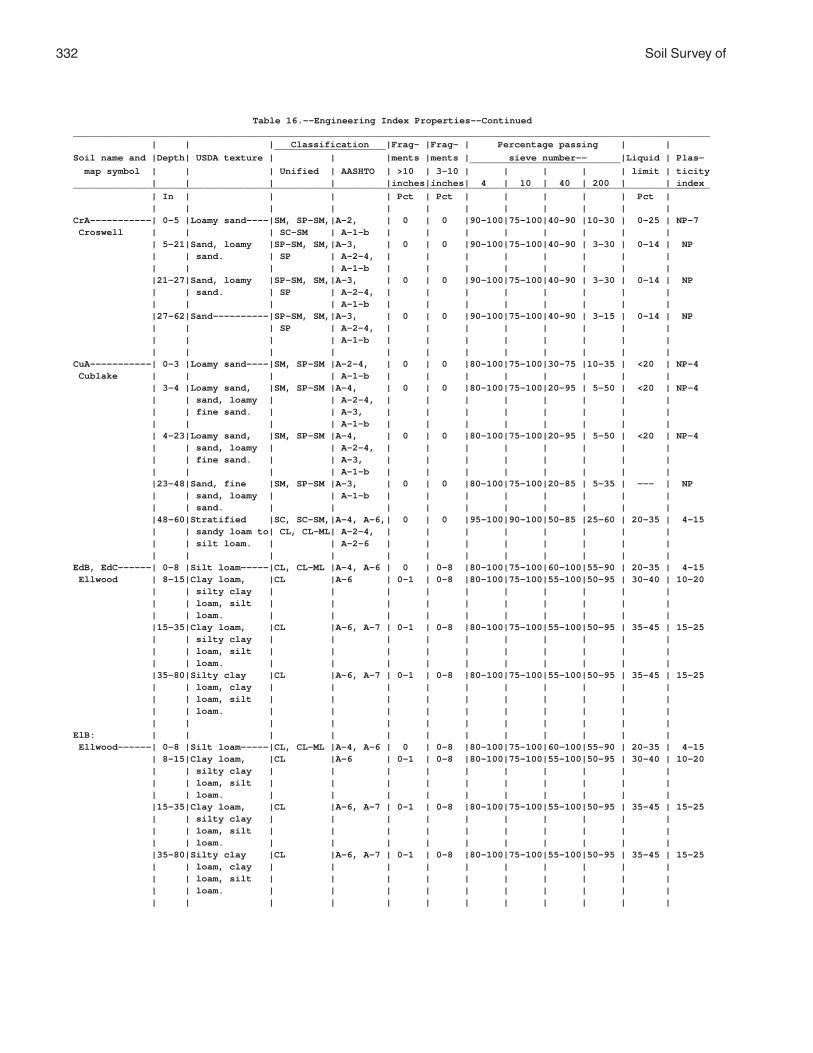
332 Soil Survey of
Table 16.--Engineering Index Properties--Continued__________________________________________________________________________________________________________________ | | | Classification |Frag- |Frag- | Percentage passing | | ____________________Soil name and |Depth| USDA texture | | |ments |ments | sieve number-- |Liquid | Plas- ___________________________ map symbol | | | Unified | AASHTO | >10 | 3-10 | | | | | limit | ticity | | | | |inches|inches| 4 | 10 | 40 | 200 | | index__________________________________________________________________________________________________________________ | In | | | | Pct | Pct | | | | | Pct | | | | | | | | | | | | |CrA-----------| 0-5 |Loamy sand----|SM, SP-SM,|A-2, | 0 | 0 |90-100|75-100|40-90 |10-30 | 0-25 | NP-7 Croswell | | | SC-SM | A-1-b | | | | | | | | | 5-21|Sand, loamy |SP-SM, SM,|A-3, | 0 | 0 |90-100|75-100|40-90 | 3-30 | 0-14 | NP | | sand. | SP | A-2-4, | | | | | | | | | | | | A-1-b | | | | | | | | |21-27|Sand, loamy |SP-SM, SM,|A-3, | 0 | 0 |90-100|75-100|40-90 | 3-30 | 0-14 | NP | | sand. | SP | A-2-4, | | | | | | | | | | | | A-1-b | | | | | | | | |27-62|Sand----------|SP-SM, SM,|A-3, | 0 | 0 |90-100|75-100|40-90 | 3-15 | 0-14 | NP | | | SP | A-2-4, | | | | | | | | | | | | A-1-b | | | | | | | | | | | | | | | | | | | |CuA-----------| 0-3 |Loamy sand----|SM, SP-SM |A-2-4, | 0 | 0 |80-100|75-100|30-75 |10-35 | <20 | NP-4 Cublake | | | | A-1-b | | | | | | | | | 3-4 |Loamy sand, |SM, SP-SM |A-4, | 0 | 0 |80-100|75-100|20-95 | 5-50 | <20 | NP-4 | | sand, loamy | | A-2-4, | | | | | | | | | | fine sand. | | A-3, | | | | | | | | | | | | A-1-b | | | | | | | | | 4-23|Loamy sand, |SM, SP-SM |A-4, | 0 | 0 |80-100|75-100|20-95 | 5-50 | <20 | NP-4 | | sand, loamy | | A-2-4, | | | | | | | | | | fine sand. | | A-3, | | | | | | | | | | | | A-1-b | | | | | | | | |23-48|Sand, fine |SM, SP-SM |A-3, | 0 | 0 |80-100|75-100|20-85 | 5-35 | --- | NP | | sand, loamy | | A-1-b | | | | | | | | | | sand. | | | | | | | | | | |48-60|Stratified |SC, SC-SM,|A-4, A-6,| 0 | 0 |95-100|90-100|50-85 |25-60 | 20-35 | 4-15 | | sandy loam to| CL, CL-ML| A-2-4, | | | | | | | | | | silt loam. | | A-2-6 | | | | | | | | | | | | | | | | | | | |EdB, EdC------| 0-8 |Silt loam-----|CL, CL-ML |A-4, A-6 | 0 | 0-8 |80-100|75-100|60-100|55-90 | 20-35 | 4-15 Ellwood | 8-15|Clay loam, |CL |A-6 | 0-1 | 0-8 |80-100|75-100|55-100|50-95 | 30-40 | 10-20 | | silty clay | | | | | | | | | | | | loam, silt | | | | | | | | | | | | loam. | | | | | | | | | | |15-35|Clay loam, |CL |A-6, A-7 | 0-1 | 0-8 |80-100|75-100|55-100|50-95 | 35-45 | 15-25 | | silty clay | | | | | | | | | | | | loam, silt | | | | | | | | | | | | loam. | | | | | | | | | | |35-80|Silty clay |CL |A-6, A-7 | 0-1 | 0-8 |80-100|75-100|55-100|50-95 | 35-45 | 15-25 | | loam, clay | | | | | | | | | | | | loam, silt | | | | | | | | | | | | loam. | | | | | | | | | | | | | | | | | | | | | |ElB: | | | | | | | | | | | | Ellwood------| 0-8 |Silt loam-----|CL, CL-ML |A-4, A-6 | 0 | 0-8 |80-100|75-100|60-100|55-90 | 20-35 | 4-15 | 8-15|Clay loam, |CL |A-6 | 0-1 | 0-8 |80-100|75-100|55-100|50-95 | 30-40 | 10-20 | | silty clay | | | | | | | | | | | | loam, silt | | | | | | | | | | | | loam. | | | | | | | | | | |15-35|Clay loam, |CL |A-6, A-7 | 0-1 | 0-8 |80-100|75-100|55-100|50-95 | 35-45 | 15-25 | | silty clay | | | | | | | | | | | | loam, silt | | | | | | | | | | | | loam. | | | | | | | | | | |35-80|Silty clay |CL |A-6, A-7 | 0-1 | 0-8 |80-100|75-100|55-100|50-95 | 35-45 | 15-25 | | loam, clay | | | | | | | | | | | | loam, silt | | | | | | | | | | | | loam. | | | | | | | | | | | | | | | | | | | | | |

Florence County, Wisconsin 333
Table 16.--Engineering Index Properties--Continued__________________________________________________________________________________________________________________ | | | Classification |Frag- |Frag- | Percentage passing | | ____________________Soil name and |Depth| USDA texture | | |ments |ments | sieve number-- |Liquid | Plas- ___________________________ map symbol | | | Unified | AASHTO | >10 | 3-10 | | | | | limit | ticity | | | | |inches|inches| 4 | 10 | 40 | 200 | | index__________________________________________________________________________________________________________________ | In | | | | Pct | Pct | | | | | Pct | | | | | | | | | | | | |ElB: | | | | | | | | | | | | Crossett-----| 0-9 |Silt loam-----|CL, CL-ML |A-4, A-6 | 0 | 0-8 |80-100|75-100|60-100|50-90 | 20-35 | 4-15 | 9-19|Silt loam, |CL |A-6 | 0-1 | 0-8 |80-100|75-100|55-100|45-95 | 30-40 | 10-20 | | silty clay | | | | | | | | | | | | loam, loam. | | | | | | | | | | |19-38|Silty clay |CL |A-6, A-7 | 0-1 | 0-8 |80-100|75-100|60-100|50-95 | 35-45 | 15-25 | | loam, clay | | | | | | | | | | | | loam. | | | | | | | | | | |38-80|Silty clay |CL |A-6, A-7 | 0-1 | 0-8 |80-100|75-100|60-100|50-95 | 35-45 | 15-25 | | loam, clay | | | | | | | | | | | | loam. | | | | | | | | | | | | | | | | | | | | | |EmB: | | | | | | | | | | | | Ellwood------| 0-8 |Silt loam-----|CL, CL-ML |A-4, A-6 | 0 | 0-8 |80-100|75-100|60-100|55-90 | 20-35 | 4-15 | 8-15|Clay loam, |CL |A-6 | 0-1 | 0-8 |80-100|75-100|55-100|50-95 | 30-40 | 10-20 | | silty clay | | | | | | | | | | | | loam, silt | | | | | | | | | | | | loam. | | | | | | | | | | |15-35|Clay loam, |CL |A-6, A-7 | 0-1 | 0-8 |80-100|75-100|55-100|50-95 | 35-45 | 15-25 | | silty clay | | | | | | | | | | | | loam, silt | | | | | | | | | | | | loam. | | | | | | | | | | |35-80|Silty clay |CL |A-6, A-7 | 0-1 | 0-8 |80-100|75-100|55-100|50-95 | 35-45 | 15-25 | | loam, clay | | | | | | | | | | | | loam, silt | | | | | | | | | | | | loam. | | | | | | | | | | | | | | | | | | | | | | Iosco--------| 0-11|Loamy fine |SM, SP-SM |A-2-4, | 0 | 0-8 |90-100|75-100|35-85 |10-35 | --- | NP | | sand. | | A-1-b | | | | | | | | |11-33|Loamy sand, |SM, SP-SM,|A-2-4, | 0 | 0-8 |90-100|75-100|35-85 | 5-35 | <25 | NP-7 | | sand, loamy | SC-SM | A-3, | | | | | | | | | | fine sand. | | A-1-b | | | | | | | | |33-44|Silty clay |CL, CL-ML,|A-4, A-6,| 0 | 0-8 |90-100|85-100|65-95 |30-90 | 25-45 | 5-25 | | loam, loam, | SC, SC-SM| A-7, A-2| | | | | | | | | | sandy clay | | | | | | | | | | | | loam. | | | | | | | | | | |44-60|Silty clay |CL, CL-ML |A-4, A-6,| 0 | 0-8 |90-100|85-100|70-95 |50-90 | 25-45 | 5-25 | | loam, clay | | A-7 | | | | | | | | | | loam, loam. | | | | | | | | | | | | | | | | | | | | | | Morganlake---| 0-7 |Loamy fine |SM, SC-SM |A-4, | 0 | 0 |95-100|90-100|65-95 |20-50 | <25 | NP-6 | | sand. | | A-2-4 | | | | | | | | | 7-8 |Loamy fine |SM, SC-SM,|A-4, | 0 | 0 |95-100|90-100|25-95 | 5-50 | <25 | NP-6 | | sand, sand. | SP-SM | A-2-4, | | | | | | | | | | | | A-3, | | | | | | | | | | | | A-1-b | | | | | | | | | 8-26|Loamy fine |SM, SC-SM,|A-4, | 0 | 0 |95-100|90-100|25-95 | 5-50 | <25 | NP-6 | | sand, sand. | SP-SM | A-2-4, | | | | | | | | | | | | A-3, | | | | | | | | | | | | A-1-b | | | | | | | | |26-31|Loamy fine |SM, SC-SM,|A-4, | 0 | 0 |95-100|90-100|25-95 | 5-50 | <25 | NP-6 | | sand, sand. | SP-SM | A-2-4, | | | | | | | | | | | | A-3, | | | | | | | | | | | | A-1-b | | | | | | | | |31-40|Silty clay |CL | --- | 0 | 0 |80-95 |75-95 |60-95 |50-90 | 25-45 | 10-20 | | loam, silt | | | | | | | | | | | | loam, clay | | | | | | | | | | | | loam. | | | | | | | | | | |40-60|Silty clay |CL | --- | 0 | 0 |80-95 |75-95 |60-95 |50-90 | 25-45 | 10-20 | | loam, clay | | | | | | | | | | | | loam. | | | | | | | | | | | | | | | | | | | | | |
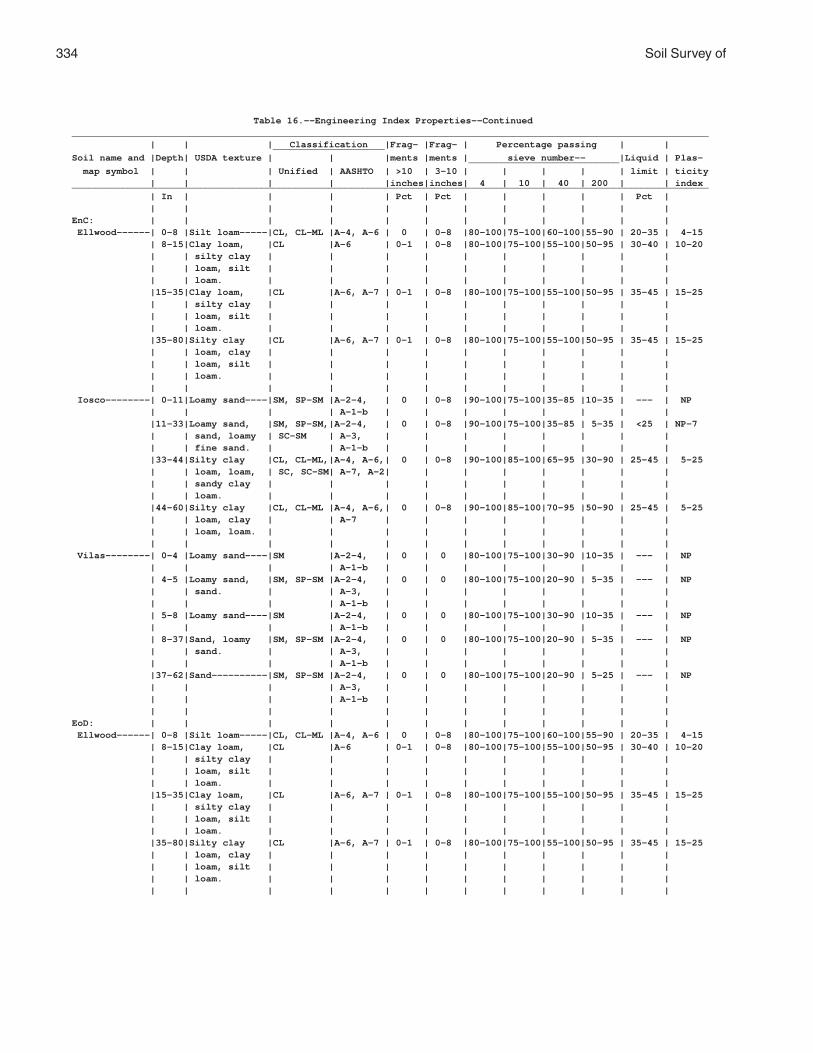
334 Soil Survey of
Table 16.--Engineering Index Properties--Continued__________________________________________________________________________________________________________________ | | | Classification |Frag- |Frag- | Percentage passing | | ____________________Soil name and |Depth| USDA texture | | |ments |ments | sieve number-- |Liquid | Plas- ___________________________ map symbol | | | Unified | AASHTO | >10 | 3-10 | | | | | limit | ticity | | | | |inches|inches| 4 | 10 | 40 | 200 | | index__________________________________________________________________________________________________________________ | In | | | | Pct | Pct | | | | | Pct | | | | | | | | | | | | |EnC: | | | | | | | | | | | | Ellwood------| 0-8 |Silt loam-----|CL, CL-ML |A-4, A-6 | 0 | 0-8 |80-100|75-100|60-100|55-90 | 20-35 | 4-15 | 8-15|Clay loam, |CL |A-6 | 0-1 | 0-8 |80-100|75-100|55-100|50-95 | 30-40 | 10-20 | | silty clay | | | | | | | | | | | | loam, silt | | | | | | | | | | | | loam. | | | | | | | | | | |15-35|Clay loam, |CL |A-6, A-7 | 0-1 | 0-8 |80-100|75-100|55-100|50-95 | 35-45 | 15-25 | | silty clay | | | | | | | | | | | | loam, silt | | | | | | | | | | | | loam. | | | | | | | | | | |35-80|Silty clay |CL |A-6, A-7 | 0-1 | 0-8 |80-100|75-100|55-100|50-95 | 35-45 | 15-25 | | loam, clay | | | | | | | | | | | | loam, silt | | | | | | | | | | | | loam. | | | | | | | | | | | | | | | | | | | | | | Iosco--------| 0-11|Loamy sand----|SM, SP-SM |A-2-4, | 0 | 0-8 |90-100|75-100|35-85 |10-35 | --- | NP | | | | A-1-b | | | | | | | | |11-33|Loamy sand, |SM, SP-SM,|A-2-4, | 0 | 0-8 |90-100|75-100|35-85 | 5-35 | <25 | NP-7 | | sand, loamy | SC-SM | A-3, | | | | | | | | | | fine sand. | | A-1-b | | | | | | | | |33-44|Silty clay |CL, CL-ML,|A-4, A-6,| 0 | 0-8 |90-100|85-100|65-95 |30-90 | 25-45 | 5-25 | | loam, loam, | SC, SC-SM| A-7, A-2| | | | | | | | | | sandy clay | | | | | | | | | | | | loam. | | | | | | | | | | |44-60|Silty clay |CL, CL-ML |A-4, A-6,| 0 | 0-8 |90-100|85-100|70-95 |50-90 | 25-45 | 5-25 | | loam, clay | | A-7 | | | | | | | | | | loam, loam. | | | | | | | | | | | | | | | | | | | | | | Vilas--------| 0-4 |Loamy sand----|SM |A-2-4, | 0 | 0 |80-100|75-100|30-90 |10-35 | --- | NP | | | | A-1-b | | | | | | | | | 4-5 |Loamy sand, |SM, SP-SM |A-2-4, | 0 | 0 |80-100|75-100|20-90 | 5-35 | --- | NP | | sand. | | A-3, | | | | | | | | | | | | A-1-b | | | | | | | | | 5-8 |Loamy sand----|SM |A-2-4, | 0 | 0 |80-100|75-100|30-90 |10-35 | --- | NP | | | | A-1-b | | | | | | | | | 8-37|Sand, loamy |SM, SP-SM |A-2-4, | 0 | 0 |80-100|75-100|20-90 | 5-35 | --- | NP | | sand. | | A-3, | | | | | | | | | | | | A-1-b | | | | | | | | |37-62|Sand----------|SM, SP-SM |A-2-4, | 0 | 0 |80-100|75-100|20-90 | 5-25 | --- | NP | | | | A-3, | | | | | | | | | | | | A-1-b | | | | | | | | | | | | | | | | | | | |EoD: | | | | | | | | | | | | Ellwood------| 0-8 |Silt loam-----|CL, CL-ML |A-4, A-6 | 0 | 0-8 |80-100|75-100|60-100|55-90 | 20-35 | 4-15 | 8-15|Clay loam, |CL |A-6 | 0-1 | 0-8 |80-100|75-100|55-100|50-95 | 30-40 | 10-20 | | silty clay | | | | | | | | | | | | loam, silt | | | | | | | | | | | | loam. | | | | | | | | | | |15-35|Clay loam, |CL |A-6, A-7 | 0-1 | 0-8 |80-100|75-100|55-100|50-95 | 35-45 | 15-25 | | silty clay | | | | | | | | | | | | loam, silt | | | | | | | | | | | | loam. | | | | | | | | | | |35-80|Silty clay |CL |A-6, A-7 | 0-1 | 0-8 |80-100|75-100|55-100|50-95 | 35-45 | 15-25 | | loam, clay | | | | | | | | | | | | loam, silt | | | | | | | | | | | | loam. | | | | | | | | | | | | | | | | | | | | | |

Florence County, Wisconsin 335
Table 16.--Engineering Index Properties--Continued__________________________________________________________________________________________________________________ | | | Classification |Frag- |Frag- | Percentage passing | | ____________________Soil name and |Depth| USDA texture | | |ments |ments | sieve number-- |Liquid | Plas- ___________________________ map symbol | | | Unified | AASHTO | >10 | 3-10 | | | | | limit | ticity | | | | |inches|inches| 4 | 10 | 40 | 200 | | index__________________________________________________________________________________________________________________ | In | | | | Pct | Pct | | | | | Pct | | | | | | | | | | | | |EoD: | | | | | | | | | | | | Vilas--------| 0-4 |Loamy sand----|SM |A-2-4, | 0 | 0 |80-100|75-100|30-90 |10-35 | --- | NP | | | | A-1-b | | | | | | | | | 4-5 |Loamy sand, |SM, SP-SM |A-2-4, | 0 | 0 |80-100|75-100|20-90 | 5-35 | --- | NP | | sand. | | A-3, | | | | | | | | | | | | A-1-b | | | | | | | | | 5-8 |Loamy sand----|SM |A-2-4, | 0 | 0 |80-100|75-100|30-90 |10-35 | --- | NP | | | | A-1-b | | | | | | | | | 8-37|Sand, loamy |SM, SP-SM |A-2-4, | 0 | 0 |80-100|75-100|20-90 | 5-35 | --- | NP | | sand. | | A-3, | | | | | | | | | | | | A-1-b | | | | | | | | |37-62|Sand----------|SM, SP-SM |A-2-4, | 0 | 0 |80-100|75-100|20-90 | 5-25 | --- | NP | | | | A-3, | | | | | | | | | | | | A-1-b | | | | | | | | | | | | | | | | | | | | Padus--------| 0-2 |Sandy loam----|SM |A-2, A-4,| 0 | 0-9 |55-100|50-100|30-90 |15-50 | <21 | NP-4 | | | | A-1-b | | | | | | | | | 2-3 |Sandy loam, |ML, CL-ML,|A-4, A-2,| 0 | 0-9 |55-100|50-100|30-95 |15-80 | <23 | NP-6 | | fine sandy | SM, SC-SM| A-1-b | | | | | | | | | | loam, loam. | | | | | | | | | | | 3-19|Sandy loam, |SM, SC, |A-2, A-4,| 0 | 0-9 |55-100|50-100|30-95 |15-80 | <26 | NP-8 | | loam, fine | ML, CL | A-1-b | | | | | | | | | | sandy loam. | | | | | | | | | | |19-38|Sandy loam, |SM, SC, |A-2, A-4,| 0 | 0-9 |55-100|50-100|30-95 |15-80 | <28 | NP-9 | | gravelly | ML, CL | A-1 | | | | | | | | | | loam, fine | | | | | | | | | | | | sandy loam. | | | | | | | | | | |38-60|Stratified |SP, SP-SM,|A-1, A-2,| 0 | 0-9 |30-100|25-95 | 7-65 | 1-25 | --- | NP | | sand to very | GP, GP-GM| A-3 | | | | | | | | | | gravelly | | | | | | | | | | | | coarse sand. | | | | | | | | | | | | | | | | | | | | | |Ep: | | | | | | | | | | | | Epiaquents---| 0-8 |Muck----------|PT |A-8 | 0 | 0 | --- | --- | --- | --- | --- | --- | 8-11|Fine sandy |SM, SC, |A-4, A-6,| 0-1 | 0-3 |90-100|85-100|50-95 |15-90 | <35 | NP-15 | | loam, mucky | ML, CL | A-2 | | | | | | | | | | loamy sand, | | | | | | | | | | | | silt loam. | | | | | | | | | | |11-60|Gravelly very |SM, SC, |A-4, A-6,| 0-2 | 0-7 |75-100|70-100|20-100| 3-95 | <40 | NP-18 | | fine sandy | ML, CL | A-2, A-1| | | | | | | | | | loam, silty | | | | | | | | | | | | clay loam, | | | | | | | | | | | | sand. | | | | | | | | | | | | | | | | | | | | | | Epiaquods----| 0-8 |Muck----------|PT |A-8 | 0 | 0 | --- | --- | --- | --- | --- | --- | 8-12|Fine sandy |SC, SM, |A-4, | 0-1 | 0-3 |90-100|85-100|25-95 | 5-80 | <30 | NP-11 | | loam, sand, | ML, CL | A-2-4, | | | | | | | | | | loam. | | A-3, A-1| | | | | | | | |12-23|Fine sandy |SC, SM, |A-4, | 0-2 | 0-5 |90-100|85-100|25-95 | 5-80 | <30 | NP-11 | | loam, sand, | ML, CL | A-2-4, | | | | | | | | | | loam. | | A-3, A-1| | | | | | | | |23-60|Sandy loam, |SM, SC-SM,|A-4, | 0-2 | 0-7 |75-100|70-100|20-95 | 3-80 | <25 | NP-7 | | gravelly | ML, CL-ML| A-2-4, | | | | | | | | | | sand, loam. | | A-3, A-1| | | | | | | | | | | | | | | | | | | |

336 Soil Survey of
Table 16.--Engineering Index Properties--Continued__________________________________________________________________________________________________________________ | | | Classification |Frag- |Frag- | Percentage passing | | ____________________Soil name and |Depth| USDA texture | | |ments |ments | sieve number-- |Liquid | Plas- ___________________________ map symbol | | | Unified | AASHTO | >10 | 3-10 | | | | | limit | ticity | | | | |inches|inches| 4 | 10 | 40 | 200 | | index__________________________________________________________________________________________________________________ | In | | | | Pct | Pct | | | | | Pct | | | | | | | | | | | | |FeB-----------| 0-2 |Silt loam-----|ML, CL-ML,|A-4 | 0 | 0 | 100 |96-100|90-100|80-100| 20-30 | 3-9 Fence | | | CL | | | | | | | | | | 2-6 |Silt loam, |ML, CL-ML |A-4 | 0 | 0 | 100 |96-100|90-100|80-100| <25 | NP-7 | | very fine | | | | | | | | | | | | sandy loam, | | | | | | | | | | | | silt. | | | | | | | | | | | 6-14|Silt loam, |ML, CL-ML |A-4 | 0 | 0 | 100 |96-100|90-100|80-100| 15-25 | NP-7 | | fine sandy | | | | | | | | | | | | loam, loamy | | | | | | | | | | | | very fine | | | | | | | | | | | | sand. | | | | | | | | | | |14-25|Silt loam, |ML, CL-ML |A-4 | 0 | 0 | 100 |96-100|90-100|80-100| 15-25 | NP-7 | | very fine | | | | | | | | | | | | sandy loam, | | | | | | | | | | | | silt. | | | | | | | | | | |25-42|Silt loam, |ML, CL-ML,|A-4 | 0 | 0 | 100 |96-100|85-100|70-100| 20-30 | 3-9 | | very fine | CL | | | | | | | | | | | sandy loam, | | | | | | | | | | | | loamy very | | | | | | | | | | | | fine sand. | | | | | | | | | | |42-60|Stratified |ML, CL-ML |A-4 | 0 | 0 | 100 |96-100|75-100|50-90 | 15-25 | NP-7 | | silt to very | | | | | | | | | | | | fine sand. | | | | | | | | | | | | | | | | | | | | | |Fm------------| 0-9 |Loam----------|ML, CL, |A-4, A-6 | 0 | 0-15 |80-100|75-100|55-100|45-85 | 20-35 | 3-15 Fordum | | | SM, SC | | | | | | | | | | 9-29|Silt loam, |SM, SC, |A-2, A-4,| 0 | 0-15 |30-100|25-100|20-100|10-90 | <30 | 3-10 | | very fine | ML, CL | A-1 | | | | | | | | | | sandy loam, | | | | | | | | | | | | fine sandy | | | | | | | | | | | | loam. | | | | | | | | | | |29-60|Sand, very |SP, SM, |A-3, A-2,| 0 | 0-15 |30-100|25-100| 7-95 | 1-50 | --- | NP | | gravelly | GP, SM | A-1 | | | | | | | | | | loamy fine | | | | | | | | | | | | sand. | | | | | | | | | | | | | | | | | | | | | |GaA-----------| 0-3 |Silt loam-----|ML, CL-ML |A-4 | 0 | 0 | 100 | 100 |80-100|60-90 | 0-25 | NP-7 Gastrow | 3-6 |Silt loam, |ML, CL-ML |A-4 | 0 | 0 | 100 | 100 |80-100|50-65 | 0-25 | NP-7 | | very fine | | | | | | | | | | | | sandy loam. | | | | | | | | | | | 6-10|Silt loam, |ML, CL-ML |A-4 | 0 | 0 | 100 | 100 |80-100|50-70 | 0-25 | NP-7 | | very fine | | | | | | | | | | | | sandy loam. | | | | | | | | | | |10-31|Silt loam, |ML, CL-ML |A-4 | 0 | 0 | 100 | 100 |80-100|50-80 | 0-25 | NP-7 | | very fine | | | | | | | | | | | | sandy loam. | | | | | | | | | | |31-37|Fine sandy |ML, CL-ML |A-4 | 0 | 0 | 100 | 100 |75-100|50-80 | 18-25 | 3-7 | | loam, silt | | | | | | | | | | | | loam, very | | | | | | | | | | | | fine sandy | | | | | | | | | | | | loam. | | | | | | | | | | |37-60|Stratified |SM, SC-SM,|A-4 | 0 | 0 | 100 | 100 |65-95 |35-80 | 0-25 | NP-7 | | silt loam to | ML, CL-ML| | | | | | | | | | | fine sand. | | | | | | | | | | | | | | | | | | | | | |

Florence County, Wisconsin 337
Table 16.--Engineering Index Properties--Continued__________________________________________________________________________________________________________________ | | | Classification |Frag- |Frag- | Percentage passing | | ____________________Soil name and |Depth| USDA texture | | |ments |ments | sieve number-- |Liquid | Plas- ___________________________ map symbol | | | Unified | AASHTO | >10 | 3-10 | | | | | limit | ticity | | | | |inches|inches| 4 | 10 | 40 | 200 | | index__________________________________________________________________________________________________________________ | In | | | | Pct | Pct | | | | | Pct | | | | | | | | | | | | |GmC, GmD------| 0-4 |Silt loam-----|ML, CL-ML |A-4 | 2-3 | 0-10 |90-100|85-100|85-100|75-100| <23 | NP-6 Goodman | 4-20|Silt loam-----|ML, CL-ML |A-4 | 2-5 | 0-10 |90-100|85-100|70-100|60-90 | <25 | NP-7 |20-31|Silt loam, |ML, CL-ML |A-4 | 2-5 | 0-10 |90-100|85-100|70-100|60-90 | <25 | NP-7 | | silt. | | | | | | | | | | |31-35|Sandy loam, |ML, CL-ML,|A-4, | 2-10 | 0-10 |65-100|55-95 |20-90 | 8-75 | <23 | NP-6 | | gravelly | SM, SP-SM| A-1-b, | | | | | | | | | | loamy sand, | | A-2-4 | | | | | | | | | | loam. | | | | | | | | | | |35-62|Loamy sand, |SC-SM, SM,|A-4, | 2-10 | 0-10 |65-100|55-95 |20-85 | 8-50 | <23 | NP-6 | | fine sandy | SP-SM | A-1-b, | | | | | | | | | | loam, | | A-2-4 | | | | | | | | | | gravelly | | | | | | | | | | | | sandy loam. | | | | | | | | | | | | | | | | | | | | | |GwB-----------| 0-5 |Silt loam-----|ML, CL-ML |A-4 | 2-3 | 0-15 |90-100|85-100|70-100|60-90 | <23 | NP-6 Goodwit | 5-6 |Silt loam, |ML |A-4 | 2-3 | 0-15 |90-100|85-100|70-100|60-100| <21 | NP-4 | | silt. | | | | | | | | | | | 6-17|Silt loam-----|ML, CL-ML |A-4 | 2-5 | 0-15 |90-100|85-100|70-100|60-90 | <25 | NP-7 |17-40|Silt loam-----|ML, CL-ML |A-4 | 2-5 | 0-15 |90-100|85-100|70-100|60-90 | <25 | NP-7 |40-47|Loam, sandy |ML, CL, |A-4, | 2-10 | 0-15 |60-100|55-95 |35-90 |15-75 | <28 | NP-9 | | loam, | SM, SC | A-1-b, | | | | | | | | | | gravelly fine| | A-2-4 | | | | | | | | | | sandy loam. | | | | | | | | | | |47-62|Gravelly loamy|SC-SM, SM,|A-3, A-1,| 2-10 | 0-15 |60-100|55-95 |20-75 | 8-45 | <23 | NP-6 | | sand, sandy | SP-SM | A-2-4 | | | | | | | | | | loam, | | | | | | | | | | | | gravelly | | | | | | | | | | | | sandy loam. | | | | | | | | | | | | | | | | | | | | | |IsA-----------| 0-11|Loamy fine |SM, SP-SM |A-2-4, | 0 | 0-8 |90-100|75-100|35-85 |10-35 | --- | NP Iosco | | sand. | | A-1-b | | | | | | | | |11-33|Loamy sand, |SM, SP-SM,|A-2-4, | 0 | 0-8 |90-100|75-100|35-85 | 5-35 | <25 | NP-7 | | sand, loamy | SC-SM | A-3, | | | | | | | | | | fine sand. | | A-1-b | | | | | | | | |33-44|Silty clay |CL, CL-ML,|A-4, A-6,| 0 | 0-8 |90-100|85-100|65-95 |30-90 | 25-45 | 5-25 | | loam, loam, | SC, SC-SM| A-7, A-2| | | | | | | | | | sandy clay | | | | | | | | | | | | loam. | | | | | | | | | | |44-60|Silty clay |CL, CL-ML |A-4, A-6,| 0 | 0-8 |90-100|85-100|70-95 |50-90 | 25-45 | 5-25 | | loam, clay | | A-7 | | | | | | | | | | loam, loam. | | | | | | | | | | | | | | | | | | | | | |Kr------------| 0-2 |Muck----------|PT |A-8 | 0 | 0 | --- | --- | --- | --- | --- | NP Kinross | 2-17|Sand, fine |SP-SM, SM |A-3, | 0 | 0 | 100 |90-100|50-80 | 5-30 | --- | NP | | sand, loamy | | A-2-4 | | | | | | | | | | sand. | | | | | | | | | | |17-60|Sand, fine |SP-SM, SM |A-3, | 0 | 0 | 100 |90-100|50-80 | 5-30 | --- | NP | | sand. | | A-2-4 | | | | | | | | | | | | | | | | | | | |Lo: | | | | | | | | | | | | Loxley-------| 0-9 |Peat----------|PT |A-8 | 0 | 0 | --- | --- | --- | --- | --- | --- | 9-60|Muck----------|PT |A-8 | 0 | 0 | --- | --- | --- | --- | --- | --- | | | | | | | | | | | | Beseman------| 0-12|Peat----------|PT |A-8 | 0 | 0 | --- | --- | --- | --- | --- | --- |12-36|Muck----------|PT |A-8 | 0 | 0 | --- | --- | --- | --- | --- | --- |36-60|Loam, sandy |CL, ML, |A-2, A-4,| 0 | 0-2 |75-100|65-100|40-95 |25-75 | 15-30 | NP-12 | | loam, silt | SM, SC | A-6 | | | | | | | | | | loam. | | | | | | | | | | | | | | | | | | | | | |

338 Soil Survey of
Table 16.--Engineering Index Properties--Continued__________________________________________________________________________________________________________________ | | | Classification |Frag- |Frag- | Percentage passing | | ____________________Soil name and |Depth| USDA texture | | |ments |ments | sieve number-- |Liquid | Plas- ___________________________ map symbol | | | Unified | AASHTO | >10 | 3-10 | | | | | limit | ticity | | | | |inches|inches| 4 | 10 | 40 | 200 | | index__________________________________________________________________________________________________________________ | In | | | | Pct | Pct | | | | | Pct | | | | | | | | | | | | |Lo: | | | | | | | | | | | | Dawson-------| 0-10|Peat----------|PT |A-8 | 0 | 0 | --- | --- | --- | --- | --- | --- |10-44|Muck----------|PT |A-8 | 0 | 0 | --- | --- | --- | --- | --- | --- |44-60|Sand, gravelly|SP, SM, |A-2, A-3,| 0 | 0 |45-100|35-100|15-90 | 0-45 | <20 | NP-10 | | sand, very | SC, GP | A-1, A-4| | | | | | | | | | gravelly very| | | | | | | | | | | | fine sand. | | | | | | | | | | | | | | | | | | | | | |Lu: | | | | | | | | | | | | Lupton-------| 0-6 |Muck----------|PT |A-8 | 0 | 0 | --- | --- | --- | --- | --- | --- | 6-60|Muck----------|PT |A-8 | 0 | 0 | --- | --- | --- | --- | --- | --- | | | | | | | | | | | | Cathro-------| 0-8 |Muck----------|PT |A-8 | 0 | 0 | --- | --- | --- | --- | --- | --- | 8-30|Muck----------|PT |A-8 | 0 | 0 | --- | --- | --- | --- | --- | --- |30-60|Loam, silt |SC-SM, |A-4, A-6 | 0 | 0-5 |80-100|65-100|60-100|35-90 | 20-40 | 4-20 | | loam, sandy | CL-ML, | | | | | | | | | | | loam. | SC, CL | | | | | | | | | | | | | | | | | | | | | Markey-------| 0-36|Muck----------|PT |A-8 | 0 | 0 | --- | --- | --- | --- | --- | --- |36-60|Sand, fine |SP, SM, |A-2, A-3,| 0 | 0 |95-100|60-100|30-75 | 0-30 | --- | NP | | sand, | SP-SM | A-1 | | | | | | | | | | gravelly | | | | | | | | | | | | loamy sand. | | | | | | | | | | | | | | | | | | | | | |MaA-----------| 0-4 |Sandy loam----|SM, ML |A-4 | 0 | 0-15 |80-100|75-100|50-85 |35-55 | <21 | NP-4 Manitowish | 4-13|Sandy loam, |SM, SC-SM,|A-4, | 0 | 0-15 |55-100|50-100|35-95 |20-75 | <25 | NP-7 | | loam, | ML, CL-ML| A-2-4 | | | | | | | | | | gravelly fine| | | | | | | | | | | | sandy loam. | | | | | | | | | | |13-29|Loamy sand, |SM, SC-SM,|A-2, A-1,| 0 | 0-15 |55-100|50-90 |20-90 | 5-50 | <25 | NP-6 | | gravelly | GM, GM-GC| A-3, A-4| | | | | | | | | | sand, sand. | | | | | | | | | | |29-62|Stratified |SP, SP-SM |A-1, A-3,| 0 | 0-15 |55-100|50-75 |20-70 | 0-12 | --- | NP | | sand to | | A-2 | | | | | | | | | | gravelly | | | | | | | | | | | | coarse sand. | | | | | | | | | | | | | | | | | | | | | |Mn------------| 0-5 |Muck----------|PT |A-8 | 0 | 0 | --- | --- | --- | --- | --- | --- Minocqua | 5-21|Silt loam, |SC, SM, |A-2, A-4,| 0-1 | 0-9 |80-100|75-100|45-100|25-90 | <35 | NP-13 | | fine sandy | CL, ML | A-6 | | | | | | | | | | loam, | | | | | | | | | | | | gravelly | | | | | | | | | | | | loam. | | | | | | | | | | |21-25|Gravelly loamy|SM, GM, |A-2, A-1,| 0-1 | 0-9 |40-100|35-100| 5-70 | 2-40 | <20 | NP-4 | | coarse sand, | GP, SP | A-3, A-4| | | | | | | | | | loamy sand, | | | | | | | | | | | | very gravelly| | | | | | | | | | | | coarse sand. | | | | | | | | | | |25-60|Coarse sand, |SP, SM, |A-1, A-3,| 0-1 | 0-9 |30-100|25-100| 5-70 | 0-30 | --- | NP | | sand, very | GP, GM | A-2 | | | | | | | | | | gravelly | | | | | | | | | | | | sand. | | | | | | | | | | | | | | | | | | | | | |

Florence County, Wisconsin 339
Table 16.--Engineering Index Properties--Continued__________________________________________________________________________________________________________________ | | | Classification |Frag- |Frag- | Percentage passing | | ____________________Soil name and |Depth| USDA texture | | |ments |ments | sieve number-- |Liquid | Plas- ___________________________ map symbol | | | Unified | AASHTO | >10 | 3-10 | | | | | limit | ticity | | | | |inches|inches| 4 | 10 | 40 | 200 | | index__________________________________________________________________________________________________________________ | In | | | | Pct | Pct | | | | | Pct | | | | | | | | | | | | |MrB-----------| 0-7 |Loamy fine |SM, SC-SM |A-4, | 0 | 0 |95-100|90-100|65-95 |20-50 | <25 | NP-6 Morganlake | | sand. | | A-2-4 | | | | | | | | | 7-8 |Loamy fine |SM, SC-SM,|A-4, | 0 | 0 |95-100|90-100|25-95 | 5-50 | <25 | NP-6 | | sand, sand. | SP-SM | A-2-4, | | | | | | | | | | | | A-3, | | | | | | | | | | | | A-1-b | | | | | | | | | 8-26|Loamy fine |SM, SC-SM,|A-4, | 0 | 0 |95-100|90-100|25-95 | 5-50 | <25 | NP-6 | | sand, sand. | SP-SM | A-2-4, | | | | | | | | | | | | A-3, | | | | | | | | | | | | A-1-b | | | | | | | | |26-31|Loamy fine |SM, SC-SM,|A-4, | 0 | 0 |95-100|90-100|25-95 | 5-50 | <25 | NP-6 | | sand, sand. | SP-SM | A-2-4, | | | | | | | | | | | | A-3, | | | | | | | | | | | | A-1-b | | | | | | | | |31-40|Silty clay |CL | --- | 0 | 0 |80-95 |75-95 |60-95 |50-90 | 25-45 | 10-20 | | loam, silt | | | | | | | | | | | | loam, clay | | | | | | | | | | | | loam. | | | | | | | | | | |40-60|Silty clay |CL | --- | 0 | 0 |80-95 |75-95 |60-95 |50-90 | 25-45 | 10-20 | | loam, clay | | | | | | | | | | | | loam. | | | | | | | | | | | | | | | | | | | | | |MuB-----------| 0-4 |Silt loam-----|ML, CL-ML |A-4 | 2-3 | 0-15 |80-100|75-100|55-95 |50-90 | 15-25 | NP-6 Mudlake | 4-5 |Silt loam, |ML, CL-ML |A-4 | 1-5 | 0-15 |80-100|75-100|55-95 |50-90 | <25 | NP-6 | | silt. | | | | | | | | | | | 5-12|Silt loam-----|ML, CL-ML |A-4 | 0-8 | 0-15 |80-100|75-100|55-95 |50-90 | 15-25 | NP-6 |12-34|Silt loam-----|ML, CL-ML |A-4 | 0-8 | 0-15 |80-100|75-100|55-95 |50-90 | 15-25 | NP-7 |34-43|Sandy loam, |SM, SC, |A-2-4, | 0-10 | 0-25 |60-95 |55-95 |35-90 |15-75 | 15-25 | NP-9 | | gravelly | CL, ML | A-4, | | | | | | | | | | sandy loam, | | A-1-b | | | | | | | | | | loam. | | | | | | | | | | |43-70|Sandy loam, |SM, SC-SM,|A-2-4, | 0-10 | 0-25 |60-95 |55-95 |20-75 | 8-45 | 15-25 | NP-6 | | gravelly | SP-SM | A-4, | | | | | | | | | | loamy sand. | | A-1-b | | | | | | | | | | | | | | | | | | | |PaB, PaC, PaD-| 0-2 |Sandy loam----|SM |A-2, A-4,| 0 | 0-9 |55-100|50-100|30-90 |15-50 | <21 | NP-4 Padus | | | | A-1-b | | | | | | | | | 2-3 |Sandy loam, |ML, CL-ML,|A-4, A-2,| 0 | 0-9 |55-100|50-100|30-95 |15-80 | <23 | NP-6 | | fine sandy | SM, SC-SM| A-1-b | | | | | | | | | | loam, loam. | | | | | | | | | | | 3-19|Sandy loam, |SM, SC, |A-2, A-4,| 0 | 0-9 |55-100|50-100|30-95 |15-80 | <26 | NP-8 | | loam, fine | ML, CL | A-1-b | | | | | | | | | | sandy loam. | | | | | | | | | | |19-38|Sandy loam, |SM, SC, |A-2, A-4,| 0 | 0-9 |55-100|50-100|30-95 |15-80 | <28 | NP-9 | | gravelly | ML, CL | A-1 | | | | | | | | | | loam, fine | | | | | | | | | | | | sandy loam. | | | | | | | | | | |38-60|Stratified |SP, SP-SM,|A-1, A-2,| 0 | 0-9 |30-100|25-95 | 7-65 | 1-25 | --- | NP | | sand to very | GP, GP-GM| A-3 | | | | | | | | | | gravelly | | | | | | | | | | | | coarse sand. | | | | | | | | | | | | | | | | | | | | | |

340 Soil Survey of
Table 16.--Engineering Index Properties--Continued__________________________________________________________________________________________________________________ | | | Classification |Frag- |Frag- | Percentage passing | | ____________________Soil name and |Depth| USDA texture | | |ments |ments | sieve number-- |Liquid | Plas- ___________________________ map symbol | | | Unified | AASHTO | >10 | 3-10 | | | | | limit | ticity | | | | |inches|inches| 4 | 10 | 40 | 200 | | index__________________________________________________________________________________________________________________ | In | | | | Pct | Pct | | | | | Pct | | | | | | | | | | | | |PeB, PeC, PeD:| | | | | | | | | | | | Padus--------| 0-2 |Sandy loam----|SM |A-2, A-4,| 0 | 0-9 |55-100|50-100|30-90 |15-50 | <21 | NP-4 | | | | A-1-b | | | | | | | | | 2-3 |Sandy loam, |ML, CL-ML,|A-4, A-2,| 0 | 0-9 |55-100|50-100|30-95 |15-80 | <23 | NP-6 | | fine sandy | SM, SC-SM| A-1-b | | | | | | | | | | loam, loam. | | | | | | | | | | | 3-19|Sandy loam, |SM, SC, |A-2, A-4,| 0 | 0-9 |55-100|50-100|30-95 |15-80 | <26 | NP-8 | | loam, fine | ML, CL | A-1-b | | | | | | | | | | sandy loam. | | | | | | | | | | |19-38|Sandy loam, |SM, SC, |A-2, A-4,| 0 | 0-9 |55-100|50-100|30-95 |15-80 | <28 | NP-9 | | gravelly | ML, CL | A-1 | | | | | | | | | | loam, fine | | | | | | | | | | | | sandy loam. | | | | | | | | | | |38-60|Stratified |SP, SP-SM,|A-1, A-2,| 0 | 0-9 |30-100|25-95 | 7-65 | 1-25 | --- | NP | | sand to very | GP, GP-GM| A-3 | | | | | | | | | | gravelly | | | | | | | | | | | | coarse sand. | | | | | | | | | | | | | | | | | | | | | | Pence--------| 0-4 |Sandy loam----|SM, ML |A-4, | 0 | 0-15 |85-100|75-100|45-85 |20-55 | <21 | NP-4 | | | | A-2-4, | | | | | | | | | | | | A-1-b | | | | | | | | | 4-15|Gravelly sandy|SM, ML, |A-4, | 0-4 | 0-15 |55-100|50-100|30-95 |15-75 | <25 | NP-7 | | loam, sandy | CL-ML, | A-2-4, | | | | | | | | | | loam, loam. | SC-SM | A-1-b | | | | | | | | |15-31|Gravelly |SM, SP-SM,|A-3, | 0-4 | 0-15 |55-100|50-100|25-75 | 2-30 | --- | NP | | coarse sand, | GM, GP-GM| A-1-b | | | | | | | | | | loamy sand, | | | | | | | | | | | | sand. | | | | | | | | | | |31-60|Gravelly |SP, SM |A-3, | 0-4 | 0-15 |55-90 |35-90 |15-55 | 2-15 | --- | NP | | coarse sand, | | A-1-b | | | | | | | | | | sand, very | | | | | | | | | | | | gravelly | | | | | | | | | | | | sand. | | | | | | | | | | | | | | | | | | | | | |PnB, PnC, PnD-| 0-4 |Sandy loam----|SM, ML |A-4, | 0 | 0-15 |85-100|75-100|45-85 |20-55 | <21 | NP-4 Pence | | | | A-2-4, | | | | | | | | | | | | A-1-b | | | | | | | | | 4-15|Gravelly sandy|SM, ML, |A-4, | 0-4 | 0-15 |55-100|50-100|30-95 |15-75 | <25 | NP-7 | | loam, sandy | CL-ML, | A-2-4, | | | | | | | | | | loam, loam. | SC-SM | A-1-b | | | | | | | | |15-31|Gravelly |SM, SP-SM,|A-3, | 0-4 | 0-15 |55-100|50-100|25-75 | 2-30 | --- | NP | | coarse sand, | GM, GP-GM| A-1-b | | | | | | | | | | loamy sand, | | | | | | | | | | | | sand. | | | | | | | | | | |31-60|Gravelly |SP, SM |A-3, | 0-4 | 0-15 |55-90 |35-90 |15-55 | 2-15 | --- | NP | | coarse sand, | | A-1-b | | | | | | | | | | sand, very | | | | | | | | | | | | gravelly | | | | | | | | | | | | sand. | | | | | | | | | | | | | | | | | | | | | |

Florence County, Wisconsin 341
Table 16.--Engineering Index Properties--Continued__________________________________________________________________________________________________________________ | | | Classification |Frag- |Frag- | Percentage passing | | ____________________Soil name and |Depth| USDA texture | | |ments |ments | sieve number-- |Liquid | Plas- ___________________________ map symbol | | | Unified | AASHTO | >10 | 3-10 | | | | | limit | ticity | | | | |inches|inches| 4 | 10 | 40 | 200 | | index__________________________________________________________________________________________________________________ | In | | | | Pct | Pct | | | | | Pct | | | | | | | | | | | | |PsB, PsC, PsD:| | | | | | | | | | | | Pence--------| 0-4 |Sandy loam----|SM, ML |A-4, | 0 | 0-15 |85-100|75-100|45-85 |20-55 | <21 | NP-4 | | | | A-2-4, | | | | | | | | | | | | A-1-b | | | | | | | | | 4-15|Gravelly sandy|SM, ML, |A-4, | 0-4 | 0-15 |55-100|50-100|30-95 |15-75 | <25 | NP-7 | | loam, sandy | CL-ML, | A-2-4, | | | | | | | | | | loam, loam. | SC-SM | A-1-b | | | | | | | | |15-31|Gravelly |SM, SP-SM,|A-3, | 0-4 | 0-15 |55-100|50-100|25-75 | 2-30 | --- | NP | | coarse sand, | GM, GP-GM| A-1-b | | | | | | | | | | loamy sand, | | | | | | | | | | | | sand. | | | | | | | | | | |31-60|Gravelly |SP, SM |A-3, | 0-4 | 0-15 |55-90 |35-90 |15-55 | 2-15 | --- | NP | | coarse sand, | | A-1-b | | | | | | | | | | sand, very | | | | | | | | | | | | gravelly | | | | | | | | | | | | sand. | | | | | | | | | | | | | | | | | | | | | | Vilas--------| 0-4 |Loamy sand----|SM |A-2-4, | 0 | 0 |80-100|75-100|30-90 |10-35 | --- | NP | | | | A-1-b | | | | | | | | | 4-5 |Loamy sand, |SM, SP-SM |A-2-4, | 0 | 0 |80-100|75-100|20-90 | 5-35 | --- | NP | | sand. | | A-3, | | | | | | | | | | | | A-1-b | | | | | | | | | 5-8 |Loamy sand----|SM |A-2-4, | 0 | 0 |80-100|75-100|30-90 |10-35 | --- | NP | | | | A-1-b | | | | | | | | | 8-37|Sand, loamy |SM, SP-SM |A-2-4, | 0 | 0 |80-100|75-100|20-90 | 5-35 | --- | NP | | sand. | | A-3, | | | | | | | | | | | | A-1-b | | | | | | | | |37-62|Sand----------|SM, SP-SM |A-2-4, | 0 | 0 |80-100|75-100|20-90 | 5-25 | --- | NP | | | | A-3, | | | | | | | | | | | | A-1-b | | | | | | | | | | | | | | | | | | | |Pt------------| 0-60|Sand and |GP, SP, | --- | --- | 0-10 | --- | --- | --- | --- | --- | --- Pits, gravel | | gravel. | GP-GM, | | | | | | | | | | | | SP-SM | | | | | | | | | | | | | | | | | | | | |Px. | | | | | | | | | | | | Pits, mine | | | | | | | | | | | | | | | | | | | | | | | |Rb------------| 0-7 |Fine sandy |SM, SC-SM |A-2-4, | 0 | 0 |80-100|75-100|50-90 |25-50 | <26 | NP-8 Robago | | loam. | | A-4 | | | | | | | | | 7-17|Fine sandy |SM, SC-SM,|A-2-4, | 0 | 0 |80-100|75-100|50-95 |25-80 | <26 | NP-8 | | loam, sandy | ML, CL-ML| A-4 | | | | | | | | | | loam, loam. | | | | | | | | | | |17-27|Fine sandy |SM, SC-SM,|A-2-4, | 0 | 0 |80-100|75-100|50-95 |25-80 | <26 | NP-8 | | loam, sandy | ML, CL-ML| A-4 | | | | | | | | | | loam, loam. | | | | | | | | | | |27-38|Fine sandy |SM, SC, |A-2-4, | 0 | 0 |80-100|75-100|50-95 |25-80 | 18-28 | 3-9 | | loam, sandy | ML, CL | A-4 | | | | | | | | | | loam, loam. | | | | | | | | | | |38-62|Stratified |SM, SC-SM,|A-2-4, | 0 | 0 |80-100|75-100|50-95 |25-80 | <26 | NP-8 | | fine sand to | ML, CL-ML| A-4 | | | | | | | | | | silt loam. | | | | | | | | | | | | | | | | | | | | | |

342 Soil Survey of
Table 16.--Engineering Index Properties--Continued__________________________________________________________________________________________________________________ | | | Classification |Frag- |Frag- | Percentage passing | | ____________________Soil name and |Depth| USDA texture | | |ments |ments | sieve number-- |Liquid | Plas- ___________________________ map symbol | | | Unified | AASHTO | >10 | 3-10 | | | | | limit | ticity | | | | |inches|inches| 4 | 10 | 40 | 200 | | index__________________________________________________________________________________________________________________ | In | | | | Pct | Pct | | | | | Pct | | | | | | | | | | | | |RkC, RkD: | | | | | | | | | | | | Rock outcrop.| | | | | | | | | | | | | | | | | | | | | | | | Ishpeming----| 0-4 |Loamy sand----|SM, SP-SM,|A-2-4, | 0 | 0-15 |90-100|85-100|40-100|10-50 | 0-25 | NP-7 | | | SC-SM | A-1-b, | | | | | | | | | | | | A-4 | | | | | | | | | 4-32|Loamy sand, |SM, SP-SM,|A-1-b, | 0 | 0-15 |90-100|85-100|40-100| 5-50 | 0-25 | NP-7 | | loamy fine | SC-SM | A-2-4, | | | | | | | | | | sand, sand. | | A-3, A-4| | | | | | | | | 32 |Unweathered | --- | --- | --- | --- | --- | --- | --- | --- | --- | --- | | bedrock. | | | | | | | | | | | | | | | | | | | | | | Vilas--------| 0-4 |Loamy sand----|SM |A-2-4, | 0 | 0 |80-100|75-100|30-75 |10-35 | --- | NP | | | | A-1-b | | | | | | | | | 4-5 |Loamy sand, |SM, SP-SM |A-2-4, | 0 | 0 |80-100|75-100|20-75 | 5-35 | --- | NP | | sand. | | A-3, | | | | | | | | | | | | A-1-b | | | | | | | | | 5-8 |Loamy sand----|SM |A-2-4, | 0 | 0 |80-100|75-100|30-75 |10-35 | --- | NP | | | | A-1-b | | | | | | | | | 8-37|Sand, loamy |SM, SP-SM |A-2-4, | 0 | 0 |80-100|75-100|20-75 | 5-35 | --- | NP | | sand. | | A-3, | | | | | | | | | | | | A-1-b | | | | | | | | |37-62|Sand----------|SM, SP-SM |A-2-4, | 0 | 0 |80-100|75-100|20-70 | 5-25 | --- | NP | | | | A-3, | | | | | | | | | | | | A-1-b | | | | | | | | | | | | | | | | | | | |RmC, RmD: | | | | | | | | | | | | Rock outcrop.| | | | | | | | | | | | | | | | | | | | | | | | Metonga------| 0-2 |Fine sandy |SM |A-4 | 0 | 0-9 |95-100|90-100|65-90 |35-50 | <20 | NP-4 | | loam. | | | | | | | | | | | 2-4 |Very fine |SM, ML, |A-4 | 0 | 0-9 |95-100|90-100|65-95 |35-85 | <25 | NP-7 | | sandy loam, | SC-SM, | | | | | | | | | | | silt loam, | CL-ML | | | | | | | | | | | fine sandy | | | | | | | | | | | | loam. | | | | | | | | | | | 4-17|Very fine |SM, ML, |A-4 | 0-1 | 0-9 |95-100|90-100|65-95 |35-85 | <25 | NP-7 | | sandy loam, | SC-SM, | | | | | | | | | | | silt loam, | CL-ML | | | | | | | | | | | fine sandy | | | | | | | | | | | | loam. | | | | | | | | | | |17-39|Sandy loam, |SM |A-2-4, | 0-2 | 0-15 |55-95 |50-90 |30-80 |15-50 | <20 | NP-4 | | gravelly | | A-4, | | | | | | | | | | sandy loam. | | A-1-b | | | | | | | | | 39 |Unweathered | --- | --- | --- | --- | --- | --- | --- | --- | --- | --- | | bedrock. | | | | | | | | | | | | | | | | | | | | | |

Florence County, Wisconsin 343
Table 16.--Engineering Index Properties--Continued__________________________________________________________________________________________________________________ | | | Classification |Frag- |Frag- | Percentage passing | | ____________________Soil name and |Depth| USDA texture | | |ments |ments | sieve number-- |Liquid | Plas- ___________________________ map symbol | | | Unified | AASHTO | >10 | 3-10 | | | | | limit | ticity | | | | |inches|inches| 4 | 10 | 40 | 200 | | index__________________________________________________________________________________________________________________ | In | | | | Pct | Pct | | | | | Pct | | | | | | | | | | | | |RmC, RmD: | | | | | | | | | | | | Sarona-------| 0-1 |Fine sandy |SM, SC-SM |A-2, A-4 | 0 | 0-15 |80-100|75-98 |55-90 |30-55 | <25 | NP-7 | | loam. | | | | | | | | | | | 1-3 |Fine sandy |ML, CL-ML,|A-4, A-2,| 0 | 0-15 |80-100|75-98 |30-90 |10-55 | <23 | NP-6 | | loam, sandy | SM, SP-SM| A-1 | | | | | | | | | | loam, loamy | | | | | | | | | | | | sand. | | | | | | | | | | | 3-16|Fine sandy |SM, SC-SM,|A-2, A-4,| 0-1 | 0-15 |55-100|50-98 |30-90 |13-55 | <23 | NP-6 | | loam, sandy | ML, CL-ML| A-1 | | | | | | | | | | loam, | | | | | | | | | | | | gravelly | | | | | | | | | | | | loam. | | | | | | | | | | |16-41|Sandy loam, |SC, SM, |A-2, A-1,| 0-2 | 0-15 |55-100|50-98 |30-90 |12-45 | <28 | NP-9 | | gravelly fine| SC-SM | A-4 | | | | | | | | | | sandy loam. | | | | | | | | | | |41-60|Loamy sand, |SM, SC-SM,|A-2, A-1,| 0-2 | 0-15 |55-100|50-98 |20-75 | 7-45 | <25 | NP-7 | | sandy loam, | SP-SM | A-4, A-3| | | | | | | | | | gravelly | | | | | | | | | | | | sandy loam. | | | | | | | | | | | | | | | | | | | | | |RsB, RsC------| 0-6 |Loamy fine |SM |A-2-4, | 0 | 0 | 100 | 100 |75-95 |25-45 | --- | NP Rousseau | | sand. | | A-4 | | | | | | | | | 6-36|Fine sand, |SM |A-2-4 | 0 | 0 | 100 | 100 |65-100|20-35 | --- | NP | | loamy fine | | | | | | | | | | | | sand. | | | | | | | | | | |36-60|Fine sand, |SP-SM, SM |A-2-4, | 0 | 0 | 100 | 100 |50-100| 5-35 | --- | NP | | sand. | | A-3 | | | | | | | | | | | | | | | | | | | |SaB, SaC, SaD-| 0-3 |Fine sandy |SC-SM, SM |A-4, | 2-3 | 0-15 |80-100|75-98 |45-90 |20-50 | 0-23 | NP-6 Sarona | | loam. | | A-2-4, | | | | | | | | | | | | A-1-b | | | | | | | | | 3-17|Fine sandy |SM, SC-SM,|A-2-4, | 2-3 | 0-15 |55-100|50-98 |30-90 |13-55 | 0-23 | NP-6 | | loam, sandy | ML, CL-ML| A-4, | | | | | | | | | | loam, | | A-1-b | | | | | | | | | | gravelly | | | | | | | | | | | | loam. | | | | | | | | | | |17-48|Fine sandy |SM, SC-SM |A-2-4, | 0-15 | 0-15 |70-100|50-98 |30-90 |12-45 | 0-25 | NP-7 | | loam, | | A-1-b, | | | | | | | | | | gravelly | | A-4 | | | | | | | | | | sandy loam, | | | | | | | | | | | | gravelly | | | | | | | | | | | | loamy sand. | | | | | | | | | | |48-66|Gravelly sandy|SM, SC-SM,|A-2-4, | 0-15 | 0-15 |55-100|50-98 |30-90 |12-45 | 0-28 | NP-9 | | loam, fine | SC | A-1-b, | | | | | | | | | | sandy loam. | | A-4 | | | | | | | | |66-73|Gravelly sandy|SM, SC-SM,|A-2-4, | 0-15 | 0-15 |55-100|50-98 |20-90 | 7-45 | 0-25 | NP-7 | | loam, loamy | SP-SM | A-1-b, | | | | | | | | | | sand. | | A-4 | | | | | | | | | | | | | | | | | | | |

344 Soil Survey of
Table 16.--Engineering Index Properties--Continued__________________________________________________________________________________________________________________ | | | Classification |Frag- |Frag- | Percentage passing | | ____________________Soil name and |Depth| USDA texture | | |ments |ments | sieve number-- |Liquid | Plas- ___________________________ map symbol | | | Unified | AASHTO | >10 | 3-10 | | | | | limit | ticity | | | | |inches|inches| 4 | 10 | 40 | 200 | | index__________________________________________________________________________________________________________________ | In | | | | Pct | Pct | | | | | Pct | | | | | | | | | | | | |SdB, SdC, SdD:| | | | | | | | | | | | Sarona-------| 0-3 |Fine sandy |SC-SM, SM |A-4, | 2-3 | 0-15 |80-100|75-98 |45-90 |20-50 | 0-23 | NP-6 | | loam. | | A-2-4, | | | | | | | | | | | | A-1-b | | | | | | | | | 3-17|Fine sandy |SM, SC-SM,|A-2-4, | 2-3 | 0-15 |55-100|50-98 |30-90 |13-55 | 0-23 | NP-6 | | loam, sandy | ML, CL-ML| A-4, | | | | | | | | | | loam, | | A-1-b | | | | | | | | | | gravelly | | | | | | | | | | | | loam. | | | | | | | | | | |17-48|Fine sandy |SM, SC-SM |A-2-4, | 0-15 | 0-15 |70-100|50-98 |30-90 |12-45 | 0-25 | NP-7 | | loam, | | A-1-b, | | | | | | | | | | gravelly | | A-4 | | | | | | | | | | sandy loam, | | | | | | | | | | | | gravelly | | | | | | | | | | | | loamy sand. | | | | | | | | | | |48-66|Gravelly sandy|SM, SC-SM,|A-2-4, | 0-15 | 0-15 |55-100|50-98 |30-90 |12-45 | 0-28 | NP-9 | | loam, fine | SC | A-1-b, | | | | | | | | | | sandy loam. | | A-4 | | | | | | | | |66-73|Gravelly sandy|SM, SC-SM,|A-2-4, | 0-15 | 0-15 |55-100|50-98 |20-90 | 7-45 | 0-25 | NP-7 | | loam, loamy | SP-SM | A-1-b, | | | | | | | | | | sand. | | A-4 | | | | | | | | | | | | | | | | | | | | Padus--------| 0-2 |Sandy loam----|SM |A-2, A-4,| 0 | 0-9 |55-100|50-100|30-90 |15-50 | <21 | NP-4 | | | | A-1-b | | | | | | | | | 2-3 |Sandy loam, |ML, CL-ML,|A-4, A-2,| 0 | 0-9 |55-100|50-100|30-95 |15-80 | <23 | NP-6 | | fine sandy | SM, SC-SM| A-1-b | | | | | | | | | | loam, loam. | | | | | | | | | | | 3-19|Sandy loam, |SM, SC, |A-2, A-4,| 0 | 0-9 |55-100|50-100|30-95 |15-80 | <26 | NP-8 | | loam, fine | ML, CL | A-1-b | | | | | | | | | | sandy loam. | | | | | | | | | | |19-38|Sandy loam, |SM, SC, |A-2, A-4,| 0 | 0-9 |55-100|50-100|30-95 |15-80 | <28 | NP-9 | | gravelly | ML, CL | A-1 | | | | | | | | | | loam, fine | | | | | | | | | | | | sandy loam. | | | | | | | | | | |38-60|Stratified |SP, SP-SM,|A-1, A-2,| 0 | 0-9 |30-100|25-95 | 7-65 | 1-25 | --- | NP | | sand to very | GP, GP-GM| A-3 | | | | | | | | | | gravelly | | | | | | | | | | | | coarse sand. | | | | | | | | | | | | | | | | | | | | | |SlB, SlC, SlD:| | | | | | | | | | | | Sarona-------| 0-3 |Fine sandy |SC-SM, SM |A-4, | 2-3 | 0-15 |80-100|75-98 |45-90 |20-50 | 0-23 | NP-6 | | loam. | | A-2-4, | | | | | | | | | | | | A-1-b | | | | | | | | | 3-17|Fine sandy |SM, SC-SM,|A-2-4, | 2-3 | 0-15 |55-100|50-98 |30-90 |13-55 | 0-23 | NP-6 | | loam, sandy | ML, CL-ML| A-4, | | | | | | | | | | loam, | | A-1-b | | | | | | | | | | gravelly | | | | | | | | | | | | loam. | | | | | | | | | | |17-48|Fine sandy |SM, SC-SM |A-2-4, | 0-15 | 0-15 |70-100|50-98 |30-90 |12-45 | 0-25 | NP-7 | | loam, | | A-1-b, | | | | | | | | | | gravelly | | A-4 | | | | | | | | | | sandy loam, | | | | | | | | | | | | gravelly | | | | | | | | | | | | loamy sand. | | | | | | | | | | |48-66|Gravelly sandy|SM, SC-SM,|A-2-4, | 0-15 | 0-15 |55-100|50-98 |30-90 |12-45 | 0-28 | NP-9 | | loam, fine | SC | A-1-b, | | | | | | | | | | sandy loam. | | A-4 | | | | | | | | |66-73|Gravelly sandy|SM, SC-SM,|A-2-4, | 0-15 | 0-15 |55-100|50-98 |20-90 | 7-45 | 0-25 | NP-7 | | loam, loamy | SP-SM | A-1-b, | | | | | | | | | | sand. | | A-4 | | | | | | | | | | | | | | | | | | | |

Florence County, Wisconsin 345
Table 16.--Engineering Index Properties--Continued__________________________________________________________________________________________________________________ | | | Classification |Frag- |Frag- | Percentage passing | | ____________________Soil name and |Depth| USDA texture | | |ments |ments | sieve number-- |Liquid | Plas- ___________________________ map symbol | | | Unified | AASHTO | >10 | 3-10 | | | | | limit | ticity | | | | |inches|inches| 4 | 10 | 40 | 200 | | index__________________________________________________________________________________________________________________ | In | | | | Pct | Pct | | | | | Pct | | | | | | | | | | | | |SlB, SlC, SlD:| | | | | | | | | | | | Vilas--------| 0-4 |Loamy sand----|SM |A-2-4, | 0 | 0 |80-100|75-100|30-90 |10-35 | --- | NP | | | | A-1-b | | | | | | | | | 4-5 |Loamy sand, |SM, SP-SM |A-2-4, | 0 | 0 |80-100|75-100|20-90 | 5-35 | --- | NP | | sand. | | A-3, | | | | | | | | | | | | A-1-b | | | | | | | | | 5-8 |Loamy sand----|SM |A-2-4, | 0 | 0 |80-100|75-100|30-90 |10-35 | --- | NP | | | | A-1-b | | | | | | | | | 8-37|Sand, loamy |SM, SP-SM |A-2-4, | 0 | 0 |80-100|75-100|20-90 | 5-35 | --- | NP | | sand. | | A-3, | | | | | | | | | | | | A-1-b | | | | | | | | |37-62|Sand----------|SM, SP-SM |A-2-4, | 0 | 0 |80-100|75-100|20-90 | 5-25 | --- | NP | | | | A-3, | | | | | | | | | | | | A-1-b | | | | | | | | | | | | | | | | | | | |SnB, SnC, SnD-| 0-4 |Loamy sand----|SM, SP-SM |A-1 | 0 | 0-15 |80-100|75-100|30-75 |10-35 | --- | NP Sayner | 4-17|Loamy sand, |SP, SM |A-1, A-3 | 0 | 0-15 |50-100|50-100|15-75 | 2-35 | --- | NP | | sand, | | | | | | | | | | | | gravelly | | | | | | | | | | | | sand. | | | | | | | | | | |17-27|Gravelly sand,|SM, SP |A-3, A-1 | 0-3 | 0-15 |55-100|50-100|15-75 | 2-35 | --- | NP | | loamy sand. | | | | | | | | | | |27-63|Stratified |SP, SM |A-1 | 0-3 | 0-15 |55-90 |50-75 |15-45 | 2-20 | --- | NP | | sand to | | | | | | | | | | | | gravel. | | | | | | | | | | | | | | | | | | | | | |SoD: | | | | | | | | | | | | Soperton-----| 0-5 |Silt loam-----|ML |A-4 | 2-3 | 5-15 |90-100|85-100|70-100|60-85 | <20 | NP-4 | 5-22|Silt loam, |ML, CL-ML |A-4 | 1-5 | 0-15 |90-100|85-100|70-100|60-85 | <25 | NP-6 | | silt. | | | | | | | | | | |22-42|Gravelly sandy|SM, SC, |A-4, A-2,| 1-5 | 0-30 |70-100|65-90 |40-70 |20-45 | <25 | NP-8 | | loam, sandy | SC-SM | A-1-b | | | | | | | | | | loam. | | | | | | | | | | |42-61|Gravelly loamy|SM, SP-SM |A-1, A-2,| 1-5 | 0-30 |70-100|65-90 |25-70 |10-45 | <20 | NP-4 | | sand, sandy | | A-4 | | | | | | | | | | loam. | | | | | | | | | | | | | | | | | | | | | | Goodman------| 0-4 |Silt loam-----|ML, CL-ML |A-4 | 2-3 | 0-10 |90-100|85-100|85-100|75-100| <23 | NP-6 | 4-20|Silt loam-----|ML, CL-ML |A-4 | 2-5 | 0-10 |90-100|85-100|70-100|60-90 | <25 | NP-7 |20-31|Silt loam, |ML, CL-ML |A-4 | 2-5 | 0-10 |90-100|85-100|70-100|60-90 | <25 | NP-7 | | silt. | | | | | | | | | | |31-35|Sandy loam, |ML, CL-ML,|A-4, | 2-10 | 0-10 |65-100|55-95 |20-90 | 8-75 | <23 | NP-6 | | gravelly | SM, SP-SM| A-1-b, | | | | | | | | | | loamy sand, | | A-2-4 | | | | | | | | | | loam. | | | | | | | | | | |35-62|Loamy sand, |SC-SM, SM,|A-4, | 2-10 | 0-10 |65-100|55-95 |20-85 | 8-50 | <23 | NP-6 | | fine sandy | SP-SM | A-1-b, | | | | | | | | | | loam, | | A-2-4 | | | | | | | | | | gravelly | | | | | | | | | | | | sandy loam. | | | | | | | | | | | | | | | | | | | | | |StC, StD------| 0-17|Silt loam-----|ML, CL-ML |A-4 | 0 | 0-8 |95-100|90-100|80-100|55-90 | <26 | 2-7 Stambaugh |17-33|Silt, silt |ML, CL-ML,|A-4 | 0 | 0-8 |95-100|90-100|80-100|80-95 | <30 | 2-9 | | loam, very | CL | | | | | | | | | | | fine sandy | | | | | | | | | | | | loam. | | | | | | | | | | |33-61|Sand, gravelly|SP, SP-SM |A-1 | 0 | 0-15 |70-90 |25-60 |15-40 | 0-10 | --- | NP | | coarse sand. | | | | | | | | | | | | | | | | | | | | | |

346 Soil Survey of
Table 16.--Engineering Index Properties--Continued__________________________________________________________________________________________________________________ | | | Classification |Frag- |Frag- | Percentage passing | | ____________________Soil name and |Depth| USDA texture | | |ments |ments | sieve number-- |Liquid | Plas- ___________________________ map symbol | | | Unified | AASHTO | >10 | 3-10 | | | | | limit | ticity | | | | |inches|inches| 4 | 10 | 40 | 200 | | index__________________________________________________________________________________________________________________ | In | | | | Pct | Pct | | | | | Pct | | | | | | | | | | | | |SuC, SuD: | | | | | | | | | | | | Stambaugh----| 0-17|Silt loam-----|ML, CL-ML |A-4 | 0 | 0-8 |95-100|90-100|80-100|55-90 | <26 | 2-7 |17-33|Silt, silt |ML, CL-ML,|A-4 | 0 | 0-8 |95-100|90-100|80-100|80-95 | <30 | 2-9 | | loam, very | CL | | | | | | | | | | | fine sandy | | | | | | | | | | | | loam. | | | | | | | | | | |33-61|Sand, gravelly|SP, SP-SM |A-1 | 0 | 0-15 |70-90 |25-60 |15-40 | 0-10 | --- | NP | | coarse sand. | | | | | | | | | | | | | | | | | | | | | | Goodman------| 0-4 |Silt loam-----|ML, CL-ML |A-4 | 2-3 | 0-10 |90-100|85-100|85-100|75-100| <23 | NP-6 | 4-20|Silt loam-----|ML, CL-ML |A-4 | 2-5 | 0-10 |90-100|85-100|70-100|60-90 | <25 | NP-7 |20-31|Silt loam, |ML, CL-ML |A-4 | 2-5 | 0-10 |90-100|85-100|70-100|60-90 | <25 | NP-7 | | silt. | | | | | | | | | | |31-35|Sandy loam, |ML, CL-ML,|A-4, | 2-10 | 0-10 |65-100|55-95 |20-90 | 8-75 | <23 | NP-6 | | gravelly | SM, SP-SM| A-1-b, | | | | | | | | | | loamy sand, | | A-2-4 | | | | | | | | | | loam. | | | | | | | | | | |35-62|Loamy sand, |SC-SM, SM,|A-4, | 2-10 | 0-10 |65-100|55-95 |20-85 | 8-50 | <23 | NP-6 | | fine sandy | SP-SM | A-1-b, | | | | | | | | | | loam, | | A-2-4 | | | | | | | | | | gravelly | | | | | | | | | | | | sandy loam. | | | | | | | | | | | | | | | | | | | | | |TpA-----------| 0-2 |Sandy loam----|SM |A-2, A-4 | 0 | 0-9 |55-100|50-100|30-80 |15-50 | <20 | NP-4 Tipler | 2-4 |Sandy loam, |SM |A-2, A-4 | 0 | 0-9 |55-100|50-100|30-95 |15-80 | 15-20 | NP-4 | | gravelly fine| | | | | | | | | | | | sandy loam, | | | | | | | | | | | | loam. | | | | | | | | | | | 4-22|Sandy loam, |SM, SC, |A-2, A-4,| 0 | 0-9 |55-100|50-100|30-95 |15-80 | <26 | NP-8 | | loam, fine | ML, CL | A-1-b | | | | | | | | | | sandy loam. | | | | | | | | | | |22-31|Fine sandy |SM, SC, |A-2, A-4,| 0 | 0-9 |55-100|50-100|30-95 |15-80 | <30 | NP-9 | | loam, | ML, CL | A-1 | | | | | | | | | | sandy loam, | | | | | | | | | | | | loam. | | | | | | | | | | |31-60|Gravelly |SP, SM, |A-1, A-2,| 0 | 0-9 |30-100|25-95 | 7-70 | 1-25 | --- | NP | | coarse sand, | GP, GM | A-3 | | | | | | | | | | sand. | | | | | | | | | | | | | | | | | | | | | |VaB-----------| 0-1 |Silt loam-----|ML, CL-ML |A-4 | 0 | 0-9 |95-100|90-100|85-100|80-95 | <25 | NP-7 Vanzile | 1-4 |Silt loam, |ML, CL-ML |A-4 | 0 | 0-9 |95-100|90-100|85-100|80-95 | <25 | NP-7 | | silt. | | | | | | | | | | | 4-13|Silt loam-----|ML, CL-ML |A-4 | 0 | 0-9 |95-100|90-100|85-100|80-95 | <30 | NP-7 |13-17|Silt loam, |ML, CL-ML |A-4 | 0 | 0-9 |95-100|90-100|85-100|80-95 | <30 | NP-7 | | silt. | | | | | | | | | | |17-33|Silt loam-----|ML, CL-ML,|A-4 | 0 | 0-9 |95-100|90-100|85-100|80-95 | <30 | NP-9 | | | CL | | | | | | | | | |33-60|Stratified |SP, SP-SM,|A-1, A-3 | 0 | 0-9 |45-95 |40-95 |10-75 | 2-25 | --- | NP | | sand to very | GP, GP-GM| | | | | | | | | | | gravelly | | | | | | | | | | | | coarse sand. | | | | | | | | | | | | | | | | | | | | | |

Florence County, Wisconsin 347
Table 16.--Engineering Index Properties--Continued__________________________________________________________________________________________________________________ | | | Classification |Frag- |Frag- | Percentage passing | | ____________________Soil name and |Depth| USDA texture | | |ments |ments | sieve number-- |Liquid | Plas- ___________________________ map symbol | | | Unified | AASHTO | >10 | 3-10 | | | | | limit | ticity | | | | |inches|inches| 4 | 10 | 40 | 200 | | index__________________________________________________________________________________________________________________ | In | | | | Pct | Pct | | | | | Pct | | | | | | | | | | | | |VgB: | | | | | | | | | | | | Vanzile------| 0-1 |Silt loam-----|ML, CL-ML |A-4 | 0 | 0-9 |95-100|90-100|85-100|80-95 | <25 | NP-7 | 1-4 |Silt loam, |ML, CL-ML |A-4 | 0 | 0-9 |95-100|90-100|85-100|80-95 | <25 | NP-7 | | silt. | | | | | | | | | | | 4-13|Silt loam-----|ML, CL-ML |A-4 | 0 | 0-9 |95-100|90-100|85-100|80-95 | <30 | NP-7 |13-17|Silt loam, |ML, CL-ML |A-4 | 0 | 0-9 |95-100|90-100|85-100|80-95 | <30 | NP-7 | | silt. | | | | | | | | | | |17-33|Silt loam-----|ML, CL-ML,|A-4 | 0 | 0-9 |95-100|90-100|85-100|80-95 | <30 | NP-9 | | | CL | | | | | | | | | |33-60|Stratified |SP, SP-SM,|A-1, A-3 | 0 | 0-9 |45-95 |40-95 |10-75 | 2-25 | --- | NP | | sand to very | GP, GP-GM| | | | | | | | | | | gravelly | | | | | | | | | | | | coarse sand. | | | | | | | | | | | | | | | | | | | | | | Goodwit------| 0-5 |Silt loam-----|ML, CL-ML |A-4 | 2-3 | 0-15 |90-100|85-100|70-100|60-90 | <23 | NP-6 | 5-6 |Silt loam, |ML |A-4 | 2-3 | 0-15 |90-100|85-100|70-100|60-100| <21 | NP-4 | | silt. | | | | | | | | | | | 6-17|Silt loam-----|ML, CL-ML |A-4 | 2-5 | 0-15 |90-100|85-100|70-100|60-90 | <25 | NP-7 |17-40|Silt loam-----|ML, CL-ML |A-4 | 2-5 | 0-15 |90-100|85-100|70-100|60-90 | <25 | NP-7 |40-47|Loam, sandy |ML, CL, |A-4, | 2-10 | 0-15 |60-100|55-95 |35-90 |15-75 | <28 | NP-9 | | loam, | SM, SC | A-1-b, | | | | | | | | | | gravelly fine| | A-2-4 | | | | | | | | | | sandy loam. | | | | | | | | | | |47-62|Gravelly loamy|SC-SM, SM,|A-3, A-1,| 2-10 | 0-15 |60-100|55-95 |20-75 | 8-45 | <23 | NP-6 | | sand, sandy | SP-SM | A-2-4 | | | | | | | | | | loam, | | | | | | | | | | | | gravelly | | | | | | | | | | | | sandy loam. | | | | | | | | | | | | | | | | | | | | | |VsB, VsC, VsD-| 0-4 |Loamy sand----|SM |A-2-4, | 0 | 0 |80-100|75-100|30-90 |10-35 | --- | NP Vilas | | | | A-1-b | | | | | | | | | 4-5 |Loamy sand, |SM, SP-SM |A-2-4, | 0 | 0 |80-100|75-100|20-90 | 5-35 | --- | NP | | sand. | | A-3, | | | | | | | | | | | | A-1-b | | | | | | | | | 5-8 |Loamy sand----|SM |A-2-4, | 0 | 0 |80-100|75-100|30-90 |10-35 | --- | NP | | | | A-1-b | | | | | | | | | 8-37|Sand, loamy |SM, SP-SM |A-2-4, | 0 | 0 |80-100|75-100|20-90 | 5-35 | --- | NP | | sand. | | A-3, | | | | | | | | | | | | A-1-b | | | | | | | | |37-62|Sand----------|SM, SP-SM |A-2-4, | 0 | 0 |80-100|75-100|20-90 | 5-25 | --- | NP | | | | A-3, | | | | | | | | | | | | A-1-b | | | | | | | | | | | | | | | | | | | |WaC: | | | | | | | | | | | | Wabeno-------| 0-5 |Silt loam-----|ML, CL-ML |A-4 | 2-3 | 0-15 |90-100|85-100|70-100|60-90 | 0-25 | NP-6 | 5-11|Silt loam-----|ML, CL-ML |A-4 | 2-5 | 0-15 |90-100|85-100|70-100|60-95 | 0-25 | NP-7 |11-15|Silt, silt |ML, CL-ML |A-4 | 1-5 | 0-15 |90-100|85-100|70-100|60-90 | 15-25 | NP-6 | | loam. | | | | | | | | | | |15-24|Silt loam-----|ML, CL, |A-4 | 1-5 | 0-15 |90-100|85-100|70-100|60-90 | 0-30 | NP-10 | | | CL-ML | | | | | | | | | |24-55|Gravelly sandy|SM, SC, |A-1, | 0-5 | 0-30 |70-100|65-90 |30-65 |10-35 | 0-30 | NP-10 | | loam, loamy | SP-SM, | A-2-4 | | | | | | | | | | sand, cobbly | SC-SM | | | | | | | | | | | sandy loam. | | | | | | | | | | |55-63|Gravelly sandy|SM, SC-SM,|A-1, | 0-5 | 0-30 |70-90 |65-90 |25-70 |10-25 | 0-23 | NP-6 | | loam, cobbly | SP-SM | A-2-4 | | | | | | | | | | loamy sand, | | | | | | | | | | | | loamy sand. | | | | | | | | | | | | | | | | | | | | | |

348 Soil Survey of
Table 16.--Engineering Index Properties--Continued__________________________________________________________________________________________________________________ | | | Classification |Frag- |Frag- | Percentage passing | | ____________________Soil name and |Depth| USDA texture | | |ments |ments | sieve number-- |Liquid | Plas- ___________________________ map symbol | | | Unified | AASHTO | >10 | 3-10 | | | | | limit | ticity | | | | |inches|inches| 4 | 10 | 40 | 200 | | index__________________________________________________________________________________________________________________ | In | | | | Pct | Pct | | | | | Pct | | | | | | | | | | | | |WaC: | | | | | | | | | | | | Goodman------| 0-4 |Silt loam-----|ML, CL-ML |A-4 | 2-3 | 0-10 |90-100|85-100|85-100|75-100| <23 | NP-6 | 4-20|Silt loam-----|ML, CL-ML |A-4 | 2-5 | 0-10 |90-100|85-100|70-100|60-90 | <25 | NP-7 |20-31|Silt loam, |ML, CL-ML |A-4 | 2-5 | 0-10 |90-100|85-100|70-100|60-90 | <25 | NP-7 | | silt. | | | | | | | | | | |31-35|Sandy loam, |ML, CL-ML,|A-4, | 2-10 | 0-10 |65-100|55-95 |20-90 | 8-75 | <23 | NP-6 | | gravelly | SM, SP-SM| A-1-b, | | | | | | | | | | loamy sand, | | A-2-4 | | | | | | | | | | loam. | | | | | | | | | | |35-62|Loamy sand, |SC-SM, SM,|A-4, | 2-10 | 0-10 |65-100|55-95 |20-85 | 8-50 | <23 | NP-6 | | fine sandy | SP-SM | A-1-b, | | | | | | | | | | loam, | | A-2-4 | | | | | | | | | | gravelly | | | | | | | | | | | | sandy loam. | | | | | | | | | | | | | | | | | | | | | |WbB: | | | | | | | | | | | | Wabeno-------| 0-5 |Silt loam-----|ML, CL-ML |A-4 | 2-3 | 0-15 |90-100|85-100|70-100|60-90 | 0-25 | NP-6 | 5-11|Silt loam-----|ML, CL-ML |A-4 | 2-5 | 0-15 |90-100|85-100|70-100|60-95 | 0-25 | NP-7 |11-15|Silt, silt |ML, CL-ML |A-4 | 1-5 | 0-15 |90-100|85-100|70-100|60-90 | 15-25 | NP-6 | | loam. | | | | | | | | | | |15-24|Silt loam-----|ML, CL, |A-4 | 1-5 | 0-15 |90-100|85-100|70-100|60-90 | 0-30 | NP-10 | | | CL-ML | | | | | | | | | |24-55|Gravelly sandy|SM, SC, |A-1, | 0-5 | 0-30 |70-100|65-90 |30-65 |10-35 | 0-30 | NP-10 | | loam, loamy | SP-SM, | A-2-4 | | | | | | | | | | sand, cobbly | SC-SM | | | | | | | | | | | sandy loam. | | | | | | | | | | |55-63|Gravelly sandy|SM, SC-SM,|A-1, | 0-5 | 0-30 |70-90 |65-90 |25-70 |10-25 | 0-23 | NP-6 | | loam, cobbly | SP-SM | A-2-4 | | | | | | | | | | loamy sand, | | | | | | | | | | | | loamy sand. | | | | | | | | | | | | | | | | | | | | | | Goodwit------| 0-5 |Silt loam-----|ML, CL-ML |A-4 | 2-3 | 0-15 |90-100|85-100|70-100|60-90 | <23 | NP-6 | 5-6 |Silt loam, |ML |A-4 | 2-3 | 0-15 |90-100|85-100|70-100|60-100| <21 | NP-4 | | silt. | | | | | | | | | | | 6-17|Silt loam-----|ML, CL-ML |A-4 | 2-5 | 0-15 |90-100|85-100|70-100|60-90 | <25 | NP-7 |17-40|Silt loam-----|ML, CL-ML |A-4 | 2-5 | 0-15 |90-100|85-100|70-100|60-90 | <25 | NP-7 |40-47|Loam, sandy |ML, CL, |A-4, | 2-10 | 0-15 |60-100|55-95 |35-90 |15-75 | <28 | NP-9 | | loam, | SM, SC | A-1-b, | | | | | | | | | | gravelly fine| | A-2-4 | | | | | | | | | | sandy loam. | | | | | | | | | | |47-62|Gravelly loamy|SC-SM, SM,|A-3, A-1,| 2-10 | 0-15 |60-100|55-95 |20-75 | 8-45 | <23 | NP-6 | | sand, sandy | SP-SM | A-2-4 | | | | | | | | | | loam, | | | | | | | | | | | | gravelly | | | | | | | | | | | | sandy loam. | | | | | | | | | | | | | | | | | | | | | |WkB, WkC------| 0-5 |Silt loam-----|ML, CL-ML |A-4 | 2-3 | 0-9 |80-100|75-95 |60-95 |50-85 | 18-25 | 3-7 Wakefield | 5-6 |Silt loam-----|ML, CL-ML |A-4 | 2-5 | 0-9 |80-100|75-95 |60-95 |50-85 | 18-25 | 3-7 | 6-16|Silt loam, |ML, CL-ML,|A-4, | 1-5 | 0-9 |80-100|75-95 |55-95 |30-85 | 18-25 | 3-7 | | loam, fine | SM, SC-SM| A-2-4 | | | | | | | | | | sandy loam. | | | | | | | | | | |16-27|Fine sandy |SC, SC-SM |A-4, A-6,| 0-5 | 0-9 |80-100|75-95 |45-85 |20-50 | 21-34 | 4-14 | | loam, loam. | | A-2-4, | | | | | | | | | | | | A-2-6 | | | | | | | | |27-50|Loam, clay |CL |A-6 | 0-5 | 0-9 |80-100|75-95 |60-95 |50-75 | 28-40 | 10-18 | | loam. | | | | | | | | | | |50-60|Loam, fine |CL-ML, CL,|A-4, | 0-5 | 0-9 |80-100|75-95 |55-90 |30-60 | 21-30 | 4-11 | | sandy loam, | SC, SC-SM| A-2-4, | | | | | | | | | | very fine | | A-6 | | | | | | | | | | sandy loam. | | | | | | | | | | | | | | | | | | | | | |

Florence County, Wisconsin 349
Table 16.--Engineering Index Properties--Continued__________________________________________________________________________________________________________________ | | | Classification |Frag- |Frag- | Percentage passing | | ____________________Soil name and |Depth| USDA texture | | |ments |ments | sieve number-- |Liquid | Plas- ___________________________ map symbol | | | Unified | AASHTO | >10 | 3-10 | | | | | limit | ticity | | | | |inches|inches| 4 | 10 | 40 | 200 | | index__________________________________________________________________________________________________________________ | In | | | | Pct | Pct | | | | | Pct | | | | | | | | | | | | |WrA-----------| 0-5 |Sandy loam----|SM, SC, |A-4, | 0 | 0-9 |80-100|75-100|45-90 |25-50 | <26 | NP-8 Worcester | | | SC-SM | A-2-4 | | | | | | | | | 5-21|Sandy loam, |SM, SC, |A-4, | 0 | 0-9 |55-100|50-100|35-95 |12-45 | <26 | NP-8 | | loam, | SC-SM | A-2-4, | | | | | | | | | | gravelly fine| | A-1-b | | | | | | | | | | sandy loam. | | | | | | | | | | |21-30|Sandy loam, |SM, SC, |A-4, | 0 | 0-9 |55-100|50-100|35-95 |12-45 | 18-28 | 3-9 | | fine sandy | SC-SM | A-2-4, | | | | | | | | | | loam, | | A-1-b | | | | | | | | | | gravelly | | | | | | | | | | | | loam. | | | | | | | | | | |30-34|Gravelly loamy|SM, GM |A-2-4, | 0 | 0-9 |30-100|25-100|10-75 | 5-35 | <18 | NP-3 | | sand, very | | A-3, | | | | | | | | | | gravelly | | A-1-a | | | | | | | | | | coarse sand, | | | | | | | | | | | | sand. | | | | | | | | | | |34-62|Gravelly sand,|SP, SM, |A-3, | 0 | 0-9 |30-100|25-100| 7-70 | 1-25 | --- | NP | | gravelly | GP, GM | A-1-a | | | | | | | | | | coarse sand, | | | | | | | | | | | | sand. | | | | | | | | | | | | | | | | | | | | | |__________________________________________________________________________________________________________________

350 Soil Survey of
Table 17.--Physical and Chemical Properties of the Soils
(See text for definitions of terms used in this table. Entries under "Erosion factors--T" apply to the entire profile. Entries under "Wind erodibility group" and "Organic matter" apply only to the surface layer. Absence of an entry indicates that data were not available or were not estimated)
_____________________________________________________________________________________________________________________ | | | | | | | | |Wind | Soil name and |Depth|Clay | Moist |Permeability|Available| Soil |Shrink-swell |Erosion factors|erodi-|Organic _______________ map symbol | | | bulk | (Ksat) | water |reaction| potential | | | |bility| matter | | | density | |capacity | | | K | Kf | T |group |_____________________________________________________________________________________________________________________ | In | Pct | g/cc | In/hr | In/in | pH | | | | | | Pct | | | | | | | | | | | |AnB, AnC---------| 0-3 | 5-15|1.25-1.55| 0.6-2.0 |0.08-0.18|4.5-7.8 |Low----------|0.28 |0.28 | 5 | 3 | 1-3 Annalake | 3-6 | 2-15|1.30-1.60| 0.6-2.0 |0.11-0.22|4.5-7.8 |Low----------|0.24 |0.24 | | | | 6-17| 5-15|1.40-1.70| 0.6-2.0 |0.10-0.14|4.5-6.0 |Low----------|0.24 |0.24 | | | |17-31| 5-15|1.40-1.70| 0.6-2.0 |0.10-0.14|4.5-7.3 |Low----------|0.24 |0.24 | | | |31-39| 8-18|1.40-1.70| 0.6-2.0 |0.10-0.19|4.5-7.3 |Low----------|0.24 |0.24 | | | |39-60| 5-15|1.45-1.70| 0.6-2.0 |0.10-0.15|5.1-8.4 |Low----------|0.24 |0.24 | | | | | | | | | | | | | | |Au---------------| 0-7 |10-15|1.30-1.55| 6.0-20 |0.07-0.09|3.6-7.3 |Low----------|0.10 |0.10 | 5 | 2 | 2-4 Au Gres | 7-17| 1-15|1.50-1.70| 6.0-20 |0.06-0.09|3.6-7.3 |Low----------|0.10 |0.15 | | | |17-62| 0-8 |1.50-1.70| 6.0-20 |0.05-0.07|4.5-7.3 |Low----------|0.10 |0.15 | | | | | | | | | | | | | | |Ca---------------| 0-5 | --- |0.15-0.35| 2.0-6.0 |0.35-0.45|4.5-7.3 |Low----------|0.37 |0.37 | 5 | 2 | 50-80 Capitola | 5-20| 8-17|1.35-1.60| 0.2-2.0 |0.09-0.22|4.5-7.3 |Low----------|0.43 |0.43 | | | |20-34| 8-16|1.40-1.90| 0.2-2.0 |0.07-0.16|4.5-7.3 |Low----------|0.28 |0.28 | | | |34-60| 5-10|1.70-1.90| 0.2-0.6 |0.05-0.16|5.1-7.8 |Low----------|0.28 |0.28 | | | | | | | | | | | | | | |CoA--------------| 0-9 |10-25|1.35-1.60| 0.6-2.0 |0.19-0.24|3.6-7.3 |Low----------|0.43 |0.43 | 5 | 5 | 1-3 Crossett | 9-19|20-30|1.45-1.65| 0.2-0.6 |0.14-0.22|3.6-7.3 |Moderate-----|0.43 |0.43 | | | |19-38|27-35|1.50-1.65| 0.2-0.6 |0.12-0.20|5.1-7.8 |Moderate-----|0.43 |0.43 | | | |38-80|27-35|1.50-1.65| 0.2-0.6 |0.12-0.20|6.1-8.4 |Moderate-----|0.43 |0.43 | | | | | | | | | | | | | | |CrA--------------| 0-5 | 5-15|1.30-1.50| 6.0-20 |0.09-0.12|3.6-6.5 |Low----------|0.10 |0.10 | 5 | 2 | .5-2 Croswell | 5-21| 0-10|1.40-1.60| 6.0-20 |0.06-0.10|3.6-7.3 |Low----------|0.10 |0.15 | | | |21-27| 0-10|1.40-1.60| 6.0-20 |0.06-0.09|3.6-7.3 |Low----------|0.10 |0.15 | | | |27-62| 0-10|1.50-1.65| 6.0-20 |0.05-0.07|3.6-8.4 |Low----------|0.10 |0.15 | | | | | | | | | | | | | | |CuA--------------| 0-3 | 1-10|1.35-1.60| 2.0-6.0 |0.08-0.12|3.6-6.0 |Low----------|0.10 |0.10 | 5 | 2 | 1-2 Cublake | 3-4 | 0-10|1.35-1.65| 2.0-20 |0.05-0.12|3.6-6.0 |Low----------|0.17 |0.17 | | | | 4-23| 0-10|1.40-1.70| 2.0-20 |0.04-0.11|3.6-6.0 |Low----------|0.17 |0.17 | | | |23-48| 0-5 |1.45-1.70| 2.0-20 |0.04-0.11|3.6-7.3 |Low----------|0.15 |0.15 | | | |48-60|10-25|1.40-1.80| 0.2-2.0 |0.12-0.18|5.1-7.3 |Low----------|0.32 |0.32 | | | | | | | | | | | | | | |EdB, EdC---------| 0-8 |10-25|1.35-1.55| 0.6-2.0 |0.19-0.24|3.6-7.3 |Low----------|0.43 |0.43 | 5 | 5 | 1-3 Ellwood | 8-15|20-32|1.45-1.65| 0.2-0.6 |0.14-0.22|3.6-7.3 |Moderate-----|0.32 |0.32 | | | |15-35|27-35|1.50-1.70| 0.2-0.6 |0.12-0.18|3.6-7.3 |Moderate-----|0.32 |0.32 | | | |35-80|27-35|1.50-1.70| 0.2-0.6 |0.12-0.18|6.1-8.4 |Moderate-----|0.43 |0.43 | | | | | | | | | | | | | | |ElB: | | | | | | | | | | | | Ellwood---------| 0-8 |10-25|1.35-1.55| 0.6-2.0 |0.19-0.24|3.6-7.3 |Low----------|0.43 |0.43 | 5 | 5 | 1-3 | 8-15|20-32|1.45-1.65| 0.2-0.6 |0.14-0.22|3.6-7.3 |Moderate-----|0.32 |0.32 | | | |15-35|27-35|1.50-1.70| 0.2-0.6 |0.12-0.18|3.6-7.3 |Moderate-----|0.32 |0.32 | | | |35-80|27-35|1.50-1.70| 0.2-0.6 |0.12-0.18|6.1-8.4 |Moderate-----|0.43 |0.43 | | | | | | | | | | | | | | | Crossett--------| 0-9 |10-25|1.35-1.60| 0.6-2.0 |0.19-0.24|3.6-7.3 |Low----------|0.43 |0.43 | 5 | 5 | 1-3 | 9-19|20-30|1.45-1.65| 0.2-0.6 |0.14-0.22|3.6-7.3 |Moderate-----|0.43 |0.43 | | | |19-38|27-35|1.50-1.65| 0.2-0.6 |0.12-0.20|5.1-7.8 |Moderate-----|0.43 |0.43 | | | |38-80|27-35|1.50-1.65| 0.2-0.6 |0.12-0.20|6.1-8.4 |Moderate-----|0.43 |0.43 | | | | | | | | | | | | | | |EmB: | | | | | | | | | | | | Ellwood---------| 0-8 |10-25|1.35-1.55| 0.6-2.0 |0.19-0.24|3.6-7.3 |Low----------|0.43 |0.43 | 5 | 5 | 1-3 | 8-15|20-32|1.45-1.65| 0.2-0.6 |0.14-0.22|3.6-7.3 |Moderate-----|0.32 |0.32 | | | |15-35|27-35|1.50-1.70| 0.2-0.6 |0.12-0.18|3.6-7.3 |Moderate-----|0.32 |0.32 | | | |35-80|27-35|1.50-1.70| 0.2-0.6 |0.12-0.18|6.1-8.4 |Moderate-----|0.43 |0.43 | | | | | | | | | | | | | | | Iosco-----------| 0-11|10-15|1.25-1.40| 6.0-20 |0.10-0.12|5.1-7.3 |Low----------|0.10 |0.10 | 5 | 2 | 1-4 |11-33| 0-15|1.35-1.60| 6.0-20 |0.06-0.11|5.1-6.5 |Low----------|0.17 |0.17 | | | |33-44|18-35|1.50-1.70| 0.2-0.6 |0.16-0.20|6.1-7.8 |Moderate-----|0.37 |0.37 | | | |44-60|15-35|1.50-1.70| 0.2-0.6 |0.17-0.20|6.6-8.4 |Moderate-----|0.37 |0.37 | | | | | | | | | | | | | | |

Florence County, Wisconsin 351
Table 17.--Physical and Chemical Properties of the Soils--Continued_____________________________________________________________________________________________________________________ | | | | | | | | |Wind | Soil name and |Depth|Clay | Moist |Permeability|Available| Soil |Shrink-swell |Erosion factors|erodi-|Organic _______________ map symbol | | | bulk | (Ksat) | water |reaction| potential | | | |bility| matter | | | density | |capacity | | | K | Kf | T |group |_____________________________________________________________________________________________________________________ | In | Pct | g/cc | In/hr | In/in | pH | | | | | | Pct | | | | | | | | | | | |EmB: | | | | | | | | | | | | Morganlake------| 0-7 | 1-12|1.35-1.60| 2.0-20 |0.09-0.14|5.1-7.3 |Low----------|0.15 |0.15 | 5 | 2 | 1-3 | 7-8 | 1-12|1.40-1.65| 2.0-20 |0.06-0.12|5.1-6.0 |Low----------|0.17 |0.17 | | | | 8-26| 1-12|1.45-1.70| 2.0-20 |0.06-0.12|5.1-6.0 |Low----------|0.17 |0.17 | | | |26-31| 1-12|1.45-1.70| 2.0-20 |0.06-0.12|5.1-6.0 |Low----------|0.17 |0.17 | | | |31-40|18-35|1.45-1.65| 0.2-0.6 |0.13-0.20|5.6-8.4 |Moderate-----|0.43 |0.43 | | | |40-60|18-35|1.50-1.75| 0.2-0.6 |0.12-0.18|5.6-8.4 |Moderate-----|0.43 |0.43 | | | | | | | | | | | | | | |EnC: | | | | | | | | | | | | Ellwood---------| 0-8 |10-25|1.35-1.55| 0.6-2.0 |0.19-0.24|3.6-7.3 |Low----------|0.43 |0.43 | 5 | 5 | 1-3 | 8-15|20-32|1.45-1.65| 0.2-0.6 |0.14-0.22|3.6-7.3 |Moderate-----|0.32 |0.32 | | | |15-35|27-35|1.50-1.70| 0.2-0.6 |0.12-0.18|3.6-7.3 |Moderate-----|0.32 |0.32 | | | |35-80|27-35|1.50-1.70| 0.2-0.6 |0.12-0.18|6.1-8.4 |Moderate-----|0.43 |0.43 | | | | | | | | | | | | | | | Iosco-----------| 0-11|10-15|1.25-1.40| 6.0-20 |0.10-0.12|5.1-7.3 |Low----------|0.10 |0.10 | 5 | 2 | 1-4 |11-33| 0-15|1.35-1.60| 6.0-20 |0.06-0.11|5.1-6.5 |Low----------|0.17 |0.17 | | | |33-44|18-35|1.50-1.70| 0.2-0.6 |0.16-0.20|6.1-7.8 |Moderate-----|0.37 |0.37 | | | |44-60|15-35|1.50-1.70| 0.2-0.6 |0.17-0.20|6.6-8.4 |Moderate-----|0.37 |0.37 | | | | | | | | | | | | | | | Vilas-----------| 0-4 | 2-6 |1.35-1.65| 6.0-20 |0.09-0.12|4.5-7.3 |Low----------|0.10 |0.10 | 5 | 2 | 1-3 | 4-5 | 1-5 |1.35-1.65| 6.0-20 |0.06-0.12|4.5-6.5 |Low----------|0.17 |0.17 | | | | 5-8 | 2-6 |1.50-1.65| 6.0-20 |0.07-0.12|4.5-6.5 |Low----------|0.17 |0.17 | | | | 8-37| 1-5 |1.50-1.70| 6.0-20 |0.05-0.08|4.5-6.5 |Low----------|0.15 |0.15 | | | |37-62| 0-3 |1.50-1.70| 6.0-20 |0.04-0.07|4.5-6.5 |Low----------|0.15 |0.15 | | | | | | | | | | | | | | |EoD: | | | | | | | | | | | | Ellwood---------| 0-8 |10-25|1.35-1.55| 0.6-2.0 |0.19-0.24|3.6-7.3 |Low----------|0.43 |0.43 | 5 | 5 | 1-3 | 8-15|20-32|1.45-1.65| 0.2-0.6 |0.14-0.22|3.6-7.3 |Moderate-----|0.32 |0.32 | | | |15-35|27-35|1.50-1.70| 0.2-0.6 |0.12-0.18|3.6-7.3 |Moderate-----|0.32 |0.32 | | | |35-80|27-35|1.50-1.70| 0.2-0.6 |0.12-0.18|6.1-8.4 |Moderate-----|0.43 |0.43 | | | | | | | | | | | | | | | Vilas-----------| 0-4 | 2-6 |1.35-1.65| 6.0-20 |0.09-0.12|4.5-7.3 |Low----------|0.10 |0.10 | 5 | 2 | 1-3 | 4-5 | 1-5 |1.35-1.65| 6.0-20 |0.06-0.12|4.5-6.5 |Low----------|0.17 |0.17 | | | | 5-8 | 2-6 |1.50-1.65| 6.0-20 |0.07-0.12|4.5-6.5 |Low----------|0.17 |0.17 | | | | 8-37| 1-5 |1.50-1.70| 6.0-20 |0.05-0.08|4.5-6.5 |Low----------|0.15 |0.15 | | | |37-62| 0-3 |1.50-1.70| 6.0-20 |0.04-0.07|4.5-6.5 |Low----------|0.15 |0.15 | | | | | | | | | | | | | | | Padus-----------| 0-2 | 3-10|1.35-1.70| 0.6-2.0 |0.10-0.18|4.5-7.3 |Low----------|0.24 |0.24 | 4 | 3 | 1-3 | 2-3 | 3-12|1.40-1.70| 0.6-2.0 |0.09-0.19|4.5-6.5 |Low----------|0.24 |0.24 | | | | 3-19| 6-15|1.40-1.70| 0.6-2.0 |0.09-0.19|4.5-6.0 |Low----------|0.24 |0.24 | | | |19-38| 6-18|1.40-1.70| 0.6-2.0 |0.06-0.19|4.5-6.5 |Low----------|0.24 |0.24 | | | |38-60| 0-3 |1.55-1.80| >6.0 |0.01-0.06|5.1-6.5 |Low----------|0.10 |0.10 | | | | | | | | | | | | | | |Ep: | | | | | | | | | | | | Epiaquents------| 0-8 | --- |0.30-0.50| 2.0-6.0 |0.35-0.45|5.6-7.8 |-------------|0.10 |0.10 | 5 | 2 | 20-80 | 8-11| 5-25|1.30-1.70| 0.6-6.0 |0.07-0.30|5.1-7.3 |Low----------|0.28 |0.28 | | | |11-60| 3-30|1.35-1.80| 0.2-20 |0.05-0.15|6.1-8.4 |Low----------|0.28 |0.28 | | | | | | | | | | | | | | | Epiaquods-------| 0-8 | --- |0.30-0.50| 2.0-6.0 |0.35-0.45|3.6-6.5 |-------------|0.10 |0.10 | 5 | 2 | 20-80 | 8-12| 3-20|1.40-1.70| 0.6-20 |0.05-0.18|3.6-6.5 |Low----------| --- | --- | | | |12-23| 3-20|1.40-1.70| 0.6-20 |0.05-0.18|4.5-6.5 |Low----------| --- | --- | | | |23-60| 2-15|1.40-1.80| 0.6-20 |0.02-0.15|5.6-7.3 |Low----------| --- | --- | | | | | | | | | | | | | | |FeB--------------| 0-2 | 8-20|1.35-1.55| 0.6-2.0 |0.20-0.24|3.6-7.3 |Low----------|0.37 |0.37 | 5 | 5 | 1-2 Fence | 2-6 | 5-15|1.35-1.55| 0.6-2.0 |0.20-0.22|3.6-6.5 |Low----------|0.37 |0.37 | | | | 6-14| 5-15|1.50-1.65| 0.6-2.0 |0.16-0.22|3.6-6.0 |Low----------|0.37 |0.37 | | | |14-25| 5-15|1.50-1.65| 0.6-2.0 |0.16-0.22|3.6-6.5 |Low----------|0.43 |0.43 | | | |25-42| 8-18|1.50-1.65| 0.6-2.0 |0.16-0.22|4.5-7.8 |Low----------|0.43 |0.43 | | | |42-60| 5-15|1.50-1.65| 0.2-0.6 |0.14-0.20| --- |Low----------|0.43 |0.43 | | | | | | | | | | | | | | |

352 Soil Survey of
Table 17.--Physical and Chemical Properties of the Soils--Continued_____________________________________________________________________________________________________________________ | | | | | | | | |Wind | Soil name and |Depth|Clay | Moist |Permeability|Available| Soil |Shrink-swell |Erosion factors|erodi-|Organic _______________ map symbol | | | bulk | (Ksat) | water |reaction| potential | | | |bility| matter | | | density | |capacity | | | K | Kf | T |group |_____________________________________________________________________________________________________________________ | In | Pct | g/cc | In/hr | In/in | pH | | | | | | Pct | | | | | | | | | | | |Fm---------------| 0-9 |10-23|1.35-1.45| 0.6-2.0 |0.17-0.24|4.5-8.4 |Low----------|0.24 |0.24 | 4 | 8 | 4-12 Fordum | 9-29| 8-17|1.40-1.50| 0.6-6.0 |0.10-0.22|4.5-8.4 |Low----------|0.37 |0.37 | | | |29-60| 2-5 |1.55-1.70| >6.0 |0.04-0.10|5.6-8.4 |Low----------|0.15 |0.15 | | | | | | | | | | | | | | |GaA--------------| 0-3 | 5-15|1.30-1.55| 0.6-2.0 |0.22-0.24|3.6-7.3 |Low----------|0.37 |0.37 | 5 | 5 | 2-4 Gastrow | 3-6 | 2-15|1.30-1.55| 0.6-2.0 |0.18-0.22|3.6-7.3 |Low----------|0.43 |0.43 | | | | 6-10| 5-15|1.40-1.65| 0.6-2.0 |0.18-0.22|3.6-6.0 |Low----------|0.43 |0.43 | | | |10-31| 5-15|1.40-1.65| 0.6-2.0 |0.18-0.22|3.6-6.0 |Low----------|0.43 |0.43 | | | |31-37| 8-17|1.40-1.65| 0.6-2.0 |0.16-0.20|5.1-7.3 |Low----------|0.24 |0.24 | | | |37-60| 5-15|1.45-1.65| 0.6-2.0 |0.12-0.16|5.6-7.3 |Low----------|0.24 |0.24 | | | | | | | | | | | | | | |GmC, GmD---------| 0-4 | 5-12|1.35-1.45| 0.6-2.0 |0.19-0.24|3.6-6.5 |Low----------|0.43 |0.43 | 5 | 5 | 2-4 Goodman | 4-20| 8-14|1.45-1.60| 0.6-2.0 |0.17-0.22|3.6-6.5 |Low----------|0.37 |0.37 | | | |20-31| 8-14|1.50-1.60| 0.6-2.0 |0.17-0.22|3.6-6.5 |Low----------|0.43 |0.43 | | | |31-35| 2-12|1.50-1.70| 0.6-2.0 |0.05-0.18|3.6-6.5 |Low----------|0.24 |0.24 | | | |35-62| 2-12|1.50-1.75| 0.6-6.0 |0.05-0.16|5.1-6.5 |Low----------|0.28 |0.28 | | | | | | | | | | | | | | |GwB--------------| 0-5 | 5-12|1.35-1.45| 0.6-2.0 |0.19-0.24|4.5-7.3 |Low----------|0.43 |0.43 | 5 | 5 | 2-4 Goodwit | 5-6 | 4-10|1.45-1.60| 0.6-2.0 |0.18-0.22|4.5-7.3 |Low----------|0.37 |0.37 | | | | 6-17| 6-14|1.45-1.60| 0.6-2.0 |0.17-0.22|4.5-6.0 |Low----------|0.37 |0.37 | | | |17-40| 8-14|1.50-1.60| 0.6-2.0 |0.17-0.22|4.5-6.5 |Low----------|0.43 |0.43 | | | |40-47| 8-17|1.50-1.70| 0.6-2.0 |0.07-0.18|4.5-6.5 |Low----------|0.32 |0.32 | | | |47-62| 2-12|1.50-1.75| 0.6-2.0 |0.05-0.12|5.1-6.5 |Low----------|0.10 |0.10 | | | | | | | | | | | | | | |IsA--------------| 0-11|10-15|1.25-1.40| 6.0-20 |0.10-0.12|5.1-7.3 |Low----------|0.10 |0.10 | 5 | 2 | 1-4 Iosco |11-33| 0-15|1.35-1.60| 6.0-20 |0.06-0.11|5.1-6.5 |Low----------|0.17 |0.17 | | | |33-44|18-35|1.50-1.70| 0.2-0.6 |0.16-0.20|6.1-7.8 |Moderate-----|0.37 |0.37 | | | |44-60|15-35|1.50-1.70| 0.2-0.6 |0.17-0.20|6.6-8.4 |Moderate-----|0.37 |0.37 | | | | | | | | | | | | | | |Kr---------------| 0-2 | --- |0.10-0.35| 2.0-20 |0.35-0.45|3.6-5.0 |-------------|0.05 |0.05 | 5 | 2 | 20-70 Kinross | 2-17| 0-10|1.40-1.70| 6.0-20 |0.04-0.09|3.6-6.0 |Low----------|0.15 |0.15 | | | |17-60| 0-10|1.40-1.70| 6.0-20 |0.04-0.06|4.5-6.5 |Low----------|0.15 |0.15 | | | | | | | | | | | | | | |Lo: | | | | | | | | | | | | Loxley----------| 0-9 | --- |0.30-0.40| >6.0 |0.55-0.65|3.6-4.4 |-------------| --- | --- | 3 | 7 | 70-90 | 9-60| --- |0.10-0.35| 0.2-6.0 |0.35-0.45|3.6-4.4 |-------------| --- | --- | | | | | | | | | | | | | | | Beseman---------| 0-12| --- |0.10-0.20| >6.0 |0.55-0.65|3.6-4.4 |-------------| --- | --- | 2 | 7 | 25-75 |12-36| --- |0.10-0.25| 0.6-6.0 |0.35-0.45|3.6-4.4 |-------------| --- | --- | | | |36-60|10-27|1.55-1.95| 0.2-0.6 |0.11-0.18|3.6-7.3 |Moderate-----|0.28 |0.37 | | | | | | | | | | | | | | | Dawson----------| 0-10| --- |0.15-0.30| >6.0 |0.55-0.65|3.6-4.4 |-------------| --- | --- | 2 | 7 | 65-85 |10-44| --- |0.15-0.40| 0.2-6.0 |0.35-0.45|3.6-4.4 |-------------| --- | --- | | | |44-60| 0-10|1.55-1.75| 6.0-20 |0.03-0.10|4.5-6.5 |Low----------|0.10 |0.10 | | | | | | | | | | | | | | |Lu: | | | | | | | | | | | | Lupton----------| 0-6 | --- |0.10-0.35| 0.2-6.0 |0.35-0.45|5.6-7.8 |-------------| --- | --- | 3 | 2 | 70-90 | 6-60| --- |0.10-0.35| 0.2-6.0 |0.35-0.45|5.6-7.8 |-------------| --- | --- | | | | | | | | | | | | | | | Cathro----------| 0-8 | --- |0.28-0.45| 0.2-6.0 |0.35-0.45|4.5-7.8 |-------------| --- | --- | 2 | 2 | 60-85 | 8-30| --- |0.15-0.30| 0.2-6.0 |0.35-0.45|4.5-7.8 |-------------| --- | --- | | | |30-60|10-27|1.50-1.70| 0.2-2.0 |0.11-0.22|5.6-8.4 |Low----------|0.32 | --- | | | | | | | | | | | | | | | Markey----------| 0-36| --- |0.15-0.45| 0.2-6.0 |0.35-0.45|5.6-7.8 |-------------| --- | --- | 2 | 2 | 55-85 |36-60| 0-10|1.40-1.65| >20 |0.03-0.08|5.6-8.4 |Low----------|0.10 |0.15 | | | | | | | | | | | | | | |MaA--------------| 0-4 | 4-10|1.30-1.70| 2.0-6.0 |0.11-0.15|4.5-7.3 |Low----------|0.20 |0.20 | 3 | 3 | 1-3 Manitowish | 4-13| 5-15|1.40-1.70| 0.6-6.0 |0.11-0.18|4.5-6.0 |Low----------|0.24 |0.24 | | | |13-29| 3-12|1.45-1.65| 2.0-60 |0.04-0.12|4.5-6.5 |Low----------|0.15 |0.15 | | | |29-62| 0-3 |1.55-1.70| 6.0-60 |0.02-0.07|5.1-6.5 |Low----------|0.10 |0.15 | | | | | | | | | | | | | | |

Florence County, Wisconsin 353
Table 17.--Physical and Chemical Properties of the Soils--Continued_____________________________________________________________________________________________________________________ | | | | | | | | |Wind | Soil name and |Depth|Clay | Moist |Permeability|Available| Soil |Shrink-swell |Erosion factors|erodi-|Organic _______________ map symbol | | | bulk | (Ksat) | water |reaction| potential | | | |bility| matter | | | density | |capacity | | | K | Kf | T |group |_____________________________________________________________________________________________________________________ | In | Pct | g/cc | In/hr | In/in | pH | | | | | | Pct | | | | | | | | | | | |Mn---------------| 0-5 | --- |0.15-0.45| 2.0-6.0 |0.35-0.45|4.5-7.8 |Low----------|0.32 |0.32 | 4 | 2 | 30-60 Minocqua | 5-21|10-17|1.50-1.60| 0.6-2.0 |0.11-0.19|4.5-7.8 |Low----------|0.43 |0.43 | | | |21-25| 3-10|1.65-1.75| 2.0-20 |0.06-0.13|4.5-7.8 |Low----------|0.10 |0.15 | | | |25-60| 0-3 |1.75-1.85| >6.0 |0.02-0.04|4.5-7.8 |Low----------|0.10 |0.10 | | | | | | | | | | | | | | |MrB--------------| 0-7 | 1-12|1.35-1.60| 2.0-20 |0.09-0.14|5.1-7.3 |Low----------|0.15 |0.15 | 5 | 2 | 1-3 Morganlake | 7-8 | 1-12|1.40-1.65| 2.0-20 |0.06-0.12|5.1-6.0 |Low----------|0.17 |0.17 | | | | 8-26| 1-12|1.45-1.70| 2.0-20 |0.06-0.12|5.1-6.0 |Low----------|0.17 |0.17 | | | |26-31| 1-12|1.45-1.70| 2.0-20 |0.06-0.12|5.1-6.0 |Low----------|0.17 |0.17 | | | |31-40|18-35|1.45-1.65| 0.2-0.6 |0.13-0.20|5.6-8.4 |Moderate-----|0.43 |0.43 | | | |40-60|18-35|1.50-1.75| 0.2-0.6 |0.12-0.18|5.6-8.4 |Moderate-----|0.43 |0.43 | | | | | | | | | | | | | | |MuB--------------| 0-4 | 4-15|1.35-1.60| 0.6-2.0 |0.18-0.24|4.5-7.3 |Low----------|0.43 |0.43 | 5 | 5 | 2-4 Mudlake | 4-5 | 4-12|1.45-1.60| 0.6-2.0 |0.17-0.22|4.5-6.0 |Low----------|0.37 |0.37 | | | | 5-12| 4-15|1.45-1.60| 0.6-2.0 |0.17-0.22|4.5-6.0 |Low----------|0.37 |0.37 | | | |12-34| 4-17|1.45-1.60| 0.6-2.0 |0.17-0.22|4.5-6.0 |Low----------|0.37 |0.37 | | | |34-43| 5-17|1.40-1.70| 0.6-2.0 |0.07-0.21|4.5-6.0 |Low----------|0.28 |0.28 | | | |43-70| 4-12|1.40-1.70| 0.6-6.0 |0.05-0.14|5.1-6.5 |Low----------|0.20 |0.20 | | | | | | | | | | | | | | |PaB, PaC, PaD----| 0-2 | 3-10|1.35-1.70| 0.6-2.0 |0.10-0.18|4.5-7.3 |Low----------|0.24 |0.24 | 4 | 3 | 1-3 Padus | 2-3 | 3-12|1.40-1.70| 0.6-2.0 |0.09-0.19|4.5-6.5 |Low----------|0.24 |0.24 | | | | 3-19| 6-15|1.40-1.70| 0.6-2.0 |0.09-0.19|4.5-6.0 |Low----------|0.24 |0.24 | | | |19-38| 6-18|1.40-1.70| 0.6-2.0 |0.06-0.19|4.5-6.5 |Low----------|0.24 |0.24 | | | |38-60| 0-3 |1.55-1.80| >6.0 |0.01-0.06|5.1-6.5 |Low----------|0.10 |0.10 | | | | | | | | | | | | | | |PeB, PeC, PeD: | | | | | | | | | | | | Padus-----------| 0-2 | 3-10|1.35-1.70| 0.6-2.0 |0.10-0.18|4.5-7.3 |Low----------|0.24 |0.24 | 4 | 3 | 1-3 | 2-3 | 3-12|1.40-1.70| 0.6-2.0 |0.09-0.19|4.5-6.5 |Low----------|0.24 |0.24 | | | | 3-19| 6-15|1.40-1.70| 0.6-2.0 |0.09-0.19|4.5-6.0 |Low----------|0.24 |0.24 | | | |19-38| 6-18|1.40-1.70| 0.6-2.0 |0.06-0.19|4.5-6.5 |Low----------|0.24 |0.24 | | | |38-60| 0-3 |1.55-1.80| >6.0 |0.01-0.06|5.1-6.5 |Low----------|0.10 |0.10 | | | | | | | | | | | | | | | Pence-----------| 0-4 | 3-15|1.20-1.65| 2.0-6.0 |0.10-0.18|4.5-7.3 |Low----------|0.20 |0.20 | 3 | 3 | 1-3 | 4-15| 2-15|1.35-1.45| 0.6-6.0 |0.10-0.15|4.5-6.0 |Low----------|0.17 |0.24 | | | |15-31| 2-10|1.65-1.75| 2.0-60 |0.05-0.08|4.5-6.5 |Low----------|0.05 |0.10 | | | |31-60| 0-4 |1.35-1.80| 6.0-60 |0.02-0.05|5.1-6.5 |Low----------|0.05 |0.10 | | | | | | | | | | | | | | |PnB, PnC, PnD----| 0-4 | 3-15|1.20-1.65| 2.0-6.0 |0.10-0.18|4.5-7.3 |Low----------|0.20 |0.20 | 3 | 3 | 1-3 Pence | 4-15| 2-15|1.35-1.45| 0.6-6.0 |0.10-0.15|4.5-6.0 |Low----------|0.17 |0.24 | | | |15-31| 2-10|1.65-1.75| 2.0-60 |0.05-0.08|4.5-6.5 |Low----------|0.05 |0.10 | | | |31-60| 0-4 |1.35-1.80| 6.0-60 |0.02-0.05|5.1-6.5 |Low----------|0.05 |0.10 | | | | | | | | | | | | | | |PsB, PsC, PsD: | | | | | | | | | | | | Pence-----------| 0-4 | 3-15|1.20-1.65| 2.0-6.0 |0.10-0.18|4.5-7.3 |Low----------|0.20 |0.20 | 3 | 3 | 1-3 | 4-15| 2-15|1.35-1.45| 0.6-6.0 |0.10-0.15|4.5-6.0 |Low----------|0.17 |0.24 | | | |15-31| 2-10|1.65-1.75| 2.0-60 |0.05-0.08|4.5-6.5 |Low----------|0.05 |0.10 | | | |31-60| 0-4 |1.35-1.80| 6.0-60 |0.02-0.05|5.1-6.5 |Low----------|0.05 |0.10 | | | | | | | | | | | | | | | Vilas-----------| 0-4 | 2-6 |1.35-1.65| 6.0-20 |0.09-0.12|4.5-7.3 |Low----------|0.10 |0.10 | 5 | 2 | 1-3 | 4-5 | 1-5 |1.35-1.65| 6.0-20 |0.06-0.12|4.5-6.5 |Low----------|0.17 |0.17 | | | | 5-8 | 2-6 |1.50-1.65| 6.0-20 |0.07-0.12|4.5-6.5 |Low----------|0.17 |0.17 | | | | 8-37| 1-5 |1.50-1.70| 6.0-20 |0.05-0.08|4.5-6.5 |Low----------|0.15 |0.15 | | | |37-62| 0-3 |1.50-1.70| 6.0-20 |0.04-0.07|4.5-6.5 |Low----------|0.15 |0.15 | | | | | | | | | | | | | | |Pt. | | | | | | | | | | | | Pits, gravel | | | | | | | | | | | | | | | | | | | | | | | |Px. | | | | | | | | | | | | Pits, mine | | | | | | | | | | | | | | | | | | | | | | | |

354 Soil Survey of
Table 17.--Physical and Chemical Properties of the Soils--Continued_____________________________________________________________________________________________________________________ | | | | | | | | |Wind | Soil name and |Depth|Clay | Moist |Permeability|Available| Soil |Shrink-swell |Erosion factors|erodi-|Organic _______________ map symbol | | | bulk | (Ksat) | water |reaction| potential | | | |bility| matter | | | density | |capacity | | | K | Kf | T |group |_____________________________________________________________________________________________________________________ | In | Pct | g/cc | In/hr | In/in | pH | | | | | | Pct | | | | | | | | | | | |Rb---------------| 0-7 | 5-15|1.25-1.55| 0.6-2.0 |0.08-0.18|3.6-7.3 |Low----------|0.28 |0.28 | 5 | 3 | 2-4 Robago | 7-17| 5-15|1.40-1.70| 0.6-2.0 |0.10-0.14|3.6-6.0 |Low----------|0.24 |0.24 | | | |17-27| 5-15|1.40-1.70| 0.6-2.0 |0.10-0.14|5.1-6.5 |Low----------|0.24 |0.24 | | | |27-38| 8-18|1.40-1.70| 0.6-2.0 |0.10-0.14|5.6-7.3 |Low----------|0.24 |0.24 | | | |38-62| 5-15|1.45-1.70| 0.6-2.0 |0.10-0.15|6.1-7.3 |Low----------|0.24 |0.24 | | | | | | | | | | | | | | |RkC, RkD: | | | | | | | | | | | | Rock outcrop. | | | | | | | | | | | | | | | | | | | | | | | | Ishpeming-------| 0-4 | 2-15|1.30-1.60| 6.0-20 |0.09-0.12|4.5-6.5 |Low----------|0.10 |0.10 | 2 | 2 | 1-2 | 4-32| 2-15|1.30-1.60| 6.0-20 |0.05-0.11|4.5-6.5 |Low----------|0.17 |0.17 | | | | 32 | --- | --- | 0.01-20 | --- | --- |-------------| --- | --- | | | | | | | | | | | | | | | Vilas-----------| 0-4 | 2-6 |1.35-1.65| 6.0-20 |0.09-0.12|4.5-7.3 |Low----------|0.10 |0.10 | 5 | 2 | 1-3 | 4-5 | 1-5 |1.35-1.65| 6.0-20 |0.06-0.12|4.5-6.5 |Low----------|0.17 |0.17 | | | | 5-8 | 2-6 |1.50-1.65| 6.0-20 |0.07-0.12|4.5-6.5 |Low----------|0.17 |0.17 | | | | 8-37| 1-5 |1.50-1.70| 6.0-20 |0.05-0.08|4.5-6.5 |Low----------|0.15 |0.15 | | | |37-62| 0-3 |1.50-1.70| 6.0-20 |0.04-0.07|4.5-6.5 |Low----------|0.15 |0.15 | | | | | | | | | | | | | | |RmC, RmD: | | | | | | | | | | | | Rock outcrop. | | | | | | | | | | | | | | | | | | | | | | | | Metonga---------| 0-2 | 3-10|1.35-1.70| 0.6-2.0 |0.14-0.18|3.6-6.0 |Low----------|0.28 |0.28 | 2 | 3 | 1-4 | 2-4 | 3-15|1.35-1.70| 0.6-2.0 |0.16-0.22|3.6-6.0 |Low----------|0.37 |0.37 | | | | 4-17| 3-15|1.40-1.70| 0.6-2.0 |0.13-0.24|3.6-6.0 |Low----------|0.37 |0.37 | | | |17-39| 3-10|1.40-1.75| 0.6-2.0 |0.05-0.16|5.1-6.5 |Low----------|0.24 |0.24 | | | | 39 | --- | --- | 0.01-20 | --- | --- |-------------| --- | --- | | | | | | | | | | | | | | | Sarona----------| 0-1 | 4-15|1.35-1.65| 0.6-2.0 |0.10-0.18|4.5-7.3 |Low----------|0.28 |0.28 | 5 | 3 | 1-3 | 1-3 | 4-12|1.45-1.65| 0.6-6.0 |0.08-0.18|4.5-6.5 |Low----------|0.24 |0.24 | | | | 3-16| 4-12|1.55-1.65| 0.6-6.0 |0.05-0.17|4.5-6.5 |Low----------|0.24 |0.24 | | | |16-41| 5-17|1.60-1.70| 0.6-6.0 |0.07-0.17|4.5-6.5 |Low----------|0.24 |0.24 | | | |41-60| 4-15|1.60-1.70| 0.6-6.0 |0.04-0.13|5.1-6.5 |Low----------|0.17 |0.17 | | | | | | | | | | | | | | |RsB, RsC---------| 0-6 | 2-12|1.30-1.55| 2.0-6.0 |0.10-0.12|4.5-6.0 |Low----------|0.15 |0.15 | 5 | 2 | 1-2 Rousseau | 6-36| 0-10|1.30-1.60| 6.0-20 |0.06-0.08|4.5-6.5 |Low----------|0.15 |0.15 | | | |36-60| 0-10|1.50-1.65| 6.0-20 |0.05-0.07|5.1-6.5 |Low----------|0.15 |0.15 | | | | | | | | | | | | | | |SaB, SaC, SaD----| 0-3 | 4-12|1.35-1.65| 0.6-2.0 |0.10-0.18|4.5-7.3 |Low----------|0.28 |0.28 | 5 | 3 | 1-3 Sarona | 3-17| 4-12|1.55-1.65| 0.6-6.0 |0.05-0.17|4.5-6.0 |Low----------|0.24 |0.24 | | | |17-48| 4-15|1.55-1.70| 0.6-6.0 |0.05-0.17|4.5-6.0 |Low----------|0.24 |0.24 | | | |48-66| 5-17|1.60-1.70| 0.6-6.0 |0.07-0.17|5.1-6.5 |Low----------|0.17 |0.24 | | | |66-73| 4-15|1.60-1.70| 0.6-6.0 |0.05-0.15|5.1-6.5 |Low----------|0.17 |0.17 | | | | | | | | | | | | | | |SdB, SdC, SdD: | | | | | | | | | | | | Sarona----------| 0-3 | 4-12|1.35-1.65| 0.6-2.0 |0.10-0.18|4.5-7.3 |Low----------|0.28 |0.28 | 5 | 3 | 1-3 | 3-17| 4-12|1.55-1.65| 0.6-6.0 |0.05-0.17|4.5-6.0 |Low----------|0.24 |0.24 | | | |17-48| 4-15|1.55-1.70| 0.6-6.0 |0.05-0.17|4.5-6.0 |Low----------|0.24 |0.24 | | | |48-66| 5-17|1.60-1.70| 0.6-6.0 |0.07-0.17|5.1-6.5 |Low----------|0.17 |0.24 | | | |66-73| 4-15|1.60-1.70| 0.6-6.0 |0.05-0.15|5.1-6.5 |Low----------|0.17 |0.17 | | | | | | | | | | | | | | | Padus-----------| 0-2 | 3-10|1.35-1.70| 0.6-2.0 |0.10-0.18|4.5-7.3 |Low----------|0.24 |0.24 | 4 | 3 | 1-3 | 2-3 | 3-12|1.40-1.70| 0.6-2.0 |0.09-0.19|4.5-6.5 |Low----------|0.24 |0.24 | | | | 3-19| 6-15|1.40-1.70| 0.6-2.0 |0.09-0.19|4.5-6.0 |Low----------|0.24 |0.24 | | | |19-38| 6-18|1.40-1.70| 0.6-2.0 |0.06-0.19|4.5-6.5 |Low----------|0.24 |0.24 | | | |38-60| 0-3 |1.55-1.80| >6.0 |0.01-0.06|5.1-6.5 |Low----------|0.10 |0.10 | | | | | | | | | | | | | | |

Florence County, Wisconsin 355
Table 17.--Physical and Chemical Properties of the Soils--Continued_____________________________________________________________________________________________________________________ | | | | | | | | |Wind | Soil name and |Depth|Clay | Moist |Permeability|Available| Soil |Shrink-swell |Erosion factors|erodi-|Organic _______________ map symbol | | | bulk | (Ksat) | water |reaction| potential | | | |bility| matter | | | density | |capacity | | | K | Kf | T |group |_____________________________________________________________________________________________________________________ | In | Pct | g/cc | In/hr | In/in | pH | | | | | | Pct | | | | | | | | | | | |SlB, SlC, SlD: | | | | | | | | | | | | Sarona----------| 0-3 | 4-12|1.35-1.65| 0.6-2.0 |0.10-0.18|4.5-7.3 |Low----------|0.28 |0.28 | 5 | 3 | 1-3 | 3-17| 4-12|1.55-1.65| 0.6-6.0 |0.05-0.17|4.5-6.0 |Low----------|0.24 |0.24 | | | |17-48| 4-15|1.55-1.70| 0.6-6.0 |0.05-0.17|4.5-6.0 |Low----------|0.24 |0.24 | | | |48-66| 5-17|1.60-1.70| 0.6-6.0 |0.07-0.17|5.1-6.5 |Low----------|0.17 |0.24 | | | |66-73| 4-15|1.60-1.70| 0.6-6.0 |0.05-0.15|5.1-6.5 |Low----------|0.17 |0.17 | | | | | | | | | | | | | | | Vilas-----------| 0-4 | 2-6 |1.35-1.65| 6.0-20 |0.09-0.12|4.5-7.3 |Low----------|0.10 |0.10 | 5 | 2 | 1-3 | 4-5 | 1-5 |1.35-1.65| 6.0-20 |0.06-0.12|4.5-6.5 |Low----------|0.17 |0.17 | | | | 5-8 | 2-6 |1.50-1.65| 6.0-20 |0.07-0.12|4.5-6.5 |Low----------|0.17 |0.17 | | | | 8-37| 1-5 |1.50-1.70| 6.0-20 |0.05-0.08|4.5-6.5 |Low----------|0.15 |0.15 | | | |37-62| 0-3 |1.50-1.70| 6.0-20 |0.04-0.07|4.5-6.5 |Low----------|0.15 |0.15 | | | | | | | | | | | | | | |SnB, SnC, SnD----| 0-4 | 1-5 |1.25-1.45| 2.0-6.0 |0.08-0.12|4.5-6.5 |Low----------|0.10 |0.10 | 5 | 2 | 1-3 Sayner | 4-17| 0-5 |1.35-1.65| 2.0-20 |0.03-0.11|4.5-6.0 |Low----------|0.17 |0.17 | | | |17-27| 0-4 |1.45-1.70| 2.0-20 |0.03-0.11|4.5-6.5 |Low----------|0.10 |0.15 | | | |27-63| 0-3 |1.55-1.80| >6.0 |0.01-0.03|5.1-6.5 |Low----------|0.10 |0.15 | | | | | | | | | | | | | | |SoD: | | | | | | | | | | | | Soperton--------| 0-5 | 3-10|1.20-1.50| 0.6-2.0 |0.16-0.23|3.6-7.3 |Low----------|0.43 |0.43 | 4 | 5 | 2-3 | 5-22| 4-12|1.30-1.45| 0.6-2.0 |0.16-0.21|3.6-6.0 |Low----------|0.43 |0.43 | | | |22-42| 6-16|1.80-1.95| 0.06-0.2 |0.06-0.12|3.6-6.5 |Low----------|0.20 |0.28 | | | |42-61| 3-10|1.65-1.80| 0.6-6.0 |0.04-0.10|4.5-6.5 |Low----------|0.10 |0.17 | | | | | | | | | | | | | | | Goodman---------| 0-4 | 5-12|1.35-1.45| 0.6-2.0 |0.19-0.24|3.6-6.5 |Low----------|0.43 |0.43 | 5 | 5 | 2-4 | 4-20| 8-14|1.45-1.60| 0.6-2.0 |0.17-0.22|3.6-6.5 |Low----------|0.37 |0.37 | | | |20-31| 8-14|1.50-1.60| 0.6-2.0 |0.17-0.22|3.6-6.5 |Low----------|0.43 |0.43 | | | |31-35| 2-12|1.50-1.70| 0.6-2.0 |0.05-0.18|3.6-6.5 |Low----------|0.24 |0.24 | | | |35-62| 2-12|1.50-1.75| 0.6-6.0 |0.05-0.16|5.1-6.5 |Low----------|0.28 |0.28 | | | | | | | | | | | | | | |StC, StD---------| 0-17| 5-15|1.10-1.60| 0.6-2.0 |0.21-0.24|4.5-6.0 |Low----------|0.43 |0.43 | 4 | 5 | 1-3 Stambaugh |17-33| 8-18|1.25-1.70| 0.2-0.6 |0.20-0.22|4.5-6.0 |Low----------|0.37 |0.32 | | | |33-61| 0-8 |1.50-1.70| >20 |0.02-0.04|5.1-6.5 |Low----------|0.10 | --- | | | | | | | | | | | | | | |SuC, SuD: | | | | | | | | | | | | Stambaugh-------| 0-17| 5-15|1.10-1.60| 0.6-2.0 |0.21-0.24|4.5-6.0 |Low----------|0.43 |0.43 | 4 | 5 | 1-3 |17-33| 8-18|1.25-1.70| 0.2-0.6 |0.20-0.22|4.5-6.0 |Low----------|0.37 |0.32 | | | |33-61| 0-8 |1.50-1.70| >20 |0.02-0.04|5.1-6.5 |Low----------|0.10 | --- | | | | | | | | | | | | | | | Goodman---------| 0-4 | 5-12|1.35-1.45| 0.6-2.0 |0.19-0.24|3.6-6.5 |Low----------|0.43 |0.43 | 5 | 5 | 2-4 | 4-20| 8-14|1.45-1.60| 0.6-2.0 |0.17-0.22|3.6-6.5 |Low----------|0.37 |0.37 | | | |20-31| 8-14|1.50-1.60| 0.6-2.0 |0.17-0.22|3.6-6.5 |Low----------|0.43 |0.43 | | | |31-35| 2-12|1.50-1.70| 0.6-2.0 |0.05-0.18|3.6-6.5 |Low----------|0.24 |0.24 | | | |35-62| 2-12|1.50-1.75| 0.6-6.0 |0.05-0.16|5.1-6.5 |Low----------|0.28 |0.28 | | | | | | | | | | | | | | |TpA--------------| 0-2 | 3-10|1.35-1.70| 0.6-2.0 |0.10-0.15|4.5-7.3 |Low----------|0.24 |0.24 | 4 | 3 | 2-3 Tipler | 2-4 | 3-10|1.40-1.65| 0.6-2.0 |0.08-0.19|4.5-6.5 |Low----------|0.24 |0.24 | | | | 4-22| 5-15|1.40-1.65| 0.6-2.0 |0.09-0.19|4.5-6.0 |Low----------|0.24 |0.24 | | | |22-31| 6-17|1.40-1.65| 0.6-2.0 |0.06-0.19|5.1-6.5 |Low----------|0.24 |0.24 | | | |31-60| 0-3 |1.55-1.80| >6.0 |0.01-0.06|5.1-6.5 |Low----------|0.15 |0.10 | | | | | | | | | | | | | | |VaB--------------| 0-1 | 5-15|1.35-1.55| 0.6-2.0 |0.20-0.24|4.5-7.3 |Low----------|0.43 |0.43 | 4 | 5 | 1-3 Vanzile | 1-4 | 3-15|1.35-1.55| 0.6-2.0 |0.20-0.24|4.5-6.0 |Low----------|0.37 |0.37 | | | | 4-13| 5-15|1.35-1.65| 0.6-2.0 |0.17-0.22|4.5-6.0 |Low----------|0.37 |0.37 | | | |13-17| 3-15|1.35-1.65| 0.6-2.0 |0.17-0.22|4.5-6.5 |Low----------|0.43 |0.43 | | | |17-33| 8-18|1.40-1.65| 0.2-2.0 |0.17-0.22|4.5-6.5 |Low----------|0.43 |0.43 | | | |33-60| 0-8 |1.50-1.80| >6.0 |0.01-0.06|4.5-6.5 |Low----------|0.10 |0.15 | | | | | | | | | | | | | | |

356 Soil Survey of
Table 17.--Physical and Chemical Properties of the Soils--Continued_____________________________________________________________________________________________________________________ | | | | | | | | |Wind | Soil name and |Depth|Clay | Moist |Permeability|Available| Soil |Shrink-swell |Erosion factors|erodi-|Organic _______________ map symbol | | | bulk | (Ksat) | water |reaction| potential | | | |bility| matter | | | density | |capacity | | | K | Kf | T |group |_____________________________________________________________________________________________________________________ | In | Pct | g/cc | In/hr | In/in | pH | | | | | | Pct | | | | | | | | | | | |VgB: | | | | | | | | | | | | Vanzile---------| 0-1 | 5-15|1.35-1.55| 0.6-2.0 |0.20-0.24|4.5-7.3 |Low----------|0.43 |0.43 | 4 | 5 | 1-3 | 1-4 | 3-15|1.35-1.55| 0.6-2.0 |0.20-0.24|4.5-6.0 |Low----------|0.37 |0.37 | | | | 4-13| 5-15|1.35-1.65| 0.6-2.0 |0.17-0.22|4.5-6.0 |Low----------|0.37 |0.37 | | | |13-17| 3-15|1.35-1.65| 0.6-2.0 |0.17-0.22|4.5-6.5 |Low----------|0.43 |0.43 | | | |17-33| 8-18|1.40-1.65| 0.2-2.0 |0.17-0.22|4.5-6.5 |Low----------|0.43 |0.43 | | | |33-60| 0-8 |1.50-1.80| >6.0 |0.01-0.06|4.5-6.5 |Low----------|0.10 |0.15 | | | | | | | | | | | | | | | Goodwit---------| 0-5 | 5-12|1.35-1.45| 0.6-2.0 |0.19-0.24|4.5-7.3 |Low----------|0.43 |0.43 | 5 | 5 | 2-4 | 5-6 | 4-10|1.45-1.60| 0.6-2.0 |0.18-0.22|4.5-7.3 |Low----------|0.37 |0.37 | | | | 6-17| 6-14|1.45-1.60| 0.6-2.0 |0.17-0.22|4.5-6.0 |Low----------|0.37 |0.37 | | | |17-40| 8-14|1.50-1.60| 0.6-2.0 |0.17-0.22|4.5-6.5 |Low----------|0.43 |0.43 | | | |40-47| 8-17|1.50-1.70| 0.6-2.0 |0.07-0.18|4.5-6.5 |Low----------|0.32 |0.32 | | | |47-62| 2-12|1.50-1.75| 0.6-2.0 |0.05-0.12|5.1-6.5 |Low----------|0.10 |0.17 | | | | | | | | | | | | | | |VsB, VsC, VsD----| 0-4 | 2-6 |1.35-1.65| 6.0-20 |0.09-0.12|4.5-7.3 |Low----------|0.10 |0.10 | 5 | 2 | 1-3 Vilas | 4-5 | 1-5 |1.35-1.65| 6.0-20 |0.06-0.12|4.5-6.5 |Low----------|0.17 |0.17 | | | | 5-8 | 2-6 |1.50-1.65| 6.0-20 |0.07-0.12|4.5-6.5 |Low----------|0.17 |0.17 | | | | 8-37| 1-5 |1.50-1.70| 6.0-20 |0.05-0.08|4.5-6.5 |Low----------|0.15 |0.15 | | | |37-62| 0-3 |1.50-1.70| 6.0-20 |0.04-0.07|4.5-6.5 |Low----------|0.15 |0.15 | | | | | | | | | | | | | | |WaC: | | | | | | | | | | | | Wabeno----------| 0-5 | 3-10|1.20-1.50| 0.6-2.0 |0.14-0.23|3.6-7.3 |Low----------|0.43 |0.43 | 4 | 5 | 1-3 | 5-11| 3-10|1.30-1.45| 0.6-2.0 |0.17-0.24|3.6-6.0 |Low----------|0.37 |0.37 | | | |11-15| 3-10|1.30-1.45| 0.6-2.0 |0.18-0.22|5.1-6.5 |Low----------|0.43 |0.43 | | | |15-24| 6-16|1.65-1.80| 0.6-2.0 |0.12-0.22|5.1-6.5 |Low----------|0.43 |0.43 | | | |24-55| 6-16|1.80-1.95| 0.06-0.2 |0.01-0.03|5.1-6.5 |Low----------|0.17 |0.24 | | | |55-63| 3-10|1.65-1.80| 0.6-2.0 |0.01-0.03|4.5-6.5 |Low----------|0.20 |0.28 | | | | | | | | | | | | | | | Goodman---------| 0-4 | 5-12|1.35-1.45| 0.6-2.0 |0.19-0.24|3.6-6.5 |Low----------|0.43 |0.43 | 5 | 5 | 2-4 | 4-20| 8-14|1.45-1.60| 0.6-2.0 |0.17-0.22|3.6-6.5 |Low----------|0.37 |0.37 | | | |20-31| 8-14|1.50-1.60| 0.6-2.0 |0.17-0.22|3.6-6.5 |Low----------|0.43 |0.43 | | | |31-35| 2-12|1.50-1.70| 0.6-2.0 |0.05-0.18|3.6-6.5 |Low----------|0.24 |0.24 | | | |35-62| 2-12|1.50-1.75| 0.6-6.0 |0.05-0.16|5.1-6.5 |Low----------|0.28 |0.28 | | | | | | | | | | | | | | |WbB: | | | | | | | | | | | | Wabeno----------| 0-5 | 3-10|1.20-1.50| 0.6-2.0 |0.14-0.23|3.6-7.3 |Low----------|0.43 |0.43 | 4 | 5 | 1-3 | 5-11| 3-10|1.30-1.45| 0.6-2.0 |0.17-0.24|3.6-6.0 |Low----------|0.37 |0.37 | | | |11-15| 3-10|1.30-1.45| 0.6-2.0 |0.18-0.22|5.1-6.5 |Low----------|0.43 |0.43 | | | |15-24| 6-16|1.65-1.80| 0.6-2.0 |0.12-0.22|5.1-6.5 |Low----------|0.43 |0.43 | | | |24-55| 6-16|1.80-1.95| 0.06-0.2 |0.01-0.03|5.1-6.5 |Low----------|0.17 |0.24 | | | |55-63| 3-10|1.65-1.80| 0.6-2.0 |0.01-0.03|4.5-6.5 |Low----------|0.20 |0.28 | | | | | | | | | | | | | | | Goodwit---------| 0-5 | 5-12|1.35-1.45| 0.6-2.0 |0.19-0.24|4.5-7.3 |Low----------|0.43 |0.43 | 5 | 5 | 2-4 | 5-6 | 4-10|1.45-1.60| 0.6-2.0 |0.18-0.22|4.5-7.3 |Low----------|0.37 |0.37 | | | | 6-17| 6-14|1.45-1.60| 0.6-2.0 |0.17-0.22|4.5-6.0 |Low----------|0.37 |0.37 | | | |17-40| 8-14|1.50-1.60| 0.6-2.0 |0.17-0.22|4.5-6.5 |Low----------|0.43 |0.43 | | | |40-47| 8-17|1.50-1.70| 0.6-2.0 |0.07-0.18|4.5-6.5 |Low----------|0.32 |0.32 | | | |47-62| 2-12|1.50-1.75| 0.6-2.0 |0.05-0.12|5.1-6.5 |Low----------|0.10 |0.17 | | | | | | | | | | | | | | |WkB, WkC---------| 0-5 | 8-15|1.30-1.55| 0.6-2.0 |0.18-0.24|4.5-6.5 |Low----------|0.49 |0.49 | 3 | 5 | 1-3 Wakefield | 5-6 | 8-15|1.30-1.60| 0.6-2.0 |0.16-0.20|4.5-6.5 |Low----------|0.43 |0.43 | | | | 6-16| 8-15|1.35-1.65| 0.6-2.0 |0.12-0.20|4.5-6.5 |Low----------|0.43 |0.43 | | | |16-27|10-24|1.80-2.05| <0.06 |0.04-0.05|4.5-6.5 |Low----------|0.28 |0.28 | | | |27-50|18-30|1.45-1.70| 0.6-2.0 |0.03-0.05|4.5-6.5 |Low----------|0.32 |0.32 | | | |50-60|10-20|1.45-1.80| 0.6-2.0 |0.03-0.05|4.5-6.5 |Low----------|0.37 |0.37 | | | | | | | | | | | | | | |

Florence County, Wisconsin 357
Table 17.--Physical and Chemical Properties of the Soils--Continued_____________________________________________________________________________________________________________________ | | | | | | | | |Wind | Soil name and |Depth|Clay | Moist |Permeability|Available| Soil |Shrink-swell |Erosion factors|erodi-|Organic _______________ map symbol | | | bulk | (Ksat) | water |reaction| potential | | | |bility| matter | | | density | |capacity | | | K | Kf | T |group |_____________________________________________________________________________________________________________________ | In | Pct | g/cc | In/hr | In/in | pH | | | | | | Pct | | | | | | | | | | | |WrA--------------| 0-5 | 5-15|1.35-1.70| 0.6-2.0 |0.10-0.18|4.5-7.3 |Low----------|0.24 |0.24 | 4 | 3 | 1-3 Worcester | 5-21| 5-15|1.40-1.70| 0.6-2.0 |0.06-0.19|4.5-6.0 |Low----------|0.24 |0.24 | | | |21-30| 8-17|1.40-1.70| 0.6-2.0 |0.06-0.19|4.5-6.5 |Low----------|0.24 |0.24 | | | |30-34| 3-8 |1.45-1.70| >6.0 |0.02-0.11|4.5-6.5 |Low----------|0.10 |0.17 | | | |34-62| 0-3 |1.50-1.80| >6.0 |0.01-0.07|5.1-6.5 |Low----------|0.10 |0.15 | | | | | | | | | | | | | | |______________________________________________________________________________________________________________________

358S
oil Survey of
Table 18.--Soil and Water Features
("Flooding" and "water table" and terms such as "frequent," "brief," "apparent," and "perched" are explained in the text. Absence of an entry indicates that the feature is not a concern or that data were not estimated)
__________________________________________________________________________________________________________________________________ | | Flooding | High water table | Bedrock | | | Risk of corrosion _____________________________________________________________________ ___________________ Soil name and |Hydro-| | | | | | | | |Total |Potential| | map symbol | logic| Frequency | Duration |Months | Depth | Kind |Months |Depth|Hard- |subsi-| frost |Uncoated |Concrete |group | | | | | | | | ness | dence| action | steel |__________________________________________________________________________________________________________________________________ | | | | | Ft | | | In | | In | | | | | | | | | | | | | | | |AnB, AnC--------| B |None--------| --- | --- |2.5-3.5|Perched |Sep-Jun| >60 | --- | --- |Moderate |Moderate |Low. Annalake | | | | | | | | | | | | | | | | | | | | | | | | | |Au--------------| B |None--------| --- | --- |0.5-1.5|Apparent|Oct-May| >60 | --- | --- |Moderate |Low------|Moderate. Au Gres | | | | | | | | | | | | | | | | | | | | | | | | | |Ca--------------| B/D |None--------| --- | --- | +1-1.0|Perched |Sep-Jun| >60 | --- | --- |High-----|High-----|High. Capitola | | | | | | | | | | | | | | | | | | | | | | | | | |CoA-------------| C |None--------| --- | --- |0.5-2.5|Perched |Sep-Jun| >60 | --- | --- |High-----|High-----|Low. Crossett | | | | | | | | | | | | | | | | | | | | | | | | | |CrA-------------| A |None--------| --- | --- |2.0-3.5|Apparent|Nov-May| >60 | --- | --- |Low------|Low------|Moderate. Croswell | | | | | | | | | | | | | | | | | | | | | | | | | |CuA-------------| A |None--------| --- | --- |2.0-3.5|Perched |Oct-May| >60 | --- | --- |Low------|Low------|Moderate. Cublake | | | | | | | | | | | | | | | | | | | | | | | | | |EdB, EdC--------| C |None--------| --- | --- |1.5-3.5|Perched |Oct-May| >60 | --- | --- |Moderate |Moderate |Low. Ellwood | | | | | | | | | | | | | | | | | | | | | | | | | |ElB: | | | | | | | | | | | | | Ellwood--------| C |None--------| --- | --- |1.5-3.5|Perched |Oct-May| >60 | --- | --- |Moderate |Moderate |Low. | | | | | | | | | | | | | Crossett-------| C |None--------| --- | --- |0.5-2.5|Perched |Sep-Jun| >60 | --- | --- |High-----|High-----|Low. | | | | | | | | | | | | |EmB: | | | | | | | | | | | | | Ellwood--------| C |None--------| --- | --- |1.5-3.5|Perched |Oct-May| >60 | --- | --- |Moderate |Moderate |Low. | | | | | | | | | | | | | Iosco----------| B |None--------| --- | --- |0.5-1.5|Apparent|Nov-Jun| >60 | --- | --- |Moderate |High-----|Low. | | | | | | | | | | | | | Morganlake-----| B |None--------| --- | --- |1.5-3.5|Perched |Oct-May| >60 | --- | --- |Low------|Low------|Moderate. | | | | | | | | | | | | |EnC: | | | | | | | | | | | | | Ellwood--------| C |None--------| --- | --- |1.5-3.5|Perched |Oct-May| >60 | --- | --- |Moderate |Moderate |Low. | | | | | | | | | | | | | Iosco----------| B |None--------| --- | --- |0.5-1.5|Apparent|Nov-Jun| >60 | --- | --- |Moderate |High-----|Low. | | | | | | | | | | | | | Vilas----------| A |None--------| --- | --- | >6.0 | --- | --- | >60 | --- | --- |Low------|Low------|High. | | | | | | | | | | | | |

Florence C
ounty, Wisconsin
359
Table 18.--Soil and Water Features--Continued__________________________________________________________________________________________________________________________________ | | Flooding | High water table | Bedrock | | | Risk of corrosion _____________________________________________________________________ ___________________ Soil name and |Hydro-| | | | | | | | |Total |Potential| | map symbol | logic| Frequency | Duration |Months | Depth | Kind |Months |Depth|Hard- |subsi-| frost |Uncoated |Concrete |group | | | | | | | | ness | dence| action | steel |__________________________________________________________________________________________________________________________________ | | | | | Ft | | | In | | In | | | | | | | | | | | | | | | |EoD: | | | | | | | | | | | | | Ellwood--------| C |None--------| --- | --- |1.5-3.5|Perched |Oct-May| >60 | --- | --- |Moderate |Moderate |Low. | | | | | | | | | | | | | Vilas----------| A |None--------| --- | --- | >6.0 | --- | --- | >60 | --- | --- |Low------|Low------|High. | | | | | | | | | | | | | Padus----------| B |None--------| --- | --- | >6.0 | --- | --- | >60 | --- | --- |Moderate |Low------|Moderate. | | | | | | | | | | | | |Ep: | | | | | | | | | | | | | Epiaquents-----| D |None--------| --- | --- | +1-1.0|Perched |Oct-Jun| >60 | --- | --- |High-----|High-----|Moderate. | | | | | | | | | | | | | Epiaquods------| D |None--------| --- | --- | +1-1.0|Perched |Oct-Jun| >60 | --- | --- |High-----|High-----|Moderate. | | | | | | | | | | | | |FeB-------------| B |None--------| --- | --- |2.5-3.5|Perched |Sep-Jun| >60 | --- | --- |High-----|Low------|High. Fence | | | | | | | | | | | | | | | | | | | | | | | | | |Fm--------------| D |Frequent----|Brief or |Mar-Jun| +1-1.0|Apparent|Jan-Dec| >60 | --- | --- |High-----|High-----|High. Fordum | | | long. | | | | | | | | | | | | | | | | | | | | | | |GaA-------------| C |None--------| --- | --- |0.5-2.0|Apparent|Sep-Jun| >60 | --- | --- |High-----|Low------|Moderate. Gastrow | | | | | | | | | | | | | | | | | | | | | | | | | |GmC, GmD--------| B |None--------| --- | --- | >6.0 | --- | --- | >60 | --- | --- |Moderate |Low------|High. Goodman | | | | | | | | | | | | | | | | | | | | | | | | | |GwB-------------| B |None--------| --- | --- |2.5-3.5|Perched |Sep-Jun| >60 | --- | --- |Moderate |Low------|High. Goodwit | | | | | | | | | | | | | | | | | | | | | | | | | |IsA-------------| B |None--------| --- | --- |0.5-1.5|Apparent|Nov-Jun| >60 | --- | --- |Moderate |High-----|Low. Iosco | | | | | | | | | | | | | | | | | | | | | | | | | |Kr--------------| A/D |None--------| --- | --- | +1-1.0|Apparent|Oct-May| >60 | --- | --- |Moderate |High-----|Moderate. Kinross | | | | | | | | | | | | | | | | | | | | | | | | | |Lo: | | | | | | | | | | | | | Loxley---------| A/D |None--------| --- | --- | +1-1.0|Apparent|Sep-Jun| >60 | --- |50-55 |High-----|High-----|High. | | | | | | | | | | | | | Beseman--------| A/D |None--------| --- | --- | +1-1.0|Apparent|Sep-Jun| >60 | --- |12-36 |High-----|High-----|High. | | | | | | | | | | | | | Dawson---------| A/D |None--------| --- | --- | +1-1.0|Apparent|Sep-Jun| >60 | --- |30-36 |High-----|High-----|High. | | | | | | | | | | | | |Lu: | | | | | | | | | | | | | Lupton---------| A/D |None--------| --- | --- | +1-1.0|Apparent|Oct-May| >60 | --- |50-55 |High-----|High-----|Low. | | | | | | | | | | | | | Cathro---------| A/D |None--------| --- | --- | +1-1.0|Apparent|Oct-May| >60 | --- |19-22 |High-----|High-----|Low. | | | | | | | | | | | | | Markey---------| A/D |None--------| --- | --- | +1-1.0|Apparent|Oct-May| >60 | --- |25-30 |High-----|High-----|Low. | | | | | | | | | | | | |

360S
oil Survey of
Table 18.--Soil and Water Features--Continued__________________________________________________________________________________________________________________________________ | | Flooding | High water table | Bedrock | | | Risk of corrosion _____________________________________________________________________ ___________________ Soil name and |Hydro-| | | | | | | | |Total |Potential| | map symbol | logic| Frequency | Duration |Months | Depth | Kind |Months |Depth|Hard- |subsi-| frost |Uncoated |Concrete |group | | | | | | | | ness | dence| action | steel |__________________________________________________________________________________________________________________________________ | | | | | Ft | | | In | | In | | | | | | | | | | | | | | | |MaA-------------| B |None--------| --- | --- |2.5-3.5|Apparent|Sep-Jun| >60 | --- | --- |Low------|Low------|Moderate. Manitowish | | | | | | | | | | | | | | | | | | | | | | | | | |Mn--------------| B/D |None--------| --- | --- | +1-1.0|Apparent|Oct-Jun| >60 | --- | --- |High-----|High-----|High. Minocqua | | | | | | | | | | | | | | | | | | | | | | | | | |MrB-------------| B |None--------| --- | --- |1.5-3.5|Perched |Oct-May| >60 | --- | --- |Low------|Low------|Moderate. Morganlake | | | | | | | | | | | | | | | | | | | | | | | | | |MuB-------------| C |None--------| --- | --- |0.5-2.0|Perched |Sep-Jun| >60 | --- | --- |High-----|Moderate |High. Mudlake | | | | | | | | | | | | | | | | | | | | | | | | | |PaB, PaC, PaD---| B |None--------| --- | --- | >6.0 | --- | --- | >60 | --- | --- |Moderate |Low------|Moderate. Padus | | | | | | | | | | | | | | | | | | | | | | | | | |PeB, PeC, PeD: | | | | | | | | | | | | | Padus----------| B |None--------| --- | --- | >6.0 | --- | --- | >60 | --- | --- |Moderate |Low------|Moderate. | | | | | | | | | | | | | Pence----------| B |None--------| --- | --- | >6.0 | --- | --- | >60 | --- | --- |Low------|Low------|Moderate. | | | | | | | | | | | | |PnB, PnC, PnD---| B |None--------| --- | --- | >6.0 | --- | --- | >60 | --- | --- |Low------|Low------|Moderate. Pence | | | | | | | | | | | | | | | | | | | | | | | | | |PsB, PsC, PsD: | | | | | | | | | | | | | Pence----------| B |None--------| --- | --- | >6.0 | --- | --- | >60 | --- | --- |Low------|Low------|Moderate. | | | | | | | | | | | | | Vilas----------| A |None--------| --- | --- | >6.0 | --- | --- | >60 | --- | --- |Low------|Low------|High. | | | | | | | | | | | | |Pt. | | | | | | | | | | | | | Pits, gravel | | | | | | | | | | | | | | | | | | | | | | | | | |Px. | | | | | | | | | | | | | Pits, mine | | | | | | | | | | | | | | | | | | | | | | | | | |Rb--------------| B |None--------| --- | --- |0.5-2.0|Apparent|Sep-Jun| >60 | --- | --- |High-----|Moderate |Moderate. Robago | | | | | | | | | | | | | | | | | | | | | | | | | |RkC, RkD: | | | | | | | | | | | | | Rock outcrop. | | | | | | | | | | | | | | | | | | | | | | | | | | Ishpeming------| A |None--------| --- | --- | >6.0 | --- | --- |20-40|Hard | --- |Low------|Low------|High. | | | | | | | | | | | | | Vilas----------| A |None--------| --- | --- | >6.0 | --- | --- | >60 | --- | --- |Low------|Low------|High. | | | | | | | | | | | | |

Florence C
ounty, Wisconsin
361
Table 18.--Soil and Water Features--Continued__________________________________________________________________________________________________________________________________ | | Flooding | High water table | Bedrock | | | Risk of corrosion _____________________________________________________________________ ___________________ Soil name and |Hydro-| | | | | | | | |Total |Potential| | map symbol | logic| Frequency | Duration |Months | Depth | Kind |Months |Depth|Hard- |subsi-| frost |Uncoated |Concrete |group | | | | | | | | ness | dence| action | steel |__________________________________________________________________________________________________________________________________ | | | | | Ft | | | In | | In | | | | | | | | | | | | | | | |RmC, RmD: | | | | | | | | | | | | | Rock outcrop. | | | | | | | | | | | | | | | | | | | | | | | | | | Metonga--------| B |None--------| --- | --- | >6.0 | --- | --- |20-40|Hard | --- |Moderate |Low------|High. | | | | | | | | | | | | | Sarona---------| B |None--------| --- | --- | >6.0 | --- | --- | >60 | --- | --- |Moderate |Low------|Moderate. | | | | | | | | | | | | |RsB, RsC--------| A |None--------| --- | --- | >6.0 | --- | --- | >60 | --- | --- |Low------|Low------|Moderate. Rousseau | | | | | | | | | | | | | | | | | | | | | | | | | |SaB, SaC, SaD---| B |None--------| --- | --- | >6.0 | --- | --- | >60 | --- | --- |Moderate |Low------|Moderate. Sarona | | | | | | | | | | | | | | | | | | | | | | | | | |SdB, SdC, SdD: | | | | | | | | | | | | | Sarona---------| B |None--------| --- | --- | >6.0 | --- | --- | >60 | --- | --- |Moderate |Low------|Moderate. | | | | | | | | | | | | | Padus----------| B |None--------| --- | --- | >6.0 | --- | --- | >60 | --- | --- |Moderate |Low------|Moderate. | | | | | | | | | | | | |SlB, SlC, SlD: | | | | | | | | | | | | | Sarona---------| B |None--------| --- | --- | >6.0 | --- | --- | >60 | --- | --- |Moderate |Low------|Moderate. | | | | | | | | | | | | | Vilas----------| A |None--------| --- | --- | >6.0 | --- | --- | >60 | --- | --- |Low------|Low------|High. | | | | | | | | | | | | |SnB, SnC, SnD---| A |None--------| --- | --- | >6.0 | --- | --- | >60 | --- | --- |Low------|Low------|Moderate. Sayner | | | | | | | | | | | | | | | | | | | | | | | | | |SoD: | | | | | | | | | | | | | Soperton-------| B |None--------| --- | --- | >6.0 | --- | --- | >60 | --- | --- |Moderate |Low------|High. | | | | | | | | | | | | | Goodman--------| B |None--------| --- | --- | >6.0 | --- | --- | >60 | --- | --- |Moderate |Low------|High. | | | | | | | | | | | | |StC, StD--------| B |None--------| --- | --- | >6.0 | --- | --- | >60 | --- | --- |Moderate |Low------|Moderate. Stambaugh | | | | | | | | | | | | | | | | | | | | | | | | | |SuC, SuD: | | | | | | | | | | | | | Stambaugh------| B |None--------| --- | --- | >6.0 | --- | --- | >60 | --- | --- |Moderate |Low------|Moderate. | | | | | | | | | | | | | Goodman--------| B |None--------| --- | --- | >6.0 | --- | --- | >60 | --- | --- |Moderate |Low------|High. | | | | | | | | | | | | |TpA-------------| B |None--------| --- | --- |2.5-3.5|Apparent|Sep-Jun| >60 | --- | --- |Moderate |Moderate |High. Tipler | | | | | | | | | | | | | | | | | | | | | | | | | |VaB-------------| B |None--------| --- | --- | >6.0 | --- | --- | >60 | --- | --- |Moderate |Low------|Moderate. Vanzile | | | | | | | | | | | | | | | | | | | | | | | | | |

362S
oil Survey of
Table 18.--Soil and Water Features--Continued__________________________________________________________________________________________________________________________________ | | Flooding | High water table | Bedrock | | | Risk of corrosion _____________________________________________________________________ ___________________ Soil name and |Hydro-| | | | | | | | |Total |Potential| | map symbol | logic| Frequency | Duration |Months | Depth | Kind |Months |Depth|Hard- |subsi-| frost |Uncoated |Concrete |group | | | | | | | | ness | dence| action | steel |__________________________________________________________________________________________________________________________________ | | | | | Ft | | | In | | In | | | | | | | | | | | | | | | |VgB: | | | | | | | | | | | | | Vanzile--------| B |None--------| --- | --- | >6.0 | --- | --- | >60 | --- | --- |Moderate |Low------|Moderate. | | | | | | | | | | | | | Goodwit--------| B |None--------| --- | --- |2.5-3.5|Perched |Sep-Jun| >60 | --- | --- |Moderate |Low------|High. | | | | | | | | | | | | |VsB, VsC, VsD---| A |None--------| --- | --- | >6.0 | --- | --- | >60 | --- | --- |Low------|Low------|High. Vilas | | | | | | | | | | | | | | | | | | | | | | | | | |WaC: | | | | | | | | | | | | | Wabeno---------| B |None--------| --- | --- |1.5-3.0|Perched |Oct-Jun| >60 | --- | --- |Moderate |Moderate |High. | | | | | | | | | | | | | Goodman--------| B |None--------| --- | --- | >6.0 | --- | --- | >60 | --- | --- |Moderate |Low------|High. | | | | | | | | | | | | |WbB: | | | | | | | | | | | | | Wabeno---------| B |None--------| --- | --- |1.5-3.0|Perched |Oct-Jun| >60 | --- | --- |Moderate |Moderate |High. | | | | | | | | | | | | | Goodwit--------| B |None--------| --- | --- |2.5-3.5|Perched |Sep-Jun| >60 | --- | --- |Moderate |Low------|High. | | | | | | | | | | | | |WkB, WkC--------| B |None--------| --- | --- |1.0-1.5|Perched |Oct-May| >60 | --- | --- |Moderate |Moderate |Moderate. Wakefield | | | | | | | | | | | | | | | | | | | | | | | | | |WrA-------------| C |None--------| --- | --- |0.5-2.0|Apparent|Oct-Jun| >60 | --- | --- |High-----|High-----|High. Worcester | | | | | | | | | | | | | | | | | | | | | | | | | |__________________________________________________________________________________________________________________________________

Florence C
ounty, Wisconsin
363
Table 19.--Engineering Index Test Data
(Dashes indicate that data were not available. MAX means maximum dry density; OPT, optimum moisture; LL, liquid limit; PI, plasticity index; NP, nonplastic; and UN, Unified)
_________________________________________________________________________________________________________________________________________ | | | | Moisture | Percentage | Percentage smaller | | | Classi- | | | | density | passing sieve--* | than--* | | | fication _____________________________________________________________ ______________ Soil name and | Parent | Report |Depth| | | | | | | | | | | LL | PI | AASHTO | UN location | material | number | | MAX | OPT | No. | No. | No. | No. |0.05 |0.02 |0.005|0.002| | | | | | | | | | 4 | 10 | 40 | 200 | mm | mm | mm | mm | | | |_________________________________________________________________________________________________________________________________________ | | | In | Lb/ft3| Pct | | | | | | | | | Pct | | | | | | | | | | | | | | | | | | | |Au Gres loamy | | | | | | | | | | | | | | | | | sand: |Primarily sandy|S91WI-037-| | | | | | | | | | | | | | | NW1/4SW1/4 | glacial | 4-1 | 6-15| --- | --- | 100 | 100 | 88 | 20 | 15 | 8 | 4 | 2 | --- | NP |A-2-4(0)|SM sec. 14, T. | outwash. | 4-2 |24-60| --- | --- | 100 | 100 | 93 | 15 | 9 | 3 | 2 | 2 | --- | NP |A-2-4(0)|SM 38 N., R. 17 | | | | | | | | | | | | | | | | | E. | | | | | | | | | | | | | | | | | | | | | | | | | | | | | | | | | |Croswell loamy | | | | | | | | | | | | | | | | | sand: |Primarily sandy|S91WI-037-| | | | | | | | | | | | | | | SW1/4SE1/4 | glacial | 1-1 | 3-10| --- | --- | 100 | 100 | 88 | 12 | 11 | 8 | 4 | 3 | --- | NP |A-2-4(0)|SM sec. 13, T. | outwash. | 1-2 |25-60| --- | --- | 99 | 99 | 89 | 5 | 4 | 2 | 1 | 1 | --- | NP |A-3(0) |SP 38 N., R. 18 | | | | | | | | | | | | | | | | | E. | | | | | | | | | | | | | | | | | | | | | | | | | | | | | | | | | |Ellwood silt | | | | | | | | | | | | | | | | | loam: |Silty deposits |S85WI-037-| | | | | | | | | | | | | | | SE1/4SE1/4 | underlain by | 2-1 |21-30| --- | --- | 97 | 97 | 92 | 77 | 76 | 73 | 44 | 28 | 38.6|16.8 |A-6(11) |CL sec. 3, T. | silty, loamy, | 2-2 |42-60| --- | --- | 96 | 96 | 91 | 78 | 76 | 73 | 46 | 23 | 35.9|14.5 |A-6(10) |CL 38 N., R. 18 | or clayey | | | | | | | | | | | | | | | | E. | glacial till. | | | | | | | | | | | | | | | | | | | | | | | | | | | | | | | | |Ellwood silt | | | | | | | | | | | | | | | | | loam: |Silty deposits |S90WI-037-| | | | | | | | | | | | | | | NE1/4SE1/4 | underlain by | 1-4 |25-35| --- | --- | 98 | 97 | 95 | 84 | 84 | 81 | 47 | 29 | 38.6|18.6 |A-6(11) |CL sec. 3, T. | silty, loamy, | 1-8 |63-72| --- | --- | 97 | 96 | 92 | 80 | 79 | 75 | 47 | 29 | 40.6|21.8 |A-7(13) |CL 38 N., R. 18 | or clayey | | | | | | | | | | | | | | | | E. | glacial till. | | | | | | | | | | | | | | | | | | | | | | | | | | | | | | | | |Goodwit silt | | | | | | | | | | | | | | | | | loam: |Primarily silty|S85WI-037-| | | | | | | | | | | | | | | SE1/4NE1/4 | deposits | 4-1 |19-38| --- | --- | 98 | 98 | 96 | 86 | 76 | 26 | 9 | 4 | 20.2| NP |A-4(8) |ML sec. 34, T. | underlain by | 4-2 |45-60| --- | --- | 86 | 80 | 61 | 19 | 17 | 14 | 9 | 6 | 13.3| NP |A-2-4(0)|SM 38 N., R. 16 | sandy or loamy| | | | | | | | | | | | | | | | E. | glacial till | | | | | | | | | | | | | | | | | or glacial | | | | | | | | | | | | | | | | | mudflow | | | | | | | | | | | | | | | | | sediment. | | | | | | | | | | | | | | | | | | | | | | | | | | | | | | | | |
See footnote at end of table.

364S
oil Survey of
Table 19.--Engineering Index Test Data--Continued_________________________________________________________________________________________________________________________________________ | | | | Moisture | Percentage | Percentage smaller | | | Classi- | | | | density | passing sieve--* | than--* | | | fication _____________________________________________________________ ______________ Soil name and | Parent | Report |Depth| | | | | | | | | | | LL | PI | AASHTO | UN location | material | number | | MAX | OPT | No. | No. | No. | No. |0.05 |0.02 |0.005|0.002| | | | | | | | | | 4 | 10 | 40 | 200 | mm | mm | mm | mm | | | |_________________________________________________________________________________________________________________________________________ | | | In | Lb/ft3| Pct | | | | | | | | | Pct | | | | | | | | | | | | | | | | | | | |Padus sandy | | | | | | | | | | | | | | | | | loam: |Loamy deposits |S90WI-037-| | | | | | | | | | | | | | | SW1/4SE1/4 | underlain by | 3-1 | 3-8 | --- | --- | 100 | 100 | 94 | 58 | 42 | 23 | 12 | 8 | 21.5| NP |A-4(5) |ML sec. 30, T. | sandy or sandy| 3-2 |26-38| --- | --- | 96 | 92 | 70 | 34 | 29 | 17 | 8 | 5 | 14.0| NP |A-2-4(0)|SM 38 N., R. 16 | and gravelly | 3-3 |38-60| --- | --- | 89 | 86 | 49 | 3 | 2 | 2 | 1 | 1 | ---| NP |A-1(0) |SP E. | glacial | | | | | | | | | | | | | | | | | outwash. | | | | | | | | | | | | | | | | | | | | | | | | | | | | | | | | |Pence sandy | | | | | | | | | | | | | | | | | loam: |Loamy deposits |S89WI-037-| | | | | | | | | | | | | | | SE1/4NW1/4 | underlain by | 2-3 | 4-7 | --- | --- | 100 | 100 | 80 | 51 | 42 | 20 | 7 | 4 | 19.1| NP |A-4(3) |ML sec. 8, T. | sandy and | 2-6 |31-60| --- | --- | 93 | 88 | 53 | 2 | 1 | 1 | 1 | 1 | ---| NP |A-3(0) |SP 39 N., R. 19 | gravelly | | | | | | | | | | | | | | | | E. | glacial | | | | | | | | | | | | | | | | | outwash. | | | | | | | | | | | | | | | | | | | | | | | | | | | | | | | | |Rousseau loamy | | | | | | | | | | | | | | | | | fine sand: |Sandy glacial |S91WI-037-| | | | | | | | | | | | | | | NW1/4NW1/4 | outwash or | 2-1 | 6-12| --- | --- | 100 | 100 | 96 | 32 | 21 | 7 | 3 | 2 | --- | NP |A-2-4(0)|SM sec. 3, T. | lacustrine | 2-2 |36-60| --- | --- | 99 | 99 | 93 | 22 | 10 | 2 | 1 | 1 | --- | NP |A-2-4(0)|SM 38 N., R. 19 | deposits. | | | | | | | | | | | | | | | | E. | | | | | | | | | | | | | | | | | | | | | | | | | | | | | | | | | |Vanzile silt | | | | | | | | | | | | | | | | | loam: |Silty deposits |S85WI-037-| | | | | | | | | | | | | | | NE1/4NW1/4 | underlain by | 1-1 | 7-22| --- | --- | 100 | 100 | 99 | 95 | 87 | 45 | 18 | 10 | 18.9| NP |A-4(8) |ML sec. 34, T. | sandy or sandy| 1-2 |22-34| --- | --- | 100 | 100 | 98 | 92 | 83 | 41 | 20 | 14 | 25.5| 3.9 |A-4(8) |ML 39 N., R. 15 | and gravelly | 1-3 |37-60| --- | --- | 88 | 86 | 58 | 2 | 2 | 2 | 2 | 2 | ---| NP |A-3(0) |SP E. | glacial | | | | | | | | | | | | | | | | | outwash. | | | | | | | | | | | | | | | | | | | | | | | | | | | | | | | | |Vanzile silt | | | | | | | | | | | | | | | | | loam: |Silty deposits |S88WI-037-| | | | | | | | | | | | | | | SE1/4SW1/4 | underlain by | 2-3 | 4-9 | --- | --- | 100 | 100 | 97 | 87 | 76 | 36 | 9 | 5 | 30.1| NP |A-4(8) |ML sec. 2, T. | sandy or sandy| 2-6 |17-33| --- | --- | 100 | 100 | 98 | 88 | 72 | 34 | 17 | 12 | 23.6| NP |A-4(8) |ML 38 N., R. 15 | and gravelly | 2-7 |33-60| --- | --- | 95 | 93 | 75 | 2 | 2 | 1 | 1 | 1 | ---| NP |A-3(0) |SP E. | glacial | | | | | | | | | | | | | | | | | outwash. | | | | | | | | | | | | | | | | | | | | | | | | | | | | | | | | |
See footnote at end of table.

Florence C
ounty, Wisconsin
365
Table 19.--Engineering Index Test Data--Continued_________________________________________________________________________________________________________________________________________ | | | | Moisture | Percentage | Percentage smaller | | | Classi- | | | | density | passing sieve--* | than--* | | | fication _____________________________________________________________ ______________ Soil name and | Parent | Report |Depth| | | | | | | | | | | LL | PI | AASHTO | UN location | material | number | | MAX | OPT | No. | No. | No. | No. |0.05 |0.02 |0.005|0.002| | | | | | | | | | 4 | 10 | 40 | 200 | mm | mm | mm | mm | | | |_________________________________________________________________________________________________________________________________________ | | | In | Lb/ft3| Pct | | | | | | | | | Pct | | | | | | | | | | | | | | | | | | | |Wabeno silt | | | | | | | | | | | | | | | | | loam: |Primarily silty|S88WI-037-| | | | | | | | | | | | | | | SE1/4SE1/4 | deposits | 1-3 | 2-8 | --- | --- | 100 | 100 | 98 | 91 | 76 | 39 | 16 | 12 | 25.0| NP |A-4(8) |ML sec. 26, T. | underlain by | 1-5 |12-21| --- | --- | 96 | 96 | 95 | 91 | 81 | 32 | 11 | 5 | 25.2| NP |A-4(8) |ML 40 N., R. 15 | sandy or loamy| 1-9 |52-60| --- | --- | 87 | 83 | 63 | 21 | 19 | 14 | 7 | 5 | ---| NP |A-2-4(0)|SM E. | glacial till | | | | | | | | | | | | | | | | | or glacial | | | | | | | | | | | | | | | | | mudflow | | | | | | | | | | | | | | | | | sediment. | | | | | | | | | | | | | | | | | | | | | | | | | | | | | | | | |Wabeno silt | | | | | | | | | | | | | | | | | loam: |Primarily silty|S90WI-037-| | | | | | | | | | | | | | | NW1/4NW1/4 | deposits | 4-1 | 4-12| --- | --- | 99 | 98 | 96 | 90 | 81 | 45 | 15 | 9 | 25.3| NP |A-4(8) |ML sec. 24, T. | underlain by | 4-2 |19-27| --- | --- | 98 | 97 | 93 | 79 | 69 | 39 | 16 | 12 | 20.8| NP |A-4(8) |ML 40 N., R. 15 | sandy or loamy| 4-3 |38-60| --- | --- | 85 | 81 | 59 | 17 | 15 | 11 | 7 | 6 | 14.4| NP |A-2-4(0)|SM E. | glacial till | | | | | | | | | | | | | | | | | or glacial | | | | | | | | | | | | | | | | | mudflow | | | | | | | | | | | | | | | | | sediment. | | | | | | | | | | | | | | | | | | | | | | | | | | | | | | | | |Wabeno silt | | | | | | | | | | | | | | | | | loam: |Primarily silty|S87WI-037-| | | | | | | | | | | | | | | SE1/4NW1/4 | deposits | 5-1 | 5-14| --- | --- | 100 | 100 | 97 | 88 | 79 | 44 | 15 | 95 | ---| NP |A-4(8) |ML sec. 5, T. | underlain by | 5-3 |20-47| --- | --- | 81 | 76 | 58 | 22 | 19 | 15 | 8 | 5 | ---| NP |A-2-4(0)|SM 40 N., R. 15 | sandy or loamy| 5-4 |47-66| --- | --- | 81 | 77 | 54 | 18 | 16 | 14 | 8 | 5 | ---| NP |A-2-4(0)|SM E. | glacial till | | | | | | | | | | | | | | | | | or glacial | | | | | | | | | | | | | | | | | mudflow | | | | | | | | | | | | | | | | | sediment. | | | | | | | | | | | | | | | | | | | | | | | | | | | | | | | | |
See footnote at end of table.

366S
oil Survey of
Table 19.--Engineering Index Test Data--Continued_________________________________________________________________________________________________________________________________________ | | | | Moisture | Percentage | Percentage smaller | | | Classi- | | | | density | passing sieve--* | than--* | | | fication _____________________________________________________________ ______________ Soil name and | Parent | Report |Depth| | | | | | | | | | | LL | PI | AASHTO | UN location | material | number | | MAX | OPT | No. | No. | No. | No. |0.05 |0.02 |0.005|0.002| | | | | | | | | | 4 | 10 | 40 | 200 | mm | mm | mm | mm | | | |_________________________________________________________________________________________________________________________________________ | | | In | Lb/ft3| Pct | | | | | | | | | Pct | | | | | | | | | | | | | | | | | | | |Wabeno silt | | | | | | | | | | | | | | | | | loam: |Primarily silty|S87WI-037-| | | | | | | | | | | | | | | SW1/4NE1/4 | deposits | 6-2 | 8-18| --- | --- | 95 | 94 | 88 | 78 | 70 | 40 | 14 | 8 | ---| NP |A-4(8) |ML sec. 5, T. | underlain by | 6-3 |23-41| --- | --- | 84 | 78 | 58 | 18 | 16 | 13 | 7 | 4 | ---| NP |A-2-4(0)|SM 40 N., R. 15 | sandy or loamy| 6-4 |67-72| --- | --- | 80 | 74 | 53 | 16 | 14 | 12 | 7 | 4 | ---| NP |A-2-4(0)|SM E. | glacial till | | | | | | | | | | | | | | | | | or glacial | | | | | | | | | | | | | | | | | mudflow | | | | | | | | | | | | | | | | | sediment. | | | | | | | | | | | | | | | | | | | | | | | | | | | | | | | | |_________________________________________________________________________________________________________________________________________
* Mechanical analysis according to the AASHTO Designation T88-57. Results from this procedure can differ somewhat from the resultsobtained by the soil survey procedure of the Natural Resources Conservation Service (NRCS). In the AASHTO procedure, the fine material isanalyzed by hydrometer method and the various grain-size fractions are calculated on the basis of all material up to and including that3 inches in diameter. In the NRCS soil survey procedure, the fine material is analyzed by the pipette method and the material coarserthan 2 millimeters in diameter is excluded from the calculation of grain-size fraction. The mechanical analysis data used in this tableare not suitable for use in naming textural classes of soils.

Florence County, Wisconsin 367
Table 20.--Classification of the Soils______________________________________________________________________________________________________________ | Soil name | Family or higher taxonomic class |______________________________________________________________________________________________________________ | Annalake------------------| Coarse-loamy, mixed, frigid Oxyaquic Haplorthods Au Gres-------------------| Sandy, mixed, frigid Typic Endoaquods Beseman-------------------| Loamy, mixed, dysic Terric Borosaprists Capitola------------------| Coarse-loamy, mixed, frigid Mollic Epiaqualfs Cathro--------------------| Loamy, mixed, euic Terric Borosaprists Crossett------------------| Fine-loamy, mixed Glossaquic Eutroboralfs Croswell------------------| Sandy, mixed, frigid Oxyaquic Haplorthods Cublake-------------------| Sandy, mixed, frigid Oxyaquic Haplorthods Dawson--------------------| Sandy or sandy-skeletal, mixed, dysic Terric Borosaprists Ellwood-------------------| Fine-loamy, mixed Oxyaquic Eutroboralfs Epiaquents----------------| Epiaquents Epiaquods-----------------| Epiaquods Fence---------------------| Coarse-silty, mixed, frigid Oxyaquic Haplorthods Fordum--------------------| Coarse-loamy, mixed, nonacid, frigid Mollic Fluvaquents Gastrow-------------------| Coarse-loamy, mixed, frigid Argic Endoaquods Goodman-------------------| Coarse-loamy, mixed, frigid Alfic Haplorthods Goodwit-------------------| Coarse-loamy, mixed, frigid Oxyaquic Haplorthods Iosco---------------------| Sandy over loamy, mixed, frigid Argic Endoaquods Ishpeming-----------------| Sandy, mixed, frigid Entic Haplorthods Kinross-------------------| Sandy, mixed, frigid Typic Endoaquods Loxley--------------------| Dysic Typic Borosaprists Lupton--------------------| Euic Typic Borosaprists Manitowish----------------| Sandy, mixed, frigid Oxyaquic Haplorthods Markey--------------------| Sandy or sandy-skeletal, mixed, euic Terric Borosaprists Metonga-------------------| Coarse-loamy, mixed, frigid Entic Haplorthods Minocqua------------------| Coarse-loamy over sandy or sandy-skeletal, mixed, nonacid, frigid Typic | Endoaquepts Morganlake----------------| Sandy over loamy, mixed, frigid Oxyaquic Haplorthods Mudlake-------------------| Coarse-loamy, mixed, frigid Alfic Epiaquods Padus---------------------| Coarse-loamy, mixed, frigid Alfic Haplorthods Pence---------------------| Sandy, mixed, frigid Entic Haplorthods Robago--------------------| Coarse-loamy, mixed, frigid Argic Endoaquods Rousseau------------------| Sandy, mixed, frigid Entic Haplorthods Sarona--------------------| Coarse-loamy, mixed, frigid Alfic Haplorthods Sayner--------------------| Sandy, mixed, frigid Entic Haplorthods Soperton------------------| Coarse-loamy, mixed, frigid Alfic Fragiorthods Stambaugh-----------------| Coarse-silty over sandy or sandy-skeletal, mixed, frigid Alfic Haplorthods Tipler--------------------| Coarse-loamy, mixed, frigid Oxyaquic Haplorthods Vanzile-------------------| Coarse-silty over sandy or sandy-skeletal, mixed, frigid Alfic Haplorthods Vilas---------------------| Sandy, mixed, frigid Entic Haplorthods Wabeno--------------------| Coarse-loamy, mixed, frigid Oxyaquic Fragiorthods Wakefield-----------------| Coarse-loamy, mixed, frigid Oxyaquic Fragiorthods Worcester-----------------| Coarse-loamy, mixed, frigid Argic Endoaquods |______________________________________________________________________________________________________________