soil survey of a selected study area in somaliland soil survey... · · 2016-03-31soil survey of...
TRANSCRIPT

Soil Survey of a Selected Study Area in
Somaliland
Project Report No. L-05 Feb 2007
Somalia Water and Land Information Management Ngecha Road, Lake View. P.O Box 30470-00100, Nairobi, Kenya.
Tel +254 020 4000300 - Fax +254 020 4000333, Email: [email protected] Website: http//www.faoswalim.org.
Funded by the European Union and implemented by the Food and Agriculture Organization of the United Nations
Soil = ƒ (Cl, O, R, P,

The designations employed and the presentation of material in this information product do not imply the expression of any opinion whatsoever on the part of the Food and Agriculture Organization of the United Nations concerning the legal status of any country, territory, city or area or of its authorities, or concerning the delimitation of its frontiers or boundaries. This document should be cited as follows: Vargas, R. R., Alim, M. 2007. Soil survey of a Selected Study Area in Somaliland. FA0-SWALIM. Project Report L-05. Nairobi, Kenya.

Table of Contents
TABLE OF CONTENTS List of Acronyms Acknowledgment 1 INTRODUCTION ............................................................................................. 1 2 STUDY AREA ................................................................................................. 2
2.1 Location and delineation ........................................................................... 2 2.2 Climate .................................................................................................. 3 2.3 Geology/Lithology ................................................................................... 5 2.4 Landform and Soils .................................................................................. 6 2.5 Land cover ............................................................................................. 6 2.6 Land Use ................................................................................................ 6 2.7 Population .............................................................................................. 7
3 MATERIALS AND METHODS ............................................................................. 8 3.1 Materials ................................................................................................ 8 3.2 Methods ................................................................................................. 8
3.2.1 Bibliographic research and data collection ............................................ 8 3.2.2 The soil mapping model ..................................................................... 8 3.2.3 Landscape stratification (Geopedological approach) ............................. 11 3.2.4 Soil sampling design ....................................................................... 11 3.2.5 Soil field-survey ............................................................................. 13 3.2.6 Soil data input ................................................................................ 13 3.2.7 Soil Laboratory analysis ................................................................... 13 3.2.8 Soil classification ............................................................................ 14 3.2.9 Determination and acquisition of necessary environmental variables ...... 15 3.2.10 Development of a key to separate soil classes based on environmental variables 26 3.2.11 Characterisation of soil classes (decision tree) .................................... 26 3.2.12 Running the soil prediction model ..................................................... 28 3.2.13 Verification and validation of the soil maps ......................................... 28
4 RESULTS .................................................................................................... 29 4.1 Soil profiles .......................................................................................... 29 4.2 Soil map at 1:100 000 scale ................................................................... 29
4.2.1 Technical description of the soil classes .............................................. 30 4.2.2 General accuracy of the map ............................................................ 43
4.3 Soil map at 1:50 000 scale ..................................................................... 46 4.3.1 Technical description of the Suffix qualifiers used in the classification ..... 47
4.4 Technical assessment of the soil resource in the study area ......................... 50 5 CONCLUSIONS AND RECOMMENDATIONS ....................................................... 55 6 BIBLIOGRAPHY ............................................................................................ 56 ANNEXES .......................................................................................................... 58 Annex 1: Soil data collection form Annex 2: Soil analysis laboratory results Annex 3: Soil profile description
Table of Contents
List of Tables Table 1: Soil studies ................................................................................................................... 1 Table 2: Regions, districts, and their populations (Somalia UNDP 2005, draft version) .......... 7 Table 2: Materials ....................................................................................................................... 8 Table 4: Geodesic System ........................................................................................................ 15 Table 5: Environmental variables ............................................................................................. 15 Table 6: Landscape and relief type legend ............................................................................... 16 Table 7: Slope classes ............................................................................................................... 16 Table 8: Soil moisture and temperature regimes ...................................................................... 17 Table 9: Area of soil reference classes and key properties ....................................................... 29 Table 10: Soil laboratory results of the Vertisols ..................................................................... 33 Table 12: Prefix qualifiers ........................................................................................................ 43 Table 13: Error matrix using Expert Knowledge ..................................................................... 44 Table 14: Error matrix of the validation process ...................................................................... 45 Table 15: Extent of the soil classes .......................................................................................... 46 Table 16: Suffix qualifiers and its technical meaning ............................................................. 47 Table 17: Technical assessment of the soil resource ............................................................... 50 List of Figures Figure 1: Study area ............................................................................................. 2 Figure 2: Rainfall and potential evapotranspiration .................................................... 4 Figure 3: Relative humidity of the study area ........................................................... 4 Figure 4: Rainfall distribution and climate classification of the study area ..................... 5 Figure 5: Soil-environmental characterisation ......................................................... 26 Figure 6: Decision tree ........................................................................................ 27 List of Pictures Picture 1: Gully formation due to soil bunding ........................................................ 52 Picture 2: Soil stoniness ...................................................................................... 53 Picture 3: Available manure that is not used in the fields .......................................... 54 List of Maps Map 1: Soil transects locations ............................................................................. 12 Map 2: Landscape .............................................................................................. 18 Map 3: Relief ..................................................................................................... 20 Map 4: Land Cover ............................................................................................. 22 Map 5: Land Use ................................................................................................ 24 Map 6: Slope ..................................................................................................... 26 Map 7: Soil Moisture Regimes .............................................................................. 27 Map 8: Soil profiles location ................................................................................ 44 Map 9: Soil at Prefix Level ................................................................................... 45 Map 10: Soils at [Prefix and Suffix Level ................................................................ 51

Table of Contents
List of acronyms AOI Area of Interest CMSV Continuous Model of Spatial Variation DEM Digital Elevation Model DSM Digital Soil Mapping DMSV Discrete Model of Spatial Variation FAO Food and Agriculture Organization GP Geopedological Approach GIS Geographical Information System ILWIS Integrated Land and Water Information System LCCS Land Cover Classification System NSM Newhall Simulation Model SIHLMA Somalia Integrated Hierarchical Landform Mapping Approach SoLIM Soil Land Inference Model SRTM Shuttle Radar Topography Mission SWALIM Somalia Water and Land Information Management

Acknowledgments
ACKNOWLEDGMENTS The authors wish to acknowledge the considerable support given by the Project Task Force. Dr. Freddy Nachtergaele is thanked for his overall contribution to the present work. The work of Somali soil surveyors Omar Haji Duale and Ali Ismail Ibrahim, as well as the logistic contribution of Mohamed Jama Gahay, are highly appreciated. Thanks should be addressed to Dr. Otto Spaargaren from ISRIC for his valuable assistance in revising the soil classification of the main soil profiles under the WRB 2006 system. Many thanks go to Mr. Jan Venema for the technical revision of this study report. Finally we want to express our acknowledgment to all technical and administrative SWALIM staff, especially to Antony O. Ndubi, as well as to the management for their continuous support and contribution.

Introduction
1
1 INTRODUCTION
Soil information is a key element for natural resources management, and specifically land use planning. In developing countries like Somalia where there is no national spatial data infrastructure, soil data and information is very scarce. Conventional soil surveys were and are the most frequently used method of acquiring soil data at different scales, for various purposes. This is a highly cost- and time-consuming activity, which limits its use over broad scales. As mentioned by McKenzie et al [1], technological advances during the last few decades have created tremendous potential for improving the manner in which soil maps are produced. Remote sensing and photogrammetric techniques provide spatially explicit digital data representations of the Earth’s surface. However, in the case of soils, it is less effective due to limitations such as showing information only of the soil cover, and not the depths where soil development takes place. Although these tools can improve soil inventory techniques, soil surveys are the only way of acquiring and understanding the types and properties of soil/s present in a specific area. Soil surveys in Somalia were primarily undertaken between 1961-1988. There have been no national soil surveying and mapping initiatives at the institutional level. The most important regional soil reconnaissance surveys were conducted in the Jubba and Shabeelle region by FAO-Lockwood in 1967, and another in the northwest area of the country conducted by Sogreah in 1981. Some reconnaissance studies are shown in Table 1.
Table 1: Soil studies SURVEYOR LOCATION AREA (km2) SCALE
ICA (1961) Lower Jubba Valley 4.500 1:650.000 Selchozpromexport (1965) Lower and Middle Jubba Valley 16.000 1:200.000 FAO/Lockwood (1967) Project Area 208.500 1:60.000 Technital Jubba Valley 50.000 1:200.000 HTS (1977) Project Area 200.000 1:500.000 SOGREAH (1983) [2]* North-west Somalia 33.500 1:100.000 Sir William Halcrow & Partners[3]
Northern Somalia 1:200.000
*The only soil survey covering SWALIM’s study area. The SOGREAH study was part of the north–west region agricultural development programme. This programme was initiated due to the fact that, after the two major river valleys of the south, the North-West region is the next most populated part of the country with Hargeisa having the highest population. Natural resources inventory and evaluation was carried out between 1979-1983, including a soil survey as one of the main activities, which was later used for various agricultural development initiatives. Since the start of the war in 1991, no soil surveys have been undertaken and available soil data produced by SOGREAH has been lost, including maps showing spatial variability of soils. In view of the foregoing, and considering future planning activities in the country, there is a need to generate baseline data that provides an accurate reflection of the current status of natural resources. SWALIM is mandated to produce natural resource baselines for specific areas of interest, including the north-west. To this end, a soil survey was conducted using a combination of modern and conventional approaches (to overcome the various constraints within the

Introduction
2
study area) to map spatial variability of soils as a primary input to land suitability and land degradation assessment components of SWALIM’s activities. The objective of this study was a soil survey which would include soil mapping activities at a multi-scale level, oriented towards a variety of users.
2 STUDY AREA
2.1 Location and delineation The study area of the Northwest Somalia is located between the latitudes 9o 10’ 30.8” and 10o 41’ 36.54” North and the longitudes 43° 0’ 52.3” and 44° 27’ 54.22” East (Figure 1) thus covering a total area of 12 915 km2. It is bounded in the north by the Gulf of Aden and Lughaya District, in the east by Berbera District and the eastern parts of Hargeisa District, in the south by the Ethiopian border, and in the west by the Eastern part of Borama District.
Figure 1: Study area
Ethiopia
Djibouti
Indian
Oce
an
Kenya
Gulf of Aden
Somalia
Somalia
Northwest Somalia
!
!
!
!
!
!
!
!
!
!
"/
"/
"/
"/
Dila
Bown
Agabar
Qulujeed
Arabsiyo
Faraweyne
Ged Deeble
Allaybaday
Tog Wajaale
Awbarkhadl
BORAMA
GEBILEY
LUGHAYE
HARGEYSA
43°0'0"E
43°0'0"E
44°0'0"E
44°0'0"E
9°0'0"N 9°0'0"N
10°0'0"N 10°0'0"N
11°0'0"N 11°0'0"N
0 10 20 30 405Kilometers
−

Study Area
3
2.2 Climate
The region lies at the extremity of the sub-Saharan semi-arid zone commonly referred to as the Sahel, which traverses the continent from Senegal to Somalia. The climate of the study area is hot dry desert in the coastal plain (Lughaya and northern part of Baki districts) and arid in Borama and surrounding area. Semi-arid conditions prevail at the higher altitudes of the Al Mountains and south of Gebilley. Mean annual rainfall ranges from below 200 mm in the coastal area of Lughaye, to 500 - 600mm in the east of Borama and surroundings, while the rest of the study area has a mean annual rainfall of 300 - 500mm (see Figure 4). The study area lies entirely between the two subtropical anticyclone belts. The main weather pattern is controlled by the passage of the seasonal monsoon winds. Rainfall in the area is thus bimodal (see Figure 2). The northeast monsoon brings the primary Gu rains from March to June, followed by a hot dry period called Xagaa in June and July. Short rains locally known as Deyr also occur between August and October followed by cool long dry Jilaal period between November-February. Temperatures in the area are influenced by altitude and the strength and temperatures of the seasonal winds. Figure 3 shows how temperatures decrease with increasing altitude. In the higher altitudes of the Al Mountains and Plateau areas temperatures vary considerably with the seasons, with a mean annual temperature of 20-24°C, while the coastal region has mean annual temperatures of 28-32°C. Relative humidity of the highlands is mostly around 40%, except during rainy periods when it may go up to 80%. High temperatures in the coastal areas combine with a high relative humidity of more than 70% to create an exceedingly hot, humid environment. The major winds in the study area occur between June to July during the Xagaa dry season, during the southwest monsoon and in Jilaal between December and February. Hot, calm weather occurs between the monsoons during April and September). Generally, in the north-west winds are strongest during the southwest monsoon. Average wind speed varies between 8 - 10 m/s, but during a large part of the year strong winds of up to 17 m/s occur, causing frequent “dust-devils” over the coastal plains and plateaus. The study area is subject to high potential evapotranspiration (PET), with an annual average of between 2000 and 3000mm. Annual rainfall is far less than the PET and a significant water deficit exists throughout the region for most of the year. Rainfall is not always sufficient for successful crop production (Figure 2).

Study Area
4
Figure 2: Rainfall and potential evapotranspiration
Figure 3: Relative humidity of the study area
Rainfall Potential Evapotranspiration Graph at Borama
0
20
40
60
80
100
120
JAN
FEB
MA
R
APR
MA
Y
JUN
JUL
AUG
SEP
OC
T
NO
V
DEC
Rai
nfal
l(mm
)
0
20
40
60
80
100
120
140
PET(
mm
)
Rain PET
Rainfall Potential Evapotranspiration Graph at Gebilley
0
10
20
30
40
50
60
70
80
90
JAN
FEB
MAR AP
R
MAY JU
N
JUL
AUG
SEP
OC
T
NO
V
DEC
Rai
nfal
l(mm
)
0
20
40
60
80
100
120
140PE
T(m
m)
Rain PET
Rainfall Potential Evapotranspiration Graph at Hargeisa
0
10
20
30
40
50
60
70
80
90
JAN
FEB
MAR AP
R
MAY JU
N
JUL
AUG
SEP
OC
T
NO
V
DEC
Rai
nfal
l(mm
)
0
50
100
150
200
250
300
PET(
mm
)
Rain PET

Study Area
5
Figure 4: Rainfall distribution and climate classification of the study area
2.3 Geology/Lithology
The study area is covered by rocks dating from Pre-Cambrian to Recent, comprising sedimentary, igneous and metamorphic rocks. The tectonic arrangement of rock outcroppings in the region is complex and severely affected by many different systems of faults and fractures, mainly oriented parallel to the coast (i.e. WNW-ESE). The basement complex covers an extensive area in Al Mountain around Borama and Baki districts. In other parts of the region, it is covered by Jurassic limestone and Miocene bio-limestone, Pleistocene basalts and Recent alluvial and aeolian deposits. The igneous rocks consist mostly of basalts and rhyolites, and metamorphic rocks include a wide range of schists, ortogneiss, quartzite, migmatites, marble, calcosilicate and paragneiss, intruded by granite, diorite and gabbro. Pleistocene basalt outcrops and other volcanic rock outcrops occur dispersed along the northern escarpment and coastal plain.

Study Area
6
2.4 Landform and Soils
From a geomorphological point of view, the study area may be divided into three landscapes: (1) Piedmonts and the Coastal Plain, (2) Mountainous and Hilland, and (3) Plateau (both dissected and normal). The middle mountain range and the southern plateau are locally known as Oogo. There are three main ephemeral river systems that drain from the plateau and traverse the mountain range in the direction of the Red Sea, and from the southern side of the same mountain to the southern highlands respectively. They are called Togga Durdur, Togga Biji and Togga Waheen. (1) Piedmonts and the Coastal Plain. A small northern section of the study area is taken up by gently sloping coastal plain (locally called Guban) with elevation ranging from sea level to 600m, from the Red Sea southwards up to the foot of the mountains (see Map 1). It is characterised by debris and colluvia carried by several togas crossing the plain to the sea. The beds of the togas are very wide, and subject to flash floods during the rainy season. (2) Mountainous and Hilland. In the middle of the study area are the Al Mountains (Golis Mountains), oriented almost E-W parallel to the coast, with a very rugged topography rising to more than 1500m asl. Both sides of the mountains, towards the sea and southern hinterland, are drained by numerous streams of varying sizes. (3) Plateau. Large, gently undulating and almost flat highlands and plateaus south of the Al Mountains, varying in altitude between 1500 - 1900m asl and cut by several streams (called Togga, Tug or Wadi). According to the Sogreah soil survey report [2], patterns of soil distribution closely follow the geomorphology of the region. On the high plateau, soils were mapped as predominantly deep and heavy textured Vertisols. The Mountainous and Hilland area were mapped as rocky, or covered by shallow Entisols and some Aridisols. The soils in the Piedmont areas were classed as Entisols and Aridisols. A big portion of the region is covered by Rocky soils that were mapped as a separate non soil class.
2.5 Land cover
The land cover of the study area consists mostly of natural vegetation. Land cover classes include Open Shrubs, Open Trees and Open to Closed Herbaceous. Closed Trees are not common. Other cover types include Urban and Associated Areas (Settlement/Towns and Airport), Bare Areas (Bare Soils and Sandy areas) and Natural Waterbodies. The main woody species in the study area include Acacia nubica, A. tortilis, A. bussei, A. senegal, Aloe spp., Croton gilletti, Hypoestes hildebrandtii, Acalypha fruticosa, Grewia tenax,and Balanites aegyptiaca. Common herbaceous species are Cenchrus ciliaris, Cynodon dactylon, Sporobolus marginatus, Tragus racemosus and Aristida adscensionis. More details on land cover and vegetation of the area can be found in FAO-SWALIM Technical Report No. L-03.
2.6 Land Use
The main land use in the study area is extensive grazing (pastoralism). Other land uses include rainfed agriculture, irrigated orchards along alluvial plains, and wood collection. Rainfed agriculture is found in what is considered as the sorghum belt of Somaliland, practiced in combination with pastoralism and wood collection. This class of land use is the economic basis of households in the study area.

Study Area
7
Cultivation of irrigated orchards is a cash-oriented activity in the area, involving the growing of fruit trees such as citrus, guava, papaya and mango. Supplementary water for irrigating the crops is obtained from wells, dams and other water bodies. Wood collection for charcoal production is very frequent, occurring in all well-treed areas. Preferred tree species are Acacia bussei, A. nilotica and A. etbaica. Interventions to help introduce sustainable sources of cooking energy are important and urgent. Most of the area is used for extensive grazing, or pastoralism. Goats and sheep are grazed mostly on sloping areas, whereas cattle and camels are grazed in flatter areas. Sedentary pastoralism around homesteads is a common practice. Hay harvesting from enclosures supports this land use, as harvested hay can be used in the dry season. However, hay harvesting may be a source of conflict as enclosures are not generally welcomed. Hay production requires further research to establish its levels of sustainability without being a cause of conflict in the study area. Urban centers offer a good market for farm produce, but due to poor access roads are inaccessible to most farmers. The urban centers are also points of high demand for charcoal.
2.7 Population The study area consists of the districts of Dila, Gebiley, Faraweyne and Allaybaday, and parts of the districts of Hargeisa, Borama, Baki and Lughaya. The size of the study area is slightly more than one third of the total area of Awdal and Waqooyi Galbeed Regions. According to Somalia UNDP 2005 (Table 1), the estimated urban and non-urban population for Hargeisa by mid-2005 was 560 028, making it the second most populated town in Somalia. Borama had a population of 215 616 and Gebiley 79 564 inhabitants. These three centres are the main towns in the study area.
Table 2: Regions, districts, and their populations (Somalia UNDP 2005, draft version)
District Estimated population
Zone Region
( * Regional capital ) 2005 (Mid-year)
Total Urban Non-urban
North-west 1,828,739 819,989 1,008,750
Awdal 305,455 110,942 194,513
Borama * 215,616 82,921 132,695
Baki 25,500 8,577 16,923
Lughaye 36,104 14,010 22,094
Zeylac 28,235 5,434 22,801
Woqooyi Galbeed 700,345 490,432 209,913
Hargeisa * 560,028 422,515 137,513
Berbera 60,753 42,070 18,683
Gebiley 79,564 25,847 53,717

Materials and Methods
8
3 MATERIALS AND METHODS
3.1 Materials
The basic materials used in this work are given in Table2:
Table 2: Materials
3.2 Methods
3.2.1 Bibliographic research and data collection A complete bibliographic research of principal sources such as reports, internet, grey literature, scientific articles, etc. was performed regarding all soil survey activities carried out in the study area. The SOGREAH study [2] was the primary source of data on soils in the study area. However, attempts to collect data on soil profiles, soil descriptions and soil maps, revealed their unavailability. The soil survey report contains general information about soils, but no map. Some soil profile descriptions were available, but were without coordinates.
3.2.2 The soil mapping model
According to Heuvelink [4], soil spatial variability can be described by two types of models: a discrete model of spatial variation (DMSV), and a continuous model of spatial variation (CMSV). Traditionally, conventional soil surveys follow the discrete model of spatial variation, which produces a polygon type or entity map. Conventional soil surveys, including mapping activities, should follow standards for scale and sampling intensity, According to Avery and Dent [5, 6] if the objective is to produce a map at scales of 1:50 000 and 1:100 000, the following rules should apply: At 1:50 000 scale Medium semi-detailed soil survey, general purpose Inspection density according to Avery and Dent: 1 per 0.2 km2 (20 ha) to 1 km2 (100 ha)
Area of study: 12.936 km2
Considering the optimum and the area characteristics:
1 sample - 0.2 km2
X - 12 936 km2
X = 64684 samples Considering the minimum and the area characteristics:
1 sample - 1 km2
TYPE MATERIAL Literature Project reports
Classification key WRB 2006 Thematic maps
Hardware
Soil survey tools Soil laboratory equipment
Software ArcGIS 9.0 ILWIS 3.3 ArcViews 3.2 SDBmPlus 2.01 NSM Microsoft Excel 2000

Materials and Methods
9
X - 12 936 km2
X = 12936 samples At 1:100 000 scale Low semi-detailed soil survey, resource inventory Inspection density according to Avery and Dent: 1 km2 (100 ha) to 4 km2 (400 ha) Area of study: 12.936 km2
Considering the optimum and the area characteristics:
1 sample - 1 km2
X - 12 936 km2
X = 12 936 samples Considering the minimum and the area characteristics:
1 sample - 4 km2
X - 12 936 km2
X = 3 234 samples As we can see, a high level of soil sampling is required in order to follow a conventional survey based on determination of relationships between soils and landscapes. Constraints in this area of interest included poor accessibility (few roads), the mountainous landscape, security restrictions due to the current socio-political situation and the presence of unmapped landmines, hence it was not technically or practically feasible to perform a conventional soil survey. Instead, alternatives had to be considered in order to perform the primary objective of soil mapping. Project constraints demanded the use of rapid automated techniques, combined with relatively time-intensive techniques such as Soil Inference Systems, limited field observation and sampling. As mentioned by Scull [7], today there are many new methods that aim to improve soil mapping activities in areas with low spatial data infrastructure. These methods are known as DSM (digital soil mapping techniques) [8]. One tool is Predictive Soil Mapping, which infers soil classes based on low soil samples using an inference system relying on expert knowledge. For the purpose of this study, we adopted the SoLIM (Soil-Land Inference Model) concept [9], which is a predictive soil mapping approach based on a soil-landscape model concept. This contends that soils are predictable when local environmental conditions and soil relationships to these environmental conditions are known. This approach includes use of dedicated software, SoLIM 4.0 [10], which was not used due to the extent of the study area and the lack of certain important data components. Theoretical background of the model The State Factor (soil-forming factors) forms the theoretical basis of Predictive Soil Mapping, as well as the traditional soil survey. This is based on the equation of soil forming factors by Jenny [11], who formalised the ideas of Dokuchaev regarding soil formation:
S = F (Cl, O, R, P, T,…..) Where: S = the formed soil Cl= Climate O = Organisms (fauna, flora, human activity) R = Relief (geomorphology context) P = Parent material or lithology T = Time

Materials and Methods
10
This equation and theory states that soil profiles found in a given landscape are a function of climate, organisms, relief, parent material and time. This implies that if the spatial distribution of soil forming factors is known, the soil character may be inferred. We consider two important issues here:
- Wherever soil is present, its presence is due to the combination of soil forming factors. However, specific environmental conditions determine specific soil forming processes because soil forming factors are permanent or constant in the environment.
- The predictive model should try to identify specific soil forming factors and
processes acting in the landscape and leading to specific soil formation. The Inference Model The model comprises a combination of Expert Systems [12] and Decision Tree Analysis [13]. An expert system consists of: data (information on spatial environmental variables, e.g. climate, landform, etc.), a knowledge base (rules and facts relating to soil variation supplied by an expert, in this case the soil surveyor), and an inference engine (which combines data and the knowledge base to infer logically valid conclusions) [14]. The overall aim of the Decision Tree Analysis is to design a set of predictive rules (e.g. if geology type = A, then soil type = B) developed from training data, which can then be applied to a geographic database to predict the value of a response variable [15]. Our conceptual base consists of the theoretical background of the SoLIM (Soil-Land Inference Model) for the model itself, and the Jenny equation as the general rule for determining the distribution of soil classes. The following equation corresponds to a contextualized version of the Jenny equation which will guide some of the inference model.
SOIL A (b) = ƒ (CL(b)+R(b)+P(b)+O(b)+T(b)) This equation infers that the SOIL A situated in the environment (b) is there due to the combination of the principal soil forming factors under the specific environment B which generates specific soil forming processes A-B. In this regard, the climate factor refers to specific climatic variables acting in that environment (b). The relief under which all the process are carried out corresponds specifically to the environment (b). The parent material represents the initial material on (b), which after some processes have acted upon it will become soil. The organisms present in environment (b) determine many activities acting on its attributes. Finally, time or age is a very difficult, non-local factor. However, the initial equation relates to soil maturity, a factor that can be assessed in the field through horizon differentiation. In this study the time factor was not considered due to the primary objective being to infer which kind of soils were present in the study area. The geological

Materials and Methods
11
time can indirectly represent the soil time forming factor because it shows age of the different rocks. Components Data: the different data layers necessary to model the soil-landscape relationship. This corresponds to all the soil forming factors and specific spatial components collected in the field having a direct influence on soil spatial variability. Expert Knowledge: this component values the knowledge of a soil scientist of the study area which, based on spatial data layers and fieldwork stage characterised the specific environment where each class of soil was developed. Based on those models and this expert knowledge, decision trees were constructed where predictive rules regarding soil formation were specified. Inference engine: our inference engine was based on the use of ILWIS 3.1 and ArcGis 9.0. softare packages, together with the decision trees. As established by many authors [7], most of the Predictive Soil Mapping work was carried out in small areas in great detail and in far fewer larger areas on a smaller scale.
3.2.3 Landscape stratification (Geopedological approach) The core of the overall approach was identification and understanding of the soil-landscape model concept. Landscape stratification was performed by adapting the Geopedological (GP) approach [16] to Somalian conditions. The GP approach is an hierarchical system which stratifies terrain from a geomorphological perspective, but with the objective of determining soil formations. This approach utilises six different categorical levels; however, only Landscape, Relief, Lithology and Landform levels were used. The present exercise started from an integrated and modified GP approach. The primary difference lay in the fact that, instead of aiming at producing a soil map using aerial photography (as in a conventional soil survey), the aim was a landform map, using satellite imagery. Spatial and spectral information extracted from an aerial photograph or a satellite image are quite different, even though they can be complementary. In addition, visual image interpretation was integrated with Digital Terrain Analysis, giving rise to integrated landform maps at 1:100 000 and 1:50 000 scales which were verified in the field. The present approach has been called the Somalia Integrated Hierarchical Landform Mapping Approach – SIHLMA. For a detailed explanation of the procedure and the results, please refer to the Landform Mapping of Somalia Report [17] which is part of the land resources inventory of the SWALIM project carried out in the study area.
3.2.4 Soil sampling design Considering the aforementioned constraints and the proposed model of the soil mapping activity, a soil sampling scheme was designed that would consider representative sites that would reveal the spectrum of soil spatial variability. Using the produced landscape map, variability of different landscapes and relief types were analysed as well as their relation to soil formation, thereby assessing spatial variability and composition of the terrain component. Referring to the representative landscapes and relief types, the accessibility map, security measures and presence of landmines, a Transect Sampling Scheme (Map 1) was designed that focused field soil data collection on representative sites. Transect locations represent sites where the soil-landscape model concept corresponded with areas of high soil variability.

Materials and Methods
12

Materials and Methods
13
3.2.5 Soil field-survey
A field-based natural resources inventory was carried out by SWALIM between April and July 2006 in fulfilment of its main objective of land suitability assessment of the Dur-Dur and Gebiley catchments, which included a specific soil survey aimed at collecting soil data. To support and guide important field activities, the SWALIM land team produced a Field Survey Manual [18]. Conventional soil profile descriptions were carried out along the different relief types found in each planned soil transect. Not all planned soil transects were visited, either due to impeded accessibility or presence of landmines. At each site, a standard soil pit was dug. A soil collection form was designed to collect site information, soil attributes and pedogenetic indicators (see Annex 1). Physical and chemical soil properties were described for each soil profile and soil samples were taken for laboratory analysis in Nairobi, Kenya. A preliminary soil classification was performed using the WRB 98 soil classification system [19]. Augering was performed in areas where there was the need to definine boundaries between different soil classes. Sites with rocky or stony soils were not described in detail, but a preliminary classification was still made.
3.2.6 Soil data input
Due to logistics between Hargeisa (Somalia) and Nairobi (Kenya) where the SWALIM office is located, completed soil forms were sent to Nairobi on a weekly basis. All soil forms were entered into the soil profile database software SDBmPlus 2.1 [20], which is a specialised program for storing soil profile data. Once all soil profiles were entered, use was made of the program’s capabilities to display the different soil profiles, the results of which may be seen in Appendix 3. The software also allowed exportation of all data into a point based soil geographic database . This database was stored as a Microsoft Access file. It should be remembered that an area-class map where this kind of database is very useful, was not produced.
3.2.7 Soil Laboratory analysis A sample of 500g of soil was collected from each horizon for soil analysis. All soil samples collected in the field were sent to Nairobi on a weekly basis repeat of above. Soil samples were analysed in the KARI (Kenya Agriculture Research Institute) Soil Laboratory following a standard soil analysis. Parameters analysed and methods used were: Soil texture Particle-size analysis was done using the Bouyoucos hydrometer method, where A 50g soil sample was placed in a plastic shaking bottle with 50mls calgon dispersion agent. A blank (without soil) sample was also prepared. These were shaken overnight, transferred into sedimentation cylinders and topped up to the 1000 ml mark. The mixture was well stirred using a metal plunger to bring the particles into suspension. A soil hydrometer was used to take readings after 40 seconds and two hours, respectively. The second reading gave the clay content and was calculated as follows: % Clay = (R2-Rb)/50*100 The first Reading gives the Silt + Clay which is

Materials and Methods
14
% (Silt + Clay) = R1/50*100 %Silt is therefore this reading minus %Clay % Sand is 100 – % (Silt+Clay) After determining percentages of sand, silt and clay, a textural classification chart (see below) was used to classify the soil. Dry Soil Bulk density Only the first horizon for all the profiles was analysed. Bulk density is best estimated by a core-sampling method. However, undisturbed soil samples were unobtainable so dry bulk density was estimated as follows: Dry the soil in the oven and let it cool. Pour sample into a plastic cylinder. Let the cylinder drop from a height of 5-30 cm for 50 taps. Read the volume and weigh to determine the weight of the soil. The weight of the soil divided by the volume gives the bulk density. Extractable Phosphorus The Olsen method was used for this purpose. Dried soil samples were extracted in a1:5 ratio (w/v) with 0.5M sodium bicarbonate solution at pH 8.5. Phosphorus in the extract was determined spectrophotometrically. Soil pH and EC Soil pH and EC were determined in a 1:2:5 (w/v) soil- water suspension, using a pH meter and conductivity meter respectively. Total organic carbon The calorimetric method was used to determine this important property. All organic carbon in the soil sample was oxidized by acidified dichromate at 150°C for 30 minutes to ensure complete oxidation. Barium chloride was added to the cool digests. After thorough mixing, digests were allowed to stand overnight. Total C was determined spectrophotometrically. Total Nitrogen The Kjeldahl method was used for this purpose. Soil samples were digested with concentrated sulphuric acid containing potassium sulphate, selenium and copper sulphate hydrated at approximately 350°C. Total N was determined calorimetrically on a flow analyser. Cation Exchange Capacity and Exchangeable Ca, Mg, K, Na Soil samples were leached with 1N ammonium acetate buffered at pH 7. Leachate was analysed for exchangeable Ca, Mg, K and Na. Sample were further leached with 1N KCl, and leachate used for determination of the CEC. Elements such as Na and K were determined with a flame photometer and Ca and Mg with AAS (atomic absorption spectrophotometer). CEC was determined calorimetrically on a flow analszer. Once soil laboratory results were available, they were integrated into the general database in the SDBmPlus 2.1 software which was used to construct the final soil profile database. The samples were also sent to ICRAF where they were scanned for spectral reflectance. The results of this analysis can later be used for land degradation assessment.
3.2.8 Soil classification
All soil profiles were preliminarily classified in the field using the WRB 1998 [19]. Once soil laboratory results were available, soil profiles were classified using the new WRB soil

Materials and Methods
15
classification system v.2006 [21]. Soils were classified at two levels: at reference group, and prefix and suffix levels. Once this was done, some key soil profiles were sent for revision in terms of classification to ISRIC (Dr. Otto Spaargaren).
3.2.9 Determination and acquisition of necessary environmental variables The SWALIM land team have generated different thematic layers, mainly as landscape, relief, land cover and land use maps. All are considered important soil forming factors which later were used in the soil modelling process. Some other layers like Soil Moisture Regime and Slope maps were generated using different approaches. All the maps used the same geodesic system, that can be found in Table 4.
Table 4: Geodesic System
The different environmental variables that were generated can be found in Table 5:
Table 5: Environmental variables
Landscape and relief maps Maps mentioned in para 2.3.3 were generated using the GP approach. Project Report L-02 should be consulted for a detailed explanation on procedures and results. Maps 2 and 3 show landscape and relief types in the study area, and Table 6 contains a detailed legend. Land cover map This map was generated by the SWALIM team using the LCCS classification system for legend production, and satellite image interpretation combined with fieldwork verification. For a detailed explanation of the land cover refer to Project Report L-03 and Map 4 Land use map This map was generated by the SWALIM team using the land cover map as the cartographic basis, and a land use field survey using semi-structured interviews. For a detailed explanation of the land cover refer to Project Report L-04 and Map 5.
GEODESIC SYSTEM
PARAMETERS
Projection Universal Transversal Mercator (UTM) Datum WGS 1984 Ellipsoid WGS 1984 Zone 38
VARIABLE DATA TYPE LEVEL OF DETAIL IN THE SOILS PREDICTION
Landscape Discrete General at Reference group (WRB) Soil Moisture Regime Continuous General at Reference group (WRB) Lithology Discrete General at Reference group (WRB) Land use Discrete At prefix level (WRB) Land cover Discrete At prefix level (WRB) Relief Discrete At suffix level (WRB) Slope Continuous At suffix level (WRB)

Materials and Methods
16
Table 6: Landscape and relief type legend
Landscape Relief Landform
Code Description Code Description Code Description HiD Dissected Hilland A02 Town, Industrial district F02 Rill Hil Hilland F03 Gully C03 Sandy Coast F05 River levee MoB Block Mountain F06 Floodplain MoF Fault Mountain E05 Playa F07 Alluvial Terrace MoR Residual Mountain F09 Depression Mou Mountain F04 Braided river plain F14 Upper pediment MoV Volcanic Mountain F05 Meandering river plain F15 Middle pediment F08 Badland (complex gully) F16 Lower pediment Pie Piedmont F09 Gully/Rill erosion surface F10 Sheet erosion surface X01 Summit of the slope PlA Alluvial Plain F12 Alluvial plain X02 Shoulder of the slope PlC Coastal Plain F13 Depression X03 Backslope PlD Dissected Plain F14 Pediment X04 Footslope Pln Plain F15 Dissected pediment X05 Toe-slope F16 Delta X06 Upper Slope Pta Plateau F17 Flat floor valley X07 Lower slope PtD Dissected Plateau F18 River plain X08 Slope complex F25 River incision X09 Crest Vay Valley G08 Talus slope S08 Escarpment S15 Depression (structural) S16 Dissected ridge S24 Inselberg S25 Cuesta S26 Mesa S27 Hog back S29 Hill S30 Hill complex S31 Ridge S32 Planation surface S33 Denudational slope S34 Slope S35 Denudational surface
Slope map The slope map was produced using the corrected SRTM Digital Elevation Model. The surface spatial analyst extension of Arc GIS 9.0 was used to derive slope classes according to variability in the area. The slope classes used can be found in Table 7. Map 6 shows slope distribution in the study area.
Table 7: Slope classes
Soil moisture regime map Soil moisture and temperature regimes in the area were calculated using climatic data that was entered into the NSM (Newhall Simulation Model) software package [22]. Once the soil moisture regime for each climatic station was obtained, the values were interpolated using ILWIS 3.3. software and incorporating the DEM as a correlation factor. This was not performed for the soil temperature regime due to low variability. The
SLOPE CLASS RANGE % 1 0-3 2 3-8 3 8-15 4 15-25 5 25-40 6 40-65 7 65-100

Materials and Methods
17
different soil moisture regimes and temperature regimes can be found in Table 8 and the soil moisture regime for the area can be seen in Map 7.
Table 8: Soil moisture and temperature regimes
STATION MOISTURE
REGIME TEMPERATURE
REGIME DRY-D/M-
MOIST TENTATIVE SUB-
DIVISION Hargeisa Aridic Isohyperthermic 290-70-0 Typic Aridic Gebiley Aridic Isohyperthermic 258-102-0 Typic Aridic Borama Aridic Isohyperthermic 250-110-0 Weak Aridic Berbera Aridic Isohyperthermic 360-0-0 Extreme Aridic Burao Aridic Isohyperthermic 345-15-0 Typic Aridic Shiekh Aridic Isothermic 213-147-0 Weak Aridic Soil Temperature Regimes Isothermic The mean annual soil temperature is 15°C or higher but lower than 22°C. Isohyperthermic The mean annual soil temperature is 22°C or higher, and the difference between mean summer and mean winter soil temperature is less than 5°C at a depth of 50 cm. Soil Moisture Regimes Aridic The soil moisture control section is, in normal years:
• Dry in all parts for more than half of the cumulative days per year when the soil temperature at a depth of 50 cm from the soil surface is above 5°C; and
• Moist in some or all parts for less than 90 consecutive days when the soil temperature at a depth of 50 cm is above 8°C.
Extreme Aridic The soil moisture control section is always completely dry. Cultivation is not possible without irrigation. Typic Aridic The soil moisture control section is moist in some or all parts at same time in the year for 45 consecutive days or less when the soil temperature at 50 cm depth is more than 8°C. Cultivation is not possible without irrigation. Weak Aridic The soil moisture control section is moist in some or all parts at same time in the year for 45 consecutive days or more when the soil temperature at 50 cm depth is more than 8°C. Cultivation is possible without irrigation for a short period.

Materials and Methods
18

Materials and Methods
19

Materials and Methods
20

Materials and Methods
21

Materials and Methods
22

Materials and Methods
23

Materials and Methods
24

Materials and Methods
25

Materials and Methods
26
3.2.10 Development of a key to separate soil classes based on environmental variables
Taking into consideration the geographic context of the study area, there is a theoretical soil genesis that has determined the soil classes that can occur there. Overall soil patterns can be understood using the soil-landscape model. However, it was important to develop a key that is able to establish or predict soil type occurrences using the different soil environmental attributes generated previously. The development of this key is the core behind this model, as it characterises the environment where each individual soil class might be formed. An example of the key can be found below in Figure 5.
Figure 5: Soil-environmental characterisation
This key was later used to create different decision trees to infer or predict the occurrence of each soil class in a specific geographic position where the environmental characteristics are met.
3.2.11 Characterisation of soil classes (decision tree)
The aim of the decision trees was to design a set of predictive rules, using available data layers to guide the process of prediction or inference of the different soil classes in the study area according to its geographic patterns. These predictive rules were obtained using the key developed previously, where the environmental conditions where each soil class should be found were established. The general decision tree can be observed in Figure 6. and can be read it conditionally from column one and generating the last column where the soil class is expected under those specific environmental variables.
m.a.s.l
VERTISOLS Landscape:plateau/dis.plat Relief: denudational surf Slope:0-8% Litho: Q – Ky Luse: Agriculture Moisture: Weak aridic
LEPTOSOLS Landscape:mountain/hilland Relief: ridge,hills,slopes Slope:25-100% Litho: Ma – PB Luse: Marginal grazing Moisture: typic aridic/aridic
ARENOSOLS Landscape:coastal plain Relief: sandy coast Slope:0-5% Litho: Q Luse: marginal Moisture: extreme aridic
CALCISOLS Landscape:dis.plat/piedmo Relief: denude.surf/pedime Slope:0-8% Litho: Jc Luse: Agriculture Moisture: Weak aridic/aridic
REGOSOLS Landscape:piedmont Relief: hills/denu slopes Slope:3-12% Litho: Q – Ma Luse: Marginal Moisture: Typic aridic
FLUVISOLS Landscape:valley Relief: braided river plain,delta Slope:0-3% Litho: Q Luse: Irr. Agric./water harvesting Moisture: aridic/typic m

Materials and Methods
27
Figure 6: Decision tree
Landscape Relief Land cover Land use Lithology Slope
Valley Flat floor valley 2HL8 HRPlateau Pediment 2HL8/HR147-C RS QDissected plateau Planation surface HM47-C/2HL TRW Ky < 5% VERTISOL
Denudational surface HR47-C/2HL8 RS
Mountain block Hill complex 2TP8Mountain Ridge 6SV TS MaHilland Denudational slope 2SP S Jc > 30% LEPTOSOL
Dissected ridge 2SR
Piedmont Pediment 2SP6 TS Ky
Gully/rill erosion HR47-C/2HL8 RS Ma < 8% CALCISOL surfaces 2HL8/HR247-C TSW Ms
Piedmont Pediment 2TP8/TR3H57 TI Jc < 15% CAMBISOL Slopes
Braided river plain Meandering river plain 6S/2SR6
Valley River Plain 2TR8 TI-RW Q < 2% FLUVISOL Flat floor valley 2TP8/TR3H57
Floodplain
Coastal plain Sandy coast 2HL8 S Qsd < 2% ARENOSOL
Plain Playa 6SV TSW Q < 3% SOLONCHACK
Piedmont Planation surface 2SR TSW Q Dissected plateu Mesa 2SP S Ea 15-30% REGOSOL
Denudational slope PB
ENVIRONMENTAL VARIABLESInfered SOIL CLAS
Materials and Methods
28
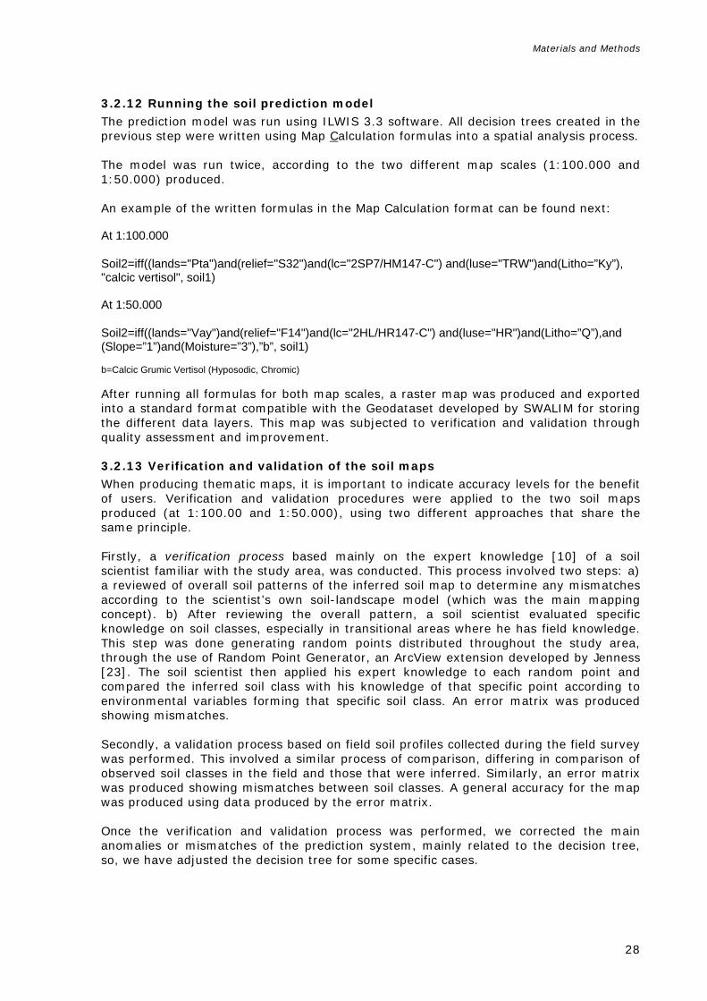
3.2.12 Running the soil prediction model
The prediction model was run using ILWIS 3.3 software. All decision trees created in the previous step were written using Map Calculation formulas into a spatial analysis process. The model was run twice, according to the two different map scales (1:100.000 and 1:50.000) produced. An example of the written formulas in the Map Calculation format can be found next: At 1:100.000 Soil2=iff((lands="Pta")and(relief="S32")and(lc="2SP7/HM147-C") and(luse="TRW")and(Litho=”Ky”), "calcic vertisol", soil1) At 1:50.000 Soil2=iff((lands="Vay")and(relief="F14")and(lc="2HL/HR147-C") and(luse="HR")and(Litho=”Q”),and (Slope=”1”)and(Moisture=”3”),”b”, soil1) b=Calcic Grumic Vertisol (Hyposodic, Chromic) After running all formulas for both map scales, a raster map was produced and exported into a standard format compatible with the Geodataset developed by SWALIM for storing the different data layers. This map was subjected to verification and validation through quality assessment and improvement.
3.2.13 Verification and validation of the soil maps When producing thematic maps, it is important to indicate accuracy levels for the benefit of users. Verification and validation procedures were applied to the two soil maps produced (at 1:100.00 and 1:50.000), using two different approaches that share the same principle. Firstly, a verification process based mainly on the expert knowledge [10] of a soil scientist familiar with the study area, was conducted. This process involved two steps: a) a reviewed of overall soil patterns of the inferred soil map to determine any mismatches according to the scientist’s own soil-landscape model (which was the main mapping concept). b) After reviewing the overall pattern, a soil scientist evaluated specific knowledge on soil classes, especially in transitional areas where he has field knowledge. This step was done generating random points distributed throughout the study area, through the use of Random Point Generator, an ArcView extension developed by Jenness [23]. The soil scientist then applied his expert knowledge to each random point and compared the inferred soil class with his knowledge of that specific point according to environmental variables forming that specific soil class. An error matrix was produced showing mismatches. Secondly, a validation process based on field soil profiles collected during the field survey was performed. This involved a similar process of comparison, differing in comparison of observed soil classes in the field and those that were inferred. Similarly, an error matrix was produced showing mismatches between soil classes. A general accuracy for the map was produced using data produced by the error matrix. Once the verification and validation process was performed, we corrected the main anomalies or mismatches of the prediction system, mainly related to the decision tree, so, we have adjusted the decision tree for some specific cases.

Results
29
Class (Reference Group) Km2 % Key properties Vertisols Calcic Grumic Vertisol Calcic Mazic Vertisol Calcic Vertisol Haplic Vertisol
1252
97 1440 170
22.9
Soils influenced by water; alternating wet-dry conditions, rich in swelling clays.
Fluvisols Calcic Endosalic Fluvisol Calcic Fluvisol Haplic Fluvisol Haplic Fluvisol (Skeletic)
117 47
771 1020
15.1
Soils influenced by water; floodplains, valleys, marshes
Calcisols Endosalic Calcisol Haplic Calcisol Hypercalcic Calcisol Luvic Calcisol Petric Calcisol Vertic Calcisol Vertic Petric Calcisol
49
558 46
120 27
368 11
9.1
Soils with accumulation of calcium carbonate.
Cambisols Fluvic Cambisol
432
3.3
Moderately developed soils.
Arenosols Haplic Arenosol
89
0.7
Sandy soils located in coastal plains.
Leptosols Haplic Leptosol Haplic Leptosol (Skeletic) Haplic Leptosol (Skeletic)/Haplic Regosol Hyperskeletic Leptosol Hyperskeletic Lithic Leptosol Lithic Leptosol Hyperskeletic Lithic Leptosol/Haplic Regosol Hyperskeletic Lithic Leptosol/Haplic Regosol (Skeletic)
216 304 200
1093 1392 1097 230 462
38.6
Shallow or extremely gravelly soils.
Solonchaks Haplic Solonchak
25
0.2
Soils with salt enrichment upon evaporation.
Regosols Haplic Regosol Haplic Regosol (Skeletic) Haplic Regosol/Haplic Calcisol
967 287
7.5 2.2
Soils with no significant profile development.
Technosols 49 0.4 Urban soils in the main towns: Hargeisa, Gebiley and Borama.
Total 12934 100
4 RESULTS
4.1 Soil profiles Eighty-two soil profiles were described in the course of this soil survey. Fifty out of the 82 profiles were completely described, including both site and profile descriptions, and soil samples being sent for chemical and physical analyses. The remaining 32 profiles consisted only of site descriptions due to their rocky and stony characteristics that did not allow digging of profiles and subsequent description. Soil classification was however possible. All profiles and site descriptions were classified using WRB 2006 and stored in a soils database. Complete soil descriptions can be found in Appendix 3. Map 8 shows the distribution of the 82 profiles in the study area.
4.2 Soil map at 1:100 000 scale A 1:100 000 soil map (Map 9) of the whole study area was produced using the Reference Soil Groups level and Prefix qualifier level of the WRB 2006 classification system. Soils encountered were mainly Vertisols, Leptosols, Regosols, Calcisols, Fluvisols, Arenosols, Cambisols and Solonchaks. Soils extent and distribution as shown in Map 9 is as follows (Table 9):
Table 9: Area of soil reference classes and key properties

Results
30
The dominant soils in the study area are Leptosols and Regosols. Difficulties were encountered in separating them due to limited field data in this inaccessible area, as well as them sharing some common characteristics. The second-most dominant soils are the Vertisols, found mainly in agropastoral areas of the area of interest. The Fluvisols are also present, in a considerable extension located mainly in the fluvial system of the area of interest. A considerable amount of Calcisols and Cambisols are also found, which are characteristic soils of the environment area?. Arenosols are respresented in a very small area in the coastal region of the area of interest and Solonchaks which are found in the playas in the southern part of the area of interest. The Technosols, corresponding to the main urban areas, were not studied in detail, so were kept at the reference group level in WRB 2006.
4.2.1 Technical description of the soil classes Vertisols (Profiles 101, 109, 122, 125, 303, 305, 307, 309, 306, 308, 323, 329, 117, 121, 301, 120, 123, 302, 325, 316, 328, 102, 304, 321, 326) Vertisols occur in the Plateau and dissected plateau between Hargeisa, Gebiley and Borama, south of the Al Mountains. The plateau is mostly flat apart from areas of uneven relief, slopes towards streams and rolling surfaces. From a climatic point of view this area is considered as semi-arid due to its higher annual rainfall of 500 mm in comparison to the rest of the study area; this situation positively influences soil formation processes. These soils are located in the unique agro-pastoral system of the study area commonly called the “sorghum belt”. Many water-harvesting techniques hva ebeen and are applied in this area, which in some cases were poorly designed and are causing gully and rill soil erosion. Vertisols are churning, deep heavy clay soils with a high proportion of swelling clays. These soils form deep, wide cracks from the surface downward to more than 50 cm below the surface when they dry out, which happens in most years. These cracks are not always well represented on the surface due to them filling with sand. Vertisols are fine-textured soils dominated by expanding montmorillonite clay minerals. The minerals normally expand and contract on wetting and drying, respectively. In the dry condition the soils develop a shallow grumic or granular mulch structure and form wide cracks on the surface. The cracks extend vertically separating blocky and prismatic structures. Some of the mulch falls or is washed into the cracks during rains so that this causes a mix up effect in the whole profile in the alternating wetting and drying when expansion pressure happens in the lower horizon. The effect of the pressure develops slip-faces (slickensides) and wedge shaped structure in the lower horizons and often to gilgai micro-relief at the surface. The soil becomes plastic and sticky when wet and the cracks close. The soils become very hard when dry. The Vertisols in the study area generally contain more than 35% clay increasing with depth, and they fall exclusively into the clay classes (see Table 10). Parent materials are mostly sediments that contain a high proportion of swelling clays, or products of rock weathering that have the characteristics of swelling clays. The soil structure of these vertisols is largely influenced by prevailing soil moisture content, which is demonstrated in dry conditions where the soils are often very hard except for the top 10 - 20 cm where there is natural, friable self-mulching layer.

Results
31
PROFILE LAB_CODE HORIZON DEPTH SAND
% SILT
% CLAY
% TEXTUR
E Bulk_density
(g/cm) C_% N_% P_ppm PH(H2O) EC
mS/cm CECm_meq/100g Ca++ Mg++ K+ Na+ PSB_% CaCO3_
% 101 1645 A1 0-35 28.0 14.0 58.0 C 1.26 0.60 0.03 8.90 8.20 0.22 14.80 24.6 1.6 1.4 2 100.0 28.00 101 1646 A2 35-65 24.0 16.0 60.0 C 0.50 0.03 35.50 8.40 0.20 11.80 18.8 0.3 1.1 1 100.0 30.00 101 1647 Bt 65-130 24.0 14.0 62.0 C 0.30 0.03 11.50 8.70 0.25 0.30 17.3 0.3 0.8 2 100.0 31.00 102 1648 A1 0-20 38.0 16.0 46.0 C 1.46 0.70 0.05 2.60 8.30 0.23 16.20 22.5 2.2 1.9 2 100.0 30.00 102 1649 A2 20-30 24.0 20.0 56.0 C 0.50 0.04 8.50 8.10 0.98 17.80 25.8 2.6 1.2 2 100.0 31.00 102 1650 B1 30-50 24.0 20.0 56.0 C 0.70 0.03 14.10 8.20 1.30 17.60 24.1 4.4 1.2 3 100.0 30.00 102 1651 B2 50-65 20.0 22.0 58.0 C 0.40 0.03 12.80 8.20 1.50 17.60 15 3.1 0.7 3 100.0 24.00 102 1652 C 65-130 22.0 20.0 58.0 C 0.40 0.03 10.80 8.20 2.20 16.60 19.4 4.4 0.52 3 100.0 28.00 109 1858 A1 0-10 52.0 4.0 44.0 SC 1.51 1.08 0.09 11.00 8.15 0.14 39.22 36.22 3.68 0.91 3.97 100.0 25.65 109 1859 A2 10-45 24.0 20.0 56.0 C 0.44 0.03 11.80 8.04 0.24 18.16 86.29 4.57 0.57 1.60 100.0 34.15 109 1860 Bk 45-100 18.0 22.0 60.0 C 0.62 0.06 10.90 8.13 2.07 26.22 20.31 7.95 0.60 1.03 100.0 28.15 117 1875 Ap 0-15 32.0 20.0 48.0 C 1.44 1.20 0.13 10.00 8.13 0.58 16.88 25.25 3.10 1.57 1.50 100.0 20.65 117 1876 AB 15-40 28.0 16.0 56.0 C 0.98 0.11 6.30 8.06 0.58 21.11 38.99 4.72 1.15 1.13 100.0 26.65 117 1877 Bt1 40-75 26.0 14.0 60.0 C 0.91 0.09 12.50 8.20 2.98 21.98 20.19 6.41 1.00 1.40 100.0 30.65 117 1878 Bt2 75-96 20.0 26.0 64.0 C 0.66 0.05 9.20 8.29 0.30 22.56 22.56 9.23 0.53 2.43 100.0 31.65 117 1879 C 96-135 20.0 14.0 66.0 C 0.44 0.04 7.90 8.51 1.80 22.12 17.08 8.22 0.78 4.70 100.0 35.65 120 1889 A1 0-10 30.0 22.0 48.0 C 1.42 1.56 0.18 30.40 8.16 0.33 9.86 13.43 2.40 1.08 1.05 100.0 23.50 120 1890 A2 10-40 30.0 18.0 52.0 C 1.06 0.11 9.30 8.22 0.40 21.24 24.80 4.72 1.38 1.65 100.0 25.00 120 1891 Bt1 40-75 28.0 14.0 58.0 C 0.87 0.08 14.70 8.45 2.65 18.80 19.08 5.99 1.06 3.00 100.0 26.00 120 1892 Bt2 >75 72.0 16.0 12.0 LS 0.87 0.04 9.90 8.37 0.20 11.00 20.68 2.07 0.48 0.50 100.0 22.00 121 1893 A1 0-20 30.0 24.0 46.0 C 1.54 1.56 0.19 22.60 8.21 0.31 11.00 14.50 2.92 1.72 1.50 100.0 27.00 121 1894 A2 20-45 28.0 14.0 58.0 C 0.59 0.06 12.60 8.46 0.32 26.60 25.64 4.52 1.06 1.75 100.0 20.00 121 1895 Bt 45-80 28.0 14.0 58.0 C 0.88 0.09 22.30 8.18 1.23 19.80 22.86 4.52 1.46 1.45 100.0 25.00 121 1896 Ck 80-140 20.0 14.0 66.0 C 0.51 0.05 13.90 8.47 1.37 19.06 11.29 3.18 0.26 1.85 100 30.00 301 1901 A1 0-30 30.0 22.0 48.0 C 1.38 0.77 0.10 10.90 8.25 1.04 19.80 16.88 4.54 0.10 1.65 100.0 20.50 301 1902 A2 30-70 28.0 22.0 50.0 C 0.54 0.10 11.90 8.32 0.45 29.18 8.08 3.57 0.80 1.25 100.0 17.50 301 1903 Btk 70-160 32.0 22.0 46.0 C 0.53 0.04 7.50 8.28 0.21 24.20 26.80 1.12 1.06 1.10 100.0 18.00 301 1904 C 160-170 12.0 28.0 60.0 C 0.41 0.06 8.70 8.80 0.39 14.53 21.26 7.70 0.86 3.75 100.0 23.50 123 2086 A1 0-25 26.0 38.0 36.0 CL 1.48 0.74 0.08 8.60 8.04 0.21 13.68 26.88 2.15 0.30 0.45 100.0 16.35 123 2087 A2 25-45 24.0 10.0 66.0 C 0.81 0.09 6.80 8.07 0.53 31.28 37.20 8.21 0.56 1.10 100.0 23.35 123 2088 Bt 45-70 22.0 8.0 70.0 C 0.63 0.08 4.70 8.28 1.30 21.08 17.06 5.89 0.28 1.50 100.0 30.85 123 2089 C 70->80 14.0 12.0 74.0 C 0.46 0.06 16.10 8.42 1.95 19.28 12.44 7.82 0.38 2.55 100.0 31.85 302 2104 Ap 0-15 48.0 10.0 42.0 SC 1.39 1.31 0.15 19.30 8.01 0.70 19.08 31.85 1.93 1.24 1.50 100.0 14.85 302 2105 A2 15-45 40.0 10.0 50.0 C 0.90 0.13 10.30 7.86 1.20 18.88 25.89 3.36 0.92 0.80 100.0 19.85 302 2106 Btk 45-65 42.0 4.0 54.0 C 0.67 0.11 4.60 8.07 0.65 22.08 37.50 5.54 0.58 0.95 100.0 17.85 302 2107 Ck 65->130 36.0 8.0 56.0 C 0.35 0.04 12.70 8.38 0.65 16.08 23.43 4.35 0.32 1.95 100.0 25.85 303 2108 Ap 0-20 42.0 4.0 54.0 C 1.39 0.96 0.09 10.30 8.14 0.27 18.12 28.40 3.68 1.36 1.45 100.0 23.35 303 2109 A2 20-39 28.0 10.0 62.0 C 0.69 0.07 10.90 8.29 0.35 24.28 31.54 2.52 1.24 1.60 100.0 28.85 303 2110 Bt1 39-65 26.0 10.0 64.0 C 0.54 0.06 11.80 8.57 0.45 19.28 17.86 7.17 0.80 2.45 100.0 29.35 303 2111 Bt2 65-115 26.0 8.0 66.0 C 0.51 0.05 8.00 8.70 0.80 15.48 16.03 8.08 0.40 3.30 100.0 30.85 303 2112 Ck >115 18.0 10.0 72.0 C 0.30 0.04 7.70 8.34 2.80 20.48 8.83 3.24 0.14 2.10 100 32.85 304 2113 A1 0-15 32.0 8.0 60.0 C 1.33 0.92 0.13 8.90 8.20 0.50 21.08 38.11 4.05 1.40 1.70 100.0 24.85

Results
32
304 2114 A2 15-40 26.0 12.0 62.0 C 0.77 0.11 8.30 8.09 1.65 21.68 26.98 6.54 0.90 1.95 100.0 28.35 304 2115 Bt 40-100 26.0 8.0 66.0 C 0.55 0.06 5.90 8.42 2.15 25.08 22.41 9.93 0.32 1.95 100.0 30.85 304 2116 C 100-130 20.0 8.0 72.0 C 0.40 0.05 4.60 8.46 2.70 27.28 18.53 7.87 0.22 2.15 100.0 33.35 305 2117 A1 0-10 32.0 12.0 56.0 C 1.45 0.95 0.11 4.50 8.19 0.35 25.07 37.22 3.27 1.30 1.30 100.0 24.85 305 2118 A2 10-35 26.0 14.0 60.0 C 0.92 0.10 2.10 8.20 0.35 25.48 30.23 4.43 0.98 1.15 100.0 25.85 305 2119 B1 35-85 28.0 10.0 62.0 C 0.61 0.07 3.50 8.70 0.40 22.28 27.17 9.49 0.44 2.20 100.0 27.85 305 2120 B2 85-140 24.0 10.0 66.0 C 0.44 0.05 8.20 8.78 0.90 14.08 13.63 10.93 0.16 1.45 100.0 31.85 306 2121 A 0-23 42.0 6.0 52.0 C 1.35 0.56 0.08 8.30 8.19 0.40 21.08 33.60 2.99 1.68 1.80 100.0 16.35 306 2122 AB 23-40 46.0 4.0 50.0 C 0.66 0.08 11.90 8.01 1.15 22.48 25.92 8.49 0.80 0.80 100.0 17.50 306 2123 Btk 40-85 46.0 6.0 48.0 C 0.50 0.06 5.20 8.15 1.00 23.88 21.95 1.24 0.56 0.70 100.0 19.00 306 2124 Ck >85 38.0 10.0 52.0 C 0.40 0.04 5.10 8.32 0.75 23.48 16.97 5.58 0.68 1.95 100.0 21.00 307 2125 A1 0-15 26.0 10.0 64.0 C 1.35 0.72 0.09 7.00 8.23 0.29 25.08 37.82 5.11 1.68 2.20 100.0 25.00 307 2126 A2 15-30 30.0 10.0 60.0 C 0.68 0.08 9.10 8.49 0.40 26.48 34.01 6.18 1.76 2.65 100.0 27.50 307 2127 B2k 30-110 20.0 12.0 68.0 C 0.40 0.06 4.70 8.63 1.55 20.08 18.12 5.45 0.48 3.00 100.0 30.50 307 2128 Ck 110-160 64.0 4.0 32.0 SCL 0.22 0.04 2.90 8.34 1.60 7.28 12.34 2.12 0.20 0.70 100.0 18.00 308 2129 A1 0-10 42.0 10.0 48.0 C 1.53 1.00 0.10 9.70 8.20 0.45 14.08 22.90 2.28 1.02 1.20 100.0 19.50 308 2130 A2 10-25 34.0 12.0 54.0 C 0.79 0.09 5.70 8.11 0.90 24.08 25.23 3.55 0.90 1.20 100.0 23.50 308 2131 Bk 25-85 34.0 8.0 58.0 C 0.41 0.05 1.50 8.56 1.80 21.08 22.98 9.54 0.52 2.60 100.0 25.50 308 2132 Ck 85-130 26.0 12.0 62.0 C 0.33 0.04 2.80 8.51 2.40 20.08 23.71 8.38 0.40 2.70 100.0 30.00 309 2133 A1 0-15 34.0 16.0 50.0 C 1.55 0.71 0.06 8.30 8.33 0.24 19.64 26.74 2.51 1.20 1.40 100.0 26.50 309 2134 A2 15-20 30.0 14.0 56.0 C 0.58 0.07 8.30 8.16 0.65 24.40 16.36 2.66 1.40 1.80 100 25.50 309 2135 B 20-70 28.0 14.0 58.0 C 0.39 0.05 5.10 8.28 1.30 16.80 15.23 3.43 1.08 1.25 100.0 29.00 309 2136 C 70-120 24.0 10.0 66.0 C 0.27 0.04 4.70 8.12 1.65 20.00 16.75 4.47 0.32 2.65 100.0 29.50 316 2140 A 0-20 34.0 16.0 50.0 C 1.48 0.47 0.07 10.00 8.20 0.35 25.40 16.49 4.22 0.84 1.35 100 22.50 316 2141 Bt 20-85 32.0 12.0 56.0 C 0.30 0.05 9.70 8.47 0.35 16.80 16.53 4.76 0.64 2.35 100.0 22.50 316 2142 C 85-120 22.0 16.0 62.0 C 0.22 0.04 7.70 8.38 1.00 28.60 19.32 4.99 1.96 3.45 100.0 26.50 321 2146 Ap 0-15 38.0 4.0 58.0 C 1.36 0.65 0.09 11.50 8.03 0.70 20.40 9.79 2.98 0.76 1.20 100 26.00 321 2147 A2 15-40 20.0 22.0 58.0 C 0.55 0.12 10.50 7.85 2.50 21.40 10.53 3.53 0.60 1.65 100 24.00 321 2148 Bt1k1 40-80 24.0 12.0 64.0 C 0.38 0.11 14.70 7.98 2.35 22.40 10.71 3.88 0.70 2.15 100 26.50 321 2149 Bt2k2 80-135 22.0 16.0 62.0 C 0.27 0.08 18.80 8.00 2.20 23.60 19.83 7.59 0.78 2.25 100.0 29.00 321 2150 Ck 135-155 18.0 16.0 66.0 C 0.23 0.07 15.40 8.09 2.15 27.20 12.27 5.26 1.16 2.65 100 32.50 323 2151 A1 0-10 6.0 32.0 62.0 C 1.41 0.52 0.07 18.00 8.06 0.55 25.40 5.02 1.21 0.28 0.20 100 24.00 323 2152 A2 10-25 6.0 32.0 62.0 C 0.46 0.08 7.10 7.98 1.20 32.00 15.71 4.80 0.80 1.80 100 23.00 323 2153 B1 25-50 10.0 38.0 52.0 C 0.51 0.11 7.30 7.81 3.50 20.60 10.97 3.20 0.42 1.35 100 22.50 323 2154 B2 50-110 8.0 34.0 58.0 C 0.41 0.10 5.60 7.84 4.00 21.80 10.89 5.92 0.68 2.35 100 25.00 323 2155 C >140 12.0 26.0 62.0 C 0.29 0.09 9.30 7.90 3.50 29.40 6.09 9.20 1.40 1.30 100 25.50 325 2162 Ap 0-20 32.0 12.0 56.0 C 1.34 1.28 0.11 6.10 7.97 0.35 27.60 31.27 2.73 1.30 1.55 100.0 19.50 325 2163 Btk 20-75 30.0 12.0 58.0 C 0.88 0.07 10.00 7.84 0.55 27.00 36.86 4.11 1.10 1.55 100.0 21.00 325 2164 Ck 75-110 24.0 12.0 64.0 C 0.64 0.05 4.60 8.13 0.95 21.60 12.96 4.61 0.50 2.30 100 27.50 326 2165 Ap 0-15 34.0 12.0 54.0 C 1.43 1.09 0.06 7.30 7.92 0.35 26.40 22.73 2.88 1.44 1.55 100.0 19.00 326 2166 AB 15-30 30.0 12.0 58.0 C 0.81 0.07 4.90 7.96 0.35 32.00 25.40 3.88 1.10 1.30 100 23.00 326 2167 Btk 30-110 24.0 14.0 62.0 C 0.53 0.04 4.20 8.13 0.50 21.20 18.11 8.24 0.96 1.65 100 25.00 326 2168 Ck >110 22.0 12.0 66.0 C 0.14 0.04 6.40 8.24 0.90 25.00 14.73 8.59 0.68 2.80 100.0 28.00 328 2169 Ap 0-20 14.0 18.0 68.0 C 1.31 1.76 0.11 6.00 7.97 0.40 41.40 27.10 5.71 0.86 0.85 100.0 22.00 328 2170 Bt 20-90 14.0 12.0 74.0 C 0.92 0.05 6.20 8.46 0.75 45.32 19.37 9.82 0.76 3.10 100 26.00

Results
33
328 2171 C 90-160 12.0 12.0 76.0 C 0.04 0.03 7.70 8.28 4.00 26.40 20.21 6.64 0.40 4.55 100.0 29.50 329 2172 Ap 0-25 16.0 14.0 70.0 C 1.16 0.02 0.14 4.40 7.82 0.60 33.70 13.24 4.63 1.10 1.05 100 25.00 329 2173 Bt 25-110 14.0 8.0 78.0 C 0.02 0.03 5.90 8.63 1.55 25.40 11.93 3.44 0.96 1.95 100 31.50 329 2174 C 110-140 10.0 10.0 80.0 C 0.01 0.02 7.00 8.50 3.50 27.00 12.96 6.41 1.00 8.55 100 30.50
Average values for Vertisols
140+
27
14.5
58
C
1,40
0.62
0.07
9.48
8.2
1.1
21.8
21.8
4.8
0.87
1.94
100
25.7
Range values for Vertisols
6-64
4-38
12-80
1.16-1.55
0.01 1.76
0.02 0.19
2.1 35.5
7.81 8.8
0.14 4.0
7.28 45.32
5.02 86.29
0.3 10.93
0.10 1.76
0.2 8.55
14.85 34.15
Table 10: Soil laboratory results of the Vertisols

Results
34
The Vertisols in the study area have low stable porosity, and a predominance of fine pores. The topography is usually flat or gently sloping throughout the alluvial plain, and the most common soil erosion type is slight sheet wash, but rill and gully erosion occur on the upper slope of the dissected plateaus around the Borama/Gebiley catchments. A Gilgai microrelief is often a peculiar sign of the Vertisols; in this study this feature was not found, although many sinkholes were observed. Soil physical properties The bulk density of the vertisols in the study area can be broadly characterised as available data is limited to the surface horizons and it is recognised that clay content increases with soil depth. Bulk densities are usually very widely distributed and occur in a moderately low range between 1.16 - 1.54g/cm3. These variations are caused by swelling and shrinking with changes in soil moisture content. Bulk density is high when the soils are dry and low when wet. Water infiltration is moderately slow. In the dry season, surface horizons are characterised by grumic and granular structure (forming surface mulch) at intervals of 10 - 20 cm which often cover up wide, deep vertical cracks in the soil. In the subsoil there are strongly developed prismatic, angular to sub-angular structures separated from each other by cracks of various sizes. In the wet season all the structures are almost completely destroyed, reducing the surface horizon to a massive block. Shiny pressure faces and/or well-developed slickensides were also observed in the profiles. Porosity is limited, except for the cracks developed during the dry season and occasional root channels. In the lower horizons the plant roots are confined to cracks and slickenside faces. The vertisols in the study area have a relatively high water storage capacity in the root zone of the upper 1m of the soil profile, due to their depth and high clay content. The soil moisture content in the deeper layers is lower, apparently due to compression effects on metric potential. As this study area is characterised by uncertain rainfall, the water stored in the soil profile is very important for survival of crops during the growing season until the end of the rainy season. Soil chemical properties In an arid and semi-arid climate it is recognised that the major chemical factors limiting crop production are usually related to the increase of soluble salts in the soil. Therefore attention is always focused on chemical analyses to assess the types and amount of soluble salts and amount of exchangeable sodium associated with the soil clay. Consequently, all the soil horizons of the sampled profiles were subjected to detailed chemical analyses. Chemical analysis of vertisols in the study area (Table 10) show them to be rich in clay content, moderately alkaline in reaction and moderately base saturated (for the interpretation, see Annex 2). Salinity values are uniformly low throughout the soil profile. The levels of exchangeable sodium are generally very low. These characteristics are favourable for crop production. Soil Fertility The results of tests on organic matter and total nitrogen in the surface horizons of the soil profiles show values of less than 1% and 0.1% respectively, indicating that levels of organic matter and total nitrogen are lower than deficient. These low values are probably a result of the arid and semi-arid climates, but a major factor is also the lack of soil management practices in relation to the agricultural and pastoral systems. Therefore, nitrogen fertilizer will be necessary to maintain or increase crop yields under present farming systems.

Results
35
Phosphorus (P) was determined to be the “available” form. The measured values of phosphorus indicate it is irregular in terms of content and distribution in almost all the profiles. Phosphorus values vary from site to site, and similarly downwards in the soil profile, ranging between 3.5 - 35.5 ppm. Rating of P according to guidelines for interpretation by Olsen’s method (Landon, 1984) suggests that values < 5 ppm can be considered low and 5 - 15 ppm as medium. Values > 15 ppm are considered excessive. As pH values of soils in the study area are moderately alkaline to strongly alkaline, phosphorous is subject to fixation or formation of poorly soluble calcium phosphate, suggesting that application of phosphate fertilizer is required and likely to improve production in intensive cultivation systems. Management and use The vertisols in this semi-arid region are used for different purposes, but primarily for rain-fed agriculture through smallholder post-rainy season crop cultivation, mainly sorghum, maize, millet, cowpeas and Qat, and extensive grazing and wood collection. Crop management practices are mainly directed towards building soil bunds for water harvesting, in combination with soil conservation in order to store more water in the soil. Neither manure nor mineral fertilizers are not applied to crops. Fluvisols (Profiles: 103, 106, 107, 113, 200, 201, 206) Fluvisols are young soils developed on parent material of recent alluvial plains, river fans and tidal marshes which are periodically flooded by seasonal rivers which are very common within the Al Mountains, Highlands and Dissected Plateaus, mostly in the central part of the study area. Soil profiles show stratification and a weak subsoil horizon differentiation due to successive flooding and deposition of soil material. The climate is arid and semi-arid, similar to that of the Vertisols. Topography is a flat to gently undulating surface. The natural vegetation varies from general open trees with shrubs, sparse shrubs with a herbaceous layer, general open shrubs and bare soil. The fluvisols in the study area are very important because they are used for irrigated orchards along the alluvial plains of the main rivers and toggas. Physical and chemical properties In arid and semi-arid climates, it is recognised that the major physical and chemical factors limiting crop production usually relate to soil texture, alkalinity, sodicity and levels of salinity. Therefore, attention is always focused on physical and chemical analyses to assess important parameters associated with soil characteristics. Consequently, all soil horizons of the sampled profiles were physically and chemical analysed, and described as follows: Fluvisols in the study area all have diverse texture classes which change within the soil profile and in different spatial areas. The majority of these soils have good water drainage and water holding capacities, and are periodically flooded. They have variable bulk density ranging from 1.30 - 1.67, which is fairly high. The pH ranges from moderately alkaline to strongly alkaline, varying with depth or spatially. Salinity is not a major hazard in these soils. Results obtained from the analyses show that a limited number of sites’ lower horizons have a moderate degree of salinity and may cause salinity problems in the long term if irrigation is applied to inadequately drained land. The analytical value of the total sums of CEC in the fluvisols of the study areas are variable and range from low (5 - 15 meq/100g) to medium (15 - 25meq/100g) and with an irregular distribution within the profiles. This is due to the diverse nature of the stratification layers and their content of colloidal material clay and organic matter. The base saturation is high or moderate. The dominant exchangeable cations are calcium and

Results
36
magnesium. There is no sodium hazard and the soils are strongly calcareous. All the fluvisols are deficient in organic carbon and nitrogen, and phosphorus values are also low. Available potassium is adequate. Application of organic manure or inorganic nitrogen can yield better crop responses in terms of yield. Management and use The fluvisols of the study area are developed in river plain landscapes and have good natural fertility. They are usually suitable for all uses, but in the project area are commonly used for irrigated crops or grazing and woodcutting for fuelwood. Calcisols (Profiles: 110, 114, 115, 118, 119, 124, 129, 135, 136, 138, 310, 311, 317) The calcisols are soils commonly developed in the study area and are characterised by having a substantial secondary accumulation of lime. They principally occur in dissected plateaux and some piedmonts of the study area. Deep fluvial incisions form areas of bare rock at the upper surface part of the landscape, generally causing high and intense degradation. They are developed in highly calcareous parent material mainly in the Fossiliferrous limestone and Yesomma sandstones. The parent material in the lower parts of the landscape is mostly alluvial and colluvial, consisting of base-rich weathered deposits consisting mainly of highly calcareous sands and gravel of colluvial and alluvial soil deposits. The natural vegetation consists of general open shrubs with open herbaceous, sparse trees and different herbaceous cover. Most of these soil units are used for rainfed agriculture and livestock grazing. Physical and chemical properties The majority of the calcisols have a clayey texture which varies slightly with soil depth (see Table 11). These soils are strongly calcareous throughout the soil profiles, moderately alkaline to strongly alkaline, non saline, have adequate to high CEC, high to adequate or rarely excessive content of phosphorus and are deficient in organic matter and total nitrogen (for interpretation see Annex 2). Management and use The vast majority of the calcisols are under shrubs, grasses, herbs and sparse tree cover and are used for general grazing. Some calcisols are used for production of isolated rainfed fields of herbaceous crops (single or multiple), sorghum and maize where arable farming is not hindered by surface stoniness or a shallow petrocalcic horizon. Cambisols (Profiles: 108) These are soils with an initial stage of subsurface soil horizon differentiation. They occur in slopes, denudational surfaces and in some alluvial deposits in the study area. The parent material is derived from a wide variety of rocks, the most common of which is fossiliferous limestone. The profiles are characterised by slight transformation of the parent material and evidence changes in soil structure, colour and clay content, but there is an absence of appreciable quantities of illuviated clay or carbonate content, organic matter, Al and/or Fe compounds. The topography varies from flat to gently sloping surfaces of alluvial deposits.

Results
37
PROFILE LAB_CODE HORIZON DEPTH SAND%
SILT%
CLAY%
TEXTURE Bulk_density (g/cm)
C_% N_% P_ppm PH(H2O) EC mS/cm
CECm_meq/100g Ca++ Mg++ K+ Na+ PSB_% CaCO3_%
110 1861 A1k 0-10 18.0 34.0 48.0 C 1.46 0.42 0.04 15.20 8.15 0.78 19.12 72.84 3.82 0.79 1.05 100.0 36.65 110 1862 A2k 10-20 22.0 20.0 58.0 C 0.77 0.06 16.30 8.03 0.33 26.39 32.84 0.47 1.03 1.20 100 27.65 110 1863 Ck 20-90 34.0 18.0 54.0 C 0.30 0.02 15.40 8.14 0.58 11.60 112.74 4.46 0.28 3.47 100 28.15 114 1867 A1 0-19 52.0 30.0 18.0 SL 1.66 0.65 0.04 11.70 8.03 2.19 19.16 14.82 1.79 1.27 0.97 100.0 6.65 114 1868 AB 19-35 44.0 30.0 26.0 L 0.66 0.05 11.60 8.14 0.60 11.38 20.47 2.29 1.37 2.00 100.0 8.65 114 1869 Bt 35-60 40.0 32.0 28.0 CL 0.64 0.05 15.60 8.19 0.29 12.36 23.81 2.94 1.00 2.53 100 9.65 114 1870 Ck 60-120 40.0 30.0 30.0 CL 0.59 0.03 12.40 8.17 0.23 13.76 20.35 3.01 0.28 2.17 100 14.65 115 1871 Ap 0-15 36.0 16.0 48.0 C 1.48 1.16 0.10 10.80 8.00 0.15 18.96 23.40 2.36 1.27 1.23 100 18.65 115 1872 Bt 15-60 44.0 16.0 40.0 CL 0.80 0.08 10.20 8.42 0.80 20.96 23.04 37.00 0.73 0.57 100 15.65 115 1873 Ck1 60-80 32.0 18.0 50.0 C 0.87 0.09 9.60 8.08 0.70 26.56 32.16 3.68 0.73 0.73 100.0 20.65 115 1874 Ck2 80-145 32.0 16.0 52.0 C 0.60 0.06 14.70 8.15 0.35 18.54 26.91 3.24 0.57 0.70 100.0 30.65 118 1880 Ap 0-15 54.0 14.0 32.0 SCL 1.45 0.60 0.05 7.20 8.26 0.22 15.60 15.11 2.69 1.16 0.80 100.0 12.50 118 1881 A2 15-28 52.0 10.0 38.0 SC 0.56 0.06 17.40 8.14 0.52 8.68 32.21 2.13 0.72 0.75 100.0 12.50 118 1882 Bt1 28-65 40.0 10.0 50.0 C 0.72 0.07 6.10 8.26 0.25 15.62 17.50 2.20 0.71 0.75 100.0 20.00 118 1883 Bt2k1 65-118 32.0 14.0 54.0 C 0.52 0.05 6.40 8.33 0.30 12.99 10.99 2.07 0.64 0.80 100.0 26.50 118 1884 Ck2 118-150 60.0 10.0 30.0 SC 0.39 0.03 39.40 8.58 1.16 10.64 11.18 3.04 0.58 1.45 100.0 31.00 119 1885 A1 0-20 30.0 14.0 56.0 C 1.65 0.58 0.08 7.00 8.37 0.16 12.00 15.03 2.51 0.56 1.45 100.0 13.00 119 1886 A2 20-42 44.0 12.0 44.0 C 0.71 0.07 7.20 8.22 0.52 18.60 42.05 3.24 0.56 0.85 100.0 21.50 119 1887 C1 42-65 36.0 12.0 52.0 C 0.44 0.04 6.50 8.35 0.35 16.40 24.53 4.58 0.40 0.85 100.0 30.00 119 1888 C2k 65-150 40.0 12.0 48.0 C 0.26 0.02 11.30 8.17 0.29 11.00 9.61 1.30 0.40 0.95 100.0 29.50 124 2090 A1 0-23 20.0 12.0 68.0 C 1.39 1.01 0.14 10.60 8.08 0.35 30.88 34.66 4.02 1.18 1.05 100.0 25.85 124 2091 A2 23-45 56.0 4.0 40.0 SC 0.53 0.06 13.60 8.23 0.27 14.28 30.18 3.92 0.24 0.50 100.0 19.35 124 2092 Ck1 45-65 52.0 6.0 42.0 SC 0.27 0.05 9.10 8.23 0.45 14.48 38.48 4.68 0.30 0.70 100.0 21.35 124 2093 Ck2 >65 50.0 6.0 44.0 SC 0.21 0.03 8.40 8.30 0.55 11.08 23.72 4.96 0.24 0.60 100.0 22.85 129 2094 ACk1 0-25 24.0 34.0 42.0 C 1.36 0.29 0.04 13.10 8.27 0.25 17.32 32.54 1.71 0.48 0.95 100.0 26.85 129 2095 Ck2 25-40 22.0 36.0 42.0 C 0.25 0.09 3.50 7.87 3.50 16.28 21.02 3.47 0.38 0.50 100.0 31.35 135 2096 A 0-25 48.0 12.0 40.0 SC 1.33 0.50 0.05 5.60 8.42 2.40 15.08 30.89 2.16 0.32 1.20 100.0 20.35 135 2097 Ck1 25-65 46.0 12.0 42.0 SC 0.38 0.05 2.70 8.01 2.30 13.48 17.71 2.02 0.16 0.85 100.0 25.85 135 2098 Ck2 65-80 44.0 12.0 44.0 C 0.28 0.04 4.40 8.13 2.45 15.08 30.10 4.13 0.28 1.80 100.0 30.85 136 2099 Ac 0-25 58.0 8.0 34.0 SCL 1.39 0.43 0.07 2.20 8.25 0.21 11.32 32.67 2.29 0.26 0.45 100.0 25.85 136 2100 Ck 25->75 42.0 16.0 42.0 C 0.42 0.04 2.20 8.55 0.24 18.12 10.08 4.81 0.24 0.70 100 37.35 138 2101 A 0-20 58.0 10.0 32.0 SCL 1.73 1.03 0.08 2.60 8.11 0.24 20.12 21.35 1.45 1.04 1.05 100.0 16.35 138 2102 Bt 20-75 38.0 10.0 52.0 C 0.74 0.09 9.90 8.10 0.40 23.08 18.31 2.67 0.92 0.95 100 19.35 138 2103 Ck >75 44.0 8.0 48.0 C 0.35 0.04 2.30 8.24 0.29 13.68 36.62 2.41 0.52 0.75 100.0 23.85 310 2137 A 0-35 76.0 6.0 18.0 SL 1.58 0.31 0.05 11.80 8.17 0.20 10.20 17.99 2.06 0.80 0.55 100.0 7.50 310 2138 B 35-75 68.0 6.0 26.0 SCL 0.27 0.05 5.20 8.11 0.50 10.00 18.51 2.16 0.36 0.75 100.0 14.00 310 2139 C 75-140 18.0 14.0 68.0 C 0.18 0.05 9.50 8.14 4.00 27.80 13.76 5.95 0.60 3.95 100 29.50 317 2143 A 0-10 34.0 18.0 48.0 C 1.38 0.62 0.07 10.10 8.17 0.35 29.40 35.73 3.78 0.88 1.60 100.0 24.00 317 2144 AB 10-20 24.0 22.0 54.0 C 0.94 0.07 9.40 8.35 0.30 33.40 18.75 3.98 0.36 1.70 100 27.00 317 2145 Bt 20-65 22.0 20.0 58.0 C 0.68 0.07 13.60 8.31 0.70 26.40 17.35 3.03 0.28 2.30 100 27.00
Average values for Calcisols
99
40.65
16
43.5
SCL
1.48
0.54
0.06
10.04
8.20
0.76
17.29
27.05
3.86
0.62
1.20
100
22.2
Range values for Calcisols
0-150
18-68
4-36
18-68
1.33-1.73
0.18 1.16
0.02 0.14
2.2 39.4
7.87 8.42
0.15 4.0
8.68 33.4
9.61 112.74
0.47 37.0
0.16 1.37
0.45 3.95
6.65 37.35
Table 11: Soil laboratory results of the Calcisols, Fluvisols, Regosols, Cambisols, Arenosols
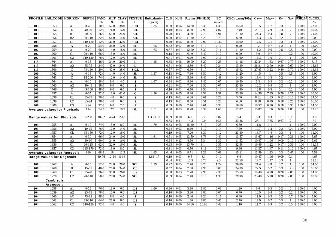
Results
38
PROFILE LAB_CODE HORIZON DEPTH SAND%
SILT%
CLAY%
TEXTURE
Bulk_density (g/cm)
C_% N_% P_ppm PH(H2O) EC mS/cm
CECm_meq/100g Ca++ Mg++ K+ Na+ PSB_% CaCO3_%
103 1653 A1 0-40 10.0 52.0 38.0 SICL 1.35 0.50 0.04 14.20 8.30 1.30 15.60 19.5 1.7 0.3 2 100.0 23.00 103 1654 E 40-60 12.0 74.0 14.0 SIL 0.40 0.05 8.60 7.90 4.07 7.40 28.1 2.9 0.3 2 100.0 10.00 103 1655 B1 60-90 16.0 60.0 24.0 SIL 0.70 0.11 4.30 7.70 8.91 21.10 24.3 0.4 0.8 7 100.0 21.00 103 1656 B2 90-110 22.0 64.0 14.0 SIL 0.20 0.02 11.30 8.20 3.73 6.30 14.3 1.6 0.2 2 100.0 9.00 103 1657 C1 110-120 12.0 46.0 42.0 SICL 0.40 0.04 8.80 7.90 10.60 14.00 17.5 3.1 0.3 11 100.0 23.00 106 1758 A 0-20 54.0 34.0 12.0 SL 1.65 0.82 0.07 10.30 8.10 0.16 9.20 12 0.7 1.2 1 100 13.00 107 1759 A1 0-20 68.0 14.0 18.0 SL 1.63 0.37 0.01 12.00 8.30 0.11 11.10 11.2 0.6 0.5 0.5 100 9.00 107 1760 C1 20-110 66.0 18.0 16.0 SL 0.18 0.01 6.40 8.40 0.12 9.90 9.9 0.7 0.1 0.2 100 10.00 107 1761 C2 110-120 78.0 12.0 10.0 SL 0.71 0.01 6.50 9.00 0.16 17.90 18.3 1.6 0.1 1 100 8.00 113 1864 A1 0-35 46.0 34.0 20.0 L 1.45 0.85 0.08 10.00 8.27 0.23 11.16 22.34 1.63 0.67 0.77 100.0 8.15 113 1865 A2 65-75 34.0 42.0 24.0 L 0.61 0.06 8.80 8.40 0.24 13.39 26.21 2.00 0.39 0.60 100.0 12.65 113 1866 C 75-150 20.0 42.0 38.0 SiCL 0.57 0.07 6.80 8.17 0.47 15.92 27.83 3.22 0.40 0.70 100.0 13.65 200 1762 A 0-15 72.0 14.0 14.0 SL 1.57 0.13 0.02 7.30 8.50 0.12 11.20 14.5 1 0.5 0.5 100 8.00 200 1763 C 15-200 74.0 12.0 14.0 SL 0.14 0.01 5.90 8.40 2.48 14.10 16.4 1.8 0.2 4 100 6.00 201 1764 A1 0-10 88.0 8.0 4.0 S 1.67 0.24 0.02 8.20 8.40 0.07 10.50 5.3 0.3 0.2 0.2 100 2.00 201 1765 A2 10-45 88.0 6.0 6.0 S 0.21 0.02 7.60 8.50 0.07 23.30 10.2 0.4 0.2 1 100 1.00 201 1766 C 45-100 88.0 6.0 6.0 S 0.16 0.01 6.50 8.50 0.10 11.90 12.8 0.3 0.1 0.2 100 5.00 206 1897 A 0-35 22.0 16.0 62.0 C 1.30 0.48 0.05 8.30 8.53 1.51 23.86 14.56 7.85 0.70 3.25 100.0 30.00 206 1898 C1 35-65 90.0 4.0 6.0 S 0.13 0.01 6.00 8.61 0.28 5.40 8.61 1.33 0.12 0.10 100.0 14.50 206 1899 C2 65-94 90.0 4.0 6.0 S 0.13 0.01 8.50 8.51 0.26 6.60 8.88 0.79 0.18 0.25 100.0 16.00 206 1900 C3 >94 92.0 6.0 2.0 S 0.09 0.00 7.70 8.61 0.30 10.60 10.57 0.96 0.18 0.30 100.0 14.50
Average values for Fluvisols
114 54.3 27 18.5 SL 1.51 0.38 0.03 8.28 8.34 1.68 12.87 15.87 1.66 0.36 1.83 100 12.25
Range values for Fluvisols 0-200 10-92 4-74 2-62 1.30-1.67 0.09 0.85
0.00 0.11
6.0 14.2
7.7 9.0
0.07 10.6
5.4 23.86
5.3 28.1
0.3 7.85
0.1 0.67
0.1 7
1.0 30
105 1755 A1 0-10 74.0 18.0 8.0 SL 1.70 0.63 0.05 15.30 8.10 0.28 6.60 11.8 1.1 1 1 100.0 7.00 105 1756 A2 10-65 76.0 10.0 14.0 SL 0.34 0.03 9.30 8.10 0.14 7.80 17.7 1.2 0.3 0.4 100.0 8.00 105 1757 Ck 65-150 72.0 12.0 16.0 SL 0.19 0.03 7.20 8.30 0.12 23.80 13.7 1.4 0.3 1 100 11.00 203 1854 A1 0-30 66.0 24.0 10.0 SL 1.61 0.51 0.05 13.50 8.76 0.40 13.57 13.67 1.16 0.17 0.36 100.0 5.65 203 1855 A2 30-60 60.0 24.0 16.0 SL 0.64 0.12 8.50 8.34 1.30 11.52 10.47 1.06 0.09 0.10 100.0 5.65 203 1856 C1 60-125 62.0 22.0 16.0 SL 0.63 0.06 13.70 8.14 0.35 32.58 16.46 1.22 0.17 0.36 100 11.15 203 1857 C2 125-170 72.0 16.0 8.0 SL 0.31 0.03 0.50 8.11 2.30 9.96 11.37 1.47 0.11 0.10 100.0 4.65
Average values for Regosols 160 68.8 18 12.5 SL 1.65 0.46 0.05 9.71 8.26 0.69 15.11 13.59 1.23 0.3 0.47 100 7.58 Range values for Regosols 60-76 12-24 8-16 1.61-1.7 0.19
0.64 0.03 0.12
0.5 15.3
8.1 8.76
0.12 2.3
6.6 32.58
10.47 17.7
1.06 1.47
0.09 0.3
0.1 1
4.65 11.15
108 1767 A 0-15 52.0 20.0 28.0 SCL 1.39 0.47 0.05 7.70 8.20 1.24 30.80 21.4 2.8 0.2 1 100 14.00 108 1768 B 15-35 40.0 26.0 34.0 CL 0.57 0.04 7.80 7.90 3.00 24.00 22.5 5.2 0.3 2 100 16.00 108 1769 C1 35-70 36.0 38.0 26.0 LS 0.38 0.03 7.70 7.90 2.30 25.50 19.40 4.90 0.20 2.00 100 14.00 108 1770 C2 70-140 50.0 26.0 24.0 SCL 0.39 0.04 7.40 8.10 1.30 29.90 23.40 5.20 0.20 2.00 100 10.00
Cambisols Arenosols
104 1658 A1 0-25 76.0 18.0 6.0 LS 1.60 0.20 0.01 3.20 8.80 0.08 1.30 6.6 0.3 0.2 0 100.0 4.00 104 1659 A2 25-75 78.0 16.0 6.0 LS 0.10 0.00 3.30 8.80 0.07 0.70 10.5 0.4 0.2 0.2 100.0 4.00 104 1660 AC 75-85 88.0 8.0 4.0 S 0.10 0.00 2.40 9.20 0.15 0.60 11.9 0.3 0.2 0.7 100.0 5.00 104 1661 C1 85-110 64.0 28.0 8.0 LS 0.10 0.00 1.60 9.80 0.40 2.70 12.9 0.7 0.5 1 100.0 4.00 104 1662 C2 110-120 92.0 4.0 4.0 S 0.10 0.00 34.60 10.00 0.40 1.10 11.7 0.3 0.2 0.5 100.0 4.00

Results
39
The soils are covered by wide range vegetation from general open trees with shrubs, dense shrubs and herbaceous cover. The main use of these soils is for livestock grazing and in small cases for rainfed agriculture purposes. Physical and chemical properties Soil analysis data of cambisols examined in the project area show that soil texture is within loamy classes and of low bulk density. These soils are moderately alkaline in soil reaction, non saline to moderately saline, high to moderate CEC, high base saturation and strongly calcareous. They are deficient in nutrients, specifically nitrogen and phosphorus. Management and use Due to insufficient rainfall moisture conditions, these soils are commonly used for grazing and wood harvesting. Small irrigated fields of fruit trees and herbaceous crops (pulses and vegetables) are practiced beside the water sources. Arenosols (Profile: 104) The Arenosols comprise soils developed on the coastal plain, which is commonly flat with small, slightly sloping surfaces towards the Red Sea. The coastal plain is intersected by broad rivers forming deltas, accumulating seawards. Seasonal flush floods originating in the hills and Al Mountains occur in large parts of the area. Parent material of soils in the coastal plain consist of mixed unconsolidated deposits from sandy aeolian beach deposits (consisting of quartz particles and mica flakes) with finer materials from loam to silty clay texture of recent alluvial deposits. The soil profile shows no sign of development or horizon differentiation. Natural vegetation cover varies from bare soil with scattered vegetation, to general open herbaceous and closed strips of exotic trees (Prosopsis sp.) along the streams. Physical and chemical properties The arenosols of the study area have a loamy sand texture class and moderately high bulk density. This indicates that these soils are highly permeable and have low water storage capacity. The soils are strongly alkaline in reaction, not saline, low in CEC and deficient in soil nutrients, particularly organic matter, nitrogen and phosphorus. Management and use The arenosols are found in the arid coastal plain where annual rainfall is lower than 150 mm. They are characterised by a common sandy class texture, high permeability and low water holding capacity, low nutrient storage and high sensitivity to wind erosion. They do not favour cultivation of crops. The most common land use is transhumance grazing and sedentary pastoralism. The most common grazing animals are goats and camels. Leptosols (Profiles: 21, 22, 23, 24, 25, 27, 28, 29, 30, 31, 32, 33, 35, 37, 38, 39, 42, 46, 51) Leptosols are the dominant soils in the study area, occurring mainly in the northern central part of the study area on the Al Mountains, but are also present in the Plateau and dissected plateaus. Their landscapes include isolated mountain blocks or successions of mountains of differing elevations, rugged or more or less dissected surfaces as a result of tectonic faulting and folding activity, volcanic activity, the effects of climatic weathering, drainage and plants and animals. There are recently developed steep-sided trenches or channels (classified as gully and rills) of varying widths and depths) in poorly consolidated bedrocks, and weathered sediments or soil on sloping lands in response to intense run-off events. The mountain surfaces are made up of stony and rocky formations without soil development. Dominant rocks are Fossiliferrous limestone,

Results
40
sandstone, biotite and amphibole, schists, sand and gravel of colluvial and small alluvial deposits in narrow river beds. They are very shallow soils over continuous rock, and soils that are extremely gravelly or stony. These characteristics make these soils of limited suitability for agriculture. Vegetation cover is variable, consisting of general open shrubs, general open trees with shrubs and general open herbaceous with shrubs. Due to the limited amount of soil material in Leptosols, soil profiles were difficult to dig and no soil samples were taken. Management and use Leptosols have the most resource potential as areas for wet season grazing and as woodland. Erosion is the greatest threat to large areas of these soils in the study area, due to increasing overexploitation for grazing and wood collection by transhumance and semi-sedentary pastoralism, which appear to determine very high levels of surface stoniness. Solonchaks (Profiles: no profiles available, bibliographic information) Solonchaks are soils with a high concentration of soluble salts at certain times of the year. They are located in the playas in the southern part of the study area on the border with Ethiopia. Land cover in the area is mainly bare soil with scattered vegetation, allowing very marginal levels of grazing activity. Regosols (Profiles: 20, 26, 36, 40, 41, 43, 44, 45, 47, 105, 137, 203) Regosols comprise all the soils that can not be referred to any of other Reference Soil Groups. These soils are characteristic of arid and semi-arid environments, and due to their aridity the soil profiles do not show diagnostic horizons that may be referred to any of the previous RSG. These soils occur in variable relief types in the landscape, particularly on planation surfaces, slopes, denudational surfaces, mesas and pediments of dissected plateaus; the topography is generally undulating to hilly. The parent material consists of unconsolidated fine-grained material originating from different rock types, including basement complexes, limestone and sandstone. Vegetation cover of the Regosols in the study area varies from place to place, generally being open shrubs, sparse trees with shrubs, sparse shrubs or general open herbaceous. Physical and chemical properties A limited number of soil profile samples were examined for physical and chemical analysis as most of these soils in the study are shallow. The data of the tested soil profiles indicate a uniform sandy loam texture and moderately high bulk density, a strongly to moderately alkaline reaction, are non saline, have high CEC, high base saturation, are strongly calcareous and deficient in nitrogen and phosphorus. Management and use Due to the low rainfall and fragile land surface and low moisture-holding capacity of this soil, the Regosols in the study area have minimal agriculture significance, as do the Leptosols. They are used as communal grazing lands and for wood collection.

Results
41

Results
42

Results
43
Prefix qualifiers According to WRB 2006, the Prefix qualifiers are typically associated qualifiers and intergrade qualifiers; the sequence of the intergrade qualifiers follows that of the RSGs in the WRB Key, with the exception of Arenosols; this intergrade is ranked with the textural suffix qualifiers. The qualifiers should be used before the reference group and give the specific soil diagnostic property that characterises the soil class.
Table 12: Prefix qualifiers
4.2.2 General accuracy of the map After running verification and validation processes, the following results were obtained: Verification of the map Forty random points were used for assessing the map quality. The table below shows the 40 random points with the soil classes inferred by the model, and the expected soil classes according to a soil scientist’s expert knowledge.
PREFIX Interpretation Calcic Having a calcic horizon or concretions of secondary carbonates between
50 and 100 cm from the soil surface. Endosalic Having a salic (salt) horizon starting within 100 cm of the soil surface. Fluvic Having fluvic material (fluviatile, marine and lacustrine sediments) in a
layer, 25 cm or more thick, within 100 cm of the soil surface. Grumic Having a surface layer with a 3 cm or more with a strong structure finer
than very coarse granular. Haplic Having a typical expression of certain features (typical in the sense that
there is no further or meaningful characterisation) and only used if none of the preceding qualifiers applies.
Hypercalcic Having a strong calcic horizon or concentrations of secondary carbonates starting within 100 cm of the soil surface.
Hyperskeletic More than 40% (by volume) gravel or other coarse fragments averaged over a depth of 100 cm from the soil surface or to continuous rock or a cemented or indurated layer, whichever is shallower.
Lithic Having continuous rock starting within 10 cm of the soil surface (in Leptosols only).
Luvic Having an argic horizon that has a CEC of 24cmolc/kg clay or more throughout or to a depth of 50 cm below its upper limit, whichever is shallower, either starting within 100 cm of the soil surface, or within 200 cm of the soil surface if the argic horizon is overlain by loamy sand or coarse textures throughout, and a base saturation ( by1 M NH4OAc) of 50 percent or more in the major part between 50 and 100 cm from the soil surface
Mazic Having a massive structure and hard to very hard consistency in the upper 20 cm of the soil
Petric Having a strongly cemented or indurated layer starting within 100 cm of the soil surface.
Vertic Having a vertic horizon (clayey subsurface horizon that, as a result of shrinking and swelling, has slickensides and wedge-shaped structural aggregates) or vertic properties starting within 100 cm of the soil surface.

Results
44
Table 13: Error matrix using Expert Knowledge
Random Point X Y Inferred
Expected (expert
knowledge) 1 379840.0027483 1078626.1741585 leptosols_regosols √ 2 339596.7945320 1053978.0190246 vertisols √ 3 304946.6938532 1136464.0262495 leptosols √ 4 415523.3487644 1035286.3300710 leptosols_regosols √ 5 297413.2196331 1141212.7533854 leptosols_regosols √ 6 321808.4816118 1120208.3726447 fluvisols √ 7 333048.0564785 1104790.4273984 regosols √ 8 304461.6021455 1135302.5410409 leptosols √ 9 397972.7307810 1023301.4472995 vertisols √ 10 393369.2104752 1135831.8904944 regosols √ 11 380349.3490414 1094270.2492684 regosols √ 12 331752.8616190 1041438.0902243 vertisols √ 13 395493.9121548 1028163.2393672 vertisols √ 14 313183.5510494 1065865.2548096 vertisols √ 15 347241.8398449 1078996.2048444 fluvisols √ 16 301682.0266606 1115423.6703033 leptosols √ 17 334527.5861869 1077176.8873053 vertisols √ 18 418225.3095762 1066821.1674149 calcisols √ 19 294953.8046752 1137101.3013197 regosols cambisols 20 293382.1075424 1121308.1860723 leptosols √ 21 327576.2220160 1098242.9399838 leptosols √ 22 380635.5531489 1033924.4115742 vertisols √ 23 316365.7526517 1112088.2548150 fluvisols √ 24 361265.8411136 1042198.7088564 vertisols √ 25 401848.6135252 1160233.3585043 leptosols regosols 26 408790.2758620 1053936.9045040 fluvisols vertisols 27 373490.1522949 1030660.9464971 vertisols √ 28 418341.7315860 1062478.4461705 regosols leptosols 29 387227.9494561 1055458.1417683 regosols cambisols 30 356094.7635099 1098803.1253277 leptosols_regosols √ 31 366325.3477726 1112242.4342675 leptosols √ 32 311388.7117311 1094912.6636537 leptosols √ 33 381329.2342908 1120285.4623710 leptosols_regosols √ 34 327687.7931087 1053073.4995702 vertisols √ 35 343807.3905546 1130923.8445910 leptosols_regosols √ 36 390099.6923655 1157802.4624704 regosols √ 37 301861.5105924 1109271.9101500 leptosols √ 38 420820.5502122 1071909.0893461 leptosols √ 39 371229.6249372 1079566.6688185 leptosols √ 40 371578.8909667 1094542.6329678 leptosols √
The above error matrix gives an overall accuracy level of 87.5% according to expert knowledge. This is due to the general scale of 1:100.000 which controls the predictive process. Validation of the map Eighty two soil profiles collected in the field were used to validate the inferred soil map. These profiles were compared with the predicted or inferred soil classes in the same area. Table 12 shows the error matrix obtained through this process. The error matrix (Table 14) gives an overall accuracy level of 80.4% which is the accuracy at which the map was produced. This demonstrates that the map represents the soil variability of the area under 80.4%.

Results
45
Table 14: Error matrix of the validation process
Random Point X Y Inferred Observed
101 409401 1035093 √ vertisol 109 293311 1098830 √ vertisol 122 367873 1050614 √ vertisol 125 372534 1056758 calcisol vertisol 303 369736 1040302 √ vertisol 305 346450 1036186 √ vertisol 307 385163 1042931 √ vertisol 309 394299 1025995 √ vertisol 306 374743 1028580 √ vertisol 308 372823 1034437 √ vertisol 323 413625 1040462 √ vertisol 329 325151 1063458 √ vertisol 117 349804 1057946 calcisol vertisol 121 347691 1042124 √ vertisol 301 292822 1100951 √ vertisol 120 347168 1053619 √ vertisol 123 318826 1061372 √ vertisol 302 372635 1047616 √ vertisol 325 339591 1061629 calcisol vertisol 316 395353 1100459 calcisol vertisol 328 327021 1068371 √ vertisol 102 409341 1034321 √ vertisol 304 338710 1038520 √ vertisol 321 391024 1042029 √ vertisol 326 331228 1056257 √ vertisol 21 365559 1115328 √ leptosol 22 367560 1112638 √ leptosol 48 375690 1048891 √ leptosol 49 365711 1053553 √ leptosol 50 360083 1055854 √ leptosol 29 320610 1077927 √ leptosol 34 391524 1105374 √ leptosol 23 366453 1107790 √ leptosol 24 306412 1135355 √ leptosol 25 283245 1116868 √ leptosol 27 310171 1114385 √ leptosol 28 310527 1114503 √ leptosol 30 359084 1108407 √ leptosol 31 297269 1102062 vertisol leptosol 33 408925 1033739 √ leptosol 35 393304 1101974 √ leptosol 37 430334 1072201 vertisol leptosol 38 387949 1091887 √ leptosol 39 380900 1098346 √ leptosol 42 404513 1108059 √ leptosol 46 413469 1038976 √ leptosol 51 332301 1071046 √ leptosol
110 310471 1114683 leptosol calcisol 115 317848 1087121 √ calcisol 118 351351 1071426 √ calcisol 119 350035 1060743 √ calcisol 124 368316 1067811 √ calcisol 138 409433 1060397 √ calcisol 136 419844 1068808 √ calcisol 310 393828 1066010 √ calcisol 114 322951 1105225 cambisol calcisol 129 400736 1091345 √ calcisol 135 425758 1071008 √ calcisol 311 392999 1069972 fluvisol calcisol 317 405573 1107070 √ calcisol 105 371735 1148073 √ regosol 137 411317 1064026 √ regosol 203 294676 1096493 √ regosol 20 290726 1100306 leptosol regosol 26 289966 1126844 √ regosol 36 402059 1109679 √ regosol 40 380109 110031 Leptosol-regosol regosol 41 392178 1083747 √ regosol 43 391422 1045205 leptosol regosol 44 392237 1048008 √ regosol 45 388196 1037591 leptosol regosol

Results
46
47 378378 1048095 leptosol regosol 106 370641 1144179 √ fluvisol 107 351437 1138236 √ fluvisol 200 351673 1130587 √ fluvisol 201 360137 1117240 √ fluvisol 206 306076 1125322 leptosol fluvisol 103 398704 1167944 √ fluvisol 113 323089 1106253 √ fluvisol 104 393211 1175039 √ arenosol 108 300192 1132129 fluvisol cambisol
4.3 Soil map at 1:50 000 scale A 1:50 000 soil map was produced only for the Agricultural areas of the study area due to the higher number of soil profiles available (from a high sampling density), which were basically the Dur-Dur and Gebiley valleys. The level of classification used in this map was the suffix which gives clearly specific soil attributes or properties to the main soil reference group and prefix level. This study area mainly comprises Vertisols, Calcisols, Fluvisols and Leptosols.
Table 15: Extent of the soil classes
Soil Type Area (ha) Area (km2) %
Calcaric Grumic Vertisol (Chromic) 31020.46 310.20 46.3
Calcaric Grumic Vertisol (Calcaric) 4152.51 41.52 Calcaric Grumic Vertisol (Hyposodic, Chromic) 9686.29 96.86 Calcic Grumic Vertisol (Calcaric, Hyposodic) 2468.84 24.68 Calcic Grumic Vertisol (Hyposalic, Hyposodic, Chromic) 21861.51 218.62 Calcic Mazic Vertisol (Bathyhyposalic, Bathyhyposodic) 1708.32 17.08 Calcic Mazic Vertisol (Chromic) 7738.72 77.39 Calcic Vertisol (Bathyhyposalic, Bathyhyposodic) 33475.76 334.76 Calcic Vertisol (Calcaric, Hyposalic) 22215.79 222.16 Calcic Vertisol (Calcaric, Hyposodic) 65496.53 654.97 Calcic Vertisol (Calcaric, Hyposodic, Chromic) 26709.23 267.09 Calcic Vertisol (Chromic) 39912.59 399.13 Calcic Vertisol (Hyposodic, Chromic) 3254.69 32.55 Haplic Vertisol (Calcaric, Chromic) 18248.77 182.49 Endosalic Calcisol (Aridic, Clayic) 5231.17 52.31 15.7
Haplic Calcisol (Aridic, Clayic) 31481.25 314.81 Haplic Calcisol (Episkeletic, Clayic) 12506.03 125.06 Petric Calcisol (Episkeletic, Arenic) 1878.40 18.78 Hypercalcic Calcisol (Aridic, Clayic) 4269.14 42.69 Vertic Calcisol (Aridic, Clayic) 42279.16 422.79 Haplic Regosol (Aridic) 3993.57 39.94 17.3
Haplic Regosol (Calcaric) 2116.78 21.17 Haplic Regosol (Calcaric, Arenic) 1967.37 19.67 Haplic Regosol (Calcaric, Aridic) 15914.75 159.15 Haplic Regosol (Skeletic) 37008.50 370.08 Haplic Regosol (Calcaric)/Hyperskeletic Lithic Leptosol(Calcaric) 29578.75 295.79 Haplic Regosol (Calcaric, Arenic)/Haplic Leptosol (Skeletic) 17115.26 171.15 Haplic Leptosol (Skeletic) 3535.02 35.35 14.9
Hyperskeletic Leptosol 59429.81 594.30 Hyperskeletic Lithic Leptosol 5660.02 56.60 Lithic Leptosol 6336.74 63.37

Results
47
The soils dominating agricultural areas in the Dur-Dur and Gebiley area are the Vertisols (46.3%) the majority of which are used for agriculture. Calcisols, Leptosols and Regosols are found in similar proportions, with calcisols used for agriculture and leptoslols and regisols for grazing and other marginal land uses. Fluvisols are distributed along the rivers and alluvial plains and are used mainly for irrigated orchards. Few Cambisols and Solonchaks are present in the study area.
4.3.1 Technical description of the Suffix qualifiers used in the classification The soils were first characterised at Reference Group level and also at Prefix qualifier level. The Suffix qualifiers were now included which, according to the WRB 2006, are qualifiers aimed at describing diagnostic horizons, properties or materials. They can also be qualifiers relating to chemical and/or physical characteristics. Descriptions of Suffix qualifiers used are found in Table 16.
Table 16: Suffix qualifiers and its technical meaning
Lithic Leptosol (Calcaric) 17631.41 176.31 Calcic Fluvisol (Aridic, Siltic) 420.75 4.21 4.5
Haplic Fluvisol (Calcaric, Aridic) 27297.12 272.97 Haplic Solonchak 2546.69 25.47 0.42
Fluvic Cambisol (Calcaric) 865.050 8.65 0.15
Technosols 4456.08 44.56 0.73
TOTAL 621468.93 6214.69 100
SUFFIX TECHNICAL MEANING Aridic Having aridic properties without takyric or yermic horizon. Aridic properties
combine a number of properties that are common in surface horizons of soils occurring under arid conditions and where pedogenesis exceeds new accumulation at the soil surface by Aeolian or alluvial activity.
Arenic Having a texture of loamy fine sand or coarser in a layer, 30 cm or more thick, within 100 cm of the soil surface.
Bathyhyposalic Salic (salt) horizon starting between 100 - 200 cm from the surface. Bathyhyposodic Sodic horizon having more than 6% saturation with exchangeable sodium
between 100 - 200 cm from the surface. Calcaric Having calcaric material between 20 - 50 cm from the soil surface or
between 20 cm and a continuous rock or a cemented or indurated layer, whichever is shallower. Calcaric material applies to material that contains 2% or more calcium carbonate equivalent.
Chromic Having within 150 cm of the soil surface a subsurface layer, 30 cm or more thick, that has a Munsell hue redder than 7.5YR or that has both, a hue of 7.5 YR and a chroma, moist, of more than 4.
Clayic Having a texture of clay in a layer, 30 cm or more thick, within 1,000 cm of the soil surface
Dystric Having a base saturation (by 1 M NH4OAc) of less than 50% in the major part between 20 - 100 cm from the soil surface or between 20 cm and continuous rock or a cemented or indurated layer, or, in Leptosols, in a layer, 5 cm or more thick, directly above continuous rock
Epihyposodic Having 15% or more exchangeable Na plus Mg on the exchange complex within 50 cm of the soil surface.
Episkeletic Having 40% or more (by volume) gravel or other coarse fragments averaged within 50 cm of the soil surface.
Hyposalic Having an ECe of 4 dSm-1 or more at 25° C in some layer within 100 cm of the soil surface.
Hyposodic Having 6% or more exchangeable on the exchange complex in a layer, 20 cm or more thick, within 100 cm of the soil surface.
Siltic Having a texture of silt, silt loam, silty clay loam or silty clay in a layer, 30 cm or more thick, within 100 cm of the soil surface.
Skeletic 40% or more (by volume) gravel or other coarse fragments averaged over a depth of 100 cm from the soil surface or to continuous rock or a cemented or indurated layer, whichever is shallower.

Results
48

Results
49

Results
50
4.4 Technical assessment of the soil resource in the study area
Table 17 gives a general idea of the main properties of the different soil classes at Reference group level. The potentialities and limitations of each soil class were expressed on a theoretical basis (soil reference books and the author’s experience) and expert knowledge.
Table 17: Technical assessment of the soil resource
SOIL CLASS
PHYSICAL PROPERTIES CHEMICAL PROPERTIES
RECOMMENDED LAND USE
LIMITATIONS
Vertisols Located on flat to slightly sloping surfaces.
Low bulk density
Dark colours
Clayey texture
Grumic/granular surface structure.
Deep soils
Angular/subangular blocky, prismatic subsurface horizons.
Deep and wide vertical cracking structure.
Wedge-shaped structure and slickenside development in lower layers.
Churning or pedoturbation.
Slow water conductivity
Relatively high water holding capacity.
Very hard below the surface horizon when dry; plastic and sticky when wet.
Low organic matter content
Low content of nitrogen and phosphorus nutrients.
pH: slightly to moderately alkaline.
EC: Negligible or slightly saline.
Low Exchangeable sodium.
CEC: Moderate
High base saturation.
High accumulation of lime.
Dominant cations calcium and magnesium.
Considered fertile soil where most agricultural land is found.
Good potential production under specific soil management practices.
Very susceptible to erosion: sheet, rill, and gully erosion, especially under poor water harvesting practices.
Soil crusting at the
surface is frequent.
Soil severely waterlogged during high rainfall periods.
Difficult to plough
with oxen-drawn implements.
Difficult to cultivate
with heavy machinery.
Poor trafficability
when wet.
Sub-surface piping through cracks and sinkholes.
Calcisols Well drained
Good water holding capacity.
Good amount of soil nutrients.
Highly calcareous
Good alternative for agriculture use due to their physical properties.
Stoniness of the surface or close to the surface in some parts.
Aridity
Salinity in lower
horizons.
High pH and/or high calcium content limits the availability of some nutrients.
Fluvisol Located on flat to gently undulating surface.
Young soils along rivers
Good water conductivity
Irregular organic content with depth.
Salinity in lower layers locally.
Good drainage conditions.
Accumulation of yearly fertile soil material.
Periodical flooding
No major soil development.

Results
51
The main aspects that should be highlighted with regard to soil resources in the study area are related to: Soil erosion Soil erosion is the primary problem in the study area. Water and wind erosion are present all over the territory and have a huge influence on the status of the soil resource and the overall environment. Sheet, rill and gully erosion are present at different levels of severity. Soil erosion problems as observed in the field and according to land users, can be attributed to natural conditions and to land mismanagement, especially increased levels of livestock grazing (overstocking), increases in numbers of water points (hand-wells, boreholes and underground water reservoirs or berkado), increasing devegetation (tree cutting, forage cutting) and some water harvesting techniques applied in agricultural areas. As the severity of soil erosion in agropastoral areas was noticed previously, two soil conservation and water harvesting projects were implemented during the 1980s and in 2000. Specifically, soil bunding was practiced in all the agricultural areas in the Plateau and dissected plateau between Hargeisa, Gebiley and Borama. In some areas it is very common to see old and unmaintained soil contour bunds together with gullies and rills, sometimes partly reduced in height through time either inside or around the fields. These soil bunds were reported as being established in the 1980s by the North-west Agricultural Development Project [24], which included soil water conservation programmes. Several newer bunds were recently made both in support of farmers practicing soil conservation, but mainly for water harvesting purposes. It is noteworthy that wind erosion problems are severe and no conservation measures are in place. Much of the erosion problems are recent, but they have advanced significantly during the past 20 years and more intensively after the end of the civil war in 1991. During this period the majority of pastoralists in the region altered their livelihood from nomadic herding to sedentary agropastoralism as a primary source of livelihood. The open grazing lands have been reduced both in extent and access, and traditional grazing has mostly been substituted by private farming, with permanent enclosures created without legal
Mainly light soil texture classes.
Leptosols Very shallow soils
High soil stoniness
Excessive internal drainage.
Very poor fertility Not suitable for any specific use. Mainly conservation.
Shallow depth.
Soil stoniness and gravel content.
Cambisols Loamy textures Medium fertility Irrigated farming
Extensive grazing land
Severe eroding land in mountain areas.
Regosols Weakly developed mineral soil in unconsolidated material.
Shallow or stony soil
Poor fertility Extensive grazing Delicate and severely eroding soils.
Poor fertility
Erosion and soil
stoniness. Arenosols Sandy soils developed in
active sand dunes.
Extremely drained
Very poor fertility
Saline soils
Extensive nomadic grazing.
Wind erosion
Salinity
Soil texture (sandy) Solonchaks Heavy texture soils
Low water conductivity
Very saline soils Conservation Salinity
Texture

Results
52
restrictions or grazing controls. Privately acquired lands are used for grazing family stock or used for grass harvesting or wood collection. The ever-increasing pressure on land resources is aggravated by an increased number of water points (wells and berkeds), and a lack of knowledge and skills amongst new farmers. Deep soils as a natural resource are limited in the study area due to its arid and semi-arid climate. Soil formation is a very slow process, and the small existing amounts of soil are being washed away, making the situation even worse for land users.
Picture 1: Consequences of lack of maintaince of a soil bunding
Soil stoniness A result of soil erosion is an increase in stoniness on the soil surface. Approximately, 45% of the soils in the study area are graded between “Many” (15 - 40% of coverage) and “Abundant” (40 - 80% of coverage) classes of soil stoniness. Soil stoniness is one of the main indicators for assessing land degradation as it is a sign of several degradational processes, usually in an advanced stage, occurring on the land. Its presence constrains cropping, grazing, forest development and even wildlife.

Results
53
Picture 2: Soil stoniness
Soil fertility Soil fertility is one of the main soil resources available in the study area especially for agropastoralism. According to laboratory results (Table 18) the soils of the study area are below the standard deficiency level (see Annex 2) which clearly shows the poor fertility status of the different soil classes.
Table 18: Fertility levels
Fertility problems occur in all soil classes in the study area but particularly in those used for agriculture, due to the unfavourable arid and semi-arid environment and also the fact that farmers do not replace minerals taken from the soil after harvest. Very few or no mineral or organic fertilizers are used, and available manure is kept outside fields because farmers feel that incorporating fresh manure into fields causes the appearance of weeds, making farming more difficult. They also fear the ticks that are present in the manure (Picture 3).
SOIL CLASS
FERTILITY LEVELS SALINITY CALCIUM CARBONATE Organic matter Nitrogen Phosphorus Potassium pH
Vertisols Deficient Deficient Deficient Low Moderately to strongly
Non saline to slightly saline
Strongly calcareous
Fluvisols Deficient Deficient Deficient to rarely adequate
Low Moderately to strongly
Non saline Strongly calcareous
Calcisols Deficient Deficient Deficient to adequate
Low Moderately alkaline
Non saline Strongly calcareous
Cambisols Deficient Deficient Adequate Low Moderately alkaline
Non saline Strongly calcareous
Regosols Deficient Deficient Deficient Low Moderately alkaline
Non saline Calcareous to strongly calcareous
Arenosols Deficient Deficient Deficient Moderate to high
Strongly alkaline
Non saline Calcareous to strongly calcareous
Leptosols* *not analyzed due to their natural limitations for sampling. Solonchack Deficient Deficient Deficient Low Strongly
alkaline Saline to strongly saline
Strongly calcareous

Results
54
All soil classes in the study area are calcareous due to the underlying parent material. This fact doesn’t have significant implications for the soil behaviour as such, but these soils are vulnerable to soil erosion because of their physical and chemical properties. Salinity is not a problem in the area, with the exception of two small areas in the southern part where saline soils are found.
Picture 3: Available manure that is not used in the fields

Conclusions and Recommendations
55
5 CONCLUSIONS AND RECOMMENDATIONS
This study produced soil data using a multiscale and multi-user approach so that users dealing with natural resources management and other applications might make ready use of the different types of soil data presented here. Most soils in the study area belong to a class denoting very limited soil development. 45% of the study area is composed by rocky/stony soils which have limitated use for agriculture. The origins of these type of soils are due to their natural geographic context expressed by a hilly terrain and arid climate, and to some human activities which further diminish the existing limited soil resources. Soil stoniness is a common feature in the study area, particularly where soil erosion is high both in extent and severity. It is advisable that this process be studied in detail under a comprehensive Land Degradation Assessment of the study area. This will determine the main causes and will also find integrated solutions as part of a Natural Resources Management (NRM) strategy. Soil fertility in the study area is low. Soils are being degraded continuously in the agro-pastoral areas, where almost no organic or inorganic fertilizers are applied. Present and future extension service activities should include the creation of awareness amongst farmers of serious declining soil fertility, and development of strategies to improve practices in the present farming systems. Research into the management and application of manure appropriate for the area is required. A soil management strategy should be proposed in relation to a NRM strategy that can later be adopted by land users in the study area, otherwise soil degradation will continue to increase both in extent and severity, resulting in very low productivity and direct negative effects in terms of socio-economic and environmental status.

Bibliography
56
6 BIBLIOGRAPHY
1. McKenzie, N.J.; Ryan, P.J., Spatial prediction of soil properties using
environmental correlation. Geoderma, 1999. 89(1/2): p. 67-94. 2. SOGREAH Consulting Engineers. 1982. Soil Survey. North-West Region
Agricultural Development Project. Feasibility Study and Technical Assistance. Somali Democratic Republic. Ministry of Agriculture. Grenoble-France. Somalia.
3. Sir William Halcrow & Partners. 1982. Northern Rangeland Development Project. Report on soils in the project area. Somali Democratic Republic. National Range Agency. London.
4. Heuvelink, G.B.M, Error propagation in quantitative spatial modelling: applications in Geographical Information Systems. Netherlands Geographical Studies 163, 1993: p. 151.
5. Avery, B.W., Soil survey methods: a review, in Technical Monograph. 1987: Silsoe: Soil Survey & Land Resource Centre. p. 86.
6. Dent, D. and A. Young, 1981.Soil survey and land evaluationGeorge Allen &Unwin London, England.
7. Scull, P., et al, Predictive soil mapping: a review. Progress in Physical Geography, 2003. 27(2): p. 171-197.
8. Pedometrics. Didital Soil Mapping. 2005 [cited; Available from: http://www.digitalsoilmapping.org.
9. A.X.Zhu, L.E. Band, B. Dutton and T. Nimlos, Automated Soil Inference Under Fuzzy Logic. Ecological Modelling, 1996. 91(2): p. 123-145.
10. Zhu, A.X., Burton, J.,, SoLIM. 2006, Solim Lab-University of Wisconsin: Wisconsin, USA.
11. Jenny, H., 1941.Factors of soil formation - a system of quantitative pedologyMcGraw-Hill New York. 281.
12. Zhu, A.X. Soil Mapping using GIS, Expert Knowledge & Fuzzy Logic. in SOLIM Workshop. 2001.
13. Bui, Elisabeth., Soil survey as a knowledge system. Geoderma, 2004. 120(2004): p. 17-26.
14. Skidemore, A.K., Watford, F., Luckananurug, P., Ryan, P.J.,, An operational GIS expert system for mapping forest soils. . Photogrammetric Engineering and Remote Sensing, 1996. 62: p. 501-511.
15. Michaelsen, J., Schimel, D.S., Friedl, M.A., Davis, F.W. and Dubayah, R.C.,, Regression tree analysis of satellite and terrain data to guide vegetation sampling and surveys. Journal of Vegetation Science, 1994. 5: p. 673-686.
16. Zinck, J.A., 1988.Physiography & soils. ITC Lecture Notes SOL 41 Enschede, The Netherlands.
17. Paron, P., Vargas, R.,. 2006. Landform mapping of Somalia. Integrated Landform mapping approach at semi-detailed scale using remote sensing and GIS techniques. FAO-SWALIM. Nairobi, Kenya.
18. FAO-SWALIM PROJECT. 2006. Field Survey Manual. Land team. Nairobi, Kenya.
19. WRB, IUSS Working Group, 1998.World Reference Base for Soil Resources. . First ed. World Soil Resources Reports. Vol. 84.Food and Agriculture Organization of the United Nations Rome, Italy. 87.
20. FAO-CSIC, Base de Datos Multilingue de perfiles de Suelos (SDBmPlus). 2002: Sevilla, Espana-Roma, Italia.
21. WRB, IUSS Working Group, 2006.World Reference Base for Soil Resources. Second ed. World Soil Resources Reports. Vol. 103.Food and Agriculture Organization if the United Nations Rome, Italy. 127.
22. Van Wambeke, A., Hastings, P., and Tolomeo, M.,, Newhall Simulation Model. 1986, Department of Agronomy, Bradfield Hall. Cornell University: Ithaca, NY.

Bibliography
57
23. Jenness, J., Random Point Generator. 2005, Jenness Enterprises. 24. TAMS. 1986. Background and Watershed Management, Final Report. Volume I.
Pilot Watershed Management for Soil and Water Conservation and Smal Garden Development. North West Region Agricultural Development Project. New York, USA- Hargeisa, Somali Democratic Republic.

Annexes
58
ANNEXES
Annex 1: Soil data collection form Annex 2: Soil analysis laboratory results Annex 3: Soil profile description Annex 1: Soil data collection form

Annexes
59
Annex 2: Ranges for the soil attributes assessment
Nutrient Deficiency
level Adequate
level Excessive
level Reference
LANDFORM UNIT According to map: According to field:
Draw a transect and the position where your profile
is located.
PROFILE AND TRANSECT CODE
SOILS
DESCRIPTION OF THE SOIL SURFACE
Prescence of salt crusts
SOIL PROFILE cm 0 25 50
75 100 125
150 175 200 WRB SOIL CLASIFICATION
COORDINATES
X
Y
Elevation: Slope:
DATE OF DESCRIPTION: SURVEYOR: LOCATION:
SURFACE STONINESS
ROCK OUTCROPS PRESENCE OF CRACKS
SURFACE HUMIDITY
SOIL DRAINAGE CLASS
LITHOLOGY
PRESENCE OF SALTS
LAND USE: VEGETATION: MICRORELIEF: FLOODING:
SURFACE CRUSTING/SEALING
SOIL EROSION CLASS: SOIL EROSION SEVERITY: SOIL EROSION EXTENT:
SOIL PROFILE DESCRIPTION
HORIZON 1
2 3 4 5
LOWER BOUNDARY
DISTIN TOPO DISTIN TOPO DISTIN TOPO DISTIN TOPO DISTIN TOPO
BOUNDARY
MOISTURE STATUS
COLOUR (moist)
COLOUR (dry)
AB SZ SH AB SZ SH AB SZ SH AB SZ SH AB SZ SH ROCK FRAGMENTS
TEXTURE
TP SZ GR TP SZ GR TP SZ GR TP SZ GR TP SZ GR
STRUCTURE
CACO3(HCL)
pH
ELECTRIC CONDUCTIVITY
ORGANIC MATTER
ABUN SZ ABUN SZ ABUN SZ ABUN SZ ABUN SZ
ROOTS
AB LOC NAT AB LOC NAT AB LOC NAT AB LOC NAT AB LOC NAT
COATINGS
AB SZ LIM AB SZ LIM AB SZ LIM AB SZ LIM AB SZ LIM
MOTTLES
Colour
NAT ST CO NAT ST CO NAT ST CO NAT ST CO NAT ST CO
CEMENTATION
SZ-SH AB K/N SZ-SH AB K/N SZ-SH AB K/N SZ-SH AB K/N SZ-SH AB K/N MINERAL
CONCENTRATIONS
TP SZ AB TP SZ AB TP SZ AB TP SZ AB TP SZ AB VOIDS
POROSITY
ABUN KIN ABUN KIN ABUN KIN ABUN KIN ABUN KIND BIOLOGICAL
FEATURES
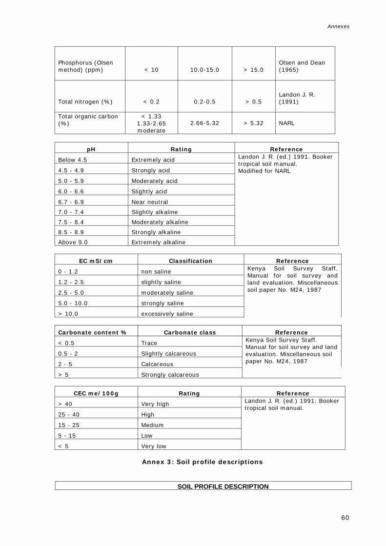
Annexes
60
Phosphorus (Olsen method) (ppm)
< 10
10.0-15.0
> 15.0
Olsen and Dean (1965)
Total nitrogen (%)
< 0.2
0.2-0.5
> 0.5
Landon J. R. (1991)
Total organic carbon (%)
< 1.33 1.33-2.65 moderate
2.66-5.32
> 5.32
NARL
pH Rating Reference
Below 4.5 Extremely acid Landon J. R. (ed.) 1991. Booker tropical soil manual. Modified for NARL
4.5 - 4.9 Strongly acid
5.0 - 5.9 Moderately acid
6.0 - 6.6 Slightly acid
6.7 - 6.9 Near neutral
7.0 - 7.4 Slightly alkaline
7.5 - 8.4 Moderately alkaline
8.5 - 8.9 Strongly alkaline
Above 9.0 Extremely alkaline
EC mS/cm Classification Reference
0 - 1.2 non saline Kenya Soil Survey Staff. Manual for soil survey and land evaluation. Miscellaneous soil paper No. M24, 1987
1.2 - 2.5 slightly saline
2.5 - 5.0 moderately saline
5.0 - 10.0 strongly saline
> 10.0 excessively saline
Carbonate content % Carbonate class Reference
< 0.5 Trace Kenya Soil Survey Staff. Manual for soil survey and land evaluation. Miscellaneous soil paper No. M24, 1987
0.5 - 2 Slightly calcareous
2 - 5 Calcareous
> 5 Strongly calcareous
CEC me/100g Rating Reference
> 40 Very high Landon J. R. (ed.) 1991. Booker tropical soil manual.
25 - 40 High
15 - 25 Medium
5 - 15 Low
< 5 Very low
Annex 3: Soil profile descriptions
ual Soil ProfiSOIL PROFILE DESCRIPTION

Annexes
61
Profile code : 20 Date : 2006-05-23 Location : Sararka Coordinates : 09º56'54" / 43º05'28" Authors : Ronald Vargas Soil climate : Aridic WRB 2006 Soil classification: Haplic Regosol (Skeletic)
Land form : Valley
Land use : Animal husbandry Drainage : Excessively Effective soil depth: 0 -25cm Moisture conditions : Dry Rock outcrops : Few Surface stoniness : Dominant UTM coordinates: 290726 - 1100306 Remarks : Profiles are impossible because this soil is dominated by stones. Usually
located in valleys surrounded by hills. Soil erodes away due to overgrazing. Rock outcrops are present. The area is used for grazing and many succulent plants are present. Mineral soil with lithic contact developed in sandstone with highly CaCO3 and metamorphic rocks. This soil type is spread through the whole area.
Horizon Depth cm Description
A 0-20 .
Plus. FAO-CSIC Multilingual S SOIL PROFILE DESCRIPTION Profile code : 21 Date : 2006-05-31 Location : Lebida Coordinates : 10º05'14" / 43º46'23"
HORIZON LOWER BOUNDARY SAND % SILT % CLAY % TEXTURE CLASS BULK DENSITY
3
C (%) N (%) P (ppm) pH EC (mS/cm) CEC (me/100g) Ca++ Mg++ K+ Na+ PSB (%) CaCO3 (%)
Profile

Annexes
62
Authors : Omar Haji Duale Soil climate : Aridic WRB 2006 Soil classification: Lithic Leptosol Land form : Hill FAO 90 classification : Land element : Slope Effective soil depth: 0 -25cm Drainage : Well Rock outcrops : Common Moisture conditions : Dry Surface stoniness : Dominant UTM coordinates: 365559 - 1115328 Remarks : This soil is found under a basement complex material in hilland. There are no
salts and the presence of rock outcrops is usual. There is a very little soil development between the rocks. The site corresponds to the shoulder of the slope.
Horizon Depth cm Description
A 0-10 .
SDBm Pll Soil Pro SOIL PROFILE DESCRIPTION Profile code : 22 Date : 2006-05-31 Location : Between Garbada and Ali Haydh Coordinates : 10º03'47" / 43º47'29" Authors : Omar Haji Duale Soil climate : Aridic WRB 2006 Soil classification: Lithic Leptosol Land form : Mountain
HORIZON LOWER BOUNDARY SAND % SILT % CLAY % TEXTURE CLASS BULK DENSITY (g/cm3) C (%) N (%) P (ppm) pH EC (mS/cm) CEC (me/100g) Ca++ Mg++ K+ Na+ PSB (%) CaCO3 (%)
Position

Annexes
63
FAO 90 classification : Land element : Slope Effective soil depth: 0 -25cm Drainage : Well Rock outcrops : Abundant Moisture conditions : Dry Surface stoniness : Dominant UTM coordinates: 367560 - 1112638. Remarks : Mountain block, ridge, upper slope. The parent material is basement complex.
with little or no soil development taking place. The specific position where the soil was described is the Backslope.
Horizon Depth cm Description
A 0-10 .
HORIZON LOWER BOUNDARY SAND % SILT % CLAY % TEXTURE CLASS BULK DENSITY (g/cm3) C (%) N (%) P (ppm) pH EC (mS/cm) CEC (me/100g) Ca++ Mg++ K+ Na+ PSB (%) CaCO3 (%)
Position
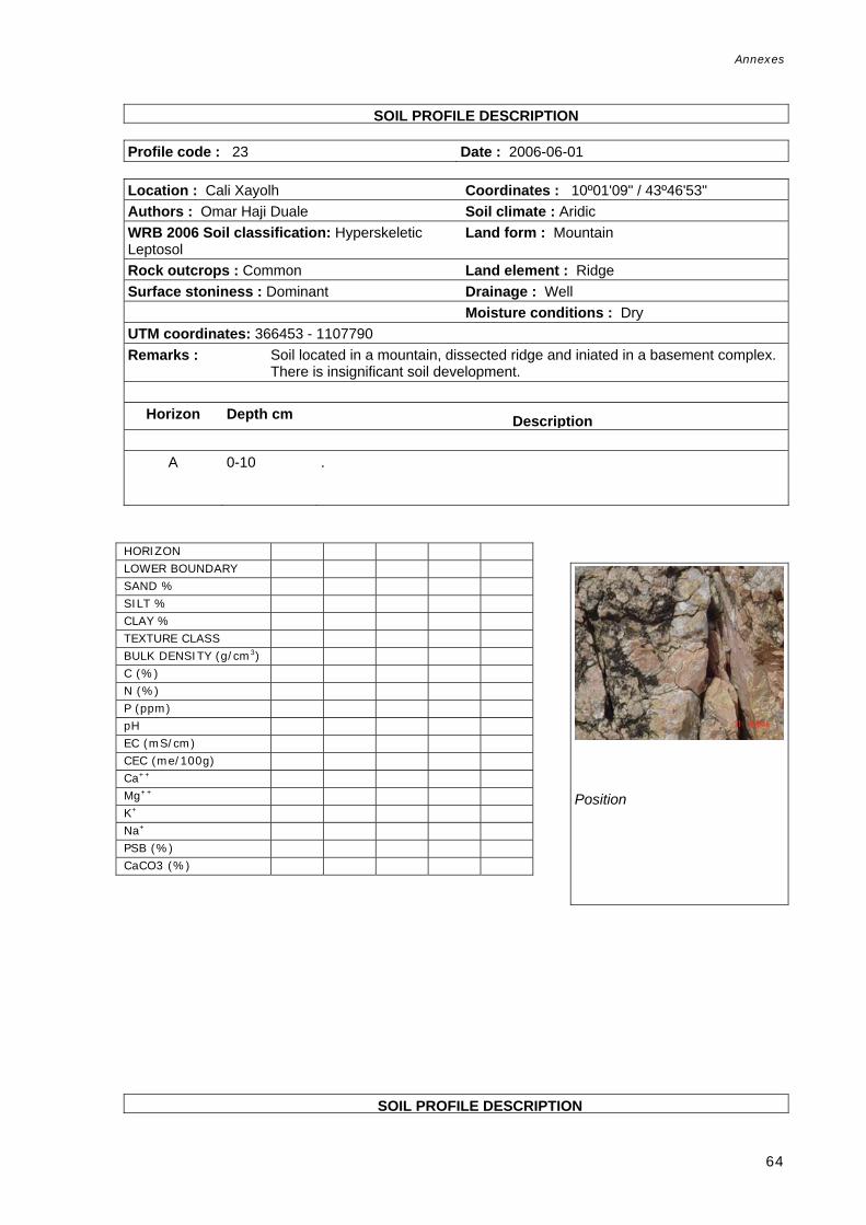
Annexes
64
l Soil Prof SOIL PROFILE DESCRIPTION Profile code : 23 Date : 2006-06-01 Location : Cali Xayolh Coordinates : 10º01'09" / 43º46'53" Authors : Omar Haji Duale Soil climate : Aridic WRB 2006 Soil classification: Hyperskeletic Leptosol
Land form : Mountain
Rock outcrops : Common Land element : Ridge Surface stoniness : Dominant Drainage : Well Moisture conditions : Dry UTM coordinates: 366453 - 1107790 Remarks : Soil located in a mountain, dissected ridge and iniated in a basement complex.
There is insignificant soil development.
Horizon Depth cm Description
A 0-10 .
m Plus. FAO-CSIC Multilingual Soi SOIL PROFILE DESCRIPTION
HORIZON LOWER BOUNDARY SAND % SILT % CLAY % TEXTURE CLASS BULK DENSITY (g/cm3) C (%) N (%) P (ppm) pH EC (mS/cm) CEC (me/100g) Ca++ Mg++ K+ Na+ PSB (%) CaCO3 (%)
Position

Annexes
65
Profile code : 24 Date : 2006-06-04 Location : Hadha Godan Coordinates : 10º15'57" / 43º13'56" Authors : Musse Shaie Soil climate : Aridic WRB 2006 Soil classification: Hyperskeletic Leptosol
Land form : Hill
Effective soil depth: 0 -25cm Drainage : Excessively Rock outcrops : Common Moisture conditions : Dry Surface stoniness : Dominant UTM coordinates: 306412 - 1135355 Remarks : No soil at the site, plenty of large boulders, but small quantities of soil can be
found in spaces between the rocks. The lithology consists of limestone in a hill/ridge.
Horizon Depth cm Description
R 0-50 .
m Plus. FAO-CSIC Multilingual Soil Prof SOIL PROFILE DESCRIPTION Profile code : 25 Date : 2006-06-05
Position
HORIZON LOWER BOUNDARY SAND % SILT % CLAY % TEXTURE CLASS BULK DENSITY (g/cm3) C (%) N (%) P (ppm) pH EC (mS/cm) CEC (me/100g) Ca++ Mg++ K+ Na+ PSB (%) CaCO3 (%)

Annexes
66
Location : Near Qohyeed Coordinates : 12º48'32" / 43º00'11" Authors : Omar Haji Duale Soil climate : Aridic WRB 2006Soil Classification: Hyperskeletic Leptosol
Land form : Hill
Effective soil depth: 0 -25cm Land element : Ridge Rock outcrops : Common Drainage : Well Surface stoniness : Dominant Moisture conditions : Dry UTM coordinates: 283245 - 1416868 Remarks : Lithology is sandstone, and the site is located in the shoulder. Very little soil
development, partly as a result of soil erosion due to overgrazing.
Horizon Depth cm Description
A 0-10 .
Bm Plus. FAO-CSIC Multilingual Soil Pro SOIL PROFILE DESCRIPTION Profile code : 26 Date : 2006-06-05 Location : Near Bown Coordinates : 10º11'17" / 43º04'58" Authors : Omar Haji Duale Soil climate : Aridic WRB 2006 Soil classification: Haplic Regosol (Skeletic)
Land form : Pediment
Position
HORIZON LOWER BOUNDARY SAND % SILT % CLAY % TEXTURE CLASS BULK DENSITY (g/cm3) C (%) N (%) P (ppm) pH EC (mS/cm) CEC (me/100g) Ca++ Mg++ K+ Na+ PSB (%) CaCO3 (%)

Annexes
67
Land use : Not used and not managed Land element : Slope Effective soil depth: 0 -25cm Drainage : Well Rock outcrops : Very few Moisture conditions : Dry Surface stoniness : Dominant Vegetation : Xeromorphic shrub UTM coordinates: 289966 - 1126847 Remarks : This is a slightly-developed soil located in a Piedmont/Planation surface.
Grazing is the land use.
Horizon Depth cm Description
A 0-12 .
HORIZON
LOWER BOUNDARY SAND % SILT % CLAY % TEXTURE CLASS BULK DENSITY (g/cm3) C (%) N (%) P (ppm) pH EC (mS/cm) CEC (me/100g) Ca++ Mg++ K+ Na+ PSB (%) CaCO3 (%)
Position

Annexes
68
ingual Soil SOIL PROFILE DESCRIPTION Profile code : 27 Date : 2006-06-11 Location : Xeego Coordinates : 10º04'35" / 43º16'03" Authors : Omar Haji Duale Soil climate : Aridic WRB2006 Soil classification: Hyperskeletic Leptosol
Land form : Pediment
Effective soil depth: 0 -25cm Drainage : Well Surface stoniness : Dominant Moisture conditions : Dry UTM coordinates: 310171 – 1114385 Remarks : Very little soil development, in a Piedmont/pediment. Boulders and stones are
present.
Horizon Depth cm Description
R 0-10 .
HORIZON LOWER BOUNDARY SAND % SILT % CLAY % TEXTURE CLASS BULK DENSITY (g/cm3) C (%) N (%) P (ppm) pH EC (mS/cm) CEC (me/100g) Ca++ Mg++ K+ Na+ PSB (%) CaCO3 (%)
Position

Annexes
69
Plus. FAO-CSIC Multilingual So SOIL PROFILE DESCRIPTION Profile code : 28 Date : 2006-06-11 Location : Xeego Coordinates : 10º04'39" / 43º16'15" Authors : Omar Haji Duale Soil climate : Aridic WRB 2006 Soil Classification: Hyperskeletic Leptosol
Land form : Pediment
Effective soil depth: 0 -25cm Drainage : Well Rock outcrops : Many Moisture conditions : Dry Surface stoniness : Abundant UTM coordinates: 310527 - 114503 Remarks : Soil with no development located in a Piedmont, pediment.
Horizon Depth cm Description
R 0-10 .
HORIZON LOWER BOUNDARY SAND % SILT % CLAY % TEXTURE CLASS BULK DENSITY (g/cm3) C (%) N (%) P (ppm) pH EC (mS/cm) CEC (me/100g) Ca++ Mg++ K+ Na+ PSB (%) CaCO3 (%)
Position

Annexes
70
DBm Plus. FAO-CSIC Multili SOIL PROFILE DESCRIPTION Profile code : 29 Date : 2006-06-14 Location : Dudwayne Coordinates : 09º44'51" / 43º21'52" Authors : Omar Haji Duale Soil climate : Aridic WRB 2006 Soil Classification: Hyperskeletic Lithic Leptosol (Calcaric)
Land form : Plateau
Effective soil depth: 0 -25cm Drainage : Excessively Surface stoniness : Many Moisture conditions : Dry UTM coordinates: 320610 - 1077927 Remarks : Little soil developement, in a plateau/hill complex under limestone.
Horizon Depth cm Description
A 0-25 .
Bm Plus. FAO-CSIC Multilingual Soil SOIL PROFILE DESCRIPTION Profile Database
Profile code : 30 Date : 2006-06-01 Location : Xiriiro, west of Ali Xayah Coordinates : 10º01'28" / 43º42'51" Authors : Musse Shaie Soil climate : Aridic WRB 2006 Soil Classification: Hyperskeletic Leptosol
Land form : Hill
Effective soil depth: 0 -25cm Drainage : Excessively Surface stoniness : Common Moisture conditions : Dry UTM coordinates: 359084 - 1108407 Remarks : Stony soil located in a Hilland/hill complex. No soil development is present.
HORIZON LOWER BOUNDARY SAND % SILT % CLAY % TEXTURE CLASS BULK DENSITY (g/cm3) C (%) N (%) P (ppm) pH EC (mS/cm) CEC (me/100g) Ca++ Mg++ K+ Na+ PSB (%) CaCO3 (%)
Position

Annexes
71
Horizon Depth cm Description
A 0-10 .
HORIZON LOWER BOUNDARY SAND % SILT % CLAY % TEXTURE CLASS BULK DENSITY (g/cm3) C (%) N (%) P (ppm) pH EC (mS/cm) CEC (me/100g) Ca++ Mg++ K+ Na+ PSB (%) CaCO3 (%)
Position

Annexes
72
CSIC Multilingual Soil SOIL PROFILE DESCRIPTION Profile code : 31 Date : 2006-06-06 Location : Carra Garanug Coordinates : 09º57'52" / 43º09'02" Authors : Omar Haji Duale Soil climate : Aridic WRB 2006 Soil classification: Hyperskeletic Leptosol
Land form : Pediment
Surface stoniness : Dominant Drainage : Well Moisture conditions : Dry UTM coordinates: 297269 - 1102062. Remarks : Gravelly surface located in a Piedmont/Pediment, denudational surface.
Horizon Depth cm Description
R 0-10 .
Position
HORIZON LOWER BOUNDARY SAND % SILT % CLAY % TEXTURE CLASS BULK DENSITY (g/cm3) C (%) N (%) P (ppm) pH EC (mS/cm) CEC (me/100g) Ca++ Mg++ K+ Na+ PSB (%) CaCO3 (%)

Annexes
73
Bm Plus. FAO-CSIC Multilingual S SOIL PROFILE DESCRIPTION Profile code : 32 Date : 2006-06-06 Location : Fulunful Coordinates : 09º59'36" / 43º07'53" Authors : Omar Haji Duale Soil climate : Aridic WRB 2006 Soil Classification: Haplic Leptosol (Skeletic)
Land form : Mountain
Surface stoniness : Abundant Drainage : Well Moisture conditions : Dry UTM coordinates: 295187 - 1105258 Remarks : Located in a mountain/dissected ridge.
Horizon Depth cm Description
R 0-10 .
HORIZON LOWER BOUNDARY SAND % SILT % CLAY % TEXTURE CLASS BULK DENSITY (g/cm3) C (%) N (%) P (ppm) pH EC (mS/cm) CEC (me/100g) Ca++ Mg++ K+ Na+ PSB (%) CaCO3 (%)
Position

Annexes
74
FAO-CSIC Multilingual S SOIL PROFILE DESCRIPTION Profile code : 33 Date : 2006-05-20 Location : Toon-maadhyaal Coordinates : 09º21'02" / 44º10'14" Authors : Ronald Vargas Land form : Plateau WRB 2006 Soil classification: Hyperskeletic Leptosol
Land element : Slope
Effective soil depth: 0 -25cm Drainage : Excessively Rock outcrops : Common Moisture conditions : Dry Surface stoniness : Dominant UTM coordinates: 408925 - 1033739 Remarks : This profile is located in the denudational surface of the plateau. The entire
profile is full of stones and very little soil can be found down to 20 cm. There is evidence of soil erosion. Is a shoat grazing area.
Horizon Depth cm Description
A 0-15 .
HORIZON LOWER BOUNDARY SAND % SILT % CLAY % TEXTURE CLASS BULK DENSITY (g/cm3) C (%) N (%) P (ppm) pH EC (mS/cm) CEC (me/100g) Ca++ Mg++ K+ Na+ PSB (%) CaCO3 (%)
Profile

Annexes
75
SOIL PROFILE DESCRIPTION
Profile code : 34 Date : 2006-07-13 Location : Galnidhiqeed Coordinates : 09º59'53" / 44º00'37" Authors : Musse Shaie Soil climate : Aridic WRB 2006 Soil Classification: Hyperskeletic Lithic Leptosol
Land form : Plateau
Effective soil depth: 0 -25cm Drainage : Excessively Rock outcrops : Dominant Moisture conditions : Dry Surface stoniness : Dominant UTM coordinates: 391524 - 1105374 Remarks : No soil profile development, the parent material is mica and schist located in a
Dissected Plateau/Pediment. Rocky soil.
Horizon Depth cm Description
R 0-10 .
SDBm O-CSIC Multilingual So SOIL PROFILE DESCRIPTION
HORIZON LOWER BOUNDARY SAND % SILT % CLAY % TEXTURE CLASS BULK DENSITY (g/cm3) C (%) N (%) P (ppm) pH EC (mS/cm) CEC (me/100g) Ca++ Mg++ K+ Na+ PSB (%) CaCO3 (%)
Position

Annexes
76
Profile code : 35 Date : 2006-07-12 Location : Illinta Qoryale Coordinates : 09º57'55" / 44º01'36" Authors : Musse Shaie Soil climate : Aridic WRB 2006 Soil Classification: Hyperskeletic Leptosol
Land form : Plateau
Effective soil depth: 0 -25cm Drainage : Excessively Surface stoniness : Dominant Moisture conditions : Dry UTM coordinates: 393304 - 1101743 Remarks : Dissected plateau/hill complex. The parent material of this undeveloped soil is
conglomerate. No cracks or salts are present.
Horizon Depth cm Description
A 0-10 .
SDBm Plus. FAO-CSIC Multilingua SOIL PROFILE DESCRIPTION
HORIZON LOWER BOUNDARY SAND % SILT % CLAY % TEXTURE CLASS BULK DENSITY (g/cm3) C (%) N (%) P (ppm) pH EC (mS/cm) CEC (me/100g) Ca++ Mg++ K+ Na+ PSB (%) CaCO3 (%)
Profile

Annexes
77
Profile code : 36 Date : 2006-07-14 Location : Gacan Waashay Coordinates : 10º02'14" / 44º06'22" Authors : Musse Shaie Soil climate : Aridic WRB 2006 Soil Classification: Haplic Regosol (Skeletic)
Land form : Plateau
Rock outcrops : Few Drainage : Excessively Surface stoniness : Dominant Moisture conditions : Dry UTM coordinates: 402059 - 1109679 Remarks : Dissected plateau/Pediment, marginal grazing land. Soil observation located in
a toeslope formed by basalt.
Horizon Depth cm Description
A 0-10 .
SDBm Plus. FAO-CSIC Multilingua SOIL PROFILE DESCRIPTION Profile code : 37 Date : 2006-07-16 Location : Diingal Coordinates : 09º41'51" / 44º21'50" Authors : Musse Shaie Soil climate : Aridic
HORIZON LOWER BOUNDARY SAND % SILT % CLAY % TEXTURE CLASS BULK DENSITY (g/cm3) C (%) N (%) P (ppm) pH EC (mS/cm) CEC (me/100g) Ca++ Mg++ K+ Na+ PSB (%) CaCO3 (%)
Position

Annexes
78
WRB 2006 Soil Classification: Hyperskeletic Leptosol
Land form : Pediment
Effective soil depth: 0 -25cm Land element : Ridge Surface stoniness : Dominant Drainage : Excessively Moisture conditions : Dry UTM coordinates: 430232 - 1072033 Remarks : Stony soil with no profile under sandstone. Located in a Piedmont/Badland.
Horizon Depth cm Description
A 0-10 .
HORIZON LOWER BOUNDARY SAND % SILT % CLAY % TEXTURE CLASS BULK DENSITY (g/cm3) C (%) N (%) P (ppm) pH EC (mS/cm) CEC (me/100g) Ca++ Mg++ K+ Na+ PSB (%) CaCO3 (%)
Position

Annexes
79
us. FAO-CSIC Multilingu SOIL PROFILE DESCRIPTION Profile code : 38 Date : 2006-07-12 Location : East Agabar Coordinates : 09º52'34" / 43º58'41" Authors : Ali Ibrahim Ismail, Omar Haji Duale Soil climate : Aridic WRB 2006 Soil Classification: Hyperskeletic Leptosol
Land form : Pediment
Effective soil depth: 0 -25cm Drainage : Well Rock outcrops : Few Moisture conditions : Dry Surface stoniness : Dominant UTM coordinates: 387949 - 1091887 Remarks : Undeveloped soil located in a Piedmont/denudational surface under tuff parent
rock. No samples.
Horizon Depth cm Description
A 0-10 .
HORIZON LOWER BOUNDARY SAND % SILT % CLAY % TEXTURE CLASS BULK DENSITY (g/cm3) C (%) N (%) P (ppm) pH EC (mS/cm) CEC (me/100g) Ca++ Mg++ K+ Na+ PSB (%) CaCO3 (%)
Position

Annexes
80
SIC Multilingual Soil P SOIL PROFILE DESCRIPTION Profile code : 39 Date : 2006-07-13 Location : Agabar Coordinates : 09º56'03" / 43º54'49" Authors : Omar Haji Duale, Ali Ibrahim Ismail Soil climate : Aridic WRB 2006 Soil Classification: Hyperskeletic Leptosol
Land form : Pediment
Effective soil depth: 0 -25cm Drainage : Excessively Rock outcrops : Few Moisture conditions : Dry Surface stoniness : Dominant UTM coordinates: 380900 - 1098346 Remarks : Undeveloped soil under complex parent material composed of sandstones
located in a piedmont/dissected ridge.
Horizon Depth cm Description
A 0-10 .
HORIZON LOWER BOUNDARY SAND % SILT % CLAY % TEXTURE CLASS BULK DENSITY (g/cm3) C (%) N (%) P (ppm) pH EC (mS/cm) CEC (me/100g) Ca++ Mg++ K+ Na+ PSB (%) CaCO3 (%)
Position

Annexes
81
SDBm Plus. FAO-CSIC Multilingua SOIL PROFILE DESCRIPTION Profile code : 40 Date : 2006-07-13 Location : North of Agabar Coordinates : 10º02'24" / 43º54'21" Authors : Ali Ibrahim Ismail, Omar Haji Duale Soil climate : Aridic WRB 2006 Soil Classification: Haplic Regosol (Skeletic)
Land form : Mountain
Effective soil depth: 0 -25cm Land element : Ridge Surface stoniness : Dominant Drainage : Excessively Moisture conditions : Dry UTM coordinates: 380109 - 1110031 Remarks : Very little-developed soil located in a Mountain/Dissected ridge under a
complex parent material.
Horizon Depth cm Description
A 0-10 .
Position
HORIZON LOWER BOUNDARY SAND % SILT % CLAY % TEXTURE CLASS BULK DENSITY (g/cm3) C (%) N (%) P (ppm) pH EC (mS/cm) CEC (me/100g) Ca++ Mg++ K+ Na+ PSB (%) CaCO3 (%)

Annexes
82
DBm Plus. FAO-CSIC Multilingual Soil Prof SOIL PROFILE DESCRIPTION e Database
Profile code : 41 Date : 2006-07-13 Location : North of Dirato Coordinates : 09º48'09" / 44º01'01" Authors : Omar Haji Duale, Ali Ibrahim Ismail Soil climate : Aridic WRB 2006 Soil Classification: Haplic Regosol (Skeletic)
Land form : Pediment
Effective soil depth: 0 -25cm Drainage : Excessively Rock outcrops : Few Moisture conditions : Dry Surface stoniness : Abundant UTM coordinates: 392178 - 1083747 Remarks : This soil observation is located in a Piedmont/Denudational surface under
limestone and granite parent material.
Horizon Depth cm Description
A 0-10 .
m Plus. FAO-CSIC Multilingual So SOIL PROFILE DESCRIPTION
Position
HORIZON LOWER BOUNDARY SAND % SILT % CLAY % TEXTURE CLASS BULK DENSITY (g/cm3) C (%) N (%) P (ppm) pH EC (mS/cm) CEC (me/100g) Ca++ Mg++ K+ Na+ PSB (%) CaCO3 (%)

Annexes
83
Profile code : 42 Date : 2006-07-14 Location : North of Illinta Dhexe Coordinates : 10º01'22" / 44º07'43" Authors : Omar Haji Duale, Ali Ibrahim Ismail Soil climate : Aridic WRB 2006 Soil Classification: Hyperskeletic Leptosol
Land form : Plateau
Effective soil depth: 0 -25cm Drainage : Excessively Rock outcrops : Nil Moisture conditions : Dry Surface stoniness : Dominant UTM coordinates: 404513 - 1108059 Remarks : Soil observation located in a Dissected plateau/Pediment under sandstone
parent rock.
Horizon Depth cm Description
A 0-10 .
-CSIC Multilingual So SOIL PROFILE DESCRIPTION
HORIZON LOWER BOUNDARY SAND % SILT % CLAY % TEXTURE CLASS BULK DENSITY (g/cm3) C (%) N (%) P (ppm) pH EC (mS/cm) CEC (me/100g) Ca++ Mg++ K+ Na+ PSB (%) CaCO3 (%)
Profile

Annexes
84
Profile code : 43 Date : 2006-07-17 Location : North of Cunagabad Coordinates : 09º27'14" / 44º00'39" Authors : Omar Haji Duale, Musse Shaie Soil climate : Aridic WRB 2006 Soil Classification: Haplic Regosol (Skeletic)
Land form : Plateau
Effective soil depth: 0 -25cm Drainage : Excessively Rock outcrops : Few Moisture conditions : Dry Surface stoniness : Common UTM coordinates: 391422 - 1045205 Remarks : Soil observation located in a Dissected plateau/denudational surface under
limestone.
Horizon Depth cm Description
A 0-10 .
Multilingual Soil Pr of SOIL PROFILE DESCRIPTION
Position
HORIZON LOWER BOUNDARY SAND % SILT % CLAY % TEXTURE CLASS BULK DENSITY (g/cm3) C (%) N (%) P (ppm) pH EC (mS/cm) CEC (me/100g) Ca++ Mg++ K+ Na+ PSB (%) CaCO3 (%)

Annexes
85
Profile code : 44 Date : 2006-07-17 Location : South of Hargeisa Coordinates : 09º28'46" / 44º01'06" Authors : Omar Haji Duale, Musse Shaie Soil climate : Aridic WRB 2006 Soil Classification: Haplic Regosol (Skeletic)
Land form : Plateau
Effective soil depth: 0 -25cm Drainage : Well Rock outcrops : Common Moisture conditions : Dry Surface stoniness : Many UTM coordinates: 392237 - 1048008 Remarks : Soil observation located in a Plateau/mesa under limestone parent rock.
Horizon Depth cm Description
R 0-50 .
SDBm Plus. FAO-CSIC Multili Soil Profil SOIL PROFILE DESCRIPTION Profile code : 45 Date : 2006-07-17 Location : South of Canagabad Coordinates : 09º23'06" / 43º58'54" Authors : Omar Haji Duale, Musse Shaie Soil climate : Aridic
HORIZON LOWER BOUNDARY SAND % SILT % CLAY % TEXTURE CLASS BULK DENSITY (g/cm3) C (%) N (%) P (ppm) pH EC (mS/cm) CEC (me/100g) Ca++ Mg++ K+ Na+ PSB (%) CaCO3 (%)
Profile

Annexes
86
WRB 2006 Soil Classification: Haplic Regosol (Skeletic)
Land form : Plateau
Effective soil depth: 0 -25cm Drainage : Well Rock outcrops : Few Moisture conditions : Dry Surface stoniness : Many UTM coordinates: 388196 - 1037591 Remarks : Soil observation located in a Dissected plateau/denudational surface under
limestone.
Horizon Depth cm Description
A 0-20 .
Plus. FAO-CSIC Multilingual Soil Profi SOIL PROFILE DESCRIPTION Profile code : 46 Date : 2006-07-16 Location : Sharmaarke Coordinates : 09º23'53" / 44º12'43" Authors : Ali Ibrahim Ismail Soil climate : Aridic WRB 2006 Soil Classification: Hyperskeletic Leptosol
Land form : Plateau
Effective soil depth: 0 -25cm Drainage : Well
Position
HORIZON LOWER BOUNDARY SAND % SILT % CLAY % TEXTURE CLASS BULK DENSITY (g/cm3) C (%) N (%) P (ppm) pH EC (mS/cm) CEC (me/100g) Ca++ Mg++ K+ Na+ PSB (%) CaCO3 (%)

Annexes
87
Rock outcrops : Few Moisture conditions : Dry Surface stoniness : Dominant UTM coordinates: 413469 - 1038976 Remarks : Soil observation located in a Dissected plateau/Denudational surface under
limestone parent rock.
Horizon Depth cm Description
A 0-20 .
HORIZON LOWER BOUNDARY SAND % SILT % CLAY % TEXTURE CLASS BULK DENSITY (g/cm3) C (%) N (%) P (ppm) pH EC (mS/cm) CEC (me/100g) Ca++ Mg++ K+ Na+ PSB (%) CaCO3 (%)
Position

Annexes
88
Plus. FAO-CSIC Multilingual Soil Pro SOIL PROFILE DESCRIPTION Profile code : 47 Date : 2006-07-17 Location : Fahda Coordinates : 09º28'47" / 43º53'31" Authors : Musse Shaie Soil climate : Aridic WRB 2006 Soil Classification: Haplic Regosol (Skeletic).
Land form : Plateau
Rock outcrops : Few Drainage : Excessively Surface stoniness : Many Moisture conditions : Dry UTM coordinates: 378378 - 1048095 Remarks : Soil observation located in a limestone parent rock in a Dissected
plateau/Denudational surface.
Horizon Depth cm Description
A 0-10 .
AO-CSIC Multilingual Soil SOIL PROFILE DESCRIPTION
Profile
HORIZON LOWER BOUNDARY SAND % SILT % CLAY % TEXTURE CLASS BULK DENSITY (g/cm3) C (%) N (%) P (ppm) pH EC (mS/cm) CEC (me/100g) Ca++ Mg++ K+ Na+ PSB (%) CaCO3 (%)

Annexes
89
Profile code : 48 Date : 2006-07-17 Location : Garyogol Coordinates : 09º29'13" / 43º52'03" Authors : Musse Shaie Soil climate : Aridic WRB 2006 Soil Classification: Lithic Leptosol (Calcaric).
Land form : Plateau
Effective soil depth: 0 -25cm: Drainage : Excessively Rock outcrops : Common Moisture conditions : Dry Surface stoniness : Dominant UTM coordinates: 375690-1048891 Remarks : Soil observation located in a Dissected plateau/Denudational surface in a
limestone parent rock.
Horizon Depth cm Description
R 0-20 .
ngual Soil Pr SOIL PROFILE DESCRIPTION Profile code : 49 Date : 2006-07-17 Location : Harcadaad Coordinates : 09º31'44" / 43º46'35"
Profile
HORIZON LOWER BOUNDARY SAND % SILT % CLAY % TEXTURE CLASS BULK DENSITY (g/cm3) C (%) N (%) P (ppm) pH EC (mS/cm) CEC (me/100g) Ca++ Mg++ K+ Na+ PSB (%) CaCO3 (%)

Annexes
90
Authors : Musse Shaie Soil climate : Aridic WRB 2006 Soil Classification: Lithic Leptosol (Calcaric).
Land form : Plateau
Effective soil depth: 0 -25cm Drainage : Excessively Rock outcrops : Many Moisture conditions : Dry Surface stoniness : Dominant UTM coordinates: 365711 - 1053553 Remarks : Soil observation located in a Dissected plateau/Hill under limestone.
Horizon Depth cm Description
R 0-20 .
Profile code : 50 Date : 2006-07-17 Location : Xidhinta Coordinates : 09º32'54" / 43º43'30" Authors : Musse Shaie Soil climate : Aridic WRB 2006 Soil classification: Lithic Leptosol (Calcaric).
Land form : Plateau
Effective soil depth: 0 -25cm Drainage : Excessively Rock outcrops : Many Moisture conditions : Dry Surface stoniness : Dominant UTM coordinates: 360073 - 1055724
Profile
HORIZON LOWER BOUNDARY SAND % SILT % CLAY % TEXTURE CLASS BULK DENSITY (g/cm3) C (%) N (%) P (ppm) pH EC (mS/cm) CEC (me/100g) Ca++ Mg++ K+ Na+ PSB (%) CaCO3 (%)
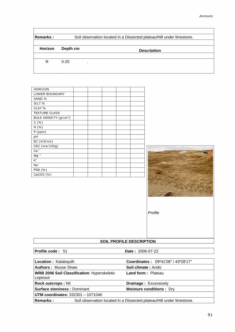
Annexes
91
Remarks : Soil observation located in a Dissected plateau/Hill under limestone.
Horizon Depth cm Description
R 0-20 .
tilingual Soil Profi SOIL PROFILE DESCRIPTION Profile code : 51 Date : 2006-07-22 Location : Kalabaydh Coordinates : 09º41'08" / 43º28'17" Authors : Musse Shaie Soil climate : Aridic WRB 2006 Soil Classification: Hyperskeletic Leptosol
Land form : Plateau
Rock outcrops : Nil Drainage : Excessively Surface stoniness : Dominant Moisture conditions : Dry UTM coordinates: 332301 – 1071046 Remarks : Soil observation located in a Dissected plateau/Hill under limestone.
Profile
HORIZON LOWER BOUNDARY SAND % SILT % CLAY % TEXTURE CLASS BULK DENSITY (g/cm3) C (%) N (%) P (ppm) pH EC (mS/cm) CEC (me/100g) Ca++ Mg++ K+ Na+ PSB (%) CaCO3 (%)

Annexes
92
Horizon Depth cm Description
A 0-10 .
Profile
HORIZON LOWER BOUNDARY SAND % SILT % CLAY % TEXTURE CLASS BULK DENSITY (g/cm3) C (%) N (%) P (ppm) pH EC (mS/cm) CEC (me/100g) Ca++ Mg++ K+ Na+ PSB (%) CaCO3 (%)

Annexes
93
SOIL PROFILE DESCRIPTION Profile code : 101 Date : 2006-05-19 Location : Toon-maadh Yaal Coordinates : 09º21'47" / 44º10'30" Authors : Omar Haji Duale, Ronald Vargas, Ali Ibrahim Ismail
Soil climate : Aridic
WRB 2006 Soil Classification: Haplic Vertisol (Calcaric, Chromic).
Land use : Mixed farming Land form : Valley Parent material : Alluvium Effective soil depth: 100-150cm Drainage : Moderately well Rock outcrops : Nil Moisture conditions : Moist Surface stoniness : Nil UTM coordinates: 409401 - 1035093
Remarks : The area is covered by sinkholes and cracks.
Horizon Depth cm Description
A1
0-35
Reddish brown (5YR 4/4) (moist); no mottles; clay; moderate medium subangular blocky structure; no cutans; many Voids fine; no rocks; strongly calcareous; few biological activity; common fine roots; Field pH: 8.2; clear smooth boundary.
A2
35-65
Dark reddish brown (5YR 3/4) (moist); no mottles; clay; weak medium subangular blocky structure; no cutans; medium porosity, many Voids fine; no rocks; strongly calcareous; few biological activity; very few very fine roots; Field pH: 8.4; gradual smooth boundary.
Bt
65-130
Reddish brown (5YR 4/4); no mottles ; clay; weak coarse subangular blocky structure; common pressure faces; low porosity, very few Voids very coarse; no rocks; strongly calcareous; few biological activity; very few very fine roots; Field pH: 8.7.
P SOIL PROFILE DESCRIPTION
Profile
HORIZON A1 A2 Bt
LOWER BOUNDARY 35 65 130
SAND % 28.0 24.0 24.0
SILT % 14.0 16.0 14.0
CLAY % 58.0 60.0 62.0
TEXTURE CLASS C C C
BULK DENSITY (g/cm3) 1.26 1.26 1.26
C (%) 0.60 0.50 0.30
N (%) 0.03 0.03 0.03
P (ppm) 8.90 35.50 11.50
pH 8.20 8.40 8.70
EC (mS/cm) 0.22 0.20 0.25
CEC (me/100g) 14.80 11.80 0.30
Ca++ 24.6 18.8 17.3
Mg++ 1.6 0.3 0.3
K+ 1.4 1.1 0.8
Na+ 2 1 2
PSB (%) 100.0 100.0 100.0
CaCO3 (%) 28.00
30.00
31.00

Annexes
94
Profile code : 102 Date : 2006-05-20 Location : Toon-maadhyaal Coordinates : 09º21'21" / 44º10'27" Authors : Omar Haji Duale, Musse Shaie, Ali Ibrahim Ismail
Land form : Valley
WRB2006 Soil Classification: Calcic Vertisol (Chromic)
Land element : Slope
Land use : Shifting cultivation Drainage : Well Effective soil depth: 100-150cm Moisture conditions : Dry Surface stoniness : Nil Vegetation : Grassland UTM coordinates: 409341 - 1034321 Remarks : Very hard soil located at the talus slope of a valley, very close to profile 201.
Soil is clayed but is very compacted and dry, so, many properties were difficult to see. Although the soil texture is clay, there is no evidence of cracks. Gilgai microtopography was found.
Horizon Depth cm Description
A1 0-20 Dark brown (7.5YR 4/4) (dry); no mottles; clay; weak very fine granular structure; no cutans; many Voids fine; no rocks; extremely calcareous; common fine-medium roots; gradual smooth boundary.
A2 20-30 Reddish brown (5YR 4/4) (dry); no mottles; clay; moderate medium granular structure; no cutans; few Voids fine; no rocks; extremely calcareous; common fine roots; gradual smooth boundary.
B1 30-50 Dark reddish brown (5YR 3/3) (dry); no mottles; clay; moderate medium subangular blocky structure; many pressure faces; very few, very fine Voids; no rocks; extremely calcareous; common very fine roots; gradual smooth boundary.
B2 50-65 Brown (7.5YR 4/3) (dry); no mottles; clay; moderate medium angular blocky structure; many pressure faces; no voids; no rocks; extremely calcareous; common very fine roots; gradual smooth boundary.
C 65-130 Brown (7.5YR 4/3) (dry); no mottles; clay; massive structure; no cutans; no voids; no rocks; extremely calcareous; very few very fine roots.
HORIZON A1 A2 B1 B2 C LOWER BOUNDARY 20 30 50 65 130 SAND % 38.0 24.0 24.0 20.0 22.0 SILT % 16.0 20.0 20.0 22.0 20.0 CLAY % 46.0 56.0 56.0 58.0 58.0 TEXTURE CLASS C C C C C BULK DENSITY (g/cm3) 1.46 1.46 1.46 1.46 1.46 C (%) 0.70 0.50 0.70 0.40 0.40 N (%) 0.05 0.04 0.03 0.03 0.03 P (ppm) 2.60 8.50 14.10 12.80 10.80pH 8.30 8.10 8.20 8.20 8.20 EC (mS/cm) 0.23 0.98 1.30 1.50 2.20 CEC (me/100g) 16.20 17.80 17.60 17.60 16.60Ca++ 22.5 25.8 24.1 15 19.4 Mg++ 2.2 2.6 4.4 3.1 4.4 K+ 1.9 1.2 1.2 0.7 0.52 Na+ 2 2 3 3 3 PSB (%) 100.0 100.0 100.0 100.0 100.0CaCO3 (%) 30.00 31.00 30.00 24.00 28.00
Profile

Annexes
95
ual SOIL PROFILE DESCRIPTION Profile code : 103 Date : 2006-05-23 Location : Caloolane Coordinates : 10º33'51" / 44º04'26" Authors : Musse Shaie, Omar Haji Duale, Ali Ibrahim Ismail
Land form : Coastal plain
WRB 20006 Soil Classification: Calcic Endosalic Fluvisol (Aridic, Siltic)
Drainage : Well
Land use : Animal husbandry Moisture conditions : Dry Effective soil depth: 100-150cm Vegetation : Xeromorphic forest Rock outcrops : NilSurface stoniness : Nil UTM coordinates: 398704 - 1167944 Remarks : Floodingis frequent. Presence of surface sealing and crusting. This profile is
located in the northern coastal plain, delta. Dried Xudhur sp. is common. Toward the coast there are many well established Prosopsis sp.
Horizon Depth cm Description
A1 0-40 Pale brown (10YR 6/3) (dry); no mottles; silty clayloam; weak fine and medium
platy structure; no cutans; no voids; no rocks; extremely calcareous; no roots; clear wavy boundary.
E 40-60 Light grey (2.5Y 7/2) (dry); no mottles; siltloam; massive structure; no cutans; no voids; no rocks; extremely calcareous; no roots; clear smooth boundary.
B1 60-90 Light olive brown (2.5Y 5/3) (dry); no mottles; siltloam; strong medium angular blocky structure; no cutans; no voids; no rocks; extremely calcareous; no roots; clear smooth boundary.
B2 90-110 Pale brown (10YR 6/3) (dry); no mottles; siltloam; massive structure; no cutans; no voids; no rocks; extremely calcareous; no roots; clear wavy boundary.
C1 110-120 Brown (10YR 5/3) (moist); no mottles; silty clay; massive structure; no cutans; no voids; no rocks; extremely calcareous; no roots.
Profile
HORIZON A1 E B1 B2 C1 LOWER BOUNDARY 40 60 90 110 120 SAND % 10.0 12.0 16.0 22.0 12.0 SILT % 52.0 74.0 60.0 64.0 46.0 CLAY % 38.0 14.0 24.0 14.0 42.0 TEXTURE CLASS SICL SIL SIL SIL SICL BULK DENSITY (g/cm3) 1.35 1.35 1.35 1.35 1.35 C (%) 0.50 0.40 0.70 0.20 0.40 N (%) 0.04 0.05 0.11 0.02 0.04 P (ppm) 14.20 8.60 4.30 11.30 8.80 pH 8.30 7.90 7.70 8.20 7.90 EC (mS/cm) 1.30 4.07 8.91 3.73 10.60CEC (me/100g) 15.60 7.40 21.10 6.30 14.00Ca++ 19.5 28.1 24.3 14.3 17.5 Mg++ 1.7 2.9 0.4 1.6 3.1 K+ 0.3 0.3 0.8 0.2 0.3 Na+ 2 2 7 2 11 PSB (%) 100.0 100.0 100.0 100.0 100.0CaCO3 (%) 23.00 23.00 22.00 22.00 23.00

Annexes
96
SOIL PROFILE DESCRIPTION SDBm Plus. FAO-CSIC
Profile code : 104 Date : 2006-05-24 Location : Beeyo Macaan Coordinates : 10º37'41" / 44º01'25" Authors : Omar Haji Duale, Ali Ibrahim, Ismail Musse Shaie
Soil climate : Aridic aridic
WRB 2006 Soil Classification: Haplic Arenosol (Calcaric, Aridic).
Land form : Coastal plain
Effective soil depth: 100-150cm Drainage : Well Rock outcrops : Nil Moisture conditions : Dry Surface stoniness : Nil UTM coordinates: 393211 - 1175039 Remarks : This profile is located in the northwest coastal plain, on the sandy coast of
Somalia. Grazing is the only land use present. No flooding hazard.
Horizon Depth cm Description
A1 0-25 Pale brown (10YR 6/3) (dry); no mottles; loamy sand; massive structure; no
cutans; no voids; no rocks; extremely calcareous; many very fine roots; clear wavy boundary.
A2 25-75 Light grey (10YR 7/2) (dry); no mottles; loamy sand; massive structure; no cutans; no voids; no rocks; strongly calcareous; many very fine roots; clear wavy boundary.
AC 75-85 Pale red (10R 7/2) (dry); no mottles; sand; massive structure; no cutans; no voids; no rocks; slightly calcareous; many very fine roots; abrupt smooth boundary.
C1 85-110 Light brownish grey (10YR 6/2) (dry); no mottles; loamy sand; massive structure; no cutans; no voids; no rocks; slightly calcareous; very few medium roots; abrupt smooth boundary.
C2 110-120 Light brownish grey (10YR 6/2) (dry); no mottles; sand; massive structure; no cutans; no rocks; slightly calcareous; very few medium roots.
HORIZON A1 A2 AC C1 C2 LOWER BOUNDARY 25 75 85 110 120 SAND % 76.0 78.0 88.0 64.0 92.0 SILT % 18.0 16.0 8.0 28.0 4.0 CLAY % 6.0 6.0 4.0 8.0 4.0 TEXTURE CLASS LS LS S LS S BULK DENSITY (g/cm3) 1.60 1.60 1.60 1.60 1.60 C (%) 0.20 0.10 0.10 0.10 0.10 N (%) 0.01 0.00 0.00 0.00 0.00 P (ppm) 3.20 3.30 2.40 1.60 34.60pH 8.80 8.80 9.20 9.80 10.00EC (mS/cm) 0.08 0.07 0.15 0.40 0.40 CEC (me/100g) 1.30 0.70 0.60 2.70 1.10 Ca++ 6.6 10.5 11.9 12.9 11.7 Mg++ 0.3 0.4 0.3 0.7 0.3 K+ 0.2 0.2 0.2 0.5 0.2 Na+ 0 0.2 0.7 1 0.5 PSB (%) 100.0 100.0 100.0 100.0 100.0CaCO3 (%) 4.00 4.00 5.00 4.00 4.00
Profile

Annexes
97
SD SOIL PROFILE DESCRIPTION Profile code : 105 Date : 2006-05-29 Location : Lurega Meygaaga Coordinates : 10º23'01" / 43º49'42" Authors : Musse Shaie Land form : Pediment WRB 2006Soil Classification: Haplic Regosol (Calcaric, Aridic)
Drainage : Moderately well
Effective soil depth: 100-150cm Moisture conditions : Dry Rock outcrops : Nil Surface stoniness : Few UTM coordinates: 371735 - 1148073 Remarks : Piedmont, alluvial plain. Grazing land use. Soils are very little developed under
Limestone. There are no salts and there are soil cracks (fine width and very widely spaced). The landform is a braided valley.
Horizon Depth cm Description
A1 0-10 Brown (7.5YR 5/2) (moist) and Pale brown (10YR 6/3) (dry); no mottles; sandy
loam; massive structure; no cutans; ; few Voids medium; no rocks; slightly calcareous; common fine roots; clear smooth boundary.
A2 10-65 Brown (7.5YR 4/3) (moist) and Brown (7.5YR 5/3) (dry); no mottles ; sandy loam; massive structure; no cutans; few Voids coarse; common fine and medium subrounded rocks; moderately calcareous; few medium-coarse roots; clear smooth boundary.
Ck 65-150 Brown to dark brown (7.5YR 4/2) (moist) and Brown (7.5YR 5/3) (dry); no mottles; sandy loam; massive structure; no cutans; very few Voids very coarse; no rocks; strongly calcareous; no roots.
Profile
HORIZON A1 A2 Ck LOWER BOUNDARY 10 65 150 SAND % 74.0 76.0 72.0 SILT % 18.0 10.0 12.0 CLAY % 8.0 14.0 16.0 TEXTURE CLASS SL SL SL BULK DENSITY (g/cm3) 1.70 1.70 1.70 C (%) 0.63 0.34 0.19 N (%) 0.05 0.03 0.03 P (ppm) 15.30 9.30 7.20 pH 8.10 8.10 8.30 EC (mS/cm) 0.28 0.14 0.12 CEC (me/100g) 6.60 7.80 23.80 Ca++ 11.8 17.7 13.7 Mg++ 1.1 1.2 1.4 K+ 1 0.3 0.3 Na+ 1 0.4 1 PSB (%) 100.0 100.0 100.0 CaCO3 (%) 7.00 8.00 11.00

Annexes
98
S SOIL PROFILE DESCRIPTION DBm Plus. FAO-CSIC
Profile code : 106 Date : 2006-05-29 Location : Ilka Weyn Colful Coordinates : 10º20'54" / 43º49'06" Authors : Omar Haji Duale, Ali Ibrahim Ismail Soil climate : Aridic WRB 2006 Soil Classification: Haplic Fluvisol (Calcaric, Skeletic).
Land form : Valley
Effective soil depth: 25-50cm Land element : Valley floor Surface stoniness : Dominant Drainage : Well Moisture conditions : Dry UTM coordinates: 370641 - 1144179 Remarks : Grazing area in a valley, braided river plain. Soil influenced by the fluvial
deposits, where old alluvial materials are found. There are no salts and very few soil cracks.
Horizon Depth cm Description
A 0-20 Pinkish grey (7.5YR 7/2) (dry); no mottles ; sandy loam; weak medium
subangular blocky structure; no cutans; ; few Voids medium; common fine angular rocks; extremely calcareous; few fine roots; clear wavy boundary.
C - .
SOIL PROFILE DESCRIPTION DBm Plus. FAO-CSIC
HORIZON A LOWER BOUNDARY 20 SAND % 54.0 SILT % 34.0 CLAY % 12.0 TEXTURE CLASS SL BULK DENSITY (g/cm3) 1.65 C (%) 0.82 N (%) 0.07 P (ppm) 10.30 pH 8.10 EC (mS/cm) 0.16 CEC (me/100g) 9.20 Ca++ 12 Mg++ 0.7 K+ 1.2 Na+ 1 PSB (%) 100 CaCO3 (%) 13.00
Profile

Annexes
99
Profile code : 107 Date : 2006-05-30 Location : Diriye Malayste-West Garbadadar Coordinates : 10º17'38" / 43º38'36" Authors : Musse Shaie Elevation : 466 WRB 2006 Soil Classification: Haplic Fluvisol (Calcaric, Aridic)
Land form : Pediment
Effective soil depth: 50-100cm Drainage : Well Rock outcrops : Nil Moisture conditions : Dry Surface stoniness : Nil UTM coordinates: 351437 - 1138236 Remarks : Soil located in a piedmont, lower pediment, on a fluvial plain. No salts and
cracks. Calcium carbonate nodules or concretions present in second and third horizons. Land use is grazing.
Horizon Depth cm Description
A1 0-20 Brown (7.5YR 5/3) (moist) and Light brown (7.5YR 6/3) (dry); no mottles; sandy
loam; massive structure; no cutans; very few, very fine Voids; no rocks; strongly calcareous; common fine-medium roots; gradual wavy boundary.
C1 20-110 Dark brown to brown (10YR 4/3) (moist) and Pale brown (10YR 6/3) (dry); no mottles; sandy loam; massive structure; no cutans; no voids; no rocks; common calcareous concretions medium; strongly calcareous; clear wavy boundary.
C2 110-150 Dark brown to brown (10YR 4/3) (moist) and Pale brown (10YR 6/3) (dry); no mottles; sandy loam; massive structure; no cutans; no voids; no rocks; common calcareous concretions medium; strongly calcareous; gradual wavy boundary.
Profile
HORIZON A1 C1 C2 LOWER BOUNDARY 20 110 120 SAND % 68.0 66.0 78.0 SILT % 14.0 18.0 12.0 CLAY % 18.0 16.0 10.0 TEXTURE CLASS SL SL SL BULK DENSITY (g/cm3) 1.63 1.63 1.63 C (%) 0.37 0.18 0.71 N (%) 0.01 0.01 0.01 P (ppm) 12.00 6.40 6.50 pH 8.30 8.40 9.00 EC (mS/cm) 0.11 0.12 0.16 CEC (me/100g) 11.10 9.90 17.90 Ca++ 11.2 9.9 18.3 Mg++ 0.6 0.7 1.6 K+ 0.5 0.1 0.1 Na+ 0.5 0.2 1 PSB (%) 100 100 100 CaCO3 (%) 9.00 10.00 8.00

Annexes
100
SOIL PROFILE DESCRIPTION SDBm Plus. FAO-CSIC Multilingual Soil Profile Database
Profile code : 108 Date : 2006-06-04 Location : Near Xalimale Coordinates : 10º14'11" / 43º10'32" Authors : Omar Haji Duale Soil climate : Aridic WRB 2006 Soil Classification: Fluvic Cambisol (Calcaric, Dystric).
Land form : Pediment
Effective soil depth: 100-150cm Drainage : Well Surface stoniness : Many Moisture conditions : Dry UTM coordinates: 300192 - 1132129 Remarks : Soil located in a Piedmont, pediment. Soil with no surface cracks or salts.
Shrubs and grazing area.
Horizon Depth cm Description
A 0-15 Reddish grey (5YR 5/2) (dry); no mottles; sandy clayloam; moderate coarse
granular structure; no cutans; few Voids fine; no rocks; common nodules calcareous fine; extremely calcareous; few fine roots; diffuse wavy boundary.
B 16-35 Reddish grey (5YR 5/2) (moist); clayloam; moderate fine granular structure; common clay on pedfaces Cutans; few Voids fine; no rocks; few fine calcareous nodules; extremely calcareous; few fine roots; clear wavy boundary.
C1 35-70 Reddish grey (5YR 5/2) (moist); no mottles; loam; moderate medium subangular blocky structure; no cutans; very few Voids fine; no rocks; very few fine calcareous nodules; extremely calcareous; few very fine roots; gradual smooth boundary.
C2 70-140 Reddish grey (5YR 5/2) (moist); no mottles; sandy clayloam; weak fine subangular blocky structure; no cutans; very few Voids very coarse; no rocks; very few fine calcareous nodules; extremely calcareous; few fine roots; diffuse wavy boundary.
HORIZON A B C1 C2 LOWER BOUNDARY 15 35 70 140 SAND % 52.0 40.0 36.0 50.0 SILT % 20.0 26.0 38.0 26.0 CLAY % 28.0 34.0 26.0 24.0 TEXTURE CLASS SCL CL LS SCL BULK DENSITY (g/cm3) 1.39 1.39 1.39 1.39 C (%) 0.47 0.57 0.38 0.39 N (%) 0.05 0.04 0.03 0.04 P (ppm) 7.70 7.80 7.70 7.40 pH 8.20 7.90 7.90 8.10 EC (mS/cm) 1.24 3.00 2.30 1.30 CEC (me/100g) 30.80 24.00 25.50 29.90 Ca++ 21.4 22.5 19.40 23.40 Mg++ 2.8 5.2 4.90 5.20 K+ 0.2 0.3 0.20 0.20 Na+ 1 2 2.00 2.00 PSB (%) 84 100 100 100 CaCO3 (%) 14.00 16.00 14.00 10.00
Profile

Annexes
101
m SOIL PROFILE DESCRIPTION
Profile code : 109 Date : 2006-06-07 Location : Abu Qays Coordinates : 09º56'06" / 43º06'53" Authors : Omar Haji Duale, Musse Shaie Soil climate : Aridic WRB 2006 Soil Classification: Calcic Grumic Vertisol (Epihyposodic).
Land form : Pediment
Effective soil depth: 50-100cm Drainage : Well Rock outcrops : Nil Moisture conditions : Dry Surface stoniness : Nil UTM coordinates: 293311 - 1098830 Remarks : Soil developed in an old piedmont/pediment. Presence of some fine very
closely spaced cracks, from surface to depth of 90 cm.
Horizon Depth cm Description
A1 0-10 Brown to dark brown (7.5YR 4/2) (moist) and Brown (7.5YR 5/3) (dry); no mottles; weak fine granular structure; no cutans; few very fine Voids; no rocks; extremely calcareous; common fine-medium roots; diffuse boundary.
A2 10-45 Brown to dark brown (7.5YR 4/2) (moist); no mottles; strong medium and coarse prismatic structure; few clay on pedfaces Cutans; very few Voids fine and very fine; no rocks; extremely calcareous; common fine roots; diffuse b dBk 45-100 Dark brown (7.5YR 3/2) (moist); no mottles; strong medium and coarse angular and subangular blocky structure; many clay on pedfaces Cutans; ; very few Voids fine and very fine; no rocks; extremely calcareous; very few fine roots.
HORIZON A1 A2 Bk LOWER BOUNDARY 10 45 100 SAND % 52.0 24.0 18.0 SILT % 4.0 20.0 22.0 CLAY % 44.0 56.0 60.0 TEXTURE CLASS SC C C BULK DENSITY (g/cm3) 1.51 1.51 1.51 C (%) 1.08 0.44 0.62 N (%) 0.09 0.03 0.06 P (ppm) 11.00 11.80 10.90 pH 8.15 8.04 8.13 EC (mS/cm) 0.14 0.24 2.07 CEC (me/100g) 39.22 18.16 26.22 Ca++ 36.22 86.29 20.31 Mg++ 3.68 4.57 7.95 K+ 0.91 0.57 0.60 Na+ 3.97 1.60 1.03 PSB (%) 100.0 100.0 100.0 CaCO3 (%) 25.65 34.15 28.15
Profile

Annexes
102
SD SOIL PROFILE DESCRIPTION
Profile code : 110 Date : 2006-06-11 Location : Xeeqo Coordinates : 10º04'45" / 43º16'13" Authors : Omar Haji Duale Soil climate : Aridic WRB 2006 Soil Classification: Vertic Calcisol (Aridic, Clayic).
Land form : Pediment
Effective soil depth: 25-50cm Drainage : Well Rock outcrops : Nil Moisture conditions : Dry Surface stoniness : Very few UTM coordinates: 310471 - 1114683 Remarks : Piedmont, pediment. Presence of fine and very closely spaced cracks.
Horizon Depth cm Description
Ak1 0-10 Reddish grey (5YR 5/2) mottled (dry); no mottles ; weak fine subangular blocky structure; no cutans; ; very few, very fine Voids; no rocks; dominant very fine calcareous concretions; extremely calcareous; common fine-medium roots; diffuse smooth boundary.
Ak2 10-20 Weak red (2.5YR 5/2) (dry); no mottles; moderate medium subangular blocky structure; no cutans; very few, very fine Voids; no rocks; dominant nodules calcareous very fine; extremely calcareous; common medium roots; gradual smooth boundary.
Ck3 20-90 Light red (10R 7/6) (dry); no mottles; strong very coarse platy structure; dominant clay on pedfaces Cutans; ; very few, very fine Voids; no rocks; dominant calcareous very fine; extremely calcareous; very few fine roots.
HORIZON A1k A2k Ck LOWER BOUNDARY 10 20 90 SAND % 18.0 22.0 34.0 SILT % 34.0 20.0 18.0 CLAY % 48.0 58.0 54.0 TEXTURE CLASS C C C BULK DENSITY (g/cm3) 1.46 1.46 1.46 C (%) 0.42 0.77 0.30 N (%) 0.04 0.06 0.02 P (ppm) 15.20 16.30 15.40 pH 8.15 8.03 8.14 EC (mS/cm) 0.78 0.33 0.58 CEC (me/100g) 19.12 26.39 11.60 Ca++ 72.84 32.84 112.74 Mg++ 3.82 0.47 4.46 K+ 0.79 1.03 0.28 Na+ 1.05 1.20 3.47 PSB (%) 100.0 100 100 CaCO3 (%) 36.65 27.65 28.15
Profile

Annexes
103
SOIL PROFILE DESCRIPTION SDBm Plus. FAO-CSIC Multilingual Soil Profile Database
Profile code : 113 Date : 2006-06-12 Location : Dijaamaley Coordinates : 10º00'13" / 43º23'29" Authors : Omar Haji Duale Soil climate : Aridic WRB 2006 Soil Classification: Calcic Fluvisol (Aridic, Siltic).
Land form : Valley
Effective soil depth: 100-150cm Drainage : Well Rock outcrops : Nil Moisture conditions : Dry Surface stoniness : Very few UTM coordinates: 323089 - 1106253 Remarks : Soil developed under unconsolidated sediment in a Valley, braided river plain.
Fine and very closely spaced cracks.
Horizon Depth cm Description
A1 0-35 Dark reddish grey (5YR 4/2) (moist); no mottles; weak fine subangular blocky structure; no cutans; very few, very fine Voids; no rocks; strongly calcareous; many very fine roots; gradual smooth boundary.
A2 35-75 Reddish brown (5YR 4/3) (moist); no mottles; moderate medium subangular blocky structure; no cutans; ; very few, very fine Voids; no rocks; strongly calcareous; common fine roots; clear wavy boundary.
C 75-150 Dark reddish brown (5YR 3/2) (moist); no mottles ; massive structure; no cutans; ; very few Voids medium; no rocks; few fine calcareous nodules; strongly calcareous; common fine roots.
S SOIL PROFILE DESCRIPTION Profile code : 114 Date : 2006-06-13
HORIZON A1 A2 C LOWER BOUNDARY 35 75 150 SAND % 46.0 34.0 20.0 SILT % 34.0 42.0 42.0 CLAY % 20.0 24.0 38.0 TEXTURE CLASS L L SiCL BULK DENSITY (g/cm3) 1.45 1.45 1.45 C (%) 0.85 0.61 0.57 N (%) 0.08 0.06 0.07 P (ppm) 10.00 8.80 6.80 pH 8.27 8.40 8.17 EC (mS/cm) 0.23 0.24 0.47 CEC (me/100g) 11.16 13.39 15.92 Ca++ 22.34 26.21 27.83 Mg++ 1.63 2.00 3.22 K+ 0.67 0.39 0.40 Na+ 0.77 0.60 0.70 PSB (%) 100.0 100.0 100.0 CaCO3 (%) 8.15 12.65 13.65
Profile

Annexes
104
Location : Dhijaamley Coordinates : 09º59'39" / 43º23'05" Authors : Omar Haji Duale, Musse Shaie Soil climate : Aridic WRB 2006 Soil Classification: Luvic Calcisol (Aridic, Siltic).
Land form : Pediment
Effective soil depth: 100-150cm Drainage : Well Rock outcrops : Nil Moisture conditions : Dry Surface stoniness : Nil UTM coordinates: 322951 - 1105225 Remarks : Soil located in a Piedmont/pediment. Land use is grazing. There are no salts.
Fine very closely spaced cracks.
Horizon Depth cm Description
A1 0-19 Brown (7.5YR 4/3) (moist) and Light brown (7.5YR 6/4) (dry); no mottles; weak very fine granular structure; no cutans; ; very few, very fine Voids; no rocks; abundant nodules calcareous medium; extremely calcareous; many fine-medium roots; gradual smooth boundary.
AB 19-35 Dark brown (7.5YR 3/2) (moist) and Brown (7.5YR 5/4) (dry); no mottles; moderate very fine granular structure; no cutans; ; very few, very fine Voids; no rocks; abundant nodules calcareous medium; extremely calcareous; many fine-medium roots; gradual irregular boundary.
Bt 35-60 Dark brown (7.5YR 3/2) (moist) and Brown to dark brown (7.5YR 4/2) (dry); no mottles; strong fine and medium subangular blocky structure; abundant clay on pedfaces Cutans; ; very few, very fine Voids; no rocks; abundant nodules calcareous medium; extremely calcareous; common fine roots; diffuse boundary.
Ck 60-120 Brown (7.5YR 4/3) (moist) and Light brown (7.5YR 6/3) (dry); no mottles; massive structure; no cutans; ; very few, very fine Voids; no rocks; abundant nodules calcareous medium; extremely calcareous; very few fine roots.
Profile
HORIZON A1 AB Bt Ck LOWER BOUNDARY 19 35 60 120 SAND % 52.0 44.0 40.0 40.0 SILT % 30.0 30.0 32.0 30.0 CLAY % 18.0 26.0 28.0 30.0 TEXTURE CLASS SL L CL CL BULK DENSITY (g/cm3) 1.66 1.66 1.66 1.66 C (%) 0.65 0.66 0.64 0.59 N (%) 0.04 0.05 0.05 0.03 P (ppm) 11.70 11.60 15.60 12.40 pH 8.03 8.14 8.19 8.17 EC (mS/cm) 2.19 0.60 0.29 0.23 CEC (me/100g) 19.16 11.38 12.36 13.76 Ca++ 14.82 20.47 23.81 20.35 Mg++ 1.79 2.29 2.94 3.01 K+ 1.27 1.37 1.00 0.28 Na+ 0.97 2.00 2.53 2.17 PSB (%) 100.0 100.0 100 100 CaCO3 (%) 6.65 8.65 9.65 14.65

Annexes
105
SOIL PROFILE DESCRIPTION Bm Plus. FAO-CSIC Multilingual Soil Profile Database
Profile code : 115 Date : 2006-06-14 Location : Jarahoroto Coordinates : 09º49'49" / 43º20'20" Authors : Omar Haji Duale, Musse Shaie Soil climate : Aridic WRB 2006 Soil Classification: Vertic Calcisol (Aridic, Clayic).
Land form : Plateau
Land use : Annual field cropping Drainage : Imperfect Effective soil depth: 100-150cm Moisture conditions : Dry Rock outcrops : Nil Surface stoniness : Nil UTM coordinates: 317848-1087121 Remarks : Soil site located in a plateau, flat valley floor under unconsolidated sediments.
No salts but some fine very closely spaced cracks.
Horizon Depth cm Description
Ap 0-15 Dark brown (7.5YR 3/3) (moist) and Pale brown (10YR 6/3) (dry); no mottles;
moderate fine and medium granular structure; no cutans; ; very few, very fine Voids; no rocks; extremely calcareous; common fine roots; clear wavy b dBt 15-60 Dark brown (7.5YR 3/3) (moist) and Brown (7.5YR 4/3) (dry); no mottles ; moderate medium subangular blocky structure; few clay on pedfaces Cutans; ; very few, very fine Voids; no rocks; extremely calcareous; many fine roots; diff b dCk1 60-80 Dark brown (7.5YR 3/2) (moist) and Brown to dark brown (7.5YR 4/2) (dry); no mottles ; moderate coarse subangular blocky structure; no cutans; ; very few, very fine Voids; no rocks; common nodules calcareous fine; extremely calcareous; very few very fine roots; gradual irregular boundary.
Ck2 80-145 Dark brown (7.5YR 3/3) (moist) and Brown (7.5YR 4/3) (dry); no mottles; massive structure; no cutans; ; very few, very fine Voids; no rocks; many nodules calcareous medium; extremely calcareous; no roots.
HORIZON Ap Bt Ck1 Ck2 LOWER BOUNDARY 15 60 80 145 SAND % 36.0 44.0 32.0 32.0 SILT % 16.0 16.0 18.0 16.0 CLAY % 48.0 40.0 50.0 52.0 TEXTURE CLASS C CL C C BULK DENSITY (g/cm3) 1.48 1.48 1.48 1.48 C (%) 1.16 0.80 0.87 0.60 N (%) 0.10 0.08 0.09 0.06 P (ppm) 10.80 10.20 9.60 14.70 pH 8.00 8.42 8.08 8.15 EC (mS/cm) 0.15 0.80 0.70 0.35 CEC (me/100g) 18.96 20.96 26.56 18.54 Ca++ 23.40 23.04 32.16 26.91 Mg++ 2.36 237.00 3.68 3.24 K+ 1.27 0.73 0.73 0.57 Na+ 1.23 0.57 0.73 0.70 PSB (%) 100 100 100.0 100.0 CaCO3 (%) 30.65 20.65 15.65 18.65
Profile

Annexes
106
Pl SOIL PROFILE DESCRIPTION Profile code : 117 Date : 2006-06-17 Location : Ijaara Coordinates : 09º34'04" / 43º37'53" Authors : Omar Haji Duale Musse Shaie Soil climate : AridicWRB 2006 Soil Classification: Calcic Vertisol (Calcaric, Hyposodic).
Land form : Plateau
Land use : Agriculture Drainage : ImperfectEffective soil depth: 100-150cm Moisture conditions : Moist Rock outcrops : NilSurface stoniness : Nil UTM coordinates: 349804 - 1057946 Remarks : Soil located in a flat cultivated dissected plateau/denudational surface. Soil
with fine, very closely spaced cracks. The soil is very moist, so difficult to determine soil structure.
Horizon Depth cm Description
Ap 0-15 Brown (7.5YR 4/3) (moist); no mottles; granular structure; no cutans; ; very few,
very fine Voids; no rocks; extremely calcareous; few burrows; many fine-medium roots; diffuse boundary.
AB 15-40 Dark brown (7.5YR 3/2) (moist); no mottles; no cutans; very few, very fine Voids; no rocks; extremely calcareous; few burrows; many fine-medium roots; diffuse boundary.
Bt1 40-75 Dark brown (7.5YR 3/2) (moist); no mottles; angular blocky structure; common clay on pedfaces Cutans; very few, very fine Voids; no rocks; extremely calcareous; common fine-medium roots; gradual wavy boundary.
Bt2 75-96 Dark brown (7.5YR 3/2) (moist); no mottles; no cutans; very few, very fine Voids; no rocks; few fine calcareous nodules; extremely calcareous; common fine and very fine roots; diffuse irregular boundary.
C 96-135 Yellowish red (5YR 4/6) (moist) and Brown (7.5YR 4/3) (moist); no mottles; no cutans; very few, very fine Voids; no rocks; strongly calcareous; few fine and very fine roots.
HORIZON Ap AB Bt1 Bt2 C LOWER BOUNDARY 15 40 75 96 135 SAND % 32.0 28.0 26.0 20.0 20.0 SILT % 20.0 16.0 14.0 26.0 14.0 CLAY % 48.0 56.0 60.0 64.0 66.0 TEXTURE CLASS C C C C C BULK DENSITY (g/cm3) 1.44 1.44 1.44 1.44 1.44 C (%) 1.20 0.98 0.91 0.66 0.44 N (%) 0.13 0.11 0.09 0.05 0.04 P (ppm) 10.00 6.30 12.50 9.20 7.90 pH 8.13 8.06 8.20 8.29 8.51 EC (mS/cm) 0.58 0.58 2.98 0.30 1.80 CEC (me/100g) 16.88 21.11 21.98 22.56 22.12Ca++ 25.25 38.99 20.19 22.56 17.08Mg++ 3.10 4.72 6.41 9.23 8.22 K+ 1.57 1.15 1.00 0.53 0.78 Na+ 1.50 1.13 1.40 2.43 4.70 PSB (%) 100.0 100.0 100.0 100.0 100.0CaCO3 (%) 20.65 26.65 30.65 31.65 35.65
Profile
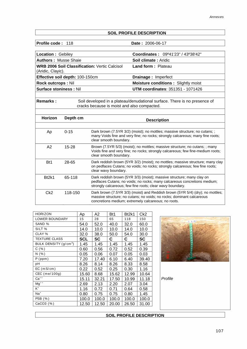
Annexes
107
SDBm SOIL PROFILE DESCRIPTION Profile code : 118 Date : 2006-06-17 Location : Gebiley Coordinates : 09º41'23" / 43º38'42" Authors : Musse Shaie Soil climate : Aridic WRB 2006 Soil Classification: Vertic Calcisol (Aridic, Clayic).
Land form : Plateau
Effective soil depth: 100-150cm Drainage : Imperfect Rock outcrops : Nil Moisture conditions : Slightly moist Surface stoniness : Nil UTM coordinates: 351351 - 1071426 Remarks : Soil developed in a plateau/denudational surface. There is no presence of
cracks because is moist and also compacted.
Horizon Depth cm Description
Ap 0-15 Dark brown (7.5YR 3/2) (moist); no mottles; massive structure; no cutans; ; many Voids fine and very fine; no rocks; strongly calcareous; many fine roots; clear smooth boundary.
A2 15-28 Brown (7.5YR 5/3) (moist); no mottles; massive structure; no cutans; ; many Voids fine and very fine; no rocks; strongly calcareous; few fine-medium roots; clear smooth boundary.
Bt1 28-65 Dark reddish brown (5YR 3/2) (moist); no mottles; massive structure; many clay on pedfaces Cutans; no voids; no rocks; strongly calcareous; few fine roots; clear wavy boundary.
Bt2k1 65-118 Dark reddish brown (5YR 3/3) (moist); massive structure; many clay on pedfaces Cutans; no voids; no rocks; many calcareous concretions medium; strongly calcareous; few fine roots; clear wavy boundary.
Ck2 118-150 Dark brown (7.5YR 3/3) (moist) and Reddish brown (5YR 5/4) (dry); no mottles; massive structure; no cutans; no voids; no rocks; dominant calcareous concretions medium; extremely calcareous; no roots.
SDB SOIL PROFILE DESCRIPTION
HORIZON Ap A2 Bt1 Bt2k1 Ck2 LOWER BOUNDARY 15 28 65 118 150 SAND % 54.0 52.0 40.0 32.0 60.0 SILT % 14.0 10.0 10.0 14.0 10.0 CLAY % 32.0 38.0 50.0 54.0 30.0 TEXTURE CLASS SCL SC C C SC BULK DENSITY (g/cm3) 1.45 1.45 1.45 1.45 1.45 C (%) 0.60 0.56 0.72 0.52 0.39 N (%) 0.05 0.06 0.07 0.05 0.03 P (ppm) 7.20 17.40 6.10 6.40 39.40pH 8.26 8.14 8.26 8.33 8.58 EC (mS/cm) 0.22 0.52 0.25 0.30 1.16 CEC (me/100g) 15.60 8.68 15.62 12.99 10.64Ca++ 15.11 32.21 17.50 10.99 11.18Mg++ 2.69 2.13 2.20 2.07 3.04 K+ 1.16 0.72 0.71 0.64 0.58 Na+ 0.80 0.75 0.75 0.80 1.45 PSB (%) 100.0 100.0 100.0 100.0 100.0CaCO3 (%) 12.50 12.50 20.00 26.50 31.00
Profile

Annexes
108
Profile code : 119 Date : 2006-06-18 Location : Ijjara Coordinates : 09º35'35" / 43º38'04" Authors : Omar Haji Duale, Musse Shaie Soil climate : Aridic WRB 2006 Soil Classification: Vertic Calcisol (Aridic, Clayic).
Land form : Plateau
Land use : Agriculture Drainage : Moderately well Effective soil depth: 100-150cm Moisture conditions : Dry Rock outcrops : Nil Surface stoniness : Very few UTM coordinates: 350035 - 1060743 Remarks : Soil developed in a plateau/denudational surface under limestone. Fallow
agricultural land. Fine very closely spaced cracks. No salts are present.
Horizon Depth cm Description
A1 0-20 Dark brown (7.5YR 3/2) (moist) and Brown (7.5YR 5/3) (dry); no mottles; weak very fine granular structure; no cutans; very few, very fine Voids; no rocks; strongly calcareous; many fine-medium roots; clear wavy boundary.
A2 20-42 Dark brown (7.5YR 3/2) (moist) and Brown (7.5YR 5/3) (dry); no mottles ; moderate medium subangular blocky structure; no cutans; ; very few, very fine Voids; no rocks; few fine calcareous nodules; strongly calcareous; few earthworms; few medium roots; clear wavy boundary.
C1 42-65 Brown (7.5YR 4/3) (moist) and Brown (7.5YR 5/3) (dry); no mottles; moderate medium subangular blocky structure; no cutans; ; very few, very fine Voids; no rocks; many calcareous concretions medium; extremely calcareous; no roots; clear irregular boundary.
C2k 65-150 Strong brown (7.5YR 4/6) (moist) and Strong brown (7.5YR 5/6) (dry); massive structure; no cutans; very few, very fine Voids; no rocks; abundant calcareous concretions medium; extremely calcareous; no roots.
HORIZON A1 A2 C1 C2k LOWER BOUNDARY 20 42 65 150 SAND % 30.0 44.0 36.0 40.0 SILT % 14.0 12.0 12.0 12.0 CLAY % 56.0 44.0 52.0 48.0 TEXTURE CLASS C C C C BULK DENSITY (g/cm3) 1.65 1.65 1.65 1.65 C (%) 0.58 0.71 0.44 0.26 N (%) 0.08 0.07 0.04 0.02 P (ppm) 7.00 7.20 6.50 11.30 pH 8.37 8.22 8.35 8.17 EC (mS/cm) 0.16 0.52 0.35 0.29 CEC (me/100g) 12.00 18.60 16.40 11.00 Ca++ 15.03 42.05 24.53 9.61 Mg++ 2.51 3.24 4.58 1.30 K+ 0.56 0.56 0.40 0.40 Na+ 1.45 0.85 0.85 0.95 PSB (%) 100.0 100.0 100.0 100.0 CaCO3 (%) 13.00 21.50 30.00 29.50
Profile

Annexes
109
SDBm Plus. FAO-CSIC M SOIL PROFILE DESCRIPTION ultilingual Soil Profile
Profile code : 120 Date : 2006-06-19 Location : North of Laaye Coordinates : 09º31'43" / 43º36'27" Authors : Omar Haji Duale, Musse Shaie Soil climate : Aridic WRB 2006 Soil Classification: Calcic Vertisol (Calcaric, Hyposalic)
Land form : Pediment
Effective soil depth: 50-100cm Drainage : Poor Rock outcrops : Nil Moisture conditions : Dry Surface stoniness : Nil UTM coordinates: 347168 - 1053619 Remarks : Soil profile located in a piedmont/denudational slope composed of alluvial clay.
Fine very closely spaced cracks. Horizon Depth cm Description
A1 0-10 Dark reddish brown (5YR 3/2) (moist) and Brown (7.5YR 4/3) (dry); no mottles;
moderate medium granular structure; no cutans; ; very few, very fine Voids; no rocks; strongly calcareous; many fine roots; clear smooth boundary.
A2 10-40 Dark reddish brown (5YR 3/3) (moist) and Brown (7.5YR 4/3) (dry); no mottles; strong medium and coarse subangular prismatic structure; no cutans; few Voids coarse; no rocks; strongly calcareous; few coarse roots; clear smooth boundary.
Bt1 40-75 Dark reddish brown (5YR 3/2) (moist) and Dark brown (7.5YR 3/2) (dry); no mottles; strong medium prismatic structure; abundant clay on pedfaces Cutans; very few, very fine Voids; no rocks; strongly calcareous; few fine roots; clear wavy boundary.
Bt2 75-100 Dark reddish brown (5YR 3/2) (moist) and Dark brown (7.5YR 3/2) (dry); no mottles; massive structure; many clay on pedfaces Cutans; very few, very fine Voids; no rocks; few fine calcareous nodules; strongly calcareous; very few very fine roots.
HORIZON A1 A2 Bt1 Bt2 LOWER BOUNDARY 10 40 75 >75 SAND % 30.0 30.0 28.0 72.0 SILT % 22.0 18.0 14.0 16.0 CLAY % 48.0 52.0 58.0 12.0 TEXTURE CLASS C C C LS BULK DENSITY (g/cm3) 1.42 1.42 1.42 1.42 C (%) 1.56 1.06 0.87 0.87 N (%) 0.18 0.11 0.08 0.04 P (ppm) 30.40 9.30 14.70 9.90 pH 8.16 8.22 8.45 8.37 EC (mS/cm) 0.33 0.40 2.65 0.20 CEC (me/100g) 9.86 21.24 18.80 11.00 Ca++ 13.43 24.80 19.08 20.68 Mg++ 2.40 4.72 5.99 2.07 K+ 1.08 1.38 1.06 0.48 Na+ 1.05 1.65 3.00 0.50 PSB (%) 100.0 100.0 100.0 100.0 CaCO3 (%) 23.50 25.00 26.00 22.00
Profile

Annexes
110
SOIL PROFILE DESCRIPTION Profile code : 121 Date : 2006-06-20 Location : Diini Goobaale Coordinates : 09º25'29" / 43º36'45" Authors : Omar Haji Duale, Musse Shaie Soil climate : Aridic WRB 2006 Soil Classification: Calcic Vertisol (Calcaric, Hyposodic).
Land form : Pediment
Effective soil depth: 100-150cm Drainage : Imperfect Rock outcrops : Nil Moisture conditions : Dry Surface stoniness : Nil UTM coordinates: 347691 - 1042124 Remarks : Soil developed under a clayed parent material in piedmont/pediment.
Horizon Depth cm Description
A1 0-20 Dark brown (7.5YR 3/3) (moist) and Brown (7.5YR 5/4) (dry); no mottles; weak fine and medium granular structure; no cutans; very few, very fine Voids; no rocks; extremely calcareous; common medium roots; clear smooth boundary.
A2 20-45 Dark brown (7.5YR 3/2) (moist) and Brown (7.5YR 4/3) (dry); no mottles; weak fine and medium subangular blocky structure; no cutans; ; very few, very fine Voids; no rocks; extremely calcareous; few fine-medium roots; diffuse wavy boundary.
Bt 45-80 Dark reddish brown (5YR 3/2) (moist) and Brown to dark brown (7.5YR 4/2) (dry); no mottles; strong medium and coarse prismatic structure; many clay on pedfaces Cutans; ; very few, very fine Voids; no rocks; few fine calcareous nodules; extremely calcareous; very few fine roots; diffuse boundary.
Ck 80-140 Dark reddish brown (5YR 3/3) (moist) and Brown (7.5YR 4/3) (dry); no mottles; massive structure; no cutans; very few, very fine Voids; no rocks; few,very fine calcareous nodules; extremely calcareous; no roots.
HORIZON A1 A2 Bt Ck LOWER BOUNDARY 20 45 80 140 SAND % 30.0 28.0 28.0 20.0 SILT % 24.0 14.0 14.0 14.0 CLAY % 46.0 58.0 58.0 66.0 TEXTURE CLASS C C C C BULK DENSITY (g/cm3) 1.54 1.54 1.54 1.54 C (%) 1.56 0.59 0.88 0.51 N (%) 0.19 0.06 0.09 0.05 P (ppm) 22.60 12.60 22.30 13.90 pH 8.21 8.46 8.18 8.47 EC (mS/cm) 0.31 0.32 1.23 1.37 CEC (me/100g) 11.00 26.60 19.80 19.06 Ca++ 14.50 25.64 22.86 11.29 Mg++ 2.92 4.52 4.52 3.18 K+ 1.72 1.06 1.46 0.26 Na+ 1.50 1.75 1.45 1.85 PSB (%) 100.0 100.0 100.0 87.0 CaCO3 (%) 27.00 20.00 25.00 30.00
Profile

Annexes
111
S SOIL PROFILE DESCRIPTION Profile code : 122 Date : 2006-06-20 Location : Abusiin Coordinates : 09º30'8" / 43º47'46" Authors : Omar Haji Duale Soil climate : Aridic WRB 2006 Soil Classification: Calcic Grumic Vertisol (Calcaric).
Land form : Pediment
Rock outcrops : Nil Drainage : Imperfect Surface stoniness : Nil Moisture conditions : Dry UTM coordinates: 367873 - 1050614 Remarks : This profile is similar to profile 121, with little more structural development
located in a Piedmont/denudational slope. Samples were not taken.
Horizon Depth cm Description
A1 0-20 Dark brown (7.5YR 3/3) (moist) and Brown (7.5YR 5/4) (dry); no mottles; weak fine and medium granular structure; no cutans; ; very few, very fine Voids; no rocks; extremely calcareous; common fine-medium roots; clear smooth boundary.
A2 2041- Brown (7.5YR 4/3) (dry); no mottles; weak fine and medium subangular blocky structure; no cutans; ; very few, very fine Voids; no rocks; extremely calcareous; few fine-medium roots; diffuse wavy boundary.
Btk 41-75 Brown to dark brown (7.5YR 4/2) (moist); no mottles; strong medium to very coarse prismatic structure; many clay on pedfaces Cutans; ; very few, very fine Voids; no rocks; extremely calcareous; very few fine roots; diffuse irregular boundary.
C 75-100 Reddish brown (5YR 4/4) (moist); no mottles; massive structure; no cutans; ; very few, very fine Voids; no rocks; extremely calcareous; no roots.
HORIZON LOWER BOUNDARY SAND % SILT % CLAY % TEXTURE CLASS BULK DENSITY (g/cm3) C (%) N (%) P (ppm) pH EC (mS/cm) CEC (me/100g) Ca++ Mg++ K+ Na+ PSB (%) CaCO3 (%)
Profile

Annexes
112
l SOIL PROFILE DESCRIPTION Profile code : 123 Date : 2006-06-24 Location : Togwajale Coordinates : 09º35'52" / 43º20'57" Authors : Omar Haji Duale Soil climate : Aridic WRB 2006 Soil Classification: Calcic Vertisol (Chromic).
Land form : Pediment
Effective soil depth: 50-100cm Drainage : Moderately well Rock outcrops : Nil Moisture conditions : Dry Surface stoniness : Nil UTM coordinates: 318826 - 1061372 Remarks : This soil profile is located in a piedmont/pediment where the parent material is
unconsolidated. Rainfed farms under fallow. The presence of cracks is common; they are 1 cm wide and very closely spaced. No salt crusts are present.
Horizon Depth cm Description
A1 0-25 Very dark grey (7.5YR 3/1) (moist) and Brown (7.5YR 4/3) (dry); no mottles ; weak fine granular structure; no cutans; ; no voids; no rocks; extremely calcareous; many fine and very fine roots; gradual smooth boundary.
A2 25-45 Brown (7.5YR 5/2) (moist) and Dark brown (7.5YR 3/2) (dry); no mottles; moderate medium subangular blocky structure; no cutans; no voids; no rocks; extremely calcareous; common fine roots; clear wavy boundary.
Bt 45-80 Dark brown (7.5YR 3/4) (moist) and Dark brown (7.5YR 3/2) (dry); no mottles; moderate medium subangular blocky structure; abundant clay on pedfaces Cutans; ; no voids; no rocks; extremely calcareous; few fine roots; diffuse boundary.
C 80-100 Dark brown (7.5YR 4/4) (moist) and Dark brown (7.5YR 3/2) (dry); no mottles; massive structure; no cutans; no voids; no rocks; extremely calcareous; very few very fine roots.
HORIZON A1 A2 Bt C LOWER BOUNDARY 25 45 70 >80 SAND % 26.0 24.0 22.0 14.0 SILT % 38.0 10.0 8.0 12.0 CLAY % 36.0 66.0 70.0 74.0 TEXTURE CLASS CL C C C BULK DENSITY (g/cm3) 1.48 1.48 1.48 1.48 C (%) 0.74 0.81 0.63 0.46 N (%) 0.08 0.09 0.08 0.06 P (ppm) 8.60 6.80 4.70 16.10 pH 8.04 8.07 8.28 8.42 EC (mS/cm) 0.21 0.53 1.30 1.95 CEC (me/100g) 13.68 31.28 21.08 19.28 Ca++ 26.88 37.20 17.06 12.44 Mg++ 2.15 8.21 5.89 7.82 K+ 0.30 0.56 0.28 0.38 Na+ 0.45 1.10 1.50 2.55 PSB (%) 100.0 100.0 100.0 100.0 CaCO3 (%) 16.35 23.35 30.85 31.85
Profile
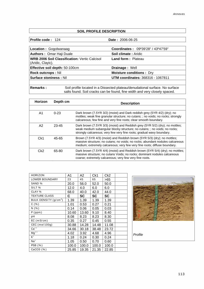
Annexes
113
AOSOIL PROFILE DESCRIPTION Profile code : 124 Date : 2006-06-25 Location : Gogolwanaag Coordinates : 09º39'28" / 43º47'59" Authors : Omar Haji Duale Soil climate : Aridic WRB 2006 Soil Classification: Vertic Calcisol (Aridic, Clayic).
Land form : Plateau
Effective soil depth: 50-100cm Drainage : Well Rock outcrops : Nil Moisture conditions : Dry Surface stoniness : Nil UTM coordinates: 368316 - 1067811 Remarks : Soil profile located in a Dissected plateau/denudational surface. No surface
salts found. Soil cracks can be found, fine width and very closely spaced.
Horizon Depth cm Description
A1 0-23 Dark brown (7.5YR 3/2) (moist) and Dark reddish grey (5YR 4/2) (dry); no mottles; weak fine granular structure; no cutans; ; no voids; no rocks; strongly calcareous; few fine and very fine roots; clear smooth boundary.
A2 23-45 Dark brown (7.5YR 3/3) (moist) and Reddish grey (5YR 5/2) (dry); no mottles; weak medium subangular blocky structure; no cutans; ; no voids; no rocks; strongly calcareous; very few very fine roots; gradual wavy boundary.
Ck1 45-65 Brown (7.5YR 4/3) (moist) and Reddish brown (5YR 5/3) (dry); no mottles; massive structure; no cutans; no voids; no rocks; abundant nodules calcareous medium; extremely calcareous; very few very fine roots; diffuse boundary.
Ck2 65-80 Dark brown (7.5YR 4/4) (moist) and Reddish brown (5YR 5/4) (dry); no mottles; massive structure; no cutans Voids; no rocks; dominant nodules calcareous coarse; extremely calcareous; very few very fine roots.
HORIZON A1 A2 Ck1 Ck2 LOWER BOUNDARY 23 45 65 >65 SAND % 20.0 56.0 52.0 50.0 SILT % 12.0 4.0 6.0 6.0 CLAY % 68.0 40.0 42.0 44.0 TEXTURE CLASS C SC SC SC BULK DENSITY (g/cm3) 1.39 1.39 1.39 1.39 C (%) 1.01 0.53 0.27 0.21 N (%) 0.14 0.06 0.05 0.03 P (ppm) 10.60 13.60 9.10 8.40 pH 8.08 8.23 8.23 8.30 EC (mS/cm) 0.35 0.27 0.45 0.55 CEC (me/100g) 30.88 14.28 14.48 11.08 Ca++ 34.66 30.18 38.48 23.72 Mg++ 4.02 3.92 4.68 4.96 K+ 1.18 0.24 0.30 0.24 Na+ 1.05 0.50 0.70 0.60 PSB (%) 100.0 100.0 100.0 100.0 CaCO3 (%) 25.85 19.35 21.35 22.85
Profile

Annexes
114
SOIL PROFILE DESCRIPTION Profile code : 125 Date : 2006-06-27 Location : Carra Muse Case Coordinates : 09º33'29" / 43º50'19" Authors : Omar Haji Duale Soil climate : Aridic WRB 2006 Soil Classification: Calcic Grumic Vertisol (Calcaric).
Land form : Plateau
Effective soil depth: 50-100cm Drainage : Well Rock outcrops : Nil Moisture conditions : Dry Surface stoniness : Nil UTM coordinates: 372534 - 1056758 Remarks : There is no soil profile description because the surveyors considered that this
profile is similar to profile 124. Without soil samples, it was not considered as a complete profile. Located on a dissected plateau/denudational surface.
Horizon Depth cm Description
A1 0-23 .
HORIZON LOWER BOUNDARY SAND % SILT % CLAY % TEXTURE CLASS BULK DENSITY (g/cm3) C (%) N (%) P (ppm) pH EC (mS/cm) CEC (me/100g) Ca++ Mg++ K+ Na+ PSB (%) CaCO3 (%)
Profile

Annexes
115
SOIL PROFILE DESCRIPTION Profile code : 129 Date : 2006-07-14 Location : Beeyo Baxday Coordinates : 09º52'17" / 44º05'41" Authors : Musse Shaie Soil climate : Aridic WRB 2006 Soil Classification: Hypercalcic Calcisol (Aridic, Clayic).
Land form : Plateau
Effective soil depth: 100-150cm Drainage : Excessive Rock outcrops : Nil Moisture conditions : Dry Surface stoniness : Few UTM coordinates: 400736 – 1091345 Remarks : Soil developed under limestone parent material located in a
Plateau/Denudational surface. The soil surface is eroded. No cracks or salts.
Horizon Depth cm Description
ACk1 0-25 Yellowish red (5YR 4/6) (moist) and Reddish brown (5YR 5/4) (dry); no mottles ; moderate medium subangular blocky structure; no cutans; ; few Voids medium; few medium rounded rocks; very few fine-medium roots; abrupt wavy boundary.
Ck2 25-40 Yellowish red (5YR 4/6) (moist) and Light reddish brown (5YR 6/4) (dry); no mottles; no cutans; no voids; many medium rounded rocks; abundant calcareous concretions medium; extremely calcareous; no roots; abrupt wavy b dCk3 40-175 Pink (5YR 8/4) (moist) and Pinkish white (5YR 8/2) (dry); no mottles ; no cutans; ; no voids; no rocks; dominant calcareous concretions medium; extremely calcareous; no roots.
SDBm Plus. FAO-CSIC Mu SOIL PROFILE DESCRIPTION
HORIZON ACk1 Ck2 LOWER BOUNDARY 25 40 SAND % 24.0 22.0 SILT % 34.0 36.0 CLAY % 42.0 42.0 TEXTURE CLASS C C BULK DENSITY (g/cm3) 1.36 1.36 C (%) 0.29 0.25 N (%) 0.04 0.09 P (ppm) 13.10 3.50 pH 8.27 7.87 EC (mS/cm) 0.25 3.50 CEC (me/100g) 17.32 16.28 Ca++ 32.54 21.02 Mg++ 1.71 3.47 K+ 0.48 0.38 Na+ 0.95 0.50 PSB (%) 100.0 100.0 CaCO3 (%) 26.85 31.35
Profile

Annexes
116
Profile code : 135 Date : 2006-07-16 Location : Sabaad Coordinates : 09º41'17" / 44º19'23" Authors : Musse Shaie Soil climate : Aridic WRB 2006 Soil Classification: Endosalic Calcisol (Aridic, Clayic).
Land element : Slope
Drainage : Excessive UTM coordinates: 425758 - 1071008 Remarks : Soil profile located in a Piedmont/Denudational surface. Lithology is limestone,
conglomerate.
Horizon Depth cm Description
A 0-25 Brown to dark brown (7.5YR 4/2) (moist) and Brown (7.5YR 5/3) (dry); no mottles ; fine and medium granular structure; no cutans; ; few very fine Voids; no rocks; slightly calcareous; common fine-medium roots; clear smooth boundary.
Ck1 25-65 Dark brown (7.5YR 4/4) (moist) and Brown (7.5YR 5/4) (dry); no mottles ; weak medium and coarse prismatic structure; no cutans; ; few very fine Voids; common fine rounded rocks; common calcareous concretions; strongly calcareous; few fine roots; abrupt wavy boundary.
Ck2 65-80 Brown (7.5YR 4/3) (moist) and Pinkish white (7.5YR 8/2) (dry); no mottles ; no cutans; ; no voids; many medium rounded rocks; dominant calcareous concretions; extremely calcareous; no roots.
Bm Plus. ngual SOIL PROFILE DESCRIPTION Soil Profile Database Profile code : 136 Date : 2006-07-16 Location : Burcada Coordinates : 09º40'05" / 44º16'09"
HORIZON A Ck1 Ck2 LOWER BOUNDARY 25 65 80 SAND % 48.0 46.0 44.0 SILT % 12.0 12.0 12.0 CLAY % 40.0 42.0 44.0 TEXTURE CLASS SC SC C BULK DENSITY (g/cm3) 1.33 1.33 1.33 C (%) 0.50 0.38 0.28 N (%) 0.05 0.05 0.04 P (ppm) 5.60 2.70 4.40 pH 8.42 8.01 8.13 EC (mS/cm) 2.40 2.30 2.45 CEC (me/100g) 15.08 13.48 15.08 Ca++ 30.89 17.71 30.10 Mg++ 2.16 2.02 4.13 K+ 0.32 0.16 0.28 Na+ 1.20 0.85 1.80 PSB (%) 100.0 100.0 100.0 CaCO3 (%) 20.35 25.85 30.85
Profile

Annexes
117
Authors : Musse Shaie Soil climate : Aridic WRB 2006 Soil Classification: Haplic Calcisol (Episkeletic, Clayic)
Land element : Slope
Effective soil depth: 25-50cm Drainage : Excessive Surface stoniness : Common Moisture conditions : Dry UTM coordinates: 419844 - 1068808 Remarks : Young calcaric soil developed from Limestone & quartzite parent rocks located
in a Piedmont/Denudational surface. No cracks or salts.
Horizon Depth cm Description
AC 0-25 Pink (7.5YR 7/3) (dry); no mottles; weak medium subangular blocky structure; no cutans; many very fine Voids; no rocks; strongly calcareous; common fine-medium roots; clear wavy boundary.
Ck 25-75 Pink (7.5YR 8/4) (dry); no mottles; massive structure; no cutans; few very fine Voids; no rocks; dominant calcareous concretions medium; extremely calcareous; few fine roots.
C Multilingual SOIL PROFILE DESCRIPTION Soil Profile Database Profile code : 137 Date : 2006-07-16 Location : Halleeya Coordinates : 09º37'29" / 44º11'30" Authors : Musse Shaie Soil climate : Aridic WRB 2006 Soil Classification: Haplic Regosol Drainage : Excessive
HORIZON Ac Ck LOWER BOUNDARY 25 >75 SAND % 58.0 42.0 SILT % 8.0 16.0 CLAY % 34.0 42.0 TEXTURE CLASS SCL C BULK DENSITY (g/cm3) 1.39 1.39 C (%) 0.43 0.42 N (%) 0.07 0.04 P (ppm) 2.20 2.20 pH 8.25 8.55 EC (mS/cm) 0.21 0.24 CEC (me/100g) 11.32 18.12 Ca++ 32.67 10.08 Mg++ 2.29 4.81 K+ 0.26 0.24 Na+ 0.45 0.70 PSB (%) 100.0 87.0 CaCO3 (%) 25.85 37.35
Profile

Annexes
118
(Calcaric, Arenic). Effective soil depth: 100-150cm Moisture conditions : Dry Rock outcrops : Nil Local soil classification (serie) : Surface stoniness : Nil UTM coordinates: 411317 – 1064026 Remarks : This profile is located in a surface where local sand dunes are formed due to
wind erosion. Piedmont landscape and Gully/rill erosion surface relief. No soil samples.
Horizon Depth cm Description
A 0-140 Light brown (7.5YR 6/4) (dry); no mottles; massive structure; no cutans;
common Voids very coarse; no rocks; strongly calcareous; many fine roots; abrupt smooth boundary.
c 140-160 Massive structure; no cutans; common Voids very coarse; no rocks; strongly calcareous; common fine roots.
HORIZON LOWER BOUNDARY SAND % SILT % CLAY % TEXTURE CLASS BULK DENSITY (g/cm3) C (%) N (%) P (ppm) pH EC (mS/cm) CEC (me/100g) Ca++ Mg++ K+ Na+ PSB (%) CaCO3 (%)
Profile
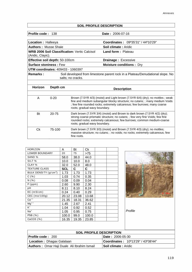
Annexes
119
S SOIL PROFILE DESCRIPTION Profile code : 138 Date : 2006-07-16 Location : Halleeya Coordinates : 09º35'31" / 44º10'29" Authors : Musse Shaie Soil climate : Aridic WRB 2006 Soil Classification: Vertic Calcisol (Aridic, Clayic).
Land form : Plateau
Effective soil depth: 50-100cm Drainage : Excessive Surface stoniness : Few Moisture conditions : Dry UTM coordinates: 409433 - 1060397 Remarks : Soil developed from limestone parent rock in a Plateau/Denudational slope. No
salts; no cracks.
Horizon Depth cm Description
A 0-20 Brown (7.5YR 4/3) (moist) and Light brown (7.5YR 6/4) (dry); no mottles ; weak fine and medium subangular blocky structure; no cutans; ; many medium Voids ; few fine rounded rocks; extremely calcareous; few burrows; many coarse roots; gradual wavy boundary.
Bt 20-75 Dark brown (7.5YR 3/4) (moist) and Brown to dark brown (7.5YR 4/2) (dry); strong coarse prismatic structure; no cutans; ; few very fine Voids; few fine rounded rocks; extremely calcareous; few burrows; common medium-coarse roots; gradual wavy boundary.
Ck 75-100 Dark brown (7.5YR 3/3) (moist) and Brown (7.5YR 4/3) (dry); no mottles; massive structure; no cutans; ; no voids; no rocks; extremely calcareous; few fine roots.
SOIL PROFILE DESCRIPTION Profile code : 200 Date : 2006-05-30 Location : Dhagax Galalaan Coordinates : 10º13'29" / 43º38'44" Authors : Omar Haji Duale Ali Ibrahim Ismail Soil climate : Aridic
HORIZON A Bt Ck LOWER BOUNDARY 20 75 >75 SAND % 58.0 38.0 44.0 SILT % 10.0 10.0 8.0 CLAY % 32.0 52.0 48.0 TEXTURE CLASS SCL C C BULK DENSITY (g/cm3) 1.73 1.73 1.73 C (%) 1.03 0.74 0.35 N (%) 0.08 0.09 0.04 P (ppm) 2.60 9.90 2.30 pH 8.11 8.10 8.24 EC (mS/cm) 0.24 0.40 0.29 CEC (me/100g) 20.12 23.08 13.68 Ca++ 21.35 18.31 36.62 Mg++ 1.45 2.67 2.41 K+ 1.04 0.92 0.52 Na+ 1.05 0.95 0.75 PSB (%) 100.0 99.0 100.0 CaCO3 (%) 16.35 19.35 23.85
Profile

Annexes
120
WRB 2006 Soil Classification: Haplic Fluvisol (Calcaric, Aridic).
Land form : Pediment
Effective soil depth: >150 Drainage : Well Rock outcrops : Nil Moisture conditions : Dry Surface stoniness : Few UTM coordinates: 351673 - 1130587 Remarks : This soil is located in a Piedmont, dissected pediment, fluvial in origin due to
presence of many seasonal rivers. There are few soil cracks in the surface and no salts. As for most of this area, the land is used for grazing.
Horizon Depth cm DescriptionA 0-15 Brown (7.5YR 5/3) (dry); no mottles; sandy loam; strong coarse granular
structure; no cutans; few Voids fine; no rocks; few fine calcareous nodules; strongly calcareous; no roots; diffuse smooth boundary.
C 15-200 Brown (7.5YR 5/3) (dry); no mottles ; sandy loam; massive structure; no cutans; ; very few, very fine Voids; few fine subrounded rocks; common nodules calcareous coarse; strongly calcareous; very few very fine roots.
P SOIL PROFILE DESCRIPTION Profile code : 201 Date : 2006-05-31 Location : Dabago Coordinates : 10º06'16" / 43º43'24" Authors : Musse Shaie Soil climate : Aridic WRB 2006 Soil Classification: Haplic Fluvisol (Aridic, Arenic)
Land form : Valley
Effective soil depth: 50-100cm Drainage : Well Rock outcrops : Nil Moisture conditions : Dry
HORIZON A C LOWER BOUNDARY 15 200 SAND % 72.0 74.0 SILT % 14.0 12.0 CLAY % 14.0 14.0 TEXTURE CLASS SL SL BULK DENSITY (g/cm3) 1.57 1.57 C (%) 0.13 0.14 N (%) 0.02 0.01 P (ppm) 7.30 5.90 pH 8.50 8.40 EC (mS/cm) 0.12 2.48 CEC (me/100g) 11.20 14.10 Ca++ 14.5 16.4 Mg++ 1 1.8 K+ 0.5 0.2 Na+ 0.5 4 PSB (%) 100 100 CaCO3 (%) 8.00 6.00
Profile

Annexes
121
Surface stoniness : Common UTM coordinates: 360137 - 1117240 Remarks : Soil located in a braided river plain. There are no salts or cracks. Purely sandy
soil.
Horizon Depth cm Description
A1 0-10 Brown (7.5YR 4/3) (moist) and Light brown (7.5YR 6/3) (dry); no mottles; sand; massive structure; no cutans; ; few Voids fine; slightly calcareous; few burrows; common fine-medium roots; diffuse smooth boundary.
A2 10-45 Brown (7.5YR 4/3) (moist) and Brown (7.5YR 5/3) (dry); no mottles; sand; no cutans; ; few Voids fine; non calcareous; few burrows; common fine-medium roots; diffuse smooth boundary.
C 45- Brown (7.5YR 5/3) (moist); no mottles; sand; massive structure; no cutans; ; few Voids fine; few stones and boulders subrounded rocks; non calcareous; very few very fine roots.
HORIZON A1 A2 C LOWER BOUNDARY 10 45 100 SAND % 88.0 88.0 88.0 SILT % 8.0 6.0 6.0 CLAY % 4.0 6.0 6.0 TEXTURE CLASS S S S BULK DENSITY (g/cm3) 1.67 1.67 1.67 C (%) 0.24 0.21 0.16 N (%) 0.02 0.02 0.01 P (ppm) 8.20 7.60 6.50 pH 8.40 8.50 8.50 EC (mS/cm) 0.07 0.07 0.10 CEC (me/100g) 10.50 23.30 11.90 Ca++ 5.3 10.2 12.8 Mg++ 0.3 0.4 0.3 K+ 0.2 0.2 0.1 Na+ 0.2 1 0.2 PSB (%) 56 49 100 CaCO3 (%) 2.00 1.00 5.00
Profile

Annexes
122
FAO-CSIC Multilingual Soil PSOIL PROFILE DESCRIPTION rofile Database Profile code : 203 Date : 2006-06-07 Location : Hancadley Coordinates : 09º54'50" / 43º07'38" Authors : Omar Haji Duale Soil climate : Aridic WRB 2006 Soil Classification: Haplic Regosol (Dystric, Aridic)
Land form : Plateau
Effective soil depth: >150 Drainage : Well Rock outcrops : Nil Moisture conditions : Dry Surface stoniness : Very few UTM coordinates: 294676 - 1096493 Remarks : Soil developed under unconsolidated material located in a plateau/piedmont,
denudational slope.
Horizon Depth cm Description
A1 0-30 Dark brown (7.5YR 3/2) (moist) and Brown to dark brown (7.5YR 4/2) (dry); no mottles; massive structure; no cutans; few Voids medium; no rocks; moderately calcareous; few burrows; common fine roots; diffuse smooth boundary.
A2 30-60 Very dark greyish brown (10YR 3/2) (moist) and Brown (7.5YR 4/3) (dry); no mottles; massive structure; no cutans; very few, very fine Voids; no rocks; strongly calcareous; many fine and very fine roots; gradual wavy boundary.
C1 60-125 Very dark grey (10YR 3/1) (moist) and Dark brown (7.5YR 3/2) (dry); no mottles; massive structure; no cutans; very few, very fine Voids; no rocks; abundant nodules calcareous medium; strongly calcareous; few fine roots; gradual wavy boundary.
C2 125-170 Brown to dark brown (7.5YR 4/2) (moist); no mottles; massive structure; no cutans; very few, very fine Voids; common fine and medium rocks; slightly calcareous; no roots.
HORIZON A1 A2 C1 C2 LOWER BOUNDARY 30 60 125 170 SAND % 66.0 60.0 62.0 72.0 SILT % 24.0 24.0 22.0 16.0 CLAY % 10.0 16.0 16.0 8.0 TEXTURE CLASS SL SL SL SL BULK DENSITY (g/cm3) 1.61 1.61 1.61 1.61 C (%) 0.51 0.64 0.63 0.31 N (%) 0.05 0.12 0.06 0.03 P (ppm) 13.50 8.50 13.70 0.50 pH 8.76 8.34 8.14 8.11 EC (mS/cm) 0.40 1.30 0.35 2.30 CEC (me/100g) 13.57 11.52 32.58 9.96 Ca++ 13.67 10.47 16.46 11.37 Mg++ 1.16 1.06 1.22 1.47 K+ 0.17 0.09 0.17 0.11 Na+ 0.36 0.10 0.36 0.10 PSB (%) 100.0 100.0 56.0 100.0 CaCO3 (%) 5.65 5.65 11.15 4.65
Profile

Annexes
123
ilingu SOIL PROFILE DESCRIPTION Profile code : 206 Date : 2006-06-12 Location : Badanbed Coordinates : 10º10'33" / 43º13'46" Authors : Musse Shaie Land form : Valley WRB 2006 Soil Classification: Haplic Fluvisol (Calcaric, Aridic, Arenic).
Drainage : Excessively
Rock outcrops : Nil Moisture conditions : Dry Surface stoniness : Nil UTM coordinates: 306050 - 1125383 Remarks : Soil developed under its bedrock limestone located in a Valley/braided river
plain. There are no cracks, no salts and no stoniness.
Horizon Depth cm Description
A 0-35 Light brown (7.5YR 6/3) (dry); no mottles; massive structure; no cutans; very few Voids medium; no rocks; strongly calcareous; few burrows; common fine-medium roots; diffuse smooth boundary.
C1 35-65 Brown (10YR 5/3) (dry); no mottles; massive structure; no cutans; no voids; no rocks; strongly calcareous; common fine roots; diffuse smooth boundary.
C2 65-94 Pale brown (10YR 6/3) (dry); no mottles; massive structure; no cutans; no voids; no rocks; strongly calcareous; few medium-coarse roots; diffuse irregular boundary.
C3 94-180 Pale brown (10YR 6/3) (dry); no mottles; massive structure; no cutans; no voids; no rocks; strongly calcareous; few fine roots.
SOIL PROFILE DESCRIPTION SDBm Plus. FAO-CSIC Multilingual Soil Profile Database
HORIZON A C1 C2 C3 LOWER BOUNDARY 35 65 94 >94 SAND % 22.0 90.0 90.0 92.0 SILT % 16.0 4.0 4.0 6.0 CLAY % 62.0 6.0 6.0 2.0 TEXTURE CLASS C S S S BULK DENSITY (g/cm3) 1.30 1.30 1.30 1.30 C (%) 0.48 0.13 0.13 0.09 N (%) 0.05 0.01 0.01 0.00 P (ppm) 8.30 6.00 8.50 7.70 pH 8.53 8.61 8.51 8.61 EC (mS/cm) 1.51 0.28 0.26 0.30 CEC (me/100g) 23.86 5.40 6.60 10.60 Ca++ 14.56 8.61 8.88 10.57 Mg++ 7.85 1.33 0.79 0.96 K+ 0.70 0.12 0.18 0.18 Na+ 3.25 0.10 0.25 0.30 PSB (%) 100.0 100.0 100.0 100.0 CaCO3 (%) 30.00 14.50 16.00 14.50
Profile

Annexes
124
Profile code : 301 Date : 2006-06-07 Location : Shebeeley Coordinates : 09º57'15" / 43º06'36" Authors : Ali Ibrahim Ismail Soil climate : AridicWRB 2006 Soil Classification: Calcic Vertisol (Calcaric, Hyposodic)
Land form : Pediment
Effective soil depth: 100-150cm Drainage : WellRock outcrops : Nil Moisture conditions : Dry Surface stoniness : Nil UTM coordinates: 292822 - 1100951 Remarks : Soil located in a Piedmont/pediment as general unit; however, the facet is an
alluvial plain. No salts and very few cracks are present.
Horizon Depth cm Description
A1 0-30 Dark brown (7.5YR 3/2) (moist); no mottles ; strong medium granular structure; no cutans; ; very few, very fine Voids; few fine subrounded rocks; extremely calcareous; many medium-coarse roots; clear wavy boundary.
A2 30-70 Brown to dark brown (7.5YR 4/2) (moist); no mottles; strong medium subangular and angular blocky structure; no cutans; few Voids fine; common medium subrounded rocks; common nodules calcareous fine; extremely calcareous; few fine roots; clear smooth boundary.
Btk 70-160 Dark brown (7.5YR 3/2) (moist); no mottles; strong medium subangular and angular blocky structure; common pressure face Cutans; very few, very fine Voids; no rocks; common nodules calcareous fine; extremely calcareous; very few very fine roots.
C 160-170 Dark brown (7.5YR 3/2) (moist); no mottles; moderate subangular and angular blocky structure; very few pressure face Cutans; very few, very fine Voids; no rocks; strongly calcareous; no roots.
FAO-CSIC Multi SOIL PROFILE DESCRIPTION lingual Soil Profile Database
Profile
HORIZON A1 A2 Btk C LOWER BOUNDARY 30 70 160 170 SAND % 30.0 28.0 32.0 12.0 SILT % 22.0 22.0 22.0 28.0 CLAY % 48.0 50.0 46.0 60.0 TEXTURE CLASS C C C C BULK DENSITY
31.38 1.38 1.38 1.38
C (%) 0.77 0.54 0.53 0.41 N (%) 0.10 0.10 0.04 0.06 P (ppm) 10.90 11.90 7.50 8.70 pH 8.25 8.32 8.28 8.80 EC (mS/cm) 1.04 0.45 0.21 0.39 CEC (me/100g) 19.80 29.18 24.20 14.53 Ca++ 16.88 8.08 26.80 21.26 Mg++ 4.54 3.57 1.12 7.70 K+ 0.10 0.80 1.06 0.86 Na+ 1.65 1.25 1.10 3.75 PSB (%) 100.0 100.0 100.0 100.0 CaCO3 (%) 20.50 17.50 18.00 23.50

Annexes
125
Profile code : 302 Date : 2006-06-29 Location : Gadhgogol Coordinates : 09º28'38" / 43º50'23" Authors : Ali Ibrahim Ismail, Musse Shaie, Omar Haji Duale
Soil climate : Aridic
WRB 2006 Soil Classification: Calcic Vertisol (Chromic)
Land form : Plateau
Effective soil depth: 100-150cm Drainage : WellSurface stoniness : Nil Moisture conditions : Dry UTM coordinates: 372635 - 1047816Remarks : Soil located in a Dissected plateau/Pediment. Few cracks are present but no
salt crusts. The soil profile is located in a flat floor valley.
Horizon Depth cm Description
Ap 0-15 Dark reddish brown (5YR 3/2) (moist) and Brown (7.5YR 5/4) (dry); no mottles; weak medium granular structure; no cutans; very few, very fine Voids; no rocks; extremely calcareous; many fine-medium roots; clear wavy boundary.
A2 15-45 Dark reddish brown (5YR 2.5/2) (moist) and Brown (7.5YR 4/3) (dry); no mottles; weak medium subangular blocky structure; no cutans; very few, very fine Voids; no rocks; extremely calcareous; common fine-medium roots; clear smooth boundary.
Btk 45-65 Dark reddish brown (5YR 3/2) (moist) and Brown to dark brown (7.5YR 4/2) (dry); no mottles ; moderate medium angular blocky structure; many pressure face Cutans; very few, very fine Voids; no rocks; few,very fine calcareous nodules; extremely calcareous; few termite channels; few coarse roots; clear smooth boundary.
Ck 65-130 Dark reddish brown (5YR 3/3) (moist) and Reddish brown (5YR 4/3) (dry); no mottles; moderate medium angular blocky structure; no cutans; very few, very fine Voids; no rocks; abundant nodules calcareous coarse; extremely calcareous; no roots.
HORIZON Ap A2 Btk Ck LOWER BOUNDARY 15 45 65 >130 SAND % 48.0 40.0 42.0 36.0 SILT % 10.0 10.0 4.0 8.0 CLAY % 42.0 50.0 54.0 56.0 TEXTURE CLASS SC C C C BULK DENSITY (g/cm3) 1.39 1.39 1.39 1.39 C (%) 1.31 0.90 0.67 0.35 N (%) 0.15 0.13 0.11 0.04 P (ppm) 19.30 10.30 4.60 12.70 pH 8.01 7.86 8.07 8.38 EC (mS/cm) 0.70 1.20 0.65 0.65 CEC (me/100g) 19.08 18.88 22.08 16.08 Ca++ 31.85 25.89 37.50 23.43 Mg++ 1.93 3.36 5.54 4.35 K+ 1.24 0.92 0.58 0.32 Na+ 1.50 0.80 0.95 1.95 PSB (%) 100.0 100.0 100.0 100.0 CaCO3 (%) 14.85 19.85 17.85 25.85
Profile

Annexes
126
ltilingual SOIL PROFILE DESCRIPTION Profile code : 303 Date : 2006-06-29 Location : Abdisamad Coordinates : 09º24'33" / 43º48'49" Authors : Musse Shaie, Ali Ibrahim Ismail, Omar Haji Duale
Soil climate : Aridic
WRB 2006 Soil Classification: Calcic Grumic Vertisol (Hyposodic, Chromic).
Drainage : Well
Effective soil depth: 100-150cm Moisture conditions : Dry Rock outcrops : Nil UTM coordinates: 369736-1040302 Surface stoniness : Nil Remarks : Soil developed in a Piedmont/Denudational slope which parent material is a re-
deposited natural material. Very closely-spaced cracks of medium width are present. No surface salts.
Horizon Depth cm Description
Ap 0-20 Dark reddish brown (5YR 3/3) (moist) and Brown (7.5YR 5/4) (dry); no mottles;
weak medium granular structure; no cutans; no voids; no rocks; extremely calcareous; many fine-medium roots; clear smooth boundary.
A2 20-39 Dark reddish brown (5YR 3/3) (moist) and Reddish brown (5YR 4/3) (dry); no mottles; moderate medium subangular blocky structure; no cutans; few Voids fine; no rocks; extremely calcareous; many fine-medium roots; diffuse b dBt1 39-65 Dark reddish brown (5YR 3/3) (moist) and Brown (7.5YR 4/3) (dry); no mottles; strong medium angular blocky structure; abundant pressure face Cutans; no voids; no rocks; extremely calcareous; many fine roots; clear wavy boundary.
Bt2 65-115 Yellowish red (5YR 4/6) (moist) and Reddish brown (5YR 4/4) (dry); no mottles; strong coarse angular blocky structure; abundant pressure face Cutans; no voids; no rocks; extremely calcareous; few fine-medium roots; clear smooth boundary.
Ck 115-130 Reddish brown (2.5YR 4/4) (moist) and Yellowish red (5YR 4/6) (dry); no mottles; moderate medium angular blocky structure; no cutans; no voids; no rocks; extremely calcareous; no roots.
Profile
HORIZON Ap A2 Bt1 Bt2 Ck LOWER BOUNDARY 20 39 65 115 >115 SAND % 42.0 28.0 26.0 26.0 18.0 SILT % 4.0 10.0 10.0 8.0 10.0 CLAY % 54.0 62.0 64.0 66.0 72.0 TEXTURE CLASS C C C C C BULK DENSITY
31.39 1.39 1.39 1.39 1.39
C (%) 0.96 0.69 0.54 0.51 0.30 N (%) 0.09 0.07 0.06 0.05 0.04 P (ppm) 10.30 10.90 11.80 8.00 7.70 pH 8.14 8.29 8.57 8.70 8.34 EC (mS/cm) 0.27 0.35 0.45 0.80 2.80 CEC (me/100g) 18.12 24.28 19.28 15.48 20.48Ca++ 28.40 31.54 17.86 16.03 8.83 Mg++ 3.68 2.52 7.17 8.08 3.24 K+ 1.36 1.24 0.80 0.40 0.14 Na+ 1.45 1.60 2.45 3.30 2.10 PSB (%) 100.0 100.0 100.0 100.0 100.0CaCO3 (%) 23.35 28.85 29.35 30.85 32.85

Annexes
127
SOIL PROFILE DESCRIPTION Profile code : 304 Date : 2006-07-02 Location : Allaybaday Coordinates : 09º23'31" / 43º31'52" Authors : Omar Haji Duale, Ali Ibrahim Ismail Soil climate : Aridic WRB 2006 Soil Classification: Calcic Mazic Vertisol (Bathyhyposodic, Bathyhyposalic).
Land form : Alluvial plain
Effective soil depth: 100-150cm Drainage : Well Rock outcrops : Nil Moisture conditions : Dry Surface stoniness : Nil UTM coordinates: 338710 - 1038520 Remarks : Parent material is silt, clay and loam located in a Piedmont/Alluvial plain. No
salt crusts are present, instead soil cracks of fine width and very closely spaced are present.
Horizon Depth cm Description
A1 0-15 Dark brown (7.5YR 3/2) (moist) and Brown (7.5YR 4/3) (dry); no mottles; weak
fine granular structure; no cutans; very few, very fine Voids; no rocks; extremely calcareous; many very fine roots; clear wavy boundary.
A2 15-40 Dark brown (7.5YR 3/2) (moist) and Dark brown (7.5YR 3/3) (dry); no mottles; moderate medium subangular blocky structure; no cutans; very few, very fine Voids; no rocks; extremely calcareous; few very fine roots; clear smooth boundary.
Bt 40-100 Dark brown (7.5YR 3/2) (moist) and Dark brown (7.5YR 3/3) (dry); no mottles; strong coarse angular blocky structure; common pressure face Cutans; very few, very fine Voids; no rocks; extremely calcareous; very few very fine roots; diffuse smooth boundary.
C 100-130 Dark brown (7.5YR 3/3) (moist) and Dark brown (7.5YR 3/4) (dry); no mottles; moderate medium angular blocky structure; no cutans; very few, very fine Voids; no rocks; extremely calcareous; no roots.
Profile
HORIZON A1 A2 Bt C LOWER BOUNDARY 15 40 100 130 SAND % 32.0 26.0 26.0 20.0 SILT % 8.0 12.0 8.0 8.0 CLAY % 60.0 62.0 66.0 72.0 TEXTURE CLASS C C C C BULK DENSITY (g/cm3) 1.33 1.33 1.33 1.33 C (%) 0.92 0.77 0.55 0.40 N (%) 0.13 0.11 0.06 0.05 P (ppm) 8.90 8.30 5.90 4.60 pH 8.20 8.09 8.42 8.46 EC (mS/cm) 0.50 1.65 2.15 2.70 CEC (me/100g) 21.08 21.68 25.08 27.28 Ca++ 38.11 26.98 22.41 18.53 Mg++ 4.05 6.54 9.93 7.87 K+ 1.40 0.90 0.32 0.22 Na+ 1.70 1.95 1.95 2.15 PSB (%) 100.0 100.0 100.0 100.0 CaCO3 (%) 24.85 28.35 30.85 33.35

Annexes
128
FAO-CSIC Multilingual Soil SOIL PROFILE DESCRIPTION Profile code : 305 Date : 2006-07-02 Location : Wadda Makasuil Coordinates : 09º22'16" / 43º36'06" Authors : Ali Ibrahim Ismail, Omar Haji Duale Soil climate : Aridic WRB 2006 Soil Classification: Calcic Grumic Vertisol (Hyposodic, Chromic).
Land form : Alluvial plain
Effective soil depth: 100-150cm Land element : Terrace Rock outcrops : Nil Drainage : Moderately well Surface stoniness : Nil Moisture conditions : Dry UTM coordinates: 346450 - 1036186 Remarks : Soil developed under clay, silt and loam in a Piedmont/Alluvial plain. Presence
of fine width and very closely spaced soil cracks. No salts.
Horizon Depth cm Description
A1 0-10 Dark brown (7.5YR 3/3) (moist) and Brown (7.5YR 4/3) (dry); no mottles; weak
very fine granular structure; no cutans; very few, very fine Voids; no rocks; extremely calcareous; very few very fine roots; clear smooth boundary.
A2 10-35 Dark brown (7.5YR 3/2) (moist) and Brown (7.5YR 4/3) (dry); no mottles; weak fine granular structure; no cutans; very few, very fine Voids; no rocks; extremely calcareous; very few fine roots; clear wavy boundary.
B1 35-85 Dark brown (7.5YR 3/3) (moist) and Dark brown (7.5YR 3/2) (dry); no mottles; strong very coarse subangular blocky structure; no cutans; very few, very fine Voids; no rocks; extremely calcareous; very few very fine roots; clear smooth boundary.
B2 85-140 Reddish brown (5YR 4/4) (moist) and Strong brown (7.5YR 4/6) (dry); no mottles; strong medium subangular blocky structure; no cutans; very few, very fine Voids; no rocks; extremely calcareous; no roots.
HORIZON A1 A2 B1 B2 LOWER BOUNDARY 10 35 85 140 SAND % 32.0 26.0 28.0 24.0 SILT % 12.0 14.0 10.0 10.0 CLAY % 56.0 60.0 62.0 66.0 TEXTURE CLASS C C C C BULK DENSITY (g/cm3) 1.45 1.45 1.45 1.45 C (%) 0.95 0.92 0.61 0.44 N (%) 0.11 0.10 0.07 0.05 P (ppm) 4.50 2.10 3.50 8.20 pH 8.19 8.20 8.70 8.78 EC (mS/cm) 0.35 0.35 0.40 0.90 CEC (me/100g) 25.07 25.48 22.28 14.08 Ca++ 37.22 30.23 27.17 13.63 Mg++ 3.27 4.43 9.49 10.93 K+ 1.30 0.98 0.44 0.16 Na+ 1.30 1.15 2.20 1.45 PSB (%) 100.0 100.0 100.0 100.0 CaCO3 (%) 24.85 25.85 27.85 31.85
Profile

Annexes
129
DBm Plus. FAO-CSIC Multilingual So SOIL PROFILE DESCRIPTION il Profile Database
Profile code : 306 Date : 2006-07-04 Location : Seyla Galbeed Coordinates : 09º18'18" / 43º51'34" Authors : Omar Haji Duale Soil climate : Aridic WRB 2006 Soil Classification: Calcic Grumic Vertisol (Chromic).
Land form : Pediment
Effective soil depth: 100-150cm Drainage : Well Rock outcrops : Nil Moisture conditions : Dry Surface stoniness : Nil UTM coordinates:374743 - 1028780 Remarks : Parent material consists of gravel, clay and loam in a Piedmont/Pediment. No
salts but there are fine width and very closely spaced cracks.
Horizon Depth cm Description
A 0-23 Reddish brown (5YR 4/3) (moist) and Dark reddish brown (5YR 3/3) (dry); no mottles ; moderate medium granular structure; no cutans; ; no voids; common fine subrounded rocks; strongly calcareous; common fine roots; gradual smooth boundary.
AB 23-40 Dark reddish brown (5YR 3/3) (moist) and Dark reddish brown (5YR 3/2) (dry); no mottles ; moderate medium subangular blocky structure; no cutans; ; no voids; few fine subrounded rocks; common very fine calcareous concretions; extremely calcareous; few fine roots; clear smooth boundary.
Btk 40-85 Dark reddish brown (5YR 3/3) (moist) and Dark reddish brown (5YR 3/2) (dry); no mottles; strong medium subangular blocky structure; common pressure face Cutans; no voids; no rocks; many very fine calcareous concretions; extremely calcareous; no roots; diffuse boundary.
Ck 85-130 Dark reddish brown (5YR 2.5/2) (moist) and Reddish brown (5YR 4/3) (dry); no mottles; moderate medium subangular blocky structure; no cutans; no voids; no rocks; abundant very fine calcareous concretions ; extremely calcareous; no roots.
Profile
HORIZON A AB Btk Ck LOWER BOUNDARY 23 40 85 >85 SAND % 42.0 46.0 46.0 38.0 SILT % 6.0 4.0 6.0 10.0 CLAY % 52.0 50.0 48.0 52.0 TEXTURE CLASS C C C C BULK DENSITY (g/cm3) 1.35 1.35 1.35 1.35 C (%) 0.56 0.66 0.50 0.40 N (%) 0.08 0.08 0.06 0.04 P (ppm) 8.30 11.90 5.20 5.10 pH 8.19 8.01 8.15 8.32 EC (mS/cm) 0.40 1.15 1.00 0.75 CEC (me/100g) 21.08 22.48 23.88 23.48 Ca++ 33.60 25.92 21.95 16.97 Mg++ 2.99 8.49 1.24 5.58 K+ 1.68 0.80 0.56 0.68 Na+ 1.80 0.80 0.70 1.95 PSB (%) 100.0 100.0 100.0 100.0 CaCO3 (%) 16.35 17.50 19.00 21.00

Annexes
130
SDBm Plus. FAO-CSling SOIL PROFILE DESCRIPTION ual Soil Profile Database Profile code : 307 Date : 2006-07-06 Location : Garabis Coordinates : 09º25'60" / 43º57'14" Authors : Ali Ibrahim Ismail Soil climate : Aridic WRB 2006 Soil Classification: Calcic Grumic Vertisol (Hyposodic, Chromic).
Land form : Valley
Effective soil depth: 100-150cm Drainage : Moderately well Rock outcrops : Nil Moisture conditions : Dry Surface stoniness : Nil UTM coordinates: 385163 - 1042931 Remarks : Soil developed under alluvium parent material located in a Valley/Pediment.
Soil covers without salt crusts and with fine width and very closely spaced cracks.
Horizon Depth cm Description
A1 0-15 Dark reddish brown (5YR 3/3) (moist) and Dark brown (7.5YR 4/4) (dry); no
mottles; weak fine granular structure; no cutans; no voids; no rocks; few soft segregation calcareous fine; extremely calcareous; many fine-medium roots; clear smooth boundary.
A2 15-30 Dark reddish brown (5YR 3/3) (moist) and Dark brown (7.5YR 3/3) (dry); no mottles; moderate medium granular structure; no cutans; no voids; no rocks; many soft segregation calcareous fine; extremely calcareous; few fine roots; clear smooth boundary.
Btk 30-110 Dark brown (7.5YR 3/3) (moist) and Dark brown (7.5YR 3/4) (dry); no mottles; strong medium angular and subangular blocky structure; no cutans; no voids; no rocks; extremely calcareous; very few fine roots; diffuse smooth boundary.
Ck 110-160 Reddish brown (5YR 4/4) (moist) and Dark brown (7.5YR 4/4) (dry); no mottles; hard prismatic structure; no cutans; no voids; no rocks; common soft segregation calcareous fine; extremely calcareous; no roots.
Profile
HORIZON A1 A2 B2k Ck LOWER BOUNDARY 15 30 110 160 SAND % 26.0 30.0 20.0 64.0 SILT % 10.0 10.0 12.0 4.0 CLAY % 64.0 60.0 68.0 32.0 TEXTURE CLASS C C C SCL BULK DENSITY (g/cm3) 1.35 1.35 1.35 1.35 C (%) 0.72 0.68 0.40 0.22 N (%) 0.09 0.08 0.06 0.04 P (ppm) 7.00 9.10 4.70 2.90 pH 8.23 8.49 8.63 8.34 EC (mS/cm) 0.29 0.40 1.55 1.60 CEC (me/100g) 25.08 26.48 20.08 7.28 Ca++ 37.82 34.01 18.12 12.34 Mg++ 5.11 6.18 5.45 2.12 K+ 1.68 1.76 0.48 0.20 Na+ 2.20 2.65 3.00 0.70 PSB (%) 100.0 100.0 100.0 100.0 CaCO3 (%) 25.00 27.50 30.50 18.00

Annexes
131
i SOIL PROFILE DESCRIPTION Profile code : 308 Date : 2006-07-06 Location : Sheik Moodhle Coordinates : 09º21'22" / 43º50'31" Authors : Ali Ibrahim Ismail Soil climate : Aridic WRB 2006 Soil Classification: Calcic Grumic Vertisol (Hyposalic, Hyposodic, Chromic)
Drainage : Well
Effective soil depth: 100-150cm Moisture conditions : Dry Rock outcrops : Nil Surface stoniness : Nil UTM coordinates: 372823 - 1034437 Remarks : Soil profile located in a Piedmont/Denudational slope where the parent material
is an alluvium. No salts and fine width very closely spaced cracks are present.
Horizon Depth cm Description
A1 0-10 Dark reddish brown (5YR 3/3) (moist) and Brown (7.5YR 4/3) (dry); no mottles; weak fine granular structure; no cutans; no voids; no rocks; extremely calcareous; common very fine roots; clear smooth boundary.
A2 10-25 Dark reddish brown (5YR 3/2) (moist) and Brown (7.5YR 4/3) (dry); no mottles; moderate medium granular structure; no cutans; no voids; no rocks; extremely calcareous; few very fine roots; diffuse smooth boundary.
Bk 25-85 Dark reddish brown (5YR 3/3) (moist) and Dark brown (7.5YR 3/4) (dry); no mottles; strong coarse subangular and angular blocky structure; no cutans; no voids; no rocks; extremely calcareous; very few very fine roots; clear smooth boundary.
Ck 85-130 Reddish brown (5YR 4/3) (moist) and Dark brown (7.5YR 3/4) (dry); no mottles; strong coarse subangular and angular blocky structure; no cutans no voids; no rocks; extremely calcareous; no roots.
Profile
HORIZON A1 A2 Bk Ck LOWER BOUNDARY 10 25 85 130 SAND % 42.0 34.0 34.0 26.0 SILT % 10.0 12.0 8.0 12.0 CLAY % 48.0 54.0 58.0 62.0 TEXTURE CLASS C C C C BULK DENSITY (g/cm3) 1.53 1.53 1.53 1.53 C (%) 1.00 0.79 0.41 0.33 N (%) 0.10 0.09 0.05 0.04 P (ppm) 9.70 5.70 1.50 2.80 pH 8.20 8.11 8.56 8.51 EC (mS/cm) 0.45 0.90 1.80 2.40 CEC (me/100g) 14.08 24.08 21.08 20.08 Ca++ 22.90 25.23 22.98 23.71 Mg++ 2.28 3.55 9.54 8.38 K+ 1.02 0.90 0.52 0.40 Na+ 1.20 1.20 2.60 2.70 PSB (%) 100.0 100.0 100.0 100.0 CaCO3 (%) 19.50 23.50 25.50 30.00
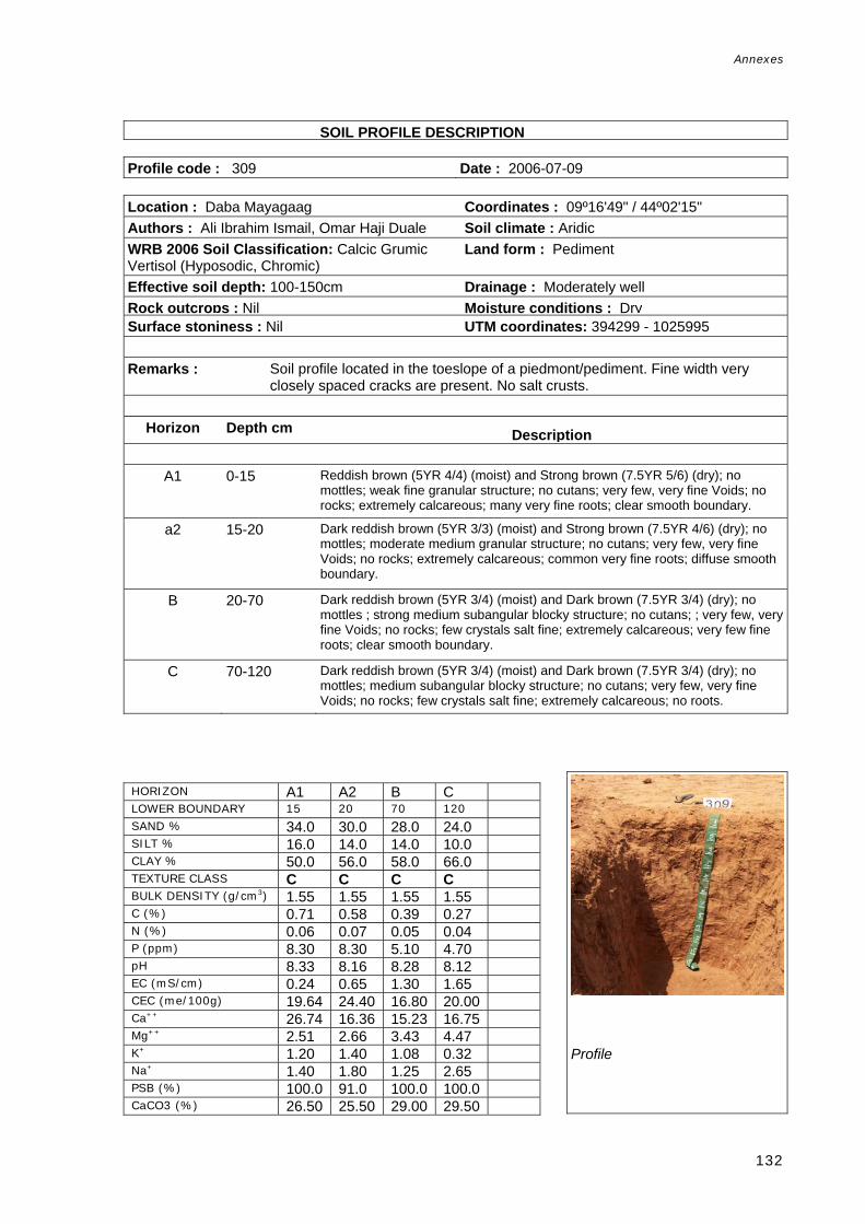
Annexes
132
Soil SOIL PROFILE DESCRIPTION Profile code : 309 Date : 2006-07-09 Location : Daba Mayagaag Coordinates : 09º16'49" / 44º02'15" Authors : Ali Ibrahim Ismail, Omar Haji Duale Soil climate : Aridic WRB 2006 Soil Classification: Calcic Grumic Vertisol (Hyposodic, Chromic)
Land form : Pediment
Effective soil depth: 100-150cm Drainage : Moderately well Rock outcrops : Nil Moisture conditions : Dry Surface stoniness : Nil UTM coordinates: 394299 - 1025995 Remarks : Soil profile located in the toeslope of a piedmont/pediment. Fine width very
closely spaced cracks are present. No salt crusts.
Horizon Depth cm Description
A1 0-15 Reddish brown (5YR 4/4) (moist) and Strong brown (7.5YR 5/6) (dry); no mottles; weak fine granular structure; no cutans; very few, very fine Voids; no rocks; extremely calcareous; many very fine roots; clear smooth boundary.
a2 15-20 Dark reddish brown (5YR 3/3) (moist) and Strong brown (7.5YR 4/6) (dry); no mottles; moderate medium granular structure; no cutans; very few, very fine Voids; no rocks; extremely calcareous; common very fine roots; diffuse smooth boundary.
B 20-70 Dark reddish brown (5YR 3/4) (moist) and Dark brown (7.5YR 3/4) (dry); no mottles ; strong medium subangular blocky structure; no cutans; ; very few, very fine Voids; no rocks; few crystals salt fine; extremely calcareous; very few fine roots; clear smooth boundary.
C 70-120 Dark reddish brown (5YR 3/4) (moist) and Dark brown (7.5YR 3/4) (dry); no mottles; medium subangular blocky structure; no cutans; very few, very fine Voids; no rocks; few crystals salt fine; extremely calcareous; no roots.
HORIZON A1 A2 B C LOWER BOUNDARY 15 20 70 120 SAND % 34.0 30.0 28.0 24.0 SILT % 16.0 14.0 14.0 10.0 CLAY % 50.0 56.0 58.0 66.0 TEXTURE CLASS C C C C BULK DENSITY (g/cm3) 1.55 1.55 1.55 1.55 C (%) 0.71 0.58 0.39 0.27 N (%) 0.06 0.07 0.05 0.04 P (ppm) 8.30 8.30 5.10 4.70 pH 8.33 8.16 8.28 8.12 EC (mS/cm) 0.24 0.65 1.30 1.65 CEC (me/100g) 19.64 24.40 16.80 20.00 Ca++ 26.74 16.36 15.23 16.75 Mg++ 2.51 2.66 3.43 4.47 K+ 1.20 1.40 1.08 0.32 Na+ 1.40 1.80 1.25 2.65 PSB (%) 100.0 91.0 100.0 100.0 CaCO3 (%) 26.50 25.50 29.00 29.50
Profile

Annexes
133
Soil P SOIL PROFILE DESCRIPTION rofile Database Profile code : 310 Date : 2006-07-11 Location : Gumbur Shiikhdon Coordinates : 09º38'32" / 44º01'56" Authors : Omar Haji Duale, Ali Ibrahim Ismail Soil climate : Aridic WRB 2006 Soil Classification: Haplic Calcisol (Aridic, Clayic).
Land form : Plateau
Rock outcrops : Nil Drainage : Well Surface stoniness : Nil Moisture conditions : Dry UTM coordinates: 393828 - 1066010 Remarks : Soil developed under limestone parent rock and located in a Dissected
Plateau/Denudational surface. Fine width very closely spaced cracks.
Horizon Depth cm Description
A 0-35 Dark brown (7.5YR 4/4) (moist) and Strong brown (7.5YR 4/6) (dry); no mottles; moderate medium granular structure; no cutans; no voids; no rocks; extremely calcareous; many very fine roots; clear smooth boundary.
B 35-75 Dark brown (7.5YR 4/4) (moist) and Strong brown (7.5YR 4/6) (dry); no mottles; moderate medium subangular blocky structure; no cutans; no voids; no rocks; few fine calcareous nodules; extremely calcareous; very few very fine roots; clear wavy boundary.
C 75-140 Brown (7.5YR 4/3) (moist) and Dark brown (7.5YR 4/4) (dry); no mottles; moderate medium subangular blocky structure; no cutans; no voids; no rocks; many nodules calcareous medium; extremely calcareous; no roots.
ultilingual Soil SOIL PROFILE DESCRIPTION
HORIZON A B C LOWER BOUNDARY 35 75 140 SAND % 76.0 68.0 18.0 SILT % 6.0 6.0 14.0 CLAY % 18.0 26.0 68.0 TEXTURE CLASS SL SCL C BULK DENSITY (g/cm3) 1.58 1.58 1.58 C (%) 0.31 0.27 0.18 N (%) 0.05 0.05 0.05 P (ppm) 11.80 5.20 9.50 pH 8.17 8.11 8.14 EC (mS/cm) 0.20 0.50 4.00 CEC (me/100g) 10.20 10.00 27.80 Ca++ 17.99 18.51 13.76 Mg++ 2.06 2.16 5.95 K+ 0.80 0.36 0.60 Na+ 0.55 0.75 3.95 PSB (%) 100.0 100.0 100.0 CaCO3 (%) 7.50 14.00 29.50
Profile

Annexes
134
Profile code : 311 Date : 2006-07-11 Location : Beeyo Doofar Coordinates : 09º40'41"/ 44º01'29" Authors : Omar Haji Duale, Ali Ibrahim Ismail Land form : Plateau WRB 2006 Soil Classification: Petric Calcisol (Episkeletic, Arenic)
Drainage : Well
Rock outcrops : Few Moisture conditions : Dry Surface stoniness : Dominant UTM coordinates: 392999 - 1069972 Remarks : Calcaric soil located in a Dissected plateau/Gully rill erosion surface, under
calcaric rock parent material. Fine width very closely spaced cracks and no salt crusts.. No soil samples were taken for soil lab analysis and there is no a complete horizon description because of soil-rock hardness
Horizon Depth cm Description
A 0-25 Brown (7.5YR 5/3) (dry);
HORIZON LOWER BOUNDARY SAND % SILT % CLAY % TEXTURE CLASS BULK DENSITY (g/cm3) C (%) N (%) P (ppm) pH EC (mS/cm) CEC (me/100g) Ca++ Mg++ K+ Na+ PSB (%) CaCO3 (%)
Profile

Annexes
135
O-CSIC Multilingual Soil SOIL PROFILE DESCRIPTION Profile Database
Profile code : 316 Date : 2006-07-14 Location : Cadayabur Coordinates : 09º57'14" / 44º02'43" Authors : Omar Haji Duale, Ali Ibrahim Ismail, Musse Shaie
Soil climate : Aridic
WRB 2006 Soil Classification: Calcic Vertisol (Hyposodic, Chromic).
Land form : Plateau
Effective soil depth: 100-150cm Drainage : Moderately well Surface stoniness : Common Moisture conditions : Dry UTM coordinates: 395353 - 1100459 Remarks : Soil profile located in a Plateau/Denudational surface and developed under clay
deposits. Fine width very closely spaced cracks are present whereas salt crusts are absent.
Horizon Depth cm Description
A 0-20 Dark brown (7.5YR 3/3) (moist) and Brown (7.5YR 4/3) (dry); no mottles;
moderate medium subangular blocky structure; no cutans; very few, very fine Voids; no rocks; extremely calcareous; many fine-medium roots; clear smooth b dBt 25-85 Dark brown (7.5YR 3/4) (moist); no mottles ; strong coarse subangular blocky structure; common pressure face Cutans; ; very few, very fine Voids; no rocks; many calcareous concretions fine; extremely calcareous; many fine roots; clear smooth boundary.
C 85-120 Dark brown (7.5YR 3/3) (moist); no mottles; moderate coarse subangular blocky structure; no cutans; very few, very fine Voids; no rocks; many calcareous concretions fine; extremely calcareous; no roots.
il SOIL PROFILE DESCRIPTION
HORIZON A Bt C LOWER BOUNDARY 20 85 120 SAND % 34.0 32.0 22.0 SILT % 16.0 12.0 16.0 CLAY % 50.0 56.0 62.0 TEXTURE CLASS C C C BULK DENSITY (g/cm3) 1.48 1.48 1.48 C (%) 0.47 0.30 0.22 N (%) 0.07 0.05 0.04 P (ppm) 10.00 9.70 7.70 pH 8.20 8.47 8.38 EC (mS/cm) 0.35 0.35 1.00 CEC (me/100g) 25.40 16.80 28.60 Ca++ 16.49 16.53 19.32 Mg++ 4.22 4.76 4.99 K+ 0.84 0.64 1.96 Na+ 1.35 2.35 3.45 PSB (%) 90.0 100.0 100.0 CaCO3 (%) 22.50 22.50 26.50
Profile

Annexes
136
Profile code : 317 Date : 2006-07-14 Location : North of Luina Dhexe Coordinates : 10º00'50" / 44º08'18" Authors : Omar Haji Duale, Ali Ibrahim Ismail Soil climate : AridicWRB 2006 Soil Classification: Vertic Petric Calcisol (Aridic, Clayic).
Land form : Plateau
Effective soil depth: 50-100cm Drainage : WellRock outcrops : Nil Moisture conditions : Dry Surface stoniness : Few UTM coordinates: 405573 - 1107070 Remarks : Soil profile located in a Dissected plateau/Pediment with parent material
calcaric rock and limestone. Fine width very closely spaced cracks are present whereas salt crusts are absent. The C horizon constitutes a CaCO3 parent rock present as a form of rocks and concretions. This horizon was not sampled.
Horizon Depth cm Description
A 0-10 Dark brown (7.5YR 3/2) (moist) and dark brown (7.5YR 4/4) (dry); no mottles ;
weak fine granular structure; no cutans; ; no voids; few fine subrounded rocks; extremely calcareous; common fine-medium roots; clear smooth boundary.
AB 10-20 Very dark Grey (7.5YR 3/1) (moist) and Dark brown (7.5YR 3/2) (dry); no mottles; strong medium subangular blocky structure; no cutans; no voids; very few fine subrounded rocks; extremely calcareous; common fine-medium roots; gradual wavy boundary.
B 20-65 Very dark Grey (7.5YR 3/1) (moist) and Very dark Grey (7.5YR 3/1) (dry); no mottles; strong medium angular blocky structure; common pressure face Cutans; no voids; very few fine subrounded rocks; extremely calcareous; few fine roots; clear wavy boundary.
C 65-110 No mottles; dominant limestone stones and boulders subrounded fresh-slightly weathered rocks; extremely calcareous.
C Multilingual Soil SOIL PROFILE DESCRIPTION Profile code : 321 Date : 2006-07-17
HORIZON A AB B LOWER BOUNDARY 10 20 65 SAND % 34.0 24.0 22.0 SILT % 18.0 22.0 20.0 CLAY % 48.0 54.0 58.0 TEXTURE CLASS C C C BULK DENSITY (g/cm3) 1.38 1.38 1.38 C (%) 0.62 0.94 0.68 N (%) 0.07 0.07 0.07 P (ppm) 10.10 9.40 13.60 pH 8.17 8.35 8.31 EC (mS/cm) 0.35 0.30 0.70 CEC (me/100g) 29.40 33.40 26.40 Ca++ 35.73 18.75 17.35 Mg++ 3.78 3.98 3.03 K+ 0.88 0.36 0.28 Na+ 1.60 1.70 2.30 PSB (%) 100.0 100.0 100.0 CaCO3 (%) 24.00 27.00 27.00
Profile

Annexes
137
Location : Cunagabad Coordinates : 09º25'31" / 44º00'26" Authors : Omar Haji Duale, Musse Shaie Soil climate : AridicWRB 2006 Soil Classification: Calcic Mazic Vertisol (Hyposalic, Hyposodic).
Land form : Valley
Effective soil depth: >150 Drainage : WellRock outcrops : Nil Moisture conditions : Dry Surface stoniness : Nil UTM coordinates: 391024 - 1042029 Remarks : Soil profile located in a Valley/Pediment under clay deposits. Fine width very
closely spaced cracks are present whereas salt crusts are absent.
Horizon Depth cm Description
Ap 0-15 Brown (7.5YR 4/3) (moist) and brown (7.5YR 5/4) (dry); no mottles; weak fine and medium granular structure; no cutans; very few voids very fine; no rocks; extremely calcareous; many fine roots; abrupt wavy boundary.
A2 15-40 Dark reddish brown (5YR 3/3) (moist) and Reddish brown (5YR 4/3) (dry); no mottles; moderate medium subangular blocky structure; no cutans; very few, very fine Voids; no rocks; extremely calcareous; common fine roots; diffuse boundary.
Bt1k1 40-80 Dark reddish brown (5YR 3/3) (moist) and Brown (7.5YR 4/3) (dry); no mottles ; strong medium subangular blocky structure; few slickensides on pedfaces Cutans; very few, very fine Voids; no rocks; common soft segregation calcareous; extremely calcareous; few burrows; few very fine roots; gradual wavy boundary.
Bt2k2 80-135 Dark reddish brown (5YR 3/3) (moist) and Reddish brown (5YR 4/3) (dry); no mottles ; strong medium and coarse angular blocky structure; few slickensides on pedfaces Cutans; ; very few, very fine Voids; no rocks; common soft segregation calcareous; extremely calcareous; no roots; gradual wavy boundary
Ck 135-155 Dark reddish brown (5YR 3/3) (moist) and Reddish brown (5YR 4/4) (dry); no mottles; strong medium and coarse angular blocky structure; no cutans; very few, very fine Voids; no rocks; common soft segregation calcareous; extremely calcareous; no roots.
Profile
HORIZON Ap A2 Bt1k1 Bt2k2 Ck LOWER BOUNDARY 15 40 80 135 155 SAND % 38.0 20.0 24.0 22.0 18.0 SILT % 4.0 22.0 12.0 16.0 16.0 CLAY % 58.0 58.0 64.0 62.0 66.0 TEXTURE CLASS C C C C C BULK DENSITY (g/cm3) 1.36 1.36 1.36 1.36 1.36 C (%) 0.65 0.55 0.38 0.27 0.23 N (%) 0.09 0.12 0.11 0.08 0.07 P (ppm) 11.50 10.50 14.70 18.80 15.40pH 8.03 7.85 7.98 8.00 8.09 EC (mS/cm) 0.70 2.50 2.35 2.20 2.15 CEC (me/100g) 20.40 21.40 22.40 23.60 27.20Ca++ 9.79 10.53 10.71 19.83 12.27Mg++ 2.98 3.53 3.88 7.59 5.26 K+ 0.76 0.60 0.70 0.78 1.16 Na+ 1.20 1.65 2.15 2.25 2.65 PSB (%) 72.0 76.0 78.0 100.0 86.0 CaCO3 (%) 26.00 24.00 26.50 29.00 32.50

Annexes
138
C Multilingual Soil SOIL PROFILE DESCRIPTION Profile code : 323 Date : 2006-07-17 Location : Sharmarke Coordinates : 09º24'42" / 44º12'48" Authors : Ali Ibrahim Ismail Soil climate : Aridic WRB 2006 Soil Classification: Calcic Grumic Vertisol (Hyposalic, Chromic).
Land form : Valley
Effective soil depth: >150 Drainage : Moderately well Rock outcrops : Nil Moisture conditions : Dry Surface stoniness : Nil UTM coordinates: 413625 - 1040462 Remarks : Soil profile located in a Valley/Flat floor valley. Fine width very closely spaced
cracks are present whereas salt crusts are absent.
Horizon Depth cm DescriptionA1 0-10 Dark brown (7.5YR 3/4) (moist) and Dark brown (7.5YR 4/4) (dry); no mottles;
strong fine granular structure; no cutans; no voids; no rocks; extremely calcareous; many fine roots; clear smooth boundary.
A2 10-25 Dark brown (7.5YR 3/4) (moist) and Dark brown (7.5YR 4/4) (dry); no mottles; strong medium subangular and angular blocky structure; no cutans; no voids; no rocks; extremely calcareous; common fine-medium roots; clear wavy boundary.
B1 25-50 Dark brown (7.5YR 3/4) (moist) and Strong brown (7.5YR 4/6) (dry); no mottles; strong coarse angular and subangular blocky structure; no cutans; no voids; no rocks; extremely calcareous; few fine roots; gradual smooth boundary.
B2 50-110 Dark brown (7.5YR 3/3) (moist) and Brown (7.5YR 4/3) (dry); no mottles; weak medium subangular and angular blocky structure; no cutans; no voids; no rocks; extremely calcareous; very few fine roots; diffuse smooth boundary.
C 110-160 Dark brown (7.5YR 3/3) (moist) and Dark brown (7.5YR 3/4) (dry); no mottles; weak medium subangular and angular blocky structure; no cutans; no voids; no rocks; extremely calcareous; no roots.
Profile
HORIZON A1 A2 B1 B2 C LOWER BOUNDARY 10 25 50 110 >140 SAND % 6.0 6.0 10.0 8.0 12.0 SILT % 32.0 32.0 38.0 34.0 26.0 CLAY % 62.0 62.0 52.0 58.0 62.0 TEXTURE CLASS C C C C C BULK DENSITY (g/cm3) 1.41 1.41 1.41 1.41 1.41 C (%) 0.52 0.46 0.51 0.41 0.29 N (%) 0.07 0.08 0.11 0.10 0.09 P (ppm) 18.00 7.10 7.30 5.60 9.30 pH 8.06 7.98 7.81 7.84 7.90 EC (mS/cm) 0.55 1.20 3.50 4.00 3.50 CEC (me/100g) 25.40 32.00 20.60 21.80 29.40Ca++ 5.02 15.71 10.97 10.89 6.09 Mg++ 1.21 4.80 3.20 5.92 9.20 K+ 0.28 0.80 0.42 0.68 1.40 Na+ 0.20 1.80 1.35 2.35 1.30 PSB (%) 100.0 100.0 100.0 100.0 100.0CaCO3 (%) 24.00 23.00 22.50 25.00 25.50

Annexes
139
CSIC Multilingual Soil Pr SOIL PROFILE DESCRIPTION Profile code : 325 Date : 2006-07-21 Location : Boodhley Coordinates : 09º36'03" / 43º32'18" Authors : Ali Ibrahim Ismail, Omar Haji Duale Soil climate : Aridic WRB 2006 Soil Classification: Calcic Vertisol (Chromic)
Land form : Plateau
Rock outcrops : Nil Drainage : Well Surface stoniness : Nil Moisture conditions : Dry UTM coordinates: 339591 - 1061629 Remarks : Soil profile located in a Plateau/Denudational surface where the parent material
is clay deposits. Fine width very closely spaced cracks are present whereas salt crusts are absent.
Horizon Depth cm Description
Ap 0-20 Dark brown (7.5YR 3/3) (moist) and Dark brown (7.5YR 4/4) (dry); no mottles;
weak fine granular structure; no cutans; ; no voids; no rocks; extremely calcareous; common very fine roots; clear wavy boundary.
Btk 20-75 Dark brown (7.5YR 3/2) (moist) and Dark brown (7.5YR 3/2) (dry); no mottles; strong coarse subangular blocky structure; common pressure face Cutans; no voids; no rocks; common soft segregation calcareous; extremely calcareous; common fine roots; diffuse boundary.
Ck 75-110 Dark brown (7.5YR 3/3) (moist) and Brown to dark brown (7.5YR 4/2) (dry); strong coarse subangular blocky structure; no cutans; no voids; no rocks; many soft segregation calcareous; extremely calcareous; few fine roots.
us. FAO-CSIC Multilingual Soil SOIL PROFILE DESCRIPTION
Profile
HORIZON Ap Btk Ck LOWER BOUNDARY 20 75 110 SAND % 32.0 30.0 24.0 SILT % 12.0 12.0 12.0 CLAY % 56.0 58.0 64.0 TEXTURE CLASS C C C BULK DENSITY (g/cm3) 1.34 1.34 1.34 C (%) 1.28 0.88 0.64 N (%) 0.11 0.07 0.05 P (ppm) 6.10 10.00 4.60 pH 7.97 7.84 8.13 EC (mS/cm) 0.35 0.55 0.95 CEC (me/100g) 27.60 27.00 21.60 Ca++ 31.27 36.86 12.96 Mg++ 2.73 4.11 4.61 K+ 1.30 1.10 0.50 Na+ 1.55 1.55 2.30 PSB (%) 100.0 100.0 93.0 CaCO3 (%) 19.50 21.00 27.50

Annexes
140
Profile code : 326 Date : 2006-07-21 Location : Idhanka Deerayaharka Coordinates : 09º33'07" / 43º27'44" Authors : Omar Haji Duale, Ali Ibrahim Ismail Soil climate : Aridic WRB 2006 Soil Classification: Calcic Mazic Vertisol (Chromic)
Land form : Pediment
Land use : Agriculture Drainage : Well Effective soil depth: 100-150cm Moisture conditions : Dry Rock outcrops : Nil Surface stoniness : Nil UTM coordinates: 331228 - 1056257 Remarks : Soil profile located in a Piedmont/Pediment where a clay deposit is the parent
material. Wide width very closely spaced cracks are present whereas salt crusts are absent.
Horizon Depth cm Description
Ap 0-15 Dark brown (7.5YR 3/2) (moist) and dark brown (7.5YR 3/2) (dry); no mottles;
weak fine granular structure; no cutans; no voids; no rocks; extremely calcareous; common very fine roots; clear smooth boundary.
AB 15-30 Very dark Grey (7.5YR 3/1) (moist) and dark brown (7.5YR 3/2) (dry); no mottles; moderate medium subangular blocky structure; no cutans; ; no voids; no rocks; extremely calcareous; common very fine roots; diffuse boundary.
Btk 30-110 Dark brown (7.5YR 3/2) (moist) and Dark brown (7.5YR 3/2) (dry); no mottles; strong coarse angular blocky structure; many pressure faces on pedfaces Cutans; no voids; no rocks; few soft segregation calcareous; extremely calcareous; few very fine roots; clear smooth boundary.
Ck 110-140 Dark brown (7.5YR 3/4) (moist) and Dark brown (7.5YR 3/3) (dry); no mottles; moderate medium angular blocky structure; no cutans; no voids; no rocks; common soft segregation calcareous; extremely calcareous; no roots.
HORIZON Ap AB Btk Ck
LOWER BOUNDARY 15 30 110 >110 SAND % 34.0 30.0 24.0 22.0 SILT % 12.0 12.0 14.0 12.0 CLAY % 54.0 58.0 62.0 66.0 TEXTURE CLASS C C C C BULK DENSITY (g/cm3) 1.43 1.43 1.43 1.43 C (%) 1.09 0.81 0.53 0.14 N (%) 0.06 0.07 0.04 0.04 P (ppm) 7.30 4.90 4.20 6.40 pH 7.92 7.96 8.13 8.24 EC (mS/cm) 0.35 0.35 0.50 0.90 CEC (me/100g) 26.40 32.00 21.20 25.00 Ca++ 22.73 25.40 18.11 14.73 Mg++ 2.88 3.88 8.24 8.59 K+ 1.44 1.10 0.96 0.68 Na+ 1.55 1.30 1.65 2.80 PSB (%) 100.0 100.0 100.0 100.0 CaCO3 (%) 19.00 23.00 25.00 28.00
Profile

Annexes
141
FAO-CSIC Multilingual Soil Pro SOIL PROFILE DESCRIPTION Profile code : 328 Date : 2006-07-23 Location : Balliga Godan Coordinates : 09º39'41" / 43º25'24" Authors : Ali Ibrahim Ismail, Omar Haji Duale Soil climate : Aridic WRB 2006 Soil Classification: Calcic Vertisol (Bathyhyposalic, Bathyhyposodic)
Land form : Pediment
Land use : Agriculture Drainage : Well Effective soil depth: >150 Moisture conditions : Dry Rock outcrops : Nil Surface stoniness : Nil UTM coordinates: 327021 - 1068371 Remarks : Soil profile developed in a Piedmont/Pediment composed of clay deposits.
Wide, very closely spaced cracks are present whereas salt crusts are absent.
Horizon Depth cm Description
Ap 0-20 Black (7.5YR 2.5/1) (moist) and very dark Grey (7.5YR 3/1) (dry); no mottles; weak fine granular structure; no cutans; very few, very fine Voids; no rocks; extremely calcareous; many very fine roots; clear wavy boundary.
Bt 20-90 Black (7.5YR 2.5/1) (moist) and Black (7.5YR 2.5/1) (dry); no mottles; strong coarse angular blocky structure; many slickensides on pedfaces Cutans; very few, very fine Voids; no rocks; extremely calcareous; very few fine-medium roots; clear smooth boundary.
C 90-160 Dark brown (7.5YR 4/4) (moist) and Dark brown (7.5YR 4/4) (dry); no mottles; strong coarse angular blocky structure; many pressure face Cutans; very few, very fine Voids; no rocks; many soft segregation calcareous; extremely calcareous; no roots.
HORIZON Ap Bt C LOWER BOUNDARY 20 90 160 SAND % 14.0 14.0 12.0 SILT % 18.0 12.0 12.0 CLAY % 68.0 74.0 76.0 TEXTURE CLASS C C C BULK DENSITY (g/cm3) 1.31 1.31 1.31 C (%) 1.76 0.92 0.04 N (%) 0.11 0.05 0.03 P (ppm) 6.00 6.20 7.70 pH 7.97 8.46 8.28 EC (mS/cm) 0.40 0.75 4.00 CEC (me/100g) 41.40 45.32 26.40 Ca++ 27.10 19.37 20.21 Mg++ 5.71 9.82 6.64 K+ 0.86 0.76 0.40 Na+ 0.85 3.10 4.55 PSB (%) 100.0 100.0 100.0 CaCO3 (%) 22.00 26.00 29.50
Profile

Annexes
142
. FAO-CSIC Multilingu SOIL PROFILE DESCRIPTION Profile code : 329 Date : 2006-07-23 Location : Mashrunca Wajale Coordinates : 09º37'07" / 43º24'24" Authors : Omar Haji Duale, Ali Ibrahim Ismail Soil climate : Aridic WRB 2006 Soil Classification: Calcic Grumic Vertisol (Bathyhyposodic, Chromic)
Land form : Pediment
Land use : Agriculture Drainage : Imperfect Effective soil depth: 100-150cm Moisture conditions : Dry Rock outcrops : Nil Surface stoniness : Nil UTM coordinates: 325151 - 1063458 Remarks : Soil profile located in a Piedmont/Pediment composed of clay deposits. Wide
width, very closely spaced cracks are present whereas salt crusts are absent.
Horizon Depth cm Description
Ap 0-25 Dark brown (7.5YR 3/2) (moist) and grey (7.5YR 6/1) (dry); no mottles; strong fine and medium granular structure; no cutans; no voids; no rocks; extremely calcareous; many fine roots; clear wavy boundary.
Bt 25-110 Brown (7.5YR 4/3) (moist) and Dark brown (7.5YR 3/2) (dry); no mottles; strong coarse angular blocky structure; many slickensides on pedfaces Cutans; no voids; no rocks; extremely calcareous; common very fine roots; gradual irregular boundary.
C 110-140 Brown (7.5YR 4/3) (moist) and dark brown (7.5YR 3/4) (dry); no mottles; moderate medium angular blocky structure; no cutans; no voids; no rocks; common crystals salt; extremely calcareous; no roots.
HORIZON Ap Bt C LOWER BOUNDARY 25 110 140 SAND % 16.0 14.0 10.0 SILT % 14.0 8.0 10.0 CLAY % 70.0 78.0 80.0 TEXTURE CLASS C C C BULK DENSITY (g/cm3) 1.16 1.16 1.16 C (%) 0.02 0.02 0.01 N (%) 0.14 0.03 0.02 P (ppm) 4.40 5.90 7.00 pH 7.82 8.63 8.50 EC (mS/cm) 0.60 1.55 3.50 CEC (me/100g) 33.70 25.40 27.00 Ca++ 13.24 11.93 12.96 Mg++ 4.63 3.44 6.41 K+ 1.10 0.96 1.00 Na+ 1.05 1.95 8.55 PSB (%) 100.0 100.0 100.0 CaCO3 (%) 25.00 31.50 30.50
Profile