soil science - west bengal forest
TRANSCRIPT

Soil Science 1
Soil Science
DIRECTORATE OF FORESTSGOVERNMENT OF WEST BENGAL

Soil Science2
This edition is published byDevelopment Circle, Directorate of Forests,Government of West Bengal,2016
Aranya BhavanLA – 10A Block, Sector IIISalt Lake City, Kolkata,West Bengal, 700098
Copyright © 2016 in textCopyright © 2016 in design and graphics
All rights reserved. No part of this publication may be reproduced, stored in any retrieval system or transmitted, in any form or by any means, electronic, mechanical, photocopying, recording or otherwise, without the prior written permission of the copyright holders.

Soil Science 3
N K Pandey, IFS Chairman, SPMU, Forest Department,
Govt of West Bengal
A Basu Ray Chaudhuri, IFS (Retd)For IBRAD (Consultant)
Kolkata, July 2015
Soil Science
PREFACE
Soil forms the foundation of forests. It has a critical role in the cycling of nutrients that influences the growth of individual trees and functioning of the forest ecosystem. It is therefore necessary that forest managers learn the fundamentals of soil science to understand how soil regulates the availability of resources to the plants. As part of the JICA project on ‘Capacity Development for Forest Management and Training of Personnel’ being implemented by the Forest Department, Govt of West Bengal, these course materials on Soil Science have been prepared for induction training of the Foresters and Forest Guards. The object of this training manual is to present the basic aspects of soil science.
The subjects covered in these materials broadly conform to syllabus laid down in the guidelines issued by the Ministry of Environment of Forests, Govt of India, vide the Ministry’s No 3 -17/1999-RT dated 05.03.13. In dealing with some of the parts of the course though, the syllabus has undergone minor revision. Some topics have been deleted and some topics have been included to facilitate complete understanding of the subjects and to provide their appropriate coverage. The revised syllabus, with such modifications, is appended.
As the materials are meant for the training of frontline staff of the Department, effort has been made to present the subject in simple and easy language and to avoid complex scientific theories and calculations.
The contents of the course materials have been compiled and edited by A Basu Ray Chaudhuri, IFS (Retd). Many books and literature including those available in internet have been made use of in preparing these course materials and references of such books and documents have been cited in the respective topics. The contents of these study materials owe heavily, in particular, to the following sources, namely, (1) Forest Ecology by Barnes, Zak, Denton and Spurr, (John Wiley & Sons, Inc); (2) India – the land and people, Land and Soil by Dr. S P Raychaudhuri, (National Book Trust India); (3) Introductory Soil Science by S S Negi, (Bishen Singh Mahendra Pal Singh Dehradun); (4) Soil and Water Management Module 1 – Basic Soil Properties, Montana State University; and (5). Methods Manual, Soil Testing in India, Department of Agriculture and Cooperation, Ministry of Agriculture, GoI, 2011. Shri A Basu Ray Chaudhuri is indebted to many forest officers who have helped in the preparation of these materials..
Efforts that have gone into making of these course materials will be best rewarded if the frontline staff of the forest department find these materials useful in their day-to-day works.
Kolkata, July 2014
A Basu Ray Chaudhuri IFS (Retd) For IBRAD (Consultant)
N K Pandey, IFS Chairman, SPMU, Forest Department, Govt of WB

Soil Science4
Soil Science
SYLLABUS
Soil Science (5 hours), Excursion 1 day 1. Rocks and Soil 1-1. Rocks
• Igneous • Sedimentary • Metamorphic 1-2. Soil formation • Physical weathering • Chemical weathering • Biological weathering 1-3. Soil profile and horizons 1-4. Physical properties – Soil texture, structure, porosity*, soil water and plant relations*, Chemical properties – macro-micro nutrients*, cation exchange capacity*,
soil pH, soil organic matter*, humus* Biological properties - soil flora*, soil fauna*, soil micro-organisms,
biological activity*
3 hours
2. Soil types 2-1. Important soil types and their properties • Alluvial soils • Black soils • Red soils • Lateritic soils • Desert soils • Saline soils • Alkaline soils • Acid soils • Peaty and marshy soil*
2-2 Soils in West Bengal* . Agro-Ecological Classification of soils in West
Bengal * • Soil problems in West Bengal*
1 hour
3. Nutrients and Soil testing*
3.1. Functions of major plant nutrients* 3.2. Soil nutrients as index of fertility* 3.3. Soil testing methods.*
1 hour
Field Study Study of soil profile
* These are modifications to the prescribed (by MoEF) course contents, indicating addition of topics and change in lesson hours.

Soil Science 5
Soil Science
Lesson No.
Contents Page No.
1
Lesson Plan Soil-foundation of forest eco-system Soil-parent material Rocks Soil Formation-Weathering Soil profile and Horizons
1-8
2
Lesson Plan Physical properties of Soil
Soil Texture Soil colloids Soil Structure Soil Porosity Soil water and plant relations
Chemical properties of soil Macro,micro nutrients Cation Exchange Capacity
9-16
3
Lesson Plan Chemical properties of soil (continued)
Soil pH Soil Organic Matter (SOM)
Biological Properties Soil flora Soil fauna Soil micro-organisms Biological Activity
17-22
4
Lesson Plan Major Soil Types in India
Alluvial Soils Black Soils(Regur) Red Soils Laterite and Lateritic soils Forest Soils Desert Soils Saline and Alkali Soils Acid soils Peaty and Marshy soils
Agro-Ecological Classification of Soils in West Bengal Soil Problems in West Bengal Appendix-I Appendix-II Appendix-III
23-35

Soil Science6
Soil Science
5 Lesson Plan Essential Plant Nutrients Soil Testing
Soil nutrient as an index of soil fertility Soil Testing procedures
Soil moisture Water holding capacity Organic Carbon Available Phosphorous Available Potasium
36-46

Soil Science 7
Soil Science- Lesson: 1
1
Lesson 1
Time 1 hour
Lesson Plan
Objective: • To understand function of soil in a forest ecosystem. • To know about parent materials of soil. • To study soil formation process – weathering • To know about soil profile and horizons.
Forward Linkage: • During tour the trainees may be shown profiles of forest soil in different agro-climatic
zones. Training materials required:
• Copy of lesson 1 to be circulated beforehand. • Demonstration of various types of rocks.
Allocation of time:
• Function of soil –5 mts • Study of rocks and demonstration – 25 mts • Soil formation – weathering – 10 mts • Soil profile and horizons – 10 mts • Discussion/miscellaneous –10 mts
1. Soil – foundation of forest eco-system
Forest trees require five primary resources for growth and development. These are –
• Radiant energy – Plants obtain energy from solar radiation • Carbon dioxide – Plants obtain carbon dioxide from atmosphere • Water • Mineral nutrients • A porous medium for physical support
The last three resources are provided by soil. Thus soil forms the “foundation” of forest ecosystems. Soil is also critical to the process of cycling of nutrients, which influences the growth of individual trees and functioning of the forest ecosystem.

Soil Science8
Soil Science- Lesson: 1
2
1.1 Soil may be defined as a porous medium consisting of minerals, organic matter, water and gases. Soils are as diverse as the climate in which they occur, the landforms on which they develop, and the plant life that grows upon and within them (Forest Ecology by Burton V. Barbes et al.)
2. Soil - parent material
The earth’s surface is blanketed by a wide array of geologic materials, different in their composition and degree of consolidation. The relatively unweathered geologic material from which a particular soil has developed is called parent material. It constitutes the basic substrate for soil formation and exerts a substantial influence on many soil properties. Parent materials are broadly classified as consolidated and unconsolidated. Consolidated parent materials include igneous, sedimentary and metamorphic rock. Soil developing in consolidated geologic substrate is said to be formed in residual parent material. Unconsolidated parent materials are mineral particles that have been transported by water, ice, wind or gravity. They are chemically similar to the rock from which they originate, but are distinguished from residual parent material by being moved from their point of origin. The agent of transport has an impact on the physical, chemical and biological properties of soils formed in unconsolidated parent materials.
3. Rocks
Depending on their mode of origin rocks are classified as – • igneous, • sedimentary, and • metamorphic.
3.1 Igneous rocks solidify from magma or molten material either within the earth’s crust or extrude on the surface as volcanic material. Based on their depth of occurrence they are further classified into three types (Introductory Soil Science – by S.S Negi)
(1). Plutonic – formed deep inside the bowels of earth (2). Hypabassal – formed at intermediate zone; (3). Volcanic – formed at the surface
Some igneous rocks are: Granite, Granodiorite, Syenite, Pitchstone, Basalt, Gabbro, Dolerite, Pegmatite, Peridotite etc.

Soil Science 9
Soil Science- Lesson: 1
3
Fig. 1.1 Granite (Source: http://geology.com/rocks/granite.shtml)
3.2 Sedimentary rocks are formed from the deposition of fragments worn from pre-existing rocks, from the accumulation of shells or other organic material, or from the precipitation of chemical compounds from solution.
3.2.1 The sedimentary rock cover of the continents of the Earth’s crust is extensive, but the total contribution of sedimentary rocks is estimated to be only 8% of the total volume of the crust. Sedimentary rocks are only a thin veneer over a crust consisting mainly of igneous and metamorphic rocks. Sedimentary rocks are deposited in layers as strata, forming a structure called bedding. (http://en.wikipedia.org/)
Some sedimentary rocks are: Limestone, Dolomite, Shale, Phyllite, Sandstone, Claystone, Mudstone etc.
3.3 Metamorphic rocks result from the re-crystallization of pre-existing rocks under changing temperature and pressure conditions. The process of formation is called metamorphism. Due to the action of plate tectonics, compression, stress and shearing forces over long periods of time, rocks can be essentially warped and deformed, causing them to be compacted into a smaller volume of space. As a consequence, metamorphic rocks are always more dense than their original material, and also much less susceptible to erosional breakdown.
Some metamorphic rocks are: Quartzite, Schist, Gneiss, Granite gneiss, Marble etc.

Soil Science10
Soil Science- Lesson: 1
4
Fig. 1.2 Limestone (Source: http://geology.com/rocks/limestone.shtml)
Fig. 1.3 (Source: http://earth.rice.edu/mtpe/geo/geosphere/topics/rocks/30_rocks_metamorphic1.html)

Soil Science 11
Soil Science- Lesson: 1
5
4. A mineral is a naturally occurring inorganic substance that is solid and stable at room temperature, representable by a chemical formula, and has an ordered atomic structure. It is different from a rock, which can be an aggregate of minerals or non-minerals and does not have a specific chemical composition.
5. Soil Formation – Weathering Weathering is the process by which rocks and minerals are broken down on earth’s surface to form soils. Rocks and geological sediments are the main parent materials of soils (the materials from which soils have formed). There is a very wide variety of rocks in the world, some acidic, some alkaline, some coarse-textured like sands, and some fine-textured and clayey. It is from the rocks and sediments that soils inherit their particular texture. The process of soil formation through weathering, however, takes a long time. In fact, it can take over 500 years to form just one centimetre of soil from some of the harder rocks.
5.1 In-situ process Weathering occurs in situ, or "with no movement", and thus should not be confused with erosion, which involves the movement of rocks and minerals by agents such as water, ice, wind, and gravity.
5.2 Different processes of weathering
Depending on the agencies of weathering, the process of weathering may be classified into three types, namely, Physical or Mechanical weathering, Chemical weathering, and Biological weathering. Often all these three processes work simultaneously.
5.2.1 Physical weathering Mechanical or physical weathering involves the breakdown of rocks and soils through heat, water, ice and pressure. During mechanical weathering, the rocks break into pieces, but their chemical properties remain unchanged. Thus mechanical weathering is an isochemical process. Agents of mechanical weathering are many, such as ice, heat differences and pressure differences. In cold regions, water accumulated inside the fractures of rocks freeze in winter season to form ice. When water becomes ice, volume increases and owing to volume increase, pressure is generated. The resulting pressure enlarges the existing fractures and facilitates further disintegration of the rocks. In hot climatic regions, the difference in temperature during day and night causes disintegration of rocks. During the day the rocks being in contact with hot air get heated up slowly. But at the night time the air becomes cool and lowers the temperature of the rock surface. However, rocks being very poor conductor of heat, the material inside take

Soil Science12
6
Soil Science- Lesson: 1
longer time to cool, and the difference between surface temperature and inside temperature result in peeling off of the rock surface called exfoliation. Likewise, a rock surface heated up by sunshine during the day, if exposed to sudden rainfall could cause similar weathering pattern. Another type of mechanical weathering occurs when clay or other materials near hard rock absorb water. The clay swells with the water, breaking apart the surrounding rock.
5.2.2 Chemical weathering Chemical weathering is the decomposition of rocks through a series of chemical processes such as acidification, dissolution and oxidation. Chemical weathering changes the materials that make up rocks and soil. Sometimes, carbon dioxide from the air or soil combines with water. This produces a weak acid, called carbonic acid that can dissolve rock. Carbonic acid is especially effective in dissolving limestone. When the carbonic acid seeps through limestone underground, it can open up huge cracks or hollow out vast networks of caves. Another type of chemical weathering works on rocks that contain iron. These rocks rust in a process called oxidation. As the rust expands, it weakens the rock and helps break it apart. Again by the process of dissolution, chemical weathering takes place. Materials which are soluble in water - like gypsum etc. – get dissolved and removed from the rock resulting in a porous structure. Potash feldspar which contains silicate reacts with water and produces clay, silicic acid and potash. Many silicates dissolve in this manner. Thus water acts not only as a solvent but is also responsible for hydrolysis which ultimately gives clay and other secondary minerals.
5.2.3 Biological weathering (Source: http://passel.unl.edu/)
Biological weathering is the weakening and subsequent disintegration of rock by plants, animals and microbes. Growing plant roots can exert stress or pressure on rock. Although the process is physical, the pressure is exerted by a biological process (i.e., growing roots). Biological processes can also produce chemical weathering, for example where plant roots or microorganisms produce organic acids which help to dissolve minerals. Microbial activity breaks down rock minerals by altering the rock’s chemical composition, thus making it more susceptible to weathering. One example of microbial activity is lichen; lichen is fungi and algae, living together in a symbiotic relationship. Fungi release chemicals that break down rock minerals; the minerals thus released from rock are consumed by the algae. As this process continues, holes and gaps continue to develop on the rock, exposing the rock further to physical and chemical weathering. Burrowing animals can move rock fragments to the surface, exposing the rock to more intense chemical, physical, and biological processes and so indirectly enhancing the process of rock weathering.

Soil Science 13
7
Soil Science- Lesson: 1
Although physical, chemical, and biological weathering is separate processes, some or all of the processes can act together in nature.
6. Soil profile and Horizons
6.1 Soil is comprised of minerals, soil organic matter (SOM), water, and air.. The pore space is occupied by water and air, whereas soil solids comprise of minerals and SOM.
6.2 As parent material weathers and is occupied by plants and animals, it differentiates into more or less distinct horizontal zones or soil horizons. A soil horizon makes up a distinct layer of soil. The horizon runs roughly parallel to the soil surface and has different properties and characteristics than the adjacent layers above and below. The soil profile is a vertical section of the soil that depicts all of its horizons. The soil profile extends from the soil surface to the parent rock material.
6.3 Soil Horizons (Source: http://www.ctahr.hawaii.edu/mauisoil/a_profile.aspx and Forest Ecology by Burton V Barnes et.al)
A typical forest soil profile can be differentiated into five zones, called master horizons. However, not all soil profiles contain all 5 horizons; and so, soil profiles differs from one location to another. The 5 master horizons are represented by the letters: O, A, E, B, and C. Please see Fig. 1.4.
O: The O horizon is a surface horizon that is comprised of organic material at various stages of decomposition. It is an attribute most unique to forest soils. Materials contained within this horizon consist almost entirely of leaves, twigs, flowers, fruits, cones and seeds that have been deposited on the soil surface. It has high organic matter content (> 20 or even 30%)
A: The A horizon is a surface horizon that largely consists of minerals (sand, silt, and clay) and with appreciable amounts of organic matter (4 to 12 %). The A horizon is also characterized by a large number of fine roots. A horizon is thin in most forest soils. This horizon is predominantly the surface layer of many soils in grasslands and agricultural lands.
E: The E horizon is a subsurface horizon that has been heavily leached. Leaching is the process in which soluble nutrients are lost from the soil due to precipitation or irrigation. The horizon is typically light in color. It is generally found beneath the O horizon. The acidity of this horizon is typically higher than the over or underlying horizons. Root densities within the E horizon are low, because few plant nutrients remain in this highly leached horizon.

Soil Science14
8
Soil Science- Lesson: 1
B: The B horizon is a subsurface horizon that is formed by deposition of materials leached and migrated from either A or E horizon. The B horizon results from the process of illuviation (i.e accumulation) and is distinguished from other soil horizons by this important soil forming process (Forest Ecology by Burton V Barnes et.al).
C: The C horizon is a subsurface horizon. It is the least weathered horizon. It is unconsolidated, loose parent material and is outside the influence of the processes giving rise to the horizons above it.
The master horizons may be followed by a subscript to make further distinctions between differences within one master horizon.
Fig. 1.4 A typical forest soil profile.
(Source: http://www.ctahr.hawaii.edu/mauisoil/a_profile.aspx)

Soil Science 159
Soil Science - Lesson: 2
Lesson 2
Time 1 hour
Lesson Plan Objective:
• To study soil properties – physical and chemical
Backward linkage:
• Soil formation in Lesson 1
Forward Linkage:
• Chemical and Biological Properties in Lesson 3.
Allocation of Time:
• Physical properties - general – 5 mts Texture – 10 mts Structure – 10 mts Porosity – 5 mts Soil water – 5 mts
• Chemical properties Macro and micro nutrients – 5 mts Cation Exchane Capacity – 10 mts
• Discussion/ miscellaneous – 10 mts
1. Physical properties of Soil
Soil is comprised of minerals, soil organic matter (SOM), water, and air. The composition and proportion of these components greatly influence soil physical properties, including texture, structure, and porosity, the fraction of pore space in a soil. In turn, these properties affect air and water movement in the soil, and thus the soil’s ability to function (source: Soil and Water Management Module I, Montana State University).
Physical properties of the solid, liquid and the gaseous phases of soil greatly influence

Soil Science16
Soil Science - Lesson: 2
10
• Supply of water and nutrients to the plants; • Supply of oxygen to the roots – supply of oxygen required by the roots for respiration is
controlled by the rate at which oxygen diffuses through water and other gases in the soil.
• Availability of physical space to anchor aboveground plant structures. Of the above three functions the anchorage is of particular importance as it helps the plants to properly orient themselves to receive sunlight for photosynthesis.
2. Soil Texture Soils are composed of mineral particles whose sizes vary over a wide range. These particles or soil separates are grouped into three size classes, namely, sand, silt and clay. The sizes of these classes are as shown below.
Soil Particles Diameter in mm Sand 2.00 to 0.02 Silt 0.02 to 0.002 Clay < 0.002
Soil texture refers to relative proportion of sand, silt and clay-sized particles contained in a particular soil. This physical property plays an integral role in regulating – (1) availability of water and mineral ions for plant uptake, and (2) the rate at which gases (O2 and CO2) are exchanged between soil and overlying atmosphere (Forest Ecology by Burton V Barnes et.al).
2.1 Soil particles of different size classes can also be distinguished by their physical and chemical properties. Sand and silt sized particles are chemically identical to the rock from which they originate and are called primary minerals. The clay fraction of soil is comprised of secondary minerals which result from physical and chemical weathering of primary minerals.
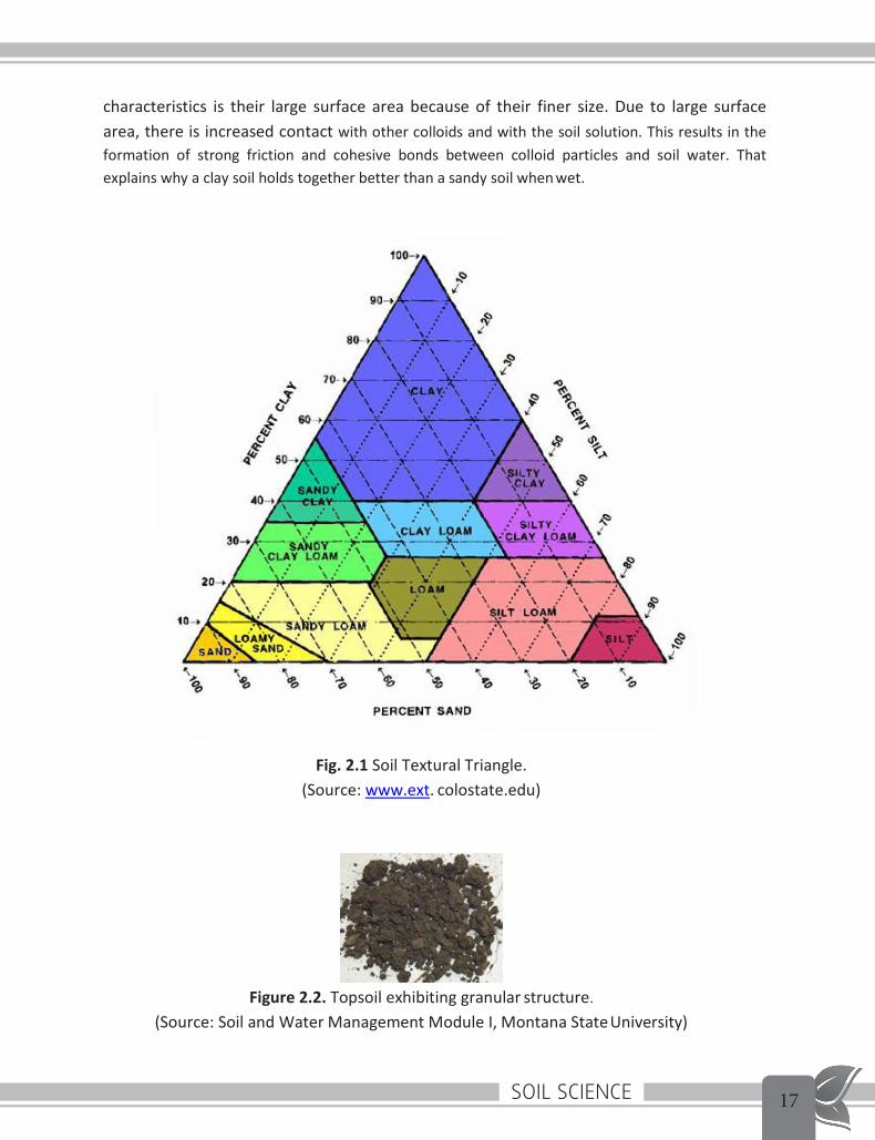
2.2 Soils are grouped into textural classes based on their sand, silt and clay content. For, example, a soil consisting of equal proportions of sand, silt and clay is classified as a loam. For a soil to be classified as a clay, 60 % of its particles must be less than less than .002 mm in diameter. In the other extreme case, sands are soils in which more than 90% of the particles are in the diameter range of 0.02 to 2.00 mm. The soil textural triangle is shown in Fig.2.1. It indicates the relative proportions of sand, silt and clay that compose each textural class.
3. Soil Colloids‘Soil colloids’ refer to the finest clay and SOM particles in a soil. Colloids have characteristics that make them the location of most physical and chemical activity in the soil. One of the
Soil Science 17
Soil Science - Lesson: 2
11
characteristics is their large surface area because of their finer size. Due to large surface area, there is increased contact with other colloids and with the soil solution. This results in the formation of strong friction and cohesive bonds between colloid particles and soil water. That explains why a clay soil holds together better than a sandy soil when wet.
Fig. 2.1 Soil Textural Triangle. (Source: www.ext. colostate.edu)
Figure 2.2. Topsoil exhibiting granular structure.
(Source: Soil and Water Management Module I, Montana State University)

Soil Science18
Soil Science - Lesson: 2
12
4. Soil structure
(Source: Soil and Water Management Module I, Montana State University)
Soil structure is the arrangement and binding together of soil particles into larger clusters, called aggregates or peds. Aggregation is important for increasing stability against erosion, for maintaining porosity and soil water movement, and for improving fertility and carbon sequestration in the soil.
4.1 Extreme cases of aggregates – Aggregates range from single-grain structure, in which soil particles are totally unattached, to massive structure in which soil particles adhere to one another in large clods. Beach sand is an example of the former, whereas the latter often occurs in poorly drained soil with high clay content. Aggregation most conducive to plant growth lies somewhere between these extremes. Within this mid range the aggregates vary from granules (several mm in diameter) to blocks, columns or prisms several cm in size (Forest Ecology by Burton .V Barnes et.al).
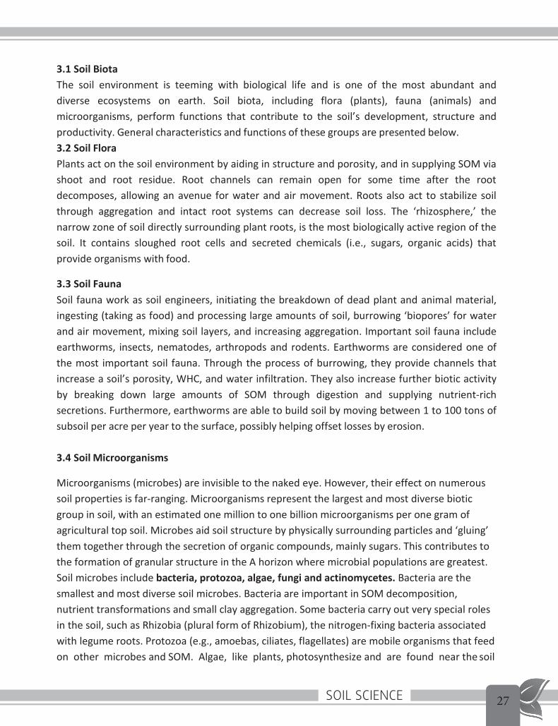
4.2 ‘Granular’ structure consists of loosely packed spheroidal peds that are glued together mostly by organic substances (Figure 2.2). Granular structure is characteristic of many A horizons, particularly those with high SOM content and biological activity. Larger peds, in the form of plates, blocks, or prisms, are commonly associated with the B horizon and are formed via shrink-swell processes and adhesive substances. As soil swells (wets or freezes) and then shrinks (dries or thaws), cracks form around soil masses, creating peds. Peds are held together in place through the adhesion of organic substances, iron oxides, clays or carbonates. Cracks and channels between peds are important for water, air, and solute transport and deep water drainage. Finer soils usually have a stronger, more defined structure than coarser soils due to shrink/swell processes predominating in clay-rich soils and more cohesive strength between particles.
5. Soil porosity A soil’s porosity and pore size distribution characterize its pore space, that portion of the soil’s volume that is not occupied by or isolated by solid material. Porosity is the fraction of the total soil volume that is taken up by pore space. Thus it is a single value quantification of the space available to fluid within a specific body of soil. Typical values for soil porosity are between 0.3 and 0.7 (Porosity and Pore Size Distribution by J.R Nimmo, US. Geological Survey at wwwcamnl.wr.usgs.gov.).
5.1 Many important soil processes take place in soil pores (the air or water-filled spaces between particles). Soil texture and structure influence porosity by determining the size,

Soil Science 19
Soil Science - Lesson: 2
13
number and interconnection of pores. Coarse-textured soils have many large (macro) pores because of the loose arrangement of larger particles with one another. Fine-textured soils are more tightly arranged and have more small (micro) pores. Macro-pores in fine-textured soils exist between aggregates. Because fine-textured soils have both macro- and micro- pores, they generally have a greater total porosity, or sum of all pores, than coarse-textured soils.
5.2 Unlike texture, porosity and structure are not constant and can be altered by management, water and chemical processes. Long-term cultivation tends to lower total porosity because of a decrease in SOM and large peds. Surface crusting and compaction decrease porosity and inhibit water entry into the soil, thereby increasing surface runoff and erosion. Calcareous and salt-affected soils can also alter porosity and structure. In general, increasing SOM levels, reducing the extent of soil disturbance, and minimizing compaction and erosion will increase soil porosity and improve structure.
Fig.2.3 Porosity in sandy and clayey soils (Source: Soil and Water Management Module I, Montana State University)
6. Soil water and Plant Relations
Distribution of vegetation on earth is controlled by water availability, that is, amount of water which is available to plants. For example, forests occur only in those regions where amount of water supplied by precipitation is more than which is lost through evaporation. Although broad- scale pattern of precipitation controls the total amount of water entering forest ecosystems, it

Soil Science20
Soil Science - Lesson: 2
14
is the interaction of water molecules with soil particles that largely influence the amount of water that can be used by an individual plant for growth (Forest Ecology by Burton V Barnes et.al)
6.1 Water flows along a continuum extending from the atmosphere, through the plant and into soil. The force driving water movement along this continuum is transpiration. Water is literally pulled from soil and through plants by this process. Transpiration at the leaf surface creates tensions that are translated down water columns extending through plants and into soil. Soils can be “dry” to plants but can still contain substantial amounts of water. This occurs at a stage when forces holding water in soil exceeds the force (i.e. tension) created by transpiration of water at the leaf surface. Understanding the dynamics of water along the atmosphere-plant-soil continuum has clear relevance for study of plant growth and eco- system function (Forest Ecology by Burton V Barnes et.al)
6.2 Soil texture and properties dependent on texture, like porosity, control the movement of water and air in the soil, which in turn affect use of water by plants and their growth. As soil becomes dry or wet, the proportion of pore space occupied by water and by air varies. When all pores are filled with water, the soil is stated to be ‘saturated’. In ‘saturated’ condition of soil, water within macropores will drain freely from the soil under the force of gravity. ‘Field capacity’ (FC) is the amount of water remaining in the soil after all gravitational water has drained. This remaining water is held in micro-pores under attractive ‘capillary’ forces or surface tension between water and solids. Unlike gravitational water, capillary water is retained in the soil and can only be removed by plant uptake or evaporation. The amount of capillary water that is available to plants is the soil’s ‘water holding capacity’ (WHC) or ‘plant available water’ (PAW). This water is available for plant uptake until the ‘permanent wilting point’ (PWP) is reached, a point at which water is held too tightly by the soil for plants to extract it (Soil and Water Management Module I, Montana State University).
7. Chemical properties of Soil Any plant, be it algae or a big tree, is constructed from a small set of elements. The table below summarizes the elements, called macro-nutrients from which plant life is constructed. The table also shows the source of these elements in the terrestrial ecosystems.
Macro-nutrient Elements Required by Plants and their Source within Terrestrial Ecosystems
Element Symbol Source Carbon C Atmosphere
Hydrogen H Water Oxygen O Atmosphere, water
Nitrogen N Organic matter, atmosphere Phosphorus P Mineral soil, organic matter

Soil Science 21
Soil Science - Lesson: 2
15
Potassium K Mineral soil, organic matter Sulphur S Mineral soil, organic matter, atmosphere
Magnesium Mg Mineral soil Calcium Ca Mineral soil
(Source: Forest Ecology by Burton V Barnes et.al) Each of the macro-nutrients, in varying quantities, is required for plant growth. These elements are called macro-nutrients, as they are required in relatively large amounts. In contrast, micro- nutrients are those elements which are required in relatively small amounts. These include Boron (B), Copper (Cu), Iron (Fe), Chlorine (Cl), Manganese (Mn), Molybdenum (Mo) and Zinc (Zn). Although required in small quantities, the micro-nutrients are essential for biochemical functioning of plants and entire ecosystems. Though plants assimilate carbon and oxygen from the atmosphere, the majority of macro and micro-nutrients are supplied by ion exchange reactions, mineral weathering or organic matter decomposition – processes all occurring within soil (Forest Ecology by Burton V Barnes et.al).
7.1 Cation Exchange Capacity (Source: Cornell University Cooperative Extension – Agronomy Fact Sheet Series, and Forest Ecology by Burton V Barnes et.al.)
7.1.1 Cations are positively charged ions such as calcium (Ca2+), magnesium (Mg2+), and potassium (K+), sodium (Na+) hydrogen (H+), aluminum (Al3+), iron (Fe2+), manganese (Mn2+), zinc (Zn2+) and copper (Cu2+). The capacity of the soil to hold on to these cations is called the cation exchange capacity (CEC). CEC is a general measure of plant nutrient availability.
7.1.2 The cations are held by the negatively charged clay and organic matter particles in the soil through electrostatic forces (negative soil particles attract the positive cations). Please see the Fig.2.4. The cations on the CEC of the soil particles are easily exchangeable with other cations and as a result, they are plant available. Cations in soil solution exist in equilibrium with those adsorbed to cation exchange sites on clay micelles (charged aggregate of molecules of colloidal size in a solution). When cations in soil solution are assimilated by plants, those adsorbed by clay particles are released and a new equilibrium is established. Thus, the CEC of a soil represents the total amount of exchangeable cations that the soil can adsorb. These adsorbed cations can be thought of as a reservoir of plant nutrient in soil. The cations used by plants in the largest amounts are calcium, magnesium, and potassium.
7.1.3 Why do soils have a CEC? Soils have a CEC primarily because clay particles and organic matter in the soil tends to be negatively charged. Since the soil as a whole does not have electric charge, the negative charge of the clay particles is balanced by the positive charge of the cations in the soil.

Soil Science22
Soil Science - Lesson: 2
16
Fig. 2.4 Simplified representation of exchange capacity
7.1.4 Units The CEC of a soil is expressed in cmolc/kg (centimol positive charge per kg of soil) or meq/100 g (milli-equivalents per 100 grams of soil). Both expressions are numerically identical (10 cmolc/kg = 10 meq/100 g).
7.1.5 Implications
o The higher the CEC the more clay or organic matter present in the soil. This usually means that high CEC (clay) soils have a greater water holding capacity than low CEC (sandy) soils.
o Low CEC soils are more likely to develop potassium and magnesium (and other cation) deficiencies, while high CEC soils are less susceptible to leaching losses of these cations. So, for sandy soils, a large one-time addition of cations e.g. potassium can lead to large leaching losses (soil is not able to hold on to the excess K). More frequent additions of smaller amounts are better.
o The lower the CEC, the faster the soil pH will decrease with time. So, sandy soils need to be limed more often than clay soils.
o The higher the CEC, the larger the quantity of lime that must be added to increase the soil pH; sandy soils need less lime than clay soils to increase the pH to desired levels.

Soil Science 23
17
Soil Science- Lesson: 3
Lesson 3
Time 1 hour
Lesson Plan Objective:
• To study soil properties – chemical and biological Backward linkage:
• Soil properties in Lesson 2 Forward Linkage:
• Soil Testing described in Lesson 5. Allocation of Time:
• Chemical properties pH – 25 mts
• Soil organic matter – 10 mts • Biological properties – 15 mts • Discussion/ miscellaneous – 10 mts
Chemical Properties of Soil Continued 1. Soil pH
Soil pH is commonly used to quantify acidity and, by definition, is the negative logarithm of the hydrogen ion concentration in soil solution (Forest Ecology by Burton V Barnes et.al).
Thus pH = - log [H+]
Please note that
• in the above relation log is to the base 10. Some examples of log values are: log 𝐥𝐥𝐨𝐨𝐠𝐠�� �� = 1, 𝐥𝐥𝐨𝐨𝐠𝐠�� ��� = 2, 𝐥𝐥𝐨𝐨𝐠𝐠�� ��𝟓𝟓 = 5, 𝐥𝐥𝐨𝐨𝐠𝐠�� ��−𝟕𝟕 = -7 etc.
• Hydrogen ion concentration [H+] is to be expressed in moles per litre. [The mole is defined as the amount of substance that contains as many elementary entities (e.g., atoms, molecules, ions, electrons) as there are atoms in 12 g of carbon.] 1 mol/L means a solution in which 1 mole of hydrogen ions is present in 1 litre.
1.1 pH scale A solution with a concentration of hydrogen ions higher than 10-7mol/L is acidic, and a solution with a lower concentration is alkaline (another way to say basic). Using the above formula, a pH of 7 is neutral, a pH less than 7 is acidic, and a pH greater than 7 is basic. The

Soil Science2418
Soil Science- Lesson: 3
pH scale goes from 0 to 14 with pH 7 as the neutral point. As the amount of hydrogen ions in the soil increases, the soil pH decreases thus becoming more acidic. From pH 7 to 0 the soil is increasingly more acidic and from pH 7 to 14 the soil is increasingly more alkaline or basic.
1.2 Influence of pH On plant growth - In combination with adsorption and exchange reactions (cation exchange) soil acidity (that is pH value) substantially influences the supply of nutrients for plant growth. It does so by controlling the solubility of soil minerals, that is, plant nutrients. Availability of most plant nutrients is greatest at neutral pH values (that is pH near 7) (Forest Ecology by Burton V Barnes et.al).
On weathering – By influencing mineral solubility, soil pH affects (1) the weathering rate of parent material, (2) the formation of clay minerals , and (3) soil development. Thus the weathering process and soil acidification often go hand in hand (Forest Ecology by Burton V Barnes et.al).
1.4 Sources of soil acidity
(Source:Forest Ecology by Burton V Barnes et.al)
Sources of soil acidity or H+ are many. Respiration of plant roots and microorganism constitutes the most important source. As we know that respiration produces CO2 which, when dissolved in soil solution, forms carbonic acid (H2CO3). When soil minerals containing base cations remain exposed to this relatively weak acid for long, they dissolve resulting in removal of base cations. Some stronger organic acids (e.g. fulvic and humic acids) are produced by the products of microbial decomposition of plant tissues. There are other organic acids that are exuded by plant roots. On long time periods (i.e 10,000 to 1,000,000 years), these sources of acidity facilitate the weathering of soil minerals and lower pH.
1.5 Measurement of soil pH (Source: Methods Manual, Soil Testing in India, Department of Agriculture & Cooperation Ministry of Agriculture, Government of India, New Delhi, January, 2011) The procedure for measurement of soil pH is given below. Apparatus • pH meter with a range of 0-14 pH • Pipette/dispenser • Beaker • Glass rod

Soil Science 25
19
Soil Science- Lesson: 3
Reagent • Buffer solutions of pH 4, 7 and 9 • Calcium chloride solution (0.01M): Dissolve 14.7 g CaCl2.2H2O in 10 litre of water to obtain 0.01M solution. Procedure 1. Calibrate the pH meter, using 2 buffer solutions, one should be the buffer with neutral pH (7.0) and the other should be chosen based on the range of pH in the soil. Take the buffer solution in the beaker. Insert the electrode alternately in the beakers containing 2 buffer solutions and adjust the pH. The instrument indicating pH as per the buffers is ready to test the samples 2. Weigh10.0 g of soil sample into 50 or 100 ml beaker, add 20 ml of CaCl2 solution (use water instead of CaCl2 solution throughout the procedure if water is used as a suspension medium). 3. Allow the soil to absorb CaCl2 solution without stirring, then thoroughly stir for 10 second using a glass rod. 4. Stir the suspension for 30 minutes and record the pH on the calibrated pH meter. Based on soil pH values, following types of soil reactions are distinguished:
PH Range Soil Reaction Rating <4.6 Extremely acidic 4.6-5.5 Strongly acidic 5.6-6.5 Moderately acidic 6.6-6.9 Slightly acidic 7.0 Neutral 7.1-8.5 Moderately alkaline >8.5 Strongly alkaline
2. Soil Organic matter (SOM) (Source: Forest Ecology by Burton V Barnes et.al) Reference to SOM has come in our lessons in relation to description of soil properties. It is, however, felt necessary to dwell upon the subject in a little more details. SOM composes a relatively small fraction of most forest soils - < 1 % to 15% (forest Ecology by Burton V Burnes et.al). SOM is also known as “plant litter”. 2.1 Function
SOM • Contributes to aggregate formation, which in turn influences amount of soil water
available to plants; • Functions as “storehouse” of plant nutrients, supplying most of the Nitrogen used in the
growth of forest ecosystems;

Soil Science26
Soil Science- Lesson: 3
20
• Is used for growth and maintenance of microbial populations in the soil; metabolic activities of these organisms lead to release of nitrogen and other plant nutrients from SOM.
• As the nutrients so released can be re-assimilated by plants, SOM represents an important “weigh station” in cycling and storage of nutrients within forest ecosystems.
2.2 Sources SOM originates from both above and below ground sources of plant litter.
• Aboveground sources – leaves, reproductive structures, twigs and tree stems; • Belowground sources – roots (fine and coarse)
2.3 Composition
In general, SOM (plant litter) contains
• Cellulose – 15 to 60% • Hemicelluloses – 10 to 30% • Lignin – 5 to 30% • Protein – 2 to 5%
In soils the above compounds are metabolized by micro-organisms, producing energy, CO2, H2O and humus as end products.
2.4 Humus Humus forms the highly decomposed organic layer of O horizon in the soil profile. A complex and chemically-resistant material humus gives surface soils their dark colour and unique chemical properties. As it is in an advance state of decay, humus does not resemble the parent material it has come from and is resistant to further microbial degradation and can remain in soils for periods of 100 to 3000 years. The surface of humus can have a net negative charge and at high pH values, the cation exchange capacity of humus (150 to 300 cmol kg-1) can exceed that of many silicate clays. In prompting cation exchange reactions, humus thus can influence nutrient availability in soil. In some soils, approximately 50% of the total cation exchange capacity of the soil can be attributed to humus.
3. Biological Properties (Source: Soil and Water Management Module 1, Basic Soil properties, Montana State University)
Soil Science 27
Soil Science- Lesson: 3
21
3.1 Soil Biota The soil environment is teeming with biological life and is one of the most abundant and diverse ecosystems on earth. Soil biota, including flora (plants), fauna (animals) and microorganisms, perform functions that contribute to the soil’s development, structure and productivity. General characteristics and functions of these groups are presented below. 3.2 Soil Flora Plants act on the soil environment by aiding in structure and porosity, and in supplying SOM via shoot and root residue. Root channels can remain open for some time after the root decomposes, allowing an avenue for water and air movement. Roots also act to stabilize soil through aggregation and intact root systems can decrease soil loss. The ‘rhizosphere,’ the narrow zone of soil directly surrounding plant roots, is the most biologically active region of the soil. It contains sloughed root cells and secreted chemicals (i.e., sugars, organic acids) that provide organisms with food.
3.3 Soil Fauna Soil fauna work as soil engineers, initiating the breakdown of dead plant and animal material, ingesting (taking as food) and processing large amounts of soil, burrowing ‘biopores’ for water and air movement, mixing soil layers, and increasing aggregation. Important soil fauna include earthworms, insects, nematodes, arthropods and rodents. Earthworms are considered one of the most important soil fauna. Through the process of burrowing, they provide channels that increase a soil’s porosity, WHC, and water infiltration. They also increase further biotic activity by breaking down large amounts of SOM through digestion and supplying nutrient-rich secretions. Furthermore, earthworms are able to build soil by moving between 1 to 100 tons of subsoil per acre per year to the surface, possibly helping offset losses by erosion.
3.4 Soil Microorganisms
Microorganisms (microbes) are invisible to the naked eye. However, their effect on numerous soil properties is far-ranging. Microorganisms represent the largest and most diverse biotic group in soil, with an estimated one million to one billion microorganisms per one gram of agricultural top soil. Microbes aid soil structure by physically surrounding particles and ‘gluing’ them together through the secretion of organic compounds, mainly sugars. This contributes to the formation of granular structure in the A horizon where microbial populations are greatest. Soil microbes include bacteria, protozoa, algae, fungi and actinomycetes. Bacteria are the smallest and most diverse soil microbes. Bacteria are important in SOM decomposition, nutrient transformations and small clay aggregation. Some bacteria carry out very special roles in the soil, such as Rhizobia (plural form of Rhizobium), the nitrogen-fixing bacteria associated with legume roots. Protozoa (e.g., amoebas, ciliates, flagellates) are mobile organisms that feed on other microbes and SOM. Algae, like plants, photosynthesize and are found near the soil

Soil Science28
Soil Science- Lesson: 3
22
surface. Fungi are a diverse group of microbes that are extremely important in the breakdown of SOM and large aggregate stability. Many fungi have long ‘hyphae’ or ‘mycelia’ (thin thread- like extensions) that can extend yards to miles underneath the soil surface and physically bind soil particles. Actinomycetes are a microbial group that are classified as bacteria, but have hyphae similar to fungi. They are important for SOM breakdown, particularly the more resistant fractions, and give soil much of its ‘earthy’ odor. Bacteria dominate in agricultural and grassland soils, whereas fungi are more prevalent in forest and acid soils.
3.4.1 An important relationship found in almost all soils and plants, including many crop species, are mycorrhizae. Mycorrhizae are a plant-fungal symbiosis (a relationship between two interacting species) in which fungi infect and live in, or on, a plant root. The fungus depends on the plant for energy, and in return, the fungus and its hyphae can take up nutrients for the plant, and possibly improve plant growing conditions. For instance, mycorrhizae associations have been shown to increase plant-water relations and reduce severity of some plant diseases, as well as improve soil aggregate stability due to the binding actions of hyphae and glomalin, a mycorrhizal secreted chemical. Ultimately, however, the full benefit of mycorrhizae to a plant will depend on the individual plant’s needs and soil conditions. Therefore, improving and maintaining existing mycorrhizal populations by increasing SOM content, reducing tillage and other soil disturbances, and eliminating long fallow periods may work best for encouraging mycorrhizal symbioses in agricultural.
3.5 Biological Activity Soil biological activity is controlled by many factors in the soil. SOM quantity and quality, primarily nitrogen (N) content, are major limiting factors for soil organism activity. Other soil factors that promote activity are adequate levels of oxygen, near-neutral pH, temperatures between 85-95°F, and 50-60% moisture. Combinations of these factors will result in maximum activity. Although some organisms have adapted to extreme environmental conditions, overall activity generally diminishes when conditions fall outside of these ideal ranges. For example, if a soil becomes too wet, oxygen diffusion is impeded and overall activity slows since oxygen is required by most organisms. Fertilizer applications can also influence soil organism populations and activity. Biotic activity in soils with low fertility or SOM content will likely increase with the addition of fertilizers, particularly those containing N. However, populations will eventually stabilize as N is consumed.

Soil Science 2923
Soil Science- Lesson: 4
Lesson 4
Time 1 hour
Lesson Plan Objective:
• To study major soil types in India • Agro-Ecological Classification of soils in West Bengal • Soil problems in West Bengal
Backward linkage:
• Soil properties in Lesson 2 and 3
Forward Linkage:
• To show the trainees during tour the vegetation and soil types of different bio- geographic zone.
Training materials required: • Copy of lesson 4 to be circulated beforehand.
Allocation of Time:
Major soil types of India – 25 mts • Agro-Ecological Classification of soils in West B – 10 mts • Soil problems in West Bengal – 15 mts • Discussion/ miscellaneous – 10 mts
1. Major Soil Types in India (Source: India-the land and people, Land and Soil by Dr. S P Raychaudhuri, Introductory Soil Science by S S Negi, Methods manual – Soil Testing in India, Deptt of Agriculture and Cooperation, Ministry of Agriculture, GoI, Jan 2011 and http://www.slideshare.net/) Some dominant groups of Indian soil, classified according to soil taxonomy and chemical property are as follows.
1) Alluvial soil 2) Black soil (regur) 3) Red soil

Soil Science3024
Soil Science- Lesson: 4
4) Laterite and lateritic soil 5) Forest and Hill soil 6) Desert Soil
1.1 Taxonomically these soils are classified as follows: Alluvial soil: Entesol, Inceptisol and Alfisol Black soil: Vertisol, Inceptisol and Entisol Red soil: Alfisol, Inceptisol and Ultisol Lateritic soil: Alfisol, Ultisol and Oxisol Desert soil: Entisol and Aridisol Forest and Hill soils: Alfisol
Distribution of soil types may be seen in the soil map given in Appendix I.
1.2 In addition, there are soil types, which are identified as problem soils. According to salt content, they are classified as follows. (i) Saline and Alkali Soil (ii) Acid Soil (iii) Peaty and Marshy Soil
1.3 Alluvial Soil
Alluvial soil is by far the largest and most important soil group of India, contributing the largest share to the agricultural wealth of the country. These soils cover about 1,500,000 square kilometers. Over this large tract, however, lots of subordinate variations of alluvial type are exhibited. Main features of this alluvial soil are derived from the deposition and silt brought in by the numerous river systems. The most important of alluvial deposit is the Indo-Gangetic plain. As the rivers flow down, the rocks are weathered in varying degree of fineness and get deposited in the plains giving rise to alluvial soil. Geologically, the alluvium is classified into two groups, namely. (1) Khadar, i.e newer alluvium of sandy, generally light coloured, and less kankary composition, and (2) Bhangar, i.e older alluvium of more clayey composition, generally of dark coloured and full of kankar. The soils differ in consistency from drift sand to loam, and from fine silt to stiff clay.
1.3.1 In West Bengal, portion of Murshidabad, Bankura, almost the whole tract known as Rarh region are composed mainly of the old alluvium, while the remaining alluvial soil in the state consists of relatively recent alluvium. The latter class of soil is more fertile and productive. The texture of the recent alluvium varies from sandy loam to clay and at certain horizons give rise to clay pan.

Soil Science 3125
Soil Science- Lesson: 4
1.3.2 Characteristics
• Coarse in upper section, finest in delta • Rich in potash and humus, but poor in phosphorus and Nitrogen; deficiency in Nitrogen
often is the limiting factor in crop production. • Very fertile soil, suitable for all kinds of crops (kharif and rabi) • Occurrence in Punjab, Haryana, UP, Bihar, WB, parts of Orissa, Assam, delta regions of
Southern part of India. 1.4 Black Soil (regur)
Black soil is also known as regur or black cotton soil. Dark grey to black in colour, black soil is derived from the Deccan trap (weathering of the deccan lava) and is common in Maharashtra, western part of Madhya Pradesh, Andhra Pradesh, Gujarat, parts of Karnataka, and parts of Tamil Nadu. It also occurs in parts of Uttar Pradesh and Rajasthan. Black soil covers an area of about 546,000 km2
1.4.1 Characteristics
• Created from igneous rocks, it is black in colour because of its volcanic origin. • Clay content is high • Very retentive in moisture and exceedingly sticky when wet; • Rich in lime, iron, calcium and magnesium carbonates, magnesia and alumina; • Develops cracks during summer because of high contraction on drying; • Poor in phosphorus, nitrogen and organic matter; • Highly suitable for cotton;
1.5 Red soils
Red soils have originated from weathering of the ancient crystalline and metamorphic rocks. They occupy good portions of Tamil Nadu, Karnataka, south-east Maharashtra, east of Andhra Pradesh, Madhya Pradesh and Chota Nagpur covering a total area of about 350,000 km2. In the north, the red soil area extends into and includes the greater part of Santhal Parganas in Jharkhand, the Birbhum district of West Bengal, and the Mirzapur, Jhansi and Hamirpur districts of Uttar Pradesh. 1.5.1 Characteristics
• More sandy and less clayey; • Generally poor in nitrogen, phosphorous and humus; • In comparison with regur (black soil), poorer in lime, potash and iron oxide; • Have small capacity for absorption of moisture and retention of bases like potassium,
calcium and magnesium by exchange;

Soil Science3226
Soil Science- Lesson: 4
• Suitable in general for cultivation of ragi, groundnut, millet, potato, tobacco, paddy, wheat and sugarcane.
1.6 Laterite and Lateritic soil Formation of this soil is typical of India and some other tropical countries with intermittently moist climate. It is a compact to vesicular rock composed, essentially of a mixture of the hydrated oxides of aluminium and iron with small amounts of manganese oxides, titania (titanium dioxide) etc. They cover a total area of about 248,000 km2. Laterite may disintegrate and get carried to lower levels by the stream flow. When re-deposited at lower levels, the laterites may become cemented again to form compact mass. Thus there are high level laterites resting on rocks from which they have been formed and low level laterites formed in the usual way of detrital deposits. 1.6.1 Occurrence
• Laterites are well developed on the summits of hills of Karnataka, Kerala, Madhya Pradesh, the eastern ghat regions of Oriss and West Bengal, south Maharashtra, Malabar coast and parts of Assam
• Laterite and lateritic soils are found in Kerala, Orissa, West Bengal, Maharashtra and Assam.
• In West Bengal lateritic soils occur in the districts of Birbhum, Burdwan, Bankura and Paschim Medinipur
1.6.2 Characteristics • Lateritic soil is generally poor in available nutrients of nitrogen, phosphorus, potassium
and calcium. • The pH ranges from 4.8 to 5.5 and base exchange capacity is low; consequently they
give high response to application of lime and potash. 1.7 Forest and Hill Soil Formation of forest soil is governed by deposition of organic matter derived from forest growth. Forest soil covers an area of about 285,000 km2. The scenario is complex as different soil climates occur on hills and in plains. Broadly two conditions of soil formation may be distinguished:
(1). Soil formed under acid conditions with the presence of acid humus and low base status; and
(2). Soils formed under slightly acidic or neutral conditions with a high base status. 1.7.1 Occurrence The soils of the hilly districts of Assam are of fine texture and reveal high content of organic matter and nitrogen, In Uttar Pradesh the sub-Himalayan tract comprises three regions, viz.,

Soil Science 3327
Soil Science- Lesson: 4
bhabar area immediately below the hills, terai and the plains. Four major groups, i.e., red loams, brown forest soils, podsols and transitional podsols have been observed in the Himalayan tract. In the Himachal Pradesh, the typical soil profiles under deodar, spruce, blue pine and chir are related to the podsols but have significant differences. The weathering of metamorphic rocks in Coorg has produced very fertile deep surface soil which annually receives the decomposition products of the virgin forest. The soils in the Darjeeling district of West Bengal consist of well-decomposed humus and mineral soil which shades off gradually, at varying depths, into the colour of the parent rock. These soils are strongly acidic in reaction. Their high base exchange capacity is due to the high organic matter content. Water-soluble manganese is present in appreciable amount.
1.8 Desert Soils A large part of the arid and semi-arid region belonging to Rajasthan, southern part of Punjab and Haryana and north Gujarat, covering an area of about 142,000 km2 is affected by desert condition. The region is characterized by scanty rainfall and high rate evaporation. The soil in this region, the desert soil, is covered by a mantle of sand which inhibits soil growth. 1.8.1 Characteristics
• Some of these soils contain high percentage of soluble salts, are alkaline (high pH) and are poor in organic matter;
• The soils may be reclaimed on proper irrigation 1.9 Saline and Alkali Soils The distribution of saline and alkaline soils is extensive throughout India in all climatic zones. Many parts of the North, especially Bihar, Uttar Pradesh, Punjab, Haryana and Rajasthan, give rise to saline and alkaline efflorescence in the same way as the soils capping the Upper Tertiary rocks. There are many yet undecomposed mineral fragments in these alluvial clays and silts, which, on weathering, liberate sodium, magnesium and calcium salts. Large areas, once fertile and populous, have become impregnated with these salts locally known as reh or kalkar with highly deleterious effect on their fitness for cultivation. The injurious salts are confined to the top layers of the soils, which are charged by capillary transference of saline solutions from the lower layers. This transference is facilitated in lands irrigated by canal waters. It has been estimated that two lakh acres of land in the Punjab and about 1 lac acre in Haryana have been affected by usar and 25 thousand acres are being added every year. Alkali soils are met with all over the states of Gujarat and Maharashtra, but badly affected lands are found in Gujarat, Karnataka and the Deccan. 1.9.1 Characteristics
• Contain salts of sodium, Calcium and Magnesium • Infertile and unfit for cultivation • Sandy to loamy in texture

Soil Science3428
Soil Science- Lesson: 4
1.10 Acid Soils
In India about 6.5 million hectares of land area is covered by strongly acid soils ( pH < 5.5 ). The acid soil areas occur in and around Bhawali (UP), Palampur, Kangra (HP), Baster and Jagdalpur (MP), Jorhat and Titabar ( Assam ), Ratnagiri ( Maharashtra ) and large areas in Ooty (Tamil Nadu ) and Kutanad ( Kerala ). The acid soils suffer due to lack of calcium and magnesium and in some cases due to aluminium and iron toxicity. However, these soils are being cultivated and their productivity can be improved when limed.
1.11 Peaty and Marshy Soil
Peaty soils originate in humid regions as a result of accumulation of large amounts of organic matter in the soil. They may also contain considerable amounts of soluble salts. Typical pity saline soil (kari) covering an area of about 150 km2 have been observed in Kuttanad in Kerala. The soils are generally submerged under water during the monsoon. After the rains, these are put under paddy cultivation. Soils are black, heavy and highly acidic, with pH as low as 3.9, and contain 10-40 per cent of organic matter. Their acidity is due to the decomposition of organic matter under anaerobic conditions, and no nitrification is possible. Sometimes the soils contain ferrous and aluminium sulphates. The depression formed by dried river-basins and lakes in alluvial and coastal areas sometimes give rise to peculiar waterlogged and anaerobic conditions of the soils. The soils of these places are generally blue due to the presence of ferrous iron and contain varying amounts or organic matter. Marshy soils of this type are found in the coastal tracts of Orissa, the Sunderbans and some other places in West Bengal, central portion of north Bihar, Almora district of Uttar Pradesh, and south-east coast of Tamil Nadu.
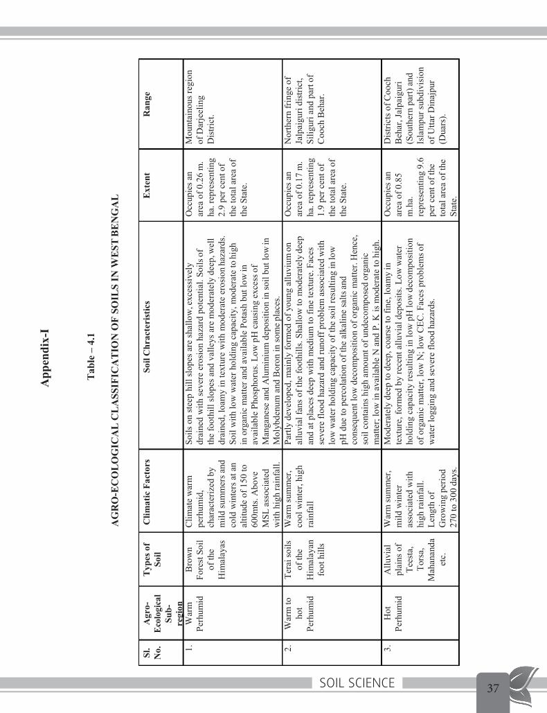
2. Agro-Ecological Classification of soils in West Bengal
(Source: State Forest Report WB 2006-07) The agro-ecological classification of soils in West Bengal may be seen in Appendix II.
3. Soil problems in West Bengal (Source: Soils of West Bengal for Optimising Land Use , NBSS & LUP 1992; State Forest Report WB 2011-12) There are different kinds of soil problems, such as soil erosion, soil depth, drainage, salinity, etc. which need be addressed for effective land use planning. The limiting soil attributes, their extent and distribution are briefly described below and in Annexure III.
3.1 Soil Depth Soil depth is one of the factors to determine the nature of crop that can be grown on a soil. The effective soil depth governs the development of roots and supply of moisture and plant

Soil Science 3529
Soil Science- Lesson: 4
nutrients. The three classes of soil depth affecting crop growth which need be considered in selecting suitable crop are described in Appendix III.
3.2 Internal Drainage Internal drainage is governed by soil texture, landform situation and depth of water table. The four drainage classes which have been found to affect adversely the soil and crop management are described in Appendix III.
3.3 Erosion Erosion caused by water is one of the major soil degradation factors in the hilly regions of Darjeeling district and undulating terrains of south western plateau region of the State where extensive areas are affected by gullies. The areas affected by severe and moderate erosion which need measures are described in Appendix III.
3.4 Texture The three texture classes that hinder crop growth and the areas affected by these classes are described in Appendix III.
3.5 Salinity Soil salinity in West Bengal is mainly due to the inundation of tidal water in deltaic zone. The reclamation of these soils by removing soluble salts is a major management aspect. The three soil salinity c1asses, viz. very strong, strong and moderate salinity hazards affect the crop growth severely. The areas affected by salinity limitation are given in Appendix III. For management of salinity either the soils need drainage followed by measures to maintain former salt balance in the soil profile.
3.6 Flooding Surface flooding is a serious limitation for crop production in the Indo-gangetic plains of West Bengal. Among the several flood limitations, the areas affected by moderate and severe flooding are given in Appendix III.
3.7 Waterlogging Waterlogging is defined as the stage where by the soil becomes saturated by water within the depth of root zone for a significant period. It is considered a serious limitation which adversely affects the yield and quality of crops. Waterlogging may be caused by high ground water table or submergence by rain water or both. The areas affected by waterlogging in West Bengal are given in Appendix III.

Soil Science36
Appendix- I Soil Science-Lesson 4
30
Appendix-I
Soil Science 37
Tab
le –
4.1
AG
RO
-EC
OL
OG
ICA
L C
LA
SSIF
ICA
TIO
N O
F SO
ILS
IN W
EST
BE
NG
AL
Sl.
No.
Agr
o-Ec
olog
ical
Su
b-re
gion
Typ
esof
So
ilC
limat
icFa
ctor
sSo
ilC
hrac
teri
stic
sE
xten
tR
ange
1.W
arm
Bro
wn
Clim
ate
war
mSo
ils o
n st
eep
hill
slop
es a
re sh
allo
w,e
xces
sive
lyO
ccup
iesa
nM
ount
aino
usre
gion
Pe
rhum
idFo
rest
Soil
perh
umid
,dr
aine
d w
ith se
vere
ero
sion
haz
ard
pote
ntia
l. So
ilsof
area
of0
.26
m.
ofD
arje
elin
g
of
the
char
acte
rized
byth
e fo
othi
ll sl
opes
and
val
leys
are
mod
erat
ely
deep
,wel
lha
.rep
rese
ntin
gD
istri
ct.
Him
alay
asm
ild su
mm
ersa
nddr
aine
d, lo
amy
in te
xtur
e w
ith m
oder
ate
eros
ion
haza
rds.
2.9
per c
ento
f
co
ld w
inte
rs a
tan
Soil
with
low
wat
er h
oldi
ng c
apac
ity, m
oder
ate
tohi
ghth
e to
tal a
rea
of
al
titud
e of
150
toin
org
anic
mat
ter a
nd a
vaila
ble
Pota
sh b
ut lo
win
the
Stat
e.
60
0mts
.Abo
veav
aila
ble
Phos
phor
us. L
ow p
H c
ausi
ng e
xces
sof
M
SLas
soci
ated
Man
gane
se a
nd A
lum
iniu
m d
epos
ition
in so
il bu
t low
in
with
hig
hra
infa
ll.M
olyb
denu
m a
nd B
oron
in so
mep
lace
s.
2.
War
mto
Tera
isoi
lsW
arm
sum
mer
,Pa
rtly
deve
lope
d, m
ainl
y fo
rmed
of y
oung
allu
vium
onO
ccup
iesa
nN
orth
ern
frin
geof
ho
tof
the
cool
win
ter,
high
allu
vial
fans
of t
he fo
othi
lls. S
hallo
w to
mod
erat
elyd
eep
area
of 0
.17
m.
Jalp
aigu
ridi
stric
t,
Perh
umid
Him
alay
anra
infa
llan
d at
pla
ces d
eep
with
med
ium
to fi
ne te
xtur
e.Fa
ces
ha.r
epre
sent
ing
Silig
uri a
nd p
arto
f
fo
othi
lls
seve
re fl
ood
haza
rd a
nd ru
noff
pro
blem
ass
ocia
ted
with
1.9
per c
ento
fC
ooch
Beh
ar.
low
wat
er h
oldi
ng c
apac
ity o
f the
soil
resu
lting
inlo
wth
e to
tal a
rea
of
pH d
ue to
per
cola
tion
of th
e al
kalin
e sa
ltsan
dth
eSt
ate.
co
nseq
uent
low
dec
ompo
sitio
n of
org
anic
mat
ter.
Hen
ce,
soil
cont
ains
hig
h am
ount
of u
ndec
ompo
sed
orga
nic
mat
ter;
low
in a
vaila
ble
N a
nd P
. K is
mod
erat
e to
high
.
3.
Hot
Allu
vial
War
msu
mm
er,
Mod
erat
ely
deep
to d
eep,
coa
rse
to fi
ne, l
oam
yin
Occ
upie
san
Dis
trict
s ofC
ooch
Pe
rhum
idpl
ains
ofm
ildw
inte
rte
xtur
e, fo
rmed
by
rece
nt a
lluvi
al d
epos
its. L
oww
ater
area
of0
.85
Beh
ar,J
alpa
igur
i
Te
esta
,as
soci
ated
with
hold
ing
capa
city
resu
lting
in lo
w p
H lo
wde
com
posi
tion
m.h
a.(S
outh
ern
part)
and
Tors
a,hi
ghra
infa
ll.of
org
anic
mat
ter,
low
N; l
ow C
EC. F
aces
pro
blem
sof
repr
esen
ting
9.6
Isla
mpu
rsub
divi
sion
Mah
anan
daLe
ngth
ofw
ater
logg
ing
and
seve
re fl
ood
haza
rds.
per c
ent o
fthe
of U
ttarD
inaj
pur
etc.
Gro
win
gpe
riod
to
tal a
rea
ofth
e(D
uars
).
270
to 3
00da
ys.
St
ate.
Con
td…
.Tab
le–4.1
App
endi
x-I

Soil Science38
4.H
otm
oist
sub-
hum
id
5.M
oist
Sub-
hum
id
Indo
-ga
nget
ic
Plai
n (B
enga
l ba
sin).
Allu
vium
of
D
amod
ar,
Kan
gsab
ati
, Ajo
y,
Rupn
aray
a n Sa
line
Soils
(P
hysio
logi
ca
lly D
ry
Soil)
.
Hot
moi
st su
mm
er a
nd
mild
win
ter,
aver
age
rain
fall
1389
to
190
8mm
. LG
P 21
0to
240
days
.
Hot
dry
su
mm
er
mod
erat
e w
inte
r, A
v.
Rain
fall
1270
to 1
520
mm
.LG
P 15
0to
180
days
. W
arm
hum
id
sum
mer
, mild
w
inte
r, m
ean
annu
al ra
infa
l co
vers
80-
90%
of e
vapo
-tra
nspi
ratio
n ra
te. L
GP*
24
0 to
270
days
.
Soil
form
ed fr
om th
e al
luvi
um d
epos
ited
by G
anga
an
dits
tribu
tarie
s.V
arie
s gre
atly
inth
eir
mor
phol
ogic
al (l
oam
y to
cla
yey
loam
), ph
ysic
al a
nd
chem
ical
pro
perti
es d
epen
ding
upo
n th
eir g
eom
orph
ic
situa
tion,
moi
sture
regi
me
and
degr
ee o
f pro
file
deve
lopm
ent.
Poss
esse
s bac
k sw
amps
in o
ld fl
ood
plai
ns w
ith h
igh
wat
er ta
ble
and
som
ewha
t poo
r dr
aina
ge. p
H 5
.8 to
8, s
oil l
ow in
ava
ilabl
e N
; P a
nd K
m
oder
ate.
Soil
form
ed b
y al
luvi
al d
epos
ts of
rive
rs o
rigin
atin
g fro
m C
hota
nagp
ur p
late
au. S
oil w
ell d
rain
ed
cont
aini
ng b
asic
and
ferru
gino
us c
oncr
etio
ns. P
H 5
.5
to 7
.2; l
ow in
org
anic
mat
ter c
onta
inin
g lo
w to
m
oder
ate
N a
nd P
whi
le m
oder
ate
to h
igh
Kco
nten
t.
Dee
p, fi
ne lo
amy
to fi
ne te
xtur
ed so
ils c
onta
inin
ghig
h am
ount
of b
asic
salts
of N
a., C
a., M
g. e
tc. a
nd h
igh
amou
nt o
f org
anic
mat
ter w
ith m
oder
ate
amou
nt o
f N
PK. B
y an
d la
rge
salt
impr
egna
ted
due
to ti
dal f
low
of
sea
wat
er th
roug
h cr
eeks
and
sub
tribu
tarie
s.Im
perfe
ctly
to p
oorly
drai
ned
with
mod
erat
e to
ver
y hi
gh sa
linity
haz
ards
. Can
be
divi
ded
into
four
ca
tego
ries,
viz.
i. S
alin
e So
ils; i
i. Sa
line-
alka
lineS
oils;
iii. A
lkal
ine
Soils
; iv.
Deg
rade
d A
lkal
ineS
oils.
Occ
upie
s an
area
of4.
39 m
. ha.
re
pres
entin
g 55
.7 p
er
cent
of t
heto
tal a
reao
f th
esta
te
Occ
upie
s an
area
of0.
68 m
.ha.
repr
esen
ting
7.6
perc
ent o
f the
tota
l ar
ea o
f the
Stat
e.
Into
-Gan
getic
pla
in c
over
ing
distr
icts
of M
alda
, Wes
t D
inaj
pur (
Sout
hern
par
t),
Mur
shid
abad
, Nad
ia, H
owra
h,
Hoo
ghly
, 24-
Parg
anas
(Nor
ther
n pa
rt),
Puru
lia(S
outh
-eas
tern
par
t),
Burd
wan
(Eas
tern
par
t),
Birb
hum
, Ban
kura
and
M
idna
pore
(Eas
tern
part)
.
Coas
tal p
arts
of th
e di
stric
ts of
24
-Par
gana
s (So
uth
and
Nor
th)
com
prisi
ng m
ostly
Sun
darb
an
area
s of S
outh
24-
Parg
anas
and
Coas
talM
idna
pore
.
Cont
d….T
able–
4.1
App
endi
x-II

Soil Science 39
6.H
otdr
ysu
b-hu
mid
Red
Late
ritic
So
il
Gne
issic
gr
avel
ly
soil
Hot
dry
Su
mm
er;C
old
dry
win
ter.
Rain
fall
1270
to 1
392
mm
.LG
P 15
0to
180
days
.
Hot
dry
Su
mm
er;
Mod
erat
e to
se
vere
dry
w
inte
r.Ra
infa
ll90
0to
127
0m
m.
LGP
150
to18
0da
ys.
Shal
low
to d
eep,
redd
ish to
yel
low
ish re
d, lo
amy
to
clay
ey a
nd im
perfe
ctly
to w
ell d
rain
ed. p
H 4
.8 to
6.6,
so
il lo
w in
org
anic
mat
ter a
ndav
aila
ble
phos
phor
us
and
min
eral
s.
Topo
grap
hy u
ndul
atin
g w
ith lo
w so
il de
pth,
surfa
ce
encr
usta
tious
are
com
mon
; pH
low
to n
eutra
l; lo
win
or
gani
c m
atte
r. Po
or c
apac
ity fo
r ret
entio
n of
ra
inw
ater
lead
s to
seve
re ru
n of
f and
soil
eros
ion.
Occ
upie
s an
area
of1.
98 h
a.re
pres
entin
g22
.3 p
erce
nt o
f the
tota
l ar
ea a
long
the
outli
ers
of th
e ea
stern
par
t of
Chot
anag
pur p
late
au
mer
ging
to B
enga
l Ba
sin o
f Ind
ogan
getic
Pl
ain.
Dist
ricts
of P
urul
ia a
ndW
este
rn
parts
of B
urdw
an, B
anku
ra,
Birb
hum
and
Mid
napo
re.
Nor
th-w
este
rn p
art o
fPur
ulia
, A
sans
ol su
b-di
visio
n of
Bu
rdw
an, p
arts
of W
est
Mid
napo
re, B
anku
ra a
nd
Birb
hum
* Le
ngth
of G
row
ing
perio
d
Sour
ce: S
tate
For
est R
epor
t, W
.B, 2
006-
2007
, Gov
t. of
Wes
tBen
gal
App
endi
x-II

Soil Science40
Appendix-III Soil Science – Lesson 4
34
Soil Problems in West Bengal

Soil Science 41
Appendix-III Soil Science – Lesson 4
35
Source: State Forest Report, W.B, 2011-2012, Govt. of W.B.

Soil Science42

Soil Science 4336
Soil Science- Lesson: 5
Lesson 5
Time 1 hour
Lesson Plan Objective:
• To know functions of major plant nutrients; • To know soil nutrients as index of fertility; • To study methods of soil testing.
Backward linkage:
• Soil properties in Lesson 2 and 3
Forward Linkage:
• To show the trainees during tour a soil laboratory and explain with demonstrations, if possible, the methods of testing certain soil parameters.
Training materials required: • Copy of lesson 5 to be circulated beforehand.
Allocation of Time:
Functions of major plant nutrients – 10 mts • Soil nutrients as index of soil fertility – 5 mts • Soil testing methods – 35 mts • Discussion/ miscellaneous – 10 mts
1. Essential Plant Nutrients (Source: Methods manual – Soil Testing in India, Deptt of Agriculture and Cooperation, Ministry of Agriculture, GoI, Jan 2011)
We have discussed in Lesson 2 the major and micro-nutrients required by the plants for growth. These nutrients – 16 in number – are called essential plant nutrients as they have essential functions in the growth of the plants. We may now discuss briefly the functions of some of the major nutrients.
1.1 Carbon Plants absorb Carbon dioxide CO2 directly from atmosphere – CO2 combines with water in presence of sunlight and produces the primary sugars, such as glucose and fructose (fruit sugar) through a process called photosynthesis.

Soil Science44
Soil Science- Lesson: 5
37
1.2 Oxygen Oxygen plays a dominant role in photosynthesis and respiration. 1.3 Hydrogen Hydrogen readily combines with oxygen to form water and with carbon to form complex chemical organic compounds. When organic compounds either break up in the plant or decompose in the soil or atmosphere, the released hydrogen always combines with oxygen and forms water. Thus, the exchange of hydrogen takes place in either of the synthesis or decomposition (including respiration) processes of organic substance
1.4 Nitrogen Nitrogen is an essential ingredient of proteins. Nitrogen is the basic nutrient and makes up 1- 4% of dry weight of plants and it forms chlorophyll, amino acids, proteins, alkaloids and protoplasm. When the plant takes up large quantities of nitrogen from the soil, the colour of the plant changes to dark-green, indicating the increase of chlorophyll in the plant. Since the amount of chlorophyll in the plant determines the carbohydrate synthesis, nitrogen, in a way, may be said to control this activity. 1.4.1 Deficiency Symptom The nitrogen-deficient plants are light green in colour. The lower leaves turn yellow and in some crops they quickly start drying up as if suffering from shortage of water.
1.5 Phosphorus It is a constituent of the cell nucleus, essential for cell division and the development of meristematic tissues at the growing points. It makes 0.1 to 0.5% of dry weight of the plant. Therefore, plants which cannot absorb adequate quantities of phosphorus from the soil have small root system and leaves, and their growth is stunted. . Phosphorus is particularly helpful in the production of legumes, as it increases the activity of nodular bacteria which fix nitrogen in the soil. 1.5.1 1 Deficiency Symptom Generally the plant is dark-green but the lower leaves may turn yellow and dry up. Growth is stunted and leaves become smaller in size. 1.6 Potassium. It plays a vital role in the formation or synthesis of amino acids and proteins from ammonium ions which are absorbed from the soil. It is also considered essential in the photosynthetic activity of the leaves. When potassium is in short supply the carbon dioxide is synthesized into sugars more slowly than when it is available in optimum quantity. The relative concentration of sodium and calcium also influences the activity of potassium in the plant. It helps in moving manufactured food, viz., carbohydrates (sugars) and proteins (amino acids), from leaves to roots.

Soil Science 45
Soil Science- Lesson: 5
38
1.6.1 Deficiency Symptom The margins of leaves turn brownish and dry up. The stem remains slender.
2. Soil Testing (Source: Methods manual – Soil Testing in India, Deptt of Agriculture and Cooperation, Ministry of Agriculture, GoI, Jan 2011) Soil Testing refers to analysis of soil to characterize and estimate the various properties of the soil. These properties include nutrient or fertility status and properties like texture, structure, pH, Cation Exchange Capacity, water holding capacity, electrical conductivity and parameters for amelioration of chemically deteriorated soils. One of the objectives of soil tests is to sort out the nutrient deficient areas from non-deficient ones.
2.1 Soil nutrient as an index of soil fertility Generally, the soil testing laboratories use organic carbon as an index of available N, Olsen’s and Bray’s method for available P, and neutral normal ammonium acetate for K. In semiarid tropics, nitrate nitrogen is also used as an index of available N in soil. Available nutrient status in the soils is generally classified into several classes. In West Bengal the classes followed are shown in the following table.
Soil Fertility Level
Organic Carbon (%)
Available P2O5
kg/ha
Available K2O kg/ha
Very high > 1.0 > 115 > 360
High 0.81-1.0 93-115 301-360
Medium 0.61-0.80 71-92 241-300
Medium Low 0.41-0.60 46-70 181-240
Low 0.21-0.40 23-45 121-180
Very Low <0.21 <23 <121
(Source: Methods manual – Soil Testing in India, Deptt of Agriculture and Cooperation, Ministry of Agriculture, GoI, Jan 2011)

Soil Science46
Soil Science- Lesson: 5
39
3. Soil Testing procedures (Source: Methods manual – Soil Testing in India, Deptt of Agriculture and Cooperation, Ministry of Agriculture, GoI, Jan 2011) Procedurally, the soil testing programme can be divided into the following components: (1) Setting up of a soil testing laboratory (2) Soil sampling - The method and procedure for obtaining soil samples vary according to the
purpose of sampling. Soils vary from place to place. In view of this, efforts should be made to take the samples in such a way that it is fully representative of the field.
(3) Analytical methods for estimation of physical properties and available nutrients We describe below methods for estimation of some of the soil properties. 3.1 Preparation of soil samples for analysis 3.1.1 Drying of samples Samples received in the laboratory may be moist. These should be dried in wooden or enamelled trays. Care should be taken to maintain the identity of each sample at all stages of preparation. During drying, the trays can be numbered or a plastic tag could be attached. The soils are allowed to dry in the air. 3.1.2 Post drying care After drying, the samples are taken to the preparation room which is separate from the main laboratory. Air dried samples are ground with a wooden pestle and mortar so that the soil aggregate are crushed but the soil particles do not break down. After grinding, the soil is screened through a 2 mm sieve. After the sample is passed through the sieve, it must be again mixed thoroughly. The soil samples should be stored in cardboard boxes in wooden drawers. These boxes should be numbered and arranged in rows in the wooden drawers, which are in turn fitted in a cabinet in the soil sample room.
3.2 Estimation of Soil Moisture Gravimetric method of moisture estimation is most widely used where the soil sample is placed in an oven at 1050 C and dried to a constant weight. The difference in weight is considered to be water present in the soil sample. Apparatus • Aluminium Moisture Box • Oven • Desiccator
Procedure 1. Take 100 g of soil sample in the aluminium moisture box and keep in the oven after removing the lid of the box.

Soil Science 47
Soil Science- Lesson: 5
40
2. The sample is kept at 1050 C till it attains a constant weight. It may take 24-36 hours. 3. Cool the sample, first in the switched off oven and then in a desiccator. 4. Take the weight of the cooled moisture box. The loss in weight is equal to moisture contained in 100 g soil sample.
Calculation
Moisture (%) = Loss in weight oven −dry weight of soil
x100
3.3 Estimation of Water Holding Capacity (WHC)
WHC or the Field capacity (FC) is defined as the amount of water held in the soil after the excess gravitational water has drained away and after the rate of downward movement of water has materially ceased. Stage of field capacity is attained in the field after 48 to 72 hours of saturation. It is the upper limit of plant available soil moisture.
Apparatus • Polythene sheets • Spade • Soil auger • Moisture boxes/cans • Balance • Oven
Procedure 1. Select a uniform plot measuring 5 m x 5 m. 2. Remove weeds, pebbles etc. and make bunds around the plot. 3. Fill sufficient water in the plot to completely saturate the soil. 4. Cover the plot area with a polythene sheet to check evaporation. 5. Take soil sample from the centre of the plot from the desired layer, starting after 24 hours of saturation and determine moisutre content daily till the values of successive days are nearly equal. 6. Record the weight as below: • Weight of empty moisture box = X • Weight of moisture box + moist soil = Y • Weight of moisture box + oven dry soil = Z • Repeat above on next day and so on till a constant Z value is reached.

Soil Science48
Soil Science- Lesson: 5
41
Calculation Moisture content in soil = Y – Z Weight of oven dry soil = Z – X
Percentage of moisture in soil (1st day) = �−�
�−� x 100 = a
Percentage of moisture on succeeding days = a1, a2, etc. Plot the daily readings on a graph paper. The lowest reading is taken as a value of field capacity (FC) or WHC of the soil.
3.4 Estimation of Soil pH Procedure for estimation of soil pH has been discussed in Lesson 3.
3.5 Estimation of Organic Carbon/Organic Matter Organic matter estimation in the soil can be done by different methods. Loss of weight on ignition can be used as a direct measure of the organic matter contained in the soil. It can also be expressed as the content of organic carbon in the soil. It is generally assumed that on an average organic matter contains about 58% organic carbon. Organic matter/organic carbon can also be estimated by volumetric and colorimetric methods. However, the use of potassium dichromate (K2Cr2O7) involved in these estimations is considered as a limitation because of its hazardous nature. Soil organic matter content can be used as an index of N availability (potential of a soil to supply N to plants) because the content of N in soil organic matter is relatively constant. We describe only the ignition method.
Loss of weight on ignition
Apparatus • Sieve • Beaker • Oven • Muffle furnace Procedure 1. Weigh 5.0 to 10.0 g (to the nearest 0.01 g) sieved (2 mm) soil into an ashing vessel (50 ml beaker or other suitable vessel). 2. Place the ashing vessel with soil into a drying oven set at 1050 C and dry for 4 hours. Remove the ashing vessel from the drying oven and place in a dry atmosphere. When cooled, weigh to the nearest 0.01 g. Place the ashing vessel with soil into a muffle furnace and bring the

Soil Science 49
Soil Science- Lesson: 5
42
temperature to 4000 C. Ash in the furnace for 4 hours. Remove the ashing vessel from the muffle furnace, cool in a dry atmosphere and weigh to the nearest 0.01 g. Calculation
Percent organic matter (OM) = �1 − �2
�1
x 100
Percent organic C = % OM x 0.58
Where, W1 is the weight of soil at 1050 C and W2 is the weight of soil at 4000 C.
3.6 Estimation of Available Phosphorus Two methods are most commonly used for determination of available phosphorus in soils: Bray’s Method No.1 for acidic soils and Olsen’s Method for neutral and alkaline soils. In these methods, specific coloured compounds are formed with the addition of appropriate reagents in the solution, the intensity of which is proportionate to the concentration of the element being estimated. The colour intensity is measured spectrophotometrically. In spectrophotometric analysis, light of definite wavelength (not exceeding say 0.1 to 1.0 nm in band width) extending to the ultraviolet region of the spectrum constitutes the light source. The photoelectric cells in spectrophotometer measure the light transmitted by the solution. 3.6.1 A spectrophotometer, as its name implies, is really two instruments in one cabinet – a spectrometer and a photometer. A spectrometer is a device for producing coloured light of any selected colour (or wavelength) and, when employed as part of a spectrophotometer, is usually termed as monochromator and is generally calibrated in wavelengths (nm). A photometer is a device for measuring the intensity of the light, and when incorporated in a spectrophotometer is used to measure the intensity of the monochromatic beam produced by the associated monochromator. Generally, the photometric measurement is made first with a reference liquid and then with a coloured sample contained in similar cells interposed in the light beam: the ratio of the two intensity measurements being a measure of the opacity of the sample at the wavelength of the test. We describe below the Bray’s Method No.1.
3.6.1 Bray’s method No. 1 (Bray and Kurtz, 1945) for acid soils Apparatus • Spectrophotometer • Pipette - 2 ml, 5 ml, 10 ml and 20 ml • Beakers/flasks - 25 ml, 50 ml, 100 ml and 500 ml

Soil Science50
Soil Science- Lesson: 5
43
Reagents • Bray Extractant No 1 (0.03M NH4F in 0.025M HCL): Dissolve 2.22 g of NH4F in 200 ml of distilled water, filter, and add to the filtrate 1.8 litres of water containing 4 ml of concentrated HCl, make up the volume to 2 litres with distilled water. • Molybdate reagent: Dissolve 1.50 g (NH4)2MoO4 in 300 ml distilled water. Add the solution to
350 ml of 10M HCl solution gradually with stirring. Dilute to 1 litre with distilled water. • Stannous chloride solution (Stock Solution): Dissolve 10 g SnCl2 2H2O in 25 ml of concentrated HCl. Add a piece of pure metallic tin and store the solution in a glass stoppered bottle. • Stannous chloride solution (Working Solution): Dilute 1 ml of the stock solution of stannous chloride to 66.0 ml with distilled water just before use. Prepare fresh dilute solution every working day.
Procedure 1. Preparation of the Standard Curve: Dissolve 0.1916 g of pure dry KH2PO4 in 1 litre of distilled water. This solution contains 0.10 mg P2O5 /ml. Preserve this as a stock standard solution of phosphate. Take 10 ml of this solution and dilute it to 1 litre with distilled water. This solution contains 1 μg P2O5/ml (0.001 mg P2O5/ml). Take 1, 2, 4, 6 and 10 ml of this solution in separate 25 ml flasks. Add to each, 5 ml of the extractant solution, 5 ml of the molybdate reagent and dilute with distilled water to about 20 ml. Add 1 ml dilute SnCl2 solution, shake again and dilute to the 25 ml mark. After 10 minutes, read the blue colour of the solution on the spectrophotometer at 660 nm wavelength. Plot the absorbance reading against μg P2O5 and join the points. 2. Extraction: Add 50 ml of the Bray’s extractant No. 1 to the 100 ml conical flask containing 5 g soil sample. Shake for 5 minutes and filter. 3. Development of colour: Take 5 ml of the filtered soil extract with a bulb pipette in a 25 ml measuring flask; deliver 5 ml of the molybdate reagent with an automatic pipette, dilute to about 20 ml with distilled water, shake and add 1 ml of the dilute SnCl2 solution with a bulb pipette. Fill to the 25 ml mark and shake thoroughly. Read the blue colour after 10 minutes on the spectrophotometer at 660 nm wavelength after setting the instrument to zero with the blank prepared similarly but without the soil.
Calculation
P (kg / ha) = A 1000000
50 2000000 x x
5 5 = 4A
Where, Weight of the soil taken = 5 g Volume of the extract = 50 ml

Soil Science 51
Soil Science- Lesson: 5
44
Volume of the extract taken for estimation = 5 ml Volume made for estimation (dilution = 5 times) = 25 ml Amount of P observed in the sample on the standard curve = A (μg). Wt. of 1 ha of soil upto a depth of 22 cm is taken as 2 million kg.
Standard Curve
As an example, the standard curve prepared by Motsara and Roy (2008) for estimation of available P by Bray’s method while establishing a soil testing laboratory in DPR Korea is given in the Figure 5.1.
Fig.5.1 (Source: Methods manual – Soil Testing in India, Deptt of Agriculture and Cooperation, Ministry
of Agriculture, GoI, Jan 2011)

Soil Science52
Soil Science- Lesson: 5
45
3.7 Estimation of Available Potassium Flame photometeric method (Toth and Prince, 1949) Potassium present in the soil is extracted with neutral ammonium acetate of 1 molarity. This is considered as plant available K in the soils. It is estimated with the help of flame photometer. This is a well-accepted method. Apparatus • Multiple Dispenser or automatic pipette – 25 ml • Flasks and beakers - 100 ml • Flame Photometer Reagents • Molar neutral ammonium acetate solution: Dissolve 77 g of ammonium acetate (NH4C2H3O2) in 1 litre of water. Check the pH with bromothymol blue or with a pH meter. If not neutral, add either ammonium hydroxide or acetic acid as per the need to neutralize it to pH 7.0. • Standard potassium solution: Dissolve 1.908 g pure KCl in 1 litre of distilled water. This solution contains 1 mg K/ml . Take 100 ml of this solution and dilute to 1 litre with ammonium acetate solution. This gives 0.1 mg K/ml as stock solution. • Working potassium standard solutions: Take 0, 5, 10, 15 and 20 ml of the stock solution separately and dilute each to 100 ml with the M ammonium acetate solution. These solutions contain 0, 5, 10, 15 and 20 μg K/ml, respectively. Procedure 1. Preparation of the Standard Curve: Set up the flame photometer by atomizing 0 and 20 μg K/ml solutions alternatively to 0 and 100 reading. Atomize intermediate working standard solutions and record the readings. Plot these readings against the respective potassium contents and connect the points with a straight line to obtain a standard curve. 2. Extraction: Add 25 ml of the ammonium acetate extractant to conical flask fixed in a wooden rack containing 5 g soil sample. Shake for 5 minutes and filter. 3. Determine potash in the filtrate with the flame photometer
Calculation
25 K(kg / ha) = A x
5 Where,
2000000 x
1000000
= 10A
A = content of K (μg) in the sample, as read from the standard curve: Weight of 1 ha of soil upto a plough depth of 22 cm is approx. 2 million kg.

Soil Science 53
Soil Science- Lesson: 5
46
Standard Curve While setting up the soil testing laboratory at DPR Korea, following standard curve (Figure 5.2) was prepared by Motsara and Roy (2008) for estimation of K on flame photometer following the above method.
Fig.5.2
(Source: Methods manual – Soil Testing in India, Deptt of Agriculture and Cooperation, Ministry of Agriculture, GoI, Jan 2011)

Soil Science54