soil gas studies along the trans-challis fault system near ... · 1 soil gas studies along the...
TRANSCRIPT

Soil Gas Studies Along the Trans-ChallisFault System near Idaho City,Boise County, Idaho
By
J.H. McCarthy
and
T.H. Kiilsgaard
U.S. Geological Survey Bulletin 2064-LL
U.S. Department of the InteriorU.S. Geological Survey
Prepared in cooperation with the Idaho Geological Survey,Idaho State University, and the University of Idaho

U.S. Department of the Interior
Gale A. Norton, Secretary
U.S. Geological Survey
Charles G. Groat, Director
This publication is only available online at:
http://geology.cr.usgs.gov/pub/bulletins/b2064-ll/
Any use of trade, product, or firm names in this publicationis for descriptive purposes only anddoes not imply endorsement by the U.S. Government
Version 1.0 2001
Published in the Central Region, Denver, ColoradoManuscript approved for publication April 9, 2001Graphics by Dave WaltersPhotocomposition by Gayle M. Dumonceaux
III
Contents
Abstract ......................................................................................................................................... 1Introduction ................................................................................................................................... 1Geology .......................................................................................................................................... 1Mineral Deposits .......................................................................................................................... 2Soil Gas Studies ............................................................................................................................ 4
Results ................................................................................................................................. 5Discussion........................................................................................................................... 5
Conclusions ................................................................................................................................... 10References ................................................................................................................................... 12
Figures
1. Map showing faults, veins, mines, and prospects in the northwestern cornerof the Hailey 1°
×
2° quadrangle .......................................................................................... 32. Map showing soil and gas sample localities in the vicinity of the
Trans-Challis fault system................................................................................................... 43-8. Maps showing distribution of:
3. Hydrogen .......................................................................................................................... 64. Carbon dioxide................................................................................................................. 75. Carbon dioxide-to-oxygen ratios .................................................................................. 86. Carbonyl sulfide............................................................................................................... 97. Methane............................................................................................................................ 108. Propane............................................................................................................................. 11
Metric Conversion Factors
Multiply By To obtain
Miles 1.609 KilometersFeet 0.3048 MetersInches 2.54 CentimetersTons 1.016 Metric tonsShort tons 0.907 Metric tonsTroy ounces 31.103 GramsOunces 28.35 Grams

1
Soil Gas Studies Along the Trans-Challis Fault System near Idaho City, Boise County, Idaho
By
J.H. McCarthy, Jr.
and
T.H. Kiilsgaard
Abstract
Soil gases were sampled along several traverses that cross the Trans-Challis fault system in central Idaho. Anomalous car-bon dioxide, hydrogen, oxygen, hydrocarbon, and sulfur gas concentrations coincide with faults and known mineralized areas. Anomalies in areas not known to be mineralized may reflect undiscovered mineral deposits or concealed faults. Soil gases may be a useful exploration guide for mineral deposits in this terrane.
Introduction
The study described herein was designed to test the useful-ness of soil gases as a guide to identifying faults and mineral deposits in the area of the Trans-Challis fault system, where pre-cious- and base-metal deposits have been emplaced along north-east-trending faults and dikes (Kiilsgaard and Lewis, 1985; Kiilsgaard and others, 1989). Some of the known faults and mineralized areas are covered by varying thicknesses of soil, grus, alluvium, or terrace gravels. Gases detected at the surface have been used as exploration guides for mineral deposits that are concealed by post-mineral or barren overburden (Gle-bovskaya and Glebovskii, 1960; Lovell and Hale, 1983; McCar-thy and others, 1986; Kesler, 1990). Carbon dioxide and sulfur gases such as sulfur dioxide, carbonyl sulfide, and hydrogen sul-fide are produced when oxygenated ground waters react with sulfide minerals (Taylor and others, 1982). These gases, when detected at the surface, may indicate oxidizing sulfide deposits at depth (Hinkle, 1986; Reid and Rasmussen, 1990). These and other gases migrate along faults because fault zones commonly are more permeable than the surrounding rock and act as con-duits through which gases escape to the surface. Plots of gases measured at the surface can indicate the location and extent of faults (Kita and others, 1980; Sugisaki and others, 1983; Scherbakov and Koslova, 1986) and the mineral deposits emplaced along them. In this study, gases were analyzed at about 70 sites along several traverses that cross part of the Trans-Challis fault system.
Geology
The study area is located mostly in the northwestern part of the Hailey 1
°×
2
°
quadrangle and includes a series of northeast-
trending faults that were mapped by Kiilsgaard and Lewis (1985) and Kiilsgaard and others (1989) in the Trans-Challis fault system. The area is underlain by Cretaceous plutonic rocks of the Idaho batholith, mainly biotite granodiorite and musco-vite-biotite granite. The Cretaceous rocks have been intruded by younger plutonic rocks, chiefly diorite, porphyritic quartz monzodiorite, and biotite granite, of Eocene age. Intruding all plutonic rocks are a myriad of Tertiary dikes that range from andesite to rhyolite in composition. The dikes and the Eocene plutonic rocks were intruded along the pre-existing Trans-Chal-lis fault system. The same northeast-trending fault system con-trolled the emplacement of a series of mineralized veins that form a discontinuous northeast-trending belt subparallel with the northeast-trending faults. The belt passes near the aban-doned town of Quartzburg about 4 km northwest of Placerville. The geology of the Hailey 1
°×
2
°
quadrangle was mapped by Worl and others (1991).
Mines along the northeast-trending belt have been the prin-cipal producers of lode gold in this area and erosion of the veins has produced much of the placer gold that was mined in the Boise Basin, the principal gold-producing area in Idaho (Kiils-gaard and others, 1989).
A northeast-trending belt of muscovite-biotite (two-mica) granite plutons in biotite granodiorite crosses the northwestern part of the Hailey 1
°×
2
°
quadrangle, (Kiilsgaard, Lewis, and Bennett, in press). Generally there is a gradational contact between the two-mica granite and the biotite granodiorite; how-ever, in places the two-mica granite is in fault contact with the biotite granodiorite. Both the biotite granodiorite and the two-mica granite weather to grus, which can be as deep as a few meters. Along major faults both rock types have been inten-sively hydrothermally altered; primary mafic minerals have been altered to iron oxide minerals and feldspars to sericite and clay. Quartz appears to be unaffected. Where alteration is intense, the protolith is difficult or impossible to identify.
A swarm of porphyritic dikes and plutonic stocks previ-ously described as the “porphyry belt” (Lindgren, 1898; Jones, 1916; Ballard, 1924; Ross, 1934; Anderson, 1947) extends through Quartzburg and continues northeast to Grimes Pass and beyond. The porphyry belt is approximately 3 km wide and more than 16 km long; emplacement of dikes and stocks in this belt was guided by faults of the Trans-Challis fault system (Worl and others, 1991; Kiilsgaard, Lewis, and Bennett, in press). Elsewhere, in the vicinity of Idaho City, a series of small, north-east-trending stocks and large dikes of Eocene porphyritic quartz monzodiorite grading to granodiorite extend along the
2 Soil Gas Studies along the Trans-Challis Fault System near Idaho City, Boise County, Idaho
west side of Mores Creek and continue northeast past Idaho City (Lewis and Kiilsgaard, 1991).
A swarm of dikes ranging from andesite to rhyolite in com-position is exposed along the porphyry belt (Anderson, 1947; Kiilsgaard, Lewis, and Bennett, in press). The dikes range from about 2 m to more than 30 m in thickness and from about 30 m to more than 1,600 m in strike length and have irregular shapes. Most of the dikes trend subparallel with the trend of the por-phyry belt, but a few strike northwest across the belt.
Quaternary sand and gravel a few meters thick cover the bottoms of most gulches in the area, and west of the Mayflower mine older gravel mantles the foothill slopes of the Boise Ridge (Kiilsgaard, Scanlan, and Stewart, in press). Many of these gulch bottom and older gravel deposits have been placered.
Northeast-striking faults of the Trans-Challis fault system are the principal geologic structures of the area. Near the west-ern part of the Hailey 1
°×
2
°
quadrangle, the northeast-trending faults are cut by the younger, north-trending Boise Ridge fault (fig. 1).
The Mineral Mountain fault (fig. 1) is the principal north-east-trending fault in the vicinity of Quartzburg. It is marked by a zone of shearing on the west side of Mineral Mountain, which is aligned with another shear zone exposed in the road bank of the Woof Creek road south of Alder Creek Summit. To the south-west, the location of the fault is obscured by dense vegetation and a heavy cover of grus. Trenches and pits on and near the Hilda Mae property, near the head of California Gulch, show sheared and altered biotite granodiorite several hundred meters wide, but the area also contains other smaller northeast-trending faults and veins, all of which aggregate a width of more than 500 m. Projected further southwest, down the gulch near the mouth of the Iowa mine adits, the fault would extend into the shear zone that Ballard (1924) described as comprising several fissure veins, approximately parallel with the Gold Hill vein, that define a shear zone 800 m or more wide. No trace of the Mineral Mountain fault was found west of the Boise Ridge fault. None of the major northeast-trending faults (Mineral Mountain, Ophir Creek, Clear Creek, or Wild Goat Creek, (fig. 1) was found west of the Boise Ridge fault.
The Boise Ridge fault, first postulated by Lindgren (1898) and mapped near Quartzburg by Anderson (1947), extends along the eastern foot of Boise Ridge (fig. 1). It continues 40 km to the north and 10 km south of Quartzburg (Worl and others, 1991). It is a young fault that offsets Miocene basaltic rocks of the Columbia Plateau (Kiilsgaard, Scalan, and Stewart, in press). Remnant caps of basalt east of the fault have been downdropped. North of the study area, and north of the town of Crouch in Gar-den Valley, movement along the northern extension of the fault has tilted black shale of the Miocene Payette Formation (Fisher and others, 1992). A small, remnant patch of cobbles and gravel on top of Boise Ridge, south of Hawley Mountain Lookout, may correlate with the Pleistocene high gravel in the area west of Quartzburg, in which case movement along the Boise Ridge fault could be of Pleistocene age. An extensive mineralized zone exposed at the Newburg prospect and the Belshazzar and Moun-tain Chief mines, west of the fault and west of the map boundary (fig. 1), could be the southwest extension of the vein zone devel-oped at the Mayflower and Gold Hill mines.
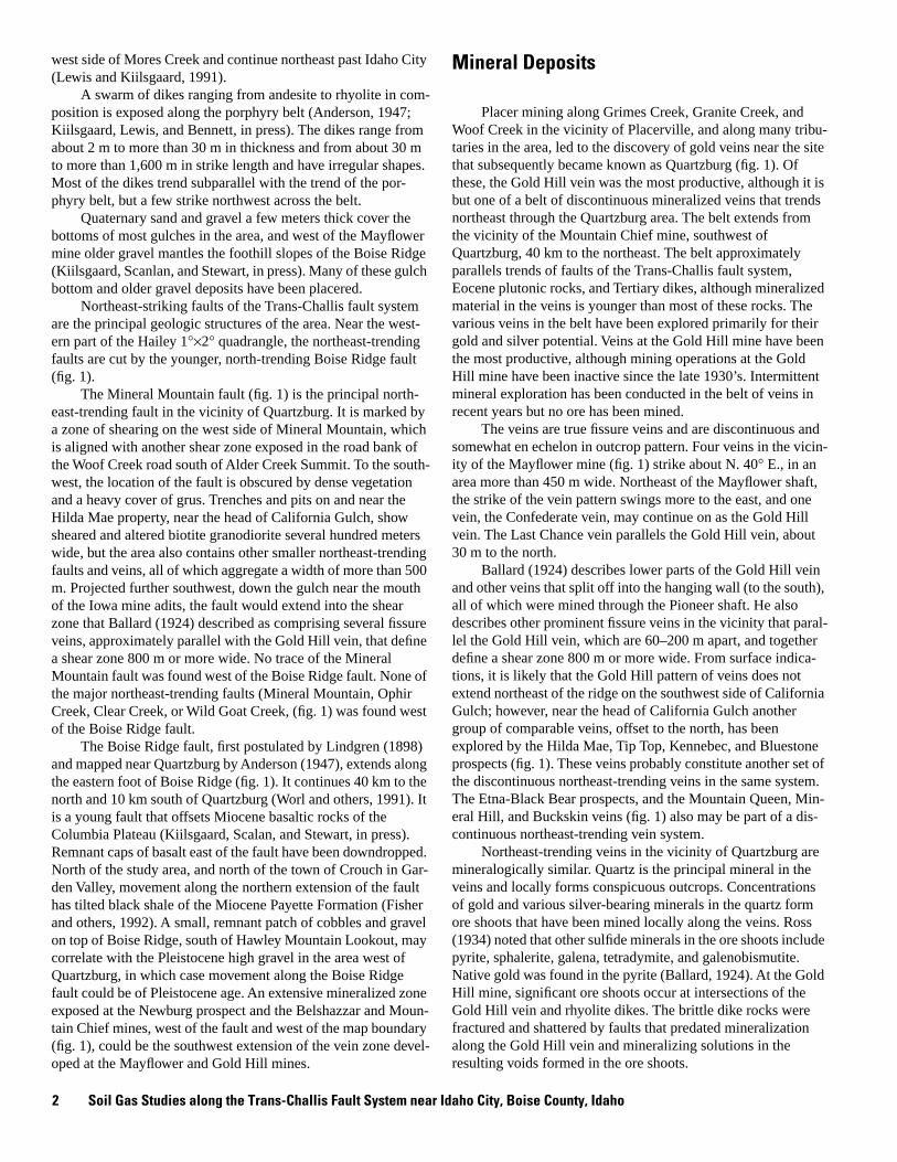
Mineral Deposits
Placer mining along Grimes Creek, Granite Creek, and Woof Creek in the vicinity of Placerville, and along many tribu-taries in the area, led to the discovery of gold veins near the site that subsequently became known as Quartzburg (fig. 1). Of these, the Gold Hill vein was the most productive, although it is but one of a belt of discontinuous mineralized veins that trends northeast through the Quartzburg area. The belt extends from the vicinity of the Mountain Chief mine, southwest of Quartzburg, 40 km to the northeast. The belt approximately parallels trends of faults of the Trans-Challis fault system, Eocene plutonic rocks, and Tertiary dikes, although mineralized material in the veins is younger than most of these rocks. The various veins in the belt have been explored primarily for their gold and silver potential. Veins at the Gold Hill mine have been the most productive, although mining operations at the Gold Hill mine have been inactive since the late 1930’s. Intermittent mineral exploration has been conducted in the belt of veins in recent years but no ore has been mined.
The veins are true fissure veins and are discontinuous and somewhat en echelon in outcrop pattern. Four veins in the vicin-ity of the Mayflower mine (fig. 1) strike about N. 40
°
E., in an area more than 450 m wide. Northeast of the Mayflower shaft, the strike of the vein pattern swings more to the east, and one vein, the Confederate vein, may continue on as the Gold Hill vein. The Last Chance vein parallels the Gold Hill vein, about 30 m to the north.
Ballard (1924) describes lower parts of the Gold Hill vein and other veins that split off into the hanging wall (to the south), all of which were mined through the Pioneer shaft. He also describes other prominent fissure veins in the vicinity that paral-lel the Gold Hill vein, which are 60–200 m apart, and together define a shear zone 800 m or more wide. From surface indica-tions, it is likely that the Gold Hill pattern of veins does not extend northeast of the ridge on the southwest side of California Gulch; however, near the head of California Gulch another group of comparable veins, offset to the north, has been explored by the Hilda Mae, Tip Top, Kennebec, and Bluestone prospects (fig. 1). These veins probably constitute another set of the discontinuous northeast-trending veins in the same system. The Etna-Black Bear prospects, and the Mountain Queen, Min-eral Hill, and Buckskin veins (fig. 1) also may be part of a dis-continuous northeast-trending vein system.
Northeast-trending veins in the vicinity of Quartzburg are mineralogically similar. Quartz is the principal mineral in the veins and locally forms conspicuous outcrops. Concentrations of gold and various silver-bearing minerals in the quartz form ore shoots that have been mined locally along the veins. Ross (1934) noted that other sulfide minerals in the ore shoots include pyrite, sphalerite, galena, tetradymite, and galenobismutite. Native gold was found in the pyrite (Ballard, 1924). At the Gold Hill mine, significant ore shoots occur at intersections of the Gold Hill vein and rhyolite dikes. The brittle dike rocks were fractured and shattered by faults that predated mineralization along the Gold Hill vein and mineralizing solutions in the resulting voids formed in the ore shoots.

3
MU
DD
Y C
REEK
FA
ULT
BO
ISE
CR
EEK
FAU
LTMIN
ERALMOUNTA
INFA
ULT
OPH
IR
CRE
EKFA
ULT
CLEA
RCRE
EKFA
ULT
1
67
8
9
11
10
12
13
1415
16
17
18
19
EXPLANATION
Mine or prospect
Mine shaft
Adit, caved at portal
Fault, dashed where approximately located, dotted where concealed bar and ball on downthrown side.
Vein, showing strike
MINES OR PROSPECTS
1 NewburgRichland (Silver Star)
Homeward Bound
Mayflower shaft
Sunday (Black Hawk)
Last Chance shaft
Gold Hill vein
Pioneer shaft
Iowa
Hilda MaeBlaine (Pandora) tunnel
Kennebec
Tip Top
Bluestone
Etna (Blum & Eken)
Black Bear
Mountain Queen (Gold Dollar)
Mineral HillBuckskin
234
5
6
7
8
910
11
12
13
14
15
1617
1819
Figure 1.
Map showing faults, veins, mines, and prospects in the northwestern corner of the Hailey 1
°×
2
°
quadrangle, Idaho.
Mineral Deposits

4 Soil Gas Studies along the Trans-Challis Fault System near Idaho City, Boise County, Idaho
4039
38
4142
4344
45
1
2
3
451
5 64
65
66
63
678
10
9
1112
1314
151617
18 19
20
21
22
23
24
28
293031
3233
3435
474849
50
52
5354
55
56
57
58
59
60
61
62
25
26
27
44°00'
116°00'
EXPLANATIONSample locality
Fault Dashed where approxamately locatedBall and bar on down thrown side
55
EXPLANATION
Sample locality
Fault— Dashed where approximately located; ball and bar on down thrown side
55
Soil Gas Studies
Soil gases were sampled at about 1,600- and 300-m intervals along roads and trails that cross the Trans-Challis fault
system. On average, about 10 samples per day were collected and analyzed; sample sites and numbers are shown in figure 2. Widely spaced samples were taken at sites beyond the inferred boundary of the fault system to see whether gas anomalies can
Figure 2.
Map showing soil and gas sample localities in the vicinity of the Trans-Challis fault system near Idaho City, Idaho.

5
be used to delineate the Trans-Challis fault system. Closely spaced samples were taken at sites near individual mineral deposits and mapped faults to determine whether gas anomalies coincide with these features. One sample traverse extended along the county road from New Centerville, across Alder Creek Summit, to the South Fork of the Payette River. This traverse crosses the Trans-Challis fault system and extends about 8 km north of the inferred boundary. Another traverse extends from Star Ranch southwest to the Harris Creek Summit and along the Boise Ridge to Hawley Mountain, again crossing part of the fault system and extending beyond it. Close-spaced samples were taken along traverses 2–3 km in length from Placerville to the Mayflower and Gold Hill mines and along the Elk Creek drainage north of Idaho City.
Soil gas samples were collected by driving a small-diame-ter hollow steel probe into the ground to a depth of 0.75 m. Five cubic centimeters of soil gas was withdrawn from that depth and analyzed at the site using a truck-mounted quadrupole mass spectrometer powered by a heavy-duty truck alternator (McCar-thy and Bigelow, 1990). The analyzer is programmed to measure atomic and molecular gases from 2 to 100 atomic mass units (AMU) and the relative concentration of individual gases are recorded for storage and plotting.
Results
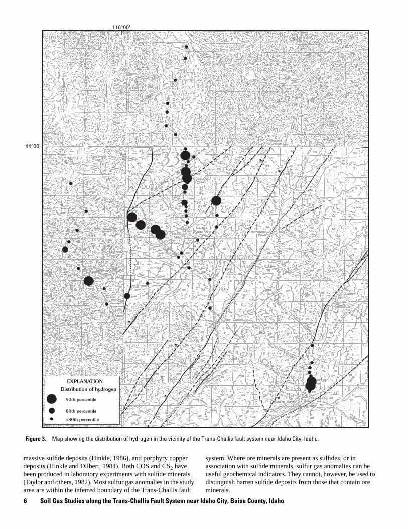
Anomalous concentrations of carbon dioxide, oxygen, sul-fur gases, and hydrocarbon gases were found along the Trans-Challis fault system. Concentrations of most of these gases are higher over the fault system than in the surrounding areas and highest concentrations appear to parallel the northwest boundary of the fault. Maps of selected gas levels in relation to the faults are shown on figures 3–8.
Concentrations of hydrogen (H
2
) are anomalous only over the Trans-Challis fault zone (fig. 3). Hydrogen anomalies coin-cide with northeast-trending shear zones that extend through the Alder Creek Summit area. Other anomalies occur along the Boise Ridge, near the Mayflower and Gold Hill mines, and in the Elk Creek drainage just north of Idaho City.
Carbon dioxide (CO
2
) concentrations are anomalous over the Trans-Challis fault system as well as at sites several miles north of the inferred boundary, toward Garden Valley (fig. 4). Anomalous concentrations of carbon dioxide were found in samples from the vicinity of the Elk Creek fault north of Idaho City and from northeast-trending shear zones south of Quartzburg and near Alder Creek Summit. Carbon dioxide is commonly produced in oxidizing sulfide deposits and may reflect such deposits in the underlying bedrock.
Values for the ratio of CO
2
to O
2
are anomalous at fewer sites than values for CO
2
alone. The ratio of these gases more specifically indicates oxidizing sulfides than does the concentra-tion of either gas alone. The ratio is anomalous at Alder Creek Summit, in the area of the Mayflower and Gold Hill mines, in the Elk Creek drainage north of Idaho City and at several sites along Alder Creek, south of Garden Valley (fig. 5).
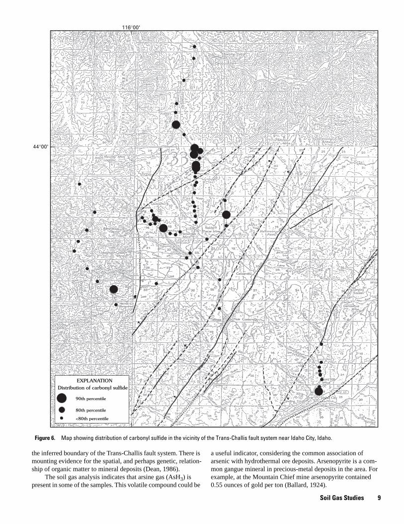
All carbonyl sulfide (COS) anomalies are within the Trans-Challis fault system (fig. 6). Most anomalies are near Alder
Creek Summit and at other sites near Harris Creek Summit and in the Elk Creek drainage north of Idaho City.
Methane (CH
4
) anomalies coincide with northeast-trending shear zones that extend through the Alder Creek Summit area (fig. 7). Some methane anomalies to the southwest, along Boise Ridge, correlate roughly with shear zones that cross the ridge and extend to the southwest.
Anomalous concentrations of propane (C
3
H
8
) are anoma-lous at sites only within the boundary of the fault system and generally coincide with areas of known mineral deposits (fig. 8). Two anomalous sites on Boise Ridge (the same sites at which methane is anomalous) are not near any known mineral deposits. Most of the hydrocarbon gas anomalies coincide with areas of known mineral deposits.
Discussion
Anomalous concentrations of all of the gases sampled are found along the Trans-Challis fault system, and most are associ-ated with mineral deposits (Rose and others, 1979; Kesler, 1990) and faults.
Hydrogen is one of the gases found in volcanic emanations and, in some cases, is of deep-seated origin (Sherbakov and Kozlova, 1986). It is also produced by serpentinization, when water reacts with ferrous iron minerals (Coveney and others, 1987), and by the breakdown of water, catalyzed by contact with fresh rock surfaces, such as along faults (Kita and others, 1980; Sugisaki and others, 1983). Hydrogen gas concentrations can be used, in areas covered by overburden, to map faults and, where mineral deposits are located along faults, may be a useful explo-ration guide. In the study area, hydrogen anomalies such as that found where northeast-trending faults cross Alder Creek Sum-mit (fig. 3) probably reflect the belt of Tertiary hypabyssal igne-ous rocks and (or) shear zones that trend northeast from Quartzburg (Ballard, 1924; Kiilsgaard and others, 1989).
Carbon dioxide is commonly associated with oxidizing sul-fide deposits (Lovell and others, 1983; McCarthy and others, 1986; Reid and Rasmussen, 1990). It is produced when acid ground waters react with calcareous minerals. Oxygen is con-sumed in this reaction, resulting in lowered concentrations of oxygen and elevated concentrations of carbon dioxide in the same soil gas sample. In the study area, carbon dioxide anoma-lies, as well as sulfur gas anomalies, probably result from oxida-tion of pyrite and other sulfide minerals along the Trans-Challis fault system. Where precious metals are associated with the pyrite, for example in auriferous pyrite in the Gold Hill mine (Kiilsgaard and others, 1989), the carbon dioxide anomalies may be useful guides to ore. Carbon dioxide anomalies are shown in figure 4, and sites at which these anomalies coincide with low oxygen values are shown in figure 5. Most of these anomalous sites occur in areas of known mineral deposits, but not all. However, all anomalous sites may be underlain by oxi-dizing sulfide deposits. The anomalies along the Elk Creek drainage, just north of Idaho City, may indicate pyrite (aurifer-ous?) in bedrock beneath the terrace gravels and alluvium.
The sulfur gases, COS, SO
2
, H
2
S and CS
2
, have been found over disseminated gold deposits (Kesler and others, 1990),
Soil Gas Studies
6 Soil Gas Studies along the Trans-Challis Fault System near Idaho City, Boise County, Idaho
fl
44°00'
116°00'
Distribution of hydrogen
90th percentile
<80th percentile
80th percentile
EXPLANATION
massive sulfide deposits (Hinkle, 1986), and porphyry copper deposits (Hinkle and Dilbert, 1984). Both COS and CS
2
have been produced in laboratory experiments with sulfide minerals (Taylor and others, 1982). Most sulfur gas anomalies in the study area are within the inferred boundary of the Trans-Challis fault
system. Where ore minerals are present as sulfides, or in association with sulfide minerals, sulfur gas anomalies can be useful geochemical indicators. They cannot, however, be used to distinguish barren sulfide deposits from those that contain ore minerals.
Figure 3.
Map showing the distribution of hydrogen in the vicinity of the Trans-Challis fault system near Idaho City, Idaho.

7
44°00'
116°00'
Distribution of carbon dioxide
90th percentile
<80th percentile
80th percentile
EXPLANATION
Hydrocarbon gases are associated with base-metal deposits (Disnar, 1990) and gold deposits (Clifton, 1986; Kessler and others, 1990). One explanation offered for the presence of hydrocarbon gases around mineral deposits is that they result
from thermal maturation of organic matter in host or wallrock by the hydrothermal solutions that introduced the ore and gangue minerals, a process that has been termed “hydrothermal catagenesis” (McCarthy and Bigelow, 1990). Alternatively, the
Figure 4.
Map showing distribution of carbon dioxide in the vicinity of the Trans-Challis fault system near Idaho City, Idaho.
Soil Gas Studies

8 Soil Gas Studies along the Trans-Challis Fault System near Idaho City, Boise County, Idaho
44°00'
116°00'
Distribution of carbon dioxide: oxygen ratio
90th percentile
<80th percentile
80th percentile
EXPLANATION
hydrocarbons may have been generated elsewhere and trans-ported in the hydrothermal solutions. In either event, they can be useful geochemical guides. Methane, propane, butane, and pen-tane anomalies were identified along the northeast-trending
shear zones that extend through the Alder Creek Summit area, as well as to the southwest along Boise Ridge where they corre-late roughly with shear zones that cross the ridge and extend to the southwest. All of the hydrocarbon gas anomalies are within
Figure 5.
Map showing distribution of carbon dioxide-to-oxygen ratios in the vicinity of the Trans-Challis fault system near Idaho City, Idaho.
9
44°00'
116°00'
Distribution of carbonyl sulfide
90th percentile
<80th percentile
80th percentile
EXPLANATION
the inferred boundary of the Trans-Challis fault system. There is mounting evidence for the spatial, and perhaps genetic, relation-ship of organic matter to mineral deposits (Dean, 1986).
The soil gas analysis indicates that arsine gas (AsH
3
) is present in some of the samples. This volatile compound could be
a useful indicator, considering the common association of arsenic with hydrothermal ore deposits. Arsenopyrite is a com-mon gangue mineral in precious-metal deposits in the area. For example, at the Mountain Chief mine arsenopyrite contained 0.55 ounces of gold per ton (Ballard, 1924).
Figure 6.
Map showing distribution of carbonyl sulfide in the vicinity of the Trans-Challis fault system near Idaho City, Idaho.
Soil Gas Studies

10 Soil Gas Studies along the Trans-Challis Fault System near Idaho City, Boise County, Idaho
44°00'
116°00'
Distribution of methane
90th percentile
<80th percentile
80th percentile
EXPLANATION
Ammonia was detected in soil gases over mineralized areas in the Trans-Challis fault system. Ammonia has been found in association with base and precious-metal deposits in clay miner-als and feldspars (Bloomstein and others, 1987), and it may be another useful indicator gas in the area.
Conclusions
Anomalous concentrations of soil gases delineate the Trans-Challis fault system in the study area. Soil gas anomalies also coincide with known mineral deposits and mineralized
Figure 7.
Map showing distribution of methane in the vicinity of the Trans-Challis fault system near Idaho City, Idaho.

11
44°00'
116°00'
Distribution of propane
90th percentile
<80th percentile
80th percentile
EXPLANATION
areas. Carbon dioxide-oxygen ratios, sulfur gas concentrations, and hydrocarbon gas concentrations correlate with known min-eral deposits whereas hydrogen concentrations are probably the best indicator of faults. Carbon dioxide-to-oxygen ratios are anomalous at sites that extend along the Alder Creek drainage
south of Garden Valley and may indicate concealed sulfide deposits. Similar anomalies in the Elk Creek drainage just north of Idaho City may indicate sulfide deposits in bedrock beneath the gravel deposits. Soil gases may be useful guides for tracing faults and mineral deposits in this terrane.
Figure 8.
Map showing distribution of propane in the vicinity of the Trans-Challis fault system near Idaho City, Idaho.
Conclusions
12 Soil Gas Studies along the Trans-Challis Fault System near Idaho City, Boise County, Idaho
References
Anderson, A.L., 1947, Geology and ore deposits of the Boise Basin, Idaho: U.S. Geological Survey Bulletin 944-C, 319 p.
Ballard, S.M., 1924, Geology and gold resources of the Boise Basin, Boise County, Idaho: Idaho Bureau of Mines and Geology Bulletin 9, 103 p.
Bloomstein, E., Kydd, R.A., and Levinson, A.A., 1987, Development of ammonium geochemistry as a new technique in precious and base metals exploration [abs.]: Journal of Geochemical Exploration, v. 29, no. 1/3, p. 386.
Clifton, C.G., 1986, Primary gas dispersion halos in disseminated gold deposits—Examples from Nevada and California [abs.]: Journal of Geochemical Exploration, v. 25, no. 1/2, p. 259.
Coveney, R.M., Jr., Goebel, E.D., Zeller, E.J., Dreschoff, G.A.M., and Ang-ino, E.E., 1987, Serpentinization and the origin of hydrogen gas in Kansas: American Association of Petroleum Geologists Bulletin, v. 71, no. 1, p. 39–48.
Dean, W.E., ed., 1986, Organics and ore deposits: Denver Region Explo-ration Geologists Society Symposium, Proceedings, 218 p.
Disnar, J.R., 1990, Volatile hydrocarbons in Ba-Zn-Pb ore genesis: analy-sis and use in mineral exploration: Journal of Geochemical Explora-tion, v.38, no. 1/2, p. 205–224.
Fisher, F.S., McIntyre, D.H., and Johnson, K.M., 1992, Geologic map of the Challis 1°
×
2° quadrangle, Idaho: U.S. Geological Survey Miscella-neous Investigations Series Map I-1819, scale 1:250,000.
Glebovskaya, V.S., and Glebovskii, S.S., 1960, The possibility of applica-tion of gas surveys in prospecting for sulfide deposits: Geological Survey of Canada, Translation 603.
Hinkle, M.E., 1986, Using volatile constituents of soils and soil gases to determine the presence of copper-zinc ore bodies at Johnson Camp, Arizona: Journal of Geophysical Research, v. B 91, no. 12, p. 12359–12365.
Hinkle, M.E., and Dilbert, C.A., 1984, Gases and trace elements in soils at the North Silver Bell deposit, Pima County, Arizona: Journal of Geochemical Exploration, v. 20, p. 323–336.
Jones, E.L., Jr., 1916, Lode mining in the Quartzburg and Grimes Pass por-phyry belt, Boise Basin, Idaho: U.S. Geological Survey Bulletin 640, p. 83–111.
Kesler, S.E., 1990, Soil and rock gas geochemistry: Journal of Geochem-ical Exploration, v.38, 245 p.
Kesler, S.E., Gerdenich, M.J., Steininger, R.C., and Smith, S.C., 1990, Dispersion of soil gas around micron gold deposits: Journal of Geochemical Exploration, v. 38, p. 117–132.
Kiilsgaard, T.H., and Lewis, R.S., 1985, Plutonic rocks of Cretaceous age and faults in the Atlanta lobe of the Idaho batholith, Challis 1°
×
2° quadrangle, Idaho,
in
McIntyre, D.H., ed., Symposium on the geology and mineral deposits of the Challis 1°
×
2° quadrangle, Idaho: U.S. Geological Survey Bulletin 1658-B, p. 29–42.
Kiilsgaard, T.H., Fisher, F.S., and Bennett, E.H., 1989, Gold-silver deposits associated with the Trans-Challis fault system, Idaho: U.S. Geologi-cal Survey Bulletin 1857-B, p. B22–B44.
Kiilsgaard, T.H., Lewis, R.S., and Bennett, E.H., in press, Plutonic and hypabyssal rocks of the Hailey 1°
×
2° quadrangle, Idaho: U.S. Geo-logical Survey Bulletin 2064-U.
Kiilsgaard, T.H., Scanlan, T.M., and Stewart, D.E., in press, Geology and mineral deposits of the Boise Basin area, Boise and Elmore Coun-ties, Idaho: U.S. Geological Survey Bulletin 2064-BB.
Kita, I., Matsuo, S., Wakita, H., and Nakamura, Y., 1980, D/H ratios of H
2
in soil gases as an indicator of fault movements: The Geochemical Society of Japan, Geochemical Journal, v. 14, no. 6, p. 317–320.
Lewis, R.S., and Kiilsgaard, T.H., 1991, Eocene plutonic rocks in south-central Idaho: Journal of Geophysical Research, v. 96, no. B8, p. 13,295–13,311.
Lindgren, Waldemar, 1898, The mining districts of the Idaho Basin and the Boise Ridge, Idaho: U.S. Geological Survey Annual Report 18, pt. 3, p. 617–719.
Lovell, J.S., Hale, M., and Webb, J.S., 1983, Soil air carbon dioxide and oxygen measurements as a guide to concealed mineralization in semi-arid and arid regions: Journal of Geochemical Exploration, v. 19, p. 305–317.
Lovell, J.S., and Hale, M., 1983, Application of soil-air carbon dioxide and oxygen measurements to mineral exploration: Transactions Insti-tute of Mining and Metallurgy, sec. B, p. 28–32.
McCarthy, J.H., Jr. and Bigelow, R.C., 1990, Multiple gas analyses using a mobile mass spectrometer: Journal of Geochemical Exploration, v. 38, p. 233–245.
McCarthy, J.H., Jr., Lambe, R.N., and Dietrich, J.A., 1986, A case study of soil gases as an exploration guide in glaciated terrain-Crandon massive sulfide deposit, Wisconsin: Economic Geology, v. 81, p. 408–420.
Reid, A.R., and Rasmussen, J.D., 1990, The use of soil-gas CO2 in the exploration for sulfide-bearing breccia pipes in northern Arizona: Journal of Geochemical Exploration, v. 38, p. 87–102.
Rose, A.W., Hawkes, H.E., and Webb, J.S., 1979, Geochemistry in mineral exploration: Academic Press, 657 p.
Ross, C.P., 1934, Some lode deposits in the northwestern part of the Boise Basin, Idaho: U.S. Geological Survey Bulletin 846-D, p. 239–276.
Shcerbakov, A.V., and Kozlova, N.D., 1986, Occurrence of hydrogen in subsurface fluids and the relationship of anomalous concentra-tions to deep faults in the USSR: Geotectonics, v. 20, no. 2, p. 120–128.
Sugisaki, R., Ido, M., Takeda, H., Isobe, Y., Hayashi, Y., Nakamura, N., Satake, H., and Mizutani, Y., 1983, Origin of hydrogen and carbon dioxide in fault gases and its relation to fault activity: Journal of Geology, v. 91, no. 3, p.239–258.
Taylor, C.H., Kesler, S.E., and Cloke, P.K., 1982, Sulfur gases produced by the decomposition of sulfide minerals: application to geochemical exploration: Journal of Geochemical Exploration, v. 17, p.165–186.
Worl, R.G., Kiilsgaard, T.H., Bennett, E.H., Link, P.K., Lewis, R.S., Mitchell, V.E., Johnson, K.M., and Snyder, L.D., 1991, Geologic map of the Hailey 1°
×
2° quadrangle, Idaho: U.S. Geological Survey Open-File Report 91-340, scale 1:250,000.