soil databases and gis - esdac.jrc.ec.europa.eu · wysoczyzna morenowa falista gliny r brunatne,...
TRANSCRIPT

European Summer School on Soil Survey, 12-16.07.2004
Soil databases and GISSoil databases and GIS
Dr Joanna KossakowskaWarsaw University of Technology

European Summer School on Soil Survey, 12-16.07.2004
1 : 5 0001 : 25 000
Applications: cadastrephysical planningsoil protectionterrain suitabilityprecision agricultureplant cultivation...........
Local Soil DatabasesLocal Soil Databases

European Summer School on Soil Survey, 12-16.07.2004
Users needs
Quality of data, precision
Costs of:
creating data base
updating
analysis and modelling
RequirementsRequirements

European Summer School on Soil Survey, 12-16.07.2004
Resolution: spatial, semanticResolution: spatial, semantic
Spatial: size of pixel or graphical precision of maps
0.5 mm 1 : 1 000 000 500m1 : 500 000 250m1 : 100 000 50m1 : 25 000 12.5m
Semantic: number of attributesprecision of attributestimeless of attributes
Quality of Quality of data, data, quality of informationquality of information

European Summer School on Soil Survey, 12-16.07.2004
Creating of the soil databaseCreating of the soil database
Type of soil
European Summer School on Soil Survey, 12-16.07.2004
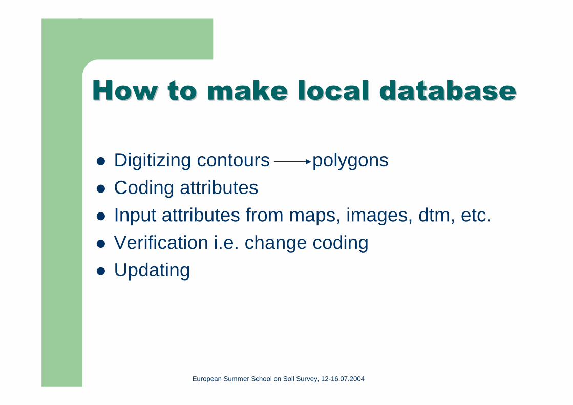
How to make local databaseHow to make local database
Digitizing contours polygons
Coding attributesInput attributes from maps, images, dtm, etc.
Verification i.e. change codingUpdating

European Summer School on Soil Survey, 12-16.07.2004
Topographical Topographical mapmap SoilSoil--agriculture agriculture mapmap
Satellite imageSatellite image DTMDTM

European Summer School on Soil Survey, 12-16.07.2004
Changes in landChanges in land use use
European Summer School on Soil Survey, 12-16.07.2004

European Summer School on Soil Survey, 12-16.07.2004
1986 1986 20022002
Changes in landChanges in land useuse

European Summer School on Soil Survey, 12-16.07.2004
Using of Soil DatabasesUsing of Soil Databases for for spatial analysis and spatial analysis and modellingmodelling
simple question
spatial distribution of selected features (soil types or soil texture)
combination of features
connection with other thematic data bases(soils + vegetation)(soils + DTM)
European Summer School on Soil Survey, 12-16.07.2004
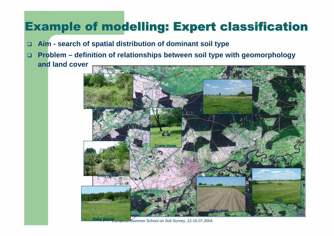
Example of Example of modelling: modelling: Expert classificationExpert classificationAim - search of spatial distribution of dominant soil type
Problem – definition of relationships between soil type with geomorphologyand land cover
Gleby płowe
Mady
Czarne ziemie
Nie użytkowane rolniczo
Gleby rdzawe
Gleby glejowe
Gleby torfowe
European Summer School on Soil Survey, 12-16.07.2004
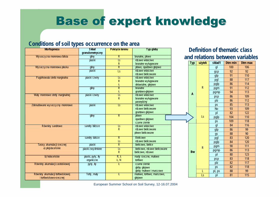
Base of expert knowledgeBase of expert knowledge
Morfogeneza Skład granulometryczny
Pokrycie terenu Typ gleby
gliny R brunatne, płowe Wysoczyzna morenowa falista piaski Ls
R rdzawe właściwe brunatne wy ługowane
gliny R płowe, opadowo glejowe Wysoczyzna morenowa płaska piaski Ls rdzawe właściwe
rdzawe bielicowane piaski i żwiry Ls
R Ł
rdzawe właściwe brunatne wy ługowane deluwialne, glejowe
Pagórkowata strefa marginalna
gliny R Ł
brunatne gruntowo-glejowe
Wały morenowe strefy marginalnej piaski i żwiry Ls R
rdzawe właściwe brunatne wy ługowane pararędziny
piaski Ls rdzawe właściwe rdzawe bielicowane gruntowo glejowe
Zdenudowane wysoczyzny morenowe
gliny R płowe opadowo glejowe czarne ziemie
sandry bliższe Ls R
rdzawe właściwe rdzawe bielicowane płowe bielicowane
Równiny sandrowe
sandry dalsze R Ls
Bielicowe rdzawe bielicowane
piaski R bielicowe, bielice Tarasy akumulacji rzecznej a) plejstoceńskie piaski zwydmione Ls
R bielicowe, rdzawe bielicowane bielicowe, rdzawe
b) holoceńskie piaski, pyły, iły organiczne
R, Ł Ł, N
mady rzeczne, mułowe torfowe
Równiny akumulacji zastoiskowej py ły , iły Ł czarne ziemie gleby glejowe gleby mułowe i murszowe
Równiny akumulacji torfowiskowej i torfowiskowo-rzecznej
Torfy , muły Ł mułowe, torfowe, murszowe, glejowe
Conditions of soil types occurrence on the area
Typ użytek skład1 Dtm min Dtm max gl 100 106
gsp 92 92 glp 91 110 pgl 88 117
pglp 86 114 pgm 91 112
pgmp 94 113 psp 86 109 plz 86 112
R
ps 85 113 No 93 109 pl 82 122
pglp 104 110
A
Ls
ps 109 118 gl 84 116
glp 86 99 gs 88 90 pgl 83 120
pglp 84 120 pgm 90 111
pgmp 86 113 pl 80 123
psp 83 118 plz 82 117
R
ps 82 118 L pl, ps 88 99
Bw
Ls pl 81 115
Definition of thematic class and relations between variables

European Summer School on Soil Survey, 12-16.07.2004
Stages of expert classificationStages of expert classification
+ kwnoledge
Base of decision rulesDigital terrain model
Land coverSatellite image
Parent materials
result
Soil type
European Summer School on Soil Survey, 12-16.07.2004
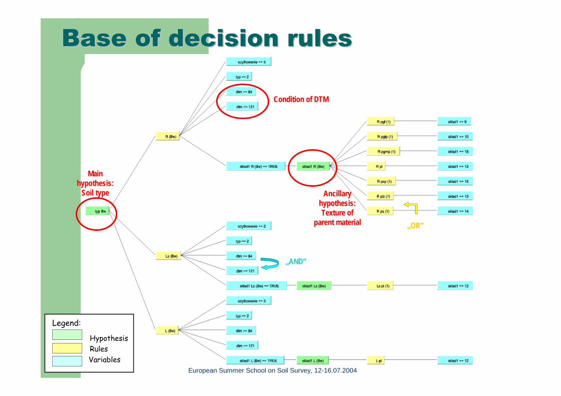
Baza reguł decyzyjnych
Ancillary hypothesis:Texture of
parent material
Condition of DTM
Main hypothesis:
Soil type
„OR”
„AND”
Legend:
HypothesisRulesVariables
Base of decision rulesBase of decision rules

European Summer School on Soil Survey, 12-16.07.2004
Expert classificationExpert classification resultresult: : dominat soil typesdominat soil types

European Summer School on Soil Survey, 12-16.07.2004
ConclusionsConclusions
Combining of data sour ces with expert knowledge Quick updating & revision of the database
Satellite image
Spectral classification
Land cover Soil type
Decision rules:IF ... THEN ....
Layer of soil type
Knowledge:Thematic contextSpatial cotext...........
GIS layers :DTM...........
European Summer School on Soil Survey, 12-16.07.2004
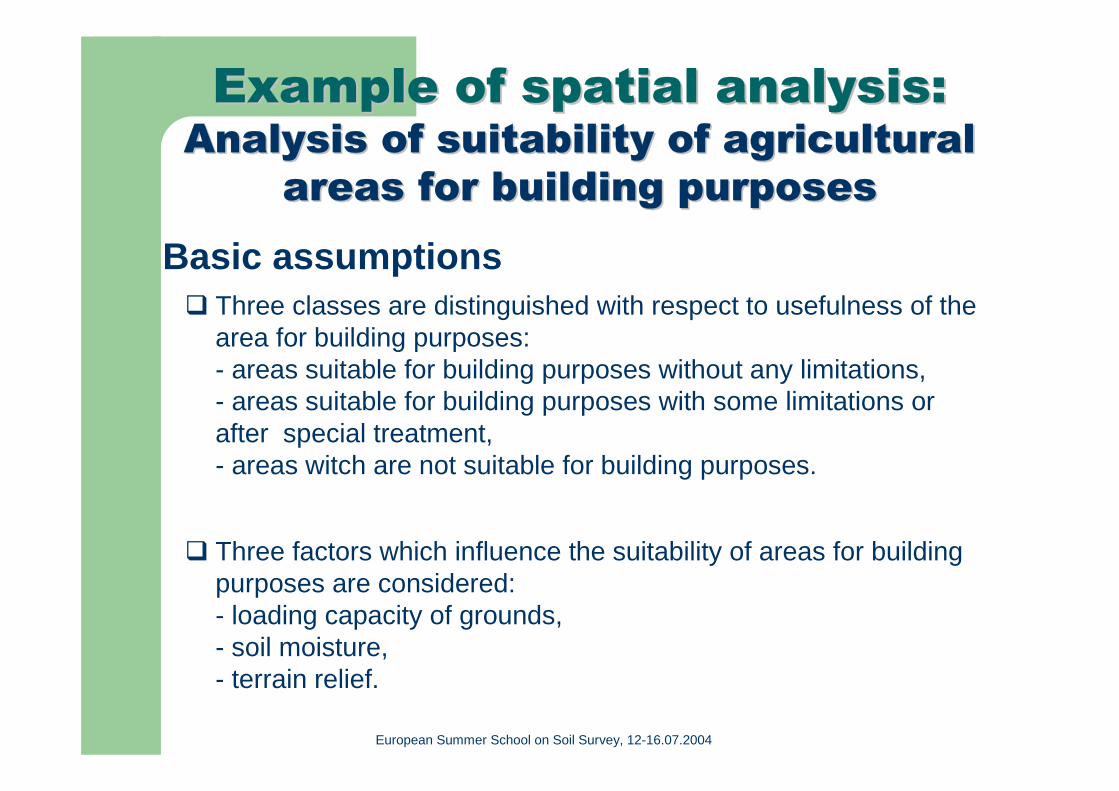
Example of spatial analysisExample of spatial analysis::AAnalysis of suitability of agricultural nalysis of suitability of agricultural
areas areas for for building purposesbuilding purposesBasic assumptions
Three classes are distinguished with respect to usefulness of the area for building purposes:- areas suitable for building purposes without any limitations,- areas suitable for building purposes with some limitations orafter special treatment,- areas witch are not suitable for building purposes.
Three factors which influence the suitability of areas for building purposes are considered:- loading capacity of grounds,- soil moisture,- terrain relief.

European Summer School on Soil Survey, 12-16.07.2004
Detailed criteria of suitabilityDetailed criteria of suitability analysisanalysisClasses of suitability
(a) loading capacity of grounds
(b) soil moisture (c) terrain relief
1.Areas suitable for housing without any limitations
All mineral soils:A, Ax, Bw, Bg, D, Dz
Soils suitability units: 1,2,3,5,6,7, A, Ax, Bw, Bg and some soils of the 4th
soil suitability unit with exclusion of Axg.
slopes 0-3 %
2. Areas suitable for housing with limitation or after special treatment
Layered Fluvisols (F) of lower location and Gleysols (G)
SSU4 Luvisols with upper gleying (Ax, Axg) of light texture in the upper layer and of clayey background (top layer 1,2,3,4 classes of texture and subsurface layer 5,6 classes).Soil suitab. Units 1-6 on black earths: D, Dz, GSoil suitab. Units 1-7 on Fluvisols: F
slopes =< 3-5% +location on a mountain - side
3. Areas unsuitable for housing
Organic soils: E, T, M. Grasslands and pastures: 1z, 2z, 3z; Soil suitab. units 8,9,14
slopes > 5% +scarps and faults

European Summer School on Soil Survey, 12-16.07.2004
Source Source datadata
Soil data baseSoil typesSoil suitability unitsTextureDeep of texture change......
Land coverDigital terrain model
European Summer School on Soil Survey, 12-16.07.2004
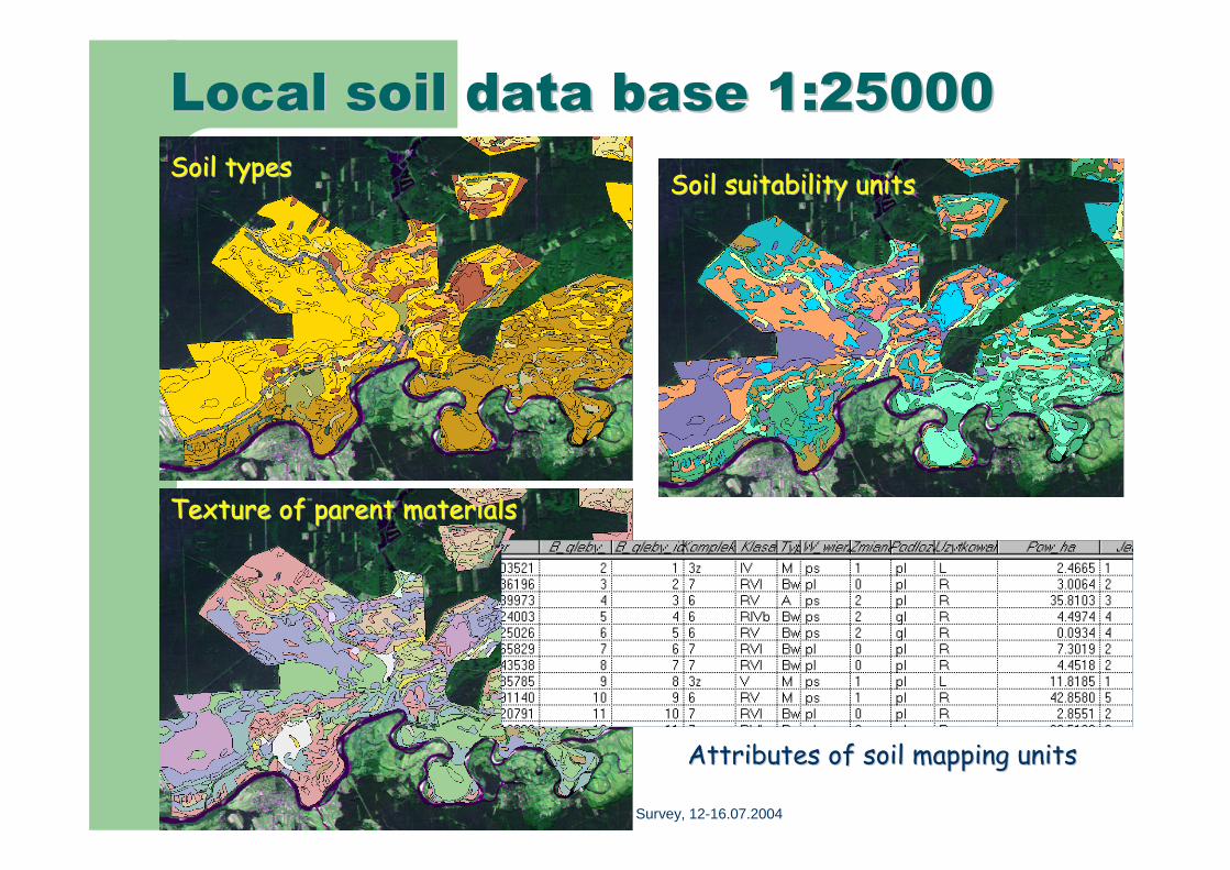
Local soilLocal soil data data base base 1:250001:25000
Texture of parent materialsTexture of parent materials
Soil suitability unitsSoil suitability unitsSoil typesSoil types
Attributes of soil mapping unitsAttributes of soil mapping units

European Summer School on Soil Survey, 12-16.07.2004
Spatial analysis Spatial analysis diagramdiagramDTM slope
Soil DB
loading capacity
Soil moisture
Land coverSatellite image Rivers
New attributes in DB
Buffer

European Summer School on Soil Survey, 12-16.07.2004
Result of spatial analysisResult of spatial analysis

European Summer School on Soil Survey, 12-16.07.2004
Perspective view Perspective view 3D3D