soil database of china and carbon dynamics at regional scale by xue-zheng shi
TRANSCRIPT

Soil database of China and carbon dynamics at regional scale
Xue-Zheng Shi
Institute of Soil Science, Chinese
Academy of Sciences, China

OutlineOutline
Role of soil database
Multiple digital soil maps of China
Soil attribute database of China
Soil reference system of China
SOC storage of China
Scale effect of SOC estimates at regional scale
Role of soil database
Multiple digital soil maps of China
Soil attribute database of China
Soil reference system of China
SOC storage of China
Scale effect of SOC estimates at regional scale

Soil resourcesSoil resources
EnvironmentFood
production
Food security
Climate change
Global warming
Role of Soil DatabaseRole of Soil Database
Urgent needs of digital soil database of China at multiple scale
Soil carbon
Soil nitrogen
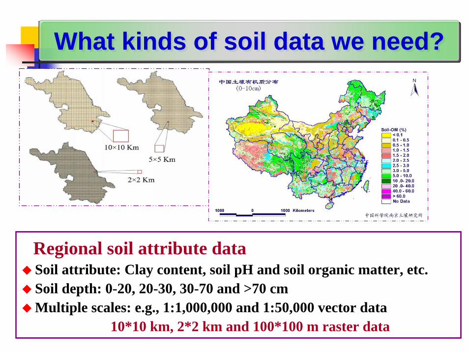
Regional soil attribute dataSoil attribute: Clay content, soil pH and soil organic matter, etc. Soil depth: 0-20, 20-30, 30-70 and >70 cmMultiple scales: e.g., 1:1,000,000 and 1:50,000 vector data
10*10 km, 2*2 km and 100*100 m raster data
What kinds of soil data we need?What kinds of soil data we need?

Soil Map
Whole regionsNational scale: 1:14,000,000National scale: 1:4,000,000National scale: 1:1,000,000Provincial scale: 1:500,000
Part regionCity scale: 1:200,000
County scale: 1:50,000
Digital Soil Maps of ChinaDigital Soil Maps of China

Digital soil map of 1:4,000,000/1:1,000,000Digital soil map of 1:4,000,000/1:1,000,000
1:4,000,000 digital soil map of China
1:1,000,000 digital soil map of China at
Orders, suborders, great groups, sub-groups and families

1:50,000 digital soil map of county1:50,000 digital soil map of county
Map unit is soil series 1:50,000 soil map of YixingCounty, Jiangsu Province

1: 500,000
1: 1,000,0001: 2,500,000
1: 4,000,000
1:10,000,000 HebeiHebei ProvinceProvince
Digital soil maps at multiple scaleDigital soil maps at multiple scale

1:50,000(52034)1:200,000(6167)1:500,000(3621)
1:1,000,000(492)1:4,000,000(31)1:14,000,000(8)
Digital soil maps at multiple scaleDigital soil maps at multiple scalePart of the Part of the TaihuTaihu Lake regionLake region

Distribution of SOM of China (0-10 cm)
Soil wilting point of forest (0-10 cm)
Distribution of SOM of China’s cropland (0-10 cm)
Soil raster data of China 10km*10km or 2km *2km
Soil raster data of China 10km*10km or 2km *2km

.
A total of about 20,000 soil profiles, 2,000,000 soil analytical data
Orders(sub-orders)
Great groups
Subgroups
Families
Soil series
Horizons
Thickness(cm)
Clay(%)
pH O.M.(%)
Aa 15 24.5 6.3 2.08
Ap 10 17.5 6.5 1.67
P 25 32.2 7.4 0.58
W1 24 37.9 7.5 0.58
Anthropic soil
Padd
y soil
Hydromorphicpaddy
soil
马肝泥田
马肝土
W2 26 44.1 7.3 0.66
Part attribute data of one soil profile
Soil attribute database of ChinaSoil attribute database of China

The Institute of Soil Science, Chinese Academy of Sciences, which provided the recent 1:1,000,000 scale Soil Map of China(http://www.iiasa.ac.at/Research/LUC/External-World-soil-database/HTML/index.html)
The soil data provided by X.Z. Shi and others of the Institute of Soil Science, Chinese Academy of Sciences(http://www.geodata.cn)
National Data for Earth Science of China

The soil data provided by X.Z. Shi and others of the Institute of Soil Science, Chinese Academy of Sciences(http://www.resdc.cn)
Data Center for Resource and Environmental Sciences, Chinese Academy of Sciences
Data Center for Environmental and Ecological Sciences of Western China
The soil data provided by X.Z. Shi and others of the Institute of Soil Science, Chinese Academy of Sciences(http://westdc.westgis.ac.cn)

During the years of 2005 ~ 2009Total 137 research projects used our soil database of China for research of agriculture etc.Show you six cases above
App. Date User Unit Scope of Soil Data App. Purpose
27-Dec-05Research Center for Eco-Environmental Sciences, CAS
Regional中国东部与西部典型区土地利用变化与比较
07-Mar-06 Beijing Normal University Regional 漳卫南运河子流域源污染SWAT模型估算研究
18-Sep-06 Peking University Regional 甘肃省西汉水流域水土流失研究
07-Feb-07Department of Thermal Engineering, TsinghuaUniversity
National 中国生物质与煤共气化研究
13-May-08Institute of Soil and Water Conservation, CAS & MWR
National 中国主要水蚀区土壤侵蚀过程与调控研究
26-Feb-09 Institute of Remote Sensing Applications, CAS National 中国区域历史土地利用覆盖数据
对中国区域气候的影响
Institutions or universities for using soil data of China (reported by data center for resource and environmental science, CAS )

Happy!It is happy for all soil data user! It is happy for us so many national and international researchprojects to use our soil database of ChinaWorried! for what???Existence for our research team in institute In our evaluation system for research team-there is no any score for our team to establish large soil database-focus on more care papers published in international journals, research funding, national awards etc.In order to survive for our research teamWe should and must do the basic or applied researches based on our soil database of China
Happy!It is happy for all soil data user! It is happy for us so many national and international researchprojects to use our soil database of ChinaWorried! for what???Existence for our research team in institute In our evaluation system for research team-there is no any score for our team to establish large soil database-focus on more care papers published in international journals, research funding, national awards etc.In order to survive for our research teamWe should and must do the basic or applied researches based on our soil database of China
Happy or Worried?Happy or Worried?
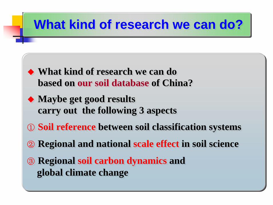
What kind of research we can do based on our soil database of China? Maybe get good resultscarry out the following 3 aspects
① Soil reference between soil classification systems
② Regional and national scale effect in soil science
③ Regional soil carbon dynamics and global climate change
What kind of research we can do based on our soil database of China? Maybe get good resultscarry out the following 3 aspects
① Soil reference between soil classification systems
② Regional and national scale effect in soil science
③ Regional soil carbon dynamics and global climate change
What kind of research we can do?What kind of research we can do?

ST (Soil Taxonomy) and WRB (World Reference Base for Soil Resources) is often used in international communication
Two soil classification systems in China is in useGSCC (Genetic Soil Classification of China) CST (Chinese Soil Taxonomy
The GSCC is different from ST or WRBWe need soil reference system from GSCC to ST, WRB and CST
Problems using Chinese soil mapsProblems using Chinese soil mapsDilemma?
Soil reference SystemSoil reference System

On basis of soil information from soil survey reportssuch as “Soil Series of China ” etc.Sort out name of each soil series in GSCC and ST or WRBLink the profile reference to the 1:1,000,000 soil map of China
An example for the reference of 3 out of 7,292 soil profiles GSCCSoil profile location
County/ProvinceGreat group Species
Subgroupin ST
Qiongshan/Hainan
Latosols Light Latosols RhodicPaleudults
Ji’an/Jiangxi
Red soils Red yellow earthwith clayed bottom
Plinthudults
Wujiang/Jiangsu
Paddy soils Yellow paddyearths
TypicEndoaquepts
Methods for Study on Soil ReferenceMethods for Study on Soil Reference

Soil reference bases of China(7292 profiles)
Digital soil map of China
“PKB” Method(Zhao, Shi et al., SSSAJ, 2006)
1:1,000,000 digital soil map of ChinaBased on ST (soil taxonomy)
1:1,000,000 digital soil map of ChinaBased on ST (soil taxonomy)
Digital soil order map of China Based on ST (Soil Taxonomy)suborder, great group, subgroup
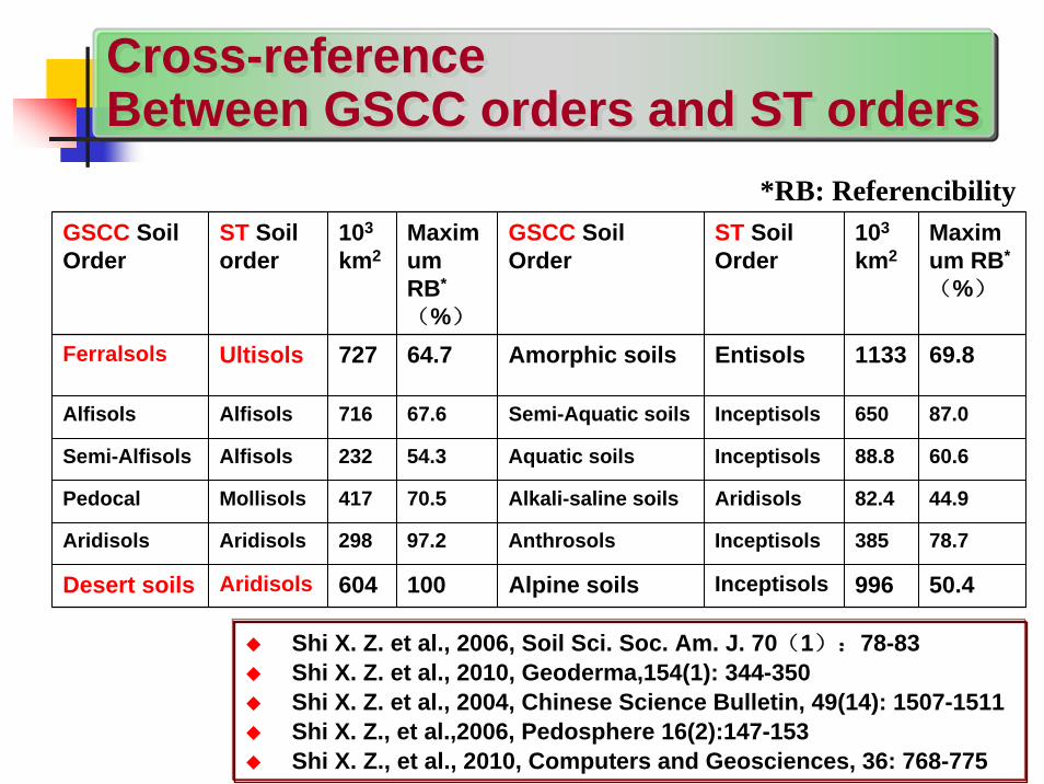
GSCC Soil Order
ST Soil order
103
km2Maximum RB*
(%)
GSCC Soil Order
ST Soil Order
103
km2Maximum RB*
(%)
Ferralsols Ultisols 727 64.7 Amorphic soils Entisols 1133 69.8
Alfisols Alfisols 716 67.6 Semi-Aquatic soils Inceptisols 650 87.0
Semi-Alfisols Alfisols 232 54.3 Aquatic soils Inceptisols 88.8 60.6
Pedocal Mollisols 417 70.5 Alkali-saline soils Aridisols 82.4 44.9
Aridisols Aridisols 298 97.2 Anthrosols Inceptisols 385 78.7
Desert soils Aridisols 604 100 Alpine soils Inceptisols 996 50.4
*RB: Referencibility
Cross-reference Between GSCC orders and ST orders Cross-reference Between GSCC orders and ST orders
Shi X. Z. et al., 2006, Soil Sci. Soc. Am. J. 70(1):78-83Shi X. Z. et al., 2010, Geoderma,154(1): 344-350Shi X. Z. et al., 2004, Chinese Science Bulletin, 49(14): 1507-1511Shi X. Z., et al.,2006, Pedosphere 16(2):147-153Shi X. Z., et al., 2010, Computers and Geosciences, 36: 768-775

The results of Chinese soil reference system published in SSSAJ, 2006 (1 issue)This is first time for Chinese soil scientist to publish the results in the journal cover
Publication

Current China’s targets for reducing GHG emissions Both afforestation and soil C sequestration can offset the increment of atmospheric CO2 emissions
Scale effect☯ SOC storage estimates in China?☯ SOC dynamics in crop land of China?
Climate change
Soil database of China
Scale effect and regional soil Carbon Scale effect and regional soil Carbon

What’s the SOC storage in China? How to distribute at regional scales?Problems: estimates of SOC storage at regional scales with great uncertainty
Rubey Bohn Post Eswaran Batjes
1951 1976 1990 1993 1996
710 2949 1395 1576 ~1548
J.Y. Fang G.X. Pan S.Q. Wang K.R. Li X.L. Xie D.S. Yu Z.B. Xie Z.P. Li
1996 1999 1999 2003 2004 2005 2007 2007
185 50 100.2 82.65 84.4 89.14 89.61 83.8
Unit:Pg C
Problems in estimating SOC storage Problems in estimating SOC storage
For global
For China
Three are more or less 4 times differences

ResearcherResearcher Soil map scaleSoil map scale(source of area)(source of area)
Number of Number of soil profilessoil profiles
AreaArea(M ha) (M ha) SOC storage (Pg) SOC storage (Pg)
J.Y. Fang (1996) 1:10,000,0001:10,000,000 (1978)(1978) 725725 944.9944.9 185 185 (0(0--1 m)1 m)
G.X. Pan (1999) Soil Series of ChinaSoil Series of China 25002500 915915 50 50 (profile depth) (profile depth)
S.Q. Wang (2000) 1:4,000,0001:4,000,000 (1988) (1988) 24732473 877.6877.6 92.4 92.4 (profile depth) (profile depth)
F. Jin (2001) 1:4,000,000 1:4,000,000 (1988) 36003600 865.2865.2 81.881.8
H.B. Wu (2003) 1:4,000,000 1:4,000,000 (unknown) 923 923 881.8881.8 77. 4 77. 4
X.L. Xie (2004) 1:4,000,000 1:4,000,000 (2000) 24562456 924924 84.4 (084.4 (0--1 m)1 m)
D.S. Yu (2005) 1:100万 (1995) 73007300 928.1928.1 89.14 (089.14 (0--1 m)1 m)
Z.B. Xie (2007) Soil Series of China 24732473 870.94870.94 89.61(089.61(0--1 m)1 m)
Z.P. Li (2007) 1:4,000,000 1:4,000,000 (2000) 24562456 918918 83.8 (083.8 (0--1 m)1 m)
More accurate estimates of SOC storage in China (X.Z. Shi and D.S. Yu, 2005)
The most detail soil data: detail soil maps and more soil profile dataOur results have been used as the initial basic values for regional SOC dynamic research in China.
SOC Storage estimates in China SOC Storage estimates in China

SOCD in China (0-1 m): 96.0 t C/haSOC storage in China (0-1 m): 89.14 Pg (1015g)
Yu D.S et al., 2007, J. Environmental Management, 85: 680-689Liu Q.H., X.Z. Shi, et al., 2006, Global Biogeochem. Cycles, 20Yu D.S. et al., 2007, Pedosphere. 17(1): 11-18
Land use Farmland Forestland Shrubland Grassland
SOCD 92.2 143.3 115.3 82.4SOC storage 12.20 21.50 25.55 11.34
Soil type SOCD SOC storage
Latosols 92.3 0.39Paddy soils 111.4 5.01Fluvo-aquic soils 65.4 2.25Inceptisols (始成土) 102.8 34.39Alfisols (淋溶土) 134.1 16.41
Distribution of SOCD
Basic values of SOC storage in China Basic values of SOC storage in China

Zhao Y.C., X.S. Shi, et al., 2006, Soil Sci. Soc. Am. J. 70(4).Zhao Y.C., X.Z. Shi, et al., 2005, Chemosphere 59.
21%
'Median' linking method
'Mean' linking method
'PKB' linking method
The same linking method different soil map scale
The maximum difference: 21%
16%The same soil map scale different linking method
The maximum difference: 16%
33%
Both soil map scale and linking method are different
The maximum difference: 33%
Scale effect of SOC storage estimates (Hebei Province)Scale effect of SOC storage estimates (Hebei Province)
1:500,000 1:1,000,000 1:2,500,000 1:4,000,000 1:10,000,000Factors: soil map scale, soil profile numbers, and linking method between soil spatial
and attribute dataThe more detail soil maps and more soil profiles with the PKB linking methodThe more accurate SOC storage

1:50,0001:200,000
1:500,000
1:1,000,0001:4,000,000
1:14,000,000
Scale effect of distribution of SOC Density(Taihu Lake region)
Scale effect of distribution of SOC Density(Taihu Lake region)

-150-100
-500
50100150200250
1982 1983 1984 1985 1986 1987 1988 1989 1990 1991 1992 1993 1994 1995 1996 1997 1998 1999 2000
年
dSOC(10
6 kg)
-300
-200
-100
0
100
200
1982 1983 1984 1985 1986 1987 1988 1989 1990 1991 1992 1993 1994 1995 1996 1997 1998 1999 2000年
dSO(10
6 kg)
-400
-300
-200
-100
0
100
1982 1983 1984 1985 1986 1987 1988 1989 1990 1991 1992 1993 1994 1995 1996 1997 1998 1999 2000
dSOC (1
06 kg)
年
-400
-300
-200
-100
0
100
1982 1983 1984 1985 1986 1987 1988 1989 1990 1991 1992 1993 1994 1995 1996 1997 1998 1999 2000年
dSOC (106kg
)
-300
-200
-100
0
100
200
1982 1983 1984 1985 1986 1987 1988 1989 1990 1991 1992 1993 1994 1995 1996 1997 1998 1999 2000
年
dSOC (106kg
)
-1000
-800
-600
-400
-200
0
1982 1983 1984 1985 1986 1987 1988 1989 1990 1991 1992 1993 1994 1995 1996 1997 1998 1999 2000
年
dSOC(10
6 kg)
Scale effect of annual dynamics of SOC storage(Taihu Lake region)
Scale effect of annual dynamics of SOC storage(Taihu Lake region)
Scale of soil data: 1 : 50,000
1 : 200,000
1 : 500,000
1 : 1,000,000
1 : 4,000,000
1 : 14,000,000The year from 1982 to 2000
Using DNDC to modeling SOC storage of paddy soils

Xu S.X., X. Z. Shi, et al., 2011,Geoderma, 166: 206-213.Xu S.X., X.Z. Shi, et al., 2011, Pedosphere, 21(6): 696–705.Yu, D. S., X. Z. Shi, et al., 2011, Global Biogeochem. Cycles, 25, GBC2004Yu D. S., X. Z. Shi et al., 2011, Pedosphere, 21(2):207-213Wang S. H., X. Z. Shi, 2011, Pedosphere, 21, (3): 277-287Zhang Z. Q., D. S. Yu, X. Z. Shi et al., 2011, Environmental Earth Sciences, 64(2): 319-328Shi X. Z., et al., 2010, Climatic Change, 102: 579-591Wang D. D., X. Z. Shi et al., 2010, Geoderma,154(1): 302-310Wang D. D., X. Z. Shi, et al., 2010, Pedosphere, 20(4): 525-535.Wang D. D., X. Z. Shi et al., 2010, J. of Soils and Sediments, 10(6):1007-1017 Zhang Z. Q., D. S. Yu, X. Z. Shi et al., 2010, Soil and Tillage Research, 110:2-7Zhang Z.Q., D. S. Yu, X. Z. Shi et al., 2010, Soil Science and Plant Nutrition, 56 (2): 307-318Shi X. Z. et al., 2009, Soil and Tillage Research, 105(2):322-327Zhang L. M, D. S. Yu, X. Z. Shi, et al., 2009, Biogeosciences, 6: 739-749Zhang L. M, D. S. Yu, X. Z. Shi et al., 2009, Atmospheric Environment, 43: 2737-2646Zhang Y., Y. C. Zhao, X. Z. Shi et al., 2008, Geoderma, 146: 449-456Zhao Y. C., et al., X. Z. Shi, 2008, Environ Monit Assess. 138: 343-355Yu D. S., X. Z. Shi et al., 2007, Pedosphere. 17(1): 11-18. Yu D. S., X. Z. Shi et al., 2007, J. Environmental Management, 85: 680-689
Published papers18 papers published in international journals for the recent 5 years of 2007 – 2011, related with SOC at regional scale
The more papers, the more score in evaluationThe more funding!!Institute director happy, we are all happy!!

Soil database is useful for researching some regional issues in soil scienceIt is useful for basic researches onsoil reference system, scale effect in soil science,mitigating global climate change related with SOC at regional scale etc.Establishing soil database is an important, hard and worried worksEstablishing soil database is only a base for soil science It is really our works for soil scientists to do more research works based on our soil database
Conclusions Conclusions

ThanksThanks!!