soil data access related tables: tables and columnssoil data access related tables: tables and...
TRANSCRIPT
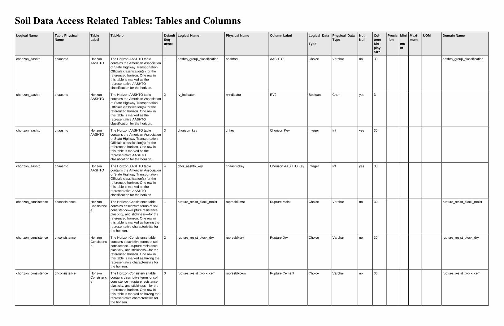
Soil Data Access Related Tables: Tables and Columns
Logical Name Table Physical
Name
Table
Label
TabHelp Default
Seq-
uence
Logical Name Physical Name Column Label Logical_Data
_
Type
Physical_Data_
Type
Not_
Null
Col-
umn
Dis-
play
Size
Precis
-ion
Mini
-
mu
m
Maxi-
mum
UOM Domain Name
chorizon_aashto chaashto Horizon
AASHTO
The Horizon AASHTO table
contains the American Association
of State Highway Transportation
Officials classification(s) for the
referenced horizon. One row in
this table is marked as the
representative AASHTO
classification for the horizon.
1 aashto_group_classification aashtocl AASHTO Choice Varchar no 30 aashto_group_classification
chorizon_aashto chaashto Horizon
AASHTO
The Horizon AASHTO table
contains the American Association
of State Highway Transportation
Officials classification(s) for the
referenced horizon. One row in
this table is marked as the
representative AASHTO
classification for the horizon.
2 rv_indicator rvindicator RV? Boolean Char yes 3
chorizon_aashto chaashto Horizon
AASHTO
The Horizon AASHTO table
contains the American Association
of State Highway Transportation
Officials classification(s) for the
referenced horizon. One row in
this table is marked as the
representative AASHTO
classification for the horizon.
3 chorizon_key chkey Chorizon Key Integer Int yes 30
chorizon_aashto chaashto Horizon
AASHTO
The Horizon AASHTO table
contains the American Association
of State Highway Transportation
Officials classification(s) for the
referenced horizon. One row in
this table is marked as the
representative AASHTO
classification for the horizon.
4 chor_aashto_key chaashtokey Chorizon AASHTO Key Integer Int yes 30
chorizon_consistence chconsistence Horizon
Consistenc
e
The Horizon Consistence table
contains descriptive terms of soil
consistence—rupture resistance,
plasticity, and stickiness—for the
referenced horizon. One row in
this table is marked as having the
representative characteristics for
the horizon.
1 rupture_resist_block_moist rupresblkmst Rupture Moist Choice Varchar no 30 rupture_resist_block_moist
chorizon_consistence chconsistence Horizon
Consistenc
e
The Horizon Consistence table
contains descriptive terms of soil
consistence—rupture resistance,
plasticity, and stickiness—for the
referenced horizon. One row in
this table is marked as having the
representative characteristics for
the horizon.
2 rupture_resist_block_dry rupresblkdry Rupture Dry Choice Varchar no 30 rupture_resist_block_dry
chorizon_consistence chconsistence Horizon
Consistenc
e
The Horizon Consistence table
contains descriptive terms of soil
consistence—rupture resistance,
plasticity, and stickiness—for the
referenced horizon. One row in
this table is marked as having the
representative characteristics for
the horizon.
3 rupture_resist_block_cem rupresblkcem Rupture Cement Choice Varchar no 30 rupture_resist_block_cem

Logical Name Table Physical
Name
Table
Label
TabHelp Default
Seq-
uence
Logical Name Physical Name Column Label Logical_Data
_
Type
Physical_Data_
Type
Not_
Null
Col-
umn
Dis-
play
Size
Precis
-ion
Mini
-
mu
m
Maxi-
mum
UOM Domain Name
chorizon_consistence chconsistence Horizon
Consistenc
e
The Horizon Consistence table
contains descriptive terms of soil
consistence—rupture resistance,
plasticity, and stickiness—for the
referenced horizon. One row in
this table is marked as having the
representative characteristics for
the horizon.
4 rupture_resist_plate rupresplate Rupture Plate Choice Varchar no 30
rupture_resist_plate
chorizon_consistence chconsistence Horizon
Consistenc
e
The Horizon Consistence table
contains descriptive terms of soil
consistence—rupture resistance,
plasticity, and stickiness—for the
referenced horizon. One row in
this table is marked as having the
representative characteristics for
the horizon.
5 manner_of_failure mannerfailure Manner of Failure Choice Varchar no 30
manner_of_failure
chorizon_consistence chconsistence Horizon
Consistenc
e
The Horizon Consistence table
contains descriptive terms of soil
consistence—rupture resistance,
plasticity, and stickiness—for the
referenced horizon. One row in
this table is marked as having the
representative characteristics for
the horizon.
6 stickiness stickiness Stickiness Choice Varchar no 30
stickiness
chorizon_consistence chconsistence Horizon
Consistenc
e
The Horizon Consistence table
contains descriptive terms of soil
consistence—rupture resistance,
plasticity, and stickiness—for the
referenced horizon. One row in
this table is marked as having the
representative characteristics for
the horizon.
7 plasticity plasticity Plasticity Choice Varchar no 30
plasticity
chorizon_consistence chconsistence Horizon
Consistenc
e
The Horizon Consistence table
contains descriptive terms of soil
consistence—rupture resistance,
plasticity, and stickiness—for the
referenced horizon. One row in
this table is marked as having the
representative characteristics for
the horizon.
8 rv_indicator rvindicator RV? Boolean Char yes 3
chorizon_consistence chconsistence Horizon
Consistenc
e
The Horizon Consistence table
contains descriptive terms of soil
consistence—rupture resistance,
plasticity, and stickiness—for the
referenced horizon. One row in
this table is marked as having the
representative characteristics for
the horizon.
9 chorizon_key chkey Chorizon Key Integer Int yes 30
chorizon_consistence chconsistence Horizon
Consistenc
e
The Horizon Consistence table
contains descriptive terms of soil
consistence—rupture resistance,
plasticity, and stickiness—for the
referenced horizon. One row in
this table is marked as having the
representative characteristics for
the horizon.
10 chor_consistence_key chconsistkey Chorizon Consistence
Key
Integer Int yes 30

Logical Name Table Physical
Name
Table
Label
TabHelp Default
Seq-
uence
Logical Name Physical Name Column Label Logical_Data
_
Type
Physical_Data_
Type
Not_
Null
Col-
umn
Dis-
play
Size
Precis
-ion
Mini
-
mu
m
Maxi-
mum
UOM Domain Name
chorizon_desgn_suffix chdesgnsuffix Horizon
Designation
Suffix
The Horizon Designation Suffix
table contains the designation
suffix(es), one per row, for the
referenced horizon. For example,
the "h" and "s" of a Bhs horizon
appear as two rows in this table.
1 horz_desgn_letter_suffix desgnsuffix Suffix Choice Varchar no 30
horz_desgn_letter_suffix
chorizon_desgn_suffix chdesgnsuffix Horizon
Designation
Suffix
The Horizon Designation Suffix
table contains the designation
suffix(es), one per row, for the
referenced horizon. For example,
the "h" and "s" of a Bhs horizon
appear as two rows in this table.
2 chorizon_key chkey Chorizon Key Integer Int yes 30
chorizon_desgn_suffix chdesgnsuffix Horizon
Designation
Suffix
The Horizon Designation Suffix
table contains the designation
suffix(es), one per row, for the
referenced horizon. For example,
the "h" and "s" of a Bhs horizon
appear as two rows in this table.
3 chor_desgn_suffix_key chdesgnsfxkey Chorizon Designation
Suffix Key
Integer Int yes 30
chorizon_fragments chfrags Horizon
Fragments
The Horizon Fragments table lists
the mineral and organic fragments
that generally occur in the
referenced horizon. If the Volume
% is greater than zero (low=5,
RV=10, high=15) in a row, the kind
and size of fragment in that row
exists everywhere this horizon and
component occur in the map unit.
If the Volume % includes zero
(low=0, RV=5, high=10), the kind
and size of fragment may exist in
some places, but not in others.
1 fragment_volume fragvol Vol % Integer Smallint no 5
0 100 percent
chorizon_fragments chfrags Horizon
Fragments
The Horizon Fragments table lists
the mineral and organic fragments
that generally occur in the
referenced horizon. If the Volume
% is greater than zero (low=5,
RV=10, high=15) in a row, the kind
and size of fragment in that row
exists everywhere this horizon and
component occur in the map unit.
If the Volume % includes zero
(low=0, RV=5, high=10), the kind
and size of fragment may exist in
some places, but not in others.
2 fragment_kind fragkind Kind Choice Varchar no 30
fragment_kind
chorizon_fragments chfrags Horizon
Fragments
The Horizon Fragments table lists
the mineral and organic fragments
that generally occur in the
referenced horizon. If the Volume
% is greater than zero (low=5,
RV=10, high=15) in a row, the kind
and size of fragment in that row
exists everywhere this horizon and
component occur in the map unit.
If the Volume % includes zero
(low=0, RV=5, high=10), the kind
and size of fragment may exist in
some places, but not in others.
3 fragment_size fragsize Size Integer Smallint no 5
2 3000 mm

Logical Name Table Physical
Name
Table
Label
TabHelp Default
Seq-
uence
Logical Name Physical Name Column Label Logical_Data
_
Type
Physical_Data_
Type
Not_
Null
Col-
umn
Dis-
play
Size
Precis
-ion
Mini
-
mu
m
Maxi-
mum
UOM Domain Name
chorizon_fragments chfrags Horizon
Fragments
The Horizon Fragments table lists
the mineral and organic fragments
that generally occur in the
referenced horizon. If the Volume
% is greater than zero (low=5,
RV=10, high=15) in a row, the kind
and size of fragment in that row
exists everywhere this horizon and
component occur in the map unit.
If the Volume % includes zero
(low=0, RV=5, high=10), the kind
and size of fragment may exist in
some places, but not in others.
4 fragment_shape fragshp Shape Choice Varchar no 30
fragment_shape
chorizon_fragments chfrags Horizon
Fragments
The Horizon Fragments table lists
the mineral and organic fragments
that generally occur in the
referenced horizon. If the Volume
% is greater than zero (low=5,
RV=10, high=15) in a row, the kind
and size of fragment in that row
exists everywhere this horizon and
component occur in the map unit.
If the Volume % includes zero
(low=0, RV=5, high=10), the kind
and size of fragment may exist in
some places, but not in others.
5 fragment_roundness fraground Roundness Choice Varchar no 30
fragment_roundness
chorizon_fragments chfrags Horizon
Fragments
The Horizon Fragments table lists
the mineral and organic fragments
that generally occur in the
referenced horizon. If the Volume
% is greater than zero (low=5,
RV=10, high=15) in a row, the kind
and size of fragment in that row
exists everywhere this horizon and
component occur in the map unit.
If the Volume % includes zero
(low=0, RV=5, high=10), the kind
and size of fragment may exist in
some places, but not in others.
6 fragment_hardness fraghard Hardness Choice Varchar no 30
rupture_resist_block_cem
chorizon_fragments chfrags Horizon
Fragments
The Horizon Fragments table lists
the mineral and organic fragments
that generally occur in the
referenced horizon. If the Volume
% is greater than zero (low=5,
RV=10, high=15) in a row, the kind
and size of fragment in that row
exists everywhere this horizon and
component occur in the map unit.
If the Volume % includes zero
(low=0, RV=5, high=10), the kind
and size of fragment may exist in
some places, but not in others.
7 chorizon_key chkey Chorizon Key Integer Int yes 30

Logical Name Table Physical
Name
Table
Label
TabHelp Default
Seq-
uence
Logical Name Physical Name Column Label Logical_Data
_
Type
Physical_Data_
Type
Not_
Null
Col-
umn
Dis-
play
Size
Precis
-ion
Mini
-
mu
m
Maxi-
mum
UOM Domain Name
chorizon_fragments chfrags Horizon
Fragments
The Horizon Fragments table lists
the mineral and organic fragments
that generally occur in the
referenced horizon. If the Volume
% is greater than zero (low=5,
RV=10, high=15) in a row, the kind
and size of fragment in that row
exists everywhere this horizon and
component occur in the map unit.
If the Volume % includes zero
(low=0, RV=5, high=10), the kind
and size of fragment may exist in
some places, but not in others.
8 chor_fragments_key chfragskey Chorizon Fragments
Key
Integer Int yes 30
chorizon chorizon Horizon The Horizon table lists the
horizon(s) and related data for the
referenced map unit component. If
the horizon thickness is greater
than zero (low=5, RV=8, high=12),
the horizon exists everywhere this
component occurs. If the horizon
thickness includes zero (low=0,
RV=1, high=3), the horizon may
exist in some places, but not in
other places. Horizons that have
two distinct parts, such as E/B or
E&Bt horizons, are recorded twice.
Once for the characteristics of the
first part; and again on another
row, using the same depths and
thicknesses, for the characteristics
of the other part.
1 horizon_designation hzname Designation String Varchar no 12
chorizon chorizon Horizon The Horizon table lists the
horizon(s) and related data for the
referenced map unit component. If
the horizon thickness is greater
than zero (low=5, RV=8, high=12),
the horizon exists everywhere this
component occurs. If the horizon
thickness includes zero (low=0,
RV=1, high=3), the horizon may
exist in some places, but not in
other places. Horizons that have
two distinct parts, such as E/B or
E&Bt horizons, are recorded twice.
Once for the characteristics of the
first part; and again on another
row, using the same depths and
thicknesses, for the characteristics
of the other part.
2 horz_desgn_discontinuity desgndisc Disc Integer Smallint no 4
2 99

Logical Name Table Physical
Name
Table
Label
TabHelp Default
Seq-
uence
Logical Name Physical Name Column Label Logical_Data
_
Type
Physical_Data_
Type
Not_
Null
Col-
umn
Dis-
play
Size
Precis
-ion
Mini
-
mu
m
Maxi-
mum
UOM Domain Name
chorizon chorizon Horizon The Horizon table lists the
horizon(s) and related data for the
referenced map unit component. If
the horizon thickness is greater
than zero (low=5, RV=8, high=12),
the horizon exists everywhere this
component occurs. If the horizon
thickness includes zero (low=0,
RV=1, high=3), the horizon may
exist in some places, but not in
other places. Horizons that have
two distinct parts, such as E/B or
E&Bt horizons, are recorded twice.
Once for the characteristics of the
first part; and again on another
row, using the same depths and
thicknesses, for the characteristics
of the other part.
3 horz_desgn_master desgnmaster Master Choice Varchar no 30
horz_desgn_master
chorizon chorizon Horizon The Horizon table lists the
horizon(s) and related data for the
referenced map unit component. If
the horizon thickness is greater
than zero (low=5, RV=8, high=12),
the horizon exists everywhere this
component occurs. If the horizon
thickness includes zero (low=0,
RV=1, high=3), the horizon may
exist in some places, but not in
other places. Horizons that have
two distinct parts, such as E/B or
E&Bt horizons, are recorded twice.
Once for the characteristics of the
first part; and again on another
row, using the same depths and
thicknesses, for the characteristics
of the other part.
4 horz_desgn_master_prime desgnmasterprime Prime Choice Varchar no 30
horz_desgn_master_prime
chorizon chorizon Horizon The Horizon table lists the
horizon(s) and related data for the
referenced map unit component. If
the horizon thickness is greater
than zero (low=5, RV=8, high=12),
the horizon exists everywhere this
component occurs. If the horizon
thickness includes zero (low=0,
RV=1, high=3), the horizon may
exist in some places, but not in
other places. Horizons that have
two distinct parts, such as E/B or
E&Bt horizons, are recorded twice.
Once for the characteristics of the
first part; and again on another
row, using the same depths and
thicknesses, for the characteristics
of the other part.
5 horz_desgn_vertical_subdvn desgnvert Sub Integer Smallint no 6
1

Logical Name Table Physical
Name
Table
Label
TabHelp Default
Seq-
uence
Logical Name Physical Name Column Label Logical_Data
_
Type
Physical_Data_
Type
Not_
Null
Col-
umn
Dis-
play
Size
Precis
-ion
Mini
-
mu
m
Maxi-
mum
UOM Domain Name
chorizon chorizon Horizon The Horizon table lists the
horizon(s) and related data for the
referenced map unit component. If
the horizon thickness is greater
than zero (low=5, RV=8, high=12),
the horizon exists everywhere this
component occurs. If the horizon
thickness includes zero (low=0,
RV=1, high=3), the horizon may
exist in some places, but not in
other places. Horizons that have
two distinct parts, such as E/B or
E&Bt horizons, are recorded twice.
Once for the characteristics of the
first part; and again on another
row, using the same depths and
thicknesses, for the characteristics
of the other part.
6 horizon_depth_to_top hzdept Top Depth Integer Smallint no 9
0 9999 cm
chorizon chorizon Horizon The Horizon table lists the
horizon(s) and related data for the
referenced map unit component. If
the horizon thickness is greater
than zero (low=5, RV=8, high=12),
the horizon exists everywhere this
component occurs. If the horizon
thickness includes zero (low=0,
RV=1, high=3), the horizon may
exist in some places, but not in
other places. Horizons that have
two distinct parts, such as E/B or
E&Bt horizons, are recorded twice.
Once for the characteristics of the
first part; and again on another
row, using the same depths and
thicknesses, for the characteristics
of the other part.
7 horizon_depth_to_bottom hzdepb Bottom Depth Integer Smallint no 12
0 9999 cm
chorizon chorizon Horizon The Horizon table lists the
horizon(s) and related data for the
referenced map unit component. If
the horizon thickness is greater
than zero (low=5, RV=8, high=12),
the horizon exists everywhere this
component occurs. If the horizon
thickness includes zero (low=0,
RV=1, high=3), the horizon may
exist in some places, but not in
other places. Horizons that have
two distinct parts, such as E/B or
E&Bt horizons, are recorded twice.
Once for the characteristics of the
first part; and again on another
row, using the same depths and
thicknesses, for the characteristics
of the other part.
8 horizon_thickness hzthk Thickness Integer Smallint no 9
0 9999 cm

Logical Name Table Physical
Name
Table
Label
TabHelp Default
Seq-
uence
Logical Name Physical Name Column Label Logical_Data
_
Type
Physical_Data_
Type
Not_
Null
Col-
umn
Dis-
play
Size
Precis
-ion
Mini
-
mu
m
Maxi-
mum
UOM Domain Name
chorizon chorizon Horizon The Horizon table lists the
horizon(s) and related data for the
referenced map unit component. If
the horizon thickness is greater
than zero (low=5, RV=8, high=12),
the horizon exists everywhere this
component occurs. If the horizon
thickness includes zero (low=0,
RV=1, high=3), the horizon may
exist in some places, but not in
other places. Horizons that have
two distinct parts, such as E/B or
E&Bt horizons, are recorded twice.
Once for the characteristics of the
first part; and again on another
row, using the same depths and
thicknesses, for the characteristics
of the other part.
9 rock_frag_greater_than_10_in fraggt10 Rock >10 Integer Smallint no 8
0 100 percent
chorizon chorizon Horizon The Horizon table lists the
horizon(s) and related data for the
referenced map unit component. If
the horizon thickness is greater
than zero (low=5, RV=8, high=12),
the horizon exists everywhere this
component occurs. If the horizon
thickness includes zero (low=0,
RV=1, high=3), the horizon may
exist in some places, but not in
other places. Horizons that have
two distinct parts, such as E/B or
E&Bt horizons, are recorded twice.
Once for the characteristics of the
first part; and again on another
row, using the same depths and
thicknesses, for the characteristics
of the other part.
10 rock_frag_3_to_10_in frag3to10 Rock 3-10 Integer Smallint no 9
0 100 percent
chorizon chorizon Horizon The Horizon table lists the
horizon(s) and related data for the
referenced map unit component. If
the horizon thickness is greater
than zero (low=5, RV=8, high=12),
the horizon exists everywhere this
component occurs. If the horizon
thickness includes zero (low=0,
RV=1, high=3), the horizon may
exist in some places, but not in
other places. Horizons that have
two distinct parts, such as E/B or
E&Bt horizons, are recorded twice.
Once for the characteristics of the
first part; and again on another
row, using the same depths and
thicknesses, for the characteristics
of the other part.
12 sieve_number_4 sieveno4 #4 Float Real no 6 1 0 100 percent

Logical Name Table Physical
Name
Table
Label
TabHelp Default
Seq-
uence
Logical Name Physical Name Column Label Logical_Data
_
Type
Physical_Data_
Type
Not_
Null
Col-
umn
Dis-
play
Size
Precis
-ion
Mini
-
mu
m
Maxi-
mum
UOM Domain Name
chorizon chorizon Horizon The Horizon table lists the
horizon(s) and related data for the
referenced map unit component. If
the horizon thickness is greater
than zero (low=5, RV=8, high=12),
the horizon exists everywhere this
component occurs. If the horizon
thickness includes zero (low=0,
RV=1, high=3), the horizon may
exist in some places, but not in
other places. Horizons that have
two distinct parts, such as E/B or
E&Bt horizons, are recorded twice.
Once for the characteristics of the
first part; and again on another
row, using the same depths and
thicknesses, for the characteristics
of the other part.
13 sieve_number_10 sieveno10 #10 Float Real no 6 1 0 100 percent
chorizon chorizon Horizon The Horizon table lists the
horizon(s) and related data for the
referenced map unit component. If
the horizon thickness is greater
than zero (low=5, RV=8, high=12),
the horizon exists everywhere this
component occurs. If the horizon
thickness includes zero (low=0,
RV=1, high=3), the horizon may
exist in some places, but not in
other places. Horizons that have
two distinct parts, such as E/B or
E&Bt horizons, are recorded twice.
Once for the characteristics of the
first part; and again on another
row, using the same depths and
thicknesses, for the characteristics
of the other part.
14 sieve_number_40 sieveno40 #40 Float Real no 6 1 0 100 percent
chorizon chorizon Horizon The Horizon table lists the
horizon(s) and related data for the
referenced map unit component. If
the horizon thickness is greater
than zero (low=5, RV=8, high=12),
the horizon exists everywhere this
component occurs. If the horizon
thickness includes zero (low=0,
RV=1, high=3), the horizon may
exist in some places, but not in
other places. Horizons that have
two distinct parts, such as E/B or
E&Bt horizons, are recorded twice.
Once for the characteristics of the
first part; and again on another
row, using the same depths and
thicknesses, for the characteristics
of the other part.
15 sieve_number_200 sieveno200 #200 Float Real no 6 1 0 100 percent

Logical Name Table Physical
Name
Table
Label
TabHelp Default
Seq-
uence
Logical Name Physical Name Column Label Logical_Data
_
Type
Physical_Data_
Type
Not_
Null
Col-
umn
Dis-
play
Size
Precis
-ion
Mini
-
mu
m
Maxi-
mum
UOM Domain Name
chorizon chorizon Horizon The Horizon table lists the
horizon(s) and related data for the
referenced map unit component. If
the horizon thickness is greater
than zero (low=5, RV=8, high=12),
the horizon exists everywhere this
component occurs. If the horizon
thickness includes zero (low=0,
RV=1, high=3), the horizon may
exist in some places, but not in
other places. Horizons that have
two distinct parts, such as E/B or
E&Bt horizons, are recorded twice.
Once for the characteristics of the
first part; and again on another
row, using the same depths and
thicknesses, for the characteristics
of the other part.
16 sand_total_separate sandtotal Total Sand Float Real no 10 1 0 100 percent
chorizon chorizon Horizon The Horizon table lists the
horizon(s) and related data for the
referenced map unit component. If
the horizon thickness is greater
than zero (low=5, RV=8, high=12),
the horizon exists everywhere this
component occurs. If the horizon
thickness includes zero (low=0,
RV=1, high=3), the horizon may
exist in some places, but not in
other places. Horizons that have
two distinct parts, such as E/B or
E&Bt horizons, are recorded twice.
Once for the characteristics of the
first part; and again on another
row, using the same depths and
thicknesses, for the characteristics
of the other part.
17 sand_very_coarse_separate sandvc vcos Float Real no 6 1 0 100 percent
chorizon chorizon Horizon The Horizon table lists the
horizon(s) and related data for the
referenced map unit component. If
the horizon thickness is greater
than zero (low=5, RV=8, high=12),
the horizon exists everywhere this
component occurs. If the horizon
thickness includes zero (low=0,
RV=1, high=3), the horizon may
exist in some places, but not in
other places. Horizons that have
two distinct parts, such as E/B or
E&Bt horizons, are recorded twice.
Once for the characteristics of the
first part; and again on another
row, using the same depths and
thicknesses, for the characteristics
of the other part.
18 sand_coarse_separate sandco cos Float Real no 6 1 0 100 percent

Logical Name Table Physical
Name
Table
Label
TabHelp Default
Seq-
uence
Logical Name Physical Name Column Label Logical_Data
_
Type
Physical_Data_
Type
Not_
Null
Col-
umn
Dis-
play
Size
Precis
-ion
Mini
-
mu
m
Maxi-
mum
UOM Domain Name
chorizon chorizon Horizon The Horizon table lists the
horizon(s) and related data for the
referenced map unit component. If
the horizon thickness is greater
than zero (low=5, RV=8, high=12),
the horizon exists everywhere this
component occurs. If the horizon
thickness includes zero (low=0,
RV=1, high=3), the horizon may
exist in some places, but not in
other places. Horizons that have
two distinct parts, such as E/B or
E&Bt horizons, are recorded twice.
Once for the characteristics of the
first part; and again on another
row, using the same depths and
thicknesses, for the characteristics
of the other part.
19 sand_medium_separate sandmed ms Float Real no 6 1 0 100 percent
chorizon chorizon Horizon The Horizon table lists the
horizon(s) and related data for the
referenced map unit component. If
the horizon thickness is greater
than zero (low=5, RV=8, high=12),
the horizon exists everywhere this
component occurs. If the horizon
thickness includes zero (low=0,
RV=1, high=3), the horizon may
exist in some places, but not in
other places. Horizons that have
two distinct parts, such as E/B or
E&Bt horizons, are recorded twice.
Once for the characteristics of the
first part; and again on another
row, using the same depths and
thicknesses, for the characteristics
of the other part.
20 sand_fine_separate sandfine fs Float Real no 6 1 0 100 percent
chorizon chorizon Horizon The Horizon table lists the
horizon(s) and related data for the
referenced map unit component. If
the horizon thickness is greater
than zero (low=5, RV=8, high=12),
the horizon exists everywhere this
component occurs. If the horizon
thickness includes zero (low=0,
RV=1, high=3), the horizon may
exist in some places, but not in
other places. Horizons that have
two distinct parts, such as E/B or
E&Bt horizons, are recorded twice.
Once for the characteristics of the
first part; and again on another
row, using the same depths and
thicknesses, for the characteristics
of the other part.
21 sand_very_fine_separate sandvf vfs Float Real no 6 1 0 100 percent

Logical Name Table Physical
Name
Table
Label
TabHelp Default
Seq-
uence
Logical Name Physical Name Column Label Logical_Data
_
Type
Physical_Data_
Type
Not_
Null
Col-
umn
Dis-
play
Size
Precis
-ion
Mini
-
mu
m
Maxi-
mum
UOM Domain Name
chorizon chorizon Horizon The Horizon table lists the
horizon(s) and related data for the
referenced map unit component. If
the horizon thickness is greater
than zero (low=5, RV=8, high=12),
the horizon exists everywhere this
component occurs. If the horizon
thickness includes zero (low=0,
RV=1, high=3), the horizon may
exist in some places, but not in
other places. Horizons that have
two distinct parts, such as E/B or
E&Bt horizons, are recorded twice.
Once for the characteristics of the
first part; and again on another
row, using the same depths and
thicknesses, for the characteristics
of the other part.
22 silt_total_separate silttotal Total Silt Float Real no 10 1 0 100 percent
chorizon chorizon Horizon The Horizon table lists the
horizon(s) and related data for the
referenced map unit component. If
the horizon thickness is greater
than zero (low=5, RV=8, high=12),
the horizon exists everywhere this
component occurs. If the horizon
thickness includes zero (low=0,
RV=1, high=3), the horizon may
exist in some places, but not in
other places. Horizons that have
two distinct parts, such as E/B or
E&Bt horizons, are recorded twice.
Once for the characteristics of the
first part; and again on another
row, using the same depths and
thicknesses, for the characteristics
of the other part.
23 silt_coarse_separate siltco Coarse Silt Float Real no 11 1 0 100 percent
chorizon chorizon Horizon The Horizon table lists the
horizon(s) and related data for the
referenced map unit component. If
the horizon thickness is greater
than zero (low=5, RV=8, high=12),
the horizon exists everywhere this
component occurs. If the horizon
thickness includes zero (low=0,
RV=1, high=3), the horizon may
exist in some places, but not in
other places. Horizons that have
two distinct parts, such as E/B or
E&Bt horizons, are recorded twice.
Once for the characteristics of the
first part; and again on another
row, using the same depths and
thicknesses, for the characteristics
of the other part.
24 silt_fine_separate siltfine Fine Silt Float Real no 9 1 0 100 percent

Logical Name Table Physical
Name
Table
Label
TabHelp Default
Seq-
uence
Logical Name Physical Name Column Label Logical_Data
_
Type
Physical_Data_
Type
Not_
Null
Col-
umn
Dis-
play
Size
Precis
-ion
Mini
-
mu
m
Maxi-
mum
UOM Domain Name
chorizon chorizon Horizon The Horizon table lists the
horizon(s) and related data for the
referenced map unit component. If
the horizon thickness is greater
than zero (low=5, RV=8, high=12),
the horizon exists everywhere this
component occurs. If the horizon
thickness includes zero (low=0,
RV=1, high=3), the horizon may
exist in some places, but not in
other places. Horizons that have
two distinct parts, such as E/B or
E&Bt horizons, are recorded twice.
Once for the characteristics of the
first part; and again on another
row, using the same depths and
thicknesses, for the characteristics
of the other part.
25 clay_total_separate claytotal Total Clay Float Real no 10 1 0 100 percent
chorizon chorizon Horizon The Horizon table lists the
horizon(s) and related data for the
referenced map unit component. If
the horizon thickness is greater
than zero (low=5, RV=8, high=12),
the horizon exists everywhere this
component occurs. If the horizon
thickness includes zero (low=0,
RV=1, high=3), the horizon may
exist in some places, but not in
other places. Horizons that have
two distinct parts, such as E/B or
E&Bt horizons, are recorded twice.
Once for the characteristics of the
first part; and again on another
row, using the same depths and
thicknesses, for the characteristics
of the other part.
26 clay_sized_carbonate claysizedcarb CaCO3 Clay Float Real no 10 1 0 100 percent
chorizon chorizon Horizon The Horizon table lists the
horizon(s) and related data for the
referenced map unit component. If
the horizon thickness is greater
than zero (low=5, RV=8, high=12),
the horizon exists everywhere this
component occurs. If the horizon
thickness includes zero (low=0,
RV=1, high=3), the horizon may
exist in some places, but not in
other places. Horizons that have
two distinct parts, such as E/B or
E&Bt horizons, are recorded twice.
Once for the characteristics of the
first part; and again on another
row, using the same depths and
thicknesses, for the characteristics
of the other part.
27 organic_matter_percent om OM Float Real no 7 2 0 100 percent

Logical Name Table Physical
Name
Table
Label
TabHelp Default
Seq-
uence
Logical Name Physical Name Column Label Logical_Data
_
Type
Physical_Data_
Type
Not_
Null
Col-
umn
Dis-
play
Size
Precis
-ion
Mini
-
mu
m
Maxi-
mum
UOM Domain Name
chorizon chorizon Horizon The Horizon table lists the
horizon(s) and related data for the
referenced map unit component. If
the horizon thickness is greater
than zero (low=5, RV=8, high=12),
the horizon exists everywhere this
component occurs. If the horizon
thickness includes zero (low=0,
RV=1, high=3), the horizon may
exist in some places, but not in
other places. Horizons that have
two distinct parts, such as E/B or
E&Bt horizons, are recorded twice.
Once for the characteristics of the
first part; and again on another
row, using the same depths and
thicknesses, for the characteristics
of the other part.
28 bulk_density_one_tenth_bar dbtenthbar Db 0.1 bar H2O Float Real no 14 2 0.02 2.6 g/cm3
chorizon chorizon Horizon The Horizon table lists the
horizon(s) and related data for the
referenced map unit component. If
the horizon thickness is greater
than zero (low=5, RV=8, high=12),
the horizon exists everywhere this
component occurs. If the horizon
thickness includes zero (low=0,
RV=1, high=3), the horizon may
exist in some places, but not in
other places. Horizons that have
two distinct parts, such as E/B or
E&Bt horizons, are recorded twice.
Once for the characteristics of the
first part; and again on another
row, using the same depths and
thicknesses, for the characteristics
of the other part.
29 bulk_density_one_third_bar dbthirdbar Db 0.33 bar H2O Float Real no 15 2 0.02 2.6 g/cm3
chorizon chorizon Horizon The Horizon table lists the
horizon(s) and related data for the
referenced map unit component. If
the horizon thickness is greater
than zero (low=5, RV=8, high=12),
the horizon exists everywhere this
component occurs. If the horizon
thickness includes zero (low=0,
RV=1, high=3), the horizon may
exist in some places, but not in
other places. Horizons that have
two distinct parts, such as E/B or
E&Bt horizons, are recorded twice.
Once for the characteristics of the
first part; and again on another
row, using the same depths and
thicknesses, for the characteristics
of the other part.
30 bulk_density_fifteen_bar dbfifteenbar Db 15 bar H2O Float Real no 13 2 0.02 2.6 g/cm3

Logical Name Table Physical
Name
Table
Label
TabHelp Default
Seq-
uence
Logical Name Physical Name Column Label Logical_Data
_
Type
Physical_Data_
Type
Not_
Null
Col-
umn
Dis-
play
Size
Precis
-ion
Mini
-
mu
m
Maxi-
mum
UOM Domain Name
chorizon chorizon Horizon The Horizon table lists the
horizon(s) and related data for the
referenced map unit component. If
the horizon thickness is greater
than zero (low=5, RV=8, high=12),
the horizon exists everywhere this
component occurs. If the horizon
thickness includes zero (low=0,
RV=1, high=3), the horizon may
exist in some places, but not in
other places. Horizons that have
two distinct parts, such as E/B or
E&Bt horizons, are recorded twice.
Once for the characteristics of the
first part; and again on another
row, using the same depths and
thicknesses, for the characteristics
of the other part.
31 bulk_density_oven_dry dbovendry Db oven dry Float Float no 11 2 0.02 2.6 g/cm3
chorizon chorizon Horizon The Horizon table lists the
horizon(s) and related data for the
referenced map unit component. If
the horizon thickness is greater
than zero (low=5, RV=8, high=12),
the horizon exists everywhere this
component occurs. If the horizon
thickness includes zero (low=0,
RV=1, high=3), the horizon may
exist in some places, but not in
other places. Horizons that have
two distinct parts, such as E/B or
E&Bt horizons, are recorded twice.
Once for the characteristics of the
first part; and again on another
row, using the same depths and
thicknesses, for the characteristics
of the other part.
32 particle_density partdensity Dp Float Real no 5 2 0.01 5 g/cm3
chorizon chorizon Horizon The Horizon table lists the
horizon(s) and related data for the
referenced map unit component. If
the horizon thickness is greater
than zero (low=5, RV=8, high=12),
the horizon exists everywhere this
component occurs. If the horizon
thickness includes zero (low=0,
RV=1, high=3), the horizon may
exist in some places, but not in
other places. Horizons that have
two distinct parts, such as E/B or
E&Bt horizons, are recorded twice.
Once for the characteristics of the
first part; and again on another
row, using the same depths and
thicknesses, for the characteristics
of the other part.
33 sat_hydraulic_conductivity ksat Ksat Float Real no 9 4 0 705 um/s

Logical Name Table Physical
Name
Table
Label
TabHelp Default
Seq-
uence
Logical Name Physical Name Column Label Logical_Data
_
Type
Physical_Data_
Type
Not_
Null
Col-
umn
Dis-
play
Size
Precis
-ion
Mini
-
mu
m
Maxi-
mum
UOM Domain Name
chorizon chorizon Horizon The Horizon table lists the
horizon(s) and related data for the
referenced map unit component. If
the horizon thickness is greater
than zero (low=5, RV=8, high=12),
the horizon exists everywhere this
component occurs. If the horizon
thickness includes zero (low=0,
RV=1, high=3), the horizon may
exist in some places, but not in
other places. Horizons that have
two distinct parts, such as E/B or
E&Bt horizons, are recorded twice.
Once for the characteristics of the
first part; and again on another
row, using the same depths and
thicknesses, for the characteristics
of the other part.
34 available_water_capacity awc AWC Float Real no 5 2 0 0.7 cm/cm
chorizon chorizon Horizon The Horizon table lists the
horizon(s) and related data for the
referenced map unit component. If
the horizon thickness is greater
than zero (low=5, RV=8, high=12),
the horizon exists everywhere this
component occurs. If the horizon
thickness includes zero (low=0,
RV=1, high=3), the horizon may
exist in some places, but not in
other places. Horizons that have
two distinct parts, such as E/B or
E&Bt horizons, are recorded twice.
Once for the characteristics of the
first part; and again on another
row, using the same depths and
thicknesses, for the characteristics
of the other part.
35 water_one_tenth_bar wtenthbar 0.1 bar H2O Float Real no 11 1 0 2000 percent
chorizon chorizon Horizon The Horizon table lists the
horizon(s) and related data for the
referenced map unit component. If
the horizon thickness is greater
than zero (low=5, RV=8, high=12),
the horizon exists everywhere this
component occurs. If the horizon
thickness includes zero (low=0,
RV=1, high=3), the horizon may
exist in some places, but not in
other places. Horizons that have
two distinct parts, such as E/B or
E&Bt horizons, are recorded twice.
Once for the characteristics of the
first part; and again on another
row, using the same depths and
thicknesses, for the characteristics
of the other part.
36 water_one_third_bar wthirdbar 0.33 bar H2O Float Real no 12 1 0 2000 percent

Logical Name Table Physical
Name
Table
Label
TabHelp Default
Seq-
uence
Logical Name Physical Name Column Label Logical_Data
_
Type
Physical_Data_
Type
Not_
Null
Col-
umn
Dis-
play
Size
Precis
-ion
Mini
-
mu
m
Maxi-
mum
UOM Domain Name
chorizon chorizon Horizon The Horizon table lists the
horizon(s) and related data for the
referenced map unit component. If
the horizon thickness is greater
than zero (low=5, RV=8, high=12),
the horizon exists everywhere this
component occurs. If the horizon
thickness includes zero (low=0,
RV=1, high=3), the horizon may
exist in some places, but not in
other places. Horizons that have
two distinct parts, such as E/B or
E&Bt horizons, are recorded twice.
Once for the characteristics of the
first part; and again on another
row, using the same depths and
thicknesses, for the characteristics
of the other part.
37 water_fifteen_bar wfifteenbar 15 bar H2O Float Real no 10 1 0 400 percent
chorizon chorizon Horizon The Horizon table lists the
horizon(s) and related data for the
referenced map unit component. If
the horizon thickness is greater
than zero (low=5, RV=8, high=12),
the horizon exists everywhere this
component occurs. If the horizon
thickness includes zero (low=0,
RV=1, high=3), the horizon may
exist in some places, but not in
other places. Horizons that have
two distinct parts, such as E/B or
E&Bt horizons, are recorded twice.
Once for the characteristics of the
first part; and again on another
row, using the same depths and
thicknesses, for the characteristics
of the other part.
38 water_satiated wsatiated Satiated H2O Integer Smallint no 12
0 100 percent
chorizon chorizon Horizon The Horizon table lists the
horizon(s) and related data for the
referenced map unit component. If
the horizon thickness is greater
than zero (low=5, RV=8, high=12),
the horizon exists everywhere this
component occurs. If the horizon
thickness includes zero (low=0,
RV=1, high=3), the horizon may
exist in some places, but not in
other places. Horizons that have
two distinct parts, such as E/B or
E&Bt horizons, are recorded twice.
Once for the characteristics of the
first part; and again on another
row, using the same depths and
thicknesses, for the characteristics
of the other part.
39 linear_extensibility_percent lep LEP Float Real no 5 1 0 30 percent

Logical Name Table Physical
Name
Table
Label
TabHelp Default
Seq-
uence
Logical Name Physical Name Column Label Logical_Data
_
Type
Physical_Data_
Type
Not_
Null
Col-
umn
Dis-
play
Size
Precis
-ion
Mini
-
mu
m
Maxi-
mum
UOM Domain Name
chorizon chorizon Horizon The Horizon table lists the
horizon(s) and related data for the
referenced map unit component. If
the horizon thickness is greater
than zero (low=5, RV=8, high=12),
the horizon exists everywhere this
component occurs. If the horizon
thickness includes zero (low=0,
RV=1, high=3), the horizon may
exist in some places, but not in
other places. Horizons that have
two distinct parts, such as E/B or
E&Bt horizons, are recorded twice.
Once for the characteristics of the
first part; and again on another
row, using the same depths and
thicknesses, for the characteristics
of the other part.
40 liquid_limit ll LL Float Real no 6 1 0 400 percent
chorizon chorizon Horizon The Horizon table lists the
horizon(s) and related data for the
referenced map unit component. If
the horizon thickness is greater
than zero (low=5, RV=8, high=12),
the horizon exists everywhere this
component occurs. If the horizon
thickness includes zero (low=0,
RV=1, high=3), the horizon may
exist in some places, but not in
other places. Horizons that have
two distinct parts, such as E/B or
E&Bt horizons, are recorded twice.
Once for the characteristics of the
first part; and again on another
row, using the same depths and
thicknesses, for the characteristics
of the other part.
41 plasticity_index pi PI Float Real no 6 1 0 130 percent
chorizon chorizon Horizon The Horizon table lists the
horizon(s) and related data for the
referenced map unit component. If
the horizon thickness is greater
than zero (low=5, RV=8, high=12),
the horizon exists everywhere this
component occurs. If the horizon
thickness includes zero (low=0,
RV=1, high=3), the horizon may
exist in some places, but not in
other places. Horizons that have
two distinct parts, such as E/B or
E&Bt horizons, are recorded twice.
Once for the characteristics of the
first part; and again on another
row, using the same depths and
thicknesses, for the characteristics
of the other part.
42 aashto_group_index aashind AASHTO Group Index Integer Smallint no 18
0 120

Logical Name Table Physical
Name
Table
Label
TabHelp Default
Seq-
uence
Logical Name Physical Name Column Label Logical_Data
_
Type
Physical_Data_
Type
Not_
Null
Col-
umn
Dis-
play
Size
Precis
-ion
Mini
-
mu
m
Maxi-
mum
UOM Domain Name
chorizon chorizon Horizon The Horizon table lists the
horizon(s) and related data for the
referenced map unit component. If
the horizon thickness is greater
than zero (low=5, RV=8, high=12),
the horizon exists everywhere this
component occurs. If the horizon
thickness includes zero (low=0,
RV=1, high=3), the horizon may
exist in some places, but not in
other places. Horizons that have
two distinct parts, such as E/B or
E&Bt horizons, are recorded twice.
Once for the characteristics of the
first part; and again on another
row, using the same depths and
thicknesses, for the characteristics
of the other part.
43 soil_erodibility_factor_whole kwfact Kw Choice Varchar no 30
soil_erodibility_factor
chorizon chorizon Horizon The Horizon table lists the
horizon(s) and related data for the
referenced map unit component. If
the horizon thickness is greater
than zero (low=5, RV=8, high=12),
the horizon exists everywhere this
component occurs. If the horizon
thickness includes zero (low=0,
RV=1, high=3), the horizon may
exist in some places, but not in
other places. Horizons that have
two distinct parts, such as E/B or
E&Bt horizons, are recorded twice.
Once for the characteristics of the
first part; and again on another
row, using the same depths and
thicknesses, for the characteristics
of the other part.
44 soil_erodibility_factor_rf kffact Kf Choice Varchar no 30
soil_erodibility_factor
chorizon chorizon Horizon The Horizon table lists the
horizon(s) and related data for the
referenced map unit component. If
the horizon thickness is greater
than zero (low=5, RV=8, high=12),
the horizon exists everywhere this
component occurs. If the horizon
thickness includes zero (low=0,
RV=1, high=3), the horizon may
exist in some places, but not in
other places. Horizons that have
two distinct parts, such as E/B or
E&Bt horizons, are recorded twice.
Once for the characteristics of the
first part; and again on another
row, using the same depths and
thicknesses, for the characteristics
of the other part.
45 calcium_carbonate_equivalent caco3 CaCO3 Integer Smallint no 5
0 110 percent
Logical Name Table Physical
Name
Table
Label
TabHelp Default
Seq-
uence
Logical Name Physical Name Column Label Logical_Data
_
Type
Physical_Data_
Type
Not_
Null
Col-
umn
Dis-
play
Size
Precis
-ion
Mini
-
mu
m
Maxi-
mum
UOM Domain Name
chorizon chorizon Horizon The Horizon table lists the
horizon(s) and related data for the
referenced map unit component. If
the horizon thickness is greater
than zero (low=5, RV=8, high=12),
the horizon exists everywhere this
component occurs. If the horizon
thickness includes zero (low=0,
RV=1, high=3), the horizon may
exist in some places, but not in
other places. Horizons that have
two distinct parts, such as E/B or
E&Bt horizons, are recorded twice.
Once for the characteristics of the
first part; and again on another
row, using the same depths and
thicknesses, for the characteristics
of the other part.
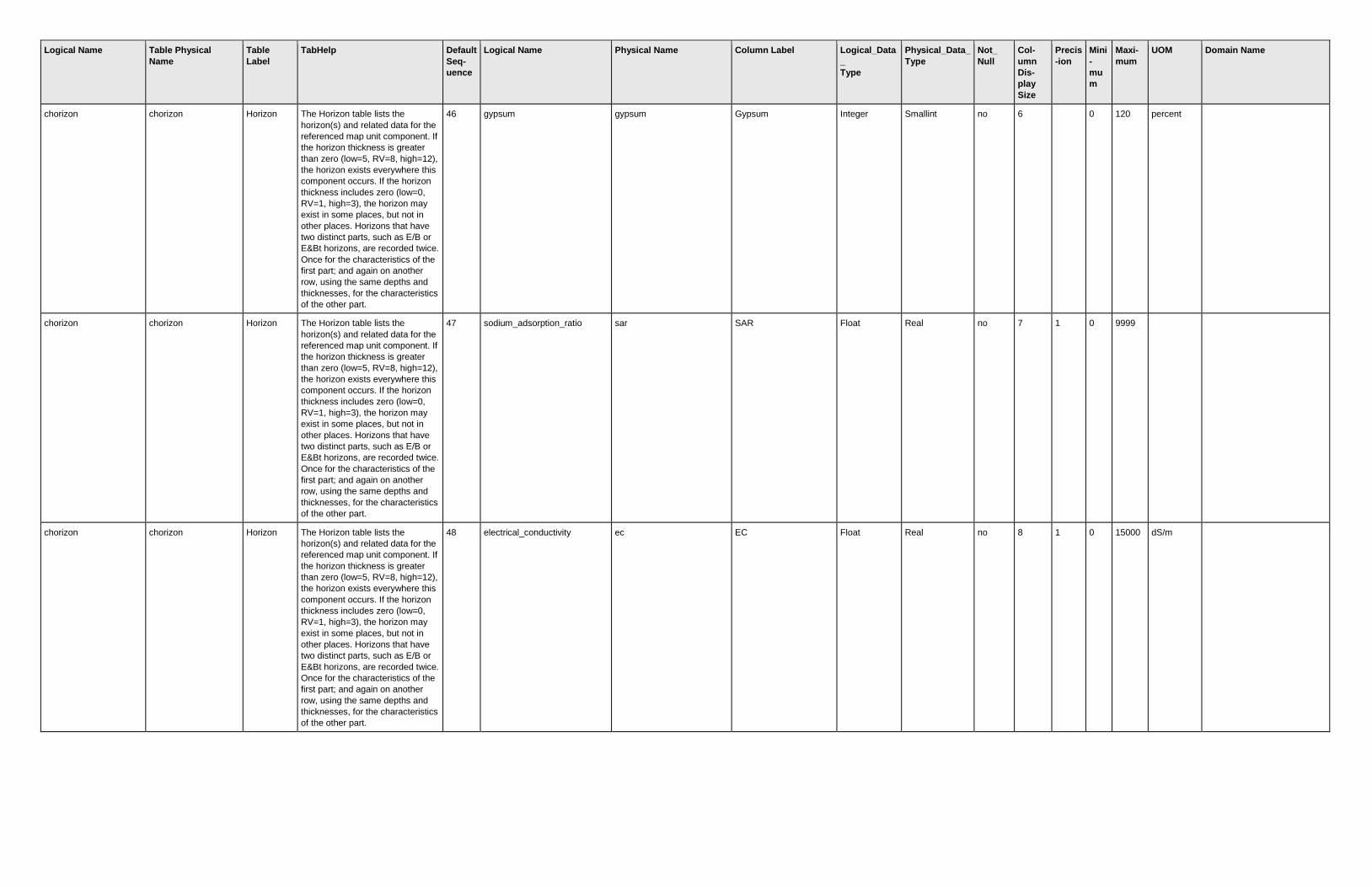
46 gypsum gypsum Gypsum Integer Smallint no 6
0 120 percent
chorizon chorizon Horizon The Horizon table lists the
horizon(s) and related data for the
referenced map unit component. If
the horizon thickness is greater
than zero (low=5, RV=8, high=12),
the horizon exists everywhere this
component occurs. If the horizon
thickness includes zero (low=0,
RV=1, high=3), the horizon may
exist in some places, but not in
other places. Horizons that have
two distinct parts, such as E/B or
E&Bt horizons, are recorded twice.
Once for the characteristics of the
first part; and again on another
row, using the same depths and
thicknesses, for the characteristics
of the other part.
47 sodium_adsorption_ratio sar SAR Float Real no 7 1 0 9999
chorizon chorizon Horizon The Horizon table lists the
horizon(s) and related data for the
referenced map unit component. If
the horizon thickness is greater
than zero (low=5, RV=8, high=12),
the horizon exists everywhere this
component occurs. If the horizon
thickness includes zero (low=0,
RV=1, high=3), the horizon may
exist in some places, but not in
other places. Horizons that have
two distinct parts, such as E/B or
E&Bt horizons, are recorded twice.
Once for the characteristics of the
first part; and again on another
row, using the same depths and
thicknesses, for the characteristics
of the other part.
48 electrical_conductivity ec EC Float Real no 8 1 0 15000 dS/m

Logical Name Table Physical
Name
Table
Label
TabHelp Default
Seq-
uence
Logical Name Physical Name Column Label Logical_Data
_
Type
Physical_Data_
Type
Not_
Null
Col-
umn
Dis-
play
Size
Precis
-ion
Mini
-
mu
m
Maxi-
mum
UOM Domain Name
chorizon chorizon Horizon The Horizon table lists the
horizon(s) and related data for the
referenced map unit component. If
the horizon thickness is greater
than zero (low=5, RV=8, high=12),
the horizon exists everywhere this
component occurs. If the horizon
thickness includes zero (low=0,
RV=1, high=3), the horizon may
exist in some places, but not in
other places. Horizons that have
two distinct parts, such as E/B or
E&Bt horizons, are recorded twice.
Once for the characteristics of the
first part; and again on another
row, using the same depths and
thicknesses, for the characteristics
of the other part.
49 cation_exch_capcty_nh4oacph
7
cec7 CEC-7 Float Real no 6 1 0 400 cmol(+)/kg
chorizon chorizon Horizon The Horizon table lists the
horizon(s) and related data for the
referenced map unit component. If
the horizon thickness is greater
than zero (low=5, RV=8, high=12),
the horizon exists everywhere this
component occurs. If the horizon
thickness includes zero (low=0,
RV=1, high=3), the horizon may
exist in some places, but not in
other places. Horizons that have
two distinct parts, such as E/B or
E&Bt horizons, are recorded twice.
Once for the characteristics of the
first part; and again on another
row, using the same depths and
thicknesses, for the characteristics
of the other part.
50 effective_cation_exch_capcty ecec ECEC Float Real no 6 1 0 400 cmol(+)/kg
chorizon chorizon Horizon The Horizon table lists the
horizon(s) and related data for the
referenced map unit component. If
the horizon thickness is greater
than zero (low=5, RV=8, high=12),
the horizon exists everywhere this
component occurs. If the horizon
thickness includes zero (low=0,
RV=1, high=3), the horizon may
exist in some places, but not in
other places. Horizons that have
two distinct parts, such as E/B or
E&Bt horizons, are recorded twice.
Once for the characteristics of the
first part; and again on another
row, using the same depths and
thicknesses, for the characteristics
of the other part.
51 sum_of_bases_nh4oacph7 sumbases Sum of Bases Float Float no 12 1 0 300 cmol(+)/kg

Logical Name Table Physical
Name
Table
Label
TabHelp Default
Seq-
uence
Logical Name Physical Name Column Label Logical_Data
_
Type
Physical_Data_
Type
Not_
Null
Col-
umn
Dis-
play
Size
Precis
-ion
Mini
-
mu
m
Maxi-
mum
UOM Domain Name
chorizon chorizon Horizon The Horizon table lists the
horizon(s) and related data for the
referenced map unit component. If
the horizon thickness is greater
than zero (low=5, RV=8, high=12),
the horizon exists everywhere this
component occurs. If the horizon
thickness includes zero (low=0,
RV=1, high=3), the horizon may
exist in some places, but not in
other places. Horizons that have
two distinct parts, such as E/B or
E&Bt horizons, are recorded twice.
Once for the characteristics of the
first part; and again on another
row, using the same depths and
thicknesses, for the characteristics
of the other part.
52 ph_1_1_water ph1to1h2o pH H2O Float Real no 6 1 1.8 11
chorizon chorizon Horizon The Horizon table lists the
horizon(s) and related data for the
referenced map unit component. If
the horizon thickness is greater
than zero (low=5, RV=8, high=12),
the horizon exists everywhere this
component occurs. If the horizon
thickness includes zero (low=0,
RV=1, high=3), the horizon may
exist in some places, but not in
other places. Horizons that have
two distinct parts, such as E/B or
E&Bt horizons, are recorded twice.
Once for the characteristics of the
first part; and again on another
row, using the same depths and
thicknesses, for the characteristics
of the other part.
53 ph_01m_cacl2 ph01mcacl2 pH CaCl2 Float Real no 8 1 1.8 11
chorizon chorizon Horizon The Horizon table lists the
horizon(s) and related data for the
referenced map unit component. If
the horizon thickness is greater
than zero (low=5, RV=8, high=12),
the horizon exists everywhere this
component occurs. If the horizon
thickness includes zero (low=0,
RV=1, high=3), the horizon may
exist in some places, but not in
other places. Horizons that have
two distinct parts, such as E/B or
E&Bt horizons, are recorded twice.
Once for the characteristics of the
first part; and again on another
row, using the same depths and
thicknesses, for the characteristics
of the other part.
54 free_iron_oxides freeiron Free Iron Float Real no 9 2 0 100 percent

Logical Name Table Physical
Name
Table
Label
TabHelp Default
Seq-
uence
Logical Name Physical Name Column Label Logical_Data
_
Type
Physical_Data_
Type
Not_
Null
Col-
umn
Dis-
play
Size
Precis
-ion
Mini
-
mu
m
Maxi-
mum
UOM Domain Name
chorizon chorizon Horizon The Horizon table lists the
horizon(s) and related data for the
referenced map unit component. If
the horizon thickness is greater
than zero (low=5, RV=8, high=12),
the horizon exists everywhere this
component occurs. If the horizon
thickness includes zero (low=0,
RV=1, high=3), the horizon may
exist in some places, but not in
other places. Horizons that have
two distinct parts, such as E/B or
E&Bt horizons, are recorded twice.
Once for the characteristics of the
first part; and again on another
row, using the same depths and
thicknesses, for the characteristics
of the other part.
55 iron_oxalate feoxalate Oxalate Fe Float Real no 10 2 0 15000
0
mg/kg
chorizon chorizon Horizon The Horizon table lists the
horizon(s) and related data for the
referenced map unit component. If
the horizon thickness is greater
than zero (low=5, RV=8, high=12),
the horizon exists everywhere this
component occurs. If the horizon
thickness includes zero (low=0,
RV=1, high=3), the horizon may
exist in some places, but not in
other places. Horizons that have
two distinct parts, such as E/B or
E&Bt horizons, are recorded twice.
Once for the characteristics of the
first part; and again on another
row, using the same depths and
thicknesses, for the characteristics
of the other part.
56 extractable_acidity extracid Ext Acidity Float Real no 11 1 0 250 cmol(+)/kg
chorizon chorizon Horizon The Horizon table lists the
horizon(s) and related data for the
referenced map unit component. If
the horizon thickness is greater
than zero (low=5, RV=8, high=12),
the horizon exists everywhere this
component occurs. If the horizon
thickness includes zero (low=0,
RV=1, high=3), the horizon may
exist in some places, but not in
other places. Horizons that have
two distinct parts, such as E/B or
E&Bt horizons, are recorded twice.
Once for the characteristics of the
first part; and again on another
row, using the same depths and
thicknesses, for the characteristics
of the other part.
57 extractable_aluminum extral Extract Al Float Real no 10 2 0 150 cmol(+)/kg

Logical Name Table Physical
Name
Table
Label
TabHelp Default
Seq-
uence
Logical Name Physical Name Column Label Logical_Data
_
Type
Physical_Data_
Type
Not_
Null
Col-
umn
Dis-
play
Size
Precis
-ion
Mini
-
mu
m
Maxi-
mum
UOM Domain Name
chorizon chorizon Horizon The Horizon table lists the
horizon(s) and related data for the
referenced map unit component. If
the horizon thickness is greater
than zero (low=5, RV=8, high=12),
the horizon exists everywhere this
component occurs. If the horizon
thickness includes zero (low=0,
RV=1, high=3), the horizon may
exist in some places, but not in
other places. Horizons that have
two distinct parts, such as E/B or
E&Bt horizons, are recorded twice.
Once for the characteristics of the
first part; and again on another
row, using the same depths and
thicknesses, for the characteristics
of the other part.
58 aluminum_oxalate aloxalate Oxalate Al Float Real no 10 1 0 17000
0
mg/kg
chorizon chorizon Horizon The Horizon table lists the
horizon(s) and related data for the
referenced map unit component. If
the horizon thickness is greater
than zero (low=5, RV=8, high=12),
the horizon exists everywhere this
component occurs. If the horizon
thickness includes zero (low=0,
RV=1, high=3), the horizon may
exist in some places, but not in
other places. Horizons that have
two distinct parts, such as E/B or
E&Bt horizons, are recorded twice.
Once for the characteristics of the
first part; and again on another
row, using the same depths and
thicknesses, for the characteristics
of the other part.
59 phosphorous_bray1 pbray1 Bray 1 Phos Float Real no 11 1 0 500 mg/kg
chorizon chorizon Horizon The Horizon table lists the
horizon(s) and related data for the
referenced map unit component. If
the horizon thickness is greater
than zero (low=5, RV=8, high=12),
the horizon exists everywhere this
component occurs. If the horizon
thickness includes zero (low=0,
RV=1, high=3), the horizon may
exist in some places, but not in
other places. Horizons that have
two distinct parts, such as E/B or
E&Bt horizons, are recorded twice.
Once for the characteristics of the
first part; and again on another
row, using the same depths and
thicknesses, for the characteristics
of the other part.
60 phosphorous_oxalate poxalate Oxalate Phos Float Real no 12 1 0
mg/kg
Logical Name Table Physical
Name
Table
Label
TabHelp Default
Seq-
uence
Logical Name Physical Name Column Label Logical_Data
_
Type
Physical_Data_
Type
Not_
Null
Col-
umn
Dis-
play
Size
Precis
-ion
Mini
-
mu
m
Maxi-
mum
UOM Domain Name
chorizon chorizon Horizon The Horizon table lists the
horizon(s) and related data for the
referenced map unit component. If
the horizon thickness is greater
than zero (low=5, RV=8, high=12),
the horizon exists everywhere this
component occurs. If the horizon
thickness includes zero (low=0,
RV=1, high=3), the horizon may
exist in some places, but not in
other places. Horizons that have
two distinct parts, such as E/B or
E&Bt horizons, are recorded twice.
Once for the characteristics of the
first part; and again on another
row, using the same depths and
thicknesses, for the characteristics
of the other part.
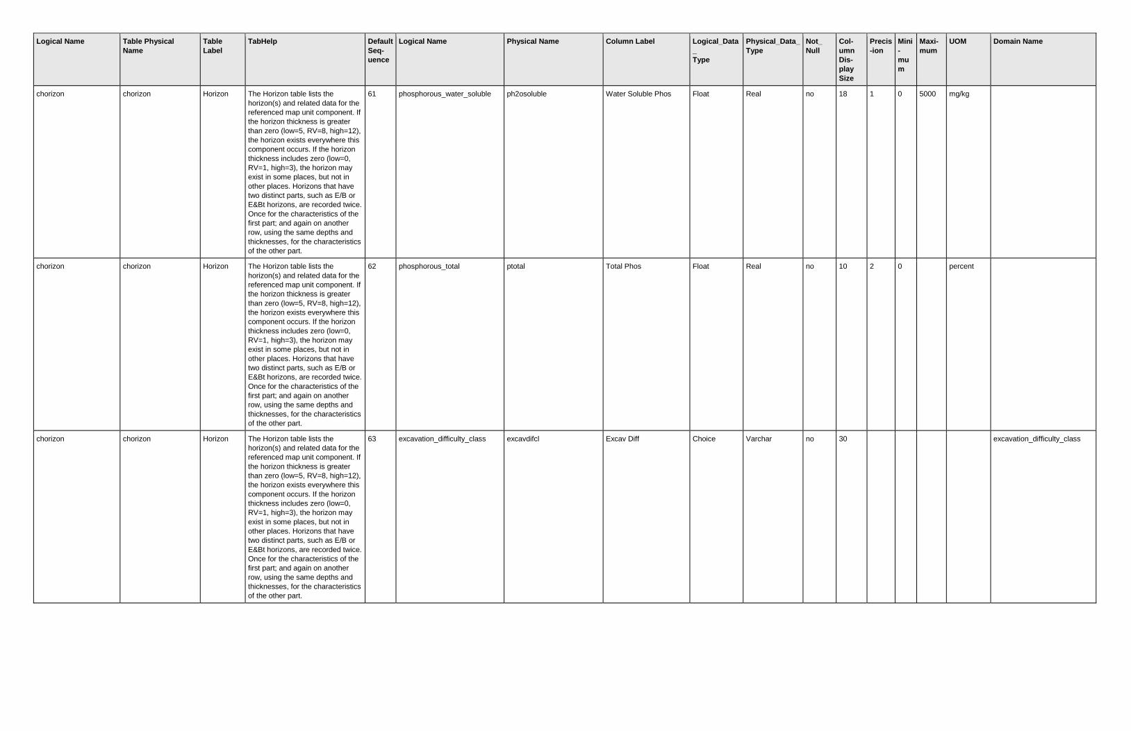
61 phosphorous_water_soluble ph2osoluble Water Soluble Phos Float Real no 18 1 0 5000 mg/kg
chorizon chorizon Horizon The Horizon table lists the
horizon(s) and related data for the
referenced map unit component. If
the horizon thickness is greater
than zero (low=5, RV=8, high=12),
the horizon exists everywhere this
component occurs. If the horizon
thickness includes zero (low=0,
RV=1, high=3), the horizon may
exist in some places, but not in
other places. Horizons that have
two distinct parts, such as E/B or
E&Bt horizons, are recorded twice.
Once for the characteristics of the
first part; and again on another
row, using the same depths and
thicknesses, for the characteristics
of the other part.
62 phosphorous_total ptotal Total Phos Float Real no 10 2 0
percent
chorizon chorizon Horizon The Horizon table lists the
horizon(s) and related data for the
referenced map unit component. If
the horizon thickness is greater
than zero (low=5, RV=8, high=12),
the horizon exists everywhere this
component occurs. If the horizon
thickness includes zero (low=0,
RV=1, high=3), the horizon may
exist in some places, but not in
other places. Horizons that have
two distinct parts, such as E/B or
E&Bt horizons, are recorded twice.
Once for the characteristics of the
first part; and again on another
row, using the same depths and
thicknesses, for the characteristics
of the other part.
63 excavation_difficulty_class excavdifcl Excav Diff Choice Varchar no 30
excavation_difficulty_class

Logical Name Table Physical
Name
Table
Label
TabHelp Default
Seq-
uence
Logical Name Physical Name Column Label Logical_Data
_
Type
Physical_Data_
Type
Not_
Null
Col-
umn
Dis-
play
Size
Precis
-ion
Mini
-
mu
m
Maxi-
mum
UOM Domain Name
chorizon chorizon Horizon The Horizon table lists the
horizon(s) and related data for the
referenced map unit component. If
the horizon thickness is greater
than zero (low=5, RV=8, high=12),
the horizon exists everywhere this
component occurs. If the horizon
thickness includes zero (low=0,
RV=1, high=3), the horizon may
exist in some places, but not in
other places. Horizons that have
two distinct parts, such as E/B or
E&Bt horizons, are recorded twice.
Once for the characteristics of the
first part; and again on another
row, using the same depths and
thicknesses, for the characteristics
of the other part.
64 excavation_difficulty_moist_st excavdifms Excav Diff Moisture Choice Varchar no 30
observed_soil_moisture_statu
s
chorizon chorizon Horizon The Horizon table lists the
horizon(s) and related data for the
referenced map unit component. If
the horizon thickness is greater
than zero (low=5, RV=8, high=12),
the horizon exists everywhere this
component occurs. If the horizon
thickness includes zero (low=0,
RV=1, high=3), the horizon may
exist in some places, but not in
other places. Horizons that have
two distinct parts, such as E/B or
E&Bt horizons, are recorded twice.
Once for the characteristics of the
first part; and again on another
row, using the same depths and
thicknesses, for the characteristics
of the other part.
65 component_key cokey Component Key Integer Int yes 30
chorizon chorizon Horizon The Horizon table lists the
horizon(s) and related data for the
referenced map unit component. If
the horizon thickness is greater
than zero (low=5, RV=8, high=12),
the horizon exists everywhere this
component occurs. If the horizon
thickness includes zero (low=0,
RV=1, high=3), the horizon may
exist in some places, but not in
other places. Horizons that have
two distinct parts, such as E/B or
E&Bt horizons, are recorded twice.
Once for the characteristics of the
first part; and again on another
row, using the same depths and
thicknesses, for the characteristics
of the other part.
66 chorizon_key chkey Chorizon Key Integer Int yes 30

Logical Name Table Physical
Name
Table
Label
TabHelp Default
Seq-
uence
Logical Name Physical Name Column Label Logical_Data
_
Type
Physical_Data_
Type
Not_
Null
Col-
umn
Dis-
play
Size
Precis
-ion
Mini
-
mu
m
Maxi-
mum
UOM Domain Name
chorizon_pores chpores Horizon
Pores
The Horizon Pores table lists the
voids for the referenced horizon. If
the Quantity is greater than zero
(low=2, RV=5, high=10) in a row,
the voids in that row exist
everywhere the horizon and
component occur in the map unit.
If the Quantity includes zero
(low=0, RV=2, high=5), the voids
may exist in some places, but not
in others. More than one row can
be marked as an RV row because
a horizon may have more than one
size or shape of void.
1 pore_quantity poreqty Quantity Float Real no 8 1 0 99 pores/area
chorizon_pores chpores Horizon
Pores
The Horizon Pores table lists the
voids for the referenced horizon. If
the Quantity is greater than zero
(low=2, RV=5, high=10) in a row,
the voids in that row exist
everywhere the horizon and
component occur in the map unit.
If the Quantity includes zero
(low=0, RV=2, high=5), the voids
may exist in some places, but not
in others. More than one row can
be marked as an RV row because
a horizon may have more than one
size or shape of void.
2 pore_size poresize Size Choice Varchar no 30
pore_root_size
chorizon_pores chpores Horizon
Pores
The Horizon Pores table lists the
voids for the referenced horizon. If
the Quantity is greater than zero
(low=2, RV=5, high=10) in a row,
the voids in that row exist
everywhere the horizon and
component occur in the map unit.
If the Quantity includes zero
(low=0, RV=2, high=5), the voids
may exist in some places, but not
in others. More than one row can
be marked as an RV row because
a horizon may have more than one
size or shape of void.
3 pore_continuity_vertical porecont Continuity Choice Varchar no 30
pore_continuity_vertical
chorizon_pores chpores Horizon
Pores
The Horizon Pores table lists the
voids for the referenced horizon. If
the Quantity is greater than zero
(low=2, RV=5, high=10) in a row,
the voids in that row exist
everywhere the horizon and
component occur in the map unit.
If the Quantity includes zero
(low=0, RV=2, high=5), the voids
may exist in some places, but not
in others. More than one row can
be marked as an RV row because
a horizon may have more than one
size or shape of void.
4 pore_shape poreshp Shape Choice Varchar no 30
pore_shape

Logical Name Table Physical
Name
Table
Label
TabHelp Default
Seq-
uence
Logical Name Physical Name Column Label Logical_Data
_
Type
Physical_Data_
Type
Not_
Null
Col-
umn
Dis-
play
Size
Precis
-ion
Mini
-
mu
m
Maxi-
mum
UOM Domain Name
chorizon_pores chpores Horizon
Pores
The Horizon Pores table lists the
voids for the referenced horizon. If
the Quantity is greater than zero
(low=2, RV=5, high=10) in a row,
the voids in that row exist
everywhere the horizon and
component occur in the map unit.
If the Quantity includes zero
(low=0, RV=2, high=5), the voids
may exist in some places, but not
in others. More than one row can
be marked as an RV row because
a horizon may have more than one
size or shape of void.
5 rv_indicator rvindicator RV? Boolean Char yes 3
chorizon_pores chpores Horizon
Pores
The Horizon Pores table lists the
voids for the referenced horizon. If
the Quantity is greater than zero
(low=2, RV=5, high=10) in a row,
the voids in that row exist
everywhere the horizon and
component occur in the map unit.
If the Quantity includes zero
(low=0, RV=2, high=5), the voids
may exist in some places, but not
in others. More than one row can
be marked as an RV row because
a horizon may have more than one
size or shape of void.
6 chorizon_key chkey Chorizon Key Integer Int yes 30
chorizon_pores chpores Horizon
Pores
The Horizon Pores table lists the
voids for the referenced horizon. If
the Quantity is greater than zero
(low=2, RV=5, high=10) in a row,
the voids in that row exist
everywhere the horizon and
component occur in the map unit.
If the Quantity includes zero
(low=0, RV=2, high=5), the voids
may exist in some places, but not
in others. More than one row can
be marked as an RV row because
a horizon may have more than one
size or shape of void.
7 chor_pores_key chporeskey Chorizon Pores Key Integer Int yes 30
chorizon_structure chstruct Horizon
Structure
The Horizon Structure table lists
the individual soil structure size,
grade, and shape terms for the
referenced horizon. Terms in this
table are assembled into a
structure group string which is
recorded in the Horizon Structure
Group table.
1 structure_grade structgrade Grade Choice Varchar no 30
structure_grade
chorizon_structure chstruct Horizon
Structure
The Horizon Structure table lists
the individual soil structure size,
grade, and shape terms for the
referenced horizon. Terms in this
table are assembled into a
structure group string which is
recorded in the Horizon Structure
Group table.
2 structure_size structsize Size Choice Varchar no 30
structure_size

Logical Name Table Physical
Name
Table
Label
TabHelp Default
Seq-
uence
Logical Name Physical Name Column Label Logical_Data
_
Type
Physical_Data_
Type
Not_
Null
Col-
umn
Dis-
play
Size
Precis
-ion
Mini
-
mu
m
Maxi-
mum
UOM Domain Name
chorizon_structure chstruct Horizon
Structure
The Horizon Structure table lists
the individual soil structure size,
grade, and shape terms for the
referenced horizon. Terms in this
table are assembled into a
structure group string which is
recorded in the Horizon Structure
Group table.
3 structure_type structtype Type Choice Varchar no 30
structure_type
chorizon_structure chstruct Horizon
Structure
The Horizon Structure table lists
the individual soil structure size,
grade, and shape terms for the
referenced horizon. Terms in this
table are assembled into a
structure group string which is
recorded in the Horizon Structure
Group table.
4 structure_id structid Structure ID Integer Smallint no 9
1
chorizon_structure chstruct Horizon
Structure
The Horizon Structure table lists
the individual soil structure size,
grade, and shape terms for the
referenced horizon. Terms in this
table are assembled into a
structure group string which is
recorded in the Horizon Structure
Group table.
5 structure_parts_to structpartsto Parts to Structure ID Integer Smallint no 12
chorizon_structure chstruct Horizon
Structure
The Horizon Structure table lists
the individual soil structure size,
grade, and shape terms for the
referenced horizon. Terms in this
table are assembled into a
structure group string which is
recorded in the Horizon Structure
Group table.
6 chor_structure_group_key chstructgrpkey Chorizon Structure
Group Key
Integer Int yes 30
chorizon_structure chstruct Horizon
Structure
The Horizon Structure table lists
the individual soil structure size,
grade, and shape terms for the
referenced horizon. Terms in this
table are assembled into a
structure group string which is
recorded in the Horizon Structure
Group table.
7 chor_structure_key chstructkey Chorizon Structure Key Integer Int yes 30
chorizon_structure_grou
p
chstructgrp Horizon
Structure
Group
The Horizon Structure Group table
lists the ranges of soil structure for
the referenced horizon. The row
with the typically occurring
structure is marked as being
representative. The entry in this
table is based on grouping of
entries in the Horizon Structure
table.
1 structure_group_name structgrpname Structure String Varchar no 30
chorizon_structure_grou
p
chstructgrp Horizon
Structure
Group
The Horizon Structure Group table
lists the ranges of soil structure for
the referenced horizon. The row
with the typically occurring
structure is marked as being
representative. The entry in this
table is based on grouping of
entries in the Horizon Structure
table.
2 rv_indicator rvindicator RV? Boolean Char yes 3

Logical Name Table Physical
Name
Table
Label
TabHelp Default
Seq-
uence
Logical Name Physical Name Column Label Logical_Data
_
Type
Physical_Data_
Type
Not_
Null
Col-
umn
Dis-
play
Size
Precis
-ion
Mini
-
mu
m
Maxi-
mum
UOM Domain Name
chorizon_structure_grou
p
chstructgrp Horizon
Structure
Group
The Horizon Structure Group table
lists the ranges of soil structure for
the referenced horizon. The row
with the typically occurring
structure is marked as being
representative. The entry in this
table is based on grouping of
entries in the Horizon Structure
table.
3 chorizon_key chkey Chorizon Key Integer Int yes 30
chorizon_structure_grou
p
chstructgrp Horizon
Structure
Group
The Horizon Structure Group table
lists the ranges of soil structure for
the referenced horizon. The row
with the typically occurring
structure is marked as being
representative. The entry in this
table is based on grouping of
entries in the Horizon Structure
table.
4 chor_structure_group_key chstructgrpkey Chorizon Structure
Group Key
Integer Int yes 30
chorizon_text chtext Horizon
Text
The Horizon Text table contains
notes and narrative descriptions
related to the referenced horizon.
Some notes may provide
additional information about the
horizon for which there is no
explicit column for such data. In
many cases, the table is empty for
a particular horizon.
1 record_date recdate Date Date/Time Datetime no 22
chorizon_text chtext Horizon
Text
The Horizon Text table contains
notes and narrative descriptions
related to the referenced horizon.
Some notes may provide
additional information about the
horizon for which there is no
explicit column for such data. In
many cases, the table is empty for
a particular horizon.
2 chorizon_text_kind chorizontextkind Kind Choice Varchar no 30
chorizon_text_kind
chorizon_text chtext Horizon
Text
The Horizon Text table contains
notes and narrative descriptions
related to the referenced horizon.
Some notes may provide
additional information about the
horizon for which there is no
explicit column for such data. In
many cases, the table is empty for
a particular horizon.
3 text_category textcat Category String Varchar no 20
chorizon_text chtext Horizon
Text
The Horizon Text table contains
notes and narrative descriptions
related to the referenced horizon.
Some notes may provide
additional information about the
horizon for which there is no
explicit column for such data. In
many cases, the table is empty for
a particular horizon.
4 text_subcategory textsubcat Subcategory String Varchar no 20

Logical Name Table Physical
Name
Table
Label
TabHelp Default
Seq-
uence
Logical Name Physical Name Column Label Logical_Data
_
Type
Physical_Data_
Type
Not_
Null
Col-
umn
Dis-
play
Size
Precis
-ion
Mini
-
mu
m
Maxi-
mum
UOM Domain Name
chorizon_text chtext Horizon
Text
The Horizon Text table contains
notes and narrative descriptions
related to the referenced horizon.
Some notes may provide
additional information about the
horizon for which there is no
explicit column for such data. In
many cases, the table is empty for
a particular horizon.
5 text text Text Narrative Text Varchar(max) no 7
chorizon_text chtext Horizon
Text
The Horizon Text table contains
notes and narrative descriptions
related to the referenced horizon.
Some notes may provide
additional information about the
horizon for which there is no
explicit column for such data. In
many cases, the table is empty for
a particular horizon.
6 chorizon_key chkey Chorizon Key Integer Int yes 30
chorizon_text chtext Horizon
Text
The Horizon Text table contains
notes and narrative descriptions
related to the referenced horizon.
Some notes may provide
additional information about the
horizon for which there is no
explicit column for such data. In
many cases, the table is empty for
a particular horizon.
7 chor_text_key chtextkey Chorizon Text Key Integer Int yes 30
chorizon_texture chtexture Horizon
Texture
The Horizon Texture table lists the
individual texture(s), or term(s)
used in lieu of texture, for the
referenced horizon. Only the
unmodified texture terms are listed
in the Horizon Texture table;
modifiers are listed in the Horizon
Texture Modifier table. For
example, a gravelly loamy sand is
shown as "GR-LS" in the Horizon
Texture Group table, "ls" in the
Horizon Texture table, and "gr" in
the Horizon Texture Modifier table.
1 texture_class texcl Texture Choice Varchar no 30
texture_class
chorizon_texture chtexture Horizon
Texture
The Horizon Texture table lists the
individual texture(s), or term(s)
used in lieu of texture, for the
referenced horizon. Only the
unmodified texture terms are listed
in the Horizon Texture table;
modifiers are listed in the Horizon
Texture Modifier table. For
example, a gravelly loamy sand is
shown as "GR-LS" in the Horizon
Texture Group table, "ls" in the
Horizon Texture table, and "gr" in
the Horizon Texture Modifier table.
2 terms_used_in_lieu_of_texture lieutex In Lieu Choice Varchar no 30
terms_used_in_lieu_of_textur
e

Logical Name Table Physical
Name
Table
Label
TabHelp Default
Seq-
uence
Logical Name Physical Name Column Label Logical_Data
_
Type
Physical_Data_
Type
Not_
Null
Col-
umn
Dis-
play
Size
Precis
-ion
Mini
-
mu
m
Maxi-
mum
UOM Domain Name
chorizon_texture chtexture Horizon
Texture
The Horizon Texture table lists the
individual texture(s), or term(s)
used in lieu of texture, for the
referenced horizon. Only the
unmodified texture terms are listed
in the Horizon Texture table;
modifiers are listed in the Horizon
Texture Modifier table. For
example, a gravelly loamy sand is
shown as "GR-LS" in the Horizon
Texture Group table, "ls" in the
Horizon Texture table, and "gr" in
the Horizon Texture Modifier table.
3 chor_texture_group_key chtgkey Chorizon Texture Group
Key
Integer Int yes 30
chorizon_texture chtexture Horizon
Texture
The Horizon Texture table lists the
individual texture(s), or term(s)
used in lieu of texture, for the
referenced horizon. Only the
unmodified texture terms are listed
in the Horizon Texture table;
modifiers are listed in the Horizon
Texture Modifier table. For
example, a gravelly loamy sand is
shown as "GR-LS" in the Horizon
Texture Group table, "ls" in the
Horizon Texture table, and "gr" in
the Horizon Texture Modifier table.
4 chor_texture_key chtkey Chorizon Texture Key Integer Int yes 30
chorizon_texture_group chtexturegrp Horizon
Texture
Group
The Horizon Texture Group table
lists the range of textures for the
referenced horizon as a
concatenation of horizon texture
and texture modifier(s). For
example, a horizon that is gravelly
loamy sand in some places and
gravelly loamy coarse sand in
other places is shown as GR-LS
on one row and GR-LCOS on
another row in this table. The row
with the typically occurring texture
is identified as the RV row.
Stratified textures are shown in
one row. For example, a horizon
that is stratified gravelly loamy fine
sand and cobbly coarse sand is
shown as SR- GR-LFS CB-COS
on one row and the Stratified?
column for that row is marked
"yes". If two or more textures
always occur together but are not
stratified, all of the textures are
listed on one row and the
Stratified? column for that row is
marked "no".
1 texture_modifier_and_class texture Tex Mod & Class String Varchar no 30

Logical Name Table Physical
Name
Table
Label
TabHelp Default
Seq-
uence
Logical Name Physical Name Column Label Logical_Data
_
Type
Physical_Data_
Type
Not_
Null
Col-
umn
Dis-
play
Size
Precis
-ion
Mini
-
mu
m
Maxi-
mum
UOM Domain Name
chorizon_texture_group chtexturegrp Horizon
Texture
Group
The Horizon Texture Group table
lists the range of textures for the
referenced horizon as a
concatenation of horizon texture
and texture modifier(s). For
example, a horizon that is gravelly
loamy sand in some places and
gravelly loamy coarse sand in
other places is shown as GR-LS
on one row and GR-LCOS on
another row in this table. The row
with the typically occurring texture
is identified as the RV row.
Stratified textures are shown in
one row. For example, a horizon
that is stratified gravelly loamy fine
sand and cobbly coarse sand is
shown as SR- GR-LFS CB-COS
on one row and the Stratified?
column for that row is marked
"yes". If two or more textures
always occur together but are not
stratified, all of the textures are
listed on one row and the
Stratified? column for that row is
marked "no".
2 stratified_textures_flag stratextsflag Stratified? Boolean Char yes 11
chorizon_texture_group chtexturegrp Horizon
Texture
Group
The Horizon Texture Group table
lists the range of textures for the
referenced horizon as a
concatenation of horizon texture
and texture modifier(s). For
example, a horizon that is gravelly
loamy sand in some places and
gravelly loamy coarse sand in
other places is shown as GR-LS
on one row and GR-LCOS on
another row in this table. The row
with the typically occurring texture
is identified as the RV row.
Stratified textures are shown in
one row. For example, a horizon
that is stratified gravelly loamy fine
sand and cobbly coarse sand is
shown as SR- GR-LFS CB-COS
on one row and the Stratified?
column for that row is marked
"yes". If two or more textures
always occur together but are not
stratified, all of the textures are
listed on one row and the
Stratified? column for that row is
marked "no".
3 rv_indicator rvindicator RV? Boolean Char yes 3
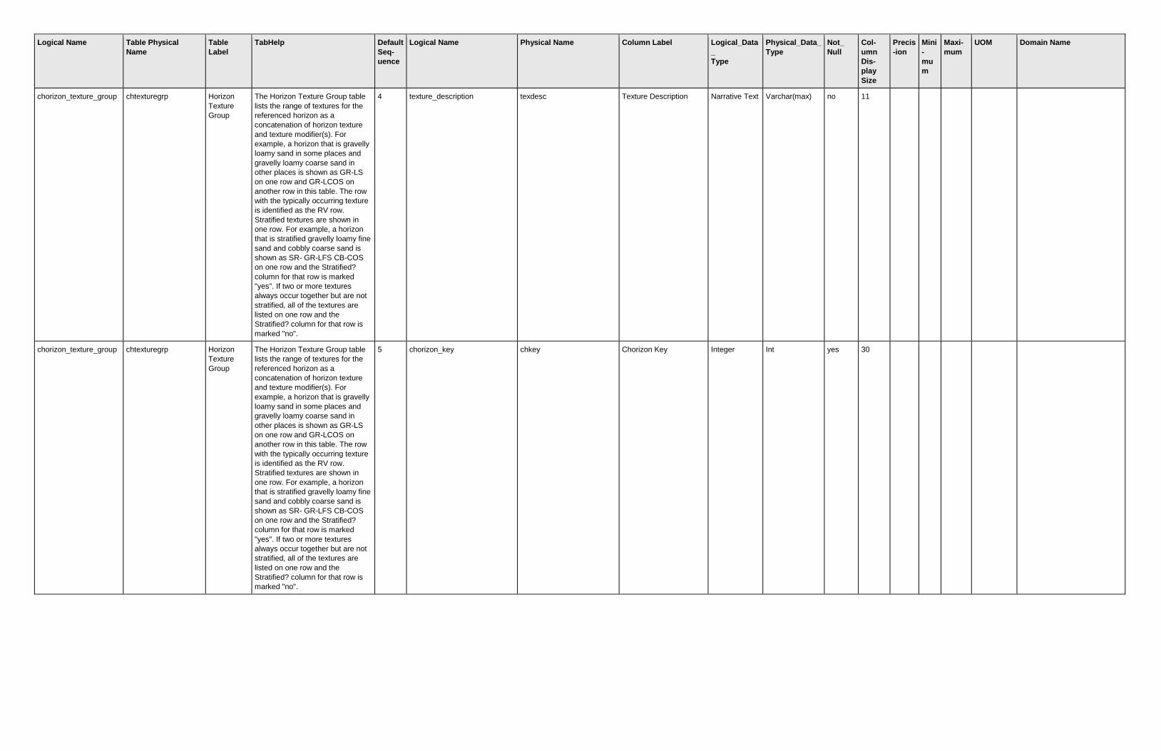
Logical Name Table Physical
Name
Table
Label
TabHelp Default
Seq-
uence
Logical Name Physical Name Column Label Logical_Data
_
Type
Physical_Data_
Type
Not_
Null
Col-
umn
Dis-
play
Size
Precis
-ion
Mini
-
mu
m
Maxi-
mum
UOM Domain Name
chorizon_texture_group chtexturegrp Horizon
Texture
Group
The Horizon Texture Group table
lists the range of textures for the
referenced horizon as a
concatenation of horizon texture
and texture modifier(s). For
example, a horizon that is gravelly
loamy sand in some places and
gravelly loamy coarse sand in
other places is shown as GR-LS
on one row and GR-LCOS on
another row in this table. The row
with the typically occurring texture
is identified as the RV row.
Stratified textures are shown in
one row. For example, a horizon
that is stratified gravelly loamy fine
sand and cobbly coarse sand is
shown as SR- GR-LFS CB-COS
on one row and the Stratified?
column for that row is marked
"yes". If two or more textures
always occur together but are not
stratified, all of the textures are
listed on one row and the
Stratified? column for that row is
marked "no".
4 texture_description texdesc Texture Description Narrative Text Varchar(max) no 11
chorizon_texture_group chtexturegrp Horizon
Texture
Group
The Horizon Texture Group table
lists the range of textures for the
referenced horizon as a
concatenation of horizon texture
and texture modifier(s). For
example, a horizon that is gravelly
loamy sand in some places and
gravelly loamy coarse sand in
other places is shown as GR-LS
on one row and GR-LCOS on
another row in this table. The row
with the typically occurring texture
is identified as the RV row.
Stratified textures are shown in
one row. For example, a horizon
that is stratified gravelly loamy fine
sand and cobbly coarse sand is
shown as SR- GR-LFS CB-COS
on one row and the Stratified?
column for that row is marked
"yes". If two or more textures
always occur together but are not
stratified, all of the textures are
listed on one row and the
Stratified? column for that row is
marked "no".
5 chorizon_key chkey Chorizon Key Integer Int yes 30

Logical Name Table Physical
Name
Table
Label
TabHelp Default
Seq-
uence
Logical Name Physical Name Column Label Logical_Data
_
Type
Physical_Data_
Type
Not_
Null
Col-
umn
Dis-
play
Size
Precis
-ion
Mini
-
mu
m
Maxi-
mum
UOM Domain Name
chorizon_texture_group chtexturegrp Horizon
Texture
Group
The Horizon Texture Group table
lists the range of textures for the
referenced horizon as a
concatenation of horizon texture
and texture modifier(s). For
example, a horizon that is gravelly
loamy sand in some places and
gravelly loamy coarse sand in
other places is shown as GR-LS
on one row and GR-LCOS on
another row in this table. The row
with the typically occurring texture
is identified as the RV row.
Stratified textures are shown in
one row. For example, a horizon
that is stratified gravelly loamy fine
sand and cobbly coarse sand is
shown as SR- GR-LFS CB-COS
on one row and the Stratified?
column for that row is marked
"yes". If two or more textures
always occur together but are not
stratified, all of the textures are
listed on one row and the
Stratified? column for that row is
marked "no".
6 chor_texture_group_key chtgkey Chorizon Texture Group
Key
Integer Int yes 30
chorizon_texture_modifi
er
chtexturemod Horizon
Texture
Modifier
The Horizon Texture Modifier table
lists the texture modifier(s) for the
referenced texture. For example, a
gravelly loamy sand is shown as
"GR-LS" in the Horizon Texture
Group table, "ls" in the Horizon
Texture table, and "gr" in this
table.
1 texture_modifier texmod Modifier Choice Varchar no 30
texture_modifier
chorizon_texture_modifi
er
chtexturemod Horizon
Texture
Modifier
The Horizon Texture Modifier table
lists the texture modifier(s) for the
referenced texture. For example, a
gravelly loamy sand is shown as
"GR-LS" in the Horizon Texture
Group table, "ls" in the Horizon
Texture table, and "gr" in this
table.
2 chor_texture_key chtkey Chorizon Texture Key Integer Int yes 30
chorizon_texture_modifi
er
chtexturemod Horizon
Texture
Modifier
The Horizon Texture Modifier table
lists the texture modifier(s) for the
referenced texture. For example, a
gravelly loamy sand is shown as
"GR-LS" in the Horizon Texture
Group table, "ls" in the Horizon
Texture table, and "gr" in this
table.
3 chor_texture_modifier_key chtexmodkey Chorizon Texture
Modifier Key
Integer Int yes 30
chorizon_unified chunified Horizon
Unified
The Horizon Unified table contains
the Unified Soil Classification(s)
for the referenced horizon. One
row in the Horizon Unified table is
marked as the representative
Unified classification for the
horizon.
1 unified_soil_classification unifiedcl Unified Choice Varchar no 30
unified_soil_classification
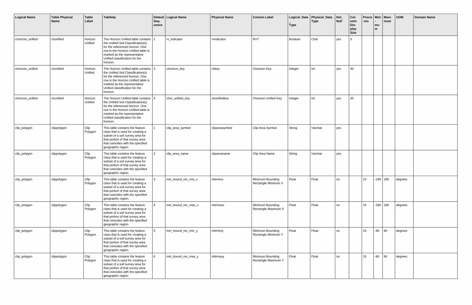
Logical Name Table Physical
Name
Table
Label
TabHelp Default
Seq-
uence
Logical Name Physical Name Column Label Logical_Data
_
Type
Physical_Data_
Type
Not_
Null
Col-
umn
Dis-
play
Size
Precis
-ion
Mini
-
mu
m
Maxi-
mum
UOM Domain Name
chorizon_unified chunified Horizon
Unified
The Horizon Unified table contains
the Unified Soil Classification(s)
for the referenced horizon. One
row in the Horizon Unified table is
marked as the representative
Unified classification for the
horizon.
2 rv_indicator rvindicator RV? Boolean Char yes 3
chorizon_unified chunified Horizon
Unified
The Horizon Unified table contains
the Unified Soil Classification(s)
for the referenced horizon. One
row in the Horizon Unified table is
marked as the representative
Unified classification for the
horizon.
3 chorizon_key chkey Chorizon Key Integer Int yes 30
chorizon_unified chunified Horizon
Unified
The Horizon Unified table contains
the Unified Soil Classification(s)
for the referenced horizon. One
row in the Horizon Unified table is
marked as the representative
Unified classification for the
horizon.
4 chor_unified_key chunifiedkey Chorizon Unified Key Integer Int yes 30
clip_polygon clippolygon Clip
Polygon
This table contains the feature
class that is used for creating a
subset of a soil survey area for
that portion of that survey area
that coincides with the specified
geographic region.
1 clip_area_symbol clipareasymbol Clip Area Symbol String Varchar yes
clip_polygon clippolygon Clip
Polygon
This table contains the feature
class that is used for creating a
subset of a soil survey area for
that portion of that survey area
that coincides with the specified
geographic region.
2 clip_area_name clipareaname Clip Area Name String Varchar yes
clip_polygon clippolygon Clip
Polygon
This table contains the feature
class that is used for creating a
subset of a soil survey area for
that portion of that survey area
that coincides with the specified
geographic region.
3 min_bound_rec_min_x mbrminx Minimum Bounding
Rectangle Minimum X
Float Float no
15 -180 180 degrees
clip_polygon clippolygon Clip
Polygon
This table contains the feature
class that is used for creating a
subset of a soil survey area for
that portion of that survey area
that coincides with the specified
geographic region.
4 min_bound_rec_max_x mbrmaxx Minimum Bounding
Rectangle Maximum X
Float Float no
15 -180 180 degrees
clip_polygon clippolygon Clip
Polygon
This table contains the feature
class that is used for creating a
subset of a soil survey area for
that portion of that survey area
that coincides with the specified
geographic region.
5 min_bound_rec_min_y mbrminy Minimum Bounding
Rectangle Minimum Y
Float Float no
15 -90 90 degrees
clip_polygon clippolygon Clip
Polygon
This table contains the feature
class that is used for creating a
subset of a soil survey area for
that portion of that survey area
that coincides with the specified
geographic region.
6 min_bound_rec_max_y mbrmaxy Minimum Bounding
Rectangle Maximum Y
Float Float no
15 -90 90 degrees

Logical Name Table Physical
Name
Table
Label
TabHelp Default
Seq-
uence
Logical Name Physical Name Column Label Logical_Data
_
Type
Physical_Data_
Type
Not_
Null
Col-
umn
Dis-
play
Size
Precis
-ion
Mini
-
mu
m
Maxi-
mum
UOM Domain Name
clip_polygon clippolygon Clip
Polygon
This table contains the feature
class that is used for creating a
subset of a soil survey area for
that portion of that survey area
that coincides with the specified
geographic region.
7 tabular_est_size tabularestsize Tabular Estimated Size Integer Int yes
bytes
clip_polygon clippolygon Clip
Polygon
This table contains the feature
class that is used for creating a
subset of a soil survey area for
that portion of that survey area
that coincides with the specified
geographic region.
8 spatial_est_size spatialestsize Spatial Estimated Size Integer Int yes
bytes
clip_polygon clippolygon Clip
Polygon
This table contains the feature
class that is used for creating a
subset of a soil survey area for
that portion of that survey area
that coincides with the specified
geographic region.
9 clip_polygon_geographic clippolygongeo Clip Polygon
Geographic
SQL
Geometry
Geometry no
clip_polygon clippolygon Clip
Polygon
This table contains the feature
class that is used for creating a
subset of a soil survey area for
that portion of that survey area
that coincides with the specified
geographic region.
10 clip_polygon_projected clippolygonproj Clip Polygon Projected SQL
Geometry
Geometry no
clip_polygon clippolygon Clip
Polygon
This table contains the feature
class that is used for creating a
subset of a soil survey area for
that portion of that survey area
that coincides with the specified
geographic region.
11 clip_polygon_key clippolygonkey Clip Polygon Key Integer Int yes
component_canopy_cov
er
cocanopycover Component
Canopy
Cover
The Component Canopy Cover
table lists the overstory plants that
typically occur on the referenced
map unit component.
1 plant_species_cover_percent plantcov Canopy Cover % Integer Smallint no 7
0 100 percent
component_canopy_cov
er
cocanopycover Component
Canopy
Cover
The Component Canopy Cover
table lists the overstory plants that
typically occur on the referenced
map unit component.
2 plant_symbol plantsym Plant Symbol String Varchar yes 8
component_canopy_cov
er
cocanopycover Component
Canopy
Cover
The Component Canopy Cover
table lists the overstory plants that
typically occur on the referenced
map unit component.
3 plant_scientific_name plantsciname Scientific Name String Varchar no 30
component_canopy_cov
er
cocanopycover Component
Canopy
Cover
The Component Canopy Cover
table lists the overstory plants that
typically occur on the referenced
map unit component.
4 plant_common_name plantcomname Common Name String Varchar no 30
component_canopy_cov
er
cocanopycover Component
Canopy
Cover
The Component Canopy Cover
table lists the overstory plants that
typically occur on the referenced
map unit component.
5 component_key cokey Component Key Integer Int yes 30
component_canopy_cov
er
cocanopycover Component
Canopy
Cover
The Component Canopy Cover
table lists the overstory plants that
typically occur on the referenced
map unit component.
6 comp_canopy_cover_key cocanopycovkey Component Canopy
Cover Key
Integer Int yes 30

Logical Name Table Physical
Name
Table
Label
TabHelp Default
Seq-
uence
Logical Name Physical Name Column Label Logical_Data
_
Type
Physical_Data_
Type
Not_
Null
Col-
umn
Dis-
play
Size
Precis
-ion
Mini
-
mu
m
Maxi-
mum
UOM Domain Name
component_crop_yield cocropyld Component
Crop Yield
The Component Crop Yield table
lists commonly grown crops and
their expected range in yields
when grown on the referenced
map unit component. Yields for the
map unit as a whole are given in
the Mapunit Crop Yield table.
1 crop_name cropname Crop Name Choice Varchar no 30
crop_name
component_crop_yield cocropyld Component
Crop Yield
The Component Crop Yield table
lists commonly grown crops and
their expected range in yields
when grown on the referenced
map unit component. Yields for the
map unit as a whole are given in
the Mapunit Crop Yield table.
2 crop_yield_units yldunits Units Choice Varchar no 30
crop_yield_units
component_crop_yield cocropyld Component
Crop Yield
The Component Crop Yield table
lists commonly grown crops and
their expected range in yields
when grown on the referenced
map unit component. Yields for the
map unit as a whole are given in
the Mapunit Crop Yield table.
3 nonirr_crop_yield nonirryield Nirr Yield Float Real no 10 2 0 9999.9
9
component_crop_yield cocropyld Component
Crop Yield
The Component Crop Yield table
lists commonly grown crops and
their expected range in yields
when grown on the referenced
map unit component. Yields for the
map unit as a whole are given in
the Mapunit Crop Yield table.
4 irrigated_crop_yield irryield Irr Yield Float Real no 9 2 0 9999.9
9
component_crop_yield cocropyld Component
Crop Yield
The Component Crop Yield table
lists commonly grown crops and
their expected range in yields
when grown on the referenced
map unit component. Yields for the
map unit as a whole are given in
the Mapunit Crop Yield table.
5 crop_productivity_index cropprodindex Prod Index Integer Smallint no 5
0 100
component_crop_yield cocropyld Component
Crop Yield
The Component Crop Yield table
lists commonly grown crops and
their expected range in yields
when grown on the referenced
map unit component. Yields for the
map unit as a whole are given in
the Mapunit Crop Yield table.
6 va_soil_productivity_group vasoiprdgrp VA Soil Prod Grp Choice Varchar no 30
va_soil_productivity_group
component_crop_yield cocropyld Component
Crop Yield
The Component Crop Yield table
lists commonly grown crops and
their expected range in yields
when grown on the referenced
map unit component. Yields for the
map unit as a whole are given in
the Mapunit Crop Yield table.
7 component_key cokey Component Key Integer Int yes 30
component_crop_yield cocropyld Component
Crop Yield
The Component Crop Yield table
lists commonly grown crops and
their expected range in yields
when grown on the referenced
map unit component. Yields for the
map unit as a whole are given in
the Mapunit Crop Yield table.
8 comp_crop_yield_key cocropyldkey Component Crop Yield
Key
Integer Int yes 30

Logical Name Table Physical
Name
Table
Label
TabHelp Default
Seq-
uence
Logical Name Physical Name Column Label Logical_Data
_
Type
Physical_Data_
Type
Not_
Null
Col-
umn
Dis-
play
Size
Precis
-ion
Mini
-
mu
m
Maxi-
mum
UOM Domain Name
component_diagnostic_f
eatures
codiagfeatures Component
Diagnostic
Features
The Component Diagnostic
Features table lists the typical soil
features, such as ochric epipedon
or cambic horizon, for the
referenced map unit component.
1 diag_horz_feat_kind featkind Kind Choice Varchar no 30
diag_horz_feat_kind
component_diagnostic_f
eatures
codiagfeatures Component
Diagnostic
Features
The Component Diagnostic
Features table lists the typical soil
features, such as ochric epipedon
or cambic horizon, for the
referenced map unit component.
2 diag_horz_feat_depth_to_top featdept Top Depth Integer Smallint no 9
0 9999 cm
component_diagnostic_f
eatures
codiagfeatures Component
Diagnostic
Features
The Component Diagnostic
Features table lists the typical soil
features, such as ochric epipedon
or cambic horizon, for the
referenced map unit component.
3 diag_horz_feat_depth_to_botm featdepb Bottom Depth Integer Smallint no 12
0 9999 cm
component_diagnostic_f
eatures
codiagfeatures Component
Diagnostic
Features
The Component Diagnostic
Features table lists the typical soil
features, such as ochric epipedon
or cambic horizon, for the
referenced map unit component.
4 diag_horz_feat_thickness featthick Thickness Integer Smallint no 9
0 9999 cm
component_diagnostic_f
eatures
codiagfeatures Component
Diagnostic
Features
The Component Diagnostic
Features table lists the typical soil
features, such as ochric epipedon
or cambic horizon, for the
referenced map unit component.
5 component_key cokey Component Key Integer Int yes 30
component_diagnostic_f
eatures
codiagfeatures Component
Diagnostic
Features
The Component Diagnostic
Features table lists the typical soil
features, such as ochric epipedon
or cambic horizon, for the
referenced map unit component.
6 comp_diagnostic_features_key codiagfeatkey Component Diagnostic
Features Key
Integer Int yes 30
component_ecological_
class
coecoclass Component
Ecological
Classificatio
n
The Component Ecological
Classification table identifies the
ecological sites typically
associated with the referenced
map unit component. These may
include the official NRCS
forestland and rangland ecological
sites, as well as those of other
classification systems, such as the
USFS Habitat Types.
1 ecological_class_type_name ecoclasstypename Ecological Classification
Type Name
String Varchar yes 30
component_ecological_
class
coecoclass Component
Ecological
Classificatio
n
The Component Ecological
Classification table identifies the
ecological sites typically
associated with the referenced
map unit component. These may
include the official NRCS
forestland and rangland ecological
sites, as well as those of other
classification systems, such as the
USFS Habitat Types.
2 ecological_class_reference ecoclassref Ecological Classification
Reference
String Varchar no 30
component_ecological_
class
coecoclass Component
Ecological
Classificatio
n
The Component Ecological
Classification table identifies the
ecological sites typically
associated with the referenced
map unit component. These may
include the official NRCS
forestland and rangland ecological
sites, as well as those of other
classification systems, such as the
USFS Habitat Types.
3 ecological_class_id ecoclassid Ecological Classification
ID
String Varchar yes 30

Logical Name Table Physical
Name
Table
Label
TabHelp Default
Seq-
uence
Logical Name Physical Name Column Label Logical_Data
_
Type
Physical_Data_
Type
Not_
Null
Col-
umn
Dis-
play
Size
Precis
-ion
Mini
-
mu
m
Maxi-
mum
UOM Domain Name
component_ecological_
class
coecoclass Component
Ecological
Classificatio
n
The Component Ecological
Classification table identifies the
ecological sites typically
associated with the referenced
map unit component. These may
include the official NRCS
forestland and rangland ecological
sites, as well as those of other
classification systems, such as the
USFS Habitat Types.
4 ecological_class_name ecoclassname Ecological Classification
Name
Narrative Text Varchar(max) no 19
component_ecological_
class
coecoclass Component
Ecological
Classificatio
n
The Component Ecological
Classification table identifies the
ecological sites typically
associated with the referenced
map unit component. These may
include the official NRCS
forestland and rangland ecological
sites, as well as those of other
classification systems, such as the
USFS Habitat Types.
5 component_key cokey Component Key Integer Int yes 30
component_ecological_
class
coecoclass Component
Ecological
Classificatio
n
The Component Ecological
Classification table identifies the
ecological sites typically
associated with the referenced
map unit component. These may
include the official NRCS
forestland and rangland ecological
sites, as well as those of other
classification systems, such as the
USFS Habitat Types.
6 comp_eco_classification_key coecoclasskey Component Ecological
Classification Key
Integer Int yes 30
component_ecological_
class
coecoclass Component
Ecological
Classificatio
n
The Component Ecological
Classification table identifies the
ecological sites typically
associated with the referenced
map unit component. These may
include the official NRCS
forestland and rangland ecological
sites, as well as those of other
classification systems, such as the
USFS Habitat Types.
7 source_sdw_primary_key sourcesdwprimarykey Source SDW Primary
Key
Integer Int no
component_ecological_
class
coecoclass Component
Ecological
Classificatio
n
The Component Ecological
Classification table identifies the
ecological sites typically
associated with the referenced
map unit component. These may
include the official NRCS
forestland and rangland ecological
sites, as well as those of other
classification systems, such as the
USFS Habitat Types.
8 source_sdw_table_physical_n
ame
sourcesdwtablephysicalnam
e
Source SDW Table
Physical Name
String Varchar no
component_existing_pla
nts
coeplants Component
Existing
Plants
The Component Existing Plants
table lists the plants, either
rangeland or forestland plants, that
typically occur on the referenced
map unit component.
1 plant_symbol plantsym Plant Symbol String Varchar yes 8
component_existing_pla
nts
coeplants Component
Existing
Plants
The Component Existing Plants
table lists the plants, either
rangeland or forestland plants, that
typically occur on the referenced
map unit component.
2 plant_scientific_name plantsciname Scientific Name String Varchar no 30

Logical Name Table Physical
Name
Table
Label
TabHelp Default
Seq-
uence
Logical Name Physical Name Column Label Logical_Data
_
Type
Physical_Data_
Type
Not_
Null
Col-
umn
Dis-
play
Size
Precis
-ion
Mini
-
mu
m
Maxi-
mum
UOM Domain Name
component_existing_pla
nts
coeplants Component
Existing
Plants
The Component Existing Plants
table lists the plants, either
rangeland or forestland plants, that
typically occur on the referenced
map unit component.
3 plant_common_name plantcomname Common Name String Varchar no 30
component_existing_pla
nts
coeplants Component
Existing
Plants
The Component Existing Plants
table lists the plants, either
rangeland or forestland plants, that
typically occur on the referenced
map unit component.
4 forest_understory_prod_pct forestunprod Understory Prod % Integer Smallint no 10
0 100 percent
component_existing_pla
nts
coeplants Component
Existing
Plants
The Component Existing Plants
table lists the plants, either
rangeland or forestland plants, that
typically occur on the referenced
map unit component.
5 rangeland_prod_percent rangeprod Range Prod % Integer Smallint no 6
0 100 percent
component_existing_pla
nts
coeplants Component
Existing
Plants
The Component Existing Plants
table lists the plants, either
rangeland or forestland plants, that
typically occur on the referenced
map unit component.
6 component_key cokey Component Key Integer Int yes 30
component_existing_pla
nts
coeplants Component
Existing
Plants
The Component Existing Plants
table lists the plants, either
rangeland or forestland plants, that
typically occur on the referenced
map unit component.
7 comp_existing_plants_key coeplantskey Component Existing
Plants Key
Integer Int yes 30
component_erosion_acc
elerated
coerosionacc Component
Erosion
Accelerated
The Component Erosion
Accelerated table lists the kinds of
accelerated erosion that occur on
the referenced map unit
component. One row in this table
is marked as the representative
kind of accelerated erosion for that
component.
1 erosion_accelerated_kind erokind Kind Choice Varchar no 30
erosion_accelerated_kind
component_erosion_acc
elerated
coerosionacc Component
Erosion
Accelerated
The Component Erosion
Accelerated table lists the kinds of
accelerated erosion that occur on
the referenced map unit
component. One row in this table
is marked as the representative
kind of accelerated erosion for that
component.
2 rv_indicator rvindicator RV? Boolean Char yes 3
component_erosion_acc
elerated
coerosionacc Component
Erosion
Accelerated
The Component Erosion
Accelerated table lists the kinds of
accelerated erosion that occur on
the referenced map unit
component. One row in this table
is marked as the representative
kind of accelerated erosion for that
component.
3 component_key cokey Component Key Integer Int yes 30
component_erosion_acc
elerated
coerosionacc Component
Erosion
Accelerated
The Component Erosion
Accelerated table lists the kinds of
accelerated erosion that occur on
the referenced map unit
component. One row in this table
is marked as the representative
kind of accelerated erosion for that
component.
4 comp_erosion_accelerated_ke
y
coeroacckey Component Erosion
Accelerated Key
Integer Int yes 30

Logical Name Table Physical
Name
Table
Label
TabHelp Default
Seq-
uence
Logical Name Physical Name Column Label Logical_Data
_
Type
Physical_Data_
Type
Not_
Null
Col-
umn
Dis-
play
Size
Precis
-ion
Mini
-
mu
m
Maxi-
mum
UOM Domain Name
component_forest_prod coforprod Component
Forest
Productivity
The Component Forest
Productivity table lists the site
index and the annual productivity
in cubic feet per acre per year
(CAMI) of forest overstory tree
species that typically occur on the
referenced map unit component.
1 plant_symbol plantsym Plant Symbol String Varchar yes 8
component_forest_prod coforprod Component
Forest
Productivity
The Component Forest
Productivity table lists the site
index and the annual productivity
in cubic feet per acre per year
(CAMI) of forest overstory tree
species that typically occur on the
referenced map unit component.
2 plant_scientific_name plantsciname Scientific Name String Varchar no 30
component_forest_prod coforprod Component
Forest
Productivity
The Component Forest
Productivity table lists the site
index and the annual productivity
in cubic feet per acre per year
(CAMI) of forest overstory tree
species that typically occur on the
referenced map unit component.
3 plant_common_name plantcomname Common Name String Varchar no 30
component_forest_prod coforprod Component
Forest
Productivity
The Component Forest
Productivity table lists the site
index and the annual productivity
in cubic feet per acre per year
(CAMI) of forest overstory tree
species that typically occur on the
referenced map unit component.
4 site_index_base siteindexbase Site Index Base Choice Varchar no 30
site_index_curves
component_forest_prod coforprod Component
Forest
Productivity
The Component Forest
Productivity table lists the site
index and the annual productivity
in cubic feet per acre per year
(CAMI) of forest overstory tree
species that typically occur on the
referenced map unit component.
5 site_index siteindex Site Index Integer Smallint no 10
1 300
component_forest_prod coforprod Component
Forest
Productivity
The Component Forest
Productivity table lists the site
index and the annual productivity
in cubic feet per acre per year
(CAMI) of forest overstory tree
species that typically occur on the
referenced map unit component.
6 forest_productivity fprod Productivity ft3/ac/yr
CMAI
Float Real no 27 2 0 9999
component_forest_prod coforprod Component
Forest
Productivity
The Component Forest
Productivity table lists the site
index and the annual productivity
in cubic feet per acre per year
(CAMI) of forest overstory tree
species that typically occur on the
referenced map unit component.
7 component_key cokey Component Key Integer Int yes 30
component_forest_prod coforprod Component
Forest
Productivity
The Component Forest
Productivity table lists the site
index and the annual productivity
in cubic feet per acre per year
(CAMI) of forest overstory tree
species that typically occur on the
referenced map unit component.
8 comp_forest_prod_key cofprodkey Component Forest
Productivity Key
Integer Int yes 30

Logical Name Table Physical
Name
Table
Label
TabHelp Default
Seq-
uence
Logical Name Physical Name Column Label Logical_Data
_
Type
Physical_Data_
Type
Not_
Null
Col-
umn
Dis-
play
Size
Precis
-ion
Mini
-
mu
m
Maxi-
mum
UOM Domain Name
component_forest_prod
_other
coforprodo Component
Forest
Productivity
- Other
The Component Forest
Productivity - Other table lists the
site index and annual productivity
of forest overstory tree species in
units other than cubic feet per acre
per year for trees that typically
occur on the referenced map unit
component.
1 site_index_base siteindexbase Site Index Base Choice Varchar no 30
site_index_curves
component_forest_prod
_other
coforprodo Component
Forest
Productivity
- Other
The Component Forest
Productivity - Other table lists the
site index and annual productivity
of forest overstory tree species in
units other than cubic feet per acre
per year for trees that typically
occur on the referenced map unit
component.
2 site_index siteindex Site Index Integer Smallint no 10
1 300
component_forest_prod
_other
coforprodo Component
Forest
Productivity
- Other
The Component Forest
Productivity - Other table lists the
site index and annual productivity
of forest overstory tree species in
units other than cubic feet per acre
per year for trees that typically
occur on the referenced map unit
component.
3 forest_productivity fprod Productivity Float Real no 12 2 0 9999
component_forest_prod
_other
coforprodo Component
Forest
Productivity
- Other
The Component Forest
Productivity - Other table lists the
site index and annual productivity
of forest overstory tree species in
units other than cubic feet per acre
per year for trees that typically
occur on the referenced map unit
component.
4 forest_productivity_units fprodunits Units Choice Varchar no 30
forest_productivity_units
component_forest_prod
_other
coforprodo Component
Forest
Productivity
- Other
The Component Forest
Productivity - Other table lists the
site index and annual productivity
of forest overstory tree species in
units other than cubic feet per acre
per year for trees that typically
occur on the referenced map unit
component.
5 comp_forest_prod_key cofprodkey Component Forest
Productivity Key
Integer Int yes 30
component_forest_prod
_other
coforprodo Component
Forest
Productivity
- Other
The Component Forest
Productivity - Other table lists the
site index and annual productivity
of forest overstory tree species in
units other than cubic feet per acre
per year for trees that typically
occur on the referenced map unit
component.
6 comp_forest_prod_other_key cofprodokey Component Forest
Productivity Other Key
Integer Int yes 30
component_geomorph_
desc
cogeomordesc Component
Geomorphi
c
Description
The Component Geomorphic
Description table lists the
geomorphic features on which the
referenced map unit component
typically occurs.
1 geomorph_feat_type_name geomftname Feature Type String Varchar yes 30
component_geomorph_
desc
cogeomordesc Component
Geomorphi
c
Description
The Component Geomorphic
Description table lists the
geomorphic features on which the
referenced map unit component
typically occurs.
2 geomorph_feat_name geomfname Feature Name String Varchar yes 30

Logical Name Table Physical
Name
Table
Label
TabHelp Default
Seq-
uence
Logical Name Physical Name Column Label Logical_Data
_
Type
Physical_Data_
Type
Not_
Null
Col-
umn
Dis-
play
Size
Precis
-ion
Mini
-
mu
m
Maxi-
mum
UOM Domain Name
component_geomorph_
desc
cogeomordesc Component
Geomorphi
c
Description
The Component Geomorphic
Description table lists the
geomorphic features on which the
referenced map unit component
typically occurs.
3 geomorph_feat_modifier geomfmod Feature Modifier String Varchar no 30
component_geomorph_
desc
cogeomordesc Component
Geomorphi
c
Description
The Component Geomorphic
Description table lists the
geomorphic features on which the
referenced map unit component
typically occurs.
4 geomorphic_feat_id geomfeatid Feature ID Integer Smallint no 7
component_geomorph_
desc
cogeomordesc Component
Geomorphi
c
Description
The Component Geomorphic
Description table lists the
geomorphic features on which the
referenced map unit component
typically occurs.
5 exists_on_feature existsonfeat Exists On Feature ID Integer Smallint no 10
component_geomorph_
desc
cogeomordesc Component
Geomorphi
c
Description
The Component Geomorphic
Description table lists the
geomorphic features on which the
referenced map unit component
typically occurs.
6 rv_indicator rvindicator RV? Boolean Char yes 3
component_geomorph_
desc
cogeomordesc Component
Geomorphi
c
Description
The Component Geomorphic
Description table lists the
geomorphic features on which the
referenced map unit component
typically occurs.
7 component_key cokey Component Key Integer Int yes 30
component_geomorph_
desc
cogeomordesc Component
Geomorphi
c
Description
The Component Geomorphic
Description table lists the
geomorphic features on which the
referenced map unit component
typically occurs.
8 comp_geomorph_desc_key cogeomdkey Component Geomorphic
Description Key
Integer Int yes 30
component_hydric_criter
ia
cohydriccriteria Component
Hydric
Criteria
The Component Hydric Criteria
table lists the hydric soil criteria
met for those referenced map unit
components that are classified as
a "hydric soil."
1 hydric_criterion hydriccriterion Hydric Criterion Choice Varchar no 30
hydric_criteria
component_hydric_criter
ia
cohydriccriteria Component
Hydric
Criteria
The Component Hydric Criteria
table lists the hydric soil criteria
met for those referenced map unit
components that are classified as
a "hydric soil."
2 component_key cokey Component Key Integer Int yes 30
component_hydric_criter
ia
cohydriccriteria Component
Hydric
Criteria
The Component Hydric Criteria
table lists the hydric soil criteria
met for those referenced map unit
components that are classified as
a "hydric soil."
3 comp_hydric_criteria_key cohydcritkey Component Hydric
Criteria Key
Integer Int yes 30
component_interpretatio
n
cointerp Component
Interpretatio
n
The Component Interpretation
table lists the predictions of
behavior and limiting features for
specified uses made for the
referenced map unit component.
1 component_key cokey Component Key Integer Int yes 30
component_interpretatio
n
cointerp Component
Interpretatio
n
The Component Interpretation
table lists the predictions of
behavior and limiting features for
specified uses made for the
referenced map unit component.
2 main_rule_key mrulekey Main Rule Key Integer Int yes 30

Logical Name Table Physical
Name
Table
Label
TabHelp Default
Seq-
uence
Logical Name Physical Name Column Label Logical_Data
_
Type
Physical_Data_
Type
Not_
Null
Col-
umn
Dis-
play
Size
Precis
-ion
Mini
-
mu
m
Maxi-
mum
UOM Domain Name
component_interpretatio
n
cointerp Component
Interpretatio
n
The Component Interpretation
table lists the predictions of
behavior and limiting features for
specified uses made for the
referenced map unit component.
3 main_rule_name mrulename Main Rule Name String Varchar yes 30
component_interpretatio
n
cointerp Component
Interpretatio
n
The Component Interpretation
table lists the predictions of
behavior and limiting features for
specified uses made for the
referenced map unit component.
4 sequence_number seqnum Seq Integer Smallint yes 6
1
component_interpretatio
n
cointerp Component
Interpretatio
n
The Component Interpretation
table lists the predictions of
behavior and limiting features for
specified uses made for the
referenced map unit component.
5 rule_key rulekey Rule Key Integer Int yes 30
component_interpretatio
n
cointerp Component
Interpretatio
n
The Component Interpretation
table lists the predictions of
behavior and limiting features for
specified uses made for the
referenced map unit component.
6 rule_name rulename Rule Name String Varchar yes 30
component_interpretatio
n
cointerp Component
Interpretatio
n
The Component Interpretation
table lists the predictions of
behavior and limiting features for
specified uses made for the
referenced map unit component.
7 rule_depth ruledepth Rule Depth Integer Smallint yes 6
component_interpretatio
n
cointerp Component
Interpretatio
n
The Component Interpretation
table lists the predictions of
behavior and limiting features for
specified uses made for the
referenced map unit component.
8 interp_low_low interpll Interp Low Low Float Float no 10 2
component_interpretatio
n
cointerp Component
Interpretatio
n
The Component Interpretation
table lists the predictions of
behavior and limiting features for
specified uses made for the
referenced map unit component.
9 interp_low_low_class interpllc Interp Low Low Class String Varchar no 30
component_interpretatio
n
cointerp Component
Interpretatio
n
The Component Interpretation
table lists the predictions of
behavior and limiting features for
specified uses made for the
referenced map unit component.
10 interp_low_rv interplr Interp Low
Representative Value
Float Float no 20 2
component_interpretatio
n
cointerp Component
Interpretatio
n
The Component Interpretation
table lists the predictions of
behavior and limiting features for
specified uses made for the
referenced map unit component.
11 interp_low_rv_class interplrc Interp Low
Representative Value
Class
String Varchar no 30
component_interpretatio
n
cointerp Component
Interpretatio
n
The Component Interpretation
table lists the predictions of
behavior and limiting features for
specified uses made for the
referenced map unit component.
12 interp_high_rv interphr Interp High
Representative Value
Float Float no 20 2
component_interpretatio
n
cointerp Component
Interpretatio
n
The Component Interpretation
table lists the predictions of
behavior and limiting features for
specified uses made for the
referenced map unit component.
13 interp_high_rv_class interphrc Interp High
Representative Value
Class
String Varchar no 30

Logical Name Table Physical
Name
Table
Label
TabHelp Default
Seq-
uence
Logical Name Physical Name Column Label Logical_Data
_
Type
Physical_Data_
Type
Not_
Null
Col-
umn
Dis-
play
Size
Precis
-ion
Mini
-
mu
m
Maxi-
mum
UOM Domain Name
component_interpretatio
n
cointerp Component
Interpretatio
n
The Component Interpretation
table lists the predictions of
behavior and limiting features for
specified uses made for the
referenced map unit component.
14 interp_high_high interphh Interp High High Float Float no 10 2
component_interpretatio
n
cointerp Component
Interpretatio
n
The Component Interpretation
table lists the predictions of
behavior and limiting features for
specified uses made for the
referenced map unit component.
15 interp_high_high_class interphhc Interp High High Class String Varchar no 30
component_interpretatio
n
cointerp Component
Interpretatio
n
The Component Interpretation
table lists the predictions of
behavior and limiting features for
specified uses made for the
referenced map unit component.
16 null_property_data_boolean nullpropdatabool Null Property Data
Boolean
Boolean Char no 13
component_interpretatio
n
cointerp Component
Interpretatio
n
The Component Interpretation
table lists the predictions of
behavior and limiting features for
specified uses made for the
referenced map unit component.
17 default_property_data_boolean defpropdatabool Default Property Data
Boolean
Boolean Char no 16
component_interpretatio
n
cointerp Component
Interpretatio
n
The Component Interpretation
table lists the predictions of
behavior and limiting features for
specified uses made for the
referenced map unit component.
18 inconsis_property_data_boole
an
incpropdatabool Inconsistent Property
Data Boolean
Boolean Char no 21
component_interpretatio
n
cointerp Component
Interpretatio
n
The Component Interpretation
table lists the predictions of
behavior and limiting features for
specified uses made for the
referenced map unit component.
19 comp_interp_key cointerpkey Component
Interpretation Key
Integer Int yes 30
component_interpretatio
n
cointerp Component
Interpretatio
n
The Component Interpretation
table lists the predictions of
behavior and limiting features for
specified uses made for the
referenced map unit component.
20 rule_depth_sequence ruledepthseq Rule Depth Sequence Integer Smallint no 10
component_interpretatio
n
cointerp Component
Interpretatio
n
The Component Interpretation
table lists the predictions of
behavior and limiting features for
specified uses made for the
referenced map unit component.
21 rule_design ruledesign Rule Design Choice Smallint yes 6
rule_design
component_month comonth Component
Month
The Component Month table lists
the monthly flooding and ponding
characteristics for the referenced
map unit component. This table
has one row for each month of the
year.
1 month_sequence monthseq Month Sequence Integer Smallint no 8
1 12
component_month comonth Component
Month
The Component Month table lists
the monthly flooding and ponding
characteristics for the referenced
map unit component. This table
has one row for each month of the
year.
2 month month Month Choice Varchar no 30
flooding_ponding_month
component_month comonth Component
Month
The Component Month table lists
the monthly flooding and ponding
characteristics for the referenced
map unit component. This table
has one row for each month of the
year.
3 flooding_frequency_class flodfreqcl Flooding Frequency Choice Varchar no 30
flooding_frequency_class

Logical Name Table Physical
Name
Table
Label
TabHelp Default
Seq-
uence
Logical Name Physical Name Column Label Logical_Data
_
Type
Physical_Data_
Type
Not_
Null
Col-
umn
Dis-
play
Size
Precis
-ion
Mini
-
mu
m
Maxi-
mum
UOM Domain Name
component_month comonth Component
Month
The Component Month table lists
the monthly flooding and ponding
characteristics for the referenced
map unit component. This table
has one row for each month of the
year.
4 flooding_duration_class floddurcl Flooding Duration Choice Varchar no 30
flooding_duration_class
component_month comonth Component
Month
The Component Month table lists
the monthly flooding and ponding
characteristics for the referenced
map unit component. This table
has one row for each month of the
year.
5 ponding_frequency_class pondfreqcl Ponding Frequency Choice Varchar no 30
ponding_frequency_class
component_month comonth Component
Month
The Component Month table lists
the monthly flooding and ponding
characteristics for the referenced
map unit component. This table
has one row for each month of the
year.
6 ponding_duration_class ponddurcl Ponding Duration Choice Varchar no 30
ponding_duration_class
component_month comonth Component
Month
The Component Month table lists
the monthly flooding and ponding
characteristics for the referenced
map unit component. This table
has one row for each month of the
year.
7 ponding_depth ponddep Ponding Depth Integer Smallint no 13
0 185 cm
component_month comonth Component
Month
The Component Month table lists
the monthly flooding and ponding
characteristics for the referenced
map unit component. This table
has one row for each month of the
year.
8 daily_avg_precip dlyavgprecip Daily Precip Integer Smallint no 12
0 750 mm
component_month comonth Component
Month
The Component Month table lists
the monthly flooding and ponding
characteristics for the referenced
map unit component. This table
has one row for each month of the
year.
9 daily_avg_pot_evapotrans dlyavgpotet Daily ET Integer Smallint no 8
0 300 mm
component_month comonth Component
Month
The Component Month table lists
the monthly flooding and ponding
characteristics for the referenced
map unit component. This table
has one row for each month of the
year.
10 component_key cokey Component Key Integer Int yes 30
component_month comonth Component
Month
The Component Month table lists
the monthly flooding and ponding
characteristics for the referenced
map unit component. This table
has one row for each month of the
year.
11 comp_month_key comonthkey Component Month Key Integer Int yes 30

Logical Name Table Physical
Name
Table
Label
TabHelp Default
Seq-
uence
Logical Name Physical Name Column Label Logical_Data
_
Type
Physical_Data_
Type
Not_
Null
Col-
umn
Dis-
play
Size
Precis
-ion
Mini
-
mu
m
Maxi-
mum
UOM Domain Name
component component Component The Component table lists the
map unit components identified in
the referenced map unit, and
selected properties of each
component. If the Component % is
greater than zero (low=65, RV=75,
high=90) for a component, that
component exists in every
delineation of that mapunit. If the
Component % includes zero
(low=0, RV=50, high=90), the
component may exist in some
delineations, but not in others.
1 component_percent comppct Comp % Integer Smallint no 6
0 100 percent
component component Component The Component table lists the
map unit components identified in
the referenced map unit, and
selected properties of each
component. If the Component % is
greater than zero (low=65, RV=75,
high=90) for a component, that
component exists in every
delineation of that mapunit. If the
Component % includes zero
(low=0, RV=50, high=90), the
component may exist in some
delineations, but not in others.
2 component_name compname Component Name String Varchar no 30
component component Component The Component table lists the
map unit components identified in
the referenced map unit, and
selected properties of each
component. If the Component % is
greater than zero (low=65, RV=75,
high=90) for a component, that
component exists in every
delineation of that mapunit. If the
Component % includes zero
(low=0, RV=50, high=90), the
component may exist in some
delineations, but not in others.
3 component_kind compkind Kind Choice Varchar no 30
component_kind
component component Component The Component table lists the
map unit components identified in
the referenced map unit, and
selected properties of each
component. If the Component % is
greater than zero (low=65, RV=75,
high=90) for a component, that
component exists in every
delineation of that mapunit. If the
Component % includes zero
(low=0, RV=50, high=90), the
component may exist in some
delineations, but not in others.
4 major_component_flag majcompflag Major Component Boolean Char no 9

Logical Name Table Physical
Name
Table
Label
TabHelp Default
Seq-
uence
Logical Name Physical Name Column Label Logical_Data
_
Type
Physical_Data_
Type
Not_
Null
Col-
umn
Dis-
play
Size
Precis
-ion
Mini
-
mu
m
Maxi-
mum
UOM Domain Name
component component Component The Component table lists the
map unit components identified in
the referenced map unit, and
selected properties of each
component. If the Component % is
greater than zero (low=65, RV=75,
high=90) for a component, that
component exists in every
delineation of that mapunit. If the
Component % includes zero
(low=0, RV=50, high=90), the
component may exist in some
delineations, but not in others.
5 class_determining_phase otherph SIR phase String Varchar no 30
component component Component The Component table lists the
map unit components identified in
the referenced map unit, and
selected properties of each
component. If the Component % is
greater than zero (low=65, RV=75,
high=90) for a component, that
component exists in every
delineation of that mapunit. If the
Component % includes zero
(low=0, RV=50, high=90), the
component may exist in some
delineations, but not in others.
6 local_phase localphase Local Phase String Varchar no 30
component component Component The Component table lists the
map unit components identified in
the referenced map unit, and
selected properties of each
component. If the Component % is
greater than zero (low=65, RV=75,
high=90) for a component, that
component exists in every
delineation of that mapunit. If the
Component % includes zero
(low=0, RV=50, high=90), the
component may exist in some
delineations, but not in others.
7 slope_gradient slope Slope Gradient Float Real no 14 1 0 999 percent
component component Component The Component table lists the
map unit components identified in
the referenced map unit, and
selected properties of each
component. If the Component % is
greater than zero (low=65, RV=75,
high=90) for a component, that
component exists in every
delineation of that mapunit. If the
Component % includes zero
(low=0, RV=50, high=90), the
component may exist in some
delineations, but not in others.
8 slope_length_usle slopelenusle Slope Length USLE Integer Smallint no 17
0 4000 meters

Logical Name Table Physical
Name
Table
Label
TabHelp Default
Seq-
uence
Logical Name Physical Name Column Label Logical_Data
_
Type
Physical_Data_
Type
Not_
Null
Col-
umn
Dis-
play
Size
Precis
-ion
Mini
-
mu
m
Maxi-
mum
UOM Domain Name
component component Component The Component table lists the
map unit components identified in
the referenced map unit, and
selected properties of each
component. If the Component % is
greater than zero (low=65, RV=75,
high=90) for a component, that
component exists in every
delineation of that mapunit. If the
Component % includes zero
(low=0, RV=50, high=90), the
component may exist in some
delineations, but not in others.
9 runoff runoff Runoff Class Choice Varchar no 30
runoff
component component Component The Component table lists the
map unit components identified in
the referenced map unit, and
selected properties of each
component. If the Component % is
greater than zero (low=65, RV=75,
high=90) for a component, that
component exists in every
delineation of that mapunit. If the
Component % includes zero
(low=0, RV=50, high=90), the
component may exist in some
delineations, but not in others.
10 t_factor tfact T Integer Smallint no 2
1 5 tons/acre/yr
component component Component The Component table lists the
map unit components identified in
the referenced map unit, and
selected properties of each
component. If the Component % is
greater than zero (low=65, RV=75,
high=90) for a component, that
component exists in every
delineation of that mapunit. If the
Component % includes zero
(low=0, RV=50, high=90), the
component may exist in some
delineations, but not in others.
11 wind_erodibility_index wei WEI Choice Varchar no 30
tons/acre/yr wind_erodibility_index
component component Component The Component table lists the
map unit components identified in
the referenced map unit, and
selected properties of each
component. If the Component % is
greater than zero (low=65, RV=75,
high=90) for a component, that
component exists in every
delineation of that mapunit. If the
Component % includes zero
(low=0, RV=50, high=90), the
component may exist in some
delineations, but not in others.
12 wind_erodibility_group weg WEG Choice Varchar no 30
wind_erodibility_group

Logical Name Table Physical
Name
Table
Label
TabHelp Default
Seq-
uence
Logical Name Physical Name Column Label Logical_Data
_
Type
Physical_Data_
Type
Not_
Null
Col-
umn
Dis-
play
Size
Precis
-ion
Mini
-
mu
m
Maxi-
mum
UOM Domain Name
component component Component The Component table lists the
map unit components identified in
the referenced map unit, and
selected properties of each
component. If the Component % is
greater than zero (low=65, RV=75,
high=90) for a component, that
component exists in every
delineation of that mapunit. If the
Component % includes zero
(low=0, RV=50, high=90), the
component may exist in some
delineations, but not in others.
13 erosion_class erocl Erosion Class Choice Varchar no 30
erosion_class
component component Component The Component table lists the
map unit components identified in
the referenced map unit, and
selected properties of each
component. If the Component % is
greater than zero (low=65, RV=75,
high=90) for a component, that
component exists in every
delineation of that mapunit. If the
Component % includes zero
(low=0, RV=50, high=90), the
component may exist in some
delineations, but not in others.
14 earth_cover_kind_level_one earthcovkind1 Cover Kind 1 Choice Varchar no 30
earth_cover_kind_level_one
component component Component The Component table lists the
map unit components identified in
the referenced map unit, and
selected properties of each
component. If the Component % is
greater than zero (low=65, RV=75,
high=90) for a component, that
component exists in every
delineation of that mapunit. If the
Component % includes zero
(low=0, RV=50, high=90), the
component may exist in some
delineations, but not in others.
15 earth_cover_kind_level_two earthcovkind2 Cover Kind 2 Choice Varchar no 30
earth_cover_kind_level_two
component component Component The Component table lists the
map unit components identified in
the referenced map unit, and
selected properties of each
component. If the Component % is
greater than zero (low=65, RV=75,
high=90) for a component, that
component exists in every
delineation of that mapunit. If the
Component % includes zero
(low=0, RV=50, high=90), the
component may exist in some
delineations, but not in others.
16 hydric_condition hydricon Hydric Condition Choice Varchar no 30
hydric_condition
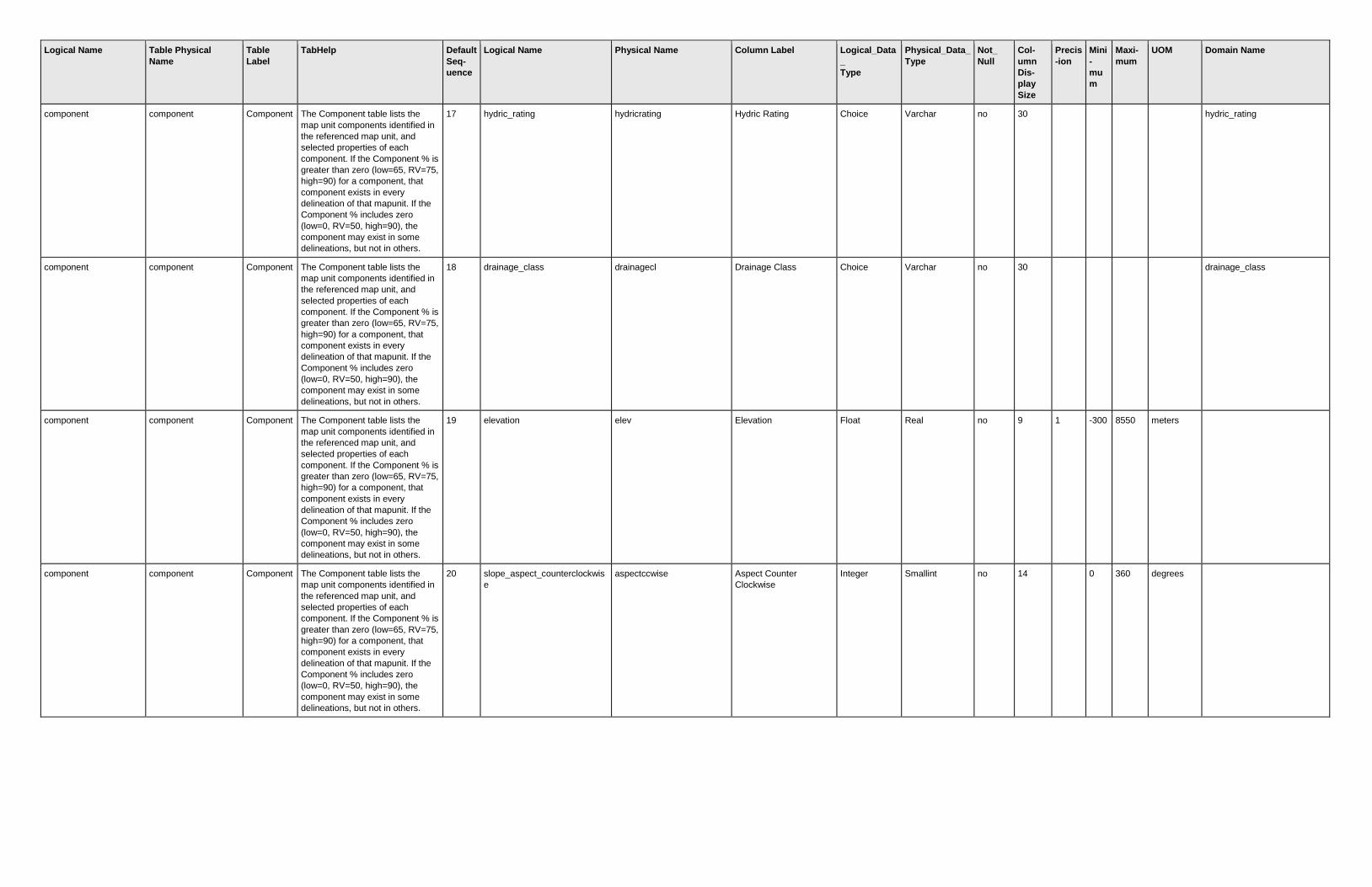
Logical Name Table Physical
Name
Table
Label
TabHelp Default
Seq-
uence
Logical Name Physical Name Column Label Logical_Data
_
Type
Physical_Data_
Type
Not_
Null
Col-
umn
Dis-
play
Size
Precis
-ion
Mini
-
mu
m
Maxi-
mum
UOM Domain Name
component component Component The Component table lists the
map unit components identified in
the referenced map unit, and
selected properties of each
component. If the Component % is
greater than zero (low=65, RV=75,
high=90) for a component, that
component exists in every
delineation of that mapunit. If the
Component % includes zero
(low=0, RV=50, high=90), the
component may exist in some
delineations, but not in others.
17 hydric_rating hydricrating Hydric Rating Choice Varchar no 30
hydric_rating
component component Component The Component table lists the
map unit components identified in
the referenced map unit, and
selected properties of each
component. If the Component % is
greater than zero (low=65, RV=75,
high=90) for a component, that
component exists in every
delineation of that mapunit. If the
Component % includes zero
(low=0, RV=50, high=90), the
component may exist in some
delineations, but not in others.
18 drainage_class drainagecl Drainage Class Choice Varchar no 30
drainage_class
component component Component The Component table lists the
map unit components identified in
the referenced map unit, and
selected properties of each
component. If the Component % is
greater than zero (low=65, RV=75,
high=90) for a component, that
component exists in every
delineation of that mapunit. If the
Component % includes zero
(low=0, RV=50, high=90), the
component may exist in some
delineations, but not in others.
19 elevation elev Elevation Float Real no 9 1 -300 8550 meters
component component Component The Component table lists the
map unit components identified in
the referenced map unit, and
selected properties of each
component. If the Component % is
greater than zero (low=65, RV=75,
high=90) for a component, that
component exists in every
delineation of that mapunit. If the
Component % includes zero
(low=0, RV=50, high=90), the
component may exist in some
delineations, but not in others.
20 slope_aspect_counterclockwis
e
aspectccwise Aspect Counter
Clockwise
Integer Smallint no 14
0 360 degrees

Logical Name Table Physical
Name
Table
Label
TabHelp Default
Seq-
uence
Logical Name Physical Name Column Label Logical_Data
_
Type
Physical_Data_
Type
Not_
Null
Col-
umn
Dis-
play
Size
Precis
-ion
Mini
-
mu
m
Maxi-
mum
UOM Domain Name
component component Component The Component table lists the
map unit components identified in
the referenced map unit, and
selected properties of each
component. If the Component % is
greater than zero (low=65, RV=75,
high=90) for a component, that
component exists in every
delineation of that mapunit. If the
Component % includes zero
(low=0, RV=50, high=90), the
component may exist in some
delineations, but not in others.
21 slope_aspect_representative aspectrep Aspect Representative Integer Smallint no 14
0 360 degrees
component component Component The Component table lists the
map unit components identified in
the referenced map unit, and
selected properties of each
component. If the Component % is
greater than zero (low=65, RV=75,
high=90) for a component, that
component exists in every
delineation of that mapunit. If the
Component % includes zero
(low=0, RV=50, high=90), the
component may exist in some
delineations, but not in others.
22 slope_aspect_clockwise aspectcwise Aspect Clockwise Integer Smallint no 9
0 360 degrees
component component Component The Component table lists the
map unit components identified in
the referenced map unit, and
selected properties of each
component. If the Component % is
greater than zero (low=65, RV=75,
high=90) for a component, that
component exists in every
delineation of that mapunit. If the
Component % includes zero
(low=0, RV=50, high=90), the
component may exist in some
delineations, but not in others.
23 geomorphic_description geomdesc Geomorphic Description Narrative Text Varchar(max) no 11
component component Component The Component table lists the
map unit components identified in
the referenced map unit, and
selected properties of each
component. If the Component % is
greater than zero (low=65, RV=75,
high=90) for a component, that
component exists in every
delineation of that mapunit. If the
Component % includes zero
(low=0, RV=50, high=90), the
component may exist in some
delineations, but not in others.
24 albedo_dry albedodry Albedo Dry Float Real no 10 2 0 1

Logical Name Table Physical
Name
Table
Label
TabHelp Default
Seq-
uence
Logical Name Physical Name Column Label Logical_Data
_
Type
Physical_Data_
Type
Not_
Null
Col-
umn
Dis-
play
Size
Precis
-ion
Mini
-
mu
m
Maxi-
mum
UOM Domain Name
component component Component The Component table lists the
map unit components identified in
the referenced map unit, and
selected properties of each
component. If the Component % is
greater than zero (low=65, RV=75,
high=90) for a component, that
component exists in every
delineation of that mapunit. If the
Component % includes zero
(low=0, RV=50, high=90), the
component may exist in some
delineations, but not in others.
25 mean_annual_air_temperature airtempa MAAT Float Real no 5 1 -50 50 degrees c
component component Component The Component table lists the
map unit components identified in
the referenced map unit, and
selected properties of each
component. If the Component % is
greater than zero (low=65, RV=75,
high=90) for a component, that
component exists in every
delineation of that mapunit. If the
Component % includes zero
(low=0, RV=50, high=90), the
component may exist in some
delineations, but not in others.
26 mean_annual_precipitation map MAP Integer Smallint no 6
0 11500 mm
component component Component The Component table lists the
map unit components identified in
the referenced map unit, and
selected properties of each
component. If the Component % is
greater than zero (low=65, RV=75,
high=90) for a component, that
component exists in every
delineation of that mapunit. If the
Component % includes zero
(low=0, RV=50, high=90), the
component may exist in some
delineations, but not in others.
27 rel_effective_annual_precip reannualprecip REAP Integer Smallint no 6
0 11500 mm
component component Component The Component table lists the
map unit components identified in
the referenced map unit, and
selected properties of each
component. If the Component % is
greater than zero (low=65, RV=75,
high=90) for a component, that
component exists in every
delineation of that mapunit. If the
Component % includes zero
(low=0, RV=50, high=90), the
component may exist in some
delineations, but not in others.
28 mean_annual_frost_free_days ffd Frost Free Days Integer Smallint no 15
0 365 days

Logical Name Table Physical
Name
Table
Label
TabHelp Default
Seq-
uence
Logical Name Physical Name Column Label Logical_Data
_
Type
Physical_Data_
Type
Not_
Null
Col-
umn
Dis-
play
Size
Precis
-ion
Mini
-
mu
m
Maxi-
mum
UOM Domain Name
component component Component The Component table lists the
map unit components identified in
the referenced map unit, and
selected properties of each
component. If the Component % is
greater than zero (low=65, RV=75,
high=90) for a component, that
component exists in every
delineation of that mapunit. If the
Component % includes zero
(low=0, RV=50, high=90), the
component may exist in some
delineations, but not in others.
29 nonirr_capability_class nirrcapcl Nirr LCC Choice Varchar no 30
capability_class
component component Component The Component table lists the
map unit components identified in
the referenced map unit, and
selected properties of each
component. If the Component % is
greater than zero (low=65, RV=75,
high=90) for a component, that
component exists in every
delineation of that mapunit. If the
Component % includes zero
(low=0, RV=50, high=90), the
component may exist in some
delineations, but not in others.
30 nonirr_capability_subclass nirrcapscl Nirr Subcl Choice Varchar no 30
capability_subclass
component component Component The Component table lists the
map unit components identified in
the referenced map unit, and
selected properties of each
component. If the Component % is
greater than zero (low=65, RV=75,
high=90) for a component, that
component exists in every
delineation of that mapunit. If the
Component % includes zero
(low=0, RV=50, high=90), the
component may exist in some
delineations, but not in others.
31 nonirr_capability_unit nirrcapunit Nirr LCU Integer Smallint no 4
1 99
component component Component The Component table lists the
map unit components identified in
the referenced map unit, and
selected properties of each
component. If the Component % is
greater than zero (low=65, RV=75,
high=90) for a component, that
component exists in every
delineation of that mapunit. If the
Component % includes zero
(low=0, RV=50, high=90), the
component may exist in some
delineations, but not in others.
32 irrigated_capability_class irrcapcl Irr LCC Choice Varchar no 30
capability_class

Logical Name Table Physical
Name
Table
Label
TabHelp Default
Seq-
uence
Logical Name Physical Name Column Label Logical_Data
_
Type
Physical_Data_
Type
Not_
Null
Col-
umn
Dis-
play
Size
Precis
-ion
Mini
-
mu
m
Maxi-
mum
UOM Domain Name
component component Component The Component table lists the
map unit components identified in
the referenced map unit, and
selected properties of each
component. If the Component % is
greater than zero (low=65, RV=75,
high=90) for a component, that
component exists in every
delineation of that mapunit. If the
Component % includes zero
(low=0, RV=50, high=90), the
component may exist in some
delineations, but not in others.
33 irrigated_capability_subclass irrcapscl Irr Subcl Choice Varchar no 30
capability_subclass
component component Component The Component table lists the
map unit components identified in
the referenced map unit, and
selected properties of each
component. If the Component % is
greater than zero (low=65, RV=75,
high=90) for a component, that
component exists in every
delineation of that mapunit. If the
Component % includes zero
(low=0, RV=50, high=90), the
component may exist in some
delineations, but not in others.
34 irrigated_capability_unit irrcapunit Irr LCU Integer Smallint no 3
1 99
component component Component The Component table lists the
map unit components identified in
the referenced map unit, and
selected properties of each
component. If the Component % is
greater than zero (low=65, RV=75,
high=90) for a component, that
component exists in every
delineation of that mapunit. If the
Component % includes zero
(low=0, RV=50, high=90), the
component may exist in some
delineations, but not in others.
35 crop_productivity_index cropprodindex Prod Index Integer Smallint no 5
0 100
component component Component The Component table lists the
map unit components identified in
the referenced map unit, and
selected properties of each
component. If the Component % is
greater than zero (low=65, RV=75,
high=90) for a component, that
component exists in every
delineation of that mapunit. If the
Component % includes zero
(low=0, RV=50, high=90), the
component may exist in some
delineations, but not in others.
36 conservation_tree_shrub_grou
p
constreeshrubgrp Cons Tree Shrub Group Choice Varchar no 30
conservation_tree_shrub_gro
up

Logical Name Table Physical
Name
Table
Label
TabHelp Default
Seq-
uence
Logical Name Physical Name Column Label Logical_Data
_
Type
Physical_Data_
Type
Not_
Null
Col-
umn
Dis-
play
Size
Precis
-ion
Mini
-
mu
m
Maxi-
mum
UOM Domain Name
component component Component The Component table lists the
map unit components identified in
the referenced map unit, and
selected properties of each
component. If the Component % is
greater than zero (low=65, RV=75,
high=90) for a component, that
component exists in every
delineation of that mapunit. If the
Component % includes zero
(low=0, RV=50, high=90), the
component may exist in some
delineations, but not in others.
37 windbreak_suitability_group wndbrksuitgrp Windbreak Suitability
(Obsolete)
Choice Varchar no 30
windbreak_suitability_group
component component Component The Component table lists the
map unit components identified in
the referenced map unit, and
selected properties of each
component. If the Component % is
greater than zero (low=65, RV=75,
high=90) for a component, that
component exists in every
delineation of that mapunit. If the
Component % includes zero
(low=0, RV=50, high=90), the
component may exist in some
delineations, but not in others.
38 range_production rsprod Range Prod Integer Int no 10
0 20000 lbs/acre/yr
component component Component The Component table lists the
map unit components identified in
the referenced map unit, and
selected properties of each
component. If the Component % is
greater than zero (low=65, RV=75,
high=90) for a component, that
component exists in every
delineation of that mapunit. If the
Component % includes zero
(low=0, RV=50, high=90), the
component may exist in some
delineations, but not in others.
39 forage_suitability_grp_id foragesuitgrpid Forage Suitability Group
ID
String Varchar no 18
component component Component The Component table lists the
map unit components identified in
the referenced map unit, and
selected properties of each
component. If the Component % is
greater than zero (low=65, RV=75,
high=90) for a component, that
component exists in every
delineation of that mapunit. If the
Component % includes zero
(low=0, RV=50, high=90), the
component may exist in some
delineations, but not in others.
40 wildlife_habitat_grain wlgrain Grain Habitat Choice Varchar no 30
wildlife_rating

Logical Name Table Physical
Name
Table
Label
TabHelp Default
Seq-
uence
Logical Name Physical Name Column Label Logical_Data
_
Type
Physical_Data_
Type
Not_
Null
Col-
umn
Dis-
play
Size
Precis
-ion
Mini
-
mu
m
Maxi-
mum
UOM Domain Name
component component Component The Component table lists the
map unit components identified in
the referenced map unit, and
selected properties of each
component. If the Component % is
greater than zero (low=65, RV=75,
high=90) for a component, that
component exists in every
delineation of that mapunit. If the
Component % includes zero
(low=0, RV=50, high=90), the
component may exist in some
delineations, but not in others.
41 wildlife_habitat_grass wlgrass Grass Habitat Choice Varchar no 30
wildlife_rating
component component Component The Component table lists the
map unit components identified in
the referenced map unit, and
selected properties of each
component. If the Component % is
greater than zero (low=65, RV=75,
high=90) for a component, that
component exists in every
delineation of that mapunit. If the
Component % includes zero
(low=0, RV=50, high=90), the
component may exist in some
delineations, but not in others.
42 wildlife_habitat_herbaceous wlherbaceous Herbaceous Habitat Choice Varchar no 30
wildlife_rating
component component Component The Component table lists the
map unit components identified in
the referenced map unit, and
selected properties of each
component. If the Component % is
greater than zero (low=65, RV=75,
high=90) for a component, that
component exists in every
delineation of that mapunit. If the
Component % includes zero
(low=0, RV=50, high=90), the
component may exist in some
delineations, but not in others.
43 wildlife_habitat_shrub wlshrub Shrub Habitat Choice Varchar no 30
wildlife_rating
component component Component The Component table lists the
map unit components identified in
the referenced map unit, and
selected properties of each
component. If the Component % is
greater than zero (low=65, RV=75,
high=90) for a component, that
component exists in every
delineation of that mapunit. If the
Component % includes zero
(low=0, RV=50, high=90), the
component may exist in some
delineations, but not in others.
44 wildlife_habitat_coniferous wlconiferous Conifer Habitat Choice Varchar no 30
wildlife_rating

Logical Name Table Physical
Name
Table
Label
TabHelp Default
Seq-
uence
Logical Name Physical Name Column Label Logical_Data
_
Type
Physical_Data_
Type
Not_
Null
Col-
umn
Dis-
play
Size
Precis
-ion
Mini
-
mu
m
Maxi-
mum
UOM Domain Name
component component Component The Component table lists the
map unit components identified in
the referenced map unit, and
selected properties of each
component. If the Component % is
greater than zero (low=65, RV=75,
high=90) for a component, that
component exists in every
delineation of that mapunit. If the
Component % includes zero
(low=0, RV=50, high=90), the
component may exist in some
delineations, but not in others.
45 wildlife_habitat_hardwood wlhardwood Hardwood Habitat Choice Varchar no 30
wildlife_rating
component component Component The Component table lists the
map unit components identified in
the referenced map unit, and
selected properties of each
component. If the Component % is
greater than zero (low=65, RV=75,
high=90) for a component, that
component exists in every
delineation of that mapunit. If the
Component % includes zero
(low=0, RV=50, high=90), the
component may exist in some
delineations, but not in others.
46 wildlife_habitat_wetland_plant wlwetplant Wetland Habitat Choice Varchar no 30
wildlife_rating
component component Component The Component table lists the
map unit components identified in
the referenced map unit, and
selected properties of each
component. If the Component % is
greater than zero (low=65, RV=75,
high=90) for a component, that
component exists in every
delineation of that mapunit. If the
Component % includes zero
(low=0, RV=50, high=90), the
component may exist in some
delineations, but not in others.
47 wildlife_habitat_shallow_water wlshallowwat Water Habitat Choice Varchar no 30
wildlife_rating
component component Component The Component table lists the
map unit components identified in
the referenced map unit, and
selected properties of each
component. If the Component % is
greater than zero (low=65, RV=75,
high=90) for a component, that
component exists in every
delineation of that mapunit. If the
Component % includes zero
(low=0, RV=50, high=90), the
component may exist in some
delineations, but not in others.
48 wildlife_habitat_rangeland wlrangeland Rangeland Wildlife Choice Varchar no 30
wildlife_rating

Logical Name Table Physical
Name
Table
Label
TabHelp Default
Seq-
uence
Logical Name Physical Name Column Label Logical_Data
_
Type
Physical_Data_
Type
Not_
Null
Col-
umn
Dis-
play
Size
Precis
-ion
Mini
-
mu
m
Maxi-
mum
UOM Domain Name
component component Component The Component table lists the
map unit components identified in
the referenced map unit, and
selected properties of each
component. If the Component % is
greater than zero (low=65, RV=75,
high=90) for a component, that
component exists in every
delineation of that mapunit. If the
Component % includes zero
(low=0, RV=50, high=90), the
component may exist in some
delineations, but not in others.
49 wildlife_habitat_openland wlopenland Openland Wildlife Choice Varchar no 30
wildlife_rating
component component Component The Component table lists the
map unit components identified in
the referenced map unit, and
selected properties of each
component. If the Component % is
greater than zero (low=65, RV=75,
high=90) for a component, that
component exists in every
delineation of that mapunit. If the
Component % includes zero
(low=0, RV=50, high=90), the
component may exist in some
delineations, but not in others.
50 wildlife_habitat_woodland wlwoodland Woodland Wildlife Choice Varchar no 30
wildlife_rating
component component Component The Component table lists the
map unit components identified in
the referenced map unit, and
selected properties of each
component. If the Component % is
greater than zero (low=65, RV=75,
high=90) for a component, that
component exists in every
delineation of that mapunit. If the
Component % includes zero
(low=0, RV=50, high=90), the
component may exist in some
delineations, but not in others.
51 wildlife_habitat_wetland wlwetland Wetland Wildlife Choice Varchar no 30
wildlife_rating
component component Component The Component table lists the
map unit components identified in
the referenced map unit, and
selected properties of each
component. If the Component % is
greater than zero (low=65, RV=75,
high=90) for a component, that
component exists in every
delineation of that mapunit. If the
Component % includes zero
(low=0, RV=50, high=90), the
component may exist in some
delineations, but not in others.
52 soil_slippage_potential soilslippot Soil Slip Pot Choice Varchar no 30
soil_slippage_potential

Logical Name Table Physical
Name
Table
Label
TabHelp Default
Seq-
uence
Logical Name Physical Name Column Label Logical_Data
_
Type
Physical_Data_
Type
Not_
Null
Col-
umn
Dis-
play
Size
Precis
-ion
Mini
-
mu
m
Maxi-
mum
UOM Domain Name
component component Component The Component table lists the
map unit components identified in
the referenced map unit, and
selected properties of each
component. If the Component % is
greater than zero (low=65, RV=75,
high=90) for a component, that
component exists in every
delineation of that mapunit. If the
Component % includes zero
(low=0, RV=50, high=90), the
component may exist in some
delineations, but not in others.
53 potential_frost_action frostact Frost Action Choice Varchar no 30
potential_frost_action
component component Component The Component table lists the
map unit components identified in
the referenced map unit, and
selected properties of each
component. If the Component % is
greater than zero (low=65, RV=75,
high=90) for a component, that
component exists in every
delineation of that mapunit. If the
Component % includes zero
(low=0, RV=50, high=90), the
component may exist in some
delineations, but not in others.
54 initial_subsidence initsub Init Subsid Integer Smallint no 11
0 999 cm
component component Component The Component table lists the
map unit components identified in
the referenced map unit, and
selected properties of each
component. If the Component % is
greater than zero (low=65, RV=75,
high=90) for a component, that
component exists in every
delineation of that mapunit. If the
Component % includes zero
(low=0, RV=50, high=90), the
component may exist in some
delineations, but not in others.
55 total_subsidence totalsub Total Subsid Integer Smallint no 12
0 999 cm
component component Component The Component table lists the
map unit components identified in
the referenced map unit, and
selected properties of each
component. If the Component % is
greater than zero (low=65, RV=75,
high=90) for a component, that
component exists in every
delineation of that mapunit. If the
Component % includes zero
(low=0, RV=50, high=90), the
component may exist in some
delineations, but not in others.
56 hydrologic_group hydgrp Hydrologic Group Choice Varchar no 30
hydrologic_group

Logical Name Table Physical
Name
Table
Label
TabHelp Default
Seq-
uence
Logical Name Physical Name Column Label Logical_Data
_
Type
Physical_Data_
Type
Not_
Null
Col-
umn
Dis-
play
Size
Precis
-ion
Mini
-
mu
m
Maxi-
mum
UOM Domain Name
component component Component The Component table lists the
map unit components identified in
the referenced map unit, and
selected properties of each
component. If the Component % is
greater than zero (low=65, RV=75,
high=90) for a component, that
component exists in every
delineation of that mapunit. If the
Component % includes zero
(low=0, RV=50, high=90), the
component may exist in some
delineations, but not in others.
57 corrosion_concrete corcon Corrosion Concrete Choice Varchar no 30
corrosion_concrete
component component Component The Component table lists the
map unit components identified in
the referenced map unit, and
selected properties of each
component. If the Component % is
greater than zero (low=65, RV=75,
high=90) for a component, that
component exists in every
delineation of that mapunit. If the
Component % includes zero
(low=0, RV=50, high=90), the
component may exist in some
delineations, but not in others.
58 corrosion_uncoated_steel corsteel Corrosion Steel Choice Varchar no 30
corrosion_uncoated_steel
component component Component The Component table lists the
map unit components identified in
the referenced map unit, and
selected properties of each
component. If the Component % is
greater than zero (low=65, RV=75,
high=90) for a component, that
component exists in every
delineation of that mapunit. If the
Component % includes zero
(low=0, RV=50, high=90), the
component may exist in some
delineations, but not in others.
59 taxonomic_classification_name taxclname Taxonomic Class String Varchar no 30
component component Component The Component table lists the
map unit components identified in
the referenced map unit, and
selected properties of each
component. If the Component % is
greater than zero (low=65, RV=75,
high=90) for a component, that
component exists in every
delineation of that mapunit. If the
Component % includes zero
(low=0, RV=50, high=90), the
component may exist in some
delineations, but not in others.
60 taxonomic_order taxorder Order Choice Varchar no 30
taxonomic_order
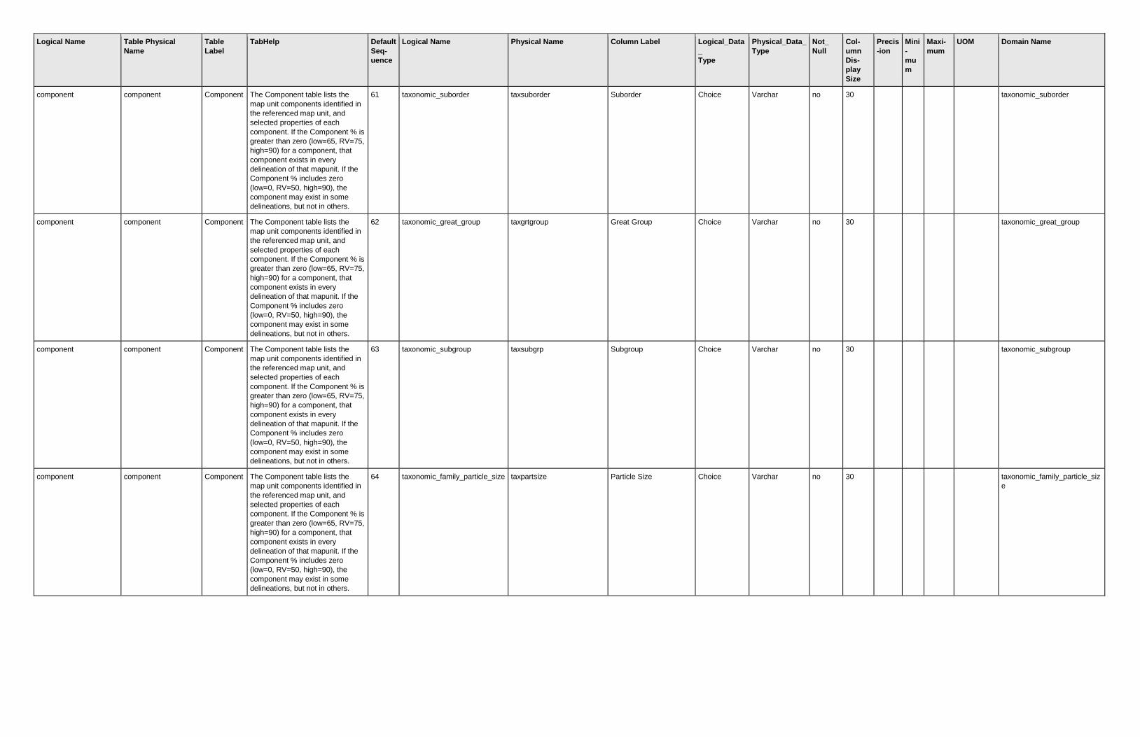
Logical Name Table Physical
Name
Table
Label
TabHelp Default
Seq-
uence
Logical Name Physical Name Column Label Logical_Data
_
Type
Physical_Data_
Type
Not_
Null
Col-
umn
Dis-
play
Size
Precis
-ion
Mini
-
mu
m
Maxi-
mum
UOM Domain Name
component component Component The Component table lists the
map unit components identified in
the referenced map unit, and
selected properties of each
component. If the Component % is
greater than zero (low=65, RV=75,
high=90) for a component, that
component exists in every
delineation of that mapunit. If the
Component % includes zero
(low=0, RV=50, high=90), the
component may exist in some
delineations, but not in others.
61 taxonomic_suborder taxsuborder Suborder Choice Varchar no 30
taxonomic_suborder
component component Component The Component table lists the
map unit components identified in
the referenced map unit, and
selected properties of each
component. If the Component % is
greater than zero (low=65, RV=75,
high=90) for a component, that
component exists in every
delineation of that mapunit. If the
Component % includes zero
(low=0, RV=50, high=90), the
component may exist in some
delineations, but not in others.
62 taxonomic_great_group taxgrtgroup Great Group Choice Varchar no 30
taxonomic_great_group
component component Component The Component table lists the
map unit components identified in
the referenced map unit, and
selected properties of each
component. If the Component % is
greater than zero (low=65, RV=75,
high=90) for a component, that
component exists in every
delineation of that mapunit. If the
Component % includes zero
(low=0, RV=50, high=90), the
component may exist in some
delineations, but not in others.
63 taxonomic_subgroup taxsubgrp Subgroup Choice Varchar no 30
taxonomic_subgroup
component component Component The Component table lists the
map unit components identified in
the referenced map unit, and
selected properties of each
component. If the Component % is
greater than zero (low=65, RV=75,
high=90) for a component, that
component exists in every
delineation of that mapunit. If the
Component % includes zero
(low=0, RV=50, high=90), the
component may exist in some
delineations, but not in others.
64 taxonomic_family_particle_size taxpartsize Particle Size Choice Varchar no 30
taxonomic_family_particle_siz
e

Logical Name Table Physical
Name
Table
Label
TabHelp Default
Seq-
uence
Logical Name Physical Name Column Label Logical_Data
_
Type
Physical_Data_
Type
Not_
Null
Col-
umn
Dis-
play
Size
Precis
-ion
Mini
-
mu
m
Maxi-
mum
UOM Domain Name
component component Component The Component table lists the
map unit components identified in
the referenced map unit, and
selected properties of each
component. If the Component % is
greater than zero (low=65, RV=75,
high=90) for a component, that
component exists in every
delineation of that mapunit. If the
Component % includes zero
(low=0, RV=50, high=90), the
component may exist in some
delineations, but not in others.
65 taxonomic_family_part_size_m
od
taxpartsizemod Particle Size Mod Choice Varchar no 30
taxonomic_family_part_size_
mod
component component Component The Component table lists the
map unit components identified in
the referenced map unit, and
selected properties of each
component. If the Component % is
greater than zero (low=65, RV=75,
high=90) for a component, that
component exists in every
delineation of that mapunit. If the
Component % includes zero
(low=0, RV=50, high=90), the
component may exist in some
delineations, but not in others.
66 taxonomic_family_c_e_act_cla
ss
taxceactcl CEC Activity Cl Choice Varchar no 30
taxonomic_family_c_e_act_cl
ass
component component Component The Component table lists the
map unit components identified in
the referenced map unit, and
selected properties of each
component. If the Component % is
greater than zero (low=65, RV=75,
high=90) for a component, that
component exists in every
delineation of that mapunit. If the
Component % includes zero
(low=0, RV=50, high=90), the
component may exist in some
delineations, but not in others.
67 taxonomic_family_reaction taxreaction Reaction Choice Varchar no 30
taxonomic_family_reaction
component component Component The Component table lists the
map unit components identified in
the referenced map unit, and
selected properties of each
component. If the Component % is
greater than zero (low=65, RV=75,
high=90) for a component, that
component exists in every
delineation of that mapunit. If the
Component % includes zero
(low=0, RV=50, high=90), the
component may exist in some
delineations, but not in others.
68 taxonomic_family_temp_class taxtempcl Temp Class Choice Varchar no 30
taxonomic_family_temp_class

Logical Name Table Physical
Name
Table
Label
TabHelp Default
Seq-
uence
Logical Name Physical Name Column Label Logical_Data
_
Type
Physical_Data_
Type
Not_
Null
Col-
umn
Dis-
play
Size
Precis
-ion
Mini
-
mu
m
Maxi-
mum
UOM Domain Name
component component Component The Component table lists the
map unit components identified in
the referenced map unit, and
selected properties of each
component. If the Component % is
greater than zero (low=65, RV=75,
high=90) for a component, that
component exists in every
delineation of that mapunit. If the
Component % includes zero
(low=0, RV=50, high=90), the
component may exist in some
delineations, but not in others.
69 taxonomic_moisture_subclass taxmoistscl Moist Subclass Choice Varchar no 30
taxonomic_moisture_subclass
component component Component The Component table lists the
map unit components identified in
the referenced map unit, and
selected properties of each
component. If the Component % is
greater than zero (low=65, RV=75,
high=90) for a component, that
component exists in every
delineation of that mapunit. If the
Component % includes zero
(low=0, RV=50, high=90), the
component may exist in some
delineations, but not in others.
70 taxonomic_temp_regime taxtempregime Temp Regime Choice Varchar no 30
taxonomic_temp_regime
component component Component The Component table lists the
map unit components identified in
the referenced map unit, and
selected properties of each
component. If the Component % is
greater than zero (low=65, RV=75,
high=90) for a component, that
component exists in every
delineation of that mapunit. If the
Component % includes zero
(low=0, RV=50, high=90), the
component may exist in some
delineations, but not in others.
71 soil_taxonomy_edition soiltaxedition Keys to Taxonomy
Edition Used
Choice Varchar no 30
soil_taxonomy_edition
component component Component The Component table lists the
map unit components identified in
the referenced map unit, and
selected properties of each
component. If the Component % is
greater than zero (low=65, RV=75,
high=90) for a component, that
component exists in every
delineation of that mapunit. If the
Component % includes zero
(low=0, RV=50, high=90), the
component may exist in some
delineations, but not in others.
72 ca_storie_index castorieindex CA Storie Index Integer Smallint no 9
0 100

Logical Name Table Physical
Name
Table
Label
TabHelp Default
Seq-
uence
Logical Name Physical Name Column Label Logical_Data
_
Type
Physical_Data_
Type
Not_
Null
Col-
umn
Dis-
play
Size
Precis
-ion
Mini
-
mu
m
Maxi-
mum
UOM Domain Name
component component Component The Component table lists the
map unit components identified in
the referenced map unit, and
selected properties of each
component. If the Component % is
greater than zero (low=65, RV=75,
high=90) for a component, that
component exists in every
delineation of that mapunit. If the
Component % includes zero
(low=0, RV=50, high=90), the
component may exist in some
delineations, but not in others.
73 fl_ecological_community_num
ber
flecolcomnum FL Ecol Comm # String Varchar no 7
component component Component The Component table lists the
map unit components identified in
the referenced map unit, and
selected properties of each
component. If the Component % is
greater than zero (low=65, RV=75,
high=90) for a component, that
component exists in every
delineation of that mapunit. If the
Component % includes zero
(low=0, RV=50, high=90), the
component may exist in some
delineations, but not in others.
74 fl_highly_erodible flhe FL HE Choice Char no 3
yes_no_n.a.
component component Component The Component table lists the
map unit components identified in
the referenced map unit, and
selected properties of each
component. If the Component % is
greater than zero (low=65, RV=75,
high=90) for a component, that
component exists in every
delineation of that mapunit. If the
Component % includes zero
(low=0, RV=50, high=90), the
component may exist in some
delineations, but not in others.
75 fl_potentially_highly_erodible flphe FL PHE Choice Char no 3
yes_no_n.a.
component component Component The Component table lists the
map unit components identified in
the referenced map unit, and
selected properties of each
component. If the Component % is
greater than zero (low=65, RV=75,
high=90) for a component, that
component exists in every
delineation of that mapunit. If the
Component % includes zero
(low=0, RV=50, high=90), the
component may exist in some
delineations, but not in others.
76 fl_soil_leaching_potential flsoilleachpot FL Leach Pot Choice Varchar no 30
fl_soil_leaching_potential

Logical Name Table Physical
Name
Table
Label
TabHelp Default
Seq-
uence
Logical Name Physical Name Column Label Logical_Data
_
Type
Physical_Data_
Type
Not_
Null
Col-
umn
Dis-
play
Size
Precis
-ion
Mini
-
mu
m
Maxi-
mum
UOM Domain Name
component component Component The Component table lists the
map unit components identified in
the referenced map unit, and
selected properties of each
component. If the Component % is
greater than zero (low=65, RV=75,
high=90) for a component, that
component exists in every
delineation of that mapunit. If the
Component % includes zero
(low=0, RV=50, high=90), the
component may exist in some
delineations, but not in others.
77 fl_soil_runoff_potential flsoirunoffpot FL Runoff Pot Choice Varchar no 30
fl_soil_runoff_potential
component component Component The Component table lists the
map unit components identified in
the referenced map unit, and
selected properties of each
component. If the Component % is
greater than zero (low=65, RV=75,
high=90) for a component, that
component exists in every
delineation of that mapunit. If the
Component % includes zero
(low=0, RV=50, high=90), the
component may exist in some
delineations, but not in others.
78 fl_temik_2_use fltemik2use FL Temik Choice Char no 5
yes_no_n.a.
component component Component The Component table lists the
map unit components identified in
the referenced map unit, and
selected properties of each
component. If the Component % is
greater than zero (low=65, RV=75,
high=90) for a component, that
component exists in every
delineation of that mapunit. If the
Component % includes zero
(low=0, RV=50, high=90), the
component may exist in some
delineations, but not in others.
79 fl_triumph_2_use fltriumph2use FL Triumph Choice Char no 7
yes_no_n.a.
component component Component The Component table lists the
map unit components identified in
the referenced map unit, and
selected properties of each
component. If the Component % is
greater than zero (low=65, RV=75,
high=90) for a component, that
component exists in every
delineation of that mapunit. If the
Component % includes zero
(low=0, RV=50, high=90), the
component may exist in some
delineations, but not in others.
80 in_drainage_group indraingrp IN Drainage Grp String Char no 11

Logical Name Table Physical
Name
Table
Label
TabHelp Default
Seq-
uence
Logical Name Physical Name Column Label Logical_Data
_
Type
Physical_Data_
Type
Not_
Null
Col-
umn
Dis-
play
Size
Precis
-ion
Mini
-
mu
m
Maxi-
mum
UOM Domain Name
component component Component The Component table lists the
map unit components identified in
the referenced map unit, and
selected properties of each
component. If the Component % is
greater than zero (low=65, RV=75,
high=90) for a component, that
component exists in every
delineation of that mapunit. If the
Component % includes zero
(low=0, RV=50, high=90), the
component may exist in some
delineations, but not in others.
81 in_nitrate_leaching_index innitrateleachi IN NO3 Leach Index Integer Smallint no 11
0 99
component component Component The Component table lists the
map unit components identified in
the referenced map unit, and
selected properties of each
component. If the Component % is
greater than zero (low=65, RV=75,
high=90) for a component, that
component exists in every
delineation of that mapunit. If the
Component % includes zero
(low=0, RV=50, high=90), the
component may exist in some
delineations, but not in others.
82 mi_soil_management_group misoimgmtgrp MI Soil Mgmt Grp Choice Varchar no 30
mi_soil_management_group
component component Component The Component table lists the
map unit components identified in
the referenced map unit, and
selected properties of each
component. If the Component % is
greater than zero (low=65, RV=75,
high=90) for a component, that
component exists in every
delineation of that mapunit. If the
Component % includes zero
(low=0, RV=50, high=90), the
component may exist in some
delineations, but not in others.
83 va_soil_management_group vasoimgtgrp VA Soil Mgmt Grp Choice Varchar no 30
va_soil_management_group
component component Component The Component table lists the
map unit components identified in
the referenced map unit, and
selected properties of each
component. If the Component % is
greater than zero (low=65, RV=75,
high=90) for a component, that
component exists in every
delineation of that mapunit. If the
Component % includes zero
(low=0, RV=50, high=90), the
component may exist in some
delineations, but not in others.
84 mapunit_key mukey Mapunit Key Integer Int yes 30

Logical Name Table Physical
Name
Table
Label
TabHelp Default
Seq-
uence
Logical Name Physical Name Column Label Logical_Data
_
Type
Physical_Data_
Type
Not_
Null
Col-
umn
Dis-
play
Size
Precis
-ion
Mini
-
mu
m
Maxi-
mum
UOM Domain Name
component component Component The Component table lists the
map unit components identified in
the referenced map unit, and
selected properties of each
component. If the Component % is
greater than zero (low=65, RV=75,
high=90) for a component, that
component exists in every
delineation of that mapunit. If the
Component % includes zero
(low=0, RV=50, high=90), the
component may exist in some
delineations, but not in others.
85 component_key cokey Component Key Integer Int yes 30
component_parent_mat
erial
copm Component
Parent
Material
The Component Parent Material
table lists the individual parent
material(s) for the referenced map
unit component. In some cases
where soils developed in multiple
materials in a vertical sequence,
that sequence will be noted. In
other cases multiple entries with
no vertical sequence noted
indicates the soil may have formed
in one of the materials listed.
1 parent_material_order pmorder Vertical Order Integer Smallint no 8
1
component_parent_mat
erial
copm Component
Parent
Material
The Component Parent Material
table lists the individual parent
material(s) for the referenced map
unit component. In some cases
where soils developed in multiple
materials in a vertical sequence,
that sequence will be noted. In
other cases multiple entries with
no vertical sequence noted
indicates the soil may have formed
in one of the materials listed.
2 parent_material_modifier pmmodifier Textural Modifier Choice Varchar no 30
parent_material_modifier
component_parent_mat
erial
copm Component
Parent
Material
The Component Parent Material
table lists the individual parent
material(s) for the referenced map
unit component. In some cases
where soils developed in multiple
materials in a vertical sequence,
that sequence will be noted. In
other cases multiple entries with
no vertical sequence noted
indicates the soil may have formed
in one of the materials listed.
3 parent_material_general_mod pmgenmod General Modifier String Varchar no 30
component_parent_mat
erial
copm Component
Parent
Material
The Component Parent Material
table lists the individual parent
material(s) for the referenced map
unit component. In some cases
where soils developed in multiple
materials in a vertical sequence,
that sequence will be noted. In
other cases multiple entries with
no vertical sequence noted
indicates the soil may have formed
in one of the materials listed.
4 parent_material_kind pmkind Kind Choice Varchar no 30
parent_material_kind

Logical Name Table Physical
Name
Table
Label
TabHelp Default
Seq-
uence
Logical Name Physical Name Column Label Logical_Data
_
Type
Physical_Data_
Type
Not_
Null
Col-
umn
Dis-
play
Size
Precis
-ion
Mini
-
mu
m
Maxi-
mum
UOM Domain Name
component_parent_mat
erial
copm Component
Parent
Material
The Component Parent Material
table lists the individual parent
material(s) for the referenced map
unit component. In some cases
where soils developed in multiple
materials in a vertical sequence,
that sequence will be noted. In
other cases multiple entries with
no vertical sequence noted
indicates the soil may have formed
in one of the materials listed.
5 parent_material_origin pmorigin Origin Choice Varchar no 30
parent_material_origin
component_parent_mat
erial
copm Component
Parent
Material
The Component Parent Material
table lists the individual parent
material(s) for the referenced map
unit component. In some cases
where soils developed in multiple
materials in a vertical sequence,
that sequence will be noted. In
other cases multiple entries with
no vertical sequence noted
indicates the soil may have formed
in one of the materials listed.
6 comp_parent_mat_grp_key copmgrpkey Component Parent
Material Group Key
Integer Int yes 30
component_parent_mat
erial
copm Component
Parent
Material
The Component Parent Material
table lists the individual parent
material(s) for the referenced map
unit component. In some cases
where soils developed in multiple
materials in a vertical sequence,
that sequence will be noted. In
other cases multiple entries with
no vertical sequence noted
indicates the soil may have formed
in one of the materials listed.
7 comp_parent_material_key copmkey Component Parent
Material Key
Integer Int yes 30
component_parent_mat
erial_grp
copmgrp Component
Parent
Material
Group
The Component Parent Material
Group table lists the concatenated
string of parent material(s) in
which the referenced map unit
component formed based on
entries in the Component Parent
Material table. For example, a
component formed in one parent
material, such as loess, or one
vertical sequence of parent
materials, such as loamy glacial
drift over silty residuum weathered
from shale, has one row in this
table. A component formed in one
parent material in some locations,
but another parent material (or
sequence of parent materials) in
other locations has two rows in
this table, one for each parent
material (or sequence of parent
materials). One row is identified as
the representative parent material.
1 parent_material_group_name pmgroupname Group Name String Varchar no 30

Logical Name Table Physical
Name
Table
Label
TabHelp Default
Seq-
uence
Logical Name Physical Name Column Label Logical_Data
_
Type
Physical_Data_
Type
Not_
Null
Col-
umn
Dis-
play
Size
Precis
-ion
Mini
-
mu
m
Maxi-
mum
UOM Domain Name
component_parent_mat
erial_grp
copmgrp Component
Parent
Material
Group
The Component Parent Material
Group table lists the concatenated
string of parent material(s) in
which the referenced map unit
component formed based on
entries in the Component Parent
Material table. For example, a
component formed in one parent
material, such as loess, or one
vertical sequence of parent
materials, such as loamy glacial
drift over silty residuum weathered
from shale, has one row in this
table. A component formed in one
parent material in some locations,
but another parent material (or
sequence of parent materials) in
other locations has two rows in
this table, one for each parent
material (or sequence of parent
materials). One row is identified as
the representative parent material.
2 rv_indicator rvindicator RV? Boolean Char yes 3
component_parent_mat
erial_grp
copmgrp Component
Parent
Material
Group
The Component Parent Material
Group table lists the concatenated
string of parent material(s) in
which the referenced map unit
component formed based on
entries in the Component Parent
Material table. For example, a
component formed in one parent
material, such as loess, or one
vertical sequence of parent
materials, such as loamy glacial
drift over silty residuum weathered
from shale, has one row in this
table. A component formed in one
parent material in some locations,
but another parent material (or
sequence of parent materials) in
other locations has two rows in
this table, one for each parent
material (or sequence of parent
materials). One row is identified as
the representative parent material.
3 component_key cokey Component Key Integer Int yes 30

Logical Name Table Physical
Name
Table
Label
TabHelp Default
Seq-
uence
Logical Name Physical Name Column Label Logical_Data
_
Type
Physical_Data_
Type
Not_
Null
Col-
umn
Dis-
play
Size
Precis
-ion
Mini
-
mu
m
Maxi-
mum
UOM Domain Name
component_parent_mat
erial_grp
copmgrp Component
Parent
Material
Group
The Component Parent Material
Group table lists the concatenated
string of parent material(s) in
which the referenced map unit
component formed based on
entries in the Component Parent
Material table. For example, a
component formed in one parent
material, such as loess, or one
vertical sequence of parent
materials, such as loamy glacial
drift over silty residuum weathered
from shale, has one row in this
table. A component formed in one
parent material in some locations,
but another parent material (or
sequence of parent materials) in
other locations has two rows in
this table, one for each parent
material (or sequence of parent
materials). One row is identified as
the representative parent material.
4 comp_parent_mat_grp_key copmgrpkey Component Parent
Material Group Key
Integer Int yes 30
component_potential_wi
ndbreak
copwindbreak Component
Potential
Windbreak
The Component Potential
Windbreak table lists the
windbreak plant species
commonly recommended for the
referenced map unit component. A
windbreak plant listed in this table
may be used alone or in
combination with other plants.
1 windbreak_tree_height wndbrkht Height Float Real no 6 1 0.1 35 meters
component_potential_wi
ndbreak
copwindbreak Component
Potential
Windbreak
The Component Potential
Windbreak table lists the
windbreak plant species
commonly recommended for the
referenced map unit component. A
windbreak plant listed in this table
may be used alone or in
combination with other plants.
2 plant_symbol plantsym Plant Symbol String Varchar yes 8
component_potential_wi
ndbreak
copwindbreak Component
Potential
Windbreak
The Component Potential
Windbreak table lists the
windbreak plant species
commonly recommended for the
referenced map unit component. A
windbreak plant listed in this table
may be used alone or in
combination with other plants.
3 plant_scientific_name plantsciname Scientific Name String Varchar no 30
component_potential_wi
ndbreak
copwindbreak Component
Potential
Windbreak
The Component Potential
Windbreak table lists the
windbreak plant species
commonly recommended for the
referenced map unit component. A
windbreak plant listed in this table
may be used alone or in
combination with other plants.
4 plant_common_name plantcomname Common Name String Varchar no 30
component_potential_wi
ndbreak
copwindbreak Component
Potential
Windbreak
The Component Potential
Windbreak table lists the
windbreak plant species
commonly recommended for the
referenced map unit component. A
windbreak plant listed in this table
may be used alone or in
combination with other plants.
5 component_key cokey Component Key Integer Int yes 30

Logical Name Table Physical
Name
Table
Label
TabHelp Default
Seq-
uence
Logical Name Physical Name Column Label Logical_Data
_
Type
Physical_Data_
Type
Not_
Null
Col-
umn
Dis-
play
Size
Precis
-ion
Mini
-
mu
m
Maxi-
mum
UOM Domain Name
component_potential_wi
ndbreak
copwindbreak Component
Potential
Windbreak
The Component Potential
Windbreak table lists the
windbreak plant species
commonly recommended for the
referenced map unit component. A
windbreak plant listed in this table
may be used alone or in
combination with other plants.
6 comp_potential_windbreak_ke
y
copwindbreakkey Component Potential
Windbreak Key
Integer Int yes 30
component_restrictions corestrictions Component
Restrictions
The Component Restrictions table
lists the root restrictive feature(s)
or layer(s) for the referenced map
unit component. If the thickness of
the restrictive layer is greater than
zero (low=5, RV=8, high=10), the
restrictive layer exists in all
delineations of the map unit where
the component occurs. If the
thickness of the restrictive layer
includes zero (low=0, RV=2,
high=5), the restrictive layer may
exist in some delineations, but not
in others. This table will be empty
if the component does not have
restrictive features, but could have
several rows if several restrictive
features occur in the soil.
1 restriction_kind reskind Kind Choice Varchar no 30
restriction_kind
component_restrictions corestrictions Component
Restrictions
The Component Restrictions table
lists the root restrictive feature(s)
or layer(s) for the referenced map
unit component. If the thickness of
the restrictive layer is greater than
zero (low=5, RV=8, high=10), the
restrictive layer exists in all
delineations of the map unit where
the component occurs. If the
thickness of the restrictive layer
includes zero (low=0, RV=2,
high=5), the restrictive layer may
exist in some delineations, but not
in others. This table will be empty
if the component does not have
restrictive features, but could have
several rows if several restrictive
features occur in the soil.
2 restriction_hardness reshard Hardness Choice Varchar no 30
rupture_resist_block_cem
component_restrictions corestrictions Component
Restrictions
The Component Restrictions table
lists the root restrictive feature(s)
or layer(s) for the referenced map
unit component. If the thickness of
the restrictive layer is greater than
zero (low=5, RV=8, high=10), the
restrictive layer exists in all
delineations of the map unit where
the component occurs. If the
thickness of the restrictive layer
includes zero (low=0, RV=2,
high=5), the restrictive layer may
exist in some delineations, but not
in others. This table will be empty
if the component does not have
restrictive features, but could have
several rows if several restrictive
features occur in the soil.
3 restriction_depth_to_top resdept Top Depth Integer Smallint no 9
0 9999 cm

Logical Name Table Physical
Name
Table
Label
TabHelp Default
Seq-
uence
Logical Name Physical Name Column Label Logical_Data
_
Type
Physical_Data_
Type
Not_
Null
Col-
umn
Dis-
play
Size
Precis
-ion
Mini
-
mu
m
Maxi-
mum
UOM Domain Name
component_restrictions corestrictions Component
Restrictions
The Component Restrictions table
lists the root restrictive feature(s)
or layer(s) for the referenced map
unit component. If the thickness of
the restrictive layer is greater than
zero (low=5, RV=8, high=10), the
restrictive layer exists in all
delineations of the map unit where
the component occurs. If the
thickness of the restrictive layer
includes zero (low=0, RV=2,
high=5), the restrictive layer may
exist in some delineations, but not
in others. This table will be empty
if the component does not have
restrictive features, but could have
several rows if several restrictive
features occur in the soil.
4 restriction_depth_to_bottom resdepb Bottom Depth Integer Smallint no 12
0 9999 cm
component_restrictions corestrictions Component
Restrictions
The Component Restrictions table
lists the root restrictive feature(s)
or layer(s) for the referenced map
unit component. If the thickness of
the restrictive layer is greater than
zero (low=5, RV=8, high=10), the
restrictive layer exists in all
delineations of the map unit where
the component occurs. If the
thickness of the restrictive layer
includes zero (low=0, RV=2,
high=5), the restrictive layer may
exist in some delineations, but not
in others. This table will be empty
if the component does not have
restrictive features, but could have
several rows if several restrictive
features occur in the soil.
5 restriction_thickness resthk Thickness Integer Smallint no 9
0 999 cm
component_restrictions corestrictions Component
Restrictions
The Component Restrictions table
lists the root restrictive feature(s)
or layer(s) for the referenced map
unit component. If the thickness of
the restrictive layer is greater than
zero (low=5, RV=8, high=10), the
restrictive layer exists in all
delineations of the map unit where
the component occurs. If the
thickness of the restrictive layer
includes zero (low=0, RV=2,
high=5), the restrictive layer may
exist in some delineations, but not
in others. This table will be empty
if the component does not have
restrictive features, but could have
several rows if several restrictive
features occur in the soil.
6 component_key cokey Component Key Integer Int yes 30

Logical Name Table Physical
Name
Table
Label
TabHelp Default
Seq-
uence
Logical Name Physical Name Column Label Logical_Data
_
Type
Physical_Data_
Type
Not_
Null
Col-
umn
Dis-
play
Size
Precis
-ion
Mini
-
mu
m
Maxi-
mum
UOM Domain Name
component_restrictions corestrictions Component
Restrictions
The Component Restrictions table
lists the root restrictive feature(s)
or layer(s) for the referenced map
unit component. If the thickness of
the restrictive layer is greater than
zero (low=5, RV=8, high=10), the
restrictive layer exists in all
delineations of the map unit where
the component occurs. If the
thickness of the restrictive layer
includes zero (low=0, RV=2,
high=5), the restrictive layer may
exist in some delineations, but not
in others. This table will be empty
if the component does not have
restrictive features, but could have
several rows if several restrictive
features occur in the soil.
7 comp_restrictions_key corestrictkey Component Restrictions
Key
Integer Int yes 30
component_soil_moistur
e
cosoilmoist Component
Soil
Moisture
The Component Soil Moisture
table describes the typical soil
moisture profile for the referenced
map unit component during the
month referenced in the
Component Month table. The soil
moisture profiles for each month,
taken as a group of twelve
months, describe the
representative situation for the
component throughout the year.
1 soil_moist_depth_to_top soimoistdept Top Depth Integer Smallint no 9
0 9999 cm
component_soil_moistur
e
cosoilmoist Component
Soil
Moisture
The Component Soil Moisture
table describes the typical soil
moisture profile for the referenced
map unit component during the
month referenced in the
Component Month table. The soil
moisture profiles for each month,
taken as a group of twelve
months, describe the
representative situation for the
component throughout the year.
2 soil_moist_depth_to_bottom soimoistdepb Bottom Depth Integer Smallint no 12
0 9999 cm
component_soil_moistur
e
cosoilmoist Component
Soil
Moisture
The Component Soil Moisture
table describes the typical soil
moisture profile for the referenced
map unit component during the
month referenced in the
Component Month table. The soil
moisture profiles for each month,
taken as a group of twelve
months, describe the
representative situation for the
component throughout the year.
3 soil_moisture_status soimoiststat Moisture Status Choice Varchar no 30
soil_moisture_status
component_soil_moistur
e
cosoilmoist Component
Soil
Moisture
The Component Soil Moisture
table describes the typical soil
moisture profile for the referenced
map unit component during the
month referenced in the
Component Month table. The soil
moisture profiles for each month,
taken as a group of twelve
months, describe the
representative situation for the
component throughout the year.
4 comp_month_key comonthkey Component Month Key Integer Int yes 30

Logical Name Table Physical
Name
Table
Label
TabHelp Default
Seq-
uence
Logical Name Physical Name Column Label Logical_Data
_
Type
Physical_Data_
Type
Not_
Null
Col-
umn
Dis-
play
Size
Precis
-ion
Mini
-
mu
m
Maxi-
mum
UOM Domain Name
component_soil_moistur
e
cosoilmoist Component
Soil
Moisture
The Component Soil Moisture
table describes the typical soil
moisture profile for the referenced
map unit component during the
month referenced in the
Component Month table. The soil
moisture profiles for each month,
taken as a group of twelve
months, describe the
representative situation for the
component throughout the year.
5 comp_soil_moisture_key cosoilmoistkey Component Soil
Moisture Key
Integer Int yes 30
component_soil_temper
ature
cosoiltemp Component
Soil
Temperatur
e
The Component Soil Temperature
table describes the typical soil
temperature profile for the
referenced map unit component
during the month referenced in the
Component Month table. The soil
temperature profiles for each
month, taken as a group of twelve
months, describe the
representative situation for the
component throughout the year.
1 soil_temperature_mean_month
ly
soitempmm Monthly Temp Integer Smallint no 7
-40 50 degrees c
component_soil_temper
ature
cosoiltemp Component
Soil
Temperatur
e
The Component Soil Temperature
table describes the typical soil
temperature profile for the
referenced map unit component
during the month referenced in the
Component Month table. The soil
temperature profiles for each
month, taken as a group of twelve
months, describe the
representative situation for the
component throughout the year.
2 soil_temp_depth_to_top soitempdept Top Depth Integer Smallint no 9
0 9999 cm
component_soil_temper
ature
cosoiltemp Component
Soil
Temperatur
e
The Component Soil Temperature
table describes the typical soil
temperature profile for the
referenced map unit component
during the month referenced in the
Component Month table. The soil
temperature profiles for each
month, taken as a group of twelve
months, describe the
representative situation for the
component throughout the year.
3 soil_temp_depth_to_bottom soitempdepb Bottom Depth Integer Smallint no 12
0 9999 cm
component_soil_temper
ature
cosoiltemp Component
Soil
Temperatur
e
The Component Soil Temperature
table describes the typical soil
temperature profile for the
referenced map unit component
during the month referenced in the
Component Month table. The soil
temperature profiles for each
month, taken as a group of twelve
months, describe the
representative situation for the
component throughout the year.
4 comp_month_key comonthkey Component Month Key Integer Int yes 30

Logical Name Table Physical
Name
Table
Label
TabHelp Default
Seq-
uence
Logical Name Physical Name Column Label Logical_Data
_
Type
Physical_Data_
Type
Not_
Null
Col-
umn
Dis-
play
Size
Precis
-ion
Mini
-
mu
m
Maxi-
mum
UOM Domain Name
component_soil_temper
ature
cosoiltemp Component
Soil
Temperatur
e
The Component Soil Temperature
table describes the typical soil
temperature profile for the
referenced map unit component
during the month referenced in the
Component Month table. The soil
temperature profiles for each
month, taken as a group of twelve
months, describe the
representative situation for the
component throughout the year.
5 comp_soil_temperature_key cosoiltempkey Component Soil
Temperature Key
Integer Int yes 30
component_surface_fra
gments
cosurffrags Component
Surface
Fragments
The Component Surface
Fragments table lists the organic
or mineral fragments that generally
occur on the surface of the
referenced map unit component. If
the cover percent is greater than
zero (low=0.1, RV=1, high=3) for a
row in this table, the fragment is in
every delineation of the map unit
where the referenced component
occurs. If the Cover % includes
zero (low=0, RV=0.01, high=1) for
a row in this table, the fragment
may exist in some delineations
and not in others.
1 surface_frag_cover_percent sfragcov Cover % Float Real no 7 2 0 100 percent
component_surface_fra
gments
cosurffrags Component
Surface
Fragments
The Component Surface
Fragments table lists the organic
or mineral fragments that generally
occur on the surface of the
referenced map unit component. If
the cover percent is greater than
zero (low=0.1, RV=1, high=3) for a
row in this table, the fragment is in
every delineation of the map unit
where the referenced component
occurs. If the Cover % includes
zero (low=0, RV=0.01, high=1) for
a row in this table, the fragment
may exist in some delineations
and not in others.
2 mean_distance_between_rock
s
distrocks Spacing Float Real no 7 2 0 50 meters
component_surface_fra
gments
cosurffrags Component
Surface
Fragments
The Component Surface
Fragments table lists the organic
or mineral fragments that generally
occur on the surface of the
referenced map unit component. If
the cover percent is greater than
zero (low=0.1, RV=1, high=3) for a
row in this table, the fragment is in
every delineation of the map unit
where the referenced component
occurs. If the Cover % includes
zero (low=0, RV=0.01, high=1) for
a row in this table, the fragment
may exist in some delineations
and not in others.
3 surface_frag_kind sfragkind Kind Choice Varchar no 30
fragment_kind

Logical Name Table Physical
Name
Table
Label
TabHelp Default
Seq-
uence
Logical Name Physical Name Column Label Logical_Data
_
Type
Physical_Data_
Type
Not_
Null
Col-
umn
Dis-
play
Size
Precis
-ion
Mini
-
mu
m
Maxi-
mum
UOM Domain Name
component_surface_fra
gments
cosurffrags Component
Surface
Fragments
The Component Surface
Fragments table lists the organic
or mineral fragments that generally
occur on the surface of the
referenced map unit component. If
the cover percent is greater than
zero (low=0.1, RV=1, high=3) for a
row in this table, the fragment is in
every delineation of the map unit
where the referenced component
occurs. If the Cover % includes
zero (low=0, RV=0.01, high=1) for
a row in this table, the fragment
may exist in some delineations
and not in others.
4 surface_frag_size sfragsize Size Integer Smallint no 5
2 3000 mm
component_surface_fra
gments
cosurffrags Component
Surface
Fragments
The Component Surface
Fragments table lists the organic
or mineral fragments that generally
occur on the surface of the
referenced map unit component. If
the cover percent is greater than
zero (low=0.1, RV=1, high=3) for a
row in this table, the fragment is in
every delineation of the map unit
where the referenced component
occurs. If the Cover % includes
zero (low=0, RV=0.01, high=1) for
a row in this table, the fragment
may exist in some delineations
and not in others.
5 surface_frag_shape sfragshp Shape Choice Varchar no 30
fragment_shape
component_surface_fra
gments
cosurffrags Component
Surface
Fragments
The Component Surface
Fragments table lists the organic
or mineral fragments that generally
occur on the surface of the
referenced map unit component. If
the cover percent is greater than
zero (low=0.1, RV=1, high=3) for a
row in this table, the fragment is in
every delineation of the map unit
where the referenced component
occurs. If the Cover % includes
zero (low=0, RV=0.01, high=1) for
a row in this table, the fragment
may exist in some delineations
and not in others.
6 surface_frag_roundness sfraground Roundness Choice Varchar no 30
fragment_roundness
component_surface_fra
gments
cosurffrags Component
Surface
Fragments
The Component Surface
Fragments table lists the organic
or mineral fragments that generally
occur on the surface of the
referenced map unit component. If
the cover percent is greater than
zero (low=0.1, RV=1, high=3) for a
row in this table, the fragment is in
every delineation of the map unit
where the referenced component
occurs. If the Cover % includes
zero (low=0, RV=0.01, high=1) for
a row in this table, the fragment
may exist in some delineations
and not in others.
7 surface_frag_hardness sfraghard Hardness Choice Varchar no 30
rupture_resist_block_cem

Logical Name Table Physical
Name
Table
Label
TabHelp Default
Seq-
uence
Logical Name Physical Name Column Label Logical_Data
_
Type
Physical_Data_
Type
Not_
Null
Col-
umn
Dis-
play
Size
Precis
-ion
Mini
-
mu
m
Maxi-
mum
UOM Domain Name
component_surface_fra
gments
cosurffrags Component
Surface
Fragments
The Component Surface
Fragments table lists the organic
or mineral fragments that generally
occur on the surface of the
referenced map unit component. If
the cover percent is greater than
zero (low=0.1, RV=1, high=3) for a
row in this table, the fragment is in
every delineation of the map unit
where the referenced component
occurs. If the Cover % includes
zero (low=0, RV=0.01, high=1) for
a row in this table, the fragment
may exist in some delineations
and not in others.
8 component_key cokey Component Key Integer Int yes 30
component_surface_fra
gments
cosurffrags Component
Surface
Fragments
The Component Surface
Fragments table lists the organic
or mineral fragments that generally
occur on the surface of the
referenced map unit component. If
the cover percent is greater than
zero (low=0.1, RV=1, high=3) for a
row in this table, the fragment is in
every delineation of the map unit
where the referenced component
occurs. If the Cover % includes
zero (low=0, RV=0.01, high=1) for
a row in this table, the fragment
may exist in some delineations
and not in others.
9 comp_surface_fragments_key cosurffragskey Component Surface
Fragments Key
Integer Int yes 30
component_surface_mo
rph_gc
cosurfmorphgc Component
Three
Dimensiona
l Surface
Morphomet
ry
The Component Three
Dimensional Surface Morphometry
table lists the typical geomorphic
position (s) of the referenced map
unit component, in three
dimension terms. The geomorphic
position(s) listed in this table apply
to the geomorphic feature
referenced in the Component
Geomorphic Description table.
1 geomorphic_position_mountai
ns
geomposmntn Geomorphic Component
- Mountains
Choice Varchar no 30
geomor_pos_mountain
component_surface_mo
rph_gc
cosurfmorphgc Component
Three
Dimensiona
l Surface
Morphomet
ry
The Component Three
Dimensional Surface Morphometry
table lists the typical geomorphic
position (s) of the referenced map
unit component, in three
dimension terms. The geomorphic
position(s) listed in this table apply
to the geomorphic feature
referenced in the Component
Geomorphic Description table.
2 geomorphic_position_hills geomposhill Geomorphic Component
- Hills
Choice Varchar no 30
geomor_pos_hill
component_surface_mo
rph_gc
cosurfmorphgc Component
Three
Dimensiona
l Surface
Morphomet
ry
The Component Three
Dimensional Surface Morphometry
table lists the typical geomorphic
position (s) of the referenced map
unit component, in three
dimension terms. The geomorphic
position(s) listed in this table apply
to the geomorphic feature
referenced in the Component
Geomorphic Description table.
3 geomorphic_position_terraces geompostrce Geomorphic Component
- Terraces
Choice Varchar no 30
geomor_pos_terrace

Logical Name Table Physical
Name
Table
Label
TabHelp Default
Seq-
uence
Logical Name Physical Name Column Label Logical_Data
_
Type
Physical_Data_
Type
Not_
Null
Col-
umn
Dis-
play
Size
Precis
-ion
Mini
-
mu
m
Maxi-
mum
UOM Domain Name
component_surface_mo
rph_gc
cosurfmorphgc Component
Three
Dimensiona
l Surface
Morphomet
ry
The Component Three
Dimensional Surface Morphometry
table lists the typical geomorphic
position (s) of the referenced map
unit component, in three
dimension terms. The geomorphic
position(s) listed in this table apply
to the geomorphic feature
referenced in the Component
Geomorphic Description table.
4 geomorphic_position_flats geomposflats Geomorphic Component
- Flats
Choice Varchar no 30
geomor_pos_flat
component_surface_mo
rph_gc
cosurfmorphgc Component
Three
Dimensiona
l Surface
Morphomet
ry
The Component Three
Dimensional Surface Morphometry
table lists the typical geomorphic
position (s) of the referenced map
unit component, in three
dimension terms. The geomorphic
position(s) listed in this table apply
to the geomorphic feature
referenced in the Component
Geomorphic Description table.
5 comp_geomorph_desc_key cogeomdkey Component Geomorphic
Description Key
Integer Int yes 30
component_surface_mo
rph_gc
cosurfmorphgc Component
Three
Dimensiona
l Surface
Morphomet
ry
The Component Three
Dimensional Surface Morphometry
table lists the typical geomorphic
position (s) of the referenced map
unit component, in three
dimension terms. The geomorphic
position(s) listed in this table apply
to the geomorphic feature
referenced in the Component
Geomorphic Description table.
6 comp_surface_morph_gc_key cosurfmorgckey Component Surface
Morphometry -
Geomorphic Component
Key
Integer Int yes 30
component_surface_mo
rph_hpp
cosurfmorphhpp Component
Two
Dimensiona
l Surface
Morphomet
ry
The Component Two Dimensional
Surface Morphometry table lists
the geomorphic position(s) of the
referenced map unit component, in
two dimensional hillslope profile
terms. The geomorphic position(s)
listed in this table apply to the
geomorphic feature referenced in
the Component Geomorphic
Description table.
1 hillslope_profile hillslopeprof Hillslope Profile Choice Varchar no 30
hillslope_profile
component_surface_mo
rph_hpp
cosurfmorphhpp Component
Two
Dimensiona
l Surface
Morphomet
ry
The Component Two Dimensional
Surface Morphometry table lists
the geomorphic position(s) of the
referenced map unit component, in
two dimensional hillslope profile
terms. The geomorphic position(s)
listed in this table apply to the
geomorphic feature referenced in
the Component Geomorphic
Description table.
2 comp_geomorph_desc_key cogeomdkey Component Geomorphic
Description Key
Integer Int yes 30
component_surface_mo
rph_hpp
cosurfmorphhpp Component
Two
Dimensiona
l Surface
Morphomet
ry
The Component Two Dimensional
Surface Morphometry table lists
the geomorphic position(s) of the
referenced map unit component, in
two dimensional hillslope profile
terms. The geomorphic position(s)
listed in this table apply to the
geomorphic feature referenced in
the Component Geomorphic
Description table.
3 comp_surface_morph_hpp_ke
y
cosurfmorhppkey Component Surface
Morphometry - Hillslope
Profile Position
Integer Int yes 30
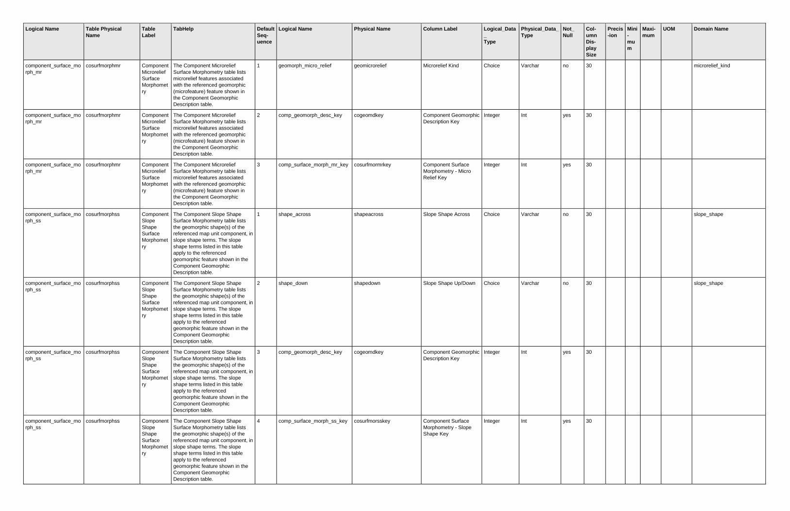
Logical Name Table Physical
Name
Table
Label
TabHelp Default
Seq-
uence
Logical Name Physical Name Column Label Logical_Data
_
Type
Physical_Data_
Type
Not_
Null
Col-
umn
Dis-
play
Size
Precis
-ion
Mini
-
mu
m
Maxi-
mum
UOM Domain Name
component_surface_mo
rph_mr
cosurfmorphmr Component
Microrelief
Surface
Morphomet
ry
The Component Microrelief
Surface Morphometry table lists
microrelief features associated
with the referenced geomorphic
(microfeature) feature shown in
the Component Geomorphic
Description table.
1 geomorph_micro_relief geomicrorelief Microrelief Kind Choice Varchar no 30
microrelief_kind
component_surface_mo
rph_mr
cosurfmorphmr Component
Microrelief
Surface
Morphomet
ry
The Component Microrelief
Surface Morphometry table lists
microrelief features associated
with the referenced geomorphic
(microfeature) feature shown in
the Component Geomorphic
Description table.
2 comp_geomorph_desc_key cogeomdkey Component Geomorphic
Description Key
Integer Int yes 30
component_surface_mo
rph_mr
cosurfmorphmr Component
Microrelief
Surface
Morphomet
ry
The Component Microrelief
Surface Morphometry table lists
microrelief features associated
with the referenced geomorphic
(microfeature) feature shown in
the Component Geomorphic
Description table.
3 comp_surface_morph_mr_key cosurfmormrkey Component Surface
Morphometry - Micro
Relief Key
Integer Int yes 30
component_surface_mo
rph_ss
cosurfmorphss Component
Slope
Shape
Surface
Morphomet
ry
The Component Slope Shape
Surface Morphometry table lists
the geomorphic shape(s) of the
referenced map unit component, in
slope shape terms. The slope
shape terms listed in this table
apply to the referenced
geomorphic feature shown in the
Component Geomorphic
Description table.
1 shape_across shapeacross Slope Shape Across Choice Varchar no 30
slope_shape
component_surface_mo
rph_ss
cosurfmorphss Component
Slope
Shape
Surface
Morphomet
ry
The Component Slope Shape
Surface Morphometry table lists
the geomorphic shape(s) of the
referenced map unit component, in
slope shape terms. The slope
shape terms listed in this table
apply to the referenced
geomorphic feature shown in the
Component Geomorphic
Description table.
2 shape_down shapedown Slope Shape Up/Down Choice Varchar no 30
slope_shape
component_surface_mo
rph_ss
cosurfmorphss Component
Slope
Shape
Surface
Morphomet
ry
The Component Slope Shape
Surface Morphometry table lists
the geomorphic shape(s) of the
referenced map unit component, in
slope shape terms. The slope
shape terms listed in this table
apply to the referenced
geomorphic feature shown in the
Component Geomorphic
Description table.
3 comp_geomorph_desc_key cogeomdkey Component Geomorphic
Description Key
Integer Int yes 30
component_surface_mo
rph_ss
cosurfmorphss Component
Slope
Shape
Surface
Morphomet
ry
The Component Slope Shape
Surface Morphometry table lists
the geomorphic shape(s) of the
referenced map unit component, in
slope shape terms. The slope
shape terms listed in this table
apply to the referenced
geomorphic feature shown in the
Component Geomorphic
Description table.
4 comp_surface_morph_ss_key cosurfmorsskey Component Surface
Morphometry - Slope
Shape Key
Integer Int yes 30

Logical Name Table Physical
Name
Table
Label
TabHelp Default
Seq-
uence
Logical Name Physical Name Column Label Logical_Data
_
Type
Physical_Data_
Type
Not_
Null
Col-
umn
Dis-
play
Size
Precis
-ion
Mini
-
mu
m
Maxi-
mum
UOM Domain Name
component_tax_fam_mi
neralogy
cotaxfmmin Component
Taxonomic
Family
Mineralogy
The Component Taxonomic
Family Mineralogy table lists the
mineralogy characteristics, as
defined in Soil Taxonomy, that
apply to the referenced map unit
component.
1 taxonomic_family_mineralogy taxminalogy Mineralogy Choice Varchar no 30
taxonomic_family_mineralogy
component_tax_fam_mi
neralogy
cotaxfmmin Component
Taxonomic
Family
Mineralogy
The Component Taxonomic
Family Mineralogy table lists the
mineralogy characteristics, as
defined in Soil Taxonomy, that
apply to the referenced map unit
component.
2 component_key cokey Component Key Integer Int yes 30
component_tax_fam_mi
neralogy
cotaxfmmin Component
Taxonomic
Family
Mineralogy
The Component Taxonomic
Family Mineralogy table lists the
mineralogy characteristics, as
defined in Soil Taxonomy, that
apply to the referenced map unit
component.
3 comp_tax_fam_min_key cotaxfmminkey Component Taxonomic
Family Mineralogy Key
Integer Int yes 30
component_tax_moistur
e_class
cotaxmoistcl Component
Taxonomic
Moisture
Class
The Component Taxonomic
Moisture Class table provides
clear identification of the intended
taxonomic moisture class, as
defined in Soil Taxonomy, that
apply to the referenced map unit
component, even though moisture
class is implied at a higher
taxonomic level. The class or
classes listed in this table describe
the representative situation for the
component.
1 taxonomic_moisture_class taxmoistcl Moisture Class Choice Varchar no 30
taxonomic_moisture_class
component_tax_moistur
e_class
cotaxmoistcl Component
Taxonomic
Moisture
Class
The Component Taxonomic
Moisture Class table provides
clear identification of the intended
taxonomic moisture class, as
defined in Soil Taxonomy, that
apply to the referenced map unit
component, even though moisture
class is implied at a higher
taxonomic level. The class or
classes listed in this table describe
the representative situation for the
component.
2 component_key cokey Component Key Integer Int yes 30
component_tax_moistur
e_class
cotaxmoistcl Component
Taxonomic
Moisture
Class
The Component Taxonomic
Moisture Class table provides
clear identification of the intended
taxonomic moisture class, as
defined in Soil Taxonomy, that
apply to the referenced map unit
component, even though moisture
class is implied at a higher
taxonomic level. The class or
classes listed in this table describe
the representative situation for the
component.
3 comp_tax_moisture_class_key cotaxmckey Component Taxonomic
Family Moisture Class
Key
Integer Int yes 30
component_text cotext Component
Text
The Component Text table
contains notes and narrative
descriptions for the referenced
map unit component. In many
cases, the table will be empty for a
particular component.
1 record_date recdate Date Date/Time Datetime no 22

Logical Name Table Physical
Name
Table
Label
TabHelp Default
Seq-
uence
Logical Name Physical Name Column Label Logical_Data
_
Type
Physical_Data_
Type
Not_
Null
Col-
umn
Dis-
play
Size
Precis
-ion
Mini
-
mu
m
Maxi-
mum
UOM Domain Name
component_text cotext Component
Text
The Component Text table
contains notes and narrative
descriptions for the referenced
map unit component. In many
cases, the table will be empty for a
particular component.
2 component_text_kind comptextkind Kind Choice Varchar no 30
component_text_kind
component_text cotext Component
Text
The Component Text table
contains notes and narrative
descriptions for the referenced
map unit component. In many
cases, the table will be empty for a
particular component.
3 text_category textcat Category String Varchar no 20
component_text cotext Component
Text
The Component Text table
contains notes and narrative
descriptions for the referenced
map unit component. In many
cases, the table will be empty for a
particular component.
4 text_subcategory textsubcat Subcategory String Varchar no 20
component_text cotext Component
Text
The Component Text table
contains notes and narrative
descriptions for the referenced
map unit component. In many
cases, the table will be empty for a
particular component.
5 text text Text Narrative Text Varchar(max) no 7
component_text cotext Component
Text
The Component Text table
contains notes and narrative
descriptions for the referenced
map unit component. In many
cases, the table will be empty for a
particular component.
6 component_key cokey Component Key Integer Int yes 30
component_text cotext Component
Text
The Component Text table
contains notes and narrative
descriptions for the referenced
map unit component. In many
cases, the table will be empty for a
particular component.
7 comp_text_key cotextkey Component Text Key Integer Int yes 30
component_trees_to_m
anage
cotreestomng Component
Trees To
Manage
The Component Trees To Manage
table lists the trees commonly
recommended for managing on
the referenced map unit
component.
1 plant_symbol plantsym Plant Symbol String Varchar yes 8
component_trees_to_m
anage
cotreestomng Component
Trees To
Manage
The Component Trees To Manage
table lists the trees commonly
recommended for managing on
the referenced map unit
component.
2 plant_scientific_name plantsciname Scientific Name String Varchar no 30
component_trees_to_m
anage
cotreestomng Component
Trees To
Manage
The Component Trees To Manage
table lists the trees commonly
recommended for managing on
the referenced map unit
component.
3 plant_common_name plantcomname Common Name String Varchar no 30
component_trees_to_m
anage
cotreestomng Component
Trees To
Manage
The Component Trees To Manage
table lists the trees commonly
recommended for managing on
the referenced map unit
component.
4 component_key cokey Component Key Integer Int yes 30

Logical Name Table Physical
Name
Table
Label
TabHelp Default
Seq-
uence
Logical Name Physical Name Column Label Logical_Data
_
Type
Physical_Data_
Type
Not_
Null
Col-
umn
Dis-
play
Size
Precis
-ion
Mini
-
mu
m
Maxi-
mum
UOM Domain Name
component_trees_to_m
anage
cotreestomng Component
Trees To
Manage
The Component Trees To Manage
table lists the trees commonly
recommended for managing on
the referenced map unit
component.
5 comp_trees_to_manage_key cotreestomngkey Component Trees to
Manage Key
Integer Int yes 30
component_tax_fam_ot
her
cotxfmother Component
Taxonomic
Family
Other
Criteria
The Component Taxonomic
Family Other Criteria table lists the
other taxonomic characteristics,
such as classes of coatings or
permanent cracks, as defined in
Soil Taxonomy, that apply to the
referenced map unit component.
The characteristics listed in this
table describe the representative
situation for the component.
1 taxonomic_family_other taxfamother Family Other Choice Varchar no 30
taxonomic_family_other
component_tax_fam_ot
her
cotxfmother Component
Taxonomic
Family
Other
Criteria
The Component Taxonomic
Family Other Criteria table lists the
other taxonomic characteristics,
such as classes of coatings or
permanent cracks, as defined in
Soil Taxonomy, that apply to the
referenced map unit component.
The characteristics listed in this
table describe the representative
situation for the component.
2 component_key cokey Component Key Integer Int yes 30
component_tax_fam_ot
her
cotxfmother Component
Taxonomic
Family
Other
Criteria
The Component Taxonomic
Family Other Criteria table lists the
other taxonomic characteristics,
such as classes of coatings or
permanent cracks, as defined in
Soil Taxonomy, that apply to the
referenced map unit component.
The characteristics listed in this
table describe the representative
situation for the component.
3 comp_tax_fam_other_key cotaxfokey Component Taxonomic
Family Other Key
Integer Int yes 30
distribution_interp_meta
data
distinterpmd Distribution
Interp
Metadata
The Distribution Interp Metadata
table records the set of NASIS
fuzzy logic interpretations which
were generated for the map unit
components included in a set of
distribution data.
1 rule_name rulename Rule Name String Varchar no 30
distribution_interp_meta
data
distinterpmd Distribution
Interp
Metadata
The Distribution Interp Metadata
table records the set of NASIS
fuzzy logic interpretations which
were generated for the map unit
components included in a set of
distribution data.
2 rule_design ruledesign Rule Design Choice Varchar yes 30
rule_design
distribution_interp_meta
data
distinterpmd Distribution
Interp
Metadata
The Distribution Interp Metadata
table records the set of NASIS
fuzzy logic interpretations which
were generated for the map unit
components included in a set of
distribution data.
3 rule_description ruledesc Description Narrative Text Varchar(max) no 11
distribution_interp_meta
data
distinterpmd Distribution
Interp
Metadata
The Distribution Interp Metadata
table records the set of NASIS
fuzzy logic interpretations which
were generated for the map unit
components included in a set of
distribution data.
4 data_approved_for_use dataafuse Ready to use? Boolean Char no 7

Logical Name Table Physical
Name
Table
Label
TabHelp Default
Seq-
uence
Logical Name Physical Name Column Label Logical_Data
_
Type
Physical_Data_
Type
Not_
Null
Col-
umn
Dis-
play
Size
Precis
-ion
Mini
-
mu
m
Maxi-
mum
UOM Domain Name
distribution_interp_meta
data
distinterpmd Distribution
Interp
Metadata
The Distribution Interp Metadata
table records the set of NASIS
fuzzy logic interpretations which
were generated for the map unit
components included in a set of
distribution data.
5 most_recent_rule_comp_wlu mrecentrulecwlu Most Recent Rule
Component When Last
Updated
Date/Time Datetime no 26
distribution_interp_meta
data
distinterpmd Distribution
Interp
Metadata
The Distribution Interp Metadata
table records the set of NASIS
fuzzy logic interpretations which
were generated for the map unit
components included in a set of
distribution data.
6 rule_key rulekey Rule Key Integer Int yes 30
distribution_interp_meta
data
distinterpmd Distribution
Interp
Metadata
The Distribution Interp Metadata
table records the set of NASIS
fuzzy logic interpretations which
were generated for the map unit
components included in a set of
distribution data.
7 dist_md_key distmdkey Distribution Metadata
Key
Integer Int yes 30
distribution_interp_meta
data
distinterpmd Distribution
Interp
Metadata
The Distribution Interp Metadata
table records the set of NASIS
fuzzy logic interpretations which
were generated for the map unit
components included in a set of
distribution data.
8 dist_interp_md_key distinterpmdkey Distribution
Interpretation Metadata
Key
Integer Int yes 30
distribution_legend_met
adata
distlegendmd Distribution
Legend
Metadata
The Distribution Legend Metadata
table records information about the
legends or soil survey areas
selected for inclusion in a set of
distributed data. The presence of a
legend in this table does not imply
that all of the available data for
that legend was included in the set
of data that was distributed. Only
certain map units and components
for that legend may have been
selected. The record of the criteria
used for selecting map units and
components may be found in the
Distribution Metadata table.
1 area_type_name areatypename Area Type Name String Varchar no 30
distribution_legend_met
adata
distlegendmd Distribution
Legend
Metadata
The Distribution Legend Metadata
table records information about the
legends or soil survey areas
selected for inclusion in a set of
distributed data. The presence of a
legend in this table does not imply
that all of the available data for
that legend was included in the set
of data that was distributed. Only
certain map units and components
for that legend may have been
selected. The record of the criteria
used for selecting map units and
components may be found in the
Distribution Metadata table.
2 area_symbol areasymbol Area Symbol String Varchar no 20

Logical Name Table Physical
Name
Table
Label
TabHelp Default
Seq-
uence
Logical Name Physical Name Column Label Logical_Data
_
Type
Physical_Data_
Type
Not_
Null
Col-
umn
Dis-
play
Size
Precis
-ion
Mini
-
mu
m
Maxi-
mum
UOM Domain Name
distribution_legend_met
adata
distlegendmd Distribution
Legend
Metadata
The Distribution Legend Metadata
table records information about the
legends or soil survey areas
selected for inclusion in a set of
distributed data. The presence of a
legend in this table does not imply
that all of the available data for
that legend was included in the set
of data that was distributed. Only
certain map units and components
for that legend may have been
selected. The record of the criteria
used for selecting map units and
components may be found in the
Distribution Metadata table.
3 area_name areaname Area Name String Varchar no 30
distribution_legend_met
adata
distlegendmd Distribution
Legend
Metadata
The Distribution Legend Metadata
table records information about the
legends or soil survey areas
selected for inclusion in a set of
distributed data. The presence of a
legend in this table does not imply
that all of the available data for
that legend was included in the set
of data that was distributed. Only
certain map units and components
for that legend may have been
selected. The record of the criteria
used for selecting map units and
components may be found in the
Distribution Metadata table.
4 soil_survey_area_status ssastatus Survey Status Choice Varchar no 30
soil_survey_area_status
distribution_legend_met
adata
distlegendmd Distribution
Legend
Metadata
The Distribution Legend Metadata
table records information about the
legends or soil survey areas
selected for inclusion in a set of
distributed data. The presence of a
legend in this table does not imply
that all of the available data for
that legend was included in the set
of data that was distributed. Only
certain map units and components
for that legend may have been
selected. The record of the criteria
used for selecting map units and
components may be found in the
Distribution Metadata table.
5 correlation_date cordate Correlation Date Date/Time Datetime no 22
distribution_legend_met
adata
distlegendmd Distribution
Legend
Metadata
The Distribution Legend Metadata
table records information about the
legends or soil survey areas
selected for inclusion in a set of
distributed data. The presence of a
legend in this table does not imply
that all of the available data for
that legend was included in the set
of data that was distributed. Only
certain map units and components
for that legend may have been
selected. The record of the criteria
used for selecting map units and
components may be found in the
Distribution Metadata table.
6 export_certification_status exportcertstatus Export Certification
Status
Choice Varchar no 30
export_certification_status

Logical Name Table Physical
Name
Table
Label
TabHelp Default
Seq-
uence
Logical Name Physical Name Column Label Logical_Data
_
Type
Physical_Data_
Type
Not_
Null
Col-
umn
Dis-
play
Size
Precis
-ion
Mini
-
mu
m
Maxi-
mum
UOM Domain Name
distribution_legend_met
adata
distlegendmd Distribution
Legend
Metadata
The Distribution Legend Metadata
table records information about the
legends or soil survey areas
selected for inclusion in a set of
distributed data. The presence of a
legend in this table does not imply
that all of the available data for
that legend was included in the set
of data that was distributed. Only
certain map units and components
for that legend may have been
selected. The record of the criteria
used for selecting map units and
components may be found in the
Distribution Metadata table.
7 export_certification_date exportcertdate Export Certification Date Date/Time Datetime no 22
distribution_legend_met
adata
distlegendmd Distribution
Legend
Metadata
The Distribution Legend Metadata
table records information about the
legends or soil survey areas
selected for inclusion in a set of
distributed data. The presence of a
legend in this table does not imply
that all of the available data for
that legend was included in the set
of data that was distributed. Only
certain map units and components
for that legend may have been
selected. The record of the criteria
used for selecting map units and
components may be found in the
Distribution Metadata table.
8 export_metadata exportmetadata Export Metadata Narrative Text Varchar(max) no 8
distribution_legend_met
adata
distlegendmd Distribution
Legend
Metadata
The Distribution Legend Metadata
table records information about the
legends or soil survey areas
selected for inclusion in a set of
distributed data. The presence of a
legend in this table does not imply
that all of the available data for
that legend was included in the set
of data that was distributed. Only
certain map units and components
for that legend may have been
selected. The record of the criteria
used for selecting map units and
components may be found in the
Distribution Metadata table.
9 legend_key lkey Legend Key Integer Int yes 30
distribution_legend_met
adata
distlegendmd Distribution
Legend
Metadata
The Distribution Legend Metadata
table records information about the
legends or soil survey areas
selected for inclusion in a set of
distributed data. The presence of a
legend in this table does not imply
that all of the available data for
that legend was included in the set
of data that was distributed. Only
certain map units and components
for that legend may have been
selected. The record of the criteria
used for selecting map units and
components may be found in the
Distribution Metadata table.
10 dist_md_key distmdkey Distribution Metadata
Key
Integer Int yes 30
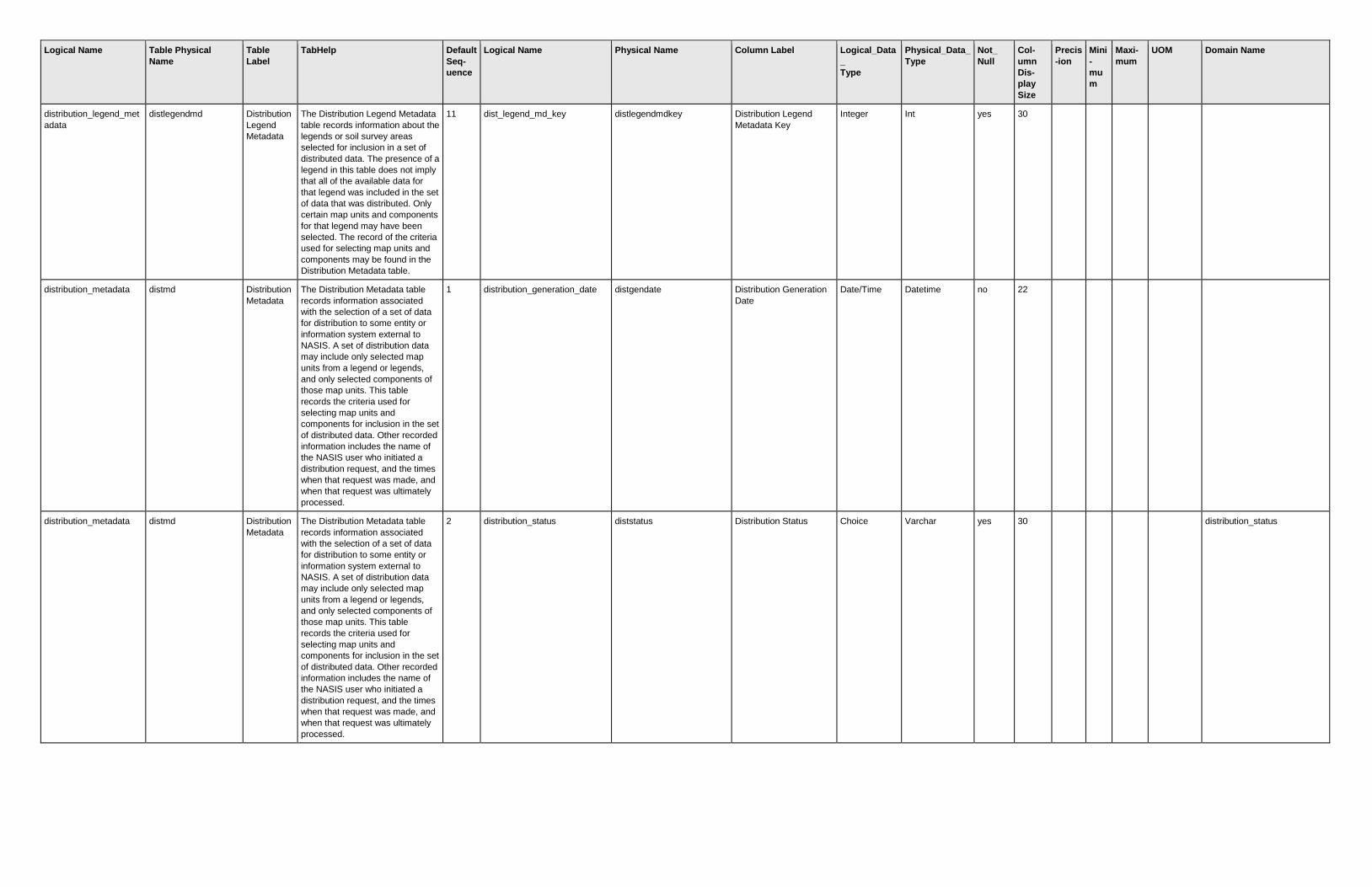
Logical Name Table Physical
Name
Table
Label
TabHelp Default
Seq-
uence
Logical Name Physical Name Column Label Logical_Data
_
Type
Physical_Data_
Type
Not_
Null
Col-
umn
Dis-
play
Size
Precis
-ion
Mini
-
mu
m
Maxi-
mum
UOM Domain Name
distribution_legend_met
adata
distlegendmd Distribution
Legend
Metadata
The Distribution Legend Metadata
table records information about the
legends or soil survey areas
selected for inclusion in a set of
distributed data. The presence of a
legend in this table does not imply
that all of the available data for
that legend was included in the set
of data that was distributed. Only
certain map units and components
for that legend may have been
selected. The record of the criteria
used for selecting map units and
components may be found in the
Distribution Metadata table.
11 dist_legend_md_key distlegendmdkey Distribution Legend
Metadata Key
Integer Int yes 30
distribution_metadata distmd Distribution
Metadata
The Distribution Metadata table
records information associated
with the selection of a set of data
for distribution to some entity or
information system external to
NASIS. A set of distribution data
may include only selected map
units from a legend or legends,
and only selected components of
those map units. This table
records the criteria used for
selecting map units and
components for inclusion in the set
of distributed data. Other recorded
information includes the name of
the NASIS user who initiated a
distribution request, and the times
when that request was made, and
when that request was ultimately
processed.
1 distribution_generation_date distgendate Distribution Generation
Date
Date/Time Datetime no 22
distribution_metadata distmd Distribution
Metadata
The Distribution Metadata table
records information associated
with the selection of a set of data
for distribution to some entity or
information system external to
NASIS. A set of distribution data
may include only selected map
units from a legend or legends,
and only selected components of
those map units. This table
records the criteria used for
selecting map units and
components for inclusion in the set
of distributed data. Other recorded
information includes the name of
the NASIS user who initiated a
distribution request, and the times
when that request was made, and
when that request was ultimately
processed.
2 distribution_status diststatus Distribution Status Choice Varchar yes 30
distribution_status

Logical Name Table Physical
Name
Table
Label
TabHelp Default
Seq-
uence
Logical Name Physical Name Column Label Logical_Data
_
Type
Physical_Data_
Type
Not_
Null
Col-
umn
Dis-
play
Size
Precis
-ion
Mini
-
mu
m
Maxi-
mum
UOM Domain Name
distribution_metadata distmd Distribution
Metadata
The Distribution Metadata table
records information associated
with the selection of a set of data
for distribution to some entity or
information system external to
NASIS. A set of distribution data
may include only selected map
units from a legend or legends,
and only selected components of
those map units. This table
records the criteria used for
selecting map units and
components for inclusion in the set
of distributed data. Other recorded
information includes the name of
the NASIS user who initiated a
distribution request, and the times
when that request was made, and
when that request was ultimately
processed.
3 interp_max_reasons interpmaxreasons Interpretation Maximum
Reasons
Integer Smallint no 15
0
distribution_metadata distmd Distribution
Metadata
The Distribution Metadata table
records information associated
with the selection of a set of data
for distribution to some entity or
information system external to
NASIS. A set of distribution data
may include only selected map
units from a legend or legends,
and only selected components of
those map units. This table
records the criteria used for
selecting map units and
components for inclusion in the set
of distributed data. Other recorded
information includes the name of
the NASIS user who initiated a
distribution request, and the times
when that request was made, and
when that request was ultimately
processed.
4 dist_md_key distmdkey Distribution Metadata
Key
Integer Int yes 30
distribution_metadata distmd Distribution
Metadata
The Distribution Metadata table
records information associated
with the selection of a set of data
for distribution to some entity or
information system external to
NASIS. A set of distribution data
may include only selected map
units from a legend or legends,
and only selected components of
those map units. This table
records the criteria used for
selecting map units and
components for inclusion in the set
of distributed data. Other recorded
information includes the name of
the NASIS user who initiated a
distribution request, and the times
when that request was made, and
when that request was ultimately
processed.
5 area_symbol areasymbol Area Symbol String Varchar yes 20

Logical Name Table Physical
Name
Table
Label
TabHelp Default
Seq-
uence
Logical Name Physical Name Column Label Logical_Data
_
Type
Physical_Data_
Type
Not_
Null
Col-
umn
Dis-
play
Size
Precis
-ion
Mini
-
mu
m
Maxi-
mum
UOM Domain Name
distribution_metadata distmd Distribution
Metadata
The Distribution Metadata table
records information associated
with the selection of a set of data
for distribution to some entity or
information system external to
NASIS. A set of distribution data
may include only selected map
units from a legend or legends,
and only selected components of
those map units. This table
records the criteria used for
selecting map units and
components for inclusion in the set
of distributed data. Other recorded
information includes the name of
the NASIS user who initiated a
distribution request, and the times
when that request was made, and
when that request was ultimately
processed.
6 tabular_version tabularversion Tabular Version Integer Int yes 11
feature_description featdesc Feature
Description
The Feature Description table
records the description of all spot
features that occur in a soil survey
area.
1 area_symbol areasymbol Area Symbol String Varchar yes 20
feature_description featdesc Feature
Description
The Feature Description table
records the description of all spot
features that occur in a soil survey
area.
2 spatial_version spatialversion Spatial Version Integer Int yes 11
feature_description featdesc Feature
Description
The Feature Description table
records the description of all spot
features that occur in a soil survey
area.
3 feature_symbol featsym Feature Symbol String Varchar yes 7
feature_description featdesc Feature
Description
The Feature Description table
records the description of all spot
features that occur in a soil survey
area.
4 feature_name featname Feature Name String Varchar yes 30
feature_description featdesc Feature
Description
The Feature Description table
records the description of all spot
features that occur in a soil survey
area.
5 feature_description featdesc Feature Description Narrative Text Varchar(max) yes 11
feature_description featdesc Feature
Description
The Feature Description table
records the description of all spot
features that occur in a soil survey
area.
6 feature_key featkey Feature Key Integer Int yes 30
feature_line featline Feature
Line
The Feature Line table records all
spot feature symbols in a soil
survey area that were digitized as
one or more lines.
1 area_symbol areasymbol Area Symbol String Varchar yes 20
feature_line featline Feature
Line
The Feature Line table records all
spot feature symbols in a soil
survey area that were digitized as
one or more lines.
2 spatial_version spatialversion Spatial Version Integer Int yes 11
feature_line featline Feature
Line
The Feature Line table records all
spot feature symbols in a soil
survey area that were digitized as
one or more lines.
3 feature_symbol featsym Feature Symbol String Varchar yes 7

Logical Name Table Physical
Name
Table
Label
TabHelp Default
Seq-
uence
Logical Name Physical Name Column Label Logical_Data
_
Type
Physical_Data_
Type
Not_
Null
Col-
umn
Dis-
play
Size
Precis
-ion
Mini
-
mu
m
Maxi-
mum
UOM Domain Name
feature_line featline Feature
Line
The Feature Line table records all
spot feature symbols in a soil
survey area that were digitized as
one or more lines.
4 feature_key featkey Feature Key Integer Int yes 30
feature_line featline Feature
Line
The Feature Line table records all
spot feature symbols in a soil
survey area that were digitized as
one or more lines.
5 feature_line_geographic featlinegeo Feature Line
Geographic
SQL
Geometry
Geometry no
feature_line featline Feature
Line
The Feature Line table records all
spot feature symbols in a soil
survey area that were digitized as
one or more lines.
6 feature_line_projected featlineproj Feature Line Projected SQL
Geometry
Geometry no
feature_line featline Feature
Line
The Feature Line table records all
spot feature symbols in a soil
survey area that were digitized as
one or more lines.
7 feature_line_key featlinekey Feature Line Key Integer Int yes
feature_point featpoint Feature
Point
The Feature Point table records all
spot feature symbols in a soil
survey area that were digitized as
one or more points.
1 area_symbol areasymbol Area Symbol String Varchar yes 20
feature_point featpoint Feature
Point
The Feature Point table records all
spot feature symbols in a soil
survey area that were digitized as
one or more points.
2 spatial_version spatialversion Spatial Version Integer Int yes 11
feature_point featpoint Feature
Point
The Feature Point table records all
spot feature symbols in a soil
survey area that were digitized as
one or more points.
3 feature_symbol featsym Feature Symbol String Varchar yes 7
feature_point featpoint Feature
Point
The Feature Point table records all
spot feature symbols in a soil
survey area that were digitized as
one or more points.
4 feature_key featkey Feature Key Integer Int yes 30
feature_point featpoint Feature
Point
The Feature Point table records all
spot feature symbols in a soil
survey area that were digitized as
one or more points.
5 feature_point_geographic featpointgeo Feature Point
Geographic
SQL
Geometry
Geometry no
feature_point featpoint Feature
Point
The Feature Point table records all
spot feature symbols in a soil
survey area that were digitized as
one or more points.
6 feature_point_projected featpointproj Feature Point Projected SQL
Geometry
Geometry no
feature_point featpoint Feature
Point
The Feature Point table records all
spot feature symbols in a soil
survey area that were digitized as
one or more points.
7 feature_point_key featpointkey Feature Point key Integer Int yes
feature_point featpoint Feature
Point
The Feature Point table records all
spot feature symbols in a soil
survey area that were digitized as
one or more points.
8 marker_character markercharacter Marker Character String Char no

Logical Name Table Physical
Name
Table
Label
TabHelp Default
Seq-
uence
Logical Name Physical Name Column Label Logical_Data
_
Type
Physical_Data_
Type
Not_
Null
Col-
umn
Dis-
play
Size
Precis
-ion
Mini
-
mu
m
Maxi-
mum
UOM Domain Name
gsm_mapunit_polygon gsmmupolygon General
Soil Map
Mapunit
Polygon
This table contains the map unit
polygon feature classes for the
general soil map of the United
States and some of its territories.
This coverage is historically known
as "STATSGO". In addition to the
map unit feature class for the
entire US, this table includes the
individual state map unit feature
classes.
1 area_symbol areasymbol Area Symbol String Varchar yes
gsm_mapunit_polygon gsmmupolygon General
Soil Map
Mapunit
Polygon
This table contains the map unit
polygon feature classes for the
general soil map of the United
States and some of its territories.
This coverage is historically known
as "STATSGO". In addition to the
map unit feature class for the
entire US, this table includes the
individual state map unit feature
classes.
2 clip_area_symbol clipareasymbol Clip Area Symbol String Varchar yes
gsm_mapunit_polygon gsmmupolygon General
Soil Map
Mapunit
Polygon
This table contains the map unit
polygon feature classes for the
general soil map of the United
States and some of its territories.
This coverage is historically known
as "STATSGO". In addition to the
map unit feature class for the
entire US, this table includes the
individual state map unit feature
classes.
3 spatial_version spatialversion Spatial Version Integer Int yes
gsm_mapunit_polygon gsmmupolygon General
Soil Map
Mapunit
Polygon
This table contains the map unit
polygon feature classes for the
general soil map of the United
States and some of its territories.
This coverage is historically known
as "STATSGO". In addition to the
map unit feature class for the
entire US, this table includes the
individual state map unit feature
classes.
4 mapunit_symbol musym Mapunit Symbol String Varchar yes
gsm_mapunit_polygon gsmmupolygon General
Soil Map
Mapunit
Polygon
This table contains the map unit
polygon feature classes for the
general soil map of the United
States and some of its territories.
This coverage is historically known
as "STATSGO". In addition to the
map unit feature class for the
entire US, this table includes the
individual state map unit feature
classes.
5 mapunit_key mukey Mapunit Key Integer Int yes
gsm_mapunit_polygon gsmmupolygon General
Soil Map
Mapunit
Polygon
This table contains the map unit
polygon feature classes for the
general soil map of the United
States and some of its territories.
This coverage is historically known
as "STATSGO". In addition to the
map unit feature class for the
entire US, this table includes the
individual state map unit feature
classes.
6 mapunit_polygon_geographic mupolygongeo Mapunit Polygon
Geographic
SQL
Geometry
Geometry no

Logical Name Table Physical
Name
Table
Label
TabHelp Default
Seq-
uence
Logical Name Physical Name Column Label Logical_Data
_
Type
Physical_Data_
Type
Not_
Null
Col-
umn
Dis-
play
Size
Precis
-ion
Mini
-
mu
m
Maxi-
mum
UOM Domain Name
gsm_mapunit_polygon gsmmupolygon General
Soil Map
Mapunit
Polygon
This table contains the map unit
polygon feature classes for the
general soil map of the United
States and some of its territories.
This coverage is historically known
as "STATSGO". In addition to the
map unit feature class for the
entire US, this table includes the
individual state map unit feature
classes.
7 mapunit_polygon_projected mupolygonproj Mapunit Polygon
Projected
SQL
Geometry
Geometry no
gsm_mapunit_polygon gsmmupolygon General
Soil Map
Mapunit
Polygon
This table contains the map unit
polygon feature classes for the
general soil map of the United
States and some of its territories.
This coverage is historically known
as "STATSGO". In addition to the
map unit feature class for the
entire US, this table includes the
individual state map unit feature
classes.
8 mapunit_polygon_key mupolygonkey Mapunit Polygon Key Integer Int yes
gsm_mapunit_polygon gsmmupolygon General
Soil Map
Mapunit
Polygon
This table contains the map unit
polygon feature classes for the
general soil map of the United
States and some of its territories.
This coverage is historically known
as "STATSGO". In addition to the
map unit feature class for the
entire US, this table includes the
individual state map unit feature
classes.
9 gsm_mapunit_polygon_key gsmmupolygonkey GSM Mapunit Polygon
Key
Integer Int yes
legend_area_overlap laoverlap Legend
Area
Overlap
The Legend Area Overlap table
lists the geographic areas that are
coincident with the soil survey
area identified in the Legend table.
For example, a survey area that
covers two counties would have
two rows in this table, one for each
county. Other types of geographic
areas listed might include state,
MLRA, rainfall (R) factor area,
climate (C) factor area, etc.
1 area_type_name areatypename Area Type Name String Varchar yes 30
legend_area_overlap laoverlap Legend
Area
Overlap
The Legend Area Overlap table
lists the geographic areas that are
coincident with the soil survey
area identified in the Legend table.
For example, a survey area that
covers two counties would have
two rows in this table, one for each
county. Other types of geographic
areas listed might include state,
MLRA, rainfall (R) factor area,
climate (C) factor area, etc.
2 area_symbol areasymbol Area Symbol String Varchar yes 20

Logical Name Table Physical
Name
Table
Label
TabHelp Default
Seq-
uence
Logical Name Physical Name Column Label Logical_Data
_
Type
Physical_Data_
Type
Not_
Null
Col-
umn
Dis-
play
Size
Precis
-ion
Mini
-
mu
m
Maxi-
mum
UOM Domain Name
legend_area_overlap laoverlap Legend
Area
Overlap
The Legend Area Overlap table
lists the geographic areas that are
coincident with the soil survey
area identified in the Legend table.
For example, a survey area that
covers two counties would have
two rows in this table, one for each
county. Other types of geographic
areas listed might include state,
MLRA, rainfall (R) factor area,
climate (C) factor area, etc.
3 area_name areaname Area Name String Varchar no 30
legend_area_overlap laoverlap Legend
Area
Overlap
The Legend Area Overlap table
lists the geographic areas that are
coincident with the soil survey
area identified in the Legend table.
For example, a survey area that
covers two counties would have
two rows in this table, one for each
county. Other types of geographic
areas listed might include state,
MLRA, rainfall (R) factor area,
climate (C) factor area, etc.
4 area_overlap_acres areaovacres Overlap Acres Integer Int no 11
0
acres
legend_area_overlap laoverlap Legend
Area
Overlap
The Legend Area Overlap table
lists the geographic areas that are
coincident with the soil survey
area identified in the Legend table.
For example, a survey area that
covers two counties would have
two rows in this table, one for each
county. Other types of geographic
areas listed might include state,
MLRA, rainfall (R) factor area,
climate (C) factor area, etc.
5 legend_key lkey Legend Key Integer Int yes 30
legend_area_overlap laoverlap Legend
Area
Overlap
The Legend Area Overlap table
lists the geographic areas that are
coincident with the soil survey
area identified in the Legend table.
For example, a survey area that
covers two counties would have
two rows in this table, one for each
county. Other types of geographic
areas listed might include state,
MLRA, rainfall (R) factor area,
climate (C) factor area, etc.
6 legend_area_overlap_key lareaovkey Legend Area Overlap
Key
Integer Int yes 30
legend legend Legend The Legend table identifies the soil
survey area that the legend is
related to, and related information
about that legend.
1 area_type_name areatypename Area Type Name String Varchar yes 30
legend legend Legend The Legend table identifies the soil
survey area that the legend is
related to, and related information
about that legend.
2 area_symbol areasymbol Area Symbol String Varchar yes 20
legend legend Legend The Legend table identifies the soil
survey area that the legend is
related to, and related information
about that legend.
3 area_name areaname Area Name String Varchar no 30
legend legend Legend The Legend table identifies the soil
survey area that the legend is
related to, and related information
about that legend.
4 area_acres areaacres Area Acres Integer Int no 11
0
acres

Logical Name Table Physical
Name
Table
Label
TabHelp Default
Seq-
uence
Logical Name Physical Name Column Label Logical_Data
_
Type
Physical_Data_
Type
Not_
Null
Col-
umn
Dis-
play
Size
Precis
-ion
Mini
-
mu
m
Maxi-
mum
UOM Domain Name
legend legend Legend The Legend table identifies the soil
survey area that the legend is
related to, and related information
about that legend.
5 mlra_office mlraoffice MLRA Office Choice Varchar no 30
mlra_office
legend legend Legend The Legend table identifies the soil
survey area that the legend is
related to, and related information
about that legend.
6 legend_description legenddesc Legend Description String Varchar no 30
legend legend Legend The Legend table identifies the soil
survey area that the legend is
related to, and related information
about that legend.
7 soil_survey_area_status ssastatus Survey Status Choice Varchar no 30
soil_survey_area_status
legend legend Legend The Legend table identifies the soil
survey area that the legend is
related to, and related information
about that legend.
8 mou_agency_responsible mouagncyresp MOU Agency
Responsible
Choice Varchar no 30
mou_agency_responsible
legend legend Legend The Legend table identifies the soil
survey area that the legend is
related to, and related information
about that legend.
9 project_scale projectscale Project Scale Integer Int no 11
legend legend Legend The Legend table identifies the soil
survey area that the legend is
related to, and related information
about that legend.
10 correlation_date cordate Correlation Date Date/Time Datetime no 22
legend legend Legend The Legend table identifies the soil
survey area that the legend is
related to, and related information
about that legend.
11 ssurgo_archived ssurgoarchived SSURGO Archived Date/Time Datetime no 22
legend legend Legend The Legend table identifies the soil
survey area that the legend is
related to, and related information
about that legend.
12 legend_suitability_for_use legendsuituse Geographic Applicability Choice Varchar no 30
legend_suitability_for_use
legend legend Legend The Legend table identifies the soil
survey area that the legend is
related to, and related information
about that legend.
13 legend_certification_status legendcertstat Legend Certification
Status
Choice Varchar no 30
legend_certification_status
legend legend Legend The Legend table identifies the soil
survey area that the legend is
related to, and related information
about that legend.
14 legend_key lkey Legend Key Integer Int yes 30
legend legend Legend The Legend table identifies the soil
survey area that the legend is
related to, and related information
about that legend.
15 tabular_version tabularversion Tabular Version Integer Int yes 11
legend_text legendtext Legend
Text
The Legend Text table contains
notes and narrative descriptions
related to the referenced legend.
Legend text is optional. In many
cases, this table is empty.
1 record_date recdate Date Date/Time Datetime no 22
legend_text legendtext Legend
Text
The Legend Text table contains
notes and narrative descriptions
related to the referenced legend.
Legend text is optional. In many
cases, this table is empty.
2 legend_text_kind legendtextkind Kind Choice Varchar no 30
legend_text_kind

Logical Name Table Physical
Name
Table
Label
TabHelp Default
Seq-
uence
Logical Name Physical Name Column Label Logical_Data
_
Type
Physical_Data_
Type
Not_
Null
Col-
umn
Dis-
play
Size
Precis
-ion
Mini
-
mu
m
Maxi-
mum
UOM Domain Name
legend_text legendtext Legend
Text
The Legend Text table contains
notes and narrative descriptions
related to the referenced legend.
Legend text is optional. In many
cases, this table is empty.
3 text_category textcat Category String Varchar no 20
legend_text legendtext Legend
Text
The Legend Text table contains
notes and narrative descriptions
related to the referenced legend.
Legend text is optional. In many
cases, this table is empty.
4 text_subcategory textsubcat Subcategory String Varchar no 20
legend_text legendtext Legend
Text
The Legend Text table contains
notes and narrative descriptions
related to the referenced legend.
Legend text is optional. In many
cases, this table is empty.
5 text text Text Narrative Text Varchar(max) no 7
legend_text legendtext Legend
Text
The Legend Text table contains
notes and narrative descriptions
related to the referenced legend.
Legend text is optional. In many
cases, this table is empty.
6 legend_key lkey Legend Key Integer Int yes 30
legend_text legendtext Legend
Text
The Legend Text table contains
notes and narrative descriptions
related to the referenced legend.
Legend text is optional. In many
cases, this table is empty.
7 legend_text_key legtextkey Legend Text Key Integer Int yes 30
mapunit mapunit Mapunit The Mapunit table identifies the
map units included in the
referenced legend. Data related
the map unit as a whole are also
given.
1 mapunit_symbol musym Mapunit Symbol String Varchar yes 7
mapunit mapunit Mapunit The Mapunit table identifies the
map units included in the
referenced legend. Data related
the map unit as a whole are also
given.
2 mapunit_name muname Mapunit Name String Varchar no 30
mapunit mapunit Mapunit The Mapunit table identifies the
map units included in the
referenced legend. Data related
the map unit as a whole are also
given.
3 mapunit_kind mukind Kind Choice Varchar no 30
mapunit_kind
mapunit mapunit Mapunit The Mapunit table identifies the
map units included in the
referenced legend. Data related
the map unit as a whole are also
given.
4 mapunit_status mustatus Status Choice Varchar no 30
mapunit_status
mapunit mapunit Mapunit The Mapunit table identifies the
map units included in the
referenced legend. Data related
the map unit as a whole are also
given.
5 mapunit_acres muacres Total Acres Integer Int no 11
0
acres
mapunit mapunit Mapunit The Mapunit table identifies the
map units included in the
referenced legend. Data related
the map unit as a whole are also
given.
6 mapunit_linear_feature_width mapunitlfw Linear Feature Width Integer Smallint no 20
meters

Logical Name Table Physical
Name
Table
Label
TabHelp Default
Seq-
uence
Logical Name Physical Name Column Label Logical_Data
_
Type
Physical_Data_
Type
Not_
Null
Col-
umn
Dis-
play
Size
Precis
-ion
Mini
-
mu
m
Maxi-
mum
UOM Domain Name
mapunit mapunit Mapunit The Mapunit table identifies the
map units included in the
referenced legend. Data related
the map unit as a whole are also
given.
7 mapunit_point_feature_area mapunitpfa Point Feature Area Float Real no 18 1 0.1 10 acres
mapunit mapunit Mapunit The Mapunit table identifies the
map units included in the
referenced legend. Data related
the map unit as a whole are also
given.
8 farmland_classification farmlndcl Farm Class Choice Varchar no 30
farmland_classification
mapunit mapunit Mapunit The Mapunit table identifies the
map units included in the
referenced legend. Data related
the map unit as a whole are also
given.
9 mapunit_hel_class muhelcl HEL Choice Varchar no 30
mapunit_hel_class
mapunit mapunit Mapunit The Mapunit table identifies the
map units included in the
referenced legend. Data related
the map unit as a whole are also
given.
10 mapunit_hel_class_water muwathelcl HEL Water Choice Varchar no 30
mapunit_hel_class
mapunit mapunit Mapunit The Mapunit table identifies the
map units included in the
referenced legend. Data related
the map unit as a whole are also
given.
11 mapunit_hel_class_wind muwndhelcl HEL Wind Choice Varchar no 30
mapunit_hel_class
mapunit mapunit Mapunit The Mapunit table identifies the
map units included in the
referenced legend. Data related
the map unit as a whole are also
given.
12 interpretive_focus interpfocus Interpretive Focus String Varchar no 30
mapunit mapunit Mapunit The Mapunit table identifies the
map units included in the
referenced legend. Data related
the map unit as a whole are also
given.
13 investigation_intensity invesintens Order of Mapping Choice Varchar no 30
investigation_intensity
mapunit mapunit Mapunit The Mapunit table identifies the
map units included in the
referenced legend. Data related
the map unit as a whole are also
given.
14 ia_corn_suitability_rating iacornsr IA CSR Integer Smallint no 4
5 100
mapunit mapunit Mapunit The Mapunit table identifies the
map units included in the
referenced legend. Data related
the map unit as a whole are also
given.
15 nh_important_forest_soil_grou
p
nhiforsoigrp NH Forest Soil Grp Choice Varchar no 30
nh_important_forest_soil_gro
up
mapunit mapunit Mapunit The Mapunit table identifies the
map units included in the
referenced legend. Data related
the map unit as a whole are also
given.
16 nh_spi_for_agriculture nhspiagr NH SPI Agr Float Float no 6 1 0 100
mapunit mapunit Mapunit The Mapunit table identifies the
map units included in the
referenced legend. Data related
the map unit as a whole are also
given.
17 vt_septic_system_class vtsepticsyscl VT Septic System Choice Varchar no 30
vt_septic_system_class_2007

Logical Name Table Physical
Name
Table
Label
TabHelp Default
Seq-
uence
Logical Name Physical Name Column Label Logical_Data
_
Type
Physical_Data_
Type
Not_
Null
Col-
umn
Dis-
play
Size
Precis
-ion
Mini
-
mu
m
Maxi-
mum
UOM Domain Name
mapunit mapunit Mapunit The Mapunit table identifies the
map units included in the
referenced legend. Data related
the map unit as a whole are also
given.
18 mapunit_certification_status mucertstat Map Unit Certification
Status
Choice Varchar no 30
mapunit_certification_status
mapunit mapunit Mapunit The Mapunit table identifies the
map units included in the
referenced legend. Data related
the map unit as a whole are also
given.
19 legend_key lkey Legend Key Integer Int yes 30
mapunit mapunit Mapunit The Mapunit table identifies the
map units included in the
referenced legend. Data related
the map unit as a whole are also
given.
20 mapunit_key mukey Mapunit Key Integer Int yes 30
mapunit mapunit Mapunit The Mapunit table identifies the
map units included in the
referenced legend. Data related
the map unit as a whole are also
given.
21 mapunit_sequence museq Mapunit Sequence Integer Int yes 11
mapunit mapunit Mapunit The Mapunit table identifies the
map units included in the
referenced legend. Data related
the map unit as a whole are also
given.
22 national_mapunit_symbol nationalmusym National Mapunit
Symbol
String Varchar yes
MetadataAlignment MetadataAlignment Alignment
Metadata
This lookup table records the list of
allowable alignment values and
names.
1 Alignment Alignment Alignment Choice Smallint yes 16
Alignment (NASIS 6
metadata)
MetadataAlignment MetadataAlignment Alignment
Metadata
This lookup table records the list of
allowable alignment values and
names.
2 AlignmentName AlignmentName Alignment Name Choice Varchar yes 16
MetadataCardinality MetadataCardinality Cardinality
Metadata
This lookup table records the list of
allowable cardinality values and
names.
1 Cardinality Cardinality Cardinality Choice Smallint yes 16
Cardinality (NASIS 6
metadata)
MetadataCardinality MetadataCardinality Cardinality
Metadata
This lookup table records the list of
allowable cardinality values and
names.
2 CardinalityName CardinalityName Cardinality Name Choice Varchar yes 16
Cardinality (NASIS 6
metadata)
MetadataColumnLookup MetadataColumnLook
up
Column
Lookup
Metadata
A record in this table corresponds
to one of the lookups required for
an end user to select a value for
the corresponding column.
Selecting a value for a column
may require multiple lookups down
a table hierarchy.
1 TableID TableID Table ID Integer Int yes 11
MetadataColumnLookup MetadataColumnLook
up
Column
Lookup
Metadata
A record in this table corresponds
to one of the lookups required for
an end user to select a value for
the corresponding column.
Selecting a value for a column
may require multiple lookups down
a table hierarchy.
2 ColumnID ColumnID Column ID Integer Int yes 11
MetadataColumnLookup MetadataColumnLook
up
Column
Lookup
Metadata
A record in this table corresponds
to one of the lookups required for
an end user to select a value for
the corresponding column.
Selecting a value for a column
may require multiple lookups down
a table hierarchy.
3 TableColumnSequence TableColumnSequence Table Column
Sequence
Integer Smallint yes 21

Logical Name Table Physical
Name
Table
Label
TabHelp Default
Seq-
uence
Logical Name Physical Name Column Label Logical_Data
_
Type
Physical_Data_
Type
Not_
Null
Col-
umn
Dis-
play
Size
Precis
-ion
Mini
-
mu
m
Maxi-
mum
UOM Domain Name
MetadataColumnLookup MetadataColumnLook
up
Column
Lookup
Metadata
A record in this table corresponds
to one of the lookups required for
an end user to select a value for
the corresponding column.
Selecting a value for a column
may require multiple lookups down
a table hierarchy.
4 RelationshipID RelationshipID Relationship ID Integer Int yes 15
MetadataColumnLookup MetadataColumnLook
up
Column
Lookup
Metadata
A record in this table corresponds
to one of the lookups required for
an end user to select a value for
the corresponding column.
Selecting a value for a column
may require multiple lookups down
a table hierarchy.
5 DisplaySequence DisplaySequence Display Sequence Integer Smallint yes 16
MetadataColumnLookup MetadataColumnLook
up
Column
Lookup
Metadata
A record in this table corresponds
to one of the lookups required for
an end user to select a value for
the corresponding column.
Selecting a value for a column
may require multiple lookups down
a table hierarchy.
6 Branch Branch Branch Integer Int yes 11
MetadataColumnLookup MetadataColumnLook
up
Column
Lookup
Metadata
A record in this table corresponds
to one of the lookups required for
an end user to select a value for
the corresponding column.
Selecting a value for a column
may require multiple lookups down
a table hierarchy.
7 DisplayTableID DisplayTableID Display Table ID Integer Int no 16
MetadataColumnLookup MetadataColumnLook
up
Column
Lookup
Metadata
A record in this table corresponds
to one of the lookups required for
an end user to select a value for
the corresponding column.
Selecting a value for a column
may require multiple lookups down
a table hierarchy.
8 DisplayColumnID DisplayColumnID DisplayColumn ID Integer Int no 16
MetadataColumnLookup MetadataColumnLook
up
Column
Lookup
Metadata
A record in this table corresponds
to one of the lookups required for
an end user to select a value for
the corresponding column.
Selecting a value for a column
may require multiple lookups down
a table hierarchy.
9 DisplayTableColumnSequence DisplayTableColumnSeque
nce
Display Table Column
Sequence
Integer Smallint no 29
MetadataColumnLookup MetadataColumnLook
up
Column
Lookup
Metadata
A record in this table corresponds
to one of the lookups required for
an end user to select a value for
the corresponding column.
Selecting a value for a column
may require multiple lookups down
a table hierarchy.
10 DisplayColumnLabel DisplayColumnLabel Display Column Label String Varchar no 30
MetadataColumnLookup MetadataColumnLook
up
Column
Lookup
Metadata
A record in this table corresponds
to one of the lookups required for
an end user to select a value for
the corresponding column.
Selecting a value for a column
may require multiple lookups down
a table hierarchy.
11 DisplayOnlyInChoiceList DisplayOnlyInChoiceList Display Only in Choice
List?
Boolean Smallint yes 28
MetadataDatetimePrecis
ion
MetadataDatetimePre
cision
Datetime
Precision
Metadata
This lookup table records the list of
allowable datetime precision
values and names.
1 DatetimePrecision DatetimePrecision Datetime Precision Choice Smallint yes 18
Datetime Precision (NASIS 6
Metadata)

Logical Name Table Physical
Name
Table
Label
TabHelp Default
Seq-
uence
Logical Name Physical Name Column Label Logical_Data
_
Type
Physical_Data_
Type
Not_
Null
Col-
umn
Dis-
play
Size
Precis
-ion
Mini
-
mu
m
Maxi-
mum
UOM Domain Name
MetadataDatetimePrecis
ion
MetadataDatetimePre
cision
Datetime
Precision
Metadata
This lookup table records the list of
allowable datetime precision
values and names.
2 DatetimePrecisionName DatetimePrecisionName Datetime Precision
Name
Choice Varchar yes 23
MetadataDefaultType MetadataDefaultType Default
Type
Metadata
This lookup table records the list of
allowable default type values and
names.
1 DefaultType DefaultType Default Type Choice Smallint yes 30
Default Type (NASIS 6
metadata)
MetadataDefaultType MetadataDefaultType Default
Type
Metadata
This lookup table records the list of
allowable default type values and
names.
2 DefaultTypeName DefaultTypeName Default Type Name Choice Varchar yes 30
MetadataDomainDetail MetadataDomainDetai
l
Domain
Detail
Metadata
A record in this table corresponds
to a member of a domain.
1 DomainID DomainID Domain ID Integer Int yes 11
MetadataDomainDetail MetadataDomainDetai
l
Domain
Detail
Metadata
A record in this table corresponds
to a member of a domain.
2 ChoiceSequence ChoiceSequence Choice Sequence Integer Smallint yes 15
MetadataDomainDetail MetadataDomainDetai
l
Domain
Detail
Metadata
A record in this table corresponds
to a member of a domain.
3 ChoiceValue ChoiceValue Choice Value Integer Smallint yes 12
MetadataDomainDetail MetadataDomainDetai
l
Domain
Detail
Metadata
A record in this table corresponds
to a member of a domain.
4 ChoiceName ChoiceName Choice Name String Varchar yes 30
MetadataDomainDetail MetadataDomainDetai
l
Domain
Detail
Metadata
A record in this table corresponds
to a member of a domain.
5 ChoiceLabel ChoiceLabel Choice Label String Varchar yes 30
MetadataDomainDetail MetadataDomainDetai
l
Domain
Detail
Metadata
A record in this table corresponds
to a member of a domain.
6 ChoiceDescription ChoiceDescription Choice Description Narrative Text Varchar(max) no 18
MetadataDomainDetail MetadataDomainDetai
l
Domain
Detail
Metadata
A record in this table corresponds
to a member of a domain.
7 ChoiceObsolete ChoiceObsolete Obsolete Choice? Boolean Smallint yes 16
MetadataDomainMaster MetadataDomainMast
er
Domain
Master
Metadata
A record in this table corresponds
to a domain. A domain is a fixed
set of values to which a column
may be restricted. The same
domain may serve as the domain
for more than one column in a
database.
1 DomainID DomainID Domain ID Integer Int yes 11
MetadataDomainMaster MetadataDomainMast
er
Domain
Master
Metadata
A record in this table corresponds
to a domain. A domain is a fixed
set of values to which a column
may be restricted. The same
domain may serve as the domain
for more than one column in a
database.
2 DomainName DomainName Domain Name String Varchar yes 30
MetadataDomainMaster MetadataDomainMast
er
Domain
Master
Metadata
A record in this table corresponds
to a domain. A domain is a fixed
set of values to which a column
may be restricted. The same
domain may serve as the domain
for more than one column in a
database.
3 DomainRanked DomainRanked Domain Ranked? Boolean Smallint yes 14
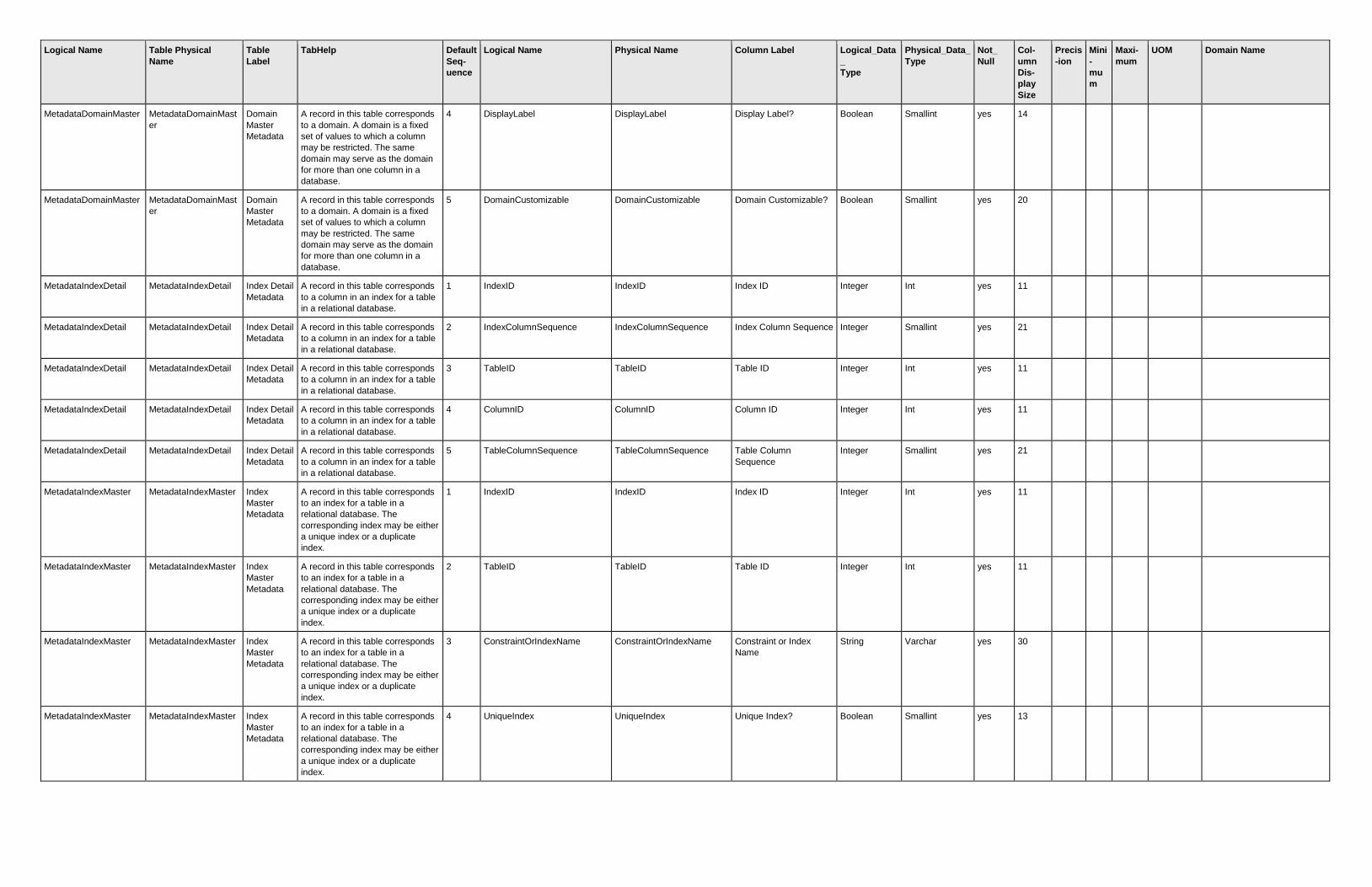
Logical Name Table Physical
Name
Table
Label
TabHelp Default
Seq-
uence
Logical Name Physical Name Column Label Logical_Data
_
Type
Physical_Data_
Type
Not_
Null
Col-
umn
Dis-
play
Size
Precis
-ion
Mini
-
mu
m
Maxi-
mum
UOM Domain Name
MetadataDomainMaster MetadataDomainMast
er
Domain
Master
Metadata
A record in this table corresponds
to a domain. A domain is a fixed
set of values to which a column
may be restricted. The same
domain may serve as the domain
for more than one column in a
database.
4 DisplayLabel DisplayLabel Display Label? Boolean Smallint yes 14
MetadataDomainMaster MetadataDomainMast
er
Domain
Master
Metadata
A record in this table corresponds
to a domain. A domain is a fixed
set of values to which a column
may be restricted. The same
domain may serve as the domain
for more than one column in a
database.
5 DomainCustomizable DomainCustomizable Domain Customizable? Boolean Smallint yes 20
MetadataIndexDetail MetadataIndexDetail Index Detail
Metadata
A record in this table corresponds
to a column in an index for a table
in a relational database.
1 IndexID IndexID Index ID Integer Int yes 11
MetadataIndexDetail MetadataIndexDetail Index Detail
Metadata
A record in this table corresponds
to a column in an index for a table
in a relational database.
2 IndexColumnSequence IndexColumnSequence Index Column Sequence Integer Smallint yes 21
MetadataIndexDetail MetadataIndexDetail Index Detail
Metadata
A record in this table corresponds
to a column in an index for a table
in a relational database.
3 TableID TableID Table ID Integer Int yes 11
MetadataIndexDetail MetadataIndexDetail Index Detail
Metadata
A record in this table corresponds
to a column in an index for a table
in a relational database.
4 ColumnID ColumnID Column ID Integer Int yes 11
MetadataIndexDetail MetadataIndexDetail Index Detail
Metadata
A record in this table corresponds
to a column in an index for a table
in a relational database.
5 TableColumnSequence TableColumnSequence Table Column
Sequence
Integer Smallint yes 21
MetadataIndexMaster MetadataIndexMaster Index
Master
Metadata
A record in this table corresponds
to an index for a table in a
relational database. The
corresponding index may be either
a unique index or a duplicate
index.
1 IndexID IndexID Index ID Integer Int yes 11
MetadataIndexMaster MetadataIndexMaster Index
Master
Metadata
A record in this table corresponds
to an index for a table in a
relational database. The
corresponding index may be either
a unique index or a duplicate
index.
2 TableID TableID Table ID Integer Int yes 11
MetadataIndexMaster MetadataIndexMaster Index
Master
Metadata
A record in this table corresponds
to an index for a table in a
relational database. The
corresponding index may be either
a unique index or a duplicate
index.
3 ConstraintOrIndexName ConstraintOrIndexName Constraint or Index
Name
String Varchar yes 30
MetadataIndexMaster MetadataIndexMaster Index
Master
Metadata
A record in this table corresponds
to an index for a table in a
relational database. The
corresponding index may be either
a unique index or a duplicate
index.
4 UniqueIndex UniqueIndex Unique Index? Boolean Smallint yes 13

Logical Name Table Physical
Name
Table
Label
TabHelp Default
Seq-
uence
Logical Name Physical Name Column Label Logical_Data
_
Type
Physical_Data_
Type
Not_
Null
Col-
umn
Dis-
play
Size
Precis
-ion
Mini
-
mu
m
Maxi-
mum
UOM Domain Name
MetadataIndexMaster MetadataIndexMaster Index
Master
Metadata
A record in this table corresponds
to an index for a table in a
relational database. The
corresponding index may be either
a unique index or a duplicate
index.
5 PrimaryIndex PrimaryIndex Primary Index? Boolean Smallint yes 14
MetadataIndexMaster MetadataIndexMaster Index
Master
Metadata
A record in this table corresponds
to an index for a table in a
relational database. The
corresponding index may be either
a unique index or a duplicate
index.
6 ConstraintDeferrable ConstraintDeferrable Constraint Deferrable? Boolean Smallint yes 22
MetadataLogicalDataTy
pe
MetadataLogicalDataT
ype
Logical
Data Type
Metadata
This lookup table records the list of
allowable logical data type values
and names.
1 LogicalDataType LogicalDataType Logical Data Type Choice Smallint yes 21
Logical Data Type (NASIS 6
metadata)
MetadataLogicalDataTy
pe
MetadataLogicalDataT
ype
Logical
Data Type
Metadata
This lookup table records the list of
allowable logical data type values
and names.
2 LogicalDataTypeName LogicalDataTypeName Logical Data Type
Name
Choice Varchar yes 22
MetadataPhysicalDataT
ype
MetadataPhysicalData
Type
Physical
Data Type
Metadata
This lookup table records the list of
allowable physical data type
values and names.
1 PhysicalDataType PhysicalDataType Physical Data Type Choice Smallint yes 18
Physical Data Type (NASIS 6
metadata)
MetadataPhysicalDataT
ype
MetadataPhysicalData
Type
Physical
Data Type
Metadata
This lookup table records the list of
allowable physical data type
values and names.
2 PhysicalDataTypeName PhysicalDataTypeName Physical Data Type
Name
Choice Varchar yes 23
MetadataRelationshipD
etail
MetadataRelationship
Detail
Relationshi
p Detail
Metadata
A record in this table corresponds
to one of the column pairs used to
join two tables in a relational
database. A join between two
tables may be based on one or
more column pairs.
1 RelationshipID RelationshipID Relationship ID Integer Int yes 15
MetadataRelationshipD
etail
MetadataRelationship
Detail
Relationshi
p Detail
Metadata
A record in this table corresponds
to one of the column pairs used to
join two tables in a relational
database. A join between two
tables may be based on one or
more column pairs.
2 LeftTableID LeftTableID Left Table ID Integer Int yes 13
MetadataRelationshipD
etail
MetadataRelationship
Detail
Relationshi
p Detail
Metadata
A record in this table corresponds
to one of the column pairs used to
join two tables in a relational
database. A join between two
tables may be based on one or
more column pairs.
3 LeftColumnID LeftColumnID Left Column ID Integer Int yes 14
MetadataRelationshipD
etail
MetadataRelationship
Detail
Relationshi
p Detail
Metadata
A record in this table corresponds
to one of the column pairs used to
join two tables in a relational
database. A join between two
tables may be based on one or
more column pairs.
4 LeftTableColumnSequence LeftTableColumnSequence Left Table Column
Sequence
Integer Smallint yes 26
MetadataRelationshipD
etail
MetadataRelationship
Detail
Relationshi
p Detail
Metadata
A record in this table corresponds
to one of the column pairs used to
join two tables in a relational
database. A join between two
tables may be based on one or
more column pairs.
5 RightTableID RightTableID Right Table ID Integer Int yes 14

Logical Name Table Physical
Name
Table
Label
TabHelp Default
Seq-
uence
Logical Name Physical Name Column Label Logical_Data
_
Type
Physical_Data_
Type
Not_
Null
Col-
umn
Dis-
play
Size
Precis
-ion
Mini
-
mu
m
Maxi-
mum
UOM Domain Name
MetadataRelationshipD
etail
MetadataRelationship
Detail
Relationshi
p Detail
Metadata
A record in this table corresponds
to one of the column pairs used to
join two tables in a relational
database. A join between two
tables may be based on one or
more column pairs.
6 RightColumnID RightColumnID Right Column ID Integer Int yes 15
MetadataRelationshipD
etail
MetadataRelationship
Detail
Relationshi
p Detail
Metadata
A record in this table corresponds
to one of the column pairs used to
join two tables in a relational
database. A join between two
tables may be based on one or
more column pairs.
7 RightTableColumnSequence RightTableColumnSequenc
e
Right Table Column
Sequence
Integer Smallint yes 27
MetadataRelationshipM
aster
MetadataRelationship
Master
Relationshi
p Master
Metadata
A record in this table corresponds
to a relationship between two
tables in a relational database.
There may be more than one
relationship between the same two
tables in a relational database.
1 RelationshipID RelationshipID Relationship ID Integer Int yes 15
MetadataRelationshipM
aster
MetadataRelationship
Master
Relationshi
p Master
Metadata
A record in this table corresponds
to a relationship between two
tables in a relational database.
There may be more than one
relationship between the same two
tables in a relational database.
2 LeftTableID LeftTableID Left Table ID Integer Int yes 13
MetadataRelationshipM
aster
MetadataRelationship
Master
Relationshi
p Master
Metadata
A record in this table corresponds
to a relationship between two
tables in a relational database.
There may be more than one
relationship between the same two
tables in a relational database.
3 RightTableID RightTableID Right Table ID Integer Int yes 14
MetadataRelationshipM
aster
MetadataRelationship
Master
Relationshi
p Master
Metadata
A record in this table corresponds
to a relationship between two
tables in a relational database.
There may be more than one
relationship between the same two
tables in a relational database.
4 RelationshipName RelationshipName Relationship Name String Varchar yes 30
MetadataRelationshipM
aster
MetadataRelationship
Master
Relationshi
p Master
Metadata
A record in this table corresponds
to a relationship between two
tables in a relational database.
There may be more than one
relationship between the same two
tables in a relational database.
5 ForeignKeyConstraintName ForeignKeyConstraintName Foreign Key Constraint
Name
String Varchar yes 30
MetadataRelationshipM
aster
MetadataRelationship
Master
Relationshi
p Master
Metadata
A record in this table corresponds
to a relationship between two
tables in a relational database.
There may be more than one
relationship between the same two
tables in a relational database.
6 Cardinality Cardinality Cardinality Choice Smallint yes 16
Cardinality (NASIS 6
metadata)
MetadataRelationshipM
aster
MetadataRelationship
Master
Relationshi
p Master
Metadata
A record in this table corresponds
to a relationship between two
tables in a relational database.
There may be more than one
relationship between the same two
tables in a relational database.
7 CardinalityMinimum CardinalityMinimum Cardinality Minimum Integer Smallint yes 19
0 1

Logical Name Table Physical
Name
Table
Label
TabHelp Default
Seq-
uence
Logical Name Physical Name Column Label Logical_Data
_
Type
Physical_Data_
Type
Not_
Null
Col-
umn
Dis-
play
Size
Precis
-ion
Mini
-
mu
m
Maxi-
mum
UOM Domain Name
MetadataRelationshipM
aster
MetadataRelationship
Master
Relationshi
p Master
Metadata
A record in this table corresponds
to a relationship between two
tables in a relational database.
There may be more than one
relationship between the same two
tables in a relational database.
8 CardinalityMaximum CardinalityMaximum Cardinality Maximum Integer Smallint yes 19
-1
MetadataRelationshipM
aster
MetadataRelationship
Master
Relationshi
p Master
Metadata
A record in this table corresponds
to a relationship between two
tables in a relational database.
There may be more than one
relationship between the same two
tables in a relational database.
9 Mandatory Mandatory Mandatory? Boolean Smallint yes 10
MetadataRelationshipM
aster
MetadataRelationship
Master
Relationshi
p Master
Metadata
A record in this table corresponds
to a relationship between two
tables in a relational database.
There may be more than one
relationship between the same two
tables in a relational database.
10 DeleteFail DeleteFail Delete Fail? Boolean Smallint yes 12
MetadataRelationshipM
aster
MetadataRelationship
Master
Relationshi
p Master
Metadata
A record in this table corresponds
to a relationship between two
tables in a relational database.
There may be more than one
relationship between the same two
tables in a relational database.
11 InHierarchy InHierarchy In Hierarchy? Boolean Smallint yes 13
MetadataRelationshipM
aster
MetadataRelationship
Master
Relationshi
p Master
Metadata
A record in this table corresponds
to a relationship between two
tables in a relational database.
There may be more than one
relationship between the same two
tables in a relational database.
12 FavoriteChild FavoriteChild Favorite Child? Boolean Smallint yes 15
MetadataRelationshipM
aster
MetadataRelationship
Master
Relationshi
p Master
Metadata
A record in this table corresponds
to a relationship between two
tables in a relational database.
There may be more than one
relationship between the same two
tables in a relational database.
13 LoadFindRelated LoadFindRelated Load/Find Related? Boolean Smallint yes 18
MetadataRelationshipM
aster
MetadataRelationship
Master
Relationshi
p Master
Metadata
A record in this table corresponds
to a relationship between two
tables in a relational database.
There may be more than one
relationship between the same two
tables in a relational database.
14 Paste Paste Paste? Boolean Smallint yes 6
MetadataRelationshipM
aster
MetadataRelationship
Master
Relationshi
p Master
Metadata
A record in this table corresponds
to a relationship between two
tables in a relational database.
There may be more than one
relationship between the same two
tables in a relational database.
15 ConstraintDeferrable ConstraintDeferrable Constraint Deferrable? Boolean Smallint yes 22
MetadataSortDirection MetadataSortDirection Sort
Direction
Metadata
This lookup table records the list of
allowable sort direction values and
names.
1 SortDirection SortDirection Sort Direction Choice Smallint yes 14
Sort Direction (NASIS 6
metadata)
MetadataSortDirection MetadataSortDirection Sort
Direction
Metadata
This lookup table records the list of
allowable sort direction values and
names.
2 SortDirectionName SortDirectionName Sort Direction Name Choice Varchar yes 19
MetadataSortType MetadataSortType Sort Type
Metadata
This lookup table records the list of
allowable sort type values and
names.
1 SortType SortType Sort Type Choice Smallint yes 29
Sort Type (NASIS 6
metadata)

Logical Name Table Physical
Name
Table
Label
TabHelp Default
Seq-
uence
Logical Name Physical Name Column Label Logical_Data
_
Type
Physical_Data_
Type
Not_
Null
Col-
umn
Dis-
play
Size
Precis
-ion
Mini
-
mu
m
Maxi-
mum
UOM Domain Name
MetadataSortType MetadataSortType Sort Type
Metadata
This lookup table records the list of
allowable sort type values and
names.
2 SortTypeName SortTypeName Sort Type Name Choice Varchar yes 29
MetadataTable MetadataTable Table
Metadata
A record in this table corresponds
to a table in a relational database.
1 TableID TableID Table ID Integer Int yes 11
MetadataTable MetadataTable Table
Metadata
A record in this table corresponds
to a table in a relational database.
2 TablePhysicalName TablePhysicalName Table Physical Name String Varchar yes 30
MetadataTable MetadataTable Table
Metadata
A record in this table corresponds
to a table in a relational database.
3 TableLogicalName TableLogicalName Table Logical Name String Varchar yes 30
MetadataTable MetadataTable Table
Metadata
A record in this table corresponds
to a table in a relational database.
4 TableLabel TableLabel Table Label String Varchar yes 30
MetadataTable MetadataTable Table
Metadata
A record in this table corresponds
to a table in a relational database.
5 TableDescription TableDescription Table Description Narrative Text Varchar(max) yes 17
MetadataTable MetadataTable Table
Metadata
A record in this table corresponds
to a table in a relational database.
6 ImportExportFileName ImportExportFileName Import/Export File Name String Varchar yes 30
MetadataTable MetadataTable Table
Metadata
A record in this table corresponds
to a table in a relational database.
7 TableCollectionID TableCollectionID Table Collection ID Integer Int no 19
MetadataTable MetadataTable Table
Metadata
A record in this table corresponds
to a table in a relational database.
8 DAGLevel DAGLevel Directed Acyclic Graph
Level
Integer Smallint yes 28
MetadataTable MetadataTable Table
Metadata
A record in this table corresponds
to a table in a relational database.
9 Visible Visible Visible? Boolean Smallint yes 8
MetadataTable MetadataTable Table
Metadata
A record in this table corresponds
to a table in a relational database.
10 Selectable Selectable Selectable? Boolean Smallint yes 11
MetadataTable MetadataTable Table
Metadata
A record in this table corresponds
to a table in a relational database.
11 Editable Editable Editable? Boolean Smallint yes 9
MetadataTable MetadataTable Table
Metadata
A record in this table corresponds
to a table in a relational database.
12 NoInsertOrDelete NoInsertOrDelete No Insert or Delete? Boolean Smallint yes 20
MetadataTable MetadataTable Table
Metadata
A record in this table corresponds
to a table in a relational database.
13 RootTable RootTable Root Table? Boolean Smallint yes 11
MetadataTable MetadataTable Table
Metadata
A record in this table corresponds
to a table in a relational database.
14 CreateAsView CreateAsView Create As View? Boolean Smallint yes 15
MetadataTable MetadataTable Table
Metadata
A record in this table corresponds
to a table in a relational database.
15 ClientDatabaseOnly ClientDatabaseOnly Client Database Only Boolean Smallint yes 20
MetadataTable MetadataTable Table
Metadata
A record in this table corresponds
to a table in a relational database.
16 ServerDatabaseOnly ServerDatabaseOnly Server Database Only Boolean Smallint yes 20
MetadataTableCollectio
n
MetadataTableCollecti
on
Table
Collection
Metadata
A record in this table corresponds
to a collection of tables in a
relational database that are
managed as a group. A table may
be a member of only one table
collection.
1 TableCollectionID TableCollectionID Table Collection ID Integer Int yes 19
MetadataTableCollectio
n
MetadataTableCollecti
on
Table
Collection
Metadata
A record in this table corresponds
to a collection of tables in a
relational database that are
managed as a group. A table may
be a member of only one table
collection.
2 TableCollectionName TableCollectionName Table Collection Name String Varchar yes 30
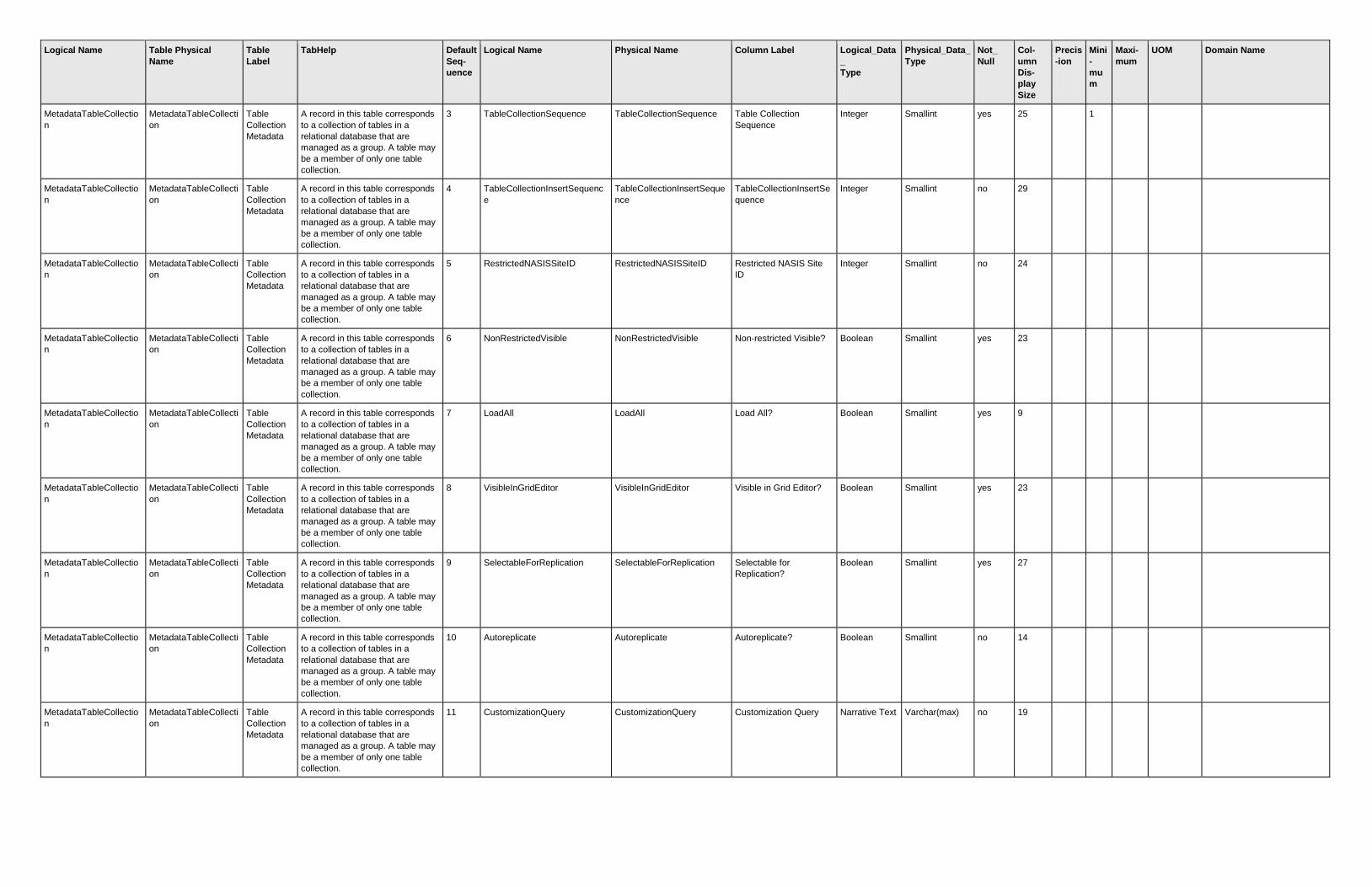
Logical Name Table Physical
Name
Table
Label
TabHelp Default
Seq-
uence
Logical Name Physical Name Column Label Logical_Data
_
Type
Physical_Data_
Type
Not_
Null
Col-
umn
Dis-
play
Size
Precis
-ion
Mini
-
mu
m
Maxi-
mum
UOM Domain Name
MetadataTableCollectio
n
MetadataTableCollecti
on
Table
Collection
Metadata
A record in this table corresponds
to a collection of tables in a
relational database that are
managed as a group. A table may
be a member of only one table
collection.
3 TableCollectionSequence TableCollectionSequence Table Collection
Sequence
Integer Smallint yes 25
1
MetadataTableCollectio
n
MetadataTableCollecti
on
Table
Collection
Metadata
A record in this table corresponds
to a collection of tables in a
relational database that are
managed as a group. A table may
be a member of only one table
collection.
4 TableCollectionInsertSequenc
e
TableCollectionInsertSeque
nce
TableCollectionInsertSe
quence
Integer Smallint no 29
MetadataTableCollectio
n
MetadataTableCollecti
on
Table
Collection
Metadata
A record in this table corresponds
to a collection of tables in a
relational database that are
managed as a group. A table may
be a member of only one table
collection.
5 RestrictedNASISSiteID RestrictedNASISSiteID Restricted NASIS Site
ID
Integer Smallint no 24
MetadataTableCollectio
n
MetadataTableCollecti
on
Table
Collection
Metadata
A record in this table corresponds
to a collection of tables in a
relational database that are
managed as a group. A table may
be a member of only one table
collection.
6 NonRestrictedVisible NonRestrictedVisible Non-restricted Visible? Boolean Smallint yes 23
MetadataTableCollectio
n
MetadataTableCollecti
on
Table
Collection
Metadata
A record in this table corresponds
to a collection of tables in a
relational database that are
managed as a group. A table may
be a member of only one table
collection.
7 LoadAll LoadAll Load All? Boolean Smallint yes 9
MetadataTableCollectio
n
MetadataTableCollecti
on
Table
Collection
Metadata
A record in this table corresponds
to a collection of tables in a
relational database that are
managed as a group. A table may
be a member of only one table
collection.
8 VisibleInGridEditor VisibleInGridEditor Visible in Grid Editor? Boolean Smallint yes 23
MetadataTableCollectio
n
MetadataTableCollecti
on
Table
Collection
Metadata
A record in this table corresponds
to a collection of tables in a
relational database that are
managed as a group. A table may
be a member of only one table
collection.
9 SelectableForReplication SelectableForReplication Selectable for
Replication?
Boolean Smallint yes 27
MetadataTableCollectio
n
MetadataTableCollecti
on
Table
Collection
Metadata
A record in this table corresponds
to a collection of tables in a
relational database that are
managed as a group. A table may
be a member of only one table
collection.
10 Autoreplicate Autoreplicate Autoreplicate? Boolean Smallint no 14
MetadataTableCollectio
n
MetadataTableCollecti
on
Table
Collection
Metadata
A record in this table corresponds
to a collection of tables in a
relational database that are
managed as a group. A table may
be a member of only one table
collection.
11 CustomizationQuery CustomizationQuery Customization Query Narrative Text Varchar(max) no 19

Logical Name Table Physical
Name
Table
Label
TabHelp Default
Seq-
uence
Logical Name Physical Name Column Label Logical_Data
_
Type
Physical_Data_
Type
Not_
Null
Col-
umn
Dis-
play
Size
Precis
-ion
Mini
-
mu
m
Maxi-
mum
UOM Domain Name
MetadataTableCollectio
n
MetadataTableCollecti
on
Table
Collection
Metadata
A record in this table corresponds
to a collection of tables in a
relational database that are
managed as a group. A table may
be a member of only one table
collection.
12 CustomizationColumnID CustomizationColumnID Customization Column
ID
Integer Int no 23
MetadataTableColumn MetadataTableColum
n
Table
Column
Metadata
A record in this table corresponds
to a column in a table in a
relational database.
1 TableID TableID Table ID Integer Int yes 11
MetadataTableColumn MetadataTableColum
n
Table
Column
Metadata
A record in this table corresponds
to a column in a table in a
relational database.
2 ColumnID ColumnID Column ID Integer Int yes 11
MetadataTableColumn MetadataTableColum
n
Table
Column
Metadata
A record in this table corresponds
to a column in a table in a
relational database.
3 TableColumnSequence TableColumnSequence Table Column
Sequence
Integer Smallint yes 21
MetadataTableColumn MetadataTableColum
n
Table
Column
Metadata
A record in this table corresponds
to a column in a table in a
relational database.
4 BaseColumnPhysicalName BaseColumnPhysicalName Base Column Physical
Name
String Varchar yes 30
MetadataTableColumn MetadataTableColum
n
Table
Column
Metadata
A record in this table corresponds
to a column in a table in a
relational database.
5 ColumnPhysicalName ColumnPhysicalName Column Physical Name String Varchar yes 30
MetadataTableColumn MetadataTableColum
n
Table
Column
Metadata
A record in this table corresponds
to a column in a table in a
relational database.
6 ColumnLogicalName ColumnLogicalName Column Logical Name String Varchar yes 30
MetadataTableColumn MetadataTableColum
n
Table
Column
Metadata
A record in this table corresponds
to a column in a table in a
relational database.
7 ColumnGroupLabel ColumnGroupLabel Column Group Label String Varchar no 30
MetadataTableColumn MetadataTableColum
n
Table
Column
Metadata
A record in this table corresponds
to a column in a table in a
relational database.
8 ColumnLabel ColumnLabel Column Label String Varchar yes 30
MetadataTableColumn MetadataTableColum
n
Table
Column
Metadata
A record in this table corresponds
to a column in a table in a
relational database.
9 PhysicalDataType PhysicalDataType Physical Data Type Choice Smallint yes 18
Physical Data Type (NASIS 6
metadata)
MetadataTableColumn MetadataTableColum
n
Table
Column
Metadata
A record in this table corresponds
to a column in a table in a
relational database.
10 LogicalDataType LogicalDataType Logical Data Type Choice Smallint yes 21
Logical Data Type (NASIS 6
metadata)
MetadataTableColumn MetadataTableColum
n
Table
Column
Metadata
A record in this table corresponds
to a column in a table in a
relational database.
11 DomainID DomainID Domain ID Integer Int no 11
MetadataTableColumn MetadataTableColum
n
Table
Column
Metadata
A record in this table corresponds
to a column in a table in a
relational database.
12 ColumnDescription ColumnDescription Column Description Narrative Text Varchar(max) yes 18
MetadataTableColumn MetadataTableColum
n
Table
Column
Metadata
A record in this table corresponds
to a column in a table in a
relational database.
13 ColumnHelpText ColumnHelpText Column Help Text Narrative Text Varchar(max) no 16
MetadataTableColumn MetadataTableColum
n
Table
Column
Metadata
A record in this table corresponds
to a column in a table in a
relational database.
14 FieldSize FieldSize Field Size Integer Smallint no 10
MetadataTableColumn MetadataTableColum
n
Table
Column
Metadata
A record in this table corresponds
to a column in a table in a
relational database.
15 DecimalPrecision DecimalPrecision Decimal Precision Integer Smallint no 17
MetadataTableColumn MetadataTableColum
n
Table
Column
Metadata
A record in this table corresponds
to a column in a table in a
relational database.
16 DatetimePrecision DatetimePrecision Datetime Precision Choice Smallint no 18
Datetime Precision (NASIS 6
Metadata)

Logical Name Table Physical
Name
Table
Label
TabHelp Default
Seq-
uence
Logical Name Physical Name Column Label Logical_Data
_
Type
Physical_Data_
Type
Not_
Null
Col-
umn
Dis-
play
Size
Precis
-ion
Mini
-
mu
m
Maxi-
mum
UOM Domain Name
MetadataTableColumn MetadataTableColum
n
Table
Column
Metadata
A record in this table corresponds
to a column in a table in a
relational database.
17 Minimum Minimum Minimum Float Float no 17 2
MetadataTableColumn MetadataTableColum
n
Table
Column
Metadata
A record in this table corresponds
to a column in a table in a
relational database.
18 Maximum Maximum Maximum Float Float no 17 2
MetadataTableColumn MetadataTableColum
n
Table
Column
Metadata
A record in this table corresponds
to a column in a table in a
relational database.
19 DefaultType DefaultType Default Type Choice Smallint no 30
Default Type (NASIS 6
metadata)
MetadataTableColumn MetadataTableColum
n
Table
Column
Metadata
A record in this table corresponds
to a column in a table in a
relational database.
20 DefaultValue DefaultValue Default Value String Varchar no 30
MetadataTableColumn MetadataTableColum
n
Table
Column
Metadata
A record in this table corresponds
to a column in a table in a
relational database.
21 Alignment Alignment Alignment Choice Smallint no 16
Alignment (NASIS 6
metadata)
MetadataTableColumn MetadataTableColum
n
Table
Column
Metadata
A record in this table corresponds
to a column in a table in a
relational database.
22 DisplaySize DisplaySize Display Size Integer Smallint no 12
0 255
MetadataTableColumn MetadataTableColum
n
Table
Column
Metadata
A record in this table corresponds
to a column in a table in a
relational database.
23 SortSequence SortSequence Sort Sequence Integer Smallint no 13
MetadataTableColumn MetadataTableColum
n
Table
Column
Metadata
A record in this table corresponds
to a column in a table in a
relational database.
24 SortType SortType Sort Type Choice Smallint no 29
Sort Type (NASIS 6
metadata)
MetadataTableColumn MetadataTableColum
n
Table
Column
Metadata
A record in this table corresponds
to a column in a table in a
relational database.
25 SortDirection SortDirection Sort Direction Choice Smallint no 14
Sort Direction (NASIS 6
metadata)
MetadataTableColumn MetadataTableColum
n
Table
Column
Metadata
A record in this table corresponds
to a column in a table in a
relational database.
26 UnitsOfMeasureUnabbreviated UnitsOfMeasureUnabbreviat
ed
Units of Measure
Unabbreviated
String Varchar no 30
MetadataTableColumn MetadataTableColum
n
Table
Column
Metadata
A record in this table corresponds
to a column in a table in a
relational database.
27 UnitsOfMeasureAbbreviated UnitsOfMeasureAbbreviated Units of Measure
Abbreviated
String Varchar no 30
MetadataTableColumn MetadataTableColum
n
Table
Column
Metadata
A record in this table corresponds
to a column in a table in a
relational database.
28 NotNull NotNull Not Null? Boolean Smallint yes 9
MetadataTableColumn MetadataTableColum
n
Table
Column
Metadata
A record in this table corresponds
to a column in a table in a
relational database.
29 Visible Visible Visible? Boolean Smallint yes 8
MetadataTableColumn MetadataTableColum
n
Table
Column
Metadata
A record in this table corresponds
to a column in a table in a
relational database.
30 Protected Protected Protected? Boolean Smallint yes 10
MetadataTableColumn MetadataTableColum
n
Table
Column
Metadata
A record in this table corresponds
to a column in a table in a
relational database.
31 SetDefaultOnObjectChange SetDefaultOnObjectChange Set Default on Object
Change?
Boolean Smallint yes 29
MetadataTableColumn MetadataTableColum
n
Table
Column
Metadata
A record in this table corresponds
to a column in a table in a
relational database.
32 SetDefaultOnRowChange SetDefaultOnRowChange Set Default on Row
Change?
Boolean Smallint yes 26
MetadataTableColumn MetadataTableColum
n
Table
Column
Metadata
A record in this table corresponds
to a column in a table in a
relational database.
33 IncludeInReplicationSelectList IncludeInReplicationSelectLi
st
Include in Replication
Select List?
Boolean Smallint yes 30
MetadataTableColumn MetadataTableColum
n
Table
Column
Metadata
A record in this table corresponds
to a column in a table in a
relational database.
34 FileContentColumnID FileContentColumnID File Content Column ID Integer Int no 22

Logical Name Table Physical
Name
Table
Label
TabHelp Default
Seq-
uence
Logical Name Physical Name Column Label Logical_Data
_
Type
Physical_Data_
Type
Not_
Null
Col-
umn
Dis-
play
Size
Precis
-ion
Mini
-
mu
m
Maxi-
mum
UOM Domain Name
MetadataVersion MetadataVersion Version
Metadata
The table records the version of
the data model of the
corresponding database and the
version of the data model of the
corresponding metadata. This
table also records when the
corresponding database was last
altered and when the
corresponding metadata was last
loaded.
1 DatabaseDataModelVersion DatabaseDataModelVersion Database Data Model
Version
String Varchar yes 27
MetadataVersion MetadataVersion Version
Metadata
The table records the version of
the data model of the
corresponding database and the
version of the data model of the
corresponding metadata. This
table also records when the
corresponding database was last
altered and when the
corresponding metadata was last
loaded.
2 DatabaseLastAltered DatabaseLastAltered Database Last Altered Date/Time Datetime yes 21
MetadataVersion MetadataVersion Version
Metadata
The table records the version of
the data model of the
corresponding database and the
version of the data model of the
corresponding metadata. This
table also records when the
corresponding database was last
altered and when the
corresponding metadata was last
loaded.
3 DatabaseDataModelLog DatabaseDataModelLog Database Data Model
Log
Narrative Text Varchar(max) yes 23
MetadataVersion MetadataVersion Version
Metadata
The table records the version of
the data model of the
corresponding database and the
version of the data model of the
corresponding metadata. This
table also records when the
corresponding database was last
altered and when the
corresponding metadata was last
loaded.
4 MetadataDataModelVersion MetadataDataModelVersion Metadata Data Model
Version
String Varchar yes 27
MetadataVersion MetadataVersion Version
Metadata
The table records the version of
the data model of the
corresponding database and the
version of the data model of the
corresponding metadata. This
table also records when the
corresponding database was last
altered and when the
corresponding metadata was last
loaded.
5 MetadataLastUpdated MetadataLastUpdated Metadata Last Updated Date/Time Datetime yes 21
MetadataVersion MetadataVersion Version
Metadata
The table records the version of
the data model of the
corresponding database and the
version of the data model of the
corresponding metadata. This
table also records when the
corresponding database was last
altered and when the
corresponding metadata was last
loaded.
6 MetadataDataModelLog MetadataDataModelLog Metadata Data Model
Log
Narrative Text Varchar(max) yes 23

Logical Name Table Physical
Name
Table
Label
TabHelp Default
Seq-
uence
Logical Name Physical Name Column Label Logical_Data
_
Type
Physical_Data_
Type
Not_
Null
Col-
umn
Dis-
play
Size
Precis
-ion
Mini
-
mu
m
Maxi-
mum
UOM Domain Name
mapunit_aggregated_att
ribute
muaggatt Mapunit
Aggregated
Attribute
The Mapunit Aggregated Attribute
table records a variety of soil
attributes and interpretations that
have been aggregated from the
component level to a single value
at the map unit level. They have
been aggregated by one or more
appropriate means in order to
express a consolidated value or
interpretation for the map unit as a
whole.
1 mapunit_symbol musym Mapunit Symbol String Varchar yes 7
mapunit_aggregated_att
ribute
muaggatt Mapunit
Aggregated
Attribute
The Mapunit Aggregated Attribute
table records a variety of soil
attributes and interpretations that
have been aggregated from the
component level to a single value
at the map unit level. They have
been aggregated by one or more
appropriate means in order to
express a consolidated value or
interpretation for the map unit as a
whole.
2 mapunit_name muname Mapunit Name String Varchar no 30
mapunit_aggregated_att
ribute
muaggatt Mapunit
Aggregated
Attribute
The Mapunit Aggregated Attribute
table records a variety of soil
attributes and interpretations that
have been aggregated from the
component level to a single value
at the map unit level. They have
been aggregated by one or more
appropriate means in order to
express a consolidated value or
interpretation for the map unit as a
whole.
3 mapunit_status mustatus Status Choice Varchar no 30
mapunit_status
mapunit_aggregated_att
ribute
muaggatt Mapunit
Aggregated
Attribute
The Mapunit Aggregated Attribute
table records a variety of soil
attributes and interpretations that
have been aggregated from the
component level to a single value
at the map unit level. They have
been aggregated by one or more
appropriate means in order to
express a consolidated value or
interpretation for the map unit as a
whole.
4 slope_gradient_dcp slopegraddcp Slope Gradient -
Dominant Component
Float Real no 18 1
percent
mapunit_aggregated_att
ribute
muaggatt Mapunit
Aggregated
Attribute
The Mapunit Aggregated Attribute
table records a variety of soil
attributes and interpretations that
have been aggregated from the
component level to a single value
at the map unit level. They have
been aggregated by one or more
appropriate means in order to
express a consolidated value or
interpretation for the map unit as a
whole.
5 slope_gradient_wta slopegradwta Slope Gradient -
Weighted Average
Float Real no 16 1
percent

Logical Name Table Physical
Name
Table
Label
TabHelp Default
Seq-
uence
Logical Name Physical Name Column Label Logical_Data
_
Type
Physical_Data_
Type
Not_
Null
Col-
umn
Dis-
play
Size
Precis
-ion
Mini
-
mu
m
Maxi-
mum
UOM Domain Name
mapunit_aggregated_att
ribute
muaggatt Mapunit
Aggregated
Attribute
The Mapunit Aggregated Attribute
table records a variety of soil
attributes and interpretations that
have been aggregated from the
component level to a single value
at the map unit level. They have
been aggregated by one or more
appropriate means in order to
express a consolidated value or
interpretation for the map unit as a
whole.
6 brockdepth_min brockdepmin Bedrock Depth -
Minimum
Integer Smallint no 13
cm
mapunit_aggregated_att
ribute
muaggatt Mapunit
Aggregated
Attribute
The Mapunit Aggregated Attribute
table records a variety of soil
attributes and interpretations that
have been aggregated from the
component level to a single value
at the map unit level. They have
been aggregated by one or more
appropriate means in order to
express a consolidated value or
interpretation for the map unit as a
whole.
7 wtdepth_annual_min wtdepannmin Water Table Depth -
Annual - Minimum
Integer Smallint no 18
cm
mapunit_aggregated_att
ribute
muaggatt Mapunit
Aggregated
Attribute
The Mapunit Aggregated Attribute
table records a variety of soil
attributes and interpretations that
have been aggregated from the
component level to a single value
at the map unit level. They have
been aggregated by one or more
appropriate means in order to
express a consolidated value or
interpretation for the map unit as a
whole.
8 wtdepth_apr_jun_min wtdepaprjunmin Water Table Depth -
April - June - Minimum
Integer Smallint no 22
cm
mapunit_aggregated_att
ribute
muaggatt Mapunit
Aggregated
Attribute
The Mapunit Aggregated Attribute
table records a variety of soil
attributes and interpretations that
have been aggregated from the
component level to a single value
at the map unit level. They have
been aggregated by one or more
appropriate means in order to
express a consolidated value or
interpretation for the map unit as a
whole.
9 flodfreq_dcd flodfreqdcd Flooding Frequency -
Dominant Condition
Choice Varchar no 30
flooding_frequency_class
mapunit_aggregated_att
ribute
muaggatt Mapunit
Aggregated
Attribute
The Mapunit Aggregated Attribute
table records a variety of soil
attributes and interpretations that
have been aggregated from the
component level to a single value
at the map unit level. They have
been aggregated by one or more
appropriate means in order to
express a consolidated value or
interpretation for the map unit as a
whole.
10 flodfreq_max flodfreqmax Flooding Frequency -
Maximum
Choice Varchar no 30
flooding_frequency_class

Logical Name Table Physical
Name
Table
Label
TabHelp Default
Seq-
uence
Logical Name Physical Name Column Label Logical_Data
_
Type
Physical_Data_
Type
Not_
Null
Col-
umn
Dis-
play
Size
Precis
-ion
Mini
-
mu
m
Maxi-
mum
UOM Domain Name
mapunit_aggregated_att
ribute
muaggatt Mapunit
Aggregated
Attribute
The Mapunit Aggregated Attribute
table records a variety of soil
attributes and interpretations that
have been aggregated from the
component level to a single value
at the map unit level. They have
been aggregated by one or more
appropriate means in order to
express a consolidated value or
interpretation for the map unit as a
whole.
11 pondfreq_prs pondfreqprs Ponding Frequency -
Presence
Choice Varchar no 30
ponding_frequency_map_lege
nd
mapunit_aggregated_att
ribute
muaggatt Mapunit
Aggregated
Attribute
The Mapunit Aggregated Attribute
table records a variety of soil
attributes and interpretations that
have been aggregated from the
component level to a single value
at the map unit level. They have
been aggregated by one or more
appropriate means in order to
express a consolidated value or
interpretation for the map unit as a
whole.
12 aws_0_25_wta aws025wta Available Water Storage
0-25 cm - Weighted
Average
Float Real no 26 2
cm
mapunit_aggregated_att
ribute
muaggatt Mapunit
Aggregated
Attribute
The Mapunit Aggregated Attribute
table records a variety of soil
attributes and interpretations that
have been aggregated from the
component level to a single value
at the map unit level. They have
been aggregated by one or more
appropriate means in order to
express a consolidated value or
interpretation for the map unit as a
whole.
13 aws_0_50_wta aws050wta Available Water Storage
0-50 cm - Weighted
Average
Float Real no 26 2
cm
mapunit_aggregated_att
ribute
muaggatt Mapunit
Aggregated
Attribute
The Mapunit Aggregated Attribute
table records a variety of soil
attributes and interpretations that
have been aggregated from the
component level to a single value
at the map unit level. They have
been aggregated by one or more
appropriate means in order to
express a consolidated value or
interpretation for the map unit as a
whole.
14 aws_0_100_wta aws0100wta Available Water Storage
0-100 cm - Weighted
Average
Float Real no 27 2
cm
mapunit_aggregated_att
ribute
muaggatt Mapunit
Aggregated
Attribute
The Mapunit Aggregated Attribute
table records a variety of soil
attributes and interpretations that
have been aggregated from the
component level to a single value
at the map unit level. They have
been aggregated by one or more
appropriate means in order to
express a consolidated value or
interpretation for the map unit as a
whole.
15 aws_0_150_wta aws0150wta Available Water Storage
0-150 cm - Weighted
Average
Float Real no 27 2
cm
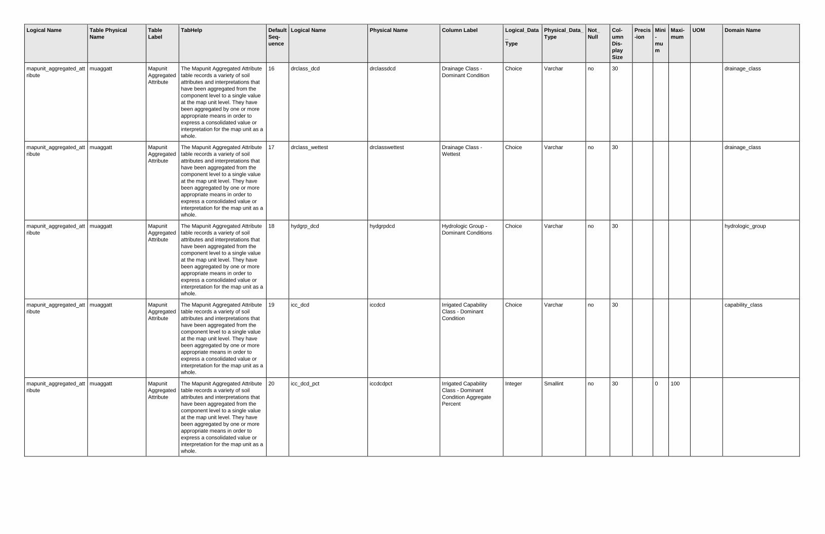
Logical Name Table Physical
Name
Table
Label
TabHelp Default
Seq-
uence
Logical Name Physical Name Column Label Logical_Data
_
Type
Physical_Data_
Type
Not_
Null
Col-
umn
Dis-
play
Size
Precis
-ion
Mini
-
mu
m
Maxi-
mum
UOM Domain Name
mapunit_aggregated_att
ribute
muaggatt Mapunit
Aggregated
Attribute
The Mapunit Aggregated Attribute
table records a variety of soil
attributes and interpretations that
have been aggregated from the
component level to a single value
at the map unit level. They have
been aggregated by one or more
appropriate means in order to
express a consolidated value or
interpretation for the map unit as a
whole.
16 drclass_dcd drclassdcd Drainage Class -
Dominant Condition
Choice Varchar no 30
drainage_class
mapunit_aggregated_att
ribute
muaggatt Mapunit
Aggregated
Attribute
The Mapunit Aggregated Attribute
table records a variety of soil
attributes and interpretations that
have been aggregated from the
component level to a single value
at the map unit level. They have
been aggregated by one or more
appropriate means in order to
express a consolidated value or
interpretation for the map unit as a
whole.
17 drclass_wettest drclasswettest Drainage Class -
Wettest
Choice Varchar no 30
drainage_class
mapunit_aggregated_att
ribute
muaggatt Mapunit
Aggregated
Attribute
The Mapunit Aggregated Attribute
table records a variety of soil
attributes and interpretations that
have been aggregated from the
component level to a single value
at the map unit level. They have
been aggregated by one or more
appropriate means in order to
express a consolidated value or
interpretation for the map unit as a
whole.
18 hydgrp_dcd hydgrpdcd Hydrologic Group -
Dominant Conditions
Choice Varchar no 30
hydrologic_group
mapunit_aggregated_att
ribute
muaggatt Mapunit
Aggregated
Attribute
The Mapunit Aggregated Attribute
table records a variety of soil
attributes and interpretations that
have been aggregated from the
component level to a single value
at the map unit level. They have
been aggregated by one or more
appropriate means in order to
express a consolidated value or
interpretation for the map unit as a
whole.
19 icc_dcd iccdcd Irrigated Capability
Class - Dominant
Condition
Choice Varchar no 30
capability_class
mapunit_aggregated_att
ribute
muaggatt Mapunit
Aggregated
Attribute
The Mapunit Aggregated Attribute
table records a variety of soil
attributes and interpretations that
have been aggregated from the
component level to a single value
at the map unit level. They have
been aggregated by one or more
appropriate means in order to
express a consolidated value or
interpretation for the map unit as a
whole.
20 icc_dcd_pct iccdcdpct Irrigated Capability
Class - Dominant
Condition Aggregate
Percent
Integer Smallint no 30
0 100

Logical Name Table Physical
Name
Table
Label
TabHelp Default
Seq-
uence
Logical Name Physical Name Column Label Logical_Data
_
Type
Physical_Data_
Type
Not_
Null
Col-
umn
Dis-
play
Size
Precis
-ion
Mini
-
mu
m
Maxi-
mum
UOM Domain Name
mapunit_aggregated_att
ribute
muaggatt Mapunit
Aggregated
Attribute
The Mapunit Aggregated Attribute
table records a variety of soil
attributes and interpretations that
have been aggregated from the
component level to a single value
at the map unit level. They have
been aggregated by one or more
appropriate means in order to
express a consolidated value or
interpretation for the map unit as a
whole.
21 nicc_dcd niccdcd Non-Irrigated Capability
Class - Dominant
Condition
Choice Varchar no 30
capability_class
mapunit_aggregated_att
ribute
muaggatt Mapunit
Aggregated
Attribute
The Mapunit Aggregated Attribute
table records a variety of soil
attributes and interpretations that
have been aggregated from the
component level to a single value
at the map unit level. They have
been aggregated by one or more
appropriate means in order to
express a consolidated value or
interpretation for the map unit as a
whole.
22 nicc_dcd_pct niccdcdpct Non-Irrigated Capability
Class - Dominant
Condition Aggregate
Percent
Integer Smallint no 30
0 100
mapunit_aggregated_att
ribute
muaggatt Mapunit
Aggregated
Attribute
The Mapunit Aggregated Attribute
table records a variety of soil
attributes and interpretations that
have been aggregated from the
component level to a single value
at the map unit level. They have
been aggregated by one or more
appropriate means in order to
express a consolidated value or
interpretation for the map unit as a
whole.
23 eng_dwob_dcd engdwobdcd ENG - Dwellings W/O
Basements - Dominant
Condition
String Varchar no 30
mapunit_aggregated_att
ribute
muaggatt Mapunit
Aggregated
Attribute
The Mapunit Aggregated Attribute
table records a variety of soil
attributes and interpretations that
have been aggregated from the
component level to a single value
at the map unit level. They have
been aggregated by one or more
appropriate means in order to
express a consolidated value or
interpretation for the map unit as a
whole.
24 eng_dwb_dcd engdwbdcd ENG - Dwellings with
Basements - Dominant
Condition
String Varchar no 30
mapunit_aggregated_att
ribute
muaggatt Mapunit
Aggregated
Attribute
The Mapunit Aggregated Attribute
table records a variety of soil
attributes and interpretations that
have been aggregated from the
component level to a single value
at the map unit level. They have
been aggregated by one or more
appropriate means in order to
express a consolidated value or
interpretation for the map unit as a
whole.
25 eng_dwb_ll engdwbll ENG - Dwellings with
Basements - Least
Limiting
String Varchar no 30

Logical Name Table Physical
Name
Table
Label
TabHelp Default
Seq-
uence
Logical Name Physical Name Column Label Logical_Data
_
Type
Physical_Data_
Type
Not_
Null
Col-
umn
Dis-
play
Size
Precis
-ion
Mini
-
mu
m
Maxi-
mum
UOM Domain Name
mapunit_aggregated_att
ribute
muaggatt Mapunit
Aggregated
Attribute
The Mapunit Aggregated Attribute
table records a variety of soil
attributes and interpretations that
have been aggregated from the
component level to a single value
at the map unit level. They have
been aggregated by one or more
appropriate means in order to
express a consolidated value or
interpretation for the map unit as a
whole.
26 eng_dwb_ml engdwbml ENG - Dwellings with
Basements - Most
Limiting
String Varchar no 30
mapunit_aggregated_att
ribute
muaggatt Mapunit
Aggregated
Attribute
The Mapunit Aggregated Attribute
table records a variety of soil
attributes and interpretations that
have been aggregated from the
component level to a single value
at the map unit level. They have
been aggregated by one or more
appropriate means in order to
express a consolidated value or
interpretation for the map unit as a
whole.
27 eng_staf_dcd engstafdcd ENG - Septic Tank
Absorption Fields -
Dominant Condition
String Varchar no 30
mapunit_aggregated_att
ribute
muaggatt Mapunit
Aggregated
Attribute
The Mapunit Aggregated Attribute
table records a variety of soil
attributes and interpretations that
have been aggregated from the
component level to a single value
at the map unit level. They have
been aggregated by one or more
appropriate means in order to
express a consolidated value or
interpretation for the map unit as a
whole.
28 eng_staf_ll engstafll ENG - Septic Tank
Absorption Fields -
Least Limiting
String Varchar no 30
mapunit_aggregated_att
ribute
muaggatt Mapunit
Aggregated
Attribute
The Mapunit Aggregated Attribute
table records a variety of soil
attributes and interpretations that
have been aggregated from the
component level to a single value
at the map unit level. They have
been aggregated by one or more
appropriate means in order to
express a consolidated value or
interpretation for the map unit as a
whole.
29 eng_staf_ml engstafml ENG - Septic Tank
Absorption Fields - Most
Limiting
String Varchar no 30
mapunit_aggregated_att
ribute
muaggatt Mapunit
Aggregated
Attribute
The Mapunit Aggregated Attribute
table records a variety of soil
attributes and interpretations that
have been aggregated from the
component level to a single value
at the map unit level. They have
been aggregated by one or more
appropriate means in order to
express a consolidated value or
interpretation for the map unit as a
whole.
30 eng_sl_dcd engsldcd ENG - Sewage Lagoons
- Dominant Condition
String Varchar no 30

Logical Name Table Physical
Name
Table
Label
TabHelp Default
Seq-
uence
Logical Name Physical Name Column Label Logical_Data
_
Type
Physical_Data_
Type
Not_
Null
Col-
umn
Dis-
play
Size
Precis
-ion
Mini
-
mu
m
Maxi-
mum
UOM Domain Name
mapunit_aggregated_att
ribute
muaggatt Mapunit
Aggregated
Attribute
The Mapunit Aggregated Attribute
table records a variety of soil
attributes and interpretations that
have been aggregated from the
component level to a single value
at the map unit level. They have
been aggregated by one or more
appropriate means in order to
express a consolidated value or
interpretation for the map unit as a
whole.
31 eng_sl_dcp engsldcp ENG - Sewage Lagoons
- Dominant Component
String Varchar no 30
mapunit_aggregated_att
ribute
muaggatt Mapunit
Aggregated
Attribute
The Mapunit Aggregated Attribute
table records a variety of soil
attributes and interpretations that
have been aggregated from the
component level to a single value
at the map unit level. They have
been aggregated by one or more
appropriate means in order to
express a consolidated value or
interpretation for the map unit as a
whole.
32 eng_lrs_dcd englrsdcd ENG - Local Roads and
Streets - Dominant
Condition
String Varchar no 30
mapunit_aggregated_att
ribute
muaggatt Mapunit
Aggregated
Attribute
The Mapunit Aggregated Attribute
table records a variety of soil
attributes and interpretations that
have been aggregated from the
component level to a single value
at the map unit level. They have
been aggregated by one or more
appropriate means in order to
express a consolidated value or
interpretation for the map unit as a
whole.
33 eng_cm_ss_dcd engcmssdcd ENG - Construction
Materials; Sand Source
- Dominant Condition
String Varchar no 30
mapunit_aggregated_att
ribute
muaggatt Mapunit
Aggregated
Attribute
The Mapunit Aggregated Attribute
table records a variety of soil
attributes and interpretations that
have been aggregated from the
component level to a single value
at the map unit level. They have
been aggregated by one or more
appropriate means in order to
express a consolidated value or
interpretation for the map unit as a
whole.
34 eng_cm_ss_mp engcmssmp ENG - Construction
Materials; Sand Source
- Most Probable
String Varchar no 30
mapunit_aggregated_att
ribute
muaggatt Mapunit
Aggregated
Attribute
The Mapunit Aggregated Attribute
table records a variety of soil
attributes and interpretations that
have been aggregated from the
component level to a single value
at the map unit level. They have
been aggregated by one or more
appropriate means in order to
express a consolidated value or
interpretation for the map unit as a
whole.
35 urb_rec_pt_dcd urbrecptdcd URB/REC - Paths and
Trails - Dominant
Condition
String Varchar no 30

Logical Name Table Physical
Name
Table
Label
TabHelp Default
Seq-
uence
Logical Name Physical Name Column Label Logical_Data
_
Type
Physical_Data_
Type
Not_
Null
Col-
umn
Dis-
play
Size
Precis
-ion
Mini
-
mu
m
Maxi-
mum
UOM Domain Name
mapunit_aggregated_att
ribute
muaggatt Mapunit
Aggregated
Attribute
The Mapunit Aggregated Attribute
table records a variety of soil
attributes and interpretations that
have been aggregated from the
component level to a single value
at the map unit level. They have
been aggregated by one or more
appropriate means in order to
express a consolidated value or
interpretation for the map unit as a
whole.
36 urb_rec_pt_wta urbrecptwta URB/REC - Paths and
Trails - Weighted
Average
Float Real no 25 2
mapunit_aggregated_att
ribute
muaggatt Mapunit
Aggregated
Attribute
The Mapunit Aggregated Attribute
table records a variety of soil
attributes and interpretations that
have been aggregated from the
component level to a single value
at the map unit level. They have
been aggregated by one or more
appropriate means in order to
express a consolidated value or
interpretation for the map unit as a
whole.
37 for_peh_rt_dcp forpehrtdcp FOR - Potential Erosion
Hazard (Road/Trail) -
Dominant Component
String Varchar no 30
mapunit_aggregated_att
ribute
muaggatt Mapunit
Aggregated
Attribute
The Mapunit Aggregated Attribute
table records a variety of soil
attributes and interpretations that
have been aggregated from the
component level to a single value
at the map unit level. They have
been aggregated by one or more
appropriate means in order to
express a consolidated value or
interpretation for the map unit as a
whole.
38 hydcl_prs hydclprs Hydric Classification -
Presence
Integer Int no 30
mapunit_aggregated_att
ribute
muaggatt Mapunit
Aggregated
Attribute
The Mapunit Aggregated Attribute
table records a variety of soil
attributes and interpretations that
have been aggregated from the
component level to a single value
at the map unit level. They have
been aggregated by one or more
appropriate means in order to
express a consolidated value or
interpretation for the map unit as a
whole.
39 awm_mfpw_wta awmmfpwwta AWM - Manure and
Food Processing Waste
- Weighted Average
Float Real no 30 2
mapunit_aggregated_att
ribute
muaggatt Mapunit
Aggregated
Attribute
The Mapunit Aggregated Attribute
table records a variety of soil
attributes and interpretations that
have been aggregated from the
component level to a single value
at the map unit level. They have
been aggregated by one or more
appropriate means in order to
express a consolidated value or
interpretation for the map unit as a
whole.
40 mapunit_key mukey Mapunit Key Integer Int yes 30
mapunit_area_overlap muaoverlap Mapunit
Area
Overlap
The Mapunit Area Overlap table
lists the map units that exist in the
overlap between the entire soil
survey area and the referenced
geographic area in the Legend
Area Overlap table.
1 area_overlap_acres areaovacres Overlap Acres Integer Int no 11
0
acres

Logical Name Table Physical
Name
Table
Label
TabHelp Default
Seq-
uence
Logical Name Physical Name Column Label Logical_Data
_
Type
Physical_Data_
Type
Not_
Null
Col-
umn
Dis-
play
Size
Precis
-ion
Mini
-
mu
m
Maxi-
mum
UOM Domain Name
mapunit_area_overlap muaoverlap Mapunit
Area
Overlap
The Mapunit Area Overlap table
lists the map units that exist in the
overlap between the entire soil
survey area and the referenced
geographic area in the Legend
Area Overlap table.
2 legend_area_overlap_key lareaovkey Legend Area Overlap
Key
Integer Int yes 30
mapunit_area_overlap muaoverlap Mapunit
Area
Overlap
The Mapunit Area Overlap table
lists the map units that exist in the
overlap between the entire soil
survey area and the referenced
geographic area in the Legend
Area Overlap table.
3 mapunit_key mukey Mapunit Key Integer Int yes 30
mapunit_area_overlap muaoverlap Mapunit
Area
Overlap
The Mapunit Area Overlap table
lists the map units that exist in the
overlap between the entire soil
survey area and the referenced
geographic area in the Legend
Area Overlap table.
4 mapunit_area_overlap_key muareaovkey Mapunit Area Overlap
Key
Integer Int yes 30
mapunit_crop_yield mucropyld Mapunit
Crop Yield
The Mapunit Crop Yield table lists
commonly grown crops and their
expected yields for the referenced
map unit as a whole. Yields for
individual map unit components
are given in the Component Crop
Yield table.
1 crop_name cropname Crop Name Choice Varchar no 30
crop_name
mapunit_crop_yield mucropyld Mapunit
Crop Yield
The Mapunit Crop Yield table lists
commonly grown crops and their
expected yields for the referenced
map unit as a whole. Yields for
individual map unit components
are given in the Component Crop
Yield table.
2 crop_yield_units yldunits Units Choice Varchar no 30
crop_yield_units
mapunit_crop_yield mucropyld Mapunit
Crop Yield
The Mapunit Crop Yield table lists
commonly grown crops and their
expected yields for the referenced
map unit as a whole. Yields for
individual map unit components
are given in the Component Crop
Yield table.
3 nonirr_crop_yield nonirryield Nirr Yield Float Real no 10 2 0 9999.9
9
mapunit_crop_yield mucropyld Mapunit
Crop Yield
The Mapunit Crop Yield table lists
commonly grown crops and their
expected yields for the referenced
map unit as a whole. Yields for
individual map unit components
are given in the Component Crop
Yield table.
4 irrigated_crop_yield irryield Irr Yield Float Real no 9 2 0 9999.9
9
mapunit_crop_yield mucropyld Mapunit
Crop Yield
The Mapunit Crop Yield table lists
commonly grown crops and their
expected yields for the referenced
map unit as a whole. Yields for
individual map unit components
are given in the Component Crop
Yield table.
5 mapunit_key mukey Mapunit Key Integer Int yes 30
mapunit_crop_yield mucropyld Mapunit
Crop Yield
The Mapunit Crop Yield table lists
commonly grown crops and their
expected yields for the referenced
map unit as a whole. Yields for
individual map unit components
are given in the Component Crop
Yield table.
6 mapunit_crop_yield_key mucrpyldkey Mapunit Crop Yield Key Integer Int yes 30

Logical Name Table Physical
Name
Table
Label
TabHelp Default
Seq-
uence
Logical Name Physical Name Column Label Logical_Data
_
Type
Physical_Data_
Type
Not_
Null
Col-
umn
Dis-
play
Size
Precis
-ion
Mini
-
mu
m
Maxi-
mum
UOM Domain Name
mapunit_line muline Mapunit
Line
The Mapunit Line table records all
map units in a soil survey area that
were digitized as one or more
lines.
1 area_symbol areasymbol Area Symbol String Varchar yes 20
mapunit_line muline Mapunit
Line
The Mapunit Line table records all
map units in a soil survey area that
were digitized as one or more
lines.
2 spatial_version spatialversion Spatial Version Integer Int yes 11
mapunit_line muline Mapunit
Line
The Mapunit Line table records all
map units in a soil survey area that
were digitized as one or more
lines.
3 mapunit_symbol musym Mapunit Symbol String Varchar yes 7
mapunit_line muline Mapunit
Line
The Mapunit Line table records all
map units in a soil survey area that
were digitized as one or more
lines.
4 national_mapunit_symbol nationalmusym National Mapunit
Symbol
String Varchar yes
mapunit_line muline Mapunit
Line
The Mapunit Line table records all
map units in a soil survey area that
were digitized as one or more
lines.
5 mapunit_key mukey Mapunit Key Integer Int yes 30
mapunit_line muline Mapunit
Line
The Mapunit Line table records all
map units in a soil survey area that
were digitized as one or more
lines.
6 mapunit_area_acres muareaacres Mapunit Area Acres Float Numeric no
8
acres
mapunit_line muline Mapunit
Line
The Mapunit Line table records all
map units in a soil survey area that
were digitized as one or more
lines.
7 mapunit_line_geographic mulinegeo Mapunit Line
Geographic
SQL
Geometry
Geometry no
mapunit_line muline Mapunit
Line
The Mapunit Line table records all
map units in a soil survey area that
were digitized as one or more
lines.
8 mapunit_line_projected mulineproj Mapunit Line Projected SQL
Geometry
Geometry no
mapunit_line muline Mapunit
Line
The Mapunit Line table records all
map units in a soil survey area that
were digitized as one or more
lines.
9 mapunit_line_key mulinekey Mapunit Line Key Integer Int yes
mapunit_point mupoint Mapunit
Point
The Mapunit Point table records all
map units in a soil survey area that
were digitized as one or more
points.
1 area_symbol areasymbol Area Symbol String Varchar yes 20
mapunit_point mupoint Mapunit
Point
The Mapunit Point table records all
map units in a soil survey area that
were digitized as one or more
points.
2 spatial_version spatialversion Spatial Version Integer Int yes 11
mapunit_point mupoint Mapunit
Point
The Mapunit Point table records all
map units in a soil survey area that
were digitized as one or more
points.
3 mapunit_symbol musym Mapunit Symbol String Varchar yes 7
mapunit_point mupoint Mapunit
Point
The Mapunit Point table records all
map units in a soil survey area that
were digitized as one or more
points.
4 national_mapunit_symbol nationalmusym National Mapunit
Symbol
String Varchar yes
mapunit_point mupoint Mapunit
Point
The Mapunit Point table records all
map units in a soil survey area that
were digitized as one or more
points.
5 mapunit_key mukey Mapunit Key Integer Int yes 30

Logical Name Table Physical
Name
Table
Label
TabHelp Default
Seq-
uence
Logical Name Physical Name Column Label Logical_Data
_
Type
Physical_Data_
Type
Not_
Null
Col-
umn
Dis-
play
Size
Precis
-ion
Mini
-
mu
m
Maxi-
mum
UOM Domain Name
mapunit_point mupoint Mapunit
Point
The Mapunit Point table records all
map units in a soil survey area that
were digitized as one or more
points.
6 mapunit_area_acres muareaacres Mapunit Area Acres Float Numeric no
8
acres
mapunit_point mupoint Mapunit
Point
The Mapunit Point table records all
map units in a soil survey area that
were digitized as one or more
points.
7 mapunit_point_geographic mupointgeo Mapunit Point
Geographic
SQL
Geometry
Geometry no
mapunit_point mupoint Mapunit
Point
The Mapunit Point table records all
map units in a soil survey area that
were digitized as one or more
points.
8 mapunit_point_projected mupointproj Mapunit Point Projected SQL
Geometry
Geometry no
mapunit_point mupoint Mapunit
Point
The Mapunit Point table records all
map units in a soil survey area that
were digitized as one or more
points.
9 mapunit_point_key mupointkey Mapunit Point Key Integer Int yes
mapunit_polygon mupolygon Mapunit
Polygon
The Mapunit Polygon table
records all map units in a soil
survey area that were digitized as
one or more polygons.
1 area_symbol areasymbol Area Symbol String Varchar yes 20
mapunit_polygon mupolygon Mapunit
Polygon
The Mapunit Polygon table
records all map units in a soil
survey area that were digitized as
one or more polygons.
2 spatial_version spatialversion Spatial Version Integer Int yes 11
mapunit_polygon mupolygon Mapunit
Polygon
The Mapunit Polygon table
records all map units in a soil
survey area that were digitized as
one or more polygons.
3 mapunit_symbol musym Mapunit Symbol String Varchar yes 7
mapunit_polygon mupolygon Mapunit
Polygon
The Mapunit Polygon table
records all map units in a soil
survey area that were digitized as
one or more polygons.
4 national_mapunit_symbol nationalmusym National Mapunit
Symbol
String Varchar yes
mapunit_polygon mupolygon Mapunit
Polygon
The Mapunit Polygon table
records all map units in a soil
survey area that were digitized as
one or more polygons.
5 mapunit_key mukey Mapunit Key Integer Int yes 30
mapunit_polygon mupolygon Mapunit
Polygon
The Mapunit Polygon table
records all map units in a soil
survey area that were digitized as
one or more polygons.
6 mapunit_area_acres muareaacres Mapunit Area Acres Float Numeric no
8
acres
mapunit_polygon mupolygon Mapunit
Polygon
The Mapunit Polygon table
records all map units in a soil
survey area that were digitized as
one or more polygons.
7 mapunit_polygon_geographic mupolygongeo Mapunit Polygon
Geographic
SQL
Geometry
Geometry no
mapunit_polygon mupolygon Mapunit
Polygon
The Mapunit Polygon table
records all map units in a soil
survey area that were digitized as
one or more polygons.
8 mapunit_polygon_projected mupolygonproj Mapunit Polygon
Projected
SQL
Geometry
Geometry no
mapunit_polygon mupolygon Mapunit
Polygon
The Mapunit Polygon table
records all map units in a soil
survey area that were digitized as
one or more polygons.
9 mapunit_polygon_key mupolygonkey Mapunit Polygon Key Integer Int yes
mapunit_polygon mupolygon Mapunit
Polygon
The Mapunit Polygon table
records all map units in a soil
survey area that were digitized as
one or more polygons.
10 point_acreage pointacreage Point acreage Float Numeric no
8
acres
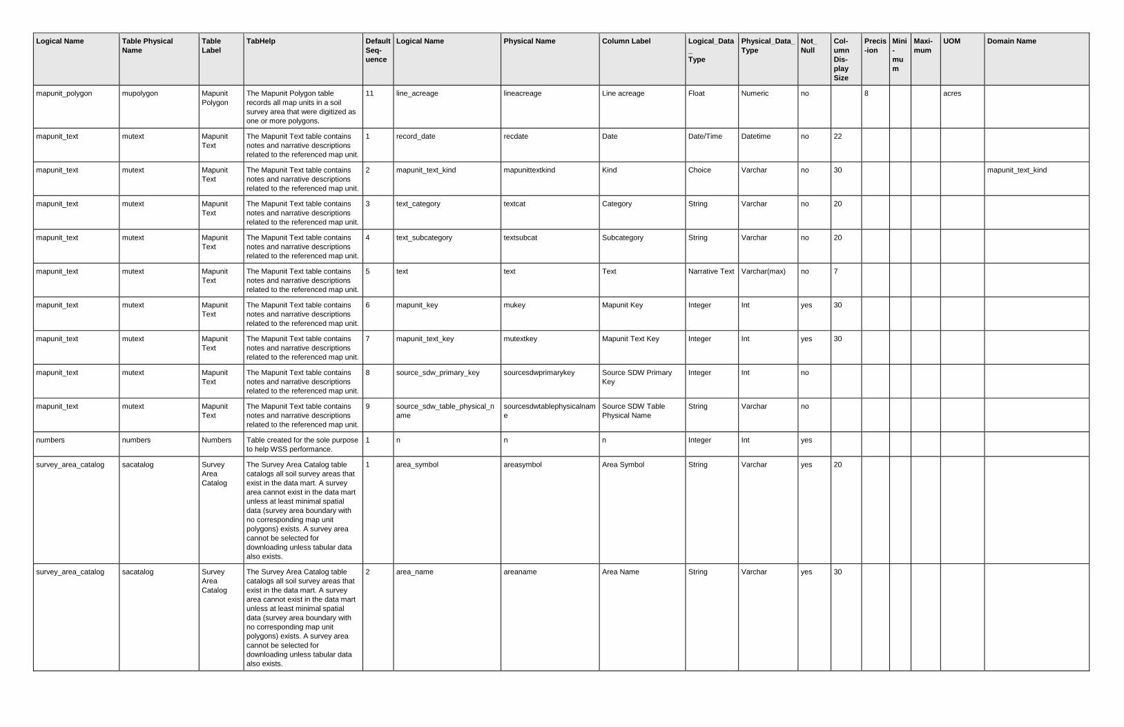
Logical Name Table Physical
Name
Table
Label
TabHelp Default
Seq-
uence
Logical Name Physical Name Column Label Logical_Data
_
Type
Physical_Data_
Type
Not_
Null
Col-
umn
Dis-
play
Size
Precis
-ion
Mini
-
mu
m
Maxi-
mum
UOM Domain Name
mapunit_polygon mupolygon Mapunit
Polygon
The Mapunit Polygon table
records all map units in a soil
survey area that were digitized as
one or more polygons.
11 line_acreage lineacreage Line acreage Float Numeric no
8
acres
mapunit_text mutext Mapunit
Text
The Mapunit Text table contains
notes and narrative descriptions
related to the referenced map unit.
1 record_date recdate Date Date/Time Datetime no 22
mapunit_text mutext Mapunit
Text
The Mapunit Text table contains
notes and narrative descriptions
related to the referenced map unit.
2 mapunit_text_kind mapunittextkind Kind Choice Varchar no 30
mapunit_text_kind
mapunit_text mutext Mapunit
Text
The Mapunit Text table contains
notes and narrative descriptions
related to the referenced map unit.
3 text_category textcat Category String Varchar no 20
mapunit_text mutext Mapunit
Text
The Mapunit Text table contains
notes and narrative descriptions
related to the referenced map unit.
4 text_subcategory textsubcat Subcategory String Varchar no 20
mapunit_text mutext Mapunit
Text
The Mapunit Text table contains
notes and narrative descriptions
related to the referenced map unit.
5 text text Text Narrative Text Varchar(max) no 7
mapunit_text mutext Mapunit
Text
The Mapunit Text table contains
notes and narrative descriptions
related to the referenced map unit.
6 mapunit_key mukey Mapunit Key Integer Int yes 30
mapunit_text mutext Mapunit
Text
The Mapunit Text table contains
notes and narrative descriptions
related to the referenced map unit.
7 mapunit_text_key mutextkey Mapunit Text Key Integer Int yes 30
mapunit_text mutext Mapunit
Text
The Mapunit Text table contains
notes and narrative descriptions
related to the referenced map unit.
8 source_sdw_primary_key sourcesdwprimarykey Source SDW Primary
Key
Integer Int no
mapunit_text mutext Mapunit
Text
The Mapunit Text table contains
notes and narrative descriptions
related to the referenced map unit.
9 source_sdw_table_physical_n
ame
sourcesdwtablephysicalnam
e
Source SDW Table
Physical Name
String Varchar no
numbers numbers Numbers Table created for the sole purpose
to help WSS performance.
1 n n n Integer Int yes
survey_area_catalog sacatalog Survey
Area
Catalog
The Survey Area Catalog table
catalogs all soil survey areas that
exist in the data mart. A survey
area cannot exist in the data mart
unless at least minimal spatial
data (survey area boundary with
no corresponding map unit
polygons) exists. A survey area
cannot be selected for
downloading unless tabular data
also exists.
1 area_symbol areasymbol Area Symbol String Varchar yes 20
survey_area_catalog sacatalog Survey
Area
Catalog
The Survey Area Catalog table
catalogs all soil survey areas that
exist in the data mart. A survey
area cannot exist in the data mart
unless at least minimal spatial
data (survey area boundary with
no corresponding map unit
polygons) exists. A survey area
cannot be selected for
downloading unless tabular data
also exists.
2 area_name areaname Area Name String Varchar yes 30

Logical Name Table Physical
Name
Table
Label
TabHelp Default
Seq-
uence
Logical Name Physical Name Column Label Logical_Data
_
Type
Physical_Data_
Type
Not_
Null
Col-
umn
Dis-
play
Size
Precis
-ion
Mini
-
mu
m
Maxi-
mum
UOM Domain Name
survey_area_catalog sacatalog Survey
Area
Catalog
The Survey Area Catalog table
catalogs all soil survey areas that
exist in the data mart. A survey
area cannot exist in the data mart
unless at least minimal spatial
data (survey area boundary with
no corresponding map unit
polygons) exists. A survey area
cannot be selected for
downloading unless tabular data
also exists.
3 survey_area_version saversion Survey Area Version Integer Int yes 11
survey_area_catalog sacatalog Survey
Area
Catalog
The Survey Area Catalog table
catalogs all soil survey areas that
exist in the data mart. A survey
area cannot exist in the data mart
unless at least minimal spatial
data (survey area boundary with
no corresponding map unit
polygons) exists. A survey area
cannot be selected for
downloading unless tabular data
also exists.
4 survey_area_version_est saverest Survey Area Version
Established
Date/Time Datetime yes 22
survey_area_catalog sacatalog Survey
Area
Catalog
The Survey Area Catalog table
catalogs all soil survey areas that
exist in the data mart. A survey
area cannot exist in the data mart
unless at least minimal spatial
data (survey area boundary with
no corresponding map unit
polygons) exists. A survey area
cannot be selected for
downloading unless tabular data
also exists.
5 fgdc_metadata fgdcmetadata FGDC Metadata Narrative Text Varchar(max) yes 8
survey_area_catalog sacatalog Survey
Area
Catalog
The Survey Area Catalog table
catalogs all soil survey areas that
exist in the data mart. A survey
area cannot exist in the data mart
unless at least minimal spatial
data (survey area boundary with
no corresponding map unit
polygons) exists. A survey area
cannot be selected for
downloading unless tabular data
also exists.
6 min_bound_rec_min_x mbrminx Minimum Bounding
Rectangle Minimum X
Float Float no 19 15 -180 180 degrees
survey_area_catalog sacatalog Survey
Area
Catalog
The Survey Area Catalog table
catalogs all soil survey areas that
exist in the data mart. A survey
area cannot exist in the data mart
unless at least minimal spatial
data (survey area boundary with
no corresponding map unit
polygons) exists. A survey area
cannot be selected for
downloading unless tabular data
also exists.
7 min_bound_rec_min_y mbrminy Minimum Bounding
Rectangle Minimum Y
Float Float no 19 15 -90 90 degrees
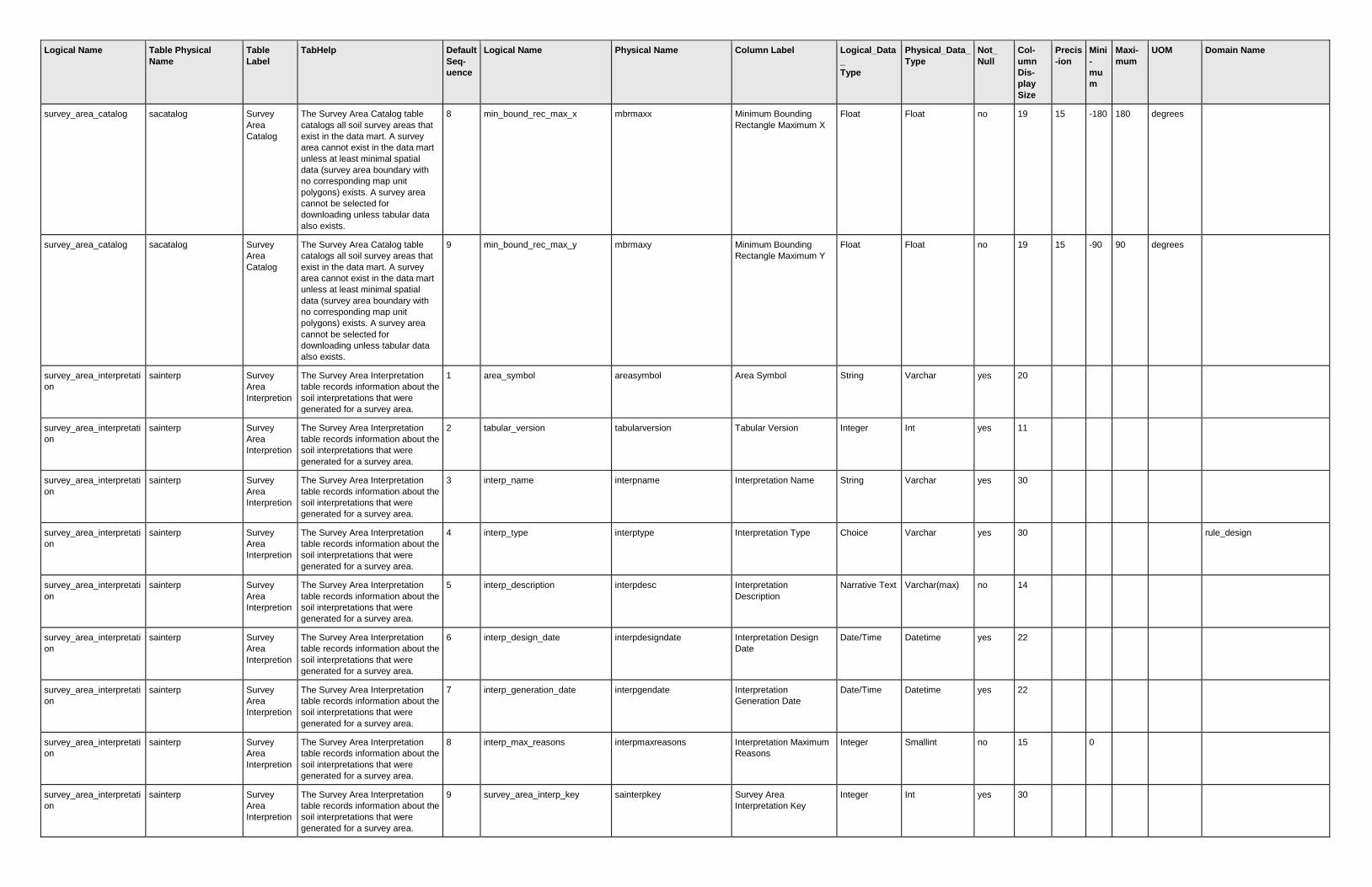
Logical Name Table Physical
Name
Table
Label
TabHelp Default
Seq-
uence
Logical Name Physical Name Column Label Logical_Data
_
Type
Physical_Data_
Type
Not_
Null
Col-
umn
Dis-
play
Size
Precis
-ion
Mini
-
mu
m
Maxi-
mum
UOM Domain Name
survey_area_catalog sacatalog Survey
Area
Catalog
The Survey Area Catalog table
catalogs all soil survey areas that
exist in the data mart. A survey
area cannot exist in the data mart
unless at least minimal spatial
data (survey area boundary with
no corresponding map unit
polygons) exists. A survey area
cannot be selected for
downloading unless tabular data
also exists.
8 min_bound_rec_max_x mbrmaxx Minimum Bounding
Rectangle Maximum X
Float Float no 19 15 -180 180 degrees
survey_area_catalog sacatalog Survey
Area
Catalog
The Survey Area Catalog table
catalogs all soil survey areas that
exist in the data mart. A survey
area cannot exist in the data mart
unless at least minimal spatial
data (survey area boundary with
no corresponding map unit
polygons) exists. A survey area
cannot be selected for
downloading unless tabular data
also exists.
9 min_bound_rec_max_y mbrmaxy Minimum Bounding
Rectangle Maximum Y
Float Float no 19 15 -90 90 degrees
survey_area_interpretati
on
sainterp Survey
Area
Interpretion
The Survey Area Interpretation
table records information about the
soil interpretations that were
generated for a survey area.
1 area_symbol areasymbol Area Symbol String Varchar yes 20
survey_area_interpretati
on
sainterp Survey
Area
Interpretion
The Survey Area Interpretation
table records information about the
soil interpretations that were
generated for a survey area.
2 tabular_version tabularversion Tabular Version Integer Int yes 11
survey_area_interpretati
on
sainterp Survey
Area
Interpretion
The Survey Area Interpretation
table records information about the
soil interpretations that were
generated for a survey area.
3 interp_name interpname Interpretation Name String Varchar yes 30
survey_area_interpretati
on
sainterp Survey
Area
Interpretion
The Survey Area Interpretation
table records information about the
soil interpretations that were
generated for a survey area.
4 interp_type interptype Interpretation Type Choice Varchar yes 30
rule_design
survey_area_interpretati
on
sainterp Survey
Area
Interpretion
The Survey Area Interpretation
table records information about the
soil interpretations that were
generated for a survey area.
5 interp_description interpdesc Interpretation
Description
Narrative Text Varchar(max) no 14
survey_area_interpretati
on
sainterp Survey
Area
Interpretion
The Survey Area Interpretation
table records information about the
soil interpretations that were
generated for a survey area.
6 interp_design_date interpdesigndate Interpretation Design
Date
Date/Time Datetime yes 22
survey_area_interpretati
on
sainterp Survey
Area
Interpretion
The Survey Area Interpretation
table records information about the
soil interpretations that were
generated for a survey area.
7 interp_generation_date interpgendate Interpretation
Generation Date
Date/Time Datetime yes 22
survey_area_interpretati
on
sainterp Survey
Area
Interpretion
The Survey Area Interpretation
table records information about the
soil interpretations that were
generated for a survey area.
8 interp_max_reasons interpmaxreasons Interpretation Maximum
Reasons
Integer Smallint no 15
0
survey_area_interpretati
on
sainterp Survey
Area
Interpretion
The Survey Area Interpretation
table records information about the
soil interpretations that were
generated for a survey area.
9 survey_area_interp_key sainterpkey Survey Area
Interpretation Key
Integer Int yes 30
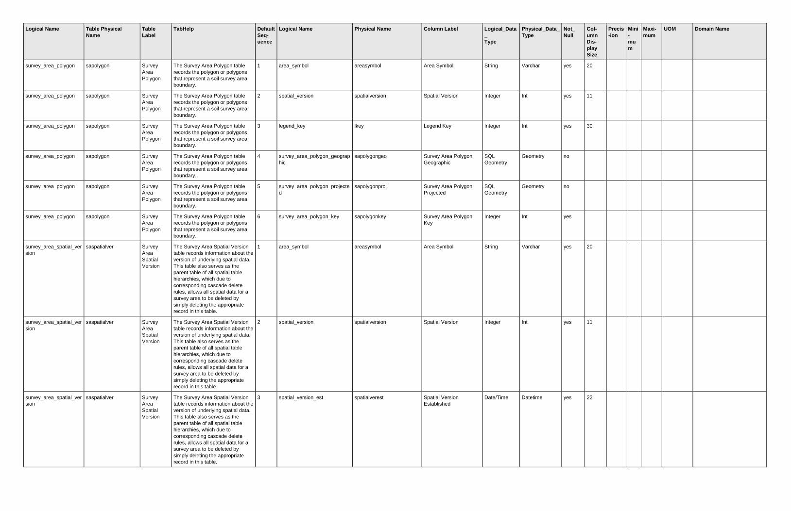
Logical Name Table Physical
Name
Table
Label
TabHelp Default
Seq-
uence
Logical Name Physical Name Column Label Logical_Data
_
Type
Physical_Data_
Type
Not_
Null
Col-
umn
Dis-
play
Size
Precis
-ion
Mini
-
mu
m
Maxi-
mum
UOM Domain Name
survey_area_polygon sapolygon Survey
Area
Polygon
The Survey Area Polygon table
records the polygon or polygons
that represent a soil survey area
boundary.
1 area_symbol areasymbol Area Symbol String Varchar yes 20
survey_area_polygon sapolygon Survey
Area
Polygon
The Survey Area Polygon table
records the polygon or polygons
that represent a soil survey area
boundary.
2 spatial_version spatialversion Spatial Version Integer Int yes 11
survey_area_polygon sapolygon Survey
Area
Polygon
The Survey Area Polygon table
records the polygon or polygons
that represent a soil survey area
boundary.
3 legend_key lkey Legend Key Integer Int yes 30
survey_area_polygon sapolygon Survey
Area
Polygon
The Survey Area Polygon table
records the polygon or polygons
that represent a soil survey area
boundary.
4 survey_area_polygon_geograp
hic
sapolygongeo Survey Area Polygon
Geographic
SQL
Geometry
Geometry no
survey_area_polygon sapolygon Survey
Area
Polygon
The Survey Area Polygon table
records the polygon or polygons
that represent a soil survey area
boundary.
5 survey_area_polygon_projecte
d
sapolygonproj Survey Area Polygon
Projected
SQL
Geometry
Geometry no
survey_area_polygon sapolygon Survey
Area
Polygon
The Survey Area Polygon table
records the polygon or polygons
that represent a soil survey area
boundary.
6 survey_area_polygon_key sapolygonkey Survey Area Polygon
Key
Integer Int yes
survey_area_spatial_ver
sion
saspatialver Survey
Area
Spatial
Version
The Survey Area Spatial Version
table records information about the
version of underlying spatial data.
This table also serves as the
parent table of all spatial table
hierarchies, which due to
corresponding cascade delete
rules, allows all spatial data for a
survey area to be deleted by
simply deleting the appropriate
record in this table.
1 area_symbol areasymbol Area Symbol String Varchar yes 20
survey_area_spatial_ver
sion
saspatialver Survey
Area
Spatial
Version
The Survey Area Spatial Version
table records information about the
version of underlying spatial data.
This table also serves as the
parent table of all spatial table
hierarchies, which due to
corresponding cascade delete
rules, allows all spatial data for a
survey area to be deleted by
simply deleting the appropriate
record in this table.
2 spatial_version spatialversion Spatial Version Integer Int yes 11
survey_area_spatial_ver
sion
saspatialver Survey
Area
Spatial
Version
The Survey Area Spatial Version
table records information about the
version of underlying spatial data.
This table also serves as the
parent table of all spatial table
hierarchies, which due to
corresponding cascade delete
rules, allows all spatial data for a
survey area to be deleted by
simply deleting the appropriate
record in this table.
3 spatial_version_est spatialverest Spatial Version
Established
Date/Time Datetime yes 22

Logical Name Table Physical
Name
Table
Label
TabHelp Default
Seq-
uence
Logical Name Physical Name Column Label Logical_Data
_
Type
Physical_Data_
Type
Not_
Null
Col-
umn
Dis-
play
Size
Precis
-ion
Mini
-
mu
m
Maxi-
mum
UOM Domain Name
survey_area_spatial_ver
sion
saspatialver Survey
Area
Spatial
Version
The Survey Area Spatial Version
table records information about the
version of underlying spatial data.
This table also serves as the
parent table of all spatial table
hierarchies, which due to
corresponding cascade delete
rules, allows all spatial data for a
survey area to be deleted by
simply deleting the appropriate
record in this table.
4 survey_area_boundary_only saboundaryonly Survey Area Boundary
Only
Boolean Bit yes 13
survey_area_spatial_ver
sion
saspatialver Survey
Area
Spatial
Version
The Survey Area Spatial Version
table records information about the
version of underlying spatial data.
This table also serves as the
parent table of all spatial table
hierarchies, which due to
corresponding cascade delete
rules, allows all spatial data for a
survey area to be deleted by
simply deleting the appropriate
record in this table.
5 spatial_est_size spatialestsize Spatial Estimated Size Integer Int no 14
bytes
survey_area_status_ma
p
sastatusmap Survey
Area Status
Map
This table records the polgons that
make up the survey area status
map. This map may include survey
areas for which corresponding
tabular data is not yet available.
1 area_symbol areasymbol Area Symbol String Varchar yes 20
survey_area_status_ma
p
sastatusmap Survey
Area Status
Map
This table records the polgons that
make up the survey area status
map. This map may include survey
areas for which corresponding
tabular data is not yet available.
2 area_name areaname Area Name String Varchar yes 30
survey_area_status_ma
p
sastatusmap Survey
Area Status
Map
This table records the polgons that
make up the survey area status
map. This map may include survey
areas for which corresponding
tabular data is not yet available.
3 survey_area_pub_status_code sapubstatuscode Survey Area Publication
Status Code
Choice Smallint yes 23
survey_area_publication_stat
us
survey_area_status_ma
p
sastatusmap Survey
Area Status
Map
This table records the polgons that
make up the survey area status
map. This map may include survey
areas for which corresponding
tabular data is not yet available.
4 survey_area_pub_status_nam
e
sapubstatusname Survey Area Publication
Status Name
Choice Varchar yes 30
survey_area_publication_stat
us
survey_area_status_ma
p
sastatusmap Survey
Area Status
Map
This table records the polgons that
make up the survey area status
map. This map may include survey
areas for which corresponding
tabular data is not yet available.
5 when_last_updated wlupdated Last Updated Date/Time Datetime yes 22
survey_area_status_ma
p
sastatusmap Survey
Area Status
Map
This table records the polgons that
make up the survey area status
map. This map may include survey
areas for which corresponding
tabular data is not yet available.
6 map_region mapregion Map Region Choice Smallint yes 6
map_region
survey_area_status_ma
p
sastatusmap Survey
Area Status
Map
This table records the polgons that
make up the survey area status
map. This map may include survey
areas for which corresponding
tabular data is not yet available.
7 survey_area_version saversion Survey Area Version Integer Int no

Logical Name Table Physical
Name
Table
Label
TabHelp Default
Seq-
uence
Logical Name Physical Name Column Label Logical_Data
_
Type
Physical_Data_
Type
Not_
Null
Col-
umn
Dis-
play
Size
Precis
-ion
Mini
-
mu
m
Maxi-
mum
UOM Domain Name
survey_area_status_ma
p
sastatusmap Survey
Area Status
Map
This table records the polgons that
make up the survey area status
map. This map may include survey
areas for which corresponding
tabular data is not yet available.
8 survey_area_version_est saverest Survey Area Version
Established
Date/Time Datetime no
survey_area_status_ma
p
sastatusmap Survey
Area Status
Map
This table records the polgons that
make up the survey area status
map. This map may include survey
areas for which corresponding
tabular data is not yet available.
9 is_complete iscomplete Is Complete? Boolean Smallint yes
survey_area_status_ma
p
sastatusmap Survey
Area Status
Map
This table records the polgons that
make up the survey area status
map. This map may include survey
areas for which corresponding
tabular data is not yet available.
10 tabular_mapunit_distribution tabularmudist Tabular Mapunit
Distribution
Choice Int no
survey_area_mapunit_distribu
tion
survey_area_status_ma
p
sastatusmap Survey
Area Status
Map
This table records the polgons that
make up the survey area status
map. This map may include survey
areas for which corresponding
tabular data is not yet available.
11 spatial_mapunit_distribution spatialmudist Spatial Mapunit
Distribution
Choice Int no
survey_area_mapunit_distribu
tion
survey_area_status_ma
p
sastatusmap Survey
Area Status
Map
This table records the polgons that
make up the survey area status
map. This map may include survey
areas for which corresponding
tabular data is not yet available.
12 survey_area_polygon_geograp
hic
sapolygongeo Survey Area Polygon
Geographic
SQL
Geometry
Geometry no
survey_area_status_ma
p
sastatusmap Survey
Area Status
Map
This table records the polgons that
make up the survey area status
map. This map may include survey
areas for which corresponding
tabular data is not yet available.
13 survey_area_polygon_projecte
d
sapolygonproj Survey Area Polygon
Projected
SQL
Geometry
Geometry no
survey_area_status_ma
p
sastatusmap Survey
Area Status
Map
This table records the polgons that
make up the survey area status
map. This map may include survey
areas for which corresponding
tabular data is not yet available.
14 survey_area_polygon_key sapolygonkey Survey Area Polygon
Key
Integer Int yes
survey_area_tabular_ve
rsion
satabularver Survey
Area
Tabular
Version
The Survey Area Tabular Version
table records information about the
version of underlying tabular data.
This table also serves as the
parent table of all tabular table
hierarchies, which due to
corresponding cascade delete
rules, allows all tabular data for a
survey area to be deleted by
simply deleting the appropriate
record in this table.
1 area_symbol areasymbol Area Symbol String Varchar yes 20
survey_area_tabular_ve
rsion
satabularver Survey
Area
Tabular
Version
The Survey Area Tabular Version
table records information about the
version of underlying tabular data.
This table also serves as the
parent table of all tabular table
hierarchies, which due to
corresponding cascade delete
rules, allows all tabular data for a
survey area to be deleted by
simply deleting the appropriate
record in this table.
2 tabular_version tabularversion Tabular Version Integer Int yes 11

Logical Name Table Physical
Name
Table
Label
TabHelp Default
Seq-
uence
Logical Name Physical Name Column Label Logical_Data
_
Type
Physical_Data_
Type
Not_
Null
Col-
umn
Dis-
play
Size
Precis
-ion
Mini
-
mu
m
Maxi-
mum
UOM Domain Name
survey_area_tabular_ve
rsion
satabularver Survey
Area
Tabular
Version
The Survey Area Tabular Version
table records information about the
version of underlying tabular data.
This table also serves as the
parent table of all tabular table
hierarchies, which due to
corresponding cascade delete
rules, allows all tabular data for a
survey area to be deleted by
simply deleting the appropriate
record in this table.
3 tabular_version_est tabularverest Tabular Version
Established
Date/Time Datetime yes 22
survey_area_tabular_ve
rsion
satabularver Survey
Area
Tabular
Version
The Survey Area Tabular Version
table records information about the
version of underlying tabular data.
This table also serves as the
parent table of all tabular table
hierarchies, which due to
corresponding cascade delete
rules, allows all tabular data for a
survey area to be deleted by
simply deleting the appropriate
record in this table.
4 tabular_nasis_export_date tabnasisexportdate Tabular NASIS Export
Date
Date/Time Datetime yes 22
survey_area_tabular_ve
rsion
satabularver Survey
Area
Tabular
Version
The Survey Area Tabular Version
table records information about the
version of underlying tabular data.
This table also serves as the
parent table of all tabular table
hierarchies, which due to
corresponding cascade delete
rules, allows all tabular data for a
survey area to be deleted by
simply deleting the appropriate
record in this table.
5 tabular_certification_status tabcertstatus Tabular Certification
Status
Choice Varchar no 30
export_certification_status
survey_area_tabular_ve
rsion
satabularver Survey
Area
Tabular
Version
The Survey Area Tabular Version
table records information about the
version of underlying tabular data.
This table also serves as the
parent table of all tabular table
hierarchies, which due to
corresponding cascade delete
rules, allows all tabular data for a
survey area to be deleted by
simply deleting the appropriate
record in this table.
6 tabular_cert_status_desc tabcertstatusdesc Tabular Certification
Status Description
Narrative Text Varchar(max) no 21
survey_area_tabular_ve
rsion
satabularver Survey
Area
Tabular
Version
The Survey Area Tabular Version
table records information about the
version of underlying tabular data.
This table also serves as the
parent table of all tabular table
hierarchies, which due to
corresponding cascade delete
rules, allows all tabular data for a
survey area to be deleted by
simply deleting the appropriate
record in this table.
7 tabular_est_size tabularestsize Tabular Estimated Size Integer Int no 14
bytes