soho mission archiving plan
TRANSCRIPT

SOHO Mission Archiving Plan
SUBMITTED IN CONJUNCTION WITH SOHO PROPOSAL TO THE SENIOR REVIEW OF HELIOPHYSICS OPERATING
MISSIONS, 2008 FEBRUARY.

Table of Contents
Executive Summary 1
I. Existing Data Products and Documentation 2
II. The Transition to Resident Archives 11
III. Long-term archiving 29
IV. Software 30
Appendix A. Acronyms 31

Executive Summary
With some minor exceptions, SOHO active archiving is robust: level-0 or -0.5 data are publicly available within minutes to hours of their ground receipt, level-1 and higher products within a few months to a year, and documentation and calibration databases are also publicly available. The existence of multiple copies of the archive with public Internet access insures the survival of the current state of the archive, and facilities in both Europe and the US used for active archiving will serve as resident archives after the mission ends. Instrument resource Web pages direct potential users to publications, calibration information, software descriptions, and user’s guides, as well as to a variety of methods for accessing the data. All SOHO data are accessible via the Virtual Solar Observatory.
This document describes in somewhat more detail the current status of the archiving efforts and documentation by instrument, as well as descriptions of the expected contents of the final archive and the effort needed to produce that archive. We also discuss, where appropriate, the tools commonly used for the analysis of the instruments’ data. Finally, we describe the likely shape of the resident archives that will serve SOHO data, documentation, and analysis tools after the end of the mission.
This document was prepared with the assistance of L. Sánchez Duarte (ESAC) and the SOHO principal Investigator teams.
1

I. Existing Data Products and Documentation
I.A Online Resources
I.A.1 Websites. The SOHO Website, http://soho.nascom.nasa.gov/, contains extensive information on the SOHO mission, instruments, spacecraft ephemeris and attitude, and access to both the SOHO mission archive (less MDI helioseismology observations) and the SOHO publications database. The MDI helioseismology are available at the Stanford Solar Center: http://soi.stanford.edu/data/data_request.html .
I.A.2 Instrument resources pages. Each SOHO instrument Principal Investigator (PI) team has a Webpage with links to standardized resources, including, but not necessarily limited to: published articles in the refereed literature describing the instrument; initial results; operational constraints; data file format description; metadata; reformatting levels; algorithms for reading the data files; recommended data access and analysis software; software and databases for calibrating lower-level data products; a user’s guide to the instrument and data; and PI team contact information. Links to all of these instrument resources pages can be found at: http://soho.nascom.nasa.gov/data/archive/ instruments.html .
I.A.3 Data access methods. The SOHO “data/archive” access page (http:// soho.nascom.nasa.gov/data/data.html ) contains links not only to a search facility for the mission archive at NASA Goddard, but also to: ancillary data such as attitude and ephemeris information, level-0 scientific telemetry since 2002, near realtime images and movies, and related information on space weather, comets, &c. The SOHO archive access page, http://sohodata.nascom.nasa.gov/cgi-bin/gui , uses fill-in forms and scrolling menus to establish metadata search parameters. Alternatively, all SOHO remote-sensing data, including those at Stanford, are also accessible via the Virtual Solar Observatory (VSO), at http://virtualsolar.org/ , through any of the multiple access methods (physical observable, data source, data provider, &c.) offered by the VSO.
I.A.4. Mission data products. Attitude, orbit, and related ancillary files are available on the SOHO Website, with an explanation of contents at: http:// sohowww.nascom.nasa.gov/data/ancillary/ .
I.A.5 Existing data products. The following tables describe the data products for each SOHO experiment currently held in the SOHO archive at GSFC and the MDI archive at Stanford, as well as the mission data products.
2

Data product Format
Uncalibrated, high time resolution data per photomultiplierchannel (level-1)
FITS
Three versions of level-2 calibrated data (whole Sun averageDoppler velocity in m/s), calibrated using three different methods
FITS
Table I-1. Current GOLF data products served by the SOHO archive.
Data product Format
Level 1 high resolution data organized per detector FITS
1 minute cadence time series of calibrated VIRGO total solar irradiance deduced from PMO6V data
ASCII
1 hour cadence time series of calibrated total solar irradiance,PMO6V and DIARAD corrected
ASCII
1 day cadence time series of calibrated total solar irradiance,PMO6V and DIARAD corrected, with DIARAD IRMB level 2data
ASCII
1 minute cadence time series of all three SPM channels,calibrated
ASCII
1 hour cadence time series of all three SPM channels,calibrated
ASCII
1 day cadence time series of all three SPM channels,calibrated
ASCII
LOI 12 pixel images filtered with a 2 day triangular filter ASCII
Table I-2. Current VIRGO data products served by the SOHO archive.
3

Data product Format
Original telemetry as received by the SSSC SFDU
Level-0 MDI image data, organized by Data Product Code (DPC), theonboard-generated data tags describing unique instrumentconfiguration and observing sequence (649 different possibilities)
FITS
Level-1.0 data which is calibrated data in units of m/s, gauss, etc., stored in datasets of (usually) hourly data organized by DPC. (332 distinct Level-1 data series)
FITS
Level 1.4/1.5 data which are collected into datasets named by observables, which may have contributions from multiple DPCs. The 1.4 data are in telemetry order of cropped images, while the 1.5 data are two-dimensional image arrays, reformatted from level 1.4 data if necessary. The 1.5 and higher data do not require special tables to use. There are 22 Level-1.4 series and 86 level-1.5.
FITS
Level 1.7/1.8 data which are “recalibrated,” best available data created on demand from the Level-1.4/1.5 data. Level-1.8 data is the lowest processing level that is recommended for use for most science data analysis, and include the latest information on image scale, image center position, magnetic zero level, &c. Level 1.7/1.8 data are usually recalibrated on the fly at time of export. Final recalibrated values will be used when the data are ingested into a resident archive.
FITS
Level-2 data result from further standard processing for particular purposes. These data include products such as tracked data cubes of time-series of e.g. 15-degree regions in heliographic coordinates followed for 1664 minutes. These data are used for input to “time-distance” and “ring” local helioseismology analysis. There are 120 Level-2 products
FITS
SHT data, Spherical Harmonic Transform data: projections of Dopplergrams onto spherical harmonics. They are used for global helioseismology. There are 45 types, with varying ranges of mode degree-l.
FITS
LOI 12 pixel images filtered with a 2 day triangular filter ASCII
Table I-3a. MDI data products served by the SOI Science Support Center (SSSC) at Stanford University, as of mid-2007. The number may increase during the mission. A much smaller
subset of the most frequently requested MDI data is also served by the SOHO archive at NASA Goddard (see following table).
4
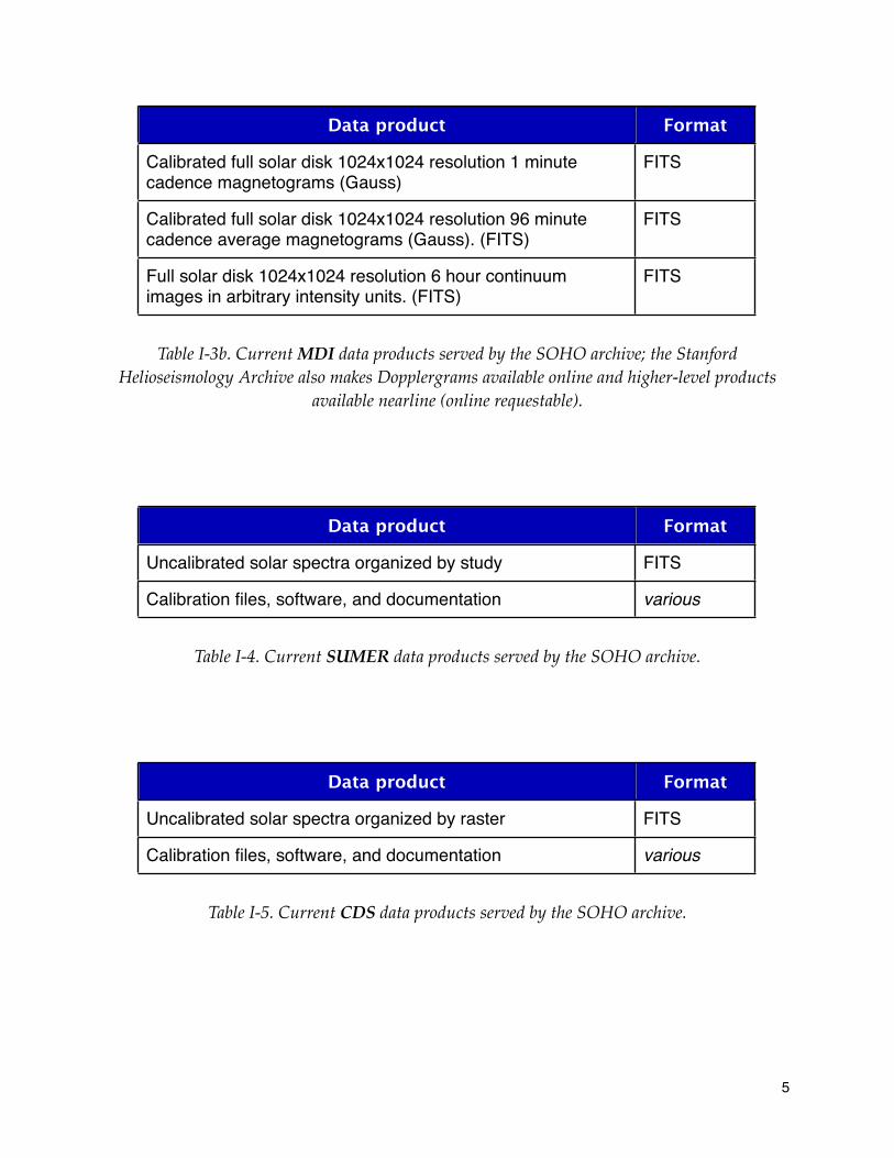
Data product Format
Calibrated full solar disk 1024x1024 resolution 1 minute cadence magnetograms (Gauss)
FITS
Calibrated full solar disk 1024x1024 resolution 96 minute cadence average magnetograms (Gauss). (FITS)
FITS
Full solar disk 1024x1024 resolution 6 hour continuum images in arbitrary intensity units. (FITS)
FITS
Table I-3b. Current MDI data products served by the SOHO archive; the Stanford Helioseismology Archive also makes Dopplergrams available online and higher-level products
available nearline (online requestable).
Data product Format
Uncalibrated solar spectra organized by study FITS
Calibration files, software, and documentation various
Table I-4. Current SUMER data products served by the SOHO archive.
Data product Format
Uncalibrated solar spectra organized by raster FITS
Calibration files, software, and documentation various
Table I-5. Current CDS data products served by the SOHO archive.
5

Data product Format
Uncalibrated, full-disk (and a small number of subfield)images in 171, 195, 284, or 304 Å
FITS
Flat fielding, degridding, and calibration filesSoftware, and documentation
FITS various
Table I-6. Current EIT data products served by the SOHO archive.
Data product Format
Uncalibrated UV spectra organized per XDL detector (each file holds multiple individual exposures)
FITS
Uncalibrated visible light data (counts from the photomultipliertube)
FITS
Calibration files Software and documentation
FITS;various
Table I-7. Current UVCS data products served by the SOHO archive.
Data product Format
Uncalibrated Fe XIV and other forbidden line C1 inner coronal images (1996 - 1998); “level 0.5”
FITS
Uncalibrated white light, 1024x1024, coronal images groupedper coronagraph (C2 and C3); “level 0.5”
FITS
1024x1024 resolution white light coronal images calibrated tomean solar brightness, grouped per detector (C2 and C3);level 1
FITS
Table I-8. Current LASCO data products served by the SOHO archive.
6

Data product Format
CTOF sensor rates: Start rate, Double Coincident rate, Triple Coincident rate, Solar wind speed, Proton rate, Helium rate (ratesin Hz)
CDF
CTOF matrix elements CDF
CTOF high resolution matrix rates, including velocity of solar windin m/s
CDF
CTOF pulse height analyzer (raw energy spectra) CDF
HSTOF matrix elements CDF
HSTOF high resolution matrix rates CDF
MTOF sensor rates (Front SEDA rate, neutral stop rate, ion stop rate, neutral double coincidence, ion double coincidence, ion startrate, multiple front SEDA rate, multiple double coincidence rate, neutral rates)
CDF
MTOF pulse height analyzer: Neutral/Ion identification, amplitudes, time of flight
CDF
MTOF time of flight spectrum (far and near sides of MCP) CDF
STOF high basic rate (including both STOF and HSTOF rates) CDF
STOF low basic rate (including both STOF and HSTOF rates) CDF
STOF matrix elements CDF
STOF high resolution matrix rates CDF
STOF pulse height analyzer (raw energy spectra) CDF
PM radial spectra: solar wind speed and alpha (counts per 100seconds)
CDF
PM theta array (counts per 100 seconds) CDF
PM total rates (Hz for each step) CDF
M radial-theta array (counts per 10 minutes) CDF
SEM (photon counts) CDF
7

Data product Format
Proton Monitor 5 minute averages (p speed, density, thermal speed, arrival direction, predicted He speed)
ASCII
Coronal mass ejection data (solar wind speed, kinetic velocity, density, position angle, ion densities)
CDF
Energetic neutral hydrogen atom fluxes (55 - 80 keV, with standard deviations)
CDF
Solar wind speed (for O, Si, Fe) CDF
Solar wind densities (O, O+6, O+7) CDF
Fe freeze-in temperatures and mean charge states CDF
Fe densities by charge state (from Fe+7 to Fe+16) CDF
Si densities (for Si+7, Si+8, Si+9) CDF
S+7 density CDF
Table I-9. Current CELIAS data products served by the SOHO archive.
Data product Format
Proton, deuterium, 3He, 4He: - 1 minute EPHIN counting rates given as intensities (in 1/cm2/s/ sr/MeV or 1/cm2/s/sr/MeV/nucleon; 3 energy bands)- 1 minute EPHIN pulse height analysis (energy deposits in MeV)- 1 minute EPHIN rate correction (in counts). (ASCII)
ASCII
Proton, He:- 15 second LION counting rates given as intensities (units 1/ cm2/s/sr/MeV) in 3 energy bands for protons, 1 for He)
ASCII
Table I-10. Current COSTEP data products served by the SOHO archive.
8

Data product Format
LED onboard analyzed counting rates (proton and He intensities 1/cm2/s/sr/MeV, 10 energy bands)
ASCII
LED pulse height data (MeV) ASCII
HED onboard analyzed counting rate (proton and He intensities 1/cm2/s/sr/MeV, 10 energy bands)
ASCII
HED pulse height data (MeV) ASCII
Table I-11. Current ERNE data products served by the SOHO archive.
Data product Format
Uncalibrated full sky Ly synoptic maps in eclipticcoordinates (one every three days: full time resolution)
FITS
Uncalibrated data organized per target of opportunity FITS
Calibration files, software, and documentation various
Table I-12. Current SWAN data products served by the SOHO archive.
9

Data product Format
Spacecraft attitude files CDF, FITS, ASCII,and SFDU
Spacecraft orbit files CDF, FITS, ASCII,and SFDU
Time correlation log (onboard clock history) ASCII
Daily report (from Flight Operations Team) ASCII
Command history reports ASCII
Spacecraft mode files ASCII
Table I-13. Current Mission data products served by the SOHO archive, available through the SOHO Website and, for FITS versions of attitude and orbit files, readable with SolarSoft
routines.
10

II. The Transition to Resident Archives
During FY09, the SOHO mission will transition to the “Bogart” mission and, after extensive intercalibration with its SDO counterpart, MDI will be turned off. Depending on the success of our request for “optimal” funding in this review, UVCS may be turned off as well. Due to the Scientific and Technical Facilities Council (STFC) funding crisis in the UK, the future funding of CDS is somewhat uncertain at this time. Finally, most US SOHO PI groups will be funded only for archiving in FY10. Thus the transition to the Bogart mission is an appropriate time for defining and creating the archive of “final” SOHO data products for the first 13.5 years of the mission. This includes LASCO, even though LASCO observations will continue in, and are indeed the primary reason for, the Bogart mission.
In the following pages, each PI team describes their archiving plan. Each should be achieved by no later than the end of FY10, and in many cases, well before. We assume that both the SOHO archive at the Solar Data Analysis Center (SDAC) at NASA Goddard and its European counterpart at the ESA Space Astronomy Centre (ESAC) in Spain will contain all of the final data products except for the bulk of MDI data which, as described below, will be ingested into the online data system being built for the SDO HMI database. All of these facilities have high-bandwith connections to the Internet and relatively stable funding with a horizon of at least a few years, corresponding well to the expectations for resident archives in the NASA Heliophysics Science Data Management Policy.
Data Access. Data will continue to be served via the “classic” SOHO archive interface, http:// sohodata.nascom.nasa.gov/cgi-bin/gui and the Virtual Solar Observatory (VSO), http:// virtualsolar.org . We will work with the Virtual Heliospheric Observatory to enable their service of as many heliospheric data sets directly as possible; in any case, all the SOHO data will be available via the VSO through translation of SPASE-based queries to VSO-native queries.
Metadata. Most of the SOHO remote sensing data are stored in FITS files which have extensive metadata available in their headers; it is in part upon those metadata that the VSO has based its data dictionary http://vso.stanford.edu/datamodel.html . The translation between SPASE and the VSO data model is an ongoing effort of the “Heliophysics Virtual Great Observatory,” the consortium of virtual observatory efforts funded by the Heliophysics MO&DA program.
11

GOLF
At present, we provide for public access daily files containing 24 hours of level-1 data. These are the cleaned-up versions of the series of intensities coming from the instrument. Conversion of these data into level-2 data is a research-based program, for which we have at present three versions. These produce three versions of the level-2 data. Level-2 is a continuous time series of the global solar surface velocity, and each is in the form of one file for the entire duration of GOLF observations to date. It is up-dated every year or so and all three versions are in the public archive. At the end of the mission observations a final update will be completed for at least one of the three versions, destined for the final mission archive. The level-2 data is in a simple form readily useable by the non-instrumentalist. The set of level-1 data will also be placed in the final archive. This allows the possibility for the more expert scientist to develop in the future possible improvements on the calibration method to arrive at level-2.
12

VIRGO
Final Archive of VIRGO data
1. Description of the archived data with references to relevant articles
2. Level-1 data as they are on the VDC as daily files. The parameters are: PMO6V, DIARAD, SPM, LOI, HK in FITS ASCII files (these data are corrected for all known effects and are the basis for all further evaluations)
3. Level-2 data which include corrections for degradation, &.: (i) 1-minute data of VIRGO TSI (deduced from PMO6V and corrected as VIRGO TSI hourly and daily data). This will be a binary FITS file; (ii) hourly data of TSI (with records on VIRGO agreed, PMO6V and DIARAD corrected, PMO6V and DIARAD level 1.8 (what this means is in the header and will be explained in the general information). This file corresponds to virgo_tsi_h_v6_001_0801.dat and will be given as an ASACII file; (iii) daily data of TSI (with records on VIRGO agreed, PMO6V and DIARAD corrected, PMO6V and DIARAD level 1.8 (this will be explained in the general information) and the DIARAD IRMB level 2 data, which are their product and could be left out - I agree, they are wrong anyway). This file corresponds to virgo_tsi_d_v6_001_0801.dat and will be given as an ASCII file; (iv) 1-minute, hourly and daily values of the 3 SPM channels. The 1-minute file in FITS format, the daily and hourly as ascii files.; (v) LOI data high-pass filtered with a 2-day triangular filter as FITS file (this is an image, although with little spatial resolution).
4. The data will be made available at the VDC and at PMOD/WRC (radiometry and SPM) and at IAS, Orsay (LOI), as well as at the SOHO European (ESAC) and US (Goddard) archives.
13

MDI
Unlike the other SOHO instruments where the primary archive is the SOHO archive at GSFC, the primary MDI archive during the mission has been the SSSC (SOHO / Stanford Science Support Center) at Stanford University. The bulk of the MDI (and therefore SOHO) data resides at the MDI data center. The current access is via: http://soi.stanford.edu/data/ .
The MDI data center is based on the DSDS (Data Storage and Distribution System) which is implemented in the SSSC. Data stored in the DSDS is in FITS file protocols with metadata also present in “.rdb” format which is tab delimited table data. The DSDS uses Ampex DD-2 19mm 330GByte tapes as its primary offline medium. (A copy of the Level-0 data are stored at the Joint Institute for Laboratory Astrophysics at the University of Colorado.) Metadata consisting primarily of the catalog of datasets is maintained in the DSDS Oracle database. MDI data is organized as “Dataseries” which are sequences of “Datasets”. A Dataset is a set of “images” spanning usually a range of time such as 60 one-minute Dopplergrams. A Dataseries is the collection of all Datasets of a given type such as the set of all hours of one-minute Dopplergrams. The data is stored by “Dataset Name” which consists of three parts: Project, Level, and Series and indexed by Series number. The holdings consist of more than 150 TByte of MDI data with a total of more than 200 TByte including ancillary data. The contents of archive at Stanford includes the dataseries listed in Table I-3a, above.
In addition to data files, there are numerous data calibration tables, event lists, command sequences, command logs, &c., which are maintained on the MDI Webpages. While these ancillary products are not strictly needed for use of the Level-1.8 data they are very helpful in resolving issues related to non-normal observing conditions.
In addition to digital data, the MDI team maintains a collection of Technical Documents some of which have online versions. These describe the implementation of the MDI instrument and the DSDS data system as well as early calibration efforts.
The best information on MDI calibration issues resides in the published journals and conference proceedings and Ph.D. dissertations.
The software for operating the DSDS and analysis through the above data products is also available through DSDS web services.
Additionally, some MDI Co-Investigators have developed SolarSoft IDL software which while not part of and not maintained by the MDI team directly is nevertheless used by many investigators to aid in the use of some of the MDI data products.
Additional Holdings in the DSDS
In addition to the MDI data archive, the DSDS serves as a community active repository for related data in the Stanford Helioseismoogy Archive (SHA). Data in the SHA includes data such as partial set of groundbased Global Oscillations Network Group (GONG) data, data from
14

both the 60-foot and 150-foot telescopes at Mt Wilson, and simulated solar data from the MSU program.
Plan for Disposition of the DSDS Archive
The primary plan for the MDI archive is to migrate it into the Solar Dynamics Observatory (SDO) Helioseismic and Magnetic Imager (HMI) and Atmospheric Imaging Array (AIA) Joint Science Operations Center (JSOC) Science Data Processing (SDP) activity. HMI and MDI share a Principal Investigator and many team members. They will ingest the DSDS holdings into the JSOC, which is designed to handle the bulk of the SDO data. HMI and AIA together generate about 1.4 TByte of compressed telemetry data per day. This will expand after decompression, calibration, recompression, &c., to about 2.0 PByte per year. Thus the DSDS holdings will comprise a few percent of the JSOC holdings.
The plan is to ingest DSDS Datasets each as a single record in the JSOC Data Record Management System (DRMS). The DRMS records will be accessed with the original DSDS dataset name. For example, the 6-hour sequence of low-rate Dopplergrams obtained on 1998 June 24 starting at 00:00 UT will move from the DSDS dataset name of:
prog:mdi,level:lev1.8,series:vw_V_06h[8000] to dsds.mdi_lev1_8_vw_V_06h[#8000] also as
dsds.mdi_lev1_8_vw_V_06h[1998.06.24_00:00]
The DSDS software system will be modified to map the old DSDS names into the new ones such that existing MDI processing and analysis programs, web export, &c., will continue to function without change.
In addition to migrating the active MDI archive to the JSOC we will archive “snapshots” of the various web based support information and will maintain a library collection of the paper-only documents from early in the SOHO mission.
Enhanced Plan for Migration of MDI data into the JSOC
We have proposed to the current Virtual Observatories AO for support to fully migrate key MDI dataseries into the JSOC DRMS with per-image record access with full metadata support instead of the base per-dataset access. This plan will use the same data files but will take advantage of the DRMS ability to link to data segments from a record in one dataseries to a file in a data segment in a record in another dataseries. Thus only one copy of the data will be needed to allow per-record access to the DSDS holdings.
15

SUMER
Experience has shown that the continuous variation of the instrument performance and the incremental knowledge about this variation will not allow to achieve the ultimate quality for data products, which have been processed in an automated way. Therefore, SUMER data will be archived in three formats/levels (all stored in FITS files):
(a) As raw counts together with all procedures and calibration files needed to process the spectra and to convert them into physical units. All steps are fully documented.
(b) On an intermediate level (decompressed, reversed, geometrically corrected, flat-fielded using standard S/W tools).
(c) Data sets which allow radiometric calibration in an automated way will also be be provided in physical units. We estimate that this includes upward of 80% of the existing data.
The archive will provide browsing tools to search for data. It is organized in such a way that different search criteria and combinations of those can be applied: wavelength, date, solar region, campaign number, study number, SUMER user, and source code.
Most of the features described here are already implemented.
16
CDS
Current Status of the CDS Data Products and Software:
• CDS Level-0 data products: CDS FITS files contain uncalibrated science data from the CDS NIS or GIS detector. Each FITS file may contain only one or many (up to several hundred) individual exposures. Level-0 data are stored in the standard FITS format, with metadata and selected housekeeping parameters inserted as the header of each file. The header defines the configuration of the instrument at the time that the data were taken. All up-to-date CDS FITS files are available through the SOHO archive at GSFC.
• CDS data analysis softwareLarge set of IDL-based routines used to read and manipulate Level-0 data. It is used to apply calibrations and corrections to Level-0 data in order to convert it into fully calibrated data in physical units and derive higher-level products such as spectral line intensities, line positions and widths. The CDS software is distributed through the SolarSoft package.
Description of the instrument, data, and software tools is available at:http://solar.bnsc.rl.ac.uk/software/software.shtmlIt includes the CDS User Guide and Software Notes.
• Other CDS data products
All CDS calibration files are included as part of the SolarSoft package. These include flat fields, wavelength calibrations, time dependent burn-in corrections, time dependent line-width correction factors for specific emission lines, and photometric calibration factors. All calibration factors, except the line width corrections, are automatically applied by the CDS calibration software.
Auxilliary data products include observing plans, data catalogs, atomic data for calculating emission measures, documentation, and housekeeping data.
CDS level-0 data together with the calibration files and CDS analysis software comprise a fully working package that has been used (with updates) for science analysis of CDS data by the solar community since the launch of SOHO.
Future archiving plan (subject to availability of funding from STFC):
• CDS Level-1 data products:
* The CDS level-0 FITS files will be converted to calibrated level-1 data in physical units by using the existing calibration routines, NIS_CALIB and GIS_CALIB. Level-1 filenames will be distinct from the current level-0 filenames to avoid confusion. * The existing routine NIS_ROTATE will be used to remove small instrumental distortions (the spectral slant and the individual tilts of the spectral lines), so that the spectral and spatial axes
17

are independent of each other.* Where feasible, cosmic rays will be removed prior to calling NIS_ROTATE, to avoid problems with broadening of the cosmic ray tracks, making them harder to remove in subsequent processing.* The data will be stored in the same FITS binary table format as is currently used. This format is a FITS standard, and is supported by many FITS software packages such as the FITSIO Fortran and C libraries. * The current set of FITS keywords will be augmented by standard World Coordinate System keywords, based on Greisen and Calabretta (2002), to describe the axes of the data arrays.
CDS User Guide will be updated with instructions how to read Level-1 FITS files in IDL. The present version of the CDS analysis software will remain available in IDL. CDS analysis software in other programming languages or packages cannot be provided.
Level-1 FITS files will be made available to the ESA Project Scientist team who will be responsible for their inclusion, distribution and access through the SOHO archive. It is understood that Level-0 data will continue being accessible through the SOHO archive in parallel to Level-1 data.
Plans for completing the CDS calibrated data products.
Development and testing of software for converting Level-0 to Level-1 FITS files – by December 2008.
Data processing to convert all level-0 FITS files into calibrated Level-1 FITS files – by December 2009.
Update the CDS User Guide with references to Level-1 data – by December 2009
18

EIT
Currently, EIT produces “raw,” level-0, 16-bit integer image data in FITS files and byte-scaled movies of images and image first differences in IDL save files. Those FITS files are available through the SOHO data archive Web interface, through a custom EIT Web interface (http:// umbra.nascom.nasa.gov/eit/eit-catalog.html ), and via the Virtual Solar Observatory. Documentation is available at the EIT instrument resource page, http:// umbra.nascom.nasa.gov/eit/eit_resources.html , and both software and calibration database files are available as part of the standard SolarSoft distribution. The SolarSoft routine EIT_PREP reads the level-0 FITS files and outputs floating-point data numbers with flat field, degridding, throughput variation, and vignetting removed. All EIT documentation and top-level software are documented in the EIT User’s Guide, http://umbra.nascom.nasa.gov/eit/eit_guide/ ; listings for all EIT SolarSoft routines are available in the User’s Guide as well.
Within one year of the end of the SOHO mission (that is, at the beginnning of the Bogart mission), we will finalize the calibration database for the mission and produce level-1 FITS files with calibrated (floating-point) DN’s. The movie database will be recast in one or more standard formats (e.g.FITS and Quicktime). All of the final archive will be served online at the SOHO archive at NASA Goddard; at the MEDOC in France; and at the SOHO European archive at ESAC (Spain). Additional, higher-level data products, such as synoptic (Carrington) maps may be added to the final archive if they can be validated with a reasonable level of effort. We also note that the original, level-0 FITS files will be part of the final archive as well, in case future users wish to refine the calibration.
19

UVCS
UVCS Data Products and Software to be Archived
UVCS Level-1 data products. Spectral Data Files: Contain integrated count data from one XDL detector. Each Exposure Sequence produces one Spectral Data File per detector. Each file may contain only one or many (more than a hundred) individual exposures.
Visible Light Data Files: Contains integrated count data from the White Light Channel photomultiplier tube. Each Exposure Sequence produces one Visible Light Data File.
These Level 1 data products are produced from Level 0 data as the first stage of processing. They contain the (uncalibrated) science data and enough (uncalibrated) housekeeping data to define the configuration of the instrument at the time that the data were taken.
Level 1 data are stored in the standard FITS format, with the above mentioned housekeeping inserted as the “header” of each file.
UVCS Level-2 data products. Fully Calibrated Ultraviolet Science Data Files and Fully Calibrated Visible Light Science Data Files: These Level 2 data products are produced from Level 1 data as the second stage of processing. They contain the best and final fully radiometrically and spectrometrically calibrated and corrected science data and all calibrated housekeeping data that are required to define the configuration of the instrument at the time the data were taken. Level 2 data are stored in the standard FITS format, with the above mentioned housekeeping inserted as the “header” of each file.
Other UVCS data products. Mission Log: Description of each observation. They are created at the time each observation is carried out.
Calibration Files: Contain information required to convert Level 1 data into Level 2 data. There is one file for each year of the mission in order to take care of time variations in the various calibrations.
Auxiliary Files: Set of files containing specialized housekeeping parameters used to perform small corrections to aspects of the instrument setup such as absolute pointing.
Detector background files contain detector background count rates for each pixel of the detector.
UVCS software. Data Analysis Software (DAS): Large IDL based code used to read and manipulate Level 1 and Level 2 data. It is used to apply calibrations and corrections to Level 1 data in order to convert it into Level 2 data.
Line Profile Curve Fitting Codes: Set of specialized IDL codes used to fit various functions to the spectral line data taking into account the instrument profile, stray light, and other effects.
Tutorial: Description of the instrument, data, tools, and how to use them.
20

Current status of data products and software tools. Visible Light Calibration Files are based on the laboratory measurements and observations of stars and Jupiter. They were finalized in 2002, and are available on the UVCS web site.
Auxiliary Files are available from the SOHO Archive from the beginning of the mission until 2 months prior to the current date.
Detector background files are considered part of the user observational data and are used by the user in analyzing the data. The DAS software provides the means to remove the detector background.
The latest version of the UVCS data analysis software (DAS-40) was released in April 2006. It is available on the UVCS web site. This version added the capability to do time-dependent calibrations as well as correcting the telescope mirror orientation value for crosstalk from the two digital impedance transducers of the grating drives. The mechanism calibrations are current as of May 2005 and are very stable. The wavelength calibration is not final and needs to be updated. The DAS is currently capable of removing detector background.
Line Profile Curve Fitting Codes are currently the responsibility of the user. SAO has line fitting codes that are available on request, but they are not very user friendly. The line fitting codes include a capability for removing the stray light contribution to the UVCS data.
The UVCS tutorial is available on the UVCS web site.
Plans for completing the UVCS data archive products. The first step is to improve the precision of the wavelength calibration as a function of time. This will be done first for beginning of mission through December 2005, and then for times up to June 2008, and finally up to June 2009 (or the start of the Bogart mission).
Produce the fully calibrated Science Data Files for beginning of mission to December 2005. (by June 2008)
Update time variations of UVCS characterization and calibration through to the end of the mission (continue to observe stars and analyze the observations).
Produce the fully calibrated Science Data Files for times up to June 2008 by October 2008, and for times up to June 2009 (or the start of the Bogart mission) by October 2009.
Produce the user friendly line profile curve fitting code, which also removes stray light by June 2009.
Continue to provide Ultraviolet Spectral Data Files to the SOHO Archive.
Continue to produce and update the Mission Log.
21
Schedule for posting the final versions
By mid-June 2010:
Recommend/describe any changes required to the SOHO Archive in order to accommodate the complete UVCS data and tools packages.
Transfer the complete UVCS data and tools packages to the Archive.
Test the SOHO Archive Interface to be sure files are findable and retrievable.
Post references to publications describing the UVCS calibration and characterization.
22

LASCO
Complete processing of latest data to level-1 and level-2 (brightness, pB, colors). The LASCO images are converted from digital numbers (DN) to physical brightness units (mean solar brightness) using procedures and calibration data that are in SolarSoft. We will validate the calibration data for the entire mission, updating as required. We normally do this check 3-6 months after the final data are collected, but it would be worthwhile to perform a final validation check for the entire mission. This will ensure that the data collected at the end have the same quality and consistency as those collected at the start of the mission. The conversions that we normally perform are (1) the Level-1 conversion to Mean Solar Brightness (MSB) units for the standard images (2) conversion of the polarization triplet images taken at three angles of linear polarization into total brightness, degree of polarization and angle of polarization. We also compute the product of polarization and brightness, pB, but that is not a unique product. The calibration data are available in SolarSoft as well as the routines to perform the calibration.
Provide final documentation for hardware issues, calibration files, software, &c. There are a number of documentation tasks that could be undertaken to improve the understanding of the on-orbit instrument performance and to collect the information into a set of documents. These include:
1. LASCO Photometric Calibration (C2 and C3) over the SOHO mission. This would include (a) the photometric calibrations using stars, (b) the polarizer response (c) the failure of one of the C3 polarizers during the 1998 off-pointing, (d) the color filter transmittance relative to the standard color developed from stars, (e) the stray light, both the radially symmetric part and the non-radial part, (f) the polarized stray light component, (g) the objective vignetting (h) etc.
2. LASCO CCD performance over the SOHO mission for the C1, C2 and C3 CCDs. This would show (a) the evolution of the dark current, (b) the evolution of the electronic bias offset, (c) the evolution of dark and hot pixels, (d) the Charge Transfer Efficiency (CTE) variation, (d) Quantum Efficiency (QE), (e) etc.
3. C1 Calibration over the mission
4. LASCO on-orbit anomalies
51. LASCO Pointing and Roll History
Clean up analysis software and write analysis guide. The LASCO analysis software has evolved considerably over the mission and many of the routines in SolarSoft are either obsolete or not useful anymore. These routines should be updated or deleted. An analysis guide exists, but could be greatly improved upon.
23

CELIAS
SOHO / CELIAS Mission Archive Plan
A substantial fraction of CELIAS data is already publicly accessible through the SOHO archive (http://sohowww.nascom.nasa.gov/data/archive). This data set is continually updated from the University of Bern (UBe). The most recent CELIAS data is not currently available through the Archive interface (although the data files were sent by UBe) because of a recently uncovered technical problem, which we are told will be rectified soon. The data available include a coronal mass ejection file, diagnostic files, an energetic neutral hydrogen file, housekeeping information, matrix elements, matrix rates, pulse height information, sensor rates, and time-of-flight spectra. Although some of the above is in raw form, solar wind parameters from the Proton Monitor are in physical units, as are the SEM EUV fluxes and the CTOF data. The CTOF data include Oxygen freeze-in temperatures; speeds for solar wind Oxygen, Silicon, and Iron; O+6, O+7, and total Oxygen densities; Iron freeze-in temperatures and mean charge states; Iron densities by charge state from +7 to +16; and densities of S7+, Si7+, Si8+, and Si9+. The CTOF data cover the entire life of the CTOF instrument.
SEM fluxes are also available via the web in text format at http://www.usc.edu/dept/ space_science/semdatafolder/semdownload.htm. Data are available at 15-second resolution by day, 5-minute data by month, 10-minute data by month, and daily averages by year for the full mission. In addition, plots of near-real time SEM are available at http://umtof.umd.edu/sem/ and http://umtof.umd.edu/semflux/.
MTOF will provide solar wind Oxygen, Magnesium, and Iron elemental densities at 5-minute resolution for the entire mission.
We currently routinely provide 5-minute Proton Monitor (PM) data to the Virtual Heliospheric Observatory project for use in their VHO web site http://vho.nasa.gov. The VHO project retrieves (via Rsync) text files containing the most recent 5-minute PM data from the University of Maryland (UMd) on a daily basis. We also provide maximum resolution 30-second data for a full year to VHO manually. The VHO site is currently being updated, so at present many links are not functioning and the PM data are unavailable using their Data Browser.
A Web page at UMd to provides access to the most recent level-1 data: the entire Proton Monitor data set is available at http://L1.umd.edu. This site allows a visitor to view or download 5-minute data for a range of days in any year, or to download full-year text files at either 5- minute or 30-second resolution. In addition, the Proton Monitor home page (http:// umtof.umd.edu/pm/) provides access to plots of near-real time PM data, data organized by Carrington rotation, and a list of interplanetary shocks identified by the PM since launch.
Solar wind parameters are derived from the Proton Monitor (PM) rate data via a complex sequence of algorithms and were calibrated partially by comparison with the Wind/SWE Faraday Cup solar wind instrument as described in Ipavich et al (1998). The software modules (in Fortran) used to derive the parameters will be provided, as will a description of the algorithms.
24

We will also provide the software package used to derive the MTOF elemental densities mentioned above, along with a description of the algorithms, effects and efficiencies that are incorporated. Calibration files obtained pre-launch with MTOF and post-launch with the MTOF spare unit will also be provided.
The PM and MTOF data files will be provided in both ASCII and CDF format to whichever archive site is requested by the project.
References
Ipavich et al., Journal of Geophysical Research, 103, 17205, 1998
25

COSTEP
EPHIN
Data will be delivered as a set of standard ASCII files containing the following information and file structure:
• Intensity-time profile (naming convention: EPxyydoy.RL2) with X equal h for data from 1995 to 1999 and I for data from 2000 on, yy a two digit e.g. 99 and doy a three digit for the day of year e.g. 005. The contents of these files is described in detail in the file http:// umbra.nascom.nasa.gov/soho/sr08/costep/l2_spec_ephin.doc .
• Correction files (with names such as EPxyydoy.KOR with X equal h for data from 1995 to 1999 and I for data from 2000 on, yy a two digit e.g. 99 and doy a three digit for the day of year e.g. 005) and contents also described in the same file l2_spec_ephin.
• Pulse Height Analysis: Energy losses in each detector, in files named PHA file: EPxyydoy.PL2 with X equal h for data from 1995 to 1999 and I for data from 2000 on, yy a two digit e.g. 99 and doy a three digit for the day of year e.g. 005 and as described in the same file l2_spec_ephin
We are currently negotiating with Arik Posner to include the Spectrogram-time-profile to the above data set.
LION
Data will be delivered as a set of standard ASCII files described in http:// umbra.nascom.nasa.gov/soho/sr08/costep/l2_spec_lion.doc :
• Housekeeping and counting rates file: LIxyydoy.SL2 with X equal o for data from 1995 to 1999 and p for data from 2000 on, yy a two digit e.g. 99 and doy a three digit for the day of year e.g. 005
All these data will be stored in Kiel in a database, access via a Web interface or anonymous ftp will be given; the best method of replicating these data in the SOHO archive is still TBD.
26

ERNE
The ERNE archived data will be an enhanced version of the current level-2 export data.
Data will be stored in daily ASCII files. Time resolution will be 1 minute, except where indicated otherwise. In the file names 'yy' are the two last digits of the year and 'doy' is three digit running day count for the year (the first day of the year is '001')
The current level-2 export data consists of five types of data files:
1) ERNE status files (ESUyydoy.STS)2) LED onboard analysed p and He spectra (LEDyydoy.SL2)3) HED onboard analysed p and He spectra (HEDyydoy.SL2)4) LED pulse height data (LEDyydoy.PL2)5) HED pulse height data (HEDyydoy.PL2)
The final archive data will have the following modifications and additions:
a) The highest energy particles (HED/D3-stopped) will be included in the final HED pulse height data HEDyydoy.PL2.
b) New filetypes will be added containing LED and HED heavy particle spectra for selected periods and elements.
c) New file type will be added containing HED anisotropy observations in a form of a single anisotropy index, describing the strength of the observed anisotropy, supplemented with pitch angle distributions from selected periods.
27

SWAN
SWAN Level 1 data are available in the SOHO archive. These files consist of the raw data divided into observing modes. The instrument parameter values have been transformed from FITS digital values into engineering values using the ground calibration tables. These files can be used to compute maps of the Lyman background using the SWAN IDL software availbale on the SWAN instrument resources page.
SWAN Level 2 data consist of calibrated maps of the Lyman background. Each map corresponds to a 24-hour observation or less and combines the data of both sensor units. The maps are stored in FITS files. The header defines the start and end times of the observation, the sensor engineering settings (HV values, integration time, scan step values) . The name of the file containing the level 1 data used to compute the map is also given in the header. The map is defined by the coordinate system used (ecliptic heliocentric J2000), the bin size (both axes, usually 1°) and the limits of the image. The maps combine data from both sensors. The cross calibration factor used is given in the header. The background values are given in counts per second. The absolute calibration factor to be applied to the data in counts per second to obtain rayleigh values is also defined in the header, with a version number in case there is a change in the future. These processed data files already exist in IDL save format and are used within the SWAN team. They will be transferred into FITS format.
Data access will follow the standard distribution rules. We expect that the calibrated maps older than one year are available to everyone. For current observations, we will wait a one-year period before making them available outside the SWAN team. Images in JPEG or PNG format are posted on the SWAN web page a few days after the observations and we encourage people who wish to use the calibrated data to contact us directly. Data will be made available upon request even if they have not been delivered to the archive at the time.
28

III. Long-term archiving
Europe. A new ESA SOHO long term mission archive is being deployed at the European Science Astronomy Centre (ESAC), the site which is ESA's focal point for science operations and data archiving for the missions of ESA’s Science Programme. The new archive is based on the technical infrastructure already developed by the ESAC Science Archive Team for astronomy and planetary missions, and has the capability of interfacing with the virtual observatories being deployed around the world. It will expand, but not replace, the services offered by the current archive at Goddard Space Flight Center. The science archives at ESAC are the permanent holding places for ESA's scientific data, including SOHO's, and they are, therefore, long term archives which hold their data in excess of 10 years. The first release of this new SOHO archive is estimated to become public in the spring of 2008.
US. The Heliophysics Science Data Management Policy calls for transitioning mission archives from Resident Archives to “a facility determined in collaboration with the NSSDC” when it is no longer cost effective to retain the data in the Resident Archives. The Policy also notes, however, that the SDAC has become a “center for excellence in providing multi-project, cross-disciplinary access to data and tools to support the broad range of science possible with the “Heliophysics Great Observatory.” It is therefore likely that the SOHO archive will continue to be served by the SDAC for some years after the end of the mission, while a backup copy of all data, documentation, and software is deposited in a deep archive facility to be determined in consultation with the NSSDC. In this connection, it should be noted that Earth Science missions are already exploring long-term archiving with the National Archives and Records Administration. In addition, we have begun discussions with Google over the possible ingest of at least parts of the SOHO archive into the planned Google Research multi-Pbyte archive Palimpsest.
29

IV. Software
Some of the in situ instruments archive plans in Section II, above, as well as MDI, describe software that can be used with their data; most of the other remote sensing instruments have extensive SolarSoft code libraries for data reduction and analysis (cf. the SolarSoft “soho” tree). The contents of the SOHO branch of the SolarSoft tree is available online at: http:// sohowww.nascom.nasa.gov/solarsoft/soho/ . It should be noted that considerable parts of the SolarSoft tree for each instrument are used to “prep” (e.g. flat-field, degrid, rectify, and/or calibrate) the raw data stored in most of the current FITS files. When the fully calibrated and corrected files are available along with the level-0 data in the final archive, the various <instrument>_PREP routines will be useful only for testing alternate calibration approaches. The entire point of widely adopted, standard formats such as FITS is to allow calibrated data to be used with anyone’s software, so long as it incorporates a FITS reader. In principle, CDF should allow the same facility.
In practice, such generalizability is only possible with good metadata; the SOHO FITS files use a standard set of keywords agreed on before launch that still form the basis for similar standards for the VSO, the STEREO mission, &c.
30

Appendix A. Acronyms
ACE Advanced Composition Explorer AIA Atmospheric Imaging Array (SDO) CDS Coronal Diagnostic Spectrometer CELIAS Charge, Element, and Isotope Analysis System CIR Corotating interaction region CISM Center for Integrated Space Weather Modeling (NSF supported) CME Coronal mass ejection CMS Command Management SystemCOSTEP Comprehensive Suprathermal and Energetic Particle Analyzer COTS Commercial, off the shelf CTOF Charge Time-Of-Flight sensor of CELIAS DIARAD DIfferential Absolute RADiometer (active cavity radiometer) component of VIRGO DSN Deep Space NetworkEAF Experimenters’ Analysis Facility ECS EOF Core System EIT Extreme ultraviolet Imaging Telescope ENA Energetic neutral atom EPHIN Electron, Proton, and Helium INstrument (COSTEP) ERNE Energetic and Relativistic Nuclei and Electron experiment EOF Experimenters’ Operations FacilityESA European Space Agency EUV Extreme ultraviolet EVE Extreme ultraviolet Variability Experiment (SDO) FDF Flight Dynamics FacilityFOT Flight Operations Team FTE Full time equivalent (one person’s work in one year)FY Fiscal yearGIS Grazing Incidence Spectrograph of CDS GOLF Global Oscillations at Low Frequencies GONG Global Oscillation Network Group HED High Energy detector (ERNE) HGO Heliophysics “Great Observatory” HMI Helioseismic and Magnetic Imager (SDO)HST Hubble Space Telescope ICME Interplanetary coronal mass ejection IONet Internet Operational Network (NASA)JSOC Joint Science and Operations Center (SDO)IP InterplanetaryL1 First Lagrangian libration pointLASCO Large-Angle and Spectrometric Coronagraph LED Low Energy Detector (ERNE) LION Low energy ION and electron instrument (COSTEP) LOI Luminosity Oscillations Imager component of VIRGOMDI Michelson Doppler ImagerMO&DA Mission Operations and Data Analysis MTF Modulation transfer function
31

MTOF Mass Time-of-Flight mass spectrometer of CELIAS NIS Normal Incidence Spectrograph of CDS NSSDC National Space Science Data CenterOMNI2 NSSDC composite data source for heliospheric measurements [*] OE Observatory EngineerPFSS Potential-field source surface PI Principal InvestigatorPM Proton Monitor of CELIAS MTOF PM06 Twin-cavity radiometer component of VIRGO SAO Smithsonian Astrophysical Observatory SDAC Solar Data Analysis Center SDO Solar Dynamics ObservatorySEM Solar EUV monitor of CELIAS SEP Solar Energetic Particle SHA Stanford Helioseismology Archive SOHO Solar and Heliospheric ObservatorySOI Solar Oscillations InvestigationSMEX Small Explorer SPM Spectral irradiance monitor component of VIRGOSSSC Solar oscillations investigation (SOI) Science Support CenterSTEREO Solar TErrestrial RElations Observatory STIS Space Telescope Imaging Spectrograph STOF Suprathermal Time-of-Flight ion telescope, part of CELIAS SUMER Solar Ultraviolet Measurements of Emitted Radiation (UV spectrometer) SWAN Solar Wind Anisotropies TRACE TRansition Region And Coronal Explorer UBe University of BernUMd University of MarylandUVCS Ultraviolet Coronagraph Spectrometer VIRGO Variability of Solar Irradiance and Gravity Oscillations VHO Virtual Heliospheric Observatory VSO Virtual Solar Observatory XDL Cross Delay Line
SOHO instrument names are in blue.
32