software interface specification for the sdos level 1b … · 2016-11-21 · d-64066 oco (orbiting...
TRANSCRIPT
D-64066
OCO (Orbiting Carbon Observatory) Project OCO-2
Software Interface Specification for the SDOS Level 1B Product
Revision D April 10, 2016 Paper copies of this document may not be current and should not be relied on for official purposes. The current version is in Product Data Management System: https://pdms.jpl.nasa.gov.
National Aeronautics and Jet Propulsion Laboratory Space Administration California Institute of Technology
D-64066, Rev D April 10, 2016
ii
Prepared by: ________________________________ ______________________ Charles Avis Date Manager, OCO-2 Science Data Operations System Reviewed by: ________________________________ ______________________ Bruce Vollmer Date GES DISC Mission Support Lead
*** Original signature page on file in project physical repository *** © 2016. All rights reserved.
D-64066, Rev D April 10, 2016
iii
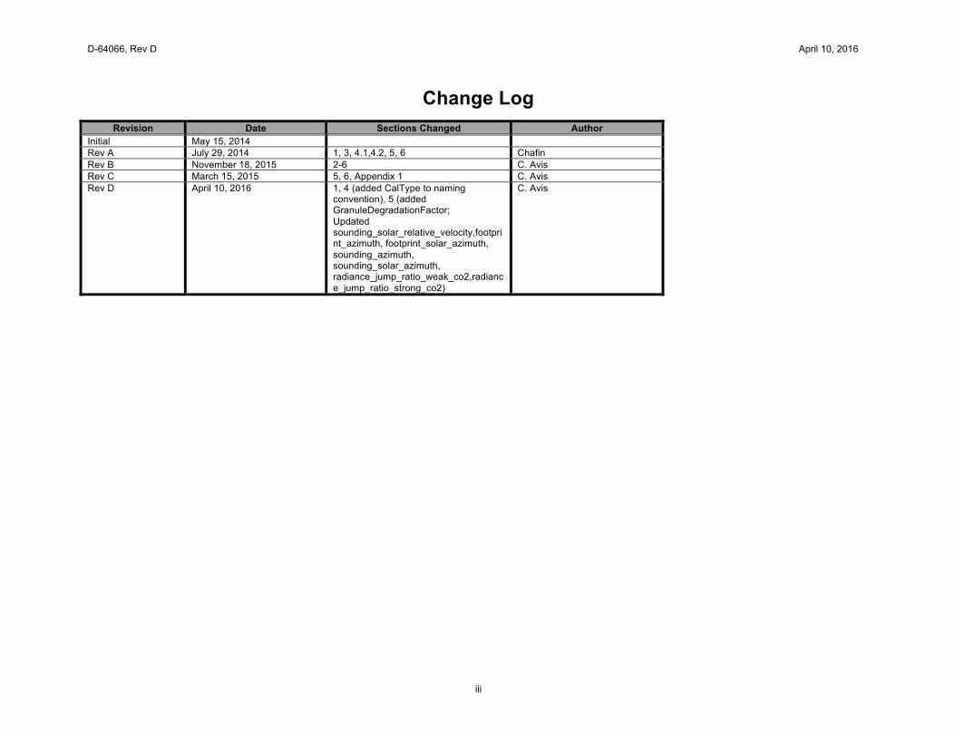
Change Log
Revision Date Sections Changed Author Initial May 15, 2014 Rev A July 29, 2014 1, 3, 4.1,4.2, 5, 6 Chafin Rev B November 18, 2015 2-6 C. Avis Rev C March 15, 2015 5, 6, Appendix 1 C. Avis Rev D April 10, 2016 1, 4 (added CalType to naming
convention), 5 (added GranuleDegradationFactor; Updated sounding_solar_relative_velocity,footprint_azimuth, footprint_solar_azimuth, sounding_azimuth, sounding_solar_azimuth, radiance_jump_ratio_weak_co2,radiance_jump_ratio_strong_co2)
C. Avis
D-64066, Rev D April 10, 2016
iv
Table of Contents
1 Product Identification and Software Version ................................................................................................................................... 1 2 Background information .................................................................................................................................................................. 1
2.1 NASA Data Levels ............................................................................................................................................................. 1 2.2 Product Pedigree and Destination ..................................................................................................................................... 1 2.3 Suggested Tools to Read Product ..................................................................................................................................... 2
3 Reference Documents .................................................................................................................................................................... 2 4 Product Description ........................................................................................................................................................................ 2
4.1 Format and Size ................................................................................................................................................................. 2 4.2 Naming Convention ........................................................................................................................................................... 3
5 Specification Table – Science Modes ............................................................................................................................................. 5 6 Specification Table – Calibration Modes ...................................................................................................................................... 24 7 Appendix 1: Shape Descriptions .................................................................................................................................................. 41 8 Appendix 2: Acronyms ................................................................................................................................................................. 43

D-64066, Rev D April 10, 2016
1
1 Product Identification and Software Version This document describes the specification of one of the data products generated by the OCO-2 Science Data Operations System (SDOS). This document applies to the following product and system version:
Product Name: Level 1B Product Short Name: OCO2_L1B_Science, OCO2_L1B_Calibration SDOS System Version: B7.3.00 and later GES DISC Version: Version 7 and Version 7r Product Description: Geolocated, radiometrically calibrated data in a standard granularity (for both science and calibration observations)
SDOS System Bn.x.yy generates products either with predictive calibration parameters (Version n) or with parameters derived via analysis of past instrument performance (Version nr). Therefore, nr is considered of higher quality. Analyses mixing the two sets should be undertaken with a degree of caution. The product specifications for n and nr are identical and this document applies to both.
2 Background information The OCO-2 SDOS converts telemetry downloaded from the Observatory into data products that provide comprehensive mission results as well as material for further research and investigation. The SDOS generates products from Level 0 through Level 2, some of which are available for distribution to both the scientific community and the general public. All products are available to users of the SDOS computing cluster.
2.1 NASA Data Levels
The following table provides the definitions of the data levels used in this document. These definitions are standard within the NASA community
Level Description Packet data Telemetry data stream as received at the ground station, with science and engineering data embedded Level 0 Instrument science data (e.g., raw voltages, counts) at full resolution, time ordered, with duplicates and transmission
errors removed Level 1A NASA Level 0 data that have been located in space and may have been transformed (e.g., calibrated, rearranged) in a
reversible manner and packaged with needed ancillary and auxiliary data (e.g., radiances with the calibration equations applied)
Level 1B Irreversibly transformed (e.g., resampled, remapped, calibrated) values of the instrument measurements (e.g., radiances, magnetic field strength)
Level 2 Geophysical parameters, generally derived from NASA Level 1 data, and located in space and time commensurate with instrument location, pointing, and sampling
2.2 Product Pedigree and Destination
This product is generated within the nominal SDOS pipeline by the CalApp PGE using the following input data: • Level 1A instrument product • Geolocation product • Ancillary Radiometric Product
D-64066, Rev D April 10, 2016
2
This product is expected to be an input to the following PGE’s within the nominal SDOS pipeline:
• L1bStat • Level 2 A-Band Preprocessor • Level 2 IMAP-DOAS Preprocessor • Level 2 Sounding Selection PGE • Level 2 Full-Physics • Level 2 Diagnostic Product Generator
The Level 1A product is slightly different for data acquired in Science modes vs. Calibration modes. Both product types are described in this document.
2.3 Suggested Tools to Read Product
The following set of tools can be used to open and examine this HDF-5 product on Linux systems. Other tools may be available. • h5dump • hdfview
3 Reference Documents
1. OCO-2 SDOS Software Design Document (JPL D-71459) 2. OCO-2 SDOS Data Bible 3. OCO-2 Science Data Management and Archive Plan (JPL D-64039)
4 Product Description
4.1 Format and Size
This product is in HDF-5 format. For most nominal orbits, the Science products use 1.1 Gigabytes (potentially across multiple files) and the Calibration products use between 35 and 77 Megabytes.
D-64066, Rev D April 10, 2016
3
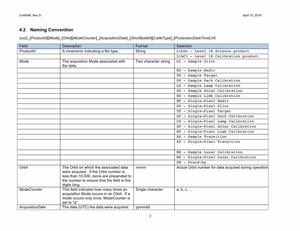
4.2 Naming Convention oco2_[ProductId][Mode]_[Orbit][ModeCounter]_[AcquisitionDate]_[ShortBuildId][CalibType]_[ProductionDateTime].h5 Field Description Format Selection ProductId A mnemonic indicating a file type. String L1bSc - Level 1B Science product L1bCl - Level 1B Calibration product Mode The acquisition Mode associated with
the data. Two character string GL - Sample Glint
ND - Sample Nadir TG - Sample Target DS - Sample Dark Calibration LS - Sample Lamp Calibration SS - Sample Solar Calibration BS - Sample Limb Calibration NP - Single-Pixel Nadir GP - Single-Pixel Glint TP - Single-Pixel Target DP - Single-Pixel Dark Calibration LP - Single-Pixel Lamp Calibration SP - Single-Pixel Solar Calibration BP - Single-Pixel Limb Calibration XS - Sample Transition XP - Single-Pixel Transition
MS - Sample Lunar Calibration MP - Single-Pixel Lunar Calibration SB - Stand-by Orbit The Orbit on which the associated data
were acquired. If the Orbit number is less than 10,000, zeros are prepended to the number to ensure that the field is five digits long.
nnnnn Actual Orbit number for data acquired during operations
ModeCounter This field indicates how many times an acquisition Mode occurs in an Orbit. If a mode occurs only once, ModeCounter is set to "a".
Single character a, b, c, …
AcquisitionDate The date (UTC) the data were acquired. yymmdd
D-64066, Rev D April 10, 2016
4
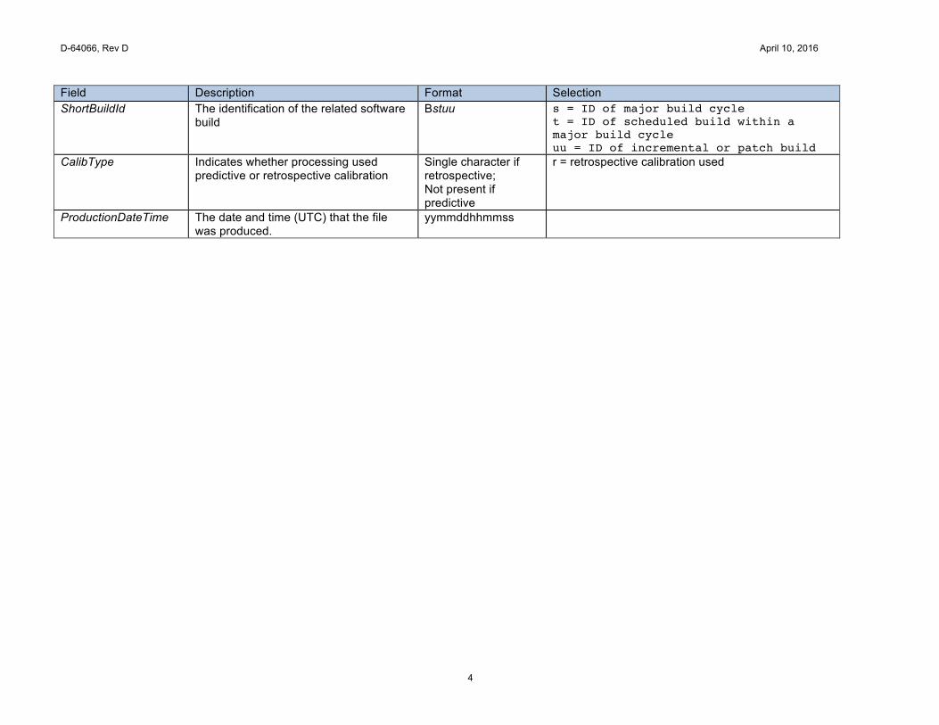
Field Description Format Selection ShortBuildId The identification of the related software
build Bstuu s = ID of major build cycle
t = ID of scheduled build within a major build cycle uu = ID of incremental or patch build
CalibType Indicates whether processing used predictive or retrospective calibration
Single character if retrospective; Not present if predictive
r = retrospective calibration used
ProductionDateTime The date and time (UTC) that the file was produced.
yymmddhhmmss
D-64066, Rev D April 10, 2016
5
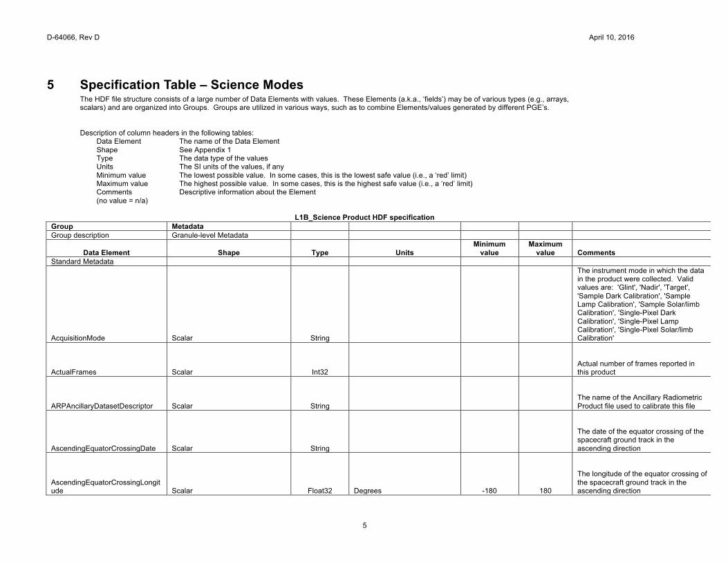
5 Specification Table – Science Modes The HDF file structure consists of a large number of Data Elements with values. These Elements (a.k.a., ‘fields’) may be of various types (e.g., arrays, scalars) and are organized into Groups. Groups are utilized in various ways, such as to combine Elements/values generated by different PGE’s. Description of column headers in the following tables:
Data Element The name of the Data Element Shape See Appendix 1 Type The data type of the values Units The SI units of the values, if any Minimum value The lowest possible value. In some cases, this is the lowest safe value (i.e., a ‘red’ limit) Maximum value The highest possible value. In some cases, this is the highest safe value (i.e., a ‘red’ limit) Comments Descriptive information about the Element (no value = n/a)
L1B_Science Product HDF specification
Group Metadata Group description Granule-level Metadata
Data Element Shape Type Units Minimum
value Maximum
value Comments Standard Metadata
AcquisitionMode Scalar String
The instrument mode in which the data in the product were collected. Valid values are: 'Glint', 'Nadir', 'Target', 'Sample Dark Calibration', 'Sample Lamp Calibration', 'Sample Solar/limb Calibration', 'Single-Pixel Dark Calibration', 'Single-Pixel Lamp Calibration', 'Single-Pixel Solar/limb Calibration'
ActualFrames Scalar Int32
Actual number of frames reported in this product
ARPAncillaryDatasetDescriptor Scalar String
The name of the Ancillary Radiometric Product file used to calibrate this file
AscendingEquatorCrossingDate Scalar String
The date of the equator crossing of the spacecraft ground track in the ascending direction
AscendingEquatorCrossingLongitude Scalar Float32 Degrees -180 180
The longitude of the equator crossing of the spacecraft ground track in the ascending direction
D-64066, Rev D April 10, 2016
6
AscendingEquatorCrossingTime Scalar String
The time of the equator crossing of the spacecraft ground track in the ascending direction
AutomaticQualityFlag Scalar String
Not implemented - set to NULL
BadPixelMapVersionNum Spectrum_Array UInt32
Version number of corresponding Bad Pixel Map used to calibrate this data file
ColorSlicePositionO2 O2Slice_Array Int16
1 1024 Absolute spectral position of each ABO2 color slice
ColorSlicePositionStrongCO2 StrongCO2Slice_Array Int16
1 1024 Absolute spectral position of each SCO2 color slice
ColorSlicePositionWeakCO2 WeakCO2Slice_Array Int16
1 1024 Absolute spectral position of each WCO2 color slice
DiffuserPosition Scalar Float32
The position of the solar diffuser at the beginning of the mode: 0 - Lamp or Closed position, 75 - Open for science, 150 - Solar Calibration position
EphemerisType Scalar String
The source of the spacecraft ephemeris data that were utilized to generate this data file
EquatorCrossingDate Scalar String
The date of the equator crossing of the spacecraft ground track in the descending direction
EquatorCrossingLongitude Scalar Float32 Degrees -180 180
The longitude of the equator crossing of the spacecraft ground track in the descending direction
EquatorCrossingTime Scalar String
The time of the equator crossing of the spacecraft ground track in the descending direction
D-64066, Rev D April 10, 2016
7
ExpectedFrames Scalar Int32
Nominal number of frames in this product
FirstSoundingId Scalar Int64
The ID of the first sounding in this file
InitialUnusedSpatialPixels Spectrum_Array Int16
Distance in spatial pixels of the start of first footprint from edge of FPA
L1BAlgorithmDescriptor Scalar String
Identification of the algorithm and version used to generate this product
LastSoundingId Scalar Int64
The ID of the last sounding in this file
MaxMS Spectrum_Array Float32 Ph sec^{-1} m^{-2} sr^{-1} um^{-1}
The maximum measureable signal value to be used in radiance noise calculation
ModeCounter Scalar String
The Nth occurrence of this particular mode for this orbit, indicated by letter ('a', 'b', 'c', 'd', etc.)
OperationMode Scalar String
The two-letter abbreviation of the AcquisitionMode: GL, ND, TG, DS, LS, SS, BS, NP, GP, TP, DP, LP, SP, BP, XS, XP, MS, MP, SB
OrbitEccentricity Scalar Float32
The eccentricity of the spacecraft orbital path
OrbitInclination Scalar Float32 Degrees 0 180
The angle between the plane of the spacecraft orbital path and the Earth equatorial plane
OrbitParametersPointer OrbitParamPtr_Array String
The data files that provided the orbit parameters used to generate this product
OrbitPeriod Scalar Float32 Seconds
The time span between two consecutive descending node crossings
D-64066, Rev D April 10, 2016
8
OrbitSemiMajorAxis Scalar Float32 Meters
The length of the semi-major axis of the spacecraft orbit
OrbitStartDate Scalar String
The date of the equator crossing of the spacecraft nadir track in the descending direction
OrbitStartLongitude Scalar Float32 Degrees -180 180
The longitude of the equator crossing of the spacecraft ground track in the descending direction
OrbitStartTime Scalar String
The time of the equator crossing of the spacecraft ground track in the descending direction
ReportedSoundings SoundingPosition_Array Int8
0 1
Indicates the inclusion of each footprint in the data: 0 - not included, 1 - included
SciToFPAColorOffset Spectrum_Array Int16
The index of the first spectral pixel of arrays with FPAColor shape that appears in the first spectral element of arrays with SciColor shape
SpectralChannel Spectrum_Array String
A description of the spectral channels used for the measurements
Group InstrumentHeader
Group description Instrument characteristics
Data Element Shape Type Units Minimum
value Maximum
value Comments
ils_delta_lambda Spectrum_Sounding_SciColor_DeltaLambda_Array Float32 Microns
Wavelength offset from peak response for sampled data
ils_relative_response Spectrum_Sounding_SciColor_DeltaLambda_Array Float32
The relative response defined at ils_delta_lamda
full_width_half_maximum Spectrum_Sounding_SciColor_Array Float32 Microns
The spectral response width at full-width-half-maximum, per pixel
D-64066, Rev D April 10, 2016
9
measureable_signal_max_observed Spectrum_Array Float32
Ph sec^{-1} m^{-2} sr^{-1} um^{-1}
Maximum radiance measurable by each spectrometer without detector saturation
snr_coef Spectrum_Sounding_SciColor_SNRCoef_Array Float64
Three coefficients of the noise model: photon component (proportional to the square root of signal), a constant background component and a bad sample flag where 0 - OK, 1 - ignore for retrievals
dispersion_coef_samp Spectrum_Sounding_DispersionCoefficient_Array Float64
Coefficients that express the relationship between the spectral element index and its associated wavelength
residual_estimate Spectrum_Sounding_SciColor_ResidualCoefficient_Array Float32
Empirical estimate of the systematic residuals that cannot be removed by calibration
GranuleDegradationFactor Spectrum_Sounding_SciColor_Array Float32
The average gain degradation factor of the granule that converts modified radiance based on the preflight gain to radiance
Group FrameHeader
Group description Frame-level metadata
Data Element Shape Type Units Minimum
value Maximumva
lue Comments
frame_id Frame_Array Int64
The mission-unique frame identifier
frame_time_string Frame_Array String
Time of telemetry frame (yyyy-mm-ddThh:mm:ss.mmmZ)
frame_time_tai93 Frame_Array Float64 Seconds
Time of telemetry frame in seconds since Jan 1, 1993
frame_qual_flag Frame_Array UInt64
Bit flags indicating the quality of the data in each frame: 0 - good, non-zero - see Product Quality Flags table below
D-64066, Rev D April 10, 2016
10
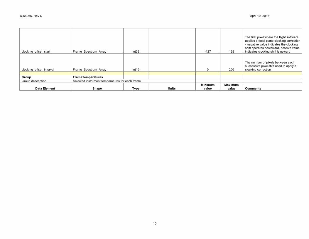
clocking_offset_start Frame_Spectrum_Array Int32
-127 128
The first pixel where the flight software applies a focal plane clocking correction - negative value indicates the clocking shift operates downward, positive value indicates clocking shift is upward
clocking_offset_interval Frame_Spectrum_Array Int16
0 256
The number of pixels between each successive pixel shift used to apply a clocking correction
Group FrameTemperatures
Group description Selected instrument temperatures for each frame
Data Element Shape Type Units Minimum
value Maximum
value Comments

D-64066, Rev D April 10, 2016
11
temp_fpa Frame_Spectrum_Array Float32 Kelvins
FPA temperatures extracted for this frame time from the temperature data history
temp_optical_bench_grating_mz Frame_Array Float32 Kelvins
Temperature of the optical bench grating
temp_relay_sco2_mz Frame_Array Float32 Kelvins
Temperature of the relay
temp_telescope Frame_Array Float32 Kelvins
Temperature of the telescope
temp_shroud_py_tz1 Frame_Array Float32 Kelvins
Temperature of the shroud
temp_afe_electronics_enclosure Frame_Array Float32 Kelvins
Temperature of the AFE electronics enclosure
temp_smooth_fpa_o2 Frame_Array Float32 Kelvins ABO2 FPA temperature after noise-reduction processing
temp_smooth_fpa_strong_co2 Frame_Array Float32 Kelvins SCO2 FPA temperature after noise-reduction processing
temp_smooth_fpa_weak_co2 Frame_Array Float32 Kelvins WCO2 FPA temperature after noise-reduction processing
temp_smooth_optical_bench_grating_mz Frame_Array Float32 Kelvins
Optics temperature for this frame after noise-reduction processing
Group FrameGeometry
Group description Geometric information that applies to all measurements in frame
Data Element Shape Type Units Minimum
value Maximum
value Comments
spacecraft_position Frame_EuclidDim_Array Float32 Meters
Interpolated spacecraft position at the frame time
spacecraft_velocity Frame_EuclidDim_Array Float32 Meters Second^{-1}
Interpolated spacecraft velocity at the frame time
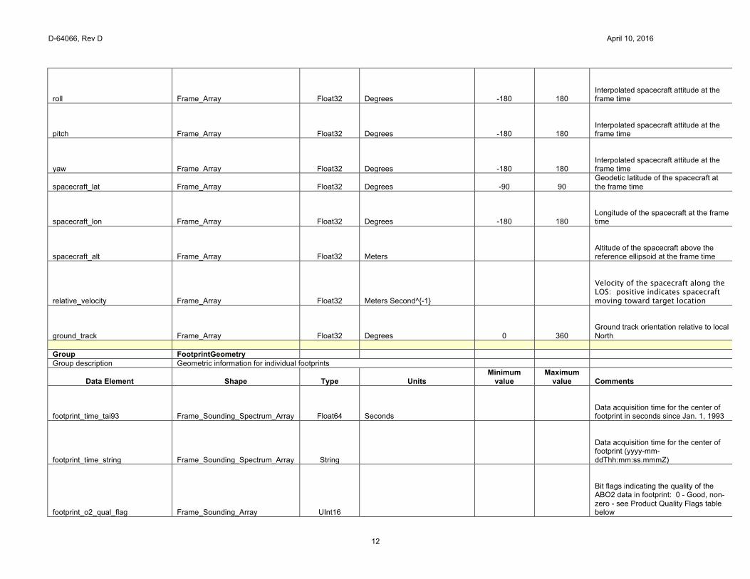
D-64066, Rev D April 10, 2016
12
roll Frame_Array Float32 Degrees -180 180 Interpolated spacecraft attitude at the frame time
pitch Frame_Array Float32 Degrees -180 180 Interpolated spacecraft attitude at the frame time
yaw Frame_Array Float32 Degrees -180 180 Interpolated spacecraft attitude at the frame time
spacecraft_lat Frame_Array Float32 Degrees -90 90 Geodetic latitude of the spacecraft at the frame time
spacecraft_lon Frame_Array Float32 Degrees -180 180 Longitude of the spacecraft at the frame time
spacecraft_alt Frame_Array Float32 Meters
Altitude of the spacecraft above the reference ellipsoid at the frame time
relative_velocity Frame_Array Float32 Meters Second^{-1}
Velocity of the spacecraft along the LOS: positive indicates spacecraft moving toward target location
ground_track Frame_Array Float32 Degrees 0 360 Ground track orientation relative to local North
Group FootprintGeometry
Group description Geometric information for individual footprints
Data Element Shape Type Units Minimum
value Maximum
value Comments
footprint_time_tai93 Frame_Sounding_Spectrum_Array Float64 Seconds
Data acquisition time for the center of footprint in seconds since Jan. 1, 1993
footprint_time_string Frame_Sounding_Spectrum_Array String
Data acquisition time for the center of footprint (yyyy-mm-ddThh:mm:ss.mmmZ)
footprint_o2_qual_flag Frame_Sounding_Array UInt16
Bit flags indicating the quality of the ABO2 data in footprint: 0 - Good, non-zero - see Product Quality Flags table below

D-64066, Rev D April 10, 2016
13
footprint_weak_co2_qual_flag Frame_Sounding_Array UInt16
Bit flags indicating the quality of the WCO2 data in footprint: 0 - Good, non-zero - see Product Quality Flags table below
footprint_strong_co2_qual_flag Frame_Sounding_Array UInt16
Bit flags indicating the quality of the SCO2 data in footprint: 0 - Good, non-zero - see Product Quality Flags table below
footprint_latitude_geoid Frame_Sounding_Spectrum_Array Float32 Degrees -90 90 Geodetic latitude of the footprint based on standard geoid
footprint_longitude_geoid Frame_Sounding_Spectrum_Array Float32 Degrees -180 180 Longitude of the footprint based on standard geoid
footprint_latitude Frame_Sounding_Spectrum_Array Float32 Degrees -90 90 Geodetic latitude of the footprint center based on Earth topography
footprint_longitude Frame_Sounding_Spectrum_Array Float32 Degrees -180 180 Longitude of the footprint center based on Earth topography
footprint_altitude Frame_Sounding_Spectrum_Array Float32 Meters
Altitude of the footprint center based on Earth topography
footprint_altitude_uncert Frame_Sounding_Spectrum_Array Float32 Meters
Uncertainty of the source Earth topography data
footprint_slope Frame_Sounding_Spectrum_Array Float32 Degrees 0 180 Slope of a plane fit to points within the footprint
footprint_plane_fit_quality Frame_Sounding_Spectrum_Array Float32 Meters
Goodness of fit - standard deviation of the points to which the plane is fitted, with the expected values taken as the orthogonal projection of the points onto the plane
footprint_aspect Frame_Sounding_Spectrum_Array Float32 Degrees 0 360 Orientation of the surface slope relative to the ground track
D-64066, Rev D April 10, 2016
14
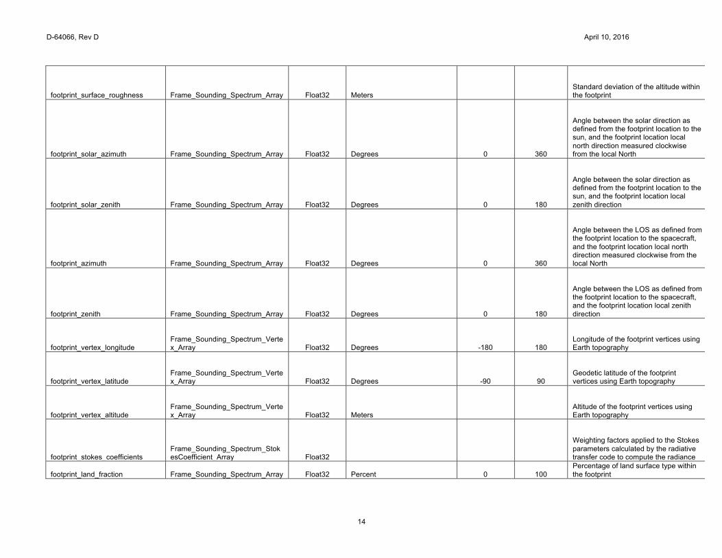
footprint_surface_roughness Frame_Sounding_Spectrum_Array Float32 Meters
Standard deviation of the altitude within the footprint
footprint_solar_azimuth Frame_Sounding_Spectrum_Array Float32 Degrees 0 360
Angle between the solar direction as defined from the footprint location to the sun, and the footprint location local north direction measured clockwise from the local North
footprint_solar_zenith Frame_Sounding_Spectrum_Array Float32 Degrees 0 180
Angle between the solar direction as defined from the footprint location to the sun, and the footprint location local zenith direction
footprint_azimuth Frame_Sounding_Spectrum_Array Float32 Degrees 0 360
Angle between the LOS as defined from the footprint location to the spacecraft, and the footprint location local north direction measured clockwise from the local North
footprint_zenith Frame_Sounding_Spectrum_Array Float32 Degrees 0 180
Angle between the LOS as defined from the footprint location to the spacecraft, and the footprint location local zenith direction
footprint_vertex_longitude Frame_Sounding_Spectrum_Vertex_Array Float32 Degrees -180 180
Longitude of the footprint vertices using Earth topography
footprint_vertex_latitude Frame_Sounding_Spectrum_Vertex_Array Float32 Degrees -90 90
Geodetic latitude of the footprint vertices using Earth topography
footprint_vertex_altitude Frame_Sounding_Spectrum_Vertex_Array Float32 Meters
Altitude of the footprint vertices using Earth topography
footprint_stokes_coefficients Frame_Sounding_Spectrum_StokesCoefficient_Array Float32
Weighting factors applied to the Stokes parameters calculated by the radiative transfer code to compute the radiance
footprint_land_fraction Frame_Sounding_Spectrum_Array Float32 Percent 0 100 Percentage of land surface type within the footprint
D-64066, Rev D April 10, 2016
15
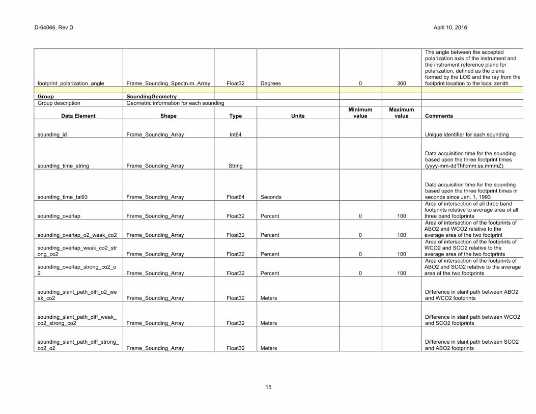
footprint_polarization_angle Frame_Sounding_Spectrum_Array Float32 Degrees 0 360
The angle between the accepted polarization axis of the instrument and the instrument reference plane for polarization, defined as the plane formed by the LOS and the ray from the footprint location to the local zenith
Group SoundingGeometry
Group description Geometric information for each sounding
Data Element Shape Type Units Minimum
value Maximum
value Comments
sounding_id Frame_Sounding_Array Int64
Unique identifier for each sounding
sounding_time_string Frame_Sounding_Array String
Data acquisition time for the sounding based upon the three footprint times (yyyy-mm-ddThh:mm:ss.mmmZ)
sounding_time_tai93 Frame_Sounding_Array Float64 Seconds
Data acquisition time for the sounding based upon the three footprint times in seconds since Jan. 1, 1993
sounding_overlap Frame_Sounding_Array Float32 Percent 0 100
Area of intersection of all three band footprints relative to average area of all three band footprints
sounding_overlap_o2_weak_co2 Frame_Sounding_Array Float32 Percent 0 100
Area of intersection of the footprints of ABO2 and WCO2 relative to the average area of the two footprint
sounding_overlap_weak_co2_strong_co2 Frame_Sounding_Array Float32 Percent 0 100
Area of intersection of the footprints of WCO2 and SCO2 relative to the average area of the two footprints
sounding_overlap_strong_co2_o2 Frame_Sounding_Array Float32 Percent 0 100
Area of intersection of the footprints of ABO2 and SCO2 relative to the average area of the two footprints
sounding_slant_path_diff_o2_weak_co2 Frame_Sounding_Array Float32 Meters
Difference in slant path between ABO2 and WCO2 footprints
sounding_slant_path_diff_weak_co2_strong_co2 Frame_Sounding_Array Float32 Meters
Difference in slant path between WCO2 and SCO2 footprints
sounding_slant_path_diff_strong_co2_o2 Frame_Sounding_Array Float32 Meters
Difference in slant path between SCO2 and ABO2 footprints
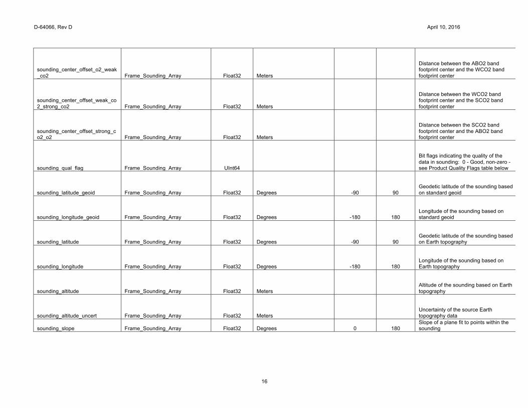
D-64066, Rev D April 10, 2016
16
sounding_center_offset_o2_weak_co2 Frame_Sounding_Array Float32 Meters
Distance between the ABO2 band footprint center and the WCO2 band footprint center
sounding_center_offset_weak_co2_strong_co2 Frame_Sounding_Array Float32 Meters
Distance between the WCO2 band footprint center and the SCO2 band footprint center
sounding_center_offset_strong_co2_o2 Frame_Sounding_Array Float32 Meters
Distance between the SCO2 band footprint center and the ABO2 band footprint center
sounding_qual_flag Frame_Sounding_Array UInt64
Bit flags indicating the quality of the data in sounding: 0 - Good, non-zero - see Product Quality Flags table below
sounding_latitude_geoid Frame_Sounding_Array Float32 Degrees -90 90 Geodetic latitude of the sounding based on standard geoid
sounding_longitude_geoid Frame_Sounding_Array Float32 Degrees -180 180 Longitude of the sounding based on standard geoid
sounding_latitude Frame_Sounding_Array Float32 Degrees -90 90 Geodetic latitude of the sounding based on Earth topography
sounding_longitude Frame_Sounding_Array Float32 Degrees -180 180 Longitude of the sounding based on Earth topography
sounding_altitude Frame_Sounding_Array Float32 Meters
Altitude of the sounding based on Earth topography
sounding_altitude_uncert Frame_Sounding_Array Float32 Meters
Uncertainty of the source Earth topography data
sounding_slope Frame_Sounding_Array Float32 Degrees 0 180 Slope of a plane fit to points within the sounding
D-64066, Rev D April 10, 2016
17
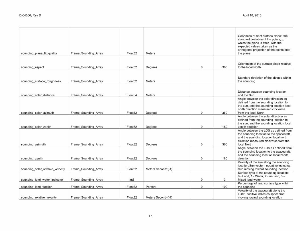
sounding_plane_fit_quality Frame_Sounding_Array Float32 Meters
Goodness-of-fit of surface slope: the standard deviation of the points, to which the plane is fitted, with the expected values taken as the orthogonal projection of the points onto the plane
sounding_aspect Frame_Sounding_Array Float32 Degrees 0 360 Orientation of the surface slope relative to the local North
sounding_surface_roughness Frame_Sounding_Array Float32 Meters
Standard deviation of the altitude within the sounding
sounding_solar_distance Frame_Sounding_Array Float64 Meters
Distance between sounding location and the Sun
sounding_solar_azimuth Frame_Sounding_Array Float32 Degrees 0 360
Angle between the solar direction as defined from the sounding location to the sun, and the sounding location local north direction measured clockwise from the local North
sounding_solar_zenith Frame_Sounding_Array Float32 Degrees 0 180
Angle between the solar direction as defined from the sounding location to the sun, and the sounding location local zenith direction
sounding_azimuth Frame_Sounding_Array Float32 Degrees 0 360
Angle between the LOS as defined from the sounding location to the spacecraft, and the sounding location local north direction measured clockwise from the local North
sounding_zenith Frame_Sounding_Array Float32 Degrees 0 180
Angle between the LOS as defined from the sounding location to the spacecraft, and the sounding location local zenith direction
sounding_solar_relative_velocity Frame_Sounding_Array Float32 Meters Second^{-1}
Velocity of the sun along the sounding location/Sun vector: negative indicates Sun moving toward sounding location
sounding_land_water_indicator Frame_Sounding_Array Int8
0 3
Surface type at the sounding location: 0 - Land, 1 - Water, 2 - unused, 3 – Mixed land water
sounding_land_fraction Frame_Sounding_Array Float32 Percent 0 100 Percentage of land surface type within the sounding
sounding_relative_velocity Frame_Sounding_Array Float32 Meters Second^{-1}
Velocity of the spacecraft along the LOS: positive indicates spacecraft moving toward sounding location
D-64066, Rev D April 10, 2016
18
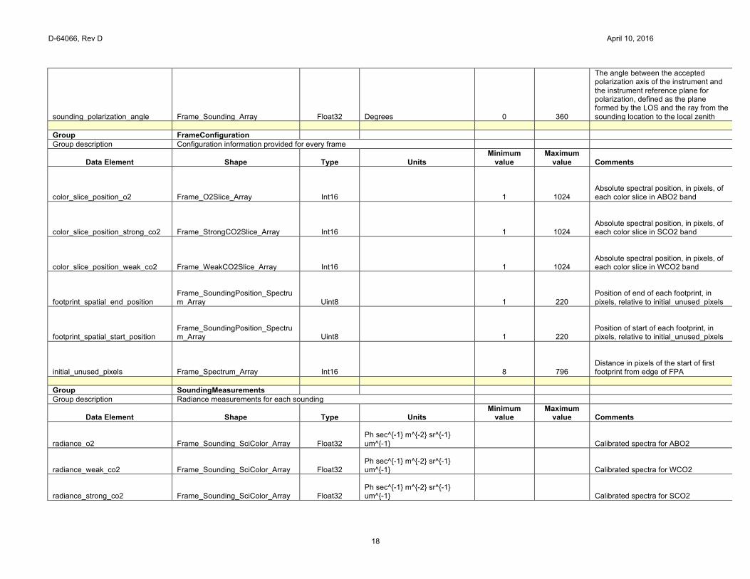
sounding_polarization_angle Frame_Sounding_Array Float32 Degrees 0 360
The angle between the accepted polarization axis of the instrument and the instrument reference plane for polarization, defined as the plane formed by the LOS and the ray from the sounding location to the local zenith
Group FrameConfiguration
Group description Configuration information provided for every frame
Data Element Shape Type Units Minimum
value Maximum
value Comments
color_slice_position_o2 Frame_O2Slice_Array Int16
1 1024 Absolute spectral position, in pixels, of each color slice in ABO2 band
color_slice_position_strong_co2 Frame_StrongCO2Slice_Array Int16
1 1024 Absolute spectral position, in pixels, of each color slice in SCO2 band
color_slice_position_weak_co2 Frame_WeakCO2Slice_Array Int16
1 1024 Absolute spectral position, in pixels, of each color slice in WCO2 band
footprint_spatial_end_position Frame_SoundingPosition_Spectrum_Array Uint8
1 220
Position of end of each footprint, in pixels, relative to initial_unused_pixels
footprint_spatial_start_position Frame_SoundingPosition_Spectrum_Array Uint8
1 220
Position of start of each footprint, in pixels, relative to initial_unused_pixels
initial_unused_pixels Frame_Spectrum_Array Int16
8 796 Distance in pixels of the start of first footprint from edge of FPA
Group SoundingMeasurements
Group description Radiance measurements for each sounding
Data Element Shape Type Units Minimum
value Maximum
value Comments
radiance_o2 Frame_Sounding_SciColor_Array Float32 Ph sec^{-1} m^{-2} sr^{-1} um^{-1}
Calibrated spectra for ABO2
radiance_weak_co2 Frame_Sounding_SciColor_Array Float32 Ph sec^{-1} m^{-2} sr^{-1} um^{-1}
Calibrated spectra for WCO2
radiance_strong_co2 Frame_Sounding_SciColor_Array Float32 Ph sec^{-1} m^{-2} sr^{-1} um^{-1}
Calibrated spectra for SCO2
D-64066, Rev D April 10, 2016
19
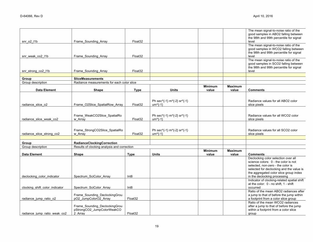
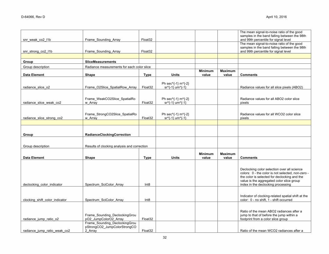
snr_o2_l1b Frame_Sounding_Array Float32
The mean signal-to-noise ratio of the good samples in ABO2 falling between the 98th and 99th percentile for signal level
snr_weak_co2_l1b Frame_Sounding_Array Float32
The mean signal-to-noise ratio of the good samples in WCO2 falling between the 98th and 99th percentile for signal level
snr_strong_co2_l1b Frame_Sounding_Array Float32
The mean signal-to-noise ratio of the good samples in SCO2 falling between the 98th and 99th percentile for signal level
Group SliceMeasurements
Group description Radiance measurements for each color slice
Data Element Shape Type Units Minimum
value Maximum
value Comments
radiance_slice_o2 Frame_O2Slice_SpatialRow_Array Float32 Ph sec^{-1} m^{-2} sr^{-1} um^{-1}
Radiance values for all ABO2 color slice pixels
radiance_slice_weak_co2 Frame_WeakCO2Slice_SpatialRow_Array Float32
Ph sec^{-1} m^{-2} sr^{-1} um^{-1}
Radiance values for all WCO2 color slice pixels
radiance_slice_strong_co2 Frame_StrongCO2Slice_SpatialRow_Array Float32
Ph sec^{-1} m^{-2} sr^{-1} um^{-1}
Radiance values for all SCO2 color slice pixels
Group RadianceClockingCorrection
Group description Results of clocking analysis and correction
Data Element Shape Type Units Minimum
value Maximum
value Comments
declocking_color_indicator Spectrum_SciColor_Array Int8
Declocking color selection over all science colors: 0 - the color is not selected, non-zero - the color is selected for declocking and the value is the aggregated color slice group index in the declocking processing
clocking_shift_color_indicator Spectrum_SciColor_Array Int8
Indicator of clocking-related spatial shift at the color: 0 - no shift, 1 - shift occurred
radiance_jump_ratio_o2 Frame_Sounding_DeclockingGroupO2_JumpColorO2_Array Float32
Ratio of the mean ABO2 radiances after a jump to that of before the jump within a footprint from a color slice group
radiance_jump_ratio_weak_co2
Frame_Sounding_DeclockingGroupStrongCO2_JumpColorWeakCO2_Array Float32
Ratio of the mean WCO2 radiances after a jump to that of before the jump within a footprint from a color slice group
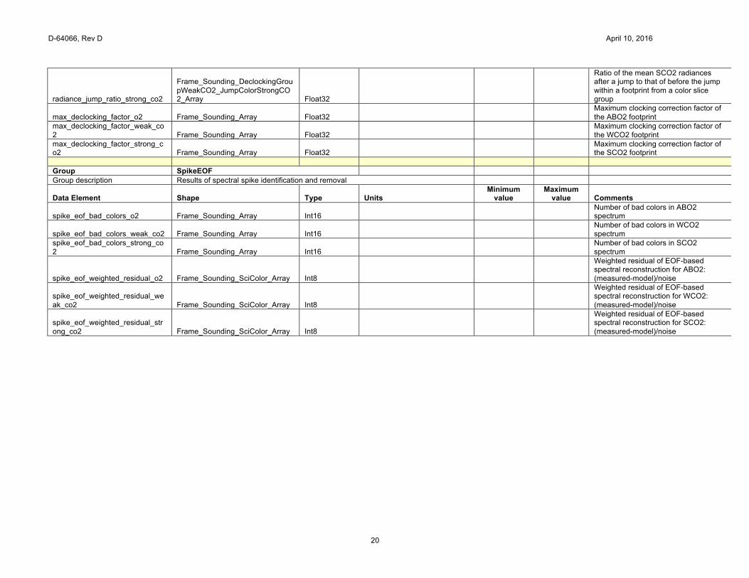
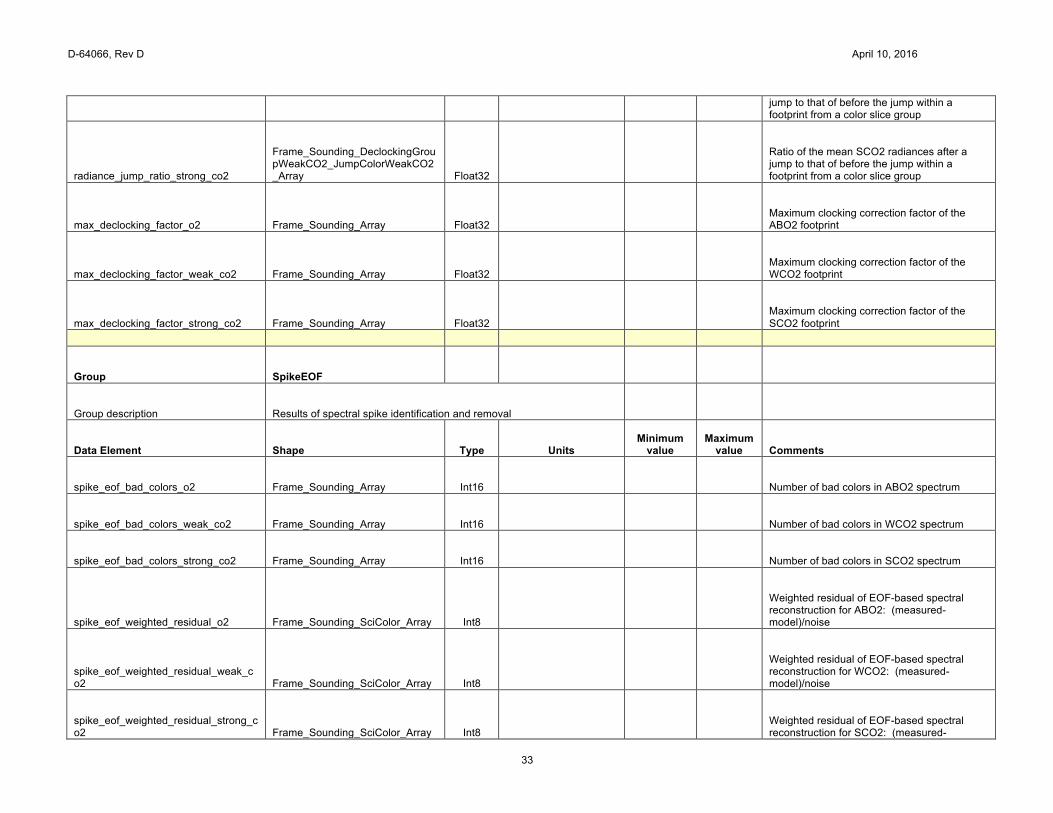
D-64066, Rev D April 10, 2016
20
radiance_jump_ratio_strong_co2
Frame_Sounding_DeclockingGroupWeakCO2_JumpColorStrongCO2_Array Float32
Ratio of the mean SCO2 radiances after a jump to that of before the jump within a footprint from a color slice group
max_declocking_factor_o2 Frame_Sounding_Array Float32 Maximum clocking correction factor of the ABO2 footprint
max_declocking_factor_weak_co2 Frame_Sounding_Array Float32
Maximum clocking correction factor of the WCO2 footprint
max_declocking_factor_strong_co2 Frame_Sounding_Array Float32
Maximum clocking correction factor of the SCO2 footprint
Group SpikeEOF
Group description Results of spectral spike identification and removal
Data Element Shape Type Units Minimum
value Maximum
value Comments
spike_eof_bad_colors_o2 Frame_Sounding_Array Int16
Number of bad colors in ABO2 spectrum
spike_eof_bad_colors_weak_co2 Frame_Sounding_Array Int16 Number of bad colors in WCO2 spectrum
spike_eof_bad_colors_strong_co2 Frame_Sounding_Array Int16
Number of bad colors in SCO2 spectrum
spike_eof_weighted_residual_o2 Frame_Sounding_SciColor_Array Int8
Weighted residual of EOF-based spectral reconstruction for ABO2: (measured-model)/noise
spike_eof_weighted_residual_weak_co2 Frame_Sounding_SciColor_Array Int8
Weighted residual of EOF-based spectral reconstruction for WCO2: (measured-model)/noise
spike_eof_weighted_residual_strong_co2 Frame_Sounding_SciColor_Array Int8
Weighted residual of EOF-based spectral reconstruction for SCO2: (measured-model)/noise
D-64066, Rev D April 10, 2016
21
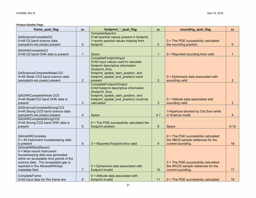
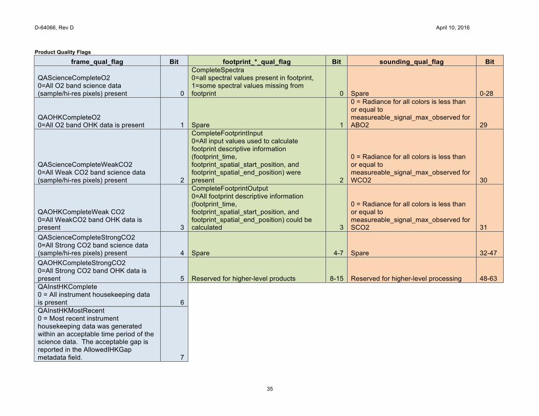
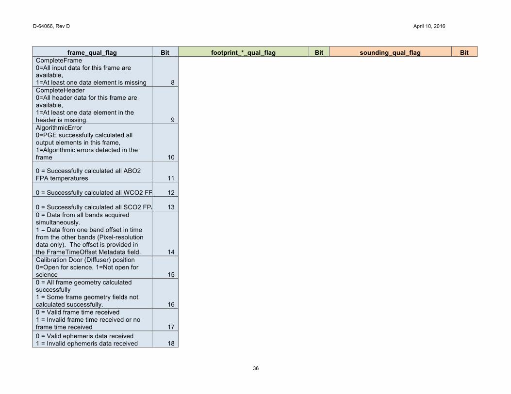
Product Quality Flags
frame_qual_flag Bit footprint_*_qual_flag Bit sounding_qual_flag Bit
QAScienceCompleteO2 0=All O2 band science data (sample/hi-res pixels) present 0
CompleteSpectra 0=all spectral values present in footprint, 1=some spectral values missing from footprint 0
0 = The PGE successfully calculated the sounding position. 0
QAOHKCompleteO2 0=All O2 band OHK data is present 1 Spare 1 0 = Reported sounding time valid 1
QAScienceCompleteWeakCO2 0=All Weak CO2 band science data (sample/hi-res pixels) present 2
CompleteFootprintInput 0=All input values used to calculate footprint descriptive information (footprint_time, footprint_spatial_start_position, and footprint_spatial_end_position) were present 2
0 = Ephemeris data associated with sounding valid 2
QAOHKCompleteWeak CO2 0=All WeakCO2 band OHK data is present 3
CompleteFootprintOutput 0=All footprint descriptive information (footprint_time, footprint_spatial_start_position, and footprint_spatial_end_position) could be calculated 3
0 = Attitude data associated with sounding valid 3
QAScienceCompleteStrongCO2 0=All Strong CO2 band science data (sample/hi-res pixels) present 4 Spare 4-7
1=Aperture blocked by Cal Door while in Science mode 4
QAOHKCompleteStrongCO2 0=All Strong CO2 band OHK data is present 5
0 = The PGE successfully calculated the footprint position. 8 Spare 5-15
QAInstHKComplete 0 = All instrument housekeeping data is present 6 0 = Reported footprint time valid 9
0 = The PGE successfully calculated the ABO2 sample radiances for the current sounding. 16
QAInstHKMostRecent 0 = Most recent instrument housekeeping data was generated within an acceptable time period of the science data. The acceptable gap is reported in the AllowedIHKGap metadata field. 7
0 = Ephemeris data associated with footprint invalid 10
0 = The PGE successfully calculated the WCO2 sample radiances for the current sounding. 17
CompleteFrame 0=All input data for this frame are 8
0 = Attitude data associated with footprint invalid 11 0 = The PGE successfully calculated 18
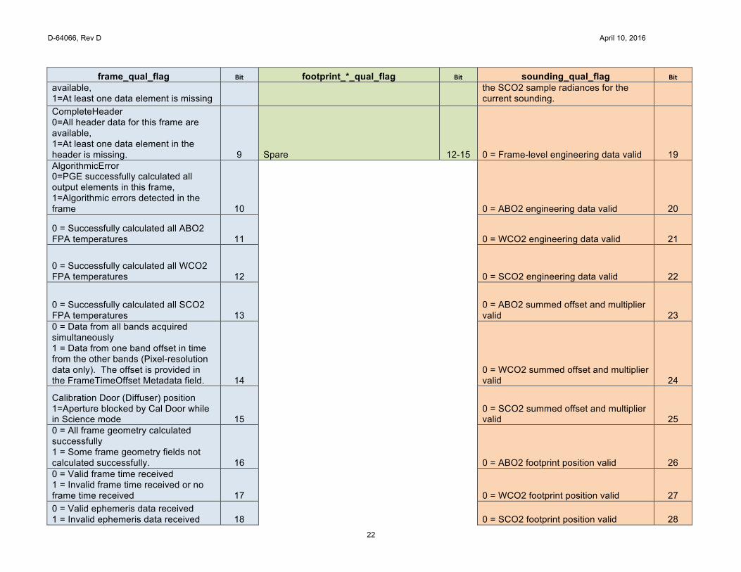
D-64066, Rev D April 10, 2016
22
frame_qual_flag Bit footprint_*_qual_flag Bit sounding_qual_flag Bit available, 1=At least one data element is missing
the SCO2 sample radiances for the current sounding.
CompleteHeader 0=All header data for this frame are available, 1=At least one data element in the header is missing. 9 Spare 12-15 0 = Frame-level engineering data valid 19 AlgorithmicError 0=PGE successfully calculated all output elements in this frame, 1=Algorithmic errors detected in the frame 10
0 = ABO2 engineering data valid 20
0 = Successfully calculated all ABO2 FPA temperatures 11
0 = WCO2 engineering data valid 21
0 = Successfully calculated all WCO2 FPA temperatures 12
0 = SCO2 engineering data valid 22
0 = Successfully calculated all SCO2 FPA temperatures 13
0 = ABO2 summed offset and multiplier valid 23
0 = Data from all bands acquired simultaneously 1 = Data from one band offset in time from the other bands (Pixel-resolution data only). The offset is provided in the FrameTimeOffset Metadata field. 14
0 = WCO2 summed offset and multiplier valid 24
Calibration Door (Diffuser) position 1=Aperture blocked by Cal Door while in Science mode 15
0 = SCO2 summed offset and multiplier valid 25
0 = All frame geometry calculated successfully 1 = Some frame geometry fields not calculated successfully. 16
0 = ABO2 footprint position valid 26
0 = Valid frame time received 1 = Invalid frame time received or no frame time received 17
0 = WCO2 footprint position valid 27
0 = Valid ephemeris data received 1 = Invalid ephemeris data received 18
0 = SCO2 footprint position valid 28
D-64066, Rev D April 10, 2016
23
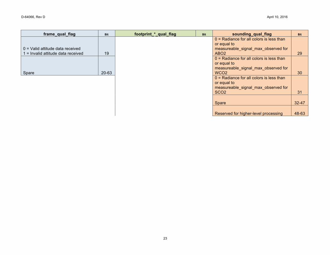
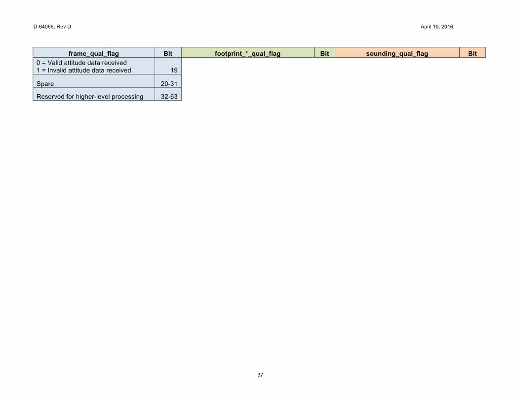
frame_qual_flag Bit footprint_*_qual_flag Bit sounding_qual_flag Bit
0 = Valid attitude data received 1 = Invalid attitude data received 19
0 = Radiance for all colors is less than or equal to measureable_signal_max_observed for ABO2 29
Spare 20-63
0 = Radiance for all colors is less than or equal to measureable_signal_max_observed for WCO2 30
0 = Radiance for all colors is less than or equal to measureable_signal_max_observed for SCO2 31
Spare 32-47
Reserved for higher-level processing 48-63
D-64066, Rev D April 10, 2016
24
6 Specification Table – Calibration Modes
L1B_Calibration Product HDF specification Group Metadata
Group description Granule-level Metadata
Data Element Shape Type Units Minimum
value Maximum
value Comments
Standard Metadata
See OCO-2 Standard Metadata specification table below
AcquisitionMode Scalar String
The instrument mode in which the data in the product were collected. Valid values are: 'Glint', 'Nadir', 'Target', 'Sample Dark Calibration', 'Sample Lamp Calibration', 'Sample Solar/limb Calibration', 'Single-Pixel Dark Calibration', 'Single-Pixel Lamp Calibration', 'Single-Pixel Solar/limb Calibration'
ActualFrames Scalar Int32
Actual number of frames reported in this product
ARPAncillaryDatasetDescriptor Scalar String
The name of the Ancillary Radiometric Product file used to calibrate this file
AscendingEquatorCrossingDate Scalar String
The date of the equator crossing of the spacecraft ground track in the ascending direction
AscendingEquatorCrossingLongitude Scalar Float32 Degrees -180 180
The longitude of the equator crossing of the spacecraft ground track in the ascending direction
AscendingEquatorCrossingTime Scalar String
The time of the equator crossing of the spacecraft ground track in the ascending direction
AutomaticQualityFlag Scalar String
Not implemented - set to NULL
BadPixelMapVersionNum Spectrum_Array UInt32
Version number of corresponding Bad Pixel Map used to calibrate this data file
D-64066, Rev D April 10, 2016
25
ColorSlicePositionO2 O2Slice_Array Int16
1 1024 Absolute spectral position of each ABO2 color slice
ColorSlicePositionStrongCO2 StrongCO2Slice_Array Int16
1 1024 Absolute spectral position of each SCO2 color slice
ColorSlicePositionWeakCO2 WeakCO2Slice_Array Int16
1 1024 Absolute spectral position of each WCO2 color slice
DiffuserPosition Scalar Float32
The position of the solar diffuser at the beginning of the mode: 0 - Lamp or Closed position, 75 - Open for science, 150 - Solar Calibration position
EphemerisType Scalar String
The source of the spacecraft ephemeris data that were utilized to generate this data file
EquatorCrossingDate Scalar String
The date of the equator crossing of the spacecraft ground track in the descending direction
EquatorCrossingLongitude Scalar Float32 Degrees -180 180
The longitude of the equator crossing of the spacecraft ground track in the descending direction
EquatorCrossingTime Scalar String
The time of the equator crossing of the spacecraft ground track in the descending direction
ExpectedFrames Scalar Int32
Nominal number of frames in this product
FirstSoundingId Scalar Int64
The ID of the first sounding in this file
InitialUnusedSpatialPixels Spectrum_Array Int16
Distance in spatial pixels of the start of first footprint from edge of FPA
L1BAlgorithmDescriptor Scalar String
Identification of the algorithm and version used to generate this product
D-64066, Rev D April 10, 2016
26
LastSoundingId Scalar Int64
The ID of the last sounding in this file
ModeCounter Scalar String
The Nth occurrence of this particular mode for this orbit, indicated by letter ('a', 'b', 'c', 'd', etc.)
MaxMS Spectrum_Array Float32 Ph sec^{-1} m^{-2} sr^{-1} um^{-1}
The maximum measureable signal value to be used in radiance noise calculation
OperationMode Scalar String
The two-letter abbreviation of the AcquisitionMode: GL, ND, TG, DS, LS, SS, BS, NP, GP, TP, DP, LP, SP, BP, XS, XP, MS, MP, SB
OrbitEccentricity Scalar Float32
The eccentricity of the spacecraft orbital path
OrbitInclination Scalar Float32 Degrees 0 180 The angle between the plane of the spacecraft orbital path and the Earth equatorial plane
OrbitParametersPointer OrbitParamPtr_Array String
The data files that provided the orbit parameters used to generate this product
OrbitPeriod Scalar Float32 Seconds
The time span between two consecutive descending node crossings
OrbitSemiMajorAxis Scalar Float32 Meters
The length of the semi-major axis of the spacecraft orbit
OrbitStartDate Scalar String
The date of the equator crossing of the spacecraft nadir track in the descending direction
OrbitStartLongitude Scalar Float32 Degrees -180 180
The longitude of the equator crossing of the spacecraft ground track in the descending direction
OrbitStartTime Scalar String
The time of the equator crossing of the spacecraft ground track in the descending direction
D-64066, Rev D April 10, 2016
27
ReportedSoundings SoundingPosition_Array Int8
0 1 Indicates the inclusion of each footprint in the data: 0 - not included, 1 - included
SciToFPAColorOffset Spectrum_Array Int16
The index of the first spectral pixel of arrays with FPAColor shape that appears in the first spectral element of arrays with SciColor shape
SpectralChannel Spectrum_Array String
A description of the spectral channels used for the measurements
Group InstrumentHeader
Group description Instrument characteristics
Data Element Shape Type Units Minimum
value Maximum
value Comments
ils_delta_lambda Spectrum_Sounding_SciColor_DeltaLambda_Array Float32 Microns
Wavelength offset from peak response for sampled data
ils_relative_response Spectrum_Sounding_SciColor_DeltaLambda_Array Float32
The relative response defined at ils_delta_lamda
full_width_half_maximum Spectrum_Sounding_SciColor_Array Float32 Microns
The spectral response width at full-width-half-maximum, per pixel
measureable_signal_max_observed Spectrum_Array Float32 Ph sec^{-1} m^{-2}
sr^{-1} um^{-1}
Maximum radiance measurable by each spectrometer without detector saturation
snr_coef Spectrum_Sounding_SciColor_SNRCoef_Array Float64
Three coefficients of the noise model: photon component (proportional to the square root of signal), a constant background component and a bad sample flag where 0 - OK, 1 - ignore for retrievals
dispersion_coef_samp Spectrum_Sounding_DispersionCoefficient_Array Float64
Coefficients that express the relationship between the spectral element index and its associated wavelength
residual_estimate Spectrum_Sounding_SciColor_ResidualCoefficient_Array Float32
Empirical estimate of the systematic residuals that cannot be removed by calibration
Group FrameHeader
D-64066, Rev D April 10, 2016
28
Group description Frame-level metadata
Data Element Shape Type Units Minimum
value Maximum
value Comments
frame_id Frame_Array Int64
The mission-unique frame identifier
frame_time_string Frame_Array String
Time of telemetry frame (yyyy-mm-ddThh:mm:ss.mmmZ)
frame_time_tai93 Frame_Array Float64 Seconds
Time of telemetry frame in seconds since Jan 1, 1993
frame_qual_flag Frame_Array UInt64
Bit flags indicating the quality of the data in each frame: 0 - good, non-zero - see Product Quality Flags table below
clocking_offset_start Frame_Spectrum_Array Int32
-127 128
The first pixel where the flight software applies a focal plane clocking correction - negative value indicates the clocking shift operates downward, positive value indicates clocking shift is upward
clocking_offset_interval Frame_Spectrum_Array Int16
0 256
The number of pixels between each successive pixel shift used to apply a clocking correction
Group FrameTemperatures
Group description
Selected instrument temperatures for each frame
Data Element Shape Type Units Minimum
value Maximum
value Comments
temp_fpa Frame_Spectrum_Array Float32 Kelvins
FPA temperatures extracted for this frame time from the temperature data history
temp_optical_bench_grating_mz Frame_Array Float32 Kelvins
Temperature of the optical bench grating
temp_relay_sco2_mz Frame_Array Float32 Kelvins
Temperature of the relay
temp_telescope Frame_Array Float32 Kelvins
Temperature of the telescope
D-64066, Rev D April 10, 2016
29
temp_shroud_py_tz1 Frame_Array Float32 Kelvins
Temperature of the shroud
temp_afe_electronics_enclosure Frame_Array Float32 Kelvins
Temperature of the AFE electronics enclosure
temp_smooth_fpa_o2
Frame_Array Float32 Kelvins
ABO2 FPA temperature after noise-reduction processing
temp_smooth_fpa_strong_co2
Frame_Array Float32 Kelvins
SCO2 FPA temperature after noise-reduction processing
temp_smooth_fpa_weak_co2
Frame_Array Float32 Kelvins
WCO2 FPA temperature after noise-reduction processing
temp_smooth_optical_bench_grating_mz
Frame_Array Float32 Kelvins
Optics temperature for this frame after noise-reduction processing
Group SpacePointingFrameGeometry Group description Geometric information that applies to all measurements in frame
Data Element Shape Type Units Minimum
value Maximum
value Comments
spacecraft_position Frame_EuclidDim_Array Float32 Meters
Interpolated spacecraft position at the frame time
spacecraft_velocity Frame_EuclidDim_Array Float32 Meters Second^{-1}
Interpolated spacecraft velocity at the frame time
roll Frame_Array Float32 Degrees -180 180 Interpolated spacecraft attitude at the frame time
pitch Frame_Array Float32 Degrees -180 180 Interpolated spacecraft attitude at the frame time
yaw Frame_Array Float32 Degrees -180 180 Interpolated spacecraft attitude at the frame time
spacecraft_lat Frame_Array Float32 Degrees -90 90 Geodetic latitude of the spacecraft at the frame time
D-64066, Rev D April 10, 2016
30
spacecraft_lon Frame_Array Float32 Degrees -180 180 Longitude of the spacecraft at the frame time
spacecraft_alt Frame_Array Float32 Meters
Altitude of the spacecraft above the reference ellipsoid at the frame time
ground_track Frame_Array Float32 Degrees 0 360 Ground track orientation relative to local North
solar_distance Frame_Array Float64 Meters
Distance between satellite and the Sun
solar_azimuth Frame_Array Float32 Degrees 0 360 Angle between the spacecraft local north direction and the solar vector
solar_zenith Frame_Array Float32 Degrees 0 180 Angle between the spacecraft local zenith direction and the solar vector
boresight_azimuth Frame_Array Float32 Degrees 0 360
Angle between the spacecraft local north direction and the instrument boresight direction
boresight_zenith Frame_Array Float32 Degrees 0 180
Angle between the spacecraft local zenith direction and the instrument boresight direction
limb_lon Frame_Array Float32 Degrees -90 90
Longitude of the point where the surface normal intersects the LOS at right angle. Fill values used for non-limb observations.
limb_lat Frame_Array Float32 Degrees -180 180
Geodetic latitude of the point where the surface normal intersects the LOS at right angle. Fill values used for non-limb observations.
limb_alt Frame_Array Float32 Meters
Altitude of the LOS above the point where the surface normal intersects the LOS at right angle. Fill values used for non-limb observations. Measured using the WGS84 ellipsoid.
Group FrameConfiguration
D-64066, Rev D April 10, 2016
31
Group description Configuration information provided for every frame
Data Element Shape Type Units Minimum
value Maximum
value Comments
color_slice_position_o2 Frame_O2Slice_Array Int16
1 1024 Absolute spectral position, in pixels, of each color slice in ABO2 band
color_slice_position_strong_co2 Frame_StrongCO2Slice_Array Int16
1 1024 Absolute spectral position, in pixels, of each color slice in SCO2 band
color_slice_position_weak_co2 Frame_WeakCO2Slice_Array Int16
1 1024 Absolute spectral position, in pixels, of each color slice in WCO2 band
footprint_spatial_end_position Frame_SoundingPosition_Spectrum_Array Uint8
1 220
Position of end of each footprint, in pixels, relative to initial_unused_pixels
footprint_spatial_start_position Frame_SoundingPosition_Spectrum_Array Uint8
1 220
Position of start of each footprint, in pixels, relative to initial_unused_pixels
initial_unused_pixels Frame_Spectrum_Array Int16
8 796 Distance in pixels of the start of first footprint from edge of FPA
Group SoundingMeasurements Group description Radiance measurements for each sounding
Data Element Shape Type Units Minimum
value Maximum
value Comments
radiance_o2 Frame_Sounding_SciColor_Array Float32 Ph sec^{-1} m^{-2}
sr^{-1} um^{-1}
Calibrated spectra for ABO2
radiance_weak_co2 Frame_Sounding_SciColor_Array Float32 Ph sec^{-1} m^{-2}
sr^{-1} um^{-1}
Calibrated spectra for WCO2
radiance_strong_co2 Frame_Sounding_SciColor_Array Float32 Ph sec^{-1} m^{-2}
sr^{-1} um^{-1}
Calibrated spectra for SCO2
sounding_qual_flag Frame_Sounding_Array UInt64
Bit flags indicating the quality of the data in sounding: 0 - Good, non-zero - see Product Quality Flags table below
snr_o2_l1b Frame_Sounding_Array Float32
The mean signal-to-noise ratio of the good samples in the band falling between the 98th and 99th percentile for signal level
D-64066, Rev D April 10, 2016
32
snr_weak_co2_l1b Frame_Sounding_Array Float32
The mean signal-to-noise ratio of the good samples in the band falling between the 98th and 99th percentile for signal level
snr_strong_co2_l1b Frame_Sounding_Array Float32
The mean signal-to-noise ratio of the good samples in the band falling between the 98th and 99th percentile for signal level
Group SliceMeasurements
Group description Radiance measurements for each color slice
Data Element Shape Type Units Minimum
value Maximum
value Comments
radiance_slice_o2 Frame_O2Slice_SpatialRow_Array Float32 Ph sec^{-1} m^{-2}
sr^{-1} um^{-1}
Radiance values for all slice pixels (ABO2)
radiance_slice_weak_co2 Frame_WeakCO2Slice_SpatialRow_Array Float32
Ph sec^{-1} m^{-2} sr^{-1} um^{-1}
Radiance values for all ABO2 color slice pixels
radiance_slice_strong_co2 Frame_StrongCO2Slice_SpatialRow_Array Float32
Ph sec^{-1} m^{-2} sr^{-1} um^{-1}
Radiance values for all WCO2 color slice pixels
Group RadianceClockingCorrection
Group description Results of clocking analysis and correction
Data Element Shape Type Units Minimum
value Maximum
value Comments
declocking_color_indicator Spectrum_SciColor_Array Int8
Declocking color selection over all science colors: 0 - the color is not selected, non-zero - the color is selected for declocking and the value is the aggregated color slice group index in the declocking processing
clocking_shift_color_indicator Spectrum_SciColor_Array Int8 Indicator of clocking-related spatial shift at the color: 0 - no shift, 1 - shift occurred
radiance_jump_ratio_o2 Frame_Sounding_DeclockingGroupO2_JumpColorO2_Array Float32
Ratio of the mean ABO2 radiances after a jump to that of before the jump within a footprint from a color slice group
radiance_jump_ratio_weak_co2
Frame_Sounding_DeclockingGroupStrongCO2_JumpColorStrongCO2_Array Float32 Ratio of the mean WCO2 radiances after a
D-64066, Rev D April 10, 2016
33
jump to that of before the jump within a footprint from a color slice group
radiance_jump_ratio_strong_co2
Frame_Sounding_DeclockingGroupWeakCO2_JumpColorWeakCO2_Array Float32
Ratio of the mean SCO2 radiances after a jump to that of before the jump within a footprint from a color slice group
max_declocking_factor_o2 Frame_Sounding_Array Float32 Maximum clocking correction factor of the ABO2 footprint
max_declocking_factor_weak_co2 Frame_Sounding_Array Float32 Maximum clocking correction factor of the WCO2 footprint
max_declocking_factor_strong_co2 Frame_Sounding_Array Float32 Maximum clocking correction factor of the SCO2 footprint
Group SpikeEOF
Group description Results of spectral spike identification and removal
Data Element Shape Type Units Minimum
value Maximum
value Comments
spike_eof_bad_colors_o2 Frame_Sounding_Array Int16 Number of bad colors in ABO2 spectrum
spike_eof_bad_colors_weak_co2 Frame_Sounding_Array Int16 Number of bad colors in WCO2 spectrum
spike_eof_bad_colors_strong_co2 Frame_Sounding_Array Int16 Number of bad colors in SCO2 spectrum
spike_eof_weighted_residual_o2 Frame_Sounding_SciColor_Array Int8
Weighted residual of EOF-based spectral reconstruction for ABO2: (measured-model)/noise
spike_eof_weighted_residual_weak_co2 Frame_Sounding_SciColor_Array Int8
Weighted residual of EOF-based spectral reconstruction for WCO2: (measured-model)/noise
spike_eof_weighted_residual_strong_co2 Frame_Sounding_SciColor_Array Int8
Weighted residual of EOF-based spectral reconstruction for SCO2: (measured-
D-64066, Rev D April 10, 2016
34
model)/noise
D-64066, Rev D April 10, 2016
35
Product Quality Flags
frame_qual_flag Bit footprint_*_qual_flag Bit sounding_qual_flag Bit
QAScienceCompleteO2 0=All O2 band science data (sample/hi-res pixels) present 0
CompleteSpectra 0=all spectral values present in footprint, 1=some spectral values missing from footprint 0 Spare 0-28
QAOHKCompleteO2 0=All O2 band OHK data is present 1 Spare 1
0 = Radiance for all colors is less than or equal to measureable_signal_max_observed for ABO2 29
QAScienceCompleteWeakCO2 0=All Weak CO2 band science data (sample/hi-res pixels) present 2
CompleteFootprintInput 0=All input values used to calculate footprint descriptive information (footprint_time, footprint_spatial_start_position, and footprint_spatial_end_position) were present 2
0 = Radiance for all colors is less than or equal to measureable_signal_max_observed for WCO2 30
QAOHKCompleteWeak CO2 0=All WeakCO2 band OHK data is present 3
CompleteFootprintOutput 0=All footprint descriptive information (footprint_time, footprint_spatial_start_position, and footprint_spatial_end_position) could be calculated 3
0 = Radiance for all colors is less than or equal to measureable_signal_max_observed for SCO2 31
QAScienceCompleteStrongCO2 0=All Strong CO2 band science data (sample/hi-res pixels) present 4 Spare 4-7 Spare 32-47 QAOHKCompleteStrongCO2 0=All Strong CO2 band OHK data is present 5 Reserved for higher-level products 8-15 Reserved for higher-level processing 48-63 QAInstHKComplete 0 = All instrument housekeeping data is present 6
6.1.1.1.1.1
QAInstHKMostRecent 0 = Most recent instrument housekeeping data was generated within an acceptable time period of the science data. The acceptable gap is reported in the AllowedIHKGap metadata field. 7
D-64066, Rev D April 10, 2016
36
frame_qual_flag Bit footprint_*_qual_flag Bit sounding_qual_flag Bit CompleteFrame 0=All input data for this frame are available, 1=At least one data element is missing 8
CompleteHeader 0=All header data for this frame are available, 1=At least one data element in the header is missing. 9
AlgorithmicError 0=PGE successfully calculated all output elements in this frame, 1=Algorithmic errors detected in the frame 10
0 = Successfully calculated all ABO2 FPA temperatures 11
0 = Successfully calculated all WCO2 FPA temperatures 12
0 = Successfully calculated all SCO2 FPA temperatures 13
0 = Data from all bands acquired simultaneously. 1 = Data from one band offset in time from the other bands (Pixel-resolution data only). The offset is provided in the FrameTimeOffset Metadata field. 14
Calibration Door (Diffuser) position 0=Open for science, 1=Not open for science 15
0 = All frame geometry calculated successfully 1 = Some frame geometry fields not calculated successfully. 16
0 = Valid frame time received 1 = Invalid frame time received or no frame time received 17
0 = Valid ephemeris data received 1 = Invalid ephemeris data received 18
D-64066, Rev D April 10, 2016
37
frame_qual_flag Bit footprint_*_qual_flag Bit sounding_qual_flag Bit 0 = Valid attitude data received 1 = Invalid attitude data received 19
Spare 20-31
Reserved for higher-level processing 32-63
D-64066, Rev D April 10, 2016
38
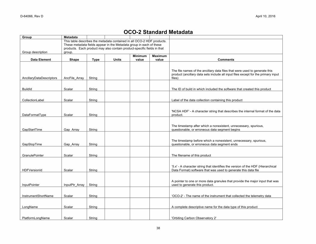
OCO-2 Standard Metadata Group Metadata
Group description
This table describes the metadata contained in all OCO-2 HDF products. These metadata fields appear in the Metadata group in each of these products. Each product may also contain product-specific fields in that group.
Data Element Shape Type Units Minimum
value Maximum
value Comments
AncillaryDataDescriptors AncFile_Array String
The file names of the ancillary data files that were used to generate this product (ancillary data sets include all input files except for the primary input files)
BuildId Scalar String
The ID of build in which included the software that created this product
CollectionLabel Scalar String
Label of the data collection containing this product
DataFormatType Scalar String
'NCSA HDF' - A character string that describes the internal format of the data product.
GapStartTime Gap_Array String
The timestamp after which a nonexistent, unnecessary, spurious, questionable, or erroneous data segment begins
GapStopTime Gap_Array String
The timestamp before which a nonexistent, unnecessary, spurious, questionable, or erroneous data segment ends
GranulePointer Scalar String
The filename of this product
HDFVersionId Scalar String
‘5.x' - A character string that identifies the version of the HDF (Hierarchical Data Format) software that was used to generate this data file
InputPointer InputPtr_Array String
A pointer to one or more data granules that provide the major input that was used to generate this product.
InstrumentShortName Scalar String
‘OCO-2' - The name of the instrument that collected the telemetry data
LongName Scalar String
A complete descriptive name for the data type of this product
PlatformLongName Scalar String
'Orbiting Carbon Observatory 2'
D-64066, Rev D April 10, 2016
39
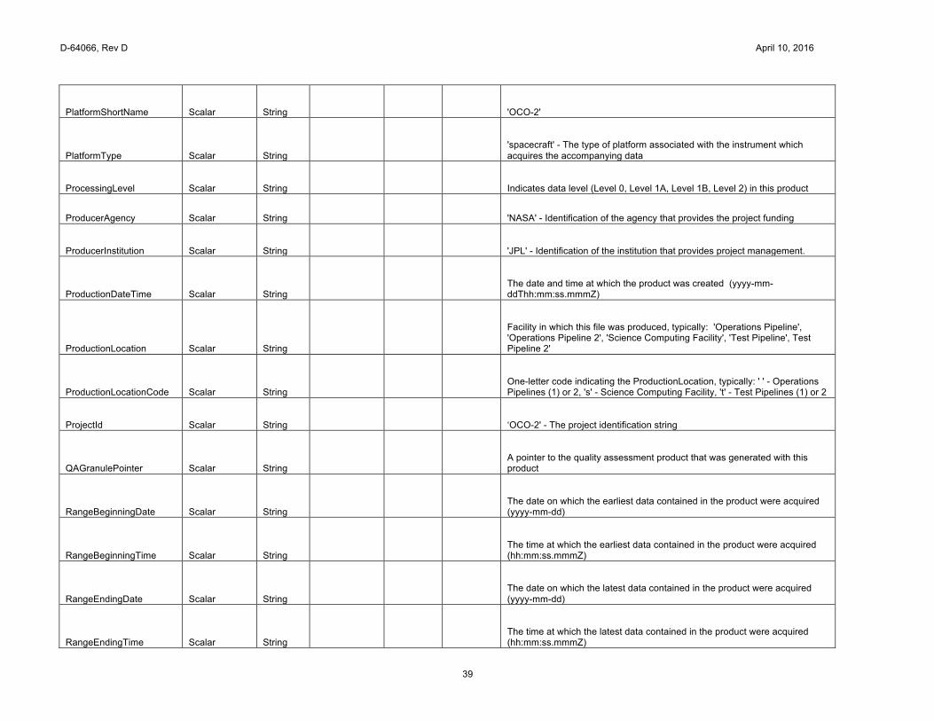
PlatformShortName Scalar String
'OCO-2'
PlatformType Scalar String
'spacecraft' - The type of platform associated with the instrument which acquires the accompanying data
ProcessingLevel Scalar String
Indicates data level (Level 0, Level 1A, Level 1B, Level 2) in this product
ProducerAgency Scalar String
'NASA' - Identification of the agency that provides the project funding
ProducerInstitution Scalar String
'JPL' - Identification of the institution that provides project management.
ProductionDateTime Scalar String
The date and time at which the product was created (yyyy-mm-ddThh:mm:ss.mmmZ)
ProductionLocation Scalar String
Facility in which this file was produced, typically: 'Operations Pipeline', 'Operations Pipeline 2', 'Science Computing Facility', 'Test Pipeline', Test Pipeline 2'
ProductionLocationCode Scalar String
One-letter code indicating the ProductionLocation, typically: ' ' - Operations Pipelines (1) or 2, 's' - Science Computing Facility, 't' - Test Pipelines (1) or 2
ProjectId Scalar String
‘OCO-2' - The project identification string
QAGranulePointer Scalar String
A pointer to the quality assessment product that was generated with this product
RangeBeginningDate Scalar String
The date on which the earliest data contained in the product were acquired (yyyy-mm-dd)
RangeBeginningTime Scalar String
The time at which the earliest data contained in the product were acquired (hh:mm:ss.mmmZ)
RangeEndingDate Scalar String
The date on which the latest data contained in the product were acquired (yyyy-mm-dd)
RangeEndingTime Scalar String
The time at which the latest data contained in the product were acquired (hh:mm:ss.mmmZ)
D-64066, Rev D April 10, 2016
40
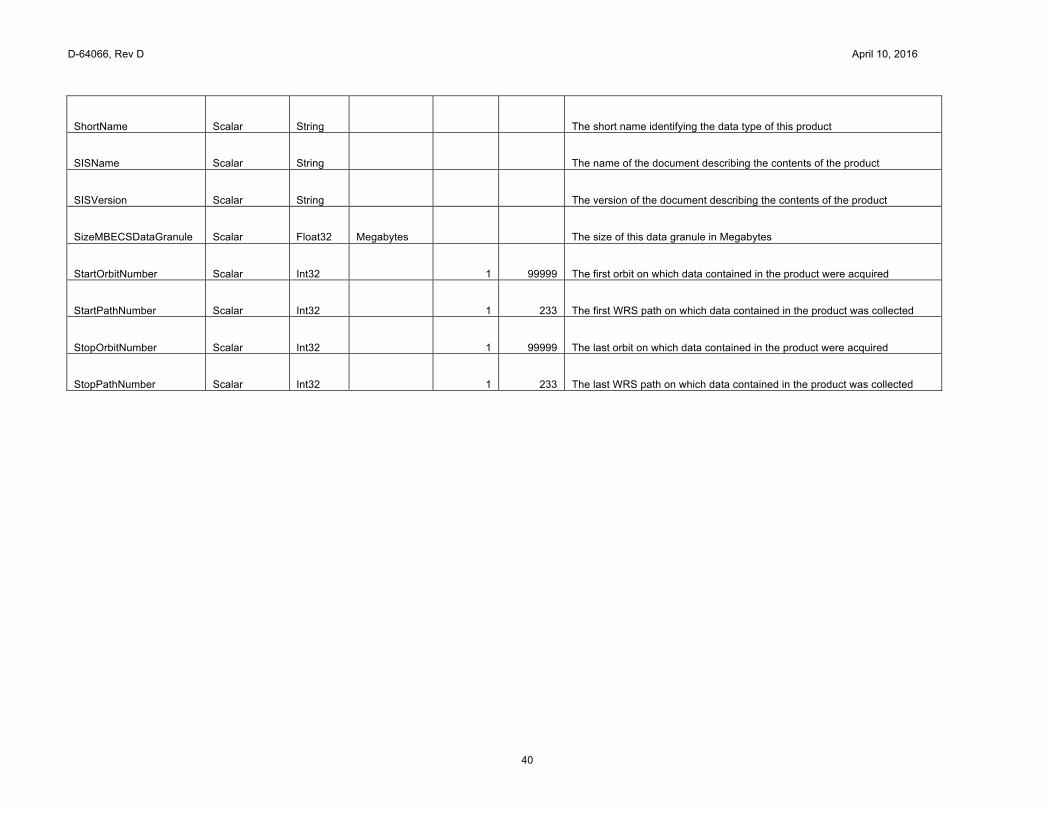
ShortName Scalar String
The short name identifying the data type of this product
SISName Scalar String
The name of the document describing the contents of the product
SISVersion Scalar String
The version of the document describing the contents of the product
SizeMBECSDataGranule Scalar Float32 Megabytes
The size of this data granule in Megabytes
StartOrbitNumber Scalar Int32
1 99999 The first orbit on which data contained in the product were acquired
StartPathNumber Scalar Int32
1 233 The first WRS path on which data contained in the product was collected
StopOrbitNumber Scalar Int32
1 99999 The last orbit on which data contained in the product were acquired
StopPathNumber Scalar Int32
1 233 The last WRS path on which data contained in the product was collected
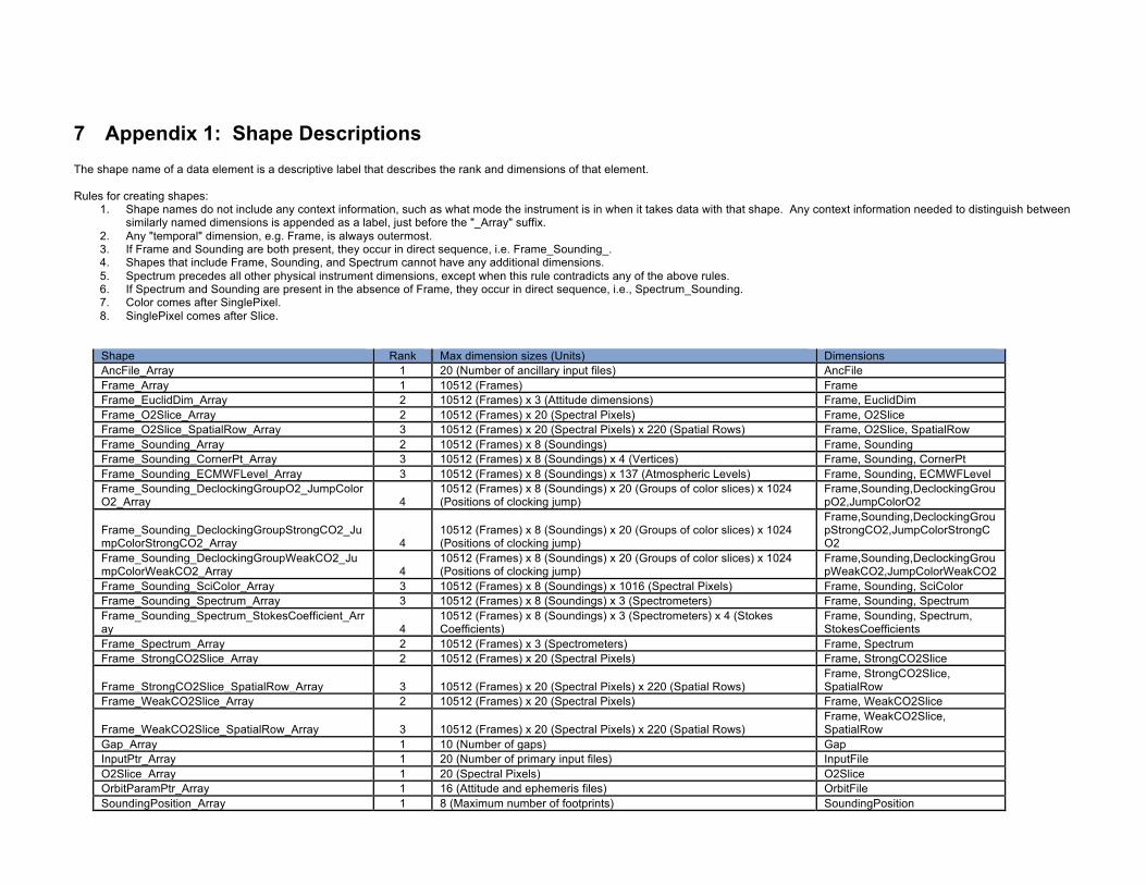
7 Appendix 1: Shape Descriptions The shape name of a data element is a descriptive label that describes the rank and dimensions of that element. Rules for creating shapes:
1. Shape names do not include any context information, such as what mode the instrument is in when it takes data with that shape. Any context information needed to distinguish between similarly named dimensions is appended as a label, just before the "_Array" suffix.
2. Any "temporal" dimension, e.g. Frame, is always outermost. 3. If Frame and Sounding are both present, they occur in direct sequence, i.e. Frame_Sounding_. 4. Shapes that include Frame, Sounding, and Spectrum cannot have any additional dimensions. 5. Spectrum precedes all other physical instrument dimensions, except when this rule contradicts any of the above rules. 6. If Spectrum and Sounding are present in the absence of Frame, they occur in direct sequence, i.e., Spectrum_Sounding. 7. Color comes after SinglePixel. 8. SinglePixel comes after Slice.
Shape Rank Max dimension sizes (Units) Dimensions AncFile_Array 1 20 (Number of ancillary input files) AncFile Frame_Array 1 10512 (Frames) Frame Frame_EuclidDim_Array 2 10512 (Frames) x 3 (Attitude dimensions) Frame, EuclidDim Frame_O2Slice_Array 2 10512 (Frames) x 20 (Spectral Pixels) Frame, O2Slice Frame_O2Slice_SpatialRow_Array 3 10512 (Frames) x 20 (Spectral Pixels) x 220 (Spatial Rows) Frame, O2Slice, SpatialRow Frame_Sounding_Array 2 10512 (Frames) x 8 (Soundings) Frame, Sounding Frame_Sounding_CornerPt_Array 3 10512 (Frames) x 8 (Soundings) x 4 (Vertices) Frame, Sounding, CornerPt Frame_Sounding_ECMWFLevel_Array 3 10512 (Frames) x 8 (Soundings) x 137 (Atmospheric Levels) Frame, Sounding, ECMWFLevel Frame_Sounding_DeclockingGroupO2_JumpColorO2_Array 4
10512 (Frames) x 8 (Soundings) x 20 (Groups of color slices) x 1024 (Positions of clocking jump)
Frame,Sounding,DeclockingGroupO2,JumpColorO2
Frame_Sounding_DeclockingGroupStrongCO2_JumpColorStrongCO2_Array 4
10512 (Frames) x 8 (Soundings) x 20 (Groups of color slices) x 1024 (Positions of clocking jump)
Frame,Sounding,DeclockingGroupStrongCO2,JumpColorStrongCO2
Frame_Sounding_DeclockingGroupWeakCO2_JumpColorWeakCO2_Array 4
10512 (Frames) x 8 (Soundings) x 20 (Groups of color slices) x 1024 (Positions of clocking jump)
Frame,Sounding,DeclockingGroupWeakCO2,JumpColorWeakCO2
Frame_Sounding_SciColor_Array 3 10512 (Frames) x 8 (Soundings) x 1016 (Spectral Pixels) Frame, Sounding, SciColor Frame_Sounding_Spectrum_Array 3 10512 (Frames) x 8 (Soundings) x 3 (Spectrometers) Frame, Sounding, Spectrum Frame_Sounding_Spectrum_StokesCoefficient_Array 4
10512 (Frames) x 8 (Soundings) x 3 (Spectrometers) x 4 (Stokes Coefficients)
Frame, Sounding, Spectrum, StokesCoefficients
Frame_Spectrum_Array 2 10512 (Frames) x 3 (Spectrometers) Frame, Spectrum Frame_StrongCO2Slice_Array 2 10512 (Frames) x 20 (Spectral Pixels) Frame, StrongCO2Slice
Frame_StrongCO2Slice_SpatialRow_Array 3 10512 (Frames) x 20 (Spectral Pixels) x 220 (Spatial Rows) Frame, StrongCO2Slice, SpatialRow
Frame_WeakCO2Slice_Array 2 10512 (Frames) x 20 (Spectral Pixels) Frame, WeakCO2Slice
Frame_WeakCO2Slice_SpatialRow_Array 3 10512 (Frames) x 20 (Spectral Pixels) x 220 (Spatial Rows) Frame, WeakCO2Slice, SpatialRow
Gap_Array 1 10 (Number of gaps) Gap InputPtr_Array 1 20 (Number of primary input files) InputFile O2Slice_Array 1 20 (Spectral Pixels) O2Slice OrbitParamPtr_Array 1 16 (Attitude and ephemeris files) OrbitFile SoundingPosition_Array 1 8 (Maximum number of footprints) SoundingPosition
D-64066, Rev D April 10, 2016
42
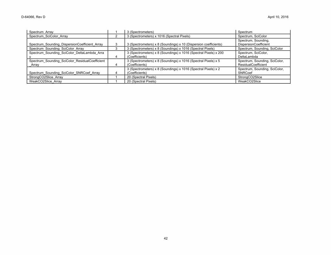
Spectrum_Array 1 3 (Spectrometers) Spectrum Spectrum_SciColor_Array 2 3 (Spectrometers) x 1016 (Spectral Pixels) Spectrum, SciColor
Spectrum_Sounding_DispersionCoefficient_Array 3 3 (Spectrometers) x 8 (Soundings) x 10 (Dispersion coefficients) Spectrum, Sounding, DispersionCoefficient
Spectrum_Sounding_SciColor_Array 3 3 (Spectrometers) x 8 (Soundings) x 1016 (Spectral Pixels) Spectrum, Sounding, SciColor Spectrum_Sounding_SciColor_DeltaLambda_Array 4
3 (Spectrometers) x 8 (Soundings) x 1016 (Spectral Pixels) x 200 (Coefficients)
Spectrum, SciColor, DeltaLambda
Spectrum_Sounding_SciColor_ResidualCoefficient_Array 4
3 (Spectrometers) x 8 (Soundings) x 1016 (Spectral Pixels) x 5 (Coefficients)
Spectrum, Sounding, SciColor, ResidualCoefficient
Spectrum_Sounding_SciColor_SNRCoef_Array 4 3 (Spectrometers) x 8 (Soundings) x 1016 (Spectral Pixels) x 2 (Coefficients)
Spectrum, Sounding, SciColor, SNRCoef
StrongCO2Slice_Array 1 20 (Spectral Pixels) StrongCO2Slice WeakCO2Slice_Array 1 20 (Spectral Pixels) WeakCO2Slice
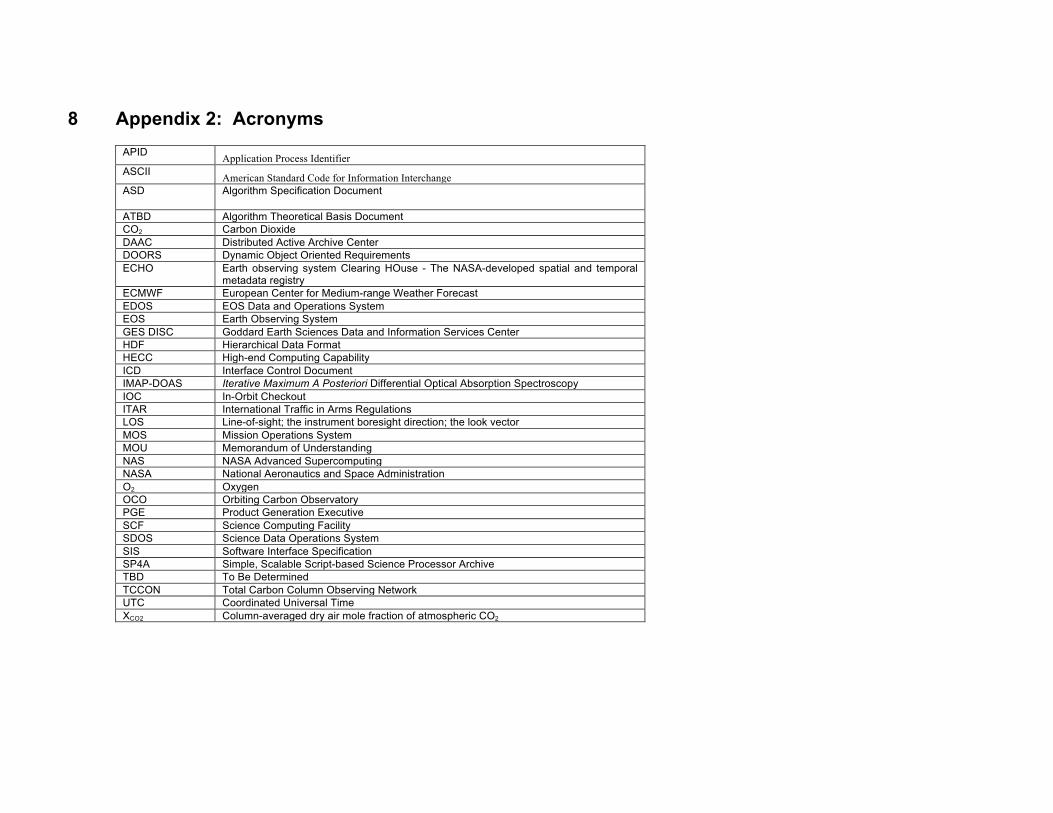
8 Appendix 2: Acronyms
APID Application Process Identifier ASCII American Standard Code for Information Interchange ASD Algorithm Specification Document
ATBD Algorithm Theoretical Basis Document CO2 Carbon Dioxide DAAC Distributed Active Archive Center DOORS Dynamic Object Oriented Requirements ECHO Earth observing system Clearing HOuse - The NASA-developed spatial and temporal
metadata registry ECMWF European Center for Medium-range Weather Forecast EDOS EOS Data and Operations System EOS Earth Observing System GES DISC Goddard Earth Sciences Data and Information Services Center HDF Hierarchical Data Format HECC High-end Computing Capability ICD Interface Control Document IMAP-DOAS Iterative Maximum A Posteriori Differential Optical Absorption Spectroscopy IOC In-Orbit Checkout ITAR International Traffic in Arms Regulations LOS Line-of-sight; the instrument boresight direction; the look vector MOS Mission Operations System MOU Memorandum of Understanding NAS NASA Advanced Supercomputing NASA National Aeronautics and Space Administration O2 Oxygen OCO Orbiting Carbon Observatory PGE Product Generation Executive SCF Science Computing Facility SDOS Science Data Operations System SIS Software Interface Specification SP4A Simple, Scalable Script-based Science Processor Archive TBD To Be Determined TCCON Total Carbon Column Observing Network UTC Coordinated Universal Time XCO2 Column-averaged dry air mole fraction of atmospheric CO2