society of american engineers - regulatory conference · marine protection research and sanctuaries...
TRANSCRIPT

US Army Corps of Engineers BUILDING STRONG®
USACE Regulatory Authorities
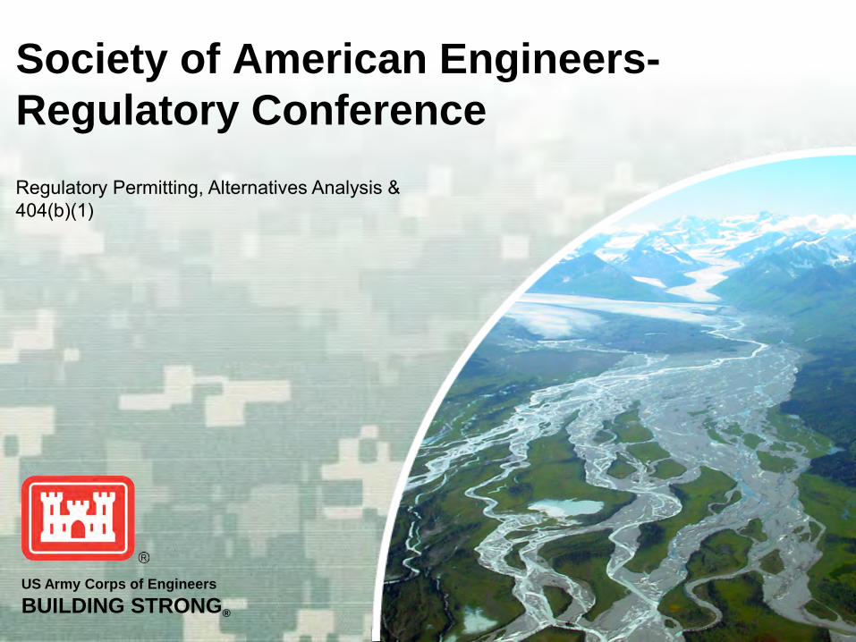
Society of American Engineers- Regulatory Conference

BUILDING STRONG®
AUTHORITIES
• Rivers and Harbors Act of 1899 (RHA) Section 7 - Danger Zones/Restricted Areas (1917 RHA) Section 9 - Dams and Dikes
(Bridges, & Causeways were transferred to the USCG in 1966)
Section 10 - Work or Structures
• Section 404 of the Clean Water Act (CWA) (formerly the Federal Water Pollution Control Act of 1972)
• Section 103 of the Marine Protection, Research and Sanctuaries Act of 1972 (MPRSA)

BUILDING STRONG®
Other Regulations and Laws 40 CFR Part 230 -Section 404(b)(1)
Guidelines 40 CFR Part 22 -Administrative
Assessment of Civil Penalties & the Revocation or Suspension of Permits
40 CFR Part 233 -State Program Regulations
40 CFR Part 233G -Tribal Regulations 40 CFR Part 1500 et seq -Council on
Environnemental Quality 36 CFR Part 800-899 -Advisory
Council on Historic Preservation 50 CFR Parts 400-499 -Endangered
Species Regulations National Environmental Policy Act National Historic Preservation Act
Wild & Scenic Rivers Act 50 CFR Part 600 -Essential Fish
Habitat Regulations Marine Protection Research and
Sanctuaries Act of 1972 -Section 302 Fish and Wildlife Coordination Act Native American Graves Protection
and Repatriation Act Clean Water Act -Section 401 Clean Water Act -Section 402 Coastal Zone Management Act of
1972 Endangered Species Act Marine Mammal Protection Act

BUILDING STRONG®
Section 10 of the Rivers and Harbors Act of 1899
prohibits the unauthorized obstruction or alteration of any navigable water of the United States unless you have a permit from the Corps of Engineers
Examples of obstructions or alterations are:
► construction of any structure in or over any navigable water of the United States,
► the excavating from or depositing of material ► the accomplishment of any other work affecting the
course, location, condition, or capacity of such waters

BUILDING STRONG®
Navigable Waters of the United States
Navigable waters of the United States are those waters that are subject to the ebb and flow of the tide and/or are presently used, or have been used in the past, or may be susceptible for use to transport interstate or foreign commerce.

BUILDING STRONG®
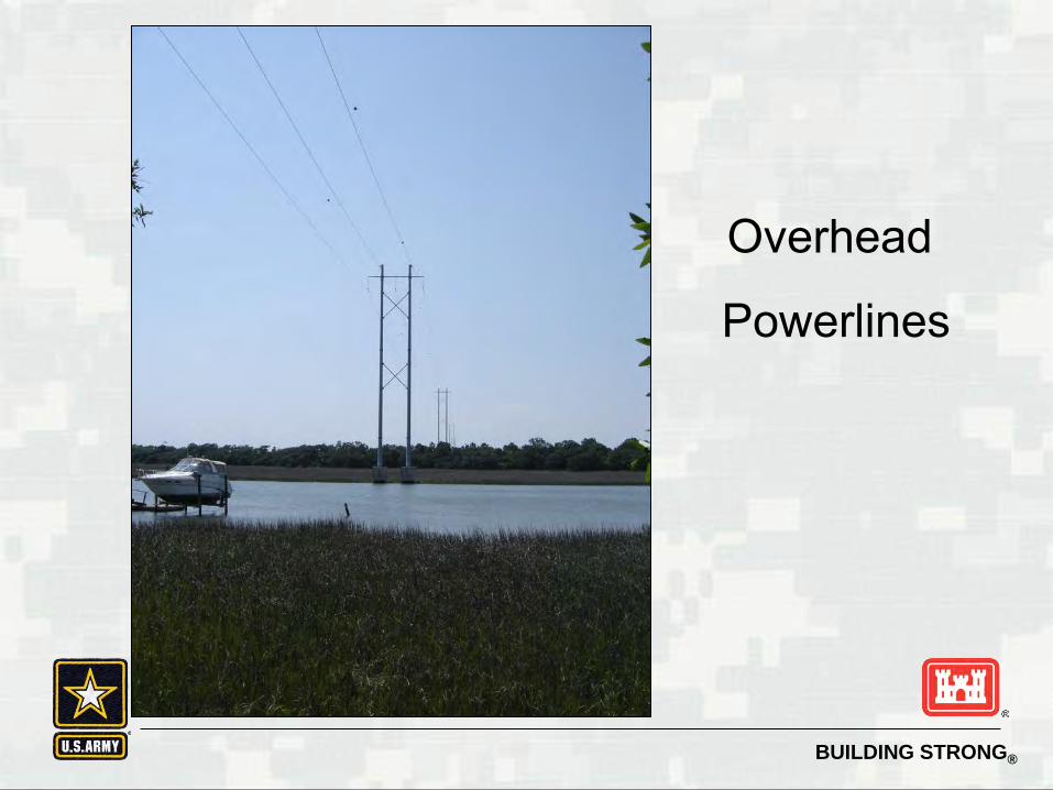
Activities Regulated under Section 10 RHA
• Structures: Weirs, utility/power lines, tunnels, piers, wharves, dolphins, breakwaters, booms, bulkheads, revetments, riprap, jetties, permanent mooring structures, aids to navigation, permanently moored floating facilities, pilings
• Work: excavation, dredging, filling, or modification

BUILDING STRONG®
Structures in Cook Inlet

BUILDING STRONG®
Marina Del Rey
BUILDING STRONG®
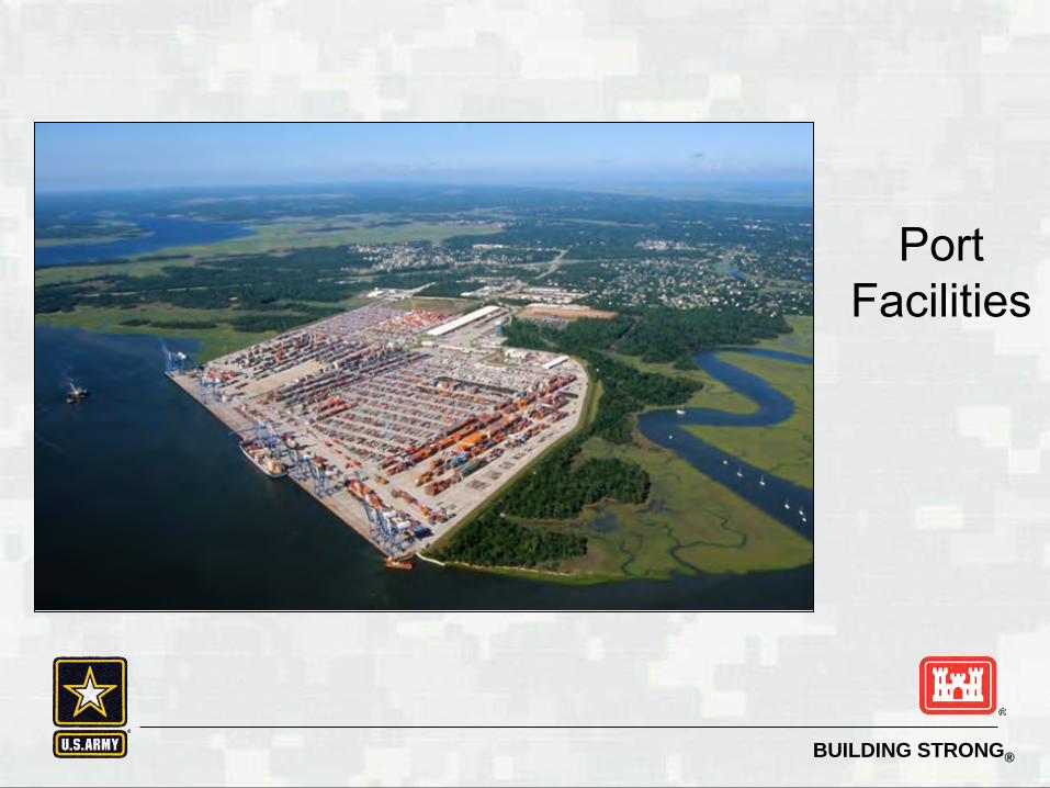
Port Facilities
BUILDING STRONG®
Overhead
Powerlines

BUILDING STRONG®
Clamshell Dredging

BUILDING STRONG®
What happens if they connect this to a Section 10 waterway?

BUILDING STRONG®
Section 404 of the Clean Water Act
…authorizes the Secretary of the Army to issue permits for the discharge of dredged or fill material into the waters of the United States at specified disposal sites.
To restore and maintain the chemical, physical and biological integrity of the waters of the U.S.

BUILDING STRONG®
Waters of the United States • All Navigable Waters of the U.S.;
• All interstate waters including interstate wetlands;
• All other waters such as intrastate lakes, rivers, streams
(including intermittent streams), mudflats, sandflats, wetlands, sloughs, prairie potholes, wet meadows, playa lakes, or natural ponds, the use, degradation or destruction of which could affect interstate or foreign commerce including any such waters:
Which are or could be used by interstate or foreign travelers for recreational or other purposes; or from which fish or shellfish are or could be taken and sold in interstate or foreign commerce; or,
Which are used or could be used for industrial purpose by industries in interstate commerce.

BUILDING STRONG®
Waters of the United States - cont • All impoundments of waters otherwise defined as
waters of the United States under the definition;
• Tributaries of waters;
• The territorial seas;
• Wetlands adjacent to waters (other than waters that are themselves wetlands);
• Waste treatment systems, including treatment ponds or lagoons designed to meet the requirements of CWA are not waters of the United States.
• Waters of the United States do not include prior converted cropland.

BUILDING STRONG®
Activities regulated under Section 404 of the Clean Water Act
•Dredged Material •Fill Material

BUILDING STRONG®
What is Dredged Material?
Material that is excavated or dredged from waters of the US

BUILDING STRONG®
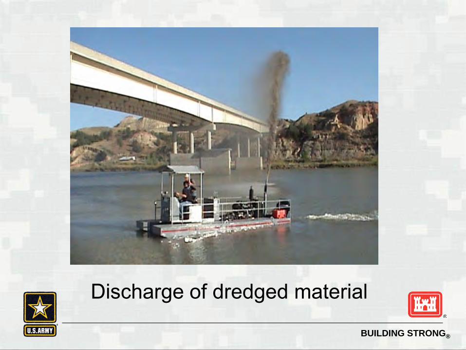
Discharge of Dredged Material (33 CFR 323.2(d)(1))
any addition of dredged material into, including redeposit of dredged material other than incidental fallback within, the waters of the US. The term includes, but is not limited to, the following: (i) The addition of dredged material to a specified discharge site located in
waters of the US; (ii) The runoff or overflow from a contained land or water disposal area; and (iii) Any addition, including redeposit other than incidental fallback, of dredged
material, including excavated material, into waters of the US which is incidental to any activity, including mechanized landclearing, ditching, channelization, or other excavation.
BUILDING STRONG®
Discharge of dredged material

BUILDING STRONG®
Mechanized Landclearing

BUILDING STRONG®
Activities that ARE NOT a Discharge of Dredged Material
(33 CFR323.2(d)(2))
Discharges resulting from the onshore subsequent processing of dredged material that is extracted for any commercial use other than fill.
Activities that involve only the cutting or removing of vegetation above the ground (e.g., mowing, rotary cutting, and chainsawing) where the activity neither substantially disturbs the root system nor involves mechanized pushing, dragging, or other similar activities that redeposit excavated soil material.
Incidental fallback.

BUILDING STRONG®
“Incidental” discharge of dredged material

BUILDING STRONG®
What is Fill Material?
Material placed in waters of the United States where the material has the effect of:
(i) Replacing any portion of a water of the US with dry land; or
(ii) Changing the bottom elevation of any portion of a water of the US.

BUILDING STRONG®
Definition of Fill Material Examples of such fill material include, but are
not limited to: rock, sand, soil, clay, plastics, construction debris, wood chips, overburden from mining or other excavation activities, and materials used to create any structure or infrastructure in the waters of the United States.

BUILDING STRONG® BUILDING STRONG®

BUILDING STRONG®
Highways

BUILDING STRONG®
Beach Nourishment Virginia Beach

BUILDING STRONG®
O&G Development North Slope, Alaska

BUILDING STRONG®
Section 103 of the Marine Protection, Research and Sanctuaries Act
(MPRSA)
Transportation of dredged material by vessel or vehicle for purpose of dumping (disposal) in ocean waters at disposal sites designated by EPA under 40 CFR 228

BUILDING STRONG®
Section 103 of the Marine Protection, Research and Sanctuaries Act
(MPRSA)
Ocean waters are defined as those waters of the open seas lying
seaward of the baseline from which the territorial sea is measured.
More to come on the determination of the
baseline.

BUILDING STRONG®
AUTHORITIES

BUILDING STRONG®
Outer-Continental Shelf consists of the submerged lands, subsoil, and seabed, lying between the seaward extent of the States' jurisdiction and the seaward extent of Federal jurisdiction. Generally, the OCS begins 3-9 nautical miles from shore (depending on the state) and extends 200 nautical miles outward, or farther if the continental shelf extends beyond 200 nautical miles.

BUILDING STRONG®
Outer-Continental Shelf Lands Act
Permits, pursuant to Section 10 of the RHA, are required for the construction of artificial islands, installations, and other devices on the seabed to the seaward limit of the outer continental shelf

BUILDING STRONG®
Outer-Continental Shelf

BUILDING STRONG®
Determining the Baseline US Baseline Committee – established in 1970 to precisely define the location and nature of the coastline. The Committee established that the baseline shall be determined in accordance with the 1958 Convention on the Territorial Sea and Contiguous Zone. As set forth in the 1958 Convention, the Committee adopted that the low-water line, specifically the lowest charted datum at Mean Lower Low Water (MLLW) on NOAA’s nautical charts, would be the basis for determining the baseline. http://www.thsoa.org/hy07/11_01.pdf

BUILDING STRONG®
Determining the Baseline If the surface area of the bay exceeds the surface area of a semi-circle with a
diameter equal to the mouth

BUILDING STRONG®
Various limits of national waters

BUILDING STRONG®
Section 9 of the Rivers and Harbors Act
Prohibits the construction of any dam or dike
across any navigable water of the US in navigable waters of the United States unless……..
you have one of 2 things
What are they?

BUILDING STRONG®
Congressional consent and approval of the Chief of Engineers
OR Where the navigable portions of a waterbody
lie wholly within the limits of a single state, you must have permission of the
legislature of that state and the Chief of Engineers.

BUILDING STRONG®
What is the definition of a “dike or dam”?
Any impoundment structure that completely spans a navigable water of the US and that may obstruct interstate waterborne commerce. It does not include weirs. Weirs are regulated under Section 10 of the RHA.

BUILDING STRONG®
Dam

BUILDING STRONG®
What other activities are regulated under Section 9?
Bridges and Causeways HOWEVER
The authority of the COE was transferred to the US Coast Guard under the Department of Transportation Act of 1966. See the 1974 MOA and RGL 85-02 which clearly states, that where “a bridge is beyond the limits of the Coast Guard jurisdiction, district commanders will not require a Section 10 permit.”

BUILDING STRONG®
Section 307 Coastal Zone Management Act
Requires any non-federal applicant for a federal license or permit to conduct an activity affecting land or water uses in the state’s coastal zone to furnish a certification that the proposed activity will comply with the state’s coastal zone management program and generally, no permit will be issued until the state has concurred with the non-federal applicant’s certification.
BUILDING STRONG®
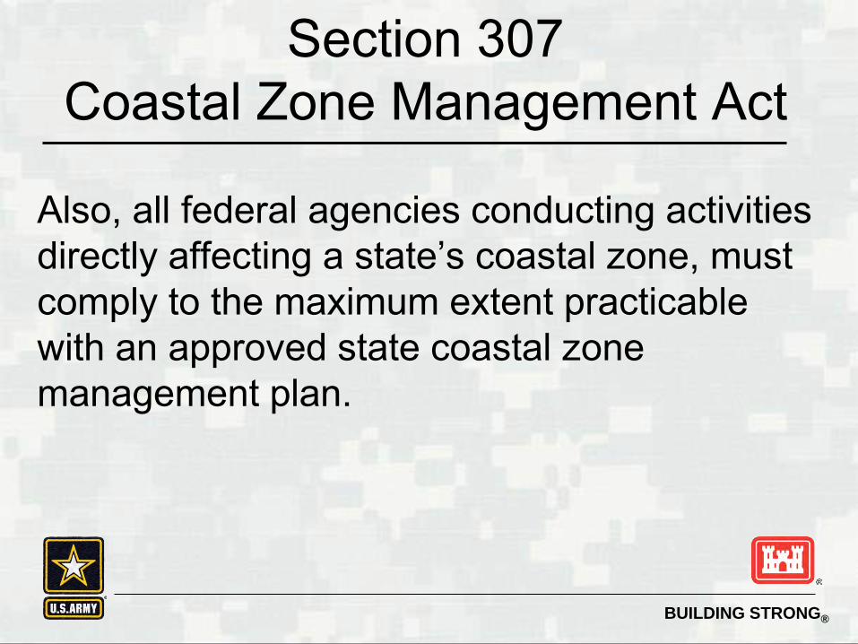
Section 307 Coastal Zone Management Act
Also, all federal agencies conducting activities directly affecting a state’s coastal zone, must comply to the maximum extent practicable with an approved state coastal zone management plan.
BUILDING STRONG®
Coastal Zone Defined
"coastal zone" means the coastal waters (including the lands therein and thereunder) and the adjacent shorelands (including the waters therein and thereunder), strongly influenced by each other and in proximity to the shorelines of the several coastal states, and includes islands, transitional and intertidal areas, salt marshes, wetlands, and beaches.

BUILDING STRONG®
Coastal States of the US

BUILDING STRONG®
Is everyone AWAKE?

BUILDING STRONG®
Is our BASIC NATIONAL CHARTER for the
protection of the environment. It requires that environmental information be available to the public BEFORE decisions are made. This information comes in the form of 1 of 2 documents: •Environmental Assessment (and FONSI) •Environmental Impact Statement
National Environmental Policy Act of 1969

BUILDING STRONG®
National Environmental Policy Act of
1969 40 CFR Parts 1500-1508 Council on Environmental Quality (CEQ) regulations “40 Most Asked Questions regarding Council on Environmental Quality (CEQ's) National Environmental Policy Act (NEPA) Regulations” 46 FR 18026 March 23 1981. 33 CFR Parts 230 and 325 Environmental Quality; Procedures for Implementing the National Environmental Policy Act (NEPA)

BUILDING STRONG®
Federal agencies shall to the fullest extent possible: (a) Interpret and administer the policies, regulations, and public laws
of the United States in accordance with the policies set forth in the Act and in these regulations.
(b) Implement procedures to make the NEPA process more useful to decisionmakers and the public; to reduce paperwork and the accumulation of extraneous background data; and to emphasize real environmental issues and alternatives.
(c) Integrate the requirements of NEPA with other planning and
environmental review procedures required by law or by agency practice so that all such procedures run concurrently rather than consecutively.
NEPA National Environmental Policy Act
Part 1500.2 Policy

BUILDING STRONG®
(d) Encourage and facilitate public involvement in decisions which affect the quality of the human environment.
(e) Use the NEPA process to identify and assess the reasonable
alternatives to proposed actions that will avoid or minimize adverse effects of these actions upon the quality of the human environment.
(f) Use all practicable means, consistent with the requirements of the
Act and other essential considerations of national policy, to restore and enhance the quality of the human environment and avoid or minimize any possible adverse effects of their actions upon the quality of the human environment.
NEPA National Environmental Policy Act
Part 1500.2 Policy - continued

BUILDING STRONG®
Case Study
What Corps regulatory statutes is the case study subject to? What additional statutes must the project
be evaluated under? What type of NEPA documentation is
required?

US Army Corps of Engineers BUILDING STRONG®
Society of American Engineers- Regulatory Conference
USACE Geographic Jurisdiction

BUILDING STRONG®
Geographic Jurisdiction Overview
Objective: Recognize the limits and extent of Corps jurisdiction and activities subject to regulation in coastal waters.
2

BUILDING STRONG®
Lateral extents of Rivers and Harbors Act Jurisdiction
Ocean and coastal waters • Shoreward limit is mean high water • All ocean and coastal waters, to the limit of the
territorial seas (3 nautical miles from baseline). Wider zones are recognized for special regulatory powers exercised over the outer continental shelf (33 CFR 322.3(b))
• Entire surface and bed of waterbody subject to tidal action, even if portions are not “navigable in fact”
• Includes shallow areas, even if obstructed by shoals, vegetation, and other barriers
3
BUILDING STRONG®
Rivers and Harbors Act Definitions
Mean High Water - shoreward limit for all tidal waters; line on the shore reached by the plane of the average high water.
Ordinary High Water - shoreward limit of jurisdiction for all non-tidal waters; line on the shore established by normal fluctuations in water level.
4
BUILDING STRONG®
Identifying Mean High Water 33 CFR 329.12
Where precise determination becomes necessary, it must be established by survey with reference to available tide datum, preferably averaged over a period of 18.6 years.
Where an estimate is needed, observation of the “apparent shoreline” which is determined by reference to physical markings, lines of vegetations or changes in type of vegetation may be used.
5

BUILDING STRONG®
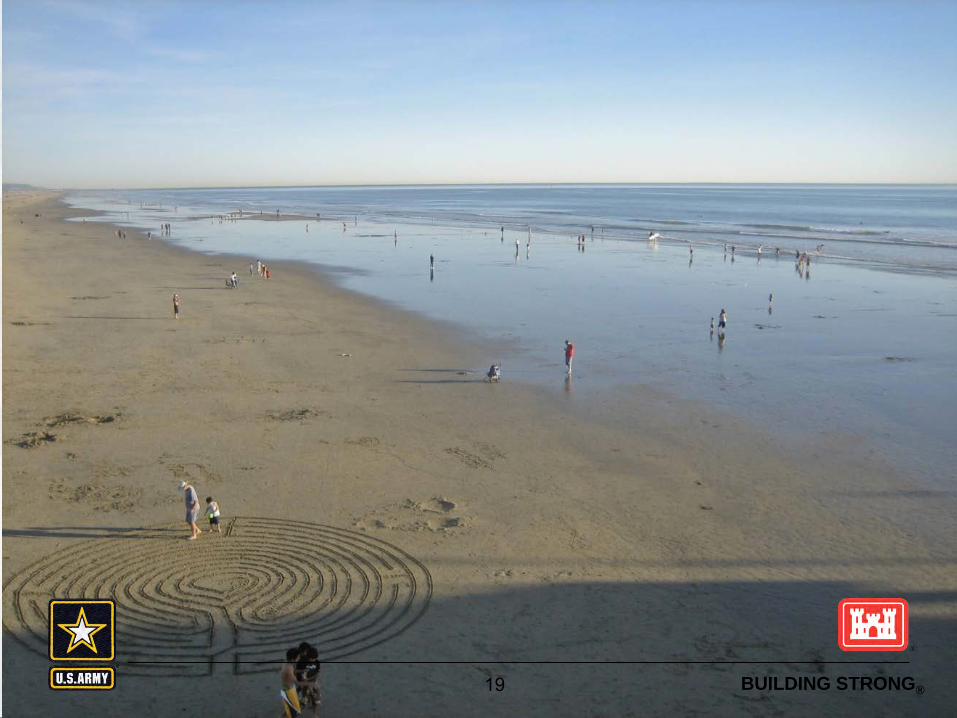
Practical Exam
Mean High Water
6
BUILDING STRONG®
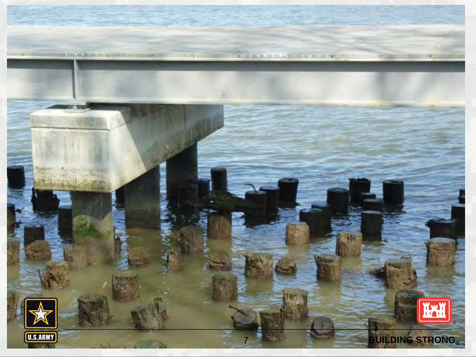
Water Marks on Structures
7 BUILDING STRONG®

BUILDING STRONG®
Water Marks on Structures
8 BUILDING STRONG®

BUILDING STRONG® 9

BUILDING STRONG® 10
BUILDING STRONG® 11 BUILDING STRONG®

BUILDING STRONG® 12 BUILDING STRONG®
BUILDING STRONG® 13 BUILDING STRONG®
BUILDING STRONG® 14 BUILDING STRONG®

BUILDING STRONG® 15 BUILDING STRONG®
BUILDING STRONG® 16 BUILDING STRONG®

BUILDING STRONG® 17 BUILDING STRONG®

BUILDING STRONG® 18 BUILDING STRONG®
BUILDING STRONG® 19 BUILDING STRONG®

BUILDING STRONG® 20 BUILDING STRONG®

BUILDING STRONG® 21 BUILDING STRONG®

BUILDING STRONG® 22 BUILDING STRONG®

BUILDING STRONG® 23 BUILDING STRONG®

BUILDING STRONG® 24 BUILDING STRONG®

BUILDING STRONG® 25
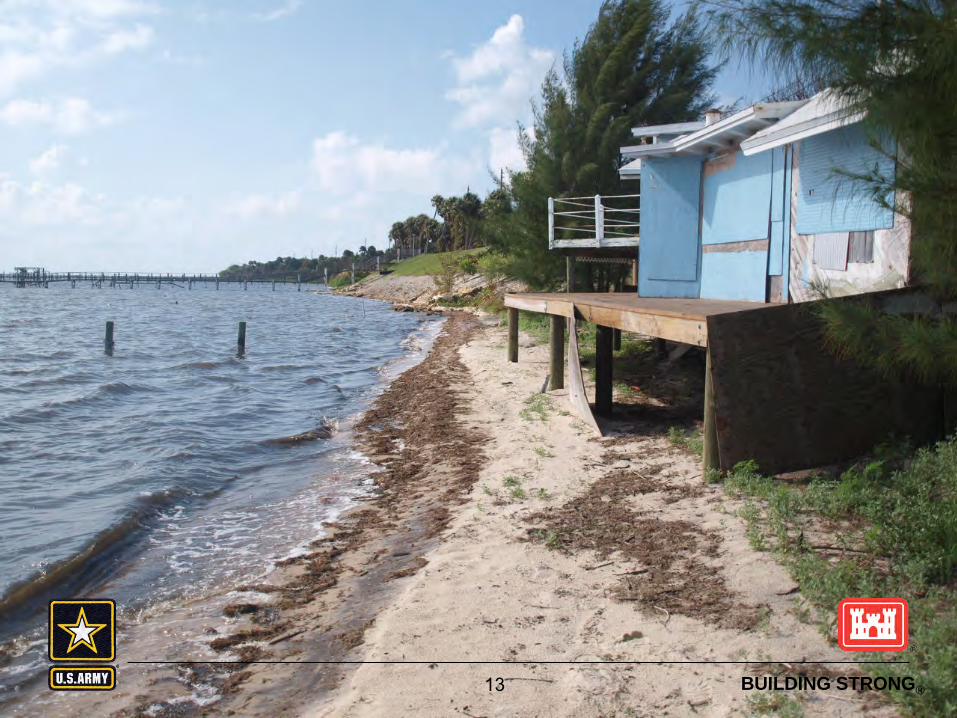
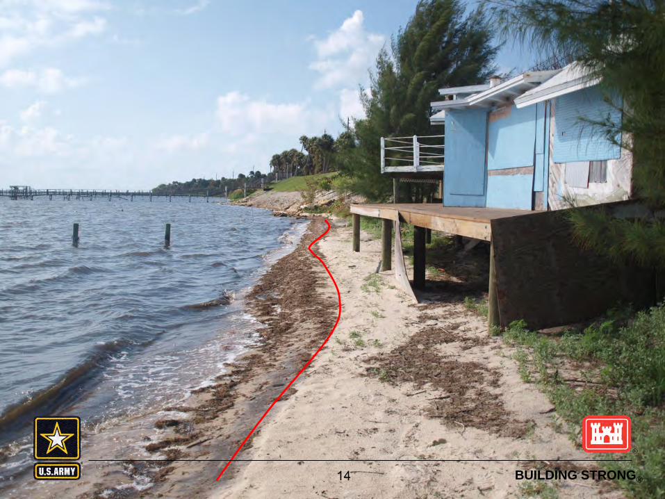
Below or above the Section 10 line?
BUILDING STRONG®

BUILDING STRONG®
RHA Beyond the Territorial Sea
Limited §10 RHA jurisdiction beyond the territorial seas to the edge of the outer continental shelf • Outer Continental Shelf Lands Act of 1953
all submerged lands lying seaward of State coastal waters (3 miles offshore) which are under U.S. jurisdiction
• Artificial islands, installations, and other devices on the seabed to limit of the outer continental shelf
• The lead Federal agency for licensing, permitting, or granting leases depends on the activity
• Corps evaluates impacts of proposed work on navigation and national security
26

BUILDING STRONG®
Outer Continental Shelf
27

BUILDING STRONG®
CWA Definitions High Tide Line (annual) – shoreward limit of jurisdiction
for all tidal waters (Section 404 regulated activities); intersection of land and water at the maximum height reached by a rising tide. (Spring Tide)
Ordinary High Water –shoreward limit of jurisdiction for all non-tidal waters; line on the shore established by normal fluctuations in the water level and indicated by physical characteristics such as a clear, natural line impressed on the bank, shelving, changes in the character of soil, destruction of terrestrial vegetation, the presence of litter and debris, or other appropriate means that consider the characteristics of the surrounding areas.
28

BUILDING STRONG®
Spring Tide
When the moon is full or new, the gravitational pull of the moon and sun are combined. At these times,
the high tides are very high and the low tides are very low. This is
known as a spring high tide. Spring tides are especially strong
tides (they do not have anything to do with the season Spring). They occur when the Earth, the Sun, and the Moon are in a line. The gravitational forces of the Moon
and the Sun both contribute to the tides.
29

BUILDING STRONG®
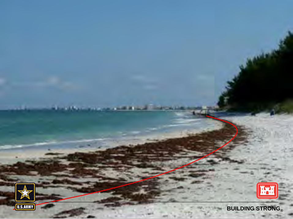
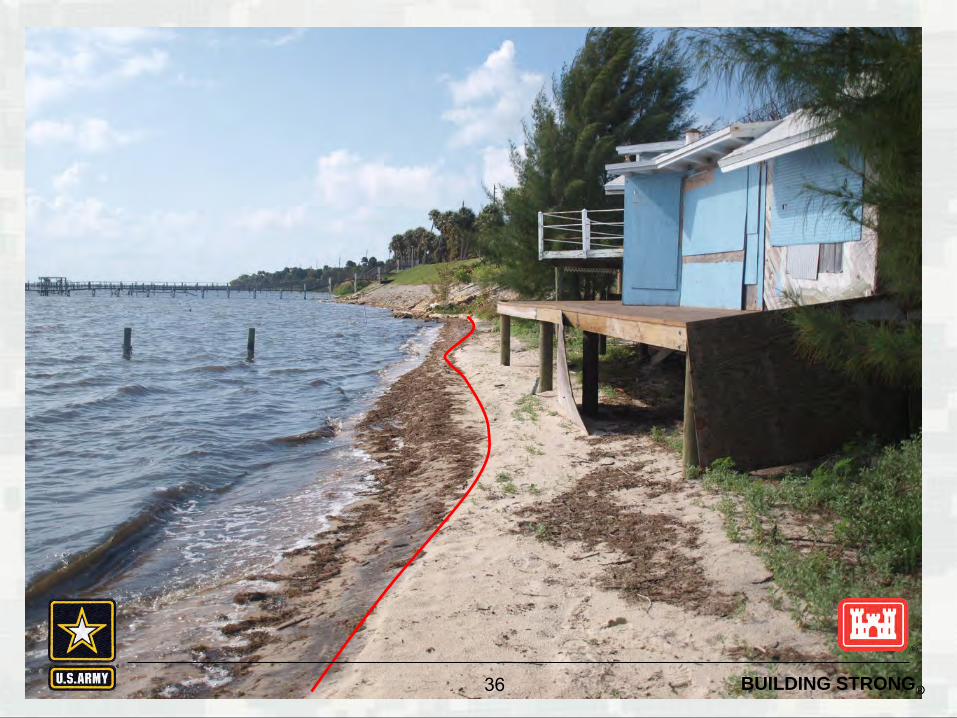
Identifying High Tide Line
Where precise determination becomes necessary, it must be established by survey with reference to available tide datum, preferably averaged over a period of 18.6 years
Where an estimate is needed, observation of the “apparent shoreline” which is determined by reference to physical markings, by a line of oil or scum along shore objects, a more or less continuous deposit of fine shell or debris on the foreshore or berm, lines of vegetation or changes in type of vegetation.
30
BUILDING STRONG®
Practical
High Tide Line
31

BUILDING STRONG®
Water Marks on Structures
32 BUILDING STRONG®

BUILDING STRONG®
Water Marks on Structures
33 BUILDING STRONG®

BUILDING STRONG®
Water Marks on Structures
34 BUILDING STRONG®

BUILDING STRONG®
Water Marks on Structures
35 BUILDING STRONG®
BUILDING STRONG® 36 BUILDING STRONG®

BUILDING STRONG® 37 BUILDING STRONG®

BUILDING STRONG® 38 BUILDING STRONG®

BUILDING STRONG® 39 BUILDING STRONG®

BUILDING STRONG® 40 BUILDING STRONG®

BUILDING STRONG® 41 BUILDING STRONG®

BUILDING STRONG®
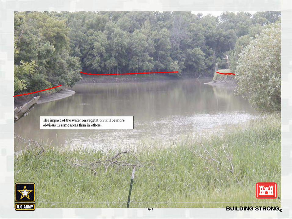
Identifying OHWM
indicated by physical characteristics such as: ► a clear, natural line impressed on the bank, ► shelving, ► changes in the character of soil, ► destruction of terrestrial vegetation, ► the presence of litter and debris, ► or other appropriate means that consider the
characteristics of the surrounding areas.
42

BUILDING STRONG®
Practical
Ordinary High Water Mark
43

BUILDING STRONG® 44

BUILDING STRONG® 45

BUILDING STRONG® 46 BUILDING STRONG®
BUILDING STRONG® 47 BUILDING STRONG®

BUILDING STRONG® 48 BUILDING STRONG®

BUILDING STRONG® 49 BUILDING STRONG®

BUILDING STRONG® 50 BUILDING STRONG®

BUILDING STRONG®
When the River Meets the Sea
An ESTUARY is defined as a semi-enclosed coastal body of water, which has a free connection with the open sea, and within which sea water is measurably diluted with freshwater derived from land drainage.
51

BUILDING STRONG® 52 BUILDING STRONG®
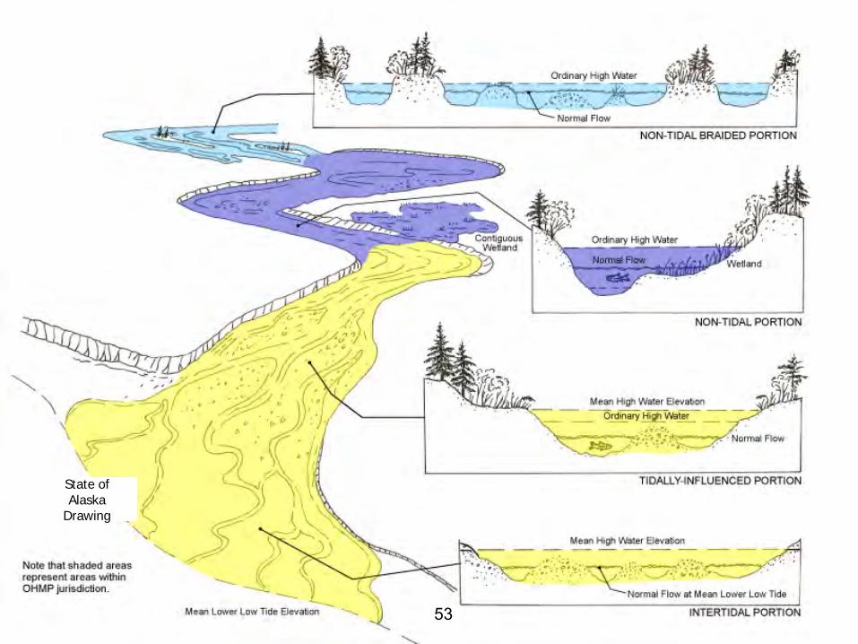
BUILDING STRONG® 53
State of Alaska
Drawing

BUILDING STRONG® 54

BUILDING STRONG®
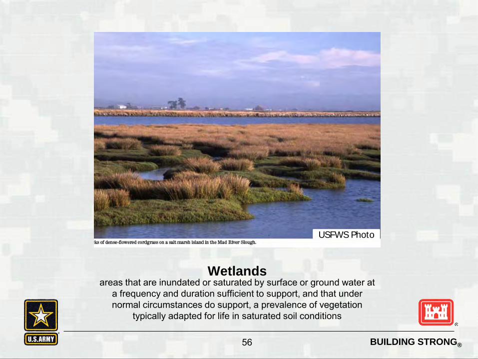
Special Aquatic Sites
Those sites identified in 40 CRF 230, Subpart E • Sanctuaries and refuges • Wetlands • Mud flats • Vegetated shallows • Coral reefs • Riffle and pool complexes
55
BUILDING STRONG®
Wetlands areas that are inundated or saturated by surface or ground water at
a frequency and duration sufficient to support, and that under normal circumstances do support, a prevalence of vegetation
typically adapted for life in saturated soil conditions
56
USFWS Photo

BUILDING STRONG®
Mud Flats broad flat areas along the sea coast and in coastal rivers to the head of tidal influence and in inland lakes, ponds, and riverine systems, Coastal mud flats are exposed at extremely low tides and inundated at high tides with the water
table at or near the surface of the substrate. The substrate of mud flats contains organic material and particles smaller in size than sand. They are
either unvegetated or vegetated only by algal mats.
57
KSU Photo

BUILDING STRONG®
Coral Reef consist of the skeletal deposit, usually of calcareous or silicaceous materials, produced by the vital activities of anthozoan polyps or
other invertebrate organisms present in growing portions of the reef.
58
NOAA Photo

BUILDING STRONG®
Vegetated Shallows permanently inundated areas that under normal circumstances
support communities of rooted aquatic vegetation, such as turtle grass and eelgrass in estuarine or marine systems as well as a
number of freshwater species in rivers and lakes
59
NOAA Photo

BUILDING STRONG®
Determination of Navigability 33 CFR 329.14
Although conclusive determinations of navigability can be made only by federal Courts and Congress, those made by federal agencies are nevertheless accorded substantial weight by the courts.
A determination whether a waterbody is a navigable water of the United States will be made by the division engineer, and will be based on a report of findings prepared at the district level in accordance with the criteria set out in this regulation. Each report of findings will be prepared by the district engineer, accompanied by an opinion of the district counsel, and forwarded to the division engineer for final determination.
60

BUILDING STRONG®
Time at which commerce exists or determination is made
33 CFR 329.9 A waterbody which was navigable in its natural or improved state, or
which was susceptible of reasonable improvement retains its character as “navigable in law” even though it is not presently used for commerce, or is presently incapable of such use because of changed conditions or the presence of obstructions.
Navigability may also be found in a waterbody's susceptibility for use in its ordinary condition or by reasonable improvement to transport interstate commerce. This may be either in its natural or improved condition, and may thus be existent although there has been no actual use to date. Non-use in the past therefore does not prevent recognition of the potential for future use.
61

BUILDING STRONG®
Existence of obstructions 33 CFR 329.10
A stream may be navigable despite the existence of falls, rapids, sand bars, bridges, portages, shifting currents, or similar obstructions. Thus, a waterway in its original condition might have had substantial obstructions which were overcome by frontier boats and/or portages, and nevertheless be a “channel” of commerce, even though boats had to be removed from the water in some stretches, or logs be brought around an obstruction by means of artificial chutes.
62

BUILDING STRONG® 63 BUILDING STRONG®

BUILDING STRONG®
Changes in Limits of Coastal Waters of the United States
33 CFR 329.13 Permanent changes in shoreline result in different limits
for waters of the U.S. Gradual changes over time as a result of natural causes
can also changes those boundaries: • Changing sea levels • Land subsidence • Siltation • Change in drainage
Man-made changes Permanent changes need to be verified by the district
engineer
64

BUILDING STRONG®
Changes in Territorial Seas Construction of solid fill structures and fill along the coasts may
extend a State’s seaward boundary under the Submerged Lands Act.
Accordingly, 33 CFR 320.4(f) REQUIRES that if it is determined that such structure or work could extend the coastline or baseline from which the territorial sea is measured, BOEM must be contacted prior to the district issuing a permit for such structure.
The activities that may affect the coast line or base line include examples such as jetties, groins, breakwaters, shoreline stabilization structures, beach nourishment etc
If the project affects the baseline, then the DE will request a waiver from the affected state which would waive the state’s interest in any increased in state-owned submerged lands. If the state refuses to grant the waiver, the permit must be issued by the ASA(CW)
65

BUILDING STRONG®
Delineation of Wetlands
The delineation of area inundated and/or saturated by surface or ground water at frequency and duration sufficient to
support, and that under normal circumstances do support, a
prevalence of vegetation typically adapted for life in saturated soils.
66

BUILDING STRONG®
What makes a Wetland?
Hydrology (water) Hydrophytic Plans (Plants Adapted
for Wet Conditions) Hydric (Wet) Soils
67

BUILDING STRONG®
1987 Corps of Engineers Wetland Delineation manual and Regional
Supplements
68

BUILDING STRONG®
Regional Supplements to the
Delineation Manual In 1993, at the request of Congress,
the National Research Council (NRC) formed a committee to review the scientific basis for wetland delineation and the technical validity of current wetland delineation manuals. The NRC report supported the basic logic and structure of the Corps Manual. However, it also concluded that regional variations among wetlands across the United States can affect the validity and usefulness of any national delineation manual, and strongly recommended that delineation procedures be revised to increase their regional specificity.
69

BUILDING STRONG®
Which Regional Supplements do we use in Galveston District?
70

BUILDING STRONG®
Documenting Jurisdiction
Approved JD Form or Preliminary JD Form Photographs-aerial or onsite groundview Show tie to navigable water (nexus) –for AJD Site inspection form or memo to the file Data Sheets (Regional Supplement) Complete data file or reference common data Other?—comply with District SOP
71

BUILDING STRONG®
Preliminary JDs
Preliminary JD Form PRESUMES jurisdictional over ALL waters
► Sets aside question of jurisdiction in order to expedite the permit process
DOES NOT involve adjacency or Significant nexus determination
CANNOT make a determination of “no jurisdiction” over a water (declining jurisdiction requires a AJD)
DOES NOT require use of wetland delineation manual or supplements. Identification of waters may be based on appearance of waters based on desk review.
72
BUILDING STRONG®
Approved JDs An approved JD is an official Corps determination that jurisdictional “waters
of the United States,” or “navigable waters of the United States,” or both, are either present or absent on a particular site. An approved JD precisely identifies the limits of those waters on the project site determined to be jurisdictional under the CWA/RHA.
Can be relied upon by a landowner, permit applicant, or other “affected party” who received an approved JD for five years;
Can be used and relied on by the recipient of the approved JD (absent extraordinary circumstances, such as approved JD based on incorrect data provided by a landonwer or consultant) if a CWA citizen’s lawsuit is brought in the Federal Courts against the landowner or other “affected party,” challenging the legitimacy of that JD or its determinations; and process.
The District Engineer retains the discretion to use an approved JD in any other circumstance where he or she determines that it is appropriate given the facts of the particular case.
73
BUILDING STRONG®
Appeals Process
Effective March 28, 2000 Outlined in 33 CFR 331 Only Approved JDs can be appealed Only Applicant or agent can appeal (no third party
appeals) Applicant/Agent has 60 days to request appeal for
specific reason (See NOA for process) Review Officer assigned to each division Review based on administrative record (no new
information)
74

BUILDING STRONG®
Concerning the Proposed Rule for Defining Waters of the United States Under the Clean Water Act
The proposed rule was published in the Federal Register on Monday, April 21 2014. The public comment period will be open for 91 days and will close on Monday, July 21, 2014.
The U.S. Army Corps of Engineers and EPA have jointly drafted a proposed rule for defining waters of the U.S. under the Clean Water Act.
The rule is intended to provide additional clarity regarding the geographic scope of Clean Water Act jurisdiction and improve consistency and predictability of jurisdictional decisions applicable to all CWA programs.
Both EPA and Army Corps of Engineers believe that the draft rule is consistent with the U.S. Supreme Court’s SWAQNCC and Raponos decision, and is as inclusive as applicable science will support.
http://www2.epa.gov/uswaters
75

BUILDING STRONG®
Summary Geographic limits of jurisdiction vary based on statutory
act. Identification of geographic limits is generally done
through visual observation Geographic limits may change as a result of man-made
and natural changes to the shoreline Navigability is based on studies conducted by the District
and approved by Division. Physical barriers may not negate navigability.
Ocean dumping pf dredge material must be done in accordance with EPA guidelines.
76
US Army Corps of Engineers BUILDING STRONG®
Society of American Engineers- Regulatory Conference Regulatory Permitting, Alternatives Analysis & 404(b)(1)

BUILDING STRONG®
Types of Corps Regulatory Permits

BUILDING STRONG®
Permitting Mechanisms
• General Permits
– Nationwide
– Regional
• Individual Permits
– Letter of permission
– Standard

BUILDING STRONG®
Nationwide Permits (NWPs) & Regional General Permits (RGP)
Authorizes Section 10 and Section 404 actions A type of general permit used to authorize specific types of
activities Minimal impact to aquatic environment Expedite permit review process Valid for 5 years
• Verification is only valid for 2 years 52* different NWPs
• 31 general conditions 23 different RGPs Regional conditions developed by District/State Mitigation may be required
BUILDING STRONG®
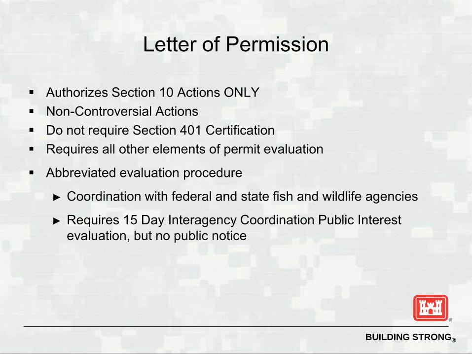
Letter of Permission
Authorizes Section 10 Actions ONLY Non-Controversial Actions Do not require Section 401 Certification Requires all other elements of permit evaluation
Abbreviated evaluation procedure
► Coordination with federal and state fish and wildlife agencies
► Requires 15 Day Interagency Coordination Public Interest evaluation, but no public notice

BUILDING STRONG®
Standard Permit “Individual Permit”
Authorizes Section 10 and Section 404 Actions Controversial Actions Requires all elements of permit evaluation Requires 30 Day Public Notice Must submit application form (Eng Form 4345) with the following
information about the proposed activity: ► A complete description, including necessary maps drawings, sketches,
and plans sufficient for the Corps to issue a public notice ► Location, purpose, and need ► Scheduling

BUILDING STRONG®
Corps Permit Review Process

BUILDING STRONG®
Permit Evaluation Process
Many pieces involved in the permit evaluation process
CZM
404(b)(1) ESA
401
Public Interest Review

BUILDING STRONG®
USACE
FWS
Public
NMFS
TCEQ TPWD
EPA
Neighbors Groups & agencies
Permit Evaluation Process

BUILDING STRONG®
Elements of Permit Evaluation
Impacts to Aquatic Resources 401 Water Quality Certification (TCEQ or TRRC)) Section 401 CWA, issued by state Endangered Species Act (ESA) (50 CFR 402) Cultural & Historic Resources (NEPA, National Historic Preservation Act, SHPO) Coastal Zone Management Compliance (TxGLO, TCEQ or TRCC) Public Notice / Public input 404(B)(1) Guidelines Magnuson-Stevens Fishery Conservation and Management Act Essential Fish Habitat (NMFS) Executive Order 11990 (Protection of Wetlands) – Executive Order 11988 (Floodplain Management) Public Interest Review Factors

BUILDING STRONG®
Public Interest Review Factors
• Conservation • Economics • Aesthetics • General Environment • Wetlands • Cultural Values • Fish & Wildlife Values • Land Use • Flood Hazards • Property Ownership
• Flood Plain Values • Navigation • Recreation • Shore Erosion &Accretion • Water Supply / Water
Quality • Energy Needs • Safety • Mineral Needs • Food & Fiber production • Needs & Welfare of
People

BUILDING STRONG®
Alternatives Analysis and the 404(b)(1) Guidelines

BUILDING STRONG®
ALTERNATIVES 1978 CEQ NEPA regulations: reasonable alternatives
1988 Corps NEPA regulations: reasonable alternatives - must be feasible - must accomplish purpose and need - alternatives that are reasonable and feasible need not
necessarily be available to the applicant 1980 404(b)(1) Guidelines: practicable alternatives - available and capable of being done taking into
consideration cost, existing technology, and logistics in light of the overall project purpose

BUILDING STRONG®
Alternatives Analysis Unless exempt by regulation, all projects involving fill
material in waters of the United States, whether these waters are special aquatic sites are required to evaluate “practicable alternatives” that would have less impact on the aquatic ecosystem.
When an activity is proposed to occur in a special
aquatic site*, the 404(b)(1) regulations presume that: 1. practicable alternatives that do not involve special
aquatic sites are available; 2. these alternatives will have less adverse impact on
the aquatic ecosystem.

BUILDING STRONG®
“Exempt By Regulation”
“Consideration of alternatives in 230.10(a) [of 404(b)(1) Guidelines] are not directly applicable to General Permits”
“Discharges of dredged or fill material into waters of the United States must be minimized or avoided to the maximum extent practicable at the project site (i.e., on-site)”

BUILDING STRONG®
Section 404(b)(1) Guidelines.
A set of guidelines listed in 40 CFR Part 230 intended to be consistent with and implement the policies in the Clean Water Act. The purpose of the guidelines is to restore and maintain the chemical, physical and biological integrity of waters of the United States through the control of discharges of dredged of fill material. Fundamental to the guidelines is the precept that dredged or fill material should not be discharged into the aquatic ecosystem, unless it can be demonstrated that such a discharge will not have an unacceptable adverse impact either individually or in combination with known and/or probable impacts of other activities affecting the ecosystems of concern.

BUILDING STRONG®
Alternatives Analysis & The Section 404(b)(1) Guidelines
Both presumptions must clearly be rebutted in writing by the applicant as a prerequisite to complying with the Section 404(b)(1) Guidelines, and thus to potential permit issuance.
In order to accomplish this evaluation, the applicant must supply the Corps with the following information:
1. A specific description of the purpose and need for the project, including the basic and the overall project purpose
2. An analysis of the practicable alternatives.
Unless the applicant clearly demonstrates to the Corps that the proposed project is the least damaging practicable alternative, the permit will be denied.

BUILDING STRONG®
Definitions Project Purpose and Need. Basically, need is a problem statement. Purpose is a
solution statement (how the need is proposed to be met). The applicant states the purpose as they understand it and then the Corps verifies that it is not unduly restrictive of potential alternatives, pursuant to the Section 404(b)(1) Guidelines (the guidelines).
Basic project purpose. The fundamental, essential, or irreducible purpose of the proposed project and is used to determine whether the project is "water dependent" or not.
Overall project purpose. The project purpose of the applicant's specific project: The 404 alternatives analysis is based on the overall project purpose.
Special Aquatic Sites. The guidelines cover all waters of the U.S., but afford special aquatic sites a higher level of scrutiny and protection. Special aquatic sites include sanctuaries and refuges, wetlands, mud flats, vegetated shallows, coral reefs, and stream riffle and pool complexes. From a national perspective, the degradation or destruction of special aquatic sites is considered among the most severe environmental impacts covered by the guidelines.

BUILDING STRONG®
Reasonable VS. Practicability
Reasonable alternatives include those that are practical or feasible from the technical and economic standpoint and using common sense, rather than simply desirable from the standpoint of the applicant.
To be practicable, an alternative must be available and capable of being done after taking into consideration cost, existing technology, and logistics in light of overall project purpose. If it is otherwise a practicable alternative, an area not presently owned by the applicant which could reasonably be obtained, utilized, expanded, or managed in order to fulfill the overall purpose of the proposed activity should be considered. Technical and logistical factors that should be considered include, but are not necessarily limited to: access, transportation needs, utilities, topography, and available construction techniques.

BUILDING STRONG®
“Water Dependency” Where the activity associated with a discharge which is proposed for
a special aquatic site (as defined in subpart E) does not require access or proximity to or sighting within the special aquatic site in question to fulfill its basic purpose (i.e., is not "water dependent"), practicable alternatives that do not involve special aquatic sites are presumed to be available, unless clearly demonstrated otherwise. In addition, where a discharge is proposed for a special aquatic site, all practicable alternatives to the proposed discharge, which do not involve a discharge into a special aquatic site are presumed to have less adverse impact on the aquatic ecosystem, unless clearly demonstrated otherwise.
For example, the basic purpose of a restaurant is to feed people, and it is therefore not a “water dependent” activity.

BUILDING STRONG®
Types of Alternatives
The alternative analysis should include both offsite and onsite alternatives which are available and capable of meeting the project purpose.
► Just because an alternative is not zoned for a certain type of development does not eliminate it from consideration.
► Not owning a piece of property does not eliminate it from consideration.
The “no-action” alternative is one which results in no construction requiring a Corps permit. It may be brought by (1) the applicant electing to modify his proposal to eliminate work under the jurisdiction of the Corps or (2) by the denial of the permit.

BUILDING STRONG®
Type of Alternatives Cont.
Only reasonable alternatives need be considered in detail, as
specified in 40 CFR 1502.14(a). Reasonable alternatives must be those that are feasible and such feasibility must focus on the accomplishment of the underlying purpose and need (of the applicant or the public) that would be satisfied by the proposed Federal action (permit issuance).
The alternatives analysis should be thorough enough to use for both the public interest review and the 404(b)(1) guidelines (40 CFR part 230) where applicable.
The decision options available to the Corps, which embrace all of the applicant's alternatives, are issue the permit, issue with modifications or deny the permit.

BUILDING STRONG®
Tips on Alternatives Analysis Alternatives Analysis must be conducted on standard permit
applications. Applicant defines project purpose and need and siting criteria; Corps
defines basic purpose and overall purpose. Applicant provides on-site and off-site alternatives analysis based
on siting criteria. Off-site analysis must identify site. Corps determines which alternative represents the least damaging
practicable alternative. Compensatory mitigation may not be used as a method to reduce
environmental impacts in the selection of the LEDPA Corp recommends preparing a matrix listing alternative sites and
analyzing them in terms of cost, logistics, existing technology as well and environmental impacts.

BUILDING STRONG®
No Discharge of Dredged or Fill Material Shall be Permitted If:
1. There is a practicable alternative to the proposed work, which would have less adverse impact on the aquatic ecosystem (so long as the alternative will not have another significant adverse environmental consequences);
2. It violates a State water quality standard, violates a toxic effluent standard, jeopardizes the continues existence of a threatened or endangered species, or violates requirements of a federal marine sanctuary;
3. It will result in significant degradation of waters of the U.S.; or 4. If appropriate and practicable steps have not been taken to
minimize potential adverse impacts of the discharge on the aquatic ecosystem.
BUILDING STRONG®
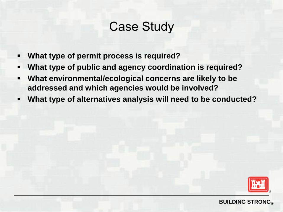
Case Study
What type of permit process is required? What type of public and agency coordination is required? What environmental/ecological concerns are likely to be
addressed and which agencies would be involved? What type of alternatives analysis will need to be conducted?

US Army Corps of Engineers BUILDING STRONG®
Society of American Engineers- Regulatory Conference
USACE Mitigation

BUILDING STRONG® 2
Xx Xx Xx

BUILDING STRONG® 3
Regulations Pertaining to Corps Mitigation
33 CFR 320.4(r) - General Mitigation Policy 33 CFR 325.4 - Implementation Guidance 40 CFR 230, Subparts B and H - 404(b)(1) 40 CFR 1508 - NEPA 33 CFR 332 - Compensatory Mitigation for Losses of Aquatic Resources 33 CFR 325.1(d)(7) – Complete Application

BUILDING STRONG® 4
Legal Requirements for Mitigation
404(b)(1) Guidelines Section 401 Certificates Endangered Species Act Coastal Zone Management Act National Historic Preservation Act
BUILDING STRONG® 5
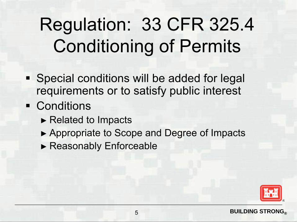
Regulation: 33 CFR 325.4 Conditioning of Permits
Special conditions will be added for legal requirements or to satisfy public interest
Conditions ► Related to Impacts ► Appropriate to Scope and Degree of Impacts ► Reasonably Enforceable

BUILDING STRONG® 6
Deny the Permit if....
Mitigation is required (33 CFR 320.4(r)) But cannot be reasonably implemented
or enforced (33 CFR 325.4(c))

BUILDING STRONG® 7
Regulation: 40 CFR 230 404(b)(1) Guidelines Subpart B
“...no discharge...shall be permitted if there is a practicable alternative...which would have less adverse impact on the aquatic ecosystem...” (40 CFR 230.10(a))

BUILDING STRONG® 8
Subpart B: Mitigation Requirement
The proposed discharge must “include all appropriate and practicable measures to minimize potential harm to the aquatic ecosystem” (40 CFR 230.12(a)(3)(iii))

BUILDING STRONG® 9
Subpart H: Actions to Minimize Adverse Effects
Location of discharge Type of material Control after discharge Method of dispersion Discharge technology Actions affecting plants and animals Actions affecting human use
BUILDING STRONG® 10
Regulation: 40 CFR 1508 NEPA Definition of Mitigation Avoid impact altogether by not taking
action or part of action Minimize impact by limiting degree or
magnitude of action Rectify impact by repairing or restoring
BUILDING STRONG® 11
NEPA Definition (continued)
Reduce impact over time by preservation and maintenance Compensate by replacing or providing
substitute

BUILDING STRONG® 12
Regulation: 33 CFR 332.1 Compensatory Mitigation
To establish standards and criteria ► Maximize credits and opportunities for mitigation ► Provide for regional variations ► Apply equivalent to each type of mitigation
To further clarify requirements ► 33 CFR 320, Policies for review of applications ► 40 CFR 230, 404(b)(1) Guidelines

BUILDING STRONG® 13
Regulation: 33 CFR 332.1 (continued)
Not alter 33 CFR 320.4(r) ► Circumstances under which mitigation is required ► Definition of “waters” or “navigable waters” ► Use of resources does not make jurisdictional
Not affect 40 CFR 230 “Sequencing” ► Avoid and minimize; compensation if unavoidable ► If available

BUILDING STRONG® 14
Regulation: 33 CFR 332.1 (continued)
Replaces ►Guidance on Mitigation Banks ►Guidance on In-Lieu Fee ►RGL 02-02 Compensatory Mitigation ►Parts of the Mitigation MOA
• Amount & location (on-site preference) • Use of preservation

BUILDING STRONG® 15
Regulation: 33 CFR 325.1(d)(7) Complete Application
Federal Register published April 10, 2008 325.1(d)(7) Application statement:
► how impacts avoided & minimized ► how compensated or why not
332.4(b)(1) Public Notice explanation: ► amount, type & location based on above ► enough info for meaningful comments

BUILDING STRONG® 16
MOA: SEQUENCING
Avoidance Minimization Compensation Disallows the use of compensatory mitigation to satisfy the alternatives test Emphasizes pre-application consultation

BUILDING STRONG® 17
MOA: Compensatory Mitigation
Goal of “functional value replacement” ► Prefer on-site, in-kind ► Plus adequate safety margin (prefer restoration) ► One-to-one acreage replacement may be a
“reasonable surrogate” Mitigation banking is allowed (preferred) Emphasis on monitoring

BUILDING STRONG® 18
MOA: Exceptions to MOA Procedures
Corps and EPA agree that sequencing is not required where discharge is necessary to avoid environmental harm. Sequence satisfied if part of Corps/EPA
approved comprehensive plan such as a SAMP or ADID.

BUILDING STRONG® 19
Exceptions (continued)
Mitigation may be impracticable ►Hydrology makes restoration
technologically impracticable ►High proportion of wetlands (Alaska)

BUILDING STRONG® 20
Exceptions (continued)
Corps may consider compensatory mitigation required by other agency, but avoidance and minimization shall still be sought. EPA/Corps agree discharge would
result in environmental gain or insignificant environmental losses.

BUILDING STRONG® 21
From the MOA: > “If on-site mitigation is not practicable, off-site compensatory mitigation should be undertaken in the same geographic area if practicable . . .”
On-site, in-kind: Stopped at the site fence?

BUILDING STRONG® 22
40 CFR 230.10 (d) “...no discharge...shall be permitted unless appropriate and practicable steps have been taken which will minimize potential adverse impacts of the discharge on the aquatic ecosystem” 33 CFR 320.4(r)(1) “...includes avoiding, minimizing, rectifying, reducing, or compensating... Compensation may occur on-site or at an off-site location.”
On-site, in-kind (continued)

BUILDING STRONG® 23
General Compensatory Mitigation Requirements

BUILDING STRONG® 24
General Considerations
Objective: Offset environmental losses District Engineer determines the compensatory
requirement Assess likelihood for ecological success District Engineer considers what is
environmentally preferable Mitigation banks or in-lieu fees preferable in
many cases

BUILDING STRONG® 25
Type and Location Options
Preference Hierarchy ► Mitigation bank credits ► In-lieu fee program credits ► Permittee-responsible under watershed approach ► Permittee-responsible on-site & in-kind ► Permittee-responsible off-site and/or out-of-kind

BUILDING STRONG® 26
Considerations
Mitigation Bank Reduces uncertainty Reduces temporal loss Less risk Larger, more ecologically
valuable parcels Consolidates resources More rigorous
scientific/technical analysis, planning & implementation
Advance site identification & project specific planning & financial assurances
In-Lieu Fee
Ditto Mitigation Bank considerations
Identifies high priority resource needs on watershed scale

BUILDING STRONG® 27
Permittee Responsible Mitigation Considerations
If watershed approach, may achieve success sooner than in-lieu fee
Permittee on-site & in-kind ► Practicable and is compatible with project
Permittee off-site/out-of-kind ► Greater likelihood to offset ► Environmentally preferable to on-site/in-kind
BUILDING STRONG® 28
Mitigation Types
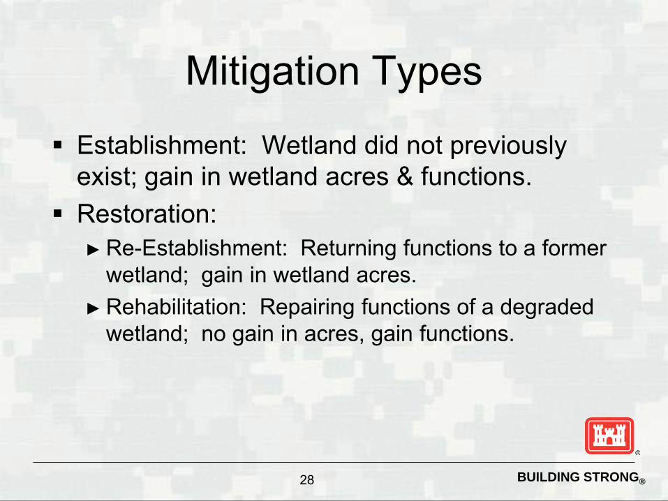
Establishment: Wetland did not previously exist; gain in wetland acres & functions.
Restoration: ► Re-Establishment: Returning functions to a former
wetland; gain in wetland acres. ► Rehabilitation: Repairing functions of a degraded
wetland; no gain in acres, gain functions.

BUILDING STRONG® 29
Restoration
Restoration first option ►Likelihood of success is greater ►Impacts to uplands less than establishment ►Gains in functions greater than
enhancement & preservation

BUILDING STRONG® 30
Mitigation Types (continued)
Enhancement: Improve specific function(s) or change the growth stage or composition of the vegetation present; no gain in wetland acres; gain one, may lose another function.
Preservation: Removal of a threat to or preventing decline of wetland conditions.

BUILDING STRONG® 31
Preservation Criteria
► Important functions to watershed
► Contribute to ecological sustainability
► Appropriate and practicable ► Threat of destruction/adverse
modification ► Legal protection
Preservation only, if high watershed priority and higher ratio

BUILDING STRONG® 32
Amount of Compensatory Mitigation 33 CFR 332.3(f)(1)
If the district engineer determines that compensatory mitigation is necessary to offset unavoidable impacts to aquatic resources, the amount of required compensatory mitigation must be, to the extent practicable, sufficient to replace lost aquatic resource functions. In cases where appropriate functional or condition assessment methods or other suitable metrics are available, these methods should be used where practicable to determine how much compensatory mitigation is required. If a functional or condition assessment or other suitable metric is not used, a minimum one-to-one acreage or linear foot compensation ratio must be used.

BUILDING STRONG® 33
Increased Ratio Rationale documented
► Method of compensation ► Likelihood of success ► Difference in functions ► Temporal loss ► Difficulty ► Distance between impact and mitigation ► If in-lieu fee and released credits not available

BUILDING STRONG® 34
Existing
With Permit
Restored natural Area. Preserved. Easement..
Project built on portion of site.
Degraded natural area.
“Pre” Functional index = 6
No Net Loss: Less is Equal?
“Post” Functional index = 6
Acre “Ratio” 2 : 1
BUILDING STRONG® 35
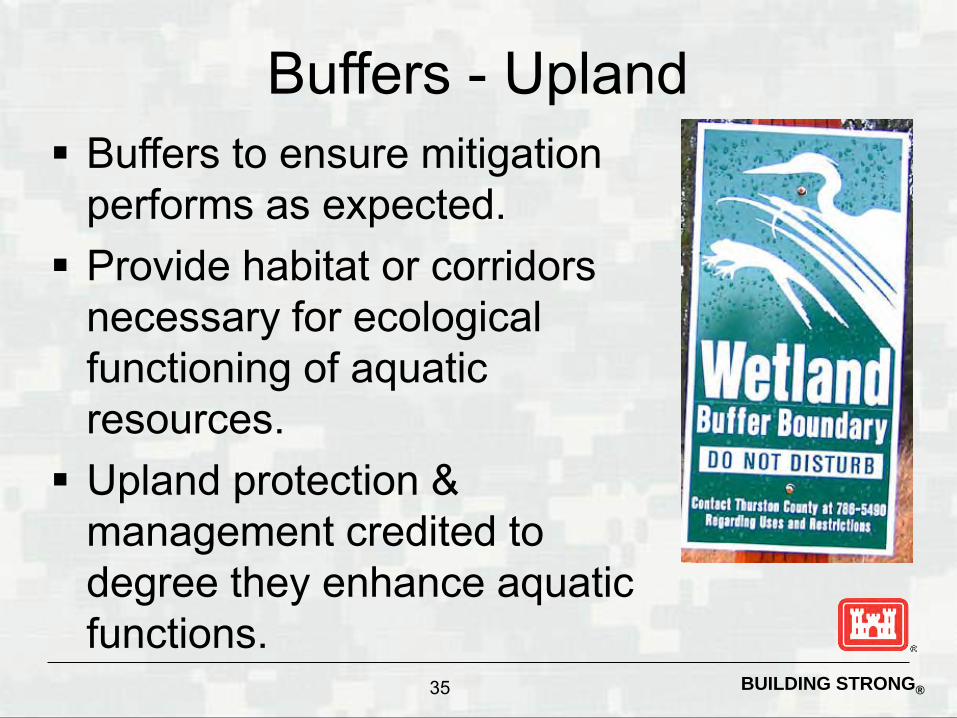
Buffers - Upland Buffers to ensure mitigation
performs as expected. Provide habitat or corridors
necessary for ecological functioning of aquatic resources. Upland protection &
management credited to degree they enhance aquatic functions.

BUILDING STRONG® 36
Watershed Approach
Goal is to maintain/improve aquatic resources Landscape position &
sustainability Provide suite of functions Combination of on-site & off-
site Watershed scale not larger
than appropriate to ensure effective compensation

BUILDING STRONG® 37
Components of a Mitigation Plan Objectives
► Describe functions lost at impact site and gained at mitigation site as well as overall watershed gain.
Site Selection ► Describe process and likelihood of success, future land use
compatibility, etc.
Site Protection Instrument ► Provide evidence of legal protective measures.
Baseline ► Provide ecological characteristics of the impact and mitigation
site; historic and existing land uses and resources impacted. ► Delineation of waters of the U.S. and reference site attributes.
BUILDING STRONG® 38
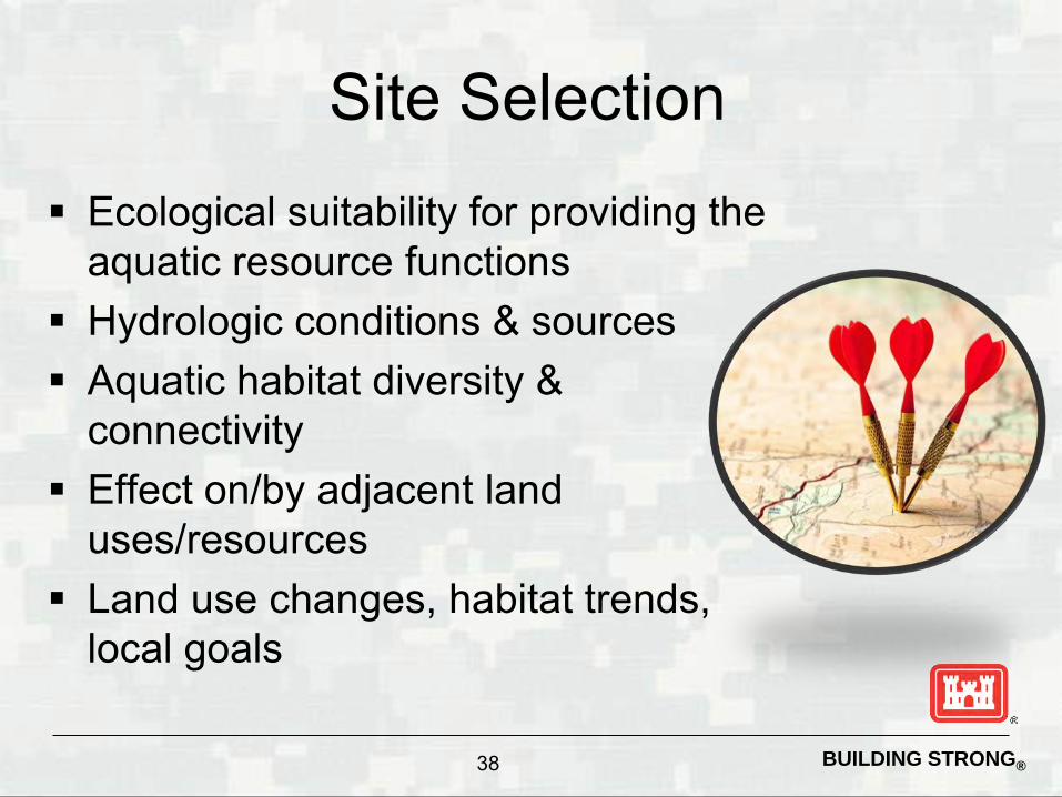
Site Selection Ecological suitability for providing the
aquatic resource functions Hydrologic conditions & sources Aquatic habitat diversity &
connectivity Effect on/by adjacent land
uses/resources Land use changes, habitat trends,
local goals

BUILDING STRONG® 39
Components of a Mitigation Plan cont. Determination of Credits
► Quantify functions lost at the impact site and gained at the mitigation site.
Mitigation Work Plan ► Construction and planting plan.
Maintenance Plan ► List parties responsible and outline maintenance plan and
schedule.
Ecological Performance Standards ► Identify success criteria and how they will be quantified.

BUILDING STRONG® 40
Components of a Mitigation Plan cont. Monitoring Requirements
► Monitoring schedule, responsible parties, data collection.
Long-term Management Plan ► Long term financial mechanisms and responsible party for
management.
Adaptive Management Plan ► Identify responsible parties, possible risk of failure and
remedial measures.
Financial Assurances ► Identify responsible parties, and specify types of assurance,
contents and schedule.

BUILDING STRONG® 41
Monitoring
Determine if fixes needed Minimum of five years
► Longer if slow development rates (forested) ► Reduce/waive remaining if standards achieved ► Extend if standards not met
Monitoring report may include as-built plans, maps, photographs, and results of functional assessment

BUILDING STRONG® 42
Assessing Function for Credit/Debit
Wetlands 4 iHGM models: Riverine Forested Riverine
herbaceous/Shrub Tidal fringe Lacustrine Fringe
Streams 2 Steam Models Level 1: All Ephemeral &
Intermittent Streams will be evaluated, all Intermittent Streams with Perennial Pools, Perennial Streams and Wadeable Rivers where the proposed impacts are less than 500 linear feet will be evaluated using Level 1
Level 2: Perennial Streams and/or Wadeable Rivers where the proposed impacts are equal to or greater than 500 linear feet.

BUILDING STRONG® 43
What is HGM
HGM is an attempt to measure each “potential” function that each wetland assessment area (WAA) performs in relationship to it’s landscape position, water source, & the flow and fluctuation of the water.

BUILDING STRONG® 44
What is the HGM Approach?
A method for assessing the functional capacity of a wetland Three pillars of the HGM Approach:
►Hydrogeomorphic Classification ►Reference Wetlands ►Assessment Models
End result is a “rapid” assessment technique for the user

BUILDING STRONG® 45
What is Functional Capacity?
The degree or magnitude to which a wetland performs a function. Depends on characteristics of the wetland
and the surrounding landscape. Similar wetlands exhibit a range of
functional capacities due to inherent characteristics, natural disturbance, and anthropogenic alteration.

BUILDING STRONG® 46
Applications of HGM Models Estimate baseline functional capacity Estimate impacts of a proposed project Evaluate project alternatives Determine mitigation requirements Estimate the effects of management Monitor the performance of restored
wetlands
BUILDING STRONG® 47
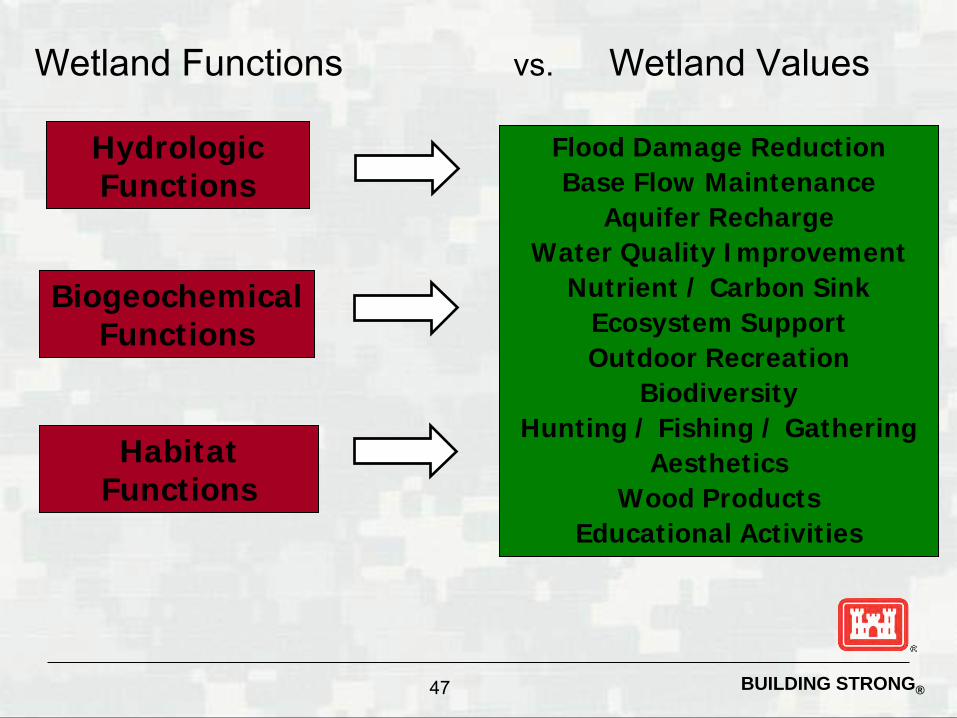
Wetland Functions vs. Wetland Values
Hydrologic Functions
Biogeochemical Functions
Habitat Functions
Flood Damage Reduction Base Flow Maintenance
Aquifer Recharge Water Quality Improvement
Nutrient / Carbon Sink Ecosystem Support Outdoor Recreation
Biodiversity Hunting / Fishing / Gathering
Aesthetics Wood Products
Educational Activities
BUILDING STRONG® 48
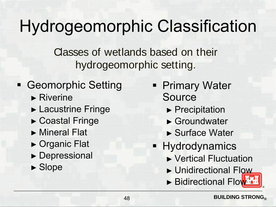
Hydrogeomorphic Classification
Geomorphic Setting ► Riverine ► Lacustrine Fringe ► Coastal Fringe ► Mineral Flat ► Organic Flat ► Depressional ► Slope
Classes of wetlands based on their hydrogeomorphic setting.
Primary Water Source ► Precipitation ► Groundwater ► Surface Water
Hydrodynamics ► Vertical Fluctuation ► Unidirectional Flow ► Bidirectional Flow

BUILDING STRONG® 49
iHGM Summary Wetland functions are processes or activities that
occur in wetlands Wetland values are beneficial goods and services
derived from wetland functions The Hydrogeomorphic (HGM) Approach is a method
for assessing the functional capacity of wetlands. It is based on:
► HGM classification • Reduces variability and simplifies models
► Reference wetlands • Models are calibrated to local conditions
► Assessment models • Simple logic models for rapid assessments

BUILDING STRONG® 50
What Changed For Streams?
2008 Mitigation Rule 33 CFR 332.3(e)(3)
For difficult-to-replace resources (e.g., bogs, fens, springs, streams, Atlantic white cedar swamps) if further avoidance and minimization is not practicable, the required compensation should be provided, if practicable, through in-kind rehabilitation, enhancement, or preservation since there is greater certainty that these methods of compensation will successfully offset permitted impacts.

BUILDING STRONG® 51
Tiered Assessment Level 1- A qualitative assessment for all Ephemeral &
Intermittent Streams, Intermittent Streams with Perennial Pools, and Perennial Stream where the impact is less than 500 LF
Level 2 – A quantitative Assessment for all Intermittent Streams With Perennial Pools, Perennial Streams and Wadeable Rivers where the impact is greater than 500 LF
Level 3 – All Impacts that have a significant effect on the human environment (EIS)

BUILDING STRONG® 52
Why a Tiered System?
The level of detail and documentation is flexible depending on the project, but should reflect the significance and complexity of the discharge activity. The level of scrutiny should be
commensurate with the severity of the environmental impact as well as the scope and cost of the project.

BUILDING STRONG® 53
Assessing a Stream
Riparian Buffer Channel Alteration
Channel Condition (channel stability) In-Stream Habitat/Biological Usage

BUILDING STRONG® 54
Where are we now? 1.usa.gov/1hrSOUd
Finalized* Level 1 Stream
Assessment** Impact Assessment Determination of
Compensation * All procedures are revisited for efficacy.
**Complex and/or controversial stream impacts may require additional information to complete an appropriate evaluation of the proposed impacts. The District reserves the right to request additional assessment of stream on a case-by-case basis.
Interim Interim Level 2
► Special Public Notice • Posted: 3/26/2014 • Expiration date: 4/1/2015
Evaluating Avoidance, Minimization, Stream Restoration Projects and Compensatory Mitigation Plans

BUILDING STRONG® 55
Case Study
What mitigation steps should be taken first? How do we assess function of aquatic
ecosystem? What type of compensatory mitigation can
be proposed? How many

Society of American Engineers- Regulatory Conference 2014 Case Study Introduction Reneaux Bleaux LLC proposes to use wave power to generate electricity to run a desalination plant 4 miles offshore Freeport, Texas, then pipe the drinking water ashore to a bottling plant that bottle the drinking water in corn-based biodegradable plastic for sale under the Reneaux Bleaux brand. Site Description The area of the proposed action, Gulf of Mexico, has been identified as EFH for several species. The designations are as follows: brown shrimp (eggs, larvae); white shrimp (eggs, larvae); Gulf stone crab (eggs, larvae); red drum (eggs); red snapper (eggs, larvae); lane snapper (eggs); dog snapper (eggs, larvae); greater amberjack (eggs, larvae); lesser amberjack (eggs, larvae); king mackerel (larva) and cobia (eggs, larvae). Potential adverse impacts to EFH include impingement and entrainment of eggs and larvae and subsequent mortality of managed species. In addition, 5 threatened or endangered species of sea turtle are known to utilize the area for foraging and nesting. Turtle species include green, hawksbill, Kemp's ridley, leatherback, and loggerhead. The onshore facility is located along a barrier island in an interdune swale complex. The barrier islands formed as a result of wave action that reworked sands delivered to the Gulf by the coastal rivers and creeks. The Gulfward advance of successive beach ridges over time has resulted in a series of ridges and troughs. Barrier island nontidal, freshwater wetlands are found in interdune swales (troughs between dune ridges). Water in the nontidal barrier island troughs is derived from a combination of runoff from the adjacent dunes and from groundwater. Water percolates through the sandy dunes very easily, and generally comes to the surface in the swales between the dunes. Many of these swales in fact rarely have ponded water on the surface, but because groundwater is found just under the surface for extended periods of time, only wetland vegetation can survive. In times of ample rainfall, these depressions provide scarce freshwater and wetland habitats for island fauna. In dry years, when these depressions are dry, biological diversity on the barriers is depleted. The depressional wetlands play a role in regulating the fresh groundwater levels; many acting as recharge areas when the groundwater level declines. Project Description The wave power system, called C-DOG, will employ a buoy-and-piston mechanism combined with a water wheel to generate electricity at an offshore platform, enough to power operations at the plant. The C-DOG is a "point absorbing" wave energy converter designed to extract a small amount of energy from a portion of the wave front as the wave passes by, as opposed to other wave energy designs that attempt to extract large amounts of energy but may terminate the wave in the process. The wave-powered technology is based on an air-filled buoyancy block within a cylindrical chamber. The chamber stays relatively stationary while the block rises and falls with the waves. In turn, the motion of the block moves a piston within a cylinder, drawing in and expelling water with every stroke. As a demonstration, Reneaux Bleaux LLC proposes to deploy 18 of the C-DOG pumps at a platform off the coast of Freeport, Texas. The system will deliver up to 60 kilowatts of electricity and the desalination equipment only requires about 4 kilowatts for its daily desalination operation, so even allowing for electricity to light the platform there will be a more
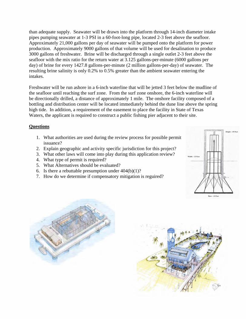
than adequate supply. Seawater will be drawn into the platform through 14-inch diameter intake pipes pumping seawater at 1-3 PSI in a 60-foot-long pipe, located 2-3 feet above the seafloor. Approximately 21,000 gallons per day of seawater will be pumped onto the platform for power production. Approximately 9000 gallons of that volume will be used for desalination to produce 3000 gallons of freshwater. Brine will be discharged through a single outlet 2-3 feet above the seafloor with the mix ratio for the return water at 3.125 gallons-per-minute (6000 gallons per day) of brine for every 1427.8 gallons-per-minute (2 million gallons-per-day) of seawater. The resulting brine salinity is only 0.2% to 0.5% greater than the ambient seawater entering the intakes. Freshwater will be run ashore in a 6-inch waterline that will be jetted 3 feet below the mudline of the seafloor until reaching the surf zone. From the surf zone onshore, the 6-inch waterline will be directionally drilled, a distance of approximately 1 mile. The onshore facility composed of a bottling and distribution center will be located immediately behind the dune line above the spring high tide. In addition, a requirement of the easement to place the facility in State of Texas Waters, the applicant is required to construct a public fishing pier adjacent to their site. Questions
1. What authorities are used during the review process for possible permit issuance?
2. Explain geographic and activity specific jurisdiction for this project? 3. What other laws will come into play during this application review? 4. What type of permit is required? 5. What Alternatives should be evaluated? 6. Is there a rebuttable presumption under 404(b)(1)? 7. How do we determine if compensatory mitigation is reguired?