smith, thomas m. (2012) enclosure & agricultural...
TRANSCRIPT

Smith, Thomas M. (2012) Enclosure & agricultural improvement in north-west Lincolnshire from circa 1600 to 1850. PhD thesis, University of Nottingham.
Access from the University of Nottingham repository: http://eprints.nottingham.ac.uk/12489/1/Tom%27s_Thesis_complete_%28slimline%29.pdf
Copyright and reuse:
The Nottingham ePrints service makes this work by researchers of the University of Nottingham available open access under the following conditions.
This article is made available under the University of Nottingham End User licence and may be reused according to the conditions of the licence. For more details see: http://eprints.nottingham.ac.uk/end_user_agreement.pdf
For more information, please contact [email protected]

i
ENCLOSURE & AGRICULTURAL IMPROVEMENT IN
NORTH-WEST LINCOLNSHIRE FROM
CIRCA 1600 TO 1850.
Thomas M. Smith, MA
Thesis submitted to the University of Nottingham
for the degree of Doctor of Philosophy
July 2012

ii
Abstract
This study sets out to establish the link between enclosure and agricultural
improvement in a group of parishes in north-west Lindsey, Lincolnshire between
the sixteenth century and the mid-nineteenth century. In particular it
emphasises the continuity of enclosure history through time, rather than
concentrating only on the period of parliamentary enclosure as has often been
the case in the past, and on links to agricultural improvement which include land
reclamation, draining and warping. It shows that a simple explanation of
enclosure in terms of driving up rents and allowing individual farmers to take
their own farming decisions, fails to take into account the particular local
circumstances of this area. Using a combination of enclosure documents and
related material such as glebe terriers, land tax assessments, census materials,
the 1801 agricultural returns and estate papers it sets out to show how
agricultural improvement transformed both the landscape and the farming
techniques in this area. In this process it covers a range of related topics
including landownership, population, and the socio-economic structure of the
villages of north-west Lindsey. It shows clearly that in this area enclosure is as
much as anything associated with land drainage, and with improvements
brought about by warping. These processes were interwoven, and separating
enclosure out as a single movement underestimates the complexity of the
farming arrangements required to ensure the most productive farming in this
area.

iii
Contents
List of Figures
iv
List of Tables
v
List of Plates
vii
Acknowledgements
ix
Abbreviations
x
Introduction
1
1 Historiography of enclosure
7
2 Methodology
38
3 Time and place
77
4 Reasons for enclosure
92
5 The long chronicle of improvement
144
6 Drainage, warping and enclosure
190
7 Case studies
250
8 The new landscape of north-west Lindsey
294
Conclusion
333
Bibliography
349

iv
Figures
Fig 1: Manley wapentake and, inset, shown within Lincolnshire 2
Fig 2: To show study area landscapes 3
Fig 3: The proportion of each parish or township not enclosed by act. 78
Fig 4: Number of acres enclosed in each half-decade in the study area 80
Fig 5: The Study Area between the three rivers 190
Fig 6: Number of Owners and Owner-occupiers 1783-1830 310

v
Tables
Table 1: Parliamentary Enclosures in East Midland Counties, by time period 17
Table 2: Fines on enclosing landowners 1635-8 23
Table 3: Messingham Glebe Lands 1686 42
Table 4: Distribution of ‘Enclosure Agreements’ by counties 47
Table 5: Types of parliamentary enclosure in Lincolnshire 79
Table 6: List of study area places, enclosed by act, in chronological order 84
Table 7: Acreages of closes and prices bid per acre in 1798 and 1799 127
Table 8: Home Office Acreage Returns 297
Table 9: Absolute numbers of owners by parish, 1783 to 1830 307
Table 10: Absolute numbers of owner-occupiers by parish, 1783 to 1830 309
Table 11: Percentage proportion of owner-occupiers by parish 310
Table 12: Numbers of surviving owner and owner-occupier surnames 312
Table 13: Surnames disappearing between enclosure and LTA date 314
Table 14: Study area population 1801-1851 318
Table 15: Size of the agricultural labour force 319
Table 16: Social and Occupational breakdown from 1851 Census 324

vi
Plates
Plate 1: part of the West Field , Messingham terrier 1686 42
Plate 2: The Frodingham terrier of 1671 44
Plate 3; Part of the Chancery Decree for Waddingham 46
Plate 4: The Whitton LTA of 1790 56
Plate 5: Alkborough petition 1765 61
Plate 6: Waddingham petition 1768 62
Plate 7: Winterton Inclosure Act 1769 63
Plate 8: Old enclosures in Ashby west field 99
Plate 9: Alkborough parish, from the Ordnance Survey 1824 101
Plate 10: Detail of: 'A Plan of the Manor of Normanby...' 117
Plate 11: Stamford Mercury, 4 October 1805 122
Plate 12: Eastern half of the Messingham Enclosure Award map of 1804 128
Plate 13: Bryant's map of 1828 shows Holme Common 132
Plate 14: Places mentioned in the Twigmore grange charter 145
Plate 15: Position of the Walcot and Haythby DMVs 149
Plate 16: 1662 Redbourne glebe terrier reporting the loss of the glebe 157
Plate 17: Enclosure for Woodland, Twigmoor, 1696 159
Plate 18: Broughton Inclosure petition 169
Plate 19: Rutland and Stamford Mercury, 25 August 1815 171
Plate 20: Part of the preamble of the Inclosure act of East Santon 172
Plate 21: Detail of East Santon Inclosure map 1833 173
Plate 22: Broughton west of Ermine Street, from Bryant's map of 1828 175
Plate 23: Stamford Mercury 12 Feb 1847 177
Plate 24: Detail of Wilkinson and Fotherby's map of the Ancholme levels 195
Plate 25: Outfall of the New Ancholme into the Humber at Ferriby Sluice 199

vii
Plate 26: Remains of ridge and furrow in the grounds of Scawby Hall 201
Plate 27: ‘...the probable improvement which may arise...' 203
Plate 28: Hibaldstow from the First Edition of the Ordnance Survey 206
Plate 29: Advert to tender for draining the carrs of Hibaldstow 208
Plate 30: Commissioners’ Minute Book, 20 May 1800 210
Plate 31: Stamford Mercury, 20 Oct 1797 218
Plate 32: Messingham parish with its township of East Butterwick 222
Plate 33: Stamford Mercury, 13 October 1854 223
Plate 34: To show position of un-warped area called Butterwick Hales 224
Plate 35: Ashby Enclosure Act 1801, part of section XIX, p.12 225
Plate 36: Detail of Ashby Enclosure map 227
Plate 37: Part of the plan accompanying the Award of 15 Apr 1843 232
Plate 38: Part of paragraph 66 of the Frodingham Enclosure Act 234
Plate 39: On a modern aerial photograph, the area warped by 1847-51 235
Plate 40: Plan of an area of 235 acres awarded to seven owners 236
Plate 41: Detail of: 'A Plan of the Parish of Flixborough 237
Plate 42: Part of Robert Barker's 1835 calculations 239
Plate 43: Detail of map of the Ancholme levels 253
Plate 44: Part of the Chancery Decree for Waddingham 256
Plate 45: Advertisement in the London Gazette 18 August 1752 261
Plate46: Waddingham from the First Edition of the Ordnance Survey 262
Plate 47: Waddingham Cow Fold Award Map 1847 264
Plate 48: Winteringham from the First Edition of the Ordnance Survey 266
Plate 49: Detail of map of the Ancholme levels 269
Plate 50: Modern aerial photo to show the phases of enclosure 271
Plate 51: Winteringham 1719 closes in Cliff and West Fields 273
Plate 52: Winteringham 1719 closes in West and Middle Fields 274
Plate 53: Winteringham 1719 Church, rectory and site of Hall 275
Plate 54: Winteringham 1719 'Composition to cottagers' 276
viii
Plate 55: Winteringham Enclosure Act of 1761 278
Plate 56: The drain from the clough to the Haven in 2009 284
Plate 57: The petition which led to the Turnpike Road Trust' 336

ix
Acknowledgements
Thanks are due to my supervisor, Professor John Beckett of the University of
Nottingham. Without his encouragement and wise counsel, this thesis would
certainly not have been completed.
I must also thank, both for advice and hospitality, my farming relatives in
northernmost Lincolnshire, that landscape of ‘spires and blue remembered hills’
of my youth …
That is the land of lost content,
I see it shining plain,
The happy highways where I went
And cannot come again.
x
Abbreviations
BL British Library
ERYA East Riding of Yorkshire Archives
IHRL Institute of Historical Research Library, WC1E 7HU
LAO Lincolnshire Archives Office
NELA North East Lincolnshire Archives
TNA The National Archives

1
Introduction
This thesis considers an area of twenty-eight parishes and townships in north-
west Lindsey, from the sixteenth century to the mid-nineteenth century and
determines the connection between enclosure and agricultural improvement.
Instead of focussing exclusively on the era of the parliamentary act, it stresses
the unbroken flow of enclosure history through time, and its relationship to
agricultural improvements such as land reclamation, draining and warping. It
shows that a straightforward explanation of enclosure in terms of forcing up
rents and allowing individual farmers to take their own farming decisions ignores
the local circumstances of enclosure. The thesis sets out to show how
agricultural improvement changed both the landscape and farming techniques in
the area. To do this, it employs a combination of enclosure documents and other
records, such as glebe terriers, land tax assessments, census materials, the
1801 agricultural returns and estate papers. A range of related topics including
landownership, population, and the socio-economic structure of the villages of
north-west Lindsey is also considered. The thesis demonstrates clearly that in
north-west Lindsey enclosure is, as much as anything, associated with land
drainage and with the improvements brought about by warping. These processes
were interwoven, and to separate enclosure out as a single movement is to
misjudge the intricacy of the agrarian arrangements which were needed to
ensure the most productive farming in this area.
The study area
The part of north-west Lindsey which is being studied has an area of about
74,350 acres or 116 square miles.1 It comprises that part of the county which
was formerly known as Manley wapentake, one of the thirty-five ancient
divisions of Lincolnshire. The practical advantages of using a wapentake as an

2
area for study, long after its administrative functions have been superseded, are
several. Firstly original documents in archive offices (for example land tax
duplicates), are often ordered by wapentake, secondly official surveys, like the
decennial census, are arranged and totalled by in the same way, while early
directories follow a similar layout.
Fig 1. Manley wapentake and, inset, shown within Lincolnshire

3
There are four main types of landscape within the study area:
First, the Trent Levels are defined by the river to the west and in the east by the
line of springs on the scarp slope at the foot of the Lincoln Edge. The greater
part of the levels comprises the low-lying floodplain areas of the River Trent
running through the study area from north to south. Second, the high ground of
the Lincoln Edge extends from Whitton at the Humber Estuary in the north to
the study area boundary in Waddingham, and is an elevated area approximately
9km wide. The western boundary is clearly defined by the down slope of the
western north-south escarpment rising out of the lowlands of the Trent Levels.
The eastern boundary roughly follows the western edge of the Ancholme Valley
floodplain.
Fig 2. To show study area landscapes

4
Third, the Ancholme Valley is about 6km at its widest and is the area, either side
of the course of the old river Ancholme that extends south, from the Humber
Estuary, into the Lincolnshire Fenlands. The eastern boundary of this study area
landscape is marked by the old river, but geographically, beyond the study area,
is marked by the Lincolnshire Wolds escarpment. The fourth type of landscape is
formed by the land which extends inland from the Humber estuary to
approximately the 10m contour.
Structure of this thesis
Chapter one discusses the historiography of the enclosure movement, in a
national context, and pays particular attention to its chronology, the different
types and the debates about its impact.
Chapter two gives an explanation of the methodology employed in this thesis,
with a breakdown of the source material that has been examined. Particular
attention is paid to the value of glebe terriers as evidence for old enclosure and
to the difficulties associated with discovering those few Chancery decrees which
actually did have the effect of validating Lincolnshire enclosure agreements. The
use of land tax documents in researching social history is discussed, and
problems surrounding the interpretation of the Lincolnshire land tax assessments
are enumerated, with an explanation of how the source is to be used in the
study. Other sources such as the many documents associated with
parliamentary enclosure, tithe files and the 1851 census enumerators’ returns
are also discussed.
Chapter three establishes the size of the movement in terms of acres, density
and geographical location and splits the chronological sequence into ‘old
enclosure’ and enclosure by act, discussing possible reasons for its timing. The
study area parliamentary enclosures are tabulated chronologically, and are
5
categorized into types of act using Turner’s classification, with details of
numbers of owners and their allotments. Finally in this section, some comments
are made about the commissioners and their influence on enclosure and
improvement in the area.
Chapter four tries to elucidate some of the reasons for enclosure and
improvement in the individual townships of the study area. It is not suggested
that any one reason was the catalyst for the process in a particular township;
rather the combination of reasons involved is explained.
Chapter five narrates the chronicle of enclosure in the study area, from the
agricultural improvements of the Cistercians in the thirteenth century to the final
few acres which were enclosed in the 1870s, not for any agrarian reason, but to
establish title to the mineral wealth that lay buried under the ground. Along the
way, early enclosure associated with deserted and shrunken settlements, the
1607 Inquisition of Depopulation and the effect of the Civil Wars of the mid–
seventeenth century are discussed. Long term familial acquisition of land, with
the object of agricultural improvement, is a feature of the study area and this is
considered. There were notable delays in the implementation of improvement in
some part of the area and these are next examined
Chapter six shows the significance of drainage and the locally important
technique of warping in agricultural improvement. The chapter looks at the two
very different ways of proceeding to enclosure used in the area; first drainage in
the valley of the Ancholme with examples from Scawby, Hibaldstow and
Waddingham and then warping in the lower Trent valley showing the experience
in parishes from Messingham, north to Burton upon Stather. A history of
drainage and the lesser known technique of warping in the study area is
provided. It is suggested that the agricultural propensity, in those parts of the

6
parishes bounded by rivers, was firstly towards repossessing the land from
water, rather than for any schemes for redeploying existing cultivated land.
Chapter seven uses two parishes, Waddingham and Winteringham, as case
studies to show the diversity of agricultural improvement. The studies discuss
the use of (what is a rare mechanism in Lincolnshire) the Chancery decree as a
means of ratifying enclosure and the extent to which flood protection, drainage
and wetlands reclamation was an integral part of the enclosure process.
Chapter eight describes the new landscape of north-west Lindsey in the middle
of the nineteenth century and the impact of enclosure, using a variety of sources
including land tax returns and 1851 census material. It finds, at the end of the
period being studied, a countryside changed not merely visually but socio-
economically by agricultural improvement.
The years that followed the rediscovery of ironstone in north-west Lindsey in
1859 brought about a scarring of the landscape, a rapid population explosion
and the sudden growth of the former tiny settlement of Scunthorpe into a town
which dominated the study area. There had however, been an earlier, more
unhurried, agrarian transformation of the area, and this thesis considers it.
Reference
1 Sum of the areas of parishes in: W. White, History, Gazetteer and Directory of
Lincolnshire (1856)

7
1. A historiography of enclosure
Introduction
In the five centuries before 1850 a large part of the rural landscape of England
was altered beyond recognition; from a land of medieval agrarian systems and
procedures, and an ancient way of living and thinking, to one whose structure
was erected less on community solidarity, and more on farming for individual
profit. This landscape of open fields and commons was not ubiquitous, but was
most widespread and characteristic of a large swathe of central England. Its
primary area was in a broad band from Yorkshire and Lincolnshire diagonally
across the country to the south coast, including parts of Norfolk and Suffolk,
Cambridgeshire, large areas of the midlands, and parts of south central
England.1 On either side of this zone, there were areas where, because of the
nature of the soil or the lie of the land, open fields had never existed or had
long disappeared; among them were the high ground of the west and north
(Devon and Cornwall, the Welsh Marches, the Pennines and the Lakeland
counties), Essex with its marshland and Kent with its hop-fields. Here, if the
land was farmed at all, other field systems prevailed.2
Field systems had variations even within the landscape of open fields and
commons, but the following may be typical of the system that was found in
central England.3 In the open-field system of agriculture there were three kinds
of land. Arable land, used for growing crops, lay in a number (usually two or
three) of very large fields. Within these large fields, individuals owned or rented
land in a number of long, thin strips scattered around the field system. The
fundamental feature of the open fields was that although the individual strips
were individually farmed, after the harvest, or in fallow years, the fields were
opened up to common grazing for all persons enjoying common pasture rights.

8
The second type of land was common meadow; individuals grew hay for winter
fodder on their portion of the common meadow. After the hay harvest the
meadow was opened to common grazing. The third kind of land in the system
was the common waste. This was permanent common grazing land, on which
all those who had common rights could pasture their stock. Not every village
had all three types of land, and all villages had indeterminate amounts of 'old
enclosures' which was enclosed land free of common right.4
These open fields and commons of the old landscape of central England, had
worked well where there were limited markets and a relatively small amount
of market specialisation, but the communal rights and the organisations
associated with them, made less sense, and were less economically appealing,
when ideas about private property were changing, and new notions about the
‘autonomous individual’ were emerging.5
Enclosure was the manifestation of the change in ideas about common
property; the process whereby open fields, common lands and wastes were
swept away, to be replaced by smaller fields surrounded by hedgerows or stone
walls. It meant also the abolition of rights of common, such as pasturage,
pannage, turbary and estover, enjoyed by villagers over some or all of the
open lands in a parish, and the redistribution of the land into individual
ownership.
In practical terms it meant the end of strip farming, of common pasture, and of
rights over the waste. Although the most obvious consequence was the visual
appearance of the landscape, important social, economic and technological
changes also followed enclosure, the effects of which historians continue to
ponder.
Official enthusiasm for enclosure has ebbed and flowed over the years. During
the sixteenth century Tudor governments were concerned at the progress of
enclosing, engrossing (the amalgamation of two or more farms into one) and

9
the conversion o f arable to pasture. They feared depopulation and the resulting
threat to the country’s defence. The measures they took varied from gentle to
severe, from parliamentary acts which could not be enforced, to energetic
county-by-county investigations, followed by prosecutions and heavy fines.
An early distinction should also be noted; that of ‘good’ versus ‘bad’ enclosure.
John Hales a leading anti-enclosure government official, in his instructions to
the enclosure commissioners in 1548, said that ‘where a man doth enclose and
hedge in his own proper ground where no man hath commons,’ that is, where it
was done legally, its benefits outweighed its problems. 6
During the reigns of James I and Charles I, the government lost much of its
antipathy, and after the last large-scale enclosure enquiry took place in 1607, it
ceased its opposition to the principle of enclosure, while continuing to keep up
the pretense of opposing it in practice. Offenders were prosecuted
intermittently, but their transgressions were pardoned on payment of a money
fine. The punishment of enclosers had become little other than a way of
raising revenue.7 After the Civil War the practical arguments for enclosure
were perhaps stronger as landlords had been hard hit by the conflict and the
increased rents, which would be obtained by the improvement of agricultural
land, were more attractive. There were no government attempts at
regulating enclosure and its progress was left in the hands of local
landowners, who in the more settled political situation, were able to set
about the process determined only by local conditions, such as the
freeholder consensus, the length of tenant leases and crop preferences.8
Timing of Enclosure
Because of the work of W.E. Tate, edited and enlarged by M.E. Turner, there is
little argument concerning the number of acres enclosed by parliamentary
10
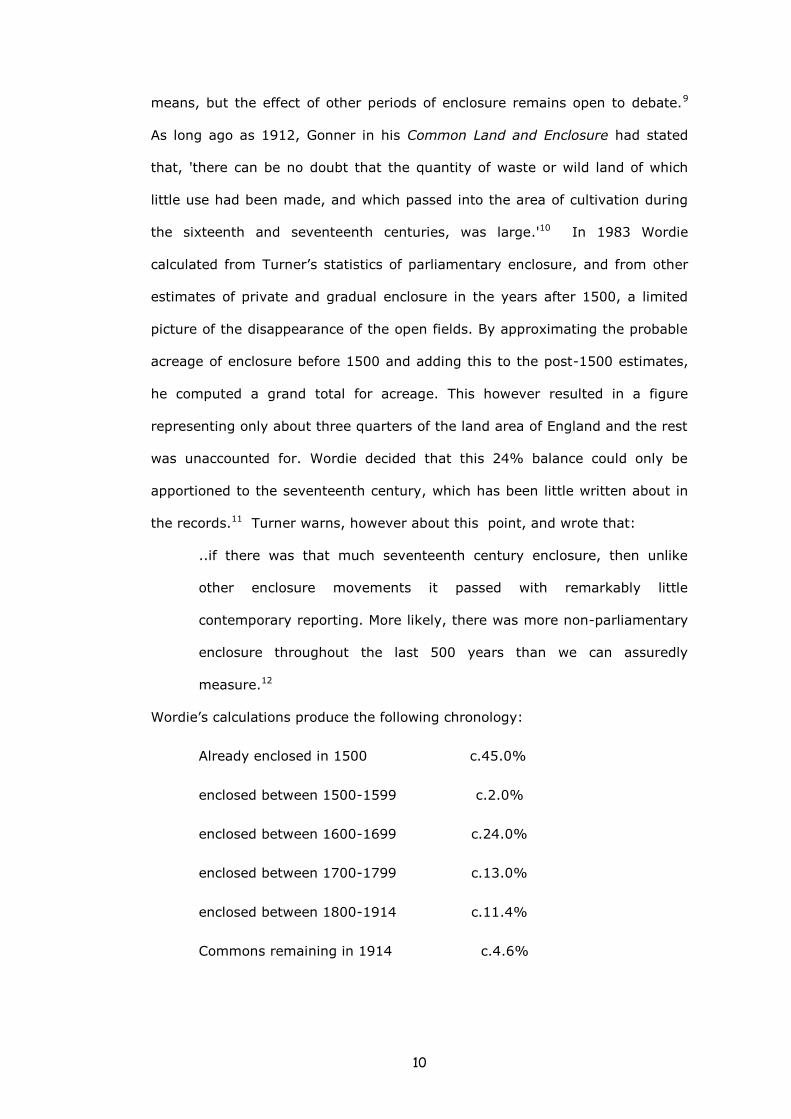
means, but the effect of other periods of enclosure remains open to debate.9
As long ago as 1912, Gonner in his Common Land and Enclosure had stated
that, 'there can be no doubt that the quantity of waste or wild land of which
little use had been made, and which passed into the area of cultivation during
the sixteenth and seventeenth centuries, was large.'10 In 1983 Wordie
calculated from Turner’s statistics of parliamentary enclosure, and from other
estimates of private and gradual enclosure in the years after 1500, a limited
picture of the disappearance of the open fields. By approximating the probable
acreage of enclosure before 1500 and adding this to the post-1500 estimates,
he computed a grand total for acreage. This however resulted in a figure
representing only about three quarters of the land area of England and the rest
was unaccounted for. Wordie decided that this 24% balance could only be
apportioned to the seventeenth century, which has been little written about in
the records.11 Turner warns, however about this point, and wrote that:
..if there was that much seventeenth century enclosure, then unlike
other enclosure movements it passed with remarkably little
contemporary reporting. More likely, there was more non-parliamentary
enclosure throughout the last 500 years than we can assuredly
measure.12
Wordie’s calculations produce the following chronology:
Already enclosed in 1500 c.45.0%
enclosed between 1500-1599 c.2.0%
enclosed between 1600-1699 c.24.0%
enclosed between 1700-1799 c.13.0%
enclosed between 1800-1914 c.11.4%
Commons remaining in 1914 c.4.6%

11
R.A. Butlin, J.V. Beckett and especially, J. Chapman have all questioned
Wordie’s results, particularly the suggested acreages of seventeenth century
enclosures when compared to the sixteenth. Chapman also doubted whether
Wordie had satisfactorily distinguished between enclosure of open fields and
enclosure of commons and wastes.13 Wordie later accepted that he might have
over-stated the amount of seventeenth century enclosure by using data from
the Tudor commissions of inquiry that had been mainly concerned with
conversion to pasture. He felt however that this over-statement was
comparatively small and argued against the accusation that he had ignored the
wastes in his calculations.14
Another complication is the extent to which land included in a parliamentary act
was already enclosed; some acts will have simply confirmed earlier
agreements. Kerridge makes much of this, suggesting that this exaggerates the
real impact of parliamentary enclosure and distorts the chronological pattern.15
The debate however continues as, more recently, Clark and Clark have
concluded that in the main parliamentary enclosure period between 1750 and
1840 there was very little enclosure by private means. Also while there was
private enclosure in the years 1600-1750, it was limited and they suggest that
no more than one acre was enclosed by private means for every four acres
later enclosed by Parliament.16
It is clear from the table above, whatever its statistical shortcomings, that
enclosure had been a more or less continuous feature of agrarian history for
hundreds of years and it confirms (what we can in any case infer from award
maps featuring areas of ‘old enclosure’) that, while parliamentary enclosure
was a very important element of that process, other periods and types of
enclosure were historically significant, even if poorly documented by
comparison.

12
Types of Enclosure
a) Piecemeal enclosure
Piecemeal enclosure usually involved only the land of a particular individual and
not of the entire manor. Although it could mean that only very small areas of
land were removed from the open field or the waste bit-by-bit, in time the
process might eventually result in the enclosure of all the land in a parish. If
not, it might be completed by parliamentary award in the eighteenth and
nineteenth centuries. Yelling noted three features implied in piecemeal
enclosure: that enclosure was completed in more than one stage, and often in
many stages; enclosure was the act of an individual, or limited group of persons,
rather than of the whole body of common-field proprietors acting in unison; and
that the enclosure was a ‘disorderly process’, frequently involving only limited
consolidation.17
Yelling distinguished piecemeal from general enclosure; the former ‘covers a
range of processes in which action is taken either by individuals or by groups of
varying sizes up to, but not including, the whole body of proprietors.’18
There may be references in private estate or manorial records to piecemeal
enclosure, but as it was often a unilateral activity undertaken without regard
for fellow parishioners in the field, these are rare. Beresford drew attention to
the possibilities of using glebe terriers as an indicator of the existence of open
fields, and hence the possibility of tracing their gradual elimination by the
change in the nature of the terrier.19 He noted that bulky terriers listing a
multitude of open-field strips tended to become one or two sheets when all
they had to record was a few consolidated blocks. Glebe terriers are a valuable
source where they are numerous and exist at frequent intervals.
Chambers and Mingay thought the process of piecemeal enclosure would have
a logical termination; ‘left to itself the development of the open fields would no
doubt have arrived in the fullness of time at completely enclosed and

13
individually managed farms….Enclosures by agreement . . . and by Act of
Parliament speeded up the process’.20 It must be debatable that the process
would lead eventually to complete enclosure. That did not happen in Europe
where most governments did little to encourage consolidation until the end of
the nineteenth century and even then at mid-twentieth century there was still
much parcelling of holdings.21
b) General enclosure
General enclosure implies that all the landowners with common field rights
acted in unison so that a single decision was arrived at, from which enclosure
proceeded. In the simplest case, a general enclosure could be made as a result
of ‘unity of control’, because one person owned the whole of a former common-
field township.
If a single individual did not control the township, some sort of agreement
would be necessary to achieve general enclosure. It was not essential at all
periods for every landowner to be a party to the agreement, but some
substantial measure of consensus would clearly be necessary. The ideal
situation would be one where there was completely harmonious consent to all
the many disparate provisions regarding the old communal husbandry system,
but this must have been unusual. It is to be expected therefore that
agreements will contain some degree of compulsion that may be detectable by
a modern researcher. Once general enclosure had taken effect, all common
rights were extinguished and land was held ‘in severalty’, the role of the manor
court in regulating agriculture came to an end, and control by individuals
began.
Many early enclosures of common lands, pastures and manorial wastes,
whether made by popular agreement or by compulsion, have left no formal

14
record at all, but again there may be references in private estate or manorial
records, many of which are now held in county archive offices. The difficult
negotiations that had lead to a successful enclosure might however increase
the likelihood that some means would be sought of making certain that the
provisions of the agreement were adhered to. One or more of the landowners
themselves might have a complete change of heart, or there might be disputes
about some aspects of the agreement.22
Because registration in London was expensive and perhaps remote, some
landowners might deposit a copy of the agreement with the Clerk of the Peace
to the county concerned. While this did not grant any additional legal status on
the enclosure arrangements, it did provide a reference copy and so guard
against loss of the original and, in the event of any future disputes, provide an
answer to any accusations that the original had been tampered with.23
Contentious enclosures, particularly those that were resisted by force, may
have resulted in legal proceedings before local or central law courts, such as
the Court of Requests or Star Chamber. Enclosures that involved the
commutation of tithes might produce records belonging to the Exchequer
Court, as that court had jurisdiction over tithe disputes. These classes of
records can be found in the National Archives.
From the mid-16th century, enclosures were sometimes enrolled by decree of
one of the equity courts, especially Chancery and Exchequer. 24 Beresford,
drawing on Miss E. M. Leonard’s work of 1905, considered that the Court of
Chancery had a special role in the history of the enclosure movement.25 This
came about because of the Court's willingness to accept cases where it was
necessary for the title of land to be established and where redistribution of land
holdings had taken place or was about to take place. Some of the cases heard
arose from genuine disputes of land title, but usually the actions were collusive.
A collusive action took place between the persons claiming title and another,
(sometimes fictitious) party who claimed in open court to dispute the claims of
15
the first. In fact, the second party acted with the full cognisance of the first, so
that when his dispute failed, the right of title of the first was established, it was
confirmed by the court and finally enrolled as a decree.
Chancery decrees are to be found at the National Archives in the series C 78.
Only a proportion of the 2,250 rotuli have been indexed and the finding aids
are imperfect and very unsatisfactory. E.M. Leonard’s main example, the village
of Brandsburton in Yorkshire, is not found in the Index Locorum for instance.26
Similarly Beresford’s table of 260 enclosure agreements enrolled during the
period 1547-1770 contains none for Hampshire, while Chapman and Seeliger
have found several examples in that county.27
Some of the confusion in studies of Chancery Decrees and formal enclosure
agreements in general, may be due to the imprecise wording employed, which
could lead to misinterpretation. While an agreement 'to divide the Down' may
seem conclusive, and this phrase was used in genuine enclosures, the word
'division' could refer to the creation of additional common field, and so was not
an enclosure in the legal meaning of the term.28 There is thus a potential both
for over and under-estimating the numbers of agreements to enclose.
c) Parliamentary Enclosure
General enclosures by agreement suffered from a number of severe
disadvantages. The consent of all proprietors was required, and this was
sometimes, depending on numbers, difficult to obtain; the death of any one of
them before an agreement could be enrolled in Chancery might invalidate
months of lengthy negotiations. Further, even when agreement had been
reached, a dissatisfied party or his successor could at any time in the future
question it. A party to an agreement might, for example, decide that the land
that he had been allotted was inferior and he might try, in consequence, to
overthrow the agreement. The only way in which these disadvantages could be

16
overcome was by obtaining a private Act of Parliament.29 This was a method of
enclosure adopted only very slowly and it did not become at all popular or
widespread before the second half of the eighteenth century.
Historians have long tried to explain the greatly increased pace of enclosure
that began at this time. Some believed that the reason lay in the domination of
English society by the landlords, their commercialization of agriculture, and the
establishment of capitalistic farming.30 Before 1793 what Thompson had called
‘the new agrarian 'posture' showed itself as a move to enlarge pasture land and
reduce arable, while in wartime conditions, post-1793, arable was at a
premium and the area given over to it needed to be increased. The device that
enabled this enlargement was parliamentary enclosure.
The number of parliamentary enclosures, by time period, in Lincolnshire and
neighbouring counties is shown in Table 1.
Parliament did not legislate that enclosure had to be undertaken; it was local
owners who took the initiative for the enclosure of their parish. It may be that
a small group of owners called a meeting to try and reach a consensus that a
private Act of Parliament be sought. Once local agreement on the practicality of
local enclosure had been reached by the owners of the majority of land in the
parish, and when the main provisional outlines of the proposed enclosure had
been settled locally, the normal sequence of events might be as follows. A
petition from local owners was sent to Parliament asking for an Act to enclose
the parish. The local Enclosure Bill was introduced, considered in Committee,
and after going through normal parliamentary procedure it, usually, became an
Act. The Act of Parliament authorising an enclosure named commissioners and
allocated to them the duties of receiving claims to land, allocating property to
private and public owners, laying out roads and other pathways, and publishing
an award. For most parliamentary enclosures a copy of the Act, and one or
more copies of the award, often together with the accompanying map, survive
in the public records.31

17
Table 1. Parliamentary Enclosures in East Midland Counties, by time
period.
Derbys Leics Lincs Notts Rutland
Total East
Midlands
1590-1699 1 1 2 4
1700-1759 4 5 9
1760-1769 9 8 18 11 46
1770-1779 20 11 65 24 1 121
1780-1789 15 6 13 1 0 35
1790-1799 13 17 58 28 1 117
1800-1809 13 8 44 25 8 98
1810-1820 13 3 31 10 0 57
1820-1829 15 3 14 10 1 43
1830-1839 9 1 26 1 1 38
1840-1849 7 30 14 2 53
1850-1859 6 14 8 3 31
1860-1869 1 10 2 13
1870-1879 1 1 6 1 9
1880-1889 1 3 4
1890-1899 0 0
1900-1929 3 3
127 59 340 135 20 681
Source: Derived from R.J.P. Kain, J. Chapman and R.R. Oliver (eds.), The Enclosure
Maps of England and Wales 1595-1918 (Cambridge, 2004) pp.62,85,87,107,111
The process of parliamentary enclosure, in many of the parishes of the study
area, has been narrated at length in the works of Rex Russell.32 Because of
this, it has not been thought necessary, throughout this thesis, to give a

18
comprehensive account of the procedures, but to use footnotes to indicate
where relevant material can be found.
Many of the earlier parliamentary enclosures did not take long to complete,
perhaps as little as one year. In Nottinghamshire the average length of time
between the passing of the enclosure act and the enrolment of the enclosure
award was between one and a half and two years before 1780.33 Nationally,
later enclosures (particularly those after about 1790) seem to have taken
longer to complete, partly because it was more likely that they would include
large areas of unenclosed common and waste, and in consequence be more
contentious, and also because greater numbers of claimants to land were
involved.34 The greater the number of claimants, the more likely it was that the
enclosure took place later, and also the longer it took to complete.35 Turner
found that in Buckinghamshire in the 1760s, there were on average 26
landowners per enclosure. The number rose to 32 by the 1790s, but to 47 in
the 1810s and to 58 by the 1840s.36
d Drainage and warping
A special form of enclosure was the draining of the Fenlands around the
borders of Norfolk, Cambridgeshire and especially in Lincolnshire where the Isle
of Axholme and the valley of the Ancholme, which is partly in the study area,
were drained. This was carried out by enterprising individuals or 'improvers'
generally under Royal mandate, who with the help of workers and ideas from
the Low Countries drained marshy areas, using straight canals, ditches and
embankments. The improved landscape which resulted replaced an economy
based on exploitation of the marshland, with one based on arable and pastoral
farming. This was done in the face of bitter opposition from local communities,
since drainage involved the destruction of local common rights to the extent of

19
destroying the whole traditional Fenland way of life at a stroke. Opposition took
both legal and illegal forms, involving petitions to Parliament and full-scale
riots.37 This form of enclosure dates principally to the seventeenth century,
particularly the period before the English Civil War.38 It has been suggested
that the role of drainage, in land reclamation, was even more important than
the role of enclosure.39
An even more localised type of enclosure, almost unique to the study area, was
the process called warping.40 This was the practice of letting turbid river water
flood onto the land, so that its suspended sediment could form a layer, before
letting the water drain away.41 In this way poor soils were covered with fertile
fine silt, and their rentable value was increased. The technique was first
practised in the 1730s and the last few acres of Lincolnshire land, which could
be improved by the method, were warped in the 1880s.42
The Impact of Enclosure
a) The impact of pre-Parliamentary or ‘old’ enclosure
In 1459 a chantry priest, called John Rous, petitioned Parliament about
enclosure and depopulation in Warwickshire. He claimed that whole villages had
disappeared and their churches were in ruins because arable land had been
turned into open pasture for sheep. Rous repeated his allegations in a
digression in, what was ostensibly, a royal history that he had been
commissioned to write, his Historia Regum Angliae of 1486. He provided a list
of depopulated villages which he had seen emptied during his own life-time and
for some of them he compared the population at that time, with that of the
Hundred Rolls of I279.43 Beresford has noted that while a few of his villages
had been re-settled, the main thrust of his argument, that enclosure was a
cause of depopulation, still stood.44
20
Parliamentary statutes, either to limit enclosures or maintain tillage, were
issued in 1489, 1515, 1516, 1534, 1536, 1550, 1552, 1555, 1589, 1593 and
1597, the general principle being that anything which led to depopulation was
an offence against common law; the large number of acts promulgated in little
more than a century indicates how inadequate they must have been.45
It was during this period of legislation that Thomas More in his Utopia (1516),
which perhaps was intended to reveal more about the England of his own time,
than to describe the blueprint for a future idealistic society, tackled the
question of depopulation and enclosure. More makes his character Raphael say
that one reason for the multiplication of thieves and beggars in England is the
increase in grazing land and then offers some solutions to the problem. He
suggests the return of land to arable so that farmers could go back to their
homes and continue their skilled occupations, and also the limiting of the
amount of wool produced, so that the nobility would not be so tempted to take
land for sheep pasture. In this way, he suggests employment would increase
and the number of thieves and beggars would fall.46
During the county’s major revolt of the 1530s, the Lincolnshire Rising, the
common people give no real indication that they had strong feelings about such
agrarian grievances as enclosures and in fact one of the leaders of the
rebellion, Vincent Graham, had previously had his own enclosures, at Langton
near Horncastle, torn down in 1531.47 They may in fact have had little more
enthusiasm for the rebellion itself as, at one point, stragglers had to be spurred
on with the cry: ‘God's blood, sirs, what will ye now do? Shall we go home and
keep sheep? Nay, by God's body, yet had I rather be hanged.’ 48
The surviving Lincolnshire returns of the Inquisition of 1517, while only relating
to the sokes of Bolingbroke and Horncastle, and the wapentake of Candleshoe,
find that the scale of depopulating enclosure was insignificant, although there
were instances of disagreement between large sheep and cattle farmers who

21
overstocked commons or turned them into private pastures, and the smaller
men who were the losers.49 Only two lawsuits concerning Lincolnshire farmers
complaining of flocks of more than 2,400 sheep came to court however,
and only four of the 583 prosecutions relating to enclosures in the same
Court of Exchequer, between 15I8 and 1568, occurred in the county.50
Manning suggests that while enclosure was not new in the sixteenth century, it
did not cause major social disturbances in the Middle Ages because of the
comparatively low population density at that time. Manning contends that
enclosure disputes 'were primarily a response to the pressure of expanding
population upon available land resources after 1530.’51
In a 1974 article Manning had suggested that it was the peerage and gentry
that played a more significant part in initiating forcible destruction of
enclosures than any peasant tenants and smallholders.52 He analysed seventy-
five Star Chamber cases dealing with enclosure riots during the reigns of Henry
VIII and Edward VI and found that in twenty-nine instances the casting down of
hedges was organised by peers or gentlemen; in four cases by order or a
manorial court or municipal officials, and in three cases riots were the indirect
result of failure to comply with a crown order commanding the removal of
enclosures. In four cases the destruction of enclosures can be blamed on
townsmen, and three cases to clerics; in another four cases he found clergy or
lesser gentry leading tenants and small holders; but in only twelve instances
could Manning find that the levelling of hedges was instigated by yeomen,
husbandmen, labourers or craftsmen. Even taking into account the fourteen
cases where the social status of the anti-enclosure rioters could not be
determined accurately, only about one-third of these riots were attributable to
peasant initiative. Enclosure riots, concluded Manning, were just one sort of
violence employed by the gentry in pursuing quarrels with rival gentry.53
22
Some scholars such as Moore see later developments, in which the gentry
became more enthusiastic about enclosures, as a cause of the English Civil war
in the seventeenth century.54 Certainly in Stuart times enclosure leading to
depopulation was an offence against the common law. Commissions inquired
into it, and the government used the courts to fine offenders. Tate writes that
‘From about 1607 to 1636, the Government pursued an active anti-enclosure
policy’.55 In 1607 the agrarian changes in the Midlands had produced an armed
revolt of the peasantry, beginning in Northamptonshire, where there had been
stirrings of unrest since 1604. The revolt was soon suppressed, but promises of
redress were only complied with to the extent of the setting up of the 1607
Inquisition of Depopulation and the gentry were soon enclosing again. In 1619
there were good harvests, the price of corn fell and commissions were
appointed to grant pardons for breaches of the depopulation acts; this is
perhaps why, in 1624, all depopulation acts, except two acts of 1597, were
repealed.56
The price of corn rose and fell, but by the 1630s enclosure was out of favour
again and from 1635-8 enclosure ‘compositions’ were charged in thirteen
counties, some six hundred persons in all being fined, the total fines amounting
to almost over £46,000 (see Table 2). Enclosers were being fined in Star
Chamber as late as 1639, but this court was to disappear in 1641 and the
Stuart intermittent policy of fining enclosers, whether out of a conviction that
enclosing was wrong or, more probably as a money–raising device for an
impoverished king, went with it.

23
Table 2. Fines on enclosing landowners - (£)
Year -> 1635 1636 1637 1638 Total
1635-8
Lincolnshire 3,130 8,023 4,990 2,703 18,846
Leicestershire 1,700 3,560 4,080 85 9,425
Northamptonshire 3,200 2,340 2,875 263 8,678
Huntingdonshire 680 1,837 230 2,747
Rutland 150 1,000 1,150
Nottinghamshire 2,010 78 2,088
Hertfordshire 2,000 2,000
Gloucestershire 50 50
Cambridgeshire 170 340 510
Oxfordshire 580 153 733
Bedfordshire 412 412
Buckinghamshire 71 71
Kent 100 100
Grand Total £ 46,810
Source: E.C.K. Gonner, Common Land and Inclosure, (1912), p.167
It is not clear how much enclosure of open fields took place during the
Commonwealth, but there seemed to have been few legal or administrative

24
attempts to stop it happening. In 1656, Edward Whalley, the Major-General in
charge of the Midlands, took fairly drastic action in response to petitions
complaining of local enclosures.57 He brought in a Bill 'touching the dividing of
the commons', but it failed and was not even given a second reading. This was
the last bill to attempt to regulate enclosure. Ten years later, in 1666, another
bill was read in the Lords, to confirm all enclosures made by court decree in the
preceding sixty years. It was also unsuccessful, but the fact that it was
introduced shows what a fundamental change there had been in the attitude
displayed by those in authority towards enclosure.58
After the Restoration there were no more depopulation commissions and no
more prosecutions, by the state, of enclosers. Tate thought that there was little
chance that Charles II would upset the gentry and clergy by showing undue
concern for the poor.59 In any case the financial hardships of the gentry due to
wartime expenditure ,the fines that had been levied on them and the static or
falling prices of grain made agricultural change a priority, which could not be
hindered by any concerns about enclosure.60
b) The impact of Parliamentary enclosure
While it is clear that the main landowning families, and the Church, emerged
from parliamentary enclosure in a favourable economic position, the identity of
those who fared less well is more difficult to determine. Historians have
debated for many years whether, following enclosure, land tended to be
transferred away from lesser landowners and become part of large estates. If
this was the case, did these, newly landless, individuals have to give up their
self-employed status and become part of a freshly created proletariat working
on the larger landholdings, or did they, perhaps, join an exodus to the growing
centres of the industrial revolution?

25
Why should parliamentary enclosure cause this to this happen at all? The first
reason is that the small landowner, although his land could have doubled in
value, might not be able to provide his share of the costs of enclosure, for new
roads, fences, hedges and the fees of the commissioners etc., and he would be
forced, in consequence, to sell up. It may also be that the owner-occupier,
especially if he were elderly, would decide that he wanted no part in the
newfangled farming culture and that it would be a suitable time for him to give
up work. The second reason is that at enclosure common rights disappeared
and the commons and wastes were incorporated into new farms. Those who
had had no land at all before enclosure, and who had relied on common rights
for food and fuel and a place to graze their animals were suddenly deprived of
this resource and, especially if the enclosure award did not compensate them,
would be obliged to find new ways to gain a living.61
The most celebrated and significant critic of parliamentary enclosure was
probably Karl Marx who had claimed in Capital of 1867: ‘About 1750, the
yeomanry had disappeared, and so had, in the last decade of the 18th century,
the last trace of the common land of the agricultural labourer’.62
Marx refers to two sorts of people in his text, the agricultural labourer, which
probably included the cottager, and the independent peasant by which, without
defining him, he may well have meant, the owner-occupier farmer.
Because of this important book, the notion of the owner-occupier or yeoman
farmer being separated from his land by parliamentary enclosure became the
conventional view amongst historians. In 1911 John and Barbara Hammond
published The Village Labourer 1760-1832 in which they put forward the idea
(which mirrored Karl Marx's) of an increasing social divide between the gentry
and aristocracy on one hand and the working class on the other.63 The
Hammonds viewed enclosure as the means by which the poor were deprived of
landownership and common rights and their ideas were substantiated by, what
seemed to them, to have been a noticeable decrease in owner-occupation of
26
land by the late nineteenth century. The prevailing view was therefore
negative, and was that parliamentary enclosure had been a device to reduce
the, once proudly independent, small farmer to a state of servitude.
Davies added a complication to the debate when he wrote in 1927 about a
number of midland counties (including the Lindsey part of Lincolnshire), which
had been heavily enclosed and decided that ‘...by 1780 the owner occupier had
ceased to be an outstanding feature of the English rural economy...‘and that
almost 90 per cent of the land at this date was in the hands of tenant farmers.
In other words, the small landowner had already disappeared before the
main period of parliamentary enclosure. He also found, however, that there had
been a general increase in ‘all grades of occupying owners’ between about
1780 and 1832.64 Davies' conclusions were based on his studies of a previously
under-exploited source, the Land Tax returns (LTAs) and his, subsequently
controversial, assumption that a constant relationship existed between the tax
paid and the land which was held, the so-called, ‘acreage equivalent’.65
The whole debate began to be reviewed critically again in the 1940s. First Tate
claimed that the aristocracy and Parliament had not conspired together to force
through enclosure bills;66 then Lavrovsky suggested in a 1942 article that, in
the case of the earlier parliamentary enclosures, the ‘peasant class’ did indeed
suffer although, as the eighteenth century came to a close, their lot improved,
a greater proportion of land being held by them than before. Despite this
Lavrovsky concluded that, generally, enclosure eroded the social and economic
welfare of the poorer classes. This was due in part to the land that was gained
by the church or impropriate rectors in commutation for tithes.67
Chambers, writing about the East Midlands (in a study which included thirty-
seven Lindsey parishes), concluded that, at the turn of the eighteenth century,
there had been an actual increase in the number of owner-occupiers, a finding
which directly challenged the claims of the Hammonds.68 Mingay had a more
positive view of the consequences of enclosure too, and in 1968 he published

27
the results of an investigation into the fate of both owner-occupiers and tenant
farmers. He decided that although there could have been a decline in the
number of this joint group, there were still large numbers of them remaining in
those parts of the country where they had traditionally flourished before
enclosure. The proportion of land acreage farmed by them, however, had
declined and, Mingay found that this had been reduced to about 11 to 14 per
cent by the end of the eighteenth century and that there was a further slight
decline to a lower proportion during the next hundred years.69
Studies in the 1970s and 1980s in Buckinghamshire and Warwickshire further
investigated the small farmer after enclosure, but to avoid the, by now, well
known problems with the land tax of which acreage equivalent inconsistency
was only one, they concentrated on the turnover of landowners’ surnames. In
Buckinghamshire Turner concluded that the turnover of small landowners every
two or three years was as much as 50-60 per cent and that a large proportion
of the new owners were cottagers.70 Martin undertook a similar study in
Warwickshire and found that, as in Buckinghamshire, there was a turnover in
small landowners but also that the total number of small landowners reduced
by as much as 39 per cent. The reduction on absentee owners was greater
than that of the owner-occupiers who cultivated their own land.71
Neeson has offered a much less positive view of the effects of enclosure. In her
1993 book, which used similar turnover studies amongst Northamptonshire
land tax returns, she found that villages after enclosure had high rates of
turnover of small landholders, a reduction in the sizes of holdings and that
there were fewer small owner-occupiers and tenants, but more large tenants
and landowners. Further, she claims that common rights were more widely
held by villagers before enclosure than is generally believed, that these
common rights had considerable economic value and thus their disappearance
28
led to a substantial decline in the quality of life.72 Her view is similar to that
offered in 1911 by the Hammonds.
Allen listed a number of changes to the well-being of the agricultural labourer,
brought about, he thought, by both the economic and non-economic aspects of
parliamentary enclosure. He believed that the welfare of labourers deteriorated
even though their wages did not fall. This was because employment in
agriculture fell and surplus labour accumulated, and it was thus impossible for
all labourers to find work at the prevailing wage.73 If a family had access to the
commons because of the ownership of a farm or a cottage, it received an
allotment in consequence, but writers have disputed whether these small
awards of land were equivalent to the value of the rights of common they had
lost. It may be that the value of the land received was swallowed up by the
cost of fencing it.74
Allen suggests that the economic structure of the family unit was altered by
parliamentary enclosure. While the whole family, husband, wife and children,
were employed on seventeenth-century farms, later farm amalgamations
reduced the job opportunities of women and children much more than that of
men. The subsequent surplus male labour further decreased the requirement
for female and child labour in agriculture, because men were given precedence
over women in hiring. Many women in the countryside became unemployed,
and the family unit became much more reliant on the earnings of the husband,
or on the charity of the parish.75
Allen argues that a significant effect of parliamentary enclosure was the ‘de-
skilling’ of the rural population. The yeoman farmer had had to actively manage
his few acres and that incentive to mental application vanished when he was
reduced to a labourer. Yeomen had been able to perform all the jobs on their
farms but, suggests Allen, most became ploughmen with much more limited
skills. The few skills that they did have were acquired with more difficulty,
because children could no longer be taught by watching their parents. The ‘de-
29
skilling’ of the wives was even more dramatic and many would become
redundant. The effect was a tragic loss of the pool of talent in the rural
community. Before parliamentary enclosure, the open field village had been
managed co-operatively by the farmers, according to the rules of a manorial
court, and had, from its own community, provided the required officials. A
measure of parochial democracy had existed which, with parliamentary
enclosure, vanished. There was what Allen calls ‘a narrowing of horizons’, which
together with declining incomes, meant that the condition of the farm labourer
deteriorated after parliamentary enclosure. 76
Thirsk saw the intangible effect, the consequence, of enclosure starkly:
After enclosure when everyman could fence his own piece of territory
and warn his neighbours off, the discipline of sharing things fairly with
one neighbour was relaxed, and every household became an island to
itself. This was the great revolution in men’s lives, greater than all the
economic changes following enclosure.77
If there has been a recent change in emphasis in the historiography of
enclosure, it may be that there has been a move towards greater data
collection and analysis to demonstrate its impact. In 1985 Snell published
Annals of the Labouring Poor and argued that far from creating employment as
some had claimed, enclosure reduced it, often immediately and certainly in the
long run, and he emphasised the differential gender consequences of
enclosure.78 His methodology was based on large numbers of poor law
settlement examinations to demonstrate that enclosure made the seasonal
incidence of unemployment worse, especially in arable counties.79
30
Conclusion
Enclosure studies in the past might be said to have divided into two periods. At
the end of the nineteenth and the start of the twentieth centuries a number of
books examined the events, mainly in the era of parliamentary acts, which had
led to the poor conditions of the small farmer and labourer. By the nineteen-
thirties and forties a new generation of historians had less interest in the
deprivations of the workers and were keener to look at the relative importance
of different sorts of enclosure and their consequences for agricultural
improvement.
The sharpest divisions amongst scholars may be said to concern the
characterisation of enclosure as expropriation. On the one hand, E.P Thompson
thought of enclosure as ‘class robbery’, and that the English peasant had been
driven, by its means, from the land. Kerridge took an equally extreme, but
opposite, view that it was ‘a monstrous and malicious slander’ to claim that
‘capitalism throve on unjust expropriations.’ He saw enclosure more as
agricultural improvement and thought that there had been no illegal
dispossession. 80
Two political extremes like these are difficult to reconcile, but this thesis will
attempt to settle the debate in the study area, as well as contributing to other
questions. It will examine the whole long sequence of different sorts of
agricultural improvement, will construct its chronology and compare it with
estimates for England as a whole. The thesis will look at the consequences for
landownership, population and occupational patterns in the area and contrast
the findings with other analyses. The motivations for enclosure will be
considered and judgements made as to whether they were affected by the
nature of the study area landscape, or whether such generally important
motivations, like the desire for increased rent, prevailed.

31
References
1 T. Williamson, Shaping Medieval Landscapes: Settlement, Society,
Environment (Macclesfield, 2003), p.4; R. Jones and M. Page, Medieval Villages
in an English Landscape: Beginnings and Ends (Macclesfield, 2006), p.4; O.
Rackham, The History of the Countryside (1986), p.3
2 J. Thirsk, (ed.), The Agrarian History of England and Wales, Vol.IV, 1500-
1640 (Cambridge,1967), chapter 1, passim
3 J. Thirsk, ‘Field Systems of the East Midlands’ in A.R.H. Baker & R.A. Butlin,
Studies of Field Systems in the British Isles (Cambridge, 1973), pp.232-80
4 H.S.A. Fox, ‘ Approaches to the adoption of the Midland System’ in T.
Rowley, ed., The Origins of Open Field Agriculture (1981), pp.64-5; L. Shaw-
Taylor, ‘Parliamentary Enclosure and the Emergence of an English Agricultural
Proletariat’, The Journal of Economic History, 61:3 (2001), p.642
5 T. Williamson, ‘Understanding Fields’, The Local Historian (February 2003),
p.12
6 R.H. Tawney and E. Power (eds.), Tudor Economic Documents, Vol i (1924),
p.41
7 J. Thirsk, ‘Enclosing and Engrossing’, in J. Thirsk (ed.), Agrarian History of
England and Wales; IV 1500-1640 (Cambridge, 1967), p. 213
8 J. Thirsk, 'Agrarian History, 1540-1950' in W. G. Hoskins & R. A. McKinley
(eds.), The Victoria History of the County of Leicester, Volume 2 (1954),
pp.218, 224
9 W.E. Tate (ed., M.E. Turner) Domesday of English Enclosure Acts and Awards
(Reading, 1978)
10 E. C. K. Gonner, Common Land and Enclosure (1912,1966 edn.), p.120

32
11 J. R. Wordie, `The Chronology of English Enclosure, 1500-1914', Economic
History Review, 2nd ser, 36 (1983), pp.483-505 , especially p.502
12 M.E. Turner, 'Parliamentary Enclosures: Gains and Costs', ReFRESH 3
(Autumn 1986)
13 R.A. Butlin, ‘The Enclosure of Open Fields and Extinction of Common Rights
in England c. 1600-1750: A Review', in H.S.A. Fox, and R.A. Butlin (eds.)
Change in the Countryside; Essays in Rural England, 1500 - 1900, Institute of
British Geographers. Special Publications 10 (1979), pp. 65-82; J. V. Beckett,
Agricultural Revolution, (Oxford, 1990) p.35; J. Chapman, The Chronology of
English Enclosure', Economic History Review, 2nd ser 37 (1984), pp. 557-559
14 J.R. Wordie, 'The Chronology of Enclosure: A reply', Economic History
Review, 2nd ser, 37 (1984), pp. 560-2.
15 E. Kerridge, The Agricultural Revolution (1967), pp.20-4.
16 G. Clark and A. Clark, 'Common Rights to Land in England, 1475-1839',
Journal of Economic History, 61:4 (2001), p.1034
17 J. A. Yelling, Common Field and Enclosure in England 1450-1850 (1977), p.6
18 Ibid.
19 M. W, Beresford, 'Glebe terriers and open field Leicestershire' in W. G.
Hoskins (ed.) Studies in Leicestershire Agrarian History (Leicester,1949); M.W.
Beresford, 'Glebe terriers and open field Yorkshire', Yorkshire Archaeological
Journal. 37:3 (1950), pp.325-368
20 J. D. Chambers & G. E. Mingay, The Agricultural Revolution, 1750-1880
(1966)
21 J. Blum, ‘English Parliamentary Enclosure [Review Article]’, in: Journal of
Modern History 53, (1981), p. 481
22 Yelling, p.8

33
23 J. Chapman and S. Seeliger, 'Enclosures by non-parliamentary means: some
comments on the records', Archives, Vol XXII, 95 (1996), p.103
24 M. W. Beresford, 'Habitation versus Improvement: the debate on enclosure
by agreement' in F.J. Fisher (ed.), Essays in the Economic and Social History of
Tudor and Stuart England in Honour of R H Tawney. (1961); M. W. Beresford,
‘The Decree Rolls of Chancery as a Source for Economic History, 1547-c. 1700’,
The Economic History Review, 32:1 (1979)
25 Beresford, ‘The Decree Rolls of Chancery’, p.2; E.M. Leonard, ‘The Inclosure
of Common Fields in the Seventeenth Century’, Transactions of the Royal
Historical Society new ser., 19 (1905)
26 Leonard, ‘Inclosure of Common Fields’, p.109
27 Beresford, ‘Decree Rolls, p.8; J. Chapman and S. Seeliger 'Formal
Agreements and the Enclosure Process: The Evidence from Hampshire',
Agricultural History Review, 43:1 (1995), pp.35-46
28 Chapman and Seeliger, p.102
29 M. Reed ‘Enclosure in North Buckinghamshire, 15OO-1750’, Agricultural
History Review, 32:2 (1984), p.133
30 E.P. Thompson, 'The Peculiarities of the English', in The Poverty of
Theory and Other Essays (London,1978), p.44; J. V. Beckett, The
Agricultural Revolution (Oxford,1990), p.45
31 Described in detail in, for example W.E. Tate (ed., M.E. Turner), Domesday
of English Enclosure Acts and Awards (Reading, 1978), p.23 et seq
32 For example in E & R.C. Russell, Landscape Changes in South Humberside
(Hull, 1982)
33 J.V. Beckett, M. E. Turner, B. Cowell, 'Farming through Enclosure', Rural
History 9:2 (1998), p.143
34
34 J. Thirsk, ‘Enclosing and Engrossing’, p. 208
35 Ibid.
36 M.E. Turner, 'Some Social and Economic Considerations of Parliamentary
Enclosure in Buckinghamshire, 1738-1865' (University of Sheffield PhD, 1973),
pp. 99-103
37 J. Thirsk, 'The Isle of Axholme before Vermuyden', Agricultural History
Review, 1 (1953), pp.16-28.
38 J. Thirsk, English Peasant Farming; The Agrarian History of Lincolnshire from
Tudor to Recent Times (1957), chapter 5
39 M. E. Turner, English Parliamentary Enclosure, its Historical Geography and
Economic History (Folkestone, 1980), p.45
40 Warping was also carried out in the Somerset Levels from about 1780, see
for example: M. Williams, The Draining of the Somerset Levels (Cambridge,
1970), pp.176-7
41 H. Prince, ‘The Changing Rural Landscape, 1750 - 1850’ p.61 in G. E. Mingay
(ed.), The Agrarian History of England and Wales, Vol. VI: 1750 - 1850
(Cambridge, 1989); B.A. Holderness, ‘East Anglia and the Fenlands,’ pp.386-7
in E. J. T. Collins (ed.), The Agrarian History of England and Wales, Vol. VII:
1850-1914 (Cambridge, 2000), Part 5
42 J. C. Loudon, An Encyclopædia of Agriculture (1831), p.332; LAO: Lindsey
award 176, Scotton and East Ferry Enclosure Award and Plan, 18 Mar 1885
43 M. W. Beresford 'The Lost Villages of Medieval England' The Geographical
Journal, 117:2 (1951), p.133; Thirsk, ‘Enclosing and Engrossing’, p. 214
44 Beresford, p.133
45 W. E. Tate, The English Village Community and the Enclosure Movements
(1967), p.193

35
46 Thomas More, Utopia, or The Happy Republic, a Philosophical Romance
(1516 in Latin, translation 1852), pp.32-4
47 M. E. James ‘Obedience and Dissent in Henrician England: The Lincolnshire
Rebellion 1536’ , Past and Present, 48 ( 1970), p.13 footnote
48 J. Gairdner, Letters and Papers of Henry VIII, 1537, Vol. XII, Part I, Sec. 70
(1890), p.39
49 I. S. Leadam The Domesday Inclosures 1517-1518 Being the Extant Returns
Chancery for Berks, Bucks, Cheshire, Essex Leicestershire, Lincolnshire,
Northants, Oxon and Warwickshire By the Commissioners of Inclosures in 1517
and for Bedfordshire in 1518 . . . (London, 1897), vol i, pp.243-66; An area of
471 acres was enclosed, with 41 evictions and 5 displaced from employment.
50 J. Thirsk, English Peasant Farming, pp. I59-60
51 R. B. Manning, Village Revolts: Social Protest and Popular Disturbances in
England, 1500-1640 (Oxford, 1988), p.27
52 R.B. Manning, ‘Patterns of Violence in Early Tudor Enclosure Riots’, Albion: 6
(1974), p.121
53 Ibid; a famous example of this rivalry is the violent dispute between Robert
Kett and John Flowerdew in Norfolk in 1549, which became known as ‘Kett’s
Rebellion’.
54 B. Moore, Jr., Social Origins of Dictatorship and Democracy: Lord and
Peasant in the Making of the Modern World, (Boston, USA, 1966), pp.9, 11-12,
14, 19
55 W. E. Tate, The English Village Community and the Enclosure Movement
(1967), p.125
56 Ibid, p.126
57 Ibid, p.127

36
58 Ibid; Thirsk, 'Agrarian History, 1540-1950' , p.219
59 W. E. Tate, English Village, p.128
60 J.V. Beckett, A History of Laxton: England's Last Open-Field Village
(Oxford,1989) ,p.107
61 J.D. Chambers and G.E. Mingay agree, and then disagree, with this
assertion, in the same book. The Agricultural Revolution, 1750-1880 (1966):
‘Many [labourers'] cottages carried with them the right to use the common for
grazing a few beasts and for getting fuel.’ pp.19-20, but then they write, 'even
before enclosure the majority of cottagers had no rights of common', p.97
62 K. Marx, Capital (reprinted 1990), p.883
63 J.L.&.B. Hammond, The Village Labourer 1760-1832 (1911)
64 E. Davies, ‘The Small Landowner 1780-1832, in the light of the Land Tax
Assessments’, Economic History Review, 1st ser., l (1927)
65 The Land Tax returns had been used before in: A.H. Johnson, The
Disappearance of the Small Landowner (Oxford, 1909; reprinted with a new
introduction by J. Thirsk, 1963), and H.L. Gray, 'Yeoman Farming in
Oxfordshire from the Sixteenth Century to the Nineteenth', Quarterly Journal of
Economics, 24 (1910)
66 W.E. Tate, 'Members of Parliament and the Proceedings upon Enclosure Bills',
Economic History Review, 1st ser. 12 (1942); in his last book, of 1967, he went
as far as to say that the Hammonds had written ‘one of the most brilliant works
of historical fiction in the English tongue.’ W. E. Tate, The English Village
Community and the Enclosure Movement (1967), p.180
67 V.M Lavrovsky. 'Parliamentary Enclosure of the Common Fields in England at
the End of the Eighteenth Century and the Beginning of the Nineteenth
Century' (review by Hill, C.), Economic History Review, 12 (1942)

37
68 J.D. Chambers, 'Enclosure and the Small Landowner', Economic History
Review, 1st ser. 10 (1940)
69 G.E. Mingay, Enclosure and the Small Farmer in the Age of the Industrial
Revolution (1968), pp.14-15
70 M.E. Turner, Enclosures in Britain 1750-1830 (1984), pp.74-5
71 J.M. Martin, ‘The Small Landowner and Parliamentary Enclosure in
Warwickshire', Economic History Review, 2nd ser., 32 (1979), p.335
72 J.M. Neeson, Commoners: Common Right, Enclosure and Social Change in
England, 1700-1820 (Cambridge, 1993), p.221 et seq.
73 R. C. Allen, Enclosure and the Yeoman: The Agricultural Development of the
South Midlands, 1450-1850 (Oxford, 1992), p.287
74 Ibid.
75 Ibid, p.288
76 Ibid, pp.289-90
77 J. Thirsk, Agricultural Change: Policy and Practice, 1500-1750 (Cambridge,
1990), p.109
78 K. D. M. Snell, Annals of the Labouring Poor: Social Change and Agrarian
England, 1660–1900 (Cambridge, 1985), p.22
79 J. Burchardt, 'Agricultural History, Rural History or Countryside History ?',
Historical Journal, 50, 2 (2007), p.470
80 E. P. Thomson, The Making of the English Working Class (1964), p.218; E.
Kerridge, Agrarian Problems in the Sixteenth Century and After (1969), p.93

38
2. Methodology
The aim of the thesis is to establish the link, in north-west Lindsey, between
enclosure and agricultural improvement, including land reclamation, draining
and warping between the sixteenth century and the mid-nineteenth century
and to pay particular attention to the continuity of enclosure history through
time, rather than merely concentrating on the period of parliamentary
enclosure. In order to show how enclosure changed both the landscape and the
farming techniques in the area, a number of related topics including
landownership, population, and the socio-economic structure of the villages of
north-west Lindsey are also considered.
To do this it was necessary to collect data from a number of original sources,
which covered the study period of two-hundred and fifty years. The principal
sources were glebe terriers, Chancery decrees, land tax assessments from
1783 to 1830, together with the copious documentary evidence generated by
the parliamentary process. The 1851 census for the study area, relating to
some fourteen thousand names was also analysed into social and occupational
groups. The twenty-nine tithe files, for the townships and parishes of the study
area, were examined at The National Archives. Data for those of the study
parishes and townships mentioned in the 1801 Crop Survey was analysed. The
pages of the Lincoln, Rutland and Stamford Mercury were searched for
references to enclosure. These sources are considered in turn below.
Glebe terriers and old enclosure
Although the major part of his income will have came from tithes, the parish
priest may also have come into possession of small strips in the open field,
gifted or bequeathed by parishioners over the centuries. In some villages
sufficient land might have been accumulated in this way to create a

39
consolidated holding or even a small farm, but in most cases the amounts
received were small. A result of the English Reformation was a tendency for
the gradual passing of this church property into the possession of the laity and
one way that the practice could be halted was the glebe terrier, which
contained a record of the endowments of each benefice.1 The very existence of
such a document helped to prevent the further transfer of the title of church
lands and possessions. Indeed if a peasant had to make sure that he did not
lose part of his land to his neighbours by surreptitious shaving of his strips or
selions, how much more important it must have been for a rector or vicar, who
was probably new to the area, to know exactly what land was his, by virtue of
his parochial office. A local landowner might, for instance, have taken the
opportunity of a change in vicar to incorporate glebe land into his own holdings.
In Redbourne the 1638 terrier lists various church lands, but the 1662 terrier
speaks sadly of twelve acres of glebe which formerly belonged to the vicarage
but ‘since the improvement of the lordship… are lost’.2 At Thornton, near
Horncastle, the glebe terrier of 1828 noted 'it appears by a terrier of 1707...
that there were many lands stated to belong to the vicarage, those of which the
present incumbent is in possession are one acre of land’.3 Rex Russell observes
that Thornton was 'privately enclosed', and suggests that the enclosers had
simply appropriated the intermixed glebe strips and abolished the cow gates in
the Ox Pasture which were recorded in the 1707 terrier.4 It is perhaps possible
that some clergy tried to avoid the added difficulty of glebe lands that were
intermixed and so could not be described accurately, by consolidating the lands
into closes within common fields; closes which would have been more visible
than anonymous strips.
At first terriers dealt only with the plots of land belonging to the parish church
and the furnishings of the parsonage house, but within a short time such items
as parish boundaries, charities, and inventories of church goods were required
by the bishop.

40
The collection of glebe terriers in the Lincolnshire Archives contains perhaps an
average of a dozen for each of the, over six hundred, parishes in the county.5
The earliest terriers date from 1577, and from 1605 onwards there are
examples at frequent intervals throughout the seventeenth and eighteenth
centuries. The use of these documents has its difficulties however; they are
often cursory, sometimes undated and it is clear that the most undemanding
way to prepare a terrier was to reproduce the previous one.6
Another difficulty in using terriers is that agrarian landscape terms, or their
definitions, may vary by parish. Some may be peculiar to an area, while others
could be specific to a settlement; we are not to know. For example amongst a
description of glebe in the East Field in Scawby in 1662 is found the first
intimation of enclosure in that parish, ‘a closse of John Mawmill gent’, but also
the imprecise terms ‘land’, ‘broad land’ and ‘narrow land’. 7 It is not clear if
‘land’ and ‘broad land’ are the same and are twenty-two yards wide, ‘narrow
land’ being eleven yards wide, or whether instead in Scawby, a land is
twenty-two yards wide, a broad land eleven yards and a ‘narrow land’ is five
and a half yards. By the time of the next glebe terrier, thirty-five years later,
in 1697 village definitions may have changed.
In the same 1662 terrier, glebe allotments in the meadow of Scawby are listed,
and the measure used for grassland is the ‘gadd’ 8 Adams believes that ‘gad’ is
a regional variant of perch normally of fifteen statutory feet in length although
he found that perches themselves varied from fifteen feet to twenty-four feet. 9
The Dorset gad was fifteen statutory feet and one inch, but the Lincolnshire gad
was only ten feet. A gad could be also be a measure of grassland equal to a
swathe, or six and a half feet.10 Cameron however thinks that the ‘gad’ is a
measure of area equal to a rood. (qv)

41
For some parishes the extent of the church land is set down in painstaking
detail, and each strip is located exactly in furlong and field. Some are so
detailed, define so many discrete parcels and name so many holders of land,
that, it is perhaps possible that with help from estate and tithe maps, a detailed
map of the field system of the community before parliamentary enclosure
might be constructed.
In the case of the Messingham terrier of 20 August 1686, for example, there
are a very large number of strips of glebe land listed in each of the four open
fields of the parish; the West, East, South and Lowbeckhill fields. This last field
must be, the one called elsewhere in the terriers, the North field as it contains
the Bottesford Beck which roughly delineates the north of the parish. Shown
below is a small part of the terrier which details the ‘gads’, or (what Cameron
takes to mean) roods of land, in the East Field11:
In the East Field.
One gad and a halfe by Cowgate side, Thomas Bishop on the South,
Thomas Taylor on the North.
Three gad more in the same furlong, John Major jun. on the South,
Thomas Stocks on the North.
Two gad in Lowman Mear, John Major on the South, Thomas Taylor on
the North...12
The phrase ‘four gad and four foot’ in the terrier suggests that Ian Adams’
definition may be the correct one here, and it would point to a length of forty-
four feet, with an unknown breadth.

42
Plate 1: part of the West Field , Messingham terrier 1686
If Cameron is right however and the “gad” is a measure of area, then an
analysis of the glebe lands in Messingham shows that there were ninety-seven
plots spread throughout the four open fields varying in area from one to nine
gads (a quarter of an acre to two and a quarter acres ), with the most
frequently occurring areas being forty plots of two gads (half an acre) and
twenty-five of four gads (one acre). The total area in the common fields was
275.5 gads or nearly 69 acres in Cameron’s view.
The following table summarises the Messingham glebe in 1686:
Table 3 Messingham Glebe Lands 1686
Size Number Total Area
in gads of plots gads
1 4 4
1.5 11 16.5
2 40 80
3 11 33
4 25 100
5 2 10
6 1 6
7 0 0
8 1 8
9 2 18
97 275.5
Source: Reworked from LAO Messingham Glebe Terrier 1686

43
At the time of parliamentary enclosure in 1804, the Bishop of Lincoln and the
vicar were awarded, in total, as much as 139 acres of land in lieu of glebe and
common rights.13
Perhaps what we see in the 1686 Messingham terrier is a snapshot, a frozen
moment in a continuing process of the consolidation of holdings in the common
fields. It seem likely that this merging would continue, for the convenience of
the inhabitants (including the incumbent), by the simple expedient of
exchanging handily-located plots of similar quality.14 Various closes are
mentioned in the document, amongst them Kirk Close, Wood Close, St. John’s
Close and Mell Close although there is no evidence that there was sufficient
enclosed land ever to form a ‘Glebe’ or ‘Church Farm’.
Did the vicar himself work on his strips during the week, was he able to employ
labourers or did he rent his land out to others in the village? Canon law was
clear that ministers were not allowed to forsake their calling, follow a trade or
farm for profit.15 There seems no clue to what actually happened in the terriers
examined, except for the evident observation that Messingham’s ninety-seven
plots would have been too much for the vicar to work by himself, whether they
were measured in length or by area. The terrier for that village mentions the
parish clerk and a tenant crofter living on glebe land so it is possible that they
helped in the fields together with any servants living in the vicarage. 16
The parish of Frodingham has twelve glebe terriers dating from 1601 to 1822
but some are very brief and others are difficult to decipher apparently due to
dampness.17 The first legible terrier of 1671 mentions a close and uses an old
unit of length, the ‘stong’, meaning a rod, pole or perch that is, five and a half
yards.18
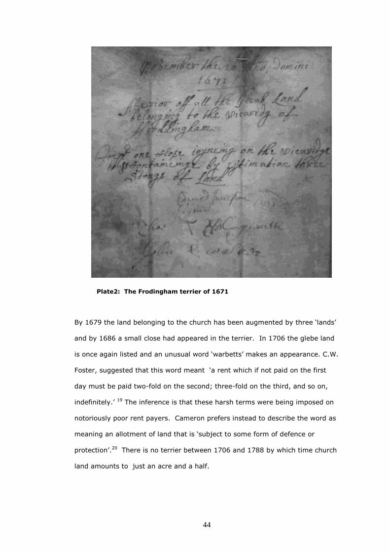
44
Plate2: The Frodingham terrier of 1671
By 1679 the land belonging to the church has been augmented by three ‘lands’
and by 1686 a small close had appeared in the terrier. In 1706 the glebe land
is once again listed and an unusual word ‘warbetts’ makes an appearance. C.W.
Foster, suggested that this word meant ‘a rent which if not paid on the first
day must be paid two-fold on the second; three-fold on the third, and so on,
indefinitely.’ 19 The inference is that these harsh terms were being imposed on
notoriously poor rent payers. Cameron prefers instead to describe the word as
meaning an allotment of land that is ‘subject to some form of defence or
protection’.20 There is no terrier between 1706 and 1788 by which time church
land amounts to just an acre and a half.
45
It is clear that open field agriculture was widespread in the study area, and
while some parsons had little glebe, others must have been moderately large
cultivators of land. From the first glebe terriers for the area of 1577 there are
mentions of closes in the study parishes and some evidence of consolidation of
holdings. During the English Civil Wars the episcopate was abolished by
Parliament and was not restored till 1660. The glebe however was not seriously
tampered with and continued to be used to support the clergy. Visitations and
terriers resumed in 1662 and the spate of new closes listed from that date,
perhaps indicates that enclosing had continued, during the upheavals of those
times.21
In general it is perhaps possible that the evidence of enclosure derived from
glebe terriers may understate the process, as the formation of closes may have
been led by yeoman farmers, with agricultural acumen, who had the necessary
drive to organise the consolidation of strips, rather than by incumbents who
merely owned land by virtue of their office, and had less interest in agrarian
improvement and may not even have been resident in the parish.
Chancery Decrees
It was from about the mid-sixteenth century that enclosures begin occasionally
to be enrolled by decree of the Court of Chancery and the earliest agreement
found seems to be that for Condover, near Shrewsbury, which was made in
May 1550 and enrolled in 1586.22 The apparent purpose of obtaining a decree
was that 'the Court was supposed to be competent to enable trustees and
guardians to consent in order to bind their successors and wards, and even to
bind dissentients'.23 A difficulty influencing interpretation of any decree arises
from the distinction that has to be made between genuine or collusive suits.
Beresford suggested that the key to the difference is the language used, and

46
that 'where the defence is more fully and vehemently stated or the plaintiff
more querulous it may be guessed that there was genuine disagreement'.24
‘Plate 3: Part of the Chancery Decree for Waddingham TNA: C78/1096/2‘ And the
complainants findeing the said landes uninclosed were disadvantegeous to them they
the tennantes and Inhabitants suffering losses by reason of the scarcity of Inclosure
wanting meanes to secure their cattle…’
There are 2,257 rolls (or rotuli) of decrees and orders of the court of Chancery
in series C78 at The National Archives The rolls are made up of parchment
membranes sewn end to end, evidently from collections of some thirty to forty
membranes which are usually, but not always, in date sequence. As each
membrane is approximately 45cm in height, an unrolled rotulus can measure
nearly twenty metres and may only be comfortably examined in sections of two
or three metres. Decrees are written in the very distinctive Chancery Hand, the
set style of handwriting used for the enrolment of acts of Parliament and other
important documents, until 1836.25 While each membrane is written in the
hand of one clerk, more than one hand can often be found in a rotulus. Each
clerk seems to have had a slightly different way of making certain letter-forms,
like the capitals ‘W’, ‘B’, and ‘S’. Perhaps this was the only way that the clerk
could stamp his own personality on the, otherwise anonymous, task.
The first one hundred and thirty rotuli (C78/1-130) have been calendared,
entry by entry, and indexed both by place and personal name in four volumes
of the List and Index Society.26 These entries are in rough chronological order
from the 1530s to a little after the end of the reign of Elizabeth.27 There is no
complete index to the rolls from C78/130 onwards.

47
Sample rolls from C78 were calendared as part of a project sponsored by M.W.
Beresford between 1974 and 1976.28 Beresford’s researchers examined twelve
thousand cases in 749 sample rotuli and recorded 260, what they described as
‘enclosure agreements’ amongst them, which were tabulated by county:
Table 4:
Distribution of ‘Enclosure Agreements’
by counties:
Bedfordshire 3 Norfolk 16
Berkshire 4 Northamptonshire 26
Buckinghamshire 7 Northumberland 1
Cambridgeshire 12 Nottinghamshire 3
Cheshire 0 Oxfordshire 8
Cornwall 0 Rutland 2
Cumberland 1 Shropshire 3
Derby 5 Somerset 5
Devon 5 Staffordshire 9
Dorset 5 Suffolk 2
Durham 1 Surrey 1
Essex 2 Sussex 5
Gloucestershire 10 Warwickshire 19
Hampshire 0 Westmorland 1
Herefordshire 2 Wiltshire 8
Hertfordshire 1 Worcestershire 0
Huntingdonshire 7 Yorkshire 23
Kent 2 Montgomeryshire 1
Lancashire 1 Monmouth 2
Leicestershire 30 Uncertain 1
Lincolnshire 24
Middlesex 2 TOTAL 260
Source: M.W. Beresford, 'The Decree Rolls of Chancery as a Source of
Economic History, 1547-C.1700' Economic History Review, 2nd ser. 32
(1979), p.8
Unfortunately a catalogue of the twelve thousand cases was never published,
nor an index made, nor was there even a listing of the two hundred and sixty
place names.29 A typescript copy of the three volume list was lodged in the
Institute of Historical Research and the entries for Lincolnshire have now been
examined.30 The list of rolls reveals that numbers 121-750 were inspected as a
complete series (except that number 163 was missing) and these were not

48
sampled, like the remainder, at a rate of one in five, or one in ten. These 630
rolls have a confused internal chronological sequence, but the run includes
most of the reigns of James I, Charles I and II, together with the
Commonwealth period. All of the Lincolnshire entries, which were found in the
Beresford list, fall within this period. The first is a dispute concerning Cadney,
Howsham and Newstede (198/10) in 1605, and the last relates to Bulby in
Irnham (736/15) in 1667. Beresford suggested that the enrolment of enclosure
decrees became more popular in the 1630s and may have reached a peak in
the 1660s. 31 It is difficult to generalise with only a small number of Lincolnshire
cases; all that can be said is that there were noticeable gaps in litigation during
the 1620s and 1640s.
The text and tables in Beresford’s article, specifically refer to numbers of
‘Enclosure Agreements’.32 This is perhaps somewhat equivocal as the list
produced by the project includes, as well as cases where ratifications of
agreements to enclose were actually being sought, disputes which touch on
other aspects of land litigation. The entries for Evedon and Bassingham do
indeed describe the Chancery Court ratification process, but elsewhere, for
example, Sir Cornelius Vermuyden complains that although he has drained and
enclosed the sea marsh at Sutton, he has not received the agreed 3,500 acres
which is owed to him.33 Richard Towneley in Nocton complains that he wishes
to make a sixty-acre deer park, but the vicar protests that he has common
pasture rights in the area of land concerned.34 While enclosure, or at least
agricultural improvement, is certainly at issue in these cases, they are not
enclosure agreements.
Only twenty-two rotulus references, which could be ascribed to the county,
were found. It may be that Beresford or his researchers have adopted another
system of accounting; perhaps parishes or townships are being counted.
Boughton, Asgarby and Howell are the subject of one Chancery dispute, but
Asgarby is a township in Boughton parish while Howell is a separate, if adjacent

49
parish.35 Perhaps places that are mentioned several times, are only listed
once. Laughterton and Kettlethorpe are mentioned twice, in 1651 and 1667.36
Swinderby is mentioned twice, because an agreement of 1629 was the cause of
friction over several decades;37 Sutton is mentioned twice, once on its own and
once in a case, concerning marshland, jointly with the parish of nearby
Gedney.38
Ditchfield appears in the Lincolnshire list with Benjamin Laney, who was Bishop
of Lincoln at the time, as defendant.39 Because Ditchfield is in
Buckinghamshire, the original decree was examined to determine if this place
was wrongly included in the Lincolnshire list because of the Episcopal
connection. The text of the decree itself however clearly has Bitchfield, which is
a small parish about seven miles south-east of Grantham.
Beresford’s summary table is not a list of enclosure agreements, as it includes
cases concerned with other aspects of land litigation, but the three volumes of
typescript produced by his researchers in 1978 do provide a useful catalogue of
the cases, by rotulus number, heard at the Court Of Chancery over a lengthy
period of time. They do appear, in different ways, to be concerned with
enclosure or agricultural improvement and some of these are actual ratifications
of enclosure agreements in the way that we have come to understand the term
from Beresford’s description.
The National Archives does not possess a complete catalogue to Chancery
Decrees, but does have available a nineteenth-century finding aid, which is a
ten-volume manuscript list of dates of entries and names of plaintiffs relating to
rolls from the years 1649 to about 1760.40 There is also a more modern
(perhaps twentieth century) manuscript finding aid, a one-volume list of place
names mentioned in rolls, for almost the same period.41 Because of its small
size however, it seems very unlikely to be a comprehensive listing and Miss E.

50
M. Leonard’s, main example, the parish of Brandesburton near Driffield, does
not appear in it.42
Two strategies were adopted when searching for enclosures in cases from
Chancery decree rolls. The first was to examine the four volumes published by
the List and Index Society, which cover the first one hundred and thirty rolls,
for names of persons, and places that might be relevant. There is hardly a
reference to enclosure in these volumes however, and this must be partly
because, as already noted, enrolment begins to become noticeable after the
time span which these volumes address.43 Another reason may be inexact
phrasing, which could lead to a case, being included, or excluded, from the
corpus of enclosure related cases. A reference to the area being ‘divided’ for
example may indicate an authentic enclosure or might merely indicate the
formation of an extra area of common field.44 It may also be the case that the
word ‘enclosure’ itself had connotations of depopulation that had to be avoided,
and so another, more oblique, word or phrase would be used in its place.
After the List and Index Society volumes had been examined, the finding aids
at the National Archives were consulted. The index locorum (IND 1/16960A)
was checked for likely place names, although it was realised that a promising
reference, even if leading to a case about land, may well have nothing at all to
do with enclosure. Leasehold and copyhold lands may be at issue, disputes
about debts and legacies seem very common, and even disagreements about
marriage settlements occur. The ten-volume index nominum (IND 1/16961A)
was then examined. Clearly it is an advantage if the likely name of the plaintiff
is suspected, and still better if that surname is an unusual one. Even so it is
probably an example of serendipity if, armed with only a familiar surname as
evidence, an enclosure suit is eventually found amongst the decree rolls.
The second strategy which was adopted when searching for enclosures in cases
in Chancery decree rolls was to search for mentions of ‘inclosure by decree’ in
other classes of documents, or in books of reference. For example, in the case

51
of Waddingham in Lincolnshire, William White’s 1856 Directory of that county
mentions that ‘the greater part of the parish was enclosed by a Decree of the
Court of Chancery’.45 A document amongst the Redbourne papers in
Lincolnshire Archives, which is undated, but with other papers of circa 1736,
mentions Redbourne’s neighbouring village and comments that ‘Waddingham
was a large open common town consisting of large cornfields, pastures and
common till the year 1700’.46 With these two items of information it was
possible to search, with a measure of confidence, the decree rolls around the
year 1700 and hope to find one which has the required case. In fact
Waddingham was discovered enrolled in a rotulus marked ‘13 W’, that is the
thirteenth regnal year of William III, or 1701-2, and was found subsequently to
be listed in volume five of the index nominum of plaintiffs as ‘Maudson, Bainton
et al’.47
The Waddingham suit was the only Chancery decree found to have a
connection with the study area, and was not amongst the twelve thousand
cases examined by Beresford’s team; it was found instead, by deduction, from
references in other documents. It is discussed in detail in chapter 7. It may be
that there are other Lincolnshire decrees concerning agricultural land which
remain to be discovered amongst the rotulus sequences that were sampled at
only one in five, or at one in ten. A very few of them may indeed validate
agreements to enclose, but it is likely that most will be real (rather than
collusive) disputes about other topics.
A less arduous way, to discover a chancery decree concerning enclosure, is to
find a copy of the agreement, catalogued in a county archive office. LAO has a
copy of Chancery decree 637/1 of 19 Feb 1656, (listed above) which has the
effect of ratifying the enclosure of Bassingham. This enclosure had begun,
years earlier in 1629, with a petition to the principal landowner, the Countess
of Warwick, from her ‘poore tenents’ listing the many reasons why they

52
favoured ‘farming in severalty, inclosure and drainage’.48 In the same archives
is an exemplification, or legal copy of a chancery decree dated 13 December
1729, specially prepared for the Earl of Cardigan.49 The decree confirms an
agreement of 20 March 1728 between the Earl and the rector of Little Ponton
concerning tithes, and to purchase Wood Close and certain other lands by way
of exchange for other listed closes, totalling about 130 acres.50 The original of
this exemplification has yet to be found amongst the chancery decree rotuli in
TNA.
It would be only about eighteen months later, in 1731, that a very similar
agreement, between the rector and lord of the manor of Biscathorpe, to
exchange glebe and other lands to facilitate enclosure, was validated not by
chancery decree, but by a new device to Lincolnshire, the parliamentary act.51
Parliamentary acts came into fashion because an agreement to enclose could
not be made with the opposition of even one person who dissented from it and
not even Chancery Court would assist the majority against the dissentient.52
Enclosure by agreement does not seem to have gone immediately out of use;
acts simply became more popular because of the certainty they gave and the
fact that they could overcome opposition.
The notion therefore that, from the early seventeenth century, the hard
bargaining necessary for enclosure by agreement had, as its consequence, an
increasing tendency to opt for validation by a Chancery decree does not seem
to be entirely correct.53 There are, admittedly, a few of these where the
‘necessary fiction of a dispute’ was established by collusive action among the
land owners, and so when the court decided in favour of the defendants, the
legality of the enclosure was much more firmly established and recorded.54 It
would be perhaps more correct to say that the seventeenth century was a
period when portions of parishes in Lincolnshire were enclosed by agreements
between landowners, and the Court of Chancery was the preferred court to
53
enrol the agreement, in those minority of occasions when this action was
thought necessary. Where the church was involved, the agreement was more
likely to be enrolled by the Court.
Land Tax
In order to attempt to gauge the effects of parliamentary enclosure on the
number of landowners and the proportion of owner occupiers, the land tax
returns for all the parishes in the study area have been analyzed both for
ownership and owner occupation for the years 1783 and 1830.55
Ginter has warned that although land tax returns, or assessments, (LTAs) have
been used to address some very large questions in British social history,
including the fate of the small landholder after enclosure, they are ‘treacherous’
and ‘nasty little documents’.56 Despite this considerable caveat, many of the
returns for the study area have been analysed with a view to determining not
only what happened to the smaller owners in the study area, but also whether
the structure of landownership within parishes may have had a bearing on the
form and the timing of enclosure.
The land tax was a property tax dating from the late-seventeenth century.
Originally it was a tax on land and, to lessen the possibility of avoidance, it
became one in which county, wapentake (or hundred) and parish quotas were
set, rather than a personal tax. These quotas became fixed and this was
confirmed by law in 1798.57 The tax assessments for any particular parcel of
land were therefore arrived at an early stage of the life of the tax and stayed at
that level until final abolition in 1963.58 In 1780 the government gave
instructions that duplicates of the assessments were to be kept by Clerks of the
Peace so that they could be employed, in place of an electoral register, to
determine which members of the parish were entitled to vote.59 As a result, the
54
records in many county record offices include fairly complete runs of the
duplicate land tax assessments from 1780 to 1832. After 1832, with the passing
of the Reform Act, the assessments no longer were helpful for electoral
purposes.
The land tax returns served a more martial purpose in 1795 when they were of
help to magistrates in the urgent recruitment of sailors for the war against
Napoleon. It was determined from the returns that there were 11,905 inhabited
dwellings in the nineteen wapentakes of Lindsey and parishes were grouped into
multiples of seventy houses, each of the seventy to provide one recruit.60 On
20 April 1795 Thomas Goulton and William Wilson, of Alkborough sent in their
account of volunteers enrolled to the Clerk of the Peace for the Division of
Lindsey, which shows that the wapentake of Manley had raised seventeen men
out of an assessment of twenty-eight. The neighbouring wapentake of
Yarborough only managed two from an assessment of twenty-one. An
examination of the records reveals the difficulty that the villages had in
providing native volunteers. Although Solomon West, a 24-year-old labourer
from Whitton, did go to sea, some of the seventeen were paid substitutes.61
James Lynch, a 27 year old cooper of Enniscorthy, County Wexford, for
example, served as a substitute for Roxby, Appleby, Burton Stather, West
Halton and Whitton.62
In the Lincolnshire Archives there is a good collection of LTAs for Manley
Wapentake from 1782 to 1831 with a few years entirely missing for the study
area and occasional years absent, or partly illegible, for individual parishes.
As already noted by Ginter, there are reasons to be cautious when using LTAs
for local history, and in particular in using them to track changes in
landownership and in quantifying the magnitude of holdings. The LTA duplicates
usually appear in a tabular form with headings consisting of the owner or

55
proprietor’s name, the occupiers’ name and the amount of tax that has been
assessed. The very structure of the LTA with its neat columns of figures seems
to demand conversion to a spreadsheet, but a number of opportunities for
confusion are mentioned in the literature and others have come to light during
the present study.
In a 1927 article, an early researcher, E. Davies, had made the controversial
assumption that a constant relationship existed between the tax paid and the
land which was held, the so-called, ‘acreage equivalent’.63 This is probably the
principal pitfall with land tax documents, because since rental values varied so
much from field to field, it is actually unsafe to draw any firm conclusions
concerning acreages farmed, from the monetary values that were paid.
There are however other difficulties with LTAs that need to be borne in mind
when considering them as a source of information about landownership. It may
be that the smallest tax-paying owners are brought in or left out of the
assessment in order to ‘balance the books’ and achieve the quota that was fixed
in 1698. The Whitton LTA of 1790 is reproduced below. (plate 4, below) In the
ninety or so years since the quota was fixed, rents had increased and it was no
longer necessary to levy at the rate of four shillings in the pound each quarter,
nor to tax the very poorest tenants at all, in order to accumulate the required
sum of £13. Instead of the 5% originally required, a rate of approximately
1.5% was needed, and this is the sum that was charged in the Whitton
document below. The amount collected in 1790 summed to 6/2¼ more than the
quarterly requirement of £13. Confusingly while most of the listed tenants are
assessed at 1.5%, one or two unaccountably pay more than this and so the
excess over £13 is more than it need to be. We can only speculate where the
surplus went.
Occupiers often held land in more than one parish and so it cannot be assumed
that they live in the parish where they are listed in the LTAs. As a variant of this

56
complication, a very few parcels of land in the study area are actually crossed
by parish boundaries and so have entries in the LTAs of two adjacent parishes.
Plate 4. The Whitton LTA of 1790 showing that Thomas Goulton owned nearly all of the
land. The sums assessed actually total £13-6-2¼. (LAO: LTAs, Manley wapentake)

57
In one case ‘Widow Wetherill’ in Whitton parish is almost certainly the same
person as the ‘Execs of Wetheril’ in West Halton, because a particular wooded
field, still known as Weatherill’s Holt, is split in two, by the boundary of these
two parishes.
Before 1798, when standard printed forms were introduced to replace entirely
handwritten returns, there was sometimes uncertainty, in the absence of
headings to columns, as to whether the owners or occupiers were listed as
proprietors. It is believed that this source of error has been eliminated by
careful examination of the study area documents.
There are other difficulties; the names could be out of date, as changes were
not always updated in the next assessment and the presence of the term ‘late’,
perhaps for a number of years, in front of a person’s name, could indicate either
death, or the sale of the property.
From 1798, the tax could be redeemed or ‘exonerated’ with the payment of a
lump sum equal to fifteen years’ annual tax. Proprietors’ names would have to
be retained on the list until 1832 because of the need to record voting rights,
but in theory details of occupiers could have been omitted. Happily this does not
appear to have been the case in the study parishes, and comprehensive details
of exonerated parcels of land seem to have been kept.
Where the word ‘ditto’ or ditto marks occurs in the assessments, it sometimes
means owner occupation, rather than the same occupier, as on the line above.
In other words, at times the ditto is being used horizontally, rather than in the
conventional vertical way and the use is not always immediately apparent to the
researcher. Where this use occurs, it can be the quirk of an individual compiler
and a change of compiler (indicated by a change of handwriting), after a
number of years, may reveal the correct meaning.
The poorest inhabitants of the village are simply not listed in land tax
duplicates. For example the Whitton 1831 census recorded 245 people; 134

58
males and 111 females in fifty-four houses.64 However the Whitton LTA for
1830, lists only forty-one tax-paying properties65; some families were therefore
either sharing houses or lived in properties exempted from paying tax, either
officially, or due to some local application of the poor rate. If the poorest
properties had suddenly disappeared from a run of LTAs due to statutory
exemption at some known point in time (at enclosure or in 1798 for instance), it
would be relatively easy to take account of them in the analysis, but their
perpetual absence from the record has serious statistical implications. Ginter
makes much of this shortcoming of LTAs and it is certainly difficult to account
for something, the extent of which is not known.66 It is therefore important to
keep in mind that a proportion (perhaps a considerable one) of properties is not
present, and to hope that its absence does not skew any analysis of
landownership.
Finally it must be remembered that the names listed on a parish LTA, are often
the summation of several townships with different enclosure experiences. The
Frodingham land tax document of 1783, for example, listed twenty-seven
owners, of which six were owner-occupiers. By 1830, the number of landowners
had fallen to seventeen while owner-occupiers had risen to eight.
Parliamentary enclosure of the townships within the parish of Frodingham
however occurred over a period of sixty-three years; the Crosby award is dated
1812, the Scunthorpe and Frodingham award is dated 1834 and the two
Brumby awards were in 1871 and 1875. There were several different reasons
for enclosure in the parish, involving a wish to organize open field arable, a
desire to enclose waste and an urgent need to establish title to land, beneath
which was ironstone. In addition, Crosby was dominated by the Sheffield
family, Scunthorpe and Frodingham by Henry Healey and Brumby by Lord
Beauchamp; there were also considerable areas of old enclosure in Scunthorpe,
Frodingham and especially Crosby. In all these circumstances, when disparate

59
townships such as these are being summed, care must be taken when drawing
inferences.67
Turner has suggested that the controversial use of acreage equivalents can be
avoided by means of the method of ‘surname turnover‘, which is based on
personalities rather than on the size of holdings. In this, the total number of
landowners in a given year is calculated; the total numbers of surviving original
names are then computed for subsequent years which, allowing for family or
corporate inheritance, indicate the extent of turnover of holdings.68 Turner
used this method to analyse the impact of parliamentary enclosure in
Buckinghamshire and Neeson has used a substantially similar technique to
investigate enclosure in Northamptonshire.69
In addition to an owner/owner-occupier five-year interval analysis for the
complete study area parishes for the period 1783 to 1830, all the surnames, in
a sample of nine of the study parishes, have been analysed using Turner’s
method above. The nine parishes were selected as they had complete and
legible runs of LTAs and (in parishes enclosed by act) had proportions of their
areas enclosed from 1761 to 1833. They include two parishes where there was
no parliamentary enclosure, Roxby and Flixborough. A total of 2,447 surname
records were extracted and analysed, from ninety land tax returns dated at five
year intervals from 1783 to 1830.
When faced with a stack of land tax assessments in a record office, a policy
regarding a uniform scheme of correction and editing of surname entries is
required. Inheritance was assumed if: a former owner no longer appeared in
the later return, and a person with the same surname appeared on the later
return, and the newcomer owned at least one parcel of land which was taxed at
the same, or similar sum, as the former owner.70
Inheritance has not been assumed if a surname, although fulfilling the above
criteria, reappears later than the next LTA of the series examined.

60
There are obvious inherent weaknesses in a method that depends on tracking
surnames in rural parishes at the turn of the eighteenth century. In the case of
names that are common throughout the country, Smith, Brown, Clarke for
example, an entry from one LTA may have no association with a similar entry in
a later year. A Fred Smith who disappears in 1790 may have no familial
connection to a Will Smith who appears in 1795 and will have not have
bequeathed his field to him, simply because they share a frequently occurring
name. On the other hand it must not be assumed that because entries have
uncommon surnames, inheritance is certain. Several, nationally infrequent,
names occur in the study area; Spilman in Whitton, Westoby and Burkill in
Winteringham, Taffinder in Burton-upon-Stather and Chafer in West Halton for
example. These families may have been settled in the area for generations, and
heads of households who are cousins, or second cousins, (like the various
Spilmans) would not necessarily leave their properties to each other. The
occasional exception has therefore been made, to the Turner/Neeson method
outlined above, to take account of locally known genealogical anomalies.
On the other hand a surname disappearance should not really be counted when
a widow marries and merely changes her name, or where a son-in-law inherits.
Turner and Neeson sensibly ignore these complications, and this study does the
same, although it is likely that surnames will have disappeared in this way.
The results of these landowner, owner–occupier and surname analyses are
discussed in chapter 8, The new landscape of north-west Lindsey.
Documentary evidence of parliamentary enclosure
It is likely that the greatest proportion of enclosure literature concerns the
period when the process was undertaken by act of parliament. This may simply
be because the sources of information are so extensive, systematic and easy to
access.71 A single township’s improvement could have associated with it, a

61
petition to parliament for a bill, the resultant act, minutes of the commissioners
appointed by the act and an award, with its accompanying map. There may
also be estate papers and correspondence in county archives which provide
context and additional information, although in the case of the study area,
despite there being many fine collections in Lincolnshire Archives such as the
Nelthorpe and Sheffield papers, relevant material is meagre.
Numbers of petitions, published in the Journals of the House of Commons, were
examined in the search for the contemporary motives for acts, but it was found
that the form of words used, was uniform and seemed to have become
standardized. Turner provided a probable reason when he wrote ‘the
statement of improvability might mean little more than the country solicitor
using existing bills to frame succeeding petitions and it should not necessarily
be assumed that this was the sole motive or indeed the main motive for
instigating enclosures.’72 If any of the wording of the petitions had differed
markedly and given atypical reasons, then these would have been useful, but
none was found. This petition for Alkborough is representative:
Plate 5. Alkborough petition. Source: Journals of the House of Commons 1688-
1834, vol 30, 24 January 1765, p.57

62
It was noted that in a relatively early petition of 1768, cooperation between
landowners was such that it was possible to ask for leave to enclose portions of
lands, in different parishes, at the same time. The petition (plate 6, below,) and
the subsequent act sought to enclose parts of the townships of Waddingham,
Atterby and Snitterby in Waddingham and Bishop Norton parishes.73 The
agrarian link was the low-lying nature of the lands, which could be improved
following better drainage in the Ancholme valley, rather than any ecclesiastical
boundary.
Plate 6. Waddingham petition. Source: Journals of the House of Commons 1688-1834,
vol 31, 14 January 1768, p.499
In the case of Winterton, although the petition had been completely
conventional in its wording and repeated that the fields etc were intermixed
and incapable of much improvement, the act went into greater detail and, for
example, made the point that there were not enough enclosures to keep cattle
for tillage and manuring.74

63
Plate 7. An Act for Dividing and Inclosing certain Open Lands, Grounds, and Common
Pastures in the Parish of Winterton, in the County of Lincoln. 25 October 1769
No enclosure counter petitions have been found, although before the act was
obtained which enabled the Level of Ancholme to be drained in 1767, there was
a counter petition from a landowner who claimed that the scheme would be
injurious to his property.75 His worries were assuaged by amendments to the
final bill and the scheme went ahead. Although a drainage act, its effect was
very like an enclosure, as agricultural improvement was the object and the end
result.
The files of Lincolnshire Archives were searched for commissioners’ minutes
relating to parliamentary enclosures in the study area. Three sets of minutes
were found. Amongst the Yarborough estate papers were preserved the
minutes relating to the Upper Santon enclosure of 1833.76 The minutes relating
to the Ashby enclosure of 1809 were found in the Brown, Hudson and Hudson
(solicitors of Barton-on-Humber) Deposit. Together with these minutes were
public notices relating to the enclosure bundled with a badly faded copy of the
Award, which was without a plan.77 The minutes of the Hibaldstow enclosure

64
of 1803 were found in the Stubbs deposit, a collection of papers from the long
established Brigg solicitors’ firm of Hett, Davy and Stubbs. The minutes are
bound into a volume of over one hundred pages, which is preceded by a copy
of the act.78
All of the awards and accompanying plans were found in Lincolnshire Archives
except that those for: Brumby Common, Brumby Moors, Hibaldstow, and
Scawby which were lodged in North East Lincolnshire Archives at Grimsby. The
Alkborough award and plan were found in University of Nottingham
Manuscripts and Special Collections.
Tithe Files
All twenty-nine tithe files, for the townships and parishes of the study area,
were examined at The National Archives. There were twelve places where no
tithe remained to be commuted in 1836.79 Eight files contained a copy or draft
of a voluntary agreement for commutation of tithes and nine places where a
draft award was imposed by an assistant tithe commissioner.80 In the case of
places with a voluntary agreement, there was in every case, the local tithe
agent's or assistant commissioner's report on the fairness or otherwise of the
agreement.81
Maps were found for the seventeen places where voluntary or imposed
agreements applied.82
These files contained some interesting data on local farming in the years
around 1840, and descriptive material on the local rural economy and society.
Most files contained observations about land use and Flixborough was noted as
having a three-course rotation with both good and poor quality pastures, while

65
Twigmoor, Roxby and Gunness has four-course rotations and both Cleatham
and West Halton had five–course rotations.
In general there were some indications of deference by the assistant tithe
commissioner towards the landowner or his agent. In Alkborough the
landowner’s bailiff refused to give straightforward answers as to whether
notices of meetings to decide on a voluntary award had been posted properly
on the church door, or the manner in which the meetings had been
conducted.83 In Roxby the agent for the principal landowner, Mr Elwes,
admitted to the Assistant Tithe Commissioner that he was the only party at the
meeting which he had himself called in the church to discuss the agreement,
despite adjourning the meeting twice, to see if any of the other smaller
landowners would appear. He was, suspiciously, unable to recall when in fact
the meeting had been held.84 In Flixborough the assistant tithe commissioner
was persuaded to treat all of that parish and Normanby, in the neighbouring
parish of Burton, as one unit, as it coincided conveniently with the estate of the
landowner Sir Robert Sheffield. The report, when it reached London, was
annotated with a message of rebuke.85
In all eight cases, the agreements were confirmed.
Newspapers
Copies of the Lincoln, Rutland and Stamford Mercury on microfilm, and in the
large bound volumes in Lincoln Central Library were searched for references to
enclosure. Numerous examples of announcements concerning the various
stages of parliamentary enclosure were found and they have been used to
illustrate the thesis.
66
1851 Census
The population characteristics of the study area were examined by classifying
the social and occupational status of the fourteen thousand individuals who
appear in the census enumerators returns.86 The classifications used were
based on those of Mills and Schürer except that group 5 ‘Manufacturers’ and
group 6 ‘Extractive Industries’ are absent, as they were not found in the study
area and numbers of children and housewives were also noted for the present
study.87
It is recognised that there are difficulties with the census returns. The main one
must be that at the time of data collection on 30 March, seasonal and casual
agricultural workers are under reported. More workers would have been noted,
many of them women, if the census had been during hay-making, the cereal
harvest or at potato picking time. The following day was Mothering Sunday and
in Lincolnshire, as elsewhere, it was often the case that farm and domestic
servants would have leave to visit their parents, perhaps in another parish.88
The instructions to the 1851 enumerators were complex and, in effect, required
a thorough itemised description of the farming unit and its resources. The
enumerators were required, for example, to collect detailed information about
acreages of farms and numbers of employees living-in as part of the household
schedule, and separately numbers of workers living out.89 In practice this was
not always done and so it proved impossible to make an inventory of the
acreages of all the farms in some parishes, or to make a comparison of
numbers of workers listed by farmers, with persons enumerated as ‘ag labs’.
Some enumerators give meticulous job titles while others often left details of
occupation unwritten. It was also difficult to distinguish between farm workers
who lived with the farmer, sometimes called ‘servants in husbandry’, and
domestic servants who were sometimes described as ‘in service’.

67
The census only required those persons returning themselves as 'farmers' or
‘landed proprietors’ to give details of land held, so there is hardly any
information about landholding by people in other occupations. This must
seriously understate the numbers of occupiers of land and must be especially
true at the lower end of the acreage scale where dual occupations were more
common. Although wealthy businessmen and clergy no doubt held some of
these unrecorded holdings, many must have been held by rural tradespeople. It
has been argued that 'nearly all tradesmen also followed some form of
agriculture either as a major or subordinate source of income', which suggests
that to differentiate too much between tradespeople and small farmers is
unwise.90
It is not surprising that the instructions for the 1861 census were much less
convoluted.91
There are many other complications amongst the fourteen thousand names,
but an effort has been made to be consistent in classifying them, even though
standards of enumeration varied so markedly across the study area.
1801 Crop Returns
Comprehensive agricultural statistics did not begin to be collected nationally
until 1866, but some limited information had been collected during the
Napoleonic wars, about seventy years before. Although this was a time when
the country was interested in its changing agriculture, the reasons for the data
collection were, actually the fear of invasion, a food blockade by the French
Navy and series of poor harvests in the second half of the 1790s. The Home
Office circulated inquiries about crops in 1793 and 1795, but the results of a
survey in 1801 are much better known. In that year the clergy of England and
Wales were requested to return to their diocese details of the acreage under
wheat, barley, oats, rye, turnips, rape, peas, beans and potatoes, for their

68
parish on a printed pro-forma. Unfortunately they were not asked to comment
on the acreage under fallow, permanent grass or temporary grass, thus greatly
reducing the value of the returns. Probably because farmers were suspicious of
being asked about acreages by the clergy and wondered whether their
questions had something to with tithes, the returns are understated. Scholars
generally agree that these returns do under-estimate the actual acreage but
that the proportions between the crops recorded are accurate.92 Another
difficulty is that the returns do not indicate the, presumably, large amounts of
crops, particularly potatoes that were grown in small plots and private gardens.
In the study area, acreages accounted for only about 29% of the land area in
the places returned. As well as the missing fallow and grassland, many places
are omitted; Redbourne, Hibaldstow and Messingham amongst them. The
whole of the parish of Winterton is missing; it is assumed either that the large
number of landowners in this open parish made the task of data collection too
daunting or that the respondents proved intransigent in the face of the vicar’s
questioning. The return for Broughton simply states that ‘the farmers…cannot
be prevailed upon to make the return of their crops…’.93 Many clergymen also
made comments on local land use and farming practice, and information on
crop yields is sometimes recorded. After the returns had been collected
together by dioceses, they were sent to the Home Office and are now kept in
The National Archives. Conveniently the extant returns have been published by
the List and Index Society and relevant statistics have been extracted for this
study.94
References
1 R. Potts, (ed.), Calendar of Cornish Glebe Terriers, 1673-1735, Devon and
Cornwall Record Society, vol 19 (Exeter, 1974), p.viii

69
2 LAO: Glebe Terrier Bundle, Redboune,1638 and 1662
3 LAO: Glebe Terrier Bundle, Thornton by Horncastle, 1828
4 E. and R.C. Russell, Old and New Landscapes in the Horncastle area (Lincoln,
1985), p.94
5 M.W. Barley 'Farmhouses and Cottages, 1550-1725', The Economic History
Review, New Series, Vol. 7, No. 3 (1955), p.301
6 In the case of a non-resident vicar, who rented out his glebe entirely and so
did not know his neighbours in the fields, reproducing the previous terrier must
have been very tempting.
7 LAO: Scawby Glebe Bundle, 1662. The previous terrier of 1634 seems to be
very similar.
8 Ibid.
9 I. H. Adams, Agrarian Landscape Terms: a Glossary for Historical Geography
(1976), p.9
10 Ibid.
11 K. Cameron, The Place Names of Lincolnshire Vol. 6 (Nottingham, 2001),
p.72, Prof. Cameron is clear that ‘gad’ is a dialect word meaning a rood or
quarter acre of land.
12 LAO: Messingham Glebe Bundle, 1686
13 This does not include a total of 805 acres awarded to Bishop and vicar. in lieu
of tithes; LAO: Enclosure award and plan. 1804. [LAO: Messingham Par Co.
Accession number: 2007/54.]
14 It was also necessary to have a tenurial structure that accepted the
exchange of strips.

70
15 D. Englander, D.Norman, et al (eds.), Culture and Belief in Europe, 1450-
1600: an Anthology of Sources (1990), p.115
16 LAO: Messingham Glebe Bundle, 1686
17 LAO: Glebe Terrier bundle, Frodingham
18 K. Cameron, Place Names, Vol. 6, p.61
19 C.W. Foster, (ed.), Lincolnshire Domesday and the Lindsey Survey (Lincoln,
1924) p. xxxviii
20 K. Cameron, The Place Names of Lincolnshire, Vol. 6 (Nottingham, 2001),
p.101
21 A. Whiteman, ‘The Re-establishment of the Church of England, 1660-1663’,
Transactions of the Royal Historical Society, 5th Ser. V (1955), pp.111-31
22 M. W. Beresford, 'The decree rolls of Chancery as a source for economic
history 1547-c1700', Economic History Review, 2nd series, 32 (1979), p.2;
TNA:C78 85/15
23 E.M. Leonard, ‘The Inclosure of Common Fields in the Seventeenth Century’,
Transactions of the Royal Historical Society, new ser., 19 (1905), p.108
24 M W Beresford, 'Habitation versus Improvement: the debate on enclosure by
agreement' in F.J. Fisher (ed.), Essays in the Economic and Social History of
Tudor and Stuart England in Honour of R H Tawney. (1961), p.58
25 Except that a rotulus of 1652 during the Commonwealth period (including the
decree relating to Boughton, Asgarby and Howell), was found to be partly in
secretary hand. (TNA:C78 398)
26 M. Zell (ed.),Chancery Decree Rolls: 36 Henry VIII - 5 & 6 Philip & Mary
(C78/1-15), List & Index Society, vol 160 (1979); K. Wyndham (ed.),Chancery
Decree Rolls: 1-20 Elizabeth I (C78/15-45), List & Index Society, vol 198
71
(1983);K. Wyndham (ed.), Calendar of Chancery Decree Rolls: C 78/46-85,
List & Index Society, vol 253 (1994);R.W. Hoyle and M.M. Norris (eds.),
Calendar of Chancery decree rolls: C 78/86-130, List & Index Society, vol 254
(1994)
27 There are three mentions of study villages in these one hundred and thirty
rotuli, but none is concerned with enclosure: C78/20/41,C78/64/6 and
C78/67/3
28 M. W. Beresford, 'The decree rolls of Chancery…’
29 Ibid, p.3
30 IHRL, London WC1E 7HU, Ref: B.1019/Ber
31 M. W. Beresford , 'Habitation versus Improvement:, pp.60,56
32 M W Beresford, 'The decree rolls of Chancery…’, for example, the titles of
the tables on p.2 and p.8.
33 Chancery Decree rolls: Evedon 396/10, Bassingham 637/1 and Sutton
350/2
34 Chancery Decree roll: 419/3
35 Chancery Decree roll: 398/14
36 Chancery Decree rolls: 736/10, 567/3
37 Chancery Decree rolls: 377/2, 575/12, and see note 20, below.
38 Chancery Decree roll: 409/1; Presumably the ‘Sutton’ referred to here is
Long Sutton with its four townships.
39 Chancery Decree roll: 738/6
40 TNA: IND 1/16961A

72
41 TNA: IND 1/16960A
42 TNA: C78/605/3; E.M. Leonard, ‘The Inclosure of Common Fields in the
Seventeenth Century’.
43 Perhaps the most unambiguous reference is C78/130/2 of June 1608, in List
& Index Society, vol 254, which refers to the ‘ratification of an indenture for the
enclosure of fens, moors and commons of Stuntney ‘ in the Isle of Ely.
44 J. Chapman and S. Seeliger, 'Enclosures by non-parliamentary means: some
comments on the records', Archives, Vol. XXII, 95 (1996), p.102; For example
the calendar entry in List & Index Society, vol 253 for the Condover Chancery
Decree (C78/85, no. 15), referred to in note 2 (above) does not mention
‘enclosure’, but refers to an ‘allocation of 200 hundred acres for tenants’
allotments’.
45 W. White, History, Gazetteer and Directory of Lincolnshire (1856), p.606
46 RED 2/4/2/5
47 TNA: C78/1096/2 Decree in Chancery, Enclosure of Waddingham; Maudson
and Bainton were just two of the many freeholders of Waddingham, not the
principal landowners.
48 LAO: Bassingham Par 17/3, Copy of Chancery Decree; Misc Dep 264.
49 LAO: MISC DON CIV 8, Exemplification of a Decree in Chancery, 13 Dec
1729
50 LAO: LITTLE PONTON PAR/5/2, Articles of agreement dated 20 Mar 1728
51 LAO: MISC DON 277/1
52 D. Brown and F.A. Sharman, 'Enclosure: Agreements and Acts', The Journal
of Legal History, 15:3 (1994), pp.269—86

73
53 For example : J. A. Yelling, Common Field and Enclosure in England 1450-
1850 (1977 ), p.8; J. Thirsk, ‘Enclosing and Engrossing’, in J. Thirsk (ed.),
Agrarian History of England and Wales; IV 1500-1640 (Cambridge, 1967),
pp.237-8
54 M.W. Beresford, 'Habitation vs. Improvement: The Debate on Enclosure by
Agreement,' in F.J. Fisher, (ed.), Essays in the Economic and Social History of
Tudor and Stuart England (Cambridge, 1961), p.58
55 LAO: Land Tax Returns, Manley Wapentake; 1785 LTAs are missing and 1784
LTAs are only partly legible.
56 D.E.Ginter, A Measure of Wealth: the English Land Tax in Historical Analysis
(1992), p.xxv
57 Ibid, pp.3-4
58 LTAs for Burton-upon-Stather, alone in Manley Wapentake, also contain
assessments based on the salary of the resident excise-officer, as well as the
stock-in-trade of the village merchants.
59 From 1780, payment of land tax on freehold property worth £2 or more a
year qualified a man to vote.
60 F. W. Brooks 'Naval Recruiting in Lindsey, 1795-7’ English Historical Review,
Vol. 43 (Apr,1928), pp.233-4
61 LAO:LQS/B/11/18/110
62 LAO:LQS/B/11/16/100
63 E.Davies, ‘The Small Landowner 1780-1832, in the light of the Land Tax
Assessments’, Economic History Review, 1st ser., 1 (1927); The Land Tax
returns had however been used before in: A.H.Johnson, The Disappearance of
the Small Landowner (Oxford, 1909; reprinted with a new introduction by
J.Thirsk, 1963), and H.L. Gray, ‘Yeoman Farming in Oxfordshire from the

74
Sixteenth Century to the Nineteenth’, The Quarterly Journal of Economics, 24,
no. 2 (1910)
64 BPP, 1833 xxxvi-xxxviii,(149) Abstracts of the Answers and Returns, p.352
65 LAO: LTAs Manley Wapentake, 1830
66 D.E. Ginter, pp.33-43
67 J. V. Beckett, ‘Land tax administration at the local level 1692-1798’ in M.E.
Turner and D. Mills (eds.), Land and Property: The English Land Tax, 1692-
1832 (Gloucester, 1986) discusses who paid, and how much tax was due.
68 M.E. Turner, ‘Parliamentary Enclosure and Landownership Change in
Buckinghamshire,’ Economic History Review, 2nd ser., 28:4 (1975), pp.565-81
discusses the methodology.
69 J. M. Neeson, Commoners: Common Right, Enclosure and Social
Change in England, 1700–1820 (Cambridge, 1993)
70 Both Turner and Neeson used very similar criteria: M.E. Turner,
‘Parliamentary Enclosure’, p.567; J.M.Neeson, p.344
71 W.E. Tate (ed., M.E. Turner), Domesday …, p.39
72 M.E. Turner, English Parliamentary Enclosure (Folkestone,1980), pp. 94-95
73 Journals of the House of Commons 1688-1834, vol 31, 14 January 1768,
p.499
74 Journals of the House of Commons 1688-1834, vol 32, 8 February 1770,
p.670; LAO: DIOC/LDAP/2/65
75 Journals Of The House Of Commons, Twelfth Parliament of Great Britain:
sixth session (11 November 1766 - 2 July 1767), 30 March 1767; LAO:2 RED
4/8/1
76 LAO: YARB/17/3, Upper Santon Inclosure Act and Commissioners' minutes
1825-1832

75
77 LAO: BH 7/1, Public notices and Minutes of Commissioners’ meetings with
four rates levied, 1801-9; Copy of Ashby award, no plan 1809; LAO: KR/2/10
Kirton Court Book, Wapentake Court of Manley 1808-1810, Copy of Ashby
Award with plan.
78 LAO: Stubbs 1/20/6 Commissioners‘ Minute Book and various Hibaldstow
enclosure documents
79 TNA: IR18/5227 Santon, 4778 Bottesford, 4714 Ashby, 5450 Yaddlthorpe,
4809 Burton-upon-Stather, 4931 Frodingham and Scunthorpe, 4866 Crosby,
5013 Hibaldstow, 5112 Manton, 5113 Messingham, 5238 Scawby-cum-Sturton
and 5409 Whitton
80 Award imposed, TNA: IR 18/4711 Appleby, 4805 Burringham, 5020 Holne
(sic), 4798 Broughton cum Castlethorpe & Ravensthorpe, 4794 Brumby, 5375
Twigmore, 4811 East Butterwick and 5418 Winteringham
81 TNA: IR18/4702 Alkborough, 4921 Flixborough (with Normanby), 4841
Cleatham, 5204 Redbourne, 5218 Roxby cum Risby, 5385 Waddingham cum
Stainton, 4990 West Halton, 4968 Gunness and 5429 Winterton
82 Microfilm copies at TNA: IR20/
83 TNA: IR18/4921
84 TNA: IR18/5218
85 TNA: IR18/4841
86 1851 Census Enumerators’ Returns HO107/2115, 2116 and 2117; A WEA
group analysed a partly overlapping geographical area for a 1970 census study,
but its results could not be reconciled with the analysis done for this present
study, and they have therefore been ignored; vide P.M. Tillott & G.S.
Stevenson, North-West Lindsey in 1851 (Sheffield, 1970)

76
87 D.R. Mills and K. Schürer (eds.), Local Communities in the Victorian Census
Enumerators' Books (Oxford, 1996), p.143
88 Guardian, 1 February 1854; M. Anderson, ‘Mis-specification of servant
occupations in the 1851 census: a problem revisited’, Local Population Studies
60 (1998), p.61
89 E. Higgs, Making Sense of the Census Revisited (2005), pp.106-7
90 B.A. Holderness, 'Rural Tradesmen 1660-1850: A Regional Study in Lindsey',
Lincolnshire History and Archaeology vol. 7 (1972), p.77
91 Ibid, p.107
92 For example, M.E. Turner, ‘Arable in England and Wales: estimates from the
1801 Crop Return’, Journal of Historical Geography, 7-3 (1981) pp.291-302
93 M.E. Turner, (ed.), Home Office: Acreage Returns (HO 67): List and Analysis
Part II Jersey to Somerset, 1801, vol. 190 (List and Index Society, 1982),
p.103
94 Ibid; TNA: HO 67/15 Home Office Acreage Returns 1801

77
3. Time and place
The part of north-west Lindsey which is being studied has an area of about
74,350 acres or 116 square miles.1 It is a simple matter to sum the areas
divided and allotted by the parliamentary commissioners in the 114 years
between 1761 and 1875, and these amount to about 35,220 acres, or 55 square
miles.2 It would seem, arithmetically therefore, that the areas that were
enclosed, from earliest times, by other means amounted to 39,130 acres or
52.6% of the study area.3 The exactness of this cannot be determined,
however, since it is certain that some of the land that had been listed in
enclosure awards had already been enclosed, perhaps for many years, and was
included in the award perhaps to add extra legitimacy to its status.4 In the case
of Winteringham for example, three of the great fields of the parish had been
organised into closes by 1719 and yet were included in the confirmatory
enclosure act of 1761.5 An area which could have been included in the total for
‘old enclosure’ is instead included among the acres enclosed by act. The parish
is discussed at length in chapter 7.
All that can be said is that at least half of the study area was enclosed by non-
parliamentary means, but that 47.4% of the area is listed in awards as the result
of acts. The map below (fig.3) shows the proportion of each parish, or township,
which was not enclosed by act of parliament.
Densities of enclosure (that is, acres of lands enclosed by parliamentary award
expressed as a percentage of county area), have been calculated by M.E. Turner.
These figures have been reworked for Lincolnshire, to show the total amount of
land enclosed by acts which included some open fields arable, and by those acts
which were concerned with common and waste.6 By classifying the study area
enclosure acts using the same method, numbers have been produced which

78
Fig 3. To show the proportion of each parish or township enclosed, other than by
parliamentary means.
enable the area being studied, to be compared with Lindsey as a whole, and with
the other divisions of the county (table 5, below).

79
Table 5. Types of parliamentary enclosure in Lincolnshire
(est. acreage, and as % age of the Division)
DIVISION ACRES OPEN FIELD COMMON TOTAL
ARABLE & WASTE
Holland 263,120 27,259 72,139 99,398
10.4% 27.4% 37.8%
Kesteven 469,377 183,977 20,621 204,598
39.2% 4.4% 43.6%
Lindsey 972,796 289,202 76,662 365,864
29.7% 7.9% 37.6%
Total LINCS 1,705,293 500,438 169,422 669,860
29.3% 9.9% 39.3%
Study Area 74,350 31,130 4,097 35,227
41.9% 5.5% 47.4%
Source: Reworked from M. E. Turner, English Parliamentary Enclosure, its Historical Geography and
Economic History (Folkestone, 1980), p.45
Lincolnshire is a large and diverse county and this is reflected in the table. This
shows that the county as a whole had a density of 39.3%, and that Kesteven
and Lindsey had widespread areas of open-field arable at the start of the
parliamentary enclosure era, whilst Holland, which was chiefly an area of fens,
contained a high proportion of common and waste.
The study area percentage of 47.4 % is noticeably higher than Lindsey, of which
it is a part, or indeed the county as a whole. This tends to confirm Turner’s
observation that the ‘broad areas of high or low enclosure within the counties do
not give a true picture of parliamentary enclosure’ and that a smaller unit is
required.7
The study area figure is high and approaches those of the counties with the
highest densities of parliamentary enclosure, Oxfordshire, Cambridgeshire,
Huntingdonshire and Northamptonshire all of which had over 50 per cent of their
land enclosed by act; and is comparable with Bedfordshire, Leicestershire,
Rutland and the East Riding, which had between 40 and 50 per cent.8

80
The study area figure is high because of the large number of acres enclosed by
acts, which included mention of open field arable in their preamble. Six of these
acts, those which enclosed parts of Burton upon Stather, Flixborough,
Frodingham, Ashby, Burringham and Messingham were parishes by the Trent
where the desirability of warping the low-lying land was a strong element in the
decision to enclose. As noted in chapter 6, covering the poor peaty soils by
fertile river silt, using the process called warping, had to be preceded by
enclosure. This was because ‘warpable’ fields had to be first identified and
delineated, and space made for large warping drains. If warping had not been an
element in their agricultural improvement, the lands might instead have been
enclosed piecemeal, over a long period, and not by parliamentary enclosure, and
so the density percentage would have been less.
The first parliamentary enclosure in the study area was of part of Winteringham,
in 1761, and the process continued for 114 years and twenty-two acts until
Brumby Common was enclosed in 1875. Fig 4 (below) shows the chronology of
parliamentary enclosure in the study area, as measured by the number of acres
enclosed in each half- decade.
1760
1765
1770
1775
1780
1785
1790
1795
1800
1805
1810
1815
1820
1825
1830
1835
1840
1845
1850
1855
1860
1865
1870
1875
0
2000
4000
6000
8000
10000
12000
Acreages Awarded
During each half-decade 1760-1875
Acre
ag
es
Aw
ard
ed
Fig 4. The number of acres enclosed in each half-decade in the study area.9
(Dates begin the half decade)

81
Yelling has warned about enclosure that, ‘Even when studied within regions of
limited extents it remains an extremely complex process, which interrelates with
numerous economic and social variables.’ 10 Despite this complexity, efforts
have been made, to correlate the timing of English parliamentary enclosures
with food prices and other factors. Schumpeter produced tables of prices of
consumer goods and cereals which demonstrated the increasing prices of
foodstuffs from 1760s to the 1780s; prices which increased markedly in the
1790s and on into the new century, before peaking in 1811/13, and then
collapsing after 1814/15.11 T.S. Ashton showed that, after 1760, the times of
busiest enclosing activity (which he measured in terms of acts passed) coincided
with, or followed times of high commodity prices. This seeming link did not
account however for the marked decline in English enclosures in the 1780s, and
so it was necessary to find another factor to account for this decline in activity.
Ashton thought that he had found the factor in the changing interest rates
which, he wrote, were so high in that decade 'as to make enclosure highly
expensive, and for many impossible.’12 Turner agreed with the assessment and
commented that, for open field arable enclosure between 1755-80, ’on the whole
the results seem to confirm Ashton's belief that interest rates were the most
sensitive indicator of the decision to enclose.’13 Between 1781-1819 he decided
that, ’For open field arable...there were good statistical results with seemingly a
very good relationship involving the rate of interest, wheat prices and war with
the incidence of enclosure.’ 14
It will be seen from the table above that, in the study area, after an initial burst
of enclosing activity in the 1760s and 1770s, there was a decline in the number
of acres enclosed through the 1780s, until a revival of activity in the mid 1790s
which lasted until the 1810s. The government passed the first General
Enclosure Act in 1801.15 This legislation was intended to make the process
simpler and cheaper, by establishing a number of general terms and conditions

82
which would have the effect of hastening the passage of individual Bills. In
particular the Act made it simpler for proprietors to enclose commons and
heathland and moorland waste. About 36% of acres were enclosed in the first
period and 48% in the second period leaving 16% to be enclosed between 1829
and 1875.
The General Enclosure Act of 1836 had enabled owners to carry out an enclosure
if two thirds of the interests agreed and commissioners were appointed to carry
out the enclosure in the same way that they did under private acts. If seven-
eighths of the owners agreed to the enclosure, no commissioners were necessary
at all. This act was intended to deal with the enclosure of open-field arable. An
1840 Act extended this method of enclosure to open lands.16 These acts do not
seem to have affected the enclosure chronology in the study area, except for
Burringham in 1843 (q.v.)
The experience in the study area is similar to the national situation in which two
periods of twenty years accounted for a total of eighty percent of all enclosure
enacted.17
While parliamentary enclosure had begun in Winteringham in 1761 it did not
mean the end of enclosing activity, by other means in the study area. It is
perhaps important to mention that although a new method of carrying out the
business of enclosing was coming into vogue, old methods still persisted. In
Ashby in 1784, for example, after seven parliamentary acts had been used to
enclose study area land, George Healey and sixteen other owners, occupiers and
cottagers reached an agreement between themselves to enclose, and increase
the production of fodder crops in part in the township. The text of the agreement
does have the feel of a parliamentary award and it may be that Healey had
borrowed wording from documents that he had recently seen.18
Enclosures by private act had begun in Lincolnshire in 1731, when the first
authorised the exchange of glebe and other lands, between the rector and the

83
lord of the manor of Biscathorpe near Louth.19 The next six from 1734 to 1757
were all acts which confirmed an agreement, and one of them, which concerned
Stallingborough a few miles east of Winteringham, might have helped the earl of
Scarbrough in his decision to use an act to validate the agreement.20
Winteringham was a case where the landowners motives for enclosure were
known, because a memorandum the earl wrote in 1784 had observed that
enclosure enabled a landlord to charge more rent and noted also that there was
‘not a feeling that enclosed villages looked better, or they were examples of
advanced methods of farming’.21
The table below (table 6) shows a list of study area places, enclosed by act, in
chronological order, with acres awarded and number of owners receiving
allotments of various sizes. The table was constructed with the aim of spotting
correlations between the temporal sequence of enclosure and other factors.
It had been initially postulated that a correlation might exist in the study area,
between the chronology of parliamentary enclosure and the type of soil enclosed,
or the agricultural land classification of the farmland. At the beginnings of the
period of parliamentary enclosure in 1761, the fields of Winteringham had been
the first to be enclosed; fields which are now classed as ‘two’ (very good) by
Defra.22 And in 1875, at the end of the period, it was the poor sandy soils of
Brumby East Common that brought up the rear. Any attempted analysis of this
type however, is inevitably made suspect, both by the passage of time and by
deliberate human modification of the landscape. Parts of the Trent-side parishes,
which would have been graded ‘poor’ at the start of the period, have been turned
into the most fertile land in the study area by the process of warping and the
sandy soils of Roxby cum Risby, Santon and Manton have been improved by
manuring. Nevertheless the early acts did enclose land of the better sort where
the process was more likely to bring rapid financial returns, while later acts were
concerned with land which was inferior, sandy or, in case of ‘warping parishes’,

84
low-lying land which was sodden peat and liable to inundation. The hoped for
correlation is no stronger than that. The factors that weaken the association,
between time and soil quality, are people and events.
Table 6 Study area places, enclosed by act, in chronological order
Sources: LAO: Lindsey Enclosure Awards; E & R.C. Russell, Landscape changes in South Humberside
(Hull, 1982),passim; W.E. Tate (ed., M.E. Turner), Domesday of English Enclosure Acts and Awards
(Reading, 1978),pp.47-8, Turner’s classification of Acts ( A to F ) has been used.

85
Thirsk has suggested that the probability of enclosure taking place sooner rather
than later rested mainly on the number of owners in villages. She thought that,
whether before or after the introduction of parliamentary acts, enclosure was
easier where there were few owners. In places with many owners, enclosure was
likely to be a slower and more difficult affair than in less populated settlements
where a resident manorial lord had authority that could not be seriously
challenged, or where owners were few and a consensus could easily be
reached.23 This seems to have been the case with non-parliamentary enclosure,
because Appleby, Flixborough and Roxby together with the Walcot estate in
Alkborough and the Normanby estate in Burton were partly or substantially
enclosed at earlier times, in circumstances such as she describes. Thirsk’s effect
cannot be seen, in relation to parliamentary enclosure, in the study area, where
the timing of enclosure does not seem to be delayed by sheer numbers of
owners. In fact there is a moderate positive correlation (+0.68) between the
acres awarded, in chronological order, and the number of owners awarded
general allotments.24 This correlation indicates that an enclosure is slightly
likely to be earlier rather than later, with more acres to be awarded and more
owners. This admittedly is not quite what Dr Thirsk was arguing against, and
there is only a small positive correlation of +0.42 between the number of owners
and the simple order in which villages or townships were enclosed. It also must
be remembered that as the years went by, and more land was enclosed, there
was less land left to enclose.
The table above shows that Waddingham in 1770 had fifty-three and Winterton
in 1772 had sixty owners at enclosure and these were amongst the first flush of
activity. Waddingham could have been the earliest in Lincolnshire but the main
landowner, James Thompson, chose instead to validate his 1699 agreement with
other owners, to divide and allot 2,075 acres of the best soil of the parish, by
use of a 1701 Chancery decree. The 1770 parliamentary act (above) enclosed a
86
further portion of the parish by this new means. A case study, in chapter 7,
discusses the parish of Waddingham in detail.
The changing face of the Commissioner
The Waddingham Chancery decree of 1701 had described how the freeholders
had appointed a surveyor and named ‘five persons of good quality who should
allott every mans quantity of land’. In some detail the decree had related that
after viewing the ‘feillds, lands, meadowes and commons,’ those persons
‘having a due regard to each mans quantity and quality did alott & plott all the
said feilds and comons by a certaine writeing, under their hand’.25 The court
may well have regarded independent outsiders as adding credibility to the
agreement, and the appointment of five may have been either because there
was more than one manor in the parish, or because the Attorney General had
to be represented, as Crown land was involved.
By the time the parliamentary act had superseded the Chancery decree, three
Commissioners was the standard number. This was because there were three
landed interests involved in the process, the lord of the manor, the owners of
the tithe and the other landowners; each needed to be represented to make
certain that a fair distribution of land was made. Any more would have meant
extra expense and might have increased the chance of disagreement.
Sometimes just two commissioners were appointed by the act, with a third
gentleman named to act as arbiter if the two disagreed This was the case in
Whitton in 1773-5 where there were only two landed interests, the lord of the
manor and the Bishop of Lincoln, and Thomas Dennisson of Normanby was to
arbitrate, if the two commissioners came into conflict.26 Three commissioners
were appointed in the first twelve acts relating to the study area, although in
the case of three enclosures a replacement commissioner had to be appointed
because the original appointee died.27 John Burcham acted five times in the

87
study area between 1798 and 1833 and his time was noticeable for the length
of the process. Messingham took five years, Burton upon Stather three, Crosby
five, Santon eight years and Manton a surprising twenty-four years. Burcham,
was the sole commissioner during the lengthy Grimsby enclosure and, for
unexplained reasons, that enclosure took thirteen years, between 1827 and
1840. Burcham must have received substantial fees for his efforts, fees which
were usually paid on a daily basis, but the total amount was not revealed in the
Grimsby award.28 As many as seventy enclosures have been found that
mention Burcham as commissioner, in Rutland, Huntingdonshire,
Leicestershire, and Nottinghamshire as well as in Lincolnshire and perhaps
more wait to be discovered. It seems that for some of the period between 1801
and 1841, when he died, he was working on the enclosures of as many as five
or six parishes at the same time. Part of the reason for the length of time the
Manton enclosure took could therefore have been caused by the pressure of
work elsewhere, or by deliberate procrastination on Burcham’s part, in an effort
to maximise his fees. At his death in Coningsby in 1841 he left the remarkable
sum of £600,000.29
Three was the normal number of commissioners until Crosby (1807-12) and
Manton (1805-1829) where only two were appointed, and here the reason was
probably that two of the three interests, land and tithe, were subsumed into the
main owners. Thanks to the General Enclosure Act of 1836 only one official, a
land surveyor, was required to oversee the enclosure of twenty-seven acres of
Burringham in 1843. Seven-eighths of the interests had agreed the
improvement and the owners themselves could carry out the enclosure without
any commissioners being needed.30 Gone too was the familiar award wording;
it was replaced by a greeting from the surveyor and a short preamble
mentioning the owners’ agreement to enclose. 31

88
By the time of the Broughton enclosure (1846-9), as mentioned in chapter 5,
the process could be undertaken at arm’s length by the filling in of forms. The
Broughton award was signed by William Blamire and George Darby. As MP for
East Cumberland, Blamire was one of the leading advocates of the
commutation of tithes and in 1836, under the new Commutation Act, was made
its first commissioner. He is remembered for his evidence to parliamentary
committees, in which he warned about the decline in the number and the
fortunes of the yeoman farmer.32 In 1845 he was invited to become
commissioner in charge of the enclosure of commons and wastes under
legislation passed, as noted above, to speed up and reduce the cost of
enclosure agreements. William Blamire supervised the enclosure of about
350,000 acres of common and waste land, including Broughton Common and
Carrs, and such was the extent of his efforts that it was said of him that he
‘helped to re-make the face of rural England.’33
References
1 Sum of the areas of parishes in: W. White, History, Gazetteer and Directory of
Lincolnshire (1856)
2 LAO: Lindsey Enclosure Awards; E & R.C. Russell, Landscape changes in South
Humberside (Hull, 1982), passim
3 A small, but unknown, proportion of this 52.6% will, of course, have consisted
of the areas of the toft and crofts which made up the settlements. Gilbert Slater
recognised this problem in The English Peasantry and the Inclosure of the
Common Fields (1907), p.191, and generalised that the percentage was greater
than a sixth, but less than one third of the area of the common fields.
4 E. Kerridge, The Agricultural Revolution (1967), pp.20-4; W. E. Tate includes
confirmatory acts, such as Winteringham in 1761, in his Domesday and M.E.
Turner has not deducted them from his total acreage figures. This study

89
therefore does the same. W.E. Tate (ed., M.E. Turner), Domesday of English
Enclosure Acts and Awards (Reading, 1978), p.160
5 LAO: MISC DEP 625/1 Map of the Manor of Winteringham, 1719
6 M. E. Turner, English Parliamentary Enclosure, its Historical Geography and
Economic History (Folkestone, 1980), p.45
7 Ibid, p.50
8 Ibid, Appendix 3, pp.180-1
9 The date of the Award, rather than that of the Act defines the half decade,
because in many study area enclosures, processes were of long duration. Ashby
and Santon each took eight years, Hibaldstow seven and Manton a surprising
twenty-four years, for example.
10 J.A. Yelling, Common Field and Enclosure, 1450-1850 (1977), p.2
11 E.B. Schumpeter, 'English Prices and Public Finance, 1660-1822', The Review
of Economics and Statistics, 20:1 (1938), p.35
12 T.S. Ashton, An Economic History of England : the 18th Century (1955), p.41
13 M. E. Turner, English Parliamentary Enclosure… p.124.
14 Ibid, p.125
15 41 Geo. III. c. 109
16 6 & 7 Wm. IV, c.115; 3 & 4 Vic., c.31
17 Ibid, p.66. Eighty percent of numbers of Acts, rather than acres.
18 LAO: Misc Dep 77/16; the agreement is discussed in the chapter on the
reasons for enclosure.

90
19 W.E. Tate (ed., M.E. Turner), Domesday of English Enclosure Acts and Awards
(Reading, 1978), p.160
20 LAO: MF/2/109, 1737; W.E. Tate (ed., M.E. Turner), Domesday…p.160; The
enclosure of Winteringham is used as a case study elsewhere in this thesis.
21 T. W. Beastall, A North Country Estate: the Lumleys and Saundersons as
Landowners, 1600-1900 (Chichester,1975), p.90
22 Agricultural Land Classification (ALC) 1:250,000, M2/1 Northern Region
(1979)
23 J. Thirsk, English Peasant Farming; The Agrarian History of Lincolnshire from
Tudor to Recent Times (1957), pp.294-6
24 Spearman Rank Coefficient Correlation.
25 TNA: C78/1096/2 Decree in Chancery
26 LAO: DIOC/LDAP/3/34, An Act for dividing and inclosing several open fields,
lands and grounds, in the parish of Whitton, co. Linc, 1773
27 John Renshaw died in 1802 and was replaced by Thomas Parkinson in
Hibaldstow, by John Burcham in Messingham and by Benjamin Codd in Ashby.
28 E. Gillett, The Enclosures of Scartho, 1795-1798 and of Great Grimsby, 1827-
1840 (Grimsby, 1970), Appendix 4
29 Ibid; Turner calls John Burcham ‘infamous’ in, 'Enclosure commissioners and
Buckinghamshire parliamentary enclosure', Agricultural History Review, Vol
25:2, (1977), p.128; T. W. Beastall, The Agricultural Revolution in Lincolnshire
(Lincoln, 1978), p.31
30 6 & 7 Wm.IV c.115; W.E. Tate (ed., M.E. Turner), Domesday…, p.329
31 LAO: Lindsey Award/160, 1843
91
32 J. V. Beckett, ‘The decline of the small landowner in England and Wales 1660-
1900' in F.M.L. Thompson (ed.), Landowners, Capitalists and Entrepreneurs:
Essays for Sir John Habakkuk (Oxford, 1994), pp.102,104,108-9
33 D. Spring, The English Landed Estate in the Nineteenth Century: its
Administration (1963), p.167

92
4. The reasons for enclosure
Introduction
This section tries to elucidate some of the motivations for enclosure and
improvement in the individual townships of the study area. It is not suggested
that any one reason was the catalyst for the process in a particular township;
rather it is proposed that a combination of reasons may have been involved in
each of them.
The promise of increased productivity and rents
Writers on agricultural matters, such as Arthur Young, thought that the open
fields, with their scattered strips, were highly unproductive and that where
communal controls were imposed, they prevented the use of new crops. While
some modern writers have argued against this view, contemporary opposition
to enclosure of the common fields was based on supposed injustices associated
with the process, or even superstition and not on disagreements over their
benefits.1
It seems likely therefore that the principal underlying reason for enclosure in
the study area, although perhaps often overlain with, one or more, other
immediate reasons, was the expectation that the enclosure of fields would
result in increased productivity and ‘more opportunities for money-making
than did commonfields.’2 The inconveniences and annoyances of the open field
system and the problems associated with the grazing of animals are cited so
often in enclosure documents that it is difficult to accept any other motive as
being more important. Waddingham’s plaintiffs to the Chancery Court in 1701,
for example, had set out their complaint as follows:

93
And the complainants findeing the said landes uninclosed were
disadvantegeous to them they the tennantes and Inhabitants suffering
losses by reason of the scarcity of Inclosure wanting meanes to secure
their cattle and releive them in the winter season & suffering casuall
losses in their stock goeing on the comons belonging to Waddingham …3
Numerous parliamentary enclosure acts for the area have slight variations on
what had become a very familiar rationale and litany, by 1795, in the Act for
Hibaldstow:
And whereas the Lands and Grounds belonging to the several
Proprietors in … Open Common Fields, Meadows, Pastures, and Leys, lie
intermixed and dispersed in small Parcels, and are in their present State
incapable of much Improvement, and it would be of great Advantage to
the several Proprietors, if the said Open Common Fields,… etc.. were
divided and inclosed, and specific Parts allotted to the several Persons
interested therein, in Proportion to their respective Properties, Rights of
Common, and other Interests... 4
There is a significant difference in the wording of the Burringham enclosure
rationale as, in 1836, an act had been passed which smoothed the progress of
the enclosure of open and arable fields, and authorized the enclosure of such
fields by commissioners when two-thirds of the interests affected were agreed,
without any further parliamentary authority.5 It is the Award of 1843, written
by a land surveyor, which carries the motives for the enclosure in Burringham.
After noting that the several common lands of the townships,
…consisted of small slips of land which lay dispersedly and intermixed
with the inclosed lands and were subject at certain times to right of
intercommon for the depasture of cattle and other live stock therein
which had been found inconvenient and detrimental by reason of the
lands not being capable of permanent occupation and improvement

94
and… that in order to remedy these inconveniences and render the
common lands improveable it had been considered beneficial for the
Township and the several proprietors, owners and persons interested
therin that the Lands over which such common rights existed should be
inclosed , apportioned, divided and allotted….6
The core sentiment however is very similar to those expressed in earlier years
and carries the hope of increased financial returns.
There is a consensus amongst modern writers that while the open-field system
was more adaptable to new crop rotations than was once thought, enclosure
did result in increases in agricultural productivity. Turner, offered the most
upbeat appraisal and reckoned that yields of grain in 1801, were up to a
quarter higher in enclosed parishes than in those that remained unenclosed.
Agricultural output was also increased by bringing marginal land into regular
cultivation, by reducing the amount of annual fallows and by changes in land
use. McCloskey reached a rather less sanguine conclusion by comparing rents
at the end of the eighteenth century on enclosed and open-field land. He
decided that the increase in rents of 50 to 100 percent after enclosure would
have meant that that enclosure raised productivity by only 10 to 13 percent.7
There are however, as noted above, the positive and even enthusiastic views of
contemporary writers like Arthur Young and the other authors of the Board of
Agriculture county reports published, between 1793 and 1815. Taking all this
into consideration, it is reasonable to suppose that the belief of very many
landowners and tenants will have been that enclosure was, for the most part,
beneficial and something to be desired, and that this was the most common
motive for the process in the study area.
95
Changes in landownership
If a broad unanimity of opinion existed in favour of enclosure, what was the
spark which led to the process actually taking place in the study area? In some
cases the catalyst may have been a change of ownership, through death, or the
purchase of land, which brought a new, a younger or more entrepreneurial
personality to the fore. In Hibaldstow the initial impetus for parliamentary
enclosure came from one of the main landowners in that parish, Lord William
Beauclerk, who had his country residence in neighbouring Redbourne, and who
would have come into ownership in 1791 when he married Charlotte Carter–
Thelwall. She was the heiress of the late Rev Robert Carter-Thelwall of
Redbourne. The main landowner in Hibaldstow however was William Dalison,
and, as in the later act of 1805 for the enclosure of Manton, he is described as
‘a lunatic in the custody of the Lord High Chancellor’. Lord William Beauclerk
will have realised that while the parish was overdue for improvement, because
of the mental state of the leading landowner, a conventional agreement was
not going to be possible and a parliamentary act was the sensible course of
action.8
At Ashby in Bottesford parish, the 1801 act to enclose what remained of the
township may have been motivated by the arrival of Philip Skipworth, who had
bought some or all of the property owned by George Healey, an earlier encloser
of land by agreement.9 It may possibly have been a joint enterprise with two
other landowners who were non-residents . The Act reveals that a John Julius
Angerstein, Esquire, was Lord of the Manor, and that a John Fardell,
Gentleman, was Impropriator and entitled to all ‘Tythes of Hay, Corn, and
Wool .... and to certain Glebe lands’. Neither of these men were residents, or
even indeed farmers. Angerstein, (c.1732–1823) was a marine insurance
broker and an art connoisseur whose earnings from his business activities
enabled him to support the upkeep of two residences, one in Pall Mall and
96
another, a country house at Blackheath. Besides investing in art, he was an
enthusiastic purchaser of farmland and at his death he left the enormous sum
of half a million pounds.10 John Fardell (1744-1805) held the post of Deputy
Registrar in the Archdeaconry of Lincoln and Stow, and effectively was the key
figure in transacting the Church’s legal business at Lincoln, including the lease
and purchase of Church land.11 Because of the expertise he built up and the
wealth that he accumulated, he was thus able to invest in property on his own
account and there are records of purchases of land at Thorpe on the Hill,
Welton and Bottesford parsonage.12 All three men will have realised the
beneficial effects which enclosure would have at Ashby.
In Winteringham the arrival of a new owner, Robert Smith, might have been
the catalyst for the 1795 enclosure. Sometime in the early 1790s the fifth Earl
of Scarbrough, because of his debts, had had to sell to Robert Smith the
Winteringham Estate. Smith (1752-1838) was the eldest of the four sons of
the banker Abel Smith. While his three younger brothers retained an
involvement with banking, Robert’s branch of the family seem to have become
detached from that business, to the extent that he showed his disdain for the
rest of the family and first tried politics as M.P. for Nottingham and then
afterwards became a landowner.13
Soon after his purchase of 2,422 acres, which had been valued at £52,197,
Smith began the procedure for parliamentary enclosure by having a notice
published in December 1794, in the Stamford Mercury. 14
Winteringham Intended Inclosure. The proprietors of the uninclosed
parts of the parish of Winteringham are requested to meet at the house
of Mr. George Bell in Winteringham aforesaid, on Wednesday the
Seventeenth of December, Instant, at Ten O'clock in the Morning, to
take into consideration the expediency of applying to Parliament the
next session, for an Act for inclosing the same.

97
The second Act for ‘dividing and enclosing a certain piece of pasture land in…
Winteringham… called the Cow Pasture, comprising . . . the Marsh, Rotten
Sykes, Low Groves and Western Greens, and other Land . . . lying between the
same Pasture and the River Humber; and for Dividing, Inclosing, and
Apportioning certain other Pieces of Meadow and Pasture grounds. . . called
the Composition Closes, and Hall Closes . . . and for other purposes’ was
passed in 1795.15
Robert Smith, later to become Lord Carrington, was a different sort of owner in
the study area; not a traditional land-owning aristocrat, but instead the scion of
a banking family. He probably saw the land like capital, as a subject for
investment and his arrival must have been the catalyst for enclosure.
The challenge of a rising animal population
Turner has suggested that one reason for enclosure was the inflexibility of the
open-field system in the face of a rising animal population. The result of this
shortcoming was a shortage of land for pasture, and (says Turner) this led to a
crisis, before 1750, and for thirty years or so afterwards.16 This seems to have
happened in part of the township of Ashby, in Bottesford parish, where an
intriguing agreement of 1784 to enclose and increase the production of fodder
crops, looks like a precursor to the later full enclosure of 1801, as it
incorporates many of the features that one would expect to find in a
parliamentary enclosure award.17 Some of the common fields were to be
divided, and fenced, communal rights were to be extinguished, (or at least
suspended) and numerous rules were laid down for aspects of agricultural
activity.
The prime mover behind the agreement will almost certainly have been George
Healey; he was an attorney who would easily have been able to design and
draw up the agreement. He was probably resident in Gainsborough, but owned

98
land, at a distance, in Scunthorpe and Frodingham townships as well as at
Ashby, and he no doubt wished to see an improvement in the profitability of his
investments by an increase in pasture land. At the time surrounding parishes
were being improved, and this also must have been a catalyst for change. The
wording of the agreement has the distinct tone of a pastiche of a parliamentary
award and it may be that Healey has borrowed phrases, clauses and
paragraphs, from contemporary documents. The agreement, of 3 June 1784, is
between George Healey, and sixteen other owners, occupiers and cottagers. It
was for the ‘Improvement of Lands in the several open Arable fields there, by
sowing of Turnips and Clover'. All or parts of the East, North and West fields of
Ashby were included in the scheme, apparently ignoring the South field. The
idea seems to have been to enclose the agreed area over a period of several
years, and, in the first year of each newly enclosed portion, to grow clover and
turnips.
The agreement has seven sections containing detailed instructions and
admonitions relating to most of the contingencies that the designer of the
agreement could envisage; how things were to be done and the penalties which
were to be imposed if they were not.18
The agreement was to continue in force for nine years, from June 1784. A
comparison of the signatories of the agreement, with the names of owners and
occupiers appearing in the 1790 Ashby land tax assessment indicates that the
list contains a mixture of (principally) owners in the parish, and occupiers.19
One name cannot be identified as being in either category; she may have been
the only cottager, involved in the agreement who was not, as well, an occupier
of land.
There is no indication whether the ‘turnip and clover’ agreement was thought
successful and whether its provisions were in operation at the end of the nine-
year term. However, the repeated warnings and cautions to the various
parties, and the continual emphasis given to penalties, punishments and

99
charges contained in the agreement, may indicate that agrarian concord
throughout Ashby was always a distant prospect or that, as the agreement was
being drawn up, the scale of the antagonism to it became more apparent.
When the surveyor Anthony Bower came to draw a plan of the township in
1801-2, in preparation for parliamentary enclosure, some sixteen years after
the agreement, he did depict a number of small, mainly rectangular ancient
enclosures in the West field (see plate 8, below).20
Plate 8. Old enclosures in Ashby west field. Surveyor’s signature at top left. 21
Although some of the owners had changed, and notably George Healey had
been replaced by Philip Skipworth, these seem to be the old closes that were
set out in the early years of the agreement.22 By 1801-2 the enclosure stimuli
had changed and so it is not clear whether the lands were still being used for
the production of fodder crops, and whether some or all had reverted to
conventional arable use.

100
To bring unproductive land into use
From very early times it seems as though landowners have seen enclosure as a
means of bringing unproductive land into use. These lands may have been
unproductive, because they had been deserted at some time, or because the
soil itself was far from good and was not used for agriculture for that reason.
In the study area, land in this category either surrounded the sites of
abandoned settlements and former religious houses, or was situated on the
coversands which are one of the characteristic soils of this part of north
Lincolnshire.23
Alkborough is a parish where the presence of unproductive land formerly
belonging both to abandoned settlements, and the sites of former religious
houses may well have provided the opportunity for an enterprising landowner
to enclose with the object of increasing income. About six hundred metres to
the south of Alkborough village are three or four relatively modern houses
which mark the site of Walcot deserted medieval village (DMV), whose
earthworks and toft boundaries survive in the surrounding fields.24 A further
five hundred metres south of Walcot DMV, is the site of Haythby, another
deserted medieval village.25 At some time in the past its territory has been
shared between Alkborough and neighbouring village of West Halton. Perhaps
Haythby was depopulated, or seriously undermined, by changes in climate and
by the famine of 1315-22, or the Black Death of 1349. The presumed site of
the settlement centre, which has a trackway, enclosure banks and possible
house sites, and is shown as a notch in the middle of the southern boundary of
the map, is actually in West Halton parish, but some of its ancient closes are
within the Alkborough boundary. As an added complication part the territory of
the settlement of Coleby called ‘Coleby closes’ lie on the southern boundary of
Alkborough parish. Coleby was a vill in Domesday Book, but at some distant
time it has lost its independence and its territory has been divided between
Alkborough and West Halton. The parish boundaries of the two villages run

101
between the remains of Coleby Hall, with its moat and fishpond, and the
settlement of Coleby itself.
These changes, which have altered township delineations, are evident on the
map and show themselves as a tongue of West Halton parish inserted between
Alkborough to the north and Burton upon Stather to the south. This particular
irregular parish boundary shape was used by Beresford as an example of a
possible indicator of deserted medieval villages.26
Plate 9 Alkborough parish, from the First Edition of the Ordnance Survey, 1824 ,
amended to show the position of Walcot and Haythby DMVs and old enclosures outside
the village as a darkened area.

102
The beginnings of ancient enclosure in the parish of Alkborough may be
associated with the former presence of two manors. The larger manor, of
Peterborough Abbey, was centred in the deserted settlement at Walcot while
the Spalding Priory property, which was later to become a manor, was located
in the southern part of the modern village of Alkborough. There was once here
a small cell with three Benedictine monks, a secular chaplain, and a prior; it
came to an end in 1220 when the monks were withdrawn to Spalding. Its
location was identified when the former lands of the priory were given, in 1624,
to Magdalene College, Cambridge by Frances, dowager Countess of Warwick.27
The 1607 Brief of Depopulations has a number of entries for the parish
amongst which there is a mention of a Martin Brighouse:
'Convercion of errable lande to pasture for feedinge of sheepe and
other cattell': Awkborough — Martin Brighowse esq deceased hath
inclosed & Converted lx acres28
According to Maddison, Martin Brighouse, who was accused of converting those
sixty acres in Alkborough, was of a family which came from the village of
Brighouse, near Halifax. Born in 1547 he married Margaret Leeds of Coleby in
about 1590 and had four children, including a son William born in 1588, and he
died in London, aged about fifty, in 1597.29 He was described as ‘ of Coleby’ so
it is assumed he lived in Coleby Hall on the West Halton parish boundary.30 In
1583 a document lists him, with a Nicholas Hamerton as servants of Chief
Justice Sir Christopher Wray who had land at nearby Winteringham.31
Brighouse was still being talked about some thirteen years later. In a dispute of
1620 between Nicholas Hamerton and the vicar of Alkborough, plaintiffs and
Martin’s son, William Brighouse, defendant, concerning the tithes of Walcot and
whether, or not, they were due to the rectory of Alkborough, an eighty-year-old

103
witness, Peter Odlinge of Coleby confirms that ‘the (Walcot) tithes then
renewing are payable to the said (Alkborough) Rectorye’, but he also mentions
the enclosure of Walcot and the loss of common rights that had happened
during his lifetime:32
To the third Interr he saith that Martin Brighouse Esquire deceased in
the interrogatory named, did in his Lyfe tyme cause a great parte of
the said Lordship of Walcott to be inclosed and converted the same
from tilladge to pasture & he further saith that the same groundes soe
converted are more fit for Corne grounde than pasture as he saieth it
And that they same are high and hard groundes & not Lome and
Marris growndes And he also saith that the said groundes soe inclosed
& converted weare almost halfe the corne feildes of Walcott aforesaid
and further to this Interr he cannot depose
To the forth Interr he saith that the farmers & occupiers of the said
Rectorie or Parsonadge of Aukburrow & ther under teanancy at the
tyme of his remembrance, before the said groundes weare inclosed
used to have & had commons of pasture in the said inclosed grounde
for their beastes & cattell Levant & couchant upon the said Rectorye of
Aukborow & Lande there at such tyme & tymes in the yeare as the
corne and haye growing in the said feildes was Reaped and carried
awaye & in such parte and in full Libertie as the inhabitants of Walcote
did use in the same feildes and further to this said Interr he cannot
depose
The deposition confirms, what the 1607 Brief of Depopuations had found, that
the late Martin Brighouse had converted, in late Tudor times, part of
Alkborough parish, around the deserted settlement called Walcot, to pasture,
although it was more suitable for arable cultivations than other parts of the
parish. Modern day observation and field walking confirms the view of the old

104
witness. The witness also pointed out that they had lost the right to graze their
cattle on the stubble after the corn had been harvested. The result of the
dispute is not clear but, as noted elsewhere, enclosure disputes that went to
court were often ended in a form ‘which preserved the interests of the
enclosers and improvers.’33 Perhaps therefore Alkborough residents
effectively lost their ancient rights to pasture their animals in Walcot’s closes
and, for the time being at least, the land remained in pasture. Whether this
was the reason why Walcot became a DMV is not certain, as it could have been
a shrinking settlement for very many years, but this lack of inhabitants may
well have been the reason why Martin Brighouse was emboldened to enclose it.
To effect drainage and warping
While the making of closes could be a solitary affair with one farmer
surrounding a few strips with a hedge and putting it to a new use, enclosure
was, by its nature, a joint operation with cooperation, collaboration and
teamwork important elements. Drainage and warping could not usually be
undertaken by a single farmer, unless that farmer had a field immediately
adjacent to a river. In that case a drain could be made to outfall to the river, or
a sluice gate could be built which would let muddy water into an embanked
field. The farmer in this situation however would find himself faced with a
considerable expense. If drainage and warping could be incorporated into the
enclosure process, with numbers of farmers agreeing to share the cost of
construction, then the cost would be reduced, and this very important element
in agricultural advancement could come about.
There is a problem of definition, because Lincolnshire enclosure acts merge
almost imperceptibly into drainage acts and some may not be considered as
part of enclosure history, because they are not primarily enacted for the

105
purpose of enclosure. It is not absolutely clear, for example, if the
Washingborough and Heighington enclosure Acts of 1827 and 1829 were more
about drainage than enclosure. They speak of ‘embanking, draining and
improving’ but had the effect of enclosing part of the parish.34 The act which
enclosed 2,435 acres of Skellingthorpe in 1804, looks at first sight to be a
drainage act, and talks of ‘embanking, draining, and improving certain lands’
before adding, almost as an afterthought, ‘also for inclosing lands in the said
parish.’35 Similarly Friskney was enclosed by an Act of 1809 which has every
appearance, from its opening paragraph, of being chiefly intended to prevent
cattle drowning in fields that are’ frequently overflowed with the Tides.’36
This problem of definition is less difficult in the study area, where a number of
self-evident enclosure acts do mention draining and warping as principal
activities to be undertaken, and those important components may have been
the catalyst which sparked the process of enclosure.
In Hibaldstow, a parish with many acres in need of draining, the landowners
commissioned a survey before applying for an act to enclose. A surviving
document is evidently the result of a request, by them to two men, who had
acted as enclosure commissioners elsewhere, to undertake an enquiry into the
financial viability of enclosing the parish. Dated 6 November 1795, it is entitled
‘The Report of John Parkinson and Samuel Turner, respecting the probable
improvement which may arise by an application to Parliament for enclosing the
Lordship of Hibaldstow…‘.37 The enclosure of Hibaldstow and the hydrological
aspects of the process, are discussed in detail in chapter six.
In the Bottesford cum Yaddlethorpe enclosure, drainage too must have played
a part in the decision to enclose. At parliamentary enclosure in 1794-7 two
new watercourses were dug which improved the drainage of the low-lying lands
below, and to the west of Yaddlethorpe township. As in the later Ashby award

106
of 1801-9, provision had been made for future agricultural improvement, by
the staking out of a strip of land, on the northern boundary with Ashby, where
a drain could be cut, if warping of the low lands became practicable. It is
marked on the Award map as ’ intended warping drain’ and is thirty feet wide.
This may be the first reference, to improvement by warping, in an award on the
east side of the Trent.38
To preserve or confirm mineral rights
In some parts of England, the requirement to preserve mineral rights or have
them confirmed was a significant motive for enclosure.39 In Brumby township
in the present study area, mineral rights were also an issue. As noted
elsewhere, the last parliamentary enclosure award that was made in the entire
study area was in Frodingham parish, and was of 785 acres of the East and
West Commons of Brumby township in 1875. Four years earlier 605 acres of
Brumby Moors had been awarded by the same parliamentary method.40 A total
of 1,309 acres was thus enclosed in the 1870s in a township which contained
2,852 acres, and so a little over 1,500 acres of, presumably, the common fields
had therefore already been enclosed by the Earls of Beauchamp using other
means.41 A Stamford Mercury article, as early as 1864, had suggested that
agricultural improvement for the West Common was in the offing:
We understand the trustees of the late Earl Beauchamp, the principal
owners of Brumby Common . . . along with the proprietors of some
small inclosures contiguous thereto, have in contemplation the warping
of the common. ... It is hoped that this hitherto unproductive valley may
be made to smile with plenty. The rich alluvial deposit of the river has
effected marvels already, and this is the only accessible waste on Trent
side unreclaimed.42
In 1867 the Stamford Mercury was able to report:

107
Passengers along the Trent and Ancholme railway may observe to the
South of the line between the Frodingham ironworks and the river Trent
a large tract of land containing several hundred acres, now in the
process of warping by the tidal waters of the Trent. This wild,
unproductive, and to the present time almost valueless tract. . . belongs
to several proprietors, but chiefly to Earl Beauchamp and Charles Winn,
Esq.43
While the West Common was seen as capable of agricultural improvement by
warping, there is little doubt that the incentive for the enclosure of the Brumby
East Common, will have been the discovery of ironstone in 1859, in the
adjoining fields of Frodingham and Scunthorpe. In these circumstances,
according to Kain et al:
… lords of the manor had to make a judgement whether to take their full
allocation of land, normally one-seventh, and lose any rights to minerals
which might be found subsequently, or to take a smaller amount,
usually one-sixteenth, and retain their rights to anything which might be
exploited in the future. Where rights were to be maintained, appropriate
arrangements had to be made for access by the lord of the manor, with
appropriate compensation for the allottee.44
The neighbouring fields were already being exploited and it was reasonable to
suppose that productive seams of ore would extend under Brumby, so Charles
Winn, as Lord of the Manor, naturally chose the second option. The following
extract from the award makes this plain:
And I further declare that I do reserve and set out to the said Lord of
the Manor of Brumby all Mines, Minerals, Stone, and other sub-strata
under the land to be enclosed, together with a right to enter the said
Land when enclosed for the purpose of opening, working, or winning
such Mines, Minerals, Stone and other sub-strata, compensation to be

108
made by the persons exercising such right for any damage to the
surface which may thereby be done.45
Subsequently, mining of iron ore did extend into Brumby township, so Winn’s
use of an act of parliament, to stake his claim, by enclosure, to the minerals
under Earl Beauchamp’s fields, had proved worthwhile.
A shortage of building land
It is generally established that the probability of enclosure taking place sooner
rather than later rested mainly on the number of owners in villages. Before or
after the introduction of parliamentary acts, enclosure was easier where there
were few owners. In places with many owners, enclosure was likely to be a
slower and more difficult affair than in less populated villages where a resident
manorial lord had authority that could not be seriously challenged, or where
owners were few and consequently a consensus could more readily be
reached.46 With the Winterton commoners’ protracted and violent history of
opposition to the drainage and improvement of the parish since the 1630s by
Monson and others, it is perhaps surprising that the parish, with its many
freeholders, was ever enclosed and, it should not perhaps have been expected
that Winterton would have applied for an act to enclose the open fields and
pastures as early as 1770.47 Despite many owners in the parish however, land
was concentrated in a few hands. The Act, in its opening paragraphs, lists those
with interests in the parish: the Prince of Wales, Edward Holgate, the Earl of
Mexborough, James Stovin, John Holden, John Dent, Elizabeth Donkin and ‘the
several Proprietors of Messuages, Cottages, Tofts… Lands, Tenements and
Hereditaments’.48 The Award (when it came in 1772) allocated 77.5% of the
general allotments, to the seven largest landowners and 85.3% to the largest
eight.49 Since it was necessary, for the success of a Bill, that the proprietors of
three-quarters or four-fifths (there was no fixed rule) of the land to be
enclosed, should be in favour, there would have been no difficulty in obtaining
109
a bill to enclose, even if it were necessary to force the measure on any
recalcitrant, of the other proprietors, who might have been against it.50
There may however have been an additional reason for the relatively early
parliamentary enclosure in Winterton and that is that it might have been seen
as a means of solving a housing problem by removing the constraining effects
of the common field. The Act makes no mention of this motivation but instead
recites that the common fields ‘are capable of very little Improvement,’ and
states that there were so few enclosures ‘ that the proprietors cannot keep a
sufficient stock of cattle for tillage and manuring.’51 At the time of the
Domesday survey Winterton was divided into as many as eight holdings.52 The
largest holdings were those held by the King as part of his soke of Kirton-in-
Lindsey and by Earl Hugh as part of his soke of West Halton, each reckoned at
4 carucates. Together the holdings supported a large population consisting
wholly of sokemen and bordars totalling thirty-three.53 It is tempting to
speculate that this existence of a comparatively large number of owners in
1086 continued somehow, over the centuries and was the reason why, in the
nineteenth century, it had become an ‘open village’ with numerous freeholders.
The presence of many owners might possibly have been the reason why only a
relatively small area of land, within the parish, had become ‘old enclosure’ by
the time of parliamentary enclosure in 1770-2, because, in these
circumstances, it might be more difficult to form consolidated holdings which
would be worth enclosing. The acreage awarded in 1772 was 3,185 acres;
therefore only 294 acres or 8.5% had already been enclosed, and much of that
was accounted for by the tofts and crofts of the township.54
The number of landowners (and, to some extent, the operation of the poor
laws) affected the way villages developed in the nineteenth century. Because a
large number of people had been awarded land at the Winterton enclosure, the
parish could grow. Population would expand if housing was made available, and
this could only be provided if owners of land were willing to sell land for

110
building. A comparison of housing growth in Winterton with that in the
adjoining parish of Roxby-cum-Risby (in which the Elwes family owned nearly
all the land) illustrates the point. Between the census of 1801 and that of 1851
Winterton grew from 174 to 311 houses, an increase of about 79%; in the
same period neighbouring Roxby-cum-Risby grew from 48 to 62 houses, up by
only 29%.55 J. A. Clarke commented on the Winterton situation:
The chief defect with regard to the houses of the poor is in their
number, for in many localities on the Wolds, Cliff, and other districts,
the no-cottage systems seems to prevail ... The population is very
unevenly distributed; and the cause invariably assigned is the
unwillingness of parishes and proprietors to rebuild old houses or erect
new ones in consequence of the ‘Law of Settlement’. They wish to keep
down the population in their respective parishes, with a view of having
less poor-rate to pay. At Winterton, for instance, are numerous
freeholds and other small occupations of land, arising in a great
measure from the reluctance of neighbouring landowners to rebuild or
erect cottages. Labourers thus driven out of other parishes find a home
here, and many are able to hire an acre or more of land (for perhaps £5
per acre), which their families, being out of the reach of paid
employment, cultivate: whilst themselves are obliged to walk a great
distance before and after their day's work.56
By the time of the first extant Land Tax Duplicate in 1783, the number of
owners in Winterton had risen, from the enclosure total of sixty, to sixty-six,
and by 1830 the list of proprietors had reached a remarkable 129.57 A lesser
motivation for enclosure in Winterton might therefore have been to provide
building plots for the expanding population.

111
Emulation
The psychological influence of agricultural improvement and enclosure, on
neighbouring owners of open fields and common rights, could well have been a
significant factor throughout the study area. Unwillingness to change or inertia
in nearby parishes would have been overcome if a programme of improvement
had been obviously successful, and it would have encouraged the proprietors
there to emulate their neighbour. Amongst the reasons put forward to enclose
Bassingham in a 1656 petition to the landowner, the Countess of Warwick,
were that neighbouring Brant Broughton is ’lately inclosed’, that Carlton le
Moorland is ‘cast to be inclosed’, that Coleby is ‘consulted upon to be inclosed’
and that Navenby intends to convert its pasture into hayground.58
If the improving landowner was the leading proprietor in the district, then the
emulation effect might be greater and more immediate. Such a landowner, in
the study area, was the Sheffield family at Normanby, owners of the whole of
Flixborough, a large proportion of Burton upon Stather and of important
holdings in other parishes.
The Sheffields seem to have been settled in Lincolnshire since the thirteenth
century and by the middle of the fifteenth century, through various fortunate
marriages, they had become, according to Canon Stonehouse, the largest
landowners in the Isle of Axholme and the most important family in the
district.59 At the end of the sixteenth century Edmund Sheffield, third Baron
Sheffield, bought a new estate in Lincolnshire, which centred on the township
of Normanby.60 This property supplemented the family's existing Lincolnshire
estate at West Butterwick which was in the swampy land of the, pre-
Vermuyden, Isle of Axholme. The Normanby property was larger, and it may
have become the family’s principal seat because it was believed to be more
salubrious than Butterwick. In the 1590s Edmund built a large house at
Normanby, which was used into the seventeenth century, while the family
steadily increased its influence.61 In 1600 the manor of Flixborough,

112
immediately south of Normanby, was added to the estate when John Sheffield
married Grisill, daughter of Sir Edmund Anderson, Chief Justice of the Common
Pleas.62 It was John Sheffield’s grandson, another John who adopted the title
Marquess of Normanby when he was raised to that honour in 1694 and who
again included the township name, when he was raised to a dukedom in 1702,
as Duke of Buckingham and Normanby. The inclusion of Normanby in his title
perhaps shows that he had some satisfaction in possessing his North
Lincolnshire estate, and it may additionally have been designed to emphasise
that he was long-established in England, and not one of those who had recently
arrived from the Low Countries at the Revolution of 1688.63 This pleasure in
possession however did not apparently extend to actually visiting the estate,
and soon after his death in 1721, it was noted that ‘he had an 'unwillingness to
take the pains to visit his estates at some distance from London in the space of
40 years.'64 In these circumstances it is unlikely that much agricultural
improvement had, by that time, been carried out at Normanby, or Flixborough.
The Duke of Buckingham and Normanby had served both in the army and navy
and, as part of his life in courtly circles in London, had become a patron of the
poet Dryden. In 1703 he began to build a great house in St James’s Park, on
land granted by the Crown.65 The life of an agrarian improver in the isolation
of the north Lincolnshire countryside would have given him little opportunity to
pursue these other activities. A steward, Francis Downes, was in charge of the
Normanby estate while the Duke was in London, but surviving reports do not
paint a flattering portrait of him. The steward was accused of selling wood from
the estate and of growing hemp and flax for his own benefit as well as
allowing tenants to 'keep their farms at shameful rents.'66 The Duke was alert
to the income which could be made from his estates however, as alum shale
was dug from property he owned at Mulgrave, near Whitby and which was sold
in London.67 He seems nevertheless to have been more interested in this raw
material, rather than in farming his properties in Burton and Flixborough.

113
In his will the Duke left his estates to his only surviving, legitimate, son
Edmund but, aware that his legitimate descendants might die out he made
provision for an illegitimate son, Charles Herbert, to inherit his property if this
should happen.68 The Duke died in 1721 leaving his widow Catherine and the
five year old Edmund, the second Duke, to manage the properties. The
following year George Prissick was appointed as steward to replace the
disgraced Downes.69 Prissick’s family seem to have been Lords of the Manor of
Carlton-in-Cleveland, near Middlesbrough for several generations, and George,
the eldest son of the family at the time, was apparently steward at the
Sheffield’s other properties at Seaton and Mulgrave in Yorkshire, as well as
those in Lincolnshire.70 The late seventeenth and early eighteenth centuries
were times when land stewards were becoming a recognisable profession,
letting estates, drawing up accounts, handling enterprises and even acting as
electoral agents.71 Prissick, presumably with the agreement of the Duchess,
commissioned in 1722 a survey of the Normanby Estate from the Stamford
Land Surveyor Edward Laurence, to ascertain states of repair and values of
holdings, and this would have helped him to justify an increase in the rents of
tenants, by thirty percent, by 1725.72 It is known from this work, that
Laurence had strong views concerning agricultural practice on land leased by
the Sheffields. For example he advocated ending the ‘paring’ or burning turf,
enforcing the use of all dung on the farm of its origin, stipulating that only poor
land was to be sown with rape, hemp, flax or mustard and stopping the
conversion of pasture and meadow to tillage, except poor land that was
covered with coarse grass and moss.73
As well as surveying and valuing the Estate between 1722 and 1727, Laurence
may well have provided insights into the long-term direction that agrarian
improvement at Normanby should take, and may have given advice concerning
such matters as the proportion of arable to pasture and the progress of
enclosure.74 His book of 1727 The duty of a Steward to his Lord, has
114
interesting general observations, some clearly related to his work in
Lincolnshire and George Prissick’s predecessor Downes. Laurence maintained,
for example, that the gentry should allow generous salaries to their stewards,
who could, if inadequately paid, adopt other means of enriching themselves.75
He preached the advantages of consolidating small holdings into larger farms,
so called ‘engrossing’. He suggested that stewards should prevent piecemeal
enclosures by individuals, that leaseholds be substituted for copyholds, that
freeholds on the estate which lie in intermixed strips be bought up, as the
essential precursor to any successful scheme for the enclosure of open-fields
and commons. His advice is unambiguous: ‘lay all the small Farms, let to poor
indigent People, to the great ones, but this must be done with discretion’ not
forgetting that ‘it is much more reasonable and popular to stay till such Farms
fall into Hand by Death.’76 Above all Edward Laurence was a believer in
enclosure and contended that, through the better and more economical
management which would result from the process, the way would be open for
the increase of production and for the raising of rents.77
Following Laurence’s work considerable amounts of money were then spent
renovating cottages and farm buildings and by ploughing up the deer park,
which made more land available for arable cultivation. In documents of 1767
concerning an agreement between the rector of West Halton and Sir Charles
Sheffield it is made plain that the Dowager Duchess had been closely involved
in the decision to alter the use of the deer park.78 While her late husband had
much preferred the attractions of the metropolis, his widow was clearly
focussed on improving the Lincolnshire estates. Unlike his mother, no
documentary evidence has been found that the young second Duke was at all
interested in agriculture and when he died, without issue, aged only nineteen in
1735, the line of the Dukes of Buckingham and Normanby became extinct.
The first Duke’s illegitimate son, Charles Herbert, was now thirty-three and he
might have thought that his claim to the estates was straightforward, but the

115
Dowager Duchess (and now grieving mother) began a program of litigation
designed to overturn the provisions of the old Duke’s will. The settlement of
the lawsuits in 1736 granted the Duchess the estate at Mulgrave, with its
valuable alum works, which had been settled on her at the time she married
the old Duke, and the remaining estates, including Normanby, were granted to
the illegitimate Charles Herbert. The Duchess continued to try and restart
proceedings to have the judgement set aside, and in 1739 Charles Herbert
obtained a permanent injunction preventing her from ever again contesting the
matter.79
George Prissick was still the steward at Normanby and he compiled a collection
of information, concerning the estate, for his new employer. It is plain that
Charles Herbert knew little or nothing about Normanby, as his steward found it
necessary to point out that 'Botterwick lays on the west side of the River Trent
about five miles distance from your other estates - All the rest of your estate
lyes on the east side of the said river’.80 Charles Herbert had never lived in
Lincolnshire, and he had Buckingham House in London as a much more
attractive residence. Normanby Hall was a small house, built out of the ruins of
the 1590s mansion, in an obscure parish in a deeply unfashionable county. In
the 1750s however he seems to have resolved to make Normanby his country
seat, as he sold a property in Essex for £40,000 which might have made a rival
seat.81 In 1754 he asked a landscape gardener to draw up plans to transform
the area surrounding the house and although the resulting ambitious plans
were not put into practice, changes were made, stables and farm buildings
were constructed and the house was improved.82 This was perhaps the most
likely time for a programme of enclosure to begin on the estate at Normanby.
Whether this programme was one of wholesale enclosure within the space of a
year or so, or one of piecemeal enclosure over thirty years, is not known.
By 1755 Charles Herbert had changed his name to Charles Sheffield and in that
year was created a baronet. A few years later, in 1762, he sold Buckingham

116
House in St James’s Park to the King.83 Unlike his father, Sir Charles Sheffield
took an active interest in the administration of his estate and documents
indicate that buildings were maintained, and rents were promptly collected.84
By 1795 the 860 acre manor of Coleby in neighbouring West Halton parish had
been added to the Sheffield’s properties by Charles’ son, Sir John Sheffield.85
It was Sir John who provides firm evidence of enclosure as it was in 1778, four
years after his father had died, as he commissioned John Snape to make plans
of the manor of Normanby, the manors of Burton and Thealby in the parish of
Burton upon Stather, and a plan of the parish of Flixborough.86 The Normanby
plan (plate 10, detail below) is on parchment, 656x1010mm at a scale of eight
chains to one inch, or 6336:1 . It shows quite clearly that, by 1788, the whole
of the manor of Normanby had been enclosed and divided into named closes.
All the closes had been hedged, except several in the Carrs and Ings to the
west of Burton Wood, which were separated instead by drainage ditches.
Neighbouring landowners, large and small, will have watched the activities of
the Sheffield family on the Normanby estate over the decades. They will have
taken careful note of the appointment of stewards, the arrival of Edward
Laurence the land surveyor, the consolidation of holdings, the ploughing up of
land for arable and the planting of hedges to make closes on the estate. By the
1750s most of the more fundamental changes will have taken place, and the
altered appearance and the new successful agricultural practices of Normanby
will have been plain for all to see. While the making of closes and the
improvement of estates had been going on for centuries in a small way, the
activities at Normanby will, locally, have amounted to a revolution in estate
management, and must have made a great impression on the landowning
neighbours of the Sheffields.

117
Plate 10. Detail of: 'A Plan of the Manor of Normanby in the parish of Burton-upon-
Stather in the County of Lincoln belonging to the Honble Sir John Sheffield Bart.,
surveyed in the year 1778 by John Snape' (NELA:524/A/9/3)
In the years that followed, adjoining and nearby parishes had their own
revolutions. It cannot, of course, have harmed the process of emulation in the
area if the soils that were being farmed were themselves similar to those at
Normanby. They may not have had the unity of ownership which the Sheffields
had been able to exploit, and instead they had to rely on the, increasingly

118
popular, parliamentary act with its award; Alkborough in 1768, Waddingham
cum Stainton, 1770; Scawby in 1771; Winterton, 1772, West Halton, 1773 and
Whitton in 1773. Each of these parishes certainly had its own extra reasons for
enclosure, but the exemplar of progress and achievement may very well have
been the Normanby estate of the Sheffield family.
As a physical expression of fitness to be a member of gentry
The squire, in the scheme of things, was dominant in the small parishes of
north Lincolnshire. He was the centre of power and society, the patron of most
things that went on in the parish, the trendsetter and the opinion maker. If
agricultural improvement was needed in the countryside, he would likely lead
its advance and new machinery, techniques and crops would first see the light
of day on his land. Only he was likely to be able to understand the legalities of
enclosure and have the wherewithal to take the process from idea into reality.87
This was the function of the squire or the leading resident landowner in the
parish and to maintain his status in the eyes of his tenants and other smaller
owners, this was the thing that he had to do. And so it was that, in some
parishes, the need to use enclosure and agricultural improvement as a physical
expression of fitness to be a member of gentry, will have been a motive of the
process itself.
It is probable that this will have been one of the reasons that persuaded the
Goulton family to enclose the unenclosed portions of Alkborough in 1768 and
the neighbouring parish of Whitton in 1773. At the time of Thomas Goulton’s
decease in 1825, he was still increasing his holding in Alkborough and was
virtually the sole owner of Whitton. Mills thought that the motivation for
purchases such as these, had to do with the fact ‘that it took more than the
acreage of one parish of average size to sustain a gentry family.’88

119
In Manton parish the Darwins bought up and enclosed piecemeal, the township
of Cleatham between about 1624 and 1710. Because more than one
generation was involved in a determined project like this, it was not the whim
of one man but the mission of the family to dominate the township. Richard
Darwyn, inherited land at Marton near Gainsborough and elsewhere, and in his
will, dated 1584, ‘bequeathed the sum of 3s. 4d. towards the settynge up of
the Queene's Majestie's armes over the quearie doore in the parishe churche
of Marton.’ Richard’s son William Darwin, who was described as ‘gentleman,’
appears to have been a successful man and while retaining his ancestral land at
Marton, he acquired through his wife, and by purchase, an estate at Cleatham,
twenty miles to the north-east and went to live in that township.89
An account of the lengthy piecemeal process of enclosure was published by
Eleanor Russell using records lent to her by the owners of Cleatham Hall.90 In
1624 William Darwin (d.1644) of Cleatham and his son, also William, began
acquiring property in the township. In that year they bought a toft and cottage;
Thomas Lee of Cleatham, Yeoman, sells to (in consideration of £15) Mr
William Darwin, Gent, of the same place and William his son and heir,
'All that Toft and Cottage in Cleatham with Croft adjoining, together with
the Commons and Common of Pasture Right.' 91
In 1628 they purchased a large estate, including the Hall for £700, which must
have been a major part of the township.
Feofment between Francis Bickley Citizen and Draper of London and
William Darwin the Elder of Cletham or Cleatham, and William Darwin
the Younger; Francis Bickley grants to William Darwin Senior and
William Darwin Junior for £700. That Capital Messuage or Tenement
with buildings and gardens, etc. in Cleatham. 11 oxgangs of Land,
Meadow and Pasture in Cleatham. That other messuage...and one close
called The Hall West Garth abutting onto the highway east and a certain

120
meadow west Cottage abutting on the highway east and Postlands West.
One Hempland Close of meadow or pasture called Dove Coat Close
abutting on the aforesaid way west, and the Church lane, east. Park
Close or Waste Lane. Welbeck Close Lamberbeck meadow or pasture
next Church Way east and Little Moor west. Close of meadow or pasture
adjoining to a hill abutting on Churchway west and Bromby south.92
William Darwin, the younger (1620-1675) served as Captain-Lieutenant in a
troop of horse during the Civil war and when the royal armies dispersed or
retreated to Scotland, his estates at Cleatham were sequestrated by
Parliament, and only redeemed on his signing the Solemn League and
Covenant, and by his paying a large fine. During the Commonwealth, William
Darwin became a barrister of Lincoln's Inn, and during that time he married the
daughter of Erasmus Earle, serjeant-at-law.93 The family continued to buy
property and land in nineteen further transactions. For example in 1644:
Robert Bennett of Hibaldstow, Labourer, and Ann his wife, Christopher
Spalding of Toft Newton, Yeoman, and Mary his wife. Daughters and co-
heirs of Hugh Bracken late of Cleatham deceased, to Mary Darwin of
Cleatham, widow. Messuage with Croft with buildings and all the estate
etc.94
It seems as though William senior’s widow, Mary had taken the opportunity to
buy some land and buildings when it came onto the market, at the death of a
neighbour. In 1650 Mary, and her son, made a substantial purchase of land
and property from the well-known Anderson family, both in Cleatham township
and in the next parish, Hibaldstow:
Indenture between Edmund Anderson of Dunholme, Gent, and William
Anderson son and heir, and Mary Darwin and William Darwin, for £335
paid by Darwins for all their messuages, pastures, closes feedings

121
woods underwoods, together with all the houses etc. in Cleatham and
Hiberstow.95
Many of the purchases include land that is already in closes, so there is often
the prospect of enclosed land being consolidated into larger blocks. In 1707 the
family took the opportunity to buy 162 acres of property, mostly in closes, from
a gentlemen who was evidently turning part of his inheritance into cash.96
These purchases continue until 1710, when the last was one was made, and by
then the family owned most of Cleatham, apart from some common land.
William‘s eldest son, another William (1655-1682) married into the Wareing
family and his wife Anne inherited Elston manor and hall near Newark. William
and Anne ended the time of the Darwins in Lincolnshire by moving from
Cleatham to Elston and so climbed another rung in the social ladder.
A manifestation of the continuing superiority of the gentry after enclosure was
the emergence of game shooting as a popular sport.97 This too might have
been a motivation to reorganise the landscape. In north Lincolnshire in 1805,
soon after the main thrust of enclosure had been completed and the commons
and wastes had been divided, there was already evidence that the leading
landowners saw the countryside as a place of recreation to be jealously
guarded against trespassers. In the Stamford Mercury (plate 11, below) three
of the main landowners in the study area, Sir John Sheffield, William Watson
and Thomas Goulton, reminded all and sundry to stay away from the newly
enclosed estates.

122
Plate 11: Stamford Mercury, 4 October 1805
To validate property swaps and tithe abolition.
While it was customary to include provisions in parliamentary acts to abolish
tithes and replace them with allocations of land or annual payments, these
were usually the subsidiary aims of a process whose principal object was to
divide the common fields and make closes. Occasionally the main motive for
enclosure acts seems to have been to make lawful schemes involving the
swapping of lands and the abolition of the tithe. In Alkborough in 1765
Christopher Goulton had to obtain a general consensus for enclosure, but his
son Thomas should not have needed to worry about such things in
neighbouring Whitton and a parliamentary act should not have been necessary
at all, as such a large proportion of the parish was owned by the Goultons.98
The reason for the Whitton act seems to be that Thomas Goulton wished to rid
himself of the need to pay tithes and to pay off both the vicar and the Bishop of
Lincoln completely. It seems also that he had made a complex agreement with
the main tithe owner, the Bishop of Lincoln, which involved the building of a
farmhouse on land in the parish that would be awarded in exchange for existing
land and buildings, and he was making sure that the agreement would be

123
watertight.99 The act goes into the matter in some detail. The Commissioners
were ordered to award to the Bishop of Lincoln and the Vicar:
... such Parcel or Parcels of the Remainder of the ... Open Fields,
Common, Ings, Carr, and Ness ... as …shall in the judgement of the ...
Commissioners, contain or be equal in Value to one full Seventh Part
thereof ...
This, together with land equal in value to one-eighth of the old enclosed lands,
was to replace the payment future tithes, and the act continues:
... to be in lieu of, and as a full Recompence and Satisfaction for all and
great and small Tythes, Dues, Duties and Payments whatsoever, arising,
renewing, increasing, or happening, or which should or might at any
Time or Times ... arise, renew, increase, or happen within the said Open
Fields, Commons, Ings, Carr, and Ness ... or within the antient
enclosed Grounds in Whitton ... 100
Thomas Goulton’s descendant, James Goulton Constable, noted in 1889 that:
It was under the sanction of these Commissioners that the Bishop of
Lincoln gave Thomas Goulton the old homestead belonging to the
Rectory with the decayed dwelling house, barns and stables situated in
the village, on the south side of the Church yard, in exchange for two
acres of land in the Ings, on condition that Thomas Goulton built a new
dwelling house, barns and stable on some part of the land allotted to the
Bishop of Lincoln in the Ings. Thomas Goulton, therefore, in fulfilment of
this condition built the homestead known to this day as Bishopthorpe.101
The appropriately named farm can be seen on the 1824 Ordnance Survey map
surrounded by the 150 acres of land allotted to it at the enclosure. This
arrangement does seem munificent, because together with the 54 acres
awarded to the vicar in lieu of tithes and rights of common, the amount of

124
ecclesiastical land amounted to something approaching a fifth of all the newly
enclosed land in the parish.102
To mitigate the cost to the parish of the poor
The poor were not always overlooked when enclosure was being contemplated.
Some communities saw it as an opportunity to deal with the poor rate, in the
same way that they would later see the tithe. If the poor rate liability could not
be extinguished entirely, enclosing some land and vesting it in trustees, whose
remit was to produce as much rent as possible to offset the rate, might be an
attractive plan. In Waddingham, when a Chancery Decree was being sought in
1700 to confirm an agreement to enclose, explicit provision was made for
them with twenty acres set aside and,
fenced at the said freeholders charge and be lett to depasture by the
then present Overseers and Church wardens, for the yeare being, and
the money ariseing distributed amongst the poor of the said Towne by
the Ministers, Church wardens and Overseers, yearly for ever.103
From 1757 the inhabitants of Messingham enclosed about 75 acres of the East
Common Field, divided it into nine closes, from six to fifteen acres, and then
rented the grazing, each Old Lady Day (5 April), to the highest bidder. The
motive in this case was not directly to offset the poor rate, but to try to correct
a previous attempt at benevolence. These particular closes had come about in
an unusual way; twelve years earlier, in May 1745 the Messingham vestry book
reveals that it had decided to build a ‘Workhouse and House of Maintenance’
and the cost of this was estimated at sixty pounds. This money was to ’be
raised by the Poor Tax Bill, by an equal lay in 7 years.’104 It was found, after a
few years however, that the workhouse was a financial burden to the
community and on 11 April 1757 the vestry met again with a proposed solution
to their problem.105

125
We whose names are underwritten, Minister, Churchwardens,
Inhabitants and owners of the Town of Messingham in Publick Vestry
having taken into our consideration the present state and condition of
our said town…do find it encumbered with a Heavy Debt contracted
many years ago by building the workhouse & likely to be opprest with a
numerous poor: in order therefore to discharge the said Debt & to
relieve this our Town from the like oppression hereafter have come to
these resolutions following:
First to make application to our worthy Lord of the Manor for leave to
take in and inclose part of our East Common for the good and benefit of
our said Town. And
Secondly having obtained his Consent, to take in and inclose sixty or
seventy acres more or less in that part of the Common which lies on the
north side of the way leading from Whirlamore Gate to Holme Gate
according to the direction of the Trustees hereafter to be named for that
purpose. And Thirdly the rents or profits of the said inclos’d Ground to
be paid into the hands of the Trustees & by them to be appropriated to
the uses & purposes following…
It seems clear that, although there was no parliamentary enclosure in the study
area at the time, the inhabitants of Messingham already appreciated that the
making of closes was likely to be a profitable enterprise. The vestry book goes
on to detail that first the expenses of the enclosure were to be repaid, and then
the ‘overplus’ at a rate of ten pounds per year was to go to pay off the town
debt, and after that had been done, the profits were to be used for the
maintenance of the poor.106 The Lord of the Manor was Francis Bristow, and
he signed, in a spidery hand, a note in the vestry book that he ‘heartily gave
his assent and concurrence to the undertaking.’107 Within a couple of days

126
work was in hand to make the enclosures and, from April to June 1757, the
vestry book has two pages of expenses associated with their setting up.
Cartloads of timber were brought from nearby Broughton Woods at 4s 6d per
load, banks were dug at 9d per rood, hundreds of ‘furrs’ were made
(presumably fir posts) and money was frequently spent on ale for the
labourers.
In the 1 June 1757 the vestry met again to devise some rules and to let the
new closes for the first time:
Mett according to notice to let the closes & came to these following
regulations, 1st to let the said closes until Lady Day next; 2ndly To let the
said closes to the best Bidder; 3dly That all the Tenants enter to the
Fences as they find them; 4thly That every Tenant that takes a close to
pay 5s down & to have it allow’d in the first half year Rent; 5thly That
every person shall have Chase and Rechase from one close to another
according as the gates as sett.108
Nine closes totalling a little over seventy-five acres were let for £39-4s-0d with
the warning that they are ‘not to be plowed this year’. The original
arrangement for the carving out of closes from the east common with Mr
Bristow was for a period of six years, but subsequently it was renewed annually
with closes being let to the highest bidder, with the repeated stipulation that
they were not to be ploughed or dug up. Because the closes were let to the
highest bidder and demand for grazing might vary with the economic climate,
there was a difference between the price bid per acre, from year to year. This
is shown in a comparison between 1798 and 1799; £64 being raised in 1798 at
an average price of 85p per acre and only £52 the following year, at an
average of 69p per acre (see Table 7, below). Yields of wheat in the 1790s are

127
well documented, but information about cattle and sheep is less well recorded,
so it is not clear what led to the variation. 109
Table 7 : To show acreages of closes and prices bid per acre in 1798 and 1799
Acres 1798 £ 1798 1799 £ 1799
Closes Acres Rods Perch Dec Equiv Rent £ per acre Rent £ per acre
1 8 0 0 8.000 12.05 1.51 9.45 1.18
2 6 2 30 6.688 5.80 0.87 4.50 0.67
3 6 2 0 6.500 4.30 0.66 3.20 0.49
4 8 3 20 8.875 3.40 0.38 2.50 0.28
5 14 3 30 14.938 7.60 0.51 5.90 0.39
6 5 3 15 5.844 7.50 1.28 5.25 0.90
7 7 0 34 7.213 9.00 1.25 8.00 1.11
8 7 0 0 7.000 6.00 0.86 4.85 0.69
9 10 1 10 10.313 8.40 0.81 8.40 0.81
Totals 75.369 64.05 0.85 52.05 0.69
The meetings, to let the closes, continued annually until 1799 when, with the
Enclosure Commissioners beginning their work, there was a final entry in the
vestry book110:
20 March 1799, Memorandum it was agreed…at a publick vestry to lett
the intacks …to the best bidder to occupy until Old Lammas Day next
1799, or longer if the Commissioners think proper…111
By this time parliamentary enclosure was underway, and so it would seem that
the commissioners deemed the lettings of the new closes to be no longer
appropriate. The geographical position of the nine closes made in 1757 is not
completely clear, because the only ones in the East Common, shown in
Anthony Bower’s 1804 plan, form a compact group, close to the parish
boundary with Twigmore township.

128
Plate 12: Eastern half of the Messingham Enclosure Award map of 1804 showing old
enclosures in green, including those of 1757 at right. (LAO: Messingham PAR CO.1)
It is possible to discern the site of this group in the landscape today, but both
Bower’s plan itself and field walking indicate that these old enclosures were,
between twenty and twenty-five acres in extent, that is to say much smaller
than the seventy-five acres that had been let for forty years or so. It may be
that there was some amalgamation or other re-arrangement of agricultural
land, immediately before parliamentary enclosure either to make the task of
the commissioners easier or to reduce the amount of bureaucracy for the
landowners.

129
Satisfactory reason for enclosure not found
Holme is an example, happily rare in this study, where field walking
demonstrates that organised enclosure has taken place, but documentary
evidence for it is meagre. Not only was there no parliamentary enclosure, but
also references to the formation of closes are rare. The timing and the identity
of the instigators of enclosure are obscure.
The township of Holme is 2.5 km to the southeast of Bottesford and consists of
a small group of houses surrounded by bumpy, sandy fields; it has the
appearance of a shrunken settlement. Raventhorpe deserted medieval village is
about 1.8 km to the north-east of Holme, and about 1 km to the south-east are
a few dwellings accessible from Twigmore in Manton parish. Until recently,
Holme Hall, a small old country house, stood to the north of Holme. Cameron
noted that ‘Holme Hall lies on a distinct island of land above the 75 contour.’112
The old hall has now gone and has been replaced by a golf clubhouse, and only
the hall’s lake remains as part of the water hazards of the course. The island of
sandy land is however very obvious and fits very well the place name meaning,
of ‘raised firm land in the marsh’.113
Little has come to light about the early history of the township and few
documents mentioning the place exist in either the Lincolnshire Archives or The
National Archives. Allen, in his history of the County, notes that the manor of
Holme was once the property and seat of a family named Morley who inherited
large possessions in this county but in consequence of their adherence to the
Catholic faith after the Reformation they became ‘objects of persecution and
endured fines and sequestrations until their inheritance was quite gone’.114 The
Bottesford antiquarian and historian Edward Peacock (1831 - 1915), wrote in
1866 that :

130
The Morleys of Holme only alienated their lands within living memory
and several of their descendants in the male line yet exist in humble life.
As the family documents are lost or dispersed the editor has not seen
evidence from which to compile a pedigree of the generations…115
The earliest settlement of the Morleys at Holme has not been
ascertained…. On the feast of S. Michael the Archangel, 1192, John
Morley, son of Morley did homage to Sir John Bussey, of Hougham, Knt.,
for certain lands in Holme… In 1547, William Morley, gentleman, served
upon the jury of the court of the Manor of Bottesford.116
but by 1580:
Thomas St. Paul, of Snarford, returned the names of John and Margaret
Morreleye among the persons in this county ‘indited for hearing of
Masse.’ Margaret Morreleye was convicted for this breach of the penal
laws.117
The problems of the family continued and in 1684, a widow Morley was
mentioned in a list of Bottesford parishioners who were excommunicated by the
vicar Robert Hornsby.
The 1783 land tax assessments for Bottesford, which included Holme township,
list a John Morley as the principal proprietor. The assessment also records
about fifteen other owners, but it is not possible to determine how many of
these held land in Holme township.118
N. Lyons reports that Holme was considered to have 'long since been enclosed'
in 1839 and cites the Report of the Commissioners for inquiring concerning
Charities of that year. Elsewhere in the Commissioners’ report however ( which
concerns the funding of a charity hospital in Worlaby, Lincolnshire) it becomes
clear that the Holme referred to, is in Nottinghamshire, and may be the
township in North Muskham parish, which was enclosed in 1771.119

131
The usually reliable terriers are silent, as no mention of closes and intakes
appear in those of 1601 and 1606, for the township for Holme in
Lincolnshire.120 De la Pryme refers to a ‘Chappel Cloase’ on his travels in
1697, but be does not make it clear whether he is in Holme in Bottesford
parish, or in neighbouring Appleby; it may be that he was not sure exactly
where he was as he walked across the sandy warrens.121 The tithe award is
more helpful, (if very late) and mentions in 1841, Bank, Bassack, Belton’s and
Calf Closes, Carrot Garth together with Chapman’s, Cinqufoin, Clegg, Home
Common Close, Coulson’s, Cow, Cox, Croucham’s, Dawson’s, Everatts Fiddle,
Field, Four Acres, Hassock, Little Hill, Hillside, Holland’s, Home, Horse, Far
House, Low, Marshall’s, Low Moor, Morley, Nathan’s, Nine Acres, Great Pea,
Pepper, Raventhorpe, Rowley, Rye, Seaton Croft, Seed, Sharp and Wood
Closes.122 Many of these closes seem to be named for families and nine of the
surnames (if they are indeed such) appear in the Bottesford baptismal register
as christenings in the seventeenth century.123
The closes listed would probably have been to the south and west of Holme
Hall, as land to the east is shown as Holme Warren on the first edition of the
Ordnance Survey and as Holme Common on Bryant’s map of 1828 (below).124
This area, warren or common, appears to be sandier than the rest of the
township and is now mainly woodland.
The timing of Holme’s enclosure is not clear, but it seems reasonable to
assume that most of it took place in a piecemeal fashion during the long period
that the Morleys owned land in the township, and that evidence for enclosure
was lost when the family papers were dispersed.

132
Plate13, Bryant’s map of 1828 shows Holme Common.
Of the reasons discussed above, it seems probable that the perceived potential
for increased productivity and rents was the most pervasive, and this
perception was heightened in those parts of the study area where ‘new’ acres
could be brought into cultivation by drainage and warping. However it appears
that in north-west Lindsey, as perhaps elsewhere, the local timing of enclosure
was the result of a combination of pressures and circumstances whose
importance varied according to the particular case.
References
1 R. C. Allen, ‘The efficiency and distributional consequences of eighteenth
century enclosures’, Economic Journal 92 (1982), pp.937-52; D. N. McCloskey,
‘English open fields as behaviour towards risk’, in P. Uselding (ed.), Research in
Economic History (1976), pp. 124–70 ; W. E. Tate, 'Opposition to Parliamentary
Enclosure in Eighteenth-Century England', Agricultural History, 19 (1945),

133
pp.137-142; G. Slater, The English Peasantry and the Inclosure of the Common
Fields (1907), p.91
2 M. Overton, The Agricultural Revolution in England: the Transformation of the
Agrarian Economy, 1500-1850 (Cambridge, 1996), p.165
3 TNA: C78/1096/2 Decree in Chancery.
4 LAO: Stubbs 1/20/6 Copy of Enclosure Act of 1796 bound into the
Commissioners‘ Minute Book.
5 6 & 7 Wm.IV c.115; W.E. Tate (ed., M.E. Turner), Domesday of English
Enclosure Acts and Awards (Reading, 1978), p.329
6 LAO: Lindsey Award/160 ,1843
7 M.E. Turner, ‘Agricultural Productivity in England in the Eighteenth Century:
Evidence from Crop Yields ’, Economic History Review, 2nd ser., 35 (1982), pp.
498-9, 505. ; D.N. McCloskey, ‘The Open Fields of England: Rent, Risk, and the
Rate of Interest, 1300-1815,’ in D. Galenson, (ed.), Markets in History
(Cambridge, 1989), pp. 21-4.
8 LAO: Stubbs 1/20/6 Copy of Enclosure Act of 1796 bound into the
Commissioners ‘ Minute Book.
9 According to A.R. Maddison (ed.), Lincolnshire Pedigrees, The Harleian Society
(1902-6) Vol 2 p.478, George Healey had died in 1794
10 F. Martin, The History of Lloyd's and of Marine Insurance in Great Britain
(1971), p.145, et seq.; The Annual Biography and Obituary, Vol. 13 (1824),
p.275
11 C.M. Lloyd, M.E. Finch (eds.), Letters from John Wallace to Madam Whichcot,
and some Correspondence of John Fardell, Deputy Registrar, 1802-5, Lincoln
Record Society, 66 (Lincoln, 1973), pp.45-9
12 Ibid, p.49

134
13 Y. Cassis, City Bankers, 1890-1914 (Cambridge, 1994 ),p. 236
14T. W. Beastall, The Agricultural Revolution…p.87. Some land will have been
lost by erosion to the Humber; Stamford Mercury 5 December 1794
15 LAO: BH/7/4 Winteringham (Cow Pasture) Enclosure Act [1795];bound with:
Barton on Humber Enclosure Act, 1793; Barrow on Humber Enclosure Act,
1797; Ancholme Drainage Act, 1761-1766.
16 M. E. Turner, English Parliamentary Enclosure, its Historical Geography and
Economic History (Folkestone, 1980), pp. 135–51; M. E. Turner, 'English Open
Fields & Enclosures: Retardation or Productivity Improvements', Journal of
Economic History, 46:3 (1986), p.673
17 LAO: Misc Dep 77/16, ‘Improvement of Lands in the several open Arable
fields there by sowing of Turnips and Clover' (This is a 1943 copy of the
agreement which notes that ‘original of 3 June 1784 is in Lord St. Oswald’s
estate office’ ).
18 Ibid. 19 ‘Principally’ owners, as some proprietors of land were of course, also
occupiers of other owners’ lands and therefore appear in both columns of the
land tax assessment.
20 Closes, which appear on parliamentary enclosure plans and award maps, are
often referred to as ‘old’ or ‘ancient’ and frequently are marked as such. It is
clear that they may not be ancient at all and might instead, like those in Ashby
West field, have been made only a little before the map.
21 LAO: KR/2/10 Kirton Court Book, Wapentake Court of Manley 1808-1810
22 Vide note 9, above.
23 M.D. Bateman, ‘The Origin and Age of Coversand in North Lincolnshire, UK’ in
Permafrost and Glacial Processes 9 (1998), pp.313-4

135
24 Centred near grid reference SE 879 208
25 Centred near grid reference SE 883 193
26 M.W. Beresford, The Lost Villages of England (1954), p.331
27 LAO:LC5/ 1/1; P. L Everson, D. Stocker, Summoning St Michael: Early
Romanesque Towers in Lincolnshire (Oxford, 2006), pp.97-8; D. Knowles,
R.N. Hadcock, Medieval Religious Houses: England and Wales (London, 1971),
p.52
28 LAO: MCD708; The returns are discussed by J.D. Gould, ‘The Inquisition
of Depopulation of 1607 in Lincolnshire’ , Economic History Review, 264
(1952), pp. 392-6
29 A.R. Maddison, (ed.), Lincolnshire Pedigrees, Vol 1 (1902), p.175
30 Ibid.
31 LAO: NEL VII/12/3 13 August, 1583; Chief Justice Sir Christopher Wray
(died 1592) was the judge who had passed sentence on Mary, Queen of Scots
in 1587.
32 TNA:E134,18Jas.I,Trin.1; Thirsk mentions this document in English Peasant
Farming (1957), p.181, but writes of Martin Brighouse as though he was still
alive in 1607.
33 K. Wrightson, English Society 1580-1680 (1983), p.179
34 LAO: WG/13/6/1 Washingborough and Heighington Enclosure Act;
LAO: WG/13/6/2,Washingborough and Heighington Enclosure amendment
Act,'An Act for amending and enlarging the Powers of an Act of His present
Majesty, …' : 22 May 1829
35 W.E. Tate (ed., M.E. Turner), Domesday of English Enclosure Acts and
Awards (Reading, 1978), p.167; LAO: MON/3/34/4 Drainage and Enclosure Act,
'An Act for embanking, draining, and improving certain lands in the City of
Lincoln and County thereof … 20 July 1804’.

136
36 LAO: FRISKNEY PAR/17, ‘An Act for embanking, inclosing, and draining
Lands within the Parish of Friskney, in the County of Lincoln’. 27th May 1809.
37 LAO: Stubbs 1/20/6 ‘Report of John Parkinson and Samuel Turner’ 6 Nov
1795
38 In the Althorpe area, across the river, warping clauses were included in the
enclosure award of 1794, and by 1799 it is recorded that three hundred acres
of land had been warped: R. van de Noort, S. Ellis, et al, Wetland Heritage of
the Ancholme and Lower Trent Valleys: an Archaeological Survey (Hull, 1988),
p.110
39 For example in Staffordshire and County Durham: D. Brown, ‘The variety of
motives for parliamentary enclosure: the example of the Cannock Chase area,
1773–1887’, Midland History, 19 (1994), pp. 105–27; R. I. Hodgson, 'The
progress of enclosure in County Durham, 1550-1870’, in H.S.A. Fox & R.A.
Butlin (eds.), Change in the Countryside: Essays on Rural England, 1500-1900
(1979), pp.83-102
40 LAO: Lindsey, Brumby award 119; LAO: Lindsey, Brumby award 154
41 W. White, ibid.
42 Stamford Mercury, 17 June 1864 quoted in : R. E. Armstrong (ed.), An
Industrial Island, p.20
43 Stamford Mercury, 12 July 1867, ibid.
44 R. J. P. Kain, J. Chapman and R. R. Oliver (eds.), The Enclosure Maps of
England and Wales, 1595-1918 (Cambridge, 2004), p.7
45 LAO: Lindsey award 119, Old Brumby (East and West Common) enclosure
award and plan
46 For example: J. Thirsk, English Peasant Farming, pp.294-6

137
47 K. Lindley, Fenland Riots and the English Revolution (1982), p.45; J. Thirsk,
English Peasant Farming: The Agrarian History of Lincolnshire from Tudor to
Recent Times (1957), p.191; TNA: E178/6301, Winterton Certificate as to
the affect of defendant's drainage works on plaintiffs' lands (Inhabitants of
Winterton v. Sir John Monson); LAO: Monson 7/17/46 ‘Statement of Winterton
case’;7/18/5 ‘Interrogatories and depositions of witnesses on behalf of the
freeholders of Winterton against Sir John Monson’.
48 LAO: DIOC/LDAP/2/65, ‘An Act for dividing and inclosing certain open lands,
grounds and common pastures in the parish of Winterton, co Linc’, [1770]
49 LAO: Winterton Par. 17 Inclosure Award and Plan 1772
50 J. A. Yelling, Common Field and Enclosure in England 1450-1850 (1977 ),
p.55
51 LAO: DIOC/LDAP/2/65; A rising animal population is therefore another likely
motivation in Winterton.
52 TNA:E31/2/2 Great Domesday Book 1086/7, Wintrintone, There are seven
entries; C. Gowen Smith, A Translation of that Portion of Domesday Book which
relates to Lincolnshire and Rutlandshire (1870), pp.16-17,79,113,171,177,179,
193, 237
53 P.L. Everson, D. Stocker, Summoning St Michael: Early Romanesque Towers
in Lincolnshire (Oxford, 2006), p.291
54 LAO: KR/2/2, Sokemote of Kirton Saturday, and Wapentake Courts of
Aslacoe, Corringham, Kirton Friday and Manley Wapentakes, 25 Jan 1772 - 12
May 1775, pp.22-46
55 W. Page (ed.), Victoria History of the County of Lincoln , Volume 2 (1906),
p.373-4; Abstract to the Answers and Returns to the Population Act 41 Geo
III.1800 (1801), p.201
56 J.A. Clarke, ‘On the Farming of Lincolnshire’, Journal of the Royal
Agricultural Society of England, 12 (1851), p.405
138
57 LAO: Land Tax Assessments, Winterton 1783, 1830
58 LAO: Misc Dep 264, ‘Enclosure petition to Lady Francis, Countess Dowager of
Warwick, from her tenants …in favour of improvement of Bassingham by
farming in severalty, inclosure and drainage’.
59 W. B. Stonehouse, The History and Topography of the Isle of Axholme
(1839), passim.
60 The date is uncertain as archival evidence for Normanby purchase has not
been found, although there is a record of Edmund, Lord Sheffield purchasing
five acres of meadow in Flixborough, and land in Burton Stather and Walcot,
from Anthony Girlington. (LAO:Sheff/A/54/5 2nd Feb. 1590/1); A. S. Larken,
(ed) Lincolnshire Pedigrees:Vol. 3, G-O (1903), pp.404 has ‘Nicholas Girlington
sold Rectory of Burton Stather to Edmund, Lord Sheffield, 1589’.
61 A. Smith, ‘A Valued Asset? The Sheffield family and their Lincolnshire estates
1702-1774’ in East Midland Historian (2004), p.39
62 LAO: Sheff/G/9, 21 Nov. 1600 Indentures of lease by way of marriage
settlement. Edmund lord Sheffield K.G. to sir Edmund Anderson L.C.J. of
Common Pleas, Sir Thomas Monson kt. of Carlton and Richard Williamson esq.
of Grays Inn. Property: the manor of Flixborough to be held, as augmentation
of the jointure of Grisill, daughter of Sir Edmund Anderson Chief Justice of the
Common Pleas , who is to marry John son and heir of Lord Sheffield.
63 A. Smith, ‘A Valued Asset?..., p.39
64 J. Sheffield, Miscellanea from the Works of John Sheffield Earl of Mulgrave,
Marquis of Normanby and Duke of Buckingham (1933), p.22
65 A. Smith, ‘A Valued Asset?..., p.41
66 NELA: 524/A/5 Book of misc information about the rent roll of the estates
when Charles Sheffield succeeded the 2nd Duke. 30 Oct 1735; A. Smith, p.42
67 LAO: Sheff E/3/2 ‘Duke of Buckinghamshire's estate at his death’

139
68 J. Sheffield, Miscellanea… ,p.262
69 Francis Downes’ memorial tablet in Burton Church paints the entirely
opposite view of his character: ’ A man of sound Faith and strict morals, whose
extensive knowledge in Business, unwearied Diligence, and Readiness in offices
of Friendship, joined with an Humility which increased wth his Fortune procured
him the Esteem of most. He died, much lamented, on the 10th of August 1733,
aged 63’ . Perhaps it is the word ‘most’ that is significant.
70 'Treasury Books and Papers: December 1736', Calendar of Treasury Books
and Papers, Volume 3: 1735-1738 (1900), pp. 195-204; ‘A History of the
County of York North Riding: Volume 2 (1923), pp.232-4
71 J.V. Beckett, 'Estate management in eighteenth-century England: the
Lowther-Spedding relationship in Cumberland,' in J. Chartres and D. Hey
(eds.), English Rural Society 1500-1800: Essays in Honour of Joan Thirsk
(Cambridge, 1990), pp.55-7
72 NELA: 524/A/4/1 ‘Terrier of lands with the maner of Conesby and Townships
of Burton, Normanby, Flixborough, Crosby and Houghton belonging to his grace
the Duke of Buckingham. Lord of the said Manner. Surveyed and valued by
Edw. Laurence Anno 1724’; A Smith, p.45: £1,693 in 1722 to £2,188 in 1725
73 NELA: 524/A/4/1
74 Laurence dedicated his book, written, in 1727, to the Dowager Duchess.( E.
Laurence The duty of a steward to his lord … design'd … for the … stewards and
tenants of his grace the duke of Buckingham (1727) p.i, second and third
editions of which were published in 1731 as The Duty and Office of a Land
Steward
75 E. Laurence, The duty of a steward to his lord…p.8
76 Ibid, p.35

140
77 The views of Edward Laurence, and his brother John, with regard to
enclosure, are discussed in: Lord Ernle, English Farming: Past and Present
(1912), pp.151-2,154,198,297
78 LAO: Sheff/E/3/18 ‘Statement of the case between Dr. Madan and Sir
Charles Sheffield as to tithe of the old park in Conesby’ 1767
79 V. Rumbold, Women's Place in Pope's World, (Cambridge, 1989), p.185
80 NELA: 524/A/5, Book of misc information about the rent roll of the estates…
There is no indication that wholesale enclosure had begun by this time.
81 LAO: Sheff/E/3/1 A memoranda book 1737-53, the Leez Priory estate in
Essex; A. Smith, ‘A Valued Asset?..., p.46
82 NELA: 524/A/7/2 'A Plan of Normonby Park the Seat of the Honble Charles
Sheffield Esqr by Fras. Richardson 1754'
83 J Richardson, The Annals of London: a Year-by-Year Record of a Thousand
Years of History (2000), p.208. The house was eventually re-built as
Buckingham Palace.
84 LAO: Sheff/E/3/3 undated About Charles Sheffield's Lincolnshire estates’;
Sheff/E/3/4, Memoranda 1738-58, Accounts and notes concerning timber and
deer sold.
85 LAO: Sheff/E/3/11 1795; Charles’ son John bought the manor after
valuation by John Parkinson; A. Smith, ‘A Valued Asset?..., p.47
86 NELA: 524/A/9/2 Flixborough; 524/A/9/3 Normanby; 524/A/9/4 Burton and
Thealby. Sir John also commissioned, at the same time, plans of West
Butterwick (524/A/9/5) and of the ‘Manor of Crosby in the Parishes of West-
Horton and Froddingham (524/A/9/6).
87 J. S. Watson The Reign of George III, 1760-1815 (Oxford, 1960), p.37

141
88 D.R.Mills, 'Canwick (Lincolnshire) and Melbourn (Cambridgeshire) in
Comparative Perspective within the Open-Closed Village Model', Rural History,
17:1 (2006), p.6
89 F. Darwin (ed.),The Life and Letters of Charles Darwin, including an
Autobiographical Chapter, vol.I (1887), pp.2-3
90 E. Russell, 'The enclosure of Cleatham, 1624-1710'. in D. Tyszka, K. Miller
and G. F. Bryant, (eds.), Land, People and Landscapes: Essays on the History
of the Lincolnshire Region (Lincoln, 1991). The principal documentation was an
‘Abstract of the Title of Joseph, Thomas and Robert Marris, Devisees in Trust in
the will of Charles Wigelsworth, late of Louth, to the Manor and township of
Cleatham, contracted to be sold to Messrs. Matthew and Geo: Maw', of 1801,
lent to Mrs. Russell by Mr. and Mrs. I. Fowler of Cleatham Hall.
91 E. Russell, 'The enclosure of Cleatham, 1624-1710', p.115
92 Ibid, p.116
93 F. Darwin (ed.),The Life and Letters…,pp.3-4; No doubt William’s great-
grandson, the physician Erasmus Darwin (1731-1802), derived his given name
from the Earle family. The grandson of Erasmus Darwin was, of course the
naturalist Charles Darwin (1809-1882).
94 E. Russell, 'The enclosure of Cleatham ‘, p.117
95 Ibid.
96 Ibid, p.118
97 J. Chapman, ‘Parliamentary enclosure in the uplands: the case of the North
York Moors’, Agricultural History Review, 24 (1976), pp. 1–17
98 In 1790 The Whitton land tax assessment shows that he was paying 90% of
the tax. (LAO: Whitton LTA, 1790).

142
99 It may be that Thomas Goulton had learned the lessons, and had seen the
advantages of a parliamentary act, from the experience of his father,
Christopher Goulton, in enclosing Alkborough a few years earlier.
100 LAO: WHITTON PAR/17/1 Enclosure award and plan 1775
101 Note written by James Goulton Constable, in this writer’s collection.
102 Judgements about the degree of munificence perhaps depend on the
valuation of the common rights.
103 TNA: C78/1096/2 Decree in Chancery
104 The decision to build a workhouse may have been prompted by the passing
of Knatchbull's Act in 1722, vide for example: R. Price, British Society, 1680-
1880: Dynamism, Containment and Change (Cambridge, 1999), p.168
105 LAO: Messingham PAR/13/1, ‘Book concerning the New Closes’ 1735-1799
106 Ibid, 11 April 1757
107 Ibid, 13 April 1757
108 'Chase and rechase' is to drive flocks of sheep or herds of cattle, at certain
times, from one sort of ground to another.
109 M. E. Turner, J.V. Beckett, and B. Afton, Farm Production in England, 1700-
1914 (Oxford, 2001), p.134 and p.173
110 LAO: Messingham PAR/13/1
111 Old Lammas Day was 12 August.
112 K. Cameron, The Place Names of Lincolnshire, Vol. 6 (Nottingham, 2001),
p.75
113 Ibid.

143
114 T. Allen, History of the County of Lincoln: from the Earliest Period to the
Present Time (1833), p.216
115 Present writer’s italics; E. Peacock, English Church Furniture, Ornaments
and Decorations, at the Period of the Reformation. As Exhibited in a List of the
Goods Destroyed in Certain Lincolnshire Churches, A.D. 1566 (1866), p.242-3
116 Ibid.
117 Ibid.
118 LAO: LTA Manley Wapentake, 1783
119 N. Lyons, Enclosure in Context in North West Lincolnshire
(Scunthorpe,1988), p.41; Report of the Commissioners for Inquiring concerning
Charities (County of Lincoln) 1837 (HMSO, 1839), p.515; W.E. Tate (ed., M.E.
Turner), Domesday of English Enclosure Acts and Awards (Reading, 1978),
p.205
120 LAO: Holme Terrier Bundle
121 A. de la Pryme, The Diary of Abraham de la Pryme, the Yorkshire Antiquary,
Surtees Society, 54 ( Durham, 1870), p.80
122 TNA: IR 29/20/175, Holme township in Bottesford parish
123 LAO: Bottesford Baptismal Register, 1603-1965; Chapman, Dawson, Everatt,
Holland, Marshall, Morley, Rowley, Sharp and Wood
124 While some regard Bryant’s 1828 map of Lincolnshire as a useful
supplement to the Ordnance Survey Old Series, Wheeler and Mills have warned
about the reliability of some of the names found on it: R. Wheeler & Joan Mills,
‘On the reliability of farm names on Bryant's map of Lincolnshire’, Lincolnshire
Past & Present, 37 (1999), pp.7–9.

144
5 The long chronicle of improvement
This chapter attempts to show that agricultural improvement, in the study
area, took place over several centuries in different forms, and that sometimes
different forms were used in the same parish.
The influence of the Cistercians
The earliest documentary indications of agricultural improvement in the study
area are associated with the monastic grange which once stood at Twigmore in
Manton parish. When a monastic house acquired holdings in a district, a
grange or farm was established from which the neighbouring arable was
cultivated and the pastures managed. The land acquired is at the heart of the
study area, and the holdings stretch beyond the immediate locale of the
grange, into the neighbouring parishes of Holme, Broughton, Scawby and
Messingham. A detailed entry in a cartulary of Peterborough Abbey lists the
holdings and gives clues to the farming operations, of the grange at
Twigmore, which was conveyed to the Cistercians of Louth Park abbey in about
1216.
The charter reads in part:
Grant in free alms to the monks of Louth Park of all the land in
Raventhorpe … as far as the boundary of Holme in length and the
boundary of Manton in breadth; and … as far as the hill by the
boundary of Manby, as it has been surveyed and divided by dykes,
and so by the boundary of Manby, and of Broughton and of Scawby to
the boundary of Manton again; and common pasture in Raventhorpe
for 500 sheep, ten cows, their woodland [?] horses, two plough-
teams of oxen with other common rights over turf and heath; and

145
Martynwell furlong lying to the north… They are also granted
whatever they can turn into arable land and 20 acres of cultivated
land in Holme… and common pasture and fuel from turf and
heather; and the site of their grange in Twigmore, surrounded by a
ditch or moat, and three acres in the tofts of Raventhorpe, and
whatever they have dyked in Manton outside their grange… …every
kind of land, including the common of the whole vill and the
easements pertaining to his fee; and the whole furlong called
‘great sleets’ on the east of the vill … and 2 bovates with their
appurtenances in the fields of Messingham… They are also confirmed
common pasture in the fields of Messingham for fifty mares with three-
year-old foals and the right of dyking and enclosing and turning to their
own uses however they wish anything which pertains to the fee of
Peterborough Abbey contained within these boundaries...1
Plate14. Places mentioned in the Twigmore grange charter (in red) extend into the five
parishes of: Manton, Messingham, Holme, Broughton and Scawby

146
The charter confirms the land transferred to the Cistercians, on which the abbot
and convent of Peterborough had established their grange and seems to
describe a fairly cohesive block surrounding Twigmore (plate 14, above).
The new and intensive Cistercian type of farming, which made fuller use of
all available land by assarting, draining and enclosing for pasture may well
have begun to be carried out at this time.2 This religious order was renowned
for reclaiming waste and woodland and bringing it to cultivation and, after a
few years, Cistercian granges were encircled with fertile arable and well
managed pasture. While they did not originate or monopolise the wool trade
they were the first to develop sheep farming on a large scale.3
Such a system of grange agriculture helps to explain the ease with which land
might be enclosed, for the advantages of closes for stock farming will have
been obvious at a very early time. In that grange system, it was then only a
small step to consolidate the strips of the old agriculture into arable closes,
whether hedged or not, and the example of sensible and practical agriculture
which was established would have spread, as secular neighbours emulated
best practice in the grange holdings. The lay brothers who actually worked the
land and tended the animals were recruited mainly from tenants of land that
had come into Cistercian ownership;4 they would probably have made eager
publicists of the new agriculture that the order had established.
The history of the site is unclear, but Louth Park Abbey seems to have parted
with Twigmore and its outlying lands by 1428 to the Bussy family, which held it
until 1542.5
If the Cistercian intensive type of farming was introduced, it would account
for the large areas of long established enclosed land, later found in those
townships which had been listed in the charter. In Twigmore itself for example,
most of the land of the township was listed as enclosed, in a terrier of May
1638.6 There is no indication who commissioned the terrier, but an examination
of documents amongst the Nelthorpe papers, suggest that by 1631 the

147
Nelthorpe family, of the neighbouring parish of Scawby, were owners.7 The
terrier lists Twigmore hall and a large number of closes, among them; Hall
closes, High close, Holbecke close, Newhall close, Scalby close and Sciphams
close, which Cameron thought was derived from the Old English, ‘scypen’ for a
cow shed.8
Elsewhere in neighbouring townships there is implicit evidence of early
enclosure. In Broughton, a parish of 6918 acres, the final 13%, or 883 acres,
of the parish was enclosed by parliamentary means in 1845-9, the rest
containing the township of Castlethorpe, and the tiny hamlets of Gokewell,
Manby and Raventhorpe having been enclosed by other means. As well as the
Cistercian agricultural activity in Broughton parish, there was also a nunnery of
the same order at Gokewell. The religious house was founded by William de
Alta Ripa prior to 1185, formerly stood in the north-west part of the parish and
at the dissolution it had a prioress and six nuns. The endowment of the priory
consisted only of some small parcels of land in the neighbourhood and so it is
unlikely that it was ever at the centre of any significant agricultural activity.9
Until about 1970 a solitary farmhouse stood on the site, and part of the
doorway of the nunnery was incorporated into it; nothing now remains of the
house.
Holme is mentioned five times in the Twigmore charter. As noted in chapter 4,
field walking demonstrates that organised enclosure has taken place in the
township, but documentary evidence for its timing is meagre. Not only was
there no parliamentary enclosure, but also references to the formation of closes
are rare. It is assumed that the earliest closes were formed either during the
time of the Twigmore grange farming operation, and afterwards in a piecemeal
fashion during the long period that the recusant family of Morley owned land in
the township, and that evidence for these later enclosures was lost when the
family papers were dispersed.10

148
Nearly 70% of Scawby parish was enclosed by parliamentary means in 1770-1
leaving about one thousand acres which had been enclosed by other means.
Part of this may well have been lands mentioned in the Twigmore charter, but
some may have been enclosed by the canons of nearby Thornholme Priory
which was located just over the parish boundary in Appleby parish.11 Over
ninety per cent of Messingham’s 6160 acres was parliamentarily enclosed in
1798-1804, and so up to ten percent could have been improved by the
Cistercians much earlier. The charter explicitly mentions dyking and enclosing
in Messingham.
It is thus suggested that some of the ancient closes in the parishes
surrounding Twigmore grange are the result of enclosing activity in the time of
the Cistercians.
Early enclosure associated with deserted and shrunken settlements
At Twigmore itself some depopulation may have taken place when the grange
was established, with the inhabitants being resettled or absorbed into the
religious community as lay brothers.12 Other places mentioned in the charter,
such as Raventhorpe (centred at SE936079), Manby (SE936088) and Manton
(SE934026) are listed as either deserted or shrunken medieval villages.13 It is
not certain whether these places became depopulated because of deliberate
action by the Cistercians, or whether they were the target of religious
acquisition because they had few people. There are however other deserted or
shrunken settlements in the study area, which are not associated with religious
houses, whose depopulated status could have provided the spur for the early
making of closes.14
By about 1600, the former settlements of Darby (SE878180) in Burton-upon-
Stather, Walcot (SE879210) in Alkborough parish, Haythby (SE883193) in
West Halton parish, Great and Little Conesby (SE894138 and SE933010) in

149
Flixborough parish, and Sawcliffe (SE912145), High Risby and Low Risby,(
SE920148 and SE930150) all in Roxby parish, had either been deserted or
greatly depopulated.15 Walcot is now just a few houses and a road sign
proclaiming its existence, but some, like the three in Roxby parish, are only
represented by single farms, At Little Conesby an isolated church site and
graveyard and a rectangular moated site remain, partially covered by soil from
iron stone workings. At Great Conesby and Haythby nothing is left, except
barely discernible crop marks at certain times of the year.16
Plate 15. Position of the Walcot and Haythby DMVs shown amongst the old enclosures
coloured green, on the Alkborough Parliamentary Award map of 176817

150
Perhaps these settlements were depopulated or seriously undermined by the
Black Death of 1349, or by earlier famine, disease and changes in climate.18
Great Conesby was amalgamated with other hamlets to form a villata for
taxation purposes in 1316 and this could have been an early effect of the
famine of 1315-22.19 Some of the communities listed are, however, on sandy
soils and poor farming techniques or simple misfortune could have led to sand
blowing and crop failures. Several of those deserted, like the three in Roxby
parish, lay close together, either on or very near sandy areas. These are
probably the lands said to be ‘vacant’ or ‘vacated’ in the 1350s and 1360s in
the Calendar of Inquisitions Post Mortem. 20
All these deserted and shrunken settlements lie at the heart of locales which
were not enclosed by parliamentary act and had been anciently enclosed. It is
thus suggested that their depopulation was the incentive for early secular
enclosing activity and that this activity could have spread into neighbouring
communal farmland. No evidence has been found that that this activity
routinely replaced abandoned arable strips with pastures for sheep.21
Gainsthorpe in Hibaldstow parish (SE956011), however, is an example of a
deserted settlement that does not seem to have provided the seed or nucleus
from which old enclosure grew. The Survey of the soke of Kirton in Lindsey of
1616 mentioned the site and remarked on its agriculture:
... as touching Gamblethorpe... there is neither tofte, tenement or
cottage standing, onlie the ruynes of the towne appeareth at the south
end of the lordship, and about half a mile to the North is the ruynes
as it seemeth, of the Church, and some farmhouse near it. It is now a
spacious shepe pasture and some arable lande, and a warren,
containing nere a thousand acres in the whole. It keeps 1500 sheepe,
and the tenants of Hibaldstow, under colour of their copie, enjoy most of
the profits.22

151
Perhaps Gainsthorpe was simply a minor secondary settlement as its name
suggests and could not survive the vicissitudes of climate or disease that the
centuries brought to it.23 At some point the inhabitants departed the place and
likely joined their neighbours in Hibaldstow township to make a more viable
community. Gainsthorpe may have been abandoned at a distant time when
pressure on land was less, and there was no particular immediate need for it to
be used for pasture; its former site therefore was gradually incorporated into
Hibaldstow’s common land as the situation required.
At the parliamentary enclosure of Hibaldstow in 1796-1803 the site of the
former settlement to the west of Ermine Street was divided and allotted to the
Vicar, having been part of an area called ‘Old Leys or Upper Common’.24
The 1607 Inquisition of Depopulation
The Church, disease, weather and type of soil were not the only reasons for
depopulation however and by 1600 a cause for concern was the practice of
tenants being bought out or expelled by landowners, so that more intensive
arable farming could take place or so that arable could be turned to pasture.
This had seemingly happened at Great Conesby in Flixborough (listed above)
during the sixteenth century under the Anderson family. De la Pryme, much
later, referred to these activities and described William Anderson as 'onely a
miserly gripeing husbandman of Flixburrow .. .. who had such good luck to
scrape together as to make all his posterity great even unto this day’.25
By this time the Crown was particularly worried about the conversion of arable
land to pasture, because it was thought to lead to unemployment as well as
depopulation, a reduction in the supply of grain and consequent social tension.
This tension had led to a series of riots, from 30 April to 8 June 1607, which
came to be known as the Midland Revolt. As a response to the Revolt and
general worries about the extent of the enclosure movement in late Tudor and

152
early Stuart England, a special Commission was set up to make inquiries about
it.
Returns for six of the seven counties surveyed by this Commission of
Inquisition of Depopulation of 1607 are lodged in The National Archives, but the
Lincolnshire returns have not survived. An abstract of them exists however at
the British Library, under the title ‘Breife of Depopulacons taken by vertue of
the commission for Lincolne'.26 A photocopy of this abstract is lodged at the
LAO.27 The ‘briefe’ makes a distinction between the decay of farms for various
reasons and the conversion of arable land to pasture. It seems likely that much
of the land converted led to decay of farmhouses although not all farms were
decayed for this reason; some were the consequence of ‘engrossing’, that is
the putting together of two or more farms. Although it has no details of the
number of people affected or even the dates of the events, the abstract shows
that by the early years of the reign of King James I, there had been some
depopulations in the study area and that the matter was of some concern. The
abstract is divided into seven sections, five of which have entries that refer to
the study area.
The Commission had found examples of 'Waistinges and decaies of husbandrie
and cottages' in six parishes; In six more it found 'Convercion of errable lande
to pasture for feedinge of sheepe and other cattell'. In a further six, there were
instances of 'The takeinge of the landes from houses of husbandry and
makeinge cottages of them or lettinge them stand emptie.' For seven parishes
it listed cases of 'Ingrossing of Farmes and makeinge of houses of husbandry
cottages or lettinge of them stand emptie' There was only one case, at
Brumby, of 'Decayes of Churches and Chauncelles' where the steeple had fallen
down, but the Commission found no examples of ‘Greate depopulacions and
decaies of husbandries’ or 'Stoppinge and straighteninge of highways by
inclosure'.
153
As mentioned elsewhere, J. D. Gould has pointed out the impossibility of
compiling accurate figures for acres enclosed or even the number of farms
decayed, left vacant or turned into cottages, as some numbers are missing
and, where they exist, they often do not total correctly within sections.28 He
does however draw two general conclusions for the whole of the county. First,
by the early seventeenth century, the movement towards sheep farming in
Lincolnshire had become much more important than in earlier times and,
secondly, the number of farmhouses either 'decayed' or abandoned was not
just greater than in any other county investigated, it was substantially greater
than in the other six counties put together.29 However the absence of ‘greate
depopulacions and decaies of husbandries’ in the study area certainly suggests
that the enclosure that had taken place, had not caused widespread
depopulation.30
The evidence of glebe terriers
Glebe terriers provide additional evidence that enclosure was taking place at
this time.31 In West Halton parish, for example, mentions of closes occur in
the terriers from 1583 when Roxbie Close appears. Unless this was land in
some way owned by the nearby parish of Roxby, it is probably from the
surname Roxby. Snowden is a well-known surname in the area, and this is
probably the origin of Snouden Closes in the terriers from 1590 to 1668.32 In
Whitton, immediately to the north of West Halton, the first written indications
of enclosure appear in the Glebe Terrier of 1601, the kemp close, perhaps from
a surname and the Abbat close, either a surname or perhaps a reminder that,
until the Reformation, the village was owned by Welbeck Abbey in
Nottinghamshire.33 If the closes were named for surnames, it may indicate
that early close making was associated with entrepreneurial families, rather
than geographical or other features.

154
By the early years of the seventeenth century it seems certain that all the
parishes of the study area had seen the formation of closes. Some townships
had seen enclosure from the waste and considerable reorganisation of the
arable and pasture, because of the legacy of the religious houses. Others saw
agricultural change caused by a few increasingly entrepreneurial landowners,
like the Andersons and Wrays (mentioned in the ‘briefe’), who converted arable
to pasture and also amalgamated holdings, allowing some farmhouses to fall
into decay.34
That level of popular agitation which had provoked the Crown into action and
into the formation of a commission of enquiry was not, however, evident in the
study area.35 The common notion that enclosure automatically caused social
upheaval must be modified by the likelihood that many instances were carried
out by agreement amongst the inhabitants, in order that both landlord and
tenants could increase their productivity.36
The principal scheme of agricultural improvement in north–west Lindsey in the
first half of the seventeenth century was the drainage of land either side of the
Old Axholme by the installation of a sluice gate at South Ferriby and the
straitening and embanking of that river. This was carried out under the
direction of a local landowner, Sir John Monson, in the years 1638-40 and
although the works were allowed to decay during the Civil War, the Ancholme
valley was eventually drained to the lasting benefit of the community.37
The General Survey of 1616
In 1616 commissioners, including the English topographer John Norden, were
appointed to make a ‘General Survey of the Soke of Kirketone in Lindsey’ as
well as various manors and lands belonging to Prince Charles, later Charles I.38

155
This Survey provided interesting details about the state of agricultural
improvement in the study area.
In Bottesford they found confusion over the status of the Prince’s land and
noted that the tenants Robert Morecroft and John Shaw ‘will not acknowledge
these landes to be the Princes but their absolute fee simple’. The survey speaks
of 6 bouvates terre customarie per estimationem, duas bouvates de warneot
per estimationem. and refers to the digging of peat in the common marsh;
Communiam et turbariam in mariscus.39
In neighbouring Ashby the survey mentions land belonging to the Prince of
Wales and records the commons of Ashby as being seven hundred acres:
vizt: East more 400 acre and West more 300 acre’ , but also notes a dispute
concerning the digging of peat, ‘700 acres wherof 280 acres they pretend their
turbary by seuerall deedes’.40
In Frodingham parish the commissioners found a confusing situation and noted
that the several settlements ‘lye muche intermixte’. The Survey describes the
extent of common lands, pointing out the problems of separating them for
surveying purposes:41
The townships of Brombye als Burnebye, Scunthorpe, Frodingham and
Gunyes lye muche intermixte confininge one the other in one parish and
therefore untill a more playne distinction they are here sett downe
together especiallie for the comon feilde lande though in the office
severally founde.42
The Survey also provides the first evidence of enclosure together with the areas
enclosed, in a list of land rented to William Bellingham: ‘Four closes adjacent to
the (Brumby Manor) house, 57 acres’; ‘One close (arable) on the East of the
156
house, 13 acres’; ‘One close called Castle Garth 3 acres’ and ‘Two other
closes of pasture called W'closes, 12 acres’.43
The ancient right to cut turf, or peat, for fuel in areas of boggy land was clearly
important, but the conclusion to be drawn might be that the ownership of
these lands by a distant and exalted landowner had held back the formation of
closes. The royal absence had led to an anarchy of claims and confusion over
lands which lay ‘muche intermixte’, and the disorder would only be cleared up
by a rational division and allotment, which would come from enclosure.
The Civil Wars and afterwards
The influence of Prince Charles on the narrative of enclosure in north west
Lindsey however was not quite finished. In the turmoil of the Civil Wars, some
years later, unlawful enclosure was carried out by tenants at the expense of
their landlords. The vicar of Hainton, near Market Rasen, for example had
noted in the 1640s that the first enclosure of the fields in his own parish:
…was clandestinely supported by the confusion and iniquity of the times.
A great many enclosures in this county are of no better extraction than
this, and a base one it is.44
Within the study area, the facts are not quite as plain as this, but church land
seems to have been lost in the same period at Redbourne. At some time, the
entire parish has been enclosed by the landowners, but evidence is lacking in
family estate documents. The Redbourne glebe terrier of 1638 listed various
lands all over the common fields, but the 1662 terrier did not and Rev. Edmund
Smith related sadly:
We are informed that twelve acres of glebeland in the fields hath
formerly belonged to the Vicaridge as free common throughout the field
and pastures but since the improvemint of the lordship, both are lost

157
and only pasture for fowre cowes from mayday to martin-mass are
allowed for both which the vicar cannot claim as due, but is affirmed to
be the courtesie of the patron Edmund Smith vicar
Later terriers refer to ‘four cowe gates in a pasture called Redburne Hayes’ and
later still, ‘four cowgates in beanelands’.45
It seems probable therefore that the ‘improvemint’ had happened after 1638,
during the Civil Wars, but that news of the loss of glebe to enclosure had to
wait until the first visitation after the Restoration. The landowner Oliver Style,
from his country seat at Wateringbury near Maidstone two hundred miles away,
had foreseen the financial advantages that agricultural progress could bring to
his new investment and, taking advantage of the ‘turmoil’, had enclosed not
only his own lands, but the few acres belonging to the church. Such was the
power of the patron that this could take place without overt opposition.46
Plate 16. The 1662 Redbourne glebe terrier reporting the loss of the glebe.
The loss of glebe was not the only consequence noticed, as in 1697 the local
antiquary, and curate of nearby Broughton, Abraham de la Pryme, wrote:
This day I went to Redburn… this town was very much larger than it is
now... within the memory of man there were above eighty farmers
therein, whereas now there is not above thirty. It is pastureing that has
undon it.47
158
Enclosure cannot always have meant conversion to pasture at this time, but
here it does, and is confirmation of what had happened in Redbourne.
Closes were not always made for the conversion of pasture or arable. Some
landowners planted trees to ensure supplies of fuel and timber. At Twigmoor in
Manton parish in 1696 a memorandum (see plate 17, below) records, in what
must be the handwriting of Sir Goddard Nelthorpe (d.1704) of Scawby a
newly made enclosure for woodland:
'Aprill:7th:1696 was my new intack in which is inclosed the Oakes &
ashes & heasells survaied by the sixteene foot & halfe poole and the
number of acers given into be by my survaies was fifteene acers &
sixteene peartches w_ch was inclosed in one peece of ground called my
high wood & in the parish Lordship of twigmore.
Aprill:7: 1696 was one peece of wood ground at the west end of my
high wood survayed by a sixteene foot & halfe foot poole & ye number
of acers was given into me to be fifteene Acers & sixteene poole by my
survayes.' 48
This seems to be the only reference among the Nelthorpe papers regarding the
development of woodland, but the deep poor sandy soils of the township, mean
that trees remain a better use for the area than arable.
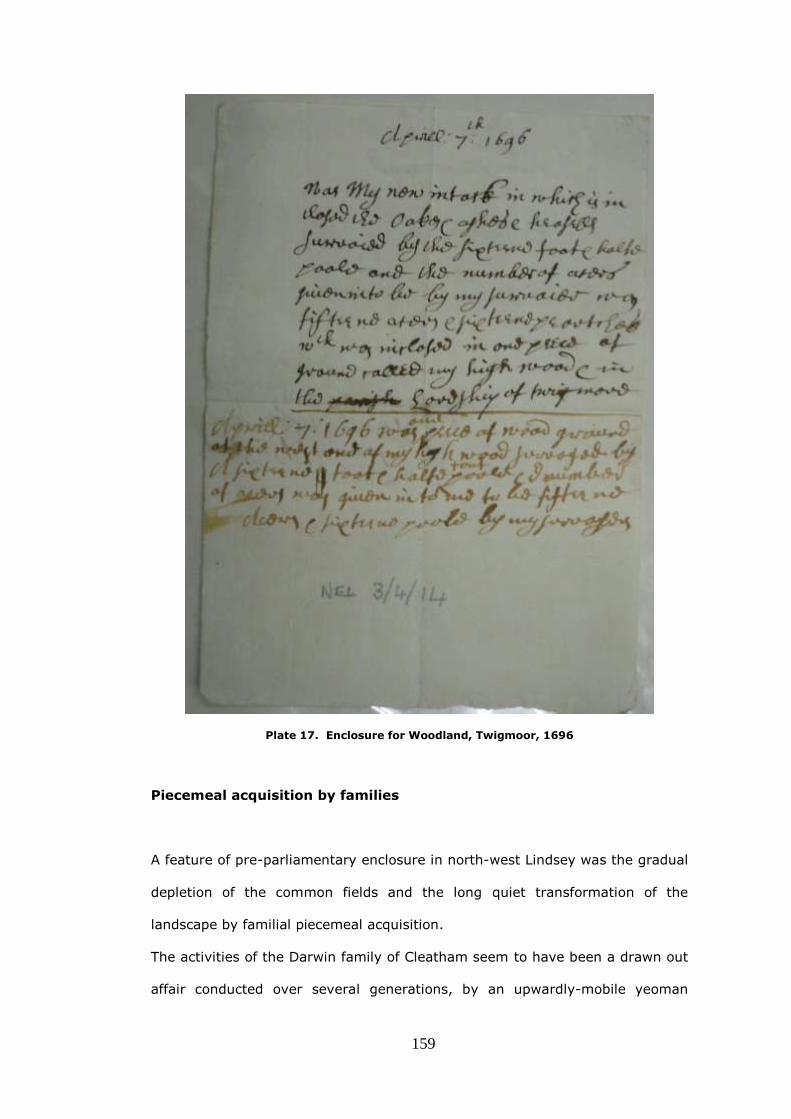
159
Plate 17. Enclosure for Woodland, Twigmoor, 1696
Piecemeal acquisition by families
A feature of pre-parliamentary enclosure in north-west Lindsey was the gradual
depletion of the common fields and the long quiet transformation of the
landscape by familial piecemeal acquisition.
The activities of the Darwin family of Cleatham seem to have been a drawn out
affair conducted over several generations, by an upwardly-mobile yeoman

160
family.49 The story of the improvement of Roxby is the history of the Elwes
family who acquired land piecemeal over a period of one hundred and seventy
years and eventually became landowners of almost all the parish.
The early history of enclosure in Roxby-cum-Risby is difficult to determine but
seems to have been associated with the two families of Hamerton and Elwes.50
Nicholas Hamerton was at Risby in 1600 and Sawcliffe by 1617, both in Roxby
parish and was said in 1619 to have recently erected the manor house at
Sawcliffe.51 S. A. Johnson reported that the terriers of Roxby-cum-Risby
showed that glebe land was dispersed in 1606 but had been consolidated and
enclosed by 1618, so it seems probable that Hamerton had been involved in
this.52 Jeremy Elwes, a London gentleman, then appeared on the scene. Jeremy
was the son of Geoffrey Elwes, an alderman of the city of London and member
of the Merchant Taylors' Company, and Jeremy was also a Londoner, having
been admitted to the freedom of that city in 1618. It may be that he had been
sufficiently successful in business to set himself up as a country gentleman in
Lincolnshire, because of his family connections with Nicholas Hamerton of
Sawcliffe, who was his uncle by marriage.53
On 25 May, 1622 Jeremy Elwes bought from Hamerton the ‘manor or reputed
manor’ of Risby, ‘the old lill fields, the new lill fields and lill garths, the meadow
known as lill ings in Appleby, the messuage called the grange of Risby, and
everything relating to the manor’, including the rectory, for £2,500. A few days
later, on 30th May, Elwes granted Nicholas Hamerton a lease of the premises
for life at a rent of £200.54 By 1634 Hamerton was at Walcot in Alkborough and
the Elwes family was purchasing land, which was both ‘dispersed in the fields’
and in closes, in Roxby-cum-Risby parish.55
In 1628 Jeremy Elwes acquired his first interest in Roxby by paying £550 to
John Eastoft (from the village of Eastoft (sic) in the Isle of Axholme), for the
rectory in the township ‘with appurtenant property’.56 A few years later, in
1641, Elwes, who was described as ‘of Broxboune, co. Hertford’, bought the

161
manor of Roxby and lands that had been formerly owned by George Lyon esq.
deceased, for £250.57 This sum seems to be a bargain, unless it was only a
part-payment of a rather larger figure. The title deed correspondence does not
suggest that Elwes actually resided in Roxby, he is ‘of Broxbourne ‘ or ‘of the
city of London’ and so it is possible that his uncle Hamerton was acting for him
in the Lincolnshire land market. In 1647 Edward Bowden of Roxby gentleman,
and Mary his wife mortgaged to Jeremy Elwes land in Roxby, listed in a terrier
of lands that was ‘dispersed in the church field in broad and narrow lands’, in
the middle and south fields and elsewhere, together with meadow and
pasture.58 There is no mention that the mortgage was redeemed and, later,
further property in Roxby was acquired from the Bowdens. In 1655 the ox close
of 20 acres was mortgaged to Jeremy Elwes ‘of Gray’s Inn, esq.’, who was the
son of Jeremy, senior and in 1657 a messuage and various lands including both
enclosed pastures and dispersed arable, which had been bequeathed to Mary
Bowden, were bought for £1000. In the same year further land was leased,
from Mary Bowden, for one hundred years.59 The acquisitions continued; lands
occupied by Francis Dent were bought in 1641, and in 1658-9, about seventy
acres of arable with meadow and pasture in the common fields, ings and north
cliff and far closes were purchased from a family called Lawson.60 In 1662,
various carr grounds totaling 182 acres which were part of the 5,827 acres
granted to Sir John Monson, for draining in the 1630s, the low-lying land
adjacent to the river Ancholme, were bought, and in 1667, two closes and
three acres of meadow were acquired from Thomas Pennyman of Stokesley in
Yorkshire.61
By this time it may be that the choicest parts of Roxby had been acquired
because, from 1654, Jeremy Elwes junior began to purchase land which had
belonged to the late Francis Tyrwhit in Kettleby, Kettleby Thorpe, Wrawby and
Brigg. This was property which would form a compact block in, and to the east
of Brigg and which left Roxby as an outlying estate.

162
In 1761 Cary Elwes (1718-82) who was Jeremy junior’ great nephew, although
presumably in favour of the enclosing activity in Roxby, was not so enthusiastic
about parliamentary enclosure, as is shown by his response to the suggestion
that another parish, where he owned considerable land, should be enclosed by
that method. He was afraid that enclosure would make the farmers of Wrawby,
east of the Ancholme, too independent of his control. 'I chuse' (sic), he wrote,
'my tenants to be all under my immediate protection, never to lease out my
own prerogative, not to have them raised by any hand but my own.'62
The last acquisition of property in Roxby as revealed by the Elwes title deeds,
is the purchase by his son, Robert Cary Elwes of the Cliff closes in 1793.63
A few miles to the south, in Scawby, about one thousand acres were enclosed
over a long period by the Nelthorpe family and it would seem, like the Elwes
family in Roxby, that there was a family ambition from the 1620s to build up
holdings and own the entire parish. The Nelthorpe family were hampered
however by the chaotic descent of the manor, and in consequence seem to
have lost sight of their objective. Because of this they were never able to
arrange a private enclosure ‘by agreement’, and instead the family had to rely
on a parliamentary act in 1770.
The descent of the manor of Scawby is complicated and is made more so
because various branches of the family intermarry into other distant branches
of the same family and because property was bequeathed to cousins, or even
an uncle, as the male line failed.64 During the time that the manor and
baronetcy was descending in this unsatisfactory manner through the decades,
land and other property in Scawby was being bought and sold by the
Nelthorpes and other landowners, and there is occasional evidence of
enclosure. In 1627 a cottage and seven acres of land ‘lately enclosed, called
Carr Ground’ was sold by John West a tanner of the township of Sturton in
Scawby to Richard Nelthorpe, and in 1633 Arthur Cressey, yeoman of Scawby

163
sold to Alexander Emerson, of Brigg, ‘a close of meadow in Scawby’.65 A few
months later Alexander Emerson, sold John Lighfoot, yeoman a piece of land
for £12 called Ings Close.66 In 1664 Richard bought a cottage and some
hempland for £18 from a Hull wine cooper called John Bewley.67
A document of 1666 conveys from Richard Nelthorpe to Sir John Monson of
Burton, four closes of lands and eight acres of meadow and pasture in Scawby,
in return for other lands in Scawby. This was perhaps an exchange, which
would make agriculture more convenient to both parties by consolidating
various properties and does indicate also the existence of enclosed land
already.68 Land transactions continued and in 1669 Richard Nelthorpe
purchased for £135 a messuage, hempland, four oxgangs of land and a cottage
in Scawby from Christopher Turswell and Anne his wife.69 In 1669 he bought a
close of meadow in Scawby for £34 from John Greene and Magdalen his wife.70
He was not above making smaller purchases, as in 1671 he bought one selion
of arable land in Scawby for £15 from Thomas and Dorothy Gillyat.71
The acquisitions went on, and in 1680 Richard and Elizabeth Stocks of
Castlethorpe, tanner, and John Stocks of Messingham a husbandman, sold to
Richard Nelthorpe, the North Close in Scawby, together with two oxgangs of
arable land in the parish. Later in the same year there were more purchases
from tanners; Richard bought from Stephen Burkenshaw, tanner of Broughton,
Thomas Smyth, tanner of Broughton , William and John Greene, tanners of
Scawby three pieces of carr ground in Scawby called the Cottagers' Carr for
£64. 72 Finally Richard Nelthorpe buys a cottage and hempyard in Scawby from
David Popplewell for £20.73
The Nelthorpe’s ambitions seemed to have run out of steam by 1685, but at
the time of the Scawby Enclosure Act of 1770 one thousand acres of the parish
(31%) had been enclosed and the family had made their mark on the
landscape with 2216 acres remaining to be enclosed by the award. This area
was divided into seventy-seven new plots by the parliamentary commissioners

164
and awarded to eighteen landowners. A feature of the award is the size of
some of the fields; nine of the Nelthorpe general allotments were over one
hundred acres. This was perhaps to reduce the amount of money that would
be needed to hedge the allotments, such hedging being usually specified in
enclosure awards. Whatever the reason, the ambitions of the Nelthopes had
been realised, ultimately, by the more convenient means of parliamentary
enclosure.
The 1788 Appleby glebe terrier is unusual as it not only lists the possessions of
the church in that year, but also mentions, by reference to earlier terriers, the
losses of glebe and tithe to the Winn family’s enclosing activity over the
years.74 It is signed by ‘Stepn Moore’ ,who was vicar of Appleby from 1780 to
1807, and whose patron was Sir Rowland Winn:75
It appears by the terrier exhibited in 1707 that there were then three
Cottage Houses with a considerable quantity of Glebe Lands all
belonging to the Church for the Repairs thereof, all of which is so mixed
and blended with Sir Rowland’s Winn’s estate that it is absolutely
impossible to be ascertained.
In evidence given to the Royal Commission on Agriculture in 1895, the Winn
family’s land agent mentions that in Appleby there had been a system of
allotments since 1711, whereby forty-two holdings, each with three and three
quarters acres of grass and a half acre of garden were let to agricultural
labourers and others.76 If this information was true, and not merely an
attempt to improve the Winn family image, it seems that from the early
eighteenth century an unknown proportion of the land had been organised into
small closes, and that plots were being rented to tenants as a form of
recompense for common rights that they had lost. It does not seem that the
church had been similarly recompensed.

165
A lack of ancient closes
Not all the parishes in the study area provide plentiful examples of old
enclosure. Winterton parish is noticeable by its lack of ancient closes. It may
be that the reason for this lies in the distant past. At the time of the Domesday
survey Winterton was divided into as many as eight holdings.77 The largest
holdings were those held by the King as part of his soke of Kirton-in-Lindsey
and by Earl Hugh as part of his soke of West Halton, each reckoned at 4
carucates. Together the holdings supported a large population consisting wholly
of sokemen and bordars totalling thirty-three.78 A sokeman was a free man
enjoying extensive rights, especially over his land, while a bordar was a feudal
tenant holding a cottage and usually a few acres of land, at the will of his lord
and bound to menial service. It is tempting to speculate that this existence of a
comparatively large number of owners in 1086 continued somehow, over the
centuries and was the reason why, in the nineteenth century, it had become
an ‘open village’ with numerous freeholders. The presence of many owners
could have been the reason why only a relatively small area of land, within the
parish, had become ‘old enclosure’ by the time of parliamentary enclosure in
1770-2. In these circumstances, it might be more difficult to form consolidated
holdings which would be worth enclosing. The acreage awarded in 1772 was
3,185 acres; therefore only 294 acres or 8.5% had already been enclosed, and
some of that was accounted for, by the tofts and crofts of the township.79

166
Delays and impediments
In earlier times enclosure, whether it was by private agreement or by validation
through an action in the Chancery court, had required the undisputed consent
of all the owners of both land and common rights. There was also the drawback
that its validity could be challenged in a court of law, even many years later. By
contrast, the passing of a private bill of enclosure allowed the process without
unanimous consent, could lay down the conditions by which the award would
be made, and was much less prone to litigation.80
In the study area parliamentary enclosure should not be seen as the procedure
which ‘transformed the landscape ‘as is claimed by some commentators, but
rather can be viewed as a more convenient way of enclosing areas of open
land that remained, for one reason or another, in a patchwork of enclosure that
had begun centuries before.81
While this new method could smooth its progress, there were still delays and
impediments for various reasons, even when the number of landowners was
few. Illness, quarrels between owners, tardiness by the commissioners and
indifference, all played a part in holding-up the completion of the enclosure of
the study area.
Manton township might have been enclosed twenty years or so before the
award was made in 1829. When the act was passed in 1805, the owner of
practically all the land in the township was William Dalison, but the act
describes him as ‘a lunatic in the custody of the Lord High Chancellor.’82 Part of
the reason for the lengthy enclosure of Manton must be the circumstances of
William Dalison’s illness and a succession of deaths in the family. William
Dalison himself died in January 1809. His only sister and heiress, Frances
Isabella Master, died in December 1818 leaving Manton and the rest of her

167
estate to her cousin William Hammond, on condition that he should take the
name Dalison and restore the family home in Kent. Unfortunately he died in
November 1821 without having changed his name and it was his son
Maximilian Dudley Digges Hammond who finally assumed the name Dalison.
After the death of Frances, three Devisees in Trust were appointed to oversee
the estate and its enclosure, but the circumstances of those appointments is
not clear from the award and the reader is left to ponder the motivations of the
various appointees and wonder if any of them had reasons to delay its signing.
Only a quarter of the township had remained to be enclosed and the late
William Dalison had been by far the predominant owner, so the question arises
as to why parliamentary enclosure was required at all. Perhaps it was to do
with tithe and glebe and the legalising, or regularising, of property swaps
between the church and the Dalisons. The award mentions exchanges of land
between the Dalison Trustees and the Rector and it appears as though some of
the glebe land, that had been scattered throughout the area of old enclosure,
was consolidated into an area immediately surrounding the church.
The reason for the length of time that it took for the award to be signed
remains uncertain however, and difficulties with the succession of the title
cannot explain all the delay. Perhaps it is noteworthy that one of the two
Manton commissioners, John Burcham, had been the only commissioner during
the protracted enclosure of Grimsby and, for reasons that are not clear, that
process took thirteen years.
There is no clue as to who had been the originator of the idea of parliamentary
enclosure in Manton. It may be that William Dalison, who was born in 1730,
had spent part of his long life enclosing those parts of the township that could
be enclosed without difficulty, and that it was always his intention to complete
the task by parliamentary means, and was only prevented by infirmity from
doing so.83 Perhaps the entire township had already been enclosed and it was
thought legally sensible to validate some, or all, of the most recent

168
improvements by an act and award. On the other hand it could be that legal
advisors of his sister believed that inheritance problems, while William Dalison
was confined as a lunatic, could be eased by an act and award. If he had not
been a lunatic, then enclosure by an act may not have been needed at all.
It might be thought that, in townships and parishes with few owners, it would
be easy to organise parliamentary enclosure, but family rivalries or seeming
indifference on one side sometimes made the process lengthy and complicated.
While the estate of Lord Yarborough was centred on a very large block of land
some miles to the east, the family had substantial holdings in the study area.
A manuscript of 1813 indicates that an attempt was made by Lord Yarborough
to initiate parliamentary enclosure in Broughton in August of that year.84 He
may well have thought that the time was overdue for the parliamentary
enclosure process to start in Broughton. To the west Ashby had been enclosed
by an act between the years 1801-9; to the east, across the Ancholme,
Wrawby had been enclosed in 1801-5. Scawby to the south had succumbed to
an act in 1770-1. Only to the north at Santon township in Appleby parish was
there land still to be enclosed and, in that parish, Lord Yarborough was in
dispute with the other major landowner, Charles Winn.
In November of that year a petition was presented in parliament setting forth
the standard reasons for enclosure in Broughton.

169
Plate 18. Broughton petition Source: Journals of the House of Commons 1688-1834, vol
69, 17 Nov 1813, p.38
Despite a fellow north Lincolnshire landowner, Charles Chaplin, and Lord
Yarborough’s own son C. A. Pelham being ordered to prepare the bill, after
those dates there is nothing to be found in the record and it appears that the
venture was abandoned.85 The other major landowner in Broughton, Mr E.
Anderson Stephens of Bower Hall, Steeple Bumstead in Essex had his seat in a
region that was not noted for enclosure by parliamentary means. By 1813 there
had only been twenty-one parliamentary enclosures in that county, and none of
them had been in the immediate area of Bower Hall.86 Although he might
reasonably have hoped to see his new Lincolnshire possessions producing more
rent as enclosed lands, for some reason this was not the right time for him to
make a move.
Whatever the reason for the delay in enclosing Broughton in 1813, Lord
Yarborough was not to be thwarted in his desire for agricultural improvement
and he turned his attention to another of his properties, the township of
Santon, one mile to the north in Appleby parish.
The land tax assessments confirm that in 1782 there were only two
landowners, Winn and Yarborough, paying the tax in Appleby parish. In 1820

170
the total tax for the 5,180 acre parish was £140-12-0 of which Lord Yarborough
paid £12-9-6 for the 921 acres of Santon.87 If all the land of the parish had
been of equal value, it would have been expected that Yarborough would have
to pay exactly £25 in tax.88 In fact £12-9-6 is almost exactly half that figure, so
it can be reckoned that Santon was thought to be half as valuable per acre as
the rest of the parish. Modern day field walking confirms this, as the land to the
west of Ermine Street is noticeably poorer and sandier than that lying on the
east side, on the slope down to the Ancholme. While the Winn family had
pursued a policy of agricultural improvement in their part of the parish, it would
seem that this was not the case in that part of Appleby that had not been sold
to Winn, and was still in the possession of Anderson’s descendant Lord
Yarborough. Perhaps this seeming neglect was partly because East Santon
hamlet was an outlying property on poor soil, and Lord Yarborough’s
agricultural improvements had thus far been concentrated on better land, in
the relatively compact block of his 55,000 acre estate, based on Brocklesby,
about twelve miles to the east.89 A general survey of the Yarborough estates
was carried out in 1809-10 and mention was made of just two closes in High
Santon; Pond close and Santon Close.90
On 25 August 1815 the first of three weekly notices were published in the
Stamford Mercury, by the solicitors Hesleden and Nicholson of Brigg, that '. . .
Application is intended to be made to Parliament, in the next session, for leave
to bring in a Bill for inclosing lands and making compensation for tithes, within
the Hamlet of East Santon otherwise Upper Santon, in the parish of Appleby. .'.

171
Plate 19. Rutland and Stamford Mercury, 25 August 1815
Nothing more, however, was heard about the enclosure of East Santon for ten
years and a petition has not been found requesting leave to introduce a bill.
In general, large proprietors in a parish were likely to have welcomed the
prospect of enclosure and done nothing to stand in its way. If there were
smaller owners, the larger ones might well have been in the forefront to
persuade them, or perhaps to bully them, into agreement. This was not of
course the case in Santon, as there were only two owners. While both families
tended to be on different sides of the political fence: Winn, the Tory and
Yarborough, the Whig, this does not seem sufficient reason to prevent an
enclosure from proceeding.91
The clue to the delay is perhaps in the wording of the enclosure Act’s preamble,
when it finally came in 1825.92
Unusually the Act incorporates the phrase ‘is or claims to be’ in respect of
both Charles Winn and Lord Yarborough, so it seems likely that some sort of
internecine conflict, over rights and properties, had caused the hiatus.

172
Plate 20. Part of the preamble of the Inclosure act of East Santon 1825
(LAO: YARB/17/3)
In 1817 Charles Winn had succeeded to his estates on the death of his brother
John and in 1823 C.A. Pelham, the first Lord Yarborough, had died and he had
been succeeded by his son, also C.A Pelham, the second Lord. The indications
are perhaps that, after ten years of delay caused by the failure to make an
agreement between John Winn and the first Yarborough, by 1825 the two
sides in the quarrel (with a new team in place), had decided to proceed with
enclosure leaving the parliamentary commissioners to make an attempt at
reconciling the claims.
The minutes of the commissioners are stilted, staccato and incomplete, and
plainly betray the frustration that must have been felt as they encountered
claim and counterclaim from the two proprietors, made on their behalf by their
agents; William Dinsdale for Lord Yarborough and John Saunderson Bennett for
Charles Winn. Often a Commissioners’ meeting began with the words: ‘There
being no proprietors present…’ and ended without anything substantive being
recorded.
One point is clear from a very early stage, Lord Yarborough did not accept
Charles Winn’s claim that he was Lord of the Manor of Upper or East Santon. It

173
is to be supposed that Yarborough considered that he had retained this, when
his Anderson ancestor had sold the rest of the parish to the Winn family. The
award was finally signed on 26 February 1833, which was about eleven months
after the Commissioners’ minutes had become a succession of almost blank
pages, with only a few words on each.93
Plate 21. Detail of East Santon Inclosure map 1833 (LAO: APPLEBY PAR/17/1)

174
While the 1833 Award had the effect of exonerating from tithes all lands in east
Santon, a dispute of 1846, sparked by the arrival in Appleby of an assistant
tithe commissioner, did manage to embroil the hamlet once more. The old
animosities still sparked and Charles Winn made several objections to the draft
tithe award; amongst these was the claim that he should have had some of the
land awarded to the vicar at the 1833 parliamentary enclosure. After a great
deal of correspondence between the parties, the assistant tithe commissioner
pronounced that he was not persuaded by Mr Winn’s arguments and the vicar
retained his land.94
With Santon in Appleby parish now enclosed, the former M.P. C.A Pelham, now
the second Lord Yarborough, turned his attention to his late father‘s unfinished
business in Broughton.
Although the Yarborough estate papers are silent on the subject of enclosure in
Broughton it seems likely that, in the years since the first attempt at
parliamentary enclosure in 1813, the piecemeal process carried on, with those
areas which seemed logical and appropriate, being formed into closes and
larger enclosures. Because such a large proportion of the land in the parish
belonged to the two men, it would not be necessary to devise formal
agreements, which would have tended to find their way into the records. 95
The General Enclosure Acts of 1836 and 1840 had eased legal requirements to
enable enclosure to take place without Commissioners. The twenty-six acres of
Burringham township in Bottesford parish were enclosed in this way. Because it
seemed that some smaller owners had been ill-treated as a result of enclosures
carried out under the 1836 and 1840 General Acts, an 1845 General Enclosure
Act was passed. This Act attempted to provide better safeguards against
discrimination by the appointment of assistant commissioners and surveyors
who enquired into the intended enclosure before it could go through, and who

175
were responsible for executing it.96 Waddingham Cow Fold, as well as
Broughton Common and Carrs was enclosed in this way.
The owner, of a large part of the parish, since 1813 had been E. Anderson
Stephens of Bower Hall, but he died in 1844 and trustees, acting for his
daughters, then began the process of selling his Broughton properties to John
Coupland (who was also representing the 2nd Lord Yarborough), to Joseph
Moore and to other smaller purchasers.
Plate 22 : Broughton west of Ermine Street, from Bryant’s map of 1828, amended to
show extent of 1846-9 Parliamentary Enclosure
A = Town Carr, B= Low Carr and C= Old Man Carr
It seems significant that the description of the lands that were intended to be
enclosed, thirty years or so before, in 1813 had been all-embracing, with
mention being made of every type of land, ‘all the open Commons, Meadows,
Pastures, Cars, Commonable Lands and Waste Grounds,’ while, in February
1846, when Broughton’s parliamentary enclosure was successfully set in train,

176
(and the sale of the Stephens estate not yet completed) only the common and
three named carrs were listed, and so it is likely that these lands were all of the
parish that remained to be enclosed. The award, which commutated the tithes
of Broughton, had been confirmed by the tithe commissioners on the 19
October 1841, so this aspect of the process was no longer a complication. 97
An application to enclose ‘Broughton Common, the Town Car, the Old Man Car,
and the Low Car’ was received by the authorities on 7 February 1846; the
intended area was stated to be 878 acres 2 roods 16 perches.98
The enclosure was administratively very different from earlier parliamentary
enclosures in the area, because it was conducted in part, at arms length, by
the ‘Inclosure Commissioners for England and Wales’ who managed the process
by issuing pro-forma letters from their office on New Street, Spring Gardens,
next to Admiralty Arch in London. Some of these pro-formas survive in the
deposited records of Nicholson, Hett & Freer, solicitors of Brigg.99 The first,
dated 7 February 1846, acknowledges the receipt of an application for the
enclosure of lands in Broughton and requests that Lord Yarborough’s power of
attorney be forwarded to the office. Soon afterwards, on 16 March, the
Commissioners sent a public announcement of the proposed enclosure, and
asked that it be fixed to the ‘principal outer door’ of the parish church ‘on
Sunday next before Divine Service.’ On the 20 May they ordered that a meeting
be called for Wednesday 10 June at the Red Lion Inn in Broughton and that
notices of the meeting be deposited at the inn and, as before, fixed to the
church door. Matters were moving quickly, as on the 1 July, the Commissioners
send notices of a meeting to be held to appoint a Valuer, and, asked whether
the presence in Broughton of an Assistant Commissioner, was necessary. The
expense of accommodation and travel could be avoided if the Assistant
Commissioner did not journey up to Lincolnshire, but the 1845 Act offered this
option, as a safeguard in the enclosure process, if it were thought necessary.
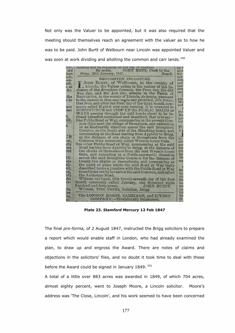
177
Not only was the Valuer to be appointed, but it was also required that the
meeting should themselves reach an agreement with the valuer as to how he
was to be paid. John Burtt of Welbourn near Lincoln was appointed Valuer and
was soon at work dividing and allotting the common and carr lands.100
Plate 23. Stamford Mercury 12 Feb 1847
The final pro-forma, of 2 August 1847, instructed the Brigg solicitors to prepare
a report which would enable staff in London, who had already examined the
plan, to draw up and engross the Award. There are notes of claims and
objections in the solicitors’ files, and no doubt it took time to deal with these
before the Award could be signed in January 1849. 101
A total of a little over 883 acres was awarded in 1849, of which 704 acres,
almost eighty percent, went to Joseph Moore, a Lincoln solicitor. Moore’s
address was ‘The Close, Lincoln’, and his work seemed to have been concerned
178
with church leases.102 He could well have been employed by the Archdeaconry
of Lincoln and Stow in the Registrar’s office at Lincoln and it may be that,
because of the expertise he had built up there and also the wealth that he
accumulated, Joseph Moore was able to invest in property on his own account.
The surveyor was not a local man, but a Mr M. Brady who was perhaps sent
from London to draw the plan, which would accompany the award. He signed it
giving his address as 55, Chester Street, Kennington Lane in Lambeth. The
plan is notable for the small amount of detail that is shown on such a large
scale map; old enclosures are not shown for example. It is drawn at three
chains to one inch, and measures 178cm x100cm, or nearly six feet long, by
over three feet wide. Despite its size, only the north-eastern quadrant of the
parish is depicted on the plan. Large sizes were not unusual for plans made
under the 1845 General Enclosure Act.103
Here the delay in enclosing Broughton must have been mainly due to the wait
for the absentee landlord E. Anderson Stephens to die, but would have been
stimulated by the General Enclosure Acts which facilitated the process and by
the appearance of Joseph Moore who wished to invest in land.
The last parliamentary enclosure award that was made in the study area was in
Frodingham parish, and was of 785 acres of the East and West Commons of
Brumby township in 1875. Four years earlier 605 acres of the Moors in that
same township had been awarded by the same parliamentary method.104 A
total of 1,309 acres was thus enclosed in the 1870s in a township which
contained 2,852 acres, and a little over 1,500 acres of (presumably) the
common fields had therefore already been enclosed by the Earls of Beauchamp
using other means.105
Perhaps a reason for the late enclosure of Brumby Moor and the West Common
was that the 4th Earl Beauchamp did not wish the expense of improving land
some of which was subject to regular flooding, or perhaps was indifferent to the

179
condition of land far from his residence in Worcestershire. 106 After his death,
in 1863 aged 79, his successors seemed to have taken a different view and
arranged for the low-lying land to be warped, before arranging for an award
confirmed by a provisional order.107
Although Brumby Moor in 1871, and the West Common by the river Trent in
1875, were enclosed for agricultural reasons, there is little doubt that the
discovery of ironstone, in the fields of Frodingham East Common and
Scunthorpe East Common in 1859, will have been the incentive for the 1875
enclosure of the adjoining Brumby East Common
Conclusion
And so at the end of an agrarian process, lasting hundreds of years, the
enclosure of these last few hundred acres of the study area was not motivated
by any wish for agricultural improvement, but rather by thoughts of the mineral
wealth, which was known by that time to be buried under the ground.
The transformation of the whole area had taken took place over several
centuries in different forms, and sometimes different forms had been used in
the same parish. Any notions that parliamentary acts alone had been used to
transform the landscape, during the period of the four Georges, do not apply in
the area.

180
References
1 C. N. L. Brooke and M. M. Postan, Carte Nativorum, Northants. Rec. Soc., vol
20 (1960), pp. 171-2
2 D. M. Owen, Church and Society in Medieval Lincolnshire (Lincoln, 1971), p.62
3 D. Knowles, The Religious Orders in England (Cambridge,1979), pp.64-5
4 According to T. Head, Medieval Hagiography: an Anthology (2001), p.496
5 C. Moor, The History of Manton: Derived from Various Published and Manuscript
Sources by Oxoniensis, and Reprinted from the ‘Gainsburgh News’ (
Gainsborough, 1903 ), pp.5-6
6 LAO: Nel III/4/11, ‘Tarrier’ of lands of the manor of Twigmore lying within the
parish of Manton, the hall and various closes, 6 May 1638
7 LAO: Nel III/4/1-14
8 K. Cameron, The Place Names of Lincolnshire, Vol. 6 (Nottingham, 2001), p.80
9 W. Page (ed.), The Victoria History of the County of Lincoln, Vol. 2 (1906),
p.156
10 E. Peacock, English Church Furniture, Ornaments and Decorations, at the
Period of the Reformation. As Exhibited in a List of the Goods Destroyed in
certain Lincolnshire Churches, A.D. 1566 (1866), pp.242-3
11 W. Page (ed.), The Victoria History of the County of Lincoln, Vol.2 (1906),
pp.166-8; The remains of the priory are most likely centred at SE 965 125.
12 J. E. Burton, Monastic and Religious Orders in Britain, 1000-1300 (Cambridge,
1994)
13 N. Loughlin, and K. Miller, A Survey of Archaeological Sites in Humberside
carried out for the Humberside Joint Archaeological Committee (Hull, 1979),
p.177

181
14 C.W. Foster (ed.), Lincolnshire Domesday and the Lindsey Survey (Lincoln,
1924), p.lxxxii
15 Place name evidence in K. Cameron, The Place Names of Lincolnshire, Vol. 6
(Nottingham, 2001), pp.52, 93-4
16 C.W. Foster, (ed.), Lincolnshire Domesday…pp.liii-lxxxvii; Canon Foster
mentioned most of the deserted or reduced settlements known in his time, but
others like Sawcliffe and Darby have been recognised more recently and, no
doubt, others remain to be found.
17 University of Nottingham Manuscripts and Special Collections: Records of the
Clerk's Department of the Trent River Authority and its predecessor bodies,
1760-1975, ref: RC.L.6, Alkborough Enclosure Award and Plan, 1768
18 B. Dodds & R. Britnell, Agriculture and Rural Society after the Black Death:
Common Themes and Regional Variations (Hatfield, 2009), p.150
19 Ibid, p.liii. Great Conesby seems to have combined with the hamlets of Crosby
to the south and Gunness to the west.
20 G.Platts, Land and People in Medieval Lincolnshire (Lincoln, 1985), p.171
referring to documents in TNA under category C135.
21 E. Power, The Wool Trade in English Medieval History (Oxford, 1941), p. 35:
‘It is difficult to find signs of that whole-sale substitution of pasture for arable
farming which, according to textbooks , happened after the Black Death.’ The
same opinion appears in J.L. Bolton, The Medieval English Economy, 1150 -
1500 (London, 1980), pp.207-45. Other scholars suggest that there was indeed
a shift from arable to pastoral farming in the late fourteenth- century; see for
example, B. M. S. Campbell and M. Overton, ‘A New Perspective on Medieval and
Early Modern Agriculture: Six Centuries of Norfolk Farming, c.1250 - c.1850’,
Past & Present, 141 (1993), pp.38–105.
22 LAO: Misc Dep 77/1, Survey of the Soke of Kirton in Lindsey, 1616. (A copy of
the original, which is in the Cambridge University Library, at Ff.4.30 )

182
23 ‘Gamal’s secondary settlement, outlying farmstead or hamlet’ , K. Cameron,
The Place Names of Lincolnshire, Vol. 6 (Nottingham, 2001), p.70
24 LAO: Hibaldstow Par /17/2, 1803
25 A. de la Pryme, 'A Letter of the Reverend Mr Abr. de la Pryme to the
Publisher, concerning Broughton in Lincolnshire…’, Philosophical Transactions
Vol. 22 (1700 - 1701) , quoted in R. E. Armstrong, ed., An Industrial Island: A
History of Scunthorpe (Scunthorpe, 1981), p.5
26 British Library, Add.MS 11574, fos. 66–94 A Briefe of Depopulacons Taken by
Vertue of the Commission for Lincolne Kesteven and the County of the Cytie of
Lincolne
27 LAO:MCD708; The returns are discussed by J.D. Gould, ‘The Inquisition of
Depopulation of 1607 in Lincolnshire’, Economic History Review, 264 (1952),
pp.392-396
28 J.D. Gould, ‘The Inquisition of Depopulation’, p.394
29 Ibid, p.395
30 J. Thirsk, English Peasant Farming (1957) pp.181; But great depopulations
were reported in the villages of Blyborough and Cammeringham to the south of
the study area.(LAO:MCD708)
31 This subject is discussed in greater detail in the methodology section on Glebe
Terriers.
32 LAO: Terrier bundle, West Halton
33 LAO: Whitton Glebe Terrier Bundle; W. Page (ed.), The Victoria History of
the County of Nottingham, Volume 2 (1910), pp.129-38
34 Sir William Wray, together with his father, had destroyed three townships
elsewhere in Lindsey. He was subsequently prosecuted in Star Chamber, fined
183
and ordered to rebuild farms and to restore lands in three villages to arable: J.
Walter, ‘ "The Pooremans Joy and the Gentlemans Plague": A Lincolnshire Libel
and the Politics of Sedition in Early Modern England', Past and Present, 203:1
(2009)
35 A number of prosecutions followed the 1607 commission, including the
conviction of twelve Lincolnshire enclosers who had been active to the south of
the study area: vide, J. M. Martin, ‘Enclosure and the Inquisitions of 1607: An
Examination of Dr Kerridge's Article “The Returns of the Inquisitions of
Depopulation” ’, Agricultural History Review, 30 (1982) , pp.41–8.
36 M.W. Beresford, 'Habitation Versus Improvement: The Debate on Enclosure by
Agreement', in F. J. Fisher (ed.), Essays in the Economic and Social History of
Tudor and Stuart England, in Honour of R H, Tawney (Cambridge, 1961), pp.40-
69, but Roger Manning, contends that Beresford exaggerated the extent of real
agreement and ignored intimidation by landlords in R.B. Manning, Village
Revolts; Social Protest and Popular Disturbances in England, 1509-1640
(Oxford, 1988), chapter 5.
37 An account of the Ancholme drainage scheme is given in the chapter,
Drainage, Warping and Enclosure.
38 LAO: Misc Dep 77/1 ‘General Survey of the Soke of Kirketone in Lindsey’ 1616
This is a handwritten copy of the original in the Cambridge University Library, at
Ff.4.30
39 Cameron defines the word ‘warneot’ as meaning an allotment of land that is
‘subject to some form of defence or protection’ : K. Cameron, The Place Names
of Lincolnshire, Vol. 6 (Nottingham, 2001), p.101
40 LAO: Misc Dep 77/1
41 The survey does mention enclosures in the soke of Kirton in Lindsey at
Wharton near Blyton , and at Northorpe according to J. Thirsk, English Peasant
Farming; The Agrarian History of Lincolnshire from Tudor to Recent Times
(1957), p.181

184
42 LAO:Misc Dep 77/1,
43 Ibid
44 LAO: D & C, DIV/59 quoted in J. Thirsk, (ed.), The Agrarian History of England
and Wales, Vol. V.II, 1640-1750: Agrarian Change (Cambridge,1985), p.318
45 LAO: Glebe Terrier Bundle, Redboune,1638, 1662, 1668,1700
46W. K. Morton (ed.) Lincolnshire Notes and Queries, vol 7 (Horncastle, 1901),
pp.38-9, apparently being derived from the Dalison family muniments deposited
in the Kent County Record Office.
47 A. de la Pryme, The Diary of Abraham de la Pryme, the Yorkshire Antiquary,
Surtees Society, 54 ( Durham, 1870), p.135
48 LAO: Nel III/4/14, ‘Memorandum of an Intake’
49 In Manton parish the Darwins bought up and enclosed piecemeal, the
township of Cleatham between about 1624 and 1710. The activities of the
family are described in the Reasons for Enclosure chapter.
50 More complete details of the purchases can be found in the Elwes family
papers in the Lincolnshire Archives and in the Lincolnshire Archives Committee,
Archivists' report 20, 17 March 1968 - 15 March 1969 (Lincoln, 1970), pp.9-12
51 LAO: Elwes 1/2/2,9,10 . This is the same Nicholas Hamerton who with Martin
Brighouse of Alkborough were servants of Chief Justice Sir Christopher Wray.
52 S.A. Johnson, ‘Some Aspects of Enclosure ‘, Lincolnshire Architectural
and Archaeological Society Reports, 9:2 (1962), p.144. The present
writer could not however find in the LAO, the two glebe terriers of 1606
and 1618, which Johnson mentions in his article.
53 Archivists' report 20, p.10; Geoffrey’s sister Isabel Elwes, had married
Nicholas Hamerton

185
54 LAO: Elwes 1/2/5-7
55 E. Green, ‘The Gentry of Lincolnshire in 1634’, Lincolnshire Notes and Queries,
II (1890), p.39; LAO: Elwes 1/2/9-21
56 LAO: Elwes 1/1/7
57 LAO: Elwes 1/1/9
58 LAO: Elwes 1/1/11
59 LAO: Elwes 1/1/14-16
60 LAO: Elwes 1/1/10,17-21
61 LAO: Elwes 1/1/22-25,26
62 G. Jackson, ‘Cary Elwes-Lord of Brigg’, Lincolnshire Historian, 2:12 (1965),
p.8; Wrawby was enclosed forty-five years later in 1805.
63 LAO: Elwes 1/1/26-55
64 Maddison, Lincolnshire Pedigrees, vol. II, pp.424-5 and pp.702-6 and T. R.
Leach, Lincolnshire Country Houses and their Families: Part Two (Lincoln,1991),
p112-3
65 LAO: NEL VI/14/3/2, 16 February 1626/7; LAO: NEL VI/7/2 30 November
1633
66 LAO: NEL VI/11/6, 4 July 1634
67 LAO: NEL V/3/22, 17. November 1664
68 LAO: NEL VI/13/17, 25 Sep 1666
69 LAO: NEL V/3/23, 25 September, 1665; LAO: NEL VII/3/11, 15 January
1668/9

186
70 LAO: NEL VI/14/3/12, 26 April 1669, Indenture of bargain and sale.
71 LAO: NEL VI/14/3/15, 1 August 1671, Indenture of bargain and sale.
72 LAO: NEL VI/10/19, 29 January 1680/1, Indenture of bargain and sale; NEL
VI/10/22 22 December, 1681, Indenture of bargain and sale.; It may be that
the tanners were selling steeping pits in the Carrs, which were no longer
needed.
73 LAO: NEL VI/15/12, 9 April 1685 Indenture of bargain and sale NEL
VI/14/3/44 11 June 1689; Indenture of grant; NEL VI/17/11, 4 Sept. 1691
74 LAO: Terrier bundle, Appleby
75 LAO: Register XXXIX, Episcopal Register of Bishops John Green, Thomas
Thurlow and George Pretyman
76 LAO: Scorer Farm 3/7, Royal Commission on Agriculture, Report on the
County of Lincolnshire, by Mr. Wilson Fox, Assistant Commissioner C.7671, XVI
(1895), p.93
77 TNA:E31/2/2 Great Domesday Book 1086/7, Wintrintone, There are seven
entries ; C. Gowen Smith, A Translation of that Portion of Domesday book which
relates to Lincolnshire and Rutlandshire (1870), pp.16-17,79,113,171,177,179,
193, 237
78 P.L. Everson, D. Stocker, Summoning St Michael: Early Romanesque Towers
in Lincolnshire (Oxford, 2006), p.291
79 LAO: KR/2/2, Sokemote of Kirton Saturday, and Wapentake Courts of Aslacoe,
Corringham, Kirton Friday and Manley Wapentakes, 25 Jan 1772 - 12 May 1775,
pp.22-46
80 J. Blum, ‘English Parliamentary Enclosure [Review Article]’, Journal of Modern
History 53 (1981), p.478;
187
81 For example: R. Muir, The New Reading the Landscape: Fieldwork in
Landscape History (Exeter, 2000) and many others
82 LAO: Lindsey Award/179, Manton Enclosure Award and Plan 1829 (bundled
with a copy of the Manton Enclosure Act, 1805).
83 The Hibaldstow Act of 1796, which involved William Dalison, had made no
mention of his infirmity, so perhaps dementia had afflicted him in old age; LAO:
Lindsey Award/38 Hibaldstow Enclosure Award and Plan 1703, (bundled with Act
of 1796)
84 LAO: Stubbs 1/27, Notice of Intended Inclosure, 1813
85 R. G. Thorne, The House of Commons, 1790-1820, Volume 1(1986), p.243; No
news items have been found that would indicate opposition to enclosure.
86 Steeple Bumpstead was not parliamentarily enclosed, and none of the
surrounding parishes (except 38 acres of Sturmer in 1845) was enclosed in that
manner, vide: W.E. Tate (ed., M.E. Turner), Domesday of English Enclosure Acts
and Awards (Reading, 1978), pp.110-114
87 LAO: Land Tax Assessments, Appleby 1782, 1820.
88 Based on the 921 acres of the Santon Enclosure Award, being 17.8% of the
entire parish.
89 B. Short, Land and Society in Edwardian Britain (Cambridge, 1997), pp.212-3;
C. K. Rawding, The Lincolnshire Wolds in the Nineteenth Century (Lincoln,
2001), pp.56-62
90 LAO: Yarb 5/1/33, General survey and valuation, High Santon et al (1809-10)
91 R. J. Olney, Lincolnshire Politics 1832-1885 (Oxford, 1973), pp.166,253
R. G. Thorne, (ed.) The House of Commons, 1790-1820, Volume 1 (1986), p.67;
H. S. Smith, The Parliaments of England: from 1st George I., to the Present
Time, Volume 2 (1845), p.144

188
92 LAO: YARB/17/3, Upper Santon Inclosure Act and Commissioners' minutes, 6
Geo 4, c 26 ‘An Act for inclosing and exonerating from tithes lands in the hamlet
of East Santon otherwise Upper Santon In the parish of Appleby in the county of
Lincoln’
93 LAO: APPLEBY PAR/17/1 Award and plan for East Santon (also called Upper
Santon) together with the oaths of impartiality of the enclosure commissioners.
94 TNA: IR 18/4711 Appleby and IR 18/5227 East Santon; LAO: YARB
3/3/3/3/2, The bundle contains copies of abstracts of title, requisitions on title,
memoranda, correspondence, and sketch plans and dates from 1846-9
95 In 1825, Mr Stephens paid about a quarter of the total land tax, while
Yarborough paid almost half of it. LAO: LTA Manley 1825, Broughton land tax
assessment.
96 8 & 9 Vic. c.118; W.E. Tate (ed., M.E. Turner), Domesday…, p.329
97 TNA:IR29 20/59 and IR18 4798, Broughton
98 Reports from Committees, 22 January - 28 August 1846 Session, PP, Volume
6, Part 2, p.21
99 LAO: Stubbs /1/27/2-3, Broughton Common Enclosure correspondence
100 John Burtt had worked as a valuer, surveyor and as a referee in land disputes
from the early 1830s; for example, LAO: 2 RED 4/9/5/5, 25 January 1832. He
was a member of a well known Quaker family, vide M.B. Bowen, The Burtts: a
Lincolnshire Quaker Family 1500-1900 (Hull, 1937)
101 LAO: Stubbs /1/27/4-6
102 Reports from Commissioners, 31 January -15 August 1850 Session, PP,
Volume 20, p.77
103 R. J. P. Kain, J. Chapman and R. R. Oliver (eds.), The Enclosure Maps of
England and Wales, 1595-1918 (Cambridge, 2004), p.173

189
104 LAO: Lindsey, Brumby award 119; LAO: Lindsey, Brumby award 154;
105 W. White, History, Gazetteer and Directory of Lincolnshire (1856), p.599
106 G.E. Cokayne, V. Gibbs, et al (eds), The Complete Peerage of England,
Scotland, Ireland, Great Britain and the United Kingdom, Extant, Extinct or
Dormant (Gloucester, 2000), vol II, p. 42
107 W.E. Tate (ed., M.E. Turner), Domesday…, p.172; LAO:Lindsey Award/154,
Brumby (Moors) Award and Plan 6 Mar 1871 and Lindsey Award/119, Old
Brumby Award and Plan, 17 Feb 1875

190
6. Drainage, Warping and Enclosure
The study region is surrounded on three sides by water; the rivers Trent,
Humber and Ancholme, and because much of the land is low-lying, it is notable
for the proportion of its surface area that has been subject to hydrological
problems of one sort or another. The lower Trent valley and the Ancholme
valley lie respectively to the west and east of the Lincoln Edge, both of whose
watercourses flow south-north to join the Humber. The lower Trent is bounded
in the west by the slightly higher ground of the Isle of Axholme, and the
eastern boundary of the shallow valley of the Ancholme is defined, in its lower
reaches, by the scarp slope of the Lincolnshire Wolds.
Fig 5. The study area between the three rivers; 10 m contour with peats and silts in
grey.1 Townships used as examples in this chapter in blue.

191
In this landscape of tidal rivers and low-lying land, landowners who wished for
agricultural improvement had two entirely different, ways of proceeding. In the
east, in the lush valley of the Ancholme, it was first necessary to hold back the
Humber tidal surges and drain the landscape, after which it would become
worthwhile to enclose the carrs. In the west however, in the valley of the
Trent, the problem was of poor quality low-lying peats and sandy soils, which
were protected from inundation by long established earthen banks. Here it was
essential to first enclose the lands by the Trent, before it would become
practicable to apply the technique of ‘warping’ to them; the procedure that
would cover the poor soils with fertile fine silt and increase their rentable
value.
This chapter suggests that the reclamation methods of Cornelius Vermuyden
and his Dutch adventurers in the Isle of Axholme in the 1620s, provided the
inspiration for the initial drainage and enclosure works in the Ancholme valley.
These later works were neglected over time, and in the 1630s, a more
successful draining of the Ancholme valley and straightening of the river was
carried out, when the unusually rainy decades of the 1750s and 1760s made
this imperative. The new drier landscape, which resulted from the drainage
works of 1767-8 provided the impetus for a period of private and parliamentary
enclosure in the parishes south of the Humber outfall.
Meanwhile, in the west of the study area, increasingly entrepreneurial owners
began to apply the engineering methods of the same adventurers to the locally
naturally occurring phenomenon of warping. By adapting the water
management techniques of the Dutch, large areas of poor low-lying land
adjacent to the Trent, were artificially ‘warped’. A necessary precursor to this
artificial warping was enclosure by private or parliamentary means, as this
would demarcate the land in ‘warpable’ areas and provide the opportunity to
make space for warping drains.

192
The two very different ways of proceeding to agricultural improvement will now
be discussed.
Drainage and enclosure in the valley of the Ancholme
Throughout the centuries low-lying lands and marshlands in the study area
were always in danger of being flooded, either by the run-off from heavy
rainfall or by spring tides. Land drainage was rudimentary, relying on ditches,
while riverside defences consisted of earth or clay banks covered in turf,
sometimes faced with wooden piles or stone walls. It was traditionally the
responsibility of local landowners and their tenants, to manage their
maintenance; some were negligent and did not look after their banks and
ditches, with the result that the Trent or the Humber broke through, flooding
their land. If this flooding had been exclusively limited to their own lands, there
would have been little problem, but often, the flooding spread across lands
belonging to other owners, causing damage to crops and buildings. It was to
prevent this physical damage and the consequent legal wrangling that, in 1531,
an act of Parliament was passed which appointed Commissioners of Sewers
throughout England charged with the drainage of low-lying land and the
embankment of land liable to flooding.2 An inquisition taken, in the area, in
July 1583, contains several dozens so called ‘verdicts’ which were presentments
by the local jury to the Commissioners listing, by parish, what needed to be
done, by whom, and in some cases what had failed to be done. Owners’
responsibilities depended on the size of their property, and it was the jury's
task to present those it thought guilty of negligence.3 The most important
directives are about the banks which kept the rivers at bay:
Item they doe further psent that all trent banks betwixt fflixbrough
stather & Butterwick shall be sufficiently repaired before Michaelmasse

193
next & so kept from time to time in payne of every rood defectiue iijs
iiijd4
Often the instructions are detailed and explicit (as in the following example),
but as will be appreciated, it might have been difficult to persuade the owners
and tenants, in several neighbouring townships, to coordinate their work or
even to do the work at all:
Item they doe further p_sent that the Sewer betwixt Winterton &
Cowlby shall be sufficiently ditched and scowred from Roxby close to
Burton bridges by the freeholders & Tenants of Winterton, every man
his owne one yeard & an halfe wider, & two foot deeper then it is now
before Michaelmasse next & so kept from time to time in payne every
Rood defectiue three shillings foure pence. And from Burton bridges to
the North end of ould Couleby by the freeholders and tenants of Cowlby
and from the North end of ould Cowleby to Haughton warth bridge by
the aforesaid inhabitants of Cowlby on the west side & tenants of the
Hall Ings on the east side. And from Haughton warth bridg to the
watermill by the inhabitants of Hawlton aforesaid every man against his
owne, the which sayd Sewer shall be diked a yard & an halfe wider &
two foot deeper then it is now before Michaelmasse next & so kept from
time to time in payne of every Rood defectiue iijs iiijd to be levyed on
every one making default.5
The influence of the Commissioners of Sewers on the inhabitants of low-lying
and marshy areas of the country seems to have been less than effective, and
so in 1585 a general drainage act was presented to Parliament.6 Despite
deteriorating climatic conditions in the 1590s which led to greater flooding and
loss of life, it was not passed until 1600.7 In that year An Act for the recovery
and inning (sic) of drowned and surrounded grounds and the draining of watery

194
marshes, fens, bogs, moors and other grounds of like nature became law.8
Although the act had been intended for the fenlands of East Anglia, it was first
used in the Isle of Axholme, much of which was royal property. After years of
discussion and negotiations, Charles I contracted in 1626 with the Dutch
engineer Cornelius Vermuyden to drain thousands of acres of land in the Isle of
Axholme, which is immediately to the west of the study area. Vermuyden
announced the completion of his work a little over two years later. 9
The eastern edge of the study area is delineated by the river Ancholme which
flows northward through central Lindsey, into the Humber estuary at South
Ferriby. So long as it could be kept navigable, it was an important channel for
the movement of goods from the Humber estuary inland, as far as Brigg. Lack
of maintenance however continually caused it to silt up and there were
recurring complaints of deterioration, because of a lack of scouring followed by
inadequate repairs.10 By the beginning of the seventeenth century the
Ancholme had become a mere tidal creek of the Humber and, with its flanking
marshes, was a serious obstacle to east-west travel as well.11 Landowners with
properties either side of the Ancholme began to agitate, for a far-reaching
scheme of drainage similar to that which they had recently seen completed in
the Isle of Axholme by Vermuyden. They wanted a scheme that would keep
their own waterway open, and make the fields alongside more productive.12
An undated document tells how at a meeting of the Court of Sewers ‘great
lords and owners on the level’ on both sides of the Ancholme from Bishopbridge
to Ferriby Bridge had decided to ‘contract with the foreign undertakers’, when a
landowner from Owersby called Sir John Monson objected to the foreigners'
price, saying it could be done ‘for a fourth less’.13 The Court of Sewers gave the
contract to Monson and in return he was promised 5,827 acres of the drained
land. Sir John invited all the other lords and freeholders affected by the
drainage scheme to become partners with him, and out of twenty-six lords of

195
manors, fourteen agreed to do so.14 Work began in 1638 and included a sluice
gate at South Ferriby which would stop the Humber tides from regularly
inundating the low-lying lands of the parishes either side of the newly
straightened river. The work was completed in February 1640, and Monson
received his allotment of acres. A problem quickly arose because the
commoners were very hostile to the effects of the scheme and the lords and
freeholders, who had earlier promised to contribute to the cost of the work,
saw they would have little chance of gaining any benefit from the drainage, and
so declined to pay their shares. When the Civil War broke out, the commoners
moved back onto their old land, and Sir John Monson's new drains and works
were neglected. Because building material for the sluice itself had been taken
from the ruins of the nearby Thornton Abbey, its decay and collapse was
ascribed to ‘a just judgement of God’.15
Plate24. Detail of Wilkinson and Fotherby’s map of the Ancholme levels ,1640

196
The map of 1640 (plate 24, above) by surveyors Francis Wilkinson and John
Fotherby of the Ancholme levels, from Sir William Dugdale’s History of
imbanking and drayning..., shows the outfall into the Humber, and the
acreages in the study area, to the west of the new river Ancholme in
Winteringham, Winterton and Roxby , which had been drained and enclosed by
Sir John Monson.16
In 1662 Monson's workmen were abused and threatened by the men from
Winterton, and the cargravers, the parish officers responsible for the village's
drainage works, were accused of building banks which interrupted the whole
Ancholme drainage scheme.17 In 1665 the commoners of Winterton claimed
that the manure from their livestock, fed in pastures that were facing
enclosure, was essential to the successful tillage of their arable land.18 The
dispute went to the Court of Sewers and in a majority verdict on 4 October
1666, six of the eleven commissioners, who had been ordered to investigate
the matter for the Exchequer rejected the claims of the commoners and came
down in favour of Monson’s undertaking. However, the remaining
commissioners handed down an entirely opposite, minority report, supporting
the commoners, and confirmed that the inhabitants of Winterton had been
‘prejudiced, not bettered’, by the drainage and enclosure works.19 Despite
Monson and his fellow undertakers’ legal victory, by the end of the seventeenth
century the condition of the river had deteriorated, leading to criticism about
the failure of the undertakers and their descendants to maintain vital works.
For the fifty-year time period to 1750, estimates by weather historians indicate
that rainfall may have been about 10% below current levels, and that the
1740s were as much as 17% below. This dryness is perhaps the reason why
there was no obvious clamour for the sluice to be repaired.20 Apart from the
entirely predictable inconvenience of high spring tides, it may well have meant
that the carrs and low-lying ground were less likely to be regularly inundated

197
during these decades of lower rainfall. After 1750 , estimated values of rainfall
show very different conditions. In England the wettest series of summers
(since records began in 1697) was 1751-60 with 127% of the average to that
date. The 1760s were also very wet with average rainfall of 117%, 1763 being
the worst year of the decade with 181% of average. The years 1775-84 were
not much better with 115% of average.21 It seems therefore that after a long
period of dry weather, when the farmers of the Ancholme valley were able to
undertake cultivations, despite the ineffective stemming of the tides by the
decaying sluice gate, climatic conditions changed significantly. Rainfall
increased to the point, where some of the low-lying lands were under water
much of the time. This important detail is known because, in January 1767, a
petition, from various owners of land in the Ancholme valley, was presented to
the House of Commons:
That many Thousand Acres of Land within the said Level have several
Years been almost entirely under Water for great Part of the Year to the
Loss of the Proprietors and Detriment of the Public; and that the said
Lands may be effectually drained; and a navigation from the Humber to
Glanford Brigg, and to Bishop Brigg in the said County, made, to the
great Advantage of the Land Owners and Promotion of Commerce: And
therefore praying the House to take the Premises into Consideration and
to give such Relief as to the House shall seem meet.22
Various witnesses confirmed to a committee of the House appointed to consider
the petition, that the Level of Ancholme had indeed been under water for
several years, and that the carrs ‘in general were very bad owing to their
being overflowed’, were of little value, but would greatly increase in value, if
they were to be drained. On 11 February an engineer called Thomas Yeomans,
was introduced to the committee by the petitioners and he told them that he

198
had surveyed the area from the Humber outfall down to Bishopbridge a few
months before, in September 1766, and:
upon taking an exact view of the Level, he is of the Opinion that Whole
may be effectually drained and a Navigation made, that the Drainage
and Navigation are connected together and that he apprehends it is
necessary to begin the Drainage first: the Expense of both will be about
£16,000 for completing the Work, through the whole Level being near
Twenty Miles.23
The committee was convinced by the evidence and on 27 Feb 1767 Lord
Brownlow Bertie presented a drainage bill to the House and it was read for the
first time.24 All was not plain sailing however as on 30 March, two new
petitioners appeared to object to the bill and claimed that the drainage scheme
that was proposed in the bill would be injurious to their property.25 The
committee agreed to make amendments, and noted that the modified bill
would have the effect of draining 18,669 acres of ‘carrs and low grounds’ It
was submitted to the House on 16 April.26
On the 20 May 1767 royal assent was received for:
An Act for the more effectual Draining the lands lying in the Level of
Ancholme, in the County of Lincoln, and making the River Ancholme
navigable from the River Humber, at or near a Place called Ferraby
Sluice, in the County of Lincoln, to the Town of Glamford Briggs; and for
continuing the said Navigation up or near to the said River, from thence
to Bishop Briggs, in the said County of Lincoln. 27
The engineer, Mr Yeomans, had already surveyed the Levels and so it is not
surprising that the crucial part of the whole scheme, the construction of a new
sluice gate, was soon afterwards completed

199
Plate 25: Outfall of the New Ancholme into the Humber at Ferriby Sluice. Here at low
tide, the remains of the gate of 1767 can be seen in the middle foreground.
The Act had stated,
… they should erect or cause to be erected a new Sluice in the River
Ancholme at or near Ferraby Sluice for stemming the tides and its neat
Capacity or Waterway should not be less than Forty feet wide and of
sufficient Height, with double pointing doors towards the Humber, to
shut out the Flow of the Tides…28
As soon as the new sluice gate was in place, not only were the low grounds of
the Level safe from inundation, but drainage began, as the gates could be
opened at each low tide to allow the escape of excess water from the land, and
then closed as the Humber tide rose. Later improvements were made in 1802,
1825 and 1844, by John Rennie and his son, Sir John, to lower the bed of the
New Ancholme and to replace Mr Yeoman’s gate.29
200
With the consequent end to tidal flooding for twenty miles south of the
Ancholme outfall in 1767, agricultural improvement became practical in the
carrs and other low-lying portions of the parishes. Previously farming had been
spasmodic. In dry seasons some crops had been grown, even if, like hay
sometimes it had to be harvested in boats, but in practice the Levels had been
useful only for the taking of fish and wild fowl.30 Drainage and embanking
works were at last worthwhile as they would not be overwhelmed by the tides,
and enclosure schemes could be pursued to the general betterment of the
whole area.
As examples, drainage and enclosure schemes in Scawby and Hibaldstow
parishes are discussed below. Waddingham is the subject of a separate case
study, and so is only mentioned briefly at this point.
In 1769-70 came the first of the parliamentary enclosures, in the valley of the
Ancholme, when ‘certain lands and grounds’ in the townships of Atterby,
Snitterby and Waddingham were enclosed, including approximately 1,280 acres
of the low-lying Waddingham North Carrs.31 Earlier enclosure by private
agreement (discussed elsewhere) had accounted for portions of these parishes,
but the new drier landscape encouraged enclosure, of almost all the area, to be
completed.
Next came Scawby. By the time of the 1770 Scawby Enclosure Act, the tofts and
crofts of the township of Scawby had been enclosed, as also had been the area
around Scawby Hall, long the home of the Nelthorpes (see plate 26).

201
Plate 26: Remains of ridge and furrow visible in the grounds of Scawby Hall.
About 2,216 acres of the parish remained to be enclosed by the usual
parliamentary process; this did not however include the, formerly inundated, carr
grounds by the Ancholme.32 The parliamentary committee investigating the
petition to enclose, from Edward Nelthorpe and the other smaller landowners,
noted that a total of 580 acres of carr grounds existed.33 These can only have been
the lands enclosed by Monson in the 1620s and transferred to the Nelthorpe family,
as a scheme partner, when the original Ancholme drainage scheme was completed.
Dugdale’s 1640 map of the Ancholme Levels shows an area of 571 acres 1 rood, 16
perches of carr lands.34 Although enclosed at that time, they were noted in the
1770 Act and listed in the Award. The Award lists over 270 acres of plots in the
carrs which would have to continue to pay Nelthorpe nine pence per acre, per
annum.35 It is clear that Edward Nelthorpe was including the carr lands, at
parliamentary enclosure, to regularise their legal position at a time, when the new
drier landscape meant they were available for cultivation.

202
The surveyor was Edward Johnson, who was to be made a commissioner when one
of the original commissioners, John Grantham, died before the award was
made.36 The 2,216 acres were divided into seventy-seven new plots and
awarded to eighteen landowners. A feature of the award is the size of
some of the fields; nine of the Nelthorpe general allotments were over
one hundred acres. This was perhaps to reduce the amount of money
that would be needed to hedge the allotments, such hedging being
usually specified in Enclosure Awards. Subsequently the fields were sub-
divided and, for example an allotment awarded to Nelthorpe of 183
acres is today partitioned into twelve smaller fields.37 As well as
awarding plots of land the commissioners oversaw the laying out of
eight public roads, together with nine private roads and five footpaths. The
Commissioners further improved drainage by ordering the construction of
two public drains together with instructions for their scouring and upkeep. In
Scawby they could now do so, and be sure that the new drains would not be
overwhelmed by tidal waters. The commissioners signed the award on 18
December 1771.
More than twenty years went by before Hibaldstow was enclosed by
parliamentary means. This may possibly have been because the landowners
were unconvinced as to the long term security of the sluice gates at South
Ferriby, or more probably because there was some disagreement as to the
financial gains to be had from drainage and enclosure. When enclosure did
come it had, unusually, been preceded by a commissioned piece of cost-benefit
analysis, and enclosure was done in two distinct parts, firstly the division and
allotment of lands and secondly the drainage of those lands.

203
Plate 27. ‘…the probable improvement which may arise…’ (Source: LAO:
Stubbs 1/20/6 )

204
Lincolnshire Archives has the commissioned document (plate 27 above) which
demonstrates due diligence by the landowners. It is evidently the result of a
request by them, to two men who had acted as enclosure commissioners
elsewhere to undertake an enquiry into the financial viability of enclosing the
parish. Dated 6 November 1795, it is entitled ‘The Report of John Parkinson
and Samuel Turner, respecting the probable improvement which may arise by
an application to Parliament for enclosing the Lordship of Hibaldstow…‘38
The main body of the document is a table, listing the lands to be enclosed and
estimates of their value (from twelve shillings to twenty-five shillings per acre),
together with the proportion of tithe payable on each sort of land (from one
ninth up to one fifth). Below the table Samuel Turner lists some explanatory
comments and compares the extra rent that could be expected, with the cost of
the works to be undertaken:
Observations:-
The open field lands being cropp'd only once in two years, are worth
14/- per acre in the cropping year, in the fallow year (being Common)
they may be worth 3/- pr. acre, which makes 17/- per acre for 2 years—
viz. 8s./6d. each year, the improvement by an inclosure will be 6s/6d.
per acre or something more.
The Commons or Old Leys in their present state are of very little value
to the occupiers, the sheep and other stock kept upon the common are
unimprovable, and subject to great loss, which make the commons
dearer to the occupiers at 2s./6d. per acre in their present state than
they will be at 10/- per acre, the improved value when inclosed.
The meadows and Carr Land when properly drained and embanked, will
make very good arable land, better worth the 15/- per acre above

205
stated, than 10/- per acre in their present state. The obtaining the
above improvement will cost the Proprietors about 5 year's purchase,
and supposing the Estate worth 30 years purchase, is 1/6th of the
improved value. The average of the land in its improved state is about
13s./8d. per acre, 1/6th of which is about 2s./3d. per acre, the money
to be expended to effectuate the above improvements.
Saml. Turner
The unequivocal nature of Turner’s report must have persuaded the landowners
that the proposed enclosure and drainage works were advantageous to them
and that it would prove cost-effective because, in the next few months, a draft
bill went through its stages and became the Act of 1796.
The Act appointed three commissioners, John Parkinson of Asgarby (who had
assisted with the viability report), John Renshaw of Owthorpe in
Nottinghamshire, and John Wilbar of Barton upon Humber. Anthony Bower of
Lincoln was appointed surveyor. They were authorized to ‘direct the course of
husbandry’ and the fees of the commissioners were set at ‘two guineas per
day, and no more’ for each day that they were either actually managing the
enclosure, or were travelling to and from Hibaldstow. Importantly the act also
laid down that the commissioners should specify which of the new allotments,
or parts of allotments, would be subject to a drainage tax to be used for ‘ the
more effectual draining the Lands within the level of Ancholme’ , and that they
should ‘set out and appoint… Drains …Water Gates…. Sluices or Engines… and
Banks sufficient to protect and defend the Low Lands…’39
The commissioners set to work and the records of the many meetings held by
them are bound into a volume of over one hundred pages of minutes, which is
preceded by a copy of the act.40 Their first meeting was on 9 and 10 June
1796 at the White Lion Hotel in Brigg when:

206
All persons having or claiming right of common or other interest upon
the said open common fields, meadows, pastures, leys, and other
commonable lands and waste grounds, are desired personally, or by
their agents, to attend, and to deliver into the said Commissioners, an
account in writing . . of their respective claims and interests, and of the
messuages, cottages, tofts, or toftsteads, in respect whereof they . . .
claim such right of common . . .
The following meeting was on 20 July at Rebecca Good’s inn at Spital in the
Street when objections to claims delivered to Richard Nicholson would be
considered, and those people who had not yet submitted objections could
deliver them personally for consideration. At the meeting it was decided that
objections ‘be affixed upon the Church Door of Hibaldstowe that the
Proprietors and Persons interested may see the same’. They also resolved to
meet again at the Angel Inn at Brigg on 19 September when they announced
the staking out of five main public roads and highways within the parish of
Hibaldstow.
Plate 28: Hibaldstow parish, from the First Edition of the Ordnance Survey, 1824.
Amended from Ordnance Survey contours to show probable extent of carr lands.
207
Two months later the commissioners met again at the Angel Inn at Brigg and
during the five days from 7 to 11 November appear to have finished their
valuations of land and common rights. In January 1797 the commissioners had
a two-day meeting at the Red Lion in Lincoln, where claims concerning common
rights and ox pasture gates were resolved. Between 18 and 23 February, the
Commissioners were back in Lincoln, this time favouring the Saracen’s Head
Hotel, and because claims had been settled they began the process of drawing
lines on plans and making calculations with the aim of designing the patchwork
of allotments. They also made a cash demand on those who would be receiving
land and allocated the estimated costs of the enclosure amongst them; this
came to £6983.41 They were back at the Saracen’s Head between the 8 and
15 March, and the minutes report that ‘they were employed in dividing and
allotting the Lordship ... to the different Proprietors’, and very soon afterwards
these new proprietors, to whom lands were soon to be awarded, were able to
pick up the provisional lists of their allotments, from the Inn at Spital in the
Street. On 5 April 1797 all Rights of Common and all Tithes were extinguished
and owners were able to take up possession of their new allotments. At the
same time instructions for fencing the new plots was given and this was to be
overseen by John Wilbar.
This was by no means the end of the business of the enclosure, as those of the
new proprietors, with low-lying land, now had to consider the plans for
drainage drawn up by the surveyor, Anthony Bower.

208
Plate 29. Advertisement to tender for draining the carrs of Hibaldstow
(LAO: Stubbs 1/20/6)

209
On 1 May 1797, the Commissioners invited sealed-bid tenders for the contract
to undertake the making of drains, banks, sluices etc. which would have the
effect of draining the carr lands of the parish. Richard Nicholson, clerk to the
commissioners, invited prospective contactors to inspect the plans at the
Lincoln office of Anthony Bower, the surveyor (see plate 29 above).42 On 23
November the Commissioners met once more, this time at the White Lion, in
Brigg, and then went, a mile or so south, to Hibaldstow to inspect the drainage
works and approved them. At the same time they met with, and considered a
complaint from, the agent, Mr Bentham, who was looking after the interests of
the Lord of the Manor, William Dalison. The agent was disappointed with his
allotted land, his proportion of expenses, and various other matters.
These grievances were resolved at their next meeting which was held, this
time, at the Angel in Sleaford, on 5 January 1798, to suit the convenience of
the agent.43
At this stage there may have been some serious thought about the expense of
the drainage works, as the Commissioners met again at the Angel in Brigg in
May, to consider the feasibility of the proposed embanking of the carr lands. It
was agreed, however, by the few owners actually affected, that the ‘intended
embankment was both proper and Expedient, and should be forthwith carried
into Execution.’ Over a year then seems to have gone by before the next
meeting and the minutes refer to the works again. In June 1799 the
Commissioners went to see the work in progress on the embankments, and
agreed that it should be completed. At the same meeting the Commissioners
ordered that their clerk Richard Nicholson should prepare a draft of the Award
and that the surveyor Anthony Bower should help. There is nothing amongst
the documents to explain why this was not done, simply that at the following
meeting, at Spital in the Street on 20 November 1799, the order was repeated
with slightly more emphasis: ‘Mr. Nicholson ... do prepare a Draft of the Award

210
... by the next Meeting, for the Perusal and Settlement of the Commissioners’.44
The clerk had a practice in Brigg and perhaps, while labourers worked on the
draining and embanking, he had returned to the bread-and-butter work of a
country lawyer. By the time of the next meeting in February 1800 at
Redbourne the Commissioners were at last able to discuss a draft of the Award
and also made a visit to Hibaldstow Carrs to inspect the newly constructed
banks and drains. They returned to the Redbourne Inn on 19 May for a three-
day meeting to examine the Award once more and read it to those proprietors
who were in attendance.
Plate 30. Part of page 83 from the Commissioners’ Minute Book, Redbourne Inn, 20 May
1800 (LAO: Stubbs 1/20/6 )
There were no objections to the Award (see plate 30., above) and it may be
that the Commissioners and their immediate team celebrated the fact that
evening since an invoice survives, amongst the enclosure documents, for ten
dinners and large amounts of ale, porter, sherry and port which was authorised
for payment by Mr. Parkinson and Mr. Renshaw.45

211
At the next meeting, at Spital on 10 July 1800, accounts prepared by Mr.
Nicholson were considered and it was decided that a second cash demand,
amounting to over £774, would have to be made on the proprietors to cover
enclosure costs, this sum to be paid by November. There were no more
meetings in 1800 and just one in 1801, when on 3 February there was a
meeting at the White Hart in Gainsborough to make some minor amendments
to the Award. At that gathering Richard Nicholson was ordered to advertise the
next meeting in the press at the White Hart in Market Rasen on 13 August
1801 at which, it was hoped the Award would be signed and the enclosure
finally completed. In fact the minutes do not mention completion, but instead
describe the examination of further accounts and expense claims and the
discovery that a further cash demand would have to be made on the
proprietors totalling £377. The Commissioners had intended to meet again in
November 1801 but before they could do this, one of the Commissioners, John
Renshaw, died. Evidently he had been looking after the interests of the church
in the enclosure process, as the Dean and Chapter of Lincoln, and the Vicar of
Hibaldstow were asked to appoint another Commissioner in his place. An entire
year went by and the minutes record that the meeting in November, 1802, was
at the Redbourne Inn with a Mr. Thomas Parkinson, of Scawby in place of
Renshaw.46 The principal topic discussed was, once again, accounts. A
concluding meeting was arranged for 3 January 1803 at the White Hart in
Lincoln, when the Award was signed and the enclosure was at last executed.
The total land enclosed was 4,232 acres and 2 roods, or about 96.4% of the
total area of the parish.47
The business of the parliamentary enclosure of Hibaldstow had been divided
into two distinct parts; first came the ending of common rights and the hedging
and fencing of new allotments, and then secondly, and probably of equal

212
agricultural importance, came the making of sluices and embankments and the
draining of low-lying land.
Having discussed some examples of drainage and enclosure in the east of the
study area, warping and enclosure in the west of the Area are now considered.
Warping and enclosure in the lower Trent valley
The canalisation of the old Ancholme, the draining of its valley and the
consequent enclosure of some of the townships along its banks, can be directly
attributed to lessons learned while watching the transformation of the Isle of
Axholme by the Dutch adventurers. The influence of the Dutch on English
farming had been long-lasting and extensive, from the design of windmills and
barns to that of agricultural drainage systems. Arguably the most important
innovation was the introduction of turnips and clover into the arable rotation,
but there were other novelties as well; fodder carrots, cole and madder were
introduced, with varying degrees of success.48 It does not seem however that
warping can be included in the list, and in fact the technique does not appear to
have been practised anywhere in the Low Countries. This is not too surprising
since, because of the topography, Dutch engineers were constructing
embankments and great sea-dikes and sluices and in general, pumping water
by one means or another from one level to a higher level. Warping, the north
Lincolnshire notion of letting water flood onto the land, so that its suspended
sediment might form a layer, before letting the water drain away, would have
seemed anathema to them.
Dr Thirsk (quoting the Victorian writer John Tomlinson) writes however that
‘...Dutch and Flemish settlers had improved much of the new land of the levels

213
(of Hatfield Chase in the 1620s) by warping’.49 It is by no means certain though
that the word is being used, at this early time, in its later sense, and it may
possibly mean here that the settlers had discovered that the land was more
fertile, after a winter flood had deposited sediment. Lord Ernle asserted that
‘warping was brought from Italy to the Isle of Axholme in the eighteenth
century, and by its means the deposits at the estuary of the Humber were
converted into “polders”, ’ using the Dutch word for land reclaimed from the
sea.50 In 1831 J.C.Loudon described a similar process that had been seen in
Tuscany:
The Italian process called colmata is nothing more than a varietv of the
British process called warping. In the Val di Chiana in Tuscany, fields
which are too low are raised and fertilised by the process called colmata
which is done in the following manner: The field is surrounded by an
embankment to confine the water, the dike of the rivulet is broken down
so as to admit the muddy water of the high floods… This water is
allowed to settle and deposit its mud on the field The water is then let
out into the river at the lower end of the field by a discharging course
called scolo and in French, canal d' écoulement 51
Rather than try and ascribe a foreign origin to the practice of warping however,
it seems more likely, that it was founded on the repeated observations of a
local and natural occurrence. The spring tides regularly overflowed the banks of
the rivers, and deposited rich, fertile sediment or ‘warp’, and this led in time to
warping being done in a controlled manner with embankments and sluice
gates.
Some credit for this should be assigned to the Dutch. The inhabitants of the
Ancholme and lower Trent wetlands will have seen the methods of Vermuyden’s

214
adventurers and learned how to make effective banks and sluices and generally
manage the hydrology of the landscape in a much better way than their
ancestors; those forbears who had caused the Commissioners of Sewers to
issue so many directives. There was no need to search for a name for the new
technique; ‘warp’ was already used, in local dialect, to mean an accumulation
of mud, or the silt that blocked ditches and drains, a sand bank in the river or
even a portion of raised ground between two furrows.52
The first reliable report of warping, in its modern sense, seems to come in the
1730s from Rawcliffe, about four miles west of the confluence of the Ouse and
Trent, where a small farmer called Barker used the technique. A few years later
in 1743 Richard Jennings, from the neighbouring village of Airmyn, was
warping on a greater scale.53 References to the practice are then almost non-
existent until George Rennie’s General view of the agriculture of the West
Riding of Yorkshire in 1793, and the reports to the Board of Agriculture begin to
appear.54 By 1799 Arthur Young was able to give a detailed description of
warping in north Lincolnshire.55 Most modern accounts of the process however
seem to be based on a paper written by Ralph Creyke, as late as 1845, in the
Journal of the Royal Agricultural Society of England.56 This explained to a
national audience, a practice apparently little known, and seemingly unique to
the lower reaches of the Trent and Ouse.
Before about 1800 warping had been carried out on a very small scale in the
county, and Dr Thirsk thought that that no more than about fifteen hundred
acres had been warped, but by the middle of the nineteenth century nearly
seven thousand acres of land had been improved in this way.57 Warping was
particularly suited to this part of the lower Trent basin, as the high tides of the
river, when combined with the adjacent low land situation of the fields to be
warped, made the practicalities of the process relatively simple. The warping
process covered the unproductive peaty and acidic soils, the sandy soils and
215
the heavy clay of the area with light, well-drained silt. The fertility of this
deposited silt was in part due to the great amount of raw sewage that was
discharged into the river from the many towns within the vast catchment area.
Warping was expensive as specially made sluice gates had to be built, and
embankments with sloping sides had to be constructed around the fields in
order to contain the water. Water was allowed into the embanked fields,
during the spring tides, through these gates, and when the tide was at its
height, the gates were closed. As the tide ebbed, the water was allowed to
escape slowly back into the Trent, having deposited most of its mud on the
surface on the enclosure in which it had been penned. The result was a
perfectly flat field, and if warping was carried out, during the several spring
tides, for two or three years, a layer of fertile silt of perhaps a metre or more,
would have been laid down. As the process was expensive it was generally the
prerogative of wealthy landowners and could only practically be carried out
where the land to be improved was in a few hands, and agreement could be
reached to share the costs.
A number of the study area townships, where drainage and warping affected
enclosure, will now be discussed.
In 1825 Archdeacon Bayley, vicar of Messingham decided that a description
should be written of the changes that parliamentary enclosure had brought to
the village and he asked his curate, John Mackinnon, to write the account.58
There is thus a nearly contemporary, before-and-after, portrayal of
Messingham:
The farmers' houses were of mean construction, built of dirt taken from
the street and covered with straw or stubble. The habitations of the
poorer people were composed of the same materials, but covered with
ling, turf or star-thack…. it contained many acres of land, yielded but

216
little, and that principally rye, which was cultivated for home
consumption. Much of the high land being of a sandy nature grew
nothing but gorse and ling, which were plentifully stocked with rabbits;
these prolific animals must ever be considered the bane of agriculture,
and a great impediment to every kind of agricultural improvement. The
low lands which were situated between the village and the Trent being
of a boggy nature, for want of proper drains produced but little herbage,
which gave support to a few sheep and large flocks of geese. Both
above and below the town in various parts of the lordship, there were
extensive pieces of water, some of them containing many acres; these
abounded with various kinds of fish, but particularly in pike and eels, the
former weighing from two to twelve pounds.59
Mackinnon went on to comment, unflatteringly on the lack of resourcefulness of
the inhabitants:
…no haughty Esquire lived here to interrupt him in his amusements, or
were any found to envy him the pleasures they yielded. Here dwelt a
peasantry rude in manners and uncultivated in mind, but if they had not
the advantage which intercourse with more civilized life invariably
affords; if they were not blessed with affluence and power they might
boast of their freedom and their plenty… In this state of retirement and
rustic simplicity, the mind wanted but little recreation.60
Before parliamentary enclosure, Mackinnon notes, Messingham had ‘three great
divisions the East Common, the Field and the West Common.’61 It seems that
the Field was, as might be expected, sub-divided and ‘North’, ‘South’, ‘East’
and ‘West’ fields are mentioned in the glebe terriers from 1634 onwards.62
From the lesser number of glebe strips in the East and West fields it is possible
that these were smaller than the North and South fields, and were perhaps
cultivated as one field on either side of the settlement of Messingham and that,

217
in consequence, a three-field system of agriculture was in operation. As well as
the enclosures of 1757 near to the eastern parish boundary, there were more
by the river associated with the tofts of East Butterwick township, and a few
closes on the northern parish boundary with others to the south of the
settlement of Messingham.63
It was the autumn of 1796 when advertisements first appeared in the Stamford
Mercury calling interested owners to a meeting at the Black Moor's Head Inn at
Gainsborough. This announced the intended enclosure of East Butterwick,
together with its neighbouring townships of Ashby and Burringham, and was ‘to
consider the Expediency of the.... Inclosure and what Terms shall be offered to
the Lord of the Manor and Tythe Owners.’64 Nothing more seems to have been
heard of this plan, for a joint enclosure of lands in the three townships, but in
September 1797, again in the pages of the Stamford Mercury, was a notice
that an application was to be made for an Act for ‘dividing allotting, draining,
embanking, improving and warping the several Open and Common Fields, Ings,
Meadows, Pastures, Moors, Commons, Wastes, and other uninclosed Lands and
Grounds within . . . East Butterwick and Messingham…. also for making a
Compensation for the several Tythes arising within the said Townships, and for
other Purposes.’65 A month later proprietors were invited to meet at the Sun
Inn in, Scotter’… . .to receive the Answers of the Tythe Owners to the Proposals
offered to them .... and to consult on other Matters relative to the said
Inclosure.’66 (see plate 31 below). The notice was signed by, Mr. William
Barnard, a large landowner in the parish.67
Negotiations amongst proprietors of land and tithe must have proceeded
satisfactorily as in 1798 an Act was passed for ‘dividing, inclosing, allotting and
improving the several open and common fields, ings, meadows, pastures,
moors, commons, wastes and other inclosed lands and grounds within the
township of Messingham. and that part of the hamlet of East Butterwick which

218
is in the parish of Messingham…’68 Significantly though, mention of warping
had disappeared from the preamble to the Act. This is probably because the
proprietors were not willing to commit to the expense of that further
improvement of the low-lying parts of the parish, at a time when there would
be plenty of outgoings in relation to the enclosing work itself.
.
Plate 31. Stamford Mercury, 20 Oct 1797
The area to be enclosed was estimated at five thousand acres and the principal
proprietors were Margaret Walker, lord of the manor, the Bishop of Lincoln
impropriator of the rectory and grange, Mrs. Mary Sanderson of Hammersmith,
Middlesex, his lessee; the Rev. Edward Jorden, Vicar, John Henry Maw, Francis
Edward Morley, Mr. Barnard in right of his wife, Richard Roadley and Samuel
Simpson.69
The Act appointed the three Enclosure Commissioners and also named the
Surveyor. All had local knowledge; two of the three, John Renshaw and
Samuel Turner, had just finished enclosing neighbouring Bottesford in 1797,
while the third, Benjamin Codd of Glentworth was to be appointed to succeed

219
John Renshaw and continue the enclosure of Ashby in 1802. The Surveyor,
Anthony Bower had just completed work on the award map of Bottesford and
was to start on the Ashby enclosure in 1801, before finishing Messingham in
1804.
The Messingham Enclosure award was signed on 15 December 1804 and stated
that the new owners had to ditch and fence their lands within three calendar
months of the execution of the Award, ( by March, 1805) and it records that
the ‘payment of all Tithes and the enjoyment of all Rights of Common’ had
ended on 13 February, 1800.70 No costs are mentioned, but Mackinnon states
that the expense of this enclosure amounted to £13,773 13s 6½d. A document
in the Lincolnshire Archives, however, gives the higher figure of £15,078 14s
10d.71 The award plan shows that, in the former West Common, the
Commissioners had laid out five Public Drains which were to be maintained by
the owners of lands in the West Common together with those in the Trent Ings,
Carr, and Side Ings. Banks had been built along the courses of the Bottesford
Beck which formed the northern parish boundary and the tiny River Eau which
formed part of the southern boundary with Scotter with the aim of preventing
those water courses flooding the low-lying lands.72 To the east of Messingham
township, two additional public drains had been constructed, to be kept in good
condition at the expense of owners who had lands in the former East Common.
By the river Trent, the drains were only a part solution to the problem of low-
lying unproductive land. While warping is not specifically mentioned in the
award, its undertaking at some time in the near future, is perhaps
foreshadowed by the appointment of a contactor who was to maintain the
drains for a limited period only:
And we do order and direct that all the .... Drains, Sewers, Cloughs, and
Banks .... shall be cleansed, maintained, and kept in repair by JOSEPH

220
THACKRAY of Gainsburgh .... at the Yearly Salary of Thirty pounds per
annum for two Years next ensuing the Execution of this Award . . . .73
Six, forty feet wide, public roads, were laid out, together with twelve private
roads, and the Surveyors of the Highways were awarded thirteen plots of land
totalling thirteen and a half acres from which material to repair them could be
dug. A total of almost 5,546 acres had been allotted, nearly eleven percent
more than the 5,000 acres estimated in the 1798 Act, and of this, 1,131 were
Special Allotments.74 The ten landowners who were each awarded more than
one hundred acres of General Allotments, accounted for sixty percent of the
total while the remaining forty-three owners shared forty percent. Since the old
enclosures, mapped by Anthony Bower totalled, nearly 489 acres, the total
area of the parish was found to be 6,035 acres.
John Mackinnon, curate of the parish, continued his account of the parish and
mentioned warping as an operation separate from the enclosure process:75
From this time the state of the Lordship underwent a material alteration,
and the village … to improve. Draining only would have been
instrumental in bettering the condition of the lands, but from their
proximity to the river Trent, and the lowness of their situation, warping,
conducted by Commissioners appointed for that purpose, has been
adopted at the expense of about ten pounds an acre, by which process
the lands readily let at sixty shillings an acre, and bring abundant crops
of wheat, beans, and potatoes.
Edward Peacock, the editor of Mackinnon’s account of Messingham, thought
that his estimated cost of warping was too low, and the yearly rental too high,
while Dr Thirsk, in English Peasant Farming, commented that:
At Messingham, where nothing is known of the circumstances of the
warping agreement, except that it followed enclosure, the cost of the

221
operation was £10 an acre. This was relatively cheap. On an average,
the cost was £12-£20, including the cost of the sluice and main drain,
but the value of the land was raised from next to nothing to between
£60 and £100 an acre. 76
The Revd. John Parkinson of East Ravendale who wrote a diary, in three
volumes, of happenings and tittle-tattle in local parishes, recorded the
beginnings of warping in Messingham:
11 December 1811. Mr Roadley is warping 200 acres at Messingham; 50
he has warped already; 40 he hopes to complete next year & 90
afterwards. He lays on the warp, as I understood him, near a yard
deep… the land, when made, lets for 50 an acre. It takes three years to
lay such a coat on.77
It seems likely that Mr Roadley, one of the parish’s leading landowners, had
deliberately caused the warping operation to be separated from the
parliamentary enclosure of 1798-1804 so that he could complete the warping of
his allotments in the low-lying areas of the parish, in his own time and
according to the constraints of his budget. No documentation has been found
as evidence for the exact timing of warping, but it seems from Parkinson’s
comments, as long as five years must have passed, after the completion of the
parliamentary enclosure process, before it got under way. This may be an
indication that the fruits of enclosure were not immediate and that several
profitable agricultural seasons had to go by, before the task of embanking
fields and making sluice gates could begin.

222
Plate 32. Messingham parish with its township of East Butterwick, from the First
Edition of the Ordnance Survey, 1824. Amended to show township boundaries and
areas of old enclosure (in grey) in 1798 (LAO: Messingham Par Co. 2007/54)
The first edition of the Ordnance Survey map of 1824 (plate 32, above) shows
that the western part of the parish was in the process of being warped with the
North and South West Common drains leading to allotments, some of which
were still marked as containing scrub or marsh.
The warping was supervised by a Commissioner appointed by virtue of ‘Articles
of Agreement for warping and Improving Lands within the parish of
Messingham…’. This supervision evidently went on for many years, and the last
mention of the agreement found was in 1854, some forty years after the
business of warping will have begun. (Plate 33, below). Warping continued for
such a long time because in some areas, especially where the original level was
of peat, the land settled. It could settle from three feet, above a datum, to one
foot because of this effect. If the original surface had been clay or sand, then
the settling would be less. In any case if the settling was only slight, the
landowner would be inclined to warp the land again, as the investment in
outfall sluice and embankments had already been made. An annual layer of
fresh fertile silt from the high equinoctial tide would be welcome after crops

223
had been harvested and, following treatment, the land would be dry enough
for ploughing early in the New Year. Warping would continue year by year
until the cost of maintaining the sluice and drains exceeded the perceived
agricultural advantage, or perhaps until expertise in the mechanics of warping
had died out.78
Plate 33. Stamford Mercury, 13 October 1854
The work of warping the low-lying land did however remain incomplete, as an
angular piece of land known as Butterwick Hales, centred at SE 847062, in East
Butterwick township and bordering Messingham township is un-warped. It is
noticeably lower than the surrounding land, has standing water in it and is
today used as pasture. White’s Directory noted in 1856 that it was about sixty
acres and ‘was purchased by the drainage commissioners, and is used as a
receptacle for water in time of floods.’ 79
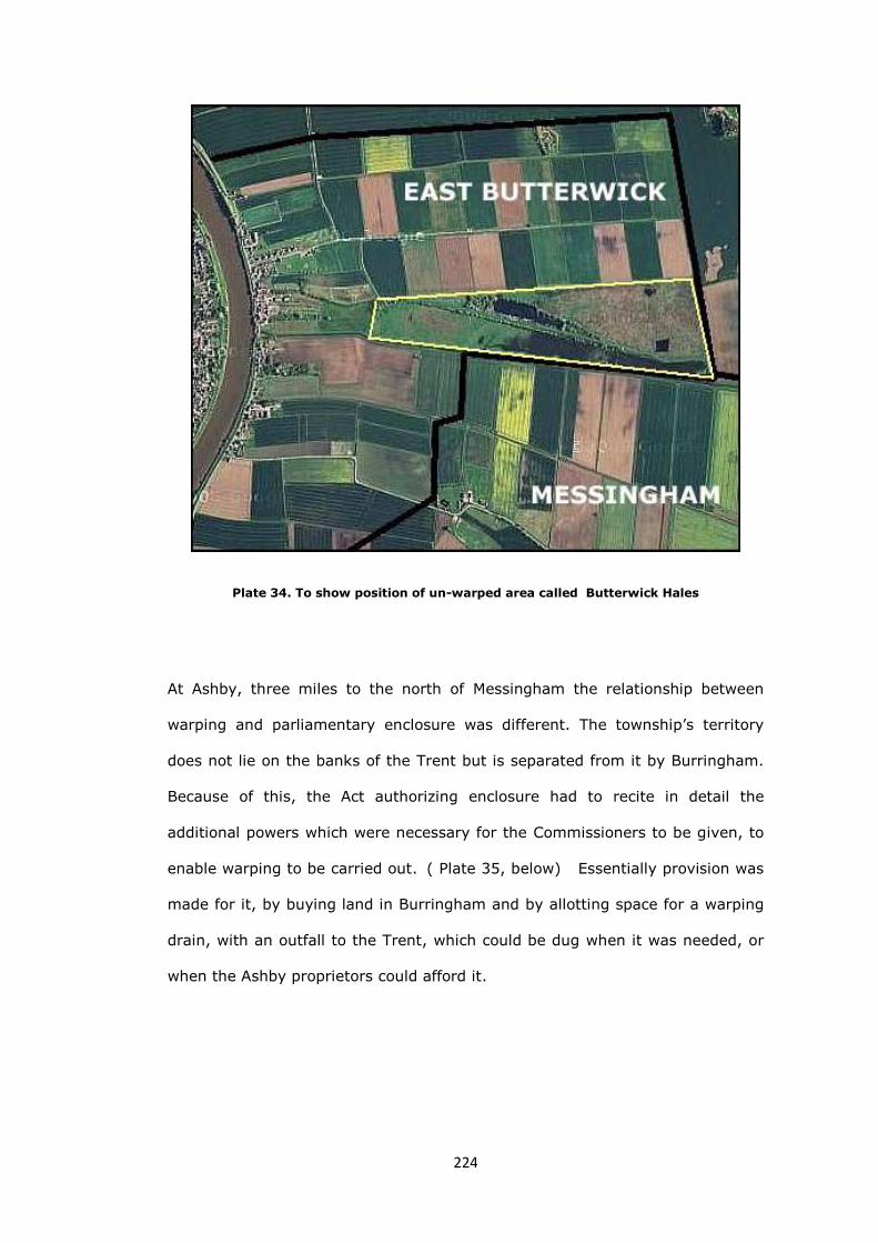
224
Plate 34. To show position of un-warped area called Butterwick Hales
At Ashby, three miles to the north of Messingham the relationship between
warping and parliamentary enclosure was different. The township’s territory
does not lie on the banks of the Trent but is separated from it by Burringham.
Because of this, the Act authorizing enclosure had to recite in detail the
additional powers which were necessary for the Commissioners to be given, to
enable warping to be carried out. ( Plate 35, below) Essentially provision was
made for it, by buying land in Burringham and by allotting space for a warping
drain, with an outfall to the Trent, which could be dug when it was needed, or
when the Ashby proprietors could afford it.

225
Plate 35: Ashby Enclosure Act 1801, part of section XIX, p.12
At the time of the Parliamentary Act of 1801, there about 320 acres of old
enclosures consisting of the tofts and croft of the township, together with the
rectangular closes in the West field, which are to be associated with a 1784
private enclosure agreement.80 There were therefore 1855 acres of land still to
be enclosed.81 The Act reveals that John Julius Angerstein, Esquire, was Lord
of the Manor, and that John Fardell, Gentleman, was Impropriator and entitled
to all ‘Tythes of Hay, Corn, and Wool .... and to certain Glebe lands’. Neither of
these men were residents, or indeed even farmers. Angerstein, (c.1732–1823)
was a marine insurance broker and an art connoisseur whose earnings from his
business activities enabled him to support the upkeep of two residences, one in
Pall Mall and another, a country house at Blackheath. Besides investing in art,
he seems to have been an enthusiastic purchaser of farmland and, at his death,
the value of his estate was half a million pounds.82 John Fardell (1744-1805)
held the post of Deputy Registrar in the Archdeaconry of Lincoln and Stow, and
effectively was the key figure in transacting the Church’s legal business at
Lincoln, including the lease and purchase of Church land.83 It seems likely that
because of the expertise he built up and the wealth that he accumulated, he
226
was able to invest in property on his own account and there are records of
purchases of land at Thorpe on the Hill and Welton and of Bottesford
parsonage.84
The preamble to the Act of 1801 continued with the usual motives for
improvement without mentioning the word warping. Perhaps the term was still
considered a little known local barbarism at that time, and not appropriate for
the first page of a parliamentary act. The Act appointed three Commissioners;
Francis Otter, of Stainton le Vale, John Renshaw, of Owthorpe, Notts and
Samuel Turner, of Buslingthorpe. Anthony Bower, of Lincoln was appointed
Surveyor. Most of the forty-seven pages of the Act are devoted to detailed
instructions to the Commissioners; how farming was to be allowed to continue
during the enclosure process, how they were to determine which of the land
could be improved by drainage and warping, how new highways and footpaths
were to be laid our and how some could be closed.
Minutes of the meetings of the Commissioners, with public notices relating to
the enclosure together with a badly faded copy of the Award, without a plan,
are in the Brown, Hudson and Hudson (solicitors of Barton-on-Humber) Deposit
at the Lincolnshire Archives. An excellent fully legible copy of the Award, with
its plan, signed by the surveyor Anthony Bower and the three surviving
commissioners, is included in the 1808-30 Kirton in Lindsey Court Book.85 It is
therefore possible to follow both the course of the enclosure proceedings, and
to study the provisions of the Award.
The Commissioners held their first meeting on 3 August 1801 at the Angel Inn,
at Brigg. By the 24 May 1804, after many meetings, the process seemed to be
nearing its conclusion and the Commissioners were at the Spital Inn, where
they worked through a copy of the Award and declared that it was ‘now ready
to be Ingrossed’. Work on the roads was ordered to be completed by the 11

227
July. On that date the Commissioners meet at Ashby to view the roads, but
work was still proceeding so they at once went to Brigg and met from 11 to 13
July, where they make several small changes to the Award. They were again at
Ashby and Brigg from 1 to 4 October. At Ashby, the roads and various other
building works were examined, while at Brigg further changes were made to
the Award, including, very significantly, the addition of a clause concerning
warping, ’ should this become possible’. Anthony Bower’s plan of Ashby (plate
36, below) clearly shows that embankments had been constructed at the low-
lying west end of the township and form its boundaries on three sides.86 The
zigzag course of an ‘intended warping drain’ was drawn on the map, but as
noted, for warping to have been possible, the drain would have to have an
inlet/outlet to the River Trent, across the fields of the neighbouring township of
Burringham to the west.
Plate 36. Detail of Ashby Enclosure map. Embankments in pink and the zigzagged
‘Intended warping Drain’. (LAO: KR/2/10)

228
The Commissioners clearly believed that the enclosure, at least, was
approaching its conclusion as they directed that ‘… all Accounts whatever
relating to this Inclosure be ready for Examination at our next Meeting…’. That
next meeting was back at the Angel in Brigg, on the 3 to 5 December 1804. It
was evident that the Commissioners wished to wind everything up, and sign
the Award on Tuesday 5 February 1805. On that date they met, at the Angel,
and noted that the Award could not be signed as some of the rates were
unpaid. They ordered their clerks to take legal action ‘… and do give Notice for
a further Meeting when they shall deem it expedient…’ There is then an
unexplained hiatus of four years before the minutes resume, at Brigg, on Friday
10 February 1809. At that meeting various bills were paid, a fourth rate of
£257 was levied and the Commissioners finally signed the Award.87 Everything
was ready for the low-lying lands of Ashby to be warped; the embankments
had been constructed and space had been left for a warping drain to be dug to
link with the Trent, by way of Burringham. The delay in the enclosure process
from 1805-9 was almost certainly because the Ashby commissioners were
waiting for the Burringham owners to begin their own enclosure, or at least to
permit this linking section of the warping drain to be dug. By 1809 the
Commissioners had evidently run out of patience with Burringham and they
concluded the Ashby enclosure, with the warping, which the Act allowed, yet to
be started. It was not for some twenty years before the process of enclosure
would begin in Burringham, and Ashby could be warped. When it came, it was
done privately, by a landowner called Henry Healey in a program of
improvement which included drainage and warping.
Burringham is a township by the Trent, of 1,450 acres, bounded on the north
by Brumby, on the east by Ashby and on the south by East Butterwick. In
1856, William White described it as once being ‘a low swampy moor which has
been improved by warping upon it the silty deposits of the Trent.’88

229
As already noted, advertisements had appeared in the Stamford Mercury in
autumn 1796 asking owners to a meeting at the Black Moor's Head Inn at
Gainsborough to discuss the intended enclosure of Burringham, together with
its neighbouring townships of Ashby and East Butterwick. It was ‘to consider
the Expediency of the.... Inclosure and what Terms shall be offered to the Lord
of the Manor and Tythe Owners.’89 Although, as already described, Ashby was
enclosed in 1801-9, nothing more was heard of this plan for a joint enclosure of
lands in the three townships, and it seems to have been abandoned.
Because, warping was expensive, it could only practically be carried out where
the land to be improved was in a few rich hands, and agreement could be
reached to share the costs. In 1799 such an agreement was apparently made
between William Hall of Hull and a local landowner, Thomas Peacock, for
‘draining and warping land at Botsford (sic) and East Butterwick under the
superintendence of Anthony Bower.’90 This involved land in Burringham
township in Bottesford parish, and in East Butterwick, across the township
boundary to the south. This proposed scheme must also have been abandoned,
as nothing more was heard of it either. Achieving a consensus for agricultural
improvement often proved difficult, but when the expense of warping and
draining is also an issue, agreement will have been even harder and the
arrangements may well have foundered on concerns about cost.
Henry Healey is the name, particularly associated with the warping of land, in
the area. He was born Henry Holgate, the youngest son of Edward Holgate of
High Risby in Roxby, and Jane, sister of George Healey of Frodingham, and
when his uncle died in 1824, he inherited property in Frodingham, Crosby,
Scunthorpe, West Halton as well as in Burringham which was, at the time, said
to be worth in excess of one hundred thousand pounds.91 By the terms of his
uncle’s will, Henry Holgate was required to adopt the surname Healey.92 He
seems immediately to have begun a vigorous programme of enlargement and

230
improvement of the late George Healey’s estate, as he raised over thirty
thousand pounds by mortgages to acquire additional property, including in
1834 Ashby Duck decoy in Ashby township, and 350 acres of land which
bordered his Burringham property. The newly renamed Henry Healey built a
large house, near the Duck decoy with ornamental grounds, which became his
family home and which he called, despite its size, Decoy Cottage.93 He was
more celebrated however for the construction of the warping embankments and
drains which were built in Burringham, a mile or so to the west of his new
home. In the twenty years after 1828, he spent an estimated £31,000 on these
works. Compensation, which had to be paid to his neighbours, added several
thousand pounds more, when the Healey drain broke on several occasions.94 It
may be that he overstretched his finances in improving his land in Burringham
by warping, as he had sold off his properties in Frodingham and Crosby by
1842.95 As he was by far the major landowner in the township, and he had
expended such a great amount of money over the years, it seems very likely
that it was Healey who finally carried out the warping of Ashby and largely
created the drained and warped landscape of Burringham that is seen today.
In 1836 an act was passed which smoothed the progress of the enclosure of
open and arable fields, and authorized the enclosure of such fields by
commissioners when two-thirds of the interests affected were agreed, without
any further parliamentary authority. Where seven-eighths of the interests
were agreed, the owners themselves could carry out the enclosure and no
commissioners being needed.96 Perhaps as a result of this act discussions took
place in 1837 concerning the few acres of Burringham which were yet to be
enclosed. Two plans exist, dated 1823, of ‘Burringham Moors’, one of which
bears a note written by Healey himself:
‘Ferry Boat Inn, Burringham, 4 October 1837. This is the plan referred
to in the Resolution this day adopted by the persons interested in the

231
open and common arable, meadow and pasture lands or fields in the
township of Burringham…’97
The resolution passed that day has not been found, but the plan delineates
narrow east/west strips of land, with a key in the margin, which names the
strips and gives their individual areas. There are nineteen strips and a few
other tiny portions of land, which total just 27 acres, 1 pole and 16 perches, or
only about 1.8% of the area of the township.
The award that resulted six years later is not the work of parliamentary
enclosure commissioners, but of a land surveyor, William Rawson, from Barton
upon Humber. Rawson will have been familiar to many of the landowners, as
he had surveyed Frodingham and Scunthorpe in 1828, and he was able to be
employed by them, because evidently seven-eighths by value of the interests,
had agreed the enclosure of these few acres.98 The familiar introduction of the
old enclosure awards is replaced by a greeting from Mr Rawson and a preamble
which refers to the resolution of 1837:99
Whereas by an agreement in writing bearing date 16 October 1837 (that
is nearly two weeks later than the date on the plan) and made in
pursuance of a resolution passed at a meeting of the owners and
proprietors of the open or common lands…duly called and held under
and by virtue of an Act of Parliament… Between Henry Healey …of Decoy
Cottage…and the several other persons…interested...
There follows the names of twenty-eight landowners.
…After reciting that the several common lands of the townships of
Burringham …consisted of small slips of land which lay dispersedly and
intermixed with the inclosed lands and were subject at certain times to
right of intercommon for the depasture of cattle and other live stock
therein which had been found inconvenient and detrimental by reason of

232
the lands not being capable of permanent occupation and improvement
and further reciting that in order to remedy these inconveniences and
render the common lands improveable it had been considered beneficial
for the Township and the several proprietors, owners and persons
interested therin that the Lands over which such common rights existed
should be inclosed , apportioned, divided and allotted….
Plate 37 Part of the plan accompanying the Award of 15 Apr 1843, showing the western
ends of the long strips.
A section of the map accompanying the award is shown, above (plate 37). By
examining the map and comparing it with the modern landscape, the rationale
behind the enclosing of twenty-seven acres becomes clearer. At the end of the
warping process, a number of narrow strips of land remained; these may well
have been the remnants of embankments built in the 1820s to aid Henry
Healey’s agricultural ambitions. By 1837 it was presumably thought that better
use could be made of them, and some have become lanes and sections of
roads, while other strips have disappeared and now form part of the
rectangular fields.

233
Henry Healey sold his land across the river, in Althorpe and West Butterwick, in
1854, and he was left with a compact estate in Burringham and Ashby of about
one thousand acres.100 He died in 1868 and the Burringham/Ashby estate was
sold in 1869.101
The experience in Frodingham, north of Burringham township, was different
again. Although permission was given in the 1831 Enclosure Act to warp, it
seems that the commissioners had learned their lessons and were no longer
willing to wait, on the whims and caprices of neighbouring landowners, before
being able to undertake warping as part of their duties. Instead, the Act
appointed the biggest owner to carry out warping.
A petition had come before the House in 1831 requesting, enclosure and
drainage of the townships of Frodingham parish.102 The House committee, in
approving the petition, seems to have added ‘warping’ to the wording.103 Before
the bill could proceed, a counter petition from a local landowner, Mrs. Sally
Smith, was considered and approved, which effectively removed Bromby
township from the enclosure.104 The Act was passed on 23 August 1831 and
allowed ‘inclosing, draining and warping’ in the rest of the parish of
Frodingham.105 The Act is conventional until paragraph sixty-six, which states
that after the lands capable of being warped had been identified by
Commissioners, it would be lawful for Frodingham’s leading landowner, Charles
Winn, to undertake the warping himself.106 (Plate 38, below)

234
Plate 38 Part of paragraph 66 of the Frodingham Enclosure Act
A series of subsequent paragraphs laid out in detail the rights and obligations
of Winn in carrying out the work. Most importantly, Winn’s estate was to be
answerable for ‘misconduct in the warping’.107 Landowners were to be charged
by Winn a total of twenty pounds per acre, for the work of warping. As soon as
an acre of land was embanked and ready for the process to begin, the owners
were to pay ten pounds per acre to Winn. When warping was ‘well and
effectually completed’ as determined by ‘engineers ’ appointed by the Act, the
balance of ten pounds per acre was to be paid. Those appointed, Edward Shaw
Peacock of Bottesford and Mark Faviell of Amcotts, were not engineers in any
modern sense, but were local farmers and landowners who would have
experienced warping in their own parishes and would have known what
successfully completed warp looked like. 108 They must also have been
acceptable to all the affected landowners. After successful completion of
warping, the Act provided for the appointment of a Warping Commissioner to
be paid for by a warping rate, charged on the owners of warped lands.109 The
Enclosure Commissioners had abrogated any responsibility they once had, for
this part of enclosure, to the leading landowner of the parish, but had tried to

235
maintain some sort of fairness, by writing into the act safeguards for lesser
landowners.110 The warping cost is at the top end of Dr Thirsk’s estimate of
twelve to twenty pounds per acre.111
The area that the act encompassed was about 1,962 acres, and the award
three years later enclosed a little over 1,754 acres, so 208 acres had already
been enclosed before that time.112 The area of warpable land identified in the
1834 award was a little over 504 acres of the the low-lying land called the carrs
and moors in Scunthorpe and Frodingham townships. About 269 acres was
owned by Winn, and the rest, amounting to about 235 acres, between
Gunhouse Ings and Frodingham Moors had been awarded to seven other
owners.113 (Plate 39, below)
Plate 39 On a modern aerial photograph, the area warped by 1847-51
It would have seemed sensible, following the award, to immediately drain and
warp the whole of this area, as part of the continuing program of agricultural
improvement, and as authorized by the Act. A notice had appeared in the
Stamford Mercury just ten days after the Act was published, announcing the
intention to drain and warp the lands that were being enclosed;114 and an

236
undated plan existed showing how the area of 235 acres might be warped and
laid out, with ditches between owners’ plots115 ( Plate 40, below ).
The progress of warping is not clear from the remaining records, but it was not
finished until 1847, when the ‘engineers’ Peacock and Faviell signed a
declaration that it had been completed ‘as well… as the situation and level will
admit’116.
Plate 40. Undated plan of an area of 235 acres awarded to seven owners, showing how
it might be drained and warped (LAO: Sheff/E/52/2)
It is now apparent why the remaining ‘warpable’ part of the parish, Brumby
West Common, should have been excluded at this time. It had not been
possible to obtain agreement to enclose and warp from the Brumby landowner
Mrs Sally Smith when the rest of Frodingham parish was enclosed. It was not
until 1867 that the area was improved, by which time its owner had become
the Earl of Beauchamp, of Madresfield Court, Worcestershire.117

237
In some parts of the study area the desire to warp the low-lying land was a
spur to enclosure, but in two parishes this could not be said to be true, as
enclosure had already taken place before the new technique became
fashionable.
North of Frodingham are Flixborough and Burton Stather parishes, home to the
Sheffield family. The Sheffields seem to have been settled in Lincolnshire since
the thirteenth century and, by the mid-eighteenth century, had an estate called
Normanby, which consisted of the whole of Flixborough parish and the southern
half of Burton. Sir John Sheffield provides firm evidence of enclosure, as in
1778 he commissioned John Snape to make plans of the manor of Normanby,
the manors of Burton and Thealby in the parish of Burton upon Stather, and a
plan of the parish of Flixborough.118 Snape’s maps shows that nearly all the
Sheffield family property had been enclosed by that time.
Plate 41. Detail of: ‘A Plan of the Parish of Flixborough in the County of Lincoln
belonging to the Honble Sir Jno. Sheffield, Bart. Surveyed in 1778 by John Snape’
(NELA:524/A/9/2)

238
The Sheffield family had thus been early agricultural innovators and had led the
way, in the study area, with the enclosures on their Normanby estate. In the
years that followed however, it had become the custom to drain and warp the
low lying lands in association with parliamentary enclosure, or as soon
afterwards as practicable. This had not happened with the Sheffield’s estates as
warping had only begun to be a recognised technique in the 1790s.119 The
family must have looked at their low-lying tenanted land by the river (plate 41,
above) and wished that its productivity, and its rentable value, could be
increased to equal that of other parishes, that had been warped later. Any
such talk of warping of the low-lying lands on the Sheffield estates will have
been more controversial at this stage, as tenants were established in their
plots, and would not have wished to lose one or more years of cultivations, so
that the landlord could charge more rent.
There were discussions about the possibility of warping land below Burton wood
in 1827, but nothing seems to have come of them.120 In 1835 there had been
discussions based upon a paper which examined the possibility of warping 255
acres of land in Flixborough township and 334 acres below Burton wood without
the construction of a new warping sluice; instead an existing drainage sluice
called Neap Clough would be used. The author of the paper (who was, almost
certainly, the Normanby estate manager Robert Barker), thought that £600
could be saved in this way and he thought that (should) ‘the summer prove
tolerably dry, it is possible that the land in question might be raised 18 inches
and some of it 2 feet in one year, at any rate not more than two years would
be required.’121 He estimated how much extra rent would be produced by the
land; at Flixborough after warping; he thought that rents could increase by
164% and in the fields below Burton wood by 134%. It was not an easy
calculation because as well as the considerable cost of the process itself,

239
landowners would need to accept a much reduced rent from tenants for an
indeterminate time.122
Plate 42: Part of Robert Barker’s 1835 calculations concerning warping on the
Normanby estate (LAO:Sheff/E/5/50 )
It seems that warping was underway in the years 1840-47, on some of the land
at least, and in November 1843, Barker produced a further set of calculations
to show its progress.123 In 1846-7 a further sixty-nine acres were warped, and
the process was completed in 1848-9 when seventy-three acres were
warped.124
A large drain together with a ‘cleugh’ into the Trent still exist just south of the
landing stage at Burton, so it seems that that Barker’s idea for saving money
was not acted upon, and a new warping drain was in fact constructed. A small
amount of land near the ‘cleugh’ remains unwarped and it may be that one or
two of the other smaller owners in Burton Stather were unwilling, or unable, to
warp their land for reasons of cost.

240
The Sheffield family had paid the price for not warping at the same time as
enclosure, but by 1850 all the riverside parts of their Normanby estate would
have been as productive as neighbouring parishes.
A curious consequence of warping was the disappearance of Will-o'-the-wisp or
ignis fatuus, the ghostly light sometimes seen at night or twilight over bogs,
swamps, and marshes. A correspondent wrote in 1852 to Notes and Queries:
Fifty years ago he might be seen nightly dancing over bog and brake;
but since the process of warping has been discovered, which has made
valuable property of what was before a morass, nearly the whole of the
commons between Gainsborough and the Humber have been brought
into cultivation, and the drainage consequent thereon has nearly
banished poor Will.
Any person wishing to make his acquaintance would probably succeed, if
he were to pass a night next November, on Brumby or Scotton
common.125
Brumby west common was not to be warped until 1867, while Scotton common
had to wait until 1884-5, by which time, with the complete disappearance of
the old marshy landscape and its replacement by a new fertile and productive
terrain, ‘poor Will’ had danced his last.126
Conclusion
Schemes of water management involving the digging of ditches are almost
always associated with enclosure, but in the study area, more advanced
techniques were necessary to convert this landscape of tidal rivers and low-
lying land to more productive use. In the east of the area, changes in climate
encouraged the taming of the Ancholme by a sluice gate, and enclosure was
then worthwhile. In the west, covering the poor peaty soils by fertile river silt,

241
using the process called warping had to be preceded by enclosure. This was
because ‘warpable’ fields had to be first delineated and identified, and space
made for large warping drains.
Because of the constructional work involved, drainage and warping schemes
were likely to be more expensive than other agricultural improvement. These
costs were justified however by the prospects of the increased rents which
would come from an end to inundation and greatly increased fertility.
As Beckett has observed, ‘it is possible that in their fascination with the
enclosure of open fields, historians have overlooked the fact that the general
trend of enclosure may have been towards land reclamation rather than
reorganization of the arable.’127 It certainly does seem that the agricultural
tendency, in those parts of the study area parishes bounded by rivers, was
firstly towards repossessing the land from water, rather than schemes for
redeploying existing cultivated land.
References
1 Based upon a map in: R. van de Noort, The Humber Wetlands: the
Archaeology of a Dynamic Landscape (Macclesfield, 2004), p.23
2 23 Henry VIII c 5 (Statute of Sewers); A. M. Kirkus (ed.), The Records of the
Commissioners of Sewers in the Parts of Holland 1547-1603 (Lincoln 1959),
p.xi, passim.
3 Lincoln county, commissioners of sewers, An Inquisition taken before the
Commissioners of Sewers for the County of Lincoln, 1583 (Ripon,1851), passim
4 Ibid, p.12
5 Ibid, p.14
6 R. Lemon (ed.), Calendar of State Papers, Domestic Series, of the Reigns of
Edward VI., Mary, Elizabeth [and James I] ...: Elizabeth, 1581-1590 (1865),
p.229

242
7 E. Royle (ed.), Issues of Regional Identity: in Honour of John Marshall
(Manchester, 1998), p.33
8 W. Cunningham, The Growth of English Industry and Commerce (1968),
p.119
9 R. van de Noort, The Humber Wetlands…, p.157; J. Thirsk, English Peasant
Farming (1957), p.117
10 J. Thirsk, English Peasant Farming (1957), p.190
11 H. Neumann , ‘The paleo-environmental survey of the Ancholme Valley’ in R.
van de Noort, S. Ellis, et al, Wetland Heritage of the Ancholme and Lower Trent
Valleys: an Archaeological Survey (Hull, 1988), pp.75-6
12 Ibid, p.190
13 LAO: MON 19/7/1/10 ; Owersby is about 4 miles north of Market Rasen and
a mile from the New River Ancholme.
14 J. Thirsk, English Peasant Farming, p.190; LAO:MON 3/9 dated 1635 is a
copy of a law empowering Sir John Monson to cut a sluice for the purpose of
draining the Ancholme basin, but it notes that the number of acres was actually
5,287.
15 E. A. Labrum (ed.), Civil Engineering Heritage: Eastern and Central England
(1993), p.49
16 W. Dugdale, The History of Imbanking and Drayning … (1662), p.89
17 LAO: Monson 7/17/46 ‘Statement of Winterton case’;7/18/5 ‘Interrogatories
and depositions of witnesses on behalf of the freeholders of Winterton against
Sir John Monson’.
18 TNA: E 134/17Chas2/East14, ‘Wm. Place, Wm. Baldwin, John Nevell, Thos.
Hilbert, Jacob Cooke, John Girdley, Wm. Snowden, Wm. Everingham, on behalf
of themselves, Wm. Holland, and divers other inhabitants and freeholders of
Winterton. v. Sir John Monson, Touching plaintiffs' claim to a parcel of ground
"adjoining to the river of Aucholne within said lordship," and defendant's claim
thereto by force of an Act of Parliament of 13 Chas. 2’
19 K. Lindley, Fenland Riots and the English Revolution (1982), pp.227-8
243
20 H.H. Lamb, Climate, History and the Modern World (1995), pp.76-77; H.
Flohn & R. Fantechi, The Climate of Europe, Past, Present, and Future: Natural
and Man-Induced Climatic Changes, a European Perspective (Dordrecht, 1984),
p.55
21 H.H. Lamb, p.246
22 Journals Of The House Of Commons, Twelfth Parliament of Great Britain:
sixth session (11 November 1766 - 2 July 1767), 26 January 1767
23 Ibid, 11 February 1767
24 Ibid, 27 February 1767
25 Ibid, 30 March 1767
26 Ibid, 16 April 1767
27 Ibid, 20 May 1767
28 LAO: 2-RED/4/8/1
29 A. Straw, ‘The Ancholme Levels north of Brigg: A history of drainage and
its effect on land utilization’, East Midland Geographer, 3 (1955), p.40; LAO:
MON/21/2/D/2. ‘A large plan of the drainage of the Ancholme’ surveyed in
1767-1768 by E. Johnson and J. Dickenson
30 A. Straw, p.40
31 LAO: Lindsey award /113 Snitterby, Atterby and Waddingham, 29 Nov 1770
32 LAO: Lindsey award/77 Scawby Enclosure Award and copy Plan, 18 Dec 1771;
ERYA: DDTH/11, Vol. 1764-1824, pp.167-184
33 Journals Of The House Of Commons, Thirteenth Parliament of Great Britain:
third session (9 January 1770 – 19 May 1770), 27 February 1770
34 W. Dugdale, The History of Imbanking … (1662), p.89
35 LAO: Lindsey award/77
36 Edward Johnson of Hull went on to be a commissioner for the enclosure of
West Halton in 1772-3 and Whitton in 1773-5.

244
37 Ordnance Survey, Ancholme Valley map, No. 281,Scale 1 in 25,000
(2006)
38 LAO: Stubbs 1/20/6, ‘Report of John Parkinson and Samuel Turner’ 6 Nov
1795
39 Hibaldstow Enclosure Act, 25 October 1795, p.20
40 LAO: Stubbs 1/20/6, Commissioners‘ Minute Book.
41 Ibid.
42 LAO: Stubbs 1/20/6; The clerk to the commissioners, Richard Nicholson,
was an attorney-at-law at a Brigg solicitors’, and it was a successor firm, Hett,
Davy & Stubbs, which made the Stubbs Deposit in which these documents are
found.
43 Ibid.
44 Ibid.
45 LAO: Stubbs 1/20/6 The expenses for ten persons amounted to £5-11-2.
46 It is tempting to speculate that Thomas Parkinson of Scawby was a relative
of Commissioner John Parkinson of Asgarby, although no evidence has been
found for this. Thomas Parkinson does not seem to have acted in the capacity
at any other time.
47 LAO: Stubbs 1/20/6
48 G. E. Fussell, 'Low Countries' Influence on English Farming', English Historical
Review, Vol. 74, No. 293 (1959), pp. 611-622; D. Neave, The Dutch
Connection: The Anglo-Dutch Heritage of Hull and Humberside (Hull, 1988),
passim.
49 J. Thirsk (ed.), The Agrarian history of England and Wales 1640-1750, Vol
V,I Cambridge,1985), p.79; J. Tomlinson, The Level of Hatfield Chase and Parts
Adjacent (Doncaster, 1882)
50 Lord Ernle, English Farming: Past and Present (1912), p.114
51 J. C. Loudon, An Encyclopædia of Agriculture (1831), p.330

245
52 J. Wright (ed.), English Dialect Dictionary, vol. vi (Oxford,1905), p.387-8;
Warping should not be confused with the other form of artificial land
reclamation: the deliberate accretion of estuarine alluvium. This involved the
construction of embankments to enable the trapping of sediments carried
naturally by the waters of the Humber. This type of reclamation was used, for
example, from the seventeenth century onwards, to build up the area round
Sunk Island Sand between Hull and Spurn Point. (M. Dinnin, 'Introduction to
the palaeoenvironmental survey' in R. Van de Noort and S. Ellis (eds), Wetland
Heritage of Holderness: an Archaeological Survey (Hull, 1995), passim)
53 J. C. Loudon, An encyclopædia…, p.332
54 G. Rennie, et al, General View of the Agriculture of the West Riding of
Yorkshire (1793), p.166
55 A. Young, General View of the Agriculture of the County of Lincoln (1799),
pp.276-7
56 R. Creyke, ‘Some account of the process of warping’ in Journal of the Royal
Agricultural Society, vol. 5 (1845), pp. 398-405
57 J. Thirsk, English Peasant Farming (1957), p.291
58 J. Mackinnon, (edited by E. Peacock), Account of Messingham in the
County of Lincoln (Hertford, reprint 1881)
59 Ibid, pp.8-9
60 Ibid, p.9
61 Ibid, p.16
62 LAO: Glebe terrier bundle, Messingham, 1634 and 1686
63 LAO: Messingham Inclosure Award and Plan PAR CO.1 (also listed as LAO:
Acc. Number: 2007/54)
64 Stamford Mercury, 17 October 1796
65 Stamford Mercury, 22 September 1797
66 Stamford Mercury, 20 October 1797

246
67 Barnard paid 21% of the parish land tax in 1800. (LAO: Land Tax
Assessments, Manley Wapentake, 1800)
68 LCL: Messingham Inclosure Act, 1798
69 Ibid.
70 LAO: Messingham Inclosure Award and Plan, PAR CO.1
71 J. Mackinnon, p.19; LAO: Misc Dep 22/27
72 LAO: Messingham PAR CO.1
73 Ibid.
74 But Turner has 5,560 awarded acres, in: W.E. Tate (ed., M.E. Turner),
Domesday of English Enclosure Acts and Awards (Reading, 1978), p.166
75 J. Mackinnon, pp.19-20
76 ibid, editor’s note; J. Thirsk, English Peasant Farming (1957), p.291
77 LAO: 1 Dixon/16/3 ‘Diary notes of the Revd John Parkinson of Ravendale,
1804-26’, p.206
78 The practice of warping over long periods is discussed in 1909 [Cd. 4461]
Royal Commission on Coast Erosion and Afforestation. Volume II. (Part II),
pp.108-120, especially p.118
79 W. White, History, Gazetteer and Directory of Lincolnshire (1856), p.603
80 LAO: Misc Dep 77/16, ‘Improvement of Lands in the several open Arable
fields there by sowing of Turnips and Clover'
81 LAO: Brown, Hudson and Hudson 7/1, Ashby Inclosure and Drainage Act, of
1801
82 F. Martin, The History Of Lloyd's And Of Marine Insurance In Great Britain
(1971), p.145, et seq.; The Annual Biography and Obituary, Vol. 13 (1824),
p.275
83 C.M. Lloyd, M.E. Finch (eds.), Letters from John Wallace to Madam Whichcot,
and some Correspondence of John Fardell, Deputy Registrar, 1802-5, Lincoln
Record Society, 66 (Lincoln, 1973), pp.45-9

247
84 Ibid, p.49
85 LAO: BH 7/1, Public notices and Minutes of Commissioners’ meetings with
four rates levied for the enclosure, 1801-9; Copy of Ashby award, no plan
1809; LAO: KR/2/10 Kirton Court Book, Wapentake Court of Manley 1808-
1810, Copy of Ashby Award with plan. The original Ashby award with plan is
thought to be with the Scunthorpe Town Clerk.
86 LAO: KR/2/10. There was no need for a fourth embankment, on the eastern
margin of the area to be warped, as the ground rises naturally on that side.
87 LAO: BH 7/1, Public notices and Minutes of Commissioners’ meetings with
four rates levied for the enclosure.
88 W. White, History… p.596
89 Stamford Mercury, 17 October 1796
90 John Rylands Library: RYCH/3102 Articles of agreement between William
Hall of Kingston upon Hull, and Thomas Peacock of Northorpe, … under the
superintendence of Anthony Bower, 1 Jan. 1799.
91 Lincolnshire Archives Committee, Archivists' report 22, 1 April 1970 - 23
March 1971 (Lincoln, 1970), p.53
92 LAO: 2 TGH 1/4/6 Note concerning an entry in London Gazette re. change of
name, 23 August 1824; A.R. Maddison (ed.), Lincolnshire Pedigrees, The
Harleian Society (1902-6), pp.477-8
93 Lincs, Archivists' report 22, p.53
94 LAO: 2 TGH 1/31/4/3
95 This was to prove a costly error, as ironstone was discovered on these lands,
in the late 1850s, by the Winn family.
96 6 & 7 Wm.IV c.115; W.E. Tate (ed., M.E. Turner), Domesday of English
Enclosure Acts and Awards (Reading, 1978), p.329
97 LAO: BH 7/11/6 Two pre-enclosure plans dated 1823 of ‘Burringham Moors’.
98 Provision of the act: 6 & 7 Will. 4, c. 115.

248
99 LAO: Lindsey Award/160 ,1843
100 LAO: 2 TGH 1/31/4/14
101 LAO: 2 TGH 1/31/5/6 and 1/31/3
102 Journals of the House of Commons, First Year of the Reign of King William
the Fourth, 17 February 1831
103 Ibid, 8 March 1831
104 Ibid, 11 July 1831
105 1 & 2 Wm.IV c.57, An Act for inclosing, draining, and warping Lands within
the Townships or Hamlets of Frodingham, Scunthorpe, and Gunhouse
(otherwise Gunnas), all in the Parish of Frodingham in the County of Lincoln, 23
August 1831.
106 Ibid, paragraph 66
107 Ibid, paragraph 68
108 Ibid, paragraph 69
109 Ibid, paragraph 76
110 By 1847 an act had been passed (10 & 11 Vict.,c.38, English Drainage Act,
1847) which in effect authorized any person interested in draining and warping
his lands, to clear a way through all obstructions, wherever it was worth the
expense of the works and the compensation to his neighbours.
111 J. Thirsk, English Peasant Farming…, p.291
112 LAO: Lindsey Award/125, Frodingham, Scunthorpe and Gunness Enclosure
Award and Plan, 22 Aug 1834; W. White, History, Gazetteer, p.598-9
113 LAO: Lindsey Award /125; LAO: Stubbs/1/249 Minutes of evidence,
accounts, lists of proprietors, for the drainage of Frodingham warped lands, in
accordance with the Enclosure Act. Henry Grantham, commissioner.
114 Stamford Mercury, 2 Sep 1831, p.2 column 4: Notice for drainage of lands
in hamlets of Frodingham under Act of Enclosure

249
115 LAO: Sheff/E/52/2. The area is immediately north of the A18 between
Gunness and Scunthorpe
116 LAO: Stubbs/1/249
117 G.E. Cokayne, V. Gibbs, et al., (eds.), The Complete Peerage of England,
Scotland, Ireland, Great Britain and the United Kingdom, Extant, Extinct or
Dormant (Gloucester, 2000), vol. II, p.41; LAO:_Lindsey Award/125; LAO:
Lindsey, Brumby award 119
118 NELA: 524/A/9/2 Flixborough; 524/A/9/3 Normanby; 524/A/9/4 Burton and
Thealby. Sir John also commissioned, at the same time, plans of West
Butterwick (524/A/9/5) and of the ‘Manor of Crosby in the Parishes of West-
Horton and Froddingham’ (524/A/9/6).
119 Plans to warp Morton Carr, north of Gainsborough with sketches of sluices
etc, were being discussed in 1796. (LAO:1-Dixon/21/4/1/4)
120 LAO: Sheff/E/1/27
121 LAO: Sheff/E/5/50; In a dry year, the flood water at spring tides carries a
higher proportion of solid matter.
122 LAO: Sheff/E/5/50
123 LAO: Sheff/E/5/48
124 LAO: Sheff/E/5/55, Land below Flixborough Hill
125 Notes and Queries (1852); s1-V: p.574
126 Stamford Mercury, 12 July 1867 quoted in R. E. Armstrong (ed.), An
Industrial Island: A History of Scunthorpe (Scunthorpe, 1981), p.20; LAO:
Lindsey, Brumby award 119; LAO: Lindsey award 176, Scotton and East Ferry
Enclosure Award and Plan, 18 Mar 1885
127 J.V. Beckett, The Agricultural Revolution (1990), p. 37

250
7. Case studies
Case studies describing the enclosure histories of two unusual study area
parishes, Waddingham and Winteringham, are given to provide examples of the
diversity of experience of agricultural improvement.
Although the enclosure histories of most parishes are poorly documented
before the advent of parliamentary enclosure, it is sometimes possible to throw
sufficient light on the process, by use of manuscript evidence, so as to show it
both as a continuing strand in the chronicle of a village, and also to account for
the whole area of the parish. Both case study parishes fall into this unusual
category
Each parish had early enclosure; Waddingham used one of the few Lincolnshire
Chancery decrees to validate their improvements while Winteringham
employed an early act of parliament to confirm the agreement that had already
been made. Later a conventional act was then required to enclose further parts
of each parish.
Both histories showed the extent to which flood protection, drainage and
wetlands reclamation was an integral part of the improvement process in north
Lincolnshire.
The two hundred year enclosure of Waddingham
Waddingham lies north of Lincoln and to the east of Ermine Street. Having an
area of 3720 acres, its western parish boundary is the Roman road, and its
eastern boundary is marked by the course of the old River Ancholme.1
Various periods of enclosure can be recognized in the parish. Since time out of
mind the small closes (or tofts) on which the cottages stood, together with the
closes (or crofts) associated with, and usually adjacent to them, will have
existed at the village core. Later, at some time before, (perhaps long before)
the Ancholme was straightened and embanked in the 1630s, various

251
enclosures, called the Thack Carr Closes, were laid out by the river. These were
presumably osier beds for basketwork, eel traps, thatching spars, firewood,
fencing and other uses.2 Other early enclosures are known in the village,
Lordship Close, New Close, Munson Close, Towne End Close, Parsonage Close
and so on.3
The 1607 ‘Breife of Depopulacons’ had made no mention of any particular
enclosure problems in Waddingham, although in nearby villages such as
Burringham and Bottesford there had been various objections to the conversion
of arable land to pasture for sheep.4 With the exception of the Midland Revolt of
1607 there were few significant disturbances, between the Lincolnshire Rising
of 1536 and the English Civil War. There were, however, numerous (what
Manning calls) ‘village revolts’.5 These were minor insurrections, usually
parochial, involving villagers acting together to protect manorial custom, at a
time when many landowners were attempting to assert their claims to land,
unqualified by any common rights.6 Evidence is slight that statutory penalties
against enclosure protesters were ever applied at the Quarter Sessions or
Assizes and manorial courts did not seem to settle such disputes; instead the
process was for complainants to initiate a private prosecution for riot at the
Court of Star Chamber.7 In 1608 a suit came before the Court involving a
dispute between a group of Waddingham husbandmen together with their
wives, and Phillip Adams, the owner of a close who had attempted to end their
manorial rights.8
It is clear from the defendants’ answers to the interrogatories that although
they all readily acknowledged the ‘compleynante’s inherytance’ in a long
established close called Ingscrofts in Waddingham, they considered it to be
Lammas land. Between 25 March and the end of July the owner could raise a
crop of hay in the hedged and ditched enclosure, but this had to be cut before
Lammas Day, 1 August, after which local people's animals were allowed on to
his land until Lady Day, the following 25 March. Perhaps encouraged by the

252
successful suppression of the Midland Revolt a few months earlier, the owner of
the close, Phillip Adams of neighbouring Snitterby, stopped up the ‘gapstead’
or entrance hoping to have the sole use of his close throughout the year.9 The
husbandmen who were used to grazing their cattle in the Ingscrofts, wondered
how they could reclaim their rights and believing that married women, as
femmes covert, were outside the law and would be immune from prosecution,
arranged for their wives to remove the entrance obstruction.10 This was despite
a warning by the constable of Waddingham to ‘forbeare the throwinge downe
of the…inclosure’:11
But they the said persons, thinkeing as yt should seeme that the
castinge downe of the fences and hedges of the said closes would be a
greater offence and more greevislie punished in them, then if yt should be
done by weomen, . . . did . . . move, persuade and procure othere
weomen to the number of fortie or thereabouts to go to cast downe the
said hedge and fences.12
The forty women seem to have been the entirety of the Waddingham wives,
and their husbandmen spouses waited together, a ‘furlonge’ away, should they
be needed. The women were alleged, by the constable, to have been armed,
but only one of them admitted to have actually carried a weapon, a ‘littel
wodde’. Both husbands and wives were prosecuted in the Court of Star
Chamber for riot and the women were charged additionally with assault.13
Jannett Wapplet explained in her evidence that she was a poor cottager, that
William, her husband, was a day labourer and that they held a cottage with
attached freehold rights.14 Their tenancy meant that they had common rights
to graze their animals in Philip Adam’s close, but she had been prevented from
exercising this right by the blocking of the ‘gapstead’ and that was the reason
that she broke down the fence.15
It is not clear, from the surviving documents, what penalty, if any, was meted

253
out to the defendants, although they were ordered not to repeat their actions.
Wrightson suggests that enclosure disputes in the Court of Star Chamber were
often ended by settlement, sometimes by arbitration, but more usually in a
form ‘which preserved the interests of the enclosers and improvers.’16 Perhaps
therefore the defendants effectively lost their ancient rights to pasture their
animals in Phillip Adams’ close.
Part of the territory of Waddingham was drained and enclosed by Sir John
Monson and his adventurers in the 1630s. Wilkinson and Fotherby’s map of
1640 shows 707 acres either side of the new straightened Ancholme as part of
the finished scheme.17 As explained elsewhere, this land returned to its marshy
state, as the levels were neglected and the sluice gate at the Humber outfall
fell into disuse. It would form part of the lands enclosed by act in 1769-70
(q.v.) and so, like other similar areas by the Ancholme in neighbouring
parishes, would be enclosed twice.
Plate 43. Detail of Wilkinson and Fotherby’s 1640map of the Ancholme levels
(North is to the left of the image)

254
In 1699 a large part of the parish, including the common fields and some
meadows and wastes, was enclosed by agreement and this was confirmed by a
Decree in Chancery of 1701.18
It may be useful to consider what could have caused such a revolutionary
agrarian step to have been taken at this particular time. Hadley believes that
Waddingham was in medieval times divided into two parishes, one of which
seems to have been associated with a lost settlement called 'Stainton'. The
parish also included the township of Snitterby, which was in a different
wapentake, that of Aslacoe.19 Waddingham village contains two individual
nuclei, one of which may represent the location of Stainton.20 Present day
Stainton Avenue runs roughly from west to east, towards the site of what
must be the lost settlement. The plan of the village has two different
alignments and Everson believes that it came into being in different
periods.21 Surprisingly however, the churches associated with the two nuclei
were located very close to each other which, Everson suggests, meant that
there was a core area where the communities of both Waddingham and
'Stainton' came together for worship.22 While it seems likely therefore that
the inhabitants of Waddingham and 'Stainton' were involved in social and
manorial interactions which often brought them into contact with each other,
even though they were divided between several manors and two parishes,
there may well have been clear distinctions between them.23 One of these
distinctions could have been the existence of two completely separate open
field systems, each trying to make the best use of its land and topographical
setting. What caused the survival of the two, presumed, different common-
field patterns to come to an end? A catalyst for change may have been the
upheavals of the English Civil War, and the dislocation of civil society which
resulted from it. The vicar of Hainton, near Market Rasen, had noted in the
1640s that the first enclosure of the fields in his own parish ‘was clandestinely
supported by the confusion and iniquity of the times’.24
255
It may however have been as simple as a melding of the two townships,
symbolised by the decision not to rebuild Waddingham’s parish church of St
Peter in 1687, but instead to pull it down and unite the benefice with that of
St Mary’s church in Stainton. The building is now known confusingly as the
Church of St Mary & St Peter, Waddingham.25 The unification of the two
congregations may have provided the impetus for the cooperation which will
have been essential for agrarian reform and for the agreement to enclose a
major part of the now joint parish.
The personality of the principal landlord, James Thompson may have played a
part; he may have been anxious to increase the rent from his property.
Overton suggests that ‘Contemporaries were virtually unanimous that enclosed
fields offered more opportunities for money-making than did commonfields.’26
Unfortunately Thompson himself, is something of a mystery. His will of 1719
describes him as a gentleman of Ropsley in Kesteven, a village some fifty miles
to the south of Waddingham and reveals him to have owned land and other
property in Ropsley and in several other parishes between Grantham and
Boston. Strangely he does not mention his wife by name and leaves her little,
the greater value of his bequests going to his nephews and in monies to endow
schools in several villages where he had land.27 Perhaps he had acquired his
land in the open fields of Waddingham by marriage and, not having a child
himself, he bestowed his wealth on the children of his siblings and in educating
the youngsters of the village. It is possible he had aspirations to found a
dynasty and become a country gentleman. He was frustrated in this and so,
just as his fellow gentry in Kesteven were doing, he resolved to turn the
common fields of Waddingham in Lindsey, into the enclosed landscape of
today.28
In order that the enclosure agreement of 1699 could be confirmed by the
Chancery Court it was necessary for both parties in the case to relate the

256
sequence of events leading to the enclosure, and explain how it was done, all
the while maintaining the pretence that the case was a genuine dispute
between the main freeholders of the village on one side, and the principal
landowner James Thompson, together with the Rector of Waddingham, the
Bishop of Lincoln and (because the living was in the gift of the king), the
Attorney General on the other. The church had a keen interest in enclosure
agreements, as glebe lands might be swallowed up in exchanges; tithes might
be commuted to fixed payments in an age of rising prices and common lands
that had been set aside for the repair of church fabric might be lost.29 The
church had therefore to be involved in the agreement and their worries
assuaged.
The Waddingham case was thus collusive and James Thompson, who must
have been the prime mover, will have acted with, it is to be hoped, the full
knowledge and agreement of the freeholders.30 When his pretended dispute
‘failed’, the rights of those freeholders to divide the land was established, was
confirmed by the court and finally enrolled as a decree.
Plate 44; Part of the Chancery Decree for Waddingham TNA: C78/1096/2: ’ Defendents
Thereby setting forth that the Complainants being severally seized of severall Acres or
Oxgangs of arable land lyeinge intermixt in the comon feilds of Waddingham aforesaid ‘
Having named both sides in the ‘dispute’, the plaintiffs set out their complaint:
And the complainants findeing the said landes uninclosed were
disadvantegeous to them they the tennantes and Inhabitants suffering
losses by reason of the scarcity of Inclosure wanting meanes to secure
their cattle and releive them in the winter season & suffering casuall
losses in their stock goeing on the comons belonging to Waddingham …

257
Firstly they make an agreement with James Thompson that the Rector should
have sixty-eight acres for glebe and £94 per year for the tithe and then they
appointed commissioners to arrange the consolidation of the strips, or ‘lands’ in
the open fields into more convenient plots for the freeholders:
And the quality and quantity of every man’s arable landes, leayes and
headinges, lyeing in the said fields of Waddingham should be laid
together in one or more convenient plotte or plottes to be held and
enjoyed in severall Dividends with hedges and ditches or other sufficient
fences, and that all convenient wayes should be laid out for all plottes to
have A Free Accesse to their grounds and that the fences, which every
one should make and maintaine as belonging to their groundes, should
be likewise sett out by five commissioners therein and hereinafter
mentioned.
The poor were not forgotten and provision was made for them with twenty
acres set aside and,
fenced at the said freeholders charge and be lett to depasture by the
then present Overseers and Church wardens, for the yeare being, and
the money ariseing distributed amongst the poor of the said Towne by
the Ministers, Church wardens and Overseers, yearly for ever.31
Much in the manner of the parliamentary acts which began to be popular some
years later, the decree relates how the freeholders had appointed a surveyor
and ‘five persons of good quality who should allott every mans quantity of
land.’
mr James Thompson and the partyes therafter named, having
retained and agreed with Mr Thomas Chapman of Ingoldsbe to be
Surveyor, and haveing nominated Richard Burnett of Lincolne, Edward
Leggerd of Grasby, John Bradley of Burton, Thomas Hooley of Kirton in
Holland and Edmund Wells of South Kelsey, all in the said county of

258
Lincolne, gentlemen, or the major part of them, to allot and plott every
mans quantity of land and where the same should lye. And sett out the
private wayes, passages, commons, lanes and droves for the said
persons use, to come to their plottes and to sett out fences to the said
plottes to be maintained by the owners thereof.
Just as in later years parliamentary commissioners would then begin their
work, the decree recounts what had happened in Waddingham:
…haveing received Information of each mans quantity from the said
Surveyor, and having, in Company of the said lord and severall of the
said Freeholders, viewed the said feillds, lands, meadowes and comons
and sett values thereof, according to the best of their Judgments, and
having a due regard to each mans quantity and quality did alott & plott
all the said feilds and comons by a certaine writeing, under their hand…
In the absence of a map the agreement went on to describe, at considerable
length, fifty-three new ‘plottes’ for the thirty-two freeholders.32 Their position in
the landscape was established by reference to each other and to existing old
enclosures, together with the new ways and footpaths which would have to be
laid out, to and through them and the hedges that would have to be planted.
For example, in the case of William Fox:
And to and for William Fox one plott to containe twenty six acres two
roods and six perches to lye in the said comon between the herein last
plotted plott on the north and the next herein to be plotted plott on the
south and to abutt on Thack carr closes on the east and on feild lands
hereinafter to be plotted for James Thompson gen on the west. And did
order that the said William Fox fence the north side and west end of the
said plott and that a way doe lye over the west end of the said plott to

259
the three last plottes plotted and a way downe the said plott to the
Thack carr closes lyeing at the east end thereof.
The advantages of the map, which almost always accompanies a parliamentary
award, quickly become clear to the reader of a decree concerning enclosure.
To further satisfy the anxieties of the rector Mr Harvey, details were given of
the proportions of the £94 per annum, each freeholder by name, would pay to
the church each quarter, the penalties for late or non-payment and the detailed
ways of obtaining payment in extremis:
that if any of the persons before mentioned, their heirs and assignes,
should at any time refuse or neglect to pay the said Thomas Harvey, or
his successors, the said sumes hereinbefore charged quarterly, as the
same grow on or within forty dayes after that, then it might be lawfull
for the said Thomas Harvey, or his successors, to enter upon the lands
and dishaine for all tythes and arreares then due, and the said distresse,
to impound and keep three dayes at the owners charge, and if the said
owner did not pay the said tyth within the said three dayes, then the
said distresse to be appraised by two or more indifferent appraisers and
then to be sold by the said Thomas Harvey or his successors rending
back the overplus, if any be, to the owners thereof.
At this point in the document, the tone abruptly changes and the various
parties to the agreement that has just been so meticulously described, begin to
relate their difficulties with it, and how in fact nothing of it can be agreed
without a decree of the court.
The Rector claimed that any agreement regarding tithes and glebe was not
valid without the consent of the Bishop and the Attorney General; statements
by them were then read out which supported the agreement. The freeholders
and principal landowner claimed that their articles of enclosure had never
actually been agreed, but the Court observed (probably with tongue in cheek)
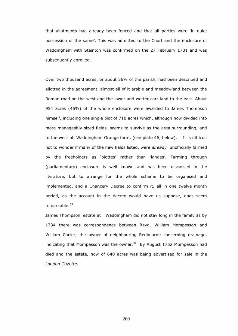
260
that allotments had already been fenced and that all parties were ‘in quiet
possession of the same’. This was admitted to the Court and the enclosure of
Waddingham with Stainton was confirmed on the 27 February 1701 and was
subsequently enrolled.
Over two thousand acres, or about 56% of the parish, had been described and
allotted in the agreement, almost all of it arable and meadowland between the
Roman road on the west and the lower and wetter carr land to the east. About
954 acres (46%) of the whole enclosure were awarded to James Thompson
himself, including one single plot of 710 acres which, although now divided into
more manageably sized fields, seems to survive as the area surrounding, and
to the west of, Waddingham Grange farm, (see plate 46, below). It is difficult
not to wonder if many of the new fields listed, were already unofficially farmed
by the freeholders as ‘plottes’ rather than ‘landes’. Farming through
(parliamentary) enclosure is well known and has been discussed in the
literature, but to arrange for the whole scheme to be organised and
implemented, and a Chancery Decree to confirm it, all in one twelve month
period, as the account in the decree would have us suppose, does seem
remarkable.33
James Thompson’ estate at Waddingham did not stay long in the family as by
1734 there was correspondence between Revd. William Mompesson and
William Carter, the owner of neighbouring Redbourne concerning drainage,
indicating that Mompesson was the owner.34 By August 1752 Mompesson had
died and the estate, now of 640 acres was being advertised for sale in the
London Gazette.

261
Plate 45. Advertisement in the London Gazette 18 August 1752
Twelve hundred and eighty acres of land, more or less adjacent to the River
Ancholme and roughly forming the eastern third of the parish of Waddingham
still remained to be enclosed, and nearly seventy years elapsed after the
Chancery Decree before this was accomplished; the reason for the delay was
the river itself.
As noted elsewhere in this thesis it was not until 1767 that a new sluice gate
was erected at the South Ferriby outfall of the Ancholme.35 With the resulting
end to tidal flooding, agricultural improvement then became possible in the
low-lying lands either side of the river and in 1769-70 came the first of two
parliamentary enclosures when ‘certain lands and grounds’ in the townships of
Atterby, Snitterby and Waddingham were enclosed, including approximately
1,280 acres of the Waddingham North Carrs.36 Although the award map cannot
be found, it would seem that contiguous areas of three parishes close to the
river were enclosed. Fortunately the written award does distinguish in which
parish each plot was situated, as the commissioners have written in the margin
’Here end the Waddingham allotments’, so the lands awarded, and the total
area enclosed, in Waddingham can be determined.37 There were fifty-five
awards of land, the greatest being 224 acres allotted to Lord Monson and 198
acres to Henry Broadhead esq.38 Because the area was low-lying, an award of a
little over seven acres was made to support the work of the bank-master, the

262
official responsible for the upkeep of the parish drains. The Enclosure Award
directed that the plot should:
be let yearly by auction on Easter Tuesday, and the rent applied
towards the cleansing and repairing the public drains in North Carr
for ever.39
The Charity Commission of 1839 found that the bank-master was letting
the allotment, for ten pounds per annum, and was using the rent to
maintain both bridges and drains in the parish.40
The enclosure also made provision for highway repairs by awarding Thomas
Cressey a plot called Stonefield of about 24 acres, but ordering also that the
town of Waddingham should have liberty to dig stones in the plot for the
repairs of the highway for ever, ‘there being two acres in addition given
to the said Thomas Cressey, in lieu of the said privileges granted to the
town.’ Perhaps because the poor had already been allowed rents from twenty
acres in the earlier Chancery Decree, the Commissioners merely acknowledged
their continuing existence by allowing them the use of an allotment called
Hemp-Dykes for hemp retting.’41
It is sometimes suggested that one of the reasons that parliamentary enclosure
became the preferred way to enclose land was that enrolled Decrees in
Chancery could be open to further litigation.42 As already pointed out, even
when an agreement had been reached, a dissatisfied party or his successor
could at any time in the future question it. In 1828 however the rector of
Waddingham William Cooper brought an action in the Court of Common Pleas
arguing that the land awarded to his predecessor rector in the 1770
parliamentary award had been wrongly calculated, because the commissioners
had become confused about the tithes in the two adjacent parishes, which were

263
also dealt with by the award.43 The rector’s action failed however and the
award of 1770 was confirmed.
In the absence of contemporary maps for either of the two major enclosures,
an attempt has been made in plate 46 (below), using a section from the First
Edition of the Ordnance Survey of 1824, to show those areas that may have
been enclosed by Chancery decree in 1701 and by parliamentary awards in
1770 and in 1848. The boundary between the two areas, A and B, has been
delineated using the field boundaries from the tithe map of 1840, and by
reference to modern mapping data, showing areas at risk of flooding, produced
by the U.K. Environment Agency.44 The boundary does not pretend to be
anything more than conjectural, but does not appear unreasonable when the
landscape is walked, and seems to approximately correspond to the acreages
which have been deduced.
Plate 46. Waddingham parish, from the First Edition of the Ordnance Survey,
1824 amended to show the areas which may have been enclosed by Chancery
Decree in 1701 (A), by Parliamentary Enclosure in 1770 (B) and the tiny Cow
Fold Enclosure of 1848 (C).
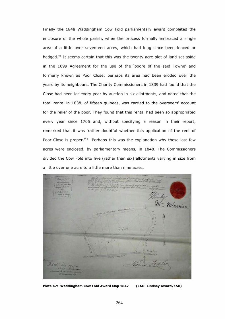
264
Finally the 1848 Waddingham Cow Fold parliamentary award completed the
enclosure of the whole parish, when the process formally embraced a single
area of a little over seventeen acres, which had long since been fenced or
hedged.45 It seems certain that this was the twenty acre plot of land set aside
in the 1699 Agreement for the use of the ‘poore of the said Towne’ and
formerly known as Poor Close; perhaps its area had been eroded over the
years by its neighbours. The Charity Commissioners in 1839 had found that the
Close had been let every year by auction in six allotments, and noted that the
total rental in 1838, of fifteen guineas, was carried to the overseers' account
for the relief of the poor. They found that this rental had been so appropriated
every year since 1705 and, without specifying a reason in their report,
remarked that it was ‘rather doubtful whether this application of the rent of
Poor Close is proper.'46 Perhaps this was the explanation why these last few
acres were enclosed, by parliamentary means, in 1848. The Commissioners
divided the Cow Fold into five (rather than six) allotments varying in size from
a little over one acre to a little more than nine acres.
Plate 47: Waddingham Cow Fold Award Map 1847 (LAO: Lindsey Award/158)

265
Its position in the landscape (confirmed by both the Tithe map of 1840 and the
Enclosure Award ), places Poor Close at the very edge of that area, next to
Constable Ings, which would have regularly flooded before 1767.47 It seems
therefore that the original Agreement, while having ostensible regard to the
needs of poor, allowed them the use of land, which was of marginal utility at
best.
The stages of the piecemeal enclosure can be tabulated as follows:
1.The tofts and crofts of the village = 348 acres (9.4%)
2.The dispute of 1608, probably… = 0 acres
3. The 1630s Ancholme Drainage = 0 acres
4.The Chancery Decree of 1701 = 2075 acres (55.8%)
5.Parliamentary Enclosure of 1769-70 = 1280 acres (34.4%)
6.Cow Fold Enclosure of 1848 = 17 acres (0.4%)
Total acreage of the parish = 3720 acres
Waddingham’s enclosure had thus taken well over two hundred years and there
is little reason to suppose that this was unusual in the study area, or
elsewhere.

266
Winteringham
Winteringham, lies on the south shore of the Humber estuary and is bounded
on the east by South Ferriby, on the south by Winterton and on the west by
Whitton and West Halton.
Plate 48 : Winteringham parish, from the First Edition of the Ordnance Survey, 1824.
When Arthur Young visited the parish at the end of the eighteenth century, he
was full of praise for its crop growing abilities:
…But the finest estate I have seen of some time for soil is the lordship of
Wintringham; it consists of three descriptions of land; marsh called here
warp and grove; strong loam under the bean husbandry; and dry loam
for turnips All three are excellent. The marsh is a tract of alluvion of the
Humber, deposited to the depth of six feet and apparently as good at
bottom as at top The bean land is not a strong loam; but a friable sandy
loam, with clay enough in it to give it rather too adhesive a tenacity for

267
turnips. The turnip land is a reddish, friable, rich loam, dry but putrid; a
finer soil can scarcely be seen, adapted to every crop that could be put
into it.48
As well as benefiting from good soil, Winteringham favours the aspiring
chronicler by having a manorial descent which is not too knotty to disentangle,
and by possessing an estate plan of 1719, together with enclosure acts of 1761
and 1795, which make its farming history less obscure than some of the
parishes in the study area.
There is confusion surrounding the area of the parish, because of the continual
action of estuarine erosion and deposition. Some authorities, like White’s
Lincolnshire, include the tidal waters within its bounds, that is, some thousand
acres of the Humber to the middle of the estuary is included, while others do
give the land area, but fail to note the date of the survey which produced the
figure.49 The First Edition of the Ordnance Survey map printed in 1824, shows
clearly that there were fields, now washed away, between Sluice Lane and the
Humber, at the time it was surveyed in about 1822, and that Read’s Island did
not then exist, merely a sand bank named ‘Ferriby Sands or Old Warp’ (plate
48, above). This study uses the area, drawn onto a plan of the parish in 1719,
which was 2,932 acres.50
In the 1580s the manor of Winteringham was owned by the tenth Baron Dacre,
otherwise Gregory Fiennes, whose father had been convicted of the murder of a
gamekeeper, his lands confiscated, and had been hanged at Tyburn in 1541.
His mother was Mary Nevill, a member of a well-known Lincolnshire landowning
family, so it may be that the manor had descended to her.
As with study settlements on the Trent, the Inquisition of the Commissioners of
Sewers, taken in 1583, has orders, concerning sewers and dykes in
Winteringham, with the object of maintaining or improving agriculture:

268
Item they do further p_sent that the sayd Sewer from the South end of
Winteringham Cowgang to Winteringham haven shall be sufficiently
diked & scowred by the towneship of Haughton & Winteringham hall
gartes from the haven to the north end of Haughton aforesaid & from
the north end of Haughton Ings to Humber by the township of
Winteringham aforesaid which sayd sewer shall be sufficiently dyked by
the said towneship eight foot wide in the toppe & five in the bottom, &
two foot deeper then it is now before Michaelmasse next comeing & so
to be kept from time to time in payne of iijli . 51
In 1589, to settle a debt for £5,000, Gregory Fiennes was obliged to hand over
the manor to Sir Christopher Wray, who was Lord Chief Justice of the Queen's
Bench and a former Speaker of the House of Commons. By the mid-
seventeenth century, it was owned by his grandson Sir John Wray who lived at
Glentworth.52 Elizabeth Wray, the only child and heir of Sir John married
Nicholas Saunderson. The Saundersons were merchants and landowners who
had built up estates in Yorkshire and Lincolnshire through marriage and
purchase in the fifteenth and sixteenth centuries. They had bought considerable
property at Saxby in Lincolnshire and, in 1549, Sandbeck in the West Riding of
Yorkshire, a former possession of the Cistercian abbey of Roche was acquired.
Roche itself was bought in 1627, and in the early eighteenth century
Glentworth and the parish of Winteringham were inherited by the Saundersons
from the Wray family by this marriage to Elizabeth.53

269
Plate 49. Detail of Wilkinson and Fotherby’s map of the Ancholme levels ,1640
Draining and enclosing had already taken place in the Ancholme levels in the
1630s, and part of the parish is pictured on Wilkinson and Fotherby’s map
(plate 49) printed in Dugdale’s history.54 North is to the left of the map and
the improved river course crosses from right to left, to fall into the Humber
estuary at Ferriby Sluice. An area of 464 acres is shown, to which is added the
words ‘wherof 100. Surrounded’. The implication in the use of the word
‘surrounded’ is that there had been new flood damage as a result of the
drainage works and that parts of the formerly dry lands, an area of one
hundred acres, had been rendered flood-prone.55 While not all the inhabitants
were happy with the results, it may have been these improving works, by Sir
John Monson, which were the catalyst for the formation of enclosures as,
during the time that the Wray family owned the manor, the large rectangular
field known as the ‘Compositions’, (shown on the 1719 plan) was first

270
mentioned in an inventory of 1653.56 A few years later a terrier of 1693, refers
to glebe lands ‘as they are accounted since the Inclosures’.57
It seems that there were three phases in the enclosure of Winteringham, and
they will first be summarised, with the aid of an amended aerial photo, and
then discussed in turn.58 First, by the time of the plan of 1719 a programme of
consolidation and partial enclosing of the common fields had already taken
place. This may also have included some changes to the common rights of the
cottagers. The 1625 terrier had spoken of ‘the east, middle & west feildes’, and
the 1693 terrier of ‘the Cliffs’, and of these four great fields of the parish, three
had been organised into closes by 1719; The Cliffs, the West Field and the
Middle Field (plate 50, bottom left).
The second phase, in 1761, was an agreement made between the Earl of
Scarbrough, and the Rector, the Reverend Thomas Adam to enclose some of
the open fields of Winteringham, and it was validated by an Act of Parliament.
The agreement included the ‘old enclosures’, that is, the three great fields
noted above, on the 1719 map, plus the East Field, the Ings and the Ancholme
Marsh, (plate 50: all below the blue line).
The final phase was the enclosure, by a conventional Act in 1795, of the rest of
the parish; the Marsh, the Rotten Sykes, Hall Close and the Compositions.
(plate 50: all above the blue line)
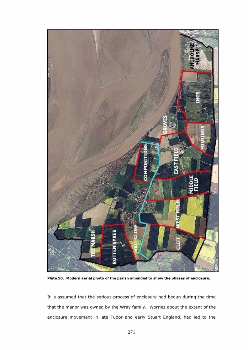
271
Plate 50. Modern aerial photo of the parish amended to show the phases of enclosure.
It is assumed that the serious process of enclosure had begun during the time
that the manor was owned by the Wray family. Worries about the extent of the
enclosure movement in late Tudor and early Stuart England, had led to the

272
creation of a special commission to make inquiries about it and the surviving,
abbreviated, report for Lincolnshire, the 1607 Abstract of Breife of
Depopulacons, has entries under three section headings for Winteringham; Sir
William Wray is mentioned in all of them.59
'Waistinges and Decayes of Husbandrie and Cottages' - John fforman
gent hath decayed a farme howse. Martin Brighowse esq deceased
decayed all the barnes & out howses belonginge to the Manor howse
ther.
Sr. Willm Wray hath decayed a barne & stable belonginge to a farm
howse called the Chaunterye howse.
'Convercons of Errable Land to Pasture for Feedinge of Shepe and Other
Cattell' - Nicholas Girlington esq the lyke for vxx acres. Sr. Willm Wray
hath converted xx acres of arable into pasture.
' Takeinge of Landes from Howses of Husbandrye and Makinge Cottages
of them or Lettinge them stand Emptie' - Sr. Willm Wray. Hath made a
howse of husbandrie a Cottage.
Several names recur in the Winteringham section of the ‘briefe’, among them,
as already noted, Sir William Wray who was married to Anne Girlington, the
daughter of Nicholas Girlington of Normanby, who also is mentioned. The late
Martin Brighouse, whose activities at Winteringham are referred to, was still
being talked about some thirteen years later in connection with Alkborough
parish enclosure. (q.v)
As noted already, in the early years of the eighteenth century the manor of
Winteringham was inherited by the Saundersons from the Wray family and it
was James Saunderson who, in 1714, became Viscount Castleton, of Sandbeck
when his father died, that appears to have taken an interest in the village by

273
commissioning the estate plan of 1719 from Joseph Dickinson.60 Although
Saunderson continued to live at Sandbeck near Maltby, he evidently felt that it
was time to appraise his Lincolnshire property by the Humber.
Joseph Dickinson’s plan reveals that, by 1719, three of the great fields in the
south west of Winteringham had already been organised into closes and, the
helpful addition of a key to the plan, shows that some of these closes were
tenanted by one person, some by two or three and others by many. In plate 51
(below), at the parish boundary with West Halton and Whitton, the Low Far Cliff
the Near Cliff and the Near Cliff each have the same thirteen tenants, but the
closes called Mitchell Cliff and Long Close each have just one tenant, denoted
by the lower case letter ‘b’, Thomas Mitchell.
Plate 51. Detail of Winteringham 1719 estate plan; closes in Cliff and West Fields
In the West Field of Winteringham (plate 52, below), Cockthorne is tenanted by
six individuals, but a close called Swallow, probably a named part of the former
open field, has been subdivided into two smaller closes, one in the tenancy of
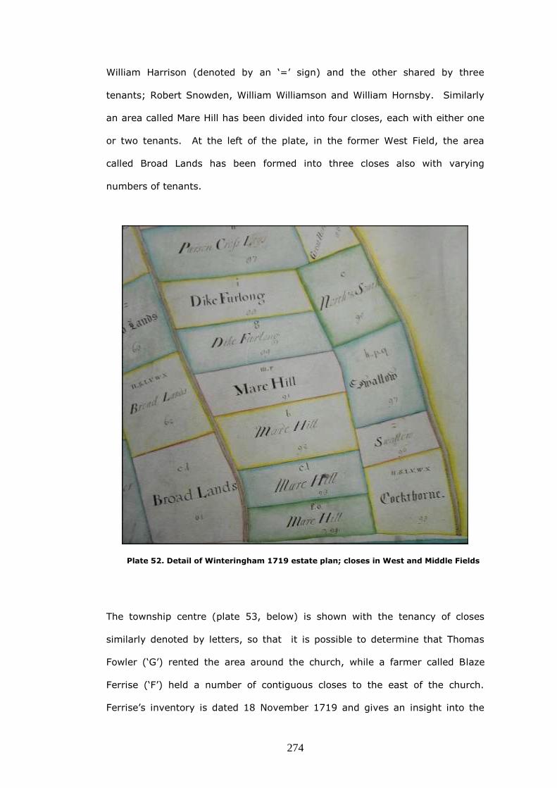
274
William Harrison (denoted by an ‘=’ sign) and the other shared by three
tenants; Robert Snowden, William Williamson and William Hornsby. Similarly
an area called Mare Hill has been divided into four closes, each with either one
or two tenants. At the left of the plate, in the former West Field, the area
called Broad Lands has been formed into three closes also with varying
numbers of tenants.
Plate 52. Detail of Winteringham 1719 estate plan; closes in West and Middle Fields
The township centre (plate 53, below) is shown with the tenancy of closes
similarly denoted by letters, so that it is possible to determine that Thomas
Fowler (‘G’) rented the area around the church, while a farmer called Blaze
Ferrise (‘F’) held a number of contiguous closes to the east of the church.
Ferrise’s inventory is dated 18 November 1719 and gives an insight into the
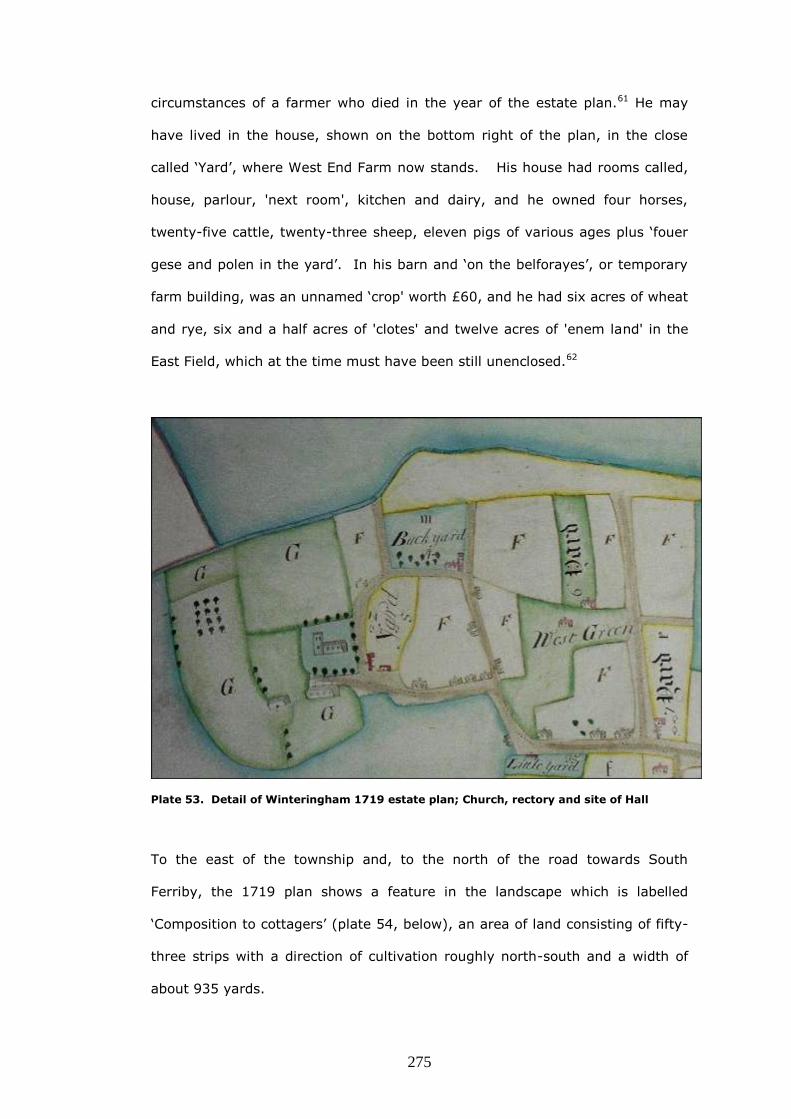
275
circumstances of a farmer who died in the year of the estate plan.61 He may
have lived in the house, shown on the bottom right of the plan, in the close
called ‘Yard’, where West End Farm now stands. His house had rooms called,
house, parlour, 'next room', kitchen and dairy, and he owned four horses,
twenty-five cattle, twenty-three sheep, eleven pigs of various ages plus ‘fouer
gese and polen in the yard’. In his barn and ‘on the belforayes’, or temporary
farm building, was an unnamed ‘crop' worth £60, and he had six acres of wheat
and rye, six and a half acres of 'clotes' and twelve acres of 'enem land' in the
East Field, which at the time must have been still unenclosed.62
Plate 53. Detail of Winteringham 1719 estate plan; Church, rectory and site of Hall
To the east of the township and, to the north of the road towards South
Ferriby, the 1719 plan shows a feature in the landscape which is labelled
‘Composition to cottagers’ (plate 54, below), an area of land consisting of fifty-
three strips with a direction of cultivation roughly north-south and a width of
about 935 yards.

276
Plate 54. Detail of Winteringham 1719 estate plan; 53 strips, ‘Composition to cottagers’
Nothing can be found in the record to indicate the precise origin of this feature,
in Winteringham but the etymology of its name, at its most basic, implies ‘an
agreement’ and it is sometimes used with the meaning of ‘payment by
agreement in lieu of, or in discharge of, some other financial or legal
obligation.’63 Either the agreement was between the owner of the lands and
the vicar, that it should in future be exempt from the payment of tithes,
because the vicar had been given money or land elsewhere or, more plausibly,
that the land had been granted, by agreement, to the cottagers, in place of
rights they had formerly had in the common fields. Support for the second
explanation is given in evidence produced during a court case of 1862
concerning tithes, as it was suggested then, that the ‘Composition’ was
amongst areas of land that were still titheable.64 In addition to this, amongst
several manorial bye-laws, written into the front of the Winteringham general
parish register, and dated the 23 October 1674, one indicates that the question
of common rights for cattle had become a matter of concern at that time:
…for the settling the peace and quiet…That every occupier of every
messuage, cottage or toft shall be allowed to have common of pasture

277
in Wintringham Marsh, Rotten-Sikes, Low Groves and Western Green for
four cows, or other beasts as long as they are not steers above two
years old, and for one horse, mare and gelding and no more. If a person
has more than one house or toft in his own hands then he shall keep no
more than one horse in the pastures but a beast instead of the horse.
If an occupier of a messuage, cottage and toft is not able or does not
want to stock the common with his own beasts or horse then he may let
his beastgates, plus the right to have another beast but no horse, to any
other person or dweller in Winteringham.65
If this second explanation is indeed the correct one, then by 1719, not only
had there been extensive, systematic formation of closes, but also, that other
pillar of later enclosing activity, the extinguishing of common rights had
somehow taken place. The enclosure to the west of the township, called ‘Hall
Closes’ on the 1719 plan (plate 50) is also marked ‘to the cottagers’, so it
seems likely that this was the product of a similar or identical arrangement.
James Saunderson who had became Viscount Castleton in 1714, on the death
of his father, himself died in 1723. As he was childless, all his honours became
extinct and his estates including Winteringham were bequeathed to his cousin
on his mother's side Thomas Lumley, third Earl of Scarbrough, who assumed,
by act of parliament, the additional surname of Saunderson.66 This owner of
Winteringham, died in 1752, leaving his property to his son Richard the fourth
Earl of Scarbrough, and it was the fourth Earl who began the second phase of
the enclosure of the parish by applying for an act of parliament in 1761.
Enclosures by private act had begun in Lincolnshire in 1731, when the first
authorised the exchange of glebe and other lands, between the rector and the
lord of the manor of Biscathorpe near Louth.67 Most of the few Lincolnshire
acts between then and the late 1750s, merely confirm an agreement to enclose
and there is, in consequence no award or map.68

278
The enclosure act of 1761, 'An
Act for Inclosing and dividing
several open Fields and
commonable Lands within the
Manor and Parish of
Wintringham, in the County of
Lincoln’ (Plate 55, left) was
passed principally to register the
agreement, between the rector
and the fourth earl of
Scarbrough, concerning
allotments made to the former in
exchange for his glebe lands in
the open fields and to an annual
money payment in lieu of tithes.
If the agreement had been made a few years earlier, a different method might
have been used and it may have been expected that some written record of
enclosure would exist amongst the Scarbrough Estate Papers, or the Church
records at Lincoln. Alternatively the agreement might have been validated by
the promulgation of a Chancery Decree, following some spurious legal
proceedings and would be found, (with difficulty) at the National Archives. The
earl of Scarbrough must have felt that these means of effecting enclosure were
somehow insufficient to the need of the occasion. First, the provisions of the
agreement are complicated and second, perhaps the earl believed that the
agreement might be challenged at some future time by ecclesiastical
authorities. He may also have been influenced by the outcome of the earliest
Lincolnshire enclosure act, Biscathorpe in 1731, which was ‘An Act for
Exchanging the Parsonage House and Glebe Lands in Biscathorpe in the County
of Lincoln, for other Lands belonging to the Lord of the Manor, and for giving a

279
Recompence to the Rector in Lieu of his Tythes, to enable the Lord of the
Manor to inclose the Common Fields.’69 Stallingborough is only twenty miles
away and that parish too, might have encouraged the use of a parliamentary
act. Here the 1737 legislation confirmed an agreement in Stallingborough
involving, a fellow north-Lincolnshire landowner, Mathew Boucherett, thirty-
seven other proprietors of lands and common rights, and the Bishop of
Lincoln.70 Whatever the reasoning of the earl, Winteringham was the first
enclosure act in north-west Lindsey.71
The act of 1761 involved the enclosure and division of approximately 1,900
acres of land in the parish. The main changes brought about were the
enclosure of land in the East Field, Groves, Folding, Ings and Ancholme Marsh
(see plate 55. above), some small repositioning of the roads in the parish, and
a reorganisation of fields and tenancies. The Rector, the Rev. Thomas Adams
received 146a. 3r. 24p. in lieu of glebe, and a further annual payment, by the
Earl to the Rector, of £100. 16s .3d. in place of tithes. The rector was also
permitted to stock the Cow Pasture ‘with five gates’ with either cattle or horses,
or he was authorised to let these rights instead. The act recognised the reality
of the continual action of estuarine erosion and deposition, because for every
acre of land that had been previously embanked or might in the future be
embanked, from the Humber adjoining the Groves, the rector was to receive an
additional sixpence per acre, in lieu of tithes.72 The prescribed routes of four,
forty-foot wide roads, all of which must have existed in some form prior to
1761, were officially established by the act, and the earl of Scarbrough agreed
to ‘appoint them’ within six months of the act; first, a road or way over the old
Middle Field to Winterton, second, a road or way over the old West Field leading
towards Roxby, third a road or way over the old East Field to the Winterton
Field and finally a road or way beginning at East Field Lane and passing over
the Groves towards South Ferriby.

280
The 1761 enclosure was not an immediate financial success however, and it
was believed at the time that the scheme had not been correctly carried out;
perhaps because there had been too little experienced supervision. The parish
was first let at a succession of relatively low rents; £809 in 1765 increased to
£1,295 in 1766, to £1,395 in 1770 and to £1,858 in 1777.73 A note of 1784,
by the earl’s agent, stated that:
the cause of Winteringham being before let at a less value, arose from
the Inclosure, and the Tenants being under restrictions respecting the
Nourishment and Care of the Quicksetts, which was very inefficiently
fenced and some parts not fenced at all, so that the Tenants could not
occupy their farms to the best advantage.74
A few years later, Arthur Young typically saw the good side of the process.
After a visit to see the Rector, he produced some statistics to demonstrate the
increase in well-being that enclosure had brought:
I wished to procure, while in the county, the births and burials of many
parishes, but was unable to effect it; a few I was favoured with; some of
which will shew in what manner inclosure has operated to diminish or
increase the people. The Rev. Mr Knight favoured me with the Births
from,
1732 to 1763, both inclusive, being 32 years =413
Ditto from 1765 to 1796, both inclusive, being 32 years =607
Increase since the inclosure =194
Deaths from 1732 to 1763 =354, and 1765 to 1796 =398
Increase since the inclosure =44
Difference between the births and burials, 1732 to 1763 =59
281
Ditto, 1765 to 1796 =209
The comparison in this parish is therefore striking in every point of view,
and proves that a vast increase of population has taken place since the
inclosure.75
By 1793 the fifth Earl of Scarbrough, because of his debts, had had to sell the
Winteringham Estate to Robert Smith, who was later to become Lord
Carrington.76 Smith (1752-1838) was the eldest of the four sons of the banker
Abel Smith. While his three younger brothers retained an involvement with
banking, Robert’s branch of the family seem to have become detached from
that business, to the extent that he showed his disdain for the rest of the
family and first tried politics as M.P. for Nottingham and then afterwards
became a landowner.77
Soon after his purchase of 2,422 acres, which had been valued at £52,197,
Smith began the procedure for parliamentary enclosure by having a notice
published in December 1794, in the Stamford Mercury. 78
Winteringham Intended Inclosure. The proprietors of the uninclosed
parts of the parish of Winteringham are requested to meet at the house
of Mr. George Bell in Winteringham aforesaid, on Wednesday the
Seventeenth of December, Instant, at Ten O'clock in the Morning, to
take into consideration the expediency of applying to Parliament the
next session, for an Act for inclosing the same.
The second Act for ‘dividing and enclosing a certain piece of pasture land in…
Winteringham… called the Cow Pasture, comprising . . . the Marsh, Rotten
Sykes, Low Groves and Western Greens, and other Land . . . lying between the
same Pasture and the River Humber; and for Dividing, Inclosing, and
Apportioning certain other Pieces of Meadow and Pasture grounds. . . called

282
the Composition Closes, and Hall Closes . . . and for other purposes’ was
passed in 1795.79 The three commissioners appointed were Francis Otter ‘late
of Coleby, now of Stainton Vale’, Samuel Turner ‘late of Cammeringham, now
of Buslingthorpe’ and Benjamin Codd of Glentworth who were to receive a fee
of £63 each for their work.80 The surveyor was to be Anthony Bower.
A few days after taking the oaths of office, the three commissioners indicated
their priorities and showed how seriously they took the matters of flood
protection, drainage and wetlands reclamation in the enclosure process, by
arranging for the following notice to be published in the Stamford Mercury on
26 June 1795:
Bank and Clough to be Made. The Commissioners appointed to inclose
certain open Lands, in the Parish of Winteringham.... intend meeting at
the House of MR. GEORGE BELL in Winteringham... on Wednesday the
1st Day of JULY next, at Ten O'clock in the Forenoon, at which time and
place, they intend to receive the Estimates or Proposals of any Person...,
who may then offer the same, for making a BANK,....... adjoining
the RIVER HUMBER, which is intended to be about Three Quarters of a
mile in length, Seven Feet in Height, Two Feet in Breadth upon the Top,
Three Feet Batter next to the Humber, and One Foot and Six Inches
Batter within; and also for cutting a new DRAIN to the Mouth of the
Haven of Winteringham.....and erecting a CLOUGH with a Ten Feet
Waterway across the same.81
Matters seem to have moved very quickly, because by September of that year
the clough appears to have been under construction and the Commissioners
were seeking quotations for making a new drain to the clough and the digging
of a new haven in the Humber:82
Drain and Haven to be Made. The COMMISSIONERS appointed to inclose
certain open Lands in the Parish of WINTERINGHAM...intend meeting at

283
the House of MR. GEORGE BELL in WINTERINGHAM on Monday the
Twelfth Day of OCTOBER next, at Ten O'clock in the Forenoon; at which
time and place they will be ready to receive the Estimates and Proposals
and to contract with any Person or Persons who may then offer the
same, for cutting a NEW DRAIN from the Warehouses near the Town of
Winteringham.... to the Clough now building there; the bottom thereof
to be Ten Feet Wide and to batter Eighteen Inches to every Foot rise -
and also for cutting a NEW HAVEN in a direct line from the Said Clough
to low Water Mark in the Humber, with a Ten Feet Bottom and to batter
Two Feet and a Half to every Four Rise. By order of the Commissioners.
The Commissioners of Sewers in 1583 had mentioned a haven at
Winteringham, but this may have fallen into disrepair and could have been
completely silted up by 1795. The cutting of a new haven seems an unusual
project to be included as part of the process of enclosure, but it would have
had agricultural uses as it would enable, more easily, the movement of animals
and crops to the north bank and the important town of Hull, as well as the
import of goods such as guano. It may also indicate that the whole enclosure
project was part of a greater scheme by Lord Carrington; a man who did not
have the upbringing of a rent-collecting land owner, but had a background of
commerce and the financial world, and was fundamentally an entrepreneur,
even if he had turned his back on his banking family.

284
Plate 56. The drain from the clough to Winteringham Haven in 2011
Roads and ways in the southern part of the parish were laid out as prescribed
in the 1761 act, but the Commissioners now needed to lay out ways through
the northern part and so in April 1796 requested quotations for stoning these
highways in the Stamford Mercury:83
Winteringham Inclosure The Commissioners for inclosing the Marsh at
WINTERINGHAM, do hereby give Notice, that they will, at their
MEETING, to be holden at the House of MR. GEORGE BELL, at
WINTERINGHAM aforesaid, on Monday the Second Day of May, next,
receive proposals and contracts for covering the Roads over the said
Marsh with Stone, of such thickness, and a such Manner as they shall
then direct. By order of the Said Commissioners.
The Winteringham Award was signed on 12 January 1798. The original Award
and map are not to be found; M.E. Turner suggested in 1978 that the originals
were in the custody of the parish council, but unfortunately this is not now the
case.84 A copy of the Award, (but not the map) exists in the Brown Hudson
deposit at the Lincolnshire Archives.85 Tithes and Common Rights had been
285
abolished from 5th April 1796. The former remaining open fields and marsh
had been allotted to forty-eight owners of general allotments and to two
owners of special allotments. The Lord of the Manor, Lord Carrington, received
special allotments of 111 acres in lieu of common rights on the Marsh, or over
eleven percent of the total area being enclosed. In making this generous
award, it may be that the commissioners recognised that this was land that
was situated on the Humber side of the newly constructed flood bank. It would
be inundated several times a year, and would, in time, disappear because of
erosion, as indeed it has. The Rector, the Honourable and Reverend John
Lumley, younger brother of the 5th Earl of Scarbrough, (who was still patron of
the Rectory although he had had to sell the manor) was a non-resident
Rector.86 He was awarded in lieu of great and small Tithes, seventy-six acres
of land in the Marsh, and a further twelve acres in place of his Common Right
and Beast Gates in the Cow Pastures. Two hundred acres had been therefore
allotted in special allotments, while the general allotments totalled 737.4 of
which Lord Carrington received another 310 acres, and the remaining forty-
seven owners shared 427.4 acres. A general order stated that allotments were
to be fenced within three months of the date of award. Because the area
enclosed in 1798 bordered the Humber and the small village of Whitton, it was
not necessary to lay out any major roads, but foot roads, a bridle road and
private carriage roads were made., Four public drains had been laid out and
these run eastwards towards the Haven drain, which must have been
constructed early in the enclosure process. Field ditches, running into the
public drains, all had to be at least four feet deep.
Lord Carrington’s interest and concern for his Lincolnshire estate and his
tenants does not seem to have diminished after enclosure, as Arthur Young
reported that:

286
..a man (is) employed whose only business is to be constantly walking
over every part of the estate in succession, in order to see if the fences
are in order: if a post or a rail is wanting and the quick exposed, he
gives notice to the farmer, and attends again to see if the neglect is
remedied. This upon a tract of land large enough to bear the expence, is
an excellent system.87
At Wintringham, Lord Carrington has built several new farm-houses,
barns &c with conveniences for new farms, and at a rate which shews
the cheapness of such works in this country.88
No instance of breaking up grass land that I had heard of in
Lincolnshire. proves the extraordinary fertility of that county more
clearly than that at Wintringham, on the estate of Lord Carrington, who,
upon the high price of corn, was willing to indulge his tenants with the
leave which they desired, of ploughing 200 acres, and for which they
offered a compensation in rent; a great part of which, however, upon
the sudden fall in the price of grain, which happened soon afterwards his
Lordship, I was informed, spontaneously remitted.89
At Wintringham, upon Lord Carrington buying the estate, he made all
the cottagers tenants to himself, and all have cows and gardens.90
Thomas Stone ridiculed the good news about rents and agricultural practices
that Arthur Young reported. In his review of Arthur Young’s survey, he said:
Mr ‘Land taster’ Young values this estate upwards of five shillings per
acre more than its present letting. Upon the whole after attentively
pursuing Mr Young's statements of the rents of estates in partial
instances not comprising collectively one twentieth part of the county

287
picked up from vague reports at market ordinaries in morning rides &c
and in many of those instances… it is impossible for an average rent to
be drawn or fixed on any description of soil for any purpose of
calculation.91
Despite the derision of Thomas Stone, and the excessive approbation that
Young lavished on everything to do with the estate, from owner to soil quality,
it is apparent that Winteringham is different to other parishes in this study. Its
undoubted fertility made it the subject of extensive early enclosure, such that
by 1719, some of the open fields had been already been enclosed and partial
abolition of common rights had taken place. A new owner enclosed the
southern part of the parish by agreement with the Rector using a fresh weapon
in the encloser’s armoury, an Act of Parliament Then a totally different sort of
owner arrived on the scene; not a traditional land-owning aristocrat, but
instead the scion of a banking family. He saw the land like capital, as a subject
for investment, quickly arranged the enclosure of the rest of the parish, and
followed up the process with a continuing program of after-care for land and
tenants.
Conclusions
Both Waddingham and Winteringham, at opposite ends of the study area, show
that where the surviving evidence is more wide-ranging than usual, the long
chronicle of agricultural improvement is seen to be more complex than might
have been expected.
Waddingham provides an example of a ‘village revolt’, but we only know this
because a unilateral attempt at enclosure was the subject of a court case. One
of the features of the study area is the lack of evidence for insurrections
against the agrarian changes that were taking place, and it is to be wondered if
there were others which, because of the lowly status of the objectors, are lost

288
to the records. A major part of the parish was enclosed with the help of a
Chancery decree. As has been demonstrated in this thesis, these documents
are unusual in Lincolnshire when they actually perform the function of ratifying
an agreement to enclose, but it is interesting to see how this document of 1701
anticipates some of the wording of later parliamentary acts and awards. The
parliamentary act, when it did come in 1769, was prompted by an event twenty
miles or so to the north, when the new sluice gate controlling the flooding of
the Ancholme basin, meant it was practicable to drain and enclose the low-
lying lands. That sluice gate had in turn been made necessary, this thesis has
suggested, by a climate change to one of several decades of warmer wetter
weather. And so it becomes clear that the reasons for enclosing activity are not
always immediately evident.
Winteringham with its three distinct phases provides a ready chronological
example of the sequence in which such a rich area of land might be improved.
Winteringham was recognised by Arthur Young as one of the places where the
different sorts of soil were all excellent and this may have been the reason why
there had been extensive enclosure by the time of the 1719 estate map. There
was no doubt that the expense of rearranging the strips in the Cliff, West Field
and Middle Field into larger units, would soon increase the rents that could be
charged by the Saunderson family. The second phase by an act which had the
effect of ratifying an agreement, in the way a Chancery decree might once
have done, included land that was lower and less well drained. Finally a
conventional act, later enclosed those portions that remained and tackled the
outstanding problems of the parish, the lack of a river embankment, a large
drain and its accompanying sluice gate.

289
References
1 W. White, History, Gazetteer and Directory of Lincolnshire (1856), p.606
2 K. Cameron, The Place Names of Lincolnshire Vol. 6 (Nottingham, 2001),
p.115. ‘Thack ‘ refers to thatching materials; TNA:PROB11/91 Will of Thomas
Turswell, Yeoman of Bishop Norton, Lincolnshire, 22 May 1598 mentions ‘tenn
swathes of Thacke grownde in Waddingham Thack Carr’ 3 K. Cameron, The Place Names of Lincolnshire, Vol. 6 (Nottingham, 2001),
pp.113-8 4 LAO: MCD708 Abstract of Breife of Depopulacons taken by vertue of the
commission for Lincolne.
5 R. Manning, Village Revolts, Social Protest and Popular Disturbances England
1500-1640 (Oxford, 1988) pp.3,64
6 Ibid.
7 K. Wrightson, English Society 1580-1680 (1983), p.179
8 TNA: STAC 8/42/11, Adams v. Burrell and others: Lincoln
9 A ‘gapstead’ is a hole in a hedge or a gateway: E. Peacock, A Glossary of
Words Used in the Wapentakes of Manley and Corringham, Lincolnshire,
Second Edition (1889), p.228
10
K. Lindley, Fenland Riots and the English Revolution (1982), p.254 11 TNA: STAC 8/42/11
12 Ibid.
13 For women in all manner of disputes, vide R. A. Houlbrooke, 'Women's social
life and common action in England from the fifteenth century to the eve of the
civil war', Continuity and Change 1 (1986), pp.171-189
14 She is also called ‘Jennet Whapplod’ elsewhere in the same set of
documents. 15
TNA: STAC 8/42/11
16 Wrightson, English Society, p.179
17 Sir W. Dugdale, The History of Imbanking and Drayning…, p.89
18 TNA: C78/1096/2 Decree in Chancery
19 D. M. Hadley, The Northern Danelaw - Its Social Structure, c. 800 – 1100
(2000), p.210
20 Ibid.
21 P. L. Everson, C. C. Taylor and C. J. Dunn, Change and Continuity: Rural
Settlement in North-West Lincolnshire ( 1991), p.13

290
22 Ibid.
23 D. M. Hadley, The Northern Danelaw, p.212
24 LAO: D & C, DIV/59 quoted in J.Thirsk, (ed.), The Agrarian History of
England and Wales, Vol. V.II, 1640-1750: Agrarian Change (Cambridge,1985),
p.318
25 LAO: Waddingham FAC8, Waddingham Church Faculty to take down the
church of St Peter and to unite the benefice with that of St Mary, 30 July 1687.
26
M. Overton, The Agricultural Revolution in England: the Transformation of the
Agrarian Economy, 1500-1850 (Cambridge, 1996), p.165 27
TNA: PROB 11/572 Will of James Thompson, Gent. of Waddingham, Lincs. 28 For examples of pre-parliamentary enclosure in Kesteven see:
J.A. Johnson, '17th-Century Agricultural Practice in Six Lincolnshire Parishes' in
Lincolnshire History and Archaeology, 18 (1983); S. McA. Stevens, 'Non-
parliamentary enclosure: Kesteven, Lincolnshire, 1536-1750 Lincolnshire’
(Unpublished M.A. dissertation, Nottingham 1999) 29 Manning, Village Revolts, p108
30
'In general, enclosure by decree was enclosure by agreement' according to
M.W. Beresford, 'Habitation versus improvement', in: F.J. Fisher, (ed.), Essays
in the Economic and Social History of Tudor and Stuart England (Cambridge,
1961) p.57. 31
‘Depasture’, to feed livestock by grazing them on pasture; The arrangements
surrounding this twenty acre allotment, which became known as Poor Close,
was commented on in an 1839 Charity Commissioners Report and became the
subject of an 1848 Enclosure Act, vide 1839 XXXII Report of the
Commissioners Appointed to Inquire Concerning Charities and Education of the
Poor in England and Wales …. Part 4, Lincolnshire, p.484
32 The decree has ten thousand words, most of which describe the plots. 33 J.V. Beckett, M.E. Turner, and B. Cowell, ‘Farming through Enclosure’, Rural
History, 9:2 (1998)
34 LAO: RED 3/1/4/1/3 May 1734 35 C.J. Page, History of the Ancholme Navigation (Lincoln, 1969), p.1 36 LAO: Lindsey award /113 Snitterby, Atterby and Waddingham, 29 Nov 1770
37 This is written in the margin of the sixteenth sheet, and it is immediately
followed by the words: ’Snitterby allotments begin here.’ 38
Lord Monson was the great–grandson of Sir John Monson; G. Norgate,
‘Monson, John, second Baron Monson (1727-1774 )’, rev. M. Kilburn, Oxford
Dictionary of National Biography Vol 38 (Oxford , 2004), p.677 39
LAO: Lindsey award /113, ibid.

291
40
1839 XXXII Report of the Commissioners … Concerning Charities and
Education of the Poor …. Part 4, Lincolnshire, p.484 41
LAO: Lindsey award /113, ibid. 42 J. Thirsk, Chapters from the Agrarian History of England and Wales:
Agricultural Change: Policy and Practice,1500-1750 (Cambridge, 1990), p.207
43
P. Bingham, Reports of Cases Argued and Determined in the Court of
Common Pleas, and Other Courts (1829), pp.116-130 44 TNA: IR 30/20/353 Waddingham tithe map; U.K. Environment Agency
website, accessed 10 March 2011, http://maps.environment-
agency.gov.uk/wiyby/wiybyController?x=498500.0&y=396500.0&topic=floodmap&ep=map&scale=4&location=Waddingham,%20Lincolnshire&lang=_e&layerGroups=1,&textonly=off 45 LAO: Lindsey Award /158 Waddingham Cow Fold Award and Plan (1848)
46
1839 XXXII Report of the Commissioners … Part 4, Lincolnshire, p.484 47
The Cow Fold Enclosure field is marked on the Tithe Map, (TNA: IR
30/20/353) as field 448 with an area of 16 acres, 1 rod, 15 perches. The Award
Map of 1848, however, notes its area as 17 acres, 1 rod, 29 perches.
48 A. Young, General View of the Agriculture of the County of Lincoln ( 1799),
p.10; Young seems unsure of the difference between ‘marsh’ and ‘warp’, and
does not attempt to translate the Lincolnshire dialect word ‘grove’ meaning a
field in which shallow parallel ditches had been dug.
49 W. White, History, Gazetteer and Directory of Lincolnshire (1856), p.614
gives 3,970 acres
50 Lao: MISC DEP 625/1
51 Lincoln county, commissioners of sewers, An Inquisition taken before the
Commissioners of Sewers for the County of Lincoln, 1583 (Ripon, 1851), p.15;
‘Haughton’ is West Halton immediately to the west of the parish.
52 T. W. Beastall, A North Country Estate: the Lumleys and Saundersons as
Landowners, 1600-1900 (1974), p.77
53 B. Burke, A Genealogical and Heraldic History of the Extinct and Dormant
Baronetcies of England, Ireland, and Scotland, 2nd edn (1844), pp.470,585
54 Sir W. Dugdale, The History of Imbanking and Drayning…, p.89
55 An obsolete meaning of ‘surrounded’ was ‘overflowed’ or ‘flooded’, vide
O.E.D.,Vol XVII (1989), p.307 Damage in the Ancholme valley caused by
Monson’s works is discussed in : K. Lindley, Fenland Riots and the English
Revolution (1982), p.15
56 LAO: Inventory 156/251, Edward Roberts Feb 1653; A transcription is given
in: D. Neave (ed.), Winteringham 1650-1760 ( Winteringham, 1984), p.70

292
57 LAO: Glebe Terrier bundle, Winteringham 1693
58 The aerial photo has been amended by reference to the 1719 plan (LAO:
MISC DEP 625/1) and a copy of the Winteringham Cow Pasture Award 1798 in
LAO: Brown Hudson deposit 7/1, which is bound into a foolscap volume with
the Barnetby Award of 1768.
59 LAO: MCD708 Abstract of Breife of Depopulacons taken by vertue of the
commission for Lincolne.
60 LAO: MISC DEP 625/1 Map of the Manor of Winteringham 1719, Surveyed for
[James Saunderson] Earl of Castleton by Joseph Dickinson. Includes names of
tenants; Joseph Dickinson seems to have been a well known local surveyor; he
surveyed, for example, Joseph Mellish’s estate at Fenwick near Doncaster in
1717 (University of Nottingham Manuscripts and Special Collections: Mellish
MSS 63/2).
61 LAO: Inventory 206/83; transcribed in: Winteringham Local History Group,
Winteringham 1761-1871 (Hull,1980), p.145
62 ‘Clotes’ may be clods or cultivated land, (vide O.E.D., vol 3 [1989], p.352)
and the valuation on it, of £7-11-6, may be the value of the work, perhaps
harrowing, that has been put into it; ‘Enem’ - Perhaps a miss-spelling of
emmer or durum wheat (vide O.E.D., vol 5 [1989], p.182); 'enem land' land
that is going to be sown in the springtime for the crop. Formerly, but no
longer, grown in England according to: C. M. Woolgar, D Serjeantson, T.
Waldron, Food in Medieval England: Diet and Nutrition (2006), p.49
63 O.E.D., vol 3 [1989], p.625; No origin is suggested by Prof. Cameron in: K.
Cameron, The Place Names of Lincolnshire, Vol. 6 (Nottingham, 2001), p.123
64 Re The Tithe Commissioners and Lord Carrington in: The Law Times Reports,
Volume VI, March to September 1862 (1862), p.820
65 LAO: Winteringham PAR/1/2 General register, Baptisms 1674-1737/38.
Marriages 1674/1675-1737/38. Burials 1674-1737/38. At front: manorial
orders and byelaws made at court leet, with names of the tenants 1674; It is
not certain why horses had become such a concern to the villagers.
66 Burke, A genealogical and heraldic history, p.470
67 W.E. Tate (ed., M.E. Turner), Domesday of English Enclosure Acts and
Awards (Reading, 1978), p.160
68 Ibid.
69 LAO: MISC DON 277/1, Biscathorpe Inclosure Act 1731
70 LAO: MF/2/109 Stallingborough Inclosure Act 1737
71 LAO: LDAP/2/14 Winteringham Inclosure Act
72 Ibid.

293
73 Quoted in T.W. Beastall, The Agricultural Revolution in Lincolnshire (Lincoln,
1978), p.133
74 Ibid.
75 A. Young, General View of the Agriculture of the County of Lincoln (1799),
p.421
76 DDCL/2925 3-4 Jun 1793
77 Y. Cassis, City bankers, 1890-1914 (Cambridge, 1994 ), p. 236
78T. W. Beastall, The Agricultural Revolution…p.87. Some land will have been
lost by erosion to the Humber; Stamford Mercury 5 December 1794
79 LAO: BH/7/4 Winteringham (Cow Pasture) Enclosure Act [1795]; bound with:
Barton on Humber Enclosure Act, 1793;Barrow on Humber Enclosure Act,
1797; Ancholme Drainage Act, 1761-1766.
80 Francis Otter was later to be a Commissioner at Ashby in Bottesford in 1809;
Samuel Turner had been a Commissioner at Bottesford cum Yaddlethorpe in
1797 and would go on to assist with Messingham in 1804, and Ashby in
Bottesford in 1809; like Turner, Benjamin Codd would act at Messingham in
1804, and Ashby in Bottesford in 1809.
81 ‘Batter’ is the slope of a wall, terrace or bank from the perpendicular (O.E.D.
vol.1 [1989], p.1006); ‘Clough’ is the outfall sluice of a drain communicating
with a tidal river and provided with flood gates (O.E.D. vol. III [1989],p.364).
The local word for it however is ‘cleugh’, which is pronounced as ‘clue’.
82 Stamford Mercury, 18 September 1795
83 Stamford Mercury, 29 April 1796
84 Tate (ed., Turner), Domesday of English Enclosure Acts, p.169
85 LAO: BH 7/1, Copy of award, Winteringham (Cow Pasture) Award 1798
bound into foolscap volume with the Barnetby Award of 1768. Also has a
schedule of Winteringham tithe payments, amount per acre payable by
proprietors and also their assessment to repair the Humber bank.
86 Burke, A Genealogical and Heraldic History, p.478 87
A. Young, General View…,p.19 88 Ibid, p.34 89 Ibid, p.198; present writer’s italics. 90
Ibid, p.413 91
T. Stone, A Review of the Corrected Agricultural Survey of Lincolnshire, by
Arthur Young, Esq. Published, in 1799 (Edinburgh,1800), p.46
An exposition of the four Gospels

294
8. The new landscape of north-west Lindsey
It would be difficult to attempt a description of husbandry in north-west Lindsey
at the end of the eighteenth century without reference to the writings of Arthur
Young, the Secretary of the Board of Agriculture. He undertook a series of
journeys throughout the British Isles and France describing agricultural activity,
and published his General View about Lincolnshire in 1799, with a second edition
in 1813.1
Nearly thirty years earlier, in the days before most of the changes brought by
parliamentary enclosure, Young had visited Lincolnshire and had seen ‘little but
what merited condemnation.’2 He was still expecting, he said, to find it ‘in a
very backward state.’3 He quickly determined the landownership situation;
’In the angle of country in the north-west of the county, the land is possessed
by half a dozen persons. The coast from Ferraby Sluice to Gun-house inclusive,
nearly all belongs to Lord Carrington, Sir John Sheffield and Mr. Goulton’.4 He
described the area’s landscape and pointed out that some land, just to the south
of the study area, was open field and yet to be enclosed.
The space from Tilby to Scunthorp, four miles long, north and south, and
three miles broad, east and west, chiefly light sand; but producing good
turnips, barley, and rye. From Scunthorp to Messingham, part sand, part
cold clay, and much open field. Winterton, good channelly loam, on a
limestone substratum, Wintringham, very rich; Alkborough, mixed sand;
Halton, good arable; Roxby, part sand, good barley, and turnip, and
some wheat , Coalby, good wheat and beans, excellent loam. These form
the nook south of the Humber. Under the whole country, generally
speaking, stone is to be found at various depths.5

295
Dr Thirsk refers to this expedition as a ‘fleeting inspection’ and Grigg points out
that he ‘cantered through Lincolnshire in twelve weeks’ and complains that it is
‘clear that that he had often not visited some of the places he describes so
vividly.’6 Since the county has almost seven hundred parishes, it could hardly
be otherwise. A close examination of the text suggests that Young visited the
estate of the Sheffields either at Normanby or Burton-upon-Stather and spoke to
Sir John Sheffield, his brother, the Reverend Robert, or the land agent, before
progressing to Alkborough where he may have been entertained by Thomas
Goulton. A description of the ‘noble scenery’ and the view of the three rivers
from Goulton’s ‘beautiful grounds’ at Walcot Hall suggest a pre-prandial stroll
with the landowner.7 Perhaps the following morning he rode to Winteringham
and spoke to Lord Carrington or his agent. From these three contacts alone, he
could have secured sufficient titbits concerning the agriculture of north-west
Lindsey to fill the pages of his General View:
Mr. Goulton at Alkborough last year (1796) dibbled peas on sward and
got 7 quarters an acre’ ;… Mr. Goulton has dibbled wheat with success
and his tenant Mr. Richard Langton at Whitton has this year 13 acres . On
the whole it has succeeded greatly’; … Mr. Goulton remarks…that turnips
are best manured with short dung …
and so on.8
Much of the text has the character of self-congratulatory gentry tittle-tattle and
there is scarcely a mention of the poorer members of the farming community in
north-west Lindsey. Thirsk thought that it was not a general view at all, but ‘the
restricted view of the progress of a minority.’9 Because however of the details
of contemporary farming practices that it contains, it is one of the best
assessments we have, until James Caird’s description of Lincolnshire in 1851.10
Statistics from the 1801 Crop Returns have been extracted for all those study

296
area places for which information was collected (table 8, below).11 The returns
contain data relating to townships and parishes which account for only about
half of the study area.12 Of this area, just 29% is accounted for by the crops
recorded and it is assumed that the rest was in fallow, permanent or temporary
grasses. Writers agree that these returns under-estimate the actual acreage of
each crop, but that the proportions between the crops recorded are accurate.13
The most noticeable feature of the study area figures is the predominance of
grain crops which accounts for two-thirds of the acres returned. The high
proportion of oats in Ashby (36% of all crops returned) may well have been
because the place was being warped at the time, and oats is the lead crop in
these circumstances, as it can be planted on new, poor or even salty soils with a
greater chance of success than other cereals.14 It may have been growing on
land that had been flooded at Winteringham, for the same reason, and so would
explain the 23% in that place, which was otherwise predominantly wheat land.
Low oats figures elsewhere, may indicate that available waste in those parishes
had been brought into cultivation in earlier years. Rye is a poor-soil crop so its
high figures on the dry sandy soil at Flixborough and Frodingham seem
appropriate. Turnip too is a light-land crop and the high figure in some areas
(assuming it was mainly turnips rather than rape) suggests that sheep were
being fed off the fields, without the fear of foot-rot. Peas and beans were widely
grown in the study area, although at this time presumably, as fodder for cattle.
While beast could be turned out onto pea fields to eat both peas and pea ‘straw’,
field beans would need to harvested and dried for winter feed, as cattle refuse to
eat bean ‘straw’.
Clover might have been grown, but was nowhere recorded perhaps because the
crop may have been regarded as coming under the heading of temporary
grasses. As it put nitrogen back into the soil, it was used as part of a four-course
rotation and so it is not possible to tell therefore whether this idea was
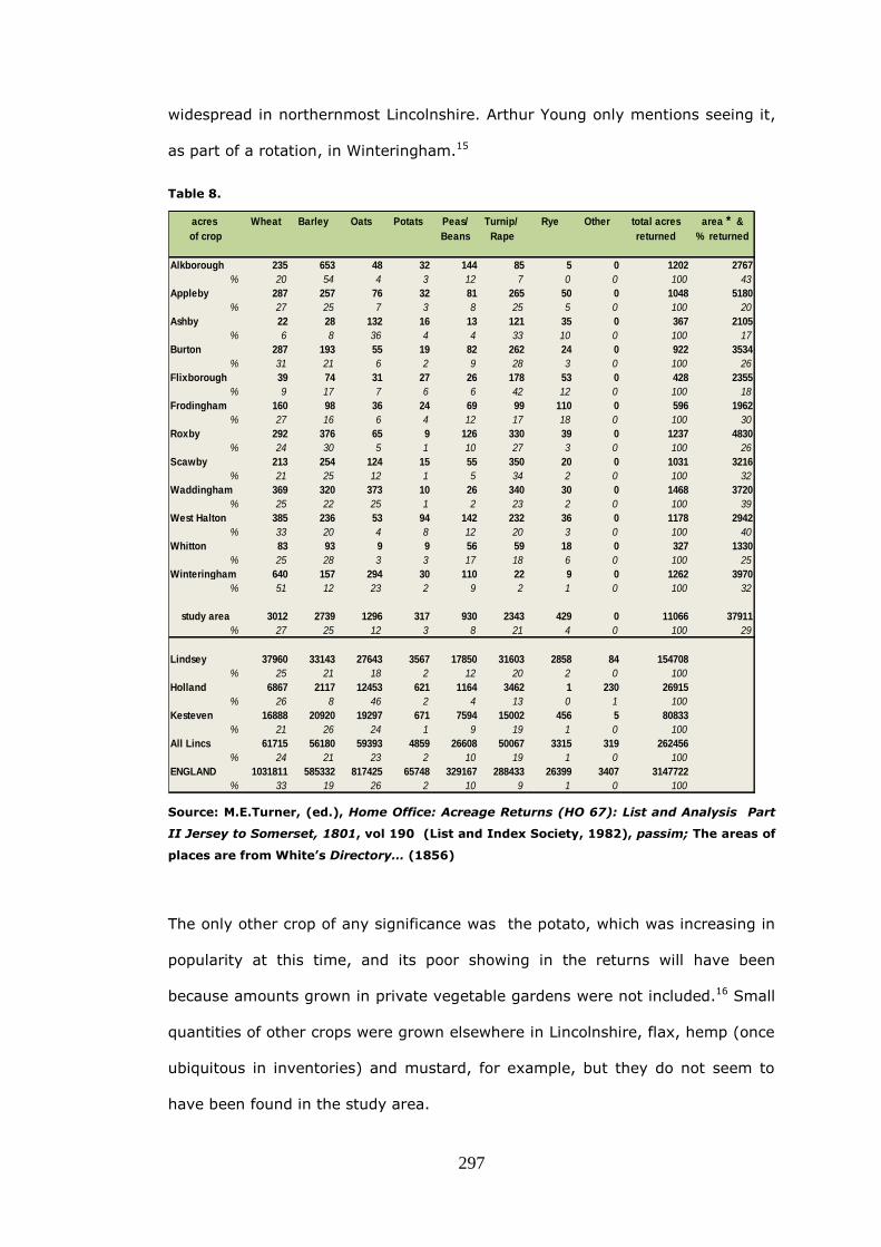
297
widespread in northernmost Lincolnshire. Arthur Young only mentions seeing it,
as part of a rotation, in Winteringham.15
Table 8.
acres Wheat Barley Oats Potats Peas/ Turnip/ Rye Other total acres area * &
of crop Beans Rape returned % returned
Alkborough 235 653 48 32 144 85 5 0 1202 2767
% 20 54 4 3 12 7 0 0 100 43
Appleby 287 257 76 32 81 265 50 0 1048 5180
% 27 25 7 3 8 25 5 0 100 20
Ashby 22 28 132 16 13 121 35 0 367 2105
% 6 8 36 4 4 33 10 0 100 17
Burton 287 193 55 19 82 262 24 0 922 3534
% 31 21 6 2 9 28 3 0 100 26
Flixborough 39 74 31 27 26 178 53 0 428 2355
% 9 17 7 6 6 42 12 0 100 18
Frodingham 160 98 36 24 69 99 110 0 596 1962
% 27 16 6 4 12 17 18 0 100 30
Roxby 292 376 65 9 126 330 39 0 1237 4830
% 24 30 5 1 10 27 3 0 100 26
Scawby 213 254 124 15 55 350 20 0 1031 3216
% 21 25 12 1 5 34 2 0 100 32
Waddingham 369 320 373 10 26 340 30 0 1468 3720
% 25 22 25 1 2 23 2 0 100 39
West Halton 385 236 53 94 142 232 36 0 1178 2942
% 33 20 4 8 12 20 3 0 100 40
Whitton 83 93 9 9 56 59 18 0 327 1330
% 25 28 3 3 17 18 6 0 100 25
Winteringham 640 157 294 30 110 22 9 0 1262 3970
% 51 12 23 2 9 2 1 0 100 32
study area 3012 2739 1296 317 930 2343 429 0 11066 37911
% 27 25 12 3 8 21 4 0 100 29
Lindsey 37960 33143 27643 3567 17850 31603 2858 84 154708
% 25 21 18 2 12 20 2 0 100
Holland 6867 2117 12453 621 1164 3462 1 230 26915
% 26 8 46 2 4 13 0 1 100
Kesteven 16888 20920 19297 671 7594 15002 456 5 80833
% 21 26 24 1 9 19 1 0 100
All Lincs 61715 56180 59393 4859 26608 50067 3315 319 262456
% 24 21 23 2 10 19 1 0 100
ENGLAND 1031811 585332 817425 65748 329167 288433 26399 3407 3147722
% 33 19 26 2 10 9 1 0 100
Source: M.E.Turner, (ed.), Home Office: Acreage Returns (HO 67): List and Analysis Part
II Jersey to Somerset, 1801, vol 190 (List and Index Society, 1982), passim; The areas of
places are from White’s Directory… (1856)
The only other crop of any significance was the potato, which was increasing in
popularity at this time, and its poor showing in the returns will have been
because amounts grown in private vegetable gardens were not included.16 Small
quantities of other crops were grown elsewhere in Lincolnshire, flax, hemp (once
ubiquitous in inventories) and mustard, for example, but they do not seem to
have been found in the study area.

298
The high figure for turnips (assuming that it was mainly that crop rather than
rape) at Burton-upon-Stather is intriguing. The parish had yet to be enclosed by
parliamentary means and one would have expected, in an open-field settlement,
that wheat and barley would be the main crops to the exclusion of most others.
Turnips accounted for 28% of the acreage however, and it seems unlikely that
this large area could have been sown, on un-enclosed land, without some special
agreement between growers and cottagers, unless in fact the place was, in fact,
already enclosed. It may be that the parliamentary process, which began two
year after the returns were collected, merely served to make legally binding a
state of affairs that already existed. In his comments to the statistics the Rev.
Sheffield makes no mention of open-fields, or indeed any crop of rape.17
By 1830 the work of enclosure was nearly done. The ancient landscape that had
been nibbled at by piecemeal enclosure, for several centuries had, in a relatively
short time, been all but gobbled up and consigned to oblivion. Some of the
poorer sandy central parts of the study area around Appleby and Frodingham
were about to be divided and fenced, the remaining twenty-seven acres of
Burringham would soon be reorganised and it only remained to apportion
Broughton common when the dispute between E. A. Stephens and Lord
Yarbrough ended, with the death of the former. Almost as an afterthought, in
the 1870s, Brumby common and moors were tidied up and that was that.
Inclosure came, and trampled on the grave
Of labours rights, and left the poor a slave…18
John Clare had written these words in about 1824, and yet it seemed that there
had hardly been an angry word in north-west Lindsey. The Midland Rising of
1607 had barely touched Lincolnshire and, in the north of the county, the
Inquisition of that year had found little evidence of depopulation. It was true
that the women of Waddingham had been reprimanded for tearing down the
‘gapsteads’ in 1608 but, after that unpleasantness, concord apparently
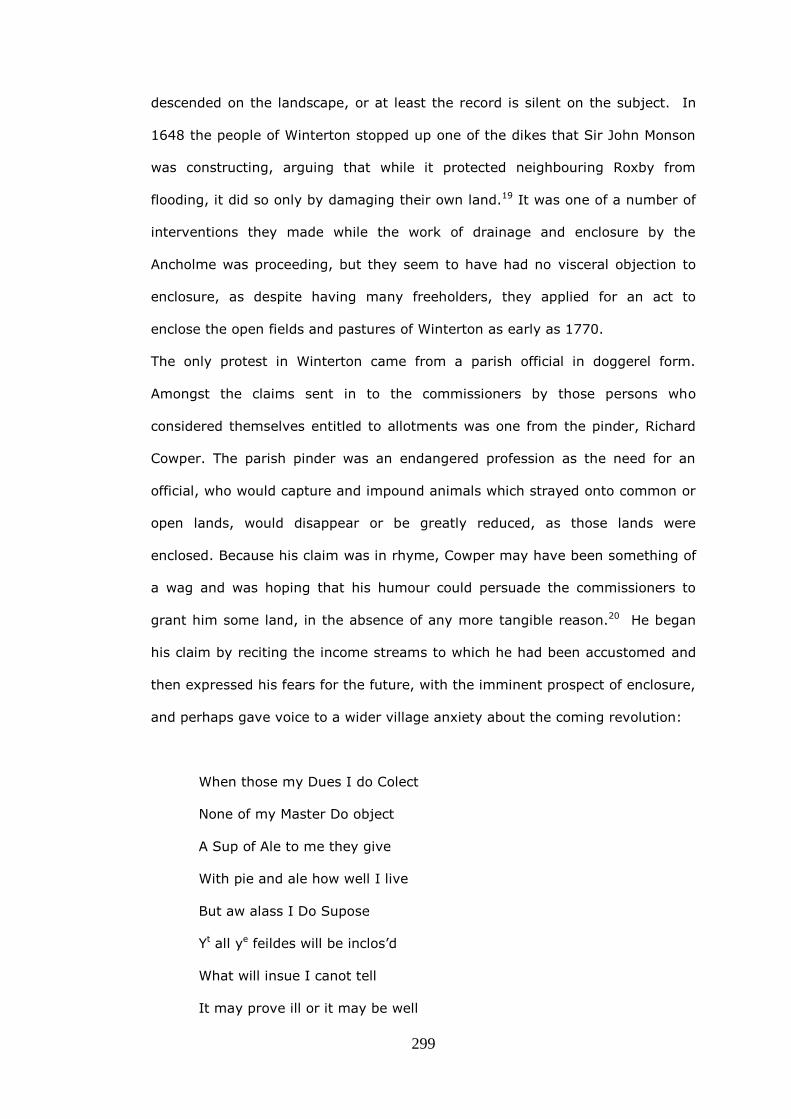
299
descended on the landscape, or at least the record is silent on the subject. In
1648 the people of Winterton stopped up one of the dikes that Sir John Monson
was constructing, arguing that while it protected neighbouring Roxby from
flooding, it did so only by damaging their own land.19 It was one of a number of
interventions they made while the work of drainage and enclosure by the
Ancholme was proceeding, but they seem to have had no visceral objection to
enclosure, as despite having many freeholders, they applied for an act to
enclose the open fields and pastures of Winterton as early as 1770.
The only protest in Winterton came from a parish official in doggerel form.
Amongst the claims sent in to the commissioners by those persons who
considered themselves entitled to allotments was one from the pinder, Richard
Cowper. The parish pinder was an endangered profession as the need for an
official, who would capture and impound animals which strayed onto common or
open lands, would disappear or be greatly reduced, as those lands were
enclosed. Because his claim was in rhyme, Cowper may have been something of
a wag and was hoping that his humour could persuade the commissioners to
grant him some land, in the absence of any more tangible reason.20 He began
his claim by reciting the income streams to which he had been accustomed and
then expressed his fears for the future, with the imminent prospect of enclosure,
and perhaps gave voice to a wider village anxiety about the coming revolution:
When those my Dues I do Colect
None of my Master Do object
A Sup of Ale to me they give
With pie and ale how well I live
But aw alass I Do Supose
Yt all ye feildes will be inclos’d
What will insue I canot tell
It may prove ill or it may be well

300
If ye kind Gent men of Our Comishon
Will grant me leve them to petition
By thear Plastick power be so kind
Leave me as Good as me thay find
I am Content no more Ile say
Your Petitioner Shall ever pray
He concludes with an appeal for a specific portion of the waste:
1 Jan 1771 Winterton
Worthey Gentlemen May you therefore be pleased to Grant to Your Poor
Petitionr, if in your power, yt peice of ye Princes Wast called Goose hill
Lane to Roxbey for the suport of a Horse or Cow or pleas lett mee aney
Waste Elcewhear for provision for my Cattle and Suporte of mv Poor
famley
Worthay Gent I am your Hble Servt
Richd Cowper
Because Richard Cowper could not claim ownership of lands, tenements or tithes
or any rights, such as beast or sheep-gates, it appears his enterprising and
amusing doggerel was in vain and he was not awarded any land at all at
enclosure.
If there was more substantive opposition to parliamentary enclosure, it has not
come to light. In the fens in 1767 at Haut Huntre 'desperate persons . . . in the
dead of night shot into the windows of several gentlemen whom they thought
active in procuring the act.'21 No such high drama has been discovered in the
study area, and even references to counter petitions in the pages of the
Commons Journals are absent. Nor do local newspapers contain references to

301
opposition to enclosure; if there were any cases, they must have been on a very
small scale.
Some would have been disadvantaged in the process however, and the dearth of
evidence for their identity must be because of their lowly status. There were
clear losers in the 1803-6 enclosure of Burton upon Stather and Coleby where
there were some very small inhabitants with little or no land, but with numbers
of common rights. Six of them had no land at all before enclosure, and were
rewarded by the commissioners with tiny plots which they would have had to
sell. 22 Another indicator of distress following enclosure may be found in vestry
accounts. Whitton vestry accounts indicate that benefits disbursed in the ten
years after parliamentary enclosure in 1775, increased by 84% from a yearly
average of £20.56 before enclosure, to £37.87 in the ten years afterwards. The
growth in assistance must indicate that there was a rise in the incidence of
poverty post-enclosure. Very steep increases in poor relief did not come,
however, until the lean years just before the turn of the century when there
were poor harvests in 1797, 1799 and 1800. In those years the amounts
disbursed were £113, £119 and £130 respectively.23
A difficulty in identifying those who had been disadvantaged by enclosure,
certainly in the years following 1815, is that after the Napoleonic wars the rural
economy slumped. ‘In the period 1814-16 the agricultural industry passed
suddenly from prosperity to extreme depression’ noted Lord Ernle. ’Farms were
thrown up, notices to quit poured in; numbers of tenants absconded. Large
tracts of land were untenanted and often uncultivated…. many large farmers lost
everything and became applicants for pauper allowances’.24 Ernle extracted
these striking words from contemporary statements of rural distress, of which
the best documented was an enquiry undertaken by the Board of Agriculture in
early 1816. The rural economy had had to adjust suddenly to the ending of a
long period of conflict. Agriculture had been stimulated by the wars, when
farmers spent large sums on enclosure and the cultivation of additional land and

302
perhaps borrowed to buy new equipment. After the wars, with grain prices
falling and agriculture still the largest source of wealth and employment, its
health was a matter of national concern.
The Agricultural State of the Kingdom in February, March and April, 1816 is the
collation of the 326 replies the Board received to a questionnaire sent out in
February of that year to its locally based correspondents. There were nine
questions asking for detailed information on tenancies, farm vacancies,
evictions, rent abatements, and other indications of rural distress. The Board
wanted to know whether arable farming was suffering more or less than grazing:
they asked about sheep farming: and whether the wartime shortage of paper
currency had caused any problems. One question was specifically about the poor
and how they were faring in comparison with 1811 and 1812. In addition the
Board wanted their correspondents to suggest remedies to alleviate rural
distress.25 There were twenty-one replies from Lincolnshire, rather more than
the average for the English counties, perhaps indicating that the county had
been more affected by an increase in cultivated land, due to wartime enclosure.
In the study area, there were replies from Sir Robert Sheffield (1786-1862) on
the Normanby estate (which included Flixborough and the southern part of
Burton-upon-Stather parish), from Thomas Goulton on the Walcot estate (which
included much of Alkborough and practically the whole of Whitton) and from
Robert Barker of Burton-upon-Stather.26 Compared to other parts of
Lincolnshire, where correspondents noted great suffering amongst the labourers,
unoccupied farms and notices to quit, the study area reported relatively little
distress. There were no unoccupied farms, just two notices to quit (at Burton),
and while rent abatements of 20% had been agreed at Burton and Walcot, Sir
Robert Sheffield had held his ground and refused any on his Normanby estate.
Both Thomas Goulton at Walcot and Mr. Barker (referring to both Burton-upon-
Stather and the Normanby estate) mention the practice of allowing poor

303
cottagers to keep cows and to provide them with small amounts of land to graze
them on. Also the provision of as much garden land as labourers can cultivate
‘without neglecting the farmer’s business’ is remarked on, and Goulton says that
this has been the custom for over fifty years, by which he presumably means,
since the time of enclosure.
There were no comments about sheep or the wartime shortage of bank notes,
but Sir Robert Sheffield clearly felt that he should offer solutions for the national
situation and suggested that grain imports should be prohibited and that the
poor rate should be regulated.27
The study area’s seemingly contented situation contrasts strongly with other
parts of the county where farmers and labourers were suffering greatly and the
lack of money was affecting additional sections of the economy. Even in small
country towns, trades people noticed that farmers were reducing their
expenditure, and the report notes that ‘…their daughters come no longer to the
milliners and dancing masters, etc., who have thus lost their best customers.’28
There was genuine poverty in the study area however and, because of it, a
workhouse at Winterton. The arrangement seems to have been to let it to a
contractor who would maintain the poor at the very lowest price per head. An
advertisement from 1830 stated the requirements:
Wanted: a man and his wife, of industrious habits and unexceptionable
characters, to take the management of the poor of the parish of
Winterton … and four adjoining parishes…. Any persons desirous of
contracting are requested to send in immediately... stating the mode of
employment, and at what amount per head per week they will provide for
the paupers.29
An economic upturn during the mid-1820s brought little respite from the
increasing cost of the poor. Spending on relief in England and Wales was £6.8m
in 1830 and real expenditure on the poor increased by 23% from 1817 to
1832.30 Following a harvest failure in 1829 there was violent rural unrest and in
304
the south of England the ‘Captain Swing’ disturbances of 1830-1831 caused
anxiety among landowners who feared a complete breakdown of the social
order. Sir Robert Sheffield, thought that there would be attempts by the
labourers to raise their wages. 'The Wages in this Part are 2s a day', he informed
Lord Brownlow, the Lord Lieutenant, 'and if any refractory spirit should show
itself here among the Labourers it will be for an increase of Wages ... but a
stand will be made at present at two shillings'.31 In north-west Lindsey, the
firing of stacks, or at least the threat of incendiarism seem to have been a much
greater worry than the machine breaking in the south. Handbills were produced
offering rewards, local associations were formed and, in February 1831, a troop
of fifty yeomanry cavalry was enrolled and stationed in Winterton. While there
were some outbreaks of stack burning in Lindsey, and a farmer at Barrow-on-
Humber dismantled his threshing machine after threats, no evidence of related
criminal activity has yet been found in the study area.32 In London the response
of the Government was to set up a comprehensive inquiry, in the form of a
Royal Commission, into the ‘administration and practical operation of the Poor
Laws’.
In the spring of 1832 the Commissioners sent questionnaires to all parishes in
England and Wales of which about 10% replied. These were collated as Rural
Queries and Town Queries. Only twenty Lincolnshire rural parishes responded,
but Burton-upon-Stather was one of them.33 The answers of Edward England,
the assistant overseer, are more revealing than the survey of 1816 and perhaps
give a more realistic overview. He reported that earnings varied from £27 to £36
per annum. These were higher wages than most of the others responding and
may have been a result of alternative work available in that parish’s Trentside
boatyards. There was however, not a single family where the mother and
children could earn even £5 a year in farm work. There were some more
fortunate inhabitants, who had inherited cottages, or a little capital. Most lived
mainly on potatoes, but those who had a little land, kept cows and grew

305
potatoes as well, and Edward England thought that their families were well fed.
Burton was quite unusual in that people with a cottage and land for two cows
had been known to save as much as £300, their cottage and land costing them
£10-£14 a year in rent. While he reported that there were seventy agricultural
labourers in the parish, he thought that only forty were actually needed, except
at harvest time. Twenty-seven had received outdoor relief in the previous week
and the poor rates (of £312 a year in 1831) provided for those eight or nine
employed on the roads, and a woman and two children in the workhouse at
Winterton. He believed that ‘reviving the old law’ and making ‘both parties do
penance during the time of Divine Service’ could reduce the eight or nine
bastards per year, chargeable to the parish. In answer to the last question,
‘Can you give the Commissioners any information respecting the causes and
consequences of the agricultural Riots and Burning of 1830 and 1831?’ Edward
England gave a considered and compassionate reply:
The Labourer who finds himself and family starving when surrounded
with corn stacks, &c. which he has perhaps laboured hard to produce,
and of which he cannot obtain a portion sufficient to satisfy the cravings
of hunger, thinks himself an injured man, and an outcast of society. He
becomes careless of consequences and, stimulated by revenge,
endeavours to reduce the man whom he fancies to be his greatest enemy
to the same level with himself, by destroying his property.34
In the wake of the Royal Commission's report came the Poor Law Amendment
Act, which received Royal Assent on 14 August 1834. The Act provided for the
setting up of Poor Law Unions and the building of workhouses. In 1835 a
workhouse for 200 inmates was built, on Wrawby Street in Brigg. It covered the
fifty parishes of the Glanford Brigg Union, including the study area parishes, and
its first chairman was Sir Robert Sheffield of Normanby Park.35

306
It is thus difficult to separate out the harm which may have been caused to
some smaller owners by reason of the study area enclosures, from problems due
to the general decline in the rural economy. The message that comes down to us
from other owners (in a rare example of contemporary observation) is instead,
one of improvement. An author, signing himself ‘JS’, wrote in the Saturday
Magazine in 1833 that Messingham had once been:
…a swampy tract of peat and peat earth interspersed with barren sand
hills and large pits of water, and when in a state of open common,
presented an appearance singularly wretched and dreary. It was
observed by an old lady, who had travelled over a great part of Europe,
that the most miserable place she had ever seen was a village called
Messingham in Lincolnshire.
However, the author went on to comment that:
After that time (the 1804 enclosure) a great and rapid improvement took
place. The land was better cultivated, new houses were built, roads
made, and a general air of comfort and cleanliness superseded the
former squalid wretchedness of the place.36
It is plain that the main landowners, were economically enhanced by
parliamentary enclosure, but it is less obvious what had been the effect on other
owners and whether the landownership structure of parishes had been altered.
By using land tax records it is possible to look at changing landownership
patterns in the study area. The three tables which follow summarise at five year
intervals, first the number of landowners, between 1783 and 1830, secondly
those of them that were owner-occupiers and lastly the proportion of owner-
occupiers.
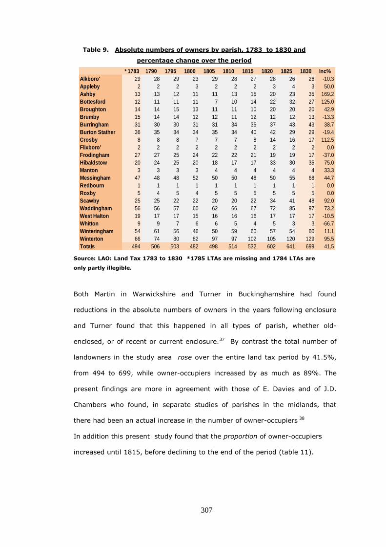
307
Table 9. Absolute numbers of owners by parish, 1783 to 1830 and
percentage change over the period
* 1783 1790 1795 1800 1805 1810 1815 1820 1825 1830 Inc%
Alkboro' 29 28 29 23 29 28 27 28 26 26 -10.3
Appleby 2 2 2 3 2 2 2 3 4 3 50.0
Ashby 13 13 12 11 11 13 15 20 23 35 169.2
Bottesford 12 11 11 11 7 10 14 22 32 27 125.0
Broughton 14 14 15 13 11 11 10 20 20 20 42.9
Brumby 15 14 14 12 12 11 12 12 12 13 -13.3
Burringham 31 30 30 31 31 34 35 37 43 43 38.7
Burton Stather 36 35 34 34 35 34 40 42 29 29 -19.4
Crosby 8 8 8 7 7 7 8 14 16 17 112.5
Flixboro' 2 2 2 2 2 2 2 2 2 2 0.0
Frodingham 27 27 25 24 22 22 21 19 19 17 -37.0
Hibaldstow 20 24 25 20 18 17 17 33 30 35 75.0
Manton 3 3 3 3 4 4 4 4 4 4 33.3
Messingham 47 48 48 52 50 50 48 50 55 68 44.7
Redbourn 1 1 1 1 1 1 1 1 1 1 0.0
Roxby 5 4 5 4 5 5 5 5 5 5 0.0
Scawby 25 25 22 22 20 20 22 34 41 48 92.0
Waddingham 56 56 57 60 62 66 67 72 85 97 73.2
West Halton 19 17 17 15 16 16 16 17 17 17 -10.5
Whitton 9 9 7 6 6 5 4 5 3 3 -66.7
Winteringham 54 61 56 46 50 59 60 57 54 60 11.1
Winterton 66 74 80 82 97 97 102 105 120 129 95.5
Totals 494 506 503 482 498 514 532 602 641 699 41.5
Source: LAO: Land Tax 1783 to 1830 *1785 LTAs are missing and 1784 LTAs are
only partly illegible.
Both Martin in Warwickshire and Turner in Buckinghamshire had found
reductions in the absolute numbers of owners in the years following enclosure
and Turner found that this happened in all types of parish, whether old-
enclosed, or of recent or current enclosure.37 By contrast the total number of
landowners in the study area rose over the entire land tax period by 41.5%,
from 494 to 699, while owner-occupiers increased by as much as 89%. The
present findings are more in agreement with those of E. Davies and of J.D.
Chambers who found, in separate studies of parishes in the midlands, that
there had been an actual increase in the number of owner-occupiers 38
In addition this present study found that the proportion of owner-occupiers
increased until 1815, before declining to the end of the period (table 11).

308
The experiences of the study area parishes are very different and do not lend
themselves to easy categorisation. In the ‘closed’ settlement of Appleby, as
well as in two villages not enclosed by act, Flixborough and Roxby, hardly any
landownership change took place, except that in the last named, the few
remaining owner-occupiers declined in number and the dominant landowner,
Robert Cary Elwes increased his holding.39 Whitton, which at enclosure in 1773
might have been thought of an ‘open’ parish with eight owners awarded general
allotments, became more like a ‘closed’ parish through the period, as Thomas
Goulton, of neighbouring Alkborough, bought land in the parish as it came onto
the market, at the deaths of the few residual owner-occupiers. By the time of
Goulton’s own decease in 1825, he had increased his holding in Alkborough and
was virtually the sole owner of Whitton.
Some of the figures in the table confirm what is seen in estate papers. The fall in
the number of owners in Burton-upon-Stather from a high of 36 in 1783 to 29 in
1830 reflects the purchase by Sir Robert Sheffield of several, apparently small
and medium, farming properties which had passed at death into the hands of
heirs, who presumably wished to realise their value. During these five years
familiar names from the LTAs, such as Waterland, Westoby, Driffill, Fowler and
Young, all feature in deeds bought by Sir Robert, and the size of his landholding
was increased by several hundreds of acres.40 It would seem that engrossments
in the study area were opportunistic and not the result of any deliberate
expulsion of smaller owners. In some parishes, while the evidence of legal
papers has not come to light, it is clear from examining land tax assessments
that non-resident owners sold land from time to time to tenants and others,
which increased the number of parochial landowners. In Ashby where the
number of owners rose dramatically towards the end of the period, a business
called The Royalty Land Company disposed of its holdings between 1825 and
1830, and several of the tenants became owners.41 In Messingham an already
large number of owners increased, because the Barnard family sold land in the

309
1820s and 1830s and similarly, in Waddingham, Monson land was sold to widen
the ownership of the parish. In Winterton sixty people had been awarded land
in the 1772 award, but only thirty were paying land tax in 1783. By 1830 there
are sixty-eight owners listed; the main reason for the increase seems to be that,
in this ‘open’ parish, some of the larger owners sub-divided and sold their plots
for housing.
J. M. Martin’s finding that in 1780, in Warwickshire, the owner-occupiers were
strongest in parishes that had been enclosed in the previous thirty years was not
confirmed in the study area. The percentage of owner-occupiers in study area
parishes, enclosed from 1761 to 1775, was found to be 37.6% of all owners,
rising to 51.3% in 1830 and this was found to be very similar to those enclosed
after 1783; 39.7% rising to 52.7%.42
Table 10 Absolute numbers of owner-occupiers by parish, 1783 to 1830
and percentage change over the period
* 1783 1790 1795 1800 1805 1810 1815 1820 1825 1830 Inc%
Alkboro' 11 14 15 11 19 20 17 11 9 8 -27.3
Appleby 0 0 0 0 0 0 0 0 0 0 0.0
Ashby 3 3 3 4 7 9 9 10 11 25 733.3
Bottesford 0 1 1 2 2 4 7 12 18 16 ∞Broughton 7 10 11 8 8 6 6 17 15 13 85.7
Brumby 4 4 4 4 4 4 4 5 5 6 50.0
Burringham 26 25 22 21 21 24 27 25 24 28 7.7
Burton Stather 14 14 18 19 22 19 25 24 13 15 7.1
Crosby 1 1 1 1 0 2 3 4 5 3 200.0
Flixboro' 2 2 2 2 2 2 0 0 1 1 -50.0
Frodingham 6 6 5 5 5 5 6 6 6 8 33.3
Hibaldstow 8 8 8 7 8 9 9 16 13 13 62.5
Manton 3 3 3 2 2 2 1 1 1 1 -66.7
Messingham 19 20 22 25 26 28 28 30 34 41 115.8
Redbourn 1 1 1 1 1 1 1 1 1 1 0.0
Roxby 3 3 4 2 2 2 3 3 1 1 -66.7
Scawby 16 16 15 15 14 15 16 20 25 34 112.5
Waddingham 10 10 19 24 37 35 35 41 40 40 300.0
West Halton 5 5 6 5 6 6 8 9 6 6 20.0
Whitton 2 2 4 4 5 4 4 4 3 3 50.0
Winteringham 23 22 29 24 35 39 43 31 34 36 56.5
Winterton 30 30 28 35 41 45 55 59 63 68 126.7
Totals 194 200 221 221 267 281 307 329 328 367 89.2 Source: LAO: Land Tax 1783 to 1830 *1785 LTAs are missing and 1784
LTAs are only partly illegible.

310
Table 11. % age proportion of owner-occupiers by parish, 1783
to 1830
* 1783 1790 1795 1800 1805 1810 1815 1820 1825 1830
Alkboro' 37.9 50.0 51.7 47.8 65.5 71.4 63.0 39.3 34.6 30.8
Appleby 0.0 0.0 0.0 0.0 0.0 0.0 0.0 0.0 0.0 0.0
Ashby 23.1 23.1 25.0 36.4 63.6 69.2 60.0 50.0 47.8 71.4
Bottesford 0.0 9.1 9.1 18.2 28.6 40.0 50.0 54.5 56.3 59.3
Broughton 50.0 71.4 73.3 61.5 72.7 54.5 60.0 85.0 75.0 65.0
Brumby 26.7 28.6 28.6 33.3 33.3 36.4 33.3 41.7 41.7 46.2
Burringham 83.9 83.3 73.3 67.7 67.7 70.6 77.1 67.6 55.8 65.1
Burton Stather 38.9 40.0 52.9 55.9 62.9 55.9 62.5 57.1 44.8 51.7
Crosby 12.5 12.5 12.5 14.3 0.0 28.6 37.5 28.6 31.3 17.6
Flixboro' 100.0 100.0 100.0 100.0 100.0 100.0 0.0 0.0 50.0 50.0
Frodingham 22.2 22.2 20.0 20.8 22.7 22.7 28.6 31.6 31.6 47.1
Hibaldstow 40.0 33.3 32.0 35.0 44.4 52.9 52.9 48.5 43.3 37.1
Manton 100.0 100.0 100.0 66.7 50.0 50.0 25.0 25.0 25.0 25.0
Messingham 40.4 41.7 45.8 48.1 52.0 56.0 58.3 60.0 61.8 60.3
Redbourn 100.0 100.0 100.0 100.0 100.0 100.0 100.0 100.0 100.0 100.0
Roxby 60.0 75.0 80.0 50.0 40.0 40.0 60.0 60.0 20.0 20.0
Scawby 64.0 64.0 68.2 68.2 70.0 75.0 72.7 58.8 61.0 70.8
Waddingham 17.9 17.9 33.3 40.0 59.7 53.0 52.2 56.9 47.1 41.2
West Halton 26.3 29.4 35.3 33.3 37.5 37.5 50.0 52.9 35.3 35.3
Whitton 22.2 22.2 57.1 66.7 83.3 80.0 100.0 80.0 100.0 100.0
Winteringham 42.6 36.1 51.8 52.2 70.0 66.1 71.7 54.4 63.0 60.0
Winterton 45.5 40.5 35.0 42.7 42.3 46.4 53.9 56.2 52.5 52.7
Totals 39.3 39.5 43.9 45.9 53.6 54.7 57.7 54.7 51.2 52.5
Source: LAO: Land Tax 1783 to 1830 *1785 LTAs are missing and 1784 LTAs
are only partly illegible.
The graph (Fig 6) which follows summarises the tables, above.
311
The surnames from land tax returns can also be used to examine the persistence
of family names in parishes, following enclosure. A total of 2,447 surnames in
ninety LTAs, from nine sample parishes, were edited and transcribed to yield the
information concerning surviving surnames in table 12, which follows.43 These
were nine parishes where complete and legible runs of LTAs made the analysis
practicable and were, in the case of the parishes enclosed by act, those which
had proportions of their areas enclosed from 1761 to 1833. Two of the parishes
(Flixborough and Roxby) had not experienced enclosure by act, but had been
enclosed entirely by other means. Using 1783 as the base year, the table shows
numbers of surviving original owners, allowing (as explained in the land tax
section of the methodology chapter ) for family or corporate inheritance.
Turner, in his study of parishes of Buckinghamshire, found a gradual reduction in
original owners, adjusted for inheritance.44 In the nine sample parishes in the
study area, 222 original landowner surnames declined to 62 over 47 years, a
decrease of 73%, of which owner-occupier surnames fell from 90 to 31 (-66%).
As in the Buckinghamshire study it was found that parishes of old enclosure, the
‘closed’ ones of Appleby, Flixborough and Roxby, showed little change.

312
Table 12. Numbers of surviving owner and owner-occupier surnames
LAO Land Tax Assessments (LTAs ) 1785 LTAs are missing and 1784 LTAs are only
partly illegible.
The LTAs show that Appleby was almost entirely owned by the Winns of Appleby
Hall, with only about one per cent being owned by others, typically members of
the Yarborough family. Unusually, except in 1815, no occupiers are listed in the
LTAs. In that year however it is revealed that there were forty-nine occupiers
including John Winn, Lord Yarborough and his brother C.A.Pelham. Flixborough

313
was totally owned by the Sheffield family who lived at Normanby Hall in
neighbouring Burton-upon-Stather. No doubt the Normanby Estate and all of
Flixborough parish was farmed as one entity, since the correspondence of the
Sheffields’ land-agent seems to make no distinction between the two parishes,
and the same occupier names feature in both parishes throughout the period.45
Roxby was almost all in the possession of the Elwes family. Robert Cary Elwes
had married Caroline Anderson, the eldest daughter of the first Lord Yarborough
in 1797 thereby uniting these two local landowning families.46 The major
holdings in the parish were all farmed by Elwes’ tenants and based on the three
DMV sites, High and Low Risby and Sawcliffe. As the years went by, the few
other small owner-occupiers moved away and left their land for tenants to farm.
The parishes, enclosed by parliamentary means, had different ownership
experiences. In Alkborough, the major owners at enclosure in 1768 were
Christopher Goulton (1709-1783), the Quaker moneylender Jonathon Dent and
Magdalen College, Cambridge, but there were thirty other owners. Over the
period of the LTAs there was a considerable surname turnover, and the number
of owner-occupiers at first rose and then fell as owners moved away and rented
their land. In West Halton, at the 1773 enclosure, the main and absentee
landowners were William Watson and the Dean and Chapter of Westminster. In
time, after the death of Watson, the parish acquired a resident landowner in
Benjamin Burnett, a Hull surgeon who seems to have crossed the river in 1805
to spend his retirement in more rural surroundings and, perhaps live the life of a
minor squire.47 At Burnett’s death in 1825 the land was sold to a family called
Slater who were occupiers for a while before moving away. Analysis of the LTAs
reveals no obvious distinctive landownership pattern and while there was
considerable surname turnover, actual numbers of both owners and owner-
occupiers vary little. As noted above, in Burton-upon-Stather, the Sheffield
families bought up plots of land as they became available and the former
owner/surnames either disappear or continue as occupiers.

314
In the big ‘open’ parishes of Winteringham and Winterton the surnames of
owner-occupiers tend to survive for longer through the period.48 It seems likely
that this is because those owner/surnames maintained their presence by leaving
agriculture and becoming tradesmen and craftsmen in a manner that was not
viable for owner-occupiers in smaller settlements.
Surnames in the six sample parishes enclosed by act, have also been analysed in
a different manner in order to show how rapidly landownership changed after
enclosure. The presence of surnames awarded land were compared with the first
extant land tax assessment, or an appropriate LTA soon after enclosure, and the
results were tabulated by the acreage of land that had been allotted at
enclosure.
Table 13. Surnames disappearing between enclosure and LTA date, by acreage.
Date Date Total
of of of over 100
to
50 to 25 to 10 to 5 to less
Parish Award LTA surnames 500
acres
499
acres
99
acres
49
acres
24
acres
9
acres
than
5
gone
Alkborough 1768 1783 11 2 3 2 4
Burton Stather 1806* 1805 * 5 1 1 3
West Halton 1773 1783 4 4
Whitton 1775 1783 4 4
Winteringham
(part)
1798 1800 15 1 5 8 1
Winterton 1772 1783 28 5 1 3 1 1 17
Totals 67 0 6 2 6 9 11 33*
*The details of lands awarded were known in 1804.
Source: LAO: Land Tax Assessments; Lindsey Enclosure Awards; E & R.C. Russell,
Landscape changes in South Humberside (Hull, 1982)
It is evident from the table above that, in the wake of parliamentary enclosure,
changes in landownership came quickly. It will be seen that almost half (33) of
the surnames that disappeared soon after parliamentary enclosure belonged to
owners with less than five acres, and nearly 80% (53) of disappeared surnames
had owned less than 25 acres. The ‘open’ parish of Winterton was an exception
with a number of larger owners taking the opportunity to sell up. The evidence of

315
subsequent LTAs suggests that some of this land in Winterton was quickly
subdivided amongst smaller owners, with homes being built and let to
labourers.49 No owner/surname, that had been awarded more than 500 acres,
disappeared between the two dates. Perhaps it is possible that this high turnover
of smaller owners, in the years immediately after enclosure, was the result of a
buoyant market in land stimulated by the prosperity enjoyed by larger owners,
rather than any inability on the part of smaller ones to pay the costs of
enclosure. It is difficult to interpret the evidence of price movements, the land
tax and enclosing expenses. In general the disappeared names were replaced by
the names of new families, and while Neeson may be right to suggest that ‘the
effect of enclosure on the last generation of open-field peasants was profound’, it
would not be correct to say (in these few parishes anyway) that the English
peasantry disappeared.50
All was not well however and a letter to The Times, written while, the Enclosure
Act of 1845 was going through committee, was trenchant in its criticism of
enclosure’s impact and speculated on what a farm labourer would say if he were
summoned to testify before it.51
Employment...is always precarious - that the former enclosures did not
better the condition of his father or grandfather – that it will not raise
wages from 12 shillings in Lincolnshire. He is steeped in poverty to the
lips; that he is ill-fed, ill-housed and he might add that he has reached
this condition during those reigns wherein 4,000 act of enclosure have
passed – these acts have added much to the comfort and wealth of most
gentlemen, but he has never seen one day-labourer the better for
them…52

316
The writings of James Caird provide an account of farming practice in the middle
of the nineteenth century and he recognised the improvements that have been
made:
The agricultural reputation of Lincolnshire is due more to the stride it has
made in a given time, than to any real pre-eminence above the best
farmed counties. A hundred years ago it was almost a terra incognita, its
land boundaries impassable fens, desolate heaths, and broad rivers with
no important sea port and lying out of the track of the traveller. Till the
reign of George III the county remained in a neglected state, the fee
simple of the now cultivated wolds and heaths worth little more than their
present annual rent: the fen districts an unwholesome reedy waste,
prolific of ague and aquatic birds.53
He appreciated especially the improvements carried beside the Trent by the
technique of warping:
Peat moss of the most sterile character has been by this process covered
with soil of the greatest fertility, and swamps which in the memory of our
informant were resorted to for leeches are now, by the effects of warping,
converted into firm and fertile fields.54
He misunderstood however the hydrological action by which warping comes
about. He plainly believed that the fertile muddy soils which formed the warp
came up the river from the sea, and were usefully deposited in this manner, as
far as thirty miles from the ocean. In reality, the mud came down the Trent from
central England, and the warping technique was limited to about thirty miles up-
river, by the diminishing spring tidal range.55
It has not proved possible to identify any study area lands for which a long series
(twenty years or more) of rent records was available, so that the impact of
enclosure, on rents paid, could be measured. Suitable lands would have been

317
difficult to locate anywhere as, although the process would have had an impact
on many places, other of the many factors in the association between landlord
and tenant would certainly not have remained static over the course of a number
of years.56 Contemporary observations do provide some evidence. Just to the
west of the study area in Barton, immediately before enclosure in 1792, the
estimated rental of the land used for agricultural purposes had been £2,000.
Soon after enclosure it rented for £6,000 and by 1856 it had reached £12,000.57
Samuel Sydney wrote in 1848 of land in an unnamed north Lincolnshire village
which had rented, as waste pasture before improvement, for two shillings per
acre and which had risen ‘after turnip culture and sheep feeding’ to twenty-five
shillings per acre.58
In the first five decades of the nineteenth century, the county’s population
increased by 95%, Lindsey’s increased by 87% and that part of Lindsey which is
the study area, increased by 88%. The experiences of the individual study area
settlements (table 14, below) were however very different. Between the census
of 1801 and that of 1851 Winterton for example, grew from 773 to 1665 people,
an increase of about 115% and in the same period its neighbour Roxby-cum-
Risby grew from 273 to 330 people, a rise of only 21%.59
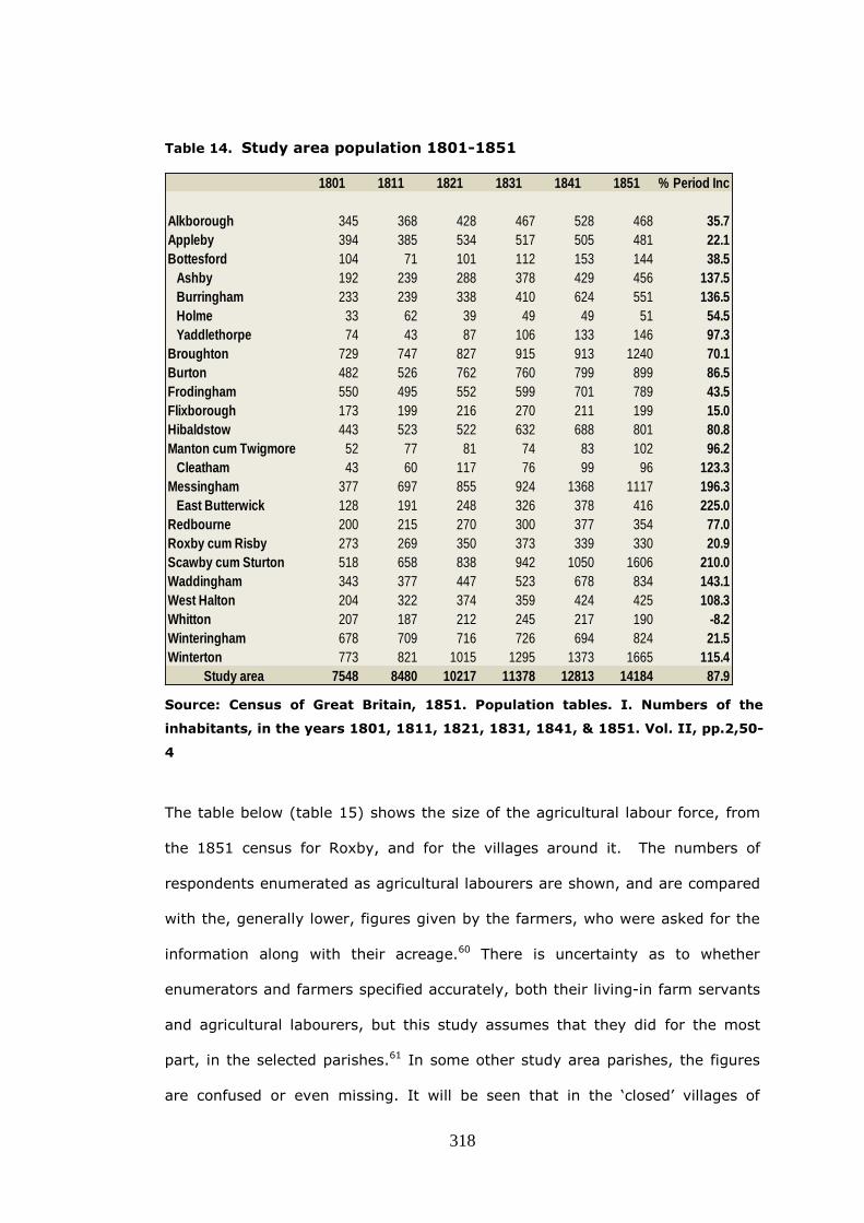
318
Table 14. Study area population 1801-1851
1801 1811 1821 1831 1841 1851 % Period Inc
Alkborough 345 368 428 467 528 468 35.7
Appleby 394 385 534 517 505 481 22.1
Bottesford 104 71 101 112 153 144 38.5
Ashby 192 239 288 378 429 456 137.5
Burringham 233 239 338 410 624 551 136.5
Holme 33 62 39 49 49 51 54.5
Yaddlethorpe 74 43 87 106 133 146 97.3
Broughton 729 747 827 915 913 1240 70.1
Burton 482 526 762 760 799 899 86.5
Frodingham 550 495 552 599 701 789 43.5
Flixborough 173 199 216 270 211 199 15.0
Hibaldstow 443 523 522 632 688 801 80.8
Manton cum Twigmore 52 77 81 74 83 102 96.2
Cleatham 43 60 117 76 99 96 123.3
Messingham 377 697 855 924 1368 1117 196.3
East Butterwick 128 191 248 326 378 416 225.0
Redbourne 200 215 270 300 377 354 77.0
Roxby cum Risby 273 269 350 373 339 330 20.9
Scawby cum Sturton 518 658 838 942 1050 1606 210.0
Waddingham 343 377 447 523 678 834 143.1
West Halton 204 322 374 359 424 425 108.3
Whitton 207 187 212 245 217 190 -8.2
Winteringham 678 709 716 726 694 824 21.5
Winterton 773 821 1015 1295 1373 1665 115.4
Study area 7548 8480 10217 11378 12813 14184 87.9
Source: Census of Great Britain, 1851. Population tables. I. Numbers of the
inhabitants, in the years 1801, 1811, 1821, 1831, 1841, & 1851. Vol. II, pp.2,50-
4
The table below (table 15) shows the size of the agricultural labour force, from
the 1851 census for Roxby, and for the villages around it. The numbers of
respondents enumerated as agricultural labourers are shown, and are compared
with the, generally lower, figures given by the farmers, who were asked for the
information along with their acreage.60 There is uncertainty as to whether
enumerators and farmers specified accurately, both their living-in farm servants
and agricultural labourers, but this study assumes that they did for the most
part, in the selected parishes.61 In some other study area parishes, the figures
are confused or even missing. It will be seen that in the ‘closed’ villages of

319
Appleby and Flixborough, the numbers claiming to be ‘ag-labs’ and the returns
of the farmers are similar, but in Roxby, there must have been a large daily trek
of workers, to–and-fro, along the footpaths between that village and the
neighbouring ‘open’ village of Winterton. If, as seems probable, workers were
also supplied to other ‘closed’ parishes, their movement from Winterton is
hidden within the figures.
Table 15. Size of the agricultural labour force
Agricultural enumerated farmers' Difference
workers In census returns *
Alkborough 85 43 42
Appleby 121 115 6
Burton 138 109 29
Flixborough 48 39 9
Roxby-cum-Risby 89 137 -48
West Halton 96 85 11
Whitton 45 36 9
Winteringham 96 65 31
Winterton 256 97 159
Totals 974 726 248
* 'in-' plus 'out-workers'.
Source: 1851 Census Enumerators' Returns HO107/2117
There is a very significant variation, of nearly two hundred and fifty in the
selected parishes, and Beastall suggested, in his study of Lincolnshire
agriculture, that farm employment prospects were poor and that ‘in March 1851
no more than two-thirds of the county’s labourers had work…’ 62 It is however,
at least, possible that these workers, who were not included in the farmers’
returns, were mainly on short-term contracts, rather than permanently
unemployed labourers. If Beastall was correct in his gloomy assessment, then
the workforce would only be fully employed during the four to six weeks of the
cereal harvest.63 Samuel Sidney had written in seeming contrast, in 1848, that
‘the labouring population seems barely equal to the agricultural wants of North

320
Lincolnshire’ and that the ‘crops are got in by the indispensable aid of travelling
bands’, by which he probably meant Irish itinerant workers.64 Sidney was also
probably referring to those few harvest weeks when the labourers were fully
employed.
One likely reason for the increase in Winterton’s population, is therefore a
shortage of accommodation in the neighbouring ‘closed’ parish of Roxby owned
by the Elwes family.
The new poor law had kept the parish as the unit of rating and settlement and
this was an advantage to the major landowners, whose sparsely populated
‘closed’ parishes, such as Redbourne, Manton and Appleby, kept the relatively
low poor rates they had enjoyed under the old poor law. In consequence, after
1834, there continued to be differences in the burden of poor rates among
parishes within the Glanford Brigg Union. The only common charges in the union
were those connected with the poor law establishment, the cost of building and
maintaining the workhouse at Brigg, paying salaries, and so on. Otherwise, each
parish was assessed on the number of its settled paupers receiving either
outdoor or indoor relief, and this was naturally a much heavier burden on more
heavily populated parishes. In order to keep down the rate burden in his parish
a large landowner might refuse to build or repair labourers’ cottages, and might
even pull down existing ones, when they became empty. This seems to have
happened in Whitton where the number of houses actually declined sharply,
between 1831 and 1841, (54 down to 42) and the place took on more of the
characteristics of a ‘closed’ parish with a population decline of 8%.65 In the
‘open’ parishes, like Messingham, Waddingham and Bottesford by contrast,
cottage ownership was more widespread, and new ones could be built with fewer
objections from landowners. The ‘open’ parish was typically much more populous
than the ‘closed’, although Mills’ definition of a population range from 300 to 500
321
inhabitants in the case of the ‘open’ settlement, compared with 50 to 300 in the
‘closed’, is not seen in the study area.66 As indicated in the table above, a
synergistic relationship developed between ‘open’ and ‘closed’ parishes, the
excess of population in the one making up for the deficiency of labour in the
other.67 It was not until the passing of the Union Chargeability Act of 1865,
which ended parochial settlement and chargeability, and spread it across the
entire union, that the tendency declined to build cottages in ‘open’ parishes, for
those labourers who worked in ‘closed’ ones.68
This manipulation of poor law regulations was not the only spur to population
growth or decline. Another important driver was the effect of agricultural
improvement especially where, as in the case of drainage and warping, this
special type of improvement, (rather than merely reorganising the arable), had
brought formerly unproductive acres into cultivation. These new areas of highly
fertile land needed agricultural labour and the effect is seen plainly on the study
area. In Bottesford parish, the townships of Ashby and Burringham (warped
c.1809) saw population increases of over 130% while, in East Butterwick
(warped c.1804), warping transformed the Trentside settlement, as its 680
acres were able to support many more workers.
Scawby increased by over two hundred percent in the first half of the nineteenth
century, but here the growth was due to the rise of the regional centre of Brigg
on the other side of its parish boundary. Scawby became effectively a suburb of
this small market town and the number of houses increased from 222 to 342, in
the ten years before 1851 alone.69
Agricultural work was of course the principal employment in all the study
parishes (table 16, below) and although the more populated parishes tended to
have lesser percentages of farmers and farm workers, the rank correlation was
weak.70 The parish with the highest percentage of resident farmers and
agricultural workers was Roxby, although as already noted, it had as well, to

322
‘import’ workers who lived in neighbouring parishes. There was no statistical
correlation between the proportion of agricultural workers and the numbers of
resident owners, or the acreage of the parish.71 Scawby’s low proportion of farm
workers was, as already indicated, due to the encroachment of the town of Brigg.
Domestic service was a significant occupation in the study area and there were
concentrations of servants in the houses of the larger landowners, with the
Winns at Appleby, the Sheffields at Burton and Flixborough and the Duke of St.
Albans at Redbourne.
There was strong positive correlation between the proportions of trades and
craftsmen and the population of parishes.72 A moderate correlation also existed
between trades and craftsmen and the numbers of owners-occupiers in the more
open parishes like Winterton, Burton-upon-Stather, Waddingham and
Winteringham.73 In Burton many of the craftsmen were associated with boat
building. A boat yard had been established at Alkborough, on the Trent, in about
1788 and it moved to Burton Stather in 1800 where a slipway was built at a cost
of £1,000. Houses were erected for the workers and this large yard was
operated until late in the nineteenth century.74 Most villages supported from
twelve to fifteen trade or service occupations, the most frequently occurring
being dress and shoemaking. Winteringham with thirty-three and Winterton
with fifty-seven different trade or service occupations, were notable for the size
and wide range of their employment with midwives, clock-makers, plumbers,
architects, lawyers, vets and even a ‘cole porter’ listed.75
There was a positive correlation between the proportions of professional,
independent and retired persons and the population of parishes, but it was not as
strong as that of the trades and craftsmen.76
The smallest proportions of children occur in Roxby, Appleby and Flixborough,
with Roxby quite noticeably below the average for the study area (35.2%) at
23.6%. It seems very possible that this is because, in these ‘closed’ parishes,
suitable homes were restricted by the leading landowner and while Whitton had a

323
relatively high 32.1% proportion of children, this was likely to fall as the pulling
down of cottages, already mentioned, took effect.
The census had only required those persons returning themselves as 'farmers' or
‘landed proprietors’ to give details of land held, so there is hardly any
information about landholding by people in other occupations.77 This must
seriously understate the numbers of occupiers of land and must be especially
true at the lower end of the acreage scale where dual occupations were more
common. Although wealthy businessmen and clergy no doubt held some of these
unrecorded holdings, many must have been held by rural tradespeople. It has
been argued that 'nearly all tradesmen also followed some form of agriculture
either as a major or subordinate source of income', which suggests that to
differentiate too much between tradespeople and small farmers is unwise.78 In
Lincolnshire villages for example, the carpenter as elsewhere, was often the
undertaker, and he may have owned a small piece of land as well. In the 1851
census he will have been called ‘carpenter’, so are his funeral duties to be
regarded as secondary, and his farming as tertiary occupations? Similarly the
innkeepers may have kept a stable and owned a little pastureland for travellers’
horses. Because agricultural work was a minor part of the working week, it
should not be concluded from the census that the small owner-occupier, the
English peasantry, was no longer present.

324
Table16 Social and Occupational breakdown of study area from 1851 Census
Farm
ers
+A
g L
ab
s
Se
rva
nts
Tra
de
+C
raft
sm
en
P
rof+
Ind
+R
et
Ho
us
ew
ive
s
Ch
ild
ren
% % % % % %
Alkborough 23.7 8.3 6.8 4.1 16.5 32.7
Appleby 29.8 10.4 6.1 2.6 15.1 26.3
Bottesford 25.6 4.6 9.1 1.8 16.8 33.4
Broughton 20.3 8.6 10.0 2.7 16.4 34.5
Burton 19.4 10.5 11.7 3.0 16.7 32.4
Flixboro' 28.0 11.6 8.3 1.4 16.0 29.4
Frodingham 30.2 6.7 7.0 1.7 17.0 30.5
Hibaldstow 25.8 7.1 9.9 0.7 16.7 34.0
Manton 29.8 10.1 2.5 2.0 15.2 32.3
Messingham 21.7 7.0 8.0 2.7 16.4 38.5
Redbourne 26.6 11.3 5.6 3.4 12.7 32.8
Roxby 32.8 8.0 4.9 2.1 17.2 23.6
Scawby 10.1 6.6 13.9 4.5 16.8 40.9
Waddingham 19.4 6.0 6.8 2.4 16.7 44.0
West Halton 30.3 8.8 4.5 2.6 16.3 31.2
Whitton 26.3 10.5 6.8 2.1 16.8 32.1
Winteringham 15.7 8.5 9.3 3.5 17.0 36.9
Winterton 18.1 7.1 13.6 2.7 17.4 35.8
Study Area 21.5 7.6 9.5 2.7 16.6 35.2
Source: Reworked from 1851 Census Enumerators’ Returns HO 107/2115, 2116, 2117
Hobsbawm and Rudé have suggested that the passive response to the labourers’
defeats in the riots of the 1830s was the rise of religion.79 It is possible that the
failure of the riots was some sort of catalyst for the decline of the old culture in
general. While there were isolated instances of stack burning, in general by the
325
1840s, the era of riots and incendiarism had given way, to mutual societies and
education. The decade saw the formation of friendly societies together with the
construction of dissenting chapels, day schools and Church of England National
Schools across the study area.80 Activity in ‘closed’ parishes like Flixborough,
Roxby and Redbourne, which were dominated by a single landowner, was more
muted.81 Any threats, in the study area, of incendiarism in the 1840s did not
cause lasting panic amongst the farmers and landowners, as they had done
previously. Not only were landowners themselves better off than in earlier
decades, but also they would have seen that the rural world had subtly changed
in only a few years.82 There were many more chapels and chapelgoers in 1851
than before, and, in some villages, Appleby, Burton-upon-Stather, and
Winterton, over 70% of the children in the census were described as ‘scholars’.83
Chapelgoers and their lay-preachers, parents with children at school and
members of friendly societies were less likely to be desperate stack-burners, and
more likely to be workers and trades people, with increasing self-belief and
optimism in the changes that agricultural improvement had brought.
The parishes had been affected not only sociologically by agricultural
improvement, but visually as well; the visual impact of the transformation
depended, to some extent, upon the amount of land which was formerly held in
common and what proportion of it had been enclosed in earlier times. No part
of Roxby, Flixborough and Redbourne had been enclosed by act. In some
parishes like Appleby, Broughton and Hibaldstow parliamentary enclosure was
merely a tidying of what were just loose ends of the landscape. In still other
parishes, Ashby, Messingham Winterton for example, almost all the land was
altered by the Commissioners. In fact however there is little difference in the
visual effect of these three sorts of parish in the landscape of roads and hedges.
The later parliamentary enclosures did not produce a tedious pattern of
rectangles, but are only slightly more regular and ordered than those of old
enclosure. All the parishes integrated ancient features, such as irregular

326
woodland, ponds and winding streams, into their new plans, so only the
observant can easily spot the curve of an old headland, or a hedge that is not
completely straight.
If somehow the Cistercians of Twigmore could have returned, they would surely
have commended the improvements of the centuries, but they might not have
liked the bustle, and the lack of solitude in the mid-nineteenth century
countryside. Like Tennyson’s Northern Farmer, they would have marvelled at the
changes that had happened in Lincolnshire:
Dubbut looäk at the waäste: theer warn't not feäd for a cow,
Nowt at all but bracken an' fuzz, an' looäk at it now,
Warn't worth nowt a haäcre an' now theer's ots o' feäd,
Fourscore yows upon it an' some on it doon in seäd.84
References
1 A. Young, General View of the Agriculture of the County of Lincoln (1799)
2 Ibid, p.92
3 Ibid.
4 Ibid, p.18
5 Ibid, p.10. By Tilby he means Thealby, Coalby is Coleby; both are in West
Halton parish.
6 J. Thirsk, English Peasant Farming… (1957), p.210; D.B.Grigg, ’The Changing
Agricultural Geography of England ‘, p.76
7 A. Young, General View … (1799), p.3
8 Ibid, pp.127,142,266
9 J. Thirsk, English Peasant Farming, p.261

327
10 J. Caird, English Agriculture in 1850-51 (1852)
11 M.E. Turner, (ed.), Home Office: Acreage Returns (HO 67): List and Analysis
Part II Jersey to Somerset, 1801, Vol. 190 (List and Index Society, 1982),
passim
12 37,911 acres of 74,350 in the study area; Turner found that the figure was
82% for the whole of Lindsey, 75.9% for all of Lincolnshire and 46.7% for
England.
13 M.E. Turner, ‘Arable in England and Wales: estimates from the 1801 Crop
Return’, Journal of Historical Geography, 7-3 (1981) pp.291-302; D. B. Grigg,
The Agricultural Revolution in South Lincolnshire (Cambridge, 1966), p.72
14 J. M. Suttie & S. G. Reynolds, Fodder Oats: a World Overview (2004), p.216
15 A. Young, p.143
16 W. Abel, Agricultural Fluctuations in Europe: from the Thirteenth to the
Twentieth Centuries (1980), p.208; for example see Winteringham parish in
M.E. Turner, (ed.), Home Office: Acreage Returns (HO 67), p.118
17 M.E. Turner, (ed.), Home Office: Acreage Returns (HO 67), p.104
18 M. Williams and R. Williams, (eds.), John Clare: Selected Poetry and Prose
(1986), p.91
19 TNA: E178/6301
20 Notes and Queries 6th series VI (July 29 1882) p.84
21 W. E. Tate, 'Parliamentary Counter-Petitions during the Enclosures of the
Eighteenth and Nineteenth Centuries', English Historical Review, Vol.LIX (1944),
p. 393

328
22 R.C. Russell, ‘Parliamentary Enclosure, Common Rights and Social Change:
Evidence from the Parts of Lindsey in Lincolnshire’, Journal of Peasant Studies
27:4 (2000), p.62
23 LAO: Whitton Vestry Accounts 1750-1800: Average amount disbursed 1776-
1785, compared with average for the years 1763-1773.
24 Lord Ernle, English Farming: Past and Present (1912), p.322
25 The Agricultural State of the Kingdom in February, March and April, 1816,
P.P., 1816, p.2
26 Robert Barker was Sir Robert Sheffield’s steward.
27 The Agricultural State…, p.150-164
28 Ibid, p.313, said of Woodbridge, Suffolk.
29 Saturday Magazine, 15 Jan 1830, quoted in E. Gillett, The Humber Region in
the Nineteenth Century (Hull, 1982), p.49
30 D. Eastwood, Governing Rural England (Oxford, 1994), p.135; G.R. Boyer, An
Economic History of the English Poor Law, 1750-1850 (Cambridge, 1990),
p.196
31 T.L. Richardson, 'The agricultural labourers' standard of living in Lincolnshire,
1790-1840: social protest and public order', Agricultural History Review, 41:1
(1993), p.15
32 R.C. Russell, Three Lincolnshire Labourers’ Movements (Barton-on-Humber,
1994), pp.28-31
33 Answers to rural queries, with indices , P.P., 1834, p.290
34 Ibid.

329
35 R.J. Olney, Rural Society and County Government in Nineteenth-Century
Lincolnshire (Lincoln, 1979), p.134
36 Saturday Magazine, No 89, 23 Nov 1833, p.196
37 J.M. Martin, ‘The Small Landowner and Parliamentary Enclosure in
Warwickshire', Economic History Review, 2nd ser., 32 (1979), p.335; M.E.
Turner, ‘Parliamentary Enclosure and Landownership Change in
Buckinghamshire,’ Economic History Review, 2nd ser., 28:4 (1975), p.566
38 E. Davies, ‘The Small Landowner 1780-1832, in the light of the Land Tax
Assessments’, Economic History Review, 1st ser., l (1927); J.D. Chambers,
'Enclosure and the Small Landowner', Economic History Review, 1st ser. 10
(1940)
39 Open and closed villages are discussed , for example in: D .R. Mills, 'Canwick
(Lincolnshire) and Melbourn (Cambridgeshire) in Comparative Perspective within
the Open-Closed Village Model', Rural History, 17:1 (2006)
40 For example: LAO: Sheffield deposit A/3/7-8, A/4/3-4 and A/9/8.
41 LAO: Land Tax Assessments Ashby 1825, 1830
42 In chronological order: Winteringham, Alkboro', Waddingham, Scawby,
Winterton, West Halton and Whitton compared with Bottesford, Hibaldstow,
Messingham, Burton Stather, Ashby, Crosby, Manton, Appleby, Frodingham,
Burringham, Broughton and Brumby.
43 The analysis previously appeared in this writer’s: ‘Life and Labour in north-
west Lindsey: The effects of agricultural change in nine parishes of Lincolnshire’
(Unpublished M.A. dissertation, Nottingham 2007)
44 M.E. Turner, ‘Parliamentary Enclosure…’, p.566-7. Some 18% between 1782-
92
45 For example LAO: Sheff/A/1-9
46 Burke’s Landed Gentry (1852), volume 1, p.377

330
47 Information from a marble monument in the church of St. Etheldreda, West
Halton.
48 Burton-upon-Stather shows the same effect to some extent.
49 LAO: Land tax Assessments, Winterton 1783-1830
50 J.M. Neeson, 'Parliamentary Enclosure and the disappearance of the English
Peasantry, Revisited', Research in Economic History (1989), pp.105
51 8&9 Vic. C.118; The Times, 27 March 1844, p.5
52 Ibid.
53 J. Caird, English Agriculture in 1850-51 (1852), p.193
54 Ibid , p.192
55 Ibid.
56 M. E. Turner, J.V. Beckett, and B. Afton, Agricultural Rent in England, 1690 -
1914 (Cambridge, 1997), pp.74-5
57 A. Young, General View… (1799), p.103; H. W. Ball & W. S. Hesleden, The
Social History and Antiquities of Barton-upon-Humber (Barton-upon-Humber,
1856), p.75
58 S. Sidney, Railways and Agriculture in North Lincolnshire (1848), p.73
59 Abstract of the Answers and Returns… P.P. 1833 (XXXVIII), p.352
60The analysis previously appeared in this writer’s: ‘Life and Labour in north-
west Lindsey…’ ; A WEA group examined a partly overlapping geographical area
for a 1970 census study, but its results could not be reconciled with the present
analysis, and they have therefore been ignored; vide P.M.Tillott & G.S.
Stevenson, North-West Lindsey in 1851 (Sheffield, 1970)

331
61 J.A. Sheppard, ‘ East Yorkshire’s Agricultural Labour Force in the mid-
Nineteenth Century’, Agricultural History Review, 9 (1961), pp.43-54: the
difficulties are discussed.
62 T.W. Beastall, The Agricultural Revolution in Lincolnshire (Lincoln, 1978),
p.117
63 Very much as Edward England had reported in 1832.
64 S. Samuel, Railways and Agriculture in North Lincolnshire (1848), p.72
65 Abstract of the Answers and Returns. P.P. 1833 (XXXVIII), p.352; P.P. 1844
(XXVII), p.171
66 D. R. Mills, 'English Villages in the eighteenth and nineteenth century: a
sociological classification', Amateur Historian, vi (1965), p.276
67 J. Caird, p.197
68 A. Brundage, The English Poor Laws (Basingstoke,2002), p.104
69 Census of Great Britain, 1851. Population tables. I. Numbers of the
inhabitants…p.52
70 Spearman‘s rank correlation coefficient of -0.48
71 Number of owner-occupiers found on the 1830 land tax returns; C.K.
Rawding found a negative correlation between percentages of agricultural
workers and resident landowners: The Lincolnshire Wolds in the Nineteenth
Century (Lincoln, 2001), p.177
72 Spearman‘s rank coefficient of 0.80
73 Spearman‘s rank coefficient of 0.65
74 N.R. Wright, Lincolnshire Towns and Industry 1700-1914 (Lincoln, 1982),
p.69

332
75 If not a misspelled carrier of coal, perhaps a colporteur; a peddler of
devotional literature.
76 Spearman‘s rank coefficient of 0.46
77 E. Higgs, Making Sense of the Census Revisited (2005), p.106
78 B.A. Holderness, 'Rural Tradesmen 1660-1850: A Regional Study in Lindsey',
Lincolnshire History and Archaeology vol. 7 (1972), p.77
79 E.J. Hobsbawm & G. Rudé, Captain Swing (1969), p.291
80 R. C. Russell, From Cock-Fighting to Chapel Building (Heckington, 2002),
passim
81 W. White, History, Gazetteer and Directory of Lincolnshire (1856), pp.607-618
82 R.C. Russell, Three Lincolnshire Labourers’ Movements (Barton-upon-Humber,
1994), p.63
83 1851 Census HO107/2117
84 A. Tennyson, Poetical Works (1911), p.230
333
Conclusions
A chronology of enclosure
Conventional wisdom suggests that the landscape of north-west Lindsey was
transformed between the 1760s and about 1810, as the result of two principal
waves of parliamentary enclosing activity. This thesis suggests instead that the
countryside had been almost continuously changing, certainly from the time of
the Cistercians’ arrival in the area, if not earlier. It is now possible to offer a
chronology of enclosure in the study area.
By 1600 there was a measure of enclosure in all the villages of the study area
although the open-field system still prevailed. Some of the ancient closes in the
parishes in the central part of the study area, Manton, Holme, Broughton,
Scawby and Messingham, were the result of enclosing activity, during the time
the Cistercians of Louth Park Abbey held a grange at Twigmoor in Manton
parish between 1216 and 1428. The lay brothers made these closes on grange
holdings and their secular neighbours emulated the agricultural practices they
saw, on their own lands.
By about the same period, the former settlements of Darby, Haythby, Great
and Little Conesby, Sawcliffe High Risby and Low Risby had either been
deserted or greatly depopulated. They might have fallen victim to the Black
Death or to earlier famine, disease and changes in climate or, because they
were on poor soils, to inadequate farming techniques. All these deserted and
shrunken settlements lie in locations that were not enclosed by act and had
instead been anciently enclosed. It has been suggested in this thesis that their
depopulation, for whatever reason, was the inducement for early secular

334
enclosing activity and that this activity could have widened into adjoining
communal farmland. From 1531 Commissioners of Sewers were charged with
the drainage of low-lying land and the embankment of land liable to flooding. It
may have been in this period that the banks which guard the study area rivers,
were constructed, and land suitable for farming began to be reclaimed from the
Trent and Humber.
From 1577 glebe terriers provide evidence that the making of closes in the area
was widespread. Some terriers are additionally informative and the Redbourne
terrier of 1662 indicates that ‘since the improvemint of the lordship’, former
glebe land had been appropriated by the patron. In the 1580s or 1590s the
township of Walcot, in Alkborough parish, was converted from ‘tilladge to
pasture’. A deposition confirms, what the 1607 Brief of Depopuations found
later, that the landowner, Martin Brighouse, had changed the land use,
although it was more suitable for arable cultivations than other parts of the
township.
The 1607 Brief of Depopulations revealed that there had been some conversion
of arable land to pasture and also some engrossing of farms. Several of those
who are named in the Brief were known gentry entrepreneur landowners whose
activities span several parishes. Because no ‘greate depopulacions and decaies
of husbandries’ in the study area were listed it seems that what enclosure had
taken place, had not caused widespread depopulation.
The principal scheme of agricultural improvement in north–west Lindsey in the
first half of the seventeenth century was the drainage of the low lands either
side of the Old Axholme by the installation of a sluice gate at South Ferriby and
the straitening and embanking of that river. The closes that were made as a
result of this enterprise in Winteringham, Appleby, Scawby etc., did not all
survive, when the Ancholme levels were neglected, and some , like Town Carr,
Low Carr and Old Man Carr in Broughton, shown on Wilkinson and Fotherby’s

335
1640 map of the Ancholme levels as having been drained and enclosed by Sir
John Monson, had to be re-enclosed in a later era, by act of parliament.
At the end of the century one of the very few chancery decrees in Lincolnshire,
which validated the enclosure of part of a parish, was used in Waddingham. An
agreement of 1699, affecting a little over two thousand acres (56%) of
Waddingham, was confirmed by the Chancery Court and enrolled in 1701.
By 1719 in Winteringham , not only had there been extensive and systematic
formation of closes, but also common rights had been extinguished. In 1757
the inhabitants of Messingham enclosed about 75 acres of the East Common
Field, divided it into nine closes, and then rented out the grazing, each year to
the highest bidder. The arrangement seems to have continued until
parliamentary enclosure was underway in 1799.
John Snape’s plans, for the Sheffield family, of the manor of Normanby, the
manors of Burton and Thealby in the parish of Burton upon Stather, and the
parish of Flixborough, drawn in 1778, indicate that all these areas have been
divided into named closes and had nearly all been hedged. Whether this
programme was one of comprehensive and rapid improvement within the space
of a few years, or one of more leisurely piecemeal enclosure over the thirty
years since Charles Sheffield commissioned the scheme in 1754, to transform
the area around his house, cannot be established by documentation. It
however seems most likely that the programme was carried out over a number
of years, and that it must have made an impression on the lesser gentry, and
other landowners in neighbouring townships, and shifted their attitudes in
favour of agrarian progress.
It is impossible to determine accurately what percentage of the study area had
been enclosed by the time of the first parliamentary enclosure in 1761. After
that year 47.4%, or 74,350 acres, were enclosed, but it seems very likely that
lands already made into closes were included in that figure. It may be that as

336
much as 60% of the area being studied was already enclosed by this time,
although the physical differences of straight roads, new banks and ditches and
quickthorn hedges, which characterised later enclosure by act, would not have
been so evident. They might, at this time (if they had been asked), have
professed that not a great deal of the landscape had changed in their lifetime,
and they would have perhaps thought that things had been much the same for
generations.
The Alkborough enclosure act of 1765 was the earliest in the study area that
did not confirm an agreement. It was prompted either by the chief landowner’s,
Christopher Goulton’s, Yorkshire relatives who were, at the time, enclosing
their lands near Bridlington, or because of a desire to copy the Sheffield
family’s activities, or perhaps by the act of the same year which authorised the
area’s first turnpike and indicated a better transportation infrastructure for
what had been up to that time, an out of the way area. For the larger owner
making turnpikes, like enclosing, was ‘a highly profitable investment in financial
terms’, and Goulton may have been impressed by the effects of recent
turnpiking such as the White Cross to Beverley turnpike of 1761.1
Plate 57: The petition which led to the ‘The Barton Waterside to Riseholme
Turnpike Road Trust’ of 5 Geo3 c88 (1765), usually called the Brigg Turnpike
Trust, (LAO: STUBBS/1/1)2

337
The setting up of a new sluice gate at the Ancholme outfall into the Humber in
1767 made the low lands either side of the river Ancholme safe from inundation
and capable of being drained and improved. It has been suggested in this
thesis, that the motivation for this installation was a series of very wet seasons
in the 1750s and 1760s. The first of the parliamentary enclosures, in the valley
of the Ancholme came in 1769-71, when ‘certain lands and grounds’ in the
townships of Atterby, Snitterby and Waddingham were enclosed, including
approximately 1,280 acres of the low-lying Waddingham North Carrs Soon
afterwards at Scawby in 1770-1 the Nelthorpes enclosed 2216 acres some of
which had been enclosed by Monson in the 1630s and then abandoned as Civil
Wars and neglect of the original sluice gate, affected the drainage.
From 1770 the desire to emulate the improving Normanby estate may well
have motivated others of the Sheffield’s family’s neighbours into action. Within
a few years, portions of several nearby parishes received the attentions of the
parliamentary commissioners. At Winterton in 1770-2 James Stovin and the
Earl of Mexborough were the main landowners behind the enclosure of over
three thousand acres. West Halton quickly followed in 1772-3 when William
Watson was the principal beneficiary and neighbouring Whitton was the next to
enclose in 1773-5 when Thomas Goulton, son of Christopher enclosed over one
thousand acres.
In 1784 at a time when parliamentary enclosure had become the recognised
way to improve agricultural land, part of Ashby was enclosed by private
agreement between the owners and occupiers. The motivation may have been
a shortage of land for pasture. This method avoided the expense of an act, but
echoed, in the wording of the agreement, the phrases and clauses of
parliamentary jargon
It might have been expected that Hibaldstow, in the Ancholme valley, would
have been enclosed at the same time as neighbouring Scawby, but over twenty

338
years passed before it was that parish’s turn in 1796. This may conceivably
have been because the landowners were unconvinced as to the long term
security of the sluice gates at the Humber outfall. It is more likely however that
there was some difference of opinion as to the economic gains to be had from
drainage and enclosure, as this is suggested by the evidence of a
commissioned piece of cost-benefit analysis.
From the 1790s owners began to apply water management techniques to the
locally naturally occurring phenomenon of warping. Within a few years, portions
of Messingham, Burton upon Stather, Ashby and Crosby had been artificially
warped as part of the process of parliamentary enclosure.
From 1805 enclosure by act was used for the most part to fill in gaps and tie up
loose end. The process ended in the 1870s with parts of Brumby being
enclosed, not for any agricultural reason, but instead to establish ownership of
ironstone beneath the fields.
This study’s findings give some credence to Wordie’s computed figure of 47%,
for the amount of enclosure before 1600.3 Activity in the parishes surrounding
Manton from the time of 1216 and the presumed emulation of the farming
methods of the Cistercians together with documentary evidence in the 1607
Brief of Depopuations give confidence to a considerable percentage having
being enclosed by that time. It is thought that in the study area the figure will
not have been quite as large as 47%, since the amount of later parliamentary
enclosures associated with warping and draining will have been higher.
Wordie had attributed the 24% of his computation that could not be accounted
for elsewhere, to the seventeenth century.4 It had been thought that an
examination of the Chancery decrees associated by Beresford with enclosure
and enumerated in his well-known paper might reveal details of enclosure
agreements dating to the seventeenth century and would support Wordie.5
This thesis found instead that any belief that there was a marked inclination for

339
confirmation by chancery decrees in the seventeenth century is mistaken.
When the twenty-two (Beresford’s table has 24) Lincolnshire chancery decrees
were identified and examined, it was found that they included, many disputes
which touched on other aspects of land litigation, as well as some cases where
ratifications, of agreements to enclose, were actually being sought.6
It was not possible therefore to use the documentary evidence of decrees to
assign much more enclosure in Lincolnshire to dates in the seventeenth
century, and so Wordie’s assessment of the amount of non-parliamentary
improvement could not be refined.
In general this study found that agricultural improvement was a continuing
process which was taking place from at least the time of the Cistercians. Its
pace varied as a result of a combination of pressures and circumstances, whose
importance differed according to the particular case. The causes were not
always completely understandable by reference to the commercial purpose of
the desire for increased rents. The methods used to enclose changed with time,
from the natural consolidation of strips, to more formal agreements, through a
period when Chancery decrees were sometimes used to validate them. The
process ended with the century-long era of enclosure by private act, which
concluded when the last piece of unenclosed land was allotted.
Changing landownership patterns
The study looked at changing landownership patterns in the study area by
using an analysis of land tax assessments. It was found that the total number
of study area landowners increased over the entire land tax period (1783-
1830) by 41.5%, while owner-occupiers rose by as much as 89%. This is quite
the opposite of the findings of both Martin in Warwickshire and Turner in
Buckinghamshire who saw reductions in the absolute numbers of owners after
enclosure.7 This study’s findings agree with those of Davies and of Chambers

340
who found, in separate studies of parishes in the Midlands, that there had been
an actual increase in the number of owner-occupiers.8 This present study also
found that the proportion of owner-occupiers increased until 1815, before
declining to the end of the period.
The percentage of owner-occupiers in study area parishes, enclosed from 1761
to 1775, was found to be 37.6% of all owners, rising to 51.3% in 1830 and this
was found to be very similar to those enclosed after 1783; 39.7% rising to
52.7%. Martin’s finding that in 1780, in Warwickshire, that owner-occupiers
were strongest in parishes that had been enclosed in the previous thirty years
was therefore not confirmed in the study area.9
Surnames were also analysed in nine sample parishes to establish the extent
of turnover of holdings. Analysis of the LTAs reveals no obvious distinctive
landownership pattern and while there was considerable surname turnover,
actual numbers of both owners and owner-occupiers varied little. In the large
‘open’ villages of Winteringham and Winterton the surnames of owner-
occupiers tended to survive for longer through the period.
Six of the nine sample parishes were enclosed by act and these were analysed
in a different manner to order to show how rapidly landownership, by size of
acreage allotted, changed after enclosure. Almost half of the surnames that
disappeared soon after parliamentary enclosure belonged to owners with less
than five acres, and nearly 80% of lost surnames had owned less than 25
acres. It was found that the lost names were replaced by names new to
landownership in the parish. In Buckinghamshire, Turner had concluded that
the turnover of small landowners every two or three years was as much as 50-
60 per cent and that a large proportion of the new owners were cottagers.10
Although it is not certain that the newcomers, in the six study area parishes,
actually farmed the land, this study agreed that there was a rapid turnover of
341
owners, and found no evidence that small landowners were in danger of
becoming extinct.
Population and occupational status
An examination of the census returns for 1801-51 revealed that while the
population of the study area, as a whole, had increased by 88%, there were
important variations within it. Many of these could be ascribed to the ‘open’ or
‘closed’ characteristic of the parish; the ‘closed’ settlements of Roxby and
Appleby had a small population increase and Whitton’s actually declined. In
‘open’ parishes, like Messingham, Waddingham and Bottesford by contrast,
increases were greater as landownership was more widespread and new
cottages could be built with fewer objections from dominant landowners.
Another important driver of population growth 1801-51 was the effect of
agricultural improvement especially where, as in the case of drainage and
warping, the improvement had brought formerly unproductive acres into
cultivation. These new areas of highly fertile land needed labour and in
Bottesford parish, the townships of Ashby and Burringham (warped c.1809)
saw population increases of over 130% while in East Butterwick (warped
c.1804) warping transformed the Trentside settlement, and its population
increased by 225%.
Using the census returns it was found that in 1851, after almost all agricultural
improvement had taken place, farming employment prospects were poor. The
numbers of respondents who were enumerated as ‘ag labs’ in Roxby and
surrounding parishes were compared with the generally lower figures given by
the farmers, who had been asked for the information along with their
acreage.11 Nearly two hundred and fifty more respondents described
themselves as agricultural workers, than were returned by the farmers. It must
have been the case that there was only full employment, in the study area,

342
during the cereal harvest, and it seems probable that Beastall is correct in
thinking that no more than two-thirds of labourers were employed at other
times.12
The population characteristics of the study area were examined by classifying
the social and occupational status of the fourteen thousand individuals who
appear in the 1851 census enumerators returns.13 Agricultural work was the
principal employment in all the study parishes, and it was found that there was
weak correlation between the proportion of agricultural workers and the
numbers of resident owners, or the acreage of the parish.14
Allen argued that a significant effect of parliamentary enclosure was the ‘de-
skilling’ of the rural population; he thought that, when reduced to a labourer,
the incentive to mental application required by a small farmer disappeared.15
It seems possible that what happened instead was that some former small
farmers developed new skills and became trade or craftsman in the larger
settlements. It was found that there was a strong positive correlation
(Spearman‘s rank coefficient of 0.80) between the proportions of trades and
craftsmen and the population of parishes. Winteringham with thirty-three and
Winterton with fifty-seven different trade or service occupations, were notable
for the size and wide range of their employment, with for example clock-
makers and plumbers as well as numerous shoemakers.
The smallest proportions of children were found in Roxby, Appleby and
Flixborough, with Roxby quite noticeably below the average for the study area
(35.2%) at 23.6%. It is likely that this is because, in these ‘closed’ parishes,
suitable homes were restricted by the leading landowner.
It was thought unwise to draw any firm conclusion from the numbers of people
designating themselves as ‘farmers’. The census had only required those
persons returning themselves as 'farmers' or ‘landed proprietors’ to give details

343
of land held, so there is hardly any information about landholding by those with
dual occupations.16
Warping and the density of parliamentary enclosure
The study area density of parliamentary enclosure was found to be 47.4 %
(defined as, acres of lands enclosed by the awards expressed as a percentage
of the study area). This is higher than Lindsey, of which it is a part, and also
higher than Lincolnshire as a whole.17 The reason for the high density is that a
greater proportion of the study area, than elsewhere, consisted of parishes
where improvement by warping had to be preceded by parliamentary enclosure
in order to create suitable allotments and to establish title.
Motivations for enclosure and the importance of land reclamation
A number of motivations were identified as the spur to agricultural
improvement in individual townships and parishes. The promise of increased
productivity and rents was found to be a general cause, but other reasons were
often present. The catalyst to action was sometimes, as in Hibaldstow,
Winteringham or Ashby, a change in ownership and the arrival on the scene of
a fresh personality who was more open to the idea of change. In Ashby another
motivation seems to have been a shortage of land for pasture.18 This might
have been a more widespread problem in the study area, but it found its
expression as a reason for enclosure in a 1784 agreement to enclose parts of
the township, which preceded full enclosure by act, a few years later.
Another reason was found to be the desire to bring unproductive land into use.
In the study area, land in this category either surrounded the sites of
abandoned settlements and former religious houses like Walcot, or like Haythby

344
DMV, was situated on the coversands, which are one of the characteristic and
poor soils of this part of north Lincolnshire.
At Winterton it was thought that a reason for the relatively early parliamentary
enclosure was that it might have been seen as a means of solving a housing
problem by removing the constraining effects of the common field. The act of
1770 makes no mention of this motive, but the land tax reveals a steady
increase in the number of proprietors by 1830.19
In a number of townships and parishes it was found that emulation of the
Sheffield family may well have been the spur to action. Each of the parishes:
Alkborough in 1768, Waddingham cum Stainton, 1770; Scawby in 1771;
Winterton, 1772, West Halton, 1773 and Whitton in 1773 certainly had its own
extra reasons for enclosure, but the exemplar of progress and achievement
may very well have been the nearby Normanby estate of the Sheffield family.
There were also a number of examples of enclosure, Thomas Goulton in
Alkborough and the Darwin family in Cleatham where the leading landowner or
squire may have felt that to maintain his status in the eyes of his tenants and
other smaller owners, enclosure was the thing that he had to do. And so it was
that, in some parishes, the need to use agricultural improvement as a physical
expression of fitness to be a member of the gentry that will have been the
motive for the process itself.
Occasionally a principal reason for enclosure acts seems to have been to make
lawful schemes involving the swapping of lands and the abolition of the tithe.
Whitton was thought to be example of such an act because, as well as
extinguishing the irritation of tithe, it brought together the church’s properties
dispersed across the parish and consolidated them at a distance from the main
settlement.20

345
In Waddingham and Messingham enclosure will have been seen as a good way
to mitigate the cost to the parish of the poor, by arranging allotments of land
which would fund the poor rate.21
The requirement to preserve mineral rights or have them confirmed was a
significant motive for enclosure in Brumby township.22 The validation given by
the act would enable the minerals under the ground to be exploited and so in a
rather different sort of way, the land would become more productive.
The promise of increased productivity and rent could be detected in most of the
agreements and acts in the study area and this was thought to be the
underlying driver of agricultural improvement. The second most important
driver in the area however was found to be the desire to drain and warp those
lands which lay on the banks of rivers. Enclosure is very often associated with
the making of ditches, but in the study area, more advanced methods were
necessary to convert the landscape to productive use. In the east of the area,
changes in climate were the spur to the building of an effective sluice gate for
the Ancholme outfall, and for associated embankments. These ended regular
inundations and made enclosure worthwhile. In the west, enclosure had to
come before the technique of warping, which covered the poor peaty soils by
fertile river silt. The enclosure process identified both those plots which could
be warped, and the spaces which would be needed for the related warping
drains.
While historians debate the connection between agricultural improvement and
productivity in England as a whole, there seems little doubt that, in the study
area, the prospect of developing land that had been near worthless, because
of its poor quality or because it was subject to regular inundation, was a
powerful motivation for drainage and warping. Land that had been of little
value could be made to produce crops and could be let out at greatly increased

346
rents. The pessimistic estimates of some historians as to the advantages of
enclosure did not apply to the low-lying lands of the study area where yields
and rents will have been increased to much higher figures
This thesis has asserted that the different phases of enclosure, from the
sixteenth to the nineteenth centuries, cannot be compartmentalised into
convenient discrete units, but are linked and continuous with only the tempo of
activity to mark their identities.
It found no evidence of depopulation in the seventeenth century and the
Inquisition of 1607 did not mention it as a concern. Nor was it linked later with
the era of parliamentary enclosure. In fact when it was associated with warping
it was an agent of population growth, as areas of highly fertile land needed
labour and workers were drawn to newly warped parts of the study area.
The study found that the importance ascribed to Chancery decrees as a method
of validating Lincolnshire agreements in the seventeenth century is not as great
as had been thought. It was determined that Beresford’s well known list of
‘Enclosure Agreements… by Counties’ includes, as well as cases where
ratifications of agreements to enclose were actually being sought, disputes
which touch on other aspects of land litigation.23
It has established that the idea that the only spur to a parliamentary act, was
the promise of rent increases by redeploying existing cultivated land, is
incorrect. In the study area, the desire to use the technique of warping was a
principal driver to enclosure, as it was a necessary precursor to the technique.
The thesis has confirmed the view that the number of small owner-occupiers
increased after enclosure, and that any belief that enclosure had led to the
elimination of the small owner-occupiers was mistaken. Thomson’s
characterisation of enclosure as ‘class robbery’ is not appropriate in the area
and while it is difficult to prove Kerridge’s view that there had been no unjust

347
expropriation, the whole long process seems to have been carried out with
scarcely a murmur of protest.
Regional differences in enclosure history have been highlighted in other studies
at the county level. This present study has demonstrated the influence that
drainage, and especially the technique of warping, have made to the chronicle
of agricultural improvement in a part of the county of Lincolnshire.
References
1 J. D. Chambers & G. E. Mingay, The Agricultural Revolution, 1750-1880
(1966), p.84; 1 Geo3 c52
2 P.P., Twelfth Parliament of Great Britain: fourth session (10 January 1765 -
25 May 1765) 7 February 1765, p.91
3 J. R. Wordie, `The Chronology of English Enclosure, 1500-1914', Economic
History Review, 2nd ser., 36 (1983), pp.483-505 , especially p.502
4 Ibid.
5 M. W. Beresford, ‘The Decree Rolls of Chancery as a Source for Economic
History, 1547-c. 1700’, Economic History Review, 32:1 (1979)
6 For decrees, concerning other aspects of land litigation, from Beresford’s table
see for example, TNA:C78/178/12 Imyngham 1616, C78/321/8 Owersby 1610
or C78/377/2 Swinderby 1638.
7 J.M. Martin, ‘The Small Landowner and Parliamentary Enclosure in
Warwickshire', Economic History Review, 2nd ser., 32 (1979), p.335; M.E.
Turner, ‘Parliamentary Enclosure and Landownership Change in
Buckinghamshire,’ Economic History Review, 2nd ser., 28:4 (1975), p.566
8 E. Davies, ‘The Small Landowner 1780-1832, in the light of the Land Tax
Assessments’, Economic History Review, 1st ser., l (1927); J.D. Chambers,

348
'Enclosure and the Small Landowner', Economic History Review, 1st ser. 10
(1940)
9 J.M. Martin, ibid.
10 M.E. Turner, Enclosures in Britain 1750-1830 (1984), pp.74-5
11 This analysis previously appeared in this writer’s: ‘Life and Labour in north-
west Lindsey…’ ( Nottingham, 2007)
12 T. W. Beastall, The Agricultural Revolution in Lincolnshire (Lincoln, 1978),
p.117
13 1851 Census Enumerators’ Returns HO107/2115, 2116 and 2117
14 Number of owner-occupiers found on the 1830 land tax returns.
15 R. C. Allen, Enclosure and the Yeoman: The Agricultural Development of the
South Midlands, 1450-1850 (Oxford, 1992), pp.289-90
16 E. Higgs, Making Sense of the Census Revisited (2005), p.106
17 M. E. Turner, English Parliamentary Enclosure, its Historical Geography and
Economic History (Folkestone, 1980), p.45
18 M. E. Turner, 'English Open Fields & Enclosures: Retardation or Productivity
Improvements', Journal of Economic History, 46:3 (1986), p.673
19 LAO: DIOC/LDAP/2/65; LAO: Land Tax Assessments, Winterton 1783, 1830
20 LAO: WHITTON PAR/17/1 Enclosure award and plan 1775
21 C78/1096/2 Decree in Chancery ; LAO: Messingham PAR/13/1, ‘Book
concerning the New Closes’ 1735-1799
22 LAO: Lindsey, Brumby award 119; LAO: Lindsey, Brumby award 154
23 M.W. Beresford, 'The Decree Rolls of Chancery as a Source of Economic
History, 1547-C.1700' Economic History Review, 2nd ser., 32 (1979), p.8

349
Bibliography
Primary Sources, Manuscript
The National Archives (hereafter TNA)
TNA: Special Commissions of Enquiry relating to enclosures
(C47)
TNA: Patent Rolls (C66); licenses to enclose, and pardons for
having illegally done so.
TNA: Privy Council Registers, 1540 onwards (PC2); aggrieved
parties' petitions for redress.
TNA: PROB11/91 Will of Thomas Turswell, Yeoman of Bishop
Norton, Lincolnshire dated 22 May 1598
TNA: PROB 11/572 Will of James Thompson , Gent.
Decrees in Chancery:
TNA: C78/178/12, Imyngham
TNA: C78/197/2, Manor of Claypoole
TNA: C78/198/10, Cadney, Howsham and Newstede
TNA: C78/301/7, Briggesley
TNA: C78/321/3, North Kelsey
TNA: C78/321/8, Owersby
TNA: C78/350/2, Sutton
TNA: C78/377/2, Swinderby
TNA: C78/396/10, Evedon
TNA: C78/398/14, Boughton, Asgarby and Howell
TNA: C78/409/1, Sutton & Gedney
TNA: C78/419/3, Notton
TNA: C78/475/3, Manor of Linwood and other properties.
TNA: C78/567/3, Kettlethorpe and Laughterton
TNA: C78/575/18, Swinderby
TNA: C78/624/16, Marston
TNA: C78/637/1, Bassingham
TNA: C78/712/15, Allingeton
TNA: C78/736/10, Laughterton and Kettlethorpe
TNA: C78/736/14, Stowe
TNA: C78/736/15, Bulby in Irnham

350
TNA: C78/738/6, Ditchfield
TNA: C78/1096/2, Waddingham
TNA: STAC 8/42/11 Philip Adams, gent. v. William Burrell,
husbandman
TNA: IR18 correspondence
IR29 tithe apportionments
IR30 maps
TNA: 1851 census Census Enumerators’ Returns, HO107/2117
Lincolnshire Archives Office (hereafter LAO)
LAO: Glebe Terrier Bundles
LAO: MCD708 Abstract of Breife of Depopulacons taken by
vertue of the commission for Lincolne.
LAO: Register XXXIX Episcopal register of Bishops John Green,
Thomas Thurlow and George Pretyman
LAO: Misc Dep 77/1 Survey of the soke of Kirton in Lindsey,
1616; 77/16
LAO: Elwes Papers
LAO: Monson Papers, MON 19/7/1/10, MON 3/9
LAO: Nelthorpe papers, NEL VI/13/2, NEL VI/14/1/1, NEL
VI/14/1/11, NEL VI/12/7, NEL VII/3/7, NEL VI/14/2/28, NEL
VI/14/3/2, NEL VI/11/6, NEL V/3/22, NEL VI/13/17, NEL V/3/23,
NEL VI/14/3/12, NEL VI/14/3/15, NEL VI/10/19, NEL VI/15/12
LAO:Whitton Vestry Accounts 1750-1800
LAO:Bassingham Par 17/1 'An Exact and Perfect Survey…of
Bassingham’
LAO: Bassingham Par 17/3 Copy of Chancery Decree to ratify the
Enclosure of Bassingham

351
LAO: 1 Dixon/16/3 ‘Diary notes of the Revd John Parkinson of
Ravendale, 1804-26’
LAO: Redbourne papers, RED 3/1/4/1/3 May 1734; RED
1/4/3/7, 2 May 1739, Release for a mortgage
LAO: Sheff/A/45/4 Mortgage indenture, 1670, A/1-9,A/3/7-8,
A/4/3-4 and A/9/8
LAO:Hibaldstow PAR/10/1 Vestry book 1765; PAR/17/1 Enclosure
Award
LAO: Stubbs 1/20/6, Various Hibaldstow enclosure documents;
1/27
LAO: Waddingham Fac8, Faculty to take down the church of St
Peter and unite the benefice with St Mary, 30 July 1687
LAO: Land Tax Assessments c. 1783-1830.
LAO: Kesteven Award/18 Claypole Enclosure Award and copy
Plan. 12 Nov 1771
LAO: KR/2/9 Kirton Manorial Manley Court Book 1789-1807,
Copy of Bottesford with Yaddlethorpe Enclosure Award and Plan,
17 July 1797
LAO: Lindsey Award/38 Hibaldstow Enclosure Award and Plan
1803, (bundled with Act of 1796)
LAO: Lindsey Award/41 West Halton Enclosure award 1773, no
plan
LAO: PAR/17/1 West Halton Enclosure Plan
LAO: Lindsey Award/77 Scawby Enclosure Award and copy Plan
1771
LAO: Lindsey Award/88 Whitton Enclosure Award and Plan, 1775
LAO: Lindsey Award/113 Snitterby, Atterby and Waddingham,
1770
LAO: Lindsey Award/124 Broughton Enclosure Award and Plan,
1849
LAO: Lindsey Award/125, Frodingham, Scunthorpe, and
Gunhouse, 1834 (bundled with Act of 1831)
LAO: Lindsey Award/154 Brumby (Moors) Enclosure Award and
Plan, 1871

352
LAO: Lindsey Award/158 Waddingham Cow Fold, Award and
Plan, 1848
LAO: Lindsey Award/160 Burringham Enclosure Award and Plan,
1843
LAO: Lindsey Award/179, Manton Enclosure Award and Plan 1829
(bundled with a copy of Manton Enclosure Act, 1805
LAO: Lindsey Award/194, Copy of Burton upon Stather and West
Halton Enclosure Award, 1806
LAO: Lindsey Award/200, Crosby, 1812
LAO: Kirton in Lindsey Par 17/8
LAO:Lindsey Award/38, Hibaldstow and Hibaldstow Award
LAO:PAR/17/1
LAO: KR/2/10 Kirton Court Book, Wapentake Court of Manley
1808-1810, with copy of Ashby Award with plan
LAO: YARB 2/11/234 Agreement to survey and apportion the
land of the manor or lordship of Cadney cum Howsham; 5/1/33
North East Lincolnshire Archives (NELA)
NELA: 390 Scawby, inclosure award and map 1771
NELA:/130 inclosure maps of Crosby 1812, Brumby Moors 1865,
Brumby East and West Commons 1875
NELA: Normanby Estate Maps, 524/A/9/2 Flixborough;
524/A/9/3 Normanby; 524/A/9/4 Burton and Thealby. ‘Manor of
Crosby in the Parishes of West-Horton and Froddingham’
(524/A/9/6).
Lincoln Central Library
LCL: ‘An Act for Dividing and Inclosing the Open and Common
Fields, Meadows, Pastures, and other Commonable Lands, and
Waste Grounds in the Township of Bottesford and Hamlet of
Yaddlethorpe.’
353
LCL: ‘Lincolnshire Inclosure Acts : in alphabetical order of
villages’ , bound into sixteen volumes
East Riding of Yorkshire Archives (ERYA)
ERYA: Enclosure acts DDTH/11 1764-1824, Scawby, West
Halton; DDEL/14/1 Exchange of property at Scawby
DDCL/2925 Copy lease, release & conveyance re Winteringham
University of Nottingham Manuscripts and Special Collections
Records of the Clerk's Department of the Trent River Authority
and its predecessor bodies, 1760-1975, RC.L.6, Alkborough
Enclosure Award and Plan, 1768
Institute of Historical Research Library
M.W. Beresford (ed.), Lists of Seventeenth-century Chancery
decree rolls, three volumes (1978), B.1019/Ber
Primary Sources, Printed
Journals Of The House Of Commons
TNA HO 67/15 Home Office Acreage Returns 1801
Parliamentary Papers (PP):
1801 Abstract to the Answers and Returns to the
Population Act 41 Geo III. 1800
1803-04, XIII Poor Rate Returns, 1776, 1783-85, 1803
1822, V Poor Rate Returns, 1816-21
1825, IV Poor Rate Returns, 1822-24
1830-31, XI Poor Rate Returns, 1825-29
1834, XXX Report from Her Majesty’s Commissioners on the
administration and practical operation of the Poor Law: appendix (B.1),
answers to rural queries, with indices.
1835, XLVII Poor Rate Returns, 1830-34
1837-38, XXXVIII Second Report for Poor Law Commissioner
Royal Commission on Agriculture, Report on the County of Lincolnshire,
by Mr. Wilson Fox, Assistant Commissioner C.7671, XVI (1895)
1839 XXXII Report of the Commissioners Appointed to Inquire
Concerning Charities and Education of the Poor in England and Wales.
Part 4, Lincolnshire

354
Fourteenth General Report From The Ecclesiastical Commissioners For
England (1862)
Reports from Committees, 22 January-28 August 1846 Session, PP,
Volume 6, Part 2
T. Allen, History of the County of Lincoln: from the Earliest Period to the
Present Time (1833)
P. Bingham, Reports of Cases Argued and Determined in the Court of
Common Pleas, and Other Courts: With Tables of the Cases and
Principal Matters (1829)
Board of Agriculture, The Agricultural State of the Kingdom in February,
March and April, 1816 (1816)
The Annual Biography and Obituary, Vol. 13 (1824)
W. Andrew, The History of Winterton and the Adjoining Villages... (Hull,
1836)
M. Bowker (ed.), An Episcopal Court Book for the Diocese of Lincoln
1514-20, Lincoln Record Society 61 (1967)
C.N.L. Brooke and M.M. Postan (eds.), Carte Nativorum: a Peterborough
Abbey Cartulary of the Fourteenth Century (Oxford, 1960)
B. Burke (ed.), A Genealogical and Heraldic History of the Extinct and
Dormant Baronetcies of England, Ireland and Scotland (1844)
J. Caird, English Agriculture in 1850-51 (1852)
J. A. Clarke, ‘On the Farming of Lincolnshire’, Journal of the Royal
Agricultural Society of England, 12 (1851)
R. Creyke, ‘Some account of the process of warping’, Journal of the
Royal Agricultural Society, 5 (1845)
A. de la Pryme, The Diary of Abraham de la Pryme, the Yorkshire
Antiquary, Surtees Society, 54 (Durham, 1870)
Sir W. Dugdale, The History of Imbanking and Drayning of Divers Fenns
and Marshes, both in Forein Parts and in this Kingdom, and of the
Improvements thereby extracted from Records, Manuscripts, and other
Authentick Testimonies (1662)
T. Fricker (ed.), Poll Book of the North Lincolnshire Election, Taken in
July 1852, with a History of the Election, etc. (Boston, 1852)

355
S. Hatfield, The Terra Incognita of Lincolnshire (London, 1816)
E. Lawrence, The Duty of a Steward to his Lord … Design'd … for the …
Stewards and Tenants of his Grace the Duke of Buckingham (1727)
E. Lawrence, The Duty and Office of a Land Steward (1731)
I .S. Leadam, Domesday of Enclosures 1517-18, two volumes (1897)
R. Lemon (ed.), Calendar of State Papers, Domestic Series, of the
Reigns of Edward VI., Mary, Elizabeth [and James I] ...: Elizabeth,
1581-1590 (1865)
Lincoln county, commissioners of sewers, An Inquisition taken before
the Commissioners of Sewers for the County of Lincoln, 1583 (Ripon,
1851)
Lincolnshire Archives Committee, Archivists' Reports 3, 8, 9, 20, 22, 24
C.M. Lloyd, M.E. Finch (eds.), Letters from John Wallace to Madam
Whichcot, and some Correspondence of John Fardell, Deputy Registrar,
1802-5, Lincoln Record Society, 66 (Lincoln, 1973)
J. C. Loudon, An Encyclopædia of Agriculture (1831)
F. Madden, B. Bandinel, et al (eds.), Collectanea topographica et
genealogica (1834)
W. Marshall, The Review and Abstracts to the Board of Agriculture, Vol.
III: Eastern Department (1811, 1818)
Sir Thomas More, Utopia, or The Happy Republic, a Philosophical
Romance (1516, reprinted 1852)
Ordnance Survey, Ancholme Valley map, No. 281,Scale 1 in 25000
(2006)
G. Rennie, et al, General View of the Agriculture of the West Riding of
Yorkshire (1793)
S. Sidney, Railways and Agriculture in North Lincolnshire: Rough notes
of a Ride over the Track of the Manchester, Sheffield, Lincolnshire, and
other Railways (1848)
T. Stone, General View of Lincolnshire (1794)
A.H. Thompson (ed.), Visitations in the Diocese of Lincoln 1517-1531,
Lincoln Record Society 37 (1940)

356
W.F. Webster (ed.), Protestation Returns 1641/2 - Lincolnshire
(Mapperley, 1984)
W. White, History, Gazetteer and Directory of Lincolnshire (1856)
A. Whiteman, The Compton Census of 1676: a Critical Edition (Oxford,
1986)
K. Wyndham (ed.), Chancery Decree Rolls: 1-20 Elizabeth I (C78/15-
45), List & Index Society, vol. 198 (1983)
K. Wyndham (ed.), Calendar of Chancery Decree Rolls: C 78/46-85, List
& Index Society, vol. 253 (1994)
J. Wright (ed.), English Dialect Dictionary, vol. vi (Oxford, 1905)
A. Young, General View of the Agriculture of the County of Lincoln
(1799, 1813)
M. Zell (ed.), Chancery Decree Rolls: 36 Henry VIII - 5 & 6 Philip & Mary
(C78/1-15), List & Index Society, vol. 160 (1979)
Gentleman's magazine
Hull Packet and Humber Mercury
Illustrated London News
Lincolnshire Notes and Queries
Lincoln, Stamford and Rutland Mercury
London Gazette
Notes and Queries 6th series
Saturday magazine
Secondary Sources:
W. Abel, Agricultural Fluctuations in Europe: from the Thirteenth to the
Twentieth Centuries (1980)
I. H. Adams, Agrarian Landscape Terms: a Glossary for Historical
Geography (1976)
R.C. Allen, ‘The efficiency and distributional consequences of eighteenth
century enclosures’, Economic Journal 92 (1982)
R.C. Allen, Enclosure and the Yeoman: the Agricultural Development of
the South Midlands 1450-1850 (Oxford, 1992)
R.C. Allen, ‘Agriculture during the industrial revolution’ in R. Floud
(ed.), The Cambridge Economic History of Modern Britain: Volume 1,
Industrialisation, 1700–1860 (Cambridge, 2004)

357
R.W. Ambler, (ed.), Lincolnshire Returns of the Census of Religious
Worship 1851, Lincoln Record Society, vol. 72 (Lincoln, 1979)
C.A. Anderson (ed. & rev. by A.R. Maddison), The Lincoln Pocket Guide
(3rd ed., 1892)
M. Anderson, ‘Mis-specification of servant occupations in the 1851
census: a problem revisited’, Local Population Studies 60 (1998)
T. Arkell, N. Evans and N. Goose, When Death do us Part:
Understanding and Interpreting the Probate Records of Early Modern
England (Oxford, 2000)
T. Arkell, ‘A method for estimating population totals from the Compton
Census returns’, in K. Schürer and T. Arkell (eds.), Surveying the People
(Oxford, 1992)
R. E. Armstrong (ed.), An Industrial Island: A History of Scunthorpe
(Scunthorpe, 1981)
T.S. Ashton, An Economic History of England: the 18th Century (1955)
J. Ashton, 'E. Peacock, Esq., J.P., F.S.A.’, North Lindsey Year Book
(Brigg, 1909)
T.H. Aston and T.E. Philpin (eds.), The Brenner Debate: Agrarian Class
Structure and Economic Development in Pre-industrial Europe
(Cambridge, 1985)
W O. Ault, ‘Open-Field Husbandry and the Village Community: A Study
of Agrarian By-Laws in Medieval England’, Transactions of the American
Philosophical Society, New Ser., 55:7 (1965), pp. 1-102
W.O. Ault, Open Field Farming in Medieval England (1972)
M. Bailey, The English Manor c.1200-c.1500 (Manchester, 2002)
A.R.H. Baker & R. A. Butlin (eds.), Studies of Field Systems in the
British Isles (Cambridge, 1973)
A.R.H. Baker, ‘The evidence in the Nonarum Inquisitiones of contracting
arable lands in England during the early fourteenth century’, Economic
History Review, 2nd ser., 19 (1966)
S. Banks, ‘Nineteenth-Century Scandal or Twentieth-Century Model? A
New Look at “Open” and “Close” Parishes’, Economic History Review,
41:1 ( 1988)
M.W. Barley 'Farmhouses and Cottages, 1550-1725', Economic History
Review, New Series, Vol. 7, No. 3 (1955)
D. M. Barrett, (ed.), Ecclesiastical Terriers of Warwickshire Parishes, vol.
1, Dugdale Society, 22 (1955)

358
M.D. Bateman, ‘The Origin and Age of Coversand in North Lincolnshire,
UK’ in Permafrost and Glacial Processes 9 (1998)
T. W. Beastall, A North Country Estate: the Lumleys and Saundersons as
Landowners, 1600-1900 (Chichester, 1975)
T. W. Beastall, The Agricultural Revolution in Lincolnshire (Lincoln,
1978)
J.V. Beckett, ‘The Pattern of Landownership in England and Wales,
1660-1880’, Economic History Review, 2nd ser, 37 (1984)
J.V. Beckett, A History of Laxton: England's Last Open-Field Village
(Oxford, 1989)
J.V. Beckett, The Agricultural Revolution (Oxford, 1990)
J.V. Beckett, 'Estate management in eighteenth-century England: the
Lowther-Spedding relationship in Cumberland,' in J. Chartres and D. Hey
(eds.), English Rural Society 1500-1800: Essays in Honour of Joan
Thirsk (Cambridge, 1990)
J.V. Beckett, J.E. Heath (eds.), Derbyshire Tithe Files 1836-50,
Derbyshire Record Society, 22 ( Cardiff, 1995 )
J.V. Beckett, M. E. Turner, B. Cowell, 'Farming through Enclosure', Rural
History 9:2 (1998)
J.V. Beckett & M. E. Turner, 'End of the Old Order? F.M.L. Thompson,
the Land Question, and the burden of ownership in England, c.1880-
c.1925’, Agricultural History Review, 55:2 (2007)
I. S. Beckwith, 'The present state of enclosure studies in Lincolnshire',
Bulletin of Local History, East Midlands region, vol. 6 (1971)
M. W. Beresford, ‘Ridge and Furrow and the Open Fields’, Economic
History Review, 2nd Series 1, (1948)
M. W, Beresford, "Glebe Terriers in Open-Field Leicestershire,"
Transactions of the Leicestershire Archaeological Society, XXIV (1948)
M. W, Beresford, 'Glebe terriers and open field Leicestershire' in W. G.
Hoskins (ed.) Studies in Leicestershire Agrarian History (Leicester,
1949)
M.W. Beresford, 'Glebe terriers and open field Yorkshire', Yorkshire
Archaeological Journal. 37:3 (1950)

359
M.W. Beresford, The Lost Villages of England (1954)
M.W. Beresford, 'Habitation versus Improvement: the debate on
enclosure by agreement' in F.J. Fisher (ed.), Essays in the Economic and
Social History of Tudor and Stuart England in Honour of R H Tawney
(1961)
M. W. Beresford, ‘The Decree Rolls of Chancery as a Source for
Economic History, 1547-c.1700’, Economic History Review, 32:1 (1979)
M. W. Beresford, J G. Hurst, Deserted Medieval Villages: Studies (1971)
I. Blanchard, ‘Population Change, Enclosure, and the Early Tudor
Economy’, Economic History Review, 2nd ser. 23 (1970)
J. Blum, ‘English Parliamentary Enclosure [Review Article]’, Journal of
Modern History 53 (1981)
J.L. Bolton, The Medieval English Economy, 1150 - 1500 (London, 1980)
J. Bond, Monastic Landscapes (Stroud, 2004)
E. Boserup, Population and Technological Change: A Study of Long-Term
Trends (Chicago, 1981)
G. R. Boyer, An Economic History of the English Poor Law, 1750-1850
(Cambridge, 1990)
G.R. Boyer ‘Review of “Enclosure and the Yeoman: The Agricultural
Development of the South Midlands, 1450-1850”’, R.C. Allen, Journal of
Economic History, 53:4 (1993)
H.W Brace, ‘Jonathan Dent’, Lincolnshire Architectural and Archaeological
Society Reports, 5:2 (1954)
H. Bradley, ‘The Enclosures in England: An Economic Reconstruction’,
Studies in History, Economics, and Public Law, Columbia University. Vol.
LXXV, No. 2 (New York, 1918)
C. Brears, Lincolnshire in the 17th and 18th Centuries (1940)
J. Broad, ‘The Fate of the Midland Yeoman: Tenants, Copyholders, and
Freeholders as Farmers in North Buckinghamshire, 1620-1800’,
Continuity & Change 14:3 (1999)
D. Brown, ‘The variety of motives for parliamentary enclosure: the
example of the Cannock Chase area, 1773–1887’, Midland History, 19
(1994),

360
D. Brown & F. A. Sharman, 'Enclosure: Agreements and acts', Journal
of Legal History, 15:3 (1994)
J. Brown, Farming in Lincolnshire 1850-1945 (Lincoln, 2005)
A. Brundage, The English Poor Laws (Basingstoke, 2002)
M.B. Bowen, The Burtts: a Lincolnshire Quaker family 1500-1900 (Hull,
1937)
J. Burchardt, 'Agricultural History, Rural History or Countryside History?'
Historical Journal, 50, 2 (2007)
R.A. Butlin, ‘The Enclosure of Open Fields and Extinction of Common
Rights in England, c.1600-1750: A Review’, in H.S.A. Fox & R.A. Butlin
(eds), Change in the Countryside: Essays on Rural England, 1500-1900
(1979)
K. Cameron, The Place Names of Lincolnshire, Vol. 6 (Nottingham, 2001)
B.M.S. Campbell, English Seigniorial Agriculture, 1250-1450
(Cambridge, 2000)
B. M. S. Campbell and M. Overton, ‘A New Perspective on Medieval and
Early Modern Agriculture: Six Centuries of Norfolk Farming, c.1250-
c.1850’, Past & Present, 141 (1993)
M. Campbell, The English Yeoman under Elizabeth and the Early Stuarts
(Yale, 1942)
L. M. Cantor, The Changing English Countryside, 1400-1700 (1987)
Y. Cassis, City Bankers, 1890-1914 (Cambridge, 1994)
J.D. Chambers, 'Enclosure and the Small Landowner', Economic History
Review, 1st ser., 10 (1940)
J. D. Chambers, 'Enclosure and the small landowner in Lindsey: an
historical enquiry', Lincolnshire Historian, 1:1 (1947)
J. D. Chambers & G. E. Mingay, The agricultural revolution, 1750-1880
(1966)
J. Chapman, ‘Parliamentary enclosure in the uplands: the case of the
North York Moors’, Agricultural History Review, 24 (1976)
J. Chapman, The Chronology of English Enclosure', Economic History
Review, 2nd ser., 37 (1984)

361
J. Chapman, `Enclosure commissioners as landscape planners',
Landscape History, 15 (1994)
J. Chapman and S. Seeliger, `Non-parliamentary enclosure: the
evidence from Southern England' Working Papers of the Department of
Geography 28, University of Portsmouth (Portsmouth, 1993)
J. Chapman and S. Seeliger 'Formal Agreements and the Enclosure
Process: The Evidence from Hampshire' Agricultural History Review,
43:1 (1995)
J. Chapman and S. Seeliger, 'Enclosures by non-parliamentary means:
some comments on the records', Archives, Vol. XXII, 95 (1996)
J. S. Cohen and M. L. Weitzman, ‘Enclosure and Depopulation: A
Marxian Analysis’, W. N. Parker and E. L. Jones, European Peasants and
their Markets (Princeton, N.J., 1975)
G.E. Cokayne, V. Gibbs, et al (eds), The Complete Peerage of England,
Scotland, Ireland, Great Britain and the United Kingdom, Extant, Extinct
or Dormant (Gloucester, 2000)
J. Cornwall, ‘English population in the early sixteenth century’, Economic
History Review, 23 (1970)
G. Clark, 'The cost of capital and medieval agricultural technique',
Explorations in Economic History, 25:3 (1988)
G. Clark and A. Clark, 'Common Rights to Land in England, 1475-1839',
Journal of Economic History, 61:4, (2001),
E. J. T. Collins (ed.), The Agrarian History of England and Wales, Vol.
VII: 1850-1914 (Cambridge, 2000), Part 5, especially: A. Howkins,
‘Types of rural communities’ and B.A. Holderness, ‘East Anglia and the
Fenlands’
W. Cunningham, The Growth of English Industry and Commerce (1968)
H. C. Darby (ed.), A New Historical Geography of England (Cambridge,
1973)
F. Darwin (ed.), The Life and Letters of Charles Darwin, including an
Autobiographical Chapter, vol. I (1887)
E. Davies, ‘The Small Landowner, 1780-1832, in the Light of the Tax
Assessments,’ Economic History Review, 1st ser. 1 (1927)
M. Davies and J. Kissock, 'The feet of fines, the land market and the
English agricultural crisis of 1315 to 1322', Journal of Historical
Geography, 30:2 (2004)

362
M. Dinnin, ‘Introduction to the palaeoenvironmental survey' in R. Van de
Noort and S. Ellis (eds.), Wetland Heritage of Holderness: an
Archaeological Survey (Hull, 1995)
B. Dodds & R. Britnell, Agriculture and Rural Society after the Black
Death: Common Themes and Regional Variations (Hatfield, 2009)
H.E Dudley, History and Antiquities of the Scunthorpe and Frodingham
District (Scunthorpe, 1931)
H. E. Dudley (ed.), Historical Records relating to the Parish of Burton-
upon-Stather, Lincs, which includes Burton, Flixborough, Normanby and
Thealby (Burton upon Stather, 1935)
H.E Dudley, Early Days in North West Lincolnshire (Scunthorpe, 1949)
A. Dyer, Decline and Growth in English Towns 1400-1640 (Basingstoke,
1991)
C. Dyer, ‘Peasant farmers: rural settlements and landscapes in an age of
transition’ in D. Gaimster and P. Stamper (eds.), The Age of Transition:
the Archaeology of English Culture 1400 – 1600 (Oxford, 1997)
C. Dyer, Everyday Life in Medieval England (2000)
C. Dyer, Making a Living in the Middle Ages: The People of Britain 850-
1520 (London, 2003)
C. Dyer, An Age of Transition? Economy and Society in the Later Middle
Ages (Oxford, 2005)
C. Dyer, ‘Conflict in the landscape: the enclosure movement in England,
1220-1349’, Landscape History, 28 (2006)
C. Dyer, The Self-Contained Village? The Social History of Rural
Communities 1250-1900 (Hatfield, 2007)
D. Eastwood, Governing Rural England: Tradition and Transformation in
Local Government 1780-1840 (Oxford, 1994)
D. Englander, D. Norman, et al (eds.), Culture and Belief in Europe,
1450-1600: an Anthology of Sources (1990)
Lord Ernle, English Farming: Past and Present (1912)
P. L. Everson, C. C. Taylor and C. J. Dunn, Change and Continuity: Rural
Settlement in North-West Lincolnshire (1991)

363
P. L Everson, D.Stocker, Summoning St Michael: Early Romanesque
Towers in Lincolnshire (Oxford, 2006)
C. C. Fenwick, The Poll Taxes of 1377 ,1379 and 1381:part Two -
Lincolnshire to Westmorland (Oxford, 2001)
H. Flohn & R. Fantechi, The Climate of Europe, Past, Present, and Future
(Dordrecht, 1984)
C.W. Foster, (ed.), Lincolnshire Domesday and the Lindsey Survey
(Lincoln, 1924)
C.W. Foster & A. Hamilton Thompson, 'The Chantry Certificates for
Lincoln and Lincolnshire returned in 1548 under the Act of Parliament of
1 Edward VI' in Lincolnshire Architectural and Archaeological Society
Reports and Papers, 36:2 (1922)
H.S.A. Fox, ‘The alleged transformation from two-field to three-field
systems in medieval England’, Economic History Review, 2nd Ser., 39,
no. 4 (1986)
G. E. Fussell, ’English Agriculture: From Arthur Young to William
Cobbett’, Economic History Review, 6:2 (1936)
G. E. Fussell, 'Low Countries' Influence on English Farming', English
Historical Review, Vol. 74, No. 293 (1959)
E. Gillett, The Enclosures of Scartho, 1795-1798 and of Great Grimsby,
1827-1840 (Grimsby, 1970)
E. Gillett, The Humber Region in the Nineteenth Century (Hull, 1982)
D. E. Ginter, A Measure of Wealth: the English Land Tax in Historical
Analysis (1992)
R. Glasscock (ed.), The Lay Subsidy of 1344 (1975)
J.A. Goldstone 'Capitalist Origins of the English Revolution: Chasing a
Chimera', Theory and Society, 12:2 (1983)
E.C.K. Gonner, Common Land and Inclosure, Second edition (1966)
N. Goose, ‘Farm service, seasonal unemployment and casual labour in
mid nineteenth-century England’, Agricultural History Review, 54:2
(2006)
J.D. Gould, ‘The Inquisition of Depopulation of 1607 in Lincolnshire’,
Economic History Review, 264 (1952)
364
C. Gowen Smith, A Translation of that Portion of Domesday book which
relates to Lincolnshire and Rutlandshire (1870)
H.L. Gray, 'Yeoman Farming in Oxfordshire from the Sixteenth Century
to the Nineteenth', Quarterly Journal of Economics, 24 (1910)
H.L Gray, English Field Systems (Cambridge, Mass, 1915)
E. Green, ‘The Gentry of Lincolnshire in 1634’, Lincolnshire Notes and
Queries, II (1890)
D. B. Grigg, ’The 1801 Crop Returns for South Lincolnshire’, East
Midland Geographer, 16 (1961)
D. B. Grigg, ‘The Land Tax Returns’, Agricultural History Review, 11
(1963)
D. B. Grigg, ’The Changing Agricultural Geography of England …1770-
1850.’ Transactions of the Institute of British Geographers, 41 (1967)
D. B. Grigg, The Agricultural Revolution in South Lincolnshire
(Cambridge, 1966)
D. B. Grigg, English Agriculture: An Historical Perspective (Oxford, 1989)
M.S. Giuseppi (ed.), Lists and Indexes Supplementary Series No. III,
Volume 2: List of the Lands of Dissolved Religious Houses: Kent -
Middlesex (New York, Reprint 1964)
H.J. Habakkuk, 'The Market for Monastic Property 1539-1603', Economic
History Review, New Series, 10:3 (1958)
D. M. Hadley, The Northern Danelaw - Its Social Structure, c. 800 – 1100
(2000)
H. R. Haggard, Rural England, Vol 2 (1902)
H. E. Hallam, H. P. R. Finberg, J Thirsk, et al, The Agrarian History of
England and Wales from Pre-Norman times to the Outbreak of the Black
Death (Cambridge, 1967)
J.L. and B. Hammond, The Village Labourer 1760-1832 (1911)
N. S. Harding (ed.), A Stow Visitation by the Venerable W. B. Stonehouse
(Lincoln, 1940)
P.D.A. Harvey (ed.), The Peasant Land Market in Medieval England
(Oxford, 1984)
J. Hatcher, Plague, Population and the English Economy, 1348-1530
(1977)
365
T. Head, Medieval Hagiography: an Anthology (2001)
D. G. Hey, ’The 1801 Crop Returns for South Yorkshire’, Yorkshire
Archaeological Journal, 42:4 (1970)
E. Higgs, ‘Occupational Censuses and the Agricultural Workforce in
Victorian England and Wales,’ Economic History Review, 2nd ser., 48:4
(1995)
E. Higgs, Making Sense of the Census Revisited (2005)
C.P. Hill, British Economic and Social History 1700-1964 (1971)
J.W.F. Hill, Tudor & Stuart Lincoln (Cambridge, 1956)
R.H. Hilton, The Decline of Serfdom in Medieval England (London, 1969)
R.H. Hilton, English Peasantry in the Later Middle Ages (Oxford, 1975)
E. J. Hobsbawm and G. Rudé, Captain Swing (1969)
G. A. J. Hodgett, ‘The Dissolution of the Religious Houses in
Lincolnshire’, Lincolnshire Architectural and Archaeological Society's
Reports and Papers, 4th series, part 1 (1951)
G. A. J. Hodgett, Tudor Lincolnshire (Lincoln, 1975)
R. I. Hodgson, 'The progress of enclosure in County Durham, 1550-
1870’, in H.S.A. Fox & R.A. Butlin (eds.), Change in the Countryside:
Essays on Rural England, 1500-1900 (1979)
B.A. Holderness, ‘The Agricultural Activities of the Massingberds of
South Ormsby, Lincolnshire, 1638-c. 1750’, Midland History vol. 1:3
(1971/72)
B. A. Holderness, 'Rural Tradesmen 1660-1850 - A Regional Study in
Lindsey', Lincolnshire History and Archaeology, 7 (1972)
B. A. Holderness, 'Aspects of Inter-Regional Land Use and Agriculture in
Lincolnshire 1600-1850', Lincolnshire History and Archaeology, 9 (1974)
B. A. Holderness, 'English Land Market in the Eighteenth Century: the
Case of Lincolnshire', Economic History Review, 2nd ser., 27 (1974)
B. A. Holderness, Pre-Industrial England: Economy and Society, 1500-
1750 (1976)
B. A. Holderness & M.E. Turner, (eds.), Land Labour and Agriculture,
1700-1920 (1991)

366
S. Hollowell, Enclosure Records for Historians (Chichester, 2000)
C. Holmes, Seventeenth Century Lincolnshire (Lincoln, 1980)
G.C. Homans, English Villagers in the Thirteenth Century (Cambridge,
Massachusetts, 1941)
W.H. Hosford, 'An Eye Witness's Account of a Seventeenth-Century
Enclosure', Economic History Review, 2nd series 4:2 (1951)
W.G. Hoskins, The Midland Peasant: the Economic and Social History of
a Leicestershire Village (London, 1957)
W.G. Hoskins, 'The rebuilding of rural England, 1570-1640', Past and
Present, 4 (1953)
W.G. Hoskins, 'Harvest Fluctuations and English Economic History 1480-
1619', Agricultural History Review, 12, Pt. 1 (1964)
R.A. Houlbrooke, 'Women's social life and common action in England
from the fifteenth century to the eve of the civil war', Continuity and
Change 1 (1986)
R.W. Hoyle, ‘Tenure and the land market in early modern England: or a
late contribution to the Brenner debate’, Economic History Review, 2nd
ser., 43, no. 1 (1990)
R.W. Hoyle, ‘Taxation and the mid-Tudor crisis’, Economic History
Review, 2nd Ser., 51, no. 4 (1998)
R.W. Hoyle and M.M. Norris (eds.), Calendar of Chancery Decree Rolls:
C 78/86-130, List & Index Society, vol. 254 (1994)
H. G. Hunt, ‘Landownership and Enclosure, 1750-1830’, Economic
History Review, 2nd ser., 11 (1958/59)
G. Jackson, ‘Cary Elwes - Lord of Brigg’, Lincolnshire Historian, 2:12
(1965)
A. H. Johnson, The Disappearance of the Small Landowner (Oxford,
1909; reprinted with a new introduction by J. Thirsk, 1963)
J.A. Johnston, '17th-Century Agricultural Practice in Six Lincolnshire
Parishes', Lincolnshire History and Archaeology, Vol. 18 (1983)
M. Johnson, An Archaeology of Capitalism (Oxford, 1995)
367
S. A. Johnson, ‘Some Aspects of Enclosure and changing agricultural
landscapes in Lindsey from the sixteenth to the nineteenth century’,
Lincolnshire Architectural and Archaeological Society Reports, 9:2 (1962)
S. A. Johnson, 'Enclosure and Changing Agricultural Landscape in
Lindsey', Agricultural History Review, 11 (1963)
R. Jones and M. Page, Medieval Villages in an English Landscape:
Beginnings and Ends (Macclesfield, 2006)
R. J. P. Kain and H. C. Prince, The Tithe Surveys of England and Wales
(Cambridge, 1985)
R. J. P. Kain, R. E. J. Fry, et al, An atlas and Index of the Tithe Files of
Mid-Nineteenth-Century England and Wales ( Cambridge, 1986)
R. J. P. Kain, R. R. Oliver, et al., The Tithe Maps of England and Wales: a
Cartographic Analysis and County-by-County Catalogue
(Cambridge,1995)
R. J. P. Kain, J. Chapman and R. R. Oliver (eds.), The Enclosure Maps of
England and Wales, 1595-1918 (Cambridge, 2004)
J. Kermode (ed.), Enterprise and Individuals in Fifteenth-Century
England (Stroud, 1991)
E. Kerridge, The Agricultural Revolution (1967)
E. Kerridge, Agrarian Problems in the Sixteenth Century and After
(1969)
E. Kerridge, The Common Fields of England (Manchester, 1992)
I. Kershaw, ‘The great famine and agrarian crisis in England, 1315-22’,
in R.H. Hilton (ed.), Peasants, Knights and Heretics (Cambridge, 1976)
A. M. Kirkus (ed.), The Records of the Commissioners of Sewers in the
Parts of Holland 1547-1603 (Lincoln, 1959)
D. Knowles, The Religious Orders in England (Cambridge, 1979)
D. Knowles & R.N. Hadcock, Medieval Religious Houses: England and
Wales (London, 1971)
E.A. Kosminsky, Studies in the Agrarian History of England in the
Thirteenth Century (Oxford, 1956)
B. Kümin, The Shaping of a Community: the Rise and Reformation of
the English Parish c.1400-1560 (Aldershot, 1996)

368
E. A. Labrum (ed.), Civil Engineering Heritage: Eastern and Central
England (1993)
H.H. Lamb, Climate, History and the Modern World (1995)
E. Langford, Notes for a Visit to Alkborough and Walcot, Society for
Lincolnshire History and Archaeology pamphlet (Lincoln, 1984)
P. Laslett, 'Size and Structure of the Household in England Over Three
Centuries', Population Studies, 23:2 (1969)
V.M. Lavrovsky, 'Parliamentary Enclosure of the Common Fields in
England at the End of the Eighteenth Century and the Beginning of the
Nineteenth Century' (review by C. Hill ), Economic History Review, 12
(1942)
T. R. Leach, Lincolnshire Country Houses and their Families: Part Two
(Lincoln, 1991)
E.M. Leonard, ‘The Inclosure of Common Fields in the Seventeenth
Century’, Transactions of the Royal Historical Society new ser., 19
(1905)
D. Levine, Family Formation in an Age of Nascent Capitalism (New York,
1977)
M. Lillie, ‘Alluvium and warping in the Humberhead Levels’ in R. Van de
Noort and S. Ellis (eds.), Wetland Heritage of the Humberhead Levels:
an Archaeological Survey (Hull, 1997)
M. Lillie, ‘Alluvium and warping in the lower Trent valley’ in R. Van de
Noort and S. Ellis (eds.), Wetland Heritage of the Ancholme and Lower
Trent Valleys: an Archaeological Survey (Hull, 1998 )
K. Lindley, Fenland Riots and the English Revolution (1982)
N. Loughlin and K. Miller, A Survey of Archaeological Sites in
Humberside carried out for the Humberside Joint Archaeological
Committee (Hull, 1979)
N. Lyons, Enclosure in Context in North West Lincolnshire (Scunthorpe,
1988)
J. Mackinnon, (edited by E. Peacock), Account of Messingham in the
County of Lincoln (Hertford, reprint 1881)
A.R. Maddison (ed.), Lincolnshire pedigrees, Vol. I: [A-F],
Harleian Society, 50 (1902)

369
A.R. Maddison (ed.), Lincolnshire pedigrees, Vol. II: [G-O],
Harleian Society, 51 (1903)
A.R. Maddison (ed.), Lincolnshire pedigrees, Vol. III: [P-Y],
Harleian Society, 52 (1904)
R.B. Manning, ‘Patterns of Violence in Early Tudor Enclosure Riots’,
Albion, 6:2 (1974)
R. B. Manning, Village Revolts: Social Protest and Popular Disturbances
in England, 1509-1640 (Oxford, 1988)
K. Marx, Capital: A Critique of Political Economy, Vol. 1. The Process of
Capitalist Production (Chicago, 1906 Reprint)
F. Martin, The History Of Lloyd's And Of Marine Insurance In Great
Britain (1971)
J. M. Martin, ‘Landownership and the Land Tax Returns,’ Agricultural
History Review, 14 (1966)
J.M. Martin, ‘The Small Landowner and Parliamentary Enclosure in
Warwickshire', Economic History Review, 2nd ser. 32 (1979)
J. M. Martin, ‘Enclosure and the Inquisitions of 1607: An Examination of
Dr Kerridge's Article “The Returns of the Inquisitions of Depopulation” ’,
Agricultural History Review, 30 (1982)
J. M. Martin, ‘Village Traders and the Emergence of a Proletariat in South
Warwickshire, 1750-1851’, Agricultural History Review, 32 (1984)
S. W. Martins and T. Williamson, ‘Labour and improvement: agricultural
change in East Anglia, c. 1750-1870’, Labour History Review, 62:3
(1997)
D.N. McCloskey, ‘English open fields as behavior towards risk’, in P.
Uselding (ed.), Research in Economic History (1976),
D.N. McCloskey, ‘The Open Fields of England: Rent, Risk, and the Rate
of Interest, 1300-1815,’ in David Galenson, (ed.), Markets in History
(Cambridge, 1989)
A. McRae, God Speed the Plough: The Representation of Agrarian
England, 1500-1660 (Cambridge, 2002)
D. R. Mills, 'Enclosure in Kesteven', Agricultural History Review,
7 (1959)

370
D. R. Mills, ‘The Poor Laws and the Distribution of Population,
c.1600-1860, with special reference to Lincolnshire’, Institute
of British Geographers, 26 (1959)
D. R. Mills, 'English Villages in the eighteenth and nineteenth century: a
sociological classification', Amateur Historian, vi (1965)
D. R. Mills, ‘The Development of Rural Settlement around
Lincoln’, in D. R. Mills (ed.), English Rural Communities (1973)
D. R. Mills, Lord and Peasant in Nineteenth Century Britain (1980)
D .R. Mills, 'Canwick (Lincolnshire) and Melbourn (Cambridgeshire) in
Comparative Perspective within the Open-Closed Village Model', Rural
History, 17:1 (2006)
D. R. Mills and K. Schürer, (eds.), Local Communities in the
Victorian Census Enumerators' Books (Oxford, 1996)
G. E. Mingay, English Landed Society in the Eighteenth Century (1963)
G.E. Mingay, ‘The Land Tax Assessments and the Small Landowner,’
Econ Hist Rev, 2nd ser. 17 (1964)
G.E. Mingay, Enclosure and the Small Farmer in the Age of the Industrial
Revolution (1968)
G.E. Mingay, Land and Society in England: 1750-1850 (Harlow, 1994)
G. E. Mingay (ed.), The Agricultural Revolution: Changes in Agriculture,
1650 - 1880 (London, 1977)
G. E. Mingay (ed.), The Agrarian History of England and Wales, Vol. VI:
1750 - 1850 (Cambridge, 1989), especially: H. Prince, ‘The Changing
Rural Landscape, 1750 - 1850’, J.V. Beckett, ‘Landownership and Estate
Management’, J.H. Porter, ‘The Development of Rural Society’ and G. E.
Mingay, ‘Conclusion: the Progress of Agriculture 1750 - 1850’
C. Moor, The History of Hibaldstowe and Manton: reprinted from the
‘Gainsburgh News’ ( Gainsborough, 1903 )
R. Muir, The New Reading the Landscape: Fieldwork in Landscape History
(Exeter, 2000)
J.D. Needham, & A.J. Warburton, Roxby: a Village Story (Scunthorpe,
undated)

371
J.M. Neeson, 'Parliamentary Enclosure and the Disappearance of the
English Peasantry, Revisited', in G. W. Grantham and C. Leonard (eds.),
Agrarian Organization in the Century of Industrialization, Supplement no.
5 of Research in Economic History ( 1989)
J.M. Neeson, 'English Enclosures and British Peasants: Current Debates
on Rural Social Structure 1750-1850', Jahrbuch für
Wirtschaftsgeschichte (October, 2000)
J. M. Neeson, Commoners: Common Right, Enclosure and
Social Change in England, 1700–1820 (Cambridge, 1993)
D. Neave (ed.), Winteringham 1650-1760 (Winteringham,
1984)
D. Neave, The Dutch Connection: The Anglo-Dutch Heritage of
Hull and Humberside (Hull, 1988)
R. Newman, D. Cranstone, C. Howard-Davis, The Historical
Archaeology of Britain 1540-1900 (2001)
P. Nightingale, ‘Some new evidence of crises and trends of mortality in
late medieval England’, Past & Present, 187 (2005)
R. van de Noort, The Humber Wetlands: the Archaeology of a Dynamic
Landscape (Macclesfield, 2004)
R. van de Noort, S. Ellis, et al, Wetland Heritage of the Ancholme and
Lower Trent valleys: an Archaeological Survey (Hull, 1988)
J. Obelkevich, Religion and Rural Society in South Lindsey 1825-75
(1976)
F. O’Gorman, ‘Electoral Deference in “Unreformed” England’, Journal Of
Modern History, 56 (1984)
R. J. Olney, Lincolnshire Politics 1832-1885 (Oxford, 1973)
R. J. Olney, Rural Society and County Government in Nineteenth
Century Lincolnshire (Lincoln, 1979)
M. Overton, ‘Estimating Crop Yields from Probate Inventories: An
Example from East Anglia, 1585-1735’, Journal of Economic History
39:2 (1979)
M. Overton, The Agricultural Revolution in England: the Transformation
of the Agrarian Economy, 1500-1850 (Cambridge, 1996)

372
D. M. Owen, Church and Society in Medieval Lincolnshire (Lincoln, 1971)
R. Pacey, Lost Country Houses of Lincolnshire, Volume 5, (Burgh-le-
Marsh, 2002)
C.J. Page, History of the Ancholme Navigation (Lincoln, 1969)
T.W. Page, The End of Villeinage in England (New York, 1900)
W. Page (ed.), Victoria History of the County of Lincoln, Volume 2
(1906)
W. Page (ed.), Victoria History of the County of Nottingham, Volume 2
(1910)
E. Peacock, English Church Furniture, Ornaments and Decorations, at
the Period of the Reformation (1866)
E. Peacock, ‘The Court Rolls of the Manor of Hibbaldstow’, Archaeological
Journal, XLIV (1887)
E. Peacock, A Glossary of Words Used in the Wapentakes of Manley and
Corringham, Lincolnshire, Second Edition (1889)
J. A. Perkins, 'Tenure, Tenant Right and Agricultural Progress in Lindsey,
1780-1850', Agricultural History Review, 23 (1975)
J. A. Perkins, 'The Prosperity of Farming in the Lindsey uplands, 1813-
37', Agricultural History Review, 24 (1976)
J. A. Perkins, Sheep Farming in Eighteenth and Nineteenth Century
Lincolnshire (SLHA, Occasional Paper 4, 1977)
N. Pevsner, (ed.), The Buildings of England: Lincolnshire
(Harmondsworth, 1989)
I. Pinchbeck, Women Workers and the Industrial Revolution, 1750-1850
(1930, reprinted 1981)
G. Platts, Land and People in Medieval Lincolnshire (Lincoln, 1985)
D. C. D. Pocock, 'Land ownership and urban growth in Scunthorpe', East
Midland Geographer, 5:1-2 (1970)
R. Porter, English Society in the Eighteenth Century (Harmondsworth,
1982)
M. M. Postan, 'Some evidence of declining population in the later Middle
Ages', Economic History Review, 2nd Series, 3 (1950)
373
M. M. Postan, The Medieval Economy and Society: an Economic History
of Britain in the Middle Ages (1972)
R. Potts, (ed.), Calendar of Cornish Glebe Terriers, 1673-1735, Devon
and Cornwall Record Society, vol. 19 (Exeter, 1974)
N.J.G. Pounds, 'Terriers and the historical geographer' Journal of
Historical Geography, 31 (2005)
E. Power, The Wool Trade in English Medieval History (Oxford, 1941)
R. Price, British Society, 1680-1880: Dynamism, Containment and
Change (Cambridge, 1999)
O. Rackham, The History of the Countryside (1986)
C. K. Rawding, The Lincolnshire Wolds in the Nineteenth Century
(Lincoln, 2001)
Z. Razi, ‘Family, land and the village community’, Past & Present, 93
(1982)
Z. Razi, ‘The myth of the immutable English family’, Past & Present, 140
(1993)
Z. Razi and R.M. Smith (eds.), Medieval Society and the Manor Court
(Oxford, 1996)
M. C. Reed, The Buckinghamshire Landscape (1979)
M. C. Reed, 'Pre-Parliamentary enclosure in the East Midlands, 1550-
1750, and its impact on the landscape', Landscape History 3 (1981)
M.C. Reed, ‘Enclosure in north Buckinghamshire 1500-1750’,
Agricultural History Review, 32:2 (1984)
M.C. Reed, The Landscape of Britain: From the Beginnings to 1914
(1997)
M.C. Reed, (ed.), Buckinghamshire Glebe Terriers, 1578-1640,
Buckinghamshire Record Society, vol. 30 (Aylesbury, 1997)
Mick Reed and R. Wells, Class, Conflict and Protest in the English
Countryside, 1700-1880 (1990)
T. L. Richardson, 'The agricultural labourers' standard of living in
Lincolnshire, 1790-1840: social protest and public order', Agricultural
History Review, 41:1 (1993)

374
S.H. Rigby, English Society in the Later Middle Ages: Class, Status,
Gender (Basingstoke, 1995)
T. Rowley, (ed.), The Origins of Open Field Agriculture (1981)
E. Royle (ed.), Issues of Regional Identity: in Honour of John Marshall
(Manchester, 1998)
V. Rumbold, Women's Place in Pope's World (Cambridge, 1989)
E. Russell, ‘The enclosure of Cleatham, 1624-1710' in D. Tyszka, K.
Miller and G. F. Bryant, (eds.), Land, People and Landscapes: Essays on
the History of the Lincolnshire region (Lincoln, 1991)
E & R.C. Russell, Landscape Changes in South Humberside (Hull, 1982)
E. & R.C. Russell, Old and New landscapes in the Horncastle Area
(Lincoln, 1985)
R.C. Russell, The History of the Enclosures of Nettleton, Caistor, and
Caistor Moors: 1791 to 1814 (Nettleton, 1960)
R.C. Russell, Three Lincolnshire Labourers’ Movements (Barton-on-
Humber, 1994)
R.C. Russell, ‘Parliamentary Enclosure, Common Rights and Social
Change: Evidence from the Parts of Lindsey in Lincolnshire’, Journal of
Peasant Studies 27:4 (2000)
R. C. Russell, From Cock-Fighting to Chapel Building; Changes in
Popular Culture in Eighteenth and Nineteenth Century Lincolnshire
(Heckington, 2002)
P.R. Schofield, Peasant and Community in Medieval England
(Basingstoke, 2003)
E.B. Schumpeter, 'English Prices and Public Finance, 1660-1822',
Review of Economics and Statistics, 20:1 (1938)
T. Scott (ed.), The Peasantries of Europe from the Fourteenth to the
Eighteenth Centuries (Harlow, 1998)
F. Seebohm, The English Village Community (London, 1883)
F .A. Sharman, 'An introduction to the enclosure acts', Journal of Legal
History, 10:1 (1989)
L. Shaw-Taylor, 'Parliamentary Enclosure and the Emergence of an
English Agricultural Proletariat', Journal of Economic History, 61:3
(2001)

375
J. Sheffield, Miscellanea from the Works of John Sheffield (1933)
J. Shephard, 'Cadney cum Howsham: an early enclosure document from
Lincolnshire', The Local Historian, 38:3 (2008)
J. A. Sheppard, ‘East Yorkshire’s Agricultural Labour Force in the mid-
Nineteenth Century’, Agricultural History Review, 9 (1961)
B. Short, Land and Society in Edwardian Britain (Cambridge, 1997)
G. Slater, The English Peasantry and the Inclosure of the Common Fields
(1907)
A. Smith, ‘A Valued Asset? The Sheffield family and their Lincolnshire
estates 1702-1774’, East Midland Historian (2004)
H. S. Smith, The Parliaments of England: from 1st George I., to the
Present Time, Vol. 2 (1845)
J.W. Smith, A Selection of Leading Cases on Various Branches of the
Law, 11th edition (1903)
R.M. Smith, ‘The English Peasantry, 1250-1650’, in T. Scott (ed.), The
Peasantries of Europe from the Fourteenth to the Eighteenth Centuries
(Harlow, 1998)
K. D. M. Snell, Annals of the Labouring Poor: Social Change and
Agrarian England, 1660–1900 (Cambridge, 1985)
D. Spencer, 'Reformulating the ‘closed’ parish thesis: associations,
interests, and interaction', Journal of Historical Geography, 26:1 (2000)
D. Spring, The English Landed Estate in the Nineteenth Century: its
Administration (1963)
L. D. Stamp (ed.), The Land of Britain: Report of the Land Utilisation
Survey of Britain, Parts 76-77, Lincolnshire: Lindsey and Kesteven
(1942)
S. McA. Stevens, 'Evedon: non-Parliamentary enclosure in a Kesteven
parish in Lincolnshire, 1536-1750', East Midland Historian, 13 (2003)
W. B. Stonehouse, The History and Topography of the Isle of Axholme
(1839)
W.W. Story, A Treatise On The Law Of Contracts (2006)

376
A. Straw, ‘The Ancholme Levels north of Brigg’, East Midland
Geographer, 3 (1955)
A. Straw, Lincolnshire Soils (Lincoln, 1969)
J. M. Suttie & S. G. Reynolds, Fodder Oats: a World Overview (2004)
R.N. Sutton-Nelthorpe, 'Twigmore and the Gunpowder Plot’,
Lincolnshire Magazine, II (1934-6)
T. H. Swales, 'The Parliamentary Enclosures of Lindsey', Reports and
Papers of the Architectural and Archaeological Societies of Lincs. &
Northants. XLII (1937); new series, II (1938)
W.E. Tate, 'Members of Parliament and the Proceedings upon
Enclosure Bills', Economic History Review, 1st ser., 12 (1942)
W. E. Tate, 'The Commons' Journals as Sources of Information
Concerning the Eighteenth-Century Enclosure Movement', Economic
Journal, Vol. 54, No. 213 (1944)
W. E. Tate, 'Parliamentary Counter-Petitions during the Enclosures of
the Eighteenth and Nineteenth Centuries', English Historical Review,
Vol.LIX (1944)
W. E. Tate, 'Opposition to Parliamentary Enclosure in Eighteenth-
Century England', Agricultural History, 19 (1945)
W. E. Tate, The English Village Community and the Enclosure
Movements (1967)
W. E. Tate (ed., M.E. Turner), Domesday of English Enclosure Acts and
Awards (Reading, 1978)
R.H. Tawney, The Agrarian Problem of the Sixteenth Century (London,
1912)
R.H. Tawney. Religion and the Rise of Capitalism: A Historical Study
(1926, reprinted, Harmondsworth: 1990),
R.H. Tawney ‘The Rise of the Gentry: 1558-1640’, Economic History
Review 11 (1941)
R.H. Tawney and E. Power (eds.), Tudor Economic Documents, Vol. i
(1924)
J. Thirsk, 'The Isle of Axholme before Vermuyden', Agricultural History
Review, 1 (1953)
377
J. Thirsk, 'Agrarian History, 1540-1950' in W. G. Hoskins & R. A.
McKinley (eds.), Victoria History of the County of Leicester, Volume 2
(1954)
J. Thirsk, English Peasant Farming: The Agrarian History of Lincolnshire
from Tudor to Recent Times (1957)
J. Thirsk, ‘Enclosing and Engrossing’, in J. Thirsk (ed.), Agrarian History
of England and Wales; IV 1500-1640 (Cambridge, 1967)
J. Thirsk, (ed.), The Agrarian History of England and Wales, Vol. V.II,
1640-1750: Agrarian Change (Cambridge, 1985)
J. Thirsk, Chapters from the Agrarian History of England and Wales:
Agricultural Change: Policy and Practice, 1500-1750 (Cambridge, 1990)
E. P. Thompson, The Making of the English Working Class (1963)
E. P. Thompson, 'The Peculiarities of the English', in The Poverty of
Theory and other Essays (London, 1978)
R. G. Thorne, The House of Commons, 1790-1820, Volume 1(1986)
P. M. Tillott & G. S. Stevenson, North-West Lindsey in 1851 (Sheffield,
1970)
J. Tomlinson, The level of Hatfield Chase and Parts Adjacent (Doncaster,
1882)
H.R. Trevor-Roper , ‘The Gentry, 1540-1640’, Economic History Review,
Supplement no. 1, (Cambridge, 1953)
M. E. Turner, ‘The cost of parliamentary enclosure in Buckinghamshire’,
Agricultural History Review, vol. 21 (1973)
M. E. Turner, ‘Parliamentary Enclosure and Landownership Change in
Buckinghamshire,’ Economic History Review 2nd ser., 28:4 (1975)
M. E. Turner, ‘Parliamentary Enclosure and Population Change in
England, 1750 - 1830,’ and G. Philpot, ‘Reply,’ Explorations in Economic
History, 13 (1976)
M.E. Turner, 'Enclosure commissioners and Buckinghamshire
parliamentary enclosure', Agricultural History Review, Vol. 25:2 (1977)
M. E. Turner, English Parliamentary Enclosure, its Historical Geography
and Economic History (Folkestone, 1980)
M. E. Turner, "Cost, finance, and parliamentary enclosure", Economic
History Review, vol. 33 (1981)

378
M. E. Turner, ‘Arable in England and Wales: estimates from the 1801
Crop Return’, Journal of Historical Geography, 7-3 (1981)
M.E. Turner, ‘Agricultural Productivity in England in the Eighteenth
Century: Evidence from Crop Yields,’ Economic History Review, 2nd ser.,
35 (1982)
M.E. Turner, (ed.), Home Office: Acreage Returns (HO 67): List and
Analysis Part II Jersey to Somerset, 1801, vol. 190 (List and Index
Society, 1982)
M. E. Turner, ‘Agricultural productivity in eighteenth century England:
further strains of speculation’, Economic History Review, vol. 37 (1984)
M. E. Turner, ‘Livestock in the agrarian economy of counties Down and
Antrim from 1803 to the Famine’, Irish Economic and Social History, vol.
11 (1984)
M.E. Turner, Enclosures in Britain 1750-1830 (1984)
M. E. Turner, ‘Crop distributions, land productivity and English
parliamentary enclosure’, Journal of Economic History, vol. XLVI (1986)
M.E. Turner, 'English Open Fields & Enclosures: Retardation or
Productivity Improvements', Journal of Economic History, 46:3 (1986)
M.E. Turner's, 'Parliamentary Enclosures: Gains and Costs', ReFRESH 3
(Autumn 1986)
M. E. Turner, ‘Towards an agricultural prices index for Ireland 1850-
1914’, Economic and Social Review, vol. 18 (no.2) (1987)
M. E. Turner, ‘Economic protest in rural society: opposition to
parliamentary enclosure’, Southern History, vol. X (1988)
M. E. Turner, ‘Benefits but at cost: the debates about parliamentary
enclosure’, Research in Economic History, Supplement 5, Part A (1989)
M. E. Turner and D.R. Mills, (eds.), Land and Property: the English Land
Tax 1692-1832 (Gloucester, 1986)
M. E. Turner and B.A. Holderness (eds.), Land, Labour and Agriculture,
1700-1920: Essays for Gordon Mingay (1991),
M. E. Turner, J.V. Beckett, and B. Afton, Agricultural Rent in England,
1690-1914 (Cambridge, 1997)
M. E. Turner, J.V. Beckett, and B. Afton, Farm Production in England,
1700-1914 (Oxford, 2001)

379
M. E. Turner & J.V. Beckett, ‘End of the Old Order? F.M.L. Thompson,
the Land Question, and the burden of ownership in England, c.1880-
c.1925’, Agricultural History Review, 55:2 (2007)
D. Ulyatt, Rural Women and Work: Lincolnshire c.1800-1875 (2005)
N. Verdon, 'The rural labour market in the early nineteenth century:
women's and children's employment, family income, and the 1834 Poor
Law Report', Economic History Review, 55:2 (2002)
M. E. C. Walcott, The Constitutions and Canons Ecclesiastical of the
Church of England (1874)
J. W. Walker, (ed.), Yorkshire Pedigrees, Part I: A-F, Harleian Society,
94 (1942)
J. W. Walker, (ed.), Yorkshire Pedigrees, Part II: G-S, Harleian Society,
95 (1943)
J. W. Walker, (ed.), Yorkshire Pedigrees, Part III: T-Z, and index
nominum and locorum, Harleian Society, 96 (1944)
R. Wall, ‘English population statistics before 1800’, The History of the
Family, 9:1 (2004)
J. Walter, ‘ "The Pooremans Joy and the Gentlemans Plague": A
Lincolnshire Libel and the Politics of Sedition in Early Modern England',
Past and Present, 203:1 (2009)
J. S. Watson, The Reign of George III, 1760-1815 (Oxford, 1960)
A. Whiteman, ‘The Re-establishment of the Church of England, 1660-
1663’, Transactions of the Royal Historical Society, 5th ser. V (1955)
J. Whittle, ‘Individualism and the family-land bond: a re-assessment of
land transfer patterns among the English peasantry c.1270-1580’, Past
and Present, 160 (1998)
M.T. Wild, Village England: a Social History of the Countryside (2004)
M. Williams, The Draining of the Somerset Levels (Cambridge,1970)
M. Williams and R. Williams, (eds.), John Clare: Selected Poetry and
Prose (1986)
T. Williamson, The Transformation of Rural England: Farming and the
Landscape, 1700-1870 (Exeter, 2002)
T. Williamson, ‘Understanding Fields’, Local Historian (February 2003)

380
T. Williamson, Shaping Medieval Landscapes: Settlement, Society,
Environment (Macclesfield, 2003)
I. Whyte, ‘Parliamentary enclosure and changes in landownership in an
upland environment: Westmoreland, c.1770-1860’, Agricultural History
Review, 54:2 (2006)
Winteringham Local History Group, Winteringham 1761-1871; a History
of a Village (Hull, 1980)
B.P. Wolfe, The Royal Demesne in English History: the Crown Estate in
the Governaunce of the Realm from the Conquest to 1509 (1971)
J.R. Wordie, (ed.), Enclosure In Berkshire, 1485-1885 (Reading, 2000)
J.R. Wordie, 'The Chronology of English Enclosure, 1500-1914',
Economic History Review, vol.36, no.4 (1983)
J.R. Wordie, 'The Chronology of Enclosure: A reply', Economic History
Review, 2nd ser, 37 (1984)
N. R. Wright, Lincolnshire Towns and Industry 1700-1900 (Lincoln,
1982)
K. Wrightson, English Society 1580-1680 (1983)
E.A. Wrigley and R.S. Schofield, The Population History of England, 1541
-1871: A Reconstruction (1981)
J. A. Yelling, Common Field and Enclosure in England 1450-1850 (1977)
Theses
P. Barnes, ‘The last 150 years of open field farming in an East
Nottinghamshire manor: Orston 1641-1793’ (Unpublished M.A.
dissertation, Nottingham 1991)
J.E. Crowther, ‘Parliamentary enclosure in eastern Yorkshire, 1725-
1860’ (Unpublished PhD thesis, Hull 1983)
H. A. Fuller, ‘Landownership in Lindsey, circa 1800-1860, with
particular reference to the role of the ‘large’ landowner as an agent
of agricultural improvement and landscape change’ (Unpublished
M.A. dissertation, Hull 1974)
B.A. Holderness, 'Rural society in south-east Lindsey 1660’ (Unpublished
PhD thesis, Nottingham 1968)

381
S. Hollowell, ‘Aspects of Northamptonshire inclosure: social and
economic motives and movements’ (Unpublished PhD thesis,
Nottingham 1998)
L.A. Parker, ‘Enclosure in Leicestershire, 1485-1607’ (unpublished PhD
thesis, London, 1948)
T.M. Smith, ‘Life and Labour in north-west Lindsey: The effects of
agricultural change in nine parishes of Lincolnshire’ (Unpublished M.A.
dissertation, Nottingham 2007)
S. McA. Stevens, 'Non-parliamentary enclosure: Kesteven, Lincolnshire,
1536-1750' Lincolnshire’ (Unpublished M.A. dissertation, Nottingham
1999)
M.E. Turner, 'Some Social and Economic Considerations of Parliamentary
Enclosure in Buckinghamshire, 1738-1865' (Unpublished PhD thesis,
Sheffield, 1973)
S. G. Upex, ‘The reconstruction of open field layout from landscape
evidence in Northamptonshire and Cambridgeshire’ (Unpublished PhD
thesis, Nottingham 1984)