smartphones based crowdsourcing for indoor localization
DESCRIPTION
Smartphones Based Crowdsourcing for Indoor LocalizationTRANSCRIPT

7/17/2019 Smartphones Based Crowdsourcing for Indoor Localization
http://slidepdf.com/reader/full/smartphones-based-crowdsourcing-for-indoor-localization 1/14
Smartphones Based Crowdsourcingfor Indoor Localization
Chenshu Wu, Student Member, IEEE , Zheng Yang, Member, IEEE , and
Yunhao Liu, Senior Member, IEEE
Abstract—Indoor localization is of great importance for a range of pervasive applications, attracting many research efforts in the past
decades. Most radio-based solutions require a process of site survey, in which radio signatures of an interested area are annotated
with their real recorded locations. Site survey involves intensive costs on manpower and time, limiting the applicable buildings of
wireless localization worldwide. In this study, we investigate novel sensors integrated in modern mobile phones and leverage user
motions to construct the radio map of a floor plan, which is previously obtained only by site survey. Considering user movements in a
building, originally separated RSS fingerprints are geographically connected by user moving paths of locations where they are
recorded, and they consequently form a high dimension fingerprint space, in which the distances among fingerprints are preserved.
The fingerprint space is then automatically mapped to the floor plan in a stress-free form, which results in fingerprints labeled with
physical locations. On this basis, we design LiFS, an indoor localization system based on off-the-shelf WiFi infrastructure and mobile
phones. LiFS is deployed in an office building covering over 1,600 m2, and its deployment is easy and rapid since little human
intervention is needed. In LiFS, the calibration of fingerprints is crowdsourced and automatic. Experiment results show that LiFS
achieves comparable location accuracy to previous approaches even without site survey.
Index Terms—Indoor localization, floor plan, RSS fingerprint, smartphones, site survey
Ç
1 INTRODUCTION
THE popularity of mobile and pervasive computing stim-ulates extensive research on wireless indoor localiza-
tion. Many solutions are introduced to provide room-levellocation-based services, for example, locating a person or aprinter in an office building.
The majority of previous localization approaches utilizeReceived Signal Strength (RSS) as a metric for locationdeterminations. RSS fingerprints can be easily obtainedfrom most off-the-shelf wireless network equipments,such as WiFi- or ZigBee-compatible devices. In these methods, localization isdivided into two phases: training and operating. In thefirst stage, traditional methods involve a site survey pro-cess (a.k.a. calibration), in which engineers record the RSSfingerprints (e.g., WiFi signal strengths from multipleAccess Points, APs) at every location of an interested area
and accordingly build a fingerprint database (a.k.a. radiomap) in which fingerprints are related with the locationswhere they are recorded. Next in the operating stage,when a user sends a location query with his current RSSfingerprint, localization algorithms retrieve the fingerprint
database and return the matched fingerprints as well asthe corresponding locations.
Although site survey is time-consuming, labor-intensive,and vulnerable to environmental dynamics, it is inevitablefor fingerprinting-based approaches, since the fingerprintdatabase is constructed by locationally labeled fingerprintsfrom on-site records. In the end of 2011, Google releasedGoogle Map 6.0 that provides indoor localization and navi-gation available only at some selected airports and shop-ping malls in the US and Japan. The enlargement of applicable areas is strangled by pretty limited fingerprintdata of building interiors. If ordinary mobile phone usersare able to participate in site survey by contributing theirdata, the burden of indoor map providers like Google will be effectively reduced.
The development of wireless and embedded technology
has fostered the flourish of smartphone market. Nowadaysmobile phones possess powerful computation and commu-nication capability, and are equipped with various func-tional built-in sensors. Along with users round-the-clock,mobile phones can be seen as an increasingly importantinformation interface between users and environments.These advances lay solid foundations of breakthrough tech-nology for indoor localization.
On this basis, we reassess existing localization schemesand explore the possibility of using previously unavailableinformation. Considering user movements in a building,originally separated RSS fingerprints are geographically
connected by user moving paths of locations where they arerecorded, and they consequently form a high dimension fin-
gerprint space, in which the distances among fingerprints,measured by footsteps, are preserved. In addition, we
C. Wu is with the Department of Computer Science and Technology, andwith the School of Software and TNLIST, Tsinghua University.E-mail: [email protected].
Z. Yang and Y. Liu are with the School of Software and TNLIST, TsinghuaUniversity. E-mail: [email protected], [email protected].
Manuscript received 11 Nov. 2013; revised 9 Apr. 2014; accepted 15 Apr.2014. Date of publication 24 Apr. 2014; date of current version 23 Dec. 2014. For information on obtaining reprints of this article, please send e-mail to:[email protected], and reference the Digital Object Identifier below.Digital Object Identifier no. 10.1109/TMC.2014.2320254
444 IEEE TRANSACTIONS ON MOBILE COMPUTING, VOL. 14, NO. 2, FEBRUARY 2015
1536-1233 2014 IEEE. Personal use is permitted, but republication/redistribution requires IEEE permission.See http://www.ieee.org/publications_standards/publications/rights/index.html for more information.

7/17/2019 Smartphones Based Crowdsourcing for Indoor Localization
http://slidepdf.com/reader/full/smartphones-based-crowdsourcing-for-indoor-localization 2/14
reform the floor plan of a building to the stress-free floor plan,a high dimension space in which the distance between twolocations reflects their walking distance according to thereal floor plan. The spatial similarity of stress-free floor planand fingerprint space enables fingerprints labeled with reallocations, which would be done only by site survey previ-ously. These observations motivate us to design practical,flexible, and rapidly deployed localization approaches with
little human costs and intervention.In this study, we propose Locating in Fingerprint Space
(LiFS), a wireless indoor localization approach. By exploit-ing user motions from mobile phones, we successfullyremove the site survey process of traditional approaches,while at the same time, achieve competitive localizationaccuracy. The key idea behind LiFS is that human motionscan be applied to connect previously independent radio fin-gerprints under certain semantics. LiFS requires no priorknowledge of AP locations, which is often unavailable incommercial or office buildings where APs are installed bydifferent organizations. In addition, LiFS’ users are in no
need of explicit participation to label measured data withcorresponding locations, even in the training stage. In all,LiFS transforms the localization problem from 2D floor planto a high dimension fingerprint space and introduces newprospective techniques for automatic labeling.
To validate this design, we deploy a prototype systemand conduct extensive experiments in a middle-size aca-demic building covering over 1,600 m2. Experiment resultsshow that LiFS achieves comparable location accuracy toprevious approaches even without site survey. The averagelocalization error is 5.8 meters and can be reduced to be about 2 meters by incorporating trajectory matching,
while the room-level localization error is about 11 percent.The rest of the paper is organized as follows. We discussthe state-of-the-art of indoor localization technology andmulti-dimensional scaling (MDS) in Section 2. Section 3presents the system overview of LiFS. The construction of stress-free floor plan is introduced in Section 4. Section 5shows how to transform RSS fingerprints into high-dimen-sion fingerprint space. In Section 6, we promote severaltechniques to establish the relationship between stress-freefloor plan and fingerprint space. The localization scheme isintroduced in Section 7. The prototype implementation andexperiments are discussed in Section 8. Design details andlimitations are discussed in Section 9. We conclude the
work in Section 10.
2 RELATED WORK
2.1 Wireless Localization
In the literature of indoor localization, many techniques have been proposed in the past two decades. Generally, they fallinto two categories: fingerprinting-based and model-based.
Fingerprinting-based techniques. A large body of indoorlocalization approaches adopt fingerprint matching as the basic scheme of location determination. The main idea is tofingerprint the surrounding signatures at every location in
the areas of interests and then build a fingerprint database.The location is then estimated by mapping the measuredfingerprints against the database. Researchers have strivento exploit different signatures of the existing devices or
reduce the mapping effort. Most of these techniques utilizethe RF signals such as RADAR [2], Horus [40], improvedupon RADAR, LANDMARC [21], ActiveCampus [11],PlaceLab [16] and OIL [25]. SurroundSense [1] performs log-ical location estimation based on ambience features includ-ing sound, light, color, WiFi, etc. In two recent works, FMradio [5] and Channel Frequency Response [29] areexplored to use as fingerprints. All these approaches require
site survey over areas of interests to build a fingerprint data- base. The considerable manual cost and efforts, in additionto the inflexibility to environment dynamics are the maindrawbacks of fingerprinting-based methods.
Model-based techniques. These schemes calculate locations based on geometrical models rather than search for best-fitsignatures from pre-labeled reference database. The preva-lent log-distance path loss (LDPL) model, for instance, builds up a semi-statistical function between RSS valuesand RF propagation distances [6], [17]. These approachestrade the measurement efforts at the cost of decreasinglocalization accuracy. Turner et al. [34] investigate several
approaches based on AP locations and radio propagationmodels, and reports average error greater than 5 meters.Apart from power-distance mapping, Time of Arrival (ToA)[41], Time Difference of Arrival (TDoA) [26], and Angle of Arrival (AoA) [22], [43] have brought a host of alternativeperspectives to capture geometric relationship between sig-nal transmitters and receivers.
2.2 Simultaneous Localization and Mapping (SLAM)
While the robotics and computer vision communities havedeveloped techniques for jointly estimating the locations of a robot and a map of an environment, the nature of wireless
signal strength prohibits the use of standard SLAM techni-ques [20], [33]. These techniques typically depend on twofacts: 1) the ability to sense and match discrete entities suchas landmarks or obstacles detected by sonar or laser range-finders; 2) precisely controlled movement of robots to depictdiscovered environments. Both of them are unreasonablefor smartphone-based localization [36].
WiFi-SLAM [9] uses the Gaussian process latent vari-able models to relate RSS fingerprints and models humanmovements (displacement, direction, etc.) as hidden varia- bles. When a small portion of RSS measurements aretagged with the real coordinates, semi-supervised localiza-tion [27] estimate the others’ locations according to RSS
dissimilarity. GraphSLAM [12] further improves WiFi-SLAM regarding computing efficiency and relyingassumptions. Similar in leveraging human mobility, Zee[28] devises techniques for accurate dead-reckoning usingsmartphones and places recorded user paths into an indoormap according to the constrains imposed by the map (e.g.,that a user cannot walk through a wall or other barriermarked on the map), such that wireless fingerprints arerelated to locations.
Different from previous SLAM solutions and [28], LiFSonly measures walking steps and is free of using dead-reckoning based on noisy inertial sensors of smartphones. In
the proposed solution, neither digital compass norgyroscope is involved. Instead, we use accelerometer(as pedometer) to record only the number of footsteps, whichcan be accurately measured by nowadays smartphones, with
WU ET AL.: SMARTPHONES BASED CROWDSOURCING FOR INDOOR LOCALIZATION 445

7/17/2019 Smartphones Based Crowdsourcing for Indoor Localization
http://slidepdf.com/reader/full/smartphones-based-crowdsourcing-for-indoor-localization 3/14
respect to the displacement and directions of users’ move-ments. Locations are computed through the deterministicMDS method. The mapping of discovered world and theground-truth one has not been specifically discussed inSLAM and the solution relies on global references. In con-trast, LiFS exploits the geometry of fingerprint space to con-struct fingerprints databases.
2.3 Multidimensional Scaling
Multidimensional scaling [4] is a set of related statisticaltechniques often used in information visualization forexploring similarities or dissimilarities in data. An MDSalgorithm starts with a matrix of item-item dissimilarities,then assigns a location to each item in d -dimensional space,where d is specified a priori. For sufficiently small d
(d ¼ 2; 3), the resulting locations may be displayed in a 2Dgraph or a 3D structure.
Seeing inter-device distances as a metric of dissimilarity,many approaches of network localization adopt MDS as atool for calculating the locations of wireless devices [8], [30].For example, in wireless sensor networks, sensor nodes are
capable of measuring the distances to neighboring nodes byRSS, ToA, TDoA, etc. MDS is used to assign a coordinate toeach node such that the measured inter-node distances areas much preserved as possible. Some researchers proposeMDS to figure out WiFi AP locations [14]. In their approach,AP-AP distances are determined by a radio attenuationmodel. Although being similar to our solution in terms of the usage of MDS, it is neither for user localization nor fin-gerprinting-based.
3 OVERVIEW
3.1 Data CollectionUser participation is essential in the initial period at theonline stage. Untrained users walk in a building followingdaily activities. Mobile phones, carried by users, collect
WiFi RSS characteristics (a.k.a. RSS fingerprints or signa-tures) at various locations along user movement paths, andthe walking distances are also recorded. Walking distancesare measured as footsteps from the readings of integratedaccelerometers in mobile phones. Similarly, accelerometersalso infer the starting and finishing moments of user paths.LiFS harnesses the walking distance between two endpoints(denoted by corresponding fingerprints) along a user path
to establish the geographical relationship among finger-prints. During data collection, users can be even unaware of the collection task in which they are actually involved.
3.2 System Architecture
In this section, we present the system architecture of LiFS, asshown in Fig. 1. The working process of LiFS consists of twophases: training and operating. The major output of trainingphase is a fingerprint database in which an RSS fingerprintand its corresponding location are associated. The finger-print database is further used in operating phase to processlocation requests. We describe the training and operating
phases in detail next.Training phase. The core task of training phase is to build
the fingerprint database. We divide this task into threesteps: (1) transforming floor plan to stress-free floor plan;(2) creating fingerprint space; (3) mapping fingerprints toreal locations.
A floor plan shows a view of a building structure fromabove, including the relationships between rooms, spaces,and other physical features. The geographical distance between two locations in a floor plan is not necessary to bethe walking distance between them due to the block of wallsand other obstacles. Hence, we propose stress-free floor
plan, which puts real locations in a floor plan into a highdimension space by multidimensional scaling [4], such thatthe geometrical distances between the points in the highdimension space reflect their real walking distances.Through stress-free floor plan, the walking distances col-lected by users can be accurately and carefully utilized.
Fingerprint space is a unique component in LiFS, differ-ent from traditional approaches. According to the inter-fingerprint distances, MDS is used to create a high dimen-sion space, in which fingerprints are represented by points,and their mutual distances are preserved. In traditionalapproaches, fingerprints are geographically unrelated, los-ing the possibility of building fingerprint space.
In fingerprint database, fingerprints are associated withtheir collecting locations (i.e., fingerprints are labeled withlocations). Such associations are achieved by mappingfingerprint space (fingerprints) to stress-free floor plan(locations). In LiFS, the fingerprint database is updated con-tinuously according to newly collected data, such that thedatabase reflects the up-to-date radio signal distribution. Asshown in Fig. 1, fingerprint database, as the core compo-nent, connects training and operating phase.
Operating phase. When a location query comes, usually anRSS fingerprint sent by a user, LiFS takes it as a keywordand searches the fingerprint database. The best matched
item is viewed as the location estimation and sent back tousers. To find the best matches, many searching algorithmscan be used. In this design, we adopt a simple one, the near-est neighbor algorithm. More specifically, we assume that a
Fig. 1. System architecture.
446 IEEE TRANSACTIONS ON MOBILE COMPUTING, VOL. 14, NO. 2, FEBRUARY 2015

7/17/2019 Smartphones Based Crowdsourcing for Indoor Localization
http://slidepdf.com/reader/full/smartphones-based-crowdsourcing-for-indoor-localization 4/14
fingerprint f is collected at the same location as f 0, if f 0 is themost similar to f in the fingerprint database. Besides theclassical nearest neighbor algorithm, we also propose a con-tinuous trajectory matching scheme to reduce the localiza-tion error caused by the fingerprint ambiguity for mobileusers. In this scheme, a user’s location is estimated based onhis/her moving trajectory, instead of one single RSS report, by measuring successive RSSs and the accompanyingmobility information when a user is moving.
4 STRESS-FREE FLOOR PLAN
In architecture and building engineering, a floor plan is a dia-gram, showing a view from above of the relationships
between rooms, spaces, and other physical features at onelevel of a structure. Dimensions are usually drawn betweenthe walls to specify room size and wall length. The floor planof our experiment field is shown in Fig. 2. The geographicaldistance betweentwo locations in a floor plan does not neces-sarily equal to the walking distance between them due to the block of walls and other obstacles. Hence, ground-truth floorplans come into conflict with the measured distances duringdata collection. Fig. 2 also illustrates the distance mismatchphenomenon. The walking distance of two marked locationsis greatly larger than their straight-line distance since wallsare not easily passed through by users.
To address the distance mismatch problem, we proposethe concept of stress-free floor plan. We sample an area of interests at the intersecting locations of a mesh of grids ina floor plan, as shown in Fig. 3. The length l of a grid can be
1-3 meters according to the general performance of finger-printing-based localization methods. Overmuch large orsmall values of l will decrease location accuracy or gainmarginally or even scarcely. In our experiment, we setl ¼ 2 m. By calculating the distances between all pairs of sample locations, we have the distance matrix D ¼ d ij
,
where d ij is the walking distance between two sample loca-tions pi and p j in the floor plan. Using D as an input, MDSmaps all pis into a d -dimension euclidean space. In a stress-free floor plan, the euclidean distance between a pair of points reflects the walking distance of their correspondinglocations in a real floor plan. Stress-free floor plans are oftenhardly embeddable in a low dimension space due to exces-sive distance constraints. For the convenience of observa-
tion, we set d ¼ 2; 3 and the resulting stress-free floor plansin 2D and 3D visualization are shown in Figs. 5 and 6,respectively, where points with the same color represent thesample locations from the same area.
5 FINGERPRINT SPACE
This section discusses the techniques for constructing fin-gerprint space based on the data collected by users.
5.1 Fingerprint Collection
Suppose m APs in an area A. For each location in A, the RSS
fingerprint at this location can be denoted as a vectorf ¼ ðs1; s2; . . . ; smÞ, where si is the RSS of the ith AP andsi ¼ 0 if the signal of the ith AP cannot be detected. Let d 0ij
denote the distance between the positions of f i and f j. We
Fig. 2. Floor plan of the experiment field.
Fig. 3. Floor plan with sample locations.
Fig. 5. 2D stress-free floor plan.
Fig. 6. 3D stress-free floor plan.Fig. 4. Moving paths.
WU ET AL.: SMARTPHONES BASED CROWDSOURCING FOR INDOOR LOCALIZATION 447
7/17/2019 Smartphones Based Crowdsourcing for Indoor Localization
http://slidepdf.com/reader/full/smartphones-based-crowdsourcing-for-indoor-localization 5/14
set d 0ij ¼ þ1 temporarily if the distance record between f iand f j is not available. We measure d 0ij as follows. Supposeat somewhere a mobile phone records f i; Along with walk-ing users, it moves to another position and records f j. In thiscase, d 0ij is the number of footsteps during the movement.
RSS fingerprints are collected during users’ routineindoor movements. Users walk in a building and theirmobile phones record RSS fingerprints along their walking
paths, as well as the footsteps between every pairs of twoconsecutive fingerprints. As illustrated in Fig. 4, fingerprints(denoted as squares, circles, or triangles) are recorded alongthree walking paths and the line segments between finger-prints indicate their distances in terms of footsteps.
After fingerprint collection, we have a set of fingerprintsF ¼ ff i; i ¼ 1 . . . ng (n is the number of records) and a dis-tance matrix D0 ¼ ½d 0ij, both of which are essential for con-structing the fingerprint space.
5.2 Pre-Processing
As user movements are usually arbitrary and ruleless, walk-ing paths might be intersectant and accordingly the finger-prints might be overlapped. Hence data pre-processing isnecessary to merge similar fingerprints, which means they arelikely from thesame (or very close) locations in the floor plan.
Generally, for two fingerprints f i ¼ ðs1; s2; . . . ; smÞ andf j ¼ ðt1; t2; . . . ; tmÞ, define RSS difference (dissimilarity) d between f i; f j as follows:
dij ¼ kf i f jk1 ¼Xm
k¼1
jsk tkj: (1)
For f i and f j, if their dissimilarity dij is smaller than a prede-
fined threshold
, then they are merged as a same point inthe fingerprint space to be generated. Otherwise, if dij > ,f i and f j are treated as two different points. The determina-tion of is based on the fingerprint samples collected at agiven location (when phones are not moving). Several otherworks like [36], [38] adopt the similar solution as well.Hence, represents the average maximum dissimilarity of fingerprints from a distinct location, which is then feasiblefor merging fingerprints from the same (or close) locationsand distinguishing fingerprints from different locations. Inpractice, the calculation of can be automatically finished by exploiting fingerprint measurements from stationaryusers, who can be detected via inspecting the inertial sensor
data from their mobile phones.Moreover, the raw data from accelerometer readings are
pre-processed to obtain walking distance measurements.Theoretically the distance traveled can be calculated by inte-grating acceleration twice with respect to time. Howeverdue to the presence of noise in accelerometer readings, erroraccumulates rapidly and can reach up to 100 meters afterone minute of operation [37].
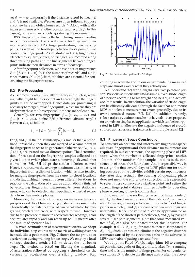
To avoid accumulation of measurement errors, we adoptthe individual step counts as the metric of walking distanceinstead, like a pedometer. Fig. 7 shows the magnitude of acceleration during walking for ten steps. We employ a local
variance threshold method [13] to detect the number of steps. The method is based on filtering the magnitudeof acceleration followed by applying a threshold on thevariance of acceleration over a sliding window. Step
counting is accurate and in our experiments the measuredsteps are almost exactly what they actually are.
We understand that stride lengths vary from person to per-son. Previous solutions like [36] assume a fixed stride length
of a person according to his weight and height, and achieveaccurate results. In our solution, the variation of stride lengthcan be efficiently alleviated through the fact that non-metricMDS can tolerate measurement errors gracefully, due to itsover-determined nature [30], [31]. In addition, recently,robust trajectory estimation schemes have also been proposedfor crowdsourcing-based applications, which can be incorpo-rated in LiFS to alleviate the negative influence of crowd-sourced abnormal user trajectories from multiple users [42].
5.3 Fingerprint Space Construction
To construct an accurate and informative fingerprint space,adequate fingerprints and their distance measurements arerequired. In our experiments, the operating phase of LiFSstarts when the number of collected fingerprints reaches10 times of the number of the sample locations in the con-struction of stress-free floor plans. Another possible way isto assign the first several days of LiFS’ pilot run for train-ing because routine activities exhibit certain repetitivenessday after day. Actually the running of operating phasedoes not mean the end of data collection. It is reasonableto select a less conservative starting point and refine thecurrent fingerprint database uninterruptedly in operatingphase according to newly coming data.
If no user path passes through a pair of fingerprints f iand f j, the direct measurement of the distance d 0ij is unavail-able. However, all user paths constitute a network of finger-prints in which f i and f j are connected via more than oneuser paths. Hence, the value of d 0ij can be approximated asthe length of the shortest path between f i and f j by passingseveral user path segments. Note that some measured val-ues of d 0ij can also be updated under this intuition. Forexample, if d 0ij > d 0ik þ d 0kj for some k, then d 0ij is updated tod 0ik þ d 0kj. Such updates can eliminate the negative distanceestimates caused by the circuitous paths or the adverse (toLiFS) user habit of pacing back and forth.
We adopt the Floyd-Warshall algorithm [10] to computeall-pair shortest paths of fingerprints. It takes Oðn3Þ runningtime and n is the number of fingerprints. For convenience,we still use D0 to denote the distance matrix after the above-
Fig. 7. The acceleration pattern for 10 steps.
448 IEEE TRANSACTIONS ON MOBILE COMPUTING, VOL. 14, NO. 2, FEBRUARY 2015

7/17/2019 Smartphones Based Crowdsourcing for Indoor Localization
http://slidepdf.com/reader/full/smartphones-based-crowdsourcing-for-indoor-localization 6/14
mentioned refinements on the original D0. So far D0 is denseand meaningful.
Similar to constructing stress-free floor plan, using D0 asan input, MDS maps all f i into a d -dimension euclideanspace. Figs. 8 and 9 demonstrate the 2D and 3D visualiza-tion of fingerprints, respectively.
6 MAPPING
If all fingerprints correspond with the sample locations inthe stress-free floor plan, we are able to label each finger-print with a real location. Such correspondence comes fromthe spatial similarity between stress-free floor plan and fin-gerprint space.
6.1 Feature Extraction
6.1.1 Corridor Recognition
Generally speaking, corridors in a building connect all otheroffice rooms like hubs in a network. When people walkfrom one room to another, they need to pass through corri-dors. Such characteristics in real life are reflected in bothstress-free floor plan and fingerprint space, as shown inFigs. 5, 6, 8, and 9. We observe that fingerprints collected atcorridors reside in core positions in fingerprint space. Interms of graph centrality [23], these fingerprints have a rela-tively large centrality values.
In graph theory, vertex centrality can be valued bydegree, betweenness, closeness, etc, [23]. In our context, weadopt the betweenness centrality to identify corridor finger-prints. Conceptually, vertices that have a high probability to
occur on a randomly chosen shortest path between two ran-domly chosen nodes have a high betweenness. Formally, ina graph G ¼ ðV; E Þ of vertices V and edges E , the between-
ness centrality of a vertex v 2 V is defined as
B ðvÞ ¼X
s6¼v6¼t2V
s stðvÞ
s st
; (2)
where s st is the number of shortest paths from s to t, ands stðvÞ is the number of shortest paths from s to t that passthrough a vertex v.
Our solution first recognizes the fingerprints collected incorridors in the fingerprint space. According to the distan-ces among fingerprints, we build the Minimum SpanningTree (MST) [7] T that connects all fingerprints in F , as illus-trated in Fig. 10. In addition, we compute the vertex
betweenness for all vertices (fingerprints) in T and then dis-tinguish fingerprints from corridors and other areas basedon a betweenness watershed. The betweenness watershedvalue is determined by two parameters: 1) the area ratio rc
of corridors to entire floor plan (i.e., rc ¼ size(corridor)/size(all)), which is available when generating the stress-freefloor plan; and 2) the largest gap of betweenness values of fingerprints. The area ratio rc is used to cut a feasible inter-val of the betweenness distribution and then the watershedis finally determined by finding the largest gap of between-ness values in the feasible interval. In this sense, the betweenness watershed is an automatically determined
value that depends on the specific scenario settings. In ourexperiment, the resulting cumulative distribution (CDF) of betweenness is shown in Fig. 11. Roughly, nearly 8.6 percenthave their betweenness larger than 8,200; while others all
Fig. 8. 2D fingerprint space.
Fig. 9. 3D fingerprint space.
Fig. 10. MST in 3D fingerprint space.
Fig. 11. Betweenness distribution.
WU ET AL.: SMARTPHONES BASED CROWDSOURCING FOR INDOOR LOCALIZATION 449

7/17/2019 Smartphones Based Crowdsourcing for Indoor Localization
http://slidepdf.com/reader/full/smartphones-based-crowdsourcing-for-indoor-localization 7/14
less than 7,000 (shown in Fig. 11). Obviously two groups of fingerprints are formed and we regard the one of larger betweenness as coming from corridors considering thestructure shown in Fig. 2. Let F c denote the set of finger-prints that are estimated collected from corridors.
6.1.2 Room Recognition
Removing F c from the fingerprint space, we observe from both Figs. 8 and 9 that the remaining fingerprints form sev-eral clusters that are apparently spatially separated. Togather the fingerprints that are sufficiently close to eachother, the k-means algorithm [18] (a classic clusteringmethod) is chosen due to its computational efficiency. Thusall fingerprints in F F c are classified into k clusters(denoted by F Ri
, i ¼ 1; 2; . . . ; k) and in the k-means algo-rithm k is set to be the number of rooms in real floor plan.After clustering, all fingerprints of a same F Ri
are consid-ered from the same real rooms, though we cannot tell whichspecific room they are from. The next section focuses on this
mapping problem.
6.1.3 Reference Point Mapping
After characterizing corridors and rooms, we are able toestablish relationships between stress-free floor plan andfingerprint space, and we think doors are the keys. Particu-larly, we are intended to identify the fingerprints that arecollected near doors. We define f̂ i and f̂ 0i as follows:
f̂ i; f̂ 0i
¼ arg min
f 2F Ri;f 02F c
kf f 0 k; (3)
where k k denotes the 2-Norm in the fingerprint space.
Specifically, f̂ i and f̂ 0i locate as close as possible to a doorin the floor plan but in opposite sides (f̂ i inside the roomand f̂ 0i outside the room). Let F D ¼ ff̂ 0i ; i ¼ 1; 2; . . . ; kgdenote the set of key corresponding points. Actually, thefingerprints in F D can be organized in a chain in the MST T ,as shown in Fig. 10. So we present F D in a vector form asF D ¼ ðf 1; f 2; . . . ; f kÞ.
While in the stress-free floor plan, let P D ¼ ð p1; p2, . . ., pkÞdenote the set of sample locations in the corridor that arethe closest to every door. The order of sample locations inP D are in accord with their appearance from one side to theother side along the corridor. There are two possible ways
(s
1;s
2 : F D ! P D) mapping F D to P D:
s 1 : f i 7! pi;
s 2 : f i 7! pkiþ1:
In fact only one of s 1 and s 2 is the ground-truth. We use thedistance constraints in both stress-free floor plan and finger-print space to eliminate the ambiguity. We definel ¼ ðl1; l2; . . . ; lk1Þ and li ¼ k piþ1 pi k. Similarly, l0 isdefined as l0 ¼ ðl0
1; l02; . . . ; l0
k1Þ and l0i ¼ k f iþ1 f i k. The
values of li and l0i can be determined according to the dis-
tance matrix D and D0, respectively. The cosine similarity of l and l0, denoted by s1, is calculated by
l l0
k l kk l0 k:
While the similarity of l and the reverse of l0, denoted by s2, isalso calculated. If s1 s2, we adopt s 1, otherwise s 2. Withoutloss of generality, s 1 is chosen in the following discussion.
Up to now, a group of fingerprints (F D) are labeled withreal locations. The relationship between F D and P D can befurther used to map other fingerprints to real locations.
6.2 Space Transformation
In this section, we discuss how to map fingerprints (finger-print space) to locations (stress-free floor plan). We initiallytry floor-level transformation and then turn to room-leveltransformation for better accuracy.
6.2.1 Floor-Level Transformation
From the visualization of the stress-free floor plan and thefingerprint space, we observe that they are structurally simi-lar but under trivial variations, including translation, rota-tion, or reflection. We use a transform matrix to solve suchtrivial variations.
Suppose a fingerprint f i 2 F D has its coordinate in theform of xi ¼ ½x1i x2
i . . . xd i T, where d is the dimension of the
fingerprint space. And its corresponding location pi 2 P D
has a coordinate yi ¼ ½y1i y2
i . . . yd i T in the stress-free floor
plan. Let A denote the d d transformation matrix and
B ¼ ½b1b2 . . . bd T. We have k ¼ jF Dj following equations
yi ¼ Axi þ B: (4)
We re-write the k equations as
H iz ¼ Gi; (5)
where H i ¼ ½xTi 1, z ¼ ½A B
T
, and Gi ¼ yTi . Combining k
equations as a matrix equation, we have
Hz ¼ G; (6)
where H i and Gi are the ith row of H and G, respectively.The least square estimation [3] of above k equations gives
z ¼ ðH TH Þ1H TG; (7)
which minimizes k G Hz k.So far, the transformation matrices A and B can be deter-
mined by z ; thus we are able to map any fingerprint to the
stress-free floor plan with a fixed location. For a fingerprintf with the coordinate x ¼ ½x1x2 . . . xd T, the sample locationthat is closest to Ax þ B is estimated as the real location of f .
6.2.2 Room-Level Transformation
From the experiment results, the unsatisfactory perfor-mance of floor-level transformation motivated us to designa fine-grained mapping solution. As previously mentioned,doors and fingerprints near doors are related, which furtherindicates that the rooms and the fingerprints from corre-sponding rooms are also related since a door belongs toonly one room (i.e., the mapping from doors to rooms is
injective). This fact enables room-level mapping instead of floor-level mapping.
Using MDS, the fingerprints from one room are trans-formed to d -dimension space. In the same way, the sample
450 IEEE TRANSACTIONS ON MOBILE COMPUTING, VOL. 14, NO. 2, FEBRUARY 2015

7/17/2019 Smartphones Based Crowdsourcing for Indoor Localization
http://slidepdf.com/reader/full/smartphones-based-crowdsourcing-for-indoor-localization 8/14
locations from the corresponding room are also mapped tod -dimension stress-free floor plan. Using doors and roomcorners as reference points, the fingerprints and samplelocations are linked determinately by the transformationmatrix above discussed. We perform the above step oneroom by one room and finally achieve a full mappingfor all fingerprints after multiple steps of room-leveltransformation.
7 LOCALIZATION
Basically, LiFS performs fingerprint database look-up toresponse to current location query using the nearest neigh- bour algorithm. User’s current location is estimated as thelocation of which the fingerprints pre-stored in the databaseare the most similar to the query measurements in terms of euclidean distance. Under this scheme, LiFS yields averagelocalization error of 5.9 meters and maximum error of about16 meters, as shown in Fig. 20.
The causes of insufficient accuracy lie in two folds: 1) the
fingerprint database generated by automatic crowdsourcingis naturally less accurate than that constructed by manualefforts. 2) the fingerprints from distant locations could besimilar and thus difficult to distinguish due to complexindoor environments, which is referred to as fingerprintambiguity in the literature [39]. While the former is inevita- ble to crowdsourced site survey, we propose a continuoustrajectory matching scheme to reduce the localization errorcaused by the fingerprint ambiguity for mobile users. Theidea is similar to other sequence matching approaches forGSM localization [24], [44].
We record successive RSS measurements instead of onlysingle report when a user is moving. Such continuous fin-gerprints represent the moving trajectory of a mobile user.When performing the localization, we search for a series of locations L ¼ fL1; L2; . . . ; Lkg that minimize the integraldistance as follows:
arg minf 0
Li2F
Xk
i¼1
kf i f 0Lik; (8)
where f i is the ith RSS vector in the trajectory measurements,and f 0Li
indicates the fingerprint of location Li stored in finger-print database F . When the matched trajectory is determined,the latest location, Lk, is returned as the current estimation.
Finding the best-fitted trajectory, however, incurs expo-nential computation cost. To reduce the search space, weleverage the dead-reckoned distance between successivemeasurements and consider only the candidate locations sat-isfying the distance constraints. By doing this, the number of candidate locations are largely reduced. Assume that the thenumber of candidate locations of the ith measurement in thetrajectory is reduced from n to a limited value, denoted as ci,then the computational complexity of the trajectory match-ing decreases from OðnkÞ to Oðn ck1Þ, where k is the recordnumber of the trajectory and c ¼ maxfci; i ¼ 2; . . . ; kg. Typi-cally, c is a small number (usually no more than 10) given the
distance constraints. In addition, a small value k (e.g., 2 to 4)is demonstrated to generate considerable accuracy improve-ment. Hence in practice, the complexity can be approxi-mately treated as OðnÞ since the factor ck1 is equivalent to a
constant. In other words, as demonstrated in the experi-ments, the trajectory matching scheme would not causeheavy computational cost, yet can significantly improvesaccuracy. Since we have conducted inertial sensing to countfootsteps as distance estimation in fingerprint space (asexpounded in Section 5, the trajectory matching scheme thatrely on successive RSS measurements and continuous dead-reckoning does not incur too much extra cost. The perfor-
mance benefits are provided in Section 8.
8 EXPERIMENTS
8.1 Experiment Design
We develop the prototype of LiFS on the increasingly popu-lar Android OS and on two Google Nexus S phones whichsupport WiFi and accelerometer sensors. We conduct theexperiment on one floor of a typical office building covering1,600 m2, with the length of 70 m and width of 23 m. Asshown in Fig. 2, the building contains 16 office rooms, of which five are large rooms of 142 m2, seven are small oneswith different sizes and the other four are inaccessible.Totally m ¼ 26 APs are installed, of which 15 are withknown locations and are denoted in Fig. 2.
We sample the experiment floor plan approximatelyevery 4 m2 (2 m 2 m grid) and obtain 292 sample locationsover all accessible areas. Although this density is not a con-sistently best solution for all situations (including corridors,office rooms, meeting rooms, etc.,) however, it provides rea-sonable positioning accuracy for general office buildings.Afterwards, we conduct MDS and the results in 2D and 3Dare depicted in Figs. 5 and 6, respectively.
The experiment lasts 5 hours by four volunteers. Eachvolunteer holds a mobile phone in hand and walk through
areas of interests. LiFS records the accelerometer readingsto count walking distances and picks up RSS values alongthe paths. Fingerprints are recorded every 45 steps duringmoving, which corresponds 23 m under normal walkingstyles. Accelerometers work in two different frequencies:when detecting movements, they record sensory data withshort intervals; otherwise a relatively long interval isadopted. WiFi is only scanned when the users are detectedto be moving at a frequency of about 2 Hz.
Totally 600 user traces along with 16,498 fingerprintrecords are collected. These traces cover most of the areas of the experimental field. The small and large rooms are covered
by at least five and 10 paths, respectively. In addition, the cor-ridor is covered by more than 500 paths. Different paths varynot only in the areas they covered but also in lengths. Theraw data are preprocessed and refined according to the RSSvalues and stability over time. After that, we select a half of these data for training and use the rest in operating phase.
8.2 Performance Evaluation
8.2.1 Fingerprint Space Generation
Before generating the fingerprint space, we obtain finger-print points (i.e., points in the fingerprint space) and theirpairwise distances from raw sensory data. Each point has a
set of fingerprints. Fingerprints are distinguished by theirRSS dissimilarities. Fingerprints with similar RSS featuresare attached to the same fingerprint points while fingerprintswith large dissimilarities are stickled to different points. As
WU ET AL.: SMARTPHONES BASED CROWDSOURCING FOR INDOOR LOCALIZATION 451

7/17/2019 Smartphones Based Crowdsourcing for Indoor Localization
http://slidepdf.com/reader/full/smartphones-based-crowdsourcing-for-indoor-localization 9/14
user traces may be overlapped in the floor plan, fingerprintscollected from different traces may be attached to the samepoint in the fingerprint space. In addition, fingerprints froma same sample location may be bounded to different points
due to the RSS fluctuation. Hence, the threshold value of can affect the fingerprint space generation a lot.
To obtain an appropriate for generating fingerprintspace, we first collect a series of fingerprints from the samelocation and calculate the maximum dissimilarity of thesefingerprints. This procedure is repeated over a set of distinctlocations (randomly selected), which results in a set of dis-similarity values. Finally we set the threshold epsilon as themean value of these dissimilarity values, which is supposedto represent the average maximum dissimilarity of finger-prints from one distinct location.
Location error and room error defined as follows are used
to examine the effects of .
Location Error ¼ kLðf Þ L0ðf Þk; (9)
Room Error ¼ 1
N
X
f 2F
I ðRðf Þ 6¼ R0ðf ÞÞ; (10)
where f is a fingerprint, Lðf Þ (Rðf Þ) and L0ðf Þ (R0ðf Þ) repre-sent the ground truth location (room) in floor plan and infingerprint space respectively, N is the number of finger-prints, F is the set of fingerprints, and I is an indicativefunction. For each fingerprint, its ground truth location(room) in fingerprint space is determined as the labeled-
location of those predominant fingerprints with the samelocation (room) label.
We plot the cumulative distribution of location error inFig. 12. The impact of on room error and the number of points are illustrated in Fig. 13. As from the results, locationerror and room error both increase when changes from 10to 100, while the number of points decreases from about1,600 to 1. Too small or large values of deteriorate the per-formance as fingerprints will be wrongly clustered. Wechoose ¼ 30 for further experiments, since 80 percent of fingerprints are accurate when ¼ 30.
To obtain walking distances of fingerprints, we first
evaluate the step counts estimation using the local variancethreshold method. Paths with different lengths (from 5 to200 footsteps) are designed for testing. Experiment resultsshow an error rate of 2 percent in the number of steps. To
further validate the performance under relatively long tracesin different scenarios, we collect accelerometer data from dif-ferent users by letting them walk a 300-step walking withtheir mobile phones in hand, in pockets, or in bags and per-
form the step counting algorithm. The results show thaterrors of 90 percent of all testing cases are limited within fivesteps, which is fairly accurate and suffices the requirementsof distance estimation for LiFS. Although different usershave various step sizes which result in different distances of the same number of steps, it will be shown later that MDShas outstanding performance in tolerance to measurementerrors. The accumulative error of long paths brings aboutunobvious performance drop as only path segments (inter-fingerprint distances) are used by MDS and the distance of far-away points are calculated by aggregating many paths.
Totally, 795 points are generated for fingerprint space
when ¼ 30. First we assign the pairwise distances of thesepoints with their measured walking distances and thus weget a connected network. By performing the Floyd-Warshallalgorithm on the network, we obtain all the pairwise distan-ces of 795 points. Finally, we conduct 2D and 3D MDS onthese points and the results are shown in Figs. 8 and 9, whereeach color denotes one room (or the corridor) in the floorplan. As seen from the figures, real floor plan structure is wellreflected by MDS under constraints of walking distances.
8.2.2 Mapping Performance
We build the MST of the fingerprint points (Fig. 10) to calcu-
late the betweenness centrality of each point. We sort allpoints by betweenness centrality in Fig. 11 and select thosepoints with higher betweenness than the watershed value(8,000 in our experiments). All selected points are estimatedfrom the corridor recognition. As illustrated in Fig. 14, mostof the candidate corridor points are correctly extracted.However, some room points are also mixed among themand on the other hand, some true corridor fingerprints arenot included. Hence, we refine the corridor recognition byiteratively performing MST and sifting low betweennesspoints until the MST of the remaining points form a singleline, i.e., each point has at most one parent and one child in
the MST. The final corridor points are depicted in Fig. 15.The rest of fingerprint points, most of which are actually
collected from rooms, are then clustered into 12 clusters(equal to the room number) using k-Means. The clustering
Fig. 12. CDF of location error on different . Fig. 13. Room error rate versus .
452 IEEE TRANSACTIONS ON MOBILE COMPUTING, VOL. 14, NO. 2, FEBRUARY 2015

7/17/2019 Smartphones Based Crowdsourcing for Indoor Localization
http://slidepdf.com/reader/full/smartphones-based-crowdsourcing-for-indoor-localization 10/14
results are shown in Fig. 16, where each different color indi-cates a cluster. The figure shows that most rooms can be rec-ognized correctly while only a small portion of corridorpoints are mixed.
For each cluster, we identify a point in the corridors thathas the shortest distance to all the points in a cluster as thereference point. The 12 reference points for 12 clusters areshown in Fig. 17. Some clusters may take the same point asits reference point, which is caused by the clustering errors.The reference points in the floor plan which link rooms tocorridors are also presented in Fig. 17. The reference pointsequences of floor plan and fingerprint space are l ¼ f2.37,3.36, 9.40, 1.18, 1.16, 8.07, 1.17, 3.82, 2.51, 2.55, 1.25g andl0 ¼ {0.33, 2.12, 12.98, 1.31, 1.31, 10.17, 1.24, 10.17, 1.24, 5.99,3.69, 1.18, 0} respectively. Let l00 be the reverse of l0. Thecosine similarities of l and l0 and l and l 00 are s1 ¼ 0:97 ands2 ¼ 0:67, respectively. Since s1 > s2, l0 is adopted.
Up to now, the corresponding relationship of clusters torooms is achieved. We then conduct the room-level transfor-mation below. To understand the cluster-room mapping, weplot the 2D MDS results of each cluster and each room in
Fig. 18. The mapping relations of 12 clusters and their corre-sponding rooms are also illustrated in Fig. 18. As seen fromFig. 18, the stress-free rooms are the same as in the floor planwhile the 2D fingerprint points especially those from smallrooms are a bit rambling. This is because the points are frommultiple rooms and the measured distances are of errors.
We then map the points in each cluster to sample locationsinitscorrespondingroombychoosingthenearestneighborforeach point. As shown in Fig. 19, the mapping results are satis-factory as the mapping errorof up to 96 percent points is lowerthan4metersandtheaverageerrorofisonly1.33meters.
8.2.3 Localization Error Two metrics are designed for localization performance:location error and room error. Location error is defined asthe euclidean distance from the estimated location to the
ground truth one. Room error means the error rate of fin-gerprints that are estimated to be in incorrect rooms. Asthe final outputs of LiFS, the RSS noises and mappingerrors are simultaneously taken into account. We emulate8,249 queries using real data on LiFS, and integrate all thelocalization results, as shown in Fig. 20. Each query con-tains a fingerprint and LiFS returns an estimated location.
We also implement RADAR [2], a famous and classicalfingerprint-based localization system, and compare its per-formance with LiFS on the same experiment data. The rea-sons we choose RADAR as our performance reference arethat LiFS adopts the standard algorithm of RADAR for fin-gerprint matching and our main purpose of this part of
experiments is to show the location accuracy losses due tocrowdsourced site survey, rather than how LiFS outper-forms RADAR. As shown in Fig. 20, the average localizationerror of LiFS is 5.88 meters, which is larger than RADAR(3.42 meters). The performance of LiFS is comparable tothe state-of-the-art model-based approaches (larger than5 meters) reported in [34] and outperforms EZ (larger than7 meters) [6]. As shown in Fig. 20, localization error of 80 percent of fingerprints is under 9 meters while about60 percent is under 6 meters. Some location errors arecaused by the symmetric structure of rooms, but they arerelatively small and will not contribute to room error. This
accuracy is fairly reasonable, though not much impressive,as LiFS needs no site survey and no specific infrastructure.
While the basic performance of LiFS is as expected to beno better than the classical RADAR since the automatic
Fig. 15. MST of corridor points.
Fig. 16. Clustering results by K-Means.
Fig. 17. Floor plan corridor versus Recognized corridor. Points markedwith ‘X’ are reference points.
Fig. 14. MST of corridor points extracted using betweenness centrality.
WU ET AL.: SMARTPHONES BASED CROWDSOURCING FOR INDOOR LOCALIZATION 453

7/17/2019 Smartphones Based Crowdsourcing for Indoor Localization
http://slidepdf.com/reader/full/smartphones-based-crowdsourcing-for-indoor-localization 11/14
generated radio map is inevitably less accurate than the man-ually constructed one, the accuracy of the enhanced trajec-tory matching scheme for mobile users is surprisinglypromising. We examine the effect of the trajectory matching
scheme by letting a user walk for a certain duration and thenstop at a specific spot. The RSS and inertial sensor data alongthe user’s moving are record and fed to the localizationserver while the spot which the user stopped at is marked asthe ground-truth location of this query. We collect multiplequery trajectories from different users and integratethe localization results in Fig. 21. As portrayed in Fig. 21,the average localization error is about 2 meters and themaximum error is bound within 8 meters, reduced by morethan 60 and 50 percent respectively compared to the basiclocalization scheme. The results not only outperformthe RADAR but also are comparable to several recent locali-zation schemes [28]. While providing good accuracy, the
computing time is no significantly larger than the nearestneighbor algorithm, since the accuracy improvement can begained by short trajectories of several successive records. Wealso analyse the room error of all queries on LiFS and find
that the room error rate is only 10.91 percent. As shown inTable 1, LiFS requires less sensors (only accelerometer)while produces comparable accuracy compare to a numberof other localization methods. Such encouraging resultsshow the benefits of mobility assisted localization and dem-onstrate the feasibility of LiFS in practical applications.
9 DISCUSSION AND FUTURE WORK
9.1 Global Reference Point and Multiple Floors
Global reference points include the last reported GPS location[6], AP’s location [19], similar surrounding sound signature[1], feature-distinct public area, etc. Though we do not use
Fig. 18. Fingerprints clusters versus floor plan rooms.
Fig. 19. CDF of mapping error. Fig. 20. CDF of localization error.
454 IEEE TRANSACTIONS ON MOBILE COMPUTING, VOL. 14, NO. 2, FEBRUARY 2015

7/17/2019 Smartphones Based Crowdsourcing for Indoor Localization
http://slidepdf.com/reader/full/smartphones-based-crowdsourcing-for-indoor-localization 12/14
global reference point in this design, they can be integratedinto LiFS, resulting in a more robust mapping solution, whileLiFS still works in case of deficient global information. Global
reference points are also the key in case of symmetric floorplans or multi-floor buildings. As the crowdsourced data can be collected from multiple floors in practice, part of ourfuture work is to incorporate automatic floor identification by leveraging global reference point as long with existingfloor localization methods such as skyloc [35]. Inspired by recent works, the motion states of users walking across dif-ferent floors using elevators, escalators, or stairs can be char-acterized by inertial sensors with advanced detectionalgorithms [15], [32], [36]. These motion states can further beincorporated into the LiFS systems to determine floors.
9.2 Building Types
Our experiment field is one floor of an academic building.The corridor in the middle connects all other office roomsthat lie on both sides of the corridor. According to such lay-out, we try to distinguish corridors and rooms based onuser traces. This solution fits a majority of office buildings but may fail in large open environments, such as hall,atrium, gymnasium, or museum, in which users’ move-ments are difficult to characterize. We envision that the rec-ognition of different functions of areas helps to regionalizespaces and model users’ movements, as our future work.
9.3 Device Heterogeneity
Device heterogeneity is a long-standing common challengeof all WiFi fingerprint based indoor localization techniques.Even under identical wireless environment, users with
different devices would observe different wireless signals(and thus wireless fingerprints) due to the hardware diver-sity. The problem become even more prominent in crowd-sourcing-based applications where a large amount of userswith different devices participate in data collection. In ourwork, benefiting from user mobility information, LiFS issupposed to tolerate different hardware devices better thantraditional methods because mobility provides a new
dimension of knowledge as an effective supplement to wire-less fingerprint itself. However, the issue is not yet dedicat-edly considered in current prototype implementation,which leaves as our future work.
9.4 Floor Plan Construction From User Data
Floor plan plays an essential role in many indoor pervasiveand mobile applications, but its collection and on-site cali- bration are inconvenient and usually prohibitively costlyfor (indoor) map providers. Based on the ideas of human-centric sensing and crowdsourcing, it becomes possible togenerate floor plans automatically. The movement records
from a large amount of contributing users can be used todepict the interior layout of a building. Further, the func-tions of a specified area (such as offices, corridor, elevator,and stairs) can be identified from rich sensor hints accord-ing to user behaviors. Such higher level semantics enableniche targeting location-based services.
9.5 Social Significance of Mobility Observation
Automatic floor plan construction also assists the research of human mobility and social behavior, in which data collectionis hard and the collected data are less well labeled. Our sys-tem provides not only sufficient mobility information, but
also corresponding meaningful comments. For example,through the traces collected from one user in a certain dura-tion, we can investigate the lengths of stays at his office andin the corridor, the total walking distance, as well as the aver-age speeds in the office and corridor respectively, and etc.
10 CONCLUSION
By utilizing the spatial relation of RSS fingerprints, we areable to create fingerprint space in which fingerprints are dis-tributed according to their mutual distances in real world.On this basis, we design and implement LiFS, an indoorlocalization system based on off-the-shelf WiFi infrastruc-
ture and mobile phones. The preliminary experiment resultsshow that LiFS achieves low human cost, rapid systemdeployment, and competitive location accuracy. This work
TABLE 1Comparison with Other Localization Systems
Fig. 21. Localization error of trajectory matching scheme (Denoted asLiFS-TM).
WU ET AL.: SMARTPHONES BASED CROWDSOURCING FOR INDOOR LOCALIZATION 455

7/17/2019 Smartphones Based Crowdsourcing for Indoor Localization
http://slidepdf.com/reader/full/smartphones-based-crowdsourcing-for-indoor-localization 13/14
sets up a novel perspective to cut off human intervention of indoor localization approaches. Our ongoing researchfocuses on making LiFS feasible and pervasive to variousapplied environments and buildings.
ACKNOWLEDGMENTS
This work was supported in part by the NSFC Major Pro-gram 61190110, NSFC under Grant 61171067, 61272429, and61133016, National Basic Research Program of China (973)under Grant No. 2012CB316200, and the NSFC Distin-guished Young Scholars Program under Grant 61125202.
REFERENCES
[1] M. Azizyan, I. Constandache, and R. Roy Choudhury,“Surroundsense: Mobile phone localization via ambience finger-printing,” in Proc. ACM 15th Annu. Int. Conf. Mobile Comput.Netw., 2009, pp. 261–272.
[2] P. Bahl and V. N. Padmanabhan, “RADAR: An in-building RF- based user location and tracking system,” in Proc. IEEE Conf. Com-put. Commun., 2000, vol. 2, pp. 775–784.
[3] A
. Bj€orck, Numerical Methods for Least Squares Problems. Philadel-
phia, PA, USA: SIAM, 51, 1996.[4] I. Borg and P. Groenen, Modern Multidimensional Scaling: Theory And Applications. New York, NY, USA: Springer-Verlag, 2005.
[5] Y. Chen, D. Lymberopoulos, J. Liu, and B. Priyantha, “FM-basedindoor localization,” in Proc. ACM 10th Int. Conf. Mobile Syst., Appl. Serv., 2012, pp. 169–182.
[6] K. Chintalapudi, A. P. Iyer, and V. N. Padmanabhan, “Indoorlocalization without the pain,” in Proc. ACM 16th Annu. Int. Conf. Mobile Comput. Netw., 2010, pp. 173–184.
[7] T. Cormen, Introduction to Algorithms. Cambridge, MA, USA: MITPress, 2001.
[8] J. Costa, N. Patwari, and A. Hero III, “Distributed weighted-mul-tidimensional scaling for node localization in sensor networks,” ACM Trans. Sens. Netw., vol. 2, no. 1, pp. 39–64, 2006.
[9] B. Ferris, D. Fox, and N. Lawrence, “Wifi-slam using gaussianprocess latent variable models,” in Proc. 20th Int. Joint Conf. Artif.
Intell., 2007, pp. 2480–2485.[10] R. Floyd, “Algorithm 97: Shortest path,” Commun. ACM, vol. 5,
no. 6, p. 345, 1962.[11] W. G. Griswold, P. Shanahan, S. W. Brown, R. Boyer, M. Ratto, R.
B. Shapiro, and T. M. Truong, “ActiveCampus: Experiments incommunity-oriented ubiquitous computing,” Comput., vol. 37,no. 10, pp. 73–81, 2004.
[12] J. Huang, D. Millman, M. Quigley, D. Stavens, S. Thrun, andA. Aggarwal, “Efficient, generalized indoor WiFi Graph-SLAM,” in Proc. IEEE Int. Conf. Robot. Autom., 2011, pp. 1038–1043.
[13] A. Jimenez, F. Seco, C. Prieto, and J. Guevara, “A comparisonof pedestrian dead-reckoning algorithms using a low-costMEMS IMU,” in Proc. IEEE Int. Symp. Intell. Signal Process.,2009, pp. 37–42.
[14] J. Koo and H. Cha, “Autonomous construction of a WiFi accesspoint map using multidimensional scaling,” in Proc. 9th Int. Conf.Pervasive Comput., 2011, pp. 115–132.
[15] J. R. Kwapisz, G. M. Weiss, and S. A. Moore, “Activity recognitionusing cell phone accelerometers,” ACM SIGKDD ExplorationsNewslett., vol. 12, no. 2, pp. 74–82, 2011.
[16] A. LaMarca, Y. Chawathe, S. Consolvo, J. Hightower, I. Smith, J. Scott, T. Sohn, J. Howard, J. Hughes, F. Potter, J. Tabert, P.Powledge, G. Borriello, and B. Schilit, “Place lab: Device posi-tioning using radio beacons in the wild,” Pervasive Comput.,vol. 3468, pp. 116–133, 2005.
[17] H. Lim, L. C. Kung, J. C. Hou, and H. Luo, “Zero-configurationindoor localization over IEEE 802.11 wireless infrastructure,”Wireless Netw., vol. 16, no. 2, pp. 405–420, 2010.
[18] J. MacQueen, “Some methods for classification and analysis of multivariate observations,” in Proc. 5th Berkeley Symp. Math.
Statist. Probability, 1967, vol. 1, pp. 281–297.[19] D. Madigan, E. Einahrawy, R. P. Martin, W. H. Ju, P. Krishnan,and A. S. Krishnakumar, “Bayesian indoor positioning systems,”in Proc. IEEE 24th Annu. Joint Conf. IEEE Comput. Commun. Soc. ,2005, pp. 1217–1227.
[20] M. Montemerlo, S. Thrun, D. Koller, and B. Wegbreit, “FastSlam:A factored solution to the simultaneous localization and mappingproblem,” in Proc. 18th Nat. Conf. Artif. Intell., 2002, pp. 593–598.
[21] L. M. Ni, Y. Liu, Y. C. Lau, and A. P. Patil, “LANDMARC: Indoorlocation sensing using active RFID,” Wireless Netw., vol. 10, no. 6,pp. 701–710, 2004.
[22] D. Niculescu and B. Nath, “Ad hoc positioning system (APS)using AOA,” in Proc. IEEE 22nd Annu. Joint Conf. IEEE Comput.Communi. IEEE Societies, vol. 3, 2003, pp. 1734–1743.
[23] T. Opsahl, F. Agneessens, and J. Skvoretz, “Node centrality in
weighted networks: Generalizing degree and shortest paths,”Social Netw., vol. 32, no. 3, pp. 245–251, 2010.[24] J. Paek, K.-H. Kim, J. P. Singh, and R. Govindan, “Energy-efficient
positioning for smartphones using cell-id sequence matching,” inProc. 9th Int. Conf. Mobile Syst., Appl., Serv., 2011, pp. 293–306.[Online]. Available: http://doi.acm.org/10.1145/1999995.2000024
[25] J. Park, B. Charrow, D. Curtis, J. Battat, E. Minkov, J. Hicks, S. Teller,and J. Ledlie, “Growing an organic indoor location system,” in Proc. ACM 8th Int. Conf. MobileSyst., Appl. Serv., 2010, pp. 271–284.
[26] N. B. Priyantha, A. Chakraborty, and H. Balakrishnan, “Thecricket location-support system,” in Proc. ACM 6th Annu. Int.Conf. Mobile Comput. Netw., 2000, pp. 32–43.
[27] T. Pulkkinen, T. Roos, and P. Myllym€aki, “Semi-supervised learn-ing for WLAN positioning,” Artif. Neural Netw. Mach. Learn.,vol. 6791, pp. 355–362, 2011.
[28] A. Rai, R. Sen, K. K. Chintalapudi, and V. Padmanabhan, “Zee:
Zero-effort crowdsourcing for indoor localization,” in Proc. ACM Annu. Int. Conf. Mobile Comput. Netw., 2012, pp. 293–304.
[29] S. Sen, B. Radunovic, R. R. Choudhury, and T. Minka, “You arefacing the Mona Lisa: Spot localization using PHY layerinformation,” in Proc. ACM Int. Conf. Mobile Syst., Appl. Serv.,2012, pp. 183–196.
[30] Y. Shang and W. Ruml, “Improved MDS-based localization,” inProc. IEEE Conf. Comput. Commun., 2004, vol. 4, pp. 2640–2651.
[31] Y. Shang, W. Ruml, Y. Zhang, and M. Fromherz, “Localizationfrom mere connectivity,” in Proc. ACM 4th ACM Int. Symp. Mobile Ad Hoc Netw. Comput., 2003, pp. 201–212.
[32] G. Shen, Z. Chen, P. Zhang, T. Moscibroda, and Y. Zhang, “Walkie-markie: Indoor pathway mapping made easy,” in Proc. 10th USE-NIX Conf. Netw. Syst. Des. Implementation, 2013, pp.85–98.
[33] S. Thrun, W. Burgard, and D. Fox, Probabilistic Robotics.Cambridge, MA, USA: MIT Press, 2005.
[34] D. Turner, S. Savage, and A. Snoeren, “On the empirical perfor-mance of self-calibrating WiFi location systems,” in Proc. 36thConf. Local Comput. Netw., Oct. 2011, pp. 76–84.
[35] A. Varshavsky, A. LaMarca, J. Hightower, and E. de Lara, “Theskyloc floor localization system,” in Proc. 5th Int. Conf. PervasiveComput. Commun., 2007, pp. 125–134.
[36] H. Wang, S. Sen, A. Elgohary, M. Farid, M. Youssef, and R. Choud-hury, “No need to war-drive: Unsupervised indoor localization,” inProc. ACM 10thInt. Conf. Mobile Syst., Appl. Serv., 2012, pp. 197–210.
[37] O. Woodman and R. Harle, “Pedestrian localisation for indoorenvironments,” in Proc. ACM 10th Int. Conf. Ubiquitous Comput.,2008, pp. 114–123.
[38] C. Wu, Z. Yang, Y. Liu, and W. Xi, “Will: Wireless indoor localiza-tion without site survey,” IEEE Trans. Parallel Distrib. Syst., vol. 24,no. 4, pp. 839–848, Apr. 2013.
[39] S. Yoon,K. Lee, and I. Rhee, “FM-based indoor localization via auto-matic fingerprint DB construction and matching,” in Proc. ACM 11th Annu. Int. Conf. Mobile Syst., Appl. Serv., 2013, pp. 207–220. [Online].Available: http://doi.acm.org/10.1145/2462456.2464445
[40] M. Youssef and A. Agrawala, “The horus WLAN location deter-mination system,” in Proc. ACM Annu. Int. Conf. Mobile Syst., Appl.Serv., 2005, pp. 205–218.
[41] M. Youssef, A. Youssef, C. Rieger, U. Shankar, and A. Agrawala,“Pinpoint: An asynchronous time-based location determinationsystem,” in Proc. ACM Int. Conf. Mobile Syst., Appl. Serv., 2006,pp. 165–176.
[42] X. Zhang, Z. Yang, C. Wu, W. Sun, Y. Liu, and K. Xing, “Robusttrajectory estimation for crowdsourcing-based mobileapplications,” IEEE Trans. Parallel Distrib. Syst., vol. 25, no. 7,pp. 1876–1885, Jul. 2014.
[43] Z. Zhang, X. Zhou, W. Zhang, Y. Zhang, G. Wang, B. Y. Zhao, and
H. Zheng, “I am the antenna: Accurate outdoor ap location usingsmartphones,” in Proc. ACM 17th Annu. Int. Conf. Mobile Comput.Netw., 2011, pp. 109–120. [Online]. Available: http://doi.acm.org/10.1145/2030613.2030626
456 IEEE TRANSACTIONS ON MOBILE COMPUTING, VOL. 14, NO. 2, FEBRUARY 2015
7/17/2019 Smartphones Based Crowdsourcing for Indoor Localization
http://slidepdf.com/reader/full/smartphones-based-crowdsourcing-for-indoor-localization 14/14
[44] P. Zhou, Y. Zheng, and M. Li, “How long to wait?: Predicting busarrival time with mobile phone based participatory sensing,” inProc. ACM Int. Conf. Mobile Syst., Appl. Serv., 2012, pp. 379–392.[Online]. Available: http://doi.acm.org/10.1145/2307636.2307671
Chenshu Wu received the BS degree in theSchool of Software from Tsinghua University,Beijing, P.R. China, in 2010. He is working towardthe PhD degree in the Department of ComputerScience and Technology, Tsinghua University.
His research interests include wireless ad-hoc/ sensor networks and mobile computing. He is astudent member of the IEEE and the ACM.
Zheng Yang received the BE degree in com-puter science from Tsinghua University in 2006and the PhD degree in computer science fromthe Hong Kong University of Science and Tech-nology in 2010. He is currently an assistant pro-fessor at Tsinghua University. His main researchinterests include wireless ad-hoc/sensor net-works and mobile computing. He was awardedthe 2011 National Nature Science Award (secondclass). He is a member of the IEEE and the ACM.
Yunhao Liu received the BS degree in automa-tion from Tsinghua University, China, in 1995,the MS, and the PhD degrees in computer sci-ence and engineering from Michigan State Uni-versity, in 2003 and 2004, respectively. He iscurrently a ChangJiang professor at TsinghuaUniversity. His research interests include wire-less sensor network, peer-to-peer computing,and pervasive computing. He is a senior memberof the IEEE.
" For more information on this or any other computing topic,please visit our Digital Library at www.computer.org/publications/dlib.
WU ET AL.: SMARTPHONES BASED CROWDSOURCING FOR INDOOR LOCALIZATION 457