sixth grade caribbean unit - cisdsocialstudies -...
TRANSCRIPT
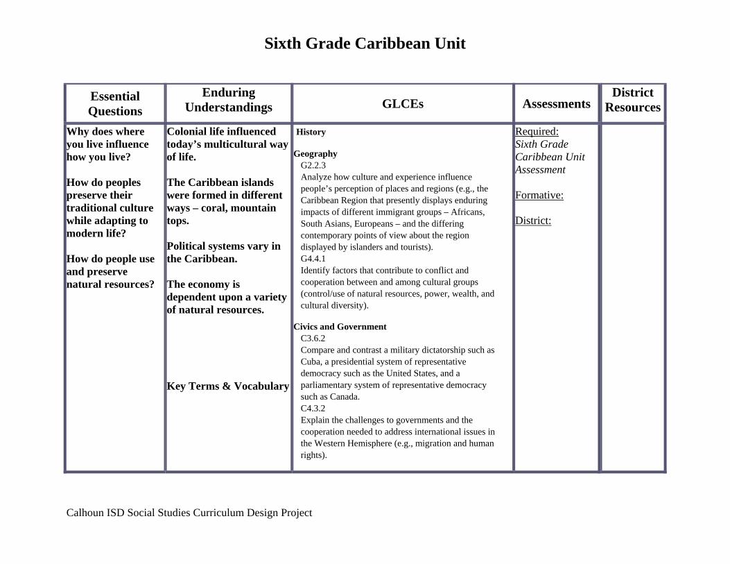
Sixth Grade Caribbean Unit
Essential Questions
Enduring Understandings GLCEs Assessments
District Resources
Why does where you live influence how you live? How do peoples preserve their traditional culture while adapting to modern life? How do people use and preserve natural resources?
Colonial life influenced today’s multicultural way of life. The Caribbean islands were formed in different ways – coral, mountain tops. Political systems vary in the Caribbean. The economy is dependent upon a variety of natural resources. Key Terms & Vocabulary
History Geography
G2.2.3 Analyze how culture and experience influence people’s perception of places and regions (e.g., the Caribbean Region that presently displays enduring impacts of different immigrant groups – Africans, South Asians, Europeans – and the differing contemporary points of view about the region displayed by islanders and tourists). G4.4.1 Identify factors that contribute to conflict and cooperation between and among cultural groups (control/use of natural resources, power, wealth, and cultural diversity).
Civics and Government
C3.6.2 Compare and contrast a military dictatorship such as Cuba, a presidential system of representative democracy such as the United States, and a parliamentary system of representative democracy such as Canada. C4.3.2 Explain the challenges to governments and the cooperation needed to address international issues in the Western Hemisphere (e.g., migration and human rights).
Required: Sixth Grade Caribbean Unit Assessment Formative: District:
Calhoun ISD Social Studies Curriculum Design Project
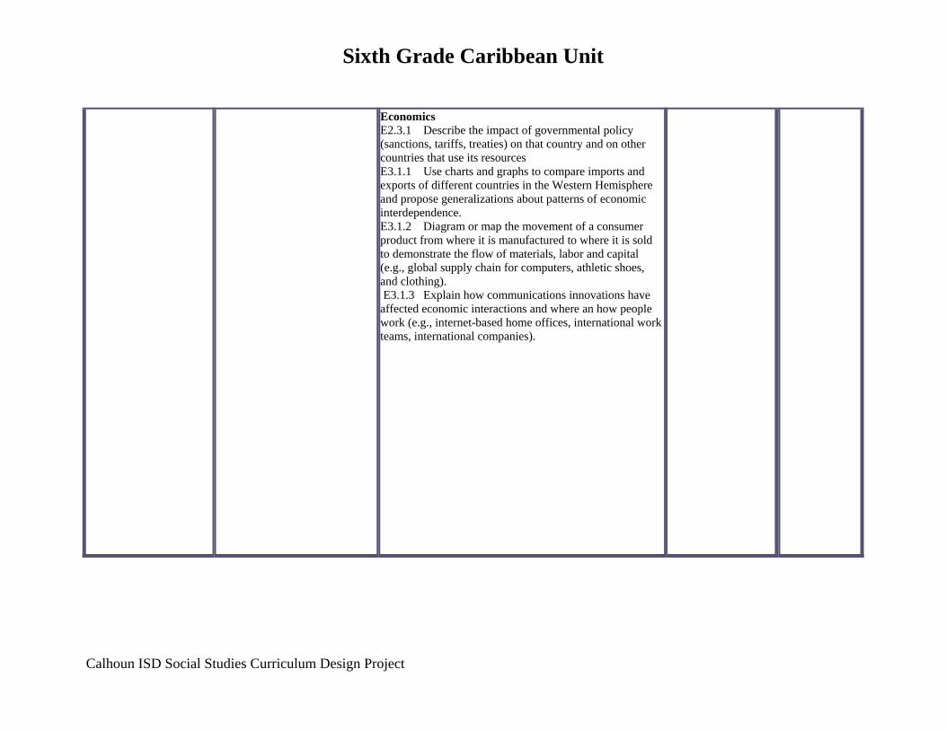
Sixth Grade Caribbean Unit
Calhoun ISD Social Studies Curriculum Design Project
Economics E2.3.1 Describe the impact of governmental policy (sanctions, tariffs, treaties) on that country and on other countries that use its resources E3.1.1 Use charts and graphs to compare imports and exports of different countries in the Western Hemisphere and propose generalizations about patterns of economic interdependence. E3.1.2 Diagram or map the movement of a consumer product from where it is manufactured to where it is sold to demonstrate the flow of materials, labor and capital (e.g., global supply chain for computers, athletic shoes, and clothing). E3.1.3 Explain how communications innovations have affected economic interactions and where an how people work (e.g., internet-based home offices, international work teams, international companies).
Calhoun ISD Social Studies Curriculum Design Project
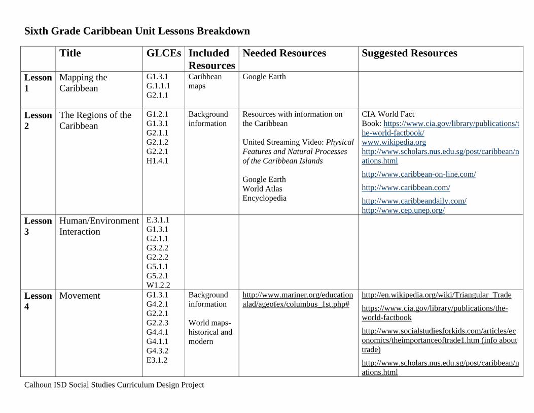
Sixth Grade Caribbean Unit Lessons Breakdown Title GLCEs Included
ResourcesNeeded Resources Suggested Resources
Lesson 1
Mapping the Caribbean
G1.3.1 G.1.1.1 G2.1.1
Caribbean maps
Google Earth
Lesson 2
The Regions of the Caribbean
G1.2.1 G1.3.1 G2.1.1 G2.1.2 G2.2.1 H1.4.1
Background information
Resources with information on the Caribbean United Streaming Video: Physical Features and Natural Processes of the Caribbean Islands Google Earth World Atlas Encyclopedia
CIA World Fact Book: https://www.cia.gov/library/publications/the-world-factbook/ www.wikipedia.org http://www.scholars.nus.edu.sg/post/caribbean/nations.html
http://www.caribbean-on-line.com/
http://www.caribbean.com/
http://www.caribbeandaily.com/ http://www.cep.unep.org/
Lesson 3
Human/Environment Interaction
E.3.1.1 G1.3.1 G2.1.1 G3.2.2 G2.2.2 G5.1.1 G5.2.1 W1.2.2
Lesson 4
Movement G1.3.1 G4.2.1 G2.2.1 G2.2.3 G4.4.1 G4.1.1 G4.3.2 E3.1.2
Background information World maps-historical and modern
http://www.mariner.org/educationalad/ageofex/columbus_1st.php#
http://en.wikipedia.org/wiki/Triangular_Trade
https://www.cia.gov/library/publications/the-world-factbook
http://www.socialstudiesforkids.com/articles/economics/theimportanceoftrade1.htm (info about trade)
http://www.scholars.nus.edu.sg/post/caribbean/nations.html
Calhoun ISD Social Studies Curriculum Design Project
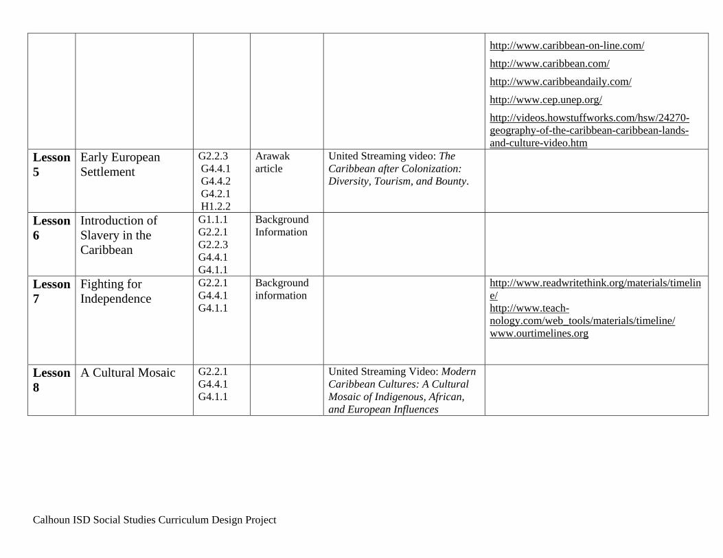
http://www.caribbean-on-line.com/
http://www.caribbean.com/
http://www.caribbeandaily.com/
http://www.cep.unep.org/
http://videos.howstuffworks.com/hsw/24270-geography-of-the-caribbean-caribbean-lands-and-culture-video.htm
Lesson 5
Early European Settlement
G2.2.3 G4.4.1 G4.4.2 G4.2.1 H1.2.2
Arawak article
United Streaming video: The Caribbean after Colonization: Diversity, Tourism, and Bounty.
Lesson 6
Introduction of Slavery in the Caribbean
G1.1.1 G2.2.1 G2.2.3 G4.4.1 G4.1.1
Background Information
Lesson 7
Fighting for Independence
G2.2.1 G4.4.1 G4.1.1
Background information
http://www.readwritethink.org/materials/timeline/ http://www.teach-nology.com/web_tools/materials/timeline/ www.ourtimelines.org
Lesson 8
A Cultural Mosaic G2.2.1 G4.4.1 G4.1.1
United Streaming Video: Modern Caribbean Cultures: A Cultural Mosaic of Indigenous, African, and European Influences

Sixth Grade Caribbean Unit Lesson 1 Title: Geography of the Caribbean: Mapping the Caribbean Grade Level: 6 Unit of Study: Caribbean GLCE: G1.3.1 Use the fundamental themes of geography (location, place, human environment interaction, movement, region) to describe regions or places on earth. G.1.1.1 Describe how geographers use mapping to represent places and natural and human phenomena in the world G2.1.1 Describe the landform features and the climate of the region (within the Western or Eastern Hemispheres) under study Time: 1-2 Days (flexible) Abstract: In this lesson students will create a map of the Caribbean. Key Concepts: Identify the location of the three regions of the Caribbean Islands: Bahamas, Greater Antilles, and Lesser Antilles Sequence of Activities:
1. Use Google Earth or examine a map of the Caribbean to identify the islands of each region. Discuss absolute and relative location.
2. Students will create a map of the Caribbean, including the three regions (Bahamas,
Greater Antilles, and Lesser Antilles), names of the islands, and a variety of natural and human features of each area.
3. Connections: Art, Math (through use of rulers and measurement tools)
Resources Google Earth World Atlas http://www.scholars.nus.edu.sg/post/caribbean/nations.html
http://www.caribbean-on-line.com/
http://www.caribbean.com/
http://www.caribbeandaily.com/
http://www.cep.unep.org/
Calhoun ISD Social Studies Curriculum Design Project
NAME: ___________________________________ DATE: ___________________
HOUR: ______
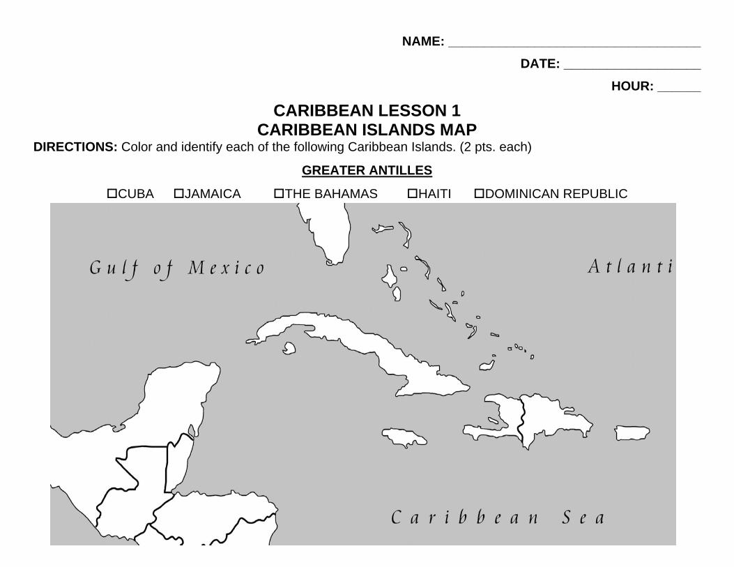
CARIBBEAN LESSON 1 CARIBBEAN ISLANDS MAP
DIRECTIONS: Color and identify each of the following Caribbean Islands. (2 pts. each)
GREATER ANTILLES
CUBA JAMAICA THE BAHAMAS HAITI DOMINICAN REPUBLIC

DIRECTIONS: Color and identify each of the following Caribbean Islands. (2 pts. each) LESSER ANTILLES
BARBUDA
ANTIGUA
MONTSERRAT
GUADELOUPE
DOMINICA
MARTINIQUE
ST. LUCIA
BARBADOS
ST. VINCENT AND THE GRENADINES
GRENADA
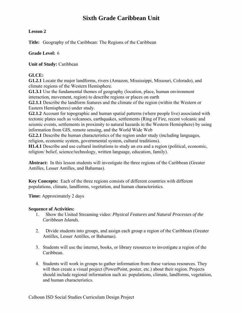
Sixth Grade Caribbean Unit Lesson 2 Title: Geography of the Caribbean: The Regions of the Caribbean Grade Level: 6 Unit of Study: Caribbean GLCE: G1.2.1 Locate the major landforms, rivers (Amazon, Mississippi, Missouri, Colorado), and climate regions of the Western Hemisphere. G1.3.1 Use the fundamental themes of geography (location, place, human environment interaction, movement, region) to describe regions or places on earth G2.1.1 Describe the landform features and the climate of the region (within the Western or Eastern Hemispheres) under study. G2.1.2 Account for topographic and human spatial patterns (where people live) associated with tectonic plates such as volcanoes, earthquakes, settlements (Ring of Fire, recent volcanic and seismic events, settlements in proximity to natural hazards in the Western Hemisphere) by using information from GIS, remote sensing, and the World Wide Web G2.2.1 Describe the human characteristics of the region under study (including languages, religion, economic system, governmental system, cultural traditions). H1.4.1 Describe and use cultural institutions to study an era and a region (political, economic, religion/ belief, science/technology, written language, education, family). Abstract: In this lesson students will investigate the three regions of the Caribbean (Greater Antilles, Lesser Antilles, and Bahamas). Key Concepts: Each of the three regions consists of different countries with different populations, climate, landforms, vegetation, and human characteristics.
Time: Approximately 2 days Sequence of Activities:
1. Show the United Streaming video: Physical Features and Natural Processes of the Caribbean Islands.
2. Divide students into groups, and assign each group a region of the Caribbean (Greater
Antilles, Lesser Antilles, or Bahamas).
3. Students will use the internet, books, or library resources to investigate a region of the Caribbean.
4. Students will work in groups to gather information from these various resources. They
will then create a visual project (PowerPoint, poster, etc.) about their region. Projects should include regional information such as: populations, climate, landforms, vegetation, and human characteristics.
Calhoun ISD Social Studies Curriculum Design Project
Sixth Grade Caribbean Unit Connections: Art, Technology, Math (population/climate graph if used) Resources United Streaming Video: Physical Features and Natural Processes of the Caribbean Islands Google Earth World Atlas Encyclopedia Textbook (if available) CIA World Fact Book: (https://www.cia.gov/library/publications/the-world-factbook/) www.wikipedia.org http://www.scholars.nus.edu.sg/post/caribbean/nations.html
http://www.caribbean-on-line.com/
http://www.caribbean.com/
http://www.caribbeandaily.com/ http://www.cep.unep.org/ Background Information Greater Antilles From Wikipedia, the free encyclopedia
Location of the Greater Antilles (green) in relation to the rest of the Caribbean The Greater Antilles is one of three island groups in the Caribbean. Comprising Cuba, Jamaica, Hispaniola, and Puerto Rico--the four largest islands of the Antilles--the Greater Antilles constitutes almost 90% of the land mass of the entire West Indies.[1] The Greater Antilles in context The islands of the Caribbean Sea, collectively known as the West Indies, are sorted by size and location into the Bahamas (or Lucayan archipelago, which includes the Turks and Caicos Islands), the Lesser Antilles, and the Greater Antilles. The "Greater Antilles" refers to Cuba,
Calhoun ISD Social Studies Curriculum Design Project
Sixth Grade Caribbean Unit Jamaica, Hispaniola (Haiti and the Dominican Republic), and Puerto Rico. The smaller islands in the vicinity of these four major islands are sometimes also treated as part of the group. This includes the smaller islands that surround the main islands, but are still part of the main island country (for instance, the Republic of Cuba consists of the island of Cuba, the Isle of Pines, and several smaller islands around them.) The Cayman Islands are also often included in the Greater Antilles because of their geographical proximity to Cuba. The Greater Antilles are made up of continental rock, part of North America, as distinct from that of the Lesser Antilles, which are mostly young volcanic or coral islands.
The Yucatan Channel separates the Greater Antilles from Mexico, and the Florida Straits separate them from the United States. To the South of the Greater Antilles, and completely surrounding Jamaica, is the Caribbean Sea.
Located on the islands of the Greater Antilles are three original members of the United Nations: the Dominican Republic, Haiti, and Cuba. Jamaica was formerly a possession of the United Kingdom, winning its independence on August 6, 1962, and joining the United Nations that same year. Puerto Rico is still a voluntary Commonwealth of the United States (by repeated votes by its people), which means that it is neither a state, nor an independent country, but is a U.S. territory.
The Greater Antilles were of strategic significance during the years when sea power defined a country's might, and they served as the battlegrounds for several important powers, particularly Spain, France, and Great Britain. Later, the Greater Antilles became important to the United States of America, with its large fleets of merchant ships and its Navy. First exploited for their own resources, the Greater Antilles were later utilized as the principal landing points for ships traveling between Europe and the New World. With the advent of long-range steamships and commercial airlines, the strategic importance of these islands has diminished over time.
The Greater Antilles remain strategically important to the United States and the United Kingdom, each of which maintain naval and air bases there. Cuba, formerly a key ally of the Soviet Union, demonstrated the regional importance of the Greater Antilles in the Cuban Missile Crisis. Currently, the United States leases a naval base and naval air station at Guantanamo Bay, Cuba, making yearly payments by check that the current Cuban government does not cash.[citation
needed]
Islands of the Greater Antilles
Calhoun ISD Social Studies Curriculum Design Project
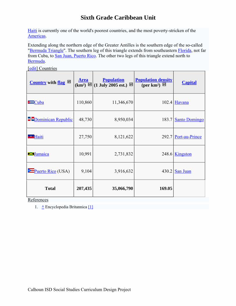
Sixth Grade Caribbean Unit Haiti is currently one of the world's poorest countries, and the most poverty-stricken of the Americas.
Extending along the northern edge of the Greater Antilles is the southern edge of the so-called "Bermuda Triangle". The southern leg of this triangle extends from southeastern Florida, not far from Cuba, to San Juan, Puerto Rico. The other two legs of this triangle extend north to Bermuda. [edit] Countries
Country with flag Area (km²)
Population (1 July 2005 est.)
Population density (per km²) Capital
Cuba 110,860 11,346,670 102.4 Havana
Dominican Republic 48,730 8,950,034 183.7 Santo Domingo
Haiti 27,750 8,121,622 292.7 Port-au-Prince
Jamaica 10,991 2,731,832 248.6 Kingston
Puerto Rico (USA) 9,104 3,916,632 430.2 San Juan
Total 207,435 35,066,790 169.05
References 1. ^ Encyclopedia Britannica [1]
Calhoun ISD Social Studies Curriculum Design Project
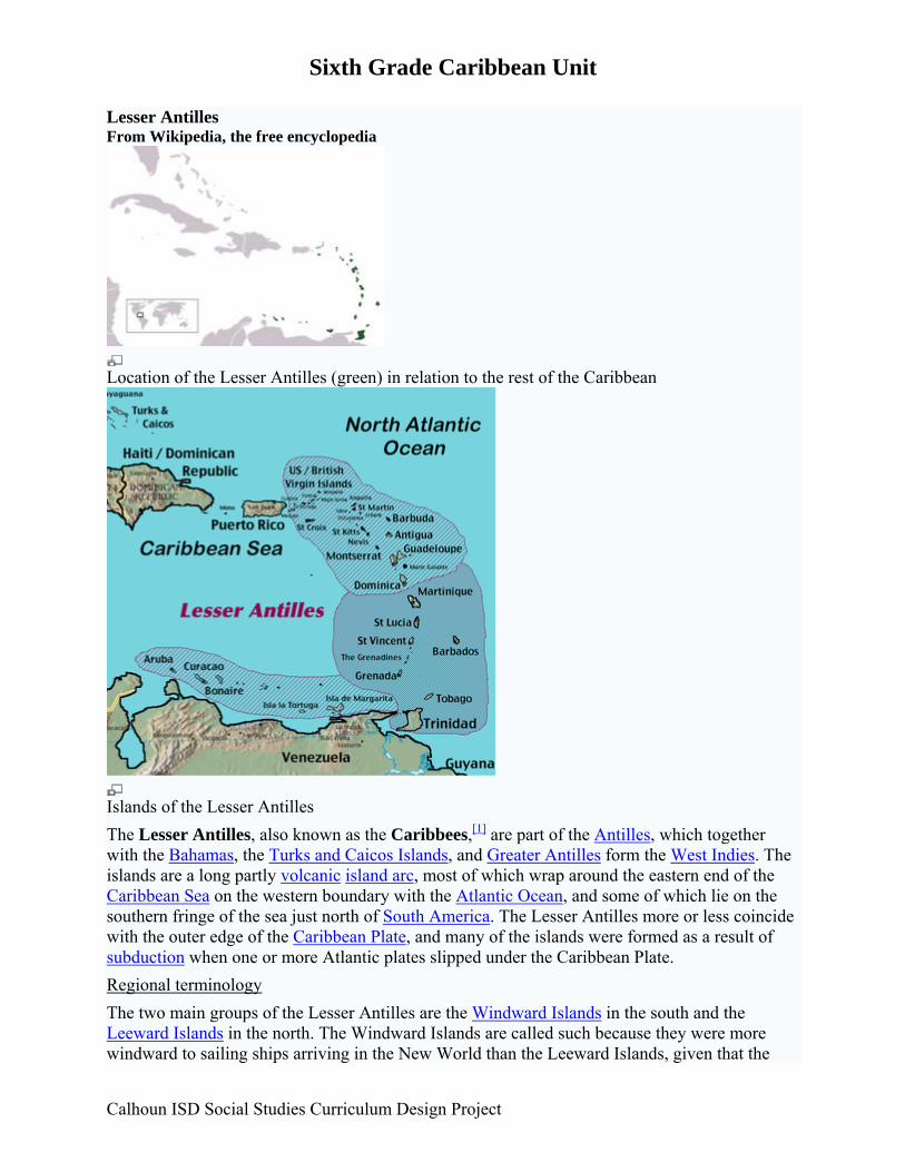
Sixth Grade Caribbean Unit Lesser Antilles From Wikipedia, the free encyclopedia
Location of the Lesser Antilles (green) in relation to the rest of the Caribbean
Islands of the Lesser Antilles The Lesser Antilles, also known as the Caribbees,[1] are part of the Antilles, which together with the Bahamas, the Turks and Caicos Islands, and Greater Antilles form the West Indies. The islands are a long partly volcanic island arc, most of which wrap around the eastern end of the Caribbean Sea on the western boundary with the Atlantic Ocean, and some of which lie on the southern fringe of the sea just north of South America. The Lesser Antilles more or less coincide with the outer edge of the Caribbean Plate, and many of the islands were formed as a result of subduction when one or more Atlantic plates slipped under the Caribbean Plate. Regional terminology The two main groups of the Lesser Antilles are the Windward Islands in the south and the Leeward Islands in the north. The Windward Islands are called such because they were more windward to sailing ships arriving in the New World than the Leeward Islands, given that the
Calhoun ISD Social Studies Curriculum Design Project
Sixth Grade Caribbean Unit prevailing trade winds blow east to west. The trans-Atlantic currents and winds that provided the fastest route across the ocean brought these ships to the rough dividing line between the Windward and Leeward Islands.
A third category which is part of the Lesser Antilles is the Netherland Antilles. The Netherlands Antilles consist of two groups of islands, one in the southwest (the Leeward Antilles or the ABC islands) just off the coast of Venezuela, plus several others in the northeast (several of the Leeward Islands). Islands The main Lesser Antilles are (from north to south to west):
Leeward Islands:
• Virgin Islands:
o U.S. Virgin Islands: St. Thomas, St. John, St. Croix
o British Virgin Islands: Tortola, Virgin Gorda, Anegada, Jost Van Dyke
• Anguilla (UK)
• Saint Martin/Sint Maarten (France/Neth. Antilles)
• Saint-Barthélemy (Fr.)
• Saba (Neth.)
• Sint Eustatius (Neth.)
• Saint Kitts
• Nevis
• Barbuda
• Antigua
• Redonda
• Montserrat (UK)
• Guadeloupe (Fr.)
• La Désirade (Fr.)
• Les Saintes (Fr.)
• Marie-Galante (Fr.)
Windward Islands:
Calhoun ISD Social Studies Curriculum Design Project
Sixth Grade Caribbean Unit
• Dominica
• Martinique (Fr.)
• Saint Lucia
• Saint Vincent
• Grenadines
• Grenada
• Barbados (Barbados is a Continental Island found 100 miles east of the Windward chain)[2][3][4]
• Trinidad and Tobago (are sometimes erroneously considered part of the Windward Islands. They are the most southern islands of the Caribbean region. [1][5][6]
Leeward Antilles – islands north of the Venezuelan coast (from west to east):
• Aruba (Neth.)
• Curaçao (Neth.)
• Bonaire (Neth.)
• Margarita Island (Ven)
• Coche (Ven)
• La Tortuga (Ven)
• Cubagua (Ven)
• Venezuelan Archipelago (Ven) [edit] References
1. ^ a b "West Indies." Merriam-Webster's Geographical Dictionary, 3rd ed. 2001. (ISBN 0-87779-546-0) Springfield, MA: Merriam-Webster Inc., p. 1298.
2. ^ Encyclopædia Britannica: The Windward Islands
3. ^ United Nations Educational, Scientific and Cultural Organization (UNESCO) | The Scotland District of Barbados
4. ^ CountryStudies.us | The Windward Islands and Barbados
5. ^ Cohen, Saul B., ed. "West Indies" The Columbia Gazetteer of North America. New York: Columbia University Press – Bartleby. Accessed: 19 September 2006
6. ^ ARBITRAL TRIBUNAL CONSTITUTED PURSUANT TO ARTICLE 287, AND IN ACCORDANCE WITH ANNEX VII, OF THE UNITED NATIONS CONVENTION ON THE
Calhoun ISD Social Studies Curriculum Design Project
Sixth Grade Caribbean Unit
LAW OF THE SEA IN THE MATTER OF AN ARBITRATION BETWEEN: BARBADOS - AND - THE REPUBLIC OF TRINIDAD AND TOBAGO - The Hague, 11 April 2006 (Pages 15-16)
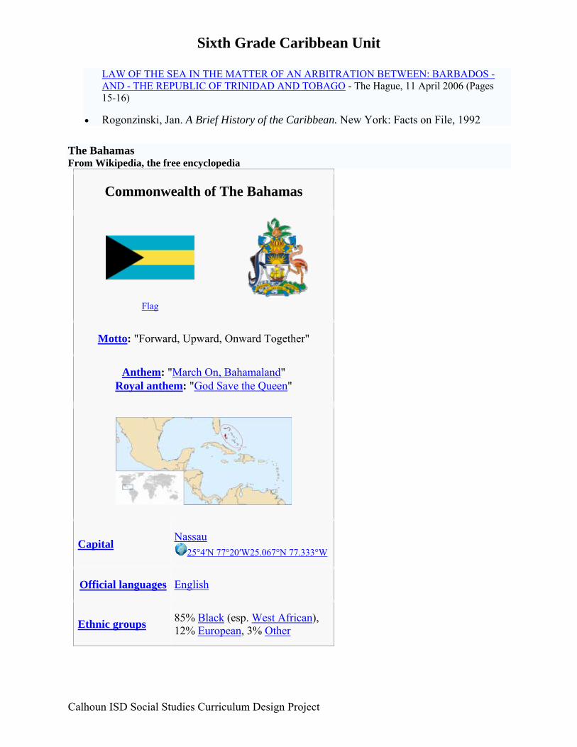
• Rogonzinski, Jan. A Brief History of the Caribbean. New York: Facts on File, 1992 The Bahamas From Wikipedia, the free encyclopedia
Commonwealth of The Bahamas
Flag
Motto: "Forward, Upward, Onward Together"
Anthem: "March On, Bahamaland" Royal anthem: "God Save the Queen"
Capital Nassau
25°4′N 77°20′W25.067°N 77.333°W
Official languages English
Ethnic groups 85% Black (esp. West African), 12% European, 3% Other
Calhoun ISD Social Studies Curriculum Design Project
Sixth Grade Caribbean Unit
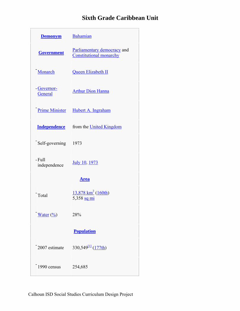
Demonym Bahamian
Government Parliamentary democracy and Constitutional monarchy
- Monarch Queen Elizabeth II
-
Governor-General Arthur Dion Hanna
- Prime Minister Hubert A. Ingraham
Independence from the United Kingdom
- Self-governing 1973
-
Full independence July 10, 1973
Area
- Total 13,878 km2 (160th)
5,358 sq mi
- Water (%) 28%
Population
- 2007 estimate 330,549[1] (177th)
- 1990 census 254,685
Calhoun ISD Social Studies Curriculum Design Project
Sixth Grade Caribbean Unit
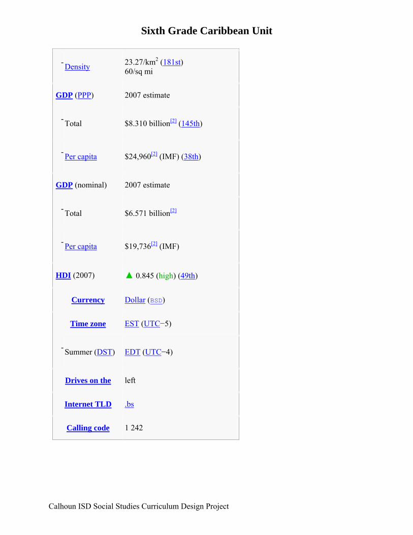
- Density 23.27/km2 (181st)
60/sq mi
GDP (PPP) 2007 estimate
- Total $8.310 billion[2] (145th)
- Per capita $24,960[2] (IMF) (38th)
GDP (nominal) 2007 estimate
- Total $6.571 billion[2]
- Per capita $19,736[2] (IMF)
HDI (2007) ▲ 0.845 (high) (49th)
Currency Dollar (BSD)
Time zone EST (UTC−5)
- Summer (DST) EDT (UTC−4)
Drives on the left
Internet TLD .bs
Calling code 1 242
Calhoun ISD Social Studies Curriculum Design Project
Sixth Grade Caribbean Unit
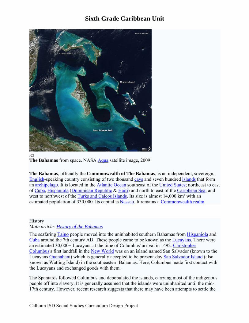
The Bahamas from space. NASA Aqua satellite image, 2009 The Bahamas, officially the Commonwealth of The Bahamas, is an independent, sovereign, English-speaking country consisting of two thousand cays and seven hundred islands that form an archipelago. It is located in the Atlantic Ocean southeast of the United States; northeast to east of Cuba, Hispaniola (Dominican Republic & Haiti) and north to east of the Caribbean Sea; and west to northwest of the Turks and Caicos Islands. Its size is almost 14,000 km² with an estimated population of 330,000. Its capital is Nassau. It remains a Commonwealth realm.
History Main article: History of the Bahamas The seafaring Taino people moved into the uninhabited southern Bahamas from Hispaniola and Cuba around the 7th century AD. These people came to be known as the Lucayans. There were an estimated 30,000+ Lucayans at the time of Columbus' arrival in 1492. Christopher Columbus's first landfall in the New World was on an island named San Salvador (known to the Lucayans Guanahani) which is generally accepted to be present-day San Salvador Island (also known as Watling Island) in the southeastern Bahamas. Here, Columbus made first contact with the Lucayans and exchanged goods with them.
The Spaniards followed Columbus and depopulated the islands, carrying most of the indigenous people off into slavery. It is generally assumed that the islands were uninhabited until the mid-17th century. However, recent research suggests that there may have been attempts to settle the
Calhoun ISD Social Studies Curriculum Design Project
Sixth Grade Caribbean Unit islands by groups from Spain, France, and Britain, as well as by other Amerindians. In 1648, the Eleutherian Adventurers migrated from Bermuda. The Adventurers (who were English) established the first permanent European settlements on an island which they named Eleuthera — the name derives from the Greek word for freedom. They later discovered New Providence and named it Sayle's Island. To survive, the settlers salvaged goods from wrecks.
In 1670 King Charles II granted the islands to the Lords Proprietors of the Carolinas, who rented the islands from the king with rights of trading, tax, appointing governors, and administering the country.
During proprietary rule, the Bahamas became a haven for pirates, including the infamous Blackbeard. To restore orderly government, the Bahamas was made a British crown colony in 1718 under the royal governorship of Woodes Rogers, who, after a difficult struggle, succeeded in suppressing piracy.[3]
During the American Revolutionary War, the islands were a target for American naval forces under the command of Commodore Ezekial Hopkins. The capital of Nassau on island of New Providence was occupied by US Marines for a fortnight.
In 1782, after the British defeat at Yorktown, a Spanish fleet appeared off the coast of Nassau, which surrendered without fight. But the 1783 Treaty of Versailles — which ended the global conflict between Britain, France and Spain — returned the Bahamas to British sovereignty.
After the American Revolution, some 7,300 loyalists and their slaves moved to the Bahamas from New York, Florida and the Carolinas. These Americans established plantations on several islands and became a political force in the capital. The small population became mostly African from this point on.
The British abolished the slave trade in 1807, which led to the forced settlement on Bahamian islands of thousands of Africans liberated from slave ships by the Royal Navy. Slavery itself was finally abolished in the British Empire on August 1, 1834.
Modern political development began after the Second World War. The first political parties were formed in the 1950s and the British made the islands internally self-governing in 1964, with Roland Symonette of the United Bahamian Party as the first premier.
In 1967, Lynden Pindling of the Progressive Liberal Party became the first black premier of the colony, and in 1968 the title was changed to prime minister. In 1973, the Bahamas became fully independent, but retained membership in the Commonwealth of Nations. Sir Milo Butler was appointed the first black governor-general (the representative of Queen Elizabeth II) shortly after independence.
Based on the twin pillars of tourism and offshore finance, the Bahamian economy has prospered since the 1950s. However, there remain significant challenges in areas such as education, health care, international narcotics trafficking and illegal immigration from Haiti.
The origin of the name "Bahamas" is unclear. It may derive from the Spanish baja mar, meaning "shallow seas";[citation needed] or the Lucayan word for Grand Bahama Island, ba-ha-ma "large upper middle land".[citation needed]
Calhoun ISD Social Studies Curriculum Design Project
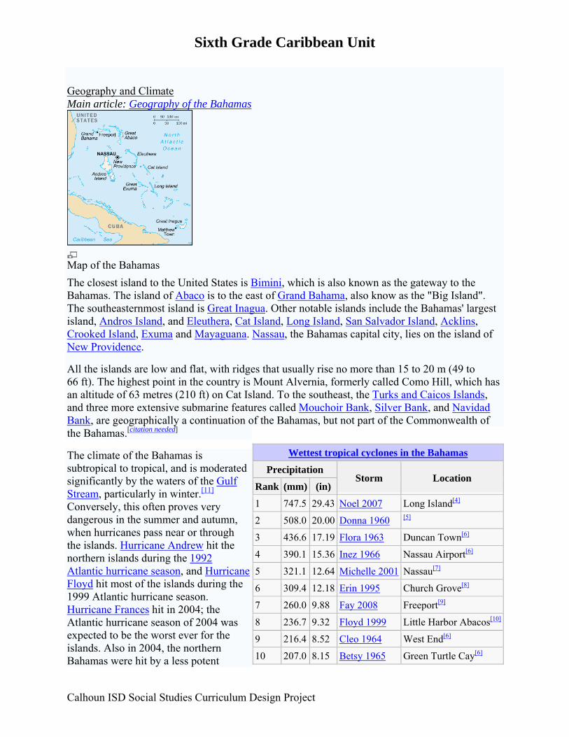
Sixth Grade Caribbean Unit Geography and Climate Main article: Geography of the Bahamas
Map of the Bahamas The closest island to the United States is Bimini, which is also known as the gateway to the Bahamas. The island of Abaco is to the east of Grand Bahama, also know as the "Big Island". The southeasternmost island is Great Inagua. Other notable islands include the Bahamas' largest island, Andros Island, and Eleuthera, Cat Island, Long Island, San Salvador Island, Acklins, Crooked Island, Exuma and Mayaguana. Nassau, the Bahamas capital city, lies on the island of New Providence.
All the islands are low and flat, with ridges that usually rise no more than 15 to 20 m (49 to 66 ft). The highest point in the country is Mount Alvernia, formerly called Como Hill, which has an altitude of 63 metres (210 ft) on Cat Island. To the southeast, the Turks and Caicos Islands, and three more extensive submarine features called Mouchoir Bank, Silver Bank, and Navidad Bank, are geographically a continuation of the Bahamas, but not part of the Commonwealth of the Bahamas.[citation needed]
The climate of the Bahamas is subtropical to tropical, and is moderated significantly by the waters of the Gulf Stream, particularly in winter.[11] Conversely, this often proves very dangerous in the summer and autumn, when hurricanes pass near or through the islands. Hurricane Andrew hit the northern islands during the 1992 Atlantic hurricane season, and Hurricane Floyd hit most of the islands during the 1999 Atlantic hurricane season. Hurricane Frances hit in 2004; the Atlantic hurricane season of 2004 was expected to be the worst ever for the islands. Also in 2004, the northern Bahamas were hit by a less potent
Wettest tropical cyclones in the Bahamas
Precipitation Storm Location
Rank (mm) (in)
1 747.5 29.43 Noel 2007 Long Island[4]
2 508.0 20.00 Donna 1960 [5]
3 436.6 17.19 Flora 1963 Duncan Town[6]
4 390.1 15.36 Inez 1966 Nassau Airport[6]
5 321.1 12.64 Michelle 2001 Nassau[7]
6 309.4 12.18 Erin 1995 Church Grove[8]
7 260.0 9.88 Fay 2008 Freeport[9]
8 236.7 9.32 Floyd 1999 Little Harbor Abacos[10]
9 216.4 8.52 Cleo 1964 West End[6]
10 207.0 8.15 Betsy 1965 Green Turtle Cay[6]
Calhoun ISD Social Studies Curriculum Design Project
Sixth Grade Caribbean Unit
Calhoun ISD Social Studies Curriculum Design Project
Hurricane Jeanne. In 2005 the northern islands were once again struck, this time by Hurricane Wilma. In Grand Bahama, tidal surges and high winds destroyed homes and schools, floated graves and made roughly 1,000 people homeless, most of whom lived on the west coast of the island.
While there has never been a freeze reported in the Bahamas, the temperature can fall as low as 2-3°C during Arctic outbreaks that affect nearby Florida. Snow has been reported to have mixed with rain in Freeport in January, 1977, the same time that it snowed in the Miami, FL area. The temperature was about 5°C at the time.[citation needed] Districts Main article: Districts of the Bahamas The districts of the Bahamas provide a system of local government everywhere in The Bahamas except New Providence, whose affairs are handled directly by the central government. The districts other than New Providence are:
1. Acklins
2. Berry Islands
3. Bimini
4. Black Point, Exuma
5. Cat Island
6. Central Abaco
7. Central Andros
8. Central Eleuthera
9. City of Freeport, Grand Bahama
10. Crooked Island
11. East Grand Bahama
12. Exuma
13. Grand Cay, Abaco
14. Harbour Island, Eleuthera
15. Hope Town, Abaco
16. Inagua
17. Long Island
NAME: ____________________________ DATE: ________________
HOUR: ______
CARIBBEAN CLIMATE COMPARISON QUESTIONS
DIRECTIONS: Write the letter of the BEST answer on the line provided. (2 pts.) ____ 1. Which city is most likely the farthest north? A. Kingston B. Port-au-Prince C. Santo Domingo D. Nassau ____ 2. Which city is most likely the farthest south? A. Kingston B. Port-au-Prince C. Santo Domingo D. Nassau ____ 3. According to the chart, why does Santo Domingo have the greatest population? A. It is the warmest B. It is the wettest C. There's not enough information D. It is located in the Dominican Republic ____ 4. According to the chart, why is Nassau have the smallest population? A. It has the most comfortable temperature. B. It has enough rainfall C. There's not enough information D. It is located in the Bahamas ____ 5. What could we add to the chart that would help us compare the cities population, temperature, precipitation and where they are in the Caribbean? A. Absolute Location B. Land area C. Rainfall D. Map
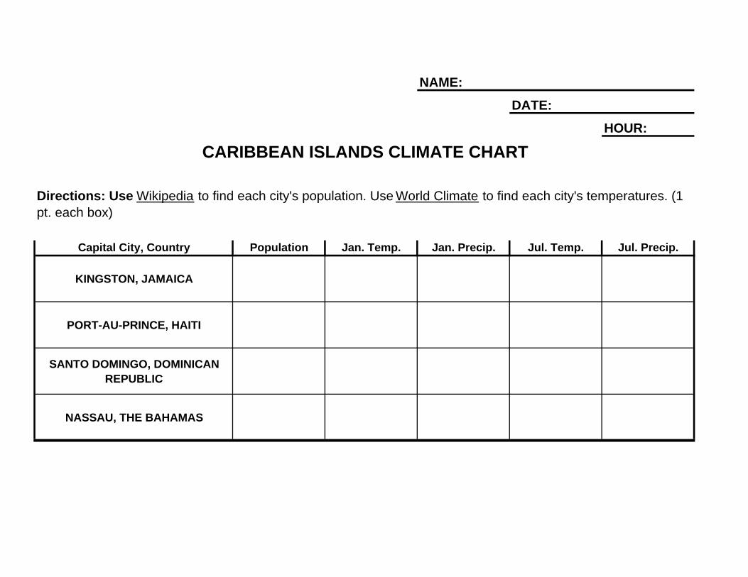
HOUR:
NASSAU, THE BAHAMAS
pt. each box)
NAME:
DATE:
CARIBBEAN ISLANDS CLIMATE CHART
Directions: Use Wikipedia to find each city's population. Use World Climate to find each city's temperatures. (1
Capital City, Country Population Jan. Temp. Jan. Precip. Jul. Temp. Jul. Precip.
KINGSTON, JAMAICA
PORT-AU-PRINCE, HAITI
SANTO DOMINGO, DOMINICAN REPUBLIC
Sixth Grade Caribbean Unit Lesson 3 Title: Geography of the Caribbean: Human/Environment Interaction Grade Level: 6 Unit of Study: Caribbean Time: 1 day Abstract: In this lesson students will investigate the ways humans have changed and utilized the environment in the Islands of the Caribbean. Key Concepts: The environment of the Caribbean Islands makes is a hot spot for tourism. The people of the Caribbean also benefit from agriculture and fishing in this region. GLCE: E.3.1.1 Use charts and graphs to compare imports and exports of different countries in the Western Hemisphere and propose generalizations about patterns of economic interdependence. G1.3.1 Use the fundamental themes of geography (location, place, human environment interaction, movement, region) to describe regions or places on earth. G2.1.1 Describe the landform features and the climate of the region (within the Western or Eastern Hemispheres) under study. G3.2.2 Identify ecosystems and explain why some are more attractive for humans to use than are others (e.g., mid-latitude forest in North America, high latitude of Peru, tropical forests in Honduras, fish or marine vegetation in coastal zones). G2.2.2 Explain that communities are affected positively or negatively by changes in technology (e.g., Canada with regard to mining, forestry, hydroelectric power generation, agriculture, snowmobiles, cell phones, air travel). G5.1.1 Describe the environmental effects of human action on the atmosphere (air), biosphere (people, animals, and plants), lithosphere (soil), and hydrosphere (water) (e.g., changes in the tropical forest environments in Brazil, Peru, and Costa Rica). G5.2.1 Describe the effects that a change in the physical environment could have on human activities and the choices people would have to make in adjusting to the change (e.g. drought in northern Mexico, disappearance of forest vegetation in the Amazon, natural hazards and disasters from volcanic eruptions in Central America and the Caribbean and earthquakes in Mexico City and Colombia). W1.2.2 Describe the importance of the natural environment in the development of agricultural settlements in different locations (e.g., available water for irrigation, adequate precipitation, and suitable growing season). Sequence of Activities:
1. As a class, discuss the agriculture, fishing, and tourist industries in the Caribbean. Debate the benefits and drawbacks of each industry.
Calhoun ISD Social Studies Curriculum Design Project
Sixth Grade Caribbean Unit
Calhoun ISD Social Studies Curriculum Design Project
2. Students will take into account the benefits and drawbacks of each industry, and make a decision as to what type of business they would choose to establish if they moved to the Caribbean.
3. Students will write a persuasive paragraph, describing the type of business they would choose to establish and defending their choice with at least three supporting statements.
Connections: Language Arts Resources
https://www.cia.gov/library/publications/the-world-factbook
http://www.socialstudiesforkids.com/articles/economics/theimportanceoftrade1.htm (info about trade)
http://www.scholars.nus.edu.sg/post/caribbean/nations.html
http://www.caribbean-on-line.com/
http://www.caribbean.com/
http://www.caribbeandaily.com/
http://www.cep.unep.org/
Sixth Grade Caribbean Unit Lesson 4 Title: Geography of the Caribbean: Movement Grade Level: 6 Unit of Study: Caribbean GLCE: G1.3.1 Use the fundamental themes of geography (location, place, human environment interaction, movement, region) to describe regions or places on earth. G4.2.1 List and describe the advantages and disadvantages of different technologies used to move people, products, and ideas throughout the world (e.g., call centers in the Eastern Hemisphere that service the Western Hemisphere; the United States and Canada as hubs for the Internet; transport of people and perishable products; and the spread of individuals’ ideas as voice and image messages on electronic networks such as the Internet). G2.2.1 Describe the human characteristics of the region under study (including languages, religion, economic system, governmental system, cultural traditions). G2.2.3 Analyze how culture and experience influence people’s perception of places and regions (e.g., the Caribbean Region that presently displays enduring impacts of different immigrant groups – Africans, South Asians, Europeans – and the differing contemporary points of view about the region displayed by islanders and tourists). G4.4.1 Identify factors that contribute to conflict and cooperation between and among cultural groups (control/use of natural resources, power, wealth, and cultural diversity). G4.1.1 Identify and explain examples of cultural diffusion within the Americas (e.g., baseball, soccer, music, architecture, television, languages, health care, Internet, consumer brands, currency, restaurants, international migration). G4.3.2 Describe patterns of settlement by using historical and modern maps (e.g., coastal and river cities and towns in the past and present, locations of megacities – modern cities over 5 million, such as Mexico City, and patterns of agricultural settlements in South and North America). E3.1.2 Diagram or map the movement of a consumer product from where it is manufactured to where it is sold to demonstrate the flow of materials, labor, and capital (e.g., global supply chain for computers, athletic shoes, and clothing). Time: 1 day, 2 if needed Abstract: In this lesson students will discover how and why people migrated to the Caribbean 500 years ago and why people migrate to and from the Caribbean today. They will also trace the changing path of trade goods to and from the Caribbean throughout history. Key Concepts: The arrival of various cultural groups in the Caribbean region brought about many changes, which impacted Caribbean society.
Calhoun ISD Social Studies Curriculum Design Project
Sixth Grade Caribbean Unit Sequence of Activities:
1. Discuss with students the reasons various cultural groups came to the Caribbean and their purpose for being there. Discuss the importance of sugar cane and slave trade within the region, and how this impacted the Western Hemisphere.
2. Ask students to search for goods at home or in the classroom that were manufactured in
the Caribbean. As a class, trace the route these goods traveled from their place of origin to where they are now. Next, students will use a world map to trace the path of peoples and goods to and from the Caribbean. Students may use a color-coding system for clarification (Ex: red lines indicate the path of goods, green lines indicate the path of peoples).
3. Discuss the ways movement affects people both internationally and intra-nationally
(migrant workers, legal and illegal immigration, etc.) Connections: Language Arts, Math (use of ruler) Resources Teacher Background Information From wikipedia: Impact of Colonialism on the Caribbean
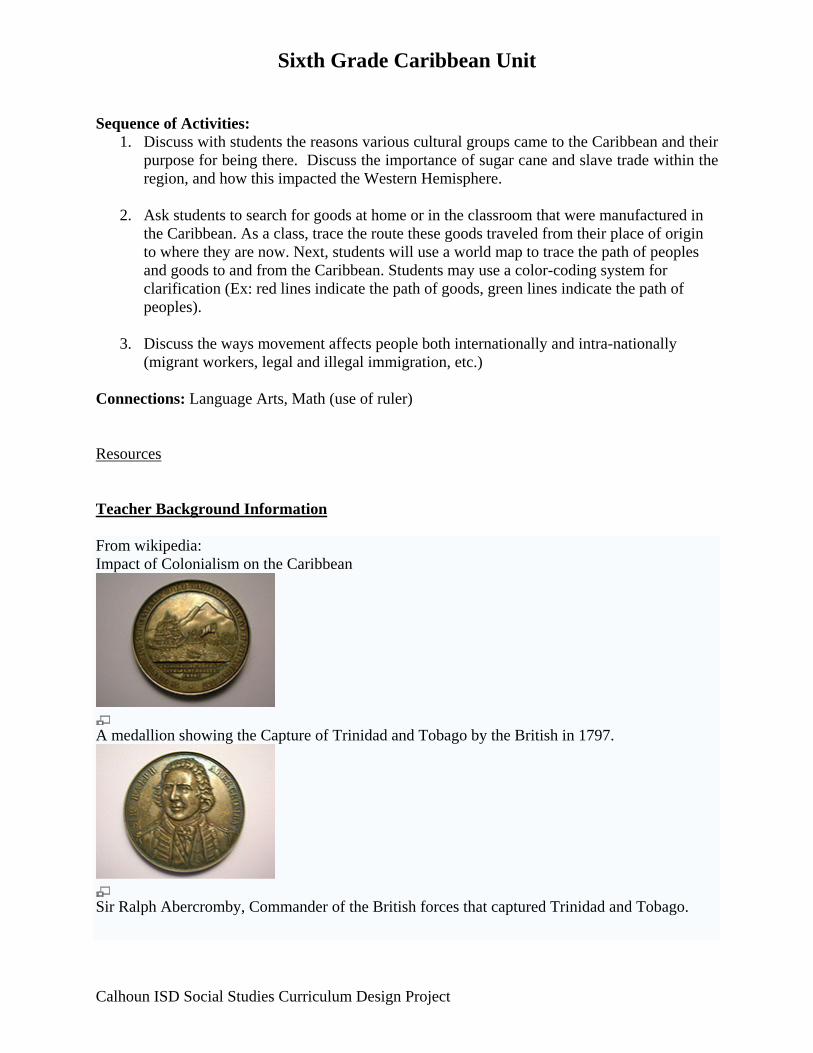
A medallion showing the Capture of Trinidad and Tobago by the British in 1797.
Sir Ralph Abercromby, Commander of the British forces that captured Trinidad and Tobago.
Calhoun ISD Social Studies Curriculum Design Project
Sixth Grade Caribbean Unit The exploitation of the Caribbean landscape dates back to the Spanish conquistadors around 1600 who mined the islands for gold which they brought back to Spain. The more significant development came when Christopher Columbus wrote back to Spain that the islands were made for sugar development.[2] The history of Caribbean agricultural dependency is closely linked with European colonialism which altered the financial potential of the region by introducing a plantation system. Much like the Spanish enslaved indigenous Indians to work in gold mines, the seventeenth brought a new series of oppressors in the form of the Dutch, the English, and the French. By the middle of the eighteenth century sugar was Britain's largest import which made the Caribbean that much more important as a colony. [3] The “New World” plantations were established in order to fulfill the growing needs of the “Old World”. The sugar plantations were built with the intention of exporting the sugar back to Britain which is why the British did not need to stimulate local demand for the sugar with wages. A system of slavery was adapted since it allowed the colonizer to have an abundant work force with little worry about declining demands for sugar. In the nineteenth century wages were finally introduced with the abolition of slavery. The new system in place however was similar to the previous as it was based on white capital and colored labor. Large numbers of unskilled workers were hired to perform repeated tasks, which made it very difficult for these workers to ever leave and pursue any non farming employment. Unlike other countries, where there was an urban option for finding work, the Caribbean countries had money invested in agriculture and lacked any core industrial base. [6] The cities that did exist offered limited opportunities to citizens and almost none for the unskilled masses who had worked in agriculture their entire lives. The products produced brought in no profits for the countries since they were sold to the colonial occupant buyer who controlled the price the products were sold at. This resulted in extremely low wages with no potential for growth since the occupant nations had no intention of selling the products at a higher price to themselves. The result of this economic exploitation was a plantation dependence which saw the Caribbean nations possessing a large quantity of unskilled workers capable of performing agricultural tasks and not much else. After many years of colonial rule the nations also saw no profits brought into their country since the sugar production was controlled by the colonial rulers. This left the Caribbean nations with little capital to invest towards enhancing any future industries unlike European nations which were developing rapidly and separating themselves technologically and economically from most impoverished nations of the world. Triangular trade From Wikipedia, the free encyclopedia
Calhoun ISD Social Studies Curriculum Design Project
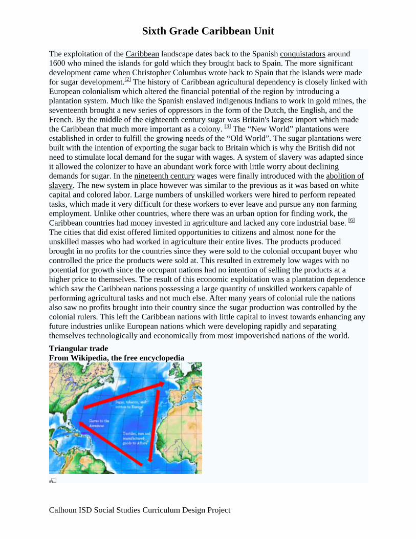
Sixth Grade Caribbean Unit Depiction of the classical model of the Triangular trade. Triangular trade, or Triangle trade, is a historical term indicating trade among three ports or regions. The trade evolved where a region had an export commodity that was required in the region from which its major imports came. Triangular trade thus provided a mechanism for rectifying trade imbalances.
The Transatlantic Triangular Trade operated during the 17th, 18th and early 19th centuries, carrying slaves, cash crops, and manufactured goods between West Africa, the Caribbean or American colonies and the European colonial powers, with the northern colonies of British North America, especially New England, sometimes taking over the role of Europe.[1]
Atlantic triangular trade African slaves were elementary to run the colonial cash crop economy, the products of which were in turn exported to Europe. European goods, in turn, were used to purchase African slaves, which were then brought on the sea lane west from Africa to the Americas, the so called middle passage. [2]
A classic example would be the trade of sugar (often in its liquid form, molasses) from the Caribbean to Europe or New England, where it was distilled into rum, some of which was then used to purchase new slaves in West Africa.
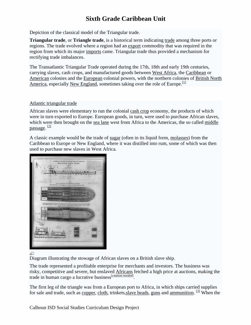
Diagram illustrating the stowage of African slaves on a British slave ship. The trade represented a profitable enterprise for merchants and investors. The business was risky, competitive and severe, but enslaved Africans fetched a high price at auctions, making the trade in human cargo a lucrative business[citation needed].
The first leg of the triangle was from a European port to Africa, in which ships carried supplies for sale and trade, such as copper, cloth, trinkets,slave beads, guns and ammunition. [3] When the
Calhoun ISD Social Studies Curriculum Design Project
Sixth Grade Caribbean Unit slave ship arrived, its cargo would be sold or bartered for slaves, who were tightly packed like any other cargo to maximize profits.
On the second leg, ships made the journey of the Middle Passage from Africa to the New World. Once the slave ship reached the New World, enslaved survivors were sold in the Caribbean or the Americas.
The ships were then prepared to get them thoroughly cleaned, drained, and loaded with export goods for a return voyage, the third leg, to their home port.[4] From the West Indies the main export cargoes were sugar, rum, and molasses; from Virginia, commodities were tobacco and hemp. The ship then returned to Europe to complete the triangle.
However, because of several disadvantages that slave ships faced compared to other trade ships, they often returned to their home port carrying whatever goods were readily available in the Americas and filled up a large part or all of their capacity with ballast. Other disadvantages include the different form of the ships (to carry as many humans as possible, but not ideal to carry a maximum amount of produce) and the variations in the duration of a slave voyage, making it practically impossible to pre-schedule appointments in the Americas, which meant that slave ships often arrived in the Americas out-of-season. Instead, the cash crops were transported mainly by a separate fleet which only sailed from Europe to the Americas and back. It is therefore important to note that the Triangular trade is a trade model, not an exact description of the ships route. [5] New England
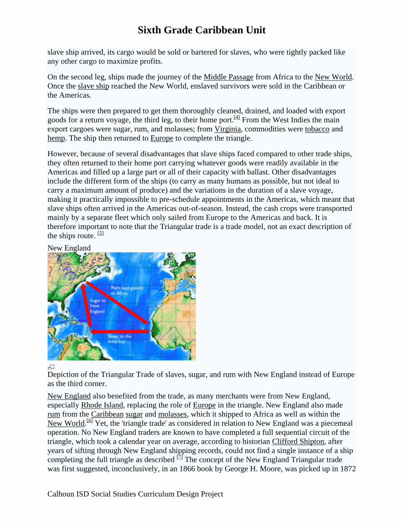
Depiction of the Triangular Trade of slaves, sugar, and rum with New England instead of Europe as the third corner. New England also benefited from the trade, as many merchants were from New England, especially Rhode Island, replacing the role of Europe in the triangle. New England also made rum from the Caribbean sugar and molasses, which it shipped to Africa as well as within the New World.[6] Yet, the 'triangle trade' as considered in relation to New England was a piecemeal operation. No New England traders are known to have completed a full sequential circuit of the triangle, which took a calendar year on average, according to historian Clifford Shipton, after years of sifting through New England shipping records, could not find a single instance of a ship completing the full triangle as described [7] The concept of the New England Triangular trade was first suggested, inconclusively, in an 1866 book by George H. Moore, was picked up in 1872
Calhoun ISD Social Studies Curriculum Design Project

Sixth Grade Caribbean Unit by historian George C. Mason, and reached full consideration from a lecture in 1887 by American businessman and historian William B. Weeden. [8] Other triangular trades The term "triangular trade" also refers to a variety of other trades:
• A trade pattern which evolved before the American Revolutionary War between Great Britain, the colonies of British North America, and British colonies in the Caribbean. This typically involved exporting raw resources such as fish (especially salt cod) or agricultural produce from British North American colonies to feed slaves and planters in the West Indies (also lumber); sugar and molasses from the Caribbean; and various manufactured commodities from Great Britain.[9]
• The shipment of (island)|Newfoundland]] salt cod and corn from Boston, Massachusetts in British vessels to southern Europe.[10]
• The "sugar triangle" whereby American ships took local produce to Cuba, then brought sugar or coffee from Cuba to St. Petersburg, then bar iron and hemp back to New England.[11]
• The "Indian Ocean Triangle" or "Double Triangle" involved dhows with Arab and sometimes Somali crews, who traveled to Basra, Bombay/Mumbai and Mombassa on the outward passage and returned to Dar-es-Salaam, Karachi and Aden. The above were known as the "Six Ports" to those involved in the trade. The origins of this trade route go back to medieval times. It was still thriving in the 1960s.
• The Transatlantic Slave Trade Database, a portal to data concerning the history of the triangular trade of transatlantic slave trade voyages.
References 1. ^ About.com: The Trans-Atlantic Slave Trade. Accessed 6 November 2007.
2. ^ National Maritime Museum - Triangular Trade. Accessed 26 March 2007.
3. ^ Scotland and the Abolition of the Slave Trade. Accessed 28 March 2007.
4. ^ A. P. Middleton, Tobacco Coast.
5. ^ Emmer, P.C.: The Dutch in the Atlantic Economy, 1580-1880. Trade, Slavery and Emancipation. Variorum Collected Studies Series CS614, 1998.
6. ^ Rhode Island Slavery History. Accessed 15 December 2007.
7. ^ Curtis, Wayne. and a Bottle of Rum. New York: Three Rivers Press, 2006-2007. ISBN 978-0-307-33862-4. page 117.
8. ^ Curtis, Wayne. and a Bottle of Rum. New York: Three Rivers Press, 2006-2007. ISBN 978-0-307-33862-4. page 119.
9. ^ Kurlansky, Mark. Cod: A Biography of the Fish That Changed the World. New York: Walker, 1997. ISBN 0-8027-1326-2.
Calhoun ISD Social Studies Curriculum Design Project
Sixth Grade Caribbean Unit
Calhoun ISD Social Studies Curriculum Design Project
10. ^ Morgan, Kenneth. Bristol and the Atlantic Trade in the Eighteenth Century. Cambridge: Cambridge University Press, 1993. ISBN 0521330173. Pages 64–77.
11. ^ Chris Evans and Göran Rydén, Baltic Iron in the Atlantic World in the Eighteenth Century : Brill, 2007 ISBN 9789004161535, 279
http://en.wikipedia.org/wiki/Triangular_Trade
https://www.cia.gov/library/publications/the-world-factbook
http://www.socialstudiesforkids.com/articles/economics/theimportanceoftrade1.htm (info about trade)
http://www.scholars.nus.edu.sg/post/caribbean/nations.html
http://www.caribbean-on-line.com/
http://www.caribbean.com/
http://www.caribbeandaily.com/
http://www.cep.unep.org/
http://videos.howstuffworks.com/hsw/24270-geography-of-the-caribbean-caribbean-lands-and-culture-video.htm

Sixth Grade Caribbean Unit Lesson 5 Title: Early European Settlement Grade Level: 6 Unit of Study: Caribbean GLCE: G2.2.3 Analyze how culture and experience influence people’s perception of places and regions (e.g., the Caribbean Region that presently displays enduring impacts of different immigrant groups – Africans, South Asians, Europeans – and the differing contemporary points of view about the region displayed by islanders and tourists). G4.4.1 Identify factors that contribute to conflict and cooperation between and among cultural groups (control/use of natural resources, power, wealth, and cultural diversity). G4.4.2 Describe the cultural clash of First Peoples, French and English in Canada long ago, and the establishment of Nunavut in 1999. G4.2.1 List and describe the advantages and disadvantages of different technologies used to move people, products, and ideas throughout the world (e.g., call centers in the Eastern Hemisphere that service the Western Hemisphere; the United States and Canada as hubs for the Internet; transport of people and perishable products; and the spread of individuals’ ideas as voice and image messages on electronic networks such as the Internet). H1.2.2 Read and comprehend a historical passage to identify basic factual knowledge and the literal meaning by indicating who was involved, what happened, where it happened, what events led to the development, and what consequences or outcomes followed Time: Approximately 1 day (continuation from Lesson 4) Abstract: In this lesson students will investigate how European exploration led to colonization. Key Concepts: The arrival of Columbus and the Europeans in the Caribbean had a great impact on life in the Caribbean as well as the rest of the Western Hemisphere. Sequence of Activities:
1. Read the article “Arawak” located at the end of this lesson 2. Discuss the effect European colonization had on the Arawak Indians. 3. Watch the United Streaming video: The Caribbean after Colonization: Diversity,
Tourism, and Bounty. 4. Discuss the various effects that the arrival of the European settlers had on the Caribbean
Islands. 5. Students will create a “Before and After” T-chart, describing the Caribbean before and
after European exploration and settlement.
Calhoun ISD Social Studies Curriculum Design Project
Sixth Grade Caribbean Unit Connections: Language Arts, Technology Resources http://www.scholars.nus.edu.sg/post/caribbean/nations.html
http://www.caribbean-on-line.com/
http://www.caribbean.com/
http://www.caribbeandaily.com/
http://www.cep.unep.org/ Google Earth World Atlas Encyclopedia ) CIA World Fact Book (https://www.cia.gov/library/publications/the-world-factbook/) www.wikipedia.org Background Information from http://player.discoveryeducation.com/index.cfm?guidAssetId=17080308-8EDC-4F7D-BC64-67FBB5836A80&blnFromSearch=1&productcode=US
ARAWAK, A once-predominant group of South American Indians of the Arawakan language family, and of the northern South America and Caribbean culture area, whose domain once stretched from present-day Florida down through the islands of the West Indies and the coastal area of South America as far as southern Brazil. The Arawak were the first natives of the New World encountered by Christopher Columbus. A number of Arawak tribes have been extinct for several hundred years. Those of the Lesser Antilles were subjugated in fighting with the Carib Indians in the late 15th century. The Arawak population in the West Indies fell from a probable 2 to 3 million to a few thousand by the early 16th century; by the end of that century island Arawak were extinct. This catastrophic mortality rate was due to the introduction of European diseases, damage to the Arawaks' food supplies, and Spanish brutality and enslavement. Before the Spanish conquest, the large-island ecologies, with bountiful harvests and abundant fish combined with compact and stable populations, permitted the development of an elaborate political and social structure. A class of hereditary chiefs ruled three other classes, the lowest of which was composed of slaves. Conflict between classes was apparently minimal. In this matrilineal society, rulers were succeeded by their eldest sister's eldest son. Religion offered a hierarchy of deities parallel to the social structure. The Arawak tribes of South America better survived European contact because their groups were smaller and more scattered. Their social structure was also matrilineal but much less complex. Mainland Arawak traded with the Dutch and English. In the 17th and 18th centuries they made a transition to plantation agriculture. In the 20th century, the existing Arawak began to accept wage-paying jobs as a supplement to farming, hunting, and fishing. Although their present-day culture reflects various non-Arawak influences, this group has been noted since pre-Columbian times as skilled potters, weavers, and wood- and
Calhoun ISD Social Studies Curriculum Design Project

Sixth Grade Caribbean Unit
Calhoun ISD Social Studies Curriculum Design Project
metalworkers. Today some 30,000 Arawak live in Guyana, with smaller numbers in Suriname and French Guiana. Arawakan-speaking groups are also widespread in other parts of South America.
Sixth Grade Caribbean Unit Lesson 6 Title: Introduction of Slavery in the Caribbean Grade Level: 6 Unit: Caribbean GLCE: G1.1.1 Describe how geographers use mapping to represent places and natural and human phenomena in the world. G2.2.1 Describe the human characteristics of the region under study (including languages, religion, economic system, governmental system, cultural traditions). G2.2.3 Analyze how culture and experience influence people’s perception of places and regions (e.g., the Caribbean Region that presently displays enduring impacts of different immigrant groups – Africans, South Asians, Europeans – and the differing contemporary points of view about the region displayed by islanders and tourists). G4.4.1 Identify factors that contribute to conflict and cooperation between and among cultural groups (control/use of natural resources, power, wealth, and cultural diversity). G4.1.1 Identify and explain examples of cultural diffusion within the Americas (e.g., baseball, soccer, music, architecture, television, languages, health care, Internet, consumer brands, currency, restaurants, international migration). Time: Approximately 1 day Abstract: In this lesson students will discover how and why the African culture was brought to the Caribbean. Key Concepts: African culture was first brought to the Caribbean through slave trade. Students will review the triangle trade. Sequence of Activities:
1. Divide students into two groups. The first group of students will participate in an Internet Scavenger Hunt, using online resources to discover the reasons Africans were brought to the Caribbean as slaves (sugarcane farming was difficult and Africans were brought as slaves after the Arawaks became extinct).
2. The second group of students will participate in an Internet scavenger hunt, using online
resources to discover how slaves in the Caribbean were emancipated.
3. Students will share their findings and collectively create a web on the board for further discussion of slavery in the Caribbean.
Connections: Language Arts, Technology
Calhoun ISD Social Studies Curriculum Design Project
Sixth Grade Caribbean Unit Resources http://www.scholars.nus.edu.sg/post/caribbean/nations.html http://www.caribbean-on-line.com/
http://www.caribbean.com/
http://www.caribbeandaily.com/ http://www.cep.unep.org/ Google Earth World Atlas Encyclopedia CIA World Fact Book: https://www.cia.gov/library/publications/the-world-factbook/) www.wikipedia.org
Background information: From http://74.125.95.132/search?q=cache:7TC1AlxHLm4J:www.qub.ac.uk/english/imperial/carib/slavery.htm+slavery+in+the+caribbean&cd=1&hl=en&ct=clnk&gl=us Slavery and the Caribbean
This page last revised 13 May 1997
Europeans came into contact with the Caribbean after Columbus's momentous journeys in 1492, 1496 and 1498. The desire for expansion and trade led to the settlement of the colonies. The indigenous peoples, according to our sources mostly peaceful Tainos and warlike Caribs, proved to be unsuitable for slave labour in the newly formed plantations, and they were quickly and brutally decimated. The descendants of this once thriving community can now only be found in Guiana and Trinidad.
The slave trade which had already begun on the West Coast of Africa provided the needed labour, and a period from 1496 (Columbus's second voyage) to 1838 saw Africans flogged and tortured in an effort to assimilate them into the plantation economy. Slave labour supplied the most coveted and important items in Atlantic and European commerce: the sugar, coffee, cotton and cacao of the Caribbean; the tobacco, rice and indigo of North America; the gold and sugar of Portuguese and Spanish South America. These commodities comprised about a third of the value of European commerce, a figure inflated by regulations that obliged colonial products to be brought to the metropolis prior to their re-export to other destinations. Atlantic navigation and European settlement of the New World made the Americas Europe's most convenient and practical source of tropical and sub-tropical produce. The rate of growth of Atlantic trade in the eighteenth century had outstripped all other branches of European commerce and created fabulous fortunes.
Calhoun ISD Social Studies Curriculum Design Project
Sixth Grade Caribbean Unit An estimate of the slave population in the British Caribbean in Robin Blackburn's study, The Overthrow of Colonial Slavery: 1776-1848, puts the slave numbers at 428,000 out of a population of 500,000, so the number of slaves vastly exceeded the number of white owners and overseers. Absentee plantation owners added to the unrest. Rebellion was common, with the forms including self mutilation, suicide and infanticide as well as escape and maroonage (whereby the slaves escaped into the hills and wooded interiors of the islands and set up potentially threatening communities of their own. See references in Wide Sargasso Sea). Jamaica holds the record for slave revolts, with serious uprisings in 1655, 1673, 1760 and continued disquiet after that. The documentation of revolts in Trinidad is less complete, but we know of at least one serious plot in 1805. Guiana was actually governed by a slave named Cuffy for a year after the revolt in 1763, and Barbados also had numerous plots, including six between 1649 and 1701.
Even after Emancipation in 1838, the unequal system continued. The first indication of this came with the awarding of some twenty million pounds to the planters by way of compensation, with nothing being awarded to the former slaves. The system tried to force them to continue the arduous work on the plantations by introducing high taxes on small holdings, high rates for licences or small traders, and contracts to shackle the labourers to the large plantations. The problems associated with the uneasy post-Emancipation time form the backdrop for Rhys's Wide Sargasso Sea.
The shortage of available labour led to the introduction of indentured labour from another of Britain's colonies, India, in 1844. These labourers worsened conditions for the former slaves by undermining attempts to achieve improved conditions through strikes. By 1917, when immigration came to a halt some 145,000 Indians had come to Trinidad, and 238,000 to Guiana. The importation of Indians affected Jamaica, but not Barbados, as well, with 39,000 immigrants. Writers such as V.S. Naipaul, the highly reputed Trinidadian novelist, have their roots in the importation of Indian indentured labourers to replace the slaves.
Slavery is a recurring theme in the literature of the Caribbean. Many writers feel the need to attempt a vocalisation of all that was denied under the brutal system. Writers such as Derek Walcott in Omeros, and George Lamming in In the Castle of my Skin talk about the difficulty of moving forward from the feelings of injustice inspired by the slave system and the lack of improvement of life after slavery. The Caribbean moved from a place of glory in the British Empire, with Barbados nicknamed "Little England," to its present position of instability and reliance on tourism for the survival of the economy. Some writers, including Jamaica Kincaid, see tourism as an extension of the system of slavery, with the "natives" there for the tourist's amusement and comfort. Any study of the literature of this region must bear in mind the violent heritage of the place, and the fact that the indigenous population were almost totally destroyed and the present population were brought there entirely against their will.
This project was completed under the direction of Dr Leon Litvack as a requirement for the MA degree in Modern Literary Studies in the School of English at the Queen's University of Belfast. The site is evolving and will include contributions from future generations of MA students on other writers and themes.
Calhoun ISD Social Studies Curriculum Design Project
Sixth Grade Caribbean Unit
Calhoun ISD Social Studies Curriculum Design Project
This page was written by Eimer Page. Please e-mail me with your comments.
The Imperial Archive Project is supervised by Leon Litvack. E-mail me with your suggestions From http://www.mrdowling.com/710-slavery.html Slavery in the Caribbean Demand for slaves to cultivate sugarcane and other crops caused what came to be known as the triangle trade. Ships leaving Europe first stopped in Africa where they traded weapons, ammunition, metal, liquor, and cloth for captives taken in wars or raids. The ships then traveled to America, where slaves were exchanged for sugar, rum, salt, and other island products. The ships returned home loaded with products popular with the European people, and ready to begin their journey again.
An estimated 8 to 15 million Africans reached the Americas from the 16th through the 19th century. Only the youngest and healthiest people were taken for what was called the middle passage of the triangle trade, partly because they would be worth more in America, and partly because they were the most likely to reach their destination alive. Conditions aboard the ship were dreadful. Slaves were jammed into the hull; chained to one another in order to stop revolts; as many as one in five passengers did not survive the journey. When one of the enslaved people was stricken with dysentery or smallpox, they were cast overboard.
Those who survived the middle passage faced more abuses on the plantations. Many of the plantation owners had returned to Europe, leaving their holdings in America to be managed by overseers who were often unstable or unsavory. Families were split up, and the Africans were not allowed to learn to read or write. African men, women, and children were forced to work with little to eat or drink.
The African slave population quickly began to outnumber the Europeans and Native Americans. The proportion of slaves ranged from about one third in Cuba, to more than ninety percent in many of the islands. Slave rebellions were common. As slave rebellions became more frequent, European investors lost money. The costs of maintaining slavery grew higher when the European governments sent in armed forces to quell the revolts.
Many Europeans began to pressure their governments to abolish slavery. The first organized opposition to slavery came in 1724 from the Quakers, a Christian sect also known as the Society of Friends. Great Britain outlawed slavery in all of their territories in 1833, but the practice continued for almost fifty years on some of the islands of the Caribbean.
Once slavery was abolished, the plantation owners hired hundreds of thousands of people from India and other places in Asia. In Trinidad, about forty percent of the population is Asian.
NAME: ____________________________ DATE: ______________
HOUR: _____
TRIANGULAR TRADE ROUTE
DIRECTIONS: Write the letter of the best answer on the line provided. (2 pts.) ____ 1. What was traded on the "Middle Passage?" A. Slaves B. Indigo C. Sugar D. Fish ____ 2. According to the map, which European countries were mostly involved in the Triangle Trade? A. England, Europe, Spain B. England, Portugal C. Portugal, Spain D. Portugal, Spain, England ____ 3. According to the map, what was another name for the Caribbean? A. British Colonies B. West Indies C. Boston D. Sugar ____ 4. Why is it called the "Triangle Trade"? A. It is near the Bermuda Triangle B. The routes are in three continents C. They traded many different goods D. The trade routes look like a triangle ____ 5. Where were things sent to from the British Colonies? A. Europe B. Africa C. West Indies D. All of the above

Sixth Grade Caribbean Unit Lesson 7 Title: History of the Caribbean: Fighting for Independence Grade Level: 6 Unit of Study: Caribbean GLCE: G2.2.1 Describe the human characteristics of the region under study (including languages, religion, economic system, governmental system, cultural traditions). G4.4.1 Identify factors that contribute to conflict and cooperation between and among cultural groups (control/use of natural resources, power, wealth, and cultural diversity). G4.1.1 Identify and explain examples of cultural diffusion within the Americas (e.g., baseball, soccer, music, architecture, television, languages, health care, Internet, consumer brands, currency, restaurants, international migration). Time: Approximately 1-3 days (depending on teacher preference for depth of activity) Abstract: In this lesson students will examine the path to independence for Caribbean nations such as Puerto Rico, Cuba, and the Dominican Republic. Students will also explore today’s Caribbean society, and create a timeline of Caribbean History. Key Concepts: Caribbean nations sought, fought for, and won independence from European rule. Many countries in the Caribbean today have experienced many struggles, but continue to strive for success. Today’s Caribbean culture remains influenced by an ethnic mosaic of peoples which unites all of the islands. Sequence of Activities:
1. Students will investigate the Ten Years War and the Spanish American War and how these wars affected Caribbean life today by reading about them in an encyclopedia or at www.wikipedia.org (see background information at the end of this lesson).
2. Students will use the information they have gathered throughout lessons in this unit so far in order to create a Timeline of Caribbean History. They may create a pencil/paper timeline or a web-based timeline using the following websites:
• http://www.readwritethink.org/materials/timeline/ • http://www.teach-nology.com/web_tools/materials/timeline/ • www.ourtimelines.org
Connections: Language Arts, Technology, Art Resources http://www.scholars.nus.edu.sg/post/caribbean/nations.html
http://www.caribbean-on-line.com/
http://www.caribbean.com/
Calhoun ISD Social Studies Curriculum Design Project
Sixth Grade Caribbean Unit http://www.caribbeandaily.com/ http://www.cep.unep.org/ Google Earth World Atlas Encyclopedia Textbook (if available) CIA World Fact Book: (https://www.cia.gov/library/publications/the-world-factbook/) www.wikipedia.org
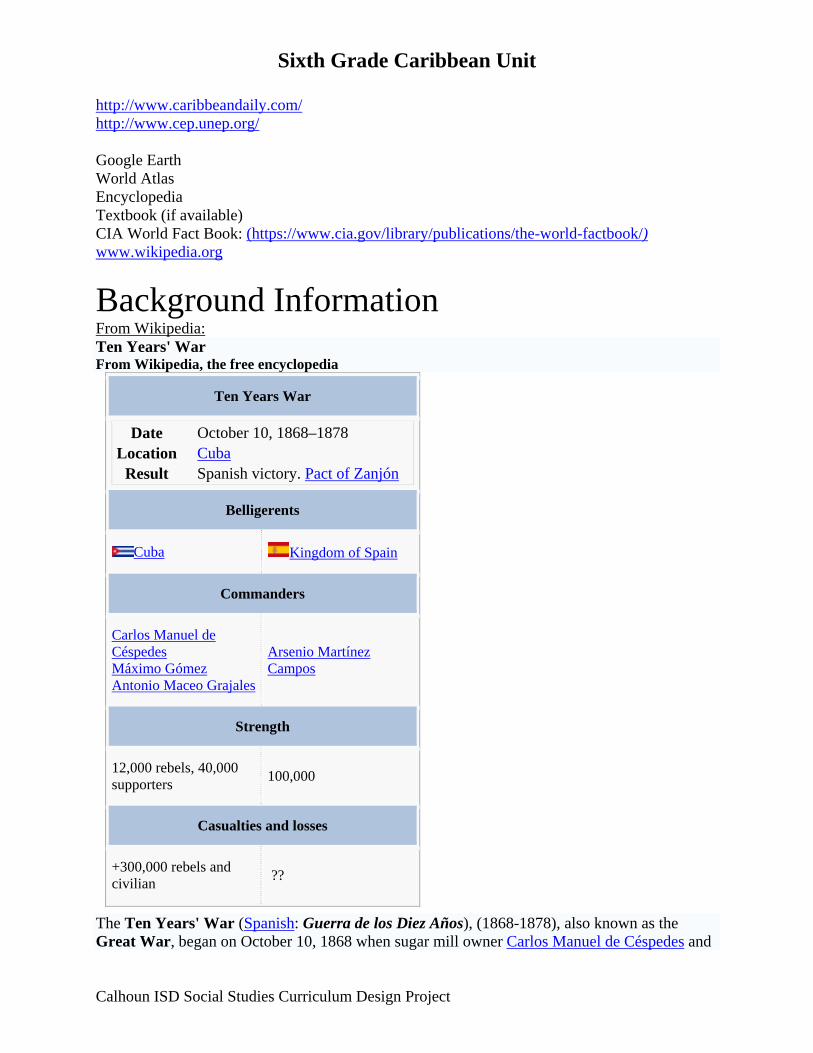
Background Information From Wikipedia: Ten Years' War From Wikipedia, the free encyclopedia
Ten Years War
Date October 10, 1868–1878 Location Cuba
Result Spanish victory. Pact of Zanjón
Belligerents
Cuba Kingdom of Spain
Commanders
Carlos Manuel de Céspedes Máximo Gómez Antonio Maceo Grajales
Arsenio Martínez Campos
Strength
12,000 rebels, 40,000 supporters 100,000
Casualties and losses
+300,000 rebels and civilian ??
The Ten Years' War (Spanish: Guerra de los Diez Años), (1868-1878), also known as the Great War, began on October 10, 1868 when sugar mill owner Carlos Manuel de Céspedes and
Calhoun ISD Social Studies Curriculum Design Project

Sixth Grade Caribbean Unit his followers proclaimed Cuba's independence from Spain. It was the first of three liberation wars that Cuba fought against Spain, the other two being the Little War (1879-1880) and the Cuban War of Independence (1895-1898). The final three months of the last conflict escalated to become the Spanish–American War.
Background The failure of the latest Reformist efforts, the demise of the "Information Board" and an economic crisis in 1866/67 gave way to a new scenario. In spite of the crisis, the colonial administration continued to make huge profits which were not invested on the island but either went into military expenditures (44% of the revenue), paid for the colonial governments expenses (41%) or sent to Spain and Fernando Poo (12%). The Spaniards with 8% of the population appropriated over 90% of the island’s wealth. In addition, the majority of the Cuban population still had no political rights giving rise to underground movements, especially in the eastern part of the country. [1]
In July 1867, the "Revolutionary Committee of Bayamo" was founded under the leadership of a one of Cuba’s wealthiest plantation owners, Francisco Vicente Aguilera. The conspiracy rapidly spread to Oriente’s lager towns, most of all Manzanillo where Carlos Manuel de Céspedes became the main protagonist of the uprising. Originally from Bayamo, Céspedes owned an estate and sugar mill known as ‘’’La Demajagua’’’. The Spanish, aware of Céspedes’ anti-colonial intransigence, tried to force him into submission by imprisoning his son Oscar. Céspedes refused to negotiate and Oscar was executed. [2] Tactics
Carlos Manuel de Céspedes The date for the uprising was moved up, because the Spaniards had discovered the plans in early October. In the early morning of October 10 Céspedes issued the independence cry ‘’’10th of October Manifesto’’’ at La Demajagua, starting the war against Spanish rule in Cuba. As a first step, Céspedes freed his slaves, asking them to join the struggle. However, many questioned Céspedes's plans for manumission, notably the rate at which slaves were to be freed, or disagreed with his call for U.S. annexation of Cuba.
During the first few days, the uprising almost failed. Céspedes intended to occupy the nearby town of Yara on October 11, from which this revolution took its name, but suffered numerous casualties and was dispersed by a Spanish Army column on the way. Céspedes escaped with only 12 men. The October 10 date is commemorated in Cuba as a national holiday under the name Grito de Yara ("Cry of Yara"). In spite of this defeat, the uprising of Yara was supported in
Calhoun ISD Social Studies Curriculum Design Project
Sixth Grade Caribbean Unit various regions on Oriente and continued to spread throughout the eastern region of Cuba. On October 13, the rebels took eight towns in the province favouring enrolment and acquisition of arms. By the end of October, the insurrection had some 12,000 volunteers.
That same month, Máximo Gómez, a former cavalry officer for the Spanish Army in the Dominican Republic, with his extraordinary military skills, taught the Cuban forces what would be their most lethal tactic: the machete charge. [1]. The machete charge was particularly lethal because it involved firearms as well. If the Spanish were caught on the march, the machetes would cut through their ranks. When the Spaniards (following then-standard tactics) formed a square, rifle fire from infantry under cover and pistol and carbine fire from charging cavalry would cause many losses. However, as it would be in wars such as these, yellow fever caused the heaviest losses because the Spanish had not acquired the childhood immunity that the Cuban troops had. Progress of the War The rebels proceeded to seize the important city of Bayamo after a 3-day-combat. It was in the enthusiasm of this victory when the poet and musician, Pedro Figueredo composed Cuba’s national anthem, the “Bayamo”. The first government of the Republic in Arms, headed by Céspedes, was established in Bayamo. The city was retaken by the Spanish after 3 months on January 12, but it had been burned to the ground.[3]
Nevertheless, the war spread in Oriente: On November 4, 1868, Camagüey rose up in arms and, in early February1869, Las Villas followed. The uprising was not supported in the westernmost provinces Pinar del Río, Havana and Matanzas and, with few exceptions (Vuelta Abajo) remained clandestine. A staunch supporter of the rebellion was José Martí who, at the age of 16, was detained and condemned to 16 years of hard labour, later deported to Spain and would eventually become a leading Latin American intellectual and Cuba’s foremost national hero as a primary architect of the 1895-98 War of Independence.
After some initial victories, and then defeats, Céspedes replaced Gomez with General Thomas Jordan, who brought a well-equipped force, as head of Cuban army. However, General Jordan's regular tactics, although initially effective, left the families of Cuban rebels far too vulnerable to the "ethnic cleansing" tactics of the ruthless Blas Villate, Count of Valmaceda (also spelled Balmaceda). Valeriano Weyler, who would reach notoriety as the "Butcher Weyler" in the 1895-1898 War, fought along the Count of Balmaceda. General Jordan then left, Máximo Gómez was returned to his command and a new generation of skilled battle-tested Cuban commanders rose from the ranks, these including Antonio Maceo Grajales, José Maceo, and Calixto García and Vicente Garcia González [2]. Other war leaders of note fighting on the Cuban Mambí side included: Donato Mármol, Luis Marcano-Alvarez, Carlos Roloff, Enrique Loret de Mola, Julio Sanguily, Domingo Goicuría, Guillermo Moncada, Quintin Bandera, Benjamín Ramirez, and Julio Grave de Peralta.
On April 10, 1869, a constitutional assembly took place in the town of Guáimaro (Camagüey), with the purpose of providing the revolution with greater organizational and juridical unity and with representatives from the areas that had joined the uprising. A major topic of the discussions was whether a centralized leadership should be in charge of both military and civilian affairs or if there should be a separation between civilian government and military leadership, the latter being subordinate to the first. The overwhelming majority voted for the separation option. Céspedes
Calhoun ISD Social Studies Curriculum Design Project
Sixth Grade Caribbean Unit was elected president of this assembly and General Ignacio Agramonte y Loynáz and Antonio Zambrana, principal authors of the proposed Constitution, were elected Secretaries.[4] After completing its work, the Assembly reconstituted itself as the House of Representatives as the state’s supreme power, electing Salvador Cisneros Betancourt as its president, Miguel Gerónimo Gutiérrez as vice-president, and Agramonte and Zambrana as Secretaries. Céspedes was then elected, on April 12, 1869, as the first president of the Republic in Arms and General Manuel de Quesada (who had fought in Mexico under Benito Juárez during the French invasion of that country), as Chief of the Armed Forces.
After failing to reach an agreement with the insurrection forces in early 1869, the Spanish responded by unleashing a war of extermination. The colonial government passed several laws: all arrested leaders and collaborators would be executed on the spot, ships carrying weapons would be seized and all on board immediately executed, males 15 and older caught outside of their plantations or places of residence without justification would be summarily executed, all towns were ordered to raise the white flag, otherwise burnt to the ground, any woman caught away from her farm or place of residence would be concentrated in cities. Apart from its own army the government could rely on the Voluntary Corps which had been created a few years earlier to face the announced invasion by Narcisco López and which became notorious for its barbaric and bloody acts. One infamous incident was the execution of eight students from the University of Havana on November 27, 1871. [5] Another one was the seizure of the steamship Virginius in international waters on October 31, 1873 , and, starting on November 4, serial execution of 53 persons, including the captain, most of the crew and a number of Cuban insurgents on board. The serial executions were only stopped by the intervention of a British man-of-war under the command of Sir Lambton Lorraine. In another incident, the so-called "Creciente de Valmaseda", farmers (Guajiros), and the families of Mambises were killed or captured en masse and sent to concentration camps.
The Mambises fought using guerrilla warfare and their efforts had much more impact on the eastern side of the island than on the western, due in part to a lack of supplies. Ignacio Agramonte was killed by a stray bullet on May 11, 1873 and was replaced in the command of the central troops by Máximo Gómez. Due to political and personal disagreements and Agramonte's death, the Assembly deposed Céspedes as president, who was replaced by Cisneros. Agramonte had come to realize that his dream Constitution and government were ill suited to the Cuban Republic in Arms, which was the reason he quit as Secretary and assumed command of the Camaguey region. By being curtailed by the Congress, he understood Cespedes' plight, thus becoming a supporter. Céspedes was later surprised and killed by a swift-moving patrol of Spanish troops on February 27, 1874. The new Cuban government had left him with only one escort and denied him permission to leave Cuba for the US, where he wanted to help to prepare and send armed expeditions.
Activities in the Ten Years War peaked in the years 1872 and 1873, but after the death of Agramonte and destitution of Céspedes, Cuban operations were limited to the regions of Camagüey and Oriente. Gómez began an invasion of Western Cuba in 1875, but the vast majority of slaves and wealthy sugar producers in the region did not join the revolt. After his most trusted general, the American Henry Reeve, was killed in 1876, the invasion was over.
Spain's efforts to fight were hindered by the civil war (Third Carlist War),that broke out in Spain in 1872. When the civil war ended in 1876, more Spanish troops were sent to Cuba until they
Calhoun ISD Social Studies Curriculum Design Project
Sixth Grade Caribbean Unit numbered more than 250.000. The impact of the Spanish measures on the liberation forces was severe. Neither side in the war was able to win a single concrete victory, let alone crush the opposing side to win the war, but in the long run Spain gained the upper hand.[6] [edit] Conclusion of the War From the very onset of the war there were deep divisions with respect its organisation which became even more pronounced after the Assembly of Guáimaro with the dismissal of Céspedes and Quesada in 1873. The Spanish were able to exploit regionalist sentiments and fears that the slaves of Matanzas would break the weak existing balance between whites and blacks. They changed their policy towards the Mambises offering amnesties and reforms. The Mambises did not prevail for a variety of reasons; lack of organization and resources; lower participation by whites; internal racist sabotage (against Maceo and the goals of the Liberating Army); the inability to bring the war to the western provinces (Havana in particular); and opposition by the US government to Cuban independence. The US sold the latest weapons to Spain, but not to the Cuban rebels. [7]
Tomás Estrada Palma succeeded Cisneros as president of the Republic in Arms. Estrada Palma was captured by Spanish troops on October 19, 1877. As a result of successive misfortunes, on February 8, 1878, the constitutional organs of the Cuban government were dissolved and negotiations for peace were started in Zanjón, Puerto Príncipe.
General Arsenio Martínez Campos, in charge of applying the new policy, arrived in Cuba, but it took him almost two years to convince most of the rebels to accept the Pact of Zanjón on February 10, 1878, signed by a negotiating committee. The document contained most of the promises made by Spain. The Ten Years' War came to an end, except for the resistance of a small group in Oriente led by General Garciá and Antonio Maceo Grajales, who protested in Los Mangos de Baraguá on March 15. Even a constitution and a provisional government was set up but the revolutionary élan was gone. The provisional government convinced Maceo to give up, thus ending the war in May 28, 1878.[8] Many of the graduates of Ten Year War, however, became central players in Cuba's war of independence started in 1895. These include the Maceo brothers, Maximo Gómez, Calixto Garcia and others. [7]
The Pact of Zanjón promised various reforms throughout the island which would improve the financial situation of Cuba. Perhaps the most significant was to free all slaves who had fought Spain. A major conflict throughout the war was the abolition of the slavery. Both the rebels and the people loyal to Spain wanted to abolish slavery. In 1880, a law was passed by the Spanish government that freed all of the slaves. However, the slaves were required by law to work for their masters for a number of years but the masters had to pay the slaves for their work. The wages were so low the slaves could barely afford to live off of them. The Spanish government lifted the law before it was to expire because neither the land owners nor the freed men appreciated it.
After the war ended, there were 17 years of tension between the people of Cuba and the Spanish government, a time called ‘’’The Rewarding Truce’’’, including the Little War (La Guerra Chiquita) between 1879-1880. These separatists would go on to follow the lead of José Martí, the most passionate of the rebels chose exile over Spanish rule. There was also a severe depression throughout the island. Overall, about 200,000 people lost their lives in the conflict. The war also devastated the coffee industry and American tariffs badly damaged Cuban exports.
Calhoun ISD Social Studies Curriculum Design Project

Sixth Grade Caribbean Unit References
1. ^ Navarro, José Cantón: History of Cuba, Havana, Cuba, 1998, p. 43
2. ^ Navarro, José Cantón: History of Cuba, Havana, Cuba, 1998, p. 43-44
3. ^ Navarro, José Cantón: History of Cuba, Havana, Cuba, 1998, p. 45
4. ^ Navarro, José Cantón: History of Cuba, Havana, Cuba, 1998, p. 47
5. ^ Navarro, José Cantón: History of Cuba, Havana, Cuba, 1998, p. 48
6. ^ Navarro, José Cantón: History of Cuba, Havana, Cuba, 1998, p. 50
7. ^ a b History of Cuba - The Ten Year War
8. ^ Navarro, José Cantón: History of Cuba, Havana, Cuba, 1998, p. 52
• Perez Jr., Louis A (1988). Cuba: Between Reform and Revolution. New York: Oxford University Press.
• Navarro, José Cantón: History of Cuba. The Challenge of the Yoke and the Star. Editorial SI-MAR S. A., Havana, Cuba, 1998, ISBN 959-7054-19-1
Further reading Portions of this article were extracted from CubaGenWeb.
Perhaps the most detailed source for information on the Ten Years' War is still Antonio Pirala's Anales de la Guerra en Cuba, (1895, 1896 and some from 1874) Felipe González Rojas (Editor), Madrid Spanish–American War From Wikipedia, the free encyclopedia
Spanish-American War
Part of the Philippine Revolution, Cuban War of Independence
Calhoun ISD Social Studies Curriculum Design Project
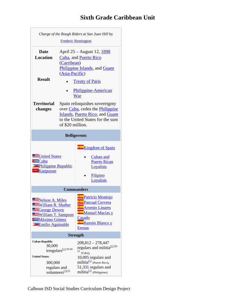
Sixth Grade Caribbean Unit
Charge of the Rough Riders at San Juan Hill by
Frederic Remington
Date April 25 – August 12, 1898 Location Cuba, and Puerto Rico
(Carribean) Philippine Islands, and Guam (Asia-Pacific)
Result • Treaty of Paris
• Philippine-American War
Territorial changes
Spain relinquishes sovereignty over Cuba, cedes the Philippine Islands, Puerto Rico, and Guamto the United States for the sum of $20 million.
Belligerents
United States Cuba Philippine Republic Katipunan
Kingdom of Spain
• Cuban and Puerto Rican Loyalists
• Filipino Loyalists
Commanders
Nelson A. Miles William R. Shafter George Dewey William T. Sampson Máximo Gómez Emilio Aguinaldo
Patricio Montojo Pascual Cervera Arsenio Linares Manuel Macías y
Casado Ramón Blanco y
Erenas
Strength Cuban Republic:
30,000 irregulars[1]:19-20
United States: 300,000 regulars and volunteers[1]:21
208,812 – 278,447 regulars and militia[1]:20-
21 (Cuba), 10,005 regulars and militia[1] (Puerto Rico), 51,331 regulars and militia[1] (Philippines)
Calhoun ISD Social Studies Curriculum Design Project
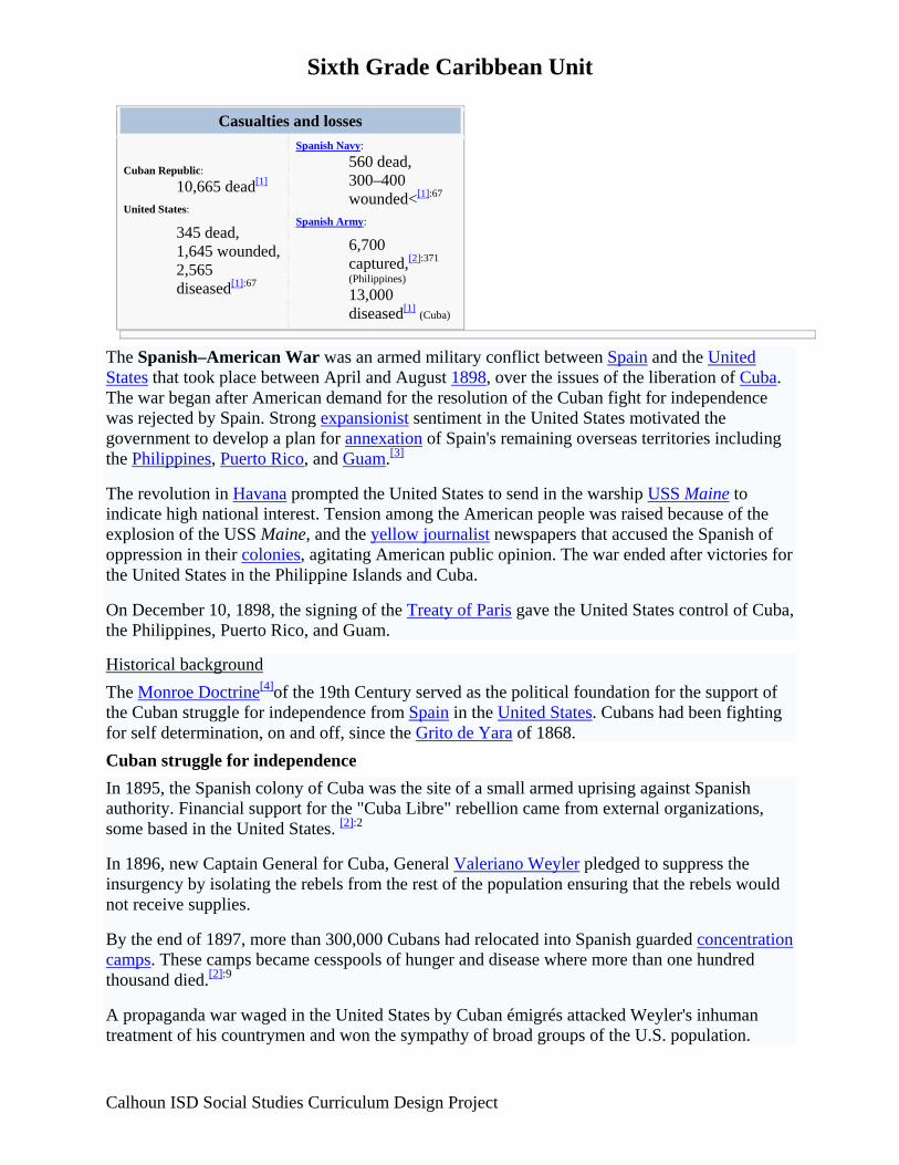
Sixth Grade Caribbean Unit
Casualties and losses
Cuban Republic: 10,665 dead[1]
United States: 345 dead, 1,645 wounded, 2,565 diseased[1]:67
Spanish Navy:560 dead, 300–400 wounded<[1]:67
Spanish Army: 6,700 captured,[2]:371 (Philippines) 13,000 diseased[1] (Cuba)
The Spanish–American War was an armed military conflict between Spain and the United States that took place between April and August 1898, over the issues of the liberation of Cuba. The war began after American demand for the resolution of the Cuban fight for independence was rejected by Spain. Strong expansionist sentiment in the United States motivated the government to develop a plan for annexation of Spain's remaining overseas territories including the Philippines, Puerto Rico, and Guam.[3]
The revolution in Havana prompted the United States to send in the warship USS Maine to indicate high national interest. Tension among the American people was raised because of the explosion of the USS Maine, and the yellow journalist newspapers that accused the Spanish of oppression in their colonies, agitating American public opinion. The war ended after victories for the United States in the Philippine Islands and Cuba.
On December 10, 1898, the signing of the Treaty of Paris gave the United States control of Cuba, the Philippines, Puerto Rico, and Guam.
Historical background The Monroe Doctrine[4]of the 19th Century served as the political foundation for the support of the Cuban struggle for independence from Spain in the United States. Cubans had been fighting for self determination, on and off, since the Grito de Yara of 1868. Cuban struggle for independence In 1895, the Spanish colony of Cuba was the site of a small armed uprising against Spanish authority. Financial support for the "Cuba Libre" rebellion came from external organizations, some based in the United States. [2]:2
In 1896, new Captain General for Cuba, General Valeriano Weyler pledged to suppress the insurgency by isolating the rebels from the rest of the population ensuring that the rebels would not receive supplies.
By the end of 1897, more than 300,000 Cubans had relocated into Spanish guarded concentration camps. These camps became cesspools of hunger and disease where more than one hundred thousand died.[2]:9
A propaganda war waged in the United States by Cuban émigrés attacked Weyler's inhuman treatment of his countrymen and won the sympathy of broad groups of the U.S. population.
Calhoun ISD Social Studies Curriculum Design Project

Sixth Grade Caribbean Unit Weyler was referred to as a "Butcher" by yellow journalists like William Randolph Hearst. The American newspapers began agitating for intervention with stories of Spanish atrocities against the Cuban population. USS Maine In January 1898, a riot by Cuban volunteers, most of whom were Spanish loyalists, broke out in Havana and led to the destruction of the printing presses of three local newspapers that were critical of General Weyler. These riots prompted the presence of an American Marine force in the island although there had been no attack on Americans during the rioting.[2]:24[5] yet there were still fears for the lives of Americans living in Havana. Concern focused on the pro-Spanish Cubans who harbored resentment of the growing support in the United States for Cuban independence. Washington informed the Consul-General in Havana, Fitzhugh Lee, a nephew of Robert E. Lee, that the Maine would be sent to protect United States interests should tensions escalate further.
The USS Maine arrived in Havana on January 25, 1898. Her stay was uneventful until the following month. On February 15, 1898, at 9:40 p. m. the Maine sank in Havana Harbor after an explosion, resulting in the deaths of 266 men. The Spanish attributed the event to an internal explosion; but an American inquiry reported that it was caused by a mine; a fact that has been questioned by historians to this day.[who?] Recent investigations have lead to believe that the explosion was indeed caused by an internal infusion of coal combustion and not a land mine.[who?]
A total of four USS Maine investigations were conducted into the causes of the explosion, with the investigators coming to different conclusions. The Spanish and American versions would carry on with divergences.[6] A 1999 investigation commissioned by National Geographic Magazine and carried out by Advanced Marine Enterprises concluded that "it appears more probable than was previously concluded that a mine caused the inward bent bottom structure" and the detonation of the ship. However there is still much contention over what caused the explosion.[7] Spanish and loyalist Cuban opinions included a theory that the United States government may have intentionally caused the detonation as a pretext to go to war with Spain.[6][8] Path to war Main article: Propaganda of the Spanish American War Upon the destruction of the Maine,[9] newspaper owners such as William Randolph Hearst came to the conclusion that Spanish officials in Cuba were to blame, and they widely publicized this theory as fact. Their sensationalistic publications fueled American anger by publishing astonishing accounts of "atrocities" committed by Spain in Cuba. A common myth states that Hearst responded to the opinion of his illustrator Frederic Remington, that conditions in Cuba were not bad enough to warrant hostilities with: "You furnish the pictures and I'll furnish the war."[10] Lashed to fury, in part by such press, the American cry of the hour became, "Remember the Maine, To Hell with Spain!" President William McKinley, Speaker of the House Thomas Brackett Reed and the business community opposed the growing public demand for war.
Senator Redfield Proctor's speech, delivered on March 17, 1898 thoroughly analyzed the situation concluding that war was the only answer. Many in the business and religious communities, which had heretofore opposed war, switched sides, leaving President McKinley
Calhoun ISD Social Studies Curriculum Design Project

Sixth Grade Caribbean Unit and Speaker Reed almost alone in their opposition to the war.[11] On April 11 President McKinley asked Congress for authority to send American troops to Cuba for the purpose of ending the civil war there.
On April 19, while Congress was considering joint resolutions supporting Cuban independence, Senator Henry M. Teller of Colorado proposed the Teller amendment to ensure that the United States would not establish permanent control over Cuba following the cessation of hostilities with Spain. The amendment, disclaiming any intention to annex Cuba passed Senate 42 to 35; the House concurred the same day, 311 to 6. The amended resolution demanded Spanish withdrawal and authorized the president to use as much military force as he thought necessary to help Cuba gain independence from Spain. President McKinley signed the joint resolution on April 20, 1898, and the ultimatum was forwarded to Spain. In response, Spain broke off diplomatic relations with the United States and declared war on April 23. On April 25, Congress declared that a state of war between the United States and Spain had existed since April 20 (later changed to April 21).[12] Theaters of operations Pacific Philippines The Spanish had first discovered the Philippines on March 17, 1521. Ever since then they had been a key holding for the Spanish Empire. The first battle between American and Spanish forces was at Manila Bay where, on May 1, 1898, Commodore George Dewey, commanding the United States Navy's Asiatic Squadron aboard the USS Olympia, in a matter of hours, defeated the Spanish squadron under Admiral Patricio Montojo y Pasarón. Dewey managed this with only nine wounded.[13][14]
With the German seizure of Tsingtao in 1897, Dewey's Squadron had become the only naval force in the Far East without a local base of its own, and was beset with coal and ammunition problems.[15] Despite these logistical problems, the Asiatic squadron had not only destroyed the Spanish fleet but had also captured the harbor of Manila.[15]
Following Dewey's victory, Manila Bay was filled with the warships of Great Britain, Germany, France, and Japan; all of which outgunned Dewey's force.[15] The German fleet of eight ships, ostensibly in Philippine waters to protect German interests (a single import firm), acted provocatively—cutting in front of American ships, refusing to salute the United States flag (according to customs of naval courtesy), taking soundings of the harbor, and landing supplies for the besieged Spanish. The Germans, with interests of their own, were eager to take advantage of whatever opportunities the conflict in the islands might afford. The Americans called the bluff of the Germans, threatening conflict if the aggressive activities continued, and the Germans backed down.[16][17]
Commodore Dewey had transported Emilio Aguinaldo to the Philippines from exile in Hong Kong in order to rally Filipinos against the Spanish colonial government.[18] U.S. land forces and the Filipinos had taken control of most of the islands by June, except for the walled city of Intramuros and, on June 12, 1898, Aguinaldo had declared the independence of the Philippines.[19]
Calhoun ISD Social Studies Curriculum Design Project
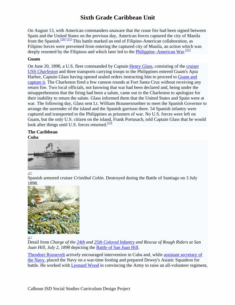
Sixth Grade Caribbean Unit On August 13, with American commanders unaware that the cease fire had been signed between Spain and the United States on the previous day, American forces captured the city of Manila from the Spanish.[20] [21] This battle marked an end of Filipino-American collaboration, as Filipino forces were prevented from entering the captured city of Manila, an action which was deeply resented by the Filipinos and which later led to the Philippine–American War.[22] Guam On June 20, 1898, a U.S. fleet commanded by Captain Henry Glass, consisting of the cruiser USS Charleston and three transports carrying troops to the Philippines entered Guam's Apia Harbor, Captain Glass having opened sealed orders instructing him to proceed to Guam and capture it. The Charleston fired a few cannon rounds at Fort Santa Cruz without receiving any return fire. Two local officials, not knowing that war had been declared and, being under the misapprehension that the firing had been a salute, came out to the Charleston to apologize for their inability to return the salute. Glass informed them that the United States and Spain were at war. The following day, Glass sent Lt. William Braunersruehter to meet the Spanish Governor to arrange the surrender of the island and the Spanish garrison there. 54 Spanish infantry were captured and transported to the Philippines as prisoners of war. No U.S. forces were left on Guam, but the only U.S. citizen on the island, Frank Portusach, told Captain Glass that he would look after things until U.S. forces returned.[23] The Caribbean Cuba
Spanish armored cruiser Cristóbal Colón. Destroyed during the Battle of Santiago on 3 July 1898.
Detail from Charge of the 24th and 25th Colored Infantry and Rescue of Rough Riders at San Juan Hill, July 2, 1898 depicting the Battle of San Juan Hill. Theodore Roosevelt actively encouraged intervention in Cuba and, while assistant secretary of the Navy, placed the Navy on a war-time footing and prepared Dewey's Asiatic Squadron for battle. He worked with Leonard Wood in convincing the Army to raise an all-volunteer regiment,
Calhoun ISD Social Studies Curriculum Design Project
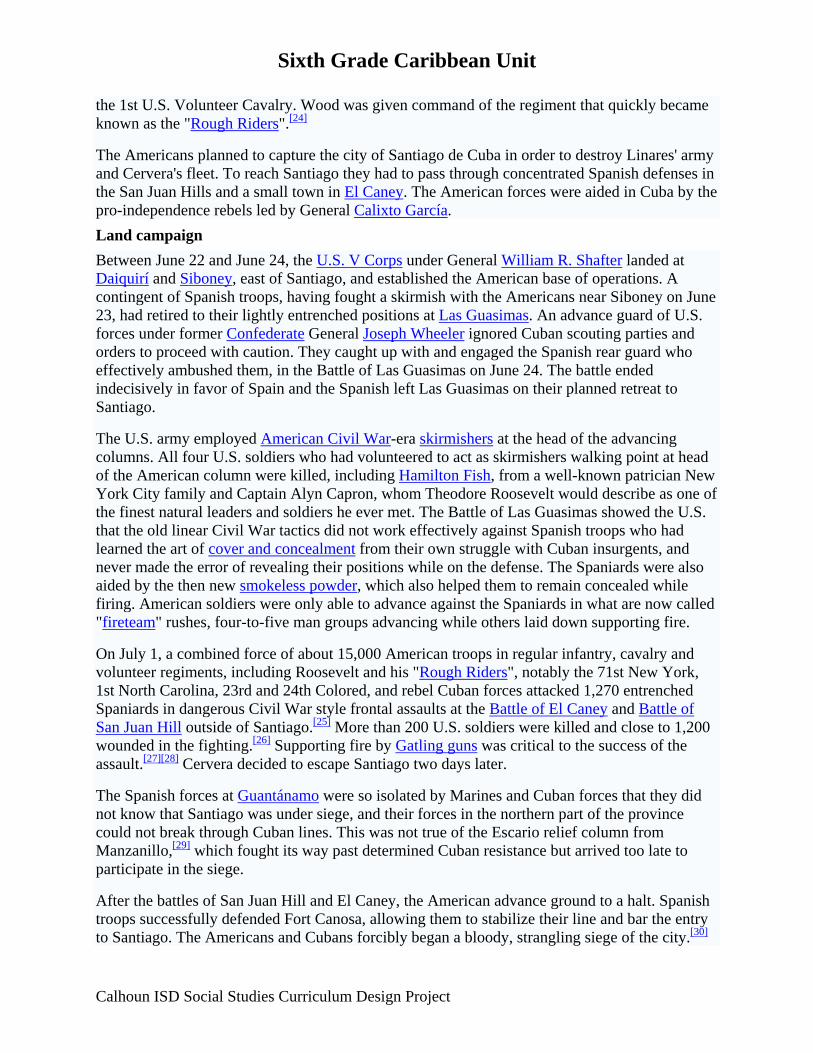
Sixth Grade Caribbean Unit the 1st U.S. Volunteer Cavalry. Wood was given command of the regiment that quickly became known as the "Rough Riders".[24]
The Americans planned to capture the city of Santiago de Cuba in order to destroy Linares' army and Cervera's fleet. To reach Santiago they had to pass through concentrated Spanish defenses in the San Juan Hills and a small town in El Caney. The American forces were aided in Cuba by the pro-independence rebels led by General Calixto García. Land campaign Between June 22 and June 24, the U.S. V Corps under General William R. Shafter landed at Daiquirí and Siboney, east of Santiago, and established the American base of operations. A contingent of Spanish troops, having fought a skirmish with the Americans near Siboney on June 23, had retired to their lightly entrenched positions at Las Guasimas. An advance guard of U.S. forces under former Confederate General Joseph Wheeler ignored Cuban scouting parties and orders to proceed with caution. They caught up with and engaged the Spanish rear guard who effectively ambushed them, in the Battle of Las Guasimas on June 24. The battle ended indecisively in favor of Spain and the Spanish left Las Guasimas on their planned retreat to Santiago.
The U.S. army employed American Civil War-era skirmishers at the head of the advancing columns. All four U.S. soldiers who had volunteered to act as skirmishers walking point at head of the American column were killed, including Hamilton Fish, from a well-known patrician New York City family and Captain Alyn Capron, whom Theodore Roosevelt would describe as one of the finest natural leaders and soldiers he ever met. The Battle of Las Guasimas showed the U.S. that the old linear Civil War tactics did not work effectively against Spanish troops who had learned the art of cover and concealment from their own struggle with Cuban insurgents, and never made the error of revealing their positions while on the defense. The Spaniards were also aided by the then new smokeless powder, which also helped them to remain concealed while firing. American soldiers were only able to advance against the Spaniards in what are now called "fireteam" rushes, four-to-five man groups advancing while others laid down supporting fire.
On July 1, a combined force of about 15,000 American troops in regular infantry, cavalry and volunteer regiments, including Roosevelt and his "Rough Riders", notably the 71st New York, 1st North Carolina, 23rd and 24th Colored, and rebel Cuban forces attacked 1,270 entrenched Spaniards in dangerous Civil War style frontal assaults at the Battle of El Caney and Battle of San Juan Hill outside of Santiago.[25] More than 200 U.S. soldiers were killed and close to 1,200 wounded in the fighting.[26] Supporting fire by Gatling guns was critical to the success of the assault.[27][28] Cervera decided to escape Santiago two days later.
The Spanish forces at Guantánamo were so isolated by Marines and Cuban forces that they did not know that Santiago was under siege, and their forces in the northern part of the province could not break through Cuban lines. This was not true of the Escario relief column from Manzanillo,[29] which fought its way past determined Cuban resistance but arrived too late to participate in the siege.
After the battles of San Juan Hill and El Caney, the American advance ground to a halt. Spanish troops successfully defended Fort Canosa, allowing them to stabilize their line and bar the entry to Santiago. The Americans and Cubans forcibly began a bloody, strangling siege of the city.[30]
Calhoun ISD Social Studies Curriculum Design Project
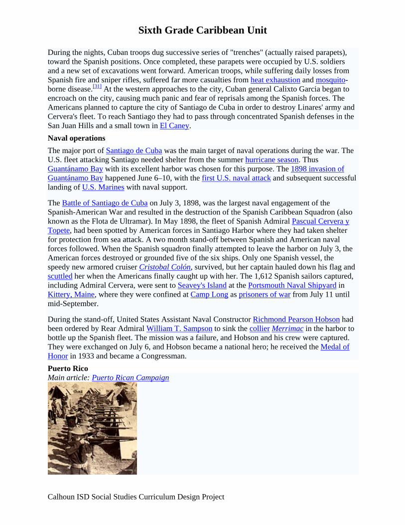
Sixth Grade Caribbean Unit During the nights, Cuban troops dug successive series of "trenches" (actually raised parapets), toward the Spanish positions. Once completed, these parapets were occupied by U.S. soldiers and a new set of excavations went forward. American troops, while suffering daily losses from Spanish fire and sniper rifles, suffered far more casualties from heat exhaustion and mosquito-borne disease.[31] At the western approaches to the city, Cuban general Calixto Garcia began to encroach on the city, causing much panic and fear of reprisals among the Spanish forces. The Americans planned to capture the city of Santiago de Cuba in order to destroy Linares' army and Cervera's fleet. To reach Santiago they had to pass through concentrated Spanish defenses in the San Juan Hills and a small town in El Caney. Naval operations The major port of Santiago de Cuba was the main target of naval operations during the war. The U.S. fleet attacking Santiago needed shelter from the summer hurricane season. Thus Guantánamo Bay with its excellent harbor was chosen for this purpose. The 1898 invasion of Guantánamo Bay happened June 6–10, with the first U.S. naval attack and subsequent successful landing of U.S. Marines with naval support.
The Battle of Santiago de Cuba on July 3, 1898, was the largest naval engagement of the Spanish-American War and resulted in the destruction of the Spanish Caribbean Squadron (also known as the Flota de Ultramar). In May 1898, the fleet of Spanish Admiral Pascual Cervera y Topete, had been spotted by American forces in Santiago Harbor where they had taken shelter for protection from sea attack. A two month stand-off between Spanish and American naval forces followed. When the Spanish squadron finally attempted to leave the harbor on July 3, the American forces destroyed or grounded five of the six ships. Only one Spanish vessel, the speedy new armored cruiser Cristobal Colón, survived, but her captain hauled down his flag and scuttled her when the Americans finally caught up with her. The 1,612 Spanish sailors captured, including Admiral Cervera, were sent to Seavey's Island at the Portsmouth Naval Shipyard in Kittery, Maine, where they were confined at Camp Long as prisoners of war from July 11 until mid-September.
During the stand-off, United States Assistant Naval Constructor Richmond Pearson Hobson had been ordered by Rear Admiral William T. Sampson to sink the collier Merrimac in the harbor to bottle up the Spanish fleet. The mission was a failure, and Hobson and his crew were captured. They were exchanged on July 6, and Hobson became a national hero; he received the Medal of Honor in 1933 and became a Congressman. Puerto Rico Main article: Puerto Rican Campaign
Calhoun ISD Social Studies Curriculum Design Project
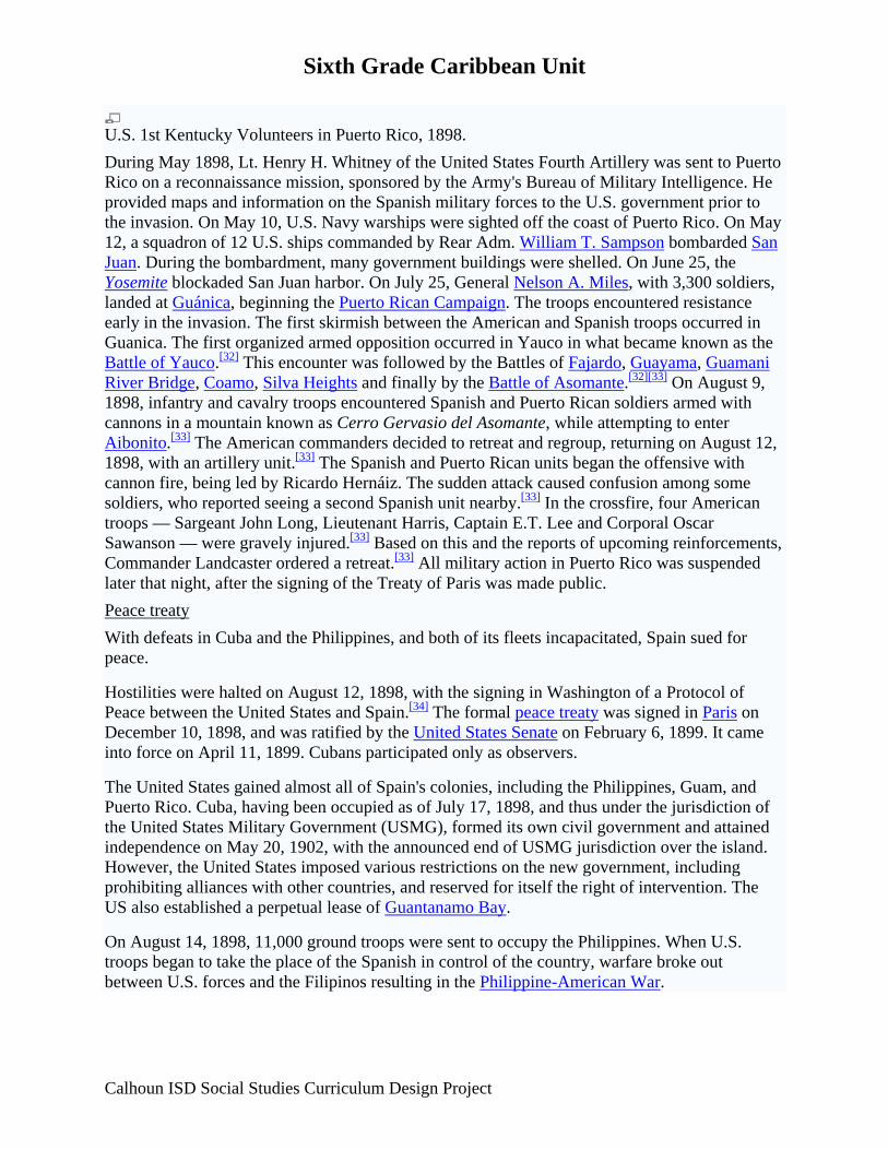
Sixth Grade Caribbean Unit
U.S. 1st Kentucky Volunteers in Puerto Rico, 1898. During May 1898, Lt. Henry H. Whitney of the United States Fourth Artillery was sent to Puerto Rico on a reconnaissance mission, sponsored by the Army's Bureau of Military Intelligence. He provided maps and information on the Spanish military forces to the U.S. government prior to the invasion. On May 10, U.S. Navy warships were sighted off the coast of Puerto Rico. On May 12, a squadron of 12 U.S. ships commanded by Rear Adm. William T. Sampson bombarded San Juan. During the bombardment, many government buildings were shelled. On June 25, the Yosemite blockaded San Juan harbor. On July 25, General Nelson A. Miles, with 3,300 soldiers, landed at Guánica, beginning the Puerto Rican Campaign. The troops encountered resistance early in the invasion. The first skirmish between the American and Spanish troops occurred in Guanica. The first organized armed opposition occurred in Yauco in what became known as the Battle of Yauco.[32] This encounter was followed by the Battles of Fajardo, Guayama, Guamani River Bridge, Coamo, Silva Heights and finally by the Battle of Asomante.[32][33] On August 9, 1898, infantry and cavalry troops encountered Spanish and Puerto Rican soldiers armed with cannons in a mountain known as Cerro Gervasio del Asomante, while attempting to enter Aibonito.[33] The American commanders decided to retreat and regroup, returning on August 12, 1898, with an artillery unit.[33] The Spanish and Puerto Rican units began the offensive with cannon fire, being led by Ricardo Hernáiz. The sudden attack caused confusion among some soldiers, who reported seeing a second Spanish unit nearby.[33] In the crossfire, four American troops — Sargeant John Long, Lieutenant Harris, Captain E.T. Lee and Corporal Oscar Sawanson — were gravely injured.[33] Based on this and the reports of upcoming reinforcements, Commander Landcaster ordered a retreat.[33] All military action in Puerto Rico was suspended later that night, after the signing of the Treaty of Paris was made public. Peace treaty With defeats in Cuba and the Philippines, and both of its fleets incapacitated, Spain sued for peace.
Hostilities were halted on August 12, 1898, with the signing in Washington of a Protocol of Peace between the United States and Spain.[34] The formal peace treaty was signed in Paris on December 10, 1898, and was ratified by the United States Senate on February 6, 1899. It came into force on April 11, 1899. Cubans participated only as observers.
The United States gained almost all of Spain's colonies, including the Philippines, Guam, and Puerto Rico. Cuba, having been occupied as of July 17, 1898, and thus under the jurisdiction of the United States Military Government (USMG), formed its own civil government and attained independence on May 20, 1902, with the announced end of USMG jurisdiction over the island. However, the United States imposed various restrictions on the new government, including prohibiting alliances with other countries, and reserved for itself the right of intervention. The US also established a perpetual lease of Guantanamo Bay.
On August 14, 1898, 11,000 ground troops were sent to occupy the Philippines. When U.S. troops began to take the place of the Spanish in control of the country, warfare broke out between U.S. forces and the Filipinos resulting in the Philippine-American War.
Calhoun ISD Social Studies Curriculum Design Project
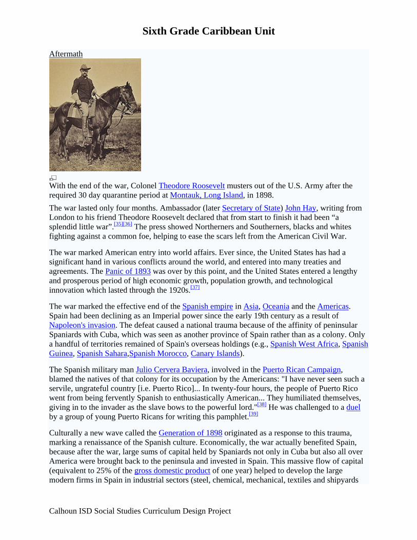
Sixth Grade Caribbean Unit Aftermath
With the end of the war, Colonel Theodore Roosevelt musters out of the U.S. Army after the required 30 day quarantine period at Montauk, Long Island, in 1898. The war lasted only four months. Ambassador (later Secretary of State) John Hay, writing from London to his friend Theodore Roosevelt declared that from start to finish it had been “a splendid little war”.[35][36] The press showed Northerners and Southerners, blacks and whites fighting against a common foe, helping to ease the scars left from the American Civil War.
The war marked American entry into world affairs. Ever since, the United States has had a significant hand in various conflicts around the world, and entered into many treaties and agreements. The Panic of 1893 was over by this point, and the United States entered a lengthy and prosperous period of high economic growth, population growth, and technological innovation which lasted through the 1920s.[37]
The war marked the effective end of the Spanish empire in Asia, Oceania and the Americas. Spain had been declining as an Imperial power since the early 19th century as a result of Napoleon's invasion. The defeat caused a national trauma because of the affinity of peninsular Spaniards with Cuba, which was seen as another province of Spain rather than as a colony. Only a handful of territories remained of Spain's overseas holdings (e.g., Spanish West Africa, Spanish Guinea, Spanish Sahara,Spanish Morocco, Canary Islands).
The Spanish military man Julio Cervera Baviera, involved in the Puerto Rican Campaign, blamed the natives of that colony for its occupation by the Americans: "I have never seen such a servile, ungrateful country [i.e. Puerto Rico]... In twenty-four hours, the people of Puerto Rico went from being fervently Spanish to enthusiastically American... They humiliated themselves, giving in to the invader as the slave bows to the powerful lord."[38] He was challenged to a duel by a group of young Puerto Ricans for writing this pamphlet.[39]
Culturally a new wave called the Generation of 1898 originated as a response to this trauma, marking a renaissance of the Spanish culture. Economically, the war actually benefited Spain, because after the war, large sums of capital held by Spaniards not only in Cuba but also all over America were brought back to the peninsula and invested in Spain. This massive flow of capital (equivalent to 25% of the gross domestic product of one year) helped to develop the large modern firms in Spain in industrial sectors (steel, chemical, mechanical, textiles and shipyards
Calhoun ISD Social Studies Curriculum Design Project
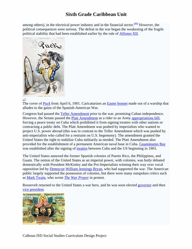
Sixth Grade Caribbean Unit among others), in the electrical power industry and in the financial sector.[40] However, the political consequences were serious. The defeat in the war began the weakening of the fragile political stability that had been established earlier by the rule of Alfonso XII.
The cover of Puck from April 6, 1901. Caricaturizes an Easter bonnet made out of a warship that alludes to the gains of the Spanish-American War. Congress had passed the Teller Amendment prior to the war, promising Cuban independence. However, the Senate passed the Platt Amendment as a rider to an Army appropriations bill, forcing a peace treaty on Cuba which prohibited it from signing treaties with other nations or contracting a public debt. The Platt Amendment was pushed by imperialists who wanted to project U.S. power abroad (this was in contrast to the Teller Amendment which was pushed by anti-imperialists who called for a restraint on U.S. hegemony). The amendment granted the United States the right to stabilize Cuba militarily as needed. The Platt Amendment also provided for the establishment of a permanent American naval base in Cuba. Guantánamo Bay was established after the signing of treaties between Cuba and the US beginning in 1903.
The United States annexed the former Spanish colonies of Puerto Rico, the Philippines, and Guam. The notion of the United States as an imperial power, with colonies, was hotly debated domestically with President McKinley and the Pro-Imperialists winning their way over vocal opposition led by Democrat William Jennings Bryan, who had supported the war. The American public largely supported the possession of colonies, but there were many outspoken critics such as Mark Twain, who wrote The War Prayer in protest.
Roosevelt returned to the United States a war hero, and he was soon elected governor and then vice president.
Calhoun ISD Social Studies Curriculum Design Project

Sixth Grade Caribbean Unit
1900 Campaign poster. The war served to further cement relations between the American North and South. The war gave both sides a common enemy for the first time since the end of the Civil War in 1865, and many friendships were formed between soldiers of both northern and southern states during their tours of duty. This was an important development since many soldiers in this war were the children of Civil War veterans on both sides.[41]
Segregation in the U.S. Military, 1898. The African-American community strongly supported the rebels in Cuba, supported entry into the war, and gained prestige from their wartime performance in the Army. Spokesmen noted that 33 African-American seamen had died in the Maine explosion. The most influential Black leader, Booker T. Washington, argued that his race was ready to fight. War offered them a chance "to render service to our country that no other race can", because, unlike Whites, they were "accustomed" to the "peculiar and dangerous climate" of Cuba. One of the Black units that served in the war was the 9th Cavalry Regiment. In March 1898, Washington promised the Secretary of the Navy that war would be answered by "at least ten thousand loyal, brave, strong Black men in the south who crave an opportunity to show their loyalty to our land, and would gladly take this method of showing their gratitude for the lives laid down, and the sacrifices made, that Blacks might have their freedom and rights."[42]
In 1904, the United Spanish War Veterans was created from smaller groups of the veterans of the Spanish American War. Today, that organization is defunct, but it left an heir in the form of the Sons of Spanish American War Veterans, created in 1937 at the 39th National Encampment of the United Spanish War Veterans. According to data from the United States Department of Veterans Affairs, the last surviving U.S. veteran of the conflict, Nathan E. Cook, died on September 10, 1992, at age 106. (If the data are to be believed, Cook, born October 10, 1885, would have been only 12 years old when he served in the war.)
Finally, in an effort to pay the costs of the war, Congress passed an excise tax on long-distance phone service.[43] At the time, it affected only wealthy Americans who owned telephones. However, the Congress neglected to repeal the tax after the war ended four months later, and the tax remained in place for over 100 years until, on August 1, 2006, it was announced that the U.S. Department of the Treasury and the IRS would no longer collect the tax.[44] Spanish-American War in film and television
• The Rough Riders, a 1927 silent film
• Rough Riders, a 1997 television mini-series directed by John Milius, and featuring Tom Berenger (Theodore Roosevelt), Gary Busey (Joseph Wheeler), Sam Elliott (Bucky
Calhoun ISD Social Studies Curriculum Design Project

Sixth Grade Caribbean Unit
Calhoun ISD Social Studies Curriculum Design Project
O'Neill), Dale Dye (Leonard Wood), Brian Keith (William McKinley), George Hamilton (William Randolph Hearst), and R. Lee Ermey (John Hay)
• The Spanish-American War: First Intervention, a 2007 docudrama from The History Channel
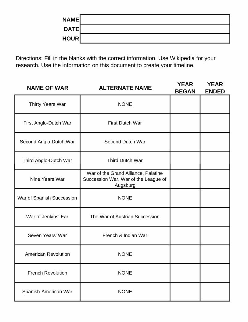
NAMEDATEHOUR
Directions: Fill in the blanks with the correct information. Use Wikipedia for your research. Use the information on this document to create your timeline.
NAME OF WAR ALTERNATE NAME YEAR BEGAN
YEAR ENDED
Thirty Years War NONE
First Anglo-Dutch War First Dutch War
Second Anglo-Dutch War Second Dutch War
Third Anglo-Dutch War Third Dutch War
Nine Years WarWar of the Grand Alliance, Palatine
Succession War, War of the League of Augsburg
War of Spanish Succession NONE
War of Jenkins' Ear The War of Austrian Succession
Seven Years' War French & Indian War
American Revolution NONE
French Revolution NONE
Spanish-American War NONE
Sixth Grade Caribbean Unit Lesson 8 Title: Caribbean Today: A Cultural Mosaic Grade level: 6 Unit: Caribbean GLCE: G2.2.1 Describe the human characteristics of the region under study (including languages, religion, economic system, governmental system, cultural traditions). G4.4.1 Identify factors that contribute to conflict and cooperation between and among cultural groups (control/use of natural resources, power, wealth, and cultural diversity). G4.1.1 Identify and explain examples of cultural diffusion within the Americas (e.g., baseball, soccer, music, architecture, television, languages, health care, Internet, consumer brands, currency, restaurants, international migration). Time: Approximately 1-3 days (depending on teacher preference for depth of study) Abstract: In this lesson students will investigate life in the Caribbean today and the importance of tourism to Caribbean society. Key Concepts: Today’s Caribbean society depends on the tourism industry. The Caribbean culture remains influenced by an ethnic mosaic of peoples which unites all of the islands. Sequence of Activities:
1. Watch the United Streaming Video: Modern Caribbean Cultures: A Cultural Mosaic of Indigenous, African, and European Influences
2. Students will create a postcard for a Caribbean vacation spot. The front of the postcard
will include a collage of pictures from travel magazines or the Internet. The collage must depict the influence of a mosaic of cultures on that country. Students will then write a letter home, on the back of the postcard, describing their “vacation experience” in that country.
Connections: Language Arts, Technology, Art Resources http://www.scholars.nus.edu.sg/post/caribbean/nations.html http://www.caribbean-on-line.com/
http://www.caribbean.com/
http://www.caribbeandaily.com/ http://www.cep.unep.org/ Google Earth
Calhoun ISD Social Studies Curriculum Design Project
Sixth Grade Caribbean Unit
Calhoun ISD Social Studies Curriculum Design Project
World Atlas Encyclopedia CIA World Fact Book (https://www.cia.gov/library/publications/the-world-factbook/)
www.wikipedia.org