site quality determination
TRANSCRIPT

This part of the course is designed to provide you with information which can help you read the land you are selling. In this section, we will give you tips and tools to determine if a site has high potential (or quality) for growing forests and other agricultural crops. This presentation was put together by Matt Yancey, Extension Agent in Agriculture and Natural Resources, Harrisonburg.
Site quality is a measure of the ability of a piece of land to provide the resources needed for plant growth i.e., how nutrient rich is the soil, how well does the soil hold water, how deep is the soil, how much sunlight reaches the area.
The photo on this slide is from a yellow poplar stump in a poplar plantation in the Great Smokey Mountain National Park in Tennessee. The wide growth ring widths tell us this tree was growing VERY fast. Rings from neighboring trees told the same story, telling us this was an exceedingly high quality site. Looking for clues to the past land use history (as we learned in part 1 of this class), we determined this tree was growing on an old agricultural field (based on the presence of rock piles and relatively gentle slope). Typically, old fields have residual fertilizer in the soils, which results in fast tree growth. Plus, yellow poplar is an early successional species – preferring high levels of sunlight, which would be available in a recently abandoned field.
1

First, let’s define some terms which may come up during this talk:•Site - the area where trees grow•Productivity – the capacity of a piece of land to grow vegetative material•Site index – an indicator of site productivity – based on tree height (which is pretty independent of other factors, such as competition from neighboring trees) – average height of the tallest trees in the stand at a base age (typically age 25 or 50 in Virginia). For example, the poplar stand in this photo, based on the rings counted on the stump, is approximately 35 years old and the trees are currently about 120 feet tall. Assuming a height growth rate of 3.5 feet/yr (120/35), these trees would have been about 84 feet tall at age 25, so the site index is 85, base age 25. FYI - this is an exceptional site index!•Aspect – the direction a slope faces•Erosion – removal of soil/rock by moving water•Mesic - moist•Xeric - dry
2

We will discuss each of these in more depth in the following slide.
3
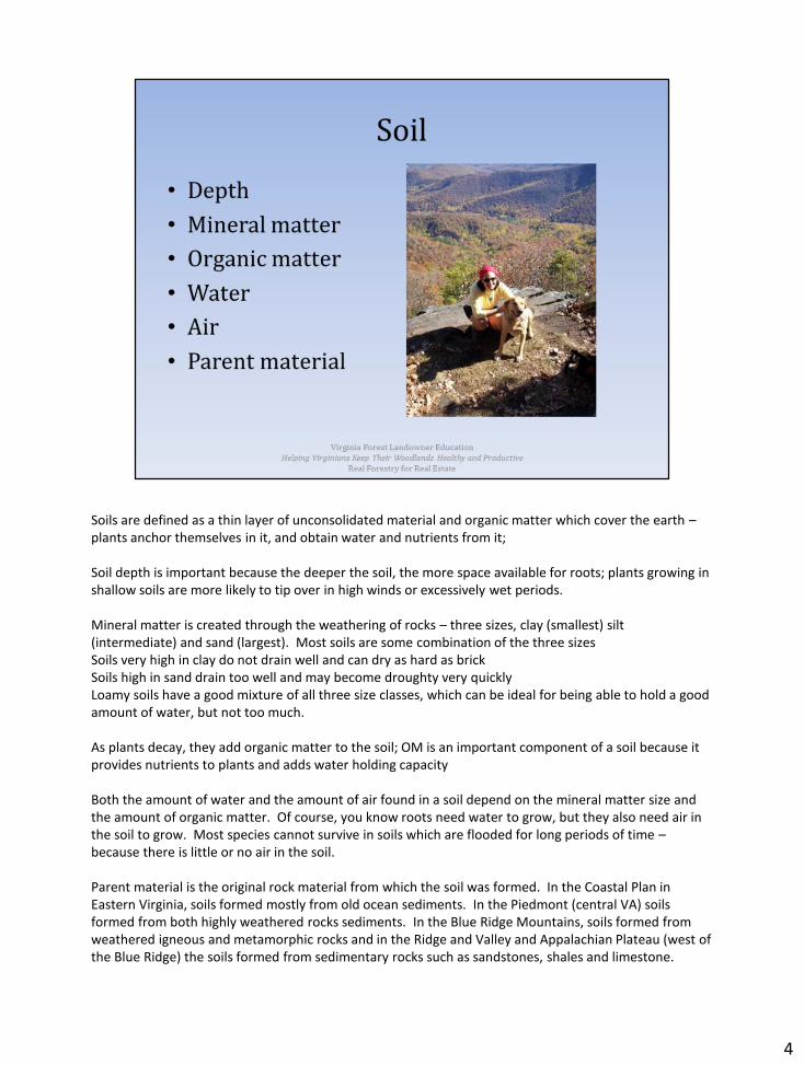
Soils are defined as a thin layer of unconsolidated material and organic matter which cover the earth –plants anchor themselves in it, and obtain water and nutrients from it;
Soil depth is important because the deeper the soil, the more space available for roots; plants growing in shallow soils are more likely to tip over in high winds or excessively wet periods.
Mineral matter is created through the weathering of rocks – three sizes, clay (smallest) silt (intermediate) and sand (largest). Most soils are some combination of the three sizesSoils very high in clay do not drain well and can dry as hard as brickSoils high in sand drain too well and may become droughty very quicklyLoamy soils have a good mixture of all three size classes, which can be ideal for being able to hold a good amount of water, but not too much.
As plants decay, they add organic matter to the soil; OM is an important component of a soil because it provides nutrients to plants and adds water holding capacity
Both the amount of water and the amount of air found in a soil depend on the mineral matter size and the amount of organic matter. Of course, you know roots need water to grow, but they also need air in the soil to grow. Most species cannot survive in soils which are flooded for long periods of time –because there is little or no air in the soil.
Parent material is the original rock material from which the soil was formed. In the Coastal Plan in Eastern Virginia, soils formed mostly from old ocean sediments. In the Piedmont (central VA) soils formed from both highly weathered rocks sediments. In the Blue Ridge Mountains, soils formed from weathered igneous and metamorphic rocks and in the Ridge and Valley and Appalachian Plateau (west of the Blue Ridge) the soils formed from sedimentary rocks such as sandstones, shales and limestone.
4

These are highly productive soils (think Shenandoah and New River Valleys).
Some of the richest soils are in coves –areas where soils collect as they erode from higher, steeper areas; yellow poplars thrive in these nutrient rich areas. In this photo, you can see the pockets of bright yellow – these are yellow-poplar coves.
4

In areas with topography, the steepness of slope is important. Steeper slopes generally have shallower soils due to higher erosion in these areas. Why is erosion higher on steeper slopes? Water runs downhill - the steeper the slope, the faster the water runs downhill, usually taking soil with it. The key to reducing erosion is to slow the speed at which water travels across the landscape. This allows more water to seep into the soil instead of moving over it.
Aspect refers to the direction a slope faces; slopes that face the South and east tend to be hotter and drier (pines do better here – more tolerant of hot and dry and more tolerant of fire, which occurs more often)Slopes that face the north and west tend to be cooler and moister (deciduous trees –many of which are valuable timber species, do better here)Elevation is most important in the mountains (not much elevation change in the Coastal Plain and Piedmont) – can affect climate (i.e., the amount of rainfall, snow and ice, temperature, and length of growing season)Different species will grow at different elevations – as you move up in elevation, forests will more closely resemble northern forests (i.e., more sugar maple at high elevations in Highland County – sugar maple is typically considered a New England species; or spruce fir forests at high elevation on the top of Mount Rogers)
5
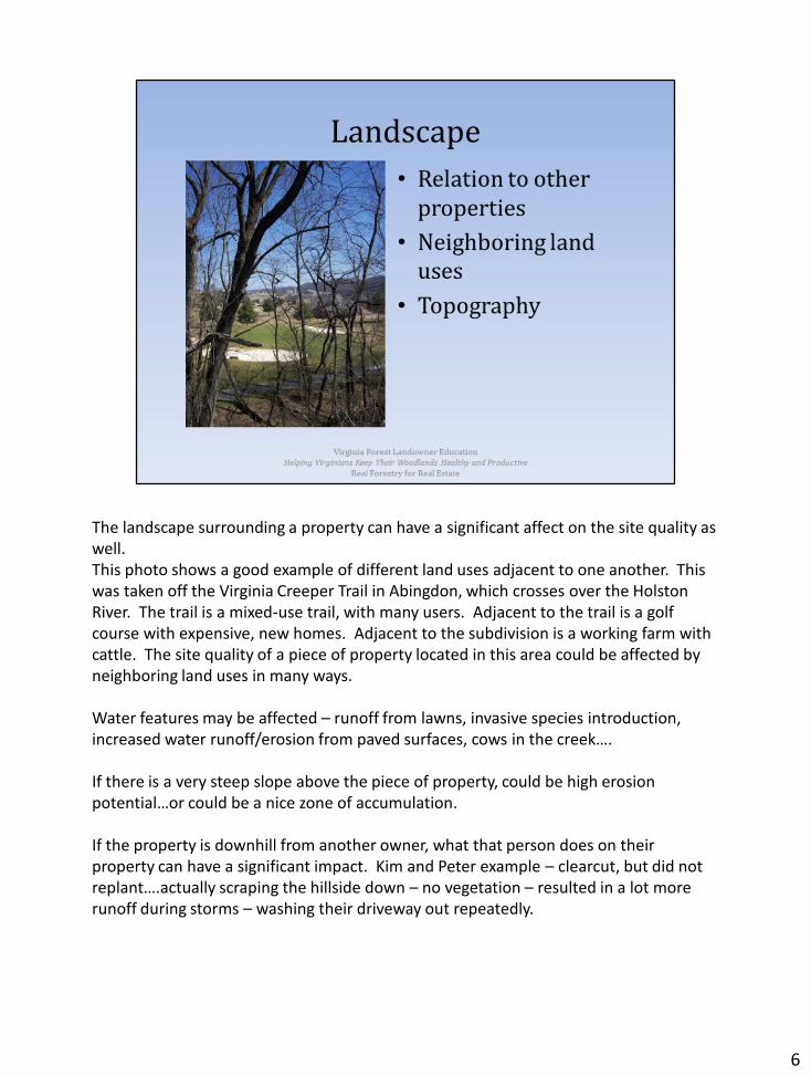
The landscape surrounding a property can have a significant affect on the site quality as well.This photo shows a good example of different land uses adjacent to one another. This was taken off the Virginia Creeper Trail in Abingdon, which crosses over the Holston River. The trail is a mixed-use trail, with many users. Adjacent to the trail is a golf course with expensive, new homes. Adjacent to the subdivision is a working farm with cattle. The site quality of a piece of property located in this area could be affected by neighboring land uses in many ways.
Water features may be affected – runoff from lawns, invasive species introduction, increased water runoff/erosion from paved surfaces, cows in the creek….
If there is a very steep slope above the piece of property, could be high erosion potential…or could be a nice zone of accumulation.
If the property is downhill from another owner, what that person does on their property can have a significant impact. Kim and Peter example – clearcut, but did not replant….actually scraping the hillside down – no vegetation – resulted in a lot more runoff during storms – washing their driveway out repeatedly.
6
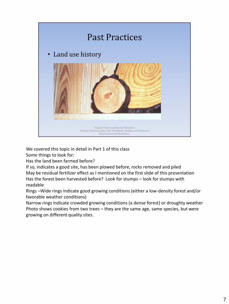
We covered this topic in detail in Part 1 of this classSome things to look for:Has the land been farmed before? If so, indicates a good site, has been plowed before, rocks removed and piledMay be residual fertilizer effect as I mentioned on the first slide of this presentationHas the forest been harvested before? Look for stumps – look for stumps with readable Rings –Wide rings indicate good growing conditions (either a low-density forest and/or favorable weather conditions)Narrow rings indicate crowded growing conditions (a dense forest) or droughty weatherPhoto shows cookies from two trees – they are the same age, same species, but were growing on different quality sites.
7
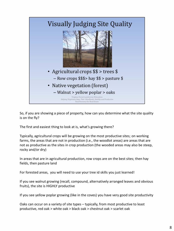
So, if you are showing a piece of property, how can you determine what the site quality is on the fly?
The first and easiest thing to look at is, what’s growing there?
Typically, agricultural crops will be growing on the most productive sites; on working farms, the areas that are not in production (i.e., the woodlot areas) are areas that are not as productive as the sites in crop production (the wooded areas may also be steep, rocky and/or dry)
In areas that are in agricultural production, row crops are on the best sites; then hay fields, then pasture land
For forested areas, you will need to use your tree id skills you just learned!
If you see walnut growing (recall, compound, alternatively arranged leaves and obvious fruits), the site is HIGHLY productive
If you see yellow poplar growing (like in the coves) you have very good site productivity
Oaks can occur on a variety of site types – typically, from most productive to least productive, red oak > white oak > black oak > chestnut oak > scarlet oak
8

The next thing to look at is the landscape (these clues are best suited for folks selling land in the mountains)
Check out the steepness of the property –Steep slopes will have lower site quality than gentler slopes; where is the land located along the slope? Land in the valleys is typically better – retains more moisture, less run off, deeper soilsAnd, which way does the slope face? Recall, slopes facing north and east are cooler, moister and more productive – and are the home to more valuable timber speciesAlso, how rocky are the soils? If they are very rocky – possibly eroded due to poor past land management, or simply poor land/shallow soil, site quality will be lower.
Other clues – poultry houses, probably poultry litter spread on fields to enhance nutrients. Crop stubble, pasture and hay fields, early successional woods (old fields). Tillage generally degrades field soil quality; many farmers are going to no till systems, which encourage soil quality, so look for evidence of no till (crop residues). Soy beans may have been part of the crop rotation, and are legumes, which contribute nitrogen to the soil.
Larger parcels of land may have a variety of slope types and aspects. And, don’t despair if your visual inspection reveals the property isn’t highly productive. Recall from our discussion on landowners earlier today that not all potential landowners are only (if at all) interested in site productivity – some may be more interested in the aesthetics, privacy, wildlife aspects.
9

You can also determine a lot of this information in the office. The Natural Resources Conservation Service has developed a tool called the Web Soil Survey.This tool allows you to map a property using GIS and it will provide you will information about the productivity.The following slides will lead you through this process.
Photos show some of the wide variety of soils there are.
10

USDA Web soil survey (websoilsurvey.nrcs.usda.gov/). Next several slides show how to navigate this to find soils information for a given property (e.g. 3675 Captain Yancey Rd., Elkton, VA 22827). Only use if internet is unavailable.
Pointer finger shows where to point to get to next screen/slide. “Click on ‘start wss’ to continue.”
11

Click on address.
12

This shows the address menu, which opens, and the example address that was entered.
13

Click on legend.
14

The map legend pops up, where you decide what layers will be displayed on the map.
15

Click AOI to select your area of interest on the map.
16

Map zooms to AOI. Click on soil map. A list of the soil series units present at your AOI will appear.
17

Click on soil data explorer. These tables outline various soils properties related to the table name (buildling site development, construction materials) and shows their suitability for each.
18

Click on vegetative productivity, then forest productivity. The table will show the potential cubit feet per acre volume per year that may be achieved.
19

Click on land classification, then farmland classification. This will tell you the relative productivity of land (prime farmland, farmland of statewide importance, farmland of local importance, unique farmland, or not).
Lots of other soil characteristics to look at, all with descriptions.
Hardcopy soil surveys are available in many Extension offices or USDA Service Centers.
20

21

Across the street in the back, the land is clearly much steeper!Yellow poplar has a site index of 95 on the lower part of the hill; black oak has a SI of 70. These were no data for eastern white pine. So, I would guess someone made a management decision based on the landform and the soils type. Also, on the steep slopes, planting is difficult – and if the slope is too steep, may not be able to harvest any timber at all without risking erosion.
Again, this takes practice and using the Web Soil Survey is probably the easiest way to go.
22