site plan review planner’s public … the general area of the rock crusher and initial stockpile...
TRANSCRIPT
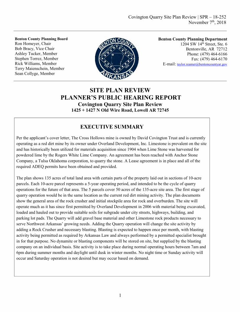
Covington Quarry Site Plan Review | SPR – 18-252 November 7th, 2018
1
Benton County Planning Board Ron Homeyer, Chair Bob Bracy, Vice Chair Ashley Tucker, Member Stephen Torrez, Member Rick Williams, Member Terry Maienschein, Member Sean Collyge, Member
Benton County Planning Department 1204 SW 14th Street, Ste. 6
Bentonville, AR 72712 Phone: (479) 464-6166
Fax: (479) 464-6170 E-mail: [email protected]
SITE PLAN REVIEW
PLANNER’S PUBLIC HEARING REPORT Covington Quarry Site Plan Review
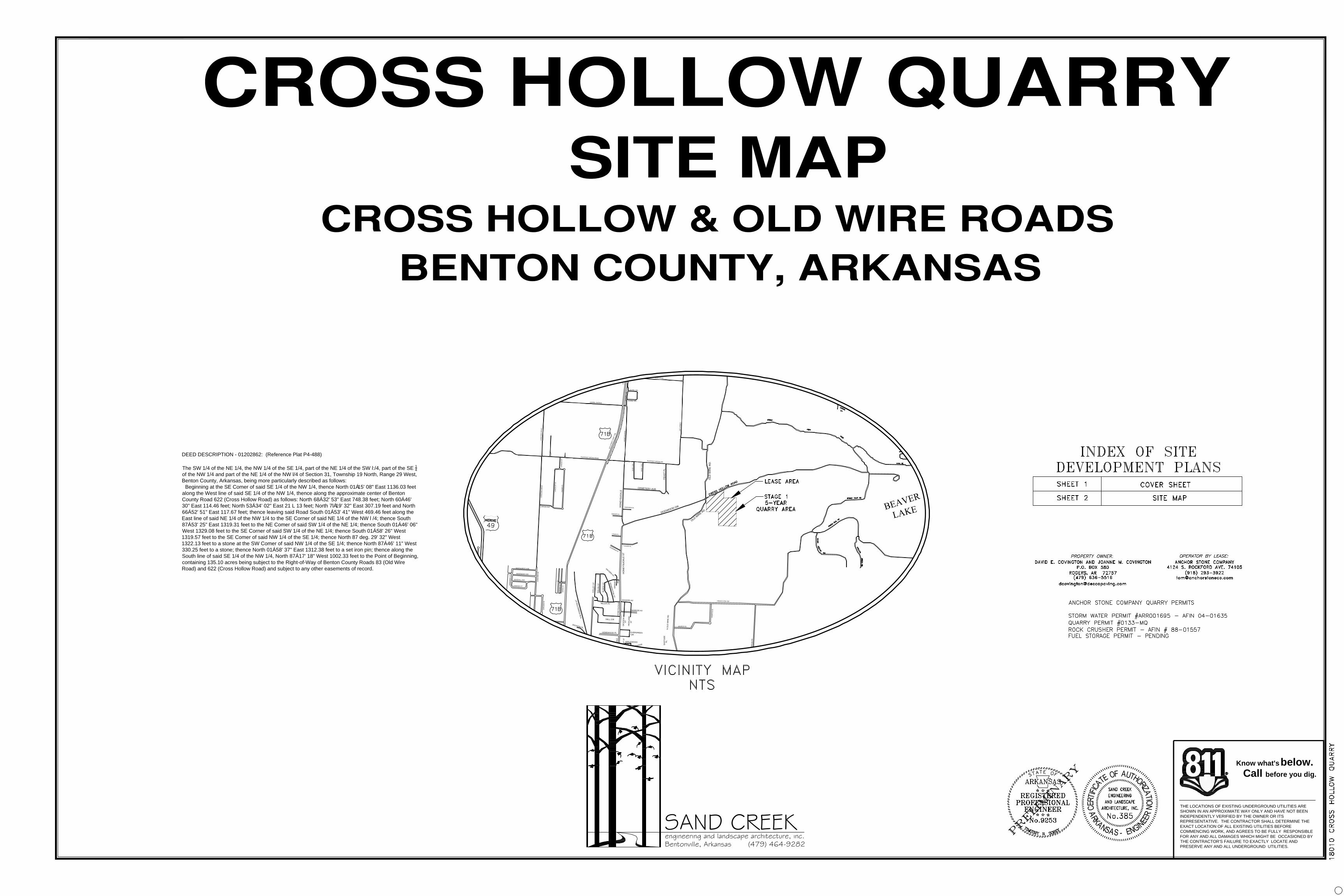
1425 + 1427 N Old Wire Road, Lowell AR 72745
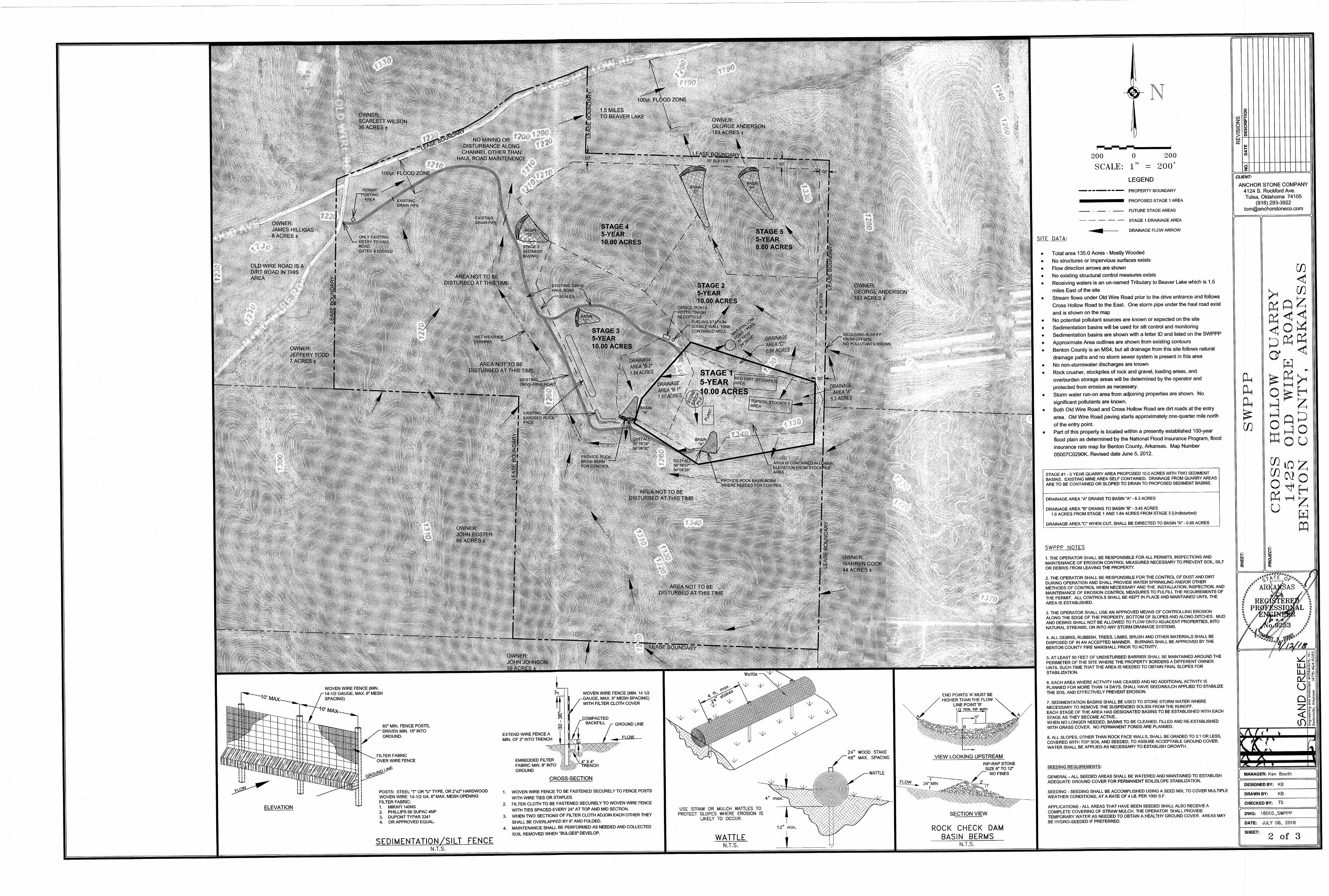
EXECUTIVE SUMMARY Per the applicant’s cover letter, The Cross Hollows mine is owned by David Covington Trust and is currently operating as a red dirt mine by its owner under Overland Development, Inc. Limestone is prevalent on the site and has historically been utilized for materials acquisition since 1904 when Lime Stone was harvested for powdered lime by the Rogers White Lime Company. An agreement has been reached with Anchor Stone Company, a Tulsa Oklahoma corporation, to quarry the stone. A Lease agreement is in place and all of the required ADEQ permits have been obtained and provided. The plan shows 135 acres of total land area with certain parts of the property laid out in sections of 10-acre parcels. Each 10-acre parcel represents a 5-year operating period, and intended to be the cycle of quarry operations for the future of that area. The 5 parcels cover 50 acres of the 135-acre site area. The first stage of quarry operation would be in the same location as the current red dirt mining activity. The plan documents show the general area of the rock crusher and initial stockpile area for rock and overburden. The site will operate much as it has since first permitted by Overland Development in 2006 with material being excavated, loaded and hauled out to provide suitable soils for subgrade under city streets, highways, building, and parking lot pads. The Quarry will add gravel base material and other Limestone rock products necessary to serve Northwest Arkansas’ growing needs. Adding the Quarry operation will change the site activity by adding a Rock Crusher and necessary blasting. Blasting is expected to happen once per month, with blasting activity being permitted as required by Arkansas Law and always performed by a permitted specialist brought in for that purpose. No dynamite or blasting components will be stored on site, but supplied by the blasting company on an individual basis. Site activity is to take place during normal operating hours between 7am and 6pm during summer months and daylight until dusk in winter months. No night time or Sunday activity will occur and Saturday operation is not desired but may occur based on demand.

Covington Quarry Site Plan Review | SPR – 18-252 November 7th, 2018
2
PROJECT INFORMATION Owner: David Covington
Engineer: Sand Creek Engineering – Ken Booth
Address of subject property (as assigned): 1425 N Old Wire Road, Lowell AR 72745
Parcel IDs: 18-04070-001
Parcel Area: 135.0 +/- acres (50 +/- acres of mining operation in 5 10-acre stages within first 25 years)
Current Land Use(s): Consent Decree of Open Cut Mining for red dirt by Overland Development (30.0 acres total)
Proposed Land Use(s): Heavy Industrial Use (11) – Limestone Quarry
Attachments: The following drawings and documents are attached:
1. Vicinity Graphic 2. Context Map 3. Site Aerial 4. Civil Set from Applicant 5. State Permits
PLANNING ANALYSIS Description of Property and Surrounding Area: The subject property consists of a one hundred thirty-five (135) acre parcel located on the south side of Cross Hollow Road at the Cross Hollow / N Old Wire Road intersection. Primary vehicular access is proposed via an existing gravel drive extending east from N Old Wire Road. The property is partially located within the FEMA 100-yr. floodplain and not within the County designated Urbanized MS4 area. The immediately surrounding land uses are as follows:
- North: Vacant Timber / Agricultural - East: Agricultural / Single Family Residential - South: Single Family Residential - West: Single Family Residential
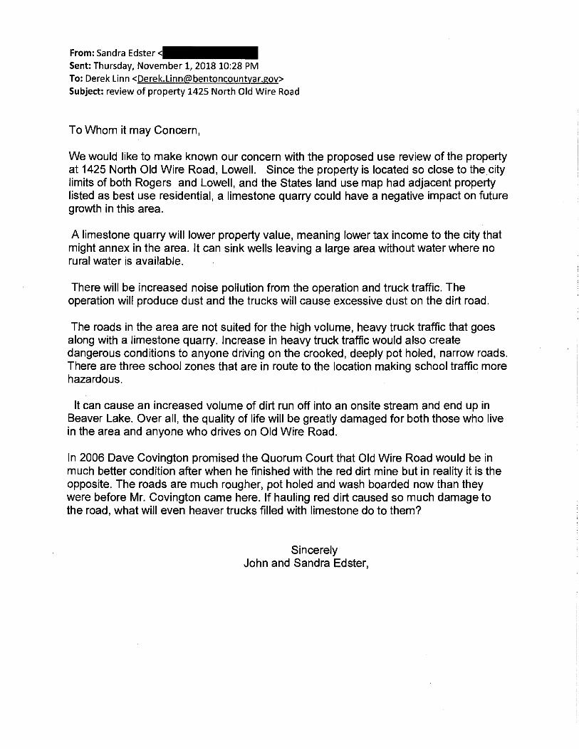
Background information: On October 3rd, 2018, the applicant submitted a Site Plan Review application and accompanying information meeting Staff’s requirements. On October 9th, 2018, an inter-departmental review form was sent to the following agencies: Planning Division, Health Dept., Road Dept., Building Dept., Fire Marshal, City of Lowell, Assessor’s GIS Mapping Manager, and Benton County E-911 Administration.

Covington Quarry Site Plan Review | SPR – 18-252 November 7th, 2018
3
TECHNICAL REVIEW OF SITE PLAN Parcel Information: Site inspection and research against State assessment records show the property as having zero assessed improvements. Parcel History – County Planning:
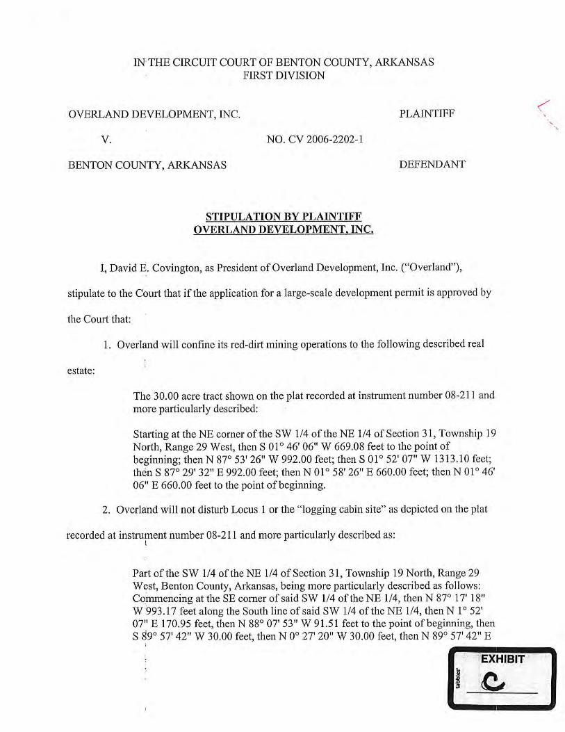
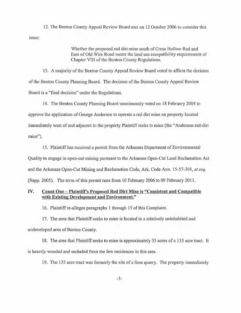
• August 2006 | Benton County Planning Board denied the Red Dirt mine proposal by Overland Development. • October 2006 | Benton County Justice of the Peace’s Appeal Panel upheld the Planning Board denial. • November 2006 | Overland Development filed a Complaint against Benton County, Arkansas requesting an
Appeal pursuant of Ark. Code Ann. 14-17-211. • December 2006 | Benton County, Arkansas files a response to the November 2006 Complaint. • June 2008 | Consent Decree is agreed upon by both parties and filed for record.
Noticing Requirements: On October 24th, 2018, the applicant submitted USPS certified mail receipts showing that written notice was sent to surrounding property owners regarding the November 7th Public Hearing. On October 24th, 2018, the applicant submitted the required photographs verifying that the required public hearing notice signage along the property’s frontage has been conspicuously posted on site. Standard Building Setbacks: Required: Fifty (50) feet measured from the center line of the fronting road (Cross Hollow and Old Wire Rd) or twenty-five (25) feet from the fronting property lines, whichever is greater is required; A side and rear yard, building to property line setback of ten (10) feet is required. Comments: The site plans detail the required 10-ft. setback along the side and rear property line, but shall be revised to notate the required front setback along County roads Cross Hollow and N Old Wire. Parking Requirements: ‘Professional Office’:
Required: 3 spaces per 1,000-sq. ft. GFA Calculation: 3/1000 x 720 = 3 spaces Required Parking: 3 spaces
Total Parking Provided: 10 parking spaces. The project engineer shall designate one (1) space as ADA Van accessible. Site Features - Loading area: Loading areas not designated on site plan. Site Features – Lighting: The Site Plan shall provide a text note that all outdoor lights will be ‘full cut-off lighting in accordance with IESNA standards. Parking / Landscape Buffer: Required: Adjoining incompatible uses should be screened with landscaping, walls, berms, or similar treatments. Section 4.6.16.c states that all required vegetative screening must have a minimum height of five (5) feet. All trees should be wire basket, B & B, or container grown. Smaller flowering trees and ornamentals will be centered at four (4’) feet maximum. Coniferous trees will be centered at four (4’) feet to five (5’) feet depending on desired effect. All shrubs are to be planted in continuous planting beds. Planting beds will be mulched to a minimum depth of three (3”) inches and will be

Covington Quarry Site Plan Review | SPR – 18-252 November 7th, 2018
4
maintained weed free. Plantings consisting of trees and shrubs will be a minimum of 50% coniferous plantings. All required setbacks are required to be maintained as landscaped open space, per §4.6(16). Comment: Land Use Compatibility analysis, per sec. 6.7, shows that the proposed use is classified as ‘Heavy Industrial’ use, and is immediately adjacent to aspects of residential uses to the east, south, and west; vacant land to the north. This places the proposed use as being ‘Incompatible’ with adjacent properties requiring extraordinary levels of mitigation in order to buffer and screen the proposed Heavy Industrial use. Specifically, table 6.6 (Compatibility Levels and Criteria) indicates greater than 20 ft. of additional setback, buffering 40 ft. or greater in depth, and may require wall/fence and 3 tier plantings. The current site plan details a State required 50-ft. buffer area along all property lines of the 135 acres. Access Driveways/Internal Circulation: Required: The design and construction shall be in accordance with the standards as presented in the Benton County Road Plan. Comment: The site fronts along a County maintained roadway. The applicant proposes to utilize an existing access drive from the public right-of-way. The site plans detail internal ‘Drive-Haul Roads’ for the red dirt mine and proposed quarry. Site Services - Drainage/ Storm water Management Plan: Required: Applicant is required to indicate on plan storm drainage infrastructure and to provide an off-site drainage study. If study indicates an increase in peak flow discharge downstream, the developer shall construct a detention facility or an alternative LID methodology that shall control the peak runoff rate. The County also recommends minimizing impervious surface to limit the need for such facilities. Comment: The subject property is not located in an MS4 area. The project engineer shall prepare an off-site drainage study in accordance with Chapter 4, sec. 4.6, 10, B. The project engineer submitted a copy of ADEQ’s Notice of Coverage for the Industrial Stormwater permit. Site Services - Solid Waste Disposal: The applicant confirmed the necessity of outdoor refuse containers and the location of such containers with fence enclosure. Site Services - Electrical Power Supply: The applicant shall provide written confirmation from provider. Site Services – Septic System: Required: Regardless of development size, a state-approved septic disposal method is required of all commercial and industrial developments. All disposal system criteria must meet or exceed septic requirements as established by the Arkansas Department of Health (ADH) in accordance with Act 402 of 1977 as amended. Comment: The proposal does not detail septic requirements. Site Services - Water Service: The development does not detail water service to the site. Site Services - Fire & EMS: The Benton County Emergency 911 Administration verified the addresses associated with the property.

Covington Quarry Site Plan Review | SPR – 18-252 November 7th, 2018
5
Staff has received formal comments from the Benton County Fire Marshal.
1. Quarry Gate and Office Trailer will need a Knox style box keyed to the Lowell Fire Department. 2. Fuel Tank will need to be permitted by the Arkansas State Fire Marshal. 3. Office Trailer will need to the required emergency lighting and Fire Extinguishers. 4. Fuel Tank will need a Fire Extinguisher mounted within a weather tight fixture.
The site plans shall be revised to detail all required Fire Marshal comments with both text and graphical plan elements. Site Services – Hazardous Chemical Storage In accordance with §4.6. B #5, all proposed commercial and industrial developments must submit written confirmation of hazardous materials to be used and stored on-site. Documentation is to be forwarded to the County Office of Emergency Services. The applicant submitted documentation providing that no hazardous chemicals are to be stored on site. The site plans detail a 12,000-gallon fuel tank on site, the applicant shall submit the State Fire Marshal’s approved permit for the above ground tank prior to quarry operation. State Permitting Review: The applicant shall be required to apply and receive all State permits prior to quarry operation. The applicant submitted the following documents:
1. Authorized ADEQ General Air Permit for Rock Crushing Facilities | Expiration date: 9/22/2022 a. AFIN: 88-01557, Tracking: 1916-AGP-144
2. Arkansas State Police Aboveground Storage Tank Installation application a. To be reviewed and approved by the State and Local Fire Marshal prior to operation.
3. Approved ADEQ Industrial Stormwater General Permit Notice of Coverage | Expiration: 06/30/2019 a. AFIN: 04-01635, Tracking: ARR001695
4. Authorized ADEQ Quarry permit for the ‘Cross Hollow Quarry’ issued to Anchor Stone | Expiration: 09/03/2023 a. Tracking: 033-MQ Anchor Stone Company

Covington Quarry Site Plan Review | SPR – 18-252 November 7th, 2018
6
OUTSTANDING ITEMS:
1. The site plans shall be revised to notate the required front setback along County roads Cross Hollow and N Old
Wire. 2. The project engineer shall designate one (1) space as ADA Van compliant.
3. The Site Plan shall provide a text note that all outdoor lights will be ‘full cut-off lighting in accordance with
IESNA standards.
4. The site plans shall be revised to detail all required Fire Marshal comments with both text and graphical plan
elements.
5. The site plans detail a 12,000-gallon fuel tank on site, the applicant shall submit the State Fire Marshal’s approved
permit for the above ground tank prior to quarry operation.
6. The project engineer shall prepare an off-site drainage study in accordance with Chapter 4, sec. 4.6, 10, B.
CONSIDERATIONS FOR THE BOARD:
I. Covington Quarry Site Plan Review, case no. 18-252 conditioned upon the following; 1. The site plans shall be revised to notate the required front setback along County roads Cross Hollow and
N Old Wire. 2. The project engineer shall designate one (1) space as ADA Van compliant.
3. The Site Plan shall provide a text note that all outdoor lights will be ‘full cut-off lighting in accordance
with IESNA standards.
4. The site plans shall be revised to detail all required Fire Marshal comments with both text and graphical
plan elements.
5. The site plans detail a 12,000-gallon fuel tank on site, the applicant shall submit the State Fire Marshal’s
approved permit for the above ground tank prior to quarry operation.
6. The project engineer shall prepare an off-site drainage study in accordance with Chapter 4, sec. 4.6, 10, B.
7. The current and future property owners shall appear before the Planning Board every 24-months for status
updates.
8. The project shall adhere to Standard Conditions of Site Plan Review
Prepared by: Taylor Reamer – Planning Director Reviewed by: Derek Linn – Senior County Planner

4305 S 1ST ST
4131 S 1ST ST
4001 S 1ST ST
4111 S 1ST ST
4201 S 1ST ST
1515 FEAST PL
4315 S 1ST ST
4301 S 1ST ST
904 N OLD WIRE RD824 N OLD WIRE RD
1427 N OLD WIRE RD
3940 S OLD WIRE RD
3995 S OLD WIRE RD
4602 S OLD WIRE RD
1425 N OLD WIRE RD
1024 N OLD WIRE RD
1000 N OLD WIRE RD
4600 S OLD WIRE RD
4002 S OLD WIRE RD
1111 N OLD WIRE RD
1226 N OLD WIRE RD
4003 S OLD WIRE RD
4304 S OLD WIRE RD
1206 N OLD WIRE RD
4009 S OLD WIRE RD
4010 S OLD WIRE RD
4610 S OLD WIRE RD
4314 S OLD WIRE RD4310 S OLD WIRE RD
4005 S OLD WIRE RD
1013 N OLD WIRE RD
4312 S OLD WIRE RD
3939 S OLD WIRE RD
10789 STONEY POINT RD
12590 CROSS HOLLOW RD12400 CROSS HOLLOW RD
12810 FRISCO CEMETERY RD
12830 FRISCO CEMETERY RD
12824 FRISCO CEMETERY RD
12788 FRISCO CEMETERY RD
12707 FRISCO CEMETERY RD
12806 FRISCO CEMETERY RD
12820 FRISCO CEMETERY RD
12828 FRISCO CEMETERY RD
12780 FRISCO CEMETERY RD
ROGERS
LOWELL
N OLD WIRE RD
CROSS HOLLOW RD
S OLD WIRE RD
S 1ST
ST
DOGWOOD AVE
S 1ST
ST
11
22
11
22
Covington Limestone Quarry
¯
1:8,400 1 in = 700 ft
Area of Development

1292
1302
13281330
1216
1200
1326
130
4
1346
1344
1246
1244
1358
1192
1260
124
2
1276
125
2
1228
1254
1226
123
6
1334
1298
1238
1350
1320
1230
1310
1354
1206
1322
1218
1250
1220
1332
1294
1212
1288
1316
1258
1274
1342
130
8129
0
1280
1222
1296
1256 1352
1266
1264
1198
1282
122
4
1284
1262
1340
130
6
1278
1240
1208
1214
1300
1270
120
2
1194
1314
1338
1286
131
2
1348
1248
1272
1234
1336
1210
132
4
1318
126
81232
12041224
1338
1336
132
2
124
6
1328
1254
1330
1338
1260
1326
1334
1214
132
2
1224
1308
1218
1330
1340
1344
1344
1324
132
4
1332
124
6
13441346
122
0
122
0
1206
1328
1348
1244
1326
1322
1342
1336
122
4
1334
1242
1342
1304
CROSS HOLLOW RD
S OLD WIRE RD
N OLD
WIRE
RD
Covington Limestone Quarry
¯
1:4,800 1 in = 400 ft

1610 NW 12th Street Bentonville, AR 72712 Phone: (479) 464-9282 Fax: (479) 464-9284
October 3, 2018 Project #18010
RE: Cross Hollow Quarry, Benton County, Arkansas
Dear Planning,
As requested by the submittal application, this narrative is offered to provide written description of this
submittal, the intended use of the site and its compatibility with the surrounding properties.
The Cross Hollows mine is owned by David Covington Trust and is currently operating as a red dirt
mine by its owner under Overland Development, Inc. Limestone is prevalent on the site and has
historically been utilized for materials acquisition since 1904 when Lime Stone was harvested for
powdered lime by the Rogers White Lime Company. An agreement has been reached with Anchor Stone
Company, a Tulsa Oklahoma corporation, to quarry the stone. A Lease agreement is in place and all of
the required ADEQ permits have been obtained and provided.
The plan shows 135 acres of total land area with certain parts of the property laid out in sections of 10
acre parcels. Each 10 acre parcel represents a 5-year operating period, and intended to be the cycle of
quarry operations for the future of that area. The 5 parcels cover 50 acres of the 135 acre site area. The
first stage of quarry operation will be in the same location as the current red dirt mining activity. The
plan documents show the general area of the rock crusher and initial stockpile area for rock and
overburden. The site will operate much as it has since first permitted by Overland Development in 2006
with material being excavated, loaded and hauled out to provide suitable soils for subgrade under city
streets, highways, building, and parking lot pads. The Quarry will add gravel base material and other
Limestone rock products necessary to serve Northwest Arkansas’ growing needs.

– 2 – October 3, 2018
1610 NW 12th Street Bentonville, AR 72712 Phone: (479) 464-9282 Fax: (479) 464-9284
Adding the Quarry operation will change the site activity by adding a Rock Crusher and necessary
blasting. Blasting is expected to happen once per month, with blasting activity being permitted as
required by Arkansas Law and always performed by a permitted specialist brought in for that purpose.
No dynamite or blasting components will be stored on site, but supplied by the blasting company on an
individual basis. Site activity is to take place during normal operating hours between 7am and 6pm
during summer months and daylight until dusk in winter months. No night time or Sunday activity will
occur and Saturday operation is not desired but may occur based on demand.
The surrounding properties consist of undeveloped land, poultry farming, ranching, and large track
residential. The closest structure to the Stage 1 quarry area is a mobile home on the East side of the
property serving as a residence for a Poultry operation manager and is 145’ East of the property line.
The nearest Poultry house is 345’ East of the property boundary.
To the Southeast of the Phase 1 area is a residence at 1150’±, to the South is a residence at 1430’, and to
the West is a residence at 1750’. To the Northwest the nearest residence is 2500’, and to the North the
nearest is 1800’ being on the North side of Cross Hollow Road.
The site has been operating as a red dirt mine since 2006 and is situated to provide high quality
limestone for construction projects in the Eastern part of the County.
Sincerely,
Ken Booth
Sand Creek Eng. - Project Manager kboot h@s andcr eek. us


PLE
AS
AN
T G
RO
VE
RO
AD
DA
IS
Y C
IR
.
DA
IS
Y C
IR
.
PLE
AS
AN
T G
RO
VE
RD
.
8
T
H
S
T
R
E
E
T
(
H
W
Y
7
1
B
)
HO
NE
YS
UC
KLE
LAU
RE
L AV
EN
UE
8T
H
S
TR
EE
T (H
W
Y. 71B
)
PO
ST
RO
AD
FE
AS
T P
L.
1S
T S
TR
EE
T
PLE
AS
AN
T G
RO
VE
RO
AD
CO
NC
OR
D D
RIV
E
LAU
RE
L AV
EN
UE
DIX
IE
LA
ND
R
OA
D
LAUREL CIR.
LA
U
R
E
L R
D
.
LAUREL CIR.
L
A
U
R
E
L
C
R
O
S
S
I
N
G
A
V
E
.
R
A
V
E
N
P
L
.
L
A
U
R
E
L
N
E
A
L
T
E
R
.
C
R
O
S
S
I
N
G
C
IR
.
BRIDLE DR.
17T
H S
T.
SADDLEBROOK LN.
BRIDLE DR.
17T
H P
L.
LO
ND
ON
S
T.
LA
NC
ELO
T S
T.
TU
DO
R S
T.
LA
RS
ON
AV
E.
CO
NC
OR
D D
RIV
E
BEAVER
LAKE
JENIFER RD.
OLD
W
IR
E R
D.
CE
ME
TE
RY
AV
E.
HO
NE
YS
UC
KLE
D
O
G
W
O
O
D
D
RHA
RV
ISO
N P
L
GR
AV
ES
PL
LE
WIS
PL
TU
CK
ER
PL
G
O
O
D
M
A
N
P
L
O
L
D
W
I
R
E
R
D
FRISCO CEM. RD
HO
NE
YS
UC
KLE
PR
IM
RO
SE
R
D
PA
IG
E B
LV
D
OAKW
OO
D AVE
OLR
ID
GE
P
L
OA
KW
OO
D S
T
ROBINSON AVE
GR
EE
NW
AY
C
T
NORTHCREST AVE
RIDGEMONT AVE
EDGEHILL AVE
LINWO
OD CT
CO
NC
OR
D D
R
GA
RLA
ND
P
L
JE
FF
ER
D LN
DIA
NA
LN
FULLER
TON
AS
H S
T
BIR
DIE
LN
L
I
N
K
S
D
R
P
A
R
L
N
B
O
G
E
Y
D
R
GR
EE
NS
C
OV
E
EAGLE CO
URT
FRANKLIN WAY
OA
KW
OO
D A
V
McC
LUR
E A
VE
HW
Y 71B
J
A
C
K
S
O
N
P
L
F
R
IS
C
O
P
L
HOMEWOOD PL
DELL CIR
H
A
Y
D
E
N
A
V
HO
NE
YS
UC
KL
E S
T
N
B
L
O
O
M
IN
G
T
O
N
S
T
CO
LLE
Y S
T
GR
AN
DY
P
E
N
N
IN
G
T
O
N
S
T
IR
ELA
N S
T
ALM
OO
S
TNELDA AV
PL
SU
MM
ER
SE
T S
T
W
IL
D
W
O
O
D
SUMMERFIELD
S
T
EVERGREEN
APPLEWOOD
AV
CIR
EA
ST
SID
E
PL
HIG
HLA
ND
ST
ST
DIC
KS
ON
BARKER AV
N O
LD
W
IR
E R
D
ROGERS AV
HO
NE
YS
UC
KLE
Know what's below.
Call before you dig.
THE LOCATIONS OF EXISTING UNDERGROUND UTILITIES ARE
SHOWN IN AN APPROXIMATE WAY ONLY AND HAVE NOT BEEN
INDEPENDENTLY VERIFIED BY THE OWNER OR ITS
REPRESENTATIVE. THE CONTRACTOR SHALL DETERMINE THE
EXACT LOCATION OF ALL EXISTING UTILITIES BEFORE
COMMENCING WORK, AND AGREES TO BE FULLY RESPONSIBLE
FOR ANY AND ALL DAMAGES WHICH MIGHT BE OCCASIONED BY
THE CONTRACTOR'S FAILURE TO EXACTLY LOCATE AND
PRESERVE ANY AND ALL UNDERGROUND UTILITIES.
CROSS HOLLOW QUARRY SITE MAP
CROSS HOLLOW & OLD WIRE ROADSBENTON COUNTY, ARKANSAS
DEED DESCRIPTION - 01202862: (Reference Plat P4-488)
The SW 1/4 of the NE 1/4, the NW 1/4 of the SE 1/4, part of the NE 1/4 of the SW l:/4, part of the SE
1
4
of the NW 1/4 and part of the NE 1/4 of the NW l/4 of Section 31, Township 19 North, Range 29 West,
Benton County, Arkansas, being more particularly described as follows:
Beginning at the SE Comer of said SE 1/4 of the NW 1/4, thence North 01°15' 08" East 1136.03 feet
along the West line of said SE 1/4 of the NW 1/4, thence along the approximate center of Benton
County Road 622 (Cross Hollow Road) as follows: North 68° 32' 53" East 748.38 feet; North 60° 46'
30" East 114.46 feet; North 53° 34' 02" East 21 L 13 feet; North 7l°19' 32" East 307.19 feet and North
66° 52' 51" East 117.67 feet; thence leaving said Road South 01° 53' 41" West 469.46 feet along the
East line of said NE 1/4 of the NW 1/4 to the SE Corner of said NE 1/4 of the NW l /4; thence South
87° 53' 25" East 1319.31 feet to the NE Comer of said SW 1/4 of the NE 1/4; thence South 01° 46' 06"
West 1329.08 feet to the SE Corner of said SW 1/4 of the NE 1/4; thence South 01° 58' 26" West
1319.57 feet to the SE Comer of said NW 1/4 of the SE 1/4; thence North 87 deg. 29' 32" West
1322.13 feet to a stone at the SW Comer of said NW 1/4 of the SE 1/4; thence North 87° 46' 11" West
330.25 feet to a stone; thence North 01° 58' 37" East 1312.38 feet to a set iron pin; thence along the
South line of said SE 1/4 of the NW 1/4, North 87° 17' 18" West 1002.33 feet to the Point of Beginning,
containing 135.10 acres being subject to the Right-of-Way of Benton County Roads 83 (Old Wire
Road) and 622 (Cross Hollow Road) and subject to any other easements of record.
SAND CREEKengineering and landscape architecture, inc.Bentonville, Arkansas (479) 464-9282
CERT
IF
IC
A
T
E
O
FA
U
T
H
O
R
IZ
A
TIO
N
A
R
K
A
N
S
A
S-
E
N
G
I
N
E
E
R

STAGE 1
5-YEAR
10.00 ACRES
50'
50'
EXISTING
DRAIN PIPE
STAGE 3
SEDIMENT
BASIN C
BASIN
"C"
BASIN
"B"
STAGE 3
5-YEAR
10.00 ACRES
STAGE 4
5-YEAR
10.00 ACRES
STAGE 5
5-YEAR
8.60 ACRES
ONLY EXISTING
ENTRY TO HAUL
ROAD
GATED & LOCKED
EXISTING DRIVE-
HAUL ROAD
STAGE 2
5-YEAR
10.00 ACRES
BASIN
"A"
SCALES
OFFICE TRAILER,
PORTA POTTY,
TRASH RECEPTACLE
(See detail below)
RECEIVING RUNOFF
FROM OFFSITE
NO POLLUTANTS KNOWN
AREA NOT TO BE
DISTURBED AT THIS TIME
AREA NOT TO BE
DISTURBED AT THIS TIME
AREA NOT TO BE
DISTURBED AT THIS TIME
1.5 MILES
TO BEAVER LAKE
PROVIDE ROCK BASIN BERM
WHERE NEEDED FOR CONTROL
PROVIDE ROCK
BASIN BERM
FOR CONTROL
OWNER:
GEORGE ANDERSON
183 ACRES ±
OWNER:
WARREN COOK
44 ACRES ±
OWNER:
GEORGE ANDERSON
183 ACRES ±
OWNER:
JOHN JOHNSON
38 ACRES ±
OWNER:
JOHN EDSTER
86 ACRES ±
OWNER:
JEFFERY TODD
7 ACRES ±
OWNER:
JAMES HILLIGAS
8 ACRES ±
OWNER:
SCARLETT WILSON
36 ACRES ±
LEASE BOUNDARY
LE
AS
E B
OU
ND
AR
Y
LE
AS
E B
OU
ND
AR
Y
LEASE BOUNDARY
LE
AS
E B
OU
ND
AR
Y
LE
AS
E B
OU
ND
AR
Y
LE
AS
E B
OU
ND
AR
Y
L
E
A
S
E
B
O
U
N
D
A
R
Y
PERMIT
POSTING
AREA
NO MINING OR
DISTURBANCE ALONG
CHANNEL OTHER THAN
HAUL ROAD MAINTENENCE
AREA NOT TO BE
DISTURBED AT THIS TIME
EXISTING
DRIVE-HAUL ROAD
O
L
D
W
I
R
E
R
O
A
D
(
D
I
R
T
I
N
T
H
I
S
A
R
E
A
)
BASIN
"D"
50' B
UF
FE
R
50' BUFFER
50'
50'
EXISTING
DRAIN PIPE
OUTFALL
36°16'27"
94°06'26"
OUTFALL
36°16'28"
94°06'30"
P
L
A
N
T
S
T
O
N
E
S
T
O
C
K
P
I
L
E
RE
D-D
IRT
ST
OC
KP
ILE
AR
EA
TO
PS
OIL
ST
OC
KP
ILE
AR
EA
BASIN
"E"
BASIN
"F"
FUELING STATION
DOUBLE-WALL TANK
CONTAINED AREA
EXISTING
EXPOSED ROCK
FACE
D
O
G
W
O
O
D
D
R
I
V
E
(
D
I
R
T
I
N
T
H
I
S
A
R
E
A
)
C
R
O
S
S
H
O
L
L
O
W
R
O
A
D
(
D
I
R
T
I
N
T
H
I
S
A
R
E
A
)
10' SETBACK
10' SETBACK
25' SETBACK
10' SETBACK
10' SETBACK
10' SETBACK
10' SETBACK
50'
50'
50'
50'
50'
1
0
0
y
r
F
lo
o
d
A
r
e
a
1
0
0
y
r
F
lo
o
d
A
r
e
a
LEGEND
PROPERTY BOUNDARY
PROPOSED STAGE 1 AREA
FUTURE STAGE AREAS
BUILDING SETBACKS
ALONG STREET - 25'
SIDE & REAR - 10'
100yr FEMA FLOOD AREA
(Approximate)
Fema Flood Map-
15007C0292K June 5, 2012
SH
EE
T:
PR
OJE
CT
:
CLIENT:
NO
.D
ES
CR
IPT
ION
RE
VIS
IO
NS
DA
TE
DWG:
DATE:
ANCHOR STONE COMPANY
4124 S. Rockford Ave.
Tulsa, Oklahoma 74105
(918) 293-3922
DESIGNED BY:
DRAWN BY:
CHECKED BY:
SHEET:
engi
neer
ing
and
land
scap
e ar
chite
ctur
e, in
c.Ben
tonv
ille,
Ark
ansa
s (4
79) 464-9
282
SAND
CREE
K
MANAGER:
· Total area 135.0 Acres - Mostly Wooded
· No structures or impervious surfaces exists and none are planned other
than a mobile office trailer
· No potential pollutant sources are known or expected on the site
· Sedimentation basins will be used for silt control and monitoring
· Sedimentation basins are shown with a letter ID and approved by the
ADEQ SWPPP permit. Storm drainage will be routed and collected in
these basins to be used in the quarrying operations.
· Potential Rock crusher, stockpiles of rock and gravel, loading areas, and
overburden storage areas are shown, but will be determined by the
operator and protected from erosion as necessary as quarrying
progresses.
· Both Old Wire Road and Cross Hollow Road are dirt roads at the entry
area. Old Wire Road paving starts approximately one-quarter mile north
of the entry point.
· Part of this property is located within a presently established 100-year
flood plain as determined by the National Flood Insurance Program, flood
insurance rate map for Benton County, Arkansas. Map Number
05007C0290K. Revised date June 5, 2012. Other than the haul-road, no
activity will occur near the flood area
NOTES:
Trash dumpster area to be screened to protect from trash blowout and prevent
scatter. Regular maintenance and pickup to be performed.
Office and employee trash must be deposited into collection area for proper
disposal.
12,000 gallon double-walled fuel tank will be placed at the drive area for easy
access and a contained area provided for equipment fueling safely away from
quarrying activity.
A Porta-Potty is to be provided with a maintenance agreement for regular
pickup. Steps should be taken to prevent tip-over in windy conditions.
Quarry Operator exposes and excavates the lime stone and crushes the stone
to the requested specifications. Materials are loaded and hauled from the site
by private drivers or trucking company's. No truck storage on site.
Parking at office is based on 5 site workers, 1 site manager, 1 load counter, and
2 visitor spaces. Parking area to be natural ground or gravel. No hard surface
areas are proposed.
TRASH RECEPTICLESCREENED WITH 6'CHAINLINK FENCEAND GATE
PORTA-POTTY WITHMAINTENENCEAGREEMENT
OFFICE TRAILER
GRAVEL PARKINGAREA
12,000 Gal.DOUBLE-WALLEDDIESEL FUEL TANK
HAUL ROAD
19'
10'
Not to Scale
42'
OFFICE/PARKING DETAIL